1AScl Corporation - US Environmental Protection Agency
71
August 1992 Application of MULTIMED Model to Alcyon Racetrack Site (Lipari Landfill) by Mansour Zakikhani1, Ronald G. Wilhelm2, Robert B. Ambrose, Jr.2 1AScl Corporation Athens, GA 30613 2Environmental Research Laboratory U. S. Environmental Protection Agency Athens, GA 30613 Center For Exposure Assessment Modeling Superfund Technical Support Center U. S. Environmental Protection Agency Athens, Georgia 30613 272 908 iiniinii 228
-
Upload
khangminh22 -
Category
Documents
-
view
0 -
download
0
Transcript of 1AScl Corporation - US Environmental Protection Agency

August 1992
Application of MULTIMED Model to Alcyon Racetrack Site (Lipari Landfill)
by
Mansour Zakikhani1, Ronald G. Wilhelm2, Robert B. Ambrose, Jr.2
1AScl Corporation Athens, GA 30613
2Environmental Research Laboratory U. S. Environmental Protection Agency
Athens, GA 30613
Center For Exposure Assessment Modeling Superfund Technical Support Center
U. S. Environmental Protection Agency Athens, Georgia 30613
272 908 iiniinii 228

ABSTRACT
This report describes the calculation of soil clean-up levels for five chemicals-- bis(2-chlproethyl)ether (BCEE), benzene, chloroform, 1,2-dichloroethane, and ethylbenzene. These chemicals were assumed to remain in treated soil placed on Alcyon Racetrack adjacent to the Lipari Landfill. A mathematical model was developed to simulate the transport and transformation of the five chemicals in a subsurface system. The mathematical simulation predicted the average concentration of each chemical that should remain in the treated soil. The predicted levels in the treated soil are based on the Federal water quality criteria given for the surface water in nearby Alcyon Lake.
P1® results provided here are based on the assumptions and conditions described in this report and the associated references. ? i • 8oil cor^centxations, given in this report, are a
useful tool in establishing safe soil levels prior to their placement at the Alcyon Racetrack site.
ii
229

TABLE OF CONTENTS
Abstract .. Figures T, Tables !!!!!!!!!!!!;;;;*;; Acknowledgments •••!!!!!!!!!!!!!!!!!!!!!!!!!!!!!!!*" vi 1. INTRODUCTION x
2. SITE CHARACTERISTICS j 3. CHEMICAL SELECTION u
4 . AVERAGE INFILTRATION RATE 11 5. MASS BALANCE CALCULATIONS 17
6. MODELING APPROACH ig 6 .1 MULTIMED Model !!!!!! to 6.2 Model Limitation !!!!!!!!****20 6.3 Model Application !!!!!!!!! 20
7. RESULTS AND CONCLUSIONS 23 7.1 Example of Partition Coefficient Calculation!!!!!!.23 7.2 Dilution Estimation 26 7.3 BCEE Leaching with Hydrolysis Effects 30 7.4 Average Concentration. !!! 34
8. REFERENCES 38
9. APPENDIX A. Sample Calculations of Pulse Time..!!!!!!!!!!!!!!!!40 B. Sample Calculations of Cleanup Values 41 C. Well Logs Results 1111142
iii
230

FIGURES Figure 1. Regional Map of the Lipari Landfill Figure 2. Groundwater Plume Interception by the Lake Figure 3. Direction and Gradient of Groundwater at Alcyon Racetrack Figure 4. Area Soil Types at the Site Figure 5. Rainfall and Evaporation Data for Philadelphia
Airport for Period 1964-1983 Figure 6. Average Calculated Infiltration Rate Using PRZM
(using runoff curve number » 80).... Figure 7. Average Calculated Infiltration Rate Using PRZM
(using runoff curve number =74). . Figure 8. A Schematic of Source Penetration in Different Zones and Mixing Zone Figure 9. Normalized Concentration Distribution of Toluene
(with no hydrolysis effect) Figure 10. Normalized Concentration Distribution of BCEE
(with no hydrolysis effect) Figure 11. Normalized Concentration Distribution of BCEE
(with hydrolysis effect) Figure 12. Schematic of a Treated sediment Element .32 Figure 13. Selected Points Along the Lake-Aquifer Interface
Used for Averaging the Concentration... .35
iv
231

Table TABLES
1. Properties of the Aura Soil from DBAPE 9
Table 2. Hydrogeological and Soil Parameters of the Lipari Superfund Site.. T....10
Table 3. Water Quality Criteria for the Selected Chemicals.il Table 4. Runoff Curve Numberjfor Hydrologic Soil-Cover Complex
(Antecedent Moisture Condition II, ia = 0.2 S)....16 Table 5. Pulse time (Tp) Values for Selected Chemicals 19 Table 6. Summary of Parameters of two of Potential Organic
Contaminant of Concern 25 7. Mobility Index. 8. Analytical Results of Treated Sediment 33
Table 9. Calculated Normalized Concentration of BCEE at the-^®7Aquifer Interface (BCEE; percolation rate =0.30
Table Table
m/yr) 34 Table 10. Calculated Normalized Concentration of BCEE at the-
Lake-Aguifer Interface (BCEE; percolation rate = 0.36 m/yr) * • • Table ll. Calculated Concentrations for Five Chemicals Using
Average Dilution Factor (percolation rate = .30 m /yr) 37
Table 12. Calculated Concentrations for BCEE Using Average Dilution rector (percolation rate = .36 m/yr)
37
V
232 •I

!• INTRODUHTTnM
?° a rec^fat- for technical assistance from the ^ 4. nvironmental Pr°tection Agency (USEPA), Region II,
% j Center for Exposure Assessment Modeling (CEAM) screening analysis of a non-hazardous disposal area
P , f.! a Superfund site. The computer program used for these MDLTIMED ?sha™SHthe Mul5im?dia Exposure Assessment Model, (sharP~Hansen et al., 1990). Percolation rates for PMM c™eiee?aiiU th® Pesticide Root Zone Model, Estimi£o^ inf£p ?! * and the Data Base and Parameter available'fran^CEAM^1 " *1" 1989>- 11,988 tht9e Pr°9™ms «re
Priorit^List^NPL^Hfn 1 Q a ,w^ic^ YaB listed on the EPA National * ? 1983 for cleanup under Superfund, is Jhf the Borough of Pitman, Gloucester County, Ne^ Jersey ^ho«?1iP?Svi ? WvS Alcyon Racetrack, which is located about 1.2 km from the Lipari Landfill (Figure 1). The racetrack at ?£»a! *Hte Wixl con8i8t °f thr« -nain SnltB-i a cfean Mpaon at the land surface, a treated soil below it, and an undisturbed roofs^ ?).801i layer. A fully developed cover of grass will be flowstowards Sl^n"Lf011- *** 9roundwater beneath the site
chlorofo™°rit?eH?°??ling ?°rk' Subsequently, benzene, foJfhfJTi 1,2-dichloroethane, and ethylbenzene also were used p?oje« eatimations as requested by the EPA's reeedilf
of t-hIh2TTT5?SSSiveJ°? }hLs reP°rt 18 to describe the application tfansnn^of^? "? , ±2 determining the potential for subsurface ™ ??P « chemicals from the treated soil and sediments Dlaced on Alcyon Racetrack to Alcyon Lake. The MULTIMED model used in
rt8 devel°Ped using certain assumptions and mM? hf ?aJ 8 (Sharp-Hansen et al., 1990). The modeling results
££££io!£ S f S f Z i BXolS9i"i1d9Cay was not !n the s?lSt?d f lack °f biodegradation data on the chemicals; hence, the results are conservative. The
££?£& quali^'criteria?116 88"8"98 federal
1
233

2. SITE CHARACTERTfiTTPS
. . The geology and hydrogeology of the Lipari site is described IQOO? « J f off-site remedial investigation report (USEPA, 1988). Hydrogeologic information consisted of data from subsurface sampling at the racetrack and other local data. Because of the proximity of the racetrack to the landfill, some
K yC^°9eoi°9ic data measured for the landfill were used for the subsurface hydrogeologic information needed for the modeling of chemical movement at the racetrack site. The primary source of inxormation was from the subsurface sampling data at the racetrack. Other sources of data were the landfill remedial investigation, the feasibility study and design information, which were provided by the RPM.
The subsurface of the Alcyon Racetrack site can be 1 f^raC^erifej as a system of placement source, unsaturated zone, *FigureU2* zone which is hydraulically connected to the lake
At the Lipari Landfill, approximately 6 acres of the site was used for disposal of both solid and liquid chemical wastes from 1958 until 1971. The landfill was closed in 1971 when streamTcnM fr£m e landfill into a nearby marsh and stream (CDM, 1987) was observed. Wastes in the landfill include cleaning solvents, paints, paint thinners, and dirty waste solvents (USDC, 1981). Detailed records of the quantity and type of the wastes placed in the landfill were not available.
.Thf »ain surface water drainage system near the site is Chestnut Branch. Chestnut Branch flows almost directly north along the eastern side of the landfill and discharges into the Alcyon Lake, east of the Alcyon Racetrack area. Historically, recharge to Alcyon Lake occurred from these surface waters, as
t? from artesian springs in the lake bottom. However, flow f??? SS Sprfngs has been gradually impeded by deposition of silt and organic matter on the lake bottom (U.S. EPA, 1988). Rahh?+8£ream? ?£ int?rest in the area are Lost Lake Run and theLipari' ilndfill! -"-"Charge into Chestnut Branch near
P?rJS?perfund Purposes, the Lipari Landfill site was separated into "on-site" and "off-site" areas. The "on-site"
slurry wall/synthetic membrane encapsulation WaS 5?nstructed 1x1 1983-84 to isolate the landfill
SSU-5 surrounding area. The remainder of the area was considered "off-site".
is °* the f?11 and water at the Lipari Landfill ! « Priority pollutants have been identified in the
groundwater, in the soils of the Chestnut Branch marsh, and in
234

Figure 1. Regional Map of the Llparl Landfill, (Source* CDM, 1987).
235

Figure 2. Groundwater Plume Interception by the Lake. (adapted from MULTIMED User's Manual, 1990)
4

^S!L8e?Sn?ts „o£ Chestnut Branch, Rabbit Run and Alcyon Lake (CDM, 1987). Much of the contamination is directly related to the °P®ration of the Lipari Landfill. A detailed discussion of the extent and nature of the contamination in the area is presented m the Off-site Remedial Investigation Report (CDM, 1987). ,K_CUfr!ntly: the s,Fffce waters of Alcyon Lake, Rabbit Run and Chestnut Branch contain levels, of contaminants that are in violation of federal and state; water quality standards and/or sources^uld^v0?911 th® eJ^ination o£ up-gradient contaminant would likely cause the; contaminant concentration in these AlcwS LSeerLhS<?eSrea8%rniatiVely «uickly' the sediments of Alcyon Lake, Rabbit Run and Chestnut Branch are contaminated. These sediments provide a contaminant pathway via the soil, sediment, and surface water interface.
j!
ffrSt r®medial action was taken in 1983, when a slurry cutoff wall, surface cap, gas vents and surface water runoff controls were installed at the landfill site. Remedial r o t e r t h e o f f - s i t e a r e a s b e g a n i n 1 9 8 5 , w h e n s u r f a c e water, sediments, soil, leachate, groundwater and air samples
an2 anf1yzed (CDM, 1987). The proposed *1 off-site areas impacted by contaminant
landfill are presented in the Record of fof.the Off-Site Areas (U.S. EPA, 1988). The selected
remedial actions involve the excavation of the contaminated Chestnut Branch marsh soils and dredging and dewatering of sediments from Alcyon Lake, Chestnut Branch and Rabbit Run. These soils and sediments will be thermally treated to remove
an2 then r111 h® Placed at nearby Alcyon Racetrack. The levels of organic contaminants in the treated soils and sediments must be reduced sufficiently to ensure protection of human health and the environment before these materials are deposited at the racetrack (U.S. EPA, 1988). The S5 .2* e*P°8ure pathway from any insufficiently treated soils
8adi®ents is through the migration of contaminants to the groundwater underlying the racetrack.
mane ?a^a U8e<? for modelin9 purposes were obtained from maps and other information provided by the Remedial Project Catan®° <EPA' R«9ion II) and AQUA TERRA
hSSSi??!!ll A contour map (Figure 3) was used to determine the T»vfV gradients and the location of the water table. Alcyon Lake is very shallow with an average depth of 0.91 m and a
P °? X*?3 The b6ttom o£ the lake is covered with ?' fw119 thickness from a few centimeters to about 2
"*5 Vi?inity of the Lipari Landfill, groundwater tends both SL S"? Ches5nut Branch from both sides of the stream, in Cohansey and the Kirkwood aquifers. If the same
f*ist® £or Alcyon Lake, the lake acts as a no-flow boundary, in other words, the groundwater flow from Alcyon Racetrack is towards the like and would not flow under the lake.
237

The soils in the off-site Lipari landfill area include Aura, Downey, and Westphalia soil series (CDM, 1987). Figure 4 shows the distribution of these soils. As shown in Figure 4, the area between the racetrack and Alcyon Lake contains Aura soil. Aura
i f*ar? w®11~drain®d sandy loam or loamy sands that are *e_f.,Y y ow in both organic matter content and natural » 5y (CDM» 1987). Measured and estimated properties of the Aura soil are given in Table 1.
f®sujY8 fYom monitoring wells and stratigraphic data ?K the Lipari Landfill, AQUA TERRA Consultants estimated the bottom of the aquifer (i.e. bottom of the Kirkwood sand) at thl 11,7 mJabove mean sea level. The thickness of the saturated zone was estimated to be around 20 m at the upper-gradient edge of the racetrack. The hydraulic gradient was calculated using the map given in Figure 3. Average vertical and horizontal hydraulic conductivity values for both the Lower Cohansey and the Kirkwood Sand were calculated based on measurement at the Lipari Landfill. The average horizontal hydraulic conductivity was 0.7 m/day and the average vertical
c°n^ctiyity was 0.15 m/day. As mentioned, due to the proximity of the Lipari Landfill site to the Alcyon Racetrack, the measured values for the landfill were used for the racetrack. A summary of hydrogeological characteristics of the site that were used in the model is given in Table 2. Part of these data were provided by AQUA TERRA Consultants (personal communications).
6
238

Figure 3. Direction and Gradient of Groundwater at Alcyon RaceTrack.
239

Figure 1. Are. Soil Types .. The Sit. (ed.pt.d fro. CPU. 1987)
240

?ooie 1* ProPerties °f the Aura Soil from DBAPE (Imhoff et al.f 1989)
Surface Subsurface Substratum
Depth (cm) 20.3 149.9 182.9 Soil Texture sandy loam sandy loam loamy sand Percent Sand
Low 30 50 60 High 70 77 95
Percent Clay Low 7 15 3 High 20 23 5
Bulk density (g/cm3) 1.18 1.50 1.45
Hxgh 1.60 1.70 1.65 Organic matter (%)
Low 1.0 0.2 0.1 Hi9h 3.0 1.2 0.6
Wilting point* 0.142 0.121 0.047 Field capacity (at -0.10 bar)"
0.321 0.226 0.142 Field capacity (at -0.33 bar)*
0.287 0.202 0.116 Residual water content.
0.067 0.090 0.045
"Midpoint estimate
9
241

Table 2. Hydrogeological and Soil Parameters of the Lipari Superfund Site (AQUA TERRA Consultants, personal communications)
Parameters describing contaminated soil zone Surface AreafAc,) Depth (De„) Organic carbon content (= f^ x 1.0E+6) Bulk density (pB) J Infiltration rate (q) Porosity (n) Parameters describing unsaturated zone Saturated hydraulic conductivity Porosity Bulk density Thickness Organic matter content Residual water saturation
46.452 m2 = 4.6 ha 2.34 m 23.390 ma/kctrTablefii 0.985 a /cm3 0.30 m/vr 43 %
0.625 cm/hr 43 % 1.49 g/cmJ=1490ko/iF 5.8 m 0.6 % 10. %
Parameters describing porous saturated zone Hydraulic conductivity Porosity Bulk density Hydraulic gradient Thickness Organic carbon content
0.7 m/dav«256. m/yr 45_% 1.65 q/cm3-1650ko/n,3 0.0175 m/m 20.0 m 0.35 %
10
242

3. CHEMICAL SELECT!DM
BCEE, toluene, di-n-butyl phthalate, and BaP were selected °f.thefr frequency of occurrence or relatively high
concentratxon xn the marsh or lake sediments (CDM, 1987), their thl™!?! Pr°5efJi?S' which represent a wide range of chemicals at III fS 'van<? ?e jresponse characteristics, which are different sSLSfaM^dii. chemic»l condition, existing in the site
Th® ®BA Region II Remedial Project Manager provided the lity erxteria that were used for the cleanup
r *5® ?ouf chemicals • The acceptable concentration ilu these chemicals in the Alcyon Lake are given in Table 3. These EPA water quality standards Ire based on hu^In
contaminated fish only- The lake is used primarily fmw activitxes; it is not a source of drinking water (RPM, personal communication). water
BCEE (ug/1)
Toluene (mg/1)
Phthalate Esters (mg/1)
Benzo(a)pyrene (ug/1)
Fish Consumption Only source: RPM. epa n<
1.36 424.0 55.0 0.0311
Criteria for Water, 1986 u* uuaxxty
4• AVERAGE INFILTRATION RATE
at the Alcyon Racetrack site occurs as a result of TlSfg- f?° on (infiltration). A reasonable estimate of the todii /r irat® Yas obtained using the Pesticide Root Zone JTOLTIMED ? I' ) * This oatimate was used as input to each^emical expected exposure concentration for
ch•rJ22fiH*Ulre8 ®eteorological/ weather data and data on soil I f H I measured at the site. The PRZM user's manual
? detailed guidelines for{arriving at reasonable infiitration rate values for the various soil parameters. The recommendations in the PRZM manual were closely adhered to with
*° the nature and type of the soils encLn^redattS site. The reader is referred to the PRZM manual for details Weather data were obtained from DBAPE (Imhoff et al., 1989) which
11
243

f? data from the National Oceanic and Atmospheric toi&fSFf0?; Pi?ure 5 shows a record of rain and evaporation to the site Airport, which is the nearest available station
rTT-«»^Rnn°^5vCUrre were estimated for hydrologic soil antecedent moisture condition II (average). Table 4
?MccS®nPETqR9t ? z™0** curve number for various land uses AtSSl r our Prinary analysis, we chose a runoff curve number of 80, representing open spaces in fair condition. It is ?oL2w?r*™-hat ?hiS wi^ be8t *e£lect c°nditions on the site
? engineering application at the surface, particularly in SSrSSf,,2 °V years Yhen BCEE leaching is of molt conVeS.ThS percolation rate was calculated for 20 years (1964-1983) Results about O^cm/year?"6 #' calculated average "oS Sffg
nor f6 1186 of the Inherent uncertainty in the calculation of percolation, we performed a second set of calculations usina a runoff curve number of 74. This represents opSnspaVes ingood
? 55 5d Percolation rates, shown in Figure 7, average about 36 cm/year, an increase of 20 percent.
12

0. >
Philadelphia Airport
Ml agp
720.0 7440.0 2100.0 2000.0 0000.0 4020.0 BtUfla aiiiTf , TIME (DAYS; 0 - JAN 1,1964; 7305- DEC 31,1M3)
Figure 5. Rainfall and Evaporation Data for Philadelphia Airport forJPeriod 1964-1983.
13
245

• • Yearly Average
1984
N-> i ON ' Figure g. Average Calculated Infiltration Rate Using FRZH.
(runoff curve number = 80).

Yearly Average
Years Figure 7. Average Calculated Infiltration Rate Using PRZM.
(runoff curve number = 74).

TABLE 4. Runoff Curve Numbers for Hydrologic Soil-Cover Complexes (Antecedent Moisture Condition n, and I — 0.2 5)
Land Use Dpscription/Treatment^rvdrnlogic Condition Hvdrolnpir SnOG^m Residential:-7
Average lot size Average % Impervious 7
1/8 acre or less 55 1/4 acre gg 1/3 acre 30 1/2 acre 25 1 acre 20
Paved parking lots, roofs, driveways, etc.!7
Streets and roads: paved with curbs and storm sewers 7 gravel dirt
Commercial and business areas (85% impervious)
Industrial districts (72% impervious)
Open Spaces, lawns, parks, golf courses, cemeteries, etc.
good condition: grass cover on 75% or more of the area fair condition: grass cover on 50% to 75% of the area
Pasture Poor or«nge Fai,
Good Contoured Poor Contoured Fair Contoured Good
Meadow Good Woods or Poor Forest land faa
Good Farmsteads
A B C D
77 85 90 92 61 75 83 87 57 72 81 86 54 70 80 85 51 68 79 84 98 98 98 98
98 98 98 98 76 85 89 91 72 82 87 89 89 92 94 95 81 88 91 93
39 61 74 80 49 69 79 84 68 79 86 89 49 69 79 84 39 61 74 80 47 67 81 88 25 59 75 83 6 35 70 79
30 58 71 78
45 66 77 83 36 60 73 79 25 55 70 77
59 74 82 86 ^ ^ ers are computed assuming thp runoff from the house and driveway is directed towards the street with a minimum of roof water directed to lawns where additional infiltration could occur n eranammg pervious areas (lawn) are considered to be in good pasture condition for these curve l7In same warmer climates of the country a curve number of 95 may be -H
16
248

5. MASS BALANCE CALCULATIONS
The model simulation can be performed for either a steady state or unsteady state mass transport of the chemicals at the site. In field conditions, the Concentration of chemicals at the source of contamination normally will change with the time (i.e. unsteady condition). One element of required data for the unsteady state calculation in MULTIMED is called pulse time (Salhotra et al.f 1990). Pulse time is a finite amount of time
which concentrations at the source of contamination (e.g., 5S i « stay constant. To Calculate the pulse time, we used
S* P3? conservation of mass. The mass flux that leaches out of the disposal zone (racetrack) is thereby equal to the mass SSf ®5 9v ® subsurface unsaturated and saturated zones. For
f',the following mass balance calculations A* Partition coefficient, Kd (ml/g) may be defined K organic carbon (K in ml/g) and fraction organic carbon (f )as:
= foe • Koe (1)
The percentage of organic matter also can be converted into the fraction organic carbon using: foe - f« / 172.4 (2)
The total mass of contaminated soil (M ) may be calculated as: Heo = Ae« • Deo • PB (3)
where Ae. is the area of contaminated soil (m2), D_a is the depth <;°ftaminated soil (m), and p8 is the bulk density of soil (kg/m ).
™w«?Chat®wrate,ex?ected to be 9enerated at the site each year(Q) can be calculated as:
Q " 9 • KB (4) where q is the infiltration rate at the site (m/yr).
that it takes for complete removal of th** f?°m bhe soil is ba»ed on the assumption that partitioning is the only factor; that relates leachate
concentration to soil concentration, and is defined as: TP - Me / (Q . Ca ) (5)
18 • ^et (6)
where Me is the mass of chemical in soil (mg), Xe, is the 17
249

concentration of contaminant in the soil (mg/kg), and C, is the
andr°n °f contaminant in the leachate (mg/1) 1
^CB = K4 • Cj (7)
Substituting Equations 3, 4, and 6 into Equation 5:
tp - (Kd . )/ Q (8)
Equation 8 can be simplified to:
- p = • DCB . pB)/(1000 . q) (9)
the leachate (pulse) time (years), K.« (K. = f jr > eonihe-dlJt5ibU4fon coefficient (mg/kg/mg/1), DC8 is the depth of lOnn 1 8oil. (m)' PB is the bulk density of soil (kg/m3), )°°° 15 a conversion factor, and q is the infiltration rate tSar Equation 9 indicates that Tp is independent of some of the parameters used in Equations 1 through 8. The values of P rameters given in Equation 9 may be found in Table 1 and Table
given^in Sb™1f?ed V8lUeS o£ T- for the "elected chemicals are
18
250

Table 5. Pulse Time (T„) Values for Selected Chemicals. Chemicals Bis (2-chloroethyl) ether ( BGBK )
KQC (1/kg) 13.9
(yr) 2.50
Kd (1/kg) 0.325
Toluene Dl-n-butyl phthalate Benzo(a)pyrene
300.0 1.7E+5 0.63E+6
53.9 30500.0 113214.0
7.02 3978.0 14742.0
6. MODELING APPwnarw 6.1 MOLTIMED MnHol
the transport and transformation of contaminants from a sirll" wftli soiint^n5/a ad3aee51: environment (air, imLTTMED J' { groundwater). The output from MDLTIMED also may be used to evaluate the potential toxic tSo«nhSi-h0 ?nS and other receptors as these chemicals move and biological'tran^formations?6'^0 Cl3a«'l« P"ysi=al, chemical,
MS8 techniques. The assumptions used to simplify the orioinai model t^certain^robl^sS°Thti0nS limit the aPPlication of the
of *" with "y mode1' caution
results. application and the interpretation of
simiiSte'iiSahj5.f1?i 8peci£ic Problem, MULTIMED can be used to .. , ©achate flux emanating from the source, transport through the unsaturated zone, transport in the saturated zone f°"®tr?aa concentration due to contaminant loading, and ' contaminant emission rates from the disposal unit into the SriSSta 2a??2£i0?' tB? Bodal can gan«a« faS Sobers Sncr fSr^?f®S .?na|ya6e usfn" «°nc« carlo simulation.. variabiiity >f the input parametMsr °n"lYBi8 °f
251

6.2 Model Limitations section some of the assumptions and limitations of
MULTIMED are summarized. For more detail, the reader is referred to MULTIMED model theory documentation (Sharp-Hansen, 1990). - Distribution of contaminant in the soil should be fairly uniform and the contaminated'soil has a box shape (i.e.. be rectangular in plan). 1
- Contaminant sorption is instantaneous and follows a linear adsorption isotherm, and the® adsorbed phase is in local equilibrium.
- Unsaturated zone and saturated zone are isotropic and homogeneous.
- Groundwater flow velocity is constant throughout the aquifer. - Mixing of leachate with groundwater, in the defined mixing zone, is instantaneous and complete. Contaminant concentration at the downgradient edge of the mixing zone has a Gaussian distribution (i. e., bell shape) in the transverse direction and is uniform vertically throughout the depth of the mixing zone. Chemical degradation within the saturated zone is limited to hydrolysis and the by-products of hydrolysis are assumed to be non-hazardous.
Some of the above assumptions may not be exactly applicable 5? fef^ail? Problems. For example, in some field situations, the attribution °f contaminant in soil may not be uniform. Some regions in the soil may have higher concentration of pollutants ana other regions may have lower concentrations. Soil cleanup levels from the model should be interpreted as the maviimim permissible, so that the average leachate concentration will be less and the results protective of the environment.
6.3 Model Application MULTIMED was used to estimate the cleanup levels of the
?r9a»ic chemicals detected at the site. Chemicals were selected based on their toxicity/ persistence, water solubility, and concentration. Some of the input datS for this application are given in Table 2. Other required information was estimated using equations defined in the computer code. Leachate time was nSlCU«aiw using the mass balance described earlier (Section 5). One of the parameters that controls the amount of leachate entering the unsaturated zone is the infiltration rate. The
20
252

infiltration rate has a direct effect on the mass balance calculations. PRZM was used to calculate this variable. Another parameter, hydrodynamic dispersion (i. e., the spreading and
by mechanical dispersion) was introduced in MULTIMED in terms of dispersivity. The dispersivities used in this application are defined as follows. /ioo-. n the vadose zone, the equation given by Gelhar and Axness (1981) was used as:
sv = 0.02 +0.022 L (10) where L is the thickness of the vadose zone (unsaturated zone). For the saturated zone the following relationships for dispersivities were used. These values were selected from site specific studies at other sites; they were used here because there were no measurements existing for the Alcyon site. For more (199™ ' reader referred to Sharp-Hansen et al.
«L " 20 m (ii) a, -J ^ /3. 1 ' av = 2. m
where at, «T, and av are the longitudinal, transverse and vertical dispersivities, respectively, in the saturated zone. n vfn Genuchten's parameters a and p were set equal to 0.096 and 1.47, respectively, for the type of soil encountered at tne site. For more information about these parameters, the reader if«refe?£e?vt0 Table 6-5 in the Subtitle D Landfill Application
et a1*' 199°)• MULTIMED was run in the transient mode with the duration of the constant concentration leakage pulse set equal to the Tp calculated earlier (Section 5). Percolation of leachate through the vadose zone results in
the development of a mixing zone below the vadose zone and in the saturated zone (see Figure 5.2 in MOLTIMED user's manual). This mixing zone is the source of contamination for the saturated zone. The thickness of the mixing zone is calculated using the
dispersivity coefficient (av), the length scale of vel£iiSr the fiow direction, the horizontal seepage velocity in the aquifer, the thickness of the aquifer, and the InSiaSi 2? velocity in the upper unsaturated zone. This zoK th® coetinuity of flow between the unsaturated J? 22 2 and the saturated zone downgradient. The ratio between these two mass flows is defined as the Near Field
Factor. The value of this factor should be less than or qual to unity. Figure 8 shows a schematic of source penetrating ua rfS Ura? i a!?d u?saturated aones and thickness of mixing zone used to calculate the near field mixing factor.
21
253

Lake-Aquifer Interface
H = Thickness of mixing zone
Figure 7*. A Schematic of Source Penetration in Different Zones and Mixing Zone.
to <01 Vi !

7. RESULTS AND CONCLUSIONS 7•1 Example of Partition Coefficient Calculation
This section describes the calculation of the partition coefficient for benzo(a)pyrene. This parameter along with the other properties then were used to estimate the transport of benzo(a)pyrene in the site.
The partition coefficient Ka relates the sorbate and solute for linear isotherms. A number of studies have been conducted to develop empirical relationships for the partition coefficients in natural sediments. One of these equations was used to calculate
f°r benzo(a)pyrene. The equations given here are obtained from the U. S. EPA report on assessment of water quality (US EPA, 1985). The predicted octanol-water partition coefficient is given as (Equation 11-20 ,US EPA, 1985):
log K= 5.0-0.67 log(Sw) (12) where Sw is the solubility in pmole/l. From Table II-9 (US EPA, 1985), the solubility of benzo(a)pyrene is 0.0038 mg/1, and the octanol partition coefficient is 10*. The solubility of 0.0038 mg/1 can be converted to |imole/l as:
Sw = (0.0038 mg/1) (10"3 g/mg) (1 mole/ 252 g) (10 |imole/mole) - 0.015 jimole/1 (13)
The predicted octanol-water partition coefficient is calculated as (Equation 11-20, US EPA, 1985):
log = 5.0-0.67 log (0.015) = 6.22 (14) or Kw = 106-22
This is close to the tabulated value of 10®. Using the calculated K^, the normalized distribution coefficient (K„) is computed as (Equation II-8, US EPA, 1985):
Koe = 0.63 x 106,2S (15)
The distribution coefficient (K*) was then calculated by the MULTIMED program using and the fractional organic carbon content. The results of the MULTIMED simulation indicate that transport of benzo(a)pyrene in the water phase is very slow due to low solubility value and high adsorption coefficient. The relative movement of organic chemicals in the subsurface can be calculated using the mobility index developed by Laskowski et al. (1983). The
23

mobility index (MI) is a function of water solubility (Sw). vapor pressure (VP) and the organic carbon partition coefficient (IL) of the chemrcal; it is defined ass '
KT-log((SjxVP) /K^) (16)
Mobility indices for the selected chemicals are given in Table 6. Tftese numbers can be compared with the MI numbers given in Table 7, to estimate the relative mobility of the above chemicals.
24
256

Table 6. Summary of Parameters of Two Potential Organic Pnntflfnfviavi^ 9
PAH water Solubility |(mg/l) 20°
[Vapor pressure
C|ram Hg Log Kow
Log Koc
Mobility Index
Benzo(a)Pyrene |o.0038 |5X10"9 6.22 5.80 -16.8 Bis(2-ethylhexyl)phthalate jo.4 b X lO"7 9.61 9.4 -16.51
Relative Mobility Index (MI) Mobility Descriptor
>5.0 Extremely Mobile 0.0 to 5.0 Very Mobile -5.0 to 0.0 Slightly Mobile -10. to -5.0 Immobile
<-10. ! Very Immobile
25
257

7.2 Dilution EBt<mat<nn
xf concentrations of chemicals in the soil and sediment that plac®d ,as non-hazardous material on the Alcyon Racetrack i? a5 using the following procedure. First, the dilution
of 1 0 mo/1 ofoh1 (DA ) /aS calculated by computing the reduction ifvi; • ? * chemical from the site to the aquifer-lake (Alcyon c2cila rtfhaeC6i(Eq; 37) * Then' the factor was used to oualitv er<tor<a ^ J concentration using the federal water Sufi 5 ltefia Provided by EPA Region II. Note that the
? values are restricted to only homogeneous aquifer J? cs/ simple initial and boundary conditions, and other assumptions used to develop the HULTIMED computer program. dilution attenuation factor, the maximum liquid phase
21?™ }?!! a5 e toP of the unsaturated zone (C*), and the pbaa® concentration in the soil (C8) are calculated follows acceptable (standard) concentration at the lake (C„) as
DAF = 1.0 (mg/l)/ ,. = Cx /Cd (17) Cx a C* - DAF . Cd C8 = K,, . C*
c»«.w is the maximum calculated concentration at the lake-
thf' of°" thS anitS °f Md C' ,m" b9
Manaoer W|r® P °vided by the Region II Remedial Project a oHffxi® ' ?® 11)* Based on those values, the maximum concentrations in the soil were calculated. The dilution Darameters W ia a£fected by physical, chemical, and biological p?f ®ters• We did not calculate the effect of biodegradation on to rL vorai!?f?rmaSf6n °f the chen,icals for this work due conc tration iiS ®K *igu?es 9 and " show the normalized i u distribution of toluene and BCEE at the lake-aquifer i??®* a°? * ny y®18 reaction may also occur between chemicals and deorfda* ™ ?!* 5?' x0H"' °5 Hs° * Hence' w® included the hydrolysis transm nf nn?.p J~ -° caiculations to determine the fate and DMvidS -h® . Environmental Research Laboratory-Athens staff provided the coefficient of neutral hydrolysis as k,, = 0.23/yr and dis r-i = \ yrs} * The normalized concentration distribution for BCEE with hydrolysis in effect is given in Figure
26
258

K) -J
I |. - - T - I I I I | | | | | I 0.0 20.0 40.0 00.0 00.0 100.0 120.0 140.0 100.0 100.0 200.0 220.0 240.0 200.0 200.0 000.0 TIME (YEAR)
to VO
Figure 8 . Normalized Concentration Distribution of Toluene (no hydrolysis, decay).

to 0\ o
to CO
P.« 4.0 0.0 10.0 M.0 00.0 04.0 04.0 32.0 30.0 40.0 44.0 48.0 oLo 60.0 40 0 64.0 TIME (YEAR)
Pigure 9 . Normalized Concentration Distribution of BCEE ( with no hydrolysis effect).

Figure 10. Normalized Concentration Distribution of BCEB (with hydrolysis effect).

7-3 BCBE Leachino with Hydrolysis Effect
1 av0 fi! f°r contamination of the aquifer and the adjacent ill* A ^ or9anic chemical is mainly determined by adsorption
i°n ®"ects* Organic chemicals are partially sorbed by nJ" andsoil particles. The transport of chemicals occur by ??i°n 2! Wauter. and may be retarded or delayed compared to the
fvC emiCa} ProceS8es' volatilization, and hydrolysis the quantity of chemicals so that only a fraction of
< ?"9f 5 compound enters the aquifer-lake interface. However eietnni11*?6 7 the hydrolysis decay effect in the calculation of leanup level for BCEE chemical. This was done by inputting the hvSol^ie VXf£^ct®nt in the MULTIMED. For more detail about the hydrolysis calculation, see MULTIMED user's manual (Salhotra et
the 1 modeling' adsorption is based on the concept of the retardation factor, R, as: F
R=u/ua (18)
T«"te) velocity?*11 V9l°City and u- iB the chemical
to anl Gra^ani-Bryce (1980) have shown that R is equivalent ??efetr-eH t° ° i *° dissolved chemical. For a sediment element ehemt^f? ti5 e- cake) weighing 1.0 kg and containing an organic t>a^t4a?i 5 partially dissolved in the sediment pore water and concentration8 is^Pigure pa"iCles' the ««l chemical
ctotm =Di ssol ved+Adsorbed (19)
^total~^w ' XI ' Sw+Cg ' Pg
is th<! concentration of chemical adsorbed to the solid ch^ical in Pthi8i den8i?y' 18 the concentration of cnemicai in the liquid phase, n is the porositv. S is the water saturation (volume of water/volume of voids), and n S is called the water (moisture) content (volume of water/bulk volume).
earlier Tho^8^6 \ e^uilibrium adsorption as described earlier, then the retardation factor R due to adsorption is given
R= (20) Cjisv CjLs, v

(21)
"?n.ce' .the retardation factor is a function of chemical property i *pr°?frtief (PB'n'Sw) • The retardation factor provides a general indication of a chemical's mobility in the soil.
Using the average specific gravity (P*) and average total solxds (7?) of the sediment element (Table 8), we can calculate the bulk density of the cake (soil and sediment element) as:
PB=^B ' Pc
Volume of cake, V= Pc
Volume of water, V„= lJcflr-(l-Js)/pr Cake water content, nSw=VjVc='pc(l-fB)
where pv is the specific gravity of water ( p„ = 1). Icj *^^jiveif*as: between the solid Phase (c.) and the water phase
. f^ (22)
Ca = Kd . Cw
where is the average fraction organic carbon in the soil. Substituting the above equations into Equation 19, we see that:
Ceak».vol-Cv ' Pe * (l"f,) +CS • fB ' ~pe (ug/1)
^CAke,vaight=^caka,vol/ Pe (23) Ccake.veight~Cv^~^ +Cs ' fB (Ug/kg)
Tsediment jwlBht th& equilibrium concentration of BCEE in the cake
31
263

1 kg Cake
S = Solids W = Watei
Figure 11. Schematic of a Treated Sediment El i-mt.

Table 8. Analytical Results of Treated Sediment (Source: Provided by the RPM, EPA Region II)
Composite Sample Number
% Cake Total Solids* (fs)
Cake % Moisture**
Cake Specific Gravity ( pc )
Total Organic Carbon (mg/kg)
1 76.2 31 1.79 45/700 2 49.9 100 1.36 4,710 3 77.3 29 1.69 28,050 4 50.8 97 1.37 15,100
Average 63.55 64.25 1.55 23,390
Total sample basis; %= weight of solids xiqo total weight of sample
(24) • • % moisture« T,~^bg-°£ ^^^..xioo
lbs of feed soil
33
265

7.4 Average Concentration
The distribution of BCEE concentration at the source and at the lake-aquifer interface is assumed to be Gaussian (i.e., bell shape). In other words, the chemicals enter the lake through the lake-aquifer interface (part of the western shore of the lake) as shown in Figure 12. To calculate all of the chemical concentration coming from the racetrack into [the lake, the concentration of BCEE at the interface was calculated at the points along the western 8®®re "the lake (Figure 13) and then was averaged. This average value provides a uniform cleanup level estimation. The present version of MULTIMED does not calculate the distribution of concentration explicitly. Hence, the distribution of chemical concentration and its average were calculated implicitly. The results of the calculations are given in Table 9 for a percolation rate of 30 cm/year, and in Table 10 for a percolation rate of 36 cm/year.
Table 9. Calculated Normalized Concentrations of BCEE at the Late-Aquifer Interface (BCEE) Using Percolation Rate of 30
Angle Radial Distance 0. 180*62 0.1507E-01 14. 189.65 0.1125E-01 30. 203.20 0.4717E-02 42. 212.23 0.1743E-02 59. 225.78 0.2530E-03 75. 270.93 0.3360E-05 84. 293.51 0.1073E-06 89. 406.40 0.1468E-10 17. 203.20 0.8386E-02 30. 158;04 0.1211E-01 40. 167.08 0.6712E-02 51. 180.62 0.2589E-02 64. 203.20 0.4531E-03 70. 230.29 0.6894E-04 77. 252.87 0.7872E-05 Average Concentration 0.4224E-02
34
266

Figure 12. Selected Points Along The Lake-Aquifer Interface Used for Averaging the_Concentratlons.
35 267

Table 10. Calculated Normalized Concentrations of BCEE at the Lake-Aquifer Interface (BCEE) Using Percolation Rate of 1 £ rm/w
Angle Radial Distance 0. 180.62 0.1404E-01 14. 189.65 0.1107E-01 30. 203.20 0.5898E-02 42. 212.23 0.3010E-02 59. 225.78 0.8981E-03 75. 270.93 0.5198E-04 84. 293.51 0.9442E-05 89. 406.40 0.7401E-09 17. 203.20 0.8461E-02 30. 158.04 0.1470E-01 40. 167.08 0.9956E-02 51. 180.62 0.5363E-02 64. 203.20 0.1784E-02 70. 230.29 0.4826E-03 77. 252.87 0.1286E-03 Average Concentration 0.5056E-02
The equation used to average the concentration values is given ast
£ s ,Ci - 0.42245-2 mg/1 (25)
where n is the total number of calculated concentrations. Other concentrations values can be calculated ast
"c DAF°
Cw=DAFxCd
C,=KdxCw (26)
36
268

where DAF is the dilution attenuation factor, C is the average concentration at the lake-aquifer interface, cw is the solid phase, C„ is the water phase, and CtotaJ is the total soil cleanup at the site.
The above procedure for averaging were repeated for other selected chemxcals detected at the site and the final calculated results are given in Table 11 for a percolation rate of 30 cm/year. For a percolation rate of 36 cm/year, the BCEE calculations are given in Table 12. Table 11. Calculated Concentrations for Five Chemicals Using
Average Dilution Factor (the percolation rate =30 cm/yr). Chemical DAF Cw (ug/1)
C. (ug/kg) Ctotal (ug/kg) BCEE 0.4224E-2 236 321.0 104.0 183.0 Benzene 6.4136E-2 15 1107.0 2102.0 1739.0 Chloroform 5.1084E-2 19 9200.0 10764.0 10194.0 1,2-Dichloroethane 2.6916E-2 37 3678.0 1637.0 2381.0
Ethylbenzene 9.8288E-2 10 295048.0 5861608.0 3832597
Table 12. Calculated Concentrations for Five Chemicals Using Average Dilution Factor (the percolation rate = 30 cm/yr I
Chemical DAF Cw C. Ctotal
BCEE 0.5057E-2 197 269.0 87.5 153.0 The results provided here are based on the assumptions
conditions described in this report and the associated references. The calculated soil concentrations, given in Table 11 and Table 12, are a useful^ tool in establishing soil cleanup levels at Alcyon
37
269

8. REFERENCES Camp Dresser and McKee (CDM). Draft Final Off-site Remedial Investigation Report/Phase 11 for Llnarj Landfill. Volume I and TT. Reported for U.S. Environmental Protection Agency, New York, New York. Contract No. 68-01-6939, 1987. {Unpublished). Carsel, R. p., c. N. Smith, L. A. Mulkey, J. D. Dean, and p. Jowise. Users Manual for the Pesticide Root Zone Model fPRZMi. Release 1. EPA-600/3-84-109, U. S. Environmental Agency, Athens, Georgia, 1984.
Gelhar, L. W. and C. J. Axness. Stochastic Analysis of Macro-pisperslon in Three-Dlmensional Heterogenous Aquifers. Report No. H-8, Hydraulic Research Program. New Mexico Institute of Mining and Technology, Soccorro, New Mexico, 140 p., 1981. Hartley, G. S. and I. J. Graham-Bryce. Physical Principles nf Pesticide Behavior. Academic Press, New York, 1980.
Ci*' R* p* Carsel» J- L« Kittle, Jr., and P. R. Hummel. Database Analyser and Parameter Estimator, dbapb (User's Manual\. 89/083 19890nm Protection Agency, Athens, GA., EPA/600/3-
° A * - ' C * A * G o r i n 9 ' p - J - M u l l , a n d R . L . S w a n n . f —Environment in Environmental Risk Analysis for
Chemicals. Environmental Risk Analysis of Chemicals, R. A. Conwaya, ed., Van Nostrand Reinhold Co., New York, NY, 1983.
R« ?,*' A Guide to Hvdroloqic Analysis» Using SCS Methods. Prentice-Hall, Inc, Englewood Cliffs, NJ, 1982.
L., C. Sato, D. McKechnie, and D. Sahoo. Processes. -8f ,an Models fQr Simulating Toxic Oroanics and Heavy
Metals in Surface Watery EPA/600/3-87/015T U. S. Environmental Protection Agency, Athens, Georgia, 1987.(Tables A1 and A2).
PV s- Sharp-Hansen, and T. Allison, ^ Exposure Assessment Model /MUT/TTMEDI for Evaluating the SSSeeSlSPKl °f W®«tes, Modej Theory , u. s. Environmental Protection Agency, Athens,Georgia, 1990. (Unpublished).
SV, C* 5^ers, P. Hummel, and T. Allison, A Subtitle r Manual *0X Multimedia Exposure Assessment
SheL/^orgllV^O.' S" E"wlron»™"1 Protection Agency,
U. S. District Court of New Jersey (USDC). Civil Action No. 80-791 Oral Deposition of Microbial Cell Numbers In Subsurface s*mpiea
38
270

Groundwater 23(1): 17-25, 1981. U. S. Environmental Protection Agency (USEPA). Lipari Landfill Superfund SitetRecord of Decision for Off-Site Areas. USEPA, Region II, New York, New York. 1988. (Unpublished). U. S. Environmental Protection Agency. Water Quality Assessment: A Screening Procedure for Toxic and Conventional Pollutants i n Surface and Groundwater-Part I. EPA/600/6-85/002a, U. S. Environmental Protection Agency, Athens, Georgia, 1985.
39
271

Appendix A - Sample Calculations of Pulse Time
To calculate pulse time for a chemical, begin with equation 9:
TP - (fee • *oe • Dc, • pB) / (1000 • q)
From Table 2, f - 23,390 mg/kg, or 0.02339 as a unitless fraction: = 2*34 ml PB 88 0.985 g/cm , or 985 kg/m3; and q = 0.30 m/yr.
Note that the factor 1000 converts liters to m3. Substitutina these values into equation 9, we obtain:
Tp = (0.02339 • Ko, , • 2.34 • 985) / (1000 • 0.30)
- 0.1797 Kb,
Substituting in the value for for BCEE, found in Table 4, a of, 2.50 years is obtained. It should be pointed out
tnat this calculation assumes the most conservative case of a square pulse," where leachate values are assumed to be at a constant concentration defined «by equilibrium partitioning until the mass of contaminant in the soil is completely exhausted.
40

Appendix B - Calculation of Soil Cleanup Value
The final soil cleanup calculations are given by equations 26, and summarized in Table 9. Here, values for BCEE will be used.
DAF = 1/c^
tituting in C^ from MULTIMED, as given in the first column of •rame 9, one obtains: DAF = 1/0.004224 - 237
Next, C» = DAF • C« Substituting in Cd from Table 3:
C* = 237 • 1.36 =322 Next, C. = K,j • C* Substituting in from Table 4:
C, = 0.325 • 322 = 105 Finally,
C total = C, • f8 + C* • (1- f„) where average fB, as summarized in Table 8, is 63.55%, or 0.6355 expressed as a fraction. Substituting in this value:
^totai " 105 • 0.6355 + 322 • (1 - 0.6355) = 184
41
273

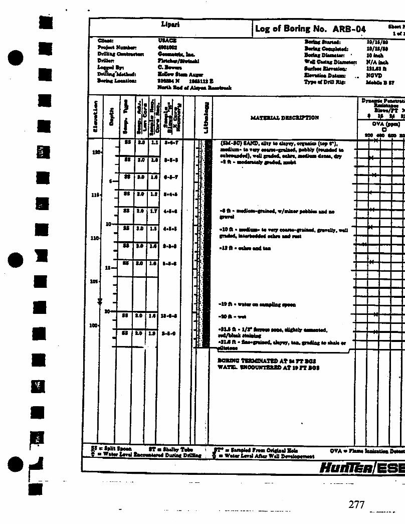
Lipul Log of Boring No. ARB-01 Sheet No. lefl
Client! Project Nttmbef! ©riSing Qantnetars ©Hilar: Logged By i ©rillia&Mtjbod: IcdM toother
VIACS 4901008
rMefaro/SMakl C.BOVOTO XeOtroStma Anger SMTOrN 1808488 S ; KaNtMrfAlaMlMNck
Boring Started: JO/29/89 Mai Completed: 10/19/«9 Bering Plrortw. 8 Inch WeB Oaalng ©lametmt X/A tsefc Surface Slevetioa: U0.T1 ft BIHIIM Ditws NOV© Type ef Drill Rigi •-Mobile I IT
111-
1X0
108
i i
10-
18—
I f
88 ST* 88
88
i i l l in 8.0
10
to to to
8.0
L»
2J0
OA
U
1*
M
To
u
to
M-l
M-T
8-0-11
18-1T-1T
f-18-11
W-T
S-T-S
MAttBIAX, DE8CIUPTIOX
(8M-8C) SAXO. tilty to clayey, »/orgaiu«a (top 4*), •lightly clayey, eoaree-gniaed, erell graded, c/cfttr ealiioundig parol. ochre. looec, alight ly moiat •8.8 ft • flae-gmiaed, madcwtaly pidri. w/mlaor anbwwadcd gro-cl end pebble*, tan •/mottled ochre -4ft- very One- to tine-poised, iotcrbedded ten ood
• 10 J ft • very fine-to veil eroded, nrioot •/too mottUag
- 14ft - «/miBorvefy
groined, moderoteiy quart* groia*, ochre-
groined quartern eaad to i J
rl8ft- +33-8OMM0 TERMINATE© AT 10 ft BOS NO WATER ENCOUNTERED
©yaaaiie Penetration Bmirtaaee Blotn/rr X I 18 »•« 08 OVA (ppm) D 800 400 000 800 44
88 • Split Ipeoo ST a Shelby Tube iff* a Sampled From Original Hale X m Water Level Eneotatewd During Prilling a a Water Level After WaB Devaltpammt
M-
44
M-
44-
ri-
OVA a Flame lonlaatien Detaatm
HurilERlESB
274

Llparl
1
CUaati FnlKtMnkiR Drittiat OesttaeaoR Dritttr: Lasted By: DrttUnx Mathod:
USACE 400100* Log of Boring No. ARB-02
G. Beams •eOoaftamAasar •00410 K 100IOT01 •autkeaat End of Akron I
Botiac Started:
I Dlaawter:
10/16/09 10/M/tS • lack N/Alaeb UMlft
Etoeatlen Batumi MGVD Typaorofdiur. •* MokikBsr
Wall
(SM-SC) SAND, siltjr to clayey, u/ersaaiu (top r)T feaaeatay, medium-to coene^aiBod,uall traded, a/eobfouaded ahart aad quarts travel aad pabblaa. •1 ft • aehia, w/iaciuaaad gravel aad pebbles •4ft. Baa. la oWhua-jrainad, wall u amderetely 1 h* •4 ft - moderately ta paeHy traded. eehm aad taa aaattlad -0 ft - W*wy aeama quarts aaad freiaa, aery amis!
•10ft •flae.daiaod, BMdiuateweU traded, w/ariaor raiy caataa quarter* aaad palm, ochre grading ta red/brewa, medium daaaa.i •» ft • medium^uinad, »/»
10.0 ft »lateibadikd aA BORING TERMINATED AT 10 FT BOB NO WATBR ENCOUNTERED
Dynamic Paaelreti Ecaktsnca BJawi/TT >
OVA(ppm) o 100 400 €00 SB tt-
• W "baity Tuba 0T* • Sampled Tram Ortftaal Sate 9 " Water Urat bceuatarod Dmfat PiMHag f m Wataf Laval After WaU Daealar
• -
OVA i
HurilBm,
275

LI pari Log of Boring No. ARB-03 thaal No. tari
CBaat: Projaet Nuaban Piffling Contractor MDnt X-btdPr DrilUspMathod: MifletMlaii
USACB 4001003 QnuiiliU. l»t-flatabar/SM&att C.Bovan Befiao Staa Augaf MtnN wuni CMW at Alayaa Ktatnck
BMtailMid: lo/so/w io/»/w
Bariac PiaaMtott • lack Wall Cadag DIiiWit N/A lack
ft i PUUB: NOVO
lypaafDimiUfs •AfaMUBlT
i I
$-
lo
ll—
I
f
u
M
IS
i i l l
tp
sp
SA
34
1.0
14
3.0
>4
3 14
14
14
14
14
14
14
04
t-o-i
11-13-13
11-13-14
T-13-11
T-T-T
4-r-r
T-0-14
r-u-is
KATEIUAX. DPSCJUrnOK
(SM-3C) SAMP, alKp *• alight* dam. w/eagaaka (top r). medium- ta eoaiea-gidnad, waUgradad. w/sebiwiaded quaitoaa grerai aad pabblaa, Inwob grading to achra, looae, aeM •3 ft - medium- to otay aoaiaa grained. nr/aubiauadad
gteral bad layer of thwt aad guana aobblea
•I ft - gravel aad pabbtaa baddad (alight* graded), w/flaa grained dapay iaraia
•grained, •10 ft - with 1/3* I ted-Maeb aaad (appaan to ba tereua) •11 ft • dap aoatoat toartaaiag tttk dapdi -13 ft « aoaiaa-gaalaad aaad w/oat goad and pabblaa
ftOMMG TBKMWAItP AT 10 m0« NO WATBK ENCOWTBftJBD
Pyaemia Panatretio*
Blowa/FT X t Oft o OVA(ppn) o too 400 000 000 -#
•to
*-
*•
I fpttt tpaoa IT a Shalby Tuba • Watar toad Baeattntornd Paring Piffling
IT* • taoplad Praia Oitglad Bala f m Watar toad Aflar Wdl ~
OVA B llama
Itoiflfew/BSE
276
Lipvi C&Mrt: AmIMI II. W HljiW 111 MUac DfUtaR tog»J »r DriiWfcfetkod: >nrtw» Ualwu
OTACB 4901003
Log of Boring No. ARB-04 Sheet K let!
flHtW/IWwU C.BMOT BeUov Sicca Auaer
IK 1MI1UE Naeth
Baria* Stwtcdi Boriac CnpiplHd, Bods« Diaaalar: * Wafi eMtaic OImmmr Surface ElcTetioa: flmtiaa Datum: 1>p««rDraiKir
10/ll/M 10/1S/M 10 lack H/A lack 1*14311 NOVO Mobile B17
HuitIkRlE.BE
277

._)• «io rpuji Ese-tntuiNecKiNU HiU I U 14«Md4b33408 P.07
Upari
Cttrat: U0ACE Project Nnmber 4201002 PitUtec OaatractoR Ceomatrix, laa. DrfUen fleteher/Siwiadd UnriBr ftftw Drilling Method; HoOovOtaat Anger Soring Location; 222222 N 1224S22B
tenth Bad afAlapaa Raaatiack
Log of Boring No. ARB-05 Obeet Ne. 10(1
Borta* Started; 10/U/29 Mac Coaphiidi 10/12/29 Boriai OiaoMton SO tech WcB Cootec Diameter N/A tech Intel immiiiii iNji ft Bhvattea OatvaK NOVO lypooCDiutiUr . MobUoftir
120
111
110
t i
I —
10'
12—
i I 05
08
00
00
00
00
00
ft i ft
i 1ft
Oft
2ft
Sft
2.0
2.0
1ft
2ft
V I teft
I
1ft
14
1.4
14
14
U
14
P 2-1.2
«>S-4
«4>4
2-0-4
4.2.0
M4
M4
MATERIAL DESCRIPTION
(8M-8C) SAND, Or to dftfti Wfaaiei (top 4*), floe- to eedlum-grotoed, •/eubrounded wed, light bton to ochn, OHM •2ft • In'rtrilrtiil iihn unit (iociIImiii in w«w IftiiiN) with MbNwM pml and pebblaa •24 ft • 1/2* layer of •lightly aeateatad, red/black, mdium.frdnad, tenia taod
•24 ft • Mack aBfhtlr rai o»d aootf layer a* ten •2ft. IMVMM ochre oad tea, medium to coam-croteod raid arilk greed and pobMw •T ft « 1/2* Mock eaod layer (net cemented) •Oft* Mock Mad laror (aaad frola* am oootod •/Mack) -10 ft - •/•
•10 ft « ctayter. •(raised, pebbly, jrcUow/toa,
BORING TERMINATED AT 12 PT B60 NO WATBR ENCOUNTERED
Dynamic Penetration Raaietanee B1O**/IT X » 12 24 20
*-
OVA(ppm)
200 400 COO 200
M-
44-
2f
I m Split Opooo • Water Lead 8T • Shdby Tuba ST* • OcavM from Origted Hole Purine PHUtox * • Water Ural After Well Partial OVA a RIM laaisatioa DatocUr
HutfTenfBBE
278

Llpari Client: Project Numben DrUlinc Contractor DrUlar: Lotted By: DiOlinc Methods BortnfcLocailoa:
;IACS 490100) Gaoaatita,lM. U Wahloa C.Ro«an BoDowBtamAanr 990900N UMMIB iidiM Ub and
LOG of Boring No. MW-01 TCSngSuHad! Borinc Dlaaatar. WaB Caaint Plana r. tuifhea Slaoatlent Elrrmtien Datum: «9paafMHIU«:
•« 1
100
01
»•
H u
1 •
%R u i{ 94
I . u
*
99 94 1.9 I
99 9.0 14
-
99 94 1.1
-
so AO 14
99 94 14
tk 94 14
m
99 *i 94 to
19.90-90
19.90-49
•f 1 8i
1-9*9
9.14-11
0-1-9
1.1-9
M4
1-1-9
! I
MATERIAL DESCRIPTION
(SM'OC) SAM), «ihy to clayey, tap**' (top 4*), too-to aoaraafteiaad. PMM. »/wbfo«»4ad pebble*. 7*Uev/beown, IOOM,
S| O ntdtan* Nt Btadium-craiaad, a/pwtl and pabWaa, ocbta
-10 ft - oary ooam-gMiaad (4-) prod lap to BHdlun-fralnad (J*), (lading to pebbly pa»d (anbaonndad torotmdod), tan tdoahra, wall aBgbtly clayey
fine- to
-194 ft - »/oiit groTaL eery flae-gralned. poorly graded, achre brooming gray (bottom 9*), *et - water at 194 ft
1 -14 ft-
-19 ft - wary ftne-poieed w/e mkaramw. rad/browa Intorbaddad tilt *Uty gray i
-90 ft - oey ttoe-to oeoiee-petoed, owuew. thyey, ahghily otkaoaooa, fray grading to aabre
>90ft< w/aot oabra and nd/brawa.
BORING TERMINATED AT 99 FT BOO WATER ENCOVNTEREO AT 194 rr MO
Sheet No. 1 of 1
lo/ir/or 10/1T/99 9 lath N/Ataeh 10949 ft NOVO MobUaBOT
Dyaanit Panat ration Bloro/PT X
f V 'I1 V OVA(ppm)
D 900 400 000 090
£a Split Ipoon 9T • Obalby Tuba a Watar Laval Encounttrad Diattg Drilling
9T* • Sampled Trooi Original Sola t * Watar Le»*i After WeB Prretoprment
jtoril&fg/ESB
279

MIMTLLUWNTLLU I/IV
Up*ri Log of Boring No. MW-01A >•« CViiti Pnjwt NiohR DiOliacCea PriOac Lowed »yi DriUiaf Method: IwtaiUtttiaM
U3ACB 4(01002 CaumliU. lac. B. Wihlaa
Bollvr ItoaAimr 33(900N 1MCMI8 Betwaae Lake aad
Baetec tuned:
(I CM* torn MW«0t)
10/11/(9 10/13/(9
Boeing Diwilin 10 lack WillCHlac&iHHto; SIMI lute Bmliw 103.93II Elrvaiiea Datum: , HCVD TypaefDiUlRir Mobile BIT
I I
100'
I—
10—
(0(- -
oo-
Il
ls—
I
I
i 1
3.0
3.0
l i
u
1.T S-3-9
i • *"
MW.01A DRILLED I IT FROM MW-01. SEC LOO or Mw-oi roR UTKOLOOY
-13.43 ft - etatte volar Irwtl odor wall
BORING TERMINATED AT 30 Ft MS
Dynamic P« llaw/TT :
* * * ' OVA(ppa) O
100 400 (00 0
-H
33 m Spilt Speee ST m Shelby Tube ! JT* • Sampled hum Oil* 9 m Water Let! Encountered During DiHttat f m Water teeel Afla Wall
Original Hole OVA a Flam* babalha Date
Ifglflju/BSI
280

UIUITW\|IXI WIV >110 Lipsri
Project Wnmhtn 4001003 OrilUag Contractor: Caoaatrix. Ino. DriOart WtMan/Oriathaw tagged 8y: C. Bowoia Drilling Mtthod: BoDow Stem Angar Boring location: SSSSISN lSSSfSOB
Outiida Bcnctiaiil Betemo
Log of Boring No. MW-02 t irf:
Baring Itutid: 10/11/19 Bering Ooapkttd: 10/11/19 Boring Diaarior. Slack W«0 Coring Diameter: K/A inch Soribea Brrttloo: 9M4 ft Miration Datum: NGVD Typo of Drill Sir Mobile BIT
CM Scant Kn iri Akron ftacottack
1 I
n 10-
11-
»•
I t
99
M
H
1.0
M
OA
1.0
SB
SB
i
1.1
l.t
IB
SB
SB
SB
SB
SB
H
t-s-s
»-»-u
0*44
M4
0-1-1
o-s-o
1-0-0
i I
MATERIAL DESCRIPTION
(SM-OC) IAW, tilty *o clayey, topeoil (top 0*), •/lag* well minded iittlw, dark bww, ieeoe,
-Oft- tan ta yellow/eehre to ran
-0B ft • water ewmmtarad, rety fiao- Olw-piltri.
-10B ft • elightly aleaeeoae. racy Swa-grained, w/eiibangular gravel ot top of cample, taterleyeied gray, yellow, and ted/brawn, wet
•10 ft - nltowaua, oUghtly mottled, HitoHamlnatod
•SI ft - any fine-grained (qoartaoee), w/eoaroe, angular mine, Ughtmr.i
-SOB ft -Si ft-Bght my.
•ST ft < my and iad/hmwn
•00 ft-rad/krawn
-soft
Dynamic Pcnetreti Baoirtonta BJow»/fT X ! f H
OVA (ppm) o no on MO to
M-
*
X-
{Sw SpUtSpoca ST aSbtlby Tuba JT* • Sampled Pram Original Halt OVA • Flame bateaUon Data 1 • Wtahval Encountered Paring Piffling | • Water Loral After Wall Deeetopement
HutilenlESE
281

282

NO>-08-1991 14:00 FROM ESS-ENGINEERING DIU TO 14045463340F P. 12
Llpiri Log of Boring No. MW-02A fbaat Wo. i«ri
CUant: Ptajaal HaahMt DriUlac Cautosctam DrUUr;
DriUinf Matted: loital Uii>lMi
UXACS
WaUau/OrimahMr C.ta« BoOow Statt Auftr »UUN INtmi OutaMa liMtwk Batvaaa CM
io/ii/s« xo/u/w 10 inch
Bariaf liintdi BaatsgCamplatad: Bwiag Diamatan . Wall Caaiag OiacnaiaR 1laeh Suriaea fltritigtr 96.44 ft ffitallau Datum: T)rpt uf Drill Rig;
Rim andAkrouUka (6 CM* AWMW-M) NGVD MobOaBIT
i 1 !
»— W '
to
ll—
lo
ll—
I
i j i ! in
i MATSRIAL DSSCRIFTION
i • \ -
iii jljilji 3Si!
BORING DR1LLSD 0 FT FROM MW-Ot . SEE LOG or MW-OI roR tmioLOGY
-41 ft • utatk vataf lawl aftar ««8 4avatepamaat
BORING URMINATSD AT SIS fT BOS
Dyuaaie Paaatfatiao Raaiitania Blaart/TT X
0 £B n OVA (ppmj Q
too 400 ooo see
,S> Split Spoaa ST • Stetbr Tuba m Walar Lara! Bsaauataaud During DHW—
ST* a Samptad frea Orifisal Halt ft • Wstai Laaal Allaa WaB Daaalapaupt
OVA " run* iawliUlao D atari ar
HuriTenlESE
283

Lipid
Olinl: Praia* Hasten DitUtaf Contract* Mitel l«cc<4*r> Drlllinc Matted: ltein\a«»Hani
USAGE 4901003
Log of Boring No. MW-04 SbMttk. Sato
Pleteter/Slariaaki C. Iwni Hutlir- Itim rtiim 930340 tt MOIOlt E •tek EMIdlMdiMk (laaada)
Mac Started: 10/34/99 Boriac Cawplatad: 10/31/99 Bofiac Otenataf: 10 inch W«B Caaiao SUiMtan I inch MM Biwilit! 131.01 ft BluaUtai Datiua: K0VJ> TjrpacfMllIU*! -MabOeBlT
<4
1 r 1
I
!
v i? n * ! i
n a Split Spaaa ETa Shelby TMte g a Water Laval Enaonnterad Baria> DI""-T
MATERIAL DESCRIPTION
WATER ENCOUNTERED AT I» rr BOS
Jf B Saaplad tea Orictaal Bala ft B Waiar Level After W«H Pavalapanwat
Byaank Paaatratiaa Blaaa/FT X f M M 93
OVAjppm)
900 400 000 900
OVA b flaaw laataaHoa Dataataa
ifglflfew/ESB
284 i

NOO-0B-1991 14:04 FROM ESE-ENGINEERIhC DIU TO 14045463340 p. 03 Lipnri
Cliwtl DrtlUnf Contract* DrfUar. t*o4lri DrOlta* MaUutd:
USACS «MW
Log of Boring No. MW-05 Sbaat No. tors
Ptotthe/Siwiaakl Hollo* Stem Aanr MN1N UMIMI Outride Aicyoe Racetrack by Craadataada
Ma« Started! 10/11/19 Boring Oo np tot ad: 10/39/19 Bering Diameter. 10 inch Writ Carinc Plamatari I inch litrfw Blaratiaa,1 1NM It Btoeattoo Datum: NOVD IVpe of Drill Rig: - Mobile B17
130
139
330
US
UO1
I00<
10-
1$.
so«
se
es
ss
u
1.0
M
•4
S4
34
1.0
14
14
14
14
0-9-*0
l-M
4-4.5
4-4-0
o-T-r
(SM-SC) SAMP, rilty to clay ay, topaoil (top 9*), medium- to two raa. grata ad, w/aubtvtindod pebblae, y«Uo«/brawn, tooaa, aaotot •14 to • ft - quiitaeoa grard toyor. eUgfctly cemented, w/oeam-grilned aaad, i
•10 It. -Stained, dark tan w/yoltov/oohrc
•1S4 It • medium- toc v/reuadedte
-30 It - Madly toamy booioi gained. */i •ubrotmded pebblae and minor day iachmiene,
-30 ft-
-SO It • v/btorbeddad good
•S4 O • rery < */cabMaa —rf -I— M/twai, 'f*®.. ST • Shdby Tube ST* • Sampled PeaOriginal Bale OVA*
9 • Wear Laval Baeountotod During DrilMag j • Water Laval After Wall Ptvalor-T*
•0
00
04
HuriTknlESE
285

NOV-00-1991 14:05 FROM ESE-ENGINEERING DIU TO 14045463340 p. 04 Liptri
CHMU Pujwt Number: Drilllm Ceetractr Driller: Tnurd Byi Dlillln^Method:
USACZ 4102003 Oninitite. lac Fletelter/SiwimU C. Iwn Better Stem Axer 834*41N llOOOItB; ftmifcAlqwIinHMl by
Log of Boring No. MW-05 Sheet No. taro
Serins Started: 10/11/(9 Sarins Completed: 10/29/19 Beriftf Diameter • 20bcb WaB faatnc Diameter; 2 inch turlaea Blevaiioa: ISOBtft Bkretiea Datum: NGVD Type «f Drill JUr MoUlt 81?
J
too.
w
01
n<
40-
42- ss
to
st'
ST
SS
2.0
3.0
SB
3.0
3.0
SB
SB
SB
IB
SB
3.0
SB
SB
IB
SB
SB
1 i
2-t-t
0*3-1
4-S-4
I-S-t
s-r-it
MATSR2AL DBSCUFTION
•80B ft - 3/3* layer laeaeiy ted, black, veir •oeMaateaalpwd •M.T ft - laa -ST.43 ft-static water level after wall deveiepcmeet
•40B ft • 3/3* black eaad and (ravel layer a* above -40.0 ft • very fine-fraiaed, w/tetcrlomlaUtod (ravel clay, laminated rvd/brvem and ochre, elifhOy
-41 II • vary fine* to flac-tralaad, akfbtly id iitbt (ray, wet,
-SOB ft - very flne-fralaed, (ray, w/few echrt laminae
-SI ft • dark (ray,
-BOft-elsyier
3? "if1!' *f°°*. _ ST • Shelby Tube Jf* w Sampled From Orilbal f • Water Level Encountered During PriUbg g » Water Ural After Well Devil rrimenl
DrnemicFeaetrallatt Resistance Btewe/rr x * » « » OVA (ppm) o 300 400 000 tOO Nt
IH
*
Bole OVA = Flam* tadtietiea Detecter
HuiiJenfESE
286

*•»* **** »>iw rrujrt i-ciiuirceniriu JJIv iu 14IMS«bA34U p.k9b Llporl
Ctau PnjNt Number: Drilling I Mhn LecoedBr: Prolyl
Log of Boring No. MW-05 Sheet Nc lift
USACX 4001000 Oeeoitrh, tae. Tleteher/SierlMk! C. Severn HoUew ft—Anyer S80001N Willi E Oalelde Akjroa Racetrack bp OrenSeteade
Borin* Started: 10/13/89 Borioo Completed: 10/39/89 Borfet Wiaiiew 10 iaeh WeB Ceainf Diameter: S fob Surfeoe Etorctiee: IMS! ft Eteratioo Datum: NOVO Tppe e< DrillRlgi - MehOcBIT
I ! !
i j
n & n
f MATERIAL DESCRIPTION
Dpseatlc Pesetratie Bleee/PT X
OVA(«w) O 000 400 000 000 Mf 08 0.0 u 0>M
0.0 1.0 4-0-13
so 0.0 0.0 00
1-0-11
-TO ft - lilt srejr, »err
-00 ft « dark otto/onr. ell(blip, i
BORING TERMINATED AT 08 PT BOS WATER ENCOUNTERED AT 04 rr BOS
-If
SS n Split Opeoa f » Weler Level
0T « Shelby Tube Durini DrilMni ST* > Sampled Prom Orifiael Bale j e f — -1 Water Le-el After Well Drulapeancel
OVA m Plane TnnlieHwn Detacto
tflfriRH/ESE
287

Ltpftri UOACE
Log of Boring No. RB-05 ShwlNo, lift
CliMl; Projaet Nt X>iillia< Coal Mikes Un^Br Drilling Mrtood: IWIIIIDIIIIibi
rUaohor/Mwtaakl e. miuN UMUt Owlwi B—d by »iwHwk
BortagSOrtad: X0/O9/O9 10/»/W Blach *"*W Mlnt ft'*irn*Tr N/Atawh Barftao Betokens UMX ft tlwlM n*Mm NOVO Type* DriDlUc IMIkBir
XI*
110
I
I «l
so
li XX
1.0
sx
XX
XX
XX
M4
MATERIAL DBICRIPTIOX
(M4C) 9AM>« ftHf M clajrtjr, wfMfc (top 4*), flat.
-tn«Udkil •Oft* XtooiiMi a/a i.«ChM •4ft • fiat- to •I ft • puri Mi v/mI BO IUHG TBRMDCATED AT 0 FT BOO K0 WATER ENCOUNTERED
ftyMatc Fttatntin Eton/FT X I MM U OVA (ppta) o
000 400 000 000 to
44
IpUt a Wttwiml
IT a 8b«tVT Tub* JT* a OanpM Fie» Original Bate During PrUMag * a Witor fcttol After WeP Dowlaprrat
OVA a Fleaa ImiaaUaaDrtocter
HurilenlESE
288

*-'L 4 • ' •—L
4 M B • • '• •
to oo *o

-BT-T M M .u.
SOIL CLASSIFICATION RECORO SHEET
LIFMJtf LfiMCPtU. 4901002 110. SI ft 16 ft ns Manic
MO mter
ft 1? Sllty to cUywy sand SM-ae MeJii— trt ffHllWl rtth
UL2 gravel ana pehhlea, btan, wedUii dense, slightly nolat
J1 JE Slits Hi rlayy «»»i SMT
Pino to Mtfw otalnrd- nrW trim rrf*l«>- ton— STNLLAR FN IWPLA 11 UHLL 1 noilst
K> vo o I

«•*' *tfOi - ? s s < SOIL CLASSIFICATION RECORD SHEET
(inn uNDPiu. 4901002 117.73 ft 16 ft BBS HtaaMR .
No encountered
miM
JL Silts In diw» «d tu.tr **•*'•• *"1 •wist, loose
J2. Silts to el, •3 with 1/r layers of grained, red/Mack sand M Silts to clwav sand flMC Qaars? Jnteti?9ddej yjjl| ytff. dgwy «n w" coarse, red/black cemented sand layers
-
to vo
5


f •„ J J SOIL CLASSIFICATION RECORD SHEET
TSP5 UfW UHVU 4901002 102.92 ft 32 ft BBS Nf-0t fWliitllU
13.5 ft BBS
i* Of
22 SUtytodawrwri a*-9C Pine to ooarae grained with aufcranded pebbles. wllow/bnm loose 12 Slity to clayey sand ai-SC Vtay coarse grained grading to Una to Medium grained.
grading tn-i mint..
to vo •o M


NOO-08-1991 14:01 FROM ESE-ENGINEERING DIU TO 140454033404 P. 14 Lipari
UOAC* 4901003
fletaber/SMaakl
Log of Boring No. MW-04 UNI HE Ul
DeUkit tiw«d Byi DriUag Method: Bwlajlaatlw! 9M940N 1900010ft
South Bed odUeotraek(laa(de)
BoriagStanedi 10/34/09 li 10/U/09
10 lack Well Caatag Pit me ten I iaeh
1114111 NOVO
TlnwafMBIttr .MebOeBOr
MATEMA2. OBOCJUPTION
(SM-SC) SAND, eilljr to elerer, offanie (top (*), medium to eearae'*graiaed, v/eobaagular to NbnnM (mO and euViiumded pAMa, H! graded, medium beoom, medium deaee, allghliy amiet • 0 ft • intieeeed (tap no • dft«<
0 (I • V/OMM (paralbly Im), DM* to graiaed, rad/brava layera (1/r thick)
•0 ft • •94 Ik• pebble and gravel tod •10 ft • laterhadaated rd/km aad ectara, w/flae-graiaad raad aad white elap laotlaae* ••MlaaolAtH (A W |HMV •IS ft • fiae* to medium* graiaed, todwtalp graded, Intaibodded rad aad ockra
- 10 ft • medium to raarae graiaed, faitetbedded eetara aad lod/biewa, (lightly adeaeaaua, poorly graded, met *1140 ft • Itatic water level after wall i •U ft • ialerbedded taa, rad/beowa. aad eetara •194ft.
Dyaeah Peaatntiaa 81ewe/FT X * » * »
OVA(ppm) O
OaSpU ? • Wata • ST • Shelby Tabe v " Water Iwd Bacaaaurad PaHag PiflBat
JV m Sampled Pram prigfaal Bah g = Water Level After Well Developemaat
-M
M-
OVAi
Hurflenl
296 TOTAL P. 14

• 11
SOIL CLASSIFICATION RECORD SHEET
uma UNfu. 4901002 121.01 ft 34 ft BGS
18 ft BGS
Silty to clayey sand 84-SC Fire wadUwi grained, IrtetMM red and odse, -jh
*
»• to vo -o