1999 MASTER PLAN UPDATE Chapter 4 - Milford NH |
121
Town of Milford MASTER PLAN Adopted October 19, 1999 Updates : May 08, 2007 September 16, 2008 February 23, 2010 July 17, 2012 December 27, 2016 Office of Community Development Reformatted May, 2010
-
Upload
khangminh22 -
Category
Documents
-
view
0 -
download
0
Transcript of 1999 MASTER PLAN UPDATE Chapter 4 - Milford NH |

Town of Milford
MASTER PLAN Adopted October 19, 1999 Updates : May 08, 2007 September 16, 2008 February 23, 2010 July 17, 2012 December 27, 2016
Office of Community Development Reformatted May, 2010


MASTER PLAN UPDATES
Recreation – Chapter 8 Adopted on December 27, 2016 Prepared by: Town of Milford Planning Board & Recreation Dept/Commission
Members Alternate members Staff Chris Beer, Chairman Veeral Bharucha Lincoln Daley, Janet Langdell, Vice-Chair Jacob Lafontaine Community Development Director
Paul Amato Mark Fougere, BOS alternate Shirley Wilson, Tim Finan Administrative Assistant
Douglas Knott Arene Berry, Susan Robinson Recreation Director
Kevin Federico, BOS Rep
Transportation - Chapter 4
Adopted on July 17, 2012 Prepared by: Town of Milford Planning Board
Members Alternate members Staff Janet Langdell, Chairperson Susan Robinson Bill Parker, Tom Sloan, Vice-Chair Malia Ohlson Community Development Director
Paul Amato Gary Williams Shirley Wilson, Chris Beer Mark Fougere, BOS alternate Administrative Assistant
Steve Duncanson Judy Plant Katherine Bauer, BOS Rep
Housing - Chapter 7
Adopted on February 23, 2010 Prepared by: Town of Milford Planning Board Members Alternate members Staff Janet Langdell, Chairperson Meghan Bilz Sarah Marchant, Tom Sloan, Vice-Chair Steve Duncanson Town Planner/GIS Coordinator
Paul Amato Susan Robinson Shirley Wilson, Chris Beer Gary Williams Administrative Assistant
Paul Blanchette Nate Carmen, BOS alternate Judy Plant Katherine Bauer, BOS Rep Community Facilities - Chapter 3
Adopted on September 16, 2008
Prepared by: Community Facilities Committee & Town of Milford Planning Board
Members Staff Janet Langdell, Chairperson Tom Sloan, Vice-Chair Sarah Marchant, Paul Amato Chris Beer Town Planner/GIS Coordinator
Paul Blanchette Judy Plant Shirley Wilson, Susan Robinson, Alternate Tim Finan, BOS Rep Administrative Assistant
Katherine Bauer, BOS alternate
Community Character - Chapter 1 Adopted on May 08, 2007
Prepared by: Town of Milford Planning Board
Members Alternate members Staff Walter Murray, Chairman Ben Frost Bill Parker, Janet Langdell, Vice-Chair Judy Plant Community Development Director
Paul Amato Susan Robinson Shirley Wilson, Chris Beer Steve Sareault Administrative Assistant
Paul Blanchette Mike Putnam, BOS alternate Tom Sloan Tim Finan, BOS Rep
1999 Master Plan Update, inclusive of the Milford Conservation Plan, Adopted on October 19, 1999
Prepared by: Town of Milford Planning Board Walter Murray, Chairman, 1999
Vivian Barry, Chairman, 1995-1999
Steve Sareault, Vice-Chairman Laura LaRue
Paul Amato Alan O'Neal
Chris Sturges Mark Fougere
Noreen O'Connell Dave Albert
George Infanti, Selectmen's Representative
Staff: Bill Parker, Director of Planning and Community Development Shirley Carl, Administrative Assistant, Planning and Community Development


6
1999 MASTER PLAN UPDATE
Town of Milford, New Hampshire
INTRODUCTION
The 1999 Master Plan Update presents to the Town a reflection of current attitudes, goals, and actions designed to guide Milford's land use and planning decisions into the next century. This Update is meant to build upon the 1993 Milford Master Plan which stated that the Town must "... plan for the integration of community development which balances residential, industrial, and commercial growth while at the same time realizing the need for educational, municipal and recreational services.
The 1993 Plan was drafted during an economic downturn across the state and region. Growth and development had slowed considerably from the accelerated and inflated pace of the 1980’s. However, by the middle of this decade, the economic downturn of the State and New England reversed itself and the Town's economy followed suit. Residential building permits increased once again and new home construction has continued at a steady rate throughout the last five years. Concurrently, new and expanded commercial and industrial development kept pace. This development, despite being beneficial to the local economy, also presented signs that if left unchecked it could threaten the natural and built characteristics and attributes that make up the fabric of the community.
Perhaps galvanized by its 1994 Bicentennial Celebration and recent downtown revitalization efforts, Milford citizens have taken steps within the last five years to further enhance its quality of life. Parks, trails and conservation areas are being expanded and schools are undergoing renovation and new construction to meet the needs of a growing population. However, Milford must still face the challenge to find ways to build a balanced property tax base, protect its historic and natural resources, lessen traffic congestion, and provide the services and facilities appropriate for and desired by its citizens.
In May 1997, the Milford Planning Board, charged with undertaking the recommended five-year update of its 1993 Master Plan, engaged a broad-based group of thirty concerned and committed citizens to examine issues associated with community character, water resources, community facilities, traffic and transportation, and economic development. The 1999 Master Plan Update is the result of the dedication and work of these individuals. This Update is not a compilation of statistics and data (better left for the next cycle to be based on 2000 Census data) but instead focuses on the desirability and necessity for the Town to “grab hold" of its future and implement sustainable goals and policies.
To achieve this end, the Milford Planning Board has adopted the following overall philosophy for the 1999 Update that builds upon the foundation of the 1993 Master Plan:
To develop a pro-active, organized and deliberate approach to enhance and protect the character and resources of the Town and Community for both the present and the future.
In its approval of the 1999 Master Plan Update, the Planning Board commits to an annual review of the plan, with input of citizens, to determine the progress made to achieve its stated philosophy and goals.

7
Contents Chapter 1: COMMUNITY CHARACTER: .................................................................. 8
Chapter 2: WATER RESOURCES ................................................................................ 15
Chapter 3: COMMUNITY FACILITIES ...................................................................... 18
Chapter 4: TRANSPORTATION ................................................................................. 43
Chapter 5: ECONOMIC DEVELOPMENT ................................................................ 66
Chapter 6: THE BROX PROPERTY ............................................................................. 70
Chapter 7: HOUSING CHAPTER ............................................................................... 72
Chapter 8 RECREATION .............................................................................................. 96
Maps MAP 1: LOCAL OR STATE ROADS (March, 2000)
MAP 2: ZONING DISTRICT BOUNDARIES (March, 2000)
MAP 3: GENERALIZED LAND USE (March, 2000)
Attachment: MILFORD CONSERVATION PLAN
MILFORD MASTER PLAN Chapter 1
Community Character (2007)
8
Chapter 1:
COMMUNITY CHARACTER: The Character of Milford and The Community’s
Vision for the Future
I: INTRODUCTION
In 1999, the Town of Milford recognized in its Master Plan Update that the Town’s greatest attributes are its strong sense of place, its distinct identity, and its responsible and caring citizens. The Update acknowledged the importance of being vigilant in creating and enforcing land use policies and planning strategies recognizing that:
- The community’s strengths must be protected and not taken for granted, - The community must share a sense of responsibility and stewardship to insure
that all changes in the community meet the needs of present residents without compromising the opportunities for future generations;
- The community must steer itself in a positive direction that is not subject to
“outside forces” that determine a negative direction of change;
- The community is influenced by regional growth and development and in turn influences regional growth and development;
- A conservation, recycling, historic, cultural, and resource protection ethic is
necessary to sustain natural and historic resources for future generations;
- A strong and diversified economic base is necessary for the continued health and prosperity of Milford’s citizens, businesses, and neighboring communities.
Since the adoption of the 1999 Master Plan Update the Town has continued to experience a steady rate of population growth and commercial development that seemed to outpace efforts to implement strategies to manage the impacts of this growth. However, most of the recommendations for action included in the 1999 Update have been addressed. A synopsis of these actions follows.
II: STATUS OF 1999 MASTER PLAN UPDATE ACTIONS
The Planning Board, with the help of interested citizens, carried out several of its recommendations from the last Update. Following is a brief description of the status of each action item as of April, 2007:
HIGH PRIORITY – ACTION: A
Revise the Town Sign Ordinance
A committee was established by the Planning Board in 2002 to undertake the task of reviewing and revising the 1993 Sign Ordinance. A draft regulation was developed, and was presented for public hearings in the fall of 2003. At that time there was significant public input that identified areas of concern in the ordinance. The Planning Board, in December

MILFORD MASTER PLAN Chapter 1
Community Character (2007)
9
2003, decided not to present a revised sign ordinance to the Town on the 2004 warrant. After obtaining public input at that time, the Board decided that it would continue to refine the ordinance based upon input from the public. This effort was sidetracked soon after as the Board decided to instead tackle the issue of residential growth management.
In the fall of 2005, the Planning Board revisited the sign ordinance prepared in 2003, made modifications, held public hearings, and presented it to the Town for a vote on the March 2006 warrant. After adoption of the 2006 sign ordinance the Board received feedback from the community and legal counsel suggesting a new ordinance would need to be crafted. In the fall of 2006 the Board held a public hearing to decide how to proceed with a new ordinance. The Board formed a subcommittee and developed a new ordinance in conjunction with an attorney to better meet the needs of the community and recent legal precedent. Public hearings were held in January of 2007 and a new ordinance was adopted by voters in March of 2007.
Status: The voters approved the new ordinance presented on the 2007 Warrant.
2.01 HIGH PRIORITY – ACTION: B
Develop and Implement an Open Space and Conservation Zoning Overlay District and
Subdivision Design Criteria
In March 2000, based upon committee work spearheaded by the Conservation Commission, Town voters approved a new section to the Zoning Ordinance entitled “Open Space and Conservation Zoning District, Section 6.040” (OSPD) with the intent of creating residential developments that promoted preserving of environmental resources, minimizing negative impacts on environmental resources, preserving natural and historic features, providing recreational opportunities, promoting flexibility of subdivision design, and discouraging sprawling, land-consuming development. The ordinance received minor amendments in 2004. Since its adoption in 2000 through December of 2006, 13 major single-family home residential developments were approved subject to the OSPD. This has resulted in the permanent preservation of over 343 acres of open space.1 The Planning Board continually reviews the implementation and effectiveness of the Ordinance. Status: To develop and implement an Open Space and Conservation Zoning Overlay
District has been accomplished.
1 Subdivisions of 5 or more single-family lots approved in the period between March 2000 and December 31,
2006 and the corresponding area of open space approved as part of each subdivision includes the following: LeAnn Drive, 16 lots, 6.6ac.; Trombly Terrace, 6 lots, 4 ac.; Riverlea Estates, 8 lots, 9.6 ac.; Federal Pointe, 40 lots, 54.9 ac.; Christmas Tree Farm Estates, 18 lots, 9 ac.; Wallingford Place, 24 lots, 48 ac.; Rotch Subdivision (Melendy Road), 6 lots, 40.4 ac.; Elite Construction (Boynton Hill), 7 lots, 6.3ac.; Patch Hill, 37 lots, 34.7 ac.; Falcon Ridge, 45 lots, 68.9 ac.; Wyman Farms, 12 lots,14 ac.; Singer Brook, 11 lots, 19 ac.; and The Reserve at Federal Hill, 73 lots, 27.8 ac.

MILFORD MASTER PLAN Chapter 1
Community Character (2007)
10
2.02 HIGH PRIORITY - ACTION: C
Develop site design, architectural, and landscaping design standards that include
mechanisms to protect and enhance Milford’s historic heritage, established
neighborhoods, major arterials, new neighborhoods, scenic roads, and entryways
into the Town
Since the 1999 Update, the Planning Board found that undertaking the task of developing site plan and subdivision standards, guidelines and regulations to better protect and enhance Milford’s character is a major endeavor. The Planning Board has incorporated minor amendments to the Town’s development regulations to better regulate signage, exterior lighting, snow storage, and dead-end road specifications. Scenic road regulations were developed by staff in 2004 and presented to the Board, but growth management initiatives were deemed a higher priority. A subcommittee is in the process of a comprehensive overhaul of the Subdivision and Site Plan Regulations. Status: To develop new site design standards to protect and enhance Milford’s character
and heritage is in process with a goal completion date of early 2008.
2.03 HIGH PRIORITY – ACTION: D
Develop additional avenues to enhance communication between town government
and boards, the school district, community organizations, and private citizens
During the master planning process leading up to the 1999 Update, there was much discussion within the citizen committees working on the plan that there was not enough communication between the various stakeholders in the community. Issues such as facility maintenance, management, and joint use, property taxes, duplication of effort, and the need to create better avenues of communication were identified. Since 1999 there have been significant efforts made to provide better avenues of communication between various entities which have manifested themselves in such ways as establishing a joint School/Town/Recreation interests committee to review the state of recreation facilities in Town and provide recommendations within a short-term recreation facility plan; the establishment of a Town website; the use of a quarterly newsletter as a communication piece for both Town government and the School District; continual refinements in the annual voter’s guide; community signage at the Transfer Center; 5th Monday forums with the Board of Selectmen; the implementation of a community cable channel, and in general increased efforts between boards, departments, commissions, and citizen’s groups to better communicate. Status: To establish additional avenues of communication between Town stakeholders as
been significantly achieved and continues to be implemented.
2.04 HIGH PRIORITY – ACTION: E
Develop an ordinance regulating adult entertainment businesses
At the time of the 1999 Update, there was no ordinance in Milford that defined and regulated what is commonly referred to as “adult entertainment” and “adult business”. To be proactive rather than to wait for potential negative public reaction to the location of adult businesses in Town, an ordinance was developed, presented for Town vote in 2000, and adopted.
MILFORD MASTER PLAN Chapter 1
Community Character (2007)
11
Status: to develop an adult entertainment business ordinance was accomplished.
2.05 HIGH PRIORITY – ACTION: F
Review, and revise where necessary, existing Town regulations governing wireless
communications to reflect changing trends and technology
At the time of the 1999 Update was being developed, the telecommunications industry was moving at great speed in its technological advancements and in its efforts to provide ever-increasing service to customers. This resulted in pressure from the communications industry on the community and the region to allow construction of cell towers. Milford did not have a regulation in place in 1999 that could adequately address the many issues associated with the construction of telecommunications facilities, and a goal was set to develop and enact regulations that balanced the Town’s desire to protect its environment and character with the need to stay current with the technological advances in the telecommunications industry. An ordinance was subsequently developed and presented for Town vote in 2000. Status: To review and revise existing Town regulations governing telecommunications facilities was accomplished. An ordinance was approved by Town voters on the 2000 Warrant.
2.06 MEDIUM PRIORITY – ACTION: G
Examine and implement measures to change the Milford governmental form from a
Board of Selectmen to a more responsive representative form of government
Citizen committee discussions during the formulation of the 1999 Master Plan Update identified the need to evaluate Milford’s form of government and its ability to serve the needs of the Community. These discussions were based on concerns resulting from the Town’s growing population and whether the recently enacted Senate Bill 2 provisions replacing the traditional town meeting form of government with a deliberative session and ballot voting provided an adequate governmental structure. The Planning Board made it a goal to encourage the Board of Selectmen to appoint a citizen committee to review this issue. The Selectmen formed a committee in 2003 and charged it with “A study and assessment of the various forms of government including changes that could be made to our existing form of government allowed in New Hampshire and determination of whether the current form (RSA 40:13) is suitable for the Town now and as it continues to grow, including both town and school government in the study and analysis Note: Based on the Nashua Regional Planning Commission projections, the population of Milford stands to grow from approximately 14,000 now to approximately 18,000 over the next twenty years.” The Government Study Committee issued a report to the Board of Selectmen dated July 12, 2004 and the conclusion was that “…the committee does not recommend significant changes in the form of government for the town of Milford at the present time”.
Status: To examine the Milford form of government was accomplished.
MILFORD MASTER PLAN Chapter 1
Community Character (2007)
12
2.07 MEDIUM PRIORITY – ACTION: H
Develop and implement a long-term management plan for Osgood Pond
The maintenance of Osgood Pond, particularly the dredging of the Pond to maintain its integrity as a surface water, storm drainage, historic, and recreational resource has been an ongoing priority for the Town. As of December 31, 2005, the Town had set aside $88,705.85 in a capital reserve fund to provide at least a portion of the required Town match for federal funding to dredge the Pond. Since 1999, the Town has been working with the Army Corps of Engineers to design and implement a plan to dredge Osgood Pond. Currently, the Osgood Pond plan incorporates as part of the Town matching fund requirements earth materials from the Town-owned BROX property to be mixed with dredged materials to then be used to reclaim disturbed wetland areas at another location on the BROX property. Final details of this project are still pending, and the project is on hold at the Army Corps of Engineers level due to lack of funding due to competing federal priorities. Status: To develop a long-term management plan for Osgood Pond has been partially
accomplished and not yet implemented. III: CURRENT COMMUNITY CHARACTER ISSUES
As stated in the Introduction, since 1999 the Town has continued to experience a steady rate of population growth and commercial development. This growth has also brought about increased public awareness that the Town still faces threats to maintaining its community character. The Planning Board, with the approval of voters in March 2005, implemented an Interim Growth Management Ordinance (IGMO) to afford the Town time to develop a formal growth management ordinance for Town vote in 2006. One of the over-riding reasons for this action was to determine what Milford’s “character” is, and what actions to take to insure that future land use policies protect it. As a basis for laying the foundation for the GMO, the Planning Board distributed a Community Vision survey in May 2005 to find out…
“…why you live here, what is important to preserve and make better, and what you want Milford to be like in 10 years or more.”
The simple survey, seeking to get a general view from residents on how they perceived the character of the Town and what they hoped the future character would be, was widely distributed in The Granite Town Quarterly, a newsletter from the Board of Selectmen. Three hundred and sixty surveys were returned, representing a 5% response rate. Results of the Community Vision Survey indicated the following:
- People live in Milford because of its rural character, community feel, and it’s a good place to raise a family.
- Residents feel it is important to preserve and protect the rural character, the historic character, and a clean environment.
- Residents feel it is important to enhance and improve the rural character, a clean environment, the historic character, and the Town’s natural resources.
MILFORD MASTER PLAN Chapter 1
Community Character (2007)
13
- In 10 years, people want Milford to look the same as it does now, presuming this means protecting the existing rural and historic character, and have less traffic and less signage.
- Residents feel Milford is now a “large town”.
- Milford residents overwhelmingly have community pride.
- Milford citizens believe the Town needs stronger regulations to control and enhance development, presumably to protect and enhance rural character, and protect the environment.
- Milford citizens believe that there should be stronger regulations, even if private property rights are affected.
- Milford citizens are evenly divided on their support of stronger regulations if it means housing becomes unaffordable.
A growth management ordinance was adopted by Milford voters in March 2006 which included findings on the current residential development trends in Town that necessitated the need for tools to manage the rate of residential growth. The ordinance cites that “new residential development is having a rapid and adverse effect on traffic and open space, and there is a perception that the community is losing its character”.2 IV: MILFORD’S VISION STATEMENT
According to NH RSA 674:2, the purpose of a Town master plan is to set down as clearly and practically as possible the best and most appropriate future development of the Town. The master plan must incorporate a vision section that serves to direct the other sections of the plan, with statements and guiding principles that articulate the desires of the citizens. Based upon community input, and building on the 1999 Update, the 2007 Master Plan Update states as its vision: Through responsible management and promotion of individual and community
stewardship, Milford will be a sustainable community rich in physical, cultural, economic and social diversity, and will be characterized by a small-town atmosphere; a vibrant downtown; an active business community; human scale, interconnected neighborhoods; local agriculture; and the preservation of natural resources, rural landscapes and historic features.
V: ACHIEVING THE VISION: GOALS AND ACTIONS
The 2007 Master Plan Update has identified the following goals and actions that shall form the blueprint for attaining the Vision: Goal No. 1: Ensure that downtown Milford (Union Square, the Oval, and
adjacent neighborhoods) remains the commercial, social, and community hub of Town by protecting its historic character, promoting and enhancing its economic vitality, and integrating the Souhegan River and its tributaries into the public realm.
2 Milford Zoning Ordinance (2006), Article XII, Sec. 12.002.F.1.

MILFORD MASTER PLAN Chapter 1
Community Character (2007)
14
Actions: 1. Design and construct the South Street Improvement Project – Phase I from Union
Square to the South Street railroad crossing, (2006 – 2008)
This project is a continuation of downtown revitalization efforts begun by the Town in the early 1990s. In 1995 and 1996 the Union Square Revitalization project was accomplished, which included vehicular and pedestrian traffic safety enhancements, period lighting, landscaping, and infrastructure upgrades. The South Street Improvement Project – Phase I is a continuation of a portion of the Union Square Project which was not carried out due to a lack of funding. The South Street Improvement Project will continue safety and aesthetic upgrades with sidewalks and pedestrian components, undergrounding of utilities, and street widening. Funding will include federal, state, and local sources.
2. Promote continued economic revitalization of downtown Milford by:
- developing and implementing site design standards that reinforce and protect the historic character and human scale of downtown and which allow flexible mixed-use creative redevelopment, (2007 –2008);
- continuing support and commitment to the Milford Main Street Program / Downtown Ongoing Improvement Team (DO-IT),(ongoing);
- developing and implementing strategies to increase public awareness and access to the Souhegan River and downtown parks and green spaces, (2008-2009)
Goal No. 2: Foster the traditional character of Milford’s neighborhoods by encouraging a human scale of development that is similar in setbacks, size, and height, and that is comfortable and safe for pedestrians and non-motorized vehicles while allowing for an efficient and safe roadway network.
Actions: 1. Review and rewrite the existing zoning ordinance to reflect the intended character of
Milford’s residential, commercial, and industrial neighborhoods relative to height, lot coverage, setbacks, and allowable uses, (2007-2009);
2. Review and rewrite the existing subdivision and site plan regulations to reflect the intended character of Milford’s residential, commercial and industrial neighborhoods (including all entryway corridors and gateways) relative to architectural and historic heritage, landscaping, stormwater management, traffic management, scenic roads, parking, and allowable uses, (2006-2008);
Goal No. 3: Preserve the rural landscape in Town, including views, stone walls, historic structures and sites, forests, farmlands, wildlife habitats and corridors, water features and resources, and scenic roadways.
Actions: 1. Identify and prioritize those components of the rural landscape that are critical to
preserve and review, and revise the land use codes to incorporate innovative land use techniques to preserve these components while respecting private property rights.
2. Complete the Osgood Pond reclamation and management efforts by implementing the dredging and wetland reclamation plans developed by the US Army Corps of Engineers.
MILFORD MASTER PLAN Chapter 2
Water Resources (1999)
15
Chapter 2
WATER RESOURCES
Milford Water Resources Philosophy
The community of Milford recognizes that protection of surface water and groundwater
resources is fundamental to its continued health, safety and well-being, both at local and
regional levels. The Town must continue to insure that water resources are protected for
current and future residents, through community supported regulatory and education efforts
that increase awareness and action on protecting water for drinking, conservation, the
economy, and recreation.
As stated in the Milford Conservation Plan, water resources, including rivers, streams, lakes, ponds, wetlands,-aquifers and floodplains, are among the most precious of a town's natural resources: Water is the most precious natural resource. New Hampshire RSA 4-C:22.I states that a municipality may include in its master plan a local water resource management and protection plan, or local water plan, as part of the municipal master plan (RSA 675:9). Implementation of local water plans must be through the adoption and enforcement of ordinances consistent with the plan and through such other measures lawfully available to a community. Milford's wetlands and aquifer protection ordinances, when utilized in conjunction with State and federal protection measures, provide a strong foundation for water resource management. However, there is no formally adopted water plan for the community that reflects a holistic approach to managing watersheds.
The 1999 Master Plan Update recognizes the need to continue strengthening water resource protection and management. To accomplish this, efforts need to be made at a regulatory level and through increased public education. This effort must be made by both the municipal government and by the individual citizen. To put the water resource philosophy into action, the following actions are recommended: II: HIGH PRIORITY ACTIONS FOR 1999 / 2000
2.01 ACTION: A
Develop and adopt comprehensive water resource protection and management
policies and implementation measures.
Although the Town currently has in place various ordinances and regulations or protecting surface and ground water, there is no overall plan to make sure all necessary steps and actions are considered for water resource management and protection for future generations. Development and adoption of comprehensive protection and management tools will serve to guide decision-making.
Responsibilities and Actions:
The Milford Planning Board, the Water Commissioners, and the Conservation Commission,
shall develop, adopt and begin measures of implementing a Water Resources Management
and Protection Plan, based on a watershed approach. The plan shall incorporate
recommendations for regulatory and education action necessary for long range protection of
water resources.
Not only are the Town's water resources among the most precious of its natural resources, it can be argued that water is the most precious.
The Milford Conservation Plan contains a complete inventory and analysis of the
Town's water resources.
MILFORD MASTER PLAN Chapter 2
Water Resources (1999)
16
Specifically, regarding regulatory policies, the Planning Board shall:
a. Evaluate Milford land use regulations, and incorporate where necessary and appropriate (Zoning Ordinance, Subdivision regulations, site plan regulations), the latest recommendations for stormwater management.
Stormwater management has traditionally focused on storing and directing the volume of water expected in storm events of25-, 50-, and l00-year magnitudes. Current thinking and regulatory trends also addresses treating the stormwater to improve the quality of the runoff before it enters either surface or groundwater.
b. Incorporate Site Specific Mapping Standards for New Hampshire and Vermont into Milford subdivision and site plan regulations.
Site specific mapping standards for soil delineation have been officially approved and adopted by the Society of Soil Scientists of Northern New England, and are replacing the high intensity soil standards commonly utilized in the past fifteen years.
c. Further refine and modify, if appropriate, the Wetlands Conservation District regulations in the Zoning Ordinance.
Such sources as the Shoreland Protection Act (RSA 483-B), Buffers for Wetlands and Surface Waters, A Guidebook for New Hampshire Municipalities, and Riparian Forest Buffers provide the latest knowledge and research relative to the function of wetland buffer areas. Milford's wetland buffer requirements should be reviewed to incorporate appropriate community supported buffer requirements.
d. Further refine and modify, if appropriate, the Aquifer Protection District regulations in the Zoning Ordinance.
The Aquifer Protection District regulations have not been analyzed and reviewed relative
to advances and findings in methods to protect the aquifer in relation to various land uses and environmental hazard mitigation. The current regulations should reflect updated scientific findings to further protect the aquifer.
As responsibilities are outlined for groups that will promote the EDUCATIONAL
components of water resource protection and management, specific
recommendations include:
a. Educate the community about point-source and non-point source pollution within watersheds,
b. Utilize the watershed model provided by the Hillsborough County Conservation Office for outreach at schools and fairs,
c. Promote water protection concepts at Earth Day celebrations each spring,
d. Expand local participation in the national and state level Coastal Cleanup each September to include an annual cleanup along the shores of the Souhegan River,
e. Continue storm-drain stenciling efforts to create greater public awareness that stormwater discharges into local brooks, streams, rivers, and wetlands,
f. Utilize local media to educate and inform the public on water resources, drinking water, and nonpoint pollution sources and impacts,
A watershed is a geographic area consisting of all that land that drains to a particular body of water.
"Watershed approach" refers to using a naturally delineated area -a watershed - as a unit of analysis and management
Point-source pollution: pollution whose source can be attributed to a specific location, land use, or event
Nonpoint-source pollution: pollution transported from a variety of sources (e.g., farms, construction sites, roadways, septic systems, parking lots) by rain and melting snow over the land or through the soil into a water body.
MILFORD MASTER PLAN Chapter 2
Water Resources (1999)
17
g. Continue to seek out and utilize opportunities for increased involvement of children and the schools in water resource management (e.g., KlDSNET, curriculum development),
h. Create a user-friendly and public accessible database (GIS mapping, parcel data) that locates point and nonpoint source pollution locations, land uses in the watersheds, wetlands, and other information related to water resource management,
Recommendations on means to accomplish the AETHESTIC AND RECREATIONAL component of water resource protection and management, to be utilized by the Planning Board and the Conservation Commission include:
a. Encourage conservation easements and public purchase of land along the Souhegan River and significant brooks and streams.
b. Develop a town-wide master plan for a trail system, with initial emphasis on obtaining trail corridors and usage rights along the Souhegan River.
c. Develop with the Downtown Ongoing Improvement Team (DO-IT), the Souhegan Watershed Association, ·and other civic groups in-town trails utilizing old railroad beds and established footpaths to link downtown parks and municipal facilities.
d. Plan and implement a street side park at the Fletcher's Paintworks Superfund site, that would incorporate the required environmental mitigation measures, and have universal access, take advantage of the oxbow view of the Souhegan River, be visually prominent, provide added parking and access to Keyes Field, and provide a positive community reuse and adaptation of the site.
e. Compile and publish a guidebook to the Souhegan River that emphasizes the recreational and aesthetic opportunities provided by River, similar to efforts accomplished by the Merrimack River Watershed Association.
f. Improve signage and availability of maps and guides for the Souhegan River Trail between the Milford Fish Hatchery and Fitch's Farm.
g. Implement an "Adopt-A-Stream" program similar to the "Adopt-A-Mile" highway stewardship program that will encourage groups and families to clean and maintain stretches of the Souhegan River and its tributaries.

MILFORD MASTER PLAN Chapter 3
Community Facilities (2008)
18
Chapter 3:
COMMUNITY FACILITIES
I: INTRODUCTION
The Milford Facilities Committee was established in April 2003. At that time, the committee
was given the following charge:
To develop a comprehensive community-supported Town and School facilities
master plan, with background that supports specific recommendations for facility
size, location, function and timing for construction; and to implement specific actions
to inform, educate, and gain approval from the elected officials and citizenry of
Milford in implementing the plan.
Since 2003, the committee has studied the condition of all Town facilities. The following
information is a result of this effort and a belief that providing suitable, accessible community
facilities and services is a principal function of local government, and one that affects the
quality of life of every citizen. The committee finds that the effectiveness of local government
is measured to a great extent by its ability to plan for and finance these facilities in
accordance with a long range plan.
A master plan should be read with the notion in mind that the plan is constructed at a point
in time and based on the information available and variables operant at that given point in
time. The planning process is fluid and ought to be flexible enough to accommodate
changes in the community variables that define the plan. Thus, the Milford Facilities
Committee anticipates that this plan will be reviewed with input from Department Heads and
the Town Administrator, among others, on an annual basis and that the actual Master Plan
Facilities chapter will be updated at least every five years.
II: FACILITY INFORMATION / HEALTH ASSESSMENT
The following information was gathered through individual interviews and research by
committee members and through group presentations by the respective department heads
or facility representatives.
2.01 EMERGENCY SERVICES
2.01.1 Police Department
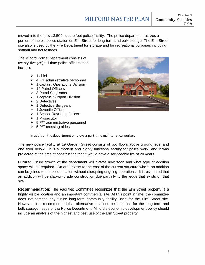
Background: The Milford Police Station opened its new station in late 2006. The station
moved to this downtown location, on the site of the old Garden Street School, to be central
to the downtown area. Previously, the police station was located at 589 Elm Street on the
west side of Town adjacent to an Environmental Protection Agency clean-up site. The Elm
Street property is zoned “Integrated Commercial Industrial” and is just east of the Route
101-Route 101A/Elm Street intersection.
Current Condition: The Milford Police Department now occupies the property at 19
Garden Street in Milford; formerly the Garden Street School site. In 2006 the department
MILFORD MASTER PLAN Chapter 3
Community Facilities (2008)
19
moved into the new 13,500 square foot police facility. The police department utilizes a
portion of the old police station on Elm Street for long-term and bulk storage. The Elm Street
site also is used by the Fire Department for storage and for recreational purposes including
softball and horseshoes.
The Milford Police Department consists of
twenty-five (25) full time police officers that
include:
1 chief 4 F/T administrative personnel 1 captain, Operations Division 14 Patrol Officers 3 Patrol Sergeants 1 captain, Support Division 2 Detectives 1 Detective Sergeant 1 Juvenile Officer 1 School Resource Officer 1 Prosecutor 5 P/T administrative personnel 5 P/T crossing aides
In addition the department employs a part-time maintenance worker.
The new police facility at 19 Garden Street consists of two floors above ground level and
one floor below. It is a modern and highly functional facility for police work, and it was
projected at the time of construction that it would have a serviceable life of 20 years.
Future: Future growth of the department will dictate how soon and what type of addition
space will be required. An area exists to the east of the current structure where an addition
can be joined to the police station without disrupting ongoing operations. It is estimated that
an addition will be slab-on-grade construction due partially to the ledge that exists on that
site.
Recommendation: The Facilities Committee recognizes that the Elm Street property is a
highly visible location and an important commercial site. At this point in time, the committee
does not foresee any future long-term community facility uses for the Elm Street site.
However, it is recommended that alternative locations be identified for the long-term and
bulk storage needs of the Police Department. Milford’s economic development policy should
include an analysis of the highest and best use of the Elm Street property.
MILFORD MASTER PLAN Chapter 3
Community Facilities (2008)
20
2.01.2 Fire Department
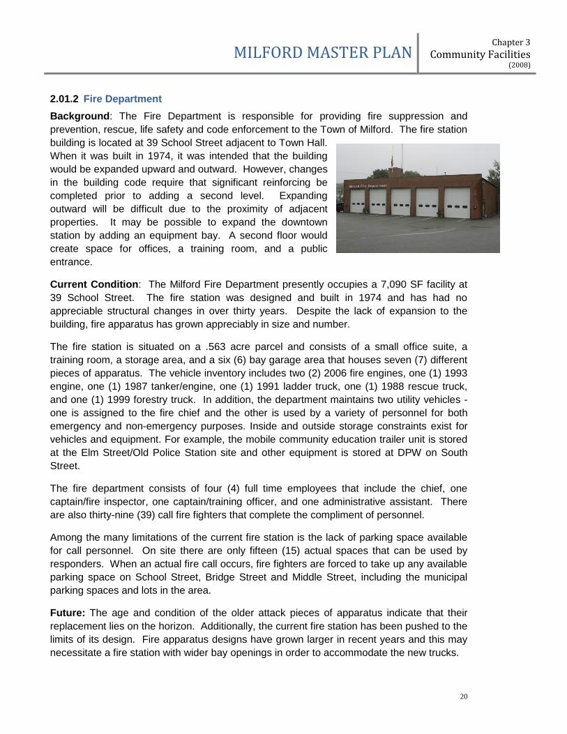
Background: The Fire Department is responsible for providing fire suppression and
prevention, rescue, life safety and code enforcement to the Town of Milford. The fire station
building is located at 39 School Street adjacent to Town Hall.
When it was built in 1974, it was intended that the building
would be expanded upward and outward. However, changes
in the building code require that significant reinforcing be
completed prior to adding a second level. Expanding
outward will be difficult due to the proximity of adjacent
properties. It may be possible to expand the downtown
station by adding an equipment bay. A second floor would
create space for offices, a training room, and a public
entrance.
Current Condition: The Milford Fire Department presently occupies a 7,090 SF facility at
39 School Street. The fire station was designed and built in 1974 and has had no
appreciable structural changes in over thirty years. Despite the lack of expansion to the
building, fire apparatus has grown appreciably in size and number.
The fire station is situated on a .563 acre parcel and consists of a small office suite, a
training room, a storage area, and a six (6) bay garage area that houses seven (7) different
pieces of apparatus. The vehicle inventory includes two (2) 2006 fire engines, one (1) 1993
engine, one (1) 1987 tanker/engine, one (1) 1991 ladder truck, one (1) 1988 rescue truck,
and one (1) 1999 forestry truck. In addition, the department maintains two utility vehicles -
one is assigned to the fire chief and the other is used by a variety of personnel for both
emergency and non-emergency purposes. Inside and outside storage constraints exist for
vehicles and equipment. For example, the mobile community education trailer unit is stored
at the Elm Street/Old Police Station site and other equipment is stored at DPW on South
Street.
The fire department consists of four (4) full time employees that include the chief, one
captain/fire inspector, one captain/training officer, and one administrative assistant. There
are also thirty-nine (39) call fire fighters that complete the compliment of personnel.
Among the many limitations of the current fire station is the lack of parking space available
for call personnel. On site there are only fifteen (15) actual spaces that can be used by
responders. When an actual fire call occurs, fire fighters are forced to take up any available
parking space on School Street, Bridge Street and Middle Street, including the municipal
parking spaces and lots in the area.
Future: The age and condition of the older attack pieces of apparatus indicate that their
replacement lies on the horizon. Additionally, the current fire station has been pushed to the
limits of its design. Fire apparatus designs have grown larger in recent years and this may
necessitate a fire station with wider bay openings in order to accommodate the new trucks.
MILFORD MASTER PLAN Chapter 3
Community Facilities (2008)
21
There continue to be discussions regarding the Town’s need for a fire department substation
on the west end of Milford. However, planning for any substation is dependent on
establishing appropriate parameters of need and determining the main fire department
facility plan.
Recommendation: In a report dated March 11, 2008, the current fire chief concurred with
the previous fire chief on the importance of maintaining the Fire Station in a downtown
location. It is recommended that the Town pursue a rapid response analysis to include:
options for a combined Fire, Ambulance and Emergency Management Safety Complex; all
possible location options within Town including potential land acquisition that meet the
mission of the departments; and possible options for a public-private partnership which
might reduce the required bonding costs. In addition, the Town should determine the
necessity and feasibility of substation location and construction.
2.01.3 Fire Training Facility
Background: The Milford Fire Training Area is located at the Milford Transfer Station. This
facility was never designed for the type of training that currently is required by local and
state standards. Due to its’ condition, the fire training facility has not been utilized for a
number of years.
Current Condition: The facility is over 20 years old and is not structurally stable. It does
not allow for live fire and water usage. It does not allow for ladder, rescue or rope
evaluations and is beyond repair.
Future: A new fire training facility is proposed by the Fire Department and could be co-
located with another Town facility. Co-location of facilities could minimize site work and
ancillary utility costs for bathrooms, meeting space, storage, etc. This project may also be
partially offset by grant funding and the concept of a regional training facility.
Recommendation: Conduct a thorough site analysis for the best location and possible
regional use of an updated fire training facility.
2.01.4 Ambulance Service
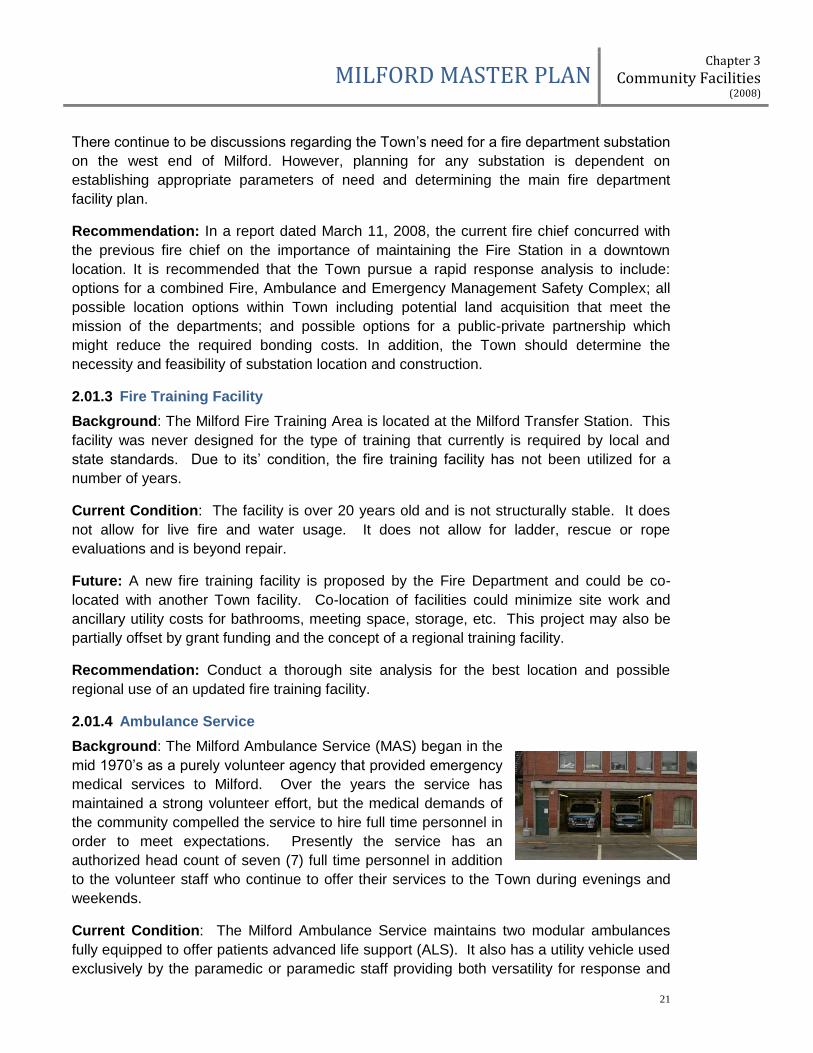
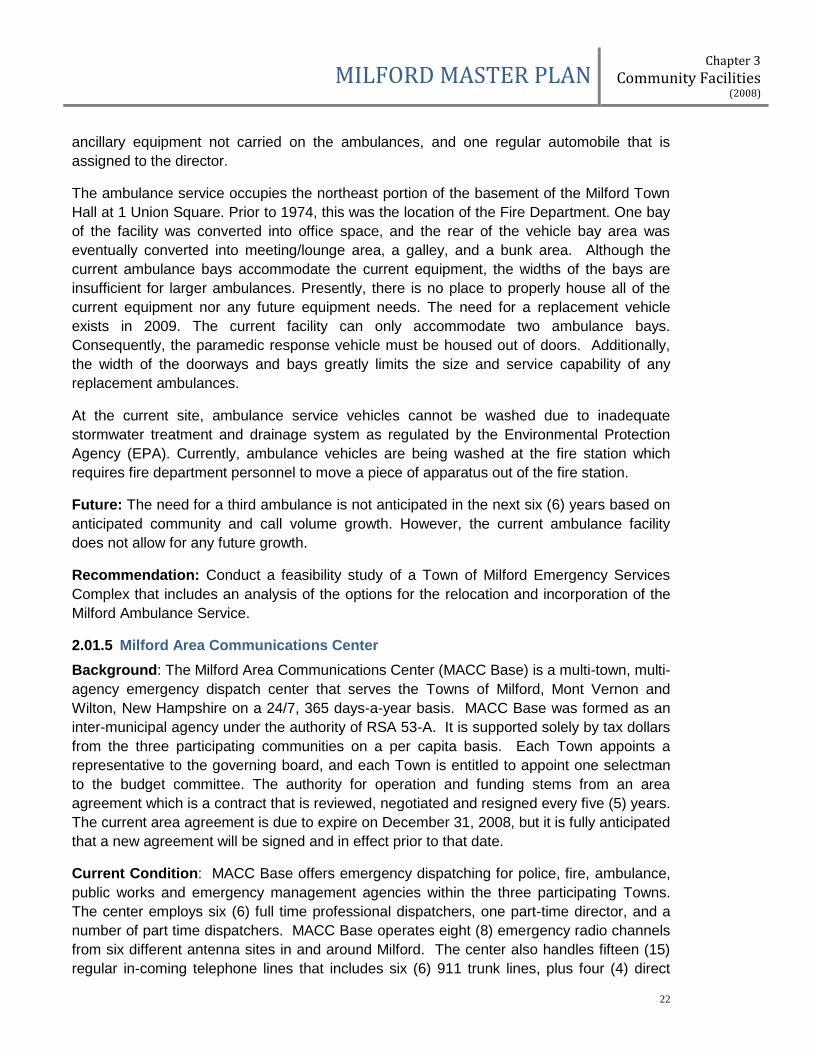
Background: The Milford Ambulance Service (MAS) began in the
mid 1970’s as a purely volunteer agency that provided emergency
medical services to Milford. Over the years the service has
maintained a strong volunteer effort, but the medical demands of
the community compelled the service to hire full time personnel in
order to meet expectations. Presently the service has an
authorized head count of seven (7) full time personnel in addition
to the volunteer staff who continue to offer their services to the Town during evenings and
weekends.
Current Condition: The Milford Ambulance Service maintains two modular ambulances
fully equipped to offer patients advanced life support (ALS). It also has a utility vehicle used
exclusively by the paramedic or paramedic staff providing both versatility for response and
MILFORD MASTER PLAN Chapter 3
Community Facilities (2008)
22
ancillary equipment not carried on the ambulances, and one regular automobile that is
assigned to the director.
The ambulance service occupies the northeast portion of the basement of the Milford Town
Hall at 1 Union Square. Prior to 1974, this was the location of the Fire Department. One bay
of the facility was converted into office space, and the rear of the vehicle bay area was
eventually converted into meeting/lounge area, a galley, and a bunk area. Although the
current ambulance bays accommodate the current equipment, the widths of the bays are
insufficient for larger ambulances. Presently, there is no place to properly house all of the
current equipment nor any future equipment needs. The need for a replacement vehicle
exists in 2009. The current facility can only accommodate two ambulance bays.
Consequently, the paramedic response vehicle must be housed out of doors. Additionally,
the width of the doorways and bays greatly limits the size and service capability of any
replacement ambulances.
At the current site, ambulance service vehicles cannot be washed due to inadequate
stormwater treatment and drainage system as regulated by the Environmental Protection
Agency (EPA). Currently, ambulance vehicles are being washed at the fire station which
requires fire department personnel to move a piece of apparatus out of the fire station.
Future: The need for a third ambulance is not anticipated in the next six (6) years based on
anticipated community and call volume growth. However, the current ambulance facility
does not allow for any future growth.
Recommendation: Conduct a feasibility study of a Town of Milford Emergency Services
Complex that includes an analysis of the options for the relocation and incorporation of the
Milford Ambulance Service.
2.01.5 Milford Area Communications Center
Background: The Milford Area Communications Center (MACC Base) is a multi-town, multi-
agency emergency dispatch center that serves the Towns of Milford, Mont Vernon and
Wilton, New Hampshire on a 24/7, 365 days-a-year basis. MACC Base was formed as an
inter-municipal agency under the authority of RSA 53-A. It is supported solely by tax dollars
from the three participating communities on a per capita basis. Each Town appoints a
representative to the governing board, and each Town is entitled to appoint one selectman
to the budget committee. The authority for operation and funding stems from an area
agreement which is a contract that is reviewed, negotiated and resigned every five (5) years.
The current area agreement is due to expire on December 31, 2008, but it is fully anticipated
that a new agreement will be signed and in effect prior to that date.
Current Condition: MACC Base offers emergency dispatching for police, fire, ambulance,
public works and emergency management agencies within the three participating Towns.
The center employs six (6) full time professional dispatchers, one part-time director, and a
number of part time dispatchers. MACC Base operates eight (8) emergency radio channels
from six different antenna sites in and around Milford. The center also handles fifteen (15)
regular in-coming telephone lines that includes six (6) 911 trunk lines, plus four (4) direct
MILFORD MASTER PLAN Chapter 3
Community Facilities (2008)
23
ring-down lines for direct communications with various emergency departments in Milford.
In addition the center monitors Milford’s municipal fire alarm system that includes both
municipal and commercial buildings.
MACC Base occupies the majority of the space on the fourth floor of the Milford Town Hall at
1 Union Square. Access to the center is restricted and controlled due to the nature of the
work and the need for security of information.
Future: Based on current and projected plans for MACC Base, the current location in Town
Hall can continue to meet the operating needs of the service. Available information indicates
that there is space and capacity at MACC Base to add more member Towns.
Recommendation: Although adequate at this time, evaluation of the MACC Base space
should be included in the proposed Town Hall Improvement Plan. Moreover, the MACC
Base facility space should be evaluated relative to the impact of any increase or decrease in
member Towns.
2.02 TOWN ADMINISTRATIVE SERVICES
2.02.1 Town Hall
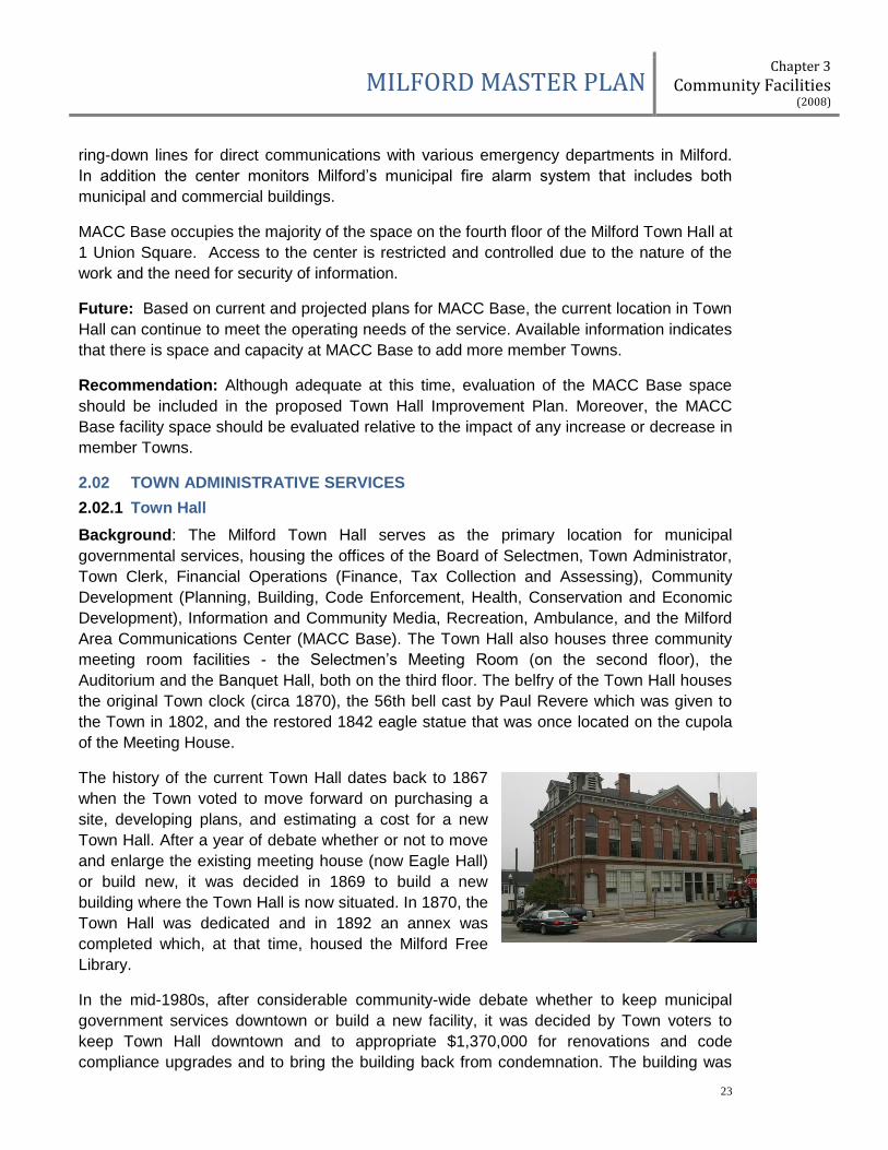
Background: The Milford Town Hall serves as the primary location for municipal
governmental services, housing the offices of the Board of Selectmen, Town Administrator,
Town Clerk, Financial Operations (Finance, Tax Collection and Assessing), Community
Development (Planning, Building, Code Enforcement, Health, Conservation and Economic
Development), Information and Community Media, Recreation, Ambulance, and the Milford
Area Communications Center (MACC Base). The Town Hall also houses three community
meeting room facilities - the Selectmen’s Meeting Room (on the second floor), the
Auditorium and the Banquet Hall, both on the third floor. The belfry of the Town Hall houses
the original Town clock (circa 1870), the 56th bell cast by Paul Revere which was given to
the Town in 1802, and the restored 1842 eagle statue that was once located on the cupola
of the Meeting House.
The history of the current Town Hall dates back to 1867
when the Town voted to move forward on purchasing a
site, developing plans, and estimating a cost for a new
Town Hall. After a year of debate whether or not to move
and enlarge the existing meeting house (now Eagle Hall)
or build new, it was decided in 1869 to build a new
building where the Town Hall is now situated. In 1870, the
Town Hall was dedicated and in 1892 an annex was
completed which, at that time, housed the Milford Free
Library.
In the mid-1980s, after considerable community-wide debate whether to keep municipal
government services downtown or build a new facility, it was decided by Town voters to
keep Town Hall downtown and to appropriate $1,370,000 for renovations and code
compliance upgrades and to bring the building back from condemnation. The building was

MILFORD MASTER PLAN Chapter 3
Community Facilities (2008)
24
listed in the National Register of Historic Places in 1988. Additional community-wide support
and funding were required to complete the Auditorium and Banquet Hall renovations as
those costs were not included in the $1.37 million. In 1993, the National Trust for Historic
Preservation awarded the Town with the National Preservation Honor Award for its efforts to
restore the Town Hall. A full history of the Town Hall is available at Town offices.
Current Condition As stated above, the Town Hall is the central location to conduct
municipal affairs. Office space is utilized at capacity, and there is little flexibility in space
arrangement due to the floor plan and construction of the building. It was noted by the Town
Administrator in January 2008 that no additional staffing is foreseen within the next several
years which would require additional office space. However, traffic flow between some
offices is not efficient, there is little privacy in some departments in which to conduct daily
confidential business, the Selectmen’s Meeting Room also serves as an “office area” for the
Supervisors of the Checklist”, some offices have no direct sunlight, direct public access into
some areas (most notably the Recreation Department) is restricted to non-handicapped and
there needs to be security upgrades throughout the building to keep up with changing
societal conditions.
The Selectmen’s Meeting Room is used as a community meeting room and has received
extensive electronic upgrades to allow for cable television access and emergency
management capability. The meeting room is also used for public meetings of other boards
and commissions, most notably the Planning Board. Attendance at some public meetings
often exceeds room capacity.
The Ambulance Department occupies a major portion of the ground floor off Middle Street
and has a two-bay ambulance garage that accesses Middle Street. This Department
includes offices and a living/sleeping area for departmental employees. It has been noted by
the Ambulance Director that the narrow width of the ambulance bay doors is too restrictive
for newer model ambulances.
Both the Auditorium and Banquet Hall are well-utilized for community and area-wide
functions. For many major activities, however, acoustics in both areas need improvement.
Future: The Town Hall is a major landmark and symbol of the community, and represents a
major source of pride. Upkeep of the facility reflects its important place in the community.
However, efficient and adequate office space and meeting room area is at a premium.
Current long-range facility planning for emergency services downtown includes a joint facility
to house the Fire, Ambulance, and Emergency Management departments. This joint facility
is currently felt to be best located downtown. An emergency management complex is
included in the 2008-2013 Capital Improvements Plan and is currently planned for
construction in 2013. With that plan and upon completion of the emergency management
complex there will be a relocation of the Ambulance Department out of Town Hall. At that
time there will be significant new space freed up for Town Hall functions.

MILFORD MASTER PLAN Chapter 3
Community Facilities (2008)
25
Recommendation: Initiate a Town Hall Improvement Plan to address and recommend
solutions to the Town Hall space deficiencies outlined in the Facility Requirements - Town
Hall / Library Annex document dated 2/14/08 as well as other potential improvements in
administrative services delivery which can be accomplished by space adjustments or
renovations. Moreover, this Improvement Plan should address the deficiencies from two
perspectives as follows:
a. No change in the Ambulance Department location;
b. Movement of the Ambulance Department to another location.
It is recommended that the Improvement Plan be under the auspices of the Community
Development Director but be primarily authored by a person or persons whose work
assignment(s) is/are outside Town Hall and possibly outside the Town government
completely.
2.02.2 Wadleigh Memorial Library
Background: Library service in Milford dates back to 1796 when an
association known as the Milford Social Library Proprietors was
formed. The first library was housed in the home of Jonathan Buxton
on the west side of the Oval. Later, the library was located in the Town
Hall Annex where “Library” can still be seen over the doorway leading
to the Planning Department.
In 1935 Mrs. Fannie B. Wadleigh left $100,000 in trust to build a library
in her hometown, named in honor of her late husband, William Y.
Wadleigh. The land selected for this purpose had been left in part to
the Town in 1910 by Mrs. Mary A. Lull; however, she only owned a one
half interest in the property. In 1943 the other half interest in the
property was purchased from Dr. Dearborn by Mr. and Mrs. James
Howison. They gave their interest to the Town in honor of Mr. Howison’s sister, Mrs.
Josephine Dayfoot. The library continues to be located at this site.
By the time construction actually started in August 1949, the money left for the library was
inadequate to build a structure of sufficient size. The plans were substantially scaled back
and the Wadleigh Library was built with barely more space than had been available in the
Town Hall annex. On July 19, 1950 the new building opened without adequate space for a
growing population.
Efforts to add space to the Wadleigh building were made over the intervening years. From
1974 to 1984 three bond issues failed to gain approval. Each one represented a different
plan. In 1985 the Town voted a $950,000 bond issue to expand the library. The low bid for
construction was more than $100,000 higher than the funds available. Plans were once
again scaled back. The two-story (plus basement) colonial style brick building was
expanded to the left side and rear with this addition that was opened in the spring of 1986.

MILFORD MASTER PLAN Chapter 3
Community Facilities (2008)
26
Current Situation: The Wadleigh Library contains 14,452 square feet. The current building
is not ADA compliant, although most areas are physically accessible to handicapped
individuals as a result of the ground level rear entrance and the use of the elevator. The
library has certain structural limitations such as the upper floor of the original building is not
load bearing for books and the basement is damp with a mildew problem. The library is
centrally located in the downtown area. Milford residents and other library patrons make
extensive use of the library. The library circulated 194,670 items in 2006 or nearly 13 items
for every person in Town. This was a 4% increase over 2005. The library has a small
parking lot with 37 spaces plus one handicapped space, to the rear of the building. The
sloping library site was expanded in 1999 and 2001 when the trustees purchased two
adjacent properties. Often, popular programs at the library require participants to park at
other locations in the nearby Town area. There is only one exit from the Library parking lot.
As a steep, short, curving drive, this exit is extremely difficult to keep safe during the winter
months. Special attention is required to ensure patrons do not slide into traffic on Nashua
Street. Library patrons must turn right onto Nashua Street due to the heavy traffic. The
1986 addition to the library was designed to serve a population of 12,000 with a 15-year life
and reach capacity in the year 2000. In actuality, capacity was reached in 1997, four years
earlier than originally projected. In 2000 Milford’s population was approximately 13,000. In
2007 the population served by the library is 15,000.
Future: The Library Trustees have developed a plan for addition and renovation in the near
future – 21 years since the last addition opened. The Town and Library have purchased two
adjacent houses to provide land for future expansion.
Using population projections from the Nashua Regional Planning Commission (NRPC) and
the State of N.H., the anticipated Library use “population” for Milford in 2026 is 24,350. This
number includes a projected resident population of 18,500 including non-resident users who
work in Town, non-residents who purchase cards and people who use the library while in
Town on other business. Based on the Wisconsin Public Library Space Needs planning
process (the only nationally accepted model), and a Needs Assessment performed by a
nationally recognized Library Consultant, the Trustees have determined that 25,500 square
feet of space would meet the needs of the Town for library services for another 20 years.
The expansion concept provides a two level structure to the east along Nashua Street, with
the children’s services on the main level and a large meeting room in the lower level.
Expansion to the south is on two levels wrapping around the west facade, providing
expanded adult services on the main level and on a mezzanine level. This concept will
require the removal of the two residential structures and re-grading to provide a more
efficient parking layout. The existing parking of 38 spaces is increased to 60 spaces. The
addition includes a redesign of the entry, making it more prominent. The exterior is
envisioned in brick, matching the existing facade.
In summary the plan includes:
a. Addition of 12,000 square feet for a grand total of approximately 25,500 square feet,
b. Expansion of parking for a total of 60 cars including additional handicapped parking

MILFORD MASTER PLAN Chapter 3
Community Facilities (2008)
27
c. An increase to the size of the Children’s Room adding a service desk to ease crowding
at the main service desk, craft and story-time areas, adjacent storage and badly needed
bathroom facilities
d. A large meeting room with a capacity for 125 people for Town committees and
organizations with after-hours access, kitchenette, and bathroom facilities
e. Increased and redesigned computer workspace for public access
f. Increased staff and stack space
g. Additional and improved display space
h. New main circulation desk area that will accommodate the changes in how libraries are
used now.
Recommendation: The Library Trustees should continue to refine and implement a full
capital expansion plan including funding stream development, land acquisition priorities and
public education with the objective of a Town vote in 2011.
2.03 WATER UTILITIES
Portions of the Town of Milford are served by public water and wastewater utility systems
which until 2005 were operated and managed under the authority of the Board of Selectmen
serving as water and sewer commissioners. The responsibility for managing, construction,
control, and direction of these utilities is now governed by an elected three-member Water
and Wastewater Commission which was authorized by Town vote in March 2005. The
changeover in management was based upon a 2004 Water & Wastewater study committee
recommendation that establishing a water and sewer commission to oversee the two utilities
would better protect Milford’s natural water resources, improve the quality of the resources,
and provide a more efficient and cost effective utility.
In early 2008 all operations for both the water and wastewater systems were consolidated at
the wastewater treatment facility located at 564 Nashua Street (Map 44/Lot 2). Until 2005
the utilities were managed by the Department of Public Works, however, under the
governing of the Water and Wastewater Commission, the department was reorganized and
renamed as Water Utilities.
2.03.1 Water System
Background: According to the 2001 Water Master Plan and
Rate Study, Milford, New Hampshire, prepared by the firm of
Dufresne-Henry, the original Town of Milford water system
was constructed in the early 1890s and obtained its water from
Great Brook. Water treatment took place at a filtration plant on
South Street at the site of the current Department of Public
Works.
During the 1970s, the Town abandoned its surface water supply and converted its supply
source to three gravel-packed wells (commonly known as the Kokko Well, the Savage Well,
and the Keyes Well). In 1983 and 1984 the Savage and Keyes wells were abandoned due
to industrial contamination. The Town moved quickly to replace these water sources with

MILFORD MASTER PLAN Chapter 3
Community Facilities (2008)
28
two wells located across from Kaley Park on the northerly side of the Souhegan River in the
Town of Amherst. In 1995 the Kokko Well located adjacent to Osgood Pond was taken off-
line due to high manganese and iron levels which limited capacity and required excessive
maintenance. In 1988 the Town entered into an agreement with the Pennichuck Water
Works to extend its water distribution system from nearby Amherst to the Milford-Amherst
town line and connect into the Milford system. This agreement allowed the Town to augment
its supply when necessary.
Current Condition: In 2007, approximately 94% of the Town’s water supply came from the
Curtis Wells and 6% from Pennichuck Water Works. A full explanation of the Town’s water
sources can be found in the Dufresne-Henry report.
Milford’s water distribution system is comprised of over 55 miles of large diameter loops and
smaller diameter branch mains. One section that is being upgraded in order to eliminate a
bottleneck is the Union/South/Elm St. area. Upgrading the water main in this area will better
utilize the recently built Holland storage tank located on Osgood Road. The water
distribution system services approximately 3300 customers classified as either residential or
commercial/industrial, as well as providing water for fire protection. The Curtis Wells are
capable of delivering 1100 gallons per minute and the Pennichuck water connection is rated
at 1350 gallons per minute.
Although the overall system is in generally good condition there are ongoing improvements
necessary which are regularly undertaken in accordance with the utility’s capital
improvements plan.
The system’s maximum allowable service elevation for any connection into the system is
390 feet above mean sea level. Current Commission policy is to not extend the distribution
system above the 390-foot elevation primarily to avoid having to operate and maintain
booster stations. Pennichuck Water Works has an agreement with the Commission to serve
locations above the 390-foot elevation; however there is a stipulation in the agreement to
allow the municipal system to extend its system above 390’ if appropriate.
In addition, the municipal system has agreements in place to provide water to private
systems and into some areas of Amherst, as well an agreement with the Town of Wilton to
provide water to some Milford residents.
Future: The Milford Water and Sewer Commission finalized a ten-year capital
improvements plan (CIP) report for the period of 2007 through 2017 which is updated
annually. A full report titled 2007 Final Report Water Rate Study / Water Rate Structure
addressing recommendations to the water rate structure to support anticipated infrastructure
improvements and expansion was prepared for the Water and Sewer Commission by
Stantec in September 2007.
Capital improvements recommended in the Stantec report adopted by the Commission
include renovations of the Wastewater administration building on Nashua Street; Elm Street
Phase II water main improvements; Union Street railroad crossing improvements; South

MILFORD MASTER PLAN Chapter 3
Community Facilities (2008)
29
Street improvements from Nashua Street to Clinton Street; Union Street improvements from
Lincoln Street to Orange Street; ongoing meter replacement program; improvements to the
Curtis Wells; and new water source development.
Recommendations:
1. New water source development should be made a high priority to accommodate economic development initiatives and ongoing residential, commercial, and industrial growth in accordance with the Town’s economic development policies.
2. Close communication should be established between the Water and Sewer
Commission, the Planning Board, and the Board of Selectmen to insure Town
master plan goals are met relative to long-term strategic planning.
2.03.2 Wastewater System
Background:
The Town of Milford owns and operates a secondary wastewater treatment facility (WWTF)
that utilizes the conventional activated sludge process. The process consists of grinding
influent flow, pumping, and grit removal at a headworks facility, followed by primary settling,
conventional activated sludge processing utilizing fine bubble aeration, secondary
clarification, and ultraviolet disinfection prior to the final effluent discharge. In addition to
providing treatment of wastewater from Milford, the treatment facility also treats wastewater
from the Town of Wilton, which is governed under an intermunicipal agreement.
The sewage collection system consists of approximately 38 miles of collection piping that
receives sewage from approximately 2500 residential, commercial and industrial customers.
The Wastewater Treatment Plant, located off east Nashua Street adjacent to the Souhegan
River, went online in 1981. The design capacity of the facility is 2.15 million gallons per day
(MGD) total average annual daily flow, with an available capacity of approximately 1.1 MGD.
The peak load capacity of the system is 6.45 MGD
The Town of Wilton is allotted 15% of the total design capacity and currently utilizes 13%.
The original design capacity was based on a project that 12,800 people, out of a total
population of 19,000, would utilize the system by the year 2002. 2007 figures indicate
approximately 13,500 people utilize the system, and current population projections predict
that a population of 19,000 (Milford and Wilton residents on the system) will be reached by
2030.
In 1988 a Sewer District was established by a water and sewer advisory committee that
defined an area in which sewer extensions would be allowed.
Future: Facility ownership, operation, and management are under the authority of an
elected three-member Water and Sewer Commission established in 2005. The Commission
finalized a ten-year capital improvements plan for the period of 2007 through 2017 which is
updated annually. A full report titled 2006 Report Sewer Rate Study / Sewer Rate Structure,
Milford, New Hampshire, prepared by the firm of Stantec Consulting Services itemized

MILFORD MASTER PLAN Chapter 3
Community Facilities (2008)
30
capital projects, updating the Dufresne-Henry February 2002 Milford, New Hampshire
Wastewater Treatment Facility Plan Report. A complete explanation of planned
improvements and anticipated costs and revenue is contained in the 2006 Study.
Recommendations:
1. Close communication should be established between the Water and Sewer Commission, the Planning Board, and the Board of Selectmen to insure Town master plan goals are met.
2. The Sewer District boundaries should be reviewed and amended, if necessary, to reflect future growth areas and development potential that will require wastewater collection and treatment.
2.04 DEPARTMENT OF PUBLIC WORKS
2.04.1 DPW/Highway
Background: The Department of Public Works (DPW) facility located on South Street,
Route 13 in Milford serves three purposes:
• DPW administrative offices
• Garage and maintenance of DPW equipment and tools
• Storage of materials such as sand, water pipe, road salt, etc.
Current Condition: DPW South Street site capacity within
the currently developed footprint, there is little room for
future expansion. As the Town continues to grow and new
roads come on line, the DPW will be required to increase its
vehicle inventory. This will necessitate more room for
storage and maintenance. Any increases in staffing will
likely stretch the already limited capacity of the current
offices housed in the former Pumping Station. Lastly, there
is already a need to erect some form of secure covered storage for stocked materials.
There is approximately ¼ acre at this site which is high, dry, and set back from the wetlands.
There is sufficient room to run an access road to this land. This one parcel alone would
seem to address the immediate needs for more storage area.
With the aid of the Milford Conservation Commission maps of Town owned land, it was
learned that a sizeable property of 3-4 acres or more is also available directly behind the
South Street facility.
There are three potential access points to this property:
A culvert over Great Brook directly behind the current garage. Potential access from Oak Street near or through land currently owned by
Northern Marble and Granite Co.
MILFORD MASTER PLAN Chapter 3
Community Facilities (2008)
31
A proposed development of Northern Marble and Granite Co., land with an access road out to South Street could offer a spur into the back land behind DPW.
Further review of the existing steel building reveals that the original design was set to
accommodate later expansion by punching out the north wall to add more bays.
It appears that the South Street site has more than enough space and opportunity to satisfy
DPW needs for the very long-term.
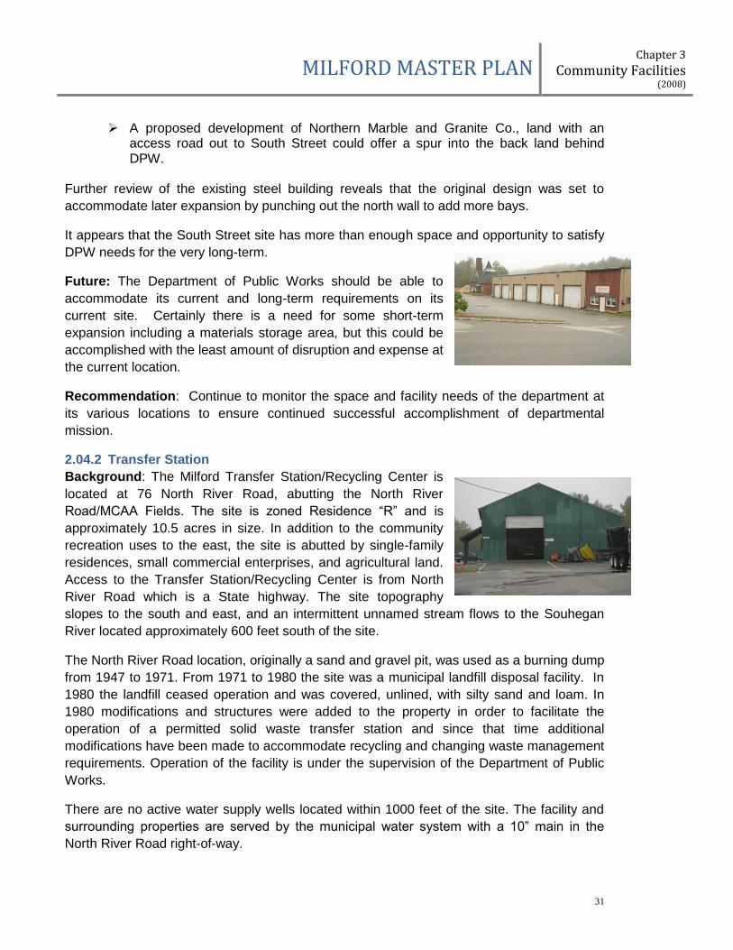
Future: The Department of Public Works should be able to
accommodate its current and long-term requirements on its
current site. Certainly there is a need for some short-term
expansion including a materials storage area, but this could be
accomplished with the least amount of disruption and expense at
the current location.
Recommendation: Continue to monitor the space and facility needs of the department at
its various locations to ensure continued successful accomplishment of departmental
mission.
2.04.2 Transfer Station
Background: The Milford Transfer Station/Recycling Center is
located at 76 North River Road, abutting the North River
Road/MCAA Fields. The site is zoned Residence “R” and is
approximately 10.5 acres in size. In addition to the community
recreation uses to the east, the site is abutted by single-family
residences, small commercial enterprises, and agricultural land.
Access to the Transfer Station/Recycling Center is from North
River Road which is a State highway. The site topography
slopes to the south and east, and an intermittent unnamed stream flows to the Souhegan
River located approximately 600 feet south of the site.
The North River Road location, originally a sand and gravel pit, was used as a burning dump
from 1947 to 1971. From 1971 to 1980 the site was a municipal landfill disposal facility. In
1980 the landfill ceased operation and was covered, unlined, with silty sand and loam. In
1980 modifications and structures were added to the property in order to facilitate the
operation of a permitted solid waste transfer station and since that time additional
modifications have been made to accommodate recycling and changing waste management
requirements. Operation of the facility is under the supervision of the Department of Public
Works.
There are no active water supply wells located within 1000 feet of the site. The facility and
surrounding properties are served by the municipal water system with a 10” main in the
North River Road right-of-way.
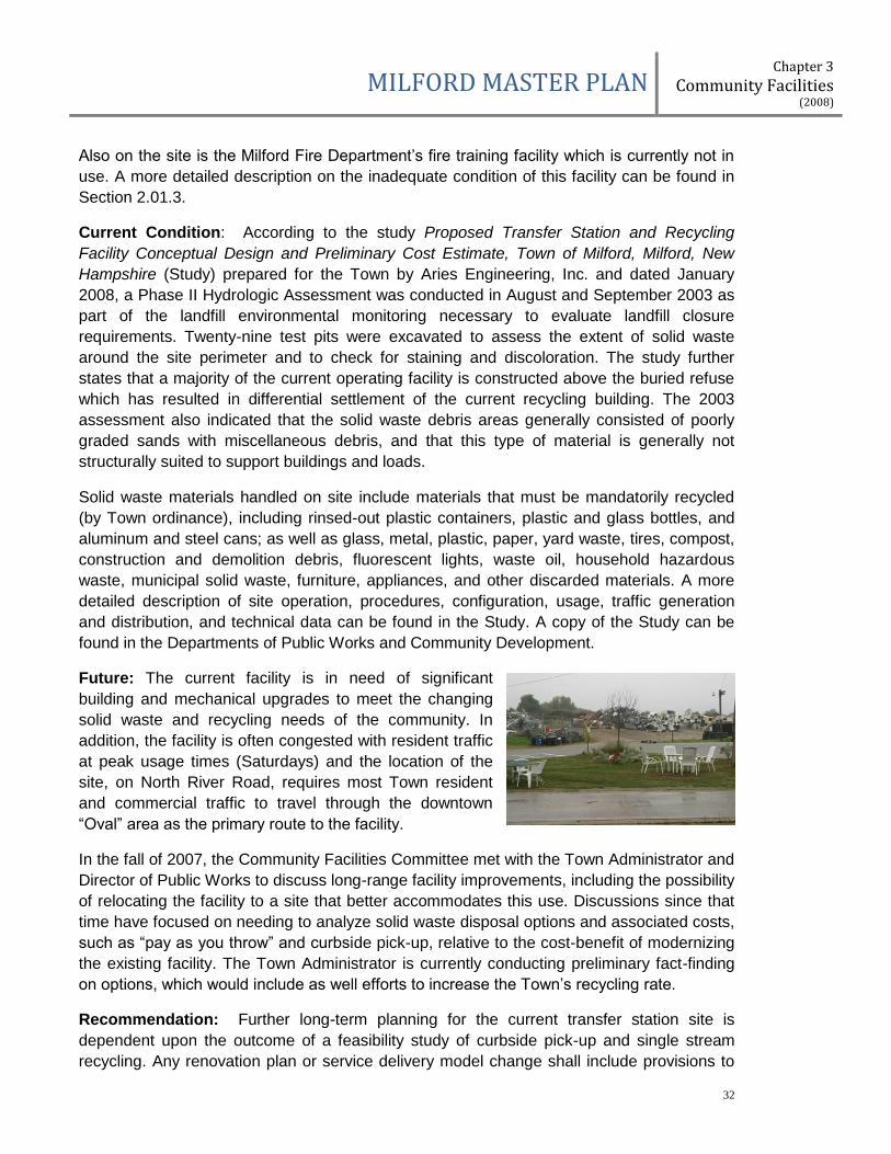
MILFORD MASTER PLAN Chapter 3
Community Facilities (2008)
32
Also on the site is the Milford Fire Department’s fire training facility which is currently not in
use. A more detailed description on the inadequate condition of this facility can be found in
Section 2.01.3.
Current Condition: According to the study Proposed Transfer Station and Recycling
Facility Conceptual Design and Preliminary Cost Estimate, Town of Milford, Milford, New
Hampshire (Study) prepared for the Town by Aries Engineering, Inc. and dated January
2008, a Phase II Hydrologic Assessment was conducted in August and September 2003 as
part of the landfill environmental monitoring necessary to evaluate landfill closure
requirements. Twenty-nine test pits were excavated to assess the extent of solid waste
around the site perimeter and to check for staining and discoloration. The study further
states that a majority of the current operating facility is constructed above the buried refuse
which has resulted in differential settlement of the current recycling building. The 2003
assessment also indicated that the solid waste debris areas generally consisted of poorly
graded sands with miscellaneous debris, and that this type of material is generally not
structurally suited to support buildings and loads.
Solid waste materials handled on site include materials that must be mandatorily recycled
(by Town ordinance), including rinsed-out plastic containers, plastic and glass bottles, and
aluminum and steel cans; as well as glass, metal, plastic, paper, yard waste, tires, compost,
construction and demolition debris, fluorescent lights, waste oil, household hazardous
waste, municipal solid waste, furniture, appliances, and other discarded materials. A more
detailed description of site operation, procedures, configuration, usage, traffic generation
and distribution, and technical data can be found in the Study. A copy of the Study can be
found in the Departments of Public Works and Community Development.
Future: The current facility is in need of significant
building and mechanical upgrades to meet the changing
solid waste and recycling needs of the community. In
addition, the facility is often congested with resident traffic
at peak usage times (Saturdays) and the location of the
site, on North River Road, requires most Town resident
and commercial traffic to travel through the downtown
“Oval” area as the primary route to the facility.
In the fall of 2007, the Community Facilities Committee met with the Town Administrator and
Director of Public Works to discuss long-range facility improvements, including the possibility
of relocating the facility to a site that better accommodates this use. Discussions since that
time have focused on needing to analyze solid waste disposal options and associated costs,
such as “pay as you throw” and curbside pick-up, relative to the cost-benefit of modernizing
the existing facility. The Town Administrator is currently conducting preliminary fact-finding
on options, which would include as well efforts to increase the Town’s recycling rate.
Recommendation: Further long-term planning for the current transfer station site is
dependent upon the outcome of a feasibility study of curbside pick-up and single stream
recycling. Any renovation plan or service delivery model change shall include provisions to

MILFORD MASTER PLAN Chapter 3
Community Facilities (2008)
33
increase Milford’s overall recycling rate and to maximize the types of materials that can be
recycled.
2.04.3 Cemeteries
Background: Milford currently has five cemeteries
located on Elm Street, Union Street, West Street, North
River Road and Nashua Street. Riverside Cemetery on
Nashua Street is the only existing cemetery with plots
for sale and has a projected capacity to accommodate
the Town's needs for 60 years.
Approximately 25 acres of the 270 acre Town owned
BROX property in west Milford has been reserved for
future cemetery use. Also, 1.512 acres of Town owned Kaley property abutting Riverside
Cemetery is reserved for cemetery expansion.
Current Condition: Presently a full-time six man DPW facilities crew and a part-time four
man crew provide upkeep for all five Milford cemeteries, fourteen Milford parks and several
Town buildings.
Future: This spring construction will start on a new 30' X
50' facilities maintenance building for the Cemetery and
Parks Departments at Riverside Cemetery, which
will provide much needed garage space, a repair shop,
as well as office space, rest rooms, and lunch/meeting
room. Families will be able to use the meeting room
when arranging for cemetery plots for loved ones.
Recommendation: Based on future cemetery needs
projections, re-evaluate the best use for the twenty-five (25) acres designated for future
cemetery expansion in the BROX Community Lands Master Plan.
2.04.4 Parks & Recreation
Background: The Milford Recreation Department goals are to: first, provide a variety of quality recreation and leisure programs for all age groups within the community; second, utilize the existing parks and recreation facilities within the Town to their best advantage establishing formal partnerships between the Town, School District and other providers of facilities; and third develop long range master plans for community recreation.
Currently, the Recreation Director reports directly to the Director, Department of Public Works. It is staffed by the Recreation Director and a part time assistant to help organize paperwork for all recreation programs. Its office is located in the basement of the Town Hall. The Recreation Department works with the Recreation Commission whose 6 members are appointed by the Board of Selectmen. This commission serves as an advisory arm to the department and BOS.

MILFORD MASTER PLAN Chapter 3
Community Facilities (2008)
34
Current Condition: Milford maintains four (4) Town owned fields/facilities and one includes an outdoor pool. They are Keyes Field, Shepard Park, Adam’s Park and Kaley Park.
Lacrosse Field
Hockey Soccer Baseball Softball Swimming
Day Camp
Play-ground
Skate Park
Boat/ Water Access
Basketball Tennis
Keyes Field
XX XX XX XX XX XX XX XX XX XX XX XX
Adam’s Park
XX XX XX XX
Shepard Park
XX XX XX XX
Kaley Park
Open Field Space XX
The condition of these fields is poor-to-good due to overuse. The soccer field at Keyes Field was refurbished last year, and the softball and baseball fields will receive infield improvements in 2008. Shepard Park underwent a refurbishment in 2005-2006 to add additional quality baseball facilities. However, with the continued growth of youth and adult participation in sports, the need for recreation fields is reaching a critical point in Milford. Field space is used by the Recreation Department, the MCAA, youth leagues (soccer, football, baseball and softball), Middle and High School teams, adult leagues, the Souhegan Valley Boy’s and Girl’s Club and family use.
Future: Future needs will involve the development of new fields in Milford. Kaley Park is currently an undeveloped piece of land that is designated as a future Town recreation facility. The BROX Community Master Plan also designates over forty-six (46) acres with approximately twenty-five (25) buildable acres as future recreation land.
Recommendation:
1. Complete the initial field and parking construction at Kaley Park such that Kaley Park will
be available for use when Keyes Field is partially closed due to the Fletcher/EPA site
clean-up,
2. Continue to evaluate the long-term best uses for Kaley Park.
3. Based on Recreation Department projections, re-evaluate the best use for the forty-six
(46) acres designated for future recreation needs in the BROX Community Lands Master
Plan.
2.05 SCHOOL SERVICES
The Community Facilities Committee did not feel that they could make any facility specific
recommendations for school services given that representatives from the Milford School
system were not actively involved in this review process. However, a global
recommendation would be for improved communication between our municipal government
and our school system in order to prepare a complete Town-wide facilities long-term
strategic plan.

MILFORD MASTER PLAN Chapter 3
Community Facilities (2008)
35
In May 2008, the School Board identified the following probable upcoming items:
1. $2 million for a Kindergarten proposal (two half-day sessions at Jacques School) in 2009,
2. $150,000 in 2009 for land acquisition to create additional parking at the High School in the future, and
3. $10 million for renovations at the Bales School, the High School, and the Middle School in 2012 potentially including roof upgrades at the Middle School and ongoing attention to the High School building and grounds maintenance needs.
Demographic changes will ultimately dictate school facility infrastructure modifications.
However, the current SAU opinion is that enrollments will remain relatively flat for the next
15 to 20 years.
2.05.1 Jacques Elementary School
Background: Jacques School is located off Elm Street
adjacent to the Bales School. It was built in 1955 and
was named after a local serviceman, Lt. Leon Jacques.
The school was originally built with 12 classrooms, a
gymnasium/cafeteria, supporting offices and core
facilities. It was designed as an elementary school and
has remained one ever since.
Current Condition: Eight additional classrooms were added in the 1990's and in early
2000 a new roof system was installed to address the long-standing roof issues. Currently,
the school is used for Readiness and 1st grade. The existing Jacques School building is
56,280 square feet. The area around the school has limited parking but does have space for
playgrounds on a lower level. At this time, a driveway circles around the Bales School
building with entrance and exit via Elm Street. There is a pedestrian light at the exit onto Elm
Street.
Future: As a Readiness and 1st grade school, Jacques School is expected to reach
capacity in 15-20 years. If public Kindergarten is to be offered in Milford, this school could
be considered as a location. It is designed to accommodate a Kindergarten curriculum.
2.05.2 Bales School (aka Centennial High School)
Background: In 1886, the Town began acquiring parcels of land just west of the Oval on
Elm Street which would eventually become the sites of
Endicott Park, the Centennial High School, and the
Jacques Memorial School. In 1893, the Town voted to
raise the funds needed to purchase land for a high school.
Built in 1894, during the centennial year of the Town’s
incorporation, the high school was opened in 1895 and
called the Centennial High School.

MILFORD MASTER PLAN Chapter 3
Community Facilities (2008)
36
Recurrent themes throughout the history of Centennial High School were the need for more
school space and the challenge of efficiently using available space. The first major change
to the school occurred in 1916 when the mechanical arts department wing was added. For
many years, it was hoped that a gymnasium would be added to the high school. To
accommodate this deficiency, students used a large, unfinished hall on the third floor for
girls’ calisthenics, the boys drill team and other athletic events. In 1929, the community was
feeling prosperous and an improvement and expansion plan was proposed including an
auditorium and gymnasium over the mechanical arts wing. However, it was determined that
essential needs including classroom space, a new heating system and plumbing upgrades
outweighed the expansion plans. Further planning for an auditorium-gymnasium had to be
put aside due to the Depression and it was not until around 1939 that these plans could be
revived under the supervision of school Superintendent Harold C. Bales. Unfortunately, Mr.
Bales, whose dream it had been to have an auditorium-gymnasium at the high school, died
in April 1939 and he was not able to see the completion of this project. In recognition of his
many contributions, the new addition was named in his honor in 1941.
By the late 1940s, due to the post World War II birthrate increase or as it was called the
“wave of war babies”, there was again a need for more classroom space. In March 1951, the
Town voted to build a four classroom annex onto the high school. The annex would house
two 6th grade classes from the “crowded Garden Street School” and two 7th grade classes
from the “overcrowded high school”. In 1955, Jacques Memorial School was opened for
grades 5-8 and part of the annex was remodeled for junior high home economics classes. In
1959, there was an “imperative” need for more high school space. Thus, in 1961 the “new”
three year high school was opened on West Street and the “old” Centennial High School
was reassigned as the junior high school. In 1964, the Town adopted the concept of being
an AREA (Authorized Region Enrollment Area) school which required a major expansion of
the West Street High School to accommodate Amherst students from grades 7-12 and to
provide space for a six year high school. At the same time, the Town was wrestling with the
problem of what to do with the “old” Centennial High School given that the junior high pupils
would be moving to the “new” six year high school. According to author Edith Hunter (A Brief
History of Public Schools in Milford, N.H., p.92): “There were two views: one, that ‘the old
fire-trap’ should be scuttled, and the other that it was a substantially built building and was
worth redeeming.” In 1968, the Town voted to renovate the Centennial High School for use
by the elementary grades 5 and 6. When opened in 1969, the school was renamed the
Bales Elementary School again in honor of Supt. Harold C. Bales.
As older schools have been modified and new schools built, the use of the Bales School has
continued to change over time. In 1970, a new AREA Junior High School was opened on
Osgood Road. Renamed the Milford Middle School, this school was expanded in 1992 and
currently houses grades 6-8. In 2001, the Heron Pond Elementary School opened and now
houses grades 2-5. For several years, the Bales School was vacant or minimally used. In
2004, due to the fire destruction of the Garden Street School, the Sage School moved into
the Bales School.
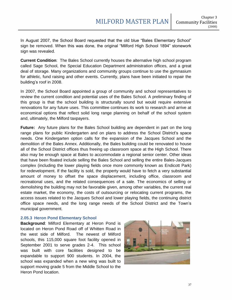
MILFORD MASTER PLAN Chapter 3
Community Facilities (2008)
37
In August 2007, the School Board requested that the old blue “Bales Elementary School”
sign be removed. When this was done, the original “Milford High School 1894” stonework
sign was revealed.
Current Condition: The Bales School currently houses the alternative high school program
called Sage School, the Special Education Department administration offices, and a great
deal of storage. Many organizations and community groups continue to use the gymnasium
for athletic, fund raising and other events. Currently, plans have been initiated to repair the
building’s roof in 2008.
In 2007, the School Board appointed a group of community and school representatives to
review the current condition and potential uses of the Bales School. A preliminary finding of
this group is that the school building is structurally sound but would require extensive
renovations for any future uses. This committee continues its work to research and arrive at
economical options that reflect solid long range planning on behalf of the school system
and, ultimately, the Milford taxpayers.
Future: Any future plans for the Bales School building are dependent in part on the long
range plans for public Kindergarten and on plans to address the School District’s space
needs. One Kindergarten option calls for the expansion of the Jacques School and the
demolition of the Bales Annex. Additionally, the Bales building could be renovated to house
all of the School District offices thus freeing up classroom space at the High School. There
also may be enough space at Bales to accommodate a regional senior center. Other ideas
that have been floated include selling the Bales School and selling the entire Bales-Jacques
complex (including the lower playing fields once more commonly known as Endicott Park)
for redevelopment. If the facility is sold, the property would have to fetch a very substantial
amount of money to offset the space displacement, including office, classroom and
recreational uses, and the related consequences of a sale. The economics of selling or
demolishing the building may not be favorable given, among other variables, the current real
estate market, the economy, the costs of outsourcing or relocating current programs, the
access issues related to the Jacques School and lower playing fields, the continuing district
office space needs, and the long range needs of the School District and the Town’s
municipal government.
2.05.3 Heron Pond Elementary School
Background: Milford Elementary at Heron Pond is
located on Heron Pond Road off of Whitten Road in
the west side of Milford. The newest of Milford
schools, this 115,000 square foot facility opened in
September 2001 to serve grades 2-4. This school
was built with core facilities designed to be
expandable to support 900 students. In 2004, the
school was expanded when a new wing was built to
support moving grade 5 from the Middle School to the
Heron Pond location.

MILFORD MASTER PLAN Chapter 3
Community Facilities (2008)
38
Current Condition: Currently the facility houses grades 2-5. It contains 40 classrooms,
support services, administrative offices, gym, cafeteria, common areas, and nature trails.
There are 125 members on the faculty and staff and over 700 students.
Future: In its current function as a 2-5th grade school, Heron Pond is expected to last 20+
years.
2.05.4 Milford Middle School
Background: The Milford Middle School was constructed
on Town owned land in 1970. In 1992 an addition was
added. In 2005, the 5th grade was moved to the Heron
Pond School, alleviating severe overcrowding and the need
for portable classrooms. The school is located on Osgood
Road approximately one mile from The Oval in Milford’s
central downtown area.
Current Conditions: The Milford Middle School is a 104,000 square foot facility about 40
years old. The school has 45 classrooms, a gymnasium, cafeteria, common area, library,
media center and tech area. The school was built with core facilities to support 642
students. There are approximately 600 students in attendance at this time. This building
supports 54 teachers (including substitute teachers and aides) plus staff. The Middle
School shares athletic fields with the High School.
Future: There is land available at the current site for expansion, but it is not needed at this
time or in the foreseeable future.
2.05.5 Milford High School and Applied Technology Center
Background: The Milford High School and Applied
Technology Center is located at 100 West Street in
Milford. The core facility has the capacity for 1010
students with the SAU office on site and 1070 students
with the SAU offsite. The facility was built in 1964 and a
35,000 square foot Technology Center was added in
1998.
Current Conditions: The Milford High School and Applied Technology Center currently has
approximately 900 students enrolled. Many of the classrooms have not been updated since
the building’s construction. However, a significant renovation currently is in progress
replacing windows; updating the cafeteria, stage and music department; enhancing
classroom and lab spaces; and several classrooms are receiving much needed heating and
ventilation upgrades. In addition, the construction of a new athletic complex, including a
new football/soccer/lacrosse field and a track and field facility, is nearing completion. The
Milford SAU office occupies a corner of the High School facility for their offices. The High
School classroom spaces are rarely unoccupied and the School Board is now assessing
alternatives to move the SAU office and release that space back to school programs.

MILFORD MASTER PLAN Chapter 3
Community Facilities (2008)
39
Future: The School Board has concluded that the best long-term use of the West Street
facility is as a High School due to its specialized
construction and equipment. In 2007, a bond was passed
that provided significant funds for High School facility
renovations and a new field and track. These projects are
intended to be completed in 2008. Over time it is assumed
that the High School and current Middle School will evolve
to a school campus environment and it is assumed that the
SAU office will be relocated within near-term years.
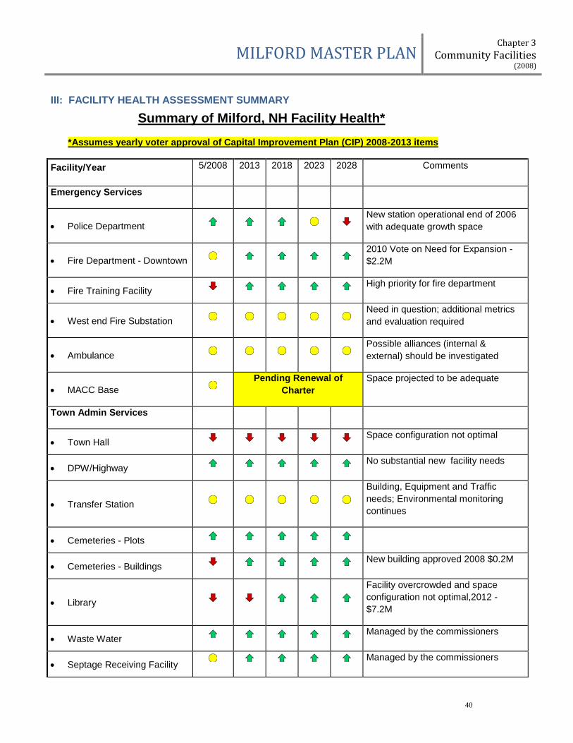
MILFORD MASTER PLAN Chapter 3
Community Facilities (2008)
40
III: FACILITY HEALTH ASSESSMENT SUMMARY
Summary of Milford, NH Facility Health*
*Assumes yearly voter approval of Capital Improvement Plan (CIP) 2008-2013 items
Facility/Year 5/2008 2013 2018 2023 2028 Comments
Emergency Services
Police Department New station operational end of 2006
with adequate growth space
Fire Department - Downtown 2010 Vote on Need for Expansion -
$2.2M
Fire Training Facility High priority for fire department
West end Fire Substation Need in question; additional metrics
and evaluation required
Ambulance Possible alliances (internal &
external) should be investigated
MACC Base Pending Renewal of
Charter
Space projected to be adequate
Town Admin Services
Town Hall Space configuration not optimal
DPW/Highway No substantial new facility needs
Transfer Station
Building, Equipment and Traffic
needs; Environmental monitoring
continues
Cemeteries - Plots
Cemeteries - Buildings New building approved 2008 $0.2M
Library
Facility overcrowded and space
configuration not optimal,2012 -
$7.2M
Waste Water Managed by the commissioners
Septage Receiving Facility Managed by the commissioners

MILFORD MASTER PLAN Chapter 3
Community Facilities (2008)
41
Facility/Year 5/2008 2013 2018 2023 2028 Comments
Water Service Building 2010 Vote planned $0.3M
Parks & Recreation
Kaley Park Future expansion remains possible
Keyes Pool Recent renovations
Keyes Field Continued renovations, Fletcher site
cleanup 2010
Adams Field Tied to Osgood Pond improvements
Shepard Park
Improvements started 2005 via
private funds, donations, & recreation
dept.
- BROX Fields/Heron Pond Recreation
Committee working plans and funding
- North River Rd MCAA maintained and enhanced
School Services
Bales
Separate committee
recommendations Full plan yet to be
determined by SAU
Jacques Memorial Kindergarten issue unclear
Heron Pond New school in 2000, addition in 2006
Milford Middle School
Improved with relocation of grade 5 to
Heron Pond; roof upgrades needed in
near future
- Milford High Track & Field Approved in 2007 vote
Milford High School
Major renovations approved in 2007
vote; ongoing needs to be
coordinated with SAU office
relocation
Needs to be Addressed Issue w/in 5 yrs OK *Revision 8 21 08
MILFORD MASTER PLAN Chapter 3
Community Facilities (2008)
42
IV: GOALS
1. As part of Milford’s economic development plan, analyze the highest and best use for the Elm Street Property (former Police Station).
2. Re-evaluate the 2005 BROX Community Lands Master Plan to reflect projected changes in community facility needs.
3. Continue to utilize, refine and strengthen the Community Facilities Planning Process.
3.1. Develop and implement a formal communication process with the Milford School
Board that promotes coordinated Town-wide facilities planning.
3.2. Develop and implement a formal communication process with the Milford Water and Sewer Commission that promotes coordinated Town-wide facilities planning.
3.3. Incorporate the Community Facilities Planning Process and the Facilities Updates as part of the annual "Reports" provided by Town Department Heads, the Town Administrator, and the School Board to the Planning Board and the Community Facilities Committee.
4. Analyze, promote and implement inter-town cooperation and regionalization of
functions and facilities for more efficient and cost effective delivery of common services.

MILFORD MASTER PLAN Chapter 4
Transportation (2012)
43
Chapter 4
TRANSPORTATION
I. INTRODUCTION AND PURPOSE
Essential to any municipality’s well-being is a transportation system that supports efficient
and safe movement of people, goods, and services both within the town limits and the
region. Moving into the next decades Milford’s transportation system must be fully integrated
with housing, commercial, and industrial land uses, protection of water and air quality, and
must be cost-effective both in construction, maintenance, and service. The overall public
and economic health of both the individual and the community relies on an affordable and
accessible transportation system that can adapt to the forces of growth, fuel availability and
cost, regulatory requirements, and changes in environmental conditions.
There are ten commonly accepted smart growth principles (US EPA) that reflect the
interrelationship of the elements that make up a community’s land use patterns and
development. These principles have been incorporated into updates of chapters of the
Milford Master Plan to guide Town growth:
Mix land uses
Take advantage of compact housing design
Create a range of housing opportunities and choices
Create walkable neighborhoods
Foster distinctive, attractive communities with a strong sense of place
Preserve open space, farmland, natural beauty, and critical environmental areas
Strengthen and direct development towards existing communities
Provide a variety of transportation choices
Make development decisions predictable, fair, and cost-effective
Encourage community and stakeholder collaboration in development decisions
New Hampshire RSA 674:2.I states that the purpose of the master plan is to set down as
clearly and practically as possible the best and most appropriate future development of the
area under the jurisdiction of the Planning Board, to aid the board in designing ordinances
that result in preserving and enhancing the unique quality of life and culture of New
Hampshire, and to guide the board in the performance of its other duties in a manner that
achieves the principles of smart growth, sound planning, and wise resource protection. A
transportation section is recommended by this statute, and the section should consider “all
pertinent modes of transportation” and also provides for “a framework for both adequate
local needs and for coordination with regional and state transportation plans. Considerations
may include but are not limited to public transportation, park and ride facilities, and bicycle
routes, or paths, or both”.
The Transportation chapter outlines how the Town of Milford will face the challenges and
opportunities to incorporate short-term and long range planning needed to maintain,
improve, and sustain an efficient transportation system integrated with desired land use,
community character, and environmental goals.
MILFORD MASTER PLAN Chapter 4
Transportation (2012)
44
II. HISTORICAL CONTEXT
Milford physically developed in a pattern typical of New England towns. During the middle
years of the 18th century a gristmill and sawmill were established on the Souhegan River just
east of the present day stone arch Colonel John Shepard Bridge. Milford’s current
downtown grew in the vicinity of the Souhegan River and Great Brook. By the time the Town
incorporated in 1794 this area had developed into a village center with a mixture of civic,
commercial, small-scale manufacturing, and residential buildings surrounding a town
common3 and remains as the hub of the community to this day.
Settlement in this area created the need for roads and one of the earliest roadways later
became the main route between Nashua and Wilton. Other routes leading to the village
center developed from the adjacent farms and outlying granite quarries and Nashua Street,
South Street, Elm Street, and Mont Vernon Street became primary routes. Textiles,
foundries, granite quarrying, lumber, and farming formed the basis of the Milford economy
during the 1800s, and the arrival of the railroad in 1852 allowed Milford to connect to larger
markets. After growing to a population of 3,939 in 1910, Milford’s population remained
relatively unchanged through 1950 when the population was 4,159.
In the early 1900’s the automobile emerged as a new means of transportation and began to
shape ‘the building patterns and infrastructure of the Town”. By 1930 there were nine gas
stations and by 1939 the downtown Oval area was experiencing parking problems.4 During
the mid-1920’s rail usage was in decline, and by 1941 rail passenger service was
discontinued and a bus line was established between Manchester and Fitchburg,
Massachusetts with stops in Milford and Wilton.
Significant road construction and improvements were accomplished in the first half of the
twentieth century as a result of the establishment of both state and federal road systems.
Around 1920 the State had established a series of trunk lines and cross state roads,
including the “South Side Highway” which was subsequently designated as NH Route 101.
In Milford the route began at the Milford/Wilton town line and followed Elm Street through
Union Square, crossed the Souhegan River and proceeded to Amherst. In 1935 Jones’s and
Richardson’s crossings in the west end of town were eliminated with the construction of a
federal road between Milford and Wilton. The Elm Street portion of NH Route 101 became
NH Route 101A at the time the Route 101 Bypass was constructed (1969-1978). Currently,
NH Routes 101, 101A (both east-west) and NH Route 13 (north-south) have created major
highway transportation corridors that provide significant regional linkages for the Town and
carry high traffic volumes.
3 Page 7, NHDHR Area Form, Downtown Milford Commercial, Civic, and Residential Historic District (Area MIL-CCR), Preservation Company, August 9, 2010. 4 Page 17, NHDHR Area Form, Downtown Milford Commercial, Civic, and Residential Historic District
(Area MIL-CCR), Preservation Company, August 9, 2010.

MILFORD MASTER PLAN Chapter 4
Transportation (2012)
45
2.01 PREVIOUS MILFORD MASTER PLANS
Since 1963 the Town has completed three comprehensive planning cycles that included
traffic and transportation sections.
2.01.1 In the Master Plan for the Town of Milford N.H., 1963-1983, these major issues and actions were identified:
Milford was described as carrying its traffic on streets that were originally designed for horses and carriages. Streets were found to be in fair condition. Sidewalks were in need of improvement. Traffic flow on Nashua Street and around the Oval was found to be congested to the point of being detrimental to business.
It was recommended that street classifications be established and adopted and improvements made on the basis of classification.
Construction of the NH Route 101 Bypass was a priority, however it was noted that a ‘bypass’ can create both positive and negative impacts and the Master Plan identified downtown revitalization as critical to draw people downtown and that the Bypass not result in travelers circumventing the Town and harming the economic health of the business community.
Street construction and improvements should accommodate future traffic and that it was a community responsibility to most appropriately deal with the automobile to the satisfaction of not only the highway user but also to abutting property owners.
2.01.2 The 1993 Milford Master Plan provided detailed listings of road classifications, traffic counts, accident locations, scenic roads (first established in 1974), intersection capacity analysis (level of service or ‘LOS’), and intersection turning movement counts. Specific recommendations included:
Further analyze and prioritize problem intersections discussed (in chapter) and include these projects in the Capital Improvements Plan.
It should be the policy of the Planning Board to discourage the construction of dead-end streets.
The Planning Board should encourage obtaining rights-of-way to adjacent lands. Both this policy and the one above are intended to increase the efficient flow of traffic throughout the community.
Long term traffic improvements should be a Route 13 bypass to avoid the Oval and the connection of Powers Street with South Street. Both of these proposals would reduce traffic on both Nashua and Elm Streets.
The Planning Staff, on a yearly basis, should obtain the accident report data from the Department of Transportation in order to analyze these statistics and determine if a particular area is becoming a problem.

MILFORD MASTER PLAN Chapter 4
Transportation (2012)
46
Pedestrian safety is a major problem in and around the Oval. Improvements which should be considered include: The existing signs that indicate cars must stop at crosswalks should be made more visible. In addition, these signs should note that fines up to $100 can be issued to those who fail to stop at crosswalks. Improve the visibility of the crosswalks.
The Planning Board should continue to require that developers participate in off-site road improvements when it is reasonable and necessary.
2.01.3 The 1999 Master Plan Update included an updated chapter for Traffic and Transportation, which began with the following philosophy:
“The Town of Milford, as well as the region, will likely continue to grow at a
moderate pace within the next five to ten years. This residential, commercial,
and industrial growth and development will place ever-increasing demands
on the existing road and transportation network. The Town’s transportation
system should be safe and support the needs of the community, and impacts
of transportation-related improvements and growth must not override the
community’s desired quality of life.”
The Chapter specified ‘high’ and ‘medium’ actions to occur during the following years. For
1999/2000 the foremost high priority action to be taken was to develop and begin
implementation of a Town Traffic Management Plan to be a coordinated effort between the
Planning Board, Planning and Public Works Departments, and the Nashua Regional
Planning Commission. The Traffic Management Plan was intended to address levels of
service and deficiencies of the existing road system; identify where future deficiencies could
occur based on anticipated growth; determine methods to address existing and future
deficiencies; identify roads that serve as regional links; evaluate road, sidewalk, drainage,
and utility construction specifications; incorporate pedestrian, bicycle, and intermodal
improvements; evaluate implementation of traffic impact fees; and evaluate public
transportation needs and implement services. Additionally, the Planning Board determined
that road corridor plans should be developed that incorporated access management,
aesthetics, and land use intensity.
Medium priority actions noted in 1999 included implementing appropriate recommendations
from the Traffic Management Plan, specifically programming improvements projects into the
annual Capital Improvements Plan (CIP) to insure phased and orderly implementation of
projects and encouraging increased traffic calming and individual courtesy and responsibility
by citizens when traveling Milford roadways.
2.02 TRANSPORTATION RELATED EFFORTS IN MILFORD – 2000 TO PRESENT
Over the past decade there has been much planning and groundwork completed to
implement specific road projects, but no overall Transportation Management Plan has been
created and adopted to fully coordinate and integrate the goals set forth by prior master
plans. However, existing planning documents will be instrumental in carrying out the goals
set forth in the current 2012 Master Plan update. Additionally, the recognition that

MILFORD MASTER PLAN Chapter 4
Transportation (2012)
47
transportation systems are just one element of an overall systems approach to planning
Milford’s future has become an overarching principle insuring that economic development,
protection of natural and built infrastructure, land use, community character, and public
health are all integrally related components and are not independent of each other. This
awareness, in conjunction with smart growth principles, is critical at both the local and
regional levels.
Major Studies and Plans Guiding Current Transportation Projects An itemized list and description of completed studies and plans with detailed data to
incorporate into near term and long range project planning follows:
2.02.1 Evaluation of Highway Improvement Alternatives in Milford, New Hampshire (January 2002, Hoyle, Tanner and Associates)
Authorized by Town vote in 2000 to begin implementation of the 1999 Master Plan update
goal, this document with supporting data and analysis, provides a baseline from which to
develop Oval traffic congestion and additional primary roadway improvements
recommendations throughout Milford. This study also included a preliminary analysis of
additional potential road crossings of the Souhegan River (the West Street Corridor, the
Powers Street Corridor, and the BROX Corridor).
2.02.2 NH 101A Corridor Master Plan and Improvements Program (August 2002, prepared by VHB, Inc. for the Nashua Regional Planning Commission (NRPC))
Commissioned by the NRPC with New Hampshire Department of Transportation (NHDOT)
and federal funding, this Master Plan and associated recommended improvements studied
the NH 101A Corridor from its intersection with NH 101 at the Milford/Amherst town line to
its intersection with US Route 3 in Nashua.
This Corridor Master Plan provides recommendations that address the following goals:
Preserve the existing roadway capacity of NH 101A through access management, intersection improvements, and traffic signal system optimization.
Provide a priority capital improvement program for use by the NHDOT for purpose of implementation and funding.
Enable safe pedestrian, bicycle, and transit access throughout the corridor.
Improve the appearance of the corridor through the development of landscaping and lighting guidelines.
Guide future development and redevelopment through the development review process.
Provide recommendations for long-term solutions.
Protect groundwater quality through establishment of stormwater management guidelines and the implementation of flexible design standards.

MILFORD MASTER PLAN Chapter 4
Transportation (2012)
48
Current Plan Implementation Status:
Specific to Milford is a recommendation for a conceptual interchange upgrade at the NH
101A/101 interchange and short term recommendations for at-grade interchange
improvements and sidewalk reconstruction from the interchange westerly to James Street in
Milford.
In March 2011, the NHDOT began soliciting additional public input from NRPC communities
on the recommendations in the Corridor Master Plan with the intent of implementing
additional improvements during 2012 and 2013 contingent on federal and state funding
availability. Included at this time is additional design for the NH 101A/101 short term
upgrades.
2.02.3 New Hampshire Route 101 Corridor Plan – Amherst, Milford, Wilton (September 2002, prepared by VHB, Inc., Wallace Floyd Design Group, and RKG Associates, Inc. for the Nashua Regional Planning Commission (NRPC))
Commissioned by the NRPC with NHDOT and federal funding, this Master Plan and
associated recommended improvements studied the NH 101 Corridor from the highway’s
intersection with Abbott Hill Road in Wilton to the Bedford town line. A separate corridor plan
was completed during the same time period for NH 101 through Bedford.
The goal of this Corridor Plan is to implement a comprehensive highway improvements
approach with these intended results:
A safer roadway with less congestion.
Less diversion of traffic into residential areas.
A better commercial center in Bedford encouraging lower vehicular speeds and accommodating pedestrians, and better conditions for development in western Milford and Wilton.
An attractive highway corridor through all four towns, preserving existing character.
The NH 101 Corridor Plan provides a thorough inventory and analysis of traffic volumes,
pedestrian and bicycle transportation accommodations, traffic operations, and identification
of visual, natural systems, land use and development regulatory conditions, utilities,
economic development conditions, and historic and cultural resources. Specific to the
segment of NH 101 that traverses Milford are conceptual short term and long term
improvements at the NH 101/NH 101A interchange, at the NH 101/NH 13 interchange, and
for NH 101 westerly to Wilton (inclusive of an extension of the 101 Bypass to relieve
congestion on existing NH 101 from its intersections with Old Wilton Road, Phelan Road,
Elm Street (NH 101A) and Wilton Road).
The NH 101 Corridor Plan provides detailed economic development/market analysis
background on the BROX commercial-industrial area and Milford in general as well as
design guidelines for future development.
Current Plan Implementation Status:

MILFORD MASTER PLAN Chapter 4
Transportation (2012)
49
Within the past several years the NHDOT has made significant improvements to NH 101
within Milford and Amherst to address critical safety issues related to fatal traffic accidents.
Additionally the NHDOT has performed major road maintenance and paving work with the
availability of federal American Recovery and Reinvestment Act 2009 (ARRA) funding. In
March 2011 the NHDOT began initial public meetings to begin the process of implementing
the short and long term recommendations included in the NH 101 Corridor Plan. In April
2011 the Milford Board of Selectmen, based on input from Town staff members and the
Planning Board, provided the NHDOT and the NRPC an official notification that safety
improvements on the NH 101 segment between Phelan/Old Wilton Roads and Wilton Road
be prioritized as the Town’s foremost short term improvement.
Based on anticipated growth and development scenarios projected in Milford in the coming
decades one new NH 101 project has been submitted for incorporation into the State 10-
Year Transportation Improvement Plan (TIP) and one existing project has been requested
for removal from the TIP. Town staff has officially notified the NHDOT and the NRPC that a
new access on NH 101 to serve the planned west Milford mixed-use development area
(Commerce and Community District) be incorporated into the TIP. Concurrently, the Town,
based on changing conditions, project cost, and project feasibility, has requested that the
NH 101 Bypass extension be removed from the TIP.
Due to its comprehensive nature, the NH 101 Corridor Plan will continue to be utilized as the
Town progresses on master planning the west Milford area for mixed-use development, site
development guidelines, and capital improvements planning.
2.02.4 Transportation and Community and Systems Preservation Study, Milford, New Hampshire (July 2006, prepared by the Nashua Regional Planning Commission (NRPC))
The 2006 Transportation and Community and Systems Preservation (TCSP) Study, funded
through NRPC Metropolitan Planning Organization federal grants, expands upon the 2002
NH Route 101 Corridor plan with an in-depth review of those Town transportation systems
exclusive of the NH 101 and NH 101A state routes. The stated purpose of this study is to
“improve the interface between land use and the transportation system through strategies
that:
Reduce dependence upon the automobile for meeting transportation needs.
Provide access management techniques that preserve roadway capacity and reduce safety problems.
Incorporate design guidelines that decrease visual clutter along local transportation corridors.
As stated in this study, the strategies presented are intended to decrease wear and tear on
the local road system which will lessen the need for future roadway expansion; reduce
diversion of traffic from State routes into residential neighborhoods to create safer roads;
and develop alternate modes of transportation that are feasible for Milford –including
bicycle, pedestrian and public transit options. These strategies, if implemented, will lead to
less-vehicle-miles traveled by reducing the number of single occupancy vehicles on the

MILFORD MASTER PLAN Chapter 4
Transportation (2012)
50
roads. A reduction in overall vehicle-miles-traveled improves air quality, reduces cost for the
individual and the Town in time and maintenance dollars, and benefits public health.
The study includes several key components for the Town, forming the basis for
transportation planning initiatives over the past 5-7 years. In particular, the 2006
recommendations include:
On Nashua Street, the westbound left turn lane at Clinton Street should be extended east past the Edgewood Plaza Shopping Center to Monson Place. A left turn lane should also be installed on the Nashua Street westbound- approach to Powers Street. These projects would improve the poor levels of service that currently exist at those locations.
The Nashua Street / Ponemah Hill Road intersection should be improved and signalized.
Nashua Street sidewalks are lacking in the vicinity of Lorden and Richmond Plazas. Existing sidewalks should be extended on both sides of Nashua Street from the cemetery all the way to these shopping centers. These improvements will encourage increased biking and walking to calm traffic and provide safe alternatives to motorized vehicles.
Architecture and building design on segments of Elm Street are out of character and scale with the rest of Milford. Site plan guidelines that maintain residential character and reflect traditional Milford architecture should be adopted.
South Street is narrow, varies in width, bulges in sections and has many undefined curb cuts which results in concern for pedestrian and motorist safety. Safety and aesthetic improvements need to be made.
The feasibility of an additional crossing of the Souhegan River should be studied and incorporated into any future NH 101 widening project.
The transition from western Milford to Wilton is a bottleneck with traffic signals, at grade railroad crossings, and poor access management. An access management plan and center-turn lane should be developed and constructed.
The transition from the highway system to the local street system could be greatly enhanced by landscaped gateways at key entries into Town.
An effort should be made to enhance the perception that Milford is a pedestrian and bicycle friendly Town. This can be accomplished by developing programs that help maintain pavement, policies that encourage increased biking and walking and designated bicycle and pedestrian routes.
The location of Milford on the urban fringe of the Nashua region provides an opportunity to integrate public transit into the planning process. Full day fixed- route bus service would assist Milford in best meeting the needs of households with limited incomes, limited vehicle availability, and the disabled population, and would reduce vehicle miles traveled.
This study provides data from the period 2005-2006 relative to existing conditions on
the Town’s roads and sidewalks as well as many tools and recommendations for
revisions to regulations and policies.
MILFORD MASTER PLAN Chapter 4
Transportation (2012)
51
Current Plan Implementation Status
The Town has taken steps to implement several of the 2006 TCSP Study recommendations
in the last 5-7 years. Specifically:
1. Nashua Street improvements from Clinton Street past Edgewood Plaza Shopping
Center have been conceptually developed and included as an improvement project in
the 2009 Traffic and Pedestrian Evaluation for Milford Downtown Area and are
tentatively scheduled for implementation in 2013-2014. This project will be funded by the
federal Section 1702 Transportation Improvements grant and local matching funds.
2. A signal warrant study and engineering plans have been completed for the Nashua
Street/Ponemah Hill Road intersection. A warrant article for the project did not receive
voter approval in 2007. The project remains in the Town’s Capital Improvements Plan for
implementation in 2015.
3. Engineering plans have been completed for the construction of sidewalks on Nashua
Street to complete the connection to the Lorden and Richmond shopping centers. The
project is included as a three-phase project in the Town’s Capital Improvements Plan for
implementation in 2013, 2014, and 2015.
4. The Planning Board developed a Nashua Street/Elm Street Corridor Overlay zoning
district with design guidelines to address development and redevelopment reflective of
community character and inclusive of safe and multi-modal transportation provisions.
These regulations were adopted by the Town in 2008.
5. In 2011 the Planning Board and Economic Development Advisory Council (EDAC), with
assistance from NRPC, expanded the corridor design regulations and guidelines effort to
include west Elm Street and NH 101 to the Wilton town line, resulting in the Town
adopting the West Elm Street Gateway District in March 2012.
6. A significant safety and aesthetics improvement project is underway for South Street
from its intersection with Union Square southerly to the railroad right-of-way.
Construction is intended to begin in late 2012. This project is funded by federal
Transportation Enhancement and Section 1702 Transportation Improvements funding as
well as local matching funds.
7. Addressing the NH 101 transition in west Milford is a high priority safety issue identified
by the Board of Selectmen, Planning Board, and town staff and in April 2011 the NHDOT
was made aware of its importance for inclusion in NHDOT short term NH 101 safety
enhancements programming.
8. Pedestrian safety improvements and sidewalk linkages have been constructed through
the utilization of local, federal, and private funding sources at the following locations:
a. On West Street and Osgood Road, adjacent to the Milford Middle School and
Milford High School;
b. North River Road, from its intersection with Mont Vernon Road to the
MCAA/North River Road athletic fields;

MILFORD MASTER PLAN Chapter 4
Transportation (2012)
52
c. Across the Souhegan River, connecting Keyes Field via the Gregg’s Crossing
Pedestrian Bridge and a gravel packed pathway to Mont Vernon Street;
d. Detached asphalt sidewalks on portions of Heron Pond Road, Philip’s Way, and
Ponemah Hill Road; and attached sidewalks within the Ledgewood development
and portions of the east-end Nashua Street commercial area.
9. In 2010 the Town applied for and received federal Congestion Mitigation and Air Quality (CMAQ) funding to address critical safety and congestion issues at the Route 13 South/Emerson Road/Armory Road intersection with the intent to undertake signalization and intersection improvements. Design is anticipated to be completed in the summer of 2012 and construction is anticipated to begin in late 2012, pending NHDOT funding.
10. The Souhegan Valley Transportation Collaborative (SVTC) organized and implemented a limited non-emergency community transportation service in 2008. The current service is a demand response, dial-a-ride type bus service available to residents of Milford, Amherst, Brookline, and Hollis. SVTC subcontracts the buses, drivers, and call center operations through the Nashua Transit System (NTS). Working closely with the NRPC, NTS, and the four towns, SVTC was able to leverage federal funding in 2010 that allowed expansion of the service from three days to five days per week, added destinations, and added hours of operation based on community input. SVTC continues to work with local and regional stakeholders on further service improvements and sustainable funding plans.
2.02.5 Traffic and Pedestrian Improvement Evaluation for Milford Downtown Area,
Milford, New Hampshire (March 2009, prepared by CLD Consulting Engineers)
The Traffic and Pedestrian Improvement Evaluation for Milford Downtown Area was
developed as a requirement by the NHDOT as the plan for guiding the utilization of federal
Section 1702 and Transportation Enhancement (TE) funding for downtown traffic and safety
improvement projects. The evaluation is based on community and town staff input on priority
safety improvements in the downtown area defined as The Oval/Union Square, Nashua
Street easterly to Tonella Road, South Street southerly to the South Street/Lincoln Street/
Marshall Street/Prospect Street intersection, the Westside Neighborhood (Lincoln St/Union
St/Garden St/Cottage St/Elm St) and the Mont Vernon/Grove/Amherst Street area.
This comprehensive evaluation consists of traffic and turning movement counts, signal
warrant analyses, accident rates and locations, capacity analyses, cultural and historic
documentation, and conceptual plans/cost estimates for improvements.
Current Plan Implementation Status:
In line with requirements established by federal and NHDOT funding, the Town has outlined
the following anticipated schedule for implementation contingent on funding availability:
1. South Street Improvements Project: anticipated start of construction late 2012.
MILFORD MASTER PLAN Chapter 4
Transportation (2012)
53
2. Oval Area/Union Square: engineering and plan approval late 2012/early 2013; construction 2013.
3. Westside Neighborhood/southern South Street area: engineering and plan approval 2013; construction 2014.
4. Nashua Street area: engineering and plan approval late 2013; construction 2014.
5. Mont Vernon/Grove/Amherst Street area: engineering and plan approval late 2014/early 2015; construction 2015.
III. VISION
Based upon a review and analysis of Milford’s existing transportation system and
infrastructure, existing and anticipated land use, the 1999 Traffic and Transportation chapter
of the Master Plan and subsequent updates of the Community Character (2005),
Community Facilities (2008), and Housing (2010) chapters, the following vision statement to
guide transportation planning and development for the Town has been established:
Milford will have a transportation system that integrates land use with efficient
and safe flow of multi-modal transportation and utilizes roadways at optimal
capacity and energy efficiency. The transportation and circulation system
shall balance the needs of all residents and businesses and promote and
maintain the economic, social, public, and environmental health and
character of the community while recognizing Milford’s integral role in the
regional transportation system.
IV. TRANSPORTATION ACTION PROGRAM
The following section shall form the blueprint for realizing the Town’s vision for its
transportation system. To implement these actions the Town will need to undertake a
concerted effort, drawing upon the expertise and resources of staff, volunteer boards,
professional consultants, and the community’s citizens.
Goal No. 1: Promote the development and redevelopment of the Town’s
transportation system by incorporating smart growth principles and
policies balancing desired community character with a reduction in
dependence on the automobile.
Actions:
1. Develop a Town future land use plan that integrates transportation system
improvements with desired and appropriate land uses.
2. Wherever possible, address and incorporate measures that reduce impacts on air
quality, water quality, climate, and hazard mitigation with the intent to improve public
health, environmental quality, and cost-effectiveness.

MILFORD MASTER PLAN Chapter 4
Transportation (2012)
54
3. Develop corridor design guidelines and overlay districts for South Street/Route 13, and
Mont Vernon Street/Mont Vernon Road.
4. Insure that the downtown area traffic plans and improvements, as identified in the Traffic
and Pedestrian Improvement Evaluation for Downtown Milford Area (2009) and funded
by federal and local sources maintain and enhance the character of downtown Milford.
5. Integrate into development plans wherever possible trail connections and improvements
as identified in the Town-wide trail master plan by the Conservation Commission and
other entities.
Goal No. 2: Carefully preserve road capacity, function, and efficiency of movement
by coordinating land use and transportation. Encourage the
development of a circulation system to safely and efficiently move
vehicular, pedestrian, bicycle, and public transit transportation
alternatives between residential neighborhoods, commercial and
industrial areas, mixed-use zones, and rural areas, as well as into and
out of adjacent towns.
Actions:
1. Analyze existing and future zoning and land uses to determine current roadway capacity
and function, and insure there is adequate capacity for development and future growth.
2. Utilize existing traffic studies and NRPC traffic analysis resources to develop a
comprehensive transportation plan for anticipated development impacts in west Milford
(Commerce and Community District)/ Route 101/Elm Street/Phelan Road/Old Wilton
Road area and surrounding lands.
3. Utilize a variety of funding sources for anticipated improvements to lessen property tax
burden, including but not limited to tax increment financing, fair-share developer
contributions, grants opportunities, vehicle registrations, and impact fees.
4. Require interconnectivity for roadways, pedestrian links, trails, and bicycle routes in new
development and incorporate interconnections where feasible in existing developed
areas.
5. Develop a comprehensive town-wide sidewalk/pedestrian plan which identifies locations
for new sidewalks and locations for sidewalk improvements.
6. Utilize region-wide bicycle plan recommendations to develop a town-wide bicycle route
plan, implement methodologies to make Milford’s transportation system more bicycle-
friendly, and incorporate specifications for bicycle lanes in the Department of Public
Works Infrastructure Design, Construction, and Administration Standards.
7. Continue efforts to work with the NHDOT and the NRPC to analyze feasibility, location,
preliminary design and cost for the construction of an additional access from Route 101
to serve anticipated development, and to include this project in the NHDOT 10-Year
Transportation Improvement Plan.
MILFORD MASTER PLAN Chapter 4
Transportation (2012)
55
8. Continue efforts to work with the NHDOT and the NRPC to prioritize safety
improvements and access management for the segment of NH 101, as identified in the
2002 Route 101 Corridor Plan, from its intersection with Elm Street and North River
Road westerly to Wilton Road, and to include this project in the NHDOT 10-Year
Transportation Improvement Plan.
9. Keep the following Nashua Street corridor improvements in the Milford Capital
Improvements Plan:
a. Intersection improvements and signalization at the Nashua Street/ Ponemah Hill Road intersection;
b. Completed sidewalk connections between Medlyn Street and the west traffic signal at Lorden Plaza and the Nashua Street/Ponemah Hill Road intersection and the Quarrywood Green residential development;
c. Access management improvements in the Shepard Park, St. Joseph’s Medical Center, Kaley Park, and Riverside Cemetery neighborhood.
10. Keep the Osgood Road Sidewalk/Bicycle Lane – Phase II Project in the Milford Capital
Improvements Plan to improve pedestrian and bicycle safety and provide non-vehicular
link from the High School/Middle School complex to the heavily utilized Adams
Field/Osgood Pond recreation areas.
11. Incorporate interconnectivity and neighborhood-level transportation design in the master-
planned development of the west Milford Commerce and Community District based on
smart growth principles of environmental sensitivity, bike/hike/pedestrian infrastructure,
and cost-effectiveness.
12. Work with the NRPC on the future utilization of the Guilford Transportation railroad
corridor through Town relative to rail usage and/or joint usage as a regional bicycle-
pedestrian corridor.
Goal No. 3: Expand local and regional public transportation systems and implement
sustainable funding mechanisms.
Actions:
1. Be open to collaboration with other Souhegan Valley communities and regional
organizations in order to develop efficient, effective, and sustainable solutions to local
public transportation needs.
2. Support the ongoing development of the Souhegan Valley Transportation Collaborative
(SVTC) as a provider of non-emergency community transportation.
3. Initiate discussions with the Nashua Regional Planning Commission, Nashua Transit
System, other public transit service providers, and community stakeholders to determine
the feasibility of implementing regular bus service to and within Milford.
MILFORD MASTER PLAN Chapter 4
Transportation (2012)
56
4. Explore the need for and feasibility of locating a park and ride facility in Milford.
Goal No. 4: Integrate stormwater management and drainage improvements as
necessary and appropriate in all project planning and implementation of
the Department of Public Works roadway maintenance and upgrade
projects to insure protection of surface and groundwater quality.

MILFORD MASTER PLAN Chapter 4
Transportation (2012)
57
IV. APPENDICES
1. Town of Milford Road Map (June 2011)
2. Traffic Volumes – Most Recent Volumes / 2035 Volumes (No Build / Build) a. NH 101A West of NH 101 (near Lorden Plaza) b. NH 101A East of Oval c. NH 101A West of West Street d. NH 101A West of Old Wilton Rd e. NH 101 East of NH 13 f. NH 101 West of NH 13 g. NH 101 South of NH 101A h. NH 101 at Wilton Town Line i. NH 13 North of NH 101 j. NH 13 South of North River Road
3. Map of Most Recent Traffic Volume Counts
4. Map of 2035 Traffic Volumes (No Build/Build)
5. Map of 2035 Forecast Changes in Traffic Volume (No-Build)
6. Map of 2035 Forecast Changes in Traffic Volume (Build)
7. Existing Intersection Level of Service (2011) a. NH 101/Phelan Road/Old Wilton Road b. Elm Street/West Street c. Phelan Road/Meadowbrook Road/Jones Road
8. Future (2035) Intersection Level of Service (No Build/Build) a. NH 101/Phelan Road/Old Wilton Road b. Elm Street/West Street c. Phelan Road/Meadowbrook Road/Jones Road

MILFORD MASTER PLAN Chapter 4
Transportation (2012)
58
APPENDIX V.1
TOWN OF MILFORD ROAD MAP (JUNE 2011)
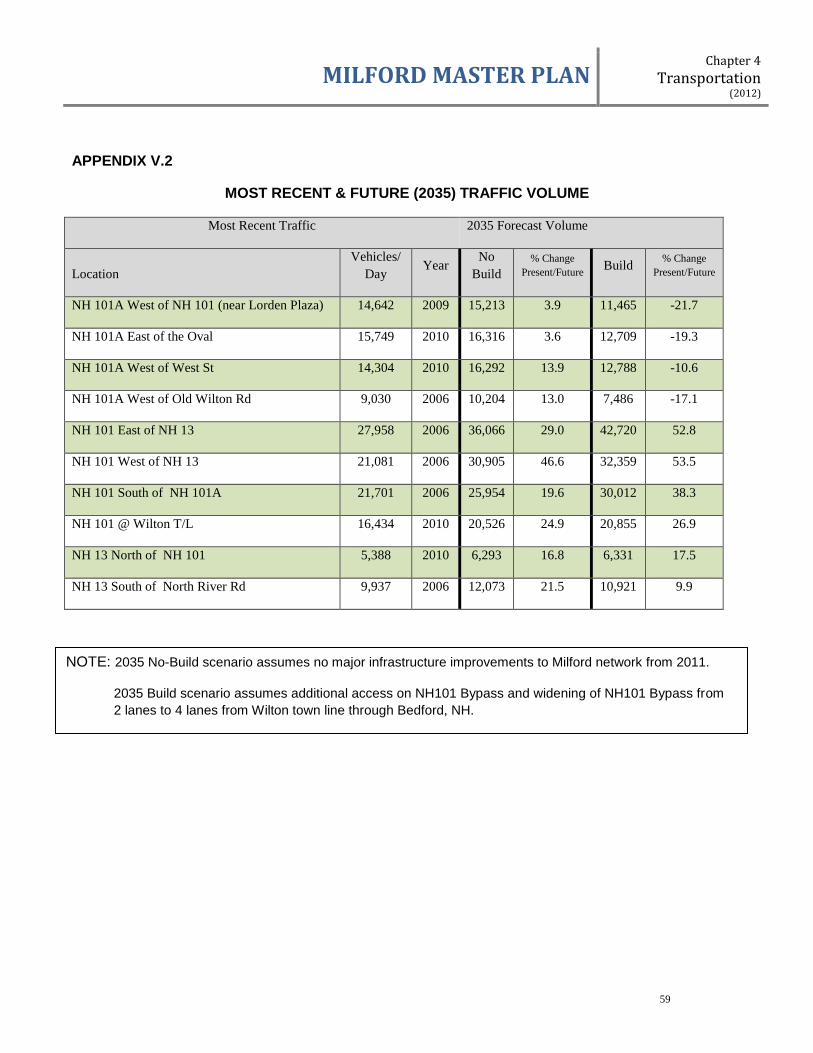
MILFORD MASTER PLAN Chapter 4
Transportation (2012)
59
APPENDIX V.2
MOST RECENT & FUTURE (2035) TRAFFIC VOLUME
Most Recent Traffic 2035 Forecast Volume
Location
Vehicles/
Day Year
No
Build
% Change
Present/Future Build
% Change
Present/Future
NH 101A West of NH 101 (near Lorden Plaza) 14,642 2009 15,213 3.9 11,465 -21.7
NH 101A East of the Oval 15,749 2010 16,316 3.6 12,709 -19.3
NH 101A West of West St 14,304 2010 16,292 13.9 12,788 -10.6
NH 101A West of Old Wilton Rd 9,030 2006 10,204 13.0 7,486 -17.1
NH 101 East of NH 13 27,958 2006 36,066 29.0 42,720 52.8
NH 101 West of NH 13 21,081 2006 30,905 46.6 32,359 53.5
NH 101 South of NH 101A 21,701 2006 25,954 19.6 30,012 38.3
NH 101 @ Wilton T/L 16,434 2010 20,526 24.9 20,855 26.9
NH 13 North of NH 101 5,388 2010 6,293 16.8 6,331 17.5
NH 13 South of North River Rd 9,937 2006 12,073 21.5 10,921 9.9
NOTE: 2035 No-Build scenario assumes no major infrastructure improvements to Milford network from 2011.
2035 Build scenario assumes additional access on NH101 Bypass and widening of NH101 Bypass from
2 lanes to 4 lanes from Wilton town line through Bedford, NH.

MILFORD MASTER PLAN Chapter 4
Transportation (2012)
60
APPENDIX V.3
MOST RECENT TRAFFIC VOLUME COUNTS
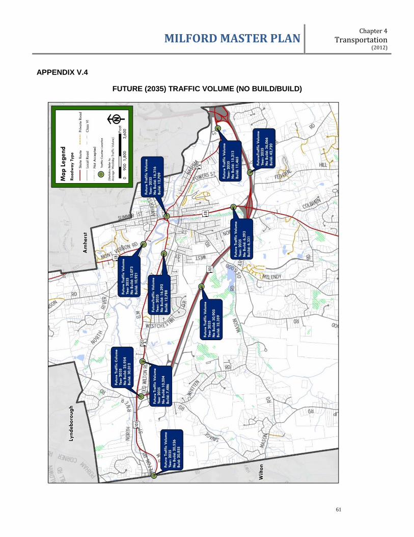
MILFORD MASTER PLAN Chapter 4
Transportation (2012)
61
APPENDIX V.4
FUTURE (2035) TRAFFIC VOLUME (NO BUILD/BUILD)
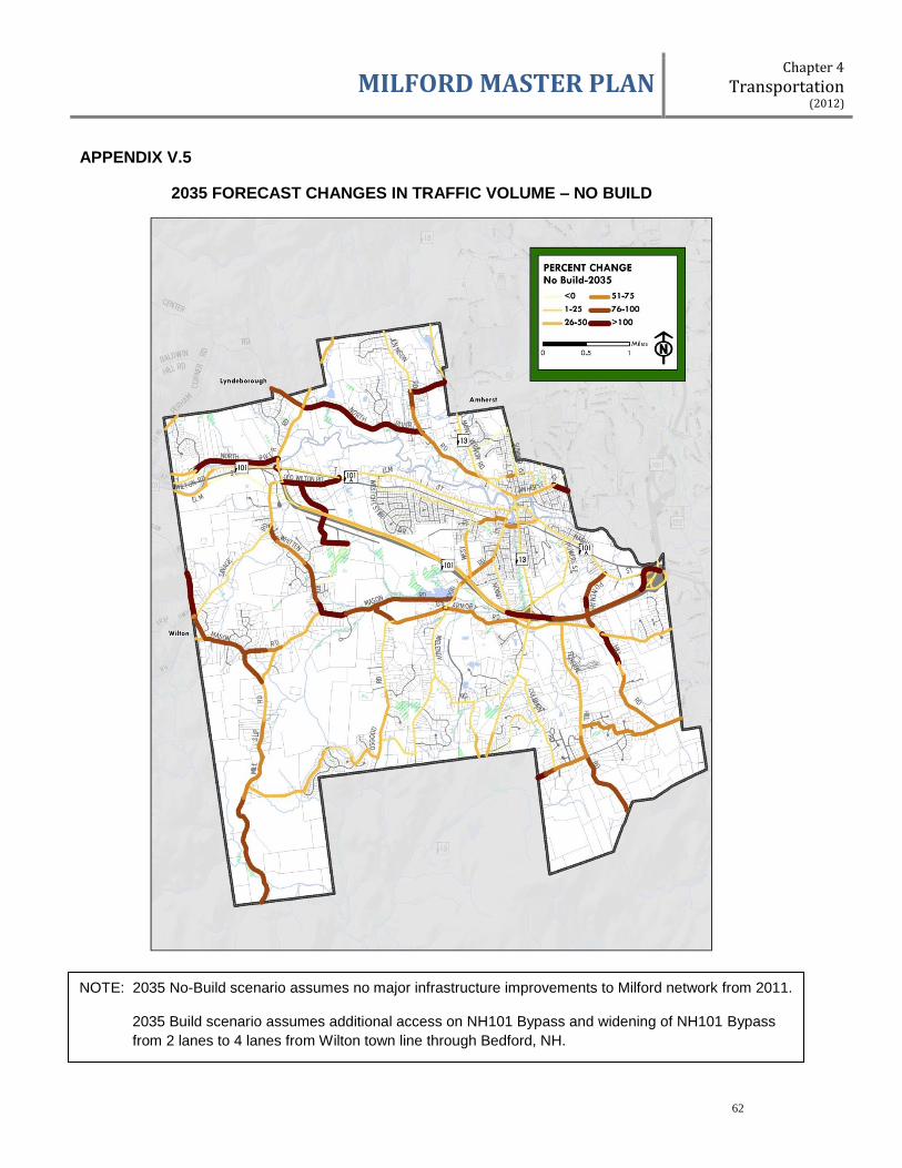
MILFORD MASTER PLAN Chapter 4
Transportation (2012)
62
APPENDIX V.5
2035 FORECAST CHANGES IN TRAFFIC VOLUME – NO BUILD
NOTE: 2035 No-Build scenario assumes no major infrastructure improvements to Milford network from 2011.
2035 Build scenario assumes additional access on NH101 Bypass and widening of NH101 Bypass
from 2 lanes to 4 lanes from Wilton town line through Bedford, NH.
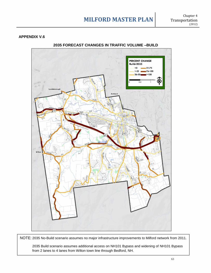
MILFORD MASTER PLAN Chapter 4
Transportation (2012)
63
APPENDIX V.6
2035 FORECAST CHANGES IN TRAFFIC VOLUME –BUILD
NOTE: 2035 No-Build scenario assumes no major infrastructure improvements to Milford network from 2011.
2035 Build scenario assumes additional access on NH101 Bypass and widening of NH101 Bypass
from 2 lanes to 4 lanes from Wilton town line through Bedford, NH.

MILFORD MASTER PLAN Chapter 4
Transportation (2012)
64
APPENDIX V.7
EXISTING (2011) INTERSECTION LEVEL OF SERVICE
SIGNALIZED INTERSECTIONS:
AM Peak
Delay (sec.)
AM Peak
LOS
PM Peak
Delay (sec.)
PM Peak
LOS
NH101/PHELAN RD/OLD WILTON RD
NH101 NB, approach 36.2 D 103.9 F
NH101 SB, approach 56.5 E 32.6 C
Phelan Rd. EB approach 52.7 D 218.3 F
Old Wilton Rd. WB, approach 51.0 D 73 E
ELM ST/WEST ST
Elm St WB, approach 15.8 B 22.7 C
West St NB, approach 43.9 D 41.3 D
NO-SIGNALIZED INTERSECTIONS: AM Peak
Delay (sec.)
AM Peak
LOS
PM Peak
Delay (sec.)
PM Peak
LOS
PHELAN RD/MEADOWBROOK/JONES RD
Phelan Rd EB, left 7.7 A 8.2 A
Phelan Rd WB left 7.7 A 7.5 A
Jones Rd SB, approach 13.5 B 25.0 D
Meadowbrook Rd NB, approach 9.5 A 10.5 B
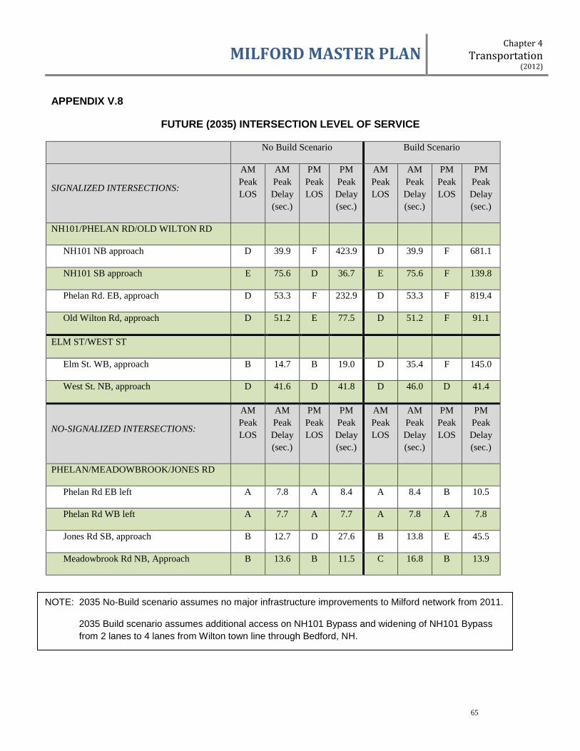
MILFORD MASTER PLAN Chapter 4
Transportation (2012)
65
APPENDIX V.8
FUTURE (2035) INTERSECTION LEVEL OF SERVICE
No Build Scenario Build Scenario
SIGNALIZED INTERSECTIONS:
AM
Peak
LOS
AM
Peak
Delay
(sec.)
PM
Peak
LOS
PM
Peak
Delay
(sec.)
AM
Peak
LOS
AM
Peak
Delay
(sec.)
PM
Peak
LOS
PM
Peak
Delay
(sec.)
NH101/PHELAN RD/OLD WILTON RD
NH101 NB approach D 39.9 F 423.9 D 39.9 F 681.1
NH101 SB approach E 75.6 D 36.7 E 75.6 F 139.8
Phelan Rd. EB, approach D 53.3 F 232.9 D 53.3 F 819.4
Old Wilton Rd, approach D 51.2 E 77.5 D 51.2 F 91.1
ELM ST/WEST ST
Elm St. WB, approach B 14.7 B 19.0 D 35.4 F 145.0
West St. NB, approach D 41.6 D 41.8 D 46.0 D 41.4
NO-SIGNALIZED INTERSECTIONS:
AM
Peak
LOS
AM
Peak
Delay
(sec.)
PM
Peak
LOS
PM
Peak
Delay
(sec.)
AM
Peak
LOS
AM
Peak
Delay
(sec.)
PM
Peak
LOS
PM
Peak
Delay
(sec.)
PHELAN/MEADOWBROOK/JONES RD
Phelan Rd EB left A 7.8 A 8.4 A 8.4 B 10.5
Phelan Rd WB left A 7.7 A 7.7 A 7.8 A 7.8
Jones Rd SB, approach B 12.7 D 27.6 B 13.8 E 45.5
Meadowbrook Rd NB, Approach B 13.6 B 11.5 C 16.8 B 13.9
NOTE: 2035 No-Build scenario assumes no major infrastructure improvements to Milford network from 2011.
2035 Build scenario assumes additional access on NH101 Bypass and widening of NH101 Bypass
from 2 lanes to 4 lanes from Wilton town line through Bedford, NH.
MILFORD MASTER PLAN Chapter 5
Economic Development (1999)
66
Chapter 5
ECONOMIC DEVELOPMENT
Milford Economic Development Philosophy
The Town of Milford should strive for an aggressive, proactive community growing through
beneficial projects. The Town should strive to stabilize its remaining rural character through'
maximized open space protection. The Town should strive for a manageable population with
quality affordable services, and predictable tax rates through balanced taxable assets.
The Town should design its economic development strategy utilizing a relative contribution
formula. Positive property tax growth projects should be encouraged, assisted and
implemented pro-actively.
At the time the Planning Board adopted the 1993 Master Plan, the Town of Milford, the southern New Hampshire region, New England and much of the country was in the midst of a significant economic recession. Milford unemployment was high, and new construction of any kind was slow. The local economy reflected the impacts from corporate "downsizing" and restructuring, changing national and global manufacturing trends, and the effects of a quick downturn in real estate values resulting from the inflated real estate market of the late 1980’s.
Within the last five to six years, there has been sustained moderately paced economic
growth in the region, consistent with national trends since the low-point of the recession.
Southern New Hampshire has benefited economically from growth in technological, health
and service industries, as well as location near the Boston metropolitan area. The region
has been consistently noted nationally as a desirable place to live with an attractive quality
of life.
Milford's economic base has exhibited strength primarily by continued expansion in the
established manufacturing sector. Commercial development has followed suit, as Milford
continues to be the largest “full-service" town between Nashua and Keene, drawing on a
commercial trade area population of approximately 35,000. Most new commercial
development has occurred at either end of the Nashua Street/Elm Street east-west corridor,
where high traffic counts, access and site visibility create locations attractive for commercial
development.
Correlative to continued commercial and industrial expansion in Milford has been steady
single-family residential construction. This strong residential growth has almost exclusively
been in the form of single-family residences. In addition, the percentage of net valuation of
residential vs. non-residential land and buildings has increased from 68.33% vs. 31.67%
(1992) to 70.49% vs. 29.51% (1998). This points to a trend that the residential tax base is
increasing in Milford at the expense of the non-residential tax base.
Property taxes in Milford, as in all New Hampshire communities, are allocated between the
county (Hillsborough in Milford's case), the local school district (SAU #40) and the
The 1993 unemployment rate in Milford averaged close to 9%. For the year 1998, the rate was 1.9%
NH Employment security,
Economic and Labor
Market Information Bureau

MILFORD MASTER PLAN Chapter 5
Economic Development (1999)
67
municipality. During the period 1992 through 1998, the school district claimed the highest
percentage of property taxes (ranging annually between 71%-74%), the Town was
apportioned between 20%-22%, and the County received 5%-8%. Additionally, the overall
tax rate between 1992 and 1998 climbed 28%, with the School portion increasing 31%.
(Source: Town Reports, 1992 through 1998).
As is commonly acknowledged, the burden of school funding in New Hampshire falls upon
local property taxes, with the bulk of property taxes collected being generated by the
residential property owner. However, costs to educate students are not adequately covered
by the property taxes collected on residential properties, especially single-family homes and
some multi-family developments; both of which can generate a higher amount of school
children per household. Thus, residential growth generally demands a greater amount of
property taxes than it usually pays. This is considered "tax negative". Consequently, the
New Hampshire Supreme Court, in its 1998 "Claremont Decision", ordered the State to
develop school funding mechanisms that do not rely solely on local property taxes.
As part of the development of this Master Plan Update, the subcommittee charged with
economic development reiterated that for Milford the cost of residential growth far exceeded
the revenue generated.
The current situation in Milford can be described by the following:
The tax burden is increasing faster than inflation,
The Town's school costs are the largest share of the budget and are increasing at
the fastest rate,
The Town is non-competitive for commercial/industrial growth,
Under current conditions, things will get worse.
The subcommittee determined. that the following common assumptions were false:
New development increases the tax base, New development lowers taxes for all, Large developments cost more and thus generate more tax revenue, New development pays its own way, All growth is good for the Town, Good or bad, you cannot control growth.
The subcommittee concluded that new developments are either tax-positive or tax.-
negative; that most growth costs all taxpayers some money; some growth costs more, some
less; and the Town Master Plan should encourage the kind of growth that is best for the
Town as a whole. Consequently, if residential growth costs more than its tax revenue, and if
nothing else happens to offset those costs, then taxpayers are subsidizing additional
residential development. The subcommittee found that existing commercial and industrial
development makes up 28% of the tax base and drives 7% of the cost of services. Open
space is 4% of the tax base and drives 1% of the cost. Disproportionately, residential
property equals 68% of the tax base and drives 92% of the cost.
New single-family building permits issued:
1992: 52 1993: 37 1994: 55 1995: 60 1996: 37 1997: 56 1998: 72 1999: 65 (est.)
-Town reports,
1993 through 1998
Residential vs. Non-residential Net Valuation (%):
1992: 68.3/31.7 1993: 69.0/31.0 1994: 69.1/30.9 1995: 68.6/31.4 1996: 68.3/31.7 1997: 70.4/29.6 1998: 70.5/29.5
-Milford Assessing Dept. MS1 Analysis

MILFORD MASTER PLAN Chapter 5
Economic Development (1999)
68
The subcommittee also determined that the Town has several obstacles and disincentives
to encouraging commercial and industrial growth, including limited available land with even
more limiting lack of available infrastructure (roads and utilities), high site development
costs, the high local tax rate, and an attitude by many citizens and decision-makers that
Town government should not be in the "development business".
To counter these obstacles and disincentives, the following recommendations and actions
shall be taken by the Town:
II: ACTIONS FOR 1999/2000
2.01 HIGH PRIORITY - ACTION: A
Make Milford more industry ready.
In order to encourage new commercial and industrial development, actions must be taken
that make the Town "industry ready", and thus be in a position to act proactively to obtain
tax positive development in the ever increasing competitive economic development
environment This can be accomplished by:
1. Evaluating and implementing appropriate actions to extend infrastructure into areas feasible for industrial land uses, including the implementation of "'tax increment financing" as a practical tool to finance infrastructure improvements,
2. Evaluating the need for additional industrially and commercially zoned land and
implementing zoning changes, 3. Encouraging tax-positive residential development,
a. Implement flexible regulatory policies that promote retirement-living, elderly, and assisted-living opportunities; encourage conversion of existing multi-family developments to retirement-living, elderly and assisted living housing;
b. Implement opens space preservation subdivision techniques.
1. Responsibilities and Actions
The Planning Board shall review and implement the land use related actions necessary to
make Milford more industry ready. A strong consensus of agreement between the Planning
Board, the Board of Selectmen, the Milford Industrial Development Corporation, School
Board, budget advisory committees, citizen groups, and the public needs to be forged.
See Chapter 6, THE BROX PROPERTY, which identifies an opportunity the Town must seize to address many of the issues identified as economic development concerns.

MILFORD MASTER PLAN Chapter 5
Economic Development (1999)
69
III: ACTIONS FOR 2000/2002
3.01 MEDIUM PRIORITY - ACTION: B
Evaluate and implement methods to reconstruct local property tax system.
The purpose of this recommendation is to provide for a more equitable means of taxation.
Implementation of this idea will be a challenge in that many basic tenets and philosophies
regarding taxation and local /state control will be confronted. It means effecting change at
the State level, making it possible for local level decision-makers to better serve the needs
of their communities.
The Board of Selectmen shall engage Milford's representatives in Concord in proposing
legislation enabling alternative revenue generating mechanisms, such as a local income tax,
industrial abatements, school department trusts, "per living unit" base, and senior
exemptions.
3.02 MEDIUM PRIORITY - ACTION: C
Continue efforts to expand tax positive growth and land use at a faster rate than tax negative growth and land use.
Efforts to make Milford more industry ready (High Priority Action: A.) must be followed up
with additional actions that will serve to adjust the land use and property tax generating ratio
to lessen the burden on the residential property owner. 1. Responsibilities and Actions
The Planning Board shall take the lead in continuing the review and implementation of
strategies to achieve a greater tax-positive land use base. The Board shall work with the
Milford Industrial Development Corporation, the Conservation Commission, and the Board of
Selectmen to examine and implement regulatory changes to encourage more agriculture
and open space-related businesses (e.g. encourage golf course development), and review
allowable residential densities. The Planning Board will conduct a study on the feasibility
and need for impact fees to be placed on new development to assist in lessening the cost of
growth. The Planning Board shall encourage efforts to build and support land trusts.
See Community Character Action B. • Develop and Implement Open Space and Conservation Zoning and subdivision techniques.
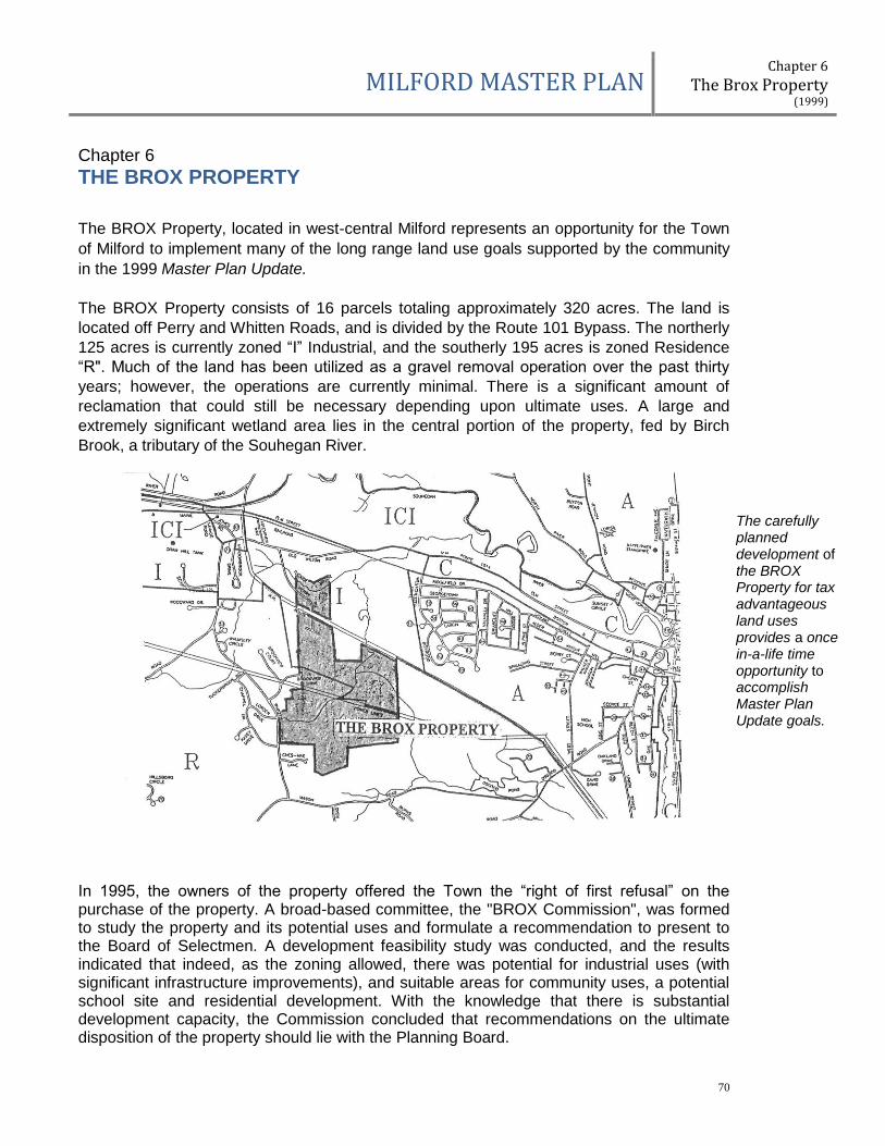
MILFORD MASTER PLAN Chapter 6
The Brox Property (1999)
70
Chapter 6
THE BROX PROPERTY
The BROX Property, located in west-central Milford represents an opportunity for the Town
of Milford to implement many of the long range land use goals supported by the community
in the 1999 Master Plan Update.
The BROX Property consists of 16 parcels totaling approximately 320 acres. The land is
located off Perry and Whitten Roads, and is divided by the Route 101 Bypass. The northerly
125 acres is currently zoned “I” Industrial, and the southerly 195 acres is zoned Residence
“R". Much of the land has been utilized as a gravel removal operation over the past thirty
years; however, the operations are currently minimal. There is a significant amount of
reclamation that could still be necessary depending upon ultimate uses. A large and
extremely significant wetland area lies in the central portion of the property, fed by Birch
Brook, a tributary of the Souhegan River.
In 1995, the owners of the property offered the Town the “right of first refusal” on the purchase of the property. A broad-based committee, the "BROX Commission", was formed to study the property and its potential uses and formulate a recommendation to present to the Board of Selectmen. A development feasibility study was conducted, and the results indicated that indeed, as the zoning allowed, there was potential for industrial uses (with significant infrastructure improvements), and suitable areas for community uses, a potential school site and residential development. With the knowledge that there is substantial development capacity, the Commission concluded that recommendations on the ultimate disposition of the property should lie with the Planning Board.
The carefully planned development of the BROX Property for tax advantageous land uses provides a once in-a-life time opportunity to accomplish Master Plan Update goals.
MILFORD MASTER PLAN Chapter 6
The Brox Property (1999)
71
Concurrently, over the past several years, the Milford Industrial Development Corporation
began efforts to encourage industrial development in the Perry Road I Bypass portion of the
property. The School Board identified, after exhaustive land searches for a new elementary
school site, a 50-acre site off Whitten Road. Both organizations entered into negotiations
with the property owners for their particular uses.
The property has been the subject of much discussion by the community regarding its
ultimate development. There was much unofficial community sentiment at the end of 1998
and the beginning of 1999 that the community would best be served by keeping single-
family residential development from occurring (tax-negative), pursuing industrial
development, protecting important natural resource areas, and locating a school off Whitten
Road. The Master Plan Update committees discussed the ultimate development and
ownership of the BROX Property at length throughout the update process.
II: BROX PROPERTY RECOMMENDATION:
2.01 HIGH PRIORITY ACTION FOR 1999/2000.
Recognizing that the BROX Property represents substantial development capacity for
industrial, residential, community facility and recreational uses, the Town should purchase
and/or facilitate purchase by others of the entire 320 acres in order to control its ultimate
development. In controlling the ultimate development of the site, the Town recognizes the
importance of restricting and/or prohibiting single-family residential development from this
location due to the tax-negative impact such residential development imposes on the Town.
Once the property is purchased, the Town should:
1. Work with the Milford Industrial Development Corporation (MIDC) and private industrial
developers to make the industrially-zoned acreage "development ready" by seeking
means to extend necessary roads and utilities.
2. Work with the Milford School District to guarantee that any proposed school facility is
built with the long-range development of the entire BROX property in mind, especially
relative to utility and road extensions and mutual benefit from potential community and
recreational facilities.
3. Work with conservation groups, including the Milford Conservation Commission, to
preserve and protect the significant wetlands, surface waters, and natural areas located
on the property,
4. Incorporate available land into the long range community facilities master plan, to
include areas reserved for cemeteries, recreation facilities, fields, a golf course and
trails, potential additional school locations, and other municipal purposes, 5. Promote the development of retired living, elderly and "empty-nester" housing, and other
residential development that is tax-positive. Responsibilities and Actions
The Planning Board shall take a lead role, in partnership with the Board of Selectmen, the
Conservation Commission, the School Board, the Milford Industrial Development
Corporation among others, to bring a plan to purchase and/or control the development of the
BROX Property for Town deliberation and vote in the year 2000.
The Town's highest priority regarding community facilities is the development and implementation of a facilities master plan - the BROX Property should play an essential role in providing land for future facilities.
MILFORD MASTER PLAN Chapter 7
Housing (2010)
72
Chapter 7:
HOUSING CHAPTER
INTRODUCTION
The Town of Milford is part of Hillsborough County, the Souhegan Valley and the Nashua
Regional Planning Commission. The robust population and housing growth experienced in
Milford has been and will continue to be influenced by its geographic and economic location.
Milford lies at the intersections of the State’s major east-west highway, Route 101 and Route
101A. It is further bisected by Route 13, a north-south roadway running from Massachusetts to
New Hampshire’s state capital, Concord.
Given its location, Milford serves as a hub of commercial and industrial activities. In addition to
its geographic connections, as of 2009 Milford is one of only four communities within the
Nashua Regional Planning Commission region to have a municipal water system and
wastewater treatment plant. These municipal utilities serve the community throughout the more
densely populated downtown area and along major roadway corridors. As a Town with a
substantial commercial-industrial sector and municipal water and sewer utilities, Milford has
historically provided a diverse range of housing options for all income and age ranges, and
continues to do so.
Per state statute, the Housing Chapter of a Master Plan must assess the local housing
conditions and project the future housing needs of the community and the region for all income
levels and ages. The purpose of this chapter is to examine trends and forecasts for population,
income and housing in Milford, in the context of the region defined by the Nashua Regional
Planning Commission’s (NRPC) borders. In addition, this chapter outlines the community’s
program of action to help ensure Milford’s housing stock continues to provide for the needs of its
current and future population. Safe, quality housing that reflects the economic and community
character of Milford is vital to the long-term future of Milford.
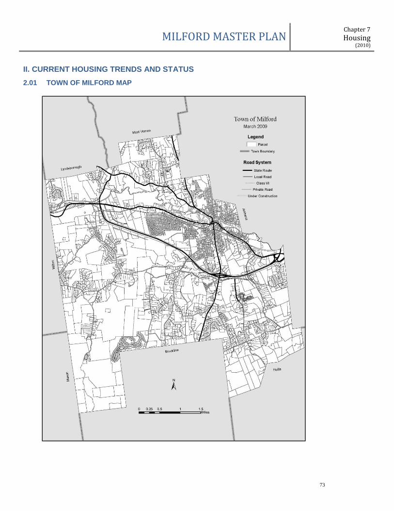
MILFORD MASTER PLAN Chapter 7
Housing (2010)
73
II. CURRENT HOUSING TRENDS AND STATUS
2.01 TOWN OF MILFORD MAP
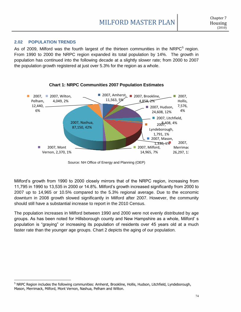
MILFORD MASTER PLAN Chapter 7
Housing (2010)
74
2.02 POPULATION TRENDS
As of 2009, Milford was the fourth largest of the thirteen communities in the NRPC5 region.
From 1990 to 2000 the NRPC region expanded its total population by 14%. The growth in
population has continued into the following decade at a slightly slower rate; from 2000 to 2007
the population growth registered at just over 5.3% for the region as a whole.
Chart 1: NRPC Communities 2007 Population Estimates
Source: NH Office of Energy and Planning (OEP)
Milford’s growth from 1990 to 2000 closely mirrors that of the NRPC region, increasing from
11,795 in 1990 to 13,535 in 2000 or 14.8%. Milford’s growth increased significantly from 2000 to
2007 up to 14,965 or 10.5% compared to the 5.3% regional average. Due to the economic
downturn in 2008 growth slowed significantly in Milford after 2007. However, the community
should still have a substantial increase to report in the 2010 Census.
The population increases in Milford between 1990 and 2000 were not evenly distributed by age
groups. As has been noted for Hillsborough county and New Hampshire as a whole, Milford’ s
population is “graying” or increasing its population of residents over 45 years old at a much
faster rate than the younger age groups. Chart 2 depicts the aging of our population.
5 NRPC Region includes the following communities: Amherst, Brookline, Hollis, Hudson, Litchfield, Lyndeborough, Mason, Merrimack, Milford, Mont Vernon, Nashua, Pelham and Wilton.
2007, Amherst, 11,563, 5%
2007, Brookline, 4,858, 2%
2007, Hollis, 7,576,
4% 2007, Hudson, 24,608, 12%
2007, Litchfield, 8,408, 4% 2007,
Lyndeborough, 1,791, 1%
2007, Mason, 1,330, 1% 2007,
Merrimack, 26,297, 13%
2007, Milford, 14,965, 7%
2007, Mont Vernon, 2,370, 1%
2007, Nashua, 87,150, 42%
2007, Pelham, 12,440,
6%
2007, Wilton, 4,049, 2%
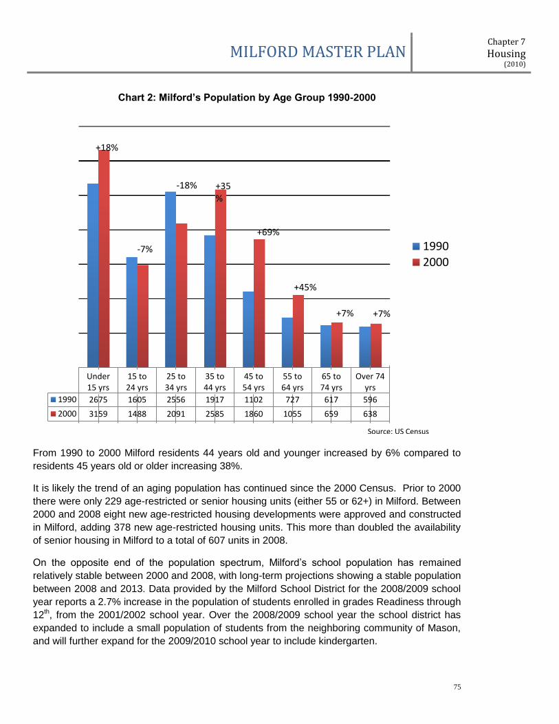
MILFORD MASTER PLAN Chapter 7
Housing (2010)
75
Chart 2: Milford’s Population by Age Group 1990-2000
From 1990 to 2000 Milford residents 44 years old and younger increased by 6% compared to
residents 45 years old or older increasing 38%.
It is likely the trend of an aging population has continued since the 2000 Census. Prior to 2000
there were only 229 age-restricted or senior housing units (either 55 or 62+) in Milford. Between
2000 and 2008 eight new age-restricted housing developments were approved and constructed
in Milford, adding 378 new age-restricted housing units. This more than doubled the availability
of senior housing in Milford to a total of 607 units in 2008.
On the opposite end of the population spectrum, Milford’s school population has remained
relatively stable between 2000 and 2008, with long-term projections showing a stable population
between 2008 and 2013. Data provided by the Milford School District for the 2008/2009 school
year reports a 2.7% increase in the population of students enrolled in grades Readiness through
12th, from the 2001/2002 school year. Over the 2008/2009 school year the school district has
expanded to include a small population of students from the neighboring community of Mason,
and will further expand for the 2009/2010 school year to include kindergarten.
Under15 yrs
15 to24 yrs
25 to34 yrs
35 to44 yrs
45 to54 yrs
55 to64 yrs
65 to74 yrs
Over 74yrs
1990 2675 1605 2556 1917 1102 727 617 596
2000 3159 1488 2091 2585 1860 1055 659 638
19902000
Source: US Census
+18%
-7%
-18% +35%
+69%
+45%
+7% +7%

MILFORD MASTER PLAN Chapter 7
Housing (2010)
76
2.03 INCOME TRENDS
Income data is typically reported in one of three major indices: Per Capita Income, Median
Family Income and Median Household Income.
Per Capita Income is a measure of the income for an entire geography (in this case the Town of
Milford) divided by the total population, or every man, woman and child. This index takes into
account children, who do not generally contribute any income, producing a lower value than
median incomes.
A median measure divides an income distribution into two equal parts, with one-half falling
below and one-half above the median number. Median Family Income includes the incomes of
all family members 15 years old and over related to the “householder” versus the Median
Household Income which includes the income of all individuals in the household whether they
are related or not. As there are many households with one person, this index is generally lower
than the family income.
As this report evaluates housing in Milford and the NRPC region, the median family and
household incomes data are used for comparison purposes. The major source for broadly
reported income data at the community level comes from the US Census Bureau’s dicentennial
census. Due to the constraints of the data available in 2009, this report was not able to evaluate
more recent trends in income data; however as the new census data becomes available in 2011
this report should be updated.
The decade from 1990 through 2000 details considerable increases in income for all New
Hampshire residents. The Median Family Income increased by 38.3% over the decade and the
Median Household Income by 36.2% for the state as a whole. Hillsborough County reported
similar growth in both family and household income for the same period, at 34.8% and 32.1%
respectively. Looking at the smaller NRPC region, the increases in income are even greater
than the state and county averages. In 1989 the Median Family Income for the NRPC region
was $52,667, which increased to $74,659 in 1999, a 41.8% growth. Households fared better
than the state and county as well, with a reported $49,458 income in 1989, increasing to
$68,012 in 1999, a 37.5% increase.
The prosperous growth of this decade carried into Milford as well. Milford’s median incomes are
approximately $10,000 less than the NRPC region’s average, but show similar rates of growth
over the decade (See Tables 1 & 2).
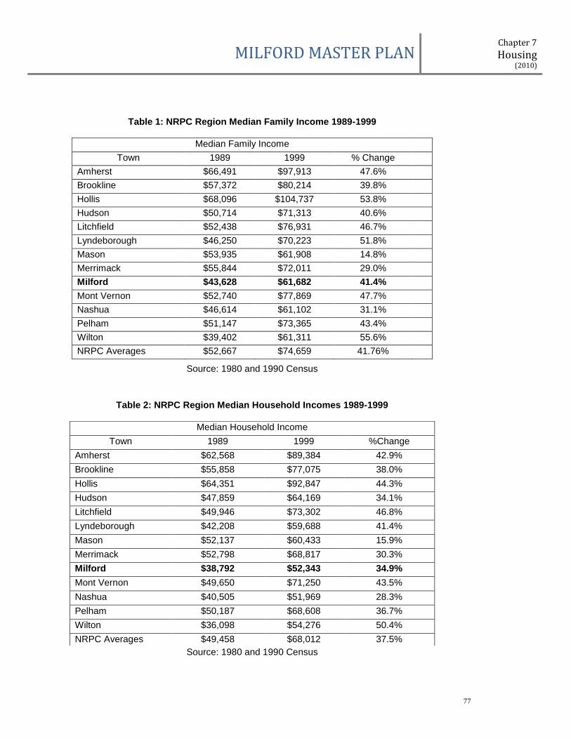
MILFORD MASTER PLAN Chapter 7
Housing (2010)
77
Table 1: NRPC Region Median Family Income 1989-1999
Source: 1980 and 1990 Census
Table 2: NRPC Region Median Household Incomes 1989-1999
Source: 1980 and 1990 Census
Median Family Income
Town 1989 1999 % Change
Amherst $66,491 $97,913 47.6%
Brookline $57,372 $80,214 39.8%
Hollis $68,096 $104,737 53.8%
Hudson $50,714 $71,313 40.6%
Litchfield $52,438 $76,931 46.7%
Lyndeborough $46,250 $70,223 51.8%
Mason $53,935 $61,908 14.8%
Merrimack $55,844 $72,011 29.0%
Milford $43,628 $61,682 41.4%
Mont Vernon $52,740 $77,869 47.7%
Nashua $46,614 $61,102 31.1%
Pelham $51,147 $73,365 43.4%
Wilton $39,402 $61,311 55.6%
NRPC Averages $52,667 $74,659 41.76%
Median Household Income
Town 1989 1999 %Change
Amherst $62,568 $89,384 42.9%
Brookline $55,858 $77,075 38.0%
Hollis $64,351 $92,847 44.3%
Hudson $47,859 $64,169 34.1%
Litchfield $49,946 $73,302 46.8%
Lyndeborough $42,208 $59,688 41.4%
Mason $52,137 $60,433 15.9%
Merrimack $52,798 $68,817 30.3%
Milford $38,792 $52,343 34.9%
Mont Vernon $49,650 $71,250 43.5%
Nashua $40,505 $51,969 28.3%
Pelham $50,187 $68,608 36.7%
Wilton $36,098 $54,276 50.4%
NRPC Averages $49,458 $68,012 37.5%

MILFORD MASTER PLAN Chapter 7
Housing (2010)
78
Within Milford, the growth in income was further displayed through changes in the distribution of
income groups. Chart 3 displays the income of Milford households by income group from the
1990 and 2000 Census. As will be discussed later in this report, the number of households and
housing units also increased significantly from 1990 to 2000; not only were the incomes of
existing residents rising, but it is likely new households were adding to the increase in income
for Milford and the region.
Chart 3: Milford Household Income Groups 1990 & 2000
The chart shows a clear trend of increased incomes in Milford. All of the income groups making
$49,999 or less per household lost population over the decade and in contrast, all income
groups making $50,000 or more made significant gains.
After the 2000 Census the economy continued to expand throughout the United States and New
Hampshire until late in 2007. It is reasonable to assume that family and household incomes
have continued to rise since the census survey in 2000. However, due to the 2008 economic
downturn and contraction of the economy, it is likely that the rate of increase in Milford shown in
the 2010 Census will be less substantial than over the previous decade.
Less than10,000
$10,000 to$14,999
$15,000 to$24,999
$25,000 to$34,999
$35,000 to$49,999
$50,000 to$74,999
$75,000 to$99,999
$100,000to
$149,999
Greaterthan
$150,000
1990 340 227 581 741 1230 890 355 141 24
2000 239 204 410 594 984 1336 730 518 190
Nu
mb
er
of
Ho
use
ho
lds
1990
2000
Source: 1990 & 2000 US Census
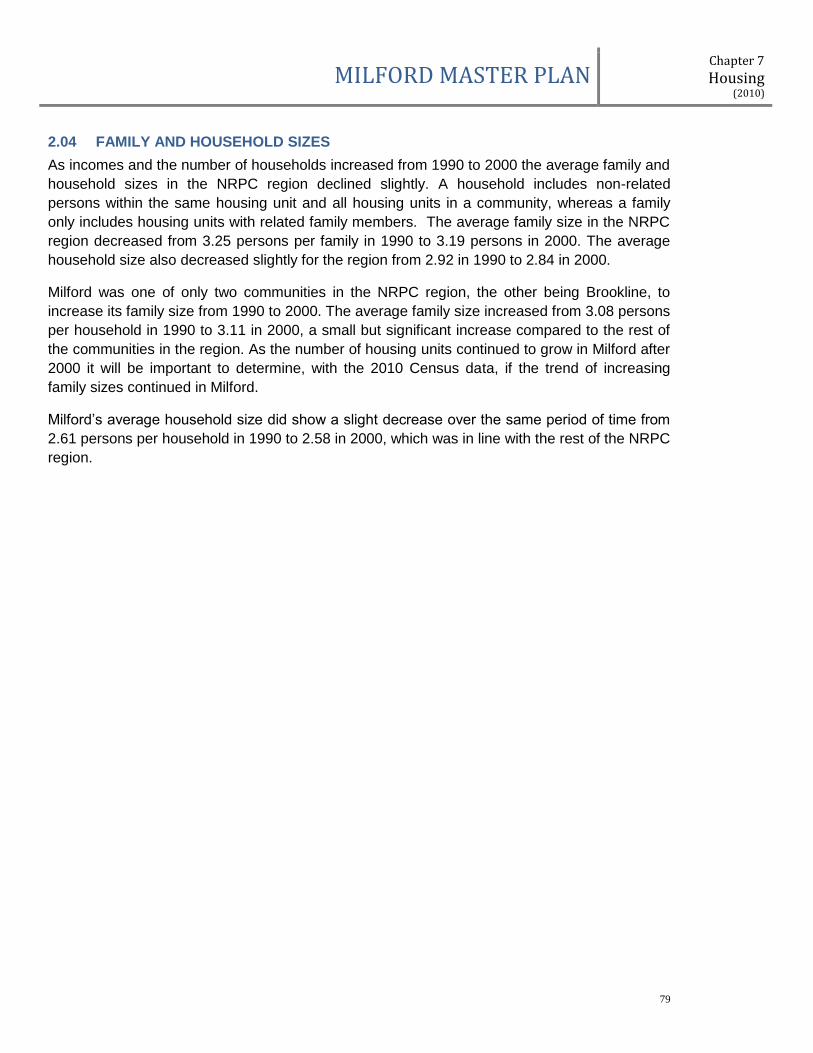
MILFORD MASTER PLAN Chapter 7
Housing (2010)
79
2.04 FAMILY AND HOUSEHOLD SIZES
As incomes and the number of households increased from 1990 to 2000 the average family and
household sizes in the NRPC region declined slightly. A household includes non-related
persons within the same housing unit and all housing units in a community, whereas a family
only includes housing units with related family members. The average family size in the NRPC
region decreased from 3.25 persons per family in 1990 to 3.19 persons in 2000. The average
household size also decreased slightly for the region from 2.92 in 1990 to 2.84 in 2000.
Milford was one of only two communities in the NRPC region, the other being Brookline, to
increase its family size from 1990 to 2000. The average family size increased from 3.08 persons
per household in 1990 to 3.11 in 2000, a small but significant increase compared to the rest of
the communities in the region. As the number of housing units continued to grow in Milford after
2000 it will be important to determine, with the 2010 Census data, if the trend of increasing
family sizes continued in Milford.
Milford’s average household size did show a slight decrease over the same period of time from
2.61 persons per household in 1990 to 2.58 in 2000, which was in line with the rest of the NRPC
region.
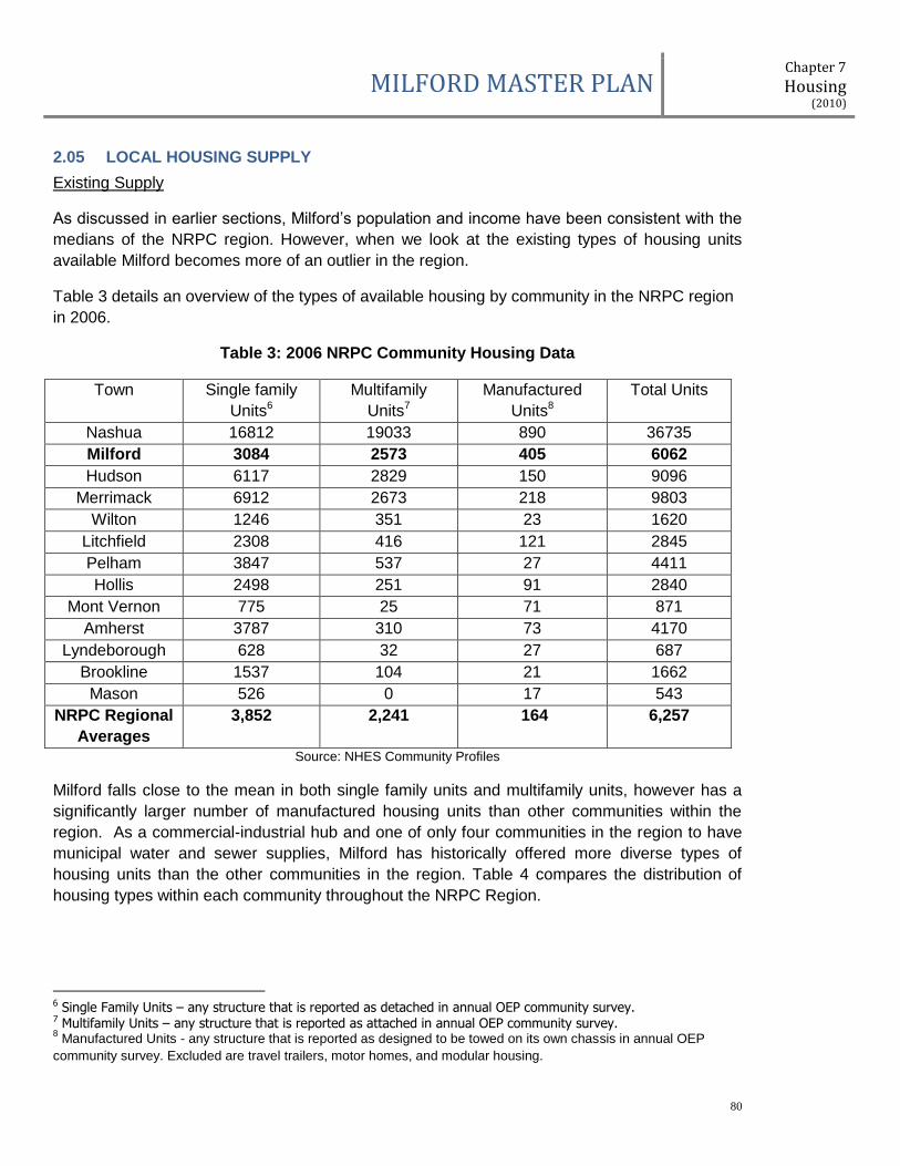
MILFORD MASTER PLAN Chapter 7
Housing (2010)
80
2.05 LOCAL HOUSING SUPPLY
Existing Supply
As discussed in earlier sections, Milford’s population and income have been consistent with the
medians of the NRPC region. However, when we look at the existing types of housing units
available Milford becomes more of an outlier in the region.
Table 3 details an overview of the types of available housing by community in the NRPC region
in 2006.
Table 3: 2006 NRPC Community Housing Data
Town Single family
Units6
Multifamily
Units7
Manufactured
Units8
Total Units
Nashua 16812 19033 890 36735
Milford 3084 2573 405 6062
Hudson 6117 2829 150 9096
Merrimack 6912 2673 218 9803
Wilton 1246 351 23 1620
Litchfield 2308 416 121 2845
Pelham 3847 537 27 4411
Hollis 2498 251 91 2840
Mont Vernon 775 25 71 871
Amherst 3787 310 73 4170
Lyndeborough 628 32 27 687
Brookline 1537 104 21 1662
Mason 526 0 17 543
NRPC Regional
Averages
3,852 2,241 164 6,257
Source: NHES Community Profiles
Milford falls close to the mean in both single family units and multifamily units, however has a
significantly larger number of manufactured housing units than other communities within the
region. As a commercial-industrial hub and one of only four communities in the region to have
municipal water and sewer supplies, Milford has historically offered more diverse types of
housing units than the other communities in the region. Table 4 compares the distribution of
housing types within each community throughout the NRPC Region.
6 Single Family Units – any structure that is reported as detached in annual OEP community survey. 7 Multifamily Units – any structure that is reported as attached in annual OEP community survey. 8 Manufactured Units - any structure that is reported as designed to be towed on its own chassis in annual OEP
community survey. Excluded are travel trailers, motor homes, and modular housing.

MILFORD MASTER PLAN Chapter 7
Housing (2010)
81
Table 4: 2006 NRPC Communities Housing Units Percent by Type
Town Percent of Single
family Units
Percent of
Multifamily Units
Percent of
Manufactured Units
Nashua 45.8% 51.8% 2.4%
Milford 50.9% 42.4% 6.7%
Hudson 67.2% 31.1% 1.6%
Merrimack 70.5% 27.3% 2.2%
Wilton 76.9% 21.7% 1.4%
Litchfield 81.1% 14.6% 4.3%
Pelham 87.2% 12.2% 0.6%
Hollis 88% 8.8% 3.2%
Mont Vernon 89% 2.9% 8.2%
Amherst 90.8% 7.4% 1.8%
Lyndeborough 91.4% 4.7% 3.9%
Brookline 92.5% 6.3% 1.3%
Mason 96.9% 0% 3.1%
NRPC Regional
Averages
61.6% 22.6% 2.6%
Source: NHES Community Profiles
Milford is significantly different from the regional means in all categories when comparing
housing unit distribution. Milford has the second lowest percentage of single family homes at
50.9% and the second highest rate of multifamily (42.4%) and manufactured homes (6.7%) in
the region. The municipal water and sewer have allowed for higher densities of housing and
commercial-industrial activities, which communities without these services were unable to meet.
In addition, the commercial-industrial sector has supplied many local jobs to the community
which has in turn encouraged a variety of housing options to serve those businesses. As Table
4 displays, Milford provides a more balanced (percentage wise) and diverse choice of housing
types than all communities in our region.
In an effort to examine Milford’s housing stock in more detail the Milford Assessor’s Office
supplied data on all housing units in Milford, including address, number of units and total
assessed value of the property. The following data was reported for 2008 and it is important to
note, differs slightly from the previous regional statics due to dissimilar source data. Chart 4
details the types of housing units available in Milford.
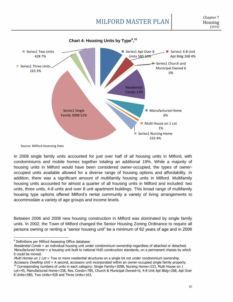
MILFORD MASTER PLAN Chapter 7
Housing (2010)
82
Chart 4: Housing Units by Type9,10
In 2008 single family units accounted for just over half of all housing units in Milford, with
condominiums and mobile homes together totaling an additional 19%. While a majority of
housing units in Milford would have been considered owner-occupied, the types of owner-
occupied units available allowed for a diverse range of housing options and affordability. In
addition, there was a significant amount of multifamily housing units in Milford. Multifamily
housing units accounted for almost a quarter of all housing units in Milford and included: two
units, three units, 4-8 units and over 8 unit apartment buildings. This broad range of multifamily
housing type options offered Milford’s rental community a variety of living arrangements to
accommodate a variety of age groups and income levels.
Between 2006 and 2008 new housing construction in Milford was dominated by single family
units. In 2002, the Town of Milford changed the Senior Housing Zoning Ordinance to require all
persons owning or renting a “senior housing unit” be a minimum of 62 years of age and in 2006
9 Definitions per Milford Assessing Office database: Residential Condo = an individual housing unit under condominium ownership regardless of attached or detached. Manufactured Home = a housing unit built to national HUD construction standards, on a permanent chassis by which it could be moved. Multi Homes on 1 Lot = Tow or more residential structures on a single lot not under condominium ownership. Accessory Dwelling Unit = A second, accessory unit incorporated within an owner-occupied single family property. 10 Corresponding numbers of units in each category: Single Family=3098, Nursing Home=233, Multi House on 1 Lot=45, Manufactured Home=338, Res. Condo=785, Church & Municipal Owned=6, 4-8 Unit Apt Bldg=268, Apt Over 8 Units=580, Two Units=428 and Three Units=163.
Series1 Apt Over 8 Units 580 10%
Series1 4-8 Unit Apt Bldg 268 4%
Series1 Church and Municipal Owned 6
0%
Residential Condo 13%
Manufactured Home 6%
Multi House on 1 Lot 1%
Series1 Nursing Home 233 4%
Series1 Single Family 3098 52%
Series1 Three Units 163 3%
Series1 Two Units 428 7%
Source: Milford Assessing Data
MILFORD MASTER PLAN Chapter 7
Housing (2010)
83
enacted a Growth Management Ordinance (GMO). These changes caused a dramatic drop in
the amount of new multifamily and senior housing units being constructed. In addition, with the
downturn in the economy starting in 2008 there was a significant decrease in new construction
for all types of housing units.
2.06 LOCAL HOUSING OCCUPANCY RATES
Between 2000 and 2008 Milford experienced a tight housing market. According to the 2000
Census there were only 87 vacant housing units, including both units for sale and for rent. From
2000-2007 Milford experienced a significant boom in the construction of all types of housing
units, but the housing market remained very tight. Between 2007 and 2008 the construction of
new housing units leveled off and in 2008 began to rapidly decline following the economic
downturn. As a result the 2010 vacancy rate is expected to be much higher than noted in the
last census, due to unfilled rental apartments, and vacant and foreclosed homes.
2.07 LOCAL HOUSING CONDITIONS
The US Census collects data on housing conditions to estimate the standards of housing within
a community. Of the 5,316 housing units reported in 2000, including single family, multifamily
and manufactured homes, only 8 were lacking in complete kitchen and plumbing facilities. Well
over 99% of Milford’s units have complete kitchen and plumbing facilities.
Another indicator of the condition of a communities housing stock is the age or year built.
Building codes and requirements have been updated significantly over the last several decades
to protect the health and safety of residents. The older a home is the more likely it is to be in
need of repair and the less likely it is to meet current building and safety codes. Data from the
2000 Census coupled with new data from Milford’s Building Department shows our major
housing growth occurred from 1970 to 1989. As seen in Chart 5 nearly half of all housing units
were built after 1979.
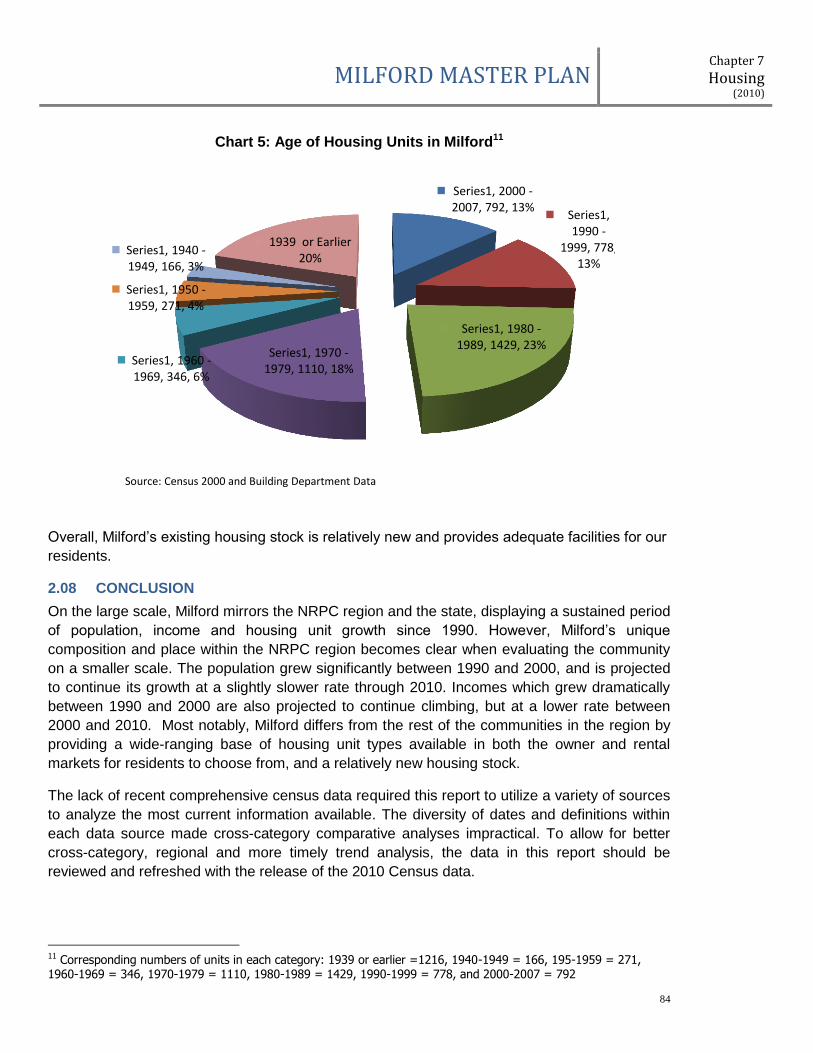
MILFORD MASTER PLAN Chapter 7
Housing (2010)
84
Chart 5: Age of Housing Units in Milford11
Overall, Milford’s existing housing stock is relatively new and provides adequate facilities for our
residents.
2.08 CONCLUSION
On the large scale, Milford mirrors the NRPC region and the state, displaying a sustained period
of population, income and housing unit growth since 1990. However, Milford’s unique
composition and place within the NRPC region becomes clear when evaluating the community
on a smaller scale. The population grew significantly between 1990 and 2000, and is projected
to continue its growth at a slightly slower rate through 2010. Incomes which grew dramatically
between 1990 and 2000 are also projected to continue climbing, but at a lower rate between
2000 and 2010. Most notably, Milford differs from the rest of the communities in the region by
providing a wide-ranging base of housing unit types available in both the owner and rental
markets for residents to choose from, and a relatively new housing stock.
The lack of recent comprehensive census data required this report to utilize a variety of sources
to analyze the most current information available. The diversity of dates and definitions within
each data source made cross-category comparative analyses impractical. To allow for better
cross-category, regional and more timely trend analysis, the data in this report should be
reviewed and refreshed with the release of the 2010 Census data.
11 Corresponding numbers of units in each category: 1939 or earlier =1216, 1940-1949 = 166, 195-1959 = 271, 1960-1969 = 346, 1970-1979 = 1110, 1980-1989 = 1429, 1990-1999 = 778, and 2000-2007 = 792
Series1, 2000 - 2007, 792, 13%
Series1, 1990 -
1999, 778, 13%
Series1, 1980 - 1989, 1429, 23%
Series1, 1970 - 1979, 1110, 18%
Series1, 1960 - 1969, 346, 6%
Series1, 1950 - 1959, 271, 4%
Series1, 1940 - 1949, 166, 3%
1939 or Earlier 20%
Source: Census 2000 and Building Department Data

MILFORD MASTER PLAN Chapter 7
Housing (2010)
85
III: COSTS AND AFFORDABILITY
Housing costs have changed substantially over the last several years in Milford and throughout
the NRPC region. Both owner-occupied and rental housing units’ costs climbed steadily upward
from 2000 through 2007, and began declining in 2008 with the economic downturn. To examine
the cost of housing in Milford and our region, this report will look at owner-occupied and rental
housing units. In addition, it will examine housing affordability through the definitions provided
by the Workforce Housing statutes (RSA 674:58-61).
3.01 OWNER-OCCUPIED HOUSING UNITS
The New Hampshire Housing Finance Authority (NHHFA) tracks the median purchase price of
primary homes for the NRPC Region. In 2000 the median purchase price for all homes (existing,
new construction and condominiums) was $160,000. By 2007 that price had risen to $275,000,
a 72.0% increase in the price of housing. The regional trend is mirrored in Milford with a 2000
median purchase price of $144,000, increasing to $260,000 by 2007, an 80.5% increase.
As housing prices increased dramatically from 2000 to 2007 the number of housing units
affordable to lower and middle income families has diminished. In an effort to provide economic
and housing stability to New Hampshire, the state passed the Workforce Housing statutes in
2008 mandating each community allow for its ‘fair-share’ of the regional workforce housing
need. This report will utilize definitions from the Workforce Housing statutes to assess the
affordability of housing in Milford.
The Milford Assessor’s Office supplied data on all housing units in Milford, including address,
number of units and total assessed value of the property, to examine Milford’s housing stock in
more detail. The following data was reported for 2007 and it is important to note, differs slightly
from the previous regional statistics due to dissimilar source data.
Owner-occupied housing information includes all single family, manufactured homes and
condominiums in the Assessing Department’s database. There are many two and three family
units12 in Milford which are believed to be owner-occupied, but were not included in this report
as the Town does not have information determining whether a property is owner-occupied.
Table 5 is a snapshot of Milford’s owner-occupied units and associated values.
Table 5: 2007 Milford Owner-Occupied Housing Units by Type
Housing Type Total Assessed Value Total Number of Units Average Value
Single Family Houses $915,882,436.00 3082 $297,171.46
Condominiums $136,339,200.00 736 $185,243.48
Manufactured Homes $26,091,898.00 318 $82,049.99
Totals $1,089,571,031.00 4136 $261,916.11
Source: Milford Assessing Database
The total value of each property is utilized in the next section to determine housing units that
qualify as affordable in accordance with the Workforce Housing statutes (RSA 674:58-61). In
12 The Assessor’s database details 214 two-family structures and 54 three-family structures in Milford for a total of 428 two-family units and 162 three-family units.
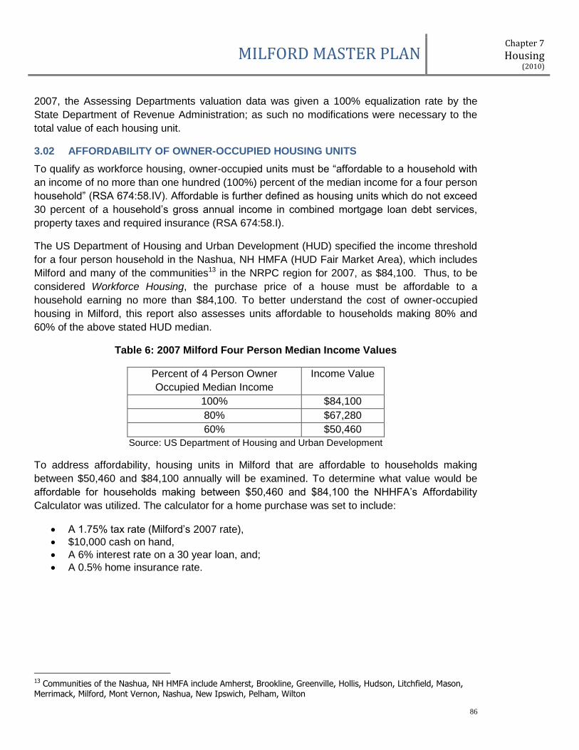
MILFORD MASTER PLAN Chapter 7
Housing (2010)
86
2007, the Assessing Departments valuation data was given a 100% equalization rate by the
State Department of Revenue Administration; as such no modifications were necessary to the
total value of each housing unit.
3.02 AFFORDABILITY OF OWNER-OCCUPIED HOUSING UNITS
To qualify as workforce housing, owner-occupied units must be “affordable to a household with
an income of no more than one hundred (100%) percent of the median income for a four person
household” (RSA 674:58.IV). Affordable is further defined as housing units which do not exceed
30 percent of a household’s gross annual income in combined mortgage loan debt services,
property taxes and required insurance (RSA 674:58.I).
The US Department of Housing and Urban Development (HUD) specified the income threshold
for a four person household in the Nashua, NH HMFA (HUD Fair Market Area), which includes
Milford and many of the communities13 in the NRPC region for 2007, as $84,100. Thus, to be
considered Workforce Housing, the purchase price of a house must be affordable to a
household earning no more than $84,100. To better understand the cost of owner-occupied
housing in Milford, this report also assesses units affordable to households making 80% and
60% of the above stated HUD median.
Table 6: 2007 Milford Four Person Median Income Values
Percent of 4 Person Owner
Occupied Median Income
Income Value
100% $84,100
80% $67,280
60% $50,460
Source: US Department of Housing and Urban Development
To address affordability, housing units in Milford that are affordable to households making
between $50,460 and $84,100 annually will be examined. To determine what value would be
affordable for households making between $50,460 and $84,100 the NHHFA’s Affordability
Calculator was utilized. The calculator for a home purchase was set to include:
A 1.75% tax rate (Milford’s 2007 rate),
$10,000 cash on hand,
A 6% interest rate on a 30 year loan, and;
A 0.5% home insurance rate.
13 Communities of the Nashua, NH HMFA include Amherst, Brookline, Greenville, Hollis, Hudson, Litchfield, Mason, Merrimack, Milford, Mont Vernon, Nashua, New Ipswich, Pelham, Wilton
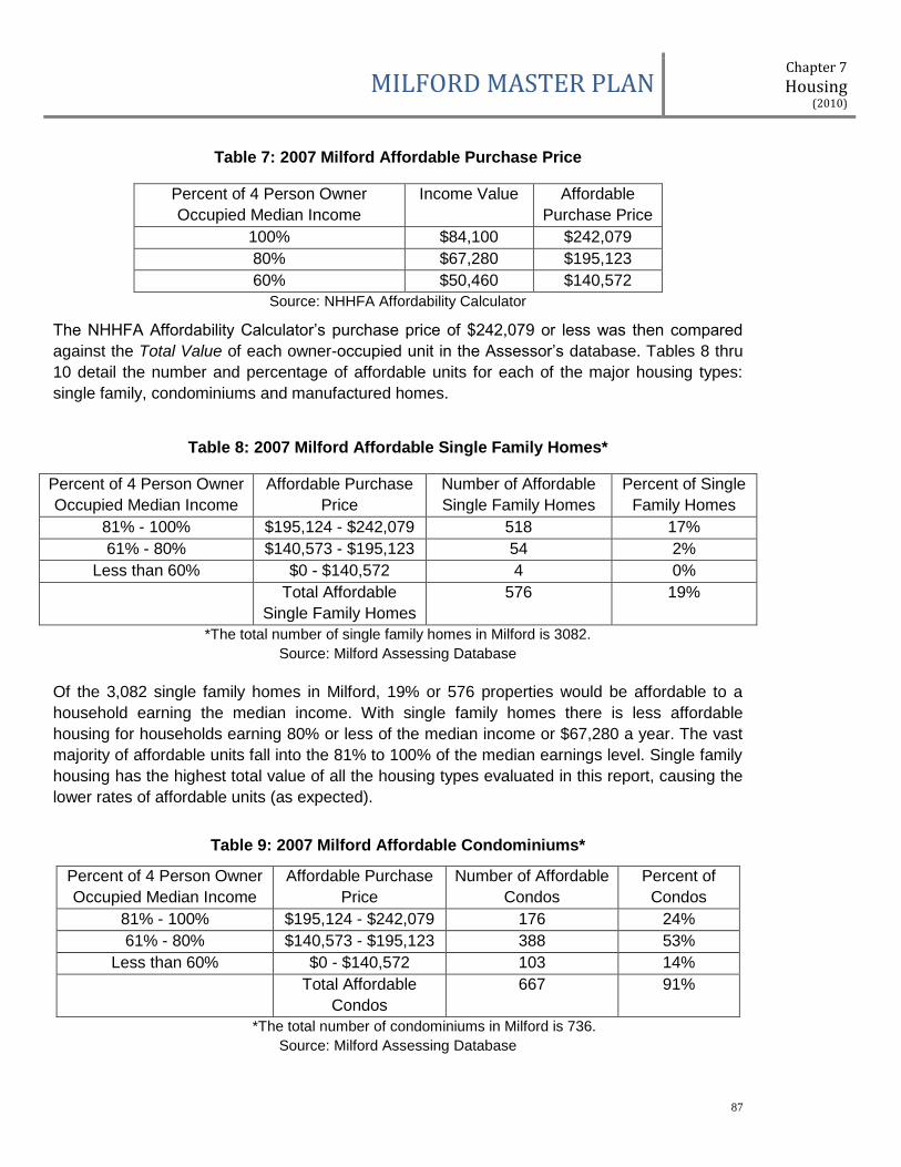
MILFORD MASTER PLAN Chapter 7
Housing (2010)
87
Table 7: 2007 Milford Affordable Purchase Price
Percent of 4 Person Owner
Occupied Median Income
Income Value Affordable
Purchase Price
100% $84,100 $242,079
80% $67,280 $195,123
60% $50,460 $140,572
Source: NHHFA Affordability Calculator
The NHHFA Affordability Calculator’s purchase price of $242,079 or less was then compared
against the Total Value of each owner-occupied unit in the Assessor’s database. Tables 8 thru
10 detail the number and percentage of affordable units for each of the major housing types:
single family, condominiums and manufactured homes.
Table 8: 2007 Milford Affordable Single Family Homes*
Percent of 4 Person Owner
Occupied Median Income
Affordable Purchase
Price
Number of Affordable
Single Family Homes
Percent of Single
Family Homes
81% - 100% $195,124 - $242,079 518 17%
61% - 80% $140,573 - $195,123 54 2%
Less than 60% $0 - $140,572 4 0%
Total Affordable
Single Family Homes
576 19%
*The total number of single family homes in Milford is 3082.
Source: Milford Assessing Database
Of the 3,082 single family homes in Milford, 19% or 576 properties would be affordable to a
household earning the median income. With single family homes there is less affordable
housing for households earning 80% or less of the median income or $67,280 a year. The vast
majority of affordable units fall into the 81% to 100% of the median earnings level. Single family
housing has the highest total value of all the housing types evaluated in this report, causing the
lower rates of affordable units (as expected).
Table 9: 2007 Milford Affordable Condominiums*
Percent of 4 Person Owner
Occupied Median Income
Affordable Purchase
Price
Number of Affordable
Condos
Percent of
Condos
81% - 100% $195,124 - $242,079 176 24%
61% - 80% $140,573 - $195,123 388 53%
Less than 60% $0 - $140,572 103 14%
Total Affordable
Condos
667 91%
*The total number of condominiums in Milford is 736.
Source: Milford Assessing Database

MILFORD MASTER PLAN Chapter 7
Housing (2010)
88
Of the 736 condominiums in Milford, 91% or 667 properties would be affordable to a household
earning the median income. In addition, a majority of condominiums are affordable to
households earning between 61% and 80% of the median income, with a significant number
also affordable to households earning 60% or less of the median or $50,460. The total value of
condominiums varies greatly in Milford depending on if there is land associated with the housing
unit, or if the units are attached or detached. However, even with these variations in options and
values, the vast majority of condominiums in Milford are considered affordable.
Table 10: 2007 Milford Affordable Manufactured Homes*
Percent of 4 Person Owner
Occupied Median Income
Affordable Purchase
Price
Number of Affordable
Manu. Homes
Percent of
Manu. Homes
81% - 100% $195,124 - $242,079 14 4%
61% - 80% $140,573 - $195,123 32 10%
Less than 60% $0 - $140,572 268 84%
Total Affordable
Manu. Homes
314 99%
*The total number of manufactured homes in Milford is 318.
Source: Milford Assessing Database
Of the 318 manufactured homes in Milford, 99% or 314 of the properties would be affordable to
a household earning the median income. Furthermore, the vast majority of all manufactured
homes would be considered affordable to a household making only 60% of the median income
or $50,460 a year. The high rates of affordability are expected with manufactured homes as
they traditionally have a lower total value than both single family homes and condominiums.
Additionally, as shown in Table 4, except for Mont Vernon, Milford far exceeds the rest of the
region in its percentage supply of this type of affordable housing relative to total housing units.
Milford has a diverse owner-occupied housing stock which translates into many affordable
housing units within the community. Table 11 details the total number of affordable units in
Milford at the median household income and for households making 60% and 80% of the
median.
Table 11: 2007 Milford Affordable Housing Units*
Percent of 4 Person Owner
Occupied Median Income
Affordable Purchase
Price
Number of Affordable
Housing Units
Percent of Total
Affordable Housing Units
81% - 100% $195,124 - $242,079 708 17%
61% - 80% $140,573 - $195,123 474 15%
Less than 60% $0 - $140,572 375 9%
Total Affordable
Housing Units
1557 38%
*The total number of owner-occupied units in Milford is 4136.
Source: Milford Assessing Database
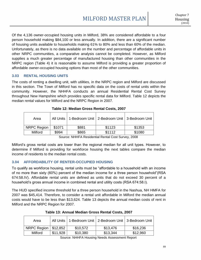
MILFORD MASTER PLAN Chapter 7
Housing (2010)
89
Of the 4,136 owner-occupied housing units in Milford, 38% are considered affordable to a four
person household making $84,100 or less annually. In addition, there are a significant number
of housing units available to households making 61% to 80% and less than 60% of the median.
Unfortunately, as there is no data available on the number and percentage of affordable units in
other NRPC communities, a comparative analysis cannot be completed. However, as Milford
supplies a much greater percentage of manufactured housing than other communities in the
NRPC region (Table 4) it is reasonable to assume Milford is providing a greater proportion of
affordable owner-occupied housing options than most of the other communities.
3.03 RENTAL HOUSING UNITS
The costs of renting a dwelling unit, with utilities, in the NRPC region and Milford are discussed
in this section. The Town of Milford has no specific data on the costs of rental units within the
community. However, the NHHFA conducts an annual Residential Rental Cost Survey
throughout New Hampshire which provides specific rental data for Milford. Table 12 depicts the
median rental values for Milford and the NRPC Region in 2007.
Table 12: Median Gross Rental Costs, 2007
Area All Units 1-Bedroom Unit 2-Bedroom Unit 3-Bedroom Unit
NRPC Region $1071 $881 $1123 $1353
Milford $994 $865 $1112 $1080
Source: NHHFA Residential Rental Cost Survey, 2008
Milford’s gross rental costs are lower than the regional median for all unit types. However, to
determine if Milford is providing for workforce housing the next tables compare the median
income of residents to the median rental costs.
3.04 AFFORDABILITY OF RENTER-OCCUPIED HOUSING
To qualify as workforce housing, rental units must be “affordable to a household with an income
of no more than sixty (60%) percent of the median income for a three person household”(RSA
674:58.IV). Affordable rental units are defined as units that do not exceed 30 percent of a
household’s gross annual income in combined rental and utility costs (RSA 674:58.I).
The HUD specified income threshold for a three person household in the Nashua, NH HMFA for
2007 was $45,414. Therefore, to consider a rental unit affordable in Milford the median annual
costs would have to be less than $13,624. Table 13 depicts the annual median costs of rent in
Milford and the NRPC Region for 2007.
Table 13: Annual Median Gross Rental Costs, 2007
Area All Units 1-Bedroom Unit 2-Bedroom Unit 3-Bedroom Unit
NRPC Region $12,852 $10,572 $13,476 $16,236
Milford $11,928 $10,380 $13,344 $12,960
Source: NHHFA Housing Needs Assessment Report
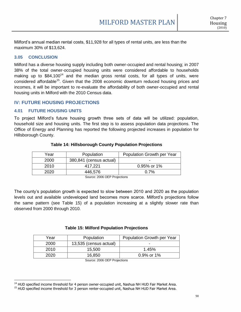
MILFORD MASTER PLAN Chapter 7
Housing (2010)
90
Milford’s annual median rental costs, $11,928 for all types of rental units, are less than the
maximum 30% of $13,624.
3.05 CONCLUSION
Milford has a diverse housing supply including both owner-occupied and rental housing; in 2007
38% of the total owner-occupied housing units were considered affordable to households
making up to $84,10014 and the median gross rental costs, for all types of units, were
considered affordable15. Given that the 2008 economic downturn reduced housing prices and
incomes, it will be important to re-evaluate the affordability of both owner-occupied and rental
housing units in Milford with the 2010 Census data.
IV: FUTURE HOUSING PROJECTIONS
4.01 FUTURE HOUSING UNITS
To project Milford’s future housing growth three sets of data will be utilized: population,
household size and housing units. The first step is to assess population data projections. The
Office of Energy and Planning has reported the following projected increases in population for
Hillsborough County.
Table 14: Hillsborough County Population Projections
Year Population Population Growth per Year
2000 380,841 (census actual) -
2010 417,221 0.95% or 1%
2020 446,576 0.7% Source: 2006 OEP Projections
The county’s population growth is expected to slow between 2010 and 2020 as the population
levels out and available undeveloped land becomes more scarce. Milford’s projections follow
the same pattern (see Table 15) of a population increasing at a slightly slower rate than
observed from 2000 through 2010.
Table 15: Milford Population Projections
Year Population Population Growth per Year
2000 13,535 (census actual) -
2010 15,500 1.45%
2020 16,850 0.9% or 1% Source: 2006 OEP Projections
14 HUD specified income threshold for 4 person owner-occupied unit, Nashua NH HUD Fair Market Area. 15 HUD specified income threshold for 3 person renter-occupied unit, Nashua NH HUD Fair Market Area.

MILFORD MASTER PLAN Chapter 7
Housing (2010)
91
Once population growth rates have been established, the next step is to determine the average
household size. As discussed earlier, the average household size at the time of the 2000
Census was reported at 2.58, a slight decrease from the previous decade. To determine a
slightly more current average household size this report utilizes 2006 data as shown in Table
16.
Table 16: Milford 2006 Average Household Size
Housing Units Population Average Household Size
6062 1486016 2.45
As reported in Table 3, Milford had 6,062 housing units in 2006 including single family,
condominiums, multifamily and manufactured housing. As Table 16 displays, the average
household size in Milford has continued to decline since the last census.
Based on the above population and household size estimates Milford anticipates 26117 housing
units will be added between 2006 and 2010, and 55118 new housing units between 2010 and
2020 for a total of 812 new housing units in Milford by 2020.
4.02 FUTURE HOUSING UNITS BY TYPE
Since 2006 the development of multifamily units has slowed in Milford, mainly due to the GMO
and changes to the Senior Housing Ordinance. However, as the GMO will sunset in 2010 and
the housing market is shifting away from senior housing and 55+ communities, to workforce or
affordable housing, it is likely that multifamily housing unit development will remain a large,
steady portion of Milford’s housing trends for the foreseeable future.
For consistency with the census and other regional data sources used in this report, future
housing projections were calculated utilizing the base numbers and definitions reported in
Tables 3 and 4 of this report. Deciphering which unit types (condominiums detached or attached
or types of manufactured homes) classify as single family or multifamily per the Assessing data
codes is beyond the scope of this report.
The data reported from the census and reported in the NHES community profiles details Milford
as 51% single family, 42% multifamily and 7% manufactured housing. For future housing
projections these percents are projected forward to result in the addition of the following types of
housing units by 2020:
Table 17: New Housing Units by Type Projected for 2020
Single Family Units 47119
Multifamily Units 34120
16 OEP Population Projection 17 Projected population increase 2006-2010 = 640 / divided by average household size of 2.45 = 640/2.45 = 261 18 Projected population increase 2010-2020 = 1350 / divided by average household size of 2.45 = 1350/2.45 = 551 19 471 new single-family units = 58% of 812, and includes all single-family, manufactured and detached condo housing units.
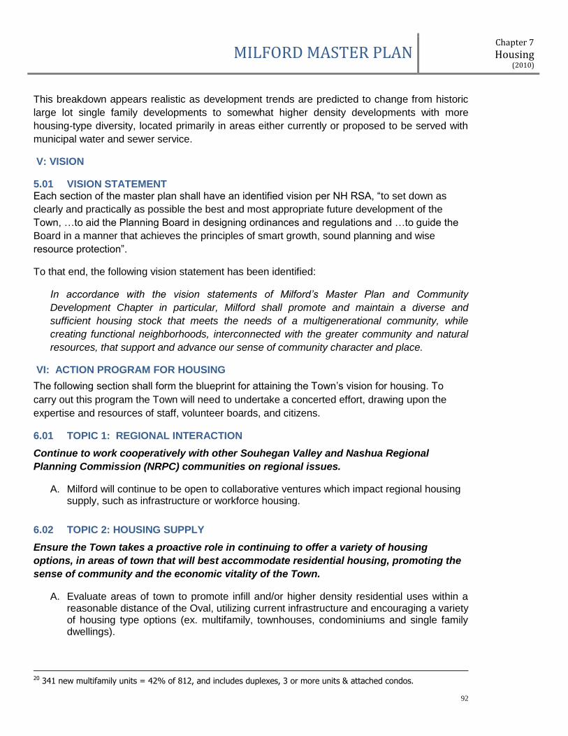
MILFORD MASTER PLAN Chapter 7
Housing (2010)
92
This breakdown appears realistic as development trends are predicted to change from historic
large lot single family developments to somewhat higher density developments with more
housing-type diversity, located primarily in areas either currently or proposed to be served with
municipal water and sewer service.
V: VISION
5.01 VISION STATEMENT Each section of the master plan shall have an identified vision per NH RSA, “to set down as
clearly and practically as possible the best and most appropriate future development of the
Town, …to aid the Planning Board in designing ordinances and regulations and …to guide the
Board in a manner that achieves the principles of smart growth, sound planning and wise
resource protection”.
To that end, the following vision statement has been identified:
In accordance with the vision statements of Milford’s Master Plan and Community
Development Chapter in particular, Milford shall promote and maintain a diverse and
sufficient housing stock that meets the needs of a multigenerational community, while
creating functional neighborhoods, interconnected with the greater community and natural
resources, that support and advance our sense of community character and place.
VI: ACTION PROGRAM FOR HOUSING
The following section shall form the blueprint for attaining the Town’s vision for housing. To
carry out this program the Town will need to undertake a concerted effort, drawing upon the
expertise and resources of staff, volunteer boards, and citizens.
6.01 TOPIC 1: REGIONAL INTERACTION
Continue to work cooperatively with other Souhegan Valley and Nashua Regional
Planning Commission (NRPC) communities on regional issues.
A. Milford will continue to be open to collaborative ventures which impact regional housing supply, such as infrastructure or workforce housing.
6.02 TOPIC 2: HOUSING SUPPLY
Ensure the Town takes a proactive role in continuing to offer a variety of housing
options, in areas of town that will best accommodate residential housing, promoting the
sense of community and the economic vitality of the Town.
A. Evaluate areas of town to promote infill and/or higher density residential uses within a reasonable distance of the Oval, utilizing current infrastructure and encouraging a variety of housing type options (ex. multifamily, townhouses, condominiums and single family dwellings).
20 341 new multifamily units = 42% of 812, and includes duplexes, 3 or more units & attached condos.
MILFORD MASTER PLAN Chapter 7
Housing (2010)
93
B. Evaluate community receptiveness to expanded zoning, allowing for more mixed-use land uses (residential and business combinations) and locations where mixed-use developments would best fit within Milford.
C. Strive to make mixed uses (as currently zoned or if expanded) and economic development policies work in tandem with residential uses, taking into consideration noise, light, fumes, traffic, etc. Facilitate the positive co-existence of residences and businesses in compatible neighborhoods.
D. Evaluate the impact of Milford’s ordinances and regulations on the diversity of the Town’s housing stock and make adjustments that will encourage a range of housing to meet the needs of our multigenerational community, for example the Accessory Dwelling Unit Ordinance.
E. Explore and evaluate opportunities for larger scale developments in town such as Planned Unit Developments (PUD’s) or other comparable models, with a mix of housing unit types and uses. Evaluate if we have enough land in close proximity to services that could support or sustain a large mixed use development, interconnected within the neighborhood and with the greater community.
F. Evaluate the advantages and disadvantages of regulations pertaining to community well and septic systems as part of future developments.
6.03 TOPIC 3: HOUSING AFFORDABILITY
Determine how Milford should support the continued development of housing that meets
the needs of our population from entry level housing to aging in place.
A. Explore and potentially implement a Workforce Housing Overlay District for areas that meet specific criteria (for example: on Town utilities, access to services, pedestrian access, potential future transit access, green site design, outside of natural resource protection areas, community integration, or diversity of housing options).
B. Explore the potential for density bonuses through the Zoning Ordinance if a residential developer wants to build affordable and/or infill housing.
C. Evaluate the existing Senior Housing Ordinance to determine if it meets the intended goals of the overlay district and if the ordinance is compatible with current community needs, and amend as necessary.
D. Evaluate the need to incorporate special exemptions for federally or state subsidized housing units in Milford, and amend ordinances and regulations as necessary.
MILFORD MASTER PLAN Chapter 7
Housing (2010)
94
6.04 TOPIC 4: NEIGHBORHOOD CHARACTER
Evaluate how Milford can encourage the creation of interconnected functional
neighborhoods that support the Town’s sense of community character.
A. Analyze existing residential neighborhoods to identify desirable elements of neighborhood development patterns, including building mass, setbacks, and siting. Consider amending regulations that would strengthen existing neighborhoods as growth continues, and encourage successful new interconnected neighborhoods.
B. As part of neighborhood planning, encourage sidewalks, bike paths, public transit stops, and walking paths, as well as other pedestrian-oriented and traffic calming amenities.
6.05 TOPIC 5: RELATIONSHIP BETWEEN RESIDENTIAL DEVELOPMENT AND OTHER PLANNING GOALS
Strive to make residential development compatible with other planning, natural
resources, code enforcement, transportation and economic development goals of
Milford.
A. Work with the Conservation Commission to evaluate Milford’s ordinances and regulations, and amend as needed to protect the Town’s high priority natural resources by developing a Natural Resource Protection Overlay District.
B. Review and amend as necessary the Open Space Conservation Subdivision overlay district to meet the intended goals of the district.
C. In conjunction with the Traffic and Transportation chapter of the Master Plan create a sidewalk and bicycle plan for Milford to increase safety, walkability, and overall community health and connectivity.
D. Review and amend as necessary the existing Town ordinances and regulations to accommodate public transit systems and evaluate the potential for incentives to include public transit facilities within development.
E. Promoting and supporting multi-modal transit oriented development principals within Town Ordinances and Regulations.
F. Work with the Economic Development Advisory Council to study land use relative to existing zoning and economic development opportunities and constraints, and provide recommendations for incorporation into the Master Plan and for potential zoning and regulatory changes.
G. Work with Code Enforcement to evaluate the possibilities of adopting ‘Green Building Codes’ for both site and building design, and potential incentives to encourage green site and building designs.
MILFORD MASTER PLAN Chapter 7
Housing (2010)
95
6.06 TOPIC 6: LONG-TERM IMPACT OF DEVELOPMENT ON TOWN INFRASTRUCTURE
New housing development should be designed to minimize the Town’s long-term costs
in providing services.
A. Evaluate the advantages and disadvantages of private roadways in new developments as they relate to town costs.
B. Evaluate the potential need for additional impact fee ordinances in Milford.
C. Coordinate with the long-term planning of the Water Utilities Department to evaluate areas of potential infill development and increased residential density along the Town’s existing and proposed water and sewer systems.
D. Work with the Water & Sewer Commissioners and Water Utilities Department as they develop a Facility and Capital Improvements Plan that will ensure the long-term viability of the wastewater treatment plant as well as the necessary upgrades in relation to future development and Milford’s economic vitality.
MILFORD MASTER PLAN Chapter 8
Recreation (2016)
96
CHAPTER 8
RECREATION
I: INTRODUCTION AND VISION FOR MILFORD RECREATION
As authorized by NH RSA 674:2, the Recreation Chapter of the Milford Master Plan lays out both short-
term and long-range goals and actions providing a framework on which to ensure that recreation
opportunities are provided for Milford citizens.
Recreation is a major component that makes up the quality of life and valued by Milford residents. The
Town has a rich history of providing programs, facilities, and parks to serve recreation needs. However,
as the community grows and its demographics change, the Town must be prepared to meet the
challenges to serve both existing residents and future generations. It is essential that the Town
maintain and improve its current recreation facilities and parks; enhance and grow its programs based
on community needs; and plan for and implement mechanisms to provide for future park and recreation
development. Inclusion of projects that require significant public investments must be included in the
Town’s Capital Improvements Plan. High quality programs, facilities, and recreation areas are essential
elements of the Town’s economic, social, and public health.
With these elements in mind, the vision for Milford recreation is as follows:
II: A HISTORICAL LOOK AT PARKS AND RECREATION IN MILFORD
As documented in Winifred A. Wright’s The Granite Town, Milford, New Hampshire 1901/1978,
Milford’s first public park was located on Elm Street, on the site of the current Bales and Jacques
Elementary Schools and was known as Endicott Park. The park was established in the late 1800’s on
private farmland that was no longer needed, and grew from an old cornfield that became a baseball
diamond where Milford’s first baseball games were played. The Town bought the property in 1886 for
$5000, however it was not until 1925 that the Town began to make improvements. That same year, the
first Town-appointed recreation committee was formed, and with an appropriation of $250 installed
playground equipment at the North, Pine Valley, and Osgood schools, prepared the playground area at
the Garden Street School, improved the entrance to Endicott Park and relocated the town dump from
that site. Over the course of the next decade, Town recreation activities continued to expand, with an
additional ball field, a running track, lights, drinking fountains, and an area flooded for ice-skating
provided at Endicott Park and band concerts on the Oval. Other than from funding from the federal
Public Works Administration during the Depression years, there was no Town funding through both the
Depression and World War II eras.
The people of Milford recognize the importance recreation brings to establishing and
enhancing quality of life and in building a strong community. The Town will meet
its current and future recreation needs while improving its small town character and
protecting its natural resources.

MILFORD MASTER PLAN Chapter 8
Recreation (2016)
97
In 1947, the Department of Public Works was established and that department took over the
responsibility for Endicott Park. Over the next several years bleachers were built and an area
blacktopped for basketball, volleyball, and badminton. Further development of Endicott Park ceased in
1957 as the site was eventually acquired by the School District for the Jacques Elementary School.
For many years, the focus of the Town in providing recreation programs was to provide summer
activities. Directed by the volunteer Parks and Playground Committee, summer programs included
public swimming, swimming lessons, and the Keyes Swim Team; tennis lessons; and playground
activities. In 1994, a citizen volunteer group was formed, and in working with the Planning Department,
met over the course of the following year to determine the adequacy of existing recreation programs,
facilities, and lands to meet both the current recreation needs of the growing community and to plan for
future recreation development. The Recreation Committee solicited Town opinion and attitudes and
found that there were few offerings for all age groups; there was no central coordinating position to
efficiently manage the increased demand on Town facilities; and there was no long range plan to guide
the growth of recreation in Town. The Recreation Committee put forth a warrant article in 1995 that
established a year-round Recreation Commission. In 1996, a full-time recreation director position was
approved by Town and a one-person department established to manage and grow recreation
opportunities to meet Town demand. That same year, the Town voted to authorize the establishment of
a recreation revolving fund to provide funding for recreational programming.
The Recreation Department is currently staffed with a director and a full-time recreation program
coordinator and is funded through the general fund and the recreation revolving fund. The Recreation
Department is responsible for planning, programming, organizing, and administering recreation
services for the community. Additional seasonal employees are utilized for summer programs and park
security and a strong volunteer base provides additional support and throughout the year.
The Department of Public Works is responsible for the management and maintenance of the Town’s
297 acres of public parks and memorials, including the related recreational facilities and structures.
The maintenance programs include mowing, pruning, weeding, vandalism repair, painting, rubbish
removal, and upkeep of the multiple irrigation systems. In addition, the Department works
collaboratively with the Milford School Department, MCAA, and local American Legion Baseball League
team to maintain the multiple ball fields and multi-purpose fields.
III: PRIMARY MILFORD RECREATION FACILITIES AND RECOMMENDATIONS FOR
FACILITY USE AND IMPROVEMENTS
The following section provides a brief history and description of each of Milford’s municipal parks and
recreation areas, a listing of the existing facilities, and recommendations with an associated timeframe
for implementation for renovation, enhancement, or construction of new recreation facilities. The
section is divided between “active” and “passive” recreation facilities and areas. The Milford Zoning
Ordinance defines “active recreation” as leisure time activities, usually of a formal nature and often
performed with others, requiring equipment and taking place at prescribed places, sites, or fields. Said
designed and specific activity areas include, but are not limited to: ballfields, soccer fields, basketball

MILFORD MASTER PLAN Chapter 8
Recreation (2016)
98
courts, tennis courts, and swimming along with associated structures to support these activities. These
areas may contain play apparatus, open playing fields, and passive recreation features.
“Passive recreation” is defined as leisure time activities that involve relatively inactive or less energetic
activities such as walking, sitting, picnicking, and table games. Said areas are designed primarily for
unstructured uses, such walking and hiking paths, open lawn areas, viewing locations and nature study.
Passive recreation sites may include minor ancillary structures such as memorials, shade structures,
restrooms, informational kiosks, and children’s play apparatus.
Providing a comprehensive recreation program for all ages and interests and the associated facilities to
implement the programs is essential to meet Milford’s vision for recreation. Challenges inherent in the
vision statement include insuring adequate funding, building community support, and guaranteeing
ongoing maintenance of both existing and future facilities and programs. An overriding issue for years
in Milford has been the ‘overuse’ of limited existing recreation fields which doesn’t allow for field rest
and rejuvenation. This in turn, leads to further field degradation and limitations to programs and
activities. To address the overuse of existing fields and to properly manage any future fields when
constructed, a proposed “Milford Turf Management Plan ” level as detailed in Appendix C.
Recommended turf management guidelines (on file in the Recreation Department and Public Works
Department) are designed to establish a level of maintenance appropriate for field usage. All park areas
are from Milford Assessing Department records. Comprehensive and complete records and history are
located in the Town Lands files compiled by Lorraine Carson, Town Land Researcher.
3.01 ACTIVE RECREATION AREAS AND FACILITIES
3.01.1 KEYES MEMORIAL PARK
Location: 45 Elm Street (Map 25/Lot 133)
Area: 19.0 acres
The uppermost part of Endicott Park was
acquired in 1954 by the School District
for the site of the new Jacques
Elementary School. In 1957, the site of
Keyes Memorial Park (commonly known
as “Keyes Field”) was given to the School
District, and plans were made to improve
that location with new recreation facilities.
In 1964, the School District exchanged
the Keyes site for the Town-owned
Endicott Park property. The School
District did retain a portion of Endicott
Park for use by school children.
Keyes Memorial Park was originally
farmland owned by members of the Crosby family, who were also the original owners of the Endicott
Park property. The last Crosby family member to own the Keyes property was Annabell (Crosby)
Secombe, who willed the property at the time of her death in 1952 to a longtime employee, Henry
MILFORD MASTER PLAN Chapter 8
Recreation (2016)
99
Laxon. Laxon sold the property in 1957 to the Arthur L. Keyes Memorial Trust, which then gave the
land to the School District for athletic fields and a playground.
Keyes Memorial Park development began with the construction of a public swimming pool facility in
1965, funded with borrowing by the Town and reimbursed by the Keyes Trust over the following thirteen
years. The facility included a wading pool, concrete bathhouse, landscaping, and fencing. Two tennis
courts were constructed as a gift from the Rotch family in memory of Malcolm Rotch. Recreation
programs at Keyes continued to expand, with baseball, softball, archery, summer arts and crafts,
special activities, and the construction of two additional tennis courts in 1974. At that time, summer
programs required swimming pool staff and instructors, activity staff, and the assistance of many
volunteers. As stated in The Granite Town , “Although a great deal of money has been expended for
the upkeep and supervision of Keyes Memorial Park, Milford citizens have felt that the money which
provided recreation for everyone during the summer months, was well spent”. (Wright, 1979, p. 311)
Keyes Memorial Park remains the primary community recreation park for the Town and is anticipated to
continue this function for the foreseeable future.
Financial support from community resources and many dedicated volunteers have been an essential
component to improving and upgrading recreational opportunities at Keyes Memorial Park. Examples
such as the skateboard park, the playground, ballfield amenities, tennis court landscaping, and pool
improvements have been the result of commitment from local foundations, service organizations, Boy
Scouts, and ad-hoc volunteer committees.
Adjacent to Keyes Memorial Park to the west is a 5.80 acre parcel commonly referred to as “127 Elm
Street” or the former “Permatach Building”. Town acquisition of this site occurred in December 2015.
The acquisition was approved by a special Town vote on September 9, 2014 and funded by pledged
donations and the waiver of back taxes. The purchase of “127 Elm” provides a secondary access to
Keyes Memorial Park necessary due to the closure of Keyes Drive during the Fletcher Paint EPA
Superfund clean-up project and allows opportunity for expansion and integration of recreational
facilities and parking for Keyes Memorial Park.
In April 2016, the Board of Selectmen formed the Keyes Memorial Park Expansion Committee. The
charge of the Committee was to develop short- and long- term recommendations for the integration of
the property into the Keyes Memorial Park and to make any additional recommendations about how
best to use utilize/re-purpose the land and buildings. The Committee met throughout 2016 and
submitted a report to Board of Selectmen detailing their findings, recommendations, and a 10-year
development master plan. The Board of Selectmen will continue to evaluate and develop a strategic plan
for the integration, funding, and development of the properties and expansion of services within the Keyes
Memorial Park and Keyes Drive.
MILFORD MASTER PLAN Chapter 8
Recreation (2016)
100
EXISTING FACILITIES:
Outdoor Pool
Kiddie Pool
Pool building (office, lockers, storage, staff room, restrooms, concession stand)
Softball (2 diamonds)
Baseball (1-90’ diamond)
Tennis (4 courts)
Playground
Skateboard Park
Volleyball Court
Basketball (full-court)
Lighting
Recreational Field Space
Picnic Area
Pavilion with Pergola
Stage
Storage Buildings
Parking
RECOMMEDATIONS:
Immediate Needs:
Improve softball diamonds
Replace/repair dugout roofs
Increase trash/recycling receptacles
Add additional portable toilets
Improve to Level 2 turf management
Develop Keyes Memorial Park Master Plan incorporating the “127 Elm” site and Fletcher site
1-3 Years:
Begin site development based on Keyes Memorial Park Master Plan
Begin feasibility study for Community Center
3-5 Years:
Continue site development based on Keyes Memorial Park Master Plan
5 Years and Beyond:
Construct Community Center

MILFORD MASTER PLAN Chapter 8
Recreation (2016)
101
Additional Recommendations:
It is recommended that Keyes Memorial Park remain as the Town’s primary recreation facility serving
the needs of both the community at-large and the schools. The Milford School District utilizes Keyes
Memorial Park for middle and high school athletics. Given that Keyes Memorial Park is within walking
distance to the Middle School, it is recommended that Keyes Memorial Park become the primary
location for Middle School programs and that the Brox Recreation Fields be utilized for High School
programs as the driving distance and transportation can be more readily accommodated by older
students.
3.01.2 SHEPARD PARK / TRENTINI BASEBALL PARK
Location: 418 Nashua Street (Map 31/Lot 33) Area: 2.30 acres Shepard Park, a two and one-third acre park on
Nashua Street in east Milford, was established in
1899 by a donation of the land by Andrew
Shepard. The park, adjacent to the Laurel Street
School, had been a fairground and the site of
many activities. A Shepard Park committee was
appointed in 1913 with a town appropriation of
$200 for upkeep and maintenance. In 1915, the
first ball field was constructed, followed by a
softball diamond in 1950. Various other
improvements included a Little League field with
dugouts provided by the Rotary Club, and the
establishment of the Boy Scout house in the old school building, also provided by the Rotary Club. In
1961 the Little League facility was officially dedicated as the Hugo Trentini Memorial Park.
EXISTING FACILITIES:
Baseball (2-50’ diamonds)
Seasonal ice skating rinks (2)
Warming hut/storage building
Playground
RECOMMENDATIONS:
Immediate Needs:
Dugouts at new diamond
Improve to Level 2 turf management

MILFORD MASTER PLAN Chapter 8
Recreation (2016)
102
Additional Recommendations:
Given its size, function, and location it is recommended that Shepard Park/Trentini Baseball Park
continues to be utilized as currently used, with facilities maintained and enhanced as needed to keep
usage at current levels and activities.
3.01.3 ADAMS PARK
Location: 105 Osgood Road (Map 42/Lot 10) Area: 6.00 acres
Adams Park is a 5.5 acre parcel that lies
adjacent to Osgood Pond off Osgood Road.
The property was bequeathed to the Town in
1991 by Hazel Adams Burns. In 1996, Adams
Park was graded and seeded to accommodate
field sports and a parking area constructed.
Currently, the Park is utilized primarily as a
sports field accommodating soccer, lacrosse,
field hockey, and football. However, the field
area is limited in size which restricts regulation
games, matches, and events. A gravel parking
area exists immediately off Osgood Road.
A 50-foot wetlands buffer exists along the edge of Osgood Pond consistent with zoning requirements.
No tree-cutting is allowed within this buffer as agreed to between the Conservation Commission and
the Board of Selectmen at the time of acquisition.
Osgood Pond, adjacent to Adams Park, is a significant surface water body in Town and historically has
been utilized for fishing and boating. Over several decades the Pond has lost its value for fish and
aquatic wildlife and boating activities due to ongoing sedimentation. Dredging of the Pond to restore
these values has been a priority of the community for many years and State and federal agencies have
assisted in planning for a dredging project. In 2012, utilizing funds available from a Town special
purpose account, engineering plans (Osgood Pond Restoration Project) were developed for a phased
dredging and reclamation of the Pond to restore wildlife habitat and provide fishing and boating
opportunities. In September 2015, the National Park Service Land and Water Conservation Fund
(LWCF) awarded $150,000 to the Town to assist in the reclamation project, to be matched by
$150,000 from Town and other sources. Public access to the Pond from Adams Park is required as
condition of the LWCF program. At this time a boat launch, fishing pier, and picnicking facilities are
planned adjacent to the Pond but within the boundaries of Adams Park. Reclamation of the Pond began
in the summer of 2016.

MILFORD MASTER PLAN Chapter 8
Recreation (2016)
103
EXISTING FACILITIES:
Multi-purpose recreation field
Parking
RECOMMENDATIONS:
Immediate needs:
Regrade existing field.
Maintain at Level 1 turf management with turf height determined by grounds manager
1-3 years
Improve recreational field
Construct boat launch/fishing pier
Construct public access drive to boat launch
Install picnic tables
Reconfigure and delineate more efficient parking lot
5 Years and Beyond
Convert Adams Park from a sports-oriented facility to a less intensive neighborhood park level
with a playground, bocce, Osgood Pond amenities, and other improvements
Additional Recommendations:
The size, irregular boundary, and adjacency to Osgood Pond limits the usage of Adams Park for
regulation field sports. As Keyes Memorial Park is improved and as the Brox Recreation Fields complex
is developed, the School District will rely less on the Adams Park for school-related sports. This allows
for Adams Park to be converted to a neighborhood facility serving central Milford.
3.01.4 RUSS MONBLEAU YOUTH SPORTS
COMPLEX / NORTH RIVER ROAD FIELDS
Location: 36 North River Road (Map 8/Lot 11) Area: 16.80 acres The “North River Road Fields” were renamed the
Russ Monbleau Youth Sports Complex in 2008 to
honor longtime youth sports supporter and active
Milford Community Athletic Association (MCAA)
volunteer Russ Monbleau. The site consists of 16.8
acres and is the principal location for MCAA sports
programs, including baseball, softball, and soccer.

MILFORD MASTER PLAN Chapter 8
Recreation (2016)
104
The facility also accommodates School District sports when necessary.
Situated off North River Road and bordered on the southwest by the Souhegan River the facility
contains three ball diamonds with dugouts, two regulation soccer fields, one intermediate size soccer
field, a concession stand with restrooms, a batting cage, a pavilion and picnic tables, irrigation systems,
lighting, and parking. A portion of the Souhegan River Trail runs through the property along the River,
located within an easement that was granted to the Town by the Milford Hospital Association in 1994.
The existing improvements take up approximately half of the 16.8 acres and the remainder of the
property is primarily wooded area and wetlands. A small undeveloped field area lies on the northwest
portion of the property separated by wetlands along the westerly recreation fields. A smaller portion of
the easterly soccer field and ball diamond lies on property owned by the St. Joseph Hospital (Map 8/Lot
11-1).
The facility was developed on property originally owned by the Milford Hospital Association. In 1993,
the Town voted to accept a gift of the land from the Association and to enter into a 10-year lease
agreement with the MCAA to continue utilizing the recreation area for its programs, which it had been
utilizing since the construction of York Field in 1981. The lease continues with automatic renewals at
10-year intervals as long as the MCAA utilizes the property.
EXISTING FACILITIES:
Baseball (3 diamonds)
Soccer fields (4)
Concession/storage building with restrooms
Parking
Pavilion
Souhegan River Trail
RECOMMENDATIONS:
Immediate and Multi-Year Needs:
Determined by the Milford Community Athletic Association based upon program priorities and
resources, both volunteer and financial.
Additional Recommendations:
The North River Road Fields are currently managed by the Milford Community Athletic Association
(MCAA) which leases the property from the Town of Milford. The MCAA is responsible for
improvements and facilities, except for mowing which is provided by the Department of Public Works.
This arrangement has worked well over the years and is not anticipated to change. It is recommended
that the North River Road Fields complex be converted to a ‘stick and ball’ facility to lessen impact on
the playing fields caused by continual multi-sport usage. This conversion should be concurrent with the
development of the Brox Recreational Fields which will provide fields for sports such as soccer,
lacrosse, and football. Acquisition or leasing of the adjacent St. Joseph Hospital property should be
explored.

MILFORD MASTER PLAN Chapter 8
Recreation (2016)
105
3.01.5 KALEY PARK
Location: 448 Nashua Street (Map 31/Lot 32) Area: 19.70 acres Kaley Park, located in east Milford off Nashua
Street, is the Town’s newest recreation
facility. The 19.7 acre parcel was proposed in
the late 1980s as a 15 – 20 lot residential
subdivision, however access into the site with
a public roadway and further development
was constricted by the existence of a major
Public Service Company of New Hampshire
power line easement. In the mid-1990s the
Recreation Commission saw the site as a
prime location to construct a new recreation facility due to its central location and topography. The
owners of the parcel, Harry Whelan and James Stellos, agreed to sell the property to the Town for
$150,000 and in 1995 the Town approved $76,000 as the Town’s share of the acquisition. The balance
of $74,000 was provided by a federal Land and Water Conservation Fund (LWCF) grant; and cash
contributions from the Milford Conservation Commission, Milford Rotary Club, the Milford-Bennington
Railroad, the Veterans of Foreign Wars - Post 4368, and the Kaley Foundation. The Kaley Foundation
also pledged an additional $33,000 over the course of 1996 and 1997 to offset and reduce the Town’s
appropriation to a final $43,000.
Kaley Park as originally planned was to be a multi-use site with two regulation soccer fields, three
baseball diamonds, a storage building, concession building, conservation area, canoe launch, and
parking areas. Additionally, approximately two acres immediately adjacent to Riverside Cemetery was
set aside for future cemetery expansion when needed. Funding for full development has been limited,
and significant construction of improvements was not begun until Spring 2008 with the construction of
the Phase I recreational field. Additional improvements were the construction of a portion of the
planned parking areas, a drilled well, and installation of an irrigation system. In the spring and summer
of 2010 the second recreational field and the remaining parking areas (Phase II) were constructed and
irrigation installed. Additional improvements include a canoe launch built as an Eagle Scout project, as
well as fencing and parking area posts. In 2014. a softball field (Carson Field) with benches was
constructed by the Department of Public Works.
Development of Kaley Park has been a community project utilizing local contractors. Much of the work
has been donated, and the Recreation Department and Commission continue to raise additional funds
through events and donations that are placed in the Kaley Park Development Fund. As the
improvement fund grows additional improvements will be made to the facility.

MILFORD MASTER PLAN Chapter 8
Recreation (2016)
106
EXISTING FACILITIES:
2 recreational playing fields
Softball (1 diamond)
Canoe launch
Conservation area
Parking
RECOMMENDATIONS:
Immediate need:
Improve softball diamond
Maintain irrigation system
Improve to Level 2 turf management
1-3 years
Improve grading of recreational fields
Construct fitness loop trail
3-5 years
Construct second softball diamond
Years and Beyond
Construct storage building
Additional Recommendations:
As originally conceptualized in 1996, Kaley Park was to be constructed as a multi-use sports facility and
park with two regulation-sized sports fields, three ball diamonds with bleachers and dugouts, a
playground, picnic areas, horseshoe pits, adequate parking, and a no-build conservation area adjacent
to the Souhegan River. Actual field construction did not occur until the years 2008-2010 due in part to
neighborhood concerns relative to the intensity of a formal multi-use facility and difficulty in obtaining
funding for site development. The focus of the Recreation Commission was modified to utilize the Kaley
Park with less intensive uses as recommended above.

MILFORD MASTER PLAN Chapter 8
Recreation (2016)
107
3.01.6 FORMER POLICE STATION BALLFIELD
Location: 589 Elm Street (Map 13/Lot 5) Area: 8.45 acres The Town acquired this parcel in 1987 from
Hitchiner Manufacturing Co., Inc. in exchange for
the property which was the site of the Town’s
municipal Savage Well (Map 13/Lot 5). From 1988
to 2006, 589 Elm Street was the location of the
Milford Police Department. Since that time, the
existing structure has been utilized by the Town for
storage. On the site is a ballfield which is utilized
by the Recreation Department and primarily rented
out to local softball groups.
EXISTING FACILTIES:
Softball (1 diamond)
Parking
RECOMMENDATIONS:
The site is adjacent to the OK Tool EPA Superfund clean-up project and contains structures, utilities,
and monitoring wells that are tied into that project. In March 2006, Milford voters approved a warrant
article to allow the Board of Selectmen to sell this site as it has potential for commercial property tax
generating development. Furthermore, the 2008 Community Facilities chapter of the Milford Master
Plan recommended that as part of Milford’s economic development plan, the site be analyzed for its
highest and best use. At the current time, both Phase I and Phase II environmental site assessments
have been completed and additional soil testing was done to determine arsenic levels. The next step
for this site to prepare for eventual sale, if warranted by the Board of Selectmen, is to finalize an activity
and use restriction agreement with the NH Department of Environmental Services and the EPA. It is
thus recommended that this site continue to be utilized for softball programs until such time as the
property is sold, and that no further improvements be made other than ongoing maintenance of the
softball field.
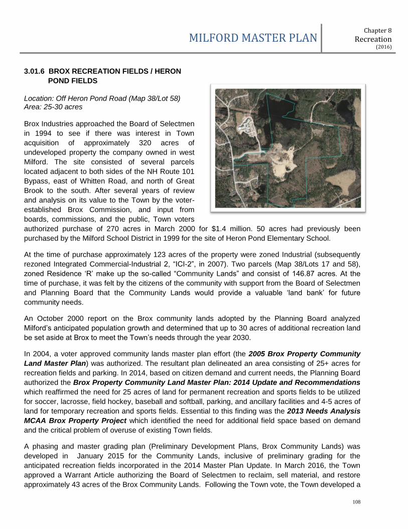
MILFORD MASTER PLAN Chapter 8
Recreation (2016)
108
3.01.6 BROX RECREATION FIELDS / HERON
POND FIELDS
Location: Off Heron Pond Road (Map 38/Lot 58) Area: 25-30 acres Brox Industries approached the Board of Selectmen
in 1994 to see if there was interest in Town
acquisition of approximately 320 acres of
undeveloped property the company owned in west
Milford. The site consisted of several parcels
located adjacent to both sides of the NH Route 101
Bypass, east of Whitten Road, and north of Great
Brook to the south. After several years of review
and analysis on its value to the Town by the voter-
established Brox Commission, and input from
boards, commissions, and the public, Town voters
authorized purchase of 270 acres in March 2000 for $1.4 million. 50 acres had previously been
purchased by the Milford School District in 1999 for the site of Heron Pond Elementary School.
At the time of purchase approximately 123 acres of the property were zoned Industrial (subsequently
rezoned Integrated Commercial-Industrial 2, “ICI-2”, in 2007). Two parcels (Map 38/Lots 17 and 58),
zoned Residence ‘R’ make up the so-called “Community Lands” and consist of 146.87 acres. At the
time of purchase, it was felt by the citizens of the community with support from the Board of Selectmen
and Planning Board that the Community Lands would provide a valuable ‘land bank’ for future
community needs.
An October 2000 report on the Brox community lands adopted by the Planning Board analyzed
Milford’s anticipated population growth and determined that up to 30 acres of additional recreation land
be set aside at Brox to meet the Town’s needs through the year 2030.
In 2004, a voter approved community lands master plan effort (the 2005 Brox Property Community
Land Master Plan) was authorized. The resultant plan delineated an area consisting of 25+ acres for
recreation fields and parking. In 2014, based on citizen demand and current needs, the Planning Board
authorized the Brox Property Community Land Master Plan: 2014 Update and Recommendations
which reaffirmed the need for 25 acres of land for permanent recreation and sports fields to be utilized
for soccer, lacrosse, field hockey, baseball and softball, parking, and ancillary facilities and 4-5 acres of
land for temporary recreation and sports fields. Essential to this finding was the 2013 Needs Analysis
MCAA Brox Property Project which identified the need for additional field space based on demand
and the critical problem of overuse of existing Town fields.
A phasing and master grading plan (Preliminary Development Plans, Brox Community Lands) was
developed in January 2015 for the Community Lands, inclusive of preliminary grading for the
anticipated recreation fields incorporated in the 2014 Master Plan Update. In March 2016, the Town
approved a Warrant Article authorizing the Board of Selectmen to reclaim, sell material, and restore
approximately 43 acres of the Brox Community Lands. Following the Town vote, the Town developed a

MILFORD MASTER PLAN Chapter 8
Recreation (2016)
109
final master reclamation, grading, and restoration plan (Gravel Removal Operation, Brox Community
Lands). The project is anticipated to begin in 2017 and will take approximately five (5) years to
complete.
Concurrent with the reclamation, grading, and restoration plan, in 2016, the Town completed Phase I(A)
of the 2014 Brox Community Land Master Plan Update by constructing two temporary, multi-purpose
fields on southerly side of Heron Pond Road. The completion of the fields in conduction with the
potential expansion of recreational opportunities and fields within the Keyes Memorial Park will address
a portion of the overall demand cited in the MCAA 2013 Needs Analysis Report.
EXISTING FACILITIES: None
RECOMMENDATIONS:
1-3 Years
Maintain site development of the Phase 1 of the Brox Recreation Fields as shown in the Brox
Property Community Land Master Plan: 2014 Update and Recommendations in the annual
Capital Improvements Plan for funding in 2018
Obtain funding and complete final engineering for Phase 1 site development
3-5 years
Initiate site development of Phase 1 in partnership with the Milford Community Athletic
Association
5 Years and Beyond
Complete site development of Phase 1 Initiate planning and engineering for future phases as
demand necessitates and funding allows
Additional Comments:
The intent of the Brox Recreation Fields is to develop the facility primarily as one that accommodates
field sports to be utilized by the general public, the Milford Community Athletic Association, and the
School District for high school field sports, thus allowing the North River Road Fields to transition over
to ‘stick and ball’ sports and Keyes Memorial Park to be utilized for Middle School programs.
It is fully anticipated that the Brox Recreation Fields will be designed to integrate with open space and
trail connections planned for the Community Lands, as well other future municipal and school facilities.
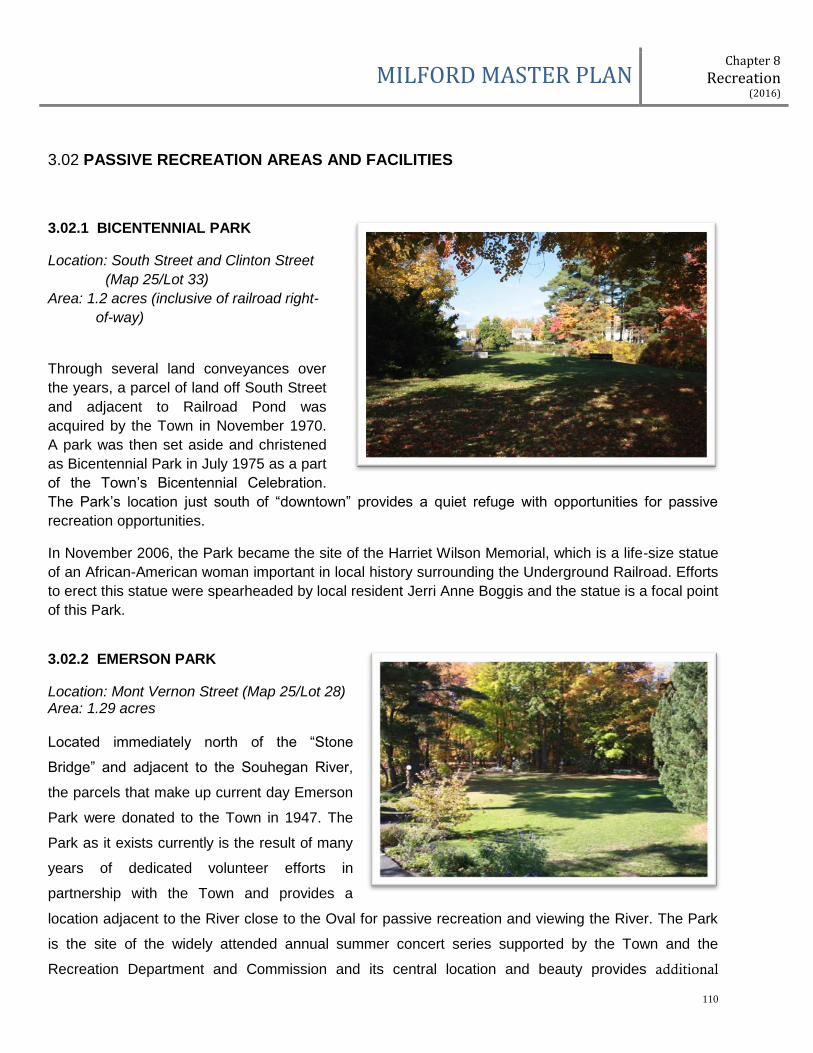
MILFORD MASTER PLAN Chapter 8
Recreation (2016)
110
3.02 PASSIVE RECREATION AREAS AND FACILITIES
3.02.1 BICENTENNIAL PARK
Location: South Street and Clinton Street
(Map 25/Lot 33)
Area: 1.2 acres (inclusive of railroad right-
of-way)
Through several land conveyances over
the years, a parcel of land off South Street
and adjacent to Railroad Pond was
acquired by the Town in November 1970.
A park was then set aside and christened
as Bicentennial Park in July 1975 as a part
of the Town’s Bicentennial Celebration.
The Park’s location just south of “downtown” provides a quiet refuge with opportunities for passive
recreation opportunities.
In November 2006, the Park became the site of the Harriet Wilson Memorial, which is a life-size statue
of an African-American woman important in local history surrounding the Underground Railroad. Efforts
to erect this statue were spearheaded by local resident Jerri Anne Boggis and the statue is a focal point
of this Park.
3.02.2 EMERSON PARK
Location: Mont Vernon Street (Map 25/Lot 28) Area: 1.29 acres Located immediately north of the “Stone
Bridge” and adjacent to the Souhegan River,
the parcels that make up current day Emerson
Park were donated to the Town in 1947. The
Park as it exists currently is the result of many
years of dedicated volunteer efforts in
partnership with the Town and provides a
location adjacent to the River close to the Oval for passive recreation and viewing the River. The Park
is the site of the widely attended annual summer concert series supported by the Town and the
Recreation Department and Commission and its central location and beauty provides additional
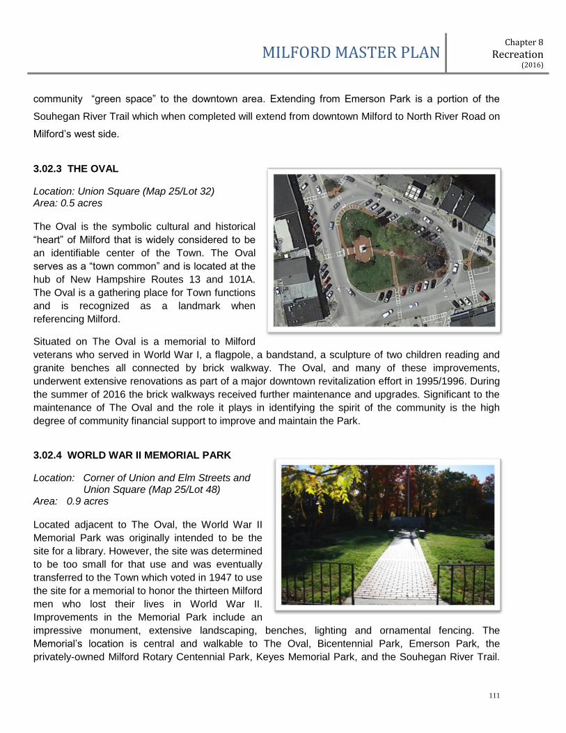
MILFORD MASTER PLAN Chapter 8
Recreation (2016)
111
community “green space” to the downtown area. Extending from Emerson Park is a portion of the
Souhegan River Trail which when completed will extend from downtown Milford to North River Road on
Milford’s west side.
3.02.3 THE OVAL
Location: Union Square (Map 25/Lot 32) Area: 0.5 acres The Oval is the symbolic cultural and historical
“heart” of Milford that is widely considered to be
an identifiable center of the Town. The Oval
serves as a “town common” and is located at the
hub of New Hampshire Routes 13 and 101A.
The Oval is a gathering place for Town functions
and is recognized as a landmark when
referencing Milford.
Situated on The Oval is a memorial to Milford
veterans who served in World War I, a flagpole, a bandstand, a sculpture of two children reading and
granite benches all connected by brick walkway. The Oval, and many of these improvements,
underwent extensive renovations as part of a major downtown revitalization effort in 1995/1996. During
the summer of 2016 the brick walkways received further maintenance and upgrades. Significant to the
maintenance of The Oval and the role it plays in identifying the spirit of the community is the high
degree of community financial support to improve and maintain the Park.
3.02.4 WORLD WAR II MEMORIAL PARK
Location: Corner of Union and Elm Streets and Union Square (Map 25/Lot 48)
Area: 0.9 acres Located adjacent to The Oval, the World War II
Memorial Park was originally intended to be the
site for a library. However, the site was determined
to be too small for that use and was eventually
transferred to the Town which voted in 1947 to use
the site for a memorial to honor the thirteen Milford
men who lost their lives in World War II.
Improvements in the Memorial Park include an
impressive monument, extensive landscaping, benches, lighting and ornamental fencing. The
Memorial’s location is central and walkable to The Oval, Bicentennial Park, Emerson Park, the
privately-owned Milford Rotary Centennial Park, Keyes Memorial Park, and the Souhegan River Trail.
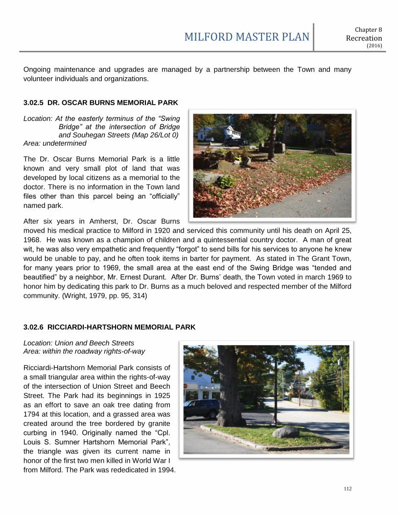
MILFORD MASTER PLAN Chapter 8
Recreation (2016)
112
Ongoing maintenance and upgrades are managed by a partnership between the Town and many
volunteer individuals and organizations.
3.02.5 DR. OSCAR BURNS MEMORIAL PARK
Location: At the easterly terminus of the “Swing Bridge” at the intersection of Bridge and Souhegan Streets (Map 26/Lot 0)
Area: undetermined
The Dr. Oscar Burns Memorial Park is a little
known and very small plot of land that was
developed by local citizens as a memorial to the
doctor. There is no information in the Town land
files other than this parcel being an “officially”
named park.
After six years in Amherst, Dr. Oscar Burns
moved his medical practice to Milford in 1920 and serviced this community until his death on April 25,
1968. He was known as a champion of children and a quintessential country doctor. A man of great
wit, he was also very empathetic and frequently “forgot” to send bills for his services to anyone he knew
would be unable to pay, and he often took items in barter for payment. As stated in The Grant Town,
for many years prior to 1969, the small area at the east end of the Swing Bridge was “tended and
beautified” by a neighbor, Mr. Ernest Durant. After Dr. Burns’ death, the Town voted in march 1969 to
honor him by dedicating this park to Dr. Burns as a much beloved and respected member of the Milford
community. (Wright, 1979, pp. 95, 314)
3.02.6 RICCIARDI-HARTSHORN MEMORIAL PARK
Location: Union and Beech Streets Area: within the roadway rights-of-way Ricciardi-Hartshorn Memorial Park consists of
a small triangular area within the rights-of-way
of the intersection of Union Street and Beech
Street. The Park had its beginnings in 1925
as an effort to save an oak tree dating from
1794 at this location, and a grassed area was
created around the tree bordered by granite
curbing in 1940. Originally named the “Cpl.
Louis S. Sumner Hartshorn Memorial Park”,
the triangle was given its current name in
honor of the first two men killed in World War I
from Milford. The Park was rededicated in 1994.
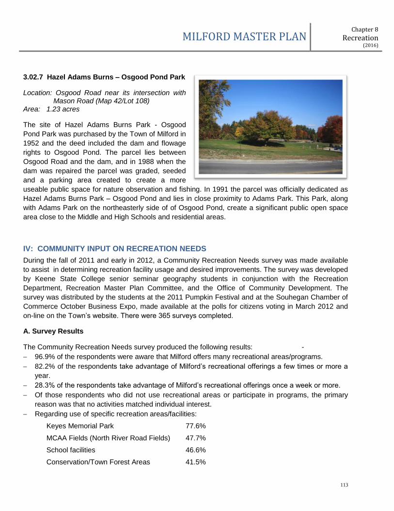
MILFORD MASTER PLAN Chapter 8
Recreation (2016)
113
3.02.7 Hazel Adams Burns – Osgood Pond Park
Location: Osgood Road near its intersection with Mason Road (Map 42/Lot 108)
Area: 1.23 acres
The site of Hazel Adams Burns Park - Osgood
Pond Park was purchased by the Town of Milford in
1952 and the deed included the dam and flowage
rights to Osgood Pond. The parcel lies between
Osgood Road and the dam, and in 1988 when the
dam was repaired the parcel was graded, seeded
and a parking area created to create a more
useable public space for nature observation and fishing. In 1991 the parcel was officially dedicated as
Hazel Adams Burns Park – Osgood Pond and lies in close proximity to Adams Park. This Park, along
with Adams Park on the northeasterly side of of Osgood Pond, create a significant public open space
area close to the Middle and High Schools and residential areas.
IV: COMMUNITY INPUT ON RECREATION NEEDS
During the fall of 2011 and early in 2012, a Community Recreation Needs survey was made available
to assist in determining recreation facility usage and desired improvements. The survey was developed
by Keene State College senior seminar geography students in conjunction with the Recreation
Department, Recreation Master Plan Committee, and the Office of Community Development. The
survey was distributed by the students at the 2011 Pumpkin Festival and at the Souhegan Chamber of
Commerce October Business Expo, made available at the polls for citizens voting in March 2012 and
on-line on the Town’s website. There were 365 surveys completed.
A. Survey Results
The Community Recreation Needs survey produced the following results: -
96.9% of the respondents were aware that Milford offers many recreational areas/programs.
82.2% of the respondents take advantage of Milford’s recreational offerings a few times or more a
year.
28.3% of the respondents take advantage of Milford’s recreational offerings once a week or more.
Of those respondents who did not use recreational areas or participate in programs, the primary
reason was that no activities matched individual interest.
Regarding use of specific recreation areas/facilities:
Keyes Memorial Park 77.6%
MCAA Fields (North River Road Fields) 47.7%
School facilities 46.6%
Conservation/Town Forest Areas 41.5%
MILFORD MASTER PLAN Chapter 8
Recreation (2016)
114
Keyes Pool 39.2%
Town Hall facilities 38.6%
Shepard Park 32.7%
Souhegan River 23.3%
Emerson Park 23.0%
Souhegan Valley Boys and Girls Club 21.3%
Kaley Park 17.3%
Osgood Pond 16.5%
Adams Park 13.6%
Bicentennial Park/Railroad Pond 12.5%
Hartshorn Pond 6.0%
Old Police Station 4.8%
Other 4.5%
Regarding activity undertaken at Milford’s recreational areas and facilities:
Hiking-Walking 64.7% of respondents participated
Playgrounds 54.3%
Swimming 37.5%
Soccer 34.2%
Baseball/Softball 29.4%
Physical Fitness 28.9%
Special Events/Dances 25.5%
Biking 25.2%
Basketball 24.9%
Dog Walking 24.6%
Ice Skating 24.4%
River/Pond Access 21.6%
Tennis 20.2%
Running 18.5%
Skate Park 12.0%
Sledding 11.5%
Field Hockey/Lacrosse 6.7%
Football 4.2%
Do Not Use for Any Activity 3.9%
Snowmobiling 3.6%

MILFORD MASTER PLAN Chapter 8
Recreation (2016)
115
Regarding the importance of ‘recreation’ and recreation areas and facilities to the respondents:
57.9% Strongly Agree and 31.6% Agree that recreation is an important part of their lives.
54.0% Agree and 14.8% Strongly Agree that recreational areas in Milford meet their recreational
needs. 20.6% were Neutral.
47.5% Agree, 27.2% were Neutral, and 12.6% Strongly Agree that recreational programs and
activities meet their needs.
36.1% Agree, 30.1% Strongly Agree, and 26.7% were Neutral on the statement that it is
important that Milford improve current recreational areas.
On the statement “the quality of the Milford recreational areas I use is excellent”, 47.6% Agree,
16.6% Strongly Agree, and 23.4% were Neutral.
When asked if it was important for Milford to build/provide new facilities to meet current and
future demand, 35.7% Agree, 30.9% Strongly Agree, and 23.6% were Neutral.
V. CURRENT RECREATION PROGRAMS AND NEEDS
Milford’s strong reputation as a family-friendly community illustrates the residents' commitment to
recreation, both organized team events, and programming, as well as informal family outings.
Recreation and recreational facilities are community priorities to be planned, developed, and
maintained like any other town capital asset. The underlying goal of this plan is to improve recreational
opportunities and facilities to match the needs of the present residents and to keep up with the pace of
the Town's population growth, evolving demographic, and diversity of activities. This includes providing
a diverse mix of recreational facilities and opportunities for residents of all age groups.
5.01 Program Enrollment and Field Usage
The following tables show program enrollment for Recreation Programs in Milford since 2012 and
number of hours. Program enrollment and field usage data is used to develop needs assessments for
future facilities and programs, plan future recreation budgets, and as an input into the town budget
planning process.
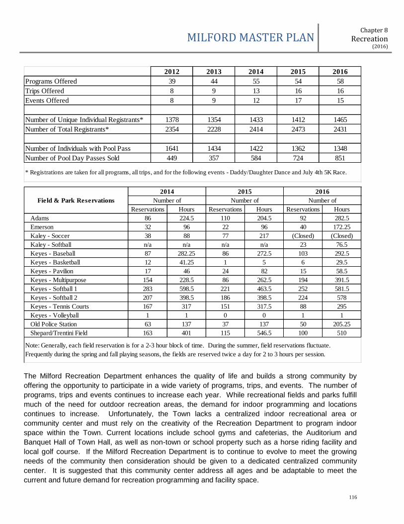
MILFORD MASTER PLAN Chapter 8
Recreation (2016)
116
The Milford Recreation Department enhances the quality of life and builds a strong community by
offering the opportunity to participate in a wide variety of programs, trips, and events. The number of
programs, trips and events continues to increase each year. While recreational fields and parks fulfill
much of the need for outdoor recreation areas, the demand for indoor programming and locations
continues to increase. Unfortunately, the Town lacks a centralized indoor recreational area or
community center and must rely on the creativity of the Recreation Department to program indoor
space within the Town. Current locations include school gyms and cafeterias, the Auditorium and
Banquet Hall of Town Hall, as well as non-town or school property such as a horse riding facility and
local golf course. If the Milford Recreation Department is to continue to evolve to meet the growing
needs of the community then consideration should be given to a dedicated centralized community
center. It is suggested that this community center address all ages and be adaptable to meet the
current and future demand for recreation programming and facility space.
2012 2013 2014 2015 2016
Programs Offered 39 44 55 54 58
Trips Offered 8 9 13 16 16
Events Offered 8 9 12 17 15
Number of Unique Individual Registrants* 1378 1354 1433 1412 1465
Number of Total Registrants* 2354 2228 2414 2473 2431
Number of Individuals with Pool Pass 1641 1434 1422 1362 1348
Number of Pool Day Passes Sold 449 357 584 724 851
* Registrations are taken for all programs, all trips, and for the following events - Daddy/Daughter Dance and July 4th 5K Race.
Reservations Hours Reservations Hours Reservations Hours
Adams 86 224.5 110 204.5 92 282.5
Emerson 32 96 22 96 40 172.25
Kaley - Soccer 38 88 77 217 (Closed) (Closed)
Kaley - Softball n/a n/a n/a n/a 23 76.5
Keyes - Baseball 87 282.25 86 272.5 103 292.5
Keyes - Basketball 12 41.25 1 5 6 29.5
Keyes - Pavilion 17 46 24 82 15 58.5
Keyes - Multipurpose 154 228.5 86 262.5 194 391.5
Keyes - Softball 1 283 598.5 221 463.5 252 581.5
Keyes - Softball 2 207 398.5 186 398.5 224 578
Keyes - Tennis Courts 167 317 151 317.5 88 295
Keyes - Volleyball 1 1 0 0 1 1
Old Police Station 63 137 37 137 50 205.25
Shepard/Trentini Field 163 401 115 546.5 100 510
Field & Park Reservations
Note: Generally, each field reservation is for a 2-3 hour block of time. During the summer, field reservations fluctuate.
Frequently during the spring and fall playing seasons, the fields are reserved twice a day for 2 to 3 hours per session.
2014 2015
Number of Number of Number of
2016

MILFORD MASTER PLAN Chapter 8
Recreation (2016)
117
Conducting a needs assessment and feasibility study for a community center would be an important
next step for the Town to undertake. The studies should address community support, what facilities
should be provided, funding mechanisms, operational support, annual budget impacts, and finding a
central location that is easily accessible by multi-modal travel.
VI. RECREATION ACTION PROGRAM
The following section forms the blueprint for realizing the Town’s vision for meeting the recreation
facility and program goals of the Town, both short-term and long-range. To implement the desired
actions the Town will need to undertake a concerted effort, drawing upon the expertise and resources
of staff; elected officials, volunteer boards and community groups, and the citizens of the community.
Goal No. 1: Implement the Immediate, 1-3 Years, 3-5 Years, and 5 Years and Beyond
recommendations identified for each Town facility and park.
Action 1: Incorporate funding and resources into appropriate municipal budgets and foster and
grow partnerships between the Town, School District, recreation organizations and
community groups to implement.
Action 2: Identify and include capital projects that exceed $75,000 in cost in the annual Capital
Improvements Plan (CIP) process.
Action 3: Review and evaluate the status of implementation every two (2) years and update
implementation plans as necessary.
Goal No. 2: Evaluate Recreation Department staffing and resources to adequately meet
administrative and programming demands and recreation services for the
residents of Milford.
Action 1: Review adequacy of staffing requirements of the Recreation Department to ensure the
Department can adequately meet the growing and increasingly diversified recreation
programming demands of the community.
Action 2: Ensure that the Recreation Department budget supports staffing and programming
demands.
Action 3: Determine space needs to accommodate efficient and adequate office and program
space and actively participate in ongoing municipal departmental space planning efforts.
Goal No. 3: Evaluate the need for a centralized recreation and/or community center in Town.

MILFORD MASTER PLAN Chapter 8
Recreation (2016)
118
Action 1: Conduct a demand and needs assessment to quantify facility and recreational program
needs within the Milford Community including a gap analysis evaluation.
Action 2: Based on the results of the needs assessment, conduct a feasibility study for a
centralized recreation and/or community center that meets the demand for current and
future recreation programming/services.
Action 3: Enlist involvement of the Community Facilities Committee to review conceptual plans,
determine location, develop cost estimates, and determine funding sources. At a
minimum, the cost analysis should reflect the estimated costs of construction and
anticipated costs for the continued maintenance and management of the facility.
Action 4: Include any proposed community center in the Capital Improvements Plan.
Goal No. 4: Ensure that Milford is bicycle and pedestrian friendly.
Action 1: In conjunction with implementing the goals of the Transportation Chapter of the Master
Plan, determine locations of needed sidewalk connections and bicycle routes that
provide non-motorized access to Town recreation facilities.
Action 2: Identify appropriate locations and roadways for designation of safe bicycle routes, adopt
a bicycle route master plan, and include implementation strategies in the Town’s
Development Regulations and Public Improvement Construction Specifications and
Standards.
Action 3: Support the Conservation Commission’s implementation efforts to create Town-wide trail
connections as designated in the Commission’s master plan.
Appendices
VII. APPENDIX
A. 2011 Milford Plans to Play Survey Results
B. 2013 MCAA Needs Analysis
C. Milford Turf Management Plan
D. Proposed Time Frame for Improvements and Action
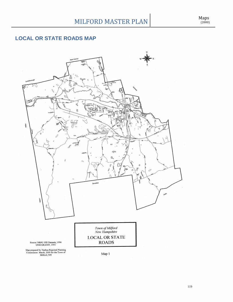
MILFORD MASTER PLAN Maps (2000)
119
LOCAL OR STATE ROADS MAP
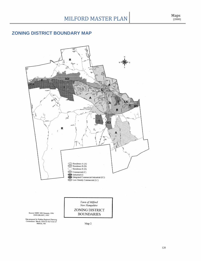
MILFORD MASTER PLAN Maps (2000)
120
ZONING DISTRICT BOUNDARY MAP

MILFORD MASTER PLAN Maps (2000)
121
GENERALIZED LAND USES MAP