1971, Contrasting geometric adjustment styles of drifting continents and spreading sea floors.
10
VOL. 76, NO. 14 JOURNAL OF GEOPHYSICAL RESEARCH MAY 10, 1971 Contrasting Geometric Adjustment Styles of Drifting Continents and Spreading Sea Floors K•WN S. Ro•o•o Department of Geological Sciences University of Illinois, Chicago 60680 The geometry of moving oceanic lithospheric plates is modeled easily by combining plate subduction anddestruction with an application of Euler's theorem to the Euclidean sphere of the earth's surface. However, continental masses mustrespond to drift motion in a differ- entmanner because they cannot sink into thedenser mantle. A theoretical geometric analysis, tested by data from theeastern Pacific margin, is presented to illustrate theunique response to drift of large continental masses. If they arelarge enough to comprise a significant fraction of the earth's circumference, an alignment of continental masses should undergo extension until the frontier between them and the ocean overwhich they encroach approximates a global greatcircle. This extension should entail secondary sea-floor spreading transverse to primaryspreading directions, localized wherecontinental masses alongthe frontier are narrow and therefore weakest, and ductile stretching and fracturing of the narrow con- tinental spans. Continued sea-floor spreading and continental driftbeyond thestage at which the continent-ocean frontier approximates great circle configuration presents a new problem. The maximized frontierlengthmustnow adjustto a decreased area of encroached ocean. Adjacent continents must now approach each other along the frontier direction, and formerly stretched and disrupted continental spans mustbe 'bent' to account for the excess frontier length. Recent reconstructions of post-Paleozoic continental drift indicate that the American and Antarctic continents and intervennig Caribbean and Scotia seas and island arcs may have undergone such a history. The hypothesis of sea-floor spreading postu- lated independently by Holmes [1945] andHess [1962], which a recent series of significant papers [Morgan, 1968; Le Pichon, 1968; Heirtzler e• al., 1968; Isacks e• al., 1968] de- veloped into the 'new global tectonics,' attri- butes continentaldrift to the movementof rigid lithospheric plates composedof oceanic crust and upper mantle. These plates are thought to be generated at oceanic ridges from ris- ing asthenospheric mantle material. Continental drift is envisioned as being caused when spreading begins underneathcontinental masses that are rifted apart and rafted away from spreading centers. If the distal portion of a moving plate is oceanic, it can underthrust an opposing plate that may or may not carry con- tinental crust. Such an underthrusting plate is believed to be destroyedby reassimilation into the mantle. The site of this destruction is marked at the surface by a trench, which separatesthe downgoing lithosphere from an Copyright ¸ 197I by the American Geophysical Union. island arc or an Andean-type continental mar- gin. Continental masses are generally treated as essentially passive and rigidunless they are rafted to a trench by a downgoing plate. Only in this circumstance do they manifest their individuality because theycannot sink intothe denser mantle. Thus continents borne by oppos- ingplates eventually collide to form linear zones of thickened sialic crust (compressional moun- tainbelts of alpine type). One ofthe most intellectually appealing char- acteristics of platetectonic theory is the ele- gantly simple geometry of plate generation and propagation, i.e., Euler's theorem asit applies to a Euclidean sphere: any relativemotionof two platesat the earth'ssurface can be resolved intoa rotation about a global axis, and all rela- tive velocities between the two plates must lie along small latitudinal circlesabout that axis. Spatial geometric problems do not arise from thecontinued production and migration oflitho- sphere because theplates depart from theearth's surface and are destroyed at depth. 3272
Transcript of 1971, Contrasting geometric adjustment styles of drifting continents and spreading sea floors.

VOL. 76, NO. 14 JOURNAL OF GEOPHYSICAL RESEARCH MAY 10, 1971
Contrasting Geometric Adjustment Styles of Drifting Continents and Spreading Sea Floors
K•WN S. Ro•o•o
Department of Geological Sciences University of Illinois, Chicago 60680
The geometry of moving oceanic lithospheric plates is modeled easily by combining plate subduction and destruction with an application of Euler's theorem to the Euclidean sphere of the earth's surface. However, continental masses must respond to drift motion in a differ- ent manner because they cannot sink into the denser mantle. A theoretical geometric analysis, tested by data from the eastern Pacific margin, is presented to illustrate the unique response to drift of large continental masses. If they are large enough to comprise a significant fraction of the earth's circumference, an alignment of continental masses should undergo extension until the frontier between them and the ocean over which they encroach approximates a global great circle. This extension should entail secondary sea-floor spreading transverse to primary spreading directions, localized where continental masses along the frontier are narrow and therefore weakest, and ductile stretching and fracturing of the narrow con- tinental spans. Continued sea-floor spreading and continental drift beyond the stage at which the continent-ocean frontier approximates great circle configuration presents a new problem. The maximized frontier length must now adjust to a decreased area of encroached ocean. Adjacent continents must now approach each other along the frontier direction, and formerly stretched and disrupted continental spans must be 'bent' to account for the excess frontier length. Recent reconstructions of post-Paleozoic continental drift indicate that the American and Antarctic continents and intervennig Caribbean and Scotia seas and island arcs may have undergone such a history.
The hypothesis of sea-floor spreading postu- lated independently by Holmes [1945] and Hess [1962], which a recent series of significant papers [Morgan, 1968; Le Pichon, 1968; Heirtzler e• al., 1968; Isacks e• al., 1968] de- veloped into the 'new global tectonics,' attri- butes continental drift to the movement of rigid lithospheric plates composed of oceanic crust and upper mantle. These plates are thought to be generated at oceanic ridges from ris- ing asthenospheric mantle material. Continental drift is envisioned as being caused when spreading begins underneath continental masses that are rifted apart and rafted away from spreading centers. If the distal portion of a moving plate is oceanic, it can underthrust an opposing plate that may or may not carry con- tinental crust. Such an underthrusting plate is believed to be destroyed by reassimilation into the mantle. The site of this destruction is
marked at the surface by a trench, which separates the downgoing lithosphere from an
Copyright ̧ 197I by the American Geophysical Union.
island arc or an Andean-type continental mar- gin.
Continental masses are generally treated as essentially passive and rigid unless they are rafted to a trench by a downgoing plate. Only in this circumstance do they manifest their individuality because they cannot sink into the denser mantle. Thus continents borne by oppos- ing plates eventually collide to form linear zones of thickened sialic crust (compressional moun- tain belts of alpine type).
One of the most intellectually appealing char- acteristics of plate tectonic theory is the ele- gantly simple geometry of plate generation and propagation, i.e., Euler's theorem as it applies to a Euclidean sphere: any relative motion of two plates at the earth's surface can be resolved into a rotation about a global axis, and all rela- tive velocities between the two plates must lie along small latitudinal circles about that axis. Spatial geometric problems do not arise from the continued production and migration of litho- sphere because the plates depart from the earth's surface and are destroyed at depth.
3272

Unfortunately, because plate theory treats the continents as passive, and because of the ease with which most plate motion can be modeled by a combination of Euler's theorem and plate destruction, attention has been focused mainly on the movements of oceanic lithosphere. Many 'new global tectonicians' have become overly casual about the role, behavior, and de- formation of the continents undergoing drift.
This report is virtually in complete harmony with the fundamental assumptions and data of plate tectonic theory. However, an attempt is made here to extend the 'new global tectonics' by examining an additional, important global aspect. The principal thesis of this report, doubtlessly controversial, is that drifting con- tinental masses must also obey the geometry that governs the movements of large areal seg- ments over a sphere; further, that continents cannot resolve areal geometric problems by sinking beneath the surface and thus must re- spond to migration in a manner that differs fundamentally from that of oceanic lithosphere. If drifting continental masses are large enough in area to approach global magnitude, their deformative adjustments to the requirements of spherical geometry should remain evident at the earth's surface. The eastern margin of the Pa- cific Ocean will be examined in this light. A corollary to this thesis is that where a conti- nental mass comprises a significant portion of a tectonic plate, the dynamic adjustments re- quired of it by the earth's spherical configura- tion may prevent it from passively obeying the advective surface motion of the lithosphere on which it rides. If this corollary is valid, drifting continents may even influence and alter the geometry of the lithosphere being produced behind them. The Atlantic Ocean will be viewed briefly in this context during development of the principal argument. It is hoped that these analyses will generate further reexamination of the behavior of continents during drift and sea-floor spreading.
LIMITATIONS OF EULER'S THEOREM
The rules of spherical geometry as they apply to continental drift were first demonstrated when Bullard el al. [1965] applied Euler's theorem in reconstructing the predrift fit of the continents around the Atlantic Ocean. Subse-
quently, McKenzie and Parlce•' [1967] extended
3273
the theorem to an analysis of plate production and propagation in the North Pacific, demon- strating that Wilson's [1965] ridge-ridge trans- form faults and their associated fracture zones
constitute small circles that describe the rela-
tive displacements between plates. The now classic series of papers published in
1968 by Morgan, Le Pichon, Heirtzler et al. and Isacks et al. applied the same geometry to demonstrate convincingly that sea-floor spread- ing rates calculated from magnetic anomalies parallel to ridge crests vary directly with dis- tance from plate rotational poles. From these reports, it can be concluded that: (1) each ridge-crest segment between consecutive trans- forms is a segment of great circle passing through the spreading poles (Figure 1); (2) an
Fig. 1. Sea-floor spreading and Euler's Theo- rem. Transform faults are necessary to reconcile the constant width of an individual magnetic stripe segment with the requirement of increased spreading rates with decreased spreading latitude. Consecutive transforms are drawn much farther
apart than is typical in nature. Modified from Heirtzler, 1968.

327-! KELVIN S. RODOLFO
individual m:1gnetic anomaly stripe between consecuti,·e transforms or fracture zones has a constant width; and (3) two chronologically identical stripes within a single lithospheric plate but bounded by different transforms or
fractures ha\"e different widths because angular rotational velocities of spreading must be identical, but spreading velocities must vary with latitude from the spreading poles. Transform faults thus appear to be mechanisms that reconcile conditions 2 and 3 and sen·e as zones of geometric adjustment. Exi�tence of this mechanism made theoretically permissible the assumption [lsacks et al.., H)68; Morgan, 1968; Le Pichon, 1968; Molnar and Sykes, 1969J that a single plate consisting of both American continents and the western Atlantic can move as a unit.
More detailed work, however, has indicated that individual plates may be limited to smaller dimensions. A series of paper [Funnell and
Smith, 1968; Ball et al.., 1969; Bal.l and HalTison, 1970J has shown the Atlantic Ocean to be composed of three latitudinal pairs of plates separated by two east-west oriented wedgeshaped zones (Figure 2). North-south extension and sinistral shear characterize the wedges,
Fig. 2. Atlant.ic sea fioor, composed of three latitudinal pairs of lithospheric plates between which north-south extension and transcurrent faulting have occurred in two zones (stippled areas). Modified from Funnell and Smith, 1968.
which trend respectively eastward into the Tethys belt between Europe and Africa, and westward into the Caribbean region between
North and South America. Ball and Harrison [1970J suggest that plate
size (and, presumably, operations of Eulerian spreading about a single pole) are limited to the magnitude of typical continental blocks. One possible explanation for the segmentation and discordant movement of the AmericanWestern Atlantic lithosphere is simply that the history of the Atlantic opening is not a single event. H eirtzler [1968J has concluded from geomagnetic data that the separation of North America from Europe preceded the separation of South America from Africa. A comple
mentary explanation exists: a single continental mass composed of the Americas constitutes such a large proportion of the globe's area and meridional circumference that it cannot migrate over the sphere without being areally deformed. If the continental mass undergoing distortion remains coupled to the lithosphere on which it rides, the lithosphere must also be distorted.
Such a deformation of oceanic lithosphere
would have to take two forms. First, the direction of sea-floor spreading at the ridge behind the continent could undergo adjustment in the manner proposed by Menard and Atwater
[1968J. Second, oceanic lithosphere already in existence would have to be either augmented or destroyed along directions transverse to the primary spreading direction. The north-south extension and shear of the Atlantic wedges in Figure 2 would have served this function.
The foregoing analysis would remain idle speculation unless it is demonstrated that continental masses do undergo deformation solely as a geometric consequence of their migrations over the earth sphere. The following analysis provides such a demonstration. Some of the terminology used to describe areal relationships
(e.g., empire, country, frontier) were inspired by Blackett's [1967J exposition of t.he famous topologic 'four-color problem.'
MODIFICATIONS IN AREAL GEOMETRY OF
CONTINENTS AND OCEANS DURING
CONTINENTAL DRIFT
General. statement. The following qualified assumptions, all in conformit�· with 'new global tectonic' dogma, are made:
DRIFTING CONTINENTS, SPREADING SEA FLOORS
1. Oceanic lithosphere is continually pro- duced at ridges and destroyed at trenches.
2. Once differentiated out of the mantle, continental material remains at or close to the
earth's surface. It may be recycled palingeneti- cally, but continental masses, even when frag- mented by drift, occupy essentially permanent percentages of global surface.
3. The continents at the end of the Paleo-
zoic era were a single landmass. Modern sea- floor spreading data support this assumption over the concept of separate Laurasian and Gondwanic supercontinents [Heirtzler, 1968; Dietz and Holden, 1970a, b]. If future data revive the idea of two separate landmasses the argument will not be affected significantly.
4. Pre-Triassic continental crust has not
diminished appreciably in area up to the present (as a consequence of assumption 2). At any moment in time since Pangaea began to break up, its fragments have covered approximately 40% of the earth's surface. This figure includes all oceanic areas of continental shelf and slope shoaler than 2000 meters (from the data of Menard and Smith [1966]). Some minor palin- spastic areal loss may have resulted from thick- ening of sialic crust at trenches and from con- tinental collisions along the Alpine-Himalayan belt.
5. More importantly, if the leading edge of a lithospheric plate is continental, the length of this edge cannot be shortened. However, it may be lengthened or bent if subjected to the proper stress and if the width and thickness of the continental mass is sufficiently small to permit plastic deformation.
6. The earth's 40,000-km meridional cir- cumference has remained unchanged since the breakup of Pangaea. Although the ensuing dis- cussion embodies some of the features of a
'topologic' argument for an expanding earth presented by Meservey [1969], the present treatment does not involve global expan- sion. The expanding earth concept also has received insufficient attention from global tec- tonictans but is not germane to the present argument.
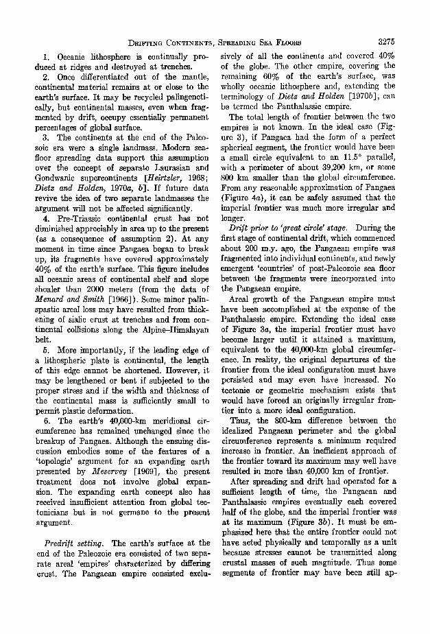
Predri/t setting. The earth's surface at the end of the Paleozoic era consisted of two sepa- rate areal 'empires' characterized by differing crust. The Pangaean empire consisted exclu-
3275
sively of all the continents and covered 40% of the globe. The other empire, covering the remaining 60% of the earth's surface, was wholly oceanic lithosphere and, extending the terminology of Dietz and Holden [1970b], can be termed the Panthalassic empire.
The total length of frontier between the two empires is not known. In the ideal case (Fig- ure 3), if Pangaea had the form of a perfect spherical segment, the frontier would have been a small circle equivalent to an 11.5 ø parallel, with a perimeter of about 39,200 km, or some 800 km smaller than the global circumference. From any reasonable approximation of Pangaea (Figure 4a), it can be safely assumed that the imperial frontier was much more irregular and longer.
Drift prior to 'great circle' stage. During the first stage of continental drift, which commenced about 200 m.y. ago, the Pangaean empire was fragmented into individual continents, and newly emergent 'countries' of post-Paleozoic sea floor between the fragments were incorporated into the Pangaean empire.
Areal growth of the Pangaean empire must have been accomplished at the expense of the Panthalassic empire. Extending the ideal case of Figure 3a, the imperial frontier must have become larger until it attained a maximum, equivalent to the 40,000-km global circumfer- ence. In reality, the original departures of the frontier from the ideal configuration must have persisted and may even have increased. No tectonic or geometric mechanism exists that would have forced an originally irregular fron- tier into a more ideal configuration.
Thus, the 800-kin difference between the idealized Pangaean perimeter and the global circumference represents a minimum required increase in frontier. An inefficient approach of the frontier toward its maximum may well have resulted in more than 40,000 km of frontier.
After spreading and drift had operated for a sufficient length of time, the Pangaean and Panthalassic empires eventually each covered half of the globe, and the imperial frontier was at its maximum (Figure 3b). It must be em- phasized here that the entire frontier could not have acted physically and temporally as a unit because stresses cannot be transmitted along crustal masses of such magnitude. Thus some segments of frontier may have been still

............ ....... L/../. / / l .... 4,..•'•-.•o,ooo •m •'•.;-•!'•-::•: .?-:: :..' ..:.. ?•..:: .
•' e• • :-','*';L•,' '" ' '.." ,-•'.• --• '•
b
Ao= 204 X 106km 2 = 2•Rh o /- •/• bo: 5100 km ß . 6371-5100 .. • / •o = arcsl n---•¾•T .... • • . go l_
2 ro= Rcosq• ø : 6 43 km
Po: 2•,(6243) -- 39,200 km •)p: 19 ø pp= 37,840 km • •- •oo•.,•......._-......-.,:.• _.•._•....•
' •/•. 70ø
,•-": : /,/ / / /'•' • ••••......•• ""'"'"'•-'""'"•'••••>'•'"1• • • • ..- - ..:.:..-•: ,,•,,•
ß •'•'-.'*•?•":ø ....'•- *-• : .L,- -' -'%*-•'it-.*'*:: ...:..,-..?•-?' • •:• •t• ""• .. q•*-.%.-:•%..'. •....
' -"':•"" ' ?• d •(•:N ...... '-- ----.'•: '•• C.
'.•:i::.
ß :i.:'!'. ..:•!i• ... / •.•;,,. ,-'"'."' '. ' ' i:i:i:?" ,.,. 'i:i::'.• .:,.-o.,,..-.-.. ß o ::..:..:.'. ,•, ,,, ...%:-2..'? •,-'-" ::.:.:3' "-., - ::..?,, *.,,-.V" ' :'::' "T. --.-•.",•"'."• .... •: ' .....:,.'.-:!•!:i:' ß '-• .' .'.'
ii. '-: -!..•. ;;,• 6oø• ß ...............
// i!ii::i::iiiii::::i::i•i::ili:,:...'" ':':*•::::i•i::::. Fig. 3. Idealized area] geometry of drifting j_
continents and the Pangaean-Pantha]•ssie fron- tier. In •, Pangaea approximates a spherical seg- ', ment of one base, the small circle. po "'• 39,200
km, calculated as shown. In b, new se• floor has "• .... '"'"'"'"'"•!'"""•o/i• rafted the continents to the maximum imperial frontier p• ---- 40,000 km. Continents have moved apart along frontier by transverse sea-floor spread- ing (stippled zones). Narrow continental spans at transverse spreading zones have been atten- uated and fragmented. In c, spreading has brought frontier to the present Pacific margin p•. Con- tinents have moved closer to each other along frontier; stretched and fragmented continental spans have looped behind the continents.
Fig. 4. Aitoff projections' of post-Paleozoic breakup and drift. of Pangaea according to Dietz and Holden [1970a, b]. In a, great circle distance A-B is •--13,100 km; in b, •--14,900 km; in c, --•16,600; in d, •--16,100 km; and at present in e, --•14,160 km. These v•lues 'are plotted in Figure 6. Heavy meridians in a indicate an arbitrary great circle.

DRIFTIN(• CONTINENTS, SPREADING SEA FLOORS
proaching the maxi•num while others already beyond it were responding to new geometric requirements.
The frontier could have been increased by sea-floor spreading transverse to the primary spreading direction and frontier. The Atlantic wedge-shaped zones of Figure 2 could have served this purpose.
Continents undergoing this motion would have moved farther from each other along the fron- tier direction. Such movement is indicated by the Pangaean reconstruction of Dietz and Holden [1970a, b]. The relative distances of two arbitrarily chosen points along the Antarctic- North American portion of the frontier were measured by standard spherical trigonometry. Point A is located at the present head of the Gulf of Alasks (60øN, 142øE) and point B lies on the coast of Ellsworth Land in Antarctica
(72øS, 90øE). An original great circle distance of about 13,100 km 200 m.y. ago is indicated. After 20 m.y. of drift, the distance is shown to have increased by 1800 km (Figure 4b). A maximum distance of 16,600 km, representing an increase of 3500 km, is shown for the end of the Jurassic, 135 m.y. ago (Figure 4c).
The increase in frontier represented by these figures as well as by the idealized geometry would have been accomplished most easily in localities where continental masses were either
missing or narrow and therefore weak. Tensional stresses indicated by these movements may have fragmented the narrow continental crust into islands separated by the oceanic lithosphere produced by secondary (transverse) spreading. However, as Cullen [1969] has pointed out, tensional fracture of rock is often preceded by some form of plastic deformation. Plastic lengthening of narrow isthmian portions of the continental frontier may also have contributed to the lengthening of the frontier. Southern Mexico and Central America do not conform to
attempted pre-Atlantic reconstructions of the continental fits. Bullard e• al. [1965] terminate North America just south of the Tropic of Cancer without explanation. Dietz and Holden [1970a, b] fragment Yucatan and Honduras into their eratonic elements and arbitrarily rotate the eratons into the gap of the Gulf of Mexico. These difi%uIties may be due to plastic deformation of the original Pangaean configura- tion of these narrow portions of the continents.
3277
Hamilton [1966], summarizing reports of a number of workers, has concluded that narrow isthmian connections between the Americas and between South America and Antarctics existed
during Mesozoic time. Islands of both the Carib- bean and Scotia arcs (Figure 5) include Triassic and Jurassic rocks now areally divorced from their original provenantes on the continents. Dalziel [1970] reports that the northern and southern limbs of the Scotia arc inchide Paleo- zoic and possibly Precambrian rocks as well. From the initial conception of continental drift [Wegener, 1924] both arcs have been inter- preted as disrupted spans between the conti- nents. Carey [1958] gave them as examples of oroclinotaths (orogenic belts that have under- gone substantial bending and stretching).
Dri]t subsequent to 'great circle' stage. After the imperial frontier had attained its maximum, and the composite Pangaean empire and Pantha- lassie empire each covered half the earth, a new geometric problem arose. The stretched frontier
now began to enclose a continually decreasing Panthalassic area.
The Pacific Ocean represents what remains of Panthalassa. Its area is about 172 X 100 km 2, including the deeper oceanic portions of the South China, Japan, Okhotsk, and Bering mar- ginal seas. Extending the ideal case (Figure 3c), if the Pacific were configured with maximum geometric economy, its perimeter would be a small circle equivalent to a 19 ø parallel with a length of 37,840 km, 2160 km less than the global great circle. In actuality, irregularities in the Pacific margin result in a perimeter of about 41,300 km (Table 1; Figure 5, insert), invalidating Meservey's [1969] assertion that the Pacific margin was never large enough to enclose half the earth's surface. In any case, the 2160-km value represents the most reasonable value of the difference between the actual maxi- mum and modern frontiers.
As the continents continued to drift beyond the maximum frontier stage, adjacent conti- nents along the frontier must have moved closer toward one another. Such a motion along the frontier sector from North America to Ant-
arctic• is indicated by the reconstruction in Figure 4. Here it is seen that points A and B, which had moved farther apart during pre- great circle drift, began to approach each other in post-Jurassic time, from the maximum sepa-

3278 K•,•,wN S. RO•)OT,FO
CL_•At•ION Ft•ACTUR•- ZONe-
CL IPPElO TON Ft•ACTUt•' ZONe'
CUBA
HISPANIOLA P•J•'/•7'O /:t/CO
VIRGIN IS
!-LL•sS•R ß .. ,.j ANTILLES
ß
.o
ß FALKLAND IS.
".3 "d- x• S. SH[TLAUD•S .... • S OR•UE• •S•EOR•A!
••0• S SANDWICH _ .....
••111t111t11•1111•11• • •o• ._
Fig. 5. The Caribbean and Scotia arcs, and the Pacific margin (insert). Letters denote the generalized Pacific perimeter of Meaervey [1969]. The perimeter segments of Table I corre- spond to this notation.

DRIFTING CONTINENTS, SPREADING SEA FLOORS
ration of 16,600 km to the modern distance of 14,160 kin.
In consequence of this motion, any transverse sea-floor spreading that marked the previous stage must have diminished and ceased. A more serious geometric problem is posed by the in- elastic continental portions of the frontier that earlier had undergone stretching. Its inelasticity required that the frontier length had to remain constant even as the Panthalassic area became smaller.
The most logical areas for the necessary adjustment would have been the zones that had formerly provided the required expansion. Two such zones, from the foregoing analysis, would have been the new lithosphere of the Caribbean and Scotia seas bearing the stretched and frag- mented Caribbean and Scotia bridges. The frontier slack would have been taken up in a 'bending' of these insular-peninsular arcs as the continents moved closer to one another in the
manner illustrated by Figure 3c. Bending and disruption of the arcs during Tertiary time are indicated by field evidence [Hamilton, 1966; Dalziel, 1970]. Such an adjustment could have been accomplished through actual bending by plastic flow; in a manner analogous to shear
3279
folding, by short wrench translations along fractures or zones of weakness originally de- veloped during the elongation stage; by large- scale transcurrent faulting at the northern end and southern boundaries of the Caribbean and
Scotia lithosphere; or by any combination of the three mechanisms. Between the Americas a
first stage of perimeter adjustment became complete when formation of the isthmian link during the Pliocene produced a more linearly economic Pacific margin and stranded the Carib- bean plate in the Atlantic.
RATES AND HISTORY OF FRONTIER DISTORTION
If it is assumed that the sea floor of the
earth has spread at a constant rate since the breakup of Pangaea, the history of frontier dis- tortion can be geometrically approximated. In the ideal case of Figure 3, constant spreading would mean that the frontier was first enlarged and then contracted in a continuous series of
circles described by a linear change in g) with time. Consequently, the change in frontier length would have varied with the cosine of g), since
r, = R cos • hence p• =•2wR cos •
with the subscript n denoting the general case.
TABLE 1. Lengths of the Segments of the Average Pacific Perimeter Depicted in the Insert of Figure 5
Segment Point and Locality Latitude Longitude Segment Length, km
A Southeast Asia 14øN 108øE
B North Australia 13øN 130øE
C South Australia 38% 147øE
D Victoria Land, Antarctica
E Ellsworth Land, Antarctica
F Tierra del Fuego, South America
G Southern Isthmus of Panama
H West-central Mexico
I Western Alaska
J Eastern Siberia
Southeast Asia
Total average Pacific perimeter Meridional circumference of earth
71 øS 167øE
73øS 82øW
53øS 74øW
8øN 77øW
19øN 105øW
60øN 162øW
63øN 172øE
14øN 108øE
AB 35OO
BC 38OO
CD 3200
DE 2400
EF 2900
FG 6900
GH 380O
HI 6100
IJ 8OO
JA 7900
41,300 40,000

3280
The idealized frontier history is summarized by the solid line curve in Figure 6. The abscissa linearly equates • with time, as required by the foregoing assumption. Approximately 80% of the frontier elongation would have been accom- plished by 160 m.y. ago, and the great circle stage would have been attained by 125 m.y. ago. Subsequent departure from the great circle would have been slow until about 70 m.y. ago but would have accelerated along the cosine curve to the present.
Comparison of this idealized curve with the history of the American-Antarctic sector of the frontier is interesting. On Figure 6 the distances between points A and B of Figure 4 have been plotted with the maximum A-B distance ad- justed to the same ordinate level as the ideal maximum, for easy comparison. It can be seen that the Dietz and Holden reconstruction indi- cates much more pre-great circle frontier elongation than the ideal case requires for the entire perimeter. Of much more interest is the fact that the maximum length of this frontier segment occurred very close in time to the ideal
40-
•' 39
z
uu_•38
o
_N 5Z
TIME, X 106 YEARS BP 2OO I00 0
P•o /// - %4 d ///
I AB, 4e b ! I
11,5 5 o 5 lO 15
½, DEGREES
KELVIN S. RODOLFO
maximum, and the subsequent history of the frontier segment closely follows the idea]. This correspondence appears too close to have oc- curred by happenstance.
CONCLUSIONS
If the foregoing argument is valid, the follow- ing points are indicated'
1. The large predrift departures of the American-Antarctic sector from the idea] case
indicate a geometrically inefficient approach of an individual frontier segment toward great circle configuration. This excess elongation would probably have been accompanied by ine•- ciency elsewhere along the Pacific perimeter.
2. Post-great circle frontier adjustments could be accounted for by the American- Antarctic sector alone. However, because stresses cannot be transmitted along the whole frontier, adjustments are probably occurring elsewhere. Thus, the segment between southeast Asia and Australia (A-B, Figure 5) is becoming shorter [Rodol/o, 1969, 1970]. This is at ]east partially offset by the post-Jurassic perimeter expansion between Australia and Antarctica demonstrated
by the geomagnetic data of Pitman et al. [1968]. 3. The close correspondence in post-great
166 circle deformationa] history of the ideal frontier and the American-Antarctic sector of Pacific
margin may suggest that the Atlantic sea-floor spreading directly responsible for the migration
• of the sector has been fairly constant since about • 135 m.y. ago.
-15 x 4. Details of the history of sea-floor spread- <• ing may be discovered elsewhere by careful
ip • appraisal of frontier distortion preserved in 5 continental segments of frontier. In general, any
-14 • alignment of continental masses along a signifi- cant fraction of global circumference should experience decelerating elongation in localized areas, an essentially quiet period lasting for
-15 about 25 m.y., and accelerating deformation as
•, continued spreading results in a smaller and smMler ideal frontier.
The proposed model of frontier deformation may provide some insight into the history of island arcs such as the Aleutian are, which are convex toward the ocean. Post-great circle ori- gin and deformation of such arcs are indicated by their shapes.
Evidence for perimeter adjustments must be
Fig. 6. Idealized history of the Pangean- Panthalassic frontier (solid line), assuming con- stant rates of sea-floor spreading, and the history (dashed line) of the American-Antarctic perime- ter sector indicated by the data of Dietz and Holden [1970a, b]. 4a, 4b, 4c, 4d, and 4e refer to the A-B distances at each stage of drift de- picted in Figure 4.

DRIFTING CONTINENTS, SPREADING SEA FLOORS 3281
localized in relatively narrow zones aligned transverse to frontiers. Such zones may have experienced both distension and compression in order to provide the required frontier adjust- ments.
Ack,•owledgments. I thank T. Nardin, R. E. DeMar, and W. H. Baur for many fruitful dis- cussions, and W. Hamilton, D. W. Scholl, and G. A. Davis for critical review. Many of the ideas were discussed with other participants of the 1969 Penrose Conference of the Geological Society of America in Monterey, California, which had as its theme 'The Meaning of the New Global Tec- tonics for Magmatism, Sedimentation, and Meta- morphism in Orogenic Belts.'
The work was aided in part by National Science Foundation grant GA-1072.
t•EFERENCES
Ball, M. N., and C. G. A. Harrison, Crustal plates in the central Atlantic, Science, 167, 1128, 1970.
Ball, M. N., C. G. A. Harrison, and P. R. Supko, Atlantic opening and the origin of the Carib- bean, Nature, 223, 167, 1969.
Blackerr, D. W., Elementary Topology: ,4 Com- bi•atorial and '41gebraic '4pp•oach, 224 pp., Academic, New York, 1967.
Bullard, E., J. E. Everett, and A. G. Smith, The fit of the continents around the Atlantic, Phil. Trar•s. Roy. Soc. London, Ser. ̀4, 258, 41, 1965.
Carey, S. W., ed., A tectonic approach to conti- nental drift, in Continental Drift: A Sympo- sium, p. 177, University of Tasmania, Hobart Australia, 1958.
Cullen, D. J., Strike-slip displacement of mid- ocean rises and the concept of mid-ocean rise migration, J. Geophys. Res., 74, 1409, 1969.
Dalziel, I. W. D., The evolution of the ScotJan Arc, '4bstracts with Programs/or ,4nnual Meet- ings, Geol. Soc. Amer., 531, 1970.
I)ietz, R. S., and J. C. Holden, Reconstruction of Pangaea: breakup and dispersion of continents, Permian to present, J. Geophys. Res., 75, 4939, 1970a.
I)ietz, R. S., and J. C. Holden, The breakup of Pangaea, Sci. ,4ruer., 223, 30, 1970b.
Funnell, B. M., and A. G. Smith, Opening of the Atlantic Ocean, Nature, 219, 1328, 196,8.
Hamilton, W., Formation of the Scotia. and Carib- bean arcs, in Cont,inental Margins and ]sland ,4rcs, edited by W. H. Poole, p. 178, Geol. Surv. Can. Pap. 66-15, 1966.
Heirtzler, J. R., Sea-floor spreading, Sci. ,4ruer., 219, 60, 1968.
Heirtzler, J. R., G. O. Dickson, E. M. Herron, W. C. Pitman III, and X. Le Pichon, Marine magnetic anomalies, geomagnetic field reversals, and motions of the ocean floor and continents, J. Geophys. Res., 73, 2119, 1968.
Hess, H. H., History of the ocean basins, in Petrologic Studies: ,4 Volume in Honor o/ `4. F. Buddi•gto•, edited by A. E. J. Engel et al., p. 599, Geological Society of America, Boulder. Colo., 1962.
Holmes, A., Principles o/ Physical Geology, ed., pp. 505-509, Ronald, New York, 1945.
Isacks, B., J. Oliver, and L. R. Sykes, Seisinology and the new global tectonics, J. Geophys. Res. 73, 5855, 1968.
Le Pichon, X., Sea-floor spreading and continen- tal drift, J. Geophys. Res., 73, 366,1, 1968.
McKenzie, D., and R. L. Parker, The North Pacific: An example of tectonics on a sphere, Nature, 216, 1276, 1967.
Menard, H. W., and T. Atwater, Changes in direction of sea-floor spreading, Nature, 219, 463, 1968.
Menard, H. W., and S. M. Smith, Hypsometry of ocean basin provinces, J. Geophys. Res., 71, 4305, 1966.
Meservey, R., Topological inconsistency of con- tinental drift on the present-sized earth, Science, 166, 609, 1969.
Molnar, P., and L. R. Sykes, Tectonics of the Caribbean and Middle America regions from focal mechanisms and seismicity, Bull. Geol. $oc. ,4ruer., 80, 1639, 1969.
Morgan, W. J., Rises,, trenches, great faults, and crustal blocks, J. Geophys. Res., 73, 1959, 1958.
Pitman, W. C., III, E. M. Herron, and J. R. Heirtzler, Magnetic anomalies in the Pacific and sea-floor spreading, J. Geophys. Res., 73, 2069, 1968.
Rodolfo, K. S., Bathymetry and marine geology of the Andaman Basin, and tectonic implications for southeast Asia, Bull. Geol. Soc. ,4ruer., 80, 1203, 1969,.
Rodolfo, K. S., Andaman Basin and Burma: Fur- ther comments, Bull. Geol. Soc. Amer., 81, 1851, 1970.
Wegener, A., The Origin o• Continents and Oceans, Methuen, London, 1924.
Wilson, J. T., A new class of faults and their bearing on continental drift, Nature, 207, 343, 1965.
(Received December 15, 1969; revised January 29, 1971.)