120 MINUTES
12
A 21710 120 MINUTES 1. According to Growth Pole Theory the second ranking centers identified for economic growth are: A) Growth Poles B) Growth Centers C) Growth Points C) Nodal Points 2. The theory which states that ‘the main cause of backwardness and regional disparities have been the strong backwash effect and weak spread effect’: A) Growth Pole Theory B) Cumulative Causation Theory C) Central Place Theory D) Demographic Transition Theory 3. The duration of 12th Five Year Plan of India : A) 2007-2012 B) 2012-2017 C) 2010-2015 D) 2008-2013 4. The least urbanized state in India as per 2011 Census : A) Haryana B) Gujarat C) Himachal Pradesh D) Sikkim 5. According to Census of India, Ottappalam is an example of: A) Census Town B) Statutory Town C) Out Growth D) Urban Agglomeration. 6. In the Kuttanad region of Kerala the Puncha cultivation of rice is done between the months of: A) May / June to August / September B) October / November to February / March C) April / May to September / October D) August / September to December / January 7. Wave lengths of visible spectrum of electromagnetic radiation is: A) 0.4µ to 0.7µ B) 0.7µ to 1.0µ C) 1.0µ to 10 µ D) 10µ to 100µ 8. The green vegetation reflects most of the energy in the: A) Near Infrared band B) Far Infrared band C) Blue band D) Green Band 9. Cinder Cone is a: A) Aeolian landform B) Volcanic landform C) Glacial landform D) Fluvial landform
-
Upload
khangminh22 -
Category
Documents
-
view
1 -
download
0
Transcript of 120 MINUTES
A 21710 120 MINUTES
1. According to Growth Pole Theory the second ranking centers identified for economic growth are: A) Growth Poles B) Growth Centers C) Growth Points C) Nodal Points 2. The theory which states that ‘the main cause of backwardness and regional disparities
have been the strong backwash effect and weak spread effect’: A) Growth Pole Theory B) Cumulative Causation Theory C) Central Place Theory D) Demographic Transition Theory 3. The duration of 12th Five Year Plan of India : A) 2007-2012 B) 2012-2017 C) 2010-2015 D) 2008-2013 4. The least urbanized state in India as per 2011 Census : A) Haryana B) Gujarat C) Himachal Pradesh D) Sikkim 5. According to Census of India, Ottappalam is an example of: A) Census Town B) Statutory Town C) Out Growth D) Urban Agglomeration. 6. In the Kuttanad region of Kerala the Puncha cultivation of rice is done between the
months of: A) May / June to August / September B) October / November to February / March C) April / May to September / October D) August / September to December / January 7. Wave lengths of visible spectrum of electromagnetic radiation is: A) 0.4µ to 0.7µ B) 0.7µ to 1.0µ C) 1.0µ to 10 µ D) 10µ to 100µ 8. The green vegetation reflects most of the energy in the: A) Near Infrared band B) Far Infrared band C) Blue band D) Green Band 9. Cinder Cone is a: A) Aeolian landform B) Volcanic landform C) Glacial landform D) Fluvial landform
2
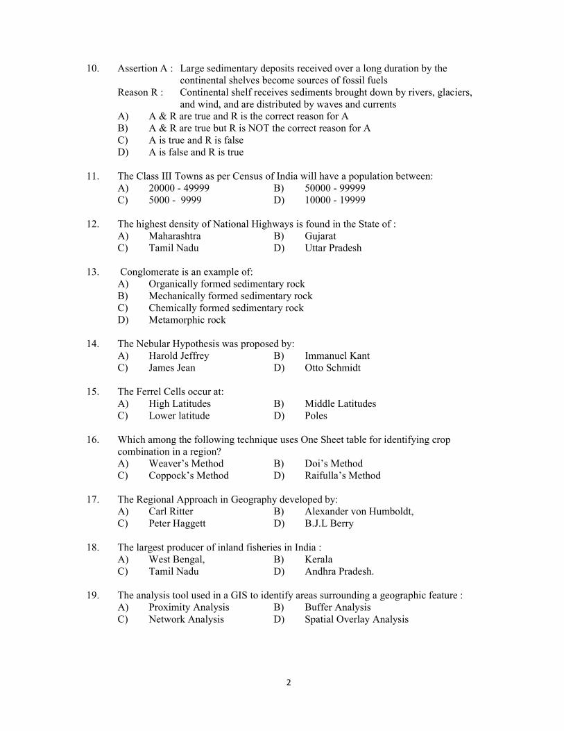
10. Assertion A : Large sedimentary deposits received over a long duration by the continental shelves become sources of fossil fuels Reason R : Continental shelf receives sediments brought down by rivers, glaciers, and wind, and are distributed by waves and currents A) A & R are true and R is the correct reason for A B) A & R are true but R is NOT the correct reason for A C) A is true and R is false D) A is false and R is true 11. The Class III Towns as per Census of India will have a population between: A) 20000 - 49999 B) 50000 - 99999 C) 5000 - 9999 D) 10000 - 19999 12. The highest density of National Highways is found in the State of : A) Maharashtra B) Gujarat C) Tamil Nadu D) Uttar Pradesh 13. Conglomerate is an example of: A) Organically formed sedimentary rock B) Mechanically formed sedimentary rock C) Chemically formed sedimentary rock D) Metamorphic rock 14. The Nebular Hypothesis was proposed by: A) Harold Jeffrey B) Immanuel Kant C) James Jean D) Otto Schmidt 15. The Ferrel Cells occur at: A) High Latitudes B) Middle Latitudes C) Lower latitude D) Poles 16. Which among the following technique uses One Sheet table for identifying crop combination in a region? A) Weaver’s Method B) Doi’s Method C) Coppock’s Method D) Raifulla’s Method 17. The Regional Approach in Geography developed by: A) Carl Ritter B) Alexander von Humboldt, C) Peter Haggett D) B.J.L Berry 18. The largest producer of inland fisheries in India : A) West Bengal, B) Kerala C) Tamil Nadu D) Andhra Pradesh. 19. The analysis tool used in a GIS to identify areas surrounding a geographic feature : A) Proximity Analysis B) Buffer Analysis C) Network Analysis D) Spatial Overlay Analysis
3
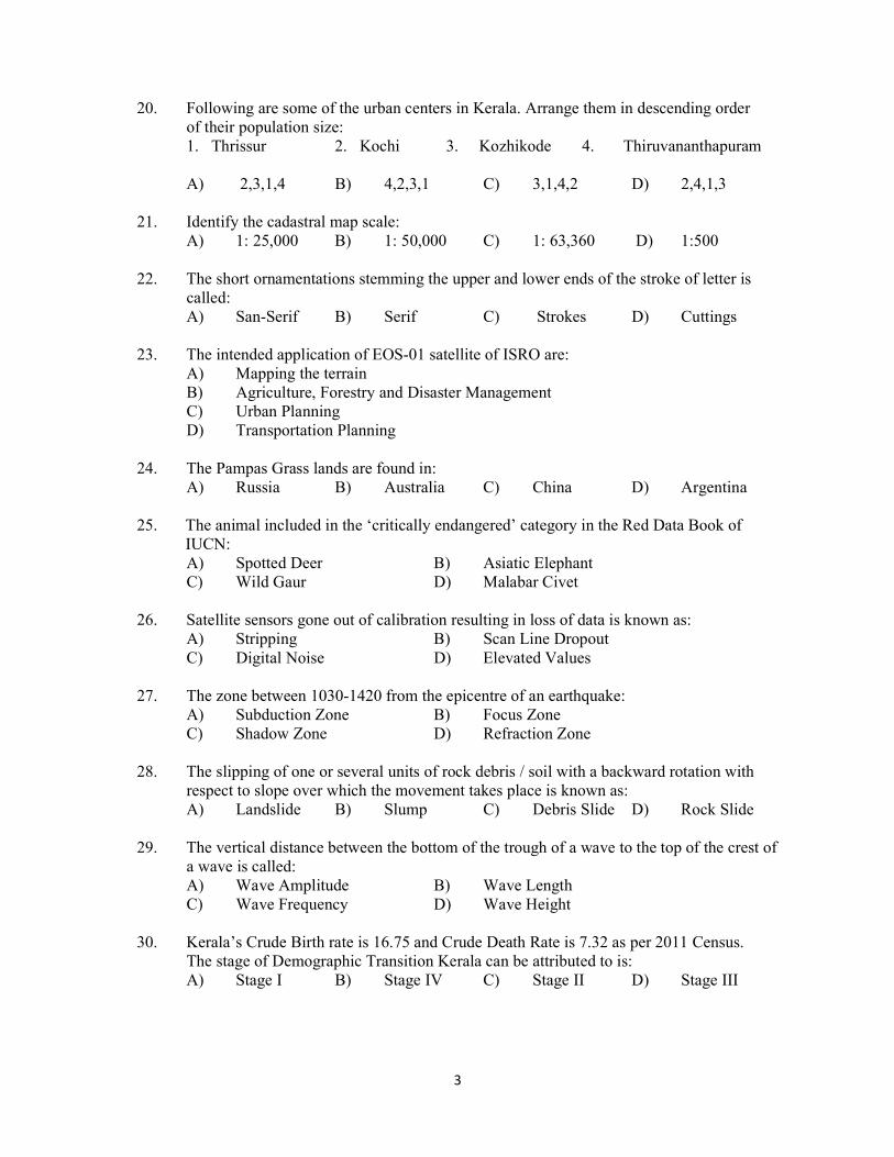
20. Following are some of the urban centers in Kerala. Arrange them in descending order of their population size: 1. Thrissur 2. Kochi 3. Kozhikode 4. Thiruvananthapuram A) 2,3,1,4 B) 4,2,3,1 C) 3,1,4,2 D) 2,4,1,3 21. Identify the cadastral map scale: A) 1: 25,000 B) 1: 50,000 C) 1: 63,360 D) 1:500 22. The short ornamentations stemming the upper and lower ends of the stroke of letter is called: A) San-Serif B) Serif C) Strokes D) Cuttings 23. The intended application of EOS-01 satellite of ISRO are: A) Mapping the terrain B) Agriculture, Forestry and Disaster Management C) Urban Planning D) Transportation Planning 24. The Pampas Grass lands are found in: A) Russia B) Australia C) China D) Argentina 25. The animal included in the ‘critically endangered’ category in the Red Data Book of
IUCN: A) Spotted Deer B) Asiatic Elephant C) Wild Gaur D) Malabar Civet 26. Satellite sensors gone out of calibration resulting in loss of data is known as: A) Stripping B) Scan Line Dropout C) Digital Noise D) Elevated Values 27. The zone between 1030-1420 from the epicentre of an earthquake: A) Subduction Zone B) Focus Zone C) Shadow Zone D) Refraction Zone 28. The slipping of one or several units of rock debris / soil with a backward rotation with respect to slope over which the movement takes place is known as: A) Landslide B) Slump C) Debris Slide D) Rock Slide 29. The vertical distance between the bottom of the trough of a wave to the top of the crest of a wave is called: A) Wave Amplitude B) Wave Length C) Wave Frequency D) Wave Height 30. Kerala’s Crude Birth rate is 16.75 and Crude Death Rate is 7.32 as per 2011 Census. The stage of Demographic Transition Kerala can be attributed to is: A) Stage I B) Stage IV C) Stage II D) Stage III
4
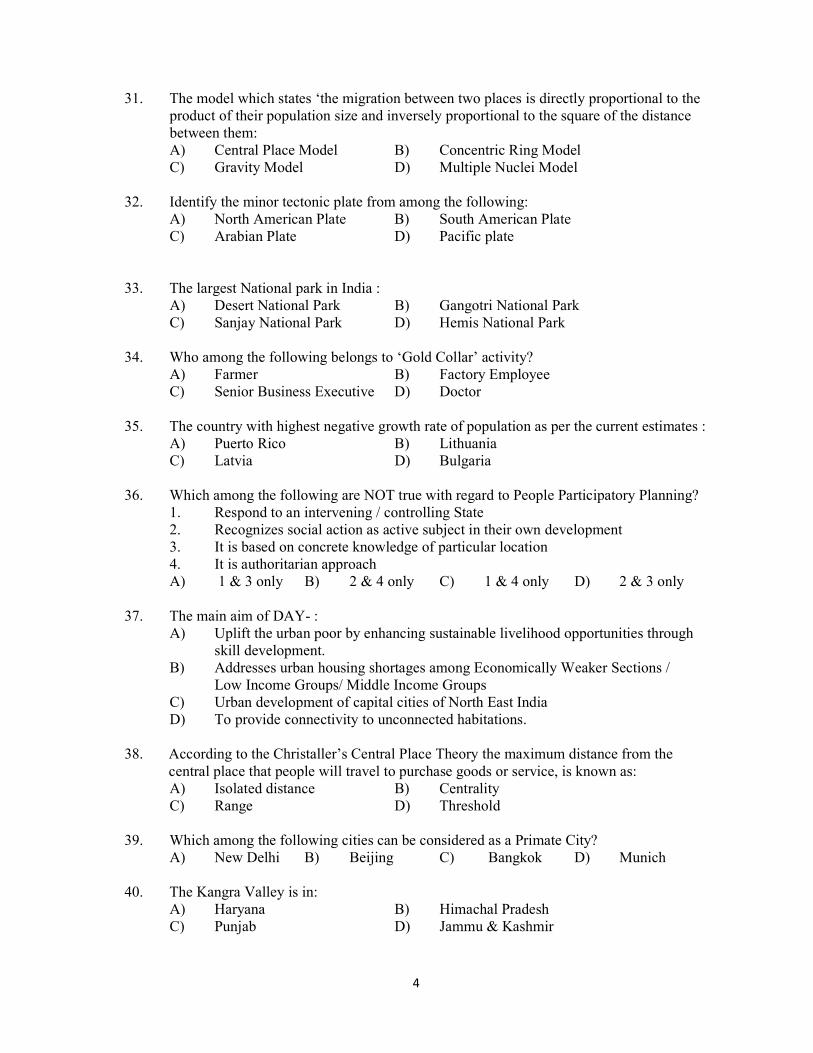
31. The model which states ‘the migration between two places is directly proportional to the product of their population size and inversely proportional to the square of the distance between them: A) Central Place Model B) Concentric Ring Model C) Gravity Model D) Multiple Nuclei Model 32. Identify the minor tectonic plate from among the following: A) North American Plate B) South American Plate C) Arabian Plate D) Pacific plate 33. The largest National park in India : A) Desert National Park B) Gangotri National Park C) Sanjay National Park D) Hemis National Park 34. Who among the following belongs to ‘Gold Collar’ activity? A) Farmer B) Factory Employee C) Senior Business Executive D) Doctor 35. The country with highest negative growth rate of population as per the current estimates : A) Puerto Rico B) Lithuania C) Latvia D) Bulgaria 36. Which among the following are NOT true with regard to People Participatory Planning? 1. Respond to an intervening / controlling State 2. Recognizes social action as active subject in their own development 3. It is based on concrete knowledge of particular location 4. It is authoritarian approach A) 1 & 3 only B) 2 & 4 only C) 1 & 4 only D) 2 & 3 only 37. The main aim of DAY- : A) Uplift the urban poor by enhancing sustainable livelihood opportunities through skill development. B) Addresses urban housing shortages among Economically Weaker Sections / Low Income Groups/ Middle Income Groups C) Urban development of capital cities of North East India D) To provide connectivity to unconnected habitations. 38. According to the Christaller’s Central Place Theory the maximum distance from the
central place that people will travel to purchase goods or service, is known as: A) Isolated distance B) Centrality C) Range D) Threshold 39. Which among the following cities can be considered as a Primate City? A) New Delhi B) Beijing C) Bangkok D) Munich 40. The Kangra Valley is in: A) Haryana B) Himachal Pradesh C) Punjab D) Jammu & Kashmir
5
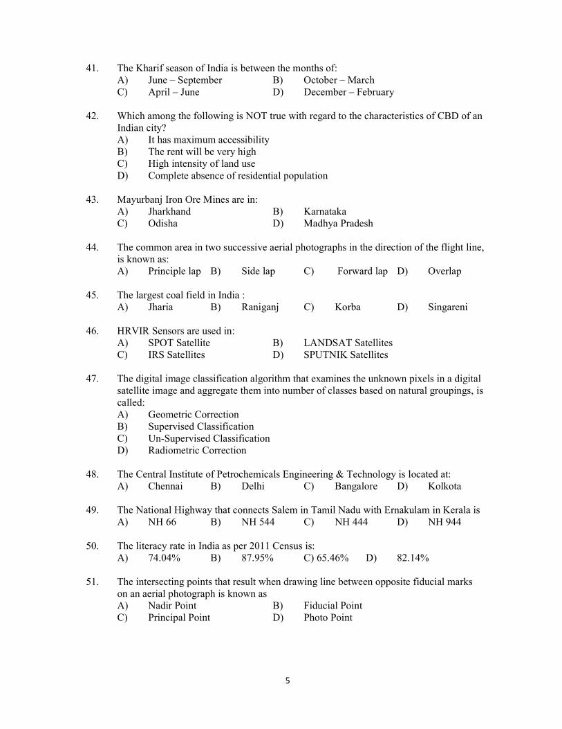
41. The Kharif season of India is between the months of: A) June – September B) October – March C) April – June D) December – February 42. Which among the following is NOT true with regard to the characteristics of CBD of an Indian city? A) It has maximum accessibility B) The rent will be very high C) High intensity of land use D) Complete absence of residential population 43. Mayurbanj Iron Ore Mines are in: A) Jharkhand B) Karnataka C) Odisha D) Madhya Pradesh 44. The common area in two successive aerial photographs in the direction of the flight line, is known as: A) Principle lap B) Side lap C) Forward lap D) Overlap 45. The largest coal field in India : A) Jharia B) Raniganj C) Korba D) Singareni 46. HRVIR Sensors are used in: A) SPOT Satellite B) LANDSAT Satellites C) IRS Satellites D) SPUTNIK Satellites 47. The digital image classification algorithm that examines the unknown pixels in a digital satellite image and aggregate them into number of classes based on natural groupings, is called: A) Geometric Correction B) Supervised Classification C) Un-Supervised Classification D) Radiometric Correction 48. The Central Institute of Petrochemicals Engineering & Technology is located at: A) Chennai B) Delhi C) Bangalore D) Kolkota 49. The National Highway that connects Salem in Tamil Nadu with Ernakulam in Kerala is A) NH 66 B) NH 544 C) NH 444 D) NH 944 50. The literacy rate in India as per 2011 Census is: A) 74.04% B) 87.95% C) 65.46% D) 82.14% 51. The intersecting points that result when drawing line between opposite fiducial marks on an aerial photograph is known as A) Nadir Point B) Fiducial Point C) Principal Point D) Photo Point
6
52. ‘Aretes’ are: A) Landforms of Glacial erosion B) Landforms of Glacial deposition C) Landforms of Aeolian erosion D) Landforms of Aeolian deposition 53. Which among the following is an open source software? A) GRASS B) MapInfo C) AutoCAD MAP D) ArcGIS 54. The Pepper Research Station of Kerala Agricultural University is located at: A) Ambalavayal B) Pattambi C) Piliocode D) Panniyur 55. The ancient philosopher who defined geography as ‘the study of the earth as the home of man’ : A) Eratosthenes B) Hecataeus C) Herodotus D) Plato 56. The letter code ET according to Koeppen’s Climatic Classification indicates: A) Tropical Wet and Dry Climate B) Tundra Climate C) Highland Climate D) Mid Latitude Desert Climate 57. Which among the following are true with regard to Net Sown Area in India? 1) Represents the total area sown with crops and orchards during the reference Year. 2) Represents the total cultivated area cultivated and area under current fallow 3) Area sown more than once is counted only once 4) Includes land under miscellaneous tree crops also. A) Only 1 is true B) Only 2 is true C) 1 & 3 are true D) 2 & 4 are true 58. A community of biotic and abiotic components linked together through nutrient cycles and energy flows is known as: A) Ecosystem B) Environment C) Biome D) Ecotone 59. The current annual growth rate of population in the world : A) 1.12% B) 1.14% C) 1.24% D) 1.05% 60. A district is an example of a: A) Formal Region B) Functional Region C) Vernacular Region D) Political Region 61. The shape of age-sex pyramid of a country with expanding population would be: A) Triangle shaped B) Square shaped C) Bell shaped D) Narrow base and tapering tip
7
62. Which among the following is NOT a component of AMRUT Scheme? A) Urban Water Supply B) Urban Transportation C) Sewage & Septage Management D) Green space and parks 63. Run-length encoding is a: A) A GIS Overlay analysis method B) A raster compaction method C) A digital spatial analysis method D) A GIS Network analysis method 64. The transition zone between two biomes are called:
A) Detrivore B) Geotope C) Ecotone D) Ecotope 65. The geometric distortions in a GIS project are corrected using A) Transform B) Edge matching C) Rubber Sheeting D) Topology Building 66. The first aerial photograph in the world was taken by: A) Gaaspard-Felix Tornachan B) James Wallace Black C) Cecil Shadboldt D) Arthur Batut 67. The most densely populated State in India as per 2011 Census : A) Bihar B) Kerala C) West Bengal D) Uttar Pradesh 68. The State with largest area under sugarcane cultivation in India : A) Maharashtra B) Tamil Nadu C) Uttar Pradesh D) Karnataka 69. The School of Geography to which Friedrich Ratzel belong: A) German B) French C) British D) American 70. The streams that have their courses in accordance with the initial slope of the land Surface is known as: A) Resequent Stream B) Obsequent Stream C) Consequent Stream D) Subsequent Stream 71. Identify the RAMSAR Wetlands from the following: 1. Ashtamudi Lake 2. Vellayani Lake 3. Vembanad-Kole Wetlands 4. Pookode lake A) 1 & 3 only B) 2 & 4 only C) 2 & 3 only D) 1 & 4 only 72. Large dome shaped intrusive bodies with level base and connected by a pipeline conduit from below, is known as A) Laccolith B) Batholith C) Sill D) Phacolith
8
73. How many times does the Spring Tide occur in a month? A) 2 times B) 3 times C) 1 time D) 4 times 74. Humboldt Current is a: A) Warm current in the Pacific Ocean B) Cold current in the Pacific Ocean C) Cold current in the Atlantic Ocean D) Warm current in the Indian Ocean 75. Which among the following characteristics of National Parks are NOT true? 1. They are formed by governing bodies to preserve wildlife and evolve them 2. They aim to protect historic natural objects as well as wildlife of the territory 3. Boundaries are fixed by the governing administration 4. Human activity is permitted to some specific limits A) 1 & 3 only B) 2 & 3 only C) 4 only D) 1 only 76. The district in Kerala which recorded lowest Crude Birth rate as per 2011 Census: A) Malappuram B) Kannur C) Ernakulam D) Alappuzha 77. According to the Burgess Model, Zone V is called: A) Zone of working men B) Zone of transition C) Commuter Zone D) Residential Zone 78. Which among the following is a satellite town? A) Bangalore B) Gurugram C) Pondicherry D) Hyderabad 79. Following are the states in India where tank irrigation is predominant. Arrange them in descending order of area under tank irrigation 1. Maharashtra 2. Tamil Nadu 3. Andhra Pradesh 4. Karnataka A) 2,1,3,4, B) 4,3,2,1 C) 3,2,1,4 D) 2,3,4,1 80. Identify the drive in beach in Kerala: A) Kovalam Beach B) Varkala Beach C) Muzhipilangad Beach D) Cherai Beach 81. Snow appears white in a false colour composite because: A) It has high reflectance across all wave lengths in the visible spectrum B) It has low reflectance across all wave lengths in the visible spectrum C) It absorbs energy across all wave lengths D) It has very low reflectance of short wave infrared. 82. Part of India included under the Sundaland Biodiversity Hotspot: A) Lakshadweep Islands B) Andaman Islands C) Nicobar Islands D) Sundarbans 83. Who among the following opined that ‘the word resource is an abstraction reflecting human appraisal and relating to a function or operation’? A) Walter Christaller B) Erich Zimmerman C) Alfred Weber D) August Losch
9
84. The Lorraine Industrial Region is in: A) France B) Germany C) England D) Italy 85. The word Green Revolution was coined by: A) William S Gaud B) M.S. Swaminathan C) Whittlesey D) Dudly Stamp 86. The country with current highest annual natural growth rate of population: A) Nigeria B) Niger C) Zambia D) Uganda 87. An example of non-ecumene is: A) Mauritian Islands B) Andaman Islands C) Northern Siberia D) Fiji Island 88. The country that shares largest land frontier with India : A) Bangladesh B) China C) Pakistan D) Nepal 89. Which among the following is GI Registered agricultural product of Kerala? A) Idukki Cardamom B) Munnar Tea C) Alleppey Cardamom D) Wayanad Ginger 90. Boarder line placed around individual map area in a map layout is known as A) Frame Line B) Neat Line C) Border Line D) Box 91. By which colour would a deep water body appear in FCC: A) White B) Red C) Green D) Black 92. An aircraft flies and takes photograph at an altitude of 3750 meters. The focal length of the camera lens is 15 cm. What would be the scale of the photograph? A) 1:25,000 B) 1: 50,000 C) 1: 37,500 D) 1: 100,000 93. Non-Spatial information in a GIS is known as: A) Attribute data B) Feature data C) Spatial data D) Temporal data 94. Who among the following is NOT a proponent of Environmental Determinism? A) Carl O Sauer B) Ellen Churchill Semple C) Ellsworth Huntington D) Carl Ritter 95. The concept of Isolated State was used in: A) Losch’s Industrial Location Model B) Von Thunen’s Concentric Ring Model C) Christaller’s Central Place Model D) Weber’s industrial Location Model
10
96. Which among the following characteristics of agriculture were taken into consideration by Whittlesey while classifying the agricultural systems of the world? 1. Crop and Livestock association 2. Productivity of crops 3. Labour and Capital intensity 4. Consumption pattern of production 5. Methods and techniques used A) 1 & 3 only B) 2 & 5 only C) 4 & 5 only D) All the above 97. The belief that variations in human behavior around the world can be explained by the differences in natural environment, is known as: A) Environmental Determinism B) Determinism C) Possibilism D) Ecological Possibilism 98. The analysis that provides a framework, within which a geographer examines shapes and forms in space, is known as: A) Cognitive Description B) Morphometric Analysis C) Cause-Effect Analysis D) Temporal Analysis 99. The following are geologic eras. Arrange them from present to past 1. Paleozoic 2. Mesozoic 3. Pre-Cambrian 4. Cenozoic A) 2,1,4,3 B) 4,2,1,3 C) 3,1,2,4 D) 3,2,4,1 100. Assertion A : The longshore currents move parallel to the beach and carries sediments with it ReasonR : Breaking waves induce longshore current A) A & R are true but R is not the correct explanation of A B) A & R are true and R is the correct explanation of A C) A is true but R is false D) A is false but R is true 101. Inversion of temperature in the atmosphere usually occurs during: A) Rainy nights with convection currents B) Winter nights with turbulent air C) Summer nights with mild air movements D) Winter nights with clear skies and still air 102. Which among the following tribes of India are pastoral nomads? A) Gujjars B) Muthuvas C) Irular D) Gonds 103. The programme of Govt. of India which aims at the development of heritage cities of
India: A) PMFBY B) PMGKY C) JNNRUM D) HRIDAY 104. The most urbanized district in Kerala as per 2011 Census : A) Thiruvananthapuram B) Malappuram C) Alappuzha D) Ernakulam
11
105. A village or part of a village contiguous to a statutory town and possess urban features in terms of infrastructure and amenities is known as: A) Urban Agglomeration B) Out Growth C) Satellite Town D) Conurbation 106. Which among the following is NOT a RDBMS software? A) IBMDb2 B) MySQL C) dBASE D) Postgre SQL 107. Carl O Sauer was a / an A) American Geographer B) French Geographer C) British Geographer D) German Geographer 108. Match the following:
Author Book a . Ptolemy 1.Influence of Geographic Environment b. Alexander von Homboldt 2. The Almagast c. Charles Darwin 3. Kosmos d. Ellen Churchill Semple 4. Origin of Species
A) a- 2, b-3, c-4, d-1 B) a-3, b-1, c-4, d-2 C) a-4, b-3, c-1, d- 2 D) a-1, b-2, c- 4, d-3 109. A moisture Index of above 100 according to Thornthwait’s Climatic Classification indicates: A) Humid Climate B) Semi-Arid Climate C) Per Humid Climate D) Arid Climate 110. Wildlife Institute of India is located at:
A) Dehradun B) Kolkata C) Indore D) Lucknow 111. The city popularly known as the Motor City: A) New York B) Detroit C) Chicago D) Leipzig 112. The Concentric Ring Theory of urban structure was proposed by: A) Von Thunen B) H. Hoyt C) E.W.Burgess D) Peter Haggett 113. The geomorphological feature that forms the northern boundary of The Great Indian Plains : A) Bhangar B) Tarai C) Khadar D) Bhabar 114. A Chorochromatic map is a: A) Qualitative map B) Quantitative map C) Large scale map D) Small scale map
12
115. The islands separated by the Ten Degree Channel: A) Minicoy and Lakshadweep Archipelago B) Andaman and Nicobar Islands C) Minicoy and Maldives D) Sri Lanka and Rameswaram 116. Which among the following is NOT a geostationary satellite? A) INSAT 3D B) CARTOSAT 3
C) GSAT 31 D) CMS-01 117. Strabo’s geographical treaties is known as: A) Geographica B) The Almagast C) Chorography D) Meteorologica 118. The process by which the air in contact with the land gets heated : A) Convection B) Advection C) Subduction D) Conduction 119. According to Weber’s Industrial Location Theory the three main factors that influence the industrial location are: A) Fuel - Raw Material - Market B) Raw Material – Labour - Market C) Transport Cost - Labour Cost - Agglomeration of Economies D) Labour - Transport Cost - Market 120. Match the following:
Land Capability Class Characteristics a. CLASS I 1. Soils are extremely rough, arid or swampy. Unsuitable for cultivation
b. CLASS IV 2. Soils are deep, productive and easily workable and highly suitable for
cultivation c. CLASS VI 3. Affected by water logging and water deficiency, subsistence farming
is practiced d. CLASS VIII 4. Unsuitable for cultivation, steep and shallow, more prone to erosion
A) a-4, b-3, c-1, d-2 B) a-2, b-3, c-4, d-1 C) a-3, b-4, c-2, d-1 D) a-4, b-1, c-3, d-2