1 of 1 - MP Pollution Control Board
11
Feasibility Study and Preparation of Detailed Project Report for 2-laning of Umranala-Ramkona-Sausar-Saoner section of NH 26B Package No: NHAI/DPR/MP/SP-3 Executive Summary 1 of 1
-
Upload
khangminh22 -
Category
Documents
-
view
1 -
download
0
Transcript of 1 of 1 - MP Pollution Control Board

Feasibility Study and Preparation of Detailed Project Report for 2-laning of Umranala-Ramkona-Sausar-Saoner section of NH 26B Package No: NHAI/DPR/MP/SP-3
Executive Summary
1 of 1
Feasibility Study and Preparation of Detailed Project Report for 2-laning of Umranala-Ramkona-Sausar-Saoner section of NH 26B Package No: NHAI/DPR/MP/SP-3
Executive Summary
2 of 2
1. PROJECT DESCRIPTION
A) Introduction
The Govt. of India (GoI) through Ministry of Shipping, Road Transport & Highways (MOSRT&H) is
contemplating to enhance the traffic capacity and safety for efficient transshipment of goods as well as
passenger traffic on few of the selected corridors of National Highways.
The existing project road is a 2-lane 6 m wide carriageway with shoulder width varying between 1-2
m on either side. Mostly shoulders are earthen/hard type.
The NHAI has assigned LEA Associates South Asia Private Limited (LASA) to conduct Feasibility study and
Preparation of Detailed Project Report and facilitate necessary clearances for the Project.
Location
The project corridor, Umranala-Ramkona-Sausar-Saoner, is located in the state of Madhya Pradesh /
Maharashtra. Earlier this corridor was SH19/SH 250, but in a recent Notification of the Ministry of Road
Transport & Highways dated 21st January 2010, the project road has been declared as National Highway
NH26 B.
The project corridor originates from Chhindwara, just 18 km ahead of Umranala, in Madhya
Pradesh. It continues up to Km 75 (MP /Maharashtra border) and runs for another 13 kilometers in
Maharashtra before it terminates at the intersection with NH-69. The map showing the project
corridor is presented in Figure 1. The corridor traverses through important settlements viz.
Sillevani, Ramakona, Sausar, Borgaon and Kelvad. The corridor passes through Nagpur district
(Saoner taluka) in Maharastra and Chhindwara district (Sausar and Mohkheda taluka) of Madhya
Pradesh.
Existing RoW
The existing RoW is 36m along the project road, except at the GHAT which includes the Khadbeli
Reserve Forest section where right of way is approximately 30 m.
B) Project Influence Area
i) Direct Area of Influence
The direct influence area of the project is restricted to proposed Right of Way (RoW) only, since the project
involves widening of existing highway and all construction and operation stage activities will be contained
with in it. The proposed RoW is 36 m except at realignments (total about 5 km) where proposed RoW is 45
m.
ii) Indirect Area of Influence
As per MoEF guidelines for conducting EIA (EIA notification, S O 1533 dated 14th Sept, 2006); the
geographical scope of the EIA study has been considered as 15 km radius for highway projects for major
environmental features like National Park, Wildlife Sanctuary, Critically Polluted Area, Notified Eco-Sensitive
Zone, Inter-state Boundaries and International Boundaries (10 km), Coastal Zones, Areas protected under
international conventions, defence installations etc. Physical features like physiography, hydrology were also
studied/ recorded within 15 km radius of the project road.
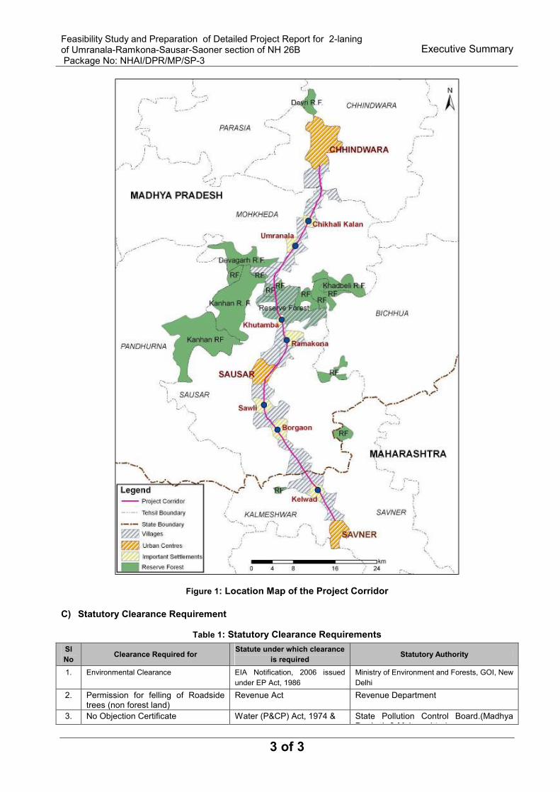
Feasibility Study and Preparation of Detailed Project Report for 2-laning of Umranala-Ramkona-Sausar-Saoner section of NH 26B Package No: NHAI/DPR/MP/SP-3
Executive Summary
3 of 3
Figure 1: Location Map of the Project Corridor
C) Statutory Clearance Requirement
Table 1: Statutory Clearance Requirements
Sl
No Clearance Required for
Statute under which clearance
is required Statutory Authority
1. Environmental Clearance EIA Notification, 2006 issued
under EP Act, 1986
Ministry of Environment and Forests, GOI, New
Delhi
2. Permission for felling of Roadside trees (non forest land)
Revenue Act Revenue Department
3. No Objection Certificate Water (P&CP) Act, 1974 & State Pollution Control Board.(Madhya Pradesh & Maharashtra)
Feasibility Study and Preparation of Detailed Project Report for 2-laning of Umranala-Ramkona-Sausar-Saoner section of NH 26B Package No: NHAI/DPR/MP/SP-3
Executive Summary
4 of 4
Sl
No Clearance Required for
Statute under which clearance
is required Statutory Authority
(Consent To Establish) Air (P&CP) Act, 1981 Pradesh & Maharashtra)
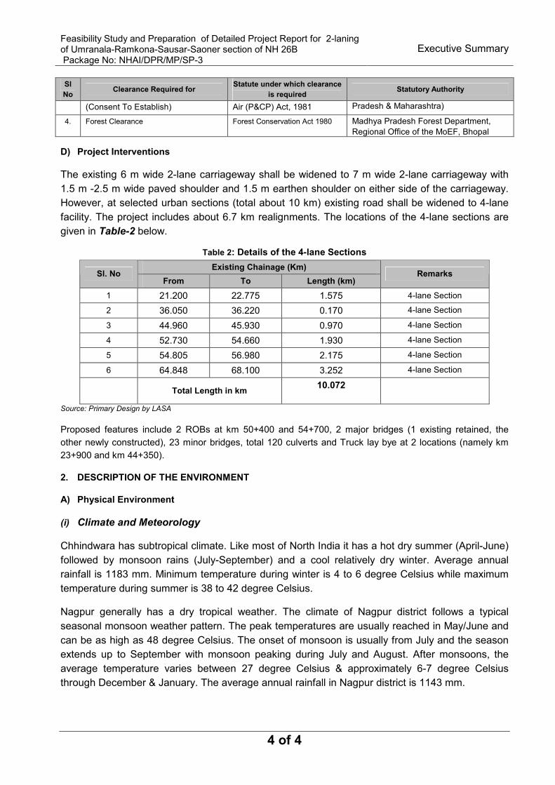
4. Forest Clearance Forest Conservation Act 1980 Madhya Pradesh Forest Department,
Regional Office of the MoEF, Bhopal
D) Project Interventions
The existing 6 m wide 2-lane carriageway shall be widened to 7 m wide 2-lane carriageway with
1.5 m -2.5 m wide paved shoulder and 1.5 m earthen shoulder on either side of the carriageway.
However, at selected urban sections (total about 10 km) existing road shall be widened to 4-lane
facility. The project includes about 6.7 km realignments. The locations of the 4-lane sections are
given in Table-2 below.
Table 2: Details of the 4-lane Sections
Existing Chainage (Km) Sl. No
From To Length (km) Remarks
1 21.200 22.775 1.575 4-lane Section
2 36.050 36.220 0.170 4-lane Section
3 44.960 45.930 0.970 4-lane Section
4 52.730 54.660 1.930 4-lane Section
5 54.805 56.980 2.175 4-lane Section
6 64.848 68.100 3.252 4-lane Section
Total Length in km 10.072
Source: Primary Design by LASA
Proposed features include 2 ROBs at km 50+400 and 54+700, 2 major bridges (1 existing retained, the
other newly constructed), 23 minor bridges, total 120 culverts and Truck lay bye at 2 locations (namely km
23+900 and km 44+350).
2. DESCRIPTION OF THE ENVIRONMENT
A) Physical Environment
(i) Climate and Meteorology
Chhindwara has subtropical climate. Like most of North India it has a hot dry summer (April-June)
followed by monsoon rains (July-September) and a cool relatively dry winter. Average annual
rainfall is 1183 mm. Minimum temperature during winter is 4 to 6 degree Celsius while maximum
temperature during summer is 38 to 42 degree Celsius.
Nagpur generally has a dry tropical weather. The climate of Nagpur district follows a typical
seasonal monsoon weather pattern. The peak temperatures are usually reached in May/June and
can be as high as 48 degree Celsius. The onset of monsoon is usually from July and the season
extends up to September with monsoon peaking during July and August. After monsoons, the
average temperature varies between 27 degree Celsius & approximately 6-7 degree Celsius
through December & January. The average annual rainfall in Nagpur district is 1143 mm.

Feasibility Study and Preparation of Detailed Project Report for 2-laning of Umranala-Ramkona-Sausar-Saoner section of NH 26B Package No: NHAI/DPR/MP/SP-3
Executive Summary
5 of 5
During the south-west monsoon season, the relative humidity generally exceeds 87% (August)
and the rest of the year is drier. The driest part of the year is the summer season when relative
humidity is less than 33%. May is the driest month of the year.
The wind velocity is higher during the pre monsoon period as compared to post monsoon period.
The maximum wind velocity, 9.5km/hr observed during the month of June and minimum, 3.3 km/hr
during the month of November. The average annual wind velocity is 5.4 km/hr.
ii) Physiography and Terrain
Chhindwara district can be divided into three main regions- 1) The plains near Nagpur region
comprising Tehsils Sausar & Pandhurna, 2) the central region comprising of Chhindwara &
northern part of Sausar region and the third region, mostly the northern region comprising of hilly
terrain. The height of the district varies from 1550 ft (470m) to 3820 ft (1160m) above sea level
with an average elevation of 2215 ft (675m).
In Nagpur district, the surrounding region is an undulating plateau rising northward to the Satpura
Range, from 889 to 2142 feet (271 to 653 m) high and is drained by the Kanhan & Pench rivers in
the centre.
(iii) Land Use
Project corridor passes through mainly agricultural land followed by forest land and settlements.
(iv) Water Resources
Surface Water: The two main rivers that cross the project corridor include Kanhan and Jam. Jam
river flows mostly through the Sausar region and joins with the Kanhan river. Both the rivers are
perennial.
Ground Water: Ground water is the major source of irrigation in the project Districts. Irrigation takes
place mainly by dug wells, tube wells/bore wells, tanks/ponds and canals. The pre monsoon depth
to water level range during 2006 is 3.65m (min) and 15.75m (max).The post monsoon depth to
water level range during 2006 is 0.60m (min) and 15m (max). It has been found by Central Ground
Water Board that ground water contains high concentration of fluoride (1.60-20.00 mg/l) in deeper
aquifers. The major ground water problem in Chhindwara is the fluoride content.
(v) Water Quality
Water samples from the monitoring stations (ground and surface water) were collected once in
October 2009 during the survey period for physicochemical, trace metals and bacteriological
analysis. Parameters like pH, conductivity, temperature, DO etc were measured in the field itself
while collecting the samples using a microprocessor based Portable Water Analysis Kit (Elico
Model PE136). Samples for chemical analysis were collected as per procedures outlined in
IS:2488.
Surface Water Quality Results: The pH value ranged between 7.51-7.80. TDS content ranged between
480-554 mg/l while Chloride values ranged from 80 to 142 mg/l respectively, well below the tolerance limits.
Iron content is found varying between 0.01-0.02 mg/l. There is no significant presence of trace metals in the
surface waters. There is no faecal contamination and the Total Coliform bacteria found varying between 2 to

Feasibility Study and Preparation of Detailed Project Report for 2-laning of Umranala-Ramkona-Sausar-Saoner section of NH 26B Package No: NHAI/DPR/MP/SP-3
Executive Summary
6 of 6
24 in MPN/100 ml. Turbidity ranges between 1-2 NTU indicates that there is low sediment load in the water
bodies. Oil and grease found to be nil. Howver, BOD value (3 day 27 deg C) ranged between 4-8 mg/l, DO
varies between 1.8 to 3.25 mg/l, which is lower than the desirable value (4 mg/l).
While comparing with the CPCB Norms for Surface Waters, all parameters are found to be within the
standard limits except BOD, which is exceeds permissible limit and DO which is below the desirable limit.
Ground Water Quality Results: The ground water sample has been collected at two locations (Sillevani
Ghat and Ramakona) from hand pumps. The pH value ranged between 7.75 - 7.85, generally above the
neutral mark and within the permissible limits for drinking water. TDS value ranged between 340-440 mg/l,
within the permissible limit for drinking water (500 mg/l), total hardness ranges between 240-317 Chloride
values ranged from 110mg/l to 412 mg/l, iron content ranged between 0.06 to 0.08 mg/l, thus within
permissible limits. There is no significant bacteriological contamination of these sources. Heavy metals like
arsenic, mercury, lead are absent.
(vi) Air Quality
The air polluting sources in the project region primarily consist of the vehicles plying on the roads. A total of
five (5) ambient air quality monitoring stations were identified based on the different existing land use pattern
to study.
All the stations are located in residential and rural zone. The values of RPM varied between 40.33 & 74.33
µg/m3, SPM varied between 107.7 to 191 µg/m
3, SO2 varied between 4.39 to 10.21 µg/m
3, NOx varied
between 6.43 to 11.24 µg/m3 and CO is below 29 µg/m
3. All the parameters of the ambient air quality are
within the permissible limit.
(vii) Noise Quality
To assess background noise levels in the study area, ambient noise monitoring was conducted. A total of
five (5) locations are identified along the project road, based on different category of zones. Out of total, 3
stations have been selected in Residential Zone and 2 in Commercial Zone.
The Leq(day) varied between 43.28 dB(A) to 46.12 dB(A) in Residential Zone and Leq(day) varied between
46.07 dB(A) to 65.75 dB(A) in Commercial Zone. The Leq(night) varied between 29.0 dB(A) to 31.94 dB(A) in
Residential Zone and Leq(night) varied between 29.62 dB(A) to 38.0 dB(A) in Commercial Zone. Thus, ambient
noise results at all the stations are within the permissible limit except at Sausar Market (commercial zone),
where Leq(day) was recorded as 65.75 dB(A), slightly exceeding permissible limits.
B) Ecological Environment
Forests
Chhindwara district has a forest cover of 4300 sq km. The forests predominantly comprise of
Sagwan trees but species like sal and bamboo are also present.
The project road falls in Sillewani Range, South Chhindwara forest division. The road runs through
Khadbeli Reserve Forest in the Sillevani Ghat section from Ch 30/000 to 40/000. Main species in
the forest includes Sagwan. Other species include Sal, Salai, Khair, Anjan and Kardhai. The forest
density is above 0.7 indicating that the forest has high density and is predominantly middle aged.
However, as reported by forest officials & locals, apart from monkeys and other common animals,
no wild animals, endangered animals are present in these forests.
C) Socio-economic and Cultural Environment

Feasibility Study and Preparation of Detailed Project Report for 2-laning of Umranala-Ramkona-Sausar-Saoner section of NH 26B Package No: NHAI/DPR/MP/SP-3
Executive Summary
7 of 7
There is no Protected Monument by ASI within corridor of direct impact and even 200 m radious of the
corridor. No historical and cultural conserved sites present within the direct area of influence. The entire road
stretch has about 69 religious structures (temples, mosques & shrines). Most of these are temples.
Noteworthy temples along the stretch include the Banjari Mata Temple in the Sillewani Ghat section and the
Bajrangbali temple in Borgaon.
14 educational institutes are present along the project corridor; most of them are primary schools and are
located outside the Right of Way. Thus they remain unaffected.
3. ANTICIPATED ENVIRONMENTAL IMPACT AND MITIGATION MEASURES
A) Anticipated Impacts
The impacts of the project have been categorized into three phases: pre-construction, construction and
operation phase.
(i) Pre-construction Phase: Impacts during the preconstruction phase primarily relate to preconstruction
activities such as diversion of about 19.89 ha of Forest Land, acquisition of new Right of Way and site
clearance activities. The estimated total land requirement for the project is 44.128 ha (including forest
land). There are number of amenities and utility services located along the highway such as restaurants,
hand pumps, water taps, repair and spare parts shops, resting spaces, parking lots, PCOs, electric
transformers, OFC etc. which will be impacted directly or indirectly due to widening of road.
(ii) Construction Phase: Impacts during construction phase are primarily on account of negligence while
undertaking the construction works. Impacts include nuisance on account of air, noise and vibration effects
during road construction, hindrance to access of road side properties during shifting of utilities and
construction of road side drains and road safety issues from construction materials and equipments.
The microclimate is likely to be affected due to removal of some roadside trees and addition of increased
pavement surface. The road widening will involve about 107766 cum of cutting and 524215 cum of filling.
The acquisition of agricultural land would cause loss of productive soil. All bridge locations where elevated
embankments are required would be more sensitive to erosion during the construction period. Spillage of
construction materials like bitumen, asphalt, oil & grease etc. and the unwarranted disposal of construction
spoils and debris will affect the core characteristics of the soil, which in turn can become unsuitable for
agriculture. Aggregate (6 no of aggregate quarry identified) and sand (2 no of sand quarry identified) shall be
procured from the licensed sources. Earth shall be collected from nearby borrow areas (24 borrow areas
identified) as suitable. These sites and haul roads will have impact in terms of dust and noise. During
construction, the disposal of solid and liquid waste from labour camps, fuel and lubricant spills or leaks from
construction vehicles, pollution from fuel storage & distribution sites is likely to affect water quality. The
negative impacts on air quality during construction will be mostly localized and concentrated in the Right of
Way (RoW)/COI. However, it is likely that impacts due to dust generation are likely to be felt downwind of the
site rather than the site itself. The noise levels in the project area during construction will increase though it
will be intermittent and temporary in nature. The noise levels will be more pronounced around settlements
and in inhabited areas. Most of the religious structures will remain unaffected due to widening. Only four
medium sized temples & a few shrines will be affected. Two schools along realignment stretches will be
partially affected. Sewage and domestic solid waste will be generated at the construction workers colony.
Improper management of these wastes may lead to health and hygiene related problems among the
construction workers and the local population.
(iii) Operation Phase: Soil pollution due to accidental vehicle spills or leaks is a low probability but
potentially disastrous to the receiving environment, if they occur. These impacts can be a long term and
irreversible depending upon the extent and type of spill. Pollutants from vehicles, and accidental fuel spills

Feasibility Study and Preparation of Detailed Project Report for 2-laning of Umranala-Ramkona-Sausar-Saoner section of NH 26B Package No: NHAI/DPR/MP/SP-3
Executive Summary
8 of 8
may also make their way into surface water bodies across/along the project corridor. Higher traffic volume
and speed will have impact on the ambient air quality. Increase in the number of vehicles would increase the
pollutant load. Higher noise levels due to increased traffic volume and speed will affect the residential areas
and sensitive receptor like educational institutes.
Projected noise levels (Leq) near these educational institutes are mostly within the desired level for
residential areas in most of the cases. The maximum predicted value is 56.00 dB (A) in 2030 at
Brahmakumari School. However, the increase in noise level is not very significant for any of the receptors in
the future years. The maximum increase in noise level in the year 2020 from 2015 is 2.35 dB (A); in 2025,
the maximum increase from 2015 is 4.65 dB (A); in the year 2030, the maximum increase in noise level from
2010 is 6.35 dB (A).
B) Environmental Mitigation Measures
(i) Pre-construction Phase: Widening option has been selected as concentric except hilly stretches where
widening is proposed on hill side. Realignments are proposed for correction of geometry and it will enhance
Road safety for the user of the corridor. As a part of the compensatory plantation at least 2 trees shall be
planted for each tree cut. Net Present Value shall be deposited to the Forest Department for diversion of
Reserve Forests as per demand note of the forest department. Compensation shall be paid for acquisition of
land structures as per the Entitlement matrix developed for the project subject to recommendation by the
Special Land Acquisition Officer. The amenities like hand pumps, water tap, tube wells etc. and cultural
resources viz temples, schools etc. which comes under direct impact will be compensated and relocated
with community consultation and others will be shifted as per resettlement action plan.
(ii) Construction Phase:
Cut and fill is being balanced in the design to the extent feasible to minimize impacts on the physiography of
the region. Aggregates will be sourced only from the licensed quarry sites, complying with the environmental
and other applicable regulations. Rehabilitation of borrow pits and quarry areas shall be carried out in a
environment friendly manner. Similarly, fresh embankment created at the site shall be covered with dredged
earth for turfing of slope in order to prevent soil erosion. Top soil shall be striped upto a depth of 15 cm and
stripped top soil shall be stock piled at suitable location and shall be used wisely. Plants viz. Hot Mix Plant, D
G Sets, Batching Plant, Crusher etc. shall be located at down stream direction to the habitations, if any and
EMP guidelines shall be followed. Water shall be sprinkled at the haul roads, plant sites and construction
sites as per requirement. Construction vehicles, equipments and plants shall strictly adhere permissible
noise standard during construction period. All necessary and adequate care has been taken to minimize
impact on cultural properties (which includes Temples, places of worship, Majar, & others). Silt fencing and
or brush barrier shall be installed for collecting sediments before letting them into the surface water bodies
(Kanha & Jaam river).
NHAI shall pay the Net Present Value of the forest land to be diverted for the project. A Compensatory
Afforestation programme shall be undertaken by the Forest Department at least double the quantum of
forest land to be diverted. Compensatory plantation shall be carried out as part of the project to minimize the
proposed loss of green cover along the corridor due to cut of road side trees.
Disposal of construction waste shall be undertaken at landfill sites to minimize impacts. If a spillage occurs,
measures for safe incineration of spilled oil shall be taken to prevent seepage into the ground. To avoid
contamination of the water bodies and drainage channels from fuel and lubricants, oil interceptor shall be
provided at re-fuelling locations, construction vehicle parking area, vehicle repair area and workshops. The
sewage system (including septic tanks and soak pits) for construction camps will be properly designed and
built so that no water pollution takes place in any water body or watercourse.
Feasibility Study and Preparation of Detailed Project Report for 2-laning of Umranala-Ramkona-Sausar-Saoner section of NH 26B Package No: NHAI/DPR/MP/SP-3
Executive Summary
9 of 9
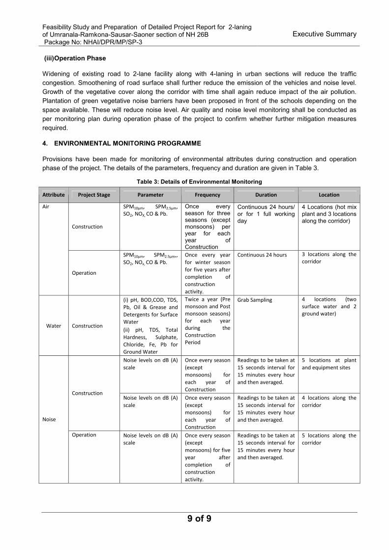
(iii) Operation Phase
Widening of existing road to 2-lane facility along with 4-laning in urban sections will reduce the traffic
congestion. Smoothening of road surface shall further reduce the emission of the vehicles and noise level.
Growth of the vegetative cover along the corridor with time shall again reduce impact of the air pollution.
Plantation of green vegetative noise barriers have been proposed in front of the schools depending on the
space available. These will reduce noise level. Air quality and noise level monitoring shall be conducted as
per monitoring plan during operation phase of the project to confirm whether further mitigation measures
required.
4. ENVIRONMENTAL MONITORING PROGRAMME
Provisions have been made for monitoring of environmental attributes during construction and operation
phase of the project. The details of the parameters, frequency and duration are given in Table 3.
Table 3: Details of Environmental Monitoring
Attribute Project Stage Parameter Frequency Duration Location
Construction
SPM10µm, SPM2.5µm,
SO2, NOX, CO & Pb.
Once every season for three seasons (except monsoons) per year for each year of Construction
Continuous 24 hours/
or for 1 full working day
4 Locations (hot mix
plant and 3 locations along the corridor)
Air
Operation
SPM10µm, SPM2.5µm,,
SO2, NOx, CO & Pb.
Once every year
for winter season
for five years after
completion of
construction
activity.
Continuous 24 hours 3 locations along the
corridor
Water Construction
(i) pH, BOD,COD, TDS,
Pb, Oil & Grease and
Detergents for Surface
Water
(ii) pH, TDS, Total
Hardness, Sulphate,
Chloride, Fe, Pb for
Ground Water
Twice a year (Pre
monsoon and Post
monsoon seasons)
for each year
during the
Construction
Period
Grab Sampling 4 locations (two
surface water and 2
ground water)
Noise levels on dB (A)
scale
Once every season
(except
monsoons) for
each year of
Construction
Readings to be taken at
15 seconds interval for
15 minutes every hour
and then averaged.
5 locations at plant
and equipment sites
Construction Noise levels on dB (A)
scale
Once every season
(except
monsoons) for
each year of
Construction
Readings to be taken at
15 seconds interval for
15 minutes every hour
and then averaged.
4 locations along the
corridor
Noise
Operation Noise levels on dB (A)
scale
Once every season
(except
monsoons) for five
year after
completion of
construction
activity.
Readings to be taken at
15 seconds interval for
15 minutes every hour
and then averaged.
5 locations along the
corridor
Feasibility Study and Preparation of Detailed Project Report for 2-laning of Umranala-Ramkona-Sausar-Saoner section of NH 26B Package No: NHAI/DPR/MP/SP-3
Executive Summary
10 of 10
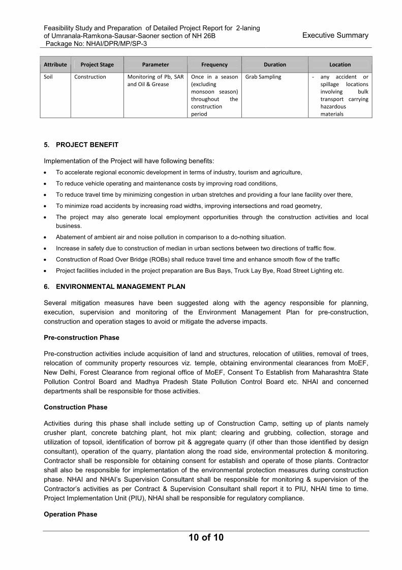
Attribute Project Stage Parameter Frequency Duration Location
Soil Construction Monitoring of Pb, SAR
and Oil & Grease
Once in a season
(excluding
monsoon season)
throughout the
construction
period
Grab Sampling - any accident or
spillage locations
involving bulk
transport carrying
hazardous
materials
5. PROJECT BENEFIT
Implementation of the Project will have following benefits:
• To accelerate regional economic development in terms of industry, tourism and agriculture,
• To reduce vehicle operating and maintenance costs by improving road conditions,
• To reduce travel time by minimizing congestion in urban stretches and providing a four lane facility over there,
• To minimize road accidents by increasing road widths, improving intersections and road geometry,
• The project may also generate local employment opportunities through the construction activities and local
business.
• Abatement of ambient air and noise pollution in comparison to a do-nothing situation.
• Increase in safety due to construction of median in urban sections between two directions of traffic flow.
• Construction of Road Over Bridge (ROBs) shall reduce travel time and enhance smooth flow of the traffic
• Project facilities included in the project preparation are Bus Bays, Truck Lay Bye, Road Street Lighting etc.
6. ENVIRONMENTAL MANAGEMENT PLAN
Several mitigation measures have been suggested along with the agency responsible for planning,
execution, supervision and monitoring of the Environment Management Plan for pre-construction,
construction and operation stages to avoid or mitigate the adverse impacts.
Pre-construction Phase
Pre-construction activities include acquisition of land and structures, relocation of utilities, removal of trees,
relocation of community property resources viz. temple, obtaining environmental clearances from MoEF,
New Delhi, Forest Clearance from regional office of MoEF, Consent To Establish from Maharashtra State
Pollution Control Board and Madhya Pradesh State Pollution Control Board etc. NHAI and concerned
departments shall be responsible for those activities.
Construction Phase
Activities during this phase shall include setting up of Construction Camp, setting up of plants namely
crusher plant, concrete batching plant, hot mix plant; clearing and grubbing, collection, storage and
utilization of topsoil, identification of borrow pit & aggregate quarry (if other than those identified by design
consultant), operation of the quarry, plantation along the road side, environmental protection & monitoring.
Contractor shall be responsible for obtaining consent for establish and operate of those plants. Contractor
shall also be responsible for implementation of the environmental protection measures during construction
phase. NHAI and NHAI’s Supervision Consultant shall be responsible for monitoring & supervision of the
Contractor’s activities as per Contract & Supervision Consultant shall report it to PIU, NHAI time to time.
Project Implementation Unit (PIU), NHAI shall be responsible for regulatory compliance.
Operation Phase

Feasibility Study and Preparation of Detailed Project Report for 2-laning of Umranala-Ramkona-Sausar-Saoner section of NH 26B Package No: NHAI/DPR/MP/SP-3
Executive Summary
11 of 11
Operation phase activities include environmental monitoring and to ensure survival rate of the plantation etc.
The PIU shall be responsible for those activities.
Environmental costs
The costs for mitigation and management measures have been estimated for inclusion into the Economic
Analysis. These costs along with the social costs have to be incurred by the implementing agency to include
environmental and social safeguard measures into the proposed project. However, the environmental cost
estimates are presented in Table 4.
Table 4: Environmental cost estimates
Particulars Amount (Rs)
Construction Phase (A)
Environmental Monitoring 669000
Environmental Protection and Enhancement 12637600
NPV for diversion of Forest Land Compensatory Plantation and Maintenance 49695500
Cultural Property Relocation and Enhancement 14650000
Sub Total 77652100
Operation Phase (B)
Air Quality and Noise Level Monitoring for 20 year (once in two year) 350000Total (A+B) 78002100
Contingency @ 10% 7800210Total Cost for Environmental Measures 85802310
*Environmental monitoring has been considered for 3 year construction and 20 year operation period.