— IRELAND— - Irish Aviation Authority
102
AIRAC AIP AMDT 006/22 Effective date: 16 JUN 2022 AIRAC — IRELAND— Phone: +353 (0)61 703 750 Irish Aviation Authority AIRAC AIP AMDT 006/22 Fax: +353 (0)61 366 245 Aeronautical Information Service Effective Date: 16 JUN 2022 AFS: EINNZPZX Ballycasey Cross Publication Date: 05 MAY 2022 Email: [email protected] Co. Clare URL: https://www.iaa.ie V14 C446 Ireland IRISH AVIATION AUTHORITY PAGE 1/2 PAGE REVISIONS AIRAC Changes incorporated in this Amendment are: GEN 0.2 Record of AIP Amendments: Updated Text. GEN 0.4 Checklist of Pages: Updated Text. GEN 3.2 Aeronautical Charts: Updated Charts for EIDW AD. EIDW AD Updated information sections: AD 2.7, AD 2.8, AD 2.23 and AD 2.24. AD 2.24 Charts: Updated AD 2.24-11 and AD 2.24-17. EIKY AD Updated information sections: AD 2.9, AD 2.14, AD 2.15, AD 2.20 and AD 2.22. EIKK AD AD 2.7 Runway Surface Condition Assessment & Reporting & Snow Plan: Updated Heading. EINC AD AD 2.7 Runway Surface Condition Assessment & Reporting & Snow Plan: Updated Heading. EIRT AD Removal of text indicating which sections are intentionally left blank. Remove Pages Insert Pages GEN 0.2-1/GEN 0.2-2 GEN 0.2-1/GEN 0.2-2 16 JUN 2022/16 JUN 2022 GEN 0.4-1/GEN 0.4-8 GEN 0.4-1/GEN 0.4-8 16 JUN 2022/16 JUN 2022 GEN 3.2-1/GEN 3.2-10 GEN 3.2-1/GEN 3.2-10 16 JUN 2022/16 JUN 2022 EIDW AD 2-1 / EIDW AD 2-40 EIDW AD 2-1 / EIDW AD 2-40 16 JUN 2022/16 JUN 2022 EIDW AD 2.24-11.1/ EIDW AD 2.24-11.3 EIDW AD 2.24-11.1/ EIDW AD 2.24-11.3 16 JUN 2022/16 JUN 2022 EIDW AD 2.24-17.1/EIDW AD 2.24-17.3 EIDW AD 2.24-17.1/EIDW AD 2.24-17.3 16 JUN 2022/16 JUN 2022 EIKY AD 2-1 / EIKY AD 2-14 EIKY AD 2-1 / EIKY AD 2-16 16 JUN 2022/16 JUN 2022 EIKK AD 2-1/EIKK AD 2-6 EIKK AD 2-1/EIKK AD 2-6 16 JUN 2022/16 JUN 2022 EINC AD 2-1/EINC AD 2-6 EINC AD 2-1/EINC AD 2-6 16 JUN 2022/16 JUN 2022 EIRT AD 2-1/EIRT AD 2-6 EIRT AD 2-1/EIRT AD 2-6 16 JUN 2022/16 JUN 2022 New Supplements for this Amendment: NIL Supplements cancelled in this Amendment: NIL New AIC for this Amendment: NIL
-
Upload
khangminh22 -
Category
Documents
-
view
0 -
download
0
Transcript of — IRELAND— - Irish Aviation Authority

AIRAC AIP AMDT 006/22 Effective date: 16 JUN 2022 AIRAC
— IRELAND—
Phone: +353 (0)61 703 750 Irish Aviation Authority AIRAC AIP AMDT 006/22
Fax: +353 (0)61 366 245 Aeronautical Information Service Effective Date: 16 JUN 2022
AFS: EINNZPZX Ballycasey Cross Publication Date: 05 MAY 2022
Email: [email protected] Co. Clare
URL: https://www.iaa.ie V14 C446
Ireland
IRISH AVIATION AUTHORITY PAGE 1/2
PAGE REVISIONS
AIRAC Changes incorporated in this Amendment are:
GEN 0.2 Record of AIP Amendments: Updated Text.
GEN 0.4 Checklist of Pages: Updated Text.
GEN 3.2 Aeronautical Charts: Updated Charts for EIDW AD.
EIDW AD Updated information sections: AD 2.7, AD 2.8, AD 2.23 and AD 2.24.
AD 2.24 Charts: Updated AD 2.24-11 and AD 2.24-17.
EIKY AD Updated information sections: AD 2.9, AD 2.14, AD 2.15, AD 2.20 and AD 2.22.
EIKK AD AD 2.7 Runway Surface Condition Assessment & Reporting & Snow Plan: Updated Heading.
EINC AD AD 2.7 Runway Surface Condition Assessment & Reporting & Snow Plan: Updated Heading.
EIRT AD Removal of text indicating which sections are intentionally left blank.
Remove Pages Insert Pages
GEN 0.2-1/GEN 0.2-2 GEN 0.2-1/GEN 0.2-2 16 JUN 2022/16 JUN 2022
GEN 0.4-1/GEN 0.4-8 GEN 0.4-1/GEN 0.4-8 16 JUN 2022/16 JUN 2022
GEN 3.2-1/GEN 3.2-10 GEN 3.2-1/GEN 3.2-10 16 JUN 2022/16 JUN 2022
EIDW AD 2-1 / EIDW AD 2-40 EIDW AD 2-1 / EIDW AD 2-40 16 JUN 2022/16 JUN 2022
EIDW AD 2.24-11.1/ EIDW AD 2.24-11.3
EIDW AD 2.24-11.1/ EIDW AD 2.24-11.3
16 JUN 2022/16 JUN 2022
EIDW AD 2.24-17.1/EIDW AD 2.24-17.3
EIDW AD 2.24-17.1/EIDW AD 2.24-17.3
16 JUN 2022/16 JUN 2022
EIKY AD 2-1 / EIKY AD 2-14 EIKY AD 2-1 / EIKY AD 2-16 16 JUN 2022/16 JUN 2022
EIKK AD 2-1/EIKK AD 2-6 EIKK AD 2-1/EIKK AD 2-6 16 JUN 2022/16 JUN 2022
EINC AD 2-1/EINC AD 2-6 EINC AD 2-1/EINC AD 2-6 16 JUN 2022/16 JUN 2022
EIRT AD 2-1/EIRT AD 2-6 EIRT AD 2-1/EIRT AD 2-6 16 JUN 2022/16 JUN 2022
New Supplements for this Amendment: NIL
Supplements cancelled in this Amendment: NIL
New AIC for this Amendment: NIL

AIRAC AIP AMDT 006/22 Effective date: 16 JUN 2022 AIRAC
PAGE 2/2 IRISH AVIATION AUTHORITY
AIC cancelled in this Amendment: NIL
PERM NOTAM* incorporated in this Amendment: NIL
*Note: NOTAMC will be issued 14 days after effective date of this AIRAC AIP Amdt.
000

AIP IRELAND GEN 0.2-1 16 JUN 2022
Irish Aviation Authority AIRAC Amdt 006/22
Record of Amendments AIP AMENDMENT AIRAC AIP AMENDMENT
NR/Year Publication date
Date Inserted
Inserted by NR/Year Publication date
Effective date Inserted by
001/22 16-DEC-2021 27-JAN-2022 002/22 13-JAN-2022 24-FEB-2022 003/22 10-FEB-2022 24-MAR-2022 004/22 10-MAR-2022 21-APR-2022 005/22 07-APR-2022 19-MAY-2022 006/22 05-MAY-2022 16-JUN-2022
GEN 0.2-2 AIP IRELAND 16 JUN 2022
AIRAC Amdt 006/22 Irish Aviation Authority
THIS PAGE INTENTIONALLY LEFT BLANK

AIP IRELAND GEN 0.4-1 16 JUN 2022
Irish Aviation Authority AIRAC Amdt 006/22
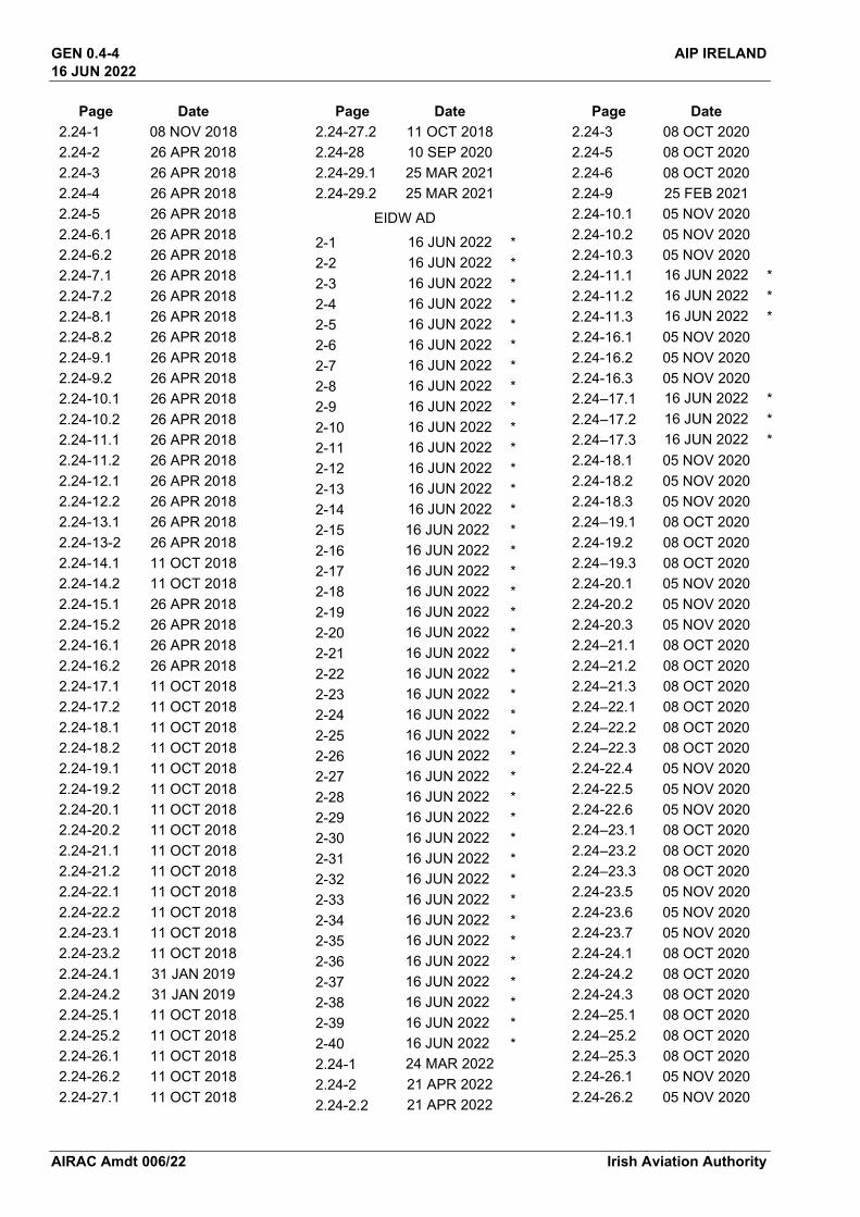
GEN 0.4 Check list of AIP Pages
New Pages * Page Date
GEN 0
0.1-1 25 FEB 2021 0.1-2 25 FEB 2021 0.2-1 16 JUN 2022 *0.2-2 16 JUN 2022 *0.3-1 19 MAY 2022 0.3-2 19 MAY 2022 0.4-1 16 JUN 2022 *0.4-2 16 JUN 2022 *0.4-3 16 JUN 2022 *0.4-4 16 JUN 2022 *0.4-5 16 JUN 2022 *0.4-6 16 JUN 2022 *0.4-7 16 JUN 2022 *0.4-8 16 JUN 2022 *0.5-1 15 JUL 2021 0.5-2 15 JUL 2021 0.6-1 19 MAY 2022 0.6-2 19 MAY 2022 0.6-3 19 MAY 2022 0.6-4 19 MAY 2022
GEN 1
1.1-1 19 MAY 2022 1.1-2 19 MAY 2022 1.1-3 19 MAY 2022 1.1-4 19 MAY 2022 1.2-1 02 DEC 2021 1.2-2 02 DEC 2021 1.2-3 02 DEC 2021 1.2-4 02 DEC 2021 1.3-1 13 AUG 2020 1.3-2 13 AUG 2020 1.3-3 13 AUG 2020 1.3-4 13 AUG 2020 1.4-1 08 DEC 2016 1.4-2 08 DEC 2016 1.5-1 08 NOV 2018 1.5-2 08 NOV 2018 1.5-3 08 NOV 2018 1.5-4 08 NOV 2018 1.5-5 08 NOV 2018 1.5-6 08 NOV 2018 1.5-7 08 NOV 2018 1.5-8 08 NOV 2018 1.5-9 08 NOV 2018
Page Date 1.5-10 08 NOV 2018 1.5-11 08 NOV 2018 1.5-12 08 NOV 2018 1.5-13 08 NOV 2018 1.5-14 08 NOV 2018 1.6-1 02 MAR 2017 1.6-2 02 MAR 2017 1.6-3 02 MAR 2017 1.6-4 02 MAR 2017 1.6-5 02 MAR 2017 1.6-6 02 MAR 2017 1.7-1 24 MAR 2022 1.7-2 24 MAR 2022 1.7-3 24 MAR 2022 1.7-4 24 MAR 2022 1.7-5 24 MAR 2022 1.7-6 24 MAR 2022 1.7-7 24 MAR 2022 1.7-8 24 MAR 2022 1.7-9 24 MAR 2022 1.7-10 24 MAR 2022 1.7-11 24 MAR 2022 1.7-12 24 MAR 2022 1.7-13 24 MAR 2022 1.7-14 24 MAR 2022 1.7-15 24 MAR 2022 1.7-16 24 MAR 2022 1.7-17 24 MAR 2022 1.7-18 24 MAR 2022 1.7-19 24 MAR 2022 1.7–20 24 MAR 2022 1.7–21 24 MAR 2022 1.7–22 24 MAR 2022 1.7–23 24 MAR 2022 1.7–24 24 MAR 2022 1.7–25 24 MAR 2022 1.7–26 24 MAR 2022 1.7–27 24 MAR 2022 1.7–28 24 MAR 2022 1.7–29 24 MAR 2022 1.7–30 24 MAR 2022 1.7–31 24 MAR 2022 1.7–32 24 MAR 2022
GEN 2
2.1-1 24 FEB 2022
Page Date 2.1-2 24 FEB 2022 2.2-1 02 DEC 2021 2.2-2 02 DEC 2021 2.2-3 02 DEC 2021 2.2-4 02 DEC 2021 2.2-5 02 DEC 2021 2.2-6 02 DEC 2021 2.2-7 02 DEC 2021 2.2-8 02 DEC 2021 2.2-9 02 DEC 2021 2.2-10 02 DEC 2021 2.2-11 02 DEC 2021 2.2-12 02 DEC 2021 2.2-13 02 DEC 2021 2.2-14 02 DEC 2021 2.3-1 12 FEB 2009 2.3-2 12 FEB 2009 2.4-1 21 APR 2022 2.4-2 21 APR 2022 2.5-1 08 OCT 2020 2.5-2 08 OCT 2020 2.6-1 11 FEB 2010 2.6-2 11 FEB 2010 2.7-1 13 OCT 2016 2.7-2 13 OCT 2016 2.7-3 13 OCT 2016 2.7-4 13 OCT 2016 2.7-5 13 OCT 2016 2.7-6 13 OCT 2016
GEN 3
3.1-1 24 FEB 2022 3.1-2 24 FEB 2022 3.1-3 24 FEB 2022 3.1-4 24 FEB 2022 3.2-1 16 JUN 2022 *3.2-2 16 JUN 2022 *3.2-3 16 JUN 2022 *3.2-4 16 JUN 2022 *3.2-5 16 JUN 2022 *3.2-6 16 JUN 2022 *3.2-7 16 JUN 2022 *3.2-8 16 JUN 2022 *3.2-9 16 JUN 2022 *3.2-10 16 JUN 2022 *3.3-1 28 MAR 2019

GEN 0.4-2 AIP IRELAND 16 JUN 2022
AIRAC Amdt 006/22 Irish Aviation Authority
Page Date 3.3-2 28 MAR 2019 3.3-3 28 MAR 2019 3.3-4 28 MAR 2019 3.4-1 08 OCT 2020 3.4–2 08 OCT 2020 3.4-3 08 OCT 2020 3.4-4 08 OCT 2020 3.4-5 08 OCT 2020 3.4-6 08 OCT 2020 3.4-7 08 OCT 2020 3.4-8 08 OCT 2020 3.5-1 08 OCT 2020 3.5-2 08 OCT 2020 3.5-3 08 OCT 2020 3.5-4 08 OCT 2020 3.5-5 08 OCT 2020 3.5-6 08 OCT 2020 3.5-7 08 OCT 2020 3.5-8 08 OCT 2020 3.5-9 08 OCT 2020 3.5-10 08 OCT 2020 3.5-11 08 OCT 2020 3.5-12 08 OCT 2020 3.6-1 07 FEB 2013 3.6-2 07 FEB 2013 3.6-3 07 FEB 2013 3.6-4 07 FEB 2013
GEN 4 4.1-1 27 FEB 2020 4.1-2 27 FEB 2020 4.2-1 26 AUG 2010 4.2-2 26 AUG 2010
ENR 0
0.1-1 12 OCT 2017 0.1-2 12 OCT 2017 0.2-1 12 OCT 2017 0.2–2 12 OCT 2017 0.3-1 12 OCT 2017 0.3-2 12 OCT 2017 0.4-1 12 OCT 2017 0.4-2 12 OCT 2017 0.5–1 12 OCT 2017 0.5–2 12 OCT 2017 0.6–1 25 APR 2019 0.6–2 25 APR 2019
ENR 1
1.1-1 02 DEC 2021
Page Date 1.1-2 02 DEC 2021 1.2-1 27 JAN 2022 1.2-2 27 JAN 2022 1.3-1 02 DEC 2021 1.3-2 02 DEC 2021 1.3-3 02 DEC 2021 1.3-4 02 DEC 2021 1.3-5 02 DEC 2021 1.3-6 02 DEC 2021 1.3-7 02 DEC 2021 1.3-8 02 DEC 2021 1.4-1 10 MAR 2011 1.4-2 10 MAR 2011 1.5-1 19 MAY 2022 1.5-2 19 MAY 2022 1.6-1 25 FEB 2021 1.6-2 25 FEB 2021 1.6-3 25 FEB 2021 1.6-4 25 FEB 2021 1.6-5 25 FEB 2021 1.6-6 25 FEB 2021 1.6-7 25 FEB 2021 1.6-8 25 FEB 2021 1.7-1 28 JAN 2021 1.7-2 28 JAN 2021 1.7-3 28 JAN 2021 1.7-4 28 JAN 2021 1.8-1 08 NOV 2018 1.8-2 08 NOV 2018 1.8-3 08 NOV 2018 1.8-4 08 NOV 2018 1.9-1 07 OCT 2021 1.9-2 07 OCT 2021 1.9-3 07 OCT 2021 1.9-4 07 OCT 2021 1.9-5 07 OCT 2021 1.9-6 07 OCT 2021 1.9-7 07 OCT 2021 1.9-8 07 OCT 2021 1.9-9 07 OCT 2021 1.9-10 07 OCT 2021 1.10-1 02 DEC 2021 1.10-2 02 DEC 2021 1.10-3 02 DEC 2021 1.10-4 02 DEC 2021 1.10-5 02 DEC 2021 1.10-6 02 DEC 2021 1.10-7 02 DEC 2021
Page Date 1.10–8 02 DEC 2021 1.10–9 02 DEC 2021 1.10–10 02 DEC 2021 1.10–11 02 DEC 2021 1.10–12 02 DEC 2021 1.10–13 02 DEC 2021 1.10–14 02 DEC 2021 1.10–15 02 DEC 2021 1.10–16 02 DEC 2021 1.10–17 02 DEC 2021 1.10-18 02 DEC 2021 1.11-1 20 JUN 2019 1.11-2 20 JUN 2019 1.12-1 08 JUN 2006 1.12-2 08 JUN 2006 1.12-3 08 JUN 2006 1.12-4 08 JUN 2006 1.13-1 22 APR 2021 1.13-2 22 APR 2021 1.13-3 22 APR 2021 1.13-4 22 APR 2021 1.14-1 08 JUN 2006 1.14-2 08 JUN 2006 1.14-3 08 JUN 2006 1.14-4 08 JUN 2006 1.14-5 08 JUN 2006 1.14-6 08 JUN 2006
ENR 2 2.1-1 26 MAR 2020 2.1-2 26 MAR 2020 2.1-3 26 MAR 2020 2.1-4 26 MAR 2020 2.1-5 26 MAR 2020 2.1-6 26 MAR 2020 2.1-7 26 MAR 2020 2.1-8 26 MAR 2020 2.2-1 02 DEC 2021 2.2-2 02 DEC 2021 2.2-3 02 DEC 2021 2.2-4 02 DEC 2021 2.2-5 02 DEC 2021 2.2-6 02 DEC 2021 2.2-7 02 DEC 2021 2.2-8 02 DEC 2021 2.2-9 02 DEC 2021 2.2-10 02 DEC 2021
ENR 3

AIP IRELAND GEN 0.4-3 16 JUN 2022
Irish Aviation Authority AIRAC Amdt 006/22
Page Date 3.1-1 20 JUN 2019 3.1-2 20 JUN 2019 3.2-1 17 DEC 2009 3.2-2 17 DEC 2009 3.3-1 19 MAY 2022 3.3-2 19 MAY 2022 3.3-3 19 MAY 2022 3.3-4 19 MAY 2022 3.3-5 19 MAY 2022 3.3-6 19 MAY 2022 3.3-7 19 MAY 2022 3.3-8 19 MAY 2022 3.3-9 19 MAY 2022 3.3-10 19 MAY 2022 3.4-1 08 JUN 2006 3.4-2 08 JUN 2006 3.5-1 26 MAR 2020 3.5-2 26 MAR 2020 3.6-1 28 APR 2016 3.6-2 28 APR 2016
ENR 4
4.1-1 24 MAR 2022 4.1-2 24 MAR 2022 4.2-1 08 JUN 2006 4.2-2 08 JUN 2006 4.3-1 06 DEC 2018 4.3-2 06 DEC 2018 4.4-1 02 DEC 2021 4.4-2 02 DEC 2021 4.4-3 02 DEC 2021 4.4-4 02 DEC 2021 4.4-5 02 DEC 2021 4.4-6 02 DEC 2021 4.4-7 02 DEC 2021 4.4-8 02 DEC 2021 4.5-1 24 FEB 2022 4.5-2 24 FEB 2022
ENR 5
5.1-1 09 SEP 2021 5.1-2 09 SEP 2021 5.1-3 09 SEP 2021 5.1-4 09 SEP 2021 5.2-1 25 FEB 2021 5.2-2 25 FEB 2021 5.2-3 25 FEB 2021 5.2-4 25 FEB 2021 5.3-1 17 SEP 2015
Page Date 5.3-2 17 SEP 2015 5.4-1 27 JAN 2022 5.4-2 27 JAN 2022 5.5-1 19 MAY 2022 5.5-2 19 MAY 2022 5.5-3 19 MAY 2022 5.5-4 19 MAY 2022 5.5-5 19 MAY 2022 5.5-6 19 MAY 2022 5.5-7 19 MAY 2022 5.5-8 19 MAY 2022 5.5-9 19 MAY 2022 5.5-10 19 MAY 2022 5.5-11 19 MAY 2022 5.5-12 19 MAY 2022 5.5-13 19 MAY 2022 5.5-14 19 MAY 2022 5.5-15 19 MAY 2022 5.5-16 19 MAY 2022 5.5-17 19 MAY 2022 5.5-18 19 MAY 2022 5.5-19 19 MAY 2022 5.5-20 19 MAY 2022 5.5-21 19 MAY 2022 5.5-22 19 MAY 2022 5.5-23 19 MAY 2022 5.5-24 19 MAY 2022 5.6-1 27 FEB 2020 5.6-2 27 FEB 2020 5.6-3 27 FEB 2020 5.6-4 27 FEB 2020 5.6-5 27 FEB 2020 5.6-6 27 FEB 2020 5.6-7 27 FEB 2020 5.6-8 27 FEB 2020
ENR 6
6-1 02 DEC 2021 6-2 02 DEC 2021 6-3 02 DEC 2021
AD 0
0.1-1 07 MAR 2013 0.1-2 07 MAR 2013 0.2-1 07 MAR 2013 0.2-2 07 MAR 2013 0.3-1 07 MAR 2013 0.3-2 07 MAR 2013 0.4-1 07 MAR 2013
Page Date 0.4-2 07 MAR 2013 0.5-1 07 MAR 2013 0.5-2 07 MAR 2013 0.6-1 25 FEB 2021 0.6-2 25 FEB 2021 0.6-3 25 FEB 2021 0.6-4 25 FEB 2021 0.6-5 25 FEB 2021 0.6-6 25 FEB 2021 0.6-7 25 FEB 2021 0.6-8 25 FEB 2021 0.6-9 25 FEB 2021 0.6-10 25 FEB 2021 0.6-11 25 FEB 2021 0.6-12 25 FEB 2021 0.6-13 25 FEB 2021 0.6-14 25 FEB 2021
AD 1
1.1-1 25 FEB 2021 1.1-2 25 FEB 2021 1.1-3 25 FEB 2021 1.1-4 25 FEB 2021 1.2-1 04 NOV 2021 1.2-2 04 NOV 2021 1.3-1 28 JAN 2021 1.3-2 28 JAN 2021 1.4-1 25 FEB 2021 1.4-2 25 FEB 2021 1.5-1 25 FEB 2021 1.5-2 25 FEB 2021
EICK AD
2-1 24 MAR 2022
2-2 24 MAR 2022
2-3 24 MAR 2022
2-4 24 MAR 2022
2-5 24 MAR 2022
2-6 24 MAR 2022
2-7 24 MAR 2022
2-8 24 MAR 2022
2-9 24 MAR 2022
2-10 24 MAR 2022
2-11 24 MAR 2022
2-12 24 MAR 2022
2-13 24 MAR 2022
2-14 24 MAR 2022
2-15 24 MAR 2022
2-16 24 MAR 2022
GEN 0.4-4 AIP IRELAND 16 JUN 2022
AIRAC Amdt 006/22 Irish Aviation Authority
Page Date 2.24-1 08 NOV 2018 2.24-2 26 APR 2018 2.24-3 26 APR 2018 2.24-4 26 APR 2018 2.24-5 26 APR 2018 2.24-6.1 26 APR 2018 2.24-6.2 26 APR 2018 2.24-7.1 26 APR 2018 2.24-7.2 26 APR 2018 2.24-8.1 26 APR 2018 2.24-8.2 26 APR 2018 2.24-9.1 26 APR 2018 2.24-9.2 26 APR 2018 2.24-10.1 26 APR 2018 2.24-10.2 26 APR 2018 2.24-11.1 26 APR 2018 2.24-11.2 26 APR 2018 2.24-12.1 26 APR 2018 2.24-12.2 26 APR 2018 2.24-13.1 26 APR 2018 2.24-13-2 26 APR 2018 2.24-14.1 11 OCT 2018 2.24-14.2 11 OCT 2018 2.24-15.1 26 APR 2018 2.24-15.2 26 APR 2018 2.24-16.1 26 APR 2018 2.24-16.2 26 APR 2018 2.24-17.1 11 OCT 2018 2.24-17.2 11 OCT 2018 2.24-18.1 11 OCT 2018 2.24-18.2 11 OCT 2018 2.24-19.1 11 OCT 2018 2.24-19.2 11 OCT 2018 2.24-20.1 11 OCT 2018 2.24-20.2 11 OCT 2018 2.24-21.1 11 OCT 2018 2.24-21.2 11 OCT 2018 2.24-22.1 11 OCT 2018 2.24-22.2 11 OCT 2018 2.24-23.1 11 OCT 2018 2.24-23.2 11 OCT 2018 2.24-24.1 31 JAN 2019 2.24-24.2 31 JAN 2019 2.24-25.1 11 OCT 2018 2.24-25.2 11 OCT 2018 2.24-26.1 11 OCT 2018 2.24-26.2 11 OCT 2018 2.24-27.1 11 OCT 2018
Page Date 2.24-27.2 11 OCT 2018 2.24-28 10 SEP 2020 2.24-29.1 25 MAR 2021 2.24-29.2 25 MAR 2021
EIDW AD
2-1 16 JUN 2022 * 2-2 16 JUN 2022 * 2-3 16 JUN 2022 * 2-4 16 JUN 2022 * 2-5 16 JUN 2022 * 2-6 16 JUN 2022 * 2-7 16 JUN 2022 * 2-8 16 JUN 2022 * 2-9 16 JUN 2022 * 2-10 16 JUN 2022 * 2-11 16 JUN 2022 * 2-12 16 JUN 2022 * 2-13 16 JUN 2022 * 2-14 16 JUN 2022 * 2-15 16 JUN 2022 * 2-16 16 JUN 2022 * 2-17 16 JUN 2022 * 2-18 16 JUN 2022 * 2-19 16 JUN 2022 * 2-20 16 JUN 2022 * 2-21 16 JUN 2022 * 2-22 16 JUN 2022 * 2-23 16 JUN 2022 * 2-24 16 JUN 2022 * 2-25 16 JUN 2022 * 2-26 16 JUN 2022 * 2-27 16 JUN 2022 * 2-28 16 JUN 2022 * 2-29 16 JUN 2022 * 2-30 16 JUN 2022 * 2-31 16 JUN 2022 * 2-32 16 JUN 2022 * 2-33 16 JUN 2022 * 2-34 16 JUN 2022 * 2-35 16 JUN 2022 * 2-36 16 JUN 2022 * 2-37 16 JUN 2022 * 2-38 16 JUN 2022 * 2-39 16 JUN 2022 * 2-40 16 JUN 2022 * 2.24-1 24 MAR 2022 2.24-2 21 APR 2022 2.24-2.2 21 APR 2022
Page Date 2.24-3 08 OCT 2020 2.24-5 08 OCT 2020 2.24-6 08 OCT 2020 2.24-9 25 FEB 2021 2.24-10.1 05 NOV 2020 2.24-10.2 05 NOV 2020 2.24-10.3 05 NOV 2020 2.24-11.1 16 JUN 2022 * 2.24-11.2 16 JUN 2022 * 2.24-11.3 16 JUN 2022 * 2.24-16.1 05 NOV 2020 2.24-16.2 05 NOV 2020 2.24-16.3 05 NOV 2020 2.24–17.1 16 JUN 2022 * 2.24–17.2 16 JUN 2022 * 2.24–17.3 16 JUN 2022 * 2.24-18.1 05 NOV 2020 2.24-18.2 05 NOV 2020 2.24-18.3 05 NOV 2020 2.24–19.1 08 OCT 2020 2.24-19.2 08 OCT 2020 2.24–19.3 08 OCT 2020 2.24-20.1 05 NOV 2020 2.24-20.2 05 NOV 2020 2.24-20.3 05 NOV 2020 2.24–21.1 08 OCT 2020 2.24–21.2 08 OCT 2020 2.24–21.3 08 OCT 2020 2.24–22.1 08 OCT 2020 2.24–22.2 08 OCT 2020 2.24–22.3 08 OCT 2020 2.24-22.4 05 NOV 2020 2.24-22.5 05 NOV 2020 2.24-22.6 05 NOV 2020 2.24–23.1 08 OCT 2020 2.24–23.2 08 OCT 2020 2.24–23.3 08 OCT 2020 2.24-23.5 05 NOV 2020 2.24-23.6 05 NOV 2020 2.24-23.7 05 NOV 2020 2.24-24.1 08 OCT 2020 2.24-24.2 08 OCT 2020 2.24-24.3 08 OCT 2020 2.24–25.1 08 OCT 2020 2.24–25.2 08 OCT 2020 2.24–25.3 08 OCT 2020 2.24-26.1 05 NOV 2020 2.24-26.2 05 NOV 2020
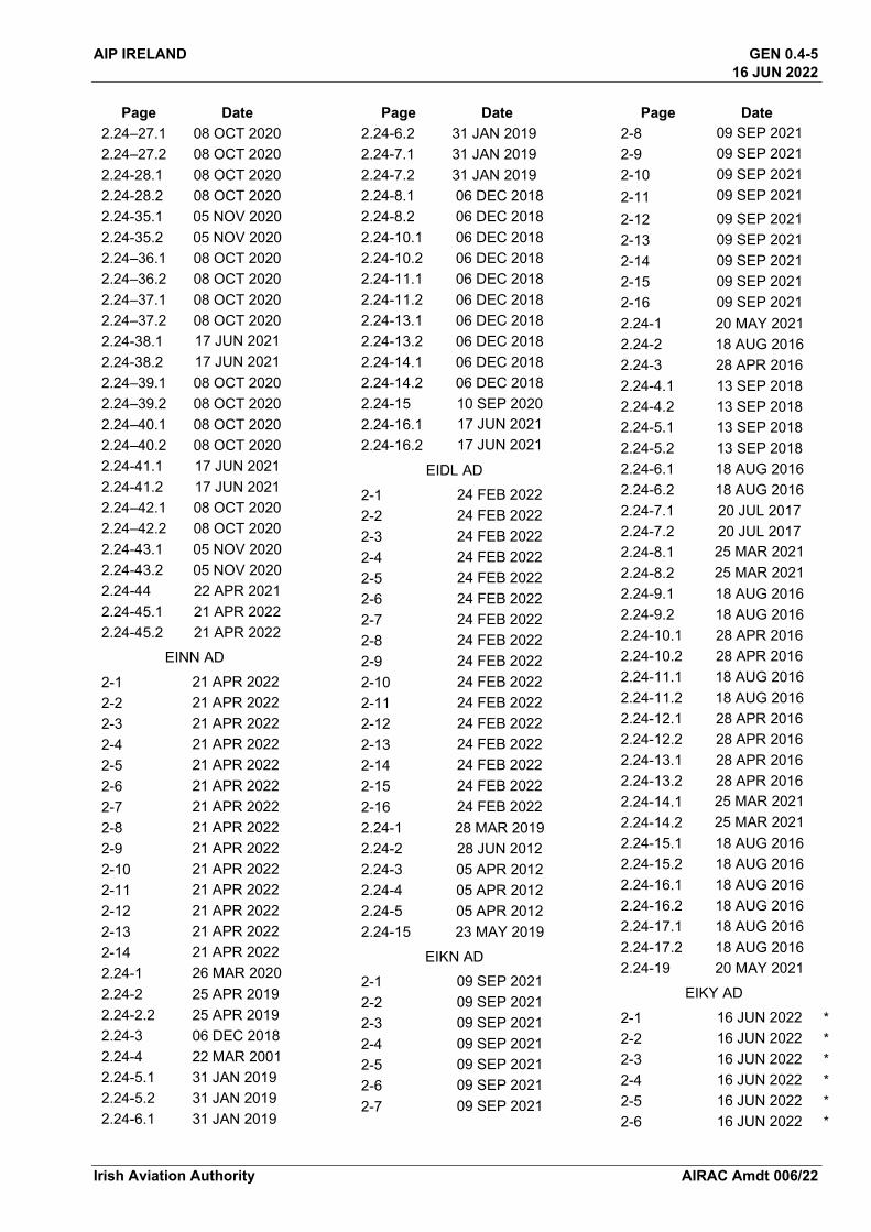
AIP IRELAND GEN 0.4-5 16 JUN 2022
Irish Aviation Authority AIRAC Amdt 006/22
Page Date 2.24–27.1 08 OCT 2020 2.24–27.2 08 OCT 2020 2.24-28.1 08 OCT 2020 2.24-28.2 08 OCT 2020 2.24-35.1 05 NOV 2020 2.24-35.2 05 NOV 2020 2.24–36.1 08 OCT 2020 2.24–36.2 08 OCT 2020 2.24–37.1 08 OCT 2020 2.24–37.2 08 OCT 2020 2.24-38.1 17 JUN 2021 2.24-38.2 17 JUN 2021 2.24–39.1 08 OCT 2020 2.24–39.2 08 OCT 2020 2.24–40.1 08 OCT 2020 2.24–40.2 08 OCT 2020 2.24-41.1 17 JUN 2021 2.24-41.2 17 JUN 2021 2.24–42.1 08 OCT 2020 2.24–42.2 08 OCT 2020 2.24-43.1 05 NOV 2020 2.24-43.2 05 NOV 2020 2.24-44 22 APR 2021 2.24-45.1 21 APR 2022 2.24-45.2 21 APR 2022
EINN AD
2-1 21 APR 2022
2-2 21 APR 2022
2-3 21 APR 2022
2-4 21 APR 2022
2-5 21 APR 2022
2-6 21 APR 2022
2-7 21 APR 2022
2-8 21 APR 2022
2-9 21 APR 2022
2-10 21 APR 2022
2-11 21 APR 2022
2-12 21 APR 2022
2-13 21 APR 2022
2-14 21 APR 2022
2.24-1 26 MAR 2020
2.24-2 25 APR 2019 2.24-2.2 25 APR 2019 2.24-3 06 DEC 2018 2.24-4 22 MAR 2001 2.24-5.1 31 JAN 2019 2.24-5.2 31 JAN 2019 2.24-6.1 31 JAN 2019
Page Date 2.24-6.2 31 JAN 2019 2.24-7.1 31 JAN 2019 2.24-7.2 31 JAN 2019 2.24-8.1 06 DEC 2018 2.24-8.2 06 DEC 2018 2.24-10.1 06 DEC 2018 2.24-10.2 06 DEC 2018 2.24-11.1 06 DEC 2018 2.24-11.2 06 DEC 2018 2.24-13.1 06 DEC 2018 2.24-13.2 06 DEC 2018 2.24-14.1 06 DEC 2018 2.24-14.2 06 DEC 2018 2.24-15 10 SEP 2020 2.24-16.1 17 JUN 2021 2.24-16.2 17 JUN 2021
EIDL AD
2-1 24 FEB 2022 2-2 24 FEB 2022 2-3 24 FEB 2022 2-4 24 FEB 2022 2-5 24 FEB 2022 2-6 24 FEB 2022 2-7 24 FEB 2022 2-8 24 FEB 2022 2-9 24 FEB 2022 2-10 24 FEB 2022 2-11 24 FEB 2022 2-12 24 FEB 2022 2-13 24 FEB 2022 2-14 24 FEB 2022 2-15 24 FEB 2022 2-16 24 FEB 2022 2.24-1 28 MAR 2019 2.24-2 28 JUN 2012 2.24-3 05 APR 2012 2.24-4 05 APR 2012 2.24-5 05 APR 2012 2.24-15 23 MAY 2019
EIKN AD
2-1 09 SEP 2021 2-2 09 SEP 2021 2-3 09 SEP 2021 2-4 09 SEP 2021 2-5 09 SEP 2021 2-6 09 SEP 2021 2-7 09 SEP 2021
Page Date 2-8 09 SEP 2021 2-9 09 SEP 2021 2-10 09 SEP 2021 2-11 09 SEP 2021 2-12 09 SEP 2021 2-13 09 SEP 2021 2-14 09 SEP 2021 2-15 09 SEP 2021 2-16 09 SEP 2021 2.24-1 20 MAY 2021 2.24-2 18 AUG 2016 2.24-3 28 APR 2016 2.24-4.1 13 SEP 2018 2.24-4.2 13 SEP 2018 2.24-5.1 13 SEP 2018 2.24-5.2 13 SEP 2018 2.24-6.1 18 AUG 2016 2.24-6.2 18 AUG 2016 2.24-7.1 20 JUL 2017 2.24-7.2 20 JUL 2017 2.24-8.1 25 MAR 2021 2.24-8.2 25 MAR 2021 2.24-9.1 18 AUG 2016 2.24-9.2 18 AUG 2016 2.24-10.1 28 APR 2016 2.24-10.2 28 APR 2016 2.24-11.1 18 AUG 2016 2.24-11.2 18 AUG 2016 2.24-12.1 28 APR 2016 2.24-12.2 28 APR 2016 2.24-13.1 28 APR 2016 2.24-13.2 28 APR 2016 2.24-14.1 25 MAR 2021 2.24-14.2 25 MAR 2021 2.24-15.1 18 AUG 2016 2.24-15.2 18 AUG 2016 2.24-16.1 18 AUG 2016 2.24-16.2 18 AUG 2016 2.24-17.1 18 AUG 2016 2.24-17.2 18 AUG 2016 2.24-19 20 MAY 2021
EIKY AD
2-1 16 JUN 2022 *2-2 16 JUN 2022 *2-3 16 JUN 2022 *2-4 16 JUN 2022 *2-5 16 JUN 2022 *2-6 16 JUN 2022 *

GEN 0.4-6 AIP IRELAND 16 JUN 2022
AIRAC Amdt 006/22 Irish Aviation Authority
Page Date 2-7 16 JUN 2022 * 2-8 16 JUN 2022 * 2-9 16 JUN 2022 * 2-10 16 JUN 2022 * 2-11 16 JUN 2022 * 2-12 16 JUN 2022 * 2-13 16 JUN 2022 * 2-14 16 JUN 2022 * 2-15 16 JUN 2022 * 2-16 16 JUN 2022 * 2.24-1 20 MAY 2021 2.24-2 28 OCT 2004 2.24-3.1 25 MAR 2021 2.24-3.2 25 MAR 2021 2.24-4.1 25 MAR 2021 2.24-4.2 25 MAR 2021 2.24-5.1 25 MAR 2021 2.24-5.2 25 MAR 2021 2.24-6.1 25 MAR 2021 2.24-6.2 25 MAR 2021 2.24-7.1 25 MAR 2021 2.24-7.2 25 MAR 2021 2.24-7.3 25 MAR 2021 2.24-8.1 08 DEC 2016 2.24-8.2 08 DEC 2016 2.24-9.1 08 DEC 2016 2.24-9.2 08 DEC 2016 2.24-10.1 20 MAY 2021 2.24-10.2 20 MAY 2021 2.24-10.3 20 MAY 2021 2.24-11.1 18 AUG 2016 2.24-11.2 18 AUG 2016 2.24-13 25 MAR 2021
EISG AD 2-1 27 JAN 2022 2-2 27 JAN 2022 2-3 27 JAN 2022 2-4 27 JAN 2022 2-5 27 JAN 2022 2-6 27 JAN 2022 2-7 27 JAN 2022 2-8 27 JAN 2022 2-9 27 JAN 2022 2-10 27 JAN 2022 2-11 27 JAN 2022 2-12 27 JAN 2022 2.24-1 28 JAN 2021 2.24-2 28 JAN 2021
Page Date 2.24-7.1 22 APR 2021 2.24-7.2 22 APR 2021 2.24-8.1 22 APR 2021 2.24-8.2 22 APR 2021 2.24-9.1 22 APR 2021 2.24-9.2 22 APR 2021 2.24-10.1 22 APR 2021 2.24-10.2 22 APR 2021 2.24-11.1 22 APR 2021 2.24-11.2 22 APR 2021 2.24-12.1 22 APR 2021 2.24-12.2 22 APR 2021 2.24-16 28 JAN 2021
EIWF AD
2-1 27 JAN 2022 2-2 27 JAN 2022 2-3 27 JAN 2022 2-4 27 JAN 2022 2-5 27 JAN 2022 2-6 27 JAN 2022 2-7 27 JAN 2022 2-8 27 JAN 2022 2-9 27 JAN 2022 2-10 27 JAN 2022 2-11 27 JAN 2022 2-12 27 JAN 2022 2.24-1 30 OCT 2003 2.24-2 30 OCT 2003 2.24-3.1 20 JUL 2017 2.24-3.2 20 JUL 2017 2.24-5 30 OCT 2003 2.24-6.1 08 DEC 2016 2.24-6.2 08 DEC 2016 2.24-7 30 OCT 2003
EIWT AD
2-1 09 SEP 2021 2-2 09 SEP 2021 2-3 09 SEP 2021 2-4 09 SEP 2021 2-5 09 SEP 2021 2-6 09 SEP 2021 2-7 09 SEP 2021 2-8 09 SEP 2021 2-9 09 SEP 2021 2-10 09 SEP 2021 2.24-1 07 JUN 2007
EIAB AD
Page Date 2-1 24 MAR 2022 2-2 24 MAR 2022 2-3 24 MAR 2022 2-4 24 MAR 2022 2-5 24 MAR 2022 2-6 24 MAR 2022
EIBN AD
2-1 24 MAR 2022 2-2 24 MAR 2022 2-3 24 MAR 2022 2-4 24 MAR 2022 2-5 24 MAR 2022 2-6 24 MAR 2022
EIBR AD
2-1 24 MAR 2022 2-2 24 MAR 2022 2-3 24 MAR 2022 2-4 24 MAR 2022 2-5 24 MAR 2022 2-6 24 MAR 2022
EICA AD
2-1 21 APR 2022 2-2 21 APR 2022 2-3 21 APR 2022 2-4 21 APR 2022 2-5 21 APR 2022 2-6 21 APR 2022
EICL AD
2-1 21 APR 2022 2-2 21 APR 2022 2-3 21 APR 2022 2-4 21 APR 2022 2-5 21 APR 2022 2-6 21 APR 2022
EICN AD
2-1 21 APR 2022 2-2 21 APR 2022 2-3 21 APR 2022 2-4 21 APR 2022 2-5 21 APR 2022 2-6 21 APR 2022
EIIM AD
2-1 19 MAY 2022 2-2 19 MAY 2022 2-3 19 MAY 2022 2-4 19 MAY 2022
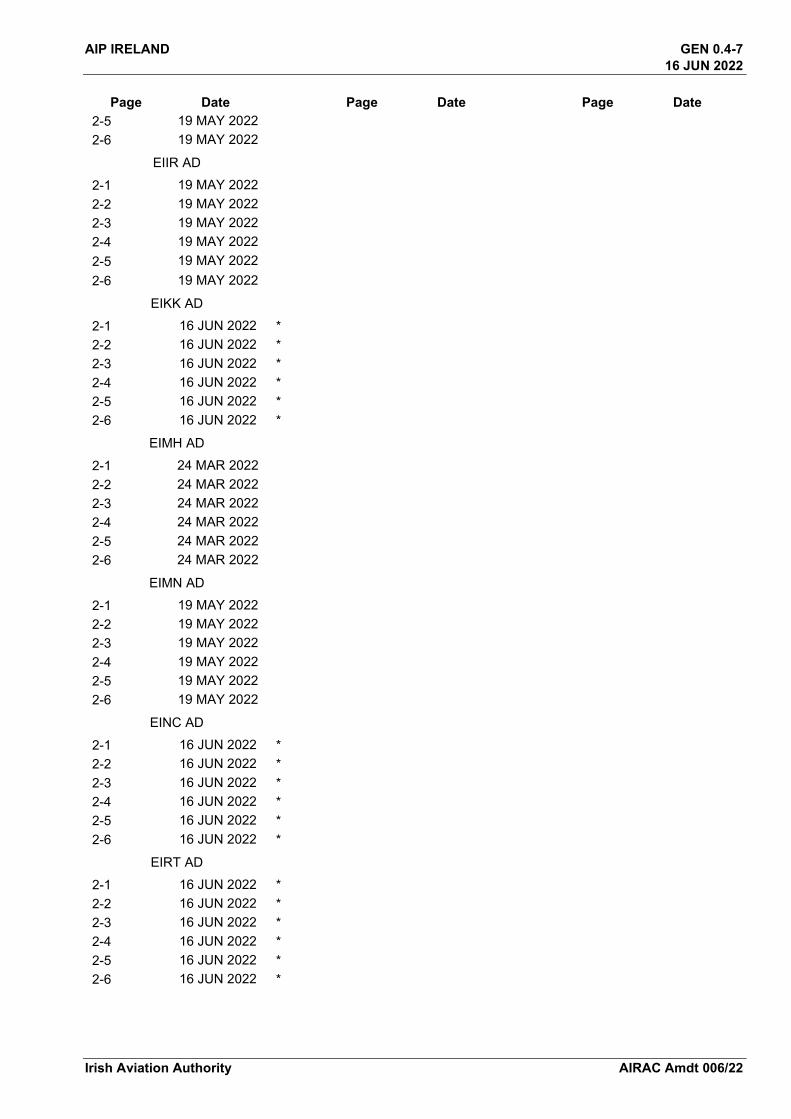
AIP IRELAND GEN 0.4-7 16 JUN 2022
Irish Aviation Authority AIRAC Amdt 006/22
Page Date 2-5 19 MAY 2022 2-6 19 MAY 2022
EIIR AD
2-1 19 MAY 2022 2-2 19 MAY 2022 2-3 19 MAY 2022 2-4 19 MAY 2022 2-5 19 MAY 2022 2-6 19 MAY 2022
EIKK AD
2-1 16 JUN 2022 *2-2 16 JUN 2022 *2-3 16 JUN 2022 *2-4 16 JUN 2022 *2-5 16 JUN 2022 *2-6 16 JUN 2022 *
EIMH AD
2-1 24 MAR 2022 2-2 24 MAR 2022 2-3 24 MAR 2022 2-4 24 MAR 2022 2-5 24 MAR 2022 2-6 24 MAR 2022
EIMN AD
2-1 19 MAY 2022 2-2 19 MAY 2022 2-3 19 MAY 2022 2-4 19 MAY 2022 2-5 19 MAY 2022 2-6 19 MAY 2022
EINC AD
2-1 16 JUN 2022 *2-2 16 JUN 2022 *2-3 16 JUN 2022 *2-4 16 JUN 2022 *2-5 16 JUN 2022 *2-6 16 JUN 2022 *
EIRT AD 2-1 16 JUN 2022 *2-2 16 JUN 2022 *2-3 16 JUN 2022 *2-4 16 JUN 2022 *2-5 16 JUN 2022 *2-6 16 JUN 2022 *
Page Date Page Date
GEN 0.4-8 AIP IRELAND 16 JUN 2022
AIRAC Amdt 006/22 Irish Aviation Authority
Page Date Page Date Page Date
THIS PAGE INTENTIONALLY LEFT BLANK
GEN 3.2 - 1AIP IRELAND16 JUN 2022
16 JUN 2022
GEN 3.2 AERONAUTICAL CHARTS
1. RESPONSIBLE SERVICEAeronautical Charts for the territory of Ireland are published by
Post: The Irish Aviation Authority,The Times Building11-12 D’Olier StreetDublin 2D02 T449Ireland
Phone: + 353 1 671 8655
Fax: + 353 1 679 2934
Email: [email protected]
URL: http://www.iaa.ie
Charts based on ICAO documents: Annex 4, Doc 8697Differences to these provisions are detailed in GEN 1.7Topographical information is reproduced under licence by permission of Ordnance Survey Ireland.Charting service is available during Office hours 0930-1730 Local Time.
2. MAINTENANCE OF CHARTS
2.1. Aeronautical Charts included in the AIP are kept up to date by amendments to the AIP. Significant amendments or revisions in aeronautical information may be promulgated by NOTAM or Aeronautical Information Circular, as appropriate.
2.2. Corrections to Aeronautical Charts are promulgated as hand amendments to the AIP and listed in Sections GEN 0.5 and GEN 3.2.8. Items of information found after publication to have been incorrect at the aeronautical information date are corrected immediately by NOTAM if they are of operational significance.
3. PURCHASE ARRANGEMENTS
VFR Chart Scale 1:500,000
The Irish Aviation Authority has produced a visual flight rules (VFR) aeronautical encapsulated A4 folded chart Scale 1:500,000. This chart is for VFR navigation within the boundaries of the Shannon FIR. In addition to aeronautical information, the charts provide terrain contours, hydrographic, topographic, cultural and other visual features compatible with legibility at the scale of the chart - this information is supplied by Ordnance Survey Ireland and/or Ordnance Survey Northern Ireland. It is available to order at a cost of €30.00 including VAT from:
Post: OSI,Map Sales Shop,Phoenix Park,Dublin 8,
Phone: + 353 1 802 5379
URL: https://store.osi.ie/index.php/paper-products/aeronautical-charts.html
VFR Airspace Chart Scale 1:500,000
The Irish Aviation Authority has produced a visual flight rules (VFR) aeronautical airspace chart Scale 1:500,000.This chart is for VFR navigation within the boundaries of the Shannon FIR.It is available free to download from the IAA Web Site,
URL: https://www.iaa.ie/commercial-aviation/airspace/aeronautical-charts
VFR Chart Scale 1:250,000
The Irish Aviation Authority has produced a visual flight rules (VFR) aeronautical encapsulated A4 folded chart Scale 1:250,000. It comprises two charts - front and back (East & West, North & South), covering the Shannon FIR. The
Irish Aviation Authority AIRAC Amdt 006/22
GEN 3.2 - 2 AIP IRELAND16 JUN 2022
16 JUN 2022
charts are for VFR navigation within the boundaries of the Shannon FIR. In addition to aeronautical information, the charts provide terrain contours, hydrographic, topographic, cultural and other visual features compatible with legibility at the scale of the chart - this information is supplied by Ordnance Survey Ireland and/or Ordnance Survey Northern Ireland. It is available to order at a cost of €30.00 including VAT per chart from:
Post: OSI,Map Sales Shop,Phoenix Park,Dublin 8,
Phone: + 353 1 802 5379
URL: https://store.osi.ie/index.php/paper-products/aeronautical-charts.html
All other aeronautical charts are available to download from:-
URL: http://www.iaa.ie/commercial-aviation/airspace/aeronautical-charts
4. AERONAUTICAL CHART SERIES AVAILABLE
4.1 The following series of aeronautical charts are produced
1. Aeronautical Chart - ICAO 1:500,0002. Aeronautical Chart 1:250,0003. Instrument Approach Chart - ICAO *4. Standard Departure Chart - Instrument (SID) - ICAO *5. Standard Arrival Chart - Instrument (STAR) - ICAO *6. Visual Approach Chart - ICAO*7. Aerodrome Chart - ICAO *8. Aircraft Parking/Docking Chart - ICAO *9. Aerodrome Obstacle Chart - ICAO Type “A” (Operating Limitations) *10. Aerodrome Obstacle Chart - ICAO Type “B” 11. Precision Approach Terrain Chart – ICAO12. ATC Surveillance Minimum Altitude Chart *
(*Included in AIP Ireland)
URL: http://www.iaa.ie
4.2 General Description of Series of Charts
4.2.1 Aeronautical Chart - ICAO 1:500,000 The Irish Aviation Authority has produced a visual flight rules (VFR) aeronautical encapsulated A4 folded chart Scale 1:500,000. This chart is for VFR navigation within the boundaries of the Shannon FIR. In addition to aeronautical information, the charts provide terrain contours, hydrographic, topographic, cultural and other visual features compatible with legibility at the scale of the chart - this information is supplied by Ordnance Survey Ireland and/or Ordnance Survey Northern Ireland.
4.2.2 Aeronautical Chart 1:250,000The Irish Aviation Authority has produced a visual flight rules (VFR) aeronautical encapsulated A4 folded chart Scale 1:250,000. It comprises two charts - front and back (East & West, North & South), covering the Shannon FIR. The charts are for VFR navigation within the boundaries of the Shannon FIR. In addition to aeronautical information, the charts provide terrain contours, hydrographic, topographic, cultural and other visual features compatible with legibility at the scale of the chart - this information is supplied by Ordnance Survey Ireland and/or Ordnance Survey Northern Ireland.
4.2.3 Instrument Approach Chart – ICAOThese charts are designed to provide the pilot with a graphic presentation of the Instrument Approach, Missed Approach and Holding Procedures and to facilitate the transition from non-visual to visual flight at any point on the final approach.
Irish Aviation AuthorityAIRAC Amdt 006/22

GEN 3.2 - 3AIP IRELAND16 JUN 2022
16 JUN 2022
4.2.4 Visual Approach Chart – ICAOThese charts are designed to assist pilots making a visual approach and to provide pilots with designated holding patterns maintained by visual reference to the ground.
4.2.5 Aerodrome Chart – ICAOThese charts provide flight crew with detailed information on runways, taxiways, lighting and other aerodrome features to facilitate the surface movement of aircraft.
4.2.6 Aerodrome Obstacle Chart - ICAO - TYPE “A” (Operating Limitations)These charts are designed to provide the operator with the data necessary to enable compliance with the operating limitations as contained in ICAO Annex 6.
4.2.7 Aerodrome Obstacle Chart - ICAO - TYPE “B”These charts are designed to provide the data necessary or determination of minimum safe altitudes/heights and procedures for use in the event of an emergency during take-off or landing.
4.2.8 Precision Approach Terrain Chart – ICAOThese charts provide detailed terrain profile information within a defined portion of the final approach so as to enable aircraft operating agencies to assess the effect of terrain on decision height determination by the use of radio altimeter.
4.2.9 ATC Surveillance Minimum Altitude ChartThis Supplementary Chart shall provide information that will enable flight crews to monitor and cross check altitudes assigned by a controller using an ATS surveillance system.
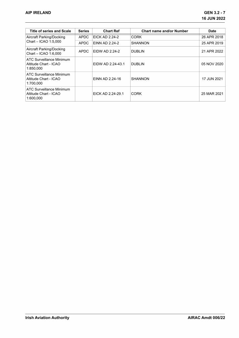
5. LIST OF CHART SERIES
Title of series and Scale Series Chart Ref Chart name and/or Number DateAeronautical Chart ICAO1:500,000 ANC/500 Edition 12 Ireland Sheet 2172 ABCD 24 FEB 2022
Aeronautical Chart/West1:250,000 ANC/250 Edition 09 Ireland Sheet 2172 ABCD 24 FEB 2022
Aeronautical Chart/East1:250,000 ANC/250 Edition 09 Ireland Sheet 2172 ABCD 24 FEB 2022
Aeronautical Chart/North1:250,000 ANC/250 Edition 09 Ireland Sheet 2172 ABCD 24 FEB 2022
Aeronautical Chart/South1:250,000 ANC/250 Edition 09 Ireland Sheet 2172 ABCD 24 FEB 2022
Standard Departure Chart-Instrument (SID) ICAO1:750,000
SID EIDW AD 2.24-10.1 EIDW RNAV RWY 28L CAT A,B 05 NOV 2020SID EIDW AD 2.24-11.1 EIDW RNAV RWY 28L CAT C, D 16 JUN 2022SID EIDW AD 2.24-16.1 EIDW RNAV RWY 10R CAT A, B 05 NOV 2020SID EIDW AD 2.24-17.1 EIDW RNAV RWY 10R CAT C, D 16 JUN 2022SID EIDW AD 2.24-18.1 EIDW RNAV RWY 16 CAT A, B 05 NOV 2020SID EIDW AD 2.24-19.1 EIDW RNAV RWY 16 CAT C, D 08 OCT 2020SID EIDW AD 2.24-20.1 EIDW RNAV RWY 34 CAT A, B 05 NOV 2020SID EIDW AD 2.24-21.1 EIDW RNAV RWY 34 CAT C, D 08 OCT 2020SID EIKY AD 2.24-3 EIKY RWY 26 CAT A, B 25 MAR 2021SID EIKY AD 2.24-4 EIKY RWY 26 CAT C 25 MAR 2021SID EIKY AD 2.24-5 EIKY RWY 08 CAT A, B 25 MAR 2021SID EIKY AD 2.24-6 EIKY RWY 08 CAT C 25 MAR 2021SID EINN AD 2.24-5.1 EINN RNAV RWY 06 31 JAN 2019SID EINN AD 2.24-6.1 EINN RNAV RWY 24 31 JAN 2019
Irish Aviation Authority AIRAC Amdt 006/22
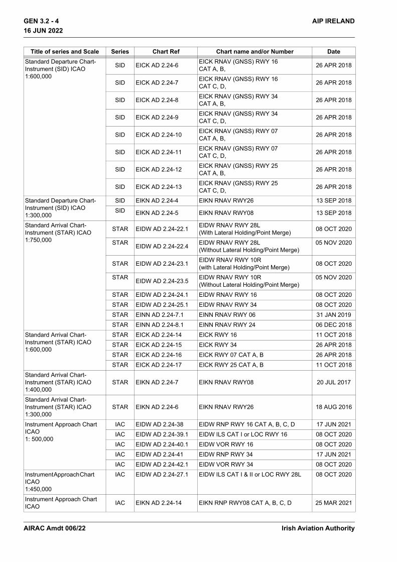
GEN 3.2 - 4 AIP IRELAND16 JUN 2022
16 JUN 2022
Standard Departure Chart-Instrument (SID) ICAO1:600,000
SID EICK AD 2.24-6 EICK RNAV (GNSS) RWY 16CAT A, B, 26 APR 2018
SID EICK AD 2.24-7 EICK RNAV (GNSS) RWY 16CAT C, D, 26 APR 2018
SID EICK AD 2.24-8 EICK RNAV (GNSS) RWY 34CAT A, B, 26 APR 2018
SID EICK AD 2.24-9 EICK RNAV (GNSS) RWY 34CAT C, D, 26 APR 2018
SID EICK AD 2.24-10 EICK RNAV (GNSS) RWY 07CAT A, B, 26 APR 2018
SID EICK AD 2.24-11 EICK RNAV (GNSS) RWY 07CAT C, D, 26 APR 2018
SID EICK AD 2.24-12 EICK RNAV (GNSS) RWY 25CAT A, B, 26 APR 2018
SID EICK AD 2.24-13 EICK RNAV (GNSS) RWY 25CAT C, D, 26 APR 2018
Standard Departure Chart-Instrument (SID) ICAO1:300,000
SID EIKN AD 2.24-4 EIKN RNAV RWY26 13 SEP 2018SID EIKN AD 2.24-5 EIKN RNAV RWY08 13 SEP 2018
Standard Arrival Chart-Instrument (STAR) ICAO1:750,000
STAR EIDW AD 2.24-22.1 EIDW RNAV RWY 28L(With Lateral Holding/Point Merge) 08 OCT 2020
STAR EIDW AD 2.24-22.4 EIDW RNAV RWY 28L(Without Lateral Holding/Point Merge)
05 NOV 2020
STAR EIDW AD 2.24-23.1 EIDW RNAV RWY 10R(with Lateral Holding/Point Merge) 08 OCT 2020
STAR EIDW AD 2.24-23.5 EIDW RNAV RWY 10R(Without Lateral Holding/Point Merge)
05 NOV 2020
STAR EIDW AD 2.24-24.1 EIDW RNAV RWY 16 08 OCT 2020STAR EIDW AD 2.24-25.1 EIDW RNAV RWY 34 08 OCT 2020STAR EINN AD 2.24-7.1 EINN RNAV RWY 06 31 JAN 2019STAR EINN AD 2.24-8.1 EINN RNAV RWY 24 06 DEC 2018
Standard Arrival Chart-Instrument (STAR) ICAO1:600,000
STAR EICK AD 2.24-14 EICK RWY 16 11 OCT 2018STAR EICK AD 2.24-15 EICK RWY 34 26 APR 2018STAR EICK AD 2.24-16 EICK RWY 07 CAT A, B 26 APR 2018STAR EICK AD 2.24-17 EICK RWY 25 CAT A, B 11 OCT 2018
Standard Arrival Chart-Instrument (STAR) ICAO1:400,000
STAR EIKN AD 2.24-7 EIKN RNAV RWY08 20 JUL 2017
Standard Arrival Chart-Instrument (STAR) ICAO1:300,000
STAR EIKN AD 2.24-6 EIKN RNAV RWY26 18 AUG 2016
Instrument Approach Chart ICAO1: 500,000
IAC EIDW AD 2.24-38 EIDW RNP RWY 16 CAT A, B, C, D 17 JUN 2021IAC EIDW AD 2.24-39.1 EIDW ILS CAT I or LOC RWY 16 08 OCT 2020IAC EIDW AD 2.24-40.1 EIDW VOR RWY 16 08 OCT 2020IAC EIDW AD 2.24-41 EIDW RNP RWY 34 17 JUN 2021IAC EIDW AD 2.24-42.1 EIDW VOR RWY 34 08 OCT 2020
Instrument Approach Chart ICAO 1:450,000
IAC EIDW AD 2.24-27.1 EIDW ILS CAT I & II or LOC RWY 28L 08 OCT 2020
Instrument Approach Chart ICAO IAC EIKN AD 2.24-14 EIKN RNP RWY08 CAT A, B, C, D 25 MAR 2021
Title of series and Scale Series Chart Ref Chart name and/or Number Date
Irish Aviation AuthorityAIRAC Amdt 006/22

GEN 3.2 - 5AIP IRELAND16 JUN 2022
16 JUN 2022
1: 400,000 IAC EIDW AD 2.24-35.1 EIDW RNP RWY 10R 05 NOV 2020Instrument Approach Chart ICAO 1:350,000
IAC EINN AD 2.24-10.1 EINN ILS OR LOC RWY 06 CAT A,B,C,D 06 DEC 2018IAC EINN AD 2.24-11.1 EINN VOR RWY 26 CAT A, B, C, D 06 DEC 2018
IAC EINN AD 2.24-13.1 EINN ILS CAT I & II or LOC RWY 24 CAT A, B, C, D 06 DEC 2018
IAC EINN AD 2.24-14.1 EINN VOR RWY 24 CAT A, B, C, D 06 DEC 2018
IAC EIKY AD 2.24-8 EIKY ILS OR LOC RWY 26 ACFT CAT A, B, C 08 DEC 2016
IAC EIKY AD 2.24-9 EIKY NDB RWY 26 CAT A,B,C 08 DEC 2016IAC EIKN AD 2.24-8 EIKN RNP RWY26 CAT A, B, C, D 25 MAR 2021IAC EIKN AD 2.24-9 EIKN ILS A CAT I & CAT II or LOC RWY26 18 AUG 2016IAC EIKN AD 2.24-11 EIKN VOR RWY26 18 AUG 2016IAC EIKN AD 2.24-15 EIKN VOR RWY08 18 AUG 2016IAC EIKN AD 2.24-16 EIKN NDB RWY08 18 AUG 2016IAC EIKN AD 2.24-17 EIKN NDB RWY08 18 AUG 2016IAC EIDW AD 2.24-26.1 EIDW RNP RWY 28L 05 NOV 2020IAC EIDW AD 2.24-28.1 EIDW VOR RWY 28L 08 OCT 2020IAC EIDW AD 2.24-36.1 EIDW ILS CAT I & II or LOC RWY 10R 08 OCT 2020IAC EIDW AD 2.24-37.1 EIDW VOR RWY 10R 08 OCT 2020IAC EIDW AD 2.24-45 EIDW VOR T RWY 28L CAT A, B, C, D 21 APR 2022IAC EISG AD 2.24-7.1 EISG RNP Y RWY 10 CAT A, B 22 APR 2021IAC EISG AD 2.24-8.1 EISG RNP Z RWY 10 CAT A, B 22 APR 2021IAC EISG AD 2.24-9.1 EISG NDB Y RWY 10 CAT A, B 22 APR 2021IAC EISG AD 2.24-10.1 EISG NDB Z RWY 10 CAT A, B 22 APR 2021IAC EISG AD 2.24-11.1 EISG RNP RWY 28 CAT A, B 22 APR 2021IAC EISG AD 2.24-12.1 EISG NDB RWY 28 CAT A, B 22 APR 2021
Instrument Approach Chart ICAO1: 330,000
IAC EIDL AD 2.24-3 EIDL LOC RWY 21 05 APR 2012IAC EIDL AD 2.24-4 EIDL NDB RWY 21 05 APR 2012IAC EIDL AD 2.24-5 EIDL NDB RWY 03 05 APR 2012IAC EIKN AD 2.24-10 EIKN ILS B CAT I & CAT II RWY26 28 APR 2016IAC EIKN AD 2.24-12 EIKN NDB RWY26 28 APR 2016IAC EIKN AD 2.24-13 EIKN NDB RWY26 28 APR 2016
IAC EIWF AD 2.24-3 EIWF ILS CAT 1 OR LOC RWY 21 CAT A,B,C 20 JUL 2017
IAC EIWF AD 2.24-5 EIWF NDB/DME RWY 21 30 OCT 2003IAC EIWF AD 2.24-6 EIWF NDB RWY 03 CAT A, B, C 08 DEC 2016
Instrument Approach Chart ICAO 1:300,000
IAC EICK AD 2.24-18 EICK RNP RWY 16 11 OCT 2018IAC EICK AD 2.24-19.1 EICK ILS CAT I & II or LOC RWY 16 11 OCT 2018IAC EICK AD 2.24-20 EICK VOR RWY 16 11 OCT 2018IAC EICK AD 2.24-21 EICK RNP RWY 34 11 OCT 2018IAC EICK AD 2.24-22 EICK ILS CAT I or LOC RWY 34 11 OCT 2018IAC EICK AD 2.24-23 EICK VOR RWY 34 11 OCT 2018IAC EICK AD 2.24-24 EICK RNP RWY 07 31 JAN 2019IAC EICK AD 2.24-25 EICK VOR RWY 07 11 OCT 2018IAC EICK AD 2.24-26 EICK RNP RWY 25 (LNAV Only) 11 OCT 2018IAC EICK AD 2.24-27 EICK VOR RWY 25 11 OCT 2018
Title of series and Scale Series Chart Ref Chart name and/or Number Date
Irish Aviation Authority AIRAC Amdt 006/22

GEN 3.2 - 6 AIP IRELAND16 JUN 2022
16 JUN 2022
Instrument Approach Chart ICAO 1:250,000
IAC EIKY AD 2.24-7 EIKY RNP RWY 26 CAT A, B, C 25 MAR 2021IAC EIKY AD 2.24-10 EIKY RNP RWY 08 CAT A, B, C 20 MAY 2021IAC EIKY AD 2.24-11 EIKY NDB RWY 08 CAT A, B, C 26 MAY 2016
Visual Approach Chart ICAO1: 250,000
VAC EICK AD 2.24-28 CORK 10 SEP 2020VAC EIDL AD 2.24-15 DONEGAL 23 MAY 2019VAC EIKN AD 2.24-19 IRELAND WEST/KNOCK 20 MAY 2021VAC EIKY AD 2.24-13 KERRY 25 MAR 2021VAC EINN AD 2.24-15 SHANNON 10 SEP 2020VAC EISG AD 2.24-16 SLIGO 28 JAN 2021VAC EIWF AD 2.24-7 WATERFORD 30 OCT 2003
Visual Approach Chart ICAO1: 160,000 VAC EIDW AD 2.24-44 DUBLIN 22 APR 2021
Aerodrome Chart ICAO1: 25,000
AD EICK AD 2.24-1 CORK 08 NOV 2018AD EINN AD 2.24-1 SHANNON 26 MAR 2020
Aerodrome Chart ICAO1: 20,000
AD EIKN AD 2.24-1 IRELAND WEST 20 MAY 2021AD EIKY AD 2.24-1 KERRY 20 MAY 2021
Aerodrome Chart ICAO1: 15,000
AD EIDL AD 2.24-1 DONEGAL 28 MAR 2019AD EIWF AD 2.24-1 WATERFORD 30 OCT 2003AD EIWT AD 2.24-1 WESTON 07 JUN 2007AD EISG AD 2.24-1 SLIGO 28 JAN 2021
Aerodrome Chart ICAO As per Published Chart AD EIDW AD 2.24-1 DUBLIN 24 MAR 2022
Aerodrome Obstacle Chart ICAO – Type “A” Horizontal Scale 1:10,000Vertical Scale 1:1,000
AOC EICK AD 2.24-3 EICK RWY 07/25 26 APR 2018AOC EICK AD 2.24-4 EICK RWY 16/34 26 APR 2018AOC EIDL AD 2.24-2 EIDL RWY 03/21 28 JUN 2012AOC EIDW AD 2.24-3 EIDW RWY 10R/28L 08 OCT 2020AOC EIDW AD 2.24-5 EIDW RWY 16/34 08 OCT 2020AOC EIKN AD 2.24-2 EIKN RWY 08/26 18 AUG 2016AOC EIKY AD 2.24-2 EIKY RWY 08/26 09 APR 2009AOC EINN AD 2.24-4 EINN RWY 06/24 28 SEP 2006AOC EISG AD 2.24-2 EISG RWY 10/28 28 JAN 2021AOC EIWF AD 2.24-2 EIWF RWY 03/21 30 OCT 2003
Aerodrome Obstacle Chart ICAO – Type “B”
AOC EICK/Type B/Ver 1 EICK -AOC EIDL/Type B/Ver 1 EIDL -AOC EIDW/Type B/Ver 1 EIDW -AOC EIKN/Type B/Ver 1 EIKN -AOC EIKY/ Type B/Ver 1 EIKY -AOC EINN/Type B/Ver 1 EINN -AOC EISG/Type B/Ver 1 EISG -AOC EIWF/Type B/Ver 1 EIWF -
Precision Approach Terrain ChartHorizontal Scale 1:2,500Vertical Scale 1:500
PATC EICK AD 2.24-5 EICK RWY 16 26 APR 2018PATC EIDW AD 2.24-9 EIDW RWY 10R 25 FEB 2021PATC EIDW AD 2.24-6 EIDW RWY 28L 08 OCT 2020PATC EIKN AD2.24-3 EIKN RWY 27 21 MAR 2002PATC EINN AD 2.24-3 EINN RWY 24 06 DEC 2018
Title of series and Scale Series Chart Ref Chart name and/or Number Date
Irish Aviation AuthorityAIRAC Amdt 006/22
GEN 3.2 - 7AIP IRELAND16 JUN 2022
16 JUN 2022
Aircraft Parking/Docking Chart – ICAO 1:5,000
APDC EICK AD 2.24-2 CORK 26 APR 2018APDC EINN AD 2.24-2 SHANNON 25 APR 2019
Aircraft Parking/Docking Chart – ICAO 1:6,000 APDC EIDW AD 2.24-2 DUBLIN 21 APR 2022
ATC Surveillance Minimum Altitude Chart - ICAO 1:850,000
EIDW AD 2.24-43.1 DUBLIN 05 NOV 2020
ATC Surveillance Minimum Altitude Chart - ICAO 1:700,000
EINN AD 2.24-16 SHANNON 17 JUN 2021
ATC Surveillance Minimum Altitude Chart - ICAO 1:600,000
EICK AD 2.24-29.1 CORK 25 MAR 2021
Title of series and Scale Series Chart Ref Chart name and/or Number Date
Irish Aviation Authority AIRAC Amdt 006/22
GEN 3.2 - 8 AIP IRELAND16 JUN 2022
16 JUN 2022
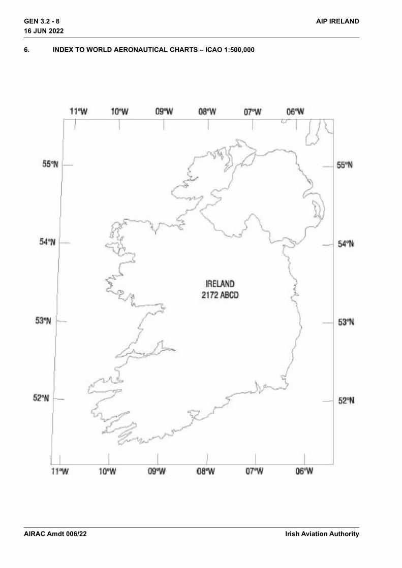
6. INDEX TO WORLD AERONAUTICAL CHARTS – ICAO 1:500,000
Irish Aviation AuthorityAIRAC Amdt 006/22

GEN 3.2 - 9AIP IRELAND16 JUN 2022
16 JUN 2022
7. TOPOGRAPHICAL CHARTSRefer to GEN 3.2.3
8. CORRECTIONS TO CHARTS NOT CONTAINED IN THE AIP
Chart Location CorrectionNIL NIL NIL
Irish Aviation Authority AIRAC Amdt 006/22
THIS PAGE INTENTIONALLY LEFT BLANK
Irish Aviation Authority
GEN 3.2 - 10 AIP IRELAND16 JUN 2022
16 JUN 2022
AIRAC Amdt 006/22
EIDW AD 2 - 1AIP IRELAND
16 JUN 2022
16 JUN 2022
EIDW AD 2.1 AERODROME LOCATION INDICATOR AND NAME
EIDW – DUBLIN/International
EIDW AD 2.2 AERODROME GEOGRAPHICAL AND ADMINISTRATIVE DATA
EIDW AD 2.3 OPERATIONAL HOURS
1 ARP and its site 532517N 0061612W Midpoint RWY 10R/28L
2 Direction and distance from (city) 10 KM (5.3 NM) N of Dublin
3 AD Elevation, Reference Temperature & Mean Low Temperature
242 ft AMSL / 19.7°C (Max Temp) 0.1°C (MNM Temp)
4 Geoid undulation at AD ELEV PSN 184 ft
5 MAG VAR/Annual change 2° W (2020) / 11’ decreasing
6 AD Operator, address, telephone, telefax, email, AFS, Website
Post: daa plc. Dublin Airport Co Dublin
Phone:+ 353 1 944 1111
Fax: + 353 1 944 4715, AVBL H24
SITA: DUBRN7X, Airport Administration
AFS: EIDWYDYX
7 Types of traffic permitted (IFR/VFR) IFR/VFR
8 Contact Details Post: Resource Allocation Unit (for stand allocation)
Phone: +353 1 944 5228
Email: [email protected]
Post: Airside Operations and Safety Officers (AOSO)
Phone: + 353 87 2892277
Email: [email protected]
Post: Airport Duty Manager
Phone: + 353 87 2892222
Email: [email protected]
9 Remarks Nil
1 AD Operator H24
2 Customs and immigration Customs/Irish Immigration: H24
Department of Agriculture, Food and the Marine: H24
US Customs and Border Protection: By prior negotiation with Dublin US Embassy, USCBP 0700 - 1700
Irish Aviation Authority AIRAC Amdt 006/22

EIDW AD 2 - 2 AIP IRELAND16 JUN 2022
16 JUN 2022
EIDW AD 2.4 HANDLING SERVICES AND FACILITIES
3 Health and sanitation H24
4 AIS Briefing Office See Remarks
5 ATS Reporting Office (ARO) H24
6 MET Briefing Office H24
7 ATS H24
8 Fuelling H24
9 Handling H24
10 Security H24
11 De-icing H24
12 Remarks Airport closed on 25th December. Exact hours advised by NOTAM.
PIB AVBL from AIS, Shannon see GEN 3.1.5
1 Cargo handling facilities: Available from IAG Cargo, Swissport Cargo and WFS
2 Fuel/oil types JET A1Fuel
Oil Grades 100, 100W, 100U, 100E, 120, W80, E80.
Turbo Oils 750, 390, 2380
3 Fuelling facilities/capacity JET A1 H24 No limitations. Hydrant fuelling available on Pier 4 stands Fuelling by bowser available on all other stands
4 De-icing facilities On request from Signature and Swissport.
5 Hangar space available for visiting aircraft On request from Dublin Aerospace and Aer Lingus.
6 Repair facilities for visiting aircraft Repair facilities from Dublin Aerospace.
7 Remarks Passenger Handling: Available from Swissport, Sky Handling, Signature Flight Support (Corporate), Universal Aviation (Corporate).
Catering: Available from Gate Gourmet and Dnata Catering
General Aviation Handling: Signature Flight Support, Universal Aviation, (Other ground handlers listed above on request)
Fixed ground power: Pier 1: Stands 121 to 127 inclusive, Stands 108L to 111R inclusive Pier 3: Stands 311C/311R, 312, 313C, 314, 315C, 316, 317, 318L, 318C and 318R Pier 4: Stands 400L to 409R inclusive
Aircraft Power Plant Test Runs: See EIDW AD 2.20
Irish Aviation AuthorityAIRAC Amdt 006/22

EIDW AD 2 - 3AIP IRELAND
16 JUN 2022
16 JUN 2022
EIDW AD 2.5 PASSENGER FACILITIES
EIDW AD 2.6 RESCUE AND FIRE FIGHTING SERVICES
1 Hotel(s) at or in the vicinity of AD Hotels At Airport and in Dublin area. See www.booking.com Link in doc
2 Restaurant(s) at or in the vicinity of AD See www.dublinairport.com
3 Transportation possibilities Buses, taxis, car hire AVBL at Airport
4 Medical facilities First aid treatment, All Airport Police are trained Emergency first Responders (ERFs), Rescue and Fire Fighting Services Personnel (RFFS) Paramedics with 1 domestic ambulance. Hospitals in Dublin, 8km.
5 Bank and Post Office at or in the vicinity of AD ATM and Bureau De Change available at Airport
No Post Office at Airport
6 Tourist Office At Airport
7 Remarks Short term Car Parking - 3750 spaces
Long term Car Parking - 18600 spaces
Executive lounges - See www.dublinairport.com
1 AD category for fire fighting Required CAT 9
Available CAT 9
2 Rescue equipment Emergency lighting and other equipment adequate to meet Category 9 requirements
3 Capability for removal of disabled aircraft Aircraft Recovery Coordinator Mr Odhran McCann - Airfield Delivery Manager
Phone:+353 (0)87 203 5950
Capability Up to Code C aircraft (nosewheel recovery up to Code E) Details available from Coordinator (Utilising equipment available at Dublin Airport)
4 Remarks Communication with Rescue and Fire Fighting Service: Frequency 121.600 MHz AVBL for direct communication between ACFT and Rescue and Fire Fighting Service. 121.600 MHz should be requested initially via ATC. Call sign for the Rescue and Fire Fighting Service is ‘Dublin Fire’. It is mandatory for both ACFT and Rescue and Fire Fighting Service to maintain contact with ATC at all times.
ATC do not have access to 121.600 MHz.
Frequency 121.600 MHz is H24 and AVBL within 10 NM radius of Dublin Airport
Irish Aviation Authority AIRAC Amdt 006/22

EIDW AD 2 - 4 AIP IRELAND16 JUN 2022
16 JUN 2022
EIDW AD 2.7 SEASONAL AVAILABILITY - CLEARINGRUNWAY SURFACE CONDITION ASSESSMENT AND REPORTING AND SNOW PLAN
EIDW AD 2.8 APRONS, TAXIWAYS AND CHECK LOCATION DATA
1 Type(s) of clearing equipment Snow clearing and anti-icing equipment including: Sweeper-blowers Tractors equipped with ploughs or brushes Sprayers of de-icing fluid Snow blowers Ramp ploughs/brushes Motorised brushes
2 Clearance priorities 1. Duty runway and associated taxiways, aircraft stands, together with apron areas
2. Other areas3 Use of material for movement area surface
treatmentDe/anti-icing of aircraft movement areas carried out as required using potassium acetate fluids (KAC) and potassium formate (KFOR)
4 Specially prepared winter runways Nil5 Remarks Annual snow plan available from the Aerodrome Operator on
request. See also AD 1.2.
1 Apron surface and strength Surface: CONC Strength: PCN 70/R/C/W/U
2 Taxiway width, surface and strength TAXIWAY WIDTH SURFACE STRENGTH
A 23 M ASPH PCN 97/R/C/W/T
B1 24 M CONC PCN 108/R/B/W/T
B2 24 M CONC PCN 97/R/B/W/T
C 23 M CONC PCN 107/R/C/W/T
DN 15 M CONC PCN 107/R/C/W/T
DS 15 M CONC PCN 107/R/C/W/T
E1 23 M CONC/ASPH PCN 120/F/B/W/T
F-Inner 15 M CONC PCN 100/R/B/W/T
F-Outer 23 M CONC PCN 109/R/B/W/T
F1 25 M CONC/ASPH PCN 88/R/C/W/T
F2 23 M CONC PCN 98/R/B/W/T
F3 23 M CONC PCN 98/R/B/W/T
H1 23 M CONC/ASPH PCN 84/R/B/W/T
K 23 M CONC PCN 114/R/C/W/T
M1 25 M CONC/ASPH PCN 120/R/A/W/T
Irish Aviation AuthorityAIRAC Amdt 006/22

EIDW AD 2 - 5AIP IRELAND
16 JUN 2022
16 JUN 2022
N 23 M CONC PCN 114/R/C/W/T
N4 23 M CONC/ASPH PCN 98/F/C/W/T
P1 23 M CONC/ASPH PCN 68/R/B/W/T
S 23 M CONC/ASPH PCN 95/R/B/W/T
S1 23 M CONC PCN 60/R/B/W/T
S2 23 M ASPH PCN 70/R/C/W/U
S3 23 M ASPH PCN 48/R/B/W/T
S4 23 M CONC PCN 60/R/B/W/T
S5 30 M CONC PCN 55/R/B/W/T
S6 23 M CONC PCN 59/R/B/W/T
S7 23 M ASPH PCN 95/R/B/W/T
W1 25 M ASPH PCN 120/R/A/W/T
W2 23 M ASPH PCN 120/F/A/W/T
W3 23 M CONC PCN 73/R/A/W/T
W4 15 M ASPH PCN 52/R/B/W/T
Z 23 M ASPH PCN 114/R/C/W/T
LINK 1 33 M CONC PCN 110/R/C/W/T
LINK 2 65 M CONC/ASPH PCN 70/R/C/W/U
LINK 3 42 M CONC PCN 79/R/B/W/T
LINK 4 73 M CONC PCN 84/R/A/W/T
LINK 5 23 M CONC/ASPH PCN 108/R/B/W/T
LINK 6 23 M CONC PCN 109/R/C/W/T
LINK 7 23 M CONC PCN 114/R/C/W/T
AT 1 47 M CONC PCN 70/R/C/W/U
AT 2 47 M CONC PCN 70/R/C/W/U
AT 3 61 M CONC PCN 70/R/C/W/U
AT 4 59 M CONC PCN 70/R/C/W/U
AT 5 81 M CONC/ASPH PCN 70/R/C/W/U
AT 6 58 M CONC PCN 70/R/C/W/U
West Apron
86 M CONC PCN 70/R/C/W/U
North Apron
48 M CONC PCN 70/R/C/W/U
South Apron
30 M CONC PCN 70/R/C/W/U
Irish Aviation Authority AIRAC Amdt 006/22

EIDW AD 2 - 6 AIP IRELAND16 JUN 2022
16 JUN 2022
EIDW AD 2.9 SURFACE MOVEMENT GUIDANCE AND CONTROL SYSTEM AND MARKINGS
3 Altimeter checkpoint location and elevation Location: South Apron / Elevation: 201ft AMSL
4 VOR checkpoint Nil
5 INS checkpoint EIDW AD 2.24-2
6 Remarks Nil
1 Use of aircraft stand ID signs, TWY guide lines and visual docking/parking guidance system of aircraft stands
Taxiing guidance signs at all intersections and at holding points. Mandatory signs lighted. Guidelines on aprons and taxiways. Taxiway information markings. AVDGS is installed on majority of stands. Where AVDGS is available and operational, it is mandatory for it to be used. On stands where AVDGS is not available or not operational Marshallers must be provided. No aircraft should enter a stand without guidance. If AVDGS is not operational on the stands listed below, the aircraft listed cannot taxi onto stand due to reduced clearances. Aircraft will be allocated an alternative stand or must shut down engines and tow on. Stand Restrictions: Stand 313C - B777-300. Stand 314 - B787-900, A330-200 and A330-300. Stand 316 - All A/C types. Stand 409C - All A/C types.
2 RWY/TWY markings and LGT RWY 10R/28L Designation, THR, TDZ, centreline, side stripe, aiming point. Rapid exit taxiway indicator markings for TWY S5 located on RWY 28L.
RWY 16/34 Designation, THR, TDZ, centreline, side stripe, aiming point. RWY 16/34 - for the purpose of Taxiing Intermediate holding positions.
Taxiways Centreline, edge stripes, holding positions, intersection markings except TWY S1.
3 Stop bars Switchable Stop bars at CAT II Hold on TWY E1, S7. Switchable Stop bars at CAT I Hold on TWY A, B2, E1, H1, M1, N, N4, P1, S, S1, S2, S3, S4, S5, S6, S7, W1, W2, W3, W4, RWY 34 and RWY 28L (Switchable Stop bars).
Fixed Stop bars on TWY A, S1,S2,S3,S4,S5,S6, RWY 34, H1.
Runway Guard lights on TWY A, B2, E1, H1, M1, P1, S, S1, S2, S3, S4, S5, S6, S7, W1, W3, W4.
Intermediate holding position lights on TWY H1, M1, W2, Link 1, Link 2, Link 3, Apron Taxiway 6 and RWY 16/34 at 16-1 and 34-2, 16-2.
4 Other RWY Protection measures -
Irish Aviation AuthorityAIRAC Amdt 006/22
EIDW AD 2 - 7AIP IRELAND
16 JUN 2022
16 JUN 2022
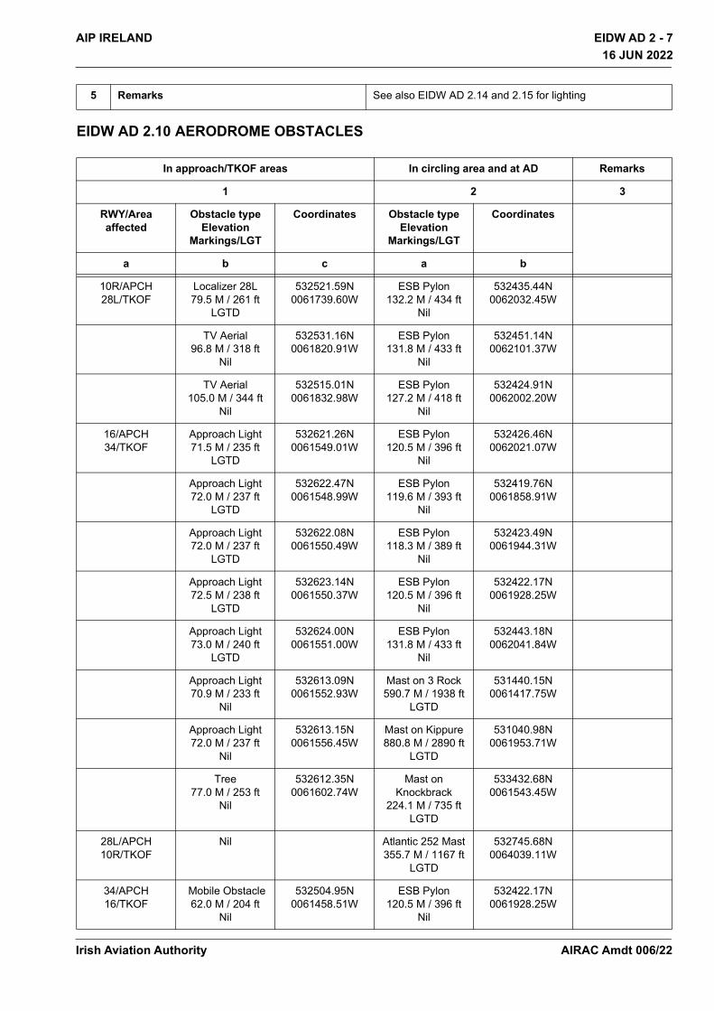
EIDW AD 2.10 AERODROME OBSTACLES
5 Remarks See also EIDW AD 2.14 and 2.15 for lighting
In approach/TKOF areas In circling area and at AD Remarks
1 2 3
RWY/Area affected
Obstacle type Elevation
Markings/LGT
Coordinates Obstacle type Elevation
Markings/LGT
Coordinates
a b c a b
10R/APCH28L/TKOF
Localizer 28L79.5 M / 261 ft
LGTD
532521.59N0061739.60W
ESB Pylon132.2 M / 434 ft
Nil
532435.44N0062032.45W
TV Aerial96.8 M / 318 ft
Nil
532531.16N0061820.91W
ESB Pylon131.8 M / 433 ft
Nil
532451.14N0062101.37W
TV Aerial105.0 M / 344 ft
Nil
532515.01N0061832.98W
ESB Pylon127.2 M / 418 ft
Nil
532424.91N0062002.20W
16/APCH34/TKOF
Approach Light71.5 M / 235 ft
LGTD
532621.26N0061549.01W
ESB Pylon120.5 M / 396 ft
Nil
532426.46N0062021.07W
Approach Light72.0 M / 237 ft
LGTD
532622.47N0061548.99W
ESB Pylon119.6 M / 393 ft
Nil
532419.76N0061858.91W
Approach Light72.0 M / 237 ft
LGTD
532622.08N0061550.49W
ESB Pylon118.3 M / 389 ft
Nil
532423.49N0061944.31W
Approach Light72.5 M / 238 ft
LGTD
532623.14N0061550.37W
ESB Pylon120.5 M / 396 ft
Nil
532422.17N0061928.25W
Approach Light73.0 M / 240 ft
LGTD
532624.00N0061551.00W
ESB Pylon131.8 M / 433 ft
Nil
532443.18N0062041.84W
Approach Light70.9 M / 233 ft
Nil
532613.09N0061552.93W
Mast on 3 Rock590.7 M / 1938 ft
LGTD
531440.15N0061417.75W
Approach Light72.0 M / 237 ft
Nil
532613.15N0061556.45W
Mast on Kippure880.8 M / 2890 ft
LGTD
531040.98N0061953.71W
Tree77.0 M / 253 ft
Nil
532612.35N0061602.74W
Mast on Knockbrack
224.1 M / 735 ftLGTD
533432.68N0061543.45W
28L/APCH10R/TKOF
Nil Atlantic 252 Mast355.7 M / 1167 ft
LGTD
532745.68N0064039.11W
34/APCH16/TKOF
Mobile Obstacle62.0 M / 204 ft
Nil
532504.95N0061458.51W
ESB Pylon120.5 M / 396 ft
Nil
532422.17N0061928.25W
Irish Aviation Authority AIRAC Amdt 006/22
EIDW AD 2 - 8 AIP IRELAND16 JUN 2022
16 JUN 2022
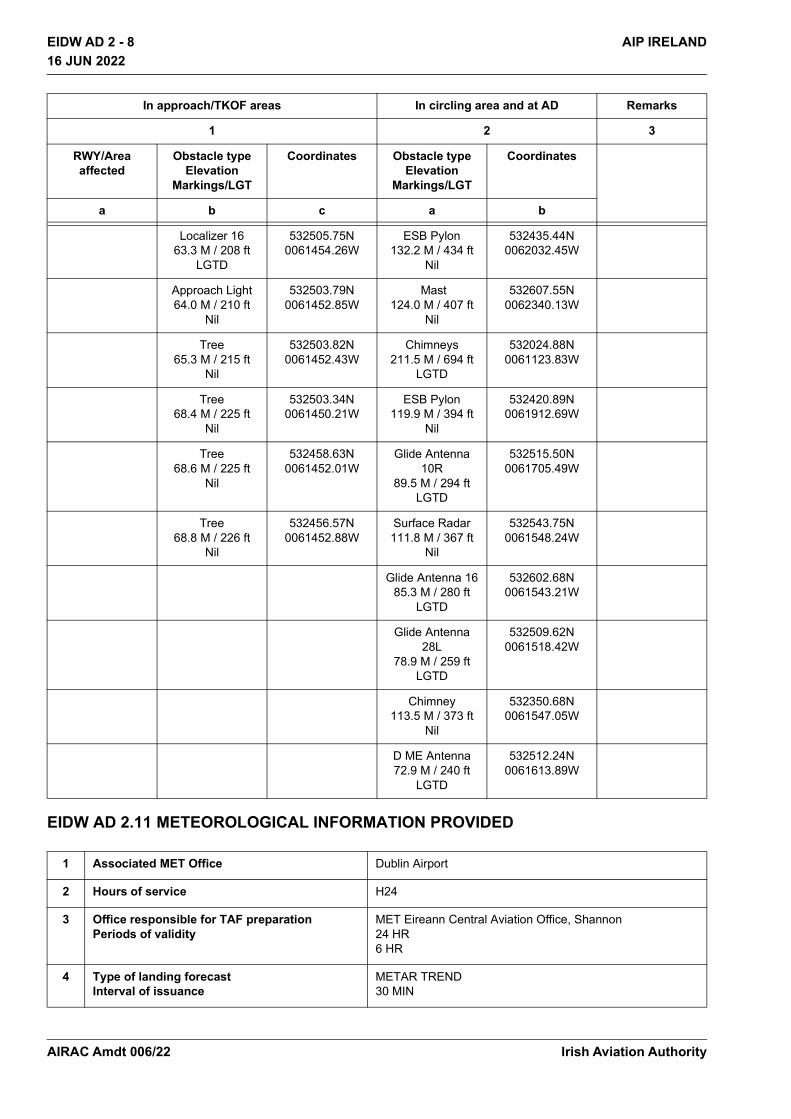
EIDW AD 2.11 METEOROLOGICAL INFORMATION PROVIDED
Localizer 1663.3 M / 208 ft
LGTD
532505.75N0061454.26W
ESB Pylon132.2 M / 434 ft
Nil
532435.44N0062032.45W
Approach Light64.0 M / 210 ft
Nil
532503.79N0061452.85W
Mast124.0 M / 407 ft
Nil
532607.55N0062340.13W
Tree65.3 M / 215 ft
Nil
532503.82N0061452.43W
Chimneys211.5 M / 694 ft
LGTD
532024.88N0061123.83W
Tree68.4 M / 225 ft
Nil
532503.34N0061450.21W
ESB Pylon119.9 M / 394 ft
Nil
532420.89N0061912.69W
Tree68.6 M / 225 ft
Nil
532458.63N0061452.01W
Glide Antenna 10R
89.5 M / 294 ftLGTD
532515.50N0061705.49W
Tree68.8 M / 226 ft
Nil
532456.57N0061452.88W
Surface Radar111.8 M / 367 ft
Nil
532543.75N0061548.24W
Glide Antenna 1685.3 M / 280 ft
LGTD
532602.68N0061543.21W
Glide Antenna 28L
78.9 M / 259 ftLGTD
532509.62N0061518.42W
Chimney113.5 M / 373 ft
Nil
532350.68N0061547.05W
D ME Antenna72.9 M / 240 ft
LGTD
532512.24N0061613.89W
1 Associated MET Office Dublin Airport
2 Hours of service H24
3 Office responsible for TAF preparation Periods of validity
MET Eireann Central Aviation Office, Shannon 24 HR 6 HR
4 Type of landing forecast Interval of issuance
METAR TREND 30 MIN
In approach/TKOF areas In circling area and at AD Remarks
1 2 3
RWY/Area affected
Obstacle type Elevation
Markings/LGT
Coordinates Obstacle type Elevation
Markings/LGT
Coordinates
a b c a b
Irish Aviation AuthorityAIRAC Amdt 006/22

EIDW AD 2 - 9AIP IRELAND
16 JUN 2022
16 JUN 2022
EIDW AD 2.12 RUNWAY PHYSICAL CHARACTERISTICS
5 Briefing/consultation provided Computer-based self-briefing facility Personal briefing by telephone from Central Aviation Office, Shannon
6 Flight documentation Language(s) used
Charts and tabular English
7 Charts and other information available for briefing or consultation
6-hourly synoptic chart, 6-hourly prognostic chart (surface), prognostic chart of significant weather, prognostic chart of wind/temperature at upper levels, prognostic chart of tropopause levels
8 Supplementary equipment available for providing information
Weather RADAR, satellite cloud picture receiver, IRVR RWYs 10R and 28L (touchdown, midpoint, stopend) IRVR RWY 16 (touchdown, midpoint) Satellite Display available.
9 ATS units provided with information Dublin TWR
10 Additional information (limitation of service, etc.)
GEN 3.5.4.2 to request additional information.
Designations RWY NR
TRUE BRG Dimensions of RWY
Strength (PCN) and surface of RWY and SWY
THR coordinatesRWY end
coordinatesTHR Geoid undulation
THR elevation and highest elevation
of TDZ of precision APP
RWY1 2 3 4 5 6
10R 095.24° 2637 M x45 M 92/R/B/W/TASPHASPH
532520.75N 0061724.27W532512.94N
0061502.08W 184 ft
THR 242ft
28L 275.27° 2637 M x45 M 92/R/B/W/TASPHASPH
532512.94N 0061502.08W532520.75N
0061724.27W184 ft
THR 202ft
16 156.58° 2072 M x45 M 84/R/B/W/TASPH
-
532613.16N 0061543.12W532511.66N
0061458.54W184 ft
THR 217ft
34 336.59° 2072 M x45 M 84/R/B/W/TASPH
-
532511.66N 0061458.54W532613.16N
0061543.12W184 ft
THR 202ft
Irish Aviation Authority AIRAC Amdt 006/22
EIDW AD 2 - 10 AIP IRELAND16 JUN 2022
16 JUN 2022
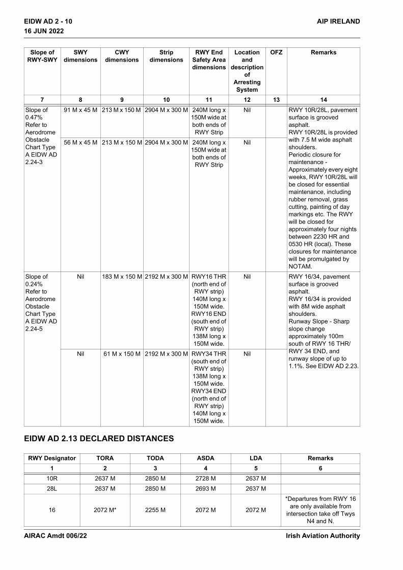
EIDW AD 2.13 DECLARED DISTANCES
Slope of RWY-SWY
SWY dimensions
CWY dimensions
Strip dimensions
RWY End Safety Area dimensions
Location and
description of
Arresting System
OFZ Remarks
7 8 9 10 11 12 13 14Slope of 0.47% Refer to Aerodrome Obstacle Chart Type A EIDW AD 2.24-3
91 M x 45 M 213 M x 150 M 2904 M x 300 M 240M long x 150M wide at both ends of RWY Strip
Nil RWY 10R/28L, pavement surface is grooved asphalt. RWY 10R/28L is provided with 7.5 M wide asphalt shoulders. Periodic closure for maintenance - Approximately every eight weeks, RWY 10R/28L will be closed for essential maintenance, including rubber removal, grass cutting, painting of day markings etc. The RWY will be closed for approximately four nights between 2230 HR and 0530 HR (local). These closures for maintenance will be promulgated by NOTAM.
56 M x 45 M 213 M x 150 M 2904 M x 300 M 240M long x 150M wide at both ends of RWY Strip
Nil
Slope of 0.24% Refer to Aerodrome Obstacle Chart Type A EIDW AD 2.24-5
Nil 183 M x 150 M 2192 M x 300 M RWY16 THR (north end of RWY strip)
140M long x 150M wide.
RWY16 END (south end of RWY strip)
138M long x 150M wide.
Nil RWY 16/34, pavement surface is grooved asphalt. RWY 16/34 is provided with 8M wide asphalt shoulders. Runway Slope - Sharp slope change approximately 100m south of RWY 16 THR/RWY 34 END, and runway slope of up to 1.1%. See EIDW AD 2.23.
Nil 61 M x 150 M 2192 M x 300 M RWY34 THR (south end of RWY strip)
138M long x 150M wide.
RWY34 END (north end of RWY strip)
140M long x 150M wide.
Nil
RWY Designator TORA TODA ASDA LDA Remarks1 2 3 4 5 6
10R 2637 M 2850 M 2728 M 2637 M 28L 2637 M 2850 M 2693 M 2637 M
16 2072 M* 2255 M 2072 M 2072 M
*Departures from RWY 16 are only available from
intersection take off Twys N4 and N.
Irish Aviation AuthorityAIRAC Amdt 006/22

EIDW AD 2 - 11AIP IRELAND
16 JUN 2022
16 JUN 2022
EIDW AD 2.14 APPROACH AND RUNWAY LIGHTING
34 2072 M 2133 M 2072 M 2072 M
INTERSECTION TAKE-OFFRWY Designator TWY TORA TODA ASDA Remarks
10R S6 2156 M 2369 M 2247 M
see EIDW AD 2.20
10R S4 1352 M 1565 M 1443 M28L S1 2415 M 2628 M 2471 M16 N4 2026 M 2209 M 2026 M16 N 1653 M 1836 M 1653 M34 A 1815 M 1876 M 1815 M34 B2 1815 M 1876 M 1815 M34 S1 1815 M 1876 M 1815 M
RW
YD
esig
nato
r APCH LGTtype
LEN INTST
THR LGTcolourWBAR
VASIS(MEHT)
PAPI
TDZLength
RWY Centre Line LGT Length, spacing,
colour, INTST
RWY edge LGT LEN, spacing, colour, INTST
RWY End LGT
colour WBAR
SWY LGT LEN
(M) colour
Remarks
1 2 3 4 5 6 7 8 9 1010R CAT II/III
900M LIH
Green LIH Green LIH
PAPI Both sides/3° MEHT 20M (439M)
900M 30M LIH
2637M 15M coded 0-1737M White, 1737M-2337M Red/White, 2337M-2637M Red LIH
2637M 60M nom White (last 600M Yellow) LIH
Red LIH -
Red LIH
Nil
28L CAT II/III 900M LIH
Green LIH Green LIH
PAPI Both sides/3° MEHT 21M (374M)
900M 30M LIH
2637M 15M coded 0-1737M White, 1737M-2337M Red/White, 2337M-2637M Red LIH
2637M 60M nom White (last 600M Yellow) LIH
Red LIH -
Red LIH
RETILs (yellow) prior to exit to TWY S5
16 CAT I 910M LIH
Green LIH Green LIH
PAPI Both sides/3° MEHT 19M (380M)
Nil Nil 2073M 60M nom White (last 600M Yellow) LIH
Red LIH -
Nil Nil
RWY Designator TORA TODA ASDA LDA Remarks1 2 3 4 5 6
Irish Aviation Authority AIRAC Amdt 006/22

EIDW AD 2 - 12 AIP IRELAND16 JUN 2022
16 JUN 2022
EIDW AD 2.15 OTHER LIGHTING, SECONDARY POWER SUPPLY
EIDW AD 2.16 HELICOPTER LANDING AREA
NIL
34 SALS 426M LIL
GreenLIH
PAPI Both sides/3° MEHT 20M (380M)
Nil Nil 2073M 60M nom White (last 600M Yellow) LIH
Red LIH -
Nil For small aircraft (A & B) Runway 34 end lights may not be sighted until the last 400 metres.
1 ABN/IBN location, characteristics and hours of operation
Nil
2 LDI location and LGT Anemometer location and LGT
Nil 2 Nr.
3 TWY edge and centre line lighting Edge; blue all TWY except M1, S3, W2, W4.
Edge, blue, RWY 16/34 from TWY A to THR 34 and TWY N to THR 16.
Edge, blue, retroreflective markers TWY W4.
Centreline, green (green/yellow on exit TWYs) TWY B1, B2, E1, F1, F2, F3, H1, K, M1, N, S, S1, S2, S5, S7, W1, W2 Link 2, Link 3 and Link 4.
4 Secondary power supply/switch-over time Secondary power supply provided, switch-over time 15 SEC (1 SEC in Low Visibility Procedures). Electric battery lamps.
5 Remarks Apron - Floodlights
Apron edge - Blue, omni-directional
Apron centreline lighting - Green bi-directional on all apron taxiways and taxilanes except Apron TWY 6 and West Apron.
Obstacles: Fixed red.
WDIs 4 Nr. (2 lighted). See Aerodrome Chart EIDW AD 2.24-1
RW
YD
esig
nato
r APCH LGTtype
LEN INTST
THR LGTcolourWBAR
VASIS(MEHT)
PAPI
TDZLength
RWY Centre Line LGT Length, spacing,
colour, INTST
RWY edge LGT LEN, spacing, colour, INTST
RWY End LGT
colour WBAR
SWY LGT LEN
(M) colour
Remarks
1 2 3 4 5 6 7 8 9 10
Irish Aviation AuthorityAIRAC Amdt 006/22
EIDW AD 2 - 13AIP IRELAND
16 JUN 2022
16 JUN 2022
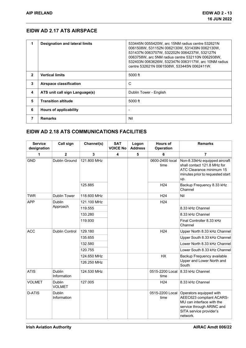
EIDW AD 2.17 ATS AIRSPACE
EIDW AD 2.18 ATS COMMUNICATIONS FACILITIES
1 Designation and lateral limits 533445N 0055420W, arc 15NM radius centre 532621N 0061508W, 531152N 0062130W, 531439N 0062130W, 531437N 0063707W, 532202N 0064237W, 532127N 0063758W, arc 5NM radius centre 532110N 0062938W, 532403N 0063626W, 532347N 0063117W, arc 10NM radius centre 532621N 0061508W, 533445N 0062411W.
2 Vertical limits 5000 ft
3 Airspace classification C
4 ATS unit call sign Language(s) Dublin Tower - English
5 Transition altitude 5000 ft
6 Hours of applicability -
7 Remarks Nil
Service designation
Call sign Channel(s) SAT VOICE No
Logon Address
Hours of Operation
Remarks
1 2 3 4 5 6 7GND Dublin Ground 121.800 MHz 0600-2400 local
timeNon-8.33kHz equipped aircraft shall contact 121.8 MHz for ATC Clearance minimum 15 minutes prior to requested start up.
125.885 H24 Backup Frequency 8.33 kHz Channel
TWR Dublin Tower 118.600 MHz H24 NilAPP Dublin
Approach121.100 MHz H24119.555 8.33 kHz Channel133.280 8.33 kHz Channel119.930 Final Controller 8.33 kHz
ChannelACC Dublin Control 129.180 H24 Upper North 8.33 kHz Channel
135.655 Upper South 8.33 kHz Channel132.580 Lower North 8.33 kHz Channel120.755 Lower South 8.33 kHz Channel124.650 MHz HX Backup Frequency available
Upper and Lower North and South
126.250 MHz
ATIS Dublin Information
124.530 MHz 0515-2200 Local time
8.33 kHz Channel
VOLMET Dublin VOLMET
127.005 H24 8.33 kHz Channel
D-ATIS Dublin Information
0515-2200 Local time
Operators equipped with AEEC623 compliant ACARS-MU can interface with the service through ARINC and SITA service provider’s network.
Irish Aviation Authority AIRAC Amdt 006/22
EIDW AD 2 - 14 AIP IRELAND16 JUN 2022
16 JUN 2022
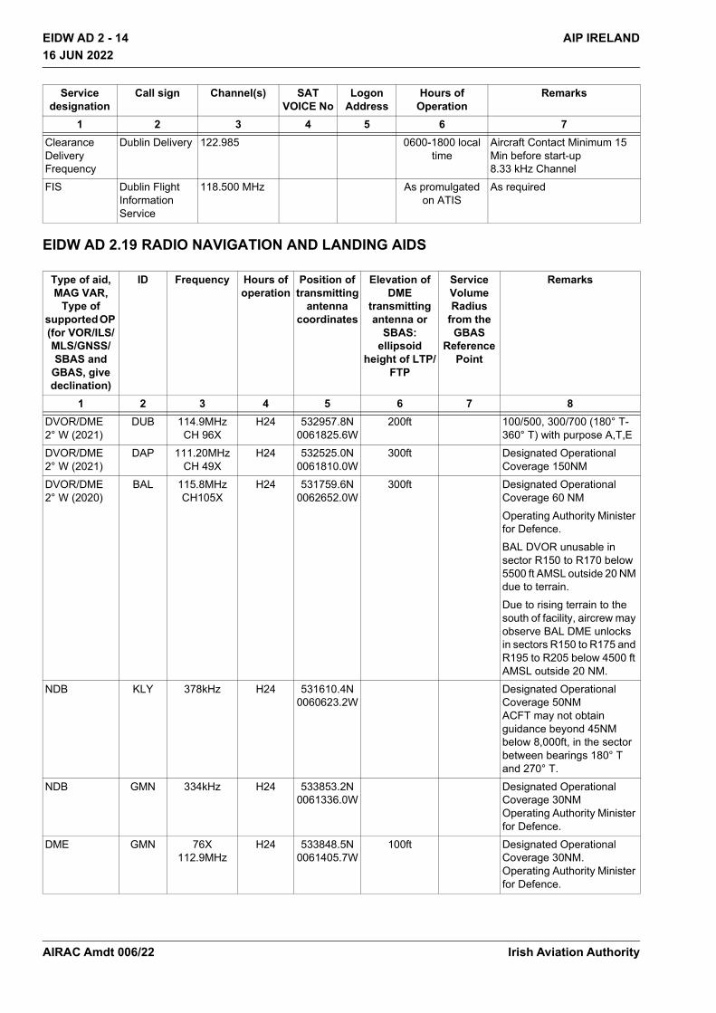
EIDW AD 2.19 RADIO NAVIGATION AND LANDING AIDS
Clearance Delivery Frequency
Dublin Delivery 122.985 0600-1800 local time
Aircraft Contact Minimum 15 Min before start-up 8.33 kHz Channel
FIS Dublin Flight Information Service
118.500 MHz As promulgated on ATIS
As required
Type of aid,MAG VAR,
Type of supported OP (for VOR/ILS/MLS/GNSS/SBAS and
GBAS, give declination)
ID Frequency Hours of operation
Position of transmitting
antenna coordinates
Elevation of DME
transmitting antenna or
SBAS: ellipsoid
height of LTP/FTP
Service Volume Radius
from the GBAS
Reference Point
Remarks
1 2 3 4 5 6 7 8DVOR/DME 2° W (2021)
DUB 114.9MHzCH 96X
H24 532957.8N 0061825.6W
200ft 100/500, 300/700 (180° T-360° T) with purpose A,T,E
DVOR/DME 2° W (2021)
DAP 111.20MHzCH 49X
H24 532525.0N 0061810.0W
300ft Designated Operational Coverage 150NM
DVOR/DME 2° W (2020)
BAL 115.8MHzCH105X
H24 531759.6N 0062652.0W
300ft Designated Operational Coverage 60 NMOperating Authority Minister for Defence. BAL DVOR unusable in sector R150 to R170 below 5500 ft AMSL outside 20 NM due to terrain.Due to rising terrain to the south of facility, aircrew may observe BAL DME unlocks in sectors R150 to R175 and R195 to R205 below 4500 ft AMSL outside 20 NM.
NDB KLY 378kHz H24 531610.4N 0060623.2W
Designated Operational Coverage 50NM ACFT may not obtain guidance beyond 45NM below 8,000ft, in the sector between bearings 180° T and 270° T.
NDB GMN 334kHz H24 533853.2N 0061336.0W
Designated Operational Coverage 30NM Operating Authority Minister for Defence.
DME GMN 76X112.9MHz
H24 533848.5N 0061405.7W
100ft Designated Operational Coverage 30NM. Operating Authority Minister for Defence.
Service designation
Call sign Channel(s) SAT VOICE No
Logon Address
Hours of Operation
Remarks
1 2 3 4 5 6 7
Irish Aviation AuthorityAIRAC Amdt 006/22
EIDW AD 2 - 15AIP IRELAND
16 JUN 2022
16 JUN 2022
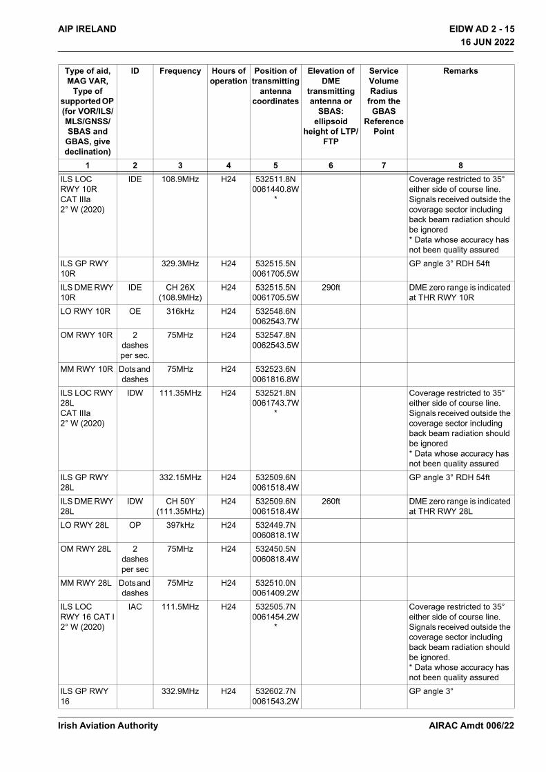
ILS LOC RWY 10R CAT IIIa 2° W (2020)
IDE 108.9MHz H24 532511.8N 0061440.8W
*
Coverage restricted to 35° either side of course line. Signals received outside the coverage sector including back beam radiation should be ignored * Data whose accuracy has not been quality assured
ILS GP RWY 10R
329.3MHz H24 532515.5N 0061705.5W
GP angle 3° RDH 54ft
ILS DME RWY 10R
IDE CH 26X (108.9MHz)
H24 532515.5N 0061705.5W
290ft DME zero range is indicated at THR RWY 10R
LO RWY 10R OE 316kHz H24 532548.6N 0062543.7W
OM RWY 10R 2 dashes per sec.
75MHz H24 532547.8N 0062543.5W
MM RWY 10R Dots and dashes
75MHz H24 532523.6N 0061816.8W
ILS LOC RWY 28L CAT IIIa 2° W (2020)
IDW 111.35MHz H24 532521.8N 0061743.7W
*
Coverage restricted to 35° either side of course line. Signals received outside the coverage sector including back beam radiation should be ignored * Data whose accuracy has not been quality assured
ILS GP RWY 28L
332.15MHz H24 532509.6N 0061518.4W
GP angle 3° RDH 54ft
ILS DME RWY 28L
IDW CH 50Y (111.35MHz)
H24 532509.6N 0061518.4W
260ft DME zero range is indicated at THR RWY 28L
LO RWY 28L OP 397kHz H24 532449.7N 0060818.1W
OM RWY 28L 2 dashes per sec
75MHz H24 532450.5N 0060818.4W
MM RWY 28L Dots and dashes
75MHz H24 532510.0N 0061409.2W
ILS LOC RWY 16 CAT I 2° W (2020)
IAC 111.5MHz H24 532505.7N 0061454.2W
*
Coverage restricted to 35° either side of course line. Signals received outside the coverage sector including back beam radiation should be ignored. * Data whose accuracy has not been quality assured
ILS GP RWY 16
332.9MHz H24 532602.7N 0061543.2W
GP angle 3°
Type of aid,MAG VAR,
Type of supported OP (for VOR/ILS/MLS/GNSS/SBAS and
GBAS, give declination)
ID Frequency Hours of operation
Position of transmitting
antenna coordinates
Elevation of DME
transmitting antenna or
SBAS: ellipsoid
height of LTP/FTP
Service Volume Radius
from the GBAS
Reference Point
Remarks
1 2 3 4 5 6 7 8
Irish Aviation Authority AIRAC Amdt 006/22
EIDW AD 2 - 16 AIP IRELAND16 JUN 2022
16 JUN 2022
EIDW AD 2.20 LOCAL TRAFFIC REGULATIONS
1. Ground Movement
1.1 General
i. Stop-bars are provided at all runway entry/exit points and are illuminated to protect active runways. When a runway is inactive the associated stop-bar is normally not illuminated. However, specific clearance from ATC must still be obtained before entering or crossing an inactive runway.
ii. Pilots should use the minimum power necessary while taxiing. In apron areas, pilots should operate at the minimum power commensurate with the intended manoeuvre, due to the effect of jet blast on personnel, equipment and buildings.
iii. Flight crew are responsible for wing tip clearance and are reminded of the importance of maintaining a careful lookout at all times, regardless of location and visibility conditions.
iv. ATC may require aircraft to manoeuvre in close proximity to other aircraft. Avoidance of other aircraft is the responsibility of the flight crew involved. If doubt exists as to whether an aircraft can be passed safely, the flight crew should stop, advise ATC, and request alternative instructions if available.
v. In order to assist in the maintenance of safe separation of aircraft, when flight crew are instructed to stop at any runway-holding or intermediate holding position they should position the aircraft as close as possible to the relevant pavement marking while ensuring that the marking remains visible from the cockpit.
1.2 Turning
No turns should be made at taxiway/taxiway intersections where taxi centreline markings are not provided.Particular attention is drawn to the following:
• No turns should be made by aircraft from TWY W1 to TWY S East of TWY W1 or vice versa
• No turns should be made by aircraft from TWY F1 to TWY B2 or vice versa
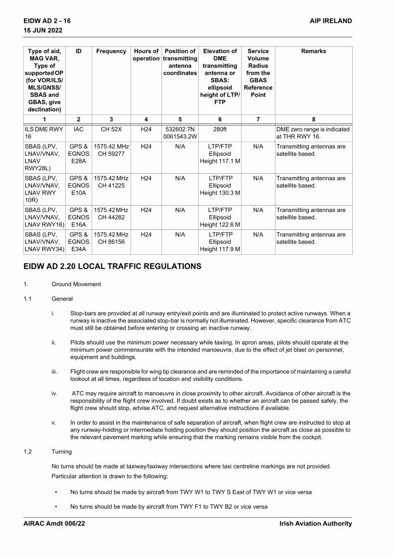
ILS DME RWY 16
IAC CH 52X H24 532602.7N 0061543.2W
280ft DME zero range is indicated at THR RWY 16.
SBAS (LPV, LNAV/VNAV, LNAV RWY28L)
GPS & EGNOS
E28A
1575.42 MHzCH 59277
H24 N/A LTP/FTP Ellipsoid
Height 117.1 M
N/A Transmitting antennas are satellite based.
SBAS (LPV, LNAV/VNAV, LNAV RWY 10R)
GPS & EGNOS
E10A
1575.42 MHz CH 41225
H24 N/A LTP/FTP Ellipsoid
Height 130.3 M
N/A Transmitting antennas are satellite based.
SBAS (LPV, LNAV/VNAV, LNAV RWY16)
GPS & EGNOS
E16A
1575.42 MHz CH 44282
H24 N/A LTP/FTP Ellipsoid
Height 122.6 M
N/A Transmitting antennas are satellite based.
SBAS (LPV, LNAV/VNAV, LNAV RWY34)
GPS & EGNOS
E34A
1575.42 MHz CH 86156
H24 N/A LTP/FTP Ellipsoid
Height 117.9 M
N/A Transmitting antennas are satellite based.
Type of aid,MAG VAR,
Type of supported OP (for VOR/ILS/MLS/GNSS/SBAS and
GBAS, give declination)
ID Frequency Hours of operation
Position of transmitting
antenna coordinates
Elevation of DME
transmitting antenna or
SBAS: ellipsoid
height of LTP/FTP
Service Volume Radius
from the GBAS
Reference Point
Remarks
1 2 3 4 5 6 7 8
Irish Aviation AuthorityAIRAC Amdt 006/22
EIDW AD 2 - 17AIP IRELAND
16 JUN 2022
16 JUN 2022
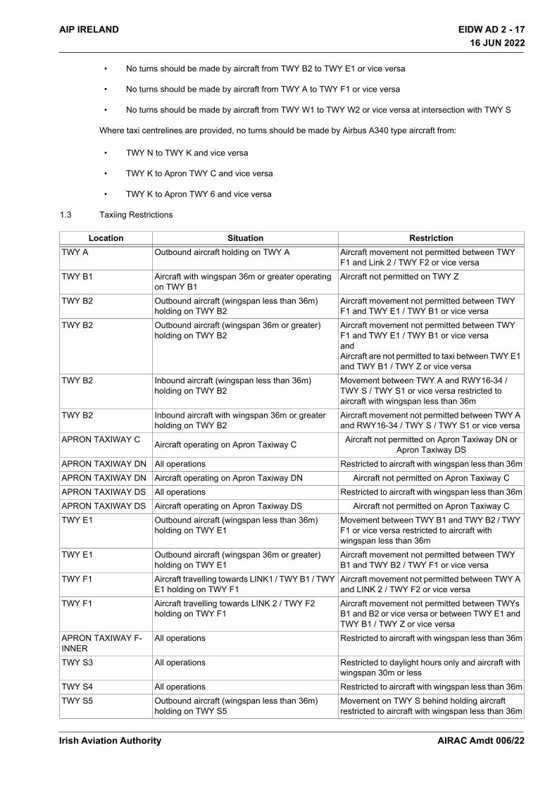
• No turns should be made by aircraft from TWY B2 to TWY E1 or vice versa
• No turns should be made by aircraft from TWY A to TWY F1 or vice versa
• No turns should be made by aircraft from TWY W1 to TWY W2 or vice versa at intersection with TWY S
Where taxi centrelines are provided, no turns should be made by Airbus A340 type aircraft from:
• TWY N to TWY K and vice versa
• TWY K to Apron TWY C and vice versa
• TWY K to Apron TWY 6 and vice versa
1.3 Taxiing Restrictions
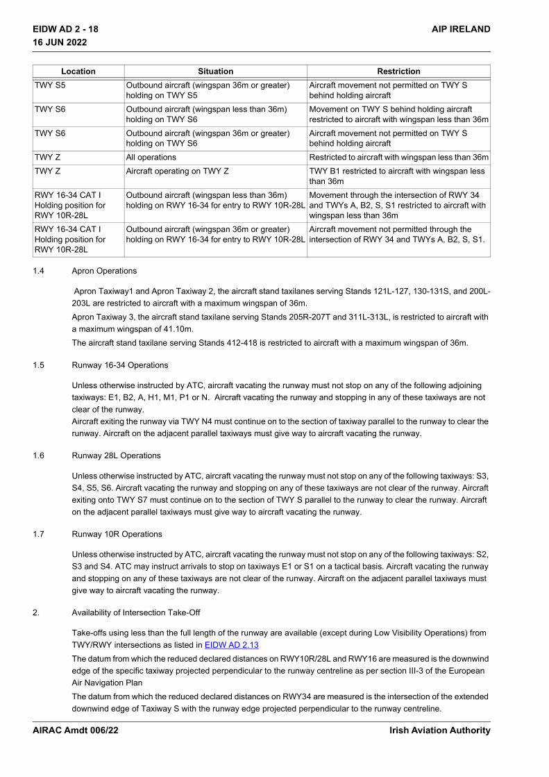
Location Situation RestrictionTWY A Outbound aircraft holding on TWY A Aircraft movement not permitted between TWY
F1 and Link 2 / TWY F2 or vice versaTWY B1 Aircraft with wingspan 36m or greater operating
on TWY B1Aircraft not permitted on TWY Z
TWY B2 Outbound aircraft (wingspan less than 36m) holding on TWY B2
Aircraft movement not permitted between TWY F1 and TWY E1 / TWY B1 or vice versa
TWY B2 Outbound aircraft (wingspan 36m or greater) holding on TWY B2
Aircraft movement not permitted between TWY F1 and TWY E1 / TWY B1 or vice versa and Aircraft are not permitted to taxi between TWY E1 and TWY B1 / TWY Z or vice versa
TWY B2 Inbound aircraft (wingspan less than 36m) holding on TWY B2
Movement between TWY A and RWY16-34 / TWY S / TWY S1 or vice versa restricted to aircraft with wingspan less than 36m
TWY B2 Inbound aircraft with wingspan 36m or greater holding on TWY B2
Aircraft movement not permitted between TWY A and RWY16-34 / TWY S / TWY S1 or vice versa
APRON TAXIWAY C Aircraft operating on Apron Taxiway C Aircraft not permitted on Apron Taxiway DN or Apron Taxiway DS
APRON TAXIWAY DN All operations Restricted to aircraft with wingspan less than 36mAPRON TAXIWAY DN Aircraft operating on Apron Taxiway DN Aircraft not permitted on Apron Taxiway CAPRON TAXIWAY DS All operations Restricted to aircraft with wingspan less than 36mAPRON TAXIWAY DS Aircraft operating on Apron Taxiway DS Aircraft not permitted on Apron Taxiway CTWY E1 Outbound aircraft (wingspan less than 36m)
holding on TWY E1Movement between TWY B1 and TWY B2 / TWY F1 or vice versa restricted to aircraft with wingspan less than 36m
TWY E1 Outbound aircraft (wingspan 36m or greater) holding on TWY E1
Aircraft movement not permitted between TWY B1 and TWY B2 / TWY F1 or vice versa
TWY F1 Aircraft travelling towards LINK1 / TWY B1 / TWY E1 holding on TWY F1
Aircraft movement not permitted between TWY A and LINK 2 / TWY F2 or vice versa
TWY F1 Aircraft travelling towards LINK 2 / TWY F2 holding on TWY F1
Aircraft movement not permitted between TWYs B1 and B2 or vice versa or between TWY E1 and TWY B1 / TWY Z or vice versa
APRON TAXIWAY F-INNER
All operations Restricted to aircraft with wingspan less than 36m
TWY S3 All operations Restricted to daylight hours only and aircraft with wingspan 30m or less
TWY S4 All operations Restricted to aircraft with wingspan less than 36mTWY S5 Outbound aircraft (wingspan less than 36m)
holding on TWY S5Movement on TWY S behind holding aircraft restricted to aircraft with wingspan less than 36m
Irish Aviation Authority AIRAC Amdt 006/22
EIDW AD 2 - 18 AIP IRELAND16 JUN 2022
16 JUN 2022
1.4 Apron Operations
Apron Taxiway1 and Apron Taxiway 2, the aircraft stand taxilanes serving Stands 121L-127, 130-131S, and 200L-203L are restricted to aircraft with a maximum wingspan of 36m.Apron Taxiway 3, the aircraft stand taxilane serving Stands 205R-207T and 311L-313L, is restricted to aircraft with a maximum wingspan of 41.10m.The aircraft stand taxilane serving Stands 412-418 is restricted to aircraft with a maximum wingspan of 36m.
1.5 Runway 16-34 Operations
Unless otherwise instructed by ATC, aircraft vacating the runway must not stop on any of the following adjoining taxiways: E1, B2, A, H1, M1, P1 or N. Aircraft vacating the runway and stopping in any of these taxiways are not clear of the runway. Aircraft exiting the runway via TWY N4 must continue on to the section of taxiway parallel to the runway to clear the runway. Aircraft on the adjacent parallel taxiways must give way to aircraft vacating the runway.
1.6 Runway 28L Operations
Unless otherwise instructed by ATC, aircraft vacating the runway must not stop on any of the following taxiways: S3, S4, S5, S6. Aircraft vacating the runway and stopping on any of these taxiways are not clear of the runway. Aircraft exiting onto TWY S7 must continue on to the section of TWY S parallel to the runway to clear the runway. Aircraft on the adjacent parallel taxiways must give way to aircraft vacating the runway.
1.7 Runway 10R Operations
Unless otherwise instructed by ATC, aircraft vacating the runway must not stop on any of the following taxiways: S2, S3 and S4. ATC may instruct arrivals to stop on taxiways E1 or S1 on a tactical basis. Aircraft vacating the runway and stopping on any of these taxiways are not clear of the runway. Aircraft on the adjacent parallel taxiways must give way to aircraft vacating the runway.
2. Availability of Intersection Take-Off
Take-offs using less than the full length of the runway are available (except during Low Visibility Operations) from TWY/RWY intersections as listed in EIDW AD 2.13 The datum from which the reduced declared distances on RWY10R/28L and RWY16 are measured is the downwind edge of the specific taxiway projected perpendicular to the runway centreline as per section III-3 of the European Air Navigation PlanThe datum from which the reduced declared distances on RWY34 are measured is the intersection of the extended downwind edge of Taxiway S with the runway edge projected perpendicular to the runway centreline.
TWY S5 Outbound aircraft (wingspan 36m or greater) holding on TWY S5
Aircraft movement not permitted on TWY S behind holding aircraft
TWY S6 Outbound aircraft (wingspan less than 36m) holding on TWY S6
Movement on TWY S behind holding aircraft restricted to aircraft with wingspan less than 36m
TWY S6 Outbound aircraft (wingspan 36m or greater) holding on TWY S6
Aircraft movement not permitted on TWY S behind holding aircraft
TWY Z All operations Restricted to aircraft with wingspan less than 36mTWY Z Aircraft operating on TWY Z TWY B1 restricted to aircraft with wingspan less
than 36mRWY 16-34 CAT I Holding position for RWY 10R-28L
Outbound aircraft (wingspan less than 36m) holding on RWY 16-34 for entry to RWY 10R-28L
Movement through the intersection of RWY 34 and TWYs A, B2, S, S1 restricted to aircraft with wingspan less than 36m
RWY 16-34 CAT I Holding position for RWY 10R-28L
Outbound aircraft (wingspan 36m or greater) holding on RWY 16-34 for entry to RWY 10R-28L
Aircraft movement not permitted through the intersection of RWY 34 and TWYs A, B2, S, S1.
Location Situation Restriction
Irish Aviation AuthorityAIRAC Amdt 006/22
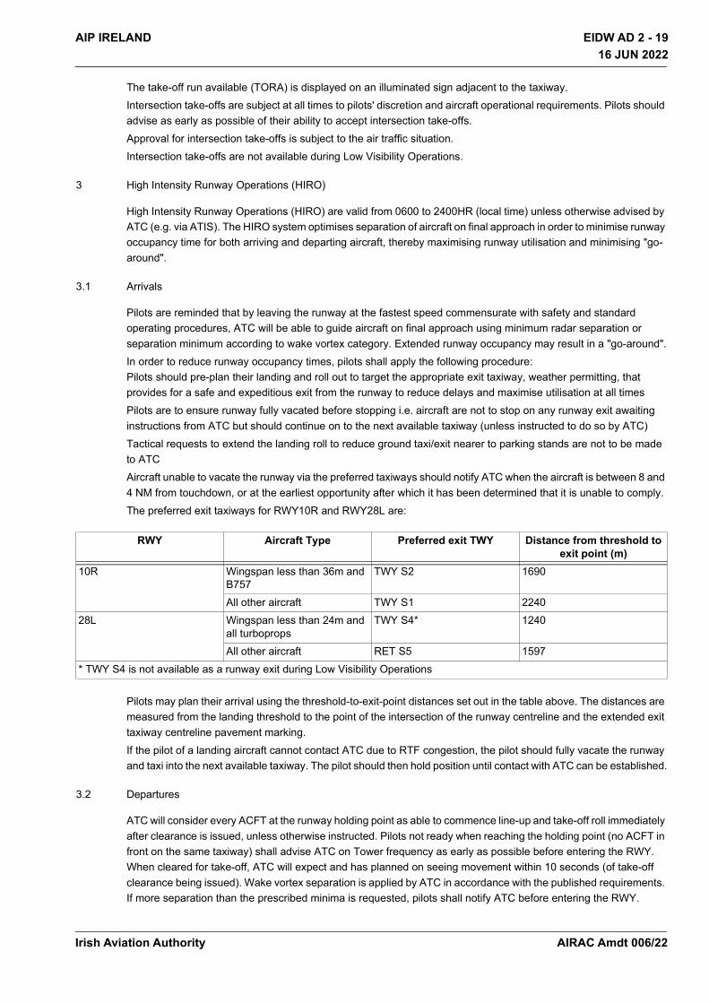
EIDW AD 2 - 19AIP IRELAND
16 JUN 2022
16 JUN 2022
The take-off run available (TORA) is displayed on an illuminated sign adjacent to the taxiway.Intersection take-offs are subject at all times to pilots' discretion and aircraft operational requirements. Pilots should advise as early as possible of their ability to accept intersection take-offs.Approval for intersection take-offs is subject to the air traffic situation.Intersection take-offs are not available during Low Visibility Operations.
3 High Intensity Runway Operations (HIRO)
High Intensity Runway Operations (HIRO) are valid from 0600 to 2400HR (local time) unless otherwise advised by ATC (e.g. via ATIS). The HIRO system optimises separation of aircraft on final approach in order to minimise runway occupancy time for both arriving and departing aircraft, thereby maximising runway utilisation and minimising "go-around".
3.1 Arrivals
Pilots are reminded that by leaving the runway at the fastest speed commensurate with safety and standard operating procedures, ATC will be able to guide aircraft on final approach using minimum radar separation or separation minimum according to wake vortex category. Extended runway occupancy may result in a "go-around".In order to reduce runway occupancy times, pilots shall apply the following procedure: Pilots should pre-plan their landing and roll out to target the appropriate exit taxiway, weather permitting, that provides for a safe and expeditious exit from the runway to reduce delays and maximise utilisation at all timesPilots are to ensure runway fully vacated before stopping i.e. aircraft are not to stop on any runway exit awaiting instructions from ATC but should continue on to the next available taxiway (unless instructed to do so by ATC)Tactical requests to extend the landing roll to reduce ground taxi/exit nearer to parking stands are not to be made to ATCAircraft unable to vacate the runway via the preferred taxiways should notify ATC when the aircraft is between 8 and 4 NM from touchdown, or at the earliest opportunity after which it has been determined that it is unable to comply.The preferred exit taxiways for RWY10R and RWY28L are:
Pilots may plan their arrival using the threshold-to-exit-point distances set out in the table above. The distances are measured from the landing threshold to the point of the intersection of the runway centreline and the extended exit taxiway centreline pavement marking. If the pilot of a landing aircraft cannot contact ATC due to RTF congestion, the pilot should fully vacate the runway and taxi into the next available taxiway. The pilot should then hold position until contact with ATC can be established.
3.2 Departures
ATC will consider every ACFT at the runway holding point as able to commence line-up and take-off roll immediately after clearance is issued, unless otherwise instructed. Pilots not ready when reaching the holding point (no ACFT in front on the same taxiway) shall advise ATC on Tower frequency as early as possible before entering the RWY. When cleared for take-off, ATC will expect and has planned on seeing movement within 10 seconds (of take-off clearance being issued). Wake vortex separation is applied by ATC in accordance with the published requirements. If more separation than the prescribed minima is requested, pilots shall notify ATC before entering the RWY.
RWY Aircraft Type Preferred exit TWY Distance from threshold to exit point (m)
10R Wingspan less than 36m and B757
TWY S2 1690
All other aircraft TWY S1 224028L Wingspan less than 24m and
all turbopropsTWY S4* 1240
All other aircraft RET S5 1597* TWY S4 is not available as a runway exit during Low Visibility Operations
Irish Aviation Authority AIRAC Amdt 006/22

EIDW AD 2 - 20 AIP IRELAND16 JUN 2022
16 JUN 2022
Where possible, cockpit checks and cabin readiness should be completed before line-up and any checks needing completion on the runway should be kept to the minimum required. Pilots should not back-track when entering the runway unless specifically requested at the runway holding position.Note: Pilots shall not cross the runway-holding position until the illuminated red stop bar has been extinguished. ATC do not issue conditional line-up clearances where stop bars are operational at line-up points.
3.3 Preferred Use of Intersection Take-Offs
Based on aircraft type and performance characteristics, ATC may issue instructions for aircraft to depart from runway intersections from which adequate take-off run is available. Intersection take-offs are subject at all times to pilots' discretion and aircraft operational requirements. Pilots unable to accept departure from an intersection point may request an alternate take-off position from ATC. Pilots requiring departure from the beginning of the runway should request it at the time of push-back/start-up, and such requests will be considered by ATC subject to delay.The preferred use of intersection take-offs for RJ85 type and all turboprops is set out in the table below.
3.4 Additional information on runway usage is available EIDW AD 2.21 NOISE ABATEMENT PROCEDURES Section 5
4. Mandatory ground handling of aircraft at Dublin Airport All aircraft must avail of ground handling. All aircraft of less than 2 tonnes maximum certified AUW must avail of minimum handling i.e. ramp transport to/from departures and the aircraft
5. Aircraft Engine Test Runs
Permission for all test runs must be obtained from the Aerodrome Operator.
Aircraft Type RWY Preferred TWY IntersectionRJ85 type and all turboprops 10R TWY S6*
28L TWY S1** Intersection take-offs are not available during Low Visibility Operations
LOCATION NOTES
ENGINE TEST SITE 1(Adjacent to TWY W1)
Up to full power engine runs. Available for aircraft up to Code C plus Boeing 757 (max wingspan 42M). Operational hours 0730 - 2000HR Local Time Monday to Friday 0900 - 2000 HR Local Time Saturday, Sunday and Bank Holidays Lighting and movable jet blast fence available. Movable jet blast fence allows for engine runs to be carried out on the following heading range: 230° - 280°. Positioning outside the headings is not permitted for any aircraft type, other than ATR.
ENGINE TEST SITE 2(Forecourt Cityjet Hangar)
Check starts, idle engine runs, running one engine at idle, for maintenance and post engine wash run are permissible. Ground engine runs WILL NOT exceed thirty minutes in duration and not above idle power. If a new engine is to be run for the first time, the Airside Operations and Safety Officers (AOSO) must be informed of this fact at the time of the request.
ENGINE TEST SITE 3 Withdrawn from service.
ENGINE TEST SITE 4(Apron Taxiway 6)
Available for all aircraft. Check starts, idle engine runs, running two engines at idle, for maintenance and post engine wash run are permissible. Caution: No lighting or acoustic/safety barriers available.
ENGINE TEST SITE 5(Adjacent to Hangar 1)
Idle engine runs at Engine Test Site 5 are permitted for operators, running two engines, at idle, for maintenance and post engine wash runs. Permission required from the Resource Allocation Unit. Caution: No acoustic/safety barriers available.
Irish Aviation AuthorityAIRAC Amdt 006/22
EIDW AD 2 - 21AIP IRELAND
16 JUN 2022
16 JUN 2022
6. Apron Parking and Marshalling of Aircraft
6.1 Aircraft are prohibited from entering any stand without the guidance of a marshaller, or the Advanced Visual Docking Guidance System (AVDGS) where provided. For availability of AVDGS, see EIDW AD 2.9.1
6.2 In order to prevent dazzling the marshaller or the push-back crew, pilots are requested to switch off the aircraft landing lights when reaching or leaving the parking position and, when equipped with both a conventional red anti-collision light and a sequenced white strobe light system, to switch off the latter system as well.
7. Building Served Stands Aircraft using building served stands are required to vacate stand immediately at scheduled departure time.
8. Rapid Exit Taxiway – S5 Taxiway S5 is the only Rapid Exit Taxiway (RET) at Dublin Airport and is designed for a maximum exit speed of 50 KT. However it is expected that aircraft using the RET will normally exit the runway at circa 35KT. Rapid Exit Taxiway Indicator Lights (RETILs) are provided.
9. Aerodrome Facilities in vicinity of thresholds Runways 28L and 34
9.1 The following resume and associated diagram are provided for ease of familiarity with aerodrome facilities on this complex area of the aerodrome. The attention of all aircrews is drawn to the layout of taxiways, the location of holding positions, and the proximity of the thresholds of Runway 28L and Runway 34. Close attention must be paid to visual aids (markings, lighting, signage).
9.2 All taxiways are provided with location signs (yellow inscription on black background) and direction signs (black on yellow). Centreline markings and edge markings are also provided.
9.3 Mandatory signs, (white inscription on red background), are provided to identify locations which aircraft shall not pass unless authorised by ATC. These signs include runway designation signs, runway-holding position signs etc.
9.4 For normal visibility conditions, CAT I runway-holding positions are established on all taxiways which intersect with runways. The CAT I runway-holding position on Taxiway E1 is a combined position for Runway 10R/28L and Runway 16/34. CAT I runway-holding positions are also established on Runway 16/34, for aircraft taxiing along Runway 16/34 towards Runway 10R/28L, and on Runway 10R/28L for aircraft taxiing along Runway 10R/28L towards Runway 16/34. These holding positions are denoted by:
i. Yellow painted holding-position markings;ii. Red mandatory markings, Indicating the Designation of the runway ahead;iii. Red mandatory signs, including the designation of the runway ahead;iv. Red controllable stop bar lights (where shown on Aerodrome Chart);v. Yellow flashing runway guard lights (ICAO Configuration A);vi. Location sign indicating the taxiway designation in yellow on a black background;
9.5 For low visibility conditions, a CAT II/III runway-holding position is established on Taxiway E1. This holding position is denoted by:
Aircraft Stands Aircraft engine test runs at idle speed not exceeding five minutes duration are permitted on all stands. Permission required from the Resource Allocation Unit. If greater then than 5mins up to 30mins permission is required from the AOSO. Only one engine is permitted to be running at any stage during the engine run. Caution: No acoustic/safety barriers available.
Location to be agreed For aircraft larger than code C/B757 contact Resource Allocation Unit for agreed location and available times. Code C aircraft: 0800 - 2000HR local Monday to Friday, 0900 - 2000HR, Saturday, Sunday and Bank Holidays. Code D aircraft: 0900 - 2000HR local, Monday to Sunday, but not outside daylight hours. Caution: No lighting or acoustic/safety barriers available.
LOCATION NOTES
Irish Aviation Authority AIRAC Amdt 006/22
EIDW AD 2 - 22 AIP IRELAND16 JUN 2022
16 JUN 2022
i. Yellow painted markings;ii. Red mandatory signs with the inscription 28L CAT II/III;iii. Red controllable stopbar lights;iv. Yellow flashing runway guard lights (ICAO Configuration A);v. Location sign indicating E1 in yellow on a black background;
9.6 Runway-holding positions cannot be passed without permission from ATC.
9.7 Aircrews are advised that should they become unsure of their position while taxiing, they should contact ATC immediately and request assistance.
9.8 Due to the close proximity of the two runways, aircrews taking off from Runway 28L or Runway 34 are advised to ensure that they are lined up on the correct runway before commencing take-off run.
Irish Aviation AuthorityAIRAC Amdt 006/22
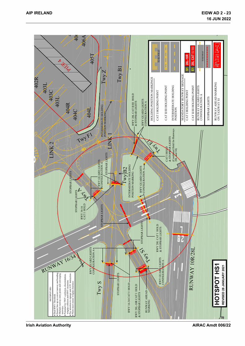
EIDW AD 2 - 23AIP IRELAND
16 JUN 2022
16 JUN 2022
TO
RU
NW
AY
TO
RU
NW
AY
16-34 16-34
16-3416-34
34-16 34-16
34-1634-16
28L28L
S128
L-10
RE1
28L
CAT II/III
28L-10R
28L-10R
28L-34
28L-34
INT
ER
ME
DIA
TE
HO
LD
ING
PO
SIT
ION
MA
RK
ING
CA
T I
HO
LD
Twy
A
Twy F1
Twy
E1
Tw
y B
2
RUNWAY 16/34
RU
NW
AY
10R
/28L
Tw
y S
Tw
y B
1
MA
ND
AT
OR
Y R
UN
WA
Y S
IGN
AG
E
CA
T I
HO
LD
ING
PO
INT
CA
T I
I/II
I H
OL
DIN
G P
OIN
T
RU
NW
AY
GU
AR
D L
IGH
TS
HO
LD
ING
PO
SIT
ION
MA
RK
ING
S
CO
NF
IGU
RA
TIO
N A
CA
T I
HO
LD
ING
PO
INT
CA
T I
I/II
I H
OL
DIN
G P
OIN
T
PO
SIT
ION
PO
SIT
ION
MA
RK
ING
ST
OP
BA
R L
IGH
TS
LIN
K 2
LIN
K 1
INT
ER
ME
DIA
TE
HO
LD
ING
Tw
y S1
ON
TA
XIW
AY
S1
404C
404L
405T
406A
4064
403L
403C
402R
403L
404R
PIER 4
& S
TO
PB
AR
LIG
HT
S
Tw
y Z
RW
Y 2
8L
CA
T I
I/II
I H
OL
D&
ST
OP
BA
R L
IGH
TS
RW
Y G
UA
RD
LIG
HT
SC
ON
FIG
UR
AT
ION
A
RW
Y G
UA
RD
LIG
HT
SC
ON
FIG
UR
AT
ION
A
RW
Y 2
8L
CA
T I
H
OL
D&
ST
OP
BA
R L
IGH
TS
RW
Y 2
8L
-10R
CA
T I
H
OL
D
& S
TO
PB
AR
LIG
HT
S
RW
Y 1
6-3
4 C
AT
I H
OL
D
ST
OP
BA
R L
IGH
TS
RW
Y G
UA
RD
LIG
HT
SC
ON
FIG
UR
AT
ION
A
RU
NW
AY
AH
EA
D
MA
RK
ING
RW
Y 3
4-1
6
CA
T I
H
OL
D
RW
Y G
UA
RD
LIG
HT
SC
ON
FIG
UR
AT
ION
A
ST
OP
BA
R L
IGH
TS
INT
ER
ME
DIA
TE
HO
LD
ING
RU
NW
AY
AH
EA
D M
AR
KIN
G
(Com
bin
ed H
old
for
Runw
ays
28L
and 3
4)
ST
OP
BA
R L
IGH
TS
ST
OP
BA
R L
IGH
TS
ST
OP
BA
R L
IGH
TS
ST
OP
BA
R L
IGH
TS
RW
Y G
UA
RD
LIG
HT
SC
ON
FIG
UR
AT
ION
A
HO
TSPO
T H
S1R
EVIS
ED 2
8 JA
NU
AR
Y 20
21
�D
ual
RW
Y T
hre
shold
.
�E
nsu
re l
ine
up o
n c
orr
ect
runw
ay a
nd h
eadin
g.
�M
ult
iple
runw
ay e
ntr
y p
oin
ts a
nd c
onver
gin
g
taxiw
ays.
�P
ote
nti
al f
or
TW
Y c
onfu
sion, dis
ori
enta
tion,
win
gti
p c
oll
isio
n a
nd R
WY
incu
rsio
n.
�P
ay a
tten
tion t
o s
ignag
e an
d A
TC
inst
ruct
ion.
�P
ilots
must
ensu
re w
ingti
p c
lear
ance
.
HO
TS
PO
T H
S1
Irish Aviation Authority AIRAC Amdt 006/22

EIDW AD 2 - 24 AIP IRELAND16 JUN 2022
16 JUN 2022
10 Stop bars
Pilots shall not cross illuminated stop bars. A pilot receiving instructions which imply that an illuminated stop bar should be crossed shall wait until the stop bar is extinguished. If the stop bar remains illuminated, the pilot shall request confirmation from ATC that the stop bar is to be crossed. Instructions to cross illuminated stop bars will only be given in exceptional circumstances. In the event of failure of the stop bar control mechanism, only TWY E1 (Runways 28L and 34), TWY S7 (Runway 10R) and TWY N4 (Runway 16) shall be used as line-up points.The following phraseology shall be used by ATC to instruct pilots or vehicle drivers to cross an illuminated stop bar:ATC: “[Callsign] Due to a failure of the control system, the stop bar will remain illuminated. Taxi/proceed across the stop bar on taxiway Echo 1/Sierra 7/November 4 and line up RW 34,28L,10R,16”Reply:“[Call-sign] Lining up Runway [10R/28L/34/16] crossing stop bar”
11 Airport Collaborative Decision Making (A-CDM)
11.1 Flight Plan Validation
Three hours prior to the Estimated Off-Block Time (EOBT) of a flight, checks will be performed to verify the consistency between the ATC Flight Plan, Airport Slot and Airport Flight Data.If the Scheduled Off-Block Time (SOBT) deviates from the EOBT, the relevant contact person will be informed and advised to adjust the times accordingly. Aircraft Operator (AO) or their Handling Agent (HA) is responsible for timely update of aircraft registration in the A-CDM portal (AOS).
11.2 Target Off-Block Time (TOBT)
This is the time that an Aircraft Operator or their Handling Agent estimates that an aircraft will be ready, all doors closed, boarding bridge removed, push back vehicle available, de-icing completed, and ready to start up/push back immediately upon reception of clearance from the Tower. TOBT= Prediction of “Aircraft Ready”
11.3 Automated TOBT
120 minutes prior to the Estimated Off-Block Time (EOBT), the A-CDM portal (AOS) system will automatically generate a default Target Off-Block Time (TOBT).
11.4 Person Responsible for TOBT
The Aircraft Operator or their agent is responsible for entry, update and if necessary deletion of TOBT’s. It is the responsibility of the AO/HA to communicate and ensure the pilot of a flight has the correct TOBT and Target Start Up Approval Time (TSAT) prior to calling for clearance. TSAT will also be included in DCL messages. If it becomes obvious that the TOBT cannot be respected, it shall be corrected or re-entered by the person responsible for the TOBT. Since the TOBT is used for various ground processes, it shall be updated by the person responsible for the TOBT when deviations of more than 5minutes occur. For deviations of 15minutes or more from the EOBT, it will still be mandatory to send a delay message (DLA) to the Network Manager.
11.5 TOBT Update/Deletion
Until the TSAT has been issued (TOBT minus 40 minutes) the TOBT can be updated as often as desired. After the TSAT has been issued, the TOBT can be updated up to three times. If a fourth TOBT update is required the flights TSAT will be removed and the flight will get re-sequenced. It is important to recognise that once sequenced, changes to TOBT are likely to impact the aircraft’s position in the Pre-Departure Sequence (PDS). TOBTs require updating if they differ by 5mins from the previous declared TOBT. If a flight is to be taken out of the TOBT/TSAT calculation, the TOBT shall be deleted. The TOBT shall be re-entered by the person responsible for the TOBT.
11.6 TOBT Reporting Routines
Irish Aviation AuthorityAIRAC Amdt 006/22
EIDW AD 2 - 25AIP IRELAND16 JUN 2022
16 JUN 2022
The TOBT is viewed and or adjusted in one of the following ways:
• A-CDM Portal (AOS)
• AOS Mobile Application
• Internal system of the Airline/Handling Agent (via interface)
• By telephone via the Dublin Airport Control Centre (ACC), Phone + 353 (0) 1 814 4352
• Advanced Visual Docking Guidance System (A-VDGS) (specific stands)
11.7 Target Start-up Approval Time (TSAT)
The TSAT is the target time for start-up approval according to the Dublin A-CDM Operational procedures, taking into account TOBT, Calculated Take Off Time (CTOT), and/or the traffic situation. The earliest time for the TSAT calculation (by the PDS) is 40 minutes prior to TOBT. TOBT is the time at which an Aircraft Operator, or his duly accredited representative expect the flight will be ready to commence movement; whereas the TSAT is the time at which Ground will grant the start-up. It is the responsibility of the AO/HA to communicate the most up to date TSAT to the pilot, prior to doors closing. The “Pre-Departure Sequence” is a result of the calculated TSATs.
11.8 TSAT Reporting Routines
The TSAT is transmitted in one of the following ways, via:
• A-CDM Portal (AOS)
• AOS Mobile application
• Internal system of the airline/Handling agent (via interface)
• Datalink Clearance (DCL). If a TSAT changes post clearance, ATC will communicate the revised TSAT verbally to the pilot. A revised DCL message will not be issued, post ATC clearance.
• Advanced Visual Docking Guidance System (A-VDGS) (specific stands)
11.9 Start-up and Push-back
The sequence of push and start is based on the TSAT sequence. The following rules apply:
• The Pilot shall report ready to push and start at TOBT (+/-) 5 minutes. (ATC clearance (including DCL) shall be requested any time prior to TOBT from delivery)
• The aircraft has to be ready for start-up at TOBT
• Ground will issue push and start clearance at TSAT (+/-) 5 minutes
• If pilots have received their clearance and called at TOBT and Ground has not called to give push and start clearance by TSAT + 5minutes, pilots are requested to call Ground requesting push and start clearance
In case of delays (>5 minutes) after ATC clearance has been received and/or a call ready at TOBT has been made, pilot shall inform clearance of the delay and a new TOBT must be sent by the AO/HA.
11.10 Datalink Clearances (DCL)
For datalink departure clearance (DCL), the published procedures and the time parameters published in the AIP will remain valid. The TSAT will also be transmitted in DCL messages.
11.11 Changes within the Sequence
Irish Aviation Authority AIRAC Amdt 006/22

EIDW AD 2 - 26 AIP IRELAND16 JUN 2022
16 JUN 2022
After a TSAT has been calculated and published, it may be possible to swap the sequence ordering of two flights under very strict condition. Swapping of flights may be facilitated provided the flights are of similar type, same operator, similar location etc. Such changes shall be coordinated with the ATC Station Manager. Flights with a Calculated Take Off Time (CTOT) cannot be switched. It is not envisaged that swapping flight will be used on a regular basis.
11.12 De-icing
De-icing must be completed before an aircraft can report ready for push and start. De-icing times shall be taken into account, to calculate the TOBT.
11.13 Coordination with the Network Manager (NMOC)
A permanent and fully automatic data exchange with the Network Operations will be established. This data transfer will enable highly accurate early predictions of landing and departure times. Furthermore, this will allow for more accurate and efficient calculation of the CTOT (when applicable) due to the use of local target take-off times. The following messages are used:
• Flight Update Message (FUM)
• Early Departure Planning Information Message (E-DPI)
• Target Departure Planning Information Message (T-DPI)
• ATC Departure Planning Information Message (A-DPI)
The basic Network Operations procedures continue to apply. The Network operations will generally take those local Target Take -Off Times (TTOT) into consideration, when updating the flights’ profiles in its system. In some cases Clearance Delivery position will offer to coordinate a new CTOT (if applicable) in agreement with the pilot.
11.14 Remote Holding
In the event of a contact stand not being available, Dublin Airport will request a remote hold stand position from ATC. The Pre-departure Sequencer (PDS) will recalculate the variable taxi time from this new remote hold location.
11.15 Contact and Information
For the TOBT dialogue and the TSAT submission, all Aircraft Operators/Handling Agents have to appoint a person responsible for TOBT and give the details to the airport company.VFR flights are not part of the A-CDM process and therefore do not require TOBTs to be entered.
11.16 Contact Details
For additional information and support documents on Dublin A-CDM, see link:https://www.dublinairport.com/regulation-and-planning/regulatory/airport-cdmContact persons for the A-CDM procedure at Dublin Airport, are as follows:Dublin Airport Resource Allocation Unit Phone: + 353 (0) 1 944 5228 Email: [email protected] Aviation Authority ATC Duty Station Manager Phone: + 353 (0) 1 8445962 Email: [email protected]
12. Runway 16/34 Surface Crossing
Irish Aviation AuthorityAIRAC Amdt 006/22

EIDW AD 2 - 27AIP IRELAND16 JUN 2022
16 JUN 2022
The Runway 16/34 Surface Crossing is a vehicle route from the vicinity of Stand 145, across Apron Taxiway F-Outer and Runway 16/34, to the Perimeter Road, for access to/from the West Apron. The Runway 16/34 Surface Crossing is not available when Runway 16/34 is required for landings or take offs (other than SAR), or when there is a widebody aircraft engine run on Runway 16.SAR operations may use RWY 16/34 south of TWY W4 for take off and landing.When the Surface Crossing is in use, the portion of RWY16/34 between TWY W4 and THR34 is available for taxiing. Taxiing north of TWY W4 is not permitted.Vehicles using the Surface Crossing must be escorted by the Airside Operations and Safety Officers (AOSO) (max two vehicles per escort).
EIDW AD 2.21 NOISE ABATEMENT PROCEDURES
1. Aircraft operators shall ensure at all times that aircraft are operated in a manner calculated to cause the least disturbance practicable in areas surrounding the airport.
2. Standard Instrument Departures
Strict compliance with SID is mandatory.
3. Other Instrument Departures
3.1 Cat A, B Aircraft
3.1.1 Cat A, B Aircraft (Non Jet) After take-off, pilots should ensure that they are at a minimum altitude of 750QNH before initiating any turn.
3.1.2 Cat A, B Aircraft (Jet) Departures must track the runway extended centreline after take-off until passing 750QNH before commencing turn. No take-off turn shall be commenced before the departure end of the runway.
3.2 Cat C, D Aircraft
3.2.1 Departures from all runways except Runway 10R, must track the runway extended centreline after take-off to 5NM before commencing turn, unless otherwise cleared by ATC above 3000ft.
3.2.2 Departures from Runway 10R must track the runway extended centreline to 5NM before commencing turn to the north, or to 6NM before commencing turn to the south.
3.2.3 Take-off climb shall comply with the procedure detailed below, which is based on noise abatement departure climb guidance contained in PANS OPS Doc 8168 Vol 1 - Appendix to Chapter 3 - NADP2.
3.2.4 Take-off thrust, speed V² + 20 to 40 km/h (V² + 10 to 20kt).
3.2.4.1 At 240m (800ft) and while maintaining a positive rate of climb, body angle is reduced and flaps/slats are retracted on schedule as the aeroplane is accelerated towards Vzf.
3.2.4.2 Power/thrust is reduced during the flap/slat retraction sequence at a point that ensures satisfactory acceleration performance.
3.2.4.3 (3000ft) Transition smoothly to en-route climb speed.
3.2.4.4 Cat C and D aircraft operating from Runway 28L directly to Weston or Baldonnel aerodromes are exempt from Sections 3.2.1, 3.2.2 and 3.2.3. These aircraft must not leave the environmental corridor below 1,500ft QNH.
4. Jet aircraft (Cat C/D) on visual approach to Runways 28L, 10R, 16 and 34 must join final approach no closer than 6NM from touchdown. Aircraft must follow a descent path which will not result in being at any time lower than the approach path which would otherwise be followed using the ILS glide-path.
Irish Aviation Authority AIRAC Amdt 006/22

EIDW AD 2 - 28 AIP IRELAND16 JUN 2022
16 JUN 2022
5. Runway 10R or 28L is the required Runway between 0600 and 2300HR Local Time when the crosswind component is 20KT or less. Runway 28L will be the preferential Runway when the tailwind component is 10KT or less and braking action is assessed as good. Aircraft will be required to use these Runways except when operational reasons dictate otherwise If the crosswind component on Runway 10R or Runway 28L is greater than 20KT Runway 16 or Runway 34 may become the active Runway. If the forecast crosswind component on Runway 10R or 28L is greater than 20KT Runway 16 or 34 may become the active Runway. The use of Runway 16/34 will be kept to an absolute minimum subject to operational conditions.
6. Runways will be prioritised for noise abatement purposes between 2300 and 0600HR Local Time, subject to the same wind calculation method and values as used between 0600 and 2300HR Local time (see Section 5). When weather conditions and flight operations permit, runway usage will be prioritised as follows:
7. Reverse thrust should not be used during landing operations on any runway between 2300-0600HR Local Time, except where operational or safety reasons dictate otherwise.
8. Cat C and D aircraft using Runways 28L, 16 and 34 shall operate within environmental corridors which are based on runway take-off flight path areas. The corridors have a width of 180 M at the departure end of the clearway, diverging at 12.5% on each side to a maximum width of 1800 M, and extending in length to 5 NM from the point of origin. The corridors extend vertically from surface to 3000 ft AMSL.
Cat C and D aircraft using Runway 10R shall operate within an environmental corridor which is based on the runway take-off flight path area. The corridor has a width of 180 M at the departure end of the clearway, diverging at 12.5% on each side to a maximum width of 1800 M, and extending in length from the point of origin to 5 NM for the northern boundary of the corridor and 6 NM for the southern boundary of the corridor. There is no upper vertical limit to this corridorThe corridors apply for departures from each runway and also for approaches to the reciprocal runway, except for circling approaches.
EIDW AD 2.22 FLIGHT PROCEDURES
1. Holding Areas
Protected airspace is provided for Holding Areas in accordance with the criteria contained in PANS-OPS ICAO Doc 8168, Volume II for basic holding areas.For RNAV procedures, holding basic areas are based on aircraft having RNAV holding system functionality.
2. SID and STAR
2.1 RNAV Equipped Aircraft
SIDs and STARs and initial segments of IAPs for RWY28L, RWY10R, RWY16 and RWY34 have been developed in accordance with ICAO Doc 8168 (PANS OPS).The RNAV Specification is RNAV 1. The supporting navigation infrastructure provided is DME/DME or GNSS. Operators which have obtained operational and airworthiness approval, from their regulatory authority, may operate the RNAV SID and STAR procedures in accordance with the conditions of approval including: • RNAV 1 certificated aircraft; • P-RNAV certificated aircraft, based on DME/DME or GNSS; • B-RNAV certificated aircraft only above MSA;
Priority
1 2 3 4
Arrival RWY 10R RWY 16 RWY 28L RWY 34
Departure RWY 28L RWY 34 RWY 10R RWY 16
Irish Aviation AuthorityAIRAC Amdt 006/22

EIDW AD 2 - 29AIP IRELAND16 JUN 2022
16 JUN 2022
RNAV SIDs climbing to MSA may be conducted using conventional navigation based on the conventional navaids serving the runway in use. If the RNAV equipment fails, or navigation accuracy of +/-1 NM can not be maintained, inform ATC as soon as possible. Radar vectoring will be provided.
2.2 RTF Phraseology
Phraseology used will be as provided in the European Regional Supplementary Procedures (ICAO Doc 7030) and outlined in Eurocontrol Guidance material for RNAV SIDs and STARs.Examples of phraseology for ATC are:
• {CALLSIGN} CLEARED {STAR designator} ARRIVAL, RUNWAY {designator}Note: On such a clearance flight crew shall continue on route until reaching start point of the STAR. • {CALLSIGN} ADVISE IF ABLE {designator} DEPARTURE [or ARRIVAL].If ATC are unable to issue a requested SID or STAR:
• {CALLSIGN} UNABLE TO ISSUE (designator) DEPARTURE [or ARRIVAL] DUE [Reason]Examples of pilot phraseology in the event of being unable to accept SID or STAR:
• UNABLE (designator) DEPARTURE [or ARRIVAL] DUE TO RNAV TYPE • UNABLE RNAV DUE EQUIPMENT
2.3 Non RNAV Equipped aircraft
Non RNAV equipped aircraft will be assigned a clearance based on conventional navigation aids and/or vectoring.
2.4 Expected Approach Distance RWY 10R and RWY 28L The expected approach distance is given the ENR 7.1 for both runways. The Lateral Holding/Point Merge STAR procedures (Chart AD 2.24-23.1 and AD 2.24-22.1) must be available in the aircraft navigation database.
3. Speed Control
Speed Restrictions
4. Recommended Flight Planning for Peak Arrival Periods
For further information refer to ENR 1.10.7.1
5. Arrival Procedures
General STAR Holds Initial Approach Segment
(BTN HLDG Fix
and IF)
Intermediate
Approach Segment (BTN IF
and FAP)
Final Approach Segment
Remarks
Below FL100, Max IAS 250KT or less.
As specified waypoints.
As specified on chart
IAS 210KT IAS 180KT BTN FAP and 4NM from THR IAS 160KT
1. ATC may request specific speeds for accurate spacing. Comply with speed adjustments as promptly as feasible within operational constraints.
2. If unable to comply with the above, advise ATC as soon as possible.
4NM to THR IAS as performance requires.
Warning Operators are advised of the probability of encountering a GPWS Terrain alert, for aircraft which are exceeding the standard speed restrictions, while at or below 5,000FT and which are in the vicinity of the hight terrain to the south of Dublin Airport.
Irish Aviation Authority AIRAC Amdt 006/22

EIDW AD 2 - 30 AIP IRELAND16 JUN 2022
16 JUN 2022
5.1 Clearance to enter the CTA and CTR
Aircraft flying the ATS Route system will be cleared into the CTA/CTR without having to request a specific entry clearance.Arriving Aircraft will normally be cleared on a STAR appropriate to the route by ATC. On occasions ATC may radar vector aircraft for arrival (Due traffic or technical reasons).
5.2 Initial Approach Procedures
5.2.1 With radar control
In order to expedite the flow of traffic, aircraft may receive radar vectors on to final approach from the STAR.For RWYs 16 & 34 pilots should plan their flight profile in such a manner as to be able to achieve 6000ft QNH at the appropriate hold. For RWY 28L & 10R pilots should plan their flight profile on the sequencing leg to achieve level constraints. ACTUAL DESCENT CLEARANCE WILL BE AS DIRECTED BY ATC.
5.2.2 Without radar control
When arriving traffic cannot be sequenced by radar, aircraft will be cleared to join the Instrument Approach Procedure appropriate to the landing from the hold.
5.3 Communications failure procedures for arriving aircraft
5.3.1 RWY16 & 34
Aircraft experiencing communications failure in the Dublin CTA/CTR shall set transponder code A7600 and comply with standard ICAO procedures.
5.3.2 RWY 28L and 10R
RWY 28L
5.3.2.1 Aircraft prior to Sequence Leg Entry
a. Squawk 7600.b. Proceed via the STAR to enter the appropriate Sequence Leg Entry Hold (i.e. KERAV or SORIN) at the last
cleared Flight Level.c. Commence descent in the Hold to the Sequence Leg entry Flight Level (FL080 or FL070 as appropriate)
specified on the chart at, or as close as possible to the expected approach time (EAT). If no EAT has been received and acknowledged descend at, or as close as possible to the estimated time of arrival resulting from the current flight plan.
d. Proceed onto the appropriate Sequence Leg, complete the full STAR as filed or last cleared by Dublin ATC, to LAPMO. After turning off the Sequence Leg descend to 3000ft QNH and complete the approach for landing on RWY28L.
e. Aircraft flying the ABLIN2L STAR losing R/T contact should squawk A7600 and should continue to fly the STAR (including the sequence leg from SIVNA onwards) and complete the approach.
f. ABLIN2X STAR: in the event of radio communication failure aircraft flying the ABLIN2X STAR should squawk A7600, continue on the procedure maintaining required altitude and speed constraints and complete the approach.
5.3.2.2 Aircraft on Sequence Leg
a. Squawk 7600.b. Complete the full STAR to LAPMO.
Irish Aviation AuthorityAIRAC Amdt 006/22

EIDW AD 2 - 31AIP IRELAND16 JUN 2022
16 JUN 2022
c. After turning off the Sequence Leg descend to 3000ft QNH and complete the approach for landing on RWY28L.
5.3.2.3 Aircraft turned off the Sequence Leg
a. Squawk 7600b. Descend to 3000ft QNHc. In the most expeditious manner route to LAPMO to complete the instrument approach procedure for
RWY28L.RWY 10R
5.3.2.4 Aircraft prior to sequence Leg Hold (ADNAL or BABON as appropriate) Squawk 7600
1. Proceed via the STAR to enter the appropriate Sequence Leg Hold (ie ADNAL or BABON) at the last cleared Flight Level
2. Commence descent in the Hold to the Sequence Leg Fight
3. Level (FL080 or FL070 as appropriate) specified on the chart at, or as close as possible to the expected approach time (EAT). If not EAT has been received and acknowledge descend at, or as close as possible to the estimated time of arrival resulting from the current flight plan.
4. Continue on the appropriate STAR Sequence Leg, complete the full STAR as filed or last cleared by Dublin ATC, to NEKIL or OSLEX as appropriate. After turning off the Sequence Leg descend to comply with the constraint altitude at NEKIL or OSLEX and complete the approach for landing on RWY10R.
5.3.2.5 Aircraft on Sequence Leg.
a. Squawk 7600b. Complete the full STAR and approach for RWY 10R.c. After turning off the Sequencing leg descend to comply with the constraint altitude at NEKIL or OSLEX and
complete the approach on RWY 10R.
5.3.2.6 Aircraft turned off the Sequence Leg
a. Squawk 7600b. Descend to comply with the constraint altitude at NEKIL or OSLEX and complete the approach for landing
on RWY 10R.
5.3.3 Non RNAV capable cat C/D aircraft.
Non RNAV capable Cat C/D aircraft should route, in the most expeditious manner, to the appropriate hold for the runway in use and hold using best navigation means available. From the hold proceed to, and complete in the most expeditious manner, the IAP for the runway in use.
6. Departure Procedures
6.1 Departure Clearance Service using Datalink
6.1.1 Introduction
6.1.1.1 The DCL service uses the Aircraft Communications Addressing and Reporting System (ACARS). DCL messages are described in EUROCAE ED-85A Appendix A and ARINC 623-2.
6.1.1.2 DCL departure clearances are provided solely to those flights departing Dublin Airport.
6.1.1.3 Clearance Delivery Procedures via RT (voice) will be utilised in the event of datalink transaction failure.
6.1.1.4 Oceanic traffic can receive domestic clearances via ACARS.
Irish Aviation Authority AIRAC Amdt 006/22

EIDW AD 2 - 32 AIP IRELAND16 JUN 2022
16 JUN 2022
6.1.2 Datalink procedure
6.1.2.1 The pilot will send a departure clearance request utilising the on-board datalink interface.Minimum 15 minutes before start-up. Any slot times will be taken into account by the pilot in the request if appropriate.
6.1.2.2 If the clearance is not received by the pilot within 3 minutes of the request the pilot will contact ATC through the normal RT communication channels and obtain a clearance on RT.
6.1.2.3 Where the pilot receives a Datalink reply and cannot accept the clearance he will contact ATC through the normal RT channels to obtain, an alternate clearance on RT.
6.1.2.4 If the pilot is satisfied with the Datalink clearance an acknowledgement message will be sent to the ground system.
6.1.2.4 If the pilot is satisfied with the Datalink clearance an acknowledgement message will be sent to the ground system.
6.1.2.4.1 If the ground system does not receive the acknowledgement message within 3 minutes after the clearance has been transmitted, or if an invalid message is received, ATC will contact the pilot through the normal VHF channels and issue the clearance via RT (voice).
6.1.2.5 All departure clearances issued through the normal VHF RT voice channels will cancel the DCL service.
6.2 RWY 28L, 10R, 16 and 34 - Standard Instrument Departures (SID)
Aircraft on IFR flights departing from RWY 28L, 10R, 16 and 34 will proceed in accordance with Standard Instrument Departures (SID) WHICH ALSO INCLUDE MANDATORY NOISE ABATEMENT ELEMENTS for jet aircraft. Category C and D departures shall remain on DUBLIN TOWER frequency until passing 2,000ft, then contact DUBLIN ACC Lower North/DUBLIN ACC Lower South as appropriate.Where ICAO obstacle clearance criteria require minimum climb gradient greater than 3.3% the required values will be included in the SID.As a cross check to confirm the correct SID has been selected in the FMS, for C,D & E aircraft pilots will be requested by CDS to confirm the first waypoint on the SID e.g. RWY 10R “DW5 51Non-Standard Departure Instructions - Pilots who cannot comply with any of the Standard Instrument Departure procedures must inform ATC in good time so that alternative clearances can be issued. A minimum climb gradient of 4.1 per cent applies to all alternate clearances.Note: CAT A, B aircraft may be assigned a SID appropriate to CAT C, D aircraft at the discretion of ATC. Note: CAT E aircraft will be assigned a SID appropriate to CAT C, D aircraft at the discretion of ATC
6.3 Communications failure procedures for departing aircraft
Aircraft experiencing communications failure in the Dublin CTA/CTR shall set transponder code A7600 and comply with standard ICAO procedures,Supplemented by the following:i. For aircraft departing on a SID where no cruising level has been specified in the enroute clearance (and
therefore no level specified in the Current Flight Plan) the climb, after the appropriate time interval, shall be to the level contained in the Filed Flight Plan.
ii. Aircraft routeing on a ROTEV SID expecting transition to BOYNE Aircraft routeing on a ROTEV SID experiencing communications failure, and expecting transition to BOYNE, should continue to ROTEV, then, in the most expeditious manner, route to BOYNE to join the Current Flight Plan route. Maintain the last assigned level for a period of three minutes, and then climb to the level specified in the Current Flight Plan.
7. Low Visibility Procedures
7.1. Low Visibility Procedures
Low Visibility Procedures apply when the cloud ceiling is below 200 ft (60M) and/or the IRVR is less than 550M or the meteorological visibility is less than 800M.
Irish Aviation AuthorityAIRAC Amdt 006/22

EIDW AD 2 - 33AIP IRELAND16 JUN 2022
16 JUN 2022
When Low Visibility Procedures are in force the following standard taxi route system applies:
Note: Code C aircraft shall not be instructed to push back onto Taxiway Fox Outer during Low Visibility OperationsCAT II/III holding position on TWY E1 and CAT II/III holding position on TWY S7 will apply as appropriate.TWY/stopbar/centreline lighting will be in use.Pilots will be informed by ATIS broadcast or RTF when Low Visibility Procedures have been initiated.Full details of low visibility operations are available on request from AD Administration (EIDW AD 2.2)A maximum taxiing speed limit of 15KT applies to all aircraft during the periods when Low Visibility Procedures are in force.
7.2. Low Visibility Take Offs (LVTOs)
During LVP Operations, LVTOs are permitted from both Runway 10R and Runway 28L.It is the at the discretion of the PIC to depart based on their airline operating procedures in LVP conditions.Take-offs are not available in IRVR conditions below 125M.All IRVR readings must show 125M or greater.ATC shall inform departing pilots if and when any IRVR value falls below 125M.
8. Holding Procedures
A standard rate of descent of between 500ft and 1000ft per min in holding patterns will be used unless otherwise instructed by ATC.
9. Operation of Mode S transponders on the Movement Area.
Table 1: Runway 28L
RUNWAY TO/FROM ARRIVAL TAXI ROUTE
DEPARTURE TAXI ROUTE
APRON TAXI ROUTES
28L Main Apron S5 or S7 to S, W2, M1 E1 All except Z
28L West Apron (Northern stands)
S5 or S7 to S, W2, W3 W3, W2, M1, E1 All except Z
28L West Apron (Southern stands)
S5 or S7 to S, W2 W2, M1, E1 All except Z
28L Main Apron If Holding for a stand
S5 or S7 to S, W1, H1 N/A All except Z
Table 2: Runway 10R
RUNWAY TO/FROM ARRIVAL TAXI ROUTE
DEPARTURE TAXI ROUTE
APRON TAXI ROUTES
10R Main Apron E1 or S2, W1, H1
M1, W2, S to S7 All except Z
10R To South Apron if Holding for a stand
S1, B2 N/A B1
10R West Apron (Northern stands)
S2, W1, H1, Link 4, M1, W2, W3 or E1, Link 4, M1, W2, W3
W3, W2, S to S7 All except Z
10R West Apron (Southern stands)
S2, W1, H1, Link 4, M1, W2 or E1, Link 4, M1, W2
W2, S to S7 All except Z
Irish Aviation Authority AIRAC Amdt 006/22

EIDW AD 2 - 34 AIP IRELAND16 JUN 2022
16 JUN 2022
Mode S transponders shall be operated on the Movement Area in accordance with the following provisions:
9.1 Departing aircraft:
i. Set aircraft identification and, when received, set assigned Mode A code.ii. Immediately prior to request for push back or taxi, or when advising Clearance Delivery that you are ready
for push and start, whichever is earlier, select: “Automatic mode” (e.g.: AUTO) or, if automatic mode is not available, select “on” (e.g. ON or XPDR),
iii. Only when approaching the holding position of the departure runway, select “TCAS” (e.g.: TA/RA).
9.2 Arriving aircraft:
i. As soon as practicable after landing de-select “TCAS” (e.g.: deselect TA/RA),ii. Select “automatic mode” (e.g.: AUTO) or, if automatic mode is not available, select “on” (e.g. ON or XPDR),iii. Continue to squawk last assigned Mode A code until fully parked, When fully parked, select “standby” (e.g.:
STBY).
10. VFR Procedures, Dublin CTR/CTA and environs
10.1 Flight Plan
Flight Plans are mandatory for flights within Dublin CTR/CTA. Flights planned to transit EIR23, EIR15, EIR16 should include this information in field 15 of the Flight PlanFlights planning to enter or leave Dublin CTR should, when practicable, indicate in item 16 of the Flight Plan, an alternate aerodrome situated outside Dublin CTR.Where the flight destination is not an aerodrome licensed for public use, the address of the place of intended landing together with the name and telephone number of the property owner should be indicated in field 18 of the Flight Plan.
10.2 Special VFR is available within Dublin CTR in accordance with the provisions of EU Reg. No 923/2012 - SERA.5010 Special VFR in control zones.
10.3 Flight Information Service is provided H24. When required and as promulgated by ATIS, a discrete frequency (118.500 MHz) is allocated to the provision of FIS for aircraft in class G airspace.
10.4 Landing Lights should be shown at all times during flight within Dublin CTR.
10.5 ATC Clearances for flights departing from within Dublin CTR.
Prior to departurei. From Dublin Airport by request for start up to Dublin Ground, 121.800 MHz.ii. Other than Dublin Airport
• Request for start/lift to Dublin Tower, 118.600 MHz • If no RTF two-way communication can be established, contact Dublin ATC by telephone and request
a time for take off / Lift off.Take off / Lift without prior two-way communications with Dublin ATC either by RTF or by Telephone is not permitted.
10.6 ATC Clearances for flights arriving to destinations within Dublin CTA/CTR
Prior to penetration of Dublin CTA/CTR, by submitting a request at least 10 minutes before ETA at the airspace boundary to the relevant ATSU as follows:
a. Dublin Tower, 118.600 MHz for entry to the Dublin CTR;
b. Dublin ACC Lower North, Channel 132.580 for entry to the Dublin CTA, North Sector;
c. Dublin ACC Lower South, 120.755 for entry to the Dublin CTA, South Sector.
d. Dublin ACC, for entry to the Dublin CTA, non 8.33 kHz equipped, 124.650 MHz or 126.250 MHz
Irish Aviation AuthorityAIRAC Amdt 006/22

EIDW AD 2 - 35AIP IRELAND16 JUN 2022
16 JUN 2022
Note: Dublin ACC Lower North Sector is divided from Dublin South Sector by a boundary line extending along the extended centreline of RWY10R/28L
10.7 VFR Routes
10.7.1 Flights departing/arriving at Dublin Airport are normally cleared as follows:
i. North arrivals/departures: via Skerries VFR Routeii. West arrivals/departures: via Skerries VFR Route or Dunshaughlin VFR Routeiii. South arrivals: As instructed by Dublin Toweriv. South West arrivals
• Fixed wing flights to enter the Dublin CTR at Dunboyne or Dunshaughlin • Helicopter flights to enter Dublin CTR at Redcow Roundabout or The Square, Tallaght
v. South departures • As instructed by Dublin Tower,
or • Flights intending to transit EIR15 are cleared to either Palmerston Roundabout Hold or Marley Park
Hold to await onwards clearance from Baldonnel Tower.
10.7.2 Flights with departure/destination other than Dublin Airport are normally cleared as follows:
i. North arrivals/departures • As directed by Dublin ATC, or • Skerries VFR route.
ii. West arrivals/departures • As instructed by Dublin ATC, or • Dunshaughlin VFR route
iii. South west arrivals • As instructed by Dublin ATC, or • Helicopter VFR flights to enter Dublin CTR at Red Cow Roundabout or The Square, Tallaght. or • Fixed-wing VFR flights to enter the Control Zone at Dunboyne or Dunshaughlin.
iv. South arrivals as instructed by Dublin ATC.v. South departures
• As instructed by Dublin ATC, or • Flights intending to transit EIR15 route to either the Palmerston Roundabout Hold or the Marley Park
Hold to await onwards clearance from Baldonnel Towervi. Weston arrivals from the East
• As instructed by Dublin ATC, or • Weston VFR Route
10.8 Visual Holding Patterns
Visual Holding Patterns for category A aircraft are established as follows:
10.8.1 Broad Meadow Bridge (532756.45N 0061125.11W (WGS-84)
Left-hand pattern, based on the M1 motorway bridge, which crosses the Broad Meadow estuary.Outbound leg is 1 minute, flown at 90KT IAS. Inbound track 187° M. Minimum holding altitude is 1000ft QNH.The following criteria also apply:On arriving overhead the Fix, left turn onto the outbound leg should be initiated before the southern shore of the Broad Meadow estuary.
Irish Aviation Authority AIRAC Amdt 006/22

EIDW AD 2 - 36 AIP IRELAND16 JUN 2022
16 JUN 2022
Left turn onto the inbound leg to the Fix should be completed to the east of the M1/N1 road. The inbound leg to the fix should remain east of the M1/N1 road at all times.
10.8.2 Finglas Church Spire (532317.23N 0061841.89W (WGS-84)
Left-hand pattern, based on the west Finglas Church spire. Outbound leg is 1 minute, flown at 90 KT IAS. Inbound track 007°M. Minimum holding altitude is 1700ft QNH. The following criteria also apply:On arriving overhead the Fix, the turn onto the outbound leg should be initiated before the M50 motorway remaining south of the motorway at all times.The turn onto the inbound leg to the Fix should be completed to the west of the M2/N2 road.The inbound leg to the fix should remain west of the M2/N2 road at all times.
10.8.3 Palmerston Roundabout (532124.26N 0062303.57W(WGS-84)
Left-hand pattern, based on the Palmerston roundabout, which intersects the M50 motorway and the M4/N4 road. Outbound leg is 1 minute, flown at 90 KT IAS. Inbound track 277° M. Minimum holding altitude is 1700ft QNH.
10.8.4 Marley Park House (531636.19N 0061601.09W(WGS-84)
Right hand pattern, based on Marley Park House, a large manor house inside the grounds of Marley Public Park. Outbound leg is 1 minute, flown at 90KT IAS. Inbound track 284° M. Minimum holding altitude is 1700ft QNH.
10.8.5 Other Visual Reporting Points (VRPs) (WGS-84)
• VRP Ashbourne Town 533043.95N 0062354.93W
• VRP Baily Lighthouse 532141.65N 0060308.76W
• VRP Ballymun Centre 532339.93N 0061554.74W
• VRP Bray Head 531119.49N 0060503.83W
• VRP Cellbridge Town 532020.42N 0063222.16W
• VRP Donadea Wood 532021.28N 0064449.03W
• VRP Dunboyne Town 532517.22N 0062836.15W
• VRP Dunshaughlin Town 533051.04N 0063228.82W
• VRP Dunsoghly Castle 532537.48N 0061910.36W
• VRP Garristown Village 533400.27N 0062258.13W
• VRP Heuston Station 532046.18N 0061746.66W
• VRP Kilcock Town 532358.13N 0064005.43W
• VRP Killiney Hill 531555.09N 0060714.33W
• VRP Kilteel Village 531410.34N 0063128.07W
• VRP Lambay Island 532929.64N 0060057.65W
• VRP Malahide Town 532704.80N 0060859.56W
Irish Aviation AuthorityAIRAC Amdt 006/22
EIDW AD 2 - 37AIP IRELAND16 JUN 2022
16 JUN 2022
10.9 Circuit Operation,
Dublin Airport Circuit training is not permitted at Dublin Airport.
10.10 Radio Communications Failure Procedures – VFR Traffic
10.10.1 Departure Traffic
Proceed in accordance with the ATC clearance last received and acknowledged and land at the most suitable aerodrome located outside Dublin Control Zone. Report arrival to an appropriate ATC unit by the most expeditious means.
10.10.2 Arrival Traffic
If outside Dublin CTR, proceed to the alternate aerodrome outside Dublin CTR specified in the flight plan and report arrival to an appropriate ATC unit by the most expeditious means.If within Dublin CTR, proceed in accordance with the last ATC clearance received and acknowledged and thereafter, as appropriate, to Broad Meadow Bridge holding pattern and hold at an altitude of 1000ft QNH or Finglas Church Spire holding pattern and hold at an altitude of 1700ft QNH.The Holding pattern chosen, should ensure, that when en-route to join the Hold, the aircraft does not pass through the approach or take off path of the runway in use.On receipt of a steady green light signal from the Control Tower, join the circuit in the manner detailed below and land on the lighted runway. The runway approach lights will indicate the landing directionFROM BROAD MEADOW BRIDGE (HOLDING PATTERN) RWY 10R/16 Left Hand circuit. RWY 28L/34 Right Hand circuit.FROM FINGLAS CHURCH SPIRE (HOLDING PATTERN) RWY 28L/34 Left Hand circuit RWY 10R/16 Right Hand CircuitIf outside the control Zone, proceed with the flight plan route, remaining clear of the Control Zone and comply with flight plan closure procedures, orIf within the Control Zone, EXIT, ensuring that the aircraft remains clear of Dublin Aerodrome and the approach and Take off path of the Runway in use.
EIDW AD 2.23 ADDITIONAL INFORMATION
Refer to ENR 5.6 for bird hazard information.Refer to ENR 1.6 2.8 Monitoring Codes
Variation from EASA Certification Specifications - Runway Slope, Runway 16/34
The longitudinal slope in the first and last quarter of a Code 4 runway should not exceed 0.8% (CS ADR-DSN.B.060(c)(1)). In the vicinity of the intersection with the new runway under construction, due to the relative slopes of the two runways, the longitudinal slope provided on RWY 16/34 is up to 1.1%, south of the new runway centreline.
In addition, a slope change between two consecutive longitudinal slopes on a Code 4 runway should not exceed 1.5%, and the transition between one slope and another should be a curved surface (CS ADR-DSN.B.065 (b)(1) and (c)(1)). Where RWY 16/34 crosses the centreline of the new runway, the slope change is 1.7%, and the transition is immediate, ie without a curved surface.
The Competent Authority has accepted that the safety intent of the Certification Specifications has been met, and that the resulting level of safety can be deemed an Equivalent Level of Safety (ELOS).
Dublin Airport has a minimal capacity to handle code F aircraft for diversions, exceptional and planned movements. Operators should give as much advance notice as possible to ensure sufficient resources are in place.
Irish Aviation Authority AIRAC Amdt 006/22
EIDW AD 2 - 38 AIP IRELAND16 JUN 2022
16 JUN 2022
Dublin Airport is available for B777-800 and B777-900 aircraft operation. If the wing tips fail to fold after the landing at Dublin Airport, pilot is required to inform ATC and request a follow-me service to stand. Pilots must proceed with caution and follow all the instructions from the follow-me provider.
Provision of Information to the IATA Standard for AOS:1. DAA requires that airlines and handling agents submit messages for inbound and outbound Dublin Flights in
the standard format described in the IATA Airport Handling Manual.2. The address that all the SITA messages shall be sent to is DUBRN7X.3. The following are the three principal message types to be submitted to DAA:
a. Load messages (AHM 583). b. Statistical load summary (AHM 588). c. Aircraft movement message (AHM 780).
4. Passenger Services Messages (PSMs) and Passenger Transfer Messages (PTMs) are also processed by the AOS. A standard format is required. Examples of the appropriate formats for these and other message types, including those related to passengers are available on the Dublin Airport Operations Library.
EIDW AD 2.24 CHARTS RELATED TO AERODROME
Name Page
Aerodrome Chart - ICAO EIDW AD 2.24-1
Aircraft Parking/Docking Chart - ICAO EIDW AD 2.24-2
Aerodrome Obstacle Chart RWY 10R/28L - ICAO EIDW AD 2.24-3
Aerodrome Obstacle Chart RWY 16/34 - ICAO EIDW AD 2.24-5
Precision Approach Terrain Chart RWY 28L - ICAO EIDW AD 2.24-6
Precision Approach Terrain Chart RWY 10R - ICAO EIDW AD 2.24-9
Standard Departure Chart – Instrument RNAV RWY 28L CAT A, B - ICAO EIDW AD 2.24-10
Standard Departure Chart – Instrument RNAV RWY 28L CAT C, D - ICAO EIDW AD 2.24-11
Standard Departure Chart – Instrument RNAV RWY 10R CAT A, B - ICAO EIDW AD 2.24-16
Standard Departure Chart – Instrument RNAV RWY 10R CAT C, D - ICAO EIDW AD 2.24-17
Standard Departure Chart – Instrument RNAV RWY 16 CAT A, B - ICAO EIDW AD 2.24-18
Standard Departure Chart – Instrument RNAV RWY 16 CAT C, D - ICAO EIDW AD 2.24-19
Standard Departure Chart – Instrument RNAV RWY 34 CAT A, B - ICAO EIDW AD 2.24-20
Standard Departure Chart – Instrument RNAV RWY 34 CAT C, D - ICAO EIDW AD 2.24-21
Standard Arrival Chart - Instrument RNAV RWY 28L (With Lateral Holding/Point Merge) - ICAO
EIDW AD 2.24-22.1
Standard Arrival Chart - Instrument RNAV RWY 28L (Without Lateral Holding/Point Merge) - ICAO
EIDW AD 2.24-22.4
Standard Arrival Chart - Instrument RNAV RWY 10R (With Lateral Holding/Point Merge) - ICAO
EIDW AD 2.24-23.1
Standard Arrival Chart - Instrument RNAV RWY 10R (Without Lateral Holding/Point Merge) - ICAO
EIDW AD 2.24-23.5
Standard Arrival Chart - Instrument RNAV RWY 16 - ICAO EIDW AD 2.24-24
Standard Arrival Chart - Instrument RNAV RWY 34 - ICAO EIDW AD 2.24-25
Instrument Approach Chart RNP RWY 28L - ICAO EIDW AD 2.24-26
Irish Aviation AuthorityAIRAC Amdt 006/22

EIDW AD 2 - 39AIP IRELAND16 JUN 2022
16 JUN 2022
Instrument Approach Chart - ILS CAT I & II or LOC RWY 28L - ICAO EIDW AD 2.24-27
Instrument Approach Chart VOR RWY 28L - ICAO EIDW AD 2.24-28
Instrument Approach Chart RNP RWY 10R - ICAO EIDW AD 2.24-35
Instrument Approach Chart - ILS CAT I & II or LOC RWY 10R - ICAO EIDW AD 2.24-36
Instrument Approach Chart VOR RWY 10R - ICAO EIDW AD 2.24-37
Instrument Approach Chart RNP RWY 16 - ICAO EIDW AD 2.24-38
Instrument Approach Chart - ILS CAT I or LOC RWY 16 - ICAO EIDW AD 2.24-39
Instrument Approach Chart VOR RWY 16 - ICAO EIDW AD 2.24-40
Instrument Approach Chart RNP RWY 34 - ICAO EIDW AD 2.24-41
Instrument Approach Chart VOR RWY 34 - ICAO EIDW AD 2.24-42
ATC Surveillance Minimum Altitude Chart - ICAO EIDW AD 2.24-43
Visual Approach Chart - ICAO EIDW AD 2.24-44
Instrument Approach Chart VOR T RWY 28L - ICAO EIDW AD 2.24-45
Name Page
Irish Aviation Authority AIRAC Amdt 006/22

THIS PAGE INTENTIONALLY LEFT BLANK
Irish Aviation Authority
EIDW AD 2 - 40 AIP IRELAND16 JUN 2022
16 JUN 2022
AIRAC Amdt 006/22
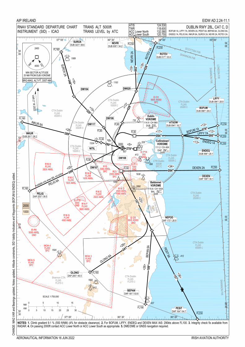
5230
5300
5300
5330
5330
5400
5400
07° 00'
07° 00'
06° 30'
06° 30'
06° 00'
06° 00' 05° 30'
0 5 10 15 20 25 30
0 5 10 15
KMNM
SCALE 1:750,000
OLONO 6A BEPA
N 6A
SUROX 2A
INKUR 6A
3000
PELIG 6A
DEXEN 2A
Available only when MIL not active
1100
437
696
1334
2890
1800
3012
412
1089
1938
1500
1440
<13>079° <12>095°
<13>104°
ENDEQ 1A<1
8>026°
<26>
241°
<36>157°
5230
526
LIFFY 7A
PESIT 6A
NEVR
I 2A
ROTE
V 2A
BOFUM 1A<1
9>002°
735
FL90
FL90
FL90
FL90
FL90 <17>094°
<12>
028°
<28>289°
<25> <34>094°
<5>
249°
<23>157°
FL90
<8>289°
BRG-MAG, ALT-FT, DIST-NM
R16 HFL240
2500 AMSL
R16 CFL240
1500 AMSL
R16 BFL240
1000 AMSL
R16 EFL240
2500 AMSL
R16 FFL240
3500 AMSL
EI P105000GND
EI P85000 AMSL
GND
MOA 4FL450SFC
MOA 5FL450SFC
MOA 3FL450SFC
R232000 AMSL
SFC
R153000 AMSL
SFC
EI P111000GND
EI P18550GND
EI D1MAX 40000
SFC
EI D5MAX 40000
GND
R16 GFL240
4500 AMSL
DAP 253°/ 39.5PELIG
DAP 109°/ 30.1DEXEN
DUB 094°/ 28.9LIFFY
DUB 017°/ 33.0ROTEV
DUB 005°/ 34.2NEVRIDUB 323°/ 38.6
SUROX
DUB 281°/ 39.2INKUR
DAP 205°/ 45.5OLONO
DAP 173°/ 28.9NEPOD
DUB 088°/ 29.0BOFUM
CollinstownVOR/DME
111.2 / CH 49XDAP Dap300ft
BaldonnelVOR/DME
115.8 / CH 105XBAL bal300ft
DW029DW104
DUB 094°/ 16.7ATGOW
DUB 098°/ 29.1ENDEQ
DW106
DW117
NITIL
DW107
DAP 181°/ 53.9BEPAN
DublinVOR/DME
114.9 / CH 96XDUB DUB200ft
048°
MIN SECTOR ALTITUDE25 NM FROM DUB VOR/DME
332°4000
2400
VAR 2° W 2022
R16 D4500 AMSL1500 AMSL
DAP 164°/ 64.7PESIT
CTA DublinFL245
4500ft C
CTA Dublin
FL2453000ft C
CTA DublinFL245
FL075 C
CTA DublinFL245
5000ft CCTR Dublin5000ftSFC C
CTA DublinFL245
2500ft C
CTA DublinFL245
3500ft C
CTA DublinFL245
1500ft C
CTA DublinFL245
4500ft C
CTA DublinFL245
1500ft C
CTA DublinFL245
2500ft C
SCOTTISH FIR
SHANNON FIR
LONDON FIR
SHANNON FIR
Shannon CTAFL245
FL075 C
SHANNON FIR
<16>348°
<15>320°
278°
413
<26>189°
FL160
FL230FL230
FL230
FL230
FL230
FL230
FL230
FL160
FL160
FL160
FL190
DW108
657
NOTES: 1. Climb gradient 9.1 % (550 ft/NM) (4% for obstacle clearance). 2. For BOFUM, LIFFY, ENDEQ and DEXEN MAX IAS: 290kts above FL100. 3. Integrity check fix available fromRADAR. 4. On passing 2000ft contact ACC Lower North or ACC Lower South as appropriate. 5. DME/DME or GNSS navigation required.
RNAV STANDARD DEPARTURE CHARTINSTRUMENT (SID) - ICAO
DUBLIN RWY 28L, CAT C, DBOFUM 1A, LIFFY 7A, DEXEN 2A, PESIT 6A, BEPAN 6A, OLONO 6A, ENDEQ 1A, PELIG 6A, INKUR 6A, SUROX 2A, NEVRI 2A, ROTEV 2A.
1000
AIP IRELAND EIDW AD 2.24-11.1ATIS 124.530TWR 118.600ACC Lower North 132.580ACC Lower South 120.755
2000
AERONAUTICAL INFORMATION 16 JUN 2022
TRANS ALT 5000ftTRANS LEVEL by ATC
CHAN
GE: M
AG V
AR an
d Bea
rings
upda
ted, N
otes u
pdate
d, Alt
itude
cons
traint
s, SI
D Va
lidity
Indic
ators
and W
aypo
ints (
BOFU
M &
ENDE
Q) ad
ded.
IRISH AVIATION AUTHORITY

EIDW AD 2.24-11.2 AIP IRELAND 16 JUN 2022
AIRAC Amdt 006/2022 IRISH AVIATION AUTHORITY
BEPAN 6A CAT C/D SID RWY28L BEPA6A
Nav. Spec. WPT Name Latitude (N)/
Longitude (W) Path Term
Fly-By Fly-over
True track / Mag track
Distance (NM)
Upper limit / Lower limit (ft)
Speed Limit (kts) Remarks
RNAV1 DW108 532548.6 / 0062543.7 CF Fly-Over 275.4 / 278 - - / +A3000 - LO RNAV1 BAL 531759.6 / 0062652.0 DF Fly-By - - -FL90 / - - Turn L, VOR RNAV1 NEPOD 525657.2 / 0061029.8 TF Fly-By 154.8 / 157 23.3 - - - RNAV1 BEPAN 523136.2 / 0061549.5 TF Fly-By 187.3 / 189 25.6 -FL190 / - - Turn R
BOFUM 1A CAT C/D SID RWY28L BOFU1A
Nav. Spec. WPT Name Latitude (N)/
Longitude (W) Path Term
Fly-By Fly-over
True track / Mag track
Distance (NM)
Upper limit / Lower limit (ft)
Speed Limit (kts) Remarks
RNAV1 DW108 532548.6 / 0062543.7 CF Fly-Over 275.4 / 278 - - / +A3000 - LO RNAV1 DUB 532957.8 / 0061825.6 DF Fly-By - - -FL90 / - - Turn R, VOR RNAV1 ATGOW 532920.2 / 0055032.5 TF Fly-By 092.0 / 094 16.7 - - - RNAV1 BOFUM 533214.0 / 0053000.0 TF Fly-By 076.6 / 079 12.6 -FL230 / - 290 Turn L
DEXEN 2A CAT C/D SID RWY28L DEXE2A
Nav. Spec.
WPT Name
Latitude (N)/ Longitude (W)
Path Term
Fly-By Fly-over
True track / Mag track
Distance (NM)
Upper limit / Lower limit (ft)
Speed Limit (kts) Remarks
RNAV1 DW108 532548.6 / 0062543.7 CF Fly-Over 275.4 / 278 - - / +A3000 - LO RNAV1 BAL 531759.6 / 0062652.0 DF Fly-By - - -FL90 / - - Turn L RNAV1 DEXEN 531649.4 / 0053000.0 TF Fly-By 091.6 / 094 34.1 -FL230 / - 290 -
ENDEQ 1A CAT C/D SID RWY28L ENDE1A
Nav. Spec. WPT Name Latitude (N)/
Longitude (W) Path Term
Fly-By Fly-over
True track / Mag track
Distance (NM)
Upper limit / Lower limit (ft)
Speed Limit (kts) Remarks
RNAV1 DW108 532548.6 / 0062543.7 CF Fly-Over 275.4 / 278 - - / +A3000 - LO RNAV1 DUB 532957.8 / 0061825.6 DF Fly-By - - -FL90 / - - Turn R, VOR RNAV1 ATGOW 532920.2 / 0055032.5 TF Fly-By 092.0 / 094 16.7 - - RNAV1 ENDEQ 532644.4 / 0053000.0 TF Fly-By 101.8 / 104 12.5 -FL230 / - 290 Turn R
INKUR 6A CAT C/D SID RWY28L INKU6A
Nav. Spec.
WPT Name
Latitude (N)/ Longitude (W)
Path Term
Fly-By Fly-over
True track / Mag track
Distance (NM)
Upper limit / Lower limit (ft)
Speed Limit (kts) Remarks
RNAV1 DW108 532548.6 / 0062543.7 CF Fly-Over 275.4 / 278 - - / +A3000 - LO RNAV1 NITIL 532800.0 / 0063755.0 TF Fly-By 286.8 / 289 7.6 -FL90 / - - Turn R RNAV1 INKUR 533551.3 / 0072328.6 TF Fly-By 286.4 / 289 28.3 -FL160 / - - -
LIFFY 7A CAT C/D SID RWY28L LIFF7A
Nav. Spec.
WPT Name
Latitude (N)/ Longitude (W)
Path Term
Fly-By Fly-over
True track / Mag track
Distance (NM)
Upper limit / Lower limit (ft)
Speed Limit (kts) Remarks
RNAV1 DW108 532548.6 / 0062543.7 CF Fly-Over 275.4 / 278 - - / +A3000 - LO RNAV1 DUB 532957.8 / 0061825.6 DF Fly-By - - -FL90 / - - Turn R, VOR RNAV1 ATGOW 532920.2 / 0055032.5 TF Fly-By 092.0 / 094 16.7 - - - RNAV1 LIFFY 532848.3 / 0053000.0 TF Fly-By 092.3 / 095 12.3 -FL230 / - 290 -
NEVRI 2A CAT C/D SID RWY28L NEVR2A
Nav. Spec.
WPT Name
Latitude (N)/ Longitude (W)
Path Term
Fly-By Fly-over
True track / Mag track
Distance (NM)
Upper limit / Lower limit (ft)
Speed Limit (kts) Remarks
RNAV1 DW108 532548.6 / 0062543.7 CF Fly-Over 275.4 / 278 - - / +A3000 - LO RNAV1 DW106 533441.8 / 0062515.3 DF Fly-By - - -FL90 / - - Turn R RNAV1 DW029 534521.0 / 0061621.0 TF Fly-By 026.3 / 029 11.9 - - - RNAV1 NEVRI 540406.0 / 0061611.4 TF Fly-By 000.3 / 002 18.8 -FL230 / - - Turn L

EIDW AD 2.24-11.3 AIP IRELAND 16 JUN 2022
AIRAC Amdt 006/2022 IRISH AVIATION AUTHORITY
OLONO 6A CAT C/D SID RWY28L OLON6A
Nav. Spec.
WPT Name
Latitude (N)/ Longitude (W)
Path Term
Fly-By Fly-over
True track / Mag track
Distance (NM)
Upper limit / Lower limit (ft)
Speed Limit (kts) Remarks
RNAV1 DW108 532548.6 / 0062543.7 CF Fly-Over 275.4 / 278 - - / +A3000 - LO RNAV1 BAL 531759.6 / 0062652.0 DF Fly-By - - -FL90 / - - Turn L, VOR RNAV1 NEPOD 525657.2 / 0061029.8 TF Fly-By 154.8 / 157 23.3 - - - RNAV1 OLONO 524323.1 / 0064644.4 TF Fly-By 238.5 / 241 25.8 -FL160 / - - Turn R
PELIG 6A CAT C/D SID RWY28L PELI6A
Nav. Spec.
WPT Name
Latitude (N)/ Longitude (W)
Path Term
Fly-By Fly-over
True track / Mag track
Distance (NM)
Upper limit / Lower limit (ft)
Speed Limit (kts) Remarks
RNAV1 DW108 532548.6 / 0062543.7 CF Fly-Over 275.4 / 278 - - / +A3000 - LO RNAV1 DW107 532149.4 / 0064234.4 DF Fly-By - - -FL90 / - - Turn L RNAV1 PELIG 531158.5 / 0072000.0 TF Fly-By 246.5 / 249 24.5 -FL160 / - - -
PESIT 6A CAT C/D SID RWY28L PESI6A
Nav. Spec.
WPT Name
Latitude (N)/ Longitude (W)
Path Term
Fly-By Fly-over
True track / Mag track
Distance (NM)
Upper limit / Lower limit (ft)
Speed Limit (kts) Remarks
RNAV1 DW108 532548.6 / 0062543.7 CF Fly-Over 275.4 / 278 - - / +A3000 - LO RNAV1 BAL 531759.6 / 0062652.0 DF Fly-By - - -FL90 / - - Turn L, VOR RNAV1 NEPOD 525657.2 / 0061029.8 TF Fly-By 154.8 / 157 23.3 - - - RNAV1 PESIT 522356.6 / 0054524.0 TF Fly-By 155.0 / 157 36.4 -FL230 / - - -
ROTEV 2A CAT C/D SID RWY28L ROTE2A
Nav. Spec.
WPT Name
Latitude (N)/ Longitude (W)
Path Term
Fly-By Fly-over
True track / Mag track
Distance (NM)
Upper limit / Lower limit (ft)
Speed Limit (kts) Remarks
RNAV1 DW108 532548.6 / 0062543.7 CF Fly-Over 275.4 / 278 - - / +A3000 - LO RNAV1 DW106 533441.8 / 0062515.3 DF Fly-By - - -FL90 / - - Turn R RNAV1 DW029 534521.0 / 0061621.0 TF Fly-By 026.3 / 029 11.9 - - - RNAV1 ROTEV 540143.7 / 0060358.4 TF Fly-By 024.0 / 026 18.0 -FL230 / - - -
SUROX 2A CAT C/D SID RWY28L SURO2A
Nav. Spec.
WPT Name
Latitude (N)/ Longitude (W)
Path Term
Fly-By Fly-over
True track / Mag track
Distance (NM)
Upper limit / Lower limit (ft)
Speed Limit (kts) Remarks
RNAV1 DW108 532548.6 / 0062543.7 CF Fly-Over 275.4 / 278 - - / +A3000 - LO RNAV1 DW117 533310.5 / 0063604.4 DF Fly-By - - -FL90 / - - Turn R RNAV1 DW104 534417.9 / 0065252.9 TF Fly-By 318.2 / 320 15.0 - - - RNAV1 SUROX 535948.0 / 0065936.5 TF Fly-By 345.7 / 348 16.0 -FL160 / - - Turn R
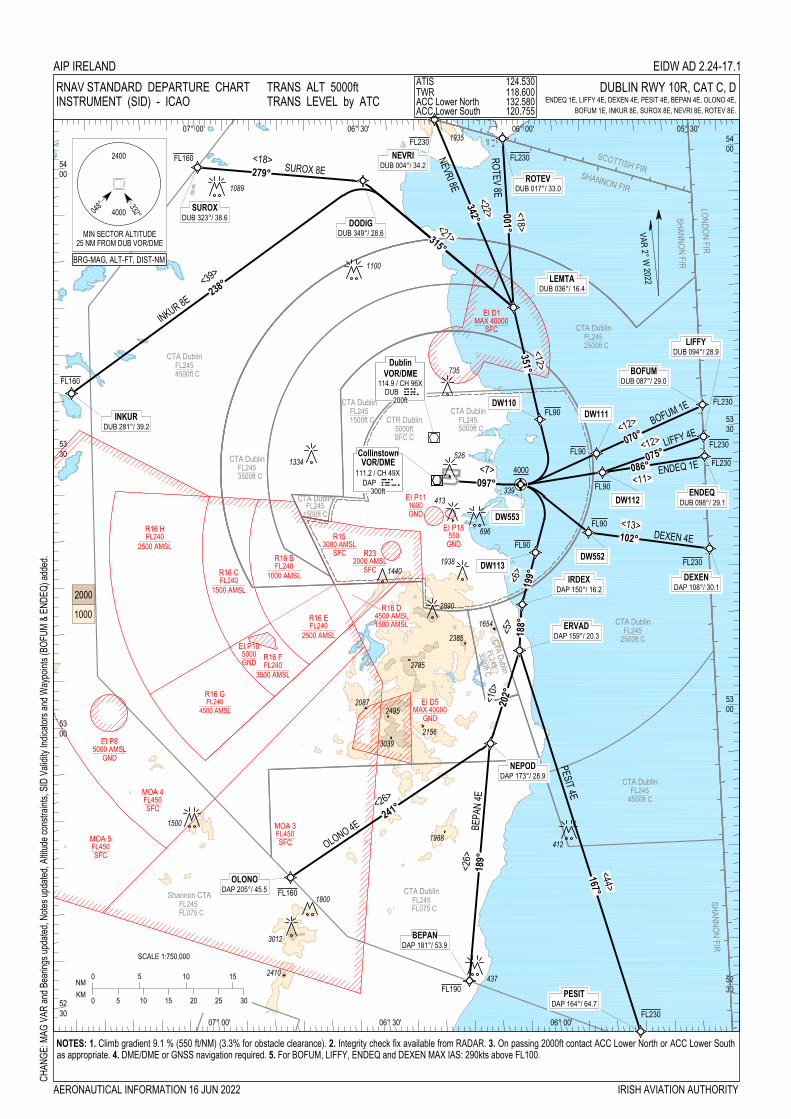
5300
5400
05° 30'
5230
5300
5330
5330
5400
07° 00'
07° 00'
06° 30'
06° 30'
06° 00'
06° 00'
0 5 10 15 20 25 30
0 5 10 15
KMNM
SCALE 1:750,000
OLONO 4E BEPA
N 4E
LIFFY 4E
ROTEV 8E
NEVRI 8E
SUROX 8E
INKUR 8E
DEXEN 4E
4000
PESIT 4E
1100
437
696
1334
2890
1800
3012
412
1089
1938
1500
1440
2385
2156
2495
2410
1988
3039
2785
1935
BOFUM 1E
ENDEQ 1E
5230
526
<7>097°
<18>001°
<22>342°
<21>315°
<18>279°
<39>
238°
<5>
188°
<10>
202°
<44>167°
<26>
<26>
241°
2087
735
413
FL90
048°
MIN SECTOR ALTITUDE25 NM FROM DUB VOR/DME
332°4000
2400
1000
2000
SCOTTISH FIR
LONDON FIR
SHANNON FIR
SHANNON FIR
DublinVOR/DME
114.9 / CH 96XDUB DUB
CollinstownVOR/DME
111.2 / CH 49XDAP Dap
200ft
300ft
DAP 205°/ 45.5OLONO
DAP 181°/ 53.9BEPAN
DAP 164°/ 64.7PESIT
DAP 173°/ 28.9NEPOD
DAP 150°/ 16.2IRDEX
DAP 159°/ 20.3ERVAD
DUB 087°/ 29.0BOFUM
DUB 094°/ 28.9LIFFY
DUB 323°/ 38.6SUROX
DUB 004°/ 34.2NEVRI
DUB 017°/ 33.0ROTEV
DUB 036°/ 16.4LEMTA
DUB 349°/ 28.6DODIG
DUB 281°/ 39.2INKUR
DUB 098°/ 29.1ENDEQ
DAP 108°/ 30.1DEXEN
<12>
<12>
<11>
<13>102°
1654
339
048°
MIN SECTOR ALTITUDE25 NM FROM DUB VOR/DME
332°4000
2400VAR 2° W
2022
BRG-MAG, ALT-FT, DIST-NM
FL90
FL90
FL90
FL90
DW113
DW553
DW552
DW110
<12>351°
DW111
070°
DW112
075°086°
<6>
199°
CTA DublinFL245
4500ft C
CTA Dublin
FL245
3000ft C
CTA DublinFL245
FL075 C
CTA DublinFL245
5000ft CCTR Dublin
5000ftSFC C
CTA DublinFL245
2500ft C
CTA DublinFL245
3500ft C
CTA DublinFL245
1500ft C
CTA DublinFL245
4500ft C
CTA DublinFL245
1500ft C
CTA DublinFL245
2500ft C
SHANNON FIR
Shannon CTAFL245
FL075 C
R16 HFL240
2500 AMSL
R16 CFL240
1500 AMSL
R16 BFL240
1000 AMSL
R16 EFL240
2500 AMSL
R16 FFL240
3500 AMSL
EI P105000GND
EI P85000 AMSL
GND
MOA 4FL450SFC
MOA 5FL450SFC
MOA 3FL450SFC
R232000 AMSL
SFC
R153000 AMSL
SFC
EI P111000GND
EI P18550
GND
EI D1MAX 40000
SFC
EI D5MAX 40000
GND
R16 GFL240
4500 AMSL
R16 D4500 AMSL1500 AMSL
189°
FL190
FL230
FL230
FL230
FL230
FL230
FL230
FL230
FL160
FL160
FL160
NOTES: 1. Climb gradient 9.1 % (550 ft/NM) (3.3% for obstacle clearance). 2. Integrity check fix available from RADAR. 3. On passing 2000ft contact ACC Lower North or ACC Lower Southas appropriate. 4. DME/DME or GNSS navigation required. 5. For BOFUM, LIFFY, ENDEQ and DEXEN MAX IAS: 290kts above FL100.
RNAV STANDARD DEPARTURE CHARTINSTRUMENT (SID) - ICAO
DUBLIN RWY 10R, CAT C, DENDEQ 1E, LIFFY 4E, DEXEN 4E, PESIT 4E, BEPAN 4E, OLONO 4E,
BOFUM 1E, INKUR 8E, SUROX 8E, NEVRI 8E, ROTEV 8E.
AIP IRELAND EIDW AD 2.24-17.1
AERONAUTICAL INFORMATION 16 JUN 2022
TRANS ALT 5000ftTRANS LEVEL by ATC
CHAN
GE: M
AG V
AR an
d Bea
rings
upda
ted, N
otes u
pdate
d, Alt
itude
cons
traint
s, SI
D Va
lidity
Indic
ators
and W
aypo
ints (
BOFU
M &
ENDE
Q) ad
ded.
ATIS 124.530TWR 118.600ACC Lower North 132.580ACC Lower South 120.755
IRISH AVIATION AUTHORITY

EIDW AD 2.24-17.2 AIP IRELAND 16 JUN 2022
AIRAC Amdt 006/2022 IRISH AVIATION AUTHORITY
BEPAN 4E CAT C/D SID RWY10R BEPA4E
Nav. Spec.
WPT Name
Latitude (N)/ Longitude (W)
Path Term
Fly-By Fly-over
True track / Mag track
Distance (NM)
Upper limit / Lower limit
Speed Limit (kts) Remarks
RNAV1 DW553 532433.5 / 0060311.7 CF Fly-Over 095.2 / 097 - - / +A4000 - 098° DAP / D9.0 DAP RNAV1 DW113 531714.5 / 0060102.4 DF Fly-By - - -FL90 / - - Turn R RNAV1 IRDEX 531145.1 / 0060350.1 TF Fly-By 197.0 / 199 5.7 - - - RNAV1 ERVAD 530647.1 / 0060440.4 TF Fly-By 185.8 / 188 5.0 - - Turn L RNAV1 NEPOD 525657.2 / 0061029.8 TF Fly-By 199.7 / 202 10.5 - - Turn R RNAV1 BEPAN 523136.2 / 0061549.5 TF Fly-By 187.3 / 189 25.6 -FL190 / - - Turn L
BOFUM 1E CAT C/D SID RWY10R BOFU1E
Nav. Spec.
WPT Name
Latitude (N)/ Longitude (W)
Path Term
Fly-By Fly-over
True track / Mag track
Distance (NM)
Upper limit / Lower limit
Speed Limit (kts) Remarks
RNAV1 DW553 532433.5 / 0060311.7 CF Fly-Over 095.2 / 097 - - / +A4000 - 098° DAP / D9.0 DAP RNAV1 DW111 532734.8 / 0054921.4 DF Fly-By - - -FL90 / - - Turn L RNAV1 BOFUM 533214.0 / 0053000.0 TF Fly-By 067.9 / 070 12.5 -FL230 / - 290 -
DEXEN 4E CAT C/D SID RWY10R DEXE4E
Nav. Spec.
WPT Name
Latitude (N)/ Longitude (W) Path Term Fly-By
Fly-over True track / Mag track
Distance (NM)
Upper limit / Lower limit
Speed Limit (kts) Remarks
RNAV1 DW553 532433.5 / 0060311.7 CF Fly-Over 095.2 / 097 - - / +A4000 - 098° DAP / D9.0 DAP RNAV1 DW552 531909.3 / 0055123.7 DF Fly-By - - -FL90 / - - Turn R RNAV1 DEXEN 531649.4 / 0053000.0 TF Fly-By 100.2 / 102 13.0 -FL230 / - 290 Turn L
ENDEQ 1E CAT C/D SID RWY10R ENDE1E
Nav. Spec.
WPT Name
Latitude (N)/ Longitude (W)
Path Term
Fly-By Fly-over
True track / Mag track
Distance (NM)
Upper limit / Lower limit
Speed Limit (kts) Remarks
RNAV1 DW553 532433.5 / 0060311.7 CF Fly-Over 095.2 / 097 - - / +A4000 - 098° DAP / D9.0 DAP RNAV1 DW112 532530.5 / 0054829.7 DF Fly-By - - -FL90 / - - Turn L RNAV1 ENDEQ 532644.4 / 0053000.0 TF Fly-By 083.5 / 086 11.1 -FL230 / - 290 -
INKUR 8E CAT C/D SID RWY10R INKU8E
Nav. Spec.
WPT Name
Latitude (N)/ Longitude (W)
Path Term
Fly-By Fly-over
True track / Mag track
Distance (NM)
Upper limit / Lower limit
Speed Limit (kts) Remarks
RNAV1 DW553 532433.5 / 0060311.7 CF Fly-Over 095.2 / 097 - - / +A4000 - 098° DAP / D9.0 DAP RNAV1 DW110 533126.2 / 0055916.4 DF Fly-By - - -FL90 / - - Turn L RNAV1 LEMTA 534334.3 / 0060311.6 TF Fly-By 349.2 / 351 12.4 - - - RNAV1 DODIG 535746.0 / 0062934.0 TF Fly-By 312.5 / 315 21.1 - - Turn L RNAV1 INKUR 533551.3 / 0072328.6 TF Fly-By 235.9 / 238 38.8 -FL160 / - - Turn L
LIFFY 4E CAT C/D SID RWY10R LIFF4E
Nav. Spec.
WPT Name
Latitude (N)/ Longitude (W)
Path Term
Fly-By Fly-over
True track / Mag track
Distance (NM)
Upper limit / Lower limit
Speed Limit (kts) Remarks
RNAV1 DW553 532433.5 / 0060311.7 CF Fly-Over 095.2 / 097 - - / +A4000 - 098° DAP / D9.0 DAP RNAV1 DW112 532530.5 / 0054829.7 DF Fly-By - - -FL90 / - - Turn L RNAV1 LIFFY 532848.3 / 0053000.0 TF Fly-By 073.3 / 075 11.5 -FL230 / - 290 Turn L
NEVRI 8E CAT C/D SID RWY10R NEVR8E
Nav. Spec.
WPT Name
Latitude (N)/ Longitude (W)
Path Term
Fly-By Fly-over
True track / Mag track
Distance (NM)
Upper limit / Lower limit
Speed Limit (kts) Remarks
RNAV1 DW553 532433.5 / 0060311.7 CF Fly-Over 095.2 / 097 - - / +A4000 - 098° DAP / D9.0 DAP RNAV1 DW110 533126.2 / 0055916.4 DF Fly-By - - -FL90 / - - Turn L RNAV1 LEMTA 534334.3 / 0060311.6 TF Fly-By 349.2 / 351 12.4 - - - RNAV1 NEVRI 540406.0 / 0061611.4 TF Fly-By 339.6 / 342 22.0 -FL230 / - - Turn L

EIDW AD 2.24-17.3 AIP IRELAND 16 JUN 2022
AIRAC Amdt 006/2022 IRISH AVIATION AUTHORITY
OLONO 4E CAT C/D SID RWY10R OLON4E
Nav. Spec.
WPT Name
Latitude (N)/ Longitude (W)
Path Term
Fly-By Fly-over
True track / Mag track
Distance (NM)
Upper limit / Lower limit
Speed Limit (kts) Remarks
RNAV1 DW553 532433.5 / 0060311.7 CF Fly-Over 095.2 / 097 - - / +A4000 - 098° DAP / D9.0 DAP RNAV1 DW113 531714.5 / 0060102.4 DF Fly-By - - -FL90 / - - Turn R RNAV1 IRDEX 531145.1 / 0060350.1 TF Fly-By 197.0 / 199 5.7 - - - RNAV1 ERVAD 530647.1 / 0060440.4 TF Fly-By 185.8 / 188 5.0 - - Turn L RNAV1 NEPOD 525657.2 / 0061029.8 TF Fly-By 199.7 / 202 10.5 - - Turn R RNAV1 OLONO 524323.1 / 0064644.4 TF Fly-By 238.5 / 241 25.8 -FL160 / - - Turn R
PESIT 4E CAT C/D SID RWY10R PESI4E
Nav. Spec.
WPT Name
Latitude (N)/ Longitude (W)
Path Term
Fly-By Fly-over
True track / Mag track
Distance (NM)
Upper limit / Lower limit
Speed Limit (kts) Remarks
RNAV1 DW553 532433.5 / 0060311.7 CF Fly-Over 095.2 / 097 - - / +A4000 - 098° DAP / D9.0 DAP RNAV1 DW113 531714.5 / 0060102.4 DF Fly-By - - -FL90 / - - Turn R RNAV1 IRDEX 531145.1 / 0060350.1 TF Fly-By 197.0 / 199 5.7 - - - RNAV1 ERVAD 530647.1 / 0060440.4 TF Fly-By 185.8 / 188 5.0 - - Turn L RNAV1 PESIT 522356.6 / 0054524.0 TF Fly-By 164.6 / 167 44.5 -FL230 / - - Turn L
ROTEV 8E CAT C/D SID RWY10R ROTE8E
Nav. Spec.
WPT Name
Latitude (N)/ Longitude (W)
Path Term
Fly-By Fly-over
True track / Mag track
Distance (NM)
Upper limit / Lower limit
Speed Limit (kts) Remarks
RNAV1 DW553 532433.5 / 0060311.7 CF Fly-Over 095.2 / 097 - - / +A4000 - 098° DAP / D9.0 DAP RNAV1 DW110 533126.2 / 0055916.4 DF Fly-By - - -FL90 / - - Turn L RNAV1 LEMTA 534334.3 / 0060311.6 TF Fly-By 349.2 / 351 12.4 - - - RNAV1 ROTEV 540143.7 / 0060358.4 TF Fly-By 358.6 / 001 18.2 -FL230 / - - Turn R
SUROX 8E CAT C/D SID RWY10R SURO8E
Nav. Spec.
WPT Name
Latitude (N)/ Longitude (W)
Path Term
Fly-By Fly-over
True track / Mag track
Distance (NM)
Upper limit / Lower limit
Speed Limit (kts) Remarks
RNAV1 DW553 532433.5 / 0060311.7 CF Fly-Over 095.2 / 097 - - / +A4000 - 098° DAP / D9.0 DAP RNAV1 DW110 533126.2 / 0055916.4 DF Fly-By - - -FL90 / - - Turn L RNAV1 LEMTA 534334.3 / 0060311.6 TF Fly-By 349.2 / 351 12.4 - - - RNAV1 DODIG 535746.0 / 0062934.0 TF Fly-By 312.5 / 315 21.1 - - Turn L RNAV1 SUROX 535948.0 / 0065936.5 TF Fly-By 276.8 / 279 17.9 -FL160 / - - Turn L

EIKY AD 2 - 1AIP IRELAND
16 JUN 2022
16 JUN 2022
EIKY AD 2.1 AERODROME LOCATION INDICATOR AND NAME
EIKY – KERRY
EIKY AD 2.2 AERODROME GEOGRAPHICAL AND ADMINISTRATIVE DATA
EIKY AD 2.3 OPERATIONAL HOURS
1 ARP and its site 521051N 0093126W Mid-point RWY 08/26
2 Direction and distance from (city) 8NM SE of Tralee / 7NM N of Killarney
3 AD Elevation, Reference Temperature & Mean Low Temperature
112 ft/20.7°C (Max Temp) 0.9°C (MNM Temp)
4 Geoid undulation at AD ELEV PSN 191ft
5 MAG VAR/Annual change 3° (2022) / 11’ decreasing
6 AD Operator, address, telephone, telefax, email, AFS, Website
Post: Kerry Airport Plc, FarranFore, Co. Kerry.
Phone:+ 353 66 976 46 44
Phone:+ 353 66 976 43 50
Fax: + 353 66 976 41 34
Fax: + 353 66 976 49 88
7 Types of traffic permitted (IFR/VFR) IFR/VFR
8 Remarks Nil
1 AD Operator Winter 0900-1800 UTC Summer 0800-1700 UTC Variations promulgated by NOTAM. Check NOTAM
2 Customs and immigration 24HR PN required to AD Operator.
3 Health and sanitation As per ATS
4 AIS Briefing Office See Remarks
5 ATS Reporting Office (ARO) As per ATS
6 MET Briefing Office See Remarks
7 ATS Winter 0900-1800 UTC Summer 0800-1700 UTC Variations promulgated by NOTAM. Check NOTAM
8 Fuelling As per ATS
9 Handling As per ATS
10 Security H24
11 De-icing As per ATS
Irish Aviation Authority AIRAC Amdt 006/22

EIKY AD 2 - 2 AIP IRELAND16 JUN 2022
16 JUN 2022
EIKY AD 2.4 HANDLING SERVICES AND FACILITIES
EIKY AD 2.5 PASSENGER FACILITIES
EIKY AD 2.6 RESCUE AND FIRE FIGHTING SERVICES
12 Remarks ATS AVBL outside published HR, 24 HR PN to AD Operator.
Fuelling - Last fuelling as ATS HR - 30MIN
PIB AVBL from AIS, Shannon see GEN 3.1.5
MET briefing AVBL from Central Aviation Office, Shannon Airport see GEN 3.5.4
Airport closed on Christmas Day. Exact hours advised by NOTAM.
1 Cargo handling facilities: Contact AD Operator
2 Fuel/oil types JET A1, AVGAS 100LL
3 Fuelling facilities/capacity 1 truck 18,000L; 1 truck 7,500L; Avgas available from kerb side pump.
4 De-icing facilities AVBL Mobile Unit
5 Hangar space available for visiting aircraft Nil
6 Repair facilities for visiting aircraft Nil
7 Remarks Handling services AVBL within AD HR by arrangement with the AD
1 Hotel(s) at or in the vicinity of AD In Tralee or KillarneyB+B Near AD
2 Restaurant(s) at or in the vicinity of AD At AD and in local towns
3 Transportation possibilities Taxis and Car Hire from the AD
4 Medical facilities First Aid at AD. Hospitals in Tralee & Killarney
5 Bank and Post Office at or in the vicinity of AD Foreign Exchange and ATM at AD. Tralee & Killarney
6 Tourist Office At AD
7 Remarks Nil
1 AD category for fire fighting CAT 6
2 Rescue equipment Hydraulic cutting equipment. Emergency lighting and other equipment in compliance with Category 7 requirements.
3 Capability for removal of disabled aircraft Capability 10,000kg (using outside Contractor equipment) Co-ordinator
Phone:+353 66 979 3014
Phone:+353 86 604 4127
4 Remarks Category 7 fire fighting AVBL with 24HR Notification to AD Operator. During periods of reduced activity available fire fighting level may be reduced. AVBL protection shall be no less than that needed for the highest category aircraft (to MAX CAT 7) planned to use the aerodrome during that time subject 24HR Notification to the AD ADMIN
Irish Aviation AuthorityAIRAC Amdt 006/22
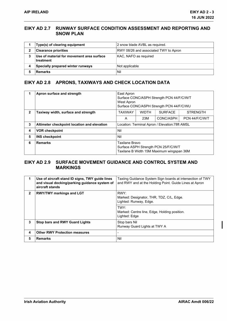
EIKY AD 2 - 3AIP IRELAND
16 JUN 2022
16 JUN 2022
EIKY AD 2.7 RUNWAY SURFACE CONDITION ASSESSMENT AND REPORTING AND SNOW PLAN
EIKY AD 2.8 APRONS, TAXIWAYS AND CHECK LOCATION DATA
EIKY AD 2.9 SURFACE MOVEMENT GUIDANCE AND CONTROL SYSTEM AND MARKINGS
1 Type(s) of clearing equipment 2 snow blade AVBL as required.2 Clearance priorities RWY 08/26 and associated TWY to Apron3 Use of material for movement area surface
treatmentKAC, NAFO as required
4 Specially prepared winter runways Not applicable5 Remarks Nil
1 Apron surface and strength East Apron Surface CONC/ASPH Strength PCN 44/F/C/W/TWest Apron Surface CONC/ASPH Strength PCN 44/F/C/WU
2 Taxiway width, surface and strength TAXIWAY WIDTH SURFACE STRENGTH
A 23M CONC/ASPH PCN 44/F/C/W/T
3 Altimeter checkpoint location and elevation Location: Terminal Apron / Elevation:78ft AMSL
4 VOR checkpoint Nil
5 INS checkpoint Nil
6 Remarks Taxilane Bravo Surface ASPH Strength PCN 25/F/C/W/T Taxilane B Width 15M Maximum wingspan 36M
1 Use of aircraft stand ID signs, TWY guide lines and visual docking/parking guidance system of aircraft stands
Taxiing Guidance System Sign boards at intersection of TWY and RWY and at the Holding Point. Guide Lines at Apron
2 RWY/TWY markings and LGT RWY: Marked: Designator, THR, TDZ, C/L, Edge. Lighted: Runway, Edge.
TWY: Marked: Centre line, Edge, Holding position. Lighted: Edge
3 Stop bars and RWY Guard Lights Stop bars Nil Runway Guard Lights at TWY A
4 Other RWY Protection measures -
5 Remarks Nil
Irish Aviation Authority AIRAC Amdt 006/22

EIKY AD 2 - 4 AIP IRELAND16 JUN 2022
16 JUN 2022
EIKY AD 2.10 AERODROME OBSTACLES
In approach/TKOF areas In circling area and at AD Remarks1 2 3
RWY/Area affected
Obstacle type Elevation
Markings/LGT
Coordinates Obstacle type Elevation
Markings/LGT
Coordinates
a b c a b26/APCH08/TKOF
Currow Church55.5M/ 182ft
Nil
52 11 07.61N009 29 43.66W
ESB Pole124.0M/407ft
Nil
52 10 24.45N009 29 32.67W
ESB Pylon197.0M/ 646ft
Nil
52 12 11.54N009 23 17.03W
ESB Pole133.5M/438ft
Nil
52 10 18.25N009 29 33.94W
ESB Pylon231.0M/ 758ft
Nil
52 12 04.54N009 23 04.23W
ESB Pole102.5M/337ft
Nil
52 10 31.09N009 30 15.47W
ESB Pylon269.0M/ 883ft
Nil
52 11 54.83N009 22 46.91W
ESB Pole91.5M/301ft
Nil
52 10 33.55N009 30 15.37W
ESB Pylon277.5M/ 910ft
Nil
52 11 46.81N009 22 31.23W
ESB Pylon228.0M/748ft
Nil
52 16 41.36N009 22 46.00W
08/APCH26/TKOF
Mill52.5M/ 172ft
Nil
52 10 21.40N009 33 10.29W
ESB Pole79.0M/259ft
Nil
52 11 38.31N009 29 14.84W
Mill55.0M/ 180ft
Nil
52 10 20.29N009 33 09.99W
Pole226.0M/741ft
Nil
52 09 41.92N009 29 40.95W
Tree44.5M/146ft
Nil
52 05 48.38N009 24 18.65W
Trig Point88.0M/289ft
Nil
52 13 00.29N009 34 42.66W
Pole253.5M/832ft
Nil
52 08 38.37N009 25 40.90W
ESB Pole228.0M/748ft
Nil
52 11 10.42N009 23 44.89W
ESB Pole232.0M/761ft
Nil
52 11 11.94N009 23 41.60W
ESB Pole237.0M/778ft
Nil
52 11 13.94N009 23 37.23W
ESB Pole245.5M/805ft
Nil
52 11 15.79N009 23 33.24W
ESB Pole246.0M/807ft
Nil
52 11 17.54N009 23 31.39W
Pole106.0M/348ft
Nil
52 09 55.74N009 34 03.68W
Pole104.0M/342ft
Nil
52 09 55.02N009 34 08.24W
Irish Aviation AuthorityAIRAC Amdt 006/22
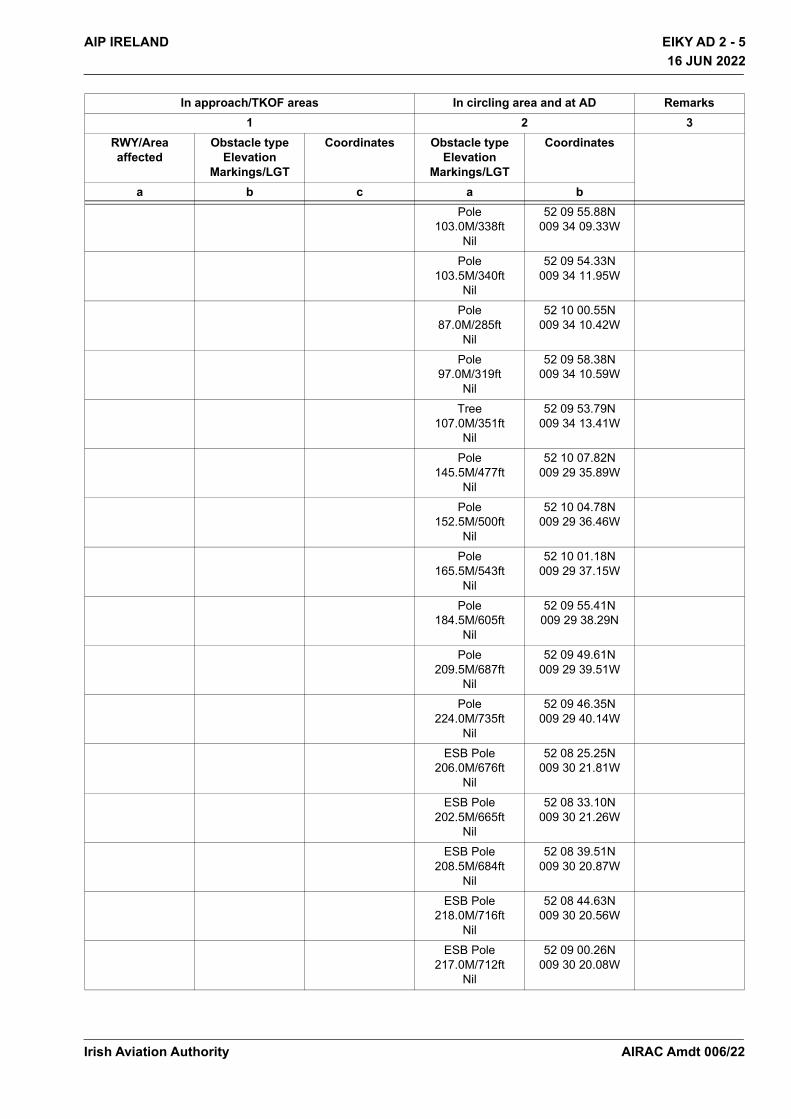
EIKY AD 2 - 5AIP IRELAND
16 JUN 2022
16 JUN 2022
Pole103.0M/338ft
Nil
52 09 55.88N009 34 09.33W
Pole103.5M/340ft
Nil
52 09 54.33N009 34 11.95W
Pole87.0M/285ft
Nil
52 10 00.55N009 34 10.42W
Pole97.0M/319ft
Nil
52 09 58.38N009 34 10.59W
Tree107.0M/351ft
Nil
52 09 53.79N009 34 13.41W
Pole145.5M/477ft
Nil
52 10 07.82N009 29 35.89W
Pole152.5M/500ft
Nil
52 10 04.78N009 29 36.46W
Pole165.5M/543ft
Nil
52 10 01.18N009 29 37.15W
Pole184.5M/605ft
Nil
52 09 55.41N009 29 38.29N
Pole209.5M/687ft
Nil
52 09 49.61N009 29 39.51W
Pole224.0M/735ft
Nil
52 09 46.35N009 29 40.14W
ESB Pole206.0M/676ft
Nil
52 08 25.25N009 30 21.81W
ESB Pole202.5M/665ft
Nil
52 08 33.10N009 30 21.26W
ESB Pole208.5M/684ft
Nil
52 08 39.51N009 30 20.87W
ESB Pole218.0M/716ft
Nil
52 08 44.63N009 30 20.56W
ESB Pole217.0M/712ft
Nil
52 09 00.26N009 30 20.08W
In approach/TKOF areas In circling area and at AD Remarks1 2 3
RWY/Area affected
Obstacle type Elevation
Markings/LGT
Coordinates Obstacle type Elevation
Markings/LGT
Coordinates
a b c a b
Irish Aviation Authority AIRAC Amdt 006/22

EIKY AD 2 - 6 AIP IRELAND16 JUN 2022
16 JUN 2022
ESB Pole174.0M/571ft
Nil
52 09 04.85N009 30 19.87W
ESB Pole166.5M/547ft
Nil
52 09 12.03N009 30 19.51W
ESB Pole162.5M/534ft
Nil
52 09 19.23N009 30 19.14W
ESB Pole158.0M/519ft
Nil
52 09 24.80N009 30 18.86W
ESB Pole161.0M/529ft
Nil
52 09 47.69N009 30 17.36W
ESB Pole141.0M/463ft
Nil
52 09 58.84N009 30 17.13W
ESB Pole 140.5M/461ft
Nil
52 10 05.80N009 30 16.59W
ESB Pole151.5M/497ft
Nil
52 10 14.82N009 30 16.11W
ESB Pole154.0M/506ft
Nil
52 10 22.82N009 30 15.71W
ESB Pole154.0M/506ft
Nil
52 10 26.45N009 30 15.64W
ESB Pole74.0M/243ft
Nil
52 10 39.19N009 29 31.47W
ESB Pole95.0M/312ft
Nil
52 10 35.08N009 29 31.25W
ESB Pole102.5M/337ft
Nil
52 10 32.93N009 29 31.13W
ESB Pole116.0M/381ft
Nil
52 10 29.36N009 29 31.71W
ESB Pole208.5M/684ft
Nil
52 08 20.76N009 29 56.40W
ESB Pole215.5M/707ft
Nil
52 08 16.22N009 29 57.25W
In approach/TKOF areas In circling area and at AD Remarks1 2 3
RWY/Area affected
Obstacle type Elevation
Markings/LGT
Coordinates Obstacle type Elevation
Markings/LGT
Coordinates
a b c a b
Irish Aviation AuthorityAIRAC Amdt 006/22
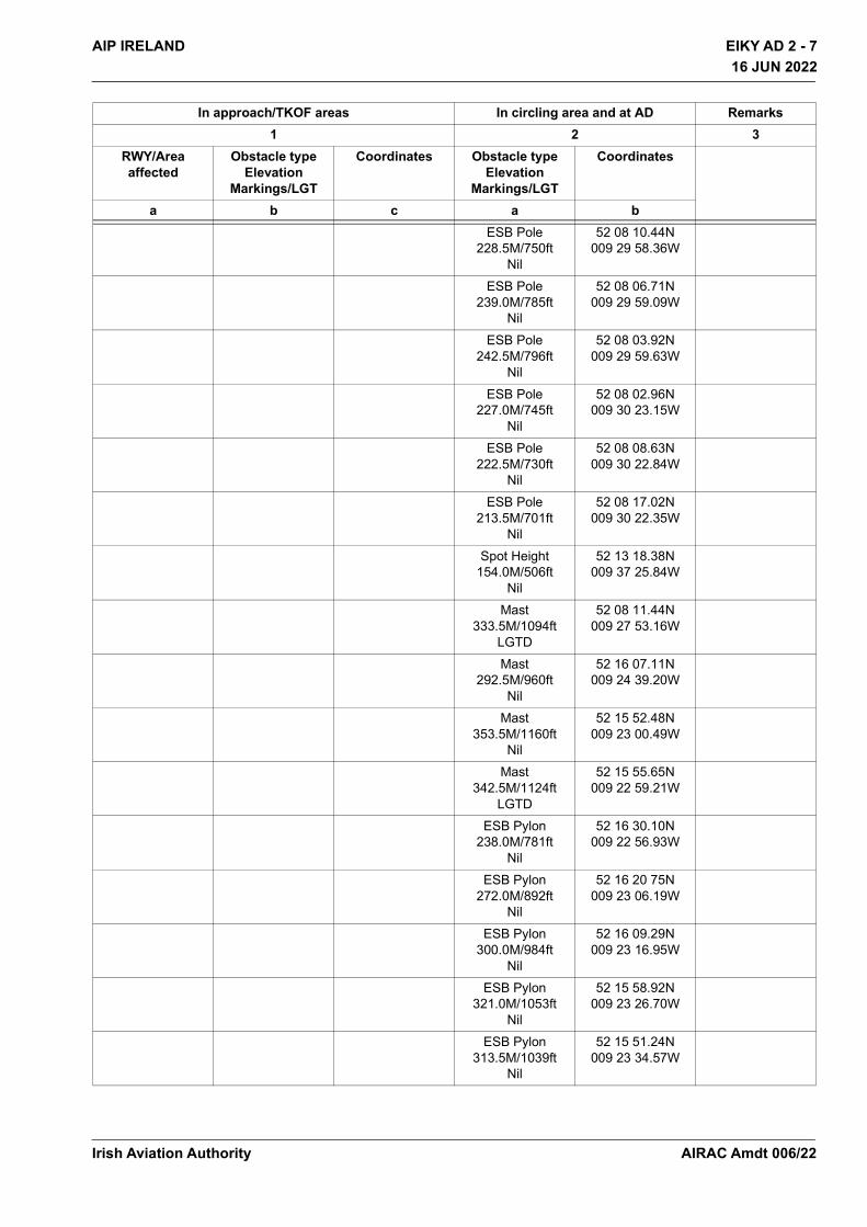
EIKY AD 2 - 7AIP IRELAND
16 JUN 2022
16 JUN 2022
ESB Pole228.5M/750ft
Nil
52 08 10.44N009 29 58.36W
ESB Pole239.0M/785ft
Nil
52 08 06.71N009 29 59.09W
ESB Pole242.5M/796ft
Nil
52 08 03.92N009 29 59.63W
ESB Pole227.0M/745ft
Nil
52 08 02.96N009 30 23.15W
ESB Pole222.5M/730ft
Nil
52 08 08.63N009 30 22.84W
ESB Pole213.5M/701ft
Nil
52 08 17.02N009 30 22.35W
Spot Height154.0M/506ft
Nil
52 13 18.38N009 37 25.84W
Mast333.5M/1094ft
LGTD
52 08 11.44N009 27 53.16W
Mast292.5M/960ft
Nil
52 16 07.11N009 24 39.20W
Mast353.5M/1160ft
Nil
52 15 52.48N009 23 00.49W
Mast342.5M/1124ft
LGTD
52 15 55.65N009 22 59.21W
ESB Pylon238.0M/781ft
Nil
52 16 30.10N009 22 56.93W
ESB Pylon272.0M/892ft
Nil
52 16 20 75N009 23 06.19W
ESB Pylon300.0M/984ft
Nil
52 16 09.29N009 23 16.95W
ESB Pylon321.0M/1053ft
Nil
52 15 58.92N009 23 26.70W
ESB Pylon313.5M/1039ft
Nil
52 15 51.24N009 23 34.57W
In approach/TKOF areas In circling area and at AD Remarks1 2 3
RWY/Area affected
Obstacle type Elevation
Markings/LGT
Coordinates Obstacle type Elevation
Markings/LGT
Coordinates
a b c a b
Irish Aviation Authority AIRAC Amdt 006/22
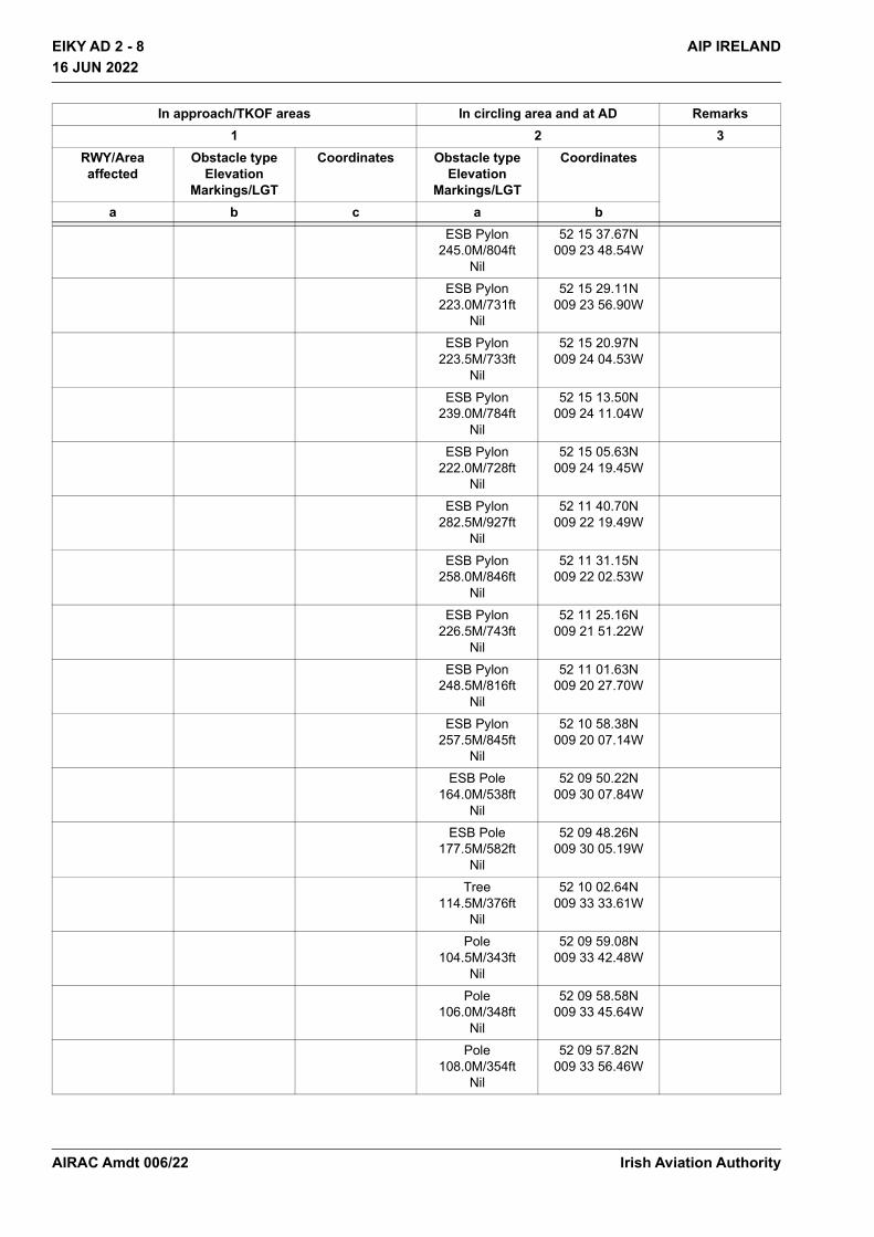
EIKY AD 2 - 8 AIP IRELAND16 JUN 2022
16 JUN 2022
ESB Pylon245.0M/804ft
Nil
52 15 37.67N009 23 48.54W
ESB Pylon223.0M/731ft
Nil
52 15 29.11N009 23 56.90W
ESB Pylon223.5M/733ft
Nil
52 15 20.97N009 24 04.53W
ESB Pylon239.0M/784ft
Nil
52 15 13.50N009 24 11.04W
ESB Pylon222.0M/728ft
Nil
52 15 05.63N009 24 19.45W
ESB Pylon282.5M/927ft
Nil
52 11 40.70N009 22 19.49W
ESB Pylon258.0M/846ft
Nil
52 11 31.15N009 22 02.53W
ESB Pylon226.5M/743ft
Nil
52 11 25.16N009 21 51.22W
ESB Pylon248.5M/816ft
Nil
52 11 01.63N009 20 27.70W
ESB Pylon257.5M/845ft
Nil
52 10 58.38N009 20 07.14W
ESB Pole164.0M/538ft
Nil
52 09 50.22N009 30 07.84W
ESB Pole177.5M/582ft
Nil
52 09 48.26N009 30 05.19W
Tree114.5M/376ft
Nil
52 10 02.64N009 33 33.61W
Pole104.5M/343ft
Nil
52 09 59.08N009 33 42.48W
Pole106.0M/348ft
Nil
52 09 58.58N009 33 45.64W
Pole108.0M/354ft
Nil
52 09 57.82N009 33 56.46W
In approach/TKOF areas In circling area and at AD Remarks1 2 3
RWY/Area affected
Obstacle type Elevation
Markings/LGT
Coordinates Obstacle type Elevation
Markings/LGT
Coordinates
a b c a b
Irish Aviation AuthorityAIRAC Amdt 006/22
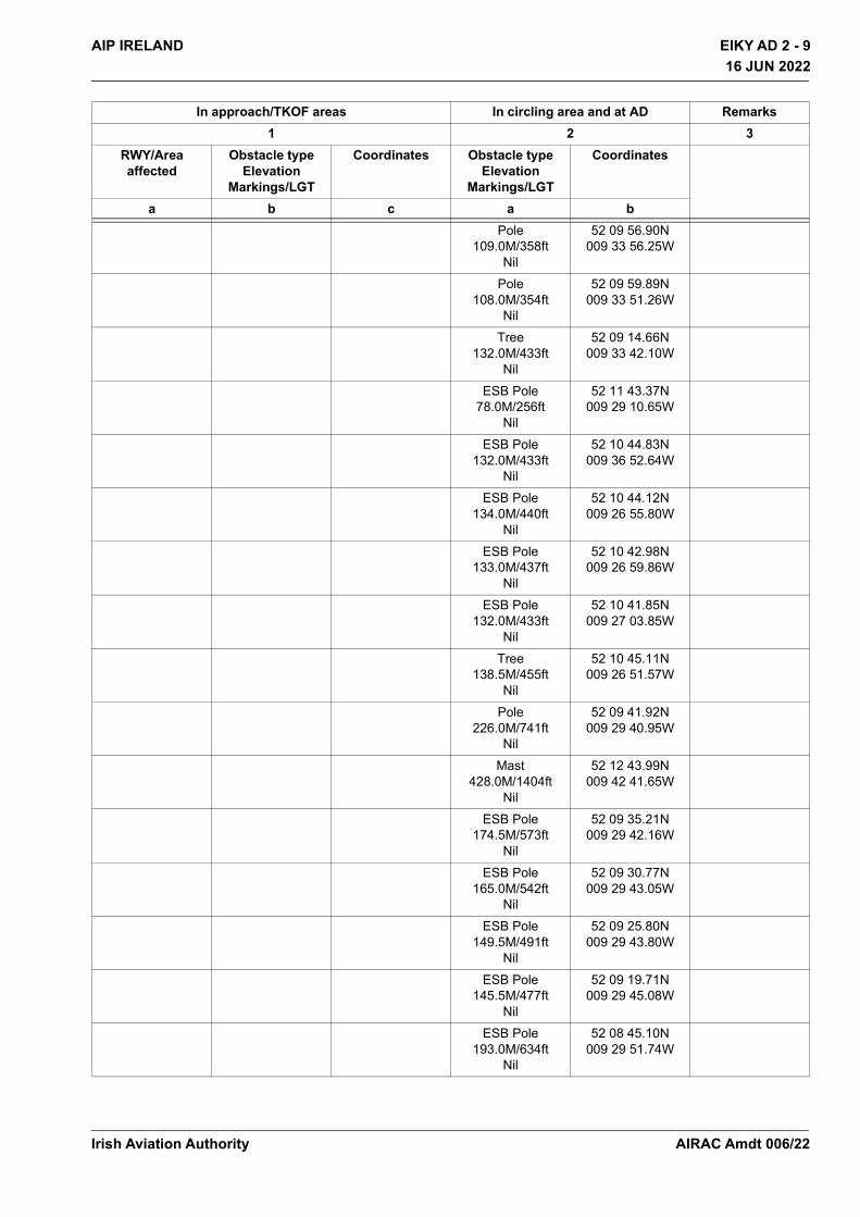
EIKY AD 2 - 9AIP IRELAND
16 JUN 2022
16 JUN 2022
Pole109.0M/358ft
Nil
52 09 56.90N009 33 56.25W
Pole108.0M/354ft
Nil
52 09 59.89N009 33 51.26W
Tree132.0M/433ft
Nil
52 09 14.66N009 33 42.10W
ESB Pole78.0M/256ft
Nil
52 11 43.37N009 29 10.65W
ESB Pole132.0M/433ft
Nil
52 10 44.83N009 36 52.64W
ESB Pole134.0M/440ft
Nil
52 10 44.12N009 26 55.80W
ESB Pole133.0M/437ft
Nil
52 10 42.98N009 26 59.86W
ESB Pole132.0M/433ft
Nil
52 10 41.85N009 27 03.85W
Tree138.5M/455ft
Nil
52 10 45.11N009 26 51.57W
Pole226.0M/741ft
Nil
52 09 41.92N009 29 40.95W
Mast428.0M/1404ft
Nil
52 12 43.99N009 42 41.65W
ESB Pole174.5M/573ft
Nil
52 09 35.21N009 29 42.16W
ESB Pole165.0M/542ft
Nil
52 09 30.77N009 29 43.05W
ESB Pole149.5M/491ft
Nil
52 09 25.80N009 29 43.80W
ESB Pole145.5M/477ft
Nil
52 09 19.71N009 29 45.08W
ESB Pole193.0M/634ft
Nil
52 08 45.10N009 29 51.74W
In approach/TKOF areas In circling area and at AD Remarks1 2 3
RWY/Area affected
Obstacle type Elevation
Markings/LGT
Coordinates Obstacle type Elevation
Markings/LGT
Coordinates
a b c a b
Irish Aviation Authority AIRAC Amdt 006/22

EIKY AD 2 - 10 AIP IRELAND16 JUN 2022
16 JUN 2022
EIKY AD 2.11 METEOROLOGICAL INFORMATION PROVIDED
EIKY AD 2.12 RUNWAY PHYSICAL CHARACTERISTICS
ESB Pole194.5M/639ft
Nil
52 08 41.54N009 29 52.41W
ESB Pole191.5M/629ft
Nil
52 08 36.94N009 29 53.28W
ESB Pole192.0M/630ft
Nil
52 08 31.11N009 29 54.39W
ESB Pole198.5M/652ft
Nil
52 08 26.02N009 29 55.39W
1 Associated MET Office Central Aviation Office, Shannon Airport see GEN 3.5.4
2 Hours of service Forecasts valid from 05:00-24:00
3 Office responsible for TAF preparation Periods of validity Interval of issuance.
Met Éireann Central Aviation Office, Shannon. 9 HR 3 HR
4 Type of landing forecastInterval of issuance
METAR 30MIN During published HR of operation
5 Briefing/consultation provided Personal
6 Flight documentationLanguage(s) used
Charts and Tabular English
7 Charts and other information available for briefing or consultation
6-hourly synoptic chart; 6-hourly prognostic chart (surface); prognostic chart of significant weather; prognostic chart of wind/temperature at upper levels; prognostic chart of tropopause levels.
8 Supplementary equipment available for providing information
Weather surveillance RADAR; Ceilometer; Automatic Weather Station; Receiver for satellite cloud pictures.
9 ATS units provided with information EIKY TWR
10 Additional information (limitation of service, etc.) Refer to GEN 3.5.4.2 for additional information
DesignationsRWYNR
TRUE BRG Dimensions of RWY
Strength (PCN) and surface of RWY and SWY
THR coordinates RWY end
coordinates THR geoid undulation
THR elevation and highest elevation
of TDZ of precision APP
RWY1 2 3 4 5 6
08 071.23° 2000x45 44/F/C/W/TASPH
521040.75N 0093215.46W521101.56N
0093035.78W191ft
25m/82ft
In approach/TKOF areas In circling area and at AD Remarks1 2 3
RWY/Area affected
Obstacle type Elevation
Markings/LGT
Coordinates Obstacle type Elevation
Markings/LGT
Coordinates
a b c a b
Irish Aviation AuthorityAIRAC Amdt 006/22
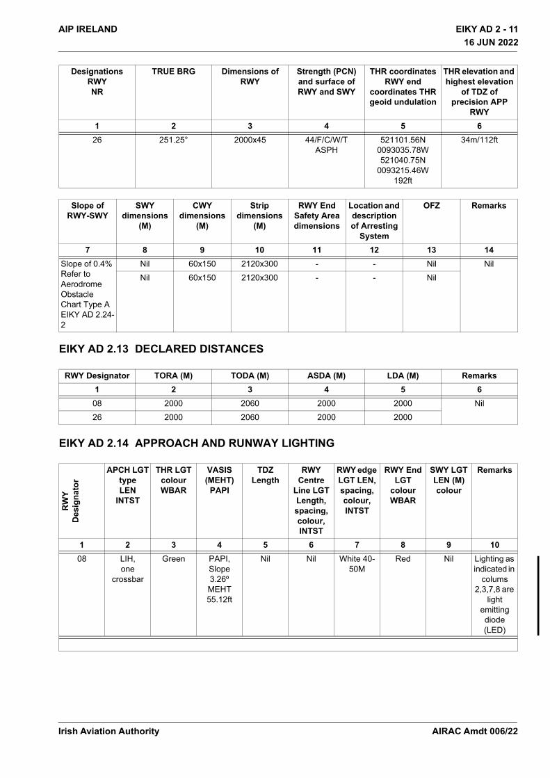
EIKY AD 2 - 11AIP IRELAND
16 JUN 2022
16 JUN 2022
EIKY AD 2.13 DECLARED DISTANCES
EIKY AD 2.14 APPROACH AND RUNWAY LIGHTING
26 251.25° 2000x45 44/F/C/W/TASPH
521101.56N 0093035.78W521040.75N
0093215.46W192ft
34m/112ft
Slope of RWY-SWY
SWY dimensions
(M)
CWY dimensions
(M)
Strip dimensions
(M)
RWY End Safety Area dimensions
Location and description of Arresting
System
OFZ Remarks
7 8 9 10 11 12 13 14Slope of 0.4% Refer to Aerodrome Obstacle Chart Type A EIKY AD 2.24-2
Nil 60x150 2120x300 - - Nil NilNil 60x150 2120x300 - - Nil
RWY Designator TORA (M) TODA (M) ASDA (M) LDA (M) Remarks1 2 3 4 5 6
08 2000 2060 2000 2000 Nil26 2000 2060 2000 2000
RW
YD
esig
nato
r
APCH LGTtypeLEN
INTST
THR LGTcolourWBAR
VASIS(MEHT)
PAPI
TDZLength
RWY Centre
Line LGT Length, spacing, colour, INTST
RWY edge LGT LEN, spacing, colour, INTST
RWY End LGT
colour WBAR
SWY LGT LEN (M) colour
Remarks
1 2 3 4 5 6 7 8 9 1008 LIH,
one crossbar
Green PAPI, Slope 3.26º MEHT 55.12ft
Nil Nil White 40-50M
Red Nil Lighting as indicated in
colums 2,3,7,8 are
light emitting diode (LED)
DesignationsRWYNR
TRUE BRG Dimensions of RWY
Strength (PCN) and surface of RWY and SWY
THR coordinates RWY end
coordinates THR geoid undulation
THR elevation and highest elevation
of TDZ of precision APP
RWY1 2 3 4 5 6
Irish Aviation Authority AIRAC Amdt 006/22
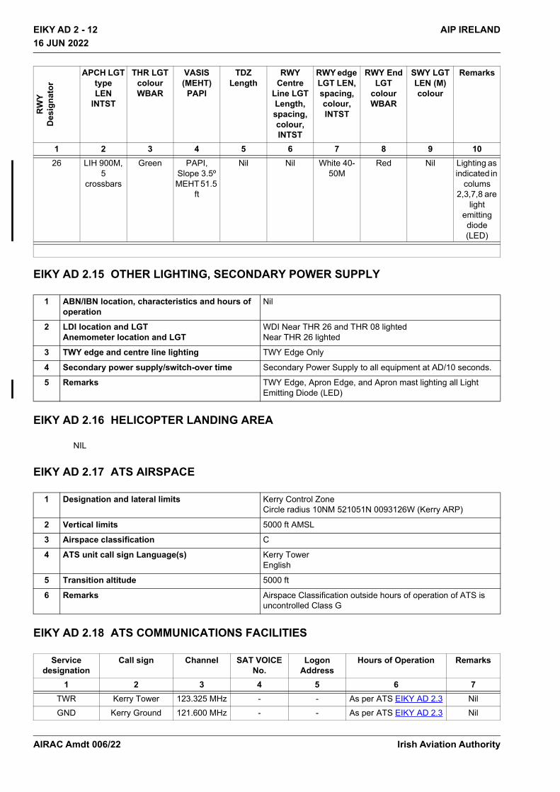
EIKY AD 2 - 12 AIP IRELAND16 JUN 2022
16 JUN 2022
EIKY AD 2.15 OTHER LIGHTING, SECONDARY POWER SUPPLY
EIKY AD 2.16 HELICOPTER LANDING AREA
NIL
EIKY AD 2.17 ATS AIRSPACE
EIKY AD 2.18 ATS COMMUNICATIONS FACILITIES
26 LIH 900M, 5
crossbars
Green PAPI, Slope 3.5º MEHT 51.5
ft
Nil Nil White 40-50M
Red Nil Lighting as indicated in
colums 2,3,7,8 are
light emitting diode (LED)
1 ABN/IBN location, characteristics and hours of operation
Nil
2 LDI location and LGT Anemometer location and LGT
WDI Near THR 26 and THR 08 lightedNear THR 26 lighted
3 TWY edge and centre line lighting TWY Edge Only
4 Secondary power supply/switch-over time Secondary Power Supply to all equipment at AD/10 seconds.
5 Remarks TWY Edge, Apron Edge, and Apron mast lighting all Light Emitting Diode (LED)
1 Designation and lateral limits Kerry Control Zone Circle radius 10NM 521051N 0093126W (Kerry ARP)
2 Vertical limits 5000 ft AMSL
3 Airspace classification C
4 ATS unit call sign Language(s) Kerry Tower English
5 Transition altitude 5000 ft
6 Remarks Airspace Classification outside hours of operation of ATS is uncontrolled Class G
Service designation
Call sign Channel SAT VOICE No.
Logon Address
Hours of Operation Remarks
1 2 3 4 5 6 7TWR Kerry Tower 123.325 MHz - - As per ATS EIKY AD 2.3 NilGND Kerry Ground 121.600 MHz - - As per ATS EIKY AD 2.3 Nil
RW
YD
esig
nato
r
APCH LGTtypeLEN
INTST
THR LGTcolourWBAR
VASIS(MEHT)
PAPI
TDZLength
RWY Centre
Line LGT Length, spacing, colour, INTST
RWY edge LGT LEN, spacing, colour, INTST
RWY End LGT
colour WBAR
SWY LGT LEN (M) colour
Remarks
1 2 3 4 5 6 7 8 9 10
Irish Aviation AuthorityAIRAC Amdt 006/22
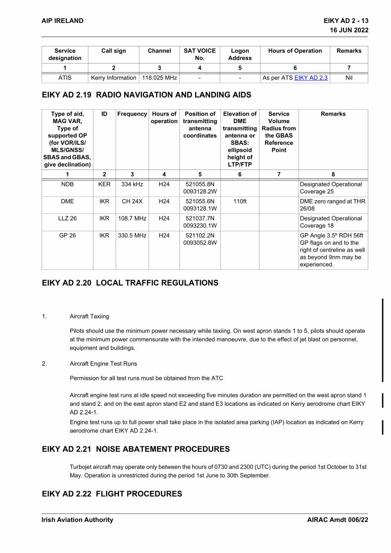
EIKY AD 2 - 13AIP IRELAND
16 JUN 2022
16 JUN 2022
EIKY AD 2.19 RADIO NAVIGATION AND LANDING AIDS
EIKY AD 2.20 LOCAL TRAFFIC REGULATIONS
1. Aircraft Taxiing
Pilots should use the minimum power necessary while taxiing. On west apron stands 1 to 5, pilots should operate at the minimum power commensurate with the intended manoeuvre, due to the effect of jet blast on personnel, equipment and buildings.
2. Aircraft Engine Test Runs
Permission for all test runs must be obtained from the ATC Aircraft engine test runs at idle speed not exceeding five minutes duration are permitted on the west apron stand 1 and stand 2, and on the east apron stand E2 and stand E3 locations as indicated on Kerry aerodrome chart EIKY AD 2.24-1.Engine test runs up to full power shall take place in the isolated area parking (IAP) location as indicated on Kerry aerodrome chart EIKY AD 2.24-1.
EIKY AD 2.21 NOISE ABATEMENT PROCEDURES
Turbojet aircraft may operate only between the hours of 0730 and 2300 (UTC) during the period 1st October to 31st May. Operation is unrestricted during the period 1st June to 30th September.
EIKY AD 2.22 FLIGHT PROCEDURES
ATIS Kerry Information 118.025 MHz - - As per ATS EIKY AD 2.3 Nil
Type of aid,MAG VAR,
Type of supported OP (for VOR/ILS/MLS/GNSS/
SBAS and GBAS, give declination)
ID Frequency Hours of operation
Position of transmitting
antenna coordinates
Elevation of DME
transmitting antenna or
SBAS: ellipsoid height of LTP/FTP
Service Volume
Radius from the GBAS Reference
Point
Remarks
1 2 3 4 5 6 7 8NDB KER 334 kHz H24 521055.8N
0093128.2WDesignated Operational Coverage 25
DME IKR CH 24X H24 521055.6N 0093128.1W
110ft DME zero ranged at THR 26/08
LLZ 26 IKR 108.7 MHz H24 521037.7N 0093230.1W
Designated Operational Coverage 18
GP 26 IKR 330.5 MHz H24 521102.2N0093052.8W
GP Angle 3.5º RDH 56ft GP flags on and to the right of centreline as well as beyond 9nm may be experienced.
Service designation
Call sign Channel SAT VOICE No.
Logon Address
Hours of Operation Remarks
1 2 3 4 5 6 7
Irish Aviation Authority AIRAC Amdt 006/22
EIKY AD 2 - 14 AIP IRELAND16 JUN 2022
16 JUN 2022
1. Arrival Procedures
Clearance to enter the CTRArrival routes may be varied at the discretion of ATC.Arrival Routes are based on holding patterns established at KER NDB and ROTSO.Shannon ATS will descend arriving traffic to the lowest usable flight level within controlled airspace (FL 080 / Shannon Transition level if higher).A lower level/altitude within controlled airspace may be coordinated with Kerry ATC.Descent into the FIR (Class G Uncontrolled airspace) Caution: Descent below FL080 or Transition level if higher, before the lateral limits of the Shannon CTA, Kerry Control Zone or associated stubs as outlined in ENR 2.1 will bring the flight into Shannon Class G (uncontrolled) airspace. There may be traffic operating in this airspace that is unknown and not operating with a transponder. Such descent, if requested, may be given at pilot’s discretion with a clearance to re-enter controlled airspace at or descending to a specified level/altitude agreed with ATC. Flight information in the FIR is available from Shannon ATS on 127.500MHz
2. Communication Failure
In the event of communication failure, the pilot shall act in accordance with the communication failure procedures in ICAO Annex 2 supplemented by the following:Traffic departing on Kerry SID SHA3A, SHA3B, SHA3C, SHA3D, CRK3A, CRK3B, CRK3C, CRK3D, KER3A, KER 3B, KER3C & KER3D, experiencing radio communication failure in the Kerry CTR/Shannon CTA shall maintain the maximum altitude specified in the SID for a period of three minutes following the time the altitude is reached and thereafter adjust level and speed in accordance with filed flight plan
3. OMNI-DIRECTIONAL DEPARTURE PROCEDURE FOR RUNWAYS 08/26
Pilots who cannot comply with any of the SID’s or Omnidirectional departure procedures must inform ATC in good time so alternative clearances can be issued.Terraina. Departing aircraft requiring a deviation from there clearance, published SID or Omnidirectional departure,
should exercise caution due high ground.b. Deviation from the published procedures required by departing aircraft will, on request, be approved by ATC
“At pilots Discretion”. Warning of high ground.
4. Reduced Aerodrome Visibility Procedures and Low Visibility Procedures
Reduced Aerodrome Visibility Procedures are approved for operations on Runway 26 and for Runway 08.
4.1 Reduced Aerodrome Visibility Procedures (RAVP)
Reduced Aerodrome Visibility Procedures come into effect when A. The IRVR and/or Met Visibility falls below 1500m and/or B. When all or part of the manoeuvring area is not visible to the Duty Air Traffic Control
Officer (DATCO) from the control tower.
RWY TRACK A/C Category Minimum Climb Gradient
Routing
26 256 A,B,C Minimum ClimbGradient of 6%
Climb straight ahead until 4500ft and then as directed by ATC
08 076 A,B,C Minimum ClimbGradient of 5.0%
Climb straight ahead until 4500ft and then as directed by ATC
Irish Aviation AuthorityAIRAC Amdt 006/22
EIKY AD 2 - 15AIP IRELAND16 JUN 2022
16 JUN 2022
The Maximum allowable movement rate on the manoeuvring area when RAVPs are in force is 3 (2 aircraft and 1 vehicle or 2 vehicles and 1 aircraft).
4.2 Low visibility procedures (LVP)
Kerry airport are not approved for low visibility procedures and therefore do not operate in low visibility conditions (LVC)Where the reported conditions are below the operational minima of RVR ≤550M or height of cloud ≤200ft, Aircraft arrival and departure operations shall be suspended.
EIKY AD 2.23 ADDITIONAL INFORMATION
NIL
EIKY AD 2.24 CHARTS RELATED TO AERODROME
Name Page Aerodrome Chart – ICAO EIKY AD 2.24-1Aerodrome Obstacle Chart RWY 08/26 – ICAO TYPE A EIKY AD 2.24-2Standard Departure Chart – Instrument RWY 26 CAT A, B - ICAO EIKY AD 2.24-3Standard Departure Chart – Instrument RWY 26 CAT C - ICAO EIKY AD 2.24-4Standard Departure Chart – Instrument RWY 08 CAT A, B - ICAO EIKY AD 2.24-5Standard Departure Chart – Instrument RWY 08 CAT C - ICAO EIKY AD 2.24-6Instrument Approach Chart RNP RWY 26 CAT A, B, C – ICAO EIKY AD 2.24-7Instrument Approach Chart ILS B OR LOC RWY 26 CAT A, B, C – ICAO EIKY AD 2.24-8Instrument Approach Chart NDB RWY 26 – ICAO EIKY AD 2.24-9Instrument Approach Chart RNP RWY 08 CAT A, B, C – ICAO EIKY AD 2.24-10Instrument Approach Chart NDB RWY 08 CAT A, B, C - ICAO EIKY AD 2.24-11Visual Approach Chart – ICAO EIKY AD 2.24-13
Irish Aviation Authority AIRAC Amdt 006/22
THIS PAGE INTENTIONALLY LEFT BLANK
Irish Aviation Authority
EIKY AD 2 - 16 AIP IRELAND16 JUN 2022
16 JUN 2022
AIRAC Amdt 006/22
EIKK AD 2 - 1AIP IRELAND16 JUN 2022
16 JUN 2022
EIKK AD 2.1 AERODROME LOCATION INDICATOR AND NAME
EIKK - KILKENNY
EIKK AD 2.2 AERODROME GEOGRAPHICAL AND ADMINISTRATIVE DATA
EIKK AD 2.3 OPERATIONAL HOURS
1 ARP and its site 523903N 0071746WTHR RWY 27
2 Direction and distance from (city) 2 NM W of KILKENNY City
3 AD Elevation, Reference Temperature & Mean Low Temperature
300 ft /20.5°C (Max Temp) -0.4°C (MNM Temp)
4 Geoid undulation at AD ELEV PSN 184 ft
5 MAG VAR/Annual Change 4° W (2014)/ 11’ decreasing
6 AD Operator, address, telephone, telefax, email, AFS, Website
Post: Irish Skydiving Club LtdKilkenny AerodromeHoldensrathCo. Kilkenny
Phone:+353 083 304 0024
URL: http://www.Kilkennyairport.ie
7 Types of traffic permitted (IFR/VFR) VFR
8 Remarks Nil
1 AD Operator HX
2 Customs and immigration Nil
3 Health and sanitation Nil
4 AIS Briefing Office See remarks
5 ATS Reporting Office (ARO) See remarks
6 MET Briefing Office See remarks
7 ATS Nil
8 Fuelling Nil
9 Handling Nil
10 Security Nil
11 De-icing Nil
12 Remarks PIB AVBL from AIS, Shannon, See Section GEN 3.1.5,ARO service is AVBL H24 from AIS Shannon See Section GEN 3.1.5Met briefing AVBL from Central Aviation Office, Shannon Airport, See Section GEN 3.5.4
Irish Aviation Authority AIRAC Amdt 006/22

EIKK AD 2 - 2 AIP IRELAND16 JUN 2022
16 JUN 2022
EIKK AD 2.4 HANDLING SERVICES AND FACILITIES
NIL
EIKK AD 2.5 PASSENGER FACILITIES
EIKK AD 2.6 RESCUE AND FIRE FIGHTING SERVICES
EIKK AD 2.7 RUNWAY SURFACE CONDITION ASSESSMENT AND REPORTING AND SNOW PLAN
NIL
EIKK AD 2.8 APRONS, TAXIWAYS AND CHECK LOCATIONS/POSITIONS DATA
EIKK AD 2.9 SURFACE MOVEMENT GUIDANCE AND CONTROL SYSTEM AND MARKINGS
NIL
EIKK AD 2.10 AERODROME OBSTACLES
NIL
1 Hotel(s) at or in the vicinity of AD Kilkenny City
2 Restaurant(s) at or in the vicinity of AD Kilkenny City
3 Transportation possibilities -
4 Medical facilities First aid at AD. Local Hospitals in Kilkenny City
5 Bank and Post Office at or in the vicinity of AD Kilkenny City
6 Tourist Office Kilkenny City
7 Remarks Nil
1 AD category for fire fighting CAT 1
2 Rescue equipment Appropriate to CAT 1
3 Capability for removal of disabled aircraft -
4 Remarks Nil
1 Apron surface and strength Grass
2 Taxiway width, surface and strength Nil
3 Altimeter checkpoint location and elevation Nil
4 VOR checkpoints Nil
5 INS checkpoints Nil
6 Remarks Nil
Irish Aviation AuthorityAIRAC Amdt 006/22
EIKK AD 2 - 3AIP IRELAND16 JUN 2022
16 JUN 2022
EIKK AD 2.11 METEOROLOGICAL INFORMATION PROVIDED
EIKK AD 2.12 RUNWAY PHYSICAL CHARACTERISTICS
EIKK AD 2.13 DECLARED DISTANCES
1 Associated MET Office See Section GEN 3.5 for Information
2 Hours of service H24
3 Office responsible for TAF preparation Periods of validity Interval of issuance
Nil
4 Type of landing forecastInterval of issuance
Nil
5 Briefing/consultation provided Computer-based self-briefing facility
URL: https://briefing.met.ie/
Personal briefing by telephone from Central Aviation Office, Shannon
6 Flight documentationLanguage(s) used
English
7 Charts and other information available for briefing or consultation
Nil
8 Supplementary equipment available for providing information
Nil
9 ATS units provided with information Nil
10 Additional information (limitation of service, etc.) Nil
DesignationsRWYNR
TRUE BRG Dimensions ofRWY
Strength (PCN) and surface of RWY and SWY
THR coordinates
RWY end coordinates THR geoid undulation
THR elevation and highest
elevation of TDZ of precision APP
RWY
1 2 3 4 5 6
27 259° 930 M X 23 M Grass - -
09 079° 930 M X 23 M Grass - -
Slope of RWY-SWY
SWY dimensions
(M)
CWY dimensions
(M)
Strip dimensions
(M)
RWY End Safety Area dimensions
Location and description of Arresting
System
OFZ Remarks
7 8 9 10 11 12 13 14Nil Nil Nil 1050MX80M - - Nil NilNil Nil Nil 1050MX80M - - Nil Nil
RWY Designator TORA TODA ASDA LDA Remarks
1 2 3 4 5 6
27 930 M 930 M 930 M 930 M Nil
09 930 M 930 M 930 M 930 M Nil
Irish Aviation Authority AIRAC Amdt 006/22

EIKK AD 2 - 4 AIP IRELAND16 JUN 2022
16 JUN 2022
EIKK AD 2.14 APPROACH AND RUNWAY LIGHTING
NIL
EIKK AD 2.15 OTHER LIGHTING, SECONDARY POWER SUPPLY
EIKK AD 2.16 HELICOPTER LANDING AREA
NIL
EIKK AD 2.17 ATS AIRSPACE
NIL
EIKK AD 2.18 ATS COMMUNICATION FACILITIES
EIKK AD 2.19 RADIO NAVIGATION AND LANDING AIDS
NIL
EIKK AD 2.20 LOCAL TRAFFIC REGULATIONS
Standard VFR aerodrome procedures apply.
EIKK AD 2.21 NOISE ABATEMENT PROCEDURES
No Overhead Joins.PPR for Circuits.Please avoid overflying Kilkenny City or built up areas. Avoid overflying nearby private residence below a least 1,000ft. Use Low power setting when able to reduce noise.Departure Rwy 27 - Climb straight ahead until at 1,000ft AGL before commencing turns.Departure Rwy 09 - Climb straight ahead until at 1,000ft AGL before commencing turns.
1 ABN/IBN location, characteristics andhours of operation
Nil
2 LDI location and LGTAnemometer location and LGT
Unlit windsock near RWY 27 THRLocated on Airport building
3 TWY edge and centre line lighting Nil
4 Secondary power supply/switch-overtime
Nil
5 Remarks Nil
Service Designation
Call sign Channel SATVOICE No.
Logon Address
Hours of Operation
Remarks
1 2 3 4 5 6 7
A/G Kilkenny Airport
122.900 MHz - - HX -
Irish Aviation AuthorityAIRAC Amdt 006/22

EIKK AD 2 - 5AIP IRELAND16 JUN 2022
16 JUN 2022
Kilkenny Airport does not have ATC and therefore all flights conducted are the responsibility of the Pilot in Command. Aircraft noise complaints will be referred to the Irish Aviation Authority.Email: [email protected]
EIKK AD 2.22 FLIGHT PROCEDURES
PPR is Strictly Required.Non PPR landings or departures will be reported to the Irish Aviation Authority.PPR Requests by www.Kilkennyairport.ie/visit-Kilkenny
Requirements:• Pilot in Command - Name and Mobile number• Aircraft type• Persons On Board• Departure Aerodrome and Estimated Time of Arrival• Purpose of Flight - Private/Commercial• You must complete and submit this online permission request• Permission is not granted until you receive a reply email
Be advised there are intensive Air Sport Flight activities at Kilkenny Airport. Report 5NM out from the aerodrome and do not approach until 2-way radio with Kilkenny.
EIKK AD 2.23 ADDITIONAL INFORMATION
NIL
EIKK AD 2.24 CHARTS RELATED TO AN AERODROME
NIL
Irish Aviation Authority AIRAC Amdt 006/22

THIS PAGE INTENTIONALLY LEFT BLANK
Irish Aviation Authority
EIKK AD 2 - 6 AIP IRELAND16 JUN 2022
16 JUN 2022
AIRAC Amdt 006/22

EINC AD 2 - 1AIP IRELAND16 JUN 2022
16 JUN 2022
EINC AD 2.1 AERODROME LOCATION INDICATOR AND NAME
EINC - NEWCASTLE
EINC AD 2.2 AERODROME GEOGRAPHICAL AND ADMINISTRATIVE DATA
EINC AD 2.3 OPERATIONAL HOURS
1 ARP and its site 530422N0060211W-
2 Direction and distance from (city) 1 NM E Newcastle
3 AD Elevation, Reference Temperature & Mean Low Temperature
1 ft/19.8°C (Max Temp) 1.7°C (MNM Temp)
4 Geoid undulation at AD ELEV PSN 183 ft
5 MAG VAR/Annual Change 4° W (2014) / 11’ decreasing
6 AD Operator, address, telephone, telefax, email, AFS, Website
Post: Mr. John NugentNewcastle AerodromeSea RoadNewcastleCo. Wicklow
Phone:+353 86 064 4424 (Operations)
Phone:+353 86 239 4417
Email: [email protected]
URL: http//:www.einc.ie
7 Types of traffic permitted (IFR/VFR) VFR
8 Remarks Nil
1 AD Operator HX
2 Customs and immigration Nil
3 Health and sanitation Nil
4 AIS Briefing Office See remarks
5 ATS Reporting Office (ARO) See remarks
6 MET Briefing Office See remarks
7 ATS Nil
8 Fuelling Nil
9 Handling Nil
10 Security Nil
11 De-icing Nil
12 Remarks PIB AVBL from AIS, Shannon, See Section GEN 3.1.5,ARO service is AVBL H24 from AIS Shannon See Section GEN 3.1.5Met briefing AVBL from Central Aviation Office, Shannon Airport, See Section GEN 3.5.4
Irish Aviation Authority AIRAC Amdt 006/22
EINC AD 2 - 2 AIP IRELAND16 JUN 2022
16 JUN 2022
EINC AD 2.4 HANDLING SERVICES AND FACILITIES
EINC AD 2.5 PASSENGER FACILITIES
EINC AD 2.6 RESCUE AND FIRE FIGHTING SERVICES
EINC AD 2.7 RUNWAY SURFACE CONDITION ASSESSMENT AND REPORTING AND SNOW PLAN
NIL
EINC AD 2.8 APRONS, TAXIWAYS AND CHECK LOCATIONS/POSITIONS DATA
1 Cargo-handling facilities Nil
2 Fuel/oil types Nil
3 Fuelling facilities/capacity Nil
4 De-icing facilities Nil
5 Hangar space for visiting aircraft Contact AD ADMIN
6 Repair facilities for visiting aircraft Nil
7 Remarks Nil
1 Hotel(s) at or in the vicinity of AD Newtownmountkennedy
2 Restaurant(s) at or in the vicinity of AD Newtownmountkennedy
3 Transportation possibilities Newcastle
4 Medical facilities Newtownmountkennedy
5 Bank and Post Office at or in the vicinity of AD Kilcoole
6 Tourist Office Wicklow Town
7 Remarks Nil
1 AD category for fire fighting CAT 1
2 Rescue equipment Appropriate to CAT 1
3 Capability for removal of disabled aircraft Nil
4 Remarks Nil
1 Apron surface and strength Surface: ASPHStrength:-
2 Taxiway width, surface and strength TAXIWAY WIDTH (M) SURFACE STRENGTH
A 18 Grass -
3 Altimeter checkpoint location and elevation Nil
4 VOR checkpoints Nil
5 INS checkpoints Nil
6 Remarks Nil
Irish Aviation AuthorityAIRAC Amdt 006/22
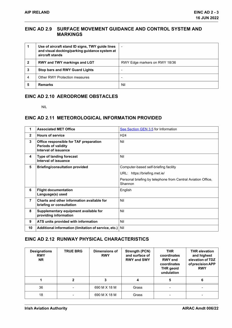
EINC AD 2 - 3AIP IRELAND16 JUN 2022
16 JUN 2022
EINC AD 2.9 SURFACE MOVEMENT GUIDANCE AND CONTROL SYSTEM AND MARKINGS
EINC AD 2.10 AERODROME OBSTACLES
NIL
EINC AD 2.11 METEOROLOGICAL INFORMATION PROVIDED
EINC AD 2.12 RUNWAY PHYSICAL CHARACTERISTICS
1 Use of aircraft stand ID signs, TWY guide lines and visual docking/parking guidance system at aircraft stands
-
2 RWY and TWY markings and LGT RWY Edge markers on RWY 18/36
3 Stop bars and RWY Guard Lights -
4 Other RWY Protection measures -
5 Remarks Nil
1 Associated MET Office See Section GEN 3.5 for Information
2 Hours of service H24
3 Office responsible for TAF preparation Periods of validity Interval of issuance
Nil
4 Type of landing forecastInterval of issuance
Nil
5 Briefing/consultation provided Computer-based self-briefing facility
URL: https://briefing.met.ie/
Personal briefing by telephone from Central Aviation Office, Shannon
6 Flight documentationLanguage(s) used
English
7 Charts and other information available for briefing or consultation
Nil
8 Supplementary equipment available for providing information
Nil
9 ATS units provided with information Nil
10 Additional information (limitation of service, etc.) Nil
DesignationsRWYNR
TRUE BRG Dimensions ofRWY
Strength (PCN) and surface of RWY and SWY
THR coordinates
RWY end coordinates THR geoid undulation
THR elevation and highest
elevation of TDZ of precision APP
RWY
1 2 3 4 5 6
36 - 690 M X 18 M Grass - -
18 - 690 M X 18 M Grass - -
Irish Aviation Authority AIRAC Amdt 006/22
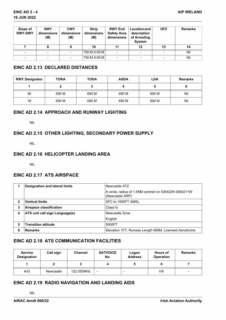
EINC AD 2 - 4 AIP IRELAND16 JUN 2022
16 JUN 2022
EINC AD 2.13 DECLARED DISTANCES
EINC AD 2.14 APPROACH AND RUNWAY LIGHTING
NIL
EINC AD 2.15 OTHER LIGHTING, SECONDARY POWER SUPPLY
NIL
EINC AD 2.16 HELICOPTER LANDING AREA
NIL
EINC AD 2.17 ATS AIRSPACE
EINC AD 2.18 ATS COMMUNICATION FACILITIES
EINC AD 2.19 RADIO NAVIGATION AND LANDING AIDS
NIL
Slope of RWY-SWY
SWY dimensions
(M)
CWY dimensions
(M)
Strip dimensions
(M)
RWY End Safety Area dimensions
Location and description of Arresting
System
OFZ Remarks
7 8 9 10 11 12 13 14- - - 750 M X 60 M - - - Nil- - - 750 M X 60 M - - - Nil
RWY Designator TORA TODA ASDA LDA Remarks
1 2 3 4 5 6
36 690 M 690 M 690 M 690 M Nil
18 690 M 690 M 690 M 690 M Nil
1 Designation and lateral limits Newcastle ATZA circle, radius of 1.5NM centred on 530422N 0060211W (Newcastle ARP)
2 Vertical limits SFC to 1500FT AMSL3 Airspace classification Class G4 ATS unit call sign Language(s) Newcastle Zone
English5 Transition altitude 5000FT6 Remarks Elevation 1FT, Runway Length 690M, Licensed Aerodrome
Service Designation
Call sign Channel SATVOICE No.
Logon Address
Hours of Operation
Remarks
1 2 3 4 5 6 7
A/G Newcastle 122.550MHz - - HX -
Irish Aviation AuthorityAIRAC Amdt 006/22

EINC AD 2 - 5AIP IRELAND16 JUN 2022
16 JUN 2022
EINC AD 2.20 LOCAL TRAFFIC REGULATIONS
Standard joining instructions apply
EINC AD 2.21 NOISE ABATEMENT PROCEDURES
NIL
EINC AD 2.22 FLIGHT PROCEDURES
All circuits should be flown to the East of the strip over the sea.
EINC AD 2.23 ADDITIONAL INFORMATION
Prior Permission Required.Transitional Surface Obstacles: Windsock located in the runway strip. Note rail line also to the East of the airfield represents a potential mobile obstacle.
EINC AD 2.24 CHARTS RELATED TO AN AERODROME
NIL
Irish Aviation Authority AIRAC Amdt 006/22

THIS PAGE INTENTIONALLY LEFT BLANK
Irish Aviation Authority
EINC AD 2 - 6 AIP IRELAND16 JUN 2022
16 JUN 2022
AIRAC Amdt 006/22

EIRT AD 2 - 1AIP IRELAND16 JUN 2022
16 JUN 2022
EIRT AD 2.1 AERODROME LOCATION INDICATOR AND NAME
EIRT - RATHCOOL
EIRT AD 2.2 AERODROME GEOGRAPHICAL AND ADMINISTRATIVE DATA
EIRT AD 2.3 OPERATIONAL HOURS
1 ARP and its site 520620N 0085900W-
2 Direction and distance from (city) 13NM W of Mallow
3 AD Elevation, Reference Temperature & Mean Low Temperature
281ft / 20.5°C (Max Temp) 0.4°C (MNM Temp)
4 Geoid undulation at AD ELEV PSN 190ft
5 MAG VAR/Annual Change 5° (2014)/11’ decreasing
6 AD Operator, address, telephone, telefax, email, AFS, Website
Post: Mr. Dennis CrowleyRathcool Flying ClubRathcoolMallowCo. Cork
Phone:+353 83 829 9938
Email: [email protected]
7 Types of traffic permitted (IFR/VFR) VFR
8 Remarks Nil
1 AD Operator HX PPR
2 Customs and immigration Nil
3 Health and sanitation Nil
4 AIS Briefing Office See remarks
5 ATS Reporting Office (ARO) See remarks
6 MET Briefing Office See remarks
7 ATS Nil
8 Fuelling Nil
9 Handling Nil
10 Security Nil
11 De-icing Nil
12 Remarks For HR of operation contact AD ADMIN
PIB AVBL from AIS, Shannon, See Section GEN 3.1.5,
ARO service is AVBL H24 from AIS Shannon See Section GEN 3.1.5
Met briefing AVBL from Central Aviation Office, Shannon Airport, See Section GEN 3.5.4
Irish Aviation Authority AIRAC Amdt 006/22

EIRT AD 2 - 2 AIP IRELAND16 JUN 2022
16 JUN 2022
EIRT AD 2.4 HANDLING SERVICES AND FACILITIES
EIRT AD 2.5 PASSENGER FACILITIES
NIL
EIRT AD 2.6 RESCUE AND FIRE FIGHTING SERVICES
EIRT AD 2.7 RUNWAY SURFACE CONDITION ASSESSMENT AND REPORTING AND SNOW PLAN
NIL
EIRT AD 2.8 APRONS, TAXIWAYS AND CHECK LOCATIONS/POSITIONS DATA
1 Cargo-handling facilities Nil
2 Fuel/oil types Nil
3 Fuelling facilities/capacity Nil
4 De-icing facilities Nil
5 Hangar space for visiting aircraft PPR
6 Repair facilities for visiting aircraft Nil
7 Remarks Nil
1 AD category for fire fighting Helicopter H2
2 Rescue equipment Appropriate to Cat Special
3 Capability for removal of disabled aircraft Nil
4 Remarks Nil
1 Apron surface and strength Surface: NilStrength:
2 Taxiway width, surface and strength TAXIWAY WIDTH (M) SURFACE STRENGTHA 7.5 Grass -
3 Altimeter checkpoint location and elevation Location: NilElevation: Nil
4 VOR checkpoint Nil
5 INS checkpoint Nil
6 Remarks Nil
Irish Aviation AuthorityAIRAC Amdt 006/22
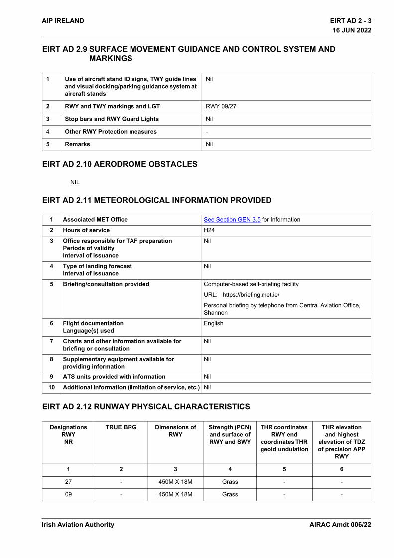
EIRT AD 2 - 3AIP IRELAND16 JUN 2022
16 JUN 2022
EIRT AD 2.9 SURFACE MOVEMENT GUIDANCE AND CONTROL SYSTEM AND MARKINGS
EIRT AD 2.10 AERODROME OBSTACLES
NIL
EIRT AD 2.11 METEOROLOGICAL INFORMATION PROVIDED
EIRT AD 2.12 RUNWAY PHYSICAL CHARACTERISTICS
1 Use of aircraft stand ID signs, TWY guide lines and visual docking/parking guidance system at aircraft stands
Nil
2 RWY and TWY markings and LGT RWY 09/27
3 Stop bars and RWY Guard Lights Nil
4 Other RWY Protection measures -
5 Remarks Nil
1 Associated MET Office See Section GEN 3.5 for Information
2 Hours of service H24
3 Office responsible for TAF preparation Periods of validity Interval of issuance
Nil
4 Type of landing forecastInterval of issuance
Nil
5 Briefing/consultation provided Computer-based self-briefing facility
URL: https://briefing.met.ie/
Personal briefing by telephone from Central Aviation Office, Shannon
6 Flight documentationLanguage(s) used
English
7 Charts and other information available for briefing or consultation
Nil
8 Supplementary equipment available for providing information
Nil
9 ATS units provided with information Nil
10 Additional information (limitation of service, etc.) Nil
DesignationsRWYNR
TRUE BRG Dimensions ofRWY
Strength (PCN) and surface of RWY and SWY
THR coordinates RWY end
coordinates THR geoid undulation
THR elevation and highest
elevation of TDZ of precision APP
RWY
1 2 3 4 5 6
27 - 450M X 18M Grass - -
09 - 450M X 18M Grass - -
Irish Aviation Authority AIRAC Amdt 006/22

EIRT AD 2 - 4 AIP IRELAND16 JUN 2022
16 JUN 2022
EIRT AD 2.13 DECLARED DISTANCES
EIRT AD 2.14 APPROACH AND RUNWAY LIGHTING
NIL
EIRT AD 2.15 OTHER LIGHTING, SECONDARY POWER SUPPLY
NIL
EIRT AD 2.16 HELICOPTER LANDING AREA
NIL
EIRT AD 2.17 ATS AIRSPACE
NIL
EIRT AD 2.18 ATS COMMUNICATION FACILITIES
EIRT AD 2.19 RADIO NAVIGATION AND LANDING AIDS
NIL
Slope of RWY-SWY
SWY dimensions
(M)
CWY dimensions
(M)
Strip dimensions
(M)
RWY End Safety Area dimensions
Location and description of Arresting
System
OFZ Remarks
7 8 9 10 11 12 13 14Nil Nil Nil Nil - - Nil NilNil Nil Nil Nil - - Nil Nil
RWY Designator
TORA TODA ASDA LDA Remarks
1 2 3 4 5 6
27 450 450 450 450 Nil
09 450 450 450 450 Nil
Service Designation
Call sign Channel SATVOICE No.
Logon Address
Hours of Operation
Remarks
1 2 3 4 5 6 7
OTHER Heli Med Ground
132.505A/G Channel
- - HX - Non Specific
Expect increased
short notice helicopter
activity due to Air Ambulance
Operations
Irish Aviation AuthorityAIRAC Amdt 006/22

EIRT AD 2 - 5AIP IRELAND16 JUN 2022
16 JUN 2022
EIRT AD 2.20 LOCAL TRAFFIC REGULATIONS
NIL
EIRT AD 2.21NOISE ABATEMENT PROCEDURES
NIL
EIRT AD 2.22 FLIGHT PROCEDURES
Very low utilisation, Standard overhead join left hand circuits is very normal and advisable as this is the only licensed aerodrome with no radio.
EIRT AD 2.23 ADDITIONAL INFORMATION
Expect intense Air Ambulance activity at EIRT
EIRT AD 2.24 CHARTS RELATED TO AN AERODROME
NIL
Irish Aviation Authority AIRAC Amdt 006/22

THIS PAGE INTENTIONALLY LEFT BLANK
Irish Aviation Authority
EIRT AD 2 - 6 AIP IRELAND16 JUN 2022
16 JUN 2022
AIRAC Amdt 006/22