Inactive Hazardous Sites and Pollutant-Only Sites Inventory ...
Upload
independentCategory
view
1download
0
Dublin Institute of TechnologyARROW@DIT
Doctoral Science
2009-10-01
The Origin of the Curvilinear Plan-Form in IrishEcclesiastical Sites: A Comparative Analysis of Sitesin Ireland, Wales and FranceClare Crowley (Thesis)Dublin Institute of Technology
Follow this and additional works at: http://arrow.dit.ie/sciendoc
Part of the History Commons
This Theses, Ph.D is brought to you for free and open access by the Scienceat ARROW@DIT. It has been accepted for inclusion in Doctoral by anauthorized administrator of ARROW@DIT. For more information, pleasecontact [email protected], [email protected].
This work is licensed under a Creative Commons Attribution-Noncommercial-Share Alike 3.0 License
Recommended CitationCrowley, Clare. The Origin of the Curvilinear Plan-Form in Irish Ecclesiastical Sites: A Comparative Analysis of Sites in Ireland, Walesand France. Dublin : Dublin Institute of Technology, 2009

THE ORIGINS OF THE CURVILINEAR PLAN-FORM
IN IRISH ECCLESIASTICAL SITES:
A COMPARATIVE ANALYSIS OF SITES IN IRELAND,
i .• WALES AND FRANCE
(VOLUME 112)
SUBMITTED BY
CLARE CROWLEY B.A. (HONS)
To SCHOOL OF FOOD SCIENCE AND
ENVIRONMENTAL HEALTH AT DUBLIN INSTITUTE
OF TECHNOLOGY FOR THE AWARD OF PHD.
SUPERVISOR: DR PAT DARGAN
OCTOBER 2009

DECLARATION
I certify that this thesis which I now submit for examination for the award of PhD, is
entirely my own work and has not been taken from the work of others save and to the
extent that such work has been cited and acknowledged within the text of my work.
This thesis was prepared according to the regulations for postgraduate studies by
research of the Dublin Institute of Technology and has not been submitted in whole or
in part for an award in any other Institute or University.
The Institute has permission to keep, to lend or to copy this thesis in whole or in part
on condition that any such use of the material of the thesis be duly acknowledged.
Signature <2.9v-e. ~ Clare Crowley

ACKNOWLEDGEMENTS
Thi's has been a game of two halves, and so I must first acknowledge those who were
with me at the beginning - my fellow postgrads at Rathmines House and all who
worked there. A special tribute must be made to the late Leo Swan, without whom
this project would not have begun.
The Everest-like task of finishing what I started could not have been done without the
support and encouragement of my former colleagues and friends in Margaret Gowen
& Co. Ltd, who also kindly allowed me to make use of their archaeological database
and anything else I needed - thank you Lisa, Siobhan, Seana, Lindsay, Kieron, Gary,
Dave, Ben, Ed and Mags.
Thank you also to my friends Kate, Gemma, Niarnh, Maria, Mary, Aoife, Anne, Sue,
Nodlaig and Toril for supporting me and accepting that I would be off-grid for a
while!
The support and boundless enthusiasm of my supervisor Dr Pat Dargan has been an
inspiration from the beginning and was instrumental in the completion of this thesis.
A special mention also to Dr Kevin Griffin - for his friendship and encouragement
over many cups of coffee! Both Pat and Kevin have been of immense help in all
ways, including academic.
Last, but by no means least, I want to thank my family - they gave me the courage to
take the step back onto the ladder and keep climbing until I reached this point! So I
say thank you with much love to Mir (a study-buddy for the last two years), Ruth
(I 'eponge! For keePing me sane), Hel (yoga-buddy, all-round cheerleader and tireless
printer and proof-reader), Mam and Dad (for everything, but mostly for believing),
Denis (bodyguard services in Provence much appreciated), James, Clodagh and
Lauren. A final thank you to my brother Paul, who died too soon, but who I know has
been with me from the start - he would be amused by the sports analogy at the
beginning of these acknowledgements!
ii

ABsTRACT
This thesis looks at the origins of the curvilinear plan-form in ecclesiastical sites in
Ireland, through the detailed examination and comparative analysis of a selection of
field study sites in Ireland, Wales and France. It asks the fundamental question: is the
concept of the curvilinear plan-form in Ireland home-grown or an import?
Curvilinear ecclesiastical settlements that appeared to be originating in the Early
Medieval period in Ireland, conform to what looks like a universal pattern. The
characteristics of this pattern commonly include an inner and outer curvilinear
enclosure, with a church, burial ground and other ecclesiastical structures and features
(for example the round tower and high crosses) located within the inner enclosure.
Swan had proposed that these curvilinear Irish ecclesiastical sites had evolved in a
unique manner and the pattern found at Irish ecclesiastical sites is commonly viewed
as different to the rest of Europe. In 1989, Swan attended a conference at which there
was a presentation of research undertaken on a group of villages in Languedoc
(southwestern France). These villages bore a remarkable similarity to the Irish
'pattern'. To date there has been no investigation of these apparent similarities. There
is a lack of knowledge with regard to the origins of these sites - how such similarity
in plan evolved and when - and there has been no examination of the physical
characteristics and plan of ecclesiastical settlements in France or elsewhere in relation
to the Irish sites. The lack of comparative archaeological and documentary
investigation in this area provided an opportunity to offer a real and significant
contribution to the study of the evolution of Irish ecclesiastical sites, the origins of the
curvilinear plan-form and its role in the formation of settlement.
There are known trade and communication links between Ireland, Britain and the
Continent (including southern France) in the prehistoric and Early Medieval periods.
As Ireland's closest neighbours, it was considered most likely that if this curvilinear
ecclesiastical settlement pattern was not unique but had spread either to or from the
Continent, it should manifest in these areas. Could the pattern of ecclesiastical
settlement in Ireland be a product of a non-Roman non-urban environment, in other
words, a localised phenomenon? In order to identify any potential differences or
shared characteristics a detailed study was undertaken of curvilinear settlements with
ecclesiastical origins in Ireland, in the thoroughly Romanised southern France (to
iii

include those sites noted by Swan in Languedoc) and in south Wales, an area on the
margins of the Roman Empire but which came under substantial Roman influence and
later Irish monastic influences.
Where urban centres grew up around the Irish ecclesiastical foundations, the lines of
the original enclosures are often still visible in the property boundaries and street-plan
of the modem town or village. Once laid down, property boundaries and streets are
rermirkably resilient to change and as such they represent a significant category of
evidence for the curvilinear plan-form. For this reason it was decided to examine field
study sites where the ecclesiastical site was incorporated within a modem town or
village. The investigation uses a multi-disciplinary approach, with each site examined
using a combination of detailed historical investigation, available archaeological
evidence, field survey and plan-analysis.
The results of the investigation demonstrated that while the Irish ecclesiastical
'pattern', with all its components was a product of a native settlement layout, the
concept behind its most recognisable element, the curvilinear ecclesiastical enclosure,
was not. The curvilinear ecclesiastical enclosure was almost certainly a product of the
cross-cultural transference of ideas, notably those of asylum, sanctuary and the
symbolic importance of the circle. The use of the curvilinear enclosure in the context
of ecclesiastical settlements also appears to have been a deliberate act, rather than a
convenient re-use of existing settlement or burial forms. In conclusion, it can be stated
that ecclesiastical sites had a profound influence on the formation of settlement in all
three of the study areas. It is clear that the church played a significant role in the
genesis of Early Medieval and Medieval settlement in all three study areas, perhaps
even in the sense of a nascent 'town planning', with the curvilinear plan-form being
part ofa pan-European movement.
iv

TABLE OF CONTENTS
DECLARATION ................................................................................ i
ACKNOWLEDGEMENTS ..................................................................... ii
ABsTRACT ...................................... " ............................ " ............... .iii
LIST OF TABLES ............................................................................... xii
LIST OF FIGURES ............................................................................. xiii
GLOSSARY OF TERMS ........................................................................ xv
NOTE ON CONVENTIONS USED IN THE TEXT .............................................. xx
CHAPTER 1: INTRODUCTION .............................................................. 2
1.1 Research ............................................................................. 3
1.2 Study Area ........................................................................... 3
1.3 Field study Sites .................................................................. ,. 4
1.4 Investigative Techniques .......................................................... 5
1.5 Aims .................................................................................. 5
CHAPTER 2: CONCEPTUAL FRAMEWORK ................................................ 9
2.1 The History of Archaeological Theory ......................................... 9
2.1.1 New Archaeology .......................................................... 9
2.1.2 New Concepts and Approaches ............................................ 10
2.2 Settlement Patterns ................................................................ 11
2.3 Theoretical and Methodological Approaches ................................ 12
2.3.1 Archaeology ............................................................... ,. 12
2.3.1.1 New approaches in settlement archaeology ................... 12
2.3.1.2 Chang's methodology ............................................ 12
2.3.1.3 Survey as a methodological approach ........................... 13
2.3.2 Geography ...................................................... , .............. 14
2.3.2.1 Human geography ..................................................... 14
2.3.2.2 Geographic models ................................................ 1"5
2.3.3 Historical Geography ....................................................... 15
2.3.3.1 Plan-analysis ........................................................ 16
2.3.3.2 Methodology ........................................................ 16
2.3.3.3 A valid form of evidence? .................................................. 19
v

2.3.4 Ethnography/Ethnology ................................................... 20
2.3.4.1 Ethnographic models ............................................. 21
2.3.4.2 Methodological approaches and theories.... ...... .... ....... 21
2.3.5 Summary of Existing Approaches and Methodologies............... 22
2.4 A working conceptual framework .............................................. 23
2.4.1 Theoretical Concepts ....................................................... 24
2.4.1.1 Settlement pattern research as methodological concept ...... 24
2.4.1.2 Variability ........................................................... 24
2.4.1.3 Culture ............................................................... 25
2.4.1.4 Settlement Archaeology: A Multi-Disciplinary Approach ... 25
2.4.1.5 Ecological approach ................................................ 26
2.4.1.6 Archaeological Approach: Identification of Evidence ........ 26
2.4.1.7 Archaeological Approach: Excavation evidence ............... 26
2.4.1.8 Geographical Approach: Analysis of Data ..................... 27
2.4.1.9 Ethnographical Approach: Establishing a Pattern ............. 27
2.4.2 Methodological Approach ................................................. 27
CHAPTER 3: LITERATURE REVIEW ........................................................ 30
3.1 Irish Ecclesiastical Sites in the Early Medieval Period ..................... 30
3.1.1 Introduction ..... " ........................................................... 30
3.1.2 Techniques of Site Identification ......................................... 30
3.1.2.1 Archaeological aerial survey ..................................... 30
3.1.2.2 A new approach in the identification of early ecclesiastical
sites ............................................................................ 39
3.1.3 Settlement pattern ........................................................... 40
3.1.4 Site Morphology ............................................................ 46
3.1.5 A Spatial Model.. .......................................................... 51
3.1.6 Dating ......................................................................... 53
3.1.7 Summary ...................................................................... 59
3.2 Irish Ecclesiastical Influence in Britain and France ........................ 61
3.2.1 Introduction .................................................................. 61
3.2.2 Communication and Trade Routes ........................................ 61
3.2.3 The Conversion of the Irish to Christianity ............................. 66
3.2.4 Early ecclesiastical contacts with France ................................ 69
vi

3.2.5 Irish Monks in Wales ...................................................... 70
3.2.6 Irish Monks in France ...................................................... 73
3.2.7 Summary ..................................................................... 79
3.3 Welsh Ecclesiastical Sites in the Early Medieval Period .................. 80
3.3.1 Introduction .................................................................. 80
3.3.2 Evidence for early ecclesiastical sites .................................... 84
3.3.3 Summary ..................................................................... 90 3.4 French Ecclesiastical Sites in the Early Medieval Period .................. 92
3.4.1 Introduction .................................................................. 92
3.4.2 The early church in France - monasticism .............................. 93
3.4.3 Archaeological evidence - monastic sites ............................... 96
3.4.4 Ecclesiastical site studies .................................................. 101
3.4.5 The concept of sanctuary .................................................. 108
3.4.6 Evidence for enclosed ecclesiastical sites ................................ 110
3.4.7 Summary ..................................................................... 112
CHAPTER 4: FIELD STUDIES ................................................................ 115
4.1 Identification of Sites for Detailed Study ...................................... 115
4.1.1 Selection of Study Areas ................................................... 1 15
4.1.2 Selection ofField study Sites .............................................. 116
4.2 Methodology and Sources ......................................................... 119
4.2.1 Format and Structure of Case Studies .................................... 119
4.2.2 Historical Evidence ......................................................... 119
4.2.3 Archaeological Data ........................................................ 120
4.2.4 Place-name Evidence ...................................................... 121
4.2.5 Cartographic Sources ....................................................... 121
4.2.6 Field Survey ................................................................. 122
4.2.7 Spatial Mode!.. ............................................................. 122
4.3 Armagh, County Armagh, Ireland ............................................. 124
4.3.1 Introduction .................................................................. 124
4.3.2 Place-name evidence ....................................................... 124
4.3.3 Evidence of early settlement: Prehistoric Period ....................... 125
4.3.4 Ecclesiastical History ....................................................... 126
4.3.5 Plan-analysis ................................................................. 129
vii

4.3.6 Summary of Findings ....................................................... 137
4.4 Kells, County Meath, Ireland .................................................... 139
4.4.1 Introduction .................................................................. 139
4.4.2 Place-name evidence ........................................................ 139
4.4.3 Evidence of early settlement: Prehistoric Period ....................... 140
4.4.4 Ecclesiastical History ....................................................... 140
4:4.5 Plan-analysis ................................................................. 144
4.4.6 Summary of Findings ....................................................... 150
4.5 Clondalkin, County Dublin, Ireland ........................................... 152
4.5.1 Introduction .................................................................. 152
4.5.2 Place-name evidence ....................................................... 152
4.5.3 Evidence of early settlement: Prehistoric Period ........................ 152
4.5.4 Ecclesiastical History ....................................................... 153
4.5.5 Plan-analysis ................................................................. 154
4.5.6 Summary of Findings ....................................................... 163
4.6 L1andaff, Glamorgan, Wales ..................................................... 164
4.6.1 Introduction .................................................................. 164
4.6.2 Place-name evidence ....................................................... 164
4.6.3 Evidence of early settlement: Prehistoric Period ....................... 165
4.6.4 Evidence of early settlement: Roman Period ............................ 166
4.6.5 Ecclesiastical History: ...................................................... 167
4.6.6 Plan-analysis ................................................ : ................ 172
4.6.7 Summary of Findings ....................................................... 179
4.7 L1andeilo,Carmarthenshire, Wales ............................................. 181
4.7.1 Introduction .................................................................. 181
4.7.2 Place-name evidence ....................................................... 181
4.7.3 Evidence of early settlement: Prehistoric Period ........................ 181
4.7.4 Evidence of early settlement: Roman Period ............................ 182
4.7.5 Ecclesiastical History ........................................................ 183
4.7.6 Plan-analysis ................................................................. 186
4.7.7 SummaryofFindings ....................................................... 193
4.8 L1ancarfan, Glamorgan, Wales .................................................. 194
4.8.1 Introduction .................................................................. 194
4.8.2 Place-name evidence ........................................................ 194
viii

4.8.3 Evidence of early settlement: Prehistoric Period ........................ 195
4.8.4 Evidence of early settlement: Roman Period ........................... 196
4.8.5 Ecclesiastical History ....................................................... 197
4.8.6 Plan-analysis ................................................................. 204
4.8.7 SummaryofFindings ....................................................... 212
4.9 Carpentras, Provence, France ................................................... 213
. 4.9:1 Introduction .................................................................. 213
4.9.2 Place-name evidence ....................................................... 213
4.9.3 Evidence of early settlement: Prehistoric Period ....................... 214
4.9.4 Evidence of early settlement: Roman Period ............................ 215
4.9.5 Ecclesiastical History ....................................................... 216
4.9.6 Plan-analysis ................................................................. 220
4.9.7 Summary of Findings .............. '" ...................................... 235
4.10 Vence, Provence, France .......................................................... 236
4.10.1 Introduction .................................................................. 236
4.10.2 Place-name evidence ....................................................... 236
4.10.3 Evidence of early settlement: Prehistoric Period ...................... 237
4.10.4 Evidence of early settlement: Roman Period ............................ 238
4.10.5 Ecclesiastical History ...................................................... 238
4.10.6 Plan-analysis ................................................................. 241
4.1 0.7 Summary of Findings ........................................................ 250
4.11 La Digne d'Amont, Languedoc, France ........................................ 252
4.1l.l Introduction .................................................................. 252
4.11.2 Place-name evidence ....................................................... 252
4.11.3 Evidence of early settlement: Prehistoric Period ....................... 253
4.11.4 Evidence of early settlement: Roman Period ............................ 254
4.11.5 Ecclesiastical History ....................................................... 257
4.11.6 Plan-analysis ................................................................. 260
4.11.7 Summary of Findings ....................................................... 264
CHAPTER 5: ANALYSIS AND DISCUSSION OF FINDINGS ................................. 267
5.1 Introduction ......................................................................... 267
5.2 Ecclesiastical Site / Settlement Relationship .................................. 267
5.2.1 Annagh ................................................................................ 267
IX

5.2.2 Kells .................................................................................... 268
5.2.3 Clondalkin ............................................................................. 268
5.2.4 Llandaff ................................................................................ 269
5.2.5 Llandeilo Fawr. ....................................................................... 269
5.2,6 Llancarfan ............................................................................. 270
5.2.7 Carpentras ............................................................................. 271
5.2.8 Veiice .. '" ............................................................. '" ............. 271
5.2.9 La Digne d' Amont... ................................................................ 273
5.3 Elements of ecclesiastical settlement form: a comparative analysis ...... 274
5.3.1 Ecclesiastical fabric ......................................................... 274
5.3.2 Holy wells / Water source .................................................. 276
5.3.3 Burial Ground ............................................................... 277
5.3.4 Ecclesiastical enclosure .................................................... 279
5.3.4.1 Inner enclosure ..................................................... 279
5.3.4.2 Outer enclosure .................................................... 282
5.3.4.3 Fonn of enclosure ................................................. 282
5.3.4.4 Dating and sequence of enclosure .............................. 286
5.3.5 Larger enclosing element .................................................... 291
5.3.6 Subdivisions, annexes and suburbs ....................................... 293
5.3.7 Market place ................................................................. 294
5.3.8 Radiating roads .............................................................. 296
5.4 F actors influencing ecclesiastical settlement form: a comparative
analysis ................................................................................ 296
5.4.1 Topography ......................................... '" ...... '" ............. 296
5.4.2 Pre-Christian settlement fonns ............................................ '298
5.4.3 Pre-Christian burial fonns .................................................. 299
5.4.4 Defence and fortification ................................................... 301
5.4.5 Sanctuary and asylum ...................................................... 302
5.4.6 Symbolism - the circle ...................................................... 305
5.4.7 Communication and trade associations ................................... 31 0
5.5 Assessment of plan-analysis as a useful investigative tool for
archaeological studies ............................................................. 313 .
x

CHAPTER 6: CONCLUSIONS ................................................................ 319
6.1 Discoveries ........................................................................... 319
6.2 Assessment of Aims............................................................... 320
6.3 Future Work ......................................................................... 329
6.4 Conclusion ............................................................................ 332
BIBLIOGRAPHY ................................................................................ , 334
PRINTED SOURCES ................................................................... 334
INTERNET SOURCES ................................................................. 354
CARTOGRAPIDC SOURCES ......................................................... 356
ApPENDIX A .................................................................................... 359
xi

LIST OF TABLES
Page Number
Table 4.3.1: Details of Ecclesiastical Elements at Armagh ........................... 138
Table 4.3.2: Elements of Settlement at Armagh .............. '" ...................... 138
Table 4.4.1: Details of Ecclesiastical Elements at Kells .............. : ............... 150
Table 4.4.2: Elements of Settlement at Kells ........................................... 151
Table 4.5.1: Details of Ecclesiastical Elements at Clondalkin ........................ 163
Table 4.5.2: Elements of Settlement at Clondalkin .................................... 163
Table 4.6.1: Details of Ecclesiastical Elements at Llandaff ........................... 179
Table 4.6.2: Elements of Settlement at Llandaff ....................................... 180
Table 4.7.1: Details of Ecclesiastical Elements at Llandeilo Fawr. ..................... 193
Table 4.7.2: Elements of Settlement at Llandeilo Fawr ............................... 193
Table 4.8.1: Details of Ecclesiastical Elements at Llancarfan ....................... 212
Table 4.8.2: Elements of Settlement at Llancarfan .................................... 212
Table 4.9.1: Details of Ecclesiastical Elements at Carpentras ........................ 235
Table 4.9.2: Elements of Settlement at Carpentras .................................... 235
Table 4.10.1: Details of Ecclesiastical Elements at Vence .................... .... 251
Table 4.10.2: Elements of Settlement at Vence .......................................... 251
Table 4.11.1: Details of Ecclesiastical Elements at La Digne d' Amont ............. 264
Table 4.11.2: Elements of Settlement at La Digne d'Amont ... : ....................... 265
Table 5.2.1: Measurement of Inner Ecclesiastical Enclosure ........................ 281
Table 5.2.2: Measurement of Outer Ecclesiastical Enclosure ........................ 282
Table 5.2.3: Form of Ecclesiastical Enclosure .......................................... 283
xii

LIST OF FIGURES
Page Number Figure 2.3.1 : Example of Plan-analysis, Coventry, England (after Lilley) .......... 17
Figure 2.3.2 : Example of Plan Unit: Archaeology and morphology of
Plan Unit I at Coventry (after Lilley) ...................................... 19
Figure 3.1. I: Plan of Skellig Michael.. ..................................................... 33
Figure 3.1.2: Aenal photograph of Illauntannig Island, County Kerry ............... 33
Figure 3.1.3: Plan ofinishmurray, County Sligo and Reask, County Kerry ......... 34
Figure 3.1.4: Plan of Nendrum, County Down ............................................ 35
Figure 3.1.5: Illustration from the Book of Mulling (after Nees) .................... 36
Figure 3.1.6: Aerial photograph of Tarramud, County Galway ....................... 38
Figure 3.1.7: Aerial photograph of Clonard, County Meath ....... , ................... 38
Figure 3.1.8: Plan of Oldtown, County Roscommon (after Swan) .................. 42
Figure 3.1.9: Plan of Duleek, County Meath (after Swan) ............................ .43
Figure 3.1.10 : Aerial view of Monasterboice facing south taken in 1978 by Swan,
showing cropmark running east/west across the field.) ............... 44
Figure 3.1.11 :Artist's Impression of Early Christian Enclosure at Killeigh, County
Offaly ...................................................................... 48
Figure 3.1.12 : Griffin's Spatial Model of Early Christian Sites ......................... 52
Figure 3.2.1: Western Seaways (after Crawford 1936) ................................. 62
Figure 3.2.2: Major rivers of France..................................................... 62
Figure 3.2.3: Suggested trading routes for E ware (after Campbell 2007) ........... 64
Figure 3.2.4: Contoured distribution map for E ware (after Campbell 2007) ........ 64
Figure 3.2.5: Irish Monastic Foundations or Settlements in Europe
(fifth to eighth centuries AD) ................................................ 75
Figure 3.3.1: Distribution oflargely and partly curved churchyards in
relation to evidence of pre-Norman date (after Brook) ................ 88
Figure 3.3.2: Enclosures at Llangan (after James) ........................................ 89
Figure 3.3.3: Enclosures at Llanwinio (after J ames) .................................... 89
Figure 3.4.1 : Alaigne, Aude: Example of village without church as nucleus ........ 105
Figure 3.4.2: Loupia, Aude: Example of village with church as nucleus ............ 106
Figure 3.4.3: Saint-Just, Aude: Example of cemetery enclosed by ditch ............ 107
Figure 3.4.4: Grans, Provence: Example of village with church as nucleus ......... 107
Xlll

Figure 3.4.5: Cropmarks at La Gleyasso ................................................... 111
Figure 4.1.1: Digne les Bains........ .. .... ...... .. .. .. .. .... .. .. .. .. .. .. .. .. .. .. .. .. .. ... 118
Figure 5.3.1 : Cylindrical bell-towers of St Michael's, Hildesheim, Germany ...... 276
Figure 5.3.2: Site plan showing excavated enclosures, St Nahi's Church ............ 287
Figure 5.3.3 : Aerial view of excavated site, facing southeast towards St Nahi's
Church ............................................................................. 288
Figure 5.3.4 : Map of Lusk showing monastic enclosures & surrounding
archaeological sites (after O'Connell) .................................... 290
Figure 5.3.5 : Larger enclosing elements at Lusk, Clonard and Old Kilcullen ...... 292
Figure 5.3.6: O.S. six-inch map of Finglas, County Dublin, showing western
market place ..................................................................... 295
Figure 5.4.1: Schematic of a fortified settlement Aggenus Urbicus ................... 307
Figure 5.4.2 : Twelfth century representation of Jerusalem ............................. 307
Figure 5.4.3 : Fifteenth century engraving of Jerusalem by Hartmann Schedel... 307
Figure 5.4.4: Egyptian hieroglyph meaning 'town' or 'village' ..................... 308
Figure 5.4.5: High cross at Castledermot, County Kildare ........................... 308
Figure 5.4.6: Archaeological interpretation of geophysical survey results
at Oldtown ............................................................ ;. 316
Figure 6.1.1: Gallarus Oratory, Dingle Peninsula, County Kerry ..................... 325
Figure 6.1.2: Structures in the Bories village in the Vaucluse region
of Provence, France ............................................................ 326
Figure 6.1.3 : Latera in Lazio, Italy ........................................................... 327
Figure 6.2.1 : Landemeau town in Brittany .................................................. 331
Figure 6.2.2: Early ecclesiastical site at St Mawgan in Meneage, Cornwall ......... 331
Figure 6.2.3 : Early ecclesiastical site at Padstow, Cornwall. ........................... 331
XIV

GLOSSARY OF TERMS
GENERAL f ECCLESIASTICAL
Annals
Bullaun stone
Atrium
Canons
Carolingian
Cenobic/coenobic
Civitas
Eremitic
Records· of religious and secular events, generally
.maintained at church sites.
Hollowed stones - generally an un-worked boulder,
with a roughly circular hollow - most likely used for
grinding food, but associated with many traditions and
beliefs.
In general, an open area, either physically within a
building or in terms of access (i.e. open to all). It is
interpreted as an open area attached to but outside of an
Irish ecclesiastical settlement. In the Gaulish church it
was also a place of sanctuary and in Ireland church law
courts were held there. /
Church laws.
The Carolingian dynasty was a Frankish noble family
that grew increasingly powerful from the late seventh
century onwards. In 751, Pepin the Short, a Carolingian,
was crowned King of the Franks. The greatest
Carolingian monarch was Charlemagne, who was
crowned Emperor by Pope Leo III at Rome.in 800. His
empire, ostensibly a continuation of the Roman Empire,
is referred to historiographically as the Carolingian
Empire. Carolingian rule lasted into the tenth century in
parts of France, though it had been displaced elsewhere
in the late ninth century.
Monastic - coenobite/cenobite refers to a member of a
monastic community.
In Ireland, a term used to refer to monasteries. In
Roman and Medieval culture it pertains to a community
of citizens or a 'city'.
Hermit.
xv

Familia
Fosse
Franks
Glebe Land
Hagiographer
Hagiography
Merovingian
Monasterium
MuragelMural charter
Oppidum
O.S.
Paruchiae
Platea/Plateola
Pomerium
Provincia
Those descended or claiming descent from a common
ancestor - used in the context of church sites with a
common founder in Ireland and Wales.
Ditch.
The Franks or Frankish people were a West Germanic
tribal confederation first attested in the third century AD
as living north and east of the Lower Rhine River.
Under the Merovingian dynasty, they founded one of
the Germanic monarchies which replaced the Western
Roman Empire from the fifth century. The Frankish
state consolidated its hold over large parts of westem
Europe by the end of the eighth century, developing into
the Carolingian Empire and its successor states.
A piece of land which served as part of a Protestant
clergyman's benefice and provided income.
Writer of a saint's life.
Accounts of a saint's life.
The Merovingians were a Salian Frankish dynasty that
came to rule the Franks in a region (known as Francia in
Latin) largely corresponding to ancient Gaul from the
middle of the fifth century to the mid-eighth century.
Term used to refer to monastery.
Medieval- granting of permission to erect town
defences.
Civic/urban site or town, possibly fortified - generally
used for Iron Age settlements.
Ordnance Survey
Monastic families or confederations of monasteries with
common ideals/allegiances.
A courtyard which provided a walking or assembly area
for monks.
The sacred boundary of a Roman town or settlement,
demarcated during the foundation ceremony.
Roman administrative region.
XVI

Revolution
RMP
Rule
Saracen
SMR
Valium (rnonasterii)
Vitae/Vitae Sanctorurn
/Life
Visigoth
IRISH
Clochan
Cloigthech
Culdees/Ceile De
Darnhliag
Refers to the French Revolution and the dissolution of
the monarchy in 1789.
Record of Monuments and Places.
Code of practice and discipline for a religious
community.
Also 'Arab'. A term used by Europeans in the Early
Medieval and Medieval period for Fatimids at first (the
dynasty ruling over the northern, coastal region of
Africa), then later for all who professed the religion of
Islam. Church writers of the period commonly describe
Saracen raids on monasteries and their killing of monks.
Sites and Monuments Record.
Church enclosure or wall around an ecclesiastical site.
Accounts of a saint's life.
The Visigoths were one of two main branches of the
Goths, an East Germanic tribe; the Ostrogoths being the
other. Together these tribes were among the barbarians
who disturbed the late Roman Empire during the fourth
and fifth centuries AD.
Small circular stone-roofed building - commonly called
beehive hut.
Name used for round tower - literally meaning 'bell
house'.
An austere reform movement, the Irish example of
which is generally accepted as having been in Tallaght,
County Dublin.
An ancient Irish word signifying a stone edifice
usually used in reference to a church.
xvii

Faithche
Ogham
Sncidud
Trian
Termonn
FRENCH
Barri
Cadastre
Carte
Chemin
Commune
Cours
Departement
Eg/ise
Faubourg
Place
Plan
Portel Portail
Rue
Ruelle
A large area outside of an ecclesiastical settlement
which could be used for communal activities, a
habitation area or an area for grazing and tillage.
The earliest form of writing in Ireland (fourth to sixth
centuries AD), carved on stone and used for funerary
and memorial inscriptions (hence Ogham Stones). It is
formed of a series of lines and notches, essentially a
kind of cipher based on the Latin alphabet.
Irish legal term meaning 'sanctuary' or 'protection'.
A district or 'third'.
Most sacred part of a church site, usually demarcated by
the inner enclosure.
Word used in the Languedoc region to refer to suburban
development.
Cadastral map (based on a cadastral survey, produced to
accompany a register of all taxable lands).
Map.
Road.
The smallest of the French administrative districts, a
subdivision of the Departement.
Avenue.
French administrative district.
Church.
Suburb.
An open area within a town, encompassing the English
terms 'plaza', 'square', 'area' or 'place' (as in 'market
place').
Map or plan.
Literally door or doorway, but in this context it refers to
a defended gateway.
Street.
Lane.
xviii

Ville
WELSH
LanlLannlLlan
Nawd
Town.
Ecclesiastical enclosure or church site.
Welsh legal tenn meaning 'sanctuary' or 'protection'.
xix-

NOTES ON CONVENTIONS USED IN THE TEXT
LANGUAGE
Non-English words are shown in italics, with a translation provided alongside or in a
footnote as deemed appropriate. A Glossary of Terms, provided above, includes
Latin, Irish, French and Welsh terms used in the text. Place-names and street names,
though they. include foreign words, are proper nouns and as such are not italicised.
CHRONOLOGICAL TERMS
In this thesis the generally accepted term 'Early Medieval' is used to refer to the
period between the early fifth and the eleventh centuries AD, rather than the
ambiguous 'Early Christian period'. All chronological divisions are capitalised in the
text to avoid confusion. For convenience, Early Medieval and Medieval will be used
in the discussion of all of the study areas, rather than 'Middle Ages' (and its various
subdivisions) which is commonly used by historians.
CHRONOLOGICAL DIVISIONS
Chronological divisions can only ever be approximate. The table below contains the
archaeological chronology used throughout the text, with variations in the chronology
for Ireland, Britain and France indicated where applicable.
ARCHAEOLOGICAL CHRONOLOGY
Ireland Britain France
Mesolithic c.SOOO-4000BC c.IO.OOO-4000BC c.IO,OOO-SOOOBC
Neolithic c.4000-2S00BC c.4000-2300BC c.SOOOBC-3000BC
Bronze Age c.2S00-S00BC c.2300-700BC c.3000-600BC
Iron Age c. SOOBC-SOOAD c.700BC-43AD c.600-S0BC
Roman nJa c.43-4S0AD c. SOBC-486AD
Early Medieval c.SOO-117IAD c.4S0-1066AD c.486-109SAD
Medieval c.117l-l600AD c.I066-IS47AD c.I09S-l498AD
Though both Britain and France experienced human activity during the Palaeolithic'
period (c.2.Smillion-8S008C) to varying degrees, the specific division for each is not
included as the term does not appear in the text. Chronological divisions after the
Medieval period are not specified; such specifics are not relevant in this thesis and are
referred to generically as either 'Post-Medieval' or 'modern' where appropriate.
xx

CHAPTER 1: INTRODUCTION

1.0 INTRODUCTION
It has recently been suggested by O'Keefe and Clinton that the origins of Irish round
towers and souterrains can be found in Continental Europe' - could the same be said
for the curvilinear plan-form in Irish ecclesiastical sites?
Curvilinear ecclesiastical settlements that appeared to be originating in the Early
Medieval period in Ireland, conform to what looks like a universal pattern. The
characteristics of this pattern commonly include an inner and outer curvilinear
enclosure, with a church, burial ground and other ecclesiastical structures and features
(for example, the round tower and high crosses) located within the inner enclosure.2
These sites were often, though not exclusively, monastic and for this reason they are
referred to as simply 'ecclesiastical' throughout this text. Many of these early
Christian sites survived to become the core of modern cities, towns and villages and
are believed to have contributed to the origins of early urbanisation in Ireland, which
has led to their being described as 'monastic proto-towns' .3 Where urban centres grew
up around these ecclesiastical foundations, the lines of the original enclosures are
often still visible in the street-plan of the modern town or village.
Swan had proposed that these curvilinear Irish ecclesiastical sites had evolved in a
unique manner and the pattern found at Irish ecclesiastical sites is commonly viewed
as different to the rest of Europe.4 In 1989 Swan attended a conference at which there
was a presentation of research undertaken on a group of villages in Languedoc
(southwestern France).5 These villages bore a remarkable similarity to the Irish
'pattern' and led Swan to question whether the plan observed at the Irish sites had
I O'Keefe, T., 2004. Ireland's Round Towers, pp.130-131; Clinton, M., 2001. The Souterrains of Ireland, p.199, 2 Swan, D.L., 1994. 'Ecclesiastical settlement in Ireland in the early medieval period', in Fixot, M. and Zadora-Rio, E. (eds), L 'environnement des "glises et la topographie religieuse des campagnes mMievales, p.54. J Swan, D.L., 1985. 'Monastic proto-towns in early medieval Ireland: the evidence of aerial photography, plan-analysis and survey', in H. B. Clarke and A. Simms (eds), The Comparative History of Urban Origins in Non-Roman Europe, p.77. Doherty proposes that major churches and monasteries were urban and functioning as towns from at least the tenth century if not earlier, while some smaller churches formed the core of 'pre-village' or 'village' nucleation: Doherty, C., 2000. 'Settlement in early Ireland: a review', in Barry, T. (ed), A History of Settlement in Ireland, p.57. The idea of the monastic proto-town is also discussed by Budin, R.A., 1977. 'Urban and proto-urban settlements in pre-Norman Ireland', in Budin, R.A. (ed.), The Development of the Irish Town.pp.II-27. • Swan, D.L. 1994. op.cit., p.55.
2

extended beyond Ireland or were imported.6 To date there has been no investigation of
these apparent similarities. There is a lack of knowledge with regard to their origins -
how such similarity in plan evolved and when - and there has been no examination of
the physical characteristics and plan of ecclesiastical settlements in France or
elsewhere in relation to the Irish sites. A discussion with Swan about this matter
brought my attention to this tantalising gap in the existing body of knowledge. Having
previously studied French and Roman archaeology, with a focus on the emergence of
Christianity in the Roman Empire, I was intrigued by a possible connection between
Irish and French Christian sites.
1.1 RESEARCH
In order to assess the presence and extent of the settlement pattern, a brief overview of
research in the field of ecclesiastical settlement in Britain and France was undertaken
by the researcher. There are known trade and communication links between Ireland,
Britain and the Continent in the prehistoric and Early Medieval periods. These
contacts extend as far as Narbonne and Marseilles in southern France and beyond into
Italy and Spain.7 As Ireland's closest neighbours, it was considered most likely that if
this pattern was not unique, but had spread either to or from the Continent, it should
manifest in these areas. The literature review confirmed that there was some evidence
for ecclesiastical sites in Wales and southern France with a similar curvilinear
topographical layout to those in Ireland. The lack of comparative archaeological and
documentary investigation in this area provided an opportunity to offer a real and
significant contribution to the study of the evolution of Irish ecclesiastical sites and
their role in the formation of settlement, in the context of similar sites in both south
Wales and southern France.
1.2 STUDY AREA
Could the pattern of ecclesiastical settlement in Ireland be a product of a non-Roman
non-urban environment - in other words, a localised phenomenon - or was it
imported? In order to identify any potential differences or shared characteristics a
S The conference papers were published in Fixot, M. and Zadora-Rio, E. (eds.), 1994, L 'environnement des egfises et fa topographie religieuse des campagnes Medievafes: IIIe congres international d'archeologie Medievale. 6 Swan,pers.comm., 1997. 7 See Section 3.2.
3

detailed and comparative study was undertaken of curvilinear settlements with
ecclesiastical origins in Ireland, in the thoroughly Romanised southern France and in
south Wales, an area on the margins of the Roman Empire but which came under
substantial Roman influence and subsequently, Irish monastic influences. Ireland was
geographically and politically independent of the Roman Empire, although it would
be simplistic to presume that this meant Ireland existed in a vacuum. Trade with
British tribes occurred both before and after the Roman conquest of Britain and there
were raids on the Welsh coast by the Irish, particularly in the late Roman period.s It is
fair to say that influences, either of a Christian or Roman nature (they were both much
the same thing at this period), were taken back to Ireland with the raiders.
As will be demonstrated in the literature review, investigations into ecclesiastical sites
in Ireland, Wales and France have been undertaken within the framework of either
individual studies or micro-regional studies. There has been no exploration of the sites
in a wider framework. A detailed examination of a selection of these sites in each of
the study areas will provide an opportunity to assess the influences of the curvilinear
settlement pattern in these areas and the degree to which the original ecclesiastical site
played a role in the formation of settlement. There are enormous regional differences
even within each of the study areas and taking into account the. diversity of each
country in terms of their historical background and geography, it is expected that there
would be a similar degree of variation in the settlement patterns. That being said, a
series of repeated phenomena (particularly the curvilinear enclosures) make it clear
that a common background was in existence at some level, in this case it would
appear to be the Christian Church.
1.3 FIELD STUDY SITES
Once laid down, property boundaries and street patterns are remarkably resilient to
change and can often be traced directly backwards in time;9 as such the town plan
represents a significant category of evidence for the curvilinear plan-form. For this
reason it was decided to examine field study sites where the ecclesiastical site was
incorporated within a modern town or village. The field study sites were deliberately
chosen to be arbitrary, with no known or obvious historical or ecclesiastical
8 Bowen, E. G., 1977. Saints, Seaways and Settlements in the Celtic Lands, pp.2-3. 9 Conzen, M.R. G., 1960. Alnwick, Northumberland - A Study in Town-Plan-analysis, pp.6-7.
4

connections. The selection of southern Wales and southern France were chosen for
the potential similarities in settlement pattern, i.e. presentation of a curvilinear pattern
with an ecclesiastical nucleus, and for their historical and geographical differences.
This part of Wales was relatively well-Romani sed yet developed a Church tradition
more like Ireland than France during the Early Medieval period. Southern France
formed one of the earliest Roman provinces and was thoroughly absorbed into the
Roman Empire. It continued to hold onto many of the Roman traditions and customs
in the form of Christianity that developed there. If there is a universal pattern or plan
that is common to most Christian church sites, then variables such as foundation date
and previous settlement patterns should not matter. Whether or not a site is monastic
or diocesan, founded at the start ofthe Early Medieval period or as late as the ninth or
tenth century, in a Roman or non-Roman part of the world, these factors should have
little effect if the site is laid out according to this 'universal' plan. By the same token,
if the curvilinear layout is derivative of topographic factors, then sites selected from a
basic cartographic survey alone should prove to have similar topographical
constraints.
1.4 L''VESTIGATIVE TECHNIQUES
This investigation uses a multi-disciplinary approach, with each site examined using a
combination of detailed historical investigation, available archaeological evidence,
field survey and plan-analysis. Such an approach is crucial to this investigation, for
reasons noted by Stout in his article 'Early Christian Ireland, settlement and
environment' :
"The fragmentary nature of evidence for the Early Christian period makes an interdisciplinary approach essential for the reconstruction of past landscapes and settlement patterns."IO
For most archaeologists, it is generally accepted that excavation provides the best
(imd sometimes the sole) answer to certain questions about the past. The number of
archaeological excavations undertaken across Ireland increased manifold during the
economic boom of the 1990s and early 2000s, as excavations were carried out in
advance of development. Much of the large-scale development in the past decade
(such as road schemes, large business parks and shopping centres) has been
10 Stout, M., 2000. 'Early Christian Ireland: Settlement and Environment', in Barry, T. (ed), A History of Settlement in Ireland, p.81.
5

greenfield, i.e. in previously undeveloped areas, allowing equally large-scale
excavations and producing some spectacular results. There has also been a relatively
large amount of excavation within towns and villages, but these are by necessity much
smaller in scale, within existing plots and tight urban spaces. Many of these have also
produced interesting and significant results (for example, part of an Early Medieval
ecclesiastical enclosure may have been identified at Peter Row in Dublin City), II but
the excavation areas provide glimpses rather than the full extent or the full picture,
rather like keyhole surgery. This serves to illustrate one of the main problems in the
archaeological study of ecclesiastical settlement patterns in an urban context - the
possibility of using excavation as an investigative tool in these cases is rare and is
confined to very small areas that are chosen by opportunity rather than through a
research framework.
The technique of plan-analysis is one that is rarely used by Irish archaeologists,
though the methodology has been used with some success by historical geographers
and others in the investigation of Dublin City and a number of Irish towns. I2 Given
the cost and time-implications inherent in archaeological excavation and the
continued and increasing importance of identifying areas of archaeological potential
in advance of development, the technique of plan-analysis could provide additional
and more accurate information than existing methodologies and for this reason will be
used and assessed in this investigation. A more focused approach to non-invasive
archaeological investigations could assist in the identification of areas where there is
the most potential for below-ground archaeological remains. Most significantly, it
could offer new insight into the origins and historical development of towns and
villages, particularly with reference to the role played by Early Medieval
ecclesiastical sites in the formation of these settlements.
1.5 AIMS
The following aims have been identified for the investigation of the origins of the
curvilinear plan-form in ecclesiastical sites in Ireland:
11 Elliott, R. 2003. 'St Peter's Churchyard, Peter Row, Dublin', Excavation licence 02E1779, in Bennett 2004:057. 12 Simms, A. 1979. 'Medieval Dublin: a topographical analysis', in Irish Geography, Vo1.l2, pp.25-42; Bradley, J. 1990. 'The role of town-Plan-analysis in the study of the medieval Irish town', in Slater, T.
6

• To establish common characteristics of Early Medieval ecclesiastical
settlement in Ireland, Wales and France through the detailed examination and
comparison of field study sites within the defined study areas;
• To investigate the direction of ecclesiastical influences between the three
study areas, with a view to exploring whether or not the curvilinear plan of
Irish ecclesiastical settlement was influenced by the early Church on the
Continent and to examining the relationship between this pattern and the
Continental Church later on, when Irish monks began their peregrinations.
• To evaluate plan-analysis as a useful technique in the archaeological
investigation of ecclesiastical settlement patterns in towns and villages.
Though this investigation is undertaken from an archaeological perspective, the
approach is multi-disciplinary, encompassing archaeology, ethnography, human
geography and historical geography. Chapter 2 discusses the broad range of
approaches that influence this work and presents a conceptual framework for the
study of settlement patterns. A review of the current literature on Christianity and
ecclesiastical settlement in Ireland, Wales and France is set out in Chapter 3. This
provides a background for the investigation of the selected field study sites and a
context for their interpretation. The main focus of this work is on field studies and
analytical investigation: A detailed examination of each field study site is contained in
Chapter 4 and a comparative analysis of all of the sites is presented and discussed in
Chapter 5. An assessment of the aims outlined above is undertaken in Chapter 6,
which also contains a summary of the discoveries made during the course of the
investigation.
R. and Rosser, G., The Church in the Medieval Town.; Dargan, P. 1998. 'Nobber, an Anglo-Norman village', in Riocht na Midhe, Vol.IX No.4, pp.28-39.
7

CHAPTER 2: CONCEPTUAL FRAMEWORK
8

2.0 CONCEPTUAL FRAMEWORK
A conceptual framework is best described as a set of interrelated concepts which
define the nature, subject, purpose and broad content of a thesis. Once developed and
completed it can then be presented for testing a particular theory or hypothesis. The
purpose of this chapter is to present such a theoretical framework within which a
study of settlement and settlement patterns can be conducted. This chapter has been
divided. into three sections. The first section looks at the transformation of
archaeology and the growth of the discipline in methodology and theory, with
particular reference to the development of settlement pattern research. Three different
theoretical and methodological approaches are reviewed in the second section. The
final section considers the various theories and approaches together and puts forward
an appropriate conceptual framework for an examination of particular ecclesiastical
settlement patterns within the study areas.
2.1 THE HISTORY OF ARCHAEOLOGICAL THEORY
Until about 1960, archaeology was primarily concerned with establishing
chronological sequences as well as classifying and describing the material culture of
the many civilisations that had been discovered in the preceding centuries.' 'This
traditional archaeology tended to narrate archaeological material and culture as a
chronicle of events, in much the same way as did history.2
2.1.1 NEW ARCHAEOLOGY
In the 1960s, a new approach was proposed, led by the American archaeologist
Binford, which professed an interest in the processes of cultural change (why and how
things change, not simply what and when). Binford and other proponents of the 'New
Archaeology' (also called 'processual archaeology') introduced a new set of aims,
core ideas and values that adhered more to the philosophy of science than to that of
history.3
This new method of studying the past focused on explaining what happened in the
past and not simply describing it. In this more scientific atmosphere it became
I Renfrew, C. and Bahn, P., 1998. Archaeology: Theories, Methods and Practice, p.36. 2 Johnson, M., 1999. Archaeological Theory: An Introduction; p.19. J Renfrew, C. and Bahn, P., op.cit., p.39.
9

important to test theories and conclusions before they were considered valid.4 Another
key concept in the New Archaeology was a 'neo-Darwinian' concern with variability
instead of with 'norm' within societies and cultures.s Both of these concepts had
implications for methodological approaches in archaeological research.
2.1.2 NEW CONCEPTS AND APPROACHES
Several new approaches, grouped together under the heading 'postprocessual
archaeology', followed the advances made by the 'processual' archaeologists. These
new approaches, inspired in the 1970s by ethnoarchaeological research, looked at the
role of non-economic factors in the development and shaping of societies and material
culture.6 One of the more important contributions of postprocessual archaeology was
to emphasise the symbolic and cognitive aspects of societies as important areas of
research.
As early as 1968, the British archaeologist Clarke stressed the importance of
employing more sophisticated techniques and advocated the use of computers and the
advantage of drawing on other disciplines.7 The theoretical movements made by the
'New Archaeology' owed much to advances being made in other disciplines, for
example, advances in geography and ecology which provided new concepts which
could be applied to archaeological studies.8 One such concept is found in the
ecological approach which states that satisfactory answers to many major questions
are only forthcoming if whole regions and their environments are looked at rather
than single sites in isolation.
The ensuing decades saw contentious debate about the proper goals, methods,
applications and philosophies of archaeology. They also saw numerous technical
developments, such as, microstratigraphy and Oeographical Information Systems
(O.LS.), that have allowed and enhanced the exploration of a wider range of
archaeological data. 9 It has recently been argued, however, that 'the single most
.4 Renfrew, C. and Bahn, P. op.cit, p .. 37. 5 Sabloff, J. and Ashmore, W., 2000, 'An Aspect of Arhcaeology's Recent Past and its Relevance in the New Millenium', in Price, T. D. and Feinman, G. M. (eds), Archaeology at the Millenium; p.3. 6 Ibid, p.4. 7 Renfrew, C. and Bahn, P. op.cit, p .. 37. 8 Johnson, M., op.cit., p.28. 9 Sablaff, J. and Ashmore, W. op.cit, p.4.
10

critical theoretical or methodological innovation in archaeology since World War II'
is that of settlement pattern studies. lo
2.2 SETTLEMENT PATTERNS
Settlement patterns are defined most simply by Sabloff and Ashmore as 'the
distribution across the landscape of material traces of human presence' .11 Settlement
pattern studies are regarded as significant for the understanding of past societies and
Renfrew and Bahn argue that it is rarely enough to locate an individual site, survey it
and then excavate it in isolation; rather, whole regions need to be explored, to better
understand settlement in the past. 12 A number of terms are used by scholars in various
disciplines to describe settlement pattern studies including: 'settlement pattern
approach', 'settlement archaeology', 'spatial or locational analysis of settlements',
and 'distribution of population aggregates'. 13
The use of settlement pattern studies as a "focused methodological concept of
archaeological research" only came to light in 1953, with the publication of Willey's
research in the Virli Valley, Chile. 14 Willey's research was groundbreaking and
brought settlement pattern studies to the forefront of archaeological research. IS
Willey considered settlement pattern studies to be an integral part of archaeological
research and believed that "an awareness of settlement data simply extends the net of
archaeological interest to take in a larger and legitimate part of the record". 16
Settlement pattern studies were quickly accepted by the New Archaeologists as an
important methodological tool; one that allowed fuller examination of cultural
variability. This was an important consideration since archaeological research was
now as much concerned with cultural variability as it was with homogeneity. 17 It must
be noted, however, that settlement pattern studies are useful only in a particular
context. Their effectiveness depends on the nature of the study: for example,
questions relating to the date of a settlement's foundation, the type of food consumed
10 Sabloff, J. and Ashmore, W. op.cit, p.4. " Ibid. 12 Renfrew, C. and Bahn, P. op.cit., p.70. 13 Chang, K. C., 1972, 'Settlement Patterns in Archaeology', in Modules in Anthropology 24, p.l. I. Ibid. " Sabloff, J. and Ashmore, W. op.cit. p.5. 16 Willey, G. R. (ed.), 1956, Prehistoric Settlement Patterns in the New World, p.l.
11

by the inhabitants or indeed the containers in which food was served or cooked, can
often only be answered by excavation.
2.3 THEORETICAL AND METHODOLOGICAL APPROACHES
2.3.1 ARCHAEOLOGY
As a result of Willey's pioneering research and other settlement studies which
. followed .in his footsteps, there has been a growing emphasis on settlement research
on a regional scale. 18 In keeping with the New Archaeologists' concern with the study
of variability and differentiation, settlement research on a regional scale meant that
variability could be seen beyond individual sites and could be observed in relation to
multiple features and zones.19
2.3.1.1 NEW APPROACHES IN SETTLEMENT ARCHAEOLOGY
Research on a scale larger than individual sites necessitated a new type of
methodological approach. Traditional approaches in archaeology use individual
artefacts or other categories of remains as the primary unit for consideration, and
these units then form the archaeological database from which interpretations are made
and an overall picture of the past is created. In settlement archaeology, as the research
is often carried out on a regional scale (or larger), the approach takes individual sites
themselves as the primary unit for consideration.2o This allows a site to be considered
in the same way as other categories of archaeological remains, forming a database
with other sites from which interpretations can then be made.
2.3.1.2 CHANG'S METHODOLOGY
Chang, in contrast, proposed a methodology for settlement archaeology in which
"settlement components, considered as loci of past activities, serve as the primary
units for classification"; settlement pattern study in archaeology being essentially a
c1assifactory process.21 The sequence of research adopted by Chang follows a
straightforward methodology: firstly, it requires definition of the settlement units;
17 Sabloff, 1. and Ashmore, W. op.cit., p.? l' Renfrew, C. and Bahn, P. op.cit., p.?!. 19 Sabloff, 1. and Ashmore, W. op.cit., p.8. 20 Chang, K. C. op.cit., p.IO. 21 Chang defines a component as an archaeological entity within a continuous space and within a meaningful time period. A component did not exist in vacuum or isolation but was always a 'component' of a larger system in space andlor in time. Chang, K. C. op.cit., pp.IO and 3.
12

second, the units must be articulated in space and time; third, contemporary groups
and diachronic changes should be obtained; and fourth, explanation for the statistics
and the dynamics of the phenomenon must be sought and the interrelationship of the
settlement data with other data must be studied. 22
2.3.1.3 SURVEY AS A METHODOLOGICAL APPROACH
Frequently, the specific methodological approach used in settlement archaeology is
survey. Survey has traditionally been employed as a preliminary stage in field-work
(finding appropriate sites to excavate), but with the growing importance of settlement
pattern research and regional studies, it has evolved to become an independent area of
research. 23 Settlement pattern and regional studies often seek answers to questions
that excavation could not answer. Such questions revolve around the spatial
distribution of human activities, an area for which excavation is often unsuited; for
example, the examinations of variations between regions, changes in population
through time, and relationships between people, land, and resources.24 This is of
paramount concern in this study, which assesses the efficacy of other techniques
(notably plan-analysis) at sites where the archaeological evidence is slight and
excavation is in all cases unsuitable, given that each of the sites is occupied by a
modern village or town.
Further, for questions formulated in regional terms, Renfrew and Bahn note ipso facto
that it is necessary to collect data on a corresponding scale. 25 This is more efficiently
and practically done through a program of survey than through individual
excavations, whereby a surface approach can provide maximum information for
minimum cost and effort. The cost, time, destruction and disruption caused by
archaeological excavation is increasingly a major factor in deciding a strategy for a
study. Conservation and heritage are key concerns worldwide and political and/or
economic obstacles often deter the invasive investigation of a site by excavation.
Consequently, surface settlement surveys are both efficacious in the context of broad,
regional studies and are becoming more important to archaeology in general. 26
22 Chang, K. C. op.cit., p.20. 23 Renfrew, C. and Bahn, P. op.cit., p.70. 24 Ibid. 25 Ibid. 26 Sablotf, 1. and Ashmore, W. op.cit., p. 13.
13

2.3.2 GEOGRAPHY
The development of the settlement pattern approach in archaeology owes much to
research carried out in other disciplines, where settlement pattern studies have been
prominent in research. Several fields besides archaeology have concerned themselves
with landscape issues, of which settlement patterning is but one; these include
geography, history, anthropology, ethnography, and urban planning. Methodologies
and models developed in geography and ethnography have proved to be especially
helpful in the study of settlement patterns. At the core of each of these two sciences is
their concern with the study of the earth's inhabitants; hence their usefulness to
settlement archaeology. It is undoubtedly advantageous to try to understand the
settlement patterns of living peoples (as studied by geographers and ethnographers),
before attempting to interpret settlement patterns in an archaeological context.
2.3.2.1 HUMAN GEOGRAPHY
The distribution of settlement has long been studied by researchers in human
geography. A number of the approaches employed and the models which were
subsequently developed have some application in settlement archaeology. Probably
one of the oldest interpretive traditions in human geography as applied to settlement
(particularly urban forms) is 'site and situation'. Ratzel, a dominant force in the newly
emerged 'human geography' of the nineteenth century, subscribed to the Darwinian
view that man had to adapt to the dictates of the environment in order to survive.27
This view, when applied to settlement studies by the early human geographers, allows
that town form was the product of the settlement's adaptation to site conditions (i.e.
towns needed to adapt to their environments).28
Another approach, used by Jones, expands on this VIew. It distinguishes three
separate aspects of settlement (for the convenience of analysis) and can be applied in
archaeological studies. These are a) site, 'the relationship between a dwelling or a
group of dwellings and the immediate physical environment' (i.e. site and situation),
b) pattern, 'the relationship of one dwelling to another, sometimes irrespective of
27 Palliser, D. M., 1975, 'Sources for urban topography: Documents, Buildings and Archaeology', in Barley, M. W. (ed.), The Plans and Topography of Medieval Towns in England and Wales, p.13. 28 Ibid.
14

site', and c) distribution, 'the much wider aspects of the settlement', for example, the
location of the settled areas and the limits of settlement.29
2.3.2.2 GEOGRAPHIC MODELS
In geography, as in ethnography, the word 'model' denotes an ideational construct,
modelled after and intended to approximate the reality. Two geographic models can
be outlined as examples. The first is the 'regular lattice' model.3o In this model there
is an assumption of uniform distribution of population, terrain, resources etc. and
under these circumstances there are certain patterns of settlement: horizontal
(arrangement on the ground) and vertical (hierarchy of groups). 31 An approach based
on this model regards settlements as clusters of activities and groups them
horizontally into networks and vertically into hierarchies.32 The second model is the
'regular cluster' model, the theory being that settlements form regular clusters.33
What this means, theoretically, is that the spacing of settlements is largely governed
by the size and function of the settlement. For archaeology, this is helpful when
considering the influence and interaction spheres of settlements of various sizes and
functions. 34
2.3.3 HISTORICAL GEOGRAPHY
The discipline of historical geography offers much to the study of settlement in the
past, using cartography to study settlement history and past settlen:'ent patterns. The
early histories of towns have left physical signs in modem urban landscapes and
scholars in the field of historical geography have developed new theoretical concepts
and methodological approaches to further the study of this history. Foremost among
these was the use of settlement (urban) morphology, which had long been used by
geographers and archaeologists, to develop a transferable methodology suitable for
the mapping of Medieval urban landscapes.35
29 Jones (1966) cited in Chang, K. C. op.eit. p.4. JO Chang, K. C. op.cit., p.4. JI This basie model for IDeational analysis in human geography is discussed in Gamer, B. J., 1967, 'Models of urban geography and settlement location', in Chorley, R. J. and Hagget, P. (eds.), SocioEconomic Models in Geography, pp.303-360. 32 Chang, K. C., op.cit., p.4. II This model was developed by Kolb and Bnmner; Kolb, J. H., and Bnmner, E. de S., 1946, A Study of Rural SoCiety. 34 Chang, K. C. op.cit., p.S. H Lilley, K., 2000, 'Mapping the Medieval city: plan-analysis and urban history', in Urban History, Vol.27, Part I, p.5.
15

2.3.3.1 PLAN-ANALYSIS
A combination of morphological analysis and cartographic representation provides a
way of conceptualising, measuring and interpreting the changing urban landscape.36
Palliser divides the sources for the study of Medieval urban topography into three
broad categories: historical documents; buildings and the physical fabric of towns, or
'above-ground archaeology', and; traditional archaeology, i.e. excavation.37 Where
excavation is not possible, the study of documents and the use of 'above-ground
archaeology' can help reveal the genesis of a settlement. This is especially important
in the context of this investigation, where ecclesiastical sites form the core of modem
villages, towns and cities and excavation is neither possible nor practical. The
technique of 'plan-analysis', introduced by Conzen in the 1960s and subsequently
developed by Slater, offers a specific methodology which can be used to map the
spatial development of a Medieval settlement. 38 This technique is based on the
concept that the form of streets and plots revealed on a large-scale plan of a settlement
can provide clues about their origin and development.39 Through the use of this
technique and the interpretation of these 'clues', it should be possible to gain new
insights into the role played by ecclesiastical sites in the formation of settlement.
2.3.3.2 METHODOLOGY
Along with a new concept and approach, Conzen devised a specialist language, which
could be used when following his methodology: for example, 'plan element' (streets,
plots and buildings) and 'plan unit' (different patterns identified within the plan
elements) 40 In essence, Conzen's work provides a procedure and a proper
terminology for the study of the form on the ground.41
The methodology itself relies heavily on the town-plan, a 'cartographic representation
of a town's physical layout to a predetermined scale' .42 Conzen's approach uses large-
36 Lilley, K. op.cit., p.15. 37 Palliser, D. M. op.cit., p.l. 38 Conzen, M. R. G., 1960, Alnwick, Northumberland: A Study in Town Plan-analysis; Slater, T. R. 1985. 'Medieval new town and port: a plan-analysis of He don, East Yorkshire', in Yorkshire Archaeological Journal, 57, 23-41. 39 Lilley, K. op.cit., p. 7. "c . onzen, Op.Clt.
41 Palliser, D. M. op.cit., p.15. 42 Simms, A., 1992, 'The early origins and morphological inheritance of European towns', in Whitehand, 1. W. R. and Larkham, P. 1., Urban Landscapes: International Perspectives, p.23.
16

scale plans of towns, such as the late nineteenth century O.S. plans. From this three
'plan elements', that is, streets, plots and buildings, can be identified, thus revealing
different patterns of the plots and streets. Of these plan elements, the most persistent
is the street system, which offers a link to the early history of a town.43 According to
Conzen, the fonn of the various patterns can be taken as evidence for the historic
plan-development, or morphogenesis, of a settlement.44
FIGURE 2.3.1 LILLEY
EXAMPLE OF PLAN-ANALYSIS, COVENTRY, ENGLAND (AFTER
Planeoam
,
t - "" , , I
i I I I I I o .. 1000
Source: Lilley 2000, p.14
Coventry Ptan Units
I Earl StN81 n Jordanw.t1 m NewStrHt IV Goaford Slreal V Part Streets VI NewGate VD Whlehiara vm Cheytoomore IX Smithlord Street X Priory Precinct
XI Mancatal'8ll. xu Biahop SlrMt XID W.II Street XIV Cook Street xv Fleet stl1l8l XVI HiD Struet XVII Span Gate XVID Span Street XIX Span End XX Far Goslord XXI St. Nicholas
Conzen's plan-analysis technique has been criticized as lacking a definitive
methodology, though this was addressed by Lilley in his work on Coventry in
England for which he devised an explicit methodology (Figure 2.3.1).45 In his article
'Mapping the Medieval city: plan-analysis and urban history', published in 2000,
Lilley provides a methodological outline of 'plan-analysis' comprising the following
four stages:
• A base town plan is prepared, using the earliest, most accurately surveyed and
detailed cadastral plan of a town. In this first stage, the town's 'morphological
skeleton' is extracted by tracing streets and plot patterns to create the base
plan.
43 Ibid. '" cr. Lilley, K. op.cit., p.8.
17

• The second stage involves the identification of 'plan units'. The plots and
streets derived from the town plan are examined in terms of their form (i.e.
size, shape and orientation), in order to highlight areas sharing similar
morphological characteristics. The boundaries of these plan units or areas
which display a morphological coherence are termed 'plan seams' and each
one is numbered and named. The units are then used as the basis for analysing
historical evidence (Figure 2.3.2).
• In the third stage, historical and archaeological evidence is carefully integrated
by mapping it on to the town plan. By interpreting this evidence, it is possible
to provide some, if not all, dates for the fabric and the development of the plan
unit. This in tum allows a relative chronology to be developed for the features
within each plan unit.
• The final stage pieces together the individual plan units and their
morphological histories to create a map of the "changing form ofthe Medieval
urban landscape" and to interpret what this changing form represents. The plan
units are essentially interpreted as a "physical expression of the formation of
an urban landscape".46
The process of selecting streets and plots to create the base town plan is subjective
and relies heavily on intuitive decision making.47 The production of the base plan is
described by Lilley as a "reflexive and hermeneutic process", where many rough
drafts undertaken during the course of the analysis of the town's plan feed into its
final form and interpretation.48 It is the process itself that allows an understanding of
the landscape, or in other words, "plan-analysis should be viewed as a means to an
end rather than an end in itself".49 This aside, it should be acknowledged that such a
subjective process is very much open to interpretation; the plan units at the junction of
Earl Street and Much Park Street in Figure 2.3.2, for example, appear ambiguous and
might be interpreted differently.
45 Lilley, K. op.cit., p.9. 46 Lilley, K. op.cit., pp.14-15. 47 Lilley, K. op.cit., p.15. 48 Ibid. 4' Lilley, K. op.cit., pp.15-16.
18

FIGURE 2.3.2 : EXAMPLE OF PLAN UNIT: ARCHAEOLOGY AND MORPHOLOGY OF
PLAN UNIT I AT COVENTRY (AFTER LILLEY)
N
Excavation Sites 1 Broadgate East (BGe)
I Darby Lane 1982-3 (Ol82-83) ., Hay Lane 1989-90 (HL 8&-90)
• Caslle Bakehouse (ca) • Bailey Lane 1987·88 (BlSNI) • Blllloy Lane (west) IBl.w) ., 7·10 Much Park Street (MPS 7-10) • Much Park Street 1986 (MPS 1996)
o Much Park Street 1970 (MPS 1970)
10 Now Law Courts 1980-1 (NLC) " Kirby House 1976-80
Source: Lilley 2000, p.19.
? I o
~ Excavated areas
metres I
I feet
Plot boundary in t85t
I 300
Medieval structures (excavated)
Medieval ditch .. (excavated)
• • •• Plan seam
F»a.rish boundary
2.3.3.3 A VALID FORM OF EVIDENCE?
Slater notes that archaeologists, with some notable exceptions, do not make use of this
technique and indeed have been slow to accept it as a valid form of evidence in the
study of early towns. 50 Furthermore, archaeologists preach caution in the use of this
technique, stressing that plans of Medieval towns do not take us back to the original
layout at the time of foundation but instead to a Medieval phase.51 Should a plan of
streets and plots, derived from nineteenth century maps, be used to assess the physical
development and history of a town?52 The usefulness and validity of this technique in
an archaeological study is under review in this thesis.
50 Slater, T. R. and Rosser, G., 1998. The Church in the Medieval Town, p.4. 51 Simms, A., 1992, op.cit., p.23. 52 Lilley, K. op.cit., p.9.
19

Although the validity of the plan-analysis approach has been questioned, there exists a
certain amount of archaeological and historical evidence which supports the use of
this methodology. Lilley used Coventry as a case study to test Conzen's approach
precisely because the city has an obscure Medieval history and little surviving
fabric. 53 The results show that the plan-analysis technique maximises the potential of
such fragmentary evidence, binding together the disparate information and creating a
coherent account of the historical development of the urban landscape. 54
Archaeological excavations carried out in the 1970s in the British towns of York,
Norwich, Bristol, Lincoln and Winchester, revealed that boundary walls shown in situ
on nineteenth and twentieth century plans could be traced back to the Middle Ages
(even as early as the tenth or eleventh century).55 Further evidence is found at
Kilkenny, County Kilkenny and Armagh, County Down (Ireland): in both cases the
street system of the present town has preserved the line of the Early Medieval
monastic enclosures, attested by historical sources and archaeological evidence.56
Thus the efficacy of plan-analysis as a method of studying the history and physical
growth of a settlement lies in a multi-disciplinary approach. Conzen himself called for
interdisciplinary co-operation and the development of comparative study in urban
morphological research in order to further conceptual thinking.57 Plan-analysis, used
alongside archaeological and historical evidence, provides a useful spatial context for
interpreting this evidence of the Medieval urban landscape.s8
2.3.4 ETIINOGRAPHY/ETHNOLOGY
Ethnography is the study at first hand of individual living cultures whereas ethnology
sets out to compare cultures using ethnographic evidence to derive general principles
about human society. 59 Ethnoarchaeology is the study of material culture in the
present by archaeologists and involves the use of ethnographic models and
approaches in archaeology.
53 Lilley, K. op.cit., p.lO. 54 Ibid. S> Lilley, K. op.cit., p.9. 5. Bury, J. B., 1971, The Life ofSt. Patrick, p.156; Edwards, N., 1990, The Archaeology of Early Medieval lreland, p.lll. " Slater, T. R. and Rosser, G. op.cit, p.l. " Lilley, K. op.cit., p.9.
20

Like all other branches of archaeology, ethnoarchaeology uses analogies to explain
and interpret data. In ethnoarchaeology, analogies are used in the following way:
infonnation is derived from one context (the present) and used to explain data found
in another context (the past).60 So in an archaeological context, this constitutes the
study of both the present-day use and significance of artefacts, buildings, and
structures within the living societies in question, and the way these material things
become incorporated into the archaeological record.61
2.3.4.1 ETHNOGRAPIDC MODELS
According to Chang, the principle use of ethnographic models for archaeological
interpretation is as heuristic models, for learning purposes.62 These models work to
allow a more realistic interpretation of the archaeological data because they provide
infonnation on specific associations (for example, use and ethnic continuity) as well
as suggesting general associations among diverse social and cultural variables.63 In
other words, the models can be of value in suggesting or prompting new hypotheses
or possible interpretations of data.64
Ethnographic models of settlement pattern pennitted Chang to make at least two
methodological generalisations for archaeological research in this area. The first is
that there are two main areas where patterns of settlement can be fonnulated: the
variable and hierarchical interrelationship of settlement units and the accompanying
variables of space and culture. The second is that the definition of settlement units is
detennined by the level of the hierarchy and the nature of the interrelationship. 65
2.3.4.2 MErnODOLOGICAL APPROACHES AND TIiEORIES
Other studies by ethnographers have offered focus for the research of settlement
patterns, in tenns of approach and methodology. Garner, for example, observed that
settlements are spatially separated from one another and linkages between them are
59 Defined in Renfrew, C. and Bahn, P. op.cit., p.ll. 60 Johnson, M. op.cit., p.48. 61 For example, studies carried out by Binford in the 1960s. 62 Chang, K. C. op.cit., p.5. 63 Ibid. 64 Johnson, M. op.cit., p.38. 65 Chang, K. C. op.cit., p.5.
21

essential; thus one framework for their study is to view each settlement as a node or
focal point within a network.66 VOg! detailed five forms of local groupings of
settlement, where the smallest grouping is the individual domestic house type and the
largest is the spatial relationships of the villages or communities to one another over
as large an area as possible; this allows easier analysis of settlement patterns.67
Binford looked to ethnography for a way to bridge the gap between the past and the
present. In his Middle-Range Theory, Binford argued that archaeological data form a
static record in the present, whereas archaeologists are interested in how this material
relates to the past and the dynamics of past societies (how they functioned, developed
and were transformed).68 The 'middle range' is the 'space' between the statics and the
dynamics, where inferences and assumptions are made.69 Binford believed that
studying the relationship between statics and dynamics in a modern setting (an
ethnographic study) would allow more 'actualistic' and accurate interpretations of the
past. 70
2.3.5 SUMMARY OF EXISTING APPROACHES AND METHODOLOGIES
There are significant differences, as characterised by Chang, between settlement
pattern study in geography/ethnography and in archaeology. Unlike geographic and
ethnographic studies, archaeology is solely concerned with the past. Thus in the study
of settlement, the people conceTned (the settlers) and their activities are often a subject
for inference and are not simply a given. Discussion by geographers/ethnographers of
settlement (markets, settlement complexes and networks etc.) is carried out
contemporaneous with the activities that characterise these. networks. In archaeology,
on the other hand, the time dimension of the data is not fixed and in some cases is
unknown; the ruins of settlement and the remains of activities accumulated over a
period of time that may be long or short. 71
66 Gamer, B. J., 1967. 'Models of urban geography and settlement location', in Chorley, R. J. and Hagget, P. (eds), Socio-Economic Models in Geography, p.306. 67 Vog!, 1956, cited in Chang, K. C., op.cit., p.6. 6' Johnson, M. op.cit., p.49. 69 Johnson, M. op.cit., pp.51-2. 70 Johnson, M. op.cit., pp52-3. 71 Chang, K. C. op.cit., p.7.
22

In spite of these distinctions/limitations, settlement research in the fields of geography
and ethnography, as noted above, can indicate possible approaches and methodologies
which might be effectively applied to research in settlement archaeology.
Both geographical and ethnographical models emphasise the place of settlements
within particular networks. Settlement archaeology also takes this approach. The
archaeological study of settlement patterns considers individual settlements as
'artefacts' or units of data. In Chang's methodology, the interrelationship of these
'units' are analysed. In the context of an archaeological study, before placing the
settlements within a network, the settlements must be set in a time-frame, in order to
assess whether the activities or settlements are contemporaneous.
Historical geography is particularly useful in archaeological settlement studies, as it
too is concerned with past settlement. In settlement archaeology research, it is
acknowledged that the surviving landscapes of earlier settlement would probably have
had a great impact in shaping subsequent inhabitation, with settlement traces
comprising a palimpsest record.72 The plan-analysis approach permits the study of the
development of urban settlement, also relying on the concept that the landscape (in
this case urban) is a palimpsest, a record to be interpreted and read.
Many of the models, approaches and methodologies outlined above can act as a basic
framework, so long as they are adapted to the particular considerations
(archaeological or otherwise) of the study in hand. Section 2.5 below outlines which
of these approaches can be adapted and used to develop a theoretical framework for
the study of ecclesiastical settlement patterns in Western Europe in an Early Medieval
context.
2.4 A WORKING CONCEPTUAL FRAMEWORK
The objective of the study is to assess the pattern of ecclesiastical settlement within
defined study areas - Ireland, southern Wales and southern France - in order to
establish the origins of the curvilinear plan-form and its role in the formation of
72 Sabloff, J. and Ashmore, W. op.cit., p.13
23

ecclesiastical settlement. For the purposes of attaining this objective, it is intended to
take a three-pronged approach, using the aims outlined in Chapter I:
I. Establish the characteristics of Early Medieval ecclesiastical settlement in
Ireland, Wales and France through the detailed examination and comparison
of field study sites within the defined study areas;
2. Investigate the direction of ecclesiastical influences between the three study
areas, with a view to exploring whether or not the plan of Irish ecclesiastical
settlement or any of its individual elements was influenced by the early church
on the Continent and to examining the relationship between this pattern and
the Continental church later on, when Irish monks began their peregrinations;
3. Evaluate the use of plan-analysis as a useful technique in the archaeological
investigation of ecclesiastical settlement patterns in towns and villages.
The theoretical framework outlined below will provide a contextualisation for this
research and it is within this framework that each of these aims will be addressed.
2.4.1 THEORETICAL CONCEPTS
The theoretical concepts and methodological approaches that form the conceptual
framework for this investigation are outlined below.
2.4.1.1 SETTLEMENT PA TIERN RESEARCH AS METHODOLOGICAL CONCEPT
A central assertion in the theoretical foundation of this work is the importance of
settlement pattern research as a methodological concept in the study of the past. The
advances made in archaeology, both in terms of methodology and theory, in the latter
half of the twentieth century, highlight the 'centralising and integrative potential' of
the settlement pattern approach in archaeology.73
2.4.1.2 V ARlABILI1Y
The evolution of the New Archaeology introduced an important concept: that an
awareness of variability within society and culture was crucial to archaeological
studies (and settlement pattern studies in particular). Understanding variability
73 Willey, G. R. op.cit., p.154.
24

implied a basic understanding of data in statistical terms. This in tum entailed the
development of sampling theory and techniques.
In the context of a study concenung three very distinct areas, this concept is
especially prominent. It is hoped that this concept, which expresses the diversity and
differentiation that is inherent in all societies and cultures, will help explain the
patterns of settlement that may emerge in the course of this study. The investigation
of ecclesiastical settlement covers large areas, often without known boundaries. The
concept of variability necessitates using sampling strategies in smaller areas so that
reliable general conclusions can be drawn about the whole area.
2.4.1.3 CULTURE
One further. concept was introduced to archaeological theory, this time as part of the
postprocessual approach. This concept a1l9wed that both symbolic and cognitive
aspects of culture were significant areas of research in archaeology (and in settlement
patterns). An awareness of these aspects of culture and how they might impact on the
landscape and settlement is essential in an examination of sites with a religious focus,
as is the case in this study.
2.4.1.4 SETTLEMENT ARCHAEOLOGY: A MULTI-DISCIPLINARY APPROACH
For the purpose of this investigation of ecclesiastical settlement patterns, a multi
disciplinary approach will be taken, drawing on theories and models' used in
settlement research in archaeology, geography, history and ethnography.
Such a multi-disciplinary approach to settlement pattern research has recently been
argued by Johnson, who believes that "a diversity of approaches to the archaeological
record is a good thing, as the interaction of different approaches tends to produce
interesting and rrUitful results, a more truthful and more stimulating account of the
past".74 Although Johnson is here referring to approaches within archaeology itself, 75
this also holds true when using approaches taken from different disciplines, such as
historical geography, history, archaeology and ethnography. Less recently the so
called 'English landscape tradition' (that views landscape as both very old and as
74 Johnson, M. op.ci~ p.187. 75 Ibid.
25

complex documents on which many phases of settlement are 'written') stressed the
integration of history, archaeology and geography using an inductive model to study
settlement.76 More useful for this particular study, Stout acknowledges that "the
fragmentary nature of evidence for the Early Christian period makes an
interdisciplinary approach essential for the reconstruction of past landscapes and
settlement patterns".77
2.4.1.5 ECOLOGICAL APPROACH
An intrinsic part of this model for the investigation of ecclesiastical settlement
patterns is taken from the ecological school of thought, whereby the study of a whole
region and its settlements should provide more satisfactory answers to questions of
settlement, society and culture in the past than would that of individual sites or sites of
particular or special importance. Accordingly, a number of ecclesiastical settlements
from each region under study will be investigated, in order to better understand not
only ecclesiastical settlement patterns but Early Medieval settlement in general.
2.4.1.6 ARCHAEOLOGICAL APPROACH: IDENTmCATION OF EVIDENCE
An archaeological approach is taken in the overall methodology, whereby the sites are
considered artefacts, the primary units for classification and consideration in the
study. Following Chang's methodological program, each of the ecclesiastical
settlements (units) under investigation will be defined and articulated in space and
time, diachronic changes will be noted and an explanation of the dynamics of the
phenomenon and the interrelationship of the settlement data with other data will be
presented.
2.4.1.7 ARCHAEOLOGICAL APPROACH: EXCA v A nON EVIDENCE
The results of archaeological excavations, both published and unpublished, will be
used where available and accessible to provide valuable information on the selected
field studies. Archaeological excavation is costly, both time-wise and financially.
Where archaeological excavations have taken place within an urban context, they are
76 Johnson, M. op.ci~ p.160. 77 Stout, M., 2000, 'Early Christian Ireland: Settlement and Environment', in Barry, T., A History of Settlement in Ireland; p. 81. Landscape is defined by Ashmore and Knapp as an entity that exists by virtue of its being perceived, experienced, and conceptualised by people: Ashmore, W. and Knapp, B., 1999, Archaeologies of Landscape: Contemporary Perspectives; p.l.
26

frequently limited in scale and the locations are subject to opportunity rather than a
dedicated research framework, i.e. the result of development-led excavation.
Although it is often the only way to provide certainty with regard to sequence and
dating, it is a methodology that is not practical - nor is it possible in most cases - to
adopt in the case oflarge-scale settlement research focused on urban sites.
2.4.1.8 GEOGRAPHICAL APPROACH: ANALYSIS OF DATA
Analysis of the sites will follow the plan-analysis technique as devised by Conzen and
developed by Slater. Using cartographic sources and morphological analysis, the
spatial development of the ecclesiastical settlements in an urban context will be
analysed.78 The plan-analysis technique will be adapted to focus on the identification
of the primary ecclesiastical plan unit for further investigation. The technique then
leads to the identification of common characteristics of the sites, such as enclosures,
approach roads, market areas and overall settlement patterns. It will provide an
accessible and accurate means by which to examine and compare ecclesiastically
influenced settlements in Ireland, southern Wales and southern France.
2.4.1.9 ETHNOGRAPHICAL APPROACH: ESTABLISHING A PATTERN
The ecclesiastical settlements have, until this point been examined and analysed
individually or within small micro-regional groups, i.e. as archaeological artifacts or
units. In order to understand the settlement pattern and distribution, these units will be
situated within a network. The interrelationships and vertical and' hierarchical
groupings will be established, thus enabling assessment ofthe pattern and the strength
of the connection between the 'units', if any.
2.4.2 METHODOLOGICAL APPROACH
In terms of methodological approaches, this study will be drawing on archaeology,
history, geography and ethnography. It is clear from the review of methodological
approaches above that settlement pattem research should not be confined to one field
of study; it should not be a purely archaeological, geographical, or ethnographical
concern. Rather, as is the case in this study, it should be approached on a rnulti-
78 The tenn 'urban' is often an emotive term in the context of ecclesiastical settlement or indeed Early Medieval settlement generally. In this context it is used to refer simply to those ecclesiastical sites that
27

disciplinary level and set within a conceptual framework which will provide an
explicit linkage between the theory, the literature, and the informed methodology and
practice of this thesis.
evolved as villages, towns or cities at some point in their development and to distinguish them from rural church sites or deserted settlements.
28

CHAPTER3: LITERATURE REVIEW
29

3.0 LlTERATURE REVIEW
3.1 IRISH ECCLESIASTICAL SITES IN THE EARLY MEDIEVAL PERIOD
3.1.1 INTRODUCTION
This chapter will look at current scholarship on the subject of Early Medieval
ecclesiastical sites in Ireland. In particular, consideration will be given to the work of
St Joseph, Swan and Griffin. Norman and St Joseph's book The Early Development of
Irish Society is primarily concerned with the Irish landscape as seen through the lens
of the aerial photographer (i.e. that of St Joseph). It includes a chapter on early
Christian sites that was instrumental in drawing attention to the survival of elements
of monastic settlements and their layouts. While the accompanying text provided by
Norman is out-dated, the use of aerial photography in this context was seminal.
Swan's research has made significant contributions to this field of study, especially in
its identification of a probable pattern of ecclesiastical layout or planned site design.
This pattern was subsequently re-assessed by Griffin's spatial model of an
ecclesiastical site and in conjunction with Swan's work offers an understanding of the ,
process of early ecclesiastical settlement.
3.1.2 TECHNIQUES OF SITE IDENTIFICATION
3.1.2.1 ARCHAEOLOGICAL AERIAL SURVEY
In 1951, St Joseph embarked upon a series of flights, which were to continue
intermittently until 1968, with the express purpose of obtaining aerial photographs
from all parts of Ireland.' Until this programme began there had been very little
archaeological exploration of this kind in Ireland. St Joseph's work constituted the
first real archaeological air reconnaissance and yielded 'an unexpected wealth of new
knowledge,.2 One chapter in Norman and St Joseph's book is devoted to early
Christian sites, despite the fact that 'the study of the early Celtic Christian church did
not seem a promising field for research by air photography,.3 Though the terminology
is out-moded, i.e. the use of the term 'Celtic', this comment is significant in the light
of the results of St Joseph's survey. The aerial photographs taken by St Joseph led to
the discovery of a surprising amount of new information regarding early Christian
I Norman, E. R. and StJoseph, 1. K, S" 1969, The Early Development of Irish Society, preface, 2 Ibid, , '
Norman, E, R, and St Joseph, J, K, S, op,cit., p, 12,
30

settlements and included details of early ecclesiastical sites and previously unknown
sites. As one of the first scholars to draw attention to the unique layout of Irish early
ecclesiastical settlements, St Joseph's pioneering aerial survey work has proved very
important in the study ofthe early Christian church in Ireland.4
The early Christians in Ireland were faced with a unique situation when they came to
establish ecclesiastical settlements. As Ireland lay outside the Roman empire, it did
not have the urban centres and administrative· organisation that would usually
accommodate the new religion in a Roman city. Instead, Irish contemporary
settlement appears to have been made up of isolated ring-forts (or raths), crannogs and
other types of dispersed settlement. The most significant component of early medieval
secular settlement is the ringfort. These sites consist of circular areas defined by banks
and external ditches, and excavation often reveals associated field systems as well as
the remains of dwelling houses and outbuildings for extended families.s Both
documentary and archaeological evidence suggest that the ringfort was usually
inhabited by a single family and its dependants and that the enclosure acted both as a
physical means to manage livestock and demarcated an area over which the owner
had exclusive rights.6
The very early churches erected when Christianity was first introduced to Ireland in
the fifth century AD have left no surface remains. Norman and St Joseph propose that
this is because of expansion of the sites and the erection of new structures when the
early church sites became monastic communities in the sixth and seventh centuries
AD.7 It is more likely, however, to be due to the nature of the earliest Irish churches.
The earliest church buildings are described by later Irish writers as rectangular timber
structures - the duirtheach or dairthech (literally 'oak house,)8 - generally of modest
proportions.9 The majority of the other structures in the earliest monasteries were also
4 Cf. discussion of Swan's work in the next section. S For example, the ringforts (Early Medieval enclosurescomplexes) excavated at Roestown, Dowdstown and Castlefarm in County Meath as part of the advance archaeological works for the M3 Motorway Scheme. www.excavations.ie: Roestown (2005:ADI6, A008/002) Dowdstown (2005:AD7, A008/033), Castlefarm (2005:AD5, A017/001). 6 Charles-Edwards, T.M., 2000, Early Christian Ireland, p.149. 1 Norman, E. R. and St Joseph, J. K. S., op.cit, pp.92-93. 8 Manning, c., 2000, 'References to church buildings in the annals', in Smyth, A.P. (ed.), Seanchas: Studies in early and medieval Irish Archaeology, History and Literature in honour of Francis J Byrne, ~.38.
Harbison, P., 1971, 'How old is Gallarus oratory?', in Medieval Archaeology 14, p.48.
31

made of wood, leaving little trace in the archaeological record. 10 The common
practice of building churches in wood continued through the ninth century. The annals
record, for instance, that in the year 868 Queen Flanna had many men in the wood
felling and cutting timber in preparation for the erection of a church at Kildare in
honour of St Brigit.l1 The widespread use of stone on monastic sites did not occur
until the early tenth century, when the occurrence of damliac (literally 'stone church')
becomes·much. more frequent in the annals. 12 There are two earlier examples are
known from the annals, recorded in the eighth century: the damliac of Duleek, County
Meath and the oratorium lapideum (literally 'an oratory made of stone') at Armagh. \3
One intact early example of a corbelled stone church, Gallarus Oratory, survives on
the Dingle peninsula in County Kerry, on the west coast of Ireland. 14 Another such
oratory, 8t Colmcille's House, survives in Kells, County Meath. Examples of early
monastic sites are also recorded in County Kerry, where their stone construction and
their remote and isolated location meant a much better chance of survival in this area
on the western sea-board. The use of stone on these sites was not typical of the period;
good timber was in short supply in this region and the exposure to Atlantic gales
made stone construction a more durable proposition. IS Stailey stresses the importance
of the differing status and type of community involved; comparing these early ascetic
sites to the later populous monasteries or even to other contemporary ecclesiastical
sites is a simplifation of the situation. 16 That being said, these sites on the western
seaboard provide some of the best examples of the layout of monastic settlements
from this early period and of the type of structures found there.
Norman and St Joseph use three case-studies as examples of where it is possible to
see the design of these early sites most completely: Skellig Michael (Figure 3.1.1) and
Illa~tannig Island (Figure 3.1.2) in Kerry and Inishmurray in Sligo (Figure 3. 1.3 a). 17
In both Figures 3.1.2 and 3.1.3a the circular enclosure is quite clear, although it is
10 Stailey, R.A., 2005, 'Ecclesiastical architecture before 1169', in 6 Cr6irtin, D. (ed.), A New History a/ireland, YoU, p.715. II Harbison,P., 1971, op.cit., p.48. 12 Manning, C., 2000, op. cit., pp.38, 41 & 51. II Manning, c., 2000, op. cit., p.51. 14 Edwards, N. 1990. op.cit.,p.124. 15 Stailey, RA., 2005, op.cit., p.715 16 Stailey, RA., 2005, op.cit., p.715. 11 Norman, E. R. and St Joseph, J. K. S., op.cit, pp.95-96.
32

noticeably missing from Skellig Michael, no doubt because of the irregular terrain on
which the settlement was built. It is interesting to note that the site on lnisbmurray
(Figure 3.1.1) has features consistently found on later sites, for example, the circular
walls enclosing a number of ecclesiastical structures, with a well outside the enclosure
and an entrance on the northeast (later site entrances are directly on the east). Features
found on all three include a church, a number of clochan (bee-hive huts), an oratory
and crosses, while graves appear only on Illauntannig and on Skellig Michael.
FIGURE 3.1.1 : PLAN OF SKELLIG MICHAEL
FIGURE 3.1.2: AERIAL PHOTOGRAPH OF ILLAUNTANNIG ISLAND, COUNTY KERRY
Source: Norman and St Joseph 1969), p.94
33

FIGURE 3.1.3: PLAN OF INISHMURRAY, COUNTY SLIGO (A) AND REASK, COUNTY KERRY (B)
A rB __ ~ __ ~~ ______ -,
N
b.
Source: Edwards (1990), A: p.l20 (after Wakeman), B: p.1l5 (after Fanning)
. The subdivision of the monastic enclosure at Inishmurray is clearly visible at another
early ecclesiastical site, Reask in County Kerry (Figures 3.1.3a & 3.1.3b).
Excavations undertaken at Reask have dated the lintelled grave cemetery, stone
oratory and circular enclosure to the fifth to seventh century, with the cemetery and its
enclosure pre-dating the oratory. IS While these sites are not necessarily typical or
representative of other ecclesiastical sites of the same period, many of the elements
surviving at Skellig Michael, Illauntannig, Inishmurray, Reask and others consistently
appear on the majority oflater ecclesiastical sites.
Norman and St Joseph suggested that the typical early monastery was always situated
within circular enclosing walls or earth-banks and that where the ecclesiastical centres
were housed in former rath settlements, the earlier fortification wall, or walls, would
remain, enclosing the monastery in one or more concentric circles. 19 They cited
Nendrurn, County Down as an example, believing it to be a pre-Christian multi
vallate ring-fort, the plan of which was retained when the site was occupied by the
monks?O The enclosures of the monastic site at Nendrurn have since been shown to
date to the Early Medieval period, indicating that the site was laid out for use as a
IS Fanning, T., 1981. 'Excavation of an Early Christian cemetery and settlement at Reask, County Kerry', in Proceedings of the Royal Irish Academy Section C, 81 Section C, p.152. 19 Nonnan, E. R. and St Joseph, J. K. S., op.cit, pp.95-96. 20 Ibid.
34

monastery and not for an earlier, secular purpose (the evidence for this is discussed
further in Section 3.1.6).21
~~
3,") )-
\~
)"~ii; { /.1 :::~',.. "'m ~. >OmO'nfortrnJoon
{/e("""r;! ifO(n lne ASCD plall.(J I'dtier.cCMd a V.I!ion""'l
Source: McErlean (2007), p.336 [Fig.12.8: Plan of 2004 with some information derived from the AS CD plan]
When settlements were built on previously uninhabited sites a pattern of circular
enclosures appears to have been followed. Whether or not the inspiration came from
the plan of ring-forts or through other means is discussed later in this thesis, though it
appears to be the case that a circular pattern was adopted into the design of
ecclesiastical settlements from an early date. This may be supported by a drawing on
the last page of the eighth century Book of Mulling or Moling, which is thought to
show a contemporary ecclesiastical enclosure - possibly of the monastic site with
which the gospel book is associated, Teach Moling ('the house of Moling') in County
Carlow.22 The illustration provides what appears to be a schematic representation of a
monastic site and shows two concentric circles enclosing 'Christ with his apostles'
21 McErlean, T. and Crothers, N. (eds), 2007. Harnessing the Tides: The early medieval tide mill at Nendrum Monastery, Strangford Lough, p.332. 22 St Mullin's: An early ecclesiastical site and Medieval settlement in County Carlow, Archaeology ireland Heritage Guide No.5 (March 1999).
35

and the 'Holy Spirit' [presumably the church] as well as named crosses at cardinal
points around the outer enclosure (Figure 3.1.5). The colophon drawing and its origins
and significance were examined in depth by Nees who argues for a later, mid-ninth
century date for the drawing. 23 Nees' considers it plausible that there is a connection
between the circular configuration depicted in the drawing and the layout of Irish
monasteries. 24 Nees proposes that the plan of the monastic enclosures was used as a
device.to show an iconographic arrangement of crosses and apostles that was closely
modelled on a Carolingian miniature (possible a Touronian page).25 Rather than a
model for monasteries to follow from that point out, it is more likely that this is a
highly schematic plan and a sort of recording of an existing pattern of circular
monastic enclosures with which the scribe was familiar (in this case those at St
Mullins where the book was written). 26
FIGURE 3.1.5 : ILLUSTRATION FROM THE BOOK OF MULLING (AFTER NEES)
, .. ' • :;, ~ .~ , • ~ ..:;:
;; , 0
: . ~ • E u u
+ +
+ t:rOS8 01 Marlo;
. ~
o· o • ~
• , ~
o , • • •
Source: St Mullin's: An early ecclesiastical site and Medieval settlement in County Carlow, Archaeology Ireland Heritage Guide No.5 (March 1999).
23 Nees, L. 1983. 'The colophon drawing in the Book of Mulling: a supposed Irish monastery plan and the tradition of tenninal illustration in early medieval manuscripts', Cambridge Medieval Celtic Studies, S, pp.85-88. "Nees, L. 1983, op. cit., p.68. 25 Nees, L. 1983, op. cit., p.88. 26 Nees, L. 1983, op. cit., p.70.
36

One very important aspect of the work of Norman and St Joseph is that it illustrates
the way in which aerial photography can be used to identify the location, size and
general layout of the ecclesiastical settlements. This is particularly valuable where
little or nothing remains of the original settlement on the ground. For example, in the
case of the numerous isolated single-chamber churches in Ireland where there is no
other indication of ecclesiastical settlement, aerial photographs have picked out faint
traces of circular enclosing walls surrounding the church. At one such site, Tarramud
in Gal way, the area within the enclosure was large enough to indicate that there must
have been a much more substantial ecclesiastical settlement here at one stage (Figure
3.1.6).27
In the above cases the outline of the enclosure is often the only extant evidence of a
monastic settlement, but this is not always the case. The monastic settlement at
Clonard, County Meath (Figure 3.1.7a) is mentioned by Medieval writers; it is
described as having had as many as three thousand inhabitants and was prestigious
and famed for its school, attracting students from abroad.28 All that remained at the
time of St Joseph's survey was a Church of Ireland church and some farm buildings,
so this figure may have seemed unlikely. The aerial photograph of the ecclesiastical
site at Clonard revealed that this was indeed the location of the settlement, and also
how extensive it was; it identified the site and numerous features not evident on the
first edition six-inch O.S. map (Figure 5.3.5, p.293). The original enclosure is ,still
visible in the circle of trees, banks and ditches surrounding the Church of Ireland
church, and there are also traces of an outer enclosure. The most interesting discovery
is the rest of the site, which consists of numerous access-ways, square enclosures and
disturbed ground. Norman and St Joseph suggest that Clonard had evolved into an
'ecclesiastical city', the original monastic site gradually being surrounded by the huts
(probably of wattle-and-daub) of students, craftsmen, lay-dependants and clients,29
and while the term 'ecclesiastical city' is a stretch, the growth of the site into a
substantial settlement is clear. A similar evolution, showing an expansion of the
27 Another example can be found near Liscarroll in County Cork; Nonnan, E. R. and St Joseph, J. K. S., op.cit, p.l12. 28 Nonnan, E. R. and St Joseph, J. K. S., op.cit, p.l 13. 29 Nonnall, E. R. and St Joseph,J. K. S. op.cit, p. 114.
37

original site, is suggested by the disturbed land near to the monastic site at Drumacoo,
County Galway.3o
FIGURE 3.1.6: AERIAL PHOTOGRAPH OF
TARRAMUD, COUNTY GALWAY
Source: Norman & St Joseph, 1969, pp.112 &114.
FIGURE 3.1.7: AERIAL PHOTOGRAPH OF
OF CLONARD, COUNTY MEATH
Archaeological aerial survey also proved useful in detecting the presence of an
ecclesiastical settlement in built-up areas, such as in modern towns and villages. In
these cases, it is again the circular enclosure which stands out. The example given by
Norman and St Joseph is Armagh,3l where the aerial photograph quite clearly shows
how the modern street plan has preserved the circular shape of the ecclesiasical
enclosures (Figure 4.3.7, Volume 2). Although Norman and St Joseph mention only
one, there are in fact many such cases where the early Christian settlement has
survived as the core of the modern town or village, such as Clondalkin in County
Dublin, and Kells and Duleek in County Meath.
It is clear from all of the examples discussed by Norman and St Joseph that the
circular enclosure was not only a cornmon element of the ecclesiastical sites, but also
the feature which best survives the passage of time. These enclosures survive in
banks, ditches, the remains of stone-work, crop-marks, hedges and field fences, as
well as in the property boundaries and street-and road-patterns of modem towns and
30 Nonnan, E. R. and StJoseph, J. K. S., op.cit, pp.1l4-115. 31 Nonnan, E. R. and St Joseph, J. K. S., op.cit, p.I17.
38

villages. In an aerial photograph it will most often be the line of the early monastery's
enclosing walls which will provide indication of its existence.
3.1.2.2 A NEW APPROACH IN TIlE IDENTIFICATION OF EARLY ECCLESIASTICAL SITES
St Joseph readily admitted that his work, although quite extensive, was only generally
representative and that many important sites remained undiscovered or 'their
significance not fully appreciated,.32 He acknowledged that his work would pose new
questions and suggest further subjects of study.33 Swan takes up where St Joseph left
off, but whereas St Joseph's aerial photographs encompassed sites ranging in date
from the prehistoric to the Early Medieval period, Swan concentrates on the early
Christian sites. 34
Swan was one ofthe first Irish scholars to look at exclusively ecclesiastical sites from
the air, beginning in 1971 with a paper titled 'The recognition and recovery of
ecclesiastical enclosures by aerial observation' and aerial photography' .35 In this and
subsequent articles,36 Swan focuses on enclosed ecclesiastical sites, a phenomenon
which we first encounter in St Joseph's aerial photographs. Swan's study is, however,
more exhaustive for two reasons. Firstly, he looks only at ecclesiastical sites and
focuses all his efforts in this one specific area. Second, he uses a different , more
comprehensive methodology to Norman and St Joseph who rely solely on aerial
photography in locating sites.
Swan uses a combination of aerial photography, plan-analysis of the six-inch O.S.
maps and field work to study the sites.37 He also looks at the documentary evidence
available for the church in the Early Medieval period. Despite there being a
'surprisingly wide selection' of contemporary or near contemporary sources, Swan
notes that this type of evidence is quite limited unless combined with evidence
32 Norman, E. R. and St Joseph, J. K. S. op.cit., preface. 33 Ibid. 34 Norman, E. R. and St Joseph, J. K. S., op.cit, pp.2, 54 and 93. Examples include the prehistoric settlement site, Dundrum Sandhills, County Down; Staigue Fort, County Kerry; ecclesiastical settlement on Illauntannig Island, County Kerry. 35 Swan, D. L., 1971. 'The recognition and recovery of ecclesiastical enclosures by aerial observation and aerial photography', Three Volumes, Unpublished M. A. Thesis, U. C. D. 36 Swan, D. L., 1985. op.cit., p.77; Swan, D. L., 1994. op.cit.; Swan, D. L., 1983, op.cit. 37 Swan, D. L., 1985. op.cit., p.80; Swan, D. L., 1983. op.cit., p.273.
39

obtained usmg the techniques mentioned above.38 There is no doubt that Swan
considers aerial photography to be of primary importance as it has provided 'the
means whereby increasingly large numbers of ecclesiastical enclosures are being
recognised for the first time' .39
According to Swan, it is possible to identify hundreds of sites which conform to a
visible pattern (see below for discussion of this pattern) but which lack associated
documentary evidence, for example Duleek, by interpreting the evidence obtained
through aerial photography.4o He also notes that where the enclosure is poorly
preserved, aerial photography is often the only way to recover the plan, for example at
Attirory, County Leitrim.41 He does acknowledge that in some cases careful analysis
of maps alone can prove fruitful; a good example of this is Oldtown, County
Roscommon.42
In a preliminary survey carried out in 1969-71, Swan conducted an examination of the
six-inch O.S. maps.43 This and other similar surveys yielded around four hundred sites
with evidence of enclosure. As vindication of his chosen methodology, another two
hundred such sites were revealed by aerial photography and fieldwork on the ground
which showed a similar distribution to the earlier survey, proving that the
combination of aerial photography, field-work and map analysis is extremely
effective.
3.1.3 SETILEMENTPATTERN
The map search carried out by Swan revealed a frequently recurring phenomenon: the
circular pattern of many town and village street plans, focusing on a churchyard in the
centre, for example Kells, Duleek, Lusk and Ratoath.44 The study of aerial
photographs and the results of field surveys confirmed the existence of this pattern,
visible in the line of roads, property boundaries and field fences.45 These lines
indicate the outline and dimensions of the original enclosure, be it circular, oval or
38 Swan, D. L., 1985. op.cit., p.77. 39 Swan, D. L., 1985. op.cit., p.80. 40 Ibid. 4! Swan, D. L., 1983. op.cit., p.273. 42 Swan, D. L., 1985. op.cit., p.81. 43 Swan, D. L., 1983. op.cit., p.273. 44. Swan, D. L., 1983. op.cit., p.269.
40

sub-rectangular.46 Quite often a double enclosure (consisting of an inner and an outer
enclosure) can be recognised, with the inner enclosure containing the church and
burial ground.47 Although the enclosure is only one of a number of elements which
survive, Swan states that it is frequently the best or the only clue to the existence of a
previously unsuspected Early Medieval ecclesiastical site.48 Its importance becomes
even more apparent when Swan suggests that 'it is unlikely that any site of
ecclesiastical significance of this period was without its enclosure".49 Sites with
curvilinear enclosures have been noted by other scholars,5o most notably by St Joseph
who recognised the circular enclosure as a consistent feature of early monastic
settlements.51
The evidence from the examples discussed by Swan revealed a remarkable
consistency in the basic planning and format of early ecclesiastical sites. 52 Swan
found that there were certain features which are consistently found on these sites and
lists them more or less in order of frequency of occurrence:
I. Evidence of enclosure. 2. Burial area. 3. Place-name with ecclesiastical element. 4. Structure, or structural remains, such as the church and round tower. S. Holy well. 6. Bullaun stone. 7. Carved, shaped, inscribed, or decorated stone cross or slab. 8. Line oftownland boundary forming part of the enclosure. 9. Souterrain. 10. Pillar stone. 11. Founder's tomb. 12. Associated traditional ritual or folk custom. 13. Radiating road network. 14. Triangular market area, commonly but not always on the east.
In almost all cases there will be four or five of these features surviving, no site will
have less than three and few, if any, will show all.53 Thus Swan found that there was a
general pattern - that of a double enclosure with the inner enclosure containing the
45 Swan, D. L., 1985. op.cit., p.77. 46 Ibid. 4' Ibid. 48 Swan, D. L., 1985. op.cil., p.78. 49 Swan, D. L., 1985. op.cit., p.77. 50 Swan, D. L., 1983. op.cit., p.269. 51 Nonnan, E. R. and SI Joseph, J. K. S., op.cit., pp.90-121. 52 Swan, D. L., 1985. op.cit., p p.91.
41

important ecclesiastical remains - of settlement lay-out to which the majority of the
earl y monastic sites conformed.
In addition to this pattern, Swan found that the various features and structures had
each their allocated positions.54 The church and burial ground were centrally located
in larger sites and within the southeast quadrant in smaller sites; the round tower was
situated to the west of the church, its. doorway facing east towards that of the church;
the burial area was located to the ,south of the church; a holy well is seldom found
within the enclosure, but usually some distance away; the site entrance, where
identifiable, is located mainly on the east and is often marked by across. 55 Swan
believes that this reinforces the concept that all of the features were planned In
association with each other. 56
Swan's inclusive methodology encompassed a wider range of ecclesiastical sites than
St Jospeh and added considerably to the body of knowledge, revealing further
evidence for Early Medieval ecclesiastical settlement elsewhere in the country. The
site of Oldtown, County Roscommon (Figure 3.1.8) is used by Swan to illustrate the
fact that careful analysis of the six-inch O.S. maps can provide evidence for enclosed
ecclesiastical sites, even without aerial photography or field survey. 57
FIGURE 3.1.8 PLAN OF OLDTOWN, COUNTY ROSCOMMON (AFTER SWAN)
'OLDTOWN
.. . i
... 200 '00 ... Source: Swan 1983, p.212.
53 Swan, D. L., 1983, op,cit., p,274, 54 Swan, D. L., 1994, op,cit., p.54, 55 Ibid, " Swan, D, L., 1985, op,cit., p,99, "Swan, D, L., 1985, op.cit., p.81.
500m
42

Although it exhibits the pattern described above, of an enclosure containing an
ecclesiastical structure and burial ground, it is one of many such sites where there is
no associated documentarr evidence indicating a monastic tradition. 58 In his study of
enclosed ecclesiastical sites, Swan found that there were many settlements of linear
pattern contained within enclosures defined by field-fences, of which Oldtown is a
typical example. 59
Duleek, County Meath (Figure 3.1.9) is another large site which has been identified
by Swan as conforming to the pattern but which is not supported by documentary
evidence. 60
FIGURE 3.1.9 PLAN OF DULEEK, COUNTY MEATH (AFTER SWAN)
>Om
Source: Swan 1994, p.52.
Both the aerial photograph and the plan of Duleek clearly show a complete enclosing
pattern, defined by the modem streets and a disused laneway. The outer enclosure is a
large oval shape, approximately three hundred and twenty metres in diameter, and the
inner enclosure contains the important ecclesiastical remains.61 There is also a
network of lanes and property boundaries radiating outwards from the inner enclosure
58 Swan, D. L., 1985. op.cit., pp.81 and 97. 59 See also Duleek which was mentioned earlier. Swan, D. L., 1983. op.cit., p.270. 60 Swan, D. L., 1985. op.cit., p.80. 61 Ibid.
43

which create a series of subdivisions within the settlement,62 and what appears to be
three larger divisions similar to the triana at Armagh. The surviving ecclesiastical
remains include those typically found on such sites, such as a recent church, an
Anglo-Norman church tower, the remains of an abbey, one carved cross and
fragments of another, early carved grave-slabs and the matrix of a collapsed round
tower. 63
Monasterboice, County Louth is a very good example of the value of aerial
photography in this field of study (Figure 3.1.1 0). This was an important monastic
establishment and was frequently mentioned in the annals.64
FIGURE 3.1.10 AERIAL VIEW OF MONASTERBOICE FACING SOUTH TAKEN IN 1978 BY SWAN, SHOWING CROPMARK RUNNING EAST/WEST ACROSS THE FIELD.
Source: Murphy, D., 1993, 'Monasterboice: secrets from the air', in Archaeology Ireland 7 (3), p.15.
Norman and St Joseph dismissed this site as one ofa number of famous monastic sites
that have no remaining signs of their earliest buildings and walls, namely because of
extensive building carried out over the original structures and continuous use of the
62 Swan, D. L., 1985. op.cit., p.80. 63 Ibid. 64 Swan, D. L., 1985. op:cit., p.91.
44

area for burial or for agricultural purposes.65 Swan, however, found that an aerial
photograph of the site revealed the line of an enclosing bank and ditch, which was
continued in a modem field fence, laneway and old townland boundary.66 From this it
was possible to reconstruct the probable outline of the original outer enclosure as
large, regular and oval.67 The inner enclosure was centrally located within this and
contained the remains of two Medieval churches, a round tower and some richly
carved crosses and slabs, while the outer enclosure contained two souterrains and a
holy well. 68
One element missing from Swan's list of features consistently found on or associated
with enclosed ecclesiastical sites has come to light in recent years. Excavations at two
monastic mills, one at Nendrum, County Down and the other at High Island off the
coast of Galway, have provided significant new information on Early Medieval
monasteries. At Nendrum, the tidal mills were substantial and early in date, with tree
ring analysis dating the first tide mill to AD 619_21.69 It was possible to equate the
history of Nendrum's mills with a general history of the monastery; when the fortunes
of the monastery were at their height the mill was an essential part of its organisation
and the ultimate abandonment of milling on the site may be linked to the decline, both
economically and culturally, of the monastery.70 On High Island, a horizontal wheeled
mill is directly associated with the extensive remains of an Early Medieval monastic
community.71 The mill site includes the remains of a water-powered mill, an enlarged
natural pond, a hill-side reservoir and mill-races. 72 Such a large-scale building project
suggests that the monastic community on High Island was equal to many of the
mainland sites, which is contrary to the formerly held belief that this was a small
eremitic community.73
65 Nonnan, E. R. and St Joseph, J. K. S. op.cit., p.117. 66 Swan, D. L., 1994. op.cit., p.53. Also Swan, D. L., 1985. op.cit., p.78. 67 Swan, D. L., 1994. op.cit., p.53. 68 Swan, D. L., 1985. op.cit., p.91. 69 McErlean, T. and Crothers, N. (eds), 2007, op. cit., p.xvi. 70 McErlean, T. and Crothers, N. (eds), 2007, op. cit., p.433. 71 Rynne, C., Rourke, G.D. and Marshall, J.W., 1996. 'An early medieval monastic watermill on High Island', Archaeology Ireland, 37, p.26. 72 Rynne, C., Rourke, G.D. and Marshall, I.W., '1996, op. cit., p.24. 73 Rynne, C., Rourke, G,D. and Marshall, J.W., 1996, op. cit., p.25.
45

Milling was of no small importance in European monastic organisation; there is
specific mention of the mill in the sixth-century Rule of St Benedict.74 Documentary
and growing archaeological evidence suggests that this was also the case in Irish
monastic organisation. Cogitosus' Life of St Brigit contains the earliest description of
the construction of an Irish monastic watermill at Kildare in the late seventh century
AD and a late eighth / early ninth century law tract refers to the use of church-owned
mills. 75 The inference from such evidence is that the mill, like the enclosure, should
be seen as a "characteristic component of an early Irish monastery".76 The biggest
problem with this component, however, is one of association. In most cases, a mill
was generally not built within the visible monastic precincts, but on the nearest
available watercourse. This was not an issue at High Island as the island itself, which
was uninhabited by later generations, act as the confines of the monastery.77 Thus if a
mill is discovered, for example, near both a known monastic site and a ringfort, with
which should it be associated? While mills form an important part of the study of
Early Medieval monasteries, they may only assist in the recognition of previously
unknown sites in conjunction with other features.
3.1.4 SITE MORPHOLOGY
A number of the enclosed ecclesiastical sites developed into towns and large
villages.78 These were the most successful of the monastic centres, such as Kells,
Armagh and Kildare, which 'took on true urban functions as the centuries progressed
and large numbers of people, both lay and ordained, were attracted both to their
thriving religious centres and to the increasing economic activities surrounding
them' .79 The date at which these sites took on urban functions (and whether this pre
dated the Norman boroughs) is a subject of some discussion, as is the extent of
urbanisation at these sites. Based on his analysis of the documentary sources in the
1980s, Doherty proposed a model of a 'monastic town' that became 'urban' in the
tenth century following the adoption of a standard format in the seventh or eighth
74 McErlean, T. and Crothers, N. (eds), 2007, op. cit., p.433. 75 Rynne, C., Rourke, G.D. and Marshall, J.W., 1996, op. cit., p.27. 76 McErlean, T. and Crothers, N. (eds), 2007, op. cit., p.433. 77 Rynne, C., Rourke, G.D. and Marshall, J.W., 1996, op. cit., p.27. 78 Swan, D. L., 1983. op.cit., p.277. 79 Barry, T. D., 1987, The Archaeology o/Medieval Ireland, p.26.
46

century. so Swift's re-examination of the documentary evidence in the late 1990s,
along with new information from archaeological excavations, indicates that while
many of the elements of a 'standard model' can be supported by the evidence, there is
nothing to support the theory that the Irish monastic sites were urban centres in the
tenth century or earlier. 81
In many examples of ecclesiastical sites there is an inner and outer enclosure visible
with the significant ecclesiastical features and structures within the inner enclosure.
According to Swan, this confirms that the inner enclosure was reserved for sacred
activities and all commercial, industrial and domestic activity took place in the outer
enclosure.82 Swan points to Doherty's examination of the literature which refers to the
layout of the early monasteries.83 The plan was based on an idealised form, with the
holiest place in the centre and areas of sanctuary decreasing in holiness as they moved
outwards.84 Swift's re-examination of the documentary sources and of Doherty's
interpretation of these sources, concluded that there was no urbanisation or even
nucleation of these sites. Her analysis of the documentary sources did provide further
evidence for a certain organisation of the site layout, particularly with regard to
enclosures and internal divisions. Swift identified further examples in the canons
which also appear to divide the ecclesiastical settlement into three separate areas (as
at Armagh and Duleek), essentially: tabernaculum (church), atrium (place of
habitation for the priests of the settlement) and faithche or platea (an open space
which could be used for communal activities or a habitation area for inhabitants ofthe
settlement).85 There are also references to the tabernaculum and its suburbana, i.e.
'suburban' development but in its simplest sense, as development beyond the church
'zone,.86 An example of this might be seen at Killeigh, County Offaly, where a sub-
"Doherty, c., 1985. 'The monastic town in Early Medieval Ireland', in Clarke H. B and Simms A. (eds), The comparative history of urban origins in non-Roman Europe, pp.45-75. " Swift, C., 1998. 'Forts and fields: a study of 'monsatic towns' in seventh and eighth century Ireland' in The Jaurnal of Irish Archaeology, Vol. IX 1998, pp.I05-126. One of the principal arguments is the translation of 'civitas', which Swift maintains does not mean 'city' in the Irish usage. S2 Swan, D. L., 1994. op.cit., p.54. 8J Doherty (J 984) cited in Swan, D. L., 1994. op.cit., 1994, p.53. 84 Swan, D. L., 1994. op.cit., p.53. 8S Swift discusses the use and meanings of tabernaculum, intervallum, atria,piatea andfaithche, which imply a similar layout to Doherty's sanctus, sanctiar, sanctissimus (holy, holier, holiest). Swift, C. 0rcit., p.lll , Swift, C. op.cit., p.1l8
47

rectangular enclosure, named the 'Nun's Enclosure', is appended to the southeast side
of the outer enclosure (Figure 3.1.11).87
Though the terms differ from Doherty's, the idea is the same, with specific areas
designated for ecclesiastical and secular activities. The texts also indicate that the
boundaries delimiting each area were visible on the ground; whether as a wall,
-palisade,-earthen bank or ditch is not c1ear. 88 The concept ofthejaith,che is not well
defined in terms of its physical extent and Swift's interpretation of the texts is that
much of the associated settlement and agricultural buildings were spread out in a
wider area, rather than being clustered around the ecclesiastical centre as suggested by
Doherty's model. 89 The references to crosses and other signs as boundary markers
indicating different zones of settlement may well have been used in place of a
physical boundary, as at Kildare for example. The archaeological and other evidence
is sufficiently strong for physical enclosures around the ecclesiastical settlement (see
above) that these markers were perhaps used for the jaithche or wider lands associated
with the church or monastery.
FIGURE 3.1.11: ARTIST'S IMPRESSION OF EARLY
CHRISTIAN ENCLOSURE AT KILLEIGH
As these sites developed, they appear to have done so in an easterly or southeasterly
direction.90, though this is demonstrably not the case at Finglas, County Dublin (see
Section 5.3.7, Figure 5.3.4). Swan suggests that this was not accidental but was
connected to the, crosses and market-places which were located to the east, within or
" Boyle, K. et al., 2006. Historic Landscape Character Assessment - Killeigh, County Offaly, p.18. "Swift, C. ap.cit., p.J09 "Swift, C. ap.cit., p. 112 90 Swan, D. L., 1985. op.cit., p.IOO.
48

just outside the outer enclosure91 Swan claims that there is enough evidence to
establish a link between the cross at the entrance and the growth of the market-place,
and supposes that a permanent market-place developed in the area around the
entrance, the cross marking the entrance being identified as the market-cross.92 In
Armagh, Market Street and Market House mark the original entrance to the monastic
enclosure.93 This is also where the 'cross of the gate of the rath' was situated.94 Thus
we have -the location of an early cross-marking the entrance to the enclosure, which
also marks the site of the present day market-place.95 Until very recently, the market
cross in Kells was still in position on the eastern perimeter of the outer enclosure and
the street here is named Market Street. This pattern is repeated in Kildare, Tuam,
Downpatrick and at Glendalough where the original gatehouse survives, an elaborate
structure which stands on the north-east of the perimeter. 96 This was the entrance of
the settlement and the Market Cross stood directly in front ofit.97
The early monastic site at Downpatrick, County Down is an interesting case, fitting as
it does into two categories of site.98 In his article on monastic proto_towns,99 Swan
distinguished between two types of site: those which developed to form the cores of
modem towns and villages and those which ceased to develop and were progressively
abandoned,IOO as at Kilkenny, County Kilkenny. At Downpatrick the site developed
eastwards from the entrance and the market-place like the sites mentioned above, but
the difference here is that urban development took place alongside the early site
instead of around it. 101 Swan has traced the outline of both the original inner and outer
enclosures and has placed the broad street, known as Market Street, on its eastern
91 Swan, D. L., 1985. op.ci!., p.99. 92 Swan, D. L., 1985. op.ci!., pp.99-100. 93 Swan, D. L., 1985. op.ci!., p.99. 94 Hennessy, W. M. (ed.), 1887, Annala Uladh: Annals of Ulster ... a Chronicle of Irish Affairsfrom A. D. 431 to A. D. 1540, voU, pp.136 and 154. 95 Swan, D. L., 1985. op.cit., p.99. 96 Swan, D. L., 1985. op.ci!., p.95. 97 Ibid. 9' Ibid. 99 Swan Uses the term 'proto-town', an expression coined by urban geographers such as R. A. Butlin to describe those monastic sites which subquently developed into large urban settlements. See Barry, T. D., 1987, op.ci!., p.26. See also Swan, D. L., 1985. op.ci!., pp.77-102. 100 Swan, D. L., 1985. op.ci!., p.95. 101 Swan, D. L., 1985. op.ci!., p.97.
49
side. 102 The Medieval and modern town developed from here, while the early
ecclesiastical site evolved separately as a site of worship and burial.103
Swan points out that the extensive urban development of some of these early
ecclesiastical sites is mentioned in documentary sources. Cogitosus' Vita sf Brigitae
describes the 'monastic city', presumably Kildare, which was the' greatest and most
celebrated monastery of St Brigit' .104 This was apparently a 'vast and metropolitan
city' with suburbs and the church at the centre surrounded by an 'ornate cashel',
probably the inner enclosure. Although the text states that there was no surrounding
wall (outer enclosing wall) it infers that this was a most unusual matter, thus implying
that such a feature was common. lOS
Whether or not these ecclesiastical sites are monastic in origin is commonly debated,
though whether or not this would have affected their plan is not apparent. Swan
suggests that the demarcation between church and monastery may be one of
perception, a matter ofterminology, imposed retrospectively. 106 A short description of
the monastery at rona by Bede mentions "an abbot in priest's orders ... in accordance
with the example of lona's first teacher, who was not a bishop but a priest and a
monk". 107 As the founder ofIona was the Irish St Columba, this has been the principal
source of the idea that the early Irish Church, as a whole, was peculiarly monastic. lOS
When the documentary evidence begins to emerge from c.600 AD onwards, the Irish
church is by this time organised on lines that differ markedly from the church in
Gaul. 109 The Irish church appears to have developed in a unique fashion and was
centred around the great monastic houses, organised in paruchiae or confederations of 110 lesser daughter houses under the control of the abbot of the mother church. In
contrast to the Continental pattern, the paruchia was not a territorial unit with fixed
boundaries, but could be widely scattered. I II The transformation from diocesan to
102 Swan, D. L., 1985. op.cit., p.97. IOJ Swan, D. L., 1985. op.cit., p.97. 104 Swan, D. L., 1994. op.cit., p.54. 105 Swan, D. L., 1994. op.cit., p.54. 106 Ibid. 107 Bede, Ecclesiastical History of the English People, III.4 108 Charles-Edwards, T.M., 2000. Early Christian Ireland, p.214. 109 6 Crown, D., 1998. Early Medieval Ireland, 400-1200, p.147. 110 Ibid. III Ibid.
50

monastic is unlikely to have been a radical event, but rather one that took place slowly
and less uniformly than has been believed previously.ll2
Swan's analysis of the early ecclesiastical sites revealed a consistency in dimension,
layout, structures and features indicating that there was a general pattern (if not a
plan) that was almost universally accepted and to which the early monastic sites seem
to have conformed. 113 He also notes that ecclesiastical sites with this same general
plan and associated features and structures have been found outside of Ireland, in
areas of lrish Christianity, such as Iona in Scotland and Jurby in the Isle of Man. I 14
From the evidence that he amassed over a number of years, Swan concluded that there
was a populous community of religious foundations, with considerable diversity in
origin and form, but unity in function, organisation and plan. lls Swan's contribution
to our knowledge of Early Medieval ecclesiastical settlements is great. The evidence
which he provided offered a new perspective on these sites, one which was contrary
to the widely-held view that Irish monastic settlement had a haphazard
development. I 16
3.1.5 ASPATIALMODEL
In order to assess the pattern of settlement proposed by Swan at Irish ecclesiastical
sites, Griffin, as part of his PhD research, took fifteen of the known early
ecclesiastical settlements and from these he created a spatial model of a typical site. I 17
The following are the sites used by Griffin: Glendalough, Clonmacnoise, Armagh,
Kells, Kildare, Nendrurn, Duleek, Tuam, Lusk, Cashel, Killala, Finglas,
Monasterboice, Lorrha and Downpatrick. Although none of the sites listed above are
exact! y alike they do possess many similar characteristics and the model was based on
those features which were most common.
112 Hughes, K. (1966, pp.44-54), cited in 6 Cr6inin, D., 1998, op. cit., p.149. 113 Swan, D. L., 1994. op.cit., p.55 and 1985, op.cit., p.IOO. 114 Swan, D. L., 1994. op.cit., p.55. II' Swan, D. L., 1994. op.cit., p.55. II' Swan, D. L., 1994. op.cit., p.55, and 1985,op.cit., p.97, Swan acknowledges that M. Herily's ~roposal (1977, 66-8) was contrary to this widely held view.
17 Griffin, K. A. 2003. Continuity of Settlement in Counties Limerick and Clare: the role of 'ecclesiastical sites' in the formation of settlement. Unpubilshed PhD thesis. Dublin Institute of Technology.
51

The sites were assessed according to a number of criteria, which Griffin has laid out
in chart form . Griffin judged the sites on the following criteria: church alignment, the
shape of the inner and outer enclosures, radiating approach roads, market area,
additional crosses, round tower and any additional indications of early ecclesiastical
settlement, such as other ecclesiastical enclosures, holy wells, etc.
FIGURE 3.1.12: GRIFFIN'S SPATIAL MODEL OF EARLY CHRISTIAN SITES
lnner enclosure I arav e yard 0 Oolter enclosure 0
Oiurcn
Round tower @
Market area cJ Eutem ilpproacb road ~
lUgh cross t Field/property boundanes r-
Holy Well 0
R.ad!.atJOg approach roads ~
Archlte ctural fragments j!
Source: Griffin 2003, Figure 2.17, p.90.
Griffin's model (Figure 3.1.12) can act as a template of the morphology of a monastic
site, permitting easier identification of sites possessing elements of Early Medieval
ecclesiastical settlement. The model shows two concentric circular enclosures. The
shape of the enclosure actually varies from site to site but usually forms some type of
curvilinear pattern: oval, circular, sub-rectangular, or variations of these.
52

Glendalough, for. example, has a circular inner enclosure while the outer enclosure is
a horizontal-oval and at Armagh both enclosures are vertical ovals. Nearly all of the
settlements have a number of approach roads radiating outwards but it is the eastern
approach road which is of primary importance as it is often associated with the later
development of a market-place. 118 The entrance of a monastic settlement was often
situated on the eastern side of the settlement, indicated by the eastern approach road,
and-can sometimes be seen to have been marked by a cross. Griffin's model shows the
positions of this and other crosses: note that some of them correspond to cardinal
points of the plan - this can also be seen on the illustration in the eighth-century Book
of Mulling (Figure 3.1.5, p.36). Almost without exception the sites are associated with
a burial ground, invariably situated inside the inner enclosure, as seen earlier in both
Swan's and Norman and St Joseph's work.
3.1.6 DATING
The dating of Early Medieval ecclesiastical sites merits some discussion, as there are a
number of problems, notably with the dating of the ecclesiastical fabric and
enclosures. There has not been sufficient archaeological excavation at anyone site to
allow a clear understanding of the sequence of activity on these sites. While the
archaeological evidence is indeed quite patchy, aerial and field surveys have provided
new evidence for ecclesiastical settlements. Unfortunately, these techniques have little
to offer on the subject of dating, being most productive in the discovery of new sites
and new or additional features around church sites.
Place-name evidence can in some cases assist in the dating of sites, albeit a general
rather than a specific date. Swan has examined place-name elements in Early Medieval
ecclesiastical sites and points out that the most common place-name elements are
those most strongly associated with the Early Medieval period and which also have a
firm ecclesiastical connection, for example the elements kil(l), desert and donough.l!9
He states that none of these terms are likely to have been attributed to new foundations
after the twelfth century, suggesting that their origins are earlier, while other common
118 Swan, D. L., 1985. op.cit., p.99. 119 Swan, D. L., 1983. op.cit., p.274.
53

elements, such as dar (oak) and lubhar (yew), indicate a non-Christian or pre
Christian origin. l2O
Another element which can help to date a site is the organisation evident in the plans
of many of the early monastic settlements. Numerous sites, which to all intents and
purposes had ceased to exist by the twelfth century, nevertheless show signs of having
followed a universal plan for their layout. This has been taken to suggest that the
planning and organisation took place at an early stage in the development of the
settlements. 121 A level of organisation is clear from the position of the chief remaining
structures, such as churches, oratories and round towers, which are not arranged
haphazardly and which quite often occupy similar positions on different sites.122
This organisation and planning can be shown to have taken place, at most sites, before
the twelfth century AD, which might help to date some of the sites to the Early
Medieval period. 123 The example given by Swan is the monastic settlement at
Monasterboice: the layout of the site exhibits signs of planning, but as the settlement
was burned in 1097 and is never referred to in the records after 1122, Swan surmises
that this planning can confidently be said to have taken place well before the end of
the eleventh century.124 An example of this organisation in site layout is the concept of
the round tower and church having been planned in association with each other: the
church is almost always aligned east-west, with the doorway facing west, while the
round tower is located to the southwest, west or northwest of the church, with its
doorway invariably facing that of the church. 125
The main problem with using features such as these to date ecclesiastical settlements is
that there is virtually no agreement among scholars as regards the dating of such
structures. A good example is the controversy surrounding the dating of round towers.
Work carried out in the 1970s on round towers pointed towards an earlier rather than a
later date, but few authorities would now place their origin earlier than the early ninth
120 Swan, D. L., 1983. op.cit., p.274. 121 Swan, D. L., 1985. op.cit., p.IO!. 122 Swan, D. L., 1985. op.cit., p.lOO. 123 Ibid. 124 Ibid. 125 Swan, D. L., 1985. op.cit., p.99.
54

or tenth centuries AD, with most constructed during this period. 126 This is mostly
based on documentary evidence: the annals contain 62 references to cloictheach
(literally 'bell tower'), providing a terminus ante and post quem for the towers, from
AD 950 to 1232. 127 Exacerbating the problem of chronology is the continued use of
many ecclesiastical sites, whereby the origin and date of some features may now be
impossible to determine, while the context of other clearly Early Medieval features
may have been lost or changed. 128 Recent work on radiocarbon dating of lime mortars
used in the construction of historic buildings has proved useful in the dating of specific
features in medieval tower houses. 129 Similar work undertaken by the OPW in the
earl y 1990s focused on national monuments in state care, most of which were
ecclesiastical buildings, ranging from round towers to various church buildings over a
wide geographical area. 130 The dates seem to show that mortar was first used in Ireland
between the seventh and ninth centuries AD, thus indicating that none of the mortared
buildings tested belong to the earliest phase of Christianity in Ireiand. 131 The specific
date ranges for each building was very broad, however, as the earlier radiocarbon
counting method used did not produce as tight a date range as modern accelerator
mass spectrometers (AMS).132 The application of the more precise AMS to mortared
ecclesiastical buildings may answer some of the questions surrounding the dating of
these sites.
Along with round towers, churches and place-names, there are high crosses and, to
some extent, ogham stones. High crosses also tend to fit into a particular layout and
conform to a fairly strict arrangement, and this can hint at the date of sites. 133 Crosses
are found at cardinal points on the perimeter of a number of monastic enclosures,
while the eastern cross seems to have some connection with the existence and location
126 Corlett, C. 1998. 'Interpretation of round towers: Public appeal or professional opinion?', in Archaeology Ireland, Volume 12 No.2, Issue No.44, pp.24-27. The work of Barrow in the late 1970s is now largely considered unreliable (Barrow, G. L., 1979. The Round Towers of Ireland: A study and gazetteer). 127 Lalor, B., 1999. The Irish round tower: origins and architecture explored, pp.89-90. 128 Edwards, N. 1990. op.cit, p.102. 129 Moygara Castle, Co. Sligo: Radiocarbon Dating of Lime Mortars; http://new.boltonconsultancy.comidefault.asp?p~Moygara%20Radiocarbon
130 Berger, R., 1995. 'Radiocarbon dating of early medieval Irish monuments', Proceedings of the Royal Irish Academy Volume 95, Section C, pp.159-174.
131 Berger, R., 1995, op. cit., p.171. I3Z Bolton, J., 2009,pers.comm. 133 Swan, D. L., 1985. op.cit., p.IOO.
55

of a market, as mentioned previously.IJ4 The illustration in the Book of Mulling
(Figure 3.1.5, p.36) shows the plan of a monastic enclosure with its crosses, each of
which was noted by Henry as being positioned at a cardinal point on the periphery of
the enclosure. 135 Henry also identified the entrance cross here as being on the south
east boundary, corresponding closely enough to what has been observed at Armagh,
Kells, Tuarn and Downpatrick. 136 Accepted dating for high crosses would place them
in the period from the mid-eighth century AD onwards, which thus represents the
latest date for the initial lay-out and organisation of many monastic establishments. 137
The limited evidence from excavations at Armagh and Downpatrick tends to confirm
this and even suggests a pre-Christian origin for these settlements, indicating
continuity in the development of these sites that may well have spanned almost two
millennia. 138
Ogham stone inscriptions represent the only contemporary body of information
available for the first centuries of Christianity in Ireland, though much of the
information is secular with only around 12 out of over 300 stones showing any trace of
Christian influence. 139 The use of ogham stones for dating is problematic as it has
proved difficult to date the stones themselves. It is thought that they were first used in
the fourth century and use then continued into the seventh and eighth century AD, but
they were at their most popular during the fifth and sixth centuries AD.140 Those
ogharn stones, dated to the fourth, fifth and sixth centuries, which can be shown to
have Christian associations, might constitute the earliest identifiable evidence of
Christianity in Ireland in the archaeological record. Indeed, Edwards believes that
these stones may provide the key to the identification of the earliest Christian sites in
Ireland. 141
As very few ecclesiastical enclosures have been surveyed in detail and almost none
excavated fully the problem of chronology remains unsolved. Extensive excavations
134 Swan, D. L., 1985. op.cit., p.lOO. m Henry, F., 1964. Irish High Crosses, pp.19-20. 136 Henry, F. op.cit., p.59; Swan, D. L., 1985.·op.cit., p.IOO. 137 Swan, D. L., 1985. op.cit.,p.l00. 118 Swan, D. L., 1985. op.cit., p.IOO. This is discussed further in the field study of Armagh in Chapter 4 of this thesis. 119 6 Croinin, D., 1998, op. cit., pp.33-34. 140 Edwards, N. 1990. op.cit, p.103. 141 Ibid.
56

were carried out at Nendrum, County Down in 1922-4, which constituted the first
excavation of a large ecclesiastical site. The recording of evidence was unsatisfactory
compared to modem standards and while Edwards has commented that the results are
now almost impossible to interpret, McErlean has shown it possible to gain more
information from a re-examination of the evidence. 142 McErlean's reassessment of the
earlier excavation results was undertaken following the excavation of the tidal mills
discovered.in 1999 at Nendrum and both sets of evidence have now been integrated. 143
The dating horizons provided by the new evidence from the tidal mills have
established that the monastery went through a strong building phase in AD619-21 and
again towards the end of the eighth century.l44 The integration of the new evidence
from the recent excavations with those from the 1920s suggests a probable early
seventh century date for the enclosure system. Although Nendrum is a multi-period
site, the present dating evidence places the enclosures early in the development of the
site if not as a primary feature. 145 The construction of a large tidal mill in AD619
demonstrates that centralised organised planning capable of such a project existed at
the monastery at that early date. This allows speculation that the triple enclosure plan
laid out around the same horizon, at the beginning of the seventh century. 146
Problematic though it may be, Nendrum is of crucial importance because it remains
the only major monastic site to have undergone large-scale excavations which have
been subsequently published.
Excavations have also been carried out at Armagh, in the southeastern section of the
enclosure which runs round the sununit of the hill (between the churchyard wall and
Castle Street; See Figure 4.3.5, Volume 2). These excavations undertaken in 1968-9
revealed a curving ditch, 6.4m wide and between 2.28m to 3m deep, between the street
and the modem graveyard wall that closely followed the inside curve of the street at
this point. 147 Materials and artefacts recovered from this ditch have been dated by
radiocarbon dating to before the mid-seventh century, the first phase of the ditch being
142 Edwards, N. 1990. op.cit, p.lOI; McErlean, T. and Crothers, N. (eds), 2007, op.cit., p.328. 143 McErlean, T., 2007, 'The mills in their monastic context, the archaeology of Nendrum reassessed', Chapter 12 in McErlean, T. and Crothers, N. (eds), 2007, op.cit. 144 McErlean, T. and Crothers, N. (eds), 2007, op.cit., p.324. 145 McErlean, T. and Crothers, N. (eds), 2007, op.cit., p.395. 1% McErlean, T. and Crothers, N. (eds), 2007, op.cit., p.396. 147 Gaskell-Brown, C. and Harper, A.E.T., 1984. 'Excavations on Cathedral Hill, Armagh, 1968', Ulster Journal of Archaeology, 47, p.112.
57

placed between the late second and mid-sixth centuries (cal. AD 180_560).148 At a
later stage, some time between the fifth and eighth centuries (cal. AD 430-770), the
ditch was filled in with material from the outer bank and then used as a tip for metal
working debris.149 This might indicate expansion of the site beyond the original
enclosures by this date.
The archaeological evidence thus suggests a very early date for activity on the site,
that is, before AD 180-560, but does not necessarily indicate pre-Christian activity.lso
Although there is no evidence that the enclosure was used for a ritual purpose, the
earliest enclosure ran around the top of the hill and seems to have had an inner ditch
and outer bank, in the manner of pagan ritual complexes, such as Navan Fort. ISI
Edwards sees the site as having a gradual evolution over many centuries, with several
different phases of enclosure, particularly round the summit of the hill.ls2 There have
been a number of small-scale excavations at other ecclesiastical sites. At Downpatrick,
for example, the evidence revealed a series of successive occupations dating from
prehistoric to Early Medieval periods, showing a continuity which mirrors that at
Armagh. 153
As regards the general dating of ecclesiastical settlements, Swan contends that
although contemporary documentation is virtually non-existent, there is little to doubt
the attribution of the majority of these sites to the initial phase of Christianity in
Ireland, that is the fifth or early sixth centuries AD.154 Both Doherty and Edwards on
the other hand attribute the beginning of the use of ecclesiastical enclosures to the
seventh century, when the concept of areas of sanctuary was first attested. lss In other
words, as an ecclesiastical settlement grew and attracted increasing numbers of lay
people, monks, clerics, pilgrims and students, organisation and layout became
essential. It became increasingly important to protect the sanctity of the holy area at
the centre and to prevent the violation of graves, and also to organise the site so that it
could cope with the constant influx of people and with its new roles. The role played
148 Gaskell-Brown, C. and Harper, A.E.T., 1984, op.cit., pp.156-7. 149 Gaskell-Brown, C. and Harper, A.E.T., 1984, op.cit., pp.158-9. ISO Edwards, N. 1990. op.cit,p.lI!. 151 Edwards, N. 1990. op.cit, p.lll 152 Ibid. 153 Swan, D. L., 1985. op.cit., p.97. "4 Swan, D. L., 1985. op.cit., p.IOO.
58

by sanctuary in the evolution of ecclesiastical sites may have been significant and also
appears in both the Welsh and French sources.
3.1.7 SUMMARY
According to Doherty the Irish concept of sanctuary was based on the biblical "city of
refuge", that is, he believes the monastic site consisted of a "holy of holies at the core,
around which were areas of sanctuary that decreased in importance the further they
were from the centre".156 This idea fits well with the picture as painted by the
evidence provided by Norman and St Joseph, Swan and other scholars. The model
created by Griffin illustrates this point, by demonstrating how the most important
ecclesiastical remains were almost invariably located within the inner enclosure,
while the outer enclosure was reserved for less holy activities, such as commerce and
craft-work. That this may be so is recorded in one of the earliest historical references
to an enclosure or valium: during his visit to Clonmacnois during the abbacy of
Ailither (AD 586-99), St Columba noted that some of the brethren were working in
the fields outside the valium of the monastery.157 The location of the oratory of St
Comcille's House at Kells, outside of the inner enclosure, is one clear exception to
this picture.
The enclosure plays a very important part in the recognition of many previously
unknown sites. Norman and St Joseph noted that the extent to which earthworks
survive at the early monastic centres was surprising. 15s This is apparent in the aerial
photographs taken by St Joseph of early Christian sites, which revealed the line of
many of the original ecclesiastical enclosures and yielded "abundant new knowledge
of their physical remains beyond hope or expectation".159 This quote indicates that
Norman and St Joseph, like many other scholars of the time, had not previously
realised just how valuable aerial photography would prove to be in the study of the
early ecclesiastical sites. Their chapter on the early Christian sites, though it is now
very much out-dated, drew attention to the phenomenon of enclosed ecclesiastical
settlements in Ireland and provided much opportunity for further research.
1S5 Edwards, N. 1990. op.cit., pp.105-6; Doherty, C. 1984. op.cit., pp.303-315. 1S6 Doherty, C. 1984. op.cit., pp.303-315. 157 Murphy, D., 1993. 'Monasterboice: secrets from the air', Archaeology Ireland, No.25, 1993, p.15. 158 Nol'lllaIl, E. R. and St Joseph, J. K. S. op.cit., p.13. 159 NOmIan, E. R. and St Joseph, J. K. S. op.cit., p.12.
59

Swan expanded on the theme of enclosed ecclesiastical sites and added considerably to
the body of work on this subject. His methodology combined the use of aerial
photography with that of field-work and plan-analysis and proved most effective. It
revealed, for example, the lines of the original enclosures a! Glendalough and
Clonrnacnois; Norman and St Joseph had dismissed these two famous centres as sites
where aerial photography was not profitable, because of the changed ground
surface. 160 Swan's most significant discovery, however, was probably that there
appears to have been a universal pattern or layout to which nearly all of the monastic
sites conformed. This general pattern is illustrated in Griffin's spatial model of
ecclesiastical sites.
Although there are undoubtedly many questions that remain to be answered about
enclosed ecclesiastical settlements, particularly with regard to dating, the research
carried out by recent scholars has gone a long way towards explaining the physical
appearance of these sites and some of the reasons behind this. One element of the sites
that has thus far been ignored, however, is the change in the nature of the enclosure -
when, where and why did the enclosing wall or the bank and or ditch change to a road
or pathway? The preservation of the line of the inner and/or outer enclosure in the
pattern of roads, streets or field boundaries is often considered the best indicator of
enclosure at many Irish urban ecclesiastical sites, 161 which raises a number of
questions. For example, at how many sites are one or both enclosures preserved in the
street pattern? At how many sites is the inner enclosure formed by a churchyard wall
or by property boundaries rather than a street and if so, is this important? This element
maY'have some significance and may represent a pattern not as yet identified and as
such will be examined at each ofthe field study sites.
160 Norman, E. R. and St Joseph, J. K. S. op.cit., p.12. 161 Swan 1985, op.cit., p. 77.
60

3.2 IRISH ECCLESIASTICAL INFLUENCE IN BRITAIN AND FRANCE
3.2.1 INTRODUCTION
This section will review early ecclesiastical contacts between Ireland, Britain and
France, with a particular focus on the ecclesiastical influences brought to these areas
by Irish monks in the centuries following the introduction of Christianity to Ireland.
3.2.2 COMMUNICATION AND TRADE ROUTES
The antiquity of the communication routes between Ireland, Britain and the Continent
is supported by both historical and archaeological evidence. Classical writers attest to
travel by land, sea and river, from Britain and through France, before the expansion of
the Roman Empire into these areas: Diodorus Siculus, a first century BC Greek
historian, describes merchants travelling from Cornwall to the mouth of the Rhone,
crossing overland from the Atlantic to the Mediterranean coasts of France in the
process; Strabo, a Roman geographer writing at the start of the first century AD, noted
that vessels sailed to Britain from the estuaries of the Loire and the Garonne rivers in
France.'
Knowledge of the western seaways was greatly increased by Bowen; he brought
together the work of earlier archaeologists who had been mapping the locations of
archaeological finds and sites in various parts of Britain and Ireland during the first
half of the twentieth century.2 By bringing together these cartographic representations
of archaeological material, Bowen provided a picture of the western seaways during
the Early Medieval period and. showed the presence of important 'marine highways'
that had been in use since the Mesolithic period.3 Bowen's research into the western
seaways has shown that the examples cited above in the Classical sources are not
unusual and that the use of these and other sea routes stretches back into the
prehistoric period.4
1 Strabo, Geography, IV,199; Diodorus Siculus. Book V, 22 and 38. Cited in Bowen, E. G. 1977. Saints, Seaways and Settlements in the Celtic Lands, p.l. 2 For example, Crawford in 1912 was the first to recognise the importance of the western seawaysin frehistoric times; cited in Bowen, E. G. 1977. op.cit., p.3.
Bowen, E. G. 1977. op.cit., p.2. 4 Bowen, E. G. 1977. op.cit. and Bowen, E. G. 1972. Britain and the Western Seaways.
61

FIGURE 3.2.1: WESTERN SEAWAYS (AFTER CRAWFORD 1936)
l!IOf l)(iS.CuwfUO lili
Source: Bowen 1977, p.lO.
MARE
OfUENTALE
-
FIGURE 3.2.2: MAJOR RIVERS OF FRANCE
Source: http://www.cruise-infrance. comlmap-rivers-france. php
More recent work by Wooding has refined our understanding of these trade and
communication routes.s While there is no maritime reason why there would not be a
direct seaborne link between Gaul and Ireland prior to the sixth century, there is little
evidence for this and "historical and economic" reasons why such links were not
previously maintained.6 The western sealanes throughout the Roman period were
most likely operated by the Veneti tribe of Annorica (Brittany), primarily focused on
the tin trade, and there is no evidence that they traded into the Irish sea-basin.7
According to Wooding, Ireland's conversion to Christianity is more likely to have
, Wooding, J.M., 1996. Communication and Commerce along the Western Sealanes AD 400-80, BAR International Series 654. British Archaeological Reports: Oxford. 6 Wooding, I.M., 1996. op. cit., p.34. 7 Wooding, I.M., 1996. op. cit., p.23.
62

come from Gaul via Britain as direct contacts between Ireland and Gaul cannot
convincingly be shown to begin before the mid- to late sixth century.8 Figure 3.2.1
illustrates the various marine and land routes between Ireland, Britain and the
Continent as illustrated by Crawford in 1936.9 It is interesting in the context of this
investigation to note that a direct sea-route travels from the southeast coast of Ireland
to the west coast of France, from which point it travels by river southwards to
Narbonne and Marseilles (this can be seen in Figure 3.2.2), although as Wooding has
noted, this is more likely to have been in use in the mid- to late sixth century. 10
That these sea routes were active during the Early Medieval period is best illustrated
by the distribution of imported Mediterranean pottery (Figure 3.2.3), first noted
during excavations at a site in Tintagel, Cornwall and analysed by Radford in the
1950s.11 Although originally interpreted as a monastery by Radford, Tintagel is now
more generally accepted as the fortified residence of a local ruler, albeit with a
possible religious element. 12 It represents the major site for imported Mediterranean
pottery in Britain. Excavations have produced a clear sequence of deposits and small
stone-walled structures dating from the Romano-British fourth century AD to the
sixth or even seventh century, all with associated Mediterranean pottery.13 Some of
the types of pottery found at the site date to the late fifth and sixth century AD and
have also been recovered at St Blaise, near Marseilles, Bordeaux and Toulouse in
France, showing definite links with southem Gaul. I4
Much of our recent information on imported goods in this context comes from
Campbell's detailed examination of the finds of imported glass and pottery in Atlantic
Britain and Ireland. IS It covers their provenance, typology, dating and distribution and
has identified two successive trading systems that brought this material to insular
8 Wooding, 1.M., 1996. op. cit., p.32. 9 Cited in Bowen, E. G. 1977. op.cit. p.lO. 10 Wooding, 1.M., 1996. op. cit., p.34. 11 Radford, C. A. R. 1956. 'Imported pottery found at Tintagel, Cornwall.' in Dark Age Britain (Ed. D. B. Harden), London; cited in Bowen, E. G. 1977. op.cit. p.14. 12 Campbell, E., 2007. Continental and Mediterranean Imports to Atlantic Britain and Ireland, AD 400-800. Council for British Archaeology Research Report 157, p.119. The religious element has been postulated by Turner, S., 2006, Making a Christian landscape: the countryside in early medieval Cornwall, Devon and Wessex, cited in Campbell, 2007, p.120. 13 Campbell, E., 2007. op. cit., p.l19. 14 Bowen, E. G. 1977. op.cit. p.14. 15 Campbell, E., 2007. op. cit., p.xiv.
63

sites: the first brought Roman pottery from the eastern Mediterranean and North
Africa in the late fifth to mid-sixth centuries AD; the second brought glass vessels and
pottery from western France in the later sixth and seventh centuries. 16 The distribution
pattern of E ware pottery has been shown to have a western distribution in Britain,
exclusive of the Romanised areas (Figure 3.2.4).17
FIGURE 3.2.3: SUGGESTED TRADING ROUTES FIGURE 3.2.4: CONTOURED FOR E WARE (AFTER CAMPBELL 2007) DISTRIBUTION MAP FOR E WARE
(AFTER CAMPBELL 2007)
Source: Campbell, E. (2007), p.112, Figure 77 Source: Campbell, E. (2007), p.134, (Suggested trading routes for E ware, showing areas of Figure 84 dangerous water or lack of natural harbours stippled. Island trading settlements, solid diamonds; putative, open diamonds; primary import centres, large dots; secondary
import sites, small dots)
This suggests the use of a post-Roman trade route on the western seaways, which
allowed the traders to avoid other routes by land and sea that were blocked by the
16 Campbell, E., 2007. op. cit., p.xiv. 17 Campbell, E., 2007. op. cit., Figure 84, p.134.
64

Gennanic tribal conquests to the east and southeast. 18 The possibility of such a change
in the post-Roman period has been identified by Wooding as one of the questions that
must be asked regarding the history of transport. 19 The fifth century sources
unequivocally depict a time of great change in western Europe, indicating a high level
of piracy, political change and Christian missionary activity, though it is possible that
old trade and communication routes carried on despite this.z° Wooding notes,
however,.that as Roman control over the land declined, the sea might have become
even more important as a means of communication simply because it bypassed
borders and hostile lands. 21
Imported Mediterranean pottery has also been recovered from the hill-fort site of
Dinas Powys near Cardiff in Wales and occurs on several sites in Ireland, including
Lagore in County Meath and Garranes, Ballycatteen and Garryduffin County Cork.22
The patterns of distribution' are markedly coastal overall but the Irish Early Historic
sites with imported wares are the most numerous of all the Atlantic regions.23 Some of
these sites are not coastal, as unlike other western Atlantic areas, the best arable land
in Ireland is more widespread.24 Similar material has been found at the monasteries at
Clonmacnois, Inishcealtra and Armagh in Ireland and at Dinas Emrys, a hill-fort in
Caernarvonshire in northwest Wales.25
Campbell has proposed that there is no direct relationship between early religious
sites and imported pottery in southwestern Britain, but that the major religious sites
appear often to be situated close to possible major secular settlements; a similar
picture might be suggested by the Irish and Welsh distribution pattern.26 Campbell's
analysis of Continental and Mediterranean imports has allowed the construction of a
model of trade and redistribution in the Atlantic West: merchants from western France
undertook trading voyages directed towards royal sites, the centres of power in the
18 Bowen,E. G. 1977. op.cit. p.14. 19 Wooding, J.M., 1996. op. cit., p.22. 20 Ibid. 21 Ibid. 22 Bowen, E. G. 1977. op.cit. p.15. 23 There are almost 50 known sites, including Dalkey Island, Clogher, Garryduff, Garranes, Lagore and Dunnyneil Island; Campbell, E., 2007. op.cit. pp.109. 24 Campbell, E., 2007. op.cit. pp.\09. 25 Campbell, E., 2007. op.cit. pp.115. 26 Such as Glastonbury Tor and Abbey, Dinas Powys and LJandougb, Padstow and Padstow Cove; Campbell, E., 2007. op.cit. p.122.
65

Atlantic areas; trade took place at or near these centres and luxury goods were then
kept by the rulers but also redistributed as gifts to lesser aristocrats or (it could be
extrapolated) to important monastic foundations. 27 The evidence, taken as a whole,
paints a picture of trade and contact between secular and ecclesiastical sites in Ireland,
Wales and southern France and the use of sea routes along the Irish Sea and either
directly southwards to France or crossing via Britain during the Early Medieval
period.
3.2.3 THE CONVERSION OF TIlE IRISH TO CHRISTIANITY
While Ireland was not conquered by the Romans, the links existing between Britain
and Ireland since the prehistoric period brought the Irish into the cultural province of
the Roman Empire. This was most likely achieved through continued trade and
commerce (including slave raids by the Irish),28 though the relative paucity of Roman
finds in. Ireland does not point to a substantial level of trading throughout the
country.29 There has been much discussion - and controversy - in the past regarding
the possibility that the archaeological monument at Drumanagh in North County
Dublin constitutes a Roman trading post or fort and that it indicates Roman military
activity in Ireland.3o The site is as yet unexcavated though there have been stray finds
of Roman material here, including Samian ware and coinage dating to the first and
second centuries AD.31 There is, however, no reason to believe that the promontory
fort is anything other than a native Iron Age construction, providing a coastal fort and
base for Irish traders.32 Similar instances of Roman finds have occurred at Dalkey
Island on the south side of Dublin Bay and Colp, near the mouth of the River Boyne.33
Charles-Edwards presents a plausible argument for emporia or "gateway
communities" on the central span of the east coast, that allowed Roman merchants
27 Campbell, E., 2007. op.cit. p.124. . 28 Patrick tells that he was only one of many thousands who were carried off in Irish raids on Britain. 0 Cr6inin, D., 1998, op. cit., p.20. 29 Mytum, H., 1981. 'Ireland and Rome: the maritime frontier', in King, A. and Henig, M. (eds) The Roman West in the third century: contributions/rom archaeology and history, pp.445-9; p.445. Though Mytum was writing almost thirty years ago, the situation is little changed, with few Roman finds and no confrrmed Roman sites uncovered in Ireland in the interim. 30 An article that appeared in the Sunday Times newspaper in January 21, 1996 - and which sparked much of this discussion - made the controversial claim that Ireland had been subject to a military invasion by the Romans. 31 Raftery, B., 1994. Pagan Celtic Ireland. London. 32 Raftery, B., 1996. 'Drumanagh and Roman Ireland', in Archaeology Ireland, Vol. 10, Issue No.1, pr 17 -19. This article was written as arebuttal to the Sunday Times article cited above.
Charles-Edwards, T.M., 2000, op. CIt., p.156.
66

access to Ireland's resources through trading sites defined by political agreement,
such as those at Drumanagh, Dalkey Island and Colp.34
By the time of the late Empire, it appears that control of the Irish Sea was coming
under the control of the Irish and the emergence of Irish sea-power is attested both
archaeologically and in documentary sources. The Roman government in Britain was
investing .heavily in coastal defences at this time, on the east coast (against the
Saxons) and to the west (against the Irish).35 Ammanius, a contemporary, records that
in AD360 a treaty was broken, resulting in devastation in areas adjacent to the frontier
of Britain and threats to the provinces themselves by the Scotti and Picti (i.e. the
Irish).36 This suggests that there had been some kind of peace treaty, which in turn
implies a Roman involvement in diplomatic contact with the Irish.37
It was through such contact with the Roman world that both Christianity and literacy
were brought into Ireland, though knowledge of writing probably preceded the
introduction of Christianity.38 By the late fourth century AD, when the power of the
Roman Empire was on the wane, Irish incursions had been made into Wales,
Cornwall, Scotland and the Isle of Man. 39 These links were intensified and widened
by the activities of the early Christian proselytisers who came to Ireland, Palladius
from Gaul and Patrick from Britain.4o The contact and communication between
Britain and Gaul that existed during the Roman period had never been completely
severed, despite the turmoil of the fifth and sixth centuries AD.41 The early British
Church traditions that were brought to Ireland owed much to the Church in Gaul, with
which it maintained a strong connection.42 To name but orie example, the abbot of
Lerins monastery in Provence in 433 AD, Faustus, is thought to have been British.43
34 Charles-Edwards, T.M., 2000, op. cit., p.l56. 35 Charles-Edwards, T.M., 2000, op. cit., p.157. 36 Charles-Edwards, T.M., 2000, op. cit., p.157. 37 Ibid. "Doherty, c., 2001. 'The Viking impact upon Ireland'. in Larsen, A-C. (ed.) The Vikings in Ireland, The Viking Ship Museum: Roskilde, pp.29-36; p.30. 39 Ibid. 40 Ibid. "Chadwick, N.K. (ed.) 1959. Studies in Early British History, pp.189-263. cited by Doble, G. H. 1984. Lives of the Welsh Saints, p.2. 42 Forthomrne Nicholson, M., 1989. 'Celtic Theology: Pelagius', in Mackey, 1. P. (ed.), An Introduction to Celtic Christianity, pp.386-413; p.388.
67

St Patrick, a Briton, arrived in Ireland as a captive, reputedly one of many thousands
carried off in Irish raids on Britain.44 He is traditionally acknowledged as being
wholly responsible for the conversion of the pagan Irish to Christianity, though it is
certainly not the case that Ireland would have remained untouched by Christian
influences until St Patrick's arrival.There are no known dates associated with Patrick,
though his arrival is generally agreed to post-date Palladius's in 431AD. It is not
known precisely how much later, though scholars postulate the second half of the fifth
century as a best guess.45 St Patrick himself attests to the fact that there were
Christians in Ireland before he arrived on his mission; in his Confession he speaks
expressly of districts of Ireland in which there had been no-one before him to baptise,
confirm or ordain, insisting that he was the first to take Christianity "even to remote
parts, where no one lived any further".46
That this is so is attested by the fact that there was a mission in the early fifth century
that preceeded Patrick's and was the first known mission to a country beyond the
frontier of the western Roman Empire.47 There had been some attempt at conversion
earlier in the fifth century AD, when a Bishop Palladius of Auxerre was sent by Pope
Celestine from Gaul to the small colonies of Christians in the southeast of Ireland.48
Prosper of Aquitaine's Chronicle records a contemporary account of the mission
describing that "To the Irish [Scotti] believing in Christ, Palladius, having been
ordained by Pope Celestine, is sent as first bishop".49 Palladius represented one of the
established elite of the Gallic church and that Celestine sent him supposes that there
. were Christian communities of some importance or of significant number in Ireland.5o
Pope Celestine had decreed that no bishop was to be sent to a community unwillingly
and it is likely that a group of Irish Christians had signified their willingness to
43 Doble, G.H. op.cit., p.3. 44 6 Croinin, D., 1998, op. cit., p.20. 45 6 Croinin, D., 1998, op. cit., pp.26-27; Charles·Edwards, T.M., 2000, op. cit., p.239. 46 Charles-Edwards, T.M., 2000, op. cit., p.21S. 47 Charles-Edwards, T.M., 2000, op. cit., p.182. 48 Bury, J. B., 1998. The Life o[St Patrick and his place in'history, p.IS!. Scotti refers to the Irish - it was the Irish colonists in Scotland during this period who later gave Scotland its name. Prosper, Epitoma ekron. (MG. Auct. ant., IX; Ckron. min., I, p.473.), cited in Gougaud, L., 1992. Christianity in Celtic Lands: a history o[ the churches of the Celts, their origin, their development, influence, and mutual relations. Translated from the Author's MS by Maud Joynt Second Edition (first edition 1932), p.2? 49 6 Croinin, D., 1998, op. cit., p.14. 50 6 Croinin, D., 1998, op. cit., p.21.
68

receive a bishop to their British contacts, perhaps around the time of Germanus'
expedition to Britain.51
3.2.4 EARLY ECCLESIASTICAL CONTACTS WITH FRANCE
There was considerable turmoil in Western Europe in the fifth century AD, with the
break-down of the Roman Empire facilitating incursions by Germanic tribes into both
Britain and Gaul. The modem region of Brittany in northern France was colonised by
Romano-British migrants - hence its name - who fled the Anglo-Saxon invasions of
eastern and southeastern Britain. Other Germanic tribes occupied the remainder of
Gaul, with the Franks in the north, Visigoths in the south and the Burgundians in the
east.52 The Romans had not yet relinquished the provinces but by the mid-fifth
century AD Roman culture and Roman order survived chiefly in the south, where it
was associated with the bishops - new representatives and power brokers of the old
Roman order. 53
Patrick reputedly travelled through parts of Europe before he returned to Ireland on
his Christian mission. A dictum attributed to him states:
"I have had the fear of God as the guide of my journey through the Gauls and Italy, and also in the isles which are in the Tyrrhenian Sea".54
In his Confession he expresses a desire to return to Gaul "to visit my brethren and to
behold the faces of the saints of my Lord".55 While on his travels Patrick is said to
have visited a number of islets in the Tyrrhenian Sea such as Caparia, Gorgona,
Palmaria, Gallinaria (the Tyrrhenian Sea is part of the Mediterranean Sea off the west
coast of Italy). It has been traditionally held that Patrick stayed at the monastery of
Lerins and at Auxerre in France, possibly for as long as fifteen years, where he trained
(probably under Amator and Germanus, both bishops}.56 De Paor considers a sojourn
at Lenns to be doubtful, however, though he acknowledges that the tradition arose
51 Charles.Edwards, T.M., 2000, op. cit., p.205. 52 This is d,,<cribed in futher detail in Section 3.4 and in the individual historical backgrounds to the French fiel" studies in Chapter 4. 53 Ibid. S< In the fifth century AD the Gulf of Genoa and even part of the Mediterranean on the coast of Provence was regarded as being part of the Tyrrhenian Sea. It is now confined to a much smaller area: Gougaud, L., op.cit., p.36. " Gougaud, L., op.cit., p.36. "Gougaud, L., op.cit, p.3?
69

from close contacts with the monastery there. 57 It is equally uncertain whether or not
the description of Patrick's travels is a true account nor if it was indeed written by
him. Whether by him or another writer, it presumably reflects known contacts
between Ireland and the Continent at that time. 6 Cr6inin notes the significance of
Patrick's writings (the Confession and Letters) for the modem historian but cautions
that they cannot be entirely relied upon, the principal difficulty being that the text
was heavily tampered with by Armagh propagandists.58
The influential island monastery of Lerins, located off the French coast near Cannes,
supplied bishops, most of them aristocratic, to the principal cities in southern France
(Cf. Section 3.4.2 below). It acted as a sort of national academy and centre of
administration for the Church in Gaul and is likely to have had a role in the initial
organising of the Church in Ireland.59 Segetius, who attended the Council of Orange
in Vienne in 441 AD, was a priest in Carpentras and may be the Segitius mentioned in
Muirchu's memoir of St Patrick.60 A deacon, Auxilius, is also mentioned by MuirchU
in the same context - he was present at both the Council of Orange in 441 AD and the
Council of Vaison in 442 AD. This is probably the same Auxilius that the Annals
record was sent with bishops Secundinus and Iserninus to help St Patrick in 439 AD.
Though the real date is more likely to have been later and the reference more
appropriately Palladius than Patrick, this points to a clear Gallic involvement in the
early Irish Church.61 The Gallic influence can be seen in the inclusion of the Life ofSt
Martin (a fourth century French monk) in the Book of Armagh; the saint's cult clearly
enjoyed some popularity in Ireland in the Early Medieval period (see Sections 3.2.6
and 3.4.2)62
3.2.5 IRISH MONKS IN WALES
The Pictish tribes in Scotland were first introduced to Christianity by Ninnian, an
early fifth century AD monk who established a monastery at Whitehorn (Candida
57 De Paor, L.1997.lreland and Early Europe, pp.66 & 71. 58 6 Cr6inin, D., 1998, op. cit., p.24. "De Paor, L. 1997. op.cit., p.66. 60 De Paor, L. 1997. op.cit., p.70. 61 There is general agreement among scholars on this point: see De Paor, L. 1997. op.cit., p.70; Charles-Edwards, T.M., 2000, op. cit., p.239; 6 Cr6inin, D., 1998, op. cit., p.22. 62 Bowen, 1977, op.cit., p.129.
70

Casa), off the coast of Galloway.63 Christianity had been introduced to Wales at an
earlier date, whilst it was still part of the Roman Empire and there is evidence for
continued contact with the Church in Gaul in the late fifth and early sixth centuries
AD prior to the arrival of the Irish missionaries.64 Significantly, the most famous of
the monastic founders from the northern half of Ireland received their training at
Whitehorn (Enda of Aran, Tighemach of Clones, Finnian of Moville and Coirpe of
Coleraine}and many of the early monks in southern Ireland were trained in Welsh
monasteries, especially by Illtud at Caldey Island (Finnian of Clonard, Aidan of
Ferns, Senan of Scattery Island and Brendan of Clonfert), in the late fifth and early
sixth centuries AD.65 Evidence for British influence in and contact with the early Irish
church abounds: Columbanus wrote to Pope Gregory c.600AD about the sixth
century British writer Gildas, telling that Finnian (probably of Clonard) had written to
Gildas about the problem of wandering monks and Gildas had sent a "most elegant
reply".66
During the sixth century AD there was a constant stream of emigrants leaving Ireland
for Britain and the Continent. These emigrants were mostly monks and they called
themselves peregrini, essentially missionaries intent on spreading the Word, though
their primary motivation was to seek out more penitential surroundings far from
home.67 According to 6 Fiaich, the activities of these missionaries constitute "one of
the most important religious and cultural phenomena on the European mainland
during the early middle ages".68 The earliest stages of these wanderings saw the
settlement of St Columba (Colmcille) on Iona in Scotland in 563 AD.69 Columba
chose to settle with the Dal Riata, an established Irish colony in western Scotland, to
convert the "northern Picts"; Ninian is said to have converted the southern Picts on an
earlier mission.7o Other Irish monks followed St Columba to Scotland, including
Finnian of Moville, Brendan of Clonfert and Findbarr of Cork. 7I
63 Walsh, J. R. and Bradley, T., 1993. A History oJthe Irish Church 400-700AD, p.53. 64 Arnold, C. J. and Davies, J. L. 2000. Roman and Early Medieval Wales, p.180. This is discussed in more detail in Section 3.1.1. 6' Walsh, 1. R. and Bradley, T. op.cit., pp.53-54. 66 6 Croinin, D., 1998, op. cit., p.173. 67 6 Fiaich, T 1989. 'Irish monks on the Continent', in Mackey, J. P. (ed.) An Introduction (0 Celtic Christianity, pp.lO 1-139; p.103-4. 6S \hid., p.IOI. 69 Walsh, J. R. and Bradley, T., 1993, op.cit., p.84. 70 Charles-Edwards, TM., 2000, op. cit., p.304. 71 Walsh, 1. R. and Bradley, T 1993, op.cit., p.85.
71

Irish missionaries continued southwards where they made a significant contribution to
the expansion of Christianity in the pagan kingdoms of the Saxons, the Angles and the
Jutes (the later Anglo-Saxon Britain).72 The contacts fostered during these missions
continued into the seventh century and beyond. The letters of the Anglo-Saxon abbot
Aldhelm at Malmesbury are the source of much of our information regarding
scholarly.contacts between Ireland. and southern England (and elsewhere) in the
seventh century AD: Alchelm studied under an Irish teacher at Malmesbury, but was
also in contact with Irish scholars at home (i.e. Wessex), Canterbury, Northumbria,
northeastern Gaul and probably Ireland itself. 73
It is generally accepted that migrations from northeastern Ireland to western Scotland
in the fourth and fifth centuries AD were paralleled by similar movements from the
southeast of Ireland to Wales and to the Devon-Cornwall peninsula.74 In Wales, as in
Scotland, it is likely that the first Irish missionaries settled in areas already colonised
by the Irish. In fact it has been argued that the kinship ties between the Irish in Britain
and the Irish in Ireland are important for their general role in the transmission of
techniques and ideas and for the assistance they presumably gave to the process of
conversion.75 Irish secular settlement in Wales during the fourth and fifth centuries
AD is most marked in the northwest and southwest of the country, presumably the
result of sustained raids by the Irish throughout this period.76 These settlements were
well established by the sixth century in areas both within and outside of Roman
territory: Argyll, Man, Gwynedd in northwest Wales, Dyfed in southwest Wales,
Brycheiniog in central southern Wales, in the west of Glamorgan in southern Wales
and in southwest Britain.77
Irish ogham stones are predominantly found in these locations and represent the most
significant archaeological evidence for the Irish in Wales in the Early Medieval
72 Walsh, J. R. and Bradley, T. 1993, op.cit., p.85. 73 Herren, M. W., 1988. 'Scholarly contacts between the Irish and the southern English in the seventh century', Perilia, 12, p.53. 74 6 CroinJn, D., 1998, op. cit., p.18. 75 Charles-Edwards, T.M., 2000, op. cit., p.161. 76 Davies, W., 1982. Wales in the Early Middle Ages, p.87. 77 Charles-Edwards, T.M., 2000, op. cit., p.161.
72

period.78 That being said, examples are found in southwest Wales, where an Irish
presence in the post-roman period is also attested by place-name evidence.79 Thomas
notes that the relative accessibility of the whole south Wales coastal plain must have
resulted in Irish settlement, albeit less dense, in this area. He cites the place-name of
the county of Brecknockshire, a former kingdom named Brecon, traditionally named
for an Irish king Brychan (Brocagnus).80 Irish personal names appear in the Dyfed
genealogy,. in a context which suggests not just the presence of Irish here but also a
measure of political control over these lands in the fifth century AD.8]
Wales was on the route for Irish monks travelling to the Continent and their presence
is attested in literary sources, which record Irish monks passing through the
monastery ofCaldy Island and through the Welsh king Merfyn's court in GwyneddY
Contacts are also implied by the Irish material at St David's and Llanbadarn in south
Wales, by the influence of Irish decorative styles on ninth and tenth century AD
crosses in west Wales and by the spread of some Irish saints' cults.83 Connections
between Jrish and Welsh monasteries are attested in the Lives of the saints. The Life of
the Welsh saint Cadoc, for instance, tells that Cadoc was trained by an Irish monk,
Tatheus (Tathai), at Caerwent in Gwent.84 It also describes how Cadoc left Wales for
Ireland in search of further instruction, travelling to Lismore in County Waterford to
study under St Mochuta (Carthach).85 Cadoc reputedly founded a monastery by the
River Liffey before returning to Wales with three Irish disciples. 86
3.2.6 IRISH MONKS IN FRANCE
In the late sixth century, monastic and missionary migrations to the Continent began
in earnest, many of whom first crossed to Britain and then proceeded to one of the
ports there.87 The evidence for direct-trading contacts between Ireland and the
Continent would suggest that the peregrini also travelled directly there using the
78 Davies, W., 1982. op.cit., p.217. 79 Thomas C., 1971 •. Britain and Ireland in Early Christian Times AD 400-800, pp.40-41. 80 Thomas C. 1971a. op.cit., p.59. SI Davies, W. 1982. op.cit., p.95. S2 Davies, W., 1982. op.cit., p.182. S3 Ibid. S4 McNeill, J. T., 1974. The Celtic Churches: A History AD 200 to 1200, p.39. S5 McNeill, I. T., op.cit., p.39-40 S6 McNeill, I.·T., op.cit., p.40. S7 6 Fiaich, T., 1989. op.cit., p.106.
73

western seaways.88 8t Columbanus stands out from the large number of monks who
left Ireland, though he was by no means the first. The Irish saints in Brittany are
numerous (e.g. Briac, Fiac, Maudez, Ninnoc and Ronan) and some have their origins
in the fifth century AD. 89
8t Columbanus' success is characterised by his extraordinary impact on the young
Frankish nobles, many of whom became patrons of monasteries which followed the
Rule of Columbanus.9o The date of his arrival in Gaul was traditionally held to be
AD575, based on an erroneous reference in the Life by Jonas.91 In fact, Columbanus
left Ireland for Gaul sometime around AD 590/591, where he was to travel via
Brittany to the Merovingian kingdom of Burgundy.92 Columbanus and his disciples
managed to secure the support of the Merovingian Frankish kings and by doing so
would instigate a fundamental change in Frankish Christianity.93 They settled initially
at Annegray, in the Vosges mountains, berore founding a second monastery at the
Roman ruins at Luxeuil.94 When political wrangling forced him from Burgundy in
612 AD, Columbanus went to Italy where the Lomabrdian king Agilulf gave him a
ruined church dedicated to 8t Peter at Bobbio in the Appenines; this was to become an
important Columbanian monastery.95 The significance of Columbanus' mission lies
not onI y in his influence on the Frankish kingdoms but also in the writings that
survive to describe it, not least of which are his letters to popes and Frankish
bishops.96 As noted by Charles-Edwards, Columbanus' own letters and the Lifo
written by his near contemporary Jonas "constitute the only body of evidence about
88 E ware importation is one example cited by Wooding; it continued throughout Ibe sevenlb century and is indicative of continued direct trade links. Wooding, J. M., 2002. 'Trade as a factor in Ibe transmission of texts between Ireland and Ibe Continent in Ibe sixth and sevenlb centuries', in Proceedings of the fifth international colloquium on Ireland and Europe in the early Middle Ages held under the joint auspices of Konstanz University and University College Dublin, Ni Chalbitin, P. and Richter, M. (eds), p.26. 89 Ibid. 90 Alibert, D. et al., 1997. Chretienllis Medievales, VII-XIe siixles, p.36. 91 This was stated as fact by earlier scholars, such as Gougaud and Fevrier; cf. Gougaud, L., op.cit., pp.140-141 and Fevrier, P. A., 1988. 'Religiosite traditionelle et christianisation', in Le Goff, J. and Remond, R. (eds), Histoire de la France Religieuse, p.134. 92 Charles-Edwards, T.M., 2000, op. cit., p.344. 93 Ibid. 94 Ibid. 95 Charles-Edwards, T.M., 2000, op. cit., pp.372-378. 96 6 Cr6inin, D., 1998, op. cit., p.198.
74

Irish monasticism before the late seventh century that is both varied in content and
considerable in extent".97
ltUCOII'lJil WUrz~~~,
; .b/!lie~tI "'U~Y
i !au,," I ft·~"II)'JII~t. • bIll,
lUItl/il '.rmirflJlet :
o lUI, 1 51.UrUII~r 25itll'~~.~ H. [Q~sl.·u
lLSI.~1J
l1j SJlrrJr~ Iii/VItti 11 "'Gell 11 ToUt'! l!1rOflhi,..· 10 AUltla ~1 Bhf nHoutir' 2J Bobb,. l'Tarn" j~ lardun 25hlbt~·!
'9' I" ],. ""1n
r"" __
Source: Bowen 1977, p.145.
FOUNDATIONS OR SETTLEMENTS IN EUROPE
0° o
Figure 3.2.5 illustrates the extensive network of Irish monastic foundations and
settlements in Europe from the fifth to the eighth century AD and the routes
connecting these areas. Significantly, one of the routes travels directly from Ireland to
the southwest coast of France and then inland to Narbonne (possibly not until the
sixth century as suggested by Wooding)," where it could connect with an important
route between italy, France and Spain. This route, the Via Domitia (Domitian's Way
or Road), ran from the Rhone valley (in Provence) via Narbonne into Spain and was
the first Roman road to be constructed in Gaul, following the course of the prehistoric
97 Charles-Edwards, T.M., 2000, op. cit., p.345. 98 Wooding, 1.M., 1996. op. cit., p.34.
75

route utilised by Greek traders. 99 Thus, the Irish monastery at Narbonne was
established at the junction of two principal communication and trade routes that pass
through the areas in which the field study sites are located: Languedoc and Provence.
Monasticism in sixth century Gaul was remarkably diverse and encompassed the
varied rules of Saint Martin and of the Rhone Valley. 100 Saint Eligius of Noyon is
recorded·as saying that before the foundation of Luxeuil by Columbanus, monasticism
in Gaul was tired and corrupt. 101 Gregory of Tours, however, who promoted the cult
of Saint Martin to a national level, must also have helped in the revival of Gallic
monasticism. 102 Christianity in pre-seventh century AD Gaul, in contrast with
Christian Ireland, was a predominantly urban phenomenon' which, for centuries,
hardly penetrated rural areas, where the inhabitants remained staunchly pagan.103 It
was the Carolingian Church in the late eighth and early ninth centuries AD which
made a serious attempt to bring Christianity to the rural population, but Columbanus'
foundations in the early seventh century started this process. 104
During the seventh century AD, after the founding of Luxeuil by Columbanus,
monasteries were more frequently situated in rural areas. lOS Columbanus brought a
different style of Christianity to Gaul. As Wallace-Hadrill has noted, the piety of the
Gallic church was 'centred upon relics and the patronage of local holy men, and the
piety of Columbanus, focused upon God and the relationship of God with man,.106
The structure of the Merovingian Church took over directly from its Gallo-Roman
predecessor. 107 Most of the early Gallic monasteries were in southern and central
Gaul, that is, in the more urbanised and Romanised areas.108 The move towards rural
monasteries and away from urban sites also involved a move towards the more
Frankicised and less urbanised north.109 The dominant trend by the end of the sixth
99 Rivet, A.L.F., 1988. Gallia Narbonensis: South France in Roman Times, p.43 100 Aiibert, D. et al. op.cit., p.35. lOt James, E., 1982a. The Origins of Francefrom Clovis to the Capetians, p.IIO. 102 Wallace-Hadrill, J. M., 1983. The Frankish Church, p.56. t03 James, E., 1982a. op.cit., p.53. 104 James, E., 1982a. op.cit., p.98. 105 James, E., 1982a. op.cit., p.llO. 106 Wallace-Hadrill, J. M., op.cit., p.63. 107 Wood, 1.,1994. The Merovingian Kingdoms, p.71. t08 James, E., 1988. The Franks, p.131. tOO James, E., 1982a. op.cit., p.llO.
76

and into the seventh century AD was a kind of estate-based monastery, founded by
the Frankish aristocrats of the northeast on their own private estates. 110
An important aspect of Columbanus' monasticism was its independence from the
bishop. I I I The Irish monastic tradition had developed in a non-urban and non-Roman
society and offered the Franks a model of a rural monastery which was effectively
outside the jurisdiction of the bishops. 112 The position of bishops, and of the diocesan
church, in the Frankish kingdom was one of absolute authority over the
monasteries. I 13 At the first Frankish Council held in AD 511, Canon 19 stated that:
"By reason of religious humility, abbots are to remain under the authority of bishops and should they do anything contrary to their rule, they are to be corrected by the bishop". 114
An episcopacy offered a position of power, which was invested with a spiritual
authority as well as holding status as an elected office. I IS Frankish bishops sought the
monopoly of religious and political authority.116 According to Gregory of Tours, King
Chilperic (AD 561-84) was perpetually heard to remark:
"My treasury is always empty. All the royal wealth has fallen into the hands of the Church. There is no one with any power left except the bishops. No one respects me as king: all respect has passed to the bishops in their cities".117
Columbanus founded and organised his monasteries in the Irish tradition and without
reference to the bishop and the independence of these monasteries was confirmed and
protected by royal command. IIB
Columbanus made a series of important acquaintances and allies among the Frankish
royalty and aristocracy.1I9 Many of these nobles became founders and patrons of
monasteries which followed the Rule of Columbanus. 12o Rather than having a bishop
ItO Percival, J.; 1987. 'Villas and monasteries in late Roman Gaul', in Journal of Ecclesiastical History Vol.48 No. I, pp.I-20; p.16. III Janaes, E., 1982. op.cit., p.ll!. 112 Janaes, E., 1988. op.cit., p.13!. 113 Geary, P. J., 1988. Before France and Germany: The Creation and Transformation of the MerovingiaN World, p.147. 114 Geary, P. J., op.cit., p.147. 115 Janaes, E., 1982a. op.cit., p.50. 116 Geary, P. J. op.cit., p.148. 117 Gregory of Tours, History of the Franks, VI. 46. 118 Janaes, E., 1982a. op.cit., p.ll!. li9 Fevrier, P. A. 1988.op.cit, p.\36. 110 Janaes, E., 1982a. op.cit., p.ll!.
77

in charge of property which had been donated to the church, Frankish aristocrats
could treat these foundations as 'family monasteries'.121 Founding a monastery was
the means by which an aristocratic family could increase its prestige and influence, as
well as providing a reservoir of wealth and land which, because it belonged to the
church, could not be alienated or fragmented. 122 The 'family monastery' could also be
used as a place where surplus children could be sent and relations could be given
positions. of power, such as that of abbot or abbess. 123 It also provided the founders
with a spiritual satisfaction and imbued them with a sense of piety. 124
Columbanus went to the north of Gaul after conflict with Queen Brunhildis. 125 The
saint had become an object of veneration and his influence in the north led to
numerous foundations being established by Frankish nobles.126 Chagnoald, the future
bishop of Laon, for example, received Columbanus at his father's house and his sister
subsequently founded the abbey at Farmoutier. 127 Similarly Adon and Dadon, sons of
Authaire, founded abbeys at Jouarre and Rebais and both followed the Rule of
Columbanus. 128 These young nobles, many of whom became bishops, were
profoundly affected by Columbanus and worked at introducing Columbanian
monasticism into their dioceses. 129 From around AD 630-40, the Benedictine Rule
gradually took over, replacing the Rule of Columbanus. At Solignac, for example,
Walbert (the second successor of Columbanus as abbot at Luxeuil, AD 625-65)
introduced Benedictine Rule and usages.
Irish influence continued throughout the seventh century despite the introduction of
the Benedictine Rule. The number and quality of the manuscripts which can be
attributed to the scriptorium at Luxeuil, for example, indicate that the monastery still
played an important part in the religious life of the seventh century AD.130 Although
Columbanus died at his monastery in Bobbio, Italy, the Frankish Church had absorbed
121 James, E. 1988. op.ci!., p.130. 122 James, E. 1982a. op.ci!., p.ll!. IZ3 James, E. 1988. op.ci!., p.13!. 124 Ibid. 125 Gougaud, L., op.ci!, p.14!. 12'lbid.
127 Ibid. 128 Ibid. 129 James, E. 1988. op.ci!., pp.132-4. 130 Fevrier, P. A. 1988. op.ci!, p.137.
78

much of his traditions and teachings.13l There were more such foundations in later
years; even after Columbanus' death, Wandrille founded Fontenelle around AD 649,
Philibert founded Jumieges around AD 654 and Amand founded Elnone during the
reign of Dagobert. 132 The list of continental monasteries with Irish associations is a
long one, but includes, in France, monasteries at Nantes, Angers and Tours in central
France and Bordeaux and Narbonne in the south (see Figure 3.2.2).133 Work had
continued after his death with the foundation of more monasteries by his non-Irish
disciples - the Franks from northern Gaul and the Burgundians in the more 'Roman'
valley of the Rhone (i.e. Provence).134 The earliest form taken by the monasteries
founded in France by Irish monks is unknown; any monastery in Gaul which was of
any importance underwent a continual process of restoration and rebuilding over the
centuries (this is discussed in further detail in Section 3.4.3).135
3.2.7 SUMMARY
The fact that communication and travel by monks between Ireland, Britain and the
Continent was commonplace is best illustrated in the Life of St Samson of Dol.
Samson was originally a Welsh saint, but is also claimed by tradition in Cornwall and
Brittany where he established monasteries during his travels. 136 The Life was written
in the sixth century not long after the saint's death and records that Samson was
visited at his monastery in Wales (on Caldey Island) by some Irish monks who were
returning from Rome. 137 Samson was then invited to go to Ireland with them, where
he remained for a short time as abbot of a monastery. 138 It is clear from this example
that contact between the Early Medieval Church in Ireland, Britain and the Continent
was well-established by this time. It is equally obvious that the oft-told tale of Irish
monks travelling to the Continent in the seventh century AD represents only one facet
of the contact between these areas - the ecclesiastical contact began at an earlier date
and was a two-way movement.
131 WalJace-Hadrill, J. M. op.cit. p.67. 132 Ibid. 133 Bowen, 1977, op.cit., p.I44. 134 Browo, P., 2003. The Rise a/Western Christendom, p.248. 135 Browo, P., op.cit. p.248. 136 McNeill, J. T. op.cit., p.37. 137 Ibid. 138 Ibid.
79

3.3 WELSH ECCLESIASTICAL SITES IN THE EARLY MEDIEVAL PERIOD
3.3.1 INTRODUCTION
It is probably the case that Christianity first arrived in Britain in the first or second
century AD, as it did in the rest of the Roman provinces. Bede, for example, describes
that in 156 AD "while the holy Eleutherus ruled the Roman Church, Lucius, a British
king, sent him a letter, asking to be made a Christian by his direction. This pious
request was quickly granted, and the Britons received the Faith and held it peacefully
in all its purity and fullness until the time of the Emperor Diocletian".' While this
story is a clear embellishment, designed to reflect well on the Medieval church in
England, it serves to illustrate that incursions were made by the Christians in the
provinces prior to the conversion of Constantine.
Wales fonned part of the Roman province of Britannia, but it was the lowland
southeastern area that was especially Romanised. The road network, forts, towns and
villae allowed both administrative and military control, as well as exploitation of the
mineral resources and fertile agriculturalland.2 The major urban/oei at Venta Silurum
(Caerwent) and Moridunum (Carrnarthen) were both in the lowland area, the fonner
in the coastal plain to the west and the latter in a major river valley to the east. As in
other parts of the Empire, the incipient Christian religion was first housed in private
chapels, often simply a converted room in a town-house or villa.3 Those Roman
garrisons that were still in Wales in the second century AD (albeit not .many) appear
to have been withdrawn by the late fourth century and fonnal contacts between the
central Roman government with the provincial administration of Britain appear to
have ended by the start of the fifth century AD.4 The extent of Christianity's survival
and evolution in the post-Roman period is largely unknown, but there is evidence that
its growth (particularly in the southeast of Wales) was encouraged by continued
I Bede, Ecclesiastical History 0/ the English People, 104. 2 There is a concentration of high status villa sites (comprising residence and farm buildings) in south Wales, but principally in the southeast, probably a mark of agricultural productivity as well as social attitudes and control of land. Not all were constructed and occupied by Romans; some excavated sites show evidence of continuity from a pre-Roman farm; Arnold, C. 1. and Davies, 1. L., 2000. Roman and Early Medieval Wales, pp. 65 & 82. 3 Brown, P. 2003. The Rise o/Western Christendom, p.63. 4 Davies, W., 1982, Wales in the Early Middle Ages, p.2.
80

contact with southern Gaul in the late fifth and sixth centuries AD.s The evidence
also suggests that by the middle of the sixth century AD the British were largely
Christian.6
Wales remained outside of the zone colonised by the Germanic tribes and so free from
Anglo-Saxon influences, which were initially non-Christian. An essentially east / west
division ran along the north/south boundary formed by Offa's Dyke until the eighth
century AD when the western fringes of England were also conquered.7 The Welsh
church, however, would remain separate from the English church until the arrival of
the Nonnans in the eleventh century AD (Brook's study outlined below is interesting
from this perspective). This meant that Christianity continued to grow, with decidedly
less input from the Roman church than occurred on the Continent. Edwards and Lane
have commented that the role of the early church in Wales in the development of
Christianity in Britain and Ireland requires investigation.8 The extent of the influence
of the Irish Church in Wales during the Early Medieval period is commonly
referenced from the Medieval Vitae onwards. There has been some research, however,
showing that early Christian influences from South Wales extended to Cornwall,
Brittany and Ireland (witness the story of St Patrick). These earlier and less well
attested ventures are frequently overshadowed by the Irish monastic foundations after
the sixth century AD.9
Settlement and settlement patterns in the immediate post-Roman period are not well
understood. Iron Age hill-forts in Wales were occupied during the Roman period, but
whether or not this represents a continuity of occupation from the first millennium BC
or a reoccupation after a period of abandonment is not clear. 10 The issue is not helped
, The sources suggest that there was contact between the Christians in Caerwent and Caerleon and those in Gaul and the Mediterranean in the late Roman period, as well as with the Irish who had settled in West Wales dnring the Roman period. Archaeological evidence for this continued contact into the post-Roman period survives in the earliest inscribed Christian monuments and imported ceramics and rlass. Arnold, C. J. and Davies, J. L. op.cit., p.180.
The is supported by the contemporary writings of the sixth century British cleric Gildas; Brook, D., 1992. 'The Early Christian Church East and West of Off a's Dyke' in Edwards, N. and Lane, A. (eds), The Early Church in Wales and the West: recent work in early Christian archaeology, history and place names, p.77. 1 Brook, D. op.cit., p.77 8 Edwards, N. and Lane, A. op.cit., p.3 9 For example, Preston-Jones, A., 1992. 'Decoding Cornish Churchyards', in Edwards, N. and Lane, A. op.cit., pp.!05-124 10 Arnold, C. J. and Davies, J. L. op.cit., p.87.
81

by the general lack of agreement among scholars over the role of the hill-fort during
the Iron Age and the difficulties with the archaeological evidence. The evidence does
suggest that at least some of the larger sites were permanent settlements, with streets,
communal defences and densely packed buildings, and that these sites acted as centres
for trade, commerce, religion and administration. II Settlement during the Roman
period had provided a number of small towns as well as two cities, Caerwent and
Carmarthen, but most activity at these sites appears to have ceased by the beginning
of the fifth century AD (although it did continue in some form at some of these sites,
they were greatly reduced in size and had lost their urban functions). 12
The turmoil and subsequent collapse of the Roman Empire in the late third and fourth
century AD resulted in the withdrawal of the colonial power and all that went with it.
This affected the economy, defence and administration in the towns and in the
countryside, where many of the villae were abandoned. Early Medieval Wales was a
primarily non-urban landscape and Davies has argued that the larger monasteries may
have performed some proto-urban function, in much the same way as they appear to
have done in Ireland. 13 The absence of markets and of local trade that was apparent in
Early Medieval Wales may have resulted in the minimal trend towards urbanisation,
in contrast to the situation found in England and Europe. 14 Thus it is possible that in
the absence of other urban foci in their vicinity, the large monasteries provided the
context for nucleation of people, commerce and industry.
As Christianity continued to flourish there was a greater need for religious
institutions, which in tum led to the development of a system of bishops with
territorial dioceses in post-Roman WalesY Davies describes the available
documentary evidence as 'inadequate for the writing of a history of Early Medieval
Wales', with very little written material surviving from the pre-Conquest period and
II Hill-forts were often considered as defensive sites, only occupied in times of emergency but evidence from archaeological excavations and aerial surveys have shown large numbers of presumably contemporary farmsteads in the landscape surrounding hill-forts. Evidence from southern Britain shows that dense settlement and internal divisions within hillforts was widespread; Aston, M and Bond, J., 1987. The Landscape of Towns, pp.35-36. 12 Arnold, C. J. and Davies, J. L. op.cit., pp.57 & 75-76. J3 Davies, W., 1982, op.cit., p.58. 14 Ibid. IS Arnold, C. J. and Davies, J. L. op.cit., p.180
82

even that is often corrupt and fragmentary.16 That being said, a detailed analysis of the
Llandaff Charters allowed Davies to extract some significant insights into the church
in Wales prior to the twelfth century AD, when the charters were inserted into the
Book of Llandaff (Liber Landavensis). 17 There are, for example, many hints within
the Llandaff Charters and other available evidence that the situation of the Church in
pre-Conquest Wales was a unique one. It is not strictly comparable to either the Irish
or the English pattern, that is, it was neither purely monastic as in Ireland, nor did it
take on the characteristics of the episcopal Roman Church, as in England and the
Continent. ls
Based on the evidence from the charters, Davies has suggested that the early Church
in Wales may have had both a species of monastic federation (similar to the Irish
paruchiae l9) and of bishoprics of the Roman diocesan type found in England.2o The
charters indicate that bishops had a clearly defined administrative function and
authority in the Church in Wales, but abbots had discretion and influence over their
communities and dependants.21 Some abbots had more power than others and some
monasteries were clearly more prominent, but Davies proposes that this prominence
was rooted in the powers which it exerted over its lesser monasteries and the number
of such communities so dependent on it.22 Difficulties with the charters, for example a
lack of consistency in terminology describing the monasteries and churches, render it
difficult to determine how truly 'monastic' these communities were. 23 As is true of the
early monasteries in France (see Section 3.4.2), there is no knowledge or evidence of
what if any rules were followed nor which vows or commitments were undertaken by
the members of the communities. Pryce summarises the situation as presented by the
evidence, that from the sixth century onwards there were 'communities to which a
monastic vocabulary was applied, but which also contained ordinary clergy who could
have performed pastoral work'. 24
16 Davies, W., 1982, op.cit., p.1 17 The Book of Llandaff is discussed more fully below in the case study of Llandaff. Davies published a detailed analysis of the charters in 1978: Davies, W., An early Welsh microcosm: studies in the LlandqffCharters. 18 Davies, W., 1978, op.cit., p.139. 19 See Section 3.1.4 and Glossary of Terms. 20 Davies, W., 1978, op.cit., p.139. 2i Davies, W., 1978, op.cit., p.162. "Ibid. 2J Davies, W., 1978, op.cit., p.122. 24 Pryce cited in Edwards, N. and Lane, A. op.cit., p.3.
83

The usual monastic pattern in Wales consisted of a clas or community of monks or
nuns, with an abbot at the head and other officers, including a presbyter or sacerdos, a
doctor or magister and canons. 25 The establishment of numerous ecclesiastical sites
was one of the functions of the Welsh clas system, whereby a mother church would
have a number of subsidiary chapels, or daughter houses, attached or associated with
it. The head of the community was the abbot and the clas community itself was made
up of claswyr, seculars, who shared the responsibility for worship, pastoral work and
economic benefits accruing to the church.26 Marriage was the norm and members of
the clas could pass on their share of the church and revenues to an heir.27
This type of Welsh monastic federation is somewhat similar to that found in
contemporary Ireland (e.g. the monastery at Lismore, County Waterford) and
examples of such 'federated communities' are proposed by Davies (based on
dedication patterns of saints), usually regionally confined to areas within easy reach
of the main house: e.g. St Cadoc, Llancarfan; St Teilo, Llandeilo Fawr; St Illtud,
Llantwit Major; St David, St David's.28 This monastic pattern of federation is
certainly in place in the seventh century AD.29 Given the scant and difficult nature of
the documentary evidence for this period in the history of the Welsh Church,
however, several questions are left unanswered: Did these 'federated communities'
pre-date the similar monastic federations found in Ireland? Could they have provided
a template for the Irish Church to follow or did they model themselves on a pattern
introduced by Irish monks in the sixth century?
3.3.2 EVIDENCE FOR EARLY ECCLESIASTICAL SITES
The principal evidence for Early Medieval ecclesiastical sites III Wales relies on
archaeological sources (sculpted and inscribed stones, burials, curvilinear enclosures,
metal-work, springs and topography), documentary evidence, place-name evidence
25 For example, the Vita Cadoci describes that 'Cadoc appointed thirty-six canons, who should continually and by their rule serve Nantcarfan church': Vita Cadoci, 48.2-3; Vitae Sanctorum Britanniae, p.l20-1. Pryce has recently suggested that the term monasterium is more appropriate than clas, as the use of the latter can be somewhat ambiguous (cited in Edwards, N. and Lane, A. op.ci!., p.3) but as it is the tenn generally used to describe the early Welsh monasteries, it will suffice for this
r,urpose. 6 Walker, D., 1990. Medieval Wales, Cambridge, p.11.
27 Ibid. 28 Davies, W., 1982, op.cit., p.162. 29 Ibid.
84

and church dedication evidence. There is a general agreement among scholars that
much of this evidence is either relatively scarce, in the case of documentary and
archaeolo gical evidence, or has suffered from a lack of proper investigation. Ongoing
work is beginning to rectify this problem and most recently there has been a new
study of Early Medieval inscribed stones in Wales. 3D This is significant as these stones
are considered by almost all scholars of the Welsh Church to be the best indicator of
the ·early· Christian origins of a church.31 Some of the earliest, for example, are
inscribed using Ogham which shows clear Irish associations;32 other inscriptions, in
the script and commemorative formulae, indicate Gaulish and African/Spanish
influences, showing a merging of Irish and other influences in Wales. 33 The stones,
which include stone tombstones and crosses, sometimes decorated and sometimes
inscribed, were first catalogued in detail by Nash-Williams in his seminal publication
The Early Christian Monuments of Wales in 1950.34 The publication of a variety of
studies in The Early Church in Wales and the West presented both new evidence
emerging from ongoing scholarship in the 19905 and provided a stark picture of how
little is yet known of Welsh ecclesiastical sites in this early period.
There is little or no evidence for dedicated church buildings in the late Empire and
immediate post-Roman period in Wales and every reason to presume (as in Ireland)
that most were timber structures.35 There have been few excavations of church sites in
Wales and only one which was excavated to a scale large enough to be useful, but
even then there are no comparable excavations.36 The excavated site at Capel Maelog
30 The second of the three volumes on the Early Medieval inscribed stones in Wales was recently published (2007). A Corpus of Early Medieval Inscribed Stones and Stone Sculpture in Wales: Volume 1 South Ens! Wales and the English Border (M. Redknapp and J. M. Lewis. 2007); Volume 11 SouthWest Wales (N. Edwards, 2007). 31 They are divided into four broad groups: I - fifth to seventh century, simple inscribed stones, concentrated mostly in the southwestern and northwestern peninsulas; II - seventh to ninth century, cross-decorated stones, usually without words, found mostly in the southwest; III - ninth to eleventh century, sculptured crosses and cross-slabs, mostly in the southeast; IV - eleventh to thirteenth century transitional Romanesque monuments, of which there are only 26 examples (Davies, W. 1982. op.cit.,
f:.217) 2 See Glossary of Terms.
33 Davies, W. 1982. op.cit., p. 217 34 Nash-Williams, V.-E., 1950. The Early Christian Monuments of Wales. Almost all scholars use the term 'Early Christian Monuments' or its abbreviation ECM, which also appears in the Sites and Monuments Records of the Welsh Archaeological Trusts. 35 The only evidence for a pre-Norman ecclesiastical structure is at Presteigne (Powys in mid-Wales) and is built in the Anglo-Saxon tradition; Arnold, C. J. and Davies, J. L. op.cit., p.18!. 36 The church and cemetery site of Capel Maelog, Llandridnod Wells, was excavated in the 1980s by the Clwyd-J>owys Archaeological Trust; James, H. 1992. 'Early Medieval cemeteries in Wales', in Edwards, N. and Lane, A. op.cit., p.IO!.
85

(L1andridnod Wells) had two main phases of activity, beginning with a small enclosed
cemetery in the sixth century AD which was subsequently overlaid by a larger
enclosing rectangular bank in the eighth century AD, containing a Medieval church
and further burials, a sequence similar to the church site at Reask in County Kerry.37
Based on her analysis of the available archaeological evidence, James has suggested
that there were enclosed cemeteries which remained 'undeveloped' after the Early
Medieval period, some of which have shown a continuity of use from Iron Age and
Roman burial sites.38 There is evidence enough to suggest that in some cases the
circular or curvilinear churchyards originated as defensive sites in the late prehistoric
period.39 This is similar to the picture emerging in Ireland, where there is
documentary and archaeological evidence for the continued use of pre-Christian
burial rites, such as burial within a circular enclosure (i.e. ring-ditches and ring
barrows), with such practices continuing into the seventh century AD.40 It has been
suggested that these sites may have been abandoned eventually in favour of
designated Christian burial grounds and church cult sites.41
The potential for the use of curvilinear churchyards as an indicator of a probable pre
Norman ecclesiastical site was first identified by Thomas in the late 1960s, although
the basic premise draws heavily on the theories proposed by Allcroft in the 1920s.42
Allcroft's publication in 1927 first proposed the idea of 'circular churchyards' as the
'normal form' of Christian burial grounds prior to the tenth century and that these
represented a re-use of prehistoric burial monuments and then an imitation of the
same.43 He believed that the circular churchyard occurred throughout Britain but that
37 Arnold, C. J. and Davies, J. L. op.cit., p.186 38 James, H. op.cit. p.lOl 39 Ibid. 40 For example, a site excavated in 2005 at Ardsallagh in County Meath where a probable Bronze Age ring-ditch with cremation burials was re-used for Christian inhumation burials (Site Director Linda Clarke, pers.comm). This site is discussed more fully with other emerging evidence in the discussion section of this thesis. 41 This has been suggested by H. James's work in Wales, who cites similar results in Ireland (O'Brien, E. 1984. Late Prehistoric - Early Historic: the burial evidence reviewed, unpublished Mphil thesis, UCD); James, H. in Edwards, N. and Lane, A. op.cit., pp.90-103. O'Brien discusses the evidence for the continued use ofIron Age burial practices, such as ring-barrows and ring-ditches, in the early Christian period in Ireland and as late as the seventh and eighth centuries ('Pagan and Christian burial in Ireland during the first Millenium AD: Continuity and Change', in Edwards, N. and Lane, A. op.cit., pp\30-137). 42 Thomas, C. 1971b. The Early Christian archaeology o/North Britain: The Hunter Marshall Lectures delivered at the University o/Glasgow in January and February 1968; Allcroft, A. H. 1927. The Cirele and the Cross: a study in Continuity. 43 Allcroft, A. H. op.cit., pp.I-2
86

it only survived in those areas where 'Latin Christianity' did not interfere and which
were 'less progressive', i.e. in the 'mostly Celtic districts' of Cornwall, Wales,
Scotland and Ireland.44 In contrast to Allcroft's almost theoretical (and rather
simplistic) debate on the origins of the form, Thomas used both archaeological and
documentary evidence in his investigations. In essence, he proposed a sequence
whereby a circular cemetery enclosure, representing the earliest Christian form in
post"Roman Britain, developed into a church site (although not all sites did develop).
The cemetery would contain internal timber structures (shrines or oratories) by the
late sixth or seventh century AD, essentially becoming a church and burial ground, an
early equivalent of the later parish church.45
The results of a much more recent study of early Christian churches and church sites
located to either side of Offa's Dyke have proved interesting in terms of a possible
date for such curvilinear enclosures in Wales.46 The area to the west of the Dyke
(along the Welsh border) did not become 'English' until the end of the eighth century
AD at the latest, thus providing an opportunity to investigate the possible survival
there of British church sites that were presumably in situ when the Germanic tribes
invaded.
The study identified a considerable number of sites with curved enclosures which may
date back to the period between the seventh and ninth centuries AD, although there
was less evidence for any earlier dates. The distribution of these sites is shown in
Figure 3.3.1, which also illustrates what appears to have been a geographic bias: 38
out of 52 major churches (i.e. monasteries, minsters and 'mother' churches) were
situated west of the Dyke; over half of these had surviving curvilinear enclosures, but
only one of the 14 to the east had such an enclosure.47 Based on her analysis of the
sites, Brook has determined that there is a strong case to be made that largely curved
churchyards to the west of Off a's Dyke are overwhelmingly pre-Norman in date.48
44 Allcroft, A. H. op.cit., pp.5-6 " Thomas, C., 1971 b. op.cit., pp.48-90. 4t Brook, D. op.cit., pp.77-89. 47 Brook, D. op.cit., p.85 48 Brook, D. op.cit., p.87
87

FIGURE 3.3.1 : DISTRIBUTION OF LARGELY AND PARTLY CURVED CHURCHYARDS IN
RELATION TO EVIDENCE OF PRE-NoRMAN DATE (AFTER BROOK
o
° • o
° o
• Largely Curved ChUrchyards
a Partly Curved Churchyards
o Prc-A.D.1100
Source: Brook 1992, p.84.
° o 0 0
• o o
o
o
o o
l!!iI IQI
°
"Jgl!! !!fl°OO
° ~ •• ~ [go'!!
iQJ •
• 0 0 o
o •• ~ 1Ij]. " o 0
cP iii 0
o • /'-.----
An aerial photographic survey of ecclesiastical sites in Wales was undertaken by T.
A. James and illustrates the variety in type, size and location of church sites and also
the preponderance of the curvilinear churchyard or ecclesiastical enclosure.49 While
not ignoring urban sites, the survey concentrates on those sites which were abandoned
and where, arguably, aerial photography has the most to offer. James' survey was by
no means comprehensive and he highlights the need for and value of further work
throughout Wales. That being said, the results of the survey suggested that the sites
fell into a number of different categories (but not always exclusively one), these
88

being: defended sites with evidence for possible Christian use or burial, but without
surviving churches; sites with surviving churches within presumed defended
enclosures andlor within very large enclosed areas; church sites in close proximity to
defended enclosures or hill-forts; segmented churchyard enclosures; rectilinear
enclosures; island sites; urban and village church sites. 50
FIGURE3.3.2 : ENCLOSURES AT
LLANGAN AFTER JAMES)
Part of Llangan Tithe Map
SiJpunmposed Cropmaoi<. enclosures
8r8 shown as (lashed 5nes.
........ ,......." ........... " ' .........
j ,-' , '-'
Source: T. A. James 1992, p.67.
FIGURE 3.3.3 : ENCLOSURES AT
art of Uanwinio ithe Map
Source: T. A. James 1992, p.70.
Although the presence of large outer enclosures in Welsh ecclesiastical sites IS
frequently dismissed, James' survey shows that they do seem to occur at some sites
(such as Llangan and Lianwinio, Figures 3.3.2 and 3.3.3 above), where they are
visible as cropmarks and in field boundaries. 51 He proposes that their apparent
absence in many cases may be the result of more intensive farming in Wales than in
Ireland.
With regard to place-name evidence, the element llan is the most common of all
Welsh ecclesiastical place-name elements and is also associated with curvilinear
49 James, T. A. 1992 .• Air photography of ecclesiastical sites in Wales', in Edwards, N. and Lane, A. op.cit., pp.62-76. 50 James, T. A. op.cit., pp.65-75.
89

churchyards in Cornwall.52 The etymology of llan is the Celtic root word landa,
meaning 'land', which came to mean 'enclosed land' or 'enclosure'. This was
followed quickly by ecclesiastical associations, with the subsequent and successive
meanings in Wales of 'enclosed cemetery', 'church within an enclosed cemetery',
'monastery', 'the area ofland served by the church' (i.e. a parish) and also became a
common noun meaning 'church,.53 The meaning of llan became so restricted in the
ecclesiastical sense that whenever it was used to denote any other sort of place, a noun
was prefixed to mark the difference, as ydllan 'the place of com', coedlan 'the place
of wood' etc. 54 The place-name element is problematic, often replacing other
ecclesiastical and secular elements, sometimes quite late. 55 Davies has noted that
many sites termed podum (denoting a monastery or a religious settlement) in the
seventh or eighth centuries, became llan in their later place-name (see Llancarfan
field study in Chapter 4, Section 8).56 Given its popularity in later times it cannot
alone be used to prove an Early Medieval foundation or the presence of an
ecclesiastical enclosure, but should be used judiciously along with other indicators.
3.3.3 S~Y
The European models of monasticism that arrived with the Normans had an impact on
existing monastic communities, while in the church as a whole territorial dioceses
with fixed boundaries emerged: Llandaffin 1107 AD, St David's with the election of
the Norman Bernard as bishop 1115 AD, and Bangor 1120 AD. 57 It is probably only
from this point onwards that there is a true distinction between a monastic and a
secular church, of the kind not evident in the early Welsh church. 58 The development
and importance of the ecclesiastical settlements in Wales after the twelfth century AD
was dictated by the actions of the new Norman ruling class and whether or not the
51 James, T. A. op.cit., pp.67 & 70. 52 It appears as 'lann • and is a demonstrably early element in place-names, implying an Early Medieval religious enclosure. Where it is contained in the name of a church site, these sites are commonly found to have a curvilinear churchyard; Preston-Jones, A. op.cit., pp.115-116 53 Roberts, T., 1992. 'Welsh ecclesiastical place-names and archaeology', in Edwards, N. and Lime, A. op.cit., pp.43-44. 54 Wade-Evans, A. W., 1923, Life afSt David by Rhygyfarch, p.97 (notes). 55 Roberts, T., op.cit., p.44 cites the example of the placename Llandarcy, which commemorates the twentieth century oil magnate William Knox D' Arcy. Pierce, Appendix II (Glamorgan County History) p.483 also advises caution and comments on the preponderance of this element in Welsh place-names and its substitution for other elements during the Medieval period and into modern times. "Davies, W. 1982. op.cit.,p.145 57 Carr, A. D., 1995. Medieval Wales, pp.50-1. 5' Edwards, N. and Lane, A. op.cit., p.4.
90

monastery received their patronage. The effect that such actions had is evident in both
the cases of Llandaff and Llancarfan described below and there does seem to be some
relationship between success during the Norman period and the size ofthe subsequent
settlement.
As noted by James and others, there may be a correlation between a prehistoric burial
or settlement site and the chosen location for an early church site, though this
relationship is by no means clear. There is a similar problem with deciphering the
nature of continuity from Roman sites, such as villae and forts, into the Early
Medieval period and what the relationship between these sites and early church sites
or cemeteries might be. 59 Many of the questions regarding enclosures, including their
date and function remain difficult to answer. While Brook's results for example are no
doubt useful, they unfortunately do not offer any insights into the origins of the form.
I! also begs the question, if the curvilinear layout appears mostly from the seventh to
ninth centuries, could it be a result of the Irish influences that were strongesi during
this period? It is perhaps most significant that the excavated site at Capel Mae1og,
shows evidence of an earlier curvilinear enclosure that pre-dates the eighth century.
,9 This is discussed in further detail in the Llandeilo case study in Chapter 4.
91

3.4 FRENCH ECCLESIASTICAL SITES
3.4.1 INTRODUCTION
The origins of Christianity in France are deeply rooted in the history of the late
Roman Empire in the West. The earliest written record of Christians in Gaul! can be
dated to the end of the second century AD when, as Frend describes: "in the summer
of 177 there took place at Lyons one of the most terrible dramas in the history of the
early Church".2 This 'drama' is the story of the persecution of the Christians of Lyons
and Vienne. It is recorded in Eusebius' Ecclesiastical History, written in the third
century AD. Eusebius claims that his account came from a letter sent to the Churches
of Asia and Phrygia in the eastern Roman Empire by an anonymous survivor of the
Christian community in Gaul.3
It is probable that Christianity was first introduced to Gaul through towns on the
southern coast. There is some evidence that the early church in Gaul was of a
predominantly Greek or Asiatic character, which would be consistent with
Christianity having been introduced first into the Rhone valley in the middle of the
second century AD.4 Marseilles, situated on the coast to the east of where the Rhone
flows into the Mediterranean Sea, had been an important port on the trade route from
the east since the time of the Mycenaeans in the second millennium BC. An
inscription from Marseilles, which refers to the probable martyrdom of Volusianus
and of Fortunatus, has been dated to not later than the second century AD.s This
epigraphical evidence, along with the account of the martyrdom of the Christians of
Lyons and Vienne, constitutes the earliest evidence for Christianity in Gaul. As Lyons
and Vienne are situated to the north of Marseille along the Rhone River, the presence
of Christians in these towns at an early date indicates that Christianity spread
northwards along this trade route.
The introduction of Christianity occurred while Gaul was still officially under Roman
control but, from the late third century AD onwards, the Roman Empire was in a state
I The area encompassed by the Roman province of Gaul (north of the Pyrenees and west of the Rhine and Alps) was slightly larger than that of modem France. 2 Frend, W. H. C., 1965. Martyrdom and Persecution in the Early Church, p.l. 3 Eusebins, The History o/the Church from Christ to Constantine, V, 1-3. , Frend, W. H. C. op.cit., p.4.
92

of tunnoil. There continued to be an emperor in the east until the late eighth century
AD who exercised control over the western part of the empire, but Roman rule
effectively disappeared from the west in AD 476.6 The incursions made into Gaul by
Germanic tribes during the fifth century diluted Rome's hold on the province and
prepared the way for the Frankish king Clovis, who was to play an important role in
the Christianisation of Gaul. 7 Clovis' conquest of Gaul signalled the beginning the
Merovingian dynasty which would hold power for the next two hundred and fifty
years.8
Although Christianity had been making inroads into the province from at least the
beginning of the second century, it had suffered under the rule of the various Arian
kingdoms which had been established in Gaul in the fifth century AD.9 The Church
only recovered its authority with the baptism of Clovis around the last decade of the
fifth century AD. IO Clovis' conversion was an inspired move and was to have a
profound impact on the future of the Church in France. As the first and only Christian
king of the time, Clovis was in a better position than the other Germanic kings to
garner the support of the Romans (both of Rome itself and, more importantly, of the
Gallo-Roman aristocracy in situ) and ease the way for expansion of the Frankish
kingdom. I I
3.4.2 THE EARLY CHURCH IN FRANCE - MONASTICISM
The early church in France undoubtedly began in the cities, but soon spread to the
countryside. Two distinct forms of monasticism had evolved in Gaul in the late
Roman and Early Medieval period and while many of the monasteries were rural and
assisted in the conversion of the countryside, they also exerted a strong influence over
the diocesan church in the cities. St Martin founded his first monastery at Liguge in
southwestern France in the mid-fourth century AD and although he is now considered
to be the father of monasticism in France, his influence while alive did not spread
very far outside his immediate area of activity, that is, the Loire region and
S Frend, W. H. C. op.cit., p.5. 6 Lebecq, S., 1990. Les Origines Franques, p.15. 7 Ibid. S James, E. 1982a, op.cit., p.1. 9 Wood, I. op.cit., p.72. lO Ibid. II James, E. 1982a, op.cit., p.1.
93

AquitaineY St Martin did, however, playa dominant role in the process of conversion
in rural areas, where he is known to have founded both rural churches and
monasteries. 13 He became bishop of Tours in AD 371 and he carried out his episcopal
duties while continuing to live as a monk in a cell outside the town, where he
established the monastery of Marmoutier. 14 Martin's biographer, Sulpicius Severus,
did much to enhance the saint's popularity and Martin became the patron saint of the
Aqtiitainian bishops.IS Martin's close connections with his mentor Bishop Hilarius of
Poitiers and his own episcopal status is typical of this early period and it is not until
much later that there is a clear distinction between the monastic and diocesan
churches. 16
It was during the Merovingian dynasty that Martin's cult gained popularity and
provided the inspiration for the establishment of a number of monasteries throughout
the Frankish empire. 17 This was not a systematic movement, unlike later monastic
orders such as those of St Columbanus and St Benedict. ls These new monastic
communities, much like the monasteries in Ireland and Wales, did not follow a
particular rule and had no institutional connection with either of Martin's original
settlements at Liguge and Marmoutier. 19
The monastic tradition begun by Martin continued to flourish in the Aquitaine region
in northwest France, but remained separate from the monasticism established in the
Rhone valley in Provence, one of the most intensively Romanised areas of France.
This took place around the beginning of the fifth century AD, shortly after Martin had
established his first monasteries. The monasticism which took root in this area was
very heavily influenced by the monastic traditions of the East. It was a disciplined
tradition with many aristocratic associations and was to become the accepted
monastic tradition of the diocesan church in France. One of the most important of the
12 Geary, P. J. op.cit., p.141. 13 Percival, J. op.cit., p.4. 14 Sulpicius Severns, Life of Saint Martin, IV, 2; The Fathers of the Church: A New Translation, Volume 7. IS Geary, P. J. op.cit., p.142. 16 In Severus' writings Martin is presented as the ideal bishop, one who was able to combine a life of monastic observance with an active public life.; Geary, P. J. op.cit., p.141. 17 Geary, P. J. op.cit., p.142. 18 WaIlaco.HadriIl, J. M. op.cit., p.59. 19 Geary, P. J. op.cit., p. 142.
94

monasteries in Provence was situated on Ile de Saint Honorat (Lerina), one of two
small islands off the coast of Cannes?O Ile de St Honorat is only three kilometres in
circumference, but is a fertile, well-watered and remote place, thus offering an ideal
location for an ascetic existence not dissimilar to that on Skellig Michael.21 There is
some evidence to suggest that the island was inhabited during the Roman period, but
certainly by the beginning of the fifth century AD, it was deserted.22 The monastery of
. Lerins was founded by St Honoratus around AD 400-410, a young man from a
Romano-Gallic consular family in northern Gaul. 23 During the fifth century AD, the
monastic centre at Lerins flourished and its population quickly grew; by AD 427,
according to John Cassian, there was an 'enormous community of monks' living on
the island?4
John Cassian, a priest, was born on the border of the Roman Empire, in the Lower
Danube region. 25 Cassian had been a student of John Chrysostom in Constantinople
and had lived for fifteen years among the anchorites in Syria and also with ascetics in
the Egyptian desert.26 Cassian records the monastic traditions of the East in his
writings, Institutes and Colloquies, thus providing a model of Eastern monasticism
which could be followed by the religious in the West.27 He imported this version of
monastic life and disciplines directly into Gaul, not only through his writings, but
through the two monasteries which he founded in Marseilles; one for men (dedicated
to St Victor) and the other for women (dedicated to St Sauveur), both examples of an
early urban monastery.28
The Rhone monasticism established by Honoratus and Cassian seems .to have
answered a need among the northern Gallic aristocrats for a spiritual and cultural
20 The second island is known as ne de Sainte Marguerite (Lero), and together these two islands are known as the nes de Urins. Local Provenl'allegend tells that Honoratus's sister, a nun called Marguerite, retired to the larger of the two islands so as to be closer to her beloved brother and founded a convent there; Decarreaux, J., 1962. Les Moines et fa Civilisation en Occident des Invasions a Charlemagne, ,p.141. 21 Klingshim, W. E., 1994. Caesarius oj Aries: The making oj a Christian community in Late Antique Gaul, p.23. 22 Fevrier, P. A., 1988. op.cit., p.12!. 23 Ibid. 24 Decarreaux, J. Op.Cil, p.140. "Fevrier, P. A., 1988. op.cit., p.117: 26 Geary, PJ. op.cit., p.I44. 27 Ibid. 28 Fevrier, P. A., 1988. op.cit., 117.
95

refuge. 29 The monastic centre at Lerins, in particular, was used as a place of refuge for
aristocrats fleeing the political and social upheaval in the north.3o Lerins gained a
reputation as an intellectual centre, with a strong aristocratic character, and exerted
some influence on fifth-century intellectuals with its theological writings.3) The
influence of Lerins and its monastic traditions was widespread (tradition says that St
Patrick visited the monastery) and Lerins became a source of leaders for the church. 32
The founder and first abbot of the monastery, Honoratus, later became bishop of ArIes
and many of his successors followed in his footsteps, both as abbot of Lerins and then
as the holder of an episcopate.33 Many of these bishops, and others who had stayed in
Lerins, went on to found similar communities in their own cities.34
3.4.3 ARCHAEOLOGICAL EVIDENCE - MONASTIC SITES
Some of the most difficult questions to answer about early monastic sites concern the
physical layout of the sites and the size and nature of the monastic buildings. This is
particularly true in France, where excavation of early monastic sites is rare. Other
methods, such as aerial photography and field survey, can be used to determine the
location, size and layout of early monastic sites, but they have been little used in
France. The archaeology of Christianity in general, and that of monasticism III
particular, for the Merovingian period (fifth to eighth century AD) in Gaul is an
almost totally undeveloped field. 35
Any monastery in Gaul which was of any importance underwent a continual process
of restoration and rebuilding over the centuries. 36 In addition to this, the majority of
Gallic monasteries were situated either within or immediately outside pre-existing
towns, or they formed the nucleus of the Medieval and modern towns.37 These two
factors have meant that full excavation of a whole monastic area along with its
enclosure, churches and communal buildings is rare. The practice of establishing a
29 Geary, P.J. op.cit., p.I44. 30 Geary, P.J. op.cit., p.I44. 31 Ibid. 32 Klingshirn, W. E. op.cit., p.20. 33 Ibid. 34 Geary, P.J. op.cit., p.145. 35 James, E. 1981. op.cit., p.33. 36 Ibid. 37 For e"maple, the two monasteries founded by Jean Cassien in Marseilles, the abbeys of Saint Victor and Saint Sauveur; Fevrier, P-A., 1964. Le Deve/oppement Urbain en Provence de ['epoque romaine a la fin du XIVe siixle, pp.69-70.
96

monastery in a pre-existing town, which was prevalent in the Romanised areas of
Gaul, creates further difficulties for the archaeologist and can cause confusion over
whether a site is monastic or not.
In many towns and cities across the Empire, buildings of Roman origin were re-used
and converted to ecclesiastical or monastic use; Gaul was no exception.38 During the
Merovingian period, existing structures were adapted for monastic use. This may have
been a matter of convenience, for economic reasons or for reasons such as a dearth of
raw materials in the area.39 Excavations at Liguge, where St Martin established his
first monastery, indicate that the saint re-used a Roman villa.4o Many Roman villas
fell into ruin and were subsequently used as cemeteries and, at a later date, some had a
church built on them.41 There are excavated examples of villa buildings being re-used
as a church or monastery (whether there was continuity from villa occupation to
church site is uncertain in many cases), but it was perhaps more common for churches
and monasteries to be founded within the boundaries of the private estate but not on
the site of the buildings themse\ves.42 The existence of buildings capable of being
used or adapted for monastic use makes it impossible to trace a clear line of
development in monastic layout in Gaul and is one of the major distinctions between
Gaul and Britain and Ireland.43
The earliest description of a Gallic monastery is preserved in Sulpicius Severus' Life
of Saint Martin, written in the late fourth or early fifth century, and describes Martin's
monastery at Marmoutier, near Tours:
"This location was so sheltered and remote that it could have been a desert solitude ... Martin himself occupied a cell built of wood. While many of the brothers had similar shelters, the majority fashioned lodgings for themselves .carved out of the rock of the overhanging mountain".44
The simplicity of the settlement and the provision of individual cells were an obvious
imitation of an Egyptian monastery and were in keeping with Martin's adherence to
J8 Bell, T., I 998.'Churches on Roman buildings: Christian associations and Roman masonry in AngloSaxon England', in Medieval Archaeology Vol.42, 1-18; 1. 39 James, E., 1981. op.cit., p.36. 40 Knight, J. K., 2005. 'From villa to monastery: Llandough in context', in Medieval Archaeology Vol. 49,93-105; 93. 41 James, E. 1981. op.cit., p.47. 42 Percival, J. op. cit., 16 43 James, E., 1981. op.cit., p.34.
97

Eastern monastic traditions. Descriptions such as this one by Severus point to a lack
of monumental architecture in early monastic settlements. Braunfels remarks of
Severus' description that the gathering of huts, cells and church gives the impression
more of a village or settlement than of a monastery.45 Braunfels also hypothesises that
where surviving Roman buildings did not provide a framework, large monasteries
must have been like nomadic encampments, with only the wall marking the area off
as hallowed ground.46 As is the case with any other literary source, Severus' account
may not be completely reliable, but some aspects of this description are supported by
evidence elsewhere. For example, the fact that caves cut into the low cliffs flanking
the Loire are still inhabited gives credence to Severns' description of the monks
lodgings carved out of the mountain side.47 A parallel with Ireland is evident here:
this tradition has echoes in 'St Kevin's Bed', a grotto or cave in Glendalough, where
St Kevin is reputed to have used as a retreat.48 Such parallels are unsurprising, given
the popularity ofSt Martin's Life in Early Medieval Ireland.49
Although there are no archaeological traces of early monastic buildings of wood in
Gaul, wooden structures must have been a common architectural form. Documentary
evidence, Severus being just one example, suggests that early Christian monastic
structures (of the fifth and sixth centuries AD) were made up of less permanent
materials, possibly wood or some type of wattle-and-daub. A description of a Gallic
monastery in the Vita Patrum Iurensium, which is generally dated to the sixth century
AD, tells of the burning of Eugendus' monastery at Condat and mentions wooden
structures:
"As it had been built of wood a long time before, and as it not only comprised individual cells attached to each other by beams but also had been doubled by finely built upper-storeys, it was so suddenly reduced to ashes that by the morning there remained nothing of the buildings".50
Bede's well-known contrasting of more Scottorum ('to build in wood') with iuxta
morem Romanorum ('to build in stone') could easily be taken to mean that the Gallo-
44 Sulpicius Severns, Life a/Saint Martin, X; The Fathers a/the Church: A New Translation, Volume 7. 45 Braunfels, W., 1972. Monasteries a/Western Europe: The Architecture a/the Orders, p.20. 46lbid. 4' James, E. 1981. op.cit., p.36. 4' McNeill, J.T., 1974. The Celtic Churches: A History AD 200 to 1200, p.78. 49 Bowen, E. G., 1977. op.cit., p.129. 50 James, E. 1981. op.cit., p.36.
98

Romans built exclusively in stone. 51 James stresses that this was not necessarily the
case and that Bede's words can be misleading.52 Stone was a more expensive raw
material than wood and sometimes less readily available in certain regions. It also
required a skilled mason to erect anything more substantial than a simple hut. Stone
would probably have been used predominantly for important structures, such as
churches, undoubtedly the most important building on any monastic site. 53
It cannot be assumed that the monastery at Marmoutier was the norm for early Gallic
monastic settlement patterns. While a typical monastic foundation of the fifth and
early sixth century resulted from the grouping of disciples around a saintly hermit, the
seventh century was typified by the monastic foundations of lay aristocrats. 54 Sixth
century hagiographers describe the squalor in which the monks of the time lived, but
later descriptions, from the seventh and eighth centuries AD, tell of the beauty of the
monastic buildings. 55
This difference is made apparent through the eighth century description of the
monastery of Jumieges. This description appears in the anonymous Life of St
Philibert, written around 100 years after the monastery was founded (c. 654-5 AD). It
reveals a very different approach to monastic building and settlement, which may
have been the result of a new approach to monasticism itself. The seventh and eighth
centuries in Gaul saw a change in monasticism, as it became more organised and
powerful, and was subject to the influx of monks from other countries (including the
Irish Columbanus). Gregory of Tours hints at a more elaborate architecture introduced
at this time, as monasteries were forced to cope with the problems of large numbers of
pilgrims. 56 Jumieges is thought to have been the first monastery with a cloister, for
example; it was certainly, according to the description, a large, well-planned, mainly
stone-built complex which foreshadowed the Carolingian monastery of St Riquier or
51The use of Scottorum suggests that Bede associated this technique with Celtic lands, while the use of Romanorum indicating that Bede believed stone to be the preferred material of the Romans; James, E. 1981. op.cit., p.38. 52 James, E. 1981. op.cit., p.38. 53 Ibid. 54 Percival, J. op.cit., p. I 6. " Prinz, F., 1975. 'Aristocracy and Christianity in Merovingian Gaul' in K. Bosl (ed.), GesellschaftKultur-Literatur: Bietrage Luitpold Wallch gewidmet, p.162. 56 Vieillard-Troiekouroff, M., 1976. Les monuments religieux de la Gaule d'apres les ouevres de Gregoire de Tours, p.444.
99

the St Gallen plan. 57 As James notes, the text is full of obscurities, is hyperbolic in
nature and of uncertain date, and thus can neither prove nor disprove these claims, but
some aspects of the picture given can be paralleled in the documentary and
archaeological evidence. 58
One of the features mentioned in the passage describing Jumieges is a stone-built
enclosure. The Merovingian monastery seems always to have had its wall or
enclosure in the same way that the Irish and Anglo-Saxon monasteries had. 59 A short
section of wall at the monastery of Nivelles is the only possible physical trace of
archaeological evidence in Gaul for monastic enclosures; unfortunately not enough
survives to give any indication of the size or shape of the enclosure.6o Despite this,
James suggests that the Merovingian enclosures may occasionally have been similar
to the Irish examples.61 Documentary evidence is more helpful. The Life of Eligius
describes the enclosure of the monastery of Solignac, near Limoges, as a circular wall
"not of stone but of earth fortified by a hedge" around 1,800 metres in
circumference.62 Eddius Stephanus tells that at the monastery at Oundle the septa was
formed by a thorny hedge.63 According to James, such an enclosure would be almost
impossible for an archaeologist to now detect. 64 Other examples include substantial
walled enclosures, such as the one at the Farmoutiers nunnery. 65
The various types of monastic enclosure do not appear to have been intended as
fortifications but instead acted as sacred boundaries, the importance of which is noted
by many contemporary writers. Jonas, for example, in his Life of Columbanus, notes
the importance of the act of both monks and strangers crossing the boundary (septa
monasterii}.66 In this respect, the enclosures of French monasteries were no different
to those in Ireland, Britain or even the early monastic settlements in Egypt; the
enclosures performed the same function as the later cloisters, that of an architectural
57 James, E. 1981. op.cit., p.40. 58 James, E. 1981. op.cit., p.40. S9 Ibid; Various tenns are used to describe these enclosures: septa, claustra or valium monas/erii. 60 Mertens, J., 1962. 'Recherches archeologiques dans I'abbaye merovingienne de Nivelles', Archaeologica belgica, 61 (Miscell. archaeol. in honorem J. Breuer), p.1 07. 61 James, E., 1981, op.cit., p.40. 62 Ibid. 63 Ibid. 64 Ibid. 6' Ibid 66 Ibid.
100

embodiment of the monastic renunciation of the world.67 A later Medieval description
of the early monastic buildings at Abingdon in England, refers to the enclosure as an
early form of cloister: "for they did not have an enclosure as we do, but were
surrounded by a high wall that was for them like a cloister".68
The Jumieges description also mentions a number of churches: one large cruciform
church and possibly three smaller churches.69 The archaeological evidence for
monastic buildings is relatively scarce. Excavations at the monastery at Nivelles
revealed the general plan and layout of its churches and constitutes the sole
archaeological evidence for layout of a Merovingian ecclesiastical site. 7o These
excavations revealed three churches, although pre-Carolingian texts mention four. 7 1
The largest of the three was dedicated to Saint Mary, with the other two dedicated to
Saint Paul and Saint Gertrude.72 All three churches were, to varying degrees, aligned
to the north-east, with Saint Mary's occupying a central position, flanked by the two
smaller churches. 73 Excavation revealed no sign of any planned relationship between
the churches, although it did uncover a stone foundation which may have belonged to
the enclosure wall. 74 The evidence available for the Merovingian period reveals a
tendency towards small churches with simple plans, usually single-aisled, rectangular
structures.75 It was during the Carolingian period that church buildings increased in
size and developed more elaborate plans.76
3.4.4 ECCLESIASTICAL SITE STUDIES
The distinction between early monasteries and early ecclesiastical sites in the south of
France is for the most part clearer than in Ireland or Wales, although the line is
blurred somewhat by the pervasive monastic influences on the early church. Almost
all of the early bishops of the towns in southern France had trained at the monastery
of Lerins. Many of the churches founded by these early monk-bishops were
67 James, E., 1981. op. cit., pAl. 68 Chronicon monasterii de Abingdon, ed. J. Stevenson (Rolls Series, 2, London, 1858),2, p.272, cited in James, E., 1981. op. cit., 40. "James, E., 1981. op. cit., p.41. 70 Mertens, J. op.cit., p.l 07. 11 James, E., 1981. op. cit., p.43. 12 Ibid. 13 Ibid. 14 Ibid. 1l James, E. 1981. op. cit., pA4. 16 Ibid.
101

established in existing Roman towns and have remained urban centres (be that as
town or village) up to the present day. Whether or not these churches were 'monastic'
in character may be unanswerable as in all of these cases the original church has not
survived and there has been little or no excavation in many of them. This is partly to
do with a lack of opportunity for archaeological investigations at urban sites, but has
also resulted from the tendency for French archaeologists to concentrate on the
Roman period. This tendency only began to change in the latter part of the twentieth
century.
The study of Early Medieval ecclesiastical sites in an urban context has received very
little attention. There has been no large-scale comprehensive study of the sites of early
monasteries and churches and although smaller micro-regional studies in southern
France have been undertaken in the varied disciplines of history, archaeology and
geography, these focus almost exclusively on the later Medieval period. One of the
most prominent archaeologists in the field of urban development in Provence was in
fact a specialist in the late Roman period. In 1964 Paul-Albert Fevrier published Le
Developpement urbain en Provence de I 'epoque romaine a la fin du XIVe siecie
(Urban Development in Provence from the Roman period to the fourteenth century).77
Fevrier concentrated on a selection of Provenyal towns, some of which had undergone
limited excavations of predominantly Roman phases of settlement (e.g. Frejus and
Vaison). In his chapter on ecclesiastical topography in the Medieval period, Fevrier
noted that the initial phase ofChristianisation left little or no trace in either town or
countryside, despite the fact that this must have been a period of intense architectural
activity. Within the space of two hundred years or so, from the second to the fourth
century AD, episcopal groups and baptisteries were constructed in towns while
monasteries and chapels were built in the surrounding areas. 78
Two main difficulties in an examination of the development of towns and villages in
Provence were highlighted by Fevrier. The first is the dispersed nature of the
archaeological research, which hampers both individual site investigations and the
potential for a comparative study. Thus, for example, there has been no large-scale
n Fevrier, P-A., 1964. op.cit. 78 Fevrier, P-A., I 964.op.cit., p.73. Where an established church, either rural or urban, was endowed with a baptistery this generally became the parish church.
102

archaeological excavation at an urban site, which makes it difficult to obtain a true
picture of how settlement developed and changed over time. The second is the way in
which sources for the Early Medieval and Medieval periods are scattered and even
when compiled provide little information regarding the layout and development of
towns. In an updated version of his work almost ten years later he remarked that "only
a comparative study of urban settlement, and one which takes account of its evolution,
will produce worthwhile results".79 The piecemeal nature of urban archaeology is a
problem common across the board and is not just restricted to France. Although
Fevrier was writing in the 1960s the situation is little changed today, with both
archaeological and documentary evidence providing scant assistance in understanding
the evolution of towns and villages in southern France.
More recent settlement studies have been undertaken throughout France, although
these are almost all individual studies, looking at the evolution of settlement or a
phase of settlement in a particular town. A number of publications over the last two
decades have sought to bring together some of this information, in an effort to address
this issue, notably Morphogenese du Village Medieval (IXe -XIle siecles)
(Morphogenesis o/the Medieval VillageJrom the ninth to eleventh centuries).80 This
comprised the publication of papers presented at a conference on the 'morphogenesis'
of Medieval villages. The studies were geographically diverse, ranging from the
French / Belgian and French / Italian borders to parts of Languedoc and Provence, and
looked at the genesis and morphology of settlements on a micro-regional basis. The
most recent discussion of the morphology of Medieval villages and towns in France
was published in 2003 and is the first to draw together studies using the technique of
plan-analysis as a means of investigating settlements.8l It is worth noting that this is
the first time that the merits of the technique have been assessed, using examples from
studies undertaken in different regions of France, and proving successful in the
examination of settlement form.
79 Fevrier, P-A., 1973. 'The origin and growth of the cities of southern Gaul to the third century AD: an assessment of the most recent archaeological discoveries', in Journal oj Roman Studies Vol. 63, pp.l-28; p.l. Although this article concentrated on the prehistoric and Roman periods of settlement only, it is illustrative of the continuing problems with the study of urban development in southern France from the later twentieth century onwards. 80 Fabre, G., Bourin, M., CaiIle, 1., Debord, A. (eds), 1996. Morphogenese du Village Medieval (IXeXlle siec/es), Actes de la table ronde de Montpellier 22-23 fevrier 1993. 81 Gauthiez, B., Zadora-Rio, E.Galine, H. (eds) 2003. Village et Ville au Moyen Age: Les Dynamiques Morphologiques, Vols I & 2. Collection Perspectives 'ViIles et Territoires' No.5.
103

It has long been assumed that settlement in the Medieval period was primarily
focused on the castle, a result of the encastellation process (incastellamento) that
swept through France (and the rest of Europe) from the ninth century AD onwards.
Research over the last few decades has begun to question this assertion. A number of
studies have been carried out on settlement patterns in the Languedoc region of
southwest France, concentrating on the preponderance of villages with a curvilinear
plan (though not necessarily ecclesiastical in nature). Some of these villages have
ecclesiastical associations, whereby a church is located at the centre of the village and
a burial ground is to be found just outside of the circular boundary of houses. As a
result of these shared characteristics, these villages have been described, at various
times, as 'ecclesiastical villages,82, 'round villages,83 and 'circulades,84.
The earliest of these studies was published in 1931 and focused on a region south of
Carcassonne called RazeS.85 Josserand's study looked at settlement forms in general
but was especially concerned with the large numbers of villages in the area which had
a circular plan. Although villages of this nature can be found elsewhere in Languedoc,
and to some extent in other parts of Europe, Josserand considered those in Razes to be
more pure in form and noted that they were present in greater numbers than
elsewhere.86 Unlike later studies, Josserand did not distinguish between those villages
where a church formed the nucleus and others that were focused on an open place
(which were most common) or a donjon or keep (Figure 3.4.1). Nor did he investigate
whether or not these variations might reflect a different origin of the settlement. The
study was interesting, as the first to note settlements with a circular plan, but it was a
primarily superficial one with little or no reference to archaeological or historical
82 Baudreu, D. and Cazes, J-P., 1994. 'Les.villages ecclesiaux dans Ie bassin de l'Aude', in Fixot, M. and Zadora-Rio, E. op.cit., pp.80-97. 83 Josserand, L., 1931, 'Les villages ronds du Razes', Extrait de la Revue Geographique des Pyrenees et du Sud-Ouest, Tome II, Fascicule I, pp.I-20. 84 Pawlowski, K., 1994. Circulades Languedociennes de l'An Mil/e. The 'circulades languedociennes' are a series of towns and villages in the Languedoc region which have a curvilinear plan; some evolved around a castle, while others have a church as the nucleus of the settlement. Pawlowski believes that the existence of this almost universal plan indicates the existence of a model of spatial planning in the tenth and eleventh centuries AD. Pawlowski's work was criticised by Baudreu on the grounds that it paid little attention to the archaeological and historical evidence and had produced inaccurately home genic plans ofthe villages, while ignoring the Napoleonic cadastral maps; Baudreu, D. 1992, 'Comptes rendus bibliographiques', in Heresis, n'18, pp. 95-100. 85 Josserand, L., op.cit. 86 Josserand, L. op.cit, p. 5. There are a number oflarge towns and cities with circular plans in Europe, for example Milan, described as 'radio-concentric' by Lavedan who notes this type of town in his work
104

sources. His conclusion was equally superficial, attributing the fonn to Medieval
fortification, an idea which corresponds to a group of circular villages in eastern
Gennany, known as Rundling, which constitute no more than a fortified place. 87
FIGURE 3.4.1 : ALAIGNE, AUDE: EXAMPLE OF VILLAGE WITHOUT CHURCH AS NUCLEUS
Alaigne
Source: Pawlowski 1994, p.\3.
Almost fifty years later, two parallel studies were carried out which looked at
Medieval settlement in Languedoc, concentrating on the villages located in the Aude
basin.88 The basin of the River Aude encompasses the area between eastern
Languedoc and Aquitaine (including Razes), to the south of Carcassonne (see Figure
4.1, Volume 2), and covers a number of very different geographical zones. The two
studies revealed a large number of sites with both a circular layout and ecclesiastical
associations within this area. The authors highlighted two of the greatest difficulties
facing such a study: that research into the evolution of Medieval settlement was a
"historiographical lacuna" and that the relationship between the church and Medieval
settlement in Languedoc, and in France in general, was at that time a largely
unexplored area. This work undertaken in the late 1980s was vital to the study of
church and settlement, at least in the later periods, as it introduced the idea that the
church might have acted as an attraction for settlement in much the same way as the
castle did during the Medieval period in France.
on urban development throughout Europe: Lavedan, P., 1926. Histoire de I 'Urbanisme, Antiquite et Moyen Age. 87 Josserand, L. op.cit, p.7. 88 The two studies were conducted by D. Baudreu and J-P. Cazes and undertaken in the communes of Fenouillet-de-Razes, Bas-Razes, Pauligne, Lasserre-de-Prouille (Baudreu) and in the Lauragais region (Cazes). Their results were presented at a conference in 1989 and published together in 1994 as 'Les villages ecclesiaux dans Ie bassin de l' Aude', in Fixot, M., and Zadora-Rio, E. op.cit., pp.80-97.
105

The Aude basin is a region in which the 'castral village' (where settlement grew up
around the castle) has historically been recognised as the primary form of Medieval
settlement.89 The research carried out by Baudreu and Cazes identified a group of
villages with a circular plan, which seem to have formed around a church and burial
ground and which appeared to pre-date the castral villages (Figure 3.4.2).90 Baudreu
and Cazes use the term 'ecclesiastical village' to describe this phenomenon, although
as noted later by Zadora-Rio this rather generic term does not necessarily imply a
certain morphology.91 'Ecclesiastical village' is a generic term that is analogous with
the term 'castral village', used to imply nucleated rather than dispersed settlement, as
in both cases settlement developed around a centre of attraction, in one instance the
church and in the other, the castle.
~FI~:~URE~~3~.4!.::.2~: !:!!~~~~~g:~~LE OF VILLAGE WITH CHURCH AS NUCLEUS
A
The studies conducted by Baudreu and Cazes looked at a variety of Medieval
ecclesiastical settlements, which they divided into four categories: churches and dry
stone structures located in areas of scrubland; cemeteries dating to the Medieval
period and located well away from the main towns of the commune; isolated or
89 Baudreu, D. and Cazes, J-P. 1994. op.cit, p.81. 90 Baudreu, D. and Cazes, J·P. 1994. op.cit, p.8? 91 Zadora-Rio, E. 2003. 'Les approches morphologiques des agglomerations: essai d'historiographie', in Gauthiez, B. et a!. op.cit., p.I?
106
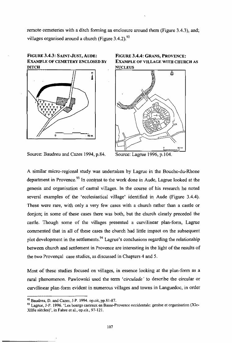
remote cemeteries with a ditch forming an enclosure around them (Figure 3.4.3), and;
vilJages organised around a church (Figure 3.4.2).92
FIGURE 3.4.3 : SAINT-JUST, AUDE:
EXAMPLE OF CEMETERY ENCLOSED BY DITCH
N
A
-- ---- --o - 50M
Source: Baudreu and Cazes 1994, p.84.
FIGURE 3.4.4: GRANS, PROVENCE:
EXAMPLE OF VILLAGE WITH CHURCH AS
NUCLEUS
Source: Lagrue 1996, p.1 04.
A similar micro-regional study was undertaken by Lagrue in the Bouche-du-Rhone
department in Provence.93 In contrast to the work done in Aude, Lagrue looked at the
genesis and organisation of castral villages. In the course of his research he noted
several examples of the 'ecclesiastical vilJage' identified in Aude (Figure 3.4.4).
These were rare, with only a very few cases with a church rather than a castle or
donjon; in some of these cases there was both, but the church clearly preceded the
castle. Though some of the villages presented a curvilinear plan-form, Lagrue
commented that in all of these cases the church had little impact on the subsequent
plot development in the settiements.94 Lagrue's conclusions regarding the relationship
between church and settlement in Provence are interesting in the light of the results of
the two Proven9al case studies, as discussed in Chapters 4 and 5.
Most of these studies focused on villages, in essence looking at the plan-form as a
rural phenomenon. Pawlowski used the term 'circulade' to describe the circular or
curvilinear plan-form evident in numerous villages and towns in Languedoc, in order
92 Baudreu, D. and Cazes, J-P. 1994. op.cil, pp.81-87. 93 Lagru., J-P. 1996. 'Les bourgs castraux en Basse-Provence occidentale: genese el organisalion (XIeXIII. siecles)', in Fabre el aI., op.cit, 97-121.
107

to avoid this distinction between villages and towns that so often appears, whether
explicitly or not, in the research frameworks of French settlement studies. There has
been a certain amount of debate regarding the functions of towns and villages in
Medieval France and the notion of urbanism, but it has been shown in Provence at
least that the boundary between villages and towns at an organisational level during
the Early Medieval and Medieval periods is almost impossible to trace.9S
3.4.5 THECONCEPTOFSANCTUARY
Research over the last two decades has also addressed the neglected question of the
relationship between the Church and Medieval settlement in this area and has
suggested a link between places of worship and early settlement. The concept and the
role of the church in the genesis of villages and the forms taken by these villages had
remained unresearched and poorly understood and other researchers were also
attempting to address this issue in the 1980s.96 Baudreu and Cazes had tentatively
dated their 'ecclesiastical villages' to the tenth or eleventh century AD and proposed
that the phenomenon of villages with an ecclesiastical enclosure could be explained
by the eleventh century Peace of God Councils, when the concept of the church as a
place of asylum was formalised. 97 This concept was examined further in an
archaeological research programme that looked at the churches and their landscape in
the Medieval period. The results of this research were published in two separate
volumes by Fixot and Zadora-Rio.98 One of the more interesting hypotheses (which
no doubt inspired Baudreu and Cazes) was that the limits of space protected by the
right of asylum left an indelible mark in the physical evolution of the settlement.
The propensity for places of worship to have a symbolic boundary marking out their
functions has long been a widespread phenomenon. Christian sanctuaries from the
very beginning, had clearly demarcated areas of sanctuary and the history of the
surroundings of the church are intimately linked with the right of asylum. As early as
the fifth century AD, Roman legislation records the existence of a boundary around a
94 Lagroe, J·P. op.cit, p.105. 95 NOled by E. Sauze. A debale on this subjecl look place following the presentalion of papers al the conference on the morphogenesis of the Medieval village. Recorded in Fabre el aI., op.cit., pp.264-26? 96 FOWl, M. and Zadora-Rio, E., 1990. L 'Eglise. Le Terroir, p.11. 97 Baudreu, D. and Cazes, J-P. 1994. op.cit, p.8? 98 These publications derived from Ihe research programme on SOCieleS el Cadres de vie au Moyen Age: approches archeologiques: Fixol, M. and Zadora-Rio, E. (eds), 1990, op.cit. and 1994, op.cit.
108

church, within which it was forbidden to pursue fugitives: a law passed on November
21, AD 4] 9, set the boundary to a circuit of fifty paces (approximately seventy
metres) around the place of worship.99 The constitution of AD 431 supplies a more
practical definition and describes the area of sanctuary as stretching from the church
to the gates of the atrium. lOO In the middle of the sixth century AD, a decree was
passed by the Merovingian kings Childebert and Clotaire, lOl which limited the area of
sanctuary ·to an arpent (approximately half a hectare) of ground on either side of the
church. 102 Over the course of the next five centuries, the right of asylum and the
extent of the area of sanctuary continued to occupy a place in legislation: the Council
of Toledo, in AD 681, defined the area by a radius of thirty paces; the charters of
Charlemagne, in the ninth century AD, used the boundary of the cemetery to define
the limits. I 03
From the end of the tenth century AD onwards, the right of asylum became a matter
of importance once more as war and violence spread throughout France. The Peace of
God movement, generated by the southern councils of the mid-eleventh century in
response to the on-going wars, formalised the idea of the church as sanctuary and
asylum, creating a legal place of refuge for those in need. The councils specified that
the 'peace zone' constituted a circuit of thirty paces around the church. lo4 In a letter
dated to AD 1059, Pope Nicholas II advised the bishops of Gaul, Aquitaine and
Gascony that church sites should have a circuit of sixty paces around the majores
ecclesiae and thirty paces around the capeUae sive minores ecclesiae. ID5 A
consequence of this decision was a tendency, particularly strong from the eleventh
century onwards, to transform the symbolic boundary (of thirty paces) of an
ecclesiastical site into a physical boundary, by constructing a wall or enclosure.
Documentary evidence indicates that this physical fortification of a church and burial
ground required the king's permission. 106
99 Timbal Duclaux de Martin, P., 1939. Le Droit d'Asile, p.77 n.l. 100 Timbal Duclaux de Martin, P. op.cit., p.79 n.2. 101 Monumenta Germaniae Historica, Capit. I, p.6. Cited in Timbal Duelaux de Martin, P. op.cit., p.ll9 n.3. and p.13S n.2. 102 An arpent is an old French measure which varied considerably but measured approximately 70 metres in length. IOJ Timbal Duclaux de Martin, P., op.cil., p.l3S n.3. 104 Fixot, M. and Zadora-Rio, E., 1990, op.cit., p.12. lOS MANSJ, I. XIX, col. 873; cited in Timbal Duelaux de Martin, P. op.cil., pp.199-200. 106 Fixot, M. and Zadora-Rio, E., 1990, op.cil., p.l3.
109

3.4.6 EVIDENCE FOR ENCLOSED ECCLESIASTICAL SITES
There is some archaeological evidence for physical boundaries around church sites.
Excavations were carried out on an enclosed ecclesiastical site at Hordain in Nord
Pas-de-Calais (near Lille in northern France), revealing a chapel and burial ground
surrounded by a ditch. The ditch, dated to the sixth or seventh century AD,
demarcates an area measuring fifty metres square. The foundations of three small
structures (a type of hut or cell) were discovered within the enclosure. Excavations
were also carried out at the church of Lunet-Viel in Herault (Languedoc). lt was
found that the church had been enclosed in the seventh or eighth century AD by a
water-filled ditch, which was replaced by a stone wall around the tenth century AD.
Burial within the enclosure pre-dates the construction of the ditch, after which burial
continued only in the area outside the boundary. This suggests that the enclosure had
a defensive function, providing protection for the church and burial ground which pre
date it. 107 At Le Mont d' Auvet in the Franche Comte department (eastern France),
excavations in 1900 provided surprisingly good results. The area within the enclosing
ditch measured approximately 90m and contained the cemetery and a church. It was
shown that the cemetery pre-dated the church and was in use from the sixth century
AD onwards; the church was probably added around the eleventh century AD. lOS It is
interesting that these enclosures pre-date the Peace of God movement, suggesting that
at least at some sites the eleventh century movement led to the fortification of existing
boundaries, rather than the imposition of new enclosures.
That there is further evidence for enclosed ecclesiastical sites (church and burial
ground) which did not evolve into urban settlements, suggests that the practice was
more common than previously believed. This is also illustrated by Passelac's aerial
survey of sites in Languedoc, the results of which indicate that the church and its
circular enclosure (many of which survive only as cropmarks) preceded the associated
settlement and that not all of these church sites developed into villages or towns. One
such example, La Gleysasso in Generville (Aude), shows an oval platform enclosed
by a wide ditch and measuring c. 65m by 45m, with the ruins of a church at the centre
107 Excavations at Hourdain were undertaken by P. Demolon and those at Lunel-Viel by C. Raynaud; cited in Fhat and Zadora-Rio, 1990, op.cit, p. 13. lOS Fixot, M. and Zadora-Rio, E., 1990, op.cit., pp.51-2.
110

(Figure 3.4.5).109 The site, located on a hillock, was partially excavated revealing a
Medieval silo and cemetery beside the church. I 10
~~i~~~i'~1~~~: CROPMARKS AT LA GLEY ASSO
Source: Passelac 1984, p.ll (better quality copy unavailable to researcher).
Similarly, a rescue excavation undertaken in 1980 of a deserted church site at Barrie
(Mas-Saintes-Puelles, Lauragais commune just north of Bas-Razes) in the commune
revealed a number of huts grouped around a chapel dedicated to St Semin the only
stone structure at the site. The chapel was located at a crossroads and was surrounded
by burials which continued after the site was deserted sometime around the eleventh
century AD. II I
There has been relatively little research carried out in France using aerial survey, a
method which has proven useful in the detection of monastic sites in Ireland and
Britain. As mentioned previously, the work of St Joseph and Swan in this area has
revealed a large number of monastic enclosures in Ireland which were unknown and
unsuspected before they were detected by aerial photography. James cites an aerial
photograph of the Auvergnat monastery of Manglieu as the only such example known
to him; it shows the size and shape of the monastic enclosure which has been
preserved in the street-plan of the modem town. ll2 As Passelac's small-scale study in
109 Passelac, M., 1984. 'Nouvelles decouvertes et observations aeriennes de sites medievaux en Languedoc', in Archeologie du Midi Medievale, II, p.11 110 Excavation by Dauzat in 1982, cited in Passelac, M. op.cit., p.11. III Described in Cazes, J-P. & Dauzat, M., 1987, 'Les villages de I'an mil' in Aspects de I'Habitat Rural en Lauragais (de la prehistoire a lafin du Moyen Age), Section 6. 112 James, E. 1981. op.cit., p.4D.
III

the Languedoc region has shown, aerial survey could prove a useful tool in the
investigation of enclosed ecclesiastical sites in other regions of France.
3.4.7 SUMMARY
The introduction and development of Christianity in France was a very different
process to that which took place in Ireland or in Wales. This section looked at the
origins of Christianity in the Roman province of Gaul and how Christianity spread
and developed as Gaul became Francia, ruled by the Merovingian Frankish dynasty.
The diocesan church was well established in towns and cities, where it was very much
the province of the ruling classes, but monasticism was the most important vehicle for
the spread of Christianity throughout France. A lack of research on the relationship
between church and the settlement in France, hindered for a long time an
understanding of the effect of these changes on urban settlement in the Early
Medieval and Medieval periods. The late twentieth century saw an attempt to address
this issue and while undoubtedly important and badly needed, the work focused
largely on the Medieval period, bringing together numerous small-scale studies and
the results of excavations throughout France.
The phenomenon of curvilinear enclosed settlements with an ecclesiastical nucleus
was noted in Languedoc as part of this new research drive. Part of the Languedoc
region in the southwest benefitted from several micro-regional studies looking at
small villages with ecclesiastical associations, many of which exhibit a similar
settlement pattern to the Irish ecclesiastical sites (a double concentric enclosure with a
church at the centre). Regrettably little has been done in the neighbouring Provence
region however, with Fevrier's work on urban development and ecclesiastical
topography representing one of the few attempts to examine the subject at a regional
level. Several Proven"al villages similar in plan to Baudreu and Cazes' 'ecclesiastical
village' were identified by Lagrue as part of his study of castral villages, but were
considered a rarity. No further work appears to have been undertaken on curvilinear
ecclesiastical settlements in Provence. Individual examples of similar curvilinear
ecclesiastical settlements were also identified elsewhere in France though there has
been no investigation of these sites in the context of an emerging 'pattern' of
ecclesiastical settlement.
112

It became apparent during this literature review that there are conflicting opinions and
evidence regarding the dating of the enclosed ecclesiastical sites. Baudreu and Cazes
proposed a tentative tenth or eleventh century AD date for the 'ecclesiastical villages'
in the Aude valley, 113 but given the lack of archaeological excavation at these sites
and the scant documentary evidence an earlier date cannot be ruled out.
Archaeological evidence from excavations at enclosed ecclesiastical sites elsewhere
in France- discussed in Section 3.4.6 - suggests a much earlier date for the origins of
the enclosing ditch, possibly as early as the sixth century AD. The evidence also
suggests that boundaries were being replaced around the tenth or eleventh century.
This might tie-in with the eleventh century Peace of Gods movement and explain the
discrepancy in the dating of enclosed ecclesiastical sites, i.e. there was a fortification
of existing boundaries, rather than the imposition of new enclosures at some sites. The
hypothesis presented by Fixot and Zadora-Rio regarding the right of asylum and the
possibility that it influences the physical evolution of settlements is tantalising and
would benefit from further examination, particularly in the case of enclosed
ecclesiastical settlements.
113 Baudreu, D. and Cazes, J-P. 1994. op.cit.
113

CHAPTER 4: FIELD STUDIES
114

4.0 FIELD STUDIES
A detailed examination of nine field study sites is undertaken in this chapter, with a
view to establishing the characteristics of settlement and plan-form at each site ..
4.1 IDENTIFICATION OF SITES FOR DETAILED STUDY
4.1.1 SELECTION OF STUDY AREAS (Figure 4.1)
There are known trade and communication links between Ireland, Britain and the
Continent in the prehistoric and Early Medieval periods. As Ireland's closest
neighbours, it was considered most likely that if the ecclesiastical settlement pattern
observed at Irish sites was not unique but had spread either to or from the Continent,
it should manifest in these areas. It was confirmed during an initial literature review
that there appeared to be evidence of ecclesiastical sites with a similar curvilinear
topographical layout to those in Ireland, with other possible examples in Scotland,
Wales, Cornwall and northern France.
Provence and Languedoc, the two regions forming southern France, were selected for
detailed study in order to further examine the possible similarities noted by Swan in
the Languedocien villages. The villages in Languedoc were small in scale and had
been studied in some detai1.as part oflocal and regional research projects.' This being
the case, it was decided to choose one of these villages for detailed examination, to
illustrate the settlement pattern present in Languedoc. This village would be examined
alongside two larger sites chosen from the neighbouring Provence region, where the
phenomenon of curvilinear ecclesiastical sites IS largely unknown or
unacknowledged. This was decided for two reasons, the first being to establish
whether the sites present in Languedoc were a regional anomaly, common only to
areas within Languedoc, which would in tum inform about the spread or otherwise of
the Irish pattern. The second reason was to assess whether this pattern in southern
France was restricted to small villages or whether it extended to large towns.
The strongest and earliest Irish connections attested in Wales in the Early Medieval
period are in the northwestern part of the country, an area where the Roman colonists
had made few if any inroads. Southern Wales and southern France had the potential to
I The work of Baudreu and Cazes as noted above in Chapter 3, p.97, footnote 88.
115

offer the most value in tenns of the survival of the pattern in the face of the earlier
Roman urban influences.
By undertaking research in Ireland, southern Wales and southern France it is intended
that sufficient new infonnation will emerge to prompt and guide future research in the
examination of ecclesiastical settlements in the areas not encompassed by this work.
4.1.2 SELECTION OF FIELD STUDY SITES (Figure 4.1, Volume 2)
The decision to select three sites within each study area was a practical one, allowing
sufficient time and space to thoroughly examine each site. A detailed examination of
the topography, history and archaeology of each site and its environs is essential for
the application of plan-analysis. Any fewer than three and the comparative assessment
would have little value, any more and the opportunity for a detailed analysis would be
lost.
As the phenomenon of ecclesiastical sites with a curvilinear layout and their influence
on the evolution of subsequent urban centres of varying success and size is relatively
well-documented and researched in Ireland, the decision was made to choose three
known early Christian sites which had evolved into a modem town or village for
detailed assessment.2 This would provide a sound basis from which to study sites in
France and Wales, to assess the characteristics of ecclesiastical site/settlement
development and the phenomenon of circular or curvilinear enclosure. It would also
allow the evaluation of the plan-analysis technique, which has yet to be applied to
these sites in an archaeological context for the assessment of early Christian elements.
The sites chosen included a large urban centre (Annagh), a town (Kells) and a village
(Clondalkin), all of which began as a monastic settlement. Though much work has
been undertaken in the study of Annagh and Kells, Clondalkin has received less
attention than these two more important sites. Each of the sites has retained its
ecclesiastical focus, with the church, burial ground and associated features remaining
at the centre of the settlement. This would provide a sound illustration of the Irish
'For example, Swan, DL, 1983, 1985 & 1994, op.cit.; Simms, A. with Simms, K., 1990. 'Kells', in Irish Historic Town Atlas, No.4; McCullough, C. and Crawford, W. H., 2007. Armagh, Irish Historic Towns Atlas No.18.
116

ecclesiastical settlement pattern and would be a strong base from which to begin a
comparative analysis.
The sites in Wales were selected following a review of the O.S. first edition six-inch
maps in the National Library of Wales in Aberystwyth. A list of sites presenting a
curvilinear plan-form was compiled and initial research was undertaken to assess
whether or not the nucleus was ecclesiastical and if so, whether there were any
obvious indicators of early Christian origins (e.g. the place-name 'llan '). Llandaff,
Llancarfan and Llandeilo Fawr were chosen from among those sites with an
ecclesiastical nucleus.
In France, the phenomenon of ecclesiastical sites with· a circular layout has been
observed in the Languedoc region but is less well documented in Provence. The
influence of the church in the development of Early Medieval settlement and the
evolution of settlement patterns is not often considered. The sites chosen in France
include the towns of Vence and Carpentras and the small village of La Digne
d' Amont in the Languedoc area. Despite disparities in the origins and the size of the
two Provenyal towns and the Languedocien village, their layout is remarkably similar:
a cathedral/church as the focus of later settlement, which grew up around the
ecclesiastical centre. Their selection was based on a review of available town plans
(usually twentieth century) in southern France. A list of sites presenting a curvilinear
plan-form was compiled and initial research was undertaken to assess whether or not
the nucleus was ecclesiastical or castral. The three case studies were chosen from
among those sites with an ecclesiastical nucleus.
The selection process was not without its difficulties, particularly given that a
curvilinear pattern is often present around a castral focus in France (i.e. a castle or
other fortified structure) and that a church is commonly found alongside the castle,
patronised by the lord in residence. One such example, Digne les Bains in Provence
was investigated during the initial reconnaissance for potential case studies in France,
but was subsequ'ently ruled out (Figure 4.1.1). On paper it was promising; with
ecclesiastical origins in the Early Medieval period confirmed by archaeological
excavation and subsequent development into a town exhibiting a similar pattern to
those in Ireland. On closer examination, however, it was apparent that the earliest
117

church and cathedral along with its bourg did not provide the impetus for settlement
beyond the Early Medieval period (Figure 4.l.1b & 4. 1.1 c). Nor did this earliest
bourg exhibit more than the slightest evidence of a curvilinear enclosure. In the case
of this town, the need for defence overrode the pull of the church. The nearby
chateau, situated on a natural height competed as a pole of attraction for settlement.
The construction of a new cathedral alongside the chateau led to this site developing
into a Medieval town, with a curvilinear street pattern probably more the result of
topography than ideology.
FIGURE 4.1.1 : DIGNE-LES-BAlNS, PROVENCE
A. THE BOURG WITH CURVILINEAR SIREETPAITERN AND MEDIEVAL CATHEDRAL.
B. THE BOURG IN RELA nON TO THE EARLY C. THE EARLY MEDIEVAL CATHEDRAL OF
MEDIEVAL CATHEDRAL OF NOIRE-DAME NOIRE-DAME AND EARLIEST SETTLEMENT.
~"'1 "*''''_'''~,, __ 10 ...... _._1 __ • __ .·· ... _ .. _.ioOt,l'pft..-...... _~·4.,.. __ .. --.. --f>o_ ..... _ ..... __ .,a~ ___ ."_"VD'" -,._ ... -U!· .... "''' •• _VA; .. _a._ -<--_ ... _ ... _ ....
f-...... __ j,-",_ ... _-,·_111.-
•
Source (a&b): Provence and the Cote d'Azur: The Rough Guide, pp.4l2-i3. Source (c): Demians d' Archimbaud, G., 1990, p.4S.
118

4.2 METHODOLOGY AND SOURCES
4.2.1 FORMAT AND STRUCTURE OF FIELD STIJDY SITES
Each site was examined using a combination of detailed historical investigation,
available archaeological evidence, field survey and plan-analysis. Each site is
assessed in terms of its physical location, place-name evidence, early evidence for
settlement and ecclesiastical history. Plan-analysis, using a combination of
cartographic, historical and archaeological evidence, is then carried out to understand
the spatial arrangement at each of the sites and to identify the principal plan units. The
purpose of this detailed examination is to explore the development of each of the field
study sites with a view to evaluating the importance of ecclesiastical foundations as a
core element of settlement structure and development. This will in turn allow a
comparative assessment of the field study sites, with comparative analysis and
discussion provided in Chapter 5.
4.2.2 HISTORICAL EVIDENCE
There are regrettably few primary documentary sources for the Early Medieval period
in any of the three study areas and this has been acknowledged as a problem by
scholars working in this field. Those which are available (such as the hagiographies)
and secondary historical sources were consulted in Ireland at the Berkeley and Early
Printed Books Libraries of Trinity College Dublin, the National Library ofIreland, the
National Archives of Ireland, the Public Libraries of Armagh, Kells and Clondalkin
and the Cathedral Library of Armagh.
Desk-based research and field work in Wales took place in October and November
2000. Much of the baseline research and literature review was undertaken in Ireland,
utilising the university libraries of Trinity College Dublin and University College
Dublin. Further baseline research and historic cartographic sources were viewed at the
National Library of Wales in Aberysthwyth.
Research and fieldwork in France took place in November 1997, April to August
1998, January 2001 and January 2009, and was part funded by the French Cultural
Embassy in Ireland. Primary sources and secondary sources were consulted at the
Archives Communaies (communal archives), the Archives Departementaies
(departmental archives), the Bibliotheque Universitaire (University Library) and the
119

Bib/iotheque de l'ArcMologie, de l'Art et de l'Histoire of the Universite d 'Aix-en
Provence (Archaeology, Art and History Library, University of Aix-en-Provence),
and the Bib/iotheque Municipale d'Aix-en-Provence (County Library of Aix-en
Provence). The system of cataloguing and storing historical information and
documents in France is different from that in Ireland and to a certain degree Wales,
where much of this information is simply stored in the university libraries, the
National . Library or the National Archives. In France, each departement
(administrative division) has its own Archives Departementales (departmental
archives), which stores much of the documented history and records of the
departement. There are also Archives Communales, archives for' the communes, the
smaller districts within each departement.
4.2.3 ARCHAEOLOGICAL DATA
Archaeological data in both Ireland and Wales is relatively easy to access, as each
have a form of centralised database in a Sites and Monuments Record (SMR). This
resource is based on all published and publicly available documentary and
cartographic sources. It records known upstanding archaeological monuments, their
original location (in cases of destroyed monuments) and the position of possible sites
identified on vertical aerial photographs.
In Ireland the SMR sites (as revised in the light of fieldwork in the 1980s and 1990s)
formed the basis for the establishment of the statutory Record of Monuments and
Places (RMP) in 1996. The topographical files of the National Museum of Ireland
(NMI), which identify recorded stray finds held in the museum's archive, were also
consulted. The finds, which have been donated to the state in accordance with
national monuments legislation, are provenanced to townland, and the files sometimes
include reports on excavations undertaken by NMI archaeologists. The Excavations
Bulletins and Excavations Database is an annual bulletin, which contains summary
accounts of all excavations carried out annually in Ireland, from 1969 to 2005. It can
be accessed both in published form and on the Internet at www.excavations.ie.
In Wales a SMR for each ofthe four regions has been compiled and is held separately
in the respective archaeological trust (Dyfed Archaeological Trust for Llandeilo and
Glamorgan Gwent Archaeological Trust for Llancarfan and Llandaft). Each
120

archaeolo gical trust also holds the excavation reports and records of stray finds for the
region.
Archaeological research in France is more difficult. Unless an excavation has been
published there is no way to access the information, particularly for the Early
Medieval period. Medieval archaeology fares a little better - a chronicle of the
previous year's excavations is published in the annual Archeologie Medilivale
(Medieval Archaeology) journal. The published results of excavations were viewed in
archaeological journals held in the library of the Maison Mediterramiene des Sciences
de l'Homme (Mediterranean Centre for Humanities) of the Centre National de la
Recherche Scientifique (National Centre of Scientific Research) in Aix-en-Provence.
There is no database, centralised or otherwise, of stray archaeological finds in France.
4.2.4 PLACE-NAME EVIDENCE
Place-name evidence - the names of towns and villages, townland names (in Ireland),
street names and field names - is a rich source of information, not only on the
topography, land ownership, and land use within the landscape or a town, but also on
its history, archaeological monuments and folklore. Where a monument has been
forgotten or destroyed, a place name may still refer to it and may indicate the
possibility that the remains of certain sites survive below the ground surface.
Similarly, street-names can often indicate the historical development of a town or an
area within a town, pointing to specific areas of trade, commerce or religion.
4.2.5 CARTOGRAPHIC SOURCES
In both Ireland and Wales, O.S. first edition, six inch and twenty-five inch mapping
compiled in the early and later nineteenth century f<;Jrm the basis of the cartographic
analysis. Where available earlier historic maps were consulted, such as the early
seventeenth century maps of Armagh by Richard Bartlett and of Llandaff by Speed
and the earlier nineteenth century tithe maps in Wales. The majority of the O.S. maps
could be consulted and studied at the Map Library in Trinity College (for Ireland) and
the National Library of Wales in Aberysthwyth (for Wales). Other maps were found
to be held in smaller collections, such as those held in the Cathedral Library in
Armagh and the County Archives in Cardiff, and were consulted and examined on
site.
121

In France the Napoleonic cadastral maps were consulted. This series of detailed maps
of France were commissioned by Napoleon at the start of the nineteenth century and
are held in the various Archives Departementaies (departmental archives), in this case
at Nice (for Vence), Avignon (for Carpentras) and Carcassonne (for La Digne
d'Amont). Other maps of various date and source were also consulted, such as the
. earlier maps of Carpentras at the Bibliotheque d'lnguimbertine (inguimbertine
Library) in Carpentras. Each of the departmental archives had separate rules regarding
the consultation of the nineteenth century maps and the copying of same. In both
Avignon and Carcassonne it was possible to view the original maps; in the former it
was permitted to trace the map and in the latter it was permitted to photograph the
map. The cadastral map of Carpentras was in mostly good condition but small areas
had been badly damaged. In Nice it was not possible to consult the original maps but
a copy was available on microfiche and could be printed; unfortunately the quality
was poor. The archives at Nice have recently uploaded the original cadastral map to
their internet website and this has been accessed online.
4.2.6 FIELD SURVEY
Each of the chosen case-studies was visited and on-the-ground examination was
carried out, which included the recording and surveying of ecclesiastical features and
extant physical structures and remains (such as enclosures, churches, crosses). Where
appropriate, the surrounding lands were examined from vantage points and roadside
where public access was not possible, to identify any low-visibility archaeological
features with little surface expression, such as enclosing banks or ditches. In addition,
aerial photographs were viewed to examine the surrounding lands for potential
archaeological features and the survival of patterns within the urban fabric.
4.2.7 SPATIAL MODEL
Use was also made of Griffin's spatial model to examine and assess the sites used as
field studies in this thesis.3 Given the level of detailed analysis already undertaken by
Griffin in the preparation of this model, it is unnecessary to repeat the process of
detailed investigation of a large number of Irish ecclesiastical sites here. As the model
was initially developed for the analysis of Irish ecclesiastical sites, it has been
3 Griffm, K. op.cit.
122

necessary to adapt and refine the existing model for use in a broader spectrum of sites
in Ireland, France and Wales. New indicators have arisen from the comparative
approach, so for example, features which are commonly found in Irish ecclesiastical
sites, such as round towers, are never present at French or Welsh sites. It was also
necessary to be aware of the Roman origins of the French towns and how this affected
the later development of the settlement in the Medieval period and whether the
Roman urban traditions in Wales affected the evolution of the sites. By carrying out a
detailed investigation of each of the chosen field study sites using these characteristics
it should be possible to evaluate the level of early Christian influence and also to
assess the similarities and differences within the three study areas.
NOTE:
The maps and illustrations for each of the field study sites detailed in this chapter are
contained in Volume 2 of this thesis.
123

4.3 ARMAGH, COUNTY ARMAGH, IRELAND
4.3.1 INTRODUCTION
Armagh occupies a central position in County Armagh in the province of Ulster,
Northern Ireland (Figures 4.1 & 4.3.1). It is situated on a prominent hill, as are other
major Irish ecclesiastical sites, such as Downpatrick and Cashel. Armagh is only three
kilometres from the major royal site and ritual complex of Navan Fort (Ernain
Macha). The River Callan flows c. 800m to the west of the city. The focus of the
modem city is the hill, a substantial rock outcrop, on which the Church of Ireland
cathedral stands (Figure 4.3.8c). A cluster of drumlins surround the 70m high rock
outcrop and provide a crossing place over the River Callan and the neighbouring
marshes. l Several major routes converge at this point, coming from the south, east and
west.
4.3.2 PLACE-NAME EVIDENCE
Armagh's elevated position is indicated by its old Irish place-name Ard Macha (the
height of Macha) and has been a place of human habitation for over two thousand
years. Both the ancient place-name of Armagh (Ard Macha) and that of the royal site
of Ernain Macha incorporate the name of the pagan goddess Macha, who legend says
founded a settlement here, and testifies to the possibility that Armagh was a place of
religious significance long before the advent of Christianity in Ireland.2 Armagh is not
unusual in this as a number of other ecclesiastical sites throughout Ireland appear to
have had pagan religious associations before becoming places of Christian worship,
suggesting a deliberate continuity of use of ancient sites of worship or gathering. This
is further evidenced by the fact that many churches were founded on the borders of
kingdoms, boundary zones being associated with the supernatural in pre-Christian
times.3
Some monasteries seem to have been connected with sacred trees, evidence for which
can be found in place-names, such as St Finnian's monastery at Movilla (Magh Bile,
plain of the tree) and Kildare (Cel/-dara, church ofthe oak wood). Notably, the annals
I McCullough. C. and Crawford, W. H. 2007. Armagh, Irish Historic Towns Atlas No.IS, p.I. 2 Hughes, K. and Hamlin, A., 1977. The Modern Traveller to the Early Irish Church, p.30-32; The authors address the question whether or not monasteries were often founded in places which had pagan religious associations and conclude that early Christians may have been willing to take over sites already sacred in popular regard.
124

for AD 995 refer to a sacred grove (jid-nemed) at Annagh. Some of the stone carvings
of bears and humans in the north transept of the cathedral at Annagh may also have
belonged to a pre-Christian tradition,4 though it is not certain whether they came from
Annagh itself or from the surrounding countryside.s Other evidence for pre-Christian
religious associations can be found in the excavated Teampull na Jerta area (see
below) where possible earlier pagan burials were revealed.6
4.3.3 EVIDENCE OF EARLY SETILEMENT: PREHISTORIC PERIOD
Annagh lies only 3km west ofNavan Fort (Emain Macha) the ancient royal capital of
Ulster and one of a very small group of royal sites in Ireland, which include Tara in
Meath, Cruachain in Connacht and Dun Ailinne in Leinster. Archaeological
excavations of the hilltop site have shown a long sequence of occupation, beginning
in the Neolithic period and continuing through the Iron Age.7 The Iron Age
stronghold and ritual site was destroyed in the first century AD and finally abandoned
some time in fourth or fifth century AD.8 It has been suggested that the siting of an
early (i.e. fifth century AD) church in Annagh was strongly influenced by the
proximity to the old royal capital, perhaps being founded to maintain the tradition and
prestige of religious worship among the local inhabitants.9 The site at Annagh was
also in use long before the foundation of a church here; extensive excavations at
Scotch Street at the base of the hill revealed a Neolithic ring ditch and evidence of
settlement during that period, radiocarbon dated to c.2500 BC, as well as Early
Medieval and Medieval activity (see below).l0 It has also been suggested that pre
Christian Annagh was associated with a local place of assembly and trading (the
oenach Macha). II
3 Edwards, N., 1990. op.cit., p.105; Hughes, K. and Hamlin, A. op.cit., pp.29-30. 4 Hughes, K. and Hamlin, A op.cit., p.98. 5 Edwards, N., 1990, op.cit., p.105. 6 Ibid. 7 Excavation began at the site in 1961 and continued for ten years under the direction ofD. M.Watenean, then Principal Inspector of Ancient Monument with the Department of Finance; Hamlin, A, 1985, 'Emain Macha: Navan Fort', in Seanchas Ard Macha -Journal of the Armagh Diocesan Historical Society, VoU] No.2, pp.295-301; p.297. 8 Hamlin proposed the mid-fifth rather than the fourth century for the abandomnent of the site; Hamlin, A, 1985, op.cit., p.296. 9 Hamlin, A., 1985. op.cit., p.296; Also McCullough, C. and Crawford, W. H. op.cit., p.l. 10 SMR file ref. ARMOI2:095, Nl SMR
125

4.3.4 ECCLESIASTICAL HISTORY
Irish tradition is unanimous in recognising St Patrick as the founder of the church at
Armagh and the traditional date given is either AD 445 or 457. Armagh is not
mentioned by Patrick in either his C01ifession or his Epistle. 12 Instead it is Muirchu
who relates the story of the foundation of Armagh (Book of Armagh, ff. 2-8): it is
recorded here that the hill-top site of the future cathedral was given to Patrick by
Daire, a local king. 13 Armagh is traditionally acknowledged as the most important of
the ecclesiastical foundations in Ireland, a tradition which has long been based around
the legend of St Patrick. Whether or not this tradition is based on fact is not as
significant as the belief that it was. The early monastic community at Armagh, and
then the later diocesan establishment, built a great ecclesiastical city on this idea that
Patrick had not only founded the church, but favoured Armagh above all his other
churches.
It is thought, however, that Daire first granted Patrick the land below the hill and a
description of this first foundation at Armagh is included in the Tripartite Life, which
Ryan claims is "certainly ancient and credible".14 According to this record, Patrick
allowed seven score feet to the enclosure, twenty-seven feet to the large house,
seventeen feet to the kitchen and seven feet to the oratory, and "it was thus that the
houses of the ecclesiastical establishment (congbala) were built always". 15 Thus Bury
calculates that the settlement would have been an enclosure, one hundred and forty
feet in diameter and surrounded by a high wall of earth. 16
Armagh is one of the few Irish ecclesiastical urban sites where excavations have been
undertaken, which have identified Early Medieval features and activity. The existence
of an initial Christian settlement at the foot of the hill, which is recorded in the
documentary sources, can be tentatively supported by archaeological evidence. Early
maps and seventeenth century documents show that Scotch Street, near the bottom of
the hill, crosses an area known as 'na Ferta', meaning 'the graves' or 'burial
11 McCull()ugh, C. and Crawford, W. H. op.cit., p. \. 12 0 Fiaich, T., 1995. 'St Patrick and Annagh', in Seanchas Ard Macha - Journal o/the Armagh Diocesan Historical Society, pp.10?-119; p.IO? 13 Bury, J. B., op.cit., p.15 \. 14 Ryan, r., 199\.lrish Monasticism:Origins and Early Development, p.89. 15 Trip. L. i, p.236; cited in Bury, J. 8., op.cit., p.156. 16 Bury, J. B., op.cit., p.156.
126

monuments'. The earliest documentary reference to the site occurs in Muirchu's
seventh century life of St Patrick, which refers to a cemetery in this location at that
time. 17 In the area of Teampull na ferta, excavations in the 1970s and 1980s revealed
37 graves, all apparently Christian burials, indicating that there was at least a
Christian cemetery here, if not an actual ecclesiastical settlement. 18 Wood from a
coffin in one of the graves from 48 Scotch Street gave radiocarbon dates in the sixth
century ·AD, placing the cemetery in the century after the reputed foundation of the
first church. The site did not survive as a cemetery throughout the Early Medieval
period and seems to have become an industrial area by the eighth or ninth centuries. 19
Thus the archaeological evidence may support the documentary evidence which
claims that Patrick first established an ecclesiastical settlement below the hill. It is
possible, as Bury suggests, that when Daire granted Patrick the higher ground for his
settlement, the older site at the bottom of the hill was devoted to the uses of a
graveyard. Furthermore, the cloister which was later built on this site was known as
Teampu/J na ferta. 2o Though traditionally translated as 'Temple of the Graveyard' ,21
Stout cites two alternative and more 'convincing' translations for fert, as a 'boundary
mound' or 'boundary ditch,.z2 There were also signs of earlier activity and Edwards
suggests that there were either earlier pagan burials in the vicinity, or that some of the
Christian burials were marked in the pagan manner, by mounds and/or ditches.23
As ancient tradition records, Daire eventually granted Patrick the elevated position on
top of the hill for the foundation of the settlement of Ard Macha, which was to
become the supreme ecclesiastical city of Ireland.24 Armagh's supremacy over all
other churches in Ireland has long been recognised and was stressed in Tirechan's
memoir (Book of Armagh, ff. 9_15).25 It is also suggested by the frequent mention of
the lex Patricii in the eighth century annals, that Armagh's claims to primacy were
17 SMR file, Ref. ARMOI2-066, NI SMR (DoENI). 18 MacDowell, J. A., in Excavations Bulletin 1985:08, URL. www.excavations.ie. accessed 24102/09 "Ibid. 20 Bwy, J. B., op.cit., p.159. 21 Ibid.; Stout, M., 2000. 'Early Christian Ireland: Settlement and Environment', in Barry, T. (ed), A History of Settlement in Ireland, pp.81-I09; p.84. 22 Stout, M. op.cit., p.84. 23 Edwards, N. 1990. op.cit., p.105. 2' Bwy, J. B., op.cit., p.159. 25 Hanson, R.P.C., 1983. The Life and Writings of the Historical Saint Patrick, p.16.
127

being actively pushed during this period.26 Tradition also has it that of all the churches
that he founded Patrick favoured Armagh; Muirchu records that Patrick fixed his
episcopal see here and that he spent the last years of his life in Armagh.27 The
surviving texts also indicate that the ecclesiastical settlement at Armagh was drawing
up documents in the late seventh century AD in an attempt to establish her position as
the most important church in lreland.28 Gougaud, however, notes that the authority of
the. primatial see overall amounted to very little as centralised ecclesiastical
organisation probably did not exist.29
By the time of the Viking raids in the ninth and tenth centuries, at which time there
were also raids by other Irishmen, the monastery's 'great church' and several of the
oratories were built of stone. 30 This indicates that the monastic settlement has
prospered, being wealthy enough to find stone buildings and to attract raiders.
Armagh's determination to establish its primacy through continued efforts, such as the
Book of Armagh, over the other churches in Ireland earned the monastery a great
reputation. This Book contained, among all of the information relating to St Patrick, a
version of the Life of St Martin of Tours, written by Sulpicius Severus.3l This
'marketing' paid off and by 1162 AD, the synod of Clane decreed that "no one should
be lector in a church in Ireland except an alumnus of Armagh before". 32 Armagh also
played a prominent role in the reform of the Church in Ireland in the late eleventh and
early twelfth centuries AD, in response to the reform movement in the Church in
western Europe. When the synod of Raith Bressail divided the Irish Church into two
provinces, Armagh and Cashel were designated at the head of the provinces. 33 As
occurred elsewhere in Ireland during the twelfth and thirteenth centuries AD,
continental religious orders were established at Armagh: a large Augustinian abbey
dedicated to SS Peter and Paul was founded in 1126; an Augustinian nunnery was in
place possibly as early as 1144; and a Franciscan friary was built in the 1260s.34
Armagh maintained its place in the Church hierarchy in Ireland until the dissolution
26 Gwynn, A. and Hadcock, R. op.cit., p.59. 21 Gougaud, L. op.cit., p.227. l8 Hughes, K. and Hamlin, A. op.cit., pp.34-35. 29 Gougaud, L., op.cit., p.229. 30 McCullough, C. and Crawford, W. H. op.cit., p.l. 3\ Ibid. 32 Ibid. 33 Ibid. 34 Ibid.
128

of the monasteries in the mid-sixteenth century AD, after which it lost its formerly
important status. 35
4.3.5 PLAN-ANALYSIS
The nature of the original ecclesiastical settlement at Annagh is not certain but it is
likely that Patrick would have initially founded a church on the model of churches he
had known in GauJ.36 Annagh became monastic at an early date, but still adhered to
the episcopal constitution, and this can be seen in the fact that the offices of bishop
and abbot were combined at Annagh from the sixth to the eighth century AD.37
Until more excavations are undertaken at Annagh, cartographic evidence and aerial
photography are the best means by which to obtain an overall idea of how the original ,
monastic settlement may have looked. A map drawn at the start of the seventeenth
century (c. 1602) by Richard Bartlett shows the ecclesiastical remains in Annagh at
that time (Figure 4.3.2). Some of the features of the settlement which are mentioned
in the annals from the eleventh and twelfth centuries can be seen depicted on this
map. The map shows the Medieval cathedral on the top of the hill, known as the Rath
in the annals/8 surrounded by a circular enclosure. According to the annals the site
was divided into three distinct districts.39 Bartlett's map also indicates the existence of
what appears to be three sectors and it has been suggested that these correspond to
Trian Mar, Trian Masain and Trian Saxan mentioned in the annals. 4o
The proposed plan units for Annagh are shown on Figure 4.3.6, which should be
referred to when reading the description of each plan unit below.
PLAN UNIT I
The earliest settlement activity at Annagh appears from existing evidence to have
been located at the base of the hill to the east (the present Scotch Street, Figure
4.3.8c). The earliest phases of burial activity (and possibly settlement) dating to the
35 McCullough, C. and Crawford, W. H. op.ci!., p.l. 36 Gwynn, A. and Hadcock, R. op.cit., p.59. 37 A list of its abbots, the coarbs of Patrick, is preserved in four ancient manuscripts: PRIA xxxv (1919), pp.316-62.; Ryan, J. op.cit., p.l02. 3S Edwards, N. 1990. op.ci!., p.l08. 39 Edwards, N. 1990. op.ci!., p.l09. "" Ibid.
129

Neolithic period have left no trace in the town plan. In addition to prehistoric burials
on this site, the documentary and archaeological evidence both also indicate the
presence of a Christian burial ground here. The curve of the lane (McCrums Court)
and property boundary on the north side of Scotch Street is partly echoed by a
corresponding curve on Market Street, where the line of properties bulges out from
the otherwise straight line of Thomas Street and Upper English Street. The plots on
the south side of Scotch Street are laid out directly perpendicular to the street, with the
exception of those plots immediately opposite McCrums Court. These plots run at an
angle that is not truly perpendicular, and one even forms a slight curve that aligns
with the curve of McCrums Court. This may represent the line of the earliest
enclosure, used to encircle the first Christian burial ground, measuring c. 80m
east/west. The presence of an enclosure around the earliest Christian site at the base of
the hill is described in the Tripartite Life.4 ! Given the evidence for prehistoric burials
on this site, it is possible that this enclosure originally formed part of a prehistoric
site. It is considerably larger than a typical prehistoric enclosed burial site, such as a
ring-barrow or ring-ditch, but a prehistoric ritual or settlement enclosure cannot be
ruled out. The possible presence of an enclosure here is interesting in the light of the
alternative translations for fert, as a 'boundary mound' or 'boundary ditch' .42
PLAN UNIT II
The six-inch O.S. map from 1835, the twenty-five inch O.S. map of 1907 and the
aerial photograph of Armagh all hint at the line of the original ecclesiastical
enclosures (Figures 4.3.4, 4.3.5 & 4.3.6). The present sub-circular churchyard
contains the majority of the principal ecclesiastical remains, including the present St
Patrick's Cathedral and graveyard and probably follows the line of an inner enclosure
(Figure 4.3.8d). Other ecclesiastical structures are mentioned in the documentary
sources and would have originally stood within this enclosure in the Early Medieval
period: a round tower (see below) and subsidiary churches - the Northern Church and
Southern Church, the Sabhall (or Bam) and the Toi (Church ofthe Elections).43
41 Trip. L. i, p.236; cited in Bury, J. B., op.ci!., p.156 42 Stout, M. op.ci!., p.84. 43 The position of the Toi is uncertain. It is mentioned in the Annals as being burnt by lightening in 916 & burnt again in the great 1020 fire. Reeves' statement that "it stood on the south side of the present church" seems based on traditions. He admits that "the site of the building is doubtful". Others have suggested that it was attached to the south side of the cathedral; Bartletts map, c.1601 (Figure 4.3.2), shows a chapel against the south aisle of the nave; SMR file, ref. ARMOI2-099.
130

The annals tell us something of the buildings of the Early Medieval ecclesiastical
settlement at Armagh. They record, for example, that 'on the fifth of the ides of
January 1125, which fell on Friday, the roof was raised on the great Daimh-liag of
Ard Macha, after having been fully covered with shingles by Celsus, successor to
Patrick, one hundred and twenty years since it had a complete roof'. 44 The annals of
AD 789 also mention a great stone church (Daimh-liag) in Armagh.4S It is likely that
the location of these earlier churches is the same as that of the present cathedral
(Figure 4.3.8a).
The existence and location of the round tower of Armagh is known, although there are
no extant remains. The tower's existence is substantiated by several references in the
annals to a cloig-theach (round tower) at Armagh, which record that it was destroyed
by lightening in AD 988, 994, 995 or 996, after which it was presumably rebuilt as it
again appears as 'burnt with its bells' in AD 1013, 1018 or 1020 and its cap tom off
by a storm in AD 1121.46 Evidence for its location can be extrapolated from a number
of sources. Reeves asserts that the tower was situated twelve metres from the
northwest comer of the 'great church', which was possibly the predecessor of the
cathedral. 4 7 Reeves provides no evidence for this assertion but a sketch map by
Hayes-McCoy, dating from 160 I, depicts a heap of stones in this approximate
position which could arguably be the remains of the round tower. 48 A later plan of
Armagh, made in 1886, places the site of the tower as being'twelve metres north of
the present cathedral. 49
PLAN UNIT III
The curving lines of the modem street pattern and property boundaries form the lines
of a second enclosure which would have originally encompassed the Abbot's House,
the Priory of the Culdees and the later Augustinian abbey of SS Peter and Paul. These
lines have been noted by Henry, St Joseph and Swan and form an ovoid enclosure
44 McKinstry, R., Oram, R., Weatherup, R. and Wilson, P., 1992. The Buildings of Armagh, p.2. 45 Edwards, N., 1990. op.cit., p.124. 46 Reeves, W., 1860. Ancient Churches of Armagh, p.13. 47 Reeves, W., 1860. Ancient Churches of Armagh,pp.l4-15. 48 Hayes-McCoy, G., 1964. Ulster and Other Irish Maps c.I600, pI iii, Armagh, post-160l. 49 The Builder, 27 September 1890, pp.247-249 including plan of 1886 restoration.
131

measuring 250 metres north to south and 200 metres east to west. 50 This enclosure can
be followed in the present Castle Street and Callan Street as they curve around St
Patrick's Cathedral, forming the southern half of the enclosure, continuing in a
property boundary to the northeast. Possible internal subdivisions within this outer
enclosure can be traced in the plot boundaries, where they radiate out from the line of
the inner enclosure.
A curving ditch was revealed during excavations in 1968-9 within the southeast side of
this enclosure, between the churchyard wall and Castle Street and concentric to the
inner enclosure that is represented by the churchyard wall.5l The ditch was substantial
in size, measuring 6.4m wide by between 2.28m to 3m deep. 52 Materials and artefacts
recovered from this ditch have been dated by radiocarbon dating to before the mid
seventh century, the first phase of the ditch being placed between the late second and
mid-sixth centuries (cal. AD 180_560).53 At a later stage, some time between the fifth
and eighth centuries (cal. AD 430-770), the ditch was filled in with material from the
outer bank and then used as a tip for metal-working debris. 54 This might indicate
expansion of the site beyond the original enclosures by this date.
Given the size of the ditch and its possible second century date, it may be that the
church was placed within a prehistoric sanctuary or settlement site. 55 Although there is
no evidence that the site was used for a ritual purpose prior to its adoption as a
Christian site, the earliest enclosure ran around the top of the hill and seerns to have
had an inner ditch and outer bank, in the marmer of pagan ritual complexes (i.e. not
defensive), such as Navan Fort.56 It is not entirely certain when the original
ecclesiastical settlement was moved from the base to the top of the hill, though
tradition records that it occurred during Patrick's lifetime, i.e. in the later fifth century
AD. The possibility that the outer ecclesiastical enclosure was already in existence,
suggests that the laying out of the inner enclosure within which the church and other
ecclesiastical fabric would stand was a deliberate and significant act - rather than
50 Swan, D. L. , 1985. op.ci!., p.84. 51 SMR file, ref. ARMOI2:066, NI SMR 52 SMR file, ref. ARMOI2:066, NI SMR. 53 Edwards, N. 1990, op.ci!., p.124; Swan, D. L. , 1985. op.ci!., p.84. 54 Edwards, N. 1990, op.ci!., p.124. 55 McCullough, C. and Crawford, W. H. op.ci!., p.1 56 Ibid.
132

simply carving out a segment of the existing enclosure, a concentric circular boundary
was demarcated within it.
As the materials and artefacts recovered from the substantial outer enclosure ditch
were dated to before the seventh century AD, when Armagh was well established as an
important monastic settlement, it is likely that both enclosures were contemporaneous
in their ecclesiastical. context (if not in their laying out): one containing the churches,
burial ground and round tower (Plan Unit II) and the other to house the monks who
serviced the monastery (Plan Unit III). This provides archaeological evidence to
confirm the probability that the essential street plan of the modern city follows the
boundaries enclosing the original monastic settlement.57
PLAN UNIT IV
A much larger outer enclosure can be seen on the 1835 and 1907 O.S. maps, although
not on Bartlett's map. It is also oval, its shape retained in the street pattern, north
round to southwest, while the rest can be traced west and northwest in some of the
property and field boundaries. At 480 metres north to south by 360 metres east to west
it is much greater than the inner enclosures. 58 The date at which this enclosure was
laid out is not known; whether it was contemporary with the initial ecclesiastical
enclosures surrounding the church on the summit or whether it came later, as the
monastic settlement grew. As the second enclosure had been filled in some time
between the fifth and eighth centuries (cal. AD 430-770), this might indicate
expansion of the site beyond the original enclosures by this date.
The Triana which are probably represented by the distinct areas depicted by Bartlett
lie within this line, although the enclosure itself is not shown on Barlett's map; Upper
English Street which curves around the northeast section probably represents the
location of the Trian Saxan, preserving the former designation in its name (i.e. Anglo
Saxon). The lines dividing these sectors may be traced in Irish Street and Market
Street. Possible subdivisions within each trian are suggested by the. traces of curving
lines of the property boundaries surviving on the east side, running concentric to the
enclosures. These lines are markedly different to the later Medieval plot boundaries,
57 Swan, D. L. , 1985. op.ci!., p.84. 58 Ibid.
133

which run perpendicular to the principal streets. When the monastic settlement was
subdivided into three sectors is not certain, nor is the date of this enclosure, though it
is more than likely later than the inner ecclesiastical enclosures and presumably was
laid out to encompass the growing settlement as the monastery evolved.
That Armagh was an important and sizeable ecclesiastical community by the twelfth
century, if not earlier, is evident in a reference in the annals in AD 1020, which states
that the library at Armagh was the only building within the Rath to escape destruction
in a fire and that many houses in the Triana were burnt. 59 This would suggest that the
settlement contained streets with numerous timber buildings, which probably would
have housed monks, students and visiting workers and families. 6o Great monasteries
such as Armagh would have acted as centres for literary production and it certainly
had a library. The surviving texts indicate that Armagh was drawing up documents in
the late seventh century AD in an attempt to establish her position as the pre-eminent
church of Ireland.61
Archaeological evidence for secular or indeed 'ecclesiastical' settlement in the Early
Medieval and Medieval period at Armagh is unfortunately quite scarce and what little
there is comes from small-scale excavations and provides only part of the picture. A
very limited test excavation on Abbey Street in 1976 uncovered several early features;
including what seemed to be part of a wall foundation (timber buildings commonly
had stone footings so this would not necessarily represent a large structure). This
could not be properly explored as it lay too close to the retaining wall of a nearby
garden, but appeared to be Medieval, or earlier. The artefacts recovered were
tantalising, suggesting as they do an earlier date for these features; souterrain ware, a
glass bead and two coins, one Hibemo-Norse one Anglo-Saxon, although the latter
two were from the topsoil.62 Further excavation on the same site in 1992 revealed an
Early Christian ditch, the fill of which was radiocarbon dated the seventh to ninth
"Edward., N., 1990. op.cit, p.113. 60 Ibid. 61 Hughe&, K. and Hamlin, A. op.cit., p.34-35. 62 SMR file, Ref. ARM012-090
134

centuries AD. 63 The material from the ditch implies some level of industrial activity in
this area before the foundation of the Medieval abbey complex.64
At the junction of Cathedral Close to the north of the cathedral and Castle Street to the
southeast is a rectangular shaped area, Market Street, with Market House at its
western end (Figure 4.3.8d). The eastern approach road is visible on the map as
Scotch Street and ends in the market square. In the pre-Christian period, a
. combination of religious and trade activities seem to have taken place on the border of
territories at the tribal oenach or fair.65 With the growth of Christianity some of the
larger monasteries appear to have taken over this role as a gathering place for local
exchange and trade. In the ninth and tenth centuries AD the fairs developed into
proper markets, with fixed market places indicated by a Market Cross as at Armagh,
Kells and numerous other monastic sites.66 The variety of crafts which were available
at these fairs is evidenced in the finds from excavations at Armagh.67
The Market Cross of Armagh survives 10 a fragmentary state in St Patrick's
Cathedral, but is shown in situ on Bartlett's map of 1602 and is recorded in an early
nineteenth century engraving (Figures 4.3.2, 4.3.8a&b). Bartlett's map shows a cross
marking the main eastern entrance of the enclosure, in the approximate location of the
present market square. The cross has been dated to the late ninth or early tenth century
AD and is similar to other surviving examples such as those at Monasterboice South,
County Louth and at Durrow.68
PLAN UNIT V
Ecclesiastical and secular activities had extended beyond the curvilinear enclosures in
the twelfth century AD, which is a further indication of the size and prosperity of the
settlement. The excavations of the Teampull na FerIa area around Scotch Street also
revealed Medieval features, the most important of which was the foundation course of
a large stone building (Plan Unit Va). It is thought that this formed part of the
63 Hurl, D., 2003. 'Excavation io Abbey Street, Armagh', Ulster Journal of Archaeology, 62, p.97. 64 Hur( D., 2003. op.ci!., p.107. 65 Edwards, N., 1990. op.ci!., p.97; McCullough, C. and Crawford, W. H. op.cit, 2. 66 Edwards, N., 1990. op.ci!., p.97. 67 Ibid. 68 Henry, F., 1964. Irish High Crosses, p.60; Edwards, N., 1990. op.ci!., p.167: the fragments have been dated to the tenth century based on a number of stylistic criteria, such as the predominantly figural iconography and the more complex range of Scriptural scenes which they portray.
135

Augustinian nunnery known to have stood in this area in the Medieval period.69 The
site of the Augustinian Abbey of SS Peter and Paul, founded in 1126 and demolished
some time prior to 1819, lies on the north side of Abbey Street (Plan Unit Vb). A
detailed account of the abbey buildings is given in an inquisition of 1614 and it is
traditionally said to have been the ancient school of Armagh.70 Though it had spread
beyond the enclosures, the site was by no means densely settled and there is a
suggestion of organised spaces. A large area is shown on early maps as lying between
the sites of St Brigid's Church (Templebreed), the Priory of the Culdees and the castle
(a Medieval tower house). This area is mentioned in the Annals in connection with
burnings and raids. Trial trenches in 1976 revealed scattered signs of Medieval
occupation, with little evidence for earlier occupation. It would seem that this site was
always what it appeared at the end of the Medieval period, an open paddock, with
occupation along the northeast.7l
PLAN UNIT VI
Armagh was not incorporated as a borough until the early seventeenth century as part
of the Plantation scheme. The settlement had suffered badly during the sixteenth
century. The dissolution of the monasteries in the 1540s deprived it of its formerly
significant status. It also suffered physically during the disturbances of the second half
of the century, with attacks by both Irish and English. In 1586 it was described as 'a
small village, having the church and other friaries there, for the most part broken'
and by the end of the Nine Years' War in 1603 was even worse.72 Bartlett's map was
drawn in 1602 and shows most of the major religious buildings as damaged and
roofless. The incorporation of Armagh as a borough in 1613 granted the right to
organise fairs and markets to the archbishop, though these privileges were normally
granted to the borough itself.73 This indicated that the archbishop would retain control
over the town in secular matters as well as ecclesiastical, despite the changing
fortunes of the previous century.
69 MacDowell, J. A., in Excavations Bulletin 1985:08, URL. www.excavations.ie. accessed 24/02/09. 70 SMR file, Ref ARM012-055 71 SMR file, ref. ARMOI2:091,NI SMR. 72 McCullough, C. and Crawford, W.H. op.cit, 2. 73 Ibid.
136

In tenns of the town's development, much of the earlier areas of settlement were
consolidated in the reconstruction programme initiated by Archbishop Hamilton in
1615. Areas of the newly designated borough were leased out as part of the
'replanting and re-edifying of the decayed city'. 74 In line with other plantation towns
the lots were to be laid out in regular size and were typically long and narrow; houses
were to be built 'according to the fonn of English houses and buildings,.75 Not all of
the proposed lots were built upon; by 1622. only seven of the twenty individuals who
had undertaken to build had fulfilled their obligations. Of these, Sir Toby Caulfield
. had leased the portion ofthe manor of Charlemont north of the cathedral and had built
a 'strong and convenient dwelling house of lime and stone' with a bawn, along with
fifteen houses nearby in which he installed English families. 76 The rebellion of 1641
resulted in further attacks on the town. The newly restored cathedral was desecrated
and the primate's palace was gutted, as were many other properties in the town. Some
of these were never replaced, resulting in a loss of their original boundaries, while
others were now occupied by several smaller and poorer properties. 77
These events make it very difficult to reconstruct the seventeenth century town plan
with any accuracy. It is probable that at least some of the new plots were laid out
within the area between the original ecclesiastical enclosures, with the majority in the
old Triana and north along English Street, where excavation has identified late
Medieval period occupation.78 The extension of settlement beyond the market and
along Scotch Street to the east and Callan Street to the west was well-underway by the.
later seventeenth century, when some substantial new properties were constructed.79
By 1760 the most substantial area of growth was to the east, culminating in The Mall,
with further accretions along the main approach roads.8o
4.3.6 SUMMARY OF FINDINGS
A summary of findings derived from the plan-analysis is presented in Tables 4.3.1
and 4.3.2 below.
14 McCullough, C. and Crawford, W.H. op.cit, 3. 1S Ibid. . 16 Ibid. 11 Ibid. 18 SMR file, ref. ARMOI2:092, NI SMR 19 Ibid.
137

TABLE 4.3.1 DETAILS OF ECCLESIASTICAL ELEMENTS AT ARMAGH
Inner enclosure Vertical oval formed by churchyard wall. Measures c.115m north-south by 85m east-west.
Outer enclosure Sub-circular in shape. Formed by road from northwest to east and property boundary to northeast, missing to north. Measures c.250m north-south by 200m east-west.
Additional Vertica! oval formed by road, incomplete on west I northwest enclosure· side. Measures c.480m north-south by 360m east-west. Church! East I West oriented Cathedral of nineteenth century date, which Cathedral replaced a Medieval structure on the same site. There IS
(orientation) documentary evidence for an Early Medieval church, probably on this site.
Location of Within inner enclosure, on south I southeast side of cathedral. burial ground Foundation date Fifth century AD. Traces of the earliest ecclesiastical site were of ecclesiastical identified in plot bouodaries on the north side of Scotch Street at site the base of the hill, indicating the presence of a curvilinear
enclosure. This is distinct from the substantial development of enclosures on the summit of the hill.
TABLE 4.3.2 ELEMENTS OF SETTLEMENT AT ARMAGH
Market place East (orientation) Subdivision of The third enclosure is subdivided into three parts - Triana - with enclosure the dividing line radiating outwards, perpendicular to the enclosure
line. There is evidence of plot boundaries providing further subdivision within each section, echoing the line of the enclosure.
AnnexeJ Development outside of the enclosures to the north at Abbey Street Suburb and to the east/southeast along Scotch Street. Radiating road Yes network
so Map 9, Growth of Armagh to 1906, by Catherine McCullough, McCullough, C. and Crawford, W.H., op. cit.
138

4.4 KELLS, COUNTY MEATH, IRELAND
4.4.1 INTRODUCTION
The town of Kells in County Meath is situated approximately fifty kilometres
northwest of Dublin city (Figures 4.1 & 4.4.1). The town's proximity to the River
Blackwater, which flows to the north, was no doubt deliberate and is not unusual.
Rivers, passes and ridges have acted as roadways and communication routes since the
prehistoric period. For a monastery to fulfill its sociological functions, such as
spreading the word of God to as many people as possible and offering hospitality to
these same people, it had to be in an accessible position.' It is for this reason, for
example, that St Cronan is said to have moved his monastery to a less isolated site: 'I
will not be in a desert place where guests and poor people cannot easily find me, but 1
will stay here in a public place '. 2 This is likely to have been one of the reasons for the
location of the ecclesiastical settlement at Kells.
4.4.2 PLACE-NAME EVIDENCE
Place-name evidence strongly suggests that Kells was formerly the site of a fort,
probably Iron Age and/or Early Medieval. Old and Middle Irish tales describe
Cenannus na rig (Kells of the kings) as a royal stronghold which was surrounded by a
rampart, although any traces which may remain of this Iron Age fort are now
indistinguishable from the later ecclesiastical settlement.3 The town itself is built upon
a ridge of Ordovician strata, rising to about 100m above sea-level. Monasteries were
sometimes located on hill-tops or raised ground, as it was at Kells, because the
surrounding flat land was very damp and water-logged. An elevated site is also useful
for defence and where monasteries have been built on a height, it will usually be
found that the site had previously been used as a pre-Christian fort. The monasteries
at Armagh and Cashel are typical examples, the name Cashel actually meaning
ringfort. This would have proved a very important defensive feature in prehistoric and
Early Medieval and Medieval times.
I Hughes, K. and Hamlin, A. op.cit., p.26. 2 Ibid. 3 Simms, A. and Simms, K., 1990. 'Kells', in Irish Historic Towns Atlas, No.4, p.l.
139

4.4.3 EVIDENCE OF EARLY SEITLEMENT: PREmSTORIC PERIOD
There was prehistoric settlement and activity in the vicinity of Kells from the
Neolithic period onwards, as evidenced by recent excavations in the immediate
environs of the town.4 Stray finds recorded from the vicinity of the town itself include
two stone axeheads of Neolithic date, Bronze Age artefacts such as a copper dagger,
bronze halberd and a flat axehead, as well as a bronze fibula of Iron Age date.5 Their
presence. attest to activity on the site of the presenttown~ which is unsurprising given
the proximity to a fording point on the Blackwater River, but there is no
archaeological evidence yet of a settlement here. Probable Bronze Age settlement
evidence was identified during excavations on the southwest side of the town, where
burnt spreads (typical of fulachta jiadh, Bronze Age cooking sites), gullies and
ditches were revealed.6 This site also lies on the main prehistoric route from the east
coast to the prehistoric site of Rathcroghan in County Roscommon. 7
4.4.4 ECCLESIASTICAL HISTORY
It is usually thought that the origins of Kells go back to St Columba or Colmcille in
the mid-sixth century AD.8 Ryan proposes that if this is so, then Kells must have been
a place of little importance in Christian Ireland as it is not mentioned in the annals
until the beginning of the ninth century AD.9 If there was an early church at Kells,
then its insignificance at this time is also suggested by a twelfth century AD
description in the Life of Columba: the saint visited Kells in the sixth century AD -
then the stronghold of the high-king Diarmait MacCerbaill - and told MacCerbaill
that Kells would one day be the most splendid of all his foundations. to There is no
record of a monastic settlement from this earlier date and the later tradition in the
4 Archaeological excavations undertaken in 2005 in advance of the M3 motorway construction identified Neolithic houses in Newrath Little townland to the east, while a substantial prehistoric settlement with industrial activity was revealed at Kilmainham to the southeast which showed occupation during the Neolithic period and Bronze Age; Senior Project Archaeologist Shane Delaney for Irish Archaeological Consultancy Ltd, Pers. Cornrn. S Bradley, J., 1985. Urban Archaeological Survey of County Meath, Unpublished report commissioned by the Office of Public Works, p.70. Also NMI Topographical files Reg. Nos 1959:96 (flanged bronze ""ehead), 1959:58 (polished stone axehead). 6 This area slopes to the south where it is bordered by marshy ground, a topography that is characteristic offolachtafiadh sites. Halpin, E., 'Climber Hall / Cannon Street, Kells', Excavation Licence No. 01E1023, in Bennett, I. 2003. Excavations 2001: Summary accounts of archaeological excavations in Ireland., 2001:980. 7 Simms,.A. and Simms, K., op.cit.. p.1 8 Columbanus is the Latin name of the saint who is also known by the names St. Colmcille and St. Columba. His original name was probably the Irish name Colum. • Ryan, J., op.cit,p.121.
140

annals which recorded that "Cenannus was given to Colmcille the musical without
battle" is not supported by anything more than circwnstantial evidence (see below). II
Kells is first recorded as a monastery at the start of the ninth century AD. It is known
that Kells was a Colwnban foundation and that it was most probably founded as a
place of refuge for monks from lona who arrived in AD 804. The Colwnban monastic
community of lona had suffered repeated attacks at the hands of the Vikings in the
early ninth century AD. The monastic settlement on lona was burned in raid in AD
802 and then in AD 806, sixty-eight members of the community were slain in another
raid. 12 Thus the reference to an ecclesiastical settlement at Kells in AD 804 was
probably in context of the arrival of the monks from lona, who had accepted the
donation of land on which to build a new monastery in Kells. 13 As the annals also
record that the church of Colmcille at Kells was destroyed in AD 807, this indicates
that a monastic community was established here at this time which was devoted to
Columba. 14
The site granted to the monks appears to have belonged to the monastery at Armagh
and it is possible that there was already a church here when the Columban community
arrived. 15 Archaeological excavation of an area immediately north and west of St
Colmcille's House (a stone oratory) in 1987 uncovered activity from the Bronze Age
through to the Medieval period, but of most interest are the features and material
dating to the seventh century.16 These included part of a ditch, which it is estimated
enclosed an area of approximately 22m diameter, placing it only a few metres from
the stone oratory. No conclusively ecclesiastical material was uncovered, but the
artefacts are indicative of some fonn of settlement that was relatively prosperous and
in place prior to the arrival of the monks from lona. 17 There is a strong possibility that
10 Simms, A., 1994. 'Kells', in Simms, A. and Andrews, J. H. (eds.),lrish Country Towns, p.21. II Gwynn, A. and Hadcock, R., op.cit., p.82. 12 Richardson, H., 2002. 'Biblical imagery and the heavenly Jerusalem in the Book of Annagh and the Book of Kells' , in Proceedings of the fifth international colloquium on Ireland and Europe in the early Middle Ages held under the joint auspices of Konstanz University and University College Dublin, Ni Chathain, P. and Richter, M. (eds), p.205. 13 Simms, A., 1994. op.cit. pp.21-22. 14 Gwynn, A. and Hadcock, R., op.cit., p.82. "Bradley, J., 1985, op.cit., p.70. 16 Excavator G. Byrne, in Bennett 1987:41 and 1988:57. 17 The artefucts include a seventh century plain bronze brooch, a stone spindle whorl, a socketed iron punch or awl, an iron ring, slag, fragments of a bronze ring, a bone cylinder and the head of a bone pin.
141

this activity is related to a secular settlement associated with the Ceannanus na rig
mentioned in the sources.
The increasing number of raids by Vikings during the tenth century AD is indicative
of the prosperity of the monastery. 18 The extant remains give some impression of this,
for example, the highly decorated carved stone crosses (see below), the production of
which would have involved much expense and organisation and indicate that Kells
was a prosperous and important settlement. The ecclesiastical settlement at Kells soon
became an important house in the familia of Columba in Ireland, and seems to have
been the most important of these churches throughout the eleventh century AD.19 The
Book of Kells contains charters from the eleventh and twelfth centuries AD copied in
Irish, recording land grants and purchases between 1033 and 1161. These charters
relate to the monastery and attest to the existence of an important and largely secular
monastery in Kells prior to the arrival of the Ango-Normans and the establishment of
a Medieval borough.2o
The Book of Kells, preserved at Trinity College Dublin, is a large vellum manuscript
which contains the illuminated gospels in Latin. It is undoubtedly the most famous
and celebrated surviving element of the ancient monastic community of Kells. It
originally had around three hundred and seventy folios, each measuring fourteen and
a half inches by ten and a quarter inches and it has been estimated that it would have
required around one hundred and fifty calves to produce this one book.21 This again
points to the monastery at Kells being a large, thriving community, one which could
afford such a skilled and expensive undertaking.
Both the date and the provenance of the Book of Kells are uncertain and have
provoked much debate. Some scholars believe that the Book was either written or . n
begun at lona and then brought to Kells for safety, along with the refugees.
Although it cannot be proven that it was written in either lona or Kells, the Book must
have its origins in a centre where Irish, Northumbrian and Pictish influences were all
is Bradley, J., 1985, op.cit., p.70 19 Gwynn, A. and Hadcock, R., op.cit., p.82. 20 Simms, A. and Simms, K. op.cit., p.l; Simms, A., 1994. op.cit." p.23; Judge, L., The Story o/Kells, ~p.13-14.
I Hughes, K. and Hamlin, A, op.cit., p,49.
142

quite strong, as it shows similarities with the Lindisfame Gospels and with elements
in Pictish art; these influences are apparent in the illuminated pages of the Book.23
Edwards thinks it likely that the Book was illuminated in lona, which would place the
production of the Book in the eighth century AD, as there are close similarities
between the ornament and iconography in the Book and on lonan stone crosses, and
that the Book was probably at Kells by the early eleventh century AD.24 Brown also
suggests a mid-eighth century date on the basis of the palaeography.25 Some of the
decorative motifs carved on the Tower Cross at Kells seem to have been copied from
the Book of Kells and a late eighth or early ninth century AD date has been proposed
for both26 Scholarly opinion then seems to date the Book of Kells to the eighth or
ninth century AD.
By the mid-twelfth century AD Kells became the bishopric of the new diocese of
Breifue and was the setting for an important reforming synod which took place in
1152.27 The church at Kells became a cathedral for the bishop of Kells and the
formerly monastic lands passed into the possession of a new Augustinian priory, St
Mary's Abbey at the western side of the town. The wealth of the ecclesiastical site
attracted the attention of the Anglo-Normans, much as it had done the Viking raiders
in the ninth and tenth centuries AD. It was chosen as the manorial site for the first
Anglo-Norman lord of Meath, Hugh de Lacy and the first castle at Kells (probably a
motte-and-bailey) was erected in 1176.28 While the secular settlement was elevated to
borough status in the late twelfth century AD, Kells' episcopal status did not last long,
surviving only until the beginning of the thirteenth century AD when new diocesan
boundaries were established.29 This originally monastic church became a cathedral
church of the diocese of Kells in 1152, and then the parish church once the dioceses
of Kells and Meath amalgamated in 1211.30
22 Richardson, H., op.cit., p.206. 23 Hughes, K. and Hamlin, A., op.cit., p.1O and Edwards, N., 1990. op.cit., p.155. 24 Edwards, N., 1990. op.cit., p.155. 25 Ibid. 26 Hughes, K. and Hamlin, A. op.cit., p.93. 21 Bradley, J. 1985, op.cit., p.?!. " Simms, A. 1990. op.cit., p.2 29 Ibid. 30 Gwynn, A. and Hadcock, R., op.cit., p.82.
143

4.4.5 PLAN-ANALYSIS
It is possible to trace much of the original lines of the Early Medieval ecclesiastical
enclosures in the modern town of Kells through the use of maps and aerial
photographs (Figures 4.4.2 to 4.4.5). Plan-analysis is particularly effective in Kells,
revealing the probable extent of the early monastic settlement and its later Medieval
development. The proposed plan units for Kells are shown on Figure 4.4.6, which
should be referred to when reading the description of each plan unit below.
PLAN UNIT I
The line of the inner enclosure at Kells can only be partially traced where it survives
in the present Cannon Street, Church Street and Church Lane (Figure 4.4.7t); the
western section of the boundary has completely disappeared. As at Armagh, the inner
enclosure at Kells contains the majority of the ecclesiastical fabric, apart from St
Colmcille's 'House', which lies just outside the enclosure to the northwest. These
include the Church of Ireland church of St Columba and its churchyard, the round
tower and a number of crosses (Figures 4.4.7a-e). The present church is late
eighteenth century in date with a sixteenth century bell tower. The tower survives
from a sixteenth century reconstruction of the Medieval church that had been left in a
ruinous state after the dissolution. Significantly, the round tower is located to the
southwest of the church with its doorway facing the entrance of the church, a layout
that has been noted at a number of other ecclesiastical sites.
The surviving ecclesiastical remains at Kells, as mentioned previously, are to be
found within the churchyard (Figures 4.4.7a-e). There are three richly carved high
crosses and the base of a fourth now located in St Columba's graveyard. The oldest of
these is dated to the eighth century and is situated between the church and the round
tower. These are known as the North, South, East and West Crosses. The South and
East Crosses, like the Market Cross, are decorated ringed granite crosses. The West
cross is a decorated granite cross with the head and part of the shaft missing, while the
North cross only survives as a weathered base. 'High Crosses' such as these are the
best known of the carved stone monuments found associated with ecclesiastical sites
144

and are unique to Ireland and parts of Britain.31 They are usually free-standing, three
dimensional crosses, often in the form of a tall ringed cross set in a shaped base,
though this varies. 32
The round tower of Kells is situated on the southern edge of the churchyard (Figure
4.4.7b). It stands complete to just above the top windows but lacks a cap, cornice,
floors and. ladders. The tower was mostly constructed using limestone, except for the
round-headed doorway and its surrounding area which used three different types of
sandstone (reddish-purple, light brown and grey). It has a diameter at its base of 4.75
metres and stands 26 metres high - it has been estimated that, with a full cap, the
tower would have measured approximately thirty and a half metres high.33 Without
cap it stands twenty six metres high. There is only one mention of the tower in the
annals, in AD 1076, when Murchadh, king of Tara, was murdered in the cloig-theach
of Ceanannus by Amlaeibh.34 There is much debate around the date of the round
tower, with some scholars dating it to the early years of the monastery, that is, the
sixth or seventh century AD - though it is unknown whether a monastery existed at
this time - or to the beginning of the ninth century when the ecclesiastical settlement
was rebuilt.35 The only certainty is that the round tower was constructed before 1076
AD, when as noted above it is recorded in the annals.
Kells is mentioned in the written sources as having had a stone church in the ninth
century AD, when they seem to have been relatively rare on lesser sites.36 It is
recorded that the church of Colmcille at Kells was destroyed in AD 807, but that it
was rebuilt and completed by Cellach, the abbot of Iona, in AD 814.37 Simms
suggests that this church of AD 814 is identical with the oratoriurn of AD 904 and the
dairnh-liag (stone church) of AD 920,1007 and i060.38 Leask believes that the record
in the annals refers to St Colmcille's 'House', a small building north-west of the inner
enclosure.39 Most other scholars, however, believe that the dairnh-liag mentioned
31 Hughes, K and Hamlin, A., op.cit., pp.87-88. 32 Hughes, K and Hamlin, A., op.cit., pp.87-88. 33 Lalor, B., 1999. The Irish round tower: origins and architecture explored, p.203. 34 Gwynn, A. and Hadcock, R., op.cit, p.82. 35 Gwynn, A. and Hadcock, R., op.cit, p.168. 36 Edwards, N. 1990. op.cit, p.124. 37 Gwynn, A. and Hadcock, R., Gwynn, A. and Hadcock, R., op.cit, p.82 .. 3S Simms, A. and Simms, K., op.cit, p.8. ,. Leask, H. G., 1987. Irish Churches and Monastic Buildings, p.32.
145

refers to a larger church, that is, the predecessor of St Columba's Church of Ireland
church, which was the main church ofthe monastic settlement at Kells.4o
PLAN UNIT II
The outer enclosure at Kells appears quite clearly on both the six-inch 1836 and the
twenty-five inch 1910 O.S. maps, although not in the line of Circular Road as it would
appear (Figures 4.4.4 & 4.4.5). This road appears on an early nineteenth century estate
map and on the first edition map as a dashed line (Figure 4.4.4), presumably a less
formal road or a path running through the Fair Green.41 An earlier estate map dating
to 1762 shows a curve in property boundaries, which is still apparent on the later
maps to the east of Circular Road (Figure 4.4.3).42 The enclosure curves around in an
arc from northwest to southeast following these property and plot boundaries, then
continues in Carrick Street, Castle Street and Cross Street. The remainder of the
enclosure can only be guessed at, but it is thought that the later Medieval town walls
followed its alignment along the south, thus creating a sub-circular enclosure. The
enclosure has been estimated as measuring 420 metres north to south and a possible
380 metres from east to west.43 These measurements put Kells on a par with Armagh,
which has a similar set of dimensions, and it has been observed that the similarities
apparent between the two might be the result of "a deliberate imitation ofSt Patrick's
city".44
To the northwest of the inner enclosure stands a small, well-preserved stone building
with a high pitched roof, known as St Colmcille's 'House' (Figure 4.4.7b). This
building, along with St Kevin's church at Glendalough and St Mochta's House in
Louth, is a typical example of a stone-roofed church which uses the propping arch to
support the roof.45 Stone-roofs had a tendency to sag inwards and the Irish mason's
solution was to use a propping arch.46 It was placed about half way up the length of
40 Edwards, N., 1990. op.ci!., p.124; De Breffny, B. and Mott, G., 1976. The Churches and Abbeys of Ireland, p.lO; Simms, A. and Simms, K., op.ci!., p.8. 41 Part of Kells: north division, 1817, by Sherrard, Brassington & Greene, Headfort Estate papers. Source: Irish Historic Towns Atlas. 42 Part of ' A map of the town and lands of Kells in the County Meath, part of the estate of the Rt Hon. Thos Ld Visct Headfort', 1762, by John O'Brien. Source: Irish Historic Towns Atlas, Kells 43 Swan, D. L., 1985, op.ci!., p.86. 44 Noted by Henry, cited in Swan, D. L., Ibid., pp.83-84. 45 Bradley, J., 1985, op.cit., p.76. 46 Leask, H. G., op.cit., p.3!.
146

the roof slope and had the double function of completing the inner vault and propping
apart the opposing roofslopes.47 St Colmcille's 'House' was one of the earliest of the
larger buildings in which this arch was used. Though Leask suggests that this may be
the church completed in AD 8l4, Bradley notes that the tenth or eleventh century it is
a more probable date.48 Simms thinks it likely that this well-preserved early Christian
stone building was the hermitage of Columbanus mentioned in an eleventh century
AD. Irish.charter, and dates the building as contemporary with this charter.49 Major
buildings mentioned in the charters, such as the refectory and guest -house, which
have otherwise left no trace probably also stood in the area between the two
enclosures. 50
A vast oval enclosure can be traced in the field boundaries surrounding the town of
Kells on the 1836 six-inch O.S. map, with its northern extent formed by the River
Callan (Figure 4.4.4). This enclosure measures approximately 2.2km by 2.5km and
may represent the extents of the monastic lands. Ecclesiastical associations can be
found within this area. St Columba's holy well is located well outside of the original
monastic settlement, beyond the outer enclosure to the southwest but within this
larger area. A large parcel of land belonging to Archdeacomy House forms the
townland of Archdeaconry Glebe (thus designated church land), occupying the area
between Kells town and the river but again within the larger enclosure.
The earliest origins of Kells are obscure and it is not clear whether or not the inner or
outer enclosure - or indeed both - might preserve the line of an earlier Iron Age and
Early Medieval secular settlement. The re-use of one or more existing enclosures as a
monastic settlement is most likely to have taken place during the early ninth century
AD when the Columban monastery was established. It is possible that an earlier
church did occupy the inner enclosure, though this is only supposition. In their
ecclesiastical context, the two enclosures are likely to have been contemporaneous in
use. The arrival of a community of monks in one recorded incident, rather than an
initial foundation by an individual who then built a community or attracted followers
is a significant factor. This would require the building of a settlement and not just a
47 Leask, H. G., op.cit., p.31. 48 Bradley 1985, op.cit., p.76. 49 Simms, A., 1994. op.cit, p.24.
147

church, thus it can be supposed that the enclosures were either laid out together or at
the very I east occupied at the same time.
Another feature common to many ecclesiastical settlements is apparent at Kells, as it
is at Armagh and Clondalkin, that is, the eastern approach road which ended in a
market area, evidence of which still survives. Where this main eastern approach road
(Headfort Place) meets the eastern edge of the outer enclosure is Market Street, which
joins the outer to the inner enclosure and which was marked by a stone cross. A
market at Kells is recorded in the eleventh and twelfth century AD charters, the
margad Cenanndsa, and probably evolved from the oenaeh or fair which took place
on major feast days outside of the outer ecclesiastical enclosure, on its eastern side.51
This carved granite high cross, which stood at the junction of Cross Street and John
Street, may originally have been a termon or boundary cross, but over the centuries it
became known locally as the Market Cross (Figure 4.4.7e). The Market Cross is no
longer in situ, but was removed for conservation and then to its current position
outside Kells Heritage Centre at the junction of the Navan and Drogheda Roads.52 The
location of the market square at Kells is significant and illustrates a common element
of early Irish ecclesiastical sites, that is, the development of the market place outside
of the inner sanctuary, in a secular part of the settlement.
PLAN UNIT III
A reference in the annals to an area south of the enclosure named • Si%ie' in 1156,
possibly 'remembered in the present Suffolk Street, might indicate the development of
some form of settlement in this area prior to the arrival of the Anglo-Normans. 53 Ifso,
this conforms to the pattern noted by Swan at other ecclesiastical sites where
settlement developed to the east or southeast, in proximity to the market.
50 Sinuns, A. and Simms, K., op.cit, p.2. SI Simms, A. and Simms, K., op.cit, p.l. 52 The Market Cross in Kells (RMP ME017·041) was located on the north-east corner of Cross Street adjacent to the Market Square, at an extremely busy junction where traffic from Market Street, Castle Street and John Street converge. The collision of a school bus with the plinth of the cross in December 1996 resulted in a decision being made to remove the cross to the National Monuments Depot in Trim for conservation. Subsequently excavation took place on the site of the cross in March 1997, but revealed no straified deposits; Excavator H. King of National Monuments Servce (Licence Ref. 97E290), Bennett 1997:423. 53 ' Bradley, 1., 1985, op,cit., p,n
148

PLANUNrrIV
The Medieval growth of the town following the selection of Kells for the de Lacy
manor in the late twelfth century AD and the establishment of the borough is readily
distinguished from the early ecclesiastical settlement. The later accretions followed a
linear settl ement pattem, extending north, east and south along the main approach
roads (Maudlin Street, John Street and Farrell Street), with additional plots laid out
along Carrick Street and Cannon Street, along the outer and inner enclosures of the
ecclesiastical settlement. 54 Many of the burgages laid out in the late twelfth or early
thirteenth century can still be traced in the town plan, particularly along Carrick
Street, Maudlin Street, Farrell Street, Cannon Street and Suffolk Street. The 1762
estate map shows that the plots along Suffolk Street, New Market Street and Farrell
Street had not yet been subdivided into elongated house-plots, perhaps indicating that
the areas to the north and east were more densely inhabited in the Medieval period. 55
The plot pattern is more complex in the areas surrounding the original inner enclosure
of the ecclesiastical settlement, where the Anglo-Normans were constrained by
existing streets and structures forming less regular, smaller blocks.
The Medieval town defences of stone walls pierced by five gates are depicted on a
detailed Down Survey map of 1655, on which the town is named 'Chief Towne' of the
Barony and is described as being on the 'Through fare from Dublin to the North
Countys,.56 It is not known when the town was first walled and the first documentary
reference to the defences is a murage grant of 1326.57 The only surviving section of
wall runs behind the properties along the south side of Cannon Street and includes a
small tower.58 The original castle or motte-and-bailey constructed by Hugh de Lacy
in 1] 76 was razed that same year in the face of an Irish attack. The castle was re
established and is recorded in 1212 and although its location is uncertain, it may well
have stood on the site of the tower-house depicted in an early nineteenth century
painting, opposite the market cross in the middle of Castle Street. 59
54 Bradley, J .,.1985, op.cit., pp.72-73 and Simms, A. and Simms, K., op.cit, p.2 55 Simms suggests that this two stage plot-pattern might indicate that there was a south-westward extension of the town wall beyond its original line, possibly dating to as late as the seventeenth century, although she acknowledges that such an extension would be rare for a small town in Ireland; Simms, A. and Simms, K., op.cit, p.2. 56 Down Survey Map and Description a/Kells 1655; Source: Trinity College Dublin Map Library. 57 Simms, A. and Simms, K., op.cit, p.2 58 RMP ME017-044030; SMR. 59 Simms, A_, 1994, op.cit., p.26
149

The town walls are thought to have followed the alignment of the outer ecclesiastical
enclosure for most of their course. They deviate from the line in the southeast,
possibly to encompass the nascent settlement in the Si%ie area. The Augustinian
Abbey of St Mary was richly endowed by Hugh de Lacy and probably stood outside
and west of Cannon Gate.60 The land on the southwest side of the town, circumvented
by the. town walls, is .also marked as 'Abbey Land'. Archaeological test excavation in
2001 revealed the probable remains of a Medieval graveyard, possibly enclosed by a
ditch, in the fields to the south of Cannon Street within the area denoted 'Abbey
Land' .61 As full excavation was not undertaken at the site the results cannot be
conclusive, but it is possible that the graveyard is associated with the Medieval abbey
and its presence is perhaps the reason why the walls bow inwards on this side.
4.4.6 SUMMARY OF FINDINGS
A sumri:tary of findings derived from the plan-analysis is presented in Tables 4.4.1
and 4.4.2 below.
TABLE 4.4.1 DETAILS OF ECCLESIASTICAL ELEMENTS
Inner enclosure Horizontal oval measuring c.116m north-south by 168m east-west. Formed by the churchyard wall, surrounded on three sides by roads.
Outer enclosure Horizontal oval measuring c.42Om north-south by 380m east-west, incomplete on west side. Formed by roads on north and east and by property boundaries on northwest and partially on south.
Additional A vast oval enclosure is visible on the first edition six-inch enclosure O.S. map, formed by field boundaries and the river, measuring
c. 2.2km by 2.5 km. Church} Cathedral EastlWest oriented church, on the site of a medieval church (orientation) and probablY earlier stone church. Location of burial Within inner enclosure, on the south/southeast side of the I!round church. HolyweU St Columba's holy well, located outside of the town (and its
enclosures) to the southwest. Foundation date of Ninth century. Possible church site in the sixth century. ecclesiastical site
60 The abbey is referred to as 'Abbey without Cannon Gate called Lady Abbey' in a seventeenth century survey; Simms, A. and Simms, K., op.cit, p.2.
150

TABLE 4.4.2 ELEMENTS OF SETTLEMENT
Market place East (orientation) Subdivision of No evidence for subdivision. enclosure Annexe I Suburb The extension of settlement . outside of the ecclesiastical
enclosures is probable in the area of Suffolk Street, south of the market place and on the southeast side of the town.
Radiating road Yes network'
61Halpin, E., 'Climber Hall / Cannon Street, Kells', Excavation Licence No. 01E1023, in Bennett,!' 2003. Excavations 2001: Summary accounts of archaeological excavations in Ireland., 2001 :980.
lSI

4.5 CLONDALKIN, COUNTY DUBLIN, IRELAND
4.5.1 INTRODUCTION
Clondalkin is situated approximately five miles southwest of Dublin city, on the road
to Naas, County Kildare (Figures 4.1 & 4.5.1). The village lies on the banks of the
River Camac, which flows to the north. The village is located within the Barony of
Uppercross, the title of which has its origins in the fifth century when districts of the
country. which were dedicated to the church were known as Croceae or Crosslands,
and were under the jurisdiction of the local bishop. Crosses were usually used to mark
the boundaries of these districts.
4.5.2 PLACE-NAME EVIDENCE
The name 'Clondalkin' refers to Cluain Dolcain or 'Dolcan's meadow'. 1 Although
the 'meadow' is clearly a topographical reference, 'Dolcan' is unknown (besides
being the proprietor of the 'meadow'). There is no known association with the
monastic settlement. Lewis in his topographical dictionary of Ireland indicates that
Clondalkin was "also referred to as 'Dun-Awley' by the Danes", which may be a
reference to a ringfort in the vicinity of the present village.2
4.5.3 EVIDENCE OF EARLY SETTLEMENT: PREIDSTORIC PERIOD
The earliest evidence for human activity in the area of Clondalkin is a Mesolithic flint
that was retrieved from tufa (calcium carbonate) in which remains of freshwater
molluscs were deposited.3 The flint dates to around 5000 BC and was uncovered
during the construction of a dual-carriageway to the south of the village in the 1980s.
This evidence for Mesolithic activity, albeit sparse, marked the beginning of an
almost continuous habitation of the area over the subsequent millennia, with further
stray finds recovered in the area dated to the Neolithic period and the Bronze Age.4
There is as yet no evidence of a prehistoric settlement on the site of the later
monastery, although its proximity to the river and the artefactual evidence, would'
suggest that the general area was settled from the Neolithic period onwards.
1 Joyce, P.W. (ed.), 1996. Irish Local Names Explained, p.29. 2 Lewis, S., 1837. A Topographical Dictionary of Ireland, (I) p.353. J Mitchell, F., 1990. Reading the Irish Landscape, p.83 4 A Neolithic hollow-based flint arrowhead (NMI 1976:24) was discovered in the surface soil of garden 15 Monastery Drive, Clondalkin; two bronze axeheads, one of the flanged variety and dating to the mid-Bronze Age (NMI 1911:242 & NMI1963:65); Topographical files of the Irish Antiquities Division of the National Museum oflreland.
152

4.5.4 ECCLESIASTICAL HISTORY
The first ecclesiastical settlement was founded here in the seventh century AD by St
Mochua, a former pupil of St Kevin of Glendalough and the first abbot of the
monastery. 5 Documentary sources attest to the existence of a monastery at Clondalkin
by 630 AD, when Mo-Chua (Cronan) moccu Lugaedon was bishop and recount that
hisrelicS.were translated in AD 789.6 Little is known of the monastic settlement itself,
either its size or its form. A fragment of the Mass Book of Clondalkin, one of the few
remaining links with the monastic settlement, is preserved in the Library of Karlsrule
in Germany, while an antiphonary from the monastery is preserved in Trinity College
library.
The monastery was sufficiently important (i.e. in its size and wealth) to be plundered
by the Vikings in AD 833 and shortly afterwards it became a base for Viking
activities in the area. The base established by Olaf the White, the first Norwegian king
of Dublin is recorded only once in the annals, when it was attacked and captured in
867 by two Leinster chieftains: 'Amlaib's fort at Cluain Do1cain was burned by
Gaithine's son [Cennetig] and Mael Ciarain, son of R6nan, and the aforesaid
commanders caused a slaughter of a hundred of the leaders [duces] of the foreigners
in the vicinity of Cluain Do1cain on the same day,.7 This entry suggests that there
were other Viking settlements in the vicinity of Clondalkin, but the exact whereabouts
of these and of the fort itself are unknown. The Vikings may have taken over the early
monastery and fortified it, as occurred at St Mullin's in County Carlow, or perhaps the
Viking base was located outside the monastery.8 Ua Broin comments that the nearby
place-name Raheen (from the Irish rathin meaning 'fort'; located on the north bank of
the Cammock) may be significant in this regard.9
It is unknown whether the Vikings returned to settle here in the tenth century or not,
though the monastery was certainly still in existence in the eleventh century AD. If
5 Gwynn, A. and Hadcock, R. op.cit., p.31 6 Ibid. 7 MacNiocaill, G., 1983. Ireland before the Vikings, p.323. 8 Bradley, J., 1998. 'The medieval boroughs of County Dublin', in Manning, C. (ed.), Dublin and Beyond the Pale: studies in honour of Patrick Healy, pp.129-144; p. 130. . 9 Va Broin, L. 1944, 'Clondalkin, County Dublin And It's Neighbourhood' in Journal of the Royal Society of Antiquaries of Ireland Vol. 74 (191-218), 206.
153

not, then at least their influence may have remained; Bradley cites a tradition that the
church lands were given to the archdiocese of Dublin by the MacGilla MochOlmog
family, vassals of the later Norse kings of Dublin.1O The monastery was burned in
1071 AD but presumably not too badly, as in 1077 a struggle between rival factions
for control of the abbacy resulted in the granting of the church to the Culdees (Celi
De, meaning servants of God)." This reforming community of monks had their
headquarters at Tallaght and like the other Culdee monasteries the lands of the abbacy
at Clondalkin became part of the see lands of the diocese of Dublin. 12 As this
happened before the Anglo-Norman invasion, it presumably reflects the diocesan
reorganisation that occurred after the Synods of Rath Bressail (Ill lAD) and Kells
(I I 52AD). 13
The area that now forms County Dublin south of the River Liffey includes the
baronies of Uppercross and Newcastle and remained under the control of Leinster
rulers until the arrival of the Anglo-Normans in the late twelfth century AD. Early
dynasties of the Laigin were well represented in the region; Dal Messin Corb was
originally based at Naas and had ecclesiastical interests in Newcastle and Uppercross,
as indeed had Ui Bairrche, and lineages of both dynasties were represented at
Clondalkin, Saggart and Kilnamanagh. Under the Norman archbishops Clondalkin
became the centre of one of the largest manors belonging to the Dublin bishopric and
following the foundation of St Patrick's Cathedral the church at Clondalkin was
attached by Archbishop Henry of London to the dean ofthe cathedral. 14
4.5.5 PLAN-ANALYSIS
Clondalkin is now a built-up suburb of Dublin city bearing little resemblance either to
a village or an ecclesiastical site. That being said, much of its history can still be
identified in its ecclesiastical remains, in its street plan and in its road and place
names. Using plan-analysis, it is possible to say something of the shape of the original
ecclesiastical settlement. The proposed plan units for Clondalkin are shown on Figure
10 Bradley, r., 1998. op.cit., p. 130. II Ibid. 12 Gwynn, A. and Hadcock, R. op.cit., p.31. 13 Bradley, r., 1998. op.cit., p.130 14 Ibid.
154

4.5.5, which should be referred to when reading the description of each plan unit
below.
PLAN UNIT I
The first edition six-inch O.S. map of Clondalkin, published in 1837-43 (Figure
4.5.3), shows the Church of Ireland church and the round tower divided by Tower
Road (Figure 4.5.7c). The original inner enclosure of .the monastic site probably
contained both the round tower and the Church of Ireland church and burial ground.
The line of the enclosure is retained in part in the wall at the back of the churchyard,
suggesting a horizontal oval shape, measuring approxiinately 53m north/south by 83m
east/west. This is supported by the fact that it is this area which contains the majority
of the important ecclesiastical remains.
There is evidence that the church and round tower were planned in relation with each
other, an example 'of the organised planning which appears to have featured at many
Early Medieval monastic sites. The church is situated directly opposite the round
tower, which is located to the west of the church. As with other sites, the doorway of
the tower faces towards that of the church.
Those physical remains which survive from the Early Medieval ecclesiastical
settlement are located, for the most part, within the graveyard of the present Church of
Ireland church (Figure 4.5.7a). The church is situated on Tower Road, in the heart of
the modem village of Clondalkin. St John's Church was originally built in 1770, then
restored in 1838 as the present church building, but there had been an earlier structure
on the same grounds which was thought to date to the Medieval period. The extensive
ruins of this earlier structure, still extant in the eighteenth century, were destroyed in
the Moyle Park Powder Mills explosion in 1787. 15 All that remains of this earlier
building is a large column of stones which stands at the rear of the graveyard that
once formed part of the chancel wall.
15 Joyce, W. StJohn., 1971. TheNeighbourhoodofDublin,p.224.
155

The Medieval church was described by Mason as being one of the finest Medieval
churches in County Dublin, 120 feet long by 50 feet wide with three altars. 16 It was
called St Mochua's Church or, simply, the Parish Church of Clondalkin and was
united with Kilmahuddrick by Master Osbertus in 1186. 17 Petrie stated that the
church was of considerable architectural importance and therefore was probably built
in the thirteenth century.18 The date of its construction, however, is not known and the
documentary evidence relating to the church can only provide a tentative twelfth
century date. A report from Archbishop Bulkeley in the early seventeenth century
comments on the church's poor state of repair, which would be consistent with a
church of around five hundred years 01d. 19 Then in 1649 it was decided to close St
Mochua's and merge the parish with that of Tallaght.2o Given that the church was
never fully restored when re-opened in 1729, the old chancel area being left in ruins,
this would suggest that the congregation had become smaller over the centuries and
had no need of it.
The churchyard contains, besides the remains of the chancel wall, a granite baptismal
font which lies against the perimeter wall of the oldest section of the graveyard
(Figure 4.5. 7 e). This hollowed granite basin is quite large and tub-shaped. Medieval
baptismal fonts have been much studied in England, unlike their Irish counterparts,
and the evidence available suggests that fonts attributable to the period between the
eleventh and twelfth centuries AD are variously shaped and decorated. 21 One of the
types of font from this early period are large tub-shaped vessels, obviously versions of
wooden proto-types, similar in description to the font at Clondalkin. There is no way
to prove either its age or provenance, but the granite font in St John's graveyard may
have been incorporated within the Medieval church.
16 Mason cited in Byrne, R. H. and Graham, A., From Generation to Generation: Clondalkin, village, parish and neighbourhood, p.3. 17 Byrne, R. H. and Graham, A., op.cit., p.3. 18 Byrne, R. H. and Graham, A., op.cit., p.3. 19 Ball, F. E., 1995. A History a/the County Dublin: the peope, parishes and antiquities/rom the earliest times to the close a/the eighteenth century, VoI.VI., ix, p.112. 20 Ibid. 21 Bond, F., 1985. Fonts and Font Covers. In this work Bond has formulated a classification in form, in doctrinal illustration and in chronological relationships, which might usefully be applied to fonts in Ireland.
156

In the graveyard wall beside the font is a piece of carved stone from the apex of one
of the Medieval church windows (Figure 4.5.7e). Set into the ground nearby, next to a
gate leading into a separate section of graveyard (the graveyard was sub-divided in
1880), is another element from the Medieval church: a stone window support with a
hollowed hole on each side.
Also contained within the churchyard are two stone crosses, both of which appear to
be of early date (Figure 4.5.7a). One of the crosses is of solid granite and in the early
1880' s it was reported as being nine feet high. It bears a faint carved image on the
back which has been eroded over time. Such large crosses are quite common in
graveyards of great antiquity and similar ones can be found in the nearby villages of
Tallaght, Rathcoole and Newcastle. The crosses are thOUght to have been placed in
fields to mark the boundaries of ecclesiastical settlements, but over time were
frequently removed by farmers to the local churchyard due to their apparent religious
significance. 22
The round tower, located to the west of the Church of Ireland church, is one of the
best preserved in Ireland and it is the only complete tower not to have had its cap
reconstructed or re-set during the intensive conservation works carried out on round
towers in the late nineteenth century (Figure 4.5.7b).23 It also represents one of the
earliest and the most visible elements of the Early Medieval ecclesiastical remains in
Clondalkin. It was built using the local calp limestone, with granite used for the
doorway jams and head. The tower has a number of unusual features which
differentiate it from others found around the country. It measures 27.5 metres high
and its circumference, being less than thirteen metres, makes it the most slender of the
extant towers.z4 Its shape is almost cylindrical, instead of tapering towards the top,
which is another unique feature. Finally, the odd bulge at the base of the tower, made
up of rubble work of smaller stones, is not seen anywhere else but was added after the
gunpowder explosions of 1787. 25
22 Byrne, R. H. and Graham, A., op.cit., p.17. 23 Lalor, B., 1999. op. cit., p.l35. 24 Lalor, B., 1999. op. cit., p.137. 25 Williams, J., 1991. The Round Towers of County Dublin, p.ll.
157

Williams believes that the tower's unconventional construction might indicate an
early date.26 In his study on the round towers of County Dublin, namely Lusk,
Swords, Clondalkin and Rathmichael, he also notes that, as all of these towers are in
an area that was plundered and then settled by the Vikings in quick succession, they
must predate the period 790-840 AD.27 More recent thinking on the date of round
towers makes such an early date highly unlikely: the vast majority are thought to have
been.built.in the eleventh and twelfth centuries AD, with a small number dating to the
tenth and thirteenth centuries AD.28 There is little evidence to support the theory of a
relationship between the arrival of the Vikings and the construction of the round
towers; the towers are more likely to have been used as belfries, as is suggested by
their Irish name, cloig-theach (literally 'bell-house,).29 Clondalkin's round tower
belongs to a group with three others within the greater Dublin area (Dyfinnarski) that
fell under Norse control: Lusk, Swords (extant) and St Michael Ie Pole
(demolished).3o Analysis of door and window openings indicates that all four of the
towers are early examples, belonging to the late tenth or early eleventh century.3l
PLAN UNIT II
Evidence of a large curvilinear outer enclosure can be seen in the pattern of the streets
today. Unlike Kells and Armagh, at Clondalkin there is no evidence to suggest that
the outer enclosure might have been laid out at the same time as the inner enclosure. It
is possible to partially trace the enclosure by following Orchard Lane and Main Street
as they curve from north/northeast to southeast (Figure 4.S.7c); a curving field
boundary is all that remains of the enclosure line on the northwest side. Enough of the
outer enclosure can be traced to suggest that it was originally an oval shape,
measuring perhaps c.3lSm north/south by 190m east/west. Two slightly curved plot
boundaries, one to the north and one to the south, may represent some sort of internal
division within this enclosure.
26 Williams, J., 1991. The Round Towers of County Dublin, p.ll. 27 Ibid. 28 Lalor, B., 1999. op. cit., p.90. 29 Lalor, B., 1999. op. cit., p.36. 3. Lalor, B., 1999. op. cit., p.133. 31 Ibid.
158

PLAN UNIT III
There are a number of roads radiating out from the village and a principal approach
road coming in from the east. Where this eastern approach road, Monastery Road,
meets the boundary of the outer enclosure, at the junction of Main Street and Orchard
Lane, is a triangular shaped area; this may have been the market place, colonised by
later development (Figure 4.5.7d). Settlement may have extended during the later
Early Medieval period into the area immediately to the south/southwest of the market
place, outside of the outer enclosure (Plan Unit IlIa). The main plot boundaries in this
area align neatly with those to the north, within the inner enclosure, which appear to
form a further subdivision of that area.
Another area of Early Medieval settlement appears to have occurred outside of the
village on its northeast side (Plan Unit lIIb). Early Medieval activity immediately
outside of this enclosure was identified during archaeological excavations in the
1960s of a church. site on the east side of Watery Lane in 'The Chapel Field' .32 The
artefacts recovered included a bronze ringed-pin that is datable to the Early Medieval
period (600-1000 AD).33 It is possible that this church site was a chapel described in
the fourteenth century (see Plan Unit IV). Glebe House, which is shown to the north
of the village on the first edition six-inch O.S. map occupies the north bank of the
River Camac and again suggests an extension of ecclesiastical lands beyond the inner
and outer enclosures (Figure 4.5.3).
Holy wells are another feature common to many early Christian settlements and
Clondalkin is no exception. St Brigit's Well is situated to the southwest of the main
ecclesiastical settlement, outside of the outer enclosure (Figure 4.5.3 & 4.5.7e). Much
of the current structure of the well, including the roofed passage over the spring, has
been tentatively dated to later than 1761, the dating being based on the symbols used
to depict the well on early maps.34 St Brigit is reputed to have baptised local people in
the small stream and an enclosure then constructed to mark the holy site. The well
was subsequently believed to have curative properties and a pattern was held at the
12 Rynne, E., 1967. 'Excavation of a church site at Clondalkin, County Dublin' in JRSAI97 (1967), 29-38. 33 NMI top<>graphica1 files Ref. No. 1964:21 34 Channing, J., 1993, Archaeological Report on Investigations at St. Brigid's Well, Clondalkin, County Dublin, Unpublished report (Licence No. 93E0016). p.2.
159

well each year until the end of World War II. 35 U a Broin records the tradition that the
site was long used as a burial place for unbaptised infants, though no trace of a cillin
was identified during archaeological test excavation alongside the well in 1993.36
As at Kells, traces of a vast curvilinear enclosure were identified during this
investigation in the field boundaries of the land surrounding Clondalkin on the first
edition six-inch O.S. map (Figure 4.5.3). The lines of the enclosure can also be traced
on the earlier historic maps of the Down Survey in the mid-seventeenth century and
of Rocque in the eighteenth century (Figure 4.5.2). These lines demarcate an area
measuring approximately 1. 7km north I south by 2.2km east west, which (like at
Kells) contain the holy well.
PLAN UNIT IV
A secular settlement at Clondalkin is not indicated until the early fourteenth century,
when an extent of the manor of Clondalkin in 1326 notes that the burgesses of
Clondalkin held thirty-two and two-third burgages, though 'it is likely that it was
already established in the thirteenth century.37 The borough was ruled by a
corporation and bailiff, an office held in 1276 by Robert Beg.38 By the late fourteenth
century there were at least five streets in the borough of Clondalkin, known as Mill
Street, Steeple Street, Pope Lane, New Street, and Mahow Street, which are attested
in an inquisition about property assigned in 1393 to the church of Clondalkin by John
Shillingford.39 Bradley attempts to identity the streets, proposing 'Mill Str~et' as the
eastern part of Newcastle Road, leading to the mills, 'Steeple Street' as Tower Road
and 'New Street' as New Road, but is uncertain about the remaining two.40
3S Byrne. R. H. and Graham, A., op.cit., p.62. 36 Va Broin, L., 1944. 'Clondalkin, County Dublin and it neighbourhood', in JRSAl, vo1.74, pp.191-218. 37 Bradley in Dublin and Beyond the Pale, p. 130; Channing, op.cit. 38 Ball, F. E. op.cit., iv, p.l08. 39 Ball, F. E. op.cit., iv, p.ll!. 40 The manor of Clondalkin had a mill from at least the thirteenth century, presumably at the site of the twentieth century Paper Mills; Bradley, J., 1998, op.cit., p. 130. There is a strong precedent for Medieval mills to occupy the site of earlier milling structures and if the monastery had its own mills, which is probable, they may also have stood on this site.
160

The remains of Tully's Castle, a narrow sixteenth century crenellated tower house,
survive on the south side of Monastery Road;41 the monument was first depicted by
Taylor in his map of 1811. Austin Cooper recorded another similar fortified house
close to Tully's Castle also at Monastery Road, which Ball claimed could still be
identified within standing buildings in the late nineteenth century.42 If the surviving
fortified house is used as an indicator, much of the Medieval borough was probably
situated along the axis of Monastery Road (the old road to Dublin), to the east of the
church site (Figure 4.5.7d).43 There is a suggestion of burg ages along the north side of
Monastery Road on Rocque's 1760 map and the plan-analysis appears to confirm this,
with possible traces of plot boundaries surviving in the small plots to the west of the
Roman Catholic 'Chapel'.
According to Ball, a manor house provided 'an occasional residence' for the
Archbishop, described in the fourteenth century as 'a chamber and a chapel badly
roofed with shingles, together with a stone stable and two thatched cottages ... valued
at nothing "because no one wished to use them.'" The same survey notes that the
curtilage was also worthless, as well as the orchard 'for want of apple trees', and that
the dovecot was in ruins.44 Though the exact location of the manor is unknown, given
the reference to an orchard, it is possible that it stood on the east side of the outer
ecclesiastical enclosure. The early nineteenth century Orchard House occupied the
land between Orchard Lane (outer enclosure) and Watery Lane. The Early Medieval
church site and activity identified immediately outside of this enclosure (described
above in Plan Unit II) may be the site of the chapel described in the fourteenth
century.
The wars of the seventeenth century caused the settlement to shrink quite substantially
in size lellding the antiquarian Cooper to describe the village as 'very small' in
178045 [n 1642, during the Confederate Wars, the village of Clondalkin had been
41 DUO I 7-04 1006 (Castle - hall-house) & DUO 17-04 1007 (Castle - unclassified), AS! Sites and Monuments Record. 42 Price, L. (ed.), 1942. An eighteenth century antiquary: the sketches. notes and diaries of Austin Cooper (1759-1830) / Printed by direction of his great grandson, Albert Darner Cooper. Dublin, 56; Ball, F. E. op.cit., iv, p.1l8. 43 Bradley, 1., 1998, op.cit., p. 130. 44 Ball, F. E. op.cit., iv, p.ll!. 45 Price, L. op.cit., pp.54-6.
161

burned by a troop of soldiers sent from Dublin.46 Though it had been described as a
'substantial village' in 1598, clearly having lost its borough status at some point, by
the time of the Civil Survey of 1656 it was greatly reduced: 'There stands at
Clandalkin a stump of a castle and some Thatchd Houses with a high watch tower [the
round tower]'.47
Although Clondalkin has not received the attention that the ecclesiastical sites of
Kells and Armagh have, either in the past or the present, this does not lessen its
importance as a good example of an Early Medieval enclosed monastic settlement. It
incorporates many of the elements commonly found on other such sites, including the
round tower and the curvilinear double enclosure. There is as yet no archaeological
evidence of Viking settlement and it is not certain that the Viking base mentioned in
the documentary sources was on the site of the present viIIage or whether it was
constructed nearby.
Though there was a Medieval borough at Clondalkin it has left little trace, either
archaeologically or in the plan. The ecclesiastical settlement seems to have left a
much stronger mark on subsequent development, particularly the outer enclosure, the
line of which is preserved in the curve of Orchard Lane; it was beyond this limit that
the Medieval castle, market and burgages were established.
The date at which a road was constructed through the heart of the early ecclesiastical
site is not known, but may have been relatively late. The Down Survey map of 1656
depicts a road branching off from the main DublinlNaas road and entering Clondalkin
(probably Monastery Road), though it continues eastward to the Carnmac River rather
than north and stays south of the ecclesiastical buildings. While the Down Survey
maps are not a highly accurate cartographic source in many ways, on comparison with
later sources they often provide a remarkably faithful depiction of main road
alignments, rivers courses and townland boundaries. It is possible that the separation
of the church and round tower did not occur until some time after the seventeenth
century (it was in place in 1760 on Rocque's map) and it may have been this intact
core of ecclesiastical (and associated secular?) settlement that led to the laying out of
46 Ball, F. E. op.cit., iv, p.1l7.
162

the Medieval plots outside of the outer enclosure on the main eastern approach road.
The fourteenth century 'Steeple Street', which Bradley equates with Tower Road,
may have provided an approach to the churchyard and tower without breaching the
original inner enclosure.
4.5.6 SUMMARY OF FINDINGS
A summary of findings derived from the plan-analysis is presented in Tables 4.5.1
and 4.5.2 below.
TABLE 4.5.1 DETAILS OF ECCLESIASTICAL ELEMENTS
Inner enclosure Horizontal oval measuring c.53m north-south by 83m east-west. Formed by the churchyard wall, incomplete on the west.
Outer enclosure Horizontal oval measuring c.315m north-south by 190m east-west, incomplete on west side. Formed by roads on north, east and southeast and by road and property boundary on northwest; incomplete to west and southwest.
Additional A vast oval enclosure is visible on the first edition six-inch O.S. enclosure map and earlier historic maps, formed by field boundaries and
measuring approximately c. 1.7krn by 2.2 krn. Church! North/south oriented church, on the site of a medieval church Cathedral and probably earlier stone church. (orientation) Location of burial Within inner enclosure, on the south and east sides of the I!round church. HolyweU St Brigid's holy well, located outside of the village (and its
enclosures) to the south. Foundation date Sixth century. of ecclesiastical site
TABLE 4.5.2 ELEMENTS OF SETTLEMENT
Market place East (orientation) Subdivision of Possible traces of subdivision identified in the outer enclosure. enclosure Annexef The extension of settlement outside of the ecclesiastical Suburb enclosures is probable in the area south of the market place and
on the southwest side of the village, with another area to the northeast.
Radiating road Yes network
47 Description of Ireland in 1598 cited in Bradley in Dublin and Beyond the Pale, p. 130; Simmington, Appendix A: 'Book of Reference' to Down Survey Maps AD 1655-56, p.292, 12.
163

4.6 LLANDAFF, GLAMORGAN, WALES
4.6.1 INTRODUCTION
The village of Llandaff, in the parish and diocese of Llandaff, is situated on the south
bank of the River Taff, two miles northwest of the city of Cardiff, in the county of
Glamorgan (Figures 4.1 & 4.6.1). It retains the appearance of a self-contained and
self-sufficient village, despite being officially absorbed into the boundaries of Cardiff
and its encroaching suburbs.
4.6.2 PLACE-NAME EVIDENCE
The place-name Llandaff consists of two elements, one relating to its ecclesiastical
past (' llan ') and the other to a topographical feature. The second part of the place
name derives from the River Taff or Taf (its earlier form, becoming 'daf" or 'dafT
later on),1 on the banks of which the settlement is situated and which indubitably
influenced the genesis of settlement in this location. The combination of 'llan' with a
topographical feature, as found in Llandaff ('The church on the River Taff) is not
uncommon but it is unusual to find it used with a river name, with only a few
examples recorded in Wales.2
According to Pierce, the names of rivers, mountains and hills are considered to be the
oldest names in existence and are often adopted as the name of a settlement which is
situated nearby.3 River names, in particular, are more frequently recorded in
documents in comparatively early historic periods because they often functioned as
territorial boundaries.4 In the case of Llandaff, we find that the settlement adopted not'
just the name of the river itself, but combined it with an element indicating the
original nature of this settlement.
The primary element' llan' is ecclesiastical and the place-name never appears without
this element in written records. Nor does it'vary or substitute a different element, as is
the case with Llancarfan (Cf. Section 4.8.2). Consequently, the name Llandaff cannot
1 Just as the river-name Ta/became Taff, a feature of anglicisation, where the Welsh -fwas in time pronounced like the English -[(not as -v) and was written in the accentuated form -If; Pierce, G, O. 1984. 'The evidence of place-names' , Appendix II, in Williams, G. et al. (eds), Glamorgan County History, Vol.11 Early Glamorgan: pre-history and early history, p.460. 2 Pierce cites only two others apart from Llandaff: Llandovery and Llanelwy (St Asaph). Pierce, G. O. op.cit., p.459. 3 Pierce, G. O. op.cit., p.4S7.
164

possibly pre-date the Early Medieval period and presumably relates to a monastic
settlement which had been established there sometime in the seventh century. The
name appears in the written records for the first time in the charters of the twelfth
century Book of L1andaff as Landavia5, although the earliest of these charters are
likely to date from AD 680.
4.6.3. EXAMINATION OF EARLY SETTLEMENT: PREHISTORIC PERIOD
Prehistoric settlement at the River Taf and in its environs can be traced back to the
Neolithic period. Finds from this period include various types of arrowheads/ a
number of stone implements' and pottery8, all firmly dated to the Neolithic period.
The pottery, along with two arrowheads, was found at the Roman villa site at Ely, a
short distance southwest of L1andaff. Recorded stray finds show that activity in the
Taf Valley continued into the Bronze Age, with artefacts of Early Bronze Age, such
as a flanged axe, and others of Late Bronze Age date (a socketed axe and axe-heads, a
fragment of the blade of a leaf-sword, socketed sickles and a Burgundian razor)9 as
well as a Bronze Age arrowhead.!O An earthwork, probably prehistoric, is also located
in the vicinity and is a further indication of settlement in the area during this period.!!
Most of the finds listed above were found in or around L1andaff, on either side of the
River Taf, which points to the river as a focus of human activity, and possibly
settlement, for much of the prehistoric period. It also suggests that there has been a
crossing point on the river at or close to L1aIi.daff from the prehistoric period onwards.
Further finds of possible Neolithic or Bronze Age date were allegedly found under the
nave of the present L1andaff Cathedral. It was reported in 1934 that deposits of
charcoal and burnt bones (possible cremation burial), along with a 'stone axe-head'
4 Pierce, G. O. op.cit., p.457. 'Davies, W., 1978, An Early Welsh Microcosm, p.135. , Leaf-shaped arrowhead found at 179 Mynachdy Road, Gabalfa (NGR STl64789; SMR, GGAT). 7 These implements include an axe-head of spotted hornfels, a flaked chert axe-head and a flint chisel, all found in or around Ely, a short distance south-west of Llandaff (STl42758, STl35769, STl37752); Knight, J. K., 1984b, 'Archaeology and History ofGlamorgan', Appendix I, in Williams, G. ef ai.,
op.cit., p.422. 8 Knight, J. K., 1 984b, op.cit., p.422. 9 STl3627733, STlI54772, STl39774, STl53765, STl65755: Knight, J. K., 1984b, op.cit., p.422. ID PRN- 01445S, NGR- ST1579; SMR, GGAT. II NGR STI57778; SMR, GGAT; the condition and date of this earthwork are unknown but it is presumed to be prehistoric in date.
165

and 'bronze spear head', had been found but were subsequently lost. 12 The veracity of
this claim cannot be substantiated but, equally, cannot be summarily dismissed, given
that there is clear evidence of activity in both the Neolithic period and Bronze Age in
the area surrounding where the cathedral now lies.
4.6.4 EXAMINA nON OF EARLY SETILEMENT: ROMAN PERIOD
There is .evidence placing Llandaff in the immediate vicinity of Roman settlement,
and, possibly, in the way of a major Roman road. There was a Roman fort and much
Romano-British activity in and around Cardiff and somewhat closer to Llandaff is the
Roman viila at Ely, c.lkm southwest on the banks of the River Ely. The site at Ely
was excavated in 1894 and again in 1922, revealing that it had been occupied from the
second to fourth centuries AD. 13
There is little by way of material evidence connecting the Romans directly with
Llandaff, with only isolated finds of Roman artefacts.14 The evidence is insufficient to
suggest that there was a Roman settlement on the site of Llandaff prior to the
founding of the monastery. It does however correspond with a theory proposed by
North, which suggests that the main road connecting the Roman sites at Ely and
Caerleon (to the northeast) went through Llandaff, with the road to Cardiff coming
later. 15 A more recent study of the Roman road network in southeast Wales provides
further evidence that there was a Roman road, but running approximately southwest
northeast in the vicinity of the present Waterhall Road, on the western outskirts of the
town.16 This is more likely to have been a road connecting the forts at Cardiff and
Caergwanaf (Miskin) to the northwest, but nonetheless would have been an important
12 Knight, J. K., I 984b, op.cit., p.422. I3 Ibid; STi4727615. 14 Ward mentions in 1908 the discovery ofa fragment ofa Roman mortarium (a Roman vessel used for pounding or mixing ingredients), amongst other pottery dug up on the crest of the scarp, and; a fragment of flanged roofing tile was found in the steep lane going down to the cathedral, in circumstances indicating that it had been thrown with other rubbish over the wall of an adjacent garden: cited in North, F. J., 1957, The Stones of LlandaffCathedral, p.1 \. IS North, F. 1., op.cit., pp.ll·13 16 Two areas of possible road metalling noted in section. one in a north-south facing section at STl4147860, during works to a footpath in Llandaff, and the other at STl3717881 during the widening of Water hall Road. The metalling was 8m wide and 0.5m in thickness with a convex surface. Trott helieved them to be parts of the same Roman road, although there is no evidence apat! from general similarity to prove they are that parts of the same road, or that they are of Roman date. This has always been assumed to be a minor road, but may possibly represent the road between the forts at Cardiff and Caergwanaf (Miskin); RR GGAT 010, Road at Llandaff(pRN(s) 00935.0s), Evans, E. & Sherman, A.
166

road. There is additional evidence of Roman activity in the area surrounding the
present village of Llandaff. The discovery of coarse Roman pottery and a coin
(Antoninus Pius, 138-161 AD) in association with ancient iron workings and slag
heaps southeast of Llantrisant is indicative of Roman mining activity in the area and
further evidence for the smelting of iron was found during excavations at Cardiff and
at the Roman villa at Ely.17
4.6.S ECCLESIASTICAL HISTORY
The church of Llandaff can tentatively trace its ecclesiastical origins to the seventh
century, when it is thought a monastic settlement was founded. Its early ecclesiastical
history is not well documented and much of our evidence for the ecclesiastical history
comes from information recorded in the Book of Llandaff (Liber Landavensis).
The twelfth century AD Book of Llandaff constitutes the most important source and
chief authority for the early ecclesiastical history of southeast Wales incorporating, as
it does, records from the monastic settlement and later episcopal see of Llandaff. It
also contains the Lives of a number of the Welsh saints, including Teilo, Dubricius
(Dyfrig), Oudoceus and Samson (the first three being closely associated with
Llandaff). The Book was intended as a cartulary for the monastery of Llandaff and
was written around IISO. 18 1t contains 149 charters which relate to the south of Wales
in general and particularly to the area of the twelfth century AD and later diocese of
Llandaff. 19 The majority of these charters has been dated to the eleventh century AD
and is contemporaneous, or at least close in date, to the compilation of the Book. 20
Davies has suggested an earlier, pre-Norman, date for around a quarter of the total
charters, which allows some light to be shed on the ecclesiastical history of the area
before the Norman Conquest in the eleventh century AD.21
2004. Roman roads in South East Wales: Desk-based assessment with recommendations/or fieldwork, GGAT Report No. 2004/073. 17 North, f. J. op.cit., p.J5. 18 Doble, G. H., 1971, Lives a/the Welsh Saints, p.6!. 19 Davies, W., 1982, Wales in the Early Middle Ages, p.20!. 20 Ibid. 21 Davies' extensive analysis of the Llandaff Charters has provided a chronology of the charters that runs from tlle very late sixth to tlle laie eleventh centuries, with nearly four per cent belonging to the eiglltll century and twenty per cent to tlle second half of tlle nintll century; Davies, W., 1982, op.cit., p.20!. .
167

The work was produced at the instigation of Urban, bishop of Llandaff in the early
twelfth century AD, in an effort to assert the rights and privileges of the see of
Llandaff and prove their antiquity. Llandaff was anxious to prove itself to be the
house of Teilo and as such, the rightful possessor of all the associated territories and
privileges. Llandaffs claim had to be persuasive enough to counter similar claims for
the territories made by Hereford and St David's.22 Braint Teilo 'the privilege of
Teilo', a document preserved along with the charters in the Book of Llandaff, was
closely associated with Urban's efforts to claim St Teilo for the see of Llandaff.23
The appropriation of the Teilo tradition by Urban may be the result of close ties
between Llandaff and Llancarfan (the clerks of this monastery were closely involved
in the compilation of the charters of Llandaff).24 In order to support this tradition, the
twelfth century clerks at Llandaff claimed that all clerics. and religious houses
between the Rivers Tywy and Tarader, had been subject to the authority of the
bishops of Llandaff for nearly seven centuries, which is, according to Davies, a highly
suspect premise.25 It was the convention throughout Early Medieval Europe that a
saint's property consisted of grants notionally made to that saint (or to the house or
houses founded by him). As such if Llandaff could prove its claim to be the house of
Teilo, or otherwise have it accepted, then it could also claim the financial benefits of
the rents and profits from these properties and exercise ecclesiastical control over the
churches and/or monasteries.26 The 37 churches listed in the Book of Llandaff as
dedicated to Teilo, as well as other dedications not listed, are distributed throughout
south Wales, meaning that Llandaffs sphere of influence its bishop would encompass
was extensive.27
According to Newell, writing at the start of the twentieth century, Llandaff owes its
foundation to an early missionary, Lucius, whose name and those of other early saints
are preserved in clusters of churches around Llandaff.28 Williams, writing around the
same time, reports that king Lucius is said to have founded the ecclesiastical
22 Doble, G. H. op.cit., p.12. 23 Pryce, H., 1993, Native Law and the Church in Medieval Wales, p.13. 24 Davies, W., 1978, op.cit., p.156. "Davies, W., 1978, op.cit., p.139. 26 Davies, W., 1978, op.cit., p.140. 27 Newell, E. J., 1902, Llandaff, Diocesan History, p.18.
168

settlement at Llandaff as early as 180 AD.29 A late note in the Book of Llandaff also
ascribes the founding of a church at Llandaff to Lucius. The other traditional founding
saints of Llandaff are associated with the sixth century and are listed in its cathedral
church dedication (Dubricius, Teilo and Oudoceus). The question of the founding
saint or saints of the monastic settlement at Llandaff is a controversial one. That for a
long time Dubricius, Teilo and Oudoceus were the accepted founders owes much to
the propaganda introduced under Bishop Urban in the twelfth century. There is no
historic evidence to support the claims of Urban, nor is there any documentary or
literary evidence describing either the foundation of the original settlement or its
founder.
The historic evidence for the existence of a monastery or ecclesiastical settlement at
Llandaff is mostly late, dating from the twelfth century and the compilation of the
Book. In spite of the difficulties with the Book of Llandaff as a source, the recording
of the monastery at Llandaff appears to suggest that there was a monastic settlement
at Llandafffrom around 680 AD, with episcopal associations from around 955 AD.30
Llandaff is one of six Glamorgan churches that can be identified as early monastic
sites from the evidence of the Book of Llandaff. 31 The evidence thus allows a possible
foundation date as early as the sixth or seventh century AD, a time during which
many other monasteries were being founded throughout Wales. It has been suggested
that although Dubricius, Teilo and Oudoceous were not the founders of the original
monastic settlement, they may well have been bishops (or abbot-bishops) at
Llandaff. 32
There is little or no evidence of the physical form taken by the early monastery at
Llandaff, either historically or archaeologically. Some sense of the monastery and its
settlement can be extrapolated from references in the Book of Llandaff; the term urbs
28 Llaneurwg (Lucius), Llanvedw (Medwy), Merthyr Dyvan (Dyvan) and St. Fagan's (previously Llanffagan). Newell, E. J., op.cit., p.9. 29 Williams, W. L., 1908, The Itinerary Through Wales and the Description of Wales by Giraldus Cambrensis, footnote p.61. 30 Davies, W., 1978, op.cit., p.136. 3lThe others are Llancarfan, Llandough, Llantwit Major and Llandaff(the four major sites), plus Bishopston and Rhossili in Gower; Knight, 1. K., 1984b, op.cit., p.371. 32 Newell, E. J. op.cit., p.l7.
169

is used in the Book of L1andaff to describe the ecclesiastical settlement at L1andaff.33
The usual translation of the Latin urbs is 'city', although it is thought in this instance
to mean 'monastery' and perhaps an associated settlement of some size. This less than
literal translation is by analogy with the case of Caerwent, the known site of a Roman
fort, which is also described in the Book of L1andaff as an urbs. It has been suggested
that in these two cases the descriptive term urbs implies a bigger than average
settlement or may be an oblique reference to Roman ancestry and/or the fortification
of a Roman site. 34 It is therefore possible that by at least the twelfth century when the
Book was compiled, L1andaffwas a large and prosperous settlement.
Education was an integral part of the monastic life and the monastic settlement at
L1andaff was large and prosperous enough to support a college.35 Lewis records that
'mention is made of a college here, stated to have been founded by St Teilo, and to
have been called after him Bangor Teilo, over which Galfrid, thirty-second bishop of
the diocese, presided prior to his consecration; but nothing further is known of its
history,.36 Further indication of the size and possibly the importance of the monastery
as a centre of jurisdiction is a reference to some sort of prison at one of the places
called 'L1andeilo' and at L1andaff, c. 955 AD and c. 1040 AD.37 L1andaffis frequently
described as an 'archmonastery' and its episcopal abbot as an 'archbishop'; for
example, the Book of L1andaff records that the lands of Mathru and Cenarth Mawr
were given to St Teilo and the, Church of L1andaff and that excommunication was
pronounced on those who should separate these lands from the 'archmonastery of
L1andaff and its pastors,.38 This offers a good example of the way in which Urban
used the Book of L1andaff to promote the interests and rights of L1andaff, by claiming
privileges and territorial rights dating to as far back as the sixth century.
The order and dates of all the bishops before the tenth century AD are unknown.
Evidence from the Book of Llandaff suggests that Llandaff was adopted as the new
33 Taui urbis is usually taken to refer to Llandaff, on the River Taf, but it is possible that it may refer to some place like Llandowror on the River Taf in Carmarthenshire: Cf Davies, W., 1978, op.cit., p.122. 34 Davies, W., 1978, op.cit., p.122. Urbs is used in the Vita Cadoci in contexts which clearly denote a fortification. 35 Newell, E. J., op.cit., p.17. 36 'Llanberis _ Llandaff, A Topographical Dictionary a/Wales (1849), pp. 493-505. URL: http://www.british-history.ac.ukireport.aspx?compid=47843 Date accessed: 08 February 2009. 37 Llandeilo in the former case may actually mean Llandaff, Davies, W., 1978, op.cit., p.121 and 136. 3S Newell, E. J., op.cit., p.17.
170

home of the Gwent bishopric (i.e. a single bishopric in the southeast) in the late tenth
or early eleventh century AD.39 It is possible that Llandaff gained the bishopric to the
detriment of Llandough monastery 4.8km to the south. The monastery at Llandough,
situated on the site of a Roman villa, fell into obscurity in the eleventh century and its
community became extinct. There is evidence that their two parishes once formed a
single unit and that Llandough was 'asset-stripped' in order to provide for Llandaffs
newposition.4o The situation before the episcopacy of Joseph in the early eleventh
century is unclear but it is certain that there was already a monastery (possibly of
Teilo) and a place on the River Taf with episcopal associations in 955 AD.41
According to Davies, Llandaff was one of many other ecclesiastical sites that began as
a monasterium and later became the seat of a bishopric and the evidence indicates that
there was no perceived distinction of type between the two communities and there
may have been no actual distinction, particularly by the ninth and tenth century.42
After the Norman Conquest, the archbishops of Canterbury exercised their
jurisdiction over the church in Wales, where previously the Welsh bishops and clergy
had maintained an independence from the English church.43 The factor which made
Llandaff a valuable centre for the diocese in the twelfth century was the establishment
of the castle and borough at nearby Cardiff.44 Bishop Joseph (1022-45 AD) was
succeeded by Herewald and then Urban (1107-34 AD).45 From the early twelfth
century, the centre of Urban's diocese of Glamorgan was the cathedral church at
Llandaff and Urban was responsible for replacing the existing small church with a
much larger and grander building, which would symbolise the importance of his see.46
The bishops of St David's and Llandaff are known to have held synods to settle
disputes over rights to churches in the earlier and mid parts of the twelfth century,
J9 This ev;dence includes the endowments which were first received by the bishops in the Llandaff area and Glamorgan under Joseph, especially c. 1030/40; Llandaff had become the house of Teilo by the 1030's and there'was a new concentration on the authority of Teilo; Dav;es, W., 1978, op.cit., p.155. 40 Knight, J. K., 2005. 'From v;lla to monastery: Llandough in context', in Medieval Archaeology Vo!' 49, pp.93-L05; pp.102-3. 41 Dav;es, W., 1978, op.cit., p.155. "For example, Rhigyfarch, like Asser, still v;ewed the episcopal community at St. David's as monastic (monastica classis); Davies, W., 1982, op.cit., p.149. 43 Burton, E., 1910, 'Ancient diocese of Llandaff (Landavensis)', in The Catholoic Encyclopedia, Vol.IX, http://www.newadvent.orgicathenl09315c.htm. 44 Walker, D., 1990, Medieval Wales,p.70. 4S Walker, D., op.cit., p.14. 46 Walker, D., op.cit., p.69.
171

many of which concerned the extensive properties associated with the house of St
Teilo (generally accepted to have been originally atLlandeilo Fawr).47
Urban was responsible for the re-dedication of the church of Llandaffto St Peter and
St Euddogwy and he added St Dyfrig, clearly in the hope of establishing his claims to
jurisdiction over the ancient areas of Dyfrig' s churches.48 The new cathedral was also
dedicated to St Teilo and while this assisted Urban in his claim, Davies argues that
Llandaffwas already associated with Teilo by the end of Bishop Joseph's episcopacy
in 1045 AD).49
4.6.6 PLAN-ANALYSIS
Llandaff occupies a striking valley bottom situation, typical of a number of early
Welsh monastic sites. The early monastic or ecclesiastical settlement appears to have
been established on an important communication/trade route and close to a river
crossing, and so was ideally placed to take advantage of these features. Despite the
paucity of historical records for the early settlement at Llandaff, the evidence does
tend to support the claim that the site housed a pre-Norman religious centre, though
this is not as immediately obvious in the plan. The proposed plan units for Llandaff
are shown on Figure 4.6.6, which should be referred to when reading the description
of each plan unit below.
PLAN UNIT]
The Cathedral of SS Dyfrig, Teilo, Oudoceus and afterwards SS Peter and Paul is
situated on the northern edge of the town, nearest to the bank of the river. It is .
oriented east and, along with the graveyard, is situated within a partially curvilinear
enclosure (Figures 4.6.8c&d). The churchyard houses the cathedral, the graveyard, the
Prebendary House and a cross (situated on the south side of the cathedral building;
Figures 4.6.8a&b). A clearly defined enclosure is depicted on Speed's plan of 1610,
curving from northwest to southeast, and is still partially retained in the present street
pattern and partially in the churchyard wall (Figure 4.6.2). This may represent an
originally circular ecclesiastical enclosure associated with the Early Medieval
47 Pryce, R, 1993, Native Law and the Church in Medieval Wales, p.155. 48 Walker, D., op.cit., p.70. 49 Ibid,
172

monastery, now somewhat obscured by later development (such as the nineteenth
century housing to the south). It is dominated by the impressive cathedral, which
occupies much of the space, and a graveyard to the south. The burial ground also
extends beyond the millstream that runs to the north of the cathedral (a later
extension) (Figures 4.6.4 & 4.6.5).
The existence of such a document as. the Braint Teilo, which is contained within the
Book of Llandaff, shows that the Welsh clergy were capable of expressing their
claims to privileges in terms of native law.50 The rights and privileges of the Church
of Llandaff, as described in the Brain! Teilo, include that it had 'full right to fines and
penalties for violation of sanctuary within or without the enclosure'. 51 In other words,
it claims jurisdiction for the church over breakers of nawdd (the Welsh law of
sanctuary) both within and outside the llan or church enclosure. 52 Whether or not
these rights and privileges had been in place since the early days of the monastic
settlement, as implied in the Book, is less interesting than the mention of an
enclosure, which it assumes to have been in place at that time.
Recent archaeological excavations to the east of the Prebendal House revealed a
cobbled surface and wall dated to the Medieval period. It is thOUght that this may
represent the remains of a yard to the west of the cathedral and part of the western
boundary wall.53 This would support the premise that the enclosure curved around to
the north of the cathedral, rather than continuing in a straight line along the lane as it
presently does.
According to Lewis 'in the year 987, the cathedral church was burned by a large party
of marauding Danes' and when Urban was consecrated to the see in 1108 he 'found
the cathedral in great dilapidation, it having frequently been despoiled by the Saxons
and other invaders who had infested the coast, and by the Normans, whose
'0 According to Davies, the text is in two parts: the fIrst is longer and dates to c.lll 0-1120/9 (during the lordship of Robert of Gloucester); the second c.1022-45 dates to the episcopacy of Joseph; Pryce, H., op.cit., p.26. 51 Newell, E. J. op.cit., p.20. 52 Pryce, H., op.cit., p.168. 53 Evans, P. 2002. Prebendal House Excavation, LlandaffCathedral, Cardiff, Archaeological Excavation Interim Report, Unpublished report, Cambrian Archaeological Projects Ltd (CAP Report No.212).
173

subjugation of the native population of Glamorgan had now become permanent'. 54
The only description of any buildings that existed prior to the Urban's cathedral is a
reference to the dimensions of the little church that Urban found and some rather
contradictory representations on early seals. 55 It is described that he 'pulled down the
old cathedral, dedicated to St Peter, a small edifice only twenty-eight feet in length,
fifteen in width, and twenty in height' .56 The original church thus appears to have
been a small structure, probably more like an oratory than a major church with 'two
aisles on either side of but a small height, and with a porch 12 feet long', that Urban
then set out to rebuild on a larger scale. 57
Six burials dated to the thirteenth century were uncovered beneath the cathedral
during the restoration works of the late nineteenth century, at which time the builder
also found 'the foundation of an ancient British church' .58 The location of these
burials beneath the present cathedral indicates that it overlies much of the original
graveyard, gradually encroaching upon it as the building was enlarged from the
twelfth century onwards.
The building sequence at Llandaff can be traced from the Romanesque church built
by Bishop Urban and dedicated in 1120 AD, through various enlargements and
additions, to the tower of the west front which took its name from Jasper Tudor at the
end of the fifteenth century (the north-west tower 'Jasper's Tower'). The Medieval
church showed neglect and the destruction of the nave in the eighteenth century and
by the first half of the nineteenth century it was in a ruinous state and was described
by Lewis in 1849 as a 'magnificent edifice a great part of which, though in ruins, is
still standing' .59 This was remedied by nineteenth century restorers, with major
54 'Uanberis _ Uandatf, A Topographical Dictionary o/Wales (1849), pp. 493-505. URL: http://www.british-history.ac.uklreport.aspx?compid=l7843 Date accessed: 08 February 2009.
55 North, F. J., op.cit., p.27.
56 'Uanberis _ Uandatf, A Topographical Dictionary o/Wales (1849), pp. 493-505. URL: http://www.british-history.ac.uklreport.aspx?compid=l7843 Date accessed: 08 February 2009.
S? Walker, D., op.cit., p.69. 58 PRN 133S (Cathedral) & 128S (cemetery, moved), SMR, Site Gazeteer, GGAT 59 'Uanberis _ Uandaff, A Topographical Dictionary o/Wales (1849), pp. 493-505. URL: http://www.british-history.ac.uklreport.aspx?compid=47843 Date accessed: 08 February 2009.
174

reconstruction again required after the building was badly damaged during the Second
World War.60
A holy well dedicated to St Teilo (Fjj;nnan Della) is located on the right-hand side of
the old road leading from the east end of Llandaff cathedral to the old ruined palace,
immediately east of the inner enclosure (Figure 4.6.8e). As with many other holy
wells; this' well was once believed to possess miraculous healing powers. 61 A second
well, known as the 'Dairy Well', is enclosed within ancient masonry at Bishop's
Court; the Book of Llandaff tells that St Docheu met women at the well of Llandaff
washing butter 'after the manner of the country', possibly a reference to this well.62 A
fragment of a sculptured cross of Sutton stone of ninth century AD date, now in the
cathedral, was discovered re-erected over St Teilo's Well in 1870 (Figure 4.6.8b).63
This fragment of cross from Llandaff and the high cross at Llandough are both made
from Sutton stone and were probably crafted in the ~ame workshop.64 While there is
even a possibility that the two pieces were originally part of the same cross, at the
very least this implies a close connection betwe~n the two churches.65 This provides
the only tangible evidence of an early monastic foundation at Llandaff, with the
exception of the possible ecclesiastical enclosures.
PLAN UNIT II
The main street curving south of the settlement may follow the line of an outer
enclosure; echoed by the curve of the river running north of the town. This outer
enclosure is dissected by four streets, all culminating in Llandaff Green and the
cathedral. This gives the appearance of five sectors within the enclosure and is
reminiscent of Armagh and its Triana. There is also a much larger arc, beginning
across the river to the north, and curving down along the east, crossing the river on
Llandaff Bridge and continuing as a footpath. A Medieval grange is recorded north of
60 Walker, D., op.cit., p.85. 61 Jones, F., 1992 (re-print of 1954), The Holy Wells o/Wales, p.18!. 62 In the etymology of well-names, in certain cases when early forms do not exist, evidence of custom may be accepted in lieu, for example, the waters of wells named FfYnnon Ymenin (Butter Well) were used by dairymaids; Jones, F., op.cit., p.6. 63 Jones, F., op.cit., p.17. 64 Knight, J. K., 1984a, 'Sources for the early history ofMorgannwg', in Savory, H. N (ed.), Glamorgan County History, Vol.ll, Early Glarnorgan, p.385. 65 Knight, J. K. 2005. op.cit., p.102.
175

the river, within !lie line of this possible enclosure close to the nineteenth century
Gabalfa House, suggesting that these lands formed part of the monastic extents.66
The curve ofHeol Fair is distinct and might represent a major subdivision of the outer
enclosure. If so, the change in the plot alignments might result from the differing
development of the two sectors, with plots running perpendicular to Llandaff Green to
the north (Plan Unit IJa, Figure 4.6.6) and parallel with the Green to the south (Plan
Unit lIb, Figure 4.6.6). Large plots to the west of the inner enclosure contain the
eighteenth and nineteenth century Deanery and Canonry, possible replacements of
earlier ecclesiastical structures and aligned northwest-southeast.
The location of a market place is not documented. Two possibilities were identified
during the plan-analysis: Llandaff Green immediately outside of the inner enclosure
to the southwest, or; a triangular area to the west just inside the line of the outer
enclosure and between the north/northwestern and the western approach roads.
Llandaff Green occupies an open space in the middle of the village (Figures 4.6.8a-c).
The green itself is occupied by several structures of medieval date, including a
Preaching Cross, which brings to mind the tradition of a market cross at Irish
ecclesiastical settlements. There is sufficient open space around the green, as depicted
on Speed's map of 16lO (Figure 4.6.2), to provide space for a market. There is no
indication that this area was ever built upon and a sense of space is stiJI evident today;
apart from the Green and its ruins, the area remains open.
The triangular area to the west is, in the context of the Irish pattern, the more typical
location for a market place. It lies away from the inner enclosure, close to two main
approach roads. Though occupied by plots on the nineteenth-century tithe and O.S.
maps (Figures 4.6.3 to 4.6.5), these are distinct from the adjacent narrow plots, lying
on a slightly different alignment and larger and more irregular in size. These may be
later accretions within a formerly open area, possibly a market place.
66 Liystalybont Grange, PRN 19242, SMR GGAT.
176

PLAN UNIT III
The dearth of historical and archaeological evidence for the early foundation is in
striking contrast to the wealth of material for the Medieval and later bishopric, much
of which appears to be contained in the area between the inner and outer enclosures.
There are numerous extant ecclesiastical buildings dating to the Medieval period
(occasionally Post-Medieval) and connected with the cathedral. Nothing is known,
however, of the Archdeacon's Castle. The.site of the structure is marked on the 1886
six-inch edition O.S. map on the north side of the mill stream, to the northwest of the
cathedral, along with the remains of the Treasurer's House to the southwest of the
cathedral. In addition to the Preaching Cross, Llandaff Green to the south/southwest
of the churchyard retains several ecclesiastical structures of Medieval date, including
a mostly destroyed bell tower and a Lych Gate that now frames the entrance to the
cathedral grounds. 67
The Old Bishop's Palace is a castellated house probably constructed by Bishop
William de Braose after 1266.68 It still looks intact on Speed's map of 1610 (Figure
4.6.2), despite tales of it being damaged during the attacks by Owain Glyndwr (and
according to Lewis it was never repaired) and abandoned by the Bishops who moved
to Mathern in Gwent at this time.69 The enclosing wall and comer towers remain
today, together with the gatehouse (Figures 4.6.8e&f). Nothing is known of the
history of the palace or castle; Lewis attributes it to the twelfth century, as one of
Urban's structures, but notes that 'a late writer inclines to refer it to the thirteenth
century'?O Given its position in the town it is unlikely to have had any great strategic
significance, as it does not guard either the river crossing or the main approach
roads71
There are various crosses associated with the church at Llandaff, both in and ex situ.72
The majority of these date to the Medieval period and include two fragments of
67 PRN 147S (bell tower), SMR GGAT 68 PRN 148S (Castle, Restored), SMR GGAT
69 'Llanberis _ Llandaff, A Topographical Dictionary of Wales (1849), pp. 493-505. URL: http://www.british-history.ac.uklreport.aspx?compid=l7843 Date accessed: 08 February 2009.
70 'Llanberis _ Llandaff, A Topographical Dictionary of Wales (1849), pp. 493-505. URL: http://www.british-history.ac.uklreport.aspx?compid~47843 Date accessed: 08 February 2009. 71 Randall, H. J., 1961. The Vale ofGlamorgan: Studies in landscape and history, p.98 72 PRN 132S, 137S, 138S, 149S, 154S; SMR, GGAT
177

headstones from graves, with an incised ring-cross, and the upper part of a composite
pillar-cross that are now housed in the cathedral. 73 The Preaching Cross on Llandaff
Green to the south of the cathedral incorporates a thirteenth century shaft (Figure
4.6.8a).74
Later settlement developed to the immediate west and south of the church enclosure.
Plot. boundaries in the two blocks to the south and southeast (southeast of Heol Fair
and High Street) of the churchyard are distinct, running northwest/southeast and for
the most part aligned with each other. These contain additional ecclesiastical
buildings, such as minor canonries, the site of the Medieval hospital, a school and a
vicarage. The plots to the southeast also relate to the pattern of long narrow fields on
the opposite side of Cardiff road, outside of the outer enclosure (Plan Unit lIIb, Figure
4.6.6). A change in the plot boundaries is evident in the block bounded by Heol Fair
and Heol y Pavin, where long narrow plots run perpendicular to Llandaff Green.
These may relate to a later phase of development and a disruption of an earlier pattern
(extant at the west end of this block, where northwest-southeast plot boundary aligns
with those to the east of Heol Fair); some of these houses have features datable to the
sixteenth century, if not before.
PLAN UNIT IV
Lewis' description of Llandaff in the mid-nineteenth century illustrates how the
formerly important bishopric had been eclipsed by the nearby Cardiff city:
"The city, now reduced to a mere village, occupies a pleasing and retired situation on the western bank of the river Tiif, on the road from Cardiff to Llantrissent. It stands on elevated ground, gently sloping on all sides, except towards the river, where the descent is more precipitous; and in this bottom stands the cathedral, partially embosomed among trees, with the river murmuring beneath its walls. It consists of little more than two short streets of cottages, not lighted or paved, terminating in a square, into which the great gateway of the old palace formerly opened, and where are still several genteel houses."
The settlement depicted on Speed's map of 1610 tallies with Lewis'description and
suggests that little had changed in the intervening two hundred years. The town has
remained relatively contained within the boundaries of Cardiff Road and Bridge Road
73 Knight, J. K., 1984b, op.cit., p.422. 74 PRN 137S, SMR GGAT
178

to the west I southwest and the river to the north/northeast. There is some evidence of
Post-Medieval expansion in the terraces on Bridge Street, but few other accretions.
These are mostly related to a renewal of the cathedral in the later runeteenth century
and the expansion of Cardiff, which led to the development of Llandaff as a
'fashionable retreat from Cardiff town' . 75
This regeneration saw the construction of new architect designed houses for the clergy
and wealthy middle classes commuting to Cardiff, as well as small Victorian terraces
on Spencers Row off Bridge Street and on Chapel Street and Heol-y-Pavin (Pavement
Street). The line of Chapel Street is closely aligned with the adjacent plot and field
boundmes, suggesting that it was newly laid out in the Victorian period but fossilised
earlier (possibly Medieval) plot boundmes. Several eighteenth and nineteenth century
estates were laid out to the west and southwest of the town, including Llandaff House,
Rockwood and Ely Court, which also succeeded in restricting development beyond its
Medieval extents.
4.6.7 SUMMARY OF FINDINGS
A summary of findings derived from the plan-analysis is presented in Tables 4.6.1
and 4.6.2 below.
TABLE 4.6.1 DETAILS OF ECCLESIASTICAL ELEMENTS
Inner enclosure Sub-circular in shape, measuring c.116m north-south by 105m east-west. Formed by the churchyard wall, incomplete on the north.
Outer enelosure Horizontal oval measuring c.325m north-south by 740m east-west, incomplete on southeast/east side. Formed by roads from south west and by river to northeast.
Additional The partial lines of two additional curvilinear enclosures are enclosure visible on the first edition six-inch O.S. map in surrounding field
boundmes, incomplete to east and north. Their partial nature makes it difficult to assess their size but the larger of the two may encompass an area over 2.Skm in diameter.
Churcbl EastlWest oriented cathedral (of medieval origin, with additions Cathedral and extensions; largely restored and reconstructed in nineteenth
I (orientation) and twentieth centuries) on the site of earlier church. Location of Within inner enclosure, on the south side of the cathedral. burial ground
75 The LiandaffSociety, URL: http://www.civictrustwales.orgillandafflplace.htm. accessed 02 February 2009.
179
--------_.

Holy well St Teilo's holy well, located immediately outside of the inner enclosure to the east.
Foundation date Seventh century. of ecclesiastical site
TABLE 4.6.2 ELEMENTS OF SETTLEMENT
Market" place Unknown. Plan-analysis indicates two possible locations: Llandaff (orientation) Green immediately outside of the inner enclosure to the southwest;
or, a triangular area to the west just inside the line of the outer enclosure and between the north/northwestern and the western approach roads.
Subdivision of Possible traces of subdivision identified in the outer enclosure, enclosure similar to the Triana of Armagh. Annexel No. Suburb Radiating road Yes. network
180

4.7 LLANDEILO FA WR, CARMARTHENSHlRE, WALES
4.7.1 INTRODUCTION
Llandeilo Fawr is a small town in the Vale ofTywi in the county ofCannarthenshire,
in Dyfed (Figures 4.1 & 4.7.1 ).' It lies inland and c. 70km to the northwest of Cardiff.
It is situated on a height above the north bank of the river Tywi (or Towy), where it is
joined by the smaller Cennen river.
4.7.2 PLACE-NAME EVIDENCE
As with Llandaff and Llancarfan, the place-name 'Llandeilo' is formed of two
elements. The first is the ecclesiastical llan- and the second is -deilo (sometimes -
di/o)2, which comes directly from the founding saint Teilo, to whom the church is
dedicated. There are numerous Llandeilo place-names in south Wales and Brittany, a
result of the spread of the cult of St Teilo fr~m the sixth century AD onwards.3 This
Llandeilo in Cannarthenshire is now generally accepted as the centre of the Early
Medieval cult of St Teilo from which other communities were established.4 It is
distinguished by the Welsh -vawr or -fawr, meaning 'great', thus Llandeilo Fawr is
'the Great Llan, or Church, of St Teilo', the reputed place of the saint's death and
possible burial place. 5
4.7.3 EVIDENCE OF EARLY SETTLEMENT: PREHISTORIC PERIOD
Although there is no evidence that the site of the Early Medieval monastery was
previously inhabited in the prehistoric or even Roman period, the topography of the
area is indicative of prehistoric settlement or activity. The Medieval castle of Dinefwr
stands on an outcrop to the west of Llandeilo and is in a prominent position in the
1 Henceforth Llandeilo Fawr is referred to as Llandeilo. 2 Lewis, 1849 pp.524-536. 'Llandewy-Brevi - Llandovery', A Topographical Dictionary o/Wales (1849), pp. 524-536. URL: http://www.british-history.ac.ukIreport.aspx?compid=47846 Date accessed: 08 February 2009; 'Llandilo-Vawr' 3 There are as many as 45 other Llandeilo's in Wales and Brittany; Llandei/o Town Guide, Llandeilo Fawr Town Council, 1994, p.8 4 Milne, R., June 1999. Llandeilo Town Archaeological and Historical Assessment Report, Draft Document, Dyfed Archaeological Trust, p.1O 5 Griffiths, R. A., 1991. 'A tale of two towns: Landeilo Fawr and Dinefwt in the Middle Ages', in James, H. (ed.), Sir Gar: Studies in Carmarthenshire History. Essays in memory o/W. H. Morris and M C. S. Evans, Vol. 4., p.206: Entries in the Bk of Llandaff suggest that he is buried in Llandeilo churchyard.
181

landscape, with extensive views over the river valley. Bearing in mind the proximity
of the river itself, this would have been an ideal site for prehistoric settlement.
A Neolithic polished stone axe was found in the grounds of Dinefwr Castle in 1876.6
In 1918, a possible Bronze Age hammerhead was recovered from a pool in the castle
grounds. This prehistoric activity is not confined to the Dinefwr Castle estate. A
possible Bronze Age round barrow is recorded in the SMR in Cae Crug Mawr ('the
field of the large tumulus)" close to the find-spots ofa Neolithic stone axe and a chert
axe.7 This field lies below the town to the east, on the edge of the Twyi flood plain.
Recent archaeological investigations within Dinefwr Park have identified a possible
Iron Age hill-fort site.8 This would have been part of a wider landscape of Iron Age
settlement, which is attested by the large hill-fort of Gam Goch to the north of
Llandeilo town.
4.7.4 EVIDENCE OF EARLY SEITLEMENT: ROMAN PERIOD
The site of the possible round barrow in Cae Crug Mawr also lies close to the
recorded find~spot of Roman artefacts. The first edition O.S. map (1891) records the
location of Roman coins 'found about AD 1800' close to St Tyfei's church in Dinefwr
Park (see below). In addition to numerous other stray finds of Roman date, including
a third century AD milestone, there is a long held tradition that the church of St Tyfei
at Llandyfeisant was the site of a Roman villa or temple.9 Antiquarian references
include the assertion that the walls of a temple were found beneath the northern angle
of Llandyfeisant church. 1O Later twentieth century finds include tesserae (Roman
mosaic tiles) in St Tyfei's churchyard and pottery sherds found in a stream bed in
Dinefwr Park and during construction on the Llandeilo Bypass in the 1990s. 11
6 PRN 862, Dyfed Archaeological Trust SMR. 7 Round Barrow Possible PRN 903; Neolithic stone axe PRN 904 and chert axe PRN 908 found in 1913. Dyfed Archaeological Trust SMR. 8 Sambroolc, P. and Hall, J., 2004. Arolwg Hanes Llandei/o Fawr: Heritage Audit. p.2l 9 Roman coin hoards (pRN 869, noted on OS map & 886) and single coin (PRN 875), milestone bearing an inscription to the Emperor Tacitus (PRN 872), Roman Bronze needles found c. 1875 (PRN 910). Documentary references mostly by antiquarians record the as yet unsubtantiated belief that a Roman villa or temple occupied the site of the church (PRN 7367); Dyfed Archaeological Trust SMR. 10 Miloe, H. op.cit., p.9. II PRN 32105 & PRN 47646; Dyfed Archaeological Trust SMR.
182

The occurrence of early Christian churches and cemeteries on the sites of Roman
villae, or within their estates, is a phenomenon better known in Continental (western)
Europe and is particularly well-represented in southwest Gaul. There is considerable
debate regarding the relationship between late Roman villae and early churches and
cemeteries in Britain and whether or not there was continuity from working villa in
the late Roman period to early monastery or church site. This is not aided by the
comparative lack of archaeological investigation on British sites, although there is
more evidence for such sites in areas outside of WalesY Within Wales itself, there is
a small number of excavated examples, notably Llandough (near Llandaff; discussed
above) and Llantwit Major. Interestingly, neither of these sites possesses a curvilinear
enclosure nor evidence that such existed. These two cemeteries have few close
parallels and Knight has suggested that they may relate to specific local conditions
within the former tribal territory of the Silures in the Early Medieval period. I3
A Roman presence at Llandyfeisant was confirmed by geophysical survey in 2003,
which located the site of a Roman fort and vicus (associated settlement) in Dinefwr
Park. 14 The survey revealed the outline of two successive forts, the earliest of which
probably dates to the conquest of Wales in AD 70-74, as well as a network of Roman
roads. Two roads run northeast and east from the fort entrance, probably providing a
link to the Twyi valley road to Llandovery (Roman Alabum) and to a bridging point
on the river below modern Llandeilo. The other two roads lead southeast and
northwest, possibly to Llandyfeisant and another river crossing and to the Twyi valley
road to Carmarthen (Roman Moridunum) respectively. The possible vicus located on
the northeast side of the fort might represent the development of a first town of
LlandeiIo and at the very least was the likely impetus for the foundation of a Christian
community on the site of the present town.
4.7.5 ECCLESIASTICAL HISTORY
The documentary sources attest to an Early Medieval monastic foundation at
Llandeilo Fawr, although little is known of its nature or extent. The church, probably
12 The situation outside of Wales is discussed in Bell's article 'Churches on Roman Buildings: Christian associations and Roman masonry in Anglo-Saxon England', in Medieval Archaeology 42 (1998),1-18. 13 Knight, J. K., 2005. op.cit. p. 99. 14 Sambrook, P. and Hall, 1., op.cit., p.22

a monasti c clas church, is first mentioned in the sixth century AD in the Book of
Llandaff and is traditionally held to have been founded by St Teilo at this time. ls
Llandeilo appears, like St David's and Bangor to have been the centre of a bishopric
from the eighth century; there are references to a sacerdos, clergy, episcopus and the
scholasticus. 16 While Llandaff was the mother church of St Teilo's cult from the
eleventh century AD onwards, Llandeilo was probably also a mother church of some
importance for a large area in the modem northeast Carmarthenshire, as indicated by
its name 'great church of Teilo,.17 Llandeilo lost its episcopal status in the eleventh
century, when the community's lands were appropriated in a grant to the Abbey of
Talley by Lord Rhys of Dinefwr. 18
St Teilo was an important figure in the early Welsh Church and his cult spread over
much of southwest Wales. 19 The Book of St Teilo and the Book of Llandaff contain
the earliest documentary references to the ecclesiastical settlement at Llandeilo.20
From the eighth to the tenth century AD the Book of St Teilo was held at Llandeilo,
although probably composed elsewhere; a marginal entry in the Book says that it was
given to 'God on the altar of St Teilo by Gelhi ab Arhtudd, who had bought it for the
price of a valuable horse' .21 The sources for the Life of St Teilo are sketchy and at
times controversial. For example, the earliest of these two sources, the ninth-century
Book of St Teilo does not mention anything about the saint himself but does refer to
his monasteries. Entries in the Book describe Teilo as the founder of a monastery in
which the alter was called the Altar of Teilau, of which the monks were the familia
Teliavi, governed by an abbot-bishop called the 'Bishop of Teliau '.22 The Book does
not specify either Llandaff or Llandeilo as the location, but it is now generally·
accepted this monastery was at Llandeilo Fawr.21
"PRN 912, Dyfed Archaeological Trust SMR. 16 Arnold, C. J. and Davies, J. L. op.cit., p.188 " Sambrook, P. and Hall, J., op.cit., p.24 " PRN 912, Dyfed Archaeological Trust SMR. 19 Sambrook, P. and Hall, J., op.cit., p.24 20 The Book of St Teilo is also known as the Book of St Chad or the Lichfield Gospels, because of its early eleventh century association with the church of Lichfield Griffiths in James 1991 p.205. It is thought to have been removed from Llandeilo to Lichfield during an English raid at the start of the eleventh century; Sambrook, P. and Hall, J., op.cit., p.24. 21 Griffiths, R. A., 1991. op.cit., p.206. 22 Doble, G. H. op.cit., p.163 23 Ibid.
184
----------_.

As well as its obvious associations with Llandaff, who also claim St Teilo as founder,
Llandeilo Fawr had connections with some of the other important monastic
foundations further south in Wales. It is told in the Vita Illtuti that Illtud (founder of
the royal monastery of Llanilltud Fawr in the sixth century AD, now Llantwit Major)
moves to Llandeilo where he is ordained by Dubricius, bishop of Llandaff, and builds
an oratory and cemetery dedicated to the Holy Trinity. 24
The Early Medieval and Medieval history of Llandeilo Fawr is intimately linked with
the nearby town and castle of Dinefwr and probably the small church of St Tyfei at
Llandyfeisant.25 The church of St Tyfei is likely to have its origins in the Early
Medieval period, although the church prior to its reconstruction in the nineteenth
century was Medieval.26 St Tyfei was a member of Teilo's 'familia' and the church at
Llandyfeisant fell under the authority of the mother church in Llandeilo?7 The
churchyard is polygonal in shape but may originally have been circular and this, along
with its proximity to Llandeilo (60Orn to the west), is suggestive of an Early Medieval
foundation. It has been suggested that the church of St Tyfei was an influential
foundation in its own right, with detached portions of its parish extending as far north
as the boundary with Talley parish. 28 In spite of this, it was Llandeilo and not
Llandyfeisant that attracted a secular settlement and subsequently developed into a
town.
The bishops ofSt David's controlled the area from the late thirteenth century and both
Llandeilo and the Abbey of Talley became possessions of the diocese.29 It was around
this time, in 1280, that Llandeilo was given its first borough charter by Edward 1.30 By
the early fourteenth century the town was flourishing, despite being one of the
smallest and least profitable of the towns within the diocese.3l Development into a
larger urban settlement was probably hindered by the urbanisation of the
neighbouring settlements at Dinefwr and Newton, two other boroughs in the
24 Knight, J. K., 1984a, op.cit., p.391. 2S Griffiths, R. A. op.cit., p.20S 26 PRN 861 & 49272, Dyfed Archaeological Trust SMR. 27 Milne, H. op.cit., p.IO " PRN 49272, Dyfed Archaeological Trust SMR. 29 Sambrook, P. aod Hall, J., op.cit., p.26 1° Ibid. 31 As listed in the Black Book ofSt David's in 1326; Griffiths, R. A. op.cit., p. 217.
185

fourteenth century, located c. Ikm west.J2 These were essentially twin towns, with
DinefWr the 'old town' on the hill and Newton or 'New Town' to the north on the site
of the later Newtown House. 33 In spite of its proximity to DinefWr and Newton,
Llandeilo survived and prospered where the other two boroughs did not. Llandeilo's
continuing prosperity as a small market town undoubtedly stemmed from its situation;
. it occupied a convenient crossing point on the River Tywi and at the convergence of
several routeways, making it an attractive market centre for the region.
The first historical references to the town of Llandeilo date to the early thirteenth
century; Rhys Grug attacked and destroyed the town in 1213, but a mention of a small
settlement and bridge in 1289 and the Villa de Lanteilo (town of Llandeilo) in 1301
indicates that the settlement recovered well.34 By 1326, the town had fourteen fully
fledged burgesses, twelve men and two women, each holding a burgage with some
land. 35 The town also had a mill at this time and was granted three annual fairs and a
weekly market. 36 In 1403, Llandeilo and DinefWr were both attacked by Owain
Glyndwr, and according to the records much of the town was burnt.37 Despite this the
town proved resilient and survived, in contrast to DinefWr, which had gone into
decline by the fifteenth century, having outlived its defensive function. 38 The town of
DinefWr had disappeared by the sixteenth century, as had the 'New Town', the
Medieval borough of Newton (both lay within the grounds of the present Dinefwr
Park).39
4.7.6 PLAN-ANALYSIS
The River Towy runs along the east side of the town and curves arourid to the
southwest below the town. There are three main approach roads - from the south,
northwest and northeast - the north-south routeway almost certainly of Roman origin.
The ecclesiastical agglomeration (made up of the church, the graveyard and at one
stage a baptistery) dominates the centre of the town, with the churchyard wall
32 Milne, H. op.cit., p.ll 33 Murphy, K. and Ludlow, N., 2000. Historic Landscape Characterisation: Carmarthenshire, No. 195: Dinefwr Park. 34 Llandeilo Town Guide, Fawr Town Council 1994, p.9 35 Griffiths, R. A. op.cit., p. 217. 36 Llandeilo Town Guide, Llandeilo Fawr Town Council, 1994, p.9 37Sambrook, P. and Hall, J., p.27 38 Griffiths, R. A. op.cit., p.220. 39 Sambrook and Hall, 2004, p.27
186

preserving the line of an Early Medieval ecclesiastical enclosure. Settlement appears
to have developed firstly around the church and then spread gradually along the
radiating access roads.
There is no evidence for an earlier settlement on the site of the present town prior to
the establishment of a monastery here in the sixth century AD. Roman settlement
appears. to be confined to the area around Llandyfeisant in Dinefwr Park to the west,
although the site of the monastery is well-connected via an originally Roman road
network. The site lies along the major Roman road, between Llandovery and Loughor
(Roman Leucarum near Swansea on the coast), with another Roman road to the north,
between Llandovery and Carmarthen (named the 'Via Julia' on the first edition O.S.
map). Roman military and civilian settlement to the west may have been one of the
primary incentives for locating the monastery on this site. A connection between a
Roman villa or temple and the site of St Tyfei' s church cannot be ruled out and
suggests an even stronger link between the monastic settlement at Llandeilo and the
original Roman settlement to the west.
There is very little in terms of archaeological evidence to indicate the phasing of the
settlement growth and as yet there has been no excavation within the town. In order to
understand the genesis and development of the first settlement and town, the
importance of the cartographic sources cannot be underestimated; the existing
documentary references date no earlier than the thirteenth century. Thus plan-analysis
using the first edition OS map of 1891 and tithe maps of 1840 to trace plot and field
boundaries is essential (Figures 4.7.5 & 4.7.6).40
The proposed plan units for Llandeilo are shown on Figure 4.7.7, which should be
referred to when reading the description of each plan unit below.
40 The tithe maps were produced from 1836 onwards by the Tithe Commission, in an effort to compile a full cadastral survey of England and Wales, with all of the advantages that this would offer for resolution of boundary disputes, transfer of property and the development of new community systems; Davies, R. 1999. The Tithe Maps a/Wales: a guide ta the tithe maps and appariatmrients a/Wales in the National Library a/Wales, p.42.
187

PLAN UNIT I
The line of the Early Medieval monastic enclosure is formed by Church Street to the
southeast, Abbey Terrace to the northeast and King Street to the west. These streets
frame the oval shaped churchyard and represent the earliest evidence for the original
ecclesiastical settlement. Besides the curvilinear enclosure, little remains of
Llandeilo's early ecclesiastical importance. The present church of St Teilo was
designed by Gilbert Scott and erected in the mid-nineteenth century.4l It is oriented
northeast and l situated on the east side of the enclosure, abutting Church Street. The
Medieval church on the same site was demolished, leaving only the west tower which
dates to the later sixteenth century and some Medieval fabric used in the new
structure.42 Lewis describes the older church in ·1833 as 'a large heavy building,
consisting only of two aisles, and undistinguished by any peculiar architectural
features,.43
The church houses fragments of two Early Medieval inscribed stones, of the
tenth/eleventh century AD, both of them knotwork-decorated cross-heads (Figure
4.7.9c).44 One, or probably both, of these crosses was unearthed in the chancel when
much of the Medieval church was demolished in 1848. A third Early Medieval stone
was recorded by Edward Llwyd in the late seventeenth century. It was thought to date
to the sixth century AD and bore the Latin epitaph of Curcagnus, an Irish name,
suggesting links between the sixth century foundation and Ireland.45
The original ecclesiastical agglomeration is now bisected by Bridge Street, as it runs
north to Rhosmaen Street, dividing the churchyard in two (Figure 4.7 .9b-d). The Mail
Road, which was turnpiked in 1763-71, originally circumvented the enclosure and
was driven through the churchyard in the I 840s.46 Lewis, writing in 1849, commented
that 'a new road has been constructed through the churchyard, instead of the old one,
which was so steep in this part of its course as to be almost impassable for
41 Davies, W. and Samuel, W., 1993. L1andeilo: A compilation of Llandeilo-Vawr and its neighborhood by W. Davies. 1858 and L1andilo, Present and Past by W. Samuel, 1868. pp.9-IO 42The structure retains approximately 15% of its pre-nineteenth century core fabric; Ludlow 1998, p.2 43 Lewis cited in Ludlow, N., October 1998. Carmarthenshire (Dinefwr) Churches, 1997-8 (DAT 48), The Welsh Historic Churches Project, Unpublished report, Cambria Archaeology, p.3. 44 Ludlow, N., op.cit., p.3. 45 Milne, H. op.cit., p.11. 46 Murpby, K. and Ludlow, N., op.cit., NO.202 Llandeilo.
188

carriages,.47 The deliberate lowering of the street level of the new road to that of the
surrounding roads, emphasises the height of the churchyard, which appears to stand
on a mound above the town. The original ground level within the churchyard is
possibly represented by a line preserved in the embanking wall (Figure 4.7.9c).
The present church building dates to 1851, with the exception of the Medieval tower,
and in.common with most Carmarthenshire churches, it consists of two naves (Figure
4.7.9a-b)48 In addition to the church building, the churchyard contains the graveyard
and once contained a baptistery. The churchyard is well wooded - many of the trees
among the graves were planted following the construction of the new church. The site
of Teilo's baptistery, which was discovered in 1880 during grave-digging, 49 is
marked on the first edition O.S. map of 1891 to the north of the church (Figure 4.7.5).
A small circular structure in the same location is depicted on the 1822 town plan,
perhaps indicating its survival in some form into the early nineteenth century (Figure
4.7.3). The natural spring that fed the baptistery was culverted and directed to an
outlet built into the wall along Church Street (Figure 4.7.ge). A holy well at Llandeilo
Fawr (Fjjmnan Dei/a) is mentioned in Bishop Rudd's will, dated 1614.50 The location
of the well is not known, although the presence of a natural spring within the
churchyard (thereby sanctifying the water) would suggest that these are one and the 51 same.
The growth of the town in the Medieval and later periods has obscured any possible
traces of habitation or settlement associated with the Early Medieval monastery and
both the archaeological and documentary evidence is silent on this point. The Early
Medieval inscribed cross-slab and cross-stone housed in the present church, along
with the curvilinear churchyard and possibly a holy well, represent scant if convincing
physical evidence that the early monastic foundation was on this site.
47 'Llandewy-Brevi _ Llandovery', A Topographical Dictionary o/Wales (1849), pp. 524-536. URL: http://www.british-history.ac.uklreport.aspx?compid=47846 Date accessed: 08 February 2009. 48 Davies, W. and Samuel, W., op.cit., p.1O 49 Llandeilo Town Guide, Llandeilo Fawr Town Council, 1994, p.7 50 Jones, F., op.cit., p.I64. 51 Lewis for example in 1849 states that the town was served by 'a pure spring in the churchyard, at which St Teilo used to baptize Christian converts in ancient times'; 'Llandewy-Brevi - Llandovery', A Topographical Dictionary o/Wales (1849), pp. 524-536. URL: http://www.britishhistory.ac.lIkIreport.aspx?compid=47846 Date accessed: 08 February 2009.
189

PLAN UNIT II
An outer ecclesiastical enclosure has not yet been confirmed at Llandeilo and the
possibility of its existence is frequently dismissed; what appears at first glance to be a
larger outer enclosure, formed by New Road and Crescent Road, dates to the later
nineteenth century (Figures 4.7.5 to 4.7.7). The first edition O.S. map was not
surveyed and published until the late nineteenth century, by which time the railway
. line and .the subsequent development north of the town had masked many of the
earlier features. Used in conjunction with the earlier nineteenth century tithe map and
a town plan of a slightly earlier date in 1822 (Figures 4.7.3 & 4.7.4), however, it is
possible to see hints of one or more outer enclosures in the property and field
boundaries.
The possible presence of a concentric outer ecclesiastical enclosure is partially visible
to the north, northeast and northwest of the town. This is evident in the field
boundaries shown on the 1822 town plan and 1841 tithe maps, particularly the long
curving boundary separating Llandeilo from Dinefwr Park and from the Parish of
Llandyfeisant (Figures 4.7.3 & 4.7.4). Given the historical separation of the Medieval
boroughs of Llandeilo and Dinefwr and of the churches and parishes of Llandyfeisant
and Liandeilo before that, the antiquity of this boundary is clear. Some of the field
boundaries can still be traced in the new property boundaries within the areas of late
nineteenth century development to the northeast, which demonstrates their durability
and resistance to change. There are also hints of a third curvilinear enclosure in field
boundaries to the north and south, extending far beyond the town and enclosing a
substantial area, which may be associated with the early monastic foundation (Figure
4.7.5).
PLAN UNIT III
A possible annexe can be traced between the inner and outer ecclesiastical enclosures
on the nineteenth century maps (Figures 4.7.3 to 4.7.6). This is formed by the line of
George's Hill, crossing Carmarthen Street, and continuing in an arc from north to east
along property boundaries. The Medieval market place, a small triangular area at the
junction of King Street, Carmarthen Street and Rhosmaen Street, is located within this
'annexe' and is the probable location of an Early Medieval market place. It lies at the
convergence of the northwest and northeast approach roads.
190

PLAN UNIT IV
Growth of the town from the thirteenth century onwards resulted from the patronage
of the bishops of St David's. There is no real indication of the size of the pre
thirteenth century settlement; it was probably concentrated around the churchyard, but
if so it has left little or no trace. By the late thirteenth century the reference to the
bridge and settlement of L1andeilo suggests that settlement was confined to the area
immediately south of the church, along Church Street and Bridge Street. ·This may
indicate a greater utilisation of the river as a resource and as a means of transport
during this period. While not a planted town per se, plot analysis has revealed traces
of burgages partially preserved along the south side of Bridge Street (these are best
depicted on the 1822 town plan, Figure 4.7.3). These may have been part of a planned
extension of the town by the ecclesiastical authorities, in an effort to increase its
commercial viability. Although the insertion of burgages southwards along Bridge
Street may have been solely to encourage river trade, their situation there may have
been forced by existing settlement already in place around the churchyard. There is a
suggestion of earlier plot boundaries along the south side of Church Street. This area
of settlement is located at the junction of Church Street with Quay Street, a narrow
lane leading south towards the river and which may have early roots. 52
The oldest market place was located just outside the churchyard wall and is
remembered in the name of Market Street which runs along the north side of this
triangular area. The fonnerly open area is now in-filled with houses. The apparent
absence of Medieval or earlier settlement to the north of the churchyard is interesting;
for example, only one house is depicted on the northeast side of the churchyard in a
mid-eighteenth century painting. 53 If this area was originally a separate annexe within
the monastic settlement, given the location of the Medieval market here, it is possible
that this area continued to be reserved for trade, forcing initial settlement growth
south of the churchyard. The annual fair (St Teilo's Fair), which was authorised by
Edward I in 1290, was held annually in the churchyard itself, which essentially served
in place of a village green and acted as a market place. Some of the agricultural
produce and other goods offered for sale are even recorded to have been displayed on
" Milne, H. op.cit., p.11. 53 Davies, W. and Samuel, W. op.cit., p.52
191

the tombstones,54 an interesting parallel with the encroachment of the market into the
cemetery at Carpentras (see Section 4.9, p.217).
There is little known of a Medieval chapel which stood east of Abbey Terrace, behind
the present Ebenezer Baptist Chapel. The mid-eighteenth century painting described
by Davies and Samuel a century later shows 'the Old Abbey' in Abbey Terrace lying
in ruins. 55 Its site is marked on the first edition OS map, in a sub-rectangular plot
depicted as organised gardens on the 1822 town plan. It was a dependency of the
Abbey of Talley and was probably associated with a Tithe Bam; a track to the east is
known locally as Ysgubor Abad, 'the Abbot's Bam', while the chapel itself stood in
Cae Ysgubor Abad, 'the field of the Abbot's Bam' .56
PLAN UNIT V
Settlement gradually expanded northwards over centuries with the development of'
King Street and Abbey Terrace, extending to the areas beyond the old market place
immediately to its north and west, along Carmarthen Street and Rhosmaen Street in
the eighteenth century.57 This development is illustrated by the construction of a
Methodist Chapel on Rhosmaen Street around 1779; meetings of the Calvinistic
Methodists had been held in a 'dwelling house' on the same street prior to the chapel
being built.58 By 1800 Rhosmaen Street is described as occupied by 'straw-thatched
houses of the poorest description'. 59 This preceded development along Crescent and
New Roads, which were constructed in the mid-nineteenth century. The introduction
of the Vale of Towy railway line in 1858, encouraged growth to the north along the
new Railway Terrace, a continuation north of Rhosmaen Street.60 Light industrial
activity is evident in the area around the railway station, such as a tannery and saw
mill, with associated residential development to the northwest of the old town centre.
54 L1andeilo Town Guide, Llandeilo Fawr Town Council, 1994, p.8 55 Davies, W. and Samuel, W. op.cit., p.52. 56 Griffiths, R. A. op.cit., p.16 57 Soulsby, I. and Jones, D., 1977, Historic Towns in the Borough ofDinefwr: Archaeological Implications of Redevelopment, p.15. . 58 The house was adapted for the purpose of the meeting in 1777; Davies, W. and Samuel, W. op.cit., p.1l 59 Murphy, K. and Ludlow, N., op.cit., No. 202 Llandeilo 60 Ibid.
192

4.7.7 SUMMARY OF FINDINGS
A summary of findings derived from the plan-analysis is presented in Tables 4.7.1
and 4.7.2 below.
TABLE 4.7.1 DETAILS OF ECCLESIASTICAL ELEMENTS
Inner enclosure Horizontal sub-oval, measuring c.l 05m north-south by 190m east-west. Formed by the churchyard wall and road on all sides.
Outer enclosure Possibly circular in shape, measuring approximately 315m diameter; incomplete to east. Formed by property, field and parish boundaries.
Additional Traces of a large curvilinear enclosure are visible on the enclosure nineteenth century town plan, tithe and o.s. maps in the
surrounding field boundaries; incomplete to east and west. It encompasses an area approximately lIan in diameter.
Churchl East-northeastlwest-southwest oriented nineteenth century Cathedral church on the site of a medieval and probably earlier church. (orientation)
Location of burial Within inner enclosure, on the north side of the church. ground HolyweU St Teilo's holy well, originally located within the Inner
enclosure, now culverted to a point just outside of the churchyard.
Foundation date Sixth century. of ecclesiastical site
TABLE 4.7.2 ELEMENTS OF SETTLEMENT
Market place North. (orientation) Subdivision of No. enclosure Annexe/Suburb A possible armexe can be traced between the inner and outer
ecclesiastical enclosures, forming a crescent shape on the north side of the inner enclosure.
Radiating road Yes. network
193

4.8 LLANCARFAN, GLAMORGAN, WALES
4.8.1 INTRODUCTION
The village of Llancarfan is situated in a small valley within the wider Vale of
G1amorgan and lies in the deanery of L1antwit Major and Cowbridge (Figure 4.1 &
4.8.1). The Vale is a distinctive lowland landscape formed on a coastal plateau that
extends from the city of Cardiff in the east to Bridgend in the west. Llancarfan village
sits on a level site on the banks of the Nant Carfan brook, a tributary of the. River
Kenson to the south. The brook is formed by seven small streams which meet nearby;
Whitewell, Greendown, Gowlog, Coed·Abernant, Whitton Bush, Walterston and
Moulton. The land rises to the east ofthe village towards the Iron Age hill-fort, Castle
Ditches.
4.8.2 PLACE-NAME EVIDENCE
The origins of the name Llancarfan are somewhat obscure. Ecclesiastical place-names
in Wales tend to follow a distinct pattern, consisting of 'llan ' followed by the founder
or patron saint's name. In the case of L1ancarfan, however, the ecclesiastical element
'llan' does not appear in the original form of the name 'Nant Carlan'. Despite the
presence of an early monastic foundation at Llancarfan, the form containing 'llan'
does not appear until the twelfth century.' The use of 'llan' as a later modification is
probably the result of popular influence. The preponderance of 'llan' in Welsh place
names has occasionally led to the substitution of 'llan' for other elements of one
syllable which bear a resemblance to it, especially phonological (as in 'llan-'for
'nant-,).2 In the case of L1ancarfan and other similar sites, the substitution is not
entirely devoid of significance given that an early monastic or ecclesiastical
foundation had existed at the site.]
In the place-name 'Nant Carfan', nant means valley rather than the later meaning of
stream or brook, and this is the 'podum Carbani Vallis' mentioned in the twelfth
century Book of Llandaff, where podum refers to a religious settlement. 4 The
probable meaning of Nant Car/an is 'Valley of the Stag', though this second element
I Anon., 1933, Report of the 87th annual meeting at Cardiff, Archaeologica Cambrensis, 88, pAOL 2 Llancarfan is the best known example of this phenomenon and appears variously as Nancarban, Nantcar/an and Nantcarban; Pierce, G.O., op.cit., ppA83-4. 3 Owen; D., H. (ed.), 1989, Settlement and Society in Wales, p.89. 4 Davies, W., 1982, op.cit., p.145.
194

'-caifan ' proves equally resistant to simple translation. There is no known saint of the
name Carfan, either at the monastery of L1ancarfan or elsewhere.5 According to
Awbery, writing in the 1950s, it is generally accepted that the brook (or valley) was
named after St Garman, one of the early saints who settled in the valley with Cadoc,
and so Nant Garman became Nant Carfan and Lann Gharban.6 A different
explanation is offered by the eleventh or twelfth century Vita Cadoci (Life of Cadoc),
which tells that Cadoc was assisted by two stags in dragging timbers from the forest
to re-build his monastery and "from the aforesaid two stags ( ... ) the principal town of
St Cadoc took ( ... ) the name of Nant Carwan, that is Stag's Valley"; from nant
(valley) and carw (stag).7
4.8.3 EXAMINA nON OF EARLY SETTLEMENT: PREHISTORIC PERIOD
Historically, the Vale of Glamorgan has been an important farming area; given the
rich agricultural land, this no doubt extends back into the prehistoric period. The
earliest evidence for settlement in the area around L1ancarfan is an Iron Age hill-fort,
known as Castle Ditches c.450m east of the village. This univallate fort has a single
bank and ditch enclosure with an area of about 4.2 hectare and may have replaced an
earlier small walled enclosure.8 Small defended settlements such as this are common
in the Vale and the Gower region, but the uplands of Glamorgan show very little sign
of habitation.9 The case for Iron Age activity in the area is substantiated by small
finds, noted in the Sites and Monuments Record, which have been dated to this
period. 1O A second Iron Age site was identified at L1anbethery c.1 km west of
L1ancarfan village, where geophysical survey revealed a double-ditched rectangular
enclosure. 11 This site was long considered to have been the site of a Roman villa and
exclusively Roman, but is now thought to have been an Iron Age enclosure later
developed by the Romans (see below Section 4.8.4).
'Awbery, S., 1957. Llancarfan: The Village ala Thousand Saints, p.13. 6 Ibid; SMR GGAT PRN s0385. 7 Vita Cadoci, 12.20-1, 12.49-51; Vitae Sanctorum Britanniae, pp.53, 55. , PRN- 00383S, NGR- ST05907002; Sites and Monuments Record, GGAT. 9 Owen, D. H. (ed.), 1989, Settlement and Society in Wales, p.166. 10 PRN-01867S, NGR-ST0570; Sites and Monuments Record, GGAT. II Geophysical survey at Llanbethery was undertaken by Stratascan Ltd for GGAT in 1999 as part of a threat-led assessment project on lowland Romano-British settlements in southeast Wales; URL http://www.stratascan. Countyuk/arch-roman.htrnl, accessed 12/0212009.
195 .

Further evidence for early settlement in the area is indicated by the discovery of
human remains in 1876. Several small cists containing cremated remains of
prehistoric date were uncovered by a group of workmen. 12 Unfortunately, there was
no proper archaeological excavation of the site and no record of the burials. The
remains were broken up and disposed of by the workmen, leaving no trace for
chronological and other analysis. This notwithstanding, these prehistoric burials are a
further indication of settlement in the Llancarfan vaHey before the arrival of the
Romans in the first century AD. 13
4.8.4 EXAMINA nON OF EARLY SEITLEMENT: ROMAN PERIOD
Settlement in the area continued during the Roman period. A major Roman road
(present A48) runs east/west at the north end of the Nant Carfan vaHey, connecting
the auxiliary forts at Cardiff and Neath.14 Two other Roman roads run through the
parish, one along the west side of the vaHey and another passing near to the vi11age;
traces can be seen at the old flour mills to the north of the village. This was known as
the 'old road' and was in use until 1825 when the present 'high road' was built on the
opposite (east) side of the brook (foHowing an existing pack-horse route). 15
There were Roman farms (villae) at the nearby Aberthaw and Llanbethery in the
fourth century AD,16 and probably at Moulton to the east.17 The site of the Roman
villa at Llanbethery was suggested from a rubble layer identified during trial
excavation, with finds of pottery of late second to fourth century AD date, roof and
box tile, nails and slag, animal bone. A coin hoard was also found nearby.18
Although the geophysical survey in 1999 revealed no certain evidence for buildings
within the double-ditched enclosure, the evidence strongly suggests a Roman
12 PRN-00395S, NGR-ST06097003; Sites and Monuments Record, Glamorgan Archaeological Trust. 13 More human remains (at least seven are marked on the 1885 O.S. six-inch map) were discovered in the latter half of the nineteenth century in and around Llancarfan, along with finds of silver coins and a sword and cannon ball (at Castle Ditches). 14Llancarfan, Vale ofGlamorgan, Ref No. HLW (SGI) 1. Landscapes of Historic Interest in Wales, GGAT " Robertson Spencer, M. 'Llancarfan', in Extract from Annals 0/ South Giamorgan, pp. 76-10 1. URL http://www.llancarfan.f9.Countyuklllancarfanihistory.httn, accessed 20/07/01. 16 Kissock, J., 1991, The Origins of Medieval Nucleated Rural Settlements in Glamorgan: A Conjectural Model', in Morgannwg (Journal o/Glamorgan History), Vol.35, p.43. 17 Arnold, c.J. and Davies, J.L., op.cit., p.82. 18 Llanbethery (ST03557023), A Research Framework/or the Archaeology o/Wales, Southeast Wales - Roman, Key Sites, 2112/2003. Also, 'Llanbethery, suspected villa' in Notes: Roman Britain, Sites Explored, Britannia XXXI, 2000, p.379.
196

settlement on this site. Liege Castle, about a mile to the north of the village of
Llancarfan, may also be of Roman origin.19 Nearer to Llancarfan, it has been.
suggested that the Iron Age fort at Castle Ditches was occupied by the Romans, based
on the discovery there of fragments of Roman pottery ranging in date from the second
to the fourth century AD.20
4.8.5 ECCLE~IASTICAL HISTORY
The settlement's ecclesiastical origins go back to the foundation of a m\mastery here
in the sixth century AD. According to literary sources, the monastery of Llancarfan
was founded in AD 535 by St Cadoc, cousin of St David of Menevia.21 The legend of
the founding of the monastery is recorded in the Vita Cadoci, which constitutes the
main source of evidence for the origins of the early monastery. Two principal versions
of the Vita Cadoci exist, by Lillis and Caradoc, both of whom studied at the
monastery of Llancarfan.22 The story of Cadoc' s life begins before his conception
with the meeting of his parents, the tale of which follows a formula familiar from
other folk-tales, such as the Irish story of Cli Chulainn and Emer.23 Similarly, the
stories surrounding Cadoc's conception and birth have a familiar ring to them. The
Vita Cadoci relates tales of dreams and visions experienced by Cadoc's parents before
his conception and birth, which promised that the child would be saintly in character
and that his decision to pursue a religious life was preordained by God himself. 24
According to the Vita Cadoci, it was Cadoc's search for a secluded place to worship
God that led to the founding of the monastic settlement at Llancarfan. He had turned
his back on his inherited position and fortune and travelled with a small group of men
19 Awbery, S., op.ci!., p.86. 20 Awbery, S., op.ci!., p.85. Also, Site Record NPRN 93040, Royal Commission on the Ancient and Historical Monuments of Wales. 21 St Cadoc is also known as Cadog and Cattwg. For continuity, the spelling 'Cadoc' will be used throughout this text. 22 Lims (also Lyms or Leomc) was the son ofHerewald, Bishop ofLlandaffand Archdeacon of Glamorgan. The Vita Cadoei was composed by Lims some time between AD 1061 and 1104, but probably in the 1070/80's rather than at a later date. Lims was also a master (magister) of the monastery at Llancarfan, the principal house of St Cadoc, and so ideally placed to write a biography of the saint. While much of the work is attributed to him, there are interpolations made in the Vespasian manuscript from a later Vita by Caradoc, while chapters 55 to 68 consist of fourteen charters of the monastery, from a lost Cartulary of Llancarfan; Davies, W., 1982, op.ci!., p.208. 23 Henken, E. R., 1987, Traditions of the Welsh Saints, p.89. 24 Vita Cadoci, 1.18; Vitae Sanctorum Britanniae, p.29.
197

In search of such a place.25 The Vita Cadoci describes Llancarfan valley as an
inhospitable place, covered with 'thorns and thistles', marsh and woodland26 and was
'not a little removed from human habitation' .27 This account in the Vita Cadoci is at
odds with the archaeological and docwnentary evidence. The Life of Sf Cadoc, like
other hagiographies, cannot be considered a historical source as the Lives were
frequently written to further a saint's cult or enhance the cause of a church or
episcopal see.28 It no doubt behoved Cadoc's biographer to portray the saint as most
pious and unworldly, in search of a place away from others to be alone with God.
Such tampering and modification of events in the Lives of Saints is not uncommon,
and usually originates in either a desire to paint the saint as the holiest of men or
could simply result from the hagiographer's ignorance of the true events or facts.
Dedications to St Cadoc and St Illtyd (a saint also associated with south Wales) tend
to follow the network of Roman roads and Roman sites, a fact that is unsurprising
given that these were the main routes for transport, trade and communication in the
early Christian period.29 Furthermore, the proximity of Castle Ditches, a sizeable Iron
Age fort, indicates that the Llancarfan valley had long been the focus of settlement, as
does its possible continued occupation under the Romans. In fact, it is more likely the
case that Cadoc chose Llancarfan precisely because it was near a former settlement
and had access to communication and trade routes. Indeed, had Castle Ditches still
been in occupation at the time ofthe monastery's foundation, there would have been a
settlement full of potential converts to the Christian faith.
The Vila tells that the land on which the monastery was founded was granted to
Cadoc by his uncle Paul of Penychen who, we are told, owned the land. 3o It is
described that he raised up 'a huge heap of earth, and to make in the same a very
beautiful cemetery dedicated to the honour of God, wherein the bodies of the faithful
might be buried round about the temple. Then when' the heap was completed, and the
cemetery in the same prepared, he made four large foot -paths across four declivities
of mountains surrounding his monastery, making passable what was impassable
2S Vita Cadoci, 8.3-5; Vitae Sane/arum Britanniae, p.4l. 26 Vita Cadaei, 8.6, 8.87-8; Vitae Sanetarum Britanniae, pp.4l, 45. 21 Vita Cadoei, 8.78~9; Vitae Sanctorum Britanniae, p.45. 28 Doble, G. H. op.ci!., p.13. 29 Walker, D., op.ci!., p.9.
198

before, following literally and spiritually the teaching of the Gospel' .31 The
description of the monastery he built, as found in the Vita Cadoci, is one that could be
applied to many other Irish and Welsh monasteries or ecclesiastical settlements. It is
described as being made up of buildings of wattle and mud and wood,32 with
individual cells for the monks and a chapel for gathering, with further cells for the
stewards, gardeners and gravediggers.33
As the community grew, both in number and importance, the landscape changed. In
order to expand the original foundation, we are told that land had to be reclaimed
from the marshes through trench-cutting and roads and footpaths were created; a
church, cemetery and cloisters were built. 34 The monastery itself appears to have been
a very substantial foundation. As Cadoc's monks tell King Rhun, Cadoc owns "a
great household, to wit, a hundred clergy, and as many soldiers, and workmen of like
number, besides women and children".35 The community prospered and became a
fully-fledged monastic settlement, such as one sees in Ireland (for example, Kells and
Clonmacnoise), with a college of some repute, the monastery itself, a hospital,
workshops and houses. 36 A passage in the Vita Cadoci describes the establishment of
another site (now believed to be Llanveithin to the north) that would serve as a place
of refuge in the event of political incursions or civil war:37 "Also he chose another
place for himself, and caused to be thrown up in it from the soil of the earth another
round tumulus like a fort, and on the tumulus to be erected what in the speech of the
Britons is called Cadog's Kastil".38 This was to become the college of the monastery,
while the settlement at Llancarfan remained the principal residence of the abbot.
The territory of the monastery was small at first but was extended by many gifts; the
community, which rivalled in importance those at Llantwit Major and Llandaff, was
30 Vita CadI>Ci, 8.29; Vitae Sanetarum Britanniae, p.4l. 31 Vita Cadoci, 9.8-15; Vitae Sanetarum Brilanniae, p.47. 32 Bryce, D. (ed.), 1990, (Baring-Gould, S. and Fisher, J, 1907), Lives of the British Saints, p.41. 33 Vita Cadoci, 48, 50; Vitae Sanetarum Britanniae, pp.121, 123. 34 Awbery, S., op.cit., p.60. 15 Vita Cadoci, 24.32-6; Vitae Sanetarum Britanniae, p. 77. 36 Awbery, S., op.cit, p.60. 37 Bryce, D. op.cit, pp.41-2. J8 Vita Cadoci, 9.19-21; Vitae Sanetarum Britanniae, p.4 7. A late nineteenth century report stating that 'the site of Ihe original monastery appears to have been, not at L1ancarfan, but at L1anveithin or Bangor Cattwg, three quarters of a mile higher up the valley'; Anon., 1888, Report of the 43'" annual meeting at Cowbridge, Arehaealagiea Cambrensis, 5 ser 5, p.386.
199

maintained by the gifts (often land) of many benefactors. 39 The monastery at
Llancarfan was renowned as a centre of learning and religion and seems to have been
a powerful foundation, with its authority extending beyond the boundaries of the
actual ecclesiastical settlement and over the wider area. The Vita Cadoci tells, for
example, that Llancarfan was Cadoc's 'principal monastery' and that the abbot also
had monasteries in Scotland and the surrounding areas of Wales.4o The Vita Cadoci
describes .the extent of the abbatial estate presided over by Cadoc as stretching as far
as Penmark and down to the Severn Sea, while on the other side the boundary of the
monastery's farm land extended to St Athan and Llanbethery with Llanveithin as the
centre.41
Llancarfan and Llanbadarn were essentially family churches with a clear line of
succession and even St David's retained this quality long after it had been transferred'
into a cathedral chapter.42 The charters contained in the Vita Cadoci detail the
acquisition of lands by the monastery at Llancarfan, for the purpose of founding
daughter houses, many of them some distance away.43 The charters in the Vita Cadoci
further expand on the subject of dependants; when Cadoc built a church he then
installed a prior/procurator so he could expect hospitality on his travels;44 Elli (his
successor) built a church and monastery and proclaimed them subject to Cadoc and
assigned provisions for three nights, summer and ~inter, to Cadoc and arranged that
the abbot of Llancarfan would preside in any change of administration, thus the
mother house accrued financial benefits as well as keeping a hand in appointments.45
The abbot also had the rights of appointment of successor and of praepositi and
principes.46 Indeed, Cadoc was so powerful that he should have had the authority to
call synods; the Vita Cadoci relates how Cadoc was angered by St David when he
discovered that David had called a synod at Llanddewi Brefi in his absence.47
39 The Book of Llandaff records gifts to the monasteries ofSt Cadoc and St llltyd; Anon., 1933, Report of the 87th annual meeting at Cardiff, Arehaealagiea Cambrensis, 88, p.40 I. 4D Davies, W., 1982, op.cit., p.57. 41 Vita Cadoci, 18.10-15; Vitae Sanetarum Britanniae, p.63. 42 Walker, D., op.cit., p.11. 43 For example, Vita Cadaei, 59, 60, 61; Vitae Sanetarum Britanniae, p.129. 44 Vita Cadoci, 58; Vitae Sanetarum Britanniae, p.129. 45 Vita Cadoci, 63 & 58; Vitae Sanetarum Britanniae, pp.l31-2 & 129. 46 Davies, W., 1982, op.cit., p.57. 47 Vita Cadoci, 17.11-14, 13.18-19; VitaeSanetorumBritanniae,pp.61, 55.
200

Cadoc's power was legendary and was remarked upon in the Vita: "He daily fed a
hundred clergy, and a hundred soldier, and a hundred workmen, and a hundred poor
men, with the same number of widows. This was the number of his household,
besides servants in attendance, and esquires, and guests, whose number was uncertain,
and a multitude of whom used to visit him frequently. Nor is it to be wondered at, for
being rich in lands he maintained many, for he was abbot and prince over the
Gwynlliog after his father".48
The wealth of the monastery can be inferred from passages in the Vita Cadoci. The
monastic diet at Llancarfan is recorded as having plenty of fish and milk, suggesting a
relatively rich diet in comparison with other monasteries.49 When King Rhun and his
men came to "Cadog's bam" they knew that "there we may drink milk enough, for
milk abounds there always".5o Further, Cadoc is reputed to have given a cask of beer,
a fat sow and fifty wheaten loaves to soldiers who came to demand food from him.51
Both the fact that the soldiers knew where to obtain victuals and the fact that Cadoc
had such fare on hand suggests that such produce was farmed at Llancarfan. It would
seem that the monastery had cultivated the surrounding land, to some success.52
Cadoc's extensive travelling allowed him to make important and influential contacts,
such as Gildas and Bishop Dyfrig.53 His renowned talents as a preacher and religious
instructor were such that even the Bishop of Rome was reputed to have heard of
him.54 Soon students and pilgrims flocked to the monastery, initially from the ancient
province of Morgannwg, the monastery's chief sphere of influence and then from
farther afield. 55 Other evidence survives of Cadoc's connections with the wider
Christian world. It is thought, for example, that Cadoc founded a monastery in
Brittany, on the island of IIe Cado on the River Estel1.56 Although there is some
48 Vita Cadoci, 18.4-10; Vitae Sanctorum Britanniae, p.63. 49 Davies, W., 1982, op.cit., p.35. so Vita Cadoci, 24.27-9; Vitae Sanetorum Britanniae, p.77. 51 Vita Codoci, 19; Vitae Sanetorum Britanniae, p.63. 52 Davies, W., 1982, op.cit., p.35. 53 "In that time, when Codoc ... had gone to Rome, and had travelled through all places of saints established throughout Italy and Gaul for the sake of seeing the relics of the saints"; Vita Cadoci, 35.3-5; Vitae Sanctornm Britanniae, p.97. 54 Bryce, D. op.cit., p.46. 55 Awbery, S., op.cit., p.60. 56 There is an island foundation in Brittany, dedicated to Cadoc, which has been incorporated into Lims' veT'ion of the Vita Cadoci (35; Vitae'Sanetorum Britanniae, p.97). The abbey is fIrst mentioned
201

controversy over this foundation, it would not be surprising given that links between
Wales, Cornwall, Brittany and Ireland were quite strong in the Early Medieval period.
Links between Ireland and Cadoc begin early: Cadoc's baptism was conducted by an
Irish hermit, Meuthi. 57 When Cadoc reached the age of seven he was sent to Meuthi to
be educated "in liberal arts and divine doctrine" at his college at Caerwent where he
remained for twelve years. 58 As part of his religious education he was also instructed
by an Irish anchorite called Muchutu at Lismor monastery (Lismore, County
Waterford, Ireland), according to Lifris the "principal monastery of that country".59
Cadoc had expressed an "ardent longing" to sail to Ireland to study.60 Lifris relates
how Cadoc spent three years in Ireland.61 The saint also brought men back with'him
from his travels there, including Finian, Macmoil and Gnauan.62 Lifris recounts later
in the Vita how Cadoc wore a cowl "as is commonly called a certain kind of garment,
which the Irish wear out of doors".63 These connections with Ireland would continue
even after Cadoc's death; in Lifris' account of the early abbots of Liancarfan, it is
recorded that the abbot Cadifor (died in 883) sent learned men from Liancarfan to
instruct the Irish.64 This early contact and the knowledge that Cadoc spent time in
Ireland strengthens the Irish connections of the monastic settlement at Llancarfan,
which are already suggested by the physical description of the monastery in the Vita
Cadoci.
After leaving Ireland, Cadoc visited Brycheiniog (BrecknocklBreconshire) and
studied under Bachan, a celebrated rhetorician from Italy.65 He then founded
in a cartulary written in 1009 in a section titled 'De sancIa Catuodo et de terris aecclesiae ejas', Cadoe being Catbodu in Breton (a possible reference to St Cadoe and the ecclesiastical lands associated with him). The island in question is now called lie Cado, previously lnislYnys Catbodu, situated on the River Estell. Henken, however, suggests that it is a Breton saint Cadoe and not the Welsh saint, that is associated with the island and that Lifris may have heard of the island and its legends and considered it to belong to his saint (Henken; E. R., op.cit., p.95). That this particular settlement may not be attributable to St Cadoc should not be taken to mean that the saint did not travel in Brittany nor that he had no influence there. 57 Vita Cadaci, 1.22; Vitae Sanetarum Britanniae, p.29. 58 Vita Cadaci, 6.29-31; Vitae Sanetarum Britanniae, p.3l. " Vita Cadaci, 10.4-5; Vitae Sanetarum Britanniae, p.47. 60 Vita Cadoci, 10.4-5; Vitae Sanetarum Britanniae, p.4 7. 61 Vita Cad~ei, 10.30; Vitae Sanetarum Britanniae, p.49. 62 Vita Cadaei, 11.4-5; Vitae Sanetarum Britanniae, p.49. 63 Vita Cadaci, 17.22-4; Vitae Sanetarum Britanniae, p.61. 64 Awbery, S., op.cit., p.35. 65 Vita Cadaci, 11.7-8; Vitae Sanetarum Britanniae, p.49.
202

Llanspyddid in Breconshire and Llangadog Fawr in Carrnarthenshire.66 When Cadoc
returned to his original settlement, or town,67 at Llancarfan after his travels through
Ireland and Wales he found it deserted and in ruins: 'He beheld the principal
monastery destroyed, and the timbers of the roofs and the rubbish of the building
scattered rudely over the cemetery, he grieved at the downfall, burning to build it
anew,.68 He ordered all his monks to go into the woods and cut timber for a new
structure.69
Soon after 528, when Gildas is reputed to have visited Llancarfan, Cadoc set off
travelling once more, this time to Scotland, leaving Gildas in charge at the
monastery.70 Cadoc's peregrinations took him farther afield than Ireland, Scotland and
Brittany where he had sought religious instruction. The saint is reputed to have
travelled as far as Rome and Jerusalem in his quest for enlightenment.7! Cadoc
resumed control of his abbey after returning from abroad and remained abbot at
Llancarfan for many years, during which he occasionally undertook further journeys,
until he was succeeded by Elli.
Even allowing for the exaggeration that persists in hagiographies, it is apparent that
the monastery at Llancarfan held a prominent place in the early development of
Christianity in Wales and in the continuing development in southeast Wales, along
with the nearby monasteries of Llantwit Major and Llandaff. Pilgrims were known to
have come from the continent to visit these monasteries, where the founders of their
churches and the early saints were taught.72 Llancarfan's influence and authority
spread through south Wales, Ireland, Scotland and Brittany as its missionaries, having
first completed their training at Llancarfan, travelled throughout these regions.
66 Vita Cadoci, 11.58; Vitae Sanctorum Britanniae, p.5l. 67 Lims use; the tenn oppidum, the Latin 'town', to describe the monastery. This may suggest that the monastery had evolved beyond being a simple monastic settlement in the short space of time between its foundation and Cadoc's retwn from his travels, although this seems unlikely. In fact, the use of oppidum is probably anachronistic and a reflection of the monastery as it was in Lims' lifetime some 400 years later. 68 Vita Cadoci, 12.6-10; Vitae Sanctorum Britanniae, p.53. 69 Vita Cadoci, 12.10-11; Vitae Sanctorum Britanniae, p.53. 10 Bryce, D. op.cit., pA5. 11 Vita Cadoci, 26.7; Vitae Sanctorum Britanniae, p.81. 12 Awbery, S., 1957. op.cit., p.8.
203

Llancarfan, much like the rest of Wales, suffered raids by Vikings, no doubt attracted
by the wealth of the monasteries (as they had been in Ireland): we are told that in 988
the Vikings ravaged the wealthy monasteries at Llancarfan, Llanbadam, St. David's,
Llanilltud and Llandudoch.73 Despite the numerous raids during the course of the
tenth century, the settlement prospered and grew until the arrival of the Normans in
the twelfth century. The wealth and power held by the monastery was undoubtedly
one of the attractions for the Norman conquerors in the twelfth century and in 1100
Robert Fitzharnmon took the emoluments of Llancarfan and gave them to St Peter's
Benedictine Abbey at Gloucester.74 The Normans had little reverence for Llancarfan
as a church and subsequently dissolved its clas system, as happened elsewhere in
Wales; the monastery was reduced to the status of ordinary parish church.
4.8.6 PLAN-ANALYSIS
There are a number of ecclesiastical centres or foundations in the area surrounding
Llancarfan, all situated within the monastic lands of the original Cadoc foundation.
This is not an uncommon situation; the foundation at Llancarfan would have acted as
the mother house, while the others were satellite foundations or daughter houses. The
settlement pattern reflects this: Llancarfan village, the site of the original and
principal monastery, while small itself, is the most substantial of the settlements in the
area, none of which developed beyond a small hamlet. An examination of the
nineteenth century O.S. and Tithe maps in conjunction with archaeological and
historical evidence allows analysis of the morphological development of Llancarfan,
from the foundation of the early monastery to the present day (Figures 4.8.2 to 4.8.4).
Cartographic analysis shows the line of two or possibly three ecclesiastical enclosures
that may be associated with the Early Medieval monastery and its lands (Figure
4.8.3). While the accounts of the monastic foundation given in the Vita Cadoci cannot
be accepted as historical fact, they nonetheless may reflect some elements of the early
monastery and later settlement seen in the plan-analysis, such as the suggestion of
curvilinear enclosure. No ruins of the early monastery are extant and the ecclesiastical
fabric in Llancarfan is instead confined to a church and churchyard which have their
origins in the Norman period. There is a dearth of archaeological evidence for Early
73 Maund, K. L., 1991, Ireland, Wales and England in the Eleventh Century, p.158. 74 Awbery, S., op.cit., p.63.
204

Medieval or later settlement at Llancarfan and consequently the use of plan-analysis
in this case is essential in attempting to determine the location, size and extent of the
early monastic foundation and the subsequent development of the secular settlement.
The proposed plan units for Llancarfan are shown on Figure 4.8.5, which should be
referred to when reading the description of each plan unit.below.
PLAN UNIT I
The Church at Llancarfan, dedicated to St Cadoc, is situated on the west bank of the
Carfan Brook and lies within the probable line of the inner ecclesiastical enclosure.
The present church is a mostly mid-nineteenth century construction and consists of a
chancel, nave and tower, with a south-facing porch. A broad south aisle extends the
full length of the church, linked to both the chancel and the nave by a series of
arcades. This church appears to have been preceded by at least one earlier building
and has been heavily restored over the centuries. The earlier structure, of Norman
date, probably also consisted of a chancel, nave and tower. This church has left only a
small number of elements, including two carved abaci reused in the chancel arch and
a small round-headed window reused in the tower, both of which date to the twelfth
century and which are often attributed to archdeacon Walter de Mapes. 75 Later
modifications saw the south aisle widened and lengthened in the early fourteenth
century to form a chapel (named Raglan Chapel after local patrons).76 The tower was
rebuilt around the same time. In the mid-fifteenth century a porch was built at the
south door, of which the original roof is retained. 77 The main restoration of the
building took place in the nineteenth century, when the chancel was re-roofed and the
tower, for the most part, rebuilt.78
The only probable relic from the monastic settlement is the shaft of a pillar cross
which now stands in the church itself. The cross, of Class E, has been dated to the
7S SMR, GGAT, Survey o/St Cadoc's Church, Llancarfan, carried out on 14111197; Anon., 1888, Report of the 43 th annual meetin~ at Cowbridge, Archaeologica Cambrensis, 5 ser 5, p.387. 76 Anon., 1933, Report of the 87' annual meeting at Cardiff, Archaeologica Cambrensis, 88, p.400. 77 Ibid. 78 SMR, Glarnorgan Archaeological Trust, Survey of St. Cadoc's Church, Llancarfan, carried out on 14/11197; Anon., 1933, Report of the 87 th annual meeting at Cardiff, Archaeologica Cambrensis, 88, p.400.
205

ninth or tenth century.79 It is decorated with interlaced ornament and bears an
inscription dated to the eleventh or twelfth century. Orrin maintains that the base of a
cross stood on the south side of the church but was removed entirely during grave
digging in 1815 and, according to Awbery, it was common for churches in the Vale of
Glamorgan to have a cross in their churchyard.8o This assertion is supported by a
reference in the SMR to a cross standing in the churchyard at Llancarfan, despite the
absence of same at the time of site visit. It is possible then, that the shaft of the pillar
cross which now stands in the church is the base mentioned by Orrin as extant in the
nineteenth century.
The churchyard is sub-rectangular in shape, rounded on the southwest side. It slopes
down from west to east and is bounded to the east by the brook and on the remaining
three sides by a coursed rubble wall. It appears slightly less regular on the tithe map
of 1841, the earliest cartographic representation (Figure 4.8.2). The main entrance to
the churchyard is through a double gate positioned in the south wall; the path leads
directly to the south porch. Another gate is positioned in the north-west comer of the
churchyard. The burial ground appears to be confined to the south of the church, with
no visible graves to the north. The Vita Cadoci, when narrating the tale of the
foundation of the monastery at Llancarfan, tells of another settlement founded a little
further north at Llanveithin which was also circular (,another round tumulus');
suggesting that the foundation at Llancarfan was laid out like its Irish contemporaries,
in curvilinear form.
The line formed by the churchyard wall most likely follows that of the original
monastic enclosure containing the first church and burial ground.8l General practice
throughout the world would indicate that there is a continuity through time in the use
of sacred space and places of worship, where possible, which would include the
sanctified or sacred ground used for burial. According to the Vita Cadoci, the
cemetery surrounded the original church, but whether this is the same location can
only be answered with any degree of certainty through archaeological excavation.
19 SMR, Glamorgan Archaeological Trust, Survey of St. Cadoc's Church, Llancarfan, carried out on 141L 1/97. 80 Awbery, 5., op.cit., p.31; Orrin, G., 1988, Medieval Churches of the Vale ofGlamorgan, p.181-9.
206

A holy well, F.fynnon Llancaifan, simply meaning the 'well ofLlancarfan' is situated
in a field to the west of the village, outside of the enclosures. The superstructure of the
well is Medieval in date and is traditionally known as a holy well, possibly associated
with the monastery.82 There are a number of other wells in the surrounding area, two
to the east and at least one other (F.fynon Dyfrig, near Garnllwyd to the north) is
probably.directly associated with the monastic site, being close to both L1ancarfan and
L1anveithin.83
The radiating access roads, which are a feature of many monastic or ecclesiastical
settlements and their evolution into village or town, almost all have a connection to
crosses. 1t has been suggested that when Irish monastic sites were first laid out,
crosses were positioned at cardinal points, on the access roads leading to and from the
settlement. Each of the following place names, featuring the word 'cross', is sited on a
road or route (footpath) radiating out from L1ancarfan: Crossgreen, Croes-hoel (cross
road), Crosstown, Middlecross and Painscross or Pancross (Figure 4.8.3). Sections of
a very large enclosure can be traced in the boundaries of the surrounding fields to the
north, south, east and west (Figure 4.8.3). The Iron Age hill-fort of Castle Ditches is
located outside of this enclosure at its eastern extent, probably representing both a
topographical boundary and a territorial one, assuming the fort was still occupied in
the sixth century (Figure 4.8.3).
The enclosure line runs close to the 'cross' place-names, which may refer to the
termon or boundary crosses (Figure 4.8.3). At least three of these cross names,
Crosstown, Pancross, and Crossgreen, are located both at cardinal points and on a
radiating access route (see below for Crossgreen). Crosstown is situated to the east
just outside of this enclosure, on what appears to be an old route from L1ancarfan to
L1anbethery (partially a footpath on the first edition O.S. map, Figure 4.8.3). There is
at least one documentary reference to an actual cross at Pancross, on a southern
approach road, strengthening the termon argument. A gift of land is mentioned in a
"This is also suggested in the SMR: the 'usually (sic) large churchyard, rounded in plan and set in the valley bottom beside a stream, may indicate the monastic enclosure'; PRN-00384S, NGRST05157008; Sites and Monuments Record, GGAT. 82 PRN-0039IS, NGR-ST06077024; Sites and Monuments Record, GGAT. 83 There are eight in total; Awbery, S., op.cit., p.18.
207

document of the early thirteenth century, given by Henry de Dumfraville of Brifin,
son of Urban. 84 This tract of land was described as being near the cross which stands
on the road between Llancarfan and Landili (Llancadle) and between the two
valleys85 According to Awbery, this cross is presumed to be "Payns Cross or
Pancross", which stood on the crossroads. 86
The other two names, Middlecross and Croes-heol, are located on approach roads or
routes, although not at cardinal points (Croes-heol is situated on a main north-south
road, just north of a footpath heading west to Llancarfan). These may simply
remember the ecclesiastical origins of this area, now fossilised in place-names, as it is
known that the ecclesiastical or abbatial estate/lands probably extended beyond these
points.
PLAN UNIT II
There may be some evidence for the growth of the monastic settlement into the area
outside of the inner enclosure, within the second concentric enclosure, possibly
connected to the growth of the monastery as discussed in the sources. This enclosure
is partly preserved in the field boundaries to the east, west and south and to the north
along a road to the south of Crossgreen (Figures 4.8.2 to 4.8.5). The ground rises
beyond the inner enclosure to the east and west, though not too steeply. Given the
topographical constraints of laying out a monastic site in a narrow valley bottom, if
this is indeed an outer ecclesiastical enclosure, then it is possible that the pattern of
enclosure was one that bore more significance than on a purely practical planned
settlement level.
Bordering Llancarfan village at its most southern point is the reputed site of the
original monastery (as marked on early O.S. maps, Figures 4.8.3 & 4.8.4). The site,
located in an open green field (increasingly encroached upon by modern properties),
contains no visible surface remains of the early monastic settlement. Accounts from
the nineteenth century describes that 'nothing now remained above ground to bear
witness to its pristine renown, though the traditional site of the monastery showed
84 Awbery, S., op.cit., p.17. " Awbery, S., op.cit., p.17. 86 Ibid.
208

'hills and hollows', with stone rubble exposed in a drainage trench, suggesting that
excavation might yield interesting results. A well in the adjacent field is associated
with the monastery'. 87
The field, known locally as CuI very or Calvery Field, is set on a slight rise
overlooking the village; possibly the 'large mound of earth' referred to in the Vita
Ca.doci. 88 Trevelyan, writing at the beginning of the twentieth century, says that the
meadow in which the monastery stood was connected to the church by a culvert,
giving the name CuI very Field. She also remarks that 'there were in this field
foundations of several substantial buildings which some believe to be the remains of
an old castle which belonged to the Humphrevelles of Penmark. These stones may
have been the foundations of the old abbey' .89 The mound was partially excavated in
1964, which revealed a substantial north-south aligned mortared foundation wall in
association with thirteenth and fourteenth century pottery, debris layer sandstone
roofing tile with green glazed ridge tile of fourteenth century type.90
The first edition O.S. marks this field as 'Site of Monastery' (Figure 4.8.3), but there
is no reason to assume that this was the site of the first church or the centre of the
monastic settlement. The field lies outside of the inner enclosure, within which the
church and cemetery are situated,. but stilI within the outer enclosure demarcating the
boundaries of the monastic settlement. The earthworks and stone foundations
described in the nineteenth and twentieth century accounts are more likely to have
been associated with the other monastic buildings, such as the hospital or college
mentioned in the sources. The southern boundary of the field has a curvilinear aspect
and may form part of the outer enclosure.
The argument that the area east of the Carfan Brook formed part of the ecclesiastical
holdings within an outer enclosure is strengthened by the recorded presence there of a
Medieval Chapel. No trace remains of St Margaret's Chapel, formerly located "at the
87 Anon., 1933, Report of the 87" annual meeting at Cardiff, Archaeologica Cambrensis, 88, pAOI-2. 88 Vita Cadoci, 9.8-15; Vitae Sanctorum Britanniae, p.47. 89 Trevelyan, M., cited in Awbery, S., op.cit., p.19. 90 SMR File No. PRN384s; SAM GM075; RCAHMW 1982.
209

end of St Margaret's Bridge over the River Carven" and described as ruinous m
Lhuyd's Parochalia.9!
PLAN UNIT III
Crossgreen is situated at the northern end of the village, on the main road heading
north and at the northern end of the probable outer enclosure. This may be the original
fair green, or market place, although there is no documentary evidence of such. The
green is triangular in shape, with Llancarfan Brook running along its western side and
a com mill and mill-race immediately to the northeast. It is unclear whether this green
acted as a market place during the Early Medieval period, although there is generally
a tendency towards continuity of use of market spaces. A triangular market place is
frequently associated with monastic settlements in Ireland, so it is not improbable to
suggest that this space was used in the pre-Norman period. The name 'Crossgreen'
might be the only possible evidence to indicate that this space was indeed associated
with the monastery, and that a cross situated on the main road leading north from
Llancarfan may have given its name to the green.
PLAN UNIT IV
The size of the present village, a very small isolated settlement nestled in the
Llancarfan valley, belies its prominence' as an important and prosperous religious
centre during the Early Medieval period. Edward Lloyd, a writer, describes the village
as he saw it in the seventeenth century with thirty-eight houses and liS inhabitants,
which suggests that there has been little growth in over four centuries. The principal
growth appears to have taken place during the Medieval period.
The present church structure represents later phases of growth at Llancarfan, starting
with the Norman period when the newly designated parish church was rebuilt. The
Norman conquest of this area at the end of the eleventh century had a direct effect on
the future expansion of the monastic settlement at Llancarfan. The settlement clearly
did not achieve its earlier potential. It went into decline after the arrival of the
Normans, when it was given the status of parish church and all its lands were given to
the abbey of St Peter of Gloucester. Its relegation to mere parish church effectively
91 SMR File No. PRN 0 1850s; Lhuyd, E. 1911, Parochalia, Archaeologica Cambrensis Supplement, pI
3,p.22.
210

arrested its growth. It is quite possible, therefore, that the present plan-fonn has
fossilised many of the elements of the pre-Nonnan settlement.
The evidence for Medieval settlement in the area surrounding the village ranges from
structural remains to stray finds. The Medieval Pen-onn Grange, a remnant of the
I early monastic properties, lies to the south of the village on land which was given to
the Great Abbey of St Peter of Gloucester by the Nonnans.92 Manor House or Court
House, a dwelling of Medieval date called Pen-onn and the adjacent Pen-onn Farm,
also survive on this Abbey land.93 A Medieval bam located close to the village and a
Medieval house at Crosstown are recorded in the Glamorgan SMR.94 There is also a
Medieval ringwork and bailey, with a well-preserved earth and stone bank, on a slight
rise of ground within the pasture fields at Middlecross, southwest of the village.95
Other small finds recorded in the SMR indicate agricultural activity; four lynchets
were found aligned north-south along the slope from which Medieval potsherds were
recovered, indicating that the field was ploughed and manured during that period.96
Pottery finds, dated to the twelfth or thirteenth century, were found in the upcast
derived from the foundation trenches for new houses in several parts of the village
itself, concentrating on the area adjacent to the churchyard.97 The cartographic
evidence gels with this - the street layout of the main agglomeration to the west of the
church appears to be Medieval in date, with a suggestion of burgages along the west
side of the street. The predominance of Medieval structures and finds suggests that the
settlement developed initially in the immediate vicinity of the church (which itself
dates to the Nonnan period), then along the road leading north from the church. The
buildings beyond the church to the north are later in date and include the eighteenth
century Fox and Hound Inn, a number of houses dating to the nineteenth century and
the early nineteenth century Weslyan chapel.98
92 PRN-00701S, NGR-ST05306940; Sites and Monuments Record, Glamorgan Archaeological Trust. 93 PRN-005J3S, NGR-ST053694; Sites and Monuments Record, Glamorgan Archaeological Trust. 94 PRN-01402S & PRN-01428S, NGR-ST0570; Sites and Monuments Record, Glamorgan Archaeological Trust. 95 PRN-00904S, NGR-ST048700; Sites and Monuments Record, Glamorgan Archaeological Trust. 96 PRN-O 1417S, NGR-ST05307005; Sites and Monuments Record, Glamorgan Archaeological Trust. 97 PRN-0J373S, NGR-ST051701; Sites and Monuments Record, GGAT. 98 PRN-01418S, 01422S, 01419S, NGR-ST051703, 051701, 051703; Sites and Monuments Record, GGAT.
211

4.8.7 SUMMARY OF FINDINGS
A summary of findings derived from the plan-analysis is presented in Tables 4.8.1
and 4.8.2 below.
TABLE 4.8.1 DETAILS OF ECCLESIASTICAL ELEMENTS
Inner enclosure Vertical sub-oval, measuring c.95m north-south by 74m east-west. Formed by the churchyard wall, with stream along east
' .. side and road south and west sides.
Outer enclosure Partial lines forming a vertical oval. measuring c.295m north-south by 425m east-west. Formed by field boundaries and a small section of road on north side.
Additional Traces of large curvilinear enclosures are visible on the enclosure nineteenth century, town plan, tithe and O.S. maps in the
surrounding field boundaries; incomplete to east. Marked by 'cross' place-names.
Church! Cathedral East-West oriented church, on the site of a medieval church (orientation) and probably earlier church. Location of burial Within inner enclosure, on the south side of the church.
. ,ground HolyweU A holy well is situated in a field to the west of the village,
outside of the enclosures. Several other holy wells are located in the surrounding area.
Foundation date of Sixth century. ecclesiastical site
TABLE 4.8.2 ELEMENTS OF SETTLEMENT
Market place (orientation) North, at Crossgreen. Subdivision of enclosure No. Annexe/Suburb No. Radiating road network Yes.
212

4.9 CARPENTRAS, PROVENCE, FRANCE
4.9.1 INTRODUCTION
The town of Carpentras is situated almost equidistant (c.25km) from A vignon, Orange
and Cavaillon, within the ancient Comtat Venaissin I (of which Carpentras was the
coUnty capital), in the modern departement of Vaucluse (Figure 4.1 & 4.9.1). It lies
close to Mont Ventoux mountain to the east and on the edge of the Plateau de
Vaucluse, a vast plain bordered by the rivers Rhone and Durance. The River Auzon, a
tributary of the Ardeche, flows around the town on its north side. A number of routes
converge at Carpentras, most notably from Cavaillon, A vignon and Orange, but also
from smaller towns such as Apt, Vaison, Sault, Buis·les-Baronnies and from the Mont
Ventoux. The site is relatively level, with the ground falling away to the east beyond
the town's limits.
4.9.2 PLACE-NAME EVIDENCE
The name is first recorded in the first century AD as Carbantorate or Carbantoracte,
becoming Civitas Carpentoratensium in the fourth century, with a reference to
Carpentratensium monast., in 896.2 It is Gallic or Celtic in origin and derives from
carbanto meaning 'chariot' and rate meaning 'fortress'. This, according to Dauzat
and Rostaing, may indicate (literally) a fortress providing safe passage for chariots or,
in other words, a fortress positioned to protect a ford on the river Auzon. 3
Bimard presents a slightly different translation of the Celtic name, with Carpentoracte
deriving from KarlKaer meaning 'town', Pen meaning 'hill' or 'elevated ground' and
Toracte meaning 'passage', possibly referring to the course of the River Auzon or a
I The ancient Comta! Venaissin (often simply 'the Corntat') was a province or county around the city of Avignon, comprising roughly the area between the Rivers Rhone and Durance and Mont Ventoux and bordering the Principality of Orange. Avignon and Orange were never part of the Corntat but formed a separate comtat and principality respectively. In the eleventh century the Comtat formed part of the lands owned by the Counts of Iou louse. It was granted to the Papacy by the French kings following the defeat of the Counts of Toulouse in the Treaty of Paris in 1229. It was reclaimed by Count Raymond of Iou louse shortly afterwards but fmally became a papal territory in 1274 and remained so until 1791. It gets its name from its former capital Venasque, which was replaced as capital by Carpentras in 1320. Avignon was sold to the Papacy in 1348, after which both comtats were joined together to form a unified papal enclave. 2 Dauzat, A. and Rostaing, c., 1989. Dictionnaire litymologique des noms de lieux en France, p.149 3 Dauzat, A. and Rostaing, c., op.cit., p.149; Gonzalez & Gurbiel propose a similar etymology in their article: Gonzalez, M. and Gurbiel, G., 1995. 'Carpentras, retrospective historique', in Bulletin No. 10.
213

place from which to access the neighbouring provinces.4 Contantin offers yet another
derivation, seeing Alpentoracte as the origin ofthe name, meaning the town 'opposite
the Alps' or 'that looks at the Alps'; from Alpen-eoraten (with eoraten from the
Greek verb oraa which refers to a town or settlement).5
4.9.3 EXAMINATION OF EARLY SETTLEMENT: PREHISTORIC PERIOD
The Vaucluse region has been occupied since the palaeolithic period and there is
evidence of Neolithic occupation to the northeast of Mont V entoux. 6 Carpentras is
strategically placed at the convergence of a number of routes leading to and from the
major settlements in the region and not surprisingly the town has always been an
important market centre. Liabastres posits that the town may even have begun as a
Greek market or trading centre, established there after the foundation of the Greek
port and trading centre Massalia (Marseilles) in the sixth century BC.7 Excavations at
the La Gardy site in 1965, on the lower slopes of La Legue hill to the east of the town,
produced pottery from as early as the sixth century BC, with Greek and Ionian pottery
and Etruscan amphorae. 8
Evidence for the pre-Roman settlement is scarce and even then is only gleaned from
documentary references as no physical trace survives on the site of the present town.
The two annual fairs and daily markets held in the town certainly pre-date the
Medieval period if not the Roman period; Count Raymond V of Toulouse (bishop and
lord of Carpentras) signed a covenant in Il55 AD recognising the antiquity of the
markets in the town and forbidding the creation of any other markets in the area
contained between the Sorgue and Ouveze rivers.9
4 Bimard cited in Liabastres, J., 1973. Histoire de Carpentras: Ancienne Capitale du Comte Venaissin, p.7; Gonzalez & Gurbiel (op.cit., p.B) present this etymology along with that proposed by Dauzat and Rostaing above. S Contantin cited in Liabastres, J., op.cit., p.7; Mont Ventoux is geologically part of the AJps and lies at their periphery, although it is often considered separate from them due to the lack of mountains of similar height nearby. 6 See Naudes, P., 1991. 'Occupation neolithique des Baises Terrasses du Ventoux', in Bulletin No.7, pp.9-10 for an account of the Neolithic evidence; Ayme discusses the study of the palaeolithic period in the Vaucluse, pp. 9·22: Ayme, C., 2003. 'Les pionniers de la prehistoire du Mont Ventoux: sur les traces des hommes du paleolithique', in Bulletin No.13. 7 Liabastres, J. op.cit., p.1O 8 Gonzalez, M., 1991. 'Carpentras et son passe', in Bulletin No.7, pp.17·19.
214

Pliny lists Carpentoracte (or Carbantorate) Meminorum in his list of the Oppida
Latina in Gaul in the first century AD, referring to the capital of the Memini tribe who
occupied this area and is the only direct evidence for a native settlement at this time. 10
The settlement named Carpentoracte, the fortified settlement or oppidum of the
Memini tribe was situated in an area of low hills at La Legue c. 4 km southeast of the
present town. II The site of the present town is the probable location of an important
market centre for the Memini tribe, located at the heart of the tribal territory and at the
point of convergence of numerous routes. An important market site, taking advantage
of regional trade routes, would have been more attractive to the Romans than a hill
fort. Whether or not there was any significant settlement at the site prior to the Roman
colonisation is unknown, but the transfer of the name to the site on the plateau
indicates a continued association with the tribe. This was usually the case in the
Gallo-Roman period, with local tribal chiefs installed in the colonised towns as the
Roman representative.
4.9.4 EXAMINATION OF EARLY SETTLEMENT: ROMAN PERIOD
The Roman province of Gaul Narbonensis,12 although conquered m the second
century BC, only began to see peace under the reign of Julius Caesar. There is a
reference to the Colonia Iulia Meminorum in an inscription discovered near Orange, 13
indicating that the native settlement at the market centre was most likely colonised by
the Romans during Caesar's reign. Although no written record survives to tell of the
transition from Memini tribal centre to Roman colony, the commemorative triumphal
arch erected in the Roman colony depicts chained Gallic prisoners among the
sculptural decoration, suggesting that the transition was not a peaceful one. The
Roman arch is dated to the start of the first century AD and now stands in Place
d'Inguimbert at the heart of the town. 14 The Greek geographer Ptolemy, in the mid-
9 Caillet, R., 1949. Carpentras et Ie Comtat Venaissin; p.lO; Both the Sorgue and the Ouvezes are tributaries of the River Rhone flowing some 51an to the north and west ofCarpentras, creatiog a substantial area within which Carpentras held the sole market. 10 Plioy, Hist. Nat., III, 36; Oppida refers to native Celtic fortified settlements. II http.llwww.vpah.culture.fr/vpahlpaca!carpentras-si.htrn; official State heritage site accessed on 08/0112009. 12 Gallia Narbonensis, which covered much of southern France. 13 Liabastres, I. op.cit., p.8. 14 Gauthier, N. and Picard, J-Ch. (eds), 1986. Topographie Chrhienne des Citlis de la aule. III. Provinces Ecc/esiastiques de Vienne et d'Arles, p.303. Accordiog to Caillet, R. op.cit., p.25, the arch owes its preservation to subsequent usage in the Medieval period as a side entrance to the Romanesque
215

second century AD, refers to this settlement as Forum Neronis. 15 It is generally
accepted that it was so-named in honour of one of Caesar's lieutenants, Tiberius
Claudius Nero. 16
In addition to the arch, evidence of settlement here during the early empire is plentiful
and includes inscriptions, funerary stelae (stone slabs), pottery, coins, mosaics and
sculptures. Test-pits excavated in the cellars of the synagogue in Carpentras revealed
levels dating to the second century BC, attesting to Gallo-Roman occupation of the
site at that time. 17 This being said, evidence for the layout and size of the Roman town
remains absent, with no trace of its plan, its extents or if it was walled, as was the case
for example at Frejus. 18 The Romans capitalised on Carpentras as a market centre,
constructing a road network which most likely formalised many of the existing pre
Roman routes. In 22 BC, construction began on the principal road network, as well as
secondary routes between Carpentras and Cadenet, Cavaillon and Orange. 19
4.9.5 ECCLESIASTICAL HISTORY
The principal towns of the various tribes in this region kept their importance under
Roman rule and subsequently became bishoprics in the early Christian period. In
addition to Carpentras, these included Avignon (Cavares tribe), Apt (Vulgientes tribe)
and Vaison (Vococes tribe).
This is not surprising given that the large centres of population were obvious first
targets for evangelising Christians. Christianity arrived relatively early at Carpentras
and according to tradition a bishop (St Valentin) was already in place in Carpentras c.
266 AD. Excepting the bishop lists and the occasional story in the hagiographies,
cathedral and in the seventeenth century as a kitchen annex of the episcopal palace, before being freed of all later accretions and enclosed in a narrow courtyard in 1829. 15 Gauthier, N. and Picard, l-Ch., 1986. op.cit.p.105 16 Caillet, R. op.cit., p.15 and Liabastres, 1. op.cit., p.7; the latter also notes that some scholars maintain the town named Fornm Neronis was in fact another Meminian settlement, Momas. 17 Estienoe, M-P., 1993. 'Quelques sondages <iffeclues dans les rez-de-chaussee de la synagogue de Carpentras', in Bulletin No.9, p.81. Ii The limits and plan of the Roman colony/town at Frejus and the results of excavations in the town are discussed in various publications by Paul-Albert Fevrier; his work in this area was recognised at a conference in 2001: Fixot, M., 2004. Paul-Albert Fiivrier, de I'Antiquite au Moyen Age: actes du colloque de Frejus, 7 et 8 avril 2001, Aix-en-Provence : Pub!. de l'Urtiv. de Provence. Fevrier notes the absence of any evidence for a enclosure around the Roman towns of CarpentTas, Apt, Avignon, Cimiez or Vaison; Fevrier in Gauthier, N. and Picard, l-Ch., 1986, op.cit., p.303.
216

there is little known of the town or its church in the late Roman Empire or immediate
post-Roman period. According to one such story, St Valentin and his fellow
clergymen were killed along with many of the townspeople by Crocus, King of the
Alamanni (a Gennanic tribe).2o The episcopal seat remained vacant for the next
twenty years, as did that in the neighbouring Venasque,21 undoubtedly a result of
continued disturbances and attacks.
The early fifth century saw these earlier disturbances become the great 'barbarian'
invasions, with the Gennanic tribes taking advantage of the collapsing Roman
Empire. By 481 AD the Visigoths had seized the coastal stretch of Provence and the
Burgondes took its northern territories (including Carpentras). By the early sixth
century the Merovingian kings had taken control of Provence and Carpentras fell
under the control of King Theodebert of Austrasie. It is during this period that the first
historical bishop of Carpentras appears in the documentary sources: Constantianus
(439-451).22
The early ecclesiastical history of Carpentras is inextricably linked to that of the
nearby fortified town of Venasque, situated c. IOkm to the southeast. The bishop lists
for the two towns remain separate until the mid-sixth century,23 when St Siffrein (see
below) united the two bishoprics as one, with the episcopal seat at Carpentras.24
Throughout the sixth century the episcopal titulature used on the conciliary letters
varies. Thus, Clematius signs for the first time in 541 as episcopus civitatis
Carpentoratensium et Vindascensium but in 549 as episcopus Carpentoratensis;
Boethius signs as bishop of Carpentras in 584 yet his tomb (d.604) is to be found
close to Venasque; Ambrosius (614) and Licerius are bishops of Venasque, while
Siffrein (as described below) is bishop of Carpentras but was living in Venasque
when he died.25 This was the result of continued unrest in the region, which was
exacerbated in the eighth and ninth centuries by the Saracen invasions of Provence
i9 Gonzalez, M. and Gurbiel, G., op.cit., p.13. 20 Liabastres, J. op.cit., p.12. 2i Andreoli, E. and Lambert, B.S., 1862. Monographie de I'Eg/ise Cathedrale St Siffrein de Carpentras, p.l. 22 Gauthier, N.·and Picard, J-Ch., 1986. op.cit., p.IOS. 23 The bishop lists for Carpentras stop after the seventh century; Gauthier, N. and Picard, J-Ch., 1986. op.cit., p.IOS. 24 Andreoli, E. and Lambert, B.S., op.cit., p.1 25 Gauthier, N. and Picard, J-Ch., 1986.op.cit., p.IOS.'
217

and Languedoc. The bishop transferred his seat to the better-defended Venasque,
which in addition to being fortified is situated on a height, while still maintaining a
'dual' diocese of Carpentras-V enasque from the late sixth to tenth centuries.26
Most scholars place St Siffrein as bishop of Carpentras in the mid-sixth century (c.
555-570 AD). 27 St Siffrein is the patron saint of Carpentras, with his feast day on the
day .of his recorded death at Venasque, November 27th• The Life of St Siffrein tells
that he founded a church dedicated to St Antoine (Antoninus) in the castrum of
Carpentras, suggesting that the town was fortified at this time.28 This church was
preceded by an earlier church situated near the Roman arch. The patron of Siffrein's
church, Antoninus, appears in the ecclesiastical council lists and may be the bishop of
Carpentras who signed concilary letters in 463?9 The church is mentioned in a charter
of 859, in which Jean II, bishop and lord of Carpentras, gifts the new King Charles of
Provence with the 'church ofSt Antoine in the city ofCarpentras,.3o
A cathedral in Carpentras is first mentioned in the tenth century, with a dedication to
the Virgin Mary, St Peter and St Siffrein/1 although it is not clear whether this was an
entirely new structure. The return ofthe bishopric to Carpentras from Venasque in the
tenth century no doubt initiated a programme of regeneration of the town and its
ecclesiastical core. This may have included the construction of a new cathedral to
replace the Church of St Antoine. The present cathedral of St Siffrein (described
below) has its origins in the late twelfth century when a Romanesque style cathedral
was constructed,32 replacing the earlier cathedral recorded in the tenth century. The
Romanesque structure had to be re-built at the start of the fifteenth century following
its collapse. The reconstruction commenced in 1404 on a site slightly south of the
26 Gauthier, N. and Picard, J-Ch., 1986, op.cit., p.466. 27 Gauthier, N. and Picard, J-Ch. (1986, op.cit., p. \OS) claim that it is not possible to accurately place 8t 8iffrein to a particular date or period, giving a broad sixth or seventh century possible date. They do not doubt that he existed, however, there being ample evidence for this. 28 Vita S. SifJredi (BHL 7703), cited in Gauthier, N. and Picard, J-Ch., 1986, op.cit., p.106 29 Gauthier, N. and Picard, J-Ch., 1986, op.cit., p. \05. 30 Liabastres, J. op.cit., p.12. 31 Reyne, A. and Brehier, D., 1975. CathMrale St SijJrein de Carpentras, p.1 32 Reyne, A. and Brehier, D., op.cit., p.l. The twelfth century structure is traditionally attributed to Geoffroy de Garosse, although he held the bishopric of Carpentras slightly later, from 1211 to 1218.
218

twelfth century edifice,33 on the orders of Pope Benoit XIII following a visit to the
town.34 The Gothic cathedral was consecrated in 1531 by Cardinal Jacques Sadolet,
who had been named bishop of Carpentras in 1517.35
Like many of the Proven9al bishops, it is known that Siffrein originally trained as a
monk at Lerins, where he was brought as a young boy by his father Ergastulus, a
soldier. His name appears in various Latin forms (Siffredus, Sisfredus, Suffredus,
Suffrenus, Suffren, etc.) but also as Sigefroi, which perhaps suggests a Germanic
origin.36 As elsewhere within the Roman empire, Gallo-Roman society was very
much multi-cultural and included people originally from the northern reaches of the
empire, brought to Gaul either by trade or, more commonly, as soldiers in the Roman
army.37
The town was greatly influenced by the church, through the offices of both the bishop
of Carpentras and of the popes seated in nearby Avignon during the fourteenth and
fifteenth centuries. In 1270, an act records an agreement between the bishop Raymond
de Brujols and the syndics (town representatives) regarding the town ditches.38 This
illustrates that the bishop's authority was not confined to spiritual matters, but
extended into such prosaic matters as the town's defences. The control of the church
over secular and economic affairs in the town can be seen during the Papacy in
Avignon, with ratification of the market privileges by a number of popes from 1416
onwards.39 It was in advance of Pope Clement V's visit to Carpentras, during his tour
of the Comtat around 1313, that a system of canals was constructed to convey
33 Biarne in Gauthier, N. and Picard, J-Ch. (1986, op.cit., p.106) cites the clearance works in 1968-69 which revealed that the earlier church was on a slightly different orientation (based on the Romanesque arch against which the later cathedral was leaning). 34 Baratier, E., Duby, G. and Hildesheimer, E., 1969. Atlas Historique: Provence, comta! Venaissin, ~riltcipaute d'Orange, comte de Nice, principaute de Monaco, p.97.
5 Reyne, A. and Brehier, D., op.cit., p.2. Biarne suggests that the fifteenth century cathedral may incorporate the site of the two earlier churches (cited in Gauthier, N. and Picard, J-Ch., 1986, op.cit., p.l06). 36 Andreoli, E. and Lambert, B.S., op.cit., p.16. 37 Soldiers were, as a rule, posted in units far from their homeland in order to reduce the risk of defection or insurrgency. 38 Lavergne, D., 2005. 'Carpentras au moyen age: Notes de topographie historique', in Bulletin No.14,
r. 5. 9 For example, a papal bull of Sigismond in 1416 as well as subsequent ratification by Popes Clement vn in 1505 and Paul III in 1540; Caillet, R., op.cit., p.lO.
219

drinking water into the town, supplying a number of newly built fountains.4o
Carpentras regained status as the capital ofthe Comtat in 1320 and was undoubtedly a
prosperous town to warrant such intervention and interest. This is also evident at a
local level: in 1616 the then bishop facilitated new business in the town by renouncing
his tax on merchandise, while in 1670 the rector 41 of the Comtat Venaissin passed a
law confinuing the privileges as originally granted by Count Raymond V.42
4.9.6 PLAN-ANALYSIS
The Napoleonic cadastral map IS the earliest accurate cartographic source for
Carpentras, as for many other French towns. Cassini's map of 1750 shows only a
schematic representation of a walled town and is too large in scale to show the town
in any detail, although it does give some indication of activities on the outskirts, such
as water and wind mills to the northeast and northwest along the River Auzon (Figure
4.9.3). Of slightly more use are two town plans, one drawn in the early eighteenth
century and the other at the end of the nineteenth century, thus providing a picture of
the town before and after the Napoleonic map. The first provides some street names
that differ from the later Napoleonic cadastral map, but otherwise provides a rough
sketch of the town in 1715 (Figure 4.9.2). The plan records the division of the town
by the town council into "quartiers" (quarters), which would incorporate the existing
"iles" (islands), of which there were 52. 43 The later map was drafted in 1899 by the
Bureau de Bienfaisance de Carpentras and provides a snapshot of the town shortly
after the removal of the town walls (Figure 4.9.11).
The morphological skeleton of the town has four principal parts: a clear north-south
axis is provided by a Roman street; this acts as a pole of attraction for the Early
Medieval ecclesiastical centre, around which there is the suggestion of a possible
enclosure; a well-defined oval traces the line of a defensive enclosure in place some
40 Caillet, R. op.cit., p.17. This water supply system was further augmented by the construction of an aquaduct in 1734; Lavergne, D. op.cit., p.14. 41 The office of rector replaced that of bishop in 1235 when the Holy See took effective possession of the Comta! Venaissin province. He was a direct representative of the Pope and Carpentras became the capital of the pontifical enclave (remaining so until the Revolution). 42 Caillet, R. op.cit., p.l O. 43 This plan is reproduced in Dubled's article 'Carpentras in 1715' in Rencontres, 1971. Dubled proposes thai the iles were in place prior to the larger divisions being intposed, given that some of the iles straddle the boundaries of the quartiers and are administered accordingly: Dubled, H., 1971. 'Carpentras en 1715', in Rencontres No.94.
220

time before the thirteenth century; and, finally the irregular, almost trapezoidal, shape
formed by the defences erected in the fourteenth century. The approach roads that line
up neatly with the gateways in the fourteenth century walls also lead directly into the
oval enclosure, with the exception of the Route de Mazan on the east side. Here the
road no longer leads directly into the inner enclosure, although its alignment would
allow it were it not for the subsequent development between Rue Porte de Mazan and
Rue GentiIle. These are undoubtedly based on the pre-Roman road network that was
formalised in the Roman period.
Those street names which survived unchanged after the Revolution and are recorded
on the Napoleonic cadastral map can offer some insight into the activities of the town.
Within the oval enclosure the later Jewish quarter for example, is distinct, with Rue de
la Juiverie (Street of the Jews) running to the north of the fourteenth century
Synagogue. Around and approaching the ecclesiastical complex, on the other hand,
the street names are mostly either religious or associated with the new French
Republic: Rue St Siffrein and Place du Palais, which is in tum approached by Rue Ste
Marthe (named on the town plan of 1715 as Rue Antique, the 'ancient street'); Rue
and Place St Jean, which approach the ecclesiastical nucleus from the old Bourg St
Jean to the east; and, Rue de la Revolution and Rue de la Liberte.
Some of the street names are more obscure, such as Rue du Chateau Rouge (literally
'Street of the Red MansionlResidencelPalace'), which appears to refer to a mansion
or large house in this location. There were numerous private residences constructed
in Carpentras, particularly during the seventeenth and eighteenth centuries, many of
them quite substantial. The ornate doorways and fayades are still evident throughout
the town, albeit somewhat decrepit in many instances.
Between the oval enclosure and the later defences there are also distinct areas, the
most obvious of which lies to the east of the Rue de Porte d'Orange. This area
contains street names that are almost entirely concerned with trade and industrial
activities. Thus we have the Marche aux Chevaux (the Horse Market), Rue du
Mouton (Sheep Street), Rue des Tanneurs (Street of the Tanners) and Rue de la
Monnaie, which refers to coins, coinage or currency and perhaps not coincidently runs
directly north from the fourteenth century Jewish quarter.
221

The proposed plan units for Carpentras are shown on Figures 4.9.6 to 4.9.10, which
should be referred to when reading the description of each plan unit below.
PLAN UNIT I
The Early Medieval and later urban development has obliterated almost all of the
Roman town plan, except perhaps for a north-south orientated street which runs
through the oval enclosure and extends north and south to the Porte d'Orange and the
Porte de Notre Dame respectively. This line is formed by Rue Ste Marthe, Place
Charles du Gaule (formerly Rue du Palais), Rue de ·1'Eveche and Rue du Porte
d'Orange and runs along the west side of the ecclesiastical complex. It most likely
represents the Carda Maximus of the Roman settlement. The presence of the. Roman
triumphal arch on the north side of the cathedral suggests that this later centre of
ecclesiastical power was previously the site chosen by the Roman administration in
which to erect their own monuments of power (Figure 4.9.13g). A triumphal arch was
by its nature a monument positioned on or close to the principal routeway, through
which the victorious Roman general would have marched. The distinct bowing of the
north-south line within the oval enclosure to create a curve around the cathedral
precinct is unexpected in a Roman road or street. Given that the arch in Carpentras
lies adjacent to this main axis rather than on it, suggests that there was a slight
reconfiguration of the street line to accommodate the ecclesiastical centre.
There is little trace left of a smaller inner enclosure which may once have surrounded
the ecclesiastical complex located within the thirteenth century enclosure, although it
does appear to be mostly contained within the sub-ovoid area formed by Place
Charles du Gaule and part of Rue de I'Eveche to the west, Place St Siffrein to the
south and perhaps Rue Gaudibert (formerly Rue de la Revolution, previously Rue
d'Epicerie) to the east and along the Place d'Inguimbert (formerly Place Nouvelle) to
the north (Figure 4.9. I 3c-d). It is possible that this line represents an earlier
ecclesiastical enclosure, perhaps a sacred enclosure which demarcated the area of
sanctuary and within which lay the first church at Carpentras and the later
ecclesiastical complex around the cathedral. This area became the cathedral precinct
in the Medieval period and remained so despite extensive reconstruction and
redevelopment programmes throughout the centuries. With the exception of Medieval
222

convents and abbeys outside of the town, the construction of ecclesiastical buildings
beyond this compact area is rare. So although this line is less clear than that of the
larger oval enclosure, it is nonetheless respected by subsequent development. The plot
patterns in this area are for the most part irregular, bearing testament to the
ecclesiastical influence, with most of the space devoted to the larger plots required by
the Church administration and religious buildings, as well as those to house the
clergy.
Unusually the ecclesiastical complex, comprising the cathedral and its dependants to
the north (the bishop's palace and canonical buildings), is not at the centre of either
the town as enclosed by the fourteenth century defences, nor of the earlier oval
enclosure. It lies slightly west of centre, a location probably dictated by proximity to
the original north-south principal Roman road. The ecclesiastical centre underwent
substantial redevelopment over time. It is likely that the return of the bishopric to
Carpentras from Venasque in the tenth century wrought substantial changes to the
centre from this period onwards, not least of which was the construction of a new
cathedral in the late twelfth century.
The Cathedral of St Siffrein is orientated slightly off-east/west, at the south end of the
ecclesiastical group, on or around the site of possibly four earlier churches and
cathedrals (Figure 4.9.13a-b). The main entrance to the cathedral is on the west side
and opens onto the Place Charles de Gaule, formerly Place du Palais (named
originally for the Palais Episocpal, now the Palais de Justice). The doorway is
decorated in the Classical style, unlike the rest of the structure, and dates to 1615.
According to local tradition, the two columns flanking the main entrance came from
the sixth century baptistery or possibly a Roman structure at Venasque.44 The bell
tower on the southwest comer of the cathedral was constructed in 1899-1902,
replacing the old Romanesque bell tower which was destroyed in 1875 and preserving
part of the twelfth century cupola.45 Other vestiges of the twelfth century Romanesque
cathedral survive, much of it in the north fa~ade: part of the original nave is visible;
damage to one of the existing walls revealed how the Romanesque cathedral was
joined to its entrance, the Roman arch; traces of Gothic vaults are also visible in the
44 Reyne, A. and Brehier, D. op.cit., p.33; Caillet, R. op.cit., p.26. " Reyne, A. and Brehier, D. op.cit., p.34.
223

north fa9ade, marking the bays of the old cloister which was destroyed at the start of
the nineteenth century to make way for a prison (demolished in 1968). One of the
bays represents an opening, leading from the cathedral to the cloister. 46
In addition to the Bishop, the Church at Carpentras employed canons, curates,
benefiers and hebdornadaires, all of whom had to be housed. The Cure is the only
such building named on the cadastral map and is situated to the southeast of the
cathedral and is accessed from Place St Siffrein. The ecclesiastical group originally
included a second church dedicated to St Etienne, located to the northeast of the
cathedral (opposite the present Post Office). The church is depicted in a late
eighteenth century drawing, but not in its original form; it was rebuilt in the mid
eighteenth century.47 A mid-seventeenth century account by Barbier may describe the
same church in its Medieval incarnation, which he claims, based on its interior and
exterior style, must have been built at the same time as the old church of St Antoine.48
A fourteenth century act alludes to a cemetery associated with the chapter house,
situated in front of this church. Both thls and the clergy houses located around the
church and cemetery are long gone, although parts of these structures have been
preserved or re-used in some of the later buildings.49
There is also evidence of a cemetery associated with the principal church, the
Cathedral of St Siffrein, on its eastern side. The main (and presumably original)
market of the town (Marchi Sf Sijfrein or St Siffrein's market) was located close to
and southeast of the cathedral. Documentary sources refer to a continuing problem of
the market encroaching upon the cemetery, with stalls set up among the tombstones.5o
Tills market was later joined by a second, located in Place des Penitents Noirs
(formerly Place de la Fusterie), to the east/southeast in the fourteenth century in an
attempt to resolve thls issue (discussed below).
46 Reyne, A. and Brehier, D. op.cit., p.35 47 Lavergne, D. op.ci!., p.9 , 48 Barbier:in 1649 describes the Medieval chapel 'fort ancienne et bastie du temps de I 'ancienne egUse comme mcmstre laforme semblable du dedans et du dehors '; Cited in Lavergne, D. op.ci!., p.9. 49 Andre"ii, E. and Lambert, B.S., op.ci!., p.46, describe a rib-vaulted cellar in an old building of the Capiscol. 50 Lavergne, D. op.ci!., p.15
224

A fourteenth century addition to the ecclesiastical group and another syIDbol of the
power of the Church within the town was the Rector's Palace, which was erected
around 1320-1330 at the north end of Place Charles du Gaule. 51 By the seventeenth
century, the Bishop of Carpentras maintained control over the twenty-eight parishes in
his diocese, drawing substantial revenues. In 1640-48, these revenues funded the
construction of a large residence on the site of the earlier fortified Bishop's Palace.
The new Bishop's Palace (it became the Palais de Justice in 1801) abuts the cathedral
at its northwestern corner and borders the Place Charles de Gaule. It was constructed
by Cardinal Antoine Bichi and remained the residence of the Bishops of Carpentras
until the Revolution.52
The Bibliotheque and its Place Nouvelle ('new' place, now Place d'Inguimbert),
along with the slightly earlier Bishop's Palace and Prison depicted on the Napoleonic
cadastral map, quite clearly represent a disruption to the original ecclesiastical
complex. The name of the Place Nouvelle does suggest that there was previously a
place here, although its size and the layout of the surrounding buildings are unclear.
No Medieval material was identified during the archaeological survey of 2001 (see
below) in the cellars and basements of buildings within this ecclesiastical centre, most
probably a result of the extensive rebuilding programme in this area.
PLAN UNIT II
There is both documentary and archaeological evidence for the existence of a
defensive enclosure prior to the construction of the substantial walled defences in the
fourteenth century. This enclosure can be traced in the town plan as a neat oval shape
along the line of (clockwise from southeast): Rue du College (formerly Rue Voltaire
and Rue Sainte Magne), Rue Raspail (formerly Rue Serrurerie), Place de I'Horloge,
Rue des Hailes, Rue de la Vigne (formerly Rue de l'Eau Pendante) and Rue Moricelly
(formerly Rue Doree, previously Rue Lafayette; Figure 4.9.13e). The line of the
enclosure is interrupted in the southeastern corner, where part of the Medieval town
was demolished in the seventeenth century to make way for La Charite, an
institutional school run by the Church. One small section of the line of the enclosure
51 Lavergne, D. op.cit., p.lO. 52 CaiIlet, R. op.cit., p.27.
225

may have survived the redevelopment in this area, being partly preserved in the line
of Rue de la Foumaque.
Although no records survive regarding the origins of this enclosure, documentary
references to the enclosure in its thirteenth century incarnation are common, if not
terribly infonnative. The evidence indicates a walled and ditched enclosure, the latter
at least partially water-filled, pierced by three gates: one to the east (Guillaume's gate
at Place St Jean) and two gates of Sainte Marie, one at each end of the principal north
south street. One such reference contained in legal records is of a dispute in 1237
between the prior of the abbey of Sainte-Marie du Gres and the bishop, in which the
abbey is described as extra muros (outside of the walls)Y The abbey lay on or near
the site of the present Hotel-Dieu on Boulevard Albin Durand, outside the enclosure
to the west but within the later fourteenth century walls. The defensive nature of the
enclosure in the thirteenth century, as well as the authority of the bishop over such
matters, is evident in the agreement reached in 1270 between Bishop Raymond de
Brujols and the town representatives or councillors regarding the town ditches. 54 The
Rue de Vigne, which runs along the east side of the enclosure was fonnerly Rue de
I'Eau-Pendante (meaning literally 'hanging water'), suggesting that at least on this
side the ditch may have been water-filled.
Archaeological evidence for the enclosure is equally patchy, although this is to be
expected given the frequent redevelopment of, and continuous habitation within, the
town. An archaeological survey was undertaken by the Service Regional de
I' Archeologie (on behalf of the Minister for Culture) in 2001, in conjunction with the
Groupe Archeologique de Carpentras. As part of this survey, an investigation of the
old cellars in the town commenced in 2001, with a view to identifying Medieval
fabric and any remains of the enclosure. 55 The results of the survey confinn the
presence of an enclosure along this line. A section of wall, of probable Medieval
date, was identified in the basement of a pharmacy on Rue des Hailes (No.40)56 and
"Lavergne, D. op.cit., p.5 ,. Ibid. 55 The results of these investigations have been summarised by D. Lavergne of the Service Regional de I' ArcheoIogie in his article in Bulletin No.14 (2005) of the GACR; Lavergne, D. op.cit. 56 Lavergne notes that although this section of wall does not correspond exactly with the orientation expected of the enclosure at this point, it does confirm the presence of Medieval construction here; Lavergne, D. op.cit., p.8.
226

part of the enclosing wall was preserved in the elevation of a now demolished house
on Rue du College. 57 Within the interrupted section of enclosure in the southeast, the
remains of a possible Medieval tower in the cellar of a house on Rue de la Foumaque
(No.39) were identified during the survey suggesting that this street did indeed form
part of the enclosure. 58
The nature of the enclosure pnor to it achieving its thirteenth century form is
unknown, although the evidence suggests that it was already defensive in nature
before the thirteenth century. The documentary reference noted above to an abbey
located outside of the walls is not the only evidence for Medieval suburban
development (see below). The growth of the town beyond the walls by this time
suggests that its use as a defence had diminished. This is also apparent by the need in
the fourteenth century to construct new town walls enclosing a much larger area.
The most regular of the plot patterns within the oval enclosure lie along the edges of
the line of this enclosure, which does confirm that there was a physical element to the
enclosure. It also suggests that the enclosure or boundary was in place before these
plots were laid out in the areas beyond the cathedral precinct. The plots are generally
long and narrow and are aligned perpendicular to the edges of the enclosure, except in
the southeastern quarter where the line has been interrupted and to the north where
they have been removed to make way for the town hall or Mairie. These may
represent the original plots laid out for the houses of the non-clergy in the Early
Medieval town.
The Hotel de Ville (town hall) was first erected in the fifteenth century at Place de
I'Horloge on the north side of the enclosure, but was destroyed by fire in 1713.59 The
town hall was re-built and by 1891 was double its original size, with the building and
its place occupying part of the original Jewish quarter on the south side of Rue des
Hailes. The original line of the enclosure and the distinctive plot layout is interrupted
where the street has been widened to create the Place de I 'Hotel de Ville. A similar
disruption to the enclosure line and the plot pattern occurs along the southeastern
57 This was observed by Fr Guyonnet, cited in Lavergne, D. op.cit., p.8. 58 Ibid. S. Caillet, R. op.cit., p.28.
227

section of the enclosure, where a large plot is occupied by La Charite and an
Abbatair, built in the seventeenth century. There is a hint of the lost section of the
enclosure in the line of Rue de la Fournaque, where the plot boundaries also suggest a
similar alignment to those surviving along the rest of the enclosure, as do those on the
south side of Rue des Marins. Rue de l'Egout (Street of the Sewer, now Rue des
Marins), which runs southeast from Rue de la Fournaque and Rue des Marins might
have originated as a channel that took waste from the edge of the oval enclosure,
perhaps from its ditch.
The street unnamed on the Napoleonic map that runs north/south and joins both the
Place Nouvelle and the Rue Gaudiber is the Passage Boyer (or Rue Vitree, literally
'the glazed street', a reference to the glass cover arching over the street). This is a
covered gallery of shops that dates to the mid-nineteenth century which represented a
'modem' version of the workshops and stalls in the Medieval arcades on Rue des
Hailes.
There is a certain amount of disagreement among scholars regarding the presence of a
chateau in the town belonging to the Counts of Toulouse. It was almost certainly not
on Rue du Chateau Rouge or Rue du Chateau, which is a very narrow street to the
north of the cathedral complex. None of the buildings tightly packed along both sides
of this street exhibit any evidence of Medieval construction, either in their style or
scale. The name of the street was most likely given by the nineteenth century town
council to perpetuate the belief that there was once a chateau in Carpentras.
Documentary evidence does not support this, however, and instead illustrates yet
again that the authority of the Church within the town from an early stage was almost
unlimited.
The Counts of Toulouse did have a residence in the town in the thirteenth century,
most probably on Place de I , Horloge and just bordering the line of the oval enclosure.
The sixteenth century campanile and belfry (erected in 1572) mark the site of the first
town hall, which dated to the fifteenth century, and are also thought to mark the site of
the chateau (most probably simply a residence rather than a fortification) of the
228

Counts of Toulouse.6o The site would be suitable for a seigniorial building, similar to
that in Vence, located on the outskirts of the enclosure and the ecclesiastical sphere of
influence. That it was more likely a residence than a fortified chateau is well-,
supported by the documentary sources of the twelfth and thirteenth centuries,
beginning with the charter of 1155 in which it was written that Count Raymond V of
Toulouse and his successors would never build a donjon or other fortification in
CarpentrasY
PLAN UNIT III
There is some evidence for a second parish within the town, in addition to that
provided by the episcopal see. This parish was focused on the Church of Saint Jean du
Bourg, of which very little is known. The exact location of the Bourg Saint Jean
('bourg' normally implies a small village or hamlet) is also uncertain, although it is
presumably remembered in the names of Rue and Place St Jean, within the
east/northeast section of the thirteenth century town. The distinct street and plot
patterns contained within the area delimited by Rue and Place St Jean to the south,
Rue de la Liberte to the west and along both sides of Rue de la Juiverie, within which
the later Jewish quarter was housed, may demarcate the original bourg or part
thereof. 62
The only physical evidence was uncovered in 1800, when the foundations of a small
church were revealed during the laying-out of the Place St Jean, within which lay
tombs inscribed with epitaphs to members of the stonemason's guild of St Jean.63
Andreoli and Lambert propose the existence of a baptistery dedicated to St Jean,
located close to the Romanesque cathedral, although there is little evidence of this. 64
Denoves was of the opinion that the church served parishioners of the bourg St Jean
quarter, which he locates outside of the thirteenth century enclosure. 65 The church
60 This is posited by Liabastres, J. op.cit., p.23, among many other historians, although there is no £hysical or documentary evidence that this was the site of the seigniorial residence. .
1 Lavecgne presents a persuasive case for the absence of a fortified chateau in Carpentras, Lavergne, D. op.cit., pp.9-10 62 Both Dubled and Ameye place the church and the bourg within this part of the town; cited in Lavergne, D. op.ci!., p.12. 63 Lavergne, D. op.ci!., p.12 64 Andreoli, E. and Lambert, B.S., op.ci!., p.81. Lavergne allows that an episcopal city would undoubtedly have had a baptistry in the late Medieval period, but comments that no record of its dedication or location exits; Lavergne, D. op.ci!., p.12. 65 Denoves (an early nineteenth century historian ofCarpentras) cited in Lavergne, D. op.cit., p.12.
229

only appears in the documentary sources from the start of the sixteenth century
onwards, which does not necessarily rule out an older foundation here. Nonetheless,
the existence of a separate parish church in or around Place St Jean underlines the
idea of separateness suggested by the plan-analysis, with the episcopal group standing
within a defined area, the cathedral precinct or earlier ecclesiastical enclosure.
PLAN UNIT IV
It is tempting to see the suggestion of another enclosure surrounding and concentric to
the oval enclosure, within which suburbs initially developed, subsequently disturbed
by the reorganisation of the suburbs in advance of the construction of the fourteenth
century defences. This line can be traced, albeit only partially, in the upper part of
Rue du Carmel, Rue Saintes Maries, Rue Vieille Monnaie, Rue Calade and Rue du
Vieil H6pital. If not a defined enclosure, then this is the result of the organic growth
of suburbs around the oval enclosure, as these blocks and plots are readily
distinguished from the more regular rectangular blocks to the northwest and northeast.
The growth of the town beyond the oval enclosure is attested in the late thirteenth
century, with an act of 1276 regarding the administration of the Jewish quarter.66 The'
synagogue in Carpentras is one of the oldest in France and still in use. It was
constructed in 1367 and attests to the relatively sizeable Jewish population in
Carpentras. As a part of the Papal territories, Carpentras offered a sanctuary for Jews
fleeing persecution elsewhere in France. The conversion of significant numbers of
these Jews to Christianity is evident in the elaborate and dedicated entrance in St
Siffrein's Cathedral. This Gothic style entrance in the south fa.yade of the cathedral,
which leads into the fourth chapel, is also known as the Jewish Gate (la Porte Juive),
and converted Jews were obliged to enter the cathedral through this door (Figure
4.9. 13b).
The first Jewish quarter occupied an area outside of the oval enclosure, to the
southeast, although its extent and exact location is not known.67 Its general location is
preserved in the name of the street Rue de la Vieille Juiverie (formerly Rue Cachee or
the 'hidden' street), south of Rue du Fournaque, but any trace of the quarter was
66 Lavergne, D. op.cit., p.5 67 Brun, G., 1975, Les Juifs du pape a Carpentras, Carpentras, p.28.
230

substantively destroyed by the redevelopment programmes of the fourteenth and
seventeenth centuries. The expulsion of the Jews from the Com tat and the destruction
of the earlier synagogue in Carpentras were ordered by Pope John XXII in 1322.68
The Jews returned to Carpentras in the l330s and received permission to rebuild a
synagogue of the same proportions as the first. Following serious riots in 1459,
Cardinal de Foix, the pontifical legate, ordered that the Jews should henceforth
occupy a block between 'rue de la Muse' and 'another street named de Galafe', where
he said they had formerly lived.69 This suggests that the new Jewish quarter
established on their return was delimited by Rue and Place St Jean to the south, Rue
de la Liberti: to the west and along both sides of Rue de la Juiverie but that in the
interim period, Jews had begun to inhabit areas beyond these limits within which they
would now be confined.7o
The expansion and prosperity of the town is well illustrated by the growth of markets,
both before and after the construction of the new ramparts in the late fourteenth
century. In addition to the extension of St Siffrein's market noted above during the
fourteenth century, another market is referred to in the late fourteenth century
documents, the marche neuf (new market), situated just inside the new defences and
close to the Porte de Mazan. This was joined by several specialised markets, some of
which are fossilized in the street names, such as the Marche au Fer (iron market) at
the western entrance to the oval enclosure and the Marche aux Chevaux (horse
market) to the east of the Porte d'Orange. The sources also mention a forum pocorum
(pig market) and a forum bovum (beef market), in the mid-fourteenth and fifteenth
centuries respectively, with the former located close to the Egiise de l'Observance in
the northeast corner of the town and the latter located along Rue les Halles. 71
68 Lavergne, D. op.cit., p.16 69 Lavergne, D. op.cit., p.17. These two streets named in the fifteenth century are, respectively, the present Rue de Saint Jean and approximately Rue de la Libert':. The latter was fanned at the same time as the Place de I'Hotel de Ville, creating a new street (so-named 'Rue Neuve' on the 1715 plan) which continued north from the Place TricadollS. The exact line of the Rue Tricadous (the fifteenth century Rue de Galafe) is lost beneath the Place de I'Hotel de Ville. 70 For example, Rue de la Monnaie, which runs directly north from this later fourteenth century Jewish quarter and may well have been connected with the Jewish community. 71 Lavergne, D. op.cit., p.15
231

By the time of the Napoleonic cadastral map, Church influence also extends beyond
the earlier enclosure, with the Jesuit College (with a seventeenth century Chapel of
the Penitents Blancs) occupying almost the entire southwestern quarter. The
Dominican order originally founded a friary in 1312, situated outside of the oval
enclosure, at the junction of Boulevard Albin Durand and Rue du Cohorn. It was
enclosed within the fourteenth century walls and replaced by the much larger
construction to the north, the present Jesuit College (named simply College on the
Napoleonic map), in the fifteenth century. La Charite, discussed above, was added in
the seventeenth century, within the original southeastern corner of the enclosure. The
sixteenth century Chapel of Notre Dame de Sante lies outside of the town at a small
bridge crossing the Auzon river. A Bernardine convent was also founded outside of
the oval enclosure in the mid-fourteenth century along Rue Beaurepaire. Like the
Dominican friary and Abbey of Notre Dame du Ores, this marked the extent of the'
town once enclosed within the new defences later that century. 72
Other Church run institutions are recorded within the Medieval town and its suburbs,
including a hospital mentioned in the fifteenth century (l 'hOpital de St SijJrein, 1476)
and situated somewhere close to the cathedral. 73 Little else is known of this hospital,
neither its exact location nor the date of its foundation. Another hospital was located
outside of the ditches (extra fossata) and demolished in 1359 at the same time as the
abbey of Notre Dame du Ores and was perhaps associated with it.74 The name of the
Rue du Vieil H6pital (Street of the Old Hospital) on the south side of the town recalls
the location of a house (l 'hOpital de St Pierre) converted by the authorities following
the demolition of the hospital in 1359.75
PLAN UNII V
Construction began in 1357 on the ramparts that enclosed the town until the late
nineteenth century. This followed an order by Pope Innocent VI to fortify the towns
of the Comtat. 76 Towns and cities of the Comtat Venaissin, and indeed France in
general, were scurrying to construct new defences or reinforce existing ones at this
72 Lavergne, D. op.cit., p.B. 73 Lavergne, D. op.cit., p.IS. 74 Ibid. 75 Ibid. 76 Caillet, R. op.cit., p.17.
232

time. A relative lull in hostilities occurred from 1357 to 1369 during the Hundred
Year war between France and England. During this time soldiers were forced to find
other ways of making money, resulting in bands of routiers (or brigands) serving
mercenary leaders such as Arnaud de Cervole. The routiers would occupy a
stronghold and terrorize the surrounding region until paid to go elsewhere, prompting
towns and cities to strengthen or renew their defences. 77
The sometimes radical defensive measures taken during the Hundred Year war had a
long-term impact on urban development in Carpentras, as elsewhere. In order for the
defences to be fully effective, the area surrounding and outside of the new walls was
to be kept free of buildings. In many cases this involved the clearance of buildings or
suburbs that had developed prior to this time. At Carpentras, the destruction of the
existing suburbs in advance of the construction of the new town defences began in
1357. Compensation for the houses destroyed was based on the value of the stone,
wood and tiles recovered and the inhabitants were re-housed inside the new walls of
the town. 78 As late as the seventeenth century the areas around the ramparts remained
relatively free of development, with dense settlement within the walls,79 a pattern that
is still evident at the time of the Napoleonic map survey in the 1830's.
The new fortifications at Carpentras were completed c.1392 and encircled the town
and its. suburbs, with stone walls reinforced by 32 towers and pierced by four
gateways.80 The fourteenth century defences were demolished in 1891, leaving only
the Porte d'Orange, a rectangular gate house c. 27m in height, and a small part of the
enclosing waH in Rue des Lices-Menteux (Figure 4.9.13f). The town plan published
by the Bureau de Bienfaisance de Carpentras in 1899 depicts the town shortly after
the removal of the walls, showing it neatly contained within the line of the old walls,
with wide boulevards replacing the ditches.8l The town's walled defences are
depicted, albeit in schematic form, on Cassini's 1750 map of France and in
77 Kibler W. W. and Zinno G. A., 1995. Medieval France: An Encyclopedia, p.145 7' Butaud, G. 2006. 'Murs neufs et vieux murs dans Ie Midi medievale', in Cahiers de la Mediterranee, Vol. 73 Les Frontieres dans la Ville [Online]. Uploaded to website 19110/2007. URL: httpllcdlm.revues.orgldocumentl683.html. Date accessed 18112/08. 7' Butaud, G. op.cit., p.55. 80 CailIet, R. op.cit., p.17 81 Plan general de la Ville, Bureau de Bienfaisance de Carpentras, 1899; Bibliotheque Municipale inguimbertine.
233

considerably more detail on the Napoleonic cadastral map (Figures 4.9.3, 4.9.4,
4.9.11 ).8Z
Although the description in the sources claim the destruction of the suburbs at
Carpentras, the cartographic analysis suggests that by no means all of the suburban
streets and buildings were cleared. There is a considerable amount of development,
around and close to the oval enclosure, that appears to have developed more
organically, as noted above. This pattern contrasts with the blocks formed by the
streets to the north, northeast and northwest of the oval enclosure near the new walls.
These appear to be the result of considered planning, being mostly rectangular or
square with narrow plots, generally subdivided into smaller even units. Perhaps the
suburbs had extended along the main roads leading from the town and it was such
outlying suburban development that was cleared away. An influx of substantial
numbers of Italians fleeing the wars of the fourteenth century undoubtedly led to a
considerable expansion of the town.B3 The re-housing of the inhabitants may have
resulted in the laying out of new blocks within the plan of the new defences.
The peace and prosperity of the seventeenth and eighteenth centuries led to general
improvements in the town, such as the erection of new public fountains fed by an
aqueduct completed in 1734, but little or no expansion beyond the fourteenth century
walls. The latter replaced the Medieval aqueduct bringing water from the Caromb
source. The eighteenth century bishop of Carpentras, Monseigneur Joseph-Malachie
d'Inguimbert was responsible for much of the new spate of monumental public
buildings. He is attributed with overseeing the reconstruction of the Chapel of Notre
Dame de Sante in 1747 outside of the town but his most notable achievement is the
Baroque style Hotel-Dieu, built between 1750 and 1761, which contains the
Bibliotheque d'Inguirnbertine (a library). The Hotel-Dieu and library lay close to the
western defensive walls and Porte Monteux (now on Boulevard Albin Durand).
82 The original scale of Cassini's map, a considerable work, was I :20,000. It also shows a windmill to the northwest of the town and water mills on the river bank to the northeast. 83 Caillet, R. op.cit., p.17.
234

4.9.7 SUMMARY OF FINDINGS
A summary of findings derived from the plan-analysis is presented in Tables 4.9.1
and 4.9.2 below.
TABLE 4.9.1 DETAILS OF ECCLESIASTICAL ELEMENTS
Inner enclosure Possible vertical sub-oval, measuring c.13Om north-south bv 110m east-west. Formed by road.
Outer enclosure Horizontal oval measuring c.240m north-south by 335m east-west. Formed bv road.
Additional enclosure Possible traces to north and south of outer enclosure. Church/Cathedral East-west oriented medieval cathedral on the site of (orientation) earlier church(es). Location of burial ground Originally within the inner enclosure, on the east side
of the cathedral. Holvwell No. Foundation date of Fifth century. (? Mid-third century) ecclesiastical site
,
TABLE 4.9.2 ELEMENTS OF SETTLEMENT
Market place East. Located within the inner enclosure. It later extended (orientation) south-eastwards beyond the inner enclosure. Subdivision of Possible subdivision - the bourg of St Jean in northwestern enclosure section of outer enclosure and later Jewish quarter to
southwest. Annexe/Suburb Yes. Radiating road Yes. network
235

4.10 VENCE, PROVENCE, FRANCE
4.10.1 INTRODUCTION
The town ofVence is located c. 12 Jan north-west of Nice, in the southeastern comer
of France, in the department of Alpes-Maritimes (Figures 4.1 & 4.10.1). It lies within
the parish of Saint Veran - Saint Lambert, in the deanery of Cagnes-Vence and the
diocese of Nice, although historically it lay within the diocese of Vence.! Vence is
situated on a plateau, which is bordered to the north by the rivers Loubiane and
Malvans and to the south by the Mediterranean Sea. The rocky outcrops of the Baou
des Blancs and the Baou des Noirs rise above the town to the north. In addition to the
nearby rivers Loubiane and Malvans, a spring ('La Foux') provides a natural source
of clear mineral water for the town. The town itself sits on level ground, bordered to
the north by the steep valley of the Malvan River.
4.10.2 PLACE-NAME EVIDENCE
The place-name Vence is most likely of Celtic or non-Latin origin, probably from the
Celtic 'vindion ,2. The meaning of the Celtic word 'vindion' is unknown and that of
the root 'vin-', 'vind-' or 'vint-' is obscure although probably pre-Indoeuropean.3
Dallemagne and Castell an both suggest that it derives from a word for a hill or
mountain, as in Ventoux or Ventabren.4 Baudot on the other hand, suggests that the
town takes its name from VintiU1:nIVencion a local Celtic god.5 Both derivations are
given in Dauzat and Rostaing's etymological dictionary.6 It is probable that the
original settlement was an oppidum, a fortified town or settlement of pre-Roman
origin; the Latin word 'castrum' meaning 'fort' is mentioned in documentary sources
in association with the place-name Vintium. These two traditions, incorporating both a
pre-Christian deity and a hill or height, are similar to the origins of the Irish Armagh,
'Ard Macha'. The first record of the name Ouintion (Vintion) comes from the early
second century AD, when Ptolemy mentions it as the capital of the Nerousioi (the
I Hildesheimer, F. (Ed.) 1984. Histoire des Dioceses de France 17: Nice et Monaco, P.5 2 Falileyev, 2006 does not give a translation of 'vindion' or indication of its meaning: Falileyev, A. 2006. Draft Version of a Dictionary of Continental Celtic Place-Names (unpublished). URL: http://cadair.aber.ac.ukldspacelbandleI2160/282. 3 Fevrier, P·A., 1964, op.cit., p.27. 4 Dallemagne, F., 1993. Vence au Moyen Age, p.l; Castellan, G., 1992. Histoire de Vence at du Pays Vencpis, p.l O. , Baudot, 0., 1990. Vence: Cite Medievale., p.5. 6 Dauzat, A. and Rostaing, C. op.cit., p.704.
236

Nerusi tribe).7 In the fifth century AD, when records show that Vence became an
episcopal see, it is referred to in texts of 442 AD as Vensiensis episcapus. In 585 AD
it is Ventia and by the twelfth century, Ventia.8
4.10.3 EXAMINATION OF EARLY SETILEMENT: PREHISTORIC PERIOD
Archaeological evidence suggests that the area has been occupied since the Paleolithic
period, with signs of habitation in the. caves in the hills north of Vence, such as La
GroUe de 1'lbis.9 Evidence indicates that settlement began on the site of the present
town of Vence during the first millenium BC, when a Ligurian settlement was
founded. There is very little known about the Ligurian settlement, although its status
as the capital of the N erusii tribe is recorded by Ptolemy, indicating that it was
important. 10 The Ligurians (one of the Celtic tribes of pre-Roman Gaul) are thought to
have occupied the coast of the Mediterranean from around 1000 to 600 BC. A
fortified Iron Age settlement (Oppidum) in the Baou de Noirs was one of a number of
such settlements that started to appear in coastal Provence from the sixth century BC
onwards. 11
The site, on a plateau, is not naturally strong nor easily defended, with only the steep
river gully to the north providing a measure of protection from attack. Numerous
other sites in the vicinity would have offered a settlement better protection, for
example, the nearby hills of Saint-Michel and La Conque. Indeed documentary
evidence from the Medieval period makes constant references to the inhabitants of
Vence fleeing the town during Saracen attacks and seeking refuge in the hills. The
presence of a natural spring (La Faux) may have been the impetus for the original
settlement at this site,12 although it is equally possible that the location was chosen
for strategic or religious reasons.
7 Castellan, G. op.cit., p.15 8 Dauzat, A. and Rostaing, C. op.cit., p.704. 9 Dallemagne, F. op.cit., p.l. 10 Gauthier, N. and Picard, J-Ch. (eds), 1989. Topographie Chrhienne des Cittis de la Gaule. VII. Provinces Eccltisiastiques de Narbonne, p.275. 1\ Gauthier, N. and Picard, J-Ch., 1989, op.cit., p.182. 12 Baudot, O. op.cit., p.2.
237

4.10.4 EXAMINATION OF EARLY SETTLEMENT: ROMAN PERIOD
The importance of the site is suggested by the introduction of settlement during the
Roman period. It is thought that the territory of the Roman civitas of Vintium
probably corresponded to that of the Vintium of the Nerusii, the Ligurian settlement. 13
Little is known about the Roman occupation of Vintium, but the available evidence
suggests that it was a relatively significant foundation. Its importance and indeed the
decision tQ colonise the original Ligurian settlement was undoubtedly based on the
presence of two trade routes. The Ligurian settlement was located on the ancient route
linking the town with Castellane, Digne and Sisteron (other Proven9al towns) 14 and
perhaps more significantly, on a trade route linking the southern Roman provinces of
Gaul with rtaly, a particularly rich and busy route. IS These routes and the importance
of Vence within the network is illustrated by an order in the third century AD by
Julius Honoratus, imperial procurator and governor of Alpes Maritimae, for the
restoration of the road from Vence to Castellane. 16 While there is a dearth of
archaeological excavations within the town and its immediate environs some evidence
remains ofthe Roman civitas or town: parts of the aqueduct built to bring the water of
the River Lubiane directly to the town; two columns gifted by the people of
Marseilles in 230 AD in honour of the god Mars Vintium (one now stands in front of
the cathedral); inscribed stones and plaques which were re-used in the walls of the
Medieval cathedral; and villas in the surrounding countryside. 17 The inscriptions
suggest a town of some importance, particularly in the second and third centuries
AD.ls
4.1 0.5 ECCLESIASTICAL HISTORY
As discussed above, Christianity came relatively early to the southeastern comer of
France, arriving in Marseilles by at least the second century AD. Nice and Cimiez,
both important Roman towns, were situated on major land and sea communication
. and trade routes. The new religion would have spread from Marseilles along these
communication routes to large towns such as Nice, and from there to smaller towns
13 I . I DaI emagne, F. Op.Clt., p .. 14 Gauthier, N. and Picard, J-Ch.; op.cit., 1989, p.268. IS DaIlemagne, F. op.cit., p.l. 16 Duval, Y., Fevrier, P-A., Guyon, J., 1986. Topographie Chrhiennes des Cites de la Gaule des Origines at; Milieu du VIIIe siecle, II, Provinces Ecclesiastiques d 'Aix et d 'Embrun (Narbonensis Secunda et Alpes Maritimae), p.90. 17 Baudot, 0., op.cit., p.2 ; Dallemagne, F. op.cit., p.l.
238

such as Vence. Given the town's location on two important trade routes, it is not
improbable that there were Christians in Vence as early as the third century AD,
although there is no direct evidence for this. Vence is attested as a bishopric in AD
419, strengthening the probability that the town was a Christian centre since the third
or fourth century AD. 19
The history of the church in Provence from the end of the fifth century AD is
relatively obscure. The episcopal lists are incomplete and historical documents
relating to the church from this time are rare. 20 Much of the information available for
the ecclesiastical history of Vence before the eleventh century AD is limited to the
names of its bishops. The most famous of the bishops ofVence was Veran (Veranus),
who succeeded Severns in AD 451 and who is now the patron saint of Vence (feast
day on October 19th). He was appointed to the bishopric possibly in AD 446, but was
certainly in position by AD 451, when he signed a letter as bishop of Vence.
Unsurprisingly, given its prominence in the ecclesiastical development of Provence,
the influence of the monastery at Lerins was felt strongly in Vence. Lerins supplied
most of the cities of south-east Gaul and beyond with bishops from its monastic
school: for example, Eucher of Lyons, Salonius of Geneva, Maxime and Faustus of
Riez.21 Veran was the son of Eucher, bishop of Lyons, and had trained as a monk at
the monastery of Lerins.
According to tradition, Veran was appointed bishop of Vence at the request of the
town's people. His first act as bishop was to sign a letter supporting the anti
entychianism movement, sent by Pope Leo to all the bishops of Gaul in AD 451. The
martyrologies record the invasions of the Goths into Provence and the persecution of
Christians as Arianism spread and many of the bishops were forced to leave their
episcopal sees. Veran, along with the people of Vence, retreated to the Baous, the hills
behind the town. In an attempt to alleviate the situation, the saint "filled with faith and
" Duval, Y. et al., op.ci!., p.90. 19 Tisserand claims that Andinus was named bishop ofVence in AD 363 and was succeeded by Eusebe (Eusebius) in AD 374 (1860, II). Conversely, Duval et al. (1986, op.ci!., pp.89-90) state that Vence was a bishopric in AD 419 and Hildeshimer notes that the bishopric ofVence is not recorded in ecclesiastical Council lists prior to the fifth century. The first bishop ofVence whose name is known, is recorded as assisting at the Council ofRiez in AD 439 and again at Vaison in AD 442 (Hildesheirner, F., 1977. op.cit., p.2). 20 Hildesheirner, F., 1977. op.ci!., p.28. 21 Hildesheirner, F. op.ci!., p.27.
239

courage, went to meet Euric, king of the Visigoths of Toulouse" and legend has it that
the church of Vence was saved by Veran's action.22 Veran died in AD 492 and
according to the martyrology of the Church of Vence, which dates to the sixteenth
century, the saint was buried in the town cernetery.23 If accurate, this indicates that
Vence had both an established church and a cemetery within the town in the late fifth
century AD.
The latter half of the sixth century saw continued unrest, with the various tribes of
northern Europe fighting for territory. Further attacks on the town are recorded in the
sixth century, when the episcopate was held by Deuthere, who replaced Bishop
Firmin (AD 529-541) in AD 541. Along with a number of towns in the region, such as
Monaco, Olivette, Nice and Cimiez, Vence was pillaged, sacked and almost entirely
destroyed. Deuthere and his people retreated to the Baous, just as Veran had done a
century before, returning eventually to begin re-building their town.24 The
construction of the fortress of Saint-Laure nt-de-la-Bast ide in the hills to the north (the
Baous) of the town may date to this first wave of attacks; Tisserand states that it was
from this time the name of Saint-Laurent dates, 'a name linked to the building of a
great fortress,?5 The fortress itself, however, is not mentioned in the texts until the
eleventh century and so may be later, perhaps constructed following the Saracen raids
of the eighth and ninth centuries.26 Some of the ruins on the Baous of Vence are
thought to be the remains of this fortress.
The church in Provence grew in importance during the seventh century and continued
to be strongly influenced by Lerins. As part of its expansion in the sixth and seventh
century, monks from Lerins were sent out into the countryside of Provence where
they founded sister houses of the Lerinian monastery. The growth of the church and
the power and influence of its clergy in Provence was interrupted at the beginning of
the eighth century by the Muslim Holy War, with invasions continuing until the tenth
century. The murder of 500 monks at Lerins was only one of the atrocities during the
eighth century that resulted in many of the towns of Provence constructing defences
22 Dailliez, L., 1978. Vence: une cite, un evtiche, un canton., p.87. 23 Martyrologue de l'Eglise de Vence, 10 septembre; folio 19, cited in Dailliez, L. op.cit., p.88. 24 Dailliez, L. op.cit., p.91. 25 Tisseranci, E., 1973. Histoire de Vence: cite, eveche, baronie de son canton et de /'ancienne viguerie deSaint-Pauldu Var,p.17.
240

against the invading Saracens.27 The Saracen invasions of the ninth century left
churches, towns and monasteries along the coast destroyed, these included Vence.
4.1 0.6 PLAN-ANALYSIS
The morphology of the present town of Vence shows a clear and well-preserved
curvilinear pattern, with the cathedral at its centre, and a network of radiating roads
entering. the town from the southeast, east, west and north. An examination of the
Napoleonic cadastral map, surveyed at the beginning of the nineteenth century, in
conjunction with historical evidence, allows analysis of the morphological
development ofVence. The Napoleonic cadastral map represents the earliest accurate
cartographic depiction of the town (Figure 4.10.4), with few older maps surviving,
none of which provide any detail of the town.
There is no trace left of the Celto-Ligurian settlement and very~little survives of the
ancient Roman civitas of Vintium. The widespread destruction wreaked on the town
by the Saracens and other invading forces also means that little remains from the
Early Medieval town, excepting the architectural fragments from an earlier church
preserved in the cathedral walls and, possibly, the settlement pattern. As there has
been no archaeological excavation to date within the Medieval town, tracing the
topographical development of the town prior to the eleventh century is difficult.
The pattern of the streets on the early nineteenth century cadastral map is little
changed from the present layout, although the older street names provide valuable, if
rare, clues to earlier uses and functions of areas and buildings. Those that survive on
the nineteenth century cadastral map include the Place and Rue 'de la Poissonerie "
literally translated as 'fish monger' but perhaps an indication of a market place. Two
of the street names refer to ovens, with Rue du Grand Four and Rue du Petit Four,
translated as 'big oven' and .'little oven' respectively and are located away from the
central cluster of ecclesiastical buildings. Communal ovens are mentioned in the
documentary sources, with the bishop granting the townspeople a bread oven and
wheat mill in 1417, in return for an annual fee. 28 Medieval and later mills typically
26 Dailliez, L. op.cit., p.91 & 94. 27 Dailliez, L. op.cit., p.94. 28 DaUeruagne, F. op.cit., p.17.
241

occupy the site of even earlier milling structures. In Vence, the Medieval (and earlier)
mills may have stood on the same site as those marked on the cadastral map, on the
northwest side of the town. No other economic or craft activities survive in the street
names.
The remaining early nineteenth century street names have partly fossilised the
ecclesiastical and administrative history of the town, with Rue de rEveche (referring
to the 'Bishop's Palace'), Place du Cimitiere Vieux (referring to the 'old cemetery'
beside the cathedral) and Place de [,Hotel de Ville (meaning 'town hall'). Each of
these three examples is located at the centre of the town, close to the cathedral. Others
outside of the main town walls hint at the town's growth, for example Place Vieille on
the east which means 'Old Place', suggesting it became defunct at some point, and
Rue du Faubourg, a reference to the faubourg or suburb which had developed on the
town's southern side.
The proposed plan units for Vence are shown on Figures 4.10.5 & 4.10.6, which
should be referred to when reading the description of each plan unit bdow.
PLAN UNIT I
While the form of the Celto-Ligurian settlement cannot be known, it is possible that
the Roman settlement followed the common elements of Roman town planning.
Roman towns were, in theory, very ordered and strictly planned, developing from the
initial laying-out of the two main roads which crossed each other, the Carda Maximus
and Decumanus Maximus, commonly oriented north/south and east/west. Larger
towns grew in a series of rectangular or square spaces, within which houses and
public buildings, such as temples, basilicas and baths, were constructed. The street
layout formed a grid pattern, enclosing each of the blocks (insulae) of buildings. In
smaller towns, the planning was slightly less strict, with one road running through the
centre of the town and smaller roads leading off it and the insulae varying
considerably in size and shape from town to town and even within each town.29 It
should be noted that not all Roman towns followed this plan, certainly the larger and
29 Aston, M and Bond, J. op.cit., p.46.
242

more important a town, the more likely it is that it was laid out according to these
criteria.
This may have been the case at Vence, with the main street surviving as Rue de
l'Evech6 (Bishop's Palace Street) and Rue des Portiques (Street of the Arches, now a
cui de sac), running on an east/west orientation (Figure 4.1O.8d). Possible vestiges of
. insulae might be traced in the' streets running north from Rue de I'Eveche. These four
narrow streets, orientated north/south, are distinctive, forming rectangular blocks with
short plot boundaries running east/west. The plot boundaries within each block run
parallel with Rue de I'Eveche rather than perpendicular to it. Plots laid out
perpendicular to a street are typical of all of the other blocks of development, both
within the town walls and along the streets in the suburbs which developed outside of
the walls.
Although no other elements of the Roman town survive or can be discerned from the
town plan, it has been suggested that the forum lies beneath the Medieval
ecclesiasbcal complex. A forum was traditionally centrally positioned in a Roman
town, both figuratively and literally, forming the centre of the physical settlement, as
well as being the political, religious and administrative centre. It has also been
suggested that the present cathedral is situated on or near to the site of a Roman
temple (which typically would have stood at one end of the forum) and, quite
possibly, the CeIto-Ligurian temple that preceded it. Dallemagne thinks it likely that
the earliest Christian church would have been on the same site as the later cathedral
and suggests that this might also have been the site of a pagan temple, at the heart of
the Roman forum (which Tisserand believes was located on the old Place de la
Poissonerie, now the Place Georges Clemenceau).3o Blanc, who also argues for the
antiquity of a church on this site, takes the Roman inscriptions contained in the
cathedral walls as evidence that this site previously held a pagan temple dedicated to
the Roman deities Mars and Cybele (Figure 4.10.8c).31
30 Dallemagne, F. op.cit., p.12. 31 Blanc, E., 1877. Bulletin Monumental, pp. 603-622, cited in Aubert, M., 1933. 'Un edifice du premier art roman en Provence: La cathedral de Vence', in Aubert, M. et al. 1978 (Reprint), Melanges offerts a M Nicholas lorga par ses amis de France et des pays de languefrancaise. Megariotis Repints: Geneva, pp.65-69.
243

There is a strong precedent for the re-use of sacred sites, both in Roman history and
also in the history of Christianity, the latter most probably modelled on the former. As
a form of colonisation or conversion it worked particularly well, by using sites already
held as sacred by the local populace, where they were accustomed to gathering for
worship. In both Roman and Christian religions it was common practice to adopt local
gods and rituals, absorbing them into the new religion (and culture) and thus assuring
higher numbers of converts more peacefully or with greater ease.
PLAN UNlT II
Analysis of the historic mapping indicates the existence of two possible ecclesiastical
enclosures preceding the later Medieval walled defences that still enclose the town
today. The line of these two enclosures can be traced in the street plan of Vence,
representing what may be a double concentric curvilinear enclosure; albeit incomplete
(Figure 4.10.6). The first of these two enclosures surrounds the major ecclesiastical
buildings (Figure 4.10.8e&g). The origins of the Medieval (and probably the earlier
Medieval) town of Vence almost certainly lie within this inner oval enclosure, the line
of which survives almost in its entirety. It can be traced in the street pattern of the
present town, following (clockwise): Rue de l'Eveche; Place Godeau (formerly Place
de la Vieille Cimetiere, where the old cemetery ('la vieille cirnetiere') was situated);
Rue Saint Lambert (formerly Rue de la Ruelle, ruelle meaning 'alleyway'); the edge
of Place Surian (formerly Place de I'H6tei de Ville, I'Hotel de Ville meaning 'town
hall') and of Place Clemenceau (formerly Place de la Poissonerie, poisson erie
meaning 'fish monger'); and Rue de la Place Vieille (Old Place Street, formerly Rue
de la Poissonerie).
The eleventh century cathedral and its dependants occupy a central position in the
town and in the inner enclosure (Figure 4.1 0.8a&b). The original ecclesiastical
buildings include the bishop's palace, destroyed in 19 \0 along with its place; the
canonical building mentioned in the statutes enacted June 16, 1312; the provost's
building which, along with the canonical houses, abutted the bell-tower of the
cathedral to the north; and the cemetery, which was located on the site of the present
Place Godeau, behind the cathedral (Figure 4.l0.8d).32:me bell tower of the cathedral
"Dallemagne, F. op.cit., p.12.
244

is crenelated and appears to have had a defensive function in the fourteenth century,
acting as a watch tower (Figure 4.10.8b).33 The cathedral and the Bishop's Palace
were originally connected by a bridged corridor supported by arches; this was
replaced in the fourteenth century and the later construction still stands in Passage
Cahours, though the Palace itself is long gone (Figure 4.10.8e).34 Only two small
blocks of short narrow property plots survive within this area, on the western and
southeastern sides. This entire central portion is otherwise composed entirely of
ecclesiastical and later administrative buildings, like the town hall, and several small
places, in addition to the larger Place Godeau and Place Clemenceau.
The historical sources afford the institution of the Church a central role in the genesis
of the town, which is unsurprising given that the principal accounts of Vence during
the Early Medieval period are provided in the hagiographies and stories of the bishops
that presided over the church in Vence. Analysis of the town plan does indicate that . . this was the case certainly by the Medieval period, if not earlier, with the cathedral
and other ecclesiastical buildings, sitting at the centre of the town which developed
around it.
The fact that the Medieval cathedral was constructed on a slightly off east-west
alignment and has a side rather than front entrance, has been used to bolster the
argument that the site was previously occupied.35 There was certainly a church in the
town prior to the construction of the present Romanesque style cathedral in the
eleventh century AD and it is likely that this forms the nucleus of both the Early
Medieval or post-Roman settlement and also of the inner ecclesiastical enclosure,
perhaps providing the genesis for this enclosing element. The archaeological evidence
for the existence of the church consists of 17 SCUlptured slabs and 220 sculptural
fragments from an earlier church that were re-used in the building of the present
cathedral (Figure 4.10.8c).36 These artefacts have been dated to the Carolingian period
33 Dallemagne cites its use in 1392 as a watch tower. Dallemagne, F. op.ci!., p.13. 34 Dallemagne, F. op.ci!., p.12. 35 Dallemagne, F. op.ci!., p.2l 36 Buis, M., 1974·5. 'Les sculputures carolingiennes de l'ancienne cathedrale de Vence', in Memoires de I'Institut<ie Prehistoire et d'Archeologie des Alpes-Maritimes, Tome XVlII, 57·65, p.57
245

of rule in France during the ninth century AD, with decorative interlacings typically
Carolingian in style. 37
A lack of excavation within the enclosing walls of the town and incomplete
documentary sources means that there is no evidence to contirm either the presence of
an earlier church on this site or its date of foundation. Even though the site of the ,
cathedral, at the heart of the town, is the most likely place for an earlier church, the
fact that the slabs were re-used in the construction of the cathedral does not in itself
indicate that the Carolingian church or an even earlier structure was located on the
same site. That being said, the re-use of sacred sites is not unusual and it would not be
altogether surprising to find that the site of the present cathedral had previously been
used as a site for religious worship in the Celto-Ligurian and Roman settlements.
The ecclesiastical buildings are abutted by the remams of the fifteenth century
chateau intra muros or residence of the Seigneurs de Villeneuve 'within the walls'
(these were the Counts of Provence and Lords of Vence who ruled Vence in
conjunction with the bishop). Together these structures represent the physical
manifestations of the two powers in the town during the Medieval period, that is, the
'worldly' power of the coseigneurs (the bishop and the seigneur, or lord) and the
spiritual power represented by the bishop. A later chateau is incorporated into the
defensive walls on the west side of the town and dates to the seventeenth century. The
Tour du Peyra situated at its southwestern comer is, however, considerably earlier,
being most likely twelfth or thirteenth century in date.38 This tower may have been the
original feudal castle (or part thereof).39 Its position outside of the ecclesiastical centre
is significant, suggesting that at least initially, the church occupied the position of
power and of influence in the town.
The original physical form taken by the enclosures is, by the Medieval period, almost
certain! y a wall. The investigation of a number of houses along the line of the inner
enclosure has shown that they appear to have been built up against a wall (Figure
4.10.8f). This is particularly noticeable on Rue de l'Eveche and Place Godeau, where
37 Auben, M. op.cit., pp.65-69. "Fevrier, P-A., \964, op.cit., p.96. J9 Baudot discusses the dating of the three chateau ofVence, Baudot, O. op.cit., p.7-8.
246

the fayades have scars from different phases of window and door openings as the use
and aspect changed from willi to street. Large stones in some of the wall fayades,
which are unusual in the house construction may be part of the enclosing wall.
PLAN UNIT III
A second enclosure concentric to the first can also be partially traced in the street
pattern (Figure 4.1O.8g). This larger enclosure is incomplete and where it survives
follows Rue Saint-Julien and Rue du Marche (,Market Street', formerly Rue du Grand
Four), curving from south/southwest to Place du Peyra (from the Latin petra meaning
stone) and Rue du Portail Levis along the northwest, before curving around to Rue de
la Coste (coste deriving from the Latin costa, meaning 'slope,4o) along the north side.
Place du Peyra is locally considered to be the place of the Roman forum and the word
'Peyra' can be found in the context of ancient ruins.41
Whether or not this line once formed a complete enclosure encircling the inner
enclosure is unclear. It is possible that it was an annex of the original enclosure, added
as the town expanded and similar to an accretion to the inner enclosure at Llandeilo
Fawr. If the narrow blocks north of Rue de l'Eveche fossilise Roman insulae, these
would have prevented an enclosure continuing eastwards from the end of Rue de la
Coste. If these blocks are later, forming part of the regularly laid out and planned
Medieval defences that still encircle the town, they may have obliterated all surface
trace of an earlier enclosure if it continued along this side. In order to fulfill a
defensive function, this earlier enclosure should have extended fully around the
existing settlement or, as' an annex, it should have been appended to the inner
enclosure. Given the plan-form, it appears that secular settlement developed or was
laid out outside of the inner enclosure, either concurrently or subsequently, and that
this settlement was contained within an enclosing wall. The distinct curve preserved
in the streets is unlikely to have developed naturally.
40 Dauzat, A. and Rostaing, C. op.cit., p.2l5. 41 Dauzat, A. and Rostaing, C. op.cit., p.528 provide the derivation from the Latin petra and also its use in places which hold or once held ancient ruins. The local Vence Tourisme website refers to this as the 'ancient' Roman forum and also state that the 'peyra' or 'pierre' in question was an execution stone. http://www.cote.azur.fr/site-tourisme-vence-1050.htm
247

The plot boundaries within this second enclosure occupy relatively small blocks,
separated by streets providing access to the ecclesiastical centre. These are distinct
from both the substantial property boundaries forming the ecclesiastical group in the
inner enclosure and also from the long narrow blocks ·which cling to later Medieval
walls running along the outermost boundary of the town to the northwest and south.
Place Surian and Place de Peyra are attested in documentary sources in the thirteenth
and fourteenth centuries.42 Each of these is positioned where a main road enters the
town: Place Surian where the route from the southeast/east enters the 'inner'
enclosure and Place du Peyra where the western route enters the 'outer' enclosure.
Though the site of a market place in the Early Medieval and Medieval periods is not
documented, it would most likely have been in one of the places, perhaps initially at
Place Surian in the earlier period and subsequently at Place du Peyra (the modem
market is held in Place du Grand Jardin to the southwest of Place du Peyra).
PLAN UNIT IV
The latest and most intact of the enclosures are the defensive walls forming an oval
around the town (Plan Unit IVa), with the associated ditch now replaced by the tree
lined avenues Avenue Marcellin Maurel (formerly Rue du Faubourg, 'Suburb' Street,
which separates the town from its suburbs to the south) and Boulevard Paul-Andre
(formerly Le Boulevart [sic]; Figure 4.1O.8h). The walls were pierced by three gates
until the eighteenth century, located at the northwest (Porte Levadis), southwest
(Porte de la Tour) and southeast (Porte de Saint-Paul), providing access to the main
routes to St Jeannet, Grasse/Coursegoules and Nice/ Antibes respectively.
The feudal chateau of the Barons of Villeneuve was incorporated into the western
length of the walls at a later date (circa seventeenth century 43), occupying the space
between the Porte Levadis and the Porte de la Tour (Figure 4.IO.8i). A second
chateau was constructed south of the cathedral in the centre of the town (chateau
intra-muros) somewhat earlier, in the fifteenth century.44 According to Fevrier, both
the fifteenth and the seventeenth century chateaux were preceded by an earlier
42 dO· Bau ot, . op.C!t., p.IS. 43 Baudot, o. op.cit., p.8, opines that this is the earliest possible date for this chdteau. 44 Baudot, O. op.cit., p.8.
248

structure, the Tour de Peyra, which was most probably constructed in the late twelfth
century45 (or slightly later perhaps; the first Baron of Villeneuve, Romee de
Villeneuve, became the feudal lord of Vence in 1230). The tower is situated at the
edge of the southwestern quadrant of the town. It has been incorporated into the wa\ls
but is at odds with both their alignment and architectural style, interrupting the regular
line of the defences which otherwise form a neat oval shape around the town. Fevrier
cites similar architectural examples in other Provenc,:al towns 46, all dated to the
twelfth century and each isolated from the town defences.
It is thought by some that the construction of the town's ramparts began as early as
the twelfth century, possibly connected to popUlation growth in the thirteenth and
fourteenth centuries, prior to the devastating plague of 1348_9.47 A fourteenth century
notarial deed cites a street 'hors-les-murs' (outside of the wa\ls)48, indicating not only
the presence of town waIls at this time but also that settlement had expanded beyond
these waIls, creating les faubourgs (suburbs) to the south of Avenue Marcel Maurel
(formerly Rue du Faubourg) and to the east of Place Vieille, north of the seventeenth
century Chapelle des Penitents Blancs (Plan Unit IVb). While Fevrier dates the waIls
to the fifteenth century, this may simply represent a date for the present construction,
possibly a reconstruction or repair of the earlier walls.49 This later activity may
represent a consolidation of the town at a time when the population had ceased
expanding and in fact had almost halved.5o Although it is possible that the fifteenth
century wa\ls (if they are so dated) may have replaced earlier waIls, Hvrier argues
that the earlier architectural style of the Tour de Peyra and its position, which is out of
line with the defences, makes it unlikely to have been constructed at the same time.51
This suggests that the waIls were more likely constructed in the thirteenth or
fourteenth century than in the twelfth century.
45 Fevrier, P-A., 1964. op.cit., p.96. 46 Antibes, Saint-Paul de Vence, Grasse and Arcs; Fevrier, P-A., 1964. op.cit., p.96. 47 Opinions are divided on this matter with Humber (cited Oallemague, F. op.cit., p.16) placing their construction in stages from the 12th century onwards and Fevrier suggesting a much later 15th century date (cited Baudot, O. op.cit., p.13). 4' Oallemague, F. op.cit., p.16. 49 Cited in Baudot, O. op.cit., p.l3 so Records show 256 hearths in Vence in 1316; this fell sharply to 150 in 1392 and 130 in 1471 (cited by Oallemagne, F. op.cit., p.13). While this is not an exact indicator of population numbers (a hearth tax was generally paid by households where the house exceeded a certain value, with a rate paid per hearth in the property), it gives a clear indication of the effect of the plagues on the inhabitants of Vence.
249

It is significant in terms of the development of the town that the earliest feudal castle
was located outside of the original enclosure( s) and separate from the ecclesiastical
sphere of influence. There is little in the town plan to suggest that it had any effect on
either the town or street pattern. This suggests that the features described above, in the
street pattern and plot boundaries showing earlier enclosures, almost certainly pre
date the twelfth century and can be attributed to a predominant, if not exclusive,
ecclesiastical influence.
The long narrow blocks which run along the inside of the later Medieval walls date to
the late fifteenth century, when the inhabitants were allowed to construct houses
against the walls. 52 This has had the effect of preserving the Medieval walls, with
crenelation and some arrow slits still visible, albeit partially filled in by later
construction. The walls remained essentially defensive in function, with no doorways
accessing the houses from the exterior, although windows were inserted into the
walls. The subsequent breach in security presented by the windows is recorded in the
sixteenth century, with documents detailing attempts to combat the problem of people
entering and exiting through the windows and causing damage to the walls. 53
In addition to the construction of houses against the inside of the walls, there is
evidence that the defensive ditch which augmented the defences on the south, east and
west was partially filled in to create la place vieille (Place Antony Mars) and la place
neuve (Place du Frene) in 1431 and 1441 respectively. 54 This again suggests the town
proper had been consolidated by this time, with the reorganisation of public spaces in
response to the 'new' town plan.
4.10.7 SUMMARY OF FINDINGS
A summary of findings derived from the plan-analysis is presented in Tables 4.10.1
and 4.10.2 below.
51 Fevrier, P-A., 1964. op.cit., p.96. 52 A document dated to 22 April 1494 graots pennission for this, cited in Baudot, O. op.cit., p.14. 53 Cited in Baudot, O. op.cit., p.14. 54 Tisseraod, E. op.cit., p.97.
250

TABLE 4.10.1 DETAILS OF ECCLESIASTICAL ELEMENTS
Inner enclosure Horizontal oval, measuring c.95m north-south by 70m east-west. Incomplete to northeast. Fonned by road.
Outer enclosure Horizontal oval measuring c.120m north-south by ?180m east-west. Fonned by road.
Additional enclosure No. Church/Cathedral East-west oriented medieval cathedral on the site of (orientation) earlier church(es). Location of.burial ground Originally within the inner enclosure, on the east!
northeast side of the cathedral. Holy well No. Foundation date of Early fifth century. ecclesiastical site
TABLE 4.10.2 ELEMENTS OF SETTLEMENT
Market place Possible locations to the southeast or west, just outside the (orientation) inner enclosure. Subdivision of No. enclosure Annexe/Suburb Yes. Radiating road Yes. network
251

4.11 LA DIGNE D' AMONT, LANGUEDOC-RoUSILLON, FRANCE
4.11.1 INTRODUCTION
The small village of La Digne d'Arnont is located within the modern commune of
Bas-Razes, in the departement of Aude in the present Languedoc-Roussillon region
(the ancient Languedoc region of southern France). It lies within the basin of the
River Aude and close to the small town of Limoux, which is less than 81an to the east.
The cities of Carcassonne and Narbonne lie c.251an north and c.701an northeast
respectively (Figures 4.1 & 4.11.1). The site is level and lies close to the River·
Courgaing, which flows along its north side.
4.11.2 PLACE-NAME EVIDENCE
La Digne d' Amont first appears as Ladingana in 959 AD.' The similarity of this name
and that of its neighbour, La Digne d' Aval,2 in their Latin and modern French forms,
as well as their physical proximity, suggests a shared root. The etymology derives
from a male personal name, Latinius or Ladius, with the suffix --ana,] thus offering
little in terms of the specific history of the viJIages. The appearance of an
anthroponomical Latin root in both names does, however, suggest a Roman origin.
This may have been in the form of a landowner during the Gallo-Roman period,
whose name continued to be associated with the land after the fall of the Roman
Empire. Thus the area came to be named Latianium or Ladianium, evolving to
become Landingana and Ladingana, which in French transcribes as La Digne.
Both La Digne d'Arnont and La Digne d'Aval are referred to on the Napoleonic
cadastral mapping as 'Digne Haut' or 'High Digne', without any distinction in the
name of either. This is also the name of the ancient commune within which they lie
and which perhaps represents the extent of the area owned by the original Roman
landowner. The genesis of the distinguishing markers is less clear but is more recent
in date and no earlier than the sixteenth century. The two villages are first
distinguished in 1234, when La Digne d' Aval is described as Villa de Ledinhano
Inferiori, becoming Ladinham d'Aval and Ledignan d'Avail by the late sixteenth
I Dauzat, A. and Rostaing, C. op.cit., p.246. 2 La Digne d' Aval is recorded as Ladinianellum for the first time in 1162; Dauzat, A. and Rostaing, C. op.cit., p.246. 3 Dauzat, A. and Rostaing, C. op.cit., p.246
252

century.4 La Digne d'Amont, on the other hand, changes from the Latin Ladiagnium
to the French La Digne Superieure and La Digne du Haut.s The distinction of the two
villages in the thirteenth century as inferior (La Digne d' Aval) and superior (La Digne
d' Amont) is indicative of a distinction between the settlements, perhaps in Size,
import'!flce and their place in relation to each other.
The descriptive d 'A mont and d 'Aval that distinguish the two villages are most likely
topographical. In La Digne d' Amont '-amont' probably derives from the Latin ad
montem, meaning 'towards the height' or 'up high'. 6 The site however is on a plain,
so perhaps this is a reference to its position in relation to La Digne d' A val and its
environs. It is further away from the main centre in Limoux, upstream on the
Courgain and further lip the road leading to the hills in the southwest. La Digne
d' Aval, which does sit on a natural height, is also referred to on the cadastral map as
'La Digne en haute', a clear reference to its topographical position. In the case of the
descriptive' -aval', the site occupies the edge of a terrace sitting above the valley of
the Courgain stream, and perhaps derives from the Latin vallis (French vallee)
meaning valley, as appears in other French place-names.7 The names achieved their
current and final form after the Revolution in 1789.
4.11.3 EXAMINA nON OF EARLY SEITLEMENT: PREIDSTORIC PERIOD
There is nothing at all known of either La Digne d' Amont or its neighbour prior to the
tenth century and even then information is scarce. The area around the two villages
has been inhabited from at least the Neolithic period onwards, with the river, the
fertile alluvial plains and low hills providing an attractive place to settle.8 There is
evidence of extensive settlements of dry-stone houses (at least forty) at Cambous in
the Herault commune to the northeast, which date to the late Neolithic period and
4 http://mairie.pagespro-orange.fr/digne-avallpages/decouvertes/patrimoine.htm; official town council site for La Digne d' Aval, accessed on 5/2/09. . , http://pagesperso-orange.fr/digne.amonticadresJdecouvertes/cadre yatrimoine.htm; official town council site La Digne d'Amont, accessed on 5/2/09. 6 As is the case for Amont-et-Effrency in the departement of Haut-Saone; Dauzat, A. and Rostaing, C. op.cit., p.15 7 Dauzat, A. and Rostaing, C. op.cit., p.694. 8 Abbe, J.-L., 2003. 'La genese des agglomerations languedociens au Moyen-Age: Ie role des XIIl'XV" siecles', in Gauthiez, B., Zadora-Rio, E.Galine, H. (eds), Village et Ville au Moyen Age: Les Dynamiques Morphologiques, p.167.
253

fonn part of the Fontbouisse culture. Regional groups ofIate Beaker culture have also
been identified in the Aude region and in Provence.9
The Aude region fonned part of the territories of the Volcae tribes of pre-Roman
Gaul, lying on the border between the territory of the Volcae Tectosages or Tolosates
and the Volcae Arecomici. The tribal capital of the Volcae Tectosages was in
Toulouse (Tolosa), while the Volcae Arecomici had their capital close to the modem
city of Narbonne. 10 It was called Narbo and was a hill-fort c. 4km north of Narbonne
at Montlaun':s. II Another of their tribal towns lay much closer to La Digne d' Amont,
Carcaso, a hill fort and forerunner of the modem Carcassonne (Pliny calls it
Carcasum Volcarum Tectosagum).12
4.11.4 EXAMINA nON OF EARLY SEITLEMENT: ROMAN PERIOD
The Roman province of Gallia Narbonensis (fonnerly Gallia Transalpina or
Transalpine Gaul) covered the modem Provence and Languedoc-Roussillon regions,
with the tiny province of Alpes Maritimae at the far eastern end (around modem
Nice). It was so-called after its capital, the first Roman colony in Gaul Narbo Martius
(Narbonne), which was founded on the coast in 118BC, close to the tribal hillfort of
the Volcae Aremomici. \3 It became a Roman province in l2IBC, allowing the
Romans to control the land route between Italy and Spain and the lucrative trade
routes of the Rhone valley, where previously Greek trade had flourished. 14 The Via
Domitia (Domitian's Way or Road) which ran from the Rhone valley via Narbonne
and into Spain was the first Roman road to be constructed in Gaul. It followed the
course of the prehistoric route utilised by Greek traders and known as the Via
Heraclea. 15
The province was thoroughly Romanised by the time of the emperor Augustus (first
century AD), with new colonies founded and Narbonne becoming a major trading
centre. The elder Pliny even described Narbonensis as 'more like Italy than a
9 Piggott, S., Daniel, G. and McBurney, C. (eds), 1974. France before the Romans, p.127. 10 James, S. 1998, Exploring the World of the Celts, p.44. 11 Rivet, A.L.F., 1988. Gallia Narbonensis: South France in Roman Times, p.130. 12 Rivet, A.L.F., op.cit., p.136-7. 13 Rivet, A.L.F., op.cit., p.130. 14 Rivet, A.L.F., op.cit., p.41. 15 Rivet, A.L.F., op.cit., p.43.
254

province' .16 The Roman presence led to a considerable development of trade in the
region, most notably of wine up the valley of the Aude. This was made possible by an
important routeway formalised by the Romans, which ran along the Aude valley,
travelling south from Carcaso. It crossed the river just south of Limoux, where the
remains of a bridge still survive, attesting the presence of a Roman settlement here. 17
The area within which La Digne d'Arnont lies is known to have been well populated
during the Gallo-Roman period, with numerous villae sites identified in the vicinity of
Limoux. These were essentially private estates or farms, usually entirely self
sufficient. They were formed by the pars urbana (residential area) and pars rustica
(agricultural complex). 18 Artefacts recovered from the town of Limoux were
substantial in number and indicative of an autonomous settlement, perhaps even a
vicus (town), occupied from the first to the fourth centuries AD. 19 One of the villae
known from the surrounding area, at Flassian to the north, was excavated between
1983 and 1987. The results of these excavations revealed that the villa and its
associated buildings continued in use as a farm in the Early Medieval period (from the
sixth to the eighth century).20
As suggested by Abbe, it is possible that there is a link between the first places of
worship or early church sites in these rural areas and the Gallo-Roman villae. 21 These
sites did not just evolve as parish churches, as perhaps is the case at La Digne
d' Arnont, but also as monasteries. Many of these are found in southwestern France
and appear to represent a dominant tendency from the sixth century onwards of
founding monasteries on private land. Percival associated this movement with the new
type of monasticism introduced by St Columbanus in the late sixth century, replacing
the cenobitic foundations pioneered at Lerins and common throughout the south in the
fifth century.22 The villae were progressively abandoned as residential centres as the
16 Cited in Wells C., 1992, The Roman Empire, p.147. 17 Rivet, A.L.F., op.cit., p.133. is Ripoll, G. and Acre, J., 2000. 'The transfonnation and end of the Roman villae', in Brogiolo, G.P., Gaulthier, N. and Christie, N. (Eds), Towns and their Territories between Late Antiquity and the Early Middle Ages, p.64. 19 Rivet, A.L.F., op.cit., p.133. 20 Abbe, J-L., op.cit., p.I72. 21 fbid. 22 Percival, J. 1997. 'Villas and monasteries in late Roman Gaul', in Journal a/Ecclesiastical History,Vol. 48, No.1, pp.I-20 (p.16).
255

Roman Empire started its decline, but some may have represented a natural centre of
attraction from which new villages would emerge. Such continuity of use is not
uncommon and there is also documentary and archaeological evidence for the re-use
of villae as church sites, cemeteries and as the nuclei for Medieval settlement.23 The
villa site as the nucleus for a Medieval settlement is particularly interesting in this
instance, especially when considered in tandem with the development of the villa site
as a church site.
Baudreu considers it likely that a Gallo-Roman habitation site at La Digne d' Amont
or close by was the genesis of the settlement here,24 although whether or not there was
also an early church site can only ever be supposition. Given the toponymy of La
Digne d' Amont and La Digne d' Aval which is indicative of a Roman origin, it is
probable that a Roman villa either previousl y occupied one or both of the sites or was
located close by. Archaeological excavations in the Rhone valley have produced
evidence that the majority of the Medieval nuclei are located on sites where a villa
had once existed.25 Ripoll and Acre do not provide specific data on those villa church
sites that may have subsequently developed into Medieval settlements. The existence
of this phenomenon can be inferred however from the sites in the Rhone valley where
large cemeteries, generally dated to between the fifth and ninth centuries, were also
present around some ofthe villae.26
F evrier has cautioned that continuity between a villa site and a church may be
apparent rather than real, at least in the case of Provence if not here. He nonetheless
considers the hypothesis that a large proportion of the tenth to twelfth century
churches and priories are located on sites, such as villae or other rural settlements, that
date back to the late Roman period.27 Among the reasons for the. transformation of
villae to church sites, whether or not these developed into Medieval settlements, is the
conversion of landowners to Christianity. This led to an increasing strength and
wealth of the' Church, as the new converts donated lands where new churches or
23 Ripon and Arce's article presents the evidence for the transformation of Roman villae in western Europe during the Medieval period: Ripon, G. and Acre, J., op.cit. 24 Baudreu, D. 1986, op.cit., p.64. 25 Ripon, G. and Acre, J., op.cit., p.96. 26 Ibid. 27 Fevrier, P-A., 1994. 'La marque de l'Antiquite tardive dans Ie paysage religieux medieval de la Provence rurale', in Fixot, M. and Zadora-Rio, E., 1994, op.cit., pp.27-35.
256

monasteries were then established.28 The fact that many villae throughout the Roman
Empire already housed private chapels, even prior to Christianity becoming the
official state religion of the Empire under Theodosius in the late fourth century,
undoubtedly encouraged this phenomenon.29
4.11.5 ECCLESIASTICAL HISTORY
La Digne d' A val and La Digne d' Amont fall within the Pagus Redensis (of which
Limoux was the capital), one of six pagi within the Roman diocese of Narbonne.3o
These dioceses as administrative areas were retained by the Church, along with many
other aspects of the Roman hierarchical and administrative structure. The smallest of
the later Roman administrative units was the pagus (giving the French word pays,
meaning in this case a community). The name of the wider area, Ie Razes, derives
from Redensis, with the modern commune of Bas-Razes (lower Razes) occupying the
northwestern comer of the Pagus Redensis. 31
Much of the modem departement of Aude is formed of the ancient territories of the
dioceses of Narbonne and Carcassonne. The influence of the archdiocese of Narbonne
with its see in the city of Narbonne, covered much of southwestern France and
Catalonia. The extent of this influence is unsurprising and historic; it reflected, in both
its size and administration, the Roman province of Narbonensis Prima. It retained this
vast sphere of influence until 1317 when it was divided into a number of smaller
dioceses.
The invasions by the Germanic tribes into the Roman Empire in the early fifth century
and subsequent invasions by the Visigoths were felt in this region as much as in
Provence. The whole area was conceded by the Emperor Zeno to Euric, king of the
28 Ripoll, G. and Acre, J., op.ci!., pp.107-8. 29 This was the case at the villa site of Primuliacum (probably Plassac, Perigueux), which belonged to the fourth century monk Sulpicius Severns and where he founded a church, a baptistery and a monastery. The presence of a baptistery also endowed the church with parochial functions. Cited in Ripoll, G. and Acre, J., op.ci!., pp.86 & 110. 30 When the Roman provinces were reformed into dioceses under the emperor Diocletian at the end of the third century AD, Gaul Narbonensis was divided into Narbonensis Prima (Languedoc-Roussillon region) and Narbonensis Secunda (provence, the eastern extent of which remained Alpes Maritimae). Each diocese was grouped around a vicarius (governor) usually based in the main town; the metropolis of Narbonensis Prima was Narbonne, which is called Civitas Narbonensium at this time; Rivet, A.L.F., op.cit., p.99.
257

Visigoths, in 475. Despite the fall of the Roman Empire and the retreat of Roman
influence from this area in the late fifth century, Christianity was afforded the
opportunity to flourish when the Burgundians and Visigoths were converted in 516
and 589 respectively.32
By 870 the Pagus or Comitatus Redensis had passed into the hands of the Counts of
Carcassonne, although it remained within the ecclesiastical diocese of Narbonne. In
1318, the Haut-Razes became part of the newly formed Alet diocese while the Bas
Razes area remained an enclave of the Narbonne diocese.33 While the La Digne
D' Amont lay within the influential archdiocese of Narbonne, the fortunes of the
village, both secular and religious, were undoubtedly closely connected to those of
nearby Limoux. The town of Limoux was greatly influenced from the tenth century
onwards by the Counts of Razes (based in Rennes-Ie-ChiLteau to the south) and of
Carcassonne, but the ecclesiastical influence stemmed from the monasteries and
abbeys in the area. The first documentary reference to Limoux is a deed dated to 844,
in which the emperor Charles Ie Chauve confirmed his father Louis Ie Pieux's grant of
the windmills in Limoux to the abbey of 8t Hilaire.34 By the early thirteenth century,
possession of the parish of Limoux was transferred to the new Dominican friary at
Prouille.35
The foundation of monasteries and abbeys is referred to in the documentary sources
from as early as the sixth century. Legislation was passed on the foundation of abbeys
by the Council of Agde in 506 and by the Provincial Council of Narbonne in 589.36
There is little enough known of the early abbeys and monasteries. The Benedictine
abbey 018t Hilaire may have its origins in the sixth century (c.13km northeast of La
Digne d' Amont); it contains the tomb of 8t Hilaire, a sixth century bishop of
Carcassonne who is traditionally named as the founder of this monastery. The plan of
this abbey as it survives in the modem town is distinctive, with small sub-circular
enclosure around the abbey buildings, which is in tum encircled by a large oval
J1 Griffe, E., 1933. Hisloire Religieuse des Anciens Pays de I'Aude: des origines Chretiennes a laftn de l'epoque carolingienne, pp.7-8 32 Rivet, p.1 08 33 Griffe, E., op.cit., pp.142-145. 34 Abbe,J.L.,op.cit.,p.I72. 35 Abbe, J-L., op.cit., p.I72. 36 CD.D.P. DE L 'AiJDE, 1980, p.39
258

enclosure. J7 A second abbey, Lagrasse, which also grew to prominence in the
Medieval period, may also have been founded in the pre-Carolingian period (i.e.
before the eighth century).38
Although the wider influence on the area was from the diocesan church, a more
immediate influence from at least the tenth century onwards was the abbey of
Lagrasse;patron of the Church of Sainte Colombe at La Digne d'Amont. The late
eighth century onwards saw the reorganisation of the Gallo-Frankish churches. The
Council of Narbonne in 788 ratified an agreement between civil and ecclesiastical
authorities regarding the definition of diocesan limits and recorded the foundation or
endowment of abbeys, such as Lagrasse in 800 and again in 814, Alet in 813 and St
Hilaire in 825.39 The Benedictine abbey of Lagrasse (founded in the Carolingian
period) was powerful and by extension wealthy, receiving numerous donations,
including fields, vineyards and houses, and this prosperity funded the establishment of
dependant priories and rural churches; between the end of the eleventh century and
the first half of the twelfth century it counted among its possessions the monasteries
of St Polycarpe, St Laurent de la Cabrerisse and St Martin des Puits.4o
As noted by Pawlowski, documentary sources for this region in the tenth and eleventh
century are rare and where they exist the texts are almost exclusively religious,41
giving us, for example, the names of the churches at La Digne d'Amont and La Digne
d'Aval but little else. La Digne d'Amont is first mentioned in the texts in 959, when
the church of Sainte Colombe (ecclesia) of Ladingara became the property of the
abbey of Lagrasse.42 It was clearly already in existence by this point, although its
original foundation date is unknown. The dedication to Sainte Colombe refers to St
Colomba of Sens (an abbey south of Paris in the commune of Meaux), a Christian
martyred at Meaux in the late third century. She came from Spain into Gaul fleeing
37 Another abbey in Aude, Caunes, has a similar foundation date and presents similar traces of curvilinear enclosure; Baudreu, D. 1996. 'Les enclos ecclesiaux dans les anciens dioceses de Carcassonne et de Narbonne: la pluralite des formes', in Fabre et aI., op.cit., pp.189-203; 192-193. 38 C.D.D.? DE L 'A UDE, 1980, p.39 39 Sabarthes (L' Abbe), 1912. Dictionnaire Topographique du Departement de l'Aude: comprenant les noms de lieux anciens et modems., p.ix. 40 Lappe, F., 2003. 'L'Abbaye de Lagrasse et ses possessions (Aude): Quelques exemples de mise en defense dans la second moitie du XIV siecle', in Archtiologie Medievale, tome XXXill p.146. 41 Pawlowski, K., 1994. Circulades Languedociennes de {'An Mil: Naissance de l'Urbanisme Europeetl, p.12. 42 Baudreu, D. and Cazes, J-P. 1994, op.cit., p.86.
259

persecution from the Emperor Aurelian. Her route north would no doubt have take her
through the Languedoc region, along the main Roman road, the Via Domitia, although
her associations with the church at La Digne d' Amont are unknown.
The village and its church appear a further four times in the texts after 959. In 1088
(and again in 1639) the church was consecrated by Dalmace, archbishop of Narbonne,
43 indicating that it no longer formed part of the possessions of the abbey. A reference
to a villa (meaning village) at La Digne d'Amont appears in 1228, and in 1351 the
village is referred to as a castrum.44 Place-names associated with the village in local
tradition include Le Chateau (castle), Le Fort (fortress) or more interestingly Le
Faubourg (suburb).45
4.11.6 PLAN-ANALYSIS
La Digne-d' Amont is a small village with a very clear almost-circular layout formed
around the Church of Sainte Columbe. The village is located on a level site on the
south bank of the Courgaing river, on the principal routeway from Limoux. As with
the episcopal cities of Vence and Carpentras, it is well connected to the main road
network, with a number of radiating roads leading to and from the village. Settlement
here appears more successful than that at the neighbouring La Digne d' Aval, which is
located further away from the principal road and the river, with fewer routes
approaching the village.
The village exhibits a curvilinear layout similar to those examined at Vence and
Carpentras, albeit on a much smaller scale. La Digne d'Amont, unlike Vence and
Carpentras, is far removed physically from the influence of the monastery of Lerins. It
lay within the vast territories of the archdiocese of Narbonne, a city more closely
linked with St Hilaire of Aries. That being said, important routeways between
Provence and Narbonne and Languedoc had been in existence since the prehistoric
period. Lerins and its influence and power in Provence was such that it extended to
43 Baudreu, D. 1986, op.cit., p.66. 44 Baudreu, D. 1986, op.cit., p.72. 45 Ibid.
260

the episcopal city of Narbonne; one of the earliest bishops of Narbonne, Rustique, had
close links with the monastery. 46
The plan-fonn exhibited at La Digne d' Amont is not unusual in this region; take for
example its equally small neighbour La Digne d' Ava!' As described earlier, the
phenomenon of villages with a curvilinear street pattern in Languedoc centred on
either a church or a donjon (a tower house or keep) has been the focus of a number of
micro-regional studies, with the assumption being that this plan-fonn (with church as
nucleus) is peculiar to the Languedoc region and simply represents a local variant on
incastellamento. 4 7
The absence of street names on the Napoleonic cadastral map (1809-1810, Figure
4.11.3) and the small scale of the settlement, and consequent lack of historical
accounts, makes it difficult to accurately date either the origins or the phases of
growth. These difficulties are augmented by the dearth of archaeological evidence,
with the exception of one stray find.
The proposed plan units for La Digne d'Arnont are shown on Figure 4.1 1.4, which
should be referred to when reading the description of each plan unit below.
PLAN UNIT I
The Rue de l'EgJise (Church Street) leads through a wide archway from the Chernin
de Ronde (Circular Road) into a small place on the east side of the church, which is in
tum partiallY,encircied by the Rue des Trois Colombes (Street of the Three Doves;
Figure 4.11.6d). The plot analysis indicates a degree of 'infiIl' around the church
which, once removed reveals an inner enclosure with the early church at its centre.
This possible earlier enclosure (measuring c.36m diameter) is fonned on the south
and east sides by the Rue des Trois Colombes. It confinns the documentary references
which are in the first place to a villa cum ecclesia (village with church) and only later
in the fourteenth century as castrum, which implies fortification .
.. Griffe, E. op.cit., p.5. 47 For example, Baudreu, D. 1986, op.cit., p.29.
261

The present church dedicated to Sainte Colombe has its origins in the ninth century,
although an earlier foundation cannot be ruled out. It is a simple but substantial
structure that dominates the centre of the village (Figure 4.11.6a-b). The majority of
the structure dates to the thirteenth century, but was modified or repaired during the
fourteenth, fifteenth and eighteenth centuries. The current entrance in the east fa9ade
opens onto the small place and consists of simple wooden doors framed by an
unornamented porch. A second and more elaborate entrance is located in the north
fa9ade, within the older part of the building. It has a sculpted arched surround and a
niche housing a statue of Sainte Colombe above.
The church retains part of the earlier Romanesque building on its north side; this is
distinguished by the Lombard style ornamentation on the apse, suggesting a
construction date some time in the ninth century. This earlier Rornanesque
construction measures c.16.5m east-west and c.6m north-south and is situated at the
precise centre of the viII age. Baudreu and Cazes have proposed that the Romanesque
structure replaced an earlier church on the same site. 48 This is likely given the ancient
origins of settlement here and is perhaps an example of an early church site occupying
a Gallo-Roman villa site.
Hyvert suggests that the expansion of the Romanesque building to the south replaced
a fortified residence,49 which would de facto have had to be in place prior to the
thirteenth century when the present church structure was begun. Given the continued
defensive nature of the site during the Medieval period, when it was encircled by a
ditch, this hypothesis is not unfounded. At both Vence and Carpentras for example,
the earliest bishop's palace adjacent the church was fortified and smaller in scale than
their successors. The present bell-tower sits on top of an older structure that originally
functioned as a watch-tower and forms the apse of the Romanesque church. The old
tower was badly damaged c.1210, during Simon de Montfort's crusade against the
Cathars in Languedoc. 50 It was restored in the late nineteenth century. It was perhaps
these upheavals in the first part of the thirteenth century that prompted the
fortification of the site ..
48 Baudreu, D and Cazes, J-P. 1994, op.cit., p. 86. 49 Cited in Baudreu, D. 1986, op.cit., p.86.
262

The sole piece of archaeological evidence for Medieval occupation or activity in the
village is an almost intact piece of Medieval pottery found during (non
archaeological) excavation works in a house in La Digne d'Amont. 51 The pegau, a
small jug or pitcher, is of a style commonly found in the Rhone valley in Provence,
often associated with burials. Although this piece has been tentatively dated to the
twelfth century, such pieces can be as early as the tenth century. While this is an
isolated find and lacks context, as no proper archaeological excavation was
undertaken, it is possible that further remains survive in situ.
The exact location of the house within the village could not be ascertained, thus the
possibility that this represents the remains of a tomb, as suggested by Baudreu, is
unhelpful in terms of plan-analysis. The only known cemetery is depicted on the
Napoleonic cadastral map in a triangular plot on the east side of the Chemin de
Ronde, outside of both enclosures. Whether this cemetery, which is still in use, was
preceded by a small burial ground beside the church, as at Vence and Carpentras, can
only be resolved by archaeological excavation (Figure 4.11.6c).
PLAN UNIT II
A sub-circular outer enclosure, measuring 84m by 84m, is formed by Chemin de
Ronde along the south, east and west and Rue du Mairie (Town Hall Street) along the
north (Figure 4.11.6d). These streets are slightly wider than the surrounding streets
and are thought to follow the line of a defensive ditch. At La Digne d' Aval, where the
presence of a ditch is attested in the compoix/1 the street encircling the inner
enclosure is remarkably wide, almost four times the width of the outer enclosing street
and approach roads. It might be posited that defence was paramount at La Digne
d'Aval, with consequent effects on the village plan and on the scope for the church to
expand. This does not appear to be the case at La Digne d' Amont. In addition to the
expansion of the church with a new structure appended to its south side, the principal
plots surrounding the inner enclosure are larger and 'except to the south, less regular in
size.
50 Also known as the Albigensian Crusade, from 1209-1229; Kibler, W.W. and Zinn, G.A., op.cit., p.20.· 51 Baudreu, D., 1983, 'La Digne d' Amont: Decouverte fortuite d'un pegau', Notes et Documents, Archeologiedu Midi Medieval, Tome I, p.129
263

PLAN UNIT III
The street running west from the village is named Rue du Barri. A barri is a generic
tenn, commonly used in this region prior to the modem era but otherwise of unknown
date, probably best translated as a type of suburban development (the French word for
suburb,foubourg, appears less frequently).53 In the case of La Digne d' Amont it refers
to the area outside of the Chemin du Ronde, particularly along the north and
northwest. The plots along the north side of Rue du Mairie and along both sides of
Rue du Barri are long and narrow, extending as far as the river to the north. They are
also decidedly more organised than those surrounding the church.
PLAN UNIT IV
The plots to the east, south and southwest are wider and appear to represent a different
phase of suburban growth, though whether this is earlier or later than that along Rue
du Barri is unknown.
4.11.7 SUMMARY OF FINDlNGS
A summary of findings derived from the plan-analysis is presented in Tables 4.10.1
and 4.11.2 below.
TABLE 4.11.1 DETAILS OF ECCLESIASTICAL ELEMENTS
Inner enclosure Circular shape measuring c.36m diameter. Fonned by road and proPerty boundaries.
Outer enclosure Circular shape measuring c.84m diameter. Fonned by road and property boundaries.
Additional enclosure No. Church/Cathedral East-west oriented medieval church possibly on the (orientation) site of earlier church. Location of burial ground Outside of the outer enclosure, on the east. Uncertain
as original location. Holy well No. Foundation date of Ninth century. ecclesiastical site
S2 A rudimentary cadastre or fiscal register providing a description, survey measurements and valuation of all parcels. 53 Pawlowski, K., 1994, op.cit., p.59.
264

TABLE 4.11.2 ELEMENTS OF SETTLEMENT
Market place Possible location to the east, outside the outer enclosure, (orientation) adjacent burial ground. Subdivision of No. enclosure AnnexefSuburb Yes. Radiating road Yes. network
265
CHAPTER 5: ANALYSIS AND DISCUSSION OF FINDINGS
266

5.0 ANALYSIS AND DISCUSSION OF FINDINGS
5.1 INTRODUCTION
During the course of this investigation it became apparent that there were a number of
commonalities within the field study sites, as well as significant differences. The
spatial relationship between ecclesiastical site and settlement formation was found to
be one of the principal commonalities. The results of the plan-analysis showing the
ecclesiastical site/settlement relationship at each of the field study sites will be
presented. This chapter will then focus on two important but distinct aspects in the
comparative analysis of the ecclesiastical settiement pattern. The first is an
examination of the elements of ecclesiastical form that survive or are present at each
of the nine sites, which may provide evidence for an early ecclesiastical foundation
and its form. Second, an assessment of the factors influencing the settlement form
within each of the individual sites and study areas. Using this approach it will be
possible to identify the ecclesiastical settlement patterns that have emerged and to
highlight where, why and how these patterns may have developed. Following this, the
use of the plan-analysis in this work is discussed. This will allow an assessment of the
technique and whether it is an appropriate or useful method of investigation in the
context of a non-invasive archaeological study.
5.2 ECCLESIASTICAL SITE/SETTLEMENT RELATIONSHIP
5.2.1 ARMAGH
The dominant influence on the initial development and subsequent growth of
settlement at Armagh is very clearly the Early Medieval ecclesiastical enclosures
(Figure 4.3.6, Volume 2). The essence of the town plan, the concentric enclosures and
ecclesiastical nucleus, is very much related to the sixth century monastic foundation
on the hill-top. The earliest prehistoric activity attested at the base of the hill also left
its mark on later settlement patterns. This was the site chosen for the earliest burial
ground and probably the first church at Armagh. Possible traces of the enclosure
surrounding this first church, previously unidentified, were noted during the plan
analysis. Though the church was moved to the hill-top, this area at the base of the hill
appears to have retained its sacred nature and was the site of a Medieval Augustinian
nunnery.
267

Settlement during the Medieval period very much respected the earlier settlement
form, being concentrated within and around the outer enclosures and to the east
around the early market place. The town remained relatively contained within these
areas until the Post-Medieval period. Incorporation as a borough during the
seventeenth century Plantations does not appear to have had a substantial impact on
the existing plan, apart from some development to the north, though this again was an
expansion of existing Early Medieval settlement in this area. It was not until the
eighteenth century that more significant growth took place outside of the earlier areas
of settlement, though even these are in a sense a product of the Early Medieval
settlement: much of the growth was again to the east and also along the main
approach roads.
5.2.2" KELLS
The monastic settlement at Kells had a significant influence on the growth of later
settlement (Figure 4.4.6, Volume 2). Whether or not this was itself originally
influenced by an existing secular settlement on the site is unknown. The ecclesiastical
settlement pattern is evident from the plan-analysis and is readily visible in the street
and plots shown on the nineteenth-century maps, with an inner and outer enclosure
(probably contemporaneous) and subsequent development with a market place to the
east and secular settlement to the southeast. This pattern affected not only the
evolution of settlement during the Early Medieval period, when the monastery was at
its most powerful and prosperous, but also during the Medieval period. The Medieval
town defences appear to follow the line of the outer ecclesiastical enclosure and· may
even have been extended southwards to encompass the Early Medieval settlement
where it extended to the southeast. The market place was retained and the primacy of
the eastern entrance and approach road was formalised by the placing of a castle in
this area. Settlement growth associated with the new borough followed the main
approach roads that were also probably a feature of the Early Medieval settlement.
5.2.3 CLONDALKIN
Though there was relatively little settlement growth at Clondalkin during the
Medieval and Post-Medieval periods, some of the disturbances to the early
ecclesiastical settlement pattern were substantial (Figure 4.5.5, Volume 2). This can
best be seen in the disruption to the inner ecclesiastical enclosure by Tower Road,
268

which bisects it. Later settlement did have the effect of preserving elements of the
ecclesiastical settlement pattern, most especially on the eastern side. The Medieval
burgages were apparently laid out along Monastery Road, which runs east from the
probable market place at the outer enclosure. This suggests that the area within the
enclosures was already occupied by settlement at this time. The presence of an Early
MedievaJ church in the area outside (to the northeast) of the outer enclosure, might
explain the later siting here of the Archbishop's occasional residence. The size of the
settlement during the Medieval or post-Medieval period is not known, though it was
nothing more than a small village by the eighteenth century. Despite this, what
settlement evidence there is indicates that the early ecclesiastical settlement pattern
had a significant impact on subsequent development.
5.2.4 LLANDAFF
The earliest ecclesiastical settlement pattern at L1andaff is difficult to reconstruct
accurately, with later Medieval regeneration of the ecclesiastical centre resulting in
substantial alterations in and around the inner enclosure (Figure 4.6.6, Volume 2). The
lines of the inner and outer enclosure can still be partially traced and there may have
been internal divisions, much like those at Armagh, which are retained in the street
pattern. Much of the settlement attested within the outer enclosure in the Medieval
period mostly comprised schools and housing for the ecclesiastical staff, possibly
reflecting the earlier use of this area. Prior to its modern incarnation as a suburb of
Cardiff city, the village remained mostly contained within the outer enclosure.
Subsequent growth and regeneration does not appear to have encroached upon
Llandaff Green and the area surrounding it. This may point to a continued use of this
space for gathering, e.g. for a village fair, which may strengthen the possibility that
this was formerly a market place. Thus while the evidence is not as strong as at some
of the other sites (the uncertain evidence for a market for example), the ecclesiastical
pattern appears to have dominated settlement growth from the Early Medieval period
onwards.
5.2.5 LLANDEILOFAWR
In spite of an earlier Roman foundation and possible earlier Iron Age hillfort in the
immediate environs, the focus for settlement in the Early MedievaJ period was the
monastic foundation of St Teilo (Figure 4.7.7, Volume 2). The sources indicate that
269

the monastery had achieved a position of some significance by the eighth or ninth
century, holding the Book of St Teilo and becoming a bishopric and mother church
with its own dependants; one of these is likely to have been the neighbouring church
of St Tyfei at Llandyfeisant. It is likely that by the time it lost its episcopal status in
the eleventh century it was already a well-established settlement, albeit ecclesiastical
in nature.
Plan-analysis suggests that the area north of the churchyard and outside of the inner
enclosure may have been in use as an area for trade prior to the record of the
Medieval market here. The triangular shape of the market place is also similar to
those seen at many Irish monastic settlements. The location of a probable Medieval
abbey and associated tithe barn to the east of the churchyard occupies another area
outside of the inner enclosure. The slightly less regular plot boundaries along Church
Street suggest that the earliest settlement was concentrated around the church, with a
natural or forced expansion towards the river under the patronage of the Bishops of St
David's. The late thirteenth century reference to a settlement and bridge probably
reflects the extension of the town south towards the river, which is evidenced by the
traces of burgages along Bridge Street. The suggestion of an outer enclosure in the
line of field and property boundaries is made more likely by the fact that all of the
possible earlier Early Medieval settlement and secular activity would have been
contained within the circumscribed area.
5.2.6 LLANCARFAN
Llancarfan is comparable to Clondalkin in its size and for its lack of any significant
settlement growth after the Early Medieval period (Figure 4.8.5, Volume 2). The
original monastic settlement was apparently sizeable enough and contained a college
and hospital, though there is little evidence of this in the later plan. The extent of the
original monastic lands is suggested by the partial lines of a much larger enclosure
and the presence of 'cross' place-names at various points along its perimeter. The
inner enclosure is retained in the churchyard but there is otherwise no perceptible
impact on subsequent settlement growth, with the important exception that later
settlement stayed within the bounds of the outer enclosure. Medieval settlement
developed in an almost linear fashion along the northern and possibly the western
fringes of the enclosure, but was presumably constrained by rising ground on the
270

eastern side. The northern bias of the settlement is probably related to Crossgreen, the
likely site for a market place.
5.2.7 CARPENTRAS
The development of the town owes much to an initial sub-ovoid ecclesiastical
enclosure or precinct that may have been established around an early church at
Carpentras in the sixth or seventh century (Figure 4.9.6, Volume 2). This was to
become and would remain the cathedral precinct throughout the Medieval and later
period, retaining its size and approximate shape despite numerous phases of
redevelopment. Documentary sources point to the primacy of the Church within the
town, with little or no influence exerted by the local seigneurs, the Counts of
Toulouse. Unlike in Vence, there was never a chateau inside the town, possibly
because of the town's status as a possession of the Papacy during the later Medieval
period.
A second, oval-shaped enclosure, has left a clear trace in the town plan and was
almost certainly defensive in nature before the thirteenth century. The origins of this
enclosure are unknown although the cartographic analysis indicates that the boundary
was in place before the plots were laid out along it. The return of the bishopric to
Carpentras in the tenth century is the likely impetus for both the enclosure and these
new accretions, with an influx of clergy and lay people to house. In addition to the
defined ecclesiastical centre, there was a separate church and possibly a bourg to its
east, perhaps a result of the growing number of inhabitants. Medieval suburban
development owed much to this larger oval enclosure, with some streets and blocks
that survived the fourteenth century clearance echoing the shape of the enclosure.
Later development, in neat rectangular blocks appears to have been associated with
the consolidation of the town within the new defences in the later fourteenth century,
with little or no reference to the earlier ecclesiastical enclosures.
5.2.8 VENCE
As at Carpentras, the Roman town plan appears to have had little impact on the future
development of the town. What is apparent is that from the Early Medieval period
onwards, the town had developed around the church, gradually forming concentric
circles radiating outward from the cathedral complex (Figure 4.10.5, Volume 2). This
271

process was cemented by the construction of the ramparts, sometime from the
thirteenth to fifteenth centuries, and culminating in the eighteenth century avenues
that form a complete oval enclosing the town.
In chronological terms, it is not known whether the two earlier enclosures are
contemporary, forming part of a coherent town plan, or whether they represent phases
of growth, developing organically from an initial enclosure around the ecclesiastical
centre. Similarly, it is not possible to determine if the enclosures originated in the
post-Roman or Early Medieval period, when the first church was constructed at
Vence. Certainly, the Frankish invasions in the sixth century and the Saracen
invasions of the subsequent centuries, might have prompted the construction of an
enclosure as a defensive measure if one did not already exist or, alternatively, perhaps
led to the fortification of an existing but less substantial ecclesiastical enclosure. The
frequency with which the inhabitants fled the town for the hills and the construction
of the fortress of Saint Laurent in the eleventh century does suggest, however, that the
enclosure or enclosures were not entirely practical or did not operate effectively to
defend the town.
As a terminus ante quem, the plague that almost halved the population of Vence in
1348-9 suggests that both enclosures must have. been in place by this time. With such
a decrease in the population there would have been little need to increase the size of
the town, while food shortages in the second half of the fifteenth century would have
further hindered population growth. Similarly, both Place Surian and Place de Peyra
are attested in documentary sources in the thirteenth and fourteenth centuries. l Each
of these is positioned where a main road enters the town: Place Surian where the route
from the southeast/east enters the 'inner' enclosure and Place du Peyra where the
western route enters the 'outer' enclosure. Though the site of a market place in the
Early Medieval and Medieval periods is not documented, it would most likely have
been in one of the places, perhaps initially at Place Surian in the earlier period and
subsequently at Place du Peyra (the modem market is held in Place du Grand Jardin to
the southwest of Place du Peyra).
I Baudot, 0., op.cit., p.IS.
272

The successive raids mentioned in the documentary sources might have wreaked such
destruction that there was an opportunity to rebuild the town to a new plan, centred on
the ecclesiastical buildings after the first raids of the sixth century. Although the
documentary sources speak of the town being razed to the ground and subsequently
rebuilt time and again, the details are vague and the stories undoubtedly embellished,
as is common in hagiographies and church histories. There is no archaeological
evidence .to either confirm or dismiss these stories of destruction. It is the case,
however, that where such evidence exists across the Roman Empire (particularly in
Britain) it has been shown that the 'devastation' wrought by the barbarian invaders
cannot be demonstrated from an archaeological viewpoint and perhaps was not as
catastrophic or as endemic as is sometimes thought? It seems unlikely that the town
would have changed dramatically every time it was rebuilt and more probable that the
main structure of the town plan remained the same, with repairs and alterations
undertaken as required. Based on the street pattern and plan-form of the town, ~s
extracted from historic mapping, the cathedral complex and its enclosure appears
central to the development of the town from the Early Medieval period onwards.
5.2.9 LA DIGNE D' AMONT
When compared with La Digne d' Aval, which exhibits a more defensive aspect, the
plan of La Digne d' Amont suggests that the placement of the church and the
enclosures took priority over the construction of a strictly defensive site (Figure
4.11.4, Volume 2). The appearance of La Digne d'Aval, both in plan and physically,
is indicative of a defensive function, with two concentric bands of tightly packed
houses. Although plots radiate out from the outer edge of the village, there are few
buildings, suggesting either that the settlement contracted or that these plots were
never intended for structures. This mirrors the documentary references to La Digne
d'Aval as Villa de Ledinhano Inferiori, which might imply a more successful
settlement growth at La Digne d' Amont. The success of the village might have been
as simple as proximity to both the river and road network. The presence of windmills
to the south of the village marked on the Napoleonic cadastral map is also indicative
of the relative prosperity of the village.
2 Ripol!, G. and Acre, J. op.cit., p.IO!.
273

Given the antiquity of the place of worship and its central position in the village, the
church is most likely to have been the principal attractor for both the initial settlement
and its development. The nearby abbey of St Hilaire has a curvilinear plan-form and
its influence on the church and settlement at La Digne d' Arnont should not be
underestimated. St Martin's monastery at Liguge was set up with the help of St
Hilaire, apparently on one of his own estates. Was the tradition of the private estate
monastery retained by the monks at St Hilaire's abbey and did elements of this
tradition (such as the curvilinear plan) spread to the church at La Digne d' Arnont?
5.3 ELEMENTS OF ECCLESIASTICAL SETTLEMENT FORM: A COMPARATIVE
ANALYSIS
5.3.1 ECCLESIASTICAL FABRIC
The survival of early ecclesiastical fabric or of an early Early Medieval church is
extremely rare on sites that have seen continuous occupation and use as an
ecclesiastical centre. The original church building is presumed in most cases to have
been on the same site as the later and subsequent structures or at the very least close
by. Unless a church site is excavated there is little hope of uncovering the site, size or
nature of the first church or a possible date of foundation. At the nine sites examined,
each has retained its ecclesiastical function and has an existing church on the site and
no excavation has been undertaken within the inner enclosure or churchyard at eight
of the nine sites. A small excavation within the inner enclosure at Llandaff appears to
confirm the presence of a curvilinear enclosure but did not provide any evidence
earlier than the Medieval period. The earliest evidence available, where it exists at all,
is in the form of documentary references. At Vence, architectural fragments
associated with a later Early Medieval church building (ninth century) have survived
and at Kells there is the tenth or eleventh century oratory, St Comcille's House (albeit
outside of the inner enclosure and presumably not the principal church). At the
remainder of the sites the physical evidence for a church relates to the Medieval
period at the earliest.
This makes the question of a foundation date incredibly difficult and where there is a
proposed foundation date, these can only ever be tenuous. Based on available
documentary evidence the ecclesiastical foundation dates for eight of the nine sites
range from the fifth to the seventh centuries. With the exception of Armagh, the
274

French sites of Vence and Carpentras have the earliest foundation dates. The church at
La Digne d'Amont cannot be dated to before the ninth century with any degree of
certainty but there is a suggestion in the place-name evidence that there was a
settlement here from the post-Roman period. The dominance of the church in the
settlement may indicate that the ecclesiastical element (as church or burial ground)
began in the post-Roman period within a former Roman villa. This was a common
occurrence in Roman Gaul and elsewhere in the Empire and would place the church at
La Digne d'Amont in the same time-frame as the other sites.
An early ecclesiastical nature is well attested by documentary references for almost all
of the sites. In some of the Irish and Welsh cases additional ecclesiastical fabric, such
as round towers and high crosses in Ireland and cross-slabs and cross-stones in Wales,
also provide an early date for the sites (Kells, Clondalkin, Liandeilo, LJancarfan). A
round tower survives at two of the Irish sites, Kells and Clondalkin, and is well
attested at Armagh. Edwards has commented that while round towers are essentially
Irish, they were almost certainly the product of Carolingian architectural influences
reaching Ireland from the Continent. 3 In terms of time-frame for these influences, it is
difficult to be precise as bell-towers and belfries continued to be constructed on the
Continent throughout the period of the ninth to twelfth centuries. For a terminus ante
quem, it is considered likely that bell-towers and belfries only became commonplace
in Europe as part of the major church and monastic foundation in the economic upturn
and the 'Carolingian Renaissance' of c.AD750-825.4
The precise origins of these influences are also obscure and it has been suggested that
they derive from the detached campanilli of northern Italy or churches with staircase
turrets in Germany or even the round towers at the western end of the church at St
Gall in Switzerland.5 The tower on the far left of the photograph of St Michael's
(Figure 5.3.1) in Hildesheim, Germany, for example, is very like the round tower at
Kinneigh, County Cork, which is also octagonal in its lower half and cylindrical on
the top.6 O'Keefe agrees that the Irish round tower has a unique physiognomy and is
3 Edwards, N. 1990, op.ci!., p.128. 4 Christie, N., 2004, 'On bells and bell-towers: origins and evolutions in Italy and Britain AD 700-1200' (The sixteenth Brixworth Lecture), in Church Archaeology, 5 & 6, pp.15-16 5 Ibid. 6 Harbison, P., 1992. Guide to national and historic monuments of Ireland, p.60.
275

essentially Irish, but also looks to the Continent and specifically to the Mediterranean
area for its origins. 7 With this in mind it is interesting to note the rounded profile of
the tower on the church in La Digne d' Amont, one of the oldest parts of the church
and ornamented with Lombardic designs (Figure 4.l1.6b, Volume 2). The
documented use of the bell tower of the cathedral in Vence as a watch tower in the
fourteenth century is also noteworthy. Here the cathedral is a symbol of ecclesiastical
power, with the additional and practical function of a tower for defence; in this
respect the tower is perhaps not unlike the round towers found on the Irish sites, in
nature if not in form.
FIGURE 5.3.1 CYLINDRICAL BELL-TOWERS OF ST MICHAEL'S, HILDESHEIM,
Source: O'Keefe, 2004,p.l22.
5.3.2 HOLYWELLsfWATERSOURCE
The tradition of a holy well does not appear to have survived, if it existed at all, in
southern France, although it is present at all of the Welsh and Irish sites examined.
Vence had long associations with a spring, sometimes attributed as the reason for the
initial prehistoric settlement. That being said, there is no record of veneration at the
natural water source and no tradition that the water had special properties or later
association with a saint. Swan noted the tendency for the holy well to be located
outside of the ecclesiastical enclosures and often some distance away and this was
observed at each of the Irish field study sites.8 If, as is proposed in Section 5.3.5, there
7 O'Keefe, T. 2004,1reland's Round Towers, p.1l9. , Swan, D. L. 1994, op.cit., p.54.
276

was originally a much larger enclosing element at these sites, then the holy wells
would be included within the 'monastic precincts'. In all three of the Welsh sites, on
the other hand, the holy well was located within or on the line of one of the
enclosures: 'within the inner enclosure at Llandeilo; on the edge of the inner enclosure
at Llandaff, with a second within the outer enclosure; and both within and outside of
the outer enclosure at Llancarfan.
5.3.3 BURIAL GROUND
Prior to the detailed examination of the three French sites, and based on an initial
review of potential case studies using historical mapping, it was presumed that one of
the principal differences between the French, Irish and Welsh sites was the location of
the cemetery. The burial ground was invariably located outside the enclosure on the
nineteenth century maps, following the Roman tradition of burial outside of the town
pomerium, the sacred boundary established at the foundation of a town. It was
considered taboo to bury the dead within a town's limits or walls and cemeteries were
often located along one of the main roads leading to the town.
In many cases the Roman tradition was fossilised in the later urban growth, with the
principal structures of the Church constructed on or near the site of the Roman
municipal buildings. As these towns were already well developed in an urban sense,
there was often little space for a cemetery around the church, forcing it to remain
outside of the town centre. At Vence and Carpentras, however, the cemetery was
found to have been originally located within the inner enclosure, next to the church -
this despite an existing Roman urban settlement on the site prior to its
Christianisation. Vence at least is referenced in the documentary sources as being
destroyed and 'rebuilt' on several occasions, perhaps allowing a new approach to the
town plan and an opportunity to deviate from its Roman successor and incorporate the
new Christian ideals.
Fevrier comments that the introduction of Christian cemeteries within a town or city's
boundaries is an important element in the history of urban topography at the end of
the Roman period. Given the scarcity of archaeological and documentary evidence on
this issue, it is not clear when or how the rules changed. Even at Frejus in Provence,
one of the few excavated examples where burials begin to appear within the walls at
277

this time, there are questions. It is uncertain whether this reflects an adjustment of the
pomerium (i.e. it was reduced in size and so the dead still lay outside of it) or an
abandonment of the custom of burial outside the pomerium altogether. 9 When this
transformation took place is also in question, but was certainly creeping in by the
early sixth century when it is attested in Aries. 10 In the early seventh century, the large
isolated or open-plan cemeteries which had previously been in favour began to be
abandoned. Burial groups' of smaller size and related to a church, usually with
parochial functions, begin to appear. II By the Medieval period the transformation was
complete and the position totally reversed, with the dead now buried within a church
or in a cemetery beside or close to the church.
This chronology may be significant in terms of the field study sites, as it begs the
question whether or not an outside influence was at play. The practice is first attested
in Aries in the sixth century, at a time when Irish monks were leaving Ireland and
travelling through Britain and the Continent. It does seem unlikely, however, that this
influence was solely Irish, if at all. In the same way that formal Christian cemeteries
only became the norm during the eighth century in Ireland and Britain (see also
Section 5.3.3),12 burial practices throughout the Roman Empire took some time to be
full y Christianised. A change began throughout the former Roman Empire in the fifth
and sixth centuries and was attributable to the cult of the saints, whereby burial near a
holy grave offered the best chance of standing beside that saint (one's protector) on
the day of the resurrection.13 The desire to be buried close to a saint's relics, which
were held within a church, resulted in the grouping of Christian graves inside (for
those who were richest or most important) and around the church. 14 This was the
same influence that was brought to bear on the Irish and British Church, where the
'cult of relics' was used as a device to attract patronage, including burial, to the
relevant saint's church during the late seventh and early eighth centuries. IS
9 Fevrier, P-A., 1964, op.cit., p.67. 10 This is also illustrated by an example in Spain in 563, whereby the Spanish bishops felt it necessary to invoke the rule against burial within the city boundaries in order to prevent the burial of the faithful within in the basilicas); Fevrier, P-A., 1964, op.cit., p.69. II Ripoll , G. and Acre, J. op.cit., p.94. 12 O'Brien, E. 1992. op.cit., p.133; James, H. 1992. op.cit. 13 Brown, P. 2003. op.cit., p.263. " Ibid. "O'Brien, E. 1992. op.cit., p.136.
278

Though the siting of a burial ground within the inner enclosure is therefore not
remarkable at the French sites, the location of the burial ground at all of the field
study sites was identified to establish if there was a pattern in its exact placement
within the enclosure. It was found that the location of the principal or original burial
area deviates from the pattem observed by Swan, where it is commonly found to the
south of the church in Irish sites.16 In the case of the three Irish sites examined, the
principal burial area was on the south/southeast side of the church at Armagh and
Kells, but on the east and south at Clondalkin (Figure 5.3a, Volume 2). The principal
burial ground at Llandaff and Llancarfan is on the south side of the church, but to the
north at Llandeilo (Figure 5.3b, Volume 2). In each of the three French sites an
eastern orientation was predominant, with the original burial area to the east at
Carpentras and to the northeast at Vence (Figure 5.3c, Volume 2). The existing burial
ground at La Digne d' Amont is also on the eastern side of the village, though there is
no way of knowing if this was also the location of the first cemetery. On their own
these results revealed little in terms of pattern, but when they were considered
alongside the siting of a market place, this indicated a possible connection between
the two (see Section 5.2.7; Figures 5.3a-c, Volume 2).
5.3.4 ECCLESIASTICAL ENCLOSURE
5.3.4.1 INNER ENCLOSURE
The inner enclosure at all of the Irish and Welsh sites is indicated, at least partially by
the existing churchyard wall. In all three of the French sites (and as observed at other
French towns) a defined churchyard enclosing the church and cemetery is not a
feature. There is nonetheless a sense of enclosure and of being contained at each of
the three sites (albeit to a lesser degree at La Digne d' Amont); on the ground this
sense comes from the buildings encircling the ecclesiastical structures, but also from
the sense of space created around these structures in the places. Although not a
churchyard in the Irish or British sense (in each case the cemetery is no longer within
the enclosure), it nonetheless captures the same feeling of separateness that was
presumably once a very strong feature at all of the sites.
16 Fevrier, P-A., 1964, op.cit, p.54.
279

Where the line of the inner enclosure appears most disturbed and is hardest to trace is
at Llandaff and Carpentras. Unlike the remaining seven sites, both of these towns
witnessed a regeneration in the Medieval period and again in the Post-Medieval
period. L1andaff became the new Norman bishopric under Urban in the twelfth
century, with a building programme to match its status, and prospered again in the
nineteenth century as a fashionable suburb of Cardiff. Carpentras began this process
in the tenth century when the bishopric returned from Venasque and continued from
the twelfth to the fourteenth centuries when it regained its status as a capital city
under the auspices of the Popes of Avignon. A further spate of public building in the
eighteenth century wrought more changes in the old ecclesiastical centre. Though two
of the other sites were also bishoprics (Kells and Vence), Kells lost its episcopal
status after a very brief period and Vence had been a bishopric since the Early
Medieval period and maintained its status throughout.
It appears that a change in the ecclesiastical rather than secular fortunes of the town
for the better in the Medieval period affected the survival of the inner ecclesiastical
enclosure, as in the case of Llandaff and Carpentras. This may indicate that the
original sanctity of the inner enclosure was no longer relevant by the Medieval period,
having been superseded by the new ecclesiastical power, which in turn supports an
argument for an early date for these enclosures. The construction of a new road
through the original inner enclosure can be seen at both Clondalkin and Llandeilo;
this was in place at Clondalkin by at least the first half of the eighteenth century and
at Llandeilo in the first half of the nineteenth century. This demonstrates the
abandonment of the belief in the sacred nature of the 'inner sanctum', if such a belief
was still held at that time. The pattern of enclosure and settlement as seen at Llandaff
and Carpentras suggests that at least at some sites this process of abandonment may
have begun much earlier. There is a sense overall that the encroachment onto sites
may have paralleled the abandonment of 'sacredness', an idea that may also have
affected the form taken by the enclosure at a later date (see Section 5.3.4.3).
With the exception of La Digne d' Amont the inner enclosure in all of the sites is
ovoid (or sub-ovoid) rather than circular (Figure 5.1, Volume 2). An examination of
shape in a study that looks at a small number of sites is undoubtedly less useful than
in a large-scale study. By analogy with one such study in Cornwall, however, these
280

results are interesting and would benefit from further investigation.17 Preston-Jones
found that those sites which were purpose-built early Christian enclosures (rather than
a re-use of prehistoric sites or churchyards of a later date) were overwhelmingly oval
or sub-rectangular and hardly ever truly circular or rectilinear. IS Without a widespread
investigation of shape in each of the study areas, it is difficult to see whether or not
this is significant or how.
It is even less clear whether or not size matters, although there is a remarkable
similarity in the size of some of the enclosures, both inner and outer. Swan's
examination of Irish enclosed ecclesiastical sites found that they were considerably
larger than contemporary secular settlements (i.e. ringforts), averaging 90-12Om
diameter, with a significant proportion ranging from 140m to over 400m and a small
number between 25m and 5Om. 19 Griffin's work also showed a sorting of sites by
size, falling into three groups - small, medium and large - with an average radius of
62.5m, 164m and 390m respectively.2o
Taking the inner enclosure as the principal measurement (Table 5.2.1) - it probably
being the earliest of the enclosures - the following emerges: Armagh, Llandaff and
Carpentras are all of a similar size and fit comfortably within the average range;
Llandeilo and Kells are slightly larger, while Llancarfan, Vence, C10ndalkin and La
Digne d' Arnont are the smallest.
TABLE 5.2.1 MEASUREMENT OF INNER ECCLESIASTICAL ENCLOSURE
Site Inner enclosure
Annagh c.115m north-south by 85m east-west.
Kells c.116m north-south by 168m east-west.
C10ndalkin c.53m north-south by 83m east-west.
Liandaff c.116m north-south by 105m east-west.
17 Swan's study in Ireland, for example, while thorough did not distinguish between the various curvilinear fonns, be they oval, circle or a variant thereof. Similarly, a regional study by Murphy in 1992 looked at the distribution of ecclesiastical sites in County Louth but did not consider the shape of the enclosures; Murphy, 0.1992. 'The distribution of early Christian monastic sites and its implications for contemporary secular settlement in County Louth', in County Louth Archaeological and Hsitorical Journal Vo1.22, pp.364-386. IS Preston-lones, A. op.cit., p.116. 19 Swan, D.L., 1983, op.cit., p.274. 20 Griffm, K., op.cit., p.31!.
281

Llandeilo Fawr e. 105m north-south by 190m east-west
Llancarfan e.95m north-south by 74m east-west
Carpentras e.130m north-south by 110m east-west
Venee e.95m north-south by 70m east-west
La Digne d' Amont e.36m diameter
5_3.4.2 OUTER ENCLOSURE
A siiililaipicture emerges when the size of the outer enclosure is considered, with the
sites falling into three average size ranges (Figure 5.2, Volume '2), More so than for
the inner enclosures, the line of the outer enclosures are incomplete in almost all of
the cases (La Digne d'Amont being the exception) and as such the measurements in
Table 5,2.2 are only estimated for these sites, Some of the enclosures are extremely
large, for example Kells and Llandaff, though the measurement of an outer enclosure
at Llandaff is at best tentative, Llandeilo, Clondalkin, Llancarfan and Carpentras are
all slightly smaller, while Armagh, Vence and La Digne d'Amont are the smallest
What this illustrates best is that there appears to be no one size that is typical of either
the French, Irish or Welsh sites examined and no obvious correlation between the size
of the inner and outer enclosures or the historical/ecclesiastical importance of a site;
they are if anything similar in their diversity,
TABLES.l.2 MEASUREMENT OF OUTER ECCLESIASTICAL ENCLOSURE
Site Outer enclosure
Armagh e.250m north-south by 200m east-west.
Kells e.420m north-south by 380m east-west.
Clondalkin e.315m north-south by 190m east-west
Llandaff e.525m north-south by 740m east-west.
Llandeilo Fawr e. 315m diameter
Llanearfan e.295m north-south by 425m east-west
Carpentras e.240m north-south by 335m east-west
Venee e.120m north-south by 181m east-west
La Digne d'Amont e.84m diameter
5,3.4.3 FORM OF ENCLOSURE
There was a change in the nature of enclosures at some point in the evolution of
settlement at ecclesiastical sites, This resulted in the total loss, in most cases, of the
original form taken by the enclosure, whether that was a wall, a hedge, a bank and
282

ditch construction or a combination of these. Presumably this occurred when the
function of the enclosure became obsolete, either on a practical level or a symbolic
one, as indicated above in Section 5.2.4.1. The form subsequently taken by the
enclosure was examined at each of the field study sites (Table 5.2.3). This was
undertaken to establish whether there is any significance to the adapted form of
enclosure.
TABLE 5.2.3 FORM OF ECCLESIASTICAL ENCLOSURE
Site Inner enclosure Outer enclosure
Armagh Churchyard wall Road * and property boundary
Kells Churchyard wall, with road on north, south Road and property boundary
and east sides
Clondalkin Churchyard wall Road and property boundary
Llandaff Churchyard wall, with road on east and west Road and river
sides
Llandeilo Fawr Churchyard wall, with road on all sides Property, field and parish
boundaries
Llancarfan Churchyard wall, with stream on east and road Field boundaries and small section
on south and west sides of road on north
Carpentras Road - partial Road
Vence Road Road
La Digne Road and property boundaries Road
d'Amont
* 'Road' is used in all cases, both in this table and in the text below, to refer to a roadway, street, lane
or pathway.
It is possible that the different form taken by the inner / outer enclosure may imply a
different significance. In the case of all three of the field shfdy sites examined in
Ireland, the line of the enclosure is preserved in a variety of forms. At both Armagh
and Clondalkin the inner enclosure is formed by the churchyard wall. This is also the
case at Kells, although at this site there is also a road on the north, south and east sides.
The outer enclosure of each of the three Irish sites is for the most part preserved in the
street pattern, though in all cases part of the line of the enclosure can only be traced in
property boundaries.
283

The inner enclosures of the Welsh sites are all fonned by churchyard walls, as at the
Irish sites. At Llandeilo the churchyard is encircled by a road, but at Llancarfan and
Llandaff this only occurs around part of the enclosure. In all three of tbe Welsh sites
traces of the outer enclosures are preserved mostly in field and property boundaries
rather than roads, while use is also made of a parish boundary at Llandeilo. Two of the
sites make use of a water-course in tbeir enclosing elements: the River Taf fonns the
northern extent of the outer enclosure at Llandaff and the Carfan Brook flows along
the eastern side of the inner enclosure at Llancarfan. Though the course of the river
and stream may have changed over time, tbere is still a distinct curve in both that may
have been exploited to emphasise and complete the ecclesiastical enclosure. By
contrast, a road is the defining element at each of tbe French sites, where it fonns tbe
line of botb the inner and outer enclosures at Carpentras and Vence and the outer
enclosure at La Digne d' Amont.
There is no obvious overall pattern in the fonn found at the field study sites, tbough
perhaps one would emerge in the examination of a larger number of sites. This may
suggest that there was no one factor that led to the change from the early enclosing
element to a road or to tbe absorption of the enclosure into the line of property or other
boundaries. It 'is clear tbat the enclosure was respected both physically and
symbolically in the creation of a road around rather than through tbe enclosure and by
the construction of properties along the line of tbe enclosure rather tban over it. It also
suggests tbat when these changes occurred the function of the enclosure was still
relevant or at least was remembered, possibly indicating an earlier rather than a later
date. It may also fossilise an element of a mural defence associated with tbe
enclosures, where a clear space was left along the inside of the enclosure.
The reasons for tbe changes in fonn and function are difficult to ascertain or even to
guess at, given the often patchy and sometimes non-existent historical accounts of the
settlements, particularly during the Early Medieval period. There were undoubtedly
external influences which varied from site to site and resulted not only in an earlier or
later date for the change of fonn and function, but which may also have affected the
rate of survival of tbe enclosure. Witness, for example, the changes evident at Llandaff
and Carpentras, where the inner enclosure was disturbed by medieval and later urban
284

regeneration and at Llandeilo and Clondalkin, where a road was driven through the
inner enclosure in the post-medieval period (see Section 5.2.4.1).
In the majority of the field study sites it is the inner enclosure that is best preserved.
Road forms the line of the outer enclosure (albeit not entirely) at all three of the Irish , '
sites but encircles only one inner enclosure (at Kells). Though this could be
coincidental, it may confirm a differentiation in the way in which the enclosures were
perceived at a given time in the settlement's history. As discussed in Section 3.1.4, the
documentary sources describe a holy of holies at the centre of an ecclesiastical site,
with decreasing levels of sanctity as one moves outward. Access to the inner enclosure
was restricted to priests, with common people allowed into the outer enclosure and
"murderers, adulterers and prostitutes" on the outer perimeter (the possible location of
church law courts)?' In other words, general traffic (pedestrian or otherwise) was kept
away from the inner enclosure and routed in and around the outer perimeter instead.
When the symbolic nature of the inner enclosure became less important or defunct,
this resulted in the construction of a roadway or properties around the inner enclosure.
In essence, the change allowed 'traffic' in and with the new access to previously
segregated areas came the construction of properties and road or pathways along the
line of the enclosure.
The rate of survival of the inner enclosure as a churchyard wall, without an encircling
roadway or properties, may depend on the occurrence of a significant change in the
evolution of the settlement. Kells, for example, became the Anglo-Norman manorial
centre of the first lord of Meath in the twelfth century. The town experienced an influx
of settlers, new areas of settlement were laid out and a castle, new churches and
abbeys were all constructed. Town defences were erected around the town that
followed in part the outer ecclesiastical enclosure. The change from ecclesiastical to
secular foreign power might have resulted in changes in the way the enclosures were
perceived, thus allowing alterations to the core of the ecclesiastical site. Neither
Armagh nor Clondalkin was colonised as an important Anglo-Norman town and at
both of these sites the inner enclosure is a churchyard wall, with 'traffic' kept beyond
2I Swift, C. op.cit., p.109.
285

the outer enclosure. This discovery is important and may represent a pattern of
evolution in Irish ecclesiastical sites that has thus far been unrecognised.
Alternatively, the change might have been in response to a practical problem, i.e. the
need to house a growing population within a town's defences. The French field study
sites illustrate this point well: all were enclosed by walled defences at some point in
their evolution and the line of both the inner and outer enclosures are predominantly
formed by roadway. This was perhaps motivated by comparatively tight space within
which these settlements grew and the need for access to the narrowly packed houses
along the lines of the enclosures. The French sites, unlike those in Ireland and Wales,
developed in a relatively contained manner, with close concentric enclosures and
properties crowded into the areas in between and along the enclosing walls, around
which suburban development grew up.
5.3.4.4 DATING AND SEQUENCE OF ENCLOSURE
The dating and sequence of enclosure at Irish ecclesiastical sites has always been
uncertain. The layout of ecclesiastical sites (probably settlements), since disappeared,
have long been identified as cropmarks in aerial photographs by Norman and St
Joseph and by Swan. Geophysical surveys undertaken in recent years have offered
even more detailed plans of such sites, confirming the existence of settlements around
isolated church sites (e.g. Oldtown, Co. Roscommon and Milverton, County Dublin).
Without excavation, however, it is impossible to tell from an aerial photograph or
geophysical survey whether the layout was deliberately planned or which of its
elements might be contemporaneous (it might be inferred but it cannot be certain).
Unfortunately, the continued use of a large number of ecclesiastical sites which
developed into modem towns and villages also creates problems in determining
chronology. Edwards remarks that "the origin and date of some features may now be
impossible to determine; the context of others, which are clearly Early Medieval, may
have been lost or subtly changed".22 Were the inner and outer enclosures laid out
contemporaneously as part of a planned ecclesiastical site or settlement, reflecting the
defined areas discussed in the documentary sources? Or did the outer enclosure follow
22 Edwards, N., 1990. op.cit, p.102.
286

as part of the evolution from church foundation to ecclesiastical settlement? These
questions have never been asked in regard to French or Welsh sites as it has been
presumed that either the enclosure is not ecclesiastical or that there is only one
enclosure. As yet unpublished archaeological evidence from recent excavations in
Ireland (discussed below) has produced interesting results in terms of the dating and
sequence of ecclesiastical enclosure, at both known and previously unknown sites.
Substantial remains of the Early Medieval outer enclosures associated with St Nahi's
church and a Medieval farm together with field systems that developed at the site
were uncovered during an archaeological excavation in the former grounds of Notre
Dame School off the Churchtown Road in County Dublin.
PLANSHO~NGEXCAVATED
Grave Yard
Source: Edmond O'Donovan (Site Director)
ST NAHI'S CHURCH
11" LOCATIO","
Dispensary
The archaeological excavations revealed three ecclesiastical enclosures dating from
the Early Medieval period (AD 600-1000).23 These enclosures or ditched defensive
boundaries defined the outer precinct around St Nahi's church and are likely to have
surrounded the priest's house and other settlement related structural remains (Figures
5.3.2 & 5.3.3). This contrasts with the activity within the inner enclosure (the exact
23 Excavation 07EOl16 Notre Dame des Missions, Dundrum; unpublished summary provided by Site Director Edmond 0 'Donovan.
287

line of which is unknown) at the core of the site where the church and graveyard are
stiIllocated today, beyond the area excavated. The outer enclosures appear to have
developed sequentially in phases, gradually increasing in size, although the
relationship of the initial outer enclosure to the inner enclosure is unknown. The
present churchyard is unlikely to represent the original enclosure, given the
disturbances of the modern road network bisecting and surrounding the site. The first·
of these. outer enclosures comprised a simple palisade but by the end of the Early
Medieval period the site was enclosed by a substantial ditch and banked enclosure.24
It could be suggested that the ditch is an indication of the high status of the site;
however, the proximity and influence of the church to the Vikings in Dublin may
provide a more plausible explanation for such sizable defences.25 Later settlement
remains indicate that the church was the administrative centre for a large farm in the
Medieval period (AD l200-l500)?6
FIGURE 5.3.3: AERIAL VIEW OF EXCAVATED SITE, FACING SOUTHEAST TOWARDS ST
NAIll'S CHURCH
Source: Edmond O'Donovan (Site Director)
24 The first phase of the enclosure comprised a 44.7m long palisade enclosing an excavated area of 25m by 25m. The second phase started when the whole site was defended by a large earth cut ditch measuring 2.8m wide and 1.6m deep. This 85m long defensive ditch would have been further protected by a large bank topped by a defensive palisade (likely to have been a stout timber fence). These 'defences earthworks or enclosures were expanded and altered later in the Early Medieval period, resulting in a ditch measuring 4m wide and 3m deep. " Site Director Edmond O'Donovanpers.comm. 26 Significant artefactual finds include the discovery of an almost complete Flemish Regware jug (thirteenth century), typical of the Medieval period.
288
1~ , .'

Although St Nahi's did not evolve into a town or village and is on a much smaller
scale, this is perhaps not unlike the sequence of enclosure at Armagh, where a much
larger third enclosure suggested in the town plan may have been added as the
monastic settlement expanded. This may also be the case at the other field study sites,
with the outer enclosure added to allow for settlement expansion. Whether or not the
enclosure was laid out in advance, at the same time as the inner enclosure and in
preparation for settlement growth is unclear. It seems more probable that as the need
arose, a second (or third) enclosure was laid out, as was certainly the case with
Armagh's third enclosure.
There are few known examples of the triple enclosure plan, as seen at Armagh and
Nendrum. Kilmacoo near Kanturk in County Cork is a good example, also having
three roughly concentric enclosures?7 Others examples are coming to light through
recent excavations; witness the multiple enclosures at St Nahi's, at Oldtown, County
Dublin (see Section 5.5, Figure 5.4.6, p.3l6) and at Clonfad, close to Lough Ennell in
County Westmeath.28 McErlean has suggested that the scarcity of clear examples may
be the result of poor survival, that outer enclosures were more prone to destruction,
with many obliterated by the encroachment of cUltivation.29 This the same argument
put forward by James to explain the lack of a second, outer enclosure at Welsh
enclosed ecclesiastical sites.3o In other words, the more ritually important inner
enclosure or 'ritual core' survives to a greater degree as the church and burial ground
frequently continue in use.31 Further surveys and excavations are likely to rectify this
situation, as for example, at Lusk, County Dublin (described below), but also as
evidenced by the results produced by this researcher's study of the three Welsh field
study sites.
Evidence of the outer enclosure at Lusk has been identified during pre-development
archaeological investigations to the southwest of the town (Figure 5.3.4).
Archaeological testing identified what was thought to represent the northwestern
21 McErlean, T. and Crothers, N. (eds), 2007. op. cit., p.393. 28 Stevens, P., 2006. 'A monastic enclosure site at Clonfad, County Westmeath', Archaeology Ireland, 20 (2), pp.8-11. . 29 McErlean, T. and Crothers, N. (eds), 2007. op. cit., p.393. JO James, T. A., 1992. op. cit., pp.67& 70. 31 McErlean, T. and Crothers, N. (eds), 2007. op. cit., p.393.
289

section of the outer enclosure which has been preserved in situ. J2 A further section of
the ditch was identified during archaeological monitoring of the road widening works
on Church Road.33 This runs under a modem bungalow site, which would provide a
weighting to Swan's location of the western extent of the enclosure which follows the
line of property boundaries that radiate westward from the inner enclosure3 4 While
dating evidence is not yet available for these sections of the enclosure at Lusk, the
archaeological investigations have at least shown the reliability of plan-analysis for
identifYing the line of ecclesiastical enclosures.
FIGURE 5.3.4: MAp OF LUSK SHOWING MONASTIC ENCLOSURES & SURROUNDING
ARCHAEOLOGICAL SITES (AFTER O'CONNELL)
p....,...~ ...... I.. ..... ,.. 1 03E1113 2 DEI2S! 1 02eIQ2lil .. 02!1031 , ....." " OlE3&' r 02Et . is 1IK0116 II 02£0e71
10 COlO
I' 06EM 12 oal :M 13 Q2El!211
" Q2ElYO
... '" _..-.cIoMn (.tt.r Sw .... 1(185)
' MUS.~ ,--• &uIrc~~ .: ~ ............ ~ . "'--'-0_ .. I:J ......... , MllltWnenlIICH:y
C.., ........ ~f. . a. rJI~ 4 CUnCll)'IrI;~ . .......
Source: O'Connell, A. , 2009, p.S8, Figure 11 3 5
32 Baker, C. Excavation licence 0 I E0872 ext. 33 O'Connell, A. Pers. Comm. 2007, the findings are as yet unpublished. 34 Swan, D.L. , 1985, op.cit. , p.85 . " The numbers 1-14 list the previous excavations in and around Lusk, with the location of each shown on the figure. The symbols on the righl hand side are shown alongside the numbers on the figure 10
indicate what was uncovered during the archaeological excavations or to indicate the presence of an archaeological monument.
290

5.3.5 LARGER ENCLOSING ELEMENT
The question of larger enclosures encompassing vast areas (up to 2km in diameter)
around the ecclesiastical settlement has emerged at some of the Irish and Welsh sites.
These can be traced to varying degrees in the boundaries of the fields surrounding
Kells, Clondalkin, Llandaff, Llandeilo and Llancarfan. The absence of larger
enclosing elements at French ecclesiastical sites cannot be assumed; intensive
agricultural practices and/or suburban development have removed any possibility of
finding such evidence in aerial photographs (Figures 4.9.12, 4.10.7, 4.11.5, Volume
2). In the case of Carpentras, Vence and La Digne d' Amont, however, there is no such
indication in the early nineteenth century maps.
It is possible that these vast boundaries represent certain lands associated with the
monastery. Whether this is the immediate monastic extents, the area of agricultural
exploitation by the monastic community or some other division is unknown. There is
obviously an element of 'the eye of faith' in this matter; the human eye will always
see patterns, but whether these are merely coincidental or not is hard to establish. The
'enclosure' at Kells is probably the most convincing and can be traced almost entirely,
with the river as its northem perimeter (Figure 4.4.4, Volume 2). That it also contains
a townland named Archdeaconry Glebe (i.e. designated church land) stretching from
the town to the river further strengthens this argument, suggesting a strong
ecclesiastical continuity.
The case at Llancarfan is also interesting as the partial enclosure lines along the
western perimeter correspond quite neatly with 'cross' place-names, possibly the
locations of boundary crosses associated with the monastic settlement (Figures 4.8.2
& 4.8.3, Volume 2). Swan and Edwards differed in their interpretation of the
illustration in the eighth-century Book of Mulling, that shows crosses positioned at
cardinal points on the periphery of the monastic enclosure (Figure 3.1.5, p.36); Swan
believed that it provided evidence for an early date for this type of lay-out of
ecclesiastical settlements, while Edwards saw it as an abstract, visual evocation
asking for the protection of the monastery by representing the symbols of that
291

protection.36 The intriguing place-names at Llancarfan might support Swan's more
literal interpretation.
Although this element of Irish ecclesiastical sites has not been noted before, such
large enclosures are readily identifiable at other sites, suggesting that it is not merely a
coincidental occurrence at the field study sites: This can be seen on the O.S. first
edition six-inch maps of Lusk, County Dublin and Clonard, County Meath and on the
1656 Down Survey map showing Old Kilcullen in County Kildare (Figure 5.3.5), to
cite three such examples known to the researcher. It is interesting to note that a street
forming a possible subdivision of the larger enclosure at Lusk is named 'Treen Hill' ,
which may derive from the Irish Irian, which prompts parallels with the ecclesiastical
subdivisions of Armagh.
FIGURE 5.3.5 : LARGER ENCLOSING ELEMENTS AT LUSK (A), CLONARD (8) AND
OLD KILCULLEN (C), BASED ON O.S. FIRST EDITION AND DOWN SURVEY MAPS.
---_. ----.~ .-
• , ........ 1.. ., ., •• ,--._II<~ "'''.~:' ' . ..,.~ . .... .i') f'fIInI ___
/7" ....,.ood.,
36 Swan, D.L. , 1985, op.cit. , p.IOO. Edwards, N., 1990, op.cit., p.1 06.
292

~ .....
Source: Annotations on maps A & B by Clare Crowley
5.3.6 SUBDIVISIONS, ANNEXES AND SUBURBS
A third enclosure, albeit incomplete on the west, is evident in the street pattern of
Amiagh (Figure 4.3.6, Volume 2). This was identified by Swan as the second of the
two ecclesiastical enclosures; his inner enclosure equates with the outer enclosure
identified by the plan-analysis in this investigation.37 It is unlike the vast enclosures
discussed above and runs concentric to the two smaller ecclesiastical enclosures,
293

measuring c.48Om north/south by 360m east/west. This appears to be delineating the
outer boundary of the Triana, the three sectors mentioned in the annals and probably
shown in Bartlett's map of 1602 (Figure 4.3.2, Volume 2). The lines dividing these
sectors may be traced in Irish Street and Market Street. When the monastic settlement
was subdivided into three sectors is not certain, nor is the date of this enclosure.
Given the emerging evidence on sequencing of enclosures, it is more than likely later
than the inner ecclesiastical enclosures and presumably was laid out to encompass the
growing settlement as the monastery evolved.
Internal subdivisions within both of the outer enclosures at Armagh were indicated by
the plan-analysis: Plot boundaries radiating out from the line of the inner enclosure
may represent radial divisions in the second enclosure, while plot boundaries form
curvilinear lines running concentric to the third enclosure. The presence of possible
annexes or internal divisions can also be traced within the outer enclosures at
Clondalkin, Llandaff, Llandeilo, Carpentras and perhaps Vence (Figures 4.5.5, 4.6.6,
4.7.7,4.9.6,4.10.5, Volume 2).
5.3.7 MARKETPLACE
Swan noted that the layout of Irish ecclesiastical sites tended towards a market place
on the eastern side, often connected to a principal eastern approach road, with
subsequent development of settlement to the east or southeast.38 More recent research
by Griffin in Counties Clare and Limerick, however, identified a tendency towards a
market area and settlement to the west ofthe church site.39 A similar pattern is evident
at Finglas in County Dublin (Figure 5.3.6), a well-known early ecclesiastical
settlement, where a market place can be identified on the western side of the outer
enclosure.4o
A market place is documented at only some of the sites and is suggested by plan
analysis at almost all ofthe others. The market place at all three of the Irish sites is on
the eastern side of the outer enclosure (Figure 5.3a, Volume 2), but this is not the case
at the Welsh sites. Although the evidence suggests a market on the northern side at
37 Swan, D.L., 1994, op.cit., p.52. 38 Swan, D. L., 1985, op.cit., p.99. 39 Griffin, K., op.cit., p.304.
294

Llancarfan (and possibly on the west / northwest side at Llandaft) and is documented
at Llandeilo, in each ofthese cases the principal approach road is either from the north
or the site is otherwise constrained by the river on its eastern side (Figure 5.3b,
VolumeZ).
FIGURE 5.3.6 O.S. SIX-INCH MAP OF FINGLAS (1837-43, SHEET 14), COUNTY
Source: Pat Dargan
At both Vence and Carpentras there is evidence that the earliest market may have
been on the eastern side of the ecclesiastical inner enclosure close to the original
cemetery, though the eastern approach road at both sites is not necessarily the
principal approach road (Figure 5.3c, Volume 2). In Llandeilo and Carpentras there is
a very similar development of a market close to the church, but particularly close to
the cemetery; both sites document the encroachment ofthe market upon the graveyard
in the Medieval period (Figures 5.3b & c, Volume 2). In each of these cases, the site
of the market is on the same orientation as the cemetery, which might indicate a
correlation between the burial ground and the evolution of a market place - perhaps at
the main entrance to the enclosure?
At La Digne d'Amont there is no documented market and the village in its present
size is too small to host one; it uses the market at the nearby town of Limoux.
40 Dargan, P., 2009, Pers. Comm.
295

Whether it once held a small market is not certain. It is interesting that the only area
large enough to accommodate such an enterprise is located at the eastern side of the
village, between the cemetery and the arched entrance in the outer enclosure, beside a
large empty plot shown on the cadastral map (Figure 5.3c, Volume 2).
5.3.8 RAnIA TING ROADS
There is evidence at all of the sites for a radiating road network. This is not
particularly unusual, as there is either a settlement or market on the site prior to the
establishment of a church at all of the sites bar Clondalkin and La Digne-d' Allont.
An established road network was in place at Vence and Carpentras prior to the Roman
colonisation of the sites and was presumably one of the principal attractions of the
sites. Likewise at the Welsh sites, each is located on or close to a Roman road and
also to both Roman and/or native British settlements. There is known prehistoric
acti vity in the immediate environs of Clondalkin and one of the main prehistoric
routeways from Dublin is in close proximity to the settlement. Similarly at Kells the
site is located on a principal prehistoric routeway.
Even at the tiny village of La Digne d' Amont, which is perhaps more surprising than
elsewhere, there is a radiating road network. It is situated beside a river, has a well
developed road network and access to a principal route, as well as evidence of mills to
the south. These elements are intriguing given how little there is in the historical
record for this site. This evidence might be indicative of a more prosperous settlement
in the Early Medieval or Medieval period. Clearly the radiating road network that
evolved was building on the presence of an existing route, in this case approaching
Limoux to the east and perhaps linking it with the villa estate that was probably.
located here or close by.
5.4 FACTORS INFLUENCING CHRISTIAN SETTLEMENT FORM: A COMPARATIVE
ANALYSIS
5.4.1 TOPOGRAPHY
In an investigation of why the curvilinear plan-form originated, topography is an
obvious candidate for consideration. Specific geographical and topographical factors
may have contributed to the re-use of prehistoric settlement or market sites, such as
proximity to a river, the presence of natural springs and good communications via an.
296

existing road network. Ignoring all other factors, where a site is located on a hill-top,
as at Armagh for example, the curvilinear layout could be seen as unremarkable as it
simply follows the contour of the land. On the other hand, there are numerous
examples of Christian sites, in Ireland, Wales and France, which follow the same
curvilinear pattern but on flat ground.
The topographical features of the sites were not taken into account when selecting the
case studies, as the selection was deliberately based on the simple plan-fonn as it
appeared on the nineteenth century maps. Though randomly selected, the nine sites
show a considerable variation in tenns of their position in the landscape with regard to
hill-top location: Armagh, Kells and Llandeilo all occupy a hill-top or ridge; Llandaff
and Llancarfan occupy a valley bottom; Clondalkin, Vence, Carpentras and La Digne
d' Arnont are all situated on a plain or otherwise level ground overlooking or close to a
river. The only consistency here is among the French sites, all of which are sited on
the edge of a plain where it meets a river valley.
All of these situations demonstrate a deliberate use of the natural landscape by the
settlement founders, ecclesiastical or secular, whether for defence purposes or for
proximity to natural routeways. In some cases, the natural landscape may have been
used to emphasise the curvilinear ecclesiastical boundaries. Two of the sites make use
of a water-course in their enclosing elements: the River Taf fonns the northern extent
of the outer enclosure at Llandaff and the Carfan Brook flows along the eastern side
of the inner enclosure at Llancarfan. This can be paralleled at several of the
ecclesiastical sites examined by Griffin in Counties Clare and Limerick: Quin,
Killaloe, Ennistymon and Kilmallock all exploit a curve in a river to demarcate the
church space.41 The site at Armagh on the other hand makes use of its elevated
position, with the enclosures following the contour lines of the hill.
There are other topographical factors which are likely to have had more of an
influence, the most obvious of which is a riverine setting. The proximity of all of
these sites to a river is unsurprising. Such a setting provides a water source, a means
of communication and transport and in many cases a strategic position in regard to
41 Griffm, K. op.cit., p.298.
297

defence and/or commerce and trade. It also supports industrial activities like milling.
Archaeological excavation has shown that horizontal mills are a coriunon feature of
early ecclesiastical centres and as they often survive in waterlogged conditions,
precise dating from timbers can date them to between AD 581-843.42 Based on the
results of the excavated tidal mills at the monastic site of Nendrum, McErlean has
proposed that "the mill, like the enclosure, should be seen as a characteristic
component of an early Irish monastery".43 All of the sites examined are situated
overlooking or close to a river. Even those sites which appear to have little strategic or
other interest, such as La Digne d' Arnont, Clondalkin and Llancarfan, are located on
the banks of a river. In the case of La Digne d' Arnont, Carpentras, Vence and
Clondalkin, milling activities are still a significant feature in the early nineteenth
century (demonstrably much earlier at Clondalkin) and serve to illustrate the
importance of a riverine setting in the prosperity of an ecclesiastical settlement and
later town or village.
5.4.2 PRE-CHRISTIAN SETILEMENT FORMS
Prior to Roman colonisation, settlements in Iron Age Wales were not necessarily
circular (unlike the contemporary ringfort in Ireland), with large Iron Age hill-forts
commonly rectilinear in shape. Ireland has the only example of a predominantly
circular settlement form, ringforts, which are the most characteristic type of Early
Medieval secular settlement.44 These are characterised by a circular area defined by
earthen or stone banks and external ditches and excavation often reveals the remains
of dwelling houses within their interior. Most ringforts are enclosed by a single bank
(a 'univallate' ringfort) but it is also quite common for them to have two sets of banks
('bivallate') or even three (,trivallate'). There are differences however, most notably
in size, as demonstrated by Swan.45 It is nonetheless possible that the burgeoning
church sought native examples when founding new churches and monastic
settlements, using the earlier circular forms as a blue-print for the layout of
ecclesiastical sites.
42 Stout, M., op.cit., p.93. 43 McErlean, T. and Crothers, N. (eds), 2007. op. cit., p.433. 44 Edwards, N., 1990, op.ci!., p.11. 45 Swan, D.L., 1983, op.cit., p.274.
298

The matter becomes less clear when the influence of the Roman Empire is taken into
account, which affected two of the three study areas: both France and Britain were
annexed as Roman provinces. The success of Roman imperialism rested as much on
the implantation of the Roman town as it did on military prowess. Roman towns were
laid out in a strict grid-pattern, in direct contrast to the curvilinear nature of these later
Christian sites. The influence of Rome was particularly strong in southern France.
Although native settlements existed in pre-Christian Gaul, the southern region of the
province had been under Classical influence from the sixth century BC, beginning
with the Greek trading port of Massalia (Marseilles) and continuing until the collapse
of the Roman Empire in the fifth century AD. When Christianity became the official
religion of Rome in the fourth century AD, the church was assimilated into the
existing urban network and infrastructure of the Empire, i.e. the Roman town. Though
a dominant settlement form, the Roman town plan appears to have had a negligible
effect on the three French sites examined.
Similarly in Wales, Roman urban and rural settlement patterns were in evidence,
albeit to a lesser degree than in the more urbanised Gaul. Again there is no obvious
Roman urban influence in the Welsh sites examined. The fertile Vale of Glamorgan
was intensively Romanised and unlike north and west Wales, there is evidence for
numerous Roman villae, some of which seem to be directly associated with Medieval
religious sites.46 There are several examples of this, such as at Llantwit Major and
Llandough, with the possibility of a similar continuity at other early monastic sites not
yet investigated. 47 This is similar to the phenomenon seen at Gallo-Roman villa sites
in Provence and possibly in the Languedoc area and suggests that there may be some
relationship between the early ecclesiastical sites in Wales and France that is as yet
unrecognised or unidentified.
5.4.3 PRE-CHRISTIAN BURIAL FORMS
It has been argued both in Ireland and Wales that the circular form taken by many
church sites derived from the pre-Christian burial sites. Burial sites from the Bronze
Age onwards, in contrast to settlements, were often though not exclusively oval or
46 Aston, M., 'Mick's Travels: Early Monasteries in Glamorgan', in British Archaeology 101, July / August 20()S. 47 Ibid.
299

circular (for example the Bronze Age mound burials, ring-barrows and ring-ditches).
These monuments and the circular form in general were not confined to either Britain
or Ireland but were also common on the Continent; the use ofthe circle in Bronze Age
burials can also be seen in the tholoi in Minoan Crete and Bronze Age mounds and
ring-ditches in parts of France and Belgiurn.48
Curvilinear church sites and cemeteries are attested in both Ireland and Wales, where
some have been shown to occupy pre-Christian burial sites. A recent example of
Christian burials within a prehistoric enclosure in Ireland was uncovered at
Ardsallagh in County Meath. Archaeological excavation revealed a prehistoric and
Early Medieval burial site consisting of a ringditch, which enclosed 23 burials. The
skeletons were laid on their backs and were oriented east-west, indicating a Christian
burial rite. The remains of a pottery vessel containing cremated bone (i.e. a pagan
burial) were located a short distance northwest of the ringditch.49 Examples of small
curvilinear cemeteries have also been noted in parts of France, though few have been
excavated and dated. Their relationship to other curvilinear ecclesiastical sites has not
as yet been the subject of investigation and there is no evidence as yet that they
represent the re-use of a prehistoric burial site.
Though the evidence for the re-use of prehistoric curvilinear burial monuments for
early church or Christian burial sites is strong, it is less convincing in the context of
ecclesiastical settlement or the evolution or continuity of settlement. There appears to
be a clear distinction between ecclesiastical settlement and simple church or burial
ground in this context, though the lack of archaeological evidence where settlements
did evolve is scarce, leaving the issue unresolved. There is no evidence to indicate
that any of the sites examined were previously a prehistoric burial site. Though
prehistoric activity was present on or close to all of the sites, there is nothing to
suggest that the ecclesiastical enclosures originated as a pre-Christian burial
monument. The possible earlier enclosure identified by plan-analysis at Armagh,
contained both early Christian and prehistoric burial activity, but was located at the
48 Pearson, M. P., 2001. The Archaeology of Death and Burial, p.12S; Harding, A. L., 2000. European Societies in the Bronze Age, C.U.P. pp.S5-6; cites examples in Aisne valley in northeast France, but notes that not nearly as many have been recorded in France as in Britain, Holland or Germany. 49 Site Ardsallagb I, Excavator Linda Clarke; Clarke, L. and Carlin, N. 'Life and death in County Meath', in Archaeology Ireland, Winter 2006, pp.22-25.
300

base of the hill and was not the progenitor of the later settlement or ecclesiastical
enclosures. This is an important finding as it offers support to the argument that
although early church and burial grounds often re-used prehistoric burial enclosures,
the enclosures at ecclesiastical settlements had a distinct purpose and were laid out
specifically to fulfill it.
5.4.4 DEFENCE AND FORTIFICA nON
Was the ecclesiastical enclosure a purely defensive feature? A circular plan
constitutes the cheapest and easiest form to layout and build. More importantly for
defence purposes, its shape eliminates reflex angles, thus making it easier to protect.
The process of incastellamento resulted in the fortification oflarge numbers oftowns
and villages throughout Europe in the Medieval period and the construction of tower
houses and castles in Britain and Ireland. This process is demonstrably later than any
of the church foundations and their enclosure. It is probably represented, at least at
Carpentras and Vence, by the later walled defences encircling both towns. Notably the
later defences at Carpentras are not curvilinear in shape but trapezoidal, illustrating
that while the circle is easier to protect, there were often other more complex factors
at play.
There is sufficient evidence at Vence to suggest that both of the earlier enclosures
were also defensive, or at least were walled. Plan-analysis also suggests that the walls
preceded much of the development between the two enclosures. At Carpentras the
form of the inner enclosure is unknown and even its line is uncertain, though the outer
enclosure was probably encircled by a ditch. Similarly a ditch appears to have run
around the outer enclosure at La Digne d' Amont. Given the unrest in southern France
in the post-Roman period and into the Early Medieval period, it would be more
surprising to find that the enclosures were not defensive.
The nature of the enclosures at the Irish and Welsh sites or the precise form taken by
them is unknown. The numerous references in the documentary sources to saints who
surround their monasteries with banks or ditches, or both, would indicate that this was
the form taken by the early Welsh and Irish enclosures. It is supported by the
archaeological evidence (such as it is) in both Ireland and Wales and echoes the
secular building tradition of the earthen or stone bank and ditch enclosures around
301

hill-forts and ringforts, as well as those surrounding the pre-Christian burial sites.
Both Ireland and Wales witnessed periods of unrest, notably the Viking raids of the
eighth and ninth centuries. There are also records of campaigns waged by native Irish
kings on the monasteries during this period, in an effort to control and access the
wealth of these sites, as well as monasteries at war with one another. 50 In Ireland there
is not a solitary documentary example of a monastery being successfully defended
against a raid. Nonetheless, there is insufficient archaeological evidence to be certain
that the enclosures were not defensive or 'impressive' in nature, nor would this
preclude them from being sacred boundaries. The interpretation of the recent
archaeological evidence from St Nahi's suggests that the outer boundaries at least
could be defensive.
5.4.5 SA.I'lCTUARY AND ASYLUM
Topography and defence are likely to have played an important role in the planning of
a new settlement and certainly defence appears to have been a factor in the layout of
the French sites, if not in Wales or Ireland. The contemporary documentary sources,
however, suggest that the concept of asylum might have had a considerable influence
on the physical element of the ecclesiastical settlement as well as the spiritual. The
sources also suggest that the influence was not restricted to one site or one area, but to
a greater or lesser degree, was common to all of the sites. It would be foolish to ignore
this element simply because it cannot be proven or because it appears illogical to
modern concepts of planning.
The theoretical radius of the boundary of the area of asylum was thirty paces from the
church walls, which should have resulted in a selection of regular circular boundaries.
The shape of surviving enclosures, however, tends to vary quite considerably and they
are by no means all regular or even curvilinear. In the case of curvilinear enclosures,
the church is not always situated in the centre of the circle, as might be expected. If
these enclosures are the result of the formalisation of the right of asylum by the Peace
of God councils, how can the variations be explained?
so Doherty, C, 2001, op.cit., pp.32-33.
302

It is probable that the hypothetical 'thirty paces' would, in reality, have fluctuating
values, the result being radii measuring smaller or larger than the prescribed 'thirty
paces'. Another factor which must be considered is that the circuit of thirty paces
would have been applied to widely different topographical areas, which would have
affected the shape of the enclosure. Finally, if a theoretical form of circular
ecclesiastical enclosure did actually exist, then it would probably have acted as little
more than a general rule. The many variations of this theoretical form are probably
the result of a compromise between the principle of a physical sacred boundary and
the constraints generated by local topography and pre-existing land divisions.
Possibly one of the most important factors in explaining the curvilinear enclosure
arises from this concept of sanctuary. The propensity for places of worship to have a
symbolic boundary marking out their functions has long been a widespread
phenomenon. Christian sanctuaries from the very beginning, had clearly demarcated
areas of sanctuary and the history of the church and its surroundings are intimately
linked with the right of asylum.
The documentary evidence from France is quite clear on the subject of sanctuary.
From as early as the fifth century AD, Roman legislation records the existence of a .
boundary around a church within which it was forbidden to pursue fugitives and set a
boundary to a circuit of fifty paces around the place of worship. By the late seventh
century the Council of Toledo had defined the area by a radius of thirty paces and in
the charters of Charlemagne, ·in the ninth century, the boundary of the cemetery was
used to define the limits. This subject has already been discussed above in the context
of French sites, where it is demonstrably a very real issue, particularly from the end of
the tenth century onwards. While the tendency to transform the symbolic boundary
(of thirty paces) around an ecclesiastical site into a physical boundary has been argued
for French sites as being particularly strong from the eleventh century, earlier
examples undoubtedly exist. At La Digne d' Arnont, for example, the inner enclosure
is approximately 36m diameter, close to the proscribed thirty paces. Though the date
of this enclosure is unfortunately unknown, it almost certainly pre-dates the tenth
century.
303

In the case of the Irish ecclesiastical settlements, sanctuary too played a role.
According to Doherty, the Irish concept of sanctuary was based on the biblical 'city of
refuge', that is, he believes the monastic site consisted of a 'holy of holies at the core,
around which were areas of sanctuary that decreased in importance the further they
were from the centre'. The concept of a sacred area was also enshrined in the native
Irish law of precinct. The church was able to benefit from this secular law that
allowed an inviolable area around the house of an Irish lord, its size depending on the
owner's rank; a church in the same way had its termon or precinct. 51 If the size of the
ecclesiastical precinct was also related to the importance of the church it protected,
then this may provide a possible solution to the variety in sizes of the ecclesiastical
enclosures. The seventh century church legislators decreed that the termon of a holy
place must be consecrated by king, bishop and people (thus securing public
acknowledgement of its inviolability) and clearly marked out by crossesY An
example of this may be preserved in the 'cross' place-names at Llancarfan, which are
aligned along the outer enclosure. The early Irish sources are less specific about
asylum, though it is implied in Cogitosus' Life of Brigit which describes the
ecclesiastical settlement as a place of refuge, with the boundaries delimiting the area
of safety. 53
In Wales too, the secular sense of 'protection' can be seen in the pre-Christian society.
Rules on ecclesiastical sanctuary in the Welsh lawbooks use the word nawdd
('protection') with noddfa (,field or place') to denote 'sanctuary-place,.54 Binchy
defines the Old Irish snadud as 'the power to accord another person immunity from
all legal processes over a definite period of time which varies according to the rank of
the "protector'''. 55 Pryce notes that both nawdd and snadud seem to derive from a
Celtic root snad-, 'to protect', and that the concept embodied in both words therefore
probably originated in the pre-Christian period.56 The Welsh secular concept of
nawdd, as in Ireland, depended on its giver's position or status for its extent or
duration.57 By the early twelfth century there is evidence at Llandaff of the
"Hughes, K. 1966. The Church in Early Irish Society, p.148. 52 Hughes, K., op.cit., 148. 53 Swift, C. op.cit., p.105. 54 Pryce, H. op.cit., p.165. "Binchy cited in Pryce, H. op.cit., p.165. 56 Pryce, H. op.cit., p.165. " Ibid.
304

transfonnation of the concept of refuge or protection into a territorial concept. The
Braint Teilo claimed jurisdiction for the church of Llandaff over breakers of its
nawdd, both within and outside the llano This is significant in that it attests to the
presence of the ecclesiastical enclosures as something separate from the concept of
asylum.
Thus .the presence of ecclesiastical enclosures may be understood in tenns of the line
separating the sacred from the profane and defining a place of refuge. The concept of
sanctuary appears to be a common feature in all of the study areas and pre-dates
Christianity. The legal concept of asylum, however, first appears in late Roman and
early canon law and probably arrived in Wales and Ireland with the early Christians.
5.4.6 SYMBOLISM - THE CIRCLE
According to Tuan, human beings have an "exceptionally refined capacity for
symbolisation ... [and] attach meaning to and organise space and place".58In the study
of world religions symbolism has always been acknowledged as an important factor,
but one that is decidedly more difficult when the principal evidence is archaeological.
The "act of symbolising" is central to religion in society, it "pervades human action
and the construction of social organisation".59 These concepts are no less real in the
context of Christianity.
The use of the words "another round tumulus" in the description of the second
settlement laid· out by St Cadog at Llancarfan indicates that the initial monastic
foundation was also a mound, circular in shape and may even suggest the re-use of a
prehistoric site. If not, it is interesting to note that both settlements were laid out in
curvilinear fonn; one designated for defence (situated on a hill-top, a naturally
defensive site) and the other functioning as a purely religious foundation. Cadoc later
refers to "my monastery and fort", making either a clear distinction between the
nature of the two sites or possibly describing the dual nature of one site.6o This
suggests that the circle had an importance beyond that of a strategic defensive feature,
"Tuan, Y. op.cit., p.5 "Wright, J., 1994. 'The spatial configuration of belief: The archaeology of Mycenae an religion', in Alcock, S. E. and Osborne, R. Placing the Gods: Sanctuaries and Sacred Space in Ancient Greece, p.40. 60 Vita Cadoci, 10.17; Vitae Sanctorum Birtanniae, p.49.
305

the oft mooted explanation for this form of settlement. It is also interesting that the
Vita tells that the layout was prescribed by God, suggesting that the use of the circle
in the laying out of religious sites had a deeper significance, and was perhaps also
significant in terms of a kind of spiritual defence.
The idea of the deliberate use of a preconceived circular plan is often rejected by
historians; who will admit only that some settlements evolved naturally in a circular
plan, for reasons of defence or because of the local topography, for example, if the
settlement was located on a hill-top. The identification of towns and villages
characterised by a very regular circular or curvilinear form might indicate the real
application of a model of spatial organisation and urban planning. The circle is an
ideal form and is intimately linked to the development of civilisation. As such it has
long been a source of intrigue to those involved in researching the evolution and
development of settlement pattems. Lavedan for example, in 1926, was the first to
look at European towns and villages with a circular plan. Lavedan theorised that the
frequency of the "radio-concentric plan" can be explained by historical means, simply
as a fashion, whereby a particular model of urban planning was being copied.61 This
theory supposes that Jerusalem served as a general prototype, on which circular cities
and smaller urban settlements were based.
The circle has appeared in visual representations of towns since Antiquity and was
presented as an ideal by a number of Classical writers. The schematic of an ideal
(fortified) town drawn in the fourth century AD by the Roman surveyor Aggenus
Urbicus is a particularly important example (Figure 5.4.1). The settlement is located
on the banks of a river, at what appears to be a river crossing (bridge?). The
settlement itself is shown as a curvilinear walled enclosure surrounding the principal
buildings that, significantly, include a church and adjacent tower. This is remarkably
similar to the pattern of church and round tower witnessed at many Irish ecclesiastical
sites, while the general model of curvilinear enclosure surrounding principal
ecclesiastical buildings shown by Urbicus could be applied to all of the field studies in
this investigation.
6i Josserand, L., op.cit., p.6.
306

FIGURE 5.4.1: SCHEMATIC OF A FORTIFIED SETTLEMENT BY AGGENUS URBICUS
Source: Pawlowski 1994, p.27, Fig.17.
Such representations become even more numerous during the Medieval period and
have, until recently, been considered imaginary or symbolic and connected to the
image of the Holy City of Jerusalem (Figures 5.4.2 & 5.4.3).62
FIGURE 5.4.2 : TWELFTH CENTURY
REPRESENTATION OF JERUSALEM
I. ~
Source: Pawlowski 1994, p.35, Fig.4l.
FIGURE 5.4.3 : FIFTEENTH CENTURY
ENGRAVING OF JERUSALEM BY HARTMANN
SCHEDEL.
. Source: Lavedan 1974, p.llI, Fig.1 O.
The scarcity of written sources pertaining to this phenomenon means that it is difficult
to establish a precise chronology, but the plans of Jerusalem were widespread in
.2Lavedan, P. op.cit., pp.7-8 & Pawlowski, op.cit., pp.31-35.
307

Europe by the tenth century.63 These representations are reminiscent of the diagram in
the eighth century Book of Mulling (Figure 3.1.5, p.36) and provoke similar
arguments regarding the interpretation of this drawing: is it a practical plan or merely
a symbol of protection? Yet another intriguing parallel with ancient symbolism can be
found in the Irish high cross. The diagram of the Egyptian hieroglyph for a village is
particularly close to the design of the Irish high cross (Figure 5.4.4), which at its
simplest.is a cross within a circle and which typically date to after the mid-eighth
century (Figure 5.4.5).64
FIGURE 5.4.4: EGYPTIAN HIEROGLYPH
MEANING 'TOWN' OR 'VILLAGE'
Source: Pawlowski 1994, p.23, fig.S.
FIGURE 5.4.5 : HIGH CROSS AT
Source: Henry 1964, plate 21.
The circle itself is very important in Christian symbolism. For first century Christians,
the solar circle became the image of Jesus, long before the Church adopted the cross
as its universal symbol. The primacy of the east in Christianity, for example the
orientation of churches and burials on an east/west alignment, is another consequence
of these earliest associations with the sun. The tenth and eleventh centuries witnessed
the construction of a number of churches with domes, as well as circular churches or
rotundas, which confirms that the beginnings of Romanesque art coincided with the
introduction of circular forms in rural secular settlement. This was even more evident
63 Pawlowski, op.cit., p.33. 64 The dating of high crosses is discussed above in Section 3.1.6.
308

III large-scale construction, such as monastic settlements. In France a number of
Benedictine abbeys were built according to the principle of a settlement surrounded
by a fortified circular enclosure. Thomas sees the circular form in Britain and Ireland
as an ideal rarely attained on the ground, due to the vagaries of local topography, but
connects it with pre-Christian fortifications and with the 'sacral' circle in a Christian
context.65
The circle, unlike the square or triangle (whose presence indicates human
intervention), occurs naturally and is such a rudimentary form that researching the
direct origins of this form is difficult. Consequently, a study of the curvilinear early
Christian settlements in this context can be problematic. The association of the
circular form and its symbolic importance to early Christians with the concept of
sanctuary is a logical step. Documentary references abound for the importance of the
right of asylum and sacred boundaries in the Irish, Welsh and French sources. These
are remarkably similar, perhaps not surprising given that the root of the concept is
enshrined in early Roman and canon law. Whether or not this had any direct impact
on the ecclesiastical settlement form is uncertain, though the physical evidence, in the
plan-form present throughout the study areas is tantalising. Short of specific
documentary references in the case of the nine sites examined, neither symbolism nor
the concept of sanctuary can be proven to be the influencing factor in the planning or
laying out of the site.
An element has emerged at the Irish field study sites, which is intriguing in the
context of the symbolism of the circle in Christianity: the round tower at both
Clondalkin and Kells measures close to 30 metres (27.5m and 30.5 metres
respectively}.66 The average height of a round tower is difficult to calculate, as many
do not survive to their original height, though the optimal height for a round tower has
been suggested by O'Keefe as being 100 feet (30.48m}.67 Of those that do survive
intact or are missing just their cap, a sufficiently large number are in or around 30
65 Thomas, C., 1971b, op.cit., pp.38-40. 66 Clearly the measurement of a 'pace' is subjective, but a metre can be paced out with relative ease in the field (and invariably provides a roughly accurate measurement in lieu of a measuring tape) thus the equation here of a pace with a metre is not inappropriate. 67 O'Keefe, T. op.cit., p.129.
309

metres high (e.g. Kilkenny, Kildare, Monasterboice, Ardmore and Donaghmore).68
Could the height of the towers be a symbolic 'radius' of the sacred circle? O'Keefe
proposes several functions for round towers - none of which were necessarily
exclusive - including a ritual function, a place to house relics and a place of
sanctuary.69 He considers the possibility that the towers were consecrated buildings,
sometimes used for masses, which would in turn allow them to be used for spiritual
refuge in the same way that churches and enclosures were.70 Significantly, O'Keefe
also argues that the origins of the round tower should be sought in the corpus of
cognitive or symbolic architecture that is focused on the Holy Sepulchre of
Jerusalem.71 If this is the case, it is another example of a concept embodying
ecclesiastical symbolism and sanctuary that was brought to Ireland from the Continent
and which influenced the physical form of Irish ecclesiastical sites. This strengthens
the argument that symbolism and sanctuary were the influencing factors in the
planning or laying out of the ecclesiastical sites and that the origins of the curvilinear
plan-form can be found in these imported concepts, as indicated by this investigation.
5.4.7 TRANFERENCE OF INFLUENCE AND IDEAS
It has been argued that the phenomenon of the circular churchyard or ecclesiastical
site is restricted to areas outside of the influence of Anglo-Saxon Britain and the
Roman church on the Continent. The idea that there was a 'Celtic Church' has led to
the assumption that the shared characteristics of the ecclesiastical settlements of
Ireland and Britain are significant. Here the controversial question of Celts and a
Celtic Church should be addressed, if only briefly. Davies stressed that "the Celtic
Church idea is unhelpful... and positively harmful: if we assume similarities in Celtic
countries, we ignore differences and fail to investigate them; we also lack an
appreciation of such similarities as did exist in Britain, Ireland and the continent; and
we tend to classify the continent as one standardized form, run from Rome". 72
68 O'Keefe, T. op.cit., pp.46-47. 69 O'Keefe, T. op.cit., pp.93-1 15. 70 O'Keefe, T. op.cit., p.108. 71 O'Keefe, T. op.cit., p.124. 72 Davies, W. 1992. 'The myth of the Celtic Church', in Edwards, N. and Lane, A., op.cit., pp.12-21; p.12.
310

Thomas added that rather than a 'Celtic Church' there was merely 'the Christian
church in Celtic-speaking lands,.73
Terminology aside, if the curvilinear plan-form does represent a feature of the
"Christian Church in Celtic-speaking lands", how can the sites in southern France be
accounted for? It is not beyond the realm of possibility that these features, if they are
indeed a product of a 'Celtic' culture, made their way to the south of France, or
indeed vice versa. Southern France is not traditionally considered as 'Celtic', but there
is evidence for both trade and settlement to and from Britain and Ireland.
Classical sources, such as Strabo, mention merchants travelling from Britain as far as
the Mediterranean and archaeological evidence supports this. While researching the
dedication distribution patterns associated with 'Celtic' saints, Bowen mapped , .
locations of archaeological finds and sites.74 Further work by Campbell and Wooding
has refined our information regarding trade and communication routes in the Early
Medieval period. 75 The evidence points to the existence of important marine highways
on the seas off Western Britain and to intense marine activity in the ocean and the
many rivers leading inland. Traffic along these routes goes back to the Mesolithic
period and there was much activity in the Early Medieval period, particularly between
Southwest France, Northern Spain and Ireland.
There are also very strong ecclesiastical connections during the Early Medieval period
between Ireland, Britain and the Continent. These began with Palladius and St Patrick
coming to Ireland in the fifth century and reached their zenith in the late sixth and
seventh centuries when Irish monks left Ireland to travel through Britain and
Continental Europe. The extent of influence in both directions should not be
underestimated and there is no doubt that ideas were transported as much as trade
goods. Whether one of these ideas included a concept for a planned ecclesiastical site
is not known, though the evidence from the sites examined in southern France
suggests that the curvilinear enclosure encircling churches probably pre-dates the
peregrinations of Columbanus and his fellow monks in the late sixth and seventh
73 Thomas, C. 1992. 'The early church In Wales and'the West: Concluding remarks', in Edwards, N. and Lane, A., op.cit., pp.145-149; 145. 74 Bowen, E.G., 1977 and 1972, op.cit.
311

century. This is a very significant finding in that it demonstrates that one of the
principal concepts behind this investigation, i.e. the transference of an ecclesiastical
settlement pattern or elements thereof, is more likely to have come from France to
Ireland than the other way around.
This discovery is important, lending credence to arguments by O'Keefe and Clinton
that the origin's ofIreland' s round towers and souterrains can be found on Continental
Europe, in the Mediterranean I Gaul and France respectively.76 In the case of round
towers, O'Keefe looks to the Carolingian architecture observed by Irish monks on
their travels through Europe in the ninth and tenth centuries. He also stresses a strong
association with cognitive or symbolic architecture, where the round tower offers a
ritual space; this space is an evocation of the greatest Christian monuments in ninth
century Europe and an imitation of their imagery.77 O'Keefe also speculates on a
direct Ireland-Mediterranean connection, with regard to the spatial 'dialogue' between
the round tower and the church on Irish sites, likening them to small 'church
groupS,.78 These arrangements of churches were seen in the Mediterranean and in
Gaul in the earliest Christian period and throughout Europe in the Early Medieval
period.79 Based on the documentary evidence for a cathedral and a second church
located to its immediate northeast indicates that such a grouping may have existed at
Carpentras.
Clinton notes the association of the earliest form of souterrains with early Church
sites in Ireland, as did Swan before him.8o The generally accepted dating for
souterrains in Ireland is c.500-c.1200AD, placing them firmly in the Early Medieval
period, but being most common after c.750AD.81 The souterrain is not exclusive to
Ireland but is also found in Brittany, Scotland, Cornwall and Denmark82 In addition,
75 Campbell, E., 2007. op. cit.; Wooding, 1.M., 1996 and 2002. op. cit. 76 O'Keefe, T., 2004, op.cit., pp.117-131; Clinton, M. 2001. The Souterrains of Ireland, p.199. 77 O'Keefe, T. op.cit., pp.124-129. 78 O'Keefe, T. op.cit., p.130. 79 Ibid. 80 Clinton, M. op.cit., pp.198-199; Swan, D. L., 1983, op.cit., p.274. Clinton cites McCarthy's work in County Cork as a good example of this association: the most impressive of the tunnelled souterrains (tunnelled being one of the earliest forms) in Couoty Cork were located within the precincts of early Church sites; McCarthy, 1. P. 1983 .• Summary of a study of County Cork souterrains', Journal of the Cork Historical and Archaeological Society, Vol. 88, p.lOO, cited in Clinton, 2001. op.cit., p.199. 8I Clinton, M. op.cit., p.95. 82 Clinton, M. op.cit p.175.
312

there are over 1000 recorded souterrains in central parts of France but' these are of a
later, Medieval date.83 The souterrain is, unfortunately, not a well-known or well
researched archaeological monument in the south of France, with little agreement on
dating or function, though they are attested in the southwest and in Provence.84
Clinton proposes that the association of souterrains with church sites is not merely
coincidental, but that it may have been church personnel who first introduced the idea
of souterrains to Ireland and that the earliest examples may thus be found in
association with early church sites, particularly in the south.85 The most likely origin
for the idea, if it was imported, is Brittany (either directly or through Cornwall) where
there are numerous examples of souterrains of a mainly Iron Age date (c.600-
lOOBC).86
Although Clinton suggests that it may have been church personnel 'returning from
abroad' who brought the idea of the souterrain to Ireland,87 the Irish peregrinations
did not begin in earnest until at least the later sixth century. The early date for the
introduction of souterrains, at the beginning of the sixth century, and their
associations with enclosed ecclesiastical settlements, could equally indicate that the
idea was brought to Ireland with the first proselytisers. Thus, if it was an imported
concept, it is likely that it arrived in the same way as the curvilinear plan-form,
through the early Christian missionaries from Gaul.
5.5 AsSESSMENT OF PLAN-ANALYSIS AS A USEFUL INVESTIGATIVE TOOL FOR
ARCHAEOLOGICAL STUDIES
There are many questions that remain to be answered about enclosed ecclesiastical
settlements, particularly with regard to dating. More dating evidence would aid
considerably in determining both a foundation date for the ecclesiastical site and the
sequence of enclosure at a site, which could help in determining the extent to which
such sites were planned. The acquisition of accurate dating evidence is reliant on a
number of factors, not least of which is the survival of organic material or the
" Clinton, M. op.cit p.l79. S4 Souterrains: Vie et Organisation. Dossiers d'Archti%gie No.30l, March 2005: Quetigny: Edition Faton. URL: http://www.dossiers-archeologie.com!referencementlsouterrains-vie-et-organisationdossiers-d-archeologie-n-30 I-du-O 1-03-2005 .hlml. Accessed 28/04/2009. 8S Clinlon, M. op.cit., p.199. 86 Clinton, M. op.cit., p.175. 87 Clinton, M. op.cit., p.199.
313

presence of datable artefacts. Archaeological excavation can, even without these,
often .provide a relative chronology, i.e. the sequence of events, if not the exact date at
which they took place. Archaeological excavation is not possible at many urban sites
(or if undertaken is necessarily piecemeal), nor is it usually carried out within existing
burial grounds or churchyards. This greatly limits the potential for archaeological
excavation to provide answers to such questions about ecclesiastical sites in an urban
context. Thus the question to be answered is whether or not a 'sequence of events' -
in the case of this thesis, the development of settlement - can be understood through
the application of non-invasive techniques.
The most significant results of the plan-analysis in this investigation are the indication
that the ecclesiastical enclosures may have been sequential rather than planned. The
laying out of two enclosures at the same time, as part of an overall settlement plan,
could be argued though not proven for Armagh and Kells. The case for the enclosures
being contemporaneous at the other field study sites is weak and presumptive, relying
on preconceived ideas of an overall plan. There is no evidence, documentary or
otherwise, that could not equally apply to a sequential development. The addition of a
third enclosure at Armagh, which appears to be morphologically different and which is
probably later, perhaps best illustrates that a settlement plan could be 'phased'.
Although the laying out of inner and outer enclosures at the majority of the field study
sites may not have been contemporaneous, a phased approach to the settlement plan
does not mean a lack of overall planning that was strongly focused on the circular
form. The outer enclosure at Vence appears to have been in place before the
construction of properties along it, which suggests that it was deliberately laid out as a
physical boundary to allow an expansion of the settlement. The fact that the second -
and in some cases additional - enclosures took the same form as the inner enclosure
emphasises the importance of the curvilinear ecclesiastical boundary in the formation
and growth of a settlement. It suggests that the curvilinear form was sufficiently
important - perhaps for symbolic reasons - that it was repeated when there was no
physical reason for it to be so.
The sequential nature of the ecclesiastical enclosure can only be confirmed through
archaeological excavation. The recent results from the excavations at St Nahi's Church
314

(discussed above in Section 5.3.4.3) demonstrate that enclosures around ecclesiastical
sites could be sequential. This confirmation is requisite to a full understanding of
ecclesiastical settlements but cannot be provided by plan-analysis, though it should be
acknowledged that even with archaeological excavation, dating evidence can prove
elusive. The lack of a concrete answer to the question of dating at these sites is
undoubtedly one of the main weaknesses of the plan-analysis technique from an
archaeological perspective. Similarly, it offers little insight into the form taken by the
original enclosures; another question that requires excavation to answer.
The existence of ecclesiastical enclosures and the extent of settlement and other
activity surrounding otherwise isolated church sites was originally identified through
aerial survey and later through cartographic surveys. Advances in technology -
namely geophysical survey - since these discoveries were made have identified new
sites. The results of geophysical survey at Oldtown, Co. Dublin - close to Swords
village, a known monastic site - revealed part of a previously unknown ecclesiastical
site (Figure 5.4.6 below).88 Earlier archaeological test excavation on the site in
advance of development had revealed human burials, pits and enclosure ditches which
suggested a more substantial settlement and pointed to an ecclesiastical nature. The
church is presumed to have been located alongside the graveyard at the centre of the
inner enclosure, although the structure was not uncovered within the limits of the
excavation.89 A large stone cross was noted at the northern edge of the site (though
probably not contemporary the cross may represent a memory or tradition of this site
as ecclesiastical). Artefactual evidence indicates an Early Medieval date for some of
the features, suggesting that at least part ofthe site was occupied during that time.9o
The geophysical survey subsequently undertaken confirmed that this was a substantial
settlement with three concentric curvilinear enclosures, the outermost of which is
subdivided into compartments and an entrance on the north side (Figure 5.4.6). The
subdivisions within the outermost enclosure at Oldtown form a radial pattern, similar
88 Nicholls, J. 2003. Geophysical Survey Report: Lands at Oldtown, Swords, North County Dublin. Unpublished report, Margaret Gowen & Co. Ltd. " Baker, C. 2004. 'A lost ecclesiastical site in Fingal', in Archaeology Ireland 18 (3), pp.14-17. 90 Baker, C. 2003. Archaeological Assessment at Oldtown, Swords, North County Dublin. Unpublished report, Margaret Gowen & Co. Ltd.
315

to the plot pattern identified by plan-analysis 10 the second enclosure at Annagh
(Figure 4.3.6, Volume 2).
FIGURE 5.4.6 : ARCHAEOLOGICAL INTERPRETATION OF GEOPHYSICAL SURVEY RESULTS AT OLDTOWN
-.......... Source: Nicholls, 2003, Figure 4.
The results also indicated that several of the subdivided areas within the outer
enclosure were used for industrial activity. An annexe of further enclosures and
activity was identified on the northeast side of the outer enclosure, which respected the
main enclosures, though whether this or any other feature was contemporary with the
original inner enclosure is unknown. 91
All of the geophysical survey results pertain to rural or otherwise greenfield sites.
Geophysical survey is commonly used to provide additional information in large areas
where archaeological excavation is not possible or would be too costly, in both time
and money, and more specifically to identify areas of potential archaeological interest.
In the same way that archaeological excavation is limited in scale within urban areas,
there are also difficulties in urban areas for a technique like geophysical survey.
316

It is for these reasons that a technique such as plan-analysis has a particular value in
the investigation of ecclesiastical sites in an urban context. Where other non-invasive
techniques, such as aerial and geophysical survey, can provide detailed layouts of
ecclesiastical settlements, there is no way to divine whether or not the elements are
contemporary. This has led to the assumption that the layout seen at many
ecclesiastical sites is part of a deliberate plan, when in fact (as shown by the results of
this investigation) the elements may not be contemporary. The application of plan
analysis at urban ecclesiastical sites is crucial. It can illuminate aspects of spatial
relationship, identify early ecclesiastical enclosures and provide an assessment of
settlement morphology.
The technique proved to be remarkably useful in this investigation. Significantly, it
provided new information at many of the sites, such as the identification in Armagh of
what may be the earliest ecclesiastical enclosure at Scotch Street. An ecclesiastical
enclosure at this location has never before been proposed, despite Armagh having been
subject to a substantial amount of investigation in the past. The cartographic survey
undertaken as part of the plan-analysis for this investigation, also newly identified vast
curvilinear enclosures associated with some of the Irish and Welsh field study sites (as
discussed in Section 5.3.5). These may represent boundaries demarcating the monastic·
lands associated with the site, or a specific division thereof - perhaps the agricultural
lands worked by the monks. Such new information offers areas of potential for future
excavation should the opportunity arise, acting as a guide to archaeological
investigation. It also provided a means by which comparative analysis could be
undertaken of ecclesiastical settlement morphology of the Irish, Welsh and French
field study sites.
91 Nicholls, I. ?003. Geophysical Survey Report: Lands at Oldtown, Swords, North County Dublin. Unpublished report, Margaret Gowen & Co. Ltd.
317

CHAPTER 6: CONCLUSIONS
318

6.0 CONCLUSIONS
6.1 DISCOVERIES
The following points summarise the significant discoveries made during the course of
this investigation. These findings will then be assessed in the context of the initial
aims ofthe research project.
• The location of the burial ground within the inner enclosure demonstrates a
strong similarity between the French, Welsh and Irish sites and is an important
discovery, showing that the Christian Church played a large part in the
adaptation and usurpation of Roman urban influences (in which burial is
restricted to areas beyond the town limits). The location ofthe burial ground at
some of the sites also proved significant, as it suggested a link between the
placement of the cemetery and the later development of a market place.
• The rate of survival of the ecclesiastical enclosures and the later form taken by
them (such as roadway, churchyard wall or property boundary) as the
settlement evolved may be closely linked to the perceived sanctity of the
enclosures. The change in the nature and form of the ecclesiastical enclosures
within a settlement - and the catalyst for these changes - is an aspect of Irish
(or other) ecclesiastical settlement that has previously been ignored. The results
from this study are intriguing, suggesting possible patterns thus far
unrecognised.
• Swan's contention that the ecclesiastical enclosure is often the best or only
clue to the existence of a previously unsuspected early medieval site remains
true, but his argument that the Irish 'pattern' or 'plan' of ecclesiastical
settlement was unique is flawed. There is no doubt that within the inner
enclosure of Irish sites there is evidence for a deliberate organisation of the
elements - of church, round tower, high crosses and entrance way - but the
double concentric enclosure used for an ecclesiastical purpose was assuredly
not a concept that was exclusive to Ireland.
• There appears to have been a transference of ideology from the early Church
in France to both Britain and Ireland, which arrived in tandem with Church
law and ritual practices in the fifth and sixth centuries AD. This included the
concept of sanctuary or asylum, probably realised in a circular enclosure.
319

• Plan-analysis of Armagh identified what may be the earliest ecclesiastical
enclosure at Scotch Street. An ecclesiastical enclosure at this location has
never before been proposed, despite Armagh having been subject to a
substantial amount of investigation in the past.
• The vast curvilinear boundaries newly identified around the ecclesiastical
settlement at the majority of the Irish and Welsh field study sites may represent
the monastic extents originally associated with these sites. If so, these are
another element of Irish and Welsh ecclesiastical sites previously
unrecognised.
6.2 ASSESSMENT OF AIMS
The main findings of this work will be assessed in the context of the aims that were
identified in the introduction.
6.2.1 The first of these aims was
"to establish the common characteristics of Early Medieval ecclesiastical settlement in Ireland, Wales and France through the detailed examination and comparison of field study sites within the defined study areas".
The characteristics of ecclesiastical settlement at each of the selected field study sites
were established using a multi-disciplinary approach: a combination of historical,
archaeological and cartographic evidence was supplemented by field survey and each
site was then examined through the application of the plan-analysis technique. This
allowed a comparative analysis of these characteristics and provided the opportunity
to assess the individual elements of the ecclesiastical settlement patterns and to
evaluate their importance in relation to the formation of settlement at each of the field
study sites. This analysis led to several significant findings regarding the
characteristics of the ecclesiastical settlement patterns in the three study areas, which
have implications for the existing theories on the pattern of settlement at Irish
ecclesiastical sites.
Swan remarked that Irish monastic sites seemed to adhere to an almost universal plan
or pattern, based on the recurrence of a certain number of characteristics on
ecclesiastical sites: including, two concentric curvilinear enclosures (sometimes
subdivided internally); an organised and deliberate placement of the ecclesiastical
320

elements (church, round tower, high crosses, the holy well, burial ground) in relation
to each other and to the enclosures; the presence of a main eastern approach road,
associated market place and settlement.! This 'plan' or 'pattern' which is so often
observed at Irish ecclesiastical sites has been shown to be present in substantial
numbers by Griffin in Counties Clare and Limerick, though he also identified variants
to Swan's pattern (e.g. a western rather than eastern bias to the principal approach
road and market place). 2
Does this 'universal plan' extend to the Welsh and French ecclesiastical sites? It can
be identified at each of the three Irish field study sites examined but not at those in
Wales or France, though elements of the 'pattern' can be seen. The 'pattern' is much
more evolved in Ireland where there is evidence of a complex plan-form, involving
the orientation and placing of distinct ecclesiastical elements. The rate of survival of
this pattern may have depended on later development and so is not evident at every
ecclesiastical site. The unique nature of some of the elements of this pattern, e.g. the
round tower and high cross, and the lack of early ecclesiastical fabric with which to
assess the organisation of the Welsh and French field study sites meant that this
element of the 'pattern' was not assessed. The results of the comparative analysis
nonetheless revealed a number of similarities, as well as differences, in the
characteristics of the ecclesiastical settlement sites examined.
The location of the burial ground produced interesting results. The burial ground was
invariably positioned within the inner enclosure of all but one of the field study sites
(though the possibility could not be ruled out at the remaining site). This was contrary
to the initial expectation that the burial ground in the French sites would be located
outside of the town, as evidenced on the historic maps, and as suggested by their
Roman origins. This demonstrates a strong similarity between the French, Welsh and
Irish sites and is an important discovery, showing that the Christian Church played a
large part in the adaptation and usurpation of Roman urban influences. The location of
the burial ground at some of the sites also proved significant, as it suggested a link
between the placement of the cemetery and the later development of a market place.
I Swan, D.L., 1994. op.cit., p.54. 2 Griffin, K. op.cit.
321

The most identifiable element at all of the field study sites is the ecclesiastical
enclosure. This is arguably the most important element of the Irish 'pattern', both in
the physical sense (i.e. its influence on subsequent settlement) and in the symbolic
sense (i.e. the probable ideology behind the form of the enclosure and the layout or
pattern of the site). The principal commonality between all nine of the field study sites
was found to be the presence of two concentric ecclesiastical enclosures. There was a
distinct lack of pattern in the size and shape of the ecclesiastical enclosures, both
within each study area and when the sites were compared to each other. This could,
admittedly, result from the scope of this investigation - a pattern might emerge in a
study of a much larger number of sites. Griffin's work encompassed a slightly larger
number of sites and suggested a grouping according to size, though a much larger
sample would be needed to provide a definitive answer. 3 It may also simply reflect the
diversity inherent in ecclesiastical sites, where each one evolved in response to
individual stimuli.
The presence of an 'outer enclosure', which may also be ecclesiastical, at the French
sites is tantalising. There is no way of knowing whether or not the two enclosures
were laid out at the same time or sequentially, although the results of this
investigation indicate that a phased settlement should be considered for many sites.
As is demonstrated at all three of the French sites, suburban expansion can and does
occur in other forms besides circular, so the likelihood is that at Vence and La Digne
d' Amont, if not also at Carpentras, a second enclosure followed the first relatively
quickly if they were not laid out contemporaneously. The outer enclosure may well
represent a repetition of an ecclesiastical boundary - so too of the town defences -
when settlement growth required it. There is no reason to presume that the
ecclesiastical boundary and the defensive boundary could not be one and the same.
Bearing in mind the concept of sanctuary and asylum was present from an early date
in France, having an ecclesiastical 'sacred' boundary incorporated into your defences
may have been considered prudent - covering all the bases so to speak.
The argument that ecclesiastical enclosures were laid out at the same time as part of
an overall plan relies on evidence that could equally apply to a sequential
J While the sites in Griffin's study appear to fall into three size categories, there was no obvious pattern; Griffin, K., 2003. op.cit., p.311 and Griffin,pers.comm., 2009.
322

development. The results of this investigation indicate that a settlement plan could be
'phased' . Although the laying out of inner and outer enclosures at the majority of the
field study sites may not have been contemporaneous, a phased approach to the
settlement plan does not mean a lack of overall planning that was strongly focused on
the circular form. The fact that the second - and in some cases additional - enclosures
took the same form as the inner enclosure emphasises the importance of the
curvilinear ecclesiastical boundary in the formation and growth of a settlement. It
suggests that the curvilinear form was sufficiently important - perhaps for symbolic
reasons - that it was repeated when there was no physical reason for it to be so. This
repetition of the circular enclosure beyond the original inner and even the outer
enclosure can be seen at the well-known monastic site ofNendrum, County Down and
at the newly discovered ecclesiastical site in Oldtown, County Dublin. At both of
these sites, there is a clear triple layout of curvilinear enclosures, as seen at Armagh.
An examination of the ecclesiastical enclosures has also produced some evidence
indicating that the rate of survival of the enclosures and the later form taken by them
(such as roadway, churchyard wall or property boundary) as the settlement evolved
was closely linked to the perceived sanctity of the enclosures. The differences apparent
at the sites were in some cases found to be linked to a significant change in
circumstances, for example, the creation of an Anglo-Norman manorial centre at Kells
and a Norman bishopric at Llandaff and the influence of the papacy on Carpentras.
The change in the nature and form of the ecclesiastical enclosures within a settlement
- and the catalyst for these. changes - is an aspect of Irish (or other) ecclesiastical
settlement that has previously been ignored. The results from this study are intriguing,
suggesting possible patterns thus far unrecognised.
Another significant finding was the existence of very large' curvilinear boundaries
enclosing land around the ecclesiastical settlement, identified at the majority of the
Irish and Welsh sites. At Llancarfan, this boundary was associated with 'cross' place
names, which suggests a connection between these features and the tradition of crosses
at Irish ecclesiastical sites that both Swan and Griffin have noted. Examples of similar
vast enclosing elements have been noted by the researcher at several other Irish early
ecclesiastical sites, namely Lusk, County Dublin, Clonard, County Meath and Old
Kilcullen, County Kildare. Those at Kilcullen are formed by the townland boundaries
323

and are clearly identifiable even on the mid-seventeenth century Down Survey map.
These may represent the monastic extents originally associated with the sites and if so,
are another element of Irish and Welsh ecclesiastical sites previously unrecognised.
Swan's contention that the ecclesiastical enclosure is often the best or only clue to the
existence of a previously unsuspected early medieval site remains true. This study has
confirmed. that the survival of the ecclesiastical enclosure in the plan of a later urban
settlement provides an identifiable element and is of considerable importance to
ecclesiasti cal settlement pattern research. Swan's argument that the Irish 'pattern' or
'plan' of ecclesiastical settlement was unique is flawed. There is no doubt that within
the inner enclosure of Irish sites there is evidence for a deliberate organisation of the
elements - of church, round tower, high crosses and entrance way - but the double
concentric enclosure used for an ecclesiastical purpose was assuredly not a concept
that was exclusive to Ireland.
6.2.2 The second aim was
"To investigate the direction of ecclesiastical influences between the three study areas, with a view to exploring whether or not the curvilinear plan of Irish ecclesiastical settlement was influenced by the early Church on the Continent and to examining the relationship between this pattern and the Continental Church later on, when Irish monks began their peregrinations".
It is clear that there was contact between the three study areas in the Early Medieval
period and so a sort of cross-cultural stimulus for the curvilinear settlement form
should not be ruled out. The most significant aspect of the activities of Irish monks in
Britain and France in the context of this thesis is that the direct influence, in other
words the foundation of monasteries by Irish monks, took place from the late sixth to
the early eighth century AD.4 This is very important in light of the discovery that
these activities post -date the foundation date of many of the churches (and thus of the
ecclesiastical enclosure) both in Wales and in the southern French towns examined in
this study. Much of the recorded activity by Irish monks in Britain is found in
Scotland, while the majority of their monastic foundations in France remained in the
northern half of the country. That being said, there is no doubt that there were Irish
monastic associations and traditions in Wales, as well as Irish secular and dynastic
4 Brown, P. op.cit., p.219-220.
324

settlements.5 The influence of St Columbanus in particular on Frankish monastic life,
through the active patronage of the Frankish royalty,6 was probably also felt in the
southern half of the country - as evidenced by the Irish associations found at the
monasteries of Narbonne and Bordeaux.
So little survives physically of the early Gaulish ecclesiastical structures and layouts
that it is unclear what influences of a structural or physical nature may have been
brought to Ireland when Christianity was first introduced. One possible influence can
be seen in the early stone church structures that survive in the west of Ireland, such as
Gallarus oratory (Figure 6.1.1). This oratory is remarkably similar both in style and in
its method of construction to structures found in the south of France, known as bories
(a particularly good example of these structures can be found in a deserted village in
southern France, in the Vaucluse region to the south of Carpentras, Figure 6.1.2). The
method of dry-stone wall construction is not unknown in Ireland outside of the
surviving early stone churches, being also found in some souterrain chambers and
much earlier in the burial chambers in Newgrange, but the style and function of the
structure is new and may have been borrowed from similar structures in France and
Italy, some of which are thought to date to as early as the Neolithic period.7 This may
demonstrate in a physical sense the exchange of ideas between Ireland and France.
Source: ,".{('walrQS 1990, p,123.
5 Redknap, M. and Lewis, 1.M. op.cit., p.42. 6 WaIlace-HadriIl, J. M. op.cit., p.67. . 7 Luberon images et signes: Bories, Pare Naturel Regional du Luberon, Aix-en-Provence: Edisud, p.28.
325

FIGURE 6.1.2 STRUCTURES IN THE BORJES VILLAGE IN THE VAUCLUSE REGION OF PR()vE:NCE, FRANCE
There appears to have been a transference of ideology from the early Church in
France to both Britain and Ireland, which arrived in tandem with Church law and
ritual practices in the fifth and sixth centuries AD. This included the concept of
sanctuary or asylum, probably realised in a circular enclosure. The widespread
adoption of the 'pattern' in Ireland and Wales is undoubtedly associated with the
contemporary and past use of the curvilinear form in both secular settlement and pre
Christian burial practices. There is overwhelming evidence that the curvilinear
churchyard in Britain, which has survived best in Wales and Cornwall , dates to before
the Anglo-Saxon period. It may represent a hangover from prehistoric burial rites, at
least partly, but its early appearance around Christian church and burial sites in France
and in Britain is highly persuasive as evidence that it originated in France and was
brought over with the first Christians - perhaps as part of the new Christian ideology.
This is an important discovery and lends credence to arguments by O'Keefe and
Clinton that the origins of Ireland's round towers and soutemuns can be found on
Continental Europe.8 It highlights the movement of the more physical and tangible
aspects of Christianity, such as architecture, with the symbolic, i.e. the significance of
a curvilinear fonn .
" O'Keefe, T., op.cit. , pp.117-131 & Clinton, M., op.cit., p .199.
326

The physical and symbolic associations of the enclosures in this ecclesiastical context
were imported from the Continental church and appear to have strong connections
with the Church in Gaul. This ideology exerted a strong influence on the evolution of
a pattern that is so focused on this curvilinear form. That is not to say that the Irish
use of the ecclesiastical enclosure was not adapted and incorporated into native beliefs
and settlements - this is evident in the variations witnessed at the Irish, Welsh and
. French field study sites. The adoption of the ecclesiastical enclosure and its use in the
study areas may be indicative of a wider pattern throughout western Europe, not yet
fully recognised or acknowledged. The settlement form of towns elsewhere which
exhibit a similar plan-form, such as the small town of Latera in Italy (Figure 6.1.3),
might also be the result of an early ecclesiastical influence.
FIGURE ITALY
The Irish adoption of the circle as the ideal form for an ecclesiastical site originated in
Continental Europe, most probably in the staunchly Roman areas around the
Mediterranean where Christianity first took hold. This is evidenced by Roman and
canon law regarding sanctuary and the early schematic representations of the ideal
form, particularly theJourth century AD drawing by Urbicus (Figure 5.4.1). These
early Mediterranean connections are interesting in the context of similar associations
that have been made with regard to round towers and high crosses, which show
327

evidence of Carolingian ecclesiastical architectural and sculptural influences
respectively.' These later Carolingian influences seen in important elements of the
Irish ecclesiastical site represent a continuing practice of adopting and adapting
features of Christian sites on the Continent for use in Irish sHes.
6.2.3 The third aim was
"to. evaluate plan-analysis as a useful technique in the' archaeological investigation of ecclesiastical settlement patterns in towns and villages".
The results of the plan-analysis revealed that the most significant feature at each of
the field study sites in terms of plan-form is the curvilinear enclosure and that this had
a real impact on the physical growth of the settlements in the Early Medieval and
Medieval periods.
The results also indicate that there was a sequential development of enclosures at
ecclesiastical sites, which is significant in the light of recent excavation at St Nahi's
Church in Dundrum, County Dublin. The correlation of both sets of results highlights
the potential uses of plan-analysis as an investigative technique for archaeologists.
This is particularly relevant in urban ecclesiastical sites where there has been little or
no opportunity for archaeological excavation and where a more detailed assessment of
historical development can assist in the isolation of specific areas of archaeological
potential otherwise unknown.
At many of the sites examined the opportunities for archaeological excavation are
severely limited. There are similar difficulties in urban areas for a non-invasive
technique like geophysical survey. It is for these reasons that a technique such as plan
analysis has a particular value in the examination of ecclesiastical sites and settlement
in an urban context. With regard to questions of spatial relationship and the
identification of early ecclesiastical enclosures and subsequent settlement
development, the technique proved to be remarkably useful. It provided new
information at many of the sites, with one of the most significant findings being the
identification in Armagh of what may be the earliest ecclesiastical enclosure at Scotch
, Harbison, P. 1987. The Carolingian contribution to Irish sculpture', in Ryan, M. (ed.), Ireland and Insular Art, AD5-1200, (Dublin), pp.105-10; Edwards, N., 1990, p.128; O'Keefe, T., op.cit., pp.1l7-131; Ciinlno, M., op.cit., p.199.
328

Street. An ecclesiastical enclosure at this location has never before been proposed,
despite Armagh having been subject to a substantial amount of investigation in the
past. The cartographic survey undertaken as part of the plan-analysis for this
investigation also newly identified vast curvilinear enclosures associated with some of
the Irish and Welsh field study sites, possibly boundaries demarcating the monastic
lands associated with the site. Such new information offers areas of potential for future
excavation should the opportunity arise, acting as a guide to archaeological
investigation. The assessment of plan-analysis as a technique for the non-invasive
archaeological investigation of ecclesiastical settlement patterns shows that it has
significant value in this area and an as yet unrealised potential for use in other fields of
settlement pattern archaeology in an urban context.
6.3 FuTURE WORK
No specific explanation or suggestion could be found for the later form taken by the
Welsh enclosures, i.e. road, churchyard or property boundaries. The results from the
Irish and French field study sites are intriguing, having raised more questions than
they have answered. The change in the nature and form of the ecclesiastical enclosures
within a settlement is a subject that merits further investigation and this would best be
addressed in a study involving a larger number of sites.
The vast curvilinear boundaries newly identified around the ecclesiastical settlement at
the majority of the Irish and Welsh field study sites may represent the monastic extents
originally associated with these sites. If so, these are another element of Irish and
Welsh ecclesiastical sites previously umecognised and deserving of further
investigation.
It is also the case, as Swan notes, that some of the most famous monastic settlements
did not develop into modern towns, such as Glendalough (see below), Monasterboice
and Durrow, but their plans are recoverable through aerial photographs. 10 Norman and
St Joseph listed these sites and others as sites where there are no remaining signs of
their earliest buildings and walls. II It is not clear why some sites developed and
evolved into permanent, successful settlements, and some did not. Take for example
10 Swan, D. L., 1994. op.cit., p.5l. II Nonnan, E. R. and St Joseph, J. K. S. op.cit., p.l17.
329

the case of two important monasteries, Glendalough and Clonmacnoise: Glendalough
is isolated and constrained by its valley location, but Clonmacnoise was located on
two important communication and trade routes: the River Shannon and the Slighe
MOl", the major east-west land route of the Early Medieval period. 12
The initial work carried out for this investigation indicated that Wales and southern
Britain had acted as a conduit for Christianity to and from France, both for the
personnel and the ideas (of faith, architecture and settlement), in much the same way
as they had done for trade and communication since prehistoric times. The detailed
investigation of the Welsh and southern French sites and an examination of them in
the light of the Irish ecclesiastical 'pattern' have produced significant results and new
questions. The next logical step would be to investigate areas of southern Britain and
northern France for evidence of the same pattern, most notably Cornwall and Brittany,
which have many links to both Ireland and Britain.
A cursory look at towns and villages in Brittany showed numerous examples of place
names beginning with 'Ian' (church or enclosure), as seen in Wales and Cornwall.
One such example, Landerneau, appears to have traces of two curvilinear enclosures
in its street plan and judging by the street name on the inner 'enclosure' (Place de
l'Eglise de Saint-Houardon) there is a church at its centre (Figure 6.2.1). The place
name means the 'Ian ofSt Ternoc', reputedly a Welsh saint (St Tymog / St Tenenan)
who arrived here in the seventh century.13 Another tantalising example is an early
ecclesiastical site at St Mawgan in Meneage, Cornwall (Figure 6.2.2). The site is
mentioned by Preston-Jones as one of three sites having 'other boundaries' besides
the curvilinear churchyards that her study focused on. These 'other boundaries' are
reminiscent of the outer ecclesiastical enclosures at the field study sites and in some
cases (e.g. Padstow, Figure 6.2.3) are large enough to provide comparanda with the
vast boundaries identified at Kells, Clondalkin and Llancarfan.
12 Edwards, N., 1990. op.cit., p.10S. 13 Dalizat, A. and Rostaing, C. op.cit., p.382. The tradition of the Welsh saint is mentioned on a travel website: http://www.tripwolfcom/enJ guidelshow/214 712IFrance/Landemeau.
330

FIGURE 6.2.1 : LANDERNEAU TOWN IN
BRITTANY
Source: Google Maps
FIGURE 6.2.2: EARLY ECCLESIASTICAL SITE
AT ST MA WGAN IN MENEAGE, CORNWALL
Source: Preston-Jones 1996, p.121.
FIGURE 6.2.1: EARLY ECCLESIASTICAL SITE AT PA",,,,N"'" CORNWALL
Source: Preston-Jones 1996, p.121.
An examination of these sites and similar in Brittany and Cornwall would allow
further investigation of the ecclesiastical settlement patterns of Ireland, France and
Britain, how they relate to each other, the influence which they have had on urban
development and the importance of the curvilinear plan-form and the Church in the
genesis of towns and villages across Europe. Further research in this field should help
to answer some of the questions which have arisen during the course of this
investigation.
331

Preston-Jones' research in Cornwall found that those sites which were purpose-built
early Christian enclosures (rather than a re-use of prehistoric sites or churchyards of a
later date) were overwhelmingly oval or sub-rectangular and hardly ever truly circular
or rectilinear. 14 Griffin's development of a spatial model using 19 ecclesiastical sites
produced no significant findings with regard to shape, though an overall pattern could
emerge with additional information. IS The past 15 years in Ireland has produced a
remarkable amount of new archaeological evidence, the majority of which has not
been published. Those excavated sites with ecclesiastical associations have yet to be
coordinated, a necessary first step in an assessment of this data. An examination of the
shape of ecclesiastical enclosures in Ireland, in conjunction with a review of this new
information, may provide. new insights into possible correlations between sites that re
used pre-Christian burial grounds.
6.4 CONCLUSION
This investigation demonstrated that while the Irish ecclesiastical 'pattern', with all its
components was a product of a native settlement layout, the concept behind its most
recognisable element, the curvilinear ecclesiastical enclosure, was not. The curvilinear
ecclesiastical enclosure was almost certainly a product of the cross-cultural
transference of ideas, notably those of asylum, sanctuary and the symbolic importance
of the circle. The use of the curvilinear enclosure in the context of ecclesiastical
settlements also appears to have been a deliberate act, rather than a convenient re-use
of existing settlement or burial forms. In conclusion, it can be stated that ecclesiastical
sites had a profound influence on the formation of settlement in all three of the study
areas. The assumption that the Roman town provided a predominant urban influence,
to the 'exclusion of all else, despite its longevity and widespread adoption under the
Empire is clearly wrong. One of the more significant and interesting conclusions is
that to a certain extent, and despite their very different urban origins, the Irish, Welsh
and French sites examined revealed a very similar pattem of development and layout.
It is clear that the church played a significant role in the genesis of Early Medieval
and Medieval settlement in all three study areas, perhaps even in the sense of a
nascent 'town planning', with the curvilinear plan-form being part of a pan-European
movement.
14 Preston-Jones, A. op.cit., p.116 " Griffin, K. op.cit., p.309
332

BIBLIOGRAPHY
333

BIBLIOGRAPHY
PRINTED SOURCES
Abbe, J.-L., 2003. 'La genese des agglomerations languedociens au Moyen-Age: Ie role des Xme_Xye siecles', in Gauthiez, B., Zadora-Rio, E.Galine, H. (eds), Village et Ville au Moyen Age: Les Dynamiques Morphologiques, Yols I, pp..429-434.
Allcroft, A. H., 1927. The Circle and the Cross: a study in Continuity. London: Macmillan.
Alibert, D., Cheynet, J. C., De Firmas, C., Saint-Somy, B., Prigent, Y. (Eds.), 1997. Chretientes Medievales VII-XIe siecles. France: Atlande.
Arneye, H., 1966. Enfliinant ... rues et places en Carpentras. Carpentras: Le Nombre d'Or.
Andreoli, E. and Lambert, B.S., 1862. Monographie de I'Eglise Cathedrale St SijJrein de Carpentras. Paris: Librairie d'architecture de Bance.
Anon., 1933. Report of the 87th annual meeting at Cardiff, Archaeologica Cambrensis, 88, pAO!.
Anon., 2000. 'Llanbethery, suspected villa' in Notes: Roman Britain, Sites Explored, Britannia XXXI, p.379.
Anon., 1933. Report of the 87th annual meeting at Cardiff, Archaeologica Cambrensis, 88, pAO!.
Anon., 1888. Report of the 43 rd annual meeting at Cowbridge, Archaeologica Cambrensis, 5 ser 5, p.386.
Anon., 1890. The Builder, 27 September 1890, Note, pp.247-249.
Arnold, C. J. and Davies, J. L., 2000. Roman and Early Medieval Wales. Sutton Publishing Ltd: Thrupp, Stroud, Gloucestershire.
Ashmore, W. and Knapp, B., 1999. Archaeologies of Landscape: Contemporary . Perspectives. Malden, Mass.: Boston. '
Aston, M., 2008. 'Mick's Travels: Early Monasteries m Glamorgan', in British Archaeology 101, July / August.
Aston, M and Bond, J., 1987. The Landscape of Towns. Gloucestor: Sutton.
Aubert, Mo, 1933. 'Un edifice du premier art roman en Provence: La cathedral de Yence', in Aubert, M. et al. 1978 (Reprint), Melanges ofJerts a M. Nicholas lorga par ses amis de France et des pays de langue francaise. Megariotis Repints: Geneva, pp.65-69.
Awbery, So, 1957, Llancaifan: The Village of a Thousand Saints. Barry: Glamorgan.
334

Ayme, C., 2003. 'Les pionniers de la prehistoire du Mont Ventoux: sur les traces des hommes du paleolithique', in Bulletin No. 13, Groupe Archeologique de Carpentras et sa Region.
Baker, C., 2004. 'A lost ecclesiastical site in Fingal', in Archaeology Ireland 18 (3), pp.14-17.
Ball, F. E., 1995. A History of the County Dublin: the peope, parishes and antiquities from the earliest times to the close of the eighteenth century, Vol.VI. Reproduced by photo-lithography from the first impression 1902. H.S.P. Library Series, Dublin: Greene's Bookshop.
Baratier, E., Duby, G. and Hildesheimer, E., 1969. Atlas Historique: Provence, comtat Venaissin, principaute d'Orange, comte de Nice, principaute de Monaco. Paris: A. Collin.
Barral I Altet, X. (ed.), 1987. Le Paysage Monumental de la France autour de ['an mil, Colloque International C. N. R. S., Hugues Capet 987-1987. Picard: C. N. R. S.
Barrow, G. L., 1979. The Round Towers of Ireland: A study and gazetteer, Dublin: Academy Press.
Barry, T. (ed), 2000. A History of Settlement in Ireland. New York: Routledge.
Barry, T. D., 1987. The Archaeology of Medieval Ireland. London: Routledge.
Baudot, 0., 1990. Vence: Cite Medievale. Colmar: S.A.E.P. Ingersheim.
Baudreu, D., 1996. 'Les enclos ecclesiaux dans les anciens diosceses de Carcassonne et de Narbonne: la pluralite des formes', in Fabre, G., Bourin, M., Caille, J. and Debord, A., Morphogenese du Village MMieval (/Xe-XIIe siixles), Actes de la table ronde de Montpellier 1993, pp.l89-203.
Baudreu, D., 1992. 'Comptes rendus bibliographiques', in Heresis, n018, 1992, pp. 95-100.
Baudreu, D., 1988a. 'Villesque-Basse, ancienne paroisse du Carcasses (Aude)', in ArcMologie du Midi Medievale, VI.
Baudreu, D., 1988b. L 'Habitat Rural Medieval en Limouxin, Catalogue d'Exposition, Rouffiac.
Baudreu, D., 1986. 'Une forme de villages medievaux concentres: Ie cas du BasRazes (Aude)', in Archeologie du Midi MMievale, N.
Baudreu, D. and Cazes, J-P., 1994. 'Les villages ecclesiaux dans Ie bassin de l'Aude', in Fixot, M. and Zadora-Rio, E. (eds.), L 'environnement des eglises et la topographie religieuse des campagne medievales: IIIe congres international d' archeologie medievale, Aix-en-Provence 1989, pp.80-97.
335

Baudreu, D. and Cazes, J-P, 1990. 'Le role de I'eglise dans la fonnation des villages medievaux. L'exemple des pays audois', in Heresis, No.2, pp.139-158.
Baudreu, D. and Dauzat, M., 1985. 'L'habitat medieval de Saint-Andrieu (Fenouillet-· du-Razes, Aude)" in Archeologie du Midi MMilival, III.
Bell, T., 1998.'Churches on Roman buildings: Chrisitan associations and Roman masonry in Anglo-Saxon England', in Medieval Archaeology Vo1.42, pp.l-18.
Berger, R., 1995. 'Radiocarbon dating of early medieval Irish monuments', Proceedings of the Royal Irish Academy, Volume 95, Section C, pp.159-174.
Biarne, J., 1979. 'Les origines de la Catbedrale St Siffrein', in Provence Historique, Vo1.29, No.118, oct-dec 1979, pp.405-416.
Bitel, L. M., 1993. Isle of the Saints: Monastic Settlement and Christian Community in Early Ireland. Cork: Cork University Press.
Blanc, E., 1877. Bulletin Monumental, pp. 603-622, cited in Aubert, M. 1933. 'Un edifice dupremier art roman en Provence: La cathedral de Vence', in Aubert, M. et al. 1978 (Reprint), Melanges offirts a M Nicholas Iorga par ses amis de France et des pays de languefrancaise. Megariotis Repints: Geneva, pp.65-69.
Bond, F., 1985. Fonts and Font Covers. London: Waterstone.
Bowen, E.G., 1977. Saints, Seaways and Settlements in the Celtic Lands. Cardiff: University of Wales.
Bowen, E.G., 1972. Britain and the Western Seaways. London: Thames and Hudson.
Bradley, J., 1998. 'The medieval boroughs of County Dublin', in Manning, C. (ed.), Dublin and Beyond the Pale: studies in honour of Patrick Healy. Bray: Wordwell in association with Rathmichael Historical Society, pp.l29-144.
Bradley, J., 1998. 'The role of town-plan-analysis in the study of the medieval Irish town', in Slater, T. R. and Rosser, G., The Church in the Medieval Town. Aldershot: Ashgate.
Braunfels, W., 1972. Monasteries of Western Europe: The Architecture of the Orders, London: Thames and Hudson.
Brook, D., 1992. 'The Early Christian Church East and West of Offa's Dyke' in Edwards, N. and Lane, A. (eds), The Early Church in Wales and the West: recent work in early Christian archaeology, history and place names. Oxford: Oxbow, pp.77-89.
Brown, P., 2003. The Rise of Western Christendom. Second Edition, Oxford: Blackwell Publishing.
336

Brun, G., 1975. Les JuijS du pape a Carpentras, Carpentras: Le Nombre d'Or.
Bryce, D. (ed.), 1990. Lives of the British Saints. Abridged edition of original by Baring-Gould, S. and Fisher, J, 1907. Felinfach: Llanern.
Buis, M., 1974-5. 'Les sculputures carolingiennes de l'ancienne cathedrale de Vence', in Memoires de I'Institut de Prehistoire et d'Archeologie des Alpes-Maritimes, Tome XVIII, pp.57-65.
Bury, J. B., 1998. The Life of St Patrick and his place in history. Reprint of 1905 edition. Mineola, New York: Dover.
Butlin, R.A., 1977. 'Urban and proto-urban settlements in pre-Norman Ireland', in Budin, R.A. (ed.), The Development of the Irish Town. London: Croom Helm.
Byrne, R. H. and Graham, A., 1989. From Generation to Generation: Clondalkin, village, parish and neighbourhood. Clondalkin: The authors.
Caillet, R., 1949. Carpentras et Ie Comtat-Venaissin. Carpentras: Ie Syndicat.
Campbell, E., 2007. Continental and Mediterranean Imports to Atlantic Britain and Ireland, AD 400-800. Council for British Archaeology Research Report 157, York: Council for British Archaeology.
Carr, A. D., 1995. Medieval Wales. Basingstoke: Macmillan.
Castell an, G., 1992. Histoire de Vence at du Pays Vencpis. Aix-en-Provence, Association pour la defense et la promotion du patrimoine vencpis: Edisud.
Cazes, J-P., 1996. 'Apercu sur les origines et la formation de quelques villages medievaux en Lauragais', in Fabre, G., Bourin, M., Caiile, J. and Debord, A., Morphogenese du Village Medieval (IXe-XIle siecles), Actes de la table ronde de Montpellier 1993, pp.165-188.
Cazes, J-P. and Dauzat, M., 1987. 'Les villages de I'an mil', in Aspects de I'Habitat Rural en Lauragais (de la prehistoire a lajin du Moyen Age)
C.D.D.P. de l'Aude., 1980. Histoire des Pays d'Aude. Carcassonne, CNDP, Centre Departemental de Documentation Pedagogique de I' Aude.
Chang, K.C., 1972. 'Settlement Patterns in Archaeology', in Modules in Anthropology 24, pp.I-26.
Charles-Edwards, T.M., 2000. Early Christian Ireland. Cambridge: Cambridge University Press.
Chelini, J., 1991. Histoire Re/igieuse de I 'Occident Medieval. Paris: Hachette.
Christie, N., 2004, 'On bells and bell-towers: origins and evolutions in Italy and Britain AD 700-1200' (The sixteenth Brixworth Lecture), in Church Archaeology, 5
337

& 6, York: Council for British Archaeology & The Society for Church Archaeology, pp.13-30.
Clarke, L. and Carlin, N., 2006. 'Life and death in County Meath', in Archaeology Ireland, Winter, pp.22-25.
Clinton, M., 2001. The Souterrains of Ireland. Bray: Wordwell.
Clondalkin History Society, 1985. Clondalkin Tourist Trail: A walk through the past. Dublin: Clondalkin History Society.
Conzen, M. R. G., 1960. Alnwick, Northumberland: A Study in Town Plan-analysis. London: The Institute of British Geographers.
Dailliez, L., 1978. Vence: une cite, un eveche, un canton. Nice: Alpes-mediterranee editions.
Dallemagne, P., 1993. Vence au Moyen Age. Nice: Alpes-mediterranee editions.
Dargan, P., 1994. 'The morphology of Irish towns: Part 1 Urban Genesis.', Geographical Viewpoint, Vol. 2; pp.49-60.
Dargan, P., 1995. 'Celtic settlement forms in Irish Towns: Part I - Identification', INSITE - Summer; pp.16-17.
Dargan, P., 1997. 'Celtic settlement forms in Irish towns: Part II - Development', INSITE - Spring; pp.18-20.
Dargan, p" 1998. 'Nobber, an Anglo-Norman village', in Riocht na Midhe, Vol.IX No.4, pp.28-39.
Dauzat, A. and Rostaing, C., 1989. Dictionnaire etymologique des noms de lieux en France. Second 'edition (first edition 1963). Paris: Librairie Guenegaud.
Davies, R., 1999. The Tithe Maps of Wales:a guide to the tithe maps and apporiotnments of Wales in the National Library of Wales. Aberystwyth: National Library of Wales.
Davies, W. and Samuel, W., 1993. Llandeilo: A compilation of Llandeilo-Vawr and its neighborhood by W. Davies, 1858 and Llandi/o, Present and Past by W. Samuel, 1868. Dyfed County Council, Cultural Services Department.
Davies, W., 1992. 'The myth of the Celtic Church', in Edwards, N. and Lane, A. (eds), The Early Church in Wales and the West: recent work in early Christian archaeology, history and place names. Oxford: Oxbow, pp.12-21.
Davies, W., 1982. Wales in the Early Middle Ages. Leicester: Leicester University Press.
338

Davies, W., 1978. An early Welsh microcosm: studies in the Llandaff Charters. London: Royal Historical Society.
De Breffuy, B. and Mott, G., 1976. The Churches and Abbeys of Ireland. London: Thames and Hudson.
De Paor, L., 1997. Ireland and Early Europe. Dublin: Four Courts Press.
De Paor, L. and De Paor, M., 1958. Early Christian Ireland. London: Thames and Hudson ....
Decarreaux, J., 1962. Les Moines et la Civilisation en Occident des Invasions a Charlemagne. Paris: Arthaud.
Demian d'Archimbaud, G., 1990. 'Le Bourg, un quartier canonial', in Archeologia No.261, pp.45-46.
Dictionnaire des Eglises de France: IL Centre et Sud-Est, 1966. Editions Robert Laffont.
Doble, G. H. (1880-1945) (edited by Simon Evans, D.), 1971. Lives of the Welsh Saints. Cardiff: University of Wales Press.
Doherty, C., 2001. 'The Viking impact upon Ireland', in Larsen, A-C. (ed.), The Vikings in Ireland. The Viking Ship Museum: Roskilde, pp.29-36.
Doherty, C, 2000. 'Settlement in early Ireland: a review', in Barry, T. (ed), A History of Settlement in Ireland, pp.50-80. New York: Routledge.
Doherty, C., 1985. 'The monastic town in Early Medieval Ireland', in Clarke, H. B. and Simms, A. (eds), The Comparative History of Urban Origins in Non-Roman Europe, BAR International Series 255; pp.45-74.
Doherty, C., 1984. 'The Basilica in Early Ireland', Pertia, 3, pp.303·315.
Doveri, E., 1995. Le site des Iles de Li~rins: Archeologie et problemes geomorphologiques. Nice: Recherche Universitaire.
Dub1ed, H., 1973. Aspects de Vieux Carpentras. Marseille: Centre regional de recherche et de documentation pedagogiques.
Dubled, H., 1971. 'Carpentras en 1715', in Rencontres No.94 (September - October), Association Carpentrassienne de Diffusion Culturelle.
Duval, Y., Fevrier, P-A., Guyon, J., 1986. Topographie Chretiennes des Cites de la Gaule des Origines au Milieu du VIlle siixle, II, Provinces Ecc/esiastiques d 'Aix et d'Embrun (Narbonensis Secunda et Alpes Maritimae). Paris: De Boccard.
Edwards, N., 1990. The Archaeology of Early Medieval Ireland. London: Batsford.
339

Edwards, N., 2007. A Corpus of Early Medieval Inscribed Stones and Stone Sculpture in Wales: Volume II South-West Wales. Cardiff: University of Wales Press.
Edwards, N. and Lane, A. (eds), 1992. The Early Church in Wales and the West: recent work in early Christian archaeology, history and place names. Oxford: Oxbow.
Estienne, M-P., 1993. 'Quelques sondages effectues dans les rez-de-chaussee de la synagogue de Carpentras', in Bulletin No.9, Groupe Arch6ologique de Carpentras et sa Region ..
Fabre, G., Bourin, M., Caille, J. and Debord, A. (eds), 1996. Morphogenese du Village Medieval (IXe-XIIe siixles). Actes de la table ronde de Montpellier 1993.
Fanning, T., 1981. 'Excavation of an Early Christian cemetery and settlement at Reask, County Kerry', in Proceedings of the Royal Irish Academy Section C, 81 Section C, pp.67-172.
Fevrier, P-A., 1994. 'La marque de I' Antiquite tardive dans Ie paysage religieux medieval de la Provence rurale', in Fixot, M. and Zadora-Rio, E. (eds), L 'environnement des eglises et la topographie religieuse des campagnes medievales: IIIe congres international d'arch6ologie medievale, Aix-en-Provence 1989, pp.27-35.
Fevrier, P. A., 1988. 'Religiosite traditionnelle et christianisation', in Le Goff, J. and Remond, R. (eds), Histoire de la France Religieuse. Paris: Seuil.
Fevrier, P-A., 1973. 'The origin and growth of the cities of southern Gaul to the third century AD: an assessment of the most recent archaeological discoveries', in Journal of Roman Studies, Vol. 63, pp.l-28.
Fevrier, P-A., 1964. Le Developpement Urbain en Provence de l'epoque romain a la fin du XIVe siixle. Paris.
Fixot, M. and Zadora-Rio, E. (eds), 1994. L 'environnement des eglises et la topographie religieuse des campagnes medievales: IIIe congres international d'archeologie medievale, Aix-en-Provence 1989.
Fixot, M. and Zadora-Rio, E. (eds), 1990, L 'Eglise, Le Terroir, Monographie du CRA No.1. Paris: C.N.R.S.
Forthomme Nicholson, M., 1989. 'Celtic Theology: Pelagius', in Mackey, J. P. (ed.) An Introduction to Celtic Christianity, Edinburgh: T&T Clarke, pp.386-413.
Frend, W. H. C., 1965. Martyrdom and Persecution in the Early Church: a study of a conflict from Macabees to Donatus. Blackwell.
Gamer, B. J., 1967. 'Models of urban geography and settlement location', in Chorley, R. J. and Hagget, P. (eds), Socio-Economic Models in Geography. London: Methuen. pp.303-360.
340

Gaskell-Brown, C. and Harper, A.E.T., 1984. 'Excavations on Cathedral Hill, Annagh, 1968', Ulster Journal of Archaeology, 47, pp.l09-61.
Gauthiez, 8., Zadora-Rio, E., Galine, H. (eds), 2003. Village et Ville au Moyen Age: Les Dynamiques Morphologiques, Vols I & 2. Collection Perspectives 'Villes et Territoires' No.5. Presses Universitaires Franyois-Rabelais.
Gauthier, N. and Picard, J-Ch. (eds), 1986. Topographie Chrtitienne des Cites de la aule. III. Provinces Ecc/esiastiques de Vienne et d'Arles. Paris: De Boccard.
Gauthier, N. and Picard, J-Ch. (eds), 1989. Topographie Chretienne des Cites de la Gaule. VII. Provinces Ecc/esiastiques de Narbonne. Paris: De Boccard.
Geary, P., 1988. Before France and Germany: The Creation and Transformation of the Merovingian World. Oxford: Oxford University Press.
Gonzalez, M. and Gurbiel, G., 1995. 'Carpentras, retrospective historique', in Bulletin No.IO, Groupe Archeologique de Carpentras et sa Region.
Gonzalez, M., 1991. 'Carpentras et son passe', in Bulletin No.7, Groupe ArcMologique de Carpentras et sa Region.
Gougaud, L., 1992. Christianity in Celtic Lands: a history of the churches of the Celts, their origin, their development, injluence, and mutual relations. Translated from the Author's MS by Maud Joynt Second Edition (first edition 1932). Dublin: Four Courts Press.
Graham, B. J., 1998. 'The town and the monastery: Early Medieval urbanisation in Ireland, AD 800-1150', in Slater, T. R. and Rosser, G., The Church in the Medieval Town. Aldershot: Ashgate.
Graham, B. J., 1987. 'Urban genesis in Early Medieval Ireland', III Journal of Historical Geography (13) 1987, pp.3-15.
Griffe, E., 1933. Histoire Religieuse des Anciens Pays de I 'Aude: des origines Chretiennes a lajin de l'epoque carolingienne. Paris: Picard.
Griffiths, R. A., 1991. 'A tale of two towns: Landeilo Fawr and Dinefwr in the Middle Ages', in James, H. (ed.), Sir Gar: Studies in Carmarthenshire History. Essays in memory of W H. Morris and M C. S. Evans, Vol. 4. Cannarthen: Carrnarthenshire Antiquarian Society.
Gwynn, A. and Hadcock, R., 1970. Medieval Religious Houses: Ireland. London: Longman.
Halpin, E., 'Climber Hall / Cannon Street, Kells', Excavation Licence No. 01EI023, in Bennett, I. 2003. Excavations 2001: Summary accounts of archaeological excavations in Ireland., 2001 :980. Dublin: Wordwell.
341

Hamlin, A., 1992. 'The early Irish church: problems of identification', in Edwards, N. and Lane, A. (eds), The Early Church in Wales and the West: recent work in early Christian archaeology, history and place names. Oxford: Oxbow; pp.138-144.
Hamlin, A., 1985. 'Emain Macha: Navan Fort', in Seanchas Ard Macha - Journal of the Armagh Diocesan Historical Society, YoU I No.2, pp.295-301; p.297.
Hanson, R.P.C., 1983. The Life and Writings of the Historical Saint Patrick. New York: The Seabury Press.
Harbison, P., 1992. Guide to national and historic monuments of Ireland: including a selection of other monuments not in state care, Dublin: Gill and Macmillan.
Harbison, P., 1987. 'The Carolingian contribution to Irish sculpture', in Ryan, M. (ed.), Ireland and Insular Art, AD500-1200, pp.105-1O. Dublin: Royal Irish Academy.
Harbison, P., 1976. The Archaeology of Ireland. London: Bodley Head.
Harbison, P., 1970. 'How old is Gallarus oratory?', Medieval Archaeology, 14, pp.34-59.
Harding, A. L., 2000. European Societies in the Bronze Age, Cambridge: C.V.P.
Harvey, A., 1990. 'The ogham inscriptions and the Roman alphabet: Two traditions or one?', Archaeology Ireland, 4 (1), pp.13-4.
Hayes-McCoy, G., 1964. Ulster and Other Irish Maps c.1600. Dublin: Stationary Office.
Henken, E. R., 1987. Traditions of the Welsh Saints. Cambridge: D. S. Brewer.
Henry, F., 1964. Irish High Crosses. Dublin: Three Candles Ltd.
Herity, M., 1983. 'The buildings and layout of early Irish monasteries before the year 1000', in Monastic Studies, No.14, Advent 1983.
Herren, M. W., 1988. 'Scholarly contacts between the Irish and the southern English in the seventh century', Peritia, 12, pp.24-53.
Hildersheimer, F. (ed.), 1977. Histoire des Dioceses de France 17: Nice et Monaco. Nice: Beauchesne.
Histoire de Pays d 'Aude, 1980. Vne oeuvre collective editee sous Ie haut patronage du conseil general de I' Aude. Carcassonne.
Hughes, K., 1966. The Church in Early Irish Society, London: Methuen.
Hughes, K., 1972. Early Christian Ireland: Introduction to the Sources, London: Sources of Hsitory Ltd, Hodder and Stoughton.
342

Hughes, K. and Hamlin, A, 1977. The Modern Traveller to the Early Irish Church, London: S. P.C. K.
Hurl, D., 2003. 'Excavation III Abbey Street, Armagh', Ulster Journal of Archaeology, 62, pp.97-115.
Ivens, R. J., 1987. 'The Early Christian monastic enclosure at Tullylish, County Down', Ulster Journal of Archaeology, 50, pp.55-121.
James, E., 1988. The Franks. Oxford: Basil Blackwell.
James, E" 1982a. The Origins of France from Clovis to the Capetians. London: Macmillan.
James, E., 1982b. 'Ireland and western Gaul in the Merovingian period', in Whitelock, D., McKitterick, R. and Dumville, D. (eds.), Ireland in Early Mediaeval Europe: Studies in memory of Kathleen Hughes, Cambridge: Cambridge University Press, pp.362-86.
James, E., 1981. 'Archaeology and the Merovingian Monastery', in Clarke, H. B. and Brennan, M., Columbanus and Merovingian Monasticism. Oxford: B.AR. International Series 113, pp.33-55.
James, H. 1992. 'Early Medieval cemeteries in Wales', in Edwards, N. and Lane, A (eds), The Early Church in Wales and the West: recent work in early Christian archaeology. history and place names. Oxford: Oxbow; pp.90-103.
James, S., 1999. The Atlantic Celts: Ancient People or Modern Invention. London: British Museum Press.
James, S., 1998. Exploring the World of the Celts. London: Thames and Hudson.
James, T. A, 1992. 'Air photography of ecclesiastical sites in south Wales', in Edwards, N. and Lane, A (eds), The Early Church in Wales and the West: recent work in early Christian archaeology, history and place names. Oxford: Oxbow; pp.62-76.
Johnson, M., 1999. Archaeological Theory: An Introduction. Oxford: Blackwell.
Jones, F., 1992. The Holy Wells of Wales. Reprint of 1954 first edition. Cardiff: University of Wales Press.
Josserand, L., 1931. 'Les villages ronds du Razes', in Extrait de. la Revue Geographique des Pyninees et du Sud-Ouest, Tome II, Fascicule I, pp.I-20.
Joyce, P.W. (ed.), 1996. Irish Local Names Explained, Dublin: Roberts Books.
Joyce, W. S., 1971. The Neighbourhood of Dublin. Facsimile reprint of first edition 1939. Wakefield: S. R. Publishers.
343

Judge, 1., 1993. The Story of Kells, Kells: Kells Publishing Ltd.
Kibler W. W. and Zinno G. A., 1995. Medieval France: An Encyclopedia. New York: Garland.
King, H., 1992. 'Excavations at Clonrnacnoise', Archaeology Ireland, 6 (3), pp.12-4.
Kissock, J., 1991. 'The Origins of Medieval Nucleated Rural Settlements in Glamorgan: A Conjectural Model', in Morgannwg (Journal of Glamorgan History), Vo1.35, pp.31-49.
Klingshem, W. E., 1994. Caesarius of Aries: The Making ofa Christian Community in Late Antique Gaul. Cambridge: Cambridge University Press.
Knight, J. K., 2005. 'From villa to monastery: Llandough in context', in Medieval Archaeology Vol. 49, pp.93-105.
Knight, J. K., 1984a. 'Sources for the early history of Morgannwg', in Williams, G, Williams, M.F. and Savory, H.N. (eds), Glamorgan County History, Vol.II Early Glamorgan: pre-history and early history, Cardiff: Glamorgan County History Trust, pp.367-409.
Knight, J. K., 1984b. 'Archaeology and History of Glamorgan', Appendix I, in Williams, G, Williams, M.F. and Savory, H.N. (eds), Glamorgan County History, Vol.II Early Glamorgan: pre-history and early history, Cardiff: Glamorgan County History Trust, pp.315-364.
Kolb, J. H., and Brunner, E. de S., 1946,A Study of Rural Society. Cambridge, Mass.: Cambridge University Press.
Lagrue, J·P., 1996. 'Les bourgs castraux en Basse-Provence occidentale: genese et organisation(Xle-XIIIe siecles)', in Fabre, G., Bourin, M., Caille, J. and Debord, A. (eds), 1996, Morphogenese du Village Medieval (IXe-XIIe siecles), Actes de la table ronde de Montpellier 1993.
Laing, L. and Laing, J., 1990. Celtic Britain and Ireland, AD 200-800: the myth of the Dark Ages. Dublin: Irish Academic Press.
Lalor, B., 1999. The Irish round tower: origins and architecture explored. Cork: Collins Press.
Lapidge, M., 1997. Columbanus: Studies on the Latin Writings, Studies in Celtic History 17. Woodbridge: Boydell Press.
Larsen, A-C. (ed.), 2001. The Vikings in Ireland, The Viking Ship Museum: Roskilde.
Lavedan, P., 1926, Histoire de l'Urbanisme, Antiquite et Moyen Age. Paris: H. Laurens.
344

Lavergne, D., 2005. 'Carpentras au moyen age: Notes de topographie historique', in Bulletin No.14, Groupe Archeo1ogique de Carpentras et sa Region.
Le Goff, J. and Remond, R. (eds), 1988. Histoire de la France Religieuse. l. Des Origines au XIVe siecle. Paris: Seuil.
Leask, H. G., 1987. Irish Churches and Monastic Buildings I: The First Phase and the Romanesque. First edition 1955. Dundalk: Dundalgan Press.
Lebecq, S., 1990. Les Origines Franques. Ve-IXe siecle, Nouvelle Histoire de la France Medievale 1. Paris: Edition de Seuil.
Lewis, S., 1837. A Topographical Dictionary of Ireland, Vols. I & II. London: Lewis &Co.
Lhuyd, E. 1911, Parochalia: Archaeologica Cambrensis Supplement, Part 3, (ed. R.H.Morris), p.22.
Liabastres, J., 1973. Histoire de Carpentras: Ancienne Capitale du Comte Venaissin. First edition 1891. Marseille: Lafitte.
Lilley, K., 2000. 'Mapping the Medieval city: plan-analysis and urban history', in Urban History, Vol.27, Part I.
Llandeilo Fawr Town Council, 1994. Llandeilo Town Guide. Llandeilo: Government Publication. .
Loppe, F., 2003. 'L' Abbaye de Lagrasse et ses possessions (Aude): Quelques exemples de mise en defense dans la second moitie du XIV siecle', in Archeologie MMiE!vale, tome XXXIII, pp.139-194.
Lynn, C. J., 1988. 'Excavations at 46-48 Scotch Street, Armagh, 1979-80', Ulster Journal of Archaeology, 51, pp.69-84.
MacNiocaiIl, G., 1983. Ireland before the Vikings. Dublin: Gill and Macmillan.
McCullough, C. and Crawford, W. H., 2007. Armagh, Irish Historic Towns Atlas No.18. Dublin: Royal Irish Academy.
McErlean, T. and Crothers, N. (eds), 2007. Harnessing the Tides: The early medieval tide mill at Nendrum Monastery. Strangford Lough. Belfast: The Stationery Office.
McKinstry, R., Gram, R., Weatherup, R. and Wilson, P., 1992. The Buildings of Armagh. Belfast: Ulster Architectural Heritage Society.
McNeill, J.T., 1974. The Celtic Churches: A History AD 200 to 1200. Chicago; London: University of Chicago Press.
Mackey, 1. P. (ed.), 1989. An Introduction to Celtic Christianity. Edinburgh: T&T Clarke.
345

Manning, C., 2000. 'References to church buildings in the annals', in Smyth, AP. (ed.), Seanchas: Studies in early and medieval Irish Archaeology, History and Literature in honour o/Francis J. Byrne, Dublin: Four Courts Press, pp. 37-52.
Manning, C. 1997. 'The date of the round tower at Clonmacnoise', in Archaeology Ireland, Volume 11, No.2, Issue No.40, pp.l2-13.
Manning, C. and Moore, F., 1991. 'An Ogham Stone find from Clonmacnoise', Archaeology Ireland, 5 (2), pp.l 0-1.
Maund, K. L., 1991. Ireland, Wales and England in the Eleventh Century. Woodbridge: Boydell Press.
Mertens, J., 1962. 'Recherches arcbeologiques dans l'abbaye merovingienne de Nivelles', in Archaeologica belgica, 61 (Miscell. archaeol. in honorem J. Breuer), pp.89-115.
Mitchell, F., 1990. Reading the Irish Landscape. Dublin: Townhouse.
Murphy, D., 1993. 'Monasterboice: secrets from the air', in Archaeology Ireland, No.25, 1993, pp.15-17.
Murphy, D.1992. 'The distribution of early Christian monastic sites and its implications for contemporary secular settlement in County Louth', in County Louth Archaeological and Historical Journal Vo1.22, pp.364-386.
Murphy, K. and Ludlow, N., 2000. Historic Landscape Characterisation: Carmarthenshire. Cadw: Welsh Historic Monuments.
Mytum, H., 1991. The Origins o/Early Christian Ireland. London: Routledge .
. Mytum, H., 1981. 'Ireland and Rome: the maritime frontier', in King, A and Henig, M. (eds), The Roman West in the Third Century, Oxford, B. A R. International Series 109; pp.445-449.
Nash-Williams, V.-E., 1950. The Early Christian Monuments 0/ Wales. Cardiff: University of Wales Press.
Naudes, P., 1991. 'Occupation neolithique des Baises Terrasses du Ventoux', III
Bulletin No.7, Groupe Arcbeologique de Carpentras et sa Region.
Nees, L., 1983. 'The colophon drawing in the Book of Mulling: a supposed Irish monastery plan and the tradition of' terminal illustration in early medieval manuscripts', Cambridge Medieval Celtic Studies, 5, pp.67-91.
Newell, E. J., 1902. Llandaff, Diocesan Histories Series. London, New York: Society for promoting Christian knowledge; E. & J. B. Young & co. .
346

Nonnan, E. R. and St Joseph, J. K., 1969. The Early Development of Irish Society: The evidence of aerial photography. Cambridge: Cambridge University Press.
North, F. 1.,1957. The Stones ofLlandajJCathedral.Cardiff: Cardiff University Press.
O'Brien, E., 1992. 'Pagan and Christian burial in Ireland during the first millenium AD: continuity and change', in Edwards, N. and Lane, A (eds), The Early Church in Wales and the West: recent work in early Christian archaeology, history and place names. Oxford: Oxbow;pp.130-l37.
O'Connell, A, 2009. 'Excavations at Church Road and the early medieval monastic foundation at Lusl, Co. Dublin', in Baker, C., Axes, Warriors and Windmills: Recent archaeological discoveries in North Fingal, Dublin: Fingal County Council, pp.51-63.
6 Croinin, D., 1998. Early Medieval Ireland, 400-1200. London, New York: Longman.
6 Fiaich, T., 1995. 'St Patrick and Armagh', in Seanchas Ard Macha - Journal of the Armagh Diocesan Historical Society, Vo1.l6 No.2, pp.107-119.
6 Fiaich, T., 1989. 'Irish monks on the Continent', in Mackey, J. P. (ed.) An Introduction to Celtic Christianity. Edinburgh: T &T Clarke, pp.l 01-139.
O'Keefe, T, 2004. Ireland's Round Towers. Great Britain: Tempus Publishing.
Orrin, G., 1988. Medieval Churches of the Vale ofGlamorgan. Cowbridge: D. Brown.
Owen, D., H. (ed.), 1989. Settlement and Society in Wales. Cardiff: Cardiff University Press.
Palliser, D. M., 1975. 'Sources for urban topography: Documents, Buildings and Archaeology', in Barley, M. W. (ed.), The Plans and Topography of Medieval Towns in England and Wales, CBA Research Report, No.14, pp.I-7.
Parodi, A, 1994. 'Les eglises dans Ie paysage rural du haut Moyen Age en Languedoc oriental (IXe-XIIe s.)', in Fixot, M. and Zadora-Rio, E. (eds), L 'environnement des eglises et la topographie religieuses des campagnes medievales: IIIe congres international d'archeologie medievales, Aix-en-Provence 1989, pp.1 07-121.
Passelac, M., 1984. 'Nouvelles decouvertes et observations aeriennes de sites medievaux en Languedoc', in Archeologie du Midi MMievale, II.
Pawlowski, K., 1987. "Villes et villages circulaires du Languedoc: un des premiers modeles de l'urbanisme medieval?", in Annales du Midi, Tome 99, No.180, pp.407-427.
Pawlowski, K., 1988. 'Circulades' languedociennes. Prototype de la creation urbaine au Moyen Age', in Monuments Historiques, No. 158.
347

Pawlowski, K., 1994. Circulades Languedociennes de rAn Mil: Naissance de l'Urbanisme Europeen. Second edition. Montpellier: Presses du Languedoc.
Pearson, M. P., 2001. The Archaeology of Death and Burial. Texas A&M: University Press.
Percival, J., 1987. 'Villas and monasteries III late Roman Gaul', in Journal of Ecclesiastical History Vo1.48 No. I, pp. '1-20.
Picard, J-M. (ed.), 1991. Ireland and Northern France AD 600-850. Dublin: Four Courts Press.
Pierce, G. 0., 1984. 'The evidence of place-names', Appendix II, in Williams, G, Williams, M.F. and Savory, H.N. (eds), Glamorgan County History, Vol.II Early Glamorgan: pre-history and early history, Cardiff: Glamorgan County History Trust, pp.456-492.
Piggott, S., Daniel, G. and McBurney, C. (eds), 1974. France before the Romans. London: Thames and Hudson.
Preston-Jones, A, 1992. 'Decoding Cornish Churchyards', in Edwards, N. and Lane, A (eds), The Early Church in Wales and the West: recent work in early Christian archaeology, history and place names. Oxford: Oxbow; pp.l 05-124.
Price, L. (ed.), 1942. An eighteenth century antiquary: the sketches, notes and diaries of Austin Cooper (1759-1830) / Printed by direction of his great grandson, Albert Darner Cooper. Dublin, 56.
Prinz, F., 1975. 'Aristocracy and Christianity in Merovingian Gaul' in K. Bosl (ed.), Gesellschaft-Kultur-Literatur: Bietrage Luitpold Wallch gewidmet. Germany: Hiersemann, A
Pryce, H., 1993. Native Law and the Church in Medieval Wales. Oxford: Clarendon Press.
Raftery, B., 1996. 'Drumanagh and Roman Ireland', in Archaeology 1reland,Vol. 10, Issue No.1, pp.17-19.
Raftery, B., 1994. Pagan Celtic Ireland. London: Thames and Hudson.
Randall, H. J., 1961. The Vale of Glamorgan: Studies in landscape and history. Newport, Mon.: R.H. Johns. -
Redknapp, M. and Lewis, J. M., 2007. A Corpus of Early Medieval Inscribed Stones and Stone Sculpture in Wales: Volume I South East Wales and the English Border. Cardiff: University of Wales Press.
Renfrew, C. and Balm, P., 1998. Archaeology: Theories, Methods and Practice. Second Edition reprint, London: Thames and Hudson.
348

Reeves, W., 1860. Ancient Churches of Armagh: being the substance of a paper read before the Armagh Natural History and Philosophical Society, on the 14th of March,J860. Lusk: Printed for the author.
Reyne, A. and Brehier, D., 1975. CathMrale St Siffrein de Carpentras. Lyon: Lesayer.
Richardson, H., 2002. 'Biblical imagery and the heavenly Jerusalem in the Book of Armagh and the Book of Kells', in Proceedings of the fifth international colloquium
. on Ireland, and Europe in the early Middle Ages held under the joint auspices of Konstanz University and University College Dublin, Ni Chathain, P. and Richter, M., (eds), University of Konstanz: Dublin: Four Courts Press, pp.205-14.
Riche, P., 1962. Education et Culture dans rOccident Barbare, VI-VIlle siixles. Paris: Edition de Seui!.
RipoIl, G. and Acre, J., 2000. 'The transformation and end of the Roman villae', in Brogiolo, G.P., Gaulthier, N. and Christie, N. (Eds), Towns and their Territories between Late Antiquity and the Early Middle Ages. Brill: Leidin, Boston, Koln.
Rivet, A.L.F., 1988. Gallia Narbonensis: South France in Roman Times. London: B.T. Batsford.
Roberts, T., 1992. 'Welsh ecclesiastical place-names and archaeology', in Edwards, N. and Lane, A. (eds), The Early Church in Wales and the West: recent work in early Christian archaeology, history and place names. Oxford: Oxbow; pp.41-44.
Roe, H., 1968. Medieval Fonts of Meath, Navan: Meath Archaeological and Historical Society.
Ryan, J., 1931. Irish Monasticism: Origins and Early Development. Dublin: Talbot Press.
Ryan, M. (ed.), 1991. The Illustrated Archaeology of Ireland. Dublin: Country House.
Rynne, C., Rourke, GD. and Marshall, J.W., 1996. 'An early medieval monastic watermill on High Island' , Archaeology Ireland, 37, pp.24-7.
Rynne, E., 1967. 'Excavation of a church site at Clondalkin, County Dublin', in Journal of the Royal Society of Antiquaries of Ireland, 97 (1967), 29-38.
Sabarthes (L'Abbe), 1912. Dictionnaire Topographique du Departement de l'Aude: comprenal1t les noms de lieux anciens et moderns. Paris: Impr.N at.
Sabloft', J. and Ashmore, W., 2001, 'An Aspect of Arhcaeology's Recent Past and its Relevance in the New Millenium', in Price, T. D. and Feinman, G. M. (eds.), Archaeology at the Millenium: A Sourcebook. New York: Springer.
Sambrook, P. and Hall, J., 2004. Arolwg Hanes Llandeilo Fawr: Heritage Audit. Cambria Archaeology (Dyfed Archaeological Trust Ltd).
349

Sharpe, R., 1984. 'Some problems concerning the organisation of the church in Early Medieval Ireland', in Peritia vol. 3 (1984), pp.230-270.
Simington, R. (ed.), 1945. The Civil Survey 1654-1656. Vol. Vll The County of Dublin.. Dublin: Stationary Office.
Simms, A., 1992. 'The early origins and morphological inheritance of European towns', in Whitehand, J. W. R. and Larkham, P. J., Urban Landscapes: International Perspectives. LondonlNew York: Routledge, pp.23-42.
Simms, A., 1979. 'Medieval Dublin: a topographical analysis', in Irish Geography, Vo1.12, pp.25-42.
Simms, A., 1994. 'Kells', in Simms, A. and Andrews, J. H. (eds.), Irish Country Town, pp.21-33.
Simms, A. and Andrews, J. H. (eds.), 1994. Irish Country Towns. Dublin: Mercier Press.
Simms, A. and Simms, K., 1990. Kells, Irish Historic Town Atlas, No.4. Dublin: Royal Irish Academy.
Slater, T. R., 1985. 'Medieval new town and port: a plan-analysis of Hedon, East Yorkshire', Yorkshire Archaeological Journal, 57, 23-41.
Slater, T. R. and Rosser, G., 1998. The Church in the Medieval Town. Aldershot: Ashgate.
Stailey, R. A., 2005. 'Ecclesiastical Architecture before 1169', in 6 Croinin, D. (ed.), A New History of 1reland, Vol. 1 Prehistoric and Early Ireland, Oxford: Oxford University Press, pp.714-43.
Stevens, P., 2006. 'A monastic enclosure site at Clonfad, County Westmeath', Archaeology 1reland, 20 (2), pp.8-11.
Stout, M., 2000. 'Early Christian Ireland: Settlement and Environment', in Barry, T. (ed),A History of Settlement in Ireland, pp.81-I09. Great Britain: Routledge.
St Mullin's: An early ecclesiastical site and Medieval settlement in County Carlow, Archaeology 1reland Heritage Guide No.5 (Condit, T. et al. (eds», March 1999, Dublin: Wordwell. .
Swan, D. L., 1994. 'Ecclesiastical settlement in Ireland in the Early Medieval period', in Fixot, M. and Zadora-Rio, E. (eds), L 'environnement des eglises et la topographie religieuse des campagnes medievales: IIIe congres international d'archeologie medievale, Aix-en-Provence 1989, pp.50-56.
Swan, D. L., 1983, 'Enclosed ecclesiastical sites and their relevance to settlement patterns of the first millenium AD', in Reeves-Smyth, T. and F. Hammond (eds), Landscape Archaeology in Ireland. Oxford, B. A. R. British Series 116; pp.269-294.
350

Swan, D. L., 1985, 'Monastic proto-towns in Early Medieval Ireland: The evidence of aerial photography, plan-analysis and survey', in H. B. Clarke and A. Simms (eds), The Comparative History of Urban Origins in Non-Roman Europe, Oxford, B. A. R. IntematiQnal Series 255; pp.77-102.
Swift, C., 1998. 'Forts and fields: a study of 'monsatic towns' in seventh and eighth century Ireland' in The Journal of Irish Archaeology, Vol. IX 1998, pp.105-126.
Swift, C, 1997. Ogham stones and the earliest Irish Christians. Maynooth: St Patrick'sCol1ege, Department of Old and Middle Irish.
Thomas, C., 1992. 'The early church In Wales and the West: Concluding remarks', in Edwards, N. and Lane, A. (eds), The Early Church in Wales and the West: recent work in early Christian archaeology, history and place names. Oxford: Oxbow; pp.14S-149.
Thomas C., 1971a. Britain and Ireland in Early Christian Times, AD 400-800. London: Thames Hudson.
Thomas, C., 1971b. The EarlyChristian archaeology of North Britain: The Hunter Marshall Lectures delivered at the University of Glasgow in January and February 1968. London: Oxford University Press.
Timbal Duclaux de Martin, P., 1939. Le Droit d'Asile. Paris.
Tisserand, E., 1973. Histoire de Vence: cite, eviichi;, baronie de son canton et de Z'ancienne viguerie de Saint-Paul du Var. Reprint of first edition 1860. Marseille: Lafitte.
Tuan, y., 1977. Space and Place: The Perspective of Experience. Minneapolis: University of Minnesota Press
Ua Broin, L. 1944, 'Clondalkin, County Dublin And It's Neighbourhood' in Journal of the Royal Society of Antiquaries of Ireland Vol. 74, pp.191-218.
Vieillard-Troiekouroff, M., 1976. Les monuments religieux de la GauZe d'apres les ouevres de Gregoire de Tours. Paris: H. Champion.
Wallace-Hadril1, J. M., 1983. The Frankish Church. Oxford: Clarendon Press.
Walker, D., 1990. Medieval Wales. Cambridge: Cambridge University Press.
Walsh, J_ R. and Bradley, T., 1993. A History of the Irish Church 400-700 AD, Dublin: Columba Press.
Weatherup, R., 1993. Armagh: Historic photographs of the PrimatiaZ City. Belfast: Friars Bu~h Press.
Wells C .• 1992, The Roman Empire. Cambridge, Mass: Harvard University Press.
351

Whitelock, D., McKitterick, R. and Dumville, D. (eds.), 1982. Ireland in Early Mediaeval Europe: Studies in memory of Kathleen Hughes, Cambridge: Cambridge University Press.
White-Marshall, J. and Rourke, G.D., 2000. 'The secular origin of the monastic enclosure wall of High Island, County Galway', in Archaeology Ireland, Volume 14, No.2, Issue No.52, pp.30-34.
Willey, G. R. (ed.), 1956, Prehistoric Settlement Patterns in the New World, Viking Fund Publications in Anthropology, 23.
Williams, J., 1991. The Round Towers of County Dublin: Condalkin, Lusk, Rathmichael, Swords, Dublin (Great Ship Street), Balrothery, Glasnevin, Ireland's Eye, Portrane .. Dublin: printed by author.
Wood, I., 1994. The Merovingian Kingdoms. London, New York: Longman.
Wood, I., 1981. 'A prelude to Columbanus: the monastic achievement in the Burgundian territories', in Clarke, H. B. and Brennan, M., Columbanus and Merovingian Monasticism, Oxford, B. A. R. International Series 113, pp.3-32.
Wooding, J. M., 2002. 'Trade as a factor in the transmission oftexts between Ireland and the Continent in the sixth and seventh centuries' , in Proceedings of the fifth international colloquium on Ireland and Europe in the early Middle Ages held under the joint auspices of Konstanz University and University College Dublin, N i Chathliin, P. and Richter, M., (eds), University of Konstanz: Dublin: Four Courts Press, pp.14-26.
Wooding, J.M., 1996. Communication and Commerce along the Western Sealanes AD 400-80, BAR International Series 654. British Archaeological Reports: Oxford.
Wright, J., 1994. 'The spatial configuration of belief: The archaeology of Mycenaean religion', in Alcock, S. E. and Osborne, R. Placing the Gods: Sanctuaries and Sacred Space in Ancient Greece, Chapter 3. Oxford: Oxford University Press.
Ua Broin, L., 1944. 'Clondalkin, County Dublin and it neighbourhood', in Journal of the Royal Society of Antiquaries of Ireland, Vo1.74, pp.191-218.
Yates, W. N., 1973. 'The Age of the Saints in Carmarthenshire: A study of church dedications', in The Carmarthenshire Antiquary, Vol. 9, pp.53-81.
Zadora-Rio, E., 2003. 'Les approches morphologiques des agglomerations: essai d 'historiographie', in Gauthiez, B., Zadora-Rio, E., Galinie, H. Village et Ville au Moyen Age: les dynamiques morphologiques. Vols I & 2. Collection Perspectives 'Villes et Territoires' No.5. Presses Universitaires Franyois-Rabelais, pp.13-27; p.17.
Zadora-Rio, E., 1994. 'L'eglise et Ie regroupement de I'habitat en Anjou aux XIe et XIIe s.', in Fixot, M. and Zadora-Rio, E. (eds.), 'L 'environnement des eglises et la topographie religieuse des campagnes mMievales: IIIe congres international d' arcbeologie medievale, Aix-en-Provence 1989, pp.139-148.
352

PRIMARY SOURCES
Bede, Ecclesiastical History of the English People, with Bede's Letter to Egbert and Cuthbert's letter of the death of Be de, 1990 edition. Translated by Leo Sherley-Price. Penguin Classics.
Early Christian Lives: Life of Antony by Athenasius, Life of Paul of Thebes by Jerome, Life of Hi/arion by Jerome, Life of Malchus by Jerome, Life of Martin of Tours by Sulpicius Severus, Life of Benedict by Gregory the Great. 1998. Translated and edited by Carolinne White. Penguin Classics.
Eusebius, The History of the Church from Christ to Constantine. Translated by G. A. Williamson, 1989 edition. Penguin Classics.
Giraldus Cambrensis, The Itinerary through Wales; Description of Wales. 1908Edited and translated by R.C. Hoare. Everyman's Library.
Gregory of Tours, The History of the Franks, 1974 edition. Translated by Lewis Thorpe. Penguin Classics.
Hennessy, W. M. and McCarthy, B. (eds), 1887-1901, Annala Uladh: Annals of Ulster, otherwise Annals of Senat: a chronicle of Irish Affairs from A. D. 431 to A. D. 1540. Dublin.
Life of St Columba by Adomnan of Iona, 1995 edition. Translated by Richard Sharpe, Penguin Classics.
Schopp, L. 1949. The Fathers of the Church: A New Translation, Volume 7: Niceta of Remesiana, Sulpicius Severus: Writings, Vincent of Lerins: Commontories, Prosper of Aquitaine: Grace and Free Will. The Catholic University Press: Washington.
Sharpe, R., 1991. Medieval Irish Saints Lives: an Introduction to Vitae Sanctorum Hiberniae. Oxford. .
Wade-Evans, A. W., 1923. Life of St David by Rhygyfarch, Translations of Christian literature, series v. Lives of the Celtic saints. London: Society for Promoting Christian Knowledge.
Wade-Evans, A. W., 1944. Vita Cadoci (Life of St Cadog), in Vitae Sanctorum Britanniae et genealogiae. Cardiff: University of Wales Press Board.
UNPUBLISHED SOURCES Boyle, K., Dargan, P. and Griffin, K., 2006. Historic Landscape Character Assessment - Killeigh, County Offaly, Dublin Institute of Technology; Offaly County Council.
Bradley, J. 1985. Urban Archaeological Survey of County Meath, Unpublished report commissioned by the Office of Public Works.
353

Channing, J., 1993. Archaeological Report on Investigations at St. Brigid's Well, Clonda/kin, County Dublin, Unpublished Report.
Evans, E. & Sherman, A. 2004. Roman roads in South East Wales: Desk-based assessment with recommendations for fieldwork, GGAT Report No. 2004/073. Gwent Glamorgan Archaeological Trust.
Evans, P. 2002. Prebendal House Excavation, Llanda./f Cathedral, Cardiff, Archaeological Excavation Interim Report, Unpublished report, Cambrian Archaeological Projects Ltd (CAP Report No.212).
Glamorgan Archaeological Trust, Survey of St. Cadoc's Church, Llancarfan, carried out on 14111197. Unpublished document.
Griffin, K. A. 2003. Continuity of Settlement in Counties Limerick and Clare: the role of 'ecclesiastical sites' in the formation of settlement. Unpubilshed PhD thesis. Dublin Institute of Technology.
Ludlow, N., October 1998. Carrnarthenshire (Dinefwr) Churches, 1997-8 (DAT 48), The Welsh Historic Churches Project, Report prepared for Cadw: Welsh Historic Monuments. Unpublished report, Cambria Archaeology.
Milne, H., June 1999. Llandeilo Town Archaeological and Historical Assessment Report, Draft Document, Dyfed Archaeological Trust.
O'Brien, E. 1984. Late Prehistoric - Early Historic: the burial evidence reviewed, Unpublished Mphil thesis, UCD.
O'Connell, A. Pers. Comm. 2007, the findings are as yet unpublished.
O'Donovan, E. Excavation 07E0116 Notre Dame des Missions, Dundrum; unpublished summary provided by Site Director.
Records from the Topographical Files of the National Museum of Ireland.
Soul sb y, 1. and Jones, D., 1977, Historic Towns in the Borough of Dinefwr: Archaeological Implications of Redevelopment, Unpublished report, Dyfed Archaeological Trust.
Swan, D. L., 1971. 'The recognition and recovery of ecclesiastical enclosures by aerial observation and aerial photography', Three Volumes, Unpublished M. A. Thesis, University College Dublin.
INTERNET SOURCES Baker, c., 'Lusk, Early Medieval Settlement', Excavation Licence NO.01E0872 ext., RefNo.2001:449 and 2002:0621, URL: www.excavations.ie.
Burton, E., 1910, 'Ancient diocese of Llandaff (Landavensis)" in The Catholoic Encyclopedia, Vol.IX, http://www.newadvent.orgicathenl09315c.htrn.
354

Butaud, G. 2006. 'Murs neufs et vieux murs dans Ie Midi medievale', in Cahiers de la Mediterramie, Vol. 73 Les Frontieres dans la Ville [Online]. Uploaded to website 19 October 2007. URL: http//cdlm.revues.orgldocument1683.htrnl. Date accessed 18/12/08.
Byrne, G. 'Kells, Townparks: Environs ofa monastic site' in Ref. Nos 1987:41 and 1988:57. URL: www.excavations.ie.
Elliott, R. 2003. 'St Peter's Churchyard, Peter Row, Dublin', Excavation licence 02E1779,.in Bennett 2004:057. URL: http://www.excavations.ie/Pages/Details.php?Y ear=&County=Dublin&id= 11502. Date accessed 23 April 2009.
Falileyev, A. 2006. Draft Version of a Dictionary of Continental Celtic Place-Names (unpublished). URL: http://cadair.aber.ac.ukldspace/handle/2160/282.
Geophysical survey at Llanbethery undertaken by Stratascan Ltd for GGAT, 1999; URL http://www.stratascan.Countyukiarch-roman.htrnl, Date accessed 12/02/2009. http.//www.vpah.culture.fr/vpah/paca/carpentras-si.htrn; official State heritage site for Carpentras, Date accessed 08/0112009.
http://mairie.pagespro-orange.fr/digne-avalJpages/decouvertes/patrimoine.htrn; official town council site for La Digne d' Aval, accessed on 5/2/09.
http://pagesperso-orange. fr/ digne.amontl cadres/ decouvertes/cadre "'patrimoine.htrn; official town council site La Digne d' Amont, accessed on 5/2/09.
King, H., 'Market Cross of Kells', Excavation Licence Ref. 97E290, Ref. No. 1997:423. URL: www.excavations.ie.
'Llanberis - Llandaff', in Lewis, S. 1849. A Topographical Dictionary of Wales, pp. 493-505. URL: http://www.british-history.ac.uklreport.aspx?compid=47843 Date accessed: 08 February 2009.
Llanbethery (ST03557023), A Research Frameworkfor the Archaeology of Wales, Southeast Wales: Roman, Key Sites, URL: http://www.cpat.org.uklresearch/seromk.htrn, Date accessed 2/1212003.
'Llandewy-Brevi - Llandovery', in Lewis, S. 1849. A Topographical Dictionary of Wales, pp. 524-536. URL: http://www.britishhistory.ac.uklreport.aspx?compid=47846 Date accessed: 08 February 2009; 'Llandilo-Vawr'
Moygara Castle, Co. Sligo: Radiocarbon Dating of Lime Mortars; Bolton· Consultancy Ltd. http://new.boltonconsultancy.comldefault.asp?p=Moygara%20Radiocarbon
Robertson Spencer, M. 'Llancarfan', in Extract from Annals of South Glamorgan, pp. 76-10 1. URL http://www.llancarfan.f9.Countyuklllancarfanihistory.htrn, accessed 20/07/01.
355

Souterrains: Vie et Organisation. Dossiers d'Archeologie No.301, March 2005. Quetigny: Edition Faton. URL: http://www.dossiersarcheologie.comireferencementJsouteITains-vie-et~organisation-dossiers-darcheologie-n-301-du-Ol-03-2005.html. Accessed 28/04/2009.
The Llandaff Society, URL: http://www.civictrustwaies.orgillandaffi.place.htm. accessed 02 February 2009.
CARTOGRAPHIC SOURCES
Bartlett, R., 1602. Map of Armagh. Source: Cathedral Library, Annagh.
Carpentras en 1715. Source: Dubled, H., 1971. 'Carpentras en 1715', in Rencontres No.94 (September - October), Association Carpentrassienne de Diffusion Culturelle.
Carte de France by Cassini, 1750, Sheet No.19 (La Digne d' Amont), Sheet No.122 (Carpentras), Sheet No.168 (Vence), Scale 1:20,000. Source: Archives Departrnentales.
City of Llandaff in the county of Glamorgan, 1864, Tithe Map. Source: National Library of Wales.
Down Survey Map and Description of Kells 1655; Source: Trinity College Dublin Map Library.
Down Survey map of the Barony of Kilcullen, 1656, Source: Trinity College Dublin Map Library.
Down Survey map of the Barony of Newcastle, 1656, Source: Trinity College Dublin Map Library.
Le Piemont et Ie Montferrat avecques les passages de France en Italie par les Alpes, 1677. Source: Archives Departrnentales d' Alpes Maritimes, Nice.
Map of the City of Armagh, constructed on John Rocque's map of 1760 and R. Livingstone's Survey of 1767. Source: Cathedral Library, Annagh.
Map of the Parish of Llandilo Vawr in the county of Carmarthen, 1841, Tithe Map. Source: National Library of Wales.
Part of' A map of the town and lands of Kells in the County Meath, part of the estate of the Rt Hon. Thos Ld Visct Headfort', 1762, by John O'Brien. Source: Irish Historic Towns Atlas, Kells.
Plan d'Alignment de la ville de Vence, 1847, Source: Archives Departmentales d' Alpes Maritimes, Nice.
Part of Kells: north division, 1817, by Sherrard, Brassington & Greene, Headfort Estate papers. Source: Irish Historic Towns Atlas, Kells.
356

Plan general de la Ville, Bureau de Bienfaisance de Carpentras, 1899; Source: Bibliotheque Municipale Inguimbertine, Carpentras.
Plan of the Parish of Llancarfan in the county of Glamorgan, 1841, Tithe Map. Source: National Library of Wales.
Plan of the town of Llandilo and Lands in the County of Carmarthen, 1822. Source: National Library of Wales.
Rocque, J. 1756, Map of the County of Dublin. Source: Trinity College Dublin Map Library.
Speed, J., 1610. Glamorgan shyre with the sittuations of the chiefe towne Cardiff and ancient Landaffe described. Source: National Library of Wales.
Speed, J., 1611. The Theatre of the Empire: The Second Booke containing the Prinicipalities of Wales, No.3 Carmarthen. Source: National Library of Wales.
NAPOLEONIC CADASTRAL MAPS (FRANCE):
Cadastre de Vence: Plan de la ville - feuille unique and Tableau de Cadastre, 1834, scale I: 1250. Source: Archives Departmentales d' Alpes Maritimes, Nice.
Cadastre de Carpentras: Plan de la ville - feuille unique and Tableau de Cadastre, 1834. Source: Archives Departmentales de Vaucluse, Avignon.
Cadastre de La Digne d'Amont, Section B - premiere feuille and Tableau de Cadastre, Section A - troisieme feuille, 1809-10. Source: Archives D6partmentales d' Aude, Carcassonne.
a.s. MAPs, IRELAND (SOURCE: TRINITY COLLEGE DUBLIN MAP LIBRARY):
Armagh: County Armagh, Sheet No.12, 1835, scale I: I 0,560. County Armagh, Sheet No.12-11 & 12-10, 1906, scale 1:2500.
Kells: County Meath, Sheet No.17, 1836, scale I: I 0,560. County Meath, Sheet No.17-5, 1910, scale 1:2500.
Clondalkin: County Dublin, Sheet No.17 & 21,1837-43, scale 1:10,560. County Dublin, Sheet No.17 & 21, 1908, scale 1:2500.
Lusk: County Dublin, Sheet No.8, 1837-43, scale I: 10,560.
Clonard: County Meath, Sheet No.4?, 1836, scale 1:10,560.
a.s. Maps, Wales (Source: National Library of Wales): Llandaff: Glamorganshire, Sheet No.43, 1886, scale I: I 0,560.
Glamorganshire, Sheet No.43-12, 1880, scale 1:2500.
Llandeilo: Carmarthenshire, Sheet No.33, 1891, scale 1:10,560.
357

Cannarthenshire, Sheet No.33-15 & 16, 1886, scale 1 :2500.
Llancarfan: Glamorganshire, Sheet No.46, 1885, ~cale I: 1 0,560. Glamorganshire, Sheet No.46-13, 1878, scale 1 :2500.
358

APPENDICES APPENDIX A' Comparative Analysis Table
Armagh Kells Clondalkin Llandaff L1ancarfan Lialldeilo Carpentras Vence La Digllc d' Amont Shape of churchyard vertical oval rectangular horizontal oval sub-circular sub-oval sub-oval none none none
-'. Y - vertical oval Y - horizontal oval: Y - horizontal oval: Y - sub-circular Y - veri teal sub-oval Y - horizontal sub-oval ?Y - possible vertical suh- Y, - horizontal oval, churchyard: approx approx approx churchyard: approx. churchyard approx churchyard: approx oval approx: 110m e- incomplete to NE: appro x
Evidence of inner enclosure 115m nos x 85m e-w 116m nos xl68m e-w 53m nos x 83m e-w 105m e-w x 116m nos 74m e-w x 95m nos 190m e-w x 105m nos w x 130m nos 70m e-w x 95m nos Y - circuiar approx 36m diameter y ~ circular enclosure ?y ~ horizontal oval -.. along streets & property Y - hodzontal oval, fanned by river to north: Y - incomplete to ?Y - hOlizontal oval: boundaries: incomplete on SE: approx Y - vertical oval: approx approx 525m n-s ?Y - vertical oval: approx east. ?circular, approx Y - horizontal oval approx approx
Evidence· of outer enclosure 250m n-s x 200m e-w 420m n-s x 380m e~w 315m n-s x 190m e-w x 740m e~w 295m n-s x 425m e~w 315m diameter 335m e~w x 240m n~s ?180m e-w x 120m n~s Y ~ circular approx 84m diameter vast oval enclosure in vast circular enclosure in va.<;t circular enclosure in traces of vast oval
Y - oval (N-S), incomplete surrounding field sUlTOunding field surrounding field enclosure in surrounding Evidence for additional on Vi, street pattem: boundaries and river c. boundaries, incomplete· boundaries, incomplete to field boundaries, ?ecclesiastical enclosure 480111 n~s x 360m e-w 2.2km x 2.5 km N to east east incomplete ?Y N N Evidence for internal division ?Y ~ bourg Sf Jean of ecclesiastical enclosure Y ~ both outer enclosures N ?Y ?Y N ?Y ~ possible annexe qllartier? ?Y ~ possible annexe? N
Defensive elements in outer Y ~ Bank and ditch typical ? Literary and place~name enclosure of ringfarts - defensive?? evidence N N N N Y Y Y Later medieval walled Y ~ partially follow!ng line defences N of outer enclosure N N N N Y Y N easUe (a - outside inner ecclesiastical enclosure) (b-outside outer ecclesiastical enclosure) ? Yb Yb Ya N N ?Yb Yb N
E-W oriented Cathedral of ?date. Documentary E~ W Oliented church, 0;1 E~W OIiented church, on ENE I WSW oriented evidence for early site of medieval church N-S oriented 18th C site of medieval church 19th century church on E~ W oriented lTIedieval . E- W oriented medieval
Church I Cathedral (date & medieval church, probably and probably earli~r stone church on site of earlier E-W oriented cathedral and probably earlier site of medieval and cathedral on site of earlier cathedral on site of earlier E~W oriented church, medieval church alignment on this site church structure on site of earlier church church )robably earlier church church{es) church(cs) Iprobably on site of earlier church
Other ecclesiastical structures Y ~ documentary & I falll"ic archaeological ?evidence Y Y Y N N Y Y N Gravcyard within inner enclosure Y Y Y Y Y Y Y Y '!Y Evidcnce of market place Y ~ East Y - East ?Y?East N ?Y ~ North Y ~ North Y - East ?Y - East? N Evidence of eastCnl approach N ~ constrained by liver N - constrained by river road Y Y Y to north and east and valley N ~ constrained by river Y Y Y Sited on prehistoric / Roman road or road network ? Y Y Y Y Y Y Y ?y Radiating road network Y Y Y Y Y Y Y y. Y Pre-Christian use of site: as settlement (1), market place (2), fording point (3) or close proximity to prehistoric (4)/ Roman settlement (5) YI 14 YI? ? Y3 Y4 15 Y2 14 I 5 YI 12 I 3 YI/2/4/5 ?Y2/5
Y - On hill overlooking Y ~ overlooking River Y - On south bank of the Y ~ on south bank of Riverine localion River Callan (to W) Blackwater (to NIJ\f£) Clondatkin River River TafT Y Y Y Y Y Holy weill Spring Y Y Y Y Y Y N Y N Topographical position: HilHop Site (H) I Valley (V) I Plain (P) H H P V V H P P P Attested datc of ecclesiastical foundation 5th century 6th century 6th century 7th century 6th century 6th century 5th century (?3rd century) 5th century 9th century Monastic Origi~s eM) I Diocesan Origins (0) / Later - -' Monastic Settlement (m) / - - --Early medieval bishopric ~) /
01 M? Medie\'al bishopric (b) Dm M M Mb M M?B MIDIS MIDIS Place-name evidence &
Market cross only; possible Place~name evidence and .?y ~ crosses now in documental)' reference to houndmy cros.~cs now in possible boundary crosses church, one on the ·green a cross at one of these
Boundary crosses Market cross only churchyard now in churchyard outside irUler enclosure places N N N N - -V-yes N no ?-possrble
359
Copyright © 2022 FDOKUMEN