
مهندسی رودخانه سیستان بر اساس شاخص های ژئومورفیک (از...
19
-
Upload
independent -
Category
Documents
-
view
4 -
download
0
Transcript of مهندسی رودخانه سیستان بر اساس شاخص های ژئومورفیک (از...

Abstract Freuqently a river cross-section, longitudinal profile, the flow pattern and its period by Waterworn processes, erosion, sedimentation and sediment transport, and human intervention can change. Order to sustain cultural and economic development in areas adjacent to a river, it is necessary to understand these processes. Because the displacement loop Meander each year a significant level of agricultural lands, villages, towns, roads, bridges, water structures, and finally all the facilities along the river puts at risk the destruction. Original limited study of Sistan River of site dam Kohak to Lake Hamoon, is length 72 km. Notable in this regard that more attention is the spatial planners Privacy issues rivers and how to determine the river because it is often based on boundary rivers the dimensions of the human coefficient such as cars and is determined while the function of natural conditions and the privacy of such coefficients does not comply with this thought has caused the occupied spaces Sometimes in the margins of rivers and behavior mechanism of conflict and confrontation in the river and be particular problems for the operation to create. One technique to achieve this stability advantage of saving the river morphology Meanders is the alluvial plain. This study on the stability and Bank to identify and correct way to identify unstable Meander Sistan River Action, the working methods by Reliance geomorphic elements( *DAm ) and analysis in Lund method was attempted. studies library and
using satellite imagery and extract information needed and indicators provided morphic Meander in natural conditions (existing) calculation and with the most desirable mode of stability and have been compared The most important results of this study include: 1- All Meanders the Spatial space between them is more than 1 are unstable, which (AM / D) is not negative. 2- All Meanders the Spatial space between them and less of 1 and bending angle is normally equals ( *aa ) is considered stable, while other Meanders unstable and geometric corrections are needed. Key words: River, Lund method, Conditional indicators, Morphic indicators, Sistan river.
Gregory, 1977


*DAmLund
Land SatIRS

Symetric
Response time
( Reaction time
+ Relaxationtime ) <

Morphic Variable
AmD*
m
(cooke 1994)
*DAm
N.M
1523 570 205 1141.5 1 1493.4 499.72 368.9 1238.3 2 1461.4 566.3 496.9 1261.8 3 2817.8 1147.9 574.5 2571.6 4 1606.8 735 320.2 1261.1 5 1616.7 1232.2 1060.7 2464.5 6 1538.4 500.4 423.7 1286.2 7 863.7 371.3 236.6 735 8
545.8 230 183.8 475.2 9 460.5 204.3 119.6 450.5 10 1284.2 558.4 389.2 1186.4 11 1345.2 4940 279.7 1192.7 12 1474.6 458.5 546.4 967.3 13 1494 659.4 340 1318.8 14
1663.1 542.8 560.8 1164.7 15 2003.9 766.3 633.8 1621.2 16 1741 633.5 500.3 1444.9 17
213 89.14 48 202.4 18 259 106.8 46.3 242.6 19
980.2 430.5 150 917.4 20 668 300.8 118.5 614.6 21
1274.1 482.1 298.8 1015.4 22 706.6 284.7 129.9 645.5 23 2795.9 861.2 750.4 2277.6 24 1625.3 550.1 462.3 1209.3 25 1167.9 374.3 377.2 845.4 26 2089.7 778.8 570.3 1624.1 27

1425.8 393 485.9 989.3 28 1334 399 447.1 949.6 29
1065.5 106.2 191.7 896.1 30 685.3 974.7 275.8 2081.2 31
649 203.2 134.8 571 32
1106.5 419.6 283 921.9 33 1288.9 465 571.3 974.9 34 984.2 358.1 282.3 776.3 35
672.5 254.3 187.3 520.3 36 1949.6 804.5 489.8 1636.6 37 1501.5 544.8 391.7 1233.7 38 2716.5 1016.9 681.6 2147.5 39 775.2 355 135.7 710 40 956.5 355.5 200.7 840.7 41 875.1 398.9 194.8 821.7 42 1024 426.5 202.9 897.9 43 662.4 198.4 186.19 528.2 44
Morphic Indicator
*/// DAA mm
5.0GAm
1HD
Am
5.1I
222 )()()(. ICHBGADS
D

N.M */
(I)(S)Am/D (H)(S)
Am/
(G)(S)*/
CAm/D
BAm/
A
0.5 1 1.5 0.73 1.33 0.35 0.74 1
0.5 1 1.5 0.44 1.20 0.73 0.82 2
0.5 1 1.5 0.37 1.15 0.87 0.86 3
0.5 1 1.5 0.69 1.09 0.50 0.91 4
0.5 1 1.5 0.65 1.27 0.43 0.78 5
0.5 1 1.5 0.85 0.65 0.86 1.52 6
0.5 1 1.5 0.38 1.19 0.84 0.32 7
0.5 1 1.5 0.51 1.17 0.637 0.85 8
0.5 1 1.5 0.42 1.14 0.79 0.87 9
0.5 1 1.5 0.67 1.02 0.58 0.97 10
0.5 1 1.5 0.54 1.08 0.69 0.92 11
0.5 1 1.5 1.04 1.12 0.05 0.88 12
0.5 1 1.5 0.20 1.52 1.19 0.65 13
0.5 1 1.5 0.65 1.13 0.51 0.88 14
0.5 1 1.5 0.08 1.42 1.03 0.70 15
0.5 1 1.5 0.33 1.23 0.82 0.80 16
0.5 1 1.5 0.39 1.20 0.78 0.82 17
0.5 1 1.5 0.69 1.05 0.53 0.95 18
0.5 1 1.5 0.77 1.06 0.43 0.93 19
0.5 1 1.5 0.85 1.06 0.34 0.93 20
0.5 1 1.5 0.79 1.08 0.39 0.92 21
0.5 1 1.5 0.49 1.25 0.61 0.79 22
0.5 1 1.5 0.74 1.09 0.45 0.91 23
0.5 1 1.5 0.34 1.22 0.87 0.81 24
0.5 1 1.5 0.25 1.34 0.84 0.74 25
0.5 1 1.5 0.13 1.38 1 0.72 26
0.5 1 1.5 0.37 1.28 0.73 0.77 27
0.5 1 1.5 0.24 1.44 1.23 0.69 28
0.5 1 1.5 0.15 1.40 1.12 0.71 29
0.5 1 1.5 0.90 1.18 1.80 0.84 30
0.5 1 1.5 1.42 0.32 0.28 3.03 31
0.5 1 1.5 0.56 1.13 0.66 0.87 32
0.5 1 1.5 0.48 1.20 0.67 0.83 33
0.5 1 1.5 0.30 1.32 1.22 0.75 34
0.5 1 1.5 0.34 1.26 0.78 0.78 35
0.5 1 1.5 0.36 1.29 0.73 0.77 36
0.5 1 1.5 0.53 1.19 0.60 0.83 37
0.5 1 1.5 0.43 1.21 0.71 0.82 38
0.5 1 1.5 0.44 1.26 0.67 0.79 39
0.5 1 1.5 0.80 1.09 0.38 0.91 40
0.5 1 1.5 0.62 1.13 0.56 0.87 41
0.5 1 1.5 0.72 1.06 0.48 0.93 42
0.5 1 1.5 0.69 1.14 0.47 0.87 43
0.5 1 1.5 0.29 1.25 0.93 0.79 44
S.DAm/D
Am/D
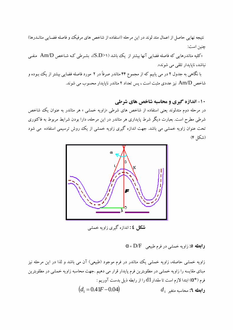
D/F
*d1
1d04.041.01 Fd
d1*
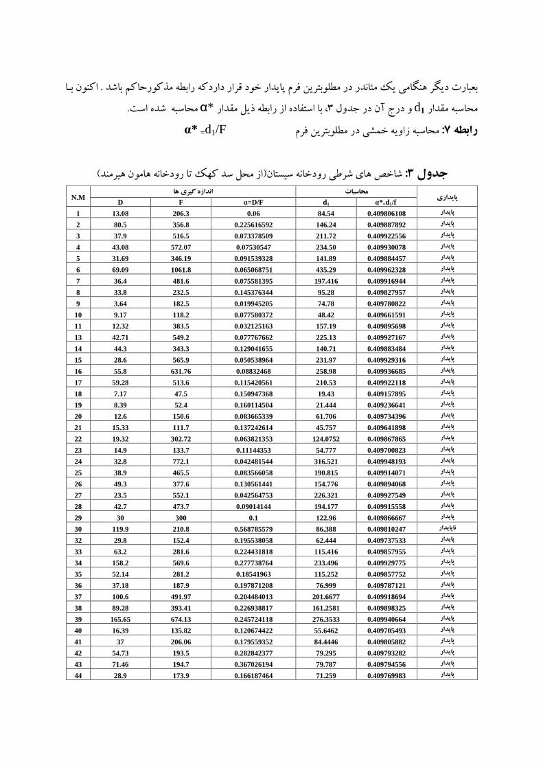
=d1/F *
N.M*=d1/f d1
=D/F FD
0.409806108 84.54 0.06 206.3 13.08 1
0.409887892 146.24 0.225616592 356.8 80.5 2
0.409922556 211.72 0.073378509 516.5 37.9 3
0.409930078 234.50 0.07530547 572.07 43.08 4
0.409884457 141.89 0.091539328 346.19 31.69 5
0.409962328 435.29 0.065068751 1061.8 69.09 6
0.409916944 197.416 0.075581395 481.6 36.4 7
0.409827957 95.28 0.145376344 232.5 33.8 8
0.409780822 74.78 0.019945205 182.5 3.64 9
0.409661591 48.42 0.077580372 118.2 9.17 10
0.409895698 157.19 0.032125163 383.5 12.32 11
0.409927167 225.13 0.077767662 549.2 42.71 13
0.409883484 140.71 0.129041655 343.3 44.3 14
0.409929316 231.97 0.050538964 565.9 28.6 15
0.409936685 258.98 0.08832468 631.76 55.8 16
0.409922118 210.53 0.115420561 513.6 59.28 17
0.409157895 19.43 0.150947368 47.5 7.17 18
0.409236641 21.444 0.160114504 52.4 8.39 19
0.409734396 61.706 0.083665339 150.6 12.6 20
0.409641898 45.757 0.137242614 111.7 15.33 21
0.409867865 124.0752 0.063821353 302.72 19.32 22
0.409700823 54.777 0.11144353 133.7 14.9 23
0.409948193 316.521 0.042481544 772.1 32.8 24
0.409914071 190.815 0.083566058 465.5 38.9 25
0.409894068 154.776 0.130561441 377.6 49.3 26
0.409927549 226.321 0.042564753 552.1 23.5 27
0.409915558 194.177 0.09014144 473.7 42.7 28
0.409866667 122.96 0.1 300 30 29
0.409810247 86.388 0.568785579 210.8 119.9 30
0.409737533 62.444 0.195538058 152.4 29.8 32
0.409857955 115.416 0.224431818 281.6 63.2 33
0.409929775 233.496 0.277738764 569.6 158.2 34
0.409857752 115.252 0.18541963 281.2 52.14 35
0.409787121 76.999 0.197871208 187.9 37.18 36
0.409918694 201.6677 0.204484013 491.97 100.6 37
0.409898325 161.2581 0.226938817 393.41 89.28 38
0.409940664 276.3533 0.245724118 674.13 165.65 39
0.409705493 55.6462 0.120674422 135.82 16.39 40
0.409805882 84.4446 0.179559352 206.06 37 41
0.409793282 79.295 0.282842377 193.5 54.73 42
0.409794556 79.787 0.367026194 194.7 71.46 43
0.409769983 71.259 0.166187464 173.9 28.9 44
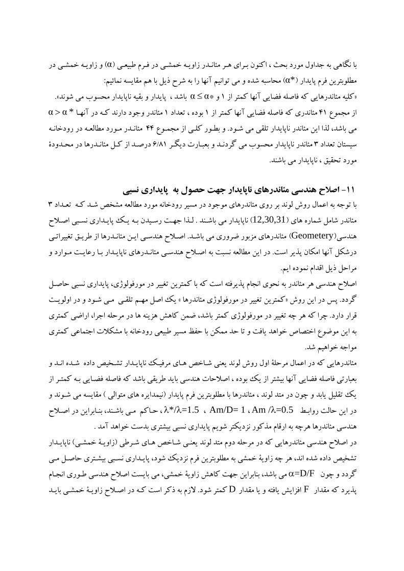
*
*
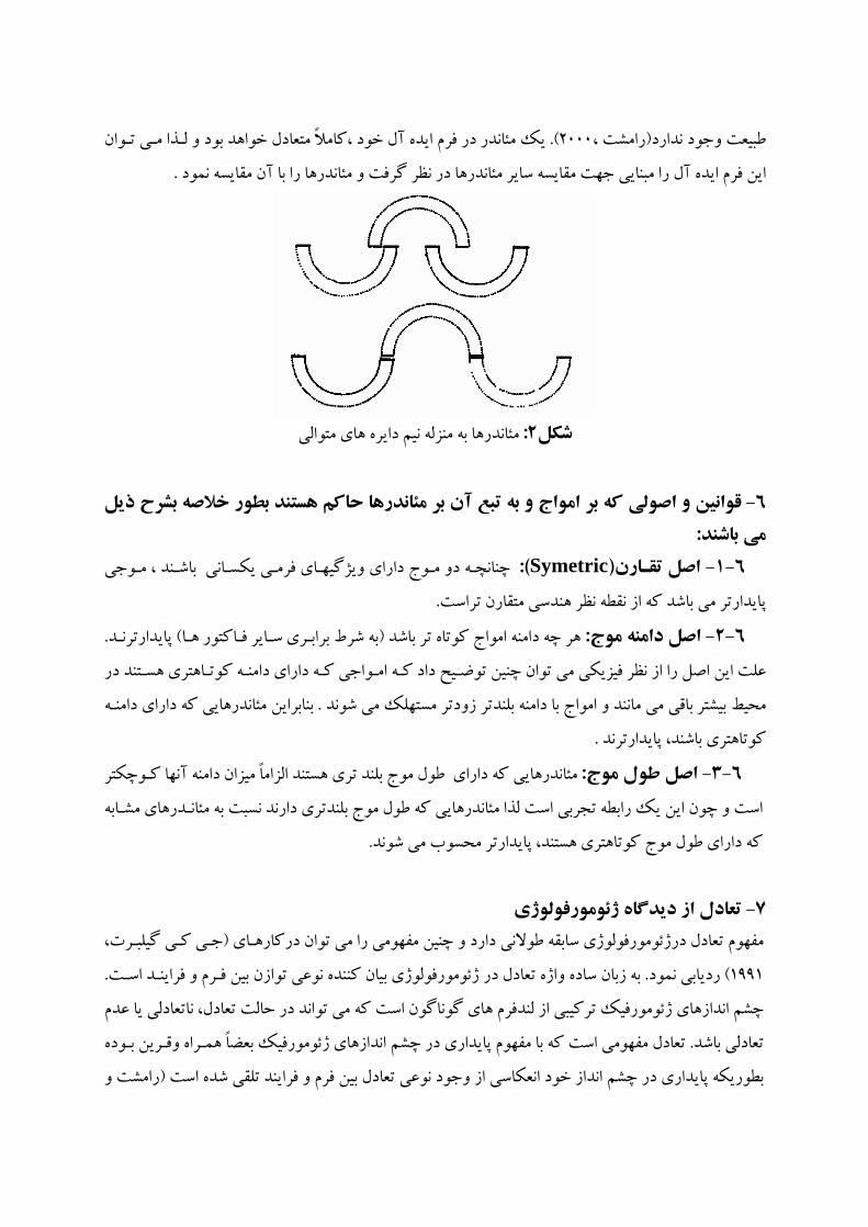
12,30,31
Geometery
Am / =0.5 Am/D= 1*/ =1.5
=D/F
F D

AmD*DF
12,30,31
N.M *DAM*DAM
16454850390 1192.7 1345.2 4940 279.7 1192.7 121156.2106.2191.7896.1 1065.5 106.2 191.7 896.1 301250600450.22081.2 685.3 974.7 275.8 2081.2 31
N.M */
(I)(S)Am/D (H)(S)
Am/
(G)(S)*/
CAm/D
BAm/
A0.940.32 0.08 1.37 1.04 1.12 0.05 0.88 120.870.21 1.80 1.29 0.90 1.18 1.80 0.84 300.970.21 0.750 0.60 1.42 0.32 0.28 3.03 31
N.M *d1FD*d1FD0.4098146.040.07184356.325.6 0.4098 121.56 0.0964 296.6 28.6 12 0.4098116.350.3892283.9110.50.4098 86.38 0.5687 210.8 119.9 30 0.4098116.2770.0359283.710.20.4098 113.53 0.04963 277.02 13.7 31
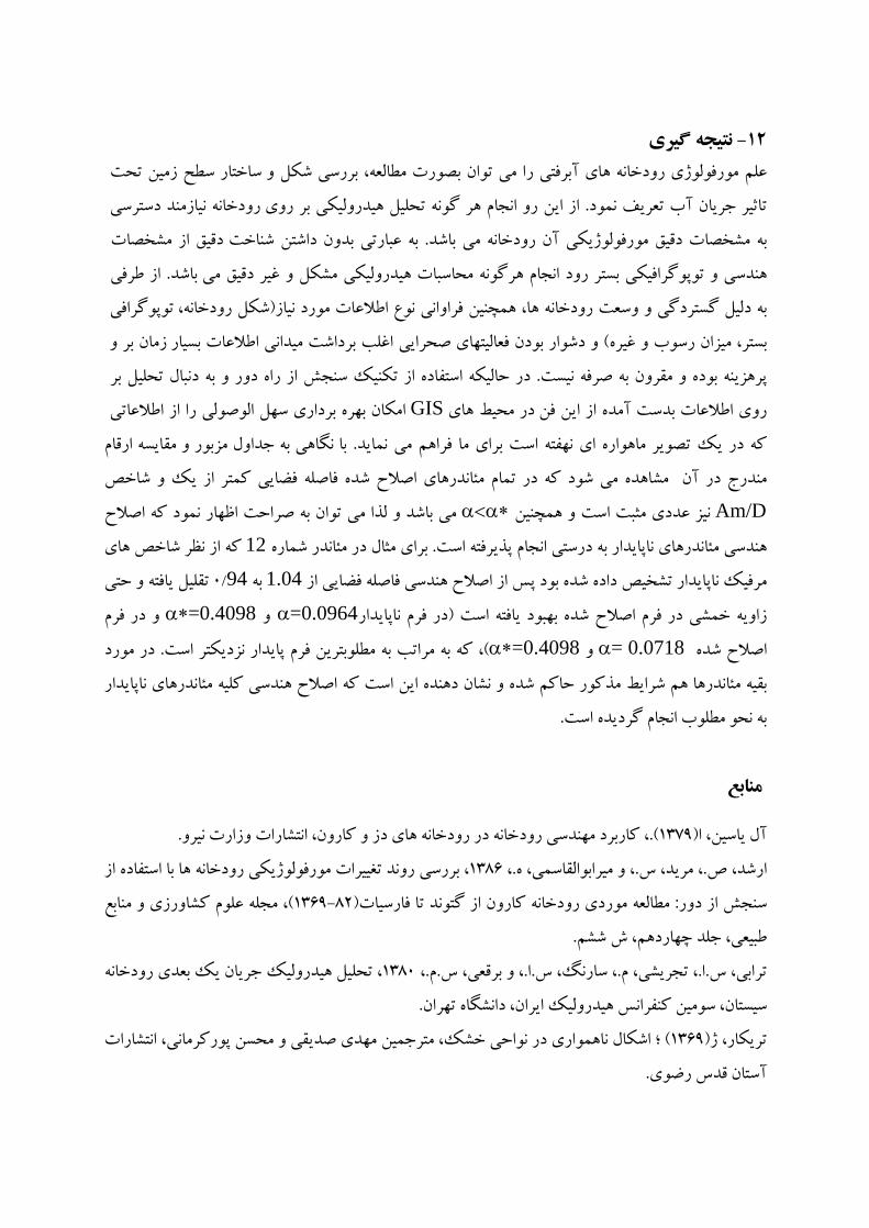
GIS
Am/D
12
1.0494
=0.0964=0.4098
0.0718==0.4098
Landsat
Bartholdy, j., and Billi, p.(2002). Morphodynamics of a pseudo meandering gravel bar reach Geomorphology, Pp42:293-310. Cooke, R.U. and Doornkamp, J.C.,(1994). Geomorphology in Environmental Management ,1974 ,oxford , p76 Gregory, K. J.,(1977). River channel changes., New York. Hack. J.T., (1973). Stream profile analysis and stream gradient index, I. Res. U.S.Geol.Surv. 1:421-429
Hack. J.T.,(1960). Interpretation of erosional topography in humid temperate regions, Am. I. Sci. 258-A:80-97 Hooke, J.M.,(2008). Temporal variations in fluvial processes on an active meandering river over a 20-year period .11p. Morid, S.,(2004). Study of Morphological Changes and their trends in Karuon River applying RS technique, University technical report. Tarbiat modares University. 63p. Petts, G E.,. and A.M. Gurnell.,(2005). Dams and geomorphology: Research progress and future directions, Geomorphology journal, Volume 71, Issue 1, 1 January 2005, Pages 27 47. Ramesht, m.h., (2000). Enivironment Impact and Sustainability of Navigation Improvements to the Karon River,Geography, Bulten, New Castle University
Rosgen, D.L.A.(19994). Classification of natural rivers. Cattena22:169-199 Simons, D.B.(1971). River and Canal Morphology,Fort Collins,Colorado Telvary, A.R., (2004).,Fundamentals of river training and engineering, Ministry of jahad-e-Agriculture. Agricultural Research and Education Organization. Soil Conservation and watershed management institute press. 454p.

This document was created with Win2PDF available at http://www.daneprairie.com.The unregistered version of Win2PDF is for evaluation or non-commercial use only.