


Bahasa
Halaman
Hukum


USE OF TRI-ELECTODE VERTICAL ELECTRICAL SOUNDING FOR ENGINEERGEOLOGY AND HYDROGEOLOGY AS ONE EFECTIVE AND HI-INFORMATIVE TEHNIQUE FOR SALLOW DEPHT
RESEARCHES
In present day geophysical practice one very actual problem is to develop methods, which could support quick expert and hi-precise and detail results mostly for depth up to 20 – 50 m. (NEAR SURFACE RESEARCHES). Such methods start to be applying for determination of a lot of engineering, hydro geological, ecological and environmental problems. Relate to that, together with development of the traditional methods used in geophysics a special interest and a special respect have been given to be adapted and developed traditional methods according the new objective needs.
According to that reason one well known and also popular as geophysics method, bat with very hi potential to be used for a shallow depth researches is tri-electrodes Vertical Electrical Sounding - – АМN-В, where electrode -В is placed in endlessness. The specific characteristics of that method are it’s very hi-sensitive according changes in vertical plane (in depth). A fact based on structure of the electrical field in depth, which is fully concentrated around currant electrode –A usually in spherical disposition.
The interpretation of results is more easer then traditional because the depth of research usually is equal of the distance between currant electrode –A and middle of the measurement dipole MN –O for a depth from 10 – 30 m.
On other hand if the method is applied on one very well prepared plan
От друга страна при едно умело прилагане на методиката с добре разчетени измервателни разноси схемата предоставя възможност за достигане на висока избирателност по отношение на детайлността при диференциране на литоложките разновидности. Търсене и отделяне на границите между отделни литоложки разновидности е възможно да бъде реализирано с максимална разрешаваща способност от порядъка на 0,30 - 0,50 м. Като резултат от такива свръх детайлни измервания кривата на привидното съпротивление в дълбочина по форма се доближава до каротажна крива, което улеснява интерпретирането и.
При интерпретиране на такава крива за отделяне на границите в разреза се ползуват характерни точки от потенциалната крива.
As examples at the report are given a few successfully realized projects in Bulgaria with different objectives in field of engineer-geology and hydrogeology where tri-electrode Vertical Electrical Sounding is used.
- Geophysical research along projected trace of hi-road Thrakia in segment КМ 292+000 - КМ 325+280 (town Stralja - town Aitos)
- Geophysical research along railway trace Vakarel - Verinsko, 40 +343/755 for determination of - Researches of hydro-geological conditions for determine underground water table relate to engineer-
geological expertise for gas stations of OMV and Shell in Bulgaria. - Geophysical research for finding water support of underground objects – coal mines “Oranovo” and
“Orlovec”; - 3D reconstruction of geological layers and structures of experimental area “Chelopechene”, village
Chelopechene, near to Sofia, as subcontract at INCO-COPERNICUS No. PL-971976 – “Development of tools needed for an impact analysis for groundwater quality to changing of agricultural soil use”.
Left side VES Right side VES Average value
0.1
1.0
10.0
AO
, AB
/2
10 ρпр.[Ω.m.] 100/10 100/10 100

By applying suitable methodology of measurements based on tri-electrode Vertical Electrical Sounding according to the needs a lot of problems in field of engineer-geology and hydrogeology ware successfully determined. As example:
1. For Hi-road Trakia and railway trace ware determined: - литоложко разчленяване на геоложкия
разрез на дълбочина до 15,75 м; - 3D conditions of different layers and theirs
superposition’s; - Depth of base rock and на ерозираната
зона; - Depth of underground static water table along
profiles.
2. For coal mines Oranovo and Orlovec: - определена е дебелината на заливни и не
заливни тераси на р. Струма в близост до гр. Симитли (мини “ Ораново” и “Орловец”) с разчленяване на скалите в отделни водоносни хоризонти;
- локализиране дебелината на рахлите отложения, определяне мощността на водопроницаемите пясъци и чакъли и нивото на подземните води (търсене на водоизточници с постоянно предназначение за ОМV, Shell и др.)
3. For INCO-COPERNICUS project – experimental area Chelopechene: - Full and detail determination of underground layers by data collected with geophysical methods (tri-
electrode VES) and 6 drills for a depth of 15 m. - Based on collected data a 3D model of structures and layers has been develop for a depth of 12
meters, which model has been successfully use for simulations of hydraulic conditions in experimental area.
Engineer geophysicist Tzvetan Tzenov
Engineer geophysicist Mihail Georgiev Institute of Thracology, Bulgarian Academy of Sciences
Engineer geophysicist Kiril Velkovsky Sofia Ing Ltd., +359 887 628-421
3D reconstruction of geological layers of experimental area Chelopechene, village Chelopechene, near to Sofia. INCO-COPERNICUS project.
S 38
S 28 S 18
S 7
(km 40 + 256)
MC14
S 6
53
6
7
8
9
7
6
8
7
9
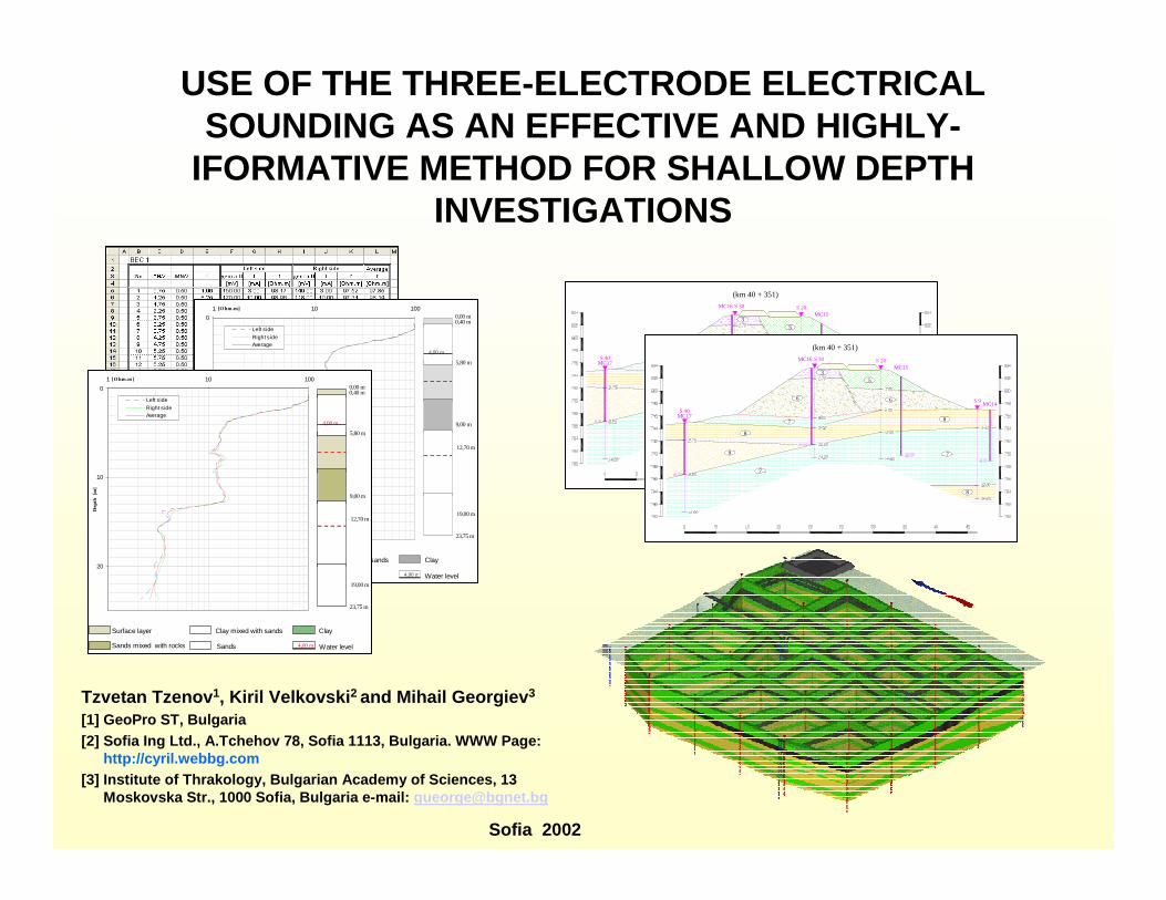
USE OF THE THREE-ELECTRODE ELECTRICALSOUNDING AS AN EFFECTIVE AND HIGHLY-
IFORMATIVE METHOD FOR SHALLOW DEPTHINVESTIGATIONS
S 40
S 30 S 20
S 9MC14
MC15
MC16
MC17
(km 40 + 351)
35
6 6
7
7
7
8
8
9
8
0
10
20
1 10 100[O hm.m]
Dep
th [
m]
Left sideRight sideAverage
4,00 m Water level
Clay
Sands
Clay mixed with sandsSurface layer
Sands mixed with rocks
0,00 m
4,00 m
0,40 m
5,80 m
9,00 m
12,70 m
19,00 m
23,75 m
0
10
20
1 10 100[O hm.m]
Dep
th [
m]
Left sideRight sideAverage
4,00 m Water level
Clay
Sands
Clay mixed with sandsSurface layer
Sands mixed with rocks
0,00 m
4,00 m
0,40 m
5,80 m
9,00 m
12,70 m
19,00 m
23,75 m
S 40
S 30 S 20
S 9MC14
MC15
MC16
MC17
(km 40 + 351)
35
6 6
7
7
7
8
8
9
8
Tzvetan Tzenov1, Kiril Velkovski2 and Mihail Georgiev3
[1] GeoPro ST, Bulgaria[2] Sofia Ing Ltd., A.Tchehov 78, Sofia 1113, Bulgar ia. WWW Page:
http://cyril.webbg.com[3] Institute of Thrakology, Bulgarian Academy of Sc iences, 13
Moskovska Str., 1000 Sofia, Bulgaria e-mail: [email protected]
Sofia 2002
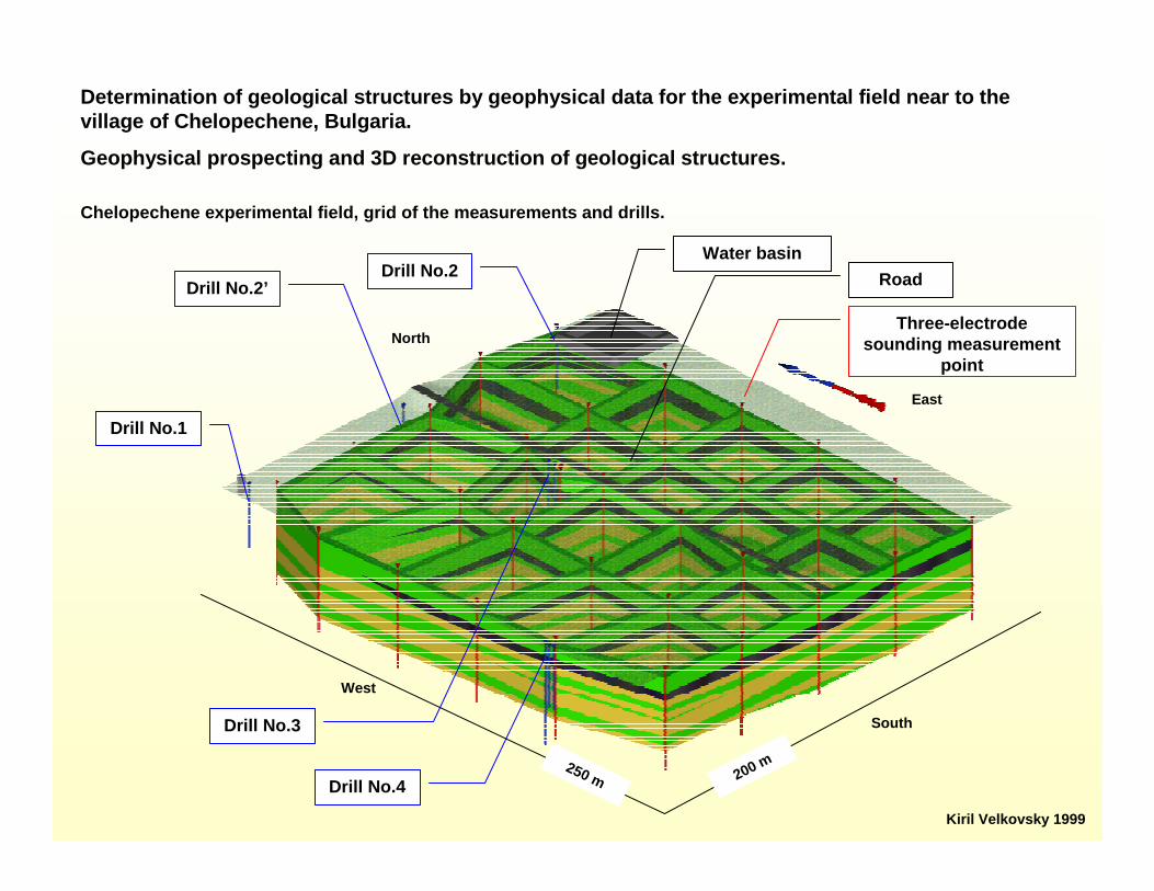
Determination of geological structures by geophysic al data for the experimental field near to the village of Chelopechene, Bulgaria.
Geophysical prospecting and 3D reconstruction of ge ological structures.
Chelopechene experimental field, grid of the measure ments and drills.
Drill No.1
Drill No.2’Drill No.2
Water basin
Drill No.4
Three-electrode sounding measurement
point
Road
Drill No.3
West
South
North
East
200 m250 m
Kiril Velkovsky 1999

0.1
1.0
10.0
10 100 1000 10000
AO
, AB
/2
Ro пр.
ВЕС 16X,Y: 317,0 309.5 Тип: A...M0.5NxB /x=1-20/ Тип: AxM0.5N...B /x=1-20/
No. BO/AO KDelta U
[mV]I [mA] Ro
[Ohm.m.]Delta U
mVI mA Ro
[Ohm.m.]Ro ср.
[Ohm.m.]Сондаж No 2 [3]
Описание1 0.75 6.28 91.00 10.00 57.18 65.00 10.00 40.84 49.01 0.10 Почвен слои2 1.25 18.85 17.25 10.00 32.52 15.05 10.00 28.37 30.44 0.253 1.75 37.70 9.00 10.00 33.93 8.40 10.00 31.67 32.80 Глини пътни с гравийни включения4 2.25 62.83 5.50 10.00 34.56 5.40 10.00 33.93 34.24 1.755 2.75 94.25 3.90 10.00 36.76 3.95 10.00 37.23 36.99 Чакъли песъчливи, заглинени6 3.25 131.95 3.10 10.00 40.90 2.90 10.00 38.26 39.58 2.607 3.75 175.93 2.40 10.00 42.22 2.20 10.00 38.70 40.46 Глини пътни с гравийни включения8 4.25 226.19 1.95 10.00 44.11 1.80 10.00 40.72 42.41 2.809 4.75 282.74 1.50 10.00 42.41 1.40 10.00 39.58 41.00 Пясъци, разнозърнести, слабо заглинени10 5.25 345.58 1.20 10.00 41.47 1.18 10.00 40.61 41.04 3.3511 5.75 414.69 1.00 10.00 41.47 0.97 10.00 40.22 40.85 Глини песачливи с гравийни включения12 6.25 490.09 0.90 10.00 43.86 0.79 10.00 38.72 41.29 4.0013 6.75 571.77 0.73 10.00 41.74 0.65 10.00 37.17 39.45 Пясъци заглинени14 7.25 659.73 0.60 10.00 39.58 0.55 10.00 36.29 37.93 4.7015 7.75 753.98 0.49 10.00 36.95 0.46 10.00 34.68 35.81 Глини пътни с въгищни чернилки16 8.25 854.51 0.38 10.00 32.47 0.39 10.00 33.33 32.90 5.1017 8.75 961.33 0.31 10.00 29.80 0.34 10.00 32.69 31.24 Глини, сиви, плътни18 9.25 1074.42 0.25 10.00 26.32 0.29 10.00 31.16 28.74 5.30 Дъно19 9.75 1193.81 0.21 10.00 24.47 0.25 10.00 29.85 27.1620 10.25 1319.47 0.18 10.00 23.75 0.22 10.00 29.03 26.39
Data processing: three-electrode electrical soundin g –measured point No.16, (the point is at drill No.2).
Legend:
Black bold line present the layers according to the drill No. 2.
Blue - Left side measurements.
Red - Right side measurements.
Magenta - Average values.
Determination of geological structures by geophysic al data for the experimental field near to the village of Chelopechene, Bulgaria.
Geophysical prospecting and 3D reconstruction of geological structures
Kiril Velkovsky 1999

Determination of geological structures by geophysic al data for the experimental field near to the vill age of Chelopechene, Bulgaria.
Geophysical prospecting and 3D reconstruction of ge ological structures
Interpretation of the three-electrode electrical so unding – measured point No.16, (the point is at dril l No.2).
0.1
1.0
10.0
10 100
AO
, AB
/2
Ro пр.No. AB/2
Ro ср. [Ohm.m.]
Дълбочина на пласта
Мощност на пласта Литоложко описание
1 0.75 49.01 0 -0.30 Почвен слои2 1.25 30.44 -0.30 -1.50 Глини пътни с гравийни включения3 1.75 32.80 -1.80 -0.80 Чакъли песъчливи, заглинени4 2.25 34.24 -2.60 -0.20 Глини песъчливи5 2.75 36.99 -2.80 -0.60 Пясъци; Пясъци, слабо заглинени6 3.25 39.58 -3.40 -0.60 Глини песачливи с гравийни включения7 3.75 40.46 -4.00 -0.70 Пясъци; Пясъци, слабо заглинени8 4.25 42.41 -4.70 -0.40 Глини пътни с въгищни чернилки9 4.75 41.00 -5.10 -0.90 Глини плътни10 5.25 41.04 -6.00 -1.30 Пясъци; Пясъци, слабо заглинени11 5.75 40.85 -7.30 Глини песъчливи12 6.25 41.2913 6.75 39.4514 7.25 37.9315 7.75 35.8116 8.25 32.9017 8.75 31.2418 9.25 28.7419 9.75 27.1620 10.25 26.39
Kiril Velkovsky 1999

0.1
1.0
10.0
Ro пр.
Ao,
AB
/2
Data processing of three-electrode electrical soundings along line V South-North - VES charts.
Geo-Electrical section along profile V – South-North.
Determination of geological structures by geophysic al data for the experimental field near to the vill age of Chelopechene, Bulgaria.
Geophysical prospecting and 3D reconstruction of ge ological structures
ВЕС 23
ВЕС 24
ВЕС 25
ВЕС 26
ВЕС 27
ВЕС 16НС-2 [3]
210
532
526
30525
40 50 60 70
529
527
528
530
531
533
534
535
South
11080 90 100 120 130 140 160150 170 180 190 200 220 230 240 260250 270 280 300 310
North
Пясъци, сл.заглинени със зърна отПясъци с гравий - заглинени
Пясъци; Пясъци слабо заглинени въглищни чернилки
Почвен слой Глини - песъчливи с гравиини включенияГлини - плътниГлини - песъчливи
Чакъли, песъчливи, заглинени Глини - плътни с гравий
Глини - плътни с въглищни чернилки
536
539
537
538
540
532
526
525
529
527
528
530
531
533
534
535
536
539
537
538
540
10 0 10 20
Kiril Velkovsky 1999

Determination of geological structures by geophysic al data for the experimental field near to the village of Chelopechene, Bulgaria.
Geophysical prospecting and 3D reconstruction of ge ological structures.
Chelopechene experimental field, grid of the measure ments and drills.
Drill No.1
Drill No.2’Drill No.2
Water basin
Drill No.4
Three-electrode sounding measurement
point
Road
Drill No.3
West
South
North
East
200 m250 m
Kiril Velkovsky 1999

Water drill
Three-electrode electrical sounding measurement point
Determination of geological structures by geophysic al data using three-electrode electrical sounding fo r areanear to the village of Bogorov, Bulgaria.
3D surface reconstruction and grid of the measureme nts.
Kiril Velkovsky 1998Mihail Georgiev 1998
Like

Kiril Velkovsky 1998Mihail Georgiev 1998
Determination of geological structures by geophysic al data using three-electrode electrical sounding fo r areanear to the village of Bogorov, Bulgaria.
3D reconstruction of the geological layers.

0
10
20
1 10 100[O hm.m]
Dep
th [
m]
Left sideRight sideAverage
4,00 m Water level
Clay
Sands
Clay mixed with sandsSurface layer
Sands mixed with rocks
0,00 m
4,00 m
0,40 m
5,80 m
9,00 m
12,70 m
19,00 m
23,75 m
Graphic of a three-electrode electrical sounding an d geological interpretation of the results.
Blue - left sideGreen - right sideRed - average values
Geological interpretation

S 37
S 27 S 17
S 6
(km 40 + 206)
3
66
5
7
8
8
8
8
9
9
Geo-electrical section constructed on a base of res ults from the interpretation of the three-electrode electrical soundings in series of p oints.


Effective usage of a three-electrode electrical sou nding
Engineer-geology
Detail prospecting
Hydro-geological conditions
Bad rock prospecting
Environmental
Prospecting of a pollutions with hydrocarbons
Hydro-geological conditions
Archaeology
Prospecting of a
Top Related
Copyright © 2022 FDOKUMEN

