


Bahasa
Halaman
Hukum

LiDAR and Early Medieval Settlement in Counties Roscommon and Leitrim: a New Angle on Early Medieval Landscape Studies.
Abstract
Early medieval settlement has long been the focus of both archaeological and historical
research, however, there are still substantial gaps in our knowledge, particularly in relation
to the largely unexplored Irish midlands. Parts of county Roscommon were identified by
Matthew Stout as an area of very high ringfort density (Stout 1997, 93), however, with the
exception of the important royal complex at Rathcroghan, relatively little research has been
conducted in the area. The application of LiDAR analysis to the study area presented an
opportunity to break new ground in two ways: firstly as a means of investigating the early
medieval landscape of a relatively unexplored part of the country; and secondly, as a pilot
study into the use of LiDAR data as a means of examining early medieval Irish settlement.
This data was combined with aerial photography and historic mapping to find and identify
previously unrecorded archaeological monuments which potentially date to the early
medieval period (primarily ringforts). This article is a summary of the results found during
the completion of an MA thesis submitted in August 2012 to the School of Archaeology,
University College Dublin; and will outline the nature of the project and discuss some of the
findings.
Introduction For many years, early medieval settlement has been the subject of considerable research
interest as the impressive bibliography compiled by EMAP1 (Harney et al. 2010)
demonstrates. However, the project undertaken as part of the author's MA thesis takes it in
a new direction as it constitutes one of the first Irish studies to use LiDAR (Light Detection
and Ranging) survey data as part of a targeted study of the Irish early medieval landscape.
LiDAR measures the height of the ground surface and other features by scanning a pulsed
laser beam from a low-flying aircraft over the survey area (Bewley et al. 2005, 637). As
LiDAR reads elevation data in addition to locational data, it enables the creation of high-
resolution topographic maps which allow us to identify subtle variations in the ground
surface created by earthworks and other features (Chapman 2006, 58).
1 Early Medieval Archaeology Project
1

This type of data has become increasingly popular in recent years due to its ability to reveal
previously 'invisible' archaeological features2 in the landscape, with the added benefit of
being able to penetrate foliage and therefore provide a model of the bare earth surface
(Megarry 2011, 32). The last 4 to 5 years in particular have seen a proliferation of Irish
LiDAR-based projects (Shaw & Corns 2011, 84). Despite the recent popularity of LiDAR
within the realm of Irish archaeology, to date, much of this type of research has been
focused on already well-known archaeological landscapes such as the Hill of Tara (Corns &
Shaw 2009) or Brú na Bóinne (Davis et al. 2010). Instead, this study utilises the data to
investigate early medieval settlement within a specific - yet arbitrary as far as archaeological
remains are concerned - area of counties Leitrim and Roscommon.
Study Area Location Commissioned by Leitrim County Council and the National Roads Authority, the LiDAR
dataset which forms the basis of this research was flown as part of the consultation phases
of the proposed N4 Carrick-on-Shannon to Dromod road scheme, and this survey dictates
the location of the project.
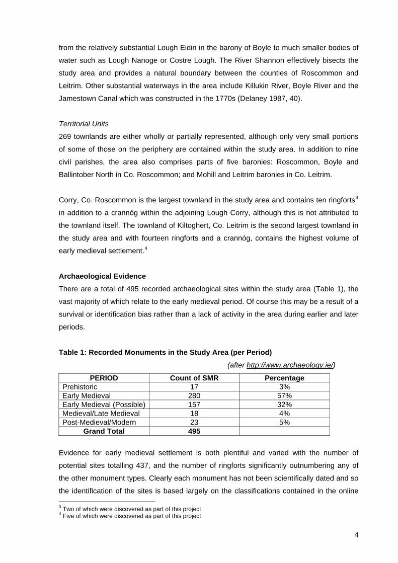
LiDAR survey data can come in a range of different resolutions, and two different
resolutions (both produced by Ordnance Survey Ireland) were used over the course of this
research. The original 2m-resolution dataset was kindly provided by Leitrim County Council
and covers an area of approximately 140km². A higher 0.5m resolution dataset was funded
by the Roscommon County Council Heritage Research Bursary 2012 and covers an area of
approximately 30km² (Figure 1). Ultimately, the real value of the higher resolution dataset
was the improved quality and sharpness of the images and the enhanced visibility of the
monuments when reproduced (Figure 2).
2 Unlike geophysical survey, LiDAR cannot detect features that solely have sub-surface remains, therefore it can only reveal archaeological features which have topographic expression, however slight they are.
2
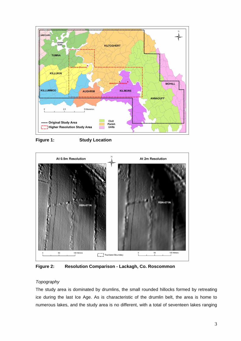
Figure 1: Study Location
Figure 2: Resolution Comparison - Lackagh, Co. Roscommon
Topography
The study area is dominated by drumlins, the small rounded hillocks formed by retreating
ice during the last Ice Age. As is characteristic of the drumlin belt, the area is home to
numerous lakes, and the study area is no different, with a total of seventeen lakes ranging
3
from the relatively substantial Lough Eidin in the barony of Boyle to much smaller bodies of
water such as Lough Nanoge or Costre Lough. The River Shannon effectively bisects the
study area and provides a natural boundary between the counties of Roscommon and
Leitrim. Other substantial waterways in the area include Killukin River, Boyle River and the
Jamestown Canal which was constructed in the 1770s (Delaney 1987, 40).
Territorial Units
269 townlands are either wholly or partially represented, although only very small portions
of some of those on the periphery are contained within the study area. In addition to nine
civil parishes, the area also comprises parts of five baronies: Roscommon, Boyle and
Ballintober North in Co. Roscommon; and Mohill and Leitrim baronies in Co. Leitrim.
Corry, Co. Roscommon is the largest townland in the study area and contains ten ringforts3
in addition to a crannóg within the adjoining Lough Corry, although this is not attributed to
the townland itself. The townland of Kiltoghert, Co. Leitrim is the second largest townland in
the study area and with fourteen ringforts and a crannóg, contains the highest volume of
early medieval settlement.4
Archaeological Evidence There are a total of 495 recorded archaeological sites within the study area (Table 1), the
vast majority of which relate to the early medieval period. Of course this may be a result of a
survival or identification bias rather than a lack of activity in the area during earlier and later
periods.
Table 1: Recorded Monuments in the Study Area (per Period) (after http://www.archaeology.ie/)
PERIOD Count of SMR Percentage Prehistoric 17 3% Early Medieval 280 57% Early Medieval (Possible) 157 32% Medieval/Late Medieval 18 4% Post-Medieval/Modern 23 5%
Grand Total 495
Evidence for early medieval settlement is both plentiful and varied with the number of
potential sites totalling 437, and the number of ringforts significantly outnumbering any of
the other monument types. Clearly each monument has not been scientifically dated and so
the identification of the sites is based largely on the classifications contained in the online 3 Two of which were discovered as part of this project 4 Five of which were discovered as part of this project
4
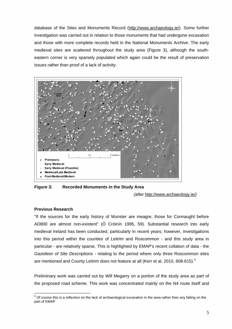
database of the Sites and Monuments Record (http://www.archaeology.ie/). Some further
investigation was carried out in relation to those monuments that had undergone excavation
and those with more complete records held in the National Monuments Archive. The early
medieval sites are scattered throughout the study area (Figure 3), although the south-
eastern corner is very sparsely populated which again could be the result of preservation
issues rather than proof of a lack of activity.
Figure 3: Recorded Monuments in the Study Area
(after http://www.archaeology.ie/)
Previous Research "If the sources for the early history of Munster are meagre, those for Connaught before
AD800 are almost non-existent" (Ó Cróinín 1995, 59). Substantial research into early
medieval Ireland has been conducted, particularly in recent years; however, investigations
into this period within the counties of Leitrim and Roscommon - and this study area in
particular - are relatively sparse. This is highlighted by EMAP's recent collation of data - the
Gazetteer of Site Descriptions - relating to the period where only three Roscommon sites
are mentioned and County Leitrim does not feature at all (Kerr et al. 2010, 608-615).5
Preliminary work was carried out by Will Megarry on a portion of the study area as part of
the proposed road scheme. This work was concentrated mainly on the N4 route itself and
5 Of course this is a reflection on the lack of archaeological excavation in the area rather than any failing on the part of EMAP
5
buffer zones of 50m and 100m around it, 41 townlands were surveyed and 12 new potential
monuments discovered, 9 of which are potential ringforts (Megarry 2011, 34).
Excavations
Perhaps the most significant excavations for this study area are those which took place in
Cloongownagh townland, Co. Roscommon in 1999 and 2003 as part of the national roads
building programme. A ringfort (SMR: RO011-160001) was partially excavated in 1999
(Licence 99E0193) and produced radiocarbon dates of cal. AD 641 - cal. AD 757 and cal.
AD 896 - cal. AD 1029, in addition to faunal remains, two rotary quern-stones and a piece of
slag (http://www.nra.ie/Archaeology/). The 2003 excavations (Licence: 03E1770) of a pit
and/or charcoal-making site produced radiocarbon dates of cal. AD 900 - cal. AD 1040
(http://www.nra.ie/Archaeology/).
Methodology The raw data were processed and imported into ArcGIS 9.36 where several hillshade
models were created in order to artificially light the surface from different angles. It is these
effects of light and shadow that help to capture and highlight the almost imperceptible
changes in topography that can indicate the presence of an archaeological monument. The
surface was then systematically examined for evidence of any potential archaeological
features, in particular ringforts within which the majority of the early medieval population
lived (Stout 1996, i).
All potential ringforts (known and 'new' monuments) were measured on the LiDAR surface
and their dimensions (internal and overall diameters) recorded. Locational data such as the
degree of slope and altitude were also recorded.
The Results The prospection for 'new' early medieval archaeological monuments resulted in the
discovery of 153 potential monuments, 98 of which were identified as 'Probable Ringforts',
54 as 'Possible Ringforts' and 1 as an 'Ecclesiastical Enclosure'. This constitutes a total
increase of approximately 44% in the number of ringforts within the catchment area,
bringing the total from 335 to 487.7 On a barony by barony basis, the number of monuments
has increased as follows:
6 A Geographical Information System (GIS) 7 The ecclesiastical enclosure has been omitted from these calculations as it is technically not a settlement site; the figure also excludes crannógs
6
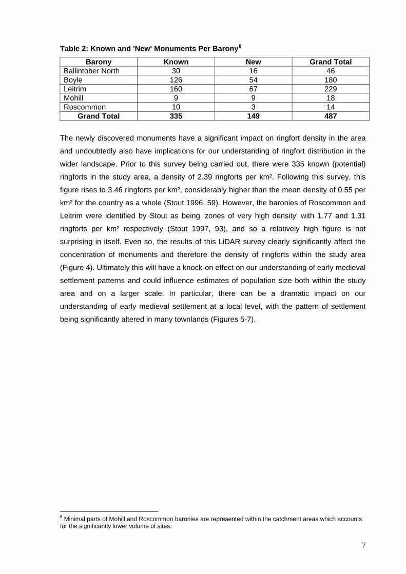
Table 2: Known and 'New' Monuments Per Barony8
Barony Known New Grand Total Ballintober North 30 16 46 Boyle 126 54 180 Leitrim 160 67 229 Mohill 9 9 18 Roscommon 10 3 14
Grand Total 335 149 487
The newly discovered monuments have a significant impact on ringfort density in the area
and undoubtedly also have implications for our understanding of ringfort distribution in the
wider landscape. Prior to this survey being carried out, there were 335 known (potential)
ringforts in the study area, a density of 2.39 ringforts per km². Following this survey, this
figure rises to 3.46 ringforts per km², considerably higher than the mean density of 0.55 per
km² for the country as a whole (Stout 1996, 59). However, the baronies of Roscommon and
Leitrim were identified by Stout as being 'zones of very high density' with 1.77 and 1.31
ringforts per km² respectively (Stout 1997, 93), and so a relatively high figure is not
surprising in itself. Even so, the results of this LiDAR survey clearly significantly affect the
concentration of monuments and therefore the density of ringforts within the study area
(Figure 4). Ultimately this will have a knock-on effect on our understanding of early medieval
settlement patterns and could influence estimates of population size both within the study
area and on a larger scale. In particular, there can be a dramatic impact on our
understanding of early medieval settlement at a local level, with the pattern of settlement
being significantly altered in many townlands (Figures 5-7).
8 Minimal parts of Mohill and Roscommon baronies are represented within the catchment areas which accounts for the significantly lower volume of sites.
7
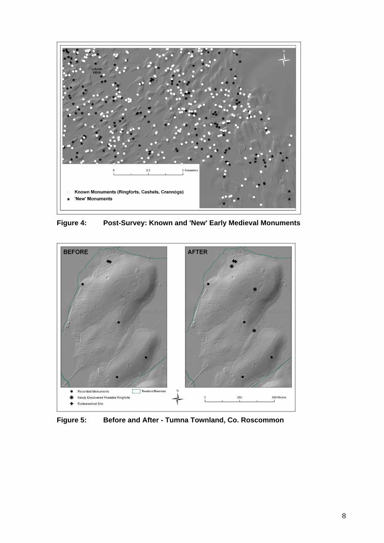
Figure 4: Post-Survey: Known and 'New' Early Medieval Monuments
Figure 5: Before and After - Tumna Townland, Co. Roscommon
8
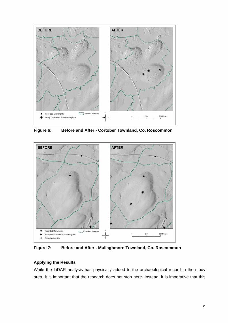
Figure 6: Before and After - Cortober Townland, Co. Roscommon
Figure 7: Before and After - Mullaghmore Townland, Co. Roscommon
Applying the Results While the LiDAR analysis has physically added to the archaeological record in the study
area, it is important that the research does not stop here. Instead, it is imperative that this
9
knowledge be applied in order to better our understanding and interpretation of early
medieval settlement. A number of the findings are presented below.9
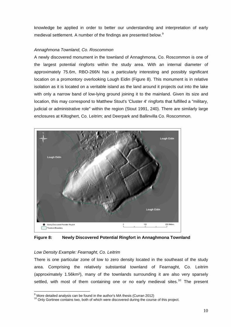
Annaghmona Townland, Co. Roscommon
A newly discovered monument in the townland of Annaghmona, Co. Roscommon is one of
the largest potential ringforts within the study area. With an internal diameter of
approximately 75.6m, RBO-266N has a particularly interesting and possibly significant
location on a promontory overlooking Lough Eidin (Figure 8). This monument is in relative
isolation as it is located on a veritable island as the land around it projects out into the lake
with only a narrow band of low-lying ground joining it to the mainland. Given its size and
location, this may correspond to Matthew Stout's 'Cluster 4' ringforts that fulfilled a "military,
judicial or administrative role" within the region (Stout 1991, 240). There are similarly large
enclosures at Kiltoghert, Co. Leitrim; and Deerpark and Ballinvilla Co. Roscommon.
Figure 8: Newly Discovered Potential Ringfort in Annaghmona Townland
Low Density Example: Fearnaght, Co. Leitrim
There is one particular zone of low to zero density located in the southeast of the study
area. Comprising the relatively substantial townland of Fearnaght, Co. Leitrim
(approximately 1.56km²), many of the townlands surrounding it are also very sparsely
settled, with most of them containing one or no early medieval sites.10 The present
9 More detailed analysis can be found in the author's MA thesis (Curran 2012) 10 Only Gortinee contains two, both of which were discovered during the course of this project.
10
topography is not particularly striking and there is no obvious reason for the absence of
settlement evidence in this south-eastern portion of the study area. With the possible
exception of a cairn (SMR: LE035-005) on the Aghintass/Finnalaghta townland border
which may actually be 17th century in date (http://www.archaeology.ie/), there is no
evidence of even prehistoric settlement.
Fearnaght townland itself has the remains of a pillar stone and bullaun stone (SMR: LE035-
017 and LE035-018 respectively) which may point to the former existence of an early
medieval ecclesiastical site, although there is no indication of this from the LiDAR raster
surface (2m-resolution), aerial photography or historic maps
(http://maps.osi.ie/publicviewer/#V1,603972,792800,6,4); and indeed none is listed on the
extensive (albeit not definitive) Monasticon Hibernicum database
(http://monasticon.celt.dias.ie/). Of course, LiDAR data is not 100% conclusive and there
could be sub-surface remains, or even surface remains which are obscured by the
substantial vegetation cover. However, even if there was a substantial ecclesiastical
presence in the area, it would not explain why there is no evidence of secular settlement
here.
It is also possible (although there is no suggestion of it on the OSI aerial photography or
historic maps) that the area may have been inhospitable or relatively inaccessible to the
early medieval population - perhaps this is where the bandits who were cast out of society
and the wild animals lurked (Bitel 1990, 34,35). Indeed there is some indication of this from
the placename evidence which paints a relatively inhospitable picture: 'Moherrevan' is the
Anglicisation of 'Mothar Riabháin' (Logainm.ie) and the Irish 'Mothar' translates as 'thicket;
jungle; wilderness' (eDil); Fearnaght itself is an Anglicisation of 'Fíodh Fhearnacht'
(Logainm.ie) with 'Fíodh' also having connotations of forestry (eDil); Corrascoffy is
translated as 'Chorr an Scafaigh' which has been taken to mean 'the round hill of the bare
patch of rocks' (Logainm.ie). Somewhat ironically 'Faulties' is translated in Irish as 'Na Fálta'
which means 'the enclosures' (Logainm.ie) so perhaps there are indeed sub-surface
remains to be uncovered.
Conversely, there are smaller townlands which contain a substantial number of sites, for
example, covering an area of just 0.18km² Lisfarrellboy, Co. Roscommon is one of the
smallest townlands yet it is home to six ringforts. Likewise, Lisnagat, Co. Leitrim covers just
0.17km² and contains four ringforts, one of which is bivallate.
11
High Density Example: Danesfort, Co. Roscommon
The townland of Danesfort covers an area of approximately 1.6km² and contains a total of 7
ringforts with varying characteristics. As such, it provides an excellent opportunity to
investigate settlement hierarchy and to attempt to reconstruct how the townland may have
been organised within the early medieval period.
Of the 7 ringforts within the townland, one is bivallate (SMR: RO011-048) and has an
internal diameter of approximately 54.1m and an overall diameter of approximately 77.8m.
This ringfort occupies a prime location on the drumlin summit with commanding views over
the surrounding territory and other neighbouring settlements. Given its size, morphology
and location, this ringfort is potentially 'royal compatible' and is likely to have housed high
status occupants. A large univallate ringfort lies just 300m to the southwest (SMR: RO011-
046), on the border with the townland of Glebe and close to that of Killukin. A smaller
ringfort lies to the west of the bivallate example, towards the foot of the drumlin. These may
have afforded some element of protection to the higher status inhabitants of the bivallate
ringfort.
The remaining ringforts range in internal diameter from 22.7m to 33.8m and this, combined
with their location, points to them being the potential residences of the lower grades of
freeman such as the bóaire (cow lord) or ócaire (young lord) classes. The bóaire would
have owned their own land while the ócaire did not have their own land but leased it from a
higher ranked lord on an annual basis (Stout 1997, 112).
Ecclesiastical Sites
The coming of Christianity to the island of Ireland in the sixth century significantly altered
the physical landscape as churches, monasteries and ecclesiastical centres were
established throughout the country. There are a number of ecclesiastical sites still extant
within County Roscommon, some of which may have their origins in the early medieval
period. Perhaps the most notable of these is the site at Tumna which is still very much
evident today with the remains of two stone churches and the tomb of the founding saint.
Although an ecclesiastical enclosure is listed on the Sites and Monuments Database (SMR:
RO007-087003), the accompanying description states that "nothing of this feature can be
seen now" (Moore 2010). However, the LiDAR surface has revealed the possible location of
this enclosure, curving around the site to the south and east (Figure 9).
12
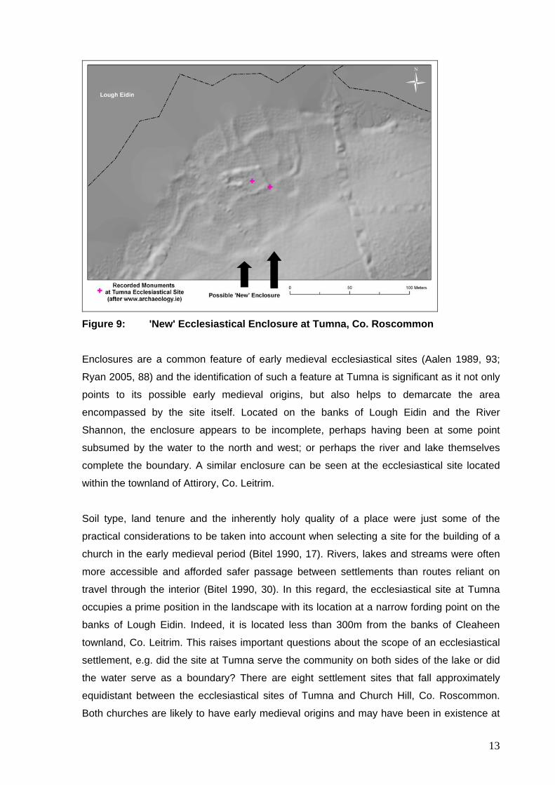
Figure 9: 'New' Ecclesiastical Enclosure at Tumna, Co. Roscommon
Enclosures are a common feature of early medieval ecclesiastical sites (Aalen 1989, 93;
Ryan 2005, 88) and the identification of such a feature at Tumna is significant as it not only
points to its possible early medieval origins, but also helps to demarcate the area
encompassed by the site itself. Located on the banks of Lough Eidin and the River
Shannon, the enclosure appears to be incomplete, perhaps having been at some point
subsumed by the water to the north and west; or perhaps the river and lake themselves
complete the boundary. A similar enclosure can be seen at the ecclesiastical site located
within the townland of Attirory, Co. Leitrim.
Soil type, land tenure and the inherently holy quality of a place were just some of the
practical considerations to be taken into account when selecting a site for the building of a
church in the early medieval period (Bitel 1990, 17). Rivers, lakes and streams were often
more accessible and afforded safer passage between settlements than routes reliant on
travel through the interior (Bitel 1990, 30). In this regard, the ecclesiastical site at Tumna
occupies a prime position in the landscape with its location at a narrow fording point on the
banks of Lough Eidin. Indeed, it is located less than 300m from the banks of Cleaheen
townland, Co. Leitrim. This raises important questions about the scope of an ecclesiastical
settlement, e.g. did the site at Tumna serve the community on both sides of the lake or did
the water serve as a boundary? There are eight settlement sites that fall approximately
equidistant between the ecclesiastical sites of Tumna and Church Hill, Co. Roscommon.
Both churches are likely to have early medieval origins and may have been in existence at
13
or around the same time; arguably either one (or both?) could have served the local
population.
Conclusion
Unlike the flat portrayal of the landscape by cartographic or photographic imagery, LiDAR
enables us to view the landscape as a two-dimensional surface, meaning that the
settlement evidence can be viewed as it lies topographically and we can therefore get a
sense of how the landscape looked and was physically experienced in the early medieval
period.
The LiDAR analysis demonstrated in this project has quite literally 'filled in the gaps' in the
landscape, gaps that we suspected - but could never prove - were there. Of course there
are undoubtedly monuments and archaeological features that LiDAR cannot pick up, and
perhaps a targeted study using a combination of LiDAR with geophysical and other
prospection methods could fill in even more of the gaps. With the application of this
technology to archaeological research, we are maximising the potential to enhance our
knowledge and understanding of early medieval settlement within the counties of
Roscommon and Leitrim, and of indeed within the whole of Ireland.
At the time of writing, all newly discovered potential monuments are in the process of being
reported to the National Monuments Service so that they can be evaluated and those
accepted will be added to the Sites and Monuments Record.
14
Bibliography Aalen, F. 1989 "Imprint of the Past" in D. Gillmor (ed) The Irish Countryside: Landscape, Wildlife, History, People. Dublin: Wolfhound Press. 83 - 120. Bewley, R.H. et al. 2005 "New Light on an Ancient Landscape: Lidar Survey in the Stonehenge World Heritage Site" Antiquity, (79). 636–647. Bitel, L.M. 1990 Isle of the Saints: Monastic Settlement and Christian Community in Early Ireland. Cork: Cork University Press. Chapman, H. 2006 Landscape Archaeology and GIS. Stroud: Tempus Publishing. Corns, A. & Shaw, R. 2009 "High Resolution 3-Dimensional Documentation of Archaeological Monuments & Landscapes Using Airborne LiDAR" Journal of Cultural Heritage, (10S). e72–e77. Curran, S. 2012 Early Medieval Settlement in Leitrim and Roscommon: A LiDAR and GIS Initiative. unpublished MA Thesis, University College Dublin. Davis, S. et al. 2010 Boyne Valley Landscapes Project: Phase III Summary Report. Dublin: The Heritage Council. Delaney, R. 1987 By Shannon Shores: An Exploration of the River. Dublin: Gill and Macmillan. Harney, L. et al. 2010 A Bibliography of Early Medieval Archaeology in Ireland: Version 3. EMAP Report 4.3. Available at: http://www.ucd.ie/archaeology/documentstore/allreports/emap_report_4.3_print.pdf Accessed 07/08/2012, 12.32pm Kerr, T. et al. 2010 Early Medieval Dwellings and Settlements in Ireland, AD 400-1100, Vol. 2: A Gazetteer of Site Descriptions (version 2). EMAP Report 3.2. Available at: http://www.ucd.ie/archaeology/documentstore/allreports/emap_report_4.2vol2_print2.pdf Accessed 07/08/2012, 12.40pm Megarry, W. 2011 “Etched in the Landscape” Seanda, (6). 32–35. Moore, M. 2010 RO007-087003 "Archaeological Survey of Ireland" on www.archaeology.ie Ó Cróinín, D. 1995 Early Medieval Ireland 400 – 1200. Essex: Longman Group Limited. Ryan, E. 2005 "Leo Swan's Pet Subject: enclosed early ecclesiastical sites in Ireland" in T. Condit & C. Corlett (eds) Above and Beyond: Essays in Memory of Leo Swan. Bray: Wordwell. 87-93. Shaw, R. & Corns, A. 2011 "High resolution LiDAR specifically for archaeology: are we fully exploiting this valuable resource?" in D.C. Cowley (ed) Remote Sensing for Archaeological Heritage Management. EAC Occasional Paper No. 5. Brussels: Europae Archaeologia Consilium (EAC). 77 - 86. Stout, M. 1991 "Ringforts in the South-West Midlands of Ireland" Proceedings of the Royal Irish Academy, (91C). 201-243.
15
Stout, M. 1996 Early Christian Settlement and Society in Ireland with Particular Reference to Ringforts. unpublished PhD thesis, Trinity College Dublin. Stout, M. 1997 The Irish Ringfort. Dublin: Four Courts Press. Websites eDil Fearnaght http://www.dil.ie/results-list.asp?mode=BAS&Fuzzy=0&searchtext=F%C3%ADodh&findlet=+&findcol=&sortField=ID&sortDIR=65602&respage=0&resperpage=10&bhcp=1 Accessed 09/08/2012, 9.13pm Moherrevan http://www.dil.ie/results-list.asp?mode=BAS&Fuzzy=0&searchtext=mothar&findlet=+&findcol=&sortField=ID&sortDIR=65602&respage=0&resperpage=10&bhcp=1 Accessed 09/08/2012, 9.05pm Logainm.ie Corrascoffy http://www.logainm.ie/30194.aspx Accessed 09/08/2012, 9.19pm Fearnaght http://www.logainm.ie/30244.aspx Accessed 09/08/2012, 9.11pm Moherrevan http://www.logainm.ie/30250.aspx Accessed 09/08/2012, 9.02pm Monasticon Hibernicum http://monasticon.celt.dias.ie/ Accessed 24/07/2012, 3.15pm National Roads Authority Cloongownagh Licence 03E1770 http://archaeology.nra.ie/Home/ViewResult/c9f0c082-30fe-4fb3-b303-4a5a41e7f1af Licence 99E0193 (1) http://archaeology.nra.ie/Home/ViewResult/707e1cb2-43ab-4718-ae4e-02f415b184fd Licence 99E0193 (2) http://archaeology.nra.ie/Home/ViewResult/5d01353e-15f3-4f6b-af42-1f2d08e911aa Accessed 05/07/2012, 4.49pm Ordnance Survey Ireland http://maps.osi.ie/publicviewer/#V1,603972,792800,6,4 Accessed 01/11/2012, 6.28pm
16

17
Sites and Monuments Record Database http://webgis.archaeology.ie/NationalMonuments/FlexViewer/ Accessed June/July 2012
Top Related
Copyright © 2022 FDOKUMEN

