


Bahasa
Halaman
Hukum

MS& ~C3
E-235 VOL. 20
KINGDOM OF THAILAND
PETROLEUM AUTHORITY OF THAILAND
NA-TURAL GAS PIPELINE PROJECT FROMBANG PAKONG TO WANG NOI
EGAT - INVESTMENT PROGRAM SUPPORT PROJECT
(WORLD BANK PARTIAL CREDIT GUARANTEE)
DRAFT FINAL REPORT
PREPARED BY
TEAM CONSULTING ENGINEERS CO., LTD.
FOR
BECHTEL INTERNATIONAL, INC.
JUNE 1994
Pub
lic D
iscl
osur
e A
utho
rized
Pub
lic D
iscl
osur
e A
utho
rized
Pub
lic D
iscl
osur
e A
utho
rized
Pub
lic D
iscl
osur
e A
utho
rized
Pub
lic D
iscl
osur
e A
utho
rized
Pub
lic D
iscl
osur
e A
utho
rized
Pub
lic D
iscl
osur
e A
utho
rized
Pub
lic D
iscl
osur
e A
utho
rized
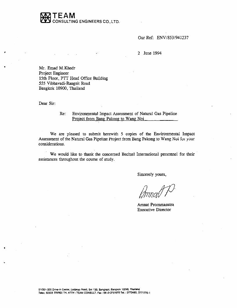
EZITEAMCONSULTING ENGINEERS CO., LTD.
Our Ref: ENV/853/941237
2 June 1994
Mr. Emad M.KhedrProject Engineer15th Floor, PTT Head Office Building555 Vibhavadi-Rangsit RoadBangkok 10900, Thailand
Dear Sir:
Re: Environmental Impact Assessment of Natural Gas PipelineProject from Bang Pakong to Wans Noi
We are pleased to submit herewith 5 copies of the Environmental ImpactAssessment of the Natural Gas Pipeline Project from Bang Pakong to Wang Noi for yourconsiderations.
We would like to thank the concerned Bechtel International personnel for theirassistances throughout the course of study.
Sincerely yours,
Amnat PrommasutraExecutive Director
51/301-305 Drive-in Center, Ladprao Road, Soi 130, Bangkapi. Bangkok 10240. ThailandTelex: 82855 TRIREX TH. ATTN: TEAM CONSULT. Fax :66 -2-3751070 Tel. : 3773480. 3771770.1
'Ulll ?¶a. i
lusuo"wfl fupiuij iin .......
LHunh1711n 4l nu nhJf11rnfllfl
l2eUwl0t.._,,a,.,._l.~ ~~~~~~~~~~~~~ ~...... . .......... ..........
1: ^ d Id II¶Ut.'1 *'Al lem. LtU TThJwi
- ... ... . .. I... .........................................................................Id , 1* . ^ t.1 4
..................................... 4..~ C f J I Pfl
u~~~~~~ i
..i^l2SlMt......... . ..QltU. . ............ l.C . a<.l' ....... w.K .>. . nQa. . .... le .........
w............... ..9 . .. .. .. .... . ............. .. ...
( ) 1.L>3?T~I
__A..-..............................
, ~~~~~~~~~~~~~~~~~~~~~~~~~~~~~~~~~~~~~~~~~~~~~.. . ... _ ....
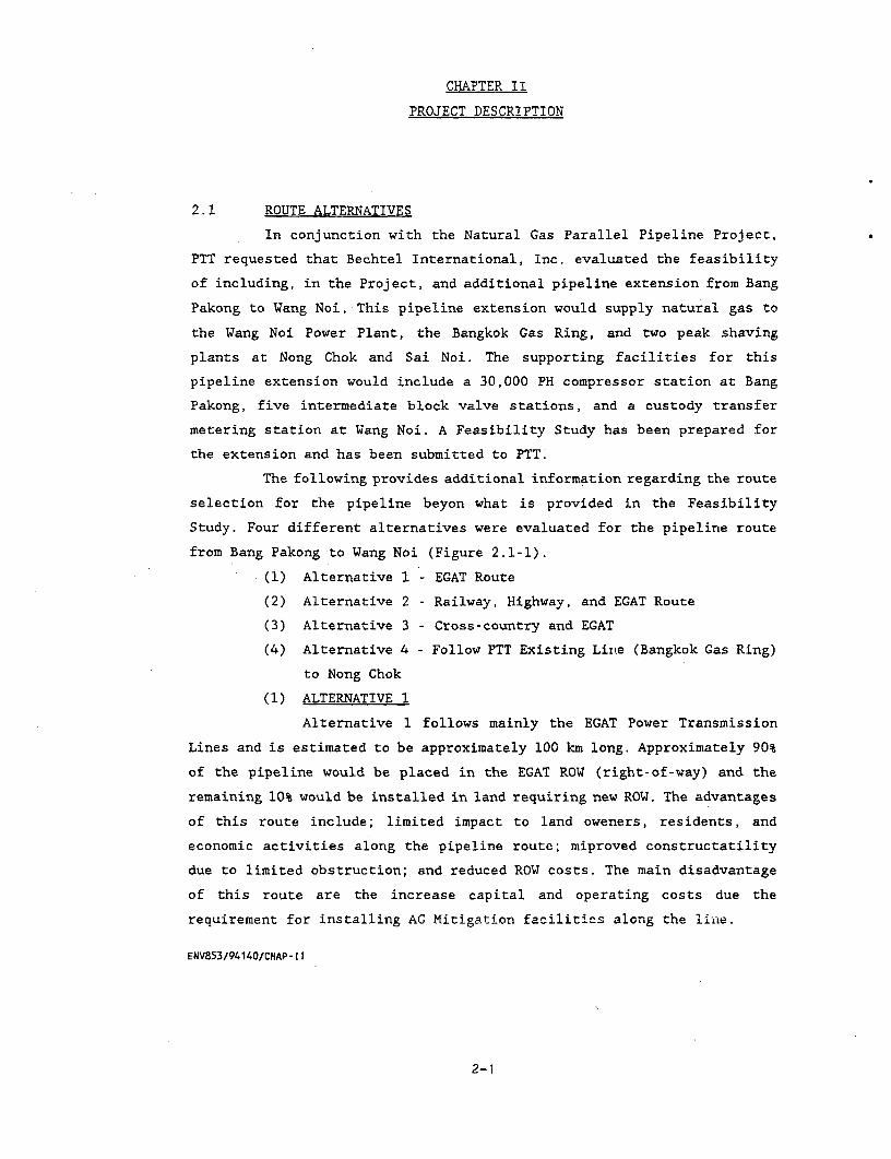
CHAPTER II
PROJECT DESCRIPTION
2.1 ROUTE ALTERNATIVES
In conjunction with the Natural Gas Parallel Pipeline Project,
PTT requested that Bechtel International, Inc. evaluated the feasibility
of including, in the Project, and additional pipeline extension from Bang
Pakong to Wang Noi. This pipeline extension would supply natural gas to
the Wang Noi Power Plant, the Bangkok Gas Ring, and two peak shaving
plants at Nong Chok and Sai Noi. The supporting facilities for this
pipeline extension would include a 30,000 PH compressor station at Bang
Pakong, five intermediate block valve stations, and a custody transfer
metering station at Wang Noi. A Feasibility Study has been prepared for
the extension and has been submitted to PTT.
The following provides additional information regarding the route
selection for the pipeline beyon what is provided in the Feasibility
Study. Four different alternatives were evaluated for the pipeline route
from Bang Pakong to Wang Noi (Figure 2.1-1).
(1) Alternative 1 - EGAT Route
(2) Alternative 2 - Railway, Highway, and EGAT Route
(3) Alternative 3 - Cross-country and EGAT
(4) Alternative 4 - Follow PTT Existing Line (Bangkok Gas Ring)
to Nong Chok
(1) ALTERNATIVE 1
Alternative 1 follows mainly the EGAT Power Transmission
Lines and is estimated to be approximately 100 km long. Approximately 90%
of the pipeline would be placed in the EGAT ROW (right-of-way) and the
remaining 10% would be installed in land requiring new ROW. The advantages
of this route include; limited impact to land oweners, residents, and
economic activities along the pipeline route; miproved constructatility
due to limited obstruction; and reduced ROW costs. The main disadvantage
of this route are the increase capital and operating costs due the
requirement for installing AG Mitigation facilities along the line.
ENV853/94140/CHAP-11
2-1

I.r ^all(a
A; , -I -9:
IC, 1
>~~~~~~~~~~~~~~~~~~~~~~~~~~~~~~~~~~~~~~~~~~~~~~C c- n v *;t z O~~~~~~~~~~~~~~~~~( r, c-= c- a a
: s J ( Q .~~~~~~~~~c ca 1: r6 < Ui ~~~~~~~~~~~~~~~~~p ; r
'1~~~~~~~~~~~~~~~~~~~~6c: c-!; r c- :t
z ) % d > R " r xct g z i~~~9.~z
o v O v 6~~~~~~~~~~~~c r, * C n;J, Ic 9 - a p
;D~~~~~~~~~r zt ;JSH
SDGE r
a)- , K:;z14 c 6
o la ~z .
suLs Vrnlmneit toepnao ru Lasn
VX- -p AIi aI wO P n"VILPrn e Al3O.te^I
U un[m) W, I J I 1 I 1,sri L LAz a Enen3LLtU UtLLrLWJI WULN-LnLP- rtUL
(OeKWtLuLsftMnt3lsWst LUr.utsLpwILtE"IIR
A P
LenmtQULPA - LtU .L-P12 l 4R LoMJDL LLUU-^RKne- e
(f3p-ttr_ W-utLLrI) t9LAUL&-R.ULPALLUm6j LLUKOLJUA.
reo>C>^Fn aKtzun,subeisuswe
3rVNlt[tV/CfSAN3
(rtLnztuLrtartn)
Sl rtP,919 LTI4WtULSLULflItUAWfl ULLlWLI WLflUjflL 8
01 K9 L1LI5LU5Wfl WLfSUtfLf L
01 nitM- U LUnLL fiUM LLtt't *9
01 fKlnflAflttLfl YttlJflL14 ftLWU 51 '
01 1 ttbL/1tt9nLl4tLUkLUtt Ll tu 4 04 wlUUtt L9 *z
01 LRUMMULWLflCLAt I3gitkLflLg2WLfl Q1
LULNILRUUflMMf16 LRUWtLU LRUGUQltA/flL P, J4 I P 0 .?. A 4
ttLLtLRULQhmnQLto nP

DRAFT FINAL REPORT OF
NATUJA. G.AS PIPELINE PROJECT FROM
BANG PAKONG TO WANG NOI
Table of Contents
Page
CHAPTER I : INTRODUCTION
1.1 PROJECT BACKGROUND 1-1
1.2 OBJECTIVES AND SCOPE OF THE STUDY 1-1
CHAPTER II : PROJECT DESCRIPTION
2.1 ROUTE ALTERNATIVES 2-1
2.2 PIPELINE FACILITIES 2-4
2.2.1 Pipeline Route 2-5
2.2.2 Pipeline Hazard/Mitigation Measure 2-8
2.2.3 Pipeline Design 2-8
2.2.4 Cathodic Protection 2-9
2.2.5 Pipeline Construction Method 2-9
2.3 PIPELINE OPERATIONS 2-15
2.3.1 Gas Transmission Facilities 2-15
2.3.2 Pipeline Markers 2-16
2.3.3 Gas Leak Control 2-16
2.3.4 Operations Schedule 2-16
2.3.5 Gas Supply/Demand 2-17
2.4 OVERALL PROJECT IMPLEMENTATION PROGRAM 2-17
2.4.1 Construction Stage 2-17
2.4.2 Operation Stage 2-17
i

CHAPTER II : EXISTING ENVIRONMENTAL CONDITIONS
3.1 SURFACE WATER QUALITY 3-1
3.1.1 Literature Review 3'1
3.1.2 Study Methodology and Sampling Stations
Description
3.1.2.1 Results of the Study 3-9
3.2 AQUATIC ECOLOGY
3.2.1 Literature Review 3-12
3.2.2 Results from Field Work 3-14
3.2.2.1 Plankton Organisms 3-14
3.2.2.2 Benthic Organisms 3-18
3.2.2.3 Aquatic Weeds 3-18
3.2.2.4 Fishery 3-21
3.3 TRANSPORTATION 3-22
3.4 INFRASTRUCTURE AND PUBLIC FACILITIES 3-22
3.5 LAND USE 3-26
3.5.1 Introduction 3-26
3.5.2 Objective 3-27
3.5.3 Scope of Work 3-27
3.5.4 Study Methodology 3-27
3.5.5 Results of the study 3-27
3.6 SOCIO-ECONOMIC 3-36
3.6.1 Scope of the Study 3-36
3.6.2 Objective of the Study 3-36
3.6.3 Methods of Study 3-36
3.6.4 Results of the Study 3-41
3.6.4.1 The Existing Gas Pipeline Area 3-41
3.6.4.2 The Proposed Gas Pipeline Area 3-61
ii

CHAPTER IV : MAJOR HAZARD ASSESSMENT
4.1 METHODOLOGY 4-1
4.1.1 Hazard Identification 4-1
4.1.2 Quantitative Analysis 4-5
4.2 HAZARDOUS ASSESSMENTS 4-8
4.3 SUMMARY OF IMPACTS 4-16
4.4 HAZARD MITIGATION MEASURES 4-16
CHAPTER V ENVIRONMENTAL IMPACT ASSESSMENT
5.1 INTRODUCTION 5-1
5.2 WATER QUALITY 5-1
5.2.1 Construction Period 5-1
5.2.2 Operation Phase 5-2
5.3 AQUATIC ECOLOGY/FISHERY 5-3
5.3.1 Construction Period 5-3
5.3.2 Operation Period 5-4
5.4 TRANSPORTATION 5-4
5.4.1 Construction Period 5-4
5.4.2 Operation Period 5-5
5.5 LAND USE 5-5
5.6 SOCIO-ECONOMICS 5-5
iii
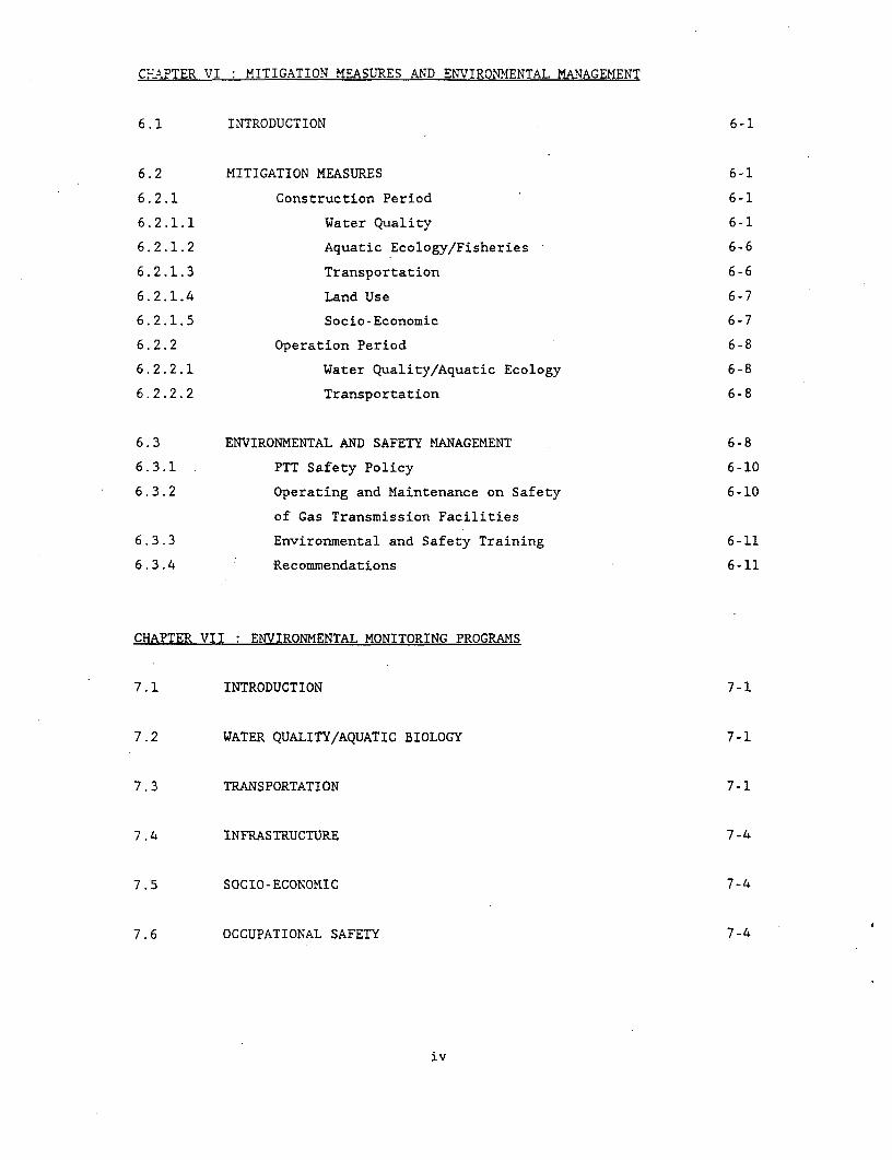
C?-fPTER VI : MITIGATION MEASURES AND ENVIRONMENTAL MANAGEMENT
6.1 INTRODUCTION 6-1
6.2 MITIGATION MEASURES 6-1
6.2.1 Construction Period 6-1
6.2.1.1 Water Quality 6-1
6.2.1.2 Aquatic Ecology/Fisheries 6-6
6.2.1.3 Transportation 6-6
6.2.1.4 Land Use 6-7
6.2.1.5 Socio-Economic 6-7
6.2.2 Operation Period 6-8
6.2.2.1 Water Quality/Aquatic Ecology 6-8
6.2.2.2 Transportation 6-8
6.3 ENVIRONMENTAL AND SAFETY MANAGEMENT 6-8
6.3.1 PTT Safety Policy 6-10
6.3.2 Operating and Maintenance on Safety 6-10
of Gas Transmission Facilities
6.3.3 Environmental and Safety Training 6-11
6.3.4 Recommendations 6-11
CHAPTER VII ENVIRONMENTAL MONITORING PROGRAMS
7.1 INTRODUCTION 7-1
7.2 WATER QUALITY/AQUATIC BIOLOGY 7-1
7.3 TRANSPORTATION 7-1
7.4 INFRASTRUCTURE 7-4
7.5 SOCIO-ECONOMIC 7-4
7.6 OCCUPATIONAL SAFETY 7-4
iv

CHAPTER VII : ENVIRONMENTAL MONITORING PROGRAMS (Corit'd)
7.7 CONCLUSIONS 7-5
v
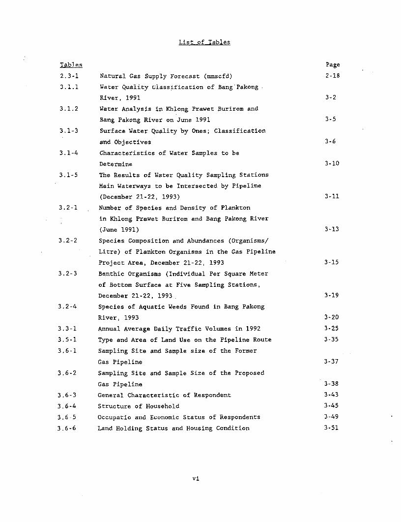
List of Tables
Tables Page
2.3-1 Natural Gas Supply Forecast (mmscfd) 2-18
3.1.1 Water Quality classification of Bang Pakong
River, 1991 3-2
3.1.2 Water Analysis in Khlong Prawet Burirom and
Bang Pakong River on June 1991 3-5
3.1-3 Surface Water Quality by Ones; Classification
and Objectives 3-6
3.1-4 Characteristics of Water Samples to be
Determine 3-10
3.1-5 The Results of Water Quality Sampling Stations
Main Waterways to be Intersected by Pipeline
(December 21-22, 1993) 3-11
3.2-1 Number of Species and Density of Plankton
in Khlong Prawet Burirom and Bang Pakong River
(June 1991) 3-13
3.2-2 Species Composition and Abundances (Organisms/
Litre) of Plankton Organisms in the Gas Pipeline
Project Area, December 21-22, 1993 3-15
3.2-3 Benthic Organisms (Individual Per Square Meter
of Bottom Surface at Five Sampling Stations,
December 21-22, 1993 3-19
3.2-4 Species of Aquatic Weeds Found in Bang Pakong
River, 1993 3-20
3.3-1 Annual Average Daily Traffic Volumes in 1992 3-25
3.5-1 Type and Area of Land Use on the Pipeline Route 3-35
3.6-1 Sampling Site and Sample size of the Former
Gas Pipeline 3-37
3.6-2 Sampling Site and Sample Size of the Proposed
Gas Pipeline 3-38
3.6-3 General Characteristic of Respondent 3-43
3.6-4 Structure of Household 3-45
3.6 e 5 Occupatio and Economic Status of Respondents 3-49
3.6-6 Land Holding Status and Housing Condition 3-51
vi
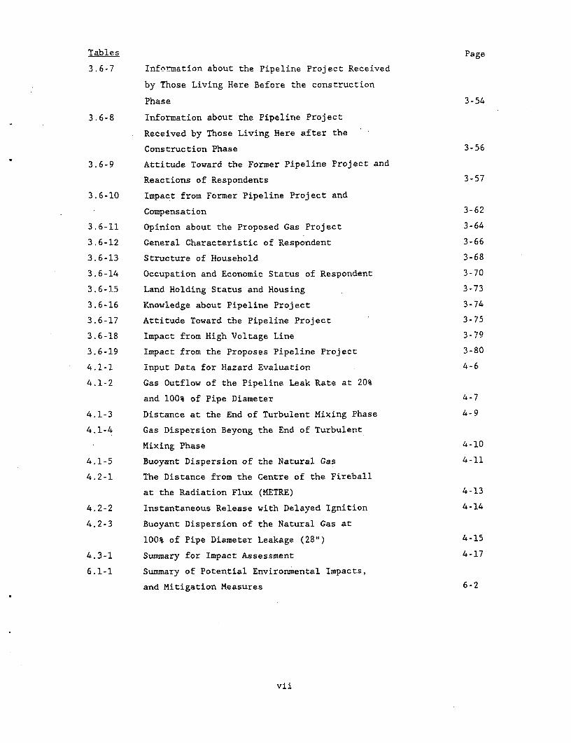
Tables Page
3.6=7 information about the Pipeline Project Received
by Those Living Here Before the construction
Phase 3-54
3.6-8 Information about the Pipeline Project
Received by Those Living Here after the
Construction Phase 3-56
3.6-9 Attitude Toward the Former Pipeline Project and
Reactions of Respondents 3-57
3.6-10 Impact from Former Pipeline Project and
Compensation 3-62
3.6-11 Opinion about the Proposed Gas Project 3-64
3.6-12 General Characteristic of Respondent 3-66
3.6-13 Structure of Household 3-68
3.6-14 Occupation and Economic Status of Respondent 3-70
3.6-15 Land Holding Status and Housing 3-73
3.6-16 Knowledge about Pipeline Project 3-74
3.6-17 Attitude Toward the Pipeline Project 3-75
3.6-18 Impact from High Voltage Line 3=79
3.6-19 Impact from the Proposes Pipeline Project 3-80
4.1-1 Input Data for Hazard Evaluation 4-6
4.1-2 Gas Outflow of the Pipeline Leak Rate at 20%
and 100% of Pipe Diameter 4-7
4.1-3 Distance at the End of Turbulent Mixing Phase 4-9
4.1-4 Gas Dispersion Beyong the End of Turbulent
Mixing Phase 4-10
4.1-5 Buoyant Dispersion of the Natural Gas 4-11
4.2-1 The Distance from the Centre of the Fireball
at the Radiation Flux (METRE) 4-13
4.2-2 Instantaneous Release with Delayed Ignition 4-14
4.2-3 Buoyant Dispersion of the Natural Gas at
100% of Pipe Diameter Leakage (28") 4-15
4.3-1 Summary for Impact Assessment 4-17
6.1-1 Summary of Potential Environmental Impacts,
and Mitigation Measures 6-2
vii

CHAPTER I
INTRODUCTT N
1.1 PROJECT BACKGROUND
Since there are rapid growth in various sectors in Thailand, the
energy supply is the main aspects for the country's need. The utilization
of natural gas pipeline system has also been developed in the Gulf of
Thailand during 1970s. The demand of natural gas has been forecasted to
increase from 350 MMCFD in the year 1986 to 2000 MMCFD by the year 2001.
To achieve the increasing demand and the necessity to produce adequate
natural gas supply for the country's need, PTT has engaged Bechtel
International, Inc. to develop the pipeline system from Bang Pakong to
Wang Noi. PTT has also entrusted TEAM Consulting Engineers Co., Ltd. to
prepare the environmental impact assessment.
The Initial environmental evaluation was undertaken for the
natural gas pipeline project from Bang Pakong to Wang Noi in March 1994.
It was indicated that the concerned parameters to be study in the EIA
include water quality, aquatic ecology, land use, transportation, socio-
economic at hazardous assessment. Thus, the content of this EIA will be
limited to the above aspects.
1.2 OBJECTIVES AND SCOPE OF THE STUDY
The main objectives are the preparation of the Environmental
Impact Assessment (EIA) report and the development of the monitoring
program of this project.
The specific objectives of the study are:
(1) To investigate and describe the existing characteristics
and quality of the concerned environmental resources and values of the
study area.
(2) To characterize the environmental aspects that would be
affected by the implementation of the proposed project.
ENV853/94140/CHAP- I
1 -1
(3) To identify the major changes of the environment that may
be expected as a results of the project implementation and development.
(4) To evaluate and forecast the short and long-term impacts
of the proposed project upon the environmental resources and values and to
define the degree of significance and magnitude of the predicted impacts.
(5) To make recommendations on short and long-term measures
to prevent or mitigate the adverse effects and/or to maximize the positive
results of the proposed project.
(6) Based on the results, recommend the appropriate
ernvironmental monitoring programs for the proposed project during project
operation.
This EIA was conducted following the "Environmental Guidelines
for Selected Industrial and Power Development Project" of the Asian
Development Bank (ADB)".
ENV853/94140/CHAP-I
1-2
CHAPTER II
PROJECT DESCRIPTION
2.1 ROUTE ALTERNATIVES
In conjunction with the Natural Gas Parallel Pipeline Project,
PTT requested that Bechtel International, Inc. evaluated the feasibility
of including, in the Project, and additional pipeline extension from Bang
Pakong to Wang Noi. This pipeline extension would supply natural gas to
the Wang Noi Power Plant, the Bangkok Gas Ring, and two peak shaving
plants at Nong Chok and Sai Noi. The supporting facilities for this
pipeline extension would include a 30,000 PH compressor station at Bang
Pakong, five intermediate block valve stations, and a custody transfer
metering station at Wang Noi. A Feasibility Study has been prepared for
the extension and has been submitted to PTT.
The following provides additional information regarding the route
selection for the pipeline beyon what is provided in the Feasibility
Study. Four different alternatives were evaluated for the pipeline route
from Bang Pakong to Wang Noi (Figure 2.1-1).
(1) Alternative 1 - EGAT Route
(2) Alternative 2 - Railway, Highway, and EGAT Route
(3) Alternative 3 - Cross-country and EGAT
(4) Alternative 4 - Follow PTT Existing Line (Bangkok Gas Ring)
to Nong Chok
(1) ALTERNATIVE 1
Alternative 1 follows mainly the EGAT Power Transmission
Lines and is estimated to be approximately 100 km long. Approximately 90%
of the pipeline would be placed in the EGAT ROW (right-of-way) and the
remaining 10% would be installed in land requiring new ROW. The advantages
of this route include; limited impact to land oweners, residents, and
economic activities along the pipeline route; miproved constructatility
due to limited obstruction; and reduced ROW costs. The main disadvantage
of this route are the increase capital and operating costs due the
requirement for installing AC Mitigation facilities along the line.
ENV853/94140/CHAP-I I
2-1
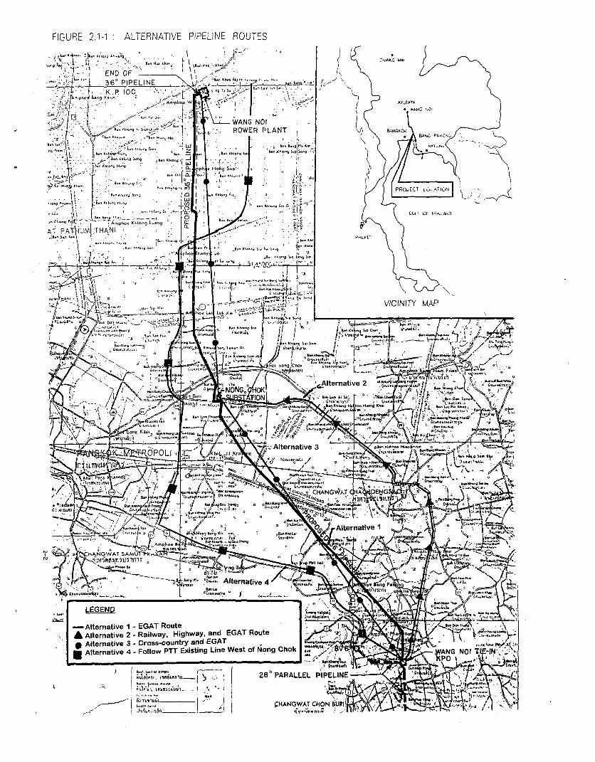
FIGURE 2.1-1 ALTERNATIVE PIPELINE ROUTES
~~ .BX
. . I :~ ! END OF 1 \ XL 36" PIPELINE P -- K -r I' K P 100i- o
l FWANG NO ,. / r ' .' / o 1AN1 sOI
POW R PLANT "Ai
b....Io&f I., *~f.P*B
*; -' )f N$L r L 9 0 t { J r#i n a t i l r . . . .. / jir g 5 |>&m ; '"e *A h I , ........ ; > t. ) _ l ' sT ti 5 J 5 | PROJECT1 Lu,ATI,N)
*lOg8*p\ } j in tIgsJtJ 4s4 ~ 0 I * jlo Sr5>1 i) g
S B. *KI~~~~~~~~~~~gp,.1
B (JU~~~~~~~~~;LF OF 11,iL.jJ,D
A4 .ph. K,1- 'L-
AT' PA5T UMj! rHANl I<, [T..ti Su 1 \ | 5 b 9 d n 5 * hVICINITY MAP
'--t?- ~ ~~~~~ - ,~ "'" S.' -.!4
-Alternative- EAT Route trnative,
.__
tbPX ,Gc'X-l^>Ateratie Nlentv .. ', - h.J
, az LGEND i gPOLI
- ~~~~~~~~~~~~~~~~~~~Alternative3 C°SSpOuEYjbg;eWetoNogCo 3 -ANNItIN,
0 ~ ~ ~ ~ .. ;l,> 1 ,( 5 hS .NGitl.;^^n_ ) || 2 AALE lEtE ! .o w C s P y
t - ' :^ ....... l;Alrn;ft .w---!-'|i,<>mt............................................
LE* . _ IaAGEA HNE)ulimE s ,

(2) Alternative 2
Alternative 9 follows the railway north from Bang Pakong to
Chachoengsao then follows Highway 304 to the Nong Chok Substation. The
route could then either follow the EGAT ROW or cut cross-country to the
Wang Noi Power Plant. The advantages of this route over Alternative 1
include; AC Mitigation costs/facilities would not be incurrend from Bang
Pakong to the Nong Chok Substation and better accessability to the
pipeline ROW. The disadvantages compared to Alternative 1 include:
significantly higher capital costs due to additional 20 km of pipeline
length; installation of the pipeline along congested. populated railway
and highway ROW; impact on property owners near congested Highway; and
additional horsepower requirements at Bang Pakong due to longer line
length wihic would adversely affect both capital and operating costs.
(3) Alternative 3
Alternative 3 follows the most direct cross-country route
from Bang Pakong to Nong Chok and from Nong Chok to the Wang Noi Power
Plant. The advantages of this route over Alternative 1 include; AC
Migigation costs/facilities would be minor and the pipeline length would
be reduced by 3 to 5 km. The disadvantages compared to Alternative 1
included; high ROW costs, high impact to property owners due to splitting
properties, and higher constructability costs due to more obstructions in
the ROW.
(4) Alternative 4
Alternative 4 follows the existing PTT pipeline along
Highway 34 and heads north and follows Highways 3256 and 3119. A majority
of the line would be in congested Highway ROW. The advantages of this
route over Alternative 1 include: Ac Mitigation costs/facilities would not
be incurred from Bang Pakong to the Nong Chok Substation and better
accessability to the pipeline ROW. The disadvantages compared to
Alternative 1 include: significantly higher capital costs due to
additional 25 km of pipeline length; installation of the pipeline along
congested, populated highway ROW; and additional horsepower requirements
at Bang Pakong due to longer line length which would adversely affect both
capitital and operating costs. This route is practically infeasible due
the the congested ROW along the highways it would parallel.
ENV853/94140/CHAP-I1
2-3
(5) Assessment of Alternative
Alternative 2 and 4 are not feasible due to the increased
pipeline length (+20% over Alternative 1 and due to the significant
congestLon which would be encountered along the highway/railway ROW.
AlterAnative 3 is feasible, however the total cost of this line may be
higher than Alternative 1 due to increased ROW and construction costs even
though the line is 3 km shorter. The main economic activities would be
affected by the installation of a new "virgin" cross-country pipeline.
This disadvantage for Alternative3, makes Alternative 1 the most
attractive route. The Alternative 1 route, which follows the EGAT ROW, is
cost effective, constructible, and minimizes the impact to residents in
Thailand. Based on this information, Alternative 1 is the selected route
for the Bang Pakong to Wang Noi extension.
The following description summarizes the major system components
and service condition:
New 100 km, 36" onshore gas pipeline from Bang Pakong to
Wang Noi Power Station. s s n4 - t rNew compressor station at Bang Pakong and new metering
facilities at Wang Noi Power Station.
Modifications to PTT's existing SCADA facilities at the
Erawan Platforms ERP and ECP, Rayong Gas Separation Plants,
the gas transmission and distribution system and Operations
Center in Chonburi.
The completion dates are scheduled at March 1996 for the onshore
pipelines. The service life for the pipelines and related facilities will
be approximately 40 years.
2.2 PIPELINE FACILITIES
The pipeline facilities related to this project include new
metering facilities at the Wang Noi Power Plant, and a new 100 km, 36"
onshore gas pipeline from Bang Pakong to Wang Noi. Also included are
modifications to the SCADA equipment and software.
ENV853/94140/CHAP- I I
2-4
2.2.1 Pipeline Route
The proposed Wang Noi Power Plant is located just south of
Highway 1, about 100 km North of the Wang Noi Pipeline (WNPL) tie-in with
the Parallel Pipeline at Amphoe Bang Pakong (Figure 2.2-1). The WNPL will
have a wall thickness of 0.375 inches or 0.406 inches (API Grade), in
accordance with ASME 31.8 code.
The WNPL will commence in rice field and head north east one
kilometer to join the EGAT R.O.W. (230 KV line). At this point, the WNPL
will parallel the EGAT line heading north. The pipeline will be 12 meters
to the east of the EGAT towers. The edge of the EGAT R.O.W. is 8 meters
further east, so no new R.O.W. will be required after WNPL's entry into
the EGAT R.O.W. Five meters of temporary work space will be necessary for
construction.
After entering the EGAT R.O.W., the WNPL will head north through
rice fields and low lands 1.5 kilometers to the Highway 3466 crossing.
Highway 3466 is a 6 meter wide asphalt road with an 8 meter wide
canal on the south side and a pond on the north. The highway will be a
standard bore crossing.
From Highway 3466, the WNPL will continue north across more rice
fields, and scattered fish ponds 0.7 kilometers to a major canal
("Khlong") crossing. The Khlong crossing can be open cut during the dry
season.
From the canal, the WNPL will continue to follow the EGAT line
north two kilometers to make an approximate 50° turn to the left.
Appropriate bending will be required to stay maintain the pipeline
alignment inside the EGAT R.O.W. This area is low lands with scattered
houses.
From the 50 P.I., the WNPL will continue northwesterly across
rural roads and three minor canals, which can all be open cut. The terrain
is flat with rice fields and low lands.
At KP 9, the EGAT line picks up a second set of towers from the
Bang Pakong Power Plant. At this point, the proposed WNPL will move in
between the two EGAT powerlines.
There is 22 meters of open work space from edge of towers. The
towers are 8 meters wide. The R.O.W. line is 12 meters from the center of
the towers. This would eliminate the need for temporary work space during
ENV853/94140/CHAP-I1
2-5
- CL
Wj--~-
FIGURE 2.2-1: LOCATION OF STU AREA
j.1.~~~~~~'I1'. .~~~~~~~~~.... ..
* nph. ,go
A.ph.. L- L.k K.*l,oA"~
I A.- Ok.-
FIGURE 2.2-I: LOCATiON O~~~~~ STUDY AREA~

construction and also avoid houses built up along rhe R.O.W. in some
areas.
About 7 kilometers further northwest, the EGAT lines cross the
Bang Pakong River. This is a major river with swift moying currents. The
crossing is almost 500 meters long. The crossing would most likely be
directionally drilled.
After the Bang Pakong River, the route crosses Highway 314 which
will be a standard bore crossing.
North of Highway 314,.the route continues through rice fields,
low lands, and several major and minor Khlongs, all of which should be
open cut with concrete coated pipe, 23 kilometers to the eastern line
railway crossing. The railway crossing will be a cased bore. The WNPL will
also cross the new 24-inch THAPP pipeline, which is under construction at
this time. The THAPP line follows the railway line west 0.6 kilometers and
turns north along a rural road to join the ECAT lines. THAPP line is
parallel to the EGAT lines at this point, on the east side of the R.O.W.,
12 meter offset Accordinzlv, there is no conflict between the WNPL route
and the THAPP line route as the proposed WNPL route is between the EGAT
towers.
The WNPL route continues northwest 11.5 kilometers across more
rice fields, minor Khlongs, and rural roads to Highway 304. At the north
side of the highway is a substation. The proposed WNPL route will leave
the EGAT R.O.W. and head east around the substation and rejoin the EGAT
R.O.W. after 500 meters. At this point, the double EGAT lines split and
the THAPP line follows the more westerly line while the WNPL route will
follow the easterly lines. The WNPL route will stay on the east side of
the towers at an approximate offset of 14 meters. The edge of R.O.W. is 26
meters from the towers, so no temporary work will be required.
The route continues north 15 kilometers across more rice fields,
two major Khlongs, several minor Khlongs, and rural roads to the next
Highway 3312.
At Highway 3312, a short re-route outside the EGAT R.O.W. will be
necessary to avoid ponds for a length of about 600 meters.
After rejoining the EGAT line, the UNPL route will continue for
10 kilometers north across several more minor Khlongs and one major Khlong-
to Highway 305. All crossings will most likely be open cut during the drv
ENV853/94140/CHAP-1I
2-7
season except the hizhway.
From Highway 305, the EGAT line continues north 20 kilometers
across rice fields and several minor Khlongs to a major Khlong crossing
that could be open cut or directionally drilled.
From here, the route contirn-es north alonlg the east Side of the
EGAT line approximately 5 kilometers to terminate at the proposed Wang
Noi Power Plant just south of Highway 1. There are two more major Khlong
crossings south of Highway 1.
2.2.2 Pipeline Hazard/Mitigation Measures
Because the gas pipelines will be located parallel to and
relatively close to high voltage (230 KV and 460 KV power transmission
lines, the pipe itself will be subjected to induced voltage). During
construction, the pipe will be grounded to prevent injury to personnel and
damage to equipments. A permanent grounding system will be installed to
protect pipeline and maintenance personnel and will be connected to the
grounding system for the individual transmission towers.
2.2.3 Pipeline Design
The gas pipelines will be designed in accordance with ASME B
31.8, Gas Transmission and Distribution Piping Systems. The pipe wall
thickness and grade will be designed for a maximum operating pressure of
1,044 psig. The wall thickness of the pipe will be increased, as required,
at crossings of highways, railways, major waterways and in areas in close
proximity to inhabited structures as specified in the codes.
The pipe will be externally coated to prevent corrosion.
Pipe block valves will be located at various points on the
pipeline to allow isolation of portions of the system. The block valves
will be equipped with gas driven actuators for ease of operation. Each
valve will be located in a designated fenced/guarded area. Facilities will
be provided at the valve sites to allow venting of the pipeline in the
event of an emergency. Scraper traps will be installed at the Rayong gas
terminal (launcher), Block Valve No.6 (receiver), Bang Pakong Compressor
Station (launcher), and Wang Noi Power Plant (receiver).
ENV853/94140/CHAP- I I
2-8
2.2.4 Cathodic Protection
In addition to the external pipe coating, the pipeline will be
protected from corrosion by means of an active cathodic protection system.
Testing stations will be located along the pipelines to allow monitoring
of the cathodic protection system. The 36" pipeline will be electrically
isolated from Block Valve No.6 facilities by means of insulating joints.
2.2.5 Pipeline Construction Method
The onshore pipeline construction will basically be a linear
assembly line, where the equipment and workers move along the pipeline
route at a constant pace, each performing an assigned task. The work
process begins with the preparation of the right-of-way, which serves as
the work site, and ends with the burial of the pipe and the restoration of
the land surface. The following are the major work steps involved in the
construction process:
(1) Rioht-of-Way Preparation
The purpose of this work step is to provide a smooth and
even work area and to facilitate the movement of equipment onto and along
the pipeline route.
(2) PiDe Stringing
Stringing is the delivery and distribution of pipe along the
right-of-way. Specially equipped trucks are used to safely haul the pipe
from the storage yard to the right-of-way.
(3) Trenching
Trenching or ditching is merely the excavation of a trench
in which to lay the pipe. The trench can be excavated using a backhoe or
a specially designed wheel-type ditching machine. In areas containing
rock, blasting is sometimes used if the rock cannot be economically
fractured or ripped using mechanical methods. The depth of the trench is
a function of how much cover is required over the pipe; in normal soils
this is 75 to 80 cms, in rock only 60 cms.
(4) Bending
Individual pipe sections may be bent to ensure that the
completed pipeline contour matches the bottom contour of the trench. The
ENV853/94140/CHAP- I I
2-9

bending is done alongside the trench using specialized equipment which
handles the pipe with little or no damage to the exterior coating.
(5) Welding
Welding of the pipe joints is completed in a series of steps
beginning wi.h tLhe line-up oF tne two surfaces 'o critical tolerances,
followed by numerous welding passes. Typically, the welding is done
manually and, on large diameter pipe, two welders work on one weld,
working on opposite sides of the pipe. Welds are visually inspected and
examined by x-ray to determine their quality and acceptability.
(6) External Coating
After acceptance of the weld, the area adjacent to the weld
is cleaned and coated to prevent corrosion. Prior to movement into the
trench, the entire pipeline segment is tested for coating defects and if
found, any defects are corrected.
(7) Lowering-In
The pipe is normally lowered into the trench in long
segments of pipe joints. This critical step is closely coordinated and
supervised. The lifting and movement of the pipe segment is done by "side
boom" tractors which have the ability of making discrete vertical and
horizontal movements..
(8) Backfilling
After the pipe has been placed in the trench, the soil taken
from the trench or another selected material is placed in the trench.
Special care is taken to ensure that there is sufficient material
underneath the pipe as well as above it and also to prevent damage to the
coated pipe. Where the pipe is laid in rocky or rough soils, a padding of
selected material (dirt or sand) is used to support and isolate the pipe
from large rocks, etc.
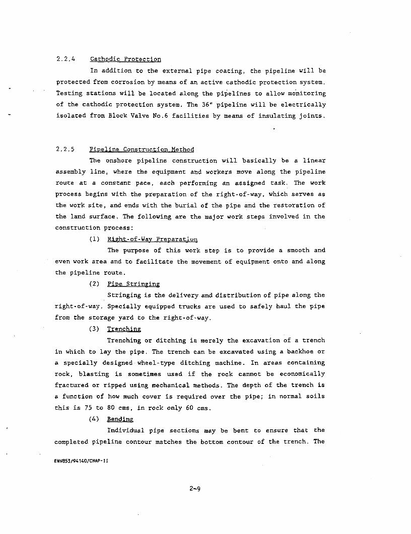
(9) Crossings
Pipeline crossings of highways, railways, canals or other
pipelines or cables are made in accordance with the requirements of the
owners. In general, major highways will be crossed without disruption of
traffic. To accomplish this, a larger diameter steel casing pipe is bored
and jacked under the highway using specially designed equipment and then
the gas pipeline is slipped through the casing pipe. (Figure 2.2-2 and
2.2-3).
ENV853/94140/CHAP-Il
2-10
I-
z 0 z
0~~~~~~~~
36 ii|2aO
O O.D. 0 0469 "WT. PIPE
PAVED RURAL ROAD CROSSINGSSCALE: NONE
NOTE
MINIMUM COVER INSIDE RURAL ROAD ROW
IS 1.5 METER. CONTRACTOR HAS THE OPTION
TO EITHER JACK BORE OR OPEN cur
PAVEO RURAL ROADS.
HOWEVER TRAFFIC FLOW MUST BE
MAINTAINED,HEAVE WALL PIPE (36" O.D. x 0.469 WT. API 5L 't 65)
SHALL EXTEND ONE METER PAST 0OTH ROW LINES.
FIGURE 2.2-2 :PAVED RURAL ROAD CROSSINGS

0
0 0
SCALE: NONE NT
36 O.D3 x 0.469 WI. API 5L 65 PIPE
(HEAVY WALL CLASS 3) SHALL E-XTEND ACROSS
RURAL ROAD AND ONE METER PAST ROW LINES.
MINIMUM COVER IS 1.5 METER.
ALL DIRT AND LATERITE ROADS WILL BE OPEN CUT.
CONTRACTOR IS RESPONDSIBLE FOR SAFETY
AND FLOW OF TRAFFIC.
FIGURE 2.2-3 :DIRT AND LATERITE RURAL ROAD CROSSINGS

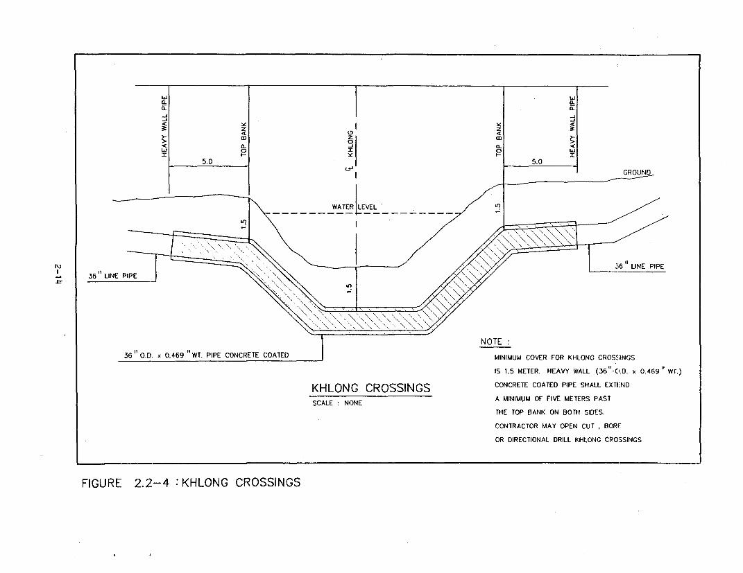
At crossings that are navigable by pleasure or commercial
craft, Contractor shall comply with all special precautionary measures
required by federal, state and local maritime authorities, to prevent or
minimize obstructions to navigation on the water course.
Construction of the pipe across rivers and streams shall be
performed in such a manner as to keep to a minimum the damage to
shorelines, water crossed, adjacent drainage areas, and fish and wildlife
habitats.
(a) Open Cut Crossings
Across streams and river, the pipeline shall normally
be laid by the open cut method as practicable and, where required, it
shall be held in place by means of concrete set-on weights or concrete
coating or screwed anchors.
Cutting of the pipeline ditch in sloped approaches
shall not be undertaken until actual pipe laying is ready to be carried
out in order to minimize silt input into the water course. If necessary,
the work area shall be graded, and other precautions shall be taken, to
pre-ven.t surface run-off from entering the ditch. In additionj the silt
fences, hay bales and other appropriate means will be applied to control
erosion and sediment runoff at all water channels adjacent to the trench
or other earth exposing construction activities.
Following installation of the pipe, the beds of streams
and rivers shall be restored, as neatly as possible, to their former
elevations and grade. Spoil, debris, piling, construction materials, and
obstructions resulting from the construction of the pipeline shall be
removed from the crossing to prevent interference with normal water flow
and use of the waterways, and shall be disposed in a satisfactory manner.
Where practicable, stream and river banks shall be
backfilled and compacted to a point above the high water line and, if
necessary, sandbagged and, or rip-rapped to prevent soil and bank erosion.
As a minimum, compaction shall be to densities equivalent to those of the
surrounding soils (Figure 2.2-4).
(b) Bored Crossings
In certain cases, the jurisdictional authority may
require that installation of the pipeline across the waterway be performed
by boring. Bored crossings shall be installed using a pilot pipe section.
ENV853/94 140/CHAP- I1
2-13
0- 0~~~~~~~~~~~~~~~~~~~~~~~~~~~~~~~~~~~~~~-JQ-~~~~~~~~~~~~~~~~~~~~~~~~~~~~~~~~~~~~~~~~~~~-
z zz
:> 0< 1 36 t. -Q. <
WATER ~ ~~ NTE:36 3LINE O PI
36 O.D. x 0.469 "WT. PIPE CONCRETE COATED MINIMUM COVER FOR KHLONG CROSSINGS
IS 1.5 METER. HEAVY WALL (36-C.D. x 0.469" WT.)
KHLONG CROSSINGS CONCRETE COATED PIPE SHALL EXTEND
SCALE: NONE A MINIMUM OF FIVE METERS PASTTHE TOP BANK ON BOTH SIDES.
CONTRACTOR MAY OPEN CUT, BORE
OR DIRECTIONAL DRILL KHLONG CROSSINGS
FIGURE 2.2-4 :KHLONG CROSSINGS

Once the pilot section- i- in place, the permanent, coated, carrier pipe
shall be welded onto the pilot section and jacked or pulled through the
bore. The pilot section shall then be cut off and removed.
(c) Directional Drilling
The installation of the pipeline crossings may be
accomplished by the use of the directional drilling method. A plan and
profile of each crossing to be installed by directional drilling is to be
approved. Entry and exit points shall be accurately located. Where the
crossing is installed parallel to an existing pipeline, the crossing
design shall ensure that a minimum twenty (20) foot separation is
maintained between the pipelines throughout the full length of the
crossing. Any drilling fluids, muds or chemical additives used shall be
acceptable to the environmental authorities having jurisdiction, and the
containment and disposal of such drilling fluids shall be in accordance
with the permit requirements. It is anticipated that the Bang Pakong River
(which is in the 36" Segment of the Wang Noi Extension) will be
directionally bored.
(10) Testing
The completed pipeline is subjected to a hydrostatic test to
approve its overall integrity. After venting all air from the completed
pipeline a pressure equivalent to 25 percent higher than maximum operating
pressure is applied and held for 24 hours. During this time, the pressure
and temperature are recorded to determine if there is any leakage.
2.3 PIPELINE OPERATIONS
2.3.1 Gas Transmission Facilities
The overall gas transmission facilities consist of the metering
and pressure control offshore on ERP, the 36" submarine pipeline, liquids
removal and dewpoint control at the Rayong gas terminal, onshore
compressor station at Rayong, the 28" onshore pipeline with metering and
pressure control at existing Block Valve No.6, 36" onshore pipeline from
Bang Pakong to Wang Noi, Compressor station at Bang Pakong, and metering
ENV853/94140/CHAP- I I
2-15
facilities at Wang Noi. The system will be monitored and controlled via
SCADA from the Operations Center in Chonburi.
Supervisory Control and Data Acquisition (SCADA) and
communications facilities would be required at the Unocal IV platform,
ERP, compression facilities near Block Valve 6, Block Valve sites along
the onshore pipeline route, and at Wang Noi. SCADA data would be sent to
the Operations Center near Chonburi where PTT has an existing SCADA and
Communications system for their current pipeline network.
2.3.2 Pipeline Markers
The onshore portion will be identified by above ground markers
which provide a warning of the presence of the pipeline and phone numbers
for contacting PTT. In addition, kilometer and marker will be installed at
regular intervals to allow identification from the air as well as from the
ground level.
2.3.3 Gas Leak Control
To control the pipeline, including leak detection, on-line
information from the pipeline inlet and outlet will be monitored;
pressure, temperature, density and volumetric flow. Where 2-phases flow is
encountered, including slug flow, densities and volumetric flows will be
obtained by direct measurement and also re-constituted from metering after
separation. On-line pipeline integrity monitoring software in the SCADA
system will perform overall pipeline mass balances, pipeline hydraulics
and rate of change pressure calculations to check for small leaks on a
long-term basis and for leaks on a short-term basis, respectively.
2.3.4 Operations Schedule
The new pipeline system is intended to operate continuously.
Equipment requiring maintenance will have stand-by units to allow a shut-
down without interruption of gas flow in the pipeline. Flow rates will
vary seasonally and throughout the day in conjunction with onshore gas
demand.
ENV853/94140/CHAP- I I
2-16
2.3.5 Gas Supply/Demand
Projected offshore suppliers from Erawan, Bongkot, joint
development area U4, and Malaysia Gas fields for each year in the future
are given in Table 2.3-1.
The projected gas demand, for Khanom, Songkhla, Bang Sapang,
Krabi, EGAT power plant at Rayong, Bang Pakong, Wang Noi and Rayong
industrial users and others were computed based on the heating values of
the gas for each year.
2.4 OVERALL PROJECT IMPLEMENTATION PROGRAM
2.4.1 Construction Stage
The mobilization for the onshore pipeline and compressor station
construction is scheduled to commence in 1995. The offshore pipelin2c
should be ready for pre-commissioning by 1996.
Testing and commissioning are scheduled for completion at the mid
of 1996.
2.4.2 Operation Stage
Actual gas operations in the new system can begin in 1996.
ENV8S3/94140/CHAP- II
2-17

TABLE 2.3-1
NATURAL GAS SUPPLY FORECAST
(mmscfd)
Year UNCAL BONGKOT U4 JDA MALAYSIA TOTAL
I, II, III (B12/27) SOUTHERN
1993 670 150 820
1994 752 200 952
1995 712 250 962
1996 900 300 1,200
1997 900 350 250 1,500
1998 900 350 300 1,550
1999 900 350 300 1,550
2000 900 350 300 150 1,700
2001 900 350 300 200 50 1,800
2002 900 350 300 250 50 1,850
2003 900 350 300 250 100 1,900
2004 900 350 300 250 100 1,900
2005 900 350 300 250 100 1,900
2006 900 350 300 250 100 1,900
ENV853/94141/TAB23-1
2-18

CHAPTER III
FXTSTTNG ENVIRONMENTAL CONDITIONS
3.1 SURFACE WATER QUALITY
3.1.1 Literature Review
The water quality along Bang Pakong river from Bang Pakong district,
Chachoengsao to Kabin Buri district, Prachinburi 19 stations about 232
kilometres of distance were surveyed by Environmental health division,
Health Department and office of public health Chachoengsao and Prachin
Buri province. Forty-tree parameters were conducted and the quality
results were compared with surface water quality standard. The results of
water quality in Bang Fakong river can be summarized in Table 3.1-1 and
Figure 3.1-1.
(1) Water quality in Bang Pakong, Ban Pho, M4uang, Bang Knia, Bang
Nam Prieo, Phanom Sarakham district of Chachoengsao province and Muang
district of Prachin Buri province were categorized as class 54 which was
not suitable for consumptioiy except transportation. The overall of water
quality along the river was categorized as class 3. In this area some
parameters exceed the standard such as lead and nitrate. The range of lead
is 0.06-0.12 mg/l and 5.89-21.7. mg/l of nitrate interms of nitrogen.
(2) In Ban Sang, Si Maha Phot and Kabin Buri district of Prachin
Buri province, water quality were categorized as class 3 which can be used
for consumption after treatment system. The important parameters in this
area are coliform and fecal coliform bacteria with the range of 5,600-
12,400 MPN/10 ml and 1,350-2,800 MPN/100 ml respectively.
(3) It was found that 7 water quality stations from total 11
stations or about 64% were categorized as class 5.
The study of Team Consulting Engineers Co., Ltd. held on June 1991
for IEE of the Bangkok-Chonburi New Highway Project was sampling the water
quality at Khlong Prawet Buri Rom and Bang Pakong River which were close
ENV853/94140/CHAP- 111
3-1
WATER QUALITY CLASSIFICATION OF BANG PAKONG RIVER, 1991
Area Class Important Average Suitable For
Parameters
Bang Pakong District of 5 Pb 0.12 mg/lChachoengsao Province Nitrate 18.41 mg/I
Ban Pho District of 5 Pb 0.07 mg/lChachoengsao Province Nitrate 5.89 mg/l
Muang District of 5 Pb 0.07 mg/l
Chachoengsao Province Nitrate 6.87 mg/l- Navigation
Bang Khla District of 5 Pb 0.07 mg/lChachoengsao Province Ammonia 0.68 mg/l
Nitrate 12.28 mg/l
Bang Nam Prieo District of 5 Pb 0.08 mg/I
Chachoengsao Province
Phanom Sarakham District 5 Pb 0.08 mg/lof Chachoengsao Province Nitrate 21.7 mg/I
Ban Sang District of 3 Feacal Coliform 1,350 mg/I - Water should be treated andPrachin Buri Province Bacteria MPN/100 ml steritized before consumption
- AgriculturalMuang District of 5 Pb 0.06 mg/l - NavigationPrachin Buri Province
Sri Maha Phot District of 3 Coliform 5,600
Drachin Buri Province MPN/100 mlFeacal Coliform 2,800
MPN/100 ml
Cabin Buri District of 3 Coliform 6,800 - Water should be treated and'rachin Buri Province MPN/100 ml sterilized before consumption'District Seat) Feacal Coliform 1,800 - Agricultural
MPN/1 00 ml
(abin Buri District of 3 Coliform 12,400
'rachin Buri Province MPN/100 mlBridges) Feacal Coliform 2,700
MPN/1 00 ml
3/941 41/T31 -13-2
PRACHINBURI
k / t OZJA~~~RACHANTAKHAMRg
g Y ,GB~~~AN SANG ABKO7;t BKO~~BK9S
V) f ~~~Si MAHA PKAHI BBURI S
EBANG NAM PRIEO
0
X X > B~~~ANG KHLA \
l~~~~®)E CHACHOENGSAO
BKO3!
X CABKO2 LEGEND
\ I )M BAN PHO WATER OUALITY CLASS I
VBNG MKU 9 2
\ ~~~~~~~~~~~~~~~~~~~3 4
5
PROVINCE
DISTRICT
A SAMPLING STATIONS
® CHONBURI
FIGURE 3.1-1: WATER QUALITY CLASSIFICATION ALONG BANG PAKONG RIVER
3-3
tz the pipeline project.
The result shown that the water at the designated sampling station
was relatively hard with alkalinity ranging from 109-111 mg/l CaC03. The
temperature and pH were quite similar at about 32°C, and pH of about 7.
The dissolved oxygen ranged from 3.2 mg/l at Bang Pakong River to 4 mg/l
at Khlong Prawet Buri Rom; with moderate turbidity at both stations (51-78
NTU). The conductivity was drastically high, 25,463 micromho/cm., at Bang
Pakong River indicating the influence of salt water intrusion. The levels
of oil, grease and lead were lower than NEB standards at both stations
(Table 3.1-2).
According to the analytical results, it is suggested that the water
quality in Khlong Prawet Buri Rom is slightly better than Bang Pakong
River. In comparison with NEB's surface water quality standard, (see Table
3.1-3), the water from Khlong Prawet Buri Rom and Bang Pakong River can be
categorized as class 3 and 4 respectively.
3.1.2 Study Methodology and Sampling Stations Description
A field sampling program was set up consisting of one reconnaissance
visit and one sampling period. Five sampling stations were selected, as
shown in Figure 3.1-2. The sampling stations description are as follow:
There are sampling stations for water quality, namely;
Station 1 (St.l) : Rapeepatra canal
Location : In front of Payom Temple
Canal usage : Domestic and agricultural purposes
Nearby land use pattern : Payom Temple area and residential
area
Canal Conditions : High water level some marginal
aquatic weed, sand and muddy canal
bed.
Station 2 (St.2) : Rangsit canal
Location : In front of Moonjinda Temple
Canal usage : Domestic and agricultural uses
Nearby land use pattern : Moonjinda Temple area and Highway
No.305
ENV853/94140/CHAP-111
3-4
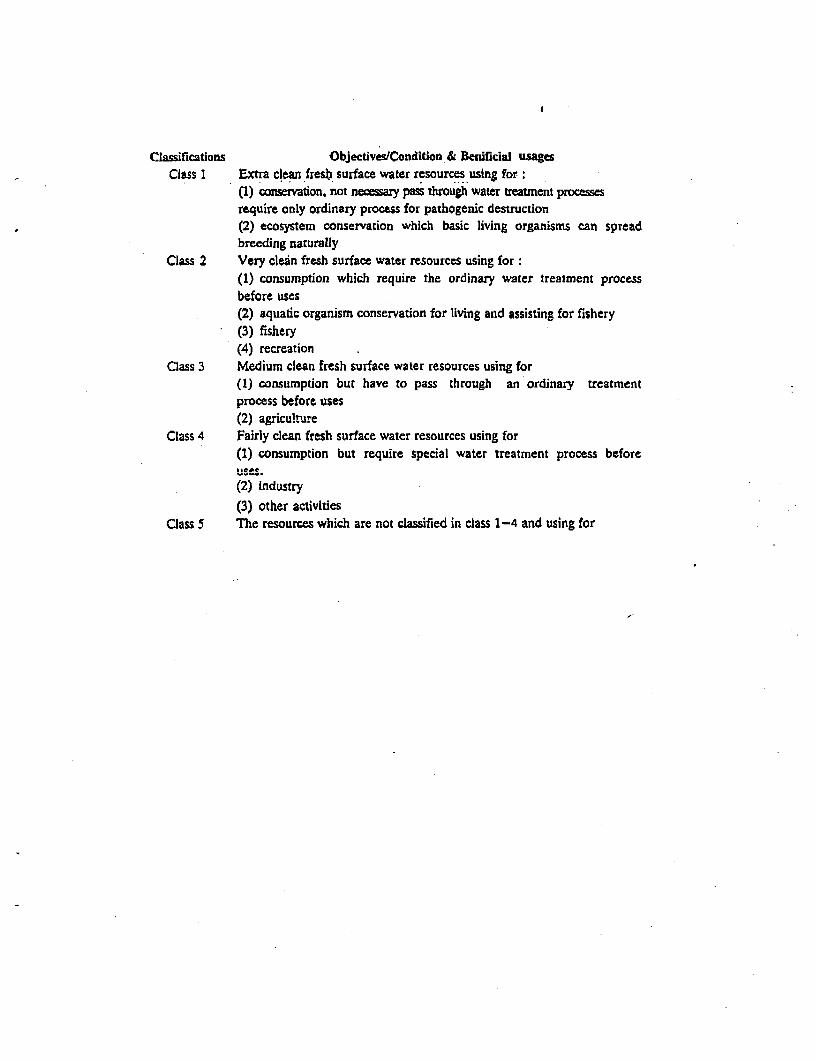
Classifications Objectives/Condition-& Benificial usgesClass 1 Extra clean fresh surface water resources using for:
(1) conservation, not nec zary pass ftiougli water treatment processesrequire only ordinary process for pathogenic destruction(2) ecosystem conservation which basic living organisms can spTeadbreeding naturally
Class 2 Very clean fresh surface water resources using for:(1) consumption which require the ordinary water treatment processbefore uses(2) aquatic organism conservation for living and assisting for fishery(3) fishery(4) recreation
Class 3 Medium clean fresh surface water resources using for(1) consumption but have to pass through an ordinary treatmentprocess before uses(2) agriculture
Class 4 Fairly clean fresh surface water resources using for(1) consumption but require special water treatment process beforeuses.
(2) industry
(3) other activitiesClass 5 The resources which are not classified in class 1-4 and using for
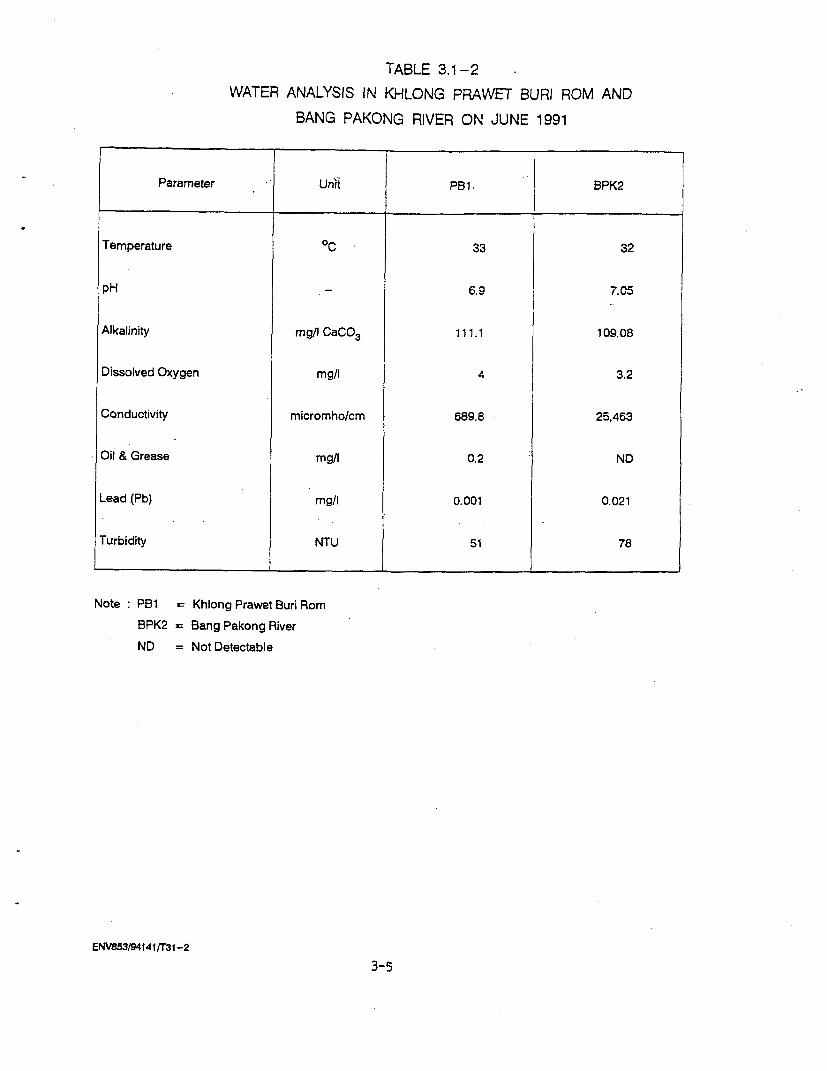
TABLE 3.1-2
WATER ANALYSIS IN KHLONG PRAWET BURI ROM AND
BANG PAKONG RIVER ON JUNE 1991
Parameter Unii PBI. BPK2
Temperature OC 33 32
pH 6.9 7.C5
Alkalinity mg/l CaCO3 111.1 109.08
Dissolved Oxygen mg/l 4 3.2
Conductivity micromho/cm 689.8 25,463
Oil & Grease mg/I 0.2 ND
Lead (Pb) mg/l 0.001 0.021
Turbidity NTU 51 78
Note PB1 = Khlong Prawet Buri Rom
BPK2 = Bang Pakong River
ND = Not Detectable
ENV853/941411r31-2
3-5
TABLE 3.1-3
SURFACE WATER QUAUTY BY ONEB; CLASSIFICATION AND OBJECTIVES
Parameter Untis Standard values for class***
J 1 2 3 4 5
1. Temperature nC 1 n' n n
2. pH value n 5-9 5-9 5-9
3. Dissolved oxygen mg/l n 6 4 2
4. BOD (5 days, 200C) mg/l 1.5 2.0 4.0
5. Coliform Bacteria
- Total Coliform MPN/1 00 ml - 5,000 20,000 -
- Fecal Coliform - 1,000 4,000
6. N03 -N mg/l n-… 5.0 --------
7. NH3-N .n------- 0.5--------
8. Phenols n-------- 0.005 …--.- -
9. Cu …n------- 0.1 --------
10. Ni n-------- 0.1 -------
11. Mn n-------- 1.0…-------
12. Zn n-------- 1.0--------
13. Cd w n 0.005*, 0.05** --- _-.--
14. Cr (Hexavalent) n-------- 0.05 ---- ___
15. Pb n-------- 0.05 ------
16. Hg (total) n …------- 0.002 --------
17. As …n------- 0.01 --------
18. CN n-------- 0.005 …--.- -19. Radioactivity
- Gross Becquerel/l ------- 0.1 --------
- Gross B n …------- 1.0 -------
20. Pesticides (Total) mg/I n …------- 0.05 --------
- DDT ug/l n------- 1.0--------
- BHC n-------- 0.02-------
- Dieldrin n-------- 0.1 -------
- Aldrin n …------- 0.1 -------
- Heptachlor & n-------- 0.1 -------
Heptachlor epoxide
- Endrin n-------- none --------
Note P = Percentile valuen = Naturaln' = Natural but changing not more than 30C.* = When water hardness not more than 100 mg/l as CaCO3
** = When water hardness more than 100 mg/l as CaCO3= Water Classification
ENV853/94141/T31 -33-6
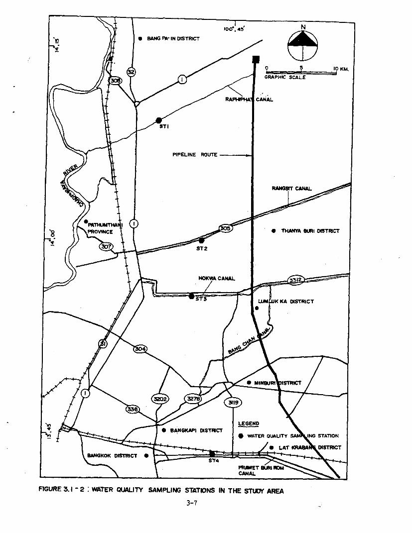
i_n 0 BANG P*- IN DISTRICT /t
j = A i > D / < ~~~~~~~~~~~GRAPHIC SCALEl
t W \) / / RA1 ~~~~~~~~CANAL
n f Nl PIPELINEPIPELROUROUT
§ ^^ P§MfNCE T * TA &IR Dt5TRICT
/ / STS j K K~~~~~~~~~A DISTRICT
r I * 8^~~~~~~BNGKAP DISTFICT _ ; . * ~~~~~~~~~~~~~WATER OUA LITY NG STATION
l~~~~~~~~~~~~~ LA T KRAN>
t8NGOKDtSTRCT * 3ST
FIGURE 3.1 -2: WATER OlALITY SAMPLING STATIONS IN THE STUIN ARE-A
3-7
W<w>>?~~~~~~ icr e (\k.N32(~~~~~~~~~~~~~~~~~ ~~~~0 5 10 KM.
RAHIC SCALE
Z A t T z -t I ~~~~~~~~~~~~~PIPELINE ROUTE30
r / N"CT | t \ / \OI TtC
ke ~~~~~~~~~~CHACHOEIG~
BA KONG DISTRICT
LEGEND
GULF OF THAILAND X-' < / o' * WATER QUAUTY SAMP STATION
FIGURE 3.1- 2: I CONT' D )
Canal condition Turbid water with debris and muddy
sediment.
Station 3 (St.3) Hok Wa canal
Location : In front of Khlong Chan Temple
Canal usage Agricultural and domestic uses
Nearby land use pattern Khlong Chan Temple and mixed
orchard area
Canal condition High water level and high flow.
Sand and debris were found in canal
bed.
Station 4 (St.4) Prawet Buri Rom canal
Location . In front of Lanboon Temple
Canal usage Agricultural purposes
Nearby land use pattern Temple and domestic area
Canal condition : Some aquatic weed, moderate turbid
water with muddy canal bed.
Station 5 (St.5) Bang Pakong River
Location : In front of Tha-Sa-An Temple
River Usage : Agricultural, Industrial and
Transportation
Nearby land use pattern : Agricultural and Industries areas.
At each sampling site, water samples were collected by using
Water Sampler Bottle. Water samples were collected at the middle of the
canal and at the surface and the mid-depth (3 m below the surface) of the
water column. Determined water characteristics are shown in Table 3.1-4
and standard methods for examination of water and wastewater by AWWA-APHA-
WECF (1992) was employed.
3.1.2.1 Results of the Study
The results of the study on water quality at the designated
sampling stations (Table 3.1-5), on December 21-22, 1993 are presented
below:
The temperature and pH of the stations 1-5 were quite similar
with water temperature ranging from 24.5-28eC and pH from 6.8-7.7,
ENV853/94140/CHAP- ItI
3-9

TABLE 3.1-4
CHARACTERISTICS OF WATER SAMPLES TO BE DETERMINE
Water Sample
Physical Characteristics Chemical Characteristics
Depth - m Conductivity (umhos/cm)
Temperature (air, water) - °C pH
Dissolved Oxygen - mg/l
Suspended Solid - mg/l
Alkalinity - mg/l
Oil & Grease - mg/l
Total Lead - mg/l
ENV853/94141/T31 -4
3-10

TABLE 3.1 -5
THE RESULTS OF WATER QUALITY SAMPLING STATIONS MAIN WATERWAYS
TO BE INTERSECTED BY PIPELINE (DECEMBER 21-22,1993)
St.1 St.2 St.3 St.4 St.5
Parameter
S M S M S M S M S M
Depth (m.) 2 2 1.5 1.5 2.5 2.5 2.5 2.5 4 4
Air Temperature (CC) 28 28 27.5 27.5 30 30 28 28 31.5 31.5
Water Temperature CC) 24.5 24.5 25 25 26 26 25 24.5 28 28
pH 7.5 7.7 7.4 7.4 7.2 7.2 6.9 7 7.3 7.5
Dissolved Oxygen (mg/I) 3.8 4 1.6, 1.2 1.8 1.4 5 4.8 5 4.6
Conductivity (umhoslcm.) 280 200 300 230 290 300 1200 1200 >5000 >5000
Alkalinity, as CaCO3 (mg/L) 85.4 85.4 101 101 111 111 212 209 80.7 80.2
Solids, Suspended (mg/L) 8.8 8.8 16.4 19.5 16.8 20.5 11.0 15.2 50.5 46
Oil & Grease (mg/L) <0.20 - 0.20 - <0.20 - <0.20 - <0.20 -
Lead, Total (mg/L) 0.001 0.002 0.002 0.005 <0.001 0.005 0.006 <3.00i 0.002 0.01
Remark Sampling Station
Sti = Rapeepatra Canal (in front of Payom Temple)
St2 = Rangsit Canal (in front of Moonjinda Temple)
St3 = Hok Wa Canal (Khlong Chan Temple)
St4 = Prawet Burl Rom Canal (Lanboon Temple)
St5 =Bang Pakong River
S = Surface water samples
M = Mid-depth water samples
- = No measurement was taken
ENV853I941 4iTAB31 -5
respectively. The dissolved oxygen were fluctuated at each of station. At
the st6tion 2 and 3 were low concentration (ranged from 1.2-1.8 mg/1)
meanwhile the station 4 and 5 were high concentration (ranged from 4.8-7
mg/1), which indicated the contamination from the different sources and
activities. At all s-mnpling stations for water quality were found total
lead and Oil & Grease, at low concentration. However the total lead at
station 5 Bang Pakong River, 0.01 mg/l was found concentration higher than
the station 1 to 4.
Considering the suspended solid within all waterways, it was
reported that at all sampling stations the SS levels here relatively high
ranging from 8.8 (at Rapeepatra canal) to 50.0 mg/l (at Bang Pakong
river).
From the analytical results, it is suggested that the water
quality on the designated waterways can be classified in class 4 and 5
(see Table 3.1-3), acceding to notification by Ministry of Science,
Technology and Environment.
3.2 AOUATIC ECOLOGY
3.2.1 Literature Review
(1) Plankton and Benthos
Plankton and benthos samples at Khlong Prawat Buri Rom and
Bang Pakong River collected on June 5, 1991. Identification results are
shown in Table 3.2-1, indicated that a total of 6 species of Phytoplankton
were found at Khlong Prawet Buri Rom belong to 3 phyla as follows: Phylum
Chlorophyta 3, Phylum Cyanophyta 2 and Phylum Euglenophtyta 1. A total of
11 species of Phytoplankton were collected at Bang Pakong River belonging
to 3 Phyla as follows: Phylum Chlorophyta 1, Phylum Cyanophyta 2 and
phylum Chrysophyta 8. The number of zooplankton species found at Khlong
Prawat Buri Rom and Bang Pakong River were 7 and 5 respectively.
Concerning the density of planktonic organisms, at Khlong Prawet Buri Rom
the Planktonic density was 36,102 ind/m3 relatively lower than the Bang
ENV853/94140/CHAP-I11
3-12

TABLE 3.2-1
NUMBER OF SPECIES AND DENSITY OF PLANKTON
IN KHLONG PRAWET BURIROM AND BANG PAKONG RIVER (JUNE 1991)
Density (Ind./m3
Group
Khlong Prawet Burirom Bang Pakong River
PHYTOPLANKTON No. of Species: 6 No. of Species: 11
Chlorophyta
- Closterium 132 660
- Ankistrodesmus 1,320
- Senedesmus 660
Cyanophyta
- Oscillatoria 1,650 15,180
- Poiycystis 990 660
Euglenophyta
- Phacus 660 _
Chrysophyta- Chaetoceros _ 4,620
Coscinodiscus _ 12,540
_ Riddulphia _ 660
- Bacteriastrum _ 660
- Planktonella _ 660
- Rhizosolenia 660- Pleurosigma 660
- Fragiilbria . 660
Subtotal 5,412 37,620
ZOOPLANKTON No. of Species: 7 No. of Species: 5
- Rotifera 7,590
- Young Copepod 1,320
- Copepod 17,820 72,930
- Watermite 1,320 660
- Zooflagellates 660
- Cladocera 1,320 660
- Larval stage of 660 6,600
Polychaeta- Protozoa _ 660
Subtotal 30,690 81,510
Grand Total 36,102 119,130
ENV853/94141fr32-1 3-13
Pakong River's of 119,130 ind/m3. It is noted that Phylum Chrysophyta was
found only in Bang Pakong River due to the estuarine condition, of this
river.
According to the results of benthos samples, no benthos were
found in Khlong Prawet Buri Rom and Banz Pakong.River. This can best be
explained by the nature of the river beds which are dredged quite often
thus, the suitable habitat for the benthic organism is relatively scarce.
3.2.2 Results from Field Work
3.2.2.1 Plankton Organisms
Species composition and the abundance of plankton organisms
collected from 5 sampling stations during 21-22 December, 1993 was shown
in Table 3.2-2.
(1) Khlong Prawet Burirom 23 species of plankton organisms was
found and consisted of 10 species of phytoplankton and 13 species of
zooplankton. The abundance of phytoplankton was 1,785 cell/litre and the
zooplankton was only 442 organisms/litre. The phytoplankton population are
consisted of Blue green algae Oscillatoria sp. 1,256 cell/litre or 70.36%
of the total populations.
(2) Khlonz RapeeRatra There were 10 species of phytoplankton
with the total density of 3,709.35 cell/litre. The filamentous blue green
algae SPirogyra sp. was found at the density of 3,466.67 cell/litre or
93.45%.of total number of phytoplankton. Thirteen species of zooplankton
found at the density of 866 individual/litre. Arthropod was the most
abundance group of zooplankton.
(3) Khlong Runz Sit The plankton populations was consisted of
13 species of phytoplankton and 14 species of zooplankton. Phytoplankton
density was 2,104 cell/litre and the zooplankton was 212 individual/litre.
Three species of blue green algae Merismopedia, Oscillatoria and Spirulina
were found at the density of 1,760, 80.67 and 7.33 organisms/litre
respectively.
(4) Khlong Hok Va This water body has low number of species
diversity of plankton organisms. There were only 10 species of
ENV853/94140/CHAP- 111
3-14
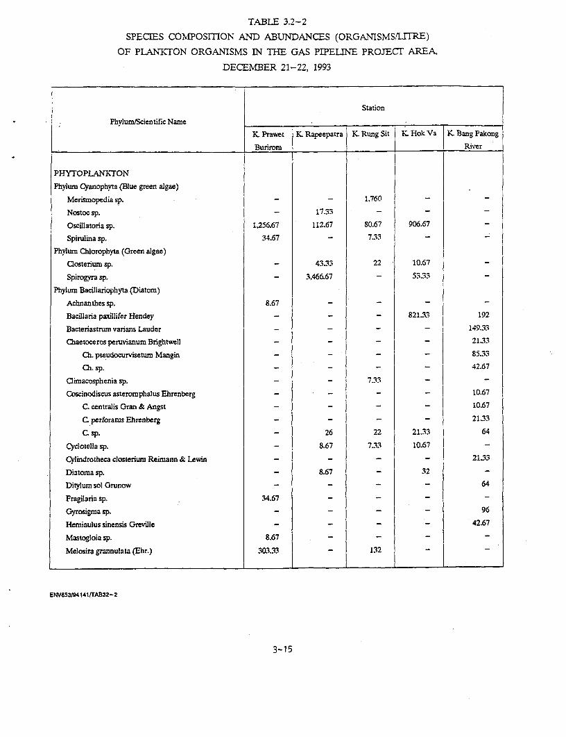
TABLE 3.2-2
SPECIES COMPOSMON AND ABUNDANCES (ORGANISMS/LITRE)
OF PLANKrON ORGANISMS IN THE GAS PIPELINE PROJECT AREA,
DECEMBER 21-22, 1993
Station
Phylum/Scientific Name . : _
K Prawet K Rapeepatra K Rung Sit K Hok Va K Bang Pakong
Burirom _ River
PHYTOPLANKTON
Phylum Cyanophyta (Blue green algae)
Merismopedia sp. _ _ 1.760 _
Nostoc sp. _ 1733 - - _
Oscilatoria sp. 1,256.67 112.67 80.67 906.67
Spirulina sp. 34.67 _ 7.33 -
Phylum Chlorophyta (Green algae)
aosterium sp. _ 4333 22 10.67
Spirogyra sp. - 3,466.67 - 53.33
Phylum Bacillariophyta (Diatom)
Achnanthes sp. 8.67 - - -
Bacillaria paxillifer Hendey - - _ 821.33 192
Bacteriastrum varians Lauder _ _ - 149.33
Chaetoceros peruvianum Brightwell _ - - - 21.33
Ch. pseudocurvisetum Mangin - - - 85.33
Ch. sp. - - - - 42.67
Climacosphenia sp. - - 7.33 - -
Coscinodiscus asteromphalus Ehrenberg - - - _ 10.67
C centralis Gran & Angst _ - - - 10.67
C perforatus Ehrenberg - - - - 2133
C sp. - 26 22 21.33 64
Cyclotella sp. - 8.67 7.33 10.67
Cylindrotheca closterium Reimann & Lewin _ - - - 21.33
Diatoma sp. - 8.67 _ 32 -
Ditylum sol Grunow - - _ _ 64
Fragilaria sp. 34.67 _ - -
Gyrosigma sp. - _ - _ 96
Hemiaulus sinensis Greville - _ _ _ 42.67
Mastogloia sp. 8.67 _- _
Melosira grannulata (Ehr.) 303.33 _ 132 _
ENVS53/941414rAB32-2
3-15
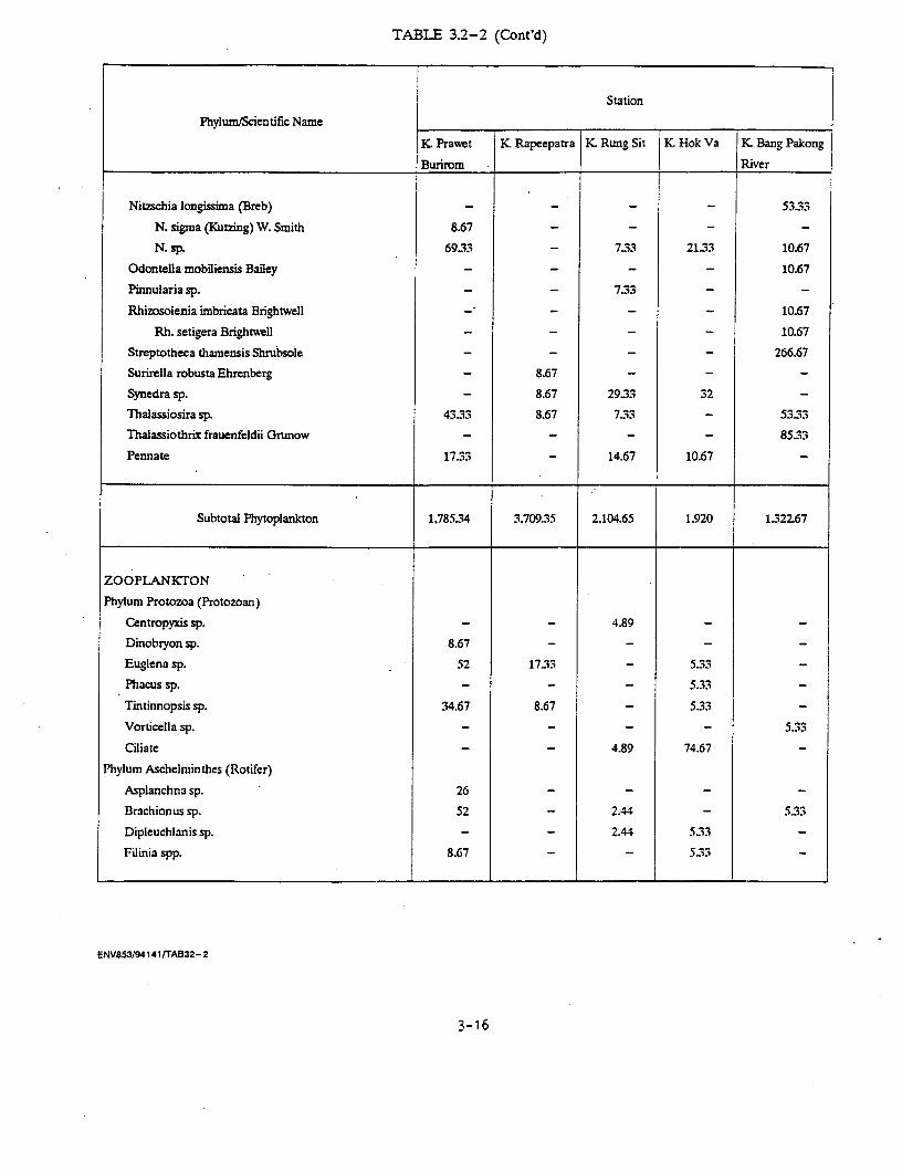
TABLE 3.2-2 (Cont'd)
Station
Phylum/Scientific Name
K Prawet K Rapeepatra K Rung Sit 1 K Hok Va K Bang Pakong
_________________________________ Burirom IRiver
Nitzschia longissima (Breb) _ _ _ - 53.33
N. sigma (Kutzing) W. Smith 8.67 _ _ -
N. sp. 69.33 7.33 21.33 10.67
Odontella mobiliensis Bailey _ - - - 10.67
Pinnularia sp. _ _ 733 - -
Rhizosolenia imbricata Brightwell - _ _ - 10.67
Rh. setigera Brightwell _- - 10.67
Streptotheca thamensis Shrubsole _- - 266.67
Surirella robusta Ehrenberg 8.67 - - -
Synedra sp. - 8.67 2933 32 -
Thalassiosira sp. 4333 8.67 733 - 5333
Thalassiothrix frauenfeldii Grunow - - - - 85.33
Pennate 17.33 _ 14.67 10.67
Subtotal Phytoplankton 1,785.34 3.70935 2,104.65 1.920 1.32267
ZOOPLANKTON
Phylum Protozoa (Protozoan)
Centropyxis sp. - _ 4.89 _
Dinobryon sp. 8.67 - - -
Euglena sp. 52 17.33 - 5.33
Phacus sp. - - - 5.33
Tintinnopsis sp. 34.67 8.67 - 5.33
Vorticella sp. - - - - 5.33
Ciliate - - 4.89 74.67
Phylum Aschelminthes (Rotifer)
Asplanchna sp. 26 - - - -
Brachionus sp. 52 - 2.44 - 5.33
Dipleuchianis sp. - - 2.44 5.33
Filinia spp. 8.67 - - 5.33
ENV853194141/rA832-2
3-16
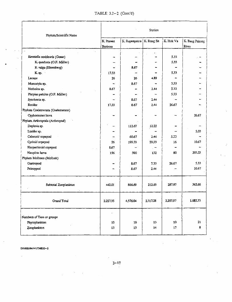
TABLE 3.2-2 (Cont'd)
Station
Phylum/Scientific Name
K Prawet K Rapeepatra K Rung Sit K Hok Va j K. Bang Pakong
Burirom , River
Keratella cochlearis (Gosse) _ _ - 5.33
K quadrata (O.F. Miiller) _- - 5.33
K valga (Ehrenberg) - 8.67 - -
K sp. 17.33 - - 5.33_
Lecane 26 26 4.89 -
Monostyla sp. _ 8.67 - 533 _
Notholca sp. 8.67 - 2.44 5.33
Platyias patulus (O.F. Miiller) - - - 5.33
Synchaeta sp. - 8.67 2.44 _
Rotifer 1733 8.67 2.44 26.67
Phylum Coelenterata (Coelenterate)
Cyphonautes larva - - - - 26.67
Phylumn Arthropoda (Arthropod)
Daphnia sp. - 112.67 12.22 -
Lucifer sp. _ _ - - 5.33
Calanoid copepod - 60.67 2.44 5.33
Cycloid copepod 26 199.33 29.33 16 10.67
Harpacticoid copepod 8.67 - - -
Nauplius larva 156 390 132 80 293.33
Phylum Mo]Jusca (Mollusk)
Gastropod _ 8.67 7.33 26.67 5.33
Pelecypod - 8.67 2.44 - 10.67
Subtotal Zooplankton 442.01 866.69 212.63 287.97 362.66
Grand Total 2.227.35 4.576.04 2.317.28 2.207.97 1.68533
Numbers of Taxa or groups
Phytoplankton 10 10 13 10 21
Zooplankton 13 13 14 17 8
ENV853M4141/rA32-2
3-17
phytoplankton found with the total density of 1,920 cell/litre. They
consisted of 2 dominant species which were Blue green algae Oscillatoria
SD. 909.67 org./litre and Diatom Bacilluria paxillifer 821.33 cell/litre.
The species composition and the abundance of plankton organism show the
eutrophic of this water body. Zooplankton was very low abundance and the
total of 17 species with density of 287 ind./l. Rotifer was the dominant
group and 9 species of Rotifer were found.
(5) Bang Pakhong River During the sampling period, the river
was in the influence of sea water. The plankton population was the groups
of the estuarine and marine plankton. The phytoplankton of diatom group
was found with the total density of 1,322 cell/litre from 9 species of
diatom. Eight species of zooplankton were found with the total density of
362.66 ind./litre. The dominant groups were Arthropod nauplius larvae and
Cyphonautes larva.
3.2.2.2 Benthic Organisms
Table 3.2-3 shows abundance of benthic organisms in the bottom
surface from five sampling stations during December 21-22, 1993.
Four sampling sites, Khlong Prawet Burirom, Khlong Rapeepatra,
Khlong Hok Wa and Bang Pakong river are freshwater stations and have
similar species composition of benthic organisms. There were two dominant
groups in these water body, aquatic earthworm of Family Tubificidae and
the chironomid larvae of Family Chironomidae. No mollusk group found at
Khlong Pravet Burirom. In Khlong Hok Wa only Tubificids and Chironomids
species were found at the total density of 1,276 ind./sq.m. The total
abundance varied from 176-1,276 organisms/sq.m. of bottom surface.
There was only polychaete group found in the bottom surface of
Bang Pakhong River at Tha Sa An. The abundance of polychete of 0.1-0.4 cm.
length size was 44 organisms/sq.m.
3.2.2.3 Aauatic Weeds
Twelve species of aquatic weeds (Table 3.2-4) were found growing
both in the Bang Pakong river and marsh areas. Of these, species, i.e.,
ENV853/94 140/CHAP- 111
3-18

TABLE 3.2-3
BENTHIC ORGANISMS (INDIVIDUAL PER SQUARE METER
OF BOTTOM SURFACE AT FIVE SAMPLING STATIONS,
DIE"CENvER '21-22, 1-93
Station
Organisms , _
K Prawet K Repeepatrg KRungSit K Hok IKBang Pakon.Burirom K. River
Phylum Annelida
Class OlgochaeteFam. Tubificidae 88 132 704 1,100 -
Class Polychaete _- - - 44
Phylum Arthropoda
Class Insecta
Family Chironomidae 88 572 132 176 -
Phylum Mollusca
Class Gastropoda
Family Viviparidae
Filopaludina sp. - 88
Class Bivalvia
Family AmblemidaePilsbryoconcha sp. - 44 _
Ensidend sp. _ 44 -
Uniandra sp. _ 44 _ _
Total Density (ind./sq.m.) 176 792 968 1,276 44
ENV853/94141/TAB32-3
3-19
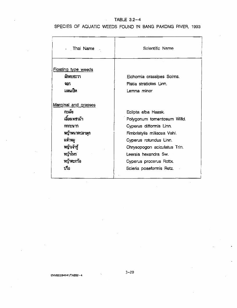
TABLE 3.2-4
SPECIES OF AQUATIC WEEDS FOUND IN BANG PAKONG RIVER, 1993
Thai Name . Scientific Name
Floating type weeds
Ahlztflm Eichornia crassipes Solms.
san Pistia stratiotes Unn.
LLUULtfl Lemna minor
Marginal and grasses
riuiu Eclipta alba Haask.
tiauLwULzi? Polygonum tomentosum WilId.
nnfuin Cyperus difformis Unn.
Fimbristylis miliacea Vahl.
LLWIIUJ Cyperus rotundus Linn.
Chrysopogon aciculatus Trin.
iuririlii Leersia hexandra Sw.
1YIrfl1sn Cyperus procerus Rottx.
Ta Scleria poaeformis Retz.
3-20ENV853/941 411TA632-4

PaK Tob Java (Eichornia crassipes), Chawk (Pistia stratiotes), and Nae Ped
(Lemna minor) were classified as floating type weed and were seen floating
at freshwater zone of the river. The rest 9 species are marginal and
grasses.
3.2.2.4 Fishery
(1) Fish Stecies Comvosition
Tarnchalanukit, et al (1991) reported that altogether 82
species of fishes, shrimps, mantis shrimps, jelly fish, crabs, squid, and
mollusc were caught by set bag and push net in 1991 in Bang Pakong river.
Fish samples collection were also made in the same year (September-
November) with totally 14 families, 27 genera, 37 species of fish and
shrimps were found.
From literature reviewed it can be roughly concluded that
totally 209 species of fish and other aquatic animals were found in the
Bang Pakong river.
All of the above mentioned aquatic animals d. gr ate
naturally up and down in the Bang Pakong river. Some are daily and some
are seasonally migration due mainly to level of water salinity and the
amount of rainfall that is directly affected to salt water intrusion.
(2) Fishery Activities -
The major fishing ground in the river was along both sides
around the river mouth and their main fishing season cover the whole year.
The monthly average fishing trips was 18 with an average of 6 fishing
hours per trip. The amount of fish caught per trip ranging between 2-180
kg. Push net and set bag were very effective that some 60-180 kg was
caught per trip per day. All of the fish caught were for their own
household consumption and sent to local fresh markets.
ENV853/94140/CHAP-111
3-21

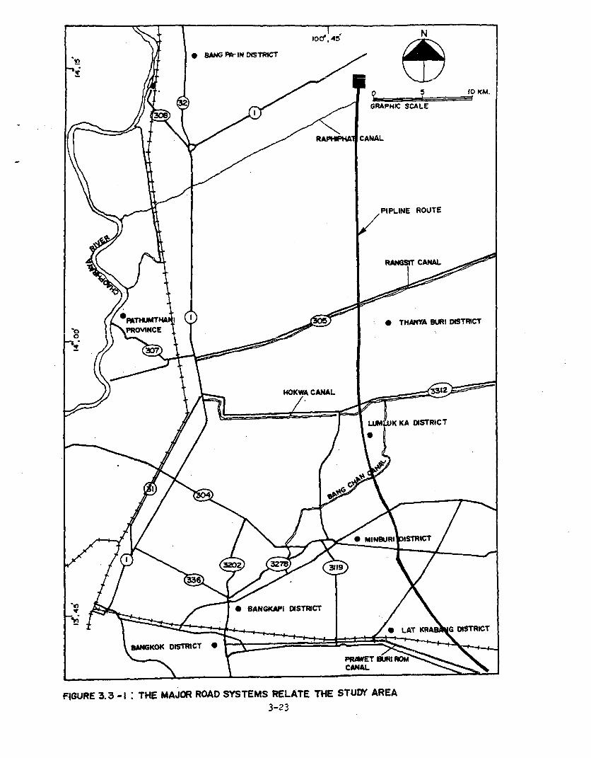
3.3 TRANSPORTATION
The proposed gas transmission pipeline route will intersect 6
major highways in Ayutthaya, Pathum Thani, Bangkok, Chachoengsao, Samut
Prakarn and Chonburi Province, most of which are of asphaltic concrete
pavmment (F'inire 'A 1'-1 Thp n vaernrinilv t,raffi. vn1iime. nn the
concerned highways in 1992 of Route 1, 305, 304, 314 and 3312 are
tabulated in Table 3.3-1.
The highest average daily traffic volume were found on Route 1
with the total of about 31,200 vehicles per day with 45.98 percent -of
heavy vehicle. On the other route the percentage of heavy vehicle is
rather lower than Route 1. And the highway with the lowest average daily
traffic volume was Route 305 with the total of about 15,324 vehicles per
day.
3.4 INFRASTRUCTURE AND PUBLIC FACILITIES
(1) Chachoengsao Province
(a) Electricity
At present, the electricity power supply in
Chachoengsao could served 73,264 household consumers in 738 villages
(93.29 percent of total villages). EGAT have planned for 3 substations and
three 22 kV. transmission line.
(b) Water Sunolv
Chachoengsao provincial waterworks could generated 460
cu.m./hour supply 11,040 cu.m./day for 6,954 households. Though the demand
for water supply is higher than the supply of the waterworks. For Bang
Pakong waterworks, it could generated 200 cu.m./hour but the water quality
is not quite good due to salt water in trusion.
(2) Pathum Thani Province
(a) Electricity
There are 3 offices under the Provincial Electricity
Authority in Pathum Thani province such as:
- Pathum Thani Provincial Electricity responsible for
Muang, Lat Lu-m Kaeo and Sam Khok district which
ENV853/94140/CHAP- 111
3-22
in BAN | *IN DMTRC Tl
.,~~~~~~~~~~~~~~~~~~~~~~ 10 KM-/)0 \ 8 < / ~ ~~~~~~~R 1 CANAL
L s~~~~~~~~~~~~~~PIPLINE ROUTE
it~~~~~~~~~~~~~~~~AGI CARNAL
|-90 )) FlTvUMT1 A0 X THA1M WR ISfCT
* / / 2 ~~~~~~~~~~~~~~~~K KA DISTRICT
It ,* BANGKAPI DISTRICT/ \
h j /~~~~~~~~~~~~~~~~ LAkT DAN6 DCT
B8ANGKOK DISTRICT*
FIGURE 3.3 -1 : THE MAJO ROAD SYSTEMS RELATE THE STUD AREA3-23

322 327 0 MIE R| 0K .
GRAPHIC SCALE
DISTRICT< ( \ A * G DISTRICT
GULF OF THAILAND *- ---.
FIGURE 3.3 -1: l(CONT'DP)
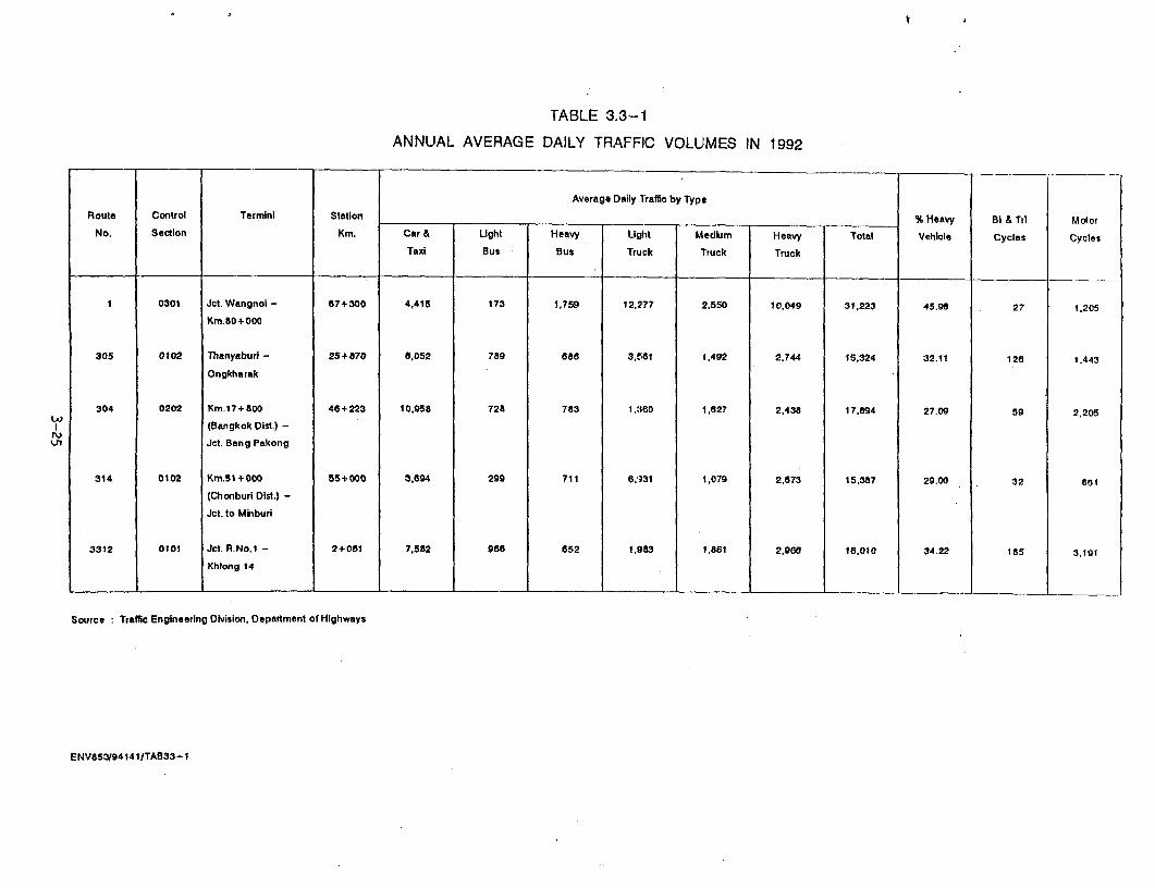
TABLE 3.3-1
ANNUAL AVERAGE DAILY TRAFFIC VOLUMES IN 1992
Average Daily lraffic by Type
Route Control Terminl Station % Heavy BI & Tri Motor
No. Section Km. Car & Light Heavy Light Medium Heavy Total Vehicle Cycles Cycles
Taxi Bus Bus Tru:k Truck Truck
1 0301 Jct. Wangnol - 67+300 4,415 173 1,759 12,277 2,550 10,049 31,223 45.9a 27 1,205
Km.80+000
305 0102 Thanyaburi - 25+870 8,052 789 688 3.511I 1,492 2,744 15,324 32.11 126 1,443
Ongkharak
304 0202 Km.17+800 46+223 10.958 728 783 1,360 1.827 2,438 17,894 27.09 59 2,205
(Bangkok Dist.) -
Jet. Bang Pakong
314 0102 Km.51+000 55+000 3.694 299 711 6,131 1,079 2,673 15,387 29.00 32 8a1
(Chonburi Dist.) -
Jct. to Minburi
3312 0101 Jct. R.No.1 - 2+061 7,582 968 652 1,983 1,861 2,966 18,010 34.22 185 3,191
Khhong 114
Source Traffic Engineering Division. Depaitment of Highways
ENV853/94141/TAB33-1

comprised of 32,053 household consumers and 373
large consumers (Industrial and Business) with the
maximum demand of 135 MW.
- Rangsit Provincial Electricity responsible for
Khlong Tmangc prt of Thanryaburi district and
Rangsit market which comprised of 32,000 household
consumers and 525 large consumers with the maximum
demand of 201 MW.
- Thanyaburi District Provincial Electricity
responsible for Thanyaburi, Lam Luk Ka and Nong Sua
district which comprised of 23,940 household
consumers and 269 large consumers with the maximum
demand of 47.5 MW.
- Water Supply
* Pathum Thani Provincial Waterworks was
responsible for 3,600 households in Muang
district and Ban Dua, Bang Luang subdistrict with
the productive capacity of 6,000 cu.m./day.
* Prachathipat Provincial Waterworks was
responsible for 6,151 households in Prachathipat,
Khlong Nung, Khu Kot subdistrict and Rattanakosin
village with the productive capacity of 20,880
cu.m./day.
3.5 LAND USE
3.5.1 Introduction
Pipeline route will pass through a long distance of land.
Although most of the lands are in the vicinity of EGAT Transmission Line,
it might cause some impact to the environment or communities. To study
present land use along the pipeline route can be used to estimate the
impact and can find suitable mitigation measures.
ENV853/94140/CHAP-111
3-26
3.5.2 Objective
-'"he objective of exi.sting land use study along the pipe line
route are as follows:
(1) To study the existing land use patterns along the route
(2) To assess the impacts on land use patterns due to the
project
(3) To recommend appropriate measures to alleviate the
3.5.3 Scone of Work
The land use study has been scoped to cover the route Bang
Pakong-Wang Noi. The widthness of the route is 40 meters.
3.5.4 Study Methodology
The study of land use has been carried out as following steps:
(1) Office Work
Collecting all references, topographic maps, and exact
pipeline route.
(2) Field Work
After obtaining the preliminary information from the office
work, field survey and observation were conducted. The detailed of land
use types were made and all land use types in the map were measured by
suing planimeter.
3.5.5 Result of the Study
In land use survey on the pipeline route, Bang Pakong-Wang Noi,
it was found that the route was located within the vicinity of EGAT
Transmission Line (about 12 meters for single power line and in the middle
line for double power line). So there is no problem about land
acquisition. There are several land use types (Figure 3.5-1). The detail
of each type is as follows:
ENV853/94 140/CHAP-111
3-27

El~ ~ ~ ~ E
2 N
>~~~~~
'-1~~~~-
I- /GCRAPHIC SCAL.EIn
SN-ML3OL
\ / !O___NGAS TRANSMISSION ROUTH
a 1 \ f V \ - ~~~~~~~~~~~~~~~~STUDY AREAW:\ / <\ ~~~~~~~~~~~~~~ROAD
-151,0 N 1- 1I1 RAILROADRIVER, KHLONG
_ ( 8 KHLONG MA> @ AMPHOE
LANDUSE TYPE
/ |$ \ g \B`KLONG THA S \/
LEGEND
/ 1 ~~~~= PADDY
4 ,; -/ | 2 = MIXED ORCHARDSAMPHOE BAN PAKO \ 3 =FISH POND
4 'NIPA PALM
S B. LANG KHAO 5 = VILLAGE VICINITY
| uZX \ \ >8 ~~~KHAO DIN/
KEY MvAl'i,496,00O N
} / s ' V 1 <A~~~M KHAN5
B <ONG B sANG NANG 2
. ~ANG SAMAE B OEN THAWON
-1,491,000 N
\)BANGSAMAN
\ / / ./WA~~~~~~~~~~~~~~~NG NOICOMPRESSOR
STATIONB. MAN SAM KLIEO
FIGr 35 I I I- I R I I _Ur
FGlJRE 3,5-1I EXISTING ll.ND USE ON PIPE LINE ROUTE
7C5,OCO E 7i0,000 E 715-00C E
r 2N
- = GP APHIC SCAL2
-1,516,000 Nji o f~
SY MiBOL LEGEND
~ 7 5g/ f <,,;,/ -- GAS TRANSMISSION ROUTH 1 PADDY -
5 \ ! q ,' * STUDY AREA 2 MIXED ORCHARDS
\1 \ ( ,/< - ROAD 3 = FISH POND
B K,LONG PRAWET BURl ROM I I I -I-I RAILROAD 4 ' NIPA PALM
7& ,/s RIVER, KHLONG 5 = VILLAGE VICINITY
r 7w-++,, vO ~~~~~AMPHOECD LANDUSE TYPE
<A7\ \1 ~~~. PRENGk
1,511,000 N
\. KRACHANG TOEIl
t B r llb 9 0 ~ ~ ~~~~~~7>9 GL PHRAYA NAKHARA
< e(/ af/ \ ~~~~~~~~~KHLONG K(HWANG
1,~~OBKEN'ODAN1,506,000 N
FIGURE 3 : 8S BA)G KHWAI j)
_ } / \ \ ( ~~~~~~~~~~~~~~~ ~ ~ ~ ~~~~~~B. Km2t BANG C H A
-1,50t,000 N _
FIGURE 3.5 -1: I CONT 'D)
093,060K E69A,0O@ E
7C3,000 E
N
'-M AYCH LI \ -i
\\ \ Sl \E LAM tIA TAP 2KM_ _
X A / ~~~~~~l/ GPRpHIC SCALE
5 4- /X'
1,527,000 N , ,
K ~~~~~~~~~~~E_ L A 9 ! <!E. LAM NOK KHWAK/
SSUNGYA ~~~~~~~~~~~~ON
#'~~~~~~~~~~~~~~~~~~~A \1
\AA X
( * / /~~ KEY MIAP
S LAM PIATHI JL AM KS EA \ -
AMP LAT KR_G > S'X(HL0N LAM PI-IAONG 5
1i,512,000 N
/~~~~~~~~~~~
-1,517,000 SAMPHOE LATR BANG /E)
o -H-HH-i-i--i-I-RAILROAD 2 =MIXED ORCHARDS
_ RIVER, KHLONG 3 L FISH POND
© AMPHOE 4 = NIPA PALM
CD LANDUSE TYPE 5 = VILLAGE VICINITY
-1,512,000 N
FIGURE 3.5-I: (CONT'D)
f 6E8,000E 693,000 E 69B,OOO E
N2 K-
M HTCH I-4
/ N SI THI-I PAET NO 6
.~~~~~~~~~~~B KHl-
AMPH-OE LAM LUK GAS TRANSMISSION ROUTH
I ~~~~~~~~~~~~STUDY AREA
B. KHLONG FET ROAD
-H--Ii--II---RAILROAD
1,539,000 NRIVER, KHLONG
-\ \ t - LANDUSE TYPE
_ --- X~~~~~ K KHLONG St
2 \ ; @ , 4 ~~~~LEGEN D
2 = MIXED ORCHARDS
- tf \ \ \ f || 3 = ~~~~~~~~~~~~~~FISH POND
5 VILLAGE VICINITY
\ \B. KO KHUN NEN< |
KEY MAP
BLM TON SAL
-1,529,000 N m IN
' I ., , 1 I COI . ,
FIGURE 3.5-1: /CONT'D)
ses,0o7 E 693;00O E 6EsE OO
S~~~~~~~~~~~~~~~~~~~~~~~~~~~IO 5F
-1557000r I) ( 1I6B K ILONG7 (4j N
jB KHLONGC 6 (4)~ j" -'| ' < wr GRAPHIC SCALE
/| 1 B E N 8. KHLONG 8 5)
1,554,000N NHLO 0'7)5)
B LAM PHAKUT MU TH 2 2 i 1B. LAM PHAK KUT MU TH II (1!
AMPHOE TINYaBuRI SYNIBOLB LAM PHAK KT MU THI I GAS TRANSMISSION ROUTH
-. - STUDY AREA_ > u 2 . | ; ROAD
| KEY MVIAP _ 2 I-I-4-.-4-i-I-+ RAILROAD
-t,5 9,000 N RIVER, KHLONG-,sc9,00oo N 6, _ .KNLONG7)6)- \ { (§) AMPHOE
(Z... ) LANDUSE TYPE
. } 1 4 /}1 | |B. KHLONG SO) TH) PAET 0. B
LEGEND
= PADDY
2 - MIXEV ORCHAARDS
3 =FISH POND_.KHLONG SOI TH) PAET 09 = NIPA PALM
, / / l 1 1 S |~~. 4 =NiPA PALM|
5 = VILLAGE VICINITY
B INHLONG SOl THI KAO NO 3
l 1i3MAT C H|'_ 11 LNE ( LiN
-1.544,000 N
FIGURE 3.5 -1: CONT'0D1
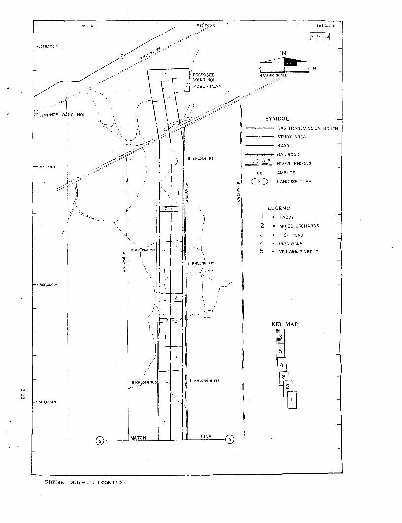
66e,0L0 E 693,0CO E 698,00C E
-2,576,000 IJ,00 , 2 AKM
PROPOSED GRAPHIC SCALEWANG NOI K
POWER PLANT
0 AMPHOE WANG NOI SYMBOL
GAS TRANSMISSION ROUTH
* -\y A1 II . STUDY AREA
, - 1/ I I ; I ROADv < \ | I \I I I 11 q I # I I IRAILROAD
'570 N , | \ B. KHLONG 681) RALRA
-1,575,000 N t , . < l I 2 | ~~~~~~~~~RIVER, KHLONG157i,000/N I I AMPHOED LANDUSE TYPE
,< /)) j 4' >N ~~~~ ~~1 CSW
2 LEGEND
< ' F/ 2 _ I ) 1 PADDYi | I j 2 = MIXED ORCHARDS_ I I . ! 3 = F;SH PONDI'
BKH ,, -j 1 4 = NIPA PALM
-4 N ON I7(2l . B 12 5 = VILLAGE VICINITY
04 1 1 B KHLO 8 t21
44 1 . .
W ~ ~~~~~~~~B. KHYNe 7I S. KHLONG B (3) L
-1,561,000 N
MATCH L_ INE K |A.
FIGURE 3.5-1: I CONT'D /
(1) Paddv field 1
There is 436 rai of paddy field on the route. This area is
located on low land which always flooded in rainy season. Most of paddy
are planted only in rainy season started from July to December. Source
which located in irrigated are can be planted.
(2) Mixed Orchard 2
In the area of Amphoe Thanyaburi and Amphoe Nongsua, fruit
trees are grown on elevated beds with intervening ditches, to improve soil
drainage. Dike are built around the orchard to provide flood protection.
Fruit trees found in the area are tangerine pomelo and mangoes.
(3) Fish Pond : 3
Fresh water fish initially developed on rice fields by
pondering technique. They are found mostly in Amphoe Thanyaburi. The main
species grown are chinese carp and dace. In the area near the sea such as
in Amphoe Bang Pakong, black tiger prawn is commonly found.
(4) Nioa Palm : 4
In the area that is occasionally flooded by sea water, much
as in Amphoe Bang Pakong, Nipa Palm is commonly found.
(5) Village Vicinity : 5
This land use type is located near the village. The area is
always left as idle land only few places that the owners grow rice.
Miscellaneous
The route in also pass roads, canals and river. The name of
roads, canals and river are as follows:
Road : No 315, 314, ARD Road, Luang Pang Road, No. 3120,
No. 304, Ratch Uthit Road, No. 3312, No. 305 and
Irrigation road.
Canals : Ban Kao, Phraya Samut, Prawet Burirom, Udom Chon
Kachon, Phra Ong Chao Chiyanuchit, Luang Pang, San
Saeb, Lower Samwa, Klong Pad and Upper Samwa.
River The Bang Pakong river.
(The area of each land use type is shown in Table 3.5-1).
ENV853/94140/CHAP-Il
3-34
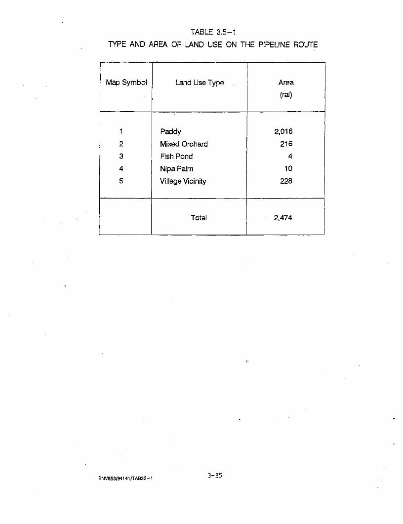
TABLE 3.5-1
TYPE AND AREA OF LAND USE ON THE PIPELINE ROUTE
Map Symbol Land Use Type Area
(rai)
1 Paddy 2,016
2 Mixed Orchard 216
3 Fish Pond 4
4 Nipa Palm 10
5 Village Vicinity 228
Total 2,474
ENV853/94141rAB3S-1 3-35
3.6 SOCIO-ECONOMIC
3.6.1 Scope of the Studv
The socio-economic studied area covers parts of 4 provinces,
i.e., Saraut Prakarn, Chachoengsao, Bangkok and Pathum thani of-which 9
Amphoe (Districts) are involved; these Amphoe are Bang Bo and Bang Phli of
Samut Prakarn, Amphoe Muang and Bang Pakong of Chachoengsao, Minburi and
Lat Krabang of Bangkok, and Lam Luk-Kha, Thanyaburi and Nong Sua of Pathum
Thani. Within these 9 Amphoe, there are 18 Tambon and 27 villages (Muban).
The studied area was divided into 2 categories; the first one
being area which the existing gas pipelines operate (along the highway)
and the second area of the proposed gas pipeline following the high
voltage power line. The first area passes through 11 villages 7 Tambon 5
Amphoe of 3 provinces (Table 3.6-1); the second area passes through 15
villages 11 Tambon 7 Amphoe of 4 provinces (Table 3.6-2).
3.6.2 Objectives of the Study
(1) To obtain knowledge about socio-economic condition of people
living in the areas of the existing and proposed gas pipelines.
(2) To learn of people's awareness of the project including
their perception and opinion of the project in both the existing and
proposed gas pipeline areas, particularly opinion about compensation
payment of the proposed gas pipeline in order to be able to recommend
about this matter meaning fully, if this is necessary.
(3) To study the impact of the existing gas pipeline upon the
nearby communities and the impact of the high voltage power line including
the expected impact of the proposed gas pipeline to be used as basic data
reducing the negative impact of the proposed gas pipeline.
3.6.3 Methods of Study
This study aims at getting first-hand primary data of people
living in communities within 500 meter radius of the proposed gas pipeline
ENV853/94140/CHAP-111
3-36

TABLE 3.6-1
SAMPLING SITE AND SAMPLE SIZE OF THE FORMER GAS PIPELINE
Village T_mbon A Aphroe
No.
9 Bang Cha-Loke Bang Phli Samut Prakarn 10
5 Racha Thewa Bang Phli Samut Prakarn 2
6 Racha Thewa Bang Phli Samut Prakarn 8
2 Min Buri Min Buri Bangkok Metropolis 10
1 Bung Kam Ploi Lam Luk-Kha Pathum Thani 5
3 Rangsit Thanya Buri Pathum Thani 5
3 Bung Ba Nong Sua Pathum Thani 6
5 Bung Ba Nong Sua Pathum Thani 5
6 Bung Ba Nong Sua Pathum Thani 2
4 Bung-Ka-Sam Nong Sua Pathum Thani 4
5 Bung-Ka-Sam Nong Sua Pathum Thani 3
Total 60
Note:
ENV853/94141 /T36- 1 3-37
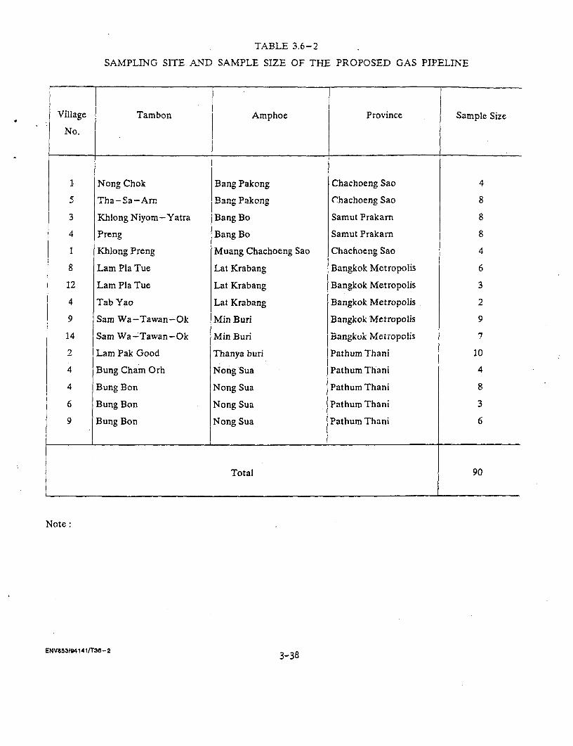
TABLE 3.6-2
SAMPLING SITE AND SAMPLE SIZE OF THE PROPOSED GAS PIPELINE
Village Tambon Amphoe Province Sample Size
No.
1 Nong Chok Bang Pakong Chachoeng Sao 4
5 Tha-Sa-Arr. Bang Pakong Chachoeng Sao 8
3 Khlong Niyom-Yatra Bang Bo Samut Prakarn 8
4 Preng Bang Bo Samut Prakarn 8
1 Khlong Preng Muang Chachoeng Sao Chachoeng Sao 4
8 Lam Pla Tue Lat Krabang Bangkok Metropolis 6
12 Lam Pla Tue Lat Krabang Bangkok Metropolis 3
4 Tab Yao Lat Krabang Bangkok Metropolis 2
9 Sam Wa-Tawan-Ok Min Buri Bangkok Metropolis 9
14 Sam Wa-Tawan-Ok Min Buri Bangkok Metropolis 7
2 Lam Pak Good Thanya buri Pathum Thani 10
4 Bung Cham Orh Nong Sua Pathum Thani 4
4 Bung Bon Nong Sua Pathum Thani 8
6 Bung Bon Nong Sua Pathum Thani 3
9 Bung Bon Nong Sua Pathum Thani 6
Total 90
Note.
ENV853/94141IT38-2 3-38
or the high voltage power line by interviewing samples with structured
interview schedules. Steps of the study can be divided as follows:
(1) Interview Schedule PreRarations: There are two sets of
interview schedule; the first set for interviewing people living in
.ommunities .f e.ierin.a.r.s .s;nolin. srA t.ha carn. f n.o fn.r .he.a l.i.i
in the area of proposed gas pipeline. Important information contains in
both sets of interview schedule can be elaborated below (detailed
structure appeared in the Appendix A).
(a) For those Living in the Existing Area:
- General information, e.g., sex, age, status within
the family, education, religion, original domicile
and migration.
- Socio-economic information of the household, e.g.,
household size, family members divided by age,
education, employment, occupation, income,
expenditure, debts, land holding, housing
condition and other valuable properties.
- Knowledge and awareness of the existing gas
pipeline of those living here before the
construction and those who moved to live here
after the construction had been completed
including their knowledge of the project.
- Impact of the project recalled from . their
experience of both groups (living before and after
the project construction); their opinions
particularly concern with the compensation paid
and degree of their satisfaction.
(b) Interview Structure for those in the Proposed Area:
- General information, more or less the same with
above.
- Socio-economic information of the household more
or less the same with those in the existing area.
- Impact of the high voltage power line and the
compensation perceived by villagers.
=Information about the proposed gas pipeline
ENV853/94140/CHAP- 111
3-39
project which will be constructed parallel to the
high voltage powerline,
- Opinions and attitudes toward the proposed gas
pipeline project.
- Impacts expected from the proposed gas pipeline
project and opinions about rate of compensation
and other relevant matters.
These interview schedules were pretested in the
fields.
(2) Population Frame and Sampling Techniques:
Because the studied area is not very wide only 500 meters
from the pipeline on both sides but very long about 225 km altogether (120
km along existing gas pipeline and 105 km along the high voltage power
line), the method of selecting samples for interview is to be specially
designed by using the military map (ratio 1:50,000) as a basic
information. The existing and proposed gas pipelines (high voltage power
line) are thereafter used as diameters for drawing of samples from
households living within the radius of 500 meter on both sides.
Enumerators were later sent to actually count the numbers of household
some of which situated by canals, amish gardens, close to fish pond, etc.
All of these made the counting very difficult. The population (household)
counting was done on the 4 January, 1994; the samples were designed to be
fairly distributed among various groups of households to be their
representatives as much as we can do.
(3) Sampling Technigues: The Multi-stage Sampling Technique
was employed as follows:
(a) Village Sampling: In order to have samples
distributed fairly and squarely, villages within the span area of 20 km
were picked as samples. However, if found villages of different occupation
or ethnic group, these villages were also picked as additional samples.
By this way, we finally selected 11 villages as samples for the existing
pipeline area (Table 1); for the proposed pipeline area, we used the same
method but with shorter range (13 km) altogether 8 spans. See more details
in Table 3.12-2.
(b) Household SamDling: The purposive method of sample
ENV853/94140/CHAP- 1I1
3-40
selection was used at this stage by considering occupation and ethnicity
as a supplement factor. The sample size was about 10 percent of the
population (household). The total sample selected was 150, 60 of which
being in villages of existing gas pipeline and 90 samples in the proposed
pipeline area.
(4) The Field Survey:
The trained enumerators went out to the field to interview
samples (training was done on the 10th of January 1994) according to plan
set forth earlier.The field survey was conducted during 11-15 and 29
January 1994. The field supervisor has checked the data collected in the
interview schedules to make sure that the collected data are valid and
reliable.
(5) Data Tabulation and Analysis:
Data tabulation and analysis was done in Bangkok by using
computers; the organization of data has been divided into 2 sections,
i.e., those in the existing pipeline and in the area of proposed pipeline.
3.6.4 Results of the Study
3.6.4.1 The Existing Gas Pipeline Area
(1) General Characters of the Samples: It was found that the
majority of samples (86.7%) being in the working age (21-60 yrs.) of
which 30 percent between 41-50 years old. 78.3 percent of samples managed
to complete at the primary level of education; the rest (16.7%) completed
secondary education and. higher. All of the samples reported to be
Buddhists and the majority of them (55.0%) migrated from other places to
live here. However, more than one-half of the immigrants came from nearby
communities within the same provincial boundaries. The most important
reason for coming to live here is economic (63.6%), i.e., to find jobs or
to seek more land to made a living, followed by social reason (27.3%),
i.e., coming along with parents, spouses or for getting marriage. Other
reasons mentioned include being forced to leave former resident (6.1%),
finding better place to live, etc. Thee vast majority of immigrants
ENV853/94140/CHAP- 111
3-41
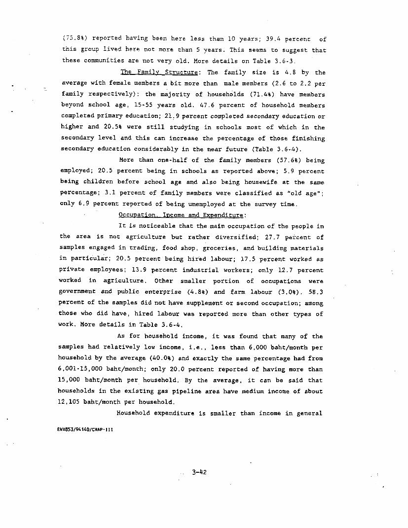
(75.8%) reported having been here less than 10 years; 39.4 percent of
this group lived here not more than 5 years. This seems to suggest that
these communities are not very old. More details on Table 3.6-3.
The Familyv Structure: The family size is 4.8 by the
average with female members a bit more than male members (2.6 to 2.2 per
family respectively): the majority of households (71.4%) have members
beyond school age, 15-55 years old. 47.6 percent of household members
completed primary education; 21.9 percent completed secondary education or
higher and 20.5% were still studying in schools most of which in the
secondary level and this can increase the percentage of those finishing
secondary education considerably in the near future (Table 3.6-4).
More than one-half of the family members (57.6%) being
employed; 20.5 percent being in schools as reported above; 5.9 percent
being children before school age and also being housewife at the same
percentage; 3.1 percent of family members were classified as "old age";
only 6.9 percent reported of being unemployed at the survey time.
Occupation. Income and Expenditure:
It is noticeable that the main occupation of the people in
the area is not agriculture but rather diversified; 27.7 percent of
samples engaged in trading, food shop, groceries, and building materials
in particular; 20.5 percent being hired labour; 17.5 percent worked as
private employees; 13.9 percent industrial workers; only 12.7 percent
worked in agriculture. Other smaller portion of occupations were
government and public enterprise (4.8%) and farm labour (3.0%). 58.3
percent of the samples did not have supplement or second occupation; among
those who did have, hired labour was reported more than other types of
work. More details in Table 3.6-4.
As for household income, it was found that many of the
samples had relatively low income, i.e., less than 6,000 baht/month per
household by the average (40.0%) and exactly the same percentage had from
6,001-15,000 baht/month; only 20.0 percent reported of having more than
15,000 baht/month per household. By the average, it can be said that
households in the existing gas pipeline area have medium income of about
12,105 baht/month per household.
Household expenditure is smaller than income in general
ENV853/94140/CHAP- I I I
3-4 2
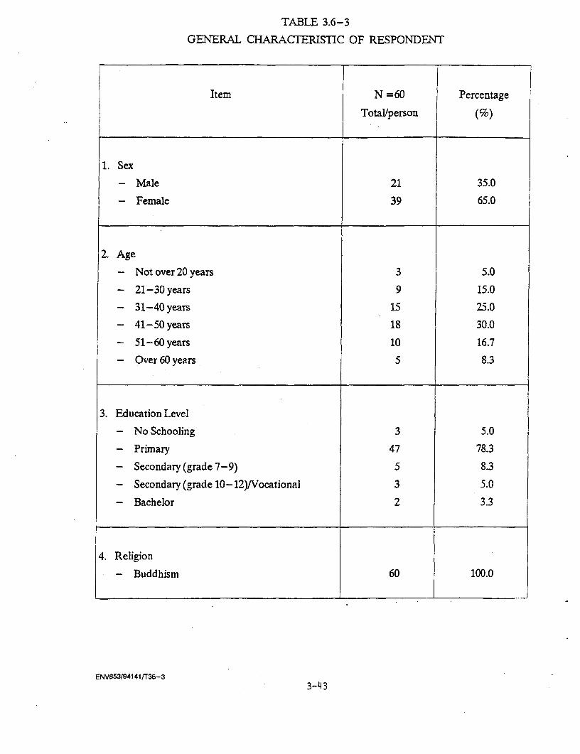
TABLE 3.6-3
GENERAL CHARACTERISTIC OF RESPONDENT
Item N =60 Percentage
Total/person (%)
1. Sex
- Male 21 35.0
- Female 39 65.0
2. Age
- Not over 20 years 3 5.0
- 21-30 years 9 15.0
- 31-40 years 15 25.0
- 41-50 years 18 30.0
- 51-60 years 10 16.7
- Over 60 years 5 8.3
3. Education Level
- No Schooling 3 5.0
- Primary 47 78.3
- Secondary (grade 7-9) 5 8.3
- Secondary (grade 10-12)/Vocational 3 5.0
- Bachelor 2 3.3
4. Religion
- Buddhism 60 100.0
ENV553/94141/T36-3
3- 43

TABLE 3.6-3 (Cont'd)
Item iN = 60 Percentage
Total/person (%) j
5. Migration
- No 27 45.0
- Yes 33 55.0
5.1 Migration from
- Other Village of This Tambon 6 18.2
- Other Tambon of This Amphoe 1 3.0
- Other Amphoe of This Province 13 39.4
- Other Province 13 39.4. __ __ _________________________ _-------------_------------
5.2 Reasons of Migration
- Seek job li 333
- Follow Parents or Spouse 3 9.1
- Marriage 6 18.2
- No Agricultural Land 10 30.3
- Forced to Move away 2 6.1
- For Convenient Transportation 1 3.0__ __ _________________________ ------------- -------------
5.3 Amount of Time Living here
- Not over 5 years 13 39.4
- 6-10 years 12 36.4
- 11-15 years 1 3.0
- 16-20 years 2 6.1
- Over 20 years 4 12.1
- No answer 1 3.0
ENV853/94141/T36-3 3 -44

TABLE 3.6-4
STRUCTURE OF HOUSEHOLD
Item N = 60 Percentage
Total/person (%)
1. Size of Household
(person/household)
- Male 2.2 45.8
- Female 2.6 54.2…_ __ __ ___ ___ ____ ___ ____ ___ __---- - - -- - -- --- -- -- -- -- -- ----- ---
Average (Persons/household) 4.8 100.00
2. Age Range of Household's Member
- Not over 14 years 53 18.4
- 15-25 years 73 25.3
- 26-35 years 58 20.1
- 36-45 years 47 16.3
- 46-55 years 28 9.7
- Over 55 years 29 10.1
Total 288 100.0
3. Education of Household's Member
- No schooling 12 4.2
- Pre school 17 5.9
- Primary school 137 47.6
- Secondary school 39 13.5
- Diploma 14 4.9
- Bachelor 10 3.5
- In school 59 20.5
Total 288 100.0
ENV85319414 1tT36-4 3-45
TABLE 3.6-4 (Cont'd)
Item Data N = 60 Percentage
Tota'uperson (%)
In schooling
- Kindergarten 3 5.1
- Primary school 22 37.3
- Secondary school 23 39.0
- Diploma 5 8.5
- Bachelor 6 10.2
Total 59 100.0
4. Working status of Household's member
- Working 166 57.6
- Unemployed 20 6.9
- Retired (senility) 9 3.1
- Children (Pre-school) 17 5.9
- Student 59 20.5
- Housewife 17 5.9
Total 288 100.0
5. Main Occupation of Household's Member
- Agriculture 21 12.7
- Goverment officiaVPublic 8 4.8
Enterprise Employee
- Employee of private sector 29 17.5
- Farm Labour 5 3.0
- Trading 46 27.7
- Hired Labour 34 20.5
- Industrial Labour 23 13.9
Total 166 100.0
ENV853/94141/736-4 3-46

TABLE 3.6-4 (Cont'd)
Item Data N = 60 Percentage
Total/person (%)
Trading
- Groceries 16 34.8
- Building materials 2 4.3
- Food stalls 24 52.2- Construction business 2 4.3
- Fresh vegetables 2 4.3
Total 46 100.0
ENV853/941 41/T36-4
with 58.4 percent of samples having less than 6,000 baht a month; 30.0
percent spent from 6,001 to 15,000 baht a month. However, the average
household expenditure was only about 8,580 baht per month. When compare
with family income, if was obvious that most households had higher income
than expenditure about 3,525 baht a month; this corresponded with debt
situations of which 70 percent of samples reported no debts at the survey
time. As for those who were in debt (30.0%), the average unpaid debts per
household were about 157,191 baht a family. More details in Table 3.6-5.
Family Properties: Land ownership in the area is almost
identical in percentage with land rent, i.e., 46.7 and 41.7 percent
respectively; the remaining 10 percent reported living on other's land and
smaller percentage on mortgaged land. 82.4 percent of land was used for
rice farming; 9.7 percent for growing other crops and 8 percent was used
as residential area. More details in Table 3.6-6.
Other important family property is the house itself; the
house structure in the studied area is mostly permanent with 61.7 percent
of the houses being one storey wooden built; 18.3 percent half-brick and
half wood structure; 11.7 percent being wooden shophouse; the rest was
concretely built as houses and shophouses; only 3.3 percent of houses were
reported as temporary shelters being built by bamboo and leaves covering
as roofs. These houses and building were about 56 meter away from the
existing gas pipelines by the average and 90 percent of them were situated
not more than 200 meter from working places. More details in Table 3.6-6.
(2) Information about the Proiect
Among the samples interviewed, 58.3 percent have been
living here before the construction of the gas pipeline; the rest lives
here after the construction. The information about the project was divided
into two periods, i.e., information before the construction and during the
construction of the gas pipeline.
Before the construction period, it was found that 71.4
percent of samples did not receive any information about the project; only
28.6 percent of them received the information. Among those who received
the information, 30 percent received it from the survey technicians,
followed by reading from the notice board in the project area and from
Kamnan and village heads (20% each). Information received was minimal,
ENV853/94140/CHAP- I11
3-48
TABLE 3.6-5
OCCUPATION AND ECONOMIC STATUS OF RESPONDENTS
Item N =60 Percentage
Total/person (%)
*.~~~~~ .,.a11~J..UJUi1., Main OC Cu- p-a .iri
- Agriculture 8 13.3
- Trading 18 30.0
- Employee of Private Sector 10 16.7
- Industrial Labour 9 15.0
- Government Official 3 5.0
- Retired Official 2 3.3
- Hired Labour 10 16.7
2. Supplementary occupation (more than 1 answer)
- No Supplementary Occupation 35 58.3
- Agriculture 2 3.3
- Trading 5 6.7
- Employee of Private Sector 4 6.7
- Industrial Labour 5 8.3
- Government Official 0 0.0
- Hired Labour 7 11.7
- Retired Official 2 3.3
3. Total Income of Household
(baht/household/month)
- Not over 2,000 baht 3 5.0
- 2,001-4,000 baht 10 16.7
- 4,001-6,000 baht 11 18.3
- 6,001-8,000 baht 6 10.0
- 8,001 - 10,000 baht 6 10.0
- 10,001-15,000 baht 12 20.0
- 15,001-20,000 baht 4 6.7
- Over 20,000 baht 8 13.3
Average (baht/HH) 12105.25
ENV853194141/T36-53-49
TABLE 3.6-5 (Cont'd)
item N =60 Percentage
Total/person (%)
4. Total Expenses of Household
(baht/household/month)
- Not over 2,000 baht 7 11.7
- 2,001-4,000 baht 15 25.0
- 4,001-6,000 baht 13 21.7
- 6,001-8,000 baht 5 8.3
- 8,001-10,000 baht 7 11.7
- 10,001- 15,000 baht 6 10.0
- 15,001-20,000 baht 2 3.3
- Over 20,000 baht .5 8.3
-------------------------------------------- ___________-__________
Average (baht/HH) 8580.00
5. Debt
- No 42 70.0
- Yes 18 30.0_____--_____________________________-______________--_____________
Average (baht/Debtor) 157,190.99
ENVS53/9414l1383-53-50
TABLE 3.6-6
LAND HOLDING STATUS AND HOUSING CONDIMON
Item N = 60 Percentage
Total/person (%)
1. Status of Land Owner (%)- Owner 28 46.7
- Rented Land 25 41.7
- Free Use of Others' Land 6 10.0
- Working on Mortgaged Land 1 1.7
2. Land Use (Rai/household)
- Residential 0.33 7.8
- Rice Farming 3.47 82.4
- Other Farming 0.41 9.7
Total (Rai/I-H) 4.21 100.0
3. Present Housing Condition
- Single House, Wooden 37 61.7
- Single House, Wooden and Concrete 11 18.3
- Single House, Concrete 1 1.7
- Row House, Wooden 7 11.7
- Concrete Shophouse 2 3.3
- Cottage 2 3.3
ENV853/94141/T36-6 3-51
TABLE 3.6-6 (Cont'd)
Item N = 60 rercentage
Total/person (g)
4. Distance between Residential
Area and Pipeline (meter)
- 1-10 24 40.0
- 11-20 12 20.0
- 21-50 10 16.7
- 51-100 6 10.0
- 101-200 8 13.3__ __ _________________________ -------------- --------------
Average (Meter) 55.97
5. Distance between Agricultural
Area and Pipeline (meter)
- not over 10 1 10.0
- 11-50 4 40.0
- 51-100 2 20.0
- 101-200 2 20.0
- over 200 1 10.0
Total 10 100.0
Average Distance (Meter) 103.5
ENV853194141/T36-6 3-52
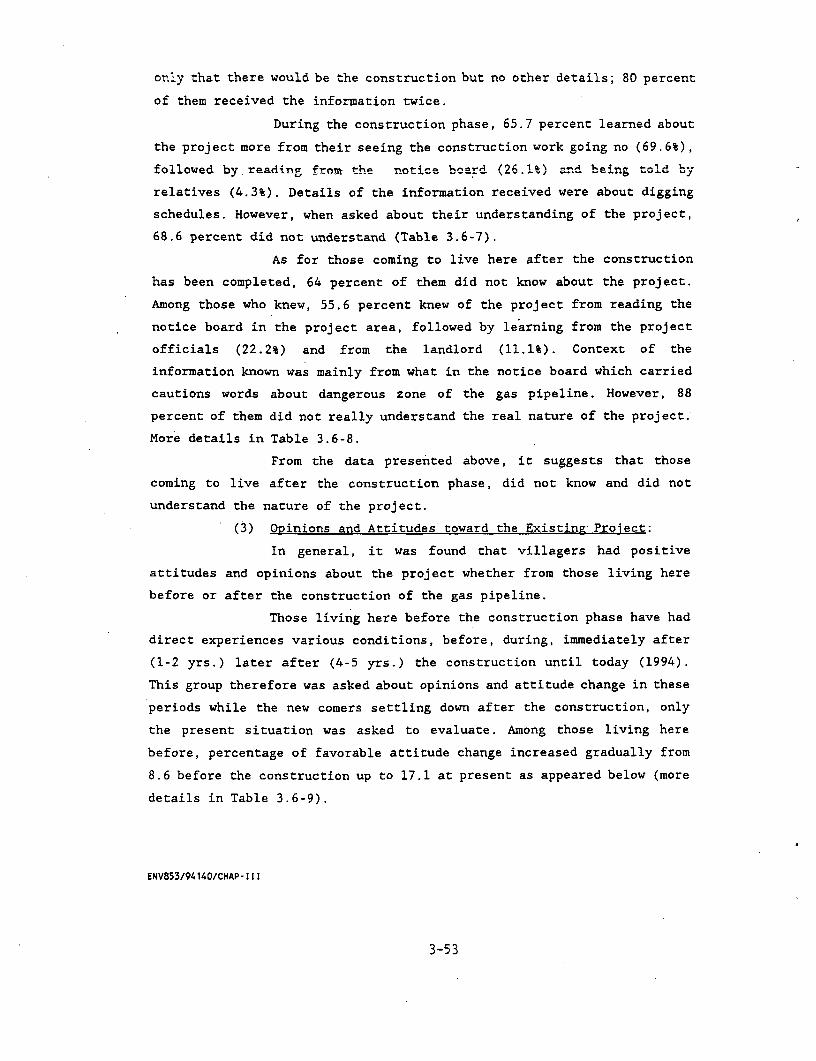
only that there would be the construction but no other details; 80 percent
of them received the information twice.
During the construction phase, 65.7 percent learned about
the project more from their seeing the construction work going no (69.6%),
followed by reading from the rotice (2d (26.1%) a.nd being told by
relatives (4.3%). Details of the information received were about digging
schedules. However, when asked about their understanding of the project,
68.6 percent did not understand (Table 3.6-7).
As for those coming to live here after the construction
has been completed, 64 percent of them did not know about the project.
Among those who knew, 55.6 percent knew of the project from reading the
notice board in the project area, followed by learning from the project
officials (22.2%) and from the landlord (11.1%). Context of the
information known was mainly from what in the notice board which carried
cautions words about dangerous zone of the gas pipeline. However, 88
percent of them did not really understand the real nature of the project.
More details in Table 3.6-8.
From the data presented above, it suggests that those
coming to live after the construction phase, did not know and did not
understand the nature of the project.
(3) Opinions and Attitudes toward the Existing Project:
In general, it was found that villagers had positive
attitudes and opinions about the project whether from those living here
before or after the construction of the gas pipeline.
Those living here before the construction phase have had
direct experiences various conditions, before, during, immediately after
(1-2 yrs.) later after (4-5 yrs.) the construction until today (1994).
This group therefore was asked about opinions and attitude change in these
periods while the new comers settling down after the construction, only
the present situation was asked to evaluate. Among those living here
before, percentage of favorable attitude change increased gradually from
8.6 before the construction up to 17.1 at present as appeared below (more
details in Table 3.6-9).
ENV853/94140/CHAP- 111
3-53
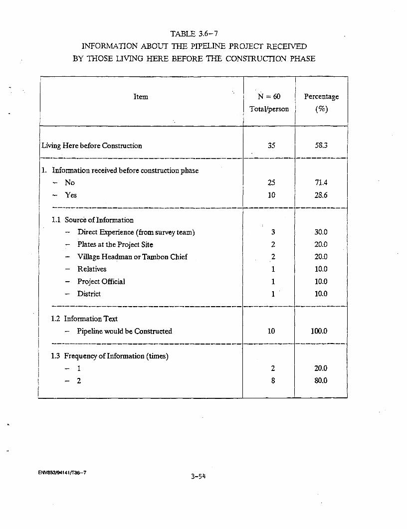
TABLE 3.6-7
INFORMATION ABOUT THE PIPELINE PROJECT RECEIVED
BY THOSE LIVING HERE BEFORE THE CONSTRUCTION PHASE
Item N = 60 Percentage
Totalperson (%)
Living Here before Construction 35 58.3----------------------------------------- ----------.-----------
1. Information received before construction phase
- No 25 71.4
- Yes 10 28.6__--_--_--____________________________-__________. __________
1.1 Source of Information
- Direct Exverience (from survey team) 3 30.0
- Plates at the Project Site 2 20.0
- Village Headman or Tambon Chief 2 20.0
- Relatives 1 10.0
- Project Official 1 10.0
- District 1 10.0__--_--_--____________________________-__________. __________
1.2 Information Text
- Pipeline would be Constructed 10 100.0
1.3 Frequency of Information (times)
-1 2 20.0
-2 8 80.0
ENV853194141/T36-7 3-54
TABLE 3.6-7 (Cont'd)
Item N = 60 Percentage
I U LaJVper,un (/O)
2. Information Received on Construction Phase
- No 12 34.3
- Yes 23 65.7-------------------------------------- _----_-_---_-----------
2.1 Source of Information
- Plates at the Project Site 6 26.1
- Relatives 1 4.3
- Direct Experience 16 69.6-------------------------------------- _----------_-----------
2.2 Information Text
- Digging Period 23 100.0
2.3 Frequency of Infornation Recieved (times)
- 1 18 78.3
- More than 2 2 8.7
- Many times (can not identified) 3 13.0
3. Understanding about the Pipeline Project
- Not at all 24 68.6
- Considerable Understanding 11 31.4
3-55ENV853/94141tT36-7

TABLE 3.6-8
INFORMATION ABOUJT THE PIPELINE PROJECTRECEIVED BY THOSE LIVING HERE AFTER THE CONSTRUC1ION PHASE
Item N = 60 PercentageTotalperson (%)
Living here after construction 25 41.7
1. Information Received after Coming to Live Here
-No 16 64.0-Yes 9 36.0
…_--_--__________________________ -- _ _ _ _ _ _…__ _ _ _--____________
1.1 Source of Information
- Plates at the Project Site 5 55.6
- Project Official 2 22.2
- Land Owner 1 11.1- No Answer 1 11.1
…_-- _-- _ _ _ _ _ _ _ _ _ _ _ _ _ _ _ _ _ _ _ _ _ _ _ _ _ _ _ _ _ _ _ _ _ _ _ _ _ _ _ _ _ _ _ _ _ _ _ _ _ _ _
1.2 Information Text
- Pipeline Direction, Size of Pipeline, 5 55.6
Depth from Surface Level
- Cut-out/dangerous Zone 4 44.4…_--_--_________________________ _____________ _ _ _ _ _ _ _ _ _ _ _ _ _
1.3 Frequency of Information Received (times)
- 2 9 100.0
2. Understanding about the Pipeline Project
- Not at all 22 88.0
- Considerable Understanding 3 12.0
ENV853/94141/T36-8
3-56
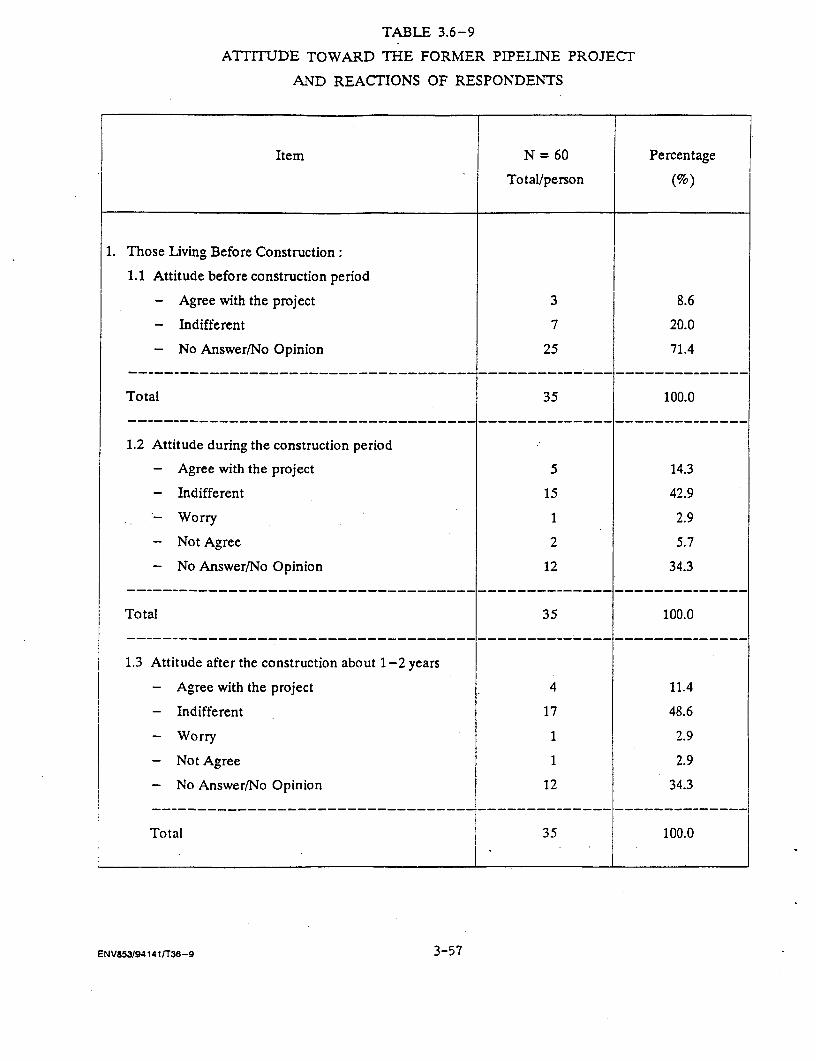
TABLE 3.6-9
ATTITUDE TOWARD THE FORMER PIPELINE PROJECT
AND REACTIONS OF RESPONDENTS
Item N = 60 Percentage
Total/person (%)
1. Those Living Before Construction:
1.1 Attitude before construction period
- Agree with the project 3 8.6
- Indifferent 7 20.0
- No Answer/No Opinion 25 71.4
Total 35 100.0
1.2 Attitude during the construction period
- Agree with the project 5 14.3
- Indifferent 15 42.9
- Worry 1 2.9
- Not Agree 2 5.7
- No Answer/No Opinion 12 34.3
Total 35 100.0
1.3 Attitude after the construction about 1-2 years
- Agree with the project 4 11.4
- Indifferent 17 48.6
- Worry 1 2.9
- Not Agree 1 2.9
- No Answer/No Opinion 12 34.3
Total 35 100.0
ENV853/94141/T36-9 3-57
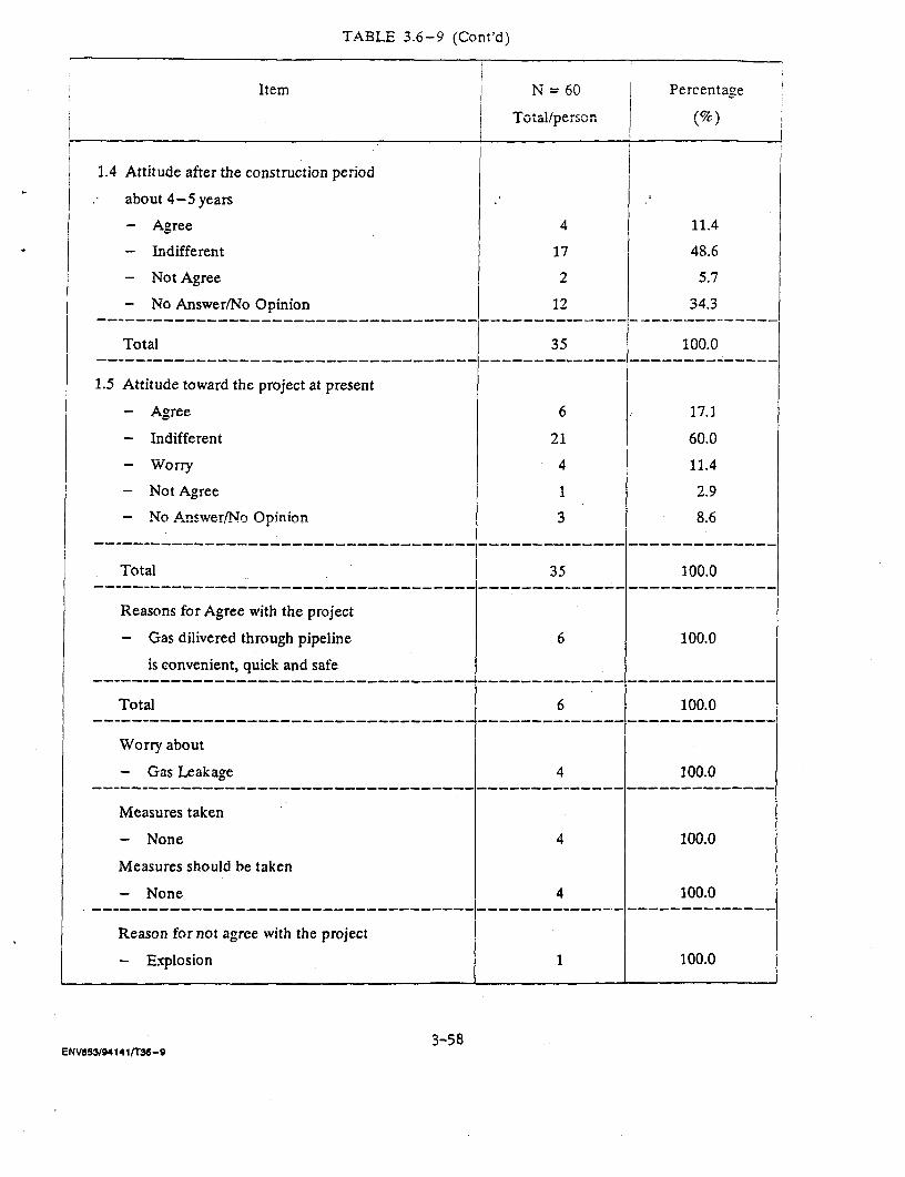
TABLE 3.6-9 (Cont'd)
Item N = 60 | Percentage
l 1 T~~~~~~~~~~~~~ ~~otal/person !5l1.4 Attitude after the construction period
about 4-5 years
- Agree 4 11.4
- Indifferent 17 48.6
- Not Agree 2 5.7
- No Answer/No Opinion 12 34.3
Total 35 100.0
1.5 Attitude toward the project at present
- Agree 6 17.1
- Indifferent 21 60.0
- Worry 4 11.4
- Not Agree 1 2.9
- No Answe/r(No Opinion 3 8.6
Total 35 100.0
Reasons for Agree with the project
- Gas dilivered through pipeline 6 100.0
is convenient, quick and safe------------------------------------ -------------- --------------
Total 6 100.0------------------------------------ -------------- --------------
Worry about
- Gas Leakage 4 100.0------------------------------------ -------------- --------------
Measures taken
- None 4 100.0
Measures should be taken
- None 4 100.0
Reason for not agree with the project
- Explosion 1 100.0
3-58ENVO53/941411T36-9
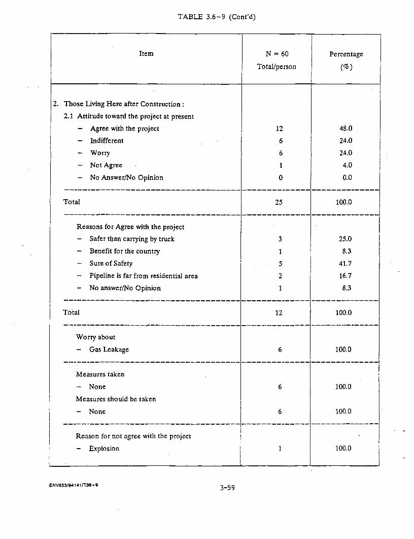
TABLE 3.6-9 (Cont'd)
Item N = 60 Percentage
Total/person (%)
2. Those Living Here after Construction:
2.1 Attitude toward the project at present
- Agree with the project 12 48.0
- Indifferent 6 24.0
- WorTy 6 24.0
- Not Agree 1 4.0
- No Answer/No Opinion 0 0.0
------------------------------------ -------------- --------------
Total 25 100.0-------------------------------------------- ___________-______-___
Reasons for Agree with the project
- Safer than carrying by truck 3 25.0
- Benefit for the country 1 8.3
- Sure of Safety 5 41.7
- Pipeline is far from residential area 2 16.7
- No answer/No Opinion 1 8.3
Total 12 100.0
Worry about
- Gas Leakage 6 100.0
------------------------------------ -------------- --------------
Measures taken
- None 6 100.0
Measures should be taken
- None 6 100.0
Reason for not agree with the project
- Explosion 1 100.0
ENV853/94141fT36-9 3-59
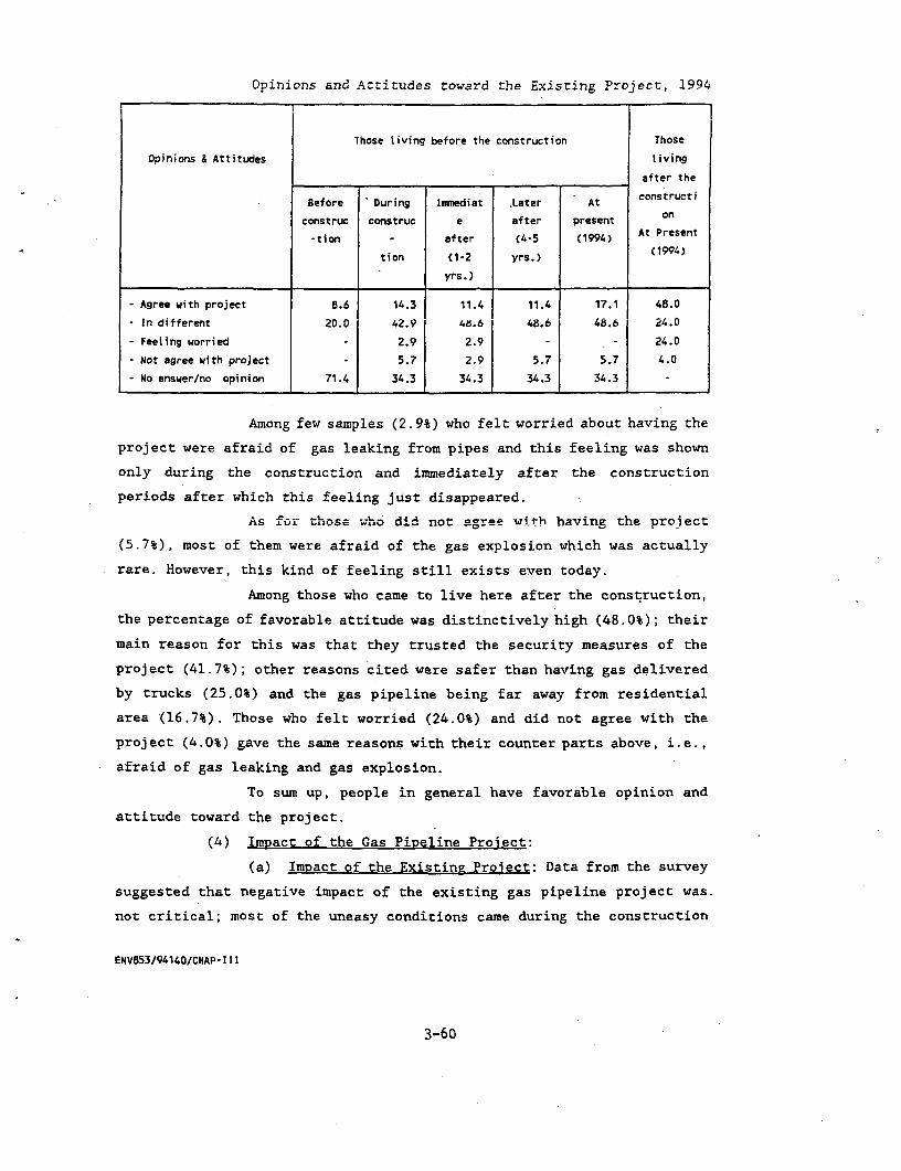
Opinions and Attitudes toward the Existing Project, 1994
Those living before the construction Those
Opinions & Attitudes living
after the
Before During Immediat Later At constructi
construc construc e after present on
-tion a after (4-5 (1994) At Present
tion (1-2 yrs.) (1994)
yrs.)
- Agree with project 8.6 14.3 11.4 11.4 17.1 48.0
- In different 20.0 42.9 4X.6 48.6 48.6 24.0
- Feeling worried - 2.9 2.9 - - 24.0
- Not agree with project 5.7 2.9 5.7 5.7 4.0
- No answer/no opinion 71.4 34.3 34.3 34.3 34.3 -
Among few samples (2.9%) who felt worried about having the
project were afraid of gas leaking from pipes and this feeling was shown
only during the construction and immediately after the construction
periods after which this feeling just disappeared.
As for those who did not agree with having the proiect
(5.7%), most of them were afraid of the gas explosion which was actually
rare. However, this kind of feeling still exists even today.
Among those who came to live here after the construction,
the percentage of favorable attitude was distinctively high (48.0%); their
main reason for this was that they trusted the security measures of the
project (41.7%); other reasons cited were safer than having gas delivered
by trucks (25.0%) and the gas pipeline being far away from residential
area (16.7%). Those who felt worried (24.0%) and did not agree with the
project (4.0%) gave the same reasons with their counter parts above, i.e.,
afraid of gas leaking and gas explosion.
To sum up, people in general have favorable opinion and
attitude toward the project.
(4) Impact of the Gas Pipeline Project:
(a) Impact of the Existing Project: Data from the survey
suggested that negative impact of the existing gas pipeline project was.
not critical; most of the uneasy conditions came during the construction
ENV853/94140/CNAP-III
3-60

period, i.e., disturbance from dust (45.7%), noise (37.1%), vibration
(28.6%), inconvenience in travelling (25.7%), have to change way to get in
and out of one own living place (2.9%). No negative impact reported after
the construction has been completed. More details in Table 3.6-10.
As for compensation for property loss or damage
because of the construction, it was reported that there were only 2 cases
needed to pay compensation for and one of them felt not satisfied with the
compensation paid. One positive impact mentioned was the better road
surface after the construction (Table 3.6-10).
Among those coming to live after the construction, 90
percent of them reported having no negative impact while 10 percent being
afraid of gas explosion.
(b) ExDected Impact of the Proposed Gas Pipeline Proiect:
The vast majority of samples reported of having no positive impact (75.0%)
and no negative impact (83.3%); 25 percent which mentioned positive impact
of the project referred to it as one of many factors for community growth.
Among those who expected negative impact (16.7%.) pointed mostly to
psychological disturbance or deterioration of mental health (70.0%)
including feeling insecure about the safety measures provided by the
project; the rest referred to inconvenience in travelling, poor conditions
in making a living, etc. However, those who felt strongly against the
project's safety measures were not small (40.0%). More details in Table
3.6-11.
3.6.4.2 The Proposed Gas PiDeline Area
(1) General Characters of Samples:
It was found that many characters of the samples in the
proposed area were not significantly different from those of the existing
area. Most of them were in the working age (73.3%), i.e., 21-60 years old;
77.8 percent completed primary education; 14.4 percent finished secondary
school or higher. Minor difference occurred in the religious affiliation
of samples; while all of samples in existing area were Buddhists, 83.3
percent of samples in the proposed area reported of being affiliated to
Buddhism; the rest (16.7%) being Muslim. 67.8 percent of samples migrated
ENV853/94140/CHAP- II I
3-61
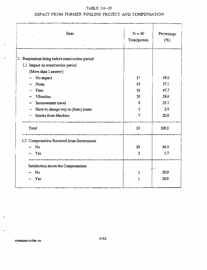
TABLE 3.6-10
IMPACT FROM FORMER PIPELINE PROJECT AND COMPENSATION
Item N = 60 Percentage
Total/person (%)
1. Respondent living before construction period
1.1 Impact on construction period
(More than 1 answer)
- No impact 17 48.6
- Noisy 13 37.1
- Dust 16 45.7
- Vibration 10 28.6
- Inconvenient travel 9 25.7
- Have to change way to (from) home 1 2.9
- Smoke from Machine 7 20.0
Total 35 100.0
1.2 Compensation Received from Government
- No 33 94.3
- Yes 2 5.7
Satisfaction about the Compensation
-No 1 50.0
-Yes 1 50.0
3-62ENV853194141/T36-10
TABLE 3.6-10 (Cont'd)
Item N = 60 Percentage
Total/person (%)
1.3 Changing of Physical Environment after Construction
Dust
- more 5 14.3
- same 23 65.7
- less 7 20.0
Total 35 100.0
Surface of Road
- better 21 60.0
- same 9 25.7
- worse 5 14.3
Total 35 100.0
2. Impact from Pipeline Project to those living after
Construction Period Impact from Pipeline Project
- None 22 88.0
- Worry about Explosion 3 12.0
__--_--________________________________-___________--__________
Total 25 100.0
ENV853/941 41/T36- 10 3-63
TABLE 3.6-11
OPINION ABOUT THE PROPOSED GAS PROJECT
Item N = 60 Percentage
Tota/person (%)
1. Positive Impact
- No Result 45 75.0
- Have Positive Impact 15 25.0-- --------------------- ------- …-- ------- -- …----
Issues of Positive Impact
- Community Growth 15 100.0
2. Negative Impact
- No Result 50 83.3
- Have Negative Impact 10 16.7…-- - - - - - - - - - - - - - - - - - - - - - - - - - - - - - - - - - - - - - - - --- - - - - - - - - - - --- - - -
- Impact on Occupation 1 10.0
- Mind health/anxious about safety system 7 70.0
- Impact on access road 1 10.0
- No Answer/No Opinion 1 10.0------------------------------------------------------------- …
Total 10. 100.0
3. Confidence on Security System of Pipeline Project
- very much 6 10.0
- much 6 10.0
- considerably 24 40.0
- not much 22 36.7
- not at all 2 3.3…--------------------------------------------…--… -------------
Total 60 100.0
ENV853194141Tr36- 11 3-64

from other places not far from the present location, most of which came
from areas within the same province. Among the immigrants, 55.2 percent
cited social reasons for their settling here, i.e., following parents or
spouses; 44.8 percent cited economic reasons, to find jobs, find land and
following the organization's order, etc. Most of the migrants have been
living here more than 10 years (51.7%). More details in Table 3.6-12.
The Family Structure: Family size in this area was larger
than that in the existing area, i.e., 5.2 persons per family;, sex ratio is
equal, 2.6 for male and female member per family by the average. 61.7
percent of family members were between 15 and 55 years old; 57.3 percent
finished primary education; 14.2 percent finished secondary education or
higher and 19 percent of family members were still studying.
The-majority of household members (67.4%) reported to be
employed and only 2.1 percent being unemployed; the rest was reported as
children before school age, studying, being housewife, and old aged. More
details in Table 3.6-13.
Occupation Income and Expenditure:.
main occupation in the proposed area was primarily in
agricultural field, i.e., 44.4 percent in crop planting, 1.9 percent in
fish/other water animal raising; hired labour (21.1%) and industrial
workers (16.1%) were also widespread; the other occupations commanded
smaller proportion, i.e., trading (9.0%), farm labour (0.9%) and
government and public enterprise (Table 3.12-13). It is noticeable that
42.2 percent of samples did not have supplementary occupation; most of the
supplement occupations reported being hired labour and agriculture (Table
3.6-14).
62.2 percent of samples had less than 6,000 baht/month
household income which was relatively low; only 14.4 percent had more than
15,000 baht a month income. However, the average household income per
month was not so low, i.e., 11,834.41 baht. As for the average household
expenditure, it was reported at 7,011.84 baht a month which is
considerably lower than the monthly income.
ENV853/94140/CHAP- I I I
3-65
TABLE 3.6-12
GENERAL CHARACTERISTIC OF RESPONDENT
Item N = 90 Percentage
Total/person (%)
1. Sex
- Male 46 51.1
- Female 44 48.9
2. Age
- Not over 20 years 2 2.2
- 21-30 years 16 17.8
- 31-40 years 22 24.4
- 41-50 years 11 12.2
- 51-60 years 17 i8.9
- Over 60 years 22 24.4
3. Education Level
- No Schooling 7 7.8
- Primary 70 77.8
- Secondary (grade 7-9) 4 4.4
- Secondary (grade 10-12)/Vocational 7 7.8
- Bachelor 2 2.2
4. Religion
- Buddhism 75 83.3
- Islamism 15 16.7
ENV85319414i1T36-12
3-66

TABLE 3.6-12 (Cont'd)
Item N = 90 Percentage
Total/person (%)
5. Migration
- No 61 67.8
- Yes 29 32.2
5.1 Migration from
- Other Village of this Tambon 7 24.1
- Other Tambon of this Amphoe 5 17.2
- Other Amnphoe of this Province 4 13.8
- Other Province 13 44.8
5.2 Reasons of Migration
- Seek job 6 20.7
- Follow Parents or Spouse 4 13.8
- Marriage 12 41.4
- No Agricultural Land 5 17.2
- Work Requirement 2 6.9
5.3 Amount of Time Living Here
- Not over 5 years 7 24.1
- 6-10 years 4 13.8
- 11-15 years 4 13.8
- 16-20 years 3 10.3
- Over 20 years 8 27.6
- No Answer/No Opinion 3 10.3
ENV853/94141 f36-12 3-67
TABLE 3.6-13
STRUCrURE OF HOUSEHOLD
item N.' = 90 Percentage
Total/person (%)
1. Size of Household
(persons/household)
- Male 2.6 50.0
- Female 2.6 50.0
Average (Person/household) 5.2 100.0
2. Age Range of Household's Member
- Not over 14 years 100 20.9
- 15-25 years 83 17.4
- 26-35 years 110 23.0
- 36-45 years 78 16.3
- 46-55 years 24 5.0
- Over 55 years 83 17.4
Total 478 100.0
3. Education of Household's Member
- Pre-School 29 6.1
- No Schooling 16 3.3
- Primary School 274 57.3
- Secondary School 51 10.7
- Diploma 13 2.7
- Bachelor 4 0.8
- In School 91 19.0
__ __ _________________________ ------------- -------------
Total 478 100.0
In schooling
- Kindcrgartcn 10 11.0
- Primary School 50 54.9
- Secondary School 21 23.1
- Diploma 8 8.8
- Bachelor 2 2.2
Total 91 100.0
ENV6S3194141tO-13 3-68
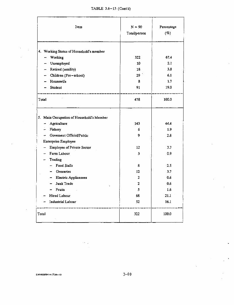
TABLFE 3.6-13 (Cont'd)
Item N = 90 Percentage
Total/person (%)
4. Working Status of Household's member
- Working 322 67.4
- Unemployed 10 2.1
- Retired (senility) 18 3.8
- Children (Pre-school) 29 6.1
- Housewife 8 1.7
- Student 91 19.0
---------------------------------- ------------- I -------------
Total 478 100.0
5. Main Occupation of Household's Member
- Agriculture 143 44.4
- Fishery 6 1.9
- Govement Official/Public 9 2.8
Enterprise Employee
- Employee of Private Sector 12 3.7
- Farm Labour 3 0.9
- Trading
- Food Stalls 8 2.5
- Groceries 12 3.7
- Electric Appliansees 2 0.6
- Junk Trade 2 0.6
- Fruits 5 1.6
- Hired Labour 68 21.1
- Industrial Labour 52 16.1
Total 322 100.0
ENV8531941411T3d-13 3-69
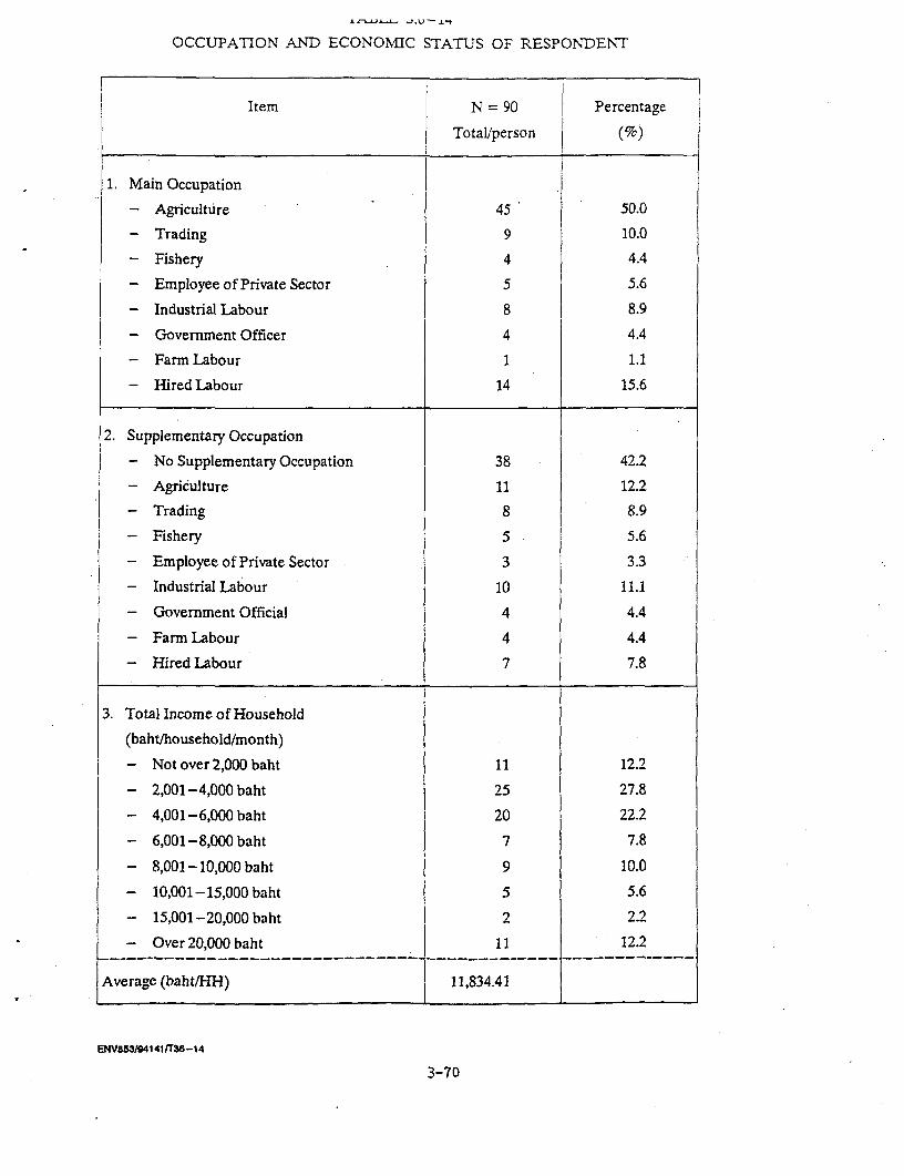
OCCUPATION ANND ECONOMIC STATUS OF RESPONDENT
Item N =90 Percentage
Total/person (%)
1. Main Occupation
- Agriculture 45 50.0
- Trading 9 10.0
- Fishery 4 4.4
- Employee of Private Sector 5 5.6
- Industrial Labour 8 8.9
- Government Officer 4 4.4
- Farm Labour 1 1.1
- Hired Labour 14 15.6
2. Supplementary Occupation
- No Supplementary Occupation 38 42.2
- Agriculture 11 12.2
- Trading 8 8.9
- Fishery 5 5.6
- Employee of Private Sector 3 3.3
- Industrial Labour 10 11.1
- Government Official 4 4.4
- Farm Labour 4 4.4
- Hired Labour 7 7.8
3. Total Income of Household
(baht/household/month)
- Not over 2,000 baht 11 12.2
- 2,001-4,000 baht 25 27.8
- 4,001-6,000 baht 20 22.2
- 6,001-8,000 baht 7 7.8
- 8,001-10,000 baht 9 10.0
- 10,001-15,000 baht 5 5.6
- 15,001-20,000 baht 2 2.2
- Over 20,000 baht 11 12.2
Average (baht/HH) 11,834.41
ENV853/941411T36-14
3-70
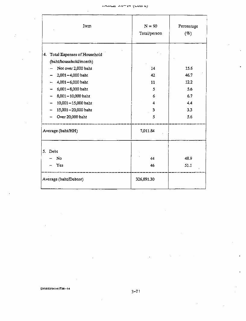
Jrca.U-1't tbU1L U)
Item N = 90 Percentage
Total/person (%)
4. Total Expenses of Household
(baht/household/month)
- Not over 2,000 baht 14 15.6
- 2,001-4,000 baht 42 46.7
- 4,001-6,000 baht 11 12.2
- 6,001-8,000 baht 5 5.6
- 8,001 - 10,000 baht 6 6.7
- 10,001-15,000 baht 4 4.4
- 15,001-20,000 baht 3 3.3
- Over 20,000 baht 5 5.6
Average (baht/HH) 7,011.84
5. Debt
- No 44 48.9
- Yes 46 51.1__--_--_________________________--____________ ________-____
Average (baht/Debtor) 326,891.30
ENVa53/94141 /38-143-71
Debt situation here was not very good because 51.5 percent
of households reported to be in debts. The averaze amount of debt
outstanding is relatively high, 326,891.30 baht per indebted household.
However, most of the borrowed money was spent for agricultural productive
cost (Table 3.6-14).
Family Properties:
It was found that the majority of samples (63.3%)
ownedland which being used. mostly for agricultural purposes, i.e.,
gardening (39.0%), rice farming (37.8%), other farming (13.7%), fish pond
(5.4%), shrimp pond (2.2%) and residential area (1.8%). 98.9 percent of
housing being built with hard wood and cement most of which being one
storey wooden (64.4%); only 1.1 percent being bamboo huts. More details in
Table 3.6-15.
(2) Information about the Proposed Gas Pipeline Project
It was reported that 90 percent of respondents did not
know of the project; the 10 percent who did knowing only about the
construction which will be coming some day but nothing else. Most of
those who know (55.5%) received the information 2 times or more; major
sources of information were relatives and neighbors (66.7%) and government
officials (33.3%). More details in Table 3.6-16.
(3) Opinions and Attitudes toward the Proposed Prolect
Opinions and attitudes toward the project in general were
more or less encouraging; about 21 percent of the respondents- had
positive opinions and attitude; 37.8 percent felt indifferent toward the
project and this should be fine because they would not interfere with the
project; however, 32.2 percent did not agree with the project and 8.9
percent felt worried about having the project (Table 3.6-17).
Among those holding favorable attitudes and opinions, 73.7
percent reasoned that the project should benefit the community, especially
when having stationsx for checking gas pressure in appropriate places along
the gas pipeline; 21.1 percent thought that the project would stimulate
national development by providing sufficient gas for usage; the remaining
5.3 percent did not see any bad effect of the project.
ENV853/94140/CHAP- 111
3-72
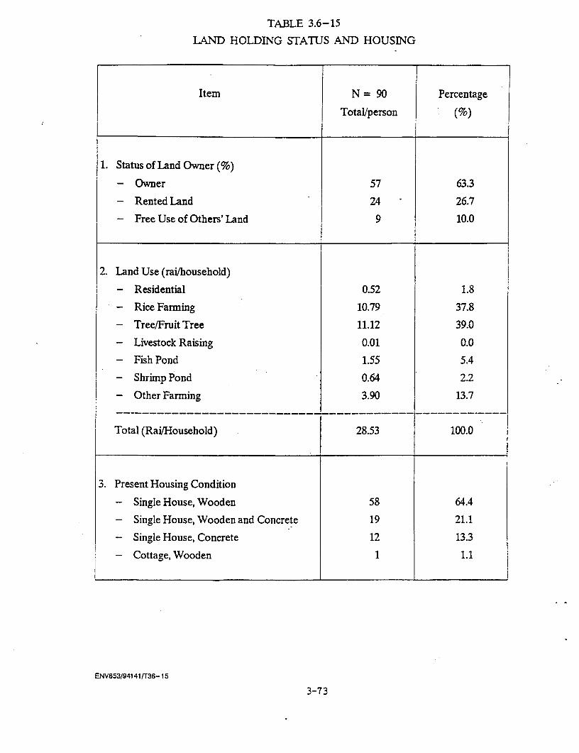
TABLE 3.6-15
LAND HOLDING STATUS AND HOUSING
Item N = 90 Percentage
Total/person (%)
1. Status of Land Owner (%)
- Owner 57 63.3
- Rented Land 24 26.7
- Free Use of Others' Land 9 10.0
2. Land Use (rai/household)
- Residential 0.52 1.8
- Rice Farming 10.79 37.8
- Tree/Fruit Tree 11.12 39.0
- Livestock Raising 0.01 0.0
- Fish Pond 1.55 5.4
- Shrimp Pond 0.64 2.2
- Other Farming 3.90 13.7
Total (Rai/Household) 28.53 100.0
3. Present Housing Condition
- Single House, Wooden 58 64.4
- Single House, Wooden and Concrete 19 21.1
- Single House, Concrete 12 13.3
- Cottage, Wooden 1 1.1
ENV853/94141 /T36- 15
3-73
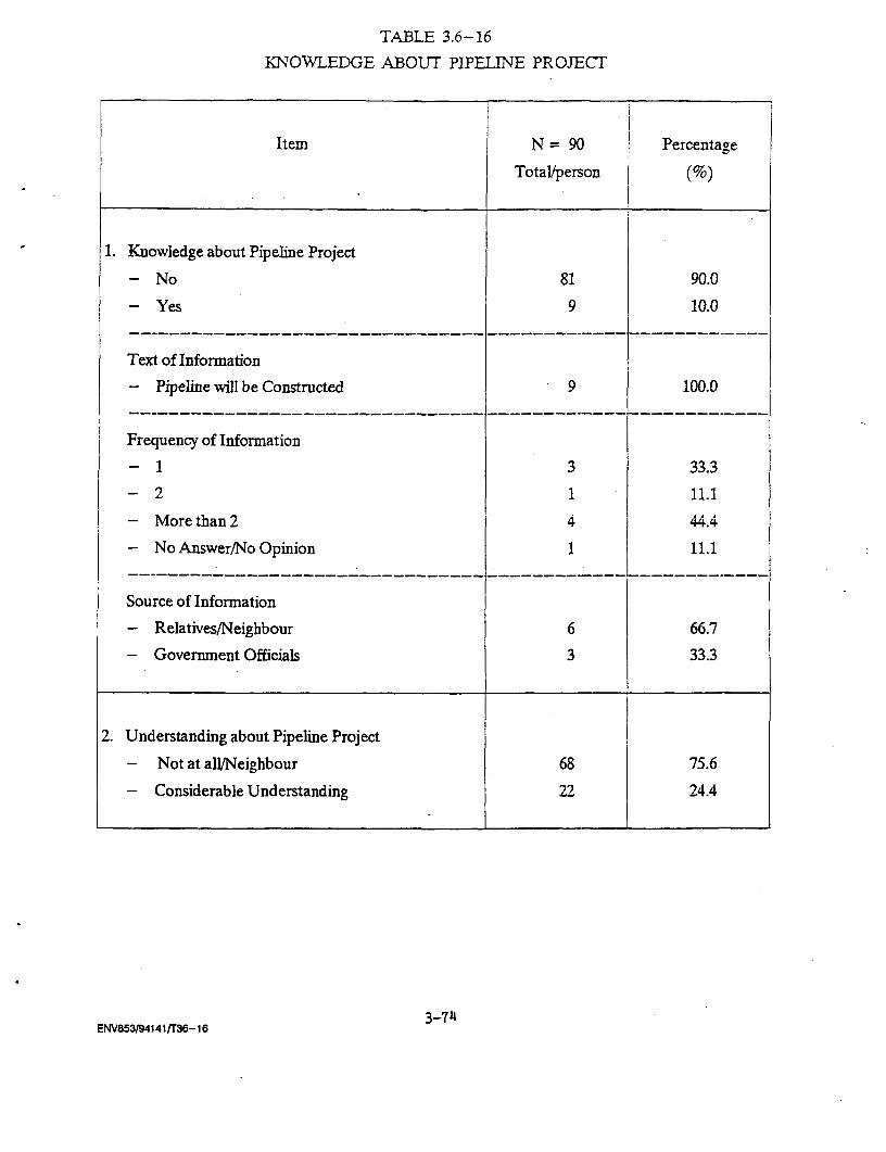
TABLE 3.6-16
KNOWLEDGE ABOUT PIPELINE PROJECT
Item N = 90 Percentage
Tota/person (%)
1. Knowledge about Pipeline Project
- No 81 90.0
- Yes 9 10.0
I __ ____________________________-------------_-------------
Text of Information
- Pipeline will be Constructed 9 100.0__ _____________________________------- -------------____ __
Frequency of Information
- 1 3 33.3
- 2 1 11.1
- More than 2 4 44.4
- No Answer/No Opinion 1 11.1
__ _____________________________------- ------------____.__
Source of Information
- Relatives/Neighbour 6 66.7
- Government Officials 3 33.3
2. Understanding about Pipeline Project
- Not at all/Neighbour 68 75.6
- Considerable Understanding 22 24.4
3-74ENV853/94141/T36-16

IA.fLt. J.i-1/
ATITUDE TOWARD THE PIPELINE PROJECT
Item N = 90 Percentage
Total/person (%)
1. Attitude Toward the Pipeline Project
- Agree with the Project 19 21.1
- Indifferent 34 37.8
- Worry 8 8.9
- Not Agree 29 32.2
Reasons for those who agree with the project
- Benefit for Community 14 73.7
- Promote National Development 4 21.1
- No Bad Effect from the Project 1 5.3
2. In Case Pipeline Direction is Parallel
to High Voltage Line:
- Agree with the Project 43 47.8
- Indifferent 13 14.4
- Not Agree 33 36.7
- No Answer/No Opinion 1 1.1
Resons for those who Agree with the Project
- The project can save some land 13 30.2
- No bad effects expected 13 30.2
- Promote National Development 6 14.0
- Benefit for Community 8 18.6
- No Answer/No Opinion 3 7.0
ENV853/94141rr36-17 3-75

TABLE 3.6-17 (Cont'd)
Item N = 90 Percentage
Total/person (%)
Reasons for those who do not agree
- Fear of Explosion 19 57.6
- Land may be expropriated 3 9.1
- Crops wil be damaged 5 15.2
- Will be lost Agricultural land 4 12.1
- No Answer/No Opinion 2 6.1
3. Co-operation with the Project in case
the pipeline passes the area
- Willing to co-operate 42 46.7
- Not willing 32 35.6
- Land is not close to the high voltage line 6 6.7
- Don't be land owner 4 4.4
- No Answer/No Opinion 6 6.7
__ _____________________________ ------------- …
Reasons for those who are not willing
to co-operate
- Fear of Explosion 9 28.1
- Concerned about land holding may be 9 28.1
expropriated
- Crops will be damaged 6 18.8
- Other (eg. no obligation to co-operate 5 15.6
being afraid of unfair treatment)
- No Answer/No Opinion 3 9.4
ENV853/94141/T36- 17 3-76

When learned that the gas pipeline would be laid in
parallel to the high voltage power line, the favorable percentage
increased to 47.8; the percentage of indifference was decreased but
percentage of disagreement with the project was slightly higher to 36.7.
~~~~Y*fl OAl6 tL.L6*%Jv; &vi *fll avvwW- S.
the project would save land (30.22%); if would not have ill effect
(30.2%); it would benefit the community (18.6%) and it would stimulate
national development (14.0%).
Among those having negative attitude, their reasons were
being afraid of gas explosion (57.6%), crops would be damaged (15.2%),
losing agricultural land (12.1%) and being afraid of land appropriation
(9.1%). More details in Table 3.12-17.
When asked about their co-operation in case the project
passes through parts of their land, 46.7 percent of respondents were
please to co-operate but 35.6 percent did not want to co-operate. Others
said their land was far away from the high vpltage power line; the
therefore needed not to co-operate; some said they did not own land.
Those who did not want to co-operate with the project gave
their reasoning as being afraid of gas explosion (28.1%), being afraid
their land would be appropriated (28.1%); their crops would be damaged
(18.8%), the rest said they did not have obligation to co-operate with
the project and being afraid of unfair treatment from the project (Table
3.6-17).
(4) The Impact of the Project
In asking about the project's impact, 2 separate issues
were solicited from the samples; the first about impact of the
construction of high power line which they already experienced and the
second about the expected impact of the proposed gas pipeline project.
Data from the study showed that 53.5 percent of
respondents did not have any bad effect from the construction of high
voltage power line; among those having negative impact, 42.9 percent said
EGAT asked to have rights over their land by paying small amount of money
in return; 40.5 percent reported their land was appropriated; 14.3 percent
mentioned their housing was damaged and another 14.3 percent their crops
were damaged.
ENV853/94140/CHAP- 111
3-77
As for those having compensation from EGAT, 75 percent of
them received compensation -ffor housing and other structures damages about
27, 284.16 baht per household by the average; 12.9 percent received
compensation for rights over land average about 4,683 baht per household,
6.4 percent for crops damage about 2,342 baht per household averagingly
and 5.7 percent compensation for land appropriate average about 5,985.72
baht per rai. More details in Table 3.6-18.
People's experiences from the high voltage power line
project should be valuable for implementation of the proposed gas pipeline
project particularly in paying compensation should be fair according to
the actual price at the time of making agreement.
Impacts expected to occur because of the construction of
the proposed gas pipeline from the respondents; answers were that 51
percent of them did not expect any negative impact while 47.8 percent
expected the negative impact and 41.9 percent of this group reported being
afraid and worried about gas explosion; 16.3 percent afraid of crop
damages; other negative impacts mentioned included occupation disturbance,
land being appropriated, or damaged, noise and air pollution during the
construction and inconvenience in travelling from home to outside and vise
versa. More details in Table 3.6-19.
W4hen asked whether they trusted the project's safety
measure, 33.3 percent did not trust it at all; 26.7 percent a little
confident; 17.8 percent said they trusted it; only 15.5 percent reported
fully trusted.
. Among those expecting positive impact (71.1%) referred to
chances of having jobs during the construction (25.0%) and bringing
progress to the community, more national development as a whole, etc. More
details in Table 3.6-19.
As for compensation for damages during the construction
and other usages, 61.1 percent expected the government should pay the
compensation; only 18.4 percent said no compensation should be paid; the
rest did not answer. Among those favored having compensation suggested the
compensation should be paid in the proportion to the extent of damages
occurred (73.8%) while 4.9 percent said up to the government's decision;
the rest did not give any answer (Table 3.6-19).
ENV853/94140/CHAP- Ill
3-78

TABLE 3.6-18
IMPACTS FROM HIGH VOLTAGE LINE
Item N = 90 Percentage
Total/person (%)
1. High Voltage line passes Residential
Agricultural Area
- Yes 42 46.7
- No 48 53.3
2. Impacts from High Voltage line
(among those who say "yes" only) 1
- Land was expropriated 17 40.5
- EGAT askes for right over land 18 42.9
- Impact on Dwelling/Building 6 14.3
- Impact on Tree/Fruit Tree 6 14.3
3. Compensation Received from EGAT
- Expropriated Land (Baht/Rai) 5985.72 14.9
- EGAT paid for right over land (Baht/HH.) 4682.94 11.6
- Dwelling/Building (Baht/HH.) 27284.16 67.7
- Tree/Fruit Tree (Baht/HH.) 2341.66 5.8
Note: 1/ = Multiple answer
ENV853/94141 /T36-18 3-79
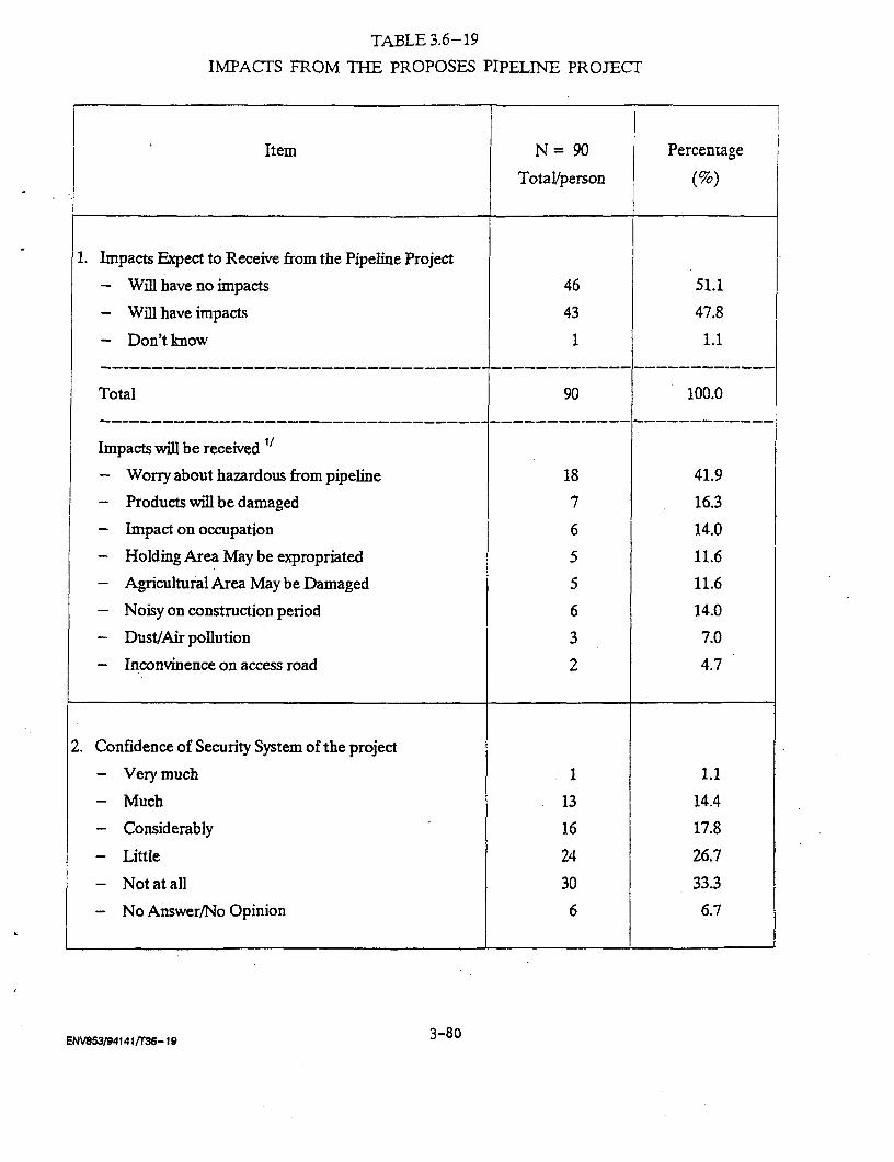
TABLE 3.6-19
IMPACTS FROM THE PROPOSES PIPELINE PROJECT
Item N = 90 Percentage
Total/person (%)
1. Impacts Expect to Receive from the Pipelhne Project
- Will have no impacts 46 51.1
- Will have impacts 43 47.8
- Don't know 1 1.1------------------------------ _----------- ____________________
Total 90 100.0__--_______________________________--___________--_______.____
Impacts will be received t
- Worry about hazardous from pipeline 18 41.9
- Products will be damaged 7 16.3
- Impact on occupation 6 14.0
- Holding Area May be expropriated 5 11.6
- Agricultural Area May be Damaged 5 11.6
- Noisy on construction period 6 14.0
- Dust/Air pollution 3 7.0
- Inconvinence on access road 2 4.7
2. Confidence of Security System of the project
- Very much 1 1.1
- Much 13 14.4
- Considerably 16 17.8
- Little 24 26.7
- Not at all 30 33.3
- No Answer/No Opinion 6 6.7
ENV853/9414 1 fr36-Io 3-8o
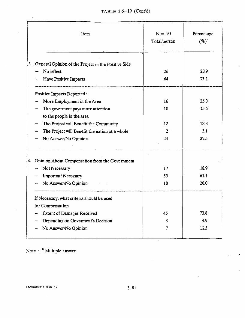
TABLE 3.6-19 (Cont'd)
Item N = 90 Percentage
Total/person
3. General Opinion of the Project in the Positive Side
- No Effect 26 28.9
- Have Positive Impacts 64 71.1
Positive Impacts Reported:
- More Employment in the Area 16 25.0
- The goverment pays more attention 10 15.6
to the people in the area
- The Project will Benefit the Community 12 18.8
- The Project will Benefit the nation as a whole 2 3.1
- No Answer/No Opinion 24 37.5
4. Opinion About Compensation from the Government
- Not Necessary 17 18.9
- Important Necessary 55 61.1
- No Answer/No Opinion 18 20.0
If Necessary, what criteria should be used
for Compensation
- Extent of Damages Received 45 73.8
- Depending on Goverinent's Decision 3 4.9
- No Answer/No Opinion 7 11.5
Note : '/ Multiple answer
ENV853/94141tT36-19 3-81

CHAPTER IV
MAJOR HAZARD ASSESSMENT
The gas transmission pipeline offers an effective mean of
petroleum product transportation. To maintain the performance and safety
of the transmission system, care have to be taken to ensure that all
safety measures are properly planned and maintained. However, the
hazardous cases could arise, fire and explosion are of the main concerns.
The flAmmable gases have flash points below room temperature and will form
explosive mixtures with air (or oxygen) within certain limits known as the
lower and upper explosion limits. From this point of view, assessment and
evaluation of hazards will be made by calculating the possible magnitude
of disaster from fire and explosion caused by gas and condensate leakages,
4.1 METHODOLOGY
4.1.1 Hazard Identification
The approach for assessment of the above scenario were
selected from the recommended method presented in the World Bank Technical
paper "Techniques for Assessing Industrial Hazards a Manual" (Technica,
1990). Flammable gas event tree (Figure 4.1-1) was employed in the
approaches for hazard assessment of natural gas leakage. The short
description of methodology and related input data used are as follows:
ENV853/94140/CHAP- IV
4-1

j IS RELEASE j IS THERE I IS THE CLOUD 0 IS THERE I DOES THE RELEASE AFFECT
INSTANTANEOUS ? I IMMEDIATE DENSER DELAYED OTHER EOUIPMENT ON THE
I | IGNITION ? THAN AIR ? IGNITION ? SITE ?I~~~~~~~~~~ a
a a g j j tMODEL ADDITIONAL RELEASES .
FIREBALL | | | YES ; ASSESS" ~ ~~~~~~~~~~~~~~~~ | YE I O|_lUtPACTS'I 1 ~~~~~~~~~~~~~~~~~~~~~~NO A1
I .'I I I I j
I ______________ I I FLASlt FIRE OR I ttMOOEL ADDITIONAL RELEASESI I I I ~~~~~~~~~ ~ ~~~~~~~~~~~EXPLOSION IYES
YES I I I IDENSE CLOUD DISPERSION rES NO 'I_ PACIS
I I '~~~~~~~~~~~YES 1-s- NO ADIABATIC I I -_ 4
EXPANSION J 1 FLASH FIRE OR I MODEL ADOJIJNAL RELEASES II j I I EXPLOSION I YES A
I l I | NO NEUTRAL /BUOYANT DISPERSION YES'| NO A
RELEASE I I I 'NO I ICASE | I i i ; IIULS
. l ~ ~~ I I I I IMODEL ADDITIONAL RELEASES I
I tET FLAUE | I ItYES T ASSESSIYES i I I NIIES?IMA7E a NO IMAT
DURATION MODEL ADTIONAL RELEASES
CALCULATE j F fLASH FIRE OR j O t ENO RELEASE RATE | a I EXPLOSION YES ASSESS
i DENSE CLOUD DISPERSION YES | NO j tMPACTS
a a I YES | NO ________________F _
a I ~~~~~~ETDSERIN I INO J1 DISPERSON FLAStt FIRE OR M MODEL ADDITIONAL REtEASES |
i I I I EXPLOSION YES ASSESSa | NO NEUTRAL /JEUOYANT DISPERSION YES I NO IMPACIS
FIGURE 4 I ; I E TE
FIGURE 4.1-1 :FLAMMABLE GAS EVENT TREE
(1) Release Cases
A set of release cases was considered according to the
facilities of the gas pipeline system as listed below:
Block Value No.6 at Bang Pa Kong
- Pipe leak (36" diameter) : 20% of pipe diameter
: 100% of pipe diameter
Wang Noi Pover.Planto
- Pipe leak (36" diameter) : 20% of pipe diameter
: 100% of pipe diameter
(2) Nature of Releases
For the proposed pipeline and facilities at Wang Noi
Power Plant Bang Pa Kong terminal, both instantaneous and noninstantaneous
releases are considered in a hazard evaluation.
(3) Iznition
A very important part of the analysis is to identify the
sources and probabilities of ignition. The types of ignitions are
classified into two categories according to the timing of the ignition, as
(a) Immediate ignition : In this case the gas is
ignited while it is still escaping from containment. Immediate ignition
can result in a jet flame or a fire ball depending on the nature of the
release (instantaneous and noninstantaneous). These can cause damage in
the immediate vicinity of the release but rarely affect anything outside
the plant boundary.
(b) Delayed ignition : This occurs after the
material has escaped from containment and has formed a cloud drifting down
wind. Delayed ignition can result in an explosion or a flash fire which
can cause damages in a wide area.
(4) Fires/Fire Damage
Fire can affect its surroundings primarily through the
radiated heat. The damage caused by heat radiation can be calculated from
the dose of radiation received; a measure of the received dose is the
energy per unit area of the surface exposed to the radiation over the
duration of the exposure. The other approaches can be calculated by using
the power per unit area received.
ENV853/94140/CHAP- IV
4-3
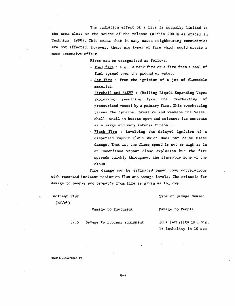
The radiation effect of a fire is normally limited to
the area close to the source of the release (within 200 m as stated in
Technica, 1990). This means that in many cases neighbouring communities
are not affected. However, there are types of fire which could create a
more extensive effect.
Fires can be categorized as follows:
- Pool fire : e.g., a tank fire or a fire from a pool of
fuel spread over the ground or water.
- Jet fire : from the ignition of a jet of flammable
material.
- Fireball and BLEVE : (Boiling Liquid Expanding Vapor
Explosion) resulting from the overheating of
pressurized vessel by a primary fire. This overheating
raises the internal pressure and weakens the vessel
shell, until it bursts open and releases its contents
as a large and very intense fireball.
- Flash Fire : involving the delayed ignition of a
dispersed vapour cloud which does not cause blase
damage. That is, the flame speed is not as high as in
an unconfined vapour cloud explosion but the fire
spreads quickly throughout the flammable zone of the
cloud.
Fire damage can be estimated based upon correlations
with recorded incident radiation flux and damage levels. The criteria for
damage to people and property from fire is given as follows:
Incident Flux Type of Damage Caused
(kW/m2 )
Damage to Equipment Damage to People
37.5 Damage to process equipment 100% lethality in 1 min.
1% lethality in 10 sec.
ENV853/94140/CHAP- IV
4-4
25.0 Minimum energy to ignite 100% lethality in 1 min.
wood at indefinitely long Significant injury in 1
exposure without a flame sec.
12.5 Minimum energy to ignite l%.lethality in 1 min.
wood with a flame; melts 1st degree burns in 10
sec.
4.0 Causes pain if duration
is longer than 20 sec
but blistering is
unlikely.
1.6 Causes no discomfort for
long exposure.
4.1.2 Ouantitative Analysis
The considerations were made for many cases of hazardous events
(Table 4.1-1). In order to focus only on the potential sources of hazard,
some of the events were screened out by considering the following aspects:
(1) Gas Flow
The amount of gas to be released to the environment was
calculated based on the approached listed in Appendix B. The estimated
outflow for different cases of releases are shown in Table 4.1-2.
(2) Impact Evaluation
The first step of impact evaluation was conducted by
comparison the concentration of the gas released (for 20 and 100% pipe
diameter) with the flammable limit of natural gas of which low flammable
limit (LFL) and upper flammable limit (UFL) are 3.83%V and 10.14%V
respectively. If the concentration of either jet or buoyant dispersion is
not in the flammable limit, the ignition will not be induced. Therefore, the
hazardous impact is negligible.
ENV853/94140/CHAP- IV
4-5

TABLE 4.1-1
INPUT DATA FOR HAZARD EVALUATION
Facilities Release Cases Nature of Release Ignition Output
Bang Pa Kong-Wang Noi
Pipe diameter 36" Pipe leak Instantaneous Immediate Fireballs
Pressure 1,600 psig 20% pipe diameter Delay Flash fire
Temperature 120°F 100% pipe diameter Noninstantaneous Immediate Jet fires
Molecular weight Delay Flash fire
of gas 25.145
ENV853/94141/TAB41 -1 4-6
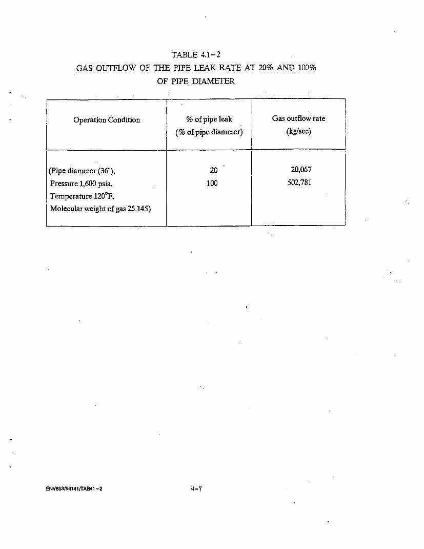
TABLE It I E.
GAS OUTFLOW OF THE PIPE LEAK RATE AT 20% AND 100%
OF PIPE DIAMETER
Operation Condition % of pipe leak Gas outflow rate
(% of pipe diameter) (kg/sec)
(Pipe diameter (36"), 20 20,067Pressure 1,600 psia, 100 502,781
Temperature 120°F,
Molecular weight of gas 25.145)
ENV853/941411TAB41-2 4_7

Noninstantaneous Relaase with Immediate Ignition (Jet Dispersion)
The jet dispersion model can calculate the concentration
and the velocity on the jet axis at a given distance from the released spot
which can determine the end of turbulent mixing phase (i.e. the distance at
which the jet velocity equals to the wind speed) presented in Table 4.1-3.
The concentration of dispersed gas beyond the end of turbulent mixing phase
with wind speed of 3 m/s. is shown in Table 4.1-4. In the stable (class A-C)
and unstable (E-F) conditions, the ignitions will not be induced due to the
improper concentration of the gas released.
Noninstantaneous Relbkse with Delayed Iznition (Buoyant Dispersion)
The buoyant dispersions of natural gas were estimated by
using gausian distribution model and amount of gas released. The dispersion
concentrations were calculated for various atmospheric conditions (Table
4.1-5).
Concerning the leakage of 20% of pipe diameter the
dispersion concentrations are all lower than LFL of 3.83% by volume, thus,
the potential hazardous events are negligible.
For the 100% of pipe diameter, the dispersion
concentrations are in the ranged of flammable limit indicating potential
hazard. Thus, the probable impact will be assessed in the next section.
4.2 HAZARDOUS ASSESSMENTS
The potential hazardous cases were identified in section 4.1 and
the assessment for each single event will be conducted as follows:
Block Value No.6 at Bang Pa Kong
This block value No.6 is surrounded by the idle land along the side
of Highway No.3 near the entrance of Bang Pa Kong Thermal Power Plant.
The assessments of the potential hazardous events are as follows:
(1) Instantaneous Release with Immediate Ignitions : Fireballs
and Fire Damages
The instantaneous releases were calculated based on the
gas volume contained in 36" pipe with 1 km. in length. The instantaneous
releases of about 357,659 kg (358 ton) (detail calculation in Appendix B),
ENV853/94140/CHAP- IV
4-8
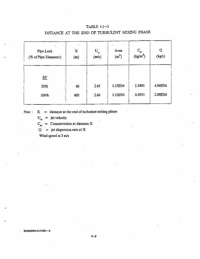
TABLE 4.1-3
DISTANCE AT TBE END OF TURBULENT MIXING PHASE
Pipe Leak X Um Area C
(% of Pipe Diameter) (m) (m/s) (m2 ) (kg/m3) (kg/s)
36"1
20% 60 2.65 1.13E04 1.3481 4.04E04
100% 600 2.66 1.13E04 0.6935 2.08E06
Noe X = distance at the end of turbulent mixing phase
Ur = jet velocity
C = Concentration at distance X,.
Q = jet dispersion rate at X
Wind speed is 3 m/s
ENV853/94141rTAB41 -3
4-9
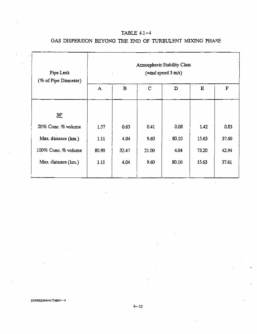
TABLE 4.1-4
GAS DISPERSION BEYONG THE END OF TURBULENT MIXING PHASE
Atmospheric Stability Class
Pipe Leak (wind speed 3 m/s)
(% of Pipe Diameter) __ _
A B C D [ E F
36"
20% Conc. % volume 1.57 0.63 0.41 0.08 1.42 0.83
Max. distance (km.) 1.11 4.04 9.60 -80.10 15.63 37.60
100% Conc. % volume 80.90 32.47 21.00 4.04 73.20 42.94
Max. distance (km.) 1.11 4.04 9.60 80.10 15.63 37.61
ENV853/94141 tTAB41 -4
4-lo
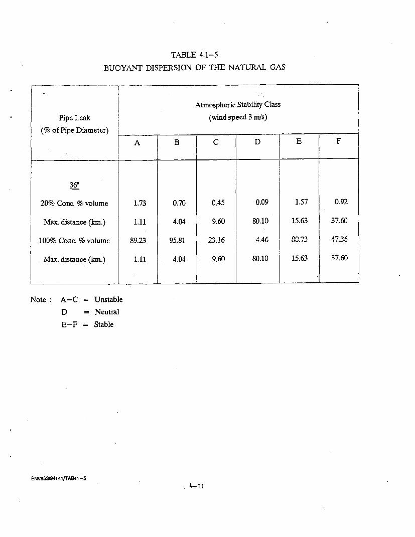
TABLrE Ai-5
BUOYANT DISPERSION OF THE NATURAL GAS
Atmospheric Stability Class
Pipe Leak (wind speed 3 mWs)(% of Pipe Diameter) , B l D
A | B | C | D | E | F
36"1
20% Conc. % volume 1.73 0.70 0.45 0.09 1.57 0.92
Max. distance (km.) 1.11 4.04 9.60 80.10 15.63 37.60
1iuOy Conc. %s voiume 89.23 9.81 23.6 4.46 U0.73 47.36
Max. distance (km.) 1.11 4.04 9.60 80.10 15.63 37.60
Note A-C = Unstable
D = Neutral
E-F = Stable
ENV853/94141/rAB4i -5
4-.1.1
the maximum radis5 of the fireball will be about 174 m. with radiation
intensity of 323 kW/m2. The affected gone with radial energy of 37.5 to 12.5
kW/m2 were ranged from 511 to 885 m without consideration of any mitigation
measures (Table 4.2-1) - The impact from the heat radiation within this zone
is quite significant. Therefore, any development within 0.9 km. from the
block value No.6 should be prohibited to minimize any hazardous events.
(2) Instantaneous Release with Delayed Ignition * Adiabatic
Expansion/Flash Fire
The adiabatic expansion model were utilized to calculate
the radius of the expanded cloud as a function of time (Table 4.2-2). All
of the percent volume of expanded gas were lower than the LFL of 3.8%V.
Thus, the hazardous impact from this case is not significant.
(3) Noninstantaneous Release with Delayed Ignition : Buoyant
Dispersion
The consideration was made only for 100% of pipe diameter
release case. The analyses were conducted at all atmospheric stability
condition (Table 4.2-3). For the stability of 1, 5 and 6, the dispersion
concentrations were higher than the LFL value (3.38%V) with the distance of
1.11 to 178.62 km. However, the stability conditions of the project area are
likely to be in class 2-3 (unstable) and class 5 (stable), the probable
distance with high LFL value are in the range of 2.533 to 19.89 km.
Wang Noi Power Plant
Similar hazard assessment approaches for Bang Pakong Block Value
#6 were conducted for Wang Noi Power Plant. This terminal will be located
within EGAT Boundary. The affected distance from the potential source of
release for radiation intensity of 37.5 kW/m2 - 12.5 kW/ml was ranged from
511 to 885 m. without any mitigation measures. Within this 0.87 km the
impact will be significant. However, the receiving facility will be entirely
in the EGAT premise and within the industrial area. However, it is
recommended that the to be located within 0.88 km radius of the receiving
facilities should be properly designed to withstand the heat intensity and
living quarters must be prohibited.
ENV853/94140/CHAP- IV
4-12

l1ABLE 4.2-i
THE DISTANCE FROM THE CENTRE OF THE FIREBAL
AT THE RADIATION FLUX (METRE)
ONSHORE
Release Case
Incident Flux Instantaneous Noninstantaneous
(kW/m 2 )
100% 100%
of pipe diameter of pipe diameter
37.5 510.89 1,128.38
25.0 625.72 1,381.98
12.5 884.90 1,954.41
ENV853/94141jrAB42-1
4-13
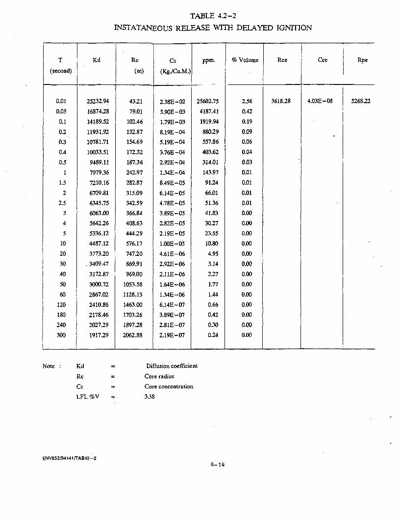
TABLE 4.2-2
INSTATANEOUS RELEASE WITH DELAYED IGNMIION
T Kd Rc Cc ppm. % Volume Rce Ccc Rpe
(second) (mK) (KgdCu.M.) {0.01 25232.94 43.21 2.38E - 02 25602.75 2.56 3618.28 4.03E-08 5268.22
0.05 16874.28 79.01 3.90E -03 4187.41 0.42
0.1 14189.52 102.46 1.79E -03 1919.94 0.19
0.2 11931.92 132.87 8.19E-04 880.29 0.09
0.3 10781.71 154.69 5.19E -04 557.86 0.06
0.4 10033.51 172.32 3.76E -04 403.62 0.04
0.5 9489.11 187.36 2.92E-04 314.01 0.03
1 7979.36 242.97 1.34E-04 143.97 0.01
1.5 7210.16 282.87 8.49E-05 91.24 0.01
2 6709.81 315.09 6.14E-05 66.01 0.01
2.5 6345.75 342.59 4.78E-05 51.36 0.01
3 6063.00 366.84 3.89E - 05 41.83 0.00
4 5642.26 408.63 2.82E-05 30.27 0.00
5 5336.12 444.29 2.19E- 05 23.55 0.00
10 4487.12 576.17 1.OOE-05 10.80 0.00
20 3773.20 747.20 4.61E-06 4.95 0.00
30 3409.47 869.91 2.92E - 06 3.14 0.00
40 3172.87 969.00 2.11E-06 2.27 0.00
50 3000.72 1053.58 1.64E-06 1.77 0.00
60 2867.02 1128.13 1.34E-06 1.44 0.00
120 2410.86 1463.00 6.14E-.07 0.66 0.00
180 2178.46 1703.26 3.89E-07 0.42 0.00
240 2027.29 1897.28 2.81E -07 0.30 0.00
300 1917.29 2062.88 2.19E-.07 0.24 0.00
Note Kd Diffusion coefficient
Rc Core radius
Cc Core conceitration
LFL %V 3.38
ENV853/94141rTAB42-24-14
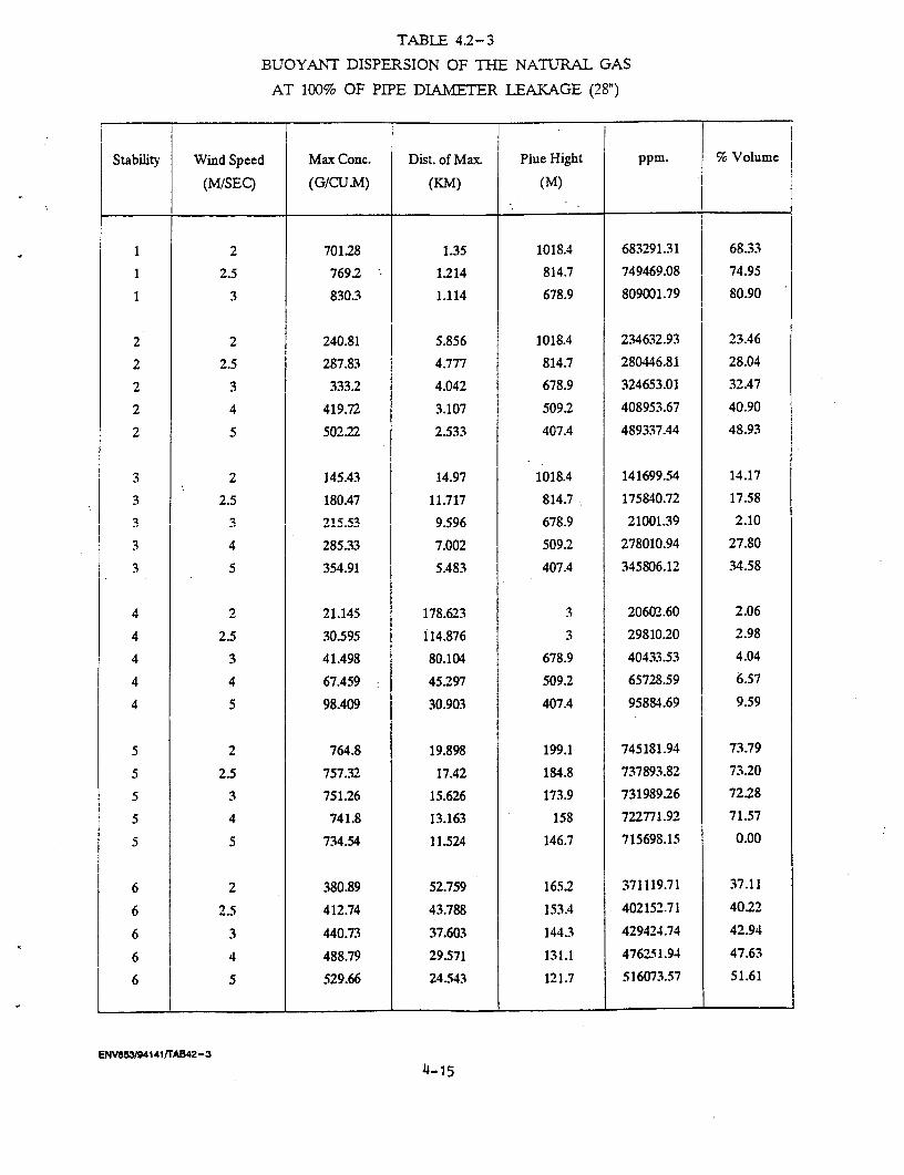
TABLE 4.2-3
BUOYANT DISPERSION OF THE NATURAL GAS
AT 100% OF PIPE DIAMETER LEAKAGE (28")
Stability Wind Speed Max Conc. Dist. of Max. Plue Hight ppm. % Volume
(M/SEC) (G/CU.M) (KM) (M)
1 2 701.28 1.35 1018.4 683291.31 68.33
1 2.5 769.2 1.214 814.7 749469.08 74.95
1 3 830.3 1.114 678.9 809001.79 80.90
2 2 240.81 5.856 1018.4 234632.93 23A6
2 2.5 287.83 4.777 814.7 280446.81 28.04
2 3 333.2 4.042 678.9 324653.01 32.47
2 4 419.72 3.107 509.2 408953.67 40.90
2 5 502.22 2.533 407.4 489337.44 48.93
3 2 145.43 14.97 1018.4 141699.54 14.17
3 2.5 180.47 11.717 814.7 175840.72 17.583 3 21 5 . a C.f 7 R 9 21001l39 2.10
3 4 285.33 7.002 509.2 278010.94 27.80
3 5 354.91 5.483 407.4 345806.12 34.58
4 2 21.145 178.623 3 20602.60 2.06
4 2.5 30.595 114.876 3 29810.20 2.98
4 3 41.498 80.104 678.9 40433.53 4.04
4 4 67.459 45.297 509.2 65728.59 6.57
4 5 98AO9 30.903 407.4 95884.69 9.59
5 2 764.8 19.898 199.1 745181.94 73.79
5 2.5 757.32 17A2 184.8 737893.82 73.20
5 3 751.26 15.626 173.9 731989.26 72.28
5 4 741.8 13.163 158 722771.92 71.57
5 5 734.54 11.524 146.7 715698.15 0.00
6 2 380.89 52.759 165.2 371119.71 37.11
6 2.5 412.74 43.788 153.4 402152.71 40.22
6 3 440.73 37.603 144.3 429424.74 42.94
6 4 488.79 29.571 131.1 476251.94 47.63
6 5 529.66 24.543 121.7 516073.57 51.61
ENV85394141frAB42-3
4-15

4.3 SUMMARY OF IMPACTS
The potential sources of hazardous events were summarized in Table
4.3-1. The most concerned case is for the pipe leakage can cause fire damage
with immediate ignition. Both leak cases, 20% and 100% of pipe diameter, are
considered for the pipeline diameter of 36 inch.
4.4 HAZARD MITIGATION MEASURES
The risk of a release can be reduced by using reliability studies
or techniques such as HAZOP which will be developed by the pipeline
engineers and reviewed by PTT to examine the design in detail as described
Hazard Identification Review to improve the operation and control of the
plant. Risks can also be reduced by improving the maintenance and inspection
of the pipeline system.
As well as reducing the consequences and risks of releases, the
analyst should also consider measures to reduce the impact of these
releases. Some possible measures are arranged in order of increasing
involvement of employees and people off-site as follows:
- provision of bunkering or blast walls;
- firewalls/fire-proofing of structures within block valve
previous;
- provision of emergency escape routes for employees;
- provision of safety and emergency training for employees;
- implementation of emergency procedures on and off-site;
- provision of public alert systems and education of public;
- planning and training for evacuation;
- provision of safety buffer-zones around the plant boundary.
ENV853/94140/CHAP- IV
4-16
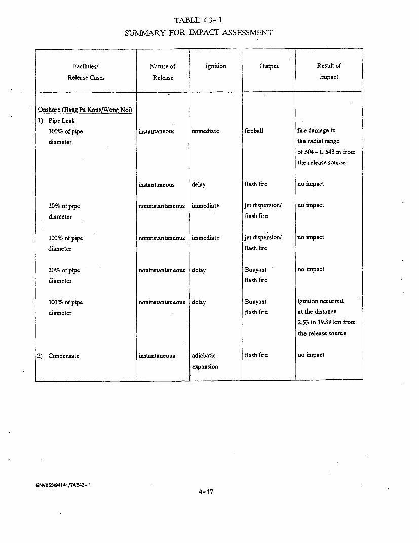
TABLE 4.3-1
SUMMARY FOR INTACT ASSESSMENT
Facilities/ Nature of Ignition Output Result of
Release Cases Release Impact
Onshore (Bang Pa Kon!/Wong Noi)
1) Pipe Leak
100% of pipe instantaneous immediate fireball fire damage in
diameter the radial range
of 504-1, 543 m fromthe release source
instantaneous delay flash fire no impact
20% of pipe noninstantaneous immediate jet dispersion/ no impact
diameter flash fire
100% of pipe noninstantaneous immediate jet dispersion/ no impact
diameter flash fire
20% of pipe noninstantaneous delay Bouyant no impact
diameter flash fire
100% of pipe noninstantaneous delay Bouyant ignition occurred
diameter flash fire at the distance
2.53 to 19.89 km from
the release source
2) Condensate instantaneous adiabatic flash fire no impact
expansion
ENV855/94141/rAe43-1
4-17
CHAPTER V
ENVTPR.7MVNTAT TMPArT A MEJT
5.1 INTRODUCTION
The environmental impacts can be classified as short-term and
long-term impacts according to their intensity and duration of occurrence.
Short-term impacts an those which would occur during the construction
phase and could continue for a short period after that. On the other hand,
long-term effects would occur in and continue throughout the operation
phase.
The predicted magnitude of effects in generally stated in
quantitative terms, whenever data and methodology allowed. However, for
some environment components, qualification of impact can not be made thus,
the qualitative analysis is employed.
5.2 WATER QUALITY
5.2.1 Construction Period
Due to the natural setting of project area, the pipeline will
be positioned in the alluvial plain of Bang Pakong and Chao Phraya Basins.
This area is dominated by both natural and man-made canal mainly for
agricultural purposes. Thus, the major impact on waterways resulting from
the pipeline construction will be during ROW preparation, and crossing.
The right-of-way preparation will include the vegetation
clearing, surface levelling and equipment mobilization. These activities
can induce soil erosion on the non-cover surface. However, the ground
disturbance will be short term and occur in the dry season with very low
rainfall intensity. Thus, the soil erosion or suspended solids to be added
into the waterways can be considered as minimal.
Concerning the crossing practices, for the relatively small
khlongs scattered over the project area, the open cut crossing will be
ENV853/94140/CHAP-V
5-1
applied. The trenching of pipeline ditch in Khlong slope will be
undertaken only when the actual pipe laying is ready to minimise silt
input to the waterways. Furthermore, the necessary precautions will be
strictly taken to alleviate surface run off to the Khlong. The appropriatecontrl..4J t.L ~J.&& L'Wer0 J. V-L-L* dU' I nf~W*t Atr * JLo f ME . *- . , - '
contol f sol eosio a,d seimet r of., .g. , h.ay -ales, silt
fences., will be applied to minimize sedimentation in the waterways. These
activities will be concentrated mainly in the dry reason which most of the
canal will dried out and the water in these khlongs are utilized primarily
for agricultural purposes, thus, the impact on water quality can be
perceived as minor.
For the large khlongs and river, e.g., Khlong Rangsit, Khlong
Prawet Buri Rom, Bang Pakong river, etc. The directional drilling will be
applied. This method will utilize the driller bored a few meters under
neath the river bed withbut any disturbance. On the bottom sediment. The
increase of suspended solids in the river is nil. In addition, the
disposal of drilling fluids and muds will be stored in the containers to
be disposed of by the municipality.
Considering the wastes generated by the equipment, machineries
and vehicles (e.g., waste oil, lubricants, coolant, etc.), these type of
waste will be collected at the maintenance unit within the construction
site office. The suitable containers will be designated to store each type
of waste and properly disposed of at the local service facilities.
During the construction period, there will be about 800 worker
involved. With the estimated BOD load of 30 g/person-day (NEB, 1981), the
total BOD load from construction camps will be 24 kg/day. The sanitary
latrines will be provided at the ratio for 15 workers/l latrine at all
construction camp to assure the proper treatment of domestic waste prior
to the dissipation into surrounding soil.
5.2.2 Operation Phase
The gas transmission pipeline will initiate no adverse effect
on water quality during operation. Focusing on the gas leakage, the
pipeline system is installed with state-of-the-art SCADA computerized
system to continuously monitor the pressure, gas flow and volume.
Therefore, the probability of gas leakage is very slim.
ENV853/94140/CHAP -V
5-2
In addition, the section of gas pipeline under the river or
can--!il be burried wit-h approximately 1. m. ofr soil on top of the-I
coated pipeline. This practice will drastically reduce any chances of
pipeline supture due to the any impact force.
5.3 AQUATIC ECOLOGY/FISHERY
5.3.1 Construction Period
The direct impact on aquatic ecology from the pipeline
development is due to increase suspended solids in surface water and the
habitat disturbances.
Regarding the small Khlongs, the open cut will be applied. The
canal bed will be trenched with the approximate strip of 1.2 m across the
width of the Khlong. The activities will be concentrated only in the dry
season which most of the small khlongs are dried up. These intermitted
waterways support very low diversity of both plankton and benthic
communities due to the disruption of life during the dry season. Thus, the
impact on the aquatic communities of small khlongs is negligible.
For the large canals and rivers, the different approach, direct
drilling, will be used. The driller will be bored under the river bed with
a few meters under the river bottom. Thus, the impacts on the planktonic
and benthic habitats in terms of suspended solids and disturbances are not
foreseen.
The changes of water quality due to the increase of BOD loads
from the construction camps are not expected due to the adequate provision
of latrine (1 latrine for 15 workers) at every construction camps. The
contaminated leachate are not anticipated.
The only major fishery resource in the project vicinity is the
Bang Pakong river mouth. This river is subjected to the directional
drilling about 10 km. upstream from the river mouth. This approach will
not disturb the river bed, thus the increase suspended solid in the river
is not foreseen, therefore, the downstream fishery area will not be
impacted from the project.
ENV853/94140/CHAP-V
5-3
5.3.2 Operation Period
The pipeline system will be totally buried under approximately
1.5 meter of soil at the bed of waterways. Thus, there will be no contact
with the aquatic lifes and fishery activities. Therefore, the potential
5.4 TRANSPORTATION
5.4.1 Construction Period
Along the 100 km. of the proposed Bang Pakong-Wang Noi pipeline,
there will be some crossings under the major highways, i.e., HW. 3466,
314, railway, 304, 3312, and 305. The potential impacts to be resulted
from the pipeline construction are as follows:
- increase traffic volume closed to the intersected points due
to the mobilization of the project's machineries and
vehicles.
- short term traffic interference on the intersected points
between the gas pipeline and highways.
The readily coated pipe will be transported from the temporary
storage area to the construction site which will be moving constantly. The
mapping of the appropriate pipe transportation route will be planned
carefully, both routing and timing, to alleviate traffic congestion. The
bored crossing technique will be applied in order to avoid any temporary
disruption on the traffic flow of the highway.
At each intersection, the pipeline will be installed by using
a pilot pipe section slipped under the highway. Once the pilot section is
in place, the permanent, coated pipeline will be welded on to the pilot
section and pulled through the bore. The casing will be designed to carry
the extra traffic loads. The interference on the traffics will be
temporary due to the equipment operation, right-of-way preparation.
However, the frontage access or detour will be properly arranged to
alleviate temporary inconvenience during construction at these
intersect ions.
ENV853/94140/CHAP-V
5-4
Thus, by the application of the above practices the short-term
l due to pipelin.e constructilon can be vi ewed as inslgnifi.cant.
5.4.2 Operation Period
The operation of the pipeline project will not cause any impact
on the transportation network due to the utilization of EGAT right-of-way
to avoid any adversed impacts on traffic disruption and land acquisition.
5.5 LANDUSE
Potential impacts on the landuse change can be assessed and
summarized as follows:
(1) Regrading the issue on landuse change due to the project
the study of this issue along the existing PTT pipeline shows evidence
that without access along the pipeline there are no or very limited
landuse changes due to pipeline development. The lands along the ROW are
still being utilized for agricultural purpose.
(2) Permission of temporary use the land for construction of
the pipelines is required for the development of the project. Though the
proposed pipeline route will be aligned on the same strip of lands already
received the ROW utilization from the owners. Additional agreement between
the PTT with each respective owners and EGAT will be necessary
5.6 SOCIO-ECONOMICS
(1) Impact to individuals and familv:
(A) Positive side:
- economically, Job opportunities related to
construction process, e.g., semi-skilled
workers, and non-skill workers;
- economically, generating income for commercial
and services in the areas including food stores,
rented houses, groceries, rented vehicles, etc.
ENV853/94140/CHAP-V
5-5
(b) Negative side:
- Some necessary public facilities may be
insufficient especially during the construction
period; these are water supply, health service,
etc;.
- Social problems may be arised and disrupted the
peaceful life style of the villagers
particularly during the construction period, for
examples, drinking problems, gambling, thefts,
quarrelling, etc. The construction activities
may cause transportation, inconveniences; all of
these make community life more difficult but,
fortunately, it will be last only for a short
period.
(2) Impact to the Country
- promote industrial growth and reduce dependency
on foreign fuel supply.
ENV853/94140/CHAP-V
5-6
CHAPTER VI
MITICATION MEASUES Ar N D E.NVTRONMF.NTAL. kNAGEMENT
6.1 INTRODUCTION
The results from the environmental impact assessment of the proposed
pipeline in the previous chapters pointed out that the level of impacts are
at the acceptable level. However, it is necessary to exercise the appropriate
mitigation measures listed in this chapter to ensure the minimum level of
impacts for the concerned parameters. (Table 6.1-1)
6.2 MITIGATION MEASURES
6.2.1 Construction Period
6.2.1.1 Water Quality
- All major construction activities, e.g., open cut crossing, bore
crossing, directional drilling, etc. must be scheduled during the
dry season. (Mid October-Beginning of May).
- Proper erosion and sedimentation control, e.g., hay bales, and
silt fences should be installed at all concerned waterways
adjacent to the pipeline approaching area.
- Store backfill material away from the bank of waterways to
minimize erosion and rudiment run off.
- Bachfill the ground cover as soon as possible after the pipeline
in place to minimize soil erosion.
- Temporary store the waste oil, lubricants and other waste material
in the designated containers for further disposal.
- Restore river bank conditions to be suitable for natural
vegetative growth.
ENV853/94140/CHAP6
6-1
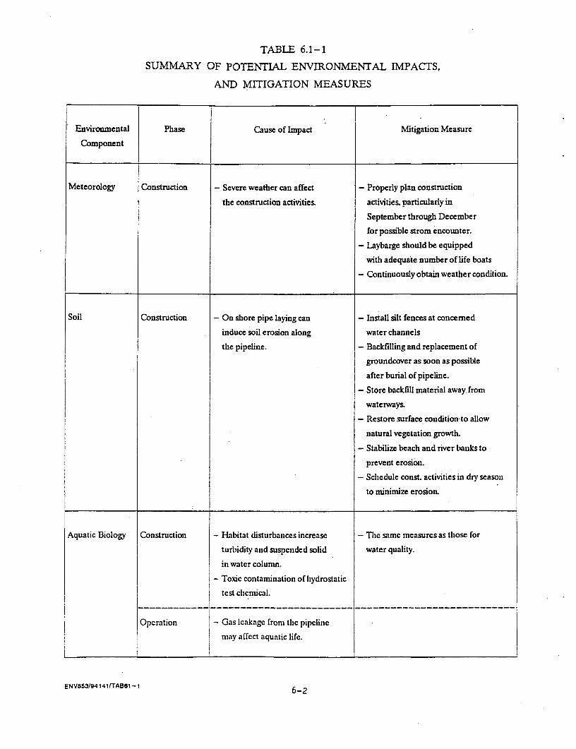
TABLE 6.1-1
SUMMARY OF POTENTIAL ENVIRONMENTAL IMPACTS,
AND MITIGATION MEASURES
Environmental Phase Cause of Impact Mitigation Measure
Component
Meteorology Construction - Severe weather can affect - Properly plan construction
the construction activities, activities. particularly in
September through December
for possible strom encounter.
- Laybarge should be equipped
with adequate number of life boats
- Continuously obtain weather condition.
Soil Construction - On shore pipe laying can - Install silt fences at concerned
induce soil erosion along water channels
the pipeline. - Backfilling and replacement of
groundcover as soon as possible
after burial of pipeline.
- Store backfill material away from
waterways.
- Restore surface condition-to allow
natural vegetation growth.
- Stabilize beach and river banks to
prevent erosion.
- Schedule const. activities in dry season
to minimize erosion.
Aquatic Biology Construction - Habitat disturbances increase - The samc measurcs as those for
turbidity and suspended solid water quality.
in watcr column.
- Toxic contamination of hydrostatic
test chcmical.
Operation - Gas Icakagc from thc pipclinec
nmay affect aquatic lifc.
ENV853/94141/TAB61 -1 6-2

TABLE 6.1-1 (Cont-d)
Environmental Phase Cause of Impact Mitigation MeasureComponent
Terrestrial Construction - Additional clearing of trees in - Minimize the additional clearing area.Ecology Huai Mahad Forest. - Set up construction camps
- Wildlife disturbances, away from the forest.- Speed up construction activities
in forest area.- Cooperate with RFD and EGAT
about usage of reserved areas.
Landuse Construction - Loss or damage to the crops - Rent additional lands for mobilizing
adjacent to the right-of-way. construction equipment or temporarycamp.
- Select proper construction period,
if possible, after harvesting.- Fair compensation to crop loss or
damage.
Transportation Construction - Interfere the traffic flow. - Avoid usage of HW.3, 344 and 315 for-Increase traffic volume from equipment transportation.
construction activities. - Provide proper frontage access for theconstruction vehicle.
- Transportation route of constructionvehicles should be carefully plannedto avoid traffic loads.
- The local residcnts should be informedabout the construction schedule to
alleviate traffic congestion.- Provide good signal system.
- Utilizc Laem Chabang and
Map Ta Pliut Ports for transportationof pipeline.
ENV853/94141/TAB61 -1 6-3
TABLE 6.1-1 (Cont'd)
Environmental Phase Cause of Impact Mitigation Measure
Component l
Infrastructure/ Construction - Increased local water demands - Implement the suitable construction
Public Facilities at the pipe coating plant and and supervision method.
during pipeline construction. - Strictly enforcement of proper
- Intersect existing water transmission pre -caution, measures and close
line. supervision during construction.
- Possible accident witb construction - Employ proper grounding method
vehicles and electrical transmissions and proper inspections.
line towers. - Cooperate with local waterworks
- Possible electrical shock from induce about construction activities close to
high voltage to the pipe and other waterpipe.
related facilities.
Socio-economic Construction - Social problems such as different - aosely discipline the workers.
traditions, theft, quarrel and - Cooperated with local authorities.
drug abuse. - Offer fair compensation rate.
- Increase job opportunities. - Provide improved facilities for
- Inconvenience for the local traffic. community.
- Temporarily decrease quality - Give priority to local residents for
of environment in the immediate employment.
vicinity of the pipeline - Select the site for construction
construction area. camps away from communities.
- Sct up Public Relation program for
the local residents.
Public Health/ Construction - Health problems and accidents. - Provide first at unit at the const. site
Safety - Living conditions in construction and barge.
camps. - Establish appropriate working
condition at construction areas.
- Provision of proper health and
environmental sanitation improvement
in workers' communities.
- Provide adequate safety devices and
set stringent regulations.
- Train personnel on usage of safety
cquipnicti.
- Spray watcr on uncovcred ground
to reduce dust.
ENVB53/9414lITAB61 -1

TABLE 6.1-1 (Cont'd)
Environmental Phase Cause of Impact Mitigation Measure
Component
Operation - Public health and occupational - Conduct comprehensive training
health problems. programs, with special attention to
- Harzardous events from gas pollution control safety and fire
leakage. prevention.
- Keep records of accidents.
- Keep equipment in good working
condition.
- Set stringent safety regulation.
- Maintain pipeline and associated
facilities regularly.
- Establish proper contingency plans
for emergencies.
- Post warning sign along pipeline route.
- Follows ASME code for piping
Archaeological/ - No inpact on the existing
Historical Values archaeological and historical
values.
Aesthetic/Tourism - No impact on the existing
aesthetic and tourism.
ENV8s3194141/TAB61 -1 6-5
- Construction camps must be at least 150 m. from the waterways and
equipped with 1 sanitary latrine/ 15 workers.
6.2.1.2 Aquatic Ecolozy/Fisheries
- Consider bore crossing and directional drilling to the maximum
extent.
- Schedule the crossing activities during the dry season (Mid
October-Beginning of May).
- Limit the disturbance on the river bed interms of both area and
timing.
- Practice the appropriate erosion control measures, e.g. silt
fences to minimize sedimentation on river bed.
- Store backfill material away from the river bank to control
sediment run off.
- Locate construction at least 150 m. from the waterways and
equipped with 1 sanitary latrine/ 15 workers.
6.2.1.3 Transportation
- Transport coated pipe from the port to construction site at night.
- Avoid the usage of HW. No. 1, 3, and 315 for heavy equipment
transportation.
- Minimize the timing for bore crossing under the major highway
e.g., HW. No. 305, 304, 314, 3312 and railroad.
- Provide proper frontage road access during the crossing
construction.
- Map out the transportation route for equipment and coated pipe to
minimize traffic. The railroad should also be considered.
- Inform local residents about the construction activities/schedules
and the alternative route should be supported to minimize traffic
congestions.
- Co-ordinate with local authorities, e.g., police community leaders
and highway department, about the construction schedule and this
information can be transfered to local communities,
ENV853/94140/CHAP6
6-6
6.2.1.4 Land Use
- Schedule the pipeline construction activities during the dry
season to minimize the paddy field disturbances.
- In case of additional area out of ECAT ROW is required for
temporary construction site, the selected areas should cause
minimum disturbance to agricultural product.
- The fair compensation should be paid to land owners.
6.1.2.5 SOCIO-ECONOMIC
In order to facilitating the work the proposed project and preventing
misunderstanding of the project among local people, 4 measures below are
recommended;
- The public relation program with the emphasis on issues (or
information) that disturb villagers' feeling about the project
particularly the safety measures preventing gas explosion
including other benefits derived from having the project. The
public relations program can be done by having a meeting with
people in their community to explain the work process of the
project to them clearly; the meeting can be held periodically,
before launching the project, during the construction, after the
construction; at the same time co-operation from people can be
expected if the public relative program is effective.
- Planning to reduce negative effects as much as possible; this
should be done before the construction work. The project should
also provide facilities for people during the construction,
helping people to live their ordinary life with little
disturbance. It possible, the construction should be done during
the dry season in order to avoid crop damages.
- Compensation rate and paying condition should be fitted with the
participation of the people concerned; if possible, the rate
should be at the present level of commodity price or market price
whether it be land, materials or labour and condition for paying
should not be too complicated to facilitate the compensation
payment.
ENV853/94140/CHAP6
6-7
- Other procedures for obtaining rights over land, the permission
to use land, and other construction work should also be simple
providing good work and good facilities for living in the area;
continuous communications between project officials and community
seaues Will |lejJ to aLLt.lieve tLh.5 UUJesXtives.
6.2.2 Operation Period
6.2.2.1 Water Ouality/Aquatic Ecologv
- Select the hydrostatic test chemicals accepted worldwide
- Utilize hydrostatic test chemicals at the recommended dosage
- Properly dispose of the hydrostatic test chemicals with the
permission from Department of Harbor
- Install the on-line computerized system to detect any changes in
gas pressures and flow.
6.2.2.2 TransRortation
- Put information on pipeline route in the road maps and/or
topographic maps
- Inform the concerned authorities, e.g., Dept. of Highway, Dept.
of Rural Development, etc., about new pipeline route.
6.3 ENVIRONMENTAL AND SAFETY MANAGEMENT
The Safety and Environment Subdivision of the Gas Pipeline Operation
Department is directly responsible to coordinate the environmental managements
and plan for the Gas Pipeline Project which have been established by the
Safety and Environment Standard Division which is directly under the Deputy
Governor for the Natural Gas Operation. The managements and operations of this
Department will be reported and instructed by the PTT Safety Administration
Committee as shown in the Organization Chart (Figure 6.3-1).
ENV853/94140/CHAP6
6-8

PTT LINE OF ALIORITI'
I I - _ G~~~~~~~~~~~~~~~~~~~~~~~~~~~~ENERL AFRs DIMOHN |
.,si~cS :R m
_N OOItEE = L O
TEKALO4 0�cNrcPuTrtr gy | m CrP.rAG P oERT AOSTATIN DEP OC-PtAERhcCR DUAA Z.ET.G REThD
G
9.lasT cs DPERATKNS OL OEPAFtTIAE)(T GIG OFAT
S G O | GJEC AERXTcE WF EN{EhmhEERlhG OEPARnrl~~~~~~~~~
{PRa-ET Ahos-FLYoFir-n CCi4EPa^En -cvERAT04 DEVELOCPUh &rPAWrMVN qE,Wa bC ERR
qRESEU ~ ~ ~ ~ ~ ~ ~ ~ ~ ~~~~~~~~~Eg AFhCW DEVUFWh OEARTiE
+PLfEJCIMD =Tt. GFALEC ~OEP*RTAGHT4,ET-A. s-Lrs oipw l . _ _
|OIL TOWlhALS AhD TRAhSN9ATFMr CERRhT_ ;A i^ *ns
| tNOIEERINO AND SERV£E DEPARTUEhT|t >_ -
NOTE = = PTT'S ENVIRONMENTAL AND SAFETY MANAGEMENT BODIES THAT EXIST IN THE LINE OF AUTHORITY
FIGURE 6.3-I : ENVIRONMENTAL AND SAFETY MANAGEMENT BODIES IN PTT LINE OF AUTHORITY 6-9

6.3.1 PTT Safety Policy
PTT's Dolicies on safety can be SUmmari7Ad as follows:
(1) PTT realizes its responsibility on the improvement and
maintenance of good working conditions, working environments and working
approaches with respect to both internal and international standards.
(2) PTT will devote the time and resources in the personnel training
towards fire-fighting and emergency life-saving.
(3) Safety is the responsibility of all personnel and is deemed as
a part of the job. Managements at the department and division levels are
required to include their safety programs in annual planning as the first
priority.
(4) It is the responsibility of all management group and personnel
of all levels to inform all accidents occurred.
6.3.2 Operating and Maintenance on Safety of Gas Transmission Facilities
.The PTT Natural Gas Parallel Pipeline System has been designed
according to the ASME Code for piping. An American National Standard is shown
in Appendix F. The operating and maintenance for gas facilities during
operation period will strictly follow the above operation manual.
The recommended practices to alleviate impacts *on safety during
construction period are as follows:
- Provide first aid unit at the construction site.
- Establish appropriate working conditions at construction site
including good light ventilation systems, proper maintain
vehicles/equipments.
- Set stringent safety regulations construction workers to be aware
of the regulation measures by training or provision of the
information/education.
- Provide appropriate safety equipment including hard hats, safety
glasses, ear plugs or muffs, gloves, and safety boots for
concerned construction workers.
- Train personnel on use of safety equipment and safety procedures,
annually.
ENV853/94140/CHAP6
6-10
- Keep regular records of accidents, causes and damages to prepare
monthly reports on the concerned matter.
- Keep equipments, machineries and vehicles operational conditions
to reduce accident.
-Post the --a-,-.ing Oi5LU alor.g the p. route with clea
instruction for any prohibited activities.
- Proper training of pipeline operators on standard operating
procedures and emergency procedures.
- Maintain pipeline and associated facilities on annual basis.
- Establish proper contingency plans for emergencies including
provisions for notification of public.
- Strictly follow ASME Code for pipeline operation and maintenance
6.3.3 Environmental and Safetv Training
PTT continuously conduct the environmental and safety training
programs for the pipeline system personnels as follow:
(1) Introductory Course (include Loss Control) : 7 times a year.
(2) Loss Control twice a year or as required by the organization.
(3) Special Skill 3 times a year.
(4) Safety : twice a year.
(5) Fire Fighting Training : once a month.
(6) Hazardous Chemicals : 5 times a year.
6.3.4 Recommendations
The PTT Safety and Environmental sub-division of the Gas Pipeline
Operation Department will be the responsible unit for implementation the
proposed monitoring program. The environmental monitoring program will include
water/aquatic biology samples during construction and operation phases. In
addition, the monitoring of land use changes, socio-economic impacts,
occupational health/safety, transportation/ navigation and solid waste
generations have to be conducted periodically as details stated in Chapter
VII. During both construction and operation period of the pipeline, PTT will
assigned the trained pipeline system and environmental. personnel. to monitor
ENV853/94140/CHAP6
6-11
and maintain the suitable safety and environmental condition. Furthermore, the
desi.gnated personnel will be trained in e.viron-ental management, safety, fire
control, loss control and hazardous chemical management periodically to
enhance their abilities to improve and maintain the proper environments,
working conditions according to internal and international standards. PTT will
submit the monitoring report every six months throughout the Construction and
first year of operation periods.
ENV853/94140/CHAP6
6-12

CHAPTER VII
ENVIRONMENTAL MONITORING PROGRAMS
7.1 INTRODUCTION
In order to confirm the actual level of impacts, it is necessary
to conduct the environmental monitoring programs during construction and
operation periods as proposed in Table 7.1-1.
7.2 WATER OUALITY/AOUATIC BIOLOGY
(1) During the crossing activities and 3 months after the
crossing activities quality and aquatic biology monitoring program should
be undertaken at Bang Pa Kong river, Khlong Prawetburirom, Khlong Hok Wa,
Khlong Rangsit and Khlong Rapeepatra at 100 m. upstream and downstream
from the crossing points. The paramneters oU concerned include:
- Depth
- Transparency
- Temperature
- pH
- Conductivity
- Dissolved Oxygen
- Suspended Solids
- Oil and Grease
- Planktonic samples
- Benthic samples
(2) Inspect and Maintain sediment control barriers weekly.
7.3 TRANSPORTATION
- Monthly record on transportation accidents associated with
the project during construction period.
ENV853/94140/CHAP-VI I
7-1
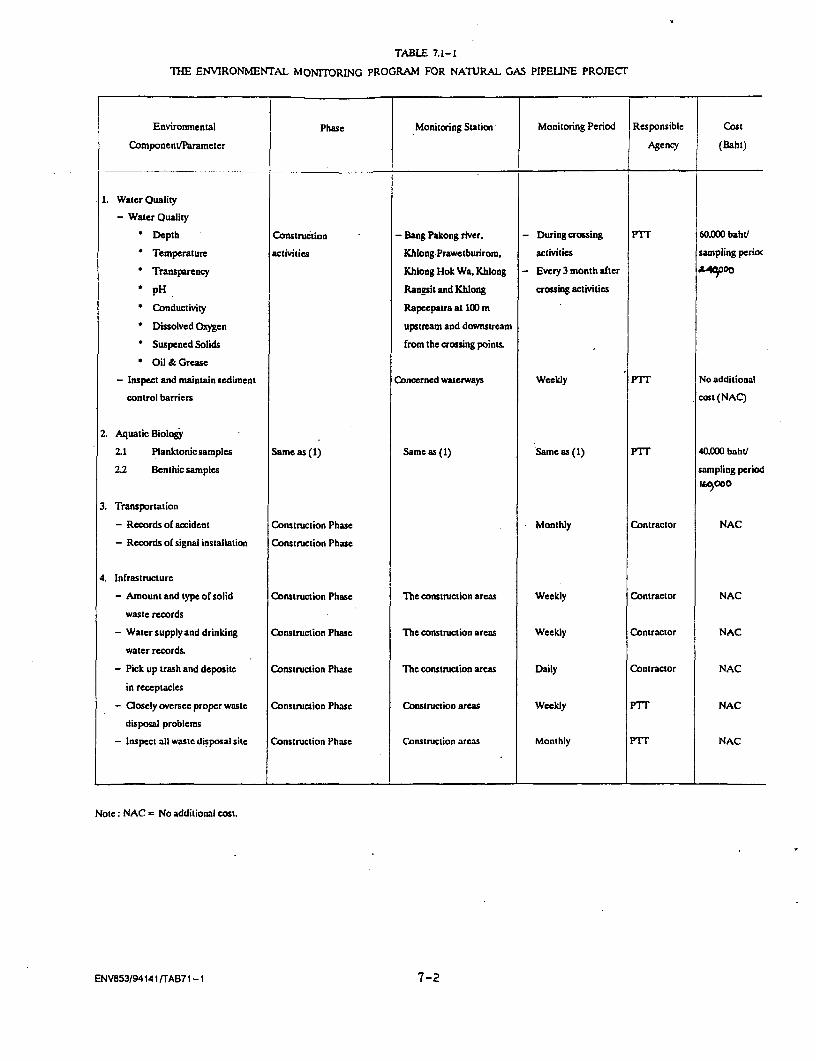
TABLE 7.1-1
THE ENVIRONMENTAL MONITORING PROGRAM FOR NATURAL GAS PIPELINE PROJECT
Environmental Phase Monitoring Station Monitoring Period Responsible Cost
Componenu/Parameter Agency (Baht)
1. Water Quality
- Water Quality
* Depth Construction - Bang Pakong river. - During crossing PTT 60,000 baht/
' Temperature activities Khlong.Prawetburirom, activities sampling perioc
* Transparency Khlong Hok Wa, Khlong - Every 3 month after A£40OO
' pH Rangsit and Khlong crossing activities
* Conductivity Rapeepatra at 100 m
Dissolved Oxygen upstream and downstream
* Suspened Solids from the crossing points.
Oil & Grease
- Inspect and maintain sediment Concerned waterways Weekly PTT No additional
control barriers cost (NAC)
2. Aquatic Biology
.21 Planktonic samples Same as (1) Same as (1) Same as (1) PTT 40.000 baht/
2.2 Benthic samples sampling period"Cooo
3. Transportation
- Records of accident Construction Phase Monthly Contractor NAC
- Records of signal installation Construction Phase
4. Infrastructure
- Amount and type of solid Construction Phase The construction areas Weekly Contractor NAC
waste records
- Water supply and drinking Construction Phase The construction areas Weekly Contractor NAC
water records.
- Pick up trash and deposite Construction Phase The construction areas Daily Contractor NAC
in receptacles
- Closely oversee proper waste Construction Phase Construction areas Weekly PTT NAC
disposal problems
- Inspect all waste disposal site Construction Phase Construction areas Monthly PIT NAC
Note: NAC = No additional cost.
ENV853/94141 ITAB71 -1 7-2
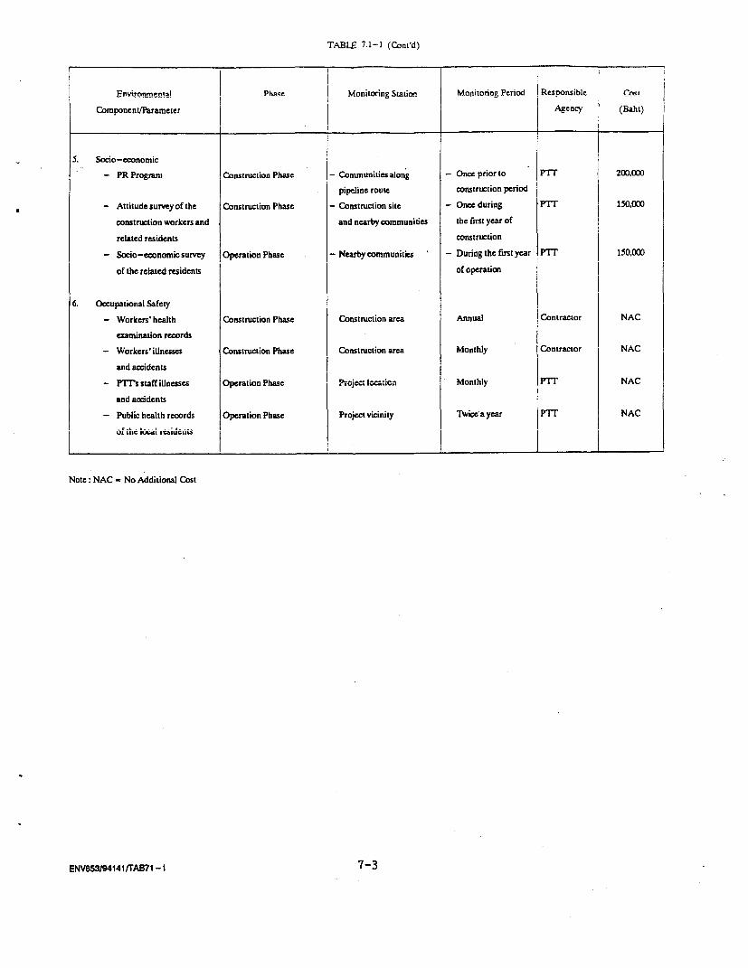
TABLE 7.1-1 (Cont'd)
Environmental Phase Monitoring Station' 1 Monitonng Period Responsible ! I
Component/Parameter Agency (Baht)
5. Socio-economic
- PR Program Construction Phase - Communities along - Once prior to PTT 200O.00
pipeline route construction period
- Attitude survey of the Construction Phase - Construction site - Once during PTT 150.000
construction workers and and nearby communities the first year of
relted residents construetion
- Socio-ewonomic survey Operation Phase - Nearby communities ' - During the first year PTT 150,000
of the related residents of operation
6. Occupational Safety
- Workers' health Construction Phase Construction area Annual Contractor NAC
examination records
- Workers' illnesses Construction Phase Construction area Monthly Contractor NAC
and accidents
- PITs staff illnesses Operation Phase Project location Monthly PTT NAC
and accidents
- Public health records Operation Phase Project vicinity Twice a year PTT NAC
--. a ghe ;u; liuC
Note: NAC No Additional Cost
ENVBSW/94141rAB71 -1 7-3
Record of signalling device installations during pipe laying
period.
7.4 INFRASTRUCTURE
- Record the weekly amount and type of solid waste generated on
the construction areas.
- Record the amount of weekly water supply and drinking water
for the personnel construction areas throughout the
construction phase.
- Daily pick up trash and properly deposited in the waste
receptacles.
- Closely oversee proper waste disposal problems.
- Inspect all waste disposal sites to assure the proper waste
disposal operations.
7.5 SOCIO-ECONOMIC
- Conduct Public Relation (PR) Program to inform local
residents about the project.
- During construction phase, the attitude survey should be
conducted once during the first year of construction after PR
Program to obtain socio-economic conditions of the
construction workers and attitude of the related residents.
During operation phase, the socio-economic survey should be
undertaken during the first year of the operation to assess
the actual attitude of the related residents.
7.6 OCCUPATIONAL SAFETY
- "Provide annual health examinations to all workers.
ENV853/94 140/CHAP-VI I
7-4
Monthly records on any illnesses and accidents during
construction and operation phases.
Updated public health record of the project vicinity every
six month to observe any alteration in public health
conditions of local residents.
7.7 CONCLUSIONS
The implementation of the Natural Gas Parallel Pipeline Project
will provide the fuel supply to EGAT Thermal Cycle Power Plant at Wang Noi
and reduce the dependency on foreign energy sources. In addition, the
local economics will receive source benefits in terms of job opportunities
and downstream businesses.
Nevertheless, there are some potential impacts to be related by the
development of this project, i.e., water quality/aquatic biology,
obstruction of transportation, socio-economics and safety aspects. The
anticipated impacts are relatively minor level of short term impacts.
Furthermore, the mitigation measures issued in this report will reduce the
forseen impacts to the acceptable levels. In order to assure the level of
impact and the effectiveness of the mitigation measures, the monitoring
programs were drawn up for the concerned environmental parameters include
water quality, aquatic biology, socio-economic, public health and safety.
With the measures and programs to be implemented by PTT according to this
study, sound environment can be sustained with this development.
ENV853/94140/CHAP-VI I
7-5
CO)
P>
0tTI
.;D
-4I
IllJ
Appendix A
ID Code ..........................Interviewer ...... / .Editor.......................
A STUDY OF SOCIO-ECONOMIC IMPACT GAS PIPELINE PROJECTALONG THE FORMER GAS PIPELINE
Name ... House No ...... Village Name ........ No.Tambon ... Amphoe .... Changwat.
1. General Information of Respondent
1.1 Sex1. Male ..... 2. Female
1.2 Age . years
1.3 Household Status of Respondent..... 1. Head ..... .2. Spouse
..... 3. Children/Son-in-law/daughter-in-law
..... 4. Sibling. 5. Others (Specified) .
1.4 Education Attainment..... 1. No Schooling 2. Primary..... 3. Secondary (grade 7-9)..... 4. Secondary (grade 10-12/Intermediate vocational)..... 5. College Diploma/Advanced Vocational..... 6. Bachelor and Over
1.5 Religion..... 1. Buddhism ..... 2. Chirstainity
..... 3. Islamism ..... 4. Other (Specified)...
1.6 Original Domicile..... 1. Born here..... 2. Migrated from other village of this Tambon..... 3. Migrated from other Tambon of this Amphoe..... 4. Migrated from other Amphoe of this Changwat..... 5. Migrated from other Changwat of this Region
........6. Migrated from other Region, Name the province.
1.7 If migrated from other place, the cause of migration is..... 1. Seek job ..... 2. Followparents/relatives..... 3. Have spouse here ..... 4. No agrt. land..... 5. Work requirement ..... 6. Other (Speified) .
ENVs53/9416/APPEN-A - 1 -
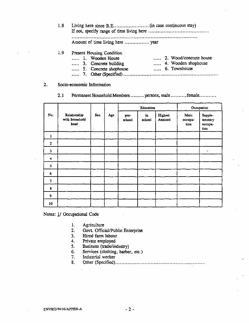
1.8 Living here since B.E .................. (in case continuous stay)If not, specify range of time living here ........................................................................................................................
Amount of time living here ................ year
1.9 Present Housing ConditiOn..... 1. Wooden House ..... 2. Wood/concrete house.... 3. Concrete building ..... 4. Wooden shophouse.... 5. Concrete shophouse ..... 6. Townhouse..... 7. Other (Specified) .
2. Socio-economic Information
2.1 PermanentHouseholdMembers ......... persons, male ......... , female.
Education Occupation
No. Relationship Sex Age pre- in Highest Main Supple-with household school school Attained occupa- mentary
head tion Occupa-tion
2
3
4
5
6
7
9
Notes: 1/ Occupational Code
1. Agriculture2. Govt. Official/Public Enterprise3. Hired farm labour4. Private employed5. Business (trade/industry)6. Services (clothing, barber, etc.)7. Industrial worker8. Other (Specified)..........................................................
ENV853/9416/APPEN-A - 2 -
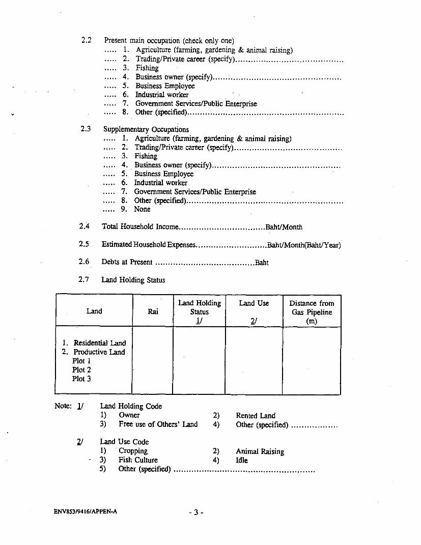
2.2 Present main occupation (check only one)..... 1. Agriculture (farming, gardening & animal raising)..... 2. Trading/Private career (specify)...... 3. Fishing..... 4. Business owner (specify)...... 5. Business Employee..... 6. Industrial worker..... 7. Government Services/Public Enterprise..... 8. Other (specified).
2.3 Supplementary Occupations..... 1. Agriculture (farming, gardening & animal raising)..... 2. Trading/Private career (specify) ..........................
..... 3. Fishing..... 4. Business owner (specify)...... 5. Business Employee..... 6. Industrial worker..... 7. Government Services/Public Enterprise..... 8. Other (specified)..... 9. None
2.4 Total Household Income .................... Baht/Month
2.5 Estimated Household Expenses .................... Baht/Month(Baht/Year)
2.6 Debts at Present .................... Baht
2.7 Land Holding Status
Land Holding Land Use Distance fromLand Rai Status Gas Pipeline
1/ 2/ (in)/
1. Residential Land2. Productive Land
Plot IPlot 2Plot 3
Note: 1/ Land Holding Code1) Owner 2) Rented Land3) Free use of Others' Land 4) Other (specified) .
2/ Land Use Code1) Cropping 2) Animal Raising3) Fish Culture 4) Idle5) Other (specified) .......................................................
ENV53/9416/APPEN-A - 3 -
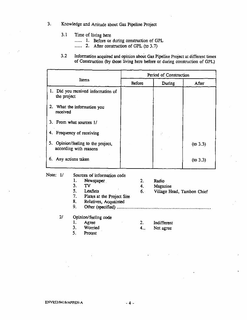
3. Knowledge and Attitude about Gas Pipeline Project
3.1 Time of living here.....1. Before or during construction of GPL.....2. After construction of GPL (to 3.7)
3.2 Information acquired and opinion about Gas Pipeline Project at different timesof Construction (by those living here before or during construction of GPL)
Period of ConstructionItems Before During After
1. Did you received information ofthe project
2. What the information youreceived
3. From what sources 1/
4. Frequency of receiving
5. Opinion/feeling to the project, (to 3.3)according with reasons
6. Any actions taken (to 3.3)
Note: 1/ Sources of information code1. Newspaper 2. Radio3. TV 4. Magazine5. Leaflets 6. Village Head, Tambon Chief7. Plates at the Project Site8. Relatives, Acquainted9. Other (specified).
2/ Opinion/feeling code1. Agree 2. Indifferent3. Worried 4.. Not agree5. Protest
ENV853/9416/APPEN-A 4 -

3.3 Your opinion and reactions toward the project after the construction period.
ltems 1-2 years after the 4-5 years after theconstruction construction
1. Opinion/feeling to theproject according withreasons I/
2. Any actions taken
Note: 1/ Opinion/feeling code1. agree 2. indiffereni3. worried 4. not agree5. protest
3.4 You think how much you know about the GPL project..... 1. Not at all ..... 2. Considerableunderstanding..... 3. Good understanding ..... 4. Other (specified).
3.5 What is your opinion of the project at present..... 1. Agree because...... 2. Indifferent..... 3. Worried about.
What action taken to reduce worries......................................What should be done to reduce worries....................................
.4. Not agree because .........................................................Any action taken ..........................................................How (if acted).............................................................
..... 5. Protestbecause .by what action ............................................................
3.6 Impact of GPL Project
3.6.1 During construction of GPL what kind of impact you got. 1. Not as all
2. Yes, i.e.,..... Loud noise..... Dust..... Smoke..... Vibration..... Inconvenient travelling..... Part of land was appropriated..... Have to change way to (from) home..... Have to move building/dwelling..... Impact on occupation because ...... Other (specified).
ENV85319416/APPEN-A - 5 -

3.6.2 Ever received compensation from government about GPL project. 1. No (pass to 3.6.4). 2. Yes
What kind of help/compensation (specify in details) ........................................................................
3.6.3 Are you satisfied with the compensation/help received.1. No because ............2. Yes because ............
3.6.4 Physical change after the construction of GPL compared withconditions before. 1. Dust
..... more
..... same
..... less. 2. Road surface along the GPL
..... better
..... same
..... worse.3. Other, i.e..
3.7 Information received of those living after construction GPL
3.7.1 Did you know about GPL project before moving here..... 1. No
2. YesReasons for moving here
. 1. Seek job..... 2. Follow parent/relatives..... 3. Having spouse here..... 4. No agricultural land.....5. Work requirement..... 6. Other (specified).
3.7.2 Have you ever received information about the project1. No
.2. Yes, about Source of information1. ......................2 ............ ......................3 ............ ......................
.3. Frequency of information .............. times
3.7.3 You think how much you know/understand the GPL project. 1. Not at all.2. Considerable understanding.3. Good understanding.4. Other (specified) ............................................
ENV853/9416/APPEN-A - 6 -
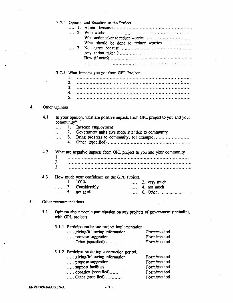
3.7.4 Opinion and Reaction to the Project. 1. Agree because .
.2. Worried about..What action taken to reduce worries ................................What should be done to reduce worries...................
.3. Not agree because.Any action taken? ............. . . .How (if acted) .......................................................................................................................................
3.7.5 What Impacts you got from GPL Project1................................................................................2...............................................................................3................................................................................4................................................................................5. ...............................................................................
4. Other Opinion
4.1 In your opinion, what are positive impacts from GPL project to you and yourcommunity?
1. Increase employment2. Government units give more attention to community3. Bring progress to community, for example.
..... 4. Other (specified).
4.2 What are negative impacts from GPL project to you and your community1. ....................................................................................2. ......................................................................................3. ......................................................................................
4.3 How much your confidence on the GPL Project.1. 100% ..... 2. very much3. Considerably ..... 4. not much5. not at all ..... 6. Other.
5. Other recommendations
5.1 Opinion about people participation on any projects of government (includingwith GPL project)
5.1.1 Participation before project implementation..... giving/following information Form/method..... propose suggestion Form/method..... Other (specified) ........... Form/method
5.1.2 Participation during construction period.* giving/following information Form/method..... propose suggestion Form/method..... support facilities Form/method..... donation (specified) ...... Form/method..... Other (specified) ........... Form/method
ENV853/9416/APPEN-A - 7 -

5.1.3 Participation on O&M period..... Giving/following information Form/method
..... Reporting to official about- gas pipeline damages and
risk conditions Form/method- hehave in a w^ ay that dsoe not damage or
reduce risk of damaging gas pipeline Form/method..... Other (specified) ......... Form/method
5.2 Have people ever participated in decision making on issues which haveimpacts upon them and their community (specified the details)
...................................................................................
5.3 In your opinion, should people participate in decision making on issues whichhave impacts upon them and their community or not (If so, identify the issuesand method of participation)
5.4 Other recommendation .......................................................................................................
ENV853/9416/APPEN-A -8 -

APPENDIX B
DETAiL FOR TYA^RDOUS ASSrSSM.EXT
APPENDIX B
DETAIL FOR HAZARDOUS ASSESSMENT
1. GAS OUTFLOW
Discharges from pipes containing gas under pressure are
calculated using the following formula
(r+l1)Q = YCAP 1 _. 2 (r-l)
RT1 r+lWhere
y = Outflow coefficient
Cd = Discharge coefficient
A, = Area of release (e2)
P1 = Process pressure (Nm2)
M = Molecular weight
r = Specific heats ratio
R = Universal gas constant (J mol'IK')
T, = Temperature of substrate (K)
Q = Release rate (kgs')
1.1 Onshore
Y = 1.0
Cd 1.0
P1 = 7.198x10⁶ Nmi2 (1044 PSIA)
M = 22.798
r = 1.23
R = 8.314 J mol1 K'
T, = 321.72 OK
1.1.1 20% of Pipe Diameter
A, = 0.3974
Q . 11,584 kg s'
ENV853/94140/APPEN-B

Gas outflow from the pipe leak of each operation condition was
estimated employing an above equation and the estimated outflow are
presented in Table 1 below:
1.1.2 l00's of PiPe Diameter
A, = 0.3 9 7 4 -
Q = 289,609
TABLE 1
GAS OUTFLOW OF THE PIPE LEAK RATE AT 20% AND 100%
OF PIPE DIAMETER
Operation Condition % of pipe leak Gas outflow rate
(% of pipe diameter) (kg/sec)
1. Onshore 20 11,584
(Pipe diameter, 100 289.609
Pressure 1,044 psia,
Temperature 120'F.
Molecular weight of gas 22.798)
2. FIREBALLS AND BLEVES
The maximum radius of the fireball is given by
Rf = 2.665 M-327
Where M is the flammable release mass in kilogrammes
The fireball has a duration, tg, given by
tf = 1.089 M0'27
The rate of release of energy by combustion is then given by
Q = Ul:MItr
Where il is the combustion efficiency, found to vary with the
saturated vapour pressure (p,) of the stoud material (in MN/m2) as follows:
11 = .2 7 p 0.32
The radiation flux, I, at a distance r from the centre of the
fi'reball is given by:
I = e4 r-
Where T is the transmissivity, conservatively taken as 1.
ENV853/94140/APPEN-B
,.: Instantaneous Release and Immediate Iqnition at Onshore
The estimation of release is based on the volume contained in the
pipe and 3 km in length.
2.1.1 Pipe Leak 100% of Pipe Diameter
P. = 4,650 psia (68.95 Nm2)psia
S. = 32.06x30 6 Nm`
= 32.06 MN m2
11 = 0.27 P, 0-32
= 0.27 (32.06)032
= 0.8190
Heating Value = 900 BTU/SCF
Hc = 900 BTU X 1,055 JSCF BTU
= 9.495xlO' J/SCF
density of natural gas at 1,044 psig and 1200F
= 4.57 Lbs/Ft 3
density at standard condition 14.7 psia and 60°F
- (4.57 Lbs) ( 14.7 ) (120x460)Ft3 1,044+14.7 60+460
= 0.0708 Lbs/SCF
H,Ic = 9.495x10 5 J x 1 SCF x 1 Lbsi SCF 0.0708 Lbs 0.4536 kg
= 2.96x10⁷ J/kg
M = pV
V = (22 2.333 ft (281") x 0.3048 m)2 x (3,000 m)7
= 4,768.89 m3
M = 4.57 Lbs x ft3 x 0.4536 kj x 4,768.89 m3
ft3 (.3048 m)3 lb
= 349,109.24 kg
Rf = 2.665 M03-7
= 2.665 (349,109.24)0327
= 173.08 m
tf = 1.089 (349,109.24)0.327
= 70.73 sec
Q = onkL!Mtf
ENV853/94140/APPEN-B
= 0.8190 x 2.96x10 7 x 349. 109.22470.73
= 1. 197x10" J/S
I =
4¶r-
at Rf = 173.08
I = 1. 197x10O' J/S4x22 (173)2 m2
I
7
= 318,021.48 J/S m2
= 3.180x10⁵ watt/M 2
= 318 kwatt/m 2
Estimate r for I = 37.5, 25.0, 12.5 and 4.0 kw/m2
r2 = 1.197xlO" J/S4x22xI m2
71/2
I = 3.75 r = 1.197xlO" J/S m2 = 503.89 m4x22 37.5xl0 3 J/S
7
I = 25.0 r = 617.14 m
I = 12.5 r = 872.77 m
I = 4.0 r = 1,542.85 m
2.1.2 PiPe Leak 20'# of Pipe Diameter
P. = 32.06 rMm2
rl 0= 0.8190Hc = 9.495xlO J/SCF
density = 4.57 Lbs/Ft3 at 1,044 psig and 120°F
density at standard condition 14.7 psig and 60°F
= 0.0708 Lbs/SCF
H. = 2. 96x10 7 J/kg
M = pv
v = 190.71 m3
M = 13,961 kg
Rf 2.665 rP 327 = 60.41 m
t, = 1.089 M0.327 24.68 sec
Q = n HM = 0.8190x2.96x10 7x13961t, 24.68
= 1.371x11 0 ° J/S
ENV853/94140/APPEN-B
I = Q = 1.37 1x10 w = 298,913 J/S m2
4 r2 4x22 (60.41)27
= 305 kwatt/m 2
I = 3.75 kw/m2 r = 170.53 m
I = 25.0 kw/m2 r = 208.86 m
I = 12.5 kw/m2 r = 295.37 m
I = 4.0 kw/m2 r = 522.15 m
2.2 Noninstantaneous Release with Immediate Iqnitions Jetf ire
(Onshore)
2.2.1 Pive Leak : 20% of Pipe Diameter
Gas outflow=11,584 kg/s (earlier calculation as shown in Table 1)
Gp n= n Q
'1 = 0.35
Q = 11,584 kg/s
T4 = 2. 96x10 7 J/kg
O-v = 0.35x11,584x2. 96x10 7kg.J
S kg= 1.200xlOl JS'k
I = gQp4jr2
where Xg is an emissivity factor which depends on the material
being burnt; and can be taken as 0.2
r = [(XQp) /41I] )'
- ((0.2x1.200xlOl) /4x22/7xI]'J
I = 37.5 kw/m 2 r = 225.68 m
I = 25.0 kw/m 2 r = 276.39 m
I = 12. S kw/m 2 r = 390.88 m
I = 4.0 kw/m2 r = 690.99 m
2.2.2 Pipe Leak : l00 of Pive Diameter
Gas outflow = 289,609 kg/s
Qp = 0.35x289,609x2.96x10 7
= 3.00Oxl01 2 J/S
4 I r2
I = 37.5 kw/m2 r = 1,128.38 m
ENV853/94140/APPEN-B
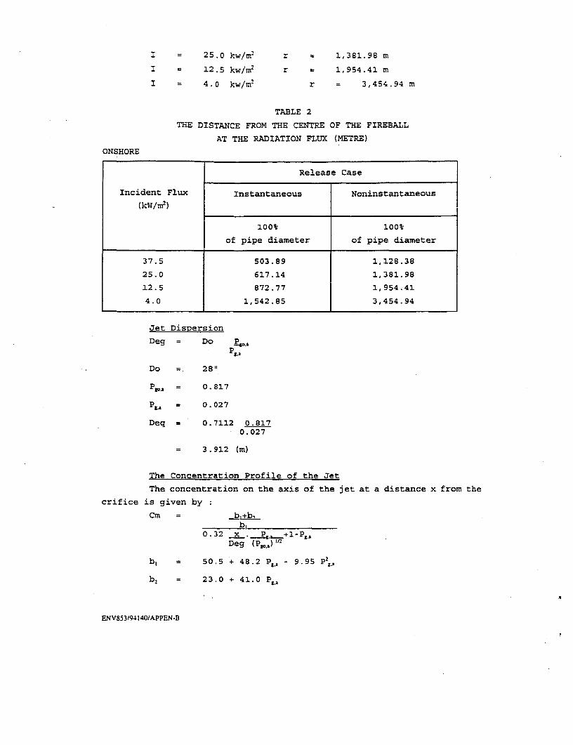
I = 25.0 kw/mn2 r 1,381.98 m
I 12.5 kw/m2 r 1,954.41 m
I = 4.0 kw/m2 r 3,454.94 m
TABLE 2
THE DISTANCE FROM THE CENTRE OF THE FIREBALL
AT THE RADIATION FLUX (METRE)
ONSHORE
Release Case
Incident Flux Instantaneous Noninstantaneous
(kW/m2 )
1001 100%
of pipe diameter of pipe diameter
37.5 503.89 1,128.38
25.0 617.14 1,381.98
12.5 872.77 1,954.41
4.0 1,542.85 3,454.94
Jet Dispersion
Deg = Do ,g.a
Do 28"
n os= 0.817
P&.a = 0.027
Deq = 0.7112 0.8170.027
= 3.912 (m)
The Concentration Profile of the Jet
The concentration on the axis of the jet at a distance x from the
crifice is given by :
Cm =b+b,b0
0.32 x .P,.- +1 -Pg.aDeg (P1 3 ) )t
b, = 50.5 + 48.2 Pea - 9.95 P',.
b, = 23.0 + 41.0 Pg,a
ENV853/94140/APPEN-B
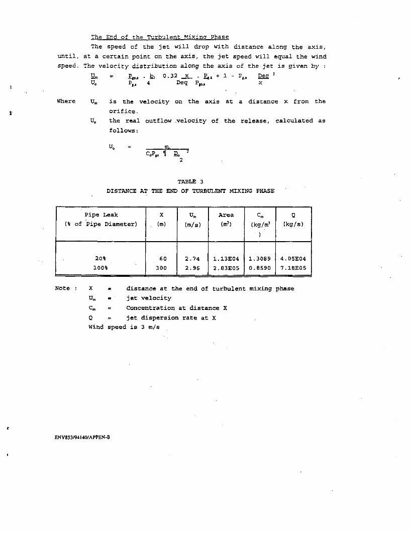
The End of the Turbulent Mixina Phase
The speed of the jet will drop with distance along the axis,
until, at a certain point on the axis, the jet speed will equal the wind
speed. The velocity distribution along the axis of the jet is given by
U_ = Po. . b 0.32 x . p+ -Pg, Dec 2
U. PsA 4 Deq Pg, x
Where Ur is the velocity on the axis at a distance x from the
orifice.
U0 the real outflow .velocity of the release, calculated as
follows:
CdSP, ¶ _o 22
TABLE 3
DISTANCE AT THE END OF TURBULENT MIXING PHASE
Pipe Leak X UM Area Cm .
(% of Pipe Diameter) (m) (m/s) (m2) (kg/ml (kg/s)
20% 60 2.74 1.13E04 1.3089 4.05E04
lo0t 300 2.96 2.83E05 0.8590 7.18E05
Note : X = distance at the end of turbulent mixing phase
Ur . jet velocity
C. = Concentration at distance X
Q = jet dispersion rate at X
Wind speed is 3 m/s
ENV8s3/94140/APPEN-B

TABLE 4
GAS DISPERSION BEYONG THE END OF TURBULENT MIXING PHASE
Atmospheric Stability Class
Pipe Leak (wind speed 3 m/s)
(% of pipe diameter) A B C D E F
20' Conc. % volume 2.65 1.19 0.81 0.19 2.53 1.81
Max. distance (km) 0.97 3.08 6.93 44.40 11.62 24.84
100% Conc. t volume 46.95 21.14 14.40 3.43 44.79 32.11
Max. distance (km) 0.97 3.08 6.93 44.40 11.62 24.84
TABLE 5
BUOYANT DISPERSION OF THE NATURAL GAS
Atmospheric Stability Class
Pipe Leak (wind speed 3 m/s)
(% of pipe diameter) A B C D E F
20% Conc. % volume 2.63 1.18 0.80 0.19 2.50 1.79
Max. distance (km) 0.97 3.10 6.98 44.93 11.69 25.05
100% Conc. % volume 46.95 3.45 2.53 0.56 7.30 5.23
Max. distance (km) 0.97 3.08 6.93 44.40 11.62 24.84
Note A-C = Unstable
D = Neutral
E-F = Stable
Instantaneous Release with Delayed IQnition
Adiabatic Expansion/Flash Fire
1/4d = 0.0137 (V>0)13 E
2'2 X2j
Where V.. is the volume of the gas at standard temperature and
pressure.
E is the energy of expansion
ENV853/94140/APPEN-8
,.
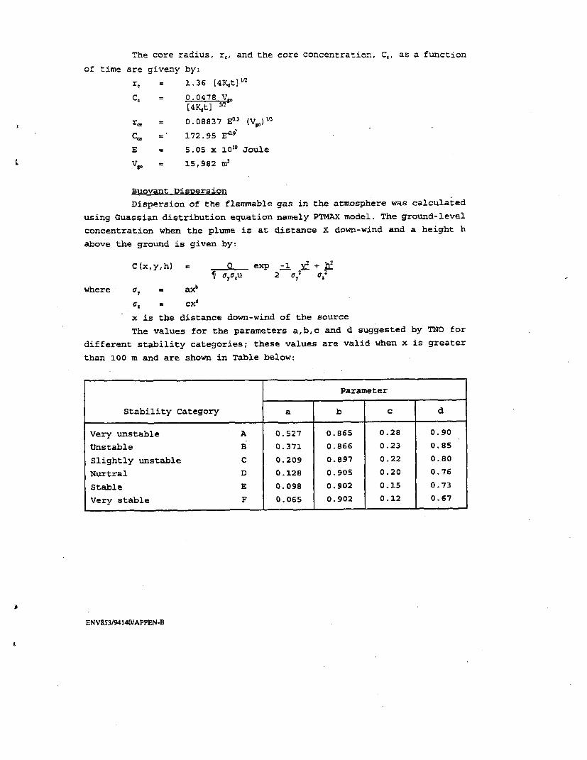
The core radius, r,, and the core concentration, C, as a function
of time are giveny by:
r - 1.36 [4Yt)"2
CC, = 0.0478 Vw
[4Kht2 31
; r - 0.08837 E03 (VV)"3
C, - 172.95 e-'
E 5.05 x 10¹⁰ Joule
V 0 - 15,982 m'
Buoyant Dispersion
Dispersion of the flammable gas in the atmosphere was calculated
using Guassian distribution equation namely PTMAX model. The ground-level
concentration when the plume is at distance X down-wind and a height h
above the ground is given by:
C(x,y,h) e Q exp -1 v + _
¶ cyacu 2 cr y 2
where -or a axb
or, cxd
x is the distance down-wind of the source
The values for the parameters a,b,c and d suggested by TNO for
different stability categories; these values are valid when x is greater
than 100 m and are shown in Table below:
Parameter
Stability Category a b c d
Very unstable A 0.527 0.865 0.28 0.90
Unstable B 0.371 0.866 0.23 0.85
Slightly unstable C 0.209 0.897 0.22 0.80
Nurtral D 0.128 0.905 0.20 0.76
Stable E 0.098 0.902 0.15 0.73
Very stable F 0.065 0.902 0.12 0.67
ENVY53/94140/APPEN-B
Top Related
Copyright © 2022 FDOKUMEN

