


Bahasa
Halaman
Hukum


COUGAR GENETIC VARIATION AND GENE FLOW IN A HETEROGENEOUS
LANDSCAPE
By
Matthew Warren
Accepted in Partial Completion
Of the Requirements for the Degree
Master of Science
____________________________________
Kathleen L. Kitto, Dean of the Graduate School
ADVISORY COMMITTEE
____________________________________
Chair, Dr. David Wallin
____________________________________
Dr. Andrew Bunn
____________________________________
Dr. Kenneth Warheit

MASTER’S THESIS
In presenting this thesis in partial fulfillment of the requirements for a master’s degree at
Western Washington University, I grant to Western Washington University the nonexclusive
royalty-free right to archive, reproduce, distribute, and display the thesis in any and all forms,
including electronic format, via any digital library mechanisms maintained by WWU.
I represent and warrant this is my original work, and does not infringe or violate any
rights of others. I warrant that I have obtained written permissions from the owner of any
third party copyrighted material included in these files.
I acknowledge that I retain ownership rights to the copyright of this work, including but not
limited to the right to use all or part of this work in future works, such as articles or books.
Library users are granted permission for individual, research and non-commercial
reproduction of this work for educational purposes only. Any further digital posting of
this document requires specific permission from the author.
Any copying or publication of this thesis for commercial purposes, or for financial gain, is
not allowed without my written permission.
Matthew J. Warren
July 12, 2013

COUGAR GENETIC VARIATION AND GENE FLOW IN A HETEROGENEOUS
LANDSCAPE
A Thesis
Presented to
The Faculty of
Western Washington University
In Partial Fulfillment
Of the Requirements for the Degree
Master of Science
by
Matthew J. Warren
July 2013

iv
ABSTRACT
Management of game species requires an understanding not just of population abundance,
but also the structure of and connections between populations. Like other large-bodied
carnivores, the cougar (Puma concolor) exhibits density –dependent dispersal and is capable
of long-distance movement; in the absence of barriers to movement, these traits should lead
to high connectivity between individuals and a lack of genetic differentiation across areas of
continuous habitat. Previous research has suggested that cougar movement may be
influenced by landscape variables such as forest cover, elevation, human population density,
and highways. I assessed the population structure of cougars (Puma concolor) in Washington
and southern British Columbia by examining patterns of genetic variation in 17 microsatellite
loci, and the contribution of landscape variables to this genetic variation.
I evaluated population structure using genetic clustering algorithms and spatial
principal components analysis. I quantified the effect of distance on genetic variation by
calculating the correlation between the genetic distance and geographic distance between
every pair of individuals, as well as the spatial autocorrelation of genetic distances. To
compare the observed pattern of genetic differentiation with that which would arise solely
from isolation by distance, I simulated allele frequencies across the study area where the cost
to movement between individuals was proportional to the distance between them. I also
evaluated the support for evidence of male-biased dispersal in allele frequencies. Bayesian
clustering analyses identified four populations in the study area, corresponding to the
Olympic Peninsula, Cascade Mountains, northeastern Washington and Blue Mountains; these
clusters were supported by patterns of genetic differentiation revealed with spatial PCA.

v
Although I found a significant relationship between the geographic and genetic distance
between individuals, simulated allele frequencies displayed no meaningful spatial pattern of
differentiation, suggesting that male dispersal would be adequate within the scale of the study
area to prevent genetic isolation from occurring if the only factor to affect dispersal was
geographic distance.
While cougars are capable of long-distance dispersal movements, dispersal in
heterogeneous landscapes may be mediated by the resistance of the landscape to movement. I
derived resistance surfaces for forest canopy cover, elevation, human population density and
highways based on GIS data and estimated the landscape resistance between pairs of
individuals using circuit theory. I quantified the effect of the resistance to movement due to
each landscape factor on genetic distance using multiple regression on distance matrices and
boosted regression tree analysis. Both models indicated that only forest canopy cover and the
geographic distance between individuals had an effect on genetic distance, with forest cover
exhibiting the greatest relative influence.
The boundaries between the genetic clusters I found largely corresponded with breaks
in forest cover, showing agreement between population structure and landscape variable
selection. The greater relative influence of forest cover may also explain why a significant
relationship was found between geographic and genetic distance, yet geographic distance
alone could not explain the observed pattern of allele frequencies. While cougars inhabit
unforested areas in other parts of their range, forested corridors appear to be important for
maintaining population connectivity in the northwest.

vi
ACKNOWLEDGEMENTS
This work was a collaborative effort between Washington Department of Fish and Wildlife
(WDFW) and Western Washington University (WWU). All genetic samples were obtained
and genotyped by WDFW; in particular I would like to thank Donny Martorello for
coordinating the statewide collection of samples from hunters and providing access to this
dataset, Richard Beausoleil for obtaining cougar samples in the field, and Cheryl Dean and
Kenneth Warheit of the WDFW Molecular Genetics Laboratory for genotyping all samples.
Thank you to Dietmar Schwarz and Tyson Waldo at WWU for advice and assistance during
data analysis. Funding for this project was provided by WDFW, Seattle City Light, the
Washington Chapter of the Wildlife Society, North Cascades Audubon Society, and Huxley
College of the Environment. I am grateful to my advisor, David Wallin, and committee
members Andrew Bunn and Kenneth Warheit, for their guidance and encouragement
throughout this project. Thank you to Erin Landguth for help with CDPOP simulations. I
would also like to thank Spencer Houck and Heidi Rodenhizer for assistance with GIS
processing. Finally, I would like to thank my wife, Pascale, for urging me to take this project
on, and never failing to offer support and advice.

vii
TABLE OF CONTENTS
ABSTRACT ............................................................................................................................... iv
ACKNOWLEDGEMENTS ............................................................................................................. vi
LIST OF TABLES ....................................................................................................................... ix
LIST OF FIGURES ....................................................................................................................... x
CHAPTER 1 ................................................................................................................................ 1
INTRODUCTION ............................................................................................................. 1
METHODS ..................................................................................................................... 3
Sample collection and genotyping ................................................................... 3
Study area......................................................................................................... 4
Population structure ......................................................................................... 5
Sex-biased dispersal ......................................................................................... 7
Isolation by distance ........................................................................................ 8
Simulation of allele frequencies....................................................................... 9
RESULTS ..................................................................................................................... 10
Genotyping ..................................................................................................... 10
Population structure ....................................................................................... 11
Descriptive statistics ...................................................................................... 12
Sex-biased dispersal ....................................................................................... 13
Isolation by distance ...................................................................................... 13
Simulation of allele frequencies..................................................................... 14
DISCUSSION ................................................................................................................ 14
Population structure ....................................................................................... 14
Management units .......................................................................................... 17
Sex-biased dispersal ....................................................................................... 17
Isolation of the Olympic Peninsula ................................................................ 18
Isolation by distance ...................................................................................... 19
CHAPTER 2 .............................................................................................................................. 37
INTRODUCTION ........................................................................................................... 37
METHODS ................................................................................................................... 40
Landscape resistance surfaces ........................................................................ 41

viii
Resistance to gene flow ................................................................................. 44
Multiple regression on distance matrices ....................................................... 44
Boosted regression trees ................................................................................ 46
RESULTS ..................................................................................................................... 48
Data distribution and trends ........................................................................... 48
Multiple regression on distance matrices ....................................................... 48
Boosted regression trees ................................................................................ 49
DISCUSSION ................................................................................................................ 50
Isolation of the Olympic Peninsula revisited ................................................. 50
Considerations for using Mantel tests ............................................................ 52
Model validation ............................................................................................ 53
LITERATURE CITED ................................................................................................................. 68

ix
LIST OF TABLES
Chapter 1
Table 1. Loci genotyped and number of alleles for cougar genetic samples ......................... 20
Table 2. Indices of genetic diversity for cougar population clusters ..................................... 21
Table 3. Estimates of genetic differentiation between cougar population clusters ................ 21
Table 4. Sex-biased dispersal permutation results ................................................................. 21
Chapter 2
Table 1. Multiple regression on distance matrices global model results ............................... 57
Table 2. Multiple regression on distance matrices reduced model results ............................ 57
Table 3. Mantel correlations between explanatory variables ................................................. 58
Table 4. Variance inflation factor coefficients for explanatory variables ............................. 58

x
LIST OF FIGURES
Chapter 1
Figure 1. Map of the study area ............................................................................................. 22
Figure 2. Estimated number of Geneland clusters ................................................................. 23
Figure 3. Geneland cluster membership ................................................................................ 24
Figure 4. Boundaries between Geneland clusters .................................................................. 25
Figure 5. Structure cluster membership ................................................................................. 26
Figure 6. Mantel correlograms for male, female, and combined samples ............................. 27
Figure 7. Spatial principal components analysis eigenvalues and scree plot ........................ 28
Figure 8. Spatial principal components analysis permutation tests ....................................... 29
Figure 9. First global spatial principal components analysis axis ......................................... 30
Figure 10. Second global spatial principal components analysis axis ................................... 31
Figure 11. Relationship between geographic and genetic distance ....................................... 32
Figure 12. Simulated correlation between genetic and geographic distance ......................... 33
Figure 13. Simulated estimate of number of Geneland clusters ............................................ 34
Figure 14. Simulated spatial principal components analysis scree plot ................................. 35
Figure 15. First simulated global spatial principal components analysis axis ....................... 36
Chapter 2
Figure 1. Extent of study area for estimating landscape resistance ....................................... 59
Figure 2. Landscape resistance surface for elevation ............................................................ 60
Figure 3. Landscape resistance surface for forest canopy cover ........................................... 61
xi
Figure 4. Landscape resistance surface for human population density ................................. 62
Figure 5. Landscape resistance surface for highways ............................................................ 63
Figure 6. Relationships between genetic distance and explanatory variables ....................... 64
Figure 7. Single regression tree for genetic distance ............................................................. 65
Figure 8. Relative influence of variables in boosted regression tree model .......................... 66
Figure 9. Partial dependence plots from boosted regression tree model ............................... 67

1
CHAPTER 1
Cougar spatial genetic variation and population structure in Washington and southern
British Columbia
INTRODUCTION
The cougar (Puma concolor) is an apex predator in Washington, where it is managed as a
game species, and sport hunting is currently used as the primary mechanism of population
control (WDFW 2011). Depending on the scale of hunting pressure, however, cougar
population density may not be affected, as high mortality in one area may be offset by
increased immigration of subadult males from surrounding areas (Robinson et al. 2008).
Effective management of cougars therefore requires a better understanding of population
structure across the state, specifically whether the state’s cougars comprise a single,
panmictic population, or function as a metapopulation.
Variation in selectively-neutral regions of the genome, such as microsatellites, can be
used to infer population structure. Like other large-bodies carnivores, cougars are capable of
dispersing across long distances, generally resulting in continuous populations across areas of
suitable habitat (Anderson et al. 2004). Genetic differentiation may then result as a function
of distance, where individuals separated by greater distances are less closely related than
individuals in close proximity to each other; this phenomenon is referred to as isolation by
distance (Wright 1943). Cougars typically disperse upon becoming independent from their
mother, between 1 and 2 years of age (Logan and Sweanor 2010). Subadult males are more
likely than subadult females to disperse, and generally travel farther than females (Logan and

2
Sweanor 2000; Sweanor et al. 2000); in Washington, the average male dispersal distance is
190 – 250 km (R. Beausoleil, personal communication). This propensity for long-distance
dispersal may be enough to prevent a pattern of isolation by distance from being observed in
Washington, however isolation by distance has been reported in cougars from California and
Wyoming (Ernest et al. 2003; Anderson et al. 2004).
Inbreeding in small, isolated populations can result in a loss of heterozygosity, and
over time deleterious alleles may accumulate in the population, resulting in losses of fitness.
Evidence of inbreeding depression was clearly seen in Florida panthers (Puma concolor
coryi), an isolated subspecies of the cougar, including sperm defects, undescended testicles,
and heart defects (Roelke et al. 1993). The shrinking population and low reproduction
success ultimately led U.S. Fish and Wildlife biologists to translocate eight female cougars
from Texas to South Florida, to reverse decades of inbreeding (Pimm et al. 2006). One of
only three previously identified genetic bottlenecks in North American cougars comes from
the Olympic Peninsula (Culver et al. 2000), and the low level of heterozygosity observed in
Olympic cougars led Beier (2010) to suggest that reintroductions may be needed to ward off
inbreeding depression. Connectivity between individuals on the Olympic Peninsula and the
nearby Cascade Mountains remains unresolved.
Discrete populations can be identified and delimited using genetic clustering
algorithms, which assign individuals to clusters by minimizing Hardy-Weinberg and linkage
disequilibria within groups (Guillot et al. 2005). Allele frequencies in a population at Hardy-
Weinberg equilibrium do not change from one generation to the next, allowing genotype
frequencies to be estimated based on the squared sum of the frequency of alleles. The

3
population’s heterozygosity, which refers to having two different alleles at a particular locus,
can then be calculated, and provides an indication of the amount of genetic variability in the
population. Hardy-Weinberg equilibrium is an idealized state where natural selection exerts
no influence on any locus being considered, there is no mutation or migration of individuals
into the population, population size is infinite and mating is random. Linkage disequilibrium
is the non-random association between alleles at two or more different loci, and can be an
indication of non-random mating or population structure within an area (Freeland 2006).
The primary aim of this study was to describe patterns of genetic variation across the
state, in order to reveal the underlying population structure in the region. This was
accomplished using cluster analysis and spatial principal components analysis (PCA). Based
on these analyses, I sought to clarify the status of Olympic Peninsula cougars, and reevaluate
their isolation from the rest of Washington and British Columbia. I also looked for genetic
evidence of male-biased dispersal. Finally, to compare the spatial genetic variation which
would arise solely from isolation by distance with the observed variation, I simulated allele
frequencies across the study area where distance between individuals was the only cost to
movement.
METHODS
Sample collection and genotyping
The Washington Department of Fish and Wildlife (WDFW) collected 612 muscle or tissue
samples from cougars across the state of Washington between 2003 and 2010. Additionally,
55 samples were obtained from the British Columbia Ministry of Forests, Lands and Natural

4
Resource Operations. Samples were taken from animals that were killed by hunters, removed
in response to public safety concerns or livestock depredation, or from live research subjects.
All genotyping was performed by the WDFW molecular genetics laboratory in Olympia,
Washington. DNA was extracted from blood and tissue samples using DNeasy blood and
tissue isolation kits. Polymerase chain reaction was used to amplify 18 previously
characterized microsatellite markers (Menotti-Raymond and O’Brien 1995; Culver 1999;
Menotti-Raymond et al. 1999). PCR products were visualized with an ABI3730 capillary
sequencer (Applied Biosystems) and sized using the Gene-Scan 500-Liz standard (Applied
Biosystems). Locations of each animal were plotted based on hunter descriptions and added
to a point shapefile; locations are considered accurate within 10 km (Figure 1).
I checked for amplification and allele scoring errors using Microchecker version 2.2.3
(van Oosterhout et al. 2004). I used Genepop version 4.1 (Rousset 2008) to test for deviations
from Hardy-Weinberg and linkage equilibria; alpha was adjusted using a simple Bonferroni
correction to accommodate multiple tests (Rice 1989).
Study area
The study area included all of Washington state and a portion of southern British Columbia
(Figure 1). It was comprised of ten ecoregions: Columbia Mountains/Northern Rockies,
North Cascades, Eastern Cascades slopes and foothills, Blue Mountains, Pacific and Nass
Ranges, Strait of Georgia/Puget Lowland, Coast Range, Willamette Valley, Thompson-
Okanogan Plateau, and Columbia Plateau (Wiken et al. 2011). Elevation ranged from 0 to
4,392 m above sea level. Human population density varied considerably across the study

5
area, ranging from roadless wilderness to the metropolitan areas of Seattle, Tacoma, and
Spokane, WA.
Cluster analysis
I used two Bayesian clustering programs to explore patterns of population structure within
the study area. Geneland version 3.3.0 (Guillot et al. 2005) estimates the number of clusters
within the global population and assigns individuals to clusters by minimizing Hardy-
Weinberg and linkage disequilibria within groups. The geographic coordinates of each
individual are included in their prior distributions (Guillot et al. 2005). I used the spatial
model with null alleles and uncorrelated allele frequencies. The uncertainty attached to the
coordinates for each individual was 10 km, a maximum of 10 populations was assumed, and
106 iterations were performed, of which every 100
th observation was retained.
I used Structure version 2.3.4 (Falush et al. 2003) without prior location information
to see if patterns of cluster assignment changed when based solely on allele frequencies. I
used the admixture model with correlated allele frequencies, a burn-in period of 105
repetitions followed by 106 Markov Chain Monte Carlo repetitions. Both Structure and
Geneland assume that discrete subpopulations exist in the study area, and that allele
frequencies in these subpopulations are in Hardy Weinberg and linkage equilibria.
Spatial PCA
Clustering algorithms are designed primarily to identify discrete groups of individuals,
therefore I also used spatial PCA to detect clinal population structure. Spatial PCA is a

6
modified version of PCA where synthetic variables maximize the product of an individual’s
principal component score, based on allele frequencies, and Moran’s I, a measure of spatial
autocorrelation (Jombart et al. 2008). Spatial autocorrelation is calculated between
neighboring points as defined by a connection network. I generated a Gabriel graph to define
this connection network, which connects two sample points only if a circle drawn between
those points does not include any others. A network based on a Gabriel graph has fewer
connections than one based on a Delaunay triangulation, which may connect distant points on
the edge of the network, and more connections than one based on a minimum spanning tree
(Legendre and Legendre 2012). Unlike Geneland and Structure, spatial PCA does not make
assumptions regarding Hardy Weinberg and linkage equilibria, so the results of this analysis
are not subject to the same issues of interpretability as those of the above clustering
programs. Spatial PCA breaks spatial autocorrelation into global structure, where neighbors
are positively autocorrelated, and local structure, where neighbors are negatively
autocorrelated (Jombart et al. 2008).
Descriptive statistics
I calculated total number of alleles, mean number of alleles per locus, number of private
alleles, expected heterozygosity (Nei 1987), and observed heterozygosity for each population
cluster identified by the Geneland analysis using Microsatellite Toolkit version 3.1.1 (Park
2001). To compare genetic differentiation between clusters I calculated pairwise estimates of
FST (Weir and Cockerham 1984) using Genepop version 4.1. I also used GENALEX v. 6.4 to
estimate inbreeding coefficients (FIS) for each cluster (Peakall and Smouse 2006).

7
Sex-biased dispersal
I looked for evidence of male-biased dispersal in genotype frequencies using Monte-Carlo
permutation tests of three common population genetic statistics: assignment index (AIC),
fixation index (FST), and inbreeding coefficient (FIS) in Fstat version 2.9.3.2 (Goudet 2001;
Goudet et al. 2002). I calculated the mean of each test statistic separately for each sex, and
then the difference between the means for each sex; genotypes were then randomly assigned
a sex and the difference between the means was recalculated. All tests were conducted with
1,000 permutations, and significance was assumed at P ≤ 0.05. The AIc calculates how likely
a given genotype is to occur within that subpopulation, based on subpopulation-specific
allele frequencies (Goudet et al. 2002); I used the results of Geneland clustering to define
subpopulations. Since male cougars are more likely to disperse than females, males were
expected to have a lower mean AIc value, because the genotypes of immigrants have a lower
probability of occurring in a subpopulation than those of residents. Variance of AIc values
should be highest for males, due to higher immigration. I also tested for differences in
genetic differentiation between the sexes, in terms of FST and FIS. FST is a pairwise measure
of the genetic differentiation between subpopulations, relative to total genetic variance.
Immigration results in greater mixing of alleles, therefore FST was expected to be lower in
males. FIS, on the other hand, describes the fit of genotype frequencies to Hardy-Weinberg
conditions; higher immigration rates for male cougars imply that within a single
subpopulation, males will be from multiple subpopulations. This subpopulation structure,
referred to as the Wahlund effect, manifests itself as a reduction in observed heterozygosity,
and should result in higher FIS values for males (Goudet et al. 2002).

8
Spatial autocorrelation
To determine the scale at which spatial patterns are detectable in allele frequencies, I
constructed a Mantel correlogram using GENALEX v. 6.4 (Peakall and Smouse 2006). The
correlogram was based on a geographic distance matrix derived from the Euclidean distance
between the coordinates of each individual, and the genetic distance between individuals,
calculated as Peakall and Smouse’s r (Peakall and Smouse 2006). I used Sturges’ Rule to
determine the number of distance classes (D) to use in the correlogram based on the range of
pairwise distances (R) and the sample size (n):
D = R___
1 + log2 n
(Sturges 1926). This resulted in 10 distance classes which were each 60 km wide. This
analysis was then repeated separately for each sex.
Isolation by distance
I tested for an effect of geographic distance on genetic distance using a simple Mantel test in
the ecodist package for R with 1,000 permutations (Goslee and Urban 2007). Euclidean
distances between the coordinates for every pair of individuals were calculated in R. I used
principal components analysis (PCA) of allele frequencies to calculate genetic distances
between individuals; I created a distance matrix in R derived from the first principal
component scores for each individual (Patterson et al. 2006; Shirk et al. 2010).

9
Simulation of allele frequencies
To compare the observed pattern of spatial genetic variation with that which would arise
under a scenario of isolation by distance, I used CDPOP version 1.2.08 (Landguth and
Cushman 2010) to simulate allele frequencies at 17 microsatellite loci across the study area.
Initial allele frequencies were randomized and the simulation was run for 6,000 years to
approximate genetic exchange during the late Holocene. The population began with 3,000
individuals; this number was based on the most recent estimate of juveniles and adults in
Washington (WDFW 2011), and extrapolated to include kittens and individuals in south-
central British Columbia. In addition to the locations of the 667 samples described above, I
generated 2,333 random locations in forested regions of the study area to serve as starting
locations for potential mates. I used a Euclidean distance matrix as the cost matrix for mating
movement and dispersal, where mating was random for pairs within 55 km of each other,
based on the average female home range size in southeastern British Columbia (Spreadbury
et al. 1996). Dispersal for both sexes was defined as the inverse square of the cost distance,
with thresholds based on average dispersal distances: 32 km for females (Anderson et al.
1992; Sweanor et al. 2000; Maehr et al. 2002), and 220 km for males (R. Beausoleil, personal
communication). Females began reproducing at 2 years of age and the number of offspring
was drawn from a Poisson distribution with a mean of 3. Age-specific mortality rates were
taken from published values in a lightly-hunted population in central Washington (Cooley et
al. 2009). I repeated the above clustering and sPCA analyses on the ending allele frequencies
for comparison with the observed data. The relationships between simulated genetic distance

10
and geographic distance, as well as observed genetic distance, were assessed using simple
Mantel tests as described above.
RESULTS
Genotyping
I detected significant homozygote excess at 16 loci when all individuals were pooled into a
single population, which could have resulted from the presence of null alleles or genetic
structure in the study area, due to the Wahlund effect. Estimated frequencies of null alleles
were ≤ 5.1% for all but one locus (FCA293, 13.5%). Geneland clustering revealed multiple
populations in the study area (described below). After separating individuals into the clusters
indicated by Geneland, the estimated frequency of null alleles at locus FCA293 was still
greater than 10% in two of four clusters, therefore this locus was dropped and all subsequent
analyses were based on the remaining 17 loci (Table 1).
Eight loci were out of HWE after Bonferroni correction for multiple tests, suggesting
that there is not a single, panmictic population in the study area. Concurrent with HWE
testing, I detected significant departures from linkage equilibrium in 55 of 152 pairwise
comparisons between loci after Bonferroni correction. Seven of 17 loci occur on separate
chromosomes or linkage groups and should be considered independent (Menotti-Raymond et
al. 1999), while one locus, FCA166, has yet to be mapped. After separating individuals into
clusters identified by Geneland, no consistent patterns of linkage or Hardy-Weiberg
disequilibria between clusters remained. All 17 retained loci were polymorphic, with
between 2 and 9 alleles per locus and 91 total alleles globally.

11
Cluster analysis
Support was highest for four populations in the study area in the Geneland simulations
(Figure 2). The clusters corresponded roughly with the Blue Mountains in southeastern
Washington, northeastern Washington, western Washington following the Cascade
Mountains, and the Olympic Peninsula (Figure 3). Cluster 1 was geographically isolated and
lay across the Columbia River Basin from clusters 2 and 3 (Figure 4a). The boundary
between clusters 2 and 3 corresponded with the Okanogan Valley (Figure 4b and 4c), and
cluster 3 was separated from cluster 4 by Puget Sound and the I-5 corridor (Figure 4d).
I also clustered the samples using the STRUCTURE program without location
information and the number of clusters set to 4. Greater spatial overlap between clusters
could be seen in the Structure assignment results compared with those from Geneland
(Figure 5). The barplot of probability of population membership shows a sharply defined
Olympic Peninsula cluster (Figure 5, in yellow), while the other three clusters transition
gradually from one to the next, with several individuals in each cluster having mixed
membership in multiple clusters.
sPCA
The first two global sPCA axes explained most of the spatial genetic variation (Figure 7a),
and were well differentiated from all other axes (Figure 7b); therefore only these two axes
were retained. Additionally, the test for global structure, a Monte Carlo randomization test
using 999 permutations, was highly significant (max(t) = 0.016, P = 0.001; Fig. 8). Local
sPCA axes explained little spatial genetic variation (Figure 7a) and were poorly differentiated

12
from each other (Figure 7b); no evidence of local structure was found (max(t) = 0.0028, P =
0.74; Figure 8b).
The first global sPCA axis displayed strong east-west genetic differentiation across
the study area; the strongest separation between neighboring samples was found along the
Okanogan Valley and edge of the Columbia River Basin (Figure 9). The second global sPCA
axis clearly separated out individuals on the Olympic Peninsula and in the Blue Mountains
from the rest of the state, as well as showing a weak east-west gradient in genetic similarity
in northeastern Washington, coinciding approximately with the Columbia River (Figure 10).
This does not imply that cougars on the Olympic Peninsula and in the Blue Mountains are
closely related to each other, rather that they are strongly differentiated from their nearest
neighbors.
Descriptive statistics
The total and mean number of alleles was highest in the northeast and Cascades clusters,
which also had the highest sample sizes (Table 2). Both expected and observed
heterozygosity were far lower in the Olympic cluster than in all other clusters, indicating
lower genetic diversity in Olympic cougars, and possibly greater isolation of this cluster
(Table 2). Population differentiation (FST) increased with distance between clusters;
differentiation was lowest between the northeast and Cascades clusters, and highest between
the Olympic and Blue Mountain clusters (Table 3). The geographically adjacent Olympic and
Cascades clusters showed a surprising degree of differentiation (FST = 0.145), in accord with
greater isolation of the Olympic cluster.

13
Spatial autocorrelation
I detected significant positive spatial autocorrelation in allele frequencies in the first three
distance classes, and significant negative spatial autocorrelation in distance classes 4 through
8; this indicates that spatial autocorrelation is positive up to 180 km, and negative beyond
180 km (Figure 6a). The results beyond 480 km should not be interpreted due to high
variances resulting from low sample sizes. When samples were separated by sex, the results
for males did not differ from those of all samples combined (Figure 6b). For female samples,
the 95% confidence interval for the 180 km distance class included 0, indicating that positive
spatial autocorrelation was detected only up to 120 km (Figure 6c). This suggests that spatial
autocorrelation of allele frequencies occurs over a smaller spatial scale for female cougars.
Sex-biased dispersal
The mean assignment index (AIc) value was significantly lower for males than for females,
as would be expected with male-biased dispersal (P = 0.029; Table 4). The variance in AIc
values was higher for male cougars, however this difference was not significant (Table 3).
Also in keeping with male-biased dispersal, male cougars exhibited significantly higher FIS
values than female cougars (P = 0.003; Table 4). FST values were lower, though not
significantly, for male cougars (Table 4).
Isolation by distance
Genetic distance was positively correlated with geographic distance, however this
relationship was fairly weak (r = 0.33, P = 0.001). Log-transforming geographic distance did

14
not strengthen the correlation. Low genetic distances were seen at a wide range of geographic
distances, indicating that closely related individuals can be found hundreds of kilometers
apart from each other (Figure 11).
Simulation of allele frequencies
Simulated genetic distance and geographic distance were not significantly correlated for
randomized initial allele frequencies (r = -0.002, P = 0.82). There was a significant
correlation between genetic and geographic distance for years 10 -2000, however this
relationship never explained more than 2.5% of variation, and after year 2000 this
relationship became nonsignificant (Figure 12). Geneland cluster analysis revealed a single
population in the study area based on ending allele frequencies (Figure 13). Structure
clustering split the proportion of samples equally between clusters for each value of K tested,
which coupled with high variances indicated a single population as well. I retained only the
first sPCA axis based on the screeplot of the eigenvalues (Figure 14), however there was no
clear pattern in genetic differentiation observed in this axis (Figure 15). Simulated genetic
distance and observed genetic distance were not significantly correlated (r = 0.023,
P = 0.054).
DISCUSSION
My results strongly suggest that cougar populations in Washington and southern
British Columbia are structured as a metapopulation, not a single, panmictic population. The
results of Geneland clustering largely agreed with those of spatial PCA, showing four

15
clusters in the study area. The boundaries between these clusters are not sharply defined, as
evinced by differences and overlap between clusters identified by Geneland and Structure.
Mixed membership in multiple clusters, observed in both Geneland and Structure clustering
results, as well as geographic separation between individuals belonging to the same cluster
observed in the Structure results, suggest that limited gene flow has been maintained between
clusters. Overall, the Structure results imply greater migration in the study area than those of
Geneland; this is to be expected, as the algorithm underlying the Structure program is better
suited to identifying migrants because it is based wholly on allele frequencies. Geneland
clusters samples by breaking the study area into polygons consisting of individuals with
similar allele frequencies, as such, a single migrant is more likely to be mixed in with
individuals from that particular subpopulation (Guillot et al. 2005). Spatial PCA is also a
powerful method for detecting migrants, which would be negatively spatially autocorrelated
to neighboring samples, resulting in local, as opposed to global, structure (Jombart et al.
2008). Given that the permutation test for local structure was not significant, and the spatial
pattern in allele frequencies detected by the Geneland analysis closely matched that revealed
by sPCA, these two methods seem to have produced the most realistic representation of
population structure in the study area.
State-wide analyses in Nevada (Musial 2009), Oregon (Andreasen et al. 2012) and
California (Ernest et al. 2003) revealed spatially-structured cougar populations, however
similar analyses in Wyoming (Anderson et al. 2004) and Utah (Sinclair et al. 2001) did not.
Anderson et al. (2004) found less genetic differentiation between cougars in Wyoming than
was observed in Washington, yet found a stronger relationship between genetic and

16
geographic distance (r=0.61, P=0.011). This suggests that although there was an isolation by
distance effect, the sparsely-developed Wyoming landscape may be more permeable to
movement than that of Washington. Given the lack of differentiation seen in Wyoming,
dispersing subadult males may encounter more resistance due to territoriality of resident
males in forested habitat than in less suitable, yet less densely-populated shrub-steppe areas.
In Utah, Sinclair et al. (2001) found little evidence of population structure, however
this may have been due to sampling design and low sample size. Genetic structure was
evaluated using F-statistics where populations were a priori defined by management units,
which may not have held any biological relevance, and each unit consisted of only 5
individual samples.
Musial (2009) detected a genetic cline in Oregon cougars where the eastern foothills
of the Cascades meet the high desert, separating the state into eastern and western clusters.
This closely resembles the pattern of differentiation I observed in the first sPCA axis, and
between the Cascades and northeastern clusters in Geneland and Structure clustering,
aligning approximately with the Okanogan Valley. Musial (2009) attributed this isolation to
unsuitable habitat, characterized by low slope and the lack of vegetative cover, between the
eastern and western clusters. Habitat in the Okanogan Valley is similar to that of the clinal
region in Oregon, however the width of this unforested corridor in Washington is far
narrower, ranging from 17 – 36 km. There is no doubt that cougars are physically capable of
crossing this valley, however the frequency which with they do so, the resistance they meet
from territorial resident males on the other side, their susceptibility to hunting mortality while

17
crossing and attempting to establish a new home range, and their probability of successfully
mating once across are all unknown.
The population clusters identified here correspond closely to existing Cougar
Management Units (CMU) in Washington, with the exception of the Cascades cluster, which
is currently divided into 5 CMUs (WDFW 2011). Each CMU has its own population
objective and hunting regulations, however the lack of genetic differentiation observed
between these 5 CMUs suggests that gene flow between them is high; achieving different
population goals within these CMUs may be impractical, as mortality in one CMU may be
offset by immigration from nearby units.
Cougars are typically managed at the state level, however this may not be an apposite
scale for analysis, as political boundaries often have no ecological relevance. Management
agencies could make the most of limited resources for genetic analysis through collaboration
with agencies in adjacent states or provinces to establish a consistent sampling procedure and
series of genetic markers, so that analyses do not have to stop at the state line. This study
shows that cougar populations overlap the international border between northern Washington
and southern British Columbia, and likely extend into Idaho and Oregon as well.
The results of the mean AIc and FST tests provided genetic evidence of male-biased
dispersal, however the variance of AIc and FST tests were non-significant. Goudet et al.
(2002) found that the variance of AIc test performs best when dispersal rates are <10%; the
propensity for male cougars to disperse from natal areas may have resulted in low power for
this particular test. Unlike AIc-based tests, spatial patterns in dispersal and genetic
differentiation can diminish the power of the FST test, particularly when populations are

18
geographically distant (Goudet et al. 2002). The isolation by distance pattern observed in
allele frequencies may have weakened my power to detect differences in FST between
clusters. Furthermore, the extent of positive spatial autocorrelation was less for females than
for males, consistent with shorter average dispersal distances for female cougars.
Cougars on the Olympic Peninsula do not appear to be as isolated as previously
thought. The Olympic cluster had the lowest mean observed heterozygosity, 0.33, of the four
clusters (Table 2); this value was similar to that found by Culver et al. (2000), 0.31, for
Olympic cougars. The percentage of polymorphic loci for this cluster, however, was much
higher in the present study, 94%, than was previously found (50%; Culver et al. 2000). This
difference may be attributable to a disparity in sample size; Culver et al.’s (2000) analysis
was based on only four samples, while the Olympic cluster in the present study was
comprised of 26 individuals. The Olympic cluster also had the highest inbreeding coefficient
(FIS) of any cluster, at 0.078 (Table 2), yet this value was relatively low compared with those
reported for small or isolated populations in California (0.03 - 0.20; Ernest et al. 2003) and
the Intermountain West (0.036 – 0.227; Loxterman 2010). This evidence suggests that
although the Olympic cougar population is small and relatively isolated from the rest of the
state, genetic diversity is not as low as originally feared, and translocations do not appear to
be necessary at this time.
The dispersal of young male cougars is likely responsible for maintaining population
connectivity at the scale of the study area. Accordingly, the population structure observed
would be expected to be the result of landscape features impeding dispersal. Boundaries
between clusters corresponded with the unforested Columbia River Basin, the Okanogan

19
Valley, and the I-5 corridor and Puget Sound. None of these barriers appeared to completely
preclude dispersal, however, given the overlap between clusters and occurrence of probable
migrants.
While I found a significant correlation between genetic distance and geographic
distance, distance alone cannot explain the genetic structure observed. Allele frequencies
simulated under a scenario of isolation by distance did not result in multiple genetic clusters
or a clear spatial pattern of differentiation. Furthermore, if distance were the only factor
influencing allele frequencies, then both north-south and east-west genetic clines should be
apparent. North-south clines were notably absent, however, even in the Cascades cluster
which covers over 480 km from the northern to southern tip. This distance is well over the
180 km threshold at which positive spatial autocorrelation was detectable, and nearly double
the average male dispersal distance in Washington. The results of sPCA and Geneland and
Structure clustering all indicate population structure within the study area, so some factor(s)
other than or in addition to geographic distance must be driving this differentiation. Further
analysis is needed to identify the landscape features which impede dispersal and isolate
clusters from one another.

20
TABLES
Table 1. Number of alleles, expected heterozygosity (HE) and observed heterozygosity (HO)
for 17 cougar microsatellite loci.
Locus No. of alleles He Ho
FCA008 2 0.403 0.357
FCA026 5 0.483 0.417
FCA035 3 0.505 0.446
FCA043 3 0.658 0.582
FCA057 8 0.713 0.673
FCA082 7 0.717 0.671
FCA090 6 0.702 0.615
FCA091 7 0.691 0.649
FCA096 4 0.638 0.610
FCA126 4 0.354 0.348
FCA132 9 0.462 0.413
FCA166 5 0.558 0.485
FCA176 7 0.482 0.438
FCA205 7 0.709 0.647
FCA254 6 0.623 0.560
FCA262 3 0.262 0.239
FCA275 5 0.691 0.648

21
Table 2. Sample size, number of alleles, expected (HE) and observed heterozygosity (HO),
and inbreeding coefficient (FIS) for cougar population clusters.
Population n
Total
alleles
Mean
alleles/locus
Private
alleles
Mean HE
(SD)
Mean HO
(SD) FIS
Blue Mtns 32 126 3.71 0 0.568 (0.04) 0.534 (0.02) 0.033
Northeast 321 170 5.00 4 0.565 (0.03) 0.549 (0.01) 0.027
Cascades 288 172 5.06 5 0.535 (0.04) 0.498 (0.01) 0.066
Olympic 26 114 3.35 0 0.354 (0.06) 0.325 (0.02) 0.078
Table 3. Estimates of genetic differentiation (FST) between cougar population clusters.
Blue Mtns Northeast Cascades
Northeast 0.094 -- --
Cascades 0.151 0.036 --
Olympic 0.310 0.205 0.145
Table 4. Permutation test results for sex-biased dispersal in cougars.
n Mean AIc Variance AIc FIS FST
Female 301 0.388 25.02 0.0297 0.0629
Male 308 -0.379 30.04 0.0761 0.0831
P-value
0.029 0.121 0.003 0.188

22
FIGURES
Figure 1. Locations of cougar genetic samples.

23
Figure 2. Number of population clusters simulated from the Geneland posterior distribution,
after a burn-in of 200 iterations and a thinning interval of 100 iterations. The maximum a
posteriori estimate is shown by the clear mode at 4 clusters.

24
Figure 3. Posterior probability of membership in Geneland clusters.

25
Figure 4. Boundaries between Geneland clusters. The posterior probability of Geneland
cluster membership is shown in panels A-D, representing clusters 1-4, respectively, and
lighter colors indicate a higher probability of membership to that cluster.

26
Figure 5. Prior probability of Structure cluster membership for all samples. The bar plot for
K=4 is shown below.

27
(a)
(b)
(c)
Figure 6. Mantel correlogram showing spatial autocorrelation of allele frequencies for (a) all
samples, (b) male samples and (c) female samples. The dashed red lines represent the upper
(U) and lower (L) 95% confidence limits of the null hypothesis that there is no spatial
structure present in the dataset. The value of Mantel’s correlation (r) is shown on the Y axis.
-0.150
-0.100
-0.050
0.000
0.050
0.100
60 120 180 240 300 360 420 480 540 600
r
Distance Class (km)
r
U
L
-0.150
-0.100
-0.050
0.000
0.050
0.100
60 120 180 240 300 360 420 480 540 600
r
Distance Class (km)
r
U
L
-0.150
-0.100
-0.050
0.000
0.050
0.100
0.150
60 120 180 240 300 360 420 480 540 600
r
Distance Class (km)
r
U
L

28
(a)
(b)
Figure 7. (a) sPCA eigenvalues; the first two global axes (on left, in red) were retained while
no local axes (on right) were retained. (b) Scree plot of the spatial and variance components
of the sPCA eigenvalues. Axes 1 and 2 (denoted by λ1 and λ2) were well differentiated from
all others, therefore only these two were retained.

29
Figure 8. Spatial PCA Monte-Carlo permutation test results for global structure (a) and local
structure (b), using 999 permutations. The location of the test statistic, max(t), is represented
by a black diamond. Significant global structure, or positive spatial autocorrelation, was
detected (max(t) = 0.016, P = 0.001). Local structure, or negative spatial autocorrelation, was
not detected (max(t) = 0.0028, P = 0.74).

30
Figure 9. First global sPCA axis. Genetic similarity is represented by color and size of
squares, where squares of different color are strongly differentiated from each other, while
squares of similar color but different size are weakly differentiated. Geographic coordinates
in UTM’s are shown on the X and Y axes.

31
Figure 10. Second global sPCA axis. Genetic similarity is represented by color and size of
squares. Geographic coordinates in UTM’s are shown on the X and Y axes.

32
Figure 11. Relationship between geographic and genetic distance. PCA-based genetic
distance was derived from the first principal component scores of allele frequencies, and
geographic distance was measured as the Euclidean distance between pairs of coordinates for
each individual.

33
Figure 12. Correlation between genetic and geographic distance for simulated allele
frequencies. Closed circles show correlations which were significant at α = 0.05; open circles
were not significant.
-0.005
0.000
0.005
0.010
0.015
0.020
0.025
0 1000 2000 3000 4000 5000 6000
Ma
nte
l's r
Year of simulation

34
Figure 13. Number of population clusters simulated from the Geneland posterior distribution
for simulated allele frequencies, after a burn-in of 200 iterations and a thinning interval of
100 iterations. The maximum a posteriori estimate is shown by the clear mode at 1 cluster.

35
Figure 14. Scree plot of the spatial and variance components of the sPCA for simulated
allele frequencies. Axis 1 was well differentiated from all others, therefore only this axis was
retained.

36
Figure 15. First global sPCA axis for simulated allele frequencies. Genetic similarity is
represented by color and size of squares. Geographic coordinates in UTM’s are shown on the
X and Y axes.

37
CHAPTER 2
Cougar gene flow in a heterogeneous landscape
INTRODUCTION
In heterogeneous landscapes, dispersal may be facilitated or impeded by the resistance to
movement inherent to the landscape matrix (Verbeylen et al. 2003). The cougar’s reclusive
nature and sparse distribution across the landscape present challenges to studying dispersal in
this species; much of what is known about habitat use during dispersal comes from small
samples of radio-tagged individuals (Beier 1995; Sweanor et al. 2000). However, radio
telemetry studies are of limited use because many dispersal events are unsuccessful in the
sense that animals die before they reproduce. Unlike radio-telemetry studies, the use of
genetic data can provide more information about dispersal in that the genetic structure of a
population is a reflection only of successful dispersal events – those that have resulted in
successful reproduction – that have occurred over the past few generations (Cushman et al.
2006). Genetic distance, or relatedness, can therefore serve as a proxy for dispersal and can
be used to gauge the degree of connectivity between populations.
The primary driver of gene flow in cougars is the dispersal of subadults away from
natal areas following independence from their mother between one and two years of age
(Logan and Sweanor 2010). Male cougars are more likely to leave their natal area than
female cougars, and males generally disperse greater distances than females (Logan and
Sweanor 2010). However, in areas of reduced or no hunting pressure gender differences may
become trivial (Newby 2011). Factors shown to influence cougar movement include

38
elevation, slope, terrain ruggedness, landcover, forest cover, high-speed paved roads, human
development, and proximity to water (Beier 1995; Dickson and Beier 2002; Dickson et al.
2005; Kertson et al. 2011; Newby 2011). Dispersing subadults in the Rocky Mountains used
habitat types similar to those used by resident adults (Newby 2011).
In western Washington, radio-collared cougars selected low elevation areas (Kertson
et al. 2011). While there may be some differences between daily movements and dispersal
movements, Newby (2011) also found selection for low elevations in dispersing subadults in
the Rocky Mountains. Similarly, cougar space use in southern California was highest in
canyon bottoms (Dickson and Beier 2007).
Although cougars may cross open areas, they spend the majority of their time in
forests with a developed understory, which provides stalking cover and concealment of food
caches (Logan and Irwin 1985; Beier 1995). Cougar space use in the Rocky Mountains and
western Washington has been positively correlated with forest cover (Kertson et al. 2011;
Newby 2011).
Cougars may make use of dirt roads while traveling, however high-speed paved roads
pose a serious mortality risk (Taylor et al. 2002; Dickson et al. 2005). Previous studies have
provided evidence that highways can reduce gene flow in cougars and other large mammals
(McRae et al. 2005; Riley et al. 2006; Balkenhol and Waits 2009; Shirk et al. 2010).
While they have been documented crossing urban areas, most cougars avoid areas of
human habitation (Stoner and Wolfe 2012). Additionally, cougars were less likely to use
areas lit by artificial street lighting than those that were not (Beier 1995). Cougar space use

39
has been negatively correlated with residential density in western Washington (Kertson et al.
2011).
The emerging field of landscape genetics focuses on the use of genetic distance
between individuals, based on allele frequencies, to evaluate alternative hypotheses regarding
landscape features that may influence gene flow (Manel et al. 2003; McRae 2006). For each
hypothesis, a landscape resistance surface is derived from GIS data layers. A matrix of
“resistance distances” between every pair of individuals is then generated (Spear et al. 2010)
using either least cost paths (Cushman et al. 2006) or, more recently, Circuitscape, which
uses circuit theory to model all possible dispersal pathways across the landscape (McRae
2006). Circuitscape has the advantage, over least cost path analysis, that it more realistically
accounts for the presence of multiple dispersal pathways and the effect of the width of
dispersal pathways. The relationship between genetic distance and resistance distance for a
given landscape variable can then be tested. Permutation tests are required to determine
statistical significance because of the interdependence of elements of a distance matrix
(Legendre and Legendre 2012).
The most common approach to relating landscape resistance to genetic distance has
been to use partial Mantel tests, however this method has been criticized for having inflated
Type I error rates (Raufaste and Rousset 2001; Guillot and Rousset 2013) and performing
poorly in distinguishing between multiple correlated distance measures (Balkenhol et al.
2009). Multiple regression on distance matrices has proven more accurate than Mantel tests
in simulation studies (Balkenhol et al. 2009), and, unlike the Mantel test, the scale of
resistance between the response and explanatory variables does not need to be known

40
beforehand. A linear relationship between variables is still assumed under multiple regression
on distance matrices, and multicollinearity must be checked for. An alternative to linear
regression, boosted regression tree analysis is a recently developed machine learning
technique that can explain the relative influence of independent variables on a response
variable, and is appropriate for nonlinear data (Elith et al. 2008).
My primary objective was to identify the landscape variables which influence gene
flow in cougars. I generated resistance surfaces across the study area for four candidate
variables based on previous studies of cougar movement and dispersal: elevation (Dickson
and Beier 2007; Kertson et al. 2011; Newby 2011), forest canopy cover (Logan and Irwin
1985; Beier 1995; Kertson et al. 2011; Newby 2011), human population density (Beier 1995;
Kertson et al. 2011), and highways (Taylor et al. 2002; Dickson et al. 2005; McRae et al.
2005). I estimated resistance between all pairs of cougar sample locations on each of these
resistance surfaces using Circuitscape (McRae 2006). Finally, I evaluated the relative
influence of these factors on gene flow by examining the relationship between genetic
distance and resistance using two different statistical approaches: multiple regression on
distance matrices and boosted regression trees.
METHODS
Study area
The study area included all of Washington state, a portion of southern British Columbia, the
western edge of Idaho and the northern edge of Oregon (Figure 1). It was comprised of ten
ecoregions: Columbia Mountains/Northern Rockies, North Cascades, Eastern Cascades
slopes and foothills, Blue Mountains, Pacific and Nass Ranges, Strait of Georgia/Puget

41
Lowland, Coast Range, Willamette Valley, Thompson-Okanogan Plateau, and Columbia
Plateau (Wiken et al. 2011). Elevation ranged from 0 to 4,392 m above sea level. Human
population density varied considerably across the study area, ranging from roadless
wilderness to the metropolitan areas of Seattle and Tacoma, WA, Vancouver, BC , Spokane,
WA, and the northern edge of Portland, OR.
Sample collection and genotyping
See chapter 1 methods for sample collection and genotyping. Samples from southeastern
Washington, referred to as the Blue Mountain cluster in chapter 1, were excluded from
landscape resistance analysis due to their geographic isolation and the artificial barriers
imposed by the boundaries of the study area, i.e. when calculating landscape conductance
due to forest canopy cover with Circuitscape, current would be forced to travel across
unforested areas of the study area, when in reality dispersing cougars could follow forested
corridors outside of the study area to reach the Blue Mountains. After this cluster was
removed a total of 633 individual samples remained (Figure 1).
Landscape resistance surfaces
I generated landscape resistance surfaces using data layers for elevation, forest canopy cover,
human population density and highways. All GIS layers were projected in a modified Albers
projection (see WHCWG 2010). The untransformed raw values of each layer were rescaled
from 0 to 1 by dividing each cell by the maximum value for that layer; this was done to
standardize resistance estimates and allow for evaluation of the relative importance of each

42
factor. Circuitscape treats 0 values as no data, therefore I added 1 to each cell, resulting in all
layers being scaled from 1 to 2. The resolution of each layer was reduced to 300 m2 by
aggregating cells based on the average cell value to maintain practical Circuitscape
computation times. All sample points were at least 70 km from the map boundary, except
where boundaries coincided with actual barriers to dispersal, such as Puget Sound; this buffer
was used to minimize the risk of overestimating resistance near map edges (Koen et al.
2010).
Elevation
U.S. elevation data was taken from the National Elevation Dataset (USGS 2012). Rasters
were downloaded as tiles and mosaicked together. Canadian elevation data came from
Terrain Resource Information Management Digital Elevation Model (Crown Registry and
Geographic Base 2012). U.S. and Canadian elevation layers were mosaicked together,
however some gaps were left along the international border. Gaps were filled in by creating a
mask over the problem area and calculating the focal mean for a 5 by 5 rectangle around each
cell within the mask (Figure 2).
Forest canopy cover
Forest canopy cover data was downloaded from the Washington Wildlife Habitat
Connectivity Working Group (WHCWG 2010). U.S. forest canopy cover was based on
Landsat imagery from 1999-2003. Canadian forest canopy cover was based on Landsat
imagery from 2000. Forest canopy cover in this dataset was classified into four broad ranges

43
(nonforest, 0-40%, 40-70%, and 70-100% canopy cover). Each category was reclassified as
the median of its range (Figure 3).
Human population density
A residential density layer was downloaded from WHCWG (2010). U.S. residential density
was based on census data from 2000. Although more recent census data was available, the
2000 census data may more realistically represent human impacts on cougar populations
during the 2001-10 timeframe during which the genetic samples were collected since the
genetic structure of the population reflects dispersal and mating events over the past several
generations. Canadian residential density was based on census data from 2001. Residential
density was classified into ranges based on acres per housing unit; I reclassified each
category as the median of its range (Figure 4).
Highways
Rasters for freeways, major highways and secondary highways were downloaded from
WHCWG (2010). U.S. roads were based on 2000 U.S. census TIGER roads and the
Washington state DNR GIS transportation data layer. Canadian roads were based on Digital
Road Atlas data for British Columbia (Figure 5). The final raster was reclassified according
to annual average daily traffic volumes for each category of highway (WSDOT 2012).
44
Resistance to gene flow
I calculated pairwise resistance estimates for each landscape variable between every pair of
individuals using Circuitscape version 3.5.8 (McRae et al. 2008). Circuitscape uses circuit
theory algorithms to calculate the resistance cost for an individual moving between two
points, in this case the coordinates of each genetic sample, based on a user-supplied
resistance surface. Landscape resistance is likened to electrical current, allowing for multiple
pathways of dispersal, with narrow dispersal corridors presenting higher resistance than wide
corridors (McRae 2006). Elevation, human population density and highway traffic volume
were run as resistance surfaces, while forest canopy cover was run as a conductance surface,
where conductance is simply the reciprocal of resistance (McRae and Shah 2011). Regardless
of whether the input is a resistance or conductance surface, the output is always a resistance
estimate. I used an eight neighbor, average resistance/conductance cell connection scheme
for each grid.
Multiple regression on distance matrices
I used multiple regression on distance matrices (Legendre et al. 1994) to evaluate the
relationships between PCA-based genetic distance (see chapter 1) and resistance estimates
for each landscape variable. While multiple regression on distance matrices produces
coefficients and R2 values identical to those produced with ordinary multiple regression,
significance must be determined using permutation tests because the individual elements of a
distance matrix are not independent from one another (Legendre et al. 1994). In order to
evaluate the contribution of geographic distance alone, I also included a pairwise distance

45
matrix based on the Euclidean distance between the coordinates for each genotyped
individual, generated using the Ecodist package in R (Goslee and Urban 2007). Each
resistance distance matrix was included as a term in a linear model, where genetic distance
was the response variable:
G ~ RE + RF + RP + RH + RG
where G = Genetic distance, RE = Resistance due to elevation, RF = Resistance due to the
reciprocal of forest canopy cover, RP = Resistance due to human population density, RH =
Resistance due to highways, and RG = Resistance due to geographic distance
Resistance estimates were z-transformed to standardize partial regression coefficients.
P-values were derived from 1,000 random permutations of the response (genetic distance)
matrix. All regression modeling was performed using the Ecodist package in R (Goslee and
Urban 2007). To remove variables which did not contribute significantly to model fit, I used
forward selection with a P-to-enter value of 0.05 (Balkenhol et al. 2009).
Geographic distance is a component of all resistance estimates, therefore some
correlation was expected between resistance estimates for each landscape variable. Like other
forms of linear regression, uncorrelated independent variables are an assumption of multiple
regression on distance matrices. I calculated pairwise correlations between all resistance
distance matrices using Mantel tests with the Ecodist package in R (Goslee and Urban 2007);
I used the Pearson correlation method and significance was based on 1,000 permutations. As
a complement to correlation analysis, I calculated the variance inflation factor for each
resistance estimate using the Companion to Applied Regression (car) package in R (Fox and

46
Weisberg 2011); a variance inflation factor greater than 10 generally indicates that terms in a
model are too highly correlated (Marquardt 1970).
Boosted regression trees
Regression trees are a nonparametric alternative to linear regression analysis; regression trees
repeatedly split the response data into two groups based on a single variable, while trying to
keep the groups as homogeneous as possible. The number of splits in the response, referred
to as the size of the tree, can be determined by cross-validation, where a sequence of
regression trees built on a random subset of the data is used to predict the response of the
remaining data. The optimal tree size has the smallest error between the observed and
predicted values. When numeric data is split, all values above the split value are placed in
one group, while all values below the split value are placed in the other group, making only
the rank order of the data important. Monotonic transformations of the explanatory variables,
therefore, have no effect on the results of a regression tree; this is particularly advantageous
in a landscape genetic framework, where the functional relationships between the response
and explanatory variables are rarely known (De’ Ath and Fabricius 2000). Simple regression
trees are generally used as an exploratory tool to detect patterns in the data, and are well-
suited to the noisy nature of landscape genetic relationships (Storfer et al. 2007).
Boosting algorithms aim to reduce the loss in predictive performance of a final
model, referred to as deviance, by averaging or reweighting many models. Boosted
regression trees minimize deviance by adding, at each step, a new tree that best reduces
prediction error. The first regression tree reduces deviance by the greatest amount. The

47
second regression tree is then fitted to the residuals of the first tree and could contain
different variables and split points than the first, and so on. Each tree becomes a term in the
model, and the model is updated after the addition of each successive tree and the residuals
recalculated (Elith et al. 2008). To avoid overfitting the model, the learning process is usually
slowed down by shrinking the contribution of each tree; this learning rate, generally ≤ 0.1, is
multiplied by the sum of all trees to yield the final fitted values (De’ath 2007). Stochasticity
is introduced to the process by randomly selecting a fraction of the training set, called the bag
fraction, to build each successive tree. The relative influence of each predictor variable is
measured by the number of splits it accounts for weighted by the squared improvement to the
model, averaged over all trees (Elith et al. 2008).
The model with the lowest deviance based on cross-validation consisted of 1,100
regression trees and a learning rate of 0.05. Given that geographic distance is a component of
every resistance estimate I chose not to model interactions between predictor variables. In
order to accurately model resistance, I constrained conductance/resistance due to forest
canopy cover, human population density and highways to increase monotonically with
genetic distance. I used the R package tree (Ripley 2013) for simple regression tree analysis
and the packages gbm (Ridgeway 2013) and gbm.step (Elith et al. 2008) for boosted
regression tree analysis.
48
RESULTS
Data distribution and trends
Visual inspection of the data indicated that although there was a fair bit of noise, forest
canopy cover and geographic distance had a roughly linear relationship with genetic distance,
while human population density was potentially logarithmically related to genetic distance
(Figure 6). There did not appear to be a strong relationship between either elevation or
highways and genetic distance (Figure 6).
Multiple regression on distance matrices
In the global model, resistance due to the reciprocal of forest canopy cover and geographic
distance were the only two significant variables, and both variables had a positive
relationship with genetic distance (Table 1). Following forward selection, again only these
two variables were found to be significant, and the final model explained 14.8% of the
variation in PCA-based genetic distance (Table 2). The null hypothesis that there was no
relationship between any explanatory variable and PCA-based genetic distance was rejected
(F = 17,388.4, P = 0.001; Table 2).
As expected, nearly all resistance estimates were significantly correlated with each
other, except for elevation, which was only correlated with geographic distance (Table 3). All
Mantel r values were < 0.75 (Table 3). The most highly correlated resistance surfaces were
forest canopy cover and human population density (Mantel r = 0.74, P = 0.001). In contrast
to the Mantel test results, all variance inflation factor coefficients were < 4, suggesting that
multicollinearity was not a problem (Table 4).

49
Boosted regression trees
The single regression tree model had two splits, the first on forest canopy cover and the
second on geographic distance, forming a total of three groups (Figure 7). This means that
when resistance due to the reciprocal of forest canopy cover is greater than 1.2 (the unitless
measure of resistance generated by Circuitscape), which was slightly higher than the mean
resistance for this variable, data was placed into the first group, which had a mean PCA-
based genetic distance of 3.2. To put these numbers into perspective, genetic distance ranged
from 0 to 7.5, with a mean of 1.7. When resistance due to the reciprocal of forest canopy
cover was less than 1.2, geographic distance became important (Figure 7). When geographic
distance was greater than 159.7 km, data was placed into the second group, which had a
mean genetic distance of 1.8. Individuals separated by less than 159.7 km fell into the third
group, which had the lowest mean genetic distance at 1.3. In other words, when forest
canopy cover resistance was high, suggesting that individuals were separated by unforested
areas, individuals shared few alleles. When individuals were within forested areas, genetic
distance was a function of geographic distance.
The boosted regression tree model explained 19.2% of the deviance in PCA-based
genetic distance. Of the explained deviance, resistance due to the reciprocal of forest canopy
cover had the highest relative influence on the model (53.6%), followed by geographic
distance (31.8%), human population density (8.9%), elevation (3.0%), and highways (2.8%;
Figure 8). There was a negative marginal effect of resistance due to the reciprocal of forest
cover at low resistances, and a positive marginal effect at high resistances (Figure 9). In other
words, high percent canopy cover led to a decrease in genetic distance, and low percent

50
canopy cover led to an increase in genetic distance. Geographic distance appeared to have an
approximately linear relationship with genetic distance up to 400 km; results beyond 400 km
are highly variable and questionable, due to the small number of comparisons at this distance
range (Figure 9). Resistance due to human population density and highways were flat across
much of their range, which is in keeping with their low estimates of relative influence.
Resistance due to elevation appeared to have an inverse Gaussian relationship with genetic
distance, however the relative influence of this variable was very low, which cautions against
drawing inferences based on this weak relationship (Figure 9).
DISCUSSION
The results of multiple regression on distance matrices and boosted regression tree analysis
both suggest that forest canopy cover has the strongest influence on gene flow, followed by
geographic distance. These factors explain the genetic differentiation I observed in chapter 1
between the Cascades and northeastern clusters, which were separated by the unforested
Okanogan Valley. Though the Blue Mountains cluster was not included in landscape
resistance modeling, forest cover and geographic distance could both logically have
contributed to the differentiation of this cluster from the others, as it is separated from them
by the wide shrub-steppe expanse of the Columbia River Basin.
Geographic distance, or the combination of forest cover and geographic distance,
could account for the differentiation observed in chapter 1 between the Olympic cluster and
the northeastern and Blue Mountains clusters, but not between it and the adjacent Cascades
cluster. The boundary between these two clusters is also mostly forested, so the lack of forest

51
cover does not explain the observed genetic differentiation either. Culver et al. (2000) found
evidence for a genetic bottleneck in Olympic cougars, which Beier (2010) attributed to
landcover change in the 19th
and early 20th
centuries, a severe reduction in population due to
persecution, or to consistently low diversity due to the peninsular geography which limits
dispersal. Other wildlife species on the Olympic peninsula have shown reduced genetic
diversity compared with continental populations, including Cope’s giant salamander
(Dicamptodon copeii; Spear et al. 2011) and Roosevelt elk (Cervus canadensis roosevelti;
Dratch 1983). It is likely that the three factors listed above worked in concert with each other,
to further restrict gene flow to an area that had always exhibited reduced genetic diversity.
Human population density did not have a significant effect on genetic distance in the
multiple regression on distance matrices model. It appeared to have a curvilinear relationship
with genetic distance in both the plotted raw resistance estimates (Figure 6) and the partial
dependence function computed during boosted regression tree analysis (Figure 9); this
departure from linearity might have explained its lack of significance in linear regression,
however this theory is not supported by the relative influence results from boosted regression
tree analysis, where population density only accounted for 8.9% of the explained deviance.
Furthermore, because resistance estimates are, in part, a function of the distance between
individuals, the negative marginal effect observed for both human population density and
highways at low resistances may be due to very low resistance between points which are
geographically very close together. As the distance, and therefore resistance, between
individuals increases, however, these variables can no longer explain the variation in genetic
distance. While collared cougars have generally avoided densely-populated urban areas

52
(Kertson et al. 2011; Newby 2011), urban crossings have been reported, and may be
facilitated by greenbelts or riparian corridors (Stoner and Wolfe 2012). This suggests that
although cougars may avoid residential areas in their daily movements, they do not present
enough of a barrier to dispersal to affect gene flow at large spatial scales. An additional
consideration is that the configuration of urban areas within the study area may not have been
adequate for testing the effects of population density, due to the majority of urban areas being
located directly adjacent to the map boundary (Figure 4). Given that the metropolitan areas of
Vancouver, Seattle, and Tacoma border the Strait of Georgia and Puget Sound, their potential
to impede cougar dispersal can’t be tested because no pairwise comparisons cross these areas
(Figure 1).
Spear et al. (2010) stated that the greatest challenge in landscape genetics comes in
parameterizing resistance surfaces; when using correlation analysis, such as Mantel tests, the
scale of resistance and weighting relative to other factors must be specified a priori. In order
to estimate these parameters, a range of values may be tested (Wasserman et al. 2010), or
models may be optimized in an iterative process (Shirk et al. 2010). As the number of models
being tested increases, however, so does the risk of Type I error, a risk that some consider too
high under the Mantel test to begin with (Raufaste and Rousset 2001; Guillot and Rousset
2013). Additionally, as resistances are transformed during optimization, relationships that
were not collinear in the raw data could become so, which is a problem when using linear
correlation analysis, such as the commonly used Pearson product-moment correlation
coefficient within the Mantel test. By using analysis methods that objectively calculate
parameter estimates based on the raw raster values, such as multiple regression, these

53
quandaries can be circumvented, provided that multicollinearity is not present in the initial
resistance estimates (Garroway et al. 2011).
I found congruence in variable selection among the multiple regression on distance
matrices global model, reduced model after forward selection, and boosted regression trees
model. While multiple regression on distance matrices assumes a linear relationship between
variables, I reached the same conclusion using boosted regression trees, which makes no
such assumptions. This suggests that any nonlinear relationships in my data did not have a
strong effect on the results, however this may not be the case for all datasets, highlighting the
need for exploratory analysis and inference based on multiple methods. Few landscape
genetics studies have taken advantage of recent advances in machine learning techniques (but
see Balkenhol 2009; Murphy et al. 2010), yet the flexibility in error distributions and
quantification of relative influence inherent to methods such as boosted regression trees and
random forests make them well-suited to exploring landscape genetic relationships. Further
research should focus on significance testing or some other framework for variable selection
using these methods, as well as the effects of spatial autocorrelation on explanatory power.
Models can be validated by using multiple approaches and finding congruence in variable
selection, as was done here, or by simulating allele frequencies based on resistance surfaces
for selected variables (Landguth and Cushman 2010; Shirk et al. 2012).
Potential sources of error in this analysis included the imprecision associated with
cougar sample coordinates, as well as nonuniform sample coverage across the study area.
Coordinates for most genetic samples were based on hunter descriptions, and were accurate
only to 10 km. Therefore, error could have been introduced into pairwise resistances at short

54
distances if capture sites were incorrectly placed. This was a random source of error,
however, and should not have resulted in a systemic bias for any variable. Furthermore,
Graves et al. (2012) found only a small reduction in the strength of landscape genetic
relationships under a scenario of simulated spatial uncertainty. With regard to highways, all
sample locations were on a known side of the highway, so there was no risk of placing a
point on the wrong side of a linear feature. Cougar samples were obtained opportunistically,
a necessity due to this species’ reclusiveness and solitary life history. This irregular sampling
design provides a wide range of distances for pairwise comparisons, but can undersample or
oversample some areas (Storfer et al. 2007). Indeed, sample coverage is very poor in
wilderness areas and national parks (Figure 1), due to lack of access or prohibitions against
hunting. The one variable this could have affected meaningfully was highways, as most
cougar samples were obtained in proximity to paved roads. Maletzke (2010) reported mean
cougar home range sizes from 199 to 753 km2
in Washington, depending on sex and hunting
pressure, which suggests that the majority of cougars in the state have at least some exposure
to highways in their daily movements. A bias toward proximity to highways in sample
collection may not necessarily translate to a misrepresentative sample, then, if the home
ranges of most cougars overlap one or more highways.
Multiple regression on distance matrices and boosted regression trees both
highlighted the importance of forest canopy cover and geographic distance, however each
model explained only 15% and 19% of the variation in genetic distance, respectively. Models
based on pairwise dissimilarities between points, as in distance matrices, generally have less
explanatory power than those based on variables measured at the points themselves

55
(Legendre and Fortin 2010). Model fit in this study was similar to that reported by other
researchers working with vagile predators (Balkenhol 2009; Garroway et al. 2010), and was
likely limited by the cougar’s ecological niche as a habitat generalist. Clearly, however, other
factors are influencing gene flow in northwestern cougars, factors that could include prey
distribution and density, sport hunting, and intraspecies territoriality and social interactions.
The influence of sport hunting on cougar gene flow is difficult to quantify, because it can
both restrict dispersal, through direct mortality of immigrants, and encourage dispersal, when
resident males are killed and dispersing subadults from other areas move in to take their
place (Robinson et al. 2008).
Cooley et al. (2009) demonstrated that low hunting mortality in an area led to
increased emigration of subadults, while Robinson et al. (2008) showed that heavy hunting
can produce a population sink. Building on these conclusions, the results of this study
suggest that hunting pressure, male territoriality and forest cover interact to shape gene flow
across the landscape. This is further supported by the pattern of genetic differentiation
observed in chapter 1 being largely explained by breaks in forest cover. The implication then
for management of cougars at the state level is that forested corridors between source and
sink populations are essential to maintaining landscape connectivity. Regional population
stability depends on the ability of migrants to move from source to sink populations, and
regions that lose this connectivity could see local population declines and genetic isolation.
Indices of inbreeding described in chapter 1 do not warrant concern over inbreeding
depression at this time; however, as fragmentation of forested lands continues, forested

56
corridors will become increasingly important in maintaining genetic connectivity and
population stability for cougars in the northwest.

57
TABLES
Table 1. Multiple regression on distance matrices results for the global model explaining
landscape effects on PCA-based genetic distance. P-values are based on 1,000 random
permutations of the genetic distance matrix.
β P
Intercept 1.696 0.001
Forest 0.346 0.001
Population -0.014 0.760
Elevation 0.017 0.564
Highways -0.029 0.380
Geographic
distance 0.220 0.001
Test
statistic P
R2 0.149 0.001
F 7,003.1 0.001
Table 2. Multiple regression on distance matrices results for the final model explaining
landscape effects on PCA-based genetic distance, following forward selection with a P-to-
enter value of 0.05. P-values are based on 1,000 random permutations of the genetic distance
matrix.
β P
Intercept 1.696 0.001
Forest 0.319 0.001
Geographic
distance 0.229 0.001
Test
statistic P
R2 0.148 0.001
F 17,388.4 0.001

58
Table 3. Mantel r correlation values between Circuitscape resistance and geographic distance
matrices. Significant results are shown in bold; significance was assessed at α = 0.05 and was
based on 1,000 random permutations of one of the two matrices being compared.
Population Highways Elevation
Geographic
Distance
Forest 0.740 0.310 -0.089 0.619
Population
0.387 -0.240 0.312
Highways
-0.165 0.150
Elevation
0.094
Table 4. Variance inflation factor coefficients for landscape resistance and geographic
distance matrices.
VIF
Forest 3.50
Population 2.64
Highways 1.19
Elevation 1.11
Geographic
Distance 1.79

59
FIGURES
Figure 1. Locations of cougar genetic samples, with samples from the Blue Mountains
removed to avoid artificially inflating resistance estimates due to the configuration of forest
cover and boundaries of the study area.

60
Figure 2. Landscape resistance surface for elevation. Low elevations are expected to provide
the least resistance to cougar gene flow, and high elevations the greatest.

61
Figure 3. Landscape resistance surface for forest canopy cover. Resistance to cougar gene
flow is expected to decrease with increasing forest canopy cover. In Circuitscape forest
canopy cover was treated as a conductance surface, where conductance is the reciprocal of
resistance, however it is displayed here as resistance for ease of comparison with other
resistance surfaces.

62
Figure 4. Landscape resistance surface for human population density. Resistance to cougar
gene flow is expected to increase with increasing human population density.
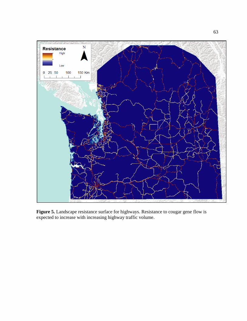
63
Figure 5. Landscape resistance surface for highways. Resistance to cougar gene flow is
expected to increase with increasing highway traffic volume.

64
Figure 6. Scatterplots of PCA-based genetic distance and raw resistance estimates. The X-
axis for the geographic distance plot is shown in units of km, while all other X-axes are
shown in terms of Circuitscape resistance (unitless). Locally-weighted scatterplot smoothing
(LOESS) lines (in blue) have been fitted to illustrate trends, but should not be interpreted as
evidence of a significant relationship.

65
Figure 7. Single regression tree explaining variation in PCA-based genetic distance.
Numbers at the terminal nodes represent the mean genetic distance for that group, where
genetic distance ranges from 0 to 7.5, with a mean of 1.7. The top node splits the data based
on resistance due to the reciprocal of forest canopy cover, which ranges from 0 to 3.2, with a
mean of 0.9. The second node splits the data based on geographic distance, shown in km. The
reduction in deviance from each split is proportional to branch length.
km

66
Figure 8. Relative influence of landscape variables on explained deviance of boosted
regression tree model. Total explained deviance = 19.2%.
53.6
31.8
8.9
3.0
2.8
0 10 20 30 40 50 60
Forest cover
Geographic distance
Population
Elevation
Highways
Relative Influence (%)

67
Figure 9. Partial dependence plots from boosted regression tree modeling, in order of
decreasing relative influence. The Y-axes shows the marginal effect of resistance on PCA-
based genetic distance. Negative marginal effects correspond to a decrease in genetic
distance between individuals, and vice versa. The X-axis for the geographic distance plot is
shown in units of km, while all other X-axes are shown in terms of Circuitscape resistance
(unitless). In order to model landscape resistance, the reciprocal of forest cover was used,
where resistance was greatest for unforested areas and least for densely forested areas. The
relative influence of each variable on the explained deviance is shown in parentheses; total
deviance explained by the model = 19.2%.

68
LITERATURE CITED
Anderson, A.E., D.C. Bowden, and D.M. Kattner. 1992. The puma on Uncompahgre
Platueau, Colorado. Technical Publication No. 40. Denver: Colorado Division of
Wildlife.
Anderson, Jr., C.R., F.G. Lindzey, and D.B. McDonald. 2004. Genetic structure of cougar
populations across the Wyoming Basin: Metapopulation or megapopulation? Journal
of Mammalogy 85: 1207-1214.
Andreasen, A.M., K.M. Stewart, W.S. Longland, J.P. Beckmann, and M.L. Forister. 2012.
Identification of source-sink dynamics in mountain lions of the Great Basin.
Molecular Ecology 21: 5689-5701.
Balkenhol, N. 2009. Evaluating and improving analytical approaches in landscape genetics
through simulations and wildlife case studies. Ph.D. dissertation, University of Idaho.
Balkenhol, N., and L.P. Waits. 2009. Molecular road ecology: exploring the potential of
genetics for investigating transportation impacts on wildlife. Molecular Ecology 18:
4151-4164.
Balkenhol, N., L.P. Waits, and R.J. Dezzani. 2009. Statistical approaches in landscape
genetics: an evaluation of methods for linking landscape and genetic data. Ecography
32: 818-830.
Beier, P. 1995. Dispersal of juvenile cougars in fragmented habitat. The Journal of Wildlife
Management 59: 228-237.

69
Beier, P. 2010. A focal species for conservation planning. Pages 177-189 in M.G. Hornocker
and S. Negri, editors. Cougar: Ecology and conservation. University of Chicago
Press, Chicago IL.
Cooley, H.S., R.B. Wielgus, G. Koehler, and B. Maletzke. 2009. Source populations in
carnivore management: cougar demography and emigration in a lightly hunted
population. Animal Conservation 12: 321-328.
Crown Registry and Geographic Base. 2012. Products – Gridded DEMs.
http://archive.ilmb.gov.bc.ca/crgb/products/imagery/gridded.htm. Accessed 28 March
2012.
Culver, M. 1999. Molecular genetic variation, population structure, and natural history of
free-ranging pumas (Puma concolor). Ph.D. dissertation, University of Maryland,
College Park, Maryland.
Culver, M., W.E. Johnson, J. Pecon-Slattery, and S.J. O’Brien. 2000. Genomic ancestry of
the American puma (Puma concolor). Journal of Heredity 91: 186-197.
Cushman, S.A., K.S. McKelvey, J. Hayden, and M.K. Schwartz. 2006. Gene flow in complex
landscapes: Testing multiple hypotheses with causal modeling. The American
Naturalist 168: 486-499.
De’ Ath, G. 2007. Boosted trees for ecological modeling and prediction. Ecology 88: 243-
251.
De’ Ath, G., and K.E. Fabricius. 2000. Classification and regression trees: a powerful yet
simple technique for ecological data analysis. Ecology 81: 3178-3192.

70
Dickson, B.G., and P. Beier. 2002. Home-range and habitat selection by adult cougars in
southern California. The Journal of Wildlife Management 66: 1235-1245.
Dickson, B.G., and P. Beier. 2007. Quantifying the influence of topographic position on
cougar (Puma concolor) movement in southern California, USA. Journal of Zoology
271: 270-277.
Dickson, B.G., J.S. Jenness, and P. Beier. 2005. Influence of vegetation, topography, and
roads on cougar movement in southern California. Journal of Wildlife Management
69: 264-276.
Dratch, P.A. 1983. Genetic subdivision in Scottish red deer and North American wapiti.
Ph.D. dissertation, University of Edinburgh, Scotland.
Elith, J., J.R. Leathwick, and T. Hastie. 2008. A working guide to boosted regression trees.
Journal of Animal Ecology 77: 802-813.
Ernest, H.B., W.M. Boyce, V.C. Bleich, B. May, S.J. Stiver, and S.G. Torres. 2003. Genetic
structure of mountain lion (Puma concolor) populations in California. Conservation
Genetics 4: 353-366.
Falush, D., M. Stephens, J.K. Pritchard. 2003. Inference of population structure using
multilocus genotype data: linked loci and correlated allele frequencies. Genetics 164:
1567–1587.
Fox, J., and S. Weisberg. 2011. An {R} Companion to Applied Regression, Second Edition.
Sage: Thousand Oaks CA. URL:
http://socserv.socsci.mcmaster.ca/jfox/Books/Companion
Freeland, J.R. 2006. Molecular Ecology. Hoboken, NJ: John Wiley and Sons.

71
Garroway, C.J., J. Bowman, and P.J. Wilson. 2011. Using a genetic network to parameterize
a landscape resistance surface for fishers, Martes pennanti. Molecular Ecology 20:
3978-3988.
Goslee, S.C., and D.L. Urban. 2007. The ecodist package for dissimilarity-based analysis of
ecological data. Journal of Statistical Software 22: 1-19.
Goudet, J. 2001. FSTAT, a program to estimate and test gene diversities and fixation indices
(version 2.9.3). Available from http://www.unil.ch/izea/softwares/fstat.html.
Goudet, J., N. Perrin, and P. Waser. 2002. Tests for sex-biased dispersal using bi-parentally
inherited genetic markers. Molecular Ecology 11: 1103-1114.
Graves, T.A., T.N. Wasserman, M.C. Ribeiro, E.L. Landguth, S.F. Spear, N. Balkenhol, C.B.
Higgins, M.J. Fortin, S.A. Cushman, and L.P. Waits. 2012. The influence of
landscape characteristics and home-range size on the quantification of landscape-
genetics relationships. Landscape Ecology 27: 253-266.
Guillot, G., and F. Rousset. 2013. Dismantling the Mantel tests. Methods in Ecology and
Evolution (in press).
Guillot, G., A. Estoup, F. Mortier, and J.F. Cosson. 2005. A spatial statistical model for
landscape genetics. Genetics 170: 1261-1280.
Jombart, T. 2012. An introduction to adegenet 1.3-4. 67 p. Available at: http://cran.r-
project.org/web/packages/adegenet/vignettes/adegenet-basics.pdf.
Jombart, T., S. Devillard, A.B. Dufour, and D. Pontier. 2008. Revealing cryptic spatial
patterns in genetic variability by a new multivariate method. Heredity 101: 92-103.

72
Kertson, B.N., R.D. Spencer, J.M. Marzluff, J. Hepinstall-Cymerman, and C.E. Grue. 2011.
Cougar space use and movements in the wildland-urban landscape of western
Washington. Ecological Applications 21: 2866-2881.
Koen, E.L., C.J. Garroway, P.J. Wilson, and J. Bowman. 2010. The effect of map boundary
on estimates of landscape resistance to animal movement. PLoS ONE 5: e11785.
Landguth, E.L, and S.A. Cushman. 2010. CDPOP: A spatially explicit cost distance
population genetics program. Molecular Ecology Resources 10: 156-161.
Legendre, P., and M.J. Fortin. 2010. Comparison of the Mantel test and alternative
approaches for detecting complex multivariate relationships in the spatial analysis of
genetic data. Molecular Ecology Resources 10: 831-844.
Legendre, P., and L. Legendre. 2012. Numerical Ecology. Third English Edition. Elsevier,
Oxford.
Legendre, P., F.J. Lapointe, and P. Casgrain. 1994. Modeling brain evolution from behavior:
a permutational regression approach. Evolution 48: 1487-1499.
Logan, K.A., and L.L. Irwin. 1985. Mountain lion habitats in the Big Horn Mountains,
Wyoming. Wildlife Society Bulletin 13: 257-262.
Logan, K.A., and L.L. Sweanor. 2000. Puma. Pages 347-377 in S. Demarais and P.R.
Krausman, editors. Ecology and management of large mammals in North America.
Englewood Cliffs, NJ: Prentice Hall.
Logan, K.A., and L.L. Sweanor. 2010. Behavior and social organization of a solitary
carnivore. Pages 105-117 in M. Hornocker and S. Negri, editors. Cougar ecology and
conservation. Chicago: University of Chicago Press.

73
Loxterman, J.L. 2010. Fine scale population genetic structure of pumas in the Intermountain
West. Conservation Genetics 12: 1049-1059.
Maehr, D.S., E.D. Land, D.B. Shindle, O.L. Bass, and T.S. Hoctor. 2002. Florida panther
dispersal and conservation. Biological Conservation 106: 187-197.
Maletzke, B.T. 2010. Effects of anthropogenic disturbance on landscape ecology of cougars.
Ph.D. dissertation, Washington State University.
Manel, S., M.K. Schwartz, G. Luikart, and P. Taberlet. 2003. Landscape genetics: combining
landscape ecology and population genetics. Trends in Ecology and Evolution 18: 189-
197.
Marquardt, D.W . 1970. Generalized inverses, ridge regression and biased linear estimation.
Technometrics 12: 591-612.
McRae, B.H. 2006. Isolation by resistance. Evolution 60: 1551-1561.
McRae, B.H., and Shah, V.B. 2011. Circuitscape User Guide. The University of California,
Santa Barbara. Available at: http://www.circuitscape.org.
McRae, B.H., P. Beier, L.E. Dewald, L.Y. Huynh, and P. Keim. 2005. Habitat barriers limit
gene flow and illuminate historical events in a wide-ranging carnivore, the American
puma. Molecular Ecology 14: 1965-77.
McRae, B.H., B.G. Dickson, T.H. Keitt, and V.B. Shah. 2008. Using circuit theory to model
connectivity in ecology, evolution, and conservation. Ecology 89: 2712-2724.
Menotti-Raymond, M.A., and S.J. O'Brien. 1995. Evolutionary conservation of ten
microsatellite loci in four species of Felidae. Journal of Heredity 86: 319-322.

74
Menotti-Raymond, M.A., V.A. David, L.A. Lyons, A.A. Schaffer, J.F. Tomlin, M.K. Hutton,
and S.J. O’Brien. 1999. A genetic linkage map of microsatellites in the domestic cat
(Felis catus). Genomics 57: 9-23.
Murphy, M.A., J.S. Evans, and A. Storfer. 2010. Quantifying Bufo boreas connectivity in
Yellowstone National Park with landscape genetics. Ecology 91: 252-261.
Musial, T.S. 2009. Evolutionary and landscape genetic structure of Puma concolor in
Oregon. MS thesis, Portland State University, Portland, Oregon.
Nei, M. 1987. Molecular evolutionary genetics. New York, NY: Columbia University Press.
Newby, J. 2011. Puma Dispersal Ecology in the Central Rocky Mountains. MS thesis,
University of Montana.
Park, S.D.E. 2001. Trypanotolerance in west African cattle and the population genetic effects
of selection. The University of Dublin, Dublin, Ireland.
Patterson, N., A.L. Price, and D. Reich. 2006. Population structure and eigenanalysis. PLOS
Genetics 2: 2074-2093.
Peakall, R. and P.E. Smouse. 2006. Genalex 6: genetic analysis in Excel. Population genetic
software for teaching and research. Molecular Ecology Notes 6: 288–295.
Pimm, S.L., L. Dollar, and O.L. Bass Jr. 2006. The genetic rescue of the Florida panther.
Animal Conservation 9: 115-122.
Raufaste, N., and F. Rousset. 2001. Are partial Mantel tests adequate? Evolution 55: 1703-
1705.
Rice, W.R. 1989. Analyzing tables of statistical tests. Evolution 43: 223-225.

75
Ridgeway, G. 2013. gbm: Generalized Boosted Regression Models. R package version 2.0-8.
http://CRAN.R-project.org/package=gbm
Riley, S.P.D., J.P. Pollinger, R.M. Sauvajot, E.C. York, C. Bromley, T.K. Fuller, and R.K.
Wayne. 2006. FAST-TRACK: A southern California freeway is a physical and social
barrier to gene flow in carnivores. Molecular Ecology 15: 1733-1741.
Ripley, B. 2012. tree: Classification and regression trees. R package version 1.0-33.
http://CRAN.R-project.org/package=tree
Robinson, H.S., R.B. Wielgus, H.S. Cooley, and S.W. Cooley. 2008. Sink populations in
carnivore management: Cougar demography and immigraton in a hunted population.
Ecological Applications 18: 1028-1037.
Roelke, M.E., J. Martenson, and S.J. O’Brien. 1993. The consequences of demographic
reduction and genetic depletion in endangered Florida panther. Current Biology 3:
340-350.
Rousset, F., 2008. Genepop'007: a complete reimplementation of the Genepop software for
Windows and Linux. Molecular Ecology Resources 8: 103-106.
Shirk, A.J., D.O. Wallin, S.A. Cushman, C.G. Rice, and K.I. Warheit. 2010. Inferring
landscape effects on gene flow: a new model selection framework. Molecular
Ecology 19: 3603-3619.
Shirk, A.J., S.A. Cushman, and E.L. Landguth. 2012. Simulating pattern-process
relationships to validate landscape genetic models. International Journal of Ecology
2012: 1-8.

76
Sinclair, E.A., E.L. Swenson, M.L. Wolfe, D.C. Choate, B. Bates, and K.A. Crandall. 2001.
Gene flow estimates in Utah’s cougars imply management beyond Utah. Animal
Conservation 4: 257-264.
Spear, S.F., N. Balkenhol, M.-J. Fortin, B.H. McRae, and K.I.M. Scribner. 2010. Use of
resistance surfaces for landscape genetic studies: considerations for parameterization
and analysis. Molecular Ecology 19: 3576-3591.
Spear, S.F., J. Baumsteiger, and S. Storfer. 2011. Type N Experimental Buffer Treatment
Study: Baseline Measures of Genetic Diversity and Gene Flow of Three Stream-
Associated Amphibians. Cooperative Monitoring Evaluation and Research Report,
CMER 06-605. Washington Department of Natural Resources, Olympia, WA.
Spreadbury, B.R., R.R. Kevin Musil, Jim Musil, Chris Kaisner, John Kovak. 1996. Cougar
population characteristics in southeastern British Columbia. Journal of Wildlife
Management 60: 962-969.
Stoner, D.C., and M.L. Wolfe. 2012. How does a widely distributed felid respond to natural
and anthropogenic habitat fragmentation? Wild Felid Monitor 5: 1-27.
Storfer, A., M.A. Murphy, J.S. Evans, C.S. Goldberg, S. Robinson, S.F. Spear, R. Dezzani,
E. Delmelle, L. Vierling, and L.P. Waits. 2007. Putting the ‘landscape’ in landscape
genetics. Heredity 98: 128-142.
Sturges, H. 1926. The choice of a class-interval. Journal of the American Statistical
Association 21: 65-66.
Sweanor, L.L., K.A. Logan, and M.G. Hornocker. 2000. Cougar dispersal patterns,
metapopulation dynamics, and conservation. Conservation Biology 14: 798-808.

77
Taylor, S., C. Buergelt, M. Roelke-Parker, B. Homer, and D. Rotstein. 2002. Causes of
mortality of free-ranging Florida panthers. Journal of Wildlife Diseases 38: 107-114.
[USGS] United States Geological Survey. 2012. Seamless Data Warehouse.
http://seamless.usgs.gov/index.php. Accessed 28 March 2012.
van Oosterhout, C., W.F. Hutchinson, D.P.M.,Wills, and P. Shipley. 2004. MICRO-
CHECKER: software for identifying and correcting genotyping errors in
microsatellite data. Molecular Ecology Resources 4: 535-538.
Verbeylen, G., L. De Bruyn, F. Adriaensen, and E. Matthysen. 2003. Does matrix resistance
influence red squirrel (Sciurus vulgaris) distribution in an urban landscape?
Landscape Ecology 18: 791-805.
[WDFW] Washington Department of Fish and Widlife. 2011. 2011 Game status and trend
report. Wildlife Program, Washington Department of Fish and Wildlife, Olympia,
WA.
[WHCWG] Washington Wildlife Habitat Connectivity Working Group. 2010. Washington
Connected Landscapes Project: Statewide Analysis. Washington Departments of Fish
and Wildlife, and Transportation, Olympia, WA.
[WSDOT] Washington State Department of Transportation. 2012. Washington State
Department of Transportation geodata catalog. Available at:
http://www.wsdot.wa.gov/Mapsdata/geodatacatalog/. Accessed 12 April 2012.
Wasserman, T. N., S. A. Cushman, M. K. Schwartz, and D. O. Wallin. 2010. Spatial scaling
and multi-model inference in landscape genetics: Martes americana in northern Idaho.
Landscape Ecology 25:1601-1612.

78
Weir, B.S., and C.C. Cockerham. 1984. Estimating F-statistics for the analysis of population
structure. Evolution 38: 1358-1370.
Wiken, E., F. Jiménez Nava, and G. Griffith. 2011. North American Terrestrial Ecoregions—
Level III. Commission for Environmental Cooperation, Montreal, Canada.
Wright, S. 1943. Isolation by distance. Genetics 28: 114-138.
Top Related
Copyright © 2022 FDOKUMEN

