


Bahasa
Halaman
Hukum


STATE OF PALESTINE CITIES REPORT 2016

STATE OF PALESTINE CITIES REPORT 2016

STATE OF PALESTINE: CITIES REPORT 2016All rights reserved © 2016Ministry of Local Government (MoLG)Ramallah, Palestine
DISCLAIMERAll rights reserved. No part of this publication may be reproduced, stored in a retrieval system, or transmitted in any form or by any means, be it electronic or mechanical, by photocopying, recording, or otherwise, except as expressly permitted by law, without the prior, written permission of the publisher.
The presentation of material and the designation employed in this report do not imply the expression of any opinion whatsoever on part of the Secretariat of the United Nations concerning the legal status of any country, territory, city or area; or regarding its authorities; or concerning the delineation of its frontiers or boundaries; or regarding its economic system or degree of development. The analysis, conclusions, and recommendations of this publication do not necessarily reflect the views of the United Nations Human Settlements Programme or its Governing Council.
ACKNOWLEDGEMENTSMain Researcher: Anjad HithnawiResearcher on Gaza: Dr. Farid al QeeqPublication coordinators: Ohood Enaia, Dr. Lubna Shaheen Maps: May Asmar
Photography Credits: Turbo Design - Palestine Image Bank , Anjad Hithnawi, Ramzi Sansur, Library of Congress, Rawabi Media, UN-Habitat Palestine, Mahmud Hams /AFP, Thomas Coex /AFP, Noora al Khalili, Shareef Sarhan.
Language editor and design: Turbo-Design, Palestine
The Ministry of Local Government and UN-Habitat would like to extend their gratitude to the following individuals and organizations, whose support and inputs were tremendous in producing a high-quality analytical report: Dr. Alma Azzoni, Frank D’hondt, Hanin Namari, the team at the Urban Planning Department of the Palestinian Ministry of Local Government, the members of the steering committee of the State of Palestine: Cities Report (SPCR), and all participating stakeholders in the consultation sessions.
This publication was funded by UN-Habitat’s Trust Fund for the Palestinian People in collaboration with the Palestinian Ministry of Local Government and the Municipal Development and Lending Fund.
FOREWORD
Cities throughout the world are witnessing rapid growth, thus increasing the demand for high-quality services and necessitating that governments and municipalities develop improved solutions that fulfill the requirements for sustainable urban development and assure the social, economic, and environmental interactions distinctive of cities in the modern era. The observable acceleration in urbanization is taking place within a framework that entails expanding globalization, intensifying competition, continuous technological development, and the transformation to smart cities. Palestinian cities and urban areas are no exception in this regard; nearly 75 percent of the Palestinian population lives in urban areas that must
expand their visions, objectives, and strategies towards the development and conservation of resources that will enable them to continuously and reliably respond to the needs of their residents and visitors.
Furthermore, Palestinian cities and urban areas must operate within a unique context, as numerous challenges and far-reaching impediments are imposed by the Israeli occupation of the Palestinian territories. Such entail the ongoing confiscation of land, demolition of houses, imposition of closures and roadblocks, sieges of urban areas, and control of the resources required for sustainable development.
The first State of Palestine: Cities Report was drafted and presented as part of preparations for the Habitat III (HIII) conference and the launching of the New Urban Agenda. The report reflects the current urban reality with all its spatial, social, economic, and environmental components and outputs. It highlights the obstacles to sustainable development in cities, and includes the most important recommendations.
I would like to thank all those who contributed their efforts and prepared and brought to fruition this report, ranging from staff at the Ministry of Local Government to partners at other national institutions and the United Nations Human Settlements Programme in Palestine. It is hoped that this report may provide a source of insight for planners and policymakers engaged in the planning of Palestinian cities.
Dr. Husein AlArajMinister of Local Government
State of Palestine: Cities Report 2016Ministry of Local Government | MoLG |

Scope of Publication - Why a State of Palestinian Cities Report? ....................................................................................................01
Definitions ..........................................................................................................02
Key Facts and Figures .....................................................................................05
Chapter 1: Urbanization and Population .................................................06
1.1. Geography ..........................................................................................................................06
1.2. Geopolitical Context .....................................................................................................06
1.3. Population ...........................................................................................................................07
1.4. Urbanization ......................................................................................................................10
1.5. Regional Implications ..................................................................................................16
Chapter 2: Urban Governance and Legislation Systems ....................18
2.1. The National Government.........................................................................................18
2.2. The Local Government Sector ................................................................................20
• 2.2.1. Legal Framework ................................................................................................20
• 2.2.2. Organizational Setup and Institutional Framework ......................20
• 2.2.3. Administrative Setup .......................................................................................21
• 2.2.4. Revenue Collection and Fiscal Management of Local Government Units .........................................................................................21
2.3. The Planning System ....................................................................................................22
• The Challenges Facing the Sector ..........................................................................25
Chapter 3: Urban Economy ..........................................................................26
3.1 Economic Development of Local Government Units ..........................28
3.2 The Informal Economy in Palestine ..................................................................30
Chapter 4: Urban Development: Housing and Land ...........................32
4.1. Housing ............................................................................................................................32
• 4.1.1. Availability and Adequacy ............................................................................32
• 4.1.2. Housing Typologies, Densities and Tenure ........................................34
TABLE OF CONTENTS • 4.1.3. Housing Finance .................................................................................................37
• 4.1.4. Planning and Policy ..........................................................................................39
4.2. Land ........................................................................................................................................39
4.3. Gaza: Urban Warfare and the Reconstruction ..............................................42
Chapter 5: Urban Services and Infrastructure .......................................46
5.1. Water ..................................................................................................................................46
5.2. Energy ...............................................................................................................................47
5.3. Wastewater and Sanitation ..................................................................................48
5.4. Solid Waste Management .....................................................................................49
5.5. Urban Mobility and Transport Systems ........................................................49
5.6. Public Open Space ....................................................................................................50
Chapter 6: Urban Resilience and Disaster Risk Reduction ................52
Chapter 7: Urban Complexities in Palestine ...........................................56
7.1. Geopolitics .....................................................................................................................56
7.2. Urban Informality: The Case of Palestinian Refugee Camps ....................................................................................................................59
7.3. Threats to Palestine’s Cultural Heritage and Cultural Landscape ............................................................................................................62
7.4. Environmental Challenges ...................................................................................64
Chapter 8: Major Urban Centers .................................................................66
8.1. East Jerusalem ..............................................................................................................67
8.2. Ramallah Urban Area ...............................................................................................70
8.3. Nablus City .....................................................................................................................73
8.4. Bethlehem Urban Area ...........................................................................................76
8.5. Hebron City ....................................................................................................................79
8.6. Gaza City ..........................................................................................................................82
8.7. City of Khan Younis....................................................................................................84
Chapter 9: Recommendations.....................................................................86
Bibliography .......................................................................................................88
State of Palestine: Cities Report 2016Ministry of Local Government | MoLG |

SCOPE OF PUBLICATION – WHY A STATE OF PALESTINE: CITIES REPORT?
Recent years have witnessed a substantial global movement to advance sustainable development agendas, among them the Paris Agreement (as part of the UN Framework Convention on Climate Change), the UN’s Sustainable Development Goals, and the Sendai Framework for Disaster Risk Reduction (UNISDR). All of these global frameworks have established – some for the first time – the importance of “thinking urban” and of capitalizing on the potentials and resources offered by cities and urban regions when making efforts to overcome key global challenges. Moreover, during the recent Habitat III conference the world has adopted the New Urban Agenda, and with SDG 11 there exists for the first time a stand-alone sustainable development goal that targets cities and communities and will guide the urban development of the world’s cities over the next twenty years.
In twenty years, more than two thirds of the world’s population will be living in cities. More than half of the world’s population is already living in urban areas, and most of the ongoing urbanization is happening in developing countries. In Palestine, we have made progress in advancing our state-building and development agendas. However, thinking urban, in terms of potentials, limitations, and ways in which global and regional urban agendas and urbanization trends are impacting national and local urban development plans, is still a new concept and at best a work in progress.
This report will present concise and up-to-date data, information, and analyses of the urban contexts in Palestine; indicate urbanization trends and forces; and highlight recent debates and initiatives regarding the urban dynamics in Palestine. It aims at encouraging further work on how to localize the global urban development agendas, including the New Urban Agenda and SDG11, in ongoing efforts towards developing more inclusive, sustainable, and resilient Palestinian cities.
1
State of Palestine: Cities Report 2016Ministry of Local Government | MoLG |

DEFINITIONS
East Jerusalem
According to the 1947 UN Partition Plan, Jerusalem was intended to be placed under an international regime as a Corpus Seperatum, a political entity under the UN’s trusteeship and separate from both the proposed Arab and Jewish states. However, as a consequence of the 1948 war, West Jerusalem came under the control of Jewish forces and East Jerusalem ended up as part of the Hashemite Kingdom of Jordan. Having occupied the city earlier that month, Israel on June 28, 1967 unilaterally and illegally expanded the borders of East Jerusalem, increasing its area from 6.5 sq. km (the boundaries as designated by Jordan) to 70.5 sq. km to include lands from many West Bank villages.1
Green Line
The 1949 Armistice Line, as agreed upon between Egypt and Jordan on the one hand and Israel on the other, following the war of 1948. After signing the Oslo Accords in 1995, the Green Line became the internationally recognized border between Israel and the occupied Palestinian territory, which comprises the Gaza Strip and the West Bank, including East Jerusalem.2
Informal Areas
Areas where groups of housing units have been constructed on land over which occupants have no legal claim, and/or unplanned areas where housing is not in compliance with current planning and building regulations.3
Informal Economy
The economic activities that are unregulated by a society’s institutions and not taxed or overseen by the government.4
Israeli Settlement
A special expanse of land allocated for Israeli civil or semi-military colonization, founded by the Israeli occupation, and built on Palestinian territory occupied since 1967. According to international law, the
1. The Applied Research Institute ARIJ (2016), “Monitoring Israeli Colonization Activities: Glossary,” POICA, available at http://poica.org/glossary/#a1.
2. Ibid.
3. The Organization for Economic Cooperation and Development (2016), Glossary of Statistical Terms, available at https://stats.oecd.org/glossary/detail.asp?ID=1351.
4. Fridell (2008), Microcredit and the Informal Sector in the West Bank, Uppsala University, Sweden, available atf http://www.diva-portal.org/smash/get/diva2:131750/FULLTEXT01.pdf
West Bank and the Gaza Strip are “occupied territory.” Thus, Israeli activities in the West Bank and Gaza are considered illegal. Israeli settlements are also described as “colonies,” and the people living in them “colonists.”5
Jerusalem (J1)
Includes the part of Jerusalem that was annexed forcefully by Israel following its occupation of the West Bank in 1967 and encompasses the following localities: Beit Hanina, Shu’fat Refugee Camp, Shu’fat, Al-’Isawiya, Sheikh Jarrah, Wadi Al-Joz, Bab As-Sahira, As-Suwwana, At-Tur, Jerusalem (“Al-Quds”), Ash-Shayyah, Ras Al-Amud, Silwan, Ath-Thuri, Jabal Al-Mukabbir, As-Sawahira Al-Gharbiya, Beit Safafa, Sharafat, Sur Bahir, and Um Tuba.6
Jerusalem (J2)
Includes the remaining parts of the governorate, namely: Rafat, Kufr A’qab, Mikhmas, Qalandya Refugee Camp, the Bedouin Community Jaba’, Qalandya, Beit Duqqu, Jaba’, Al-Judeira, Beit Anan, Al-Jib, Bir Nabala, Biet Ijza, Al-Qubeiba, Khirbat Umm Al-Lahem, Biddu, An-Nabi Samu’eil, Hezma, Beit Hanina At-Tahta, Qatanna, Beit Surik, Beit Iksa, A’nata, the Bedouin community Al-Khan Al-Ahmar, Az-Za’eem, Al-Eizariya, Abu Dis, As-Sawahreh Ash-Sharqiyeh, Ash-Sheik Sa’d.7
Poverty
Households (two adults and three children) whose monthly income is estimated at less than US$ 609.8
Refugee Camp
Any locality referred to as a refugee camp and administered by the United Nations Relief and Works Agency in the Near East (UNRWA). 9
Rural Area
Any locality whose population is less than 4,000 persons, or whose population varies from 4,000 to 9,999 persons but lacks the four elements mentioned below as defining an urban area.10
Separation or Annexation Wall
A barrier that consists of concrete walls, fences, ditches, razor wire, groomed sand paths, an electronic monitoring system, patrol roads, and a buffer zone, with a length of 712 km, constructed by Israel in the West Bank with the stated aim of preventing Palestinians from carrying out violent attacks inside Israel. However, the vast majority of the Separation Wall’s route (almost 85%) is located within the West Bank,
5. The Applied Research Institute ARIJ (2016), “Monitoring Israeli Colonization Activities.”
6. PCBS (2016), “Environment: Israeli Settlements in Palestine,” Palestine in Figures 2015, Ramallah, Palestine.
7. Ibid.
8. PCBS (2011), On the Eve of the International Population Day, available at http://www.pcbs.gov.ps/portals/_pcbs/PressRelease/Press_En_IntPopD2014E.pdf.
9. Ibid.
10. Ibid.
2
3
State of Palestine: Cities Report 2016Ministry of Local Government | MoLG |

KEY FACTS AND FIGURES
4,816,503Total population in PalestinePalestinian Central Bureau of Statistics, 2016
6,020 SQ. km AreaPCBS, 2015
2.9%Population growth rateUnited Nations Population Division, 2015
75.3% Urban populationWorld Bank, 2015
2,496 SQ.km Urban land areaCenter for International Earth Science Information Network (CIESIN), 2013
3.2% Urban population growth rate (Among top 25% of urbanizing countries)
World Urbanization Prospects, 2015
6.3% Urban poverty gap at national poverty linesWorld Bank, 2011
3.8% Rural poverty gap at national poverty linesWorld Bank, 2011
separating Palestinian communities and farming land from the rest of the West Bank and contributing to the fragmentation of Palestine.11 On July 9, 2004, the International Court of Justice stated that “the construction of the wall being built by Israel, the occupying power, in the Occupied Palestinian Territory, including in and around East Jerusalem, and its associated regime, are contrary to international law.”12
Urban Area
Any locality whose population amounts to 10,000 persons or more. This applies to all governorates or district centers regardless of their size. Besides, it refers to all localities whose population varies from 4,000 to 9,999 persons, provided they have at least four of the following elements: a public electricity network, a public water network, a post office, a health center with a full-time physician, and/or a school offering a general certificate of secondary education.13
11. OCHA (2013), The Humanitarian Impact of the Barrier, available at https://www.ochaopt.org/documents/ocha_opt_barrier_factsheet_july_2013_english.pdf.
12. International Court of Justice (2004), Summary: Legal Consequences of the Construction of a Wall in the Occupied Palestinian Territory, available at http://www.icj-cij.org/docket/files/131/1677.pdf.
13. PCBS (2012), Census Final Results in the Palestinian Territory, Ramallah- Palestine, available at http://www.pcbs.gov.ps/pcbs_2012/Publications.aspx?catid=4
26.1%Urban poverty headcount ratio (% of urban population)World Bank, 2011
19.4%Rural poverty headcount ratio (% of rural population)World Bank, 2011
18.7% Ratio of the Palestinian urban population living in the largest city (Gaza City)World Urbanization Prospects, 2015
735 PERSONS PER SQ. KM Population density, (Ranked number 13 worldwide)World Bank and FAO data, 2015
1,333 PERSONSPER SQ. KM Land urban densityWorld bank and FAO data, 2015
US$ 12.677 BILLION GDP in current pricesWorld Bank, 2011
US$ 7.463 BILLION GDP in constant pricesWorld Bank, 2011
4
5
State of Palestine: Cities Report 2016Ministry of Local Government | MoLG |

CHAPTER | 1 |
URBANIZATION AND POPULATION
1.1. Geography
The occupied State of Palestine, “Palestine,” is located in the Eastern Mediterranean region. It shares borders with Jordan from the east, th mediterranian and Israel from the west. Lebanon from the north, and Egypt from the south. The territory of Palestine covers an area of 6,020 sq. km14 and is composed of two physically separated land masses: the West Bank and the Gaza Strip. The West Bank has an area of 5,655 sq. km, and the Gaza Strip has an area of 365 sq. km.15 The geography of Palestine is characterized by a diverse topography, and its terrain includes coastal and inner plains, mountains, and hills. The elevation span in Palestine reaches from a low 429 m below sea level to 1,030 m above sea level.
1.2. Geopolitical Context
Palestine is reeling under immense pressure due to the prevailing geopolitical conditions that have resulted in its physical fragmentation and social disintegration. The Oslo Accords (1995) resulted in the division of Palestine into areas A, B, and C, which has led to cities and towns being disconnected from and not having full
14 . ARIJ (2002), An Atlas of Palestine. Bethlehem: Palestine.
15. PCBS (2015), Palestine in Figures 2015, available at http://www.pcbs.gov.ps/Downloads/book2188.pdf.
control over their hinterlands and the natural resources they contain – which are needed to sustain spatial development and ensure inclusiveness and equity. Area A constitutes 18% of the West Bank area and falls under full Palestinian control, which includes internal functions related to security and public order as well as planning. The main Palestinian cities and major urban areas fall under this zone. Area B constitutes 21% of the West Bank territory, and here Palestinians have full control over civil administration issues, including planning-related functions, but Israel has the overriding responsibilities regarding security. Area C constitutes more than 61% of the West Bank area; it includes most of the rural and peri-urban areas as well as agricultural lands and is under full Israeli control. Palestinians have no control over water and oil or gas resources, no matter in what area they are located. Israeli geopolitical artefacts on the ground include, but are not restricted to, Israeli settlements, outposts, military bases, nature reserves, archeological sites, by-pass roads, seam zones, the Separation and Annexation Wall, and more.16
1.3. Population
The Palestinian population in the West Bank and Gaza reaches 4,81 million people, of which 2.93 million are living in the West Bank (including more than 251,000 in East Jerusalem) and 1.88 million in the Gaza Strip.17 Palestine has a very high annual population-growth rate that stands at 2.9%. Currently, more than
16 . The international community considers the Israeli settlement activities in the Israeli occupied territories, including the West Bank and East Jerusalem as illegal under Article 49 of the Fourth Geneva Convention that is at the heart of international humanitarian law. Israel is a signatory to this convention that dictates that “The Occupying Power shall not deport or transfer parts of its own civilian population into the territory it occupies.”
17. PCBS (2016), Estimated Population in the Palestinian Territory Mid-Year by Governorate, 1997-2016, available at http://www.pcbs.gov.ps/Portals/_Rainbow/Documents/gover_e.htm.
Before the Creation of Israel 1917
1946 U.N Partition Plan 1947
1948-1949 Israel is Formed
1967 Present
Palestinian Land Palestinian LandJewish Land
Palestinian LandJewish Land
Palestinian LandIsraeli Land
Palestinian LandIsraeli Land
Palestinian LandIsraeli Land
Fig. 1.2. An overview of the history of the occupation of Palestinian land
Fig. 1.1. The West Bank and the Gaza Strip
6
7
State of Palestine: Cities Report 2016Ministry of Local Government | MoLG |

7.5 million Palestinians live in exile, having been displaced from their villages and towns following the 1948 and 1967 wars. The majority of Palestinian refugees live in 31 UN-administered refugee camps in Jordan, Lebanon, and Syria. There are also 1.5 million Palestinians who remained in their homeland (1948 territory, Israel today).18
The average size of a Palestinian family is estimated today at 5.2 persons, 4.9 in the West Bank and 5.7 in the Gaza Strip.19 Palestine has a very high share of youth among its population; almost 40% of Palestinians are below 14 years old, 30% are between 15 to 29 years old, and only 4.5% of the Palestinian population are above 60 years old.20
18. PCBS (2015), On the 68th Anniversary of the Palestinian Nakba, available at http://www.pcbs.gov.ps/site/512/default aspx?tabID=512&lang=en&ItemID=1661&mid=3172&wversion=Staging.
19. PCBS (2016), On the Eve of the International Population Day.
20. PCBS (2016), Palestinian Youth Survey 2015, available at http://www.pcbs.gov.ps/Downloads/book2179.pdf.
fig.1.3. Population of Palestinian Communities 2016
Of the 5 million registered Palestinian refugees worldwide, 780,000 live in the West Bank, and 1.3 million live in the Gaza Strip
Photo 1.1. Kids from Palestine
8
9
State of Palestine: Cities Report 2016Ministry of Local Government | MoLG |

1.4. Urbanization
Since the establishment of the Palestinian Authority in 1995 and the subsequent process of state building, urbanization in Palestine has been growing steadily. The urban population in Palestine today is estimated at 75%.21 Statistics from the World Bank show that Palestine has a fast urban-population-growth rate that stands at 3.2%, compared to a regional rate of 2.5%.22 The urban population in Palestine has almost tripled in the past 25 years; whereas globally, the increase rates of the urban populations over the same period are calculated at 1.7% worldwide and at 2.0% for the Arab world.23 It is expected that the population in Palestine will reach 6 million people by 2025, and 11 million by 2050. These figures do not take into account the more than 7.5 million Palestinians who were displaced from their lands, following the 1948 and 1967 wars, and are currently living in the diaspora. The Palestinian Authority is planning for the potential influx of returnees once the political situation is resolved. Such a situation will have huge implications on future policies for city development and land management in Palestine.
Palestine is considered to be among the highly dense countries in the world. With an average population density of 735 persons per sq. km, it reaches almost 9 times the density of its neighbor country, Jordan. Furthermore, there is a large difference between the population densities of the West Bank and the Gaza Strip, with densities in Gaza exceeding 4,500 people per sq. km, a figure considered amongst the highest in the World.
Urbanization in Palestine has been governed by different forces and shaped by many factors. Historically, the region has always been a center for tourism, pilgrimage, and commerce. Because it is located along the historical commerce and transport routes, “urbanization” in Palestine started several centuries ago. However, the processes of urbanization have evolved and varied throughout this time, as they responded to various strategic,
21. United Nations Department of Economics and Social Affairs (2015), Population Division: World Urbanization Prospects, available at https://esa.un.org/unpd/wup/.
22. Ibid.
23. Ibid.
fig.1.4. Population Densities
What is Urban?The statistical definition categorizes an urban area in Palestine as
“any locality whose population amounts to 10,000 persons or more. This applies to all governorates or district centers, regardless of their size. Besides, it refers to all localities whose population varies from 4,000 to 9,999 persons, provided they have at least four of the following elements: a public electricity network, a public water network, a post office, a health center with a full-time physician, and/or a school offering a general certificate of secondary education.”
Palestinian Central Bureau of Statistics
Gaza Cityis the largest and most condensed urban center in Palestine, with more than 550,000 inhabitants and densities exceeding 100,000 persons per sq. km.
10
11
State of Palestine: Cities Report 2016Ministry of Local Government | MoLG |

Photo 1.2. Ramallah 1945. Photo courtesy of Matson Photograph Collection, Library of Congress.
Photo 1.3. View of the continuous urban fabric formed by the cities Ramallah, Al-Bireh, and East Jerusalem.
religious, political, social and economic factors. The earliest evolutionary phase of urbanism in Palestine took place in the Early Bronze Age, in the fourth millennium BC, when independent Canaanite city states were established along the coast of the Mediterranean Sea and in the areas west of the Jordan River. The population began to gradually move away from agricultural dwellings and established walled cities and multi-craft settlements (such as Jericho and Gaza) that have remained in continuous existence until today. Another major phase of urban transformation in Palestine followed the conquest of Alexander the Great in 332 BC and subsequently continued under the Romans. This era witnessed a shift of settlement patterns, with people moving from coastal plains and hilltops to new settlements that were built in the upper plains and served mainly military and security objectives. Urban culture in Palestine remained for a long time influenced by Greek architecture and by Greek legal and administrative structures. The most important element was the polis (the city), a term that at the time carried a set of territorial and social implications. Cities in that period began to establish institutes to foster the cultural and educational competencies that are necessary to create a civic identity. To live an urban lifestyle was an expression of elitism. The urbanization in Palestine continued under the Romans, the Muslim empires, the Jordanian and Egyptian administrations, and under the Israeli occupation. Periods of both growth and decline, steered by various geopolitical forces and socioeconomic interests, have characterized urbanization in Palestine. Major regional cities were born throughout the different time periods – including Akko (Acre), Ashdod, and Gaza on the coastal line as well as Napolis (Nablus) and Jerusalem on the hills of the heartland of the West Bank – and Palestinian cities have played a significant role in the cultural development of the region as centers for education, political protest, religious institutions, and cultural life.
Urbanization in today’s Palestine is mainly shaped by political forces that highly impact the socio-economic dynamics within Palestinian society. The continued occupation of the Palestinian territories, with its immense impact on the everyday aspects of Palestinian lives, has resulted in various forms of “forced urbanization.” Israeli settlement activities, carried out in contravention to international law, include expansion on Palestinian
agricultural lands, settler violence against farmers and villagers, and the destruction of crops by Israeli settlers and the Israeli military; these actions have resulted in losses of livelihood for thousands of Palestinian farmers who have been living in their villages for hundreds of years, cultivating their land. The Separation and Segregation Wall, which Israel began to construct in 2002, runs to 85%24 inside the West Bank and has confiscated more than 530 sq. km,25 impacting on the freedom of movement, accessibility, and on the socioeconomic development of the Palestinian rural communities. The Separation Wall has resulted in direct and indirect forms of displacement of people who left their communities seeking security and new sources of livelihood in the jobs and services offered by urban areas and cities. Moreover, following the Palestinian government’s institution-building program of 2007 and the associated new economic development policies, coupled with a sharp increase in international aid that was granted to the newly established government and its statehood-building project, Palestinian cities have experienced significant growth in business and investment and a boom in construction. These developments have caused a rate of urbanization that is not matched by suitable planning and thus are placing immense pressures on the urban services, negatively affecting the cities’ ability to accommodate the speed of growth.
City Population 27, 28
Gaza City 583,870
East Jerusalem 264,937
Hebron 215,452
Khan Younis 185,250
Jabalya 171,642
Rafah 164,000
Nablus 153,061
Beit Lahya 89,949
Deir al Balah 72,409
Tulkarem 60,173
Beit Hanoun 53,094
Qalqilya 51,969
Al Bireh 48,887
Jenin 48,479
Ramallah 35,140
Bethlehem 31,799
Jericho 23,220
Tubas 21,487
Salfit 10,673
Table 1. Population 26,27 of the Major Palestinian Cities
24. B’Tselem (2012), Arrested Development: The Long Term Impact of Israel’s Separation Barrier in the West Bank, available at https://www.btselem.org/download/201210_arrested_development_eng.pdf, pp.13.
25. OCHA (2013), The Humanitarian Impact of the Barrier.
26. PCBS (2016), Annual Statistics: Population Projection, available at http://www.pcbs.gov.ps/site/lang_en/803/default.aspx.
27. Due to continuous internal migration taking place between Palestinian cities, in search for jobs and services, the estimated figures regarding population published by PCBS (which depend on projections from census years 1997, and 2007) differ from the figures obtained from the municipalities that calculate their numbers based on the services they provide to a city’s residents.
12
13
State of Palestine: Cities Report 2016Ministry of Local Government | MoLG |

fig.1.6 Urban growth rates of Palestinian Governoratesfig.1.5. Urban growth rate of key Palestinian Cities
14
15
State of Palestine: Cities Report 2016Ministry of Local Government | MoLG |

Photo 1.4. Air view of Jaffa, looking northeast, 1932. Photo courtesy of Library of Congress, Prints & Photographs Division.
Fig. 1.7. map of the regional Arab cities
1.5. Regional Implications
Palestine is located within a region that is experiencing a high rate of urbanization and currently faces enormous social, economic, and political challenges. Throughout history, Palestine served as the cultural crossroads for the Arab World, while Palestinian cities had strong cultural, social and economic ties with other Arab cities such as Cairo, Amman, Damascus and Beirut. In the early twentieth century, urban life in Palestine thrived, flourishing with theatre, music, and literature related activities, as Palestinian cities were at the forefront of Arab civilization and culture.28 Political life had a strong presence here as well, featuring numerous active political parties, trade unions, and labor groups. Moreover, Palestinian cities enjoyed strong transport linkages within the region, including railway networks and bus systems, services that many other Arab cities did not have at the time. For example, before Israel was created, Jaffa was considered Palestine’s commercial hub; its port served as a gateway to the Mediterranean Sea for hundreds of years, and many successful businesses and factories thrived here; in the late nineteenth and early twentieth centuries the majority of Palestine’s books and newspapers were printed and published in Jaffa. Similarly, Nablus and Damascus had very strong trade connections, as Damascus was one of the primary regional markets for Nablus in the trade of cotton and textile.29 Following the capture of the Palestinian coastal cities in 1948, the
28. Al Jazeera (2011), Lost Cities of Palestine [Documentary], available at http://www.aljazeera.com/programmes/aljazeeraworld/2014/05/palestine-lost-cities-201451283254771933.html.
29. Beshara Doumani (1995),
vast majority of Palestinians were displaced from these cities; what once had been hubs for trade, culture, and tourism in Palestine and the entire region became captured cities – and their residents became refugees. Following the 1948 war and the creation of Israel, and again with the 1967 occupation of the West Bank and the Gaza Strip, Palestinian cities suffered tremendous losses and destruction, and for more than 68 years now, Palestinian cities have lost their ties to the local and greater region that has dramatically changed, politically, economically, and socially.
Current efforts aiming to assess and understand the future urban role of Palestinian cities rarely include a discussion based on an Arabic regional perspective, nor do such discussions consider the impact prospected to be exerted by regional centers located in neighboring countries on the urban dynamics of Palestinian cities, as until now these have been cut off by the Israeli occupation. Although urban by definition, Palestinian cities are still enjoying a rural life style in terms of social ties, scale of economy, homogeneity, size of community, building and architectural styles, food, mobility and transport modes, among other features. It is crucial to factor in the multifaceted social, economic, and political complexities of the urban centers in the region when planning for Palestinian cities in a future independent, sustainable Palestinian State; their connectivity and functions must be considered regionally.
0.4 Million
2.2 Million
20.5 Million
4.2 Million 4.1 Million
2.6 Million
6.0 Million
8.7 Million
16
17
State of Palestine: Cities Report 2016Ministry of Local Government | MoLG |

Fig 2.1. The geopolitical classification of the West Bank, Oslo Agreement. Courtesy of Ministry of Local Government.
CHAPTER | 2 |
URBAN GOVERNANCE AND LEGISLATION SYSTEMS
2.1. The National Government
Palestine is currently administered by an interim self-government, the Palestinian National Authority, as outlined by the 1993 Oslo Accords. The Palestinian National Authority administers 39 percent of the West Bank (comprising areas A and B) and the whole of the Gaza Strip. The remaining 61percent of the West Bank (Area C) remains under the full Israeli control. Following the Oslo Accords, a Palestinian Legislative Council was created as a legislator for the Palestinian National Authority; however, due to the prevailing political situation, the Palestinian Legislative Council has not been functional since 2007. Therefore, the Palestinian National Authority has resorted to presidential decrees on behalf of the legislative council.
Photo 2.1. A busy Palestinian city center: Ramallah.
18
19
State of Palestine: Cities Report 2016Ministry of Local Government | MoLG |

2.2. The Local Government Sector
The local government sector in Palestine has been widely considered as a cornerstone for statehood, which is why the Palestinian Ministry of Local Government was established in May 1994, during the early days of the Palestinian Authority. It inherited a local governance system that comprised 30 municipalities and 109 village councils in the West Bank and the Gaza Strip.30 In the following years and in response to the then current needs, the number of these local government units was increased to 119 municipalities and 251 village councils (by 1997), as the Israeli government had stopped the development of the local governance sector since its occupation of the West Bank and Gaza Strip in 1967. Today, there are 142 municipalities and 275 village councils in the West Bank and the Gaza Strip.31
2.2.1. Legal Framework
The legal framework that governs the local government sector was issued in 1997 (referred to as the 1997 Law on Local Authorities) and includes articles highlighting the main responsibilities of the local government units (LGUs) and their relationship with the ministry of local government. A draft amending the law – focusing on decentralization and the restructuring of the LGUs as well as on election mechanisms, appointments, funding sources, and fiscal management, among other aspects – was issued in 2005. In early 2016, a second draft decree was issued by the government concerning the introduction of new clauses to further amend this law. However, even though progress has been made on updating and reviewing the laws and regulations that are governing the local government sector in Palestine, a single coherent framework for the sector is still absent. Instead, besides the Palestinian laws that are in place, regulations and legislations drawn from Ottoman Era rules, British Mandate laws, Jordanian law, Egyptian law, and Israeli military orders are still in place. In addition, the legal frameworks in use in the Gaza Strip and the West Bank differ from each other.32
2.2.2. Organizational Setup and Institutional Framework
The organizational setup for the local government sector in Palestine is characterized by multiple layers and parties. The key parties are mainly three:
1. The Palestinian Ministry of Local Government, considered the main policy-making body and supported with line ministries that include the ministry of national economy, the ministry of social development, the ministry of health, the ministry of education, etc.
2. The Municipal Development and Lending Fund (MDLF), the executive body of the ministry of local government with the mandate to design and implement local-government-support programs in
30. UNDP/PAPP in cooperation with Palestinian Ministry of Local Government (2004), Support to Local Government Reform Project: Diagnostic Report, available at http://www.lacs.ps/documentsShow.aspx?ATT_ID=968.
31. MoLG (2016) Election department.
32. UNDP (2004, 2009, and 2012). Diagnostic Reports for the Local Governance System in the occupied Palestinian territory (oPt).
close partnership with international donor agencies. The MDLF was established in 2005 as a quasi-governmental body with a prime focus clearly on assisting municipalities through a variety of support programs.
3. The Association of Palestinian Local Authorities (APLA), established in 1997 and officially recognized (per presidential decree) in December 2002 as an independent organization that represents the LGUs. The association has an important role to play in serving and supporting the interests of the LGUs in Palestine; however, it has not been active for the past few years for various political reasons. There are currently attempts undertaken to renew APLA’s mandate and to reposition it back within the Palestinian local government sector, where it would operate in cooperation with the active parties, the ministry of local government, and the MDLF.
The institutional framework of the local government sector, its policy and strategy are functioning within the context of the Palestinian National Development Plan. Within the sector itself, the ministry’s strategic and cross-sectorial plans are the documents that guide its policies and their execution. As of recently, the ministry of local government has prepared a draft strategic framework that translates the priorities of the Palestinian National Policy Agenda (2017-2022), prepared by the prime minister’s office. The draft strategic framework includes the formulation of a national framework on local economic development that aims to restructure the LGUs, equipping them with effective administrative, technical, financial, and human capabilities.
2.2.3. Administrative Setup
The administrative setup of the governance sector encompasses multiple levels. At the national level, the Palestinian Authority and its various national institutions are responsible for national policy making, legislation, financial planning and management, and national program development as well as for the implementation, monitoring and evaluation, quality control, and technical assistance. At the regional level, 16 governorates (11 in the West Bank, including East Jerusalem, and 5 in the Gaza Strip) represent the national government and its institutions, each with a governor as its chief administrator. At the local level, there operate 142 municipalities and 275 village councils. In addition, there are established as well more than 86 joint-service councils, in which two or more local governmental units cooperate in exercising their council functions (e.g. planning and development) or in the provision of services (e.g. solid waste collection, and water distribution). However, only approximately 35 joint-service councils are indeed active, well organized, and operational.
2.2.4. Revenue Collection and Fiscal Management of Local Government Units
Given the current economic situation of the Palestinian National Authority, the financial resources of the LGUs are scarce and unstable. The primary sources of revenues for municipalities and village councils in Palestine are property taxes, construction permit fees, and in a remaining few of them, the funds obtained from collecting utility bills.33 The LGUs have been experiencing significant budget deficits, and most of the time they are unable to cover their operational expenditures and deliver essential services, with the gap between expenditures and revenues reaching as high as 2,000 % in some cases.34 Only 20% of the municipalities and none of the local village councils manage to effectively collect local property taxes. Moreover, the majority of
33. A few years ago, the majority of LGUs were collecting utility bills. Through fiscal reform programs, this has been changed and only a few of them still collect them today.
34. MDLF (2013), Municipal Operating Budgets 2008-2013.
Local Government Units
Local government units (LGUs) are the administrative and representative bodies of the local communities in Palestine and active in issues pertaining to civil, administrative, and planning-related functions as well as in service provision. LGUs are either municipalities or village councils, and their representatives are elected every four years, according to the Local Council Elections Law No. 10 of 2005.
20
21
State of Palestine: Cities Report 2016Ministry of Local Government | MoLG |

the LGUs in Palestine deliver less than half of the services they are mandated to provide.35 Currently, various initiatives aim to reform the fiscal management of LGU resources, including measures that would enable LGUs to expand their own sources for revenues.
2.3. The Planning System
The Palestinian National Authority has to work with two sets of planning legislation that governed planning processes prior to 1967: The Jordanian Law of 1966 that was applied in the West Bank, and the Town Planning Ordinance of 1936 that was applied in the Gaza Strip. Various attempts at drafting a unified updated planning law (the Planning and Building Act) have been unsuccessful, as they were never endorsed due to the absence of a legislative council. Therefore, above-mentioned outdated legislations continue to govern the planning system in Palestine today; in addition, a number of planning bylaws are applied that have been developed and passed since 1996.
The current planning system in Palestine follows a top-down, hierarchical approach. There are three levels of spatial planning, namely the national, regional, and local level. They are mandated by the ministry of local government and represented by the higher planning council, district planning committees, and local planning committees. In Area C of the West Bank, the district and local planning committees are not currently functional, since they were cancelled by an Israeli military order in 1971 and have been activated only in areas A and B of the West Bank, after the establishment of the Palestinian Authority. As a result, Palestinians are denied the right to participate in the plan-making processes in the majority of the West Bank area.
35. The World Bank (2016), Public Expenditure Review of the Palestinian Authority: Towards Enhanced Public Finance Management and Improved Fiscal Sustainability, available at https://unispal.un.org/DPA/DPR/unispal.nsf/47d4e277b48d9d3685256ddc00612265/513363bbbf9d71d28525802d004d2237?OpenDocument.
It remains debatable whether an intermediate form of spatial planning at the governorate (city, regional) level is suitable in a relatively small country such as Palestine, or whether it would be more efficient and effective to work with only two spatial planning levels: the national and the local.36 Furthermore, there is a considerable overlap, especially at the national level, between the different Palestinian ministries, such as the ministries of education, health, transport and communication, finance and planning, national economy, tourism and antiquities, and the environmental quality authority, among others, in terms of spatial planning mandates, functions, and responsibilities over the Palestinian cities.
36. Ibid, pp. 9.
Roles and Responsibilities of the Local GovernmentUnits in Palestine
The functions of the LGUs are specified in Article 15 of the Local Authorities Law (1997). There are 27 items on the list, including town and street planning, building and construction permits, provision and management of water, power, waste water treatment, solid waste disposal solutions, as well as organizing and monitoring public markets, industrial zones, public facilities and public spaces, emergency preparedness and response plans, road and traffic management, and the management of local public health, among others.
Almost 55% of the LGUs in Palestine have local outline plans: 53% in the West Bank, and 76% in the Gaza Strip.
There are currently more than 160 local master plans under preparation to cover the remaining 40% of the LGUs.
City Development Planning
In the context of Palestine, the practice of “city development” planning has complemented the practice of “statutory” planning; however, it has never been used as a substitute. It is acknowledged that substantial efforts will be required to completely replace the traditional statutory physical planning in Palestine – which mainly focuses on providing a legal basis to guide private and public building activities – with the practice of city development or integrated planning. Nevertheless (and particularly in as dynamic an environment as can be witnessed in Palestine with its rapid urban growth and transformation), integrated city development practices are much needed to help identify priority-action needs and to develop socio-economic agendas with spatial relevance, as these cannot usually be addressed adequately by traditional physical or land-use planning that is considered outdated in current practice. Moreover, various city development plans that have been prepared for Palestinian cities and towns have remained on paper, due to different reasons that include mainly financial incapacities and the outdated regulatory framework in place. Only very few of these plans have been successfully mainstreamed into the planning system.
22
23
State of Palestine: Cities Report 2016Ministry of Local Government | MoLG |

Figure 2.2. Planning Levels in Palestine, Ministry of Local Government, 2011
Planning Levels in Palestine
Regional level Regional Development PlansRegional Spatial Plans
Gaza Regional Plan 2005-2025
National level
Physical Plans
National Spatial Plan
( For Protection of the Natural Resources and Cutural
Heritage Sites )
National Development Plan (NDP)
Strategic Development Plans
S E C T O R A L P L A N S
Local level
Rural Development Plans
Strategic Development and Investment Plans
(SDIP)
Physical Plans
Phase I: Spatial Development Framework
Phase II: Land Use Plan, Building Regulations, Complementary Sector Plan
Detailed Plans (Mandatory)
• Detailed Plans• Parcellation Plans
The Challenges Facing the Sector
The local government sector in Palestine is one of the largest receivers of international development aid. Several international development projects have been tailored towards building the capacity and the functions of the sector, but even though substantial improvements have been made since the establishment of the Palestinian National Authority, the local government sector is still facing many challenges. Most importantly, the local government sector faces constrained financing due to an unstable rate of revenue collection, a complex internal system of revenue distribution between the various branches of national and local government, the lack of territorial cohesion between the West Bank and the Gaza Strip, the current political impasse, and a weak overall national economy that is on the one hand highly dependent on international aid and on the other confined by Israeli restrictions on access to resources and transport of people and goods. This situation is caused and exacerbated by the military occupation, the restrictive spatial-economic planning regime, and the continuing blockade of the Gaza Strip.
Moreover, the planning jurisdiction within the local government sector is characterized by fragmentation that affects planning levels and planning institutes and thus creates missed opportunities for a more efficient and equitable provision of services and socio-economic development. Participatory, decentralized governance methods must be implemented that would enable the carrying out of democratic decision-making processes that involve affected citizens, even if this were to require bypassing political and administrative jurisdictions. On the other hand, the channeling of development programs in the local government sector in Palestine remains largely disorganized. The ministry of local government estimates that more than 50% of the projects that have been implemented in the sector since 1998 have not been implemented directly through the ministry or the MDLF. Today as well, on-going projects – the majority of which are funded internationally and implemented through various international organizations – tend to target municipalities and other local governmental units directly and separately, in most cases in isolation from the communities in their periphery, and generally without sufficient alignment with national and local development plans. In addition, poor regulatory and enforcement measures have led to violations of building and construction codes because in various cities and towns implementations have been executed in contradiction to existing master plans. Such disregard has negatively affected the built environment and is exacerbating the existing urban challenges.
24
25
State of Palestine: Cities Report 2016Ministry of Local Government | MoLG |

CHAPTER | 3 |
US$ 12.677 billion, GDP US$ 7.463 billion (GDP constant prices)
US$ 2,960 GDP per capitaPCBS, 2015
GDP by SectorPCBS, 2015
• Service Sector: 57%
Wholesale and retail trade:19%Finances and insurance: 3%Transportation: 2%Other services: 33%
• Public Administration and Defense: 16%
• Manufacturing: 14%
• Construction: 6%
• Agriculture: 4%
• IT and Communication: 4%
• 66% employed by the private sector
• 22% employed by the public sector
• 12% working in Israel and Israeli settlements
GDP Growth Rate in Palestine for the Past 20 Years (%)
Fig 3.1. GDP Annual Growth Rates in Palestine During the past 20 years
THE URBAN ECONOMY
The Palestinian economy is classified as less developed. At the end of 2015, the Palestinian GDP (current prices) stood at USD$ 12.677 billion, slightly less than the GDP recorded in 2014. Due to the political instability in Palestine and the associated socio-economic challenges, the GDP annual growth rates have varied immensely over the past 20 years, ranging from 26 percent (the highest, recorded in 1998) to (-)10 percent (the lowest, recorded in 2010). This fluctuation clearly indicates the fragility of the Palestinian national economy that is highly dependent on international aid and greatly vulnerable to Israeli occupation assaults. The most recent economic outlook for Palestine, issued by the World Bank in 2016, indicates that the growth of per-capita income is stagnating and its projected growth level not sufficient to support improvements in living standards. Moreover, there is a stark difference between the respective per-capita GDPs of the West Bank (standing at US$ 3,866 in current prices, US$ 2,269 in constant prices) and the Gaza Strip (standing at US$ 1,655 in current prices, US$ 971 in constant prices), with the figure in Gaza almost half of that in the West Bank.37 The poor performance in the Gaza Strip is mainly attributed to the Israeli blockade and to continuous Israeli assaults. Under these stagnating conditions, the unemployment rate in Palestine remains high with a recorded 27 percent in 2016 (42 percent in the Gaza Strip and 18 percent in the West Bank, 24 percent among men and 39 percent among women).38 Youth unemployment
37. PCBS (2016), National Accounts at Current and Constant Prices, 2015, available at: http://www.pcbs.gov.ps/Downloads/book2235.pdf
38. The World Bank (2016), Economic Monitoring Report to the Ad Hoc Liaison Committee, September 2016, available at http://documents.worldbank.org/curated/en/474311473682340785/pdf/108205-V2-WP-PUBLIC-SEPT-14-2PM-September-2016-AHLC-World-Bank-Report.pdf.
remains a particularly strong concern in Palestine and especially in the Gaza Strip, where it currently stands at 58 percent. Consequently, poverty levels are high in Palestine as well, estimated in 2016 at 25.8 percent, with 26.1 percent of the urban population living in poverty and 19 percent rural poverty.39
Sector-specific economic reports indicate that over the past ten years significant declines of the agriculture and manufacturing sectors have taken place, accompanied by an increase of the service sector. The service sector at this time is the largest contributor to the Palestinian economy; at a share of 57 percent, it employs more than 62 percent of the Palestinian workers.40 The service economy is concentrated in the major cities and urban areas of Palestine, mainly affecting Nablus, Ramallah, Jerusalem, Bethlehem, and Gaza City. Studies show that in the coming years, this sector will continue to play a leading role in the Palestinian economy, as its competitive power will be strengthened at both local and national levels.41 However, Palestinian large urban areas display
advantages and capacities that could support and contribute to equitable spatial-economic growth beyond the dominating service sector, if the components of sustainable economic development were to be realized. Most importantly, this would involve ending the Israeli occupation and giving Palestinians
39. Global Poverty Working Group (2017), Urban poverty headcount ratio at national poverty lines (% of urban population), The World Bank, available at: http://data.worldbank.org/indicator/SI.POV.URHC?locations=PS
40. PCBS (2015), National Accounts at Current and Constant Prices, 2014, available at http://www.pcbs.gov.ps/Downloads/book2172.pdf.
41. Rabeh Morrar, FaЇz Gallouj (2013), The Growth of the Service Sector in Palestine: The productivity challenge - Finding Growth Through Service Activities in Barren Times, Aix en Provence, France, available at https://halshs.archives-ouvertes.fr/halshs-01222937/document
26
27
State of Palestine: Cities Report 2016Ministry of Local Government | MoLG |

full access to their natural resources and to the freedom of movement of goods and people. For example, Hebron, recently classified as the world’s “craft city,” is considered a major industrial hub in the West Bank. Also, the heartland region (comprising Jerusalem, Ramallah, Bethlehem, and Jericho) is considered a major touristic hub, specifically for religious tourism. And the northern region (comprising Jenin, Tubas, Qalqiliya, and Salfit with Nablus at its center) owns highly valuable agricultural areas, high biodiversity, and rich cultural landscapes and natural reserves. These features combined provide endless opportunities for agricultural industries and alternative tourism activities.
The restrictions imposed by the Israeli occupation on Palestinians are the main constraints to Palestinian economic growth and to the development of a viable Palestinian economy. Such restrictions include Israel’s sole control over natural resources and materials and over the borders of the West Bank and the Gaza Strip; its prevention of the construction of industrial zones; assaults on and destruction of Palestinian people and land, businesses and facilities; and Israel’s continued full control of over 61 percent of the West Bank (Area C); among other factors. These restrictions are also the reason behind the prevailing low private-sector investment levels: contributing only 15 percent to the GDP, they are among the lowest in the world. Israeli restrictions on Area C in particular are exceedingly detrimental to economic growth in Palestine. A World Bank analysis reported that access to Area C, on its own, could increase Palestine’s GDP by 35 percent. 42 It is also estimated that the Palestinian economy since 2007 has lost 50 percent of its potential GDP as a direct result of the blockade placed on the Gaza Strip.43
3.1 Economic Development of Local Government Units
Over the past few years, the notion of urban economics has moved to center stage in the local government sector in Palestine. Most LGUs in Palestine have a relatively weak financial resource base, which is largely due to the fragile local economy, dwindling growth rates, limited development perspectives, growing unemployment, and to the unstable financial situation of the national government which continues to deteriorate due to inadequate revenues and various operational inefficiencies. In 2016, the World Bank reported that in Palestine the LGUs, especially smaller village councils, rely on utility bill collection (mostly of electricity) to finance their operational expenditures. The report concluded that this situation results
42. World Bank (2013), Palestinians Access to Area C Key to Economic Recovery and Sustainable Growth, available at http://www.worldbank.org/en/news/press-release/2013/10/07/palestinians-access-area-c-economic-recovery-sustainable-growth.
43. OCHA (2015), The Gaza Strip: The Humanitarian Impact of the Blockade, available at https://www.ochaopt.org/documents/ocha_opt_gaza_blockade_factsheet_july_2015_english.pdf.
Photo 3.1. A large office building in a residential neighborhood in Ramallah.
Fig 3.2. Poverty rates in Palestinian LGUs
28
29
State of Palestine: Cities Report 2016Ministry of Local Government | MoLG |

in “a significant source of fiscal burden on the Palestinian Authority because the (Government of Israel)deducts most of the unpaid bills from clearance revenues, which ends up costing the Palestinian Authority (2 percent) of GDP, creating the “net lending” issue. In addition to paying for unpaid electricity bills, the Palestinian Authority also pays an 11 percent late payment fee.”44 But, in order to effectively address this structural problem, a broader analysis must be carried out within the context of a comprehensive fiscal reform.
However, while a reform effort with the aim to reorganize and transform the fiscal system at the national level has been underway for some time, the local government sector’s interest has recently shifted its focus to a more defined agenda of local economic development that targets at its pilot stage a number of local government units. The local economic-development approach was recently conceived by experts in the local government sector in Palestine and is considered a crucial factor in national economic-development strategies, as it might enable the translation of a national economic-development vision into implementable and practical economic-development actions at the territorial and city levels.
While it is unclear when the fiscal reform will be completed, a wide range of local government-support programs is being implemented, with little knowledge on how the local economic-development approach will affect the reform and its outcome. Strengthening the financial handling capacity at the level of local government units is a crucial element of an approach that aims to channel funds directly from the ministry of local government to the local government units in order to enable and promote local economic development.
3.2 The Informal Economy in Palestine
It is difficult to measure and assess the informal economy sector in Palestine using traditional theoretical approaches, as informal economy is usually studied from within a sovereign national economy. In Palestine, the ongoing occupation is the most significant factor shaping the Palestinian informal economy,
because it restricts and prevents national development policies and regulations.45 The continuous assaults by Israel have strongly contributed to the informalization of the local Palestinian economy: they have destroyed entire economic sectors, caused large rates of unemployment and poverty, and are creating the segment of the population that forms the most-likely workforce for informal employment. Moreover, the Israeli economy has generated a capital center for a subordinate and dependent Palestinian economy by subcontracting some of its industrial processes (such as wood and garment works) for small informal businesses.46
44. World Bank (2016), Economic Monitoring Report to the Ad Hoc Liaison Committee, pp. 16.
45. Nida Abu Awwad (2011), “Debating the Informal Economy: Considering Colonialism and Palestine,” Review of Women’s Studies, Special Issue 1, 52-66, available at http://iws.birzeit.edu/sites/default/files/2016-10/Special%20issue%201_%20English.pdf
46. Ibid.
The size of the informal sector in Palestine is relatively large, with various figures that overall have estimated its share of the GDP at 70 percent.47 Almost 50 percent of the enterprises in Palestine are considered informal, with the domestic trade sector forming the largest contributor (constituting almost 62 percent of all informal businesses), followed by agricultural activities.48 The informal sector employs 60 percent of the workers in Palestine (66 percent in the West Bank, 43 percent in the Gaza Strip), the majority of whom engage in agricultural activities.49 Generally, the informal economy in Palestine shares many of its characteristics with other informal economies of the Middle East which suffer from poor working conditions and poor safety standards and offer no or minimal protection of occupational rights. Although it is a large contributor to the GDP, the informal economy in Palestine has negative impacts, as it promotes tax evasion, productivity losses, and high deficits, all factors that contribute to a lower-level quality of public services.
47. MM Sabra, Eltallla A., Elfar A. (2015), “The Shadow Economy in Palestine,” International Journal of Economics and Finance; Vol. 7, No.3, available at http://www.ccsenet.org/journal/index.php/ijef/article/viewFile/42537/24755/.
48. European Training Foundation (2014), Labor Market and Employment Policies in Palestine, available at http://www.etf.europa.eu/webatt.nsf/0/49583C88B3C1AD0DC1257CD1003DA5FC/$file/Employment%20policies_Palestine.pdf.
49. PCBS (2008), Informal Sector and Informal Employment Survey October-December 2008 Main Findings, available at http://www.pcbs.gov.ps/Downloads/book1760.pdf.
Photo 3.2. Street vendors constitute a form of informal economy frequently found in Palestinian cities.
Photo 3.2. Street vendors constitute a form of informal economy frequently found in Palestinian cities.
30
31
State of Palestine: Cities Report 2016Ministry of Local Government | MoLG |

URBAN DEVELOPMENT – HOUSING AND LAND
4.1. Housing
4.1.1. Availability and Adequacy
The availability and access to suitable housing in Palestine in general and in the Gaza Strip,50 East Jerusalem, and Area C of the West Bank in particular, are considered limited and inadequate. Whereas in 2013 an analysis of the available housing units in Palestine indicated a housing surplus of more than 8 percent in the Palestinian housing market,51 an in-depth analysis shows disparities between the units that are offered and the actual housing needs of Palestinian families. An affordability analysis of the housing market has shown that the units provided are beyond the reach of the majority of the Palestinian families who belong to the low-income and low-middle-income groups.52 Palestinians are forced to develop within a very limited, confined space due to the limited availability of land and the further limitations Israel places on the development of infrastructure in areas A and B – which constitute less than 40 percent of the West Bank Area. Adding these factors to a weak policy, an underdeveloped regulatory and enforcement framework, and outdated land-management and planning systems, land becomes a scarce and thus very expensive resource. Studies have indicated that 61 percent of Palestinian families will need new housing units in the next decade to replace old deteriorated units, and the market must supply space for natural growth.
Moreover, the housing sector in Palestine is under continuous threat by the Israeli occupation. The humanitarian situation in Area C of the West Bank continues to deteriorate, and more than 300,000 Palestinians continue to live under chronic uncertainty and the threat of displacement. Since 1994, as many as 13,921 demolition orders have been issued for Palestinian houses in Area C, out of which 2,800 demolitions have been carried out.53 In total, since 1994 more than 1,250 demolition orders have been executed.54 Threats of demolition result in humanitarian crises for the affected families and cause the disruption of livelihoods and the entrenchment of poverty.
50. The specific situation in the Gaza Strip is analyzed separately below.
51. Ministry of Public Works and Housing and UN-Habitat (2013). Palestine Housing Sector Profile 2013.
52. Ibid.
53. OCHA (2016). Israeli Demolition Orders against Palestinian Structures in Area C, 1988-2016, available at http://data.ochaopt.org/demolitions.aspx.
54. B’Tselem (2016), Statistics on Demolition of Houses Built Without Permits in East Jerusalem, available at http://www.btselem.org/planning_and_building/east_jerusalem_statistics.
CHAPTER | 4 |Adequate housing must provide more than four walls and a roof. A number of conditions must be met before particular forms of shelter can be considered to constitute “adequate housing,” and these elements are just as fundamental as the basic supply and availability of housing. For housing to be adequate, it must at a minimum meet the following criteria:
Security of tenure: housing is not adequate if its occupants do not have a degree of tenure security that guarantees legal protection against harassment, forced eviction, and other threats.
Availability of services, materials, facilities, and infrastructure: housing is not adequate if its occupants do not have safe drinking water, adequate sanitation, energy for cooking, heating, lighting, food storage, and refuse disposal.
Affordability: housing is not adequate if its cost threatens or compromises the occupants’ enjoyment of other human rights.
Habitability: housing is not adequate if it does not guarantee physical safety, or provides adequate space as well as protection against the cold, damp, heat, rain, wind, or against other threats to health or from structural hazards.
Accessibility: housing is not adequate if the specific needs of disadvantaged and marginalized groups are not taken into account.
Location: housing is not adequate if it is cut off from employment opportunities, health-care services, schools, childcare centers and other social facilities, or if located in polluted or dangerous areas.
Cultural adequacy: housing is not adequate if it does not respect and take into account the expression of cultural identity.
The Right to Adequate Housing, OHCHR and UN-Habitat
32
33
State of Palestine: Cities Report 2016Ministry of Local Government | MoLG |

4.1.2. Housing Typologies, Densities and Tenure
Palestine has a high rate of owner-occupied housing units, as almost 81 percent of the housing units are inhabited by their owners. The high percentage is explained by cultural norms, as in Palestine it is very significant to own one’s home, despite the restrictive economic situation.55 Only 8 percent of the housing units are rented in Palestine, and the majority of these are located in the central West Bank area, mainly in Ramallah and Bethlehem, where large-scale development projects have started to emerge over the past ten years.56 Rental units thus provide housing solutions in the locations where the majority of private and public institutions are concentrated, the localities that offer the highest percentage of jobs.
55. PCBS (2015), Percentage Distribution of Households in Palestine by Tenure of Housing Unit and Region, 2015, available at http://www.pcbs.gov.ps/Portals/_Rainbow/Documents/AN-Hous-2015-E-12.htm
56. Ibid.
The housing density in Palestine averages at 1.7 persons per room, and the average number of rooms in a housing unit is 3.4 rooms.57 On average, 20 percent of Palestinian families live in housing units of less than two rooms; and 13 percent of families live in overcrowded housing, with more than three people per room; this percentage being higher in the Gaza Strip with 20 percent. Around 23 percent of the housing units are built using stone (35 percent in the West Bank, less than 1 percent in Gaza) and 61 percent from cement blocks only (42 percent of units in the West Bank, 99 percent of units in Gaza).58 The average area of a housing unit in Palestine is 126 sq. m, showing not much difference between urban and rural areas.
The housing typology in Palestine is characterized by either single, free-standing houses (ranging in height from one to three stories, usually occupied by one family) or multi-story apartment buildings occupied by many families. Housing typologies vary between Palestinian cities and depend on their densities, topography, growth rates, and socio-economic situation. Typologies are generally governed by the local master plans and land use regulations. Housing typologies of the cities in the Gaza Strip, for example, are characterized by high-rise cement-block apartment buildings (more than 70 percent of the housing units
57. PCBS (2015), Percentage Distribution of Households in Palestine by Number of Rooms in Housing Unit, Region and Type of Locality, 2015, available at: http://www.pcbs.gov.ps/Portals/_Rainbow/Documents/AN-Hous-2015-E-2.htm
58. PCBS (2015), Number and Area of Licensed Housing Units in Palestine by Construction Material and Region, 2015, available at: http://www.pcbs.gov.ps/Portals/_Rainbow/Documents/AN-Hous-2015-E-15.htm
The Geopolitics of Housing in Palestine
The housing sector in Palestine in general and in East Jerusalem, Area C, and the Gaza Strip in particular has been heavily affected by the continued Israeli occupation and its practices on the ground. This includes the persistent expansion of Israeli settlements, the continued expropriation and confiscation of Palestinian land and properties, the weak infrastructural lines generally found in predominantly-Palestinian areas, and the demolition of Palestinian houses in East Jerusalem and Area C, along with frequent Israeli assaults on the Gaza Strip. Since July 2014, the Israeli authorities have completely destroyed more than 20,000 dwellings and partially destroyed more than 60,000 dwellings, leaving more than 350,000 Palestinians without shelter in the Gaza Strip. In Area C and East Jerusalem, the Israeli authorities furthermore refuse to grant construction licenses to Palestinians, citing various reasons. Thus, in East Jerusalem there is currently a need for more than 10,000 housing units to meet the immediate demand of Palestinians. Moreover, even though natural growth among Palestinians in East Jerusalem, according to recent statistics, requires the construction of an additional 1,500 housing units per year, only an average of 400 new housing units per year are authorized by Jerusalem Municipality. This number falls short by more than 1,000 units per year, when comparing actual housing needs and legally permitted construction. In Area C, only 1 percent of the land has been planned for Palestinian development. According to Israeli civil administration data, between 2010 and 2014 only 1.5 percent of the applications submitted by Palestinians for building permits in Area C were approved by the Israeli authorities. Today, there are pending in the occupied territories over 11,000 demolition orders, affecting an estimated 17,000 Palestinian-owned structures that include residential houses in Area C.
Photo 4.1. Apartment blocks, Ramallah.
34
35
State of Palestine: Cities Report 2016Ministry of Local Government | MoLG |

in the Gaza Strip are located in apartment buildings). Here, development takes the form of multi-story buildings, as the pressures on available land are increasing. This increasing pressure is due to the high natural population-growth rate that exacerbates the already existing high population-densities in Gaza’s cities, due to the limited land that is suitable for development, and due to the blockade placed on Gaza and the limited availability of construction materials. In the West Bank, the cities in the central region are hubs that attract thousands annually with the job opportunities and services they offer. Thus, for example, the twin-cities Ramallah and Al Bireh are experiencing accelerated growth through rapid urbanization on limited lands, while the pressures exerted by an increasing population and rising land prices are driving developers to build multi-story apartment buildings in order to meet the increasing demand. Cities in the north, such as Jenin and Tulkarem, are historically agricultural cities with slower urban transformations; therefore, low-density single-housing-unit patterns remain prevalent here.
Percentage Distribution of Households in Palestine by Type of Housing Unit and Region 60
Apartment Buildings Single Houses
Palestine 54% 45%
Urban areas 60% 39%
Rural areas 29% 69%
West Bank 44% 54%
Gaza Strip 72% 27%
Table 4.1. Percentage Distribution of Households in Palestine by Type of Housing Unit and Region59
Percentage Distribution of Households in Palestine by Tenure of Housing Unit and Region 61
Owned Rented
Palestine 81% 8%
Urban areas 81% 10%
Rural areas 83% 4%
West Bank 82% 9%
Gaza Strip 79% 6%
Table 4.2. Percentage Distribution of Households in Palestine by Tenure of Housing Unit and Region60
59. PCBS (2015), Percentage Distribution of Households in Palestine by Type of Housing Unit and Region, 2015, available at http://www.pcbs.gov.ps/Portals/_Rainbow/Documents/AN-Hous-2015-E-10.htm.
60. PCBS (2015), Percentage Distribution of Households in Palestine by Tenure of Housing Unit and Region, 2015, available at http://www.pcbs.gov.ps/Portals/_Rainbow/Documents/AN-Hous-2015-E-12.htm.
4.1.3. Housing Finance
The majority of housing in Palestine is financed through informal channels that are formed directly between the seller and the buyer through private contracts and transactions. The Palestine housing sector profile estimates that more than 80 percent of the housing transactions are cash-based and unreported.61 Also, the financing of housing through cooperatives remains popular, in which members of a cooperative pool their money to buy a piece of land and build a housing project; Palestinian households find this method more affordable than taking a housing loan. In addition, although small in portfolio, microfinancing enables some families to finance housing construction or rehabilitation. In Palestine, housing accounts for 29 percent of overall microfinance activities.62 If the portfolio of the microfinance sector were to be increased, this measure would enable more Palestinians to access forms of housing finance that they can better afford.
In terms of affordability, it is estimated that more than 70 percent of the households in Palestine cannot afford the average housing units available in the market.63 The average cost of an apartment in Ramallah’s urban area amounts to, for example, ten times the median annual household income, using the Median Multiple affordability tool. In the urban areas of Nablus and Hebron, the Median Multiple is 4 and 5 respectively, which classifies housing units in these areas as “severely unaffordable” and “seriously unaffordable,” as the Median Multiple indicator considers a Median Multiple rate below 3.0 as indicating an affordable unit. This is an extreme concern in Palestine, where poverty rates are elevated and no forms of social or government subsidized housing schemes are in existence.
61. Ministry of Public Works and Housing and UN-Habitat (2013). Palestine Housing Sector Profile 2013.
62. MAS (2015), Economic and Social Monitor, No. 42 (in Arabic), available at http://www.pcbs.gov.ps/Downloads/book2174.pdf.
63. Richard Martin (2014). Effective Housing Demand Survey: West Bank, Office of the Quartet Representative, overview and link available at https://unispal.un.org/DPA/DPR/unispal.nsf/0/8D872912D04DE5A385257DAB0056E4FD.
The Urban Challenge in East Jerusalem There are today more than 300,000 Palestinians living in East Jerusalem’s 28 neighborhoods. Historically, these communities were villages in the hinterlands of the Old City, but through processes of urbanization they have become an integral part of the city’s urban fabric. The (Israeli-administered) Jerusalem Municipality has exerted extensive efforts to limit the growth of the Palestinian neighborhoods of the city by employing various policies that limit Palestinian rights to build and develop. Maintaining a Jewish majority in the city has been the main driver for planning decisions that continue to allocate building rights in Jewish and Palestinian neighborhoods based on desired demographic outcomes rather than actual needs. Israeli settlements illegally, yet persistently continue to grow between the Palestinian neighborhoods in East Jerusalem, a practice that increased in unprecedented ways even after peace negotiations began in the early 1990s. In fact, the number of Israeli settlers living in East Jerusalem has doubled since 1993. Furthermore, Israel maintains a complex web of physical obstruction that includes the Separation and Annexation Wall as well as by-pass roads, which not only undermines the spatial contiguity of Palestinian neighborhoods, but also effectually prevents the natural spatial expansion of Palestinian neighborhoods in the city.
36
37
State of Palestine: Cities Report 2016Ministry of Local Government | MoLG |
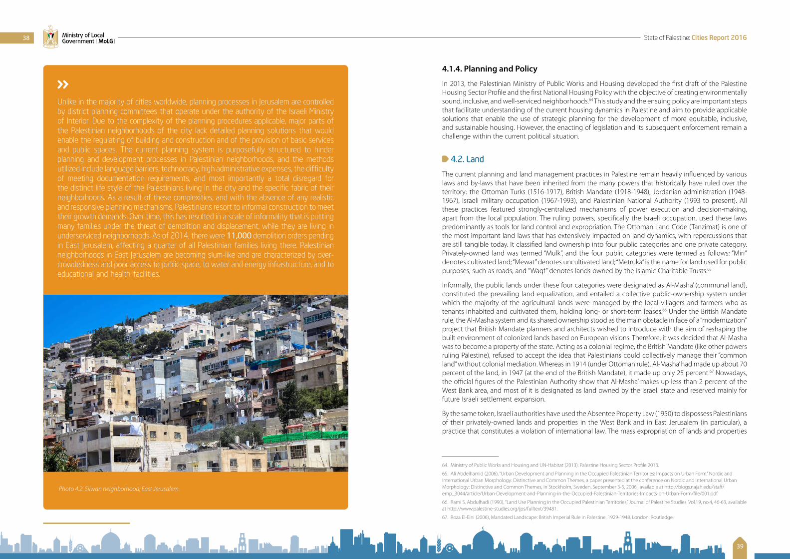
4.1.4. Planning and Policy
In 2013, the Palestinian Ministry of Public Works and Housing developed the first draft of the Palestine Housing Sector Profile and the first National Housing Policy with the objective of creating environmentally sound, inclusive, and well-serviced neighborhoods.64 This study and the ensuing policy are important steps that facilitate understanding of the current housing dynamics in Palestine and aim to provide applicable solutions that enable the use of strategic planning for the development of more equitable, inclusive, and sustainable housing. However, the enacting of legislation and its subsequent enforcement remain a challenge within the current political situation.
4.2. Land
The current planning and land management practices in Palestine remain heavily influenced by various laws and by-laws that have been inherited from the many powers that historically have ruled over the territory: the Ottoman Turks (1516-1917), British Mandate (1918-1948), Jordanian administration (1948-1967), Israeli military occupation (1967-1993), and Palestinian National Authority (1993 to present). All these practices featured strongly-centralized mechanisms of power execution and decision-making, apart from the local population. The ruling powers, specifically the Israeli occupation, used these laws predominantly as tools for land control and expropriation. The Ottoman Land Code (Tanzimat) is one of the most important land laws that has extensively impacted on land dynamics, with repercussions that are still tangible today. It classified land ownership into four public categories and one private category. Privately-owned land was termed “Mulk”, and the four public categories were termed as follows: “Miri” denotes cultivated land; “Mewat” denotes uncultivated land; “Metruka” is the name for land used for public purposes, such as roads; and “Waqf” denotes lands owned by the Islamic Charitable Trusts.65
Informally, the public lands under these four categories were designated as Al-Masha’ (communal land), constituted the prevailing land equalization, and entailed a collective public-ownership system under which the majority of the agricultural lands were managed by the local villagers and farmers who as tenants inhabited and cultivated them, holding long- or short-term leases.66 Under the British Mandate rule, the Al-Masha system and its shared ownership stood as the main obstacle in face of a “modernization” project that British Mandate planners and architects wished to introduce with the aim of reshaping the built environment of colonized lands based on European visions. Therefore, it was decided that Al-Masha was to become a property of the state. Acting as a colonial regime, the British Mandate (like other powers ruling Palestine), refused to accept the idea that Palestinians could collectively manage their “common land” without colonial mediation. Whereas in 1914 (under Ottoman rule), Al-Masha’ had made up about 70 percent of the land, in 1947 (at the end of the British Mandate), it made up only 25 percent.67 Nowadays, the official figures of the Palestinian Authority show that Al-Masha’ makes up less than 2 percent of the West Bank area, and most of it is designated as land owned by the Israeli state and reserved mainly for future Israeli settlement expansion.
By the same token, Israeli authorities have used the Absentee Property Law (1950) to dispossess Palestinians of their privately-owned lands and properties in the West Bank and in East Jerusalem (in particular), a practice that constitutes a violation of international law. The mass expropriation of lands and properties
64. Ministry of Public Works and Housing and UN-Habitat (2013). Palestine Housing Sector Profile 2013.
65. Ali Abdelhamid (2006), “Urban Development and Planning in the Occupied Palestinian Territories: Impacts on Urban Form,” Nordic and International Urban Morphology: Distinctive and Common Themes, a paper presented at the conference on Nordic and International Urban Morphology: Distinctive and Common Themes, in Stockholm, Sweden, September 3-5, 2006., available at http://blogs.najah.edu/staff/emp_3044/article/Urban-Development-and-Planning-in-the-Occupied-Palestinian-Territories-Impacts-on-Urban-Form/file/001.pdf.
66. Rami S. Abdulhadi (1990), “Land Use Planning in the Occupied Palestinian Territories,” Journal of Palestine Studies, Vol.19, no.4, 46-63, available at http://www.palestine-studies.org/jps/fulltext/39481.
67. Roza El-Eini (2006), Mandated Landscape: British Imperial Rule in Palestine, 1929-1948. London: Routledge.
Unlike in the majority of cities worldwide, planning processes in Jerusalem are controlled by district planning committees that operate under the authority of the Israeli Ministry of Interior. Due to the complexity of the planning procedures applicable, major parts of the Palestinian neighborhoods of the city lack detailed planning solutions that would enable the regulating of building and construction and of the provision of basic services and public spaces. The current planning system is purposefully structured to hinder planning and development processes in Palestinian neighborhoods, and the methods utilized include language barriers, technocracy, high administrative expenses, the difficulty of meeting documentation requirements, and most importantly a total disregard for the distinct life style of the Palestinians living in the city and the specific fabric of their neighborhoods. As a result of these complexities, and with the absence of any realistic and responsive planning mechanisms, Palestinians resort to informal construction to meet their growth demands. Over time, this has resulted in a scale of informality that is putting many families under the threat of demolition and displacement, while they are living in underserviced neighborhoods. As of 2014, there were 11,000 demolition orders pending in East Jerusalem, affecting a quarter of all Palestinian families living there. Palestinian neighborhoods in East Jerusalem are becoming slum-like and are characterized by over-crowdedness and poor access to public space, to water and energy infrastructure, and to educational and health facilities.
Photo 4.2. Silwan neighborhood, East Jerusalem.
38
39
State of Palestine: Cities Report 2016Ministry of Local Government | MoLG |

owned by displaced Palestinians was not carried out for military reasons or for the benefit of the local Palestinian population; it was used to enlarge illegal Israeli settlements in the occupied territory.68 The total area of what is referred to as “absentee land” in the West Bank, including East Jerusalem, is estimated at 430 sq. km, and it has been managed, leased, rented, and sold by the Israeli Custodian of Government and Abandoned Property through special orders.69
Land registration has been yet another challenge in Palestine. In 1967, Israeli military orders halted processes of land registration in the occupied territory, and more than 2,910 sq. km (51 percent) of the West Bank area was appropriated as “state property.” In the urbanized parts of the West Bank, land management and titling has since then proven to be a slow, fragmented, and inefficient procedure and the process remains such also today – even though the demand on information on land is growing as the activities of local industries and the government, as well as individual private enterprises are increasing. Local data sets containing information on land titles are scarce in Palestinian Authority institutes, a condition that is partly due to limitations in the methods used for deriving and inventorying land-based activities, as these neglect biophysical and economic aspects of land use. Progress in the process of land registrations has been moving slowly, and only limited improvement has been made over the last years, a situation that is mainly due to the complexities associated with inheritance and common land – but also with a lack of political will. Land registration remains inefficient despite a recent increase in the PA-allocated budget of the Palestinian Land Authority; despite increasing violations against privately-owned lands that should prompt remedial action; and because the old laws remain in place despite recently-introduced amendments, as these amendments do not comprehensively cover the challenges facing land registration, nor are they as of yet entirely operational. For instance, in February 2016, the Palestinian cabinet issued a decision to set up a Palestinian Water and Land Settlement Agency that was designated to accelerate systematic land registration, including the processes of land titling at the local level. But until now this agency did not start working independently from the Palestinian Land Authority, due to the associated required administrative, bureaucratic procedures.
Despite the unsatisfactory progress in the land sector, the Palestinian government and the development partners who are supporting land registration processes still consider land management in Palestine to remain a top priority for development interventions. The overall reform in the land sector will contribute
68. B’Tselem – The Israeli Information Center for Human Rights in the Occupied Territories (1995), A Policy of Discrimination: Land Expropriation, Planning and Building in East Jerusalem, Jerusalem: B’Tselem, pp. 17-18, link available at http://www.btselem.org/publications/summaries/199505_policy_of_discrimination.
69. Bimkom – Planners for Planning Rights (2008), The Prohibited Zone: Israeli Planning Policy in the Palestinian Villages in Area C, Jerusalem: Bimkom, pp. 28, available at http://bimkom.org/eng/wp-content/uploads/ProhibitedZone.pdf.
Photo 4.3. Bethlehem.
to the improvement of tenure security, stimulate economic growth, and enable sustainable urban development at the city and national levels. The Government of Palestine lists land-administration and management reform among its top five national priorities. New legal instruments and guidelines must be introduced; a transparent, accessible information system on land data needs to be made available; the property tax system must be reformed; and clear management strategies are needed to enable an overdue improvement in the dealing with state land at the national level, including the Gaza Strip, East Jerusalem, and Area C of the West Bank.
New Neighborhoods and New “Cities” 70
Over the past ten years, new modes of large-scale housing developments, funded by local and international investment companies, have begun to emerge in the peripheries of Palestinian cities, specifically the cities in the center, and mainly Ramallah. Since the Palestinian National Authority was established and took Ramallah as headquarter, Ramallah has witnessed many waves of migration, both from other cities and from villages in the West Bank, where jobs are fewer. As a result, demand on the local housing sector has been great. Due to various factors such as the crowdedness of the city, increases in land and property prices, and the alteration of land-use and zoning regulations, Ramallah has expanded rapidly and vastly in order to accommodate the increasing demand. This has also created disparities in the quality of life for Ramallah’s residents who live in areas that range from well-maintained neighborhoods with premium market value, to very crowded, less maintained and less valued neighborhoods. These differences, along with the influx of external investments, especially from Gulf Arab investors, have encouraged local real estate tycoons to create projects that promise their residents safe, deluxe, and superior life styles.
Rawabi (Arabic for hills), Reehan (Arabic for basil), Ghadeer (Arabic for water stream), Itihad (Arabic for union), Jinan (Arabic for paradise), and the Diplomats Neighborhood, among others, are examples of such projects.
Rawabi, situated on the periphery of the current Ramallah metropolitan region, is branded as the only planned Palestinian city and slated to accommodate 4,000 homes. The capital invested is estimated at approximately 200 million US$ and backed by the Gulf-based Qatari Diar Real Estate Investment Company. With a population capacity of 25,000 people in the first phase and 40,000 people in the second phase, Rawabi and the other new housing projects – even though they can help cater to the increasing population growth and associated demand for housing options – negatively affect the existing urban fabric in the region, especially the neighboring villages. Such projects increase the gap between different Palestinian societal groups, raise social segregation, and create an uneven economic distribution within the city. Additionally, and within the acute condition of land scarcity in the West Bank, such sprawling projects consume the remaining land in an irrational and inequitable manner and thus affect the development process of the whole region. In this context, the question of responsibility and liability must be addressed and raised with the investors, decision-makers, and urban planners of these projects.
70. Excerpts from Yousef Khatib (2014), Living in Urban Palestine, available at http://thearabdailynews.com/2014/11/19/living-urban-palestine/.
40
41
State of Palestine: Cities Report 2016Ministry of Local Government | MoLG |

4.3. Gaza: Urban Warfare and Reconstruction Efforts
Cities in Palestine have largely been areas for conflict and urban warfare due to the rich resources they contain and as they are centers for political power. Conflicts in urban areas cause not only high numbers of casualties, but also the destruction of the major infrastructure systems that are necessary for society, government, and humanitarian systems to function.
Photo 4.3. View of Rawabi, a the new city under development in Area C, Photo courtesy of Rawabi Media.
The Gaza Strip in particular has been an arena of conflict for almost fifty years, ever since it was occupied by Israel in 1967. The cities in this highly urbanized region suffer from large-scale destruction, high population densities that are exacerbated by continued rapid population growth, and scarcity of lands necessary for productive use. All of these factors are worsening the scale and intensity of the human suffering that is crippling the Gaza Strip. The last decade alone has witnessed several Israeli military offences on the Gaza Strip that killed more than 5,000 Palestinians and resulted in the destruction of hundreds of thousands of houses and other structures (the 2014 War on Gaza left more than 20,000 housing units totally damaged).71
These continuous assaults, combined with a blockade that has been ongoing for almost a decade, have resulted in a protracted humanitarian crisis: more than 47 percent of Gazans are exposed to food insecurity, 78,000 people in immediate need of shelter,72 the prevailing poverty rate stands at 39 percent, unemployment at 41 percent, and more than 168,000 people live in substandard and overcrowded housing conditions. Moreover, the blockade and the continued hostilities have caused immense destruction to Gaza’s economy and infrastructure. The 2014 War reduced Gaza’s GDP by more than half a billion USD (from the GDP projected prior to the War).73 Furthermore, the political tension between the authorities in the West Bank and the authorities of the Gaza Strip have resulted in the intermittent payment of salaries, which affects more than 40,000 employees of the public sector and gravely affects the functionality of the Palestinian ministries in Gaza and their service delivery. Besides this, the chronic energy crisis and power outages that may reach up to 12-16 hours on some days weaken service delivery, the provision of education, the functionality of health institutes, and the operation of water and wastewater facilities.
In September 2014, making attempts to address the crisis, the Palestinian Government and Israel agreed on a reconstruction mechanism that would allow for the import of materials for construction74. In November 2015, the most updated format of the agreement allowed for the entrance of materials to facilitate construction of only 10 percent of the destroyed homes. Thus, the majority of the affected and displaced population is still living either in damaged houses or rental units, with host families, or in tents and caravans.75 The persistent Israeli restrictions on the import of goods and construction materials continue to hugely hinder the reconstruction process in Gaza. Moreover, assistance promised by donors in
71. UNDP (2014), Detailed Infrastructure Damage Assessment of the 2014 Gaza War, available at http://www.ps.undp.org/content/dam/papp/docs/Publications/UNDP-papp-research-dammageassessment2014.pdf.
72. OCHA (2016), 2016 Humanitarian Needs Overview for Occupied Palestinian Territory, available at https://www.ochaopt.org/content/2016-humanitarian-needs-overview-occupied-palestinian-territory-november-2015.
73. Ministerial Committee for the Reconstruction of Gaza (2015), Detailed Needs Assessment and Recovery Framework for Gaza Reconstruction, available at http://www.lacs.ps/documentsShow.aspx?ATT_ID=21974.
74. United Nations Office of the Special Coordinator for the Middle East Peace Process (2014), Gaza Reconstruction Mechanism – Fact Sheet, available at: http://www.unsco.org/Gaza%20Reconstruction%20Mechanism%20Fact%20Sheet%209%20October%202014.pdf
75. Ministerial Committee for the Reconstruction of Gaza (2015), Detailed Needs Assessment and Recovery Framework for Gaza Reconstruction, available at http://www.lacs.ps/documentsShow.aspx?ATT_ID=21974..
The protracted humanitarian crisis in the Gaza Strip, caused by the continuous blockade and frequent Israeli military operations, has undermined the development of the Palestinian cities in Gaza. Following the 2014 war on Gaza,
500,000 people were IDPs at the peak of the crisis95,000 persons have remained permanently displacedPoverty has reached a staggering 70-80% of the population30% of newborns are suffering from anemia72% of Gazans suffer from food insecurity45% of the agricultural land has been out of production45% of Gazans are currently unemployed
Photo 4.4. Palestinians in front of their destroyed houses in Gaza. Photo courtesy of UN-Habitat Palestine, 2015.
42
43
State of Palestine: Cities Report 2016Ministry of Local Government | MoLG |
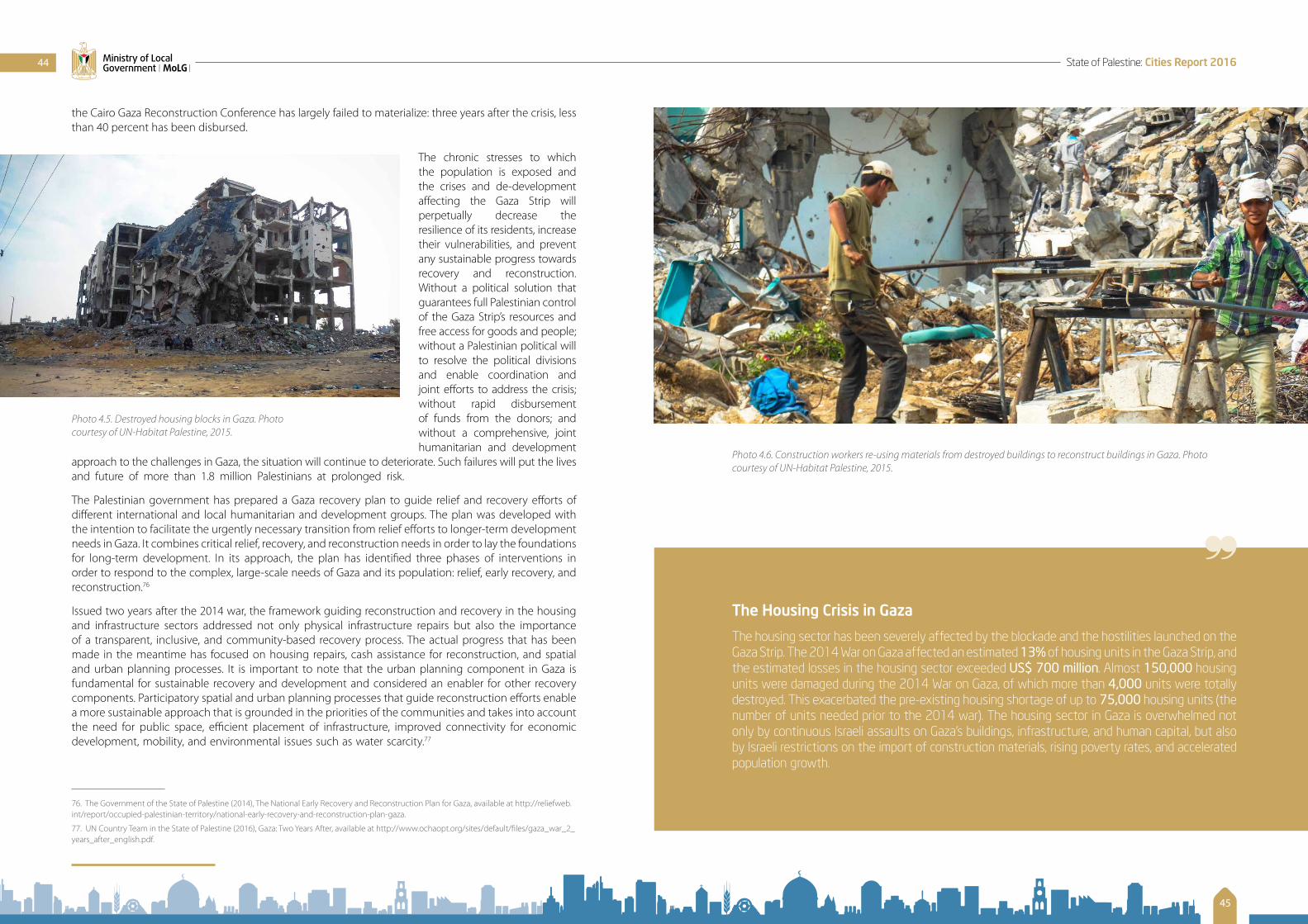
the Cairo Gaza Reconstruction Conference has largely failed to materialize: three years after the crisis, less than 40 percent has been disbursed.
The chronic stresses to which the population is exposed and the crises and de-development affecting the Gaza Strip will perpetually decrease the resilience of its residents, increase their vulnerabilities, and prevent any sustainable progress towards recovery and reconstruction. Without a political solution that guarantees full Palestinian control of the Gaza Strip’s resources and free access for goods and people; without a Palestinian political will to resolve the political divisions and enable coordination and joint efforts to address the crisis; without rapid disbursement of funds from the donors; and without a comprehensive, joint humanitarian and development
approach to the challenges in Gaza, the situation will continue to deteriorate. Such failures will put the lives and future of more than 1.8 million Palestinians at prolonged risk.
The Palestinian government has prepared a Gaza recovery plan to guide relief and recovery efforts of different international and local humanitarian and development groups. The plan was developed with the intention to facilitate the urgently necessary transition from relief efforts to longer-term development needs in Gaza. It combines critical relief, recovery, and reconstruction needs in order to lay the foundations for long-term development. In its approach, the plan has identified three phases of interventions in order to respond to the complex, large-scale needs of Gaza and its population: relief, early recovery, and reconstruction.76
Issued two years after the 2014 war, the framework guiding reconstruction and recovery in the housing and infrastructure sectors addressed not only physical infrastructure repairs but also the importance of a transparent, inclusive, and community-based recovery process. The actual progress that has been made in the meantime has focused on housing repairs, cash assistance for reconstruction, and spatial and urban planning processes. It is important to note that the urban planning component in Gaza is fundamental for sustainable recovery and development and considered an enabler for other recovery components. Participatory spatial and urban planning processes that guide reconstruction efforts enable a more sustainable approach that is grounded in the priorities of the communities and takes into account the need for public space, efficient placement of infrastructure, improved connectivity for economic development, mobility, and environmental issues such as water scarcity.77
76. The Government of the State of Palestine (2014), The National Early Recovery and Reconstruction Plan for Gaza, available at http://reliefweb.int/report/occupied-palestinian-territory/national-early-recovery-and-reconstruction-plan-gaza.
77. UN Country Team in the State of Palestine (2016), Gaza: Two Years After, available at http://www.ochaopt.org/sites/default/files/gaza_war_2_years_after_english.pdf.
Photo 4.5. Destroyed housing blocks in Gaza. Photo courtesy of UN-Habitat Palestine, 2015.
The Housing Crisis in Gaza
The housing sector has been severely affected by the blockade and the hostilities launched on the Gaza Strip. The 2014 War on Gaza affected an estimated 13% of housing units in the Gaza Strip, and the estimated losses in the housing sector exceeded US$ 700 million. Almost 150,000 housing units were damaged during the 2014 War on Gaza, of which more than 4,000 units were totally destroyed. This exacerbated the pre-existing housing shortage of up to 75,000 housing units (the number of units needed prior to the 2014 war). The housing sector in Gaza is overwhelmed not only by continuous Israeli assaults on Gaza’s buildings, infrastructure, and human capital, but also by Israeli restrictions on the import of construction materials, rising poverty rates, and accelerated population growth.
Photo 4.6. Construction workers re-using materials from destroyed buildings to reconstruct buildings in Gaza. Photo courtesy of UN-Habitat Palestine, 2015.
44
45
State of Palestine: Cities Report 2016Ministry of Local Government | MoLG |

CHAPTER | 5 |
URBAN SERVICES AND INFRASTRUCTURE
5.1. Water
Water is a scare resource in Palestine. Palestinian cities in the West Bank and the Gaza Strip continuously suffer from severe water shortages. The main water resources in Palestine are the Mountain Aquifer that includes three basins (the Western, Eastern and Northeastern basins), the Jordan River system, and the Coastal Aquifer. Most of the water resources in Palestine are controlled by the Israeli authorities. For example, Palestinians have access to only to 20 percent of the water pumped from the Mountain Aquifer that is considered the main source of water in Palestine.78 Thus, the average water consumption for domestic, commercial and industrial use in the West Bank is approximately 79 liters per person per day, which is almost a quarter of the amount consumed in Israel (estimated at 287 liters per person per day).79 It is important to note here that whereas the World Health Organization recommends a minimum of 100 liters of water per person per day to sustain domestic consumption and the use by hospitals, schools, businesses, and other public institutions, regional experts have estimated that in order for modern urban systems to function, an amount of 150 liters per person per day is needed. Moreover, in Palestine water is considered an expensive resource, with Palestinians spending almost 8 percent of their monthly expenditures on water, compared a world average of 3.5 percent.80 These disparities in water allocation have created a water crisis in Palestine, and Palestinian cities are struggling
78. B’Tselem (2016), Background: Water Crisis, available at: http://www.btselem.org/water.
79. B’Tselem (2014), Discriminatory Water Supply, available at http://www.btselem.org/water/discrimination_in_water_supply.
80. OCHA (2016), Humanitarian Needs Overview for Occupied Palestinian Territory, available at https://www.ochaopt.org.
The Water Crisis in the Gaza Strip
The water crisis in Gaza is exacerbated by the blockade and repeated assaults. Additionally, Gaza is suffering from ground water contamination with chlorine (saline) and nitrates, which are present at levels far above international water quality guidelines. Moreover, due to unsustainable water withdrawal from the coastal aquifer – in the absence of alternatives – the ground aquifer is expected to be entirely depleted by 2018.
with lengthy intervals of water cuts that affect hygiene, housework, industry, and agriculture. This shortage carries severe implications for health and general welfare. In terms of infrastructural coverage: with almost 91 percent, the majority of Palestinian localities are connected to water networks. However, 34 percent of the localities connected to water networks are dependent on Israeli water sources.81 Water pollution is another challenge in the Palestinian territory with at least 20 percent of Palestinian localities suffering from water pollution.
5.2. Energy
In recent years, high population growth rates and the associated urbanization have created a tremendous energy demand in the Palestine. Many expert groups have stated that the energy situation in Palestine is unique, compared to other countries in the region. This is largely due to a number of factors which include foremost the fact that Palestinian supply is entirely dependent on imported energy, mainly from Israel; but also the political, geographic, and economic fragmentation of the West Bank and the Gaza Strip; the financial challenges and political instability facing the Palestinian National Authority; and the restrictions on access to natural resources imposed by Israel. Israel’s control over Area C poses at this point insurmountable challenges to any plans of constructing power networks in the West Bank at some point in the future. Moreover, Israeli control over international borders limits the import of energy and fuel products from other sources, keeping Palestinians in the West Bank entirely dependent on Israel. The situation is very similar in Gaza, where continuous Israeli assaults have resulted in waves of destruction of local energy infrastructure that include the only power plant in the Gaza Strip, which was destroyed in 2014.82
As Palestine continues to be heavily dependent on Israel for meeting its energy requirements, with almost all fuel products being imported through Israeli companies and without access to more affordable solutions,83 energy is increasingly becoming unaffordable for people living in Palestine. The fuel and energy costs for Palestinians are among the highest in the region, estimated at 15 cents per kWh.
In terms of connectivity, about 97 percent of the localities in Palestine are connected to electricity networks. However, almost 27 percent of the localities in Palestine receive intermittent electricity services
81. PCBS (2015), Local Communities Survey, 2015, available (in Arabic) at: http://www.pcbs.gov.ps/Downloads/book2161.pdf.
82. Mission of Palestine to the EU (2016), Energy Sector in Palestine: Document on energy issues presented by the Mission of Palestine to the EU, 19 May 2016, available at http://www.europarl.europa.eu/meetdocs/2014_2019/documents/dpal/dv/palestinianenerg_issues_pal-mission/palestinianenerg_issues_pal-missionen.pdf.
83. PCBS (2015), Palestine in Figures 2015, available at http://www.pcbs.gov.ps/Downloads/book2188.pdf.
• 95% of Palestine’s electricity is imported from Israel
• 4% imported from Egypt
• 1% imported from Jordan
Photo 5.1. Wide sections of the water networds in Gaza were destroyed in the 2014 assault, Courtesty of Palestine Image Bank
46
47
State of Palestine: Cities Report 2016Ministry of Local Government | MoLG |

(23 percent of the localities in the West Bank and 100 percent of the localities in Gaza).84
Palestine should resort to the large-scale utilization of renewable energy resources to ensure that more affordable, sustainable and reliable sources of energy are available. The major resources for renewable energy available in Palestine are solar, geothermal and biomass energy sources. Palestine receives about 3,000 hours of sunshine per year and has an average solar radiation of 5.4 kWh per sq. m. Domestic solar water heating is widely used in Palestine, as almost 70 percent of buildings have such systems.85 Solar thermal and photovoltaic systems are about to take off in the Palestinian areas, as in early 2016, the Palestinian National Authority announced plans for the building of solar power plants in the Palestinian governorates.
5.3. Wastewater and Sanitation
Domestic wastewater is poorly managed in Palestine. With limited options for the collection of the generated wastewater via sewage networks and/or cesspits, the final discharge of untreated wastewater into the open environment is common.
In terms of a wastewater network, connectivity is far less developed than the access to water networks. Wastewater connections are limited to major urban areas that show high population concentrations. It is estimated that only 19 percent of the Palestinian communities are connected to a wastewater network, and this number varies widely between the West Bank and the Gaza Strip: while almost 73 percent of the communities in the Gaza Strip are connected to wastewater networks, only 15 percent of the West Bank communities are.86 The areas that are not served by such networks dispose their waste through cesspits or directly into the environment.
In the Gaza Strip, the three operating wastewater-treatment plants are located in Gaza City, Beit Lahia, and Rafah. But these plants do not have the capacity to treat the wastewater generated by the growing population in the Gaza Strip and at this time must function beyond their capacity. In attempts to fill the existing needs, three additional treatment plants are currently under construction in the Gaza Strip; however, due to restrictions on access to materials, the perpetual energy shortage, and continued political turbulences, their completion has been delayed for several years now.87 Thus, partially-treated and untreated wastewaters are eventually discharged into open areas such as Wadi Gaza or into the Mediterranean Sea.88 In the West Bank, most of the wastewater is discharged, untreated, into adjacent
84. PCBS (2015), Local Communities Survey, 2015.
85. Mohammad Yamin (2015), “Renewable Energy in Palestine,” EcoMENA, available at http://www.ecomena.org/tag/energy-sector-in-palestine/.
86. PCBS (2015), Local Communities Survey, 2015.
87. OCHA (2016), “Gaza: shortage of sanitation infrastructure raises health and environmental concerns,” The Monthly Humanitarian Bulletin, available at http://www.ochaopt.org/content/gaza-shortage-sanitation-infrastructure-raises-health-and-environmental-concerns.
88. Mohammed Falah El-Turk (2014), Assessment of Heavy Metals Pollution of Wadi Gaza, Eastern Mediterranean Coast, Palestine, a thesis submitted in partial fulfillment for a degree as a Master of Science in Environmental Sciences, Islamic University, Gaza, available at http://library.iugaza.edu.ps/thesis/114526.pdf.
Photo 5.2. The only power plant supplying electricity in Gaza was destroyed in Israeli attacks in 2014. Photo courtesy of Mahmud Hams/AFP/Getty Images, through Huffington Post, 2014.
valleys (either to the East, i.e. towards the Dead Sea and Wadi en-Nar, or to the West into Wadi Zimar).89
In addition to this untenable situation, pressure on the Palestinian environment is further intensified by the large amounts of wastewater that are disposed by Israeli settlements into the adjacent valleys and agricultural lands of the West Bank.
5.4. Solid Waste Management
The majority of the Palestinian communities (almost 88 percent) have access to solid-waste collection services. Nevertheless, only 48 percent of the local communities are disposing the collected waste in approved dumping sites.90 Most solid waste in Palestine is composed of organic materials (80 percent is estimated to be food waste), paper, cardboard, plastics, metals, and glass, and more. Solid waste collection and -disposal in Palestine are a function of the local municipalities. In 25% of the communities in the West Bank, the uncollected solid waste is often discarded in dumps and informal incineration sites. The average Palestinian household produces approximately 4.6 kg per day91 of solid waste, with most solid waste being produced in the major cities. This results in a per-capita rate of 0.9 kg per day, which is slightly less than the world average of 1.2 kg per day recorded by the World Economic Forum. Industrial and hazardous waste is generally processed together with municipal solid waste and therefore frequently mixed with non-hazardous materials. Israeli settlements also release quantities of untreated hazardous waste into the surrounding Palestinian environment.
In the Gaza Strip, solid waste management is among the key compelling issues that Gazans are facing today. These challenges are attributed to several factors that include the lack of investment in environmental systems, the tendency of giving less attention to environmental projects, the absence of related law enforcement, and the tendency of resorting to crisis management rather than prevention. A main aspect of the solid-waste problem involves the huge quantity of rubble and debris that has been generated, both as a result of repeated Israeli bombardments and following the destruction of Israeli settlements, carried out after Israel’s unilateral disengagement from Gaza.
5.5. Urban Mobility and Transport Systems
Palestinian cities and towns suffer from connectivity challenges, as manifested in the severe traffic congestions that plague all major cities in Palestine. Furthermore, mobility constraints exist between the various urban areas on the one hand, and between urban and rural communities on the other, and these come as the result mainly of the fragmentation of the West Bank due to the prevailing Oslo classification and the associated sovereignty restrictions. The majority of the routes connecting Palestinian cities and villages fall in Area C, where the Israeli military has full control. Moreover, the prevailing lack of resources for land acquisition and infrastructure upgrades has resulted in outdated road networks and transport modalities, the absence of major infrastructure interventions (such as building tunnels, bridges, bypass roads, etc.), and the absence of sustainable mobility solutions (including city buses, BRT, Trams, cycling routes, etc.).
The transport modes in Palestine are limited to traditional transit modes that include personal vehicles, taxis, and small minivans for passenger transport. These limitations immensely affect local Palestinian communities in terms of social disintegration, environmental degradation, public health deterioration, and pressure on land. In ways similar to other developing countries, mobility and transport planning and policies in Palestine are highly fragmented, and the majority of the sectoral plans for traffic and infrastructure networks are not aligned among the different administrative units, be it in the relevant ministries or the local government units.
89. ARIJ (2015), Status of the Environment in the State of Palestine, available at http://www.arij.org/files/arijadmin/2016/SOER_2015_final.pdf.
90. PASSIA (2015), Water and Environment, available at http://www.passia.org/palestine_facts/pdf/Water%20&%20Environment.pdf.
91. ARIJ (2015), Status of the Environment in the State of Palestine.
48
49
State of Palestine: Cities Report 2016Ministry of Local Government | MoLG |

The dichotomy between land-use and transportation planning in Palestine continues to negatively impact the urban form and prevents more sustainable and compact mixed-use developments. These complexities hinder growth potentials in Palestinian cities and exert pressure on the quantity and quality of mobility and accessibility conditions, thus leading to the noted negative effects in terms of traffic congestion (especially within the main Palestinian urban centers) and unsustainable land consumption rates. The Palestinian Ministry of Transportation is currently devising the first draft of a national transport and mobility plan that aims to address the gaps in policy and strategy in the mobility and transport sectors.
5.6. Public Open Space
The rapid urbanization and population growth that the West Bank and Gaza Strip have experienced recently have impacted negatively on the availability and quality of public spaces within Palestinian cities. Public open spaces are considered a critical factor when striving to develop sustainable, inclusive cities and to enhance the living quality of their residents. However, the planning regulations in Palestine have not been successful in facilitating the provision of public spaces in Palestinian cities, because most consideration is given to building design, elevation, heights, setbacks, parking, etc., with little focus on the design and integration of urban public space. Furthermore, no planning policies are currently mainstreamed within the Palestinian spatial-planning systems that plan, design, manage, implement, and maintain public spaces in the Palestinian cities and towns. A second major challenge to the development of public open spaces in Palestine is land ownerships. The majority of land parcels in cities are privately owned, making its very difficult to extract land for public space usage.92 Nevertheless, a few municipal efforts to utilize lands owned by the municipality have succeeded in creating public open spaces in
the neighborhoods of their cities, and they have come in the form of small parks and gardens. Although the number of these initiatives is still small, they have succeeded to meet some of the respective communities’ basic needs for public spaces.
92. L. Najjar and S. Ghadban (2015), “In-between forgotten spaces in Palestinian cities: the twin cities of Ramallah and Al-Bireh as a case study,” Sustainable Development and Planning, VII, pp. 811-822, available at http://www.witpress.com/Secure/elibrary/papers/SDP15/SDP15068FU1.pdf.
Photo 5.3. Palestinian freight transport frequently travels on inner city road networks.
Photo 5.4. Al-Birweh Park provides a beautiful setting for the Mahmoud Darwish Museum in Ramallah.
50
51
State of Palestine: Cities Report 2016Ministry of Local Government | MoLG |

URBAN RESILIENCE AND DISASTER RISK REDUCTION
Palestine, as the Mediterranean region at large, has been heavily affected by disasters – natural and human-made, alike. In terms of natural risks, Palestine is part of an active seismic zone with a high probability of sudden shocks; in addition, water scarcity, draught, and desertification, along with the danger of landslides, are among the most-anticipated dangers, especially along the Jordan Valley.
CHAPTER | 6 |
Urban Resilience
is the capacity of individuals, communities, institutions, businesses, and systems within a city to survive, adapt, and grow no matter what kinds of chronic stresses and acute shocks they experience.
CHRONIC STRESSES
weaken the fabric of a city on a daily or cyclical basis; examples include
• high unemployment• over-taxed or inefficient public transportation system• endemic violence• chronic food and water shortages.
ACUTE SHOCKS
are sudden, sharp events that threaten a city; examples include
• earthquakes• floods• disease outbreaks• attacks
Source: 100 Resilient Cities
The technical and human capacities for risk reduction exist in Palestine, but not at a sufficient level. The political will and policy priorities that have been expressed at the national level have not materialized yet, as they have not been put into concrete actions. Whereas a Palestinian national committee for risk reduction has been in existence for more than a decade, and various state and non-state actors are engaging as well, these agencies have been planning in isolation. An integrated risk reduction strategy has not been developed so far. On the academic level, research centers that show interest in risk reduction have been active, and specialized courses and workshops have been organized with the aim of promoting risk reduction measures, fostering social cohesion, and building resilience. Under this framework, more action plans are needed in order to enable the relevant actors to estimate losses, obtain and utilize advanced technologies that mitigate losses, improve early warning systems for natural hazards, acquire detailed mapping information on soil types and seismic micronisation, define the impact of potential disasters on the natural ecosystems, and assess the vulnerabilities of critical infrastructures and of communities whose condition are dire. Furthermore, high-tech technologies and tools capable of three-dimensional modeling and simulation are needed, in order to enable anticipation of how the built environment and critical infrastructures will perform under stress situations. Photo 6.1 Diverse Economic Activities
52
53
State of Palestine: Cities Report 2016Ministry of Local Government | MoLG |

The mainstreaming of risk reduction into spatial planning interventions has been weak at the various planning levels, and especially at the national level. The protection plan that was adopted in 2012 by the Palestinian cabinet under the National Spatial Plan for the State of Palestine did not consider parameters related to potential risks in disaster-prone areas. According to experts, factoring in such layers of constraints would result in different outputs and designations in the protection plans and, therefore, would ultimately change the future of spatial development and its patterns, especially in urban areas.
It is to be expected that if efforts were to be made in fostering cooperation between Palestinian stakeholders, significant progress towards building resiliency in the Palestinian urban areas could be achieved. This assumption is based on, for instance, scenarios that indicate that in the event of an earthquake of a moderate to high magnitude and with an epicenter located within the Dead Sea area, 20 percent of all structures in the Palestinian built areas would suffer total damage, and 25 percent partial damage.93
93. Jalal Dabeek (2000), Studies on earthquakes, Earth Sciences and Seismic Engineering Center, An-Najah National University, Nablus.
Ramallah, 100 Resilient Cities
In 2014, Ramallah was among the first 33 cities to join the 100 Resilient Cities (RC) movement, and in January 2016, the Ramallah resilience team commenced phase I of its strategy development. The resilience initiative is facing various challenges that include local political and security challenges and are coupled with the economic difficulties that are affecting many organizations and the Palestinian people at large. Nevertheless, the launching and moving forward with this initiative at this time and in the Palestinian context offers a light of hope for a better future to all city residents and stakeholders.
Source: 100 Resilient Cities (2016). Ramallah Preliminary Resilience Assessment.
54
55
State of Palestine: Cities Report 2016Ministry of Local Government | MoLG |
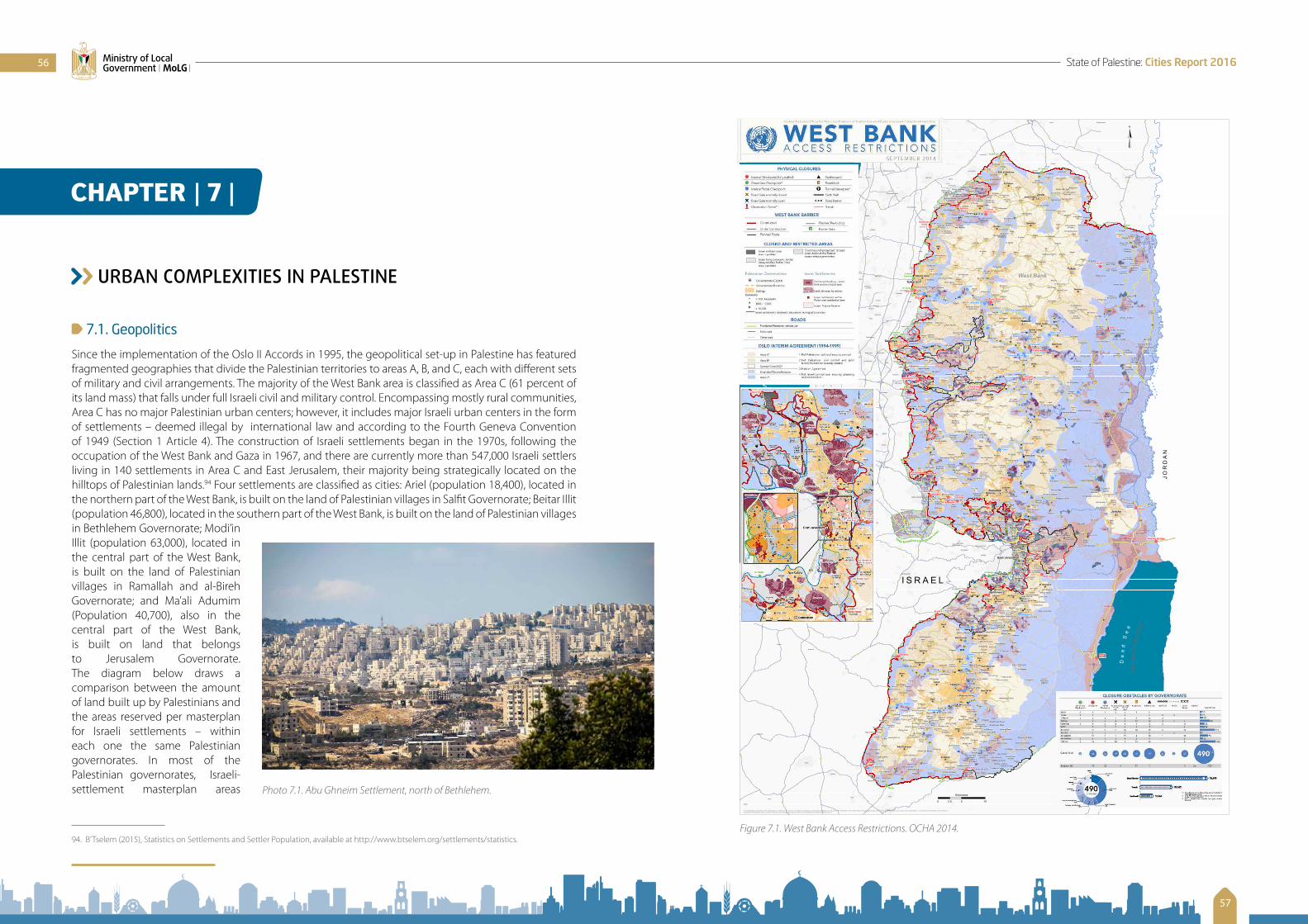
URBAN COMPLEXITIES IN PALESTINE
7.1. Geopolitics
Since the implementation of the Oslo II Accords in 1995, the geopolitical set-up in Palestine has featured fragmented geographies that divide the Palestinian territories to areas A, B, and C, each with different sets of military and civil arrangements. The majority of the West Bank area is classified as Area C (61 percent of its land mass) that falls under full Israeli civil and military control. Encompassing mostly rural communities, Area C has no major Palestinian urban centers; however, it includes major Israeli urban centers in the form of settlements – deemed illegal by international law and according to the Fourth Geneva Convention of 1949 (Section 1 Article 4). The construction of Israeli settlements began in the 1970s, following the occupation of the West Bank and Gaza in 1967, and there are currently more than 547,000 Israeli settlers living in 140 settlements in Area C and East Jerusalem, their majority being strategically located on the hilltops of Palestinian lands.94 Four settlements are classified as cities: Ariel (population 18,400), located in the northern part of the West Bank, is built on the land of Palestinian villages in Salfit Governorate; Beitar Illit (population 46,800), located in the southern part of the West Bank, is built on the land of Palestinian villages in Bethlehem Governorate; Modi’in Illit (population 63,000), located in the central part of the West Bank, is built on the land of Palestinian villages in Ramallah and al-Bireh Governorate; and Ma’ali Adumim (Population 40,700), also in the central part of the West Bank, is built on land that belongs to Jerusalem Governorate. The diagram below draws a comparison between the amount of land built up by Palestinians and the areas reserved per masterplan for Israeli settlements – within each one the same Palestinian governorates. In most of the Palestinian governorates, Israeli-settlement masterplan areas
94. B’Tselem (2015), Statistics on Settlements and Settler Population, available at http://www.btselem.org/settlements/statistics.
CHAPTER | 7 |
G
G
G
G
G
G
G
G
GG
G
G
G
G
G
G
G
G G
GG
GG
G
G
G
G
G
G G
G
GGG
G
G
G
G
G
G
GG G
G
G
G
G
G
G
G
G
G
G
G
G
G
G
G
G
G
G
G
G
G
G
G
G
G
G
GG
G
G
GG
G
G
G
G
G
G
G
G
G
G
G
G
G
G
G
G
G
G
G
G
G
GGG
GG
G
GG
G
G
G
GG
G
G
G
G
G
G
G
G
G
G
G
G
G
G
G
GG
G
G
G
G
G
G
G
G
G
G
G
G
G
G
G
G
G
G
G
G
G
G
G
G
G
G
G
G
G
G
GG
G
G
G
G
G
G
G
G
GG
GG
G
GG
G
G
G
GG
G
G
G
G
G
G
G
G
G
G
GG
G
G
G
G
GG
G
G
G
G G
G
G
G
G
G
G
G
G
G
G
G
G
G
G
G
G
G
G
G
G
G
G
G
G
G
GG
G
G
G
G
G
G
G
G
G
G
G
G
G
G
G
G
G
G
G
G
G
G
G
G
G
G
G
G
G
G
G
G
G
G
G
G
G
G
G
G
G
G
GG
G
G
G
G
G
G
G
G
G
G
G
G
G
G
G
G
G
G
G
G
G
G
G
G
G
G
G
G
G
G
G
G
G
GG
G G
G
G
G
G
G
G
G
G
G
G
G
G
G G
G
G
G
G
G
G
G
G
G
G
G
G
G
G
G
G
G
G
G
G
G
G
G
G
G
G
G
G
G
G
G
G
G
G
G
G
GG
G
G
G
G
G
G
G
G
G
G
G
GG
G
G
G
G
G
G
G
G
G
G
GG
G
G
G
GG
G
G
GGG
G
G
G
G
G
G
G
GG
G
GG
G
G
G
G
G
G
G
G
G
G
G
G
G
G
G
GG
G
GG
G
G
G
G
G
G
G
G
G
G
G
G
G
G G
G
G
G
G
G
G
G
G
G
G
G
G
G
G
G
G
G
G
G
G
G
G
G
G
G
G
G
G
G
G
GG
G
G
G
G
G
G
G
G
G
G
G
GG
G
G
G
G
G
G
GG
G
G
G
G
G
G
G
G
G
G
G
G
G
G
G
GG
G
G
G
G
G
GG
G
G
G
G
G
G
G
G
G
G
G
G
G
G
G
G
G
G
G
G
G
G
G
G
G
G
G
G
G
G
G
G
G
G
G
G
G
G
G
G
G
G
G
G
G
G
G
G
G
GG
G
G
G
G
G
G
G
G
G
G
G
G
G
G
GG
G
G
GGG
G
G
G
G
G
G
G
G
GG
G
G
G
G
G
G
G
G
G
G
G
G
G
G
G
G
G
G
G
G
G
G
G G
G
G
G
G
G
GG
G
G
G
G
GG
G
G
G
G
GG
G
G G
G
G
G
G
G
G
G
G
G
G
G
G
G
G
G
G
G
G
G
G
G
G
GG
G
G
G
G
G
G
G G
G
G
G
G
G
G
G
G
G
G
G
G
G
GG
G
G G
G
G
G
G
G
G
G
G
G
G
G
G
GG
G
G
GG
G
G
G
G
G
G
G
G
G
G
G
G
G
G
G
G
G
G
G
G
G
G
G
G
G
G
G
G
G
G
GG
G
GG
G
G
G
G
G
G
G
G
G
G
G
G
G
G
G
G
G
G
G
G
G
G
G G
G
G
G G
G
G
G
G
G
G
G
G
G
G
G
G
G
G
G
G
G
G
G
G
G
G
G
G
G
G
G
G
G
G
G
G
G
G
G G
G
G
G
G
G
G
GG
G
G
G
G
G
G
G
GG
G
G
G
G
G
G
G
GG
G
G
G
G
G
G
G
G
G
G
G
G
G
G
G
G
G
G
G
G
G
G
G
G
G
G
G
G
GG
G
G
G
G
G
G
G
G
GG
G
G
G
G
G
G
G
G
G
G
G
G
G
G
G
G
G
GG
G
G
G
G
G
G
G
G
G
G
G
G
G
G
G
G
G
GG
G
G
G
G
G
G
G
G
G GGG
G
G
G
G
G
G
G
G
G
G
G
G
G
G
G
G
G
G
G
G
G
GG
G
G
G
G
G
G
G
G
G
G
G
GG
G
G
G
G
GG
G
G
G
G
G
GG
G
G
G
G
G
G
G
G
G
GG
G
G
G
G G
G
G
G GG
G
G
G
G
G
G
G
GG
G
G
G
G
GG
G
G
G
G
G
G
GGG
G
GG
G
G
G
G
G
G
G
G
G
G
G
G
G
G
G
G
G
G
G
G G
G
G
G
G
G
G
GG
G
G
G
G
G
G
G
G
G
G
G
G
G
G
G
G G
G
G
G
G
G
G
G
G
G
G
G
G
G
G
G
G
G
G
G
G
G
G G
G
G
G
G
G
G
G
G
G
GG
G
G
G
G
G
G
G
G
GG
G
G
G
G
G
G
G
G
G
G
G
G
G
G
G
G
G
G
G
G
G
G
G
G
G
G
G
G
G
G
G
G
G
G
G
G
G
G
G
G
G
G
GG
G
G
GG
G
G
G
G
G
G
G
G
G
G
G
G
G
G
G
G
G
GG
G
G
G
G
G
G
G
G
GG
G
G
G
G
G
G
G
G
G
G
G
G
G
G
G
G
G
G
G
G
G
G
G
G
G
G
G
GG
G
G
G
G
G
G
G
G
GG
G
G
G
G
G
G
G
G
G
G
G
G
G
G
G
G
G
G
G
G
G
G
G
G
G
G
G
G
G
G
G
G
G
G
G
G
G G
G
G
G
G
G
G
G
G
G
G
G
G
G
G
G
G
G
G
G
G
G
G
G
G
G
G
G
G
G
G
G
G
G
G
G
G
G
G
G
G
G
G
G
G
G
G
G
G
G
G
G
G
G
G
G
G
G
G
G
G
G
G
G
G
G
G
G
G
G
G
G
G
G
G
G
G
G
G
G
G
G
G
G
G
G
G
G
G
G
G
G
G
G
G
G
G
G
G
G
G
G
G
G
G
G
G
G
G
G
G
G
G
G
GG
G
G
G
G
G
G
G
G
G
G
G
G
G
G
G
G
G
G
G
G
G
G
G
G
G
G
G
G
G
G
G
G
G
G
G
G
G
G
G
G
G
G
G
G
G
G
G
G
G
G
G
G
G
G
G
G
G
G
G
G
G
G
G
G
G
G
G
G
G
G
G
G
G
G
G
G
G
G
G
G
G
G
G G
G
G
G
GG
G
G
G
G
G
G
G
G
G
G
G
G
G
G
G
GG
G
G
G
G
G
G
G
G
G
G
G
G
G
G
G
G
G
G
G
G
G
G
G
G
G
G
G
G
GG
G
G
GG
GG
G
G
G
G
G
G
G
G
G
G
G
G
G
G
G
G GG
G
G
G
G
G
GG
G
G
G
G
G
GG
G
G
G G
G
GG
G
G
G
G
G
G
G
G
G
G
G
G
G
G
G
G
GG
G
G
G GG
G
G
G
G
G
G
G
G G
G
G
G
G
G
G
G
G
G
GG
G
G
G
GG
G
GG
G
G
G
G
G
GG
G
G
G
G
G
GG
G
G
G
G
GG
G
GG
G
G
G GG G
G
G
G
G GGG
GG
G
GG G
G
G
G
GG
G
G
G
G
G
G
G
G
G
G
G
GG
G
G
G
G
G
G
G
G
G
G
G
G
G
G GG
G
G
GGG
G
G
G
G
G
G
G
G
G
G
G
GG
GG
G
G
G
G
G
G
G
G
G
G
GG
G
G
G
G
G
G
G
G
GG
G
G
G
G G
G
G
G
G
G
G
G
G
G
G
G
G
G
G
G
G
G
G
G
G
G
G
G
G
GG
G
G
GG
G
G
G
G
G
G
G
G
G
G
GG G
G
G
GGG
GG
GG
GG
GGG
G
G
G
G
G
G
G
GG
G
G
G
G
G
GGG
G
G
GG
G
G
GG
G
G
G
G
G
G
G
G
GG
G
G
G
G
G
GG
G
G G
G
G
G
GG
G
G
G
G
G
G
G
G
GG
G
GG
G
G
G
G
G
G
G
G
GG
GGG
G
G
G
G
GG
G
GG
G
G
G
G
G
GG
G
G
G
GG
G
G
G
G
GGG
GG
G
G
G
G
G
G
G
G
G
G
G
G
GG
G
G
G
G G
G
G
G
G G
GG
G
G
G
G
G
G
G
G
G
GG
G
GG
G
G
G G
G
G
G
G
G
G
G
G
G
G
G
G
G
G
GG
G
G
GG
G
G
G
G
G
GG
G
G
G
G
G
G
G
G
G
G
G
G
G
G
GGG
G
G
GG
G
G
G
GG
GG
G
G
G
G
G
G
GG
G
G
GG
G
G
G
G
GG
G
G
G
GG
G
G
G
G
G
G
G
G
G
G
G
G
G
G
G
GG
G
G
G
G
G
G
G
G
G
G
G
G
G
G
G
G
GGG
G
GG
G
G
G
G
G
G
G
G
G
G
G
G
GGG
G
G
G
G
G
G
G
G
G
G
G
G
GG
GG
GGG
G
G
G
G
G
G
GG
G
G
G
G
G
G
G G
G
G
G
G
G
G
GG
GG
G
G
G
GG
G
G
G
G
G
G
G
GG
G
GG
GG
G
G
G G
GG
G G
G
G
G
GG
G
G
G
G
G
G
G
G
G
G
G
G
G
G
G
G
G
G
G
G
G
G
GG
G
G
G
G
GG
GG
G
G
G
GG
G
G
G
G
G
G
GG
G
G
G
G
G
G
G
G
G
G
G
GG
G
G
G
G
G
GG
GG
G
GG
G
G G
G G
G
G
G
G
G
G
G
G
G
G
G
G
G
G
GG
G
G
G
G
G
G
G G
G
G
G
G G
G
G
G
G
G
G
G
G
G
G
G
G
GG
GG
G
G
G
G G
G
G G
G
G
G
GG
G
G
G
GGG
G
GG
G
G
GG
G
G
G
G
G
G
G
G
G
G
G G
G
G
G
G
G
G
G
G
G
G
G
G
G
G
G
GG
G
G
G
G
G
G
G
G
G
G
G
G
G
G
G
G
G
G
G
G
G
G
G
GG
G
G
G
G
G
G
G
G G
G
G
G
G
G
G
GG
G G
G
G
G G G
G
GG
G
GG
G
G
G
G
G
G
G
G
G
G G
G
G
G
G
G
G
G
G
G
G
G
G G
G
GG
G
G
G
GG
G
G
G
G
G
GG
G
G
GG
G
G
G
G
G
G
G
G
G
G
G
G
G
G
G
G
G
G
GG
G
G
G
G
G
G
G
G
G
G
G
G
G
G
G
G
GG
G
G
G
G
G
G
GG
G
G
G
G
G
G
G
G
G
G
G
G
G
G
G
G
G
G
G
GG
G
GG
GGG
G
G
G
G
G
GG
G
G
G
G
G
G
G
GG
G
G
G
G
G
G
G
G
G
G
G
G
G
G
G GG
GG
G
G
G
G
G
GG
G
G
G
GG
G
GG
G
G
G
G
G
G
G
G
G
G
GGG
G
GG
G
G
G
G
GG
G
G
G
G
G
G
G
G
G
G
G
G
G
GG
GG
G
G
G
G
GG
G
G
G
GG
G
G
G
G
GG
G
G
GG
G
G
GGG
GG
GG
G
G
G
G
G
G
G
G
G
G
GG
G
G
G
G
G
GG
G
G
G
GG
G
G
G
G
G
G
G
G
G
G
G
GG
G
G
G
G
GG
G
G
G
G G
G
G
G
G G
G
G
G
G
G
G
GG
G
G
G
G
G
G
G
GG
G
G
G
G
GG
G
G
G
G
G
G
G
G
G
G
GG
G
G
G
GG
G
G
G
G
G
G
G
G
G
G
G
G
G
G
G
G
G
G
G
G
G
G
G
G G
GG
G
G
G
G
G
G
G
G
G
G
G
G
G
G
GG
G
G
G
G
G
GG
G
G
G
G
G
G
G
G
G
G
G
G
G
G
G
GG
G
G
G
G
G
G
GGG
G
G
G
G
G
G
G
G
G
G
G
G
G
G
G
G
G
G G
G
GG
G
G
G
G
G
G
G
GG
G
G
G
G
G
G
G
G
G
G
G G
GG
G
G
G
G
G
G
G
G
G G
G
G
G
G
G
G
G
G
G
G
G G
G
G
G
G
G
G
G
G
G GG
G
GG
GG
G
G
G
G
G
GG
G
GG
G G
G
G
G
G
G
G
G
G
G
G
G
G
G
G
G
G
G
G
G
GG
G
G
G
GG
G
G
G
G
G
G
G
G
G
G
G
G
G
G
G
G
G
G
G
G
G
G
G
G
G
GG
G
G
G
G
G
G
G
G
G
G
G
G
G
G
G
G
G
G
G
G
G
G
G
G
G
G
G
G
G
GG
G
G
G
G
G
G
G
G
G
G
G
G
G G
G
GG
G
G
G
G
G
G
G
G
G GG
G
G
G
G
G
G
G
GG
G
G
G
G
G
G
GG
G
G
GG
G
G
G
G
GG
G
G
G
G
G
G
G
G
G
G
G
G
G
GG
G
G
G
G
G
G
G G
G
G
G
G
G
G
GG
G
G
G
G
G
G
G
G
G
G
G
G
G
G
G
G
GG
G
G
G
G
G
G
GG
G
G
G
G
G
G
G
G
G
G
G
G
GG
G
G
G
G
G
G
G
G
G
G
G
G
GG
GG
G
G
G
G
G
G
G
G
G
G
G
G
G
G
G
G
G
G
G
G
G
G
GG
GG
GG
G
GG
G
G
G
G
G
G
G
G
G
G
G
G
G
G
GG
G
G
G
G
G
G
G
G
G
G
G
G
G
G
G
G
G
G
G
G
G
G
G
G
GG
G
G
G
G
G
G
G
G
G
G
G
G
G
G
G
G
G
G
G
G
G
G
G
G
G
G
G
G
G
G
G
G
GGG
G
GG
G
G
G
G
G
G
G
GG
G
G
G
G
G
G
G
G
GG
G
G
G
G
G
G
G
GG
G
G
GG
G
G
G
G
G
G
G
G
G
G
G
G
G
G
G
G
GG
G
G
G
G
G
G
G
G
G
G
G
G
G
G
G
G
G
G
G
G
G
G G
G
G
G
G
G
G
G
G
G
G
G
G
G
G
G
G
G
G
G
G
G
G
G
G
G
G
G
G
G
G
G
GG
G
G
G
G
G
G
G
G
G
G
GG
G
G
G
G
G
G
G
G
G
G
G
G
G
G
G
G
G
G
G
G
G
G
G
G
G
G
G
G
G
G
G
G
G
G
G
G
G
G
G
G
G
G
G
G
G
G
G
G
G
G
G
G
G
G
G
G
G
G
G
G
G
G
GG
G
G
G
G
G
G
G
GG
G
G G
G
G
G
G
G
G
G
G
G
G
G
G
G
G
G
G
G
G
GG
G
G
G
G
G
G
G
G
G
G
G
GG
GG
G
G
G
G
G
G
G
G
G
G
G
G
G
G
G
G
G
G
GG
G
G
G
G
G
G
G
G
G
G
G
G
G
G
G
G
G
G
G
G
G
G
GG
G
G
G
G
G
G
G
G
G
G
G
G
G
G
G
GG
G
G
G
G
G
G
G
G
G
G
G
G
G
G
G
G
G
G
G GG
G
G
G G
G
G
G
G
G
G
G
G G
G
G
G
G
G
G
G
G
G
G
G
G
G
GG
G
G
G
G
G
G
G
G
G
G
G
G
G
G
G
G
G
G
G
G
G
G
G
G
G
GG
G
G
G
G
G
G
G
G
G
G
G G
G
GG
G
G
G
G
G
G
G
G
G
G G
G
G
G
G
G
G
G
G
G
G
G
G
G
G
G
G
G
G
G
GG
G
G
G
G
G
GG
G
G
G
G
G
G
G
G
G
G
G
G
G
G
G
G
G
G
G
G
G
G
G
G
G
G
G
G
G
G
G
GG
G
G
G
G
G
GG
G
GG
G
G
G
G
G
G
G
G
G
G
G
G
G
G
G
G
G
G
G
G
G
G
G
G
G
G
GG
G
G
GG
G
G
G
G
GG
G
G
G
G
G
G
G
G
G
G
G
G
G
G
G
G
GG
G
G
GG
G
G
G
G
G
G
G
G
G
G
G
G
G
G
G
G
G
G
G
G
G
GG
G
G
G
G
G
G
G
G
G
G
G
G
G
G
G
G
G
G
G
G
G
G
G
G
G
G
G
G
G
G
GG
G
G
G
G
G
GG
G
G
G
G
G
G
G
G
G
G
G
GG
G
G
GG
G G
G
G
G
G
GG
G
G
G
GG
G
G
G
G
G
G
G
G
G
GGG
G G
G
G
G
G
G
G
G
GG
G
G
GG
G
G
G
G
G
G
G
G
GG
G
G
G
GG G
G
G
GG
G
G
GG
G
GG
G
G
G
G
GG
GG
G G
G G
G
GG
GG
G
GG G
G
G
G
G
G
G
GG
G
G
G
G
G
G
G
G
G
G
G
G
G
G
G
GG
G
G
GGG
G
G
G
G
G
G
G
G
G
G
G
GG
GG
G
G
GG
G
G
G
G
G
G
G
GG
G
G
G
G
G
G
G
GG
GG
G
G
G
GG G
G
G
GG
G
GG
G
GG G
GG
G
GG
G
G
G
G
G
G
G
G
G
G
G
G
G
G
G
G
GG
G
G
GG
G
G
G G
G
G
G
G
G
G
G
G
G
G
G
G
G
G
G
GG
G
G
G
G
G
G
G
G
G
G G
G
GG G
G
G
G
G
GG
G
G
G
GG
GG
G
G
GG
G
G
G
GG
G
G
GG
GGG
G G
G
G
G G
G
GG
G
G
G
G
GGG
G
GG
G
G
G
GG
G
G
G
G
G
G G
G
G
G
G
G
G
G
GG
G
G
G
G
G
G
G
G
G
G
G
G
G
G
GG
G
GG
G
G
G G
GG
G
GG
G
GG
G
G
G
G
G
G
G
G
G G
G G
GG
G
G
G
G
G
G GGG
GG
GG
G
G
G
G
G
G
G G
G
G
GG
G
G
G
G
G
G
G
G
G
G
G
G
G
G
GG
G
GG G GG
G
G
G
G
G
G
G
GG
GG
G
GG
G
G
G
G
G
GG
G G
G
GG
G
G
G
G
G
G
G
G
G
G
G
G
G
G
G G
G
G
G
G
G
G
G
G
G
G
G
G
G
GG
G
G
G
G
G
G
G
G
G
G
G
G
G
G
G
G
G
G
G
GGG
G
GG
G
G
G
GG
G
G
G
G
GG
G
G
G
G
G
G
G
GG
G
GG
G
GG
G
GGG
G
G
G
G
G G
G
G
G
G
G
G
GG
G
G
G
GG
GG
G
G
G
G
G
G
G
G
G
GG
G
G
G GG
G
G
G
G
G
G
G
G
G
G
G
G
G
G
G
G
G
G
GG
G
G
G
GG
G
G
G
G
G
GG
G
G
G
G
G
G
G
G
GG
G
G
G
G
G
GG G
G
G
G
GG
G
G
G
G
G
G
G
G
G
G
GG
G
G
G
G
G
G
G
G
G
G
G
GG
G
G
G
G
G
G
G
G
G G
GG
G
G
G
G
G
G
G
G
G
G
GG
G
G
G
GG
G
G
G
GG
G
G
G G
G
G
G
G
G
G
GG
G
GG
G
G
G
G
G
G
G
G
G
G
G
G
GG
G
GG
G
GG
G
G
G
G
G
G
G
G
G
G
GG
G
GG
GG
G
G
G
G
GG
G G
G
G
G
G
G
GG
G
G
GG
G
G
GG GG
G G
G
G
G
G
G
G
G
GG
G
G
G
G
G
G
G
G
G
G
G
G
G
G
G
G
G
GG
G
G
GG
G
G
G
G
GG
G
G
G
G
G
G
G
G
G
G
G
GG
G
G
G
G
G
G
G
G
G
G
G
G
G
G
GG
G
G G
GG
G
GG
G
G
G
G
G
G
G
G
G
G
GG
GG
G
GG
GG
G
G
G
G
GG
G
G
G
G
G
G
G
G
G
G
G GG
G
G
G
G
G
G
G
G
G
G
G
G G
G
GG
G
G G
G
G
G
G
G
G
G
G
G
G
G
G
G
G
G
G
G
G
G
G
GG
GG
G
GG
G
G G
G
G
G
G
G
G
G
GG
G
G
G
G G
G
G
G GGG
G
G
GG
G
G
G
G
G
G
G
G
G
G
GG
G
G
G
G
GG
G
G
G
G
G
GG
G
G
G
G
GG
G
G
G
GG G
G
GG
G
G
G
G
G
G
G
G
G
G
G
G
G
G
G
G
G
G G
G
G
G
G
G
G
GG GG
G
G
G
G
G
G
G
G
G
G
G
G
GG
G
G
G
GG G
G
G
G
G
GG
G
G
G
G
GG
G
G
G
G
G
G
G
G
G
G
G
G
G
G
G
G
G
G
G
G
G
G
G
GG
G
G
G
G G
G
G
G
G
G
G
G
G
G
G
G
GG
G
G
G
GG
G
GG
G
G
G
GG
G
G
G
G
GG
GG G
G
G
G
G
G
G
G
G
G
GG
G
G
G
G
G
G
G
G
G
G
G
G
G
G
G
G
G
G
G
G
GG
G
G
G G
G
G
G
GG
G
G
G
G
G
GG
G
G
G
G
G
G
GG
GG
G
G
G
G
G
G
G
G
G
G
G
G
G
G
G
G
G
G
G
G
G
GG
G
G
G
G
G
GG
G
G
G
G
GG
G
G
G
G
G
G
G
GG
G
G
G
G
G
G
G
G
G
G
G
G
G
G
G
G
G
G
GG
G
G
G
G
G
G
G
G
G
G
GG
G
G
G
G
G
G
G G
G
G
G
G
G
G
G G
G
G
G
G
G
G
G
G
G
G
GG
GG
G
G G
G
G
G
G
GG
GG
G
G
G
G
G
G
G
G
G
G
G
G
G
G
G
G
G
G
G
G
G
G
G
G
G
G
G
G
G
G
G
GG
G
G
G
G
G
G
G
G
G
G
G
G
G
G
G
G
G
G
G
G
G
G
G
G
G
G
GG
G
G
G
G
G
G
G
G
G
G
G
G
G
G
G
G
G
G
G G
G
G
G
G
G
G
G
GG
G
G
G
G
G
G
G
G
G
G
G
G
G
G
G
G
GG
GGG
G
G
G
G
G
G
G
G
G
G
G
G
G
G
G
GG
G
G
G
G
G
G
G
G
G
G
G
G
G
G G
G
G
G
G
G
G
G
G
G
G
G
G
G
G
G
G
G
G
G
G
G
G
G
G
G
G
G
G
G
G
G
G
G
G
G
G
G
G
G
G
G
G
G
G
G
G
GG
G
GG
G
G
G
G
G
G
G
G
G
G
G
G
G
G G
G
G
G
G
GG
G
G
G
G
G
G GG
G
GGG
G G
G
G
G
G
G
G
G
G
G
G
G
G
G
G G
G
G
G
G
G
G
G
G
G
G
G
GG
GG
G
GG
G
G
G
G
G
G
G
G
G
G
G
GG
G
G
G
G
G
G
G
G
G
G
G
G
G
G
G
G
G
G
G
G
G
G
G
G G
G
G
G
G
G
G
G
G
G
G
G
G
G
G
G
G
G
G
GG
G
G
G
G
G
G
G
G
G
G
G
GG
GG
G
G
G
G
G
G
G
G
G
G
G
G
G
G
G
G
G
G
G
GG
G
G
G
G
G
G
G
G
GG
G
G
G
G
G
G
G
G
G
G
G
G
G
G
G
G
G
G
GG
G
G G G
G
G
G
G
G
G
G
G
G
G
G
G
G
G
G
G
G
G
G
G
GG
G
G
G
G
G
G
G
G
G
G
G
G
G
G
G
G G
G
G
G
G
G
G
G
G
GG
G
G
G
G
G
G
G
G
G
G
G
G
G
GG
G
G
G
G
G
G
G
G
G
G
G
G
G
G
G
G
G
G
G
G
G
G
G
G
G
G
G
G
G
G
G
G
G
G
G
G
G
G
G
G
G
G
G
G
G
G
G
G
G
GG
G
G
G
G
G
G
G
G
G
G
G
G
G
G
G
GG
G
G
G
G
GG
G
G
G
G
G
G
G
G
G
G
G
G
G
G
G
G
G
G
G
G
G
G
GG
G
G
G
G
G
G
G
G
G
G
G
G
G
G
G
G
G
G
G
G
G
G
G
G
G
G
GGG
G
G
G
GG
G G
G
G
G
G
G
G
G
G
G
G
G
G
G
G
G
G
G
G
G
G
G
G
G
G
G
G
G
G
G
G
G
G
G
G
G
G
G
G
G G
G
G
G
GG
GG
G
G
G
G
G
GG
G
G
G
G
G
G
G
G G
G
GG
G
G
GG
G
G
G
G
G
G
G
G
G G
G
G
G
G
GG
G
G
G
G
G
G
G
G
GG
GGG
GG
G
G
G
G
G
G
G
G
G
G
GG
G
GG
G
G
G
G
G
G
G
G
G
G
G
G
G
G
G
G
G
G
G
G
G
GG
G G
G
GG
G
G
GG
G
G
G
G
G
G
G
GG
G
G
G
G G
G
G
G
G
G
G
G
G
G
G
G
G
G
GG
GG
G
G
G
G
G
G
GG
G
GG
G
G
G
G
G
G
G
G
GG
G
G G
G
G
G
G
G
G
G
G
GG
G
G
G
G
G
G
G
G
G
G
G
G
G
G
G
G
G
G
G
GG
GG
G
GG
G
G
G
G
G
G
G
G
G
G
G
G
G
G
G
G GG
G
G
G
G
G
G
G
G
G
G
G
G
G
G
GG
G
G
G
G
G
G
G
G
G
G
G
G
G
G
G
G
G
G
G
G
G
G
G
G
G
G
G
G
G
G
G
G
G
G
G
G
G
G
G
G
GG
G
G
G
G
G
G
G
G
G
GG
G
G
G
GG
G
G
G
G
G
G
G
G
G
G
GG
GG
GG
G
GG
G
GG
G
G
G
G
G
G
G
G G
G
G
G
G
G
G
G
G
G
GG
G G
G G
GG
G
G
G
G
G
G
G
G
G
G
GG
G
G
G
G
G
G
G
G
G
G
GG
G
GG G
G
G
G
G
G
G
G
G
G
G
G
G
G
G
G
GG
G
G
G
G
G
G
G
G
G
G
G
G
G
G
G
G
G
G
G
G
GG
GG
G
G
G
G
GG
GG
G
G
G
G
G
G
G
GG
G
G
G
GG
G
G
G
GG
G
GG
G
G
G
G
G
G
GG
G
G
G
G
G
G
G
G
G
G
G
G
G
G
G
GG
G
G
G
G
G
G
G
G
G
GG
G
GG
G
G
G
G
G
G
GG
G
G
GG
G
G
GG
G G
G
G
G
G
G
GG
G
G
G
G
G GG
G
G
G
G
G
G
G
G
G
GG
G
G
GG
G
G
G
G
G G
G
G
G
G
G
GG
G
G
GG
G
G
G
G
G
GG GG
GG
G
G
G
G
G
G
G
G
G
G
G GGG
G
G
G
G
GG
G
GG
G
G
G
G
GG
G
G
G
G
G
GG
G
G
G
G
G G
G
G
G
G
G
G
G
G
G
G
GG
G
G
G G
G
G
G
GG
G
G
G
G
G
G
G
G
GG
GG
G
G
G
G
G
G
G
G
G
G
G
G
G
G
G
G
G
G
G
G
GG
G
G
G
G
G
G
G
G
G
GG
G
G
G
G
GG
G
G
G
G
G
G
GG
G
G
GG
G
G
G
G
GG
G
G
G
G
GG
G
G
G
G
G
G
G
G
G
GG
G
G
G
G
G
G
G
G
G
G
G
G
G
G
G
G
G
G
G
G
G
G
GG
G
G
G
G
G
G
G
G
G
G
G
G
GG
G
G
G
G
G
G
G
G
G
G
G
G
G
G
G
G
G
G
G
G
G
G
G
G
G
G
G
G
G
G
G
G
G
G
G
G
G
G
G
G
G
G
G
G G
G
G
G
G
G
G
G
G
G G
G
G
G
G
G
GG
G
G
G
G
G
G G
G
G
G
G
G
G
G
G
G
G
G
G
G
G
G
G
G
G
G
G
G
G
G
G
G
G
G G
G
G
G
G
G
G
G
G
G
G
G
G
G
G
G
G
G
G
G
G
G
G
G
G
G
G
G
G
GG
G
G
GG
G
G
G
GG
G
G
G
GG
G
G
G
G
G
G
G
G
G
G
G
G
G
G
G
G
G
G
G
G
G
G
G
G
G
G
G
G
G
G
G G
G
G
G
G
G
G
G
G
G
G
G
G
G
G
G
G
G
G
G
G
G
G
G
G
G
G
G
G
G
G
G
G
G
G
G
G
G
G
G
G
G
G G
G
G
G
G
G
G
G
G
G
G
G
G
G
G
G
G
G
G
G
G
G
G
G
G
G
G
G
G
G
G
G
G
G
G G
GG
G
G
G
G
G
G
G
G
G
G
G
G
G
G
G
G
G
G
G
G
G
G
G
G
G
G
G
G
G
G
G
G
G
G
G
G
G
G
G
G
G
G
G
G
G
G
G
G
G
G
G
G
G
G
G
G
G
G
G
G
GG
G
G
G
G
G
G
G
G
G
G
G
G
G
G
G
G
G
G
G
G
G
G
G
G
G
G
G
G
G
G
G
G
G
G
G
G
G
G
G
G
G
G
G
G
G
G
G
G
G
G
G
G
G
G
G
G
G
G
G
G
G
GG
G
G
G
G
G
G
G
G
G
G
G
G
G
G
G
G
G
G
G
G
G
G
G
G
G
G
G
G
G
G
GG
G
G
G
G
G
G
G
G
G
G
G
G
G
G
G
G
G
G
G
G
G
G
G
G
G
G
G
G
G
G
G
G
G
G
G
G
G
G
G
G
G
G
G
G
G
G
G
G
G
G
G
G
G
G
G
G
G
G
G
G
G
G
G
G
G
G
G
G
G
G
G
G
G
G
G
G
G
G
G
G
G
G
G
G
G
G
G
G
G
G
G
G
G
G
G
G
G
G
G
G
G
G
G
G
G
G
G
G
G
G
G
G
G
G
G
G
G
G
G
G
G
G
G
G
G
G
G
G
G
G
G
G
G
G
G
G
G
G
G
G
G
G
G
G
G
G
G
G
G
G
G
G
G
G
G
G
G
G
G
G
G
G
G
G
G
G
G
G
G
G
G
G
G
G
G
G
GG
G
G
G
G
G
G
G
G
G
G
G
G
G
G
G
G
G
G
G
G
G
G
G
G
G
G
G GG
G
G
G
G
G
G
G
G
G
G
G
G
G
G
G
G
G
G
G
G
G
G
G
G
G
G
G
G
G
G
G
G
G
G
G
G
G
G
G
G
G
G
G
G
G
G
G
G
G
G
G
G
G
G
G
G
G
GG
G
G
G
G
G
G
G
G
G
G
G
G
G
G
GG
G
G
G
G
G
G
G
G
G
G
G
G
G
G
G
G
G
G
G
G
G
G
G
G
G
G
G
G
G
G
G
G
G
G
G
G
G
G
G
G
GG
G
G
G
G
G
G
G
G
G
G
GG
G
G
G
G
G
G
G
G
G
G
G
G
G
G
G
G
GG
G
G
G
G
G
G
G
G
G
G
G
G
G
G
G
G
G
G
G
G
G
G
G
GG
G
GG
G
G
G
G
G
G
G
G
G
G
G
G
G
G
G
G
G
G
G
G
G
G
G
G
GG
G
GG
G
G
G
G
G
G
G
G
G
G
G
G
G
G
G
GG
G
G
G
G
G
G
G
G
G
G
G
G
G
G
G
G
G
G
G
G
G
G
G
G
G
G
G
G
G
G
G
G
G
G
G
G
G
G
G
G
GG
G
G
GG
G
G
G
G
G
G
G
G
G
GG
G
G
G
G
G
G
G
G
G
G
G
G
G
G
G
G
G
G
G
G
G
GG
G
G
G
G
G
G
G
G
G
G
G
G
G
G
G
G
G
G
G
G
G
G
G
G
G
G
G
G
G
G
G
G
G
G
G
G
GG
G
G
G
G
G
G
G
GG
G
G
G
G
G
G
G
G
G
G
G
G
G
G
G
G
G
G
G
G
G
G
G
G
G
G
G
G
G
G G
G
G
G
G
G
G
G
G
G
G
G
G
G
G
G
G
G
G
G
G
G
G
G
G
G
G
G
G
G
G
G
G
G
G
G
G
G
G
G
G
G
G
G
G G
G
G
G
G
G
G
G
G
G
G
G
G
G
G
G
G
G
G
G
G
G
G
G
G
G
G
G
G
G
G
G
G
G
G
G
G
G
G
G
G
G
G
G
G
G
G
G
G
G
G
G
G
G
G
G
G
G
G
G
GG
G
G
G
G
G
G
G
G
G
G
G
G
GG
G
G
G
G
G
G
G G
G
G
G
GG
GG
G
G
G
G
G
GG
G
G
G
G
G
G
G
G
G
G
G
G
G
G
G
G
G
GG
G
G
G
G
G
G
G
G
G
G
G
G
G
G
GG
G
G
G
G
GG
G
G
G
G
G
G
G
GG
G
G
G
G
G
G
G
G
G
G
G
G
G
G
G
G
G
G
G
G
G G
G
G G
G
G
G
G
G
G
G
G
G
G
G
GG
G
G
G
G
G
G
G
G
G
G
G
G
G
G
G
G
G
G
G
G
G
G
G
G
G
G
G
G
G
G
G
G
G
G
G
G
G
G
G
G
GG
G
G
G
G
G
G
G
G
G
G
G
G
G
G
G
G
G
G
G
G
G
G
GG
G
G
G
G
G
G
G
G
G
G
G
G
G
G
G
G
G
G
G
GG
G
G
G
G
G
G
G
G
G
G
G
G
G
G
G
G
G
G
G
G
G
G
G
G
G
G
G
G
G
G
G
G
G
G
G
G
G
G
G
G
G
G
G
G
G
G
G
G
G
G
G
G
G
G
G
G
G
G
G
G
G
G
G
G
G
G
G
G
G
G
G
G
G
G
G
G
G
G
G
G G
G
G
G
G
G
G
G
G
G
G
G
G
G
G
G
G
G
G
G
G
G
G
G
GG
G
G
G
GG
G
G
G
G
G
G
G
G
G
G
G
G
G
G
G
G
G
G
G
G
G
G
G
G
G
G
G
G
G
G
G
GG
G
G
G
G
G
G
G
G
G
G
G
G
G
G
GG
G
G
G
G
G
G
G
G
G
G
G
G
G
G
G
G
G
G
G
G
G
G
G
G
G
G
G
G
G
G
G
G
G
G
G
G
G
G
G
G
G
G
G
G
G
G
G
G
G
G
G
G
G
G
G
G
G
GG
G
G
G
G
G
G
G
GG
G
G
G
G
G
G
G
G
G
G
G
G
G
GG
G
G
G
G
G
G
G
G
G
G
G
G
G
G
G
G
G
G
G
G
G
G
G
G
G
G
G
G
G
G
G
G
G
G
G
G
G
G
G
G
G
G
G
G
G
G
G
G
G
G
G
G
GG
G
G
G
G
G
G
G
G
G
G
G
G
G
G
G
G
G
G
G
G
G
G
G
G
G
G
G
G
G
G
G
GG
GG
G
G
G
G
G
G
G
G
G
G
G
G
G
G
G
G
G
G
G
G
G
G
G
G
G
G
G
G
G
G
G
G
G
G
G
G
G
G
G
GG
G
G
G
G
G
G
G
G
G
G
G
G
G
G
G
G
G
G
G
G
G
GG
G
G
G
G
G
G
G
G
G
G
G
G
G
G
G
G
G
G
G
G
G
G
G
G
G
G
G
G
G
G
G
G
G G
G
G
G
G
G
G
G
G
G
G
G
G
GG
G
G
G
G
G
G
G
G
G
G
G
G
G
G
G
GG
G
G
G
G
G
G
G
G
G
G
G
G
G
G
G
G
G
G
G
GG
G
G G
G
G
G
G
G
GG
G
G
G
G
G
G
G
G
GG
G
G
G
G
G
G
G
G
G
G
G
G
G
G
G
G
G
G
G
G
GG
G
G
G
G
G
G
G
G
G
G
G
G
G
G
G
G
G
GG
G
G
G
GG
G
G
G
G
G
G
G
G
G
G
G
G
G
G
G
G
G
G
G
GG
G
G
G
G
G
G
G
G
G
G
G
G
G
G G
G
G
G
G
G
G
G
G
G
G
G
G
G
G
G
G
G
G
G
G
G
G
G
G
G
GG
G
G
G G
G
G
G
G
G
G
G
G
GG
G
G
G
G
G
G
G
G
G
G
G
G
G
G
G
G
G
G
G
G
G
G
G
G
G
G
G
G
G
G
G
G
G
G
G
G
G
G
G
G
GG
G
G
G
G
G
G
G
G
G
G
G
G
G
G
G
G
G
G
G
G
G
G
G
G
G
G
G
G
G
G
G
G
G
G
G
G
G
G
G
G
G
G
G
G
G G
G
GG
G
G
G
G
G
G
G
G
G
G
G
G
G
G
G
G
G
G G
G
GG
G
G
G
G
G
G
G
G
G
G
GG
G
G
G
G
G
G
G
GG
G
G
G
G
G
G
G
G
G
G
G
G
G
G
G
G
G
G
G
G
G
G
G
G
G
G
G
G
G
G
G
GG
G
G
G
G
G
G G
G
G
G
G
G
G
G
G
G
G
GGG
G
G
G
G
G
G
G
G
G
GG
GG
G
G
G
GG
G
G
G
G
G
G
G
G
G
G
G
G
G
GG
G
G
G
G
G
G
G
G
G
G
G
G
G
G
G
G
G
G
G
G
G
G
G
G
G
G
G
G
G
G
G
G
G
G
G
G
G
G
G
G
G
G
G
GG
G
G
G
G
G
G
G
G
G
GG
G
G
G
G
G
G
G
G
G
G
G
G
G
G
G
G
G
G
G
G
G
G
G
G
G
G
G
G
G
G
G
G
G
G
G
G
G
G
G
G
G
G
G
G G
G
G
G
G
G
G
G
G
G
G
G
G
GG
G
G
G
G
G
G
G
G
G
G
G
G
G
G
G
G
GG
G
G
G
G
G
G
G
G
G
G
G
G
G
G
G
G
G
G
G
G
G
G
G
G
G
GG
G
GG
G
G
G
G
G G
G
G
G
G
G
G
G
G
G
G
G
G
G
G
G
G
G
G
G
G
G
G
G
G
G
G
G
G
G
G
G
G
G
G
G
G
G G
G
G
G
G
G
G
G
G
G
G
G
G
G
GG
G
G
G
G
G
G
G
G
G
G
G
G
G
G
G
G
G
G
G
G
G
G
G
G
G
G
G
GG
G
G
G
G
G
G
G
G
G
G
G
GG
G
G
G
G
G
G
G
G
G
G
G
G
G
G
G
G
G
G
G
G
G
G
G
G
G
G
G
G
G
GG
G
G
G
G
G
G
G
G
G
G
G
G
G
G
G
G
G
G
G
G
G
GG
G
G
G
G
G
G
G
G
G
G
G
GG
G
G
G
G
G
G
G
G
G
G
G
G
G
G
G
G
G
G
G
G
G
G
G
G
G
G
G
G
G
G
G
GG
G
G
G
G
G
G
G
G
G
G
GG
G
G
G
G
G
G
G
G
G
G
G
G
GG
G
G
G
G
G
G
G
GG
G
G
G
G
G
G
G
G
G
G
G
G
G
G
G
G
G
G
G
G
G
G
G
G
G
G
G
G
G
G
G
G
G
G
G
G
G
G
GG
G
G
G
G
G
G
G
GG
G
G
G
G
G
G
G
G
G
G
G
G
G
G
G
G
G
G
G
G
G
G
G
G
GG
G
G
G
G
GG
G
G
G
G
G
G
G
G
G
G
G
G
G
G
G
G
G
G
G
G
G
G
G
G
G
G
G
G
G
G
G
G
G
G
G
G
G
G
GG
G
G
G
G
G
G
G GG
G
G
G
G
G
G
G
G
G
G
G
G
G
G
GG
G
G
G
G
G
G
G
G
G
G
G
G
G
G
G
GGG
G
G
G
G
G
G
G
G
G
G
G
G
G
GG
G
G
G
G
G
G
G
G
G
G
G
G
G
G
G
G
G
G
G
G
G
G
G
G
G
G
G
G
G
G
G
GG
G
G
G
G
G
G
G
G
G
G
G
G
G
G
GG
G
G
G
G
G
G
G
G
G
G
G
G
G
G
G
G
G
G
G
G
G
G
G
G
G
G
G
G
GG
G
G
G
G
G
G
G
G
G
G
G
G
G
G
G
G
G
G
G
G
G
G
G
G
G
GG
G
G
GG
G
G
G
G
G
GG
G
G
G
G
G
G
G
G
GG
G
G
G
GG
GG
G
G
G
G
G
G
G
G
G
G
G
G
G
G
G
G
G
G
G
G
G
G
G
G
G
G
G
G
G
G
G
G
G
G
G
G
G
G
G
G
G
G
GG
G
G
G
G
G
G
G
G
G
G
G
G
G
G
G
G
G
G
G
G
G
G
G
G
G
G
G
G
G
G
G
G
G
G
G
G
G
G
G
G
G
G
G
G
G
G
G
GG
G
G
G
G
G
G
G
G
G
G
G
G
G
G
G
G
G
G
G
G
G
G
G
G
G
G
G
G
G
G
G
G
G
G
G
G
G
G
GG
G
G
G
G
G
G
GG
G
G
G
G
G
G
GG
G
G
G
G
G
G
G
G
G
G
G
G
G
G
G
G
G
G
G
G
G
G
G
G
G
G
G
G
G
G
G
G
G
GG
G
G
G
G
G
G
G
G
G
G
G
G
G
G
GG
G
G
G
G
G
G
G
G
G
G
G
G
G
G
G
G
G
G
G
G
G
G
G
G
G
G
G
GGG
G
G
G
G
G
G
G
G
G
G
G
G
G
G
G
G
G
G
G
G
G
G
G
GG
G
GG
G
G
G
GG
G
G
G
G
G
G
G
G
G
G
G
G
G
G
G
G
GG
GG
G
G
G
G
G
G
G
G
G
G
G
G
G
G
G
G
G
G
G
G
G
G
GG
G
G
G
G
G
G
G
G
G
G
G
G
GG
G
G
G
GG
G
G
G
G
G
G
G
G
G
G
G
G
GG
G
G
G
G
G
G
G
G
G
G
G
G
G
G
G
G
G G
G
GG
G
G
G
G
G
G
G
G
G
G
G
G
G
G
G
G
G
G
G
GG
G
G
G
G G
G
GG
G
G
G
G
G
G
G
G
G
G
G
G
G
G
G
G
G
G
G
G
G
G
G
G
G
G
G
G
G
G
G
G
G
G
G
G
G
G
G
G
G
G
G
G
G
G
G
G
G
G
G
G
G
G
G
G
G
G
G
G
G
G
G
GG
G
G
G
G
G
G G
G
G
G
G
G
G
G
G
G
G
G
G
G
G
G
G
G
G
G
G
GG
G
G
G
G G
G
G
GG
G
G
G
G
G
GG
G
G
G
G
G
G
G
G
G
G
G
G
G
G
G
G
G
G
G
G
G
G
G
G
G
G
G
G
G
G
G
G
G
G
G
G
G
G
G
G
G
G
G
G
G
G
G
G
G
G
G
G
G
G
G
G
G
G
G
G
G
G
G
G
G
G
G
G
G
G
G
G
G
G
G
G
G
G
G
G
G
G
G
G
G
G
G
G
G
G
G
G
G
G
G
G
G
G
G
G
G
G
GG
GG
G
G
G
G
G
G
G
G
G
G
G
G
G
G
G
G
G
G
G
G
G
G
G
GG
G
GG
G
G
G
G
GG
GG
G
G
GG
G
G
GG
G
GG
GG G
G
G
G
G
G
G
G
G
G
G
G
G
G
G
GGG
G
G
GG
G
G
GG
G
G
G G
GGG
G G
G
GG
G
GG
G
G
G
G
G
G
G
G
G
G
G
G
G
G
GG
G
G
G
G
G
G
G
G
G
G
GG
GG G G
G
G
G
G
GG
GG
G
GG
G
G
GG
G
G
G
GG
G
G
G
G
G
G
GG
G
G
G
G
GG
GG
G
G
GG G
GG
G
G
G
GG
G
G
GG
G
G
G
G
G
G
G
G
G
G
G
G
G
G
G
G
G
G
G
GG
G
G GGG
G
G G
G
G G
G
GG
GG
G G
G
G
G G
G
G
GG
G
G
G
G
G
G
G
G
G
G
GG
G
G
GG
G
GG G
GG
G
G
G
G
GG
G
GG
G
G
G
G
G
GG
G
G
G
G
G
G
G
G
GG
G
G
G
GG
G
GG
G
GG
G
G
GG
GGG
G
G
GG
G
G
G
G
G
G
GG
G
G
G
G
G
G
G G
G
G
G
G G
GGGG
G
G
G
GG
G
G
G
G
G
G G
GGG
G
GG
GG
GG
G G
G
GG
GG
G
G
G
G
GG
G
G
G
G
G
G
GG
GG
G
G
G
GGG
GGG
G
G
G
GG
GG
GGG
G
GGGG G
G
G
G
G
G
G
G
G
G
G
G
G
G
GGG
G
GG
G G
G
G
G
G
G
G
G
G
G
G
G
GG
G
G
G
G
G
G
G
G
G
G
G
G
G
G
G
G
G
G
G
G
G
G
G
G
G
G
G
G
G
GG
G
GG
G G
G
G
G
G
G
G
GG
G
G
G
G
G
G
G
G
G
G
G
G
G
GG
G
G
G
G
G
G
G
G
GG
G
G
G
G
G
G
G
GG
G
G
G
G
G
G
G
G
G
G
G G
G
G
G
G
G
G
G
G
G
G
G
G
G
GG
G
G
G
G
G
G
G
GG
G
G
G
G
G G
GG
G
G
G
G
G
G
G
G
G
G
G
G
G
G
G
G
G
G
G
G
G
G
G
G
G
G
G
G
G
G
G G
G
G
G
G
G
G
G
G
GG
GG
G
G
G
G
GG
G
G
G
G G
G
G
G
G
G
G
GG
G
G
G
G
GG
G
G
G
G
G
G
G
G
G
G
GG
G
G
G
G
G
G G
G
G
G
G
G
G
G
G
G
GG
G
GG
G
G
G
G
GGG
GG
G
G
G
G
G
G
G
G
G
G
G
G
G
G
G
G
G
G
G
G
G
G G
G G
G
G
G
G
GG
G
G
G
G
GG
G
G
G
G
G
G
GG
G
G
GG G G
G
GG
G
G
G
G
G
G G
G
G
G
G GG
GGG
G
G
G G
G
G
G
G
G
G
G
GG
G
G
G
G
G
GG
G
G
G
GG
G
G
GG
G
G
G
G
G
G
G
G
G
G G
G
G
G
GG
G
G
G
G
G
G
G
G
G
G
G
G
G
G
G
G
G
G
G
G
G
G
GG
GG
G
G
G
G
G
G
G
G
G
G
G
G
G
G
G
G
G
G
G
G
G
G
G
G
G
G
G
G
G
G
G
G
G
G
G
G
G
G
G
GG
G
G
G
G
G
G
G
G
G
G
G
G
GG
G
G
G
GGG
G
G
G
G
G
G
G
G
GG
G
G
G
G
G
GGG
G
G
G
G G
G
GG
G
GG
G
GG
G
G
G
G
G
G
G
G
GG
G
G
G
G
G
G
G
G
G
GG
G
G
G
G
G
GG
G
G
G
GG
G
G
G
G
G
G
G
G
G
G
G
GG
G
G
GG
G
G
G
G
G
G
G
G
G
GG
G
G
G
G
G
G
G
G
G
GG
GG
G
G
G
GG
G
G
G
G
G G
G
G
G
G
G
G
G
GG
G
G
G
GG
G
G
GG
G
G
G
G
G
G
G
G
G
G
G
GG
G
G
G
G
GG
G
G
G
G
GG
G
G
G
G
G
G
G
G
G
G
G
G G
G
GG
GG
G
G
G
G
G
G
G
G
G
G
G
G
G
G
G
G
G
G
G
G
G
G
G
G
G
G
G
G
G
G
G
G
G
G
G
G
G
G
G
G
G
G
G
G
G
G
G
G
G
GG
G G
G
G
G
G
G
GG
G
G
G
GG
G
G
G
G
G
G
G
G
G
G
G
G
G
G
G
G
G
G
G
G
G
G
G
G
G
G
G
G
G
G
G
G
G
G
GG
G
G
G
G
G
G
GG
G
G
G
G
G
G
G
G
G
G
G
G
G
G
GGG
G
G
G
G
GG
G
G
G
G
G
G
G
G
G
G
G
G
G G
GG
G
G
G
G
GG
G
G
G
G
G
G
GG
G
G
G
GG
GG
G
G
G
G
G
G
G
G
G G
G
GG
G
G
GG
G
G
G
G
G
G
G
G
G
G
G
G
G
G
G
G
G
G
G
G
G
G
G
G
G
G G
G
G
GG
G
G
G
G
G
G
G
G
G
G
G
G
GG
G G
G
G
G
G
G
G G
G
G
G
G
G
G
G
G
GG G
G
G
G
G
G
GG G
G
G
G
G
G
G
G
G
G
G
G
GG
G
G
G
G
G
GG
GG
G
G
G
G
G
G
G
G
G
G
G
G
G
G
G
G
G
G
G
G
G
GG
G
GG
G
G
G
G
G
G
GG
GG
G
G
G
G
G
GG
G
G
G
G
G
G
G
G
G
G
GG
G
G
G
G
G
G
G
G
G
G
G
G
GG
G
G
G
G
G
GG
G
G
G
GG
G
G
G
G
G
G
G
G G
G G
G
G
G
G
G
G
G
G
G
GG
G
G
G
G
GG
G
G
G
G
GG
G
G
G
G G
G
G
G
G
G
G
G
GG
GG
G
G
G
G
G
G
G
G
G
G
G
G
G
GG
G
G
G
G
G
GG
G
G
G
G
G
GG
G
G
G
G
G
G
G GG
G
G
G
G
G
G
G G
GG
GG
G
G
GG
G
G
G
G
GG
G
G
G
G
G
G
G
G
GG
G
G
GG
G
G
G
G
G
G
GG
G
GG
G
G
G
G
G
G
G
G
G
G
G
G
G
G
G
G
G
G GG
G
GG
G
G
G
G
G
G
G
G
G
G
G
G
G
G
GG
G
G
G
G
G G
G
G
G
G
G
G
G
GG
G
G
G
G
G
G
G
GG
G
GG
G
G GG
G
G G G
G
G
G
G
G
G
G G
G
G
G
G
G
G
G
G
G
G
G
G
G
G
G
GG
GG
G
G
G
G
G
G
GG
G
G
G
G
G
G G
G
G
G
G
G
GG
G
G
G
G
G G
G
G
G
G
G
G
GG
G G G
G
G
G
G
G
G
G
G
G
G
G G
G
G G
G
G
G
G
G
G
G
G
G
G
G
G G
G
G
G
GG
G
G
G
G
G
G
G
G
G
G
G
G
G
G
G
G
G
G
G
GG
G
G
G
G
G
G
G
G
G
G
G
G
GG
G
G
G
G
G
G
G
G
G
G
G
G G
G
G
G
G
G
G
G
G
G
G
G
G
G
G
GG
G
G
G
G
G
G
G
G
G
G
G
GG
G
G
G
G
G
G
G
G
G
G
G
GG
G
G
G
GG
G
G G G
G
G
G
G
G
G
G
G
G
G
G
G
G
G
G
G
G
G
G
G
G
GG
GG
G
G
G
G
G
G
G
G
G
G
G
G
G
G
G
GG
G
G
G
G G
G
G
G
G
G
G
G
G
G
GG
GG
G
G
G
G
G
GG
G
G G
G
G
G
G
G
G
G
G
G
G
G
G
G
G
G
G
G
G
G
G G
G
G
G
GG
G
G
G
G
G
GG
G
G
G
G
G
G
G
G
G
G
G
GG
G
G
G
GG
G
G
G
G
G
G
G
G
G
G
G
G
G
G
G
G
G
G
G
G
G
G
G
G
G
G
G
G
G
G GG
G G
G
G
G
G
GG
G
G
G
GG
G
G
G
G
GG
G
G
G
GG
G
G
GG
G
G
G
G
G
G
G
GG
G
G
G G
G
G
G
GG
G
G
G
G
G
GG
G
G
G
G
G
G
G
G
G
G
G
GG
G
G
G
G
G
G
G
G
G
G
G
G
G
G
G
G
G
G
G
G
G
G
G
G
G
GG
G
G
G
GG
G
G
G
G
G
G
G
G
G
G
G
G
G
G
G
GGGG
GG
G
G
G
G
G
G
G
G
G
G
G
G
G
G
G
G
G
GG
G
G
G
G
G
G
G
G
G
G
G
G
G
G
G
G
G
G
G
G
G
G
GG
G
G
G
GG
G
G
G
G
GG
G
G
G
G
G
G
GG
G
GG
G
GG
G
G
G
G
G
G
G
G
G
GG G
G
G
G
G
G
G
G
G
G
G
G
GG
GG
G
G
G
G
G
GG
G
G
G
G
G
G
G
G
G
G
G
G
G
G
G
G
G
G
G
G
G
G
G
G
G
G
G
G
G
G
G
G G
G
G
G
G
G G
G
G
G
G
G
G
G
G
G
G
G
GG
G
G
G
G
G
G
G
G
G
G
GGG G
G
G
G
G
G
G
G
G
G
GG
G G
G
G
G
G
G
G
G
G
G
G
G
G
G
G
GG
GG
G G
G
G
G
G
G
G
G
G
G
G
G
G
G
G
G
G
G
G
G
G
G
G
G
G
G
G
G
G
G
G
G
G
G
G
G
G
G
G
G
GG
G
G
G
G
G
G
G
G
G
G
G
G
G
G
GG
G
GG
G
G
G
G
G
G
G
G
G
G
G
G
GG
G
GG
GG
G
GG
G
G
G
G
G
G
G
G
G
G
G
G
G
G
G
G
G
G
GG
G
G
G
G
G
G
G
G
G
GG
G
G
G
G
G
G
G
G
GG
G
G
G
G
G
G
G
G
GG
G
G
GG
G
G
G
G
G
G
G
G
G
G G
G
G
G
G
G
G
G
G
G
GG
G
G
G
G
G
G
G
G
G
GG
G
G
G
GG
GG
G
G
G
G
G
G
G
G
G
G
G
G
G
G
G
G
G
G
G
G
G
G
GG
G
GGG
G
G
G
G
G
G
G
G
GG
G
G
G
G
G
G
G
G
G
G
G
G
G
GG G
G
G
G
GG
G
GG
G
G
G
G
G
G
G
G
G
GG
G
G
G G
G
G
GGG
G
G
G
G
G
G
G
G
G
G
G
G
G
G
G
G
G
G
GG
G
G
G
G
G G
G
G
G
G
G
G G
G
G
G
G
G
G
G
G
G
G
G
G
G
G
G
G
GG
G
G
G
G
G
G
G
G
G
GG
G
G
GG
G
G
G
G
G
G
GG
G
G
G
G
G
G
G
G
G
G
GG
G
G
G
G
G
G
G
G
G
G
G G
GG
GG
G
G
G
G
G
G
G
G
G
G
G
G
G
G
G
G
G
G
G
G
G
G
G
G
G
G
G
G
G
G
G
G
G
G
G
G
G
G
GG
G
G
G
GG
GG
G
GG
GG
G
G
G
G
G
G
G
G
G
G
G
G
G
G
G
G
G
G
G
G G
G
G
G
GG
G
G
G
G
G
G
G
G
GG
G
G
G
G
G
G
G
G
G
G
G
GG
G
G
G
G
G
G
GG
G
G
G
G
G
G
G G
G
G
G
G
G
G
G G
G
G
G
GG
G
G
G
G
G
G
G
G
G
G
G
G
G
G
G
G
GG
G
G
G
G
G
G
G
G
GG
G
G
G
G
G
G
G
G
G
G
G
G
G
G
GG
G
G
G
G
G
G
G
G
G
G
G
G
G
G
G
G
G
G
G
G
G
G
G
G
G
GG
G G
GG
GG
G
G
G
G
G
G
G
G
GG
G
GG
G
G
G
G
G
G
G
G
G
G
G
G
G
G
G
G
G
G
G
GG
G
G
G
GG
G
G
G
G
G
G
G
G
G
G
G
G
GG
G
G
G
GG
G
G
G
GG
G
G
G
G
G
G
G
G
G
G
G
G
G
G
G
G
G
G
G
G
G
G
G
G
G
GG
G
G
G
G
G
G
G
G
G
G
GG
G
G
G
G
G
GG
G
G
G
G
GG
GG
G
GGGG
G
G
G
G
G
G
G
G
G
G
G
G
G
G
G
G
G
G
G
G
G
GG
G
G G
GG
G
G
G
GG
G
G
G
G
G
G
G
G
G
G
G
G
G
GG
G
G
G
G
G
G
G
G
G
G
G
G
G
G
G
G
G
G
G
GG
G
G
G
G
G
G
GG
G
G
G
G
G
G
G
GG
G
G
G
GG
GG
G
G
G
G G
G G
G
G
G
G
G
GG
G
G
G
G
GG
G
G
G GG
G
GG
G
G
G
G
G
GG
G
G
G
G
G
G
G
G
GG
G
G
G
G
G
G
G
G
GG
G
G
G
G
G
G
G
G
G
G
G
G
GG
G
G
G
G
G
G
G
G
G
G
G
G
G
G
G
G
G
G
GG
G
G
G
G
G
G
G
G
G
G
G
G
G
G
G
G
G
G
G
G
G
G
G
G
G
G
G
G
G
G
G
G
G
G
G
G
G
GG
G
G
GG
G
G
G
G
G
G
G
G
GG
G
G
G
G
G
G
G
G
G
G
G
G
G
G
G
G
G
G
G
G
G
G
G
G
G
G
G
G
GG
G
G
G
G
G
G
G
G
G
G
G
GG
G
G
G
G
G
G
G
G
G
G
G
G
G
G
G
G
GG
G
G
G
G
G
G
G
G
G
G
G
G
G
G
G
G
G
G
G
G
G
G
G
G
G
G
G
G
G
G
G
G
GG
G
G
G
G
G
G
G
G
GG
G
G
G
G
G
G
G
G
G
G
G
G
G G
G
G
G
G
G
G
G
G
G
G
G
G
G
GG
G
G
G
GG
GG
G
G
G
G
GG
G
G
GG
G
G
GG
G
G
G
G
G
G
G
G
G
G
G
G
G
G
G
G
G
G
G
G
G
G
G
G
G
G
GG
G
G
GG
G
G
G
G
GG
G
G
G
GG
G
G
G
G
G
G
G
G
G
G
G
G GG
G
G
G
G
G
G
G
G
G
G
G
G
G
G
G
G
G
GG
G
G
G
G
G
G
G
G
G
G
G
G
G
G
G
G
G
G
G
G
G
GG
G
G
G
G
G
G
G
G
G
G
GG
G
G
G
G
G
G
G
G
G
G
G
G
G
G
G
G
G
GG
G
G
G
G
G
G
G
G
G
G
G
G
G
G
G
G
G
G
G
G
G
G
G
G
G
G
G
G
G
G
G
G
G
G
G
G
G
G
G
G
G
G
G
G
G
G
G
G
GG
G
G
G
G
G
G
G
G
G
G
G
G
G
G
G
G
G
G
G
G
G
G
G
GG
G
G
G
G
G
G
G
G
G
G
G
G
G
G
G
G
G
G
G
G
G
G
G
G
G
G
G
G
G
G
G
G
G
G
G
G
G
G
G
G
G
G
G
G
G
G
G
G
G
G
G
G
G
G
G
G
G
G
G
G
GG
G
GG
G
G
G
G
GG
G
G
G
G
G
G
G
G
G
G
G
G
G
G
G
GG
G
G
G
G
G
G
G
G
G
G
G
G
G
G
G
G
G
G
G
G
G
G
G
G
G
G
G
G
G
G
G
G
G
G
G
G
G
G
G
G
G
G
G
G
G
G
G
G
G
G
G
G
G
G
G
G
G G
G
G
GG
G
G
G
G
G G
G
G
GG
G
G
G
G
G
G
G
G
G
G
G
G
G
G
G
G
G
G
G
G
G
G
G
G
G
G
G
G
G
G
G
G
G
G
G
G
G
G
GG
G
G
G
G
G
G
G
GG
G
G
G
G
G
G
G
G
G
G
G
G
G
G
G
GG
G
G
G
G
G
GG
G
G
G
G
G
G
G
G
G
G
G
G
G
G
G
G
G
G
G
G
G
G
G
G
G
G
G
G
G
G
GG
G
G
G
G
G
G
G
G
G
G
G
GG
G
G
G
G
GG
G
G
G
G
G
G
G
G
G
G
G
G
G
G
G
G
G
G
G
G
G
GG
G
G
GG
G
G
G
G
GG
G
G
G
G
G
G
G
G
G
G
G
G
G
G
G
GG
G
G
G
G
G
G
G
G
G
G
G
G
G
G
G
G
G
G
G
G
G
GG
G
G
GG
G
G
G
G
G
G
GG
G
G
G
G
G
G
G
G
G
G
G
G
G
G
G
G
GG
G
G
G
G
G
G
G
G
G
G
G
GG
G
G
G
G
G
G
G
G
G
G
G
G
G
G
G
G
G
G
G
G
G
G
G
G
G
G
G
G
G
G
G
G
G
G
G
G
GGG
G
G
G
G
G
G
G
G
G
G
G
G
G
G
G
G
G
G
G
G
G
G
G
G
G
G
G
G
G
G
G
G
G
GG G
GG
G
G
G
G
G
GG
G
G
G
G
G
G
G
G
G
G
G
G
G
G
G
G
G
G
G
G
G
G
G
G G
G G
G
G
G
GG
G
G
G
G
G
G
G
G
GG
G G
G
G
G
G
G
GG
G
G
GG
G
GG
G
G
G
G
G
G
G
G
G
G
G
GGG
G
G G
G
G
G
G
GG
G
G
G
G
G
G
G
G
G
G G
G
G
G
G
GG
G
G G
G
G
G
G
G
G
G
G
G
G
G
G
G
G
G
G
G
G
G
G
G
G
G
G
G
G
G
G
G
G
G
G
G
G
G
G
G
G
G
G
G
G
G
G
G
G
G
G
G
G
G
GG
G
G
G
G
G
GG
G
G
G
G
G
G
G
GG
G
G
G
G
G
G
G
G
G
G
G
G
G
G
G
G
G
G
G
G
G
G
G
G
G
G
G
G
G
G
G
G
G
G
G
G
G
G
G
G
G
G
G
G
G
G
G
G
G
G
G
G
G
G
G
G
G
G
G
G
G
G
G
G
G
G
G
GG
G
G
G
G
G
G
G
G
GG
G
G
G
G
GG
G
G
GG
G
G
G
G
G
G
G
G
G
G
G
G
G
G
G
G
GG
G
G
G
G
G
G
G
G
G
G
G
G
G
G
G
G
G
G
G
G
G
G
G
G
G
G
G
G
G
G
G
G
G
G
G
G
G
G
G
G
G
G
G
G
G
G
G
G
G
G
G
G
G
G
G
G
G
G
G
G
G
G
G
G
G
G
G
G
G
G
G
G
G
G
G
G
G
G
G
G
G
G
G
G
G
G
G
G
G
GG
G
G
G
G
G
G G
G
G
G
G
G
G
G G
GG
GG
G
GG
G
G
G
G
G
G
G
G
G
G
G
G
G
G
G
G
G G
G
G
G
G
G
G
G
G
G
GG
G
G
G
G
G
G
GG
G
G
G
G
G G
G
G G
G
G
GG
G
G
G
G
G
G
G
G
G
G
G
G
G
GG
G
G
G
G
G
G
G
G G
G
G
G
G G
G
G
G
G
G
G
G
G
G
G
G
G
G
G
G
GG
G
G
G
G
G
G
G
G
G
G
G
G
G
G
G
G
G
G
G
G
G
G
G
G
G
G
G
G
G
G
G
G
G
G
G
G
G
G
G
G
G
G
G
G
G
G
G
GG
G
G
G
G
G
G
G
G
G
G
G
G
G
G
G
G
G
G
GG
G
G
G
G
GG
G
G
G
G
G
G
G
G
GG
G
G
G
G
G G
G
G
G
G
G
G
G
G
G
G
G
G
G
G
G
G
GG
G
G
G
G
G
G
G
G
G
G
G
G
G
G
G
G
G
G
G
G
G
G
G
G
G
G
G
G
G
G
G
G
G
G
G
G
G
G
G
G
GG
G
G
G
G
G
G
G
G
G
G
G
G
G
G
G
G
G G
GG
G
G
G
G
G
G
G
G
G
G
G
G
G
G
G
G
G
G
G
GG
G
G
G
G
G
GG
G
G
G
G
G
G
G
G
G
G
G
G
G
GG
G
G
G
G
G
G
G
G
G
G
G
G
G
G
G
G
GG
G
G
G
G
G
G
G
GG
G
G
G
G
G
G
G
G
G
G
G
G
G
G
G
G
G
G
G
G G
G
G
G
G
G
G
G
G
G
GG
G
G
GG
G
G
G
G
G
G
G
G
G
G
G
G
G
G
G
G
G
G
G
G
G
G
GG
G G
G
G
G
G
G
G
GG
G
G
G
G
G
G
G
GG
G
G
G
G
G
G
G
G
G
G
G
G
G
G G
G
G
G
G
GG
G
G
GG
G
G
G
G
G
GG
G
G
G
G
G
G
G
G
G
G
G
G
G
GG
G
G
G
G
G
G
G
G
G
G
G
G
G
G
G
G
G
G
G
G
GG
G
G
G
G
GG
G
G
GG
G
G
G
G
G
G
G
G
G G
G
G
GG
G
G
G
G
G
G
G
G
G
G
G
G
G
G
G
G
G
G
G
G
G
GG
G
G
G
G
G
G
G
GG
G
G
G
G
G
G
G
G
G
G
G
G
G
G
GG
G
G
G
GG
G
G
G
G
G
G
G
G
G
G
G G
G
G
G
GG
G
G
G
G
G
G
G
G
G
G
G
G
G
G
G
G
G
G
G
G
G
G
G
G
G
G
G
G
G
G
G
G
G
G
G
G
G
G
G
GG
G
G
GG
G
G
G
G
G
G
G
G
G
GG
G
G
G
G
G
G
G
GG
G
G
G
GG
G
G
G
G
G
G
G
G
G
G
G
GG
G
G
G
G
G
G
GG
G
G
G
G
G
G
G
G
G
G G
G
G
G
G
GG
G
G
G
G
G
G
G
G
G
G
G
G
G
G
G
G
G
G
G
G
G
G
G
G
G
G
G
G
G
G
G
G
G
G
G
G
G
G G
G
G
G
G
G
GG
G
G
G
G
G
G
G
G
G
G G
G
G
G
G
G
G
G
G
G
G
GG
G
G
G
G
G
G
G
G
G
G
G
G
G
G
G
G
G
G
G
G
G
G
G
G
G
G
G
G
G
G
G
G
G
G
G
G
G
G
G
G
G
G
G
GG
G
G
G
G
G
G
G
G
G
G
G
GG
G
G
G
G
G
G
G
G
G
G
G
GG
G
G
G
G
GG
G
G
G
G
G
G
GG
G
G
G
G
G
G
G
G
G
G
G
G
G
G
G
G
G
GGG G
G
G
G
G
GG
G
G
G
G
G
G
G
G
G
G
G
G
G
G
G
G
G
G
G
G
G
G
G
G
G
G
GG G
G
G
G
G
G
G
G
G
G
G
G
G
G
G
G G
G
G
G
G
G
G
GG
G
G
G
G
G
G
G
GG
G
G
G
G
G
G
G
G
G
G
G
G
G
G
G
G
G
G
G
G
G
G
G
G
G
G
G
GG
G
G
G
G
G
G
G
G
G
G
G
G
GG
G
G
G
G
GG
G
G
G
G
G
G
G
GG
G
G
G
G
G
G G
G
G
G
G
G
G
G
G
G
G
G
G
G
G
G
G
G
G
GG
GG
G
GG
G
G
G
G
GG
G
G
G
G
G G
G
G
G
G
G
G
G
G
G
G
G
G
G
GG
G
G
G
G
G
G
G
G
G
G
G
G
G
G
G
G
G
G
G
G
G
G
G
G
G
G
G
G
G
G
G
G
G
G
G
G
G
G
G
G
G
G
G
G
G
G
G
G
G
G
G
G
G
G
G
G
G G
G
G
G
G
G
G
G
G
G
G
G
G
G
G
G
G
G
G
G
G
G
G
G
G
G
GG
G
G
G
G
G
G
G
G
G
G
G
G
G
G G
G
G
G
G
G
G
G
GG
G
G
G
G
G
G
G
G
G
G
G
G
G
G
GG
G
G
G
G
G
G
G
GG
G
G
G
G
G
G
GG
G
G
G
G
G
G
G
G
G
G
GG
G
G
G
G
G
G
G
G
G
G
G
G
G
G
GG G
G
G
G
G
G
GG
G
G
G
G
G
G
G
G
G
G
G
G
G
G
G
G
G
G
G
G
G
G
G
G
GG
G
G
G
G
G
G
G
G
G
G
G
G
G
G
G
G
G
G
G
G
G
G
G
G
G
G
G
G
G
G
G
G
G
G
G
GG
G
G
GG
G
G
G
G
G
G
G
G
G
G
G
G
G
G G
G
G
G
G
G
G
G
G
G
G
G
G
G
G
G
G
G
G
G
G
G
G
G
G
G
G
G
G G
G
G
G
G
G
G
G
G
G
GG
G
G
G
G
G
G
G
G
G
G
G
G
G
G
G
GG
G
G
G
G
G
G
G
G
G
G
G
G
G
G
G
G
G
G
G
G
G
G
G
G
G
G
G
G
G
G
G
G
GG
G
G
G
G
G
G
G
GG
G
G G
G
GG
G
G
G
G
G
G
G
G
G
G
G
G
G
G
G
G
G
G
G
G
G
G
G
G
G
G
G
G
G
G
G
G
GG
G
G
G
G
G
G
GG
G
G
G
G
G
G
G
G
G
G
G
G
GG
G
G
G
G
G
G
G
G
G
G
G
G
G
G
G
GG
G
G
G
G
GG
G
GG
G
G
G
G
G
G
G
G
G
G
G
G
G
G
G
G
G
G
G
G
GG
G
G
G
G
G
G
G
G
G
GG
G
G
G
G
G
G
G
G
G
G
G
G
G
G
G
GG
G
G
G
G
G
G
G
G
G
G
G
G
G
G
GG
G
G
G
G G
G
G
G
G
G
G
G
G
G
G
G
G
GG
G
G
G
G
G
G
G
G
G
G
GG
G
GG
G
G
G
G
G
G
G
G
G
G
G
G
G
G
G
G
GG
G
G
G
G
GG
G
G
GG
G
G G
G
G
GG
G
G
G
G
GG
G
G
GG
G
G
G
G
G
G
G
G
G
G
G
G
G
G
G
G
G
G
G
G
G
G
G
G
G
G
G
G
G
G
G
G
G
G G
G
G
G
G
G
G
G
G
G
G
G
G
G
GG
G
G
G
G
G
G
G
G
G
G
G
G
G
G
G
G
G
G
G
G
G
G
G
G
G
G
G
GG
G
G
G
G
G
GG
G
G
G
G
G
G
G
G
G
G
G
G
G
GG
G
G
G
GG
G
GG
G
G
G
GG
G
G
G
G
G
G
G
G
GG
G
G
G
G
G
G
GG
G
G
G
G
G
G
G
G
G
G
G
G
G
G
G G
G
G
G
G
G
G
G
G
G
G
G
G
G
G
G
GG
G
G
G
G
G
G
G
G
G
G
G
G
G
G
G
G
G
G
G
G
G
G
G
G
G
G
G
G
G
G
GGG
GG
G
G
G
G
G
G
G
G
G
G
G
G
G
G
GG
G
G
G
G
G
G
G
G
GG
G
G
G
G
G
G
G
G
G
G
G
G
G
G
G
G
G
G
GG
G
G
G
G
G
G
G
G
G
G
G
G
G G
G
G
GG
G
G
G
G
GG
G
G
GG
G
G
GG
G
GG
GG
G
G
G
G
G
GG
G
G
G
G
G
G
G G
G
G
G
G
GG
GGG
G
G
G
G
G
G
G
G
G
G
G
G
G
G
G
G
G
G
G
G
G
G
G
G
G
G
G
GG
GG
G
GG
G
G
G
G
G
G
G
G
G
G
G
G
G
G
G
G
G
G
G
G
GG
G
G
G
G
G
G
G
G
G
G
G
G
G
G
G
G
G
G
G
G
G
G
G
G
G
G
G
G
GG
G
G
G G
G
G G
G
G
G
G
GG
G
G
G
G
G
G
G
G
G
G
G
G
G
G
G
G
G
G
GG
GG
G
G
GG
G
G
G
G
G
G
G
G
G
G
G
G
G
GG
G
G
G
G
G
G
G
GG
G
G
GG
G
G
G
G
G
G
G
G
G
G
G
G
G
G
G
G
G
G
G
G
GG
G
G
G
G
G
GG
G
GG
G
G
GG
G G
G
G
G
G
G
G
G
G
G
G
G
G
G
GG
G
G
G
G
G
G
G
GG
G
G
G
G
G
G
G
G
G
G
G
G
G
G
G
G
G
G
G
G
G
G
G
G
GG
G
G
G
G
G
G
G
G
G
G
G
G
G
GG
G
G
G
GG
G
G
GG
G
G
G
G
G
G
G
G
G
G
G
G
G
GG
G
G
G
G
G
G
G
G
G G
G
G
G
G
G
G
G
G
G
G
G
G
G
G
G
G
G
G
G
G
G
GG
G
G
G
G
G
G
GGG
G
G
G
G
G
GG
G
GG
G
G
G
G
G
G
G
G
G
G
G
G
G
G
G
G
GG
G
G
G
G
G
G
G
G G
G
G
G
G
G
G
G
G
G
G
G
G
G
G
G
G
G
G
G
G
GG G
G
GG
G
G
G
G
G
G
G
G
G
G
G
G
G
G
G
G
G
G
G
G
G
G
G G
G
G
G
G
G
GG
G
G G
G
G
G
G
G
G
G
GG
G
G
G
G
GG
G
GG
G
G
G
G
G
G
G G
G
G
G
G
G
G
G
G
G
G
GG
G
G G
G
G
G G
G
G
G
G
G
G
G
GG
G
G
G
G
G
G
G
G
G
G
G
G
G
G
G
G
G
G
GG
G
G
G
GG
G
GG
G
GG
G
G
G
G
G
G G
G
G
G
G
G
G
G
G
G
G
G
G
G
G
G
GG
G
G
G
G
G
G
G
G
G
G
G
G
G
G
G
G
G
G
G
G
G
G
G
G
G
G
G
G
G
G
G G
G
G
G
G
G
G
G
G
G
G
G
G
G
G
G
GG
G
G
GG
G
G
G
G
G
G
G
G
G
G
G
G
GG
G
G
G
GG
G
G
G
G
G
G
G
G
G
G
G
G
G
G
G
G
G
G
G
G
G
G
G
G
G
G
G
G
G
GG
G
G
G
G
G
G
G
G
G
G
G
G
GG
G
G
G
G
G
G
G
G
G
GG
G
G
G
G
G
GG
G
G
GG
GG
G
G
G
G
G
G
G
G
G
G
G
G
G
G
G
G
G
G
G
G
G
G
G
G
G
G
G
G G
G
G
G
G
G
G
G
G
G
G
G
G
G
G
G
G
G
G
G
G
G
G
G
G
G
G
G
GG
G
G
G
G
G
G
G
G
G
G
G
G
G
G
G
G
GG
G
G
G
GG
G
G
G
G
G
G
G
G
G
G
G
G
G
G
GG
G
GGG
G
G
G
G
G
G
G
G
G
G
G
G
G
G
G
G
G
G
G
G
G
G
G
G
G
G
G
G
G
G
G
G
G
G
G
G
G
G
G
G
G
G
G
G
G
G
GG
G
G
G
G
G
G
G
GG
G
G
G
G
G
G
G
G
GG
G
G
G
G
G
G
GG
G
G G
G
G
G
G
G
GG
G
GG
G
G
G
G
GG
G
G
G
G
GG
G
G
G
G
G
G
G
G
G
G
G
G
G
G
G
G
G
G
G
G
G
G
G
G
G
G
G
G
G
G
G
G
G
G
G
G
G
G GG
G
GG
G
G
G
G
G
G
G
G
G
G
G
GG
G
G
G
GG
G
G
G
G
G
G GG
G
G
G
G
G
G
GG
G
GGG
G
G
G
G
G
G
G G
G
G
G
G
G
GG
G
G
G
G
G
G
G
GG
G
G
G
G
GG
G
G
G
G
GG G
G
G
G
G
G
G
G
G
G
G
G
G
G
GG
G
G
G
G
G
G
G
G
G
G
G
G
G
G
G
G
G
G
G
G
G
G
G
G
G
G
G
G
G
G
G
G
G
GG
G
G
G
GG
G
G
G
G
G
G
G
G
G
G
G
GG
G
G
G
G
G
G
GG
G
G
G
G
G
G
G
G
G
G
G
G
G
GG
G
GG
G
G
G
G
G
GG
G
G
G
G
G
G
G
G
G
G
G
G
G
G
G
G
G
G
GG
G
G
G
G
G
G
G
G
G
G
G
G
G
G
G G
G
G
G
G
GG
G
G
G
G
G
G
G
G
G
G
G
G
G
G
G
G
GG
G
G
G
GG
G
G
G
G
G
G
G
G
G
G
G
G
G
G
G
G
G
G
G
G
GG
G
GGG
G G
GG
GG
G
G
G
G
G
G
G
G
G
G
G
GG
G
G
G
G
G
G
G
G
G
G
G
G
G
G
G
G
G
G
G
G
G
G
G
G
G
G
G
G
G
G
G
G
G
G
G G
G
G
G
G
G
G
G
GG
G
G
G
G
G
G
G
G
G
G
G
G
G
G
G
G
G
G
GG
G
G
G
G
G
G
G
G
G
G
G
G
G
G
G
G
G
G
G
G
G
G
G
G
G
G
G
G
G
G
G
G
G
G
G
G
GGG
G
G
G
GG
G
G
G
G
G
G
G
G
G
G
G
G
G G
G
GG
G
GG
G
G
G
G
G
G
G
G
G
G
G
G
G
GG
GGG
G
G
G
GG
G
G
G
G
G
G
G
G
G
G
G
G
G
G
G
G
G
G
G
GG
G
G
G
G
G
G
GG
G
G
G
G
G
G
G
G
G
G
G
G
G
G
G
GG
GG
G
G
G G
G
G
G
G
GG
G
G
G
G
G
G
G
G
G
G
G
G
G
G
G
G
G
G
G
G
G
G
GG
G
G
G
G
G
G
G
G
G G
G
G
G
G
GG
G
G
G
G
G
G
G
G
G
G
G
G
G
G
G
G
G
G
G
G
GG
GG
G
G
G
G
G
G
G
G
G
G
G
G
G
G
G
G
G
G
G
G
G
G
G
G
G
G
G
G
G
G
G G
G
G
G
G
G
G
G
G
G
G
G
G
G
G
G
G
G
G
G
G
G
G
GG
G
G
G
GG
G
G
G
G
G
G
G
G
G
G
G
G
G
GG
G
G
G
G
G
G
G
G
G
G
G
G
G
G
G
G
G
G
G
G
G
G
G
G
G
G
G
G
G
G
G
G
G
G
G
G
G
G
GG
GG
G
G
G
G
G
G
G
G
G
G
G
G
G
G
G
G
GG
G
G
G
G
G
G
G
G
G
G
G
G
G
G
G
G
G
G
G
G
G
G
G
G
G
G
G
G
G
G
G
GGG
G
G
G
G
G
G
G
G
G
G
G
GG
GG
G
G
G
G
G
G
G
G
G
G
G
G
G
G
G
G
G
G
G
G
G
G
G
G
G
G
GG
G
G
GG
G
G
G
G
G
G
G
G
G
G
G
G
G
G
G
G
G
G
G
G
G
G
G
G
G
G
G
GG
GG
G
G
G
G
G
G
G
G
G
G G
G
G
G
GG
G
G
G
G
G
G
G
G G
G
G
G
G
G G
G
G
G
G
G
G
G
G
G
G
G
G
G
G
G
G
G
G
G
G
G
G
G
G
G
G
G
G
G
G
G
G
G
G
G
G
GG
G
G
G
G
G
G
G
G
G
G
G
G
G
G
G
G
G
G
G
G
G
G
G
G
GG
G
G
G
G
G
G
G
G
G
G
G
GGG
G
G
G
G
G
G
G
G
G
G
G
G
G
G
G
G
G
G
G
G
G
G
G
G
GG
G
G
G
G
G
G
G
G
G
G
G
G
G
G
G
G
G
G
G
G
G
G
G
G
G
G
G
G
G
G
G
G
G
G
G
G
G
G
G
G
G
G
G
G
G
G
G
G
G
G
G
G
G
G
G
G
G
G
G
G
GG
G
G
G G
GG
GG
G
GG
GG
G
G
G
G
G
G
G
G
G
G
G
G
G
G
G
G
G
GGG
G
G
G
G
G
G
G
G
G
G
G
G
G
G
G
G
G
G
G
G
G
G
G
G
GG
GG
G
G
G
G
G
G
G
G
G
G
G
G
G
G
G
G
G
G
G
G
G
G
GG
G
G
G
G
G
G
G
G
G
G
G
G
G
G
GG
G
G
G
G
G
G G
G
G
G
G
G
G
G
GG
G
G
G
G
G
G
G
G
G
G
G
G
GG
G
G
G G
G
G
G
G
G
G
G
G
G
G
G
G
G
G
GG
G
G
G
G
G
G
G
G
G
G
G
G
GG
G
G
G
G
G
GG
G
GG
G
G
G
G
G
G
G
G
G
G
G
G
G
G
G
G
G
G
G
G
G
GG
G
G
G
G
G
G
G
GG
GG
G
GG
G
G
G
G
G
G
G
G
G
G
G
G
G
G
G
GG
GG
G
G
G
GG G
G
G
G
GG
G
GG
GGG
G G
G
G
G
G
G
G
G
G
GG
G
G
G
G
G
G
G
G
GG
G
G
G
G
G
G
G
G
G
G
G
G
G
G
G GG
G
G
G
G
G
G
G
G
G
GG
GGG
G
G
G
G
G
G
G
G
G
G
G
G
G
G
G
GG
GG
G
GG
G
G
G
GG GG
G
G
G
G
GG
G
G
G
G
G
GG
G
GG
GG
G
G
G
GG
G
G
G
GG
G
G
G
G
G
G
G
GG
G G
GG
G
GG
G
G
G G
G
GG
G
G
GG
G
GG
G
G
G
G
GG
G
G
G
G
G
GG
G
G
G
GG
G
GG
G
G
GG
G
G
G
GG
G
G
G
G
G
G
G
G GG
G G
G
G G
G
GG
G
G
G
G
G
G
G
G G
G
G
G
GG
G
GG
G
GG
GG GG
G
G
G
G G
GG
G
GGG
G
G G GG
G
G
GG
G
G
G
G
G
G
G
GG
G
G
G
G G
G
G
G
G
G
G
G
G
GG
G
G
G
G
GG
GG
G
G
G
G
G
G
G
G
G
G
G
G
G
G
G
G
G
G
G
G
G
GG
G
G
G
G
G
G
G
G
G
G
G
G
G
G
GG
G
G
G
GG
GG
G
G
GG
GG
G
G
G
G
G
G
G
G
G
G
G
G
G
G
G
GG
G
G
GGG
G
G
G
G
G
G
G
G
G
G
G
G
GG
G
G
G
G
G
G
G
G
GG
G
GGG
G
G
G
G
G
G
GG
G
G
G
G
G
G
G
G
G
G
G
G
G
GG
G
G
G
G
G
G
GG
GG
G
G
G
G
G
G
G
G
G
G
G
G
G
G
G
G
G
G
G
G
GG
G
G
G
G
G
G
G
GG
G
G
G GG G
G
G
G
G
GG
G
G
G
G
G
G
G
G
G
G
G
G
G
G
G
G GG
G
G
GG
G
G
GG
G
G
G
GG
G
GG
G
G
G
G
G G
G
G
G
G
G
G
G
GG
G
G
G
G
G
G
G
G
G
G
G
G
G
G
G
GG
G
G
G
G
G
GG
G
G
G
G
G
G
GG
G
G
G
G
G
G
G
G
GG
G
G
G
G
G
G
G
G
G
G
G
G
G
G
G
GG
G
G
G
G
G
G
G
G
G
G
G
G
G
G
G
G
G
G
G
G
G
G
G
G
G
G
G
G
G
G
G
G
G
G
G
G
G
G
G
G
G
G
G
G
G
GG
G
G
G
G
G
G
G
G
G
G
G
GG
G
G
G
GGG
G
G
G
G
G
G
G
G
G
G
G
G
G
G
G
G G
G
G
G
GG
GG
G
G
G
G
GG
G
GGG
G
G
G
G
G
G
G
G
G
G
G
G
G
G
GG
G
G
G
G
G
G
G
G
G
G
G
G
G
G
G
G
G
G
GG
G
G
G
G
G
G
G
G
G
G
G
G
G
G G
G
G
G
G
G
G
G
G
G
GG
G
G
G
G
G
G G
G
G
G
G
G
G
G
G
G
G
G
G
GG GG
G
G
G G
G
G
G
G
G
G
G
GG
G
G
G
G
G
G
G
G
G
G
G
G
G
G
G
G
G
G
G
G
G
G
G
G
GG
G
G
G
G
G
G
G
G
G
G
G
G
G
G
G
GG
G
G
G
G
G
G
G
G
G
G
G
G
G
G
G
G
G
G
G
G
G
GG
G
G
G
G
G
G
G
G
G
G
G
G
G
GG
G
G
GG
GG
G
G
G
G
G
GG
G
G
G
G
G
G
G
G
G
G
GG
G
G
G
G
G
G
G
GG
G
GG
G
G
G
GG
G
G
G
G
G G G
G
G
G
G
G
G
G
G
G
G
G
G
G
G
G
G
G
G
G
G
G
G
G
G
G
G
GG
G
G
G
G
G
G
G
G
G
G
G
G
G
G
G
G
G
G
G
G
G
G
G
G
G
GG
G
G
G
G
G G
G
G
G
G
G
G
G
G
G
G
G
G
G
G
G
G
G
G
G
G
G
G
GG
G
G
GG G
G
G
G
G
G
G
G
G
G
GG
G
G
G
GG
G
G
G
G
G
G
G
G
GG
G
G
G
G
G
G
G
G
G
G
G
G
G
G
G
G
G
G
G
G
G
G
G
G
G
G
GG
G
G
G
G
G
G
G
G
G G
G
G
G
G G
G
G
G
G
G
G
G
G
G
G G
GG
G
G
G
G
G
G
G
G
G
G
G
G
G
G
G
G
G
GG
G
G
G
G
GG
G
G
G
G
GG
G
G
G
G
G
G
G G
G
G
G
G
G
G
G
G
G
G
G
G
GG
G
G
G
G
GG
G G
G
G
G
G
G
G
G
G
G
G
G
G
G
G
G
G
G
G
G
G
G
G G
G
GG
G
G
G
G
G
G
G
GG
G
G
G
G
G
G
G
G
G
G
G
G
G
G
G
G
G
G
G
G
G
GG
G
G
G
G
G
GG
G
G
G
G
G
GG
G
G
G
G
G
G
G
G
G
G
G
G
G
G
G
G
G
G
G
GG
G
G
G
G
G
G
G
G
GG
G
G
G
G
G
G
G
G
G
GG
G
G
G
G
G
G
G
G
GG
GG
G
G
G
G
G
G
G
G
G
G
G
G G
G
G
G
G
G
G
G
G
G
G
G
G
G
G
G
G
GG
G
G
G
G
G
G
G
GG
G
G
GG
G
G
G
G
G
G
G
G
G
G
G
G
G
G
G
G G
G
G G
G G
G
G
G
G
G
G
G
G
G
G G
G
G
G
G
G
G
G
G
GGG
G
G
G
G
G
G
G
G
G
G
G
G
G
G
G
G
G
G
G
GG
G
G
G
G
G
G
GG
G
G
G
G
G
G
G
G
G
G
G
G
G
G
G
G
G
G
G
G
G
G
GG
G
G
G
G
G
G
G
G
G
G
G
G
G
G
G
G
GG
G
G
G
G
G
GG
G
G
G
G
G
G
G
G
G
G
G
G
G
G
GG
G
G
G
G
G
G
G
G
G
G
G
G
G
G
GG
G
G
G
G
GG G
G
G
G
GG
G
G
G
G
G
G
G
G
G
G
G
G
G
G
G
GG
G
GG
G
G
G
G
GG
G
G
GG
G
G
G
GG
G
G
G
G
G
G
G
G
G
GG
G
G
G
G
G
G
G
G
G
G
G
G
G
G
G
G
G
G
G
G
G
G
G
G
G
G
G
G
G
G
G
G
G
G
G
G
G
G
G
G
G
G
G
G
G
G
G
G
G
G
G
GG
G
G
GG
G
G
GG
G
G
G
GG
G
G
G
G
G
G
G
G
G
G
GG
GG
G
G G
G
G
G
G
G
G
G
G
G
G
GG
G
G
G
G
G
G
G
G
G
GG
G
G
G
G
G
G
G
G
G
G
G
G
GG
G
G
G G
G
G
GG
G
G
G
GG
G
G
G
GG
G
G
G
G
G
G
G
G
G
G
G
G
G
GG
G
G
G
G
G
G
G
GGG
G
GG
G
GG
G
G
G
G
G
G
G
G
G
GG
GG
G
G
G
G
G
G
GG
G
G
G
G
G
G
G
G
G
G
G
G
G
G
G
G
G
G
G
G
G
G
G
G
G
GG G
G
G
G
G
G
GG
G
G
G
G
G
G
G
G
G
G
G
G
G
G
G
G
G
G
G
G
G
G
G
G
G
GG
G
G
G
G
G
G
G
G
G
G
G
G
G
G
G
G
G
G
G
GG
G
G
G
G
G
G
G
G
GG
G
G
GG GG
G
G
G
G
G
G
G
G
G
G
G
GG
G
GG
G
GG
G
G
G
G
G
G
G
G
G
G
G
G
G
G
G
G G
G
G G
G
GG
GG
G
G
G
G
G
G
G
G
G G
G
G
G
G
G
G
G
G
G
G
G
G
G
G G
G
G
G
G
GG G
G
G
G
G G
G
G
G
G
G
G
G
G
G
G
G
G
G
G
G
GG
G
G
G
G
G
G
G
G
G
G
G
G
G
G
G
G
G
G
G
G
GG
G
G
G
G
GG
G
G
G
G
G
G
G
G
G
G
G
G
G
G
G
GG
G
G
G
G
GG
GG
G
G
G
G
G
G
G
G
G
G
G
G
G
G
G
G
G
G
G
G
G
G
G
GG
G G
G
G
G
G
G
GG
G G
GG
GG
G
G
G
G
G
G
G
G
G G
G
G
G
G
G
G
G
G
G
G
G
G
G
G
G
GG
G
G
GG
G
G
G
G
G
G
G
GG
G
G
G
G
G
GG
G
G
G
G
G
GG
G
G
G
G
G
G
GG
G
G
G
G
G
G
G
G
G
G
GG
G
G
G
G
G
G
G
G
G
G
G
G
G
G
G
G
G
G
G
G
G
G
G
G
G
G
G
G
G
G
G
G
G
G
G
G
G
G
G
G
G
G
G
GG
G
G
G
G
G
G
G
G
G G
G
G
G
GG
G
G
G G
G
G
G
G
G
G
G
G
GGG
G
G
G
GG
G
G
G
G
GG
G
G
G
G
GG
G G
G
G
G
G
G
G G
G
G
G
GG
GG
G
G
G
GG
G
G
G
G
G
G
G
G
G
G
G
G
G
G G
G
G
G
G
G
G
G
G
G
G
G
G
GG
G
G
GG
G
G
G
GG
G
G
GG
GG
GG
G
G
G
G
G
G
G GG
GG G
G
GG
GG
G
G
G
G
G
G
G
G
G
G
G
G
G
G
G
G
GG
G
G
G
G
G G
G
G
G
G
G
G
G
G
G
G
G
GG
G
GG
G
G G
G
G
G
G
G
G
G
GG
G
G
G
G
G
G
G
G
G
G
G
G
G
G
G
G
G
G
G
G
G
GG
G
G
G
G
G
GG
G
G
G
GG
G
G
G
G
G
G
G
G
G
GG
G
G
G
G
G
G
G
G
G
GG
G
G
G
G
G
G
G
G
G
G
G
G
GG
G
G
G
G
G
G
G
G
G
G
G
G
G
G
G
G
G
G
G
G
G
G
G
G
G
G
G
G
G
G
G
G
G
G
G
G
G
G
G
GG
G
GG
G
G
G
G
GG
G
G
G
G
G
G
G
G
G
G
G
G
G
G
G
G
G
G
G
G
G
G
G
G
GG
GG
G
G
G
G
G
G
G
G
G
G
G
G
G
G
G
G
G
G
G
G
G
G
G
G
G
G
G
G
G
G
G
G
G
G
G
GG
G
G
G
G
G
G
G
G
G
G
G
G
G
G
G
G
G
G
G
G
G
G
G
G
G
G
G
G
G
G
G
GG
GG
G
G
GG
G
G
G
G
G
G
G
G
G
G
G
G
G
G
G
G
G
G
G
G
G
G
G
G
GG
GG
G
G
G
G
G
G
G
G
G
G
G
G
G
G
G
G
G
G
G
G
G
G
G
GG
GGG
G
G
G
G
G
G
G
G
G
G
G
G
G
G
G
G
G
G
G
G
G
G
G
G
G
G
G
G
G
G
GG
G
G
G
G
G
G
G
GG
G
G
G
G
G
G
G
G
G
G
G
G
GG
G
G
G
G
G
G
G
G
G
G
G
G
G
G
G
G
G
G
G
G
G
G
G
G G
G
G
G
G
G
G
G
G
G
G
G
G
G
G
G
G
G
GG
G
G
G
G
G
G
GG
G
G
G
G
G G
G
G
G
GG
G
G
G
G
G
G
G
G
G
G
G
G
GGG
G
G
G
GG
G
G
G
G
G
G
G
G
G
G
G
G
G
G
G
G
G
G
G
GG
G
G
G
G
G
G
G
G
G
G
G
G
G
G
G
G
G
G
G
G
G
G
G
G
GG
G
G
G
G
G
G
G
G
G
G
G
G
G
G
G
G
G
G
G
G
G
G
G
G
G
G
G
G
G
G
G
G
G
G
G
G
G
G
G
GG
GG
G
G
G
G
G
G
G
G
G
G
GG
GG
G
G
G
G
G
G
G
G
G
G
G G
G
G
G
G
G
G
G
G
G
G
G
G
G
GG
G
G
G
G
G
G
GG
G
G
G
G
G
G
G
GG
G
G
G
G
G
G
G
G
G
G
G
G
G
G
G
G
G
G
G
G
G
G
G
G
G
G
G
G
G
G
G
G
G
G
G
G
G
G
G
GG
G
G
G
G
G
GG
G
G
GG
G
G
G
G
G
G
G
G
G
G
GG
G
G
G
G
G
G
G
G
G
G
G
G
G
G
G
G
G
G
G
G
G
G
G
G
G
G
G
G
G
G
G
G
G
G
G
G
GG
G
G
G
G
G
G
G
G
G
G
G
G
G
G
G
G
G
G
G
G
G
G
G
G
G
G
G
G
G
G
G
G
G
G
G
G
G
G
G
G
GG
G
G
GG
G
G
G
G
G
G
G
G
G
G
G
G
G
G
G
G
G
G
G
G
G
G
G
G
G G
G
G
G
G
GG
G
G
G
G
G
G
G
G
G
G
G
G
G
G
G
G
G
GG
G
G
G
G
G
G
G
G
G
G
G
G
G
G
G
G
G
G
G
G
G
G
G
G
G
G
G
G
G
G
G
G
G
G
G
G
G
G
G
GG
G
GG
GG
G
G
G
G
G
G
G
G
G
G
G
G
G
GG
G
G
G
G
G
G
G
G
G
G
G
G
G
G
G
G
G
G
G
G
G
G
G
G
G
G
G
G
G
G
G
G
G
G
G
G
G
G
G
G
G
G
G
G
G
G
G
G
G
G
G
G
G
G
G
G
G
G
G
G
G
G
G
G
G
G
G
G
G
G
G
G
G
G
G
GG
G
G
G
G
G
G
G
G
G
G
GG
G
G
G
G
G
G
G
G
G
G
G
G
G
G
G
G
G
G
G
G
G
G
G
G
G
G
G
G
G
G
G
G
G
G
G
G
G
G
G
G
G
G
G
G
G
G
G
G
G
G
GG
G
G
G
G
G
G
G
G
G
G
G
G
G
G
G G
G
G
G
G
G
GG
G
G
G
G
G
G
G
G
G
G
G
G
G
G
G
G
G
G
G
G
G
G
G
G
G
G
G
G
G
G
G
G
G
G
GG
G
G
G
G
G
G
G
G
G
G
G
G
G
G
G
G
G
G
G
G
G
G
G
G
G
G
G
G
G
G
G
G
G
G
G
G
G
G
G GG
G
G
G
G
G
G
G
G
G
G
G
G
G
G
G
G
G
G
G
G
G
G
G
G
G
G
G
G
G
G
G
G
G
GG
G
G
GG
G
G
G
G
G
G
G
G
G
G
GG
G
G
G
G
G
G
G
G
GG
G
G
G
G G
GG
G
G
G
G
G
G
G
G
G
G
G
G
G
G
G
G
G
G
G
G
G
G
G
G
G
G
G G
G
G
GG
G
G
G
G
G
GG
G
G
G
G
G
G
G
G
G
G
G
G
G
G
G
G
G
G
G
G
G
G
G
G
G
G
G
G
G
G
G
G
G
G
G
G
G
G
G
G
G
G
G
G
G
G
G
G
G
G
G
G
G
G
G
G
G
G
G
G
G
G
G
G
G
G
G
G
G
G
G
G
G
G
G
G
G
G
G
G
G
G
G
G
G
G
G
G
GG
G
G
GG
G
G
G
G
GG
G
G
G
G
G
G
G
G
G
G
G
G
G
G
G
G
G
G
G
G
G
G
GG
G
G
G
G
G
G
G
G
GG
G
G
G
G
G
G
G
G
G
G
GG
G
G
GG
G G
G
G
G
G
G
G
G
G
G
G
G
G
G
G
G
G
G
G
G
G
G
GG
G
G
G
G
G
G
G
G
G
G
G
G
G
G
G
G
G
G
G
G
G
G
G
G
G
G
G
G
G
G
G
G
G
G
G
G
G
G
G
G
G
G
G
G
G
G
G
G
G
G
G
G
G
G
G
GG
G
G
G
G
G
G
G
G
G
G
G
G
G
G
G
G
G
G
GG
G
G
G
G
G
G G
G
G
G
G
G
G
GG
G
G
G
G
G
G
GG
G
G
G
G
G
G
G
G
G
G
G
G
G
G
GG
G
G
G
G
G
G
G
G G
G
G
G
G
GG
G
G
G
G G
G
G
G
GG
G
G
G
G
G
G
G
G
G
G
G
G
G
G
G
G
G
G
G
G
G
G
G
G
G
GGG
G
G
G
G
GG
G
G
G
G
G
G
G
G
G
G
G
G
G
G
G
G
G
G
G
G
G
GG
G
G
G
G
G
G
G
G
G
G
G
G
G
G
G
G
G
G
G
G
G
G
G
G
G
G
G
G
G
G
G
G
G
G
G
G
G
G
G
G
G
G
G
G
G
G
G
G
G
G
G
G
G
G
G
G
G
G
G
G
G
G
G
G
G
G
G
G
G
G
G
G
G
G
G
GG
G
G
G
G
G
GG
G
G
GG
G
G
G
G
G
G
G
G
G
G
G
G
G
G
G
G
G
G
GG
G
G
G
G
G
G
G
G
GG
G
G
G
G
G
G
G
G
G
G
G
G
G
G
G
G
G
G
G
G
G
G
G
G
G
G
G
G
G
G
G
G
G
G
G
G
G
G
G
G
G
GG
G
G
G
G
G
G
G
G
G
G
G
G
G
G
G
G
G
G
G
G
G G
G
G G
G
G
G
G
G
G
GG
G
G
G
G
G
G
G
G
G
G
G
G
G
G
G
G
G
G
G
G
G
G
G
G
G
G
G
G
G
G
G
G
G
G
G
GG
GG
G
G
G
G
G
G
G
G
G
G
G
G
G
G
G
G
G
G
G
G
G
G
G
G
G
G
GG
G
G
G
G
G
GG
G
G
G
G
G
G
G
G
G
G
G
G
G
G
G
G
G
G
G
G
G
G
G
G
G
G
G
GG
G
G
G
G
G
G
G
G
G
G
G
G
G
G
G
G
G
G
G
G
G
G
G
G
G
G
G
G
G
G
G
G
G
G
G
GG
G
G
G
G
GG
G
G
G
G
G
GG
G
G
G
G
G
G
G
G
G
G
G
G
G
G
G
G
G
G
G
G
G
G
G
G
G
G
G
G
G
G
GG
G
G
G
G
GG
G
G
G
G
G
G
G
G
G
G
G
G
G
G
G
G
G
G
G
G
G
G
G
GG
G
G
G
G
G
G
G
G
G
G
G
G
G
G
G
G
G
G
G
GG
G
G
G
G
G
GG
G
G
GG
G
G
G
G
G
G
G
GG
G
G
G
G
G
G
G
G
G
G
G
G
G
G
GG
G
G
G
GG
G
G
G
GG
G
G
G G
GG
G
G
G
G
GG
G
G
GG
G
G
G
G GG
G
G
G
G
G
G
G
G
G
G
G
G
G
G
G
G
G
G
GG
GG
G
G
GG
G
G
G
G
G
GG
GG
G G
GG
G
G
G
G
G
G
G
G
GG G
G
G
G
G
G
GGG
G G
G
G
GG
GG
G
G
G
G
G
GG
G
G
G
G
G
G
G
G
G
G
G
GG
G
G
G
G
GG
GG
G
G
G
GG
G G
G
G
G
G
G
G
G
G
G
G
G
GG
G
GG
G G
G
G
G
G
G
GG
G
G
G
GG
G
G
G
G
G
G
G
G
G
G
G
G
G
G
G
G
G
G
G
G
G
G
G
G
G G
G
G
G
G
G
GG
G
G
G
G
G
G
G
G
G
G
GG
G
GG
G
G
G
GG
G
G
G
GG
G
G
GG
G
G
GG
G
G GGG
GG
G
GG
G
G
G
G
GG
G
G
G
G
G
G
G
G
GG
G
G
G
GG
G G
G
G
GG
G
G
GG
GG
G GG
GGG
G
G
G G
GG G
G
GG
G
G
G
G
G
GG
G
G
G
G
GGGG
G
GG
G
G
G G
GGG
GG
G
G
G
G
GG
G
G
G
G
G
G
G
G
G
G
G
GGG
GG
G
G G
G
G
G
G
G
G
G
GG G
G
G G
GG
GG
G GG
G
G
G
G
GG
G
G
GGG
G
G
G
G
G
G
G
G
GGG
GG
GG
G
G
G
GG
G
G
G
G
G
G G
G G
G
G
G
GG
G
G
G
G
G
G
G
G
G
G
GG
G
G
G
G
G
G G
G GGGG
G
G
G
GG
G
G G
G
GG
G G
GG G
G
G
GG
G
G
G
G
G
G
GG
G
GG G
G
GG
GG
GG
G
G
G
G
G
G
G
G
G
G
G
G
G
GG
G
G
G
G
G
G
G
GG
G
G
G
G
G
G
G
G
G
G
G
GG
G
G
G
G
G
G
G
G
G
G
G
G
G
G
G
G
G
G
G
G
G
G
G
G
G
G
G
GG
G
G
G
G
G
GG
G
G
G
GG
G
G
G G
G
G G
GG
G
G
G
G
G
G
G
G
G
GGG
G
G
G
G
G
G
G
G
G
G GG
G
G
G
G
G
G
G
G
G
G
GG
G
G
G
G
G
G
G
G
G
G
G
G
G
G
G
G
G
GG
G
G
G
GG
G
G
G
G
G
G
G
G
G
G
G
G
G
G
G
G
G
G
G
G
G
G
G
G
G
G
G
GG
G
G
G
G
G
G
GG
G
G
G
G
G
G
G
G
G
G
G
G
GG
GG
G
G
G
G
G
GG
G
G
G
G
G
G
G
G
GG
G
G
G
G
G
G
G
G
G
GG
G
GG
G
G
G
G
G
G
GG G
G
G
G
G
G
G
G
G
G
G
G
G
G
G
G
G
G
G
G
G
G
G
G
G
G
GG
G
G
GG
GG
G
G
G
G
G
G
G
G
G
G
G
G
G
GG
G
G
GG
G
G
G
G
G
G
G
G
G
G
GG
G
GG
G
GG
G
G
G
G
G
G
G
G
G
G
GG
G
G
GG
G
G
G
G
G
G
G
G
G
G
G
G
G
G
G
G
G
G
G
G
G
G
G
G
G
G
G
G
G
G
G
G
G
G
G
G
G
G
G
G
G
GG
G
G
G
G
G
G
G
G
G
G
G
G
G
G
G
G
G
G
G
G
G
GG
G
G
G
G
G
G
G
GG
G
GG
G
G
G
G
G
G
G
GGG
G
G
G
G
G
G
G
G
G
G
G
G
G
G
G
G
G
G
G
GG
G
G
G
G
G
G
G
G
G
G
G
G
G
G
G
G
G
G
G
G
G
GG
G
G
G
G
G
G
G
G
G
G
G
G
G
G
G
G
G
G
G
G
GG
G
G
G
G
GG
G
G
G
G
G
G
G
GG
G
G
G
G
G
G
G
G
G
G
GG
G
G
G
G
G
G
G
G
G
G
G
G
G
G
G
G
G
G
G
G
G
G
GG
G
G
G
G
G
G
G
G
G
G
G
G
GG
G
G
G
G
G
G
G
G
G
GGG
G
G
G
G
G
G
G
G
G
G
G
GG
G
G
G
G
G
G
G
G
G
G
G
G
G
G
G
G
G
G
G
G
G
G
G
G
G
G
G
G
G
G
G
G
G G
G
GG
G
G
G
GG
G
G
G
G
GG
G
G
G
G G G
G
G
G
G
G
G
G
G
G
G
G
G
G
G
G
G
G
G
G
G
G
G
G
G
G
G
G
G
G
G
G
G
GG
G
G
G
G
G
G
G
G
G
G
G
G
G
G
G
G
G
G
G
G
G
G
G
G
G
G
G
G
G
G
G
G
G
GG
G
G
G
G
G
G
GG G
GG
G
G
G
G
G
G
G
G
G
G
G
G
G
G
G
G
G
G
G
G
G
G
G
G
G
G
G
G
G
G
G
G
GG
G G
G
G
G
G
G
G
G
G
G
G
G
GG
G
G
GG
G
G
G
G
G
GG
G
G
G
G
GG
G
G
G
G
G
GG G
G
G
G
G
G
G
G
GGG
G
G
G
G
G
G
G
G
G
G
G
G
G
G
G
G
G
G
GG
G
G
G
G
G
G
G
G
G
G
G
G
G
G
G
G
G
G
G
G
G
G
G
G
G
G
G
G
G
GG
G
G
G
G
G
G
G
G
G
G
G
GG G
G
G
G
G
G
G
G
G
G
G
G
G
G
GG
G
G
G
G
G
GG
G
G
G
G
G
G
G
G
G
G G
G
G
G
G
G
G
G
G
G
G
G
G
G
G
G
G
G
G
G
G
G
G
G
G
G
G
G
G
G
G G
G
G
G
G
GG
G
G
G
G
G
G
G
G
G
G
G
G
G
G
G
G
G
G
G
G
G
G
G
G
G
G
G G
G
G
G
G
G
G
G
G
G
G
G
G
G
G
G
G
G
G
G
G
G
GG
G
G
G
G
G
G
GG
G
G
G
G
G
G
G
G
G
G
G
G
G
G
G
GG
G
G
G
G
G
G
G
G
G
G
GG
G
G
G
GG
G
G
G
GG
G
GG
G
G
G
G
GG
G
G
G
G
G
G
G
G
G
GGG
G
G G
G
G
G
G
G
GGG
G
G
G
G
G
GG
G
G
G
G
G
G
G
G
G
G
GG
G
GG
G
G
G
G
G
G
G
GG
G
G
G
GG
G
G
G
G
G
G
G
G
G
G
G
GG
G
G
G
G
G
G
G
G
G
G
G
G
G
G
G
G
G
G
G
G
G
G G
G
GG
G
G
G
G
G
G
GG
GG
G
G
GG
G
G
GG
G
GG
G
G G
G
G
GG
G
GG
G
G
G
G
G
G
G
G
G
G
GG
G
G
G
GG
G
G
G
G
G
G
G
G
G
G
G
G
GG
G
GG
G G
G
G
G
G
G
G
G
G
G
G
G
G
GG
G
G
G
G
G
G
G
G
G
G
G
G
G
G
G
G
G
G
G
G
G
G
G
G
G
G
G
G
G
G
G
G
G
G
G
G
G
G
G
GG
G
G
G
G
G
G
G
G
G
G
GG
G
GG
G
G
G
G
G
G
G
G
G
G
G
G
G
GG
G
G
G
G
GG
G
G
G
G
G
G
G
G
G
G
G
G
G
G
G
G
G
G
G
G
G
G
G
G
G
G G
G
G
GG
G
G
G
G
G
G
G
G
G
G
G
G
G
G
G
G
G
G
G
G
G
GG
G
G
GG
G
G
G
G
G
G
G
GG
G
G
G
G
G
G
G
G
G
GG
G
G
G
G
G
G
GG
G
G
G
G
G
G
G
GG
G G
G
G
G
G
G
G
G
G
G
G G
G
G
G
G
G
G
GG
G
G
G
G
GG
G
G
G
G
G
G
G
G
G
G
G
G
G
G
G
G
G
G
G
G
G
G
G
G
G
G
G
G
G
G
G
G
G
G
G
G
G
G
GG
G
G
G
G
G
G
G
G
G
GG
G
G
G
G
G
G
G
G
G
G
G
G
G
G
G
G
G
G
G
G
G
G
G
G
G
G
G
G
G
G
G
G
G
G
G
G
G
G
G
G
G
G
G
G
G
G
G
G
G
G
G
G
G
GG
G
G
G
G
G
G
GG
G
G
G
G
G
G
G
G
G
G
G
G
G
G
G
G
G
G
G
G
G
G
G
G
G
G
G
G
G
G
G
G
G
G
G
G
G
G
G
G
G
G
G
GG
G
G
G
G
G
G
G
G
G
G
G
G
G
G
G
G
G
G
G
G
G
G
G
G
G
G
G
G
G
G
G
G
G
G
G
G
G
GG
G
G
G
G
G
G
G
G
GG
G
G
G
G
G
G
G
G
G
G
G G
G
GG
G
G
G
G
G
G
G
G
G
G
G
G
G
G
G
G
G
G
G
G
G
G
G
G
G
G
G
G
G
G
G
G
G
G
G
G
G
G
G
GGG
G
G
G
G
G
G
G
G
G
GG
G G
G
G
G
G
G
G
G
G
G
G
G
G
G
G
G
G G
G
G
G G
G
G
G
G
G
G
G
G
G
G
G
G
G
G
G
G
G G
GG G
G
G
G
GG
G
G
G
G
G
G
G
G
G
G
G
G
G
G
G
G
G
G
G G
G
G
G
G
G
G
GG
G
G
G
G
G
G
G
G
G
G
G
GG
G
G
G
G
G
G
G
G
G
GGG
G
G
G
G
G
G
G
G
G
G
G
G
G
G
G
G
G
G
G
G
G
G
G
G
G
G
G
G
G
G
G
G
G
G
G
G
G
G
G
G
G
G
G
GG
G
G
G
G
G
G
G
G
G
G
G
G
G
G
G
G
G
G
G
G
G
G
G
G
G
G
G
G
G
G
G
G
G
G
G
G
G
G
G
G
G
G
G
G
G
G
G
G
G
GG
G
G G
G
G
G
GG
G
G
G
G
G
GG
G
G
G
G
G
G
G
G
G
G
GG
G
G
G
G
GG
G
G
G
G
G
GG
G
G
G
G
G
G
G
G
G
G
GG
G
G
G
G
G
G
GG
G
G
G
G
G
G
G
G
G
G
G
G
G
G
G
G
G
G
GG
G
G
G
G
G
GG
G
G
G
G
G
G
G G
G
G
GG
G
G
G
G G
G
G
G
G
G
G
G
G
G
G
G
GG
G
G
G
G
G
G
G
G
G
G
G
G
G
G
G
G
G
G
G
GG
G
GG
G
G
G
G
G
G
G
G
G
G
G
G
G
G
G
G
G
G
G
G
GG
G
G
G
G
G
GG
G
G
G
GG
G
G
G
G
G
GG
G
G
G
G
G
G
G
G
G
G
G
G
G
G
GG
G
GG
G
G
G
G
G
G
GG
G G
G
G
GG
G
G
GG
G
G
G
G
G
G
G
G
G
G
G
G
G
G
G
G
G
G
G
G
G
G
G
G
G
G
G
G
GG
G
G
G
G
G
G
G
G
G
G
G
G
G
G
G
G
G
GG
G
G G
G
G
G
G
G
G G
G
G
G
G
G
G
G
G
G
G
G
G
G
GG
G
G
G
G
GG
G
GG
G
G
G
G
G
GG
G
G
G
G
GG
GG
G
G
G
G
G
G
G
GG
GG
GG
G
G
G
G
G
G
G
G
G
G
G
G
G
G
G
G
G
G
G
G
G
G
G
G
G
G
G
G
G
G
G
G
G
GG
G
G
G
G
G
G
G
G
G
G
G
G
G
G
G
G
G
G
G
G
G
G
G
G
G
G
GG
G
G
G
G
G
G
G
G
G
G
G
GG
G G
G G
G
G
G
G
G
G
G
G
G
G
G
G
G
G
G
G
G
G
G
G
G
G
G
G
G
G
G
G
G
G
GG
G
G
G
G
G
G
G
G
G
G
G
G
G
G
G
GG
G
G
G
G
G
G
G
GG
G
G
G
G
G
G
G
G
G
G
G
GG G
G
G
G
G
G
G
G
G
G
G
G
G
G
G
G
G
G
G
G
G
G
G
G
G
G
G
GG
G
G
G
G
G
G
G
G
G
G
G
G
G
G
GG
G
G
G
G
G
GG
G
G
G
G
G
G
G
G
G
G
G
G
G
G
G
G
G
G
G
G
G
G
G
G
G
G
G
G
G
G
G
G
G
G
G
G
G
G
G
G
G
G
G
G
G
G
G
G
G G
G
G
G
G
G
G
G
G
G
G
G
GG
G G
G
G
G
G
G
G
G
G
G
G
G
G
G
G
GG
G
G
G
G
G
G
G
G
G
G
G
GG
G
G
G
G
G
G
G
G
G
G
G
G
G
GG
G
G
G
G
G
G
G
GG
G
G
G
G
G
G
G
G
G
G
G
G
GG
G
GG
GG
G
G G
G
G
GG
G
GGG
G
G
G
G
GG
G G
G
G
G
G
G
G GG GG
G
GG
GG
G
GG
G
G
G
G
G
G
G
G
GG
G
G
G G
GGG
G
G
GG
G G
GG
GGG
G
G G
G
G
GG
G
G
G
G
G
G
G
G
G
G
G
G
G
G GGG
G
G
G
G
G
G
G
G
G
G
G
G
G
GG
G
G
G G
G G
G
G
G
G
G
G
G
G
GG
GG
G
G
GGG
G
G
G
G
G
GGG
G
G
GG
G
G
G
G
G
G
G
G
G
G
G
G
G
G
G
G
G
G
G
G
G
G
G
G
G
G
G
G
G
G
G
G
GG
G
G
G
G
G
G
G
G
G
G
G
G
G
G
G
GG
G
G
G
G
G
G
G
G
G
GG
G
G
G
G
G
G
G
GG
G
G
G
G
G
GG
G
G
G
G
G
G
G
G
G
GG
GG
G
GG
G
G
G
G
G
G
G
G
G
G
G
G
G
G
G
G
GG
G
GG
G
GG
G
G
G
G
G
G
G
G
G
G
G
G
G
G
G
GG
G
G
G
G
G
G
G
G
G
G
G
G
G
G
G
G
G
G
G
G
G
G
G
G G
G
G
G
GG
G
G
G
G
G
G
G
G
G
G
G
G
G
G
G
G
G
G
G
G
G
G
GG
GG
G
G
G
G
G
GGG
G
G
GG
G
G
G
G
G
G
G
G
G
G
G
G
G
G
G
G
G
GG
G
G
G
G
G
G
G
G
G
G
G
GG
G
G
G
G GG
G
G
G
G
G
G
G
G
G
G
G
G
G
G
G
G
G
G
G
G
G
G
G
G
G
G
G
G
GGG
G
G
G
G
G
G
G
G
G
G
G
GG
G
G
GG
G
GG
GG
G
G
G
GG
G
GG
G
G
G
G
G
G
G
G
GG
G
G
GG
GG
GG
GG
GGG
G
G
GG
GGG
G
GGG
GG
G
GGG
G
GG
G
G
GGGG
GG
GG
G
G
GG G
GG
G G
G
G
G
GG
G
G
GG
GG
GG
G
GG G
GG
G G
G
G
GGG
GG
G
G
G
GGG
G
G
G
G
GG
G
G G
GGG
G
G
G
G
G
G
G
G
G
GG
GG
GG
G
GGG
G
GGG
G
GG
G
GG
G
G
G
GG
G
G
G
G
G
G
G
G
GG
G
G
GG
G
G GG
GGG
G
G
G
G
G
G
G
G
G GGG G
GGG
G
GG
G
GG
GG
G
G
GG
G
G G
G
GG
G
GG
GG
GG G
G
G
G
G
G
G
G
GG
G
G
G G
G
G
G
G
G
G
G
G
G GGG
GGG GGGGG
G
GG
GG
GG
G
G
G
G
GGG GG
G
G
G
G
G
GG
G G
G
G
G
GG
GG
G
G
GG
G
G GG
GG
GG
G
GG
GG
G G
GG
G
G
G
G G
G
G
G
G
G
G
GG
GG
GG
GG
G
GG
G
G
G
GG
G G
GG
G
GG
G
GG
G
G
G
G
G
G
G
G
G
GG
GG
GG
GG
G
G
G
G
G
G
G
G
GG
G
GG
G
G
GG
G
GGG
G
G G
G
G
G
GG
GGG G
G
G
G
GG
G
G
GG
GG
G
GGG G
G
G
GG
G
G
GGG
G
G
G
G
G
G
G
G
G
G
G
G G
GG
G
GGG
G
GG
GG
GG
G
G
G
G
G
G
G
G
GG
G
GG
G
G
G
G
G
GG
GG
G
G
G
G
G
G
G
GG
G
GG
G
G
GG
G
G
G
G
G
G
G
G
GG
G
G
G
G
GGG
G
G
GGG
G
G
GG
G
G
G
GG
G
G
G
G
GG
G
G
G
G
G
GG G
G
G
G
G
G G
G
G
G
G
G
G
GG
G
G
G
G
G
GG
G
G
G
G
G
G
G
G
G
G
G
G
G
G G
G
G
G
G
G
G G
G
G
G
G
G
G
GG
G
GG
G
G
GG
GG
G
G
GG
G
G
G
G
GG
GG
G
G
G
G
G
G
G
G
G
G
G
G
G
GG
GG
G
G
G
GGG
G
G
G
G
G
G G
G
G
G
G
G
G
G
G
G
G
G G
G
G
G
G
G
GG
G
G
G
G
G
G
G
G
G
GG
G
GGG
G
GG
G
GG
G
G
G
G
G
G
G
G
G
GG
GG
G
G
G
G G
G
G
G
G
G
G
G
G
G
G
G
GGG
GG
G
G
G
G
G
G
GG
G
G
G
G
G
G
GG
G
G
G
G
G
G
G
G
G
G
G
G
G
G
G
G
G
G
G
G
G G
G
G
G
G
G
G
G
G
G
G
G
G
G G
GG
G
G
G
G GG
G
G
GG
G
G
GG
G
G
G
G
G
G
G
G
G
GG
G
G
G
G
G
G
G
G
G
G
G
G
GG
G
G
GG
GG
G
G
G
G
G
G
G
G
G
G
GG
G
G
G
G
G
G
GG
G
G
G
G
G
G
G
G
G
G
G
GG
GG
G
G
G
G
G
G
G
G
G
G
G
GG
G
GG
G
G
G
G
G
G
G
G G
G
G
G
G
G
GG
GGG
G
GGG
G
GG
G
G
G
GG
G
G
GG
G
G
G
G
G
G
G
G
G
GGGG
GGG
G
G
GG
G
G
G
G
G
G
G
GG G
G
G
G G
GG
G
GG
G
G
G
GGG
G
G
GG
G
GG G
GG
G
G
GG
G
G
G
G
GG
G
G
G G
GG
G
GG
G
G
G
GG
G
G
GGG
G
GG
G
G GG
G
G
GG
G
G
GG
GG
G
G
GG
G
G
G
G
GG
G
G
G
GG
G
GG
G
G
GGGG
G
G
G
G
G
G
GG
G
G
G
G
GGG
G
G
G
GG
GG
G
G
G
G
G G
GG
G
G
G
G
G
G
G
GG
G
G
G
GG
G
G
G
G
G
G
G G
G
G
GG
G
GG
G
G
G
G
G
G G
G
G
G
G
G
G
G
G
GG
G
G GG
G
G
G
G
G
GG
G
G
G
G
G
GG
G
G
G
G
G
G
GG
G
G
G
G
GG
G
G
G
G
G
G
G
G
G
G
G
G
G
G
G
G
G
G
GG GG
G
G
G
G
G
G G
G
G
G
G
G
G
G GG
G
G GG
G
G
G
G
G
G
G
G
G
G
G
G
G
G
GG
G
G
GG
G
GG
G
G
G
GG
GG
GG
G
G
G
G
G
G
G
G
GG
G G
GG
G
G
GG
G
G
G
G
G
G
G
GG
G G
G G
G
G
G
G G
GG
G
GG
G
G
G
G
GG
G
G
G
G
G
G
G
G
GG
GG G
G
GG
G
G
GG
G
G
G
G G
G
G
G
G
G
G
G
G
G
G
GG
G
G
G
G
G
GG
G
G
G
G
G
G
G
G
GG
G
G
G
GG
G
GG
G
G
GG
G
G
G
G
G
GG
G
G
G
G
GG
G
G
GG
GGG
GGG
GG
G
G
G
GG
G
GG
G
GG
G GGG
GG
G
G
GG
G
G
GG
G
G
GG
GG
G G
GG
GG
G
G
G
G
G
G
GG
GG
G
G
GG
G
GGGG
GGG
GG
GG
G
G
G
G
G
G
G
GG
G
G
G
G
GG G
G
GG
G
G
G
GG
GGG
G
G
G
G
GG
G
G
G
G
G
G
GG
G
GG G G
G
G
GG GG GG
GG GG G
GGG
G
G
G
G
G
GG
GG
G
G
GGG
G
G
G G
GG G
G
GG
G
GG
GG
GG
G
GG
GG
G
G
GG
G
G
GG
GG
GG
G
GG
G
GG
GG
G
G
G
G
GG
GGG
G
G
G G
G
GGGG
G G
G
GG
GGG
G
G G
G
GG
G
G
G
G G
G
G
G
G
G
G
G
GG
G
G
G
G
G
G
G
G
G G
GG G
GG
GG
G
G
GGG
G
G
G
GGGG
GG
G
GG
G
GG
G
G
GG
G
G
GG
GG
G
G
GGG
GG
G
G
G G
G
GG
G
G
GG
GG
G
G
G
G
G
G
G
G
G GG
G
GGG
G
G
GG G
GG
G
G
GG
G
G
GG
GG
G
G
G
G
GG
GG
G
GG
G
G
G
G
G
GGG
G
G
G
G G
GG
G
G
G
G
G
GG
G
GG
G
GGG
GG
G
G
G
G
G G
G
G
G
G
G
G
G
G
G
G
G
G
G
GG
G
GG
G
G
G
G
GG
G
G G
G
G
G
G
G G
G
G
G
G
G
G
G
GG
G
G
GG
G
G G
G
G
G
G
G
G
G G
G
G
GG
GG
G
G
G
G
GG
GG
G
G
GG
GG
G
G
G
G
G G
GG
G
G
G
G
G
G
G
G G
G
G
G
G
GG
G
GGG
G
GG
GGGGGGGGGG G
GG
G
GG
GG
GG
G
G
G
GGG
G
G
G
G
G GG
G
G
G GGG
G
G
GG
G
G
G
G G
GGG
G
G
GG
GG
G
GGG
G GG
G G
GGGG
G
G
G
G
GG
GG
G
G
GG
GG
G
G
G
G GG
G
G
G
GGGG
G
G
G
G
GG
G
GG
G
G
GG
G
G
G
GG G
G
G
G
G
G
G
G
G
G
G
G
G
GG
GG
GG
G
G
G
G
G
GG
G
G
G
G
G
G
G
G
GG
G
G
GG
G
G G
G GG
G
G
G
G
GG
G
G
GG
G
GG
G
GG
G
GG
G
GG
GG
G G
G
G
G
GG
G
G
G
G
G
G
G
G
G
GG
G
GG
G
G
G
G
G
G
G G
G
G
G
GG
G
G
G
GG
G
G
G
G
G
GG
G
G
G
G
GG
G
G
GG
G G
G G
G G
G G
GG G
G
G GG
G
G
G
G
G
G
G G
G
GG
G
G
G
G
G
G
G
GG
G
G
G
G
G
G
G
G
G
G
GG
G
G
G
G
G
G
G
G
GG
G
G
G
G
GG
G
G
G
G
G
G
G
G
G
GG
G
G
G
GG
G
G
GG
G
G
G
G
G
G G
G
G
G
GG
G
G
GGG
G
G
G
G
GG
G
G
G
G
G
G
G
G
G
G
G
G
G
GG
G
G
G
G
G
G
G G
G
G
G
G
G
GG
G
G
G
G
G G
G
G
G
GG
G
G
G
G
G
G
G
G
G
G G
G
G
G G
GG
G
G
G
G G
G
G
G
G
G
G
GG
G
G
G
GG
G
G
G
G
G
G
G
G
GG
G
G
G
G
G
G G
G
G
G
GG
GG
G
G
G
GG
G
G
G
G
G
G
GG
G
G GG
G
GG
G
G G
G
G
G
G
G
G
G
GG
G
G
G G
GG
G
G
G
G
G
GG
G
G
G
G
G
GG
G
G
GG
G
G
G
G G
G
GG
G
G
G
G
G GG
GG
G
G
G
G
G
G
G
G
GG
G
GG
G
G
G
G
G
G
G
GGG
G
GG
G
GG
G
G
GG
G
G
G
G
G
G G G
G
G
G
G
G
G
G
G
G
G G
G
G
G
GG
G
G
G
G
G
GG
G
G
GG
G
GG
G
GG
G
G
G
G
G
G
G G
G
GG
G
G
G
G
G
G G
G
G
G
G
G
G
GG
G
G
G
GG
G
G
G
G
G
G
G
G GG
G
G
G
G
GG
GG
G
G
G
G
G
G
G
G
GG
G
G
G
G
G
G
GG
GG
G
GG
GG
G
G
G
G
G
G
G
GG
G
G
G
G
G
G
G
G
G
G
G
G
G
G G
G
G
G
G
G
G
G
GG
G
G
G G
G
G
G G
G
G
G
G
G
G
GG
G
G
G
G
G
G
GG
G
G
G
GG
G
GG
GGGG
G
GG G
G
G
G
GG
G
GG
G
G
GG
G
G
GG
G
G
G
GGG
G G
G
GG
GG G
GG
G GGG
GGG
GG
G
GGG GG
G
G
G
G
GG
G
GG
G GG
G
G
G
G GGG
G G
G
G
GG
G
G
GG
GG G
G
G
GGG
G G
GG
G
GG
GG
G
G
G
GG
G
G
G
G
GG
G
GGG GG
G
GG
GG
G
G
GGG
G
G
GGG
G
G
G
GGGG
GG
G
G
G
GG
G GG
G
G
G
G
G
GG
G
G
G
G G
GG
G G
GG
G
G
G
G
GG G
G
GG
G
G
G
GG
GG
G
GG
G
G
G
G
G
GG
G
G
GG
G
GG
GG
G
GG
G
G
G
G
G
G
G
G GG
G
G
G
G
G
G GG
G
G
G
GG
G
G
G
GG
G
G
G
G
G
G
G
G
G
GG
GG GG
GGG
GGG
G
GG
GG
G
G
G
G
G
GG G
G
G GG
GGGG
GGGGGG
GG
G
G
G G
G
GG
GG
G G
G
GGGG
G
G
GGGG
GG
G
G
G
GG
G GGG
G
GG
GG
GG G
GGGG
G
GG G
G
G
GG
G
GG
G
GG
G
GG
G
G
G
G
G
G
G
G
G
G
GG
G
GG
G
G
G
G
GG
G
G
G
GG
GG
G
G
G
G
GG
G
G
G
G
G
G
GG
GG
GG
G
G
G
G
G
G G
G
G
GG
GGG
G
G
G
G
G
G
G
G
GG
G
G
G G
G
G
G
G
G
G
G
GGGG
G
GGG
G
GGG
GG
G
G
G
GG
G
G
G
G
GG
G
G
G G
G G
G
G
G
G
G
G
G
G
GG
G
GG
G
GGG
GG
G G
G
G
G
G
G
GG
G
G
G
GG
G
G
G
G
G
G
G
G
G
G
G
GG GG
G
GG
G
G
G
G G
G
G
G
GG
GGG
G
GGG
GG
G
G
G
G
G
G
G
GG
GG
G
G
GGG G
G
G G
G
G
G
G
GG G
GG
GG
G
G
G
G
G
GG
G
GG
G
GGGG G
G
G
G
GG
G
G
G
G
G
G
GGG
G
G
GGG
G
G G
GG
GG
G
G
GG
GG
GG
G
G
GGG
GG
G G
G
G
G
G
G
G
G
G
G
G
G
G
G
G
G
G
G
G
G
G
G
G
G
G
G
G
G
G
G
G
G
G
G
G
G
G
G
G
G
G
G
G
G
GG
G
G
G
G
G
G
G
G
G
G
G
G
G
G
G
G
GG
G
G
G
G
G
G
GG
GG
G
G
G
G
G
G
G
G
G
G
G
G
G
G
G
GG
GG
G
G
G
G
G
G
G
G
G
GG
G
G
G
G
G
G
G
G
G
G
G
G
G
G
G
G
G
G
G
G
G
GG
G
G
G
G
G
G
G
G G
GGG
G
G
G
G
G
G
G
G
G
G
G
G
G
G
G
G
G
G
G
G
G
GG
G
G
G
G
G
G
GG
G
G
G
G
G
GG
G
G
G
G
G
G
G
GG
G
G
G
G
G
G
G
G
G
GG G
G
G
G
G
G
G
G
G
G
G
G
G
G
G
G
G
G
G
G
G
G
G
G
GG
GG
G
G
GG
G
G
G
G
G
G
G
G
G
G
G
G
G
G
G
G
G
G
G
G
G
G
G
G
G
G
G
G
G
G
G
G
G
G
G
G
G
G
G
G
G
G
G
G
G
G
GG
G
G
G
G
G
GG
G
G
G
G
GG
G
G
GG
GG
G
G
G
G G
G
G
G
G
G
G
G
G
G
G
G
G
G
G
G
G
G
G
G
G
G
GG
G
G
G
G
G
G
G
G
G
G
G
G
GG
G
GG
G
G
GG
G
G
G
G
G
G
G
G
G
GG
G
G
G
G
G
G
G
G
G
G
G
G
G
G
G
G
G
G
G
G
G
G
G
G
G
G
G
G
G
G
GG
G
G
G
G
G
G
G
G
G
G
G
G
G
G
G
G
G
G
G
G
G
G
G
G
G
G
G
G
G
G
G
G
G
G
GG
G
G
G
G
G
G
G
G
GG
G
G
G
G
G
G
G
G
G
G
G
G
G
G
G
G
G
G
G
G
G
G
GG
G
G
G
G
G
G
G
G
GG
G
G
G
G
G
G
G
G
G
G
G
GG
G
G
G
G
G
G
G
GG
G
G
GG
GGG
G
G
G
G
G
G
G
G
G
G
GG
G
G
G
G
G
G
G
G
G
G
G
G
G
G
G
G
G
G
G
GG
G
G
G
G
G
GG
G
G
G
G
G
G
G
G
G
G
G
G
G
G
G
G
G
G
G
G
G
G
G
G
G
G
G
G
G
G
G
G
G
G
G
G
G
G
G G
G
G
G
G
G
G
G
G
G
G
G
G
G
G
G
GG
GG
G
G
G
G
G
G
G
G
G
G
G
G
G
G
G
G
G
G
G
G
GG
GG
G
GG
G
G
G
G
G
G
G
G
G
G
G
G
G
G
G
G
G
G
G
G
G
G
G
G
G
G
G
G
G
G
G
G
G
G
G
G
G
G
G
G
G
G
G
G
G
G
G
G
G
G
G
G
G
GG
G
G
G
G
G
G
G
G
G
G
G
G
G
G
G
G
G
G
G
G
G
G
G
G
G
G
G
G
G
G
G
G
G
G
G
G
G
G
G
G
G
G
G
G G
G
GG
G
G
G
G
G
G
G
G
G
GG
G
G
G
G
G
G
G
G
G
G
G
G
G G
G
G
G
G
G
GG
G
G
G
G
G
G
G
G
G
G
G
G
G
G
G
G
G
G
G
G
G
G
G
G
G
G
G
G
GG
G
G
G
G
G
G
G G
G
G
G
G
G
G
G
G
G
G
G
G
GG
G
G
G
G
G
G
G
GGG
GG
G
G
GG
G
G
G
G
G
G
G
G
G
G
G
G
G
G
G
G
G
G
G
G
G
G
G
G
G
G
G
G
G
G
G
G
G
G
G
G
GG
G
G
G
G
G
G
G
G
GG
G
G
G
G
G
G
G
G
G
GG
G
GG
GG
G
G
G
G
G
G
G
G
G
G
G
G
G
G
G
G
G
GG
G
G
G
G
G
G
G
G
G
G
G
G
GG
G
G
G
G
G
G
G
G
G
G
G
G
G
GG
G
G
G
G
G
G
G
G
G
G
G
G
G
GGG
G
G
G
G
G
G
G
G
G
G
G
G
G
G
G
G
G
G
G
G
G
G
G
G
G
G
G
G
G
G
G
G
G
G
G
G
G
G
G
G G
G
G
G
G
G
GG
G
G
G
G
G
G
G
G
G
G
G
G
G
G
GG
G
G
G
G
G
G
G
G
G
G
G
G
G
G
G
G
GG
G
G
G
G
G
G
G
G
G
G
G
G
G
G
G G
G
G
G
G
G
GG
G
G
G
GG
G
G
G
G
G
G
G
G
G
G
G
G
G
G
G
G
G
G
G
G
G
G
G
G
G
G
G
G
G
G
G
G
G
G
G
GG
G
G
G
G
G
G G
G
G
G
G
G
GG
G
G
G
G
G
G
G
G
G
G
G
G
G
G
G
G
G
G
G
G
G
G
G
G
GG
G
G
G
G
G
G
G
G
G G
G
GG
G
GG
G
G
G
G
G
G
G
G
G
G
G
G
G
G
G
G
G
G
G
GGG
G
G
GG
G
G
G
G
G
G
G
G
G
G
G
G
G
G
G
G
G
G
G
G
G
G
G
G
G
G
G
G
G
G
G
G
G
G
G
G
G
G
G
G
G
G
G
G
G
G
G
G
G
G G
G
G
G
G
G
G
G
G
G
GG
G
G
G
G
G
G
G
G
G
G
G
G
G
G
GG
GGG
GG
G
G
G
G
G
G
G
G
G
G
G
G
G
G G
G
GG
G
GG
GG
G
G
G
G
G
G
G
G
G
G
G
G
G
G
G
G
G
G
G
G
G
G
GG
G
GG
G
G
G
G
GG
G
G
G
G
G
G
G G
G
G
G
G
G
G
G
G
G
G
G
G
G
G
G
G
G
G
G
GGG
G
GG
G
G
G
G G
GG
G
G
G
G
G
G
G
G
G
G
G
G
GG
G
G
G
G
G
G
G
G
G
G
G
G
G
GG
G
G
GG
G
GG
G
G
G
G
G
G
G
G
G G
GGGG
GG
GG
G
G
GG
G GGG
GG
GG
G %
%
%
%
%
%
%
%%%
%
%
%%
%
% %
%
%
%
%
%
%
%
%
%
%
%
%
%%
%
%
%
%
%
%
%%
%
%
%
%
%
%
%
%
%
%
%%
%
%
%
%
%
%%
%
%
%
%
%
%
%%
%
%
%
!T
!T
!T
!T !T
!T
!T
!T
!T
!T
!T
!T
!T
!T
!T
!T
!T
!T
!T
!T
!T
!T!T
!T
!T!T
!T!T
!T
!T
!T!T
!T
!T
!T
!T!T
!T
!T
!T
!T
!T!T
!T
!T
!T
!T
DD DD
DD
DD
DD
DDDD
DD
DDDD
DDDDDD
DD
DDDDDDDDDDDD
DD
DD
D
DDDD
DDDD
DD
DD
D
D
DDDD
DDDD
DDDD
DD
DDDD
DDDDDD
DD
D
DD
DD
DDDD
DD
DDD
DDDD
DDDD
DDDD
DD
DD
DDDDDD
DD DD
DDDD
DD DD
DD D D
D DDD
D
DD
D
D
DDD
DDDD
DDDD
DD
DD DD
DD
DD DD
DD
DDDD
DDDD
DD
DD
DD
DDD
DD
DD
DD
DD
DDDD
D
DD
DD
D
DD
DD
DD
DD
DD
DDDDDDDDDDDD
DD
DDDD
DDDD
DD
DD
DDDD
DDDD
DDDD
DDDD
DDDD
DDDD
DDDD
DDDD
DD
DDDD
DDDD
DDDD
DDDD
DDDDDDDD
DD DDDD
DDDD
DD
DDDD
DDDD
DDDD
DD
DD
DDDD
DD
DD
DD
DD
DD
DDDD
DDDDDD
DD
DDDDDDDDDDDD
DD
DD
DD
DD
D D D DDD
D
DDDD
DDDDDDD
DDDD
D
DD
DD
DD
DDDD
DDDDDDDDDDDD
DD
DD
DDDDDDDD
DDDD DD
DDDD DD
DDDD
DD
DD
DD
DDDD
DD DD DD DD DD DDDD
DDDDDDDD
GD
GD
GD
GD
GD
GD
GD
GD
GD
GD
GD
GD
GD
GDGD
GDGD
GD
GD
GD
GD
GD
GD
GD
GD
GD
GD
GD
GD
GD
GD
GD
GD
GD
GD
GD
GD
GD
GD
GD
GD
GD
GD
GDGD
GD
GDGD
GDGD
GD
GD
GD
GD
GD
GD
GD
GD
GD
GD
GD
GD
GD
GD
GD
GD
GD
GD
GD
GD
GD
GD
GD
GDGD
GDGD
GD
GD
GD
GD
GD
GD
GD
GD
GD
GDGD
GD
GD
GD
GD
GDGD
GD
GD
GD
GD
GD
GD
GD
GD
GD
GD
#
#
#
#####
#
#
#
#
#
#
#
#
#
#
#
#
#
#
#
#
#
##
#
#
#
#
#
#
#
#
#
#
#
#
#
##
#
#
#
#
#
#
#
#
#
#
##
#
#
#
#
#
###
#
#
#
#
#
##
#
#
#
#
#
###
#
#
#
#
####
#
#
#
#
#
#
#
#
#
#
#
#
#
#
#
#
#
#
#
#
# ##
#
#
#
#
#
#
#
#
#
#
#
#
#
#
#
#
##
#
#
#
#
#
#
#
#
##
#
##
#
#
#
##
#
")
")
")
")
")
")
")")
")
")
")
")
")
")
")
")
")
")
")
")
")
")")
")
")
")
") ")
")
")
")
")
")
")
")
")
")
")
")
")
")
")
")")
")
")
")
")
")
")
")
")
")
")
")
")
")")
")
")
")
")
")
")")
")
")
")
¹º»
¹º»
¹º»
¹º»
¹º»
¹º»
¹º»
¹º»
¹º»
¹º»
¹º»
¹º»
¹º»
¹º»
¹º»
¹º»
¹º»
¹º»
¹º»
¹º»
¹º»
¹º»
¹º»
¹º»
¹º»
¹º»
¹º»
¹º»
¹º»
¹º»
¹º»
¹º»
¹º»
¹º»
¹º»
¹º»
¹º»
¹º»
¹º»
¹º»
¹º»
¹º»
¹º»
¹º»
¹º»
¹º»
¹º»
¹º»
¹º»
¹º»
¹º»
¹º»
¹º»
¹º»
¹º»
¹º»
¹º»
¹º»
¹º»
¹º»
¹º»
¹º»
¹º»
¹º»
¹º»
¹º»
¹º»
¹º»
¹º»
¹º»
¹º»
¹º»
¹º»
¹º»
¹º»
¹º»
¹º»
¹º»
¹º»
¹º»
¹º»
¹º»
¹º»
¹º»
¹º»¹º»¹º»¹º»¹º»¹º»¹º»¹º»
¹º»¹º»
¹º»DD
DD
DD
¹º»
¹º»¹º»¹º»¹º»¹º»¹º»
¹º»¹º»¹º» ¹º»¹º»¹º»¹º»¹º»¹º»¹º»¹º»
¹º»
¹º»¹º»¹º»¹º»¹º»¹º»¹º»
¹º»¹º» ¹º»
¹º»¹º»
!P
!P
!P
!P
!P
!P
!P
!P
!P
!P
!P
!P
!P
!P
!P
!P
!P
!P
!P
!P
!P
!P
!P
!P
!P
!P
!P
!P!P
!P
!P
!P
!P!P
!P
!P!P
!P
!P
!P
!P
!P
!P
!P!P!P
!P
!P
!P
!P
!P
!P
!P
!P
!P
!P
!P
!P
!P
!P
!P
!P
!P
!P
!P
!P
!P
!P
!P
!P
!P
!P
!P
!P
!P
!P
!P
!P
!P
!P
!P
!P
!P
!P
!P
!P
!P
!P!P
!P !P
!P
!P
!P
!P
!P
!P
!P
!P
!P
!P
!P
!P
!P
!P
!P
!P
!P
!P
!P
!P
!P
!P
!P
!P
!P
!P
!P
!P
!P
!P
!P
!P
!P
!P
!P
!P
!P
!P
!P
!P
!P
!P
!P!P
!P
!P
!P
!P
!P
!P
!P
!P
!P
!P
!P
!P !P
!P
!P
!P
!P
!P
!P
!P
!P
!P
!P
!P
!P
!P
!P
!P
!P
!P
!P
!P
!P
!P
!P
!P
!P
!P!P
!P
!P
!P
!P !P
!P
!P
!P
!P
!P!P
!P
!P
!P
!P
!P
!P
!P
!P
!P
!P
!P
!P
!P
!P
!P
!P
!P
!P
!P
!P
!P
!P
!P
!P
!P
!P
!P
!P
!P
!P!P
!P
!P
!P
!P
!P
!P
!P
!P
!P
!P
!P
!P
!P
!P
!P
!P
!P
!P!P
!P
!P !P
!P
!P
!P
!P
!P
!P
!P!P
!P
!P
!P
!P
!P
!P
!P
!P!P
!P
!P
!P
!P
!P
!P
!P
!P
!P
!P
!P
!P!P
!P
!P
!P
!P
!P
!P
!P
!P
!P!P
!P
!P !P
!P
!P
!P
!P
!P
!P
!P
!P
!P
!P !P
!P
!P
!P
!P
!P
!P
!P
!P
!P
!P
!P
!P !P
!P
!P
!P!P
!P
!P
!P
!P
!P
!P
!P
!P
!P
!P
!P
!P!P
!P
!P
!P
!P
!P
!P
!P
!P
!P
!P
!P
!P
!P
!P
!P
!P
!P
!P
!P
!P
!P
!P!P
!P
!P
!P
!P
!P
!P !P
!P !P
!P
!P
!P
!P
!P
!P
!P
!P
!P
!P
!P
!P
!P
!P
!P !P
!P
!P
!P
!P
!P
!P
!P
!P
!P
!P!P
!P
!P
!P
!P
!P!P
!P
!P
!P
!P
!P
!P
!P!P
!P
!P
!P
!P
!P
!P
!P
!P
!P
!P
!P
!P
!P
!P
!P
!P
!P
!P
!P
!P
!P
!P
!P
!P
!P
!P
!P
!P !P!P
!P
!P
!P
!P
!P
!P
!P
!P
!P
!P!P
!P
!P
!P
!P
!P
!P
!P
!P
!P
!P!P
!P
!P
!P
!P
!P
!P
!P
!P
!P
!P
!P
!P
!P
!P
!P
!P
!P
!P
!P !P
!P
!P
!P
!P
!P
!P
!P
!P!P
!P
!P
!P
!P
!P!P
!P
!P
!P
!P
!P
!P
!P
!P
!P
!P !P
!P
!P
!P
!P
!P
!P
!P
!P
!P
!P!P
!P
!P
!P
!P
!P
!P
!P
!P
!P
!P
!P
!P
!P
!P
!P
!P
!P
!P
!P
!P
!P
!P
!P
!P
!P
!P
!P
!P
!P!P !P
!P
!P
!P
!P!P
!P
!P
!P
!P
!P
!P
!P
!P
!P
!P
!P
!P
!P !P
!P
!P
!P
!P
!P
!P!P !P
!P
!P!P
!P
!P!P
!P
!P !P
!P
!P
!P
!P
!P
!P
!P
!P
!P
!P
!P
!P
!P
!P
!P
!P
!P
!P
!P
!P!P
!P
!P
!P
!P
!P!P
!P
!P
!P !P
!P
!P
!P !P
!P
!P
!P
!P!P
!P !P
!P
!P
!P
!P
!P
!P
!P
!P
!P
!P
!P
!P
!P
!P
!P
!P
!P
!P
!P
!P
!P
!P
!P
!P
!P
!P
!P
!P
!P
!P
!P
!P
!P!P
!P
!P
!P
!P
!P
!P
!P
!P
!P
!P
!P
!P
!P!P
!P
!P
!P
!P
!P
!P
!P
!P
!P
!P
!P
!P
!P
!P
!P
!P
!P!P!P !P
!P
!P
!P
!P
!P
!P
!P
!P
!P
!P
!P
!P
!P
!P!P
!P
!P
!P
!P
!P !P
!P
!P
!P
!P
!P
!P
!P
!P!P
!P!P
!P
!P
!P!P
!P
!P
!P
!P
!P!P
!P
!P
!P!P
!P!P
!P!P
!P
!P
!P
!P
!P
!P
!P
!P
!P
!P
!P
!P
!P
!P
!P
!P
!P
!P
!P
!P
!P
!P
!P!P
!P
!P
!P
!P
!P
!P
!P
!P
!P
!P
!P
!P
!P
!P
!P!P
!P
!P
!P
!P
!P
!P
!P
!P
!P
!P
!P
!P!P
!P
!P
!P
!P
!P
!P
!P
!P
!P
!P
!P
!P
!P
!P
!P
!P
!P
!P
!P
!P
!P
!P
!P
!P
!P
!P
!P
!P
!P
!P
!P
!P
!P
!P
!P
!P
!P
!P
!P
!P
!P
!P
!P
!P
!P
!P
!P
"J
"J
"J
"J
"J
"J
"J
"J
"J
"J
GF
GF
GF
GF
GF
GFGF
GF
GF
GF
GF
GF
GF
GF
GF
GF
GF
GF
GF
GF
GF
GF
GF
GF
GF
GF
GF
GF
GF
GF
GF
GF
GFGF
GF
GF
GF
GF
GF
GF
GF
GF
GF
GF GF
GF
GF GF
GF
GF
GF
GF
GF
GF GF
GF
GF
GF
GF
GF
GF
GF
GF
GFGFGF
GF
GF
GF
GF
GFGF
GF
GF
GF
¹º»
B?90
B?2
B?66
B?4
B?70
B?3
B?1
B?6
B?35
B?40
B?44
B?38
B?5
B?71
B?41
B?65
B?57
B?443
B?55
B?325
B?6
B?4
B?40
B?65
B?40
B?6
B?4
B?6
B?40
B?25
B?40
B?25
B?3
B?4
B?4
B?90
B?5
B?35
B?40
B?38
B?60
B?40
B?65
B?35
B?65
B?4
B?1
B?35
B?6
B?4
B?2
B?40
B?2
B?38
B?60
B?31
B?4
B?40
B?4
B?6
B?6
B?60
B?57
B?65
B?31
B?40
B?57
B?40
B?90
B?90
B?71
B?2
B?1
B?65
B?71
B?31
B?1
B?6
B?4
B?4
B?35
B?6
B?35
B?5
B?4
B?4
B?6
B?40
B?40
B?44
B?4
B?40
B?1
B?6
B?60
B?66
B?44
B?3
B?354
B?356
B?1
B?354
B?57
B?437
B?404
B?443B?45
B?66
B?57
B?508
B?317
B?449
B?463
B?578
B?505
B?458
B?465
B?437
B?356
B?585
B?596
B?450
B?424
B?557
B?367
B?446
B?574
B?466
B?436
B?457
B?417
B?584
B?316
B?588
B?354
B?574
B?436
B?458
B?574
B?574
B?458
B?455
B?354
B?356
B?465
B?356
B?356
B?596
B?450
B?354
B?449
B?505
B?90
B?90
B?90
B?90
B?90
B?1 B?1
B?90
B?60
B?60
B?60
B?60
B?60
B?60
B?60
B?60
B?60
B?60
B?60
B?5B?5
B?1
B?35
B?35
B?1
B?1B?3
B?55
B?55
B?55
B?60
B?60
Ari'el
Gilo
Pisgat Ze'ev
Ma'ale Adummim
Eli
Oranit
Lapid
Betar Illit
Bet El
Ramot Allon
Giv'at Ze'ev
Efrata
Bet Arye
Har Adar
Modi'in Illit
Gilgal
Ofra
Neve Ya'akov
East Talpiyyot
Sal'it
Nili
Yafit
Peza'el
Qalya
Maccabim
Teqoa
Sha'are Tiqwa
Barqan
French Hill
Yaqir
Elqana
Ramat Shlomo
Hashmon'im
Alfe Menashe
Tomer
Mevo Horon
Hamra
Avne Hefez
Zufin
Kiryat Arba
Shilo
Nofim
Elon Moreh
Suseya
Har Homa
Ofarim
Tene
Dolev
Ramat Eshkol
Ateret
Bat Ayin
Immanu'el
Pesagot
Roi
Niran
Qedumim
Allon Shevut
El'azar
Beit Horon
Mehola
Ma'ale Shomeron
Geva Binyamin
Enav
Massu'a
Qedar
Pedu'el
Yitav
Noqedim
Netiv Hagedud
Shaqed
Ma'ale Efrayim
Yizhar
Revava
Qarne Shomron
Talmon
Ale Zahav
Mitzpe Jericho
Almon
Haggay
Kochav Ya'akov
Na'ale
Otni'el
Rimmonim
Har Gilo
Neve Daniyyel
Hinnanit
Shim'a
Gittit
Shave Shomron
No'omi
Beqa'ot
Argaman
Kfar Ruth
Kokhav Hashahar
Ma'ale Mikhmas
Almog
Itamar
Shilat
Karmi Zur
Telem
Kfar Adumim
Rosh Zurim
Mattityahu
Mekhora
Ez Efrayim
Kefar Ezyon
Rehan
Ma'ale Levona
Eshkolot
Sdemot Mehola
Hermesh
Giv'on Hahadasha
Mitzpe Ilon
Migdal Oz
Bracha (Har Bracha)
Adora
Ma'on
Mevo Dotan
Nehali'el
Har Smuel
Pene Hever
Ma'ale Amos
Hallamish(Neve Zuf)
Karmel
Qiryat Netafim
Arvot Hayarden Regional Council
Asfar (Mezad)
Kfar Tappuah
Migdalim
Rechalim
Vered Jericho
Mitzpe Shalem
Nahal Zori
Mezadot Yehuda
Nahal Negohot
Sansana
Mishor Adumim
Nahal Hemdat
Beit Haarava
Shani
Nahal En-Hogla
Maskiyyot
Nahal Rotem
Nahal Bitronot
Ovnat College
Nahal Gevaot
Asa'elShim'a
Indstrial Zone
Mor Farm
Tal Menashe
Mazor Atiqa Quarry
Sha'ar Benyamin
Quarry
Mshoki Dargot
Enav
Idhna
'Atara
Huwwara
Kafriat
At Tayba
Al Fawwar
Beit ummar
Beit Furik
Azzun Atma
Beit 'Awwa
Gush Etzion
Yitzhar-Jit
Sarra - Jit
Deir Ballut
New Beit Iba
Halhul - Sa'ir
Yizhar-Huwwara
Ma'ale Efrayim
'Asira ash Shamaliya
An Nabi Salih
Ofer
Gilo
Tura
Efrat
Hizma
Hamra
Zufin
Rantis
Tunnels
Tayasir
Jericho
Ephraim
Kafriat
Al Jab'a
Wadi Nar
MaccabimBeit Sira
Tarqumiya
Beituniya
Beit Iksa
Qalandiya
Jaljoulia
Wadi Fukin
Beit Yatir
Bet El DCO
Kafr Qasem
Azzun Atma 2
Mitzpe Shalem
Reikhan Barta'a
505 Salfit - Ariel
Beit 'Ural Fauqa
Tappuah (Za'tara)
Nazlat 'Isa South
Ya'bad Mevo Dotan
Ni’lin 446Ni’lin workers
Al 'Asakira
Huwwara -Jirzeem Mountain
Immatin
Jaba'Al Jib
Yitav ( Al Auja)
19 49 Armistice Line (Green Line)
Shura Shave Shomron
Brakha - Samiratian
KharbathaAl Misbah
Ras al Joura
Shani
Bisan
Meitar
At Tayba
Al Walaja
Al Jalama
Salem DCL
Qalqiliya North
TulkarmFactories
Jo
rda
nR
i ve
r
Tubas
Jenin
Nablus
Hebron
Salfit
Tulkarm
Jericho
Ramallah
Bethlehem
Qalqiliya
East Jerusalem
Bir OnahKhallet Hammameh
Al 'Azza Camp
Silwad Camp
Qla’a Zeta
Arab Al Khouleh
Surkhi Qunbar
JO
RD
AN
I S R A E L
West Bank
Tel Aviv - Yafo
Holon
Ashdod
Bat Yam
Ramat GanBene Beraq
Petah Tiqwa
Rishon Leziyyon
Lod
Ramla
Hadera
Rehovot
Herzliyya
Ra'annana
Kefar Sava
Bet Shemesh
Modi'in-makkabbim-re'ut
Tire
Azor
Hura
Afula
Rahat
Yavne
El'ad
Laqye
Basma
Metar
Zemer
Sulam
Na'an
Nirit
Herut
Tayibe
Ofaqim
Shoham
Ar'ara
Gedera
Savyon
Mattan
Meiser
Tifrah
Nehora
Aseret
Qidron
Lehavim
Gan Ner
Nehalim
Sandala
Mazliah
Bareqet
Ge'alya
Azriqam
Or Aqiva
Fureidis
Tel Mond
Jaljulye
Qesaryya
Muqeible
Elyakhin
Nordiyya
Shetulim
Ahi'ezer
En Sarid
Avihayil
Mabbu'im
En Wered
Nir Zevi
Or Yehuda
Qalansawe
Gan Yavne
Abu Ghosh
Bet Dagan
Bat Hefer
Zur Moshe
Sha'alvim
Bet Zayit
Ahisamakh
Mikhmoret
Giv'atayim
Qiryat Gat
Baqa -jatt
Qiryat Ono
Bet She'anKafar Qara
Kefar Yona
Bene Ayish
Pardesiyya
Kafar Bara
Bene Deror
Newe Yamin
Kefar Bilu
Kefar Hess
Umm Al-fahm
Rosh Haayin
Nes Ziyyona
Kafar Qasem
Ganne Tiqwa
Ma'ale Iron
Even Yehuda
Kefar Habad
Zur Hadassa
Ramat Ef'al
Nof Ayyalon
Karme Yosef
Ein Naqquba
Hod Hasharon
Kokhav Ya'ir
Qiryat Eqron
Qazir-harish
Kefar Vitkin
Kefar Haro'e
Sede Warburg
Jisr Az-zarqa
Be'er Ya'aqov
Qevuzat Yavne
Ramat Hasharon
Mazkeret Batya
Qiryat Ye'arim
Tayibe(baemeq)
Sede Uzziyyahu
Giv'at Brenner
Sha'ar Menashe
Ramot Hashavim
Sha'ar Efrayim
Srigim (li-on)
Qiryat Mal'akhi
Giv'at Shemu'el
Zikhron Ya'aqov
Merkaz Shappira
Kefar Shemaryahu
Ma'agan Mikha'el
Mevasseret Ziyyon
Yehud-newe Efrayim
Pardes Hanna-karkur
Binyamina-giv'at Ada
Bet Yizhaq-sh. Hefer
Dura
Tuqu'
Anata
Beita
Yatta
Attil
Surif
Sa'ir
Idhna
At Tur
Silwan
Tammun
Ya'bad
Arraba
Halhul
Taffuh
Abu Dis
Shu'fat
Ad Doha
Al Yamun
Beit Ula
Qabatiya
Al Khadr
Al Bireh
As Samu'
Ath Thuri
Sur Bahir
Beit Jala
Tarqumiya
Beituniya
Kafr 'Aqab
Bani Na'im
Beit Sahur
Askar Camp
Beit Furik
Beit Ummar
Jenin Camp
Beit Safafa
Balata Camp
Beit Fajjar
Beit Hanina
Al 'Isawiya
Ash Shuyukh
Al 'Eizariya
Al 'Ubeidiya
Tulkarm Camp
Shu'fat Camp
Sheikh Jarrah
Adh Dhahiriya
Ad Duheisha Camp
Jabal al Mukabbir
Silat al Harithiya
Ar Ram & Dahiyat al
Bareed
Ras al 'Amud
Sir
Aba
Kur
Isla
Qila
Abda
Tuba
Jala
Safa
Kafa
Suba
Fer'a
Qussa
Wadih
Jalud
Arura
Humsa
Birin
Yanun
Kisan
Tawas
Ibziq
Jinba
Kurza
Kashda
Salhab
Kuziba
Hureiz
Rakhme
Rafada
Somara
Tannin
Tarusa
Dkaika
Yaqeen
Qeiqis
Telfit
Akkaba
Juhdum
Burham
Jibiya
Yabrud
Ar Ras
Al Kum
I'zeiz
Mirkez
Susiya
Adebal
Iqtait
Iskeik
Isteih
Tatrit
Tublas
Lifjim
Kureise
Za'tara
Far'ata
Shabtin
Fheidat
Al Khas
Halaweh
Khurisa
Al 'Ein
Kardala
Umm Dar
Falamya
Imreiha
Jammala
Qawawis
Hamrush
Tha'lahAl Bira
Ad Deir
Mak-hul
Fraseen
Ad Dawa
Osaileh
Wedadie
Tarrama
Umm Tuba
Al Jarba
Ammuriya
At Taybe
Al Janab
Arabbuna
At Tarem
Saffarin
Ad Dab'a
Sharafat
Bureid'a
Umm Safa
Imneizil
Al Beida
Al Hijra
Muhaajir
Al Matwi
Al Jwaya
As Seefer
Fuqeiqis
Wadi Qana
Al Kufeir
Al Baqqar
Umm Qabub
Barghasha
Rawabi
Al Baqa'a
Al Muntar
Ar Rajman
Al Juneid
Kharoubeh
Ijnisinya
Ar Rakeez
Umm Sidra
Al Hafira
Az Zawiya
Al 'Aqaba
Umm 'Asla
At Tabaqa
Jilijliya
Beit Ijza
At Tuwani
Al Funduq
Al Halqum
Abu Nuwar
Abu Kbash
As Simiya
Al Qaffaf
Al Muntar
Al Ganoub
Al Buweib
An Najada
As Sa'aida
Kafr Laqif
Al Kurshan
Deir Hajla
As Suwwana
Ath Thabra
Iraq Burin
Ar Rawa'in
Ad Damayra
Ein Shibli
Al Khuljan
Marj Na'ja
Al Mansura
Al Mutilla
Wadi Du'oq
Al Khushna
Al Hujeila
Abu Nujeim
Ein Siniya
Al Ma'sara
Ein Qiniya
Al Haffasi
Al Masqufa
Deir Razih
Ras al Wad
Umm Daleen
Dar Faza'a
Ein Samiya
Abu Sultan
Ras al Tin
Al Walayda
Al Ja'waneh
Ein Jaryout
Silwad Camp
Al Hadidiya
Kafr Rumman
Irqan Turad
Al Manshiya
Al Jameelat
Al Mudawwar
Khirbet Sir
Deir 'Ammar
Ras al Jora
Qinan Jaber
Wadi al Joz
Al 'Asakira
Wadi ar RimAl Khamajat
Al Muwarraq
Nisf Jubeil
Umm Fagarah
Om Ashoqhan
Wadi 'Ubeid
Al 'Asa'asa
Izbat Shufa
Ath Thaghra
Wadi an Nis
Al Manshiya
Umm al Butm
Ein el Qilt
Wadi Salman
Beit Mirsim
Farsh Alhawa
Khirbet Tana
Izbat Salman
Ras at Tawil
Al Haddadiya
Khirbet Susa
Al Mas'udiya
Khirbet Bism
Umm al Kheir
Deir Sa'eeda
Ein al Hilwa
Ras al Far'a
Deir al Qilt
Khirbet Qeis
Umm ar Rihan
Wad ad Dabi'
Izbat Jal'ud
Abu al 'Asja
Wadi as Sada
Ar Rifa'iyya
Bir Musallam
Umm At Tiran
Deir al Hawa
Al Khalayleh
Umm al Hamam
An Nabi Musa
Wadi as Seeq
Ma'azi Jaba'
Umm al 'Obor
Wadi Shobash
Abo El-Henna
Al Hathroura
Wadi Sneysel
Jabal Al Deek
An Nabi Salih
Qurnet ar Ras
Khallet Hamad
Khirbet Sarra
Deir Quruntul
Khirbet Tuqu'
Jurun al Louz
Wadi Muhammad
Khirbet Suruj
Khirbet Yarza
Wadi al Kilab
Wadi ar Rasha
Umm Al Qaáran
Khallet Anjas
Rojom Eshayeb
Abu al'Urqan
Jabal Harasah
Khirbet Samra
Dar Abu Basal
Sateh al Bahr
Anab al Kabir
Khirbet 'Atuf
Jurat al Khiel
Biyar al 'Arus
Izbat Abu Adam
Wadi al Amayer
Umm al-'Asafir
Wadi al Ghrous
Nazlat Abu Nar
Arab al Hamdun
Marj al Ghazal
Khirbet Mas'ud
Khallet 'Arabi
Qinan an Najma
Wadi Umm Qal'a
Khallet 'Afana
Qinan an Namir
Khirbet Sarura
Kobar Bedouins
Ein ar Rashash
Saadet Tha'lah
Khirbet Zanuta
Khirbet Salama
Arab Abu Farda
Khirbet Jubara
Izbat at Tabib
An Nabi Samwil
Isfey al Tihta
Isfey al Fauqa
Khallet Alatot
Abu al Ghuzlan
Wadi al A'awaj
Wadi Abu Hindi
Iraq al Sakhra
Khirbet Mushrif
Izbat al Ashqar
At Tur Bedouins
Jourat al Jamal
Wadi al 'Arayis
Khirbet Jamrura
Khallet Athaba'
Izbat al Khilal
Jabal al Aqra'a
Khirbet Fraseen
Wadi al Khazrak
Marah al Baqqar
Khirbet Sab'ein
Dhaher al Malih
Qafan al Khamis
Jubbet adh Dhib
Haribat an Nabi
Khirbet ad Deir
Hadab al 'Alaqa
Mikhmas Bedouins
Jbour and 'Anani
Arab al Ka'abneh
Tell al Khashaba
Khirbet an Nahla
Khirbet Kharruba
Mashru' Beit Qad
Arab as Suweitat
Humsa - Al Jufeh
Shihda wa Hamlan
Khirbet Shuweika
Izbat Abu Hamada
Khirbet ar Rahwa
Khallet al Louza
Juwai & Kafr Jul
Arab al Fureijat
Khirbet al Majaz
Khallet Sakariya
Khashem al Karem
Latoon Abu Jumaa
Humsa - Basaliya
Fasayil al Wusta
Fasayil al Fauqa
Maghayer ad Deir
Bir al Maskoob A
Wadi ash Shajina
Khallet al 'Aqed
Humsa - Al Bqai'a
Mantiqat al Heish
Furush Beit Dajan
Samaritan Village
Hammamat al Maleh
Khallet al Haddad
An Nazla al Wusta
Khirbetal Hasaka
KhirbetAbu Hamid
Maghayir al Abeed
Khirbet at Tabban
Ras 'Ein al 'Auja
Zatara al Kurshan
Khirbet al Marajim
Izbat Abu Khameish
Humsa - Al Farsheh
Khallet al Balluta
Khirbet al Mantara
Al 'Alaqa at Tahta
Khirbet Deir Shams
Khirbet Abu 'Anqar
Ein Ayoub Bedouins
Al 'Alaqa al Fauqa
Khirbet al Fakheit
Masafer Bani Na'im
Khirbet ar Ratheem
Khallet al Maghara
Beit IksaBedouins
Marj Na'ja Herders
Al Mu'arrajat East
Khirbet al Mkahhal
Khirbet al Kharaba
Shamaliyyat at Hawa
Khirbet Bir al 'Idd
East Tayba Bedouins
Al Mashru' Bedouins
Khallet Hajar Tahta
Khallet Hajar Fauqa
Khirbet Tall al Ghar
Al Farisiya-al Zu'bi
Al Mu'arrajat Centre
Abu Shusheh Bedouins
Al Farisiya-Ihmayyer
Az Za'ayyem Bedouins
Khirbet al-Hamaam
Al Khalayleh Bedouins
Khirbet kafr Sheiyhan
Khirbet Marah ar Raha
Ein ad Duyuk at Tahta
Al Jiftlik-ash-Shuneh
Ein ad Duyuk al Fauqa
Al Mazra'a al Qibliya
Kharayib Umm al Lahim
Khirbet Tell el Himma
South Al Jib Bedouins
Beit ar Rush at Tahta
Wadi al Amayer Herders
Al Farisiya- al Jubiya
Dahiyat Sabah-al Kheir
Al Karameh(Beit Nuba)
Nazlat ash Sheikh Zeid
Deir al 'Asal at Tahta
Khirbet Tawil ash Shih
Jaba' (Tajammu' Badawi)
Khirbet ar Ras al Ahmar
As Sawahira al Gharbiya
Mantiqat Shi'b al Butum
Tal al 'Addasa Bedouins
Khirbet Ghuwein al Fauqa
Arab Al Khouli(Wadi Qana)
South Bir Nabala Bedouins
Khan al Ahmar -
Mihtawish
Khirbet ash Sheikh Sa'eed
Ein al Hilwa - Um al Jmal
Deir Ghassana (Bani Zeid)
Dahiyat al Aqbat Bedouins
Khan al Ahmar -
Abu Falah
Deir Abu Masha'al Herders
Wadi Beit Hanina Bedouins
Ein al Hilwa - Wadi al Faw
Kheroshewesh Wal Hadedeyah
Khirbet 'Abdallah al Yunis
Al Bowereh(Aqabat Injeleh)
Arab ar Ramadin ash Shamali
Hammamat al Maleh - Al Burj
Al Farisiya-Nab'a al Ghazal
Om Al Amad (Sahel Wadi Elma)
Arab ar Rashayida al Barriya
Khirbet al Muntar al Gharbiya
An Nuwei'ma Al-Fauqa Bedouins
Khirbet al Muntar ash Sharqiya
Sahel Deir Sharaf ('Arab De'is)
Deir NidhamBedouins - Al Hossa
Ein Qiniya Bedouins -
Wadi ad Dulum
AD Duweir
Ras at Tira
Jafa an Nun
Ash Shayyah
Fakht al Jul
Abu Suhweila
Jabal al Baba
Umm al Qasseis
Khirbet Khamis
Wadi al Jimel
Fahma al Jadida
Dhaher al 'Abed
Dhahrat an Nada
Bir al Maskoob B
Khallet an Nu'man
Tura ash Sharqiya
Khirbet at Tawamin
Khallet al Qaranin
Ras Shihadeh Bedouins
North Al Jib Bedouins
North 'Anata Bedouins
An Nabi Samwil Bedouins
North Bir Nabala
Bedouins
Arab ar Ramadin al Janubi
Al Farisiya-Khallet Khader
Khan Al Ahmar - Abu al Helu
Az Za'ayyem Za'atreh Herders
Beit Hanina - Al Marwaha West
Hammamat al Maleh - Al Meiteh
Khan Al Ahmar - Wadi As Sider
Khan Al Ahmar - Makab as Samen
Ein ad Duyuk al Fauqa Bedouins
Abu George Road Bedouins - Nkheila
Abu George Road Bedouins - Kassara
North Beit Hanina Al Balad Bedouins
South 'Anata Bedouins
(Wa'ar al Beik)
Zif
Jit
Qira
Abud
Tell
Urif
Raba
Nuba
Anin
AnzaAjja
Ramin
Sanur
Hajja
Azzun
Habla
YasufMarda
Sarta
Qibya
Burqa
Salim
Burin
Sarra
Odala
Qusra
Yatma
Yasid
SirisJaba'
Bal'a
Rafat
Hitta
Zabda
Mirka
BurqaSaffa
Jaba'
Rafat
Fahma
Illar
SeidaZeita
Shufa
Ma'in
Atara
Kobar
Ajjul
Jifna
HizmaBiddu
Artas
Husan
Surda
Azmut
Qusin
Karma
Sikka
Silwad
Jayyus
Iskaka
Rantis
Ni'lin
Shuqba
Budrus
Battir
Rujeib
Madama
AqrabaOsarin
Awarta
Talfit
Jurish
Qaryut
Zububa
Arrana
Qaffin
Aqqaba
Anabta
Iktaba
Kharas
Jalbun
Birqin
Biddya
Mas-ha
Sinjil
Rammun
Bil'in
Abwein
FarkhaBruqin
Far'un
Beitin
Zawata
Qezoun
Qalqas
Khursa
Talluza
Immatin
Za'tara
EinabusHuwwara
Qabalan
As Sura
Faqqu'a
Rummana
Bardala
Tayasir
Mikhmas
At Tira
Fasayil
Misliya
Ar Rama
Qatanna
Harmala
Al Majd
Al Burj
Al 'Iqab
Dhinnaba
Al 'AujaAt Tayba
Jamma'in
At Tayba
Beit Qad
Kafr Dan
Kufeirit
Kafr Qud
Jalqamus
Al Midya
Jinsafut
Al Jab'a
Bir Zeit
Abu Qash
Beitillu
Nahhalin
Kafr Sur
Ti'innik
Beit Iba
Al Heila
Bizzariya
Al Badhan
Dar Salah
Meithalun
SanniriyaBeit Amin
Beit Sira
An Naqura
Sabastiya
As Sawiya
Al Baqa'a
Al Jalama
Qalandiya
Al 'Araqa
Az Zawiya
Kafr 'Ein
Kafr Ra'i
Beit Iksa
Al Walaja
Ad Deirat
Ein 'Arik
Al Janiya
Al Maniya
Ar Rihiya
Al Karmil
Al Jalajel
Beit Kahil
Ras 'Atiya
Kifl Haris
Deir Jarir
Ein Yabrud
Beit Liqya
Beit Hasan
Kafr Qalil
Beit Imrin
Beit Dajan
Ad Duwwara
Beit 'Awwa
Al Judeida
Al 'Attara
Beit Duqqu
Umm at Tut
Kafr Malik
Beit Surik
Al Qubeiba
Beit 'Anan
Deir Samit
Wadi Fukin
Kafr Zibad
Ras Karkar
Deir Ibzi'
Kafr Ni'ma
Beit Wazan
Beit 'Amra
Umm Lasafa
Ar Ramadin
Beit 'Einun
Al Fureidis
Nazlat 'Isa
Deir Istiya
Kafr Thulth
Al 'Uddeisa
Deir Qaddis
Az Za'ayyem
Az Zababida
Ash Shuhada
Azzun 'Atma
Turmus'ayya
Deir Dibwan
An Nuwei'ma
Kafr ad DikDeir Ballut
Deir Nidham
Kafr QaddumKafr Jammal
Marah Rabah
Wadi Rahhal
Deir Sharaf
Az Zubeidat
Qaddura Camp
Al Mughayyir
Khallet Edar
Deir Ghazala
Ein al Beida
Al Jarushiya
Al Hashimiya
Al MughayyirBir al Basha
Kafr 'Abbush
Umm Salamuna
Umm ad Daraj
Ash Shawawra
Kafr al Labad
An Nabi Elyas
Wadi al Far'a
El Far'a Camp
Bab az Zahira
Deir as Sudan
Dura al Qar'a
Deir al Hatab
Khallet Salih
Baqat al Hatab
Abu Shukheidim
Al 'Aqrabaniya
Zeita Jamma'in
Al Fandaqumiya
Nur Shams Camp
Al Am'ari Camp
Qalandiya Camp
Al 'Arrub Camp
Deir Abu Da'if
Deir al Ghusun
Al Fawwar Camp
Ash Sheikh Sa'd
Silat adh Dhahr
Al Jalazun Camp
Khirbet ad Deir
Hadab al Fawwar
Deir Abu Mash'al
Aqbat Jaber Camp
Asira al Qibliya
Deir 'Ammar Camp
Khashem ad Daraj
Tura al Gharbiya
Majdal Bani Fadil
Beit 'Ur al Fauqa
Khallet al Maiyya
Beit 'Ur at Tahta
Shuyukh al 'Arrub
Mazari' an NubaniQarawat Bani Zeid
Khirbet Abu Falah
Arab ar Rashayida
Ein as Sultan Camp
Khirbet at Tayyah
Qarawat Bani Hassan
Kharbatha al Misbah
Al Lubban al Gharbi
Asira ash Shamaliya
An Nazla al Gharbiya
Al Mashareqa Altahta
Ein Beit el Mai Camp
Barta'a ash Sharqiya
An Nazla ash Sharqiya
Beit Rima(Bani Zeid)
Kharbatha Bani Harith
Beit ar Rush al Fauqa
Al Lubbanash Sharqiya
Al Jiftlik-abu al 'Ajaj
Al Mazra'aash Sharqiya
As Sawahira ash Sharqiya
Al Jiftlik - al Musaffah
Arab al Jahilin - al Jabal
Al Jiftlik-Garb al
Muthallath
Beit Hanina - Dahiyat Al Bareed
Duma
Haris
Rabud
Al Jib
Hindaza
Imreish
Beit Lid
Ayda Camp
Al Judeira
Bir Nabala
Beit Ta'mir
Beit Maqdum
An Nassariya
Marah Ma'allaJurat ash Sham'a
Baqa ash Sharqiya
Beit Hanina al Balad
Jannatah (Beit Falouh)
Deir al 'Asal al Fauqa
Allenby Bridge
The designations employed and the presentation of material on this map do not imply the expression of any opinion whatsoever on the part of the Secretariat of the United Nations concerning the legal status of any country, territory, city or area or of its authorities, or concerning the delimitation of its frontiers orboundaries. Reproduction and/or use of this material is only permitted with express reference to "United Nations OCHA oPt" as the source.
0 5 102.5
Kilometres
¥
Me
di
t er
ra
ne
an
Se
a
Inte
rnat
iona
l Bou
ndar
y
De
ad
Se
a
Figure 7.1. West Bank Access Restrictions. OCHA 2014.
Photo 7.1. Abu Ghneim Settlement, north of Bethlehem.
56
57
State of Palestine: Cities Report 2016Ministry of Local Government | MoLG |

exceed the Palestinian built-up lands. Construction activities in Israeli settlements continue, even though they are illegal and despite international pressure on Israel to freeze construction. The presence of these settlements across the West Bank and the associated imposition of an “alien” urban landscape across the West Bank geography impact negatively on the daily lives of Palestinians, particularly with its infrastructure of roads and checkpoints, and with the Separation and Annexation wall that cuts deep into the West Bank and is built largely to serve and protect these settlements. The infrastructure of occupation rips apart urban and rural landscapes in the Palestinian territory, impedes the physical mobility of goods and people, obstructs the continuity and connectivity of space, and prevents the expansion of urban communities and the use of natural resources and agricultural lands, among other impediments. Sustainable urban development in Palestine cannot possibly be realized unless Palestinians are given full access and control over the entire West Bank, and only if the Israeli infrastructure of dominance and control is removed.
7.2. Urban Informality: Palestinian Refugee Camps
Following the 1948 and 1967 wars, refugee camps were built in the West Bank and the Gaza Strip to house the thousands of Palestinians who had been displaced, having been expelled from their homes and lands, and were prohibited from returning because their property had been occupied by Israel. Refugee camps in Palestine are largely urban, and more than 96 percent of the refugee camp population lives in urban refugee camps. But although these camps are located within urban peripheries – their majority lie adjacent to city centers – they are not integrated into the municipal and regional development and planning schemes. Instead, they fall under the administration of UNRWA, which, in coordination with the Palestinian Authority, provides basic services for the registered refugees living in the camps. Given the protracted nature of the refugee crisis in Palestine, UNRWA budget deficiencies and the unsustainability of this solution that has been prolonged for way too long, the conditions of refugee camps in Palestine have worsened, with an impoverished population and deteriorated living conditions. Poverty in refugee camps
exceeds 35 percent, and unemployment among the Palestinian refugees is estimated at 45 percent.95
An analysis of the growth rates of refugee camps over the past ten years shows that refugee camps in urban areas are growing by 3.5 percent annually. In fact, some of the urban refugee camps have grown exponentially: since 2007, Aqbet Jaber refugee camp in Jericho has grown in population by 85 percent, and Shufat Refugee Camp in Jerusalem has grown by 54 percent. These growth rates amount to almost double and three times the annual population growth rate in Palestine, and they are thus a clear indication of an ongoing increase in informality in Palestinian cities. The restrictions on land development, the absence
95. PCBS (2015). On the Eve of the International Day of Refugees, available at http://pcbs.gov.ps/portals/_pcbs/PressRelease/Press_En_IntDyRef2015E.pdf .
Figure 7.2. A Comparison of Palestinian Built-up Areas and Settlement Master Plan Areas in the Palestinian Governorates, 2015. Palestinian Ministry of Public Works and Housing.
There are:
27 refugee camps in Palestine
19 in the West Bank
8 in the Gaza Strip
475,847 Palestinians live in refugee camps in Palestine
177,546 in the West Bank
298,301 in the Gaza Strip
96% of the inhabitants of Palestinian refugee camps are urban
Population Densities in some refugee camps, such as Ash Shati and Jabalya camps in Gaza, exceed
50,000 persons per sq. km
Photo 7.2 Shufat Refugee Camp, Jerusalem. Photo courtesy of Thomas Coex/AFP/Getty Images.
58
59
State of Palestine: Cities Report 2016Ministry of Local Government | MoLG |

of housing regulations to ensure access to affordable and adequate housing solutions, and the continuous economic challenges that are facing Palestinians in rural and small urban communities in areas C and B have resulted in waves of migration to cities, as urban centers offer better access to jobs and services but limited affordable housing options. This trend has resulted in the increased growth of refugee camps that today are housing not only refugees but also impoverished and low-income families.
Shufat Refugee CampShufat refugee camp, located within the Jerusalem municipal boundary, is a clear example how policies of fragmentation and displacement pressures have forced thousands of Palestinians to live in an area that since the construction of the Separation and Annexation Wall in 2003 has become cut off from the rest of the city and its services. Many researchers have stipulated that the decision to build the Annexation Wall in its current location, leaving Shufat camp on the West Bank’s side of the Wall, was made tactically and with the intention of removing more than 20,000 Palestinians from Jerusalem’s heartland. In Shufat – as in the other Palestinian neighborhoods of East Jerusalem that were left on the West Bank side of the Wall – Jerusalem Municipality has applied a policy of neglect. It deprives these neighborhoods from municipal services, while at the same time turning a blind eye to the irregular, informal construction activities taking place in these neighborhoods. Palestinians who wish to retain their Jerusalem Identity card must (prove that they) reside in the city, and many cannot afford to live in more affluent neighborhoods. As a result, neighborhoods such as Shufat camp with time have become a preferred option of construction for Palestinians unable to meet the very complicated, expensive, and lengthy procedures required for building formally in East Jerusalem. Today, Shufat refugee camp houses 12,500 registered refugees, but UNRWA estimates that in fact more than 24,00096 Palestinians are living there in an informal, deteriorated, slum-like environment.
96. UNRWA, Shufat Camp, available at https://www.unrwa.org/where-we-work/west-bank/shufat-camp.
Photo 7.3. Al-Amari Refugee Camp, Al-Bireh.
Urban Informality at the Fringes: The Case of Kufr Aqab
Kufr Aqab is a neighborhood in East Jerusalem located 13 km north of the city center. Since 2005, the neighborhood has undergone dramatic transformations as a result of the construction of the Separation and Annexation Wall that has cut off the large tracts of the neighborhood’s land located on the “West Bank-”side of the Wall. As a consequence, the neighborhood has evolved into a “no man’s land”; it remains under the jurisdiction of Jerusalem Municipality but is physically disconnected from the rest of the city. The population of Kufr Aqab has increased from almost 8,000 inhabitants in 1997 to more than 70,000 in 2016. Unauthorized high-rise, high-density buildings that do not comply with safety considerations or building regulations have exploded in the neighborhood. And many Palestinians who didn’t find it possible to build and plan in East Jerusalem moved to Kufr Aqab to be able to retain their Jerusalem IDs and maintain access to their city.
The lack of planning solutions and the policy of neglect shown by Jerusalem Municipality have created a context of informality in Kufr Aqab. Residents, even though they hold Jerusalem IDs and pay service taxes, are facing poor living conditions, a lack of basic infrastructure, and the complete detachment from the city. As these communities are outside the legal responsibility of the Palestinian Authority in the West Bank that has no sovereignty over them, they are at the same time left with no access to the health, education, and other services to which they are entitled as residents living within the borders of Jerusalem Municipality. As a result, Kufr Aqab residents suffer from increased informality, poor infrastructure, a lack of urban services, random urban development, and high built-up density.
Photo 7.4. Kufr Aqab officially belongs to Jerusalem; however, as it is located in the occupied West Bank city planning area, the enforcement of regulations and service provision are very limited. Photo courtesy of Noora al Khalili.
60
61
State of Palestine: Cities Report 2016Ministry of Local Government | MoLG |

7.3. Threats to Palestine’s Cultural Heritage and Cultural Landscape
Palestine enjoys rich natural and cultural resources; it is blessed with a diverse built heritage and varied natural landscapes that are hundreds and thousands of years old. Following the occupation of Palestine and the establishment of Israel in 1948, the Israeli authorities exerted numerous efforts to remap and re-envision the Palestinian cultural heritage in order to produce the landscape of the State of Israel – from which the indigenous Palestinians are missing.97 In such context, many aspects of Palestinian culture were appropriated in processes that have claimed and incorporated Palestinian indigenous heritage into the new colonial regime. This appropriation has included local cuisine and embroidery as well as sacred places and shrines, but most importantly the building arts and architecture.98 Although architectural heritage in Palestine is immensely rich and significant, many factors now threaten its survival and continuity. Most Palestinian cities, towns, and villages have archeological sites beneath or close to their historic centers. These localities have endured years of deterioration, destruction, and negligence as a result of Israeli assaults and through the construction boom that has taken place in the Palestinian urban centers following the establishment of the Palestinian National Authority in 1994. As a result, the urban, rural, and natural landscapes in Palestine have changed in an unprecedented manner. Almost 50 percent of buildings in most Palestinian towns and villages have been constructed between 1994 and 2000; the remaining 50 percent were built over the previous centuries.99 This growth pressure has accelerated demolitions in
97. Khaldun Bshara (2013), “Heritage in Palestine: Colonial Legacy in Postcolonial Discourse,” Archaeologies, volume 9, issue 2, available at https://link.springer.com/article/10.1007/s11759-013-9235-2
98. Ibid.
99. Nazmi Al-Ju’beh (2008), “Palestinian Identity and Cultural Heritage,” Of Times and Spaces in Palestine: The Flows and Resistances of Palestinian Identity. (Temps et espaces en Palestine: Flux et resistances identitaires). Beirut: Lebanon, available at http://books.openedition.org/ifpo/491?lang=en
Photo 7.5. Poor services provision and street pollution are found in Kufr Aqab. Photo courtesy of UN-Habitat Palestine, 2016.
historic city and town centers, as Palestine in its early stages of state building has been lacking laws and regulations that would safeguard archeology and historic centers.
In recent years, official interest in cultural heritage has increased. Recently, cultural heritage has been endorsed by the Palestinian Authority as an important aspect of nation building and as a means to preserve collective memory and the sense of a historical Palestine.100 The Palestinian Authority, municipalities as well as many donors and NGOs believe that the preservation and revitalization of Palestinian old cities and town centers carries many benefits in various dimensions. Besides preserving Palestinian architectural heritage and diverse historical and cultural fabrics, restoration efforts will provide housing solutions, revive local economies, help fight unemployment and poverty, and advance tourism.
During the past ten years, many Palestinian institutions have done tremendous work in this sphere. The ministry of tourism and antiquities, the ministry of local government, and a number of Palestinian NGOs such as RIWAQ – The Center of Architectural Preservation, the Bethlehem Centre for Cultural Heritage Preservation, the Hebron Rehabilitation Committee, the Jerusalem’s Welfare Association (Taawon), and others have been working on the restoration of the built cultural heritage in Palestine; they have been preoccupied with restoring not only the buildings but also the cultural practices they once contained. An example of such initiatives is the project titled A Geography: 50 Villages, initiated by RIWAQ, in which fifty historic centers in the West Bank are being rehabilitated and their infrastructure and living conditions improved. Efforts are extended towards creating an alternative map in which history and cultural heritage can be clearly read within the wider urban context.101
100. Riwaq (2009), A Geography: 50 Villages, 3rd RIWAQ Biennale, Venice/Palestine, for more information please visit http://www.riwaq.org/3rd-riwaq-biennale-2009-geography-50-villages.
101. Riwaq,” A Geography.”
Photo 7.6. Restoration projects in the old historic centers 2016, Ministry of Local Government.
62
63
State of Palestine: Cities Report 2016Ministry of Local Government | MoLG |

7.4. Environmental Challenges
The fragile ecosystem in Palestine is threatened by increasing population growth and limited natural resources. In the processes of rapid urban growth, environmental and ecological considerations are often neglected in favor of immediate economic outcomes. Amidst rapid urbanization and urban sprawl, the urban environment in Palestine is reeling under immense environmental pressure, as evident in water scarcity, climate change, and an overall weakened urban livability and quality of life. In Palestine, urbanization has led to one of the world’s most pressing environmental health concerns: the increasing number of people contributing to and being affected by air pollution. One hundred percent of the Palestinian population is exposed to air pollution levels that exceed WHO guideline values (PM 2.5 air pollution).102 Among the primary sources of air pollution in Palestine are the exhaust fumes of more than 170,000 motor vehicles, the majority of which carry outdated or no efficiently clean fuel technologies, thus producing significant amounts of nitrogen oxides, carbon monoxide, and other pollutants. Water pollution is another significant challenge and the result of unsustainable management patterns that are caused by water scarcity and the uneven allocation of water between Palestinians and Israelis. For example, Palestinians are denied access to the water resources of the Jordan Valley (which are becoming highly affected by pollution, especially in terms of salts and nitrates which have been increasing more than eightfold over the last eight decades),103
whereas Israel is extracting excessive amounts of groundwater with little consideration to the associated increase in water salinity. Additionally, general water quality has deteriorated due to infiltrations of sewage and agricultural chemicals and as a result of solid-waste leaching.
102. Michael Brauer, et al. (2016), “Ambient Air Pollution Exposure Estimation for the Global Burden of Disease 2013,” Environmental Science & Technology, issue 50, no. 1, pp 79–88, available at http://pubs.acs.org/doi/abs/10.1021/acs.est.5b03709
103. Palestinian Central Bureau of Statistics (PCBS) (2010), “The Palestinian Environment to where?” Press Release on World Environment Day, available at http://www.pcbs.gov.ps/Portals/_pcbs/PressRelease/Envirm-DayE.pdf.
Moreover, poor land use, weak spatial development patterns, and inadequate zoning practices have contributed to unsustainable urban sprawl and to the encroachment on agricultural land and environmentally sensitive areas in Palestine. As a result, there is a decline in agricultural lands available for farming, which has caused Palestinian farmers to excessively use fertilizers and pesticides, negatively affecting soil fertility and increasing water pollution. In the West Bank and the Gaza Strip, there are currently in use more than 19 types of pesticides that are banned internationally because of their negative impact on health.104
Solid waste management remains an enormous environmental challenge in Palestine; the absence of waste reduction policies, inefficient waste taxation procedures, and the non-existence of recycling systems exert a strong negative impact on natural environment. Furthermore, with the currently ongoing rapid urbanization and increasing population growth rates, the amount of municipal solid waste generated is projected to increase. Moreover, the majority of this waste is disposed in open dumping sites – the number of which has increased in recent years, reaching 189 random dumping sites that are sprawled near residential areas – where the main method for disposal is burning. This practice highly affects urban livability and quality of life in terms of air pollution, access to green space, and public safety.
Another environmental challenge that has recently surfaced in Palestinian cities is noise pollution. In light of current traffic conditions, this problem is becoming a challenge of alarming proportions. The situation is exacerbated by the prevailing lack of and unequal access to open spaces such as plazas, squares, parks, and greenways that normally create pockets of sanctuary in dense urban environments. Such spaces grant city residents, especially youth and children, a place for recreational activities and for community gatherings and cultural events.
100% of the Palestinian population is exposed to air pollution levels that exceed WHO guideline values.
The condition of the natural environment in the Gaza Strip is considered among the worst in the region.
There are more than 500 industrial facilities that dispose their wastes in either poor sewage systems, into the ground, or into the sea – exacerbating water and soil pollution.
In addition, continued Israeli assaults and the huge scale of destruction they have caused have resulted in a dire situation of heavy pollution. In 2015, UN estimates predicted that the Gaza Strip might become uninhabitable by 2020.105
104. Ibid.
105. UN News Centre (2015), Gaza could become uninhabitable in less than five years due to ongoing ‘de-development’– UN report, available at http://www.un.org/apps/news/story.asp?NewsID=51770#.WUZYXWiGPIU.
Photo 7.7. The Environmental Challenges, Courtesty of Ramzi Sansur
64
65
State of Palestine: Cities Report 2016Ministry of Local Government | MoLG |

8.1. East Jerusalem
Area: 71 sq. km
Population: 300,200 Palestinians; 220,000 illegal Israeli Settlers.
Urban Growth Rate: 3.3 percent in the Palestinian communities
Density: 7,437 persons per sq. km on average – in Palestinian neighborhoods, the average density is 13,500 persons per sq. km
Poverty: 75.4 percent – in Palestinian neighborhoods
Unemployment: 40 percent107
Jerusalem is one of the oldest cities in the world. The earliest human activity in the area of today’s city dates back to more than 4000 years BC, but only around 3000 to 2800 BC the early dwelling began to be permanently inhabited. Due to its significance to the three Abrahamic religions, the city developed into a major administrative and religious center for many kingdoms and ruling powers and over many periods. In brief, the Amorites founded the city, and the Jebusites maintained and developed it, making it their capital until the arrival of King David more than one thousand years later. Under the Greek and Roman reigns Jerusalem prospered, especially after Christianity became the Roman Empire’s official religion in 325 AD and the Church of the Holy Sepulcher was established. Jerusalem also prospered after the arrival of Islam in 636 AD, especially after the Al-Aqsa Mosque was built at the end of the seventh century. During the past thirteen centuries, Jerusalem has remained the focus in Palestine during the reign of first the Ayyubids and Mamluks and then the Ottomans, who in 1847 transformed it into a major center with a
107. Association for Civil Rights in Israel (2015), East Jerusalem 2015: Facts and Figures, available at http://www.acri.org.il/en/wp-content/uploads/2015/05/EJ-Facts-and-Figures-2015.pdf.
MAJOR URBAN CENTERS
There are sixteen major urban centers in Palestine: five in the Gaza Strip (Rafah, Khan Younis, Gaza, Deir Al-Balah, and Jabaliya) and eleven in the West Bank (Jenin, Tubas, Tulkarem, Salfit, Qalqiliya, Nablus, Ramallah / Al-Bireh, Jerusalem, Bethlehem, Hebron, and Jericho). Jericho, also called the Moon City, is considered the oldest city in modern history. In historical Palestine (up to 1948), another eight urban centers were significant, namely Safad, Akka, Tiberia, Nazareth, Bisan, Haifa, Ramleh, and Yafa.
According to the hierarchical classification based on social services, three regional centers can be identified in the West Bank at this time, namely Nablus, Ramalah / Al-Bireh, and Hebron. There are ten sub-regional centers that include the center cities of the governorates (Jenin, Tubas, Qalqilya, Tulkarem, Salfit, Jericho, and Bethlehem) as well as the towns Yatta, Dura, and Ar Ram. Twenty-two local centers and 23 neighborhood centers are located in semi-urban and rural areas across the West Bank.
The major urban areas in Palestine suffer from many challenges that are also common to other urban centers in the region and include: urban sprawl, traffic congestions, a weakened state of mobility, and lack of access to natural resources. In socio-economic terms, the major urban centers continue to suffer from high levels of unemployment and unprecedented poverty rates, especially in the Gaza Strip and the refugee camps. It is important to mention that despite the overall relatively weak socio-economic conditions in the State of Palestine, the Human Development Index (HDI) for the year 2011 was estimated to reach 0.641, which represents the average value for Arab countries in the same year. This value categorizes Palestine in the group of medium HDI countries, where the average value is 0.631, and it reflects strong advances in health, education, and incomes. For the sake of comparison, the HDI in Israel in 2011 was 0.888, placing it in the group of countries with very high HDI values.106
Since 1967, the Israeli occupation has continuously been the main obstacle to sustainable spatial development and territorial contiguity between the Gaza Strip and the West Bank, including occupied East Jerusalem. In addition, the ongoing political impasse between the PA-led government in the West Bank and the de-facto authority in Gaza, embodied by Hamas, further complicate all matters related to sovereignty and urban development, which inevitably hampers Palestinians in their ability of seeing the positive results that well-planned urbanization can bring.
This section will draw brief profiles of selected major urban centers in Palestine, highlighting their history of urbanization, presenting key socio-economic indicators, outlining key urban challenges, and illustrating the main economic and social-development roles they currently play. The section includes profiles for East Jerusalem, Ramallah / Al-Bireh, Hebron, and Bethlehem in the West Bank, and Gaza City, and Khan Younis in the Gaza Strip.
106. United Nations Development Programme (2011), Sustainability and Equity: A Better Future for All, New York: United Nations Development Programme (UNDP).
CHAPTER | 8 |
66
67
State of Palestine: Cities Report 2016Ministry of Local Government | MoLG |

specific administrative classification, belonging directly to the Ottoman sultan. To stress the importance of Jerusalem and the surrounding areas to the Ottoman Empire, Jerusalem became the second city, after Istanbul, to receive municipal reforms.
When Palestine came under the British Mandate in 1917, Jerusalem developed as a political, economic, and national urban center and evolved into the political and economic hub of the area, as well as into the cultural and religious core. In 1947, the United Nations Assembly recommended the partition of Palestine into two states, Arab and Jewish, under Resolution 181. The 1948 war between the Palestinian people and the Jewish immigrants in the aftermath of this resolution led to the establishment of a Jewish state, with Tel-Aviv its urban core. Jerusalem, which had previously functioned as the Palestinian core, was divided into East Jerusalem that came under the Jordanian sovereignty, and West Jerusalem, under Israeli sovereignty. East Jerusalem remained under Jordanian rule until Israel occupied the West Bank and Gaza Strip in 1967.
Following the occupation of the West Bank in 1967, Israel unilaterally annexed East Jerusalem to its territory, in contravention of international law. Thus, East Jerusalem came under Israeli jurisdiction and the administration of the Israeli Jerusalem City Council. Israel has since then striven to strengthen the Jewish presence in the city by imposing planning policies that encourage the development of Jewish settlements while simultaneously limiting the development and expansion of Palestinian neighborhoods. Thus, Israel cancelled the Jordanian planning ordinance and confiscated large areas of land for the construction of Israeli settlements. From the beginning, the Israeli planning system did not recognize the distinct characteristics of Palestinian towns and villages and their specific needs. Furthermore, Israeli planning authorities have dealt with Palestinian areas in East Jerusalem as rural areas with low densities rather than as urban areas with high densities and a major infrastructure. As a result, the Palestinian neighborhoods have become isolated from each other and from their surroundings, which has increased the fragmentation of the city.
Moreover, Israeli city plans have allocated vast tracts of lands to settlement growth and expansion, allowing for large building percentages for their settler residents. The Israeli Jerusalem municipality has, since its establishment continuously allocated tremendous portions of its funds to the improvement of infrastructure and public services in these Jewish-only settlements, while at the same time its city plans have limited the development and growth of Palestinian neighborhoods. Additionally, large tracts of privately-owned Palestinian lands have been designated as open areas where construction is prohibited, whereas lands allocated for the future planning that is to benefit the Palestinian population are already built up to their maximum capacity, leaving no room for natural growth.
In terms of provision of land for public services, Israeli plans fail to provide adequate lands for educational, health, social, and cultural facilities. Moreover, as a result of the biased planning policy, Palestinian neighborhoods in East Jerusalem suffer from discrimination – compared to Israeli settlements – in terms of municipal public-investment allocations. There is a lack of public investment in road networks, sewage, water and electrical infrastructure, waste collection systems, and public recreational facilities. Infrastructure services in Palestinian areas are largely inadequate and poorly maintained.
Moreover, the planning polices in East Jerusalem allow for very low building percentages and densities in Palestinian neighborhoods, amounts which do not meet the housing needs of the population. The average building rights in Palestinian neighborhoods range between 50 and 70 percent, compared to between 75 and 120 percent in Israeli settlements. Such discrimination has led to a severe housing crisis in East Jerusalem; more than 15,000 housing units are needed today to supply the current shortage. Simultaneously, the municipal procedures and planning frameworks – by requiring difficult, lengthy, and expensive procedures – are halting the development of detailed plans by the local communities that are a prerequisite in the application process and may allow Palestinian residents to be issued building permits, making it almost impossible for Palestinians to build. As a result, very few Palestinians manage to obtain building permits, and the majority resort to “informal” building to meet their housing needs. Having been built without permits, thousands of Palestinian homes have been placed under demolition threats, which
has increased the risk of displacement and burdened hundreds of families with municipal fines. Currently, more than half of the existing units in East Jerusalem are considered “illegal” by the municipality and are therefore under demolition threats.
The Palestinian neighborhoods in East Jerusalem are characterized by high levels of informality, over-crowdedness, deteriorating urban conditions, a poor physical infrastructure, and the lack of public spaces and public services. They are becoming slum-like living environments, which negatively affects the socio-economic conditions and the quality of life of the Palestinian residents, thus increasing unemployment, poverty, and school dropout rates. The construction of the Separation and Annexation Wall has exacerbated the situation as it has disconnected Jerusalem from its surroundings and from the rest of the West Bank. More than 99,000 Palestinian residents of East Jerusalem are isolated behind the Separation and Annexation Wall, where they live under poor living conditions and in complete detachment from the city. As a result, the urban fabric of East Jerusalem has lost its contiguity, and what remains are enclaves surrounded by Israeli settlements, the Separation and Annexation Wall, and checkpoints.
Under the 1994 Oslo Agreement, Jerusalem’s geo-political future was postponed to final peace negotiations. As a result, Palestinians chose to temporarily establish most governmental institutions in the Ramallah cluster area, with other branches established in Gaza City. Despite this political arrangement, Israel began to implement active policies of control over the Palestinians living in East Jerusalem, in order to reduce the to potential possibility of change in the status quo of the city as capital of Israel and prevent prohibit the possibility of its re-division. These policies include closure, the prohibition of any Palestinians from outside the city to enter East Jerusalem without Israeli- issued permits, control over the establishment of the Palestinian institutions in East Jerusalem, and the construction of the Separation and Annexation Wall that has defined the areas of the city where Israel holds as strategic interests.
“The urban living environment in East Jerusalem continues to deteriorate under the restrictive political, socio-economic, and spatial policies of the Jerusalem Municipality. These policies have deprived the Palestinians who live in the city from their urban rights to housing, public space, and basic urban services. Without feasible options to realize spatial planning solutions that could help generate housing, educational and health facilities, and economic opportunities, and with no possibilities to enable the issuing of building permits, more and more Palestinians are left with no option but to build “illegally,” without permits, in overcrowded and under-serviced neighborhoods, thus putting themselves under the threats of demolition and displacement.”
UN-Habitat, 2015
68
69
State of Palestine: Cities Report 2016Ministry of Local Government | MoLG |
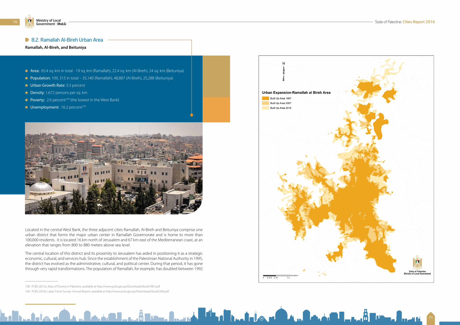
8.2. Ramallah Al-Bireh Urban AreaRamallah, Al-Bireh, and Beituniya
Area: 65.4 sq. km in total - 19 sq. km (Ramallah), 22.4 sq. km (Al-Bireh), 24 sq. km (Beituniya)
Population: 109, 315 in total – 35,140 (Ramallah), 48,887 (Al-Bireh), 25,288 (Beituniya)
Urban Growth Rate: 3.3 percent
Density: 1,672 persons per sq. km
Poverty: 2.6 percent108 (the lowest in the West Bank)
Unemployment: 16.2 percent109
Located in the central West Bank, the three adjacent cities Ramallah, Al-Bireh and Beituniya comprise one urban district that forms the major urban center in Ramallah Governorate and is home to more than 100,000 residents. It is located 16 km north of Jerusalem and 67 km east of the Mediterranean coast, at an elevation that ranges from 800 to 880 meters above sea level.
The central location of this district and its proximity to Jerusalem has aided in positioning it as a strategic economic, cultural, and services hub. Since the establishment of the Palestinian National Authority in 1995, the district has evolved as the administrative, cultural, and political center. During that period, it has gone through very rapid transformations. The population of Ramallah, for example, has doubled between 1992
108. PCBS (2013), Atlas of Poverty in Palestine, available at http://www.pcbs.gov.ps/Downloads/book1987.pdf.
109. PCBS (2016), Labor Force Survey: Annual Report, available at http://www.pcbs.gov.ps/Downloads/book2266.pdf.
70
71
State of Palestine: Cities Report 2016Ministry of Local Government | MoLG |

8.3. Nablus City
Area: 28.6 sq. km
Population: 153,061
Urban Growth Rate: 2.5 percent
Density: 5,352 persons per sq. km
Poverty: 13.4 percent110
Unemployment: 16 percent111
Nablus is located in the northern West Bank, lying in a narrow valley between the two mountains Ebal (940 m above sea level) and Gerizim (870 m above sea level), 69 km north of Jerusalem, and 42 km to the east of the Mediterranean Sea. Historically, its location placed Nablus at the junction of ancient trade routes: east-west, linking the Jordan valley to the coast of the Mediterranean Sea and Egypt; north-south, connecting Damascus to Jerusalem.112 Archeological research shows that the city was first inhabited in the fourth millennium BC, at the location called Tel Balata today. However, its prominent position as an urban center emerged only after the Romans in 72 to 73 AD built a new city, two kilometers to the northwest from the old inhabited site, and named it Flavia Neapolis. Elements typical of a Roman city were introduced, including a theatre, a basilica, and baths. In the early seventh century, the city was conquered by Muslims
110. PCBS (2013), Atlas of Poverty in Palestine, available at http://www.pcbs.gov.ps/Downloads/book1987.pdf.
111. PCBS (2016), Labor Force Survey: Annual Report, available at http://www.pcbs.gov.ps/Downloads/book2266.pdf.
112. Jorje Correia, Muath Taher (2015) “Traditional Islamic Cities Unveiled: The Quest for Urban Design Regularity,” Editorial Restauro Compás y Canto, available at http://editorialrestauro.com.mx/traditional-islamic-cities-unveiled-the-quest-for-urban-design-regularity/.
and 2004, its population growth due to positive immigration from the rest of the West Bank, resettlement of Palestinian returnees after the Oslo Agreement, and natural growth.
The development in Ramallah has taken a distinctly cultural and recreational direction. Before its occupation in 1967, the city’s cool summer temperatures, its fresh air, dynamic cultural life and attractive cafes had made it a favorite summer resort for local and international visitors. These characteristics have continued to affect the area, and today the city is still considered the recreational and cultural center of the West Bank.
The district today faces enormous challenges, as a result of exceedingly rapid urbanization processes that took place with the absence of planning and urban management mechanisms. The three cities will continue to urbanize at this unsustainable rate, as there exist no national planning proposals that address the socio-economic challenges that are facing the cities of the West Bank. An imbalanced concentration of jobs and services in a relatively small district is the primary reason behind the evident internal migration of Palestinians in search of better jobs and services. This development pattern has created much pressure on the district’s resources and driven property prices to very high levels. The average-sized apartment of 120 sq. m in Ramallah costs on average US$ 85,000. This amounts to ten times the median annual household income, as calculated by the Median Multiple affordability tool recommended by the World Bank. According to an international housing affordability survey held in 2016, these estimates show that housing units in the city fall under the “severely unaffordable” category.
The Ramallah urban area possesses a strong service economy that is highly dependent on the presence of the head offices of Palestinian financial institutions, telecommunication companies, diplomatic missions, local and international non-governmental organizations, UN agencies, and the executive offices of the Palestinian Authority, including Palestinian ministries.
Furthermore, the district owns strong industries that include paper and cardboard-making industries, furniture manufacturers, food and drink production, and pharmaceutical industries.
As the district is considered the cultural center of the West Bank, it is filled with theaters, cinemas and a wide range of local and international cultural centers and forums.
Urban Agglomerations in Palestine
In the recent years, planning authorities in Palestine have become aware of the importance of realizing urban agglomerations, metropolitan regions in Palestine in order to overcome the current geo-political complexities that are associated mainly with the lack of connectivity between the Palestinian cities and their hinterlands. This approach is further advocated under the principles of sustainable urban development, such as Agenda 2030 for Sustainable Development, which call for more compact development, mixed land uses, and transit-oriented development, among others. Ramallah, Al-Bireh and Beituniya are the first cities that have joined forces to explore the benefits of joined planning.
Housing prices in the Ramallah Al-Bireh Urban Area are estimated to be 10 times the median annual household income in Palestine, thus deeming houses in the city as “severely unaffordable.”
72
73
State of Palestine: Cities Report 2016Ministry of Local Government | MoLG |

and continued to evolve as an important trade and political center. Geographers from these periods wrote extensively about the thriving social and commercial life in the city, nicknaming it “little Damascus,” and referred to it as a most celebrated city in Palestine. Nablus continued to prosper, and many mosques, schools, and workshops were built during the thirteenth and fourteenth centuries. Its products of jam, linen, soap, and olive oil were exported to Cairo, Damascus, and Hejaz (a region of Saudi Arabia today), among others. As an important political and trade center, the city continuously transformed under the different ruling powers. In the early twentieth century, the region was hit by a strong earthquake that destroyed many of the city’s buildings and historical landmarks such as the Masjid An-Nasr (Mosque of Victory) and historic sections of the Jami’ Nablus Ak-Kabir (Nablus Great Mosque). During the British Mandate the city was an arena for armed clashes, which caused further destruction. Following the 1948 war, Nablus received thousands of Palestinian refugees who had been displaced from the areas captured by Israel. They settled in three refugee camps around the city: Ein Beit al Ma’, Balata, and Askar. Nablus has the largest refugee population among the Palestinian cities and, with more than 18,000 inhabitants, Balata is the largest refugee camp in Palestine. Nablus continued to grow under Jordanian rule, and the adjacent villages became part of its urban fabric, neighborhoods of the city. Its urban growth is heavily influenced by its geography and the lack of land for development available in the valley. Thus, urban growth is expanding to the mountains slopes, where no safety and disaster risk reduction measures have been implemented in most of the cases. Soil survey, micronization analysis, and seismic studies are showing a high vulnerability of the land parcels located on these mountainous slopes to soil instability and the danger of landslides. In addition, development in the valley is highly vulnerable to floods, which have been increasing in frequency in recent years. Several efforts by practitioners and academics in the planning field of the city are working on improving planning policies in order to integrate sustainability and resilience measures into local development plans and construction activities. However, such improvements remain a work in progress and are not yet fully considered or authorized for enforcement.
Today, Nablus is considered a vital commercial and service center for the West Bank in general and the northern West Bank in particular. It has a high concentration of shopping centers and restaurants. In addition, traditional industries have continued to function in Nablus, including the production of soap, olive oil, and small handicrafts. Modern industries are flourishing, among them furniture production, tile and stone production, and textile and leather industries. Moreover, the city is home to the largest university in Palestine, An-Najah National University, and hosts many other educational, cultural, financial, and medical centers. Nablus has a well-functioning old city with a very rich cultural heritage; it is filled with bustling markets and khans, traditional restaurants, soap factories and other traditional (and disappearing) crafts, as well as old traditional baths. The old city it is home to more than 23,000 residents.
“Nablus lies among the mountains. It abounds with olive trees, and they even name it the “Little Damascus” … Its marketplace extends from gate to gate, and a second goes to the center of the town. The Great Mosque is in its midst and very finely paved. The city has a stream of water running through it; its houses are built of stone, and some remarkable mills are to be seen here.”
Description of Syria, including Palestine, 985 AD
Mukaddasi
74
75
State of Palestine: Cities Report 2016Ministry of Local Government | MoLG |

The three cities Bethlehem, Beit Jala, and Beit Sahour have developed into one urban area with a shared socio-cultural context and constitute a service hub for the southern West Bank. With its total population of 62,162, the urban area is home to almost 2 percent of the entire urban population of the West Bank. The major challenges facing the urban development of the Bethlehem area are caused by Israeli territorial measures that are manifested in the annexation of land, the expansion of Israeli settlements, the Israeli bypass road network, and the Separation and Annexation Wall. Soon after the occupation of the West Bank in 1967, Israel annexed more than 7 sq. km from the lands of the Bethlehem area to expand the Israeli Municipal Boundaries of Jerusalem and for the construction of Israeli settlements. Likewise, in 1997, Israel constructed the settlement Har Homa on parts of land annexed in the north of Beit Sahour, on a hill known as Jabal Abu Ghneim. Thus, the northern and western parts of the Bethlehem area are surrounded by the Separation and Annexation Wall and by the Settlements Gilo and Har Gilo, whereas the southern and eastern parts of the Bethlehem area are enclosed by the Israeli bypass roads. These constructions prevent expansion of the area and have severed the traditional close connection with East Jerusalem this region used to enjoy. The existing constraints on land that should be available for development, the absence of updated planning schemes, and the preservation policy currently in place (that restricts higher density buildings in order to maintain the city’s historical urban fabric) are the reasons why there is no room left for growth, requiring the cities to consume the remaining open space and agricultural lands instead.
In addition to its own high density rate, Bethlehem provides services to over two million tourists a year (according to municipality estimates), which creates immense additional pressure on the cities’ infrastructure. And contrary to general assumptions, the cities in the Bethlehem urban area gain only very limited returns from the yearly influx of tourists. The tourism sector is struggling severely, as the great majority of tourists engage very little with Bethlehem, Beit Sahour, and Beit Jala; after touring the holy sites they tend to return to Israel.
The various Israeli governments over the past 50 years have effectively violated international law by illegally establishing 19 Israeli settlements in East Jerusalem that in 2017 house more than 132,000 Israeli settlers who currently occupy large areas of lands that belong to Palestinians from Bethlehem, Beit Jala, and Beit Sahour.
8.4. Bethlehem Urban Area Bethlehem, Beit Jala, Beit Sahour
Area: 28.6 sq. km
Population: 62,162 in total – 31,799 (Bethlehem); 14,798 ( Beit Jala); and 15,565 (Beit Sahour)
Urban Growth Rate: 3.0 percent
Density: 5,352 persons per sq. km
Poverty: 7.1 percent113
Unemployment: 21.3 percent114
The Bethlehem urban area is located in the southern West Bank, 9 km south of Jerusalem; it is the central urban hub of Bethlehem Governorate, the fifth largest among the Palestinian governorates. As Christianity reveres Bethlehem as the birth place of Jesus, the city has thrived as an important religious center for two millennia. Since its habitation by the Canaanites in the early fourteenth century BC, the city, similar to the other Palestinian cities, was ruled by different powers and destroyed and rebuilt serval times. After the 1948 war, many refugees from the cities captured by Israel fled to the Bethlehem area and their influx transformed Bethlehem and the surrounding cities.
113. PCBS (2013), Atlas of Poverty in Palestine.
114. PCBS (2016), Labor Force Survey: Annual Report.
76
77
State of Palestine: Cities Report 2016Ministry of Local Government | MoLG |

8.5. Hebron City
Area: 41 sq. km
Population: 215, 452
Urban Growth Rate: 3.79 percent
Density: 5,255 persons per sq. km
Poverty: 34 percent115
Unemployment: 21.1 percent116
Located 30 km south of Jerusalem, Hebron city lies 950 meters above sea level and is thus considered the highest city in Palestine. It is the center of Hebron Governorate that has the largest population amongst the West Bank governorates, its population standing at 622,220. The old city of Hebron is more than 5,500 years old and contains several significant historical and religious sites, the most prominent among them Abraham’s Tomb and the Ibrahimi Mosque.
The city of Hebron is deeply affected by the geo-political situation on the ground. Following the signing of the Hebron Protocol (Jan 17, 1997) between the Palestinian National Authority and Israel, the city was divided into two distinct political regions, designated as H1 and H2. The area H1 covers about 80 percent of the city and is
115. PCBS (2013), Atlas of Poverty in Palestine.
116. PCBS (2017), Labor Force Survey: Annual Report.
78
79
State of Palestine: Cities Report 2016Ministry of Local Government | MoLG |

under Palestinian civil and security control, while H2, where more than 40,000 Palestinians and a few hundred illegal Israeli settlers live, is under Israeli military and security control and Palestinian control on civil matters.117 The old city of Hebron, located in H2, is living under a full-fledged Apartheid system in which many roads are reserved for the exclusive use of Israeli settlers. Access to their houses in this part of the city is very complicated for Palestinians, and some residents resort to using windows instead of doors to enter their houses, while others must use the roofs of their neighbors to access their homes. Furthermore, there are neighborhoods which Palestinians are not allowed to enter unless they are residents – a measure that severely restricts the social lives of residents. The presence of Israeli settlements inside the city together with the associated segregation of roads is imposing severe restrictions on Palestinian movement and is causing restricted access to education, health services and water supply for Palestinians. The settler presence is leading to the closure of businesses and the abandonment of houses – and therefore to the displacement of Palestinian inhabitants of the H2 area. Over the last decade, hundreds of shops located in the Israeli-controlled H2 area have been shut down either by military order or due to lack of business.118 All these restrictive measures were put in place in order to facilitate the livelihood of less than 500 illegal Israeli settlers in the H2 area who are living in five separate settlements. These settlers are well known for their aggressive behavior against the Palestinian residents in the city who face not only severe restrictions on mobility but also daily threats. Furthermore, there are many physical obstructions in and around the city of Hebron that include checkpoints, road blocks, and the Separation and Annexation Wall that has its longest stretch in Hebron Governorate.
Planning in the city falls under the responsibility of Hebron’s municipality. The city currently does not have an updated local outline plan; the plan available was prepared during the British Mandate, in 1944, by Henri Kendell. Thus, Hebron Municipality addresses new spatial development issues on an ad-hoc basis in which building legislations are allotted on a case-by-case basis; however, the reason why it did not heavily support the development of neighborhood plans so far is that the first local municipal council was elected for the first time during the municipal election in 2012. It is estimated that only 5 percent of the neighborhoods in Hebron are covered with detailed plans. Moreover, less than 15 percent of the housing units in the H2 area of the city have building permits due to the limited control the municipality has over this part of the city. These obstacles have resulted in patterns of irregular urbanization, increased pressure on the infrastructure, and an absence of public spaces and facilities.
Hebron is considered a vital center for the provision of services in the southern West Bank and is considered one of the most important industrial and commercial Palestinian hubs. The economic activity at the governorate level is amongst the highest, comprising 21.3 percent of the West Bank’s total businesses. Traditional handcrafts, such as glass making, pottery, food and leather industries,119 in addition to modern manufacturing, such as shoe making, weaving, food processing, metallurgy, and stone and marble works, are central to the economy of Hebron.120 A large portion of Hebron’s inhabitants are furthermore working in agriculture, as the city is surrounded by fertile valleys and mountains, where mainly grapevines and fruits are cultivated. In addition, Hebron is home to many religious and historical sites, including Abraham’s Tomb and the Ibrahimi Mosque, that are being visited by thousands of domestic and international tourists annually, despite the political turmoil and the presence of the illegal Israeli settlers. There are currently
117. Protection Cluster Occupied Palestinian Territory (2014), Protection Concerns and Humanitarian Impacts of Settlement Activity in Hebron City (H2), available at http://www.globalprotectioncluster.org/_assets/files/field_protection_clusters/Occupied_Palestinian/files/oPt_PC_factsheet_Hebron_City_H2_2014_EN.pdf.
118. OCHA (2015), “Overview: Attacks and clashes must not be treated as the ‘new normal,’” Humanitarian Bulletin Occupied Palestinian Territory, December 2015, available at https://www.ochaopt.org/documents/ocha_opt_the_humanitarian_monitor_2016_01_05_english_dec.pdf.
119. In 2016, the World Crafts Council awarded Hebron the title World Crafts City.
120. Nazmi Ju’bah (2009), Old Hebron: The Charm of a Historical City and Architecture, Hebron Rehabilitation Committee.
efforts underway to include Hebron’s old city on UNESCO’s List of World Heritage Sites. If this endeavor succeeds, it will support the growth of the tourism sector in the city.121,122
121. Paragraph 4a, Guidelines for Hebron (Art. VII of Annex I of the Israeli-Palestinian Interim Agreement on the West Bank and the Gaza Strip (Oslo II Accord) of 28 September 1995); Paragraph 2 Hebron Protocol (Protocol Concerning the Redeployment in Hebron, of 17 January 1997).
122. Temporary International Presence in Hebron (TIPH), Hebron Settlements, available online at http://www.tiph.org/hebron/hebron-settlements/.
80
81
State of Palestine: Cities Report 2016Ministry of Local Government | MoLG |

8.6. Gaza City
Area: 56 sq. km
Population: 583,870
Urban Growth Rate: 3.5 percent
Density: 10,426 persons per sq. km
Poverty: 40 percent
Unemployment: 44 percent
Gaza city is the main city in the Gaza Strip and the largest city in Palestine, home to more than 20 percent of the urban population in Palestine. Similar to other cities in Palestine, the city has been inhabited since ancient ages, its origins dating back to the fifteenth century BC. Under different ruling powers it has played a key strategic role due to its location at the intersection between the Mediterranean coastal trade route connecting Europe and Africa and the ancient trade routes between Asia and Africa.
Following the 1948 war, a massive influx of Palestinian refugees swelled Gaza’s population. By 1967, the population had grown to about six times its size, compared to 1948. In 1997, almost 52 percent of Gaza’s inhabitants were refugees or their descendants. Gaza City has one of the highest-overall growth rates in the world. Its population density of 10,426 persons per sq. km is comparable to New York City (with 10,725.4 persons per sq. km), and amounts to half of the density found in Paris (with 21,000 persons per sq. km).
Gaza City is located 78 km southwest of Jerusalem, at an altitude of 14 meters above sea level. The majority of its urban development is taking place on the coastal plain. Gaza’s port is located 3 km west of the city’s center.
The primary economic activities in Gaza comprise agriculture and small-scale industries that include the production of plastics, construction materials, textiles, furniture, pottery, tiles, copperware, and carpets. Moreover, since the establishment of the Palestinian National Authority, thousands of Gaza’s residents have been employed in government ministries and security services, UN agencies, and international organizations. However, the blockade and recurring assaults have put the economy under severe pressure. Gaza City, as the largest urban centre in the strip, has been heavily affected by the blockade that started in mid-2007 and has brought Gaza’s economic activities almost to a standstill. The blockade has caused the closure of most industrial establishments and halted the work of nearly all export-oriented activities, including manufacturing and agricultural production. Therefore, the unemployment rate in Gaza City exceeds 44 percent, while the people living below the poverty line constitute approximately 40 percent of Gaza’s population.123 Moreover, according to international reports, 47 percent of Gazans suffer from food insecurity124 and about 80 percent are aid-dependent.125 As population growth models are projecting that in 2050, 5.8 million people will live in the Gaza Strip, with almost a third of them (1.8 million) living in Gaza City, projected densities will exceed 30,000 persons per sq. km in Gaza City and will average at 16,000 persons per sq. km in the entire strip. Infrastructure, electricity, water and sanitation, as well as municipal and social services will not be able to keep pace with the needs of the growing population, especially with the current political impasse, and the repeated Israeli assaults and continuous blockade.
123. United Nations Country Team Occupied Palestinian Territory (2016), Common Country Analysis, available at http://www.unsco.org/Documents/Special/UNCT/CCA_Report_En.pdf
124. Ibid.
125. World Bank (2016), West Bank and Gaza Overview, available at http://www.worldbank.org/en/country/westbankandgaza/overview.
82
83
State of Palestine: Cities Report 2016Ministry of Local Government | MoLG |

8.7. City of Khan Younis
Area: 54 sq. km
Population: 185,250
Urban Growth Rate: 3.2 percent
Density: 2,430 persons per sq. km
Poverty: 53 percent
Unemployment: 46 percent
Khan Younis shares borders with Deir Al-Balah from the north, Rafah from the south, the green line of 1948 from the east, and the Mediterranean Sea from the west.
Khan Younis is known as an important center for trade in the region. At the end of the nineteenth century, the Ottomans established a municipal council in Khan Younis, the second largest in the Gaza Strip after the city of Gaza. According to the Palestinian Central Bureau of Statistics, the city of Khan Younis had a population of 185,250 in 2016, compared to 140,697 inhabitants in 2007. Khan Yunis is the largest urban centre in Khan Younis governorate that is home to 351,934 capita, 80 percent of which are living in urban areas, less than 6 percent in its rural areas, and the remaining 14 percent in Khan Younis refugee camp. The area of Khan Younis Governorate covers about 116 square kilometres, which represents 31 percent of the total area of the Gaza Strip. Prior to the 2005 Israeli disengagement from Gaza (which really was more a redeployment), Palestinians living in Khan Younis refugee camp were repeatedly targeted for housing demolitions due
to security allegations, as the Israeli settlement complex Gush Katif was lying at the edge of the camp. Khan Younis is the only governorate in the Gaza Strip that does not have any border crossings; in this feature it is similar to Deir Al-Balah, except that the latter will host the proposed Gaza International Port.
According to statistics issued by the ministry of health, there are 5 hospitals, and 17 health clinics in Khan Younis. In 2013, Khan Younis had the largest percentage of communities and population in Palestine not connected to wastewater network services.
In 2014, the unemployment rates in Khan Younis (46.5 percent) were the second largest in Palestine after Deir Al-Balah (49.7 percent); but poverty rates in Khan Yunis (53 percent) were the highest in the entire Palestinian territories (2015). Likewise, illiteracy rates were the second highest in Khan Younis (4.6 percent) after Rafah Governorate (5 percent, in 2007).
In terms of land use, Khan Younis is predominately classified as comprising agricultural lands. The cultivated area in Khan Younis covers 37.3 sq. km, 18.1 sq. km of which are considered arable lands. Khan Younis has been suffering from a sharp decrease in rainfall quantities, with about 30 rainy days per year. According to the statistics of the ministry of agriculture, in 2014 Khan Younis had the highest share of field crop areas, compared to the other governorates of the Gaza Strip, and according to a protection plan endorsed by the Palestinian Cabinet in 2009, Khan Younis contains the largest percentage of lands with high agricultural values in the Gaza Strip.
84
85
State of Palestine: Cities Report 2016Ministry of Local Government | MoLG |

RECOMMENDATIONS
Update the frameworks regulating planning and local governance and increase their responsiveness to the current needs of the Palestinian people, without compromising future aspirations. In this context, the prevailing practices between the West Bank and the Gaza Strip should be harmonized, and an environment must be created that enables the extension of Palestinian planning jurisdiction into areas that are currently under full Israeli control, i.e. East Jerusalem and Area C of the West Bank. Such measures should result in a better linking of planning activities at the local, regional, and national levels.
Mainstream public participation policies, incorporating them into planning at local and national levels and into local governance, as this will increase inputs into decision-making processes and improve conditions for accountability and good governance.
Improve work conditions and public safety for people engaged in informal economy, in order to increase productivity and ensure quality control for the products and services provided.
Work with key stakeholders to prepare the National Urbanization Policy for the State of Palestine. In this document, guidance regarding the future development of the national urban system and recommendations for urban spatial configuration will be identified and adopted.
Complete the National Spatial Plan for the State of Palestine (2050) in order to clearly articulate the vision for a state that draws upon nationally-shared assets, in alignment with the National Policy Agenda 2017-2022.
Introduce new tools and methodologies into the craft of urban planning in Palestine, moving it away from traditional land-use and physical planning towards the application of urban-growth scenarios and modelling techniques, in order to achieve sustainability in terms of socio-economic and environmental interventions.
Adopt clear strategies and an urban agenda in order to build new cities and neighborhoods in harmony with the National Urban Policy.
Encourage public-private partnerships to regenerate old cities and to upgrade the informal urbanization that is taking place in refugee camps and areas at the peripheries, such as the neighborhoods behind the Separation Barrier.
Improve public transportation and urban mobility to promote the interests of urban centers, while achieving an economy of services.
Increase the amount of safe public spaces and provide green areas in order to respond to effects related to climate change and to possible urban heat islands.
CHAPTER | 9 |
Integrate renewable-energy policies in the local development agendas of Palestinian communities, and encourage green- and eco-friendly-energy development initiatives by introducing better standards and modern building regulations.
Localize and contextualize the 2030 Agenda for Sustainable Development and its goals, along with the New Urban Agenda in Palestine, and identify the sources of information needed to monitor the progress of implementation in Palestinian cities, towns, and villages.
Encourage competitive local economic-development initiatives, and create an enabling environment for a productive, independent, and strong economy.
Provide public services and invest in infrastructure in order to reduce housing prices, thus bridging the gap between housing units needed and affordable housing units available. Furthermore, provide the planning, regulatory, and legal environment necessary to define affordable and adequate conditions for houses.
Adopt and implement disaster-risk reduction and management, reduce vulnerability, build resilience and responsiveness to natural and man-made hazards, and foster mitigation and adaptation to climate change.
Build strong, inclusive frameworks for land registration management and institutions accountable for land registration and governance in order to foster tenure security, especially for the groups that are most vulnerable.
86
87
State of Palestine: Cities Report 2016Ministry of Local Government | MoLG |

Abdelhamid, Ali. “Urban Development and Planning in the Occupied Palestinian Territories: Impacts on Urban Form.” A paper presented at the conference on Nordic and International Urban Morphology: Distinctive and Common Themes. Stockholm, Sweden, September (3–5), 2006. http://blogs.najah.edu/staff/emp_3044/article/Urban-Development-and-Planning-in-the-Occupied-Palestinian-Territories-Impacts-on-Urban-Form/file/001.pdf.
Abdulhadi, Rami S. (1990). “Land Use Planning in the Occupied Palestinian Territories.” Journal of Palestine Studies, Vol. 19, No.4, 1990. 46-63. http://www.palestine-studies.org/jps/fulltext/39481.
Abu Awwad, Nida (2011). “Debating the Informal Economy: Considering Colonialism and Palestine,” Review of Women’s Studies, Special Issue 1, 52-66.Institute of Women’s Studies: Birzeit University. http://iws.birzeit.edu/sites/default/files/2016-10/Special%20issue%201_%20English.pdf.
Al Jazeera World (2011). Lost Cities of Palestine (Documentary. http://www.aljazeera.com/programmes/aljazeeraworld/2014/05/palestine-lost-cities-201451283254771933.html.
Al-Ju’beh, Nazmi (2009). Old Hebron: The Charm of a Historical City and Architecture. Hebron Rehabilitation Committee.
Al-Ju’beh, Nazmi (2008). “Palestinian Identity and Cultural Heritage.” In Of Times and Spaces in Palestine: The Flows and Resistances of Palestinian Identity. (Temps et espaces en Palestine: Flux et resistances identitaires), edited by Roger Heacock. Beirut, Lebanon: Presses de l’Ifpo. http://books.openedition.org/ifpo/491?lang=en.
Applied Research Institute, The – ARIJ (2016). “Monitoring Israeli Colonization Activities: Glossary.” Palestinian Observatory of Israeli Colonization Activities (POICA). http://poica.org/glossary/#a1.
ARIJ (2002). An Atlas of Palestine. Bethlehem, Palestine: ARIJ Resource Center.
ARIJ (2015). Status of the Environment in the State of Palestine. http://www.arij.org/files/arijadmin/2016/SOER_2015_final.pdf.
Association for Civil Rights in Israel – ACRI (2015). East Jerusalem 2015: Facts and Figures. http://www.acri.org.il/en/wp-content/uploads/2015/05/EJ-Facts-and-Figures-2015.pdf.
BIBLIOGRAPHY
B’Tselem – The Israeli Information Center for Human Rights in the Occupied Territories (1995). A Policy of Discrimination: Land Expropriation, Planning and Building in East Jerusalem. Jerusalem: B’Tselem. Link to Full Report, DOC, available at http://www.btselem.org/publications/summaries/199505_policy_of_discrimination.
B’Tselem (2012). Arrested Development: The Long Term Impact of Israel’s Separation Barrier in the West Bank. https://www.btselem.org/download/201210_arrested_development_eng.pdf.
B’Tselem (2014). Water Crisis: Discriminatory Water Supply. http://www.btselem.org/water/discrimination_in_water_supply.
B’Tselem (2015). Settlements: Statistics on Settlements and Settler Population. http://www.btselem.org/settlements/statistics.
B’Tselem (2016). East Jerusalem: Statistics on Demolition of Houses Built Without Permits in East Jerusalem. http://www.btselem.org/planning_and_building/east_jerusalem_statistics.
B’Tselem (2016). Water Crisis: Background. http://www.btselem.org/water.
Bimkom – Planners for Planning Rights (2008). The Prohibited Zone: Israeli Planning Policy in the Palestinian Villages in Area C. http://bimkom.org/eng/wp-content/uploads/ProhibitedZone.pdf.
Brauer, Michael et al. (2016). “Ambient Air Pollution Exposure Estimation for the Global Burden of Disease 2013.” Environmental Science & Technology, Issue 50, No. 1, pp 79–88. ACS Publications. http://pubs.acs.org/doi/abs/10.1021/acs.est.5b03709.
Bshara, Khaldun (2013). “Heritage in Palestine: Colonial Legacy in Postcolonial Discourse.” Archaeologies, Volume 9, Issue 2, pp. 295-319. https://link.springer.com/article/10.1007/s11759-013-9235-2.
Correia, Jorje and Muath Taher (2015). “Traditional Islamic Cities Unveiled: The Quest for Urban Design Regularity.” Editorial Restauro Compás y Canto. http://editorialrestauro.com.mx/traditional-islamic-cities-unveiled-the-quest-for-urban-design-regularity/.
Dabeek, Jalal (2000). Studies on earthquakes. Earth Sciences and Seismic Engineering Center, An-Najah National University, Nablus, Palestine.
Doumani, Beshara (1995). Rediscovering Palestine: Merchants and Peasants in Jabal Nablus 1700–1900 . University of California Press.
El-Eini, Roza (2006). Mandated Landscape: British Imperial Rule in Palestine, 1929-1948. London: Routledge.
El-Turk, Mohammed Falah (2014). Assessment of Heavy Metals Pollution of Wadi Gaza, Eastern Mediterranean Coast, Palestine. Master thesis, Faculty of Environmental Sciences, Islamic University, Gaza. http://library.iugaza.edu.ps/thesis/114526.pdf.
European Training Foundation (2014). Labor Market and Employment Policies in Palestine. http://www.etf.europa.eu/webatt.nsf/0/49583C88B3C1AD0DC1257CD1003DA5FC/$file/Employment%20policies_Palestine.pdf.
88
89
State of Palestine: Cities Report 2016Ministry of Local Government | MoLG |

Fridell, Mikael (2008). Microcredit and the Informal Sector in the West Bank. Master’s thesis, Department of Economics, Uppsala University, Sweden. http://www.diva-portal.org/smash/get/diva2:131750/FULLTEXT01.pdf.
Global Poverty Working Group (2016). Urban poverty headcount ratio at national poverty lines (% of urban population). The World Bank. http://data.worldbank.org/indicator/SI.POV.URHC?locations=PS.
Government of the State of Palestine, The (2014). The National Early Recovery and Reconstruction Plan for Gaza. Executive Summary http://reliefweb.int/report/occupied-palestinian-territory/national-early-recovery-and-reconstruction-plan-gaza.
Hebron Protocol (Paragraph 2). Protocol Concerning the Redeployment in Hebron of 17 January 1997.
Hebron, Guidelines for. Paragraph 4a, Art. VII of Annex I of the Israeli-Palestinian Interim Agreement on the West Bank and the Gaza Strip (Oslo II Accord) of 28 September 1995.
International Court of Justice (2004). Legal Consequences of the Construction of a Wall in the Occupied Palestinian Territory (Request for Advisory Opinion), Summary. http://www.icj-cij.org/docket/files/131/1677.pdf.
Khatib, Yousef (2014). “Living in Urban Palestine.”. The Arab Daily News, November 19, 2014. http://thearabdailynews.com/2014/11/19/living-urban-palestine/.
Martin, Richard (2014). Effective Housing Demand Survey: West Bank. Office of the Quartet Representative, Tony Blair. Executive Summary and link available at https://unispal.un.org/DPA/DPR/unispal.nsf/0/8D872912D04DE5A385257DAB0056E4FD.
Ministerial Committee for the Reconstruction of Gaza (2015). Detailed Needs Assessment (DNA) and Recovery Framework for Gaza Reconstruction. State of Palestine. http://www.lacs.ps/documentsShow.aspx?ATT_ID=21974.
Ministry of Public Works and Housing and UN-Habitat (2013). Palestine Housing Sector Profile 2013. Ramallah, Palestine: State of Palestine.
Mission of Palestine to the EU (2016). Energy Sector in Palestine. Document on energy issues presented by the Mission of Palestine to the EU, 19 May 2016. http://www.europarl.europa.eu/meetdocs/2014_2019/documents/dpal/dv/palestinianenerg_issues_pal-mission/palestinianenerg_issues_pal-missionen.pdf.
Morrar, Rabeh and FaЇz Gallouj (2013). The Growth of the Service Sector in Palestine: The productivity challenge - Finding Growth Through Service Activities in Barren Times. Aix en Provence, France: HAL multi-disciplinary open access archive. https://halshs.archives-ouvertes.fr/halshs-01222937/document
Municipal Lending and Development Fund – MDLF (2013). Municipal Operating Budgets 2008-2013. MDLF: Palestine.
Najjar, L. and S. Ghadban (2015). “In-between forgotten spaces in Palestinian cities: the twin cities of Ramallah and Al-Bireh as a case study.” Sustainable Development and Planning, VII, pp. 811-822. http://www.witpress.com/Secure/elibrary/papers/SDP15/SDP15068FU1.pdf.
OCHA (2013). The Humanitarian Impact of the Barrier. https://www.ochaopt.org/content/humanitarian-impact-barrier-july-2013.
OCHA (2015). “Overview: Attacks and clashes must not be treated as the ‘new normal.’” Humanitarian Bulletin Occupied Palestinian Territory, December 2015. http://reliefweb.int/sites/reliefweb.int/files/resources/ocha_opt_the_humanitarian_monitor_2016_01_05_english.pdf.
OCHA (2016). “Gaza: shortage of sanitation infrastructure raises health and environmental concerns.” The Monthly Humanitarian Bulletin, June 2016. http://www.ochaopt.org/content/gaza-shortage-sanitation-infrastructure-raises-health-and-environmental-concerns.
OCHA (2016). Israeli Demolition Orders against Palestinian Structures in Area C, 1988-2016. http://data.ochaopt.org/demolitions.aspx.
OCHA (2015). 2016 Humanitarian Needs Overview for Occupied Palestinian Territory/November 2015. https://www.ochaopt.org/content/2016-humanitarian-needs-overview-occupied-palestinian-territory-november-2015.
Organization for Economic Cooperation and Development, The (2016). Glossary of Statistical Terms. https://stats.oecd.org/glossary/index.htm.
Palestine Economic Research Institute – MAS (2015). Economic and Social Monitor, No. 42 (in Arabic). http://www.pcbs.gov.ps/Downloads/book2174.pdf.
Palestinian Central Bureau of Statistics (PCBS, 2008). Informal Sector and Informal Employment Survey October-December 2008: Main Findings (in Arabic). http://www.pcbs.gov.ps/Downloads/book1760.pdf.
Palestinian Central Bureau of Statistics (2010). “The Palestinian Environment to where?” Press Release on World Environment Day. http://www.pcbs.gov.ps/Portals/_pcbs/PressRelease/Envirm-DayE.pdf.
Palestinian Central Bureau of Statistics (2012). Census Final Results in the Palestinian Territory. http://www.pcbs.gov.ps/pcbs_2012/Publications.aspx?catid=4.
Palestinian Central Bureau of Statistics (2013). Atlas of Poverty in Palestine (in Arabic). http://www.pcbs.gov.ps/Downloads/book1987.pdf.
Palestinian Central Bureau of Statistics (2014). On the Eve of the International Population Day: Statistical review on the status of the Palestinian population. http://www.pcbs.gov.ps/portals/_pcbs/PressRelease/Press_En_IntPopD2014E.pdf.
Palestinian Central Bureau of Statistics (2015). Local Communities Survey, 2015 (in Arabic). http://www.pcbs.gov.ps/Downloads/book2161.pdf.
Palestinian Central Bureau of Statistics (2015). National Accounts at Current and Constant Prices, 2014. http://www.pcbs.gov.ps/Downloads/book2172.pdf.
Palestinian Central Bureau of Statistics (2015). Number and Area of Licensed Housing Units in Palestine by Construction Material and Region, 2015. http://www.pcbs.gov.ps/Portals/_Rainbow/Documents/AN-Hous-2015-E-15.htm.
Palestinian Central Bureau of Statistics (2015). Percentage Distribution of Households in Palestine by Number of Rooms in Housing Unit, Region and Type of Locality, 2015. http://www.pcbs.gov.ps/Portals/_Rainbow/Documents/AN-Hous-2015-E-2.htm.
90
91
State of Palestine: Cities Report 2016Ministry of Local Government | MoLG |

Palestinian Central Bureau of Statistics (2015). Percentage Distribution of Households in Palestine by Type of Housing Unit and Region, 2015. http://www.pcbs.gov.ps/Portals/_Rainbow/Documents/AN-Hous-2015-E-10.htm.
Palestinian Central Bureau of Statistics (2015). On the Eve of the International Day of Refugees, press release. http://pcbs.gov.ps/portals/_pcbs/PressRelease/Press_En_IntDyRef2015E.pdf.
Palestinian Central Bureau of Statistics (2015). On the 68th Anniversary of the Palestinian Nakba: Special statistical bulletin. http://www.pcbs.gov.ps/site/512/default.aspx?tabID=512&lang=en&ItemID=1661&mid=3172&wversion=Staging.
Palestinian Central Bureau of Statistics (2015). Percentage Distribution of Households in Palestine by Tenure of Housing Unit and Region, 2015. http://www.pcbs.gov.ps/Portals/_Rainbow/Documents/AN-Hous-2015-E-12.htm.
Palestinian Central Bureau of Statistics (2016). Palestine in Figures 2015. http://www.pcbs.gov.ps/Downloads/book2188.pdf.
Palestinian Central Bureau of Statistics (2016). National Accounts at Current and Constant Prices, 2015 (in Arabic). http://www.pcbs.gov.ps/Downloads/book2235.pdf.
Palestinian Central Bureau of Statistics (2016). On the Eve of the International Population Day. Ramallah, Palestine: PCBS.
Palestinian Central Bureau of Statistics (2016). Palestinian Youth Survey 2015 (in Arabic). http://www.pcbs.gov.ps/Downloads/book2179.pdf.
Palestinian Central Bureau of Statistics (2016). Population Projections: Annual Statistics (by localities in governorates). http://www.pcbs.gov.ps/site/lang__en/803/default.aspx.
Palestinian Central Bureau of Statistics (2016). Population Projections: Time Series Statistics: Estimated Population in the Palestinian Territory Mid-Year by Governorate, 1997-2016. http://www.pcbs.gov.ps/Portals/_Rainbow/Documents/gover_e.htm.
Palestinian Central Bureau of Statistics (2016). Labor Force Survey: Annual Report 2016 (in Arabic). http://www.pcbs.gov.ps/Downloads/book2266.pdf
PASSIA (2015). Water and Environment. http://www.passia.org/palestine_facts/pdf/Water%20&%20Environment.pdf.
Protection Cluster Occupied Palestinian Territory (2014). Protection Concerns and Humanitarian Impacts of Settlement Activity in Hebron City (H2). http://www.globalprotectioncluster.org/_assets/files/field_protection_clusters/Occupied_Palestinian/files/oPt_PC_factsheet_Hebron_City_H2_2014_EN.pdf.
RIWAQ (2009). A Geography: 50 Villages. 3rd RIWAQ Biennale, Venice/Palestine. Information available at http://www.riwaq.org/3rd-riwaq-biennale-2009-geography-50-villages.
Sabra, Mahmoud M., Abdel Hakeem Ahmad Eltallla, and Abdel Rahman Alfar (2015). “The Shadow Economy in Palestine: Size and Causes.” International Journal of Economics and Finance, Vol. 7, No.3. http://www.ccsenet.org/journal/index.php/ijef/article/viewFile/42537/24755/.
Temporary International Presence in Hebron (TIPH). Hebron Settlements. http://www.tiph.org/hebron/hebron-settlements/.
UNDP/PAPP and Palestinian Ministry of Local Government (2004). Support to Local Government Reform Project: Diagnostic Report. http://www.lacs.ps/documentsShow.aspx?ATT_ID=968.
United Nations Country Team in the State of Palestine (2016). Gaza: Two Years After. http://www.ochaopt.org/sites/default/files/gaza_war_2_years_after_english.pdf.
United Nations Country Team Occupied Palestinian Territory (2016). Common Country Analysis: Leave no one behind – A perspective on Vulnerability and Structural Disadvantage in Palestine. http://www.unsco.org/Documents/Special/UNCT/CCA_Report_En.pdf
United Nations Department of Economics and Social Affairs (2015), World Urbanization Prospects: the 2014 Revision. UN Population Division:. https://esa.un.org/unpd/wup/.
United Nations Development Programme (2004, 2009, and 2012). Diagnostic Reports for the Local Governance System in the occupied Palestinian territory (oPt).
United Nations Development Programme (2011). Sustainability and Equity: A Better Future for All. UNDP Human Development Reports . http://hdr.undp.org/en/content/sustainability-and-equity-better-future-all.
United Nations Development Programme (2014). Detailed Infrastructure Damage Assessment of the 2014 Gaza War. http://www.ps.undp.org/content/dam/papp/docs/Publications/UNDP-papp-research-dammageassessment2014.pdf.
United Nations Office of the Special Coordinator for the Middle East Peace Process (2014). Gaza Reconstruction Mechanism – Fact Sheet. Available at: http://www.unsco.org/Gaza%20Reconstruction%20Mechanism%20Fact%20Sheet%209%20October%202014.pdf.
World Bank (2016). Economic Monitoring Report to the Ad Hoc Liaison Committee, September 2016. http://documents.worldbank.org/curated/en/474311473682340785/pdf/108205-V2-WP-PUBLIC-SEPT-14-2PM-September-2016-AHLC-World-Bank-Report.pdf.
World Bank (2016). Public Expenditure Review of the Palestinian Authority: Towards Enhanced Public Finance Management and Improved Fiscal Sustainability. https://unispal.un.org/DPA/DPR/unispal.nsf/47d4e277b48d9d3685256ddc00612265/513363bbbf9d71d28525802d004d2237?OpenDocument.
World Bank (2016). West Bank and Gaza: Overview. http://www.worldbank.org/en/country/westbankandgaza/overview.
Yamin, Mohammad Ziad (2015). “Renewable Energy in Palestine.” EcoMENA. http://www.ecomena.org/tag/energy-sector-in-palestine/.
92
93
State of Palestine: Cities Report 2016Ministry of Local Government | MoLG |

STATE OF PALESTINE CITIES REPORT 2016

West Bank HeadquartersAl-Bireh - Albaloo - P.O.Box 731, Tel: 02 - 2401092 , Fax: 02 2401091
Gaza Strip HeadquartersTel : 08 - 2820272, Fax: 08 2828474
i n fo @ m o l g . p n a . p s
Copyright © 2022 FDOKUMEN

