Of States and Cities
16
ALSO PUBLISHED BY OXFORD UNIVERSITY PRESS The New Middle Class and the Remaking of the Central City David Ley Culture and the City in East Ásia Won Bae Kim, Mike Douglass, Sang-Chuel Choe, and Kong Chong Ho (eds.) Energy Structures and Environmental Futures in Europe Torleif Haugland, Helge Ole Bergesen, and Kjell Roland Island Epidemics Andrew Cliff, Peter Haggett, and Matthew Smallman-Raynor Pension Fund Capitalism Gordon L. Clark Cultivated Landscapes of Native North America William E. Doolittle Cultivated Landscape of Native Amazónia and the Andes William M. Denevan Globalization and Integrated Área Development in European Cities Frank Moulaert Indigenous Land Management in West África An Environmental Balancing Act Kathleen Baker Class, Ethnicity, and Community in Southern México Oaxaca's Peasantries Colin Clarke Cultivated Landscapes of Middle America on the Eve of Conquest Thomas Whitmore and B. L. Turner II Of States and Cities The Partitioning of Urban Space Editedby Peter Marcuse and Ronald van Kempen Includes an afterword on September 11 OXJFORD UNIVERSITY PRESS
Transcript of Of States and Cities
ALSO PUBLISHED BYOXFORD UNIVERSITY PRESS
The New Middle Class and the Remaking of the Central CityDavid Ley
Culture and the City in East ÁsiaWon Bae Kim, Mike Douglass, Sang-Chuel Choe,
and Kong Chong Ho (eds.)
Energy Structures and Environmental Futures in EuropeTorleif Haugland, Helge Ole Bergesen,
and Kjell Roland
Island EpidemicsAndrew Cliff, Peter Haggett,
and Matthew Smallman-Raynor
Pension Fund CapitalismGordon L. Clark
Cultivated Landscapes of Native North AmericaWilliam E. Doolittle
Cultivated Landscape of Native Amazónia and the AndesWilliam M. Denevan
Globalization and Integrated Área Development in European CitiesFrank Moulaert
Indigenous Land Management in West ÁfricaAn Environmental Balancing Act
Kathleen Baker
Class, Ethnicity, and Community in Southern MéxicoOaxaca's Peasantries
Colin Clarke
Cultivated Landscapes of Middle Americaon the Eve of Conquest
Thomas Whitmore and B. L. Turner II
Of States and CitiesThe Partitioning of Urban Space
Editedby
Peter Marcuseand
Ronald van Kempen
Includes an afterwordon September 11
OXJFORDUNIVERSITY PRESS
OXFORDUNIVERSITY PRESS
Great Clarendon Street, Oxford 0x2 6DPOxford University Press is a department of the University of Oxford.
It furthers the University's objective of excellence in research, scholarship,and education by publishing worldwide in
Oxford New YorkAuckland Bangkok Buenos Aires Cape Town Chennai
Dar es Salaam Delhi Hong Kong Istanbul Karachi KolkataKuala Lumpur Madrid Melbourne Mexico City Mumbai Nairobi
Sao Paulo Shanghai Singapore Taipei Tokyo Torontowith an associated company in Berlin
Oxford is a registered trade mark of Oxford University Pressin the UK and in certain other countries
Published in the United Statesby Oxford University Press Inc., New York
© The individual contributors, 2002
The moral rights of the authors have been assertedDatabase right Oxford University Press (maker)
First published 2002
All rights reserved. No part of this publication may be reproduced,stored in a retrieval system, or transmitted, in any form or by any means,
without the prior permission in writing of Oxford University Press,or as expressly permitted by law, or under terms agreed with the appropriate
reprographics rights organization. Enquiries concerning reproductionoutside the scope of the above should be sent to the Rights Department,
Oxford University Press, at the address above
You must not circulate this book in any other binding or coverand you must impose the same condition on any acquiror
British Library Cataloguing in Publication Data
Data available
Library of Congress Cataloging-in-Publication DataOf states and cities: the partitioning of urban space / edited by Peter Marcuse and
Ronald van Kempenp. cm.—(Oxford geographical and environmental studies)
Includes bibliographical references and index.1. Sociology, Urban. 2. Urban economics. 3. City planning. I. Marcuse, Peter.
II. Kempen, Ronald van. III. Series.HT155.O37 2001 307.76-dc21 2001035171
ISBN0-19-829719-X
1 3 5 7 9 1 0 8 6 4 2
Typeset in Times New Roman MTby SNP Best-set Typesetter Ltd., Hong Kong
Printed in Great Britain byBiddies Ltd., Guildford & Kings Lynn
rEDITORS' PREFACE
Geography and environmental studies are two closely related and burgeoningfields of academic enquiry. Both have grown rapidly over the past two decades.At once catholic in its approach and yet strongly committed to a comprehen-sive understanding of the world, geography has focused upon the interactionbetween global and local phenomena. Environmental studies, on the otherhand, have shared with the discipline of geography an engagement with differ-ent disciplines, addressing wide-ranging environmental issues in the scientificcommunity and the policy community of great significance. Ranging from theanalysis of climate change and physical processes to the cultural dislocations ofpost-modernism and human geography, these two fields of enquiry have beenin the forefront of attempts to comprehend transformations taking place in theworld, manifesting themselves in a variety of separate but interrelated spatialprocesses.
The 'Oxford Geographical and Environmental Studies' series aims toreflect this diversity and engagement. It aims to publish the best and originalresearch studies in the two related fields and in doing so, to demonstrate thesignificance of geographical and environmental perspectives for understand-ing the contemporary world. As a consequence, its scope is internationaland ranges widely in terms of its topics, approaches, and methodologies.Its authors are welcomed from all corners of the globe. We hope the series willassist in redefining the frontiers of knowledge and build bridges withinthe fields of geography and environmental studies. We hope also that it willcement links with topics and approaches that have originated outside the strictconfines of these disciplines. Resulting studies will contribute to frontiersof research and knowledge as well as representing individually the fruitsof particular and diverse specialist expertise in the traditions of scholarlypublication.
Gordon ClarkAndrew Goudie
Ceri Peach

WEAVER, R. C. (1944). 'Race restrictive housing covenants'. Journal of Land and PublicUtility Economics, 20(3): 183-93.
(1948). The Negro Ghetto. New York: Harcourt, Brace.WEST, C. (1994). Race Matters. New York: Vintage Books.WILSON, S. (1994). New York City's African Slaveholders. New York- GarlandWILSON, W J. (1987). The Truly Disadvantaged: The Inner City, the Underclass, and
Public Policy. Chicago: The University of Chicago Press.WIRTH, L. (1928). The Ghetto. Chicago: University of Chicago PressWOLCOTT, V. W. (1997). The culture of the informal economy: number runners in inter-
war black Detroit'. Radical History Review, 69: 46-75.WOOD, C. N. (1992). The Critical Chasm between Racism and Poverty in Present-day
America. Chicago: The Human Relations Foundation of Chicago MayWOODFORD, J. (2000). 'No one even knows what integration is'. 'Poverty and Race
Research Action Council: Poverty and Race, January/February: 11.WOOFTER, T J. (1928). Negro Problems in Cities. New York' Garden CityZORBAUGH, H. (1929). The Gold Coast and the Slum. Chicago: University of Chicago
Press.
Economic Restructuring and UrbanSegregation in Sao Paulo
Sueli Ramos Schiffer
Introduction
The spatial changes in the Sao Paulo Metropolitan Area can be assessed interms of its economic development from the late 1800s, when coffee produc-tion spurred the city's emergence as Brazil's economic centre, through the1990s, when the nation had to restructure the whole of its economy to fit intotoday's patterns of economic globalization.
The main factor determining Sao Paulo's current form is the nature ofBrazilian society. In Brazil, an 'elite society' controls the nation's economy byemploying a process of 'hindered accumulation', designed to restrain thedevelopment of productive forces and to control the production of spacethrough the ongoing association of the nation's elite with foreign capital.
Although immigrants (mainly Italian, Japanese, Jewish, German) formedethnic clusters in the first decades of the 20th century, the most significanturban segregation in Sao Paulo is segregation by class. The urban pattern thatdeveloped alongside post-industrialization (i.e., after 1950) preserved a radialform expanding out from the colonial nucleus, and is characterized by thesettling of lower-income groups in the outskirts of the city.
During the 1990s, the elite society maintained economic control, guaranteedby the country's ability to adapt to global economic patterns. Although neweconomic measures have been introduced and changes in the role of the statehave been called for, there have not been structural changes, a fact thathas resulted in a continuing imbalance in Brazilian society. This is stronglyreflected in the urban space of the Sao Paulo Metropolitan Area.
As Brazil's main economic centre, this metropolis today demonstratesincreasing urban segregation. Simultaneous to the expansion of advancedeconomic activities and the flourishing of expensive leisure activities and shopsin upper-class districts has been unemployment and a great increase in vio-lence, primarily in the outlying, lower-income areas. The sizeable growthof people living in slums and favelas occurs side by side with an expansion of
144 Sueli Ramos Schiffer
high-income housing clusters, in the form of gated communities. This contrastmakes urban class segregation even more visible than in the past.
Controlling the Production of Space in Sao Paulo
The Sao Paulo Metropolitan Area, created in 1973, comprises an area of8,051km2, and includes 39 municipalities, subdivided into 137 districts. It ispopulated by 16,583,234 inhabitants, according to the 1996 official populationsurvey. The municipality of Sao Paulo, the state's capital, is the largest munici-pality in both size (1,509 km2 containing 96 of the total 137 metropolitan dis-tricts) and population (9,839,436 inhabitants in 1996, representing 59.3 percent of the total metropolitan population). It is the largest Brazilian city.
The recent urban and socio-economic changes in the Sao Paulo Metropoli-tan Area cannot be attributed essentially to the present stage of international-ization of the economy, although the effects of internationalization can clearlybe observed in the arrangement of metropolitan space. To understand theprevalent shape of urban form and the social relations that comprise it, we haveto look back to the foundations of Brazilian society, in particular to the controlit exerted on the production of national space and the development of urbanagglomerations.
As mentioned by Preteceille (1997:67), most studies since the mid 1980s thataddress the dynamics of urban change in world metropolises emphasize inter-national processes as a main determinant. He claims that increasing interna-tional integration in trade and financial markets tends to overpower nationaleconomies, weakening the influence of their historically unique national socio-economic processes.
In our view, in developing countries at least, one cannot deny the importanceof states as mediators between international capitalists and domesticeconomies at each stage of development, including that of the present. In fact,state intervention in Brazil serves the ultimate interests of dominant nationalgroups. The consequential effects on the nation, in terms of both economy andspace, are a result of how these interests interconnect with the historicalprocess underway during a certain period of time. Referring to Latin America,Fernandes (1973: 59-60, 96) attributes,
the continuing and constant renovation of [its] subordination to foreign patternsthrough a very complex type of interconnection (partially spontaneous and partiallyplanned, guided and controlled) between economies, societies and cultures of unequaldevelopment. . . However, what connects them is an internal decision of the bour-geoisie, which has the autonomy to choose alternative solutions, and the power toimpose their will. To this end, they are able to capture national interests and to use theState to attain their goals . . . At the same time that dependent capitalism imposesheteronomous economic, social and political standpoints, it also offers major privileges
Urban Segregation in Sao Paulo 145
to the high and middle classes as a primary mechanism of self-defense and of preserva-tion of the internal basis for dominating relations.
According to Fernandes (1973), this is how an elite society is formed.Interpreting this process, Deak (1999) proposes that the material basis for
the reproduction of the national elite is a 'process of hindered accumulation',reminiscent of the colonial period. This process is designed to control thedevelopment of productive forces, to restrain them whenever their advancerepresents a force antagonistic to the prevalent economic model. Deak (1999:31) stresses that,
on the level of social relations, the form of capitalism characterizing Brazilian societydiffers from other forms because it is an elite society, distinct from the bourgeoisie soci-ety, where the reification of social relations is not complete . . . since the principle ofgeneralization of the commodity form does not predominate. Regarding the organiza-tion of production, the same prerequisites apply to ranking surplus expatriation overdomestic accumulation . . .
The guarantee of effective control over the domestic economy offered by thenational elite facilitates partnerships with foreign capital.
Based on these premises, we can argue that the Brazilian economy has beendictated by the relations between national and foreign capital, designed tomaintain domination by the elite through a process of hindered accumulation.These relations were made possible by the state, which implements economicand legal measures internally, organizes public investments, and disseminatesideology, all in order to assure an ongoing economic process.
One of the central mechanisms used by the Brazilian elite to ensure its inter-nal dominance is to control the intensity and nature of the national productionof space, creating homogeneity by installing the infrastructure needed to allowthe flow of capital, goods, and labour (Deak 1999), while simultaneouslyrecreating urban and regional inequalities.
Focusing on cities, Villaca (1998: 148) attributes spatial segregation to dis-putes within localities, either between social groups (in the case of ethnic seg-regation) or between social classes. In regard to social classes, these disputesimply struggle, insofar as class segregation in urban space is 'a necessaryprocess for the exercise of political domination and for the unequal appropria-tion of spatial resources, understood as the product of human work and thedeterminant force of the urban structure' (Villaca 1999: 221). Although thisprocess can been considered universal, in developing countries the socio-economic contrasts in urban space are much deeper, expressing powerfulinequities, exposing both unacceptable misery and absurd wealth.
In this sense, we can argue that the control of economic development by theruling classes also requires that spatial segregation be shaped in a distinctmanner. The range of spatial differentiation among segregated areas, whetherregional or urban, in both physical and social terms, is determined by the par-ticular stage of development of society, as measured by political and socio-
146 Sueli Ramos Schiffer
economic, rather than macro-economic, indicators. It also means that the cur-rent process of urban segregation in the Sao Paulo Metropolitan Area cannotbe understood without examining the historical development of its economyand spatial organization.
Historical Development of the Sao PauloMetropolitan Area
Founded in 1554 on the site of a Jesuit church, Sao Paulo City lies on a plateau.For about three centuries, it was a small commercial depot into which stateagricultural produce from inland regions en route to the port of Santos waschannelled. The city saw sweeping expansion and economic ascent followingthe introduction of coffee plantations and the production of coffee in the statein the second half of the 19th century. The construction of a railroad network1
centred on Sao Paulo City resulted in the city's economic prominence and itsposition at the core of the Brazilian economy. The railroad network enabledthe transport of coffee through the port of Santos, replacing the traditionalport of Rio de Janeiro.
Another important factor in the economic consolidation of Sao Paulo wasthe introduction of salaried labour for coffee production, as opposed to theslave labour2 that was used in sugar cane production in the Northeast. For morethan three hundred years, sugar cane had been Brazil's main export commod-ity. As the pace of coffee production quickened, both the opening of virginland and a greater number of workers to work the land were required. The needfor additional workers was filled by a large contingent of European immi-grants, initially mostly Italians.
According to Matos (1958: 89), the urban form of Sao Paulo was reshapedjust after 1880-90, with growing diversification of urban functions. The rapidexpansion of the small colonial nucleus at that time led to spatial segregation.Workers' districts and higher-income residential areas started to be built at adistance from each other. Spatial class segregation was illustrated by Petroni(1958:105), who noticed sometime in the first decade of the 20th century 'whatcould be observed as an interspersing of manufacturing plants, mostly of smalland medium size, among worker homes' in manufacturing areas, predomi-nantly along the railways.
It was at this time that two of the factors most determinant in the structur-ing of the Brazilian metropolis (particularly Sao Paulo) came into play: thelocation of manufacturers and the location of high-income housing areas(Villaca 1998: 140).
By 1910, segregation had definitely had an effect on urban form:
The city was divided into two major areas, and the Tamanduatei river acted as thedivider between the two . . . Both areas were interconnected [at the Northeast side of
Urban Segregation in Sao Paulo 147
the city], but only by a few roads. The two areas grew into two distinct cities, into twincities . . .On one hand, there was the downtown area and the West, Southwes^ andSouth districts [mainly occupied by the higher-income groups]. On the other hand, therewas the neighbourhood of Bras and its extension toward the East side of the city wherethe workers settled and where the manufacturing district was established. (Petroni1958:115)
Coffee production also attracted national and foreign immigration to SaoPaulo City, to such an extent that its population almost doubled in ten years,totalling 1,046,530 inhabitants in 1934. During the first three decades of the20th century, growth of the city also meant greater urban segregation. This wasreinforced by the uneven installation of public infrastructure and transport, asreported by Petroni (1958: 130-6). He observed that the first-provided andbest-served areas were those occupied by higher-income groups and the down-town, which housed local businesses. This pattern emerged because theinstallation of a basic public infrastructure, including water, electricity, sewage,streetcars, and telephones, was governed by the logic of profit. These publicservices were provided by private companies through legal concessions. Sincethe public service contracts involved only the legal urban area,3 remarkabledifferences in land prices resulted between this primary area and the un-served neighbouring rural areas (Rolnik 1999), a fact that eventually had majorimplications for the local real estate market.
The higher-income housing areas expanded towards the Southwest side ofthe city, after the construction, in 1891, of Avenida Paulista, a developmentwith a complete infrastructure, built by private capital (Rolnik 1999). Here,coffee plantation owners settled and built their mansions. The so-called 'gar-den district' residential areas were developed, also toward the Southwest, forthe upper class after 1915, mainly during the 1930s. The first was named JardimAmerica (American Garden); others followed. They were planned and built bya British real estate company, 'Companhia City':
The City [Company] bought 12 million nr of land, mainly in the South and West sidesof the city. The success of the enterprise, however, was guaranteed by an associationof interests of three parties: the City [Company], an English capital company, theBrazilian Light and Power company, which at that time had a streetcar transport andelectric power monopoly in [Sao Paulo] City, and the Sao Paulo Municipal government.When the Garden district was opened, it guaranteed residents streetcar transport, waterand power. (Leme 1999: 300)
Villaca (1998: 227) points out that the lower-income groups, composed mainlyof production workers and former plantation household servants that hadmoved into town, 'participated in producing two types of lower income hous-ing areas. . .: the downtown area, frequent in the second half of the 19th cen-tury, and the outskirts, first settled in the early 20th century, when the lowerclasses were expelled from the historical centre. Until today, the outskirts arethe major loci of the poor.' Today, the outskirts consist mostly of precarious,
148 Sueli Ramos Schiffer Urban Segregation in Sao Paulo 149
self-built homes. When the upper class began abandoning the downtown areaduring the 1960s, the central area again became the loci of lower-incomehousing, much of it occupied by squatters.
Foreign immigration also had a role in the spatial organization of Sao PauloCity. Immigration peaked around 1920 and continued at different intensitiesuntil just before 1950. Italians and other newcomers, such as Japanese,Germans, Jews, and Arabs, were involved in urban activities such as commerce,specialized manual work, and manufacturing. They occupied specific low-costareas around the historical centre. During the second half of the 20th century,the ethnic ghettos gradually dispersed and were replaced by a spatial organiza-tion based on class segregation. Today, the only exception is what remains ofthe Japanese centre; most immigrants were integrated into the urban fabricaccording to their income levels.
In the early 20th century, coffee production profits were gradually andcontinuously transferred to the manufacturing sector,4 so that by the late1940s, coffee was no longer the predominant source of revenue in Sao PauloState.
The urban expansion that would soon shape Greater Sao Paulo accompa-nied the rapid growth of the manufacturing industry along the railways, espe-cially along the line to the port of Santos, whose terminal was located at theSoutheast side of the city. The industrialization of peripheral cities beganaround 1940 in the neighbouring municipalities of Sao Caetano do Sul andSanto Andre to the south east, Guarulhos to the north east, and Osasco tothe west.
Between 1955 and 1960, a major influx of foreign capital, mainly in theautomobile industry, strengthened the economic primacy of the Sao PauloMetropolitan Area; indeed, its share of national manufacturing value-addedrose to over 50 per cent by 1960. The axis of industrialization then revolvedaround the main state highways, especially those leading to Rio de Janeiro(Presidente Dutra) and to the port of Santos (Via Anchieta). The latter re-inforced the industrialization of the Southeast, which became one of thenation's largest manufacturing centres, including the municipalities of SantoAndre, Sao Bernardo, Sao Caetano, and Diadema (EMPLASA 1994).
A pronounced process of urban expansion, encompassing most of the smallsuburban centres and the already high-density built-up area has been the gen-eral pattern since the late 1940s. It was sparked primarily by the occupation ofempty lots within the consolidated urban area and also by the vertical growthof residential districts (Langenbuch 1971: 179). Somekh (1997: 24) indicatesthat rising vertical expansion between 1940 and 1956 can be attributed largelyto the demand for small flats, such as studio apartments. With the introductionof legislation that established building guidelines that constrained construc-tion by the end of the 1950s, vertical growth was seen mostly in the higher-income areas. This represented an important element in the segregation of thecity: 79 per cent of the districts with the greatest increase in vertical building
in 1979 were concentrated in the Southwest side of Sao Paulo City, an arealargely occupied by higher-income groups (Somekh 1997).
After 1960, the local real estate market for middle- and high-income groupsquickly developed,5 creating opportunities for profit from vertical growth orthe development of new commercial areas (sometimes involving gentrifica-tion) which were moving away from the traditional downtown area towards theSouthwest side of the city (Villaca 1998). This process was led by the upperclasses in order to bring most of the dynamic economic activities and govern-ment institutions closer to their newly established residential areas, and hasbeen ongoing ever since.
Since the mid 1970s, the Sao Paulo Metropolitan Area's manufacturingindustry has been undergoing decentralization. This process can be attributedmore to the strengthening of the local trade unions than to disadvantages aris-ing from agglomeration. In the late 1970s, the unions achieved salary gainsby striking. This caused an upheaval in the wage control system used byemployers (Storper 1984). Although the transfer of manufacturing plantsto other cities was intense, the process cannot be interpreted as one of de-industrialization. Notwithstanding, most head offices have remained in thisregion (Lencioni 1996), and the Sao Paulo Metropolitan Area's share ofnational manufacturing value-added was still about 21 per cent as late as 1996.
In fact, the Sao Paulo Metropolitan Area became a tertiary-oriented region,a process similar to that experienced by most major cities of developing coun-tries in the period before 1990. So the predominance of the tertiary sector inboth the city and the metropolis has not followed the same route as job distri-bution. Although the tertiary sector labour force has increased more than themanufacturing sector labour force, this difference in growth has been muchhigher than the production performance of these two sectors, strongly impact-ing job offers, as shall be discussed later.
In addition, the economic crisis faced by Brazil since the early 1980shas taken its toll on the labour market. The most evident result is theincrease in informal jobs and other forms of non-legal job contracts, which donot offer official guarantees, such as paid vacation, social security, etc., toemployees. This process marked the 1990s to an even greater extent, asdiscussed below.
The immediate impact was a decline in the population growth rate in bothSao Paulo Metropolitan Area, and more intensely, in the city of Sao Paulo.According to the official census, this growth rate averaged 1.9 per cent perannum and 1.2 per cent per annum from 1980 to 1991 in the metropolitan areaand the city, respectively, as compared with 4.5 per cent per annum and 3.7 percent per annum from 1970 to 1980.
The consequence for the urban form was a new process of occupationemerging during the 1980s, an invasion of mostly public land and the creationof newfavelas. 'What is new in this process is that the lower-income groupsdo not need to pay for the land anymore' (Villaca 1998: 235). The predominant

r150 Sueli Ramos Schiffer
area of invasion was the city's South side, since it was relatively close tothe city's wealthiest area (the Southwest), where informal jobs could beobtained.
Since the mid 1970s, there has been an increase in average density, which hasbeen spreading from central to peripheral areas. The increase in average den-sity in the central area was due to the expanding vertical growth of the wealth-iest districts, whereas the increase in average density in the periphery wasmostly due to high low-income housing congestion. Both aspects are furtherdetailed in the following section, in which the metropolis' recent spatial form isdiscussed.
Alongside these local processes, Sao Paulo has had to deal with shifts in theworld economy, particularly after the early 1990s, when Brazil introducedstrong institutional and economic measures to ensure its inclusion in the glob-alized economy, as discussed in the following section. These measures have hadmajor impacts on the city, both spatially and socio-economically.
Trends in the Brazilian Economy During the 1990s
The economic stagnation of leading countries began in the early 1970s, char-acterized by a decreasing per capita GNP growth rate and the downgrading ofindustrial production. According to the editors of the Monthly Review (1992/9)these were the driving forces behind the introduction of new rules for interna-tional accumulation, an effort to seize new opportunities for capital profita-bility. The new set of competitive bases introduced since then has enhanced'the freedom of markets and the spirit of cooperation, presumably developingamong ruling classes of different nations, in consonance with higher levels ofglobalization' (Monthly Review 1992/10).
The Brazilian ruling class has seen in the new international economic orderan opportunity to preserve its internal hegemony, which has been weakened bythe economic crisis that has persisted since 1981.6 'Globalization patterns' werefirmly introduced into the Brazilian economy during the 1990s, using an ideo-logical approach. That is, national development was enhanced by attractingforeign capital, either to provide direct investments or to force the moderniza-tion of national industry's technology and management in order to meet newcompetitive standards.
In the previous period, particularly between 1950 and 1980, the Brazilianstate acted as a monopolistic supplier of infrastructure services and controlledmost heavy industry. During the 1990s, discourse regarding the development ofan ideal state was based on liberal precepts, despite the fact that strong stateintervention was actually crucial to attain 'market' goals.
Two great historical challenges had to be met—huge price inflation thatsoared to almost 80 per cent a month by late 1989 and the promotion of a
Urban Segregation in Sao Paulo 151
general opening of the economy—as prerequisites for Brazil's integration intoprevalent international financial and trade markets.
Some of the key measures taken in this period can be summarized as follows:
1. Abrupt reduction of the import tax on a long list of products.2. Deregulation of specific sectors to allow for the greater inflow of foreign
capital, either in the financial sector (stock market, commercial and invest-ment banks), or in the production sector.
3. Implementation of the 'Piano Real' in July 1994, designed to control infla-tion, which introduced high annual interest rates.
4. Privatization of state-owned heavy industry, and later, of the telecommuni-cations industry, and concessions for private operation of electric powerand highway systems.
5. Reorganization of the state structure, justified by claiming historical ineffi-ciency and lack of resources due to a government fiscal imbalance.
The sudden introduction of most of the measures stated above, especially theopening of the economy, has had important effects on both the overall perfor-mance of the manufacturing sector and the labour market. Soares (1998: 272)concludes that 'the indiscriminate deregulation of imports. . . had anenormous destructive potential. Whole segments of our [i.e., the Brazilian]economy were dismantled, with all the well-known economic and social sideeffects, for instance, the de-engagement of part of the labour force'.
Overall, despite the effects of this dubious economic transition, Brazil's eco-nomic performance since the early 1990s has been marked by persisting hin-dered accumulation, based once more on a recessive economy, and coming atthe expense of social investment. This process has also impacted urban andregional development and planning.
Brazil's ongoing 'liberal' restructuring has focused on the role of municipal-ities,7 as both national and regional approaches to forming urban policieshave been abandoned. This has been justified by the argument that it is moreappropriate for municipalities to address 'local problems' and communitydemands. Municipalities have also been privileged targets for official financing,including financing from the World Bank. This new source of financing reflectsan important change from previous trends of financing the state. Thisapproach entails more than a mere substitution of the 'urban planning' con-cept for the 'local management' concept, as it prevents any possible action toaddress structural problems, which can be solved only at the federal level.Although issues like income distribution, structural unemployment, socialexclusion, etc., are local political matters, it is not the duty of the municipalityto address them.
It is worth noting the spread of the following ideological doctrine: namelythat, today, because of the recurrent 'fiscal imbalance' of the state, jobs aremostly created through direct foreign investment, particularly in the manufac-turing sector. This belief has provoked an overall tax war among the federal
152 Sueli Ramos Schiffer
states, with the involvement of municipalities as well, entailing offers of specialprivileges to new investors. In addition to the public installation of requiredinfrastructure at no cost to private capital, local (or state) governments offerlong-term tax subsidies to guarantee the profitability of private invest-ments. Based on the assessment of a number of case studies, Piancastelli andPerobelli (1996) concluded that the direct and indirect financial benefits offeredby the states and municipalities fell far short of providing a positive return oninvestment, even considering the prospective new jobs or the (doubtful)agglomeration effects that could ensue.
Some local efforts to rechannel new investments in Brazil have been success-ful, particularly those aimed at attracting manufacturing assembly lines. Thegeneral trend, however, is an increasing concentration of capital and the expan-sion of advanced services and businesses in Sao Paulo. The city continues toattract a more diversified supply of leisure and cultural events, as well as privateinvestments geared to the higher-skilled labour force. These tendencies haveleft their mark on the spatial configuration of the city's metropolitan area,reshaping the urban form according to the political and socio-economicprocesses underway.
The Recent Spatial Form of the Metropolis
The Sao Paulo Metropolitan Area, as Brazil's leading economic centre, hasreacted more quickly than other areas to broad national efforts to adapt to therecent increase in the internationalization of the economy. Its reaction has beencharacterized by two opposing trends. On one hand, the city of Sao Paulo hasattracted an increasing concentration of specialized and technologically ad-vanced activities, including financial services, business conferences, 'designer'international shops, and diversified leisure activities (Schiffer 2001). It has alsoaccumulated the benefits of heftier investments, namely direct and infrastruc-ture ventures, and has built up its skilled labour force. On the other hand, it isthe locus of social dislocations resulting from greater globalization, such asgrowing unemployment and informal employment, increasing violence, andexpanding urban squatter settlements.
It can be assumed that the urbanization process in the state of Sao Paulo,which was partially responsible for the intense metropolitan populationgrowth rate, especially from 1950 to 1980, has ended: an official survey by theFIBGE (1996) reports that just 6.9 per cent of the whole state population wasclassified as rural in 1996. The decline in the population growth rate as of 1980indicates an end to the status of the Sao Paulo Metropolitan Area as theregion's main destination of immigration. Nonetheless, it is remarkable thatdespite even lower growth rates from 1991 to 1996 (1.4 and 0.4 per cent perannum for the Sao Paulo Metropolitan Area and the City, respectively) than
\
Urban Segregation in Sao Paulo 153
during the previous decade the population increased from 1980 to 1996 (inabsolute numbers) by 3,961,448 in Greater Sao Paulo and by 1,318,550 in thecity proper. This population growth creates considerable demand for housing,jobs, and public services. This is exacerbated by the fact that the geographicaldistribution of population growth within the metropolitan area is quite irregu-lar, as indicated in Figs 7.1 (a) and (b), with negative growth rates in the moreestablished areas, where the higher-income population lives, and positive ratesin the outskirts, where there are already serious deficiencies in the social andurban infrastructure, particularly in transport and telecommunications.
Overall, during the 1990s, the duality of the urban structure of the metrop-olis has intensified. Characterizing this duality is the existence of districts wellserved by advanced infrastructure alongside districts with scarce basic infra-structure; high levels of unemployment and unskilled employment contrastingwith employees paid the highest wages in the nation; luxurious buildingsequipped with all sorts of advanced electronic technology to serve thebusiness-oriented international economy coexisting with the favelas that housean increasing number of people.
Changes in the Labour Market
Ever since the mid 1970s, the metropolitan manufacturing sector hasbeen undergoing a pronounced process of assembly line and managementrestructuring aimed at increasing productivity. In practice, this has led to ahuge decrease in job offers. The national economic changes of the 1990s, aspreviously discussed, had even greater impacts on the metropolitan labourmarket.
According to research conducted by Cacciamali (1991, 1998), the mainchanges in the composition of the metropolitan area's labour market between1985 and 1995, were: (i) a growth in the number of non-registered and unli-censed workers and informal jobs;8 (ii) an increasing number of sole propri-etorships and small companies; (iii) a drop in average wages in all economicsectors and job levels; (iv) an increase in total unemployment; and (v) a grow-ing predominance of tertiary sector jobs (including informal jobs) over manu-facturing sector jobs.
In respect to economic performance, following the world trend of the lastfew decades, the metropolitan area has increased its value-added related to thetertiary sector from 20.5 per cent of total value-added produced in 1985 to 37.7per cent in 1995. At the same time, the value-added share for the manufactur-ing sector fell from 75.7 per cent to 58.0 per cent. This trend has been moreintense in Sao Paulo City, where there has been a dramatic shift in the sectoralcomposition of value-added, with an increase from 28.8 per cent to 46.2 percent in the tertiary sector, and a decline from 69.1 per cent to 49.1 per cent in themanufacturing sector in the same period (FSEADE, tables selected from thewebsite, May 1999).

154 Sueli Ramos Schiffer
'Urbanilized Area in 1995 - Distnct Division in 1INFURB/99
5 - 12.8 (17)2.5 - 5 (28)
H O - 2.5 (11)0-3 - 0 (4)TJ-6.3--3 (22)Q-8.2--6.3 (23)
r
'Urbanized Area in 1995- Distnci Division in 1991INFURB/99
(* P-a)
• 5 -18.2S 2.5- 5H O - 2.50 -3 - 0• -6.3--3
(25)(36)(41)(48)(11)
Fig. 7.1. The Sao Paulo Metropolitan Area, (a) Population growth rate (1980-91);(b) Population growth rate (1991-96)Sources: FIBGE Demographic Census, 1991 and Population Survey, 1996
Urban Segregation in Sao Paulo 155
Meanwhile, the correlated increase in tertiary jobs did not make up for thejobs lost in the manufacturing sector, resulting in a sharp rise in the unemploy-ment rate, which has been increasing substantially ever since 1989. In March of1989, the unemployment rate was 7.5 per cent for Sao Paulo City and 7.7 percent for the Metropolitan Area; by March of 1999 it had soared to 16.8 per centand 18.1 per cent, respectively. Unemployment is slightly higher in the munici-palities surrounding Sao Paulo City, mainly because these areas are predom-inantly occupied by manufacturing sector workers, and consequently havebeen most affected by the restructuring of this sector. Taking March 1988 asbase 100 for the metropolitan job level in the manufacturing sector, by March1999 the level had declined to 67.5. In addition, the portion of the working-agepopulation in informal jobs has also climbed, from 12.2 per cent in 1989, to14.7 per cent in mid 1996 (Montagner and Springer 1997).
Especially noteworthy is the fact that the spatial distribution of tertiaryjobs within the metropolis indicates a high concentration in the wealthiestareas, as shown on Fig. 7.2. These data also provide a clear picture of spatialsegregation, especially when compared to the spatial distribution of householdincomes (Figs 7.3a and b).
Salaries in all income brackets have been affected by the current Brazilianeconomic recession and the performance of the metropolitan economy, a factwith major repercussions for the average household income. Although this ishigher in Sao Paulo City than in the Sao Paulo Metropolitan Area, a generaldecline was observed between 1989 and 1996: from R$2,654 to R$ 1,681 in the
Urbanized Area in 1995-District Division in 1991
INFURB/99
Jobs/100 inhabitants
• >60 (28)H 45 to 60 (7)£5?3O to 45 (16)62 15 to 30 (60)Q Less than 15 (21)
Fig. 7.2. Sao Paulo Metropolitan Area. Tertiary sector employment rate (1997)Source: FIBGE, METRO Origin-Destination Survey, 1997
n156 Sueli Ramos Schiffer
Urbanized Area in 1995 - District Div|sion in 1991INFURB/99
0-2.5 Minimum wages (% of the population)
5 30-45 (2)S15-30 (71)S 5-15 (55)U <5 (4)
Urbanized Area in 1995 - District Division in 1991INFURB/99
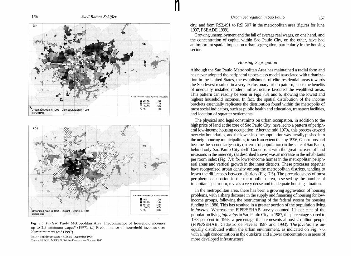
Fig. 7.3. (a) Sao Paulo Metropolitan Area. Predominance of household incomesup to 2.5 minimum wages* (1997). (b) Predominance of household incomes over20 minimum wages* (1997)Note: * 1 minimum wage = US$ 80 (December 1999)Source: FIBGE, METRO Origin-Destination Survey, 1997
Urban Segregation in Sao Paulo 157
city, and from R$2,491 to R$l,507 in the metropolitan area (figures for June1997, FSEADE 1999).
Growing unemployment and the fall of average real wages, on one hand, andthe concentration of capital within Sao Paulo City, on the other, have hadan important spatial impact on urban segregation, particularly in the housingsector.
Housing Segregation
Although the Sao Paulo Metropolitan Area has maintained a radial form andhas never adopted the peripheral upper-class model associated with urbaniza-tion in the United States, the establishment of elite residential areas towardsthe Southwest resulted in a very exclusionary urban pattern, since the benefitsof unequally installed modern infrastructure favoured the wealthiest areas.This pattern can readily be seen in Figs 7.3a and b, showing the lowest andhighest household incomes. In fact, the spatial distribution of the incomebrackets essentially replicates the distribution found within the metropolis ofmost social indicators, such as public health and education, transport facilities,and location of squatter settlements.
The physical and legal constraints on urban occupation, in addition to thehigh price of land at the core of Sao Paulo City, have led to a pattern of periph-eral low-income housing occupation. After the mid 1970s, this process crossedover city boundaries, and the lower-income population was literally pushed intothe neighbouring municipalities, to such an extent that by 1996, Guarulhos hadbecame the second largest city (in terms of population) in the state of Sao Paulo,behind only Sao Paulo City itself. Concurrent with the great increase of landinvasions in the inner city (as described above) was an increase in the inhabitantsper room index (Fig. 7.4) for lower-income homes in the metropolitan periph-eral areas and vertical growth in the inner districts. These processes togetherhave reorganized urban density among the metropolitan districts, tending tolessen the differences between districts (Fig. 7.5). The precariousness of mostperipheral occupation in the metropolitan area, assessed by the number ofinhabitants per room, reveals a very dense and inadequate housing situation.
In the metropolitan area, there has been a growing aggravation of housingproblems, with a sharp decrease in the supply and financing of housing for low-income groups, following the restructuring of the federal system for housingfunding in 1986. This has resulted in a greater portion of the population livingin favelas. Whereas the FIPE/SEHAB survey counted 1.1 per cent of thepopulation living infavelas in Sao Paulo City in 1987, the percentage soared to19.3 per cent in 1993, a percentage that represents almost 2 million people(FIPE/SEHAB, Cadastro de Favelas 1987 and 1993). The favelas are un-equally distributed within the urban environment, as indicated on Fig. 7.6,with a high concentration in the outskirts and a lower concentration in areas ofmore developed infrastructure.

158 Sueli Ramos Schiffer
Urbanized Area of 1995 - District Division of 1991INFURB/99
• 125-155^100-125G3 75-100• 0-75
(48)(58)(32)(23)
Fig. 7.4. Sao Paulo Metropolitan Area. Housing congestion index (1991)Source: FIBGE, Demographic Census, 1991
Urbanized Area in 1995-District Division in 19910/
INFURB/99
Inhabitants/hectare
• >150 (23)^ 100-150 (25)S 50-100 (38)0 <50 (46)
Fig. 7.5. Sao Paulo Metropolitan Area. Net density (1997)Source: FIBGE, METRO Origin-Destination Survey, 1997
Urban Segregation in Sao Paulo 159
••J1 i
• 1
Population living in favelas {%)45.7
Ii 1987I 1993
Fig. 7.6. Sao Paulo City. Population living in favelas (1987-93)Source: FIPE/SEHAB, Cadastro de Favelas, 1987, 1993
As for the number of slum-dwellers in the municipality of Sao Paulo,Taschner (1997) estimates the figure at close to 6 per cent of the population in1993. This represents less than 600,000 inhabitants. There is no information onthe geographical dispersal of slum-dwellers. Although the number of homes inthe favelas has increased sharply in recent years, Taschner (1997) observes thata great number of these homes have improved in terms of construction qualityand household appliances.
The most apparent problem of the peripheral settlement pattern is the inva-sion of the reservoir area by illegal housing settlements, particularly in theSouth side of Sao Paulo City, around the Guarapiranga basin, and in theSouthwest side of the metropolis along the Billings basin. The Billings andthe Guarapiranga are the two main regional reservoirs.

160 Sueli Ramos Schiffer
Most of the areas situated to the extreme south and north east of the metro-politan area belong to the protected water reservoir region, in which economicdevelopment is restricted. The control of settlements around the water reser-voir is regulated by a special state law (1172/76) of 1976, which established thatillegal settlements have no right to water, energy, and sewerage facilities, inaddition to stipulating penalties and fines. In 1997, a new state law,9 designedto prevent further environmental degradation in these areas, allowed thegovernment to implement emergency interventions, such as the provisionof infrastructure, particularly water, energy, and sewerage facilities, and thecontainment of erosion in the more densely invaded areas (FSP, 11-2-98).
Two central issues emerging after the country's accumulation stage in the1960s were resolved as early as the 1980s, benefiting practically the entire cen-tral metropolitan area and almost 80 per cent of the peripheral areas. Theseissues were: access of the population to treated water and electric power,required by Health Sanitation, and to the growth in overall paid consumption,which included the expansion of basic infrastructure. Nonetheless, the qualityand frequency of these services still remain unequally distributed among thedistricts. The distribution is even more unequal for more technologicallyadvanced infrastructures, such as telecommunications (especially fibre optics).
Data from the Official Municipality Real Estate Register, compiled to collecttaxes for road maintenance and cleaning (Cadastro de Taxa Predial de Conser-vacao e Limpeza: TPCL) in 1990 and 1995, show significant growth in new(legal) construction in the central districts, which are precisely those for whichthe demographic growth rate was negative. Taking 1995 as an example (eventhough an Official Municipality Register aiming at tax collection could be con-sidered a precarious source for obtaining data on the non-legal areas), thesedata indicate that the districts of highest vertical growth, as well as thosedistricts housing more commercial buildings, largely coincide with those ofhigher income. Moreover, recent manufacturing construction still predomin-ates in the same districts as before, mainly along the Pinheiros and the Tieterivers. Figure 7.7, compiled after the Official Municipality Register (1995),shows the predominance of land use measured in terms of built-up areas,with high-income horizontal and vertical housing, commerce, lower-incomehousing, and manufacturing areas within Sao Paulo City.
The Creation of 'New' Centres
The tendency of the Sao Paulo elite to periodically create new centres formodern business or leisure activities has contributed to the sharpening con-trast between districts where dynamic sectors (mostly connected with 'global'activities) are established and those districts on the outskirts of the city.
According to Villaca (1999: 230), 'the process of abandoning a traditionalcentre and creating a "new centre" is initiated by the real estate market. Morehighly valued "central" locations are created in areas settled by high-income
Urban Segregation in Sao Paulo 161
' • * ' LIH .. MLIH
I M •. • T HV ,' V , N
". LIH
-i LIH* •
. y * ^ - --i. v ™ i -••-. IIH . .
,. . THH rT H ' > .• A T M MHV. . „„ \ , ,„ . LIH .^ LIH
- \ H V ••"•;
- •'••H'H V ' ^
L v - ' • • H H H V , > , . ; , „
LIH
• I IH >
' LIH i N ' '
\ " ' LW
Urbanized Area in 1995-District Division in 1991 ^/ ))K5v_INFURB/99 ' ((
Predominant land use
T = Tertiary sectorM = Manufacturing sector
HV = High-income vertical housingHH = High-income horizontal housingLIH = Lower-income housing
Fig. 7.7. Sao Paulo City. Predominant land use (1995)Source: Prefeitura Municipal de Sao Paulo. Cadastro TPCL, 1995
housing, following the move to a "New Centre". By controlling the real estatemarket, the dominant class controls not only the growth (or the lack of growth)of the traditional centre, but also the form (continuous or discontinuous) andthe direction of this growth.' This process can be assessed by real estate marketvalues within the metropolitan area (Fig. 7.8). Today, the most visible outcomeof this process, whereby the elite controls the creation of 'new centres', is theexistence of four main economic centres within Sao Paulo City. As reported byVillaca (1998:264), by the end of the 1950s, the traditional centre of Sao Paulowas already divided into two sides by the Anhangabau Valley: the Southwestside, home to prestigious offices, restaurants, and shops, and the Northeastside, housing lower-income shopping and leisure activities.
A second centre was developed during the late 1960s along Paulista Avenue,where modern buildings replaced coffee plantation mansions. This 'new' centredid not completely replace the traditional one. Rather, it became a centre for

I162 Sueli Ramos Schiffer
S\ Real estate market values" ic selected districts (USS average 1996-
s i \ - - ^ ~ i ( • ' • • • • ' • • • • • • • • f « \ \ <r x / r > < \ L i < m | 1 5 1
) ( >-^i~..r \ _J-••••.-j^^J \ T v V v / x / \ V - ^ V 3 No data (47)Urbanized Area in 1995 ̂ District DivisiofTin 199V.;,/ J /\NXiJty\ \ / V \ r
Fig. 7.8. Sao Paulo Metropolitan Area. Values set by the real estate market for selecteddistricts (1996-8)Source: EMBRAESP Annual Report, 1999
activities engaged in specifically by the elite, housing an array of movietheatres, designer shops, bank head offices, and specialized services. At thistime, scattered sub-centres on streets located in non-elite residential areas alsobegan to emerge to serve the low- and middle-income population, in contrastto the elite activities performed in the 'new city centre'.
A third centre, Faria Lima, was formed in the 1970s, at the foot of and southwest of the Paulista Ridge, along Brigadeiro Faria Lima Avenue. Here, officeswere built in the vicinity of the oldest shopping mall in town, which had beenerected in the previous decade. Most of the sophisticated shops moved to thismall as well as to others later built in the highest-income housing areas. Thearea around Faria Lima mainly housed offices, bank branches, mid size stores,and luxury apartment buildings, following a pattern similar to the occupationalong and around Paulista Avenue; both were described by Villaca (1998: 266)as 'extended centres'.
The newest centre, which was developed after the 1980s along Luiz CarlosBerrini Avenue, is also an extended centre. This centre has essentially becomethe venue for multinational corporations operating in the manufacturing andfinancial sectors in connection with globalized activities. Even the architec-tural pattern predominant in this centre is very similar to the new buildingslocated in the central business districts (CBDs) of New York City or London.Most of these newer office buildings were designed by prestigious foreignarchitectural firms and built by transnational investors, a signal that the
Urban Segregation in Sao Paulo 163
process of de-location of the real estate sector in Sao Paulo is ongoing and thatit is following a process described by Beauregard and Haila (1997: 335) as beingcommon to primary world cities. This fourth centre was recently connected tothe third centre (Faria Lima) by a new avenue, called Nova Faria Lima, alongwhich office buildings, providing space for the self-employed, general contrac-tors, and other service-rendering professions catering to the growing outsourc-ing market.
The emergence of each 'new' elite centre usually leads to a process of gentri-fication, which, although conducted mainly by private capital, is largelydependent on considerable state and/or municipal investment, such as theinstallation of telecommunications and other direct core business-relatedinfrastructure services, and the construction of new access facilities, such asroads and tunnels. This infrastructure modifies previous traffic flows andmobility rates, and, most importantly, changes the value of land in the metro-politan districts by increasing the value of the renewed areas and theirsurroundings.
The Increase in Violence and the Formation of Upper-classUrban Clusters
As Costa (1999:237) argues, data from European and Latin America countriesindicate that violence has been increasing worldwide. Particularly alarming inBrazil, and especially in the Sao Paulo Metropolitan Area, is the rise in homi-cides. Cardia (1999:1) indicates that the homicide rate in the Sao Paulo Metro-politan Area grew from 14.6 per 100,000 inhabitants in 1981 to 55.8 in 1998,which was almost twice as high as the national rate.
The spread of violence in the metropolis over the last two decades can beattributed to structural and local factors, related to the economic developmentof both the country and the metropolis. At the national level, monetary and fis-cal policies have been prioritized at the expense of social policies. The ceilingfor and duration of welfare benefits remain low. There was a shortfall in socialhousing construction and financing during the 1980s. Three particular localfactors can be mentioned. First, average household income decreased dramat-ically, mostly affecting low-wage earners. Second, and most importantly,industrial restructuring has led to unemployment. Third, state intervention istoo weak to improve the poorest peripheral areas or to re-urbanize the favelas,a particular aspect of the general inadequacy of state social intervention.
Maricato (1996: 80) also points out that 'the emergence of organized crimeand the drug trade, vigilante groups, and the killing of children and adolescentsare facts that gained new dimensions after the 80's'.
Although surveys show that violence is the most evident urban problemfor all classes and ages, it affects different urban areas and different genders invarious ways. Cardia (1999: 3) stress that violence mainly 'victimizes young
I164 Sueli Ramos Schiffer
males living in the poorest areas of cities (the deprived areas on the outskirtsof the cities developed and made habitable by the people themselves), wherenow-existing public services arrived precariously after people had settledthe area'.
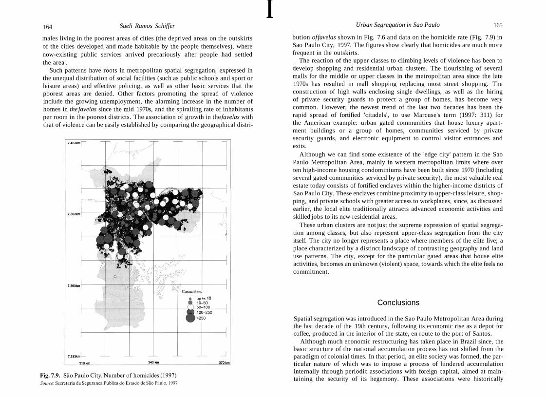
Such patterns have roots in metropolitan spatial segregation, expressed inthe unequal distribution of social facilities (such as public schools and sport orleisure areas) and effective policing, as well as other basic services that thepoorest areas are denied. Other factors promoting the spread of violenceinclude the growing unemployment, the alarming increase in the number ofhomes in the favelas since the mid 1970s, and the spiralling rate of inhabitantsper room in the poorest districts. The association of growth in the favelas withthat of violence can be easily established by comparing the geographical distri-
Urban Segregation in Sao Paulo 165
Fig. 7.9. Sao Paulo City. Number of homicides (1997)Source: Secretaria da Seguranca Publica do Estado de Sao Paulo, 1997
bution of favelas shown in Fig. 7.6 and data on the homicide rate (Fig. 7.9) inSao Paulo City, 1997. The figures show clearly that homicides are much morefrequent in the outskirts.
The reaction of the upper classes to climbing levels of violence has been todevelop shopping and residential urban clusters. The flourishing of severalmalls for the middle or upper classes in the metropolitan area since the late1970s has resulted in mall shopping replacing most street shopping. Theconstruction of high walls enclosing single dwellings, as well as the hiringof private security guards to protect a group of homes, has become verycommon. However, the newest trend of the last two decades has been therapid spread of fortified 'citadels', to use Marcuse's term (1997: 311) forthe American example: urban gated communities that house luxury apart-ment buildings or a group of homes, communities serviced by privatesecurity guards, and electronic equipment to control visitor entrances andexits.
Although we can find some existence of the 'edge city' pattern in the SaoPaulo Metropolitan Area, mainly in western metropolitan limits where overten high-income housing condominiums have been built since 1970 (includingseveral gated communities serviced by private security), the most valuable realestate today consists of fortified enclaves within the higher-income districts ofSao Paulo City. These enclaves combine proximity to upper-class leisure, shop-ping, and private schools with greater access to workplaces, since, as discussedearlier, the local elite traditionally attracts advanced economic activities andskilled jobs to its new residential areas.
These urban clusters are not just the supreme expression of spatial segrega-tion among classes, but also represent upper-class segregation from the cityitself. The city no longer represents a place where members of the elite live; aplace characterized by a distinct landscape of contrasting geography and landuse patterns. The city, except for the particular gated areas that house eliteactivities, becomes an unknown (violent) space, towards which the elite feels nocommitment.
Conclusions
Spatial segregation was introduced in the Sao Paulo Metropolitan Area duringthe last decade of the 19th century, following its economic rise as a depot forcoffee, produced in the interior of the state, en route to the port of Santos.
Although much economic restructuring has taken place in Brazil since, thebasic structure of the national accumulation process has not shifted from theparadigm of colonial times. In that period, an elite society was formed, the par-ticular nature of which was to impose a process of hindered accumulationinternally through periodic associations with foreign capital, aimed at main-taining the security of its hegemony. These associations were historically
166 Sueli Ramos Schiffer
orchestrated in such a way that benefited both foreign capital and the nationalelite: foreign capital could exert control over advanced industries in Brazil, andthe national elite could control the development of the productive forcesthrough the means of the state.
Control over the production and alteration of national space is one of thecentral mechanisms used by the Brazilian elite to ensure its internal domin-ance. Another feature of this society is its creation of high-income segregatedareas, either for housing or for skilled employment, in which all types of urbanfacilities and infrastructure are installed by the state.
Urban segregation in most Brazilian cities, particularly in the Sao PauloMetropolitan Area, is a result of class segregation, although up until the 1940s,ethnic segregation due to (newcomer) immigrant clusters could be seen in thespatial structure of cities.
Today, the metropolitan spatial form reflects two processes. The first is thehistorical local process, which basically began with the growth of industrial-ization after 1955, which was eventually followed by economic restructuringduring the mid 1970s, particularly in the manufacturing sector. The second,subsequent process brought about economic adjustments resulting from theaccommodation of current international accumulation patterns.
As a main economic outcome of both the historical and the international-ization processes in the Sao Paulo Metropolitan Area, the metropolis hasevolved from a manufacturing-oriented to a tertiary-oriented economy. Char-acterized by a high concentration of advanced services and financial industries,the metropolitan area is home to head offices of national and foreign corpora-tions, located in the municipality of Sao Paulo, the state's central city andBrazil's leading economic centre.
At the same time, negative side effects, such as growing unemployment,massive growth in the number offavela inhabitants, the spread of upper-classclusters, and social violence have threatened the quality of life of the wholepopulation. These deficiencies jeopardize the functional attractiveness of thecity, and challenge urban managers and the ruling class to revise the elitistapproach to the development of the built environment, an approach that hashistorically led to high levels of social and urban segregation.
Notes
1. The first railroad was completed in 1868, connecting the city of Sao Paulo to theport of Santos. Another line was built in 1872, connecting Sao Paulo to the maincoffee plantation regions around the city of Campinas. The railroad network in SaoPaulo State expanded speedily as new coffee plantation areas sprouted throughoutthe landscape; by the late 19th century, its total length was 3,375 km. (Matos 1958:68).
2. Slavery was officially abolished in Brazil in 1888, but international traffic in slaveswas forbidden earlier, in 1850.
Urban Segregation in Sao Paulo 167
3. The urban perimeter is delimited by municipal law in Brazil.4. This transfer was a result of aggressive state policies introduced in about 1900,
remaining in effect until the mid 1930s. These policies favoured the domestic elite(the coffee plantation owners) who strove to sustain international coffee prices,mainly by buying (and stocking) practically the entire supply at elevated prices. Thisgenerated profits that had to be channelled to other activities in the face of themounting international supply of coffee.
5. Villaca (1998) stresses that one of the three mechanisms used by the ruling class tocontrol the production of the built environment is the control of the real estatemarket.
6. The economic crisis in Brazil was postponed until the early 1980s thanks to a spe-cific government plan (II PND-II National Development Plan), implementedbetween 1974 and 1976, and designed to provide new guidelines for Brazil's inclusionin the world economy. The plan was abruptly suspended because further implemen-tation depended on substantially raising the general level of productive forces, a stepinterpreted by the national elite as a threat to its dominance. For further assessmentof the economic and political impact of the Plan, see Schiffer (1992).
7. Partly at the root of the municipality-oriented restructuring is the National Consti-tution of 1988, which increased municipalities' share of total tax revenue controlledby the federal government.
8. The definition of informal jobs used here is based on the International Labour Org-anization's (ILO) classification: independent workers (not including those who workfor just one firm with more than five employees), workers in firms with less than fiveemployees, unregistered workers, owners of a family business with less than fiveemployees, and family members who work in a family business and are not paida salary.
9. State Decree 43022/98 that regulated State Law 9866/97.
References
BEAUREGARD, R. A., and HAILA, A. (1997). 'The unavoidable incompleteness of thecity'. American Behavioral Scientist, 41: 327^41.
CACCIAMALI, M. C. (1991). 'O ajustamento do mercado de trabalho na decada deoitenta'. Paper presented at the proceedings of the seminar: Reestruturacdo do espacoregionale urbano no Brasil. Ouro Preto: ANPUR/CEDEPLAR/IPPUR.
(1998). O mercado de trabalho na regiao metropolitana de Sao Paulo no fim doseculo XX. Sao Paulo: INFURB-USP.
CARDIA, N. (1999). Urban violence in Sao Paulo. Sao Paulo: Niicleo de Estudos daViolencia da Universidade de Sao Paulo. Discussion paper.
COSTA, M. R. (1999). 'Violencia e ilegalidade na sociedade brasileira', in M. A. Souza etal. (eds.), Metropole e globalizacdo. Conhecendo a cidade de Sao Paulo, 237^44. SaoPaulo: CEDESP.
DEAK, C. (1999). 'Acumulacao entravada no Brasil e a crise dos anos "80"', in C. Deakand S. R. Schiffer (eds.), O processo de urbanizacao no Brasil, 19-48. Sao Paulo:FUPAM/EDUSP.
EMBRAESP (Empresa Brasileira de Estudos de Patrimonio S/C Ltda.) (1999). Infor-mativo imobilidrio: relatorio anualde 1998. Sao Paulo: EMBRAESP.
168 Sueli Ramos Schiffer
EMPLASA (Empresa Metropolitana de Planejamento da Grande Sao Paulo SA)(1994). Piano Metropolitano da Grande Sao Paulo: 1994/2010. Sao Paulo:EMPLASA.
FERNANDES, F. (1973). Capitalismo dependente e classes sociais na America Latina. Riode Janeiro: Zahar.
FSEADE (Fundacao Sistema Estadual de Analise de Dados) (1999). PED: PesquisaEmprego Desemprego. Sao Paulo: FSEADE.
FIBGE (Fundacao Instituto Brasileiro de Geografia e Estatistica) (1991). Censodemogrdfico. Rio de Janeiro: IBGE.
(1996). Contagem dapopulacdo. Rio de Janeiro: IBGE.FIPE/SEHAB (Fundacao Instituto de pesquisas Economicas / Secretaria da Habitacao
da Prefeitura de Sao Paulo) (1987 and 1993). Cadastro de favelas. Sao Paulo:FIPE/SEHAB.
FSP (Folha de Sao Paulo) (1998). Procon alerta sobre lotes em mananciais (11-2-1998:5).
LANGENBUCH, R. J. (1971). A estruturacao da Grande Sao Paulo. Rio de Janeiro:FIBGE.
LEME, M. C. DA S. (ed.) (1999). Urbanismo no Brasil: 1895-1965. Sao Paulo: StudioNobel/FUPAM.
LENCIONI, S. (1996). 'Restruturacao urbano-industrial no Estado de Sao Paulo: a regiaoda metropole desconcentrada', in M. Santos et al. (eds.), Territorio. Globalizacao efragmentacao, 198-210. Sao Paulo: HUCITEC/ANPUR.
MARCUSE, P. (1997). 'The ghetto of exclusion and the fortified enclave. New patterns inthe United States'. American Behavioral Scientist, 41: 311-26.
MARICATO, E. (1996). Metropole naperiferia do capitalismo. Ilegalidade, desigualdade eviolencia. Sao Paulo: HUCITEC.
MATOS, O. N. DE (1958). 'Sao Paulo no seculo XIX', in A. Azevedo (ed.), A cidade deSao Paulo. Estudos de geografia urbana, Vol. II, 49-100. Sao Paulo: Brasiliana.
METRO (Companhia do Metropolitano de Sao Paulo) (1997). Pesquisa origem-destino (OID). Sao Paulo: METR6.
MONTAGNER, P., and SPRINGER, P. (1997). 'Evolucao das insercoes ocupacionais naRegiao Metropolitana de Sao Paulo, 1988/96'. Paper presented at the IPEA, Interna-tional Workshop: O setor informal revisitado: novas tendencias eperspectivas depoliti-cas piiblicas, Brasilia, July.
Monthly Review, Editorial. (1992). 'Globalization—to what end?' Parts I and II.Monthly Review, 43(9 and 10).
PETRONI, P. (1958). 'Sao Paulo no seculo XX', in A. Azevedo (ed.), A cidade de SaoPaulo. Estudos de geografia urbana, Vol. II, 101-65. Sao Paulo: Brasiliana.
PIANCASTELLI, M., and PEROBELLI, F. (1996). ICMS: evolucao recente e guerra fiscal.Brasilia: IPEA.
Prefeitura Municipal de Sao Paulo (1990 and 1995). Cadastro TPCL: Taxa Predial deConservacao e Limpeza. Sao Paulo: PMSP.
PRETECEILLE, E. (1997). 'Cidades globais e segmentacao social', in L. C. Q. Ribeiroand O. A. Santos jr. (eds.), Globalizacao, fragmentacao e reforma urbana. Ofuturo dascidades brasileiras na crise. 2nd edn, 65-89. Rio de Janeiro: Civilizacao Brasileira.
ROLNIK, R. (1999). 'Para alem da lei: legislacao urbanistica e cidadania. (Sao Paulo1886-1936)', in M. A. Souza et al. (eds.), Metropole e globalizacao. Conhecendo acidade de Sao Paulo, 102-29. Sao Paulo: CEDESP.
Urban Segregation in Sao Paulo 169
SCHIFFER, S. (1992). A territorialidade revisitada. Brasil pos II PND. Sao Paulo:Faculdade de Arquitetura e Urbanismo da Universidade de Sao Paulo.
(2001). 'Sao Paulo: Articulating a Cross-Border Region', in S. Sassen (ed.) Citiesand Their Cross-Border Networks. London: Routledge (forthcoming).
SOARES, L. T. R. (1998). Ajuste neoliberal e desajuste social na America Latina. Rio deJaneiro: Anna Nery/UFRJ.
SOMEKH, N. (1997). A cidade vertical e o urbanismo modernizador. Sao Paulo:1920-1939. Sao Paulo: Studio Nobel/EDUSP.
STORPER, M. (1984). 'Who benefits from industrial decentralization? Social power in thelabour market, income distribution and spatial policy in Brazil'. Regional Studies, 18:143-64.
TASCHNER, S. P. (1997). 'Niicleos de habitacao informal', in INFURB, Avaliacao dosInstrumentos de Planejamento e Gestao do Uso do Solo na Regiao Metropolitana deSao Paulo. Research Report for IPEA. Brasilia. IPEA.
VILLACA, F. (1998). Espaco intra-urbano no Brasil. Sao Paulo: Studio Nobel/FAPESP/Lincoln Institute.
(1999). 'Efeitos do espaco sobre o social na metropole brasileira', in M. A. Souzaetal. (eds.), Metropole e globalizacao. Conhecendo a cidade de Sao Paulo, 221-36. SaoPaulo: CEDESP.