

![CHEMISTRY (19] - SelfStudys](https://static.fdokumen.com/doc/165x107/631f631785e2495e15105a6d/chemistry-19-selfstudys.jpg)


Bahasa
Halaman
Hukum

1.WritedowntheeasternmostlongitudeofIndia?
Ans.97°25’E.
2.WritedownthewesternmostlongitudeofIndia?
Ans.68°7’E.
3.WritedownthenorthernmostlatitudeofIndia?
Ans.37°4’N.
4.WritedownthesouthernmostlatitudeofIndia?
Ans.8°4’4.
5.WhichisSouthernmostpointofIndia?
Ans.IndiraPoint.
6.WhichisthesouthernmosttipofmainlandofIndia?
Ans.Kanyakumari
7.WhichistheareawiselargeststateofIndia?
Ans.Rajasthan.
Chapter-1
India-Size and Location
1 marks Questions
8.WhichistheareawisesmalleststateofIndia?
Ans.Goa.
9.WhatisthelengthofIndiancoastline?
Ans.7516Km.
10.Whatpercentofworld’slandareaiswithIndia?
Ans.2.4%.
11.NamethewaterbodythatseparateSriLankafromIndia?
Ans.PalkStrait.
12.NameanytwostatesofIndiathatsharesinternationalboundaries.
Ans.PunjabandJammuandKashmir.
13.Indiaislocatedinwhichhemisphere?
Ans.NorthernHemisphere.
14.WhatisStandardTime.
Ans.Theofficialtimeofacountry.
15.DefineIndianUnion?
Ans.Severalstatesareunderthecentralgovernmentbutindependentinstateaffairs.Indian
Unionconsistsofallstatesandunionterritories.
16.WhatisStrait?
Ans.Anarrowpassageofwaterconnectingtwolargerbodies.
17.DefineSubcontinent?
Ans.Apartofcontinent,separatedfromtherestofthecontinentbynaturalfeaturessuchas
mountainsandrivers.Ithasitsownspecificclimaticfeaturesandadistinctculturalidentity.
18.NamethegroupofislandslyingintheArabiansea.
Ans.LakshadweepIsland.
19.UnionTerritoryofIndiayouwillbegoingto?
Ans.LakshadweepIsland.
20.WhatisthedifferencebetweenGujaratandArunachalPradesh?
Ans.Twohours.
1.NamethesouthernmostpointofIndia?Isitvisibletoday?
Ans.TheSouthernmostpointofIndiaisIndirapoint.
TheIndirapointissituatedintheGreatNicobargroupofIslandinAndamanNicobarisland
groups.
Itisnotvisibletodaybecauseitwassubmergedundertheseainthe2004Tsunami.
2.Whichismostimportantlatitudeofthecountry?Givereason.
Ans.Thetropicofcanceristhemostimportantlatitudeofthecountry.
Itissituatedat23½N.
Thetropicofcancerdividesthecountryintotwoequalparts.
Italsodividesthecountryintotwoclimaticzones.
3.WhichismostimportantLongitudeofthecountry?Givereason.
Ans.82°30’E,longitudeisthemostimportantlongitudeofourcountry.
Toavoidconfusionandchaosinallactivitiestobecausedbyhavingadifferentlocaltimefor
differentplaces.
ThecentralMeridian82°30’EistakenastheIndianStandardTime.
Itisacceptedalloverthecountryforuniformityoftime.
4.Whyisthedifferencebetweenthedurationofdayandnighthardlyfeltat
KanyakumaributnotsoinKashmir?
Ans.Kanyakumariissituatednearertoequatoranditliesinequatorialzone.
Inequatorialzonesthedurationofdayandnightarealmostequal.
3 marks Questions
Kashmirliesinthesubtropicalzone.Herethedurationofdayandnightisnotequal.
SothedurationofdayandnightismoreprominentinKashmirthaninKanyakumari.
5.WhycountriesoftheworldselectedtheirownStandardMeridians?
Ans.EverycountryhasaStandardTimetoavoidconfusionoftime.
ItistimeofitsCentralorStandardMeridian.
EachMeridianhasitsownlocaltimewhichisthesuntimeorlocaltimeofthatparticular
place.
Toavoidconfusionandchaosinallactivitiestobecausedbyhavingadifferentlocaltimefor
differentplacesthecentralmeridianisselectedasStandardTime.
SomeCountrieswhosesizeisverylargetheyhavetheirdifferenttimezones.
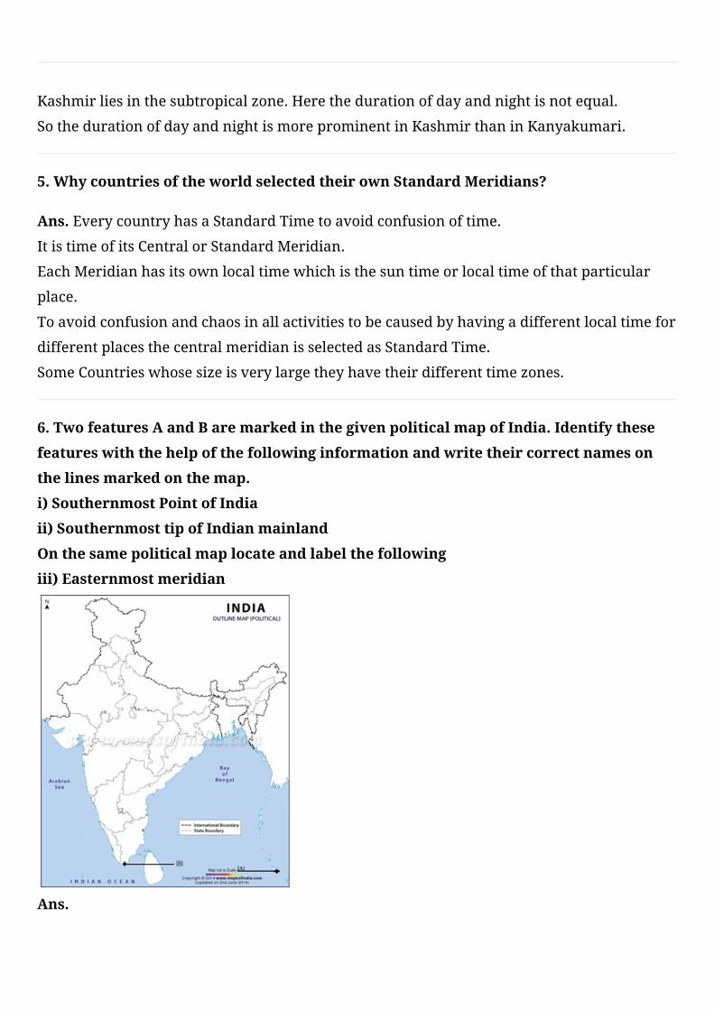
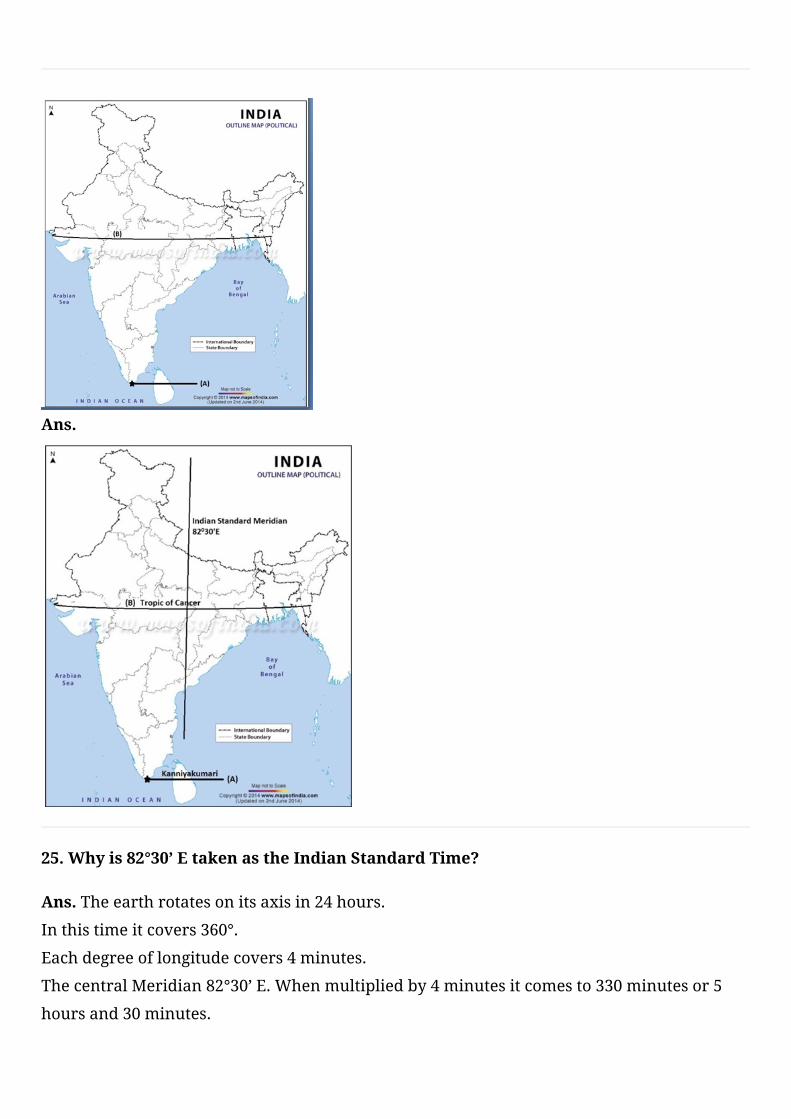
6.TwofeaturesAandBaremarkedinthegivenpoliticalmapofIndia.Identifythese
featureswiththehelpofthefollowinginformationandwritetheircorrectnameson
thelinesmarkedonthemap.
i)SouthernmostPointofIndia
ii)SouthernmosttipofIndianmainland
Onthesamepoliticalmaplocateandlabelthefollowing
iii)Easternmostmeridian
Ans.
7.Explainthemajorreasonforthetwohourtimedifferenceinthelocaltimebetween
ArunachalPradeshandGujarat?
Ans.Indiahaslongitudinalextentof30°.Duetothis,thereisatimelagoftwohoursbetween
thesunriseontheeasternmostandthewesternmosthorizonsofIndia.
Duetorotation,theearthtakes4minutestorotatethrough1°oflongitude.Thedifferencein
timeisonehourfor15°oflongitude.
Therefore,foralongitudinalextentof30°ofIndia,thereisatimelagoftwohours.
Whenitis6a.m.inArunachalPradesh,itisstill4a.m.inGujaratandJaisalmer.
8.Althoughthelatitudinalandlongitudinalextentofthemainlandisabout30°theeast
westextentappearstobesmallerthanthenorthsouthextent.Why?
Ans.Theeastwestextentappearstobesmallerthannorthsouthextentdespitethefactthat
thelatitudinalandlongitudinalextentofthemainlandisabout30°.
Itisbecausethedistancebetweenthelongitudesreducesaswemovetowardsthepolesfrom
theequatorandeastwestextentislessinkilometers.
AsIndialiesonthetropicofcancersoincomparisonwithequatorthedistancebetweenthe
longitudesislessthanthatontheequator.
9.WhatissizeofIndia?Whatisitsrankwithrespecttotheworldintermsofsize?
Ans.ThelandmassofIndiahasanareaof3.28millionsquarekm.
India’stotalareaaccountsfor2.4percentofthetotalgeographicalareaoftheworld.
Indiaistheseventhlargestcountryoftheworld.
10.WhyisIndiacalledaSubcontinent?
Ans.Indiaiscalledasubcontinentbecauseitisabiglandmass.
Thisstandsoutasadistinctgeographicalunitfromtherestofthecontinent.
Itisseparatedbynaturalfeatureslikemountainsandrivers.
IndiaisalsoseparatedfromrestofthecontinentbythemightyHimalayas.
11.HowcanyousaythatIndiahadcloselinkswithotherpartsoftheworldinancient
times?
Ans.Thevariouspassesacrossthemountainsinthenorthhaveprovidedpassagestothe
ancienttravelers.
Theserouteshavecontributedintheexchangeofideasandcommoditiessinceancienttimes.
TheideaofUpanishadsandRamayana,thestoriesofPanchtantra,theIndiannumeraland
thedecimalsystemthuscouldreachpartsoftheworld.
12.TwofeaturesAandBaremarkedinthegivenpoliticalmapofIndia.Identifythese
featureswiththehelpofthefollowinginformationandwritetheircorrectnameson
thelinesmarkedonthemap.
i)AnislandlyingintheArabiansea
ii)AnislandlyingintheBayofBengal
OnthesamepoliticalmaplocateandlabelthefollowingstateofIndia
iii)Telangana

Ans.
13.Statethereasonfortimelagbetweensunrisesontheeasternmostandthe
westernmosthorizonsofIndia.
Ans.Indiahaslongitudinalextentof30°.Duetothis,thereisatimelagoftwohoursbetween
thesunriseontheeasternmostandthewesternmosthorizonsofIndia.
Duetorotation,theearthtakes4minutestorotatethrough1°oflongitude.Thedifferencein
timeisonehourfor15°oflongitude.
Therefore,foralongitudinalextentof30°ofIndia,thereisatimelagoftwohours
Whenitis6a.m.inArunachalPradesh,itisstill4a.m.inGujaratandJaisalmer.
14.ListsixcountriesoftheworldbiggerthanIndia.
Ans.Russia,Canada,China,UnitedStatesofAmerica,Australia,Brazil,India
15.ExplainwhyAhmadabadandKolkataareabletoseethenoonsunexactlyoverhead
inayearbutnotDelhi.
Ans.ThesetwocitiesliewithintheTropicofcancer.
Thetropicofcanceristhecircleoflatitudeontheearththatmarkstheapparentpositionof
thesunatthetimeofthenorthernsolstice.
Itisalsothefarthestnorthlatitudeatwhichthesuncanbedirectlyoverhead.
SoinDelhithesunisneverdirectlyoverhead.
16.WriteashortnoteonthelocationofIndia?
Ans.ThelandmassofIndiahasanareaof3.28millionsq.km.
Indiahasalandboundaryofabout15200kmandlengthofcoastlineincludingislandis
7516.6km.
Indiaisseventhlargestcountryoftheworld.
17.WriteashortnoteonthelocationofIndia?
Ans.Indiaisavastcountrywhichliesinthenorthernhemisphere.
Themainlandextendsbetweenlatitudes8°4’and37°6’NandLongitude68°7’Eand97°25’E.
Tropicofcancer23°30’Ndividesthecountryintotwoparts.
18.TwofeaturesAandBaremarkedinthegivenpoliticalmapofIndia.Identifythese
featureswiththehelpofthefollowinginformationandwritetheircorrectnameson
thelinesmarkedonthemap.
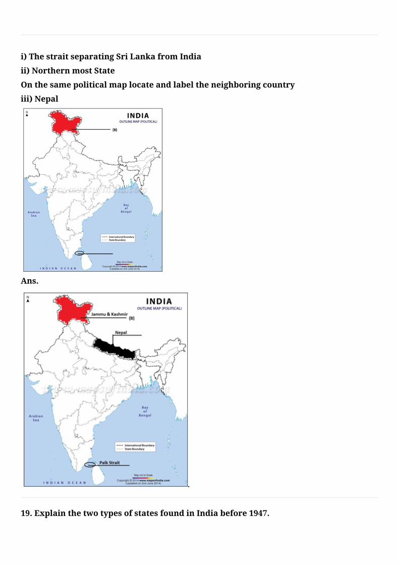
i)ThestraitseparatingSriLankafromIndia
ii)NorthernmostState
Onthesamepoliticalmaplocateandlabeltheneighboringcountry
iii)Nepal
Ans.
19.ExplainthetwotypesofstatesfoundinIndiabefore1947.
Ans.Before1947thereweretwotypesofstatesinIndia-theprovincesandtheprincely
states.
ProvincesarerulesdirectlybyBritishofficialswhowereappointedbytheViceroy.
Princelystateswereruledbylocalhereditaryrulers,whoacknowledgedsovereigntyin
returnforthelocalautonomy.
20.Indiaistheoneoftheancientcivilizationoftheworld.Explain.
Ans.Yes,Indiaistheoneofancientcivilizationintheworld.
TheideaofUpanishadsandRamayana,thestoriesofPanchtantra.
TheideaoftheIndiannumeralandthedecimalsystemthuscouldreachpartsoftheworld.
India’scontactswiththeworldhavecontinuedthroughtheagesbutherrelationships
throughthelandroutesaremucholderthanthemaritimecontacts.
21.NametheIndianstateswhicharesituatedontheeasterncoastofIndia.
Ans.WestBengal,Odisha,Telangana,AndhraPradeshandTamilNadu.
22.NametheIndianstateswhicharesituatedonthewesterncoastofIndia.
Ans.Kerala,Karnataka,GoaandMaharashtra
23.NamethesevensisterstatesofIndia.
Ans.Assam,Meghalaya,Tripura,NagalandManipur,Mizoram,ArunachalPradesh
24.TwofeaturesAandBaremarkedinthegivenpoliticalmapofIndia.Identifythese
featureswiththehelpofthefollowinginformationandwritetheircorrectnameson
thelinesmarkedonthemap.
i)Aplacesituatedonthreeseas
ii)TheimaginarylinewhichdivideIndiaintotwoequalpartsOnthesamepolitical
maplocateandlabelthefollowing
iii)IndianstandardMeridian
Ans.
25.Whyis82°30’EtakenastheIndianStandardTime?
Ans.Theearthrotatesonitsaxisin24hours.
Inthistimeitcovers360°.
Eachdegreeoflongitudecovers4minutes.
ThecentralMeridian82°30’E.Whenmultipliedby4minutesitcomesto330minutesor5
hoursand30minutes.
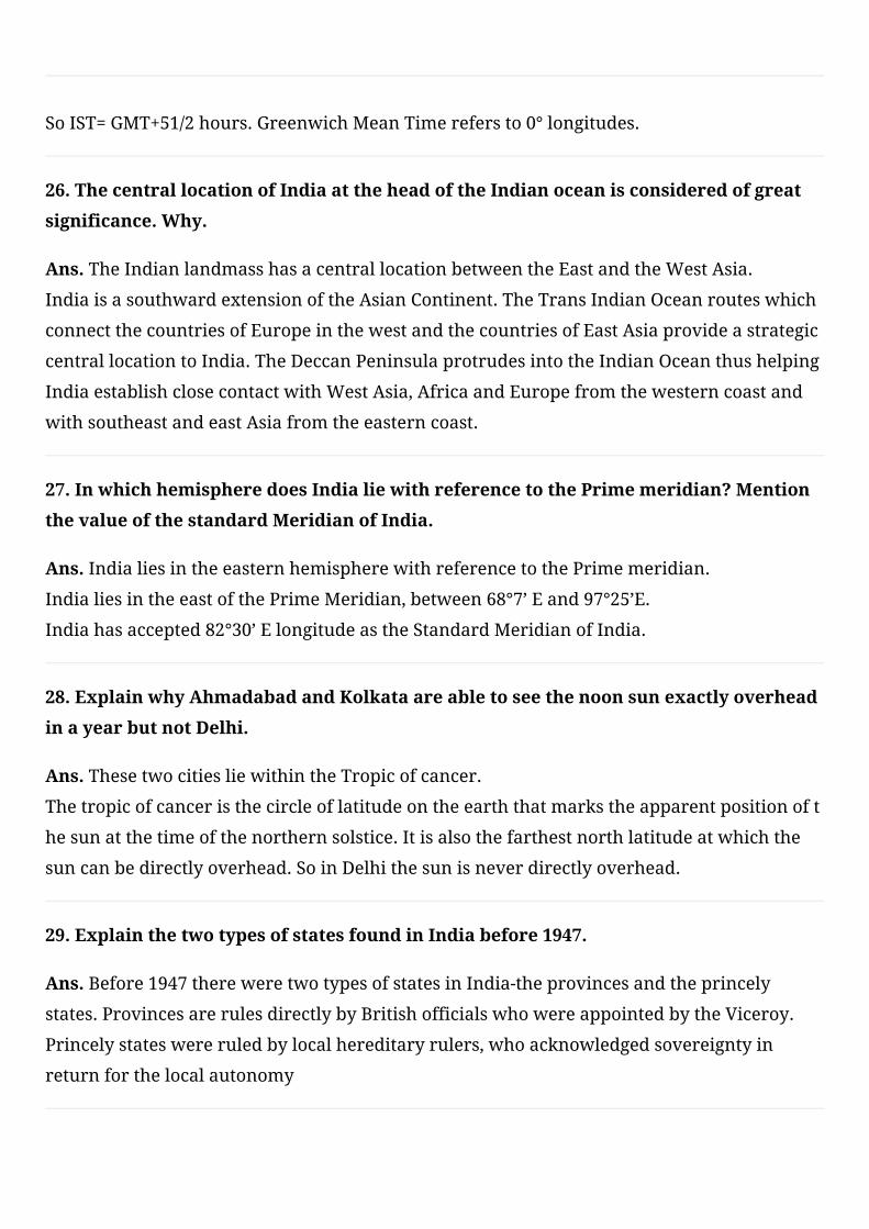
SoIST=GMT+51/2hours.GreenwichMeanTimerefersto0°longitudes.
26.ThecentrallocationofIndiaattheheadoftheIndianoceanisconsideredofgreat
significance.Why.
Ans.TheIndianlandmasshasacentrallocationbetweentheEastandtheWestAsia.
IndiaisasouthwardextensionoftheAsianContinent.TheTransIndianOceanrouteswhich
connectthecountriesofEuropeinthewestandthecountriesofEastAsiaprovideastrategic
centrallocationtoIndia.TheDeccanPeninsulaprotrudesintotheIndianOceanthushelping
IndiaestablishclosecontactwithWestAsia,AfricaandEuropefromthewesterncoastand
withsoutheastandeastAsiafromtheeasterncoast.
27.InwhichhemispheredoesIndialiewithreferencetothePrimemeridian?Mention
thevalueofthestandardMeridianofIndia.
Ans.IndialiesintheeasternhemispherewithreferencetothePrimemeridian.
IndialiesintheeastofthePrimeMeridian,between68°7’Eand97°25’E.
Indiahasaccepted82°30’ElongitudeastheStandardMeridianofIndia.
28.ExplainwhyAhmadabadandKolkataareabletoseethenoonsunexactlyoverhead
inayearbutnotDelhi.
Ans.ThesetwocitiesliewithintheTropicofcancer.
Thetropicofcanceristhecircleoflatitudeontheearththatmarkstheapparentpositionoft
hesunatthetimeofthenorthernsolstice.Itisalsothefarthestnorthlatitudeatwhichthe
suncanbedirectlyoverhead.SoinDelhithesunisneverdirectlyoverhead.
29.ExplainthetwotypesofstatesfoundinIndiabefore1947.
Ans.Before1947thereweretwotypesofstatesinIndia-theprovincesandtheprincely
states.ProvincesarerulesdirectlybyBritishofficialswhowereappointedbytheViceroy.
Princelystateswereruledbylocalhereditaryrulers,whoacknowledgedsovereigntyin
returnforthelocalautonomy
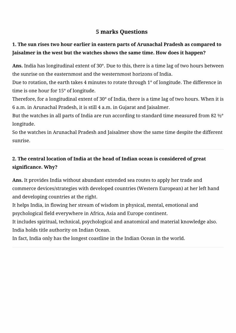
30.TwofeaturesAandBaremarkedinthegivenpoliticalmapofIndia.Identifythese
featureswiththehelpofthefollowinginformationandwritetheircorrectnameson
thelinesmarkedonthemap.
i)TheareawisesmalleststateonthewestcoastofIndia
ii)NorthernmostlatitudeofIndia
Onthesamepoliticalmaplocateandlabelthefollowing
iii)TheareawiselargeststateofIndia
Ans.
1.ThesunrisestwohourearlierineasternpartsofArunachalPradeshascomparedto
Jaisalmerinthewestbutthewatchesshowsthesametime.Howdoesithappen?
Ans.Indiahaslongitudinalextentof30°.Duetothis,thereisatimelagoftwohoursbetween
thesunriseontheeasternmostandthewesternmosthorizonsofIndia.
Duetorotation,theearthtakes4minutestorotatethrough1°oflongitude.Thedifferencein
timeisonehourfor15°oflongitude.
Therefore,foralongitudinalextentof30°ofIndia,thereisatimelagoftwohours.Whenitis
6a.m.inArunachalPradesh,itisstill4a.m.inGujaratandJaisalmer.
ButthewatchesinallpartsofIndiaarerunaccordingtostandardtimemeasuredfrom82½°
longitude.
SothewatchesinArunachalPradeshandJaisalmershowthesametimedespitethedifferent
sunrise.
2.ThecentrallocationofIndiaattheheadofIndianoceanisconsideredofgreat
significance.Why?
Ans.ItprovidesIndiawithoutabundantextendedsearoutestoapplyhertradeand
commercedevices/strategieswithdevelopedcountries(WesternEuropean)atherlefthand
anddevelopingcountriesattheright.
IthelpsIndia,inflowingherstreamofwisdominphysical,mental,emotionaland
psychologicalfieldeverywhereinAfrica,AsiaandEuropecontinent.
Itincludesspiritual,technical,psychologicalandanatomicalandmaterialknowledgealso.
IndiaholdstitleauthorityonIndianOcean.
Infact,IndiaonlyhasthelongestcoastlineintheIndianOceanintheworld.
5 marks Questions
3.WhensunrisesinArunachalPradeshitisstillnightinGujarat.Givereasons.
Ans.TheeasternmostlongitudinalextentofIndiais97°25’EatextremeendofArunachal
Pradesh.
ThewesternmostlongitudinalextentofIndiais68°7’EatextremeendofGujarat.
Thusthelongitudinalextentisabout30°.Itmeans30longitudespassfromeasttowest.
Thereistimedifferenceof4minutesbetweentwoconsecutivelongitudes.
Thetimedifferencebetween30longitudesis120minutesor2hour.
SothereistimedifferenceoftwohoursinlocaltimebetweenArunachalPradesh.
4.HighlightthesignificanceofgeographicallocationofIndia?
Ans.TheIndianlandmasshasacentrallocationbetweentheEastandtheWestAsia.
IndiaisasouthwardextensionoftheAsianContinent.
Indiahasanareaof3.28millionsquarekmwhichaccountsforabout2.4percentofthetotal
geographicalareaoftheworld.
Indiaisseventhlargestcountryoftheworld.
TheeasternmostlongitudinalextentofIndiais97°25’Eandthewesternmostlongitudinal
extentofIndiais68°7’E.
Indiaisboundedbytheyoungfoldmountainsinthenorthwest,northandnortheast.
5.JustifythenamingofIndianOceanafterIndia?
Ans.NoothercountryhaslongcoastlineontheIndianOceanasIndiahasandindeed.
ItisIndia’seminentpositionintheIndianOceanwhichjustifiesthenamingofanOcean
afterit.
IndiahascentrallocationbetweentheEastandtheWestAsia.
TheTransIndianOceanrouteswhichconnectthecountriesofEuropeinthewestandthe
countriesofEastAsiaprovideastrategiccentrallocationtoIndia.
TheDeccanPeninsulaprotrudesintotheIndianOceanthushelpingIndiaestablishclose
contactwithWestAsia.
6.HowhavebeenmountainpassesbeenhelpfulinIndiasincehistorictimes?Explain.
Ans.Indiaisboundedbytheyoungfoldmountainsinthenorthwest,northandnortheast.
Thevariouspassesacrossthemountainsinthenorththenorthshaveprovidedpassagesto
theancienttravelers.
Theserouteshavecontributedintheexchangeofideasandcommoditiessinceancienttimes.
TheideaofUpanishadsandRamayana,thestoriesofPanchtantra,theIndiannumeraland
thedecimalsystemthuscouldreachpartsoftheworld.
Thespices,muslinandothermerchandiseweretakenfromIndiatodifferentcountries.
7.WhyisIndiasaidtoenjoyastrategicpositionwithreferencetotheInternational
traderoute?
Ans.TheIndianlandmasshasacentrallocationbetweentheEastandtheWestAsia.
IndiaisasouthwardextensionoftheAsianContinent.
TheTransIndianOceanrouteswhichconnectthecountriesofEuropeinthewestandthe
countriesofEastAsiaprovideastrategiccentrallocationtoIndia.
TheDeccanPeninsulaprotrudesintotheIndianOceanthushelpingIndiaestablishclose
contactwithWestAsia,AfricaandEuropefromthewesterncoastandwithsoutheastand
eastAsiafromtheeasterncoast.
Thevariouspassesacrossthemountainsinthenorthhaveprovidedpassagestotheancient
travelers.
Theserouteshavecontributedintheexchangeofideasandcommoditiessinceancienttimes.
8.DescribeIndia’slocationwithreferencetoherneighbors.
Ans.TheIndianlandmasshasacentrallocationbetweentheEastandtheWestAsia.
IndiaisasouthwardextensionoftheAsianContinent.
IndiaoccupiesanimportantstrategicpositioninSouthAsia.
IndiaSharesitslandboundarieswithPakistanandAfghanistanintheNorthWestchinaand
NepalandBhutanintheNorth.
MyanmarandBangladeshintheeast.
OurSouthernneighborsacrosstheseaconsistofthetwoislandcountriesnamelySriLanka
andMaldives.
9.Howistheknowledgeoflatitudeandlongitudeimportantforpeople?
Ans.Thathelpsustounderstandandlocatesthegeographicallocationandglobebetter.
Theuseoflatitudesandlongitudeofferabetterandquickgraspofgeographicalfacts.
Itdeterminesthetimezonesofthedifferentregionsoftheworld.
Withthehelpoflongitudesandlatitudesitiseasytocalculatelocaltimeandstandardtime.
Longitudesandlatitudesarealsohelpingustocalculatethedistancefromoneplaceto
another.
10.WhataretheimplicationsoflargelandboundariesandvastcoastlineofIndia?
Ans.ThelargelandboundariesofIndiahavehelpedtodeveloplinkswithherneighboring
countries.
Itcontributedintheexchangeofideasandcommoditiessinceancienttimes.
TheideasoftheUpanishads,theRamayana,andtheGeetaetchavebecomeknowntothe
world.
TheIndianNumeralsaswellasdecimalsystemlongbackcrosstheborder,Arabstookthese
ideastothewest.
ThelongcoastlineontheArabianSeaandBayofBengalhashelpedIndiatodevelopclose
maritimecontactwithWestAsia,AfricaandEuropefromthewesterncoastandwithEast
AsiaandthesouthEastAsiafromtheeasterncoast.
Copyright © 2022 FDOKUMEN

