Chapter-1 India-Size and Location - SelfStudys
18
1. Write down the easternmost longitude of India? Ans. 97°25’ E. 2. Write down the western most longitude of India? Ans. 68°7’ E. 3. Write down the northern most latitude of India? Ans. 37°4’ N. 4. Write down the southernmost latitude of India? Ans. 8°4’ 4. 5. Which is Southern most point of India? Ans. Indira Point. 6. Which is the southern most tip of main land of India? Ans. Kanyakumari 7. Which is the area wise largest state of India? Ans. Rajasthan. Chapter-1 India-Size and Location 1 marks Questions
-
Upload
khangminh22 -
Category
Documents
-
view
0 -
download
0
Transcript of Chapter-1 India-Size and Location - SelfStudys
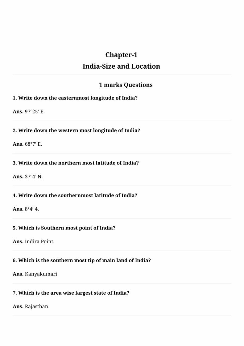
1.WritedowntheeasternmostlongitudeofIndia?
Ans.97°25’E.
2.WritedownthewesternmostlongitudeofIndia?
Ans.68°7’E.
3.WritedownthenorthernmostlatitudeofIndia?
Ans.37°4’N.
4.WritedownthesouthernmostlatitudeofIndia?
Ans.8°4’4.
5.WhichisSouthernmostpointofIndia?
Ans.IndiraPoint.
6.WhichisthesouthernmosttipofmainlandofIndia?
Ans.Kanyakumari
7.WhichistheareawiselargeststateofIndia?
Ans.Rajasthan.
Chapter-1
India-Size and Location
1 marks Questions
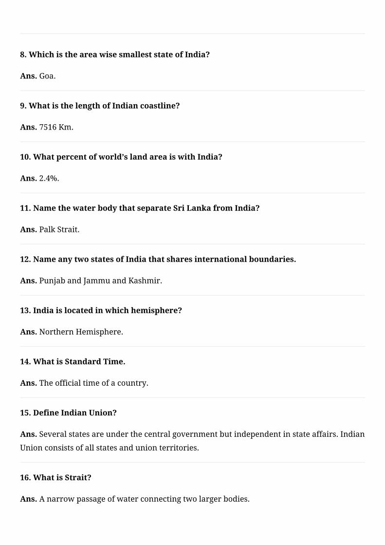
8.WhichistheareawisesmalleststateofIndia?
Ans.Goa.
9.WhatisthelengthofIndiancoastline?
Ans.7516Km.
10.Whatpercentofworld’slandareaiswithIndia?
Ans.2.4%.
11.NamethewaterbodythatseparateSriLankafromIndia?
Ans.PalkStrait.
12.NameanytwostatesofIndiathatsharesinternationalboundaries.
Ans.PunjabandJammuandKashmir.
13.Indiaislocatedinwhichhemisphere?
Ans.NorthernHemisphere.
14.WhatisStandardTime.
Ans.Theofficialtimeofacountry.
15.DefineIndianUnion?
Ans.Severalstatesareunderthecentralgovernmentbutindependentinstateaffairs.Indian
Unionconsistsofallstatesandunionterritories.
16.WhatisStrait?
Ans.Anarrowpassageofwaterconnectingtwolargerbodies.
17.DefineSubcontinent?
Ans.Apartofcontinent,separatedfromtherestofthecontinentbynaturalfeaturessuchas
mountainsandrivers.Ithasitsownspecificclimaticfeaturesandadistinctculturalidentity.
18.NamethegroupofislandslyingintheArabiansea.
Ans.LakshadweepIsland.
19.UnionTerritoryofIndiayouwillbegoingto?
Ans.LakshadweepIsland.
20.WhatisthedifferencebetweenGujaratandArunachalPradesh?
Ans.Twohours.
1.NamethesouthernmostpointofIndia?Isitvisibletoday?
Ans.TheSouthernmostpointofIndiaisIndirapoint.
TheIndirapointissituatedintheGreatNicobargroupofIslandinAndamanNicobarisland
groups.
Itisnotvisibletodaybecauseitwassubmergedundertheseainthe2004Tsunami.
2.Whichismostimportantlatitudeofthecountry?Givereason.
Ans.Thetropicofcanceristhemostimportantlatitudeofthecountry.
Itissituatedat23½N.
Thetropicofcancerdividesthecountryintotwoequalparts.
Italsodividesthecountryintotwoclimaticzones.
3.WhichismostimportantLongitudeofthecountry?Givereason.
Ans.82°30’E,longitudeisthemostimportantlongitudeofourcountry.
Toavoidconfusionandchaosinallactivitiestobecausedbyhavingadifferentlocaltimefor
differentplaces.
ThecentralMeridian82°30’EistakenastheIndianStandardTime.
Itisacceptedalloverthecountryforuniformityoftime.
4.Whyisthedifferencebetweenthedurationofdayandnighthardlyfeltat
KanyakumaributnotsoinKashmir?
Ans.Kanyakumariissituatednearertoequatoranditliesinequatorialzone.
Inequatorialzonesthedurationofdayandnightarealmostequal.
3 marks Questions
Kashmirliesinthesubtropicalzone.Herethedurationofdayandnightisnotequal.
SothedurationofdayandnightismoreprominentinKashmirthaninKanyakumari.
5.WhycountriesoftheworldselectedtheirownStandardMeridians?
Ans.EverycountryhasaStandardTimetoavoidconfusionoftime.
ItistimeofitsCentralorStandardMeridian.
EachMeridianhasitsownlocaltimewhichisthesuntimeorlocaltimeofthatparticular
place.
Toavoidconfusionandchaosinallactivitiestobecausedbyhavingadifferentlocaltimefor
differentplacesthecentralmeridianisselectedasStandardTime.
SomeCountrieswhosesizeisverylargetheyhavetheirdifferenttimezones.
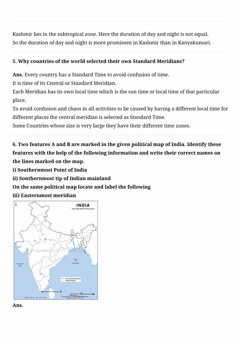
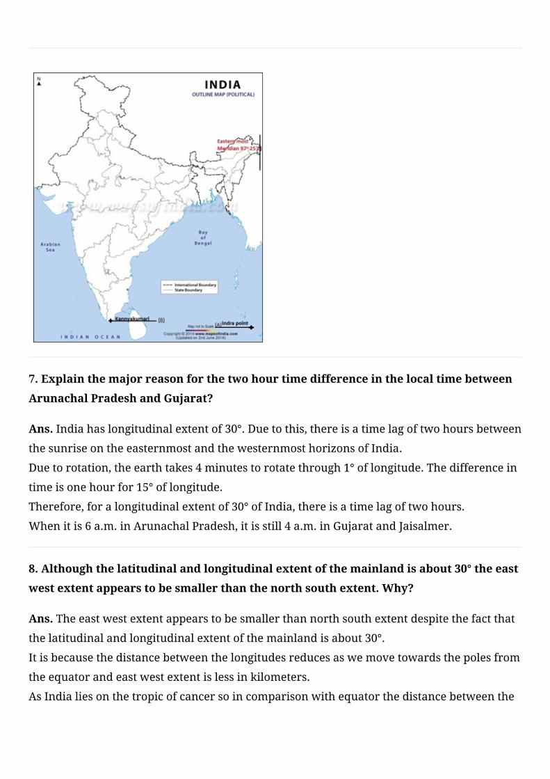
6.TwofeaturesAandBaremarkedinthegivenpoliticalmapofIndia.Identifythese
featureswiththehelpofthefollowinginformationandwritetheircorrectnameson
thelinesmarkedonthemap.
i)SouthernmostPointofIndia
ii)SouthernmosttipofIndianmainland
Onthesamepoliticalmaplocateandlabelthefollowing
iii)Easternmostmeridian
Ans.
7.Explainthemajorreasonforthetwohourtimedifferenceinthelocaltimebetween
ArunachalPradeshandGujarat?
Ans.Indiahaslongitudinalextentof30°.Duetothis,thereisatimelagoftwohoursbetween
thesunriseontheeasternmostandthewesternmosthorizonsofIndia.
Duetorotation,theearthtakes4minutestorotatethrough1°oflongitude.Thedifferencein
timeisonehourfor15°oflongitude.
Therefore,foralongitudinalextentof30°ofIndia,thereisatimelagoftwohours.
Whenitis6a.m.inArunachalPradesh,itisstill4a.m.inGujaratandJaisalmer.
8.Althoughthelatitudinalandlongitudinalextentofthemainlandisabout30°theeast
westextentappearstobesmallerthanthenorthsouthextent.Why?
Ans.Theeastwestextentappearstobesmallerthannorthsouthextentdespitethefactthat
thelatitudinalandlongitudinalextentofthemainlandisabout30°.
Itisbecausethedistancebetweenthelongitudesreducesaswemovetowardsthepolesfrom
theequatorandeastwestextentislessinkilometers.
AsIndialiesonthetropicofcancersoincomparisonwithequatorthedistancebetweenthe
longitudesislessthanthatontheequator.
9.WhatissizeofIndia?Whatisitsrankwithrespecttotheworldintermsofsize?
Ans.ThelandmassofIndiahasanareaof3.28millionsquarekm.
India’stotalareaaccountsfor2.4percentofthetotalgeographicalareaoftheworld.
Indiaistheseventhlargestcountryoftheworld.
10.WhyisIndiacalledaSubcontinent?
Ans.Indiaiscalledasubcontinentbecauseitisabiglandmass.
Thisstandsoutasadistinctgeographicalunitfromtherestofthecontinent.
Itisseparatedbynaturalfeatureslikemountainsandrivers.
IndiaisalsoseparatedfromrestofthecontinentbythemightyHimalayas.
11.HowcanyousaythatIndiahadcloselinkswithotherpartsoftheworldinancient
times?
Ans.Thevariouspassesacrossthemountainsinthenorthhaveprovidedpassagestothe
ancienttravelers.
Theserouteshavecontributedintheexchangeofideasandcommoditiessinceancienttimes.
TheideaofUpanishadsandRamayana,thestoriesofPanchtantra,theIndiannumeraland
thedecimalsystemthuscouldreachpartsoftheworld.
12.TwofeaturesAandBaremarkedinthegivenpoliticalmapofIndia.Identifythese
featureswiththehelpofthefollowinginformationandwritetheircorrectnameson
thelinesmarkedonthemap.
i)AnislandlyingintheArabiansea
ii)AnislandlyingintheBayofBengal
OnthesamepoliticalmaplocateandlabelthefollowingstateofIndia
iii)Telangana

Ans.
13.Statethereasonfortimelagbetweensunrisesontheeasternmostandthe
westernmosthorizonsofIndia.
Ans.Indiahaslongitudinalextentof30°.Duetothis,thereisatimelagoftwohoursbetween
thesunriseontheeasternmostandthewesternmosthorizonsofIndia.
Duetorotation,theearthtakes4minutestorotatethrough1°oflongitude.Thedifferencein
timeisonehourfor15°oflongitude.
Therefore,foralongitudinalextentof30°ofIndia,thereisatimelagoftwohours
Whenitis6a.m.inArunachalPradesh,itisstill4a.m.inGujaratandJaisalmer.
14.ListsixcountriesoftheworldbiggerthanIndia.
Ans.Russia,Canada,China,UnitedStatesofAmerica,Australia,Brazil,India
15.ExplainwhyAhmadabadandKolkataareabletoseethenoonsunexactlyoverhead
inayearbutnotDelhi.
Ans.ThesetwocitiesliewithintheTropicofcancer.
Thetropicofcanceristhecircleoflatitudeontheearththatmarkstheapparentpositionof
thesunatthetimeofthenorthernsolstice.
Itisalsothefarthestnorthlatitudeatwhichthesuncanbedirectlyoverhead.
SoinDelhithesunisneverdirectlyoverhead.
16.WriteashortnoteonthelocationofIndia?
Ans.ThelandmassofIndiahasanareaof3.28millionsq.km.
Indiahasalandboundaryofabout15200kmandlengthofcoastlineincludingislandis
7516.6km.
Indiaisseventhlargestcountryoftheworld.
17.WriteashortnoteonthelocationofIndia?
Ans.Indiaisavastcountrywhichliesinthenorthernhemisphere.
Themainlandextendsbetweenlatitudes8°4’and37°6’NandLongitude68°7’Eand97°25’E.
Tropicofcancer23°30’Ndividesthecountryintotwoparts.
18.TwofeaturesAandBaremarkedinthegivenpoliticalmapofIndia.Identifythese
featureswiththehelpofthefollowinginformationandwritetheircorrectnameson
thelinesmarkedonthemap.
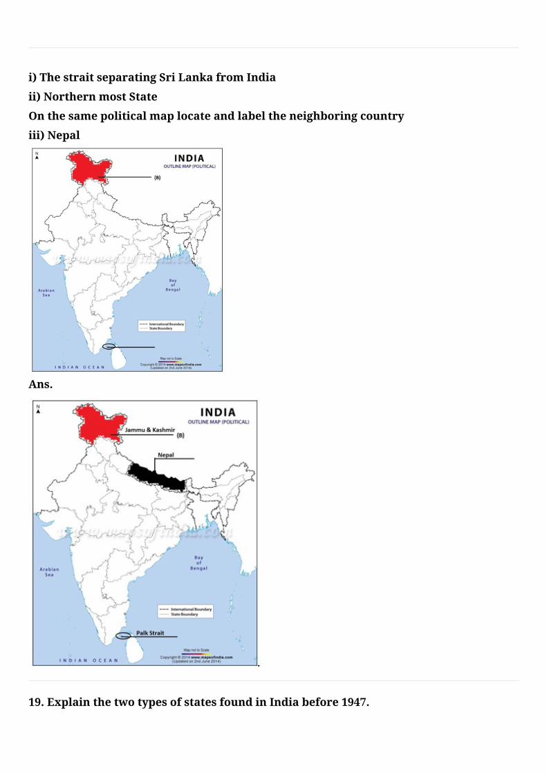
i)ThestraitseparatingSriLankafromIndia
ii)NorthernmostState
Onthesamepoliticalmaplocateandlabeltheneighboringcountry
iii)Nepal
Ans.
19.ExplainthetwotypesofstatesfoundinIndiabefore1947.
Ans.Before1947thereweretwotypesofstatesinIndia-theprovincesandtheprincely
states.
ProvincesarerulesdirectlybyBritishofficialswhowereappointedbytheViceroy.
Princelystateswereruledbylocalhereditaryrulers,whoacknowledgedsovereigntyin
returnforthelocalautonomy.
20.Indiaistheoneoftheancientcivilizationoftheworld.Explain.
Ans.Yes,Indiaistheoneofancientcivilizationintheworld.
TheideaofUpanishadsandRamayana,thestoriesofPanchtantra.
TheideaoftheIndiannumeralandthedecimalsystemthuscouldreachpartsoftheworld.
India’scontactswiththeworldhavecontinuedthroughtheagesbutherrelationships
throughthelandroutesaremucholderthanthemaritimecontacts.
21.NametheIndianstateswhicharesituatedontheeasterncoastofIndia.
Ans.WestBengal,Odisha,Telangana,AndhraPradeshandTamilNadu.
22.NametheIndianstateswhicharesituatedonthewesterncoastofIndia.
Ans.Kerala,Karnataka,GoaandMaharashtra
23.NamethesevensisterstatesofIndia.
Ans.Assam,Meghalaya,Tripura,NagalandManipur,Mizoram,ArunachalPradesh
24.TwofeaturesAandBaremarkedinthegivenpoliticalmapofIndia.Identifythese
featureswiththehelpofthefollowinginformationandwritetheircorrectnameson
thelinesmarkedonthemap.
i)Aplacesituatedonthreeseas
ii)TheimaginarylinewhichdivideIndiaintotwoequalpartsOnthesamepolitical
maplocateandlabelthefollowing
iii)IndianstandardMeridian
Ans.
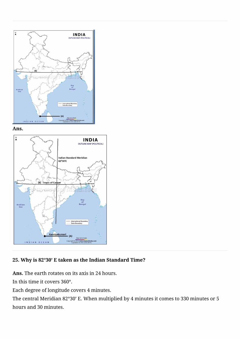
25.Whyis82°30’EtakenastheIndianStandardTime?
Ans.Theearthrotatesonitsaxisin24hours.
Inthistimeitcovers360°.
Eachdegreeoflongitudecovers4minutes.
ThecentralMeridian82°30’E.Whenmultipliedby4minutesitcomesto330minutesor5
hoursand30minutes.
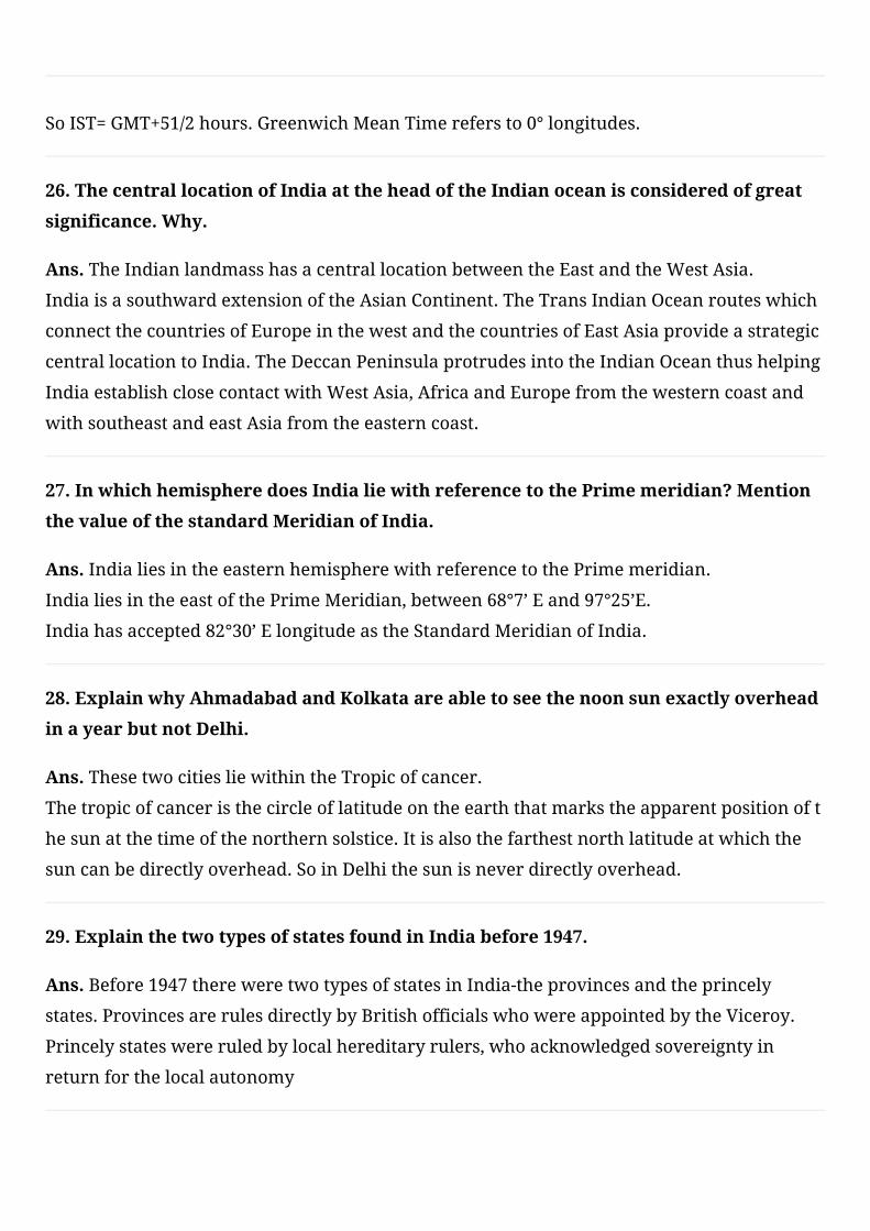
SoIST=GMT+51/2hours.GreenwichMeanTimerefersto0°longitudes.
26.ThecentrallocationofIndiaattheheadoftheIndianoceanisconsideredofgreat
significance.Why.
Ans.TheIndianlandmasshasacentrallocationbetweentheEastandtheWestAsia.
IndiaisasouthwardextensionoftheAsianContinent.TheTransIndianOceanrouteswhich
connectthecountriesofEuropeinthewestandthecountriesofEastAsiaprovideastrategic
centrallocationtoIndia.TheDeccanPeninsulaprotrudesintotheIndianOceanthushelping
IndiaestablishclosecontactwithWestAsia,AfricaandEuropefromthewesterncoastand
withsoutheastandeastAsiafromtheeasterncoast.
27.InwhichhemispheredoesIndialiewithreferencetothePrimemeridian?Mention
thevalueofthestandardMeridianofIndia.
Ans.IndialiesintheeasternhemispherewithreferencetothePrimemeridian.
IndialiesintheeastofthePrimeMeridian,between68°7’Eand97°25’E.
Indiahasaccepted82°30’ElongitudeastheStandardMeridianofIndia.
28.ExplainwhyAhmadabadandKolkataareabletoseethenoonsunexactlyoverhead
inayearbutnotDelhi.
Ans.ThesetwocitiesliewithintheTropicofcancer.
Thetropicofcanceristhecircleoflatitudeontheearththatmarkstheapparentpositionoft
hesunatthetimeofthenorthernsolstice.Itisalsothefarthestnorthlatitudeatwhichthe
suncanbedirectlyoverhead.SoinDelhithesunisneverdirectlyoverhead.
29.ExplainthetwotypesofstatesfoundinIndiabefore1947.
Ans.Before1947thereweretwotypesofstatesinIndia-theprovincesandtheprincely
states.ProvincesarerulesdirectlybyBritishofficialswhowereappointedbytheViceroy.
Princelystateswereruledbylocalhereditaryrulers,whoacknowledgedsovereigntyin
returnforthelocalautonomy
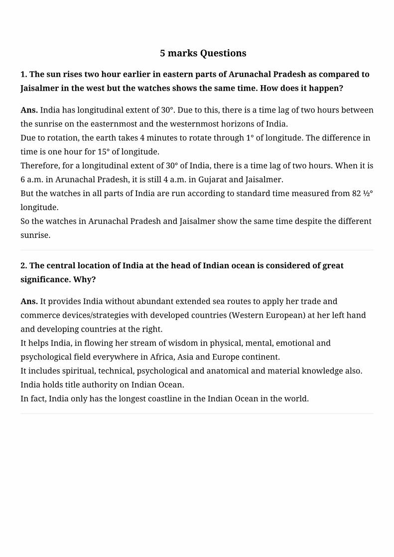
30.TwofeaturesAandBaremarkedinthegivenpoliticalmapofIndia.Identifythese
featureswiththehelpofthefollowinginformationandwritetheircorrectnameson
thelinesmarkedonthemap.
i)TheareawisesmalleststateonthewestcoastofIndia
ii)NorthernmostlatitudeofIndia
Onthesamepoliticalmaplocateandlabelthefollowing
iii)TheareawiselargeststateofIndia
Ans.
1.ThesunrisestwohourearlierineasternpartsofArunachalPradeshascomparedto
Jaisalmerinthewestbutthewatchesshowsthesametime.Howdoesithappen?
Ans.Indiahaslongitudinalextentof30°.Duetothis,thereisatimelagoftwohoursbetween
thesunriseontheeasternmostandthewesternmosthorizonsofIndia.
Duetorotation,theearthtakes4minutestorotatethrough1°oflongitude.Thedifferencein
timeisonehourfor15°oflongitude.
Therefore,foralongitudinalextentof30°ofIndia,thereisatimelagoftwohours.Whenitis
6a.m.inArunachalPradesh,itisstill4a.m.inGujaratandJaisalmer.
ButthewatchesinallpartsofIndiaarerunaccordingtostandardtimemeasuredfrom82½°
longitude.
SothewatchesinArunachalPradeshandJaisalmershowthesametimedespitethedifferent
sunrise.
2.ThecentrallocationofIndiaattheheadofIndianoceanisconsideredofgreat
significance.Why?
Ans.ItprovidesIndiawithoutabundantextendedsearoutestoapplyhertradeand
commercedevices/strategieswithdevelopedcountries(WesternEuropean)atherlefthand
anddevelopingcountriesattheright.
IthelpsIndia,inflowingherstreamofwisdominphysical,mental,emotionaland
psychologicalfieldeverywhereinAfrica,AsiaandEuropecontinent.
Itincludesspiritual,technical,psychologicalandanatomicalandmaterialknowledgealso.
IndiaholdstitleauthorityonIndianOcean.
Infact,IndiaonlyhasthelongestcoastlineintheIndianOceanintheworld.
5 marks Questions
3.WhensunrisesinArunachalPradeshitisstillnightinGujarat.Givereasons.
Ans.TheeasternmostlongitudinalextentofIndiais97°25’EatextremeendofArunachal
Pradesh.
ThewesternmostlongitudinalextentofIndiais68°7’EatextremeendofGujarat.
Thusthelongitudinalextentisabout30°.Itmeans30longitudespassfromeasttowest.
Thereistimedifferenceof4minutesbetweentwoconsecutivelongitudes.
Thetimedifferencebetween30longitudesis120minutesor2hour.
SothereistimedifferenceoftwohoursinlocaltimebetweenArunachalPradesh.
4.HighlightthesignificanceofgeographicallocationofIndia?
Ans.TheIndianlandmasshasacentrallocationbetweentheEastandtheWestAsia.
IndiaisasouthwardextensionoftheAsianContinent.
Indiahasanareaof3.28millionsquarekmwhichaccountsforabout2.4percentofthetotal
geographicalareaoftheworld.
Indiaisseventhlargestcountryoftheworld.
TheeasternmostlongitudinalextentofIndiais97°25’Eandthewesternmostlongitudinal
extentofIndiais68°7’E.
Indiaisboundedbytheyoungfoldmountainsinthenorthwest,northandnortheast.
5.JustifythenamingofIndianOceanafterIndia?
Ans.NoothercountryhaslongcoastlineontheIndianOceanasIndiahasandindeed.
ItisIndia’seminentpositionintheIndianOceanwhichjustifiesthenamingofanOcean
afterit.
IndiahascentrallocationbetweentheEastandtheWestAsia.
TheTransIndianOceanrouteswhichconnectthecountriesofEuropeinthewestandthe
countriesofEastAsiaprovideastrategiccentrallocationtoIndia.
TheDeccanPeninsulaprotrudesintotheIndianOceanthushelpingIndiaestablishclose
contactwithWestAsia.
6.HowhavebeenmountainpassesbeenhelpfulinIndiasincehistorictimes?Explain.
Ans.Indiaisboundedbytheyoungfoldmountainsinthenorthwest,northandnortheast.
Thevariouspassesacrossthemountainsinthenorththenorthshaveprovidedpassagesto
theancienttravelers.
Theserouteshavecontributedintheexchangeofideasandcommoditiessinceancienttimes.
TheideaofUpanishadsandRamayana,thestoriesofPanchtantra,theIndiannumeraland
thedecimalsystemthuscouldreachpartsoftheworld.
Thespices,muslinandothermerchandiseweretakenfromIndiatodifferentcountries.
7.WhyisIndiasaidtoenjoyastrategicpositionwithreferencetotheInternational
traderoute?
Ans.TheIndianlandmasshasacentrallocationbetweentheEastandtheWestAsia.
IndiaisasouthwardextensionoftheAsianContinent.
TheTransIndianOceanrouteswhichconnectthecountriesofEuropeinthewestandthe
countriesofEastAsiaprovideastrategiccentrallocationtoIndia.
TheDeccanPeninsulaprotrudesintotheIndianOceanthushelpingIndiaestablishclose
contactwithWestAsia,AfricaandEuropefromthewesterncoastandwithsoutheastand
eastAsiafromtheeasterncoast.
Thevariouspassesacrossthemountainsinthenorthhaveprovidedpassagestotheancient
travelers.
Theserouteshavecontributedintheexchangeofideasandcommoditiessinceancienttimes.
8.DescribeIndia’slocationwithreferencetoherneighbors.
Ans.TheIndianlandmasshasacentrallocationbetweentheEastandtheWestAsia.
IndiaisasouthwardextensionoftheAsianContinent.
IndiaoccupiesanimportantstrategicpositioninSouthAsia.
IndiaSharesitslandboundarieswithPakistanandAfghanistanintheNorthWestchinaand
NepalandBhutanintheNorth.
MyanmarandBangladeshintheeast.
OurSouthernneighborsacrosstheseaconsistofthetwoislandcountriesnamelySriLanka
andMaldives.
9.Howistheknowledgeoflatitudeandlongitudeimportantforpeople?
Ans.Thathelpsustounderstandandlocatesthegeographicallocationandglobebetter.
Theuseoflatitudesandlongitudeofferabetterandquickgraspofgeographicalfacts.
Itdeterminesthetimezonesofthedifferentregionsoftheworld.
Withthehelpoflongitudesandlatitudesitiseasytocalculatelocaltimeandstandardtime.
Longitudesandlatitudesarealsohelpingustocalculatethedistancefromoneplaceto
another.
10.WhataretheimplicationsoflargelandboundariesandvastcoastlineofIndia?
Ans.ThelargelandboundariesofIndiahavehelpedtodeveloplinkswithherneighboring
countries.
Itcontributedintheexchangeofideasandcommoditiessinceancienttimes.
TheideasoftheUpanishads,theRamayana,andtheGeetaetchavebecomeknowntothe
world.
TheIndianNumeralsaswellasdecimalsystemlongbackcrosstheborder,Arabstookthese
ideastothewest.
ThelongcoastlineontheArabianSeaandBayofBengalhashelpedIndiatodevelopclose
maritimecontactwithWestAsia,AfricaandEuropefromthewesterncoastandwithEast
AsiaandthesouthEastAsiafromtheeasterncoast.


![CHEMISTRY (19] - SelfStudys](https://static.fdokumen.com/doc/165x107/631f631785e2495e15105a6d/chemistry-19-selfstudys.jpg)