


Bahasa
Halaman
Hukum

!
!
!
!
!
!
!
!
!
!
!
!
!
!
!
!
!
!
!
!
!
!
!
!
!
!
!
!
!
!
!
!
!
!
!
!
!
!
!
!
!
!
!
!
!
!
!
!
!
!
!
!
!
!!
!
!
!!
!!
!!
!!
!
!
!
!
!
!c
!c
!c
!c
!c
!c
!c
!c
!c
!c
!c
!c
!c
!c
!c
!c!c
!c
!c!c
!c
!c
!c
!c
!c!c
!c
!c
!c!c
!c
!c
!c
!c
!c
!c
!c
!c
!c
!c
!c
!c
o
o
o
o
o
o
o
o
!o(
!o(
!c!c
!c
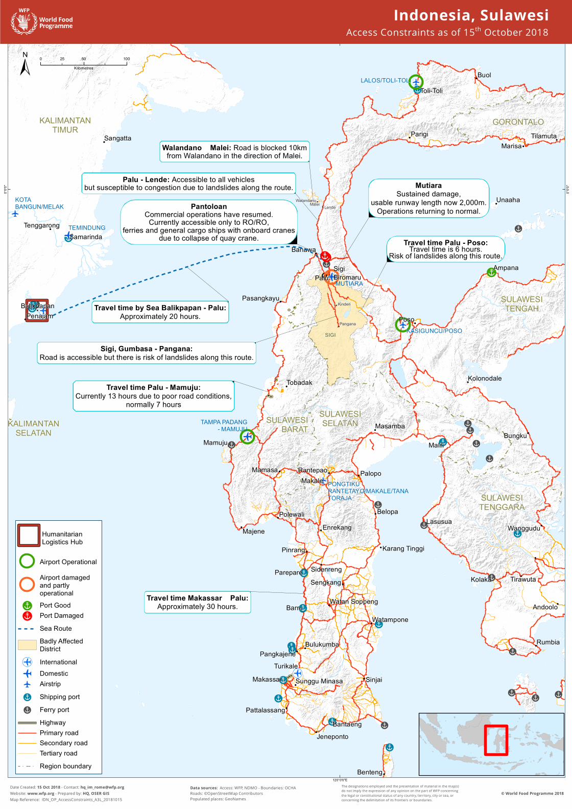
Travel time Palu - Mamuju:Currently 13 hours due to poor road conditions,
normally 7 hours
Travel time Palu - Poso:Travel time is 6 hours.Risk of landslides along this route.
Travel time by Sea Balikpapan - Palu:Approximately 20 hours.
Sigi, Gumbasa - Pangana:Road is accessible but there is risk of landslides along this route.
Travel time Makassar – Palu:Approximately 30 hours.
Palu - Lende: Accessible to all vehiclesbut susceptible to congestion due to landslides along the route.
Walandano – Malei: Road is blocked 10kmfrom Walandano in the direction of Malei.
MutiaraSustained damage,
usable runway length now 2,000m.Operations returning to normal.Pantoloan
Commercial operations have resumed.Currently accessible only to RO/RO,
ferries and general cargo ships with onboard cranesdue to collapse of quay crane.
KALIMANTANTIMUR
SULAWESIBARAT
SULAWESISELATAN
SULAWESITENGAH
SULAWESITENGGARA
GORONTALO
KALIMANTANSELATAN
TilamutaMarisa
Tenggarong
Sangatta
PenajamBalikpapan
Samarinda
Majene
Polewali
Mamasa
Mamuju
Pasangkayu
Tobadak
Benteng
BantaengJeneponto
Pattalassang
Sunggu Minasa SinjaiTurikale
BulukumbaPangkajene
BarruWatampone
Watan Soppeng
Karang Tinggi
SengkangSidenreng
Pinrang
EnrekangBelopa
Makale
Masamba
Malili
Rantepao
Makassar
Parepare
Palopo
Bungku
Poso
Banawa
Toli-ToliBuol
Parigi
Unaaha
AmpanaSigiBiromaru
Kolonodale
Palu
Kolaka
Andoolo
Rumbia
LasusuaWanggudu
Tirawuta
Malei Lende
Pangana
Walandano
Kinderi
SIGI
MUTIARA
TAMPA PADANG- MAMUJU
TEMINDUNG
KASIGUNCU/POSO
PONGTIKURANTETAYO/MAKALE/TANATORAJA
KOTABANGUN/MELAK
LALOS/TOLI-TOLI
120°0'0"E
0°0'0"
0°0'0"
Date Created: 15 Oct 2018 - Contact: [email protected] Website: www.wfp.org - Prepared by: HQ, OSER GISMap Reference: IDN_OP_AccessConstraints_A3L_20181015
± 0 50 10025Kilometres
The designations employed and the presentation of material in the map(s)do not imply the expression of any opinion on the part of WFP concerningthe legal or constitutional status of any country, territory, city or sea, orconcerning the delimitation of its frontiers or boundaries.
© World Food Programme 2018Data sources: Access: WFP, NDMO - Boundaries: OCHARoads: ©OpenStreetMap ContributorsPopulated places: GeoNames
Indonesia, SulawesiAccess Constraints as of 15th October 2018
!
HumanitarianLogistics Hub
Airport OperationalAirport damagedand partlyoperational
!c Port Good!c Port Damaged
Sea RouteBadly AffectedDistrict
!o( Internationalo Domestic
o Airstrip!c Shipping port!c Ferry port
HighwayPrimary roadSecondary roadTertiary roadRegion boundary
Top Related
Copyright © 2022 FDOKUMEN

