ZN THE NAME OF GOD THE MERCZFUL, THE BENEVOLENT
595
ZN THE NAME OF GOD THE MERCZFUL, THE BENEVOLENT
-
Upload
khangminh22 -
Category
Documents
-
view
0 -
download
0
Transcript of ZN THE NAME OF GOD THE MERCZFUL, THE BENEVOLENT

ZN THE NAME OF GOD
THE MERCZFUL, THE BENEVOLENT

INTERNATIONAL COURT OF JUSTICE
TERRITORIAL DISPUTE
(LIBYAN ARAB JAMAHIRIYAICHAD)
MEMORIAL
SUBMITTED BY THE
GREAT SOCIALIST PEOPLE'S LIBYAN ARAB JAMAHIRIYA
VOLUME 1
26 AUGUST 1991
VOLUME 1
TABLE OF CONTENTS
PART 1 INTRODUCTlON .................................................................................................. 1
CHAPTER 1. THE ORIGIN AND TERRITORIAL EXTENT O F THE DISPUTE ................................... . .......................................... . .................... 2
CHAPTER II. THE SPECIAL NATURE AND PARTICULARITY OF THE TERRITORIAL DISPUTE BETWEEN LIBYA AND CHAD.. . . . . ....... ... . . . . . . .......... . . . .. . . .. ......... . . . . . . . .......... . . ..... . . . . . ........ . . . . . . . . . . ........ 4
SEC~ION 1. The Dispute as Defined in the Accord-Cadre ................................. 5
SECI.ION 2. The Sorts of Considerations Relevant to the Resolution of Such a Dispute ...................................................................................... 6
SECTION 3. The Unique Role of the Senoussi ...................................................... 9
SECTION 4. The Contrast Between Lihya and Chad at the Time of Independence ..................................................................................... 12
SECTION 5. Aspects of the Colonial Past that Overshadow the Dispute ................................................................................................ 14
CHAPTER 111. STRUCTURE O F THE MEMORIAL .............................................. 16
SECTION 1. The Organization of the Memorial's Text ...................................... 16
SECTION 2. Annexes .......................... , .................................................................... 18
SECTION 3. Special Attachment of UN Maps .................................................... 19
PART II JURISDICTION .................................................................................................... 20
PART III GEOGRAPHICAL FACTS: THE REGION'S PHYSICAL GEOGRAPHY, PEOPLES, AND ECONOMY; AND THE IMPORTANCE OF THE SOUTHERN FRONTIER TO LIBYA'S SECUTITY .............................................................................................................. 25
CHAPTER 1. GEOGRAPHY ....................................................................................... 25
SECIION 1. Introduction ........................................................................................ 25
SECTION 2. The General African Setting of the Dispute .................................. 27
SECTION 3. The lin licaticins of the Special Environrnent of the Sÿhara b . esert ..................................................................................... 29
SECTION 4. important Physical Features Within the General Setting of the Dispute .......................................................................................... 33

SEC~ION 5 . Clirnate ................................................................................................ 36
CHAPTER II . THE INDIGENOUS PEOPLES ......................................................... 38
SI:CTION 1 . Introduction ........................................................................................ 38
S e r r i o ~ 2 . The Tribal Groups . Their Origin. Nurnbers and Location ......... 39
SECTION 3 . Senoussi Authority and Leadership in the Libya-Chad ......................................................................................... Borderlands 44
(a) The Role of the Zawiya as an Instrument of Senoussi Authority ..................................................................................... 44
(b) The Spread of the Senolissi Order int« the Sahara and the Sudan .................................................................................... 47
CHAPTER 111 . ASPECTS O F THE ECONOMIC GEOGRAPHY O F THE LIBYA-CHAD BORDERLANDS ...................................................... 55
SECIION 1 . Fezzan and Southrrn Cyrenaica ...................................................... 56
(a) The North/South Axis ............................................................... 56
(b) Effects of the Discovery of Oil and Water ............................. 57
(c) Conclusions ................................................................................. 58
SECTION 2 . An Overview of the Economic Geography of Chad and the ................................................................... Libya-Chad Borderlands 59
SEC~ION 3 . The Libya-Chad Borderlands ........................................................... 59
(a) Tibesti .......................................................................................... 60
(b) Ennedi ......................................................................................... 60
(c) Borkou-Ounianga ............................................................... 61
' SECI.ION 4 . The Effects of French and Chadian Policies .................................. 61
CHAPTER IV . THE IMPORTANCE O F LIBYA'S SOUTHERN FRONTIER TO ITS SECURITY ....................................................... 62
SECTION 1 . Factors Contributing to Libya's Vulnerability ............................... 62
SECTION 2 . The Relevance of the Geographical Situation to the Attribution of Territory in this Case ................................................ 65
PART IV THE IMPACT OF COLONIAL EXPANSION ON THE INDICENOUS PEOPLES: THE RESULTINC MODUS VIVENDI ............ 69
CHAPTER 1 . THE ARAB STATES O F NORTH AFRICA AND THE SUDANIC KINGDOMS IN THE 1YTH CENTURY ..................... 72
SECTION 1 . The North Afriçan Arab States ........................................................ 72

iii
International Relations hetween the North African States and the "Christian Nations" .............................................................. 75
The Siidanic Kingdoms and their Relations with the North African Arab States ........................................................................... 77
(a) The Sudanic Kingdoms ............................................................. 77
(b) The NorthISouth Trade Routes .............................................. 78
CHAPTER II . THE EUROPEAN COLONIAL EXPANSION IN THE REGION FROM THE 1870s TO 1914 ............................................... 84
SEC~ION 1 . Preliininary Aspects ........................................................................... 84
SEC~ION 2 . The Colonial Expansion in the Region: 1570-1900 ....................... 91
(a) The Lake Chad Area as the Main Europe.nn Colonial Objective ..................................................................................... 91
(b) France's Three-Pronged Advance on Lake Chad ................ Y2
(c) French Objectives. Colonial Rivalries and Turkish Attitudes. 1897-1900 .................................................................. 96
The Organized Peoples at the Time of European Colonial Expansion ......................................................................................... 102
(a) The Ottoman Administration in Fezzan ............................. 102
(b) The Senoussi's Special Role .................................................. 105
........................................................... (c) The Indigenous Tribes 105
The French Wars Against the Muslim Organized Peoples in the Periodl899-1909 ................................................................... 111
(a) The Senc~~issi as Organizing Power in Kanem ...................................................................................... by 1900 111
................................................ (b) The French Wars. 1900-1 909 115
(i) The First French Wnr: Against Rabbiih .................. 116
(ii) The Second French War: Bir Alali ........................... 117
(iii) The Third French War: Ouadaï ................................ 122
(c) The Limited Extent of a French Presence in the Area ................................................ During the Period 1900-1909 124
The 3910-1913 Interlude in the Area North of Lake Chad .............................................................................................. 126
(a) The Ottoman Militaiy Presence in the Libya-Chad Borderlands and Its Background .......................................... 126
(i) Ottoman Presence in Tibesti ..................................... 129

(ii) Ottoman Presence in Borkou .................................... 132
.................................... (iii) Ottoman Presence in Ennedi 133
........................... (b) French-Ottoman Relations in this Period 134
............................ (c) French-Senoussi Relations in this Period 142
The War Between ltaly and the Ottoman Empire and Its Consequences for the Situation in the Region ........................... 150
(a) The Italo-Ottoman War of 191 1-1912 ................................. 150
(b) The French War Against the Senoussi and the .................................... lndigenous Peoples Starting in 1913 153
(c) The Italian War Against the Senoussi and the ................................ Indigenous Peoples from 1923 to 1932 154
CHAPTER 111 . SUMMARY AND CONCLUSIONS ............................................. 156
PART V THE HISTORICAL BACKGROUND OF THE DISPUTE ......................... 159
CHAPTER 1 . FROM 1885 TO 1951 .......................................................................... 160
SECTION 1 . The 1885 Conference of Berlin ..................................................... 160
...................... SECKION 2 . The Anglo-French Declaration of 5 August 1890 161
......................... SECTION 3 . The Anglo-French Convention of 14 June 1898 165
SECTION 4 . The Anglo-French Additional Declaration of 21 Msrch 1899 ............................................................................................... 167
(a) The French Travaux Préparatoires of the 1889 Declaration ........................................................................ 167
(b) Certain Observations Concerning the Declaration's Final Text ........................................................................... 179
(c) The British Travaux ............................................................ 182
(d) Protests from the Ottoman Empire and Concern Voiced by ltaly ........................................................................ 184'
...................................... (e) The Effect of the 1899 Declaration 188
The 1900-1902 Secret Franco-Italian Accords ........................... 192
(a) The 1900 Secret Accord and the Travaux ........................... 194
................................ (b) Intervening Events: Ottoman Protests 197
(c) The 1902 Secret Accord and the Preliminary Travaux .................................................................................. 202
.................................................. The Secret Anglo-ltaliiin Accord 211

Attempts To Delimit the Tripolitanian Boundaries and Related Events up to World War 1 ............................................... 215
(a) Franco-Ottoman Boundary Negotiations (1910-1911) ........... ; .................................................................. 215
(b) Franco-ltalian Negotiations (1912-1914) ............................ 219
(c) The Proposed Expedition of Captain Tilho to Tibesti ................................................................................. 222
Italy's Invasion of Libya in 191 1 .................................................... 225
(a) Italy's lnvasion of Libya ........................................................ 225
(b) The Treaty of Ouchy .......................................................... 225
.................................................................. (i) The Firman 226
.......................................... (ii) The Granting of Amnesty 228
..................................................................................... World War 1 235
.................................................................... The 1919 Agreements 242
(a) Franco-Italian Accord of 12 September 1919 .................... 242
(b) The ~ n ~ l o - ~ r e n c ' h Convention of 8 September ........................................................................................... 1919 245
(c) Italy's Inquiries and Protest .................................................. 252
(d) The Differing Positions of Great Britain and ....................................................................................... France 255
The 1924 An 40-French Protocol and Declaration ............................................ Concerning t k e Sudanese Boundary 268
............................... Italo-Egyptian Accord of 6 December 1925 270
Treaties with the Senoussi ........................................................... 271
Continuing Franco-ltalian Negotiations (1920-1934) ................ 280
(a) Alternative Italian Programs ............................................... 282
......................................................................... (b) French Studies 286
(c) France's 1928 Proposal ........................................................ 288
(d) Italy's 1929 Counterproposal ............................................. 291
(e) Military Moves of ltaly and France ...................................... 294
(f) Italian School Map Incident .................................................. 299
(g) Further Formulation of the Italian and French Positions as to the Southern Boundary ................................ 299

SECTION 15 . Italo-Anglo-Egyptian Accord of 20 July 1934 Relating to the Libya-Sudan Boundary ................................................................... 303
SEC- ION 16 . The Final Phase of the Franco-ltalian Negotiations Rekating to the Southern Boundary of Libya (1934-1935) ........................ 314
Siin.io~ 17 . The 1935 Franco-ltalian Treaty (Treaty of Raine) .................... 324
SECIION 19 . Events Following the 1935 Treaty ................................................ 332
SECTION 19 . Libya During World War II ........................................................... 336
SECTION 20 . Post-War Debate ............................................................................ 339
CHAPTER II . FROM 1952 TO 1990 .......................................................................... 357
SECTION 1 . The Events Between Libya's Independence in 1951 and the Evacuation of French Forces frorn Fezzan in 1956 Pursuant to the Treaty of Amity Between Libya and France .................... 358
(a) The Conditions Facing Libya in 1951 as a Newly- Independent State ................................................................. 358
(b) The Military and Economic Agreements with the United Kingdom. the United States and France ................ 359
(c) The Treaty of Arnity of 10 August 1955 Between Libya and France ............................................................................... 361
(i) Relations Between France and Libya. 1951-1955 ..................................................................... 361
(ii) The Particular Circurnstances Leading to the Conclusion of the 1955 Treaty .................................. 363
(iii) The Objectives of the Parties in the Negotiations ................................................................. 365
(iv) Compensation to France with Respect to Security ......................................................................... 366
(v) Compensation to France with Respect to ....................................................................... Frontiers 368
(vi) Other General Political Aiins of France .................. 372
................................ (vii) The Course of the Negotiations 373
(viii) The Provisions of the 1955 Treaty Concerning ................................................................... Boundaries 385
(ix) The Relevance of the 1935 Franco-Italian Treaty of Rome in Understanding the 1955 Treaty ........................................................................ 392
(d ) The Agreement of 26 Decernher 1956 Between Libya and France Modifying Part of Libya's Frontier with Algeria ...................................................................................... 393

v i i
(e) Ratification of the 1955 Treaty ............................................. 396
(f) The Failure of the French Government To Register the 1955 Treaty Under Article 102 of the United Nations Charter Until 1991 .................................................. 401
(g) Other Conteinporary Events ............................................. 403
(i) The Moya Incident ...................................................... 404
................. (ii) Anglo-Libyan Manoeuvres Near Tibesti 407
........................................................... (iii) Discovery of Oil 408 . .
(iv) lssuance of the 1955 Petroleum Law by Libya ............................................................................. 409
The Events Between 1957 and 1977: Chad's Independence in 1960. and the Complaint Brought by Chad before the Organisation of African Unity (OAU) in 1977 ........................... 410
........................................................... (a) Independence of Chad 411
(b) The 1960 and 1964 French Military Agreements Relating to Chad .................................................................... 412
(c) The 1966 Libya-Chad Accord ............................................... 416
(d) Replacement of the Monarchy by the Lihyan Arah Republic on 1 September 1969 ............................................. 421
(e) Rupture and Reconciliation Between Libya and .......................................................................................... Chad 422
(f) Conduct of Chad (and Libya) Constituting Ackn»wled ement that the Libya-Chad Boundary
.................................................. Remained -f O Be Delimited 424
(i) The 1972 Libya-Chad Agreement of Friendship and Cooperation ........................................................ 424
(ii) The 1974 Protocole d'Accord ................................ 425
................................................................... SECTION 3 . The Events After 1977 427
PART VI THE LAW AND ITS APPLICATION TO THE FACTS ............................... 435
...................... . CHAPTER 1 . INTRODUCTION FACTUAL CONCLUSIONS 435
SECTION 1 . The Absence of a Conventional Boundary East of Toummo ........................................................................................... 435
SEC~ON 2 . Resolution of the Dispute Concerns the Attribution of ................................................ Territory Between the Two States 442

v i i i
CHAPTER II . THE LAW ............................................................................................ 447
..................................................................................... SECTION 1 . Introduction 447
SECIION 2 . The Integrity of Territorial Boundaries and the Role of the Rules of State Succession and Uti Possidetis Juris ................................................................................................... 449
.............................................. (a) The Rules of State Succession 451
(b) The Doctrine of Uti Possidetis Juris .................................... 453
The Status of the Territory during the Critical Period (1890- 1960) ................................................................................................. 455
(a) The Libya-Chad Borderlands Were Not Terra ....................................................................................... Nullius 455
(b) Title Rested with the Indigenous Peoples and with the Ottoman Empire and. Later. ltaly ....................................... 458
The Basis of French Claims in the Disputed Area ..................... 460
(a) Lack of a Conventional Boundary ......................................................................... or of Conquest 460
(b) The Legal Limitations on the Power of France To Acquire Territory by Force or Conquest ............................. 461
(i) The Covenant of the League of Nations ................. 461
(ii) The General Treaty for the Renunciatiun of .................................................................. War of 1928 466
..... ... SECTION 5 . The Role of Effectivite ................................................................ 470
SECTION 6 . The Attempts to Dispose of Title to the Libya-Chad ...................................................................................... Borderlands 472
.............................. SECTION 7 . The Right of Self Determination of Peoples 474
CHAPTER 111 . LIBYA'S CLAIM IN THIS CASE .................................................... 475

MAP INDEX
Map Number
Map No. 1
Map No. 2
Mrip No. 3
Base Maps A-G
Base Map A
Mep No. 4
Map No. 5
Mep No. 6
Map No. 7
Map No. 8
Map No. 9
Mzip No. 10
Map No. 11
Map No. 12
Map No. 13
Map No. 14
Map No. 15
Ap earing at L r a .
...................... General Setting (circular area) 1.09
General Setting (rectangular area) ............... 1.09
Pre- 1930 Bnundary hetween French West Africa and
................................ French Equatorial Africa 1.33
Specially prepared hase maps .................................... on which data is placed 3.03
h4,ag ;: C,
zind G i n Exhibit I I
........................................ Relief Map of Africa 3.07
LIinJlocked States ............................................ 3.08
Relief Map ........................................................ 3.09
Vegetation of Africa ..................................... (Saliel-Savanna Area) 3.10
Routes Followed in Colonial . . . Invasion ot Atrica ............................................. 3.11
Topogralhy of General Setting ( andtorm Map) ................................. 3.20
Geological Map of Area Small Scale 1: 15M) UNESCO) ....................................................... 3.21
Geological Mep of Area
....................................................... 3.21
Geological Map of Area (Scale 1:7.5M)
.................................. (Int. Geol. Map of Afr.) 3.27
Ve etation of Borkou ............................ an f Ounianga (Capot-Rey) 3.30

Map No. 16
Map No. 17
Map No. 18
Map No. 19
Map No. 20
Map No. 21
Map No. 22
Map No. 23
Map No. 24
Map No. 25
Map No. 26
Map No. 27
Map No. 28
Map No. 29
Map No. 30
Map No. 31
Map No. 32
Vegetation of Africa .......................................... (North of Equator) 3.31
Dividing line: Fixed Dunes - Active Dunes .... ; ................................. 3.31 pnl Rainhll
and Libya-Chad orderlands) ..................................................... 3.32
Africa: Regions where Islam Predominates ......................................... 3.35
Indigenous Trihes of the Tibesti Region (after Chapelle) ................................................ 3.35
Senoussi Control Over Indigenous Tribes, Circa 1902: Locations of Trade Routes and Zawiyas ......................................... 3.53
T l a t i o n Densit Chad and Libya- ? had orderlands - Le Rouvreur) ........................... 3.80
Industries of Chad and Libya-Chad Borderlands (showing northern limit of
.................................................... precipitation) 3.82
Oil and Gas Pipeline Network ........................................................... 3.98
.................................. Great Man-Made River 3.99
Distances: Middle of Tibesti - Petroleum Fields; Middle of Tibesti - Latitude
................................................. of N'Djamena 3.106
........................................... Libyan "Corridor" 3.107
The Hostile Island (map reversed) ............................................... 3.107
De facto Boundary Between 7-
Ottoman and French Forces 1909-1913 .......................................................... 4.06
The Sudaiiic States: 16th Century ..................................................... 4.20
Central Saharan Trade .................................... 4.25 Routes
France's Three-Pronged Advance on Lake Chad ................................... 4.56

Map No. 21
Map No. 33
Map No. 34
Map No. 35
Map No. 36
Map No. 37
Map No. 38
Map No. 39
Map No. 40
Map No. 41
Map No. 42
Map No. 43
Map No. 44
Map No. 45
Map NO. 46
Senoussi Control Over lndigen«us Tribes, Circa 1902: Locations of Trade
..... ................................... Routes and Zawiyas ; 3.53 4.90
Map in Report of Colonel Largeau (1903) (showing northern liinits
............................... of French rnilitüry posts) 4.108
Distribution of French and Turkish Forces, 1910 (Ziguei-Arada linr) ........................................ 4.120
Distribution of French and Turkish Forces: 1910 Vilayet of Tripoli Boundary
................................ Recoinmendation: 1911 4.141
1890 Anglo-French Declaration
.......................................... (Say-Barroua Line) 5.08
1890 Ottoman Claim: Tripolitaiiisin Hinterliind ............................... 5.10
Comparative lnland Extent of Hinterlands ...................................... 5.10
1898 Anglo-French Conventiiin (Maps Nos. 1 and 2 Annexed) ........................ 5.16
1899 An@-French Declaration (Livre jaune Map) ............................................ 5.16
..................................... The Fachoda Incident 5.18
Cambon SE Line to ................................................. Bahr Al Ghÿzal 5.20
Lord Salisbury's "Horseshoe" Shaped Tripolitania Hinterland ......................................................... 5.22
Tripolitanian Boundary According to 1899 Livre jaune Map ......................................................... 5.26
Extension of Say-Barroua .................................................................... Line 5.30
British Proposal for NW/SE Line Starting at 1FN-23"E .............................. 5.35

x i i
Map No. 47
Map No. 44
Map No. 48
Map No. 49
Map No. 50
Map No. 51
Map No. 52lA
Map No. 52/B
Map No. 53
Map No. 54 Map No. 55
Map No. 56 Map No. 57
Map No. 58
Map No. 59
Map No. 47
Gap Between Art. 2 Boundary and Art. 3 Zone of lnfluence SE Line .............................................................. 5.42
Tripolitania Boundary According to 1899 Livre jaune Map ......................................................... 5.26
5.70 1899 Anglo-French Declaration Livre jaiine Map) 6 eproduced on
....................................................... Base Map C 5.93
British Foreign Office Sketch Ma of Tripolitania l . Boundary howing the Caravan Routes ................................................................ 5.93
Strict SE Line Com ared With Livre jaune ~l!~ine ............................... 5.98
191 0 Franco-Ottoinan Convention Delimiting Libya-Tunisia Boundary ................................ 5.111
Boundary Recommended by Vilayet of Tripoli; 19 1 1 ................................. 5.1 14
Cornparison Between: 1890 Ottoman Claim - 191 1 Recoinmendation of Vilayet ......................................................... 5.114
Turkish-Ottoman Occupation 1906-1913 ........................................................ 5.1 16
Itiilian Maximum Program 1916 .................................................................. 5.158
Italien Mimimum Program 1916 .................................................................. 5.159
Franco-Italian Accord of 12 September 19 19 Compared to Former Tripolitanian Boundary According to 1899 Livre jaune Map ............................................. 5.168
Franco-ltalian Accord of 12 September 1919 Showing Caravan Route Between Ghadamès
.......................................................... and Ghat 5.168
Gap Between Art. 2 Boundary and Art. 3 Zone of Influence SE Line .............................................................. 5.42
5.175

xiii
Map No. 60
Map No. 61
Map No. 62
Map No. 63
Map No. 64
Map No. 65
Map No. 66
Map No. 67
Map No. 68
Map No. 69
Map No. 70
Map No. 71
M;ip No. 72
Map No. 73
Map No. 74
Anglo-French Convention of 8 September 1919 (Peace Congress Map) .................................. 5.176
Comparison: 1919 SE Line- Strict SE Line .................................................. 5.176
Comparison: 1919 SE Line - 1899 Livre jaune Map Line -
.................................................. Strict SE Line 5.179
British War Office Mep, 1916 Shuwing Line Undrr Art. 3 of the 1899 Declaration as
............................ Almost as a Strict SE Line 5.182
Line of 22"N Hypothetically Extended West of 25"E ................................. 5.199
1899 Livre jaune Map Line: "en pointillé" - "en trait
............................................................ plein" 5.201
1925 Italo-Egyptian Accord (Extended to 22"N) ........................................ 5.220
Map of Colonel Tilho ........................................................ 1912-1917 5.250
Italian Maximum Program, 1928 (Original and Reproduction
.............................................. on Base Map B) 2 1
Comparison: 1890 Ottoman Claim - 1928 Italian Maximum Program ........................................ 5.252
Italian Medium Program, 1928 -. -- (Original and Reproduction
.............................................. on Base Map B) 5.251
Italian Minimum Program, 1928 (Original and Reproduction
.............................................. on Base Map B) 5.25 1
....................... Fourth Italian Program, 1928 5.255
Comparison: Minimum ltalian Program, 1928 - Vilayet of
................................... Tripoli Proposal, 191 1 5.257
1928 ~renc 'h Pro osal (Foreign Office 5!' ketch Map) ....................... 5.260

x iv
Map No. 75lA
Map No. 75lB
Map No. 76
Map No. 77
Map No. 78
Map No. 79
Map No. 80
Map No. 81
Map No. 82
Map No. 83
Map No. 84
Map No. 85.1
Map No. 85
Map No. 86
Map No. 87
1928 French Proposal- 1929 ltalian Proposal - and Related Lines (British War Office Map, 1930) ................... 5.263
1928 French Proposal - 1929 ltalian Claim - and Related Lines (Reproduced on Base Map B) .............................................. 5.263
Comparison: Minimum ltalian Program, 1928 - Italian
................................................ Proposal, 1929 5.265
1929 Italian Proposal: No Interruption of Communication Between
........................................... A.O.F. and A.E.F 5.266
ltalian School Atlas Map, 1930 (Showing Southern Boundary) ........... 5.278
ltalian School Atlas Map, 1930, as Modified on Instructions of the Government
................. (No Southern Boundary Shown) 5.279
Alternative Italian Boundary, 1930 (Original and Reproduction on Base Map B) .............................................. 5.280
1932 Italian Protest Against ............................. French Garrison at Tekro 5.283
Sarra Triangle ................................................. 5.286
1935 Treaty Line (Sketch and Reproduction
............................................. on Base Map D) 5.320
1939 Italiiin Map .............................. (No Southern Boundary) 5.352
Libyü under Foreign Administration .......... 5.357
1948 Map (Frontiers of Libya) Prepared by Research Department, British Foreign Office .................................... 5.365
1946 French Proposa1 .................................... 5.366
UN Map No. 241, Jan. 1980, "Libya: Sketch Map of Frontiers", Attached to UN Secretariat . Study ................................................................ 5.377

Map No. 88
Map No. 89
Map Attaclied to Four Power Coinmission Report, 1949 (with notes) ..................................................... 5.381
Map Attached to Four Power Commission Report as Published by tlie French Government (with notes) .............................. 5.381
Map No. 90 French Map Furnished to ........................ the Four Power Cominission 5.381
UN Map No. 235 UN Ma s portraying UN Map No. 256 Libya's ! outhern Frontier
................................... UN Map No. 256(A) (Subject to Disclaimer) 1.48 UN Map No. 256 at end of (Rev.1) Chap. 1
Map No. 91 M;ip A - Received hy British Foreign Office from French Embassy, 12 July 1955 ................................... 5.454
Map No. 92 Mtip B - Received hy British Foreign Office from French
................................... Embassy, 12 July 1955 5.454
Map No. 93 Annex 1, 1955 Treaty, showing 1919 Boundary and
.............................................. Caravan Routes 5.488
Map No. 94 1919 Boundary and Carevan Routes, Ghadamès, Toumino ...................... 5.489
Map No. 95 Comparison: Annex 1, 1955 Treaty, and 1956 Accord Boundaries Rectifying 1919 Boundary ......................................................... 5.489
Map No. 96 Map No. 1 to Liby;in Petroleum Regulation No. 1,
.................................................................. 1955 5.525
Map No. 97 Cover Page of Mep No. 1 of Libyan Petruleuin
............................................ Regulation No. 1 5.525
Map No. 98 1966 Libya-Chad Treaty: Zone of Circulation of
........................................... Nomadic Peoples 5.541
Map No. 99 1955 Convention de bon voisinage: Zone of Circulation of Nomadic Peoplrs ............................................................ 5.543
Map No. 100
Map No. 101
Map No. 102
Map No. 103
Map No. 104
Map No. 21
Map No. 69
"Aouzoii Strip" (According to Bouquet) ................................ 5.559
"Aouzou Strip" (According t« French
...................................... Ambassador Touze) 5.559
Mjlitary Situation in Chad and Lihys-Ch:id Borderlands, Septemher 1983 (Colonel Spartacus) .............................. 5.568
Ligne Rouge at 16"N - January 1984 (Coloiiel Spartacus) ....................................... 5.569
Military Situation in Chad and Libya-Chad Borderlands, Septemher 1984 (Colonel Spartacus) ....................................... 5.569
Senoussi Control Over Indigen«us Tribes? Circa 1902: Locations ot Trzide Routes and Zawiyas ......................................... 3.53
4.90 6.25
Comparison: 1890Ottoman Claim - 1928 1tali;in
........................................ Maximum Program 5.252 6.82
Map No. 105 Lihya's Claim .................................................... 6.83
Map No. 106 Comparison: Lihya's Claim - Ottoman-Frencli De Facto line 1910-1913 .......................................................... 6.85
Map No. 107 Comparison: Libya's Clziim - Bound;iry Line Recommended to the Porte hy the Vilayet of Tripoli, 19 11 ...................................................... 6.85
Map No. 108 Comparison: Lihya's Claim - Miniiiium ltalian Program, 1928 .................................................................... 6.85
Map No. 109 Comparison: Lihyzi's Claim - .......................... French Lignes Rouges, 1984 6.85

xvii
VOLUME 2:
VOLUME 3:
VOLUME 4:
VOLUME 5:
VOLUME 6:
INTERNATIONAL ACCORDS AND AGREEMENTS ANNEX
FRENCH ARCHIVES ANNEX
BRITISH ARCHIVES ANNEX
ITALIAN ARCHIVES ANNEX
EXHIBITS ANNEX Eirt 1 Exhibits 1 - 35 Part 11 Exhibits 36 - to end

PART 1
INTRODUCTION
1.01 This case was brought before the Court under Article 40,
paragraph 1, of the Statute of the Court by notification of an agreement, entitled
"Accord-Cadre sur le règlement pacifique du différend territorial entre la Grande
Jamahiriya arabe libyenne populaire et socialiste et la République du Tchad".
The notification was filed with the Registry on 31 August 1990 on behalf of the
Great Socialist People's Libyan Arab Jamahiriya (hereinafter referred to as
" ~ i b ~ a " ) ' . By this notification, Libya submitted to the Court the territorial
dispute ("différend territorial") between Libya and the Republic of Chüd
(hereinafter referred to as "Chad"), as conternplated by Article 2 of the Accord-
Cadre. In its notification, Libya defined the question put to the Court in the
following terms:
"ln further implementation of the Accord-Cadre. and taking into account the territorial dispute between the Parties, to decide upon the limits of their respective territories in accordance with the rules of international law applicable in the matter."
1.02 On 3 September 1990, an application was filed with the
Registry of the Court on behalf of Chad instituting proceedings against Libya
based on Article 2(a) of the Accord-Cadre and, subsidiarily, on Article 8 of the
Franco-Libyan Treaty of Friendship and Good Neighbourliness of 10 August
1955 (the "1955 Treaty"). In its application Chad requested the Court -
"... de déterminer le tracé de la frontière entre la République du Tchad et la Jamahiriya arabe libyenne, conformément aux
s de droit international applicables en la matière
As translated into English by the Registry, this request was -
"... to determine the course of the frontier between the Repuhlic of Chad and the Libyan Arab Jamahiriya, in accordance with the
-- -
1 The Accord-Cadre as prinled and translaled hy the Rcgistry togeiher with the relaicd noiilicaiions. appliwiions and leiten of ihc Parties m q be found in ihe lnlcrndtional A~xords and Acrermenis Annrx, No. 39.
2 Ihid.. p. 20.

principles and rules f international law applicable in the matter as f ' ! t between the Parties .
1.03 The Application of Chad was supplemented by a letter
dated 28 September 1990 informing the Court that, having noted that its claim
"coincides" with that contained in Libya's notification of 31 August 1990, Chad
considered that -
"... those two notifications relate to one single case, referred to the Court in application of the Aigiers Agreement, which constitutes the Special Agreement, the p inci al basis of the Court's 4 , P jurisdiction to deal with the matter .
1.04 As indicated in the Court's Order of 26 October 1990, at a
meeting between the President of the Court and the Parties on 24 October 1990,
agreement was reached that the proceedings in the case had in effect been
instituted by two successive notifications of the Accord-Cadre and that the
procedure in the case should be determined by the Court on the basis of a
notification of a special agreement under Article 46, paragraph 2, of the Rules of
Court.
CHAPTER 1. THE ORIGIN AND TERRITORIAL EXTENT OF THE DISPUTE
1.05 From the papers filed so far, there appears to be a
fundamental difference between the Parties as to the origin and territorial extent
of the dispute. As to the d i s p u t e ' s m , Chad stated in its Application that "[]le
tracé de la frontière" between Libya and Chad "n'a fait l'objet d'aucun différend
jusqu'aux années 1 9 7 0 ~ . In this same paper, Chad claimed to have inherited its
boundüries with Libya from France at the moment of its independence and that
the course of these boundaries was determined in a series of agreements
concluded between 1898 and 1924 by France and Great Britain and acquiesced in
by Italy. What Chad did not mention is that these claimed frontiers, supposedly
inherited from France, were vigorously contested, first, by the Ottoman Empire
and, subsequently, by Italy, right up until the start of World War II; that the
French military incursions into the disputed regions were forcibly opposed by the
3 - Ihid.. p. 21.
4 - Ibid., p. 25.
5 - lhid., p. 14.

indigenous tribes inhabiting them; and that after the War, when the question of
the disposal of the former ltalian Colonies was referred to the United Nations,
the General Assembly recognised the fact that the southern frontier of Libya with
the French territories that are now Chad had yet ta be delirnited by international
agreement.
1.06 In contrast to the position of Chad, Libya's notification
observed -
"... that the territory in dispute has a long and complex history. The determination of the limits of the respective territories of the Parties in this region involves, inter alia, a consideration of a series of internationül agreements although, in the view of Libya, none of these agreements finally fïxed the boundary between the Parties which, accordingly, remains to be establish d in accordance with 8 the applicable principles of international law ."
1.07 A substantial part of this Memorial will be devoted to
demonstrating these points. The territorial dispute in this case does not just date
from the 1970s; it has its origins in the events affecting Africa at the time of the
1885 Conference of Berlin when the claim to territorial rights and titles of the
Ottoman Empire extended over much of this area; and the European Powers,
poised for the partition of Africa among them, undertook to respect the rights
and integrity of the Ottoman Empire in subsequent declarations. The territorial
dispute that evolved from the colonial partitioning of Africa involved at different
periods of time the Ottoman Empire, Great Britain, France and Italy; it also
concerned most directly the inhabitants of the regions being quarrelled over, the
tribes and peoples led by the Senoussi Order.
1.08 As to the territorial extent of the dispute, since Chad
evidently believes its boundaiy with Libya was fixed by international agreements
that are binding on Libya and Chad, its request to the Court is a narrow one: "de
déterminer le tracé de la frontière". In many of Chad's official public utterances,
the dispute has been said to be over an area called the "Aouzou strip" or "bande
d'AouzouM. This is not so; the case concerns a "territorial dispute", and its
resolution calls for the attribution of territory as between Libya and Chad based
on which State has the better claim to title over territories to which title has not
been resolved by any international agreement. These territories in dispute are
not restricted to the so-called "Aouzou strip", which may be a convenient, short-

hand way to refer to this territorial dispute but which does not define - and in fact
is quite misleading as to - the territorial extent of the dispute.
1.09 Since the dispute is not over the choice of one boundary line
or another established by treaty, its territorial extent cannot be precisely defined.
However, in Lihya's view it concerns the regions of Tibesti, Erdi, Ounianga,
Ennedi, Borkou and northern Kanem, lying generally north of 15"N latitude. In
this Memorial, these regions will be referred to as the "Libya-Chad borderlands",
which appear on Mao No. 1. These regions are encompassed within ü somewhat 7 larger area identified as the "General Setting" ( M a ~ s Nos. 1 and 2) . This is the
general area in which the events bearing on this dispute have taken place and to
which frequent reference will be made below. .In making this geographical
reference, Libya does not cal1 into question here its boundaries with other
adjoining States not parties to this dispute, each having its own distinctive
background, history and legal basis.
CHAPTER II. THE SPECIAL NATURE AND PARTICULARITY OF THE TERRITORIAL DISPUTE BETWEEN LlBYA AND CHAD
1.10 While it is true that no two cases concerning ü territorial
dispute are ever exactly alike, since each case depends on geographical and
historical facts necessarily specific to it (and where a cornoromis is involved, the
Court's competence is governed by its particular text), there are in this case
certain distinctive elements that distinguish it in important respects from other
territorial disputes or land boundary cases, such as, for example, the Burkina
FasolM~ili case, decided a few years ago by the court8. These elernents will be
set out below considering, first, the Accord-Cadre, second, the kinds of
considerations relevant to this particular dispute submitted under the Accord-
Cadre, the unique role played by the Senoussi, and, finallv, certain other aspects
of the dispute that illustrate its particularity. In summary fashion, this Chapter
encapsulates much of the case set out later in the Memorial, so it serves as a tour d'horizon of the case as Libya sees it. The support for the propositions made
below will appear in the succeeding parts of this pleading.
7 - See. para. 1.13. helow. where the purpose of defining ihe General Seiiing is discusscd more fully. S. also. para. 3.02. g B., hcluw, and in pariicular para. 3.04. which discmes the legcnd ihat a p p n un ihc maps specially prcpared hy Lihya tu illusiraic ihis Mcmurial.
8 Froniier Disouie. Judrmenc. I.CJ. Reoorts 19%. p. 554.

Map NO. 1
Lambert Conlormal Conic Projeaion Scale accurate at the equator
1:515a),OW


SECTION 1. The D i s ~ u t e ns Defined in the Accord-Cadre
1.11 As already noted, the dispute submitted to the Court
concerns a "territorial dispute" between Libya and Chad. 'Territorial disputen is
the term used consistently throughout the text of the Accord-Cadre. Article 2 required the Parties to submit this territorial dispute to the Court within a period
9 of approximately one year if settlement by political means was not reached . As a
result of a failure to reach such a settlement, the dispute is now before the Court
following notification of the Accord-Cadre as a Special Agreement; and the
Parties are in accord as to the jurisdiction of the Court, based on the Accord-
Cadre.
1.12 Given the circumstances of this case, the words "territorial
dispute" were well chosen. They are appropriately broad in scope to reflect the
fact that this is not a narrow dispute over whether one boundary line or another is
the proper boundary. Nor is it over the interpretation of a treaty fixing a
boundary in order to determine just where that boundary lies. It also does not
concern the determination and upgrading of colonial boundaries within the
territory of a single colonial Power in application of the principle of possidetis
ju& or in application of Resolution AHGIRes. 16 (1) of the Organisation of
African Unity ("OAU"), the so-called Cairo Declaration, adopted in July 1964,
after both Libya and Chad had already achieved independencelO.
1.13 As its background and history establbh, this dispute
concerns the attribution of territory in circumstances where no conventional
international boundary exists. This is the task the Court has been called on to
perform in order to resolve the dispute. The territory to be attributed lies within
the General Setting of the dispute, portrayed on Maos Nos.1 and 2. The purpose
of this portrayal of the General Setting is to draw the Court's attention to the
general geographical area in which the dispute is located and where the events
relevant to the dispute have occurred. It is on@ intended as a means of
geographical reference. Libya submits that, within the General Setting, Libya has
a clear title to those regions within the Libya-Chad borderlands that are described
9 'Article 2 In the ahsence ot a politiwl settlement or the terflt«ri;il dispute, the two Parties underiake: (a) tosuhmii the dispute to ihe International Court ofJustice ... ."
10 B, OAU Resoluiion AHGjRes. 16(1). 21 July 1964,- 1.

in the Submissions and illustrated on Mau No. 105, which appears at the end of
Part VI.
1.14 It is evident that before addressing the task of attribution of
territory, a preliminary question kas to be resolved. Does a boundary presently
exist pursuant to international agreement delimiting the frontier between Libya
and Chad east of Toummo'! In the presentation to the United Nations of its
position on several different occasions, Chad has maintained that there is such a
boundary. In its Application to the Court filed on 3 September 1990, Chad
reiterated this position. This was also France's official view. Libya denies there is
any such conventional boundary. Well before Libya's independence, the Ottoman Empire and ltaly both denied there was such a boundary. In 1950, the United
Nations General Assembly recognized the absence of such a boundary in
adopting Resolution 392(V), which called upon France and Libya to negotiate to
delimit the portion of the boundary between Libya and French territory not already delimitedl'. The background of this Resolution reflects the fact that the
portion of the boundary at which the Resolution was aimed concerned Libya's
southern frontier. Had a boundary east of Toummo already been delimited in
1950, Resolution 392(V) would have had no purpose. No negotiations ever
followed between Libya and France to delimit the territory now in dispute
between Libya and Chad; and since then there have been no negotiations
between Libya and Chad leading to a boundary being f ied .
1.15 As a result, the dispute submitted to the Court involves two
main tasks: resolving the question whether such a boundaiy has been fixed by
international convention; and once it has been determined by the Court that no such boundary has been f i e d - a conclusion that Libya feels is inevitable - then
attributing the territory in dispute between Libya and Chad on the basis of which
State has the better claim to title.
S ~ n i o ~ 2 . The Sorts of Considerutions Relevant to the Resolution of Such a Dispute
1.16 In the 1955 Treaty of Amity between them, Libya and
France agreed that the basis on which Libya's boundaries with France or with
French territories were to be determined, in negotiations'contemplated to follow
11 Unitcd Nations, Oflicial Rccords o f the Fifih %si<in o f the Gcncral kcscmhly. Supplçmeni No. 20 (N173). 15 December 1950. (A copy of Resolution 392(V) is actached as 2)

the Treaty, was to be the "actes internationaux" in force at the time of Libya's
independence (24 December 1951)12. Annex 1 of the Treaty contained a list of
these "actes"13. Thus, Libya and France reached agreement in 1955 on both the
criteria for making this determination and the date at which the criteria were to
be applicable. However, they never proceeded to negotiate the boundary
between the Libyan and Chadian territories as called for by General Assembly
Resolution 392(V) and as contemplated by Article 3 of the 1955 Treaty. In the
period after Chad gained its independence, no progress has been made by Lihya and Chad to negotiate the delimitation of the boundary. This is entirely
understandable in the light of the totally opposed views held by Libya and Chad
as Io the applicability and effect of the international agreements in force as of December 1951.
1.17 Therefore, Libya respectfully submits that the first task of
the Court is to examine in detail al1 relevant agreements and the results that flow
from them in order Io determine whether at the time of Libya's independence a
conventional international boundary existed between Libya and what is now
Chad. Chapter 1 of Part V of this Mernorial is largely devoted to such an
examination.
1.18 Having disposed of this question, the Court must deal with
the question of which Party has the better claim to title. Here a wide range of
facts are relevant, for the criteria to be applied are considerably broader and
quite different than would be the case were this a dispute that merely concerned
the choice of one boundary line or another as the boundary defined by a treaty.
1.19 The history of the dispute from its inception in colonial
times must be examined, including such matters as when the dispute arose, the
parties concerned, the rival claims made and their legitimacy at the time. Since
the dispute arose out of claims asserted by the Ottoman Empire and claims made
hy France by virtue of agreements made between France and Great Britain, going
back as far as 1890, the colonial environment, the meaning of such claims at the
time, and the rather different concepts of the Ottoman Empire based on Muslim
precepts from those of the European Powers as to sovereignty and territorial
12 Traite d'Amiti6 et de Bon Voisinage enlre la Republique Française et le Royaume Uni de Libye. Tripoli, IOaoOi 1955. Inlernali~~nal Accords and Acreemenis Annex. No. 23.
13 S. para. 5.477.- B.. belw. for a discussion as Io why this was not an exclusive lis1

boundaries, will bear directly on this case. So also do the situation and attitudes
of indigenous tribes whose territory was being carved up into spheres of influence
in Paris and London without any consultation with them, with virtually no
knowledge of what was being carved up, and without consultations with third
States that had a direct, legitimate interest in the territories and that repeatedly
had asserted their claims to it and had protested the Anglo-French agreements
purporting to allocate zones as between these two Powers within these territories.
1.20 The geographical characteristics of the region are also
factors to consider because, inter alia, they concern the security interests of the
two States in the light of the geographical setting. In addition, determining the
basis of title over very sparsely populated regions, such as the Sahara Desert, is
not like making such a determination as to populated regions of Europe, for
example. The assertion and exercise of sovereignty in such barren areas - particularly at the time the claims were made by the Ottoman Empire - would
inevitably be backed by rather minimal evidence of "effectiveness". The nature of
the Sahara Desert must be understood in the context of colonial tiines; only its
oases were places to inhabit; othenvise, it was a region to pass through. The
desert provided the northlsouth connecting link between the Mediterranean Sea
(and Europe beyond) and the sudan14. This was accomplished by the caravan
routes, supported by scattered oases, the control and protection of which were
among the key indications of sovereignq in the region.
1.21 It will be demonstrated below in Part IV that the regions
that were the object of the rival claims that are at the origin of this dispute were
not terra nullius. In their southern reaches, known then as the Sudan, where the
French military expeditions into this region had first set foot - in the vicinity of
Lake Chad and to its south - there had existed for rnany centuries a series of
Muslim Sultanates or Kingdoms. North of the Sudan were organized tribes and
confederations of tribes, some of which had come from Libya, others that had an
ancient history in the region. Their relationship to the of Tripoli (which at
the time included Benghazi) and to the Ottoman Empire, and towards the end of
the 19th Century onwards, their relationship to the Senoussi Order, are
considerations having a direct bearing on which State has the better claim to title
tu these regions.
14 S. para. 3.51. helow. and relaled fn., where "Sudan" is defind.

SECTION 3. The Uniaue Role of the Senoussi
1.22 The importance of the role played by the Senoussi during
this period is dealt with in subsequent portions of this Mernorial; and so it is
necessary to set out at the outset what is meant by the name "Senoussi".
"Senoussi" refers to the Islamic Order or Brotherhood (Confrèrie) founded by
Sayyid Muhammad bin Ali al-Senoussi, the "Grand Senoussi", in 1837 near
~ e c c a l ~ . The first & to be established in Libya was at al-Baida in northern
Cyrenaica in the hills (or m) behind the shores of the Mediterranean, in 1.843. The nature and functions of the a, a sort of monastery, are described below
at paragraph 3.45. "Senoussi" is also used to refer to the family and descendants
of the Grand Senoussi -for the leadership of the Order was hereditary - as well as
to the followers of the Senoussi Order, the ikhwan ("brothers").
1.23 The Senoussi leadership exercised its functions and
authority through the delegation of authority to members of the family or other
notables. Important in this chain of command were thesheikhs in charge of each
&, which served as central points of Senoussi authority and administration.
The Senoussi leadership, including the sheikhs of the zawivas, was Libyan; al1
were either appointed by the Head of the Senoussi Order or elected by the
ikhwan.
1.24 Although the Order was essentially a revivalist movernent in
Islam, its mission among the tribes of North Africa and the Sudan cannot be
separated into a spiritual and a temporal one. For the concept of separation of
Church and State, which may characterize ~h r i s t i an i t~ , does not exist in Islam,
and certainly did not for the Senoussi Order. When the tribes in this region - such
as the Zuwaya and Mijabra of southern Cyrenaica, the Awlad Sulaiman and
Tuareg of Fezzan and Kanem and the Toubou, Bideyet and Zaghawa of Tibesti,
Ounianga and Ennedi - were introduced to the precepts of the Senoussi Order,
and their members became ikhwan or followers, these tribes became, in effect,
"Senoussi tribes". The name Senoussi was applied widely to the followers of the
Order, which included virtually ail the Islamic tribes and indigenous peoples in the General Setting of this dispute. It was the unity of these tribes under the
- - -~ p~
15 A full discussion of the Senoussi Ordcr appears ai para. 3.45. g! M., helow. The Ordcr iiself is sometimes referred to as the knoussiya. As is oIlen ihe case wiih Arabic words put into English. there are several variations in the spelling of the name "Senoussi".

Senoussi, rather than their separateness as tribes, that became the signifiant
factor.
1.25 Thus, the authority exercised by the Senoussi Order in the
Libya-Chad borderlands, as elsewhere, was not merely religious or spiritual in
nature. At the zawivas, libraries were installed, and reading, writing and
aritliinetic were taught. They were also the centre of Senoussi administration and
arbitration. The secular functions of the Order were quickly adapted to the
particular circumstances. The Senoiissi played an important role in the
north/south trade along the caravan routes, the protection of which was organized
froin the zawivas that normally were established at the oases along or near these
routes. With the advance of French military forces frorn the southwest, piitting in
jeopardy the territories of the indigenous tribes, the southern zawivas, such as at
Bir Alali and Aïn Galakka, became fortified centres of resistance; and the
Senoussi provided the leadership and coordination of the Senoussi tribes in their
fight against the French attempts to usurp their lands.
1.26 In order to administer this defence against the French, the
Senoussi leadership moved their base south, first to Koufra, and then to Gouro in
Ounianga (to the southeast of Tibesti), until they were forced to move north again
into Cyrenaica, in part by the French military forces, who destroyed their zawivas
and pillaged their schools and libraries, in part by the need to organize the
opposition against the ltalian invasion of their lands in the north, particularly after
the collapse of Ottoman opposition following the Treaty of Ouchy (1912). Of
course, the indigenous tribes led by the Senoussi remained after the French
withdrew from the Libya-Chad borderlands at the start of World War 1: for they
were the inhabitants of the region.
1.27 In the north, in Cyrenaica, the Senoussi tribes led the fight
against colonial occupation by the ltalians oust as they had fought the French
earlier in the south), driving the Italian forces back along a narrow coastal strip
during World War 1, and organizing the resistance against the cruel fascist
attempts to subjugate the Libyan people following that War. In World War II,
the Senoussi-led tribes joined the British war effort against the ltalians and
Germans. They formed the Libyan Arab Force, operating under their own flag,
alongside the British. When, in 1942, Anthony Eden paid tribute to the Senoussi
in his famous declaration to the House of ~ o m r n o n s ] ~ , he was seen to be
16 B. para. 5.356. belw.

addressing al1 the Senoussi tribes, not just the Senoussi leadership; and this
message became a rallying point of the move toward independence - not just in Cyrenaicü, but throughout Libya.
1.28 With the promulgation of the Constitution of the United
Kingdom of Libya on 7 October 1951, the leadership of the Senoiissi became
merged with the new State, the Head of the Senoussi, Muhammad Idris al-Mahdi
al-Senoussi, being declared "constitutional King of ~ i b ~ a " l ~ . The Constitutir~n's
prearnble referred to the fact that the representatives of the people of Libya from
Cyrenaica, Tripolitania and Feuan had "agreed and determined to form a union"
between them under the Crown of King Idris. In Article 5, Islam was established
as the religion of the State, which under Article. 2 was to have an "hereditary
manarchy". Arabic was made the official language of the State. In his speech of
acceptance on 17 December 1950, King Idris referred to the Libyan State as an
independent constitutional rnonarchy comprising the territories of Cyrenaica, 18 Tripolitania and Fezzan "within their natural boundaries" .
1.29 Since this merger of the Senoussi Order into the new State
of Libya concerned only its secular aspects, in 1963 King Idris promulgated, by
Royal Decree, regulations for the Senoussi zawivaslY. In this way he dealt with
the religious side. The management of the zawivas, declared to be "independent
institutions': was placed in the hands of directors appojnted by the King, and it
was overseen by the Superintendent of the Royal Household.
1.30 Thus, one of the unique aspects of this case concerns the
Senoussi Order - its leadership of the Senoussi tribes throughout the Libya-Chad
borderlands and its relationship to the Ottoman Empire, to the French and to the
Italians. It must be emphasised that the Senoussi leadership was Libyan, having
settled in Cyrenaica in 1843.
17 Constiiuiion of the United Kingdom of Lihy . 7 Octoher 1951. &. Pelt. A.: Lihvÿn Indewndence and ihc Uniiçd Naiiom. New Haven and London, Yale Univïrsity Pras . 1970. pp. Y02-921. 3.
19 Ollicial Gazcite. United Kingdom of Lihya, Nos. 4 of 17 March 196.1 and 7 of 23 July 1%. Exhihii 5.

SECTION^. The Contrast Between Libva and Chad at the Time of Indewndence
1.31 Libya gained international recognition as an independent
State in quite different circumstances than Chad. For Libya, it was essentially a
matter of freeing itself of military occupation imposed during a period of
continual war and foreign oppression since the time of the Italian invasion in 1911
and the subsequent occupation hy the French, first of the borderlands and then of
Fezzan. ln the previous two centuries, Libya had acquired and exercised many of
the attributes of a sovereign %te2'. Libya had entered into treaties with other
States. It had declared and fought wars and made peace. The diplomatic
representatives of foreign States were posted there. Tripoli oversaw, controlled
and regulated entry into its hinterland over the caravan routes running from
Tripoli south to the region of Lake Chad, and beyond. It had relations with the
Muslim States of the interior. It was also, in a rather relaxed fashion, a part of the
Ottoman Empire; and in the Firman issued by the Sultan at the time of the
signing of the Treaty of Ouchy with ltaly in 1912, the autonomy of the peoples of
Libya was recognised.
1.32 Libya's independence in Decemher 1951 was not i n reality
the birth of a brand-new State: it was the recognition on the international level of
an independent status that had been repressed over many years by the military
forces of other countries and, more recently, by the wars fought over its territory.
Although Libya had the special honour of being introduced into the world as a
child of the United Nations, its independence in reality did not suddenly spring
from the United Nations Resolutions recognizing its international status. For
Libya had existed for a long period of time as a political entity that acted as, and
in many respects, was regarded as being, a sovereign power. Prior to the decision
to grant Libya independence as an independant State, its inhabitants had heen
consulted as to their wishes in the matter by the Four Power Commission.
1.33 Chad, on the other hand, became an independent State in
1960 entirely as a result of the decolonization by France of its African territories.
The houndaries of Chad were drawn as France wished. What was "Chad" was
what France called 'Tchad" on the map. The name had previously applied to the
Lake, not to any territorial unit. Prior to 1960, Chad had not had the same kind of
20 Al the lime. the names "Tripolitania" or "w of Tripoli" were cnmmonly usai. rathcr than "Libya". In this plwding. thcse ternis are someiimes us& interchangübly.

Mau No. 3

status as Libya before 1951. At the time of the French colonial incursions into the
region, it was Lake Chad that had been the focal point of the French colonial
invasion of this part of Africa. In fact, Lake Chad was the objective of the British,
the Germans and, later, the Italians, as well. As it evolved, Chad became
variously defined territorially as part either of French Equatorial Africa
("A.E.F.") or of French West Africa ("A.O.F."). This was an interna1 French
matter. After 1930, for example, a large part of the northern region of wliat
France considered part of Chad, including Tibesti, was shifted from the A.O.F. to
the A.E.F. (Mao No. 3). If France had not made this shift, inost of Tibesti would
be outside of the area that Chad now claims on the basis of its inheritance from
France.
1.34 Furthermore, French troops were in military occupation not
only of Chad but of the Lihya-Chad borderlands, particularly after 1929.
Following World War II, France moved further north and occupied and remained
in al1 of Fezzan, making no secret of the fact that it wished to remain there, too.
It even allocated the administration of parts of Fezzan to authorities governing
either Tunisia or Algeria. It was only after its independence that Libya was able
to press for the evacuation of French forces; for as an independent State it could
have invited the help of the United Nations; and Libya was even driven to the
point of considering placing the issue of French evacuation on the agenda of the
first summit meeting of the Non-Aligned Nations. The evacuation of French
forces was the overriding purpose of the 1955 Treaty between Libya and France,
and France's withdrawal was arrived at with considerable difficulty.
1.35 Thus, Chad emerged as a result of the up-grading of the
French colonial possessions within the French African territories of the A.E.F. at
the time of independence. Of course, Libya was not part of these French
territories or of the French family; and what France drew on its colonial maps as
boundaries for Chad could not have affected Libya. Being at the time in military
occupation of Fezzan and the Libya-Chad borderlands with ambitions to remain,
France may have conceived of the matter differently; if so, the French conception
was wrong.
1.36 So the present case does not involve the application of the
principle of respect for boundaries inherited from the colonial p s t ; and, as a
result, the 1964 Cairo Declaration has no application here. Libya was never a
French colony; and France wlis not at liberty to determine Libya's frontiers. This

could only have been done pursuant to an international agreement arrived at on
an arms-length basis between France and another State or entity having the
sovereign right and power to agree to such a boundary affecting Libyan territory.
At the time of Libya's independence in Decernber 1951, the date Libya and
France agreed in the 1955 Treaty as the date as of which to determine the
boundary, there was no such agreement in force that established a boundary on
the southern flank of Libya east of Toummo, and there had never been one. As
General Assembly Resolution 392(V) reflected, this boundary had yet to be
delimited.
SECTION 5. As~ects of the Colonial Past that Overshadow the Dispute
1.37 Libya and Chad did not inherit a common international
boundary from the colonial past; but they have been plagued by 'colonial
conceptions, policies and practices. This has led to a nurnber of basic
misconceptions as to the status of the Libya-Chad frontier.
1.38 Libya rejects any notion that it inherited along with Chad al1
the consequences of these colonial policies and practices. Had an international
boundary been established in colonial times between what is now the territory of
Libya and Chad, there would have been little choice but to accept it. But no such
boundary was established - only the myth of a boundary, embellished by the
misinformation disseminated by various French colonial administrations. ln the
account that follows in Parts IV and V of this Memorial of the history of this
dispute and of the various agreements, accords and understandings reached - and
of those that were attempted but never were reached - certain characteristics
stand out. These may represent policies and practices accepted by mernbers of
the "Great Power Club" at the time, but they are not acceptable today.
1.39 These practices included the following:
- misre~resentation and deception, as typified by the repeated
assertion by successive French Governments, even to the
United Nations, that a map had been annexed to the 1899 Anglo-French Declaration, when it had not been - a fact
critical to France's claim that a conventional boundary
existed along the southern flank of Libya;

use of militaw force, to achieve such objectives as the
destruction of the Senoussi zawivas at Bir Alali and Aïn
Galakka, acclaimed at the time and in officia1 histories of the period as glorious episodes in French military history - an act coinparable to the destruction of a Christian
monastery; and following World War 1, the use of military
force in violation of international law;
- total irrnorance of the Africdn territories being parcelled out,
particularly between France and Great Britain in zones of
influence agreed between them, unlike the familiarity of the
vjlavet of Tripi~li and the .Porte with the Tripolitanian
hinterland, to which the Ottoman Empire had asserted title,
and which had for a long period been inhabited, or
controlled. or overseen by Muslim authorities of one kind or
another - territories that were well known to the Porte or to
authorities to which it delegated powers, such as the
of Tripoli, and with which they maintained close ties;
total indifference to the wishes or interests of tlie indigenous
peooles - what was at stüke for France and Great Brivain
was their prestige: did the map of Africa have more parts
coloured blue (French) or red (British)?
1.40 It was a manifestation of their rejection of these eletnents of
the colonial background that in the Protocole d'Accord of 12 August 1974 Libya
and Chad agreed not to be hindered by this colonial past in their attempt to
cement their relationship as peaceful friendly neighbours in a newly independent
,4frica2'. Articles 1 and 2 of the Protocole expressed this sentiment in the
following way -
Article 1
'The two sides emphasise their intention to rnaintain f~ill cooperation in the light of the historical connections between thrir
2 1 Protwolc D'Accord hetween Lihya and Chad of 12 Aupust 1974. International ~ c & r d s and Aercemcnls Anncx. No. 35. *, also, para. 5.567, bclow, whcrc lhc Proiocolc is discwed again.

fraternal people, and to frustrate al1 attempts to hinder this mutual cooperation and closeness."
Article 2
"The frontiers between the two countries is a colonial conception in which the two peoples and 11:itions had no hand, and this matter should not obstruct their cooperation and fraternal relations."
1.41 This expressed the desire that, despite the frontier claims
during the colonial period, and the lines of zones of influence drawn on maps in
foreign chanceries, Libya and Chad could resolve their differences unhindered by
the colonial past. The Accord-Cadre held out the hope that Libya and Chad
might be able to settle their territorial dispute bypolitical means. This failed.
Perhaps it was dooined to failure because of the inheritance from the colonial
period of an illusion - a false illusion as to the existence of a boundary that had
been widely, and falsely, disseminated. The principles of the 1964 Cairo
Declaration and of ytj possidetis were never intended to convert illusory colonial
frontiers into international frontiers binding on the African people, a point which
will be dealt with more fully in Part VI below, where the principles of law
applicable to the case are discussed.
1.42 While the Colonial Powers were squabbling over zones of
influence and territorial rights in North Africa, an Arnerican poet, Robert Frost,
published a set of poems in 1914 entitlrd "North of Boston"; one of these poems,
"Mending Wall'', contained a line whose theme should have guided these Powers
in their task, but regrettably did not. The line was this: "Good fences make good
neighbours". But Libya and Chad were not destined to be left a good fence. As a
result, they have found it necessary to corne to the Court and ask it to point the
way to establishing such a fence, and in this way to assis1 Libya and Chad to
become, and remain, good neighbours.
CHAPTER 111. STRUCTURE OF THE MEMORUL
Secrios 1. The Orznnizntion of the Memorinl's Text
1.43 The text of the Memorial is divided into six Parts, al1 of
which appear in Volume 1:

Part 1 is essentially of an introductory character. Part II
addresses the subject of jurisdiction. Part 111 sets out certain
relevant geographical data and factual information
concerning the physical features of the region, its people,
economy and climate, and f;ictors bearing on the strategic
significance of the region for Libya.
Part IV describes the colonial expansion of the European
Powers into this part of Africa up until World War 1, and its
impact on the peoples living there. It deals with the ancient
Sultanates and the organized indigenous tribes. lt was in
this period that the territorial dispute now before the Court
in this case matured. The facts set out in Part IV portray the
activities during this period of the various players on the
stage - the Ottomans, the French, the Italians, the Senoussi
Order, and above all, the indigenous peoples led by the
Senoussi Ordrr - and the relationships and understandings
among them.
- In Part V, the historical background of the dispute is
examined, with particular attention given to the relevant
treaties, agreements and accords, as well as to the conduct
of the various parties concerned at the time. This Part has
been divided into two chapters: Chapter 1, covering the
period up to the time of Libya's independence in Decembrr
1951; and Chapter II, covering the period from 1952 until
the notification of the Accord-Cadre to the Court in August
1990.
Part VI contains conclusions regarding the factual aspects of
the case; it then turns to the principles of law to be applied
in this case to these facts and the conclusions to which they
leed.
- Following Pan VI are the Submissions of Libya.

SECTION 2. Annexes
1.44 The various documents referred to in this pleading have
been placed in annexes according to their subject matter or source. These
annexes (and the Volumes in which they may be found) are the following:
- International Accords and Agreements Annex (Vol. 2);
French Archives Annex (Vol. 3);
- British Archives Annex (Vol. 4);
ltalian Archives Annex (Vol. 5);
- Exhibits Annex (Vol. 6, Parts 1 and II), which includes documents from the Ottoman Empire Archives.
1.45 The documents in the International Accords and
Agreements Annex are numbered sequentially, generally in chronological order.
For example, the 1919 Anglo-French Declaration is referred to and has been filed
as No. 17 of that Annex.
1.46 The documents in the French, British, Italian and Ottoman Empire Archives Annexes are also placed in general chronological order, but
each page within the Annex itself, rather than within the document, has been
numbered sequentially in folio fashion, and references to the document will be to
that page in the Annex. For example, a British Foreign Office document will be referred to in this way:
Salisbury-Currie, 13 May 1899, FO 101194, British Archives Annex 45. (The page number refers to the page in the -.p. Annex olio, not to the number of the page within the document referred to.)
1.47 The Exhibits Annex contains al1 the other kinds of
documents referred to, as well as al1 documents from the Ottoman Empire
Archives. Documents to be found in this Annex will be referred to, after giving
their proper legal citation, simply as "Exhibit 1, Exhibit 2, Exhibit 3", etc.

SECTION 3. S~ecinl Attachment of UN Mnps
1.48 At the end of Chapter 1 of Part V (in Volume 1), as a special
attachment, appear reproductions of four United Nations maps, placed in
chronological order: U.N. Map No. 235, December 1949; U.N. Map No. 256, May
1950; U.N. Map No. 256 (A), Novernber 1955; and U.N. Map No. 256 Rev. 1, March 1958.

PART II JURISDICïïON
2.01 The matter of the jurisdiction of the Court over this dispute
was settled at the meeting between the President of the Court and the Agents of
the Parties on 24 October 1990, as the Court's Order of 26 October 1990 observes1. It was agreed there that the Court's jurisdiction w;is based on the
successive notifications of the Accord-Cadre by the Parties; and that the Accord-
Cadre constituted a Special Agreement or Cornoromis within the meaning of
Article 40, paragraph 1, of the Statute of the Court and Article 46, paragraph 2, of
the Rules of Court.
2.02 Libya regards the Accord-Cadre as the sole basis of
jurisdiction. Chad, on the other hand, in its application filed with the Registry on
3 Septeinber 1990, referred to a subsidiary basis of jurisdiction: Article 8 of the
1955 Treaty of Friendship between Libya and rance^. In Chad's letter of 28 September 1990 supplementing its application' this subsidiary basis does not seem
to have been dropped - for the letter referred to the Accord-Cadre as the
"fondement princioal" of jiirisdiction - although the 1955 Treaty was giveii no
emphasis at al1 there and is not mentioned in the Court's Order of 26 October
1990. Nevertheless, during the meeting with the President, Chad reiterated its
subsidiary reliance on Article 8 of the 1955 Treaty.
2.03 It was made plain by Libya's representatives during the
meeting with the President of the Court on 24 October 1990 that Libya does not
share the view that Article 8 of the 1955 Treaty provides a basis of jurisdiction in this case, subsidiarily or otherwise. Had Article 8 truly been available as a basis of
jurisdiction, the part of the Accord-Cadre providing that the dispute be submitted
to the Court if not settled on the political plane would not have been necessary.
But in tlie circumstances, since the Parties are in agreement as to the jurisdiction
of the Court based on the Accord-Cadre, the Court need not consider whether
1 The Order appears in the edition prinred by ihe Regisr~ . Euhihii 6.
2 Article 8 reads as follows:
"Les dilftrends auxquels pourraicnt donncr lieu I'intcrprtiaiion ei I'applicaiion du prhenl iraiié el qui n'auraicni pu elre rég1t.s par voie de négociations direcîs seront portés devant la Cour Iniernalionüle de Jusiice B la demande de l'une des deux Pariies à moins que les Hautes Pariies Contraciantes ne conviennent J'un auire mixle de réglcmenl."

any subsidiary basis of jurisdiction does exist. Accordingly, Libya can explain why
it rejects the application of Article 8 of the 1955 Treaty to the present case in just
a few paragraphs.
2.04 Article 8 of the 1955 Treaty provides no basis for the Court's
jurisdiction for a number of reasons. Under the principles of international law
codified in the 1978 Vienna Convention on Succession of States in respect of
~ r e a t i e s ~ , the 1955 Treaty, a bilateral Treaty of Amity and Good Friendship
between Libya and France, would not generally speaking be binding as between
Libya and Chad, absent their express consent that the Treaty apply (the so-called
"non-transmission" principle). No agreement on consent exists or may be implied
from the conduct of Libya or Chad. Apparently, France considers the 1955 Treaty between Libya and France still to be in force; and the Treaty hÿs not been
terminated by Libya. However, Libya and Chad entered into a Treaty of Amity
between them on 2 March 1 9 6 6 ~ in which no reference to the 1955 Treaty was
made, indicating that they considered a new Treaty of Amity to be appropriate
after Chad's independence.
2.05 Before considering the "non-transmission" principle, it
should be recalled that there is an important exception to this general rule, one
that concerns boundary regimes. Since this matter is again dealt with in Part VI, 5 it need only be briefly touched on here .
2.06 Article 11 of the 1978 Vienna Convention provides thet a
succession of States dues not affect (i) a boundary established by treaty or (ii)
obligations and rights established by a treaty and relating to a regime of a
boundary6. As this Mernorial makes clear, the 1955 Treaty established no
boundary between Libya and Chad. Although the Treaty may have created
obligations and rights relating to the regime of such a boundary, with the result
that Article 3 and Annex 1 of the 1955 Treaty apply to Libya and Chad, this does
p~~ -
3 NConf. W/31 and corr., 23 August 1978; U.N. Conference on Succession of States in Respect of Treaiics, Orficial Documents. Vol. 111. pp. 197-2W. The iexi of ihc Vicnna Convention may also bc Iound in 72 Am.J.1ni'l.L. Vol. 72, 1978, ac p. 171.
4 Treaty of Amity Bctwecn Lihya and Chad. 2 March 1966. International Accords and Acrccmcnls Annex. No. 32
5 - See, para. 6.13.gseq..helow.
6 - See. para. 6.14, bc lw. and relaled cilaiions.

not change the fact that Article 8 of the Treaty does not apply to them in the light
of two rules of treaty law: the "non-transmission" principle just mentioned; and
the rule governing the severability of the provisions, of a treaty.
2.07 The "non-transmission" principle has been explained in this
way in the 1987 treatise of Nguyen Quoc Dinh, Patrick Daillier and Alain Pellet
on the subject7:
"L'état successeur est un Etat tiers vis-h-vis des traités de I'Etat prédécesseur; il ne peut donc en revendiquer le bénéfice. La solujfn est commandée par la règle fondamentale de l'effet relatif des traités .
The authors add that a clear distinction must bemade between bilateral and
multilateral treaties:
"Les premiers ne restent en vigueur que si 1'Etat nouvellement indépendant 9 l'autre Etat partie en conviennent, expressément ou implicitement ".
They also make another distinction between what they cal1 "traités personnels"
and "traités réels": the former are those concluded intuitu personae; while the
latter concern a territory. Among the first category ("traités personnels"), the
authors expressly include "traités d'alliance". Thus, there can be no doubt that the
1955 Treaty itself - excluding Article 3 and Annex 1, which concern the regime of
a boundary - falls into such a category according to the authors, and this seems
correct.
2.08 The same distinction has been made by ~ ' ~ o n n e l l ' ~ , who
explains the distinction between "personal" and "dispositive" treaties by saying
that for "personal" treaties-
"... the performance of the treaty [is] a matter of reciprocal rights and duties of governments in the ordinary exercise of political
7 Dinh. N. Q., Dallier . P., Pellet. A.: Droit International Public, Paris, Librairie Gknérale dc Droit ei de Jurisprudence, 3e ed., 1987.
8 - Ihid., p. 486. (Acopy of ihis page is attachcd as !ZxJ&j! 7.) .
9 - Ibid.. p. 488. (A copy of ihis page is attached as Ewhibi( 7.)
10 O'Connell, D.P.: State Succession in Municinal Law and International Law. Cambridge. 1967. Volume 11. pp. 231. ou.

discretion ffecting the State as such rather than specified territory 1 Q within it ... ."
Assimilating the traditional distinction between "personal" and "dispositive"
treaties to the distinction between non-transmissible and transmissible treaties,
O'Connel1 points out that-
"... if one part of a treaty deiils with a subject-matter such as a boundary, so that one could say it fell into the category of transmissible treaties, it does not, upon devolution, carry the remainder of the treaty with it when this latter port is of such ;i $2, character that it would not norinally be transmissible .
2.09 In the passage just quoted, O'Connel1 raises the second rule
of treaty Iaw applicable here: the severability of treaty provisions. What he says is
that merely because the boundary provisions of a treaty may carry over to the
successor State does not mean that the other provisions are carried over if they
are of a non-transmissible character.
2.10 A similar question arose in the Temule of Preah Vihear
case13. In that case, Cambodia invoked the jurisdiction of the Court on the basis
of, first, Thailand's declaration under the optional clause and, second, the
incorporation of a jurisdiction clause into the 1937 Treaty of Friendship between
Siam and France. The Court found it had jurisdiction under the optional clause
and hence did not have to deal with the second basis of jurisdiction asserted by
Cambodia. But it is of interest to note that Thailand had opposed the alleged
second basis of jurisdiction, arguing that no new State succeeds to "political
provisions in treaties of the former State", among which were pacific settlement
provisions, for otherwise a bilateral treaty would be transformed into a
"multilateral pacific settlement treaty".
2.11 It is assumed that the Court in this case will take the same
view of the matter as it did in the T e m ~ l e of Preah Vihear case and consider that
it need not address the question of the subsidiary basis of jurisdiction that Chad
maintains exists. But if the Court were to consider the question, it is clear that
Article 8 of the 1955 Treaty is not transmissible.
11 m.. p. 231. (A copy of ihis page is aiiached as Ei<hihic 8.)
12 m., p. 301. (A copy of this page is 8iiached as Ei<hihic 8.)
13 T e m ~ l e of Preah Vihear. Preliminarf Obicctions, Judsmenl. 1.C.J. Reoorts 1961, p. 17.

2.12 There is a third aspect of invoking Article 8 of the 1955
Treaty aç a subsidiary basis of jurisdiction, which concerns the question of
registration of the Treaty under Article 102 of the United Nations Charter.
Under Article 102, a treaty that has not been registered may not be invoked
before an organ of the United ~ a t i o n s ' ~ . According to the information Libya
presently has, France failed to register the 1955 Treaty until February 1991, and
only then at the behest of Chad - more than 34 years after the Treaty had been
signed, and six months after the commencement of this case. Since this fact has
an important bearing on the substantive part of this case, its discussion has been
deferred until the Treaty itself is discussed15. It is evident, however, that Article 8 of the Treaty cannot provide a subsidiary basis of.jurisdiction, quite aside from
the issue of invoking the Treaty in the light of the füct that France did not register
the Treaty under Article 102 of the Charter until after this case hsid been brought.
Any further discussion of this aspect of the case will be deferred until after al1 the
facts concerning registration of the Treaty are examined. It is assumed that
Chad's Memorial will set out the pertinent facts and provide the relevant
documents since in its Application Chad has invoked the Treaty.
See. in this regard, the commentary on Article 102 appeanng in Coi. J.P. and Pcllei. A.: 14 - La Charie des Nations-Unies, Paris, Economia: Brussels. Brylani, 1955. p. 1355.
15 -, para. 5.504. CI=.. bclw.

- 25 -
PART III
CEOGRAPHICAL FACTS: THE RECION'S PHYSICAL CEOCRAPHY, PEOPLES, AND ECONOMY; AND THE IMPORTANCE OF THE SOUTHERN
FRONTIER TO LIBYA'S SECURlï'Y
CHAPTER 1. GEOGRAPHY
SECTION 1. Introduction
3.01 The territorial dispute suhmitted to the Court hy Lihya and
Chad cannot be understood adequately without a grasp of its geographical setting
or without knowing where on the map the relevant events occurred. Lord
Salisbury, one of the dominating figures of the colonial period, is reported to have
quipped -
"... the onstant study of maps is apt to disturb men's reasoning f . powers .
But it is evident from the historical record that Lord Salisbury was himself
conversant with maps and fully aware of the ignorance of the Colonial Powers as
to the geography of Africa. In one of his frequently-quoted remarks he suggested
how superficial and arbitrary were the territorial agreements of the late 19th
Century made by diplomats, comfortably ensconced in their chanceries in London
and Paris, in total ignorance of the geography of the African regions they were
busy allocating to each other. For in 1890, when the partition of Africa was about
to reach its peak, Lord Salisbury was quoted as saying:
"We have been engaged ... in drawing lines upon maps where no white man's feet have ever trod; we have been giving away mountains and rivers and lakes to each other, but we have only been hindered by the small impediment that we ever knew exactly 9. where those mountains and rivers and lakes were .
He might have added - and without the slightest concern as to the wishes of the
jnhabitants.
1 - See. relerenœ in Lowe. CI.: The Reluaant Imoerialisu: British Foreicn Policv 1878. 1902, London. Rouiledge and Kegan Paul Lid.. 1967. p. 135, In. 21. Exhibii Y. -
2 Quoted in The Timq, 7 Augusi 1890. Exhihi( 10,

3.02 Mau No. 1 appearing at the start of the Introduction (Part 1) is a map of the African continent on which a circular-shaped area labelled
"General Setting" has been highlighted. Mao No. 2 shows the "General Setting" as a rectangular-shaped shaded area. This is the area within which the territorial
dispute between the Parties is located and where the events relevant to the 3 dispute have largely occurred .
3.03 The maps and illustrations appearing in this Memorial have
either been specially prepared for this case or are reproductions of maps 4 appearing elsewhere . Each of the specially prepared maps is based on one of
seven base maps. These base maps, identified as Base Maos A-G, contiiin the names of places, regions and areas mentioned in the text. Those base maps not
appearing in the text may be found at Exhibit 11.
3.04 Specially prepared maps showing boundaries have been legended, although the complete legend does not appear on some of the smaller
maps due to lack of space. The following is the complete legend, which is deemed
to apply to al1 such maps:
"International boundaries depicted are for illustrative purposes only and are not necessarily authoritative or binding on Libya. I n some areas, where arrows appear, the houndaries are left incomplete. This does not necessarily imply that these boundaries are in dispute or are involved in the present territorial dispute between Libya and Chad."
3.05 Many maps are reproductions of maps found in books, atlases, theses, articles, or special studies. Frequently, the author of such maps
3 - See. para. 1.W. above.
4 The maps for this Mcmorial have heen prepared hy Maryland Cartographia, Inc.. undcr ihe supervision of Scoti B. Edmonds. Mr. Edmonds supervised the preparaiion of maps for Lihya in boih the Libva-Tunisia Cuntinenial Shelf and the Libva-Malta Continental Shelfcases hefore the Court. His background includes a BA in geography and an MA in - wrivgraphy from ihe Universily of Maryland. where he subsequently taught wrtography for nine yean. For the pas1 six yean, MI. Edmonds has served as president of Maryland Cartographia. a company involved in i l I l a spc is of themaiic and technical mapping.
The maps presented herein have becn hased upon Aerunautical Chartc puhlished hy the Defense Mapping Agenry of the U n i i d States. Maps ued include: Glohal Navigation and Planning Chari # I I (GNC II ) at a s a l e of 1:5,iNK),00«: and Operaiiondl Navigation Charts (ONC) #G? G3. H3. HJ. J3. JJ and JS, ai a s a l e of 1:1.000.000. Both the (GNC) and (ONC) serics are ploiicd on a Lambert Conformal Conic projection in Ihe mid- latit udes.


has indicated international boundaries. Rather than lamper with each map that
shows what Libya regards as an incorrect boundary, so as to delete or adjust the
line shown, these maps have been reproduced as is; but their appearance in this 5 Memorial does not imply any acceptançe by Libya of any boundary line shown .
However, some of the maps reproduced here have had annotations or explanations placed on them. The cases where this has been done are quite
obvious, so the maps in question have not been further burdened by an
explanatory note.
3.06 The Court is well aware of the problem of transposing the
spelling of place names, particularly Arabic names, from one language to another;
and it will be seen that many of the place names in the Libya-Chad borderlands
are Arabic names. The French sometimes replaced the Arabic place names with
French names. For example, Bir Alali was renamed Fort Pradié; but it has since 6 reverted to the original Arabic name . There is no uniform practice as to how
these Arabic names appearing on maps and in historical and geographical studies should be spelled in other'languages. In this Memorial, French spellings of
Arabic names have generally been used, since they are often more satisfactory
from a phonetic standpoint. As a guide to place names, there has been placed in
Exhibit 11, with the Base Maps, a glossary of geographic terms that appear on the
maps and are used in the text of this Memorial.
SECTION 2. The General Afkicnn Settine of the Disoute
3.07 If Base Mao A is examined together with a relief map of
Africa, reproduced here as Mao No. 4, it can be seen that the northern frontier of Libya consists entirely of the Mediterranean Sea, a coastline of almost 1,000
nautical miles. 11 is not, however, a straight coastline; for it contains the deep
indentation made by the Gulf of Sin, which intrudes southward into the Libyan
landmass by as much as 135 nautical miles, separating Libya's two major cities,
5 For a further discussion of maps, G, paras. 5.5265.528 and 5.551-5.552, helow. A series of maps issued hy the U.N. appear as a special annexai the end ofchapter 1 of Pari V of ihis Memorial. In the course of thc Mcmorial, i3equent references will he made Io the works of various experts and authorities. These are cited only in respect to thc particular point concerncd, and hy referring to thosc sources Lihya does no1 necessarily emhrace views expressed there or elsewhere on other suhjecis hy the same authors.
6 "Bir" in Arabic means 'well"; "alali" means "up ahove".

7 Tripoli and Benghazi . As will be discussed more fully in Chapter IV below, as a
result of its length and of this indentation, Libya's northern fiank is highly
vulnerable to attack from the sea. Further increasing Libya's security concerns is
the fact that Libya has frontiers with six States, three of which extend for 1,000
kilometres or more. The interna1 stability of these neighbouring States is also a
factor that could have a direct bearing on Libya's security. Since almost its
inception as an independent State, Chad has been wracked by rebellion and then
civil war, accompanied by the intervention of foreign States. These circumstances
have given rise to serious concern by Libya over the security of its southern flank,
particularly since a boundary in this area has never been agreed and, hence,
remains to be determined.
3.08 Chad is a land-locked State, a fate shared by five other
neighbouring States in this part of the African continent, al1 of which were once
French colonies (Mau No. 5). This fate results from the way in which the
boundaries as between these former French colonies were determined. Lying on
Chad's western frontier, and spilling over into Nigeria and Cameroon, is Lake
Chad, which was a f«cal point of colonial expansion into Africa and a special
target of the three-pronged French military advance into the region during the
period 1876-1900'. Running across southern Chad, and emptying into Lake
Chad, is the Chari River. The geography - and much of the history - of Africa is
dominated by its rivers, particularly the three great African rivers - the Niger, the
Congo (or Zaire) and the Nile. Al1 of Libya, however, and the Libya-Chad
borderlands lying north of Lake Chad, are located outside the basins formed by
these rivers (Mau No. 6), which results in the land being mostly arid and in large
part desert.
3.09 Libya has no basic topographical discontinuities or divisions
north of the Tibesti massif. Most of Libya is comprised of the vast desert of the
Sahara. However, running in a northwest/southeast direction from southern
Algeria to the western frontier of Sudan are three Saharan mountain massifs
(Maus Nos. 4 and 7): the Tassili in Algeria, which surprisingly played no role in
determining Algeria's boundaries; the Tibesti &f, which lies within the area of
the ~ e n e r a l Setting of this dispute and is part of the Libya-Chad borderlands; and
the Ennedi, which also lies within the borderlands. All three are linked by a belt
7 - Sce. for enamplc. Mao No. 24. refcrred Io in para. 3.98. bclow.
8 - See, para. 4.52g-q. . below. and Man No. 3 2 referred io in para. 4.56.

Map No. 5


Map No. 7

1 Map N c
sois m Pi.uvio.uFrrue ---.Ill I I ' M - . Y 9 Y . -
1 I &".o.. e u u n ! x w I ~ ~ d. L.Ablgirn Ln
.dllim. du l a p ~ a i , 1W. p. ID.

of land 500 to 1,000 metres high running from the Grand Erg Occidental in the
northwest almost as far as the Nile in the southeast. The highest peak of the
Tibesti, Emi Koussi, is 3,415 metres in height. The Tibesti massif is about equal in
area to Switzerland and Austria combined.
3.10 The geography of Chad is very different from that of Libya.
For although Chad and Libya each have a very large landmass (Libya: 1.8 million
km2; Chad: 1.234 million km2)Y, Chad's rectangular-shaped territory is elongated
in a nortWsouth direction extending to slightly south of 8"N latitude. Hence, at
about 15"N latitude, the climate and terrain of Chad shift from a desert
environment to a transitional one as tropical Africa is approached. This is the
Sahel-Savanna area of Chad, illustrated on Map No. 8. Hence, Chad has a
pronounced geographic divide between north and south in the vicinity of 15"N
latitude. As will be shown funher on, a similar divide between north and south
exists at the political, economic and ethnic levels, as well. This is not surprising.
For the physical geographical characteristics of the reginn, which are themselves
the result of its geological history, have a direct effect on climate and it, in turn. «n
the economy and the inhabitants. So it is no mere coincidence that the division
between north and south should occur at roughly the same latitude in respect to
al1 these factors.
SECTION^. n i e lm~lications of the S w i a l Environment of the Sahara Desert
3.11 Criteria for determining boundaries, developed for
application in other parts of the world, such as the heavily populated regions of
Europe, are not easily applied to a desert area such as the Sahara. To do so
properly, it is necessary that the special conditions of a desert environment be
understood and taken account of. The Sahara is composed of vast areas of arid
terrain and Sand seas, sparsely inhabited by scdttered nomadic tribes. To inhabit
these spaces means to occupy, often only sporadically, a few, widely separated
oases. Moreover, the Sahara is one of the most hostile environments on earth.
At the end of the 19th Century, when transportation across deserts was on fout or
by cainel, its hazards were daunting. It is, in fact, remarkable that explorers such
9 This and oiher meüsuremenis containui in ihis Pari. since ihey depend frequently on French sources. assume the Lihya-Chad boundary to he thai claimed by France and now hy Chad. Ohviously. this does nui imply accepiünce hy Libya o f ihis boundary. H<)u,cvcr. in order io make measurcmenis, a houndary has 10 he futed hypothciically, and il French measurements are referred io ihey normally assume the French view as to this boundÿiy.

as Barth, Nachtigal, Duveyrier, Clapperton, and others, who explored this part of
Africa, did venture into such a remote, forbidding and dangerous region of the
earth. The routes taken by most of these intrepid explorers were selected so as to
skirt, so far as possible, the central desert area. In fact, the principal routes
followed by the French in their colonial penrtration of Africa were from the West
or south, that is from the Atlantic coast of West Africa, rather than southwürd
across the desert from the Mediterranean sealO, except for the route south from
Algeria along a line of longitude well to the West of Lake Chad (Mao No. 9).
3.12 Since ancient times the Sahara has provided the northlsouth
communications link between the Mediterranean Sea and Europe (on the north),
and fertile, tropical - and, at the outset of the colonial period, fascinating and
mysterious - Africa (on the south). But it was a place to cross rather than to
inhabit, except for settlements in widely-scattered oases, which can be likened to
islands in the sea; and the Sahara is aptly described as a great sand sea. In order
to serve as a communications link, particularly before the era of motorised
transportation, the scattered oases and their wells had to'be maintained so that
caravans could cross the desert at all. Thus, the focal points of this north/south
axis were the caravan routes and the oases; and the people who controlled these
routes and oases controlled the desert and the communications routes between
the north and the south. The caravan routes were an easy prey for the nomadic
tribes of the desert. Some of these nomadic tribes, such as the Toubou of the
Tibesti, were people the likes of which the European travellers who came to visit
during the 19th Century had never before encountered. It was said of the Toubou
at that time that a manS reptation was formed not by how many friends he had
but by how many enemies. It is an indication of the authority exercised over the
desert tribes by the Senoussi Order that, when the Order turned its attention
southward, it was able to organize the protection of these routes and oases so that
commerce could flourish to the benefit of the regions served, as well as to the
Senoussi themselvesl1.
3.13 In a certain way the Sahara was well-suited to the Muslim
nomads. It was especially so for the Libyan Senoussi, who were more comfortable
and more effective in pursuing their mission away from the urban centres and in
areas of the desert where the tribes were not well organized and whose religious
10 &. pard. 4.39. belw.
11 &.para. 3.54,oa. . belw.


'habits reqiiired some rejuvenation. Moreover, for the Arabs and other peoples of
Libya the desert has historically been regarded as a place of safety - wliile the sea,
from which repeated invasions have corne, has been regarded with apprehension.
Most of Africa north of about 1S0N latitude - the area of desert climate - was
peopled by Muslim tribes, although some had been converted to Islam rather
late12. South of there, in the transitional belt of the Sahel between the desert and
tropical Africa, extended a nimber of Islainic Siidanic States, from the Atlantic
Ocean to the Nile, whose origins went back to the early Middle Ages13.
3.14 The special affinity of this part of the world for Muslim
people may have been the result in part of lslamic concepts of sovereignty and of
the State. These have been described in the following way:
"The basis of the lslamic state wes ideological, not political, territorial or ethnical and the primary purpose of government was to defend and protect the faith, not the state. . . . Political houndaries were unknown to Islam except those that separated the dar al-islam, the area inhabited by Musli s from the dar al-harb, Tt:, the abode of war inhabited by unbelievers .
lslamic constitutional theory rests on a contractual relationship between riiler and
ruled and on legitimized delegation of authority, in which lslam itself is the
legitimizing and sovereign component. The lslamic world was not priinarily
concerned with concepts such as boundaries or territorial sovereignty. Indeed, in
a region such as the Sahara, there was no practical way of linking together far-
flung and isolated desert communities under cohesive, territorially defined,
political authority, particularly given tlie limited technical means to do so by any
Power at the time. Since discrete communities established their own c»ntr;tctual
constitutional arrangements with specific rulers - the recipients, in theory, of
delegated authority -. a considerable degree of autonomy was provided to such
communities, under the mantle of ultimate Ottoman sovereignty, represented by
the Caliph - Sultan of the Ottoman Empire. This was particularly so in the case of
tlie Central Sahara. Territorial control tended to be a local, administrative
matter. While sedentary agriculturalists and land owners elsewhere may have
12 &, para. 3.35 heltw. and Mao No. 19 appearin!: therc.
13 T h s e Sudanic States will he discussed in Part IV helow.
14 Lrimhlon, A.KS.: Staieand Governmenl in Mwlieval Islam; an Introduclion ro thc Study of lslamic Political Thcorv: the Jurists, Oxford. Oxford University Press. 1981. p. 13. (A copy of this pagc is attachcd as Exhihii 12)
been concerned with precise territorial delimitation, the nomads and
transhumants of the region were concerned with the control of pastures, wells iind
trade routes. Tribes often established patterns of collective security for
collectively controlled tribal land and charged tolls for those wishing to cross it in 15 security and safety .
3.15 Boundaries only acquired importance in the context of
larger political entities. Yet, even there, boundaries were only an administrative
convenience and were subject to frequent change. Until the 19th Century at least,
spheres of different political authority in North Africa were usually separated by
border marches, rather than by precise boundaries. To the extent borders were
defined at all, it was normally on the basis natural features or of locally-
recognised tribal boundaries.
3.16 These factors are of relevance in evaluating the rival claims
of the European Powers, on the one hand, and of the Ottoman Empire, on the
other hand, during the colonial period. It was a bit naïve and certainly self-serving
of the French to maintain that, because evidence of Ottoman sovereignty was
sparse by European standards at the time, it did not exist - and to ignore the fact
that it had long pre-existed France's attempt at colonisation. At the time, only
sparse control was necessary or possible in such a desert environment; but under
Islamic concepts of sovereignty and boundaries it was nonetheless a very real
assenion of sovereignty.
3.17 As will be seen, in 1890, wheti France's colony of Algeria
was recognised by Great Britain (and by Great Britain alone) to have a zone of
influence (or hinterland) as far south as Lake Chad, France had no basis at al1 for
any such claim, not even a hinterland claim based on the geography. For Lake
Chad lies directly south of Tripoli, not Algiers. In contrast, the Ottoman Empire
had maintained over a long time the sort of control over the area that accorded
with its desert topography and climate, as well as with Islamic concepts of
sovereignty. When French military forces ultimately did reach the region of Lake
Chad in 1900, they came in very small numbers, and the subsequent military
actions'involved only a few hundred military on either side. For the region could
not support large rnilitaiy undertakings in colonial times. Manifestations of
15 Aydche. G.: Les origines de la Guerre du RiL Rabai. SMER. 1979. pp. 31-32

military strength or of sovereignty were on a very small scale by European
standards.
3.18 The French military forces that invaded the territories of the
Senoussi tribes north of Lake Chad did not come as settlers. They were largely
made up of Senegalese troops under the commind of a few French officers.
Their purpose was, by attacking the Senoussi tribes in the north, to secure the
area in the south around Lake Chad and the Chari River, where the land was
fertile and settlement was attractive. In this sense, the activities of the French in
the Libya-Chad borderlands were quite different from French colonisation of
regions of Africa further south, where they entered into agreements with the local
rulers and then settled.
3.19 For the indigenous tribes led by the Senoussi, these regions
had long been their home. They were nomads or semi-nomads to whom the
desert and regions such as the Tibesti were a refuge. They accepted and
cooperated with the Ottoman forces when they came into the area after 1936 to
join forces against the common enemy, the infidel, who had destroyed the great
Senoussi zawiva at Bir ~ l a l i l ~ and were invading their lands. However, the
Senoussi Order maintained a separate identity from the Ottomans and operated
as an independent force allied with the Ottoman forces in their mutual objective
to repel French advances.
S e n i o ~ 4. Important 'Phvsicnl Fentures Within the General Settine uf the Dispute
3.20 Turning now from the broader geographical picture - the
general African setting of the dispute and the special conditions of the desert
environment - to a more specific focus, there are certain physical features of
relevance. Earlier, in mentioning the topogriphical relief of this part of Africa
( M a ~ s Nos. 4 and 7), it was noted that two of the three Saharan massifs running
northwest/southeast across North Africa lie within the General Setting: the
Tibesti and the Ennedi massifs. These two features, and in fact the entire region
of the General Setting, appear on the landform map of E. Raisz prepared in 1952, using a technique now in wide use for portraying with accuracy the topographic
appearance and significance of features which, when shown by contour lines or by
-- - -
16 B. paras. 4 . 1 0 3 . g ~ . , and 4.126.g-q., bclow.

other traditional cartographie techniques, are difficult for the layman to
interpret17. This map is reproduced here as M ~ D No. 10.
3.21 A more meaningful appreciation of the topography of the
area is acquired if a look is taken as well at the underlying geological structures
and their history. This can be done without getting involved in any profound geologic-al analysis by referring to two maps prepared in 1968 by UNESCO as
part of its Tectonic Map of Mrica project18. The first of these maps, on a scale of
1: 15,000,000, has been reproduced here as M ~ D No. 11. The second, on a larger scale of 11 5,000,000 (Mao No. 12), covers roughly the same area as shown on the Raisz topographic map (Mao No. 10). All three maps are usefully examined
together.
3.22 Starting with the small-scale geological rnap ( M ~ D No. I l ) , it
can be seen that the Tibesti &f lies directly south of the Gulf of Sirt on the
Libyan Coast. On each side of the &f are two large basins whose connection
with the Mediterranean to the north is very apparent on the map. The Tibesti, an
elevated area between the basins, is part of a high structure (what is commonly referred to as the "Tibesti-Tripoli uplift") that runs north through the vicinity of
Tripoli and across the Mediterranean. The Mediterranean connection of these
basins and of the Tibesti &fis clearly portrayed on the map.
3.23 South of the Tibesti (on the same map) appears another
large, irregularly-shaped basin, of which Lake Chad is a part, that descends into
the Niger River basin and on southward tu the Atlantic Ocean in the vicinity of Fernando Po in the Gulf of Biafra. This southern basin is identified as the
"Cuvette de Bahr el Ghazal"19 on the larger-scale geological rnap (Mar, No. 12); it is identified as the "Bodélé Basin" on the topographic map (Mao No. 10). This
basin's Atlantic connection is clearly portrayed on these maps, and this accords
with the geological history of the region: that a part of the Atlantic Ocean once
17 Raisz. E: Landform Man of North Africa, Enviromental Protection Branch, Office of the Quariermasier Research, Washingion, D.C. 1 sheet, 1952
18 'The legends accompanying these maps Io explain ihe technical data on them have heen placed in 13.
19 There is another area also known as the Bahr el Ghazal. It lies to the wcst of Fachoda (on the Nile at 100 N laiidude). and eniers the piclure when the 1899 Anglo-French Declaraiion is discussed in Pari V. &. Cor example. Mao No. 42 a p p r i n g alter para. 5.20. beluw.


extended from the Gulf of Biafra northward into what is now southern and
central Chad. This marine transgression from the south contrasts with the
geological history of the area north of the Tibesti massif: there, a marine
transgression from the Mediterranean sea extended as far south as the Tibesti,
confirming that region's connection with the Mediterranean.
3.24 This is not merely a ritual reference to the regionos
geological past. For the geological and geographical north/south division that
occurs here has affected the climate, the economy, the ethnie composition and the political life of this part of Africa.
3.25 A related geographical feature, the importance of which is
confirmed by geoloby, is shown on al1 three maps. It is the structural connection
between the Tibesti massif and the Ennedi massif. On the smaller-scale
geological rnap ( M m No. 11) it is shown hy the brown-coloured zone running
south and then almost east £rom the Tibesti massif to the Ennedi massif. This
connection is shown with even greater clarity on the larger-scale geological rnap ( M ~ D No. 12), where it is portrayed by an arc, shaded light red, that starts to the
northeast of Emi Koussi, descending south along the fringe of the "Bassin de
Kufra" and then east along the Bassin's southern edge, where it crosses Ennedi and the Dépression de Mourdi. This structural connection reflects a basic separation between: (i) the Tibesti massif and the Libyan basins on its north, east
and West; and (ii) the Bodélé Basin to the massifs south.
3.26 Thus, geology confirms (and even explains) what the
present-day topography shows (Mau No. 10). The two Libyan basins appear on
the topographic map on either side of the Tibesti &f as the "Serir of Tibesti"
and the "Serir of Sarra"; to the north is what Mao No. 12 calls the "Bassin de
Syrte". These are mainly surfaces of gravelly desert bed (marked "serir")
overlying the geological basins20. The peak, Emi Koussi, and the ridge running southeastward from it to the Ennedi massif are easily spotted. To the north of the
"Ennedi Plateau" is a feature that runs parallel to the Plateau, the "Mourdi
Valley" or Mourdi Depression, which extends eastlwest for some 300 kilometres. The laige-scale geological map ( M ~ D No. 12) shows this feature ("Dépression de
Mourdi") to be part of the structural connection between the Ennedi and the
Tihesti massifs.
2U The international hounddry drawn on the topographical rnap appean tu coincidc with the line agrced in ibe 1935 Treacy of Rome. &. para. 5.326, g%..helow.

3.27 This structural and topographieal ridge between the two
massifs in the eastern sector of the General Setting is located in the vicinity of
18"N latitude. It is evidence of the fact that there is clear geological and
geographical separation between an area linked northward to the Mediterranean
and an area linked southward to the Atlantic, and that the Tibesti and the basins surrounding it on the north, east and West have a clear Mediterranean
connection. This separation will be referred to here as the "Tibesti-Ennedi
Divide". This Divide is illustrated on another geological map with particular
clarity, Mao No. 13, a reproduction of a part of the International Geological Map
of Mrica21.
3.28 As to the Tibesti massif, it is a highly complex unusually-
shaped feature. It rises to over 3,000 metres from a plateau of about 750 metres, and is made up of peaks, craters and deeply eroded valleys. Being volcanic in
origin, there is no one trend to the mountainous structure. On the east, it hiis a
nortNsouth spur. On the sciuth, it has a spur running northwest/southeast. The
focal point of the massif is Emi Koussi at its southwest corner. The watersheds of
the &f are illustrated on Mao No. 14, where they can be seen generally to
follow the crests of the peaks of each spur.
SECTION S. Climate
3.29 The climatic division that cuts across the middle of Chad has been touched on above and illustrated on M ~ D No. 8 appearing thereZ2. The
maps depicting comparative eastlwest zones of rainfall, types of vegetation, and
types of dunes al1 show that a desert climate exists south of Libya's Coast to about
15"-16"N latitude. At this point a change occurs. The climate starts to shift from a desert type to a Sahel or Savanna type of climate - a transition stage between
the deserts of the north and the tropics of the south. This change begins to occur
north of Lake Chad at a latitude that almost divides Chad into two equal parts.
2 1 h l e : 1:7.5 million, Sheet 2 196.1
22 & para. 3.10. above. In thc course 01 this Memorial. the name "Chad" is often used to reler io "Tchad" as it appears on French maps, and thus includes part or al1 o l the hordcrlanrls. This. of coursc, implies ni) acceptance hy Lihya o l the houndaries a p p r i n g on French or other maps u s 4 here or o l the definition ol "Tchad" [rom the French or Chadiün viewpoint.

Map No. 1 3


3.30 This climatic change is discussed and illustrated by one of
the leading authorities on the geography of this region, Robert Capot-Rey, in his
book, Borkou et Ounianga: Etude de Géographie Récionale, published in 1 ~ 6 1 ~ ~ . He refers to "le passage à la zone sahélienne" and iiiustrates it on a figure
24 that has been reproduced here as Mao No. 15 . The map includes the Lihya-
Chad borderlands regions of Tibesti, Borkou, Erdi, Ounianga and Ennedi. Two
lines on the inap cut across this region from the Mourdi Depression on the east
(at approximately 1S"N latitude) in a southwestward direction. The top, dashed
line is identified as "Limite nord de la zone saharo-sahélienne"; the bottom, solid
line: "Limite nord de la zone ~ a h é l i e n n e " ~ ~ . These lines locate the zone of
climatic change that cuts across Chad.
3.31 A parallel change in the vegetation of the region also occurs,
as illustrated on Mar, No. 16. North of latitudes 15-16"N al1 the way to the
Mediterranean, the vegetation - if there is any at al1 - consists of desert shrubs and
grass. South of there runs a zone where the vegetiition changes to acacia savanna
and thorn forest (coloured orange on the map). The next eastlwest belt, coloured
green, is a zone of savanna vegetation, which includes al1 of Chad south of about
12"N latitude. A similar change occurs between active dunes and fixed dunes, as
illustrated on Mar, No. 1 7 ~ ~ . It will be noted that the line dividing the two zones
crosses eastlwest at approximately 16"N latitude.
3.32 As might be expected, a comparable change may be found
in respect to zones of average annual rainfall. Mar, No. 18, relying on data from
the Atlas Pratiaue du Tchad (1972), shows a series of eastlwest zones. ln the
nonh, a zone labelled "climat désertique saharien" crosses nonh of Faya (marked
"Largeau"), which lies approximately on the 1 F N parallel; the next zone to the
south is characterized by a "climat désertique tropical"; then there occurs an
23 A monograph prepared under ihe auspiccs of the Institut de Recherches Sahariennes. Algiers. Université d'Alger. 1961.
24 m.. Fig. 26, after p. 66.
25 This m:ip also shows the süme Tihcsti-Ennedi conneclion referred 11) in the previous section. Fig. 15 i n Capot-Rey's houk shows this conneclion geologically. (A copy of Fig. 15 is cont:iined in Exhjbii 14). A$ in ihe case olmany of the maps used, püriicularly from French sources. the Lihya-Chad boiindsry shown on the maps illusiraiing Cüliol-Rey's hook accords with the French-Chadian viewpoint. Use of these maps ohviously implics no agreement by Libya to the boundarics shuwn.
26 Whether a dune is fixed o r active ( in ihe sense ihat il moves with ihe wind) depends on the exteni of vegetation gruwing on the dune.

eastlwest zone, between roughly 15"N and 12"N, marked "climat subdisertique".
The next two zones are marked "climat sahélien" and "climat tropical",
respectively. It is within these Iast two zones that the inost fertile part of Chad lies
and its main industries, economic activities and its capital, N'Djamena (identified
on the map by its French name, Fort Lamy), are located. This is the part of Chad
that the French have referred to as "le Tchad utile".
3.33 Thus, climatic data reveals that in the vicinity of 15"N
latitude the clilnate, rainfall, vegetation and dunes change from the desert types
of the north to the Sahel-Savanna environment of the south.
CHAPTER II. THE INDIGENOUS PEOPLES
S e c ~ i o ~ 1. Introduction
3.34 lt is easy to becorne submerged in the detail of the ethnic
mix of people to be found today in the area embraced by the General Setting
without considering whether it has a real bearing on the present case. To the
ethnologist, the subject is full of fascinating questions. The Toubou of the Libya-
Chad borderlands and particularly of Tibesti have been a favourite subject of
these studies, since their origins are obscure and much debated. Most of this has
little or nothing to do with the present case, however.
3.35 Nevertheless, there are certain basic conclusions that
ernerge from the welter of detail, which are of relevance. These include the
following:
As illustrated by Mao No. 19, the people within the
territories covered by the General Setting are
overwhelmingly Muslim and some of these tribes have been
Muslim far into the p s t .
- The area is very thinly populated in comparison to the part
of Chad that lies south of about 15"N latitude.
Some of the indigenous tribes and tribal confederations are
of Libyan origin; other Muslim tribes, such as the Toubou of
Tibesti (the Teda Toubou) and the Tuareg, with an ancient

Map No. 19
REGION D'ISLAM ET REGIONS CHRÉTIENNES
Forte minorité musulmane
I I sou-: mi HbtOd-q~d. L'mu
Ln.diUnildukSuir.0l&. p. 153.


history in the region, have traditionally had and still
maintain religious, cultural and economic ties with the
Muslim tribes to the north in Tripolitania, Cyrenaica and
Fezzan.
The ethnic groups are intermixed, and particular tribes, such
as the Toubou, may be found spread over a wide area witliin
the General Setting (Mar, No. 20); thus, any boundary in this
region cannot be based on whether or not it would divide a
discrete ethnic or tribal group, for any boundary would
separate major tribes - a result that is essentially of little
consequence to these nomadic and semi-nomadic peoples,
in any event.
- Starting in the IS70s, when the Senoussi Order moved to
southern Cyrenaica and then into the Libya-Chad
borderlands and further to the south where they established
zawivas, the major tribes became followers, and they
accepted the a~ithority and leadership of the Seno~issi
Order.
3.36 What follows in this Chapter will be largely introductory: its
main purpose is to familiarize the Court with the nümes, identity, origin and
location of the various tribal groups before going into the history of events that
have an important bearing on the dispute, and that often concerned one or
another of these tribes. More importantly, the dispute concerns territory to which
the peoples inhabiting the Libyü-Chad borderlands held title at the timr when
French military forces started to invade these lands.
SECTION 2. The Tribal Croups - Their Oriein. Numbers and h c a t i o n
3.37 The major tribal groups of interest to this case inhabit
regions extending soinewhat north of the General Setting: in Fezzan, north to the
Sebha region; in Cyrenaica, so as to include the oases in the vicinity of Koufra.
These tribes are listed below by region:

Fezzan
Magharbi
Mahamed
Hausauna
Cvrenaica (Region of Koufra)
Zuwaya
Mijabra
Toubou (Teda)
Awlad Sulaiman Tuareg
Toubou (Teda) Magharba
Azghar Tuareg
Libva-Chnd Borderlands
(Tibesti, Erdi, Ounianga? Ennedi, Borkou and northern Kanem)
Toubou (Teda and Daza)
Bideyat
Zaghawa
Libyan merchants from Fezzan and Cyrenaica, made up of27:
- Zuweya Mijabra Watiella ~ a d h a d f a ~ ' Hsoun Magharba Awlad Sulaiinan (in Kanein).
The intermixture of tribes between these areas is apparent from the above list. In
addition, there is much intermixture within the areas.
3.38 The nomadic tribes of special relevance are the Awlad
Sulaiman, the Tuareg and the Toubou; for it was principally these tribes that the
Senoussi coalesced into a fighting force to resist the advance of the French into
these territories after 1902. The Arab Bideyat and Zaghawa tribes (of Ennedi),
although converted to Islam only at the end «f the 19th Century by the Sultan of
Ouadaï (and submitting to him at the tiine), also became followers of the Senoussi
Order, and zawivas were established in Ennedi, as well.
3.39 As to the origins of the tribes in the Libya-Chad
borderlands, the Toubou, Tuareg, Bideyiit and Zaghawa have an ancient history
of settlement in the region, even predating the Arabs that came south from the
27 &, Capoc-Rey. op. a.. pp. 91 and 155; S. also. La Documentation Francaise, 1953.
25 Colonel Kadhafi, Leader of the Greai Firsi of Septemher Revoluiion, is a memher of this trihe.

Mediterranean area over the past thousand years (the Libyan Arabs) and from
the Arabian peninsula (the Mahamed). Other Libyan tribes, such as the Awlad Sulaiman in Borkou and &inem, arrived in more recent times. The Awlad
Sulaiinan hiid been forced out of Fezziin in the 1840s by the Ottoinzins, who had
taken over trom the Karainanli in Tripoli, and they inoved south into the
borderlands r e g i ~ n ~ ~ . The Libyan merchants to be found in substantial numbers
in Faya (Borkou) and in the "Fezzanese" quarte1 of Abéché came from Fezzan
and Cyrenaica ai the tirne the Senoussi Order rnoved its principal centre south
into the area and estehlished zawiviis in the borderlands regions.
3.40 A few paragraphs about the Touhou tribes are appropriate
here since, although a good deal has heen written about them, confusion exists
over the location and size of the various Toubou tribes as a result of the diversity
of inethods of classification and the profusion of the names used to identify thein.
In this Mernorial, the classifications used by the French aiithority Chepelle will
generally be used3'. He divided the ~ o u b o u ~ ~ into the Teda Toubou and the
Daza Toubou; and he associated with the Toubou the Bideyat and Zaghawa
tribes. Mai, No. 20? using data frorn a rnap in Chapelle's 1982 book32, shows the
areas where each of these groups rnay be found:
The Teda (or Teda-Tou) Toubou, centered in Tibesti - their
historic hoineland - inhabit areas as far north as Al Qatrun
(Gatroun) in Fezzcin and the Koufra oases of southern
Cyrenaica, and as far south and West as Borkou, Kanem and
Kaouar (now part of Niger);
- The Daza Toubou inhabit areas of Ennedi and Ounianga, as
well as eastern Borkou and Kanern;
29 &, para. 4.84, esol. bclow [or a fuller account of the history of this tribe.
3U See. Chapelle. J.: Nomades kirs du Sahara: les touhous, Paris, L'Harmattan. 1982. B. z, La Documeniaiion Francaise, 1953.
31 In the Teda Touhou dialect. "tau" means "rwky place" and "hou" means person. Thus. "Touhou" means the inhahilants ofa roc. placc an apt name for the Teda Toubou. who inhahit the Tihesii. &. Cline. W.: The Teda ol' Tihesii. Borkou and Kawar in the Eistcrn 9ah:ira. puhlislicd hy G. Banta of Mcnasha. Wisconsin. 1YSO. p. I I : S. also, Fuchs, P.: Dic Vülker des Sudost Sahara. Vienna. Walhelm Braumüller, 1961. p. 6.
32 Chapelle, S. &,

- Soiith of the Daza Toubou, in Ennedi, are the homelands of
the Bideyat and Zaghawa extending to just south of 15"N
latitude.
3.41 The Toubou are amonç the last remnants of the tliree
original Saharan populations (the other two being the Tuareg and the Moors). In
the 14th Century, the Awlad Muhammad, a Moroccan maraboutic dynesty,
wrested control away from the Toubou of a number of oases in ~ e z z a n ~ ~ . During
the 18th Century, the Karamanli in Tripoli organized expeditions to recover
control of Fezzan; and Toiibou raiding parties into Fezzan were forced back hy
the Karamanli, who in turn were repulsed by the Toubou when the Karainanli
forces attempted to occupy Tibesti in 1805.
3.42 Turning next to the population of the various regions and
the population distribution of the indigenous tribes, it is not necessary to go into
inuch detail. The general population levels of Fezzan, the Koufra region of
Cyrenaica and the Libya-Chad borderlands have been the following:
Fezzan Koufra Reeion (Cyrenaica)
1 9 1 7 ~ ~ : 45,300 (11,500 nomads) 191 735: 3,700 (1,200 nomads)
19.54: 59,313 1 9 5 1 ~ ~ : 12,466
1 9 6 4 ~ ~ : 79,329 (8,100 nomads)
1 9 7 3 ~ ~ : 110,318 (56% resulting from in-migration)
Libva-Chad Borderlands (excluding Kanem) 1 9 5 3 ~ ~ : 41,100 (33.900 nomads)
33 m.. p. 59.
34 De Açmiini. E.: Le Pooolazioni dcllü TripoliKinia. Tripoli. 1917, p. 364. (A copy ofthis page is aitached as Exhihi( 15.)
35 De Agostini, E.: Le Ponolazioni della Circnaicû. Benghazi. 1922-1923. (A copy of çach of ihe rclevant pages is aitachcd as 15).
36 Allan. J.A.: Lihva. ihe Experience ofOil. London, Croom Helm. 1981. p. 55
37 Alawar. M.: "Urhanization in Lihyü - Prescni Stnte and Future Prospccts", Social and Economic Develonmeni of Lihya. Joffe. E.G.H. and McLachlan, K.S., Middle Eüsi and Norih African Siudies Press Ltd., 1982. p. YS.
Ihid. 38 - 39 La Documcniation Francüisc. 1953.

The Teda Tu~ibou population in the southern regions of Fezzan and Cyrenaica in
the 1950s has been estimated at 1,200 (700 south of Al Qatrum and 500 around
Koufra and its surrounding oa~es)~ ' . Meny more Toubou have moved into Lihya
since then as a result' of the civil war in Chad. The relative thinness of the
populati«n of these borderlands regions in contrast to the regions just to their 4 1 south is brought out by the following 1953 estimates for the latter regions :
Baguirmi (Batha) 335,667 ( YI? 896 nomads)
Kanem 124,967 ( 55,416 nomads)
Ouadaï 466,528 (104,383 nomads)
Total 927,162
Thus, the population of the borderlands nurth of approximately I5"N latitude
compared to the population of the regions (including al1 of Kanem) just to the
south of that line stands in the ratio of 41,100: 927,162: and the southern regions
listed do not include the most southerly regions of Chad, in the area of the Chari
River, which are heavily populated compared to the borderlands and to Fezzan
and southern cyrenaicaJ2.
3.43 As to the Teda Toubou population of the Tibesti, it is estimated at hetween 6,000 and 8,000, a figure which has remained relatively
static. According to Capot-Rey, in 1960 two-thirds were either nomad or semi-
nomad, rneaning they had no fixed a b ~ d e ~ ~ . Thus, it can be seen that the
estimated Teda Touboii population in southern Fezzan and in the area of Koufra
of 1.200 is not negligible when considered alongside that of the small Teda
Toubou population of Tibesti of only 8,000. The Teda-Toubou drpend largely on
camel and goat herding and, between periods of transhumance, on garden
produce and small quantities of cereals and dates. They also engage in long-
distance trade: with Fezzan from the northern part of Tibesti; with Koufr a f rom
the eastern part; and with Kaouar or Djado from the western part of Tibesti.
4U Duprec, L: "The Non-Arah Ethnic Croup of l ihya", Middle East Journal. 1958. Winier. p. 12.
4 1 La Documentation Francaise. 1953.
42 Le Rouvrcur, A.: Sahéliens ci Sahariens du Tchad. Paris. L'Harmattan. 1989.
43 Capot-Rcy. R.: "Le nomadisme des Touh~us", in UNESCO siudy: N«madcs ci Nomadisme au Sahara. 1963.

Such trading patterns bring butter, Salt? cereals and manufactured goods into the
region. The Teda Toubou traditionally have had no long-distance cominercial 44 relations with Chad; such relations have been with Libya and Niger .
S I ~ C T I O N ~ . Senoussi Authoritv and Leadershia in the Libva-Chad Borderlands
3.44 The Senoussi have already been discussed above. In this
Section, the activities of the Senoussi will be described more fully, including the
spread of Senoussi authority into the borderlands and their relationsliip with the
indigenous tribes.
(a) The Role of the Zawiva a s an Instrument of Senoiissi Authority
3.45 The founder of the Senoussi Order, the Grand Senoussi, w~is
born in Algeria and continued his religious studies and teaching in Morocco and
in Mecca. In 1843, he established Libya's first züwiya, or lodge, at al-Baida in the
Jebel Akhdar (the "Green Mountains") near the Mediterranean coast in eastern
Cyrenaica.
3.46 Zawivas have been well described by several authorities.
For example, John Wright has referred to them as-
"... lodges built at tribal centres, o r at watering places and junctions on the trade and pilgrim routes, (which) served as inonasteries, schools, hostels, sources of ad ce and mediation and, in due 42 course. as administrative centres ."
Another description, set out in a note for the British Foreign Office, dated
September 1918, prepared by a British authority then posted to Cairo, M.S.
MacDonnell. is this:
"A kind of rnonastery, usually built in the most fertile spot on a trade route, containing school, rest-room for travellers, living accomiliodation for the sheikh and his family, a mosque, water
44 &, gencrally, Chapcllc, 9. &.
45 Wright, J.: Lihva. Chad and ihe Ceniral Sahara. London. Hursi & Company, 1989. p. W. (A copy of ihis page is aiiached ai Exhibii 16.)

supply, and a walled-in enclostir rotection of the animals and personal belongings of travellers .
In a recent book by a French historian, zawivas are given this description:
"Les a. qtii sont autant de points d'appui fixes de la confrérie. sont de véritables centres urbains où s'organisent les études. 1'2iccueil des cominerfants et des courriers, et la mise en exploitation par les esclaves des terres cultivables environnantes. Certaines de ces - deux d'entre elles au moins au Tchad - sont d e v e v e s des places fortes pour faire face à la menace extérieure ."
3.47 The role of the & in carryiiig out the mission of the
Senoussi was set out in the note of M.S. MacDonnell to the British Foreign
Office, referred to above. In this note, he made the point that:
"A reformer of the Mohaininadan religicin must be prepared to assume the reins of temporal power to c a r y through his reforrns. 'ln Islam rule and religion go togetlier'."
T h e note goes on t o describe the founded in the oasis of Djaraboub in
1856 as the "mother" m4'. In the organization of the Senoussi Order, the
Head of the Order was "absolute in spiritual rnatters and in al1 concerns of the
brotherhood". H e made known his wishes through the "Moquaddamms" or
notables, who were appointed leaders of sub-divisions-
"... who in turn were assisted by the Sheikhs of Zawias to promote the policy of the leader, spread the teaching! collect the dues and foster the trade and industry of the adherents, while actigg at the same time as legislators, judges and referees on al1 tnatters ."
46 "Noie on ihe Political Situation in Tripoli and Qrendica". M.S. MacDonnell. Cüiro, FO 37113805, Sepiemher 1918. p. 1. MacDonncll also added thai:
"Educaiion also was n«l neglccted. Each Zawia contained a school wherc the childrcn of thc lollowers could he educaicd and furnish a supply of tulaha. or students. who were destine* for the eniourage of the Mahdi or as missionaries Io distant lands."
Ihid., p. 3. British Archives Annex. p. 126. - 47 Triaud. J.L.: Tchad 1900-1902: Une cuerre Iranco-lihvenne ouhlike, Paris. L'H:irmatian.
1987. pp. 16-17, (A copy of these pages is atlüched al Euhihii 17.)
48 &, para. 3.51, and Man No. 21. hclow. Djarahoub is in the Lihyan descrt ncar thc eastcrn houndary of Lihya with Egpt.
49 Noie of MacD~nnell. 9. &., p. 2, British Archives Annex. p. 127.

3.48 The saine note then describes what was involved in
governing nomad tribes and how the Senoussi performed this function through
their zawivas:
"A nomad people has three main preoccupations: firstly, security for itself and its belongings; secondly, a siifficiency of food and water for itself, its flocks and herds; and thirdly, but more rarely, facilities for trade.
The leader of the Senoussi Confrateriiity seeins to have realized the potentialities for power in one who could so organize his Order as to give it the greatest influence in furthering these ends.
Zawias were accordingly huilt at al1 the places where the best supply of water was to be obtained, these being in themselves both strategic points fur intertribal wart'are and stages on the great trade routes running from north to soiith and east to West. Having thus created a neutral meeting place for the trihes who hitherto had heen compelled to resort to a trial of armed strength to settle their differences, it was hut a short step tci persuade thein to siibmit their difficulties for solution by an authority which was above and outside tribal disputes. Tribal areas were defined and water and grazing rights agreed upon, while for the traders the Zawias took the place of exchanges where prices could be settled, ventures discussed end einbarked upon, and commodities disposed of; for al1 and sundry the Zawia afforded a secure and profitable meeting place where domestic, tribal, commercial, religious, and legal difficulties could be arranged, and such contact with the outer wor maintained as 8 was politically desirable or coinmercially necessary ."
3.49 The religious purpose of the Order's missionary drive was
set out in the letter written by the head of the Senoussi to the people of Ounianga
around 1850:
"We wish to ask you to obey what God and his Prophet have ordered, making the five (daily) prayers, keepinç the (fasting) month of Ramadan, giving tithe, making the i-& (pilgrimage) to the sacre home of God (Mecca) and avoiding whüt God hüs 2 1 forbidden ."
It was essentially a revivalist movement in Islam. Once the Order became
establislied among the tribes in Cyrenaica, its message of Islamic revival was
carried across the Central Sahara and into the Eastern and Central Sudan along
5 1 Ziadeh. N.: Senoussi: A Studv ofn Revivalisc Movcment in Islam. Leiden. E.J. Brill, 1958. pp. 95-96.
the traditional trading routes of the two great Cyrenaican tribes, the Mijabra and
the Zuwaya. By winning their confidence, the Senoussi gained access to the
communications network of the Sahara, the caravan routes52. The instruments of
Senoussi policy were the brothers of the Ordrr (ikhwan) and the zawivas.
3.50 With the advance of the French militaiy forces after 1900
from the area of Lake Chad northward toward the borderlands of Borkou,
Ennedi and Tibesti, and eastward toward Ouadaï, the Senoussi took on an
expanded secular role: the organization of resistance among the indigenous tribes
- the Toubou, the Tuareg and the Awlad Sulaiinan - against the armed advance of
the French. This required that the zawivas established in Kanem, Borkou and
Tibesti be fortified, unlike most of the zawivas elsewhere. Although the zawiviis
in these regions were few in number cornpared to regions further to the north,
those that were established had a major role to play in al1 aspects of the exercise
of Senoussi authority. With the advance of the French, they wrre turned into
great blockhouses for the defence of the faith and the organization of resistance.
(b) The S ~ r e a d of the Senuussi Order into the Sahara and the
3.51 In 1856, the Order moved its headquarters to the remote
but commercially important oasis of Djaraboub. It made the move for several
reasons: to increase the distance between it and foreign Powers, including the
Ottoman Empire, and thus avoid their interference; but also to extend its mission
southward to the Southern Sahara, the borderlands and the ~ u d a n ~ ~ . With the
death of Grand Senoussi in 1859, his son Sayyid al-Mahdi assumed leadership.
Under him, the Order expanded greatly toward the south and the Sudan.
3.52 There was a special affinity between the Senoussi and the
remote areas of the Sahara and the Sudan, which were populated by nomadic
tribes. In cities, such as Tripoli, its influence was far less than in far-away iireas
among unruly nomadic tribes or partly settled peoples whose observance of the
52 Wright, Libva, Chdd and the Central Sahara, op. &.. pp. 85-86.
5.3 As used here and elsewhere. "the Sudan" rcfcrs nol to the Sudanese territory hut to the part o f Afriva lying south ol the Sdhard. The part o f Chad lying helow lSON. for example. where the Sahel-Savanna region begins. would be considered part ol "the Sudan" under this definition.

tenets of Islam needed reviving and who came to accept a greater administrative 54 and quasi-political authority .
3.53 The Senoussi prnetration of Tripolitania, on the West,
staned as early as 1845, with a a being established at Mizda in the pre-desert
south of ~ r i ~ o l i ' ~ (Map No. 21). Zawivas were later opened at other important
locations on the west-central Saharan trade and pilgrim network froin which the
Senoussi message could readily be spread, such as Mourzouk, Ghadamès and
Ghat; and at the remote, but in the future intluential, Fezzanese oasis of Wsw al 56 &ibir where, according to Duveyrier, the z m w a s opened in 1856 .
3.54 The locations of some of the more important zawivas and of
the trade routes discussed here and elsewhere are shown on Mao No. 21. The
penetration of Fezzan from about 1850 onwards led the Senoussi southwards
down the main trade routes to the oases of Kaouar, such as Bilina, which werr
essential points of rest and replenishinent in the midst of the desert. By 1866 5 7 there was a & in the Kaouar oasis of Chemidour, just north of Bilrna .
Although the Senoussi did not initially establish a in Tibesti, to the east,
there is evidence that the Order came in contact with rnembers of this tribe when
the far-ranging Toubou traders visited the oases in Kaouar where zawivas already
existed. Nachtigal, who was in Tibesti in 1869, had this to say on the subject:
"Froin Bardai [in Tihesti] is the most easterly part of the Fezzan district of Shergiya, the Wau group of oases. The road thither is well known to the Tu Tibesti people, for their spiritual authority, a Sanusi rnissionaty, lives in one of the oases, and to him they n«t infrequently rnak~~, j lgr images to satisiy their spiritual needs and get secular advice .
3.55 South of Kaouar along the ciiravan route, Senoussi
missionaries were welcomed by some of the Muslims of the decaying Sultanate of
54 Wright, Libva, Chad and the Central Sahara. op. a.. p. 84.
55 Barih, H.: Travels and Discoveries in Nortli and Central Africa. in the vears 1849-1855, Longman, 5 Volumes, London, 1857-1858, Vol. 1. p. 102.
56 Duvcyrier, H.: La Conlréric Musulmane de Sidi Mohamed ben Ali es-Senoussi ci son Domaine Géoiiraohiuuc. etc., Rome. 1918. p. 61.
57 Naïhtigal. G.: Sahara :ind Sudan. (iranslntcd by A.G.B. and H. Fisher) London. C. Hurst Sr Company, 1971-19%. Vol. II . p. (3. In.
58 M.. Vol. 1. p. 36. (A copy of this page is attached ai 18.)

fila[> No. 21
Msditsrranssn San
NIGERIA [7 Area of Senourri Influence
Kanem. Nachtigal met two of these missionaries there in 1871 and learned that
they intended to open zawivas in Borkou and ~ n n e d i ~ ' . But not until 1895 was
the necessary agreement reached with the Awlad Sulaiman nomads (who had
migrated into Kanem from the Sirt region of Libya following defeat by the 60 Ottomans some 50 years earlier ) allowing the opening of the important
at Bir Alali, northeast of Lake Chad. One of the Order's purposes in moving
deep into Kanem was to rally local support for the, by then, inevitable need to
resist the French advance into Central Africa. Kanem, however, was about the
liinit of the Order's advance to the south, just as Ouadaï marked the limit of its
expansion to the southeast.
3.56 The hostility between the Senoussi and the Mahdi in the
Nilotic Sudan put strict geographical limits to its expansion in that direction. The
Mahdi were a missionary order reseinbling the Senoussi; but there existed
between them what could be called a sort of professional jealousy, aside from
other reasons preventing their association. As a result, the Mahdi governed the
Eastern Sahara and the Senoussi governed the Central Sahara, and the two kept
apart from each other. The Senoussi Order also failed to penetrate territories
south of Kanem and Ouadaï. The approaches to the Sultan of Baguirmi
(southeast of Lake Chad) in 1896-1898 and to Sultan Rabah ibn Fadlallah
(hereinafter referred to as "Rabbah"), who had conquered Bornoii and set up a
loose "mahdist" state based on slave-raiding and slave-trading in the Chad area, 6 1 were in the end fruitless .
3.57 The oases of Koufra in southern Cyrenaica, some 700
kilornetres south of Djaraboub, had becorne the base of Senoussi soiithward
expansion well before the Order moved its headquarters there in 1895.
Geographically, Koufra was in the centre of the growing Senoussi network. It was
about hait-way (in travelling time, if not actual distance) between the
Mediterranean port of Benghazi and Abéché, the capital of the Sultanate of
Ouadaïand, thus, an essential stopping place for caravans from Benghazi. Under
Senoussi control, ten routes radiated from Koufra: three into the Libya-Chad
borderlands; three into the Western Desert; and four into various parts of
59 W.. Vol. I I . pp. 337-338.
60 Wrighi. Libva, Chad and ihe Ccntral Sahara. 9. &.. pp. 7475. &, para. 3.39. ahove, and para. 4.83. g -q.. helow.
61 Palmer, R.: The Bornu, Sahara and Sudan. London. John Murray, 1936, p. 269.


3.61 Senoussi influence spread into the political vacuum «f
Borkou slowly and methodically. Ain Galakka, in Borkou, was already an
important commercial centre for the Awlad Sulaiman and the Toubou. Borkou
itself, in contrast to Ennedi and Tibesti, was a food-producing region; indeed? it
was considered particularly important to the Senoussi as their only source of grain
in the south.
3.62 The Senoussi penetration of Borkou provided an essenti;il
link between the Senoussi Order's base in Cyrenaica, subseqiiently inoved to
Gouro in Ounianga, and the new areas of expansion in the south. Ennedi's
importance for the Senoussi was as camel-raising country and as the link hetween
Koufra and Darfour. Nachtigal learned in 1873-1874 that "it was the objective of
the Sanusiyya to root out the last reinnants of open paganisin by fouildiiig a
religious establishment in ~ n n e d i " ~ ~ . According to Duveyrier, the Order h:id by
about the early lYSOs transformed Ennedi into a Little vassal-state where there
were many zawivas and where the local "king" was a docile and respectful brother
of the ~ r d e r ~ ~ .
3.63 The Toubou and many related (but al1 nuinerically sinall)
grciups of the Central Sahara had few historically identifiable political or religious
leaders before the late 19th Century. They lived in small and often widely-
dispersed family groups, with no acknowledged political, religious or cultur:il
centre - "the principle of freedom raised almost to the level of anarchyu6'. It was
the sort of place that lent itself to the establishment of Senoussi authority.
3.64 The Senoussi began to move into Tibesti itself after almost
surrounding the massif with zawivas - notably at Kaour, Al Qatrum, Waw al
Kebir, Koufra, Aïn Galakka and Gouro. The Toubou were approached through
the one discernible figure of authority, the W.
3.65 When Nachtigal visited Tibesti in 1869, it had, according to
him, never experienced a real or Iasting dependence on any other country. But
around 1895 an energetic and capable Tomaghera Toubou aged about 30, Chai
68 Duveyrier, a. a.. p. 6.5.
69 Briggs, L.C.: Trihes of the Sahara, Cümhridge, Massachuseiis, Harvcird Universiiy Press. 1960. p. 170.
(or Chaffami) Bogar-Mi, was installed as W. He revitalised the office,
keeping it until his death in 1939. He also became the agent, first, of Senoussi
penetration into Tibesti and, subsequently, of Turkish military occupation.
3.66 Chai was a reformer who tried to codify and rationalise the
traditional custoins of his people, align them with Islamic practice, extend and
confirm his judicial role, and increase his small revenues7'. But his own position
was weak, and he needed the support of 21 greater outside authority, as well as
practical advice. Accordingly, he approached both the Turks in Fezzan and the Senoussi in Cyrenaica. On a visit to Fezzan, he was authorised by the Turks to
impose fines and imprison offenders. practices quite unknown in Tibesti until 7 1 then . As the French authority Chapelle explains, from journeys to the main
Senoussi zawivas (Djaraboub before 1895, Koufra froin 1895-1899) Chai brought back-
"... des tarifs d'indemnités et d'amendes et des listes de délits plus étendues et plus précises, parini lesqiiels l'ivresse, les rixes, l'aide fournie aux meurtriers, etc ... Mais c'est surtout sur 1ü coutûme de la vengeance en cas de meutre qiie Ir Derdé a filit porter son effort: et là il était parvenu à faire acceR,: au moins partiellement, le principe de la h o u 'prix di1 sang .
3.67 Chai encouraged the Senoussi to visit Tibesti. Drawing on the recollection of elderly Toubou, Chapelle explains how Senoussi envoys gained
a following among these people, perhaps the most difficult of converts, people who only knew outsiders as potential enemies:
"Les Senoussistes, au contraire, qui jouissaient de la protection du Derdé, arrivaient avec des pièces d'argent de toutes sortes, des ballots de ces précieuses étoffes yue les Toubous, avant leur venue, étaient obligés d'aller chercher au loin. Ils payaient tous les services rendus, faisaient des ciideaux à ceux qui assistaient à la prière du verfqredi, nourrissaient les élèves qui suivaient leur enseignement ."
A was eventiially established in Bardaï; it was to be the only one actually in Tibesti, but it had a key location in the Tibesti massif.
70 Chapelle. 9. *.. p. 324.
Ibid. 71 - 72 m.. p. 324 (A cupy ofthis page is attachcd al 20.)
73 m.. p. 377. (A copy of ihis page is attaçhcd at Exhibit 20.)
3.68 In 1899, the need ta rneet the growing French military
challenge was a factor in the further move of the Senoussi Order's headqiiarters
from Koufra to the oasis of Gouro among the spurs of the southeastern Tibesti
range in Ounianga.
3.69 Gouro became perhaps the most important 1oc;ition froin
which Senoussi authority and leadership were projected and coordinated ainong 74 the indigenous tribes in the borderlands regions . But it must also be
remembered, as pointed out a b o ~ e ~ ~ , that the Senoussi, like Libyan Arabs in
general, felt comfortable in remote areas of the desert and places like Gouro - more comfortable than near the more threatening regions of the Mediterranean
coast. I t was from Gouro that the Order inspired and directed local resistance to
the French advance from Lake Chad into Kanem. In January 1902, the French
stormed and took the southern outpost of the Senoussi, the great & at Bir
Alali. Its capture forced the Senoussi leadership out of Kanem, and they fell back
on Borkou and Ennedi.
3.70 It is pertinent to mention here how distorted the pictitre of
the Senoussi became as conveyed to Europe, Iargely through French military
sources, and widely published in the newspapers and journals of the tirne. The
Senoussi Order had no "armies of fanatics", as European propaganda rnaintained
at the time. An accurate account rnay be found in a document entitled "Notes on
the History of Senussiism and Relation to the African Possessions of European
Powers", prepared by the British War Office for the General Staff, dated 18
Janiiary 1 9 0 6 ~ ~ . In a part of this document prepared by Mayor G. T. Forestier-
Walker on 1 August 1902, the extent of Senoussi penetration is summarized in
these words:
"Practically the whole of the oases and the nomad population between E q ~ t and the Sudan on the east and the Tuareg country on the West are Senussiites to a man.
74 As will he seen. in 191.3, Colonel Largeau even proposed thai Gouro he included ils pari of ihe ltalian Colony ollihya. S. para. 4.161, helow.
75 2. para. 3.13. ahove.
76 18 January 1906, WO 10611531, British Archives Annex, p. 81.
77 nie Tuareg were in oases such as Ghar, near the Aigerian border, and in the region of Kaouar.
The Tuareg trihes are divided, and mnny of them came under French influence.
Senussiite missionaries are now pursuing an active7$;mpaign ainong these tribes, with what effect the future will show .
As will he seen in Part lv7', the future showed the Tuareg tribes rallying to the
side of the Senoussi and the other Senoussi tribes in their atternpt to halt the
French military advances onto their lands.
3.71 This British report then goes on to say that the Senoussi,
fighting in the Lake Chad region or in Ouadaï -
... woul have to rely for his main support on his personal kliower$', the dwellers in the Oasis of Tibu, the Avlad Suleiinan and Waddai army."
Turning to the future and to the Senoussi's relations to the Africiin possessions of
the European Powers, this report continues:
"The reader Of the foregoing history can hardly fail ta be struck with the erninently peaceful character of the confraternity under its present head. Colonisation and cultivation have always been its policy, cornbined with avoidance of interference on the part «f civilised Powers hy withdrawal into regions inaccessible to them, whenever the necessity was deemed to have arisen.
Thus we find Senussi leaving Jaghbub for Kufra, owing to the too pressing attentions of Turkish officiais and of the Sultan.
His withdrawal from Kufra to Geru is supposed to have bren partially due to the roximity of the latter (sic) place to the Egyptian and Turkish 8 overninents.
Until the recent fighting with the French he hes always refused t» be drawn into active quarrels. He observed a strict neutrality with regard to the Mahdi and Khalifa, and although his protélié, the Sult;in of Waddüi, was constantly at war with Rabeh Zubehr, he himself kept well out of it. In fact, no single warlike action can be laid ta his charge until the establishment of the French on the northern shores of Lake Chad, and their appearance in Baghirini, to the south of Waddai, warned him that retirernent could now only be in a direction which would cause him to re-approach one or
78 War Office Notes on the Senoussi. 9. d., p. 8, British Archives Annex. p. 87.
79 B. pars. 4 . 9 2 , g x ~ . . and para. 4.106, bclow.
80 The ikhwan; see. para. 1.22, above.

other o f the Governmeiits. froin the proximity of which he had already thought i t wise to withdraw.
He not unnaturally considered himself to be cornered, and decided to fight.
Even after the first battle, which would appear to have gone in his favour, he is reported to have given orders that the French should not be pursued beyond the borders of the Aulad Suleiman tribes, and that they were only to be again attacked if they advanced.
It would, therehre, appear most iinprob:tble that Senussi will be the aggressor in any contlict whjch may arise in the future, unless the country under his influence is invaded.
For the moment matters are nt 21 standstill. The French have withdrawn from Kanem, and are en aged in consolidating their position in the country south of Lake 8 had. This is a matter which will take some time, but sooner o r later, according to the influence wielded by the Coloiiial party in France, the fonvard pressure will recoininence, ntirthwards through Btighiriiii, and eastwards and northwards from Zinder and Lake Ched, and then it is t« be expected th#\ the active resistance of Senussi will be again encountered ."
This conteinporary report, from a more neutral source than the French army at
the time, gives a very different picture of the Senoussi than the reports then
circulating publicly in Europe.
CHAPTER 111. ASPECTS OF THE ECONOMIC GEOGRAPHY OF THE LIBYA-CHAD BORDERLANDS
3.72 Two principal aspects of the economic geography of the
Libyan-Chad borderlands will be brought out below: first, the economic links
between this area and the Mediterranean coast to the northY2; second, the
relative economic isolation of these regions froin the regions to the south, which
now comprise Chad. Even the attempts of the French during the period of
colonial intervention to divert the caravsn routes away from Tripoli to Algiers
failed permanently to disrupt the embedded and underlying pattern of trade and
commerce between the Libya-Chad borderlands and the Libyan north, as is
attested by independent observers as late as 1 ~ 2 0 ~ ~ . The strength of this linkage
between Tripoli and the borderlands regions and, in turn, with the Sudan is borne
8 1 War Office Noies on the Senoussi. op. a.. p. 11. British Archives Annex. p. %l
82 Se. generally. McLachlan. K.S.: (1977) Trinoli and Trinolirania, Instirure of British G r a p h e r s , "Lihya's vil rcsources", Lihvan Studies. Vol. 19, 1989.
83 Admiraltv Handhook on Lihvd. 1920.

out by its ability ultimately to survive such a strong assault by the French colonial
authorities. As to the sec»nd factor, the isolation of the borderlands was, if
anything, increased as a result of both French colonial policy and post- 84 independence Chadian policy, as will he shown below .
Secriox 1. Fezzan and Southern Cyrenaica
(a) The NorthISouth Axis
3.73 The econoinic links between the north, the borderlands, and
the south, and the hierarchies generated from Tripoli, are well documented.
Tripoli was at the top of the hierarchial systein of trade and cornmercial
management. The interface between the activities of the urban merchants of the
coast, as managers and financiers of caravans, and the hinterland, placed the
Libyan merchants at the apex of the trade pyramid85. The caravan trails acted as
the transportation system to the Mediterranean for products as diverse as slaves,
gold, ostrich feathers and ivorys6. Even in the years following the cominercial
export of oil in 1961 and the effective nationalisation of inost trade in 1980, the 87 trans-Saharan linkages were retained in vestigial form .
3.74 The Karainanli rulers in Tripoli maintained a loose
surveillance over this commercial traffic. When the Ottomans asserted more
direct control after 1535, garrisons were established in al1 the major centres of
southern Tripolitania and Fezzan. At Mourzouk the garrison nurnbered an Y8 estimated 500 men, according to the British' . The mutasarrifivah of Fezzan had
sub-districts throughout the area. In the deep southwest the main garrison was at
Chat, and control there increased, starting in 1874. In southerii Cyrenaica, an
area of barren desert, the Ottomans maintained control through military patrols
and visits rather than through the maintenance of garrison facilities, which were
not necessary in any event due to the authority exercised by the Senoussi.
W &. para. 3.88. g -q. helow.
85 Cachia. A.: Lihya under the Second Ottoman Empire. Tripoli, Governmeni Press, 1945. pp. 151-152.
86 W., p. 168.
87 Davies. J . : Lihyan Politia: Tribe and Revolution. London, 1.B. Tauris. 1987, pp. 236-237.
88 Admir;iliy Handhook. a. ci(.. p. 20.

3.75 At the start of the 20th Century, the transport and
communications systems in this region were based on came1 trains travelling over
well-worn caravan routes. M e r 1912, the Italians reinforced this system with new
dirt or chausée motor roads that linked the south to the Mediterranean with
increasing effect. The Italians even pruposed railways for the south. The
dissolution of the Italian administration in the early 1940% followed by wartime
occupation of the country, dislocated economic activities in the south, especially
since military administration was divided between tlie British and the French. A re-emergence of the pre-war pattern of contact and trade - the long-standing
trend of economic linkage from south to north - occurred after Libya's
independence in 1951.
3.76 The situation changed with increasing rapidity during the
1950s largely as a result of exploration for hydrocarbons. Concessions were
granted to nine foreign companies after the promulgation of Libya's Petroleum
Law of 1955. The effects of the discovery and production of oil spread into the
Central Sahara and the Libya-Chad borderlands, reestablishing the primacy of
the Libyan Mediterranean Coast as the dominant link in the economic hierarchy
of the region. There was a flood of labour to the north from the Central Saharan
region, especially from the Libya-Chad borderlands. Much of this labour
replaced the farming workforce in the Libyan southern oases, which itself rnoved
to the northern coastal region or to the towns of the Fezzan.
(b) Effects of the Discovery of Oil and Water
3.77 The coming of the developinent of the oil industry in Libya
in the 1950s caused major changes in the geography of economic activity in the
southeast of Libya. Following the issuance of the 1955 Petroleum Law with its
favourable terms for foreign oil exploration companies, these explorations
pointed to the great sedimentary embayment of the Gulf of Sirt as the most likely
area in which to find hydrocarbon-bearing geological structures. Huge sums of
rnoney were expended, beginning in the 1950s, to explore for and develop oil
reserves. The expenditure of money on exploration was in local currency and was
expended on local services such as transport, food supply, and labour, a
substantial amount concerning the southeast quadrant of the country. Even
before commercial oil was produced in 1961, more than 90% of available local
goods and services were bought or hired by the oil industry. A large part of the

local population was drawn into working for the oil companies or their suppliers.
The direct impact on the regional econoiny was enormous. ln addition to the
direct impact of the oil industry through the day-to-day exploration and
development activities, the flow of oil revenues generated by exports beginniiig in 1961 provided the means to fund economic and wrlfare projects.
3.78 A further effect of oil exploration was the discovery of vast
underground water reservoirs at Koufra, Tazirbu, Serir and other sites in the
southeast. In desert and semi-desert climatic conditions! water is the principal
determinant of economic activity. During the search for oil in the southeast,
Occidental Petroleum happened upon a significant sub-surface reservoir of water
brlow Koufra, thus opening the way f f o a large-scale program of water
development. Later hydrological studies revealed that the southern part of
Cyrenaica was water-rich. This led to the extensive development of agriculture & situ, beginning in the 1960s at Koufra itself, and to the expon of water to the - north via the Great Man-Made River Project, the first segment of which is
currently under completiong9. These developments to the north acted as a inagnet for the borderlands and held out the realistic hope that the borderlands
regions would cease to be neglected.
(c) Cunclusions
3.79 The economic history of the area shows the powerful
influence exercised by the coastal regions of Tripolitania and Cyrenaica on the
economy of the Libya-Chad borderlands since colonial times. This economic
relationship had, in fact, long pre-dated the colonial period. Colonial
interventions were never sufficient to eliminate the basic orientation of this
activity. After Libya's political independence, the long-standing economic links,
interrupted during World War II, were restored and augmented with the
emergence of the oil industry in the 1950s, with the economic development
progr;ims that oil revenues made possible, and with the discovery of huge water
resources in southern Cyrenaica.
89 *. para. 3.99, g m., helow for a furiher discussion of ihis water projcci.

Map No. 22
CLWTnLl u n s A i N r
. w n . * l ~ . O 2 r 5 0 0 0 Q 5 . ioooo O io . Saow

MaP NO. 23 NORTHERN LIMITS O F PREClPlTATlON ZONE IN C H A D
I 7
---. y.
\./. LlBYA
NIGER
CAMEROON CENTRAL AFRICAN REPUBLIC
/
Dite palrnr
p Cotton
Rice and Sugai Cane (1 Tobacm
B Food Faaoriei I
SECTIOS~. An Overview of the Economic Geography of Chnd and the Libvn-Chad Borderlands
3.80 Based on official Chadian data, Chad plus the Libya-Cliad 2 borderlands covrr an are21 of 1.234 million km and its population was estim;itttd
at 5.4 million in mid-1988, with an annual average growth rate of 2.6%. The
density and distribution of population in Chad is shown on Mao No. 22. This map
shows the boundaries of Chad as Chad apparently claims them to be.
Approximately 30% of the population lives in the major towns; and there htis
been a marked tendency towards rural-to-urban migration in recent years, in large part due to drought and civil war.
3.81 Broadly speaking, the economy of Chad revolves around the
production of cotton and livestock, but productivity is low. The Chadian economy
has been assaulted by droughts (1968169, 1972173 and 1984185, for example), a
protracted civil war and tluctuations in world prices for primary commodities.
3.82 Chadian economic history is over-shadowed by the disparity
of development between north and south. The southern provinces, south of the
latitude of Lake Chad, were described by the French colonial powers as "le Tchtid
utile" and became the chosen site for cotton cultivation, introduced in 1 9 2 ~ ~ ~ ' .
The principal types of economic activities in Chad are shown on Mao No. 23.
Manufacturing activity is concentrlited in the southern towns, pürticulürly in
N'Djamena and Moundou. The main industries are food processing, cotton
ginning, textile production and sugar refining. Foreign, especially French, firms 91 have a large stake in Chadian industry .
SECTION 3. The Libva-Chad Borderlands
3.83 The regions called in the Memorial the Libya-Chad
borderlands (but excluding northern Kanem for this purpose) - what Chad refers 2 to as the "B.E.T." - cover an area of 530,000 Km , not much smaller in size than
its regions south of the "B.E.T." They have a population of under 100.000
compared to Chad's estimated population of 5.4 million, includiny the "B.E.T."
borderlands. Thus, the northern regions, covering an area of over 40% of the
90 Jeune Afriaue, 1985, XXVllI,
91 Buijtçnhuijs. R.: Le Frolinai et Ics rkvolies DoDulaires du Tchad. 1965-76. La Haye, Mouton, 1978.

total land area of Chad and of the Chad-Libyan borderlands together contain less
than 2% of the total population. The principal economic activity of the
borderlands region consists of iivestock herding: date cultivation and the export of
salt. Cultivation operates at a very low lrvel of technology.
(a) Tibesti
3.84 It has been noted in the previous chapter that the
population of Tibesti is estimated at 8,000 persons, the majority being Teda- 92 To~ibou, two-thirds of whom are nomadie or semi-nomadic . Su far unly stilt
93 deposits, natron, amazonite and wolfran (tungsten) have been discovered .
3.85 Le Rouvreur concluded gloomily in 1962 that: "l'homme du
Tihesti est le Saharien le plus déshérité au cha ad"'^. At that tiine, camel and
goat herding was practised on a small scale by the Toubou, who also owned palm
groves and gardens in oases such as Bardaï. According to Le Rouvreur, in winter,
dates would be sold by the men as far away as Koufra, Fezzan or Kaouar, while
the women would stay behind to organise cultivation. Cereals, especially wheat
and millet, as well as toinatoes and onions, were grown then (and now) in sniall
gardens. However, agricultural productivity remains low.
(b) Ennedi
3.86 Ennedi is the best-watered area of the borderlands
r e g i ~ n ~ ~ . The Mourdi depression acts as a natural reservoir, containing many
sh;illow wells, fed by springs from the northern slopes of the Ennedi massif, from
Erdi and from eastern Tibesti. Springs emerge to the southeast of the Ennedi
massif. The Mortcha plain is the richest pastoral area of Ennedi, where herds of
camel and zebu cattle are raised. The income of Ennedi is derived from the sale
of herds and the transport and sale of dates and salt in ~ b é c h é ~ ~ .
Y2 -. 3.43, above.
Y3 Chapelle. op. d.. p. 85.
Y4 Le Rouvrcur. W. d.. p. 400.
95 &. Mar, No. 15. referred to in para. 3.30. ahovc.
96 Le Rouvreur. op. &., p. 431.

(c) Borkou-Ounianpn
3.87 The areas of Borkou and Ounianga are shown on Mar, No.
1 5 ~ ' ~ which depicts the natural vegetation. Southern ~ o r k o u consists of extensive - plains, such as the Bodélé, referred to earlier, which were once lake beds. The
only surface water in the region is at Ouniun~a: a large salt lake at Ounianga-
Kebir and a freshwater Inke at Ounianga-Saghir. Part of Borkou's wealth lies in
its salt desposits. The main areas of grazing land are to be found et Kichi-Kichi to
the West and Madadi and Mourdi to the East, as well as in the soutli on the fringes
of Mortcha ( M ~ D No. 15). The cultivation of date palms, cereals and veget:ibles is more promising in Borkou than elsewhere in the borderlands regions.
Si;.crios 4. The Effects of French and Chadion Policies
3.88 During French military occupation in the colonial period,
the borderlands regions were to a large extent written off as of no economic
interest. They were thought of as regions of noinadic and semi-nomadic piistoralism with little developinent potentisl. Contetnporary analyses indiczite
th~i t strategic considerations were paramount in the mind of the French
authorities, who had little interest in spending money on commercial YS development .
3.89 In 1935, in a report to Foreign Minister Pierre Laval, Capt. Schneider concluded that strategic considerations were paramount as reflected i n
the fact, for example, that budgetdry alloaitions to the region were well below those for the south. Schneider put it this way-
"... notre administration locale n'a jamais tendu à l'exploitation normale des pays du nord, aussi bien que du Tchad en général. Depuis 30 ans, rien n'a été fait pour l amensgement des points d'eau dans les zones de pnturage et de circulation. les taxes de douane à l'entrée des marchandises venant de Tripolitaine restent impayées à Zouar. l'impôt pour des raisons politiques qui disparaissent n'est perçu au Tibesti, enfin, l'exploitation des salines ne donne lieu à aucune ressource pour la colonie qui en a la propriété dominale ... les charges imposées au Budget colonial et
Y7 Appearing ai para. 3.30, above.
98 Massip, J.M.: Conirihuiion à l'inventaire des ressources du Tihesti. 1969. Thèse (Illèmc Cycle) Geog.. Püris EPHE, IVèmc sér.. 1). 1. (Pursiiaiit tu Article 50. l~aragraph 2 uîilie Rules of Court. a copy of the thesis has been dcl~osited with ihe Registrar.)
au budget IocaJae correspondent pas à une gérance normale de leurs éléments.
3.90 The first fifteen years of independence brought little
improvement to the borderlands. Scliools and clinics continued to be neglected.
One of the principal grievances expressed by the rebel movement, the Frolinat,
was that this region had escaped the attention of the economic planners in the
post-colonial period but was nevertheless a valuable source of governinent
revenue in the form of punitive taxation. A survey of economic development
plans in the 1960s clearly showed the preference given to industrial, agricultural
and infrastructural projects in the southern regions of chadloO. In a very real
sense, both before and after independence, the borderlands were largely written
off - a practical reflection of the fact that title to the region was unresolved
between Libyi and Chad.
CHAPTER IV. THE IRIPORTANCE OF LIBYA'S SOUTHERN FRONTlER TO ITS SECURITY
Secrioiv 1. Factors Contributine to Libya's Vulnerability
3.91 Every State has its special security concerns. They arise
from the particular geogriphical setting and the location and nature of the
country's vital centres. They also may be created by the political environment in
which the State finds itself, particularly in respect to its immediate neighbours.
Moreover, the security concerns of a State extend not only to its land territory but
also to the peoples of the State, which in desert regions, "inhabited" by nomadic
or semi-nomadic tribes, may pose complex issues. This is particularly the case if
the territorial boundaries have not been settled.
3.92 Libya's security concerns are caused by a number of factors.
One such concern is its large landmass compared to its small population.
Another relates to Libya's maritime security. For Libya has a long Mediterranean
coastline, in the centre of which is the deep indentation formed by the Gulf of
Sirt, dividing the two main cities of the country and exposing the heartland of
Libya to possible attack from the sea.
9Y Capt. Schneider. Report to Pierre Laval. Foreien Minister, 1935, p. 127. (A copy of ihe Report is ilttached as 21.)
100 Buijtenhuijs. op. u., p. 86.

3.93 Libya has frontiers with six other States, some of which
extend over 1,000 kilometres in distance. There are unresolved boundary
questions concerning certain of these frontiers, and Libyaos boundary on the
south, to the east of Toummo, has never been fixed and, thiis, remziins to be
determined. This includes the boundary between Libya and Chad involved in the
present dispute; and aside from the insecurity that arises from the fact that this
boundziry has not been determined, there is the very serious problem posed by
the political insttibility of Chtid, which has been tregically racked by rebellion and
civil war alinost since its inception as an independent State. This situation has led
to repeated interventions by major foreign powers, such as France and the United
States, not to mention otlier African States.
3.94 When Libya gained its independence in 1951: considerations
of security were not in the forefront of its worries; it was a very poor country,
struggling to survive, with not rnuch beside its sovereignty to defend. And the
continuing French occupation of the southern part of the country was a threat even to that. After the early 1960s, this situation totally changed. With the turn in
Libya's fortunes resulting from the discove~y of oil, Libya became a relatively
wealthy State (in terms of GNP) and very much at risk, unlike ifs less fortunate
neighbour Chad, from more powerful States that might seek t« gain control of its
oil resources. Of course, under the principle of the equality of States, this
situation gave Libya no special right to security or to the protection of its
sovereignty not available to Chad, but it did create for Libya a heightened
awareness of its vulnerability and of the need to take adequate measures of
protection.
3.95 Libyans have always been apprehensive of the dangers of
foreign intervention froin the sea. Except for invasions by other Muslim States,
attacks on Libya have usually come frorn the ~editerranean'". Thus, for
security, the peoples of Libya tend to seek refuge in the desert, which to them is a
place of safety.
3.96 This in-born apprehension of attack froin the sea is not
eased by Libya's coastal geography: the deep indentation made by the Gulf of Sirt
into the Libyan landmass occurs right where Libya's heartlsnd and & vital
101 B. para. 3.13, ahove.

centre is located. As the Court is aware, there have been repeated incidents
resulting from the presence of foreign navies in and near the Gulf.
3.97 As a result, it is not surprising that Libye, so directiy
threatened froin the sea, should seek to assure the security of its land frontiers
and why Libya has been so concerned over the foreign interventions that have
occurred in Chad with the outbreak of rebellion and civil war. With its northern
flank on the Mediterranean exposed to attack, Libya can hardly afford to have its
southern flank insecure as well.
3.98 The area of the Sirt Basin, which lies just south of the Gulf
of Sirt, is where almost al1 the producing oilfields of Libya, consisting of eight
major fields, are to be found. Augmenting these facilities are natural gas fields
and two large refineries. Their location is shown on Mar> No. 24. The Sirt Basin
is also the centre of Libya's fertilizer and ammonia production. Nearby, at
Misuratah, a major iron and steel complex is under construction.
3.99 Of great importance to Libya's economy and, hence,
security, is its prodigious water pipeline project, known as the Great Man-Made
River, inaugurated in August 1984 to counter Libya's poor agricultural conditions
caused by a combination of thin soils, extreme thermal conditions and leck of
water. During the 1970s, efforts were concentrated on utilizing Saharan fossil
water reserves in major irrigation projects at Koufra and Sarir. But with the
discovery of extensive underground sources in the area of Koufra, the irrigation
scheme was dropped in favour of the Man-Made River project102. The location
of these fiicilities and pipelines in the course of construction is illustrated on Mao No..
3.100 The first stage of the project has been to link water wells at
the Jalu and Tazirbu oases by pipeline to a holding tank in Ajdabija, on the Coast
of the Gulf of Sirt. From there the pipeline divides, one branch taking water to
Benghazi for domestic and agricultural use, the other travelling to Sirt to provide
irrigation water and, ultimately, to Misuratah for industrial use at the steel plant
complex mentioned above, and then to Tripoli. Around Sirt, some 180,000
hectares are planned for irrigation, over 1.5 million hectares for ranching, and
over 135,000 hectares for dry farming.
102 S. para. 3.78. above.


3.101 The strategic importance of the Great Man-Made River
Project, and thus the importance to Libya's security of this area running from the
vicinity of Koufra. where the underground sources are, to the Sirt Basin, is
obvious. This is by far Libya's largest project at the moment. Eventutilly, it is
expected that five million cubic metres of water per day will be delivered to the
Coast. The system is expected to operate for up to 100 years. The massive
industrial, agriculturai and urban development programs around the Gulf of Sirt
have been made possible by this discovery of water and the development of ways
to use it.
3.102 As a result of the discovery of oil, gas and water, the Gulf of
Sirt region has been totally transfc~rined ta becorne the nucleus of tlie country and
its industrial heart. In addition, the region of the Gulf of Sirt is Libya's major
export depot and the centre of communications and transportation. An arid
desert area has, through good luck, hard work, and bold and imaginative
planning, been inadr into the teeming industrial hub of the country. But just as it
hm been transformed so has the importance of the security of this region been
radically altered; and the need to secure Libya's frontiers on the south as well as
the north has increased proportionately.
Sficrioii.2. The Relevance of the Geoera~hical Situation to the Attribution of Territorv in this Case
3.103 What follows is no1 intended to indicate to the Court Libya's
views as to where the boundary between Libya and Chad should be or where it
might have been if the two States had been able to sit down together and agree on
a boundary. As Libya's Submissions make clear, Libya believes it has clear title to
territory considerably to the south of the geographical features discussed here.
Nevertheless, it is appropriate to point out the significance of certain facts,
principally of a geographical nature, relating to the borderlands between Libya
and Chad, and their bearing on the security of Libya and of Chad. For factors
such as these have traditionally been an element taken into account in the
settlement of boundary questions in State practice and in the resolution of
boundüry disputes by judiçial bodies.
3.104 Inevitably, the eye falls in the first instance on the Tibesti
massif, by far the most pronounced geographical feature within the General
Setting of the dispute. Features such as this have been considered relevant in

delimiting boundaries because of their military importance. Mountainous terrain
may be viewed as a potential multiplier of combat power. Such a situation has
been described in this way by a military expert:
"In mountainous terrain the progress of invaders is not so much halted as highly canalised. If they are lucky the grain of the country - the alignrnent of the ridges and valleys - will correspond with the way they want to go; on the other hand the most awkward formation of the ground is a c fa ra l massif which has spurs running away in a variety of directions ."
Tlir "awkward formation" mentioned in the passage just cited is an apt
description of the Tibesti &f. Being volcanic in origin, it has spurs running in
various directions, as well as peaks, craters and deeply eroded valleys tliat follow 104 no coherent pattern .
3.105 Aside from being a inultiplier of combat power, a feature
such as this enables its occupant to use such factors as shock and surprise, whicli
can have a decisive military effect. The conduct of modern land-air war is
dominated by intelligence. This is provided not only by satellites and aircraft but
also by radar sited at altitude. Except in the few mountainous areas in this region,
the concealment of men and equipinent on any scale is difficult. It is Iiere that the
Tibesti &f is militarily so important: it provides the possibility of concealment
while at the same time furnishing locations for surveillance; and the massif acts as
a barrier to troop movement, as well. The latter is a key factor in modern land-air
battles, which are largely governed by the mobility of ground forces and support
units.
3.106 It is particularly interesting to note the location of this
natural military citadel. If, as shown on Mao No. 26, a line is drawn straight south
along 1YE longitude from a point in the Sirt Basin near the centre of Lihya's
petroleum operations (28"N latitude) to the latitude of N'Djamena (12"N
latitude), the capital and largest city of Chad, the length of the northern segment
of the line from the centre of the Tibesti &f at approximately Yebbi Bou
(21°N latitude) is shorter than the southern segment of the line (775 km versus
1000 km). The selection of the southern point ai 12"N latitude is based on the
fact that N'Djamena and south of there is the only strategically important section
103 Faringdon. H.: Siraieeic Gwera~hy, London. Rouiledgc, 1989.
Ici4 S. p;ir:t. 3.28, above.


of Chad, since its economy relies on this part of the country, as has been seen in
the previous chapter. Thus, for the Tibesti massif to fall into hostile hands would
be considerably more threatening to Libya than it would be to Chad, particularly
if the great difference in what would be at risk in strategic-econotnic tertns is 105 taken into account .
3.107 The potential danger to the Sirt Basin posed by the Tibesti
&fis not just a matter of distance. As illustrated by the sketch appearing in
Mar, No. 27, leading from the Tibesti &f to the petrochemical - industrial
heartland of Libya in the Sirt Basin there is a kind of corridor on either side of
which are sand seas or sebkhas, which hinder movement. The corridor is
identified on the topographical map referred to above in Chapter II (Man No.
Hl 'O6, as a "featureless grave1 plain". The point of direct access from the south, thus, would be along this corridor north of the massif. Any invasion from that
direction couid be directed against the Great Man-Made Rivers Project pipelines
and the oil fields and industrial complex. From the viewpoint of Libya's national
defence, it is of critical importance that the Tibesti massif and its adjacent border
areas be secure. If Mar, No. 27 is turned around so that the Tibesti &f is on
top, it can be visualized as a potentially hostile offshore island facing the vital
centre of Libya across the sand and gravel seas of the desert ( M ~ D No. 28). In a
sense, it poses a threat from the south similar to the presence of foreign navies
navigating around the Gulf of Sirt.
3.108 But the Tibesti &f is not the sole feature hriving a direct
bearing on Libya's security. There is the eastern segment of any frontier between
Libya and Chad to consider as well - that is the borderlands area generally within
the regions of Erdi, Ounianga and Ennedi.
3.109 It is apparent that an attack on Libya from the south,
particularly an armoured thrust, would skirt the Tibesti &f, passing in al1
likelihood to its east and taking the "heartland corridor" northward to the Sirt
Basin along the "featureless gravel plain". The topography of this region - in
which are found the Ennedi Plateau and the Mourdi Depression - is shown on
105 A "worst case scenario" for Lihya would not he an attack hy Chad hut hy a major power which, a i a lime ocinstability in Chad, had intervened and ihen. hiding its forces in the Tihesii ml, had proceeded to launch a surprise altack from the horderlands northward tu seize Libya's oilfields and ils heartland.
10u B. para. 3.20, above.

Mar, No. 10. The international boundary shown on that inap (the 1935 line) can
be seen to take no account of the terrain - it is just a straight line drawn on :I map.
However, the eastlwest features just mentioned, could well provide ti basis for 21
sensible boundary that takes account of the security considerations of both Libya
and Chad. It would also coincide with the Tibesti-Ennedi Divide whose
geographical structure and geographical-topographical characteristics were
described above 'O7.
3.110 In carrying out the task of attribution of territory and
determining which State has the better claim to title over territory falling within
the General Setting of this dispute, it is the view of Libya that the security
interests of each State in the light of al1 the facts are factors that should not be
overlooked. Attributing to Libya the regions described in its Submissions to
which Libya claims to have clear title, would take full account of Lihya's security
interests, while at the same time leaving an extensive land area between such a
Lihyan frontier and the strategic and economic heartland of Chad - what the
French have called "le Tchad utile".

PART N
THE IMPACT OF COLONIAL EXPANSION ON THE INDIGENOUS
PEOPLES: THE RESULTING MODUS VIVENDI
4.01 In this Part, the coloni:il expansion into the part of Africa
with which this dispute is concerned, its effect on the organized powers and
indigenous tribes of the region, and the resulting modus vivendi are considered.
The discussion is structured in the following way: Chapter 1 will give an account of
the situation in North Africa and the sudanl in the 19th Century when the
colonial expansion began. It will describe the background and evolution of the
Arab States and Sudanic Kingdoms that the European powers found in North
Africa and in the Sudan at that time. Chapter II will take up the European
colonial expansion in the region from the 1870s to 1914. The Chapter is divided
into six Sections which, after certain preliminary considerations (Section l), take
up, in turn, the French inilitary advances up to 1900, with Lake Chad as the main
objective, and the reactions of Great Britain and the Ottoman Empire to the
French advances (Section 2); the organized powers and groups thiit the French
forces encountered at that time - the Ottomans and the indigenous tribes under
Senoussi leadership and authority (Section 3); the French wars against the
organized groups and the limited extent of the French presence in the area up to
1912 (Section 4); the 1905-1913 interlude during which the Ottoman forces
occilpied most of the borderlands and the French authorities reached certain
understandings with the Ottomans and the Senoussi (Section 5); and the war
between Italy and the Ottoman Empire, 1911-1912, and the subsequent Treaty of
Oiichy (1912), and its consequences for the region, which included the Ottoman
withdrawal and the renewed French war against the indigenous Senoussi tribes
(Section 6j. Chapter 111 sets out the conclusions to which the events described in
Part IV point.
4.02 It is apparent that the French wars against the Senoussi
trihes had only one objective: to secure the regions around Lake Chad and to the
south where the French felt it worthwhile to settle. With the outbreak of World
War 1, the French withdrew from the borderlands; when French military forces
returned in 1929, it was once more to protect French interests elsewhere, "le
-- I - Sec. para. 3.51. ahove. and relaied note. for a definition ol"ihe Sudan".

Tchad utile" and the other neighbouring French colonies - not to settle and colonize the borderlands regions. The indigenous peoples, the Senoussi tribes,
were never subjugated or "pacified"; and their title to the borderlands was never
acquired by the French. The Senoussi leadership may have been forced to
withdraw to the north again after the French had destroyed their zawivas and
confiscated or destroyed the libraries of the zawivas, which had been centres for
the teaching of Islam and for bringing Arab culture to this remote area as well as
focal points of administration and arbitrzition. But the Senoussi tribes remained
to continue the resistence to foreign occupation of their lands. And in the period
after World War 1, the focus of this fight to defend their lands shifted to the north
against the Italians. Once more the leadership of this resistence was the Senoussi
and the fight was conducted by the Senoussi tribes.
4.03 Certain other points, some of which have already heen
mentioned, will emerge below from the discussion of this period. m, there
existed in both the Sahara and the Sudan regions of North M i c a politically
organjzed societies, closely linked by transaharian trade and cultural contacts.
These ties had exhibited over inany centuries a particular strength and continuity
hetween Tripolitania and Cyrenaica and the political organizations existing in the
neighbourhood of Lake Chad and the Eastern Sudan. This was among the
reasons that this region south to Lake Chad and beyond, embracing the
north/south caravan routes, had been considered by the Ottoman Empire as the
"hinterland of Tripolitania". On the eve of the colonial expansion, there existed in
this region political entities and organized societies such as the Sudanic Kingdoms
or Sultanates; tribes or confederations of tribes, like the Tuareg and the Toubou;
and the Awlad Sulaiman and other Arab tribes that had penetrated south from
Tripolitania and Cyrenaica. In the face of the colonial expansion, there came to
this region an organizing force to mobilize the local societies against the French
colonial onslaught. This was the Senoussi Order, whose activities extended froin
the Mediterranean to Kanem and Ouadaï. Al1 of these groups - but particularly
the Senoussi - helped to secure the continuity of human relations across this vast
region of the Sahara and the Sudan.
4.04 Second, European politics and colonial rivalries prwoked
the partitition of Africa from the 1870s to the 1910s; most of the lines of division
of African territory were drawn in a sort of game of give-and-take played in the
Foreign Offices of the leading European Powers. Such lines retlected European
aims and diplornatic strategies and, out of sheer arrogance and ignorance,

disregarded the existing titles to African territory of its organized peoples. In
particular, the Anglo-French agreements between 1890 and 1899 established lines
purporting to divide "spheres of influence" between these two Powers, carving up 2 the region on paper for the purposes of European colonial expansion . But the
new and artificial map failed to reflect the existing rights of its inhabitants.
4.05 m, the "sphere of influence" given to France was
vigorously protested and refused recognition by the Ottoman Empire, starting in 1890, silice it transgressed the hinterland of Tripolitania. Subsequent French
military incursions into the region of Lake Chad, as the present Century began,
were opposed by the organized peoples of the region under Senoussi leadership
and direction. For its part, the Ottoman Empire established new military posts in
the region in 1908 and atterwards, and it was agreed between the Ottoman
Empire and France to open negotiations in order to define the southern liinits of
the of Tripolitania and its hinterland. The war between ltaly and the
Ottoman Empire put an end to these discussions.
4.06 m, the historical evidence shows that when the Anglo-
French agreements from 1890 to 1899 were concluded neither France nor Great
Britain had any effective authority over the African territories and peoples
included in their respective "spheres of influence" and, indeed, no ineaningful
presence at al1 in most of the region. When France created the "circonscription
spéciale dite 'territoire militaire des pays et protectorats du Tchad"' in September
1900, within what were then called the French Congo Territories, it had neither
effective authority nor any real presence in the areas surrounding or extending
north of Bir Alali in Kanem or in the regions of Borkou, Tibesti, Ounianga, Erdi
and Ennedi. At the moment of entry into force of the Treaty of Ouchy in 1912 between Italy and the Ottoman Empire, when the Sultan in the Firman made part
of the treaty arrangements give full autonomy to the populations of Tripolitania
and Cyrenaica, the local peoples under Senoussi leadership and the Ottoman
military forces had effective control of the territories north of a line running east
from Ziguei in Kanem to the region of Oum Chalouba and Arada (15" N latitude)
(Mao No. 29). A modus vivendi was reached at the time accepting this as a & facto boundary between the French forces and the Senoussi and Ottomans. -
2 These agreemcnls are iaken up in deiail in Part V, below

CHAPTER 1. THE ARAB STATES OF NORTH AFRICA AND THE SUDANIC KINGDOMS IN THE 19TH CENTURY
SECTION 1. The North African Arab States
4.07 With the exception of Morocco, the Arab States of North
Africa that existed at the start of the 19th Century, from Egypt to Algiers, were a
consequence of the Ottoman Empire's advance into the Mediterranean region of
North Africa during the 16th Century, putting an end to the Spanish expansion 3 along the coasts of this region . But they also were the result of the subsequent
3 The Spanish presence ai Tripoli lasted from 1510 to 1530, Tripoli being inmrporaled int« Sicily, which was a Spanish possession. Spain ceded Tripoli and Malta to the Maltae Order. which in turn was exxpelled from Tripoli in 1551 by the Ottoman forces. On the Spanish conques1 of Tripoli. -, Rossi. E: Storia di Tripoli e della Tri~olitania dalla conauista araba al 1911, Roma. lstituto per I'Oriente, 1968. pp. 109-119.

evolution in Ottoman rule that led to the North Aîrica States as they existed in
the 19th Century: the "Regencies" of Algiers, Tunis and Tripoli, and on the east,
Egypt.
4.08 All four States enjoyed a wide degree of independence from
the Porte; but they accepted the religious supremacy of the Sultan-Caliph in Constantinople as well as Ottoman sovereignty. In fact, these States had entered
into treaties and consular relations with other Powers and had even made war and
peace with the sovereign "Christian" Powers as far back as the 16th Century,
clearly evidencing their status as subjects of international law.
4.09 With regard to Egypt, with the Ottoman defeat of the
Mamluk dynasty in 1515-1516, the country was given the status of a province
governed by the Porte. Nevertheless, the Marnluk elite insinuated itself into the
Ottoman administration and emerged by the early 16th Century as the leading
force in Egyptian politics. The Egyptian viceroys received de facto recognition by
the Sultan of their autonomy, a status that lasted from 1768 to 1786. After the
interval of the French occupation (1798-1805), a new dynasty emerged under
Muhammad Ali and his successors. This led to Egypt's expansion into Arabia, the
African coast of the Red Sea and Northern Sudan.
4.10 Under Ismail (1863-1879), who obtained the special title of
Khedive frorn the Porte, the Suez Canal was opened (November 1869). Although
intended to turn Egypt into a modern Society closely linked to European Powers,
this project, quite to the contrary, led to the Khedive's financial bankruptcy,
followed by forceful Anglo-French intervention in Egypt's interna1 affairs and,
finally, to the British occupation and protectorate in 1882.
4.11 From 1536 to 1587, Algiers was ruled by Barbarossa and Iiis
successor bevlerbevs, who incorporated Tunisia into Algiers in 1574. In 1587, the
title of bevlerbey was abolished; and the three Regencies of Algiers, Tunis and
Tripoli, although by no means exactly alike, were entrusted to different I>ashas appointed by the Porte, as provinces of the Ottoman Empire. Their structure was
military in nature, which soon led to a change in the governmental structure with
the army assuming the effective power and nominating a & to manage finances
and collect taxes and relegating the Dashas appointed by the Porte to essentially
honorary positions.

4.12 This change further increased the autonomy of the
Regencies within the Ottoman Empire, each of them dealing directly with other
Powers. However, the nominal authority of the Porte continued to be recognized,
and the name of the reigning Sultan was included in the preamble of international 4 treaties concluded with other States . This situation lasted in Algeria until the
French conquest in 1830; in Tunis, where the Husayned beys, a local dynasty
recognised by the Porte, had established themselves, the situation lasted from
1705 to 1881, when the Treaty of Bardo with France estahlished a French
protectorate.
4.13 In Tripoli, the military structure of the Ottomttns established
in the 16th Century ended in 171 1 when Ahmed Karamanli, then coinmander of 5 the cavalry, seized power and established a local dynasty . The Porte accepted
the new situation and recognised him and his successors as a. The
Kararnanlis, however, considered themselves as ruling an independent State that
was more of an ally than a suhject of the Ottoman Empire.
4.14 In 1716-1718, Ahmed Karamanli extended his authority to
Fezzan, the gate-way to Central Sudan, and imposed an anniial tribute more
modest than that paid under Ottoman rule. H e also brought Cyrenaica more
firmly under Tripoli's authority, sending there young members of the ruling
family. Later, under Yusuf Pasha Karamanli, the dynasty's power was
consolidated and extended over rnuch of what is now modern Libya. Direct rule
was imposed over the main trading oases of Fezzan and broad plans were
formulated to extend Karamanli authority across the Sahara to the Sudan in the
knowledge that the State of Bornou's power had been put in jeopardy by other 6 neighbouring States of the region .
4.15 In May 1835, the Ottoman Empire, alarmed by the French
conquest of Algiers five years before and the increasing autonomy and strength of
4 - See. "Les insiilutions publiques s«us la domination turque", in Bonicms. C.: Manuel dcs Insiiiuiions alcerienna de la domination turque à I'indkpenddnce. Vol. 1, La dominaiion turque et le reeime militaire, 1518-1870, Paris, Mitions Cujas, 1976, pp. 274% Bontems. C.: L'Emoire Ottoman du XVIe au XVlIIe siCclc: Administration. Economic, SociCtC. Paris, Fayard. 1984.
5 On the origin of Karamanlis power. S. Fkraud. Ch.: Annales Trivolitaines. Paris and Tunis, Librairie Tournier. Librairie Vuiberi, 1927. p. 206. s-q.
6 Wright. Libva. Chad and the Cenlral Sahara, &, pp. 47 and 59-61,

Ebypt, reasserted its direct authority in Tripoli. In a message addressed to the
European consuls on 1 June 1835, Nedjib Pasha, the commander of the Ottoman
forces. stated that:
"Par la présente, nous vous donnons avis de notre arrivée ici, porteur d'ordres de la Sublime-Porte ottomane pour mettre f in aux désordres qui ont pendant si longtemps affligé ce pays, et uour le gouverner avec ses dévendances tant qu'il plaira à notre Auguste Maître et Souverain le Sultan Mahmoud. C'est donc à nous que vous aurez à vous adresser en toutes circonstances; soyez persuadés que, de notre côté, nous serons toujours disposés à concourir au maintien des relations d'amitié qui regnen eureusement entre la 9, Sublime-Porte et les puissances chrétiennes .
4.16 In 1835, the Ottoman government created the province or
of Tripoli, iinder a yaJ or Governor, dividing it into five administrative 8 regions or sandiak . The situation of Ottoman Tripoli remained unchanged until
1912. Then, the Sultan granted full and complete autonomy to the inhabitants of
the Tripolitania and Cyrenaica by an Imperial Firman forming part of the peace
sçttlement concluded at Ouchy between the Ottoman Empire and Italy on 15
October 1912.
SECTION 2. International Relations between the North African States and the "Christian Nations"
4.17 The North African States were more loosely ruled hy the
Ottoman Empire than were other States under Ottoman sovereignty. Although
in the case of some treaties concluded by the Porte with Austria and Russia in the
latter part of the 16th Century and the first part of the 17th Century the Porte had
7 Féraud, a., pp. 370-371. Emphasis added. (A c«py of these palges is aitachcd as Exhibit 22.) Ch. Féraud wds Consul of France ai Tripoli from 1879 io 18W and drew - largcly on the archives of the French Consulate in his m. according to Rossi, cit.. p. XIX. -
8 The sandiak of Tarabulus al-Gdrb, having Tripoli as the administrative capiial; the sandiak of Khums, comprising ihis town and the area of Misurata, Zliien and Sirtica: the sandiak of Djabal Gharian. having Iffren as administrative center and comprising the areas of Djabal Naloussa and Tarhouna: the sandiak o l Mourzouk. comprising the whole Fezzan: and the sandiak of Benghazi. comprising the whole of S r e n a i a . &ch sandiük was ruled by a govcrnor or mutassarrif. ARcr 1879, the sandiÿk of C'yrenüica was administralively separated from the of Tripoli and iransformed into an autonomous muiassarrifiva. On the organization of Libya under Ottoman rule. -, Larfaoui. M.: L'v&unation italienne de la ~ r ioo l i t a inee t de la Cyrénaïque o u Ï a naissance d'un imnerialisme (1882-19121, Thkse. Universite de Paris 2. 1978, pp. 56-63. (Pursuant to Article 50. nararraoh 2 of the Rules of Court. a coov of this thcsis has becn
. a
dePositecl with the ~ e ~ i s i r a r . > '

acted as the intermediary in the conclusion of the commercial arrangements
between those two States and the three North African States, by the 17th
Century, Tripoli, Tunis and Algeria had begun to conclude many treaties with
Western or Christian Powers in their own right and had received diplomatic 9 representatives and even engaged in war .
4.18 Without going into a detailed examination of the relations of
eech of the four North African States with Western or Christian powerslO, the
case of Tripoli may be taken as generally illustrative of the situation. In the case
of Tripoli, treaty relations with Great Britain were established in 1662, followed
by treaties concluded in 1675-76, 1716, 1751 and 1815; with France betwern 1685
and 1830 with the Netherlands between 1713 and 1728; with Spain in 1784; with
the United States in 1796"; with Sweden in 1802; and with Sardinia and the Two
Sicilies in 181612. Consuls from Christian Powers were sent to Tripoli starting in
1662, the English Consul having precedence over al1 others. Tripoli sent
embassies to the European States and received their extraordinary envoys13.
Like the European States at this time, Tripoli was frequently at war with the 1
Christian Nations, including the 1804-1805 war with the United States of 14 America .
- ~p ~ --
9 This situation was lirst examined, in the XVlll Century. hy Cornelius van Bynkerohock in his work, Quaestionum iuris puhlici lihri duo. Oxford. 1737, Chap. XVII. Clarendon Press: London, Humphrey Milford. 1930.2 volumes. On the subject. g. Montmorency: "The Barbary States in International Law". Transactions of the Grotius Society, IV. London, 1929; Monlau. J.: Les Etats Barharesaues, Paris. 1961. and Mossner. J.M.: & Vdlkerrechtlichesnersilnlichkeii der Barbareskenstaaten. Berlin, 1968.
10 For a general account. g. the references in the preceding footnote and Vcrzijl. J.H.: Intcrnÿtional Law in Hisiorical Pers~cctivc. Lcyden. A.W. Sijthoff, 1969. Vol. II. pp. 3x9- 395.
11 According to Truyol Scrra. A.: "L'expansion de la sociCté internationale aux XIXbme et XXème siècles". Recueil des Cours, Vol. 116 (1965)-Ill0, p. 130. "En fait, les traités furcni nombreux entre les Eiats europecns et tous ces Etats d'Afrique du Nord. Et lorsque Ics Etats-Unis d'Amérique eurent conquis leur indépendance. parmi les premiers traités signés après 1783. 11 y a eu un avec le Maroc le 25 janvier 1787 ... un avec Tripoli le 4 novembre 1796, et un avec Tunis en aoOt 1797".
12 Vcrzijl. p. 390. These ireaties dealt with Face and friendship. conimerce, the position of Consuls, restitution of prisoners, the conduct of privateers, the observance of neutrülity. assistance to ships and the shipwrecked.
13 Among many olhers in ihe 18th-19th Centuries were the emhassies of 1728 Io the Netherlands. rece id in solemn audience hy the "Siaten-Generaal" (g, Féraud. m., p. 233) and tu France in 1729 and 1775, (m.. pp. 235-236and 262).
14 The Tripoli-United Stales war endcd hy the Treaty of 3 June 1x05, concludcd hy the American chargé d'affaires. Mr. Tobias Lear: and it hdd consequences for Morocco-

SECTION 3. The Sudanic Kinedoms and their Relations with the North African Arab States
4.19 Lying along tlie soutliern shores of the Mediterranean Sea,
tlie North African Arab States necessarily were in constant contact - whether
friendly or hostile - with the European Nations north of the Mediterraneen. But,
Algiers, Tunis, Tripoli and Egypt, as urban and merchant societies, had
neighbours to the south that were by no ineans of minor importance.
Iinmediately to the south, was the Sahara desert and, beyond it, the pre-desert
steppes, the Sahel-Savenna region15. The Mediterranean Powers had vague (and
perhaps romantic) notions of another inhabited space further south - between the
Senegal River and the Niger River; in the Lake Chad area; and between the Nile
and the Red Sea. This space was called hy the Arabs "Bilad al-Sudan", (the "Land
of the Blacks") or the Sudan; and its fabled richness had fascinatrd the
Mediterranean States for centuries.
(a) The Sudanic Kingdoms
4.20 As has been described in Part III above, the Sahara Desert
was the communications link in this north/south relationship that has been a
dominating factor in North Africa since its origins. The social, political and
economic life of the North African Arab States from Egypt to Morocco has
depended on this north/south interchange. The ancient, much-used routes across
the Sahara were the means of inter-communication between the Mediterranean
States of North Africa and the Sudan. It was a two-way flow between the
politically - organized States with their trading societies, on the north of the
Sahara, and the regions to their south. For frorn the early Middle Ages, a series
of large, powerful States, Kingdoms, or Empires had existed "... in the narrow,
relatively well-watered country lying between the Sahara and the tropical forest-
belt, and extending without a break from the Atlantic in the east to the Red Sea in
the west", the Sudanic states16. Among them, were the ancient Kingdom of
United States relations. the former also opening war against the latter in solidarity with Tripoli. On the matier, B. Fkraud. u., @p. 318320.
15 As indicated hy Wright, Lihva. Chad and the Central Sahara. &, p. J: "Most of the Sahara is lifeless, but the steppes have supporied pastoral, warlike peoples".
16 Wright. Lihva. Chad and the Cenlral Sahara, a., p. 30. (A copy of this page is attached as 16.)

Tekrun on the Senegal River; ancient Ghana and Mali, as well as the Shongai
Empire, in the vicinity of the Niger River; the Hausa-Barkai States; surrounding
Lake Chad, the Kanem and later the Bornou Empires; and to their east and
southeast, the Baguirmi, the Ouadaï and the Darfour! extending to the Nilotic
Sudan Powers (Map No. 30)17.
4.21 At their origin, the Sudzinic Kingdoms emerged from local
societies, each having a culture of its own; but later their prominence was due to
their geographical position on the southern edge of the Sahara and the
opportunity for trade thus opened up. Islam and the Arabic language coming
from the north of Africa formed part of their identity. In between the urban and
merchant societies of the States both to the north and to the south of the Sahara
were the partly Islamised tribes of nomads and semi-nomads, extending from the
Tekna in southern Morocco to the Awlad Sulaiinan in Kanem; and in the central
part of the Sahara, the Tuareg and the Toubou, covering a large area of what is
today northeast Nigeria and the Libya-Chad borderlands.
4.22 In the contacts and relationships between the peoples and
political societies on the northern and southern reaches of the Sahara, trade was
the main factor since ancient times. North Africa and the Sahara were the
intermediaries, for they had never been prime sources of raw materials or
manufactured goods. The Mediterranean ports of North Africa and the oases of
the Sahara were the points of communication and exchange between the two
niain markets: on one side, the markets of Europe and the Levant; on the other,
the markets of the SudanI8.
(b) The NorthISouth Trade Routes
4.23 As has already been brought out in the earlier discussion of
g e ~ g r a ~ h ~ ' ~ , essential to this trans-Sahara interchange and trade were the
17 There are certain minor differences in the spelling of some of these names as between the tex1 and the maps.
18 Wright. Lihva. Chad and the Central Sahara, u.. p. 5. &. also, Fisher, A.G.B.. and Fisher. H.J.: Slaverv and Muslim Socieries in Africa: The Institution in Sahamn and Sudanic Africa and the Trans-Sahardn Trade, hndon, C. Hurst, 1970; Wickins. P.L: & Ezonomic Historv of Africa from thc Earliest Times io Partition. Cape Town. Oxford University Press, 1981; Boahen. A.A.: "The Caravan Trade in the Ninetcenth Century", (in Journal of African Historv). Vol. 111, 1962 p. 2 . g - q .
19 S. paras. 3.12 and 3.54, above. -. also, Mai> No. 21. appearingat para. 3.54.


caravan routes and, along them, the scarce, widely dispersed oases and wells,
whose locations determined the course of the caravan routes. The control of the
oases and the maintenance of wells by the States bordering the Sahara had zilways
been both an economic and a political imperative. This was particularly so in the
case of Ghat, Ghadamès and Mourzouk in Fezzan and of many other points south
of there on the West. On the east, in Cyrenaica, the oases of Koufra were critical
to the route between Benghazi and the Sudan.
4.24 In order to cross the Sahara from the merchtint cities of the
north to the trade centres of the south - Tiinbuktu, Gao, and Sokoto in the Niger
zirea, Kano in the Hausa States, Kouka in Bornou or Abéché in Ouadaï - caravans
had to overcome not only the dangers of the desert itself but also the threat of the
Saharan nomads and other warlike peoples of the pre-steppes. This relationship
has been described in this way:
"AIl the Sudanic empires relied to a greater or lesser degree on the Saharan nornads for the organization, guidance and 'protection' of the trading caravans, while the nomads themselves contributed to this trade ivestock and salt from the Saharan centres of
2d production ".
4.25 On Mao No. 31, the trade routes from Tripoli and Benghazi
across the Sahara to the trade centres of the south are drawn in red. Five routes
connected the ports of Tripoli, Misurata and Benghazi with the Sahara villages
and oases of Ghadamès, Ghat, Mourzouk (Murzuk) and Augila. A sixth route
crossed the desert in a eastlwest direction. These six routes followed the
following courses:
To the southwest, from Tripoli and Ghadamès, passing by
the Tuat, to the Sudanic Kingdoms of the Niger Bend;
- Northlsouth, from Tripoli, Ghadamès, Ghat and Agades, t o
Gao, Sokoto and Kano;
North/south, froin Tripoli, Mourzouk and Bilma to the
Kingdom of Bornou and areas surrounding Lake Chad;
20 Wright. Libva, Chad anci ihe Central Sahara. or>.., p. 40, referring 10 Mauny, R.: Tableau e6ocravhique de l'ouest Africain au Moven aee. Dakar, I.F.A.N., 1961. (A copy ol this page is aitached as 16.)

- Northlsouth, from Tripoli and Misurata, passing by
Mourzouk to the Ouadaï Kingdom and Baguirmi;
North/south, on the east, from Benghazi, passing by the
Koufra «ases: to Borkou, Ennedi, Kanern and Ouadaï; and
Eastlwest, the Saharan route from the Touat to Cairo
passing along Mourzouk and Augila thus connecting with
the Tripolitania and Cyrenaica ports to the north and the
routes to the Siidanic States to the south; this also was tlie
pilgriin route taken by Muslims making the i-kJ to Mecca.
4.26 The preeininent position of Tripoli - and including Benghazi
sornewhat later - in trans-Saharan contacts with the Sudanic States was
geographically determined by the ports of Tripolitania and Cyrenaica - Tripoli,
Misurata, Benghazi and Derna - as well as by the Ottoman control, exercised
largely through the of Tripoli, and, in turn, through Ghadamès, Ghat!
Mourzouk and Augila and the oases further soiith. This faet had always had a major effect on the history of the peoples both north and south of the Sahara,
closely linked by the Saharan trade routes, until the European intrusion
attempted to break it apart. As has been seen above21, the main trade routes
survived this onslaught.
4.27 The close northlsouth interchange along these caravan
routes is so important a fact in this case that additional discussion of the relations
between Tripoli and the States of Central Sudan is merited. But it must be borne
in mind that influences other than cominercial ones flowed south along these
routes. These were the doctrines of Islam and the cultural heritage of the Arabs,
which helped to forge the close links between north and south.
4.28 There had been a trade route across the Central Sahara, from tlie Mediterranean coast of Tripolitania to Lake Chad via Fezzan and
Kaouar, from at least the First Millennium B.C. Routes linking Northwest Africa
to Western Sudan were probably as old, having been arteries of the West African
21 &, para. 3.72. gse~., abovc.
gold trade known to the ~ a r t h a g i n i a n s ~ ~ . However, the western routes declined
in the late Middle Ages as the source of West African gold declined; the West
Sudanic states (Ghana, Mali and then Songhai) weakened; and European
seaborne trade on the West Coast became too competitive. The Central Saharan
routes (the main arteries of the slave tnide) gained from this loss of competition
and from the rise of the Hausa States and Bornou.
4.29 Two main commercial routes developed (Mao No. 31). The
first of these caravan routes, from Bornou to Tripoli, started at Kouka in Bornou
and crossed the Sahara passing through Bilma and Mourzouk. This had been a
principal trade route froin early times. The French consuls at Tripoli in the 17th 23 Century gave detailed accounts of the trziffic at that time . Until the mid-19th
Century, slaves were the main object of commerce, coming from Bornou and
Baguirmi and the Hausa States. The profits from the slave trade were an
essential economic element for Bornou, enahling it to acquire arms and other
goods from Tripoli; and under the Karamanli (1711-1835), the economic benefit
to Tripoli was to enable it to finance the Mediterranean corsairs. It is reported
that-
"... a recession in the slave trade resulting froin a lack of security on the desert roads resulted in less corsair activity. a fall in revenues, and little or no pay for the ja s iries, the troops entrusted with the 3%; protection of the trade routes .
4.30 The security of trade routes was thus vital to the States on
both sides of the Sahara. A second requirement to the functioning of these routes
was the maintenance of wells. It has been said that the free flow of trans-Süharan
trade was so important to the 13th Century Kanem Empire that:
"The protection of wells and staging-posts as far n% as possible was thus a prime objective of Kanem's foreign policy .
22 It kas been said that "compareci with thc staples ofslaves and gold. the other Sudanic trans-Saharan exports were quitc modesi in volume and value". including ivory, osirich feaihers, maierials for making perlume like civet, kola nul. receiving in turn from the norih mainly nietal goods. arms and glassware. &. Wright, Libva, Chad and the Central Sahara, op. cit.. pp. 42-43 and the references there Io other sources. (A copy of these pages is atiached as Exhihii 16.)
23 &. Wright. Libva, Chad and the Central Sahara. m., p. 46.
24 M.. pp. 48-49. (A copy of these pages is attached as 16.)
25 W.. p. 39. (A copy of the page is attached as 16.)
The authorities in Tripoli had the rame objective, as shown by Nachtigal's account
of his travels in 1869: after leaving Mourzouk and Tejerri, "the m«st southern
inhabited place in Fezzan", on June 22 of that year, Nachtigal arrived at the well
of Bir Meshu, the only watering station between Tejerri and Toummo. H e wrote:
"The sanding of this well is becoming more frequent year by year. Early governinents in Fezzan made it their biisiness to keep it in good condition because of its importance for travellers. On their frequent journeys to the south. el-Muqni and Abd el-Jlil had learnt to appreciate the need for this: Hassan Pasha, an Arab, the inost hrilliant of the goveriiors of Fezzan since the Turks toy,!x,over, had himself once sent fifty men to have the well walled in ... .
4.31 In the 1850s, another caravan route further east started to
increase in importance: that connecting Abéché in Ouadaï to Benghazi through the Tekro and the Koufra nases and Augila. This route also permitted the
connection between Cyrenaica, Ennedi, Borkou and Kanem, by a route passing
through Tekro to Gouro, Ain Galakka, Bir Alali (Mao) south to Baguirmi (Map No. at paragraph 3.21 above).
4.32 The opening of the Benghazi-Abéché route was the work of
the Mijabra tribe from Cyrenaica, who were active in trade with Bornou. But the
route's main development occurred only after 1856, when the Mijabra became
closely associated with the Senoussi, whose power and influence lay behind the
active trade along this eastern route passing through Koufra. Its height as a 27 flourishing trade route was between 1875 and 1909 . Thereafter it was
progressively disrupted by the French conquest of Ouadaï and later by the Italian-
Turkish war of 1911-1912. The economic iinportance of this 'mis of
communication between Cyrenaica and the lands surrounding Lake Chad - as
well as its security - was mainly due to the Senoussi presence as a controlling force
26 Nachtigal. on.., Vol. II, p. 217. (A copy OC the page is altached as Exhihii 18.)
27 CordeIl. D.: "Eastern Lihya. Wa&i and the Sünusiya: a iariqa and a trade routc". Journül of Atrican Histop. Vol. XVIII, 1977. 1). 22, g-(1.

i i l l along the route28, as well as their links with the Mijabra and the other local 29 tribes controlling the areas .
4.33 It will be recalled that the oases of Koufra, througli whicli
this caravan route passed on its way south from Benghazi, were where the Order
moved their lieadquarters to in 1895". The Koufra oases were a staging place
for caravans froin the north, as well as a stopping place, often for a nioiitli, for 31 caravans from the south . At the t h e , the Senoussi had close ties with the
Sultan of Ouadaï, as well, who was one of the leading powers in the area east of
Lake ~ h a d ~ ~ .
4.34 Senoussi expansion into Ennedi and Borkou took place
~ilong the trade routes? on which zawivas were built starting in the 1870s as far
south as Bir k a l i and Oiim Chalouba. The Senoussi presence was an essential
factor in the maintenance and security of these routes. New wells were dug or old
wells repaired. The high prestige and influence of the Senoussi Order amongst
the tribes - the Mijabra and Zuwaya of ~ ~ r e n e i c a ~ ~ , the Toubou of Tibesti, and
the Awlad Sulaiman and Tuareg of Borkoii and Kanem - assured the protection
of this trade, soinetimes even persuading caravan robbers to restore stolen goods.
While they were organizing local societies and giving them a certain unity, from
Cyrenaica to the Lake Chad lands, the Senoussi at the same time provided
merchants with a cornmon legal? social and commercial system, even a postal 34 service . The Senoussi acquired a strong social influence over these tribes, for
whom they performed an important conciliatory and arbitral function. At the
28 W., pp. 21-36.
29 On links hetween ihc Senoussi and the Mijahra. W. ceferences given hy Ci;immaichclla. G.: Lihvens el Francais au Tchad (1897-1914). b Confrérie Senoussie et le commerce iransahdrien. Paris, Ediiions du Cenlre National de la Recherche Scicniifique. 1987, pl). 35-36.
30 &. para. 3.57, ahove.
31 Ciammaichella, on.., p. 32.
32 On the celaiions hetween the Sultans of Ouadaï and the Senoussi. e. Wrighi. m., Lihva, Chad and the Central Sshara, pp. N58,Y.
33 The Zuwaya were in the oases of Koufra from the 18th Century on. controlling ihe carawn rouie. Ciammaichclla, pp. 36-37.
34 Wright, Lihva, Chad and the Central Sahara,g&., p. 97.

same tiine, they were able to finance the expenses of the Order by levying tolls, 35 leasing storage space and receiving gifts from merchants or local potentates .
CHAPTER II. THE EUROPEAN COLONIAL EXPANSION IN THE RECION FROM THE 1870s TO 1914
SECTIOS 1. Preliminaw Aspects
4.35 Witli the exception of the Spanish possessions on the West
coast of North Africa, the European presence in North Africa in the 1870s w;ts
limited to Algiers, conquered by France in 1830. Only certain limited coast:il
points were in British or French possession in West Africa between what is now
Senegal and ~ i g e r i a ~ ~ . Then the situation started to change.
4.36 As to the lands surrounding Lake Chad, the change
occurred slowly. Although an enormous French "sphere of influence" in Sah:iran
Africa had been recognised by Great Britain in the bilateral agreements of 1890.
1898 and 1899, French forces did not reach their central aiin, Lake Chad, until
1900. They were then obliged to fight against Rabbah and his successors in Bornou, frcim 1900 to 1901; then against the local peoples organized hy the
Senoussi in Kanem and against the peoples of Ouadaï from 1901 to 1909, a war
that was resumed to the north in 1913 when the French destroyed the great
& at Ain Galakka (in Borkou). French forces did not reach Bardai' in the
Tibesti &f until 1914, withdrawing therefrom the same year and not returning
to the Tibesti region until 1929.
4.37 The European colonial expansion into Aî'rica began with
exploration. When the Association.for Prornoting Discovery in the Inland Parts
of Africa was created in London in 1788, it was stated that notwithstanding the
already acqiiired knowledge "... on the coast and borders of that vast continent,
the map of its interior is still but a wide extended blank (where the) names ot
35 Ihid.. sec, also. Ciammaichclla. m., pp. 19-24, and the references there to consular reports and other sources.
36 In laci. the British were in Bathurst (Gamhiü) and Freetown (Sierra Leone), and in sonie coastal points o f the Gold Coast like Shdma, Emina and Accra and at Badagri and Lagos in Nigeria. The French penetrated mosi deeply in the Senegal River area. but also held coastal points in Conakry, Assinie and Grand Bassam (Ivory Coast).

some unexplored rivers end of uncertain nations" had.heen depicted37. By the
1870s two major explorations had been conducted: one from the West Atrican
Coast, the other from Tripoli. These explorations had the same dual objective:
the geographical objective of discovering whether the Niger River was linked via
Lake Chad to the Nile; and the economic objective of acquiring more knowledge
ahout the Sudanic societies in order to evaluate the European prospects of trade
with these lands.
4.38 At first, Tripoli was considered as the best point of entry for
exploratory expeditions to the inl;ind regions of Africa; and the Karamanli were
largely cooperative. Yusuf Pasha Karamanli favoured the attempts made at the
end of 18th ~ e n t u r ~ ~ ~ , and he afforded protection to the British Bornou Mission
of 1822-1825, which first explored Bornou and Hausaland. The British were well
aware that Tripoli oversaw the trade routes to the south and had real influence in 39 the Sudan . In fact, it was not possible for European travellers to venture south
into the desert and the Sudan beyond with any assurance of safety without
advance clearance froin Tripoli, which inaintained a tight control over the routes
to the south.
4.39 The exploration of lands surrounding Lake Chad froin
Tripoli was completed by the Central African Mission in 1850; Bornou and the
Hausa States were visited, with expeditions being made as far as Sokoto and
~ i m b u k t u ~ ~ ) . In addition, the travels of explorers between Tripoli and the Sudan
by men such as Gerhard Rohlfs, Gustav Nachtigal and Hanns Vischer, between
1866 and 1910, added to the knowledge of the area and its peoples. These
remarkable explorers were sometimes misled in their perceptions, however, since
they were observing the places and peoples as non-Muslim Europeans who had
little prior familiarity with the desert and the habits and way of life of desert
tribes.
37 Quoted hy Wright. in Libva. Chad and the Ccntral Sahara, p. 56. (A copy ol this page is attached as Euhihii 16.)
38 On the attempis by Simon Lucas, Fredrick Hornemann, Lyon and Belford, S. Wright. Lihva, Chad and the Central Sahara. m., pp. 5664.
39 Thc British Consul ai Tripcili. Mr. Würrington, evaluatcd ihe effectiveness of Karamünli influence in lhc Sudan hy obscrving Ihüi thc road lrom Tripoli to Bornou was "as saCc as the road from London io Paris". &. Wright, Libva. Chad and the Ceniral Sahara. g& cil., p 62. -

4.40 Nevertheless, the endeavours of the Central African Mission
had an iinportant consequence in pointing out "the possibility of opening up a
shorter and inore practical route from the south to the rich markets of Hausaland
and ~ o r n o u ~ l " . This was through the Niger-Benue River system rather than froin
Tripoli. As a result, explorations into the Siidanic inland were to begin frciin
points on the West African coasts; and by the 1860s it was apparent to the British
- though not yet to the French - that this route was safer and swifter than crossing
tlie Sahara from ~ r i ~ o l i ~ ~ . Not surprisingly, the Anglo-French colonial rivalry, 21s
well as their colonial expansion, started in West Africa in the 1870s,
supplemented in due course by the German presence in Togo and in Cameroon
in 1884. The travels of a French mission under the command of Captain Monteil
between 1890 and 1892, from Senegal to Niger and then to Sokoto and Bornou,
returning by way of Bilma* Mourzouk and Tripoli, charted the course of future
French c o ~ o n i a l e x ~ a n s i o n ~ ~ . By 1898, European Powers had staked out colonies
over al1 of West Africa with the exception of Liberia.
4.41 A great deal has been written about the origins and the
development of the European scramble to partition and occupy Airican territory
between 1870 and 1914. For the purposes of this case, only some of this story is of
importance. Two preliminary points should be mentioned before proceeding to
consider the colonial expansion in the regions falling within the General Setting of
this dispute.
4.42 The first point is that the European colonial expansion into
Africa - and, in particular, into the lands surrounding Lake Chad - was carried out
within the context of the European politics and rivalries of the Bismarck era,
4 I Boahen. A. A.: Briiain, the Sahara and the Western Sudlin. 1788-1861, Oxford. Oxlord University Press. 1964, pp. 21 1-212. quoted hy Wright. m. Chad and the Ceniral Sahara. UV. cil., p. 69. (A copy of this page is atiached as Exhihi( 16.)
42 As a consequence, Great Britain's economic ohjectives shifted from Tripoli. where i i had opened Vice-Consulaies at Mourzouk (in 1843) and Ghadamès (in 1850). to West Alrica. the two Tripolitanian Consulaies being closed in 1860-1861.
43 Ahadie. J. CI. and F.: Sahara-Tchad (1898-1900) Carne1 de route de Prosper Haller medecin de la mission Foureau-Lamy. Paris. L'Harmattan, 1989. 1). 24 Tlie authors siated ihat aner Capi. Monieil's travels of 18901892: "A partir de ce moment-là le lac Tchad allail eire I'ohjet de diverses convoitises. Le ierrihle Rahah allait s'emparer dç ses rives. et toute unc vol& d'officiers ci d'explorateurs I'r:inr;ais allait s'employer à le dClogcr pour coloniser celle plaque tournante de l'Afrique." (A copy of this page is aitaclied as Ekhihit 23.) -


4.46 Agreements concerning "spheres of influence" had hoth a
negative and a positive aspect47. On the negative side, they were a "warning to
t r e ~ ~ a s s e r s " ~ ~ , inviting other European Powers not parties to the agreement, and
\without any established interest in the area, to abstain in respect tif a given
territory. On the positive side, they reserved to the State to whom the "sphere of
influence" was attributed a future action in the territory. It was, thus, si
transitional stage on the road to colonial acquisition, to be followed hy
agreements of "cession" of territory entered into with local chiefs, or by effective
occupation if the territory was terra nullius. If such agreements affected the
territorial rights of a third State - such as the Ottoman Empire or - it was obvious that they lacked legiil effect not only as to their ohject but also under
the principle of res inter alios acta. This is borne out by the fact that further
negotiations to fix boundaries did occur as to territories that had initially been
covered by European "spheres of influence". A directly relevant example is that
France agreed in 1910-1911 to negotiate with the Ottoman Empire to delimit the
southern borders of Tripolitania, which they maintained fell within France's zone
of influence. These negotiations never took place due to the war between l taly
and the Ottoman ~ m p i r e ~ ' ) ; but the fact that the negotiations were scheduled,
planning for which had begun, was a candid admission by the French Government
that the spheres of influence set out in the 1890 and 1899 agreements between
Great Britain and France had not created a territorial boundary opposable to the
Ottoman Empire. Unlike France, Great Britain and Egypt did subsequently
enter into treaties with Italy delimiting Libya's eastern frontier.
4.47 In the first period of European colonial expansion, title to
African territory was sometiines claimed on the basis of the concept of hinterland,
that is, the territory inland appertaining to the State that effectively occupied the
47 S. Rutherford. G.W.: "Spheres of Influence: An Aspect of Semi-Suzerainty". (A.J.I.L- Vol. 20, 1936, p. 300).
48 Holdich. T.H.: Poliiical Frontiers and Boundan, Makinq. London, McMillan, 1916, pp. 96-97,
49 A.. indicated by Shaw, m.. p. 49. footnote 173, the Sultan of Zanzihar protested that territory recognised as hclonging Io him had been allowed under a German-Portuguese trüaty of 1886 to Germany. On ihe German answer, E, British and Foreign Staie m. Vol. 78. pp. 114- 115. On the protests of Oitornan Empire in respect of thc 18Yü and 1 8 9 Anglo-French Agreement as affeciing ils rights ovcr the Tripolitanian hinterland. e. paras. 5.09. g m. and g s a . , below.
50 &. para. 5.11 1, g m., below.

coast5'; and claims based on treaties creating simple "spheres of influence"
between two European States were sought to be opposed later to third States also
claiming the territory as being part of its hinterland. Like other colonial Powers,
France had invoked the idea of a hinterland for territories inland from thc
African coasts of its colonies and possessions. French authorities at this tiine
were seeking British recognition of the hinterland of Tunis and Algeria. I n the
1890 Convention between France and Great Britain. Aîrican territories north of
the Say-Barroua line were proclaiined by those two powers to form the hinterland
of French Tunis and Algeriii. But if Man No. 38 and paragraph 5.10 below are
referred to, it will be seen that much of this territory, which extends as far east as
Lake Chad, lies inland froin the Coast of Tripolitsinia, not Tunis, and certainly not
Algeria. Lake Chad itself lies due south of Tripoli.
4.48 The concepts of hinterland and "spheres of influence" were
virtually interchangeable in the minds of European Cabinets in this period. For
example, in the course of the negotiations leading to the Anglo-French
Convention of 1890, France objected to making a reference to the hinterland of
Ottoman Tripoli, suggesting the danger of this idea in respect of a future claim by
Italy "qui voudrait étendre le hinterland of Massauah jusqu'à Kassama et jusqu'au
Nil". The French Ambassador in London added that "Lord Salisbury m'objecta ... que nous venions de disooser d'un immense hinterland", referring to the line
drawn by the 1890 h on vent ion^^. On several other occasions Lord Salisbury
referred to the 1890 Say-Barroua line as defining Algeria's hinterland. So it often
came down to a question of semantics; the French challenging hinterland claims
but in the next brenth asserting claims based on an alleged sphere of influence. In
the case of North African States in the 19th Century, reliance upon the concept of
hinterland was common. It has been said that at the tirne "toute l'Afrique du
Nord s'orientait économiquement et politiquement selon des bandes sud-nord,
des régions sub-tropicales à la côte néd dit erra né en ne^^". The terms rneant much
the same thing in practice, although hinterland had traditionally been applied to
51 B. Lindley. a.. p. 234.
52 Emphdsis added. The French Amhassador however, replied ihat it was not a question of hinterland, given ihai ihc arrangement made by both couniries only concerned ".. . dcs territoires qui n'inieressaient que nos deux pays et personnc d'autre". M. Waddington. French Ambassador Io London. to M. Riboi. Minisier of Foreign Affairs, 6 Augusi 18W. French Archives Annex. p. 1.
53 Chapelle, J.: "Esquisse d'une histoire du Sahara occidenial". 1930, quoied in 1.C.J. Pleadincs. Western Sahara, Vol. IV. y. 208.

territory lying inlanâ from a State's coastal territory. In this sense, the Ançlo-
French 1890 Convention did concern a hinterland, but it was misapplied. Much
of the territory concerned lay landward of coastal areas over which the Ottoman
Einpire had undisputed sovereignty at the time.
4.49 The close relations and cultural and religious ties that hed
existed for centuries between Tripoli and the regions adjoining Lake Chad and to
its south and east, as well as the economic importance of the caravan trade for
Tripoli and its control of the caravan routes, provided a solid basis for the
Ottoman hinterland claims of 1890 and 1899. ln contrast, when "spheres of
influence" were allocated hetween France and Great Britain over Africsn
territory by the Anglo-French agreements of 1890, 1898 or 1899, neither the
French ncir the British could claim any link at al1 or even any previous contacts
with thuse territories. They were, quite simply, the objective of British and
French colonial interests; they were lines drawn on maps virtually in total
ignorance of the lands or the peoples.
4.50 This game of give-and-take was played hy the European
Cabinets in disregard of the rights to territory of third States, as discussed ebove,
or of the indigenous people . How, it may be asked, could such agreements
between European States affect rights and titles to territories held by the
organized indigenous peoples and the Ottoman Empire at the time of the colonial
expansion? In the Western Sahara case, the Court gave a clear answer to this
question in addressing the request of the U.N. General Assembly for a
determination as to whether the territory in question was terra nullius at the
moinent of Spanish colonization. The Court found that it would be possible to
acquire title by occupation-
"... only if it were established that at that time the territory helonged to no-one in the sense that it was then open to acquisition through the legal process of 'occupation'.
Whatever differences of opinion there may have been among jiirists, the State practice of the relevant period indicates that territories inhabited by tribes or people having a social and political organization were not regarded as terrae nullius. It shows that in the case of such territories the acquisition of soverei nt was not f ?'. generally considered as effected iinilaterally through 'o~~upat ion" of terra nullius by original title but through agreements concluded with local rulers ... ."
And the Court added-

"... such agreements with local rulers, whether or not considered as an actual 'cession' of the territory, were regarded as derivative roots of title and not original titles obtained by occupation of terrae 54, W s .
4.51 It follows that "sociallv and uoliticallv ornanized tribes and
peonles" hed s title to thrir own territories, accordine to international law at the
time of colonial expansion. This is confirmed by the Court's reference to the
"legal ties" between the peoples of Bilad Shinguitti and the territory of Western
aha ara^^. A fortiori, agreements aincing European States allocating "spheres of
influence" could have "no legal effect as regard the At'rican populations". Even if
thereafter further steps were taken to occupy the region, absent an agreement
with the local rulers, such action would not confer title.
SECTIOIV 2. The Colonial Expansion in the Region: 1870-1900
(a) The Lake Chad Area as the Main Euruvean Colonial Obiective
4.52 As indiceted above, France's conquest of Algiers had been
completed by 1830; but French control of Algerian territory came much leter.
There was first the war with Abdelkader (1839-1847), then the Kahylia (between
1870 and 1871), and, finally, the Saharan Tuareg opposition. France occupied
Tunis after the Treaty of Bardo of May 1881, which made Tunis a French
protectorate. This was followed by Great Britain's occupation of Ebypt, which
became a British protectorate in September 1882, a situation not accepted at first
by France, given its economic interest in Egypt. The resulting Anglo-French
colonial rivalry in North Africa did not end until the 1904 "Entente Cordiale".
Elsewhere in Africa, by the end of the I870s, France and Great Britain were
already on the match, notably in West Africa, where an Anglo-French colonial
rivalry also emerged. The objective of both was the Sudanic countries.
4.53 The arriva1 in the French colony of Senegal of Colonel
Brière de l'Isle as Governor in June 1876 marked the start of France's main thrust
of colonial expansion froin West Africa. French arms conquered eastward to
Lake Chad. The aim was to unite the French colonial territories of North, West
54 Western Sahara, Advisorv Opinion. 1.C.J. Rewrts 1975, p. 39, para. 80.
55 M., pl\ 64-65, para. 151.

and Central Africa and, if possible, to link the Atlantic Ocean and the Red Sea by
a belt of French territory. As a conseqiience, the lands and peoples surrounding 56 Lake Chad became, at the end of the 1870s, the centre of French colunial aiins .
As summarized in a recent French account of this period-
"... atteindre le Tchad et en faire la clef de voûte de l'implantation fran~aise en Afrique fut bien l'objectif central des vingt années de conqu6te de la fin du sikcle dernier, autour ditquel tout le reste s'ordonne, eu point qu'aujourd'hui encore, cent ans pliis tard, préserver une influence prépondérane à N'Djamena reste l'impératif majeur de toute politique cohérente maintien d'une $7 prisence francaise conséquente au sud du Sahara ".
(b) France's Three-Proneed Advance on Lake Chad
4.54 To attain its aim, France advanced inland along the Senegal-
Niger a i s , starting in 1879. Kita was occupied in 1881; Bamako in 1853; then the
French troops took over, in 1887-1889, the territories of Sultan Ahmadou to the
nortli and of the Alinani Samory to the south, arriving at Segu in 1891 and in
Timbuktu in January 1893. Here they were half-way on the road from Senegal to
Lake Chad. From Segu, they attacked the Mossi country of Upper Volta (now
the State of Burkina-Faso) to the southeast, occupying Wagadugu in 1896. From
Tiinbuktu they moved to Say in 1896 and to Zinder three years later, finally
arriving at N'Guimi, on the banks of Lake Chad, on 23 October 1899.
4.55 There are two aspects of the French march from Senegal to
Chad that should be mentioned. m, although by the Anglo-French Declaration
of 1890, establishing "spheres of influence" in West Africa, France was recognized
by Great Britain to have a zone of influence south of its African territories on the
Mediterranean shores to a line drawn between Say on the Niger river and
Barroua on Lake Chad, the French did not arrive at Say until 1896 and at Lake
Chad until 1899. Second, the French incursion into the Sudan from the Niger
required no less than 12 militaiy carnpaigns. It was marked by extreme violence
and cruelty to the local inhabitants. The chief offenders were the forces
56 Lake. Chad was also a magnei Tor oihcr colonial Powen, such as Germany and Great Britain and, later, Italy.
57 Biariiès. P.: Les Francais en Afriuue Noire de Richelieu à Milierand. Paris, A. Culiii Ediieur, 1987, p. 145. (A cop ol ihis paye is üitached as -2J.)

Map No. 32
Lambert Conformal Conic Projenion Scale rccurrte rt the equator.
1:51,YXI,MO
O- Kil~rn~I. .<

commanded by Capttiin P. Voulet and Lieut. J. Chanoine during 1898 and
1 8 9 9 ~ ~ .
4.56 For the main French thrust to Lake Chad, two other routes
were f o l l ~ w e d ~ ~ : one from the Congo River and the Oubangui River in the south;
the other from Algeria in the north across the Sahara through Tadjenout and
Agadès to Zinder. This last expedition was the well-armed Foureau-Lamy
Mission, to whotn the French, by arrêté of 5 March 1898, entrusted the supposed
non-inilitary task to "poursuivre l'exploration scientifique du Sahara, entre
l'Algérie et le Thus, there were three military thrusts by the French tu
Lake Chad: (i) from the West, under the command of Captain Voulet and Lieut. Chanoine; (ii) the Gentil expedition from the Congo in the south; and (iii) the
Foureau-Lainy niission froin.Algeria. These are each illustrated on Map No. 32.
4.57 The Gentil expedition, between 1875 and 1885, advanced
inland from Gabon tlirough the Congo and Oubangui rivers, at first following the
plans of Pierre Savorgnan de Brazza, which were based on wide explorations of the region, pacific penetration by entering into treüties with native Chiefs, and the
. -
58 a. Rolland, J.F.: Le Grand canitainc. Paris, Grassci. 1976, p. 81 on the atiitudc of Captain P. Voulei who had adopted ihe following principle: "Ville qui se rend, ville sauve. ville qui se ferme, ville morte". In the case of Birnin, a village of lO.i)cx> inhahicanis, i l uras atiacked wiih canon shots and bayonnet, more ihan I.WU pcrsons heing slüughtcred: in Tiheri. Captain Voulet had native women hüngd in front of thc village tu eliminate the rcsistance, and ihen hurned the village hter. &,Abadie. a., pp. 36-4 1.
59 In a note dated 12 July 1897. the French Consul-General ai Tripoli. M. Lacau. rcfers to ihc question put to him on "... lu conditions matériclles dans lesquçllcs pourrait Cire transportCe ei ravitaillée une exnédition francaise aui prenant la direction du Haui- Ouhaneui, ou partant de I'Alcéric, se rendrait au Kanem pour s'v installer" (cmphasis added), saying ihat: "Seuls des explorateurs compéicnts conimc le Capitaine Cazemajoux ou M. Gentil ayant parcouru consciencieusement et en dktail ces contrées pourraient donner à ce propos une opinion ayant une réelle valeur." &. French Archives Annex. pp. 240-241
60 Abadie. m., 1% 118. Although the Foureau-Lamy Mission had in principle a scientilic aim. Abadie adds: "Elle était néanmoins escorlée militairement el armée en raison de l'insécurité du désert et aussi Iyarce qu'elle avait un hut second: contribuer à faire un tout de l'Algérie. du Soudan et du Congo en rejoignant dans la région du Lac Tchad ka Mission Afrique Centrale des capitaines Voulei et Chanoine qui venait du Senegal el du Niger et la mission Gcniil qui venaii du Chngo ci de 170uhangui. ces deux missions dependant plus pariiculi2remcnt du Minisihre des Colonies". (A copy or ihis p g e is aitached as Euhihii 23.)

6 1 creation of a network of trading stations . But after the creation of a military
post at Bangui in 1889, the aims of French colonial expansion were widened.
From Bangui, it was possible to head eastward to the Nile river system via the
Oubangui River. This French thrust to the east, which started in 1894, ended in
the debacle of the Marchand Mission in Fachoda in November 1 8 9 8 ~ ~ . From
Bangui and Kribidje, it was also possible to move northward to Lake Chad
through the Chari-Longone River system, but the French attempts hetween 1891
and 1895 tàiled, although a military post was created on the Gribingui River
pertnitting access to the Chari River.
4.58 From this post, Gentil, with the little steam ship Léon Blot
and two whale-boats, started out on August 1897 for Lake Chad arriving on 31
Oçtober of that year63. But the French expedition navigated in the waters of
Lake Chad for only three days. Fearing an attack from Sultan Rabbah's forces, it
returned by way of the Chari River. Other than Captain Monteil during his
travels from the Niger to Tripoli in 1890-1892~~, no other French group had
reached Lake Chad until Gentil did in October 1897. Although his presence
there was very short, it had some consequences for the area. m, Gentil
concluded a protectorate treaty with the Sultan of ~ a ~ u i r r n i ~ ~ and entered into
relations with the Sultan of Dar Kouti, events that provoked Rabhah to react
promptly, attacking the Sultan of Baguirmi. Second, after the death of Lieutenant
Bretonnet and the defeat of his forces at Tobgao in July 1899, the French realized
61 At the lime. no strong organized power existed in areas «f what is t«<lay Gahon. the Congo and the Central African Republic comparable to thme of the Sudanic areas, the I«cal societies in the former being limitcd in extent and population. a, Biarnès, m., pp. 165-166.
62 &. para. 5.18. bdow.
63 French enthusiasm in respect of Geniil's expeditions seems 10 have anticipated ihe news some monihs earlier, givcn that the General-Consul al Tripoli reierred in his note of 12 July 1897 to the lac1 that "... plusieurs journaux, entre autres 'I'Echo de Paris', ont pürlé ces jours-ci de la mission Gentil EIU Lac Tchad. 'sur lequel flotterait actucllement une cannonikre portant les couleurs franqises'". &. French Archives Annex, p. 244.
64 S. para. 4.40, above.
65 On 12 July 1897. The General-Consul al Tripoli, M. Lacau. had expressed the wish that Capitain Cazemajoux's expedition could "... conclure avec le Sultan du Kancm ou avcc celui du Bornou ou du Baghirmi, un iraité d'alliance dd'apr&s lequel l'un ou l'autre de ces Sultans nous reconnaîtrait le droii dxtahlir un poste militaire dans ses Etats, nous nous trouverions en bonne posture pour suivre rle près les mouvements des Anglais, pour Faire de la propagande iranqaise parmi les populations environnantes, les persuader d'entrer en relaiions commerciales suivies avec I'AlgCrie et la Tunisie qui sont pays musalmans, el pour les aider de nos conseils". a, French Archives Annex, p. 238.

that war would have to be conducted against Rabbah if the areas surrounding
Lake Chad were to be controlledoh. I t is interesting ro note that the French
regarded the area around Lake Chad and further to the south as prospective
settlers. As will be seen below, the borderlands regions were treated in a very
different fashion - as areas to invade rnilitarily in order to protect the areas of
settleinent to the south of the borderlands.
4.59 The Fourreau-Lamy mission started from Algeria in
October 1898 with 300 men, one canon and more than 1,200 carnels. It quickly
ran into serious trouble due to the hardships encoiintered in crossing the Saheran
Desert and to the repeated attacks of the Tuareg. However, after suffering h e a y
losses, the Foureau-Lamy Mission arrived at Agadès in July 1899, and at Zinder
in November. From there, they reached Lake Chad on 21 January 1 9 ~ 0 ~ ~ , and
met up with the forces that had corne from the Niger in February 1900. I n March
1900, both forces occupied Kousseri, a village on the Chari river, where they were
joined by the forces of Gentil for the attack on abb bah^^.
4.60 To round out the picture, it is useful t« add here sorne facts
concerning the Nilotic Sudan during the period 1870 to 1900 that have relevance
to the region involved in the present case.
4.61 Under Khedive Isrnail, Egyptian hegernony over the
equatorial regions of Central Africa - what was in reality the Ebyptian hinterland - was established between 1869 and 1879, and Ecuatoria Province was created.
Egyptian influence also extended to the lands of Bahr Al-Ghazal, the Darfour and 69 the Kordofan . However, by 1879, a strong current of reaction against the anti-
sltive trade carnpaign of the Governor General of Sudan, in part due tu Ismail's
financial bankruptcy, led to a period of crbis, aggravated in June 1881 when
66 Bruel. G.: L'occu~ation du hassin du Tchad. Moulins. Crepin Leblond. 19112; Zcltner. C.: Les oavs du Tchad dans la tourmente, 188O-1W3. Paris. L'Harmattan. 19%.
67 At first. the Foureau-Lamy forces followed the southern horders of Lake Chad expectinç 10 receivc news of Gentil's forccs which had not arrived; and knuwinç thnt Rabbah was not far. they turned hack. pdssiny hy Kouka and prweeding to the northern borders ol the Lake. a. P. Haller's notes on the period between 21 January and 18 Fehruary IYW (when they joined the Central Alrican Mission). in Ahadie. ac pp. 167-175.
65 Ahadie. pp. 44-46,
69 In 1877, an Englishman. Charles G. Gordon, was appointed hy Ismail as Governor General ul ihe Sudan and entrusled with the task of suppressing slave trade, as was S. Baker in Equatoria [rom 1SGY to 1873.

Muhammad Ahmad ibn Abd Allah declared hiinself to be the Mahdi, preaching
for a return to pure Islam. The similarity of their mission to that of the Senoussi 70 has already been noted above .
4.62 From 1885 to 1898, the Mahdi controlled the general region
now comprising the State of Sudan, including Darfour, and launched a holy war or
iihad on neighbouring countries, even threatening the Lake Chad area. After
Great Britain decided to intemene in Sudan to protect the Upper Nile, an Anglo-
Egyptian ariny under the coininand of General Kitchener was ordered to invade
Sudan. They defeated the Khalifa Abd Allah and his forces in battles fought
between April and September 1898. Kitchener then pressed on down the Nile tu
Fachoda with a small flotilla, where he and Captain Marchand had their famous
encounter on 18 September 1898.
(c) French Obiectives, Colonial Rivalries and Turkish Attitudes, 1897-1900
4.63 While French forces were still far from Lake Chad, British
campaigns in Sokoto, ouvertures in Bornou by the Maclntosh Mission of the
Royal Niger Company and, coining somewhat later, British attacks in Nilotic
Sudan against the Mahdi forces had greatly preoccupied the French authorities.
This is seen from the dispatches of the French Consul-General at Tripoli, M.
Laca~i (January 1897), and of the French Ambassador in London, A. de Courcel
(4 January 1897).
4.64 M. Lacau, after referring to troubles created hy Rabbah's
occupation of Bornou, expressed his fears that:
"Le Gouvernement britannique pourrait bien profiter di1 monient psychologique o ù ces différents pays seront ruinés ... pour avancer sur l'échiquier du Soudan Haussa ce pion si important qui s'appelle la Compa nie Royale du Niger ... après le Sokoto et le Bournou 7 viendrait e tour de Kanem et du Wadaï et les anglais de la Compagnie Royale du Niger donneraient ainsi la main à l'Armée Anglo-Egyptienne dont les opérations dans le Kordofan seront
70 &, para. 3.56, ahove.

menées 5 fond avant qu'il soit longtemps. S'il en allait ainsi nous perdrions le fruit de tous les efforts que nous avons accomplis pour faire profiter l'Algérie, Iii Tunisie et nos possessions occident e î 7\ ;, d'Atrique du commerce avec les plus riches contrées du Soudün .
To banish these fears, M. Lacnu proposed an action by French inilitary forces in order to -
"... s'emparer de 121 clef de cette contrée, c'est-à-dire d'occuper militairement, et en force, le Nord du Lac Tchad afin de dominer le Bornou et de faire passer sous notre protectorat Kanem et Kztouar. D'après les renseignements qui me sont donnés le Tibestou qui a Ksiouar pour capitale est une contrée montagneuse par conséquent saine: compte vingt inille habitants pacifiques, depuis le pied de ses montagnes jusqu'a Bilina se déroule l'iinme saline ou I'on vient "ip. chercher le sel de tous les points de l'Afrique .
4.65 As for the French Ambassador in London, he concurred
with the Consul-General in Tripoli, observing that:
"Dès 1890. u n foncticinnaire itngleis au Niger, qui est :i~ijourd'hui gouverneur d'une colonie importante, coloriait en rouge sur la carte d'Afrique, comme sphère d'influence a n g l v : , toute ia région s'étendant entre la vallée du Nil et celle du Niger .
He and the Consul-General revealed the origin of these French fears: that Article
II of the 1890 Anglo-French Declaration had only established a limit of "spheres
of influence": a line between Say on the Niger River and Barroua on the western
shores of Lake Chad (Mau No. 36, referred to in paragraph 5.08 below). They
reflected the fact that the future of Bornou and the countries east of Lake Chad
was underdetermined and rnight possibly be the object of a British move from
Egypt or the Niger River into Bornou and Ouadaï, excluding any future linking iip
71 The General-Consul ol France al Tripiili, M. Lücau, 4 January 1897. French Archives Annex. p. 180. -
72 M., p. 153 S. also. dispatch of 3 March 1897. where M. Lacau indicated thai the British seemed to supporl Otioman moves Io the soulh of Tripoli. and expressed the lcdr ih:ii the British "... devienneni les seuls maîtres du Soudan Haoussa comme ils le seront p u t &Ire hieni01 du Soudan Egypticn grâce à la marche en avant du Général Kiichcnçr." M. Lawu coniinued to press this point. French Archives Annex. p. 192.
73 &. para. 1.39 (lasi item). ahove.

of the French possessions in North and West Africa with those of French 74 Equatoriül Africa .
4.66 After the conclusion of the Anglo-French Dechration of 21
March 1 8 9 9 ~ ~ , another threat to French colonial interests in the area of Lake
Chad appeared, this tiine from Germany. In a Note of 3 May 1899, Gerinany
made a general resewation concerninç its rights should they be affected by the Anglo-French agreements of 1898 and 1 8 9 9 ~ ~ . In an interna1 French note considering the portent of tliis German resewation it was stated thet (i) France
lacked at that moment any effective presence in the territories that were the
object of the Anglo-French arrangements; (ii) a Gerinan expedition t« Lake Ched would be feasible from Cameroon; and (iii) there was a third possibility:
"Une autre éventualité aurait, d'après certaines informations, préoccupé en France diverses personnalités coloniales. On se demandait si l'Allemagne ne polirrait pas chercher ?I profiter de ses bonnes relütions avec la Porte pour se faire ouvrir ou céder par elle sous forme quelconque les pays situés entre la Tripolitaine et le Tchad, et qu'à Constantinople on affecte de considérer comme constituant I'hinterland du Vilayet. La Turquie a renouvelé
74 &, the dispatch from the French Amhassador at London. dated 12 April. 1897. &. also. as to Ariicle II of the Declaralion o l l89U, thc dispatch of the Consul-General al Tripoli. 28 May 1897. in which. refcrring to "...l'attaque de front laquelle se prépare Ic Général Kitchener" he adds: "Si nous ne voulons pas laisser tomher eniièrenient aux mains de nos rivaux toutes ces contrécs du Ccntre Africain ... il faudrait agir dc noire cûté avec rapidité. décision et énergie dans ces parages, au moyen d'une expédition nombreuse et supérieurement armée. Le Haut Oubangui où nt= sommes en ierritoire franc;ais pourrait peul-etre alors étre choisi comme ligne d'opération. Ne semble-1-il vas iuste en e fk t que dans ce partace nous orenions position de maniete à Pvuvoir revendiquer Darfour, le Wadai, Kanem. Bornou, le Tibestou et cette crande saline de Bilma qui est si précieuse pour les Touarecs et à lauuelle ils sont contraints de venir s'alimenter. Touies nos oss sessions d'Afrique se irouveraicnt ainsi soudécs les unes aux autres ..." (emphasis added.) French Archives Annex, p. 214. The French General-Consul in Eupi . in a dispatch of 30 May 1897. also concurred with Baron de Courcel and M. Lacau's views, indicating that British actions in Sokoto and Niloiic Sudan were inlcnded "... à étendre Iüur influence du bassin du Nil à l'emhvuchure du Niger. et à menacer. par cela mCmc, l'hinterland de l'Algérie et de la Tunisie" (emphasis added): thus. the French occupaiion of Tibesti "serait de nature il conirebalancer sérieusement le progrès de I'inlluence anglaise, et nous permetirait de prendre position". French Archives Annex, p. 221. The French Minisier of Colonies, however. by dispatch of 4 June 1897. pointed oui that such action "risquerait actuellement d'émouvoir I'opinion publique" and that "Mon Déparlenient ne saurait en tout cas assumer la responsahiliié entikrc d'une politique qui pour elre utilemeni conduite pourrait exiger le concours de votre adniinisiraiion des Ministkres de la Guerre et de la Marine ei du Gouvernement Général de l'Algérien, French Archives Annex. p. 225.
75 a. para. 5.19, gi -y.,below.
76 a. paras. 5.56-5.57, helow.

récemment la protection (s&: protestation) dont elle nous avait saisis en 1890 au sujet de ces territoires, et on est amené à se demander s'il n'y a pas lieu de noter une certaine concordance entre cette démarche e elle ue eii aprks I'Allemagne à faite, à $Cr! ! 4 P son tour auprès de nous .
This French document went on to say the following:
"On ne saurait toutefois perdre de vue qu'à défaut d'un abandon effectif de territoires il suffirait que la bienveillance de la Turquie fû t ecq~~ise à des entreprises :illemtindes qui. reprennent 1:i route de Nachtigal gagneraient le Tchad par la Tripolitaine. Point ne serait besoin de troupes nombreuses. II ne faudrait pour cette tâche qu'un voyageur hardi et heureux qui réussirait h gagner le Kanern et ti y concl~ire des traités".
I t is important to note that no agreeiiients were entered into by the French with
the indigenous tribes of Kanem, which were led by the Senoussi.
4.67 The French position at the tiine, as established by this
document, contained at least one inherent inconsistency. On the one hand,
France considered that the African lands attributed to its zone of influence by the
Angle-French arrangements of 1898 iind 1899 were O . . . territoires que nous sont
dkvolus, mais que nous n'administrons pas". But on the other hand, white
rejecting the Ottoman claim to the hinterland of Tripolitania, the possibility of the
abandonment or cession of these territories to Germany by the Ottoman Empire
was envjsaged. But such an act could only be accomplished by a State having
sovereignty over the territory.
4.68 In 1899, the Gerrnan threat even seemed to materialize: as
the French Minister of Colonies informed Mr. Delcassé, "... deux missions
allemandes ayant le Tchad pour objectif seraient parties, l'une du Cameroun et
l'autre de ~rejabli~'". The French Embassy in Berlin, reporting on the increase
of German military forces in Cameroon voted by the Reichstag, suggested that "... l'effort de i'administration de cette colonie se p«rterait naturellement vers (le
cha ad?)"'? In order to exclude any unilateral action by Germany in the area, in
77 Note pour le Ministre au sujet de la note allemande du mai 1899. French Archives m. p. 25 1.
78 Minister of Colonies Io the Minisier of Foreign Affairs. 9 Seplember 1899, French Archives Annex, p. 253.
79 The French Embassy in Berlin tu the Minisier of Foreign Alfairs, 3 April 1W,
- 25. p. 14.

October 1901, the French governinent considered entering into negotiations with
Germany to modify the spheres of influence established by the 1894 agreement 80 between thein .
4.69 Finally, French fears concerning further Turkish action in the area surrounding Lake Chad were reawakened by the Ottoman protest
against the Anglo-French Declaration of 21 March 1899. This is shown in a
dispatch from the French Consul-General in Tripoli of 8 September 1899~'. The
dispetch addressed the report, which had appeared in a Cairo newspaper, that the
Ottoman authorities had sent a inilitary expedition to 0uadaia2 - a possibility
excluded hy the Consul-General [in the grounds of the limited Ottoinen militery
forces in Fezzan. This incident led to some other interesting developinents
be:!ring on Ottoman attitudes and the extent of control of the Senoussi.
4.70 Although excluding direct Ottoman action in the regions surrounding Lake Chad, the French believed, according to the Consul-General, that-
"... i l n'est pas moins certain que la Turquie est préoccupée de se ménager, par d'üutres moyens, une influence plus ou moins effective dans la région que n Ambassadeur a Paris appelle 'l'Hinterland de la Tripolitaine. % 3 ~ r
He added that:
"Les plus récentes informations de ce Consulat Général et du Vice- Consiilat de Benghazi établissent l'existence de négociations entre des Souverains Soudanais et les autorités ottomanes de In Tripolitaine; soit par manque d'initiative, soit par inan ue de ressources, soit par crainte de complications politiques, la # . urquie parait hésiter à accepter les offres de vassalité qui lui sont offerts et a engager son pavillon."
80 The Ministry of Foreign Aflairs Io the French Chargé d'Affaires in Berlin, 21 Ociohcr 1W1, Exhibii 25. 1). 15.
81 M. Rais to M. Delcassfi. 5 Septemhcr 1899, 25, p. 1.
82 B. tex1 in Annex 10 Dispatch from Cairo, 5 January lm, Fthihit 25. p. 7,
83 M. Rais to M. Dclcasse, 5 Scptembcr 18W. 25, pp. 1 and 4.

This revealing dispatch went on to express the belief that the danger to French
colonial interests would be "la proclamation du protectorat ottoman sur des
territoires rentrant dans notre sphère d'influence".
4.71 In fact, the Ottoman-oriented press gave out the news that
Rabbah had accepted Ottoman sovereignty, and that other local powers in the
aresi, such as 0u:tdaï. had dune so as we1lS4. It was also reporteci that an Imperial
iradé had declared Ottoman sovereignty over Ouadaï, news which the French - evaluated this way -
"... (il) paraissait vraisemblable si on la rapprochait du lan~age tenu i lors de la remise de decorations par le Gouverneur de Beng%y
destinées au Sultan de Wadai ."
To counter these threats, the French Cons~il-General at Tripoli urged that French
forces operating in the Lake Chad area be atigmented "afin de leur permettre
d'agir vigoureusement au Ouadaï et d'y établir notre prépondérance86.
4.72 The French authorities also gave careful attention to
Ottoman-Senoussi relations at the tiine. The document of 5 September 1899
referred to above, which dealt with the rumours emanating from a report in a
Cairo newspaper, mentioned "l'accord qui paraît s'être établi récemment entre le
Cheikh Senoussi et le rnontessarrif de Benghazi". It also pointed out that "la
présence à Gouri du chef du senoussisme lui permettra d'exercer son influence
plus directement dans la région du Tchad". ln this dispatch, the French General-
Consul seemed to exclude direct Ottoman influence in the area at the time for
economic and religious reasons, describing the situation in the following terms: - - - -
X4 &,an Article a p p r e d in "Truhlous" on 27 January 1900. as attache* to a Ietier of the French Consulate in Damascus, 12 Fchruary IWO, French Archives Anncx, p. 262.
85 Noie to the French Vice-C«nsul at Benghazi. 17 January 1900. referring IO an articlc in the newspaper "Es Soltana" of Cairo. Frcnch Archives Annex. p. 254. The Consul- General at Tripoli, Mr. Lacau. did no1 think that the news had any hasis. givcn the puhlicity hahitually accorde* Io an Imperial && in the Ottoman press of Constantinople. However. he confirmed that "Le sultan des Ottomans a honorC le Souverain du Wadaï d'une lettre et d'une decoration de m&me qu'il a conleré à Ouen Guidassen. I'Amenokal actuel des Azdjer un cachet officiel et la d6nomindtion de Pacha des Touareg Azdjer (Asghor)". stating thai this wds a hahiiual Turkish praaice. intended in this case to creaie dilficulties 10r the French in the area. &. M. Lacau to M. DclcassC, 19 January IWO. French Archives Annex. pp. 257-258.
86 M. Lacau to M. Delcassé, 23 Fehruary 1900. Frcnch Archives Annex. p. 265. S. also, dispalch [rom Lacau ol 14 January 1901, indicating the limited mililaiy means of Ouadaï and the advdntages of occupying this country, French Archives Annex. p. 267.

"Mais le Gouvernement Ottoman n'y est intervenu qu'accidentalement, soit pour favoriser le commerce soit pour assurer la sécurité des routes. C'est aux tribus du désert. aux confréries religieuses, aux soiiverains locaux, que les négociants doivent demander une protection ou un appui, et leur qualité d'ottomans n'est pas une sauvegarde pour eux."
SIX:TI<>N 3. Tiie Organized Peoples at the Time of European Colonial Exvansion
4.73 It has been seen that at the time whefi lines were being
drawn on maps of M i c a as a result of the Anglo-French agreements between
1890 and 1899, .neither State had any real presence in the areas of African
territory they were so cavalierly dividing up between them as "spheres of
influence". But there was in this areii a series of organized societies of tribes in
control of the regions al1 the way frorn tlie lands surrounding Lake Chad in the
south to Tripoli in the north. Hrid the French and British been there, they would
have observed: (i) the close ties between the peoples of Ottoman Tripoli and tlie
proples of Bornou, Kanem and Ouadaï. ties that had been strengthentd since the
1840s due to the presence of rrihes that moved south from Tripolitania; and (ii)
the presence of an organizing authority, the Senoussi, which had coalesced the
tribes into resisting French attempts to invade this land. Both circunistances
confirined once again the northlsouth continuum between Tripolitania (and
Cyrenaica) and the Sudanese lands that had existed over several centuries. These
two elements will now be taken up in some detail.
(a) The Ottoman Administration in Fezzan: French Threats; and Ottoman Relations with Tribes and Oreanized
4.74 After the passing of Algiers to the French in 1830 and
Mohammad Ali's attainment of near-independence in Egypt, the Ottoman
Empire's primary motive in reasserting its sovereignty over Tripoli was to prevent
further losses in North ,4fricag7. The Porte was aware that Tripoli's economic life
had been for centuries dependent on trans-Saharan trade and contacts with the
Sudanese States. Unlike the European Powers, the Ottoman Empire was well
acquainted with these lands and peoples. Thus, the control of Fezzan - and early
87 Wright, Libvÿ, Chad and ihe Central Sahara. m., pp. 73 and 112.

Ottoman occupation of Ghat, Ghadamés and ~ o u r z o u k ~ ~ - were aiined not just at preventing future French encroachments; they were to secure the caravan
routes that were of such economic importance.
4.75 Visiting Fezzan in 1869, Nachtigal offered some points of
interest concerning the Ottoman administration there. He indiçated that Tejerri was "... the most southerly inhabited place in Fezzan", and that Tripoli's
authorities gave it "some sort of protection against the Arabs! and the T«uhou 89 theinselves form a colony in Tejerri ." But he regarded the Ottoman
admiiiistratiun of Fezzan to be loose, dile to the ineagre resources at its disposal.
Regarding Mourzouk, the capital of the Fezzan, he said:
"The power o f the Icicel governinent sc;ircely extends heyoiid the walls of Murzuq. and in tlie oases suhject to its administration it has only a moral influence. It has no means at its disposal, such as, in view of the great distances to be covered, would he so essential, for making its authority felt in the more distant places, no horses, even no camels for despatching an armed force to the oasis. The roving Tuhu carry off whole herds of cainels within kt few hours of Murziiq, and the Arabs of the Sherqiya and the Meqariha from the Wadi Shiyati obey tlie povernment authorities only so fat as it suits them; for wh was willing to see theiii out and punish them in their own 90 !, homes .
4.76 The perception that European travellers had of weak
Ottoman rule in Fezzan was common at the time. But Ottoman rule was, in frict,
inore flexible than it was weak. For example, when the French appeared near
Ghadamès in 1862, entering into a treaty with the Azghar Tuareg confederation
to protect Algerian trade with the Sudan, the Ottomans had only a nilidir stationed there. But they quickly reacted to this threat, posting a garrison at
CihadamèsY1, as they did later in Borkou, Ennedi and Tibesti in the face of
88 British Vice-Consulates were opened al Mourz.uuk in 1843 and Cihadames in 1850: Wright. Lihva, Chad and thc Central Sahara,-., p. 67.
Y Nachiigal: acit.. Vol. 1. pp. 212-213. Tejerri is souih of Mourzouk. in the districi «C Qatrum where the villages of al-Qairum, Bahkhi and Medrusah are also lwaied (z. Rossi, m. 1). 338). However, in the course of the [rave1 of Haj Omar al-Tarahulsi Irom Tripoli to Ouadaï in 1871. he indicated that Al-Uar (Toummo), on the cdravan route from Bornou io Mourzouk through Kaouar. was "the further point suhject to our Sultan". a, Coro. F.: "Un documenio inedilo sull'aniico commercio cardvdnicro Ira Tripoli e I'Uadai", (Gli Annali dell'Alrica lialiana. Vol. IV, 1941). relèrred tu hy Wright. Libva. Chad and the Ccntral Sahara. 1989, u.. p. 113.
90 Nachtigal. on.., Vol. 1. p. 165- 166. (A copy olthis pige is attached as Exhibii 18.)
Y 1 Wright, Lihva. Chad and the Central Sahara. W.. pp. 112- 113.

French threats in that sector. When he said that the Ottomans had "only a moral
influence" over peoples of the oases "siihject to its administration", Nachtigal was
judging by European standards. This European misconception has already been
discussed above in Part III in dealing with the particular circuinstances that
prevail in a desert environinent. I t may be added here that the Ottoman Sultan
enjoyed a position of supremacy ainong Islainic peoples: he was at the same tinie
the Caliph of the Muslim faith and the sovereign power; but he often exercized
his authority through a kind of "indirect" administration via the chiefs of local
tribes. Allegiance to Ottoman rule by local tribes was symbolized by the simple
delivery to the local chief of a Turkish flag, robes or other indications of
sovereignty. Sometimes an Ottoman firman appointed him as kavinakam - the
ruler of a kaza or local administrative district - with a small regular payinent. For
example, the Ottoman governor or mutassarrif of Fezzan set up in 1879 two new
kaza under his overall dominion: one with the Azghar Tuareg at Djanet, the other - with the Toubou Reshada at Bardai in ~ ibes t i '~ .
4.77 The French Consul-General at Tripoli, referring to the
Turkish presence at Ghat, Ghadamès and Moiirzouk and their relations with the
Tuareg, showed that he well understood the reality of this "indirect rule" in a 1897
dispatch in which he said:
"A mon sentiment, ce n'est pas par impuissance, mais par tactique que les Turcs ont évité jusqu'à présent de s'ingérer dans les affaires du désert. En communion d'idées par la religion avec les Touaregs et les indigènes de l'intérieur, unis à eux dans un même sentiment de haine contre l'Européen, ils les ont toujours considérés comme des auxiliaires de premier ordre pour leur politique d'obstruction dans ce pays. Ils ont toujours vu en eux une barrière dressée contre notre marche en avant et notre oeuvre de pénétration dans le Centre africain ... La relève et le ravitaillement de leurs garnissons à Ghadamès! Ghat et Mourzouk se font d'une façon aisée et régulière, et le petit nombre inêine des soldats qui les composent, alors qu'ils entretiennent en Tripolitaine 12.000 homme inactifs, indique bien leur dessein prémédité de laisser aux Touaregs leur liberté d'action, de même qu'il indique la certitude où sont de ne & pas être attaqués par eux sur les points qu'ils occupent ".
92 The Arabic word "reshada" means "rock". The Toubou Reshddd were a Toubou trihe inhabiling thc "rock", that is the Tibesti massif.
-. 93 M. Lacau. note of 12 July 1597, French Archivcs Annex. p. 230-233

(b) The Senoussi3s Specinl Role
4.78 Aside from the Ottoinan ties to the region, there was the
effective org~nizing role played by the Senoussi at the time the French arrived ;it
Lake Chiid. The Ottoman administration did not ignore or oppose the Senoussi
penetration from Cyrenaica into the Fezzan and Saharan areas and southwards
into the sudanY4. Ottoinan-Senoussi relations were strained until 1896, for
religious and other reasons, although the name of the Sultan-Caliph at
Constantinople was invoked in the Friday prayers of the khutbah at ~ot i f ra '~ . In 1896, the Ottomans atteinpted a ranorocheinent with the Senoussi, accepting the
iiutonomous status of the Order. The government of Cyrenaica in the late 19th
Centtiry h;is even been referred to as a "Turco-Sanussi condominiumuy6, and it
has been said by an ltalian authority that the Ottomans allowed the creation of 97 "uno Stato semi-independente" in their territory . By the end of the 19th
Century, the Senoussi had become, in effect, the de facto government of the
interior, filling a political vacuum: an administrative apparatus which plüced the Y8 interior under a common authority .
(c) The Indigenuus Tribes
4.79 When Nachtigal visited the Tibesti in 1869, he not only
found Toubou colonies in the southern villages of ~ e z z a n ~ ' ; he observed that
outside the Tibesti massif-
"... for a long tirne they have had exclusive control of the Kawar oasis, while detached tribal secticins have penetrated as far as Kanein and Bornu, and live in the westernmost valleys of the Ennedi region which belong to the Bedeyat or Baele. But there, as in Wadai, Bornu and Fezzan, they are subordinate immigrants, and are subject to the local authorities. Only Kawar, while also constituting an independent separate comrnttnity, is still considered a colony of Tibesti, just as Teda control of the wells and oases on
Y4 Rossi. no... p. 342.
'95 This fact is reported hy Saiq Pasha in the reciial of his travels in 1896 10 Koufra. published al Consianlinople in 1902, p. G8. a. Rossi, m.. p. 343. fn. 107.
96 Evans-Pritchard, E. E.: The Sanusi of Oirenaica. Oxford. Clarendon Press. 1963, p. 98
97 Rossi. m., p. 342.
98 a. CordeIl, m.. 1). 80.
99 The Touhoii have already heen inlroduced and descrihed in Part III. ahove.

the Bornu i ~ d d from the Tummo range to the south of Kawar is undisputed ."
The Kaouar oases were then, as now, closely linked to the Tibesti massif. The
relations of the Toubou, with Ottoman Tripoli, on the one hand, and with the
Senoussi, on the other, merit some discussion in the context of the colonial
expansion in the region.
4.80 In 1858-1859, the Ottoman Governor of Fezzan, Ahined
lzzet Pasha, extended Ottoman protection to Tibesti, as evidenced by Turkish
sourceslU1. In 1879, the & of Toubou Reshada at Bardai' was created as a
local district of the Province of ~ e z z a n " ~ . The Ottoman policy of penetration
south of Fezzan appears not to have been successfully implemented in the period
between 1881 and 1890, however; but Ottoman rights and titles in the Sahara and
the Sudan were not ignored by the Porte during this period. This is shown in the
book that Colonel Omar Subhi presented to Sultan Abd al-Hainid II in May 1881,
in which particular attention was given to areas stretching from Tuat to Kaouar in
the Sahara and to Tibesti and ~ o u r n o u ~ ' ~ . The Ottoman Note of 30 October
1890 addressed to France and Great Britein protesting against the Anglo-French
Declaration of 4 August 1890 also revealed an active Ottoman rights in the region
and the assertion of Ottoman rights to it104.
4.81 In 1895-1897, fearing French colonial expansion in the area,
the Toubou of Tibesti and Kaouar asked Tripoli for protection. This is shown in
1897 dispatches of the French Consul-General in Tripoli. He reported that in
March 1897 "le Sultan du Tibesti et du Kaouar" was to corne to Tripoli in the next
month "... pour renouveler ses offres au nouveau Gouverneur Général Namik
Bey". And he added that in the course of a talk with the British Consul-General,
the latter-
100 Nachiigal, o u . , Vol. 1. p. 355. (A copy of this page is attached as - 18.)
101 Nagi and Nuri. Tarabulus-i Gharb. Constaniinople. 1912. p. 165. In. 2. as quoted hy Rossi. u., p. 338. However, when Nachiigal visiied the Tibesti in 1869 he claimed io have seen no rtïil Ottoman influence.
102 Nagi and Nuri, u., p. 166. as quoted hy Rossi. W., p. 339.
103 Omar Subhi, Tarabulus-i Gharb WC-Benehazi ile Sahra-vi kebir we-Sudan merkezi ("The Imporiancc ol Tripoli, Benghazi and Grand Sahara and Sudan"), Constaniinople. 1890, pp. 6G71. On this h o o k , ~ , Rossi,-., p. 341.
104 B. para. 5.08, g m.. below,

"... m'a parlé du Tibestou et de Kaoiiar comine de contrées nominalement so~imises à l'infliience Ottomane (et) il a a outé que rrâce à la situation qu'elle occupait en Tripolitaine et au b ezziin Iki
kublime Porte aurait pu, depuis longtemps, étendre sa domination effective jusqu'à la région du Tchad. qu'il l'avait fait un jour remarquer à Nemik Bey et que celui-ci lui avait répondu par une adhésion complète à cette opinion et en se montrant dans le sentiment 1 1 était encore temps pour son Gouvernement d'agir
luKi! de ce côté .
In May, he reported on Toubou-Ottoman contacts and what he considered the
status of the areas south of Fezzan to be, in the fc~llowing terms:
"L'on est ici unanime à affirmer (referring to the Sultan of Kaouar, who had just arrived in Tripoli) qu'il offrira à nouveau ;ILI
Gouvernement Ottoman le rotectorat de son pays. et lui demandera de faire occuper le fihestou, Kaouar et la grande saline de Bilina p i r des troupes turques ... Ces localités se trouvent en effet dans 1 hinterland de la Tripolitaine. partant de la Turquie qui, en sa qualité de co-signataire de Traité de Berlin peut, elle aussi le cas échéant, en invoquer les dispositions: elles sont en dehors des différentes zones d'influence et rentrent pour le moment dans cette part de vague et d'inconn~i que, sur les observations de notre Ambassadeur M. de Courcel, on a laissé subsister en Afrique. Et le Gouvernement Ottoman qui entretient en Tripolitaine un corps de 12.000 hommes pourrait aiséme n distraire un millier pour !'Io&, occuper ces trois points importants .
4.82 These views were not at al1 shared by the French Minister of
Colonies, M. Le Bon, wlio pronounced that France considered "comine faisant partie de sa sphère d'influence tous les territoires compris entre la ligne Say-
Barroua et le hinterland de 1 ' ~ l g é r i e ~ ~ ~ " . (When it served their purpose, the
French authorities were quite ready to invoke the doctrine of hinterland, which
they denied to the Ottoman Empire.) In July 1897, the French Consul-General
reported again on Toubou-Ottoman contacts in Tripoli:
105 Dispatch l'rom M. Lacau of 3 March 1897. S. French Archives Annex, pp. 188-189.
1% Dispatch l'rom M. Lacau of 28 May 1897 (emphasis added). m., p. 207 and 21 1-212 He reporied ihat ihe Turkish Governor "... a refu Mainaadem (the Sulian of Kaouar) avec heaucoup de bienveillance, lui a fait rendre les honncurs militaires. l'a fait reconduire dam sa voiture ei Pa honoré d'un burnous rouge brodé d'or". m.. p. 2W-210.
107 Dispatch to ihe Minisier of Foreign Afhirs from the French Minisier O( Colonies. 11 Augusi 1897. Likewise, lhe French Ci>nsul-General in Egypt in his dispatch i>I 30 May 1897 comidcred Ihal the British moves in Niger and in the Nile river sysiçm could threatçn "i'hinierland de I'Algerie et de la Tunisie", French Archives Annex, pl). 247-243.

"Par une route caravanière on se rend en un mois de Morzouk par Gatroum, Tedjerri, l'oasis de Djrbado et ceux de Ntit e t de Jeggeba à Kawar qui commande la route des caravanes du Bornou et où l'eau se rencontre partout à inoins d'un mPtre sous terre ... . Si les Turcs acceptaient les propositions de Mainaadem, ils pourraient donc occuper Kawar tivec deux i~ trois cents soldats qu'ils ravitailleraient et entretiendraient au moyen d'envois périodiques et avec les ressources locales coinme i l en va pour Ghadamès, Rhat e t Morzoiik. Toutefois, les bruits relatifs à la prot ion effective f6'8 du pays de Mainnadem par les Turcs ... sont tombés ."
4.83 With the French tlireat from the south and the descent of
the Senoussi into these regions to organize resistance against the French forces,
the picture changed. These events and the role played by the Tibesti m, Chai, have been touched on in Part I I I and will be taken up in greater detail in
Section 4, which follows.
4.84 The Awlad Sulaiman have also been introduced in Part I I I ahove. This Libyan Arab trihe and their allies had revolted against the Karamanli
between 1805 and 1816"~. In 1826, they had undertaken a successful expedition
into Kanem. In 1831, they called once more on vther Libyan tribes for help, and
they seized a large part of Fezzan. Sheikh Abd-Al-Jalil set himself ~ i p as an
independent Sultan nt ~ o u r z o u k ' ~ ' . The Karamanli soon reasserted control
over the caravan routes in Fezzan and forced the Awlad Sulaiman back into the
desert who, in turn, started to raid in areas south of Cyrenaica. The Sheikh
consolidated his control of the area between Fezzan and the Sudanic States hy
marriage alliances with the Sultan of Bornou and with notables of Tibesti and 112 ~ o r n o u l l l , hoping to be recognized by the Porte as E& of Fezzan .
4.85 After the reassertion of direct Ottoman control in Tripoli in
1835, the Awlad Sulaiman revolted agüin, but the Ottoman forces defeated them
108 Dispaich of M. Lacau of 12 July 1897,Frcnch Archives Annex* pp. 233-234
109 Zeltner. J. CI.: "Futurs voisins et parienaires des Toubous. les Ulad Sulayman à la lin d u XVllle siecle". Gens dc Roc el du Sahlc. Les Toubous. Paris. Ediiions du C.N.R.S.. 19%. pp. 149-173.
110 &, Zeliner, J. CI.: Paees d'hisioire du Kanem. DaVS tchadien, Paris. L'Harmatian. 19XiJ, pp. 234-235.
111 See. Cordell, D.: "The Awlad Sulaiman of Lihya and Chad: Power and Adaptation in ihe Sah,ra and Sahel". Canadian Journal of Alrican Siudies. 1985, p. 328. a. also. Zeliner, m., 1988. pp. 166-167.
112 &, Boahen. u., p. 136.

in May 1842, killing off much of the tribe. Some of the survivors fled to Borkou
and Kanem - pre-desert countries quite like their own - where they established a
new ~ i o i n e l a n d ~ ~ ~ . It was not long before they acquired a pre-eminent role in
areas of Borkou and Kanem, controlling the caravan routes with a group of
Qadhadfa and Orfella associated with them. (It should be noted that the ~ w l a d
Sulaiman, the Qadhadfa and Orfella have been throughout Libya's history ainong
its leading tribes, as they continue to be to&ty.) By the ISSOS, in spite of another
heavy defeat inflicted by the Kel Owi Tuareg conféderation, the Awlcid Sulaiman
had allied themseIves witli local Toubou and entered into good relations with the
Sultan of the waning kingdom of Bornou, protecting him against the rising power
of Ouadaï and helping to secure the defense of the Kanem country114. This
alliance strengthened the Awlad Sulaiman's role in Kanem's afpairs.
4.86 When Nachtigal encountered them in 1871, the Awlad
Sulaiman dominated Kanem and ~ o r k o u l l ~ . H e wrote that their success and
prestige - "... penetrated to their old home, and drew to them fellow- countrymen, adventurers eager for plunder, from the borders of Egypt to Tripoli and Fezzan, who joined for a time in their enterprises. Urfilla (Orfella) Qedadifri (Qadhadfa), Ferjan, Jawazi, Meqariha, did not shrink from the toi1 and privations of migration or from long separation from home and family, and appeared in the far south affgmporary allies to return home after a few years laden with booty ."
By maintaining close ties with tribes living in Tripolitania and Cyrenaica, the
Awlad Sulaiman increased their power, from the 1850s on, in Kanem and Borkou.
This was another illustration of the continuum between the peoples and the lands
113 Cordcll, on.., p. 329
114 Zeltner. d.. 1980, gives an historical account of this trihe in the area. pp. 224-251.
115 Zeltner. u., 1980, at p. 242. says ihac "Dans les années 1870 les Awlad Sulayman son1 les maiires incontestés du Kanem. Leur hegCmonie est reconnue à la fois par le Bornou et par le Wadday". the las1 having iried unsuccessfully either through the ncutrality or the sul)port of the Awlad Sulaiman io dominate Borkou. See. ihid. pp. 249-250. oit rel:iiiom wiih Ouadaï, where the author says ihat "11 esi ceriain que la fidélite des Awlad Sulaiman a sauve le Bornou".
116 Nachiigal. u., Vol. II . 1). 313. (A copy of this page is attached as Exhihii 18.) I n Vol. III , pp. 13-14, he says ihat in 1872 a 3Ml-man riding porty arrived from the Sirtica Io join thcir Uihül allies in Kancm. Cordcll, u., p. 333, indicalcs thai in 1861 a Iargc parc of the Mijabra trihe also came souih Io Norih Kancm. in an uneasy alliance wiih thc Awlad Sulaiman. On the relations between holh t r i h e s , ~ , Zeltner. W., IYW), pl). 246247.

bordering the Sahara on its north and south, in this case primarily along the
eastern caravan route to the oases of Koufra and Benghazi from Kanem and
Oudadaï.
4.87 Around 1860, the Senoussi had begun methodically to try to
build up a following in Kanem and Borkou, starting with Ounianga. According to
Duveyrier, by 1871 they had plans to build a zawiva at Aïn ~ a l a k k a l l ~ - an
important commercial centre for the Awlad Sulaiman and the Toubou, on the
road from Kanem to Koufra - and another zawiva in Ennedi.
4.88 However, before starting their activities in Borkou and
Kanem, the Senoiissi needed the consent of the Awlad Sulaiman. Nachtigal
refers to two Senoussi envoys in 1871 whose mission was to convince the tribe to
halt its attacks on the populations of Borkou and Ennedi. An agreement with the
Awlad Sulaiman ultimately was reached by the Senoussi soinewhat later, in
circumstances that are not entirely known118. In any event, in 1896, the Head of
the Senoussi sent an envoy to Kanem. Sayyid Muhammad Barrani to found the
great & of Bir ~ l a l i l l ~ . This facilitated the consolidation of Senoussi power
aiiiong the different peoples of Kanem and Borkou. As noted above in Part III, when compared to the large numher of zawivas in Cyrenaica and Fezzan at the
time, those established in Ennedi, Borkou and Kanem were relatively few. But
they had the common characteristic of being both larger and fortified. Thus, they
offered to the indigenous peoples such as the Awlad Sulaiman, the Tuareg and
the Toubou, fortified positions from which the defense against the forthcoming
attacks of the French could be organized and conducted.
117 Duveyrier. H.: La Confrérie musulmane de Sidi Mohammed ben Ali Es-Senoussi et son domaine geoeranhiuue en l'année 1300 de I'Hécire-1883 de noire Ere, Rome, Ministero delle colonie Direzione degli Alfari Politici. 1918, p. 65.
118 See. Ferrandi. J.: "Les oasis et les nomades du Sahara oriental". Bulletin du Comité de E b i q u e Franvaise, Januliry 1910. pp. 3-8; and Februaiy 1910, py. 38-45. According io Ferrandi. ihe consent of the Awlad Sulaiman was given only after the death of Sheikh Ahd el-Djelil. his successor Sheikh Rei being more favourably disposed to the Senoussi. Othcrs. likc Licu1.-Cul. Desienave, cited by Ciammaichella, a., p. 57, acknowlcdge favourahly the work of reconciliation of Mohammed al-Mahdi amonç thc dittcrent factions of the trihe.
119 On ihe date ofcstahlishment of the Senoussi zawiya of Bir Alali, some authon give 1899 as the daie. Mareval. J.. in Essai de chronolocie tchadienne (1707-1940). Paris, Editions du C.N.R.S.. 1974, gives 1896 as the date. &, also, Ciammaichella, p. 59. fuotnote 62.

>iap No. 21

SECIION 4. The French Wars Against the Muslim Organized Pevales in the Period 1899-1909
(a) The Senoussi as Organizin~ Power in Kanem bv 1900
4.89 Given the close contacts maintained among the trading
places of the Sudan, there is no doubt that news of the French advances toward
Lake Chad was known by the tribes in Kanem. These facts were known by the
Senoussi, as evidenced by interna1 correspondence from May 1899 to May 1902,
fo~ind by the French at the of Bir Alali. These documents demonstrate the
power and influence of the Senoussi in Kanem at that time as well as their role in
organizing the local tribes. Some of the facts disclosed by this source tire
summarised below.
4.90 I n 1896, the Senoussi hed sent to Kenem e senior memher
of the Order to establish the zawiva iit Bir Alali near Mao, an important point on
the caravan routes. ln December 1899, the headquarters of the Senoussi Order
w;is moved from Koufra to Gouro just south of the Tibesti massif, from where
there was easy access along the eastern caravan route to the zawivas establislied
kit Faya and Aïn Galakka in Bornou and Bir Alali in Kanem, as well as north to
Koufra. The location of the principal zawivas along the caravan routes is shown 120 on Mai, No. 21, which appears again here .
4.91 These moves coincided chronologically with the three-
pronged advance of the French toward Lake Chad. In his book published in
1987. Trkaud describes the move to the south in these words:
''En u n demi-siècle, le siège de 1;i Sanûsiyya n'a cessé de se déplacer vers le sud. Cette Ion ue trajectoire, qui passe par Jaghbûb (confins egyptiens) et uira (extrême sud de la Cyrénüiqiie) souligne l'importance de l'me trans-saharien et de vocation
iitl!! africaine dans l'évolution de la confrkrie U cette époque ,
4.92 The power enjoyed by the Senoussi in Kanem is
demonstrated by the arrival in 1900 of two groups of Tuareg who had come from
the region of Damergou, between Aïr and Zinder, where they had been fighting
against the French forces. The arrival of the first Tuareg group was announced to
120 The same müp appears ahove in rererence io para. 3.54.
121 Triaud, oi>... p. 19. (A copy o f ihis pagc is attached as 17.)

the of Bir Alali in a letter from their m, Sayyid Abdl al-Qadir.
Referring to an earlier letter received from Bir Alali, he wrote:
"Sacliez d'une fason assurée que mes frères de la rég,ion de Dainerg«~i (Damargû) sont venus me rejoindre avec leur t:imilles et leurs troupeaux ... J'attends les pluies; de plus je n'ai de raison d'li:ibiter ce pays qti'avec I'eutorisuiitin de Sidi Ahmad al-Rifi et de Sidi :il-Barritni: sans leur permission. ie rends Dieu i témoin (lue je n'v siliourner;ii pas un instant ... Les intilrêts du territoire ~ ~ Ctant entre vos mains. traitez bien ceux aui vous annrochent. N'attendez
~~~ a 1
de nous a y y y ~ mauvaise action; il n'y a que le bien et la paix de notre côté .
Having authorized the Tuareg's establishment at Kanein, the Senoussi sought tu
assure their well being. In a letter dated 20 July 1900 from the Head of the
Senoussi in Gouro to the sheikh of the zawiya at Bir Alali, the Senoussi's concern
tc-, take rare of these newcomers was stressed:
"Traitez bien vos voisins qui ont fui les Chrétiens et qui s'en sont affranchis, il s'agit de nos frères les Touareg. Recommendez qu'on ne leur nuise pas, mais qu'on veille sur eux; ce sont des étrangers et des voisins quels ils faut accorder le droit des voisins f%t! (l'hospitalité) .
4.93 The arrival of the Tuareg groups in Kanem risked creating a
difficult situation with regard to the other tribe already established there, the
Awlad ~ u l a i m a n ' ~ ~ . It will be recalled that the Tuareg had almost destroyed the
latter in the 1 8 5 0 s ~ ~ ~ ~ and there had been other conflicts in subsequent years.
The Senoussi were well aware of these facts in 1900, and were soon obliged to put
into practice one of the sources of their power and authority in their relations with
122 u.. p. 87. Letter No. 2. Emphasis added. (A copy of the letter is attached as a 17.)
123 Letter No. 3. in Triaud. a.. p. 90. (A copy of the letter is attached as Exhihi( 17.) 11 should he noted thst the leilers outlincd in Triaud's hook have been translated into French fr«m Arahic. In Lctier No. 6. of 2 October I W . the advice is rcpealed for the arrival ofa second group of Tuareg: "Faites allention aux Touareg qui sont chez vous; s'il en arri\~iii d'auires. en plus des premiers, ils seront égalerneni hicn traités. Recommandez, à leur sujet. que personne parmi les gens de la région ne les incommode". ibid. p. 98. (A copy of the letter is atiached as Exhihjt 17.) In the introducluiy study. p. - 51. Triaud says: "A lire cctte correspoiidancc, les Cmigrants tvureg apparaissent comme des protCg& particulit.rement choyCs di: la confidrie."
124 The first group of Tu:ireg was supplcmcnicd hy other groups, so that in ahout a F a r the Tuareg totalled some 2,Uüü - 3,000 warriors, according 10 Triaud, mc pp. 52-53.
125 &. para. 4.84. above.

the local tribes - the role of conciliation and arbitration. In fact the Senoussi
wielded the same sort of authority as did an Arab sheikh over the families of his
tribe or among different tribes in a tribal system ruled by him. In this regard, it
has been said that:
"L'aiitorité de la Sanîrsiyya dans le désert est ti~ndée sur la capacité d'arbitrage et de médiation. En interrompant les vendettas en chaîne et en s'efforcjant de désamorcer les conflits. la confrérie offre une instance clappel et un lieu de négociation neutre. Li
peur du sacré' entretenue par différents rîtes, stratégies et discours? permet & la confrérie d'exery&cette autorité sans jamais recourir directement à la force arinée ."
4.94 It is worthwhile to pursue this subject, for it deinonstrates
the teinporal role of the Senoussi. To prevent conflict between the Tuareg end
the Awlad Sulaiman, the Head of the Senoussi wrote to the Sheikh of the Awlad
Sulaiman on 1 December 1901 that:
"Vous êtes, par la volonté de Dieu, dans l'amitié dii Maître (Muhammad al-Mahdi) ... Nous voiis prions de vous occu er des üffriires concernant la zaouia. Formez un seul parti (Yüd &ihid:i) avec les Touareg et vous méri z ainsi à satisfaction et les ISY!! bénédictions du Maître et de tous .
In another letter, the paramount status of the Awlad Sulaiman in Kanern was
made clear by the head of the Senoussi:
"Je vous recommande de prendre soin de nos hôtes et les vôtres, nos frères les Touaregs. Ils sont chez vous l'assistance divine. Empêchez les Kerdi (ou Krida) (Akn4d) et autres de leur nuire. Si vous les traitez avec Ggards. tout le monde là-bas en fera autant. S'il émanait, de leur part. des faits qui exigeassent de leur adresser des observations, notre frère: le s . ykh Al-Barrânî, le ferait et vous f BI1 dispenserüit de vous en occuper .
4.95 In one instance, when a conflict arose among different
groups of the Awlad Sulaiman due to the Tuareg presence in Kanem, the Head of
the Senoussi called the leaders of the two opposing groups to Gouro. He
126 Triaud. PD... p. 57. (A copy of this page is atiached as Exhihii 17.)
127 Triaud, W., ii..Ler No. 28. pp. 143-149. (A copy of these pages is aitached as 17.) The Scnoussi Head was unaware when wriiing Ihis leiter ihat Sheikh Ghayih had been kiiied on Y November 1900 by the French ïorrvs near Bir Alali.
128 triai id.^., Leitcr No. 29 of 5 Decemher 19W. pp. 150-151. (Acopy of these pages is aiiached as 17.)
reported Iater to his representative, the sheikh of Bir Alali, that a reconciliation
had been reached, saying the following:
"Chacun des deux shaykh, Ghayth et Sharf al-Dîn, a le désir d'améliorer la situation et les relations par leur paroles et leurs actes fiiturs. S'il se rendent auprès de vous avec la paix, notre désir est que vous réiinissiez les deux parties dans un même lieu, pour les réconcilier, afin qu'ils ne forment qu'une seule fraction, un seul campement ... Si un désaccord survenait entre eux pour Lin fait quelconque, ils vous en saisiraient. Dans le cas ou l'un d'eux chercherait à faire rompre cette réconciliatiun ou à y porter atteinte par le trouble ou d'autres procédés, nous serions affranchis de lui; i\gg ferait plus pirtie des nôtres et nous ne compterions plus avec lui ."
4.96 The Senoiissi correspondence found in the Bir Alali & reveals the continued attention being given to French progress eastward after the
conques1 of Zinder in 1898. In a letter addressed to the sheikh of Bir Alali on 23
July 1900, the Head of the Senoussi look the chief to task for nut following
the French moves more closely, for the enemy (the French) "a agit6 depuis l'an
dernier la question du Kanem, désirant ce pays". He warned that, although due
to the Senoussi the French had not yet occupied the country-
"... cependant l'ennemi ne cessera pas de s'in à prendre ses inésures juslu'à ce qu'il atteigne son but ... ne prends pas mieux tes precautions ils te prendront à partie
He gave these instructions to Sidi al-Barrani:
"Fais-toi renseigner de chaque direction, et informe-moi iminédiatfgent de la réalité des faits, si tu ne viens ici en personne ".
4.97 It was at this time that a false picture of the Senoussi was
being circulated in ~ u r o ~ e l ~ ~ . The distorted image was that of the Senoussi as a
numerous, powerful military force dedicated to the annihilation of the French in
129 Triüud, a., LcLer No. 3 of 20 July 1900, pp. 89-90. (A copy of ihese pages is aitached as 17.) However. conflicts among the two factions ol' the Awlad Sulaiman followed in the next monch. as indicated in fn. 1. p. 90 and pp. 57-58 of Triaud.
130 Triaud. @., ic..tler No. 16 of 18July 1901. pp. 123-124. (A copy of these pages is atidched as 17.)
131 m. 132 -. paras. 3.70-3.71, above.

Africa. Altho~igh they considered the French as enemies, the Senoussi had iiot
preached the or "guerre sainte" against thern. Nor had they attacked the
French, contrary to what was reported in Europe, particularly in Paris, at the
time. Quite to the contrary, the Senoussi had only adopted a strategy of defense.
They had arranged the reinforceinent of the local military forces of the Awlad
Sulaiinan in Kanem with those of the Tuareg. (The Senoussi Order itself was not
a ini1it:iry force at iill; what capability they had depended on the tribes that they
recruited and organized.) The Senoussi avoided any armed confrontation with
the French until the first, unsuccessful attack on the at Bir Alali hy Captain
Milliot in December 1901. The strategy of the Senoussi has been described in the
following way by a cantemporary French authority -
"... sans exposer les forces de la confrérie à un affrontement inégriil, (elle) permettrait de détourner la progression fransaise vers d'autres régions. L'établissement d'une frontière stable avec les Infidèles - ce qui est, au demeurent, une position tout à fait orthodoxe sur le plan religieux - était probablement au fond de leur pensée. C'est d'ailleurs ce ils essaieront d'obtenir au Borkou au
l%$' cours des années suivantes ."
This was the view of the British authorities and experts at the time these events 134 were taking place .
4.98 There is another interesting aspect of the Senoussi presence
in Kanem. The Bir Alali correspondence shows that at the time of European
expansion in the area, the Sultan of Baguirmi had approached the &, as did
the Sultan of Dar Fitri, a country between Kanern and Ouadaï whose peoples
were vassals of the latter. Moreover, the Senoussi Order continued to have
intluence in Ouadaï in spite of troubles provoked by Sultan Yussufs successor,
who did not have the same close relationship with the Senoussi that Sultan Yussuf
had enjoyed. Thus, while organizing the local powers in Kanern at the tirne, the
Senoussi maintained relations with the other African States extending east of
Lake Chad.
(b) The French Wars. 1900-1909
4.99 In this period, three dates stand out in connection with the
French conquest in the areas surrounding Lake Chad: 22 April 1900, when
133 Triaud, m., p. 62. (A copy of ihis page is aiiached as Exhibic 17.)
134 a, paras. 3.70-3.71. ahovc.

Rabbah's forces were destroyed at Kousseri on the Chari River; 20 January 1902.
when the of Bir Ahli in Kanem was destroyed; and 2 June 1909, when
French forces entered Abéché, in ~ u a d a ï ' ~ ~ . As these dates i n d i ~ a t e l ~ ~ , the
French conducted three separate wars during the period against the indigenous
peoples and organized societies. These were (i) against Rabbah's Sultanate, (ii)
against the local tribes in Kanem assembled by the Senoussi and (iii) against the
Sultanate of Ouadaï. The locations where these wars took place reveal the
limited northern reach of the French presence in the area between 1900 and
1909: it did not extend north of 15" N. latitude.
(i) The First French War : Aeainst Rabbah
4.100 With regard to the first French war - apinst Rabbah -, which ended in 1900, these facts are noted. By the 1890s, the power of both the
Sultanates of Baguirmi (in the area east of the Chari river) and Bornou (in the
area south of Lake Chad) was decaying, end their place had been assiimed by the
Sultanate of Ouadaï, then the leading power in the area. But from 1879 onwards,
a chief of Sudanese origin, Rabih Fadl Allah - called Rabbah - had proceeded
from the Nilotic Sudan into the Bar-el-Ghazal and Chari areas with well-trained
armed forces - the "bandas" - and had taken control over the Sultanate of Dar-
Kouti and Dar-Rounga, attackinç the Sultanate of Baguirmi and occupying
Kouka, the capital of Bornou, on 9 May 1 8 8 3 ~ ~ ~ . From his new capital at Dikwa,
50 kilometres south of Lake Chad, Rabbah ruled the old Kingdom of Bornou,
exercising control over wide areas to the east and south that formerly were under
Baguirmi and Ouadaï sovereignty. He even tried to advance to the Hausa States
further to the west13'.
135 Histoire Militaire de I'Afrique Eauatoriale Francaise. Paris, Imprimerie Nationale, 1931. p. 237. (Pursuant to Article 50, paragraph 2 of the Rules of the Court a copy of the Histoire Militaire de l'Afrique Eauatoriale Francaise has heen deposited with the Registrar.) (Copies of al1 pages cited are attache* as Exhihit 26.)
136 A fourth date, 27 November 1913. when the & of Aïn Galakka was occupied hy French forers, will he considered helow.
137 Kouka lies just west of Lake Chad. &. Man No. 31 appearing ai para. 4.25, above, where il is spelled "Kuwka".
138 On Rahhah's progras in the area, g. Hillam, W.KR.: "The Itineraiy of Rahih Fadl Allah (1879-1893)", Bulletin of IFAN. Januaiy 1968. pp. 165-183. &, also, Gentil, E.: La Chute de I'Emoire de Rabah, Paris, Hachette. 1902.

4.101 Rabbah's Sultanate, therefore, was centrally placed with
regard to the lands south of Lake Chad, a position that permitted him to control
the trade tlirough the caravan routes going to the Mediterranean from the Sudan.
As a resiilt, he became a threat not only to Baguirmi and its commercial activities
but also to French colonial expansion in the areas neighbouring Lake Clied.
Accordingly, Sultan Gaorang of Baguirmi iisked for French support, entering iiito
a protectorate treaty in Septeinber 1897, signed by Gentil13'. This led to
reprisais by Rabbah a year leter, who ravaged the country; and when a French
column under the comin;tnd of Lieut. Bretonnet was sent to aid Sultan Gaorang,
it was destroyed by Rabbah's forces at Tobgao on 17 July 1899, a demonstration
of the latter's power in the Chari area.
4.102 This led to the war against Rabbah. French forces under the
command of Gentil attacked him at Kouno on 29 October 1899. The result of the
hattle was inconclusive, and the French were obliged to retreat to Fort
Archambault. Rabbah's forces withdrew to the north. In 1900, however, the
French forces that had corne from Senegal and Algiers in France's three-pronged
advance on the region of Lake ChadL4', met to the south of Lake Chad. They
were joined later by other forces coming from the Chari under the command of
Gentil. On 22 April 1900, the French launched a final attack against Rabbah at
Kousseri. In the course of the battle Rabbah was killed and his forces were
largely destroyed, the French suffering the death of Commander Lamy. So ended
Rabbah's Sultanate, although his son, Fad-el-Allah, continued the fight until
September 1901. From that moment on, in the words of the Military History of
French Equatorial Africa, France considered that "la voie est libre pour d'autres tâches0141
(ii) The Second French War: Bir Alali
4.103 Shortly after Rabbah's defeat at Kousseri, a French Decree of 5 September 1905 established in the French Congo Territory the
139 On thc contents of the Treaty and lhc attitudes of Sultan Gaorang. s, Lrirgcau: "Rapport sur la situation de la rkgion du Tchad en levrier IW3 au point de vue politiquc, militaire. Cconnmiquc et financier". datcd 1 March 1903, pp. 5-6. Bih. Inst. de France, Ms. 6W3 (2). The Report is aitached as -27.
141 Histoire Mililairc de I'Africfue Equa~ori;ilc Francaise, on.., p. 238. Exhihii 26. On the French atiacks agaiiist Fad-el-Allah lorces in 1W1. g. W., pp. 248-253.


This episode attributes the ferocity with which the French milita. arrivals were
resisted by the indigenous peuples led by the Senoussi.
4.105 According to Triaud, this first attempt by the French to
occupy Bir Alali deinonstrated "que le Senoussiste n'accepteraient pas la
conquête française sans résistance". The resistance of the Senoussi to European
colonial expansion - whether French or ltalian - was to last for more than 30
years. But at Bir Alali it was also demonstrated that "il n'y avait pas d'agression
dilibérée de leur part (that is, on the part of the Senoussi). L'initiative venait des
troupes françaises ... tg146
4.106 In aiiy case, the French defeat of Y November 1901 at Bir
Alali had certain consequences. m, Lieut. Colonel Destenave retreated to Fort
Lamy (N'Djamena) with most of the French forces in Kanem; and the Tuareg,
assembled at Bir Alali, marched towards Mondo, where another battle took
place147. Second, the defeat was a serious blow to French prestige in the area.
As described by a French officer present at the time:
"N«us ne pouvi«ns pas de notre c6té rester sur un tel kchec; notre autorité en souffrait au Chari et les soldats de Barrani (Sayyid al- Barrani? of the & at Bir Alali), grossissant les faits, envoyaient déjà vers le sud algérifh la nouvelle de la grande victoire du Croissant sur les inficiPles ' ."
$0, to occupy Bir Alali became an urgent goal, and Commander Tétart assenibled
at N'gouri a column of about 600 men with artillery to attack the m. On
20 January 1902, Bir Alali was ovenvhelmed by the French forces, after an heroic
1 4G Triaud, u., p. 25.
147 Letter of Captain Dubois. quoted hy Triaud. u., p. 25. On the comhai al Mondo, see. Histoire Miliiairï de i'Alriuue Euuaiorialï Francaise. m., pp. 255-257. (A copy of thcsc pages is atiached as Exhihi( 26.)
148 Captain Fouque, quoted hy Triaud, u.. p. 25. (A copy oc this page is allached as Exhibii 17.)

defense by the Tuareg, the Awlad Sulaiman and other peoples assembled by the 149 Senoussi .
4.107 The occupation of Bir Alali on 20 January 1902, however.
did not result in the French moving further north frorn Kanem into Borkou. For
most of the forces assembled by the Senoussi at Bir Alali had remained in Kanem
after abandoning the m; and they Iaunched an attack to regain Bir Alali - which had in the meantiine been renamed Fort Pradié by the French - in June
1902. This attack was followed by two others in August and December of that
year. These attempts failed. As a consequence, the Senoussi abandoned tlieir
objective of recovering Bir Alali, suspended their offensives, and adopted a dual
tactic for resisting the French colonial advance: (i) to assemble the forces of
indigenous populations at the & of Aïn Galakka, in Borkou, sealing the area
off €rom French influence1''; (ii) to press forward with the political campaign
directed at Ouadaï, and by this means to strengthen, through the help of a
powerful ally, the opposition to French colonial expansion in the area.
4.108 It was in this context that a development of considerable
significance occurred in 1902-1903. In spite of the encounters between the
French forces and the Senoussi tribes opposing them, a de facto territorial
arrangement was established in the area north of Lake Chad: the Senoussi tribes,
whose direction was centered at Aïn Galakka, remained in control of Borkou and
the northern part of Kanem; French military posts were limited to locations no
further north than Bir Alali. This situation was sketched on a map included in the
report of Colonel Largeau of 1 March 1903 concerning the distribution of French
forces in the area, which is reproduced here (Mau No. 33). On the rnap, Bir Aliili
(or Fort Pradié) appears as the most northerly military post of the French,
reinforced by a line of other milita~y posts further south. These were: N'Guigmi
to the West, to keep an eye on the Tuareg in the Zinder area; Bol and N'Gouri
just south of Bir Alali, in southern Kanem; and, to the east, Massakory, also close
149 On the losses on hoth sides. S. the references given hy Triaud. m., p. 27. According 10 the Hisioire Militaire de l'Afrique Euuatoriale Francaise. ac p. 2W, "La résisvance ennemie. B Bir Alali avait 616 acharnée. Dans les premieres iranchées elaieni entasses 139 cadavres Touareg, Ouled Slimdn ou Tripolitans senoussistes. En outre, 150 cadavres furent retrouves epars en avant de Bir Alali". (A copy of this page is aitached as Exhihit 26.) -
150 Histoire Militaire de I'Alriuue Euuatoriale Francaise. or>.., p. 268. (A copy of this page is attached as Ewhibi( 26.)

Map N o . 3 3
t e / ' / 1 'S. 1 ".-A / 1 .
/ ,. I'Vt Ly,,- 1 . . - . . i $ , G - i + s i r n w - ~ -
C/ / ' 2. "AL.. '. 6. h* / lY
I . a*'- /' 1 - r )
' j l l t ' t / t * , * y ? ~ ~ / ci L ~ * l , . l - 1- lj: * L,F -9.
/ % \ 3sZ,rjl Lfi....i., & li.
, . ' .
fl&d/& + j ~ # ~ r . , n a t , . u ~ -
Map i n Report of Colonel Largeau, 1 March 1903

to Lake Chad, which served as a link with the rnilitary forces in the Chari area
further south, as well as a point frorn which to keep track of events in Ouadaï.
4.109 According to Largeau's 1903 Report, although the situation
of the French in West and south Kanern had improved, to the north and east it
had becorne more difficult due to the attacks made in 1902 by the Senoussi tribes
to recover Bir Alali. The Report went on to say that -
" ... ces attaques incessantes nous usent si bien qu'après deux autres affaires aussi meurtrières que celles de décembre, nous nous trouverions faute de monde, dans I'iinpossibilité d'entretenir dans Bir Alali fv garnison dont le nombre réponde aux nécessites de la situation ."
Largeau's concluding remarks as to the political situation existing in the area in
1903 were these-
"... ce qui ressort d'un examen d'ensemble de la situation. c'est que nous sommes ménacés sur les bords du Chari par deux puiss~inces redoutables: l'une spirituelle, Ir Mahdisrne ... L autre temporelle, Ir Ouadaï avec lequel nous sommes en état d'hostilité ... Notre politique générale doit tenter à éviter l'union de ces deux
uissances; ... Mais par quel moyen maintenir cette division entre le genoussisme et le Ouadiii gyi est le principal élément de notre securité dans ces contrées:>'
For Colonel Largeau, a political approach to the Senoussi was excluded: he
regarded the new Head of the Senoussi as a man "irreconciliable, puisque notre
succès constitue sa perte". The alternative, thus, was a political approach to
Ouadaï; but it was indicated in the Report that "la base naturelle d'une semblable
politique devrait être une force respectable à Fort Lamy".
4.110 So, diiring the years 1903-1909, the French used force
cigainst the indigenous peoples or'ganized and led by the Senoussi organization
and the indigenous peoples of Ouadaï under the rule of the Sultan. With regard
to the Senoussi tribes, an attack was launched against the at Faya in 1906,
burning it to the ground; and then, French forces unsuccessfully attacked the
at Aïn Galakka, in April 1907, and again in Septernber 1908.
151 Large:iu. "Rapport sur la siiua(ion de la rkgion du Tchad en révrier 1903". u., Partie poliiique. Kanem. (A copy of this is aliached as 27.)

4.111 As a result, Aïn Galakka became the main French objective
of this period. But the attacks against the & did not affect the situation
elsewhere in Künem and Borkou. The 1-1 tribes assembled by the Senoussi continued to control northern Kanem, Eguei and Borkou froin Ain Galakka,
which was then under the command of a remarkable chief, Abdallah Ben el-
Fedhil, called Abdullah Tooueur. The French said of him "il releva de ses ruines
la zaouïa et forma des nombreux rezzous contre les populations ralliées153". The
official French history of these events contains this comment:
"L'ennemi n'osa pas inquiéter la colonne ni durant son séjour au Borkou, ni pendant le retour. Mais il ne devai s tarder à fondre
M f t ! de nouveau sur le Kanem et le Bahr-el-Ghazal .
4.112 Thus, the French forces remained in Kanem, with their most
northernly inilitary post at Ziguei - a place close to Bir Alali and Mao. In spite of
occasional penetrations into Borkou by the "méharistes" (troops mounted on
camels, usually Senegalese) resulting in some success against the rezzous coining
from the north as a result of the creation of this new military post at Ziguei, the
position of the French forces still had not much improved. As recorded by the
officia1 French history:
"Toutefois la sécurité des confins nord du Kanem était loin d'2tre obtenue. Les véritables ennemis de la France étaient à Aïn Galakka et à Gouro. En 1909, allors que toute l'attention allait être tournée du côté du Ouadaï, les Senoiissistes allaient faire suhir ailx populations soumises des pertes importÿy$es et même infliger à une unité méhariste un échec retenissant. "
(iii) The Third French War: Ouadaï
4.113 Turning to the situation in Ouadaï - the tliird French
camnai~n, - where battles were fought during the period 1900-1909, sotne of the
more significant facts are these. Froin the beginning of the 19th Century, the
Sultanate of Ouadaï had been the rising power in the area, controlling Kanein to
the West and the pagan lands of Dar Sila, Dar Kouti, Dar Rounga and Salamat, in
153 Hisioire Militaire de I'Aliique Euuatoriale Francaise. m., p. 282. (A copy of ihis p"ge is ûltached as 26.)
155 m.. p. 294. The haiile rckrred io was ilic oilc a l Ouchenkale in Novcmher 1909. wliere "... un rezzou horkou:in [il suhir fin novenihre. u n desasire complei à un dSiachemeni de la &me compügnie". %. pp. 359. g sea. Exhibii 26.

the south. Its power further increased under Sultan Mohammad al-Sharif (1835-
1858), who opened Ouadaï to Senoussi influenceIS6; as well as under Sultan
Yusuf (1874-1898), who also maintained close ties with the Order, iinproving
trade from Abéché through the caravan route to Koufra. However, the situation
in Ouadaï changed during the disputed succession of Sultan Ibrahim (18981900).
For in 1900, two contending claimants to the throne, Ahmed Ghezali and
Mohammed Saleh (called Doudmourrah), were elected as Sultan, while a third
pretender, Acyl, took refuge with the French at the end of 1 9 0 1 ' ~ ~ .
4.114 This situation did not enhance the relations between Sultan
Doudmourrah and the French or assist the French either to control the Sultanate
of Dar el-Fitri or to maintain their presence in southern Kanem after 1901, for
both countries had formerly bern under Ouadaï sovereignty. Up until 1906, only
a few incidents had arisen between French and Ouadaï forces. However, in 1906,
the French ordered the return of Acyl in order to create "un noyeau de fidèles et
rallier autour de lui les Ouadaïrns acquis l'influence fransaise"; and they
conducted a series of military incursions into the territory of Ouadaï, establishing
a inilitary post at ~ t i l ~ ~ . In response, Sultan Doudmourrah launched a series of
attacks against French forces in 1908, and the main hattle began. In the end,
Abéché was occupied by the French on 2 June 1909, and Acyl was proclaimed
Sultan of Ouadaï. But the war between the powers of Doudmourrah and French
forces continued. Ultimately, Acyl was deposed in 1912, and Ouadaï becamr 159 :idininistered directly by French military forces .
156 Wright. Lihya, Chad and the Central Sahlira. m.. pp. &.%, referring to Nacliti~al's trnvcls into Ouadaï in 1871-IY7J. Nachtigal had wriiicn ihat the Sultan was "ihe miai laiihful adhcreni or ihe Sünusiya". O n relations beiween Ouadaï and the Senoussi. S. also. Ciammaichella, a.. pl>. 4-1-46.
157 Lrrgeau. "R;ippori sur la siiu:iii«n d e la région du Tchad en février 1903" a., PPûriie politique, Baghirmi, p.1. 27. Asyl. hunrever. was sent to the French Congo in lcW3. afier aitacking a French column. only returning iii 1906.
15s Histoire Militaire d e I'Afriuue Euuaioriale Française. &., pp. 307-3011 and 311. siaiing ihs i . "En 1908. ... Doudmourrah va chercher le comhat. L'aiiilude des fr:inpis dclxiis 1'102 1'entrcten;iit d'ailleurs dans ccite idée qii'ils aviiieni peur d e se mesurer avec lui. Puisque le commandement franqais n'avait pas encore essaye d e prendrc AbéchC, c'est qu'il red«utait les troupes d u Ouadaï. L'installation d'un poste à Ali scinhla une provocation c t leva les derniéres hésitations d u sultan". Ejthihit 26.

(c) The Limited Extent of a French Presence in the Area Durine. the Period 1900-1909
4.115 After Rabbah's defeat at Kousseri, a French Decree (of 5
Septeinber 1900) was issued reorganizing the territory of the French Congo. It
established a special district or "circonscription spéciale" called "territoire
militaire des pays et protectorats du cha ad"'^'. According to Article 1 of the
1900 Decree:
"Cette circonscription com rend Io. Le bassin de la rivière If emo; 2". Au nord, le bassin du Chari et de ses affluents. à l'exception des concessions déjà accordées, ainsi que les pays placés s«us la domination française en vertu des conventions du 14 juin 1 9 et '1 61 du 21 mars 1899, y compris le Baguirini, le Oudaï et le Kanem ."
4.116 The exception in the second paragraph, concerning
"concessions déjà accordées", referred to areas of Bornou and Chari included in
the Franco-German agreements of 1894. Except for Baguirmi - under French
protectorate from 1897 and subject to military control from Fort Lamy starting in
April 1900 - an express reference was made onlv to Baeuirimi. Kanem and
Ouadaï as countries included within the scope of the 1898 and 1899 Anelo-French
agreements. Eguei. Borkou. Ennedi. Ounjanaa and Tibesti were not inentioned. Furthermore, this paragraph refers to "les pays", not to a single entity.
4.117 According to the Decree, the territories included in the
"circonstances spéciales" were said to be "sous la domination française". This was
clearly wrong. As already seen above, the Anglo-French agreements of 1898 and
1899 established only "spheres of intluence": they did not grant any title to the
territory162. When the Decree was issued, in September 1900: the effective
presence of the French in the area neighbouring Lake Chiid had not even
extended to southern Kanem, and certainly not to Bir Alali, which was not
occupied until January 1902..As a consequence, France had no basis whatever for
asserting title to the territories of Kanem and Ouadaï at the tiine of the Decree,
and certainly not to areas north of these regions, which in any event had not been
mentioned in the Decree.
160 -, para. 4.103. above
161 Journal Officiel de la Repuhliaue Francaise (J.O.R.F.), 8 Septemher 190. p. 6265. Exhihii 28.
162 -. para. 4.44, e l -q . . above.

4.118 After the French attacks on Bir Alali in 1901 and 1902,
Lieut. Colonel Destenave's persona1 policy of military intervention was refused
the backing of the French Government, as reflected in the French Decree of 5 July 1902, which again reorganized the territory of the French ~ o n ~ o l ~ ~ . In fact,
the Report of the Minister of Colonies presenting the Decree, after indicating the
dangers of unilateral actions taken by a "Commissaire du gouvernement"
exercising exceptional powers, made a distinction within the French Colony of
Congo between two regions: the one to the south was open to colonisation; the
other was not. This second region was described this way in the Report-
"... moins accessible à la colonisation, s'étend au nord du bassin du Congo jusqu'au Tchad, et dans laquelle le rôle de la France doit être limité présentement à une oeuvre de surveillance et de pacification, en face de popiilations dont on pourra se ment peu i45 a peu apaiser les résistances et dissiper les preventions .
4.119 Largeau's Report of March 1903 reflected this new policy,
which had been adopted largely due to the lack of financial resources needed to
strengthen French military forces in the erea. The location of the French military
posts existing at that date, as indicated above (Mao No. 33 referred to in
paragraph 4.105), illustrates the contradiction between what the French Decree
of 5 September 1900 claimed and the absence of any effective authority actiially
being exercised by the French in the territories to the north and east of Lake Chad. This situation was not modified by a third French Decree, issued on 11
February 1906, which created the autonomous administrative colony of
"Oubangui-Chari-Tchad", which included:
"4". Le territoire militaire du Tchad comprenant ail Nord de 1' Oubangui-Chari, I'enseinble des r6gions placées sous l'influence de la France en vertu des conventions internationales et ne dépendant
ouvernement général de l'Afrique occidentale pas du16g,, française .
The situation on the ground remained the same: there was no exercise of effective
authority by the French north aiid east of Lake Chad.
163 Triaud, W., pp. 179-188
164 J.O.R.F.. 6 juillel i902. pp. 47774778. (Emphasis added.) (A copy of ihese pagcs is actachcd as 29.)
165 J.O.R.E. 11 fevrier 1906. pp. 981-982. (A cupy of ihese payes is üiiached as Euhihii 30.)

4.120 The subsequent French occupation, ,in June 1909, of
Abéché, the capital of Ouadaï, lying to the east of Lake Chad and south of 14" N
latitude, did not affect the situation then prevailing in northern Kanem, Eguei,
Borkou and Ennedi. These regions remained under the authority and control of
the indigenous peoples, organized and led by the Senoussi. In 1910, the French
increased their forces in the area around Lake Chad and in Ouadaï. Their
distribution shows the limited extent of the French military presence at that date.
This is shown on Mao No. 34. In Kanem, only two French military posts existed:
at Ziguei and Mao. Thus, Ziguei was, in 1909, the most northerly point in Kanem
at which the French had a military presence. Ziguei lies just south of 15" N
latitude. In Ouadaï, the French forces were at Ati, in the Batha country, and at
Abéché, Bir Taouil and rada al^^. It should be noted that Arada, the French
post furthest to the north at the time, lies almost exactly on the line of 15" N latitude.
SECTION 5.' The 1910-1913 Interlude in the Area North of Lake Chad
(a) The Ottoman Militarv Presence in the Libva-Chad Borderlands and Its Background
4.121 According to some French sources, the Ottoman authorities ,
traditionally were neither interested nor present in the region between Fezzan
and Lake Chad. And it has even been said that "avant le début de 1911, on
n'avait jamais entendu parler des Turcs dans le bassin du cha ad"^^'. These
statements are incorrect and easily disproved by the evidence. However, betore
detailing the Ottoman presence in the borderlands, some remarks about the
extent and nature of Ottoman interests south of Fezzan from 1880 onwards are in
order.
4.122 lt will be recalled froin the earlier discussion that Ottoman
interests in the Sudanic countries had been not only a reality but also a necessity
due to the importance of the north/south trade, made possible by the caravan
166 M.. pp. 368-369.
167 Ferrandi. J.: "h vérité sur I'occup:tti<~n turque au Borkou, dans le Tihesii et I'Ennedi". Bulletin du Comité de I'Afriuue Francdise. (B.C.A.F.) 1930, p. 391. The author. who was on lhe staff of Colonel Largeau, adds that - "Cest là un fait inconieslahle ci dont nous pouvons apporter une preuve li>rmelle par l'examen des archives des différentçs wouias du Borkou que nous avons occupées de haute lune en 1913-1914." ( A copy of this page is atiached as Euhihii 31.)


routes, for the economies of Tripolitania and ~ y r e n a i c a l ~ ~ . After the French
advances from Algeria and the Congo into the region of Lake Chad, the Ottoman
Empire's concern over the protection of these interests greatly intensified. This
was retlected in the Ottoman protests to France and Great Britain of 1890 and
1 8 9 ~ ~ ~ ~ . The extent of the Ottoman Empire's interest in these regions 21t the
time can be seen from two reports: one presented by Colonel Omar Subhi tu
Sultan Abd el-Hamid II in l888I7'; the other submitted on 11 April 1594 by an
Ottoman emissary, Muhammad Basala, who had contacted the local powers in
Kaouar, Bornou (where he resided for four years) and the Sahara, and had
corresponded from Bornou with the Rulers of Baguirmi, Kanem, Ouadaï, Sokoto
and ~ano"' . The main aim of these contacts by Muhammad Basala had been to
explore the attitudes of the local powers concerning the Ottoman Empire and the possibilities of extending Ottoman sovereignty over those countries. This is an
indication of how relatively well-informed the Porte was of these regions, in
contrast to the Colonial Powers.
4.123 Certain points in the Basala Report are of particular
interest. With regard to the region of Kaouar, the Report States:
'The people of this land are inostly the followers of His Holiness the Sheikh Senusi, there being a large Senusi lodge there which is venerated and visited by many."
168 &,para. 4 . 0 7 . ~ . u.. and para. 4.23. Ga., ahove.
169 B, para. 5.09. g u.. and 5.49. :t -q. helow. Surprisingly enuugh. in the meeting hetween ihe Oitoman Amhass;idor in Paris and the French Minister (il Foreign Alfairs DClcassk in March 18'72. ihc latter. as rcportcd hy the Ottoman Amhassador. "His Excellen~y insistcd ihat French airavans had traverscd the area (hetwccn Tripolitania and Kancni) on a regular hasis and more c«ncreie French installatioiis wcre planned. Hc replird tlial our caravans had always plicd ihe routes Io and from the region on a regular hasis. M. Delcasse then staied th;it he did no1 helicve ihat we had any commercial interests in ihc arca. and thac they planned to build a rziilway there which would in no way damage cour cürüvan routes." Telcgram lr«m the Oicomün Embüssy ai Paris tu the Ministy of Foreign Allairs. 30 Marcli 189, No. 147 BBA. Yilidz EF~IS Evraki 35/231/1iM/102. (A copy of this telegram is atiached in the Ottoman Archives. p. 1) Euhihic 97.
170 Suhhi Omar,: Tarahulus-i Gharh we-Benghazi ile Sahra-vi kehir we-Sudan merkezi, ("The Importance or Tripoli and Benghazi and or ihe Great Sahara and Sudan"). Constantiiioplc, IXYO. According Io this sludy ( p p 66-71), the regions of grçaicst dircci interest lor ihe Ottoman Empirewere Central and Eastern Sahara. [rom Tuat tu Kauuar. Tibesti aiid B(irkou, See the rclerences in Rossi. u., pi). 3JO-341.
171 The Repori of Muhammad Basala. an Ott«man einissay Io suh-Saharün Africa. BBA. Yilidz Esas Evraki 39/21?X/129/11X. (A copy of iliis documeni is aitachcd iii the Oitoman Arcliives. 1). 4, Euhihic 97.)

As to Bornou, Muhammad Basala reported that:
"At the time of Sultan Gazi Abdulmecid Khan ... the riiler of this land had been honoured with an Iinperial ferman and a robe ot honour."
He goes on to say that he gave the new ruler of Bornou-
"... the most valuahle of the gifts that 1 was bearing, the standard of the Ottoman Empire. The ruler promptly and with the utm«st ceremony ordered that it he flown from his residence on feast days and Fridays. The ruler (Omer al-Kanemi) was a learned inan who had special love and esteem for our August Master."
4.124 The Report indicates that the ruler of Kanein, Shaikh Abdrl
"... is from Benghazi by origin. of the Awlad Sulaiman tribe. Some of his father's tribe decided to settle here and hr was appointrd by the Sultan of Bornu to succeed him."
Witli regard to Ouadaï, reference is made to a Senoussi lodge-
"... which ifyfnerated and visited by many who are very devoted to this tarika . The people mostly speak Arabic. The ruler at the time was Sayyid Sharif ... He has long been the proud holder of an Imperia1 firman sent hy the late Sultan Abdulinecid Khan."
When Muhammad Basala visited the Sahara and one of the Tuareg tribes, he
reported that:
"They told me that they were still proudly displaying a firirian given to al1 Tuaregs by the late Sultan Selim Khan".
And he added:
"Soine tiine ago tliey came upon some French travellers travelling hy the Gadainis route who had been sent hy the French Government. As the said travellers were not bearing passports
172 "Tarika" is Arabic lor "paili" and, hence. "Iaitli" or "beliei".

granted bylt& Exalted Caliphate, they killed them and took al1 their goods ."
4.125 Muhammed Basala concluded, after having visited the
Sudanic countries and the Sahara, that "very little effort is required for the
inclusion of these peoples in the Imperia1 Domains as Ottoman subjects", given
that the populations were "mostly Muslim and have religious links with our
Master". He made certain suggestions, among thein that a special mission should
he sent by the Porte "to Sheik Sanusi to win him to the just cause". He
particularly emphasized the oases of Kaouar.
(i) Ottoman Presence in Tibesti
4.126 Turning now to the extent and nature of the Ottoman
presence in the areas between Fezzan and Lake Chad, the regions of Tibesti,
Borkou and Ennedi will be taken up separately. (The Ottoman installations are
shown on Map No. 34 appearing ai paragraph 4.120.) With regard to Tibesti, the
first important development occurred in 1595-1897. Fearing French expansion
from Algiers, the Toubo~i of Tibesti and the Kaouar oases asked Tripoli for
protection, as already discussed a b ~ v e ' ~ ~ . However, the Ottoman authorities at
the time limited their assistance tu reinforcing their garrisuns at Ghat and
Ghadamès; they stationed no military forces actually in Tibesti or in the Kaouar
oases. The French took advantage of the situation? occupying Djanet in 1905. but 175 not without a contlict with the Ottomans, who reoccupied the place in 1906 .
To the south, in Aïr, French forces occupied Agadès in 1904 and returned tliere
definitively in 1906. From there they progressed to the oases of Kaouar,
173 This was a refercnce io ihc mission lcad I)y Coloncl Flaiicrs. which w:is dccimoicd in Fehruary 1881. an eveni ihai halled French peneiraiion inio ihe Sahara from Algeria for many years. As tu the Frcnch aitcmpts 10 gain ihc suliport of Tuarcg irihcs hordering Ghat and Ghadamès. S. BBA Y.A. HUS 3WiS6 OC 24 June 1SY4 and Communication from the Vilayet of Tripoli of 2 Ociober 1894. No. 12. Y.A. HUS 309140. Oitoman Archives, E x 97. pl). 15-20.
174 a, paras. 4.81. e t -q . , ahove.
175 In July 1W6. the kÿimakhom of Ghüi. Ahd cl-Khadcr Djoumi, cntercd Djünct with miliiary forces. which led io a proies1 Iloni the French Amhassador :il Consianlinople. This eveni and ils aftcrm:iih have heen descrihed as li)llows: "Ce fui l'origine de l'accord (non publié) de 1906 ci de I'W du 21 août IN6 fixani le statu uuo jusqu'rl I'cnicniç à inicwcnir. Jusqu'A ,1909. les Français rapcciucux du traité SC maintinrcni 3 I'oucsi du (9 de lungilude". There werc, however. othcr incidents heiween 1909-1910. &. Coriier, M.: "Les T u r a en Afrique Centrale. Lü F r a n i i h Franco-Tripoliiaiiie". Bullciin du Comitt. de I'Afriuue Francaise. (B.C.A.F.) 1911. pl). 321-322. (A copy of ihcse pages is aiiached as Euhihii 32.)

establishing a military post in Bilmi in 1907. The French Commander, Mouret,
was ordered "de préparer l'occupation du Tibesti", 500 kilometers northeast of
Bilma, but no action was t z ~ k e n l ~ ~ . Then, in 1907, French forces proceeded to
the northern oases of Kaouar: Yat, Itchouma, Szegedin et Djado, which were
closely linked with the Tibesti. This had the effect of disrupting the social
structure of the region. However, this French activity was limited to the region of
Kaouar to the West and north of Kanem and to the west of Borkou and Tibesti.
4.127 The Ottoman authorities quickly reacted tu the French
presence in Kaouar. As set out in a French document of 8 July 1907:
"Mai Chaffami Chef du Tibesti s'est rendu à Mourzouk et e sollicité 1s protection des Turcs contre nous. I I a obtenu un drapeau turc et un grou e de quatre soldats ... II a quitté Mourzouk vers le premier Mai ... 8 n'est pas impossible que la démarche de Chaft'ami suit le résultat du combat d'Ain Galiikka dont l'issue éta't onnue à Mourzouk au passage des trois conimerçants de Bilma. 175,
I t was reported that in 1908:
"Mai Chaffami a reçu le titre de Kaiinakain correspondant À peu près à celui du Chef de province. II reçoit à ce titre une pension de la sublime porte. Un poste de gendarmerie est installk à B~irdiii et) toute la population dépendant de Mai Chaffami reconnaisse sic) la souveraineté turque ... Trois Fezzanais construisent tin bl«ckhaus) à Bardai, la main d'oeuvre est f ( ix , ie par les habitants
de l'oasis à raison de 20 travailleurs par jour.
176 B.C.A.F., 1911. p. 324. See. Exhihit 32. The mission proposed io he undcriaken hy Captain Tilho but noi auihorized hy the French auihoriiies. referred io in para. 5.122.g m., helow, is pari of ihis story.
177 Correspondence, 31 July 1YO7-31 May 1908. Frcnch Archives Annex. p. 430. The fact is conlirmed on 25 July 1907. The reference Io Aïn Galakka concerned ihe Iirsi French aiiack. which was unsuccessful. againsi the of 21 April 1907, rcferrcd to in para. 4.109, above.
178 In correspondence. 1 July 1907-31 M ~ r c h 190X. document dated 29 march 1908. French Archives Annex. p. 431: and "Rappori poliiique". April 1908. French Archives Annex. pp. 432. In the "Rapport Politique" of July IYOX. following the arriva1 in Bilma of a caravan under the proieciion of Chaffami's son. ihe French auihorities expressed ihe wish io gain the hclp of the Tibesti Derde "... et nous assurer ainsi le succh d'une pénétration pacifique. du moins dans la parlie du Tihesii soumise ou prétendue soumise à l'influence de ce chef." This aitiiude, however. changed in 1909, when the presence of the Toubou of Tibesti i n Kaouar was prohibiied by the Frcnch. French Archives Antiex. p. 433.

4.128 In July 1909 it was reported that the Drrde of Tibesti, "... après un long séjour dans cette dernière ville (Mourzouk) est rentré récemment à
Bardai avec quelques soldats Turcs dStachés des troupes du ~ e z z a n " ~ ~ ~ . By
October 1910, the Ottoman authorities not only tried to occupy Yat, in the oases
north of Kaouar, but they had reinforced their garrisons at various points,
including Tibesti, thus establishing a network for future actions in areas south of
Fezzan. In effect, as depicted in a French document:
"L'autorité de Mai Chaffami est d'ailleurs appuyée de loin par le gouvernement de Mourzouk et de près par la garnison de 17 soldats blancs (probablement des Albanais) qui résident à Bardai et à l'action de laquelle est associS l'influence d'un Cadi envoyé de Tripolitaine ... La garnison de Tedjerré est installée. Elle (doit) comprendre une quarantaine de soldats. A Gatrum entrhpdjerré et Mourzouk se trouve Sgalement un détachement Turc.
4.129 Thus, the establishment of effective Ottoman authority in
Tibesti, and the building of an Ottoman fort at Bardaï. occurred at least by March
1908, according to French rnilitary sources181, In 1911, a second fort was built at -182 Bir Chirda, three kilometres from Yoo, near Zouar to the southeast of Bardai .
This point perinitted easy communication with Borkou. The local French
iiuthorities concluded as follows:
"C'est l'occupation totale et effective du Tibesti que les Turcs préparent pour nous rappeler sans doute que les droits que nous tenons de lii convention Franco-Anglaise de 1898 et de l'acte kidditionnel du 21 mars 1899 ne valent qu'en regard de l'Angleterre et que vis-à-vis des autres puissances d'après l'Acte de Berlin qui règle le droit public africain. une occupation effectivk5st nécessaire pour rendre valable une acquisition du territoire ... . "
179 "Rapp«ri politique". July IYIJY. Frcnch Archi\,cs Anncx. p. 434.
18U "Rcipport poliiique". Oct«her 1910. French Archives Annex. p. 436. Le is a judge as to al1 civil aiid erson on al matters, applying tliis lslamic sharia'a (Muslem law).
181 For other dates. ranging from 1908 Io 191 1. S. Lanne. B.: Tchad-Lihve, La Ouerellc dcs froniières. Paris, Karihala, 1982, pp. 3639.
182 Lanne. &. p. 39, quotinç ci letter from Colonel Chapelle of 30 April 1977. The lirsi rcrcrcncc io ihe second miliiary posi is made in a Frcnch document of 3 May IY 11. "Au sujet de I'action Turque au Tihesti". French Archives Annex, pp. 44O-441. The loaiiion (if the posi is indiqted in a letter of 28 April 1912 [rom the ollicer commanding ihe Section o l ltchousa.
183 Note entitled "L'Action Turque à l'heure actuelle au Tibesti". French Archives Anncx, p. 441.

4.130 As to the impetus behind the establishment of an Ottoman
presence in Tibesti, the evidence points to the requests being made by the w, for at first the Senoussi did not favour this movelg4. In any case, it was a decision
made by the Ottoman authorities in the of Tripoli; and as stated by Colonel Chapelle, the purpose of the two forts built in Tibesti was "... de résister à
I'attaque d'une troupe moderne et non aux entreprises des Teda. 1 8 5 ~
(ii) Ottoman Presence in Borkou
4.131 Turning next to the establishment of an Ottoman presence
in Borkou, the French authorities first learned of this development in Novemher
1911 from caravans coining froin Mao and Ziguei, in Kanem:
"(A) Aïn Galakka seraient arrivés i l y a qiielque temps (plus d'un mois) une dizaine de Tirailleurs et d'homme de race blanche porteurs d'un drapeau. Cette petite troupe avait gagné Aïn Galakka par le Nord venat des villages du Tihesti ... Si cette nouvelle est exacte jl est probable que les nouveaux venus sont des turcs, qui procedent comme ils ont procédé au Tibesti. Ce fait semblerait appuyer I'opinion, émise dans le rapport politique d'octobr ue les turcs se serviraient du Tibesti pour pénétrer au Borkou. f ~ 8 ~
According to the information received by the French, a Turkish officer had
arrived at Aïn Galakka, who "... aurait été appelé par les Marabouts senoussistes
de Koufra pour inspecter la garnison de la (zaouiech) senoussiste composé d'arabes tripolitains et porter à Aïn Galakka un drapeau ~ u r c " l ~ ' . Subseqiiently, the presence there of a Turkish force coinposed of more than 100 men was
184 Ciammaichella. a, p. 120. referring Io ltalian sources: N«tizi:irio Min. AIZ Esicri, Roma, Dir. Centr. Afl. Col. Repori 27 May, 8 June and 8 July 1908. Roma 17-8-1')0& A.S.M.A.I. 1011 3FJO. Howevcr, according Io this :iuth«r. the Senoussi attitude changcd after the French conqucst of AhCchC. which threatened Borkou and Ennedi.
185 Leiter of 30 April 1977, quoted hy Lanne. a. p. JO.
186 "Rapport politique", Novemhcr 1Yi0, French Archives Annex, p. 438. In the Supplcmcni to ihis report it is said that on 5 Decemhcr thcse arrived in Bilma other car:ivanecn who "ont conlirme Ics renscigncments dejà donnés sur l'occupation d'aïn Galakka par des tirailleurs venus di1 Nord et commandes par un hlanc. Mais ils ont t'te plus précis en disant que c't'taient des Turcs".
187 "Rapport ~)ulitique",. March 191 1. French Archives Anncx, p. 439
reponed188, Captain Ritky was the Commander of the Ottoman forces. They
were stationed at the oasis of Yen, near Ai'n Galakka. Abdallah (Tooueur)
remained as the Chief of the Senoussi & of Aïn Galakka.
(iii) Ottoman Presence in Ennedi
4.1.32 The Ottoman presence in Ennedi was cominunicated to
French authorities in Ouadaï by a letter dated 4 November 1912, signed both by
the representative of the Senoussi and the representative of the Ottoman
authorities, in the following terms-
"... nous v«us faisons savoir qu'à la date de ce jour nous soinmrs parvenus au djebel Ennedi en compagnie de gens du djebel, nous et le représentant de la Confrérie des Senoussistes, le Cheikh Sidi Mohammed el-Bey pour y habiter. mettre un terme aux fauteurs des troubles et empêcher les agressions du moment; les Gaëda et les gens du djebel en entier o eçonnu l'autorité ottomane et se 7Sd. sont placés sous sa domination .
4.133 An Ottoman military post was established at Baki, near
Oum ~ h a l o u b a l ~ O . The French reaction to these actions, as well as other aspects
of Franco-Ottoman relations at the tiine, will be considered in the following
section; but before going further itito the details, two main conclusions may be
arrived at froin the f«reg«ing. m, the stationing of Ottoman military forces in Tibesti, Borkou and Ennedi, although a unilateral decision of the Ottomans in the
light of French colonial incursions into the hinterland of the of Tripoli,
was supported by the indigenous populations led by the Senoussi. In Tibesti, it was rrquested by the Derde of the Toubou; in Borkou? it was siipported by the
Toubou, the Awlad Sulaiman, the Tuareg and the other Senoussi tribes or
confederations who hed fled from Kanem. In fact, French sources have stressed
the influence of Mohammed Suni of the Senoussi over these peoples in this
188 "Rapl~ori ~~oliiique". Novemher 1911. indicatin!: that ihe Turkish Forces werc ni Yao in Sepicmher 1911. French Archives Annex. p. 443. Othcr sourccs giw July 1911 ;IS the date of ihcir presencc in Aïn Galakka. S. Lanne. on., p. 47.
189 Ciamm:iichella. Annex VII. pp. 159-160. (A copy oc these pages is aiiached as 33.)
19i ) In the Lelicr of ihe,Kainiakam ol ihc Otioman Governmcnt in Bork«u datcd Dcccmhcr 1912 he states that the Ottoman Govcrnmeni "... nous avaii précédcmmeni donné l'ordre d'installer u n ptaie à Oum Chaloiih;~". adding that "Sidi Alimcd Ech-Chcrif avail, d'auirc part. dfclaré que d'après voire consul du Caire. la frontière entre vous et nous était Arada". a. Ciammaichella. e. Annexes. X. pp. 163-165.

respect. In Ennedi, as the above-quoted letter of November 1912 indicates, the
Ottoman move was supported by the local population of the country, who were
also under Senoussi leadership. Thus, the French forces advanced into the
borderlands regions were opposed by the indigenous population with whom they
had to do battle. The Ottoman forces, on the other hand, were welcomed hy the
inhabitants of the borderlands.
4.134 The conclusion is that the indigenous peoples and
the Senoussi, on the one hand, and the Ottoman military forces, on the other
hand, kept apart from each other. There were in fact two military forces in Aïn
Galakka during 1911-1912: that of the Senoussi zawiva under the coinmand of
Abdallah Tooueur, cornposed of indigenous peoples; and the Turkish forces
under the comrnand of Captain Ritky, who occupied the nearby oasis of Yen.
This duality was evidenced by the correspondence with the French authorities
during this period. Sometimes it was "le Cheikh de la Zaouia des Senoussia" wlio
addressed a letter to the French authorities or received their answer. At other
times, it was the "le Kaimakam du ~orkou""'. Both groups had a common aiin:
the defence of the territory against French colonial expansion. The fact that they
remained as distinct groups reflected the fact that in the past they had had
separate titles to the territory, for the defence of which they had determined to
cooperate and act together against the French.
(b) French-Ottoman Relations in this Period
4.135 Two aspects of French-Ottoman relations will be
considered: first, the agreement to begin negotiations to delimit the boundary
between the territory of the of Tripoli and the French possessions in
Africa; second, the relations between Ottoman authorities in Tibesti! Borkou and
Ennedi and the French during the 1910-19 13 period.
4.136 Froin June 1909 on, according t« reports of the British
Consul at Tripoli, troubles had arisen along the undelimited frontier between
Tunis and the v&& of Tripoli due to the migration of some tribes from the
Tripolitainian side. This was affecting trade in the area north of Ghadamès. To
prevent French encroachments in the area, the Ottoman Government agreed to
191 &, the correspondence in Ciammeichclla. Ucit.. Annexes, @p. L51-182.

open negotiations, which led to the Franco-Ottoman Convention of 19 May
19 10192.
4.137 The French occupation of Bilma and incidents between
French and Ottoman forces at Ghat, Djanet and the Yat oases demonstrated the
uncertain status of areas south of the frontier delimited by the Convention of
1910. On 27 Mav 1910, France, therefore. DroDosed a similar delimitation of
borders in the Sahara and Sudan: and the Ottoman Government agreed that a
Mked Commission would meet to undertake the work in December 1911. In
order to prepare for the negotiations, the authorities of the v> of Tripoli
recornmended to the Ottoman Government the course such a boundary should
t t ~ k e l ~ ~ . This proposed boundary is set out in paragraph 5.114, below, and
illustrated by M ~ D No. 52, appearing there.
4.138 In the meantime, in April 1910, Turkish forces had occupied
the Tarat passes between Ghadamès and Ghat and reinforced the post at Bardaï
in Tibesti. From there they had proceeded to Borkou, to establish a military post
at Yen, near the zawiva of Aïn Galakka, as already described above.
4.139 This last move aroused French public opinion, as shown by
articles in Le T e m ~ s , during 11-13 August 1911. The paper critized the Ministry
of Colonies for the inactivity of French Forces in the area and spoke of "une
violation du territoire français au ~ u a d a i " ' ~ ~ . (This geographical error in
referring to Ouadaï iiistead of Borkou reveals the general ignorance in France at
the time about this territory.) To appease public opinion, the Ministry of
Colonies issued a statement, dated 13 August 1911, which was published in
Temps, in which he said:
"L'arrivée des Turcs au Tibesti. loin d'amener l'ordre et la tranquillité, a coincidé avec un redoubleinent d'hostilité des populations à notre égard. Malgré la précarité de l'occupation
192 -, para. 5.111, et et.. helow.
193 Cayci. A.: Buvuk Sahra'da Turk-Fransiz Rckahei (1859-1911). Erzurum. Ataiurk University Publication House, 1970. pp. 165-166. (A copy of ihese pages is aitached as Exhihit 38.)
194 LeTemos. Paris. 11,Augusi 1911. The iexi of Ariicles in lhis newspaper on 11-15 August 1911 are annexed tu Iniernal noies of the Foreign Omce Nos. 46.47.49 and 50. dated 10, I I . 12 and 14 Augusi 1911. F.O. 146/4190. British Archives Annex. ~ i p . YS-107. In ihe ariicle of 15 August. "La France el la Turquie en Afrique Centrale", thc misiakcn relercnce Io Ouadaï in the I I Augst ariicle, and repeated un 13 Augusl. was corrected.

turque cette présence peut transformer la région en foyer d'agitation dangereux en y apportant les germes d'une fermentation islamique.
Pour cet ensemble de motifs, des représentations ont été faites pur le Departement des Affaires Etrangères près du Gouvernement ottoman sur la nécessité de respecter le statut provisoire du Tibesti ... ."
The note went on to say the following:
"Une commission doit se réunir à l'automne prochain à Tripoli aux fins de la délimitation de la Tripolitaine et du Sahara français. II appartiendra à nos délégués de soutenir les droits que nous tenons à la fois de la convention franco-anglaise de 1899 et de la situation spéciale que nous a créée vis-à-vis du Tibesti et du Borkou une contigüité ininterrompue au Sud et à I'Ouest de ces îlots sahariens.
C'est donc à l'action diplomatique seule qu'il convient à l'heure présente de laisser le soin de sauvegarder l'intégrité de notre sphère d'influence dans le Sahara oriental telle quelle résulte de 1 acte du 21 mars 1899.
Le gouvernement impérial à d'ailleurs été prévenu que dans les conférences qui se tiendront k Tripoli de Barbarie en vue de la délimitation de la Tripolitaine, les commissaires français se réfuseront à considerer les mesures prises par les autorités turques pour étendre la domination ottomane sur le Tibest le Borkou 455 comme constituant des titres en faveur de la Turquie. "
4.140 The French proposal of 27 May 1910 to ineet to delimit the
remaining part of the frontier, which was accepted by the Ottoman Governinent,
and the release of 15 August 1911 issued by the Ministry of Colonies, demonstrate
that no agreed boundary of Tripolitania existed at that time to the south and east
of Ghadamès. In the 15 August release, the Minister placed reliance «nly on the
"sphère d'influence" established by the Anglo-French Declaration of 21 March
1899, an agreement not opposable to the Ottoman Empire, and which the Porte
had vigorously protested, in any event. It is also noted that the French release of
15 August 1911 added, as a suggested basis of French claims in Borkou and
Tibesti, the claimed need for "une contiguité ininterrompue au Sud et à I'Ouest de
ces îlots sahariens". But contiguity, as a possible basis of title to territory, was also
reflected in the Ottoman claim over the "hinterland" of Tripolitania; and it would
195 Le Temns. 13 Augusi 191 1. The journal added ihat "Nous sommes à même d'ajouter que M. Lehrun. ministre des colonies. a désign6 comme membres de la c«mmission dc délimitation les chefs de bataillon Gaden et Prcvost. Ces deux ouïciers supérieurs ont commandé siiccessivemcni le cercle de Bilma ct ont. à ce titre. une compCtencc exceptionnelle pour toutes les questiuns concernant l'hinterland de la Tripolitaine". British Archives Annex, p. 106.


have been difficult to deny the contiguity that existed between Tripolitania,
Cyrenaica, Fezzan and Tibesti, Borkou and Ennedi and the other borderlands,
joined by the northlsouth caravan route, a contiguity that had existed over several
centuries and had found expression, not just on a map, but in active trnde and
coinmerce, in the interchange between nomad tribes, in the common sharing of
the Muslim religion and the heritage of Arab culture and, finally, in the
coordination and authority provided hy the Senoussi, which had as its focus in
191 1 the French military moves that inenaced these regions.
4.141 It is not possihle to conceive that in the boundary
negotiations, which in 1911 the Ottoman Empire and France had planned to
undertake, the Ottoman Governtnent would have accepted, without major
territorial concessions on the French side, "l'intégrité" of the sphere of influence
agreed between France and Great Britain in 1899. On the contrary, the Ottoman
position taken in advance of the planned negotiations sliowed that tlie Ottomans
had taken into account both the limited extent of the French military presence in
Kninem and Ouadaï and the effective Ottoman military presence in Tibesti and
Borkou, sliortly to be extended south to Ouin Chalouba in Ennedi. Mar, No. 35
indicates the locations of the Ottoman and French forces, respectively. It also
portrays the modified Ottoman clitim recoinmended by the of Tripoli in
1911. In reducing the extent of the Ottoman claims of 1890 and 1899, the
recommendation of the of Tripoli took account of the areas of effective 196 occupation of both France and the Ottoman Empire at the time .
4.142 It is correct to conclude froin the conduct of the Ottoman
authorities in Tihesti, Borkou and Ennedi and of tlie French authorities in Kanem
and Ouadaï that a de facto line of sepdration based on the effective presence of
each of them at the time had been given tacit recognition between 1910 and 1913.
- -
196 Such a hasis for reaching an understanding was rejccted hy the article in Le Temos of 15 Augusl 1911. in which it was argue* that any concession ihat contemplated a future Turkish presence in Borkou offered a double danger: "Elle nous prive d'abord d'une sorte de boulevard septentrional destiné à couvrir un jour notre centre africain contre les agissements d'autres puissances ... . Elle porte d'autre part un coup fatal à notre prestige ... ." Thc article wcnt on to say "... la France est désormais en mesure d'obtenir des I'hivcr prochain une delimitation Tchad-Tripolitaine aussi satisfaisante que le fut celle de la fionlibre tunisienne". But the article added that after the future dclimiiation Iliriher action would he required hy France: "Tant que les territoires contesth ne seront pas accu$$ effectivement par nos troupes, les d6limitations diplomatiques n'auroni que la valeur d'un document dc chancellerie cl noire territoire du Tchad restera A la merci dc surlitises désagréahles." Briiish Archives Annex, p. 107.

This modus vivendi only came to an end as a consequence of the Ottoman defeat
in tlie war with Italy, and the Treaty of Ouctiy (October 1912).
4.143 The evidence to support such a de facto boundary will now
be e ~ a m i n e d ' ~ ~ . When, in 1911, Captain Rifky, the Commander of Ottoman
forces, arrived in Borkou, lie addressed a letter to Colonel Largeau. the French
Commander at Fort Lamy, steting that having come at the request of the
Senoussi, who feared the destruction of their zawivas in Borkou, he would
welcome a good relationship with tlie French, supporting their efforts to inaintai~i
the peace in the country. In his first reponse, the French Commander refused to
accept the Ottoman presence in a territory einbraced by the 1899 Anglo-French
Declaration. Captain Rifky replied that the Ottomans had for a long tiine lield
rights over countries north of Lake Chad and had never accepted such
agreements among third States to which they were not a party. After the
outbreak of the war in September 1911 between Italy and the Ottoman Empire,
however, Colonel Largeau's attitude changed. He decided to write to the
Ottoman Commander that:
"Nous ne reconnaissons pas l'occupation ottomiine au Borkou mais liés avec La Porte par une amitie séculaire nous n'entendons pas profiter de ses difficultés actuelles pour abattre son pavillon à Gal;ikku. Nous respecterons donc -I;i situation acuuist. iusuu'i nouvel ordre et sans doute iusqii'à 181 fin de la e ~ e r r e . ' ~ " "
In this way, Colonel Largeau hoped that "... nous aurons ainsi un modus vivendi
acceptable tout en réservant l'avenir dans le sens que prescrit le D.M. (decree) du
17 octobre 1911". Perhaps the most important communication at the tiine was a letter from Colonel Largeau dated 12 January 1912 to the Ottoman Commander
at Aïn Galakkii in which he took the position that the Ottoman had assumed
responsibility for the indigenous peoples of Brokou, having raised the Turkish ilag 199 there .
197 &. hnne, 9. a.. pp. 49.51; Hisiciire Mililaire de I'Afriaue Equülori:ile Franyüise. 9. a.. p p 422-423: Bulletin du CumilC de I'Alriuue Frainc'aise, 1928. pp. 417-419: Russi. »p. &., pp. 347-348.
198 Colonel Largeau's telegram to Brazzaville n. 128. quoted hy Ciammaichclla, m. Annex. 1. p. 151. (Emphasis addcd.) (A copy olthis page is attached as Evhibit 33.)
199 See. Salvaii, C.: Italiÿ c Francia ne1 Sahara orientale, Milano, Lihreria d'Italia, 1'929, pp. Z 8 7 , 34.

4.144 The official French military history of this period is
particularly interesting in that it confirms the existence of a modus vivendi
between the French and the Ottoinans starting in 191 1. In this document appeors
the following résum;:
"Au début de 1911, lin élément n«iiveau était intervenu. La Turquie n'avait jamais ratifié les accords franco-anglais relatifs à ces régions, et les autorités du Fezzan y avaient occupé Bardaï et Zouar au Tibesti. Peu après. un officier turc venait à Ain-Galakka. L'autorité de la France en souffrit et les pillards, sùrs de I'inipunité multiplièrent leurs agressions en pays soumis.
Un arraneement passager est bien conclu avec l'officier turc d'Aïn- Galakka. Mais les rénercussions de la guerre itslo-tiiruiie se font bientot sentir. Le représentcint turc quitte le ~ ;>rkou en mai 1912, tandis que les Senoussistes et leur2$,ef Abdallah Tooueur reprennent plus que jamais leur indépendence. "
4.145 This official French military history elaborates on the
"arrangement passager". In 1911, certain of the populations of Borkou had
appealed to the French to help protect their rights to harvest the date crops wliich
a group of refugees from Ennedi had started to harvest themselves. These
refugees had fled Ennedi in the light of incursions from Ouadaï that stemmed
from the French war going on there. The French military refused assistance for
these reasons:
"Mais des ordres stricts étaient donnés pour l'observation du statu auo au Borkou. D'autre part, la situation de la France dans les pays du Tchad n'était pas suffisamment affermie et ses forces étaient encore trop faibles
our étendre I'occupation. Toutefois, les événements dans le Tibesti et le iorkou étaient suivis avec intérêt.
Dans les premiers jours de 1911, était parvenue la nouvelle de l'installation à Bardaï et à Zouar d'une garnison turque. Turquie n'avait pas adhéré à la convention franco-anglaise de 1898; tout en affirmant ses droits sur le Tibesti, elle n'avait jamais occup6 le pays jiisqiie là.
Peu après I'occupation de Bardaï, un officier turc vint à Aïn-Galakka où le pavillon ottoman f u t hissé.
Desormais la France ne poiivait plus intervenir contre les pili;irds du Borkou sans risquer des difficultes avec Izi Turquie. Le ministre de France à Const;intinople ohtinr la promesse de la réunion d'une conférence qui réglerait difinitivement la question de la frontière de Tripolitaine. En
2iJü Hisioirc Miliiairc de I'Afriuuc Eauatorialc Francaisc, m., p. 243. (Emphasis addcd.) Exhibit 26. -

attendant les résultats de cette conférence les autorités locales françaises ne pouvaient que se protéger contre les pillards devenus d'autant plus agressifs qu'ils avaient désorm;iis un refuge o ù les Turcs n'avaient pas le moyen d ' y 1 contre eux et où 121 France ne pouvait exercer aucun droit de poursuite ."
What this extract shows is that orders from Paris had been issued not to rock the
boat with the Ottoinans. The French Government planned to deal with "la
question de la frontière de Tripolitaine" at a forthcoming conference. This was
the conference that was planned to delirnit this part of the boundary but tliat
never took place due to the Ottoinan defeat by ltaly in 1912 and the resulting
Treaty of Ouchy.
4.146 The tenor of the instructions issued froin Paris appears in a
statement of the Minister of Colonies to the Chambre des Deputés on 5 April
1911:
"Pour ce qui est du Tibesti et du Borkou qui s'étendent au nord du Ouadaï, dans la région qui sépare le Oiiedeï de la Tripolitaine et dans l:iq~ielle, comme le disait tout à l'heure M. Georges Leygues, les Turcs pratiquent en ce moment une politique d'action, j'ai été l'objet de suggestions tendant à nous faire occuper le Tihesti et le Borkou. Je m'y suis refusé et j'ai donné des instructions dans ce sens aux goiiverneurs généraux de l'Afrique occidentale fran~aise et de l'Afrique équatoriale française.
Nos droits sur ces pays me paraissent évidents; ils ressortent des traités de la fason la plus claire et je considère que s'il doit intervenir une discussion diplomatique, nos plénipfpntiaires auront entre les mains tous les moyens de faire valoir nos droits -."
In other words, the French Governinent intended to rely on the resolution of the
boundary question hy direct negotiation with the Ottoman government, and
French troops were forbidden in the meantime to encroach on these areas
occupied by the Ottoman forces. Aside froin recognising Ottoman occupation of
the area, the French Government had also recognised the existence of a boundary
question to be resolved and, in the meantime, that an "arrangement passager" had
been entered into.
4.147 The situation that had corne about had certain advantages
for the French, for at the time they were engaged in the difficult war against the
Sultan of Ouadaï. The French view at the time has been explained this way:
201 W.. p. 391. 26.
202 W., ln. 1. Exhihii 26

"Dès le mois de mai 1912, les r6sultats heureux de cette entente se firent sentir, tout au moins dans les rapports entre le Borkou et le Kanem. Les indigènes purent circuler sous la seule sauvegarde des laisser-passer délivrés par l'autorité française ou par celle d'Ain Galakka ... II n'en fu t de inême du coté de 1'Ennedi. Ne disposant
.is de forces lui permettant d'atteindre les r e b e l l ~ ~ 3 1 ~ Capitaine Kitw ne put empscher les déprkdütions des pillards .
4.148 The French campziign egainst Ouadaï had serious
repercussions for Ennedi. The populations of Ouadaï, suffering a serious famine starting in 1911, frequently ravaged Ennedi to the north. As a result, in July-
September 1912, a French column, piirsuing the raiders, penetrated as far north
as the oasis of Faya: "... où les autorités françaises s'étaient momentanément
engagées à ne pas pénétrer". The French Commander of the forces met there the
Turkish Lieutenant who had coine over from Aïn calakka204. This Ied to the
Ottoman move to establish an effective presence in Ennedi, where they set up a military post at Baki, near Oum Chalouba, as already mentioned. On 4
November 1912, the French Commander at Abéché sent a letter to the Turkish
Kaimakam of Borkou protesting the Ottoman occupation of Ennedi and stating
that this country "nous appartient par droit de conquête et par les traités". But
the communication also contained the following statement:
"Ces réserves faites, je ne puis que vous remercier de la protection que vous aDDortez à la caravane de sel et de vos efforts pour faire iégner la Sécurit' De notre côté nous en ferons ailiant entre Arada et ~uevta.~''"
4.149 The response of the Kaimakam of Borkou of 13 December
1913 is an interesting document. In it, he expressed the will to cooperate with the
French forces, indicating that Turkish soldiers had been protecting the salt
caravans. But he also coinplained about the reservations on territorial rights
made hy the Commander of Abéché in his letter:
"Vous exposez en termes durs et pas convenables pour nous, nous sommes mis dans notre tort, que nous avons fait notre entrée sur votre Territoire et que nous avons outrepassé les limites;
205 Dispaich lrom ihe Commander at AhéchC lo the Kaimakam ai Aïn Galdkka. 4 Novemher 1912, B.I.F. MS 6004 (2). quoied hy Ciammaichella. a, Annex, VI11. @p. 160-161. (Empkdsis added.) (G>pics uClhe.se Vpaes are altdched as 33.)

cependant celles-ci n'ont pas été fixées entre vous et nous et vous dites même: 'Le colonel est parti en France pour établir ces limites'. Pourqiioi donc revendiquez-vous la propriété (du Territoire) avant la délimitation de nos possessions reciproqiies, délimitation qui sera faite d'un commun accord entre nos deux gouvernements? Dès qu'elle sera établie, q i i ~ c q u e outrepassera ses droits aura alors donné matière au trouble .
4.150 Tliese events point to three conclusions. m, from their
military posts at Bardaï and at Bir Cherda (near Zouar) in Tibesti, at Aïn
Galakka in Borkou, and at Baki in Ennedi, the Ottomans exercised effective
:iiithority over those regions during the period here considered, 1910-1913. This
fact was recognised by the French authorities there at the time. Second, until the
definitive withdrawal of al1 Turkish forces in 1913, a situation was created - be it a
modus vivendi or an "arrangement passager", as the French sources refer to it - in
which the French forces remained at Ziguei in Kanem and at Arada in Ouadaï,
inaking only occasional penetrations into areas where the French Government
had instructed them not to enter. There was thiis established a de facto line
separating Kanem and Ouadaï, on the French side, from Borkou, Ennedi and
Tibesti, on the Ottoman side. This was regarded by both sides as an interim
arrangement - "un arrangement passager" - pending the outcome of negotiations
to deliinit the boundary between Tripolitania and the French territories tliat were
conteinplated to take place shortly. m, Ottoman authorities in Borkou and
Ennedi rejected French claiins to territories north of this de facto line, stressing
not only previous Ottotnan rights but also the absence of üny delimitation as to
the boundary between their respective territories.
(c) French-Senoussi Relations in this Period
4.151 From their first contacts with the Senoussi, the French had
regarded them as the main obstacle to colonial expansion in areas north and east
of i a k e Chad. This conviction was strengthened by Lieut. Colonel Destenave's
report of 1902, his interpretation of the Senoussi correspondence seized at Bir
206 The Kaimakam of Borkou to the Chiel of the Bataillon of Ouadaï. 13 December 1912, B.I.F. MS 6004 (2). included in Ciammaichella. a, Annex. IX, pp. 162-163. (A copy of ihese pages is attached as Exhibii 33.)

~ l a l i ~ ~ ~ and the distorted picture of the Senoussi that had been passed on to
Paris. By 1903, Colonel Largeau had reached the same conclusion - that the
Senoussi were the principal obstacle in France's way.
4.152 What the documentary evidence shows is the following.
Although fearing the impact of French colonial expansion in the area, which had
begun to disrupt the carsvan routes and the social orgmization of indigenoits
peoples and that had started to block the extension of the Order into the Sudanic
countries, the Senoussi's initial purpose was to organize the indigenous peoples
from their & at Bir Alali, where a wary eye could be kept on the French
advance. After the French destruction of the in 1902, the Senoussi tried to
recover it, but without success. Thereafter, during 1903-1913, they adopted a
defensive policy from the zawivas of Borkou and Ennedi; and they gave support
to the Sultanate of Ouadaï in its fight against the French. The Senoussi organized
the armed resistance of the indigenous tribes of the region against French
encroachinents northward on their lands. In this effort, the Senoussi were
reinforced by the Ottoman presence in Tibesti, Borkou and Ennedi; and the
Senoussi accepted the de facto houndary liiniting the French to a line between
Ziguei in Kanem and Arada in Ouadaï (Mao No. 35).
4.153 It was in this setting that another important event occurred.
In 1911, proposais were made to the Senoussi by a representative of the French
Government, M. A. Bonnel de Mezières, who had been sent on an official mission
to Cairo. The content of tliese negotiations, and their effects on the local
situation in Borkou and Ennedi, will be considered next.
4.154 On 19 June 1911, the Ministry of Colonies gave certain
instructions to M. Bonnel de Mezières, with a view to achieving two main
objectives: (i) ta obtain "la soumission de l'ex-Sultan Doud Mourah"; and to this
end certain offers were made to the ex-sultan by M. Bonnel de Mezières on 6 July
207 =. Triaud. &. pl). 30-31. where he siates ihat "... Desenave voulut p:irachcvcr sa réussiie en justiridnt l'oeuvre entreprise. Sans doute avait-il conscience que des critiques seraient lormuKes conire son action f...). II s'atiacha donc ti rassembler toutes les picces jusiilicaiives en vue d'un plaidoyer argumenté - sorte de rapport final - q u i déinonirerait la volonié agressive de la Sanussiya el la nicessite de la désarmer avant y u'il ne soit irop tard." (Copies u l thsc pages are aitachal as 17.)


"The French Gouvernment, in order to arrive at this ohject, & established a militan, Post at a place called Arada. and our Governinent has no intention whatever of eoinr! bevond this Post, or bevond its own frontier which as vou know is verv far off froin Kufra.
You can quite see in this letter thtit the main obiect of France is to arrive at a mutual understandine and aereement with our brethren who are living within our territorv, or who are our neiehbours. If it is possible for us to succeed in this we are willing Io extend Io you our friendly hand and stroll togrther in the way of improveinent and pros .$ erity .::. . The French Government is also prepared to help the enusxiyt and Ulemas in everything they want. Should you have any suggestions or any particiilar ideas to give on this suhject, or with regard tu the svstem that we shall adont to brinr! Deace and tranuuilitv into the coiintrv North of Wadai, the French Government would he delighted to hear them and promises to follow any iyj@ or idea that will give prosprrity and happiness to the natives.
4.157 In exchange, M. Bonnrl de Mezières asked the Head of the
Senoussi to order his followers not to consider "Dar Wadai to be a country of
Jehad", to make them understand that Fnince respects "the Mahommedan Lüw
and the habits of the natives" and "to stop hostilities and aggressions ageinst our
Government". In so recluesting the Senoussi, M. Bonnel de Mezikres was
following the instructions given to hiin by the Ministry of Colonies. There is no
room to doubt, therefore, that the offer made in this letter and the statement
concerning the territorial situation in the area were other than in accordiince with
the official instructions given by the French ~ o v e r n r n e n t ~ l l . This French official
certainly had apparent authority. Moreover, his communication was entirely in
line with the "arrangement passager" already reached with the Ottomans.
4.158 At the time of receiving this letter of 6 July 1911, the Head
of the Senoussi well knew of the difficulties that the French had encountered in
Ouadaï. And he surely knew of the Turkish presence in Borkou and of the
Ottoman plans to extend their presence t o Ennedi, with a new military post at
210 Letter from Bonnel de Mezières to Said Alimed El Sherif El Senussi. annexed to the letter of Lord Kitchener to Sir E. Grey of 12 May 1912. F.O. 37111363. (Emphasis added). Briiish Archives Annex, pp. 114-115
211 Ciammaichella, oD.cii.. p. 121, says thai Bonnel de Mezières acted "sans aucun mandai officicl". Huwever. he does no1 reIcr to the Insiruaions of 19 June 1911. und it secms that he knew of the coiiteni o l the letter addressed to Ahmed el-Cherifonly indirectly.

Oum ~ h a l o u b a ~ ' ~ , some 50 kilometers directly north of Arada. Therefore, the
situation seemed to favour the Senoussi, and the Senoussi answer sent to Bonnel
de Mezières on 11 November 1911 reflected this feeling. After recalling the
French attacks against the Order and the purely defensive position of the
Senoussi, the letter declared:
"We hereby state our conditions of peace:
1. Your troops shoiild withdraw from Allali to El Kisra. You have come up before us to El Kisra and we have done the same at Allali and it would not help to peace, indeed it would be very dangerous for your troops and our brethen ta meet in one place, as blood has been shed between them.
2. The frontier between us is to be El Kisra from the Kanein side and k a d a froin the Wadai side as you have stated, and we give you our word t we will advise Siiltan Saleh and 975 will send him your letter ."
4.159 There are several aspects of these conditions to note. The
Head of the Senoussi made only a brief reference to the Ottomans. In another
part of the letter he also indicated that the Senoussi tariaa "has been honoured by
the Ottoman". For he was dealing with France on frontier questions on behalf of
the Senoussi Order and the indigenous tribes, as an autonomous power in the
area. A second aspect is that the Senoussi considered the foundation for peace
with the French to be a territorial arrangement, based on a concrete "frontier".
But their proposais in respect to Kanem went well to the south of the line
indicated by Bonnel de Mezières. They conternplated a return to the situation
existing before the French occupation of Bir Alali on 20 January 1902. On the
Ouadaï side, on the other hand, the Senoussi accepted Arada. The situation for
the Senoussi was that even if the French rejected the proposed abandonment of
Kanem by French forces, Borkou would reinain in the possession of the Senoussi,
who were in fact already well established there. As to Ennedi? it had been
forfeited by France since the French proposal was to limit their northward
penetration at Arada, which lay to the south of Ennedi, on the line of 15"N
latitude.
212 A indicated ahove. the Kaimakam of Borkou in his letter of Decemher 1912 refers to instructions OC the Ottoman Governnieni io "installer un poste à Ouni Chalouha". &. Ciammaichella. u. Annexes. X, p. 164.
213 Ahmed el-Sherif to Bonnel de Mezikres, 1st Novemher 1911. enclosed with the letier of Lord Kiichcner to Sir E. Grey of 12 May 1912. F.O. 37111363. Ahmed el-Sheril also requesied the return to the Senoussi of700 hooks and 3,000 rifles seized hy the French in the m. British Archives Annex. p. 122.

4.160 In Lord Kitchener's letter to Sir Edward Grey of 12 May 1912, to which this exchange of letters was itttached, it was stated that "the reply
of the Senussi to M. de Mezières has not yet reached that gentleman, who is supposed to be now on his way out to Ebypt". However, in Ahmed el-Sherifs
letter of 1 November 1911, it was indicated that, while awaiting the French reply,
he had written "to our brethren to put :t stop to raiding and ordered El Sheikh
Abdl El Fedil to address your Agent at El Kisra to the same effect". So the
Senoussi had already started to implement the anticipated agreement, treating it
as an official approach of the French Government; and the interest the British
were taking in the exchange suggested the same thing.
4.161 Turning now to the action taken by Sheikh Ben el-Fadhil at
El Kisra, it is known that he wrote to Colonel Largeau on I I April 1912, saying
that a letter had been received -
"... du représentant de la France en résidence au Caire, datée du I O redjeh 1329(8 juin 191 1) par laquelle il demande u n arrangement avec lui et une fixation des limites. II lui fut repondu. Nous lui avons écrit que nous vous faisons part de cela et qu'il n'y aura pas de troupes armées en c o ~ f g de razzia jusqu'à l'arrivée de la réponse du dit représentant ."
On 6 June 1912, Colonel Largeau reponed receiving a second letter from the
Sheikh of the & at Aïn Galakka, in which it was stated that:
"Vous n'ignorez pas que les pays d'Oueyta sont du domaine du wuvernement ottoman d ' c t p s !:accord qui a eu lieu entre notre keipeur Sidi Ahtned ech- herit et votre représentent au Caire. De plus jusqu'à la limite d'Arüda il ne pourra être porté 2y3Y"' atteinte de votre part à ce qui se trouvera sur notre domaine .
4.162 The correspondence beween the Senoussi and the French
authorities continued until at least 1914, always having as its subject the territorial
arrangements proposed by France in 1911 and, in particular, the northern liinits
21 4 Ciammaichella, e. Annex. II, pp. 152-153. 1t is to hc notcd that the date of thc lcltcr [rom Bonne1 de McdCres to Ahmcd cl-Cherif rcferred to by Abdallah Ben el-Fadhil (S June 191 1 ) dtm no1 coincide with the English translation in Cairo which bore a date of6 July 1911. (Acopy orthese pages is attached as- 33.)
215 Iiicluded in ielcgram of Caloncl Lürgeau No. 133 of 6 June 1912. &. Ciammaichclla, a. Annex. 111. pp. 153-154. (A copy of these pages is atiached as 33.) On the same subject. S. also. the letier seni io the French Commander ai Ouadaï hy the Chief Kaossen, @., Annexes IV, p. 155.

at ~ r a d a ~ ' ~ . However, a report of 19 April 1912 by the French Commander of
the military territory of Chad, Colonel Largeau, indicated that he had proposed to
abandon the French proposais in the light of the fact that-
"... les propositions dit Caire donnaient aux senoussistes jusqtt'à Oum Chalouba inclusivement ce qui impliquait la renonciation aux bénéfices de le Convention de 1899 et nous rendait la situation totalement intenable tant au point de vue de la sécurité y j l u point de vue iiior:il et à celui de Ir1 conservaticin des chaineaux ."
The French Agent in Cairo also indicated, in a dispatch dated 1 May 1913, that in
answering the letter from Ahmed el-cherif tu Bonnel de Mezières-
"...je me suis exprimé avec la prkcision que peut autoriser la langue arahr pour repousser la prétenti e considérer Arada coinine la Yb' limite de notre action vers le nord ."
Colonel Largeau had clearly referred to the "propositions du Caire"; now, in this
dispatch trom Cairo, the northern litnits at Arada had been transformed to a
Senoussi "prétension". A few months later? the French Representative at C;iiro
even wrote to Mohammed Idris Ben el-Mahdi that-
"...la personne qui avait écrit avant nous à Ahmed Cherif n'avait ni le pouvoir ni le droit de djre que le point d'Arada inarqur la limite de la frontière entre les possessions françaises et vous parce que cette frontière a été délimitée depuis de nombreuses annees par un accord connu de tout le monde intervenu entre les grands
216 &. the iexts in Ciammaichella. a, Annex, XV and XX, pp. 170-171. 179-180.
217 Colonel Largeau. Telcgrarn No. 129 of 30 May 1912, rcferring to the previous rcport on the müiter of 19 April. He added ihat "Je crois devoir insister sur cc point trks important". For a copy of the lelegram. g. Ciammaichclla. m., pp. 152-153. In an internal note of the French Ministry of Colonies of 11 July 1912. commenting on Largeau's telegrarns No. 126 and 133, there appears the statement that the instructions given IO Bonnel de Mezières were drafied 10 exclude the "question de reconn:iitre ;lux Scnoussi des droits territoriaux quelconques", characterizing the referencc Io Arsda in the lcttcr of the French represcncütive as "une grave imprudence". The Minisicr addcd ihat "Le Depariemeni a repondu 3 la date du ler Avril 1912 ... que nous ne pouvions admetirc aucun débat sur ce point. mais uue dans la limite des suggesiions formulçes Dar nous, les aourvarler avec le Cheikh de Koufra aourraieni continuer. II parait impossible d'aller au dclii ...". (Emphasis addcd.) Frcnch Archives Anncx. p. 157-158.
218 Derrance-Pichon, Leitcr, 1 May 1913. B. Ciammaichella. a. Annex, XVI. pl). 171- 172. (A copy of ihcse pages is atlaclied as -33.)

gouverneme et dont vous avez sans aucun doute eu 919 ,* connaissance .
4.163 But this rnatter is not so easily explained away - by accusing
the French emissary of exceeding his instructions. For the change in the French
attitude between July 1911 and April 1912 - and particularly June 1913 - is
explained by the facts tliat intervened, and which led to making Bonne1 de
Mezikres the scapegoat in order to rationalise the new course adopted by the
French authorities. Between the first two dates, Sultan Saleh of Ouadaï had
surrendered to the French. on October 1911; the Italo-Turkish war had begun, on
29 September 1911, with the Italian forces landing at Tripoli; finally, on 21 March
lY12, most of the Ottoman forces at Aïn Galakka had been withdrawn north to 220 Yoo in Tibesti, leaving behind a reduced garrison .
4.164 Thus, the situation had suddenly shifted in France's favour.
A new factor had entered the equation as well: the fact that any agreement over
the borders of Tripolitania and Cyrenaica would have to be with Italy, not with
the Ottoman Empire. These circumstances were taken into account in 1914,
when suggestions were made within the French Government to agree to yield
Gouro in Ounianga, just east of Tibesti, to the Senoussi. This was the furtliest
north that French forces had penetrated up to that tiine. It had also been tlie
Senoussi base of operations starting in 1899, from which the indigenous tribes
were organized and led by the Senoussi in the defense of their lands against the
French military advances into the region.
4.165 The French proposal to yield Gouro has been described by
sources in the French archives in the following way-
"... à la fin de 1914. alors que la situation du territoire du Tchad dominée par la ruine du Ouaddai et la disparition de son cheptel était critique, que des effectifs étaient nécessaires pour constituer les colonnes d'opérations contre le Cameroun, qu'une importance exagérée aussi était donnée i la puissance des Senoussistes, à leur force réelle et à leur influence veritable, le Général Largeau avait envisagé la oossibilité de la remise volontaire de Gouro aux Senoussistes traitant avec eux comme avec une missance organisée.
219 Lcttcr o l M. Defrance to Mohammed ldriss Ben el-Mahdi. 24 June 1913. k. Ciammaichella, Annexes. XVII. pp. 172-174 33. &. slso, the tough terms set out in the letler lrom Colonel Largeau ddted 31 December 1913, m., Anncx. X E , pp 177-178.
220 "Rapport Politique" March 1912. French Archives Annex. p. 445.

Le Département s'y opposa arguent qu'au moment ou les Italiens - qui allaient devenir bon Allies - Staient au prises en Tripolitaine avec les Senoussites2& moment ne paraissait point venu pour favoriser ces derniers ."
It is of interest that Colonel Largeau, who knew as much about the realities of the
situation as anyone, was said to have considered dealing with the Senoussi
"comme avec une puissance organisée".
Si:c:rio\ 6. The War Behveen Itals and the Ottoman Empire and Its Conseauences for the Situation in the Reeion
(a) The Italo-Ottoman War of 1911-1912
4.166 The War itself, and the Treaty of Ouchy, are dealt with in Part V, starting at paragraph 5.128. However, three aspects of the events
surrounding this war are of relevance to the present discussion. m, two inonths
after landing in the % of Tripoli, the Italian forces only controlled a part of
the Coast, having encountered strong resistance not only from Ottoman forces but
also from the indigenous tribes, including the Cyrenaican tribes led by the
Senoussi. Thus, it was the Senoussi once more who were in the forefront of the
struggle against this attempt to appropriate the lands of indigenous peciples in the
north by another colonial power, Italy.
4.167 Second, in the group of secret and public documents that
comprised the Treaty of Ouchy entered into on 15 October 1912, the Sultan
granted to the inhabitants of Tripolitania and Cyrenaica full autonomy; and he
was given the right to appoint a representative to protect Ottoman rights and
titles there and to name a cadi Cjudge). As will be seen, this was the first of a
series of actions and agreements giving special recognition to the peoples of
Lihya, culminating in the accession in December 1950, following Libya's
independence, of the Head of the Senoussi to the throne of Libya as its King. For
the indigenous peoples, who had been the victims of outrages and massacres hy
221 General Colonna de Giovellina, "Note sur les événements qui se sont déroulés sur les confins nord. nord-est et est du territoire du Tchad pendant la période du 2 ao0t 1914 au 15 juin 1916". 29 June 1916. French Archiva Annex, p. 345-456. (Emphasis added.) In a dispaich of the Administrateur du Territoire du Tchad. Merlet, dated 1 July 1916. two oiher reasons are given against Largeau's propmal concerning Gouro: "évacuation Gouro serait inierpréiée par indigenes comme signe faiblesse. D'autre part, abandon pariiel Borkou et Tibesti pourraii provoquer revendicaiion sans conire-pariie Italiens se substituani aprb guerre à Senoussisies". French Archives Annex. p. 458.

the ltalian forces from the first moments of the war, the autonoiny granted by the
Porte was an important rallying point in the struggle against ltalian occiipation of
the country over many years, a struggle led hy the Senoussi.
4.168 m, in the Treaty of Ouchy, ltaly succeeded to the
sovereign rights and legal titles of the Ottoman Empire concerning both the
territory and the peoples of Libya. Wh~itever ambigiiities may have existed in the
Treaty of Ouchy, and whatever assertions may subsequently have been made by
Turkey, both France and Great Britain repeatedly and without reservation
acknowledged that ltaly had acquired full and entire sovereignty over Libya,
which necessarily meant to its territory and to its peoples 2it that time. Thus, the
situation in the Libya-Chad borderlands as it existed in 1912 is directly relevant.
As has been seen? at the tiine that ltaly succeeded to the rights and titles of the
Ottoman Empire in the Treaty of Ouchy, French forces were posted south of a & facto line running froin Ziguei in Kanem to Arada in Ouadaï, that is south of 15" - N latitude; and the entire regions of Borkou, Tibesti, Ennedi, Ounianga and Erdi
were under the control and occupation of the Ottoman forces and the Senoussi
tribes (Mar, No. 34 referred to in paragrapli 4.120.)
4.169 The French attitude witli respect to the situation as it existed
in the regions north of Lake Chad is reflected in a note prepared by the French
Ministry of Colonies for the "Commission Interministerelle des Affaires
Musulmanes" at a date believed to be at the end of 1911, which stated that:
"Le Borkou et le Tibesti forment deux îlots sahariens où jusqu'à ce jour l'influence des Senoussya s'est manifesté sans partage. L'aridité de cette region nous a empêche d'y faire acte d'occupation et les Turcs, mettant à profit notre inaction apparente, ont tenté d'y acquerir une situation de fait susceptible d annihiler les droits que nous tenons de la convention franco- anglaise du 14 juin 1898 (acte additionnel du 21 mars 1899). Une conférence devait s'ouvrir avec le Gouvernement ottoman à l'heure où a éclaté le conflit italo-turc, en vue de la détermination précise des zones d'influence respectives des deux pays. L'annexion de la Tripolitaine par le Gouvern t de Rome rend désormais sans "9% objet ce projet de délimitation ."
The ret-erence in the note to the delimitation conference that had been scheduled
to take place between France and the Ottoman Empire is a clear indication by
the French Ministry of Colonies that no boundary existed in tliis region
222 Notc of French Minisi&re de Colonies, undatcd (believed IO be 1911). Frcnch Archives m. p. 154.

encoinpassing Tibesti and Borkou. The note went on to recommend that France
occupy these regions since the continuity of "ces deux forteresses sahariennes du
Senoussisme présenterait les plus gros inconvénients". The two Senoussi
fortresses referred to were Borkou and Tibesti.
4.170 The note indicated that the steps necessary for the
occupation of Borkou and Tibesti had been studied but that-
"... soucieux de ménager l'opinion ottomane, à l'heure oii se déroule un conflit vis-à-vis duquel notre neutralité la plus stricte s'impose, le Département a jugé utile de surseoir à toute action jusqu'au moment o ù I;$gnonce de la paix nous rendra toute liberté J e inanoeuvre ...' ."
In other words, the French Government had decided to take no action that would
affect the status quo until after the establishment of peace.
4.171 After signature of the Treaty of Peace between ltaly and
Turkey on 18 October 1912, France was the last of the Powers to recognize Italy's
sovereignty over Tripolitania - Cyrenaica. As will be seen in Part v ~ ~ ~ , the deliiy
was due to the fact that the French Foreign Ministry saw this as an opportunity to
deal with the ~inresolved boundary question by linking it to the recognition of
Italy's sovereignty over the territory and peoples of Libya, which Itüly was most
anxious to receive. In the end, the boundary question was dropped, and the
Franco-ltalian Accord of 28 October 1912 was entered into, in which there was no
mention of territorial boundaries. A few days later, France recognised Italian
sovereignty over Libya without any reservation. However, in 1914, Italy and
France agreed to appoint a joint delimitation cominission and scheduled a
meeting of the commission to be held on 20 July 1914 in Berne. The meeting
never took place as a result of the start of World War 1.
4.172 Thus, the situation existing in the regions north of Lake
Chad at the time of the signature of the Treaty of Ouchy is a key fact in this
dispute between Libya and Chad. The most northerly posts occupied hy French
forces were at Ziguei in Kanem and Arada in Ouadaï, at 15'N latitude. The
Senoussi and the indigenous tribes controlled the borderlands north of there.
Ottoman military forces were at Bardaï in Tibesti and at Yen in Borkou. In
223 m. 224 a. para. 5.117,gse~., below.

Ennedi, the Ottoman military post established at Baki, near Oum Chalouba, was
still inanned in October 1912 (Mao No. 34 referred to in paragraph 4.120).
(b) ï ï ie Frrnch War Against the Senoussi and the Indieenous Peoples Startine in 1913
4.173 The withdrawal of Ottoman forces began in Merch 1912 and
was completed as to Borkou and Ennedi by March 1 9 ~ 3 ~ ~ ~ . After that date, the 226 Senoussi and the Senoussi tribes continued the fight against the French forces .
In June 1913, the French Government authorised Colonel Largeau to execute the
plans he had already prepared to occupy Borkou, Ennedi and Tibesti "au moment opportun". (French forces had already seized Oum Chalouba in January.)
Preparations tOr the operation were begun in November 1913. The & of Aïn
Galakka was occupied and partly destroyed by French forces on 27 November
1 9 1 3 ~ ~ ~ ~ who thereafter proceeded to occupy the zawivas at Gouro and
~ u n i a n g a ~ ~ ' . Only Tibesti remained outside the French inilitary incursions of
1913. However, French forces coming from Bilina entered Zouar and Bardaï in
the suinmer of 1914, and the Senoussi leadership was obliged to move north to
Koufra from where it continued the resistance by the indigenous Senoussi tribes.
4.174 The French inilitary occupation was precarious and short-
lived. French forces abandoned Tibesti after the outbreak of World War 1 in
Europe, withdrawing to Borkou in August 1916. Military operations against the
German colony of Cameroon had severely reduced the French forces available,
causing them to withdraw to the soutli.
4.175 The situation in Tibesti between the end of World War 1 and
1929 did not change: there was no French presence in the region. In 1929-1930,
French military forces reentered Tibesti, as described this way in the official
French military history of the region:
225 &, "Journal du Cercle" 7 Novemher 1912, 21 January and I I Fchruary 1913. On 30 Septemher 19 13, the "Rapport Politique" statcs. "un detachemeni turc de 3 r6guliers ei de 1 hlanc rentrant du Bourkou en Tripi~licÿine auraii 616 aticint Juin-Juillet traiireusemïni massacr.6- par des Toubous du Tihesli". They were the remnanls of the Turkish Iorces al Baki in Ennedi. Frcnch Archives Anncx, p. 447. a. also, Lanne, m., p. 54.
226 Hisioire Militaire de l'Afrique Eouatoriüle Francaise. a, pp. 425-433. Ewhihii 26.
227 W., pp. 435-449.
228 m., pp. 351-454.

"L'avance italienne en Tripolitaine insoumise provoqua dès 1928 un exode de populations nombreuses qui vinrent se refugier en territoire frangais. Pour éviter la formation au Tibesti de rassemblements non contrôlés, l'occupation de ce massif fut décidée et confiée aux troupes de l'Afrique équatoriale française. De décembre 1928 à mars 1929 le chef de bataillon Rottier venu de Biima. Une compagnie fiit créée pour occuper Bardai et lin
nouveau groupe nomade fut char é d'assurer la sécurité du versant méridionale du Tibesti; d'Ab0 à %aouar. L+ouveile com~agnie occupa Bardai au début de novembre 1929 ... "."
(c) The Italinn War Agninst the Senoussi and the Indieenous Peoples from 1923 to 1932
4.176 As will be examined in Part V, Italy was engaged in the first
Libyan war from 1911 to 1917; from 1921 to 1932, the conquest of Libya was
assured by the fascist regiine through its full political support and the necessary
military means. Governors and military men did not have to worry about
justitjing their colonial policy with the leftist opposition in Rome; they could
instead proceed, without second thoughts, to a brutal repression of the indigenous
resistance. Northern Tripolitania fell under Italian control in 1923-1925, while
the tribes of Southern Tripolitania, protected by the desert environment,
continued the rebellion against the Italians. The superiority of the Italian military
machine allowed General Graziani, chief commander of the Italian troops, to
obtain a series of easy victories in Tripolitania between 1928 and 1930. Each campaign resulted in thousands of dead among the desert tribes.
4.177 Cyrenaica, however, was yet to be conquered. Once the
treaties with the Senoussi were proclaimed nuIl and void, the Fascist Government
could aim at obtaining direct control of the territory. But the Italian rSgime had
underestimated the strength the Libyan resistance. Organized by the Senoussi
under the leadership of a man who was destined to become a legend, Omar el-
Mukhtar, the resistance could cal1 on the full support of the entire population230.
4.178 After a series of partial defeats, the Italian Government assigned command of the military operations in Cyrenaica to General Graziani,
the victorious commander of the Tripolitanian campaign. Graziani understood
that the core of the resistance resided in the support given to the guerrillas by the
229 W., pp. 485-486 (Emphasis added.)
230 Omar el-Mukhtar was the sheikh of a zawiya in Cyrenica.

local population and proceeded to direct the repression at the civilians. In the
summer of 1930, approximately 80,000 people were deported to concentraticin
camps along the Coast and confined there for almost two years, with the full
support of the Fascist government and the indifference of international public
opinion. Graziani clearly saw the real nature of the rebellion as a spontaneous
popular movement and perceived the threat it represented to Italian sovereignty.
In his Mernoirs he noted that:
"lt (i.e., the rehellion) was not represented only hy a determined number of individuals acting out of the law, but by a much more coinplex and deeper phenornenon: which, had it still remained hidden and disguised, would have forced us to major sacrifices of blood and ey and maybe also to painful renunciations of our 'fYP!! sovereignty.
4.179 The whole of Cyrenaica was in arms against the Italians and
the inspiration provided by Omar el-M~ikhtar served as a catalyst for the Senoussi
resistence. Graziani, utterly confident of the justice of his cause, was determined
to destroy the guerrillas, giving the enemy no rest. With the creation of the
cuncentration camps, and deprived of the suppcirt of the population, the
guerrillas were forced to rely on Egypt for food and military supplies. In order to cut the supplies to the rebels, Graziani decided to build a line of barbed wire of
some 270 kilometers from the sea to Djaraboub, constantly patrolled by ltalian
forces232. The population of Cyrenaica became thus prisoners in their own
country, while the whole region quickly was turned into a lifeless desert.
4.180 Despite Graziani's systematic extermination, the Libyan
people of Cyrenaica under the Senoussi flag continued the struggle until 11
September 1931 when Omar el-Mukhtar, the standard bearer of the Libyan
revolution, was wounded and captured by the Italians.
4.181 His trial took place in the ancient seat of the short-lived
Cyrenaican Parliament, carefully chosen by Graziani to show that the
"comproinisory policy" of the pre-Fascist government was forever
r e ~ i n ~ u i s h e d ~ ~ ~ . After a summary trial, this 74 year old Senoussi shsikh was
hanged befcxe a crowd of 20,000 people forcibly brought from the concentration
231 - Sce. Graziani, R.:-, Milano. Mondadori. 1932 p. 53. (A copy olihis page is aiiached as 35.)
232 Evans-Pritchard, a., pp. 188-189.

camps to witnesshis end. The death of the legendary leader brought active
resistance to an end. Cyrenaica hiid suffered great losses, and its population had
been reduced by half between the 1920s and 1931, in part due to death, in part to 234 emigration .
4.182 The brutal repression by Graziani in Cyrenaica had
succeeded in suppressing the "government of the night" of Omitr el-Mukhtar, but
it had failed to suffocate the unifying nationalist inoveinent which the fascists had
inspired.
CHAPTER III. SUMMARY AND CONCLUSIONS
4.183 In the 19th Century, French colonial expansion in West and Central Mrica proceeded along three axes, with their starting points in Algeria,
Senegal and the Congo. The airn was to link French colonial possessions in the
area neighbouring Lake Chad. Therefore, the countries in the Lake Chad area
were the main French colonial objective, only attained by wars against the
indigenous peoples from 1900 on, whose resistance was orgiinized hy the Senoussi. By 1930, these wars had disrupted historical ties and trade routes between the Sudan and the Mediterranean across the Sahara and had shattered
the social organization of the indigenous peoples in the area, including their
religious centers, their economy and the traditional "parcours de nomadisation" of
the tribes.
4.184 The advance of the French rnilitaiy forces in the area of
Lake Chad was bitterly opposed by the indigenous peoples. Their principal religious centers - the zawivas - forrned as cultural, educational and administrative
centers became, from 1900 on, centers of resistance to the French forces,
particularly the zawivas at Bir Alali and Ain Galakka. Between 1910 and 1913, the French authorities in the area iindertook to reach a modus vivendi, dealing
with the leadership of the Senoussi Order as a representative of the indigenous
peoples and treating it as virtually an autonomous political organization. A & facto line hetween French force and the forces of the Senoussi and of the - Ottomans was accepted. In 1914, the recognition by the French of the status of the Senoussi was reflected in Colonel Largeau's proposal to yield Gouro to the
Senoussi.
234 Rochac, G.: II c»lonialismo italiano. Romc, Loescher. 1974. p. 101.


Galakka in December 1913, French inilitary posts in the area did not extend
north of a line between Ziguei in Kanem and Arada in the Sultanate of Ouadaï.
Througliout this period, Tibesti, Borkou, Ounianga, Erdi and Ennedi were under
the control of the Senoussi tribes, aiiginented by Ottoinan forces after 1908.
4.188 The territory and peoples over which the Ottoman Empire
had sovereignty was transferred to Italy by the Treaty of Ouchy, and this transfer
of sovereignty was repeatedly acknowlrdged by France and Great Britein withoiit
any resewiitioil. The sovereignty as transferred embraced the territory and
peoples of Tibesti, Borkou, Ouniengii, Erdi, and Ennedi, then under the joint
control and shared autliority of the Senoussi and the Ottoinün Empire; and it
einbraced an area which the Ottoman Empire had repeatedly claiined as part of
the Tripolitanian hinterland. The peoples inhabiting these regions within the
Tripolitanian hinterland held title to them as politically organized societies. In
the Libya-Chad borderlands, these peoples were the indigenous tribes led by the
Senoussi. The precarious and teinporary military invasion of this area by French
forces only occurred at the end of 1913. The Senoussi tribes were neither
concjuered nor pacified, and there were no formal agreements entered into
between France and the Senoussi unlike the situation between the Senoussi and
Great Britain and Italy. There was no atteinpt at al1 by the French to settle in the
ares; and the French milit'dry activities in this region were undertaken for the
security and defense of the regions around Lake Chad and further south, lying
generally to the south of 15"N latitude. Thus, the French military moves had no
effect on the title of the indigenous peoples or on the rights and titles of the
Ottoman Empire, that had been passed on to Italy in 1912.

PART V
THE HISTORICAL BACKGROUND OF THE DISPUTE
5.01 In this Part, the focus sliifts to the treaties, agreements,
:iccords and declarations directly related to this dispute, including the related
diplomatic exchanges. coupled with revelations from the diplomatic archives now
open for inspection. The variolis claiins and proposals by the Ottoman Empire
:ind by the principal colonial Powers concerned form an important part of this
history.
5.02 Two major points emerge: first, that at no time was an
agreed boundary established that was binding on either Libya or France along the
part cif Lihya's frontier that today concerns Chad, or that today is binding on
either Libya or Chad under international law; second, that from this history there
may be extracted elements to assist the Court in ils role of attributing territory
witliin the Lihya-Chad borderlands on the basis of whiçh Party, Lihya or Cliad,
lias the hetter claim to title.
5.03 In the 1955 Franco-Libyan Treaty? Lihya and France
recognisecl th:it the frontiers separating their respective territories woiild be those
that resulted hoin international agreements in force at the date of ,the
constitution of Lihya ("sont celles qui resultent des actes internationaux en
vigueur à la date de la constitution du Royaume Uni de ~ i h ~ e " ) ' . So an analysis
of the Iiistorical background of the dispute might have begun with the declaration
of Libya's independence in 1951 or with the 1955 Treaty and then have reverted
to a review of the "actes internationaux" listed in Annex 1 to the Treaty.
5.04 Such an approacli would be entirely inadequate, for it would
fail to take account of a great many relevant events. Indeed, the listing of "actes
internationaux" in Annex 1 to the 1955 Treaty was itself incomplete and was not
intended to be exclusivel as Chad has recently acknowledged2: and the 1955
Treaty was but a recent episode in a long period of histury bearing on this dispute.
Accordingly, this Part has been arranged more or less chronologically so as to
take into account al1 of these facts. It has been separated into two Chapters.
1 Treaty of Amicy and Good Fricndship between Lihya and France, 10 Augusi 1955, Internatiuiial Accords and Agreements Anncx. Nu. 25.
2 - See. para. 5.475, sa. , heltnv.

Chapter 1 deals with the events througli 1951, wlien Libya became independent.
The "actes internationaux" up until that tirne, which were in effect on 24 Decemher 1951, require careful anaiysis i n the light of Article 3 of the 1955
Treaty. Chapter 11 continues the history from 1952 until'l990, when this case was
brought before the Court.
5.U5 Libya believes that this chronological analysis demonstrates
beyond any doubt that when Libya and France signed the 1955 Treaty tliere
existed no agreed boundary between Libya and France's possessions relating to
territory that now concerns Chad. In fact, the only houndary ever agreed tu the
east of Toummo was the delimitation set out in the 1935 Treaty of Rome between
France aiid Italy. However, the exçhange of ratifications specified in that Treaty,
as a condition of its entering into force, never took place. When the French
Governinent sat down to sign the 1955 Treaty pretending publicly to believe that
the in Article 3 to various "actes internationaux" had the effect of creating
a conventional international boundsiry between Libya and France's possessions in
the area lying east of Toummo, such a belief was wrong; and in this respect the
representatives of the French Governmeiit seriously misinformed the Libyan
Governinent tit the tiine. Since tliat day, nothing has occtirred to alter the
situation as it existed at the time of Lihya's independence: there still is no
conyentional territorial boundary between Libya and Chad.
CHAPTER 1. FROM 1885 TO 1951
SECTION 1. The 1885 Conference of Berlin
5.06 The Berlin Conference and the General Act that ernerged
from it were the prelude to the colonial partition of Atrica that occurred within a 3 reinarkably short period of less than 30 years . The Ottoman Empire was not
initially invited to participate in the conference4; when it finally was given a seat,
the Porte's representative made it clear tliat the Ottoman Empire considered the
work of the Conference to concern the territory of West Africa and not East o r
3 The iext (>l'the General Ac1 of Berlin of2h Fehriia~ 18x5 m;iy he found in Herizlei. E.: Mep of Africa hv Treaty. Vol. 11.3d cd., 1967 (English tcxt); and in Dc Martens, G.: Nouvcau Recucil Génkral de Traités, 26me serie, Vol. X, 1885, reprinicd in 1967 (French iexi). The Eiiglish and French texls are atiached as Internaiioiial Accords and Acreemenis Annex. No. 1.
4 Italy also was not on the initial guest list.

North Africa in which it had territorial rights. Statements to this effect were
recorded in the Protocol to the Conference by Saïd Pacha, the Ottoman 5 representotive, and no ohjection was ever made to it during the Conference .
5.07 In Articles 34 and 35 of the General Act of 1885, the ground
rules for the acquisition of African territory were set out. They only concerned
the taking of possession of land on the toasts of tlie African continent, however,
in spite tif an attempt by Great Britain, which w;is opposed by France, to hrokiden
tlieir application to the interior of Africa6. Thus, other than being the stzirting
point of the main colonial expansion into Africa, tlie General Act provided no
basis for assertiiig claiins over territory in Africa over which the Ottoinan Einpire
considered it h:id rights. The Ottoman Empire considered that its statement of
reservation incorporated into the Protocol of the Conference without objection
coiistituted tlie recognition by the otlier Powers of their obligation tu respect the
Ottoman Empire's territorial rights in Africa. This interpretation of tlie Ottoinan
Empire was made clear by the Ottoman Government on several subsequent
occasions? 21s will be seen helow. The 1885 General Act was substantially 7 inodified in 1919 as a result of the Convention of Saint Germain-en-Laye .
sec rio^ 2. The Analo-French Declaration of 5 Aueust 1890
5.08 As illustrkited by Mar, No. 36, in the Anglo-French
Declaratioii of 5 August 1890, Great Britain recognised a French "zone of
influence" southward of its Mediterranean possessions down to a line, to be drawn
by a boundary commission pursuant to tlie Declaration, running between Say on
the Niger River and Barroua on the western shore of Lake chad8. This was inore
tlian the mere recognition of France's hinterland rights south of ~ l g e r i a ~ , as the
5 De Martens. 3. a., pp. 220. 245. 264. 272, 364 and, especially, p. 336.
7 The iexi of the Con\'cnIioii has hcen reprinicd in Am. J. lnt'l :L.. Vol. S V . 1921, Supp. 314.
Y Anglo-French Dcclaraiion of 5 Augusl IYW, Internütional Accords and Aereemenis Anncx. No. 3. -
Y II w;ts in emrily thse ierms - hinterland righis - lhai Lord Salishuiy descrihed ihe Dcclürüiion io ihc Housc of Lords on I I August 1890. S. reference 10 this speech in Robinson. R. and Gallaghcr. J.: Afriw and ihc Victorians. Second Ediiion. London. The MacMillan Press Ltd.. 1981, p. 303.

provision for a boundiiry commission and the subsecluent delimitation of a
houndary in the Anglo-French Convention of 1898 detnonstrated.
5.09 The 1890 Declaration provoked a protest from the Ottoman
Empire. This protest was, in a sense, anticipated hy France and hy Great Britain,
for on the very day they signed the Declaration, Lord Salisbury and Ainbassador
Waddington (for France) exchanged notes verhales containing the following
stateinent hy eacli (in its English version):
"ln signing the arrangement of the same date as this note, 1 desire to record that it does not affect any rights which His Imperia1 Mzijesty the Sultan may have in the regions hich lie on the
1 (KT souttiern frontier of his Tripolitanian dominions .
5.10 The Ottoman protest came in a note dated 30 October 1890
delivered to Great Britain and to France, in wliich the Porte protested the 1890
Declaration as an encroachment on territories over which the Ottoman Empire
had rights as part of the Tripolitanian hinterland1'. The note proceeded to spell
out the extent of the zone to which these Tripolitanian hinterland riglits attached.
This zone is portrayed on Man No. 37. A comparison between the territory
embraced by the Ottoman claim and hy the 1890 Declaration's zone of French
influence is shown on M i i ~ No. 38. The northlsoutli extent of each claim is ztlmost
the same. Later assertions by the French and British that the Ottoman claim was
exorbitant must be evaluated in the light of this fact.
5.1 1 Both France and Great Britain replied to this protest. The French reply expressed reservations as to the doctrine of hinterland set out by the
Porte, and France declined the invitation in the Porte's note to enter into
discussions on the subject, since the region "paraissait jusque-là être restée
c»mplètement en dehors de l'action régulière du Gouvernement 0ttoman"12.
The incorrectness of such a view has been extensively demonstrated in Part IV
10 In ils French version, the concl~iding phrase wils "dans Ics régions situées sur la frontière sud de ses provinces tril)oliwines". Waddington-Salishue noir: of 6 August 1890. Il;ilian Archives Annex. p. 1 .
11 A copy of the Ottoman of 30 October 1890 was annexed to a Ictter from the Italian Clidrgé d'Affaira in Consianlinople Lu the Iialian Ministry o l Foreign Afvdirs of 30 Jnnu;iry 1891. Italian Archives Annex. pp. 3-4.
12 e. resumé of the Frcnch Reply of 29 November 1890 in the "Note pour le Ministre", of Fcbruary 1899, French Archives Annex, p. 27.

M ~ D No. 36
M ~ D No. 37


iihove. It was France that lacked any hasis at al1 for a zone of influence down to 13 the Say-Barroua line .
5.12 In Great Britain's reply, Lord ~alisbury refused to concede
ziny Ottoman claiin south of Barroua; north of tliere, he said, was of concern to
France and not to Great ~ r i t a i n ' ~ .
5.13 The 1890 Declaration must be read in its historical context.
The part of the agreement that concerned the Aigerian hinterland was considered
hy Great Britain to be reliitively uniinportant. As Lord Salisbury put it in ii
speech to the House of Lords on 11 Aiigiist 1890, referring to what he called
"places whicli are utterly unknown not only to your Lordships, but to the rest of
the white human race":
"Anyone who looks at the msp and merely measures the degrees will perhaps be of opinion thiit France has laid claiin to a very consideriible stretçh of countiy. But it is necessary to judge land not nierely hy its extent but alsu hy its value. This land is what agriculturists wo d cal1 'very light land', that is to Say, it is the F! desert of Sahara ."
Great Britain had just concluded an agreement with Germany which was a
"inilestone towards the coming of the British Empire in East ~ t r i c a " ~ ~ as well zis
in the British strategy concerning the Nile Valley. France, as a result, wanted
compensation in Tunis, which Great Britaiii could not give in the light of the
undoubted opposition of Italy, backed by Germany. Instead, France was given, in
the 1890 Declaration, a free hand in Madagascar and in the huge territories north
of the Say-Barroua line, and France in turn acqiiiesced in the British protectorate
over Zanzibar and Peinbe. Moreover, by the 18YU Declaration, Great Britain "set
the seal on the strategy of buying off French threats to E g p t and the 171, Mediterraiiean hy agreeing to a huge French empire in the Western Sudan .
-
13 &, para. 4.46. fi -q.. above
See. reference to % i l i ~ h i i ~ ' ~ Repli in the "Note pour le Ministre" of Fehruary 1x99, 14 - French Archives Anncx. p. 27.
15 Quoted üiid ciied in Robinson aiid Giillüghei'. m. a.. ai 1). 303. (A copy 01' this page is ati;iched i i i m . 36). W. generally, Clial>ter X thereol Ior a discussion ol ihe coniexi of the I Y Y O Declaralion.

The agreement, quite clearly, was only between Great Britain and France; it was
recognised by no other Power; and it was protested by the State most concerned,
the Ottoman Empire.
5.14 The 1890 Declaration end the reaction it provoked from tlie
Porte in a sense are at the root of the territorial dispute between Libya and Chad
today, although the basis of the Ottoman claim had earlier origins. While France
gave reasons why i t disputed the Ottoman claiin, it did not at the time advance the
basis of any French claims even though the eastern third of the Say - Barroua line
lay directly to the soiith of Tripolitania, not Algeria, and there was not to be any
French presence in the Lüke Chad region for aiiother 10 years18. Hoxvever. the
Quai d'Orsay was not to remain as complacent about the situation as its official
stance might have siiggested. In a Ministry of Foreign Atfairs note of February
1898, at a tiine wlien negotiations were nearing completion between Great Britain
and France that culminated in the 1898 Convention, it was acknowledged that "la
question a été posée et est restée ouverte entre la Turquie et nous"19. The note urgently advised of a Turkish expedition on its way south of Tripolitania "pour
châtier des Tibbou, auteurs d'une agression commise contre une caravanen2'. In
the same report France's Consul-General in Tripoli referred to rurnours of I r > l occupation permsinente de certains points sur la route des caravanes entre
Keouar-Bilma et le Kanem", the rumoured occupation being hy Turkish troops.
He went on to say this:
"L'étiiblissetnent de notre influence dans le centre africain sera une oeuvre de longue haleine et, en mettant toutes choses au mieux, il nous faudra du temps priur parvenir de l'Al$ie, + ia Tunisie ou du Tchad au Tibesti. Mais en réalité le ibesti, le Borkou, le Ouadaï. le Kanem. le Bornou et une partie du Sahara sont drainés par Izi route commerciale de caravanes qui, de Gadtimès et Ghat, va à Koufra en passant par Kaouar, Bilme, et cette route elle- même est commandée par Kaouar-Bilma qui en forme en quelque sorte le noeud vital, tant par sa situation topographique que par ses salines dont dépend l'approvisionnement en sel de toutes ces régions. C'est d'ailleurs pour s'assurer cette route, et la lettre d'Essad Pacha en fait foi. que la Turquie a. en 1890, formult. les revendications territoriales ci-dessus énoncées.
18 S. para. 4.5J.get.,ahove.
19 "Noie pour le Ministre" olFebruary 1899, French Archives Annex, p. 27.
20 This information kirdly squares with suhsequent French assertions that only France was providing protection to the csrdvan roules and lhat Ottoman policing in the area was nonexistaiit. France's principal aim was to divert the caravan traliïc away [rom Tripoli to Algiers aiid Tunis.
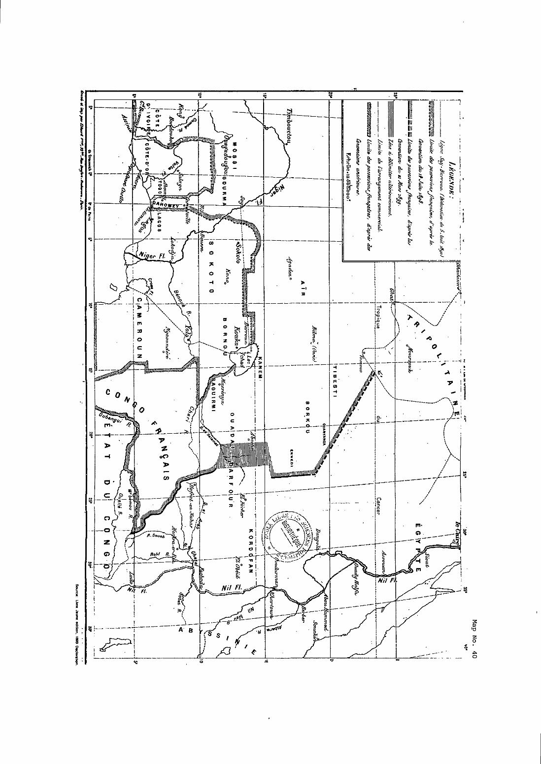


II seinble donc que nous lie devons h aucun prix nolis y laisser devancer par la Turquie, que l'Angleterre aimerait certainement mieux voir que nous $ y s ce carrefour des routes entre la Méditerranée et le Tchad ."
The report urged discreet but prompt action to preempt any such Ottoman
mission by putting in place a permanent Frencli establishinent at Bilma.
5.15 France's concern was understandable. The 1890 Declaration could have done no more than to establish that as between France
and Great Britain an Algeria-Tunisia hinterland claim wotild incur no British
objection. It was not opposable tu tiny third State such as the Ottoman Empire
res inter alios acta). Lord Salisbury's rather off-hand response to the Porte's (---- protest suggested as much; and as is sliown helow he was very much of that v i e ~
in respect to the subsequent 1898 and 1899 agreements.
SECTION 3. Tiie Anelo-Frencli Convention of 14 ,lune 1898
5.16 The 1898 Convention confirined a Protocol signed by the 22 joint deliinitation cominission cippointCd piirstiant to tht: 1890 Declaration .
The Protocol deliinited the frontiers between the British and French possessions
to the West of the Niger River. This line was marked on a map annexed to the
Convention and referred to therein as rnap no. 1. This deliinitation lias no direct
bearing on the present dispute. However, Article 4 of the Convention 23
accomplished a delimitation to the east of the Niger as far as Lake Chad between
British and French possessions, also illustrated by an annexed map (map no. 2). A reproduction of these two maps, as tliey appeared in the Livre iaune edition of
the 1898 onv vent ion^^, is set out here as Map No. 39. However, it is easier to
follow the discussion below by referring to another map - a map which has
accluired a certain notoriety - tliat is the inap'annexed to the Livre iaune editioii
of the 1899 Declaration, reproduced here as Mao No. 40, for it shows al1 the lines
2 1 French Archives Annes. 11.28.
See. Anxlu-French Cunveriti<in of IJ Jurlc 1898. inlcrn;~tional Accords and Aereeincnis 22 - m. Nu. 4.
23 More precisely described as Article 4 of the Protocol confirmed by the Convention.
24 The Livre iaune is an ciTfici;il puhlicaiion of the French Guvernmcnt in ahicli impi?riaiit trcatics aiid iigrceinenis arc rçyriiited and published tugether wiih a selectiun UT the relatcd m.

in question, including boundaries that were agreed prior to the 1890 Declaration
as well as the Declaration's line between Say and Barroiia and the 1898 line of
deliinitiition inodifying the 1890 liiie. The 1899 m;ip has also been put on
Map and appears later as Mau No. 48 at paragraph 5.b3.
5.17 In Article 4, Great Britain and France recognized their
respective "spheres" to the east of the Niger as far as Lake Chnd. The territoiy to
the north of the modified Say-Barroua line, al1 the way to France's Mediterranean
possessions, wes thiis recognised by Great Britain as fiilling withiii the French
zone of intluence. However, the 1898 Convention did not refer to territory lying
to the east of the line drawn through Lake Chad or to the east of the eastern
linlits of Caineroon.
Map No. 4 1
5.18 As these negotiations were underway, in one of the more
daring escapades of an era full of adventure in Africa, French Captain Marchand
was making his dash across Africa to the Nile. which precipitated the Fachoda
crisis (Man No. 41). France and Great Britain found themselves on the verge of

war. France evac~iated Fzichodti, and Lord Siilishury wtis sti informed hy France's 25 Ambassador in London, Paul Cambon, on 12 January 1899 . Lord Salisbury was
at the tiine reminded of his statement to the Baron de Courcel that after things
ctilined down he would be willing to examine with France "la déliinitation des
spliares d'actions des deux pays dans le Bahr el Ghazal". It inay be noted that tliis
region lay to the West of Fachoda and that Fachoda itself lay approximately at the
~x~ i i i t wliere 10''N latitude crosses the White Nile. Thus the area of priinary
concern at the outset of negotiations was well to the east and south of even Lake
Chad.
SECI'IVN 4. Tlie Anglo-French Additional Declaration of 21 March 1899
5.19 Ainbassador Cambon's meeting with Lord Salisbury on
12 January 1899 was the start of the negutiations that in a period of only three
months led to the 1899 Additional ~ e c l a r a t i o n ~ ~ . The provisions of the
Declaration "completed and became an integral part of Article 4 of the 1898
Convention, for reasons tliat will be seen further on. Lord Salisbury and
Ainbassador Cambon personally participated in most of the drafting and
negotiation, and the travaux pré~ar;itoires of the 1899 Declaration are of
considerable relevance to the present case. The views expressed hy the Quai
d'Orsay and by the British Foreign Office as the conversations progressed are
now publicly available.
(a) The French Travaux Préoarntoires of the 1889 Declarntiun
5.20 The manner in whicli tlie final text of the Declaration was
arrived iit will he examined first, hased largely on the French travaux. In his
report of 12 January 1899 to Delcassé (French Minister of Foreign Mairs),
Ambassador Cambon said that he had informed Lord Salisbury that he personally
felt that a line could easily be arrived at, or in Cambon's words: -
"... nous pouvions aisément nous mettre d'accord sur une ligne de démarcation q u ~ , partant du sud de la Tripolitaine et touchant au Darfour, traverserait obliqueineiit le Bahr el Gtiazal en suivant la ligne de partage des eiiux entre le Nil et l'Oubangui et que, sans arborer notre drapeau sur le Nil, nous pourrions obtenir, pour
25 Cambon-Delcassé Telegram, 12 January 1 8 9 , French Archives Annex, p. 3.
26 Thc lin:il icxt of ihc Aiiglo-Frcnch Addiiion:il Dcclaration of 21 March 1899 is attachcd as In~crnational Accords and A~reements Anncx. No. 4.

notre commerce, la liherté de navigation et un point 27 !q d'eiiibarqueinent sur (ce) fleuve .
Such a line has been illustrated on Man No. 42. . It descends from the
southernmost point of the Tripolitania boundary in a southeasterly direction
touching the northeast corner of Darfour at about 24"E longitude - 15"N latitude,
and tlien continues suuth to the Bahr al Ghazal.
Map No. 42
. ~
' ' - ~ , c 01 C."cs,.
5.21 Cambon met again with Salisbury on 18 Jaiiuary 1 8 ~ 9 ~ ~ . According to Cambon's report, Salisbury had referred the Camhon suggestion to
Lord Cromer in Egypt from whom he had not yet had a response, but Salisbury
had expressed the view that Cambon's suggested basis for a delimitation w«uld
encounter no opposition. Salisbury had another problem on his mind, however,
for he recalled that, after learning of the lSYO Declaration, the Porte -
27 Cambon-Delcassé Telegram. 12 January 1899, French Archives Annex, pp. 3-4.
28 Cambon-Delcassé Telegram, 18 January 1SYY. French Archives Annex, p. 6.

Map No. 43

"... avait protesté au noin des droits dii Sultan, et i l in'a demandé si j'avais réfléchi aux difficultés que pourrait soulever la Turquie. 11 a d':tilleurs reconnu avec moi que ces difficultés n'étaient pas insurmontables. 11 a ensuite signalé à mon attention les prétentions éventuel% de I'ltalie sur Tripoli et sur l'arrière-pays de cette province ."
So it is evident that Salisbury and Cambon were well aware tliat most of the
C:iinhoii line would cut across a region that fell within the area over which the
Ottoman Empire had claiined Tripolitanian hinterland rights. Cambon indicated
to Delcassé that he had replied as follows:
"J'iii répondu qu'il était possible de concevoir un trace laissant à Tripoli un avenir suffisant; que notre but principal était de grouper nos possessions du Congo, de l'Oubangui, du Niger, du Sénégal, de l'Algérie et de la Tunisie et que, ce grand intérêt assuré. nous pourrions 1:iisser à la Tripolitaine un certain hinterland:;Qyi, dit Lord Salisbiiry, on pourrait tracer une ligne en fer à cheval .
5.22 If there is superimposed on a map of Africa, north of Lake
Chiid, the shape [if 21 horseshoe (Mai7 No. 43), with its open end tci the north, then
to the West of the horseshoe would be Tunisia and Algeria, the open center would
be the Tripolitanian hinterland, to ifs south would be France's Congo-Oubangui
possessions, and to the east of the horseshoe would be the Nile Valley, Sudan and
Ebypt, in the British sphere. This would leave Tripolitania with "un avenir
suffisant" and "un certain hinterland", to use Cambon's expressions. It would also
provide ample communication between al1 of France's African possessions as of
1899, which Cambon had said was the principal objective. In this regard, it may
be noted that Ambassador Cambon made no mention of a possession named
"Chad".
5.23 Then the exchange of drafts and sketch maps began31.
Cambon's first sketch apparently adopted a quite different line thao he appeared
to propose on 12 January. The evidence points to the fact that the French
ZY m. Delcasse replit'd t o Carnhon on 21 Janilnry expressing great interest in S a l i ~ h i l ~ ' ~ uncxpecied concern over Iv~ly's iniercsls. W. Delc~ssi.-Cÿmhon Dispalch. 21 Janu:i~ 1899. Frcnch Archives Anncx. p. Y.
30 That is. "in the shape of a horseshoe". Cambon-Delcassé Telegram, 18 January 1899, French Archives Annex, p. 6.
31 TV date. research in thc archives has tailcd to locale thesc sketch maps.


instead of following exactly the "ligiie des hauteurs du Tibesti", now would have
p1;iced al1 the mises of this region in the French zone. On the other hand, Great
Britain wanted al1 of Darfour, wliich ineant departing tTom the principle «f
following "la ligne de partage des eaux". Hence, the ~ r i t i s h proposed agreeing to
depart from the principle of "ligne des Iioiuteurs" in favour of France in Tibesti
and Borkou in return for a siinilar departure in Great Britain's favour in
~ a r f o u r ~ ~ . As Lord Salisbury recorded in a Foreign Office note of February
1899
"ln point of mere territory this would be a far more valiiahle coiicessiori tliaii would be the concession of the western part of Darftir. 1 admitted that i t was not so niuch of an object to us, 21s we did not attach much importance to any arranggyents that were iiiade to the north of the 15" parallel of latitude ..: ."
The Quai d'0rs;iy accepted this proposal; but it was concerned that nothing
should appear in the agreement as an irnplicit recognition by Frcince of the British
position in Egypt. This prompted the ideo that the Declaration might be tagged
onto tlie 1898 Convention, which had not yet heen rzitified. Lord Stilish~iry
remained concerned over the Ottoman Empire's possible reaction, and leaned
toward an exchange of let ter^^^. Apparently, M. Cambon had the same concern,
for Lord Salisbury ended his 9 February note with these comments:
"The French Arnhassador's mode of addressing himself t« these questions - which I reminded him was somewhat at variance with t l~a t he had assuined at the first meeting we held on the subject - ~ippeared to ine to indiczite that he was rather following the instructions of the French Minister of Foreign Aîfairs, than the policy to which he himself would have given preference. He quite zigreed with [ne that when we reached what might be fziirly called tlie Hinterland of Tripoli, we shci~ild so fraine «tir agreement as to zivoid any appearance o f neglecting the rights which the Sultan might advance to that region, in consequence of his possession of the Provin~g of Tripoli, which is under his immediate government ."
36 Cambon-DclcassC Tclcgram. 8 Fcbruary. 189Y. Frcnïh Archivcs Anncx. p. 13.
37 Lord Salishury's Noie, 9 Fehruary 1899, FO 1411344. British Archives Annex, p. 1.
38 Camhon-DclcassC Dispttch, 10 Febrwry 1899, French Archives Annex. p.14.
39 Lord Salishury's Noie, 9 Fehruary 1899. «p. &.

5.26 . On 16 February, Cambon produced a draït he had prepared in the form of a modification of Article 4 of the 1898 on vent ion^'. The line described in the draft purponed to concern only spheres of influence. (It will be
seen as this story proceeds how the draft Declaration evolved into a delimitation of boundaries to the south of 15"N latitiide and only of snheres of influence to the
nonh.) Staning from the south, at 11"N latitude, the line in Cambon's draft
moved north to divide Darfour and Ouadaï as far as 15"N latitude. It then described the rest of the line in this, imprecise way:
"A partir de sa rencontre avec le 15" degré de latit~ide nord, cette ligne suivra ce parallèle jusqu'à la rencontre d'une ligne qui gagnera la frontière tripolitaine, de fason à laisser dans Iaflhére française la totalité des oasis formant le Borkou et le Tibesti .
40 %S. Annex (0 the Cambon-Delcasse Dispaich, 16 Fehruûry I ~ W , French Annex. p. 17. -
41 m.

Mao No. 44 shows the various points referred to above as well as the
Tripolitanian frontier, as shown on the Livre iiiune rniip (Man No. 40). I t seems
clear that the second sector line, which was to end at the Tripolitania frontier,
while leaving on the French side of the line the oases of Tibesti and Borkou, was
envisaged to begin at the intersection of the first sector boundary with 15' N latitude. Delcassé informed Cambon several days later that the line he pr<iposrd
was fine, with certain changes42. He said that other regions should be included
such as Ounianga and other districts lying ùetween the oases and Darfour.
5.77 Lord Salisbury then tabled a draft that indicated only the
delimitation between Ouadaï and Darfour as Far north as 14"20'N latitude.
Cainhon informed Delcassé why the deliinitiition had been stopped there:
"(Lord S:ilish~iry) pense, qii'nii delci de ce degré, il est iniitile de faire une délimitation prrcise. Outre la difficulté d'établir un tracé diins ces régions à peu près inconnues, Lord Salisbury seinhle redoiiter les approches de 1:i Tripolitaine. II préfkre déclarer d'une t':!son génér le que le Tibesti et le Borkou seront dans notre zone i? 9 , d'influence .
So it was evident that, north of 14"20'N latitude, Lord Salisbury considered there
was a risk of encroaching on the Tripolitanian hinterland clairned by the Ottoman
Empire.
5.28 Following the instructions he received from Paris, M. Cambon suggested including Ounianga and Ennedi within the French sphere and
reported that Salisbury had raised no objection. As to the forrn this arrangement
should take, Salisbury concurred with the French suggestion that it be added to
the 1898 Convention. This would simplifi the task of Parliament, which had not
yet ratified the Convention, and such an approach "permettait d'échapper aux
réclamations de la
5.29 During tliese negotiations, tlie qiiestion arose of referring to
and annexing a map, as had been done in the case of the 1898 Convention. There
was some discussion over which map to use as the base of reference, the French
preferring a German map (Justus Perthes, 1891) and the British preferring a
42 Delcassé-Cambon Telegram. 21 Fehruary 1899. French Archives Annex. p. 18..
43 Cambon-Delcasse Dispatch, 22 Fehruary 1899, French Archives Annex. p. 19.
Ihid. 4J -
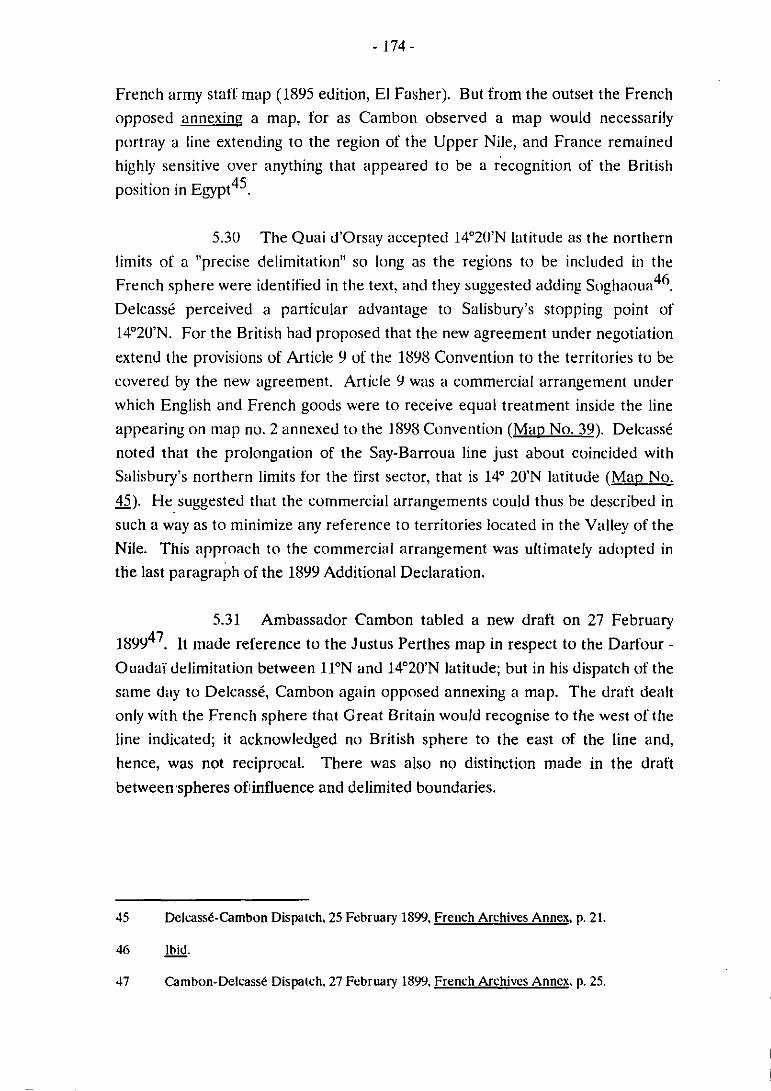
French army staff map (1895 edition, El Fasher). But from the outset the Frencli
opposed annexing a map, for as Cambon observed a rnap would necessarily
portray a line extending to the region of the Upper Nile, and France remained
highly sensitive over anything that appeared to be a ~ecognition of the British 45 position in E g p t .
5.30 The Quai d'Orsay accepted lj020'N latitude as the nortliern
liinits of a "precise delimitiition" so long as the regions to be included in the 46 French sphere were identified in tlie text, and tliey suggested adding Soghao~izi .
Delcasse perceived a particular advantage to Salisbury's stopping point of
14"2U'N. For the British had proposed that the new agreement under negotiation
extend the provisions of Article 9 of the 1898 Convention to the territories tu be
covered by the new agreement. Article Y was a commercial arrangement under
which English and French goods were to receive equal treatment inside the line
appearing on map no. 2 annexed t« the 1898 Convention (MÜD No. 39). Delcassé
noted that the prolongation of the Say-Barroua line just about coincided with
Salisbury's northern lirnits for the first sector, that is 14' 20'N latitude ( M ~ D No.
45). He suggested tliat the commercial arrangements could thus be described in - such a way as to rninimize any reference to territories located in the Valley of the
Nile. This approach to the commercial arrangement was ultimately adopted in
the last paragaph of the 1899 Additional Declaration.
5.31 Ambassador Cambon tabled a new draft on 27 February
18Y9j7. It iiiade reference to the Justus Perthes map in respect tu the Darfour - Ouadaï delimitation between 1l0N and 14"20'N latitude; but in his dispatch of the
sarne d;iy to Delcassé, Cambon agiin opposed annexing a map. The draft dealt
only with the Frencli sphere that Great Britain would recognise to the West of tlie
line indicated; it acknowledged no British sphere to the east of the line and,
hence, was not reciprocal. There was also no distinction made in the draft
betweempheres ofinfluence and delimited boundaries.
45 Delcassk-Cambon Dispaich, 25 Fcbruary 1899. French Archives Annex. p. 21.
46 - lhid.
47 Cambon-Delcasse Dispaich, 27 Februaiy 1899, French Archives Annex. p. 25.

Map No. 45
Extension of Say-Barroua Une
Lambert Conforma1 Canic Projeaion Sule accurate rr the equiior.
1:51,Ya.m0 . Kibrmrn

5.32 With the tabling of a British counter-draft on 1 March 1899,
British sensitivity to Turkish (and 1t;ilian) claiins silrfaced once gain^^, for the
revised Article 3 contained two important changes4'. m, it was reciprocal in
that each Government engaged "not to attempt io inake any territorial
acquisitions nor to exercise political intluence" to the east and West of the line
propuxd. Second. i n çontnist to the soiithern sectur of the line - to the east and
west of which British iind French spheres were each recognised, respectively - north of the parallel of latitude of a designated point on the Abéché-Nyeri road
(approxiinately 14"20'N latitude), no recognition of spheres of influence w;is
contained in Article 3 of the draft, which continued the line northwest to the wells
of Toummo. Thus, although the British draft of Article 3 had included on the
west of the line the various oases mentioned at earlier sessions by the French, this
provision only set out Great Britain's obligation not to atteinpt to acquire
territory or exercise political influence tu the West of such a line, and France's
reciprocal obligation east of the line. It said nothing about the rights of France
ancl Great Britain on either side of the line. The British draft also contemplated
zinnexing the French army staffmap of 1895, and it pleced two districts, one being
Zagliawa (Soghaoua), tu the east of the line, on the British side.
5.33 Cainbon explained the changes in this way to Delcassé:
"Vo~ilant sans doute tenir compte des préocc~ipiiticins plusieiirs fois exprimées par lui de ne pas provoquer les susceptibilité.^ tiircliies oit italiennes, le Premier Ministre ne parle plus d'attributions de territoire et se borne à enregistrer une sorte de simple obligation u%!érale de la part de chacun des Gouvernements contractants ... .
Cambon suggested checking whether the two districts proposed to be to the east
of the line were not an integrül part of territory that Fnince claimed, but he
expressed willingness to give in on this point if necessary. He added:
48 While ne$oiiaii«ns werc in full swing. ihc Quai d'Orsa? was investigaiing rumours «l'a Turkish expcdiiiun lu Tihesii and Bilmci. &. p;ii.(i. 5.14. übow. a. also. ihe Annex IO
Cainhon-Delcass6 Dispaich, 2 March IXYY, French Archives Annex. p. 29.
49 W., French Archives Annex, p. 32.
50 m., French Archives Annex. p. 30.

"En tout cas je pense que le meilleur tr;icé à ;idopter consisterait à remplacer la Iigt45 assez vaguement désignée dans le projet anglais par un méridien- ."
He did not elaborate on how this was to be done. But the main concern over the
British coiinter-dr;tft wits whether it could he interpreted as an iihandonment hy
France of its rights in Egypt.
5.34 The Quai d'Orsay's position as to the British draft of 1
March was iiiipartrd t« Canibon in Delcassii's communication of 7 March 18~9~ ' .
I t adopted a rather hard bargaining stance. France was ready to give in to the
British as to tlie inap to be refrrred to but expectrd coinpensation for doing so.
As t» Article 3, Delcassé wrote that al1 Great Britain should seek is that France
be liinited by the line from going further to the east but that any reference to
Great Britain to the east of the line should be deleted. I t was once more clear
that France's main preocciipation was to avoid any allusion to the situation in
Egypt. Delcassé insisted on the formulit: "Le Gouvernement de Sa Majesté britanniq~te reconnaît comme tombant dans la sphère française le pays à l'ouest
d'une ligne ainsi définie . . . u ~ ~ . P;iris was re;idy tci give in on the district of
Sogliaoua if the above revision could be agreed; but it wanted the commercial
agreement to be drscribed as lyiiig south of 14O2iJ.N latitude.
5.35 Clearly the negotiations had bogged down, to the point that
Lord Salisbury proposed agreeing in principle and conferring the task of
establishing the line to an "international co rnmis s i~n"~~ , subsequently clarified to
mean a mixed Anglo-French commission. This thought was set aside for the
moment, and another British draft was tabled on 19 ~ a r c h ~ ~ . The t'irst segment
of the line was described as a "ligne frontigre", and it apparently was intended to
continue north tu lSoN latitude. The draft maintained the idea of reciprocal
recognition of spheres of influence on either side of that segment of the line.
How the line was to continue north to 1S"N was unstated and is confusing in
Ihid.. French Archives Annrx. 1). 31. 51 - 52 Dclcasse-Cambon spcial Ictter ("Lettre Pariiculifre"). 7 March 18YY. French Archives
Anncx. p. 35. - 53 W., French Archives Anncx. p. 20.
54 Cambon-Delcassé Telegram, 15 Marrh 1899, French Archives Annex. p. 37.
55 Camhon-DelcassC Telcgram, 19 March 1 8 9 . French Archives Anncx. pp. 3839.
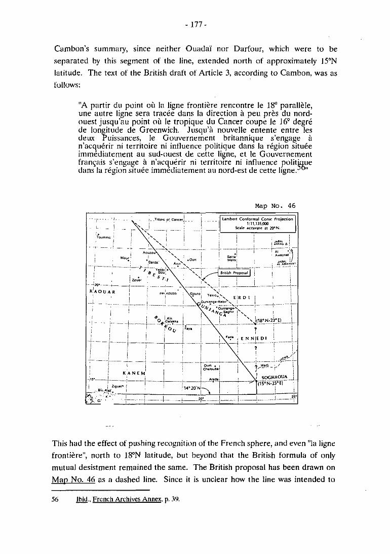
Cambon's sumrnary, since neither Ouadaï nor Darfour, which were to be
separated by this segment of the line, extended north of approxirnately 15"N latitude. The text of the British draft of Article 3, according to Cambon, was as
"A partir du point où la ligne frontière rencontre le 18" parallèle, une autre ligne sera tracée dans la direction à peu près du nord- ouest jusqu'su point o ù le tropique du Cancer coupe le 16'' degri de longitude de Greenwich. Jiisqu'à nouvelle entente entre les deiw Puissances, le Gouvernement britannique s'engage à n'acquérir ni territoire ni influence politique dans la région située irnrnédiaten~eiit au sud-ouest de cette ligne, e t le Gouvernement franc;:iis s'engage à n'acqu2rir ni territoire ni influence polit' Lie dans la région située immédiatetnent au nord-est de cette ligne. %tt
This had the effect of pushing recognition of the French sphere? and even "la ligne
frontière", north to 1FN latitude, but beyond th:tt the British formula of only
mutual desistment remained the same. The British proposal has been drawn on
Map No. 46 as a dashed line. Since it is unclear how the line was intended to
56 W.. Freiich Archives Annex. p. 39.
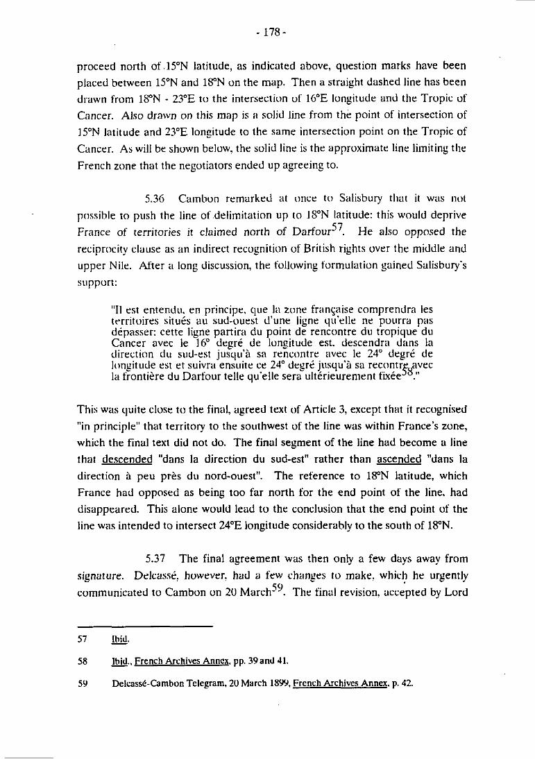
proceed north of .lSON latitude, as indicated above, question marks have been
placed between 15"N and 1S"N on the map. Then a straight dashed line has been
drawn from 1S"N - 23"E to the intersection of lbOE longitude and the Tropic of
Cancer. Also drawn on this map is ii soljd line from th6 point of intersection of
15"N latitude and 23"E longitude to the same intersection point on the Tropic of
Cancer. As will be shown below, the solid line is the approximate line lirniting the
French zone that the negotiators ended up açreeinç to.
5.36 Cainbon remarked :il ciiice to Salisbury tliat it was iiot
possible to push the line of delimitation up to lSoN latitude: this would deprive 5 7 France of territories it claimed north of Darfour . He also opposed the
reciprocity clause as an indirect recognition of British rights ovrr the middle and
Lipper Nile. After a long discussion, the following formulation gained Salisbury's
support:
"II est entendu. en principe, que la zone frtinc;aise comprendra les territoires situ& aii sud-ouest d'une ligne q~i'elle ne pourra pas dépasser: cette ligne partira du point de rencontre du tropique du Cancer avec le 16" degré de longitude est. descendra dans la direction du siid-est ~ U S C I L I ' ~ sa rencontre avec le 24" degré de longitude est et suivra ensuite ce 24" degr6 jiisqu'à sa recontr Syi!WC la frontière du Darfour telle qu'elle sera ultérieurenient fixée .
This was quite close to the final, apreed text of Article 3, except thtit it recognised
"in principle" that territory to the soiithwest of the line was within France's zone,
which the final text did not do. The final segment of the line had become a line
that descended "dans la direction du sud-est" rather than ascended "dans la
direction à peu près du nord-ouest". The reference to 1S"N latitude, which
France had opposed as being too far north for the end point of the line. had
disappeared. This alone would lead to the conclusion that the end point of the
line was intended to intersect 24"E longitude considerahly to the south of 18"N.
5.37 The final agreement was then only a few days away from
signature. Delcassé, however. had a few changes to müke? which he urgently
cominunicated to Cambon on 20 ~ a r c h ~ ' . The final revision, accepted by Lord
Ihid. 57 - 58 W., French Archives Annex. pp. 39and JI.
59 Delcassé-Cambon Telegram, 20 March 18YY. French Archives Annex, p. 42.

Salisbury, provided for the first segiiierit of the line (Article 2) to end at 15'N
latitude. Article 3 was revised, as follows, which is the final English text:
"lt is understood, in principle, tliat to the north of the 15th parallel the French zone shall be liiiiited tci the north-east and east by a line which shiill start frcim the point of intersection <if the Tropic of Cancer with the 16th degree of longitude east of Greenwich (13"40' east of Paris), shall run thence to the south-east iintil it meets the 24th degree of longitude east of Greenwich (21'40' east of Paris). iind shell tlien follow the 24th degree iintil it meets, to the north of the 15th parallel hlf latitude, tlie frontier of Darfur as it shall eventiially be fixed ."
(b) Certain Observations Concemine the Decloration's Final Tex t -
5.38 In the light of the travaux on the French side, several
conclusions may br drawn regarding tlie agreed text of the 1899 Decleration. The
element of reciprocity was preserved only in respect to the southern sector - the
line (below lSON latitude) covered by Articles 1 and 2. This line was intended to
he a "line of frontier", and the mission of the c«ininissioners appointed pursuiint
to Article 4 to delimit the frontier-line was concerned only with the southern
sector of the line set out in Article 2. In contrast, Article 3 dealt, not with a
frontier, but with limitations to the "French zone" to the north of 15"N latitude. In
fact, if the text set out in paragraph 5.36 above is cornpared with the final text
(paragraph 5.37), it can be seen that even the explicit recognition that the
territories to the southwest of the line fell within the French zone was dropped,
reflecting, inter alia, the British concern not to ruffle the feathers of the Ottoman
Empire (and Italy). The basic difference between Articles 1 and 2, which
deliinited a boundary, and Article 3, which did not, was clearly intended.
5.39 What, then, can be made of the words "in principle" ("en
principe")? Once again, the words "in principle", which oniy appeared in the final
drafts, would appear to have been an attempt to accommodate the Ottoman
Empire's sensitivity. The words moditj the limits of the French zone not the
direction of the line described later on in the sentence.
5.40 As to the direction of the line, the English text, "to the south-
east", arguably is less precise than if the phrase had been, for example: "thence
60 Anncx to Cambon-DclcassC Dispatch, 21 March 1899, Frcnch Archivcs Annex, p. 4G. See. also. Internaiional Accords and Aereemcnis Annex. No. 4.

south-east until it ineets the 24th degree of longitude". In this regard, it will be
recalled that Lord Salisbury's 19 March draft would have started the nurthern
sector of the line at the point of intersection of the Ouadaï - Darfour boundary
(whicli wcis to be drliinited between 21" and 23"E longitiide) and 1 r N latitudeb1.
Lord Salisbury's liiie was then to have been drawn "dans la direction à peu près du
nord-ouest"; but Ainbassador Cambon had strenuously objected to piishing the
stiirting point that far to the north. As Mao No. 46 shows, by starting the line at
15"N latitude. which must have been the French position, rathrr than at 1YN
latitude, as Lord Salisbury had proposed, the resulting direction of the line is
almost exactly northwest/southeast.
5.41 This appears to he coiifirined by a docuinent in the
considerably less complete travaux contained in the Livre iaune covering the 1899
Declaration. The document is the British proposal of 19 March? the French text
of wliich is set oiit in pariigraph 5.35 above; but the starting point of the line in
Article 3 of the French version of the document is 15"N latitude, not 18"N 62 latitiide . It is not known what the basis for this alteration was. However, the
hand-written version of the British proposa1 of 19 March found in the British
archives shows the number 1S" scratched out and 15'written inh3; and Cambon
informed Delcassé the following day that Salisbury had agreed to such a
changeb4. It miiy re2isonably be concliidrd, therefore, that Lord Salisbury had
indeed agreed to make this change. Thus, the agreed line was to have been
drawn from roughly the intersection of 23"E longitude and 15ON latitude,
northwest to its terminal point on the Tropic of Cancer, which is the solid line
appearing on Mau No. 46, shown in contrast to Lord Salisbury's proposed line
(the dashed line).
5.42 At the last inoinent of the negotiations, Lord Salisbury
agreed to designating the end point of the line - whose direction had now becoine
reversed in the final draft tabled by M. Cambon so that it descended in a
soutlieast direction rather than ascended in a northwest direction - es being the
61 Cambon-Delcassé Tclepram. 19 March 1899, French Archives Anncx. pp. 3X3Y.
62 Dispatch Ir«m Canihon to Delcassé, l Y March IXlEJ, as pubiishcd in Livrc iaunc. French Archives Aiiiicx, p. JO.
63 British Handwriiien Proposai, 19 March 1899. FO 971561. British Archives Annex. p. 35.
U Camhon-DclcüssC Telcgram, 20 March 1899. Frcnch Archivcs Anncx. p. 43.

intersection of such a line with 24"E instead of 23"E longitudeG5. Why he agreed
to this is not apparent, for the boundary between Ouadaï and Darfour was to be
delimited within tlie liinits of 21" and 23"E longitude. The inconsistency
apparently was perceived by the Quai d'Orsay and, in his final dispatch, Delcassé
sought to widen the Ouadaï - Darfour boundary limits so as to extend to between
21" iind 24"E longitudeo6. The final text reveals that sucli a change was not
agreed, with the resiilt that the end point of the second sector line woulcl fail to
ineet tlie iiorthern point of the first sector boundary, thus leaving a gap to be
filled (Man No. 47). Nevertheless, it clearly ernerges from the travaux that the
direction of the southeast line wes intended to be, and would inevitably result in
being, almost an exact southeast line, for it was meant to intersect 24"E longitude
211 approxiinately 15ON latitude. Of course, tlie exact end point could iiot have
been known at the tirne since the Ouadaï - Darfour deliinitation (iinder Article 2)
had yet to be accomplished, and in any event that part of the line could not go
furtlier east than 23"E longitude.
65 W., French Archives Annex, p. 4.
66 DclcassC-Camboii Telcgram, 20 March 1899. French Archives Anncx. p. 42.

5.43 Other conclusions concerning the meaning and effect of the
1899 Declaration will be taken up below in the context of subsequent
developments.
(c) The British Travaux
5.44 It is not necessaiy to make as complete an analysis of the
1899 negotiations as seen from the British side. For the British travaux largely
confirin what the French record shows. Neverthelrss, certain Foreign Office
documents merit comment.
5.45 The British view as to the intended scope of Article 3, relating to the northern sector of the line, was quite different from that of the
Quai d'Orsay. As pointed out in a Foreign Office note of Sir Thomas Sanderson,
the British Ambassaclor in Paris, coinmentiny on tlie Cambon draft of 9 March,
Cambon's pr«posecl Article 3 was objectiun~iblz to the British because, inter aliai:
"lt contains a recognition that certain places fall within the French sphere,
whereas we do not wish to go further than renounce any claim to them 67 ourselves ."
5.46 The British file also contains a rather detailed comment
dkited 14 March oii the saine draft6'. The proposal of ending the southern sector
delimitation at 14"20' was opposed on technical grounds, and a point in the
Abéché-Nyeri road was suggested instead, although the latitude of such a line was
approxiinately the same, that is 14"20'. As t« Article 3, the observation was made
that the French demands in that part of the proposed line were "growing to an
extent which is somewhat alarming". (It will be recalled that Cambon sought to
expand the French zone bryond the Tibesti-Borkou oases so es to include
Ouniünga, Ennedi and Soghaoua, as well as other regions near Darfour.) The
principal concern voiced by the British at the time was to avoid anything that
might in the future give rise to a French claim in the direction of the Koufra
OLISKS.
67 Sir Thomüs Sanderson's nole of 11 March 1899. FO 971561. British Archives Annex. p. 4.
68 Leiier [rom Sir William Evereit to Sir Thomas Sanderson, 14 March 189. FO Y7/561, British Archives Aiinex, p. 23.

5.47 As already noted, the British draft of 19 March would have
extended the end point of the first sector linr from 14"20'N latitude (stibseqtiently
1.S0N) northward to 1SoN latitiide, aloiig a line lying between 21" and 23"E
longitude. Froin there the second sector was to follow a line to be drawn "in a
direction generally to the northwest as Far as the Tropic of Cancer". But :III the
British proposals for tlie second sector were frarned in terms of a inutual
agreement of each party not to cross the line, witholit, however, üny recognition
of French rights t« the west and southwest of such a line or of British rights to the
east aiid northeast. The British proposals also conteinplated tlie annexation of a
rnap to the agreement, which as we have seen the French opposed and defeated.
The British 19 March draft was modified su as to substitute 15"N latitude for 18"N
and to describe the line running northwsrd from there as drawn "diins la direction
à peu près du nord-ouest jusq~i'au point où la tropiqlie du Cancer coupe le 16"
degrS de longitudenbY. Even then - two days before final agreement - Article 3 of
the British draft contained only an agreement hy each State not to cross the line
but accorded no recognition of any French rights to the West and southwest of
such a line - not even of a French zone of influence.
5.48 The French negotiators drafted and introduced tlie three
Iast-minute changes that have subsequently given rise to debate over the ineaning
of Article 3 of the Declaration. These changes were, first, the menticin of a
French "zone" to the southwest and West of the line. This was subsequently to be
interpreted by France to mean that a territorial boundary had been agreed, a
position with which the British Government consistently differed, inaintaining
that only the limits of a zone or sphere of influence were involved north of 15"N
latitude. Second, there was a change in the direction of the line described in
Article 3 - instead of 21 line ascending to the northwest from the first sectcir
boundary at lSON latitude, the line descended southeast to intersect 24"E
longitude and then followed that line south to the first sector boundaty at the, as
yet undetermined. point where the first sector boundary met 24"E longitude to
the north of 15"N Itititude. The third chiinge w:is to introduce 24"E Iongitiide into
the boundary formula even though, as to the first sector. the French proposal of
extending the Ouadaï - Darfour sector tu be delimited eastward to 24"' had not
been agreed and was in the end not incorporated into the Declaration, resulting
in a situation where the botindaries would not ineet up (Map No. 47).
Nevertheless. it seems clear that the end points of the limits of the two boundaries
GY Thc English icxt read: "in a n«rthwestcrly dircction as far as the point wherc the Tropic of Cancer intersecu the 16111 degrec of longiiudc."

were intended to he very close, at least as t« latitude, and that the switch in
direction in describing the second sector line was not meant to bring about a
major change in the direction of that line, which logically could only have been
;iliiiost a true northwest/southeast line.
(d) Protests from the Ottoman Empire and Concern Voiced bp rn
5.49 As the foregoing account reveals, during the negotiations
both Great Britain and France were keenly aware of the likelihood that the
Ottoinan Empire would regard the Dec1ar:itioii as an encroacliinent on tlie
Ottoman Einpire's claim to rights over the hinterland of Tripolitania. On the last
day of negotiations? in proposing a revised text for Article 3, which became the
fiiially agreed text, Cambon said this to Delcassé:
"II ne ftiiit pas oublier que nous soinmes exposés aiLw récl;imations du Sultan et aux soupçons de l'Italie [foutnote omitted]. Une dispcisition, assez précise pour nous assurer incontestahleineiit les régions qui s'étendent entre le sud (de) la Tripolitaine et le Darfour, et assez vagiie pour iioiis permettre de décliner iine conversation avec la Porte, me sembjg préférable à une énuineration ou à une mention de territoire ."
This policy of what can only be called dece~tion was to characterize the
subsequent actions of the French Governinent as to the Tripolitanian frontiers
right up to the rime of signing the 1955 Treaty with Libya.
5.50 As a result, any mention of the various regions to be
included within the French zone was dropped. Nonetheless, the Turkish protest
was not long in coming. At a diplomatic reception on 29 March 1899, the Turkish
Ainbassador handed Delcassé :i note verbale reminding France of the Ottoman
Einpire's claims, of which France had been made aware in 1 8 9 0 ~ ~ . Similar notes were presented in London, Tripoli, Berlin, Vienna, and St. Petersburg. French
Ambassador Barrère in Rome also received word of Italy's ~ o n c e r n ~ ~ , which was
shortly thereafter strongly expressed by Italy's Foreign Ministrr Admiral
70 Camhon-Delcassé Telegram. 20 March 1899. French Archives Annex. p. 44
71 Dclcassé tu French Amhassadors in Rome and Constantinople. 1 April 1899, French Archives Annex, No. 48.
72 Bürrère-Dçlcass6 Telegram, 2 April 18YY. Frcnch Archives Annex, p. 49.

~ e n e v a r o ~ ~ . France gave these expressions of Italian concern somewhat more
attention than they gave tu the formal protests of the Porte. Cünevaro set about
to try t o obtain a joint declaration of Great Britain, France and ltaly to allay
It;ilyls fears. wliich were hardly assuziged hy statements s~ich as the followiiig,
contained in e dispatch froiii French Ambassador Barrère to Delcassé:
"La région rkservée à l'influence française faisait partie intégrante de I'liintei-land de la région clu Tchiid et du Con franpis, dont Y8 v t elle était le prolongement gkographiq~ie e t naturel .
This was certainly to give the concept of hinterland an entirely different meaning
than thiit commoiily iinderstood; for the hinterland was considered to emhrace
the territory lying landward of the coast of a country. Such a definition, however,
posed problems for France. as Barrère no doubt was aware: for al1 of the territory
over which France claimed a zone of influence under the 1899 Declaration lay
landward of the Tripo1it:ini:in ancl Cyrenaican coasts, regions belonging to the
Ottoman Empire.
5.51. What Admiral Canevaro sought from France and Great
Britain was "une declaration de désinteressement à l'égard des territoires
trip«litains"75. The Quai d'Orsay, however, tèared the repercussions of such ti
declaration, which would be tantamount to the recognition of or accliiiescence in
Italy's ambitions with regard to Tripolitania. Nevertheless, Canevaro submitted
several draft proposals. These showed that Italy's main concern at the time was
over Tripolitania proper and with freedom of trade along the caravan routes to
the south toward Lake ~ h a d ~ ~ .
5.52 Then, on 19 May 1899, the Turkish Ambassador to Paris followed up his initial protest witli a note verbale addressed to French Foreign
Minister elc cassé^^ in whicli he detailed the Ottoman Empire's position as to the
Tripolitanian hinterland and repeated the reservations expressed earlier to
73 Delcasd-Bari'kre Disliaich. 5 April IX99. French Arclii\,es Annex. p. 50.
74 E ~ J ~ ~ ~ ~ c - D c ~ L Y J s s ~ Disl)rtich. I l April. 1899. Frcnc'h Archivcs Anncx, 1). 53.
75 S. "Noie pour le Ministre". 12 April 18W. French Archives Annex. p. 55.
See. the reviscd ltalian draft noie in Barrerc-DelcassC Dispatch. 12 April lYw, Annex II. 76 - Frcnch Archives Annex. p. 59.
77 Bey-Delcassk ielter. 19 May IHYY, French Arcliivïs Annex. p. 61

Delcassé on 29 March. The note showed signs of having been carefully prepared;
and it woiild norinally have been expected to receive a considered response from
France. But France's reply of 6 une^^, discussed further on, was curt, as perhaps
iniglit have been expected iii the light of Ainhassador ~&nboti ' s letter to Delcassé
of 20 Mzircli cluoted froiii i n par:igraph 5.49 :ibove.
5.53 Altlioiigh the Turkish note deserves to be read in its
eiitirety, certain of its main poiiits are set «ut here:
The Ottoman Empire's forinal reservation of its territorial
rights in Africa duriiig the 1885 Coiigress of Berlin was
recalled;
I t inentioned the exch:irige of notes hetween Great Britain
and France on 5 Augiist 1890, at the time the 1890
Convention was entered into, undertaking to respect
scrupiiloiisly the rights of tlie Ottninan Empire, as well as
Lord Salisbury's confirinatory stateinent to the House of
Lords on 11 Auçust 1890;
Lord Salisbury's express recognition of France's "hinterland"
rights over territory south of its Mediterranean possessions
in this same statenient to the House of Lords was quoted;
The hinterland concept was discussed in legal terms with
citations largely taken from French sources;
This part of Centnil Africa was said not to be res nuIlilis and,
jn any event. not suhject to occupation pursuant to the
General Act of Berlin;
Certain elements contributing to the Ottoman claitn of title
were set out. and it was :isked what the basis was of any
78 Annex Io Dclcassk-C«nst;ins Dispatch. 29 May 1899. French Archives Annex. p. 68. It is qiiitc rem;irkahle. i i i Ilic light of this cxchangc. that on several suhsequent occasions the Quai d'Orsay inlormed the British Foreign Ollice ihat the Ottoman Empire had never protesied thc 1899 Dcclaration; and wheii tliis was discovcred ta he unirue, the French descrilied Ilic Turkisli protao: as "platoiiic".

French or English claims of title over the territory or by
wliat right they purported to dispose of it.
5.54 France's interna] reaction to tlie ~i i rkish appears in a
dispatch of 29 May 1899 frein Delcassé to Constans, France's Ainbassador in
~ o n s t a n t i n o ~ l e ~ ~ . In the dispatch, the hinterland doctrine was dismissed as not
constituting a principle of international law but rather "un ensemble de
considérations de fait, cl'ordre géogrephiq~ie, politiclue. commerci:il ou autre, qiii
a paru propre à la constitution ou à faire présumer des droits". Delcassé said that
in the circumst*ances the facts did not support treating the regions to the north
and east of Lake Chad as "dépendant de la côte tripolitaine"80. The dispatch
pointed out that France had expressed at the time strong reservations as to the
1890 Ottoman hinterland claim.
5.55 The b:tsis of France's cl;tiin of title was expressed i n this way,
i n the official reply to the Porte of 6 June 1899:
"Ces régions, juscl~i'à ilne époque récente , sont restées à l'état inorganiq~ies, independantes cle t<iiite Puissance civilisée. Mais depuis lin certain noinhres d'années l'action de la France s'y est exercée progressivement, ses missions en ont parcouru la plus grande partie et y ont fait reconnaître s uprématie; ses colonnes y
?3f 9 , protègent les caravanes et le commerce .
As has been demonstrated in Part IV, at the time the French reply was delivered
to the Porte, the three-pronged French advance toward Lake Chad was just
reaching its destination. The regions with which the 1899 Declaration was
concerned, north of 15"N latitude, were regions Far to the east and north of Lake
Chad, to which French forces would n«t arrive for another I O years or more. This
may help to excuse the ignorance of the area reflected in the French reply. The
French soon learned to regard the Senoussi Order, which had organized the
Senoussi tribes to oppose the French military advance into their lands, as very much a "Piiissance" with which they had tu deal. The Senoussi mey not have
absorbed French civilization (and hence not be in French eyes a "Puissance - -
79 DclcassC-Constans Dispatch. ?Y May lSY9. French Archives Anncx. p. 68.
80 One can only wonder whal slxcial facis and cirçunistances. in conlrast, jusiilied considerjig the Aigerian hinterland in 18W as extending soulh Io the Say-Barroua line. Sec. Maps Nos. 36 and 38 reîerred to in para. 5.08, Gu.. ahove. -
Y 1 Constans tclcgrarn. presenied on 6 Junc 18W. which aplxars in the Annex Io DClcass6- Constans Dispatclt 29 May 1899, French Arcliivcs Anitex, p. 69.

civilis6eU) hut they had ti rich heritage of Areb cult~ire and were zealo~is Muslims
with a loyal following among the indigenous tribes. As noted earlier, in the
excliançes between the French and the Senoussi in 1911-1912, the Head of the
Order demanded the return of 700 books taken by the ' ~ r e n c h forces from their
z;iwiv:isY2, suggesting that they might have had a higher regard for "civilization"
tlian the French forces attacking thein, wliich consisted of only a handful of
French officers, in any event. As for the suggestion that the French were
providing protection for the caravan routes, this was, at the very least,
disinçenuous in the light of the concern expressed several months earlier by the
Quai d'Orsay concerning a Turkish detachment that was engaged in pursuing
T o ~ i b u ~ i tnarti~iders from the Tihesti who hnd been attacking canivansY3. The
French concern was over the fact that the detacliment was preparing to establish
a çarrison at Bilina not over the protection of tlie caravan routes. In foct, the
evidence shows that the Ottoinan police action in question was precisely for the
purpose of protecting the principal caravan route running through Bilma. In
contrast, France's interest in the caravan routes was, not in their protection? but
to divert them froin Tripoli to Algiers and Tunis. Besides the Ottoman garrisons
stationed in Fezzan, the other force at that time that arranged for the protection
of the caravan routes was the Senoussi. Their zawivas were often located at or
near important oases along these routes. The French invasion of these regions
had the effect of totally disrupting these historic north/south trading routesg4.
(e) The Efîect of the 1899 Declaratiun
5.56 Under the principle res inter alios acta, the agreement
hetween France and Great Britain could not have affected any rights of a third
State without its consent or acquiescence, and this was pointed out by the
Ottoman Empire in its vigorous protests. The Ottoman Empire was not the only
82 a. para. 4.158. ahove. and rclatcd fn.
83 &. para. 5.14. ühove. &. :ils«. Part IV generally. \vliich demonstrates how t«tnlly a i odds with tlie sitiraiion :is i t existcd ;II the lime \vas this statenienc in F ~ i n c c ' s ollici:~l rcply.
See, Wright. Lihva, Chad and the Central Sahara, a. &., p. 73. The British - Guvcrnmcnt's rcply 111 the Ottoman protcst was to the c f ~ c c t ihat the 1899 Dçclaration only laid duwn ceriain limiis io the acquisition of territory and political influence by the Iwo contracting powers huc did not deal with the qucstion of existing rights. a, rcference in note from Curzon tu Saint-Aulaire, 21 Augiist 1922, FO 37117749, British Archives Annex. p. 160. The rcply went o n t o say that any questions of that nature shoitld he laken up hy the Porte with ihe Power that mighi assume jurisdiction over territories claimed by the Porie. ifand when Ihat occasion should arise.

State to protest or express reservations. Gerinany also expressed an interest in
the 1898 Convention and the 1899 Declaration. The German Ambassador in
London addressed e verbale to Lord Snlisliiiry dated 3 May 1899 in which,
referriiig to these recent agreements, he said that they were-
"... reearded I>y tlie Iinperial Governineiit as unilateriil Treaties only bciiidiny Great Britain and France. They caniiot in any way or in any direcgfn prejudice the rights of third parties and therefore of Germany ."
And he reseived on behalf of Germany the full maintenance of ils rights und
interests if affected by the agreements in question.
5.57 Lord Siilishury replied on 13 May inquiring in what wey
Gerinany considered its rights t« be affectedH6. The German Ambassador
replied on 16 July that his note-
"... had solely the intention of making it clear that the Anglo-French Agreements ... inust be looked u on as inter alios acta. and clinnot therefore affect the position of Eerinrny, and our a ~ r e y existing iiiterests, or suc11 interests as inay grow up in the future .
5.58 Another conclusion regarding the effect of the 1899
Declaration is that it was not, and was iiot intended to be, tlie deliinitation of a
boundary north of 15"N latitude. It was, in fact, only at the last moment that
Great Britain accepted that any mention at al1 be made of a French "zone" to the
southwest and West of the line north of 1S0N latitude; and in the final text of
Article 3 there appears no positive expression of reccignition of any French
"zone", hut rather a negative statement limiting what is referred to as the French
"zone" to the southwest and west of the line that was drawn southeast from the
Tropic of Cancer.
5.59 The British Government certainly held such a view as to the
liinited scope and effect of the Declaration. In e dispatch of 13 May 1899 tu Lord
Currie, the British Ambassador in Rome, Lord Salisbury reported his
conversation with the Italian Ambassador in London the day before, in which the
$5 Hatziiildi-Salisbury, 3 May 1899, FO 7411343, Brilish Archives Annex, p. 42.
86 Salisbury-Haizfcldi, 13 May 1899, FO 7411343, British Archives Anna. p. 43.
Y7 Halzlildi-Sslishury, 16 July 1899, FO 7411343, British Archives Annex. p. 46.

latter had raised .the question of the 1899 Declaration. Accordinç to Salisbury,
the Italiün Ambassador wished to know "whether we were willing to give any
assurance as regards our future action in the Hinterland of Tripoli". Salisb~iry
replied as f«llows:
"Without inquiring how far we were at present in a position to discuss the future destination of a country or region whose ownersliip :it resent wüs not doiibtfiil, 1 pointed out to him tliat the A terms of the nglo-French Agreement had heen so arranged as to convey no stateinent on our part except one of a neçzitive chnracter. We simply stated thst heyond a certain line south of the Tropic of Cancer we w~)iild not incre:ise our doininion or influence westward. In this manner we avoided dealing in a positive sense witli the future of Tripoli or its Hinterland.
Wliile. Iiowever. giving this expI;iii:ition, 1 was not i n a position to hind Her Majesty's G i ~ z r n i n e n t by any assurances or engagement with regard tu Tripoli .
In 21 verbale several years Iater (7 March 1902), Lord Currie inforined the
Italian Foreign Minister, Prinetti, that-
"... the Agreement between Great Britain and France of the 21st March, 1899, laid down a line to the e:ist and West of which respectively the two Signatory Powers bound themselves not to acquire territory or political influence in the reçions traversed by the said line, hut thrit the Agreement in no way piirported to deal with the rights of other Powers, and that, in particiilar, as regards the Vilayrt of Tripoli and the Miitejgirifik of Benghazi, al1 such rights remain entirely unaffected by it ."
5.60 A similar explanation was given tu the French Ambassador
in London by Lord Sanderson on 4 April 1899. As summarized in a dispatch froin
Lord Curzon to the French Arnbassador in London inany years later (21 August
1922), Lord Sanderson had said -
"... that the paragraph of the declaration of 2Ist March, 1899, which related to the territory north of 15", was carefully worded in a negative sense, so that while it placed a limit on the eventucil advance of France to the eastward and of Great Britain to the
SS Salishuiy-Currie, 13 May 1899, FO 10lPJ. British Archives Annex. p. 45
XY Currie-Lansdowne, 15 March IW)2, FO 1701587, 10 which ihis note is atiached as "Enclosure 1 in No. 1". British Archiva Anncx. p. 8). This & was pari of thc LW2 Anglo-ltalian Accord, which is dcall witli hclow stariing at para. 5.103.

westward, it did not r, o nise or purport to pass jiidgment on any Th !tg other righis or claiins .
Lorcl Sanderson h;id ;iclded that the cl:iiise in tlie Declaration providing for
delimitation of the frontier line by commissioners did not apply to the portion of
tlie line north of 15" and that-
"... it h:id heen arrzinged hetween Lord S;ilishury and the French Amb;iss~idor that there shoiild be no agreement or words iinplying zigreeiiient for the delimitation of the territory in question."
011 the streiigtli of these documents? Lord Curzon wrote to the Frrncli
Ambassador:
"You will, 1 think, agree tliat tlie above facts support the view that it was the intention of the 1899 declaration merely to lay dowii the liinit of spheres by influence in the region in question and not to defiiie a fron r u to which the sovereignty of the two Powers Si? ,! P should extend .
5.61 Tlius, cliiite asidr froin the priiiciple of res inter slios acta.
the 1899 Declaration was n«t intended to delimit a boundary north of 15"N
latitutle and did not do so. In fact, Italian Foreign Minister Canevaro expressed
the view in February 1902 that so long as tlie 1899 Declaration affected only
regicins south of 15"N latitude it was of no concern to Itely; but sliould it extend
north of that parallel, so as to include part of the hinterland of Tripoli, the statuç
yo in the Mediterranean, which was of prime importance to Italy, would
thereupon he affected. Canevaro was reassiired on this point hy the British
Ainbassador who pointed out the limiteù effect of the 1899 ~ e c l a r a t i o n ~ ~ .
5.62 In suin, the 1899 Declaration cannot be regarded as having
delimited an international frontier of any kind north of 15"N latitude. Article 3 of
the Declaration had been worded in a negative way in order to prevent France
froin acquiring territory or extending its sphere of influence to the northeast and
Y0 Ciirzon-Saint-Aiilairc. 21 Aiigiisi 1922. FO 37117740, British Archivcs Anncs. p. 160.
Y 1 - Ihid. Lord Curzoii's ii«ie rel;iied io the dilliculiies Friiiice and Greai Briiaiii were Iiaving iii 1921 and IYZ? reconciling iheir quile dillereni pusilions concerning the elTeci ol ihe 1899 Dcclaration and ihc subscqucnt Anglo-French Convention of Y Scpicmher 1919 in rcply tu Iialy's proiwc againsi thc 1919 Convcniion, a story that will be discusscd bcluw in the contcxi of the 1919 Convention. S. para. 5.192, CI=.. bclow.
Y2 %. Lansdowne-Currie Dispatch. 3 Februa~y 1902, FO 10lB4, Briiish Archi\,es Annex, 1'. 73. /

east of the line. .It contained no recognition of the rights of either France or
Great Britain. In any event it was res inter alios actii, as Gerinany had noted.
Fin~illy, protests were made by the Ottoman Empire to Article 3, Germany
expressed reservations, and Italy voiced concern but received reassurances froin
the British.
SECTION 5. mie 1900-1902 Secret Franco-Italian Accords
5.63 In November 1899, discussions got underway between
France and Italy that ultimately led to two agreements concerning Tripolitania.
ltaly sought France's agreement to having a free hand to piirsue Italy's interests in
Tripolitania. France was only prepared to respect earlier assurances that
France's colonial expansion did not extend to Tripolitania and Cyrenaica and that
France Iiiid no intention of ciitting the ciirav;in routes linking Tripulitaniii and 93 Cyrenaica with the south . In return, France wanted "une clause de
désintéressement à l'égard du ~ a r o c " ~ ' . As to the form of suçh an agreement,
Barrère expressed this view:
"Je serais d c d'avis, en dernière analyse, de répondre au désir de M. v i s c o n t p tout en laissant, par la forme de notre déclaration, la possibilité de noiis délier iiu cas oii la politiqiie italienne reprendrait un caractère hostile à la France."
5.64 The negotiations between France and Italy, conducted in
Rome ùy Barrkre and Visconti-Venosta, were long and arduous, culminating in a
secret exchange of letters dated 14 and 16 December 1 9 0 0 ~ ~ . This 1900 Accord,
together with the secret 1902 Accord, have been described by France on a number of occasions as the "texte de base" governing the boundary question
between Libya and the French possessions toits southY7. Accordingly, these texts
and the travaux leading iip to them require close study.
Sec. Bÿrrtkc-DelcassC, 3 Novcmhcr 1899. anncxcxcd to Barrkrc-Dclcassc!, Dispalch. I I 93 - Noxmbcr 1899. French Archives Anncs. p. 72.
Y4 Noie of Birrère. 17 J:iiiii:iy IYIW). siimni;~rizing mcciing sevcr;ll days c:irlicr wiih Visconti-Vcnosta. Frcnch Archi\:cs Anncs. p. 74.
95 A reterence 10 Marquis Visconti-Veni~sta. Iialian Minister of Foreign Affairs.
96 The texi o f these leiters appwrs as enclosures tu Barrkre-Delcassd Dispatch, 10 January 1901, French Archives Annex. pp. 91-92,
97 &. x, pdrd. 5.205. beluw.

5.65 Certain matters quite unrelated to boundary questions were
Iiaving an influence on the actions of France and ltaly at the time. The Triple
Alliance was coming up for renewal in 1902. One of the clauses in an annex to
this secret Treaty would Iirive made any occupation of Tripolitaniri by France ri
casus belli. Thus, for France to give assurances to ltaly that it had no designs on -- tliis territory would elilninate one of the principal reasons Italy Iiad to renew the
alliance, which France preferred that Italy not do. The other major concern of
France was to obtain a fTee hand in Morocco. Italy, on the other hand, sought
inore from France: "non seulement notre désistement, inais notre approbation à
une action ultérieure sur ~ri~oli"". This was asking tor too inuch: France was
willing only to make an "arrangement négatif qui exclut notre reconnaissance des
visées italiennes sur ~ r i ~ o l i ~ ~ " . Moreover, the forin of the agreement itself took
on special significance because of its sensitivity not only in the light of the
impending renewal of the Triple Alliance but also because Tripolitania was part
of the 0ttuin:in ~ i n ~ i r e l ~ ~ .
5.66 These particiilar circuinstances illustrate a general theme
tli:it ruiis al1 through tlie story of the hackgro~iiid of tliis dispute. When the rnatter
of the boundary has been raised it has been only as a ininor adjustment of some
major problem that was more pressing ut the time. In 1899, the urgent matter
was to put an end to the Fachoda crisis. In 1900-1902, it was to offset the Triple
Alliance. As will be seen below, in 1935, Italy lied its eyes on Ethiopia, as well as
problems to resolve in Tunisia, and was prepared to make large territorial
concessions elsewhere in order to get France's commitrnent to support (or at least
not oppose) Italy as regards ltalian ambitions with respect to Ethiopia.
Ratifications of the 1935 Treaty of Rome were never exchanged because France
failed to provide the uuid uro auo it had offered. Similarly, the overriding and
urgent problem to be resolved in tlie 1955 Treaty between Libya and France was
tu secure the evacuation of French forces from Fezzan. As a condition of
evacuation, Libya was forced to rectify its western boundary with Algeria.
YX Biirrère-Dïlaissé Private Letier ("Lçitre Privke"), 9 May 19iH). summarizing a meeting hetween Barrère and Visconti-Venosta on 14 May 1900, French Archiva Annex, p. 77.
9Y Aiinex to the Barr6re-Delcass6 Privale klier of9 May 1900.
100 m.. French Archives Anncx. p. 80.

(a). The 1900 Secret Accord and the Travaux
5.67 The letters that comprise the IYUU Accord came about as a
result of Italy's i-equest for a more explicit clarification conceriiiiig tlie
implications of the 1899 Declaration than had been contained in the earlier oral
reassurances çiven to ltaly by France. On that point, Barrère's letter of 14
Decemher advised Visconti-Venosta-
"... que la Convention du 21 mars 1899, [k., the 1899 Declaration] eii laissant en dehors du partage d'influence qu'elle sanctionne le viltiyet de Tripoli, inarqtii: polir la splihre d'influence fniiic;;iise, pair rapport à la Tripolitaine-Cyrénaïcliie, une limite que le Gouvernement de la République n'a pas l'intention de dépasser? et qu'il n'entre pas dans ses projets d'intercepter les communications caravanière? de Tripoli vers les régions visées par la susdite
101 !! coiiventioii .
5.68 In his letter of 16 December, which completed tlie exchange,
Visconti-Venosta made no reference to this explanation of the 1899 Declaration
set out in Barrère's letterlo2. Thus. the part of the Accord dealine with the effect
of the 1899 Declaration as to Tripolitania consisted entirelv of a unilateral
stateiiient on belialf of France: but it was a clear commitment bv France to ltaly
not to eo bevond the liniits set in the Declaration, while in no wav constitutine a
recoenition hv Italv of the Anel«-French Declerntion.
5.69 Visconti-Venosta's letter dealt with France's interests in
Morocco and Italy's interests in Tripolitania, in effect giving France a free hand in
Morocco and stating his understanding that, if the situation in Morocco should be
altered, Itiily would have the reciprocal right "de développer Sventuellement son
influence par rapport à la Tripolitailie-Cyréntiique". This, as will be seen below,
fell short of Italy's aim to be recognised as heir apparent to the Ottoman Empire's
rights over Tripolitania; even the reciprocal arrangement was unbalanced in
France's favour, since Italy's rights with respect to Tripolitania arose only if the
Moroccan situation was altered in -France's favour. lndeed, the stateinent of
Visconti-Venosta itself was unilateral and self-srrving. for the Barrkre letter gave
ltaly no such assurances on behalf of France. The ltalian Foreign Minister merely
set out his understanding in what was, aside from being secret, a very guarded,
101 The secrct exchange of lettcrs is atiached as Iniernational Accords and Aerecmcnis W. No. 5.

discreet exchange tliat avoided eny bilateral coinmitment. This was well suited to
the circuinstances; for Italy had no right or title to the Libyan territory and
peoples of Tripolitania and Cyrenaica. The only interested parties having rights
and title were the Ottomans and the indigenous peoples.
Map No. 44
5.70 Barrère's clarification of the 1899 Declaration in the passage
of Iiis 14 December letter quoted above kas several interesting aspects. It
describes the Declaration as concerning a division of spheres of influence and
makes no claim that a territorial boundary delimitation of any kind was involved.
The main thrust of Barrère's letter was to explain that the of Tripoli lay
outside tlie Anglo-French division «f spheres of influence end to drcl~irr that
France had no intention of encroaching on Tripolitania - Cyrenaica. I t is evident
that ltaly had two principal concerns. The first was to be reassured that the
Declaration's failure to'mention Tripolitania in dividing iip spheres of influence
meant that this region lay outside, not within, France's sphere of influence. The
second concern was the identification of the western and southern boundaries of
Tripolitania. These boundaries are illustrated on M ~ D No. 44 as a wavy, dotted
line, running from Ghadamès to the point where that line intersected the Tropic

of Cancer at about 16"E longitudelo3. This is how this boundary was portrayed
on the map included with the text of the 1899 Declaration published by France in
the Livre iaune104. But these boundaries had never been fixed and, thus, the line
shown on this map had never been established by agreement. The Barrère letter
of 14 Deceniber dealt with the fii.st concern; but the seçond concern remained to
be addressed in the 1907 exchange of letters.
5.71 Turning next to the travaux, drafts started to be exchanged,
with a French draft tabled in eerly June 1900. Concerning the limits to the French
spliere of influence, it provided-
"... qiie la Convention di1 21 mars 1899 i n a r q i i e r y r lii sphère d'influence francaise, par rapport i la Tripolitaine- yrenaique, une limite que Ifo~ouvernement de la République n'a pas l'intention de depasser ... ."
Visconti-Venosta asked to have inserted the phrase "en laissant en dehors du
partage d'influence qu'elle sanctionne le vilayet de Tripoli" in front of "marque", a 106 clarification that was accepted and appeared in the final text .
5.72 As negotiations progressed, Visconti-Venosta sought to add
to the part of his letter dealing with Morocco a reference to France's aim to
protect its rights "au sud de ses possessions algériennes"107. If such an addition
were insisted on, Delcassé instructed BarrSre in his 13 July dispatch, then the
words "pour notre territvire" would have to replace "pour le sphère d'influence
franSaise"lo8. However, Itaiy did not insist on this change, and the rnatter was
dropped. This suggests that Delcassé was attempting to seize the opportunity to
upgrade the effect of Article 3 of the 1899 Declaration from limits as to zones of
infliience to a territorial boundary, and to gain Italy's consent. He failed.
103 Mar, No. 44 has alrcady appcarcd abovc in connection with para. 5.26.
10J &. Ma11 No. JO. relcrred Io iii puragraph 5.16. aho\,e (the hounda- line is shown i11ere as ü dashcd rathcr than a doiied line).
105 Annex 1 to Barrère-Delcassé Privatc Lciter, Y Junc 1900. French Archives Annex. p. 85.
106 W.
107 W.. Annex 111. In. 1 . French Archives Annex, p. 86.
108 Dclcasse-Barrèrc Tclegrarn, 13 July 1900, French Archives Annex p. 85.

5.73 One document. prepared after the 1900 Accord had been
signed, h a an important bearing on its scope and meaning. It is a dispatch to
Delcassé of 10 Jenuaiy 1901. shortly after the 1900 Accord had been reached, in
wliich Anibassador Barrère summarized its background and effectlO'. In the
light of later claiins by France as to the metining of this agreement, it is
noteworthy that this suinrnary contained not the slightest hint that in tlie Accord
ltaly either had abandoned any future claim over the Tripolitanian hinterland or
had given recognition to the southeast line set out in Article 3 of the 1899
Decla~ition, arguments that the French Government would later advence. If
siich a recognition really had been a French objective at tlie time of negotiation,
Ainbassador Barrère - who was the act~ial signatory to the Accord, let it be
recalled - w<iuld surely have mentioned this point, even etnphazised it, in his
detailed suinrnary.
(b) lntervening Events: Ottoman Protests; Occunation of Bilma bv Ottoman Troovs
5.74 The ltalian Government had changed in the meantiine; and
Prinetti succeeded Visconti-Venosta as Foreign Minister. Barrère stayed on as
French Ambassador in Rome, where he was to reinain for inany more years.
Prinetti wanted to make public tlie part of the 1900 Accord concerning Tripoli.
Barrère felt this would be imprudent, for Tripolitania was part of the Ottoman
Empire; but he sugçested that the Porte could be advised of the Accord on a
confidential basis. In the meantime, it became evident that the Porte had learned
of some kind of Franco-Italian agreement concerning Tripoli anyway.
5.75 A compromise solution was arrived nt: Prinetti would make
21 statement to the Italian Parliainent, the gist of which would be to siimmarize the
text of Barrère's letter of 16 December 1900. The text of Prinetti's statement,
delivered to the Italian Parliament on 14 December 1901, is set out in a dispatch
to Delcassé of 3 Deceinber 1 ~ 0 1 ~ ~ ~ ) . This statement is significant in that it reveals
that what ltaly and France had been discussing related to the eastern liinits of
France's African possessions in relation to the vilayet o f ~ r i ~ o l i l l l . These limits
1 Barrhre-Delcasse Dispatch. 10 Janu:~iy 1 XII, Freiicli Archives Annex, p. 89.
110 Barrkre-Dclcass6 Dispalch, 3 Decemhcr 1901. Io which the draft siaiemeni is annexed, French Archives Annex. 11. 93.
11 1 The plirase Princtti iised i n his speech wns: "en ce q u i concerne I:i région contiguë à la froniikre orienlalc de ses possessioiis africaines. el precis6menc la vilayei de Tripoli."

concerned only the area of the boundary between Ghadamès and Touinmo, for
beyond Toummo the bound:iry of the of Tripoli no longer lay east of any
aree of zone of influence claimed by France but, rather, to its north or West (m -44). The Quai d'Orsay had cleared Prinetti's ~ ~ e e c h ' b e f o r e it was given.
5.76 Aside from the Triple Alliance, up for renewal in mid-1902,
several events involvinç the Ottoman Einpire overshadowed the continuing
discussions between France and Italy: the Ottoman Empire had started to register
protests again; and T~irkish troops had occiipied Bilina.
5.77 The Porte took over three years to respond to France's
rather cursory reply of 5 Jiine 1899 to its detailed note verbale of 19 May 1899,
referred to above. It came in the form of an extensive memoranduin attached to
a dated 12 March 1902 froin the Turkish Arnbassador in Paris to
elc cassé^^^. If the French reply to the earlier letter was cursory, Delcassé's reply
to this note and attached memorandum was virtually to ignore it as containing
nothing new. The following are the principal points contained in the Turkish
memorandum:
Once again, the reservations concerning the hinterland
claims of the Ottoman Empire made in 1885 during the
Berlin Congress were recalled, as well as the subsequent
Anglo-French Convention of 1890 that encroached on these claims, notwithstanding the simultaneous declarations of
Great Britain and France to respect the integrity of the
Ottoman Empire;
- The inemoranduin quoted Lord Salisbury as describing the
1890 Declaration as being concerned with the Algerian
"hinterland", and a similar reference by French Foreign
Minister Hanotaux was :ils« cited:
The document challenged the inconsistency of France's
claim of a hinterland for Algeria in 1890 while in the 1899
Declaration refusing to recognize any hinterland for
Tripolitania;
112 &, Mcmorandum included wilh Bey-Délcass6 letter of 12 March 1902, Frcnch Archives A n n e x p y 5 , g - q -

- It retèrred to France's description, in its reply of 5 Jiitie
1899, of the regions as "inorganique et barbare" and cited
views t» the opptisite effect, inclu'ding those o f Hanotaiix,
former French Foreign Minister, who had reported the
findings of Stanley and of the German explorer, Barth,
showing tliat the regions were not terra nullius;
The memorandum went on to attack the French argument
that France was entitled to swallow up the Tripolitania
hinterland in order to assure order and trancluility in regions 113 adjoining its own possessions ;
- It pointed oiit that the Porte hed never been concerned over
France's intentions with regard to Tripolitania proper but
only as to the Tripolitanian hinterland1l4? as the Porte's
earlier protests had made clear, asserting that the promises
to respect the Ottoman Empire's integrity üpplied tu these
hinterland rights as well;
It asserted that France had negotiated the 1899 Declaration
with Great Britain, rather than with the real party in
interest, the Ottoman Empire, and that France had failed
even to observe the notice rrquirements of Article 34 of the 115. General Act of Berlin ,
- The memoranduin asserted that the Ottoman Empire's sovereign rights were based in part on the caravan traffic
from Tripolitania into the interior, which was of an ancient
origin;
I I3 This point hrings «ut the laci tliat the ;iim of Friince was a defensive. military one: IO
m i l s interests around Lûke Chad. not Io seitle in the region.
114 The mcmorandum quotes Hanotaux's description o fa delimitati«n of zones o l influence as a "sortc d'annexion sur le papier qu'une diplomatie persévérante cultive ensuite conime des germes de rkclaniations el de titres pour l'avenir".
115 As notcd ahovc in para. 5.07. howcvcr. Articlc 34 of Ihc Gcncral Aci did not apply since it conccrncd only taking posscssiun ul'land on thc coasls o l thc Altican Coiiiinent.

Once more, the Ottoman Empire resewed its rights.
5.78 France was iiiure wurriedt I~uwever~ «ver current Turkish
activities than over this mernorandum. O n 30 ~ o v e i n h e r 1901, the French
Ambassador sent a note to the Porte reporting that information had been
received that an Ottoinan detachinent of one officer and 40 gendarmes had
recently left for Bilma, descrihed as "sitube :ILI centre même de la zone réservée à
la rance"'^^. Of course, the French Ambassador meant "réservée" as between
Eiiglaiid end France in the 1890 Declkifiition, as part of the Algeriun hinterliind,
;ilthouçh it is noted that Bilma lay alinost due south of Tripolitania rather than
Algeria (s, Mao No. 44 ret'erred to in paragraph 5.70). It also was a main
stoppiiig point on the main caravan route froin Tripoli and Mourzouk to Kaouar
and Lake Chad. France called for the immediate removal of the Turkish
contingent.
5.79 In the meantiine, the Porte's note and iiiemor:indum of 12
March lYO2 had been received by the French Government, but there had been no
direct response tu - France's earlier note cuncerning Bilma. Ambassador
Constans, in a dispatch to DelcassS of 6 April 1902. suggested thiit the 12 March
meinoranduin conteined nothing new and proposed-
"... cllie ce sujet est Sp~iisé et q~i'il n'y :i pas lieu de notre p;irt à nous prster 2 uii n y ~ y , ! échtnge de déclaratiuiis Scrites relativement à cette question .
Constans suggested that the Bilma incident was a last-ditch attempt of the Porte
to reopen the debate with France and to challenge French "rights". The best
thing for France to do, he counselled, was to shut the door on aiiy future
discussion of the matter. Delcassé accepted this advice, and France never made a
formal reply to the Porte's comprehensive memorandum of 12 ~ a r c h l l ~ .
5.W Nevertheless. the Bilmo matter lingered un in spite of
France's written and oral objections. O n 9 May 1907, Constens inforinrd
Delcassé that the Ottoinzin Foreign Minister Iiad told him that no Ottoman troops
116 a. French Dispalch of24 Marcli IYV2 Io which a copy of t h e m of30 Novemher 1W1 is oli;iclied ~s Annex 2. French Archives Annex, p. 102.
117 Constans-Delcassé Dispatch. 6 April 1902. French Archives Annex. p. 109.
1 IY a. Delcassé-Consians Dispûich. 5 May 1902. French Archives Annex, p. 111.

were at Biliiia; but Constans said that iiiforination received £rom a "source
ahsoliiinent certaine" confirined tliat Biliiie Iiiid been occupied by the 0ttoin;iiis
and that recent instructions had gone out from the Porte to redouble their
vigilance agniiist French action there. The Porte, according to this unidentified
source, wus also considering ti plan-
"... de affaire
conférence Haye règlement cette
I t was reported that the Porte was considering the idea of sending to other
governinents a circular setting out the basis for the Ottoman claims. Constans
~idvised thrit the Porte Ii;id souglit Gerintiny's siipport to prevent Italy froin
hringiiig about any change in the status o ~ i o in the Mediterranean.
5.81 Apparrntly France was not being told the full story abolit Bilina: the Ottoinan Amb>iss:idor to Paris had admitted the occupation of Bilma
by Ottoman troops; the Foreign Minister hnd denied it120. Then, on 24
Deceinber 1902, over a year after France had first become aware of the planned
occupation of Bilma by the Turks, the French Minister of Colonies (M.
Doumerg~ie) wrote Delcassé reporting information that the Porte intended
shortly to subinit -
"... Lin projet de déliinitation de ce qii'elle appelle interland 12P' tripolitania', e t dans lequel se trouverait englobé Bilma ."
M. Doumergue cautioned against appearing to accept any notion that possession
of Bilma would fall to the first to occupy it, since Bilma Lay in the "zone
d'influence [franç;iiseIu.
5.82 Aside from the activities of the Ottoman Empire, France's
other main preoccupation concerned the Triple Alliance and the question of
Italy's renewal of its membership in it. In May 1902. Italy told France that
renewal of the ineinbersliip hrid. in principle: been de~ided ' '~ . It was this
II9 Consians-Delcasse Telegram, Y M;iy 1902. Frcnch Archives Annex. p. 113.
120 Constans-Delcassé Telcgram. 17 June 1902. French Archives Annex. p. 118.
121 Doumergue-Delcass6 Disliaich. 24 Deccmher 1902, Frcnch Archives Annex. pp. 131-132.
122 Barrèrc-Dclwss.5 Tclegrams, S May 1902. Frcncli Archives Anncx, p. 112.
situation that overshadowed the form and contents of the 1902 exchange of
letters.
(c ) The 1902 Secret Accord and the ~relirninary Travaux
5.83 The 1902 Accord consisted of letters, initially dated 10 July
1902, frotn Prinetti to Barrère and from Barrère to Prinetti, together with a
further exchange on 11 July to clariîj one point iii the 10 July let ter^'^^. The final
texts will be examined first; then the travaux will be turned to for indications as to
liow the final texts evolved.
5.84 The 1902 exchange of letters was broader in scope than the
1900 Accord. Both letters began with a reference to the reciprocal interests of
ltaly and France in the Mediterranean basin, and in particular to their respective
interests in Morocco and Tripolitania-Cyrenaica. In this context, the letters stated
thtit it appeared appropriate to "préciser les engagements" resulting frotn the
1900 exchange of letters in order to inake clear that each Power could freely
'develop its sphere of influence in these regions whenever deemed appropriate
and without the action of one heing subordinated to the action of the other. Thus,
the unequal treatment accorded ltaly in the 1900 Accord was rectified. Then
came the sentence that subsequently becaine the cornerstone of France's position
on the boundary question between Lihya and France's Af'rican possessions to the
south. It read as follows:
"II a été expliqué à cette occasion124 que, par la limite de l'expansion fran~aise en Afriq septentrionale, visée dans la lettre précitée de Votre ~ x c e l l e n c e ~ ~ du 14 dkcembre 1900: on entend hien 121 frontière J e la Tripolitaine indiclliée par la carte annexée à la déclaration du 21 mars I C 9 additionnelle à la Convention 1% franco-anglaise du 14 juin 1898 ."
123 Pi-ineiti-Barrc're secret exchiingc. o l leciers or 10-1 1 Jiily 1902. atiached lu a Barrc're- Delcassé Dispatch. 10 July 1910. French Archives Annex, pp. 126-130.
124 Relerring to the exchange of leclers belween Barrthe and Visconti-Venosta o l 14 and 16 December 1900.
125 Rererring to Barrère.
126 Priiieiti-Barrkre secret exchange o l Ietters ol 10-11 July 1902. 9. &.. French Archives u. []p. 126-130.

5.85 What strikes the eye at once is the reference to a map
annexed to the 1899 Declaration. As has been seen, no map of any sort had
either been referred to in the text of the Declziration or annexed. Although Great
Britain had proposed that this be done, France had opp6sed it, largely in order to
avoid eny appeerance of recognition of Great Britain's position in Empt, but elso
because ilie negotiators had had difficulty in agreeiiig on a map. Thus was
leunclied the strange story of the 1899 Declaration map, a mystery that has hung
over the history of this boundary dispute from its first mention in 1902 until the
present tiine. Repeatedly, France iricorrectly informed Great Britain and Italy
(and subseq~iently the United Nations General Assembly) over this period that a
mep had been so zinnexed; and on several separate occasions the British Foreign
Office wtteinpted tu iiiiravel the mystery - for it coiild find no mzip attached to its
own original copy of the 1899 Declaration - as did the Italian Foreign Ministry.
These episodes will be descrihed in due course. I n a history that is ful l of
interestiiig and ~inusual incidents, the 1899 Declaration map episode is perhaps
the inost remzirkable. If this Memorial were a detective novel rather than a
pleading, it could well be titled "The Case of the Missing Map".
5.86 To resiime the examination of the rest of the text of
Prinetti's letter before returning to the travaux and to the map, Prinetti went on to
say in his letter constituting part of the 1902 exchanges:
"Noiis avons constaté que cette interprétation ne 1;iissait subsister actuellement entre nos~Gouvernements aucune divergence sur les intérêts respectifs dans la Meditérranée."
The remainder of his letter contained undertakings by Italy of neutrality in the
event of aggression against France, and related provisions bearing on their
relations in the event of war, matters that related to the situ-ation of the Triple
Alliance and are not germane to the boundary dispute here.
5.87 Unlike the 1900 exchange of Ietters! the 1902 exchiinge took a hilateral form, and the text of one letter was largely repeated in the other. In
particular, the sentence of Prinetti's letter qiioted above in paragraph 5.84 was
again repeated in the letter of Barrkre, modified unly to fit the contrxt.
5.88 Analysis of the travaux starts with a draft dated 24 May
1902, apparently worked out jointly by Barrère and Prinetti, in the form of a
bilateral declaration12'. The key sentence quoted in paragraph 5.84 above
referring to the Tripolitanian frontiers, which appears in the final text, was not
included in the 24 May draft; nor was there nny reference to a inap.
5.89 The Quai d'Orsay generally accepted the contents of the
draft. Delcassé expressed particular interest in Prinetti's assurance that the new
treaty renewing the Triple Alliance contained no clause aimed at France or that
threkttened its security12'. In a dispatch of 18 June to Barrère, Delcassé urged
the resiitnption of negutiations with Prinetti as soon as possible, pointing oiit thiit
the main point had to do with the mutual undertakinçs of strict n e i ~ t r a l i t ~ l ~ ~ . He
suggested that the duration of the Accord should coincide with that of the Triple
Alliance, further underscoring France's primary objective of offsetting the Triple
Alliance by this agreement with Italy. Subsequent Quai d'Orsay cornrnents reveal
tliat the concession to Italy conceriiing Tripolitania was linked in France's rnind to
Italy's observing the other provisions concerning neutrality. Certajnly nothing in
the dispatch suggests that France had in mind securing Italy's agreement to sonie
sort of boundary.
5.YO The matter of the form that the Accord should take was
iiuportaiit to Italy. The King strongly objected to a bilateral treaty; so Prinetti
proposed an exchange of letters. The metter of the date of signature also hecittne
a sensitive issue since the Triple Alliance was just being renewed. For its part,
France wanted the Accord to have a five-year term to be renewable to coincide
more or less with renewal of the Triple Alliance.
5.91 Then, on 22 June 1902, Prinetti made a suggestion for an
addition to the draft:
"M. Priiietti a deinandé qu'il soit inentionné que les frontières de nos possessions africaines du côté de Tripoli sont celles indiquies
-irte annexée la convention anglo-franqaise de par laI&,, J 898 ...
127 "Projet de DGclaration Bilatérale".
128 Delcass6-Legrand Tclegrani, 30 May 1W2, French Archives Annex. p. 116.
129 Delcasse-Barrère Telegram. 18 June 1902. French Archives Annex. p. 119.
130 Barrkre-Delcassk Telegram, 22 Juiie 1W2. French Archises Annex. p. 121.

This was on Italian not a French nrooosal. Barrère's reaction was: "aucune
difficultk". Now it is iioted that Prinetti had referred to the m:ip ;innexed to the
1898 Convention. not the 1899 Decl:irati«n; and indeed two maps had heen
annexed to the former131. The text of the sentence suggested by Prinetti was
changed in discussions between Prinetti and Barrt?re s« as to refer to a map
annexed to the 1899 Declaration rather than to the 1898 onv vent ion'^^. This
was the tïnal formulation of this provision of the Accord.
5.92 There is notliiiig in tlie Freiicli dispatches at tlie tiiiie to
indicate that either party considered thet by tliis sentence Italy had in any sense
iiccepted or even considered the southeast line referred to in Article 3 of the 1899
Declaration. Neither was there any suggestion of renunciation hy Italy of iiny
Ottoman Empire hinterland rights that it might inherit in the future. The key
sentence was added at Italv's reuiiest. As inentioned ahove in parzigraph 5.70,
Italy had two concerns over the ineaning [if the 1899 Declar:ition that it wanted
clarified. Only the first concern had ultiinately been dealt with in the 1900
exchange; the second problem, whicli related to the identification of the
boundarirs of Tripolitania, still remained to be addressed.
5.93 Mao No. 45 is a reproduction of the map that France
attaciied to the version of the 1899 Declaration puhlished hy France in the
The sentence added at the reqiiest of Prinetti refers to "la frontière de
la Tripolitaine indiquée par la carte annexée (to the 1899 Declaration)"; and on
tlie basis of tlie Livre iaune version of tlie Declaration and annexed map it would
naturally be presiiined that the insp found there (Mao No. 40) had in fact been
annexed to the Declaration. Documents uncovered so far from the French,
British and Italian archives do not reveal what, if any, mnp was in f;ict shown by
the French to Visconti-Venosta in 1900 or to Prinetti in 1902. Indeed, there is
evidence that Prinetti had not seen any map when he signed the 10 July 1902
letter. Italiiin documents reveal that on 18 July 1902 the Italian Ministry of
Foreign Afftiirs (Colonial Office) Iiad sent a inap to the Army He;idqii~irters
asking that the borders of Tripolitania be traced thereon. The Army
131 &. Ma11 No. 39 rcfcrl.ed to iii Iiaro. 5.16. ahove. which was the 1898 Li\w iaunc map combining ihc twoanncxcd maps.
3 BsrrLre-Delcassé Telegram. 28 June 1902. French Archives Annex, 1). 122.
133 A reproduction of ihis map as piiblishcd appcars as Mao No. 40. and is rcferrcd Io in para. 5.16, above.

Headq~itirters responded that their data concerning these borders were scarce
and uncertain; but the staff drew the borders on the rnap in an approximate
f : ~ s h i o n l ~ ~ . The fact that in 1902 the southern bounclary of Tripoli was undefined
is coiifirmed by a note of 3 Fehruary 1902 of the ~ntelligence Division of the
British Foreign Office, to whicli was enclosed a sketch map (Man No. 49)
illiistratiiig how the boundary was generally shown o n O n 12
Septeinher 1902, the ltalian Foreign Ministry asked the Italian Amh;issador to
send to Roine copies of the "yellow book (Livre jaune), including map"136. These
were sent from Paris on 22 Septeinber and received in Rome, as acknowledged
on 6 ~ c t o b e r l ~ ~ . Of course. al1 of tliis occurred well after the Accord letters had
heen signed.
5.94 It is evident that Prinetti was not disabused by Barrère as to
whether a rnap had heen annexed to the 1899 Declaration, and that he was
subseqiiently led to believe that the rnap published in the Livre iaune had actually
been annexed to the Declaration. Nevertheless, if the Livre iaune 1899 inap is
ex:imiiied closely (Man No. 48), "la froritikre Tripolitaine indiqu6e" mentioned in Priiietti's letter is shown on the inüp as the wavy line of sinall, black dots13'
running from Ghadainès, at the upper Ieft side of the map? southward past Cha t
and Toiiniino, which lie on the Tripolitanian side of the line. This boundary then
turns northeast, intersects the Tropic of Cancer at about 16"E longitude, and then
continues northeüst and then almost due north. This was the boundary of
Tripolitaiiia traditionally shown on maps at that time, and it coincided generally
with the map sketched by British Intelligence inentioned above (Mao No. 49).
5.95 I n point of fact, no such houndary of Tripolitania had ever
been establislied by trezity o r in any other foririal manner. This is confirmed by
the fact that the ltalian General Staff could only draw this boundary in a n
134 B. Leiiers ol 18 July 1901 and 21 July 1901- and Leiter of29 July IW?. lialiai1 Archives m. pp. 6-11.
135 See. Handwriiien Leiter of ihe Iniclligence Division. 3 Fehruan 1902. and aiiached s G c h map, FO IiJJ/V4. British Archives Anncs. p. 7h.
6 &. Leiter 01' 11- Scl)tcnihcr 1902. Iiülian Archives Annex. 1). 1:.
137 S. Lcttçr of 22 Scl)icmher 1902 and Lcticr of6 Ociohcr 1902, Iialian Archives Anncx. pl>. 14 and 16.
138 On ihc rcprodiiciion ol the original (Mao No. JO. para. 5.16, abovc) thcy :ypIwdr as small black dash n1;irk.s.


approxiinate fashion. Prinetti's addition to the draft, which referred to an
annexed map, gave a more formal status tu the wavy line, at Ieast as between
Fr:iiice :~nd Itcily, and defined with more precision the hounderies of the "vilziyet
de Tripoli" rrferred to in the 1900 Accord. This explains why this sentence was
proposed to be added by Italy. It was treated quite perfunctorily by Barrère
("sans difficult6"). The only change made was to change the m:ip reference frciin
the 1898 Convention to the 1899 Declaration, correcting what must have been a
inistakr by Prinetti.
5.96 The real difficulty was, of course, that either Visconti-
Venosta, if indeed he had been shown a map in 1900, or Prinetti, or both, had
been misled by Barrère into believinç that the Livre iaune map had in fact been
annexed to the 1899 Declaration, forming an integral part of it. Since ltaly was
not a party to the 1899 Declaration: Prinetti yuite naturally relied on the
information concerning the Declaration given to hiin by Barrère. This deception
that a inap was annexed to the 1899 Declaration, when it was not, was maintained
by the French Government right up to the time of the negotiation of the 1955
Treaty of Amity with Libya, despite the fact that French interna1 documents
reveal that the French Government itself was well aware of the fact that no such
inap had been annexed to the 1899 Declaration.
5.97 Even had the map atteched to the Livre iaune edition of the
1899 Declaration actually been annexed to the original signed copies of the
Declaration, the retèrence to such a map in the 1902 Accord had nothing to do
with the line on that map running in a southeiist direction from the Tropic of
- the line described in Article 3 of the Declaration. For the Accord
referred only to the specific boundary of Tripolitania ("la frontière Tripolitaine
indiquée"), which was so clearly marked on the Livre iaune map. In the light of
the 1890 Declaration, under which Great Britain and France had agreed to the
extension southward of the Algerian hinterland tu the Say-Barroua line - Barroua
lying alinost directly south of Tripoli - and the subsequent delimitation of that linr
in the 1898 Anglo-French Convention. it is not surprising that Italy wantrd it
made clear that the boundary between Ghadamès and Toumino, as traditionelly
shown on inaps at the tiine, reinained intact as the boundary of the v&g of
Tripoli tliat the 1900-1902 excliange of letters protected. Of course, the 1900-
1902 Accords could not have had the effect of delimiting any such a boundary
between Tripolitania and France's territory or possession since at the time, Italy

had no right or. title to the area at all; Tripolitania was under Ottoman
sovereignty.
Map No. 50
5.98 While on the subject of the Livre iaune map, a glance at the
line running southeastward from the Tropic of Cancer (Mao No. 48) reveals that
it is dniwn in a direction more east-southeast than southeast and intersects 24"E longitude at approxiinately 1YN latitude, Far to the north of the intended meeting
point of the end of the southern seçtor boundary of the 1899 Declaration, which
could not have been further east than 23"E longitude nor to the north of 1S'N
latitude13Y, as illustrated on M ~ D No. 50. That may well be why France
maintained the fiction that this inap-had brrn annexed to the 1899 Drclaration,
for by pushing the intended line northward, it substantially modified it in her
Favour (thoiigh this was contrary. as seen above, to the preferences actually
expressed by the French in the course of the travaiu; préoüratoires). This was
perceived by the British Foreign Office when the Britisli Ambassador in Paris,
Lord Sanderson, obtained a copy of the Livre iaune containing text of the 1899

Declaration and the map, which he forwarded to Lord Salisbury with this
hiindwritten comment:
'The French have drawn the line froin the Tropic of Cancer to E.S.E. instead of S.E.
1 do not know that it matters I ~ U C I I .
140 v Otherwise their line seems fair .
The indifference of the British is not hard to understand: they knew that the line
ccinceriied only the liinits of the French "zone". that is, its sphere of influence, and
not a territorial boundary. As will be seen below, even as tnodified by the Livre iaune map, the line was nevertheless not satisfactory to the French Government;
so that in 1919 the 1899 Declariition was "interpreted" (by France and Great
Britaiii) so as to move the point of intersection, and thus the line, even further to
the north.
5.99 The date placed on the letters exchanged in the 1902 Accord
was ultimately fixed at 1 November 1902 in the light of Italy's desire to leave
several months' interval after tlir date of renewal of the Triple Alliance. The nian
wlio was hest inforined ahout the 1900 iind 1902 Accords was France's
Ainbassador to Rome, Barrère; for he had participated for France in both
negotiations, unlike Prinetti. In 1912, Barrère was still the French Ambassador in
Rome. On 10 March 1912, he sent a detailed summary of these Accords to the
Foreign Minister, poincaré14'. The need for such a summary had been
occasioned by a falling out between ltaly and France. Poincaré had asked to be
briefed as to the value and implications of these Accords, particularly that of
1902.
5.100 In his dispatch, Barrère gave a most complete account of the
Itistory of the Accords. H e explained how the 1902 Accord was inspired by the
threat to France's security posed by the Triple Alliance and how Prinetti had
initially approaclied witli trepidation the subject «f a counter-balancing
140 Lord Sandcrson's Handwrittcn Notc of 27 March 1899. FO 271.3456 British Arcliivcs Annex. p. 37. As is discussed in para. 5.182. helow, and illustrated hy Mav Nu. 63 - appearing there, a British War Office rnap of 1916. shmved the line as descending alrniat exactly southeast. I f extended Io intersect u t 24"E longitude, il would have dune so at apyroximitely 1S03û'N Latitude.
141 Barrkre-Poincart? Dispatcli. IO March 1912, French Archives Annex, p. 134.

agreement with France. Nevertheless, realizing that the text of the Triple
Alliance Treaty could not itself be modified, PriRetti came around to offering
France satisfactoiy assurances. He had told ~ a r r e r e that the Treaty's secret text
posed no problem fcjr France, only the Treaty's annexes, and that these were to
disappear with the Treaty's renewal. In tlie event, the Italian Ambassador in a
secret telegrain t« Delcass6 of 4 June 1902 specifically assured hiin tliat tlie
Treaty conrained nothing either directly or indirectly of an aggressive character 142 toward France, and that the oftènding annexes had heen left out .
5.101 Bürrère then recounted how negotiations hüd begiin,
leading to the 1902 exchange of letters. He went into considerable detail
disclosing that the Ietters tiad actiially heen signed on 30 June 1902, but that this
was reyarded as too close to the date of the Treaty's r e n e w a ~ ' ~ ~ . So the letters
were post-dated 1-2 November 1902; but as a precaution, a duplicate version of
the letters was signed on 10-11 July, these copies having been exchanged and tlien
destroyed on 1-2 November 1902. Barrhe poiiited out that the declaraticins
concerning Morocco and Tripolitania had intentionally been linked with the
provisions concerning the interpretation of the Triple Alliance in the 1902 Accord. Barrère suinmarized it this way:
"L'accord n'est pas un contre-traité, inais il est une contre-partie de la Tripj$g qu'il réduit à peu de chose sur le point qui nous interesse Ie plus .
He coiicluded that the 1902 Accord was still of considerable value to France and
added this:
"Mais il ne me paraît pas sans utilité d'observer que inême lapartie relative au Maroc et à 121 Tripolitaine n'a pas perdu son interêt et en conservera pour nous tant qiie la France n'aura pas établi d'iine I q o n a sc uineiit definitive sa domination sur le territoire P i ? chérifien ."
142 Tornielli-Delcassé m. 4 Julie 1402. French Archives Annex. p. 117.
14.3 Barrère-Delcns$é Tclegrarn. .lO Junc 1NlZ and Barrere-Delcassé Dispaich, 10 July 1W2, Frcnch Archivcs Annex, p. 124.
144 Barrère-Puincar6 Dispaich, 10 March 1912. French Archives Annex, p. 139
145 m., Frcnch Archivcs Anncx, pl). 140-1 41

5.102 There was not a Iiiiit in this full and definitive accoiint - given by the persoii most eininently cluelified to give it - of the Accords being of
value to France at that time (when ltaly was clearly the heir apparent to the
Ottoman Empire's African interests14') because ~ r a n c é believed that ltaly had,
in these Acccirds, accorded recognition to the southeast line set out in Article 3 of
the 1899 Declaration or renounced the Ottoman Empire's Tripolitanian
hinterland claim. It is not conceivable that such an exhaustive report, intended to
:idvise the Quai doOrsay wliether or not to abrogate these Accords, would have
Ieft out such important considerations if :it the tiine they had been intended to he
ainong the effects of the Accords. Tlie tàct is that the French contentions as to
the existence and location of a Libyan southern boundary, which relied so heavily
on the 1900-1902 Accords. were to einerge until some ten years after Barrkre's
1912 report, as will be seen further on in this historical account.
SEC~ION 6. The Secret Anglo-ltnlian Accord
5.103 While the negotiations between Italy and France were under
way in 1902, the Italians approziched the British. I t will be recalled that in 1899,
after learning of the 1899 Declaration, Foreign Minister Canevaro had proposed
a tliree-party declaration in order tu clürify the efkct of tliat agreement as well iis
tci give recognition to Italy's special status in ~ r i ~ o l i t a n i a ' ~ ~ . This proposal had
heen t~irned down at the time by Great Britain and France. ln 1902, Prinetti
renewed the attempt, seeking tliis time to enter into separate agreements with the
British and French. It may be noted in passing that since Great Britain was one of
the parties to the 1899 Declaration, any accord between it and Italy as to the
meaning and effect of the Declaration would have a significance equal to any
Franco-ltalian ;iccord on the saine suhject.
5.104 The negotiations between Italy and Great Britain began in
January 1902. On 13 January, Prinetti handed the British Ambassador, Lord
Currie, a draft declaration stating that the 1899 Declaration established, in the
direction of the vilaret of Tripoli. "an extreme limit of expansion which they 148 (Great Britain and France) do not intend tu overpass in any eventuality" .
146 Thc Trcaty of L~u=.annc (Ouchy) wns ci~ncludcd hctnccn lraly and thc Ottoman Empirc in Octohcr 1912. S. para. 5.130. CI%.. bclow.
148 Sec. Ciirrie-hnsdownc Tclegr;ims (handwrictcn). 13 17.20.21 and 23 January 1902, E1701552. British ArcIlives Anncx, p p 53-54.
Lord Currie asked to see what Italy and France had recently agreed to in their
secret exchange (a reference to the 1900 letters of Barrère and Visconti-Venosta)
and was misinforined by Prinetti that not only France but Germany and Austria
liad given Italy assurances tliat it was heir apparent t6 the Ottoman Empire's
rights to the «f ~ r ipo l i l~ ' . The British were skeptical of this report and in
cliecking fouiid it to be exaggerated. In any event, shortly thereafter, Prinetti gave
Currie a copy of tlie text of the secret 1900 Franco-Italian Accord.
5.105 On 3 February 1902, the Foreign Office (Lord Lansdowne)
sent a dispatch to Lord Currie in Rome setting out Great Britain's position in
some detail. It is an important document in this case for it reviews the history and
scope of the 1899 Declaration. I I I answer to Priiietti's coinplaint that no special
reference had been made to Italy in coiicludiiig the 1899 Declaration, the
dispatch stated:
"There was, however, apparently no reason why such a reference sho~ild have been made. The Agreement did not affect the existing riglits of any Power, and certainly did not affect Italian interests, present or qrgfective, on the southern shores of the Mediterranean .
Lansdowne went on to refer to p s t statements of Italy's Foreign Minister making
it clear that Italy had no concern over the 1899 Declaration so long as it might
affect regions south of 15"N latitude; but tliat if its effect extended north of that
parallel, so as to include part of the hinterland of Tripoli, Italy would consider the
Declaration to have disturbed the status au0 in the Mediterranean. There then
follows this very significant statement:
"This definition of the interests of ltaly was n«t lost sieht of by Lord Salisbury. The line laid down in the Anglo-French Agreement, to the west and east of which Great Britain and France respectively engaged to accl~iire neither territory nor influence, is not dniwn further north than 15" of north latitude. To the north of that deçree the line represents merely the limit beyond which the French Governinent would not at any tiine advance its pretensions. The Articles in wiiich tliis liiii i t is laid down were carefully wcirded so as to avoid bringing into question either the existing rights of other Powers cir any prospective daim which they might hereafter put fonvard: and in regard to the territories north of 15": there is no indication tliat Great Britain conteinplates either extension of inilueiice or accluisition of territoiy to tlie disturbance of the stütus
149 W.
150 Lansdowne-Curric Dispalch, 3 Fchruary 1902, FO 101/94. British Archives Annex. p. 73.

yuo. The effect.of the stipulation is merely that France iindertiikes not to advince, in iiny event, so as to overlep Darfur to the north, while she is eqiially protected from any extension of British influence which would similarly overlap Wadai or command the irain caravan routes leading thence to the Mediterranean."
5.106 As to the sort of declaration Great Britain was prepared to
inake, the dispatch indicated that the British Government would be willing to
pliice clearly oii record tliat the 1899 Declaretiuii -
"... sci fair ~ i s it affectecl the Hinterland of Tripoli, was entirely without prejudice to the rights of other Powers."
As to the province of Tripoli itself, "the soiitliern boundary of which does not
appear to have heen very accurately defined", it was stated that the whole of the
province was helieved to "lie north of the point at which the Anglo-French line
coinmences".
5.107 Biit Italy soiight mure thtin this. It wanted e positive
cleclaration of British disinterest then and thereaher. Great BritEiin wes not
prepared t o give this, in part because it would be in contlict with treaty
engagements with the Ottoman Empire. The disciissions culminated in an
agreement on the text of a declaration by Great Britain, addressed to Foreign
Minister Prinetti by Lord Currie, the British Ambassador. The Declaration,
dated 11 March 1902, in pertinent part? was as follows -
"... th:it the (1899 Decl~iration) laid down 21 line to the east and West of which respectively (France and Great Britain) bound themselves not to acquire territory or political influence in the regions traversed hy the said line, but that the Agreement in no way piirported to deal with the rights of other Powers, and th~it , in
ar, 21s regards the vilayet of Tripoli and the Mu cirifik of Ef 14 enghazi, al1 such rights reinain entirely unaffected by it . f;lirticiil
5.108 The remainder of the Declaration assured ltaly that Great
Britain had no ambitio~is designs in regard to Tripoli; that Great Britain
continiied to wish to maintain the statiis ciiio there as in other parts of the
Mediterranean; but that if any alteration of the status quo should occur-
151 Ang1;)-lialiaii Accord of 11 Marcli 1902. I p . No. 6

"... so Par as is compatible with the obligations resulting from the Treaties which at present form part of the piihlic law of Europe, such alteration should be in conforinity with ltalian interests."
As a counter-parto the Declaration ended with a statement that these assurances
were given on the understanding that ltaly had entered into no arrangements with
other Powers in regard tu this or other parts of the Mediterranean coast "of a
nature iniinical to British iiiterest".
5.109 The 1902 British Declaration was handed to Italy's Foreign
Miiiister as part of an exchange of On 11 March, Lord Currie
handed Prinetti a copy of Lord Lansdowne's dispatch of 7 March 1 9 ~ 2 ~ ~ ~ . This.
in itself, is iiriportant siiice this stateinent of interpretatiun by Great Britain of the
1899 Declaration becaine a part of the exchange. On 12 March, Currie handed
Prinetti a notr containing the British Declaration dated 11 March and received
from Prinetti a copy of Barrère's short letter of 14 December 1900 to Visconti-
Venosta containing France's declaration in regard to ~ r i ~ o l i l ~ ~ . This took place,
in fact, prior to signature of the exchange of letters on 30 June 1902 that
constitiited the Franco-ltalian Accord of 1902. Lord Lansdowne indicatrd to
Lord Currie that i t was not desirehle tliat the text of the British Declaration he
piiblished but that there would be no objection to the general purport of tlie
assurances being made known, provided Great Britain was consulted as to the
terms of the announcement.
5.110 This exchange of documents constituting the 1902 Anglo-
Italian Accord made clear, once again, that the 1899 line (at least north of 15"N
latitude, as the travaux shows) was not intended to be a territorial boundery and
tliat the 1899 Declaration did not affect tlie rights of third States (m inter alios
acta). But it had additi(ina1 significance. If the texts of the 1900 Barrère letter - comprising part of the 1900 Franco-Italian Accord and the British 1902
Declaration are compared, it is seen that the British Declaration referred to the
1899 southeast line, whereas the BarrCre Ietter of 1900 did not. BarrCi-e's letter
and the clarification of it set out in the 1901 Accord only concerned the
152 Currie-Lansdowne Dispaich, 15 Mkirch 1902, encloslire 1 in No.1. FO 170/587. British Archives Annex, p. YU.
5 &, Currie-Prinetti. 7 March 1902, and notation ihereon. FO 170/587, British Archives -, 1). 78.
154 Enclosure 2. in No.1, Currie-Lansdowne. 15 March 1902, W. !&

Tripolitanian boundaiy, which both ltalian and British documents of that time
indicated was not precisely known. This was entirely understandable. Great
Britain's exchange with Italy concerned the part of the region in whicli the British
were interested - the Cyrenaican side - and the southeast line of Article 3 of the
1899 Declar:ition coiicerned alincist exci~isively Cyrenaica and its hinterland.
France, on the otlier hand, was concerned with the Tripolitanian part of Libya
(including Fezzan) and the boundary between French territories and possessions
and tliat sector of Libya, whicli Iay to the east of these territories and possessions.
This only concerned the Tripolitanian frontier as far as Toummo, shown as a wavy
line on the Livre iaune map (Mao No. 48). The southeast line had nothing to do
witli tlie 1900-1902 Accords; it reltited to the hinterland of Cyrenaica not
Tripolitaiiiti, and thus was of interest to the British. Tlius, if Italy recognized the
southeast line in the Anglo-Italian Accord it was as part of a package of
understandings. paramount among which was the British assurance that the
southe>ist line was iieither a boundary nor affected the rights of other Powers not
sjgnntory to the 1898-1899 agreements.
Ssc~ioii7. Attempts To Deliniit the Trinolitanion Butindaries and Related Events uo to World War 1
(a) Franco-Ottonian Boundaw Negotiotions (1910-1911)
5.1 11 One of the notable events of this period was the deliinitation
of the boundary between Tripolitania and Tunisia running from Ras Ajdir on the
Mediterranean to Ghadamès (Mao No. 51). Negotiations were opened in
January 1910, resulting in an accord between France and the Ottoman Empire as to the deliiiiitation procedures to be followed. A very detailed delimitation
agreement was reached on 19 May 1910 following coinpletion of the work of the
commission appointed under the January accord155. Demarcation of the
boundary was completed in 1911 with the placement of 333 boundaiy pillars
along that boundary.
155 &,Convention of Delimitation hetween Tripolitania and Tunisia of I Y May 1910. Iniernaiional Accords and Acrecnients Annex, No. Y. a. generolly. Pichon, J.: !& Qucstion dc la Lihve düns le Rèelcnicnt dc I;I Paix. Paris, 3. Pcyronnct and Cic. 1945.

Map No. 51
. ~ . . ~. 1 ----
~ r c o , d b e ~ c c n rraocc and oiiomao
~~ . ~ ~.~
j TRIPOLITANIA 10'
!
5.112 The 1910 Franco-Ottoman Convention expressly delimited a
boundary between Tunisia and Tripolitania and, thus, stands in sharp contrat to
Article 3 of the 1899 Declaration which, north of 15"N latitude, indicated only a
dividing line between spheres of influence of Great Britain and France. Unlike
the 1910 Convention, which set out a boundary line between France's
protectorate of Tunisia and Tripolitania, then part of the Ottoman Empire to
which the Sultan held undisputed sovereign title, the 1899 southeast line
established a limit to what was termed France's "zone", but this "zone" did not
cover any territory over whicli France had ever asserted? let alone held. title.
Thus, the 1910 Convention established :in international boundxy, whereas the
1899 Declaration, at least north of 15"N latitude, did not. As a result, the form
tliese two agreements took wes totally different.
5.113 Since the Ottoman Empire had asserted a territorial claim
in 1890 einbracing üreas directly affected hy the 1898 and 1899 agreements
between France and Great Britain, and in the light of the fact thet, starting in
1908 the Ottomans had occupied parts of Kaouar, such as Bilma, and the key

156 oases in the Borkou-Tibesti region, iiicluding Zouar, Bardaï and Aïn-Galakka , it would be expected that, upon completion of the negotiations of 1910 over the
Tunisia-Tripolitania frontier, France and the Ottoman Empire might have
proceeded to consider similer deliinit;itioiis further south, to cover the frOntiers
between Tripolitania-Cyrenaica and France's territories. That is just what
happened; and it is further evidence that ni? boundary in the area south and to the 157 east of Ghadamks had yet been deliinited .
Map No. 5 2 / ~
5.114 In 1911, France and the Ottoman Empire agreed to form a
mixed commission to continue the de1imit:ition of the boundaries in the Sahtirn
and the Sudan beyond Ghadamès.. The of Tripoli recoinmended tu the
Porte that the following line be proposed: from Ghadamès to Ghat along TE
156 &. para. 4.126. g m., "WC.
157 Althouçh the secret Franco-ltalian Accords crf 1%#) and IW2 had referred to the houndaries of Tripolitania as sh«wn on the French Livre iaune mnp mentioncd thcrc (nt lwst as far as Toummo), this was no1 a delimiiation agreement since, inter alia, ltaly had nu riçhts or iitle in rcspeci to Tripolitania. which wcre under Ottoman sovcrïignly. &. para. 5.97, above.

longitude; tlien t« the oases at In Ezzzin; tlien soutli to between 20P and 2I0N
latitude; then southeast on a line tliat would leave Tibesti, Borkou and Ennedi on
tlie Ottoman side and intersect 15"N latitude15? The vilavet's proposal has been
sketched out in approximate fiishion on Man No. 521~ ; on Man No. 52B the
proposal is compared to the 1890 Ottoman claim. As the map shows, the
proposal would have made a substantial reduction in the 1890 Tripolitanian
hinterland claiin of tlie Ottoinan Empire. As has been mentioned in Part IV, the
vilavet's proposal reflected the actiial situation on tlie ground at the tiine, with the
Ottoman and French forces obsewing a de facto line. In February and again in
May 191 1, France protested against the presence of Ottoman forces in Bardaï
and Aïn Gtilakka. demanding an early meeting of the commission. However, the
negotiations between France and the Ottoman Empire that were scheduled were
destined to he c:incelled ahriiptly with the defeat of the Ottomans in 1912.
5.1 15 Although France's opening position in the negotiations was 159 . . .... to have been based on the 1899 Declaration . it 1s ditficult to discern how that
agreement was either relevant, since north of 15"N Ititit~ide it concerned spheres
of influence not territorial bounderies, or opposable to the Ottoman Empire.
This certainly was the publicly stated view of Great Britain at the time, as has
heen seen above, and would continue to be its view. Yet, leaving this aside, the
overtures to negotiate a boundary made to the Ottoman Empire revealed that as
of 1911 the French Government recognized - and indeed conceded - that no
international boundary existed between Tripolitania and France's adjoining
territories or possessions, with the exception of the recently concluded Tiinisia - Tripolitania boundary, which extended only as far as Ghadamès.
5.116 With the Italian invasion of Libya, the Ottoman Empire's
drfeat and tlie entry into force of the Treaty of Ouchy, these negotiations ceased
to have any object. Sovereignty over Tripolitania and Cyrenaica, and their
hinterland, passed to Italy. As the Ottoman forces were withdrawn from the area,
French forces took advantage of the situation cifter the Treaty w;rs signed,
replacing the Ottoman garrisons in Borkou. Ennedi, Ounianga and, in 1913-1914,
Tihesti. French forces even advanced into the Sarra wells south of Koufra, and -
158 &. Cayci. A.: Buvak Sahra'da Türk-Fransiz Rckahcri (1858-191 1 ) . Erzurum. Ataturk University Publication House. 19711, pp. 161-162and 1M-165. Exhihit 38. This proposal hüs heen mentioned in para. 4.137. above. B. also, Man No. 35 referrcd io in para. 4.140, above.
159 &.Pichun. M. a.. pp. 70-71.

Map NO. 52/B
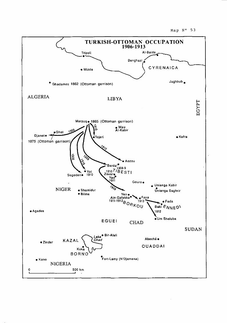
Map N o 5 3
Kufra
TURKISH-OTTOMAN OCCUPATION 1906-1913
Tripoli
Mizda C Y R E N A I C A
• Jaghbub, Ghadames 1862 (Ottoman garrison)
ALGERIA LIBYA E * 0 U
Djanet*
. Aozou Bardai*
1908-9
Segeden* 1910 Zouar.
. Unianga Kabir
NIGER . Shamidur Unianga Saghrir Bilma Yen
in-~alakka*\.~aya 1911-19128 1913 \ . Fada
"KOU \B! eNNE~\ A g a d e s
E G U E l *Um Shaluba
CHAD SUDAN
Bir-Alali
K A Z A L Abeché Zinder
Kuka O U A D D A I
B O R N 0 Kano Fort-Lamy (N'Djamena)
NIGERIA O 500 km 1 I ,

studied how they might be destroyedloO. The important Senoussi at Aïn
Galakka was overrun and destroyed by French troops in 1913. As pointed out in
paragreph 4.168 above, the sitiiation in the region as it existed in 1912 at the time
of transfer to Italy of al1 the rights and titles of the ottoman Empire to these
territories and peoples is a critical fact in this case. As shown on M a ~ s Nos. 34
and 3516'? French forces were south of 15"N latitude; and Ottoinan posts h:id
been established tliroughout the borderlands areas of Borkou, Ennedi, Ounianga
and Tibesti. Mar, No. 53 illustrates the places occupied by the Ottomans between
1906 and 1913: and the tiines when these events took place. When the French
forces moved north into the borderlands iii 1913, tliey were opposed hy tlie
indigenous trihes, wlio went on fighting in defense of their lands. This hrief
French incursion: which ended witli tlie requirements for French troops
elsewhere as a result of World War 1, had no effect on the territorial title of the
indigenous peoples.
(b) Franccr-ltaliaii Negotiations (1912-1914)
5.117 With ltaly as the successor to the rights of the Ottoman
Enipire in tlie region, France shifted its attention from the Ottomans to Italy.
After the Treaty of Ouchy hiid been concluded on 15 October 1912, ltaly was
ztnxious that other Powers recognize its sovereignty over ~ r i ~ o l i t a n i a l ~ ~ . When
1t:tly approached Frzince, the hounde~y question wzis injected into the discussic>ns
at the urging of the French Minister of Colonies. Italy opposed any such linkage,
and Barrère himself sided with the Italian view, saying to the French Foreign
Minister, Poincaré:
"II me paraît ue nous ne risquerions rien à reconnziître Izi
soiiveraineté ita 'l ienne sans viser la question de la fixation de frontière. Celle-ci reste intacte (les Italiens le reconnaissent sans difficulté). Nous demeurons inaîires de n'accepter sous ce rapport que ce c ue je considère comme conforme à nos intérêts et a nos droits. 1: ette délimitation pourrait d'ailleurs à mon sens devenir le prétexte de la remise au point de nos accords [antérieurs] avec
-- - -
160 &, Tilho. J.: "The Exploration ofTihcsti. Erdi. Borkou. and Ennedi in 1912-1917: A mission cnirusted to ihc Author hy thc Frcncli Insiiturc". The Geoeranhical Journal. Vol. LVI. Nu. 2. Atrgubi 1920. pi). 81. ;ilid 94-97, 39. a. ÜIW. Histoire Militaire de I'Afrii~ue Equ;iioriale Franc:iise. «p. &.. p. 456. Exhihi( 26.
161 &, paras. 4.120 and 4.141 ahovc.
162 &, j)ara. 5.130. g a.. bel«w. A copy of the Treaty of Ouchy is 10 De round in the International Accords :ind Aereements Annex. No. 10.
l'Italie comme la partie fiuée par la convention franco-an de 1899 fut le inotif des accords franco-italiens de 1900 et 1902 .
Poincaré did not exactly :igree, replying as follows:
"Je regrette que vous n'ayez pas fait reinarquer au Gouvernement italien que la France n'est dans le cas d'aucune des Puissances qui scirit disposées à reconnaître la souveraineté sans réserve. L'Italie v:i devenir, en effttt, notre voisine et nous ne pouvons lui reconnaitre cette souveraineté sans préciser le territoire auquel elle doit s'étendre et sans sauvegarder nos droits. Nous ne pciiivons nous assurer 'une sitii:ition hors pair en Italie'. aux dépens des intérêts français; notre amitié pour l'Italie ne doit pas tourner en duperie.
La Convention anglo-françaiise de 1899 part du tropique du Cancer et I:iisse par c<iiiséqueiit indéterininée 1:i frontière sur plus de douze cents I<ilomt.tres. II dépend du Gouvernement italien de formuler sa demande de recoqggissance dans des termes qui réservent entièrement nos droits ."
5.118 It seeins fairly cleair that when Poincaré mentioned' 1,200
kilometres of frontier "indeterminée" he was referring to the Algerian frontier
with Tripoiitania running south froin Ghadamès, the end point of the Tunisia - Tripolitania boundary, to the stürting point of the 1899 Declaration's southeast
line separating French and British zones of influence. This was the part of the
frontier that iiiterested France. However, the Ottoman claims, which Italy Iiad
fallen heir to, affected far more than just the Algerian frontier. If Poincaré was
suggesting that southeast from the Tropic of Cancer the frontier had been
determined, then he held an entirely different view of the effect of the 1899
Declaration than the British held at the t h e . The view of Great Britain had been
imparted to both the Ottoman Empire and Jtaly. assuring them that the 1899
Declaration's southeast line did not affect their interests. ln any event, this was
the part of the frontier thüt cuncerned Great Britain, since it affected the
hinterland of Cyrenaica. lt is also of interest to note the liinited value Poincaré
appears to have attributed to the 1900-1902 secret Franco-Italian Accords even as
to the Tripolitanian frontier between Ghadamès and the starting point of the
soutlieast line at the Tropic of Cancer illustrated on the Livre iaune map.
Poincaré evidently wanted a specific delimitation of that area.
163 Barrère-Poincaré Telcgïams. 17 Ociuher 1912. French Archives Annex. p. 142.
164 Poincark-Barrère Telegram, 18 Ociuber 1912, French Archives Annex, pp. 143-144.

5.119 ~ h a t ended up being agreed was for France to announce its
recognition of Italy's sovereigniy over Tripolitania and Cyrenaica and, several
days later, to publish the text of a new Franco-Italian Accord. This Accord, dated
28 October 1912, signed by Poincaré and Tittoni, the ltalian Ministry of Foreign
Affairs, provided as follows:
"Le Gouvernement de la Ré,publique française et le Gouvernement royal d'Italie, désireux d'executer dans l'esprit le plus amical leurs accords de 1902, confirment leur mutuelle intention de n'apporter réciproquement aucun obstacle à la réalisation de toutes les mesures qu'ils jugeront opportun d'édicter, la France au Maroc et l'Italie en Libye.
Ils conviennent de même que le traitement de la nation la plus fiivorisée sera réciproquement assuré. à la France en Libye et à l'Italie au Maroc, ledit traitement devant s'appliquer de la mani2re la plus large aux nationaux, aux produits, aux éta ements et aux
P!ssIt entreprises de l'un et l'autre Etats, sans exception .
Thus, France obtained a certain auid pro auo for recognizing Italy's sovereignty;
but it did not concern the boundary question, which was not mentioned.
5.120 The subject of a frontier deliinitation did not vanish with the
1912 Accord, however. According to the report made nine years later by M. Edouard Soulier to the Chambre des Deputés in connection with the Franco-
ltalian Accord of 12 September 1919, in which he referred to a 1914 report of M. Louis Marin, Italy and France agreed to a meeting in Berne to be held on 20 July
1914 by members of a joint Italian-French boundary commission to study the
procedures to be f o ~ l o w e d l ~ ~ . The report of M. Marin had indicated that the
task of the commission was to he concerned only with the Algerian frontier and
was to go no further east or south of where a line from Toummo would meet the
point of intersection of 16"E longitude and the Tropic of Cancer, which was the
beginning point of the southeast line described in Article 3 of the 1899
Declaration.
5.121 The start of World War 1 put a halt to these negotiations.
But just as in the case of the French overtures made to the Ottoman Empire in
165 A copv of the Franco-lialian Accord of 28 Ocloher 1912 is is atiached as an Annex IO the ~oin&rk-~arrkre Dispatch. 29 October 1912, French Archives Annex, p. 146. a, also, Iniernational Accords and Agreements Annex. No. 11.
166 J.o.R:F.. Documents Parlemeniaires, séance du 22 décembre 1921, p. 569. (A copy of ihis page is atiached as JO.)

1911, so also in this agreement with Italy to sit down and delimit the boundary
beyond Ghadamès, the French Government recognized three things: first, that no
agreed boundary south of Ghadamès existed; m, that France's main interest
was with the boundary between Algeria and Tripolitania-Fezzan, not with
Cyrenaica, which lay in the British sector; and m, that in 1914 the French
Government did not regard the 1900-1902 Accords as having disposed of these
boundary questions so far as ltaly was concerned.
(c) The Proposed Expedition of Captnin Tilho to Tibesti
5.122 It has been noted in a previous section that a Turkish force
of gendarmes had occupied Bilma in the region of Kaouar in 1902 and had
hoisted the Ottoman flag16'. Until 1906, French forces had not advanced as far
as Bilma, although the Turkish force had been withdrawn by that time. By 1908,
Ottoman forces were in Tibesti, estciblishing a "résidence g o u v e r n e r n e n t a ~ e " ~ ~ ~ in
Bardaï, and in April, 1911 oases in Borkou were occupied and an important
rnilitary post was established at Aïn Galakka. In 1912, the Ottomans moved into
Ennedi. AI1 this is illustrated on Mao No. 53. Until after the Treaty of Ouchy, no
French military posts had been established north of the de facto Ziguei-Areda 169 line .
5.123 In 1907, France's Ainbassador in London, Paul Cambon,
was quick to grasp the situation so Par as France was concerned: the 1899 Declüration, which he had negotiated, had, according to him, placed the Tibesti
and Borkou in France's sphere of influence; but France had never occupied these
regions, let alone settled thein. As Cambon put it in a dispatch to the Quai
d'Orsay:
"La déclaration signée à Londres le 21 mars 1899 a placé dans notre sphère d'influence le Tibesti et Je Borkou. Mais nous n'avons fait aucun acte de possession dans ces régions et rien n'empêcherait un explorateur d'une puissance n'ayant pas reconnu nos droits, l'Allemagne par exemple, d'y planter le drapeau de son pays. Vous n'ignorez pas d'ailleurs que la Porte revendique ces contrées comme faisant partie de l'hinterland de la Tripolitaine : elle a poussé récemment ses postes dans le sud de cette province
167 a, para. 5.78, m., abovc.
168 S. Communique from the French Consul in Tripoli Io the Minister olForeign Nlairs. 19 Noyember 1929, French Archives Annex, p.161.
169 a, para. 4.120, above. and Mau No. 34 reterred to thcre.

beaucoup plus loin qii'elie ne l'avait fait jusqu'à présent et nous risquons de la voir s installer un jour ou l'autre au Tibesti. Nous avons d'autant plus à redouter des incidents désagréables dans cette partie de notre empire africain qu'elle est voisine de l'oasis de Koufra. centre d'action des Senoussi. II y aurait. donc un intérêt tirgent à ce que nous affirmions nos droits au Tibesti et au Borkou par un acte de prise de possession, tout au inoins par l'envoi d'une mission.
Une telle entreprise eût présenté de grandes difficultés il y a qiielques années. Elle est devenue beaucoup plus facile depuis que nous occupons Bilma. En ce moment. la présence sur le bord du lac Tchad de la mission de délimitation de la frontiére anglo-tranqaise nous offre une occasiy, très favorable de faire procéder à une exploration du Tibesti ."
Amhassador Cambon had a specific proposal to make - to authorize an
expedition through the Tibesti by a certain Captain Tilho, who had just completed
his work for the delimitation commission that was implementing the 1898
Convention in the region west of Lake Chad. As just shown above, Cambon's
concern over Ottoinan activity in the area, both present and prospective, was well
justified.
5.124 The proposal that Captain p il ho'^' lead an expedition
through the Tibesti and, in this way, establish some sort of French activity or
presence there, was similar to a proposal already made by the Minister of
~ o l o n i e s ' ~ ~ . Cambon's dispatch was given a gond deal of attention by the Quai
d'Orsay; there was no senior French diplomat more knowledgeable than he as to
French colonial interests in Africa. In fact, the itinerary that Captain Tilho
proposed to take in returning to France had already been a matter of high-level
consideration. In a dispatch of 24 October 1907 to the Minister of Colonies,
Foreign Minister Pichon had urgently requested that Tilho avoid the region of
Djanet "où nous sommes engagés vis-à-vis du gouvernement Ottoman à observer 173 jusqu'à nouvel ordre de statu-quo" .
170 Camhon-Pichon Letter. 6 Dccemher 1W7, French Archives Annex, pp. 149-150.
171 Rising suhsequently through the ranks to General, Tilho was to hecome one of the more knowledgeable and promineni Frenchman on the question of the Lihyan frontier with France's possessions. conducting a scientiiïc and mapping expedition into Tibesti during 1912-1917, and contrihutiny studies that influenced France's position in the 1934-1935 negotiations wiih Italy.
172 Minister of Colonies - Ministty of Foreign Affairs, 15 Octoher 1%. French Archives Annex, p. 273. -
173 Dispatch o f24 October 19117, French Archives Annex, p. 148.

5.125 Before reaching a decision on Cambon's request, Pichon
asked to be brought up to date as to what was happening in the region. He was
advised that in October 1906 Captain Tilho had been instructed, in carrying out
his "études", not on any pretext to penetrate Borkou or Tibesti -
"... qui n'ont pas encore été soumis à notre domination et où la prksence de cet offici75 aurait pu donner lieu à des coinplications d'ordre international ."
5.126 In a dispatch of 9 March 1908, the Minister of Colonies
advised Pichon that the Governor General of the A.O.F. (French West Africa)
had advised against the proposal that Tilho pass hy Borkou or Tibesti and had
counselled, given the hostility of the inliabitants, that occupation of these regions
should be carefully prepared and accomplished g r a d ~ a l l ~ ~ ~ ~ . As a result,
Captain Tilho regained France by wiiy of West Africa and did not enter the Libyzi-
Chad borderlands. Pichon's reference to the inhabitants was, of course, to the
indigenous tribes that the Senoussi Order had organized to resist the French
inilitary advances onto their lands.
5.127 This episode is another confirmation that Article 3 of the
1899 Declaration had not created a territorial boundary and that this continued to
be the case after the secret Accords of 1900-1902. Ambassador Cambon, who
had sat across the table from Lord Salisbury negotiating the 1899 Declaration,
was in 1907 an ardent advocate that France act so as to occupy Borkou and
Tibesti before the Ottoman Empire or some other Power should do so. Cambon
urged France to affirin its rights by action before the Ottomans did, for the
Ottoman Empire had laid claim to this area as part of the hinterland of
Tripolitania. The French Government's response to his warning came too late.
Ottoman forces occupied the oases of Borkou and Tibesti before the French, who
were proceeding cautiously in the light of the strong resistance of the indigenous
Senoussi tribes, who had been joined by Ottoman forces, to oppose the French
military advances. The interlude between 1910 and 1913 in these regions, the
extent of Ottoman occupation and the tacit understandings reached between the
French authorities and the Ottoman forces and the Senoussi Order have been set
174 Minister of Foreign Allairs - Minisier of Colonies Dispaich, 16 December 1907. French Archives Annex. p. 151.
175 Dispatch of 9 March 1908. French Archives Annex, p. 278.

out in paragraphs 4.120to 4.164 above. The proposed Tilho expedition episode is
a refiection of the modus vivendi between the opposing forces pending what were
scheduled to be delimitation negotiations between the French and the Ottomans
to fix the boundary. These negotiations thereafter, were cancelled in the light of
the Treaty of Ouchy. Thereafter, World War 1 put an end to French plans to
negotiate the boundary with Italy.
SECTIOS 8. Itnly's Invasion of Libvn in 1911; the Treatv of Ouchv of 15 October 1912
(a) Italv's Invasion of Libvn
5.128 By 1911, after lengthy diplomatic and military preparations,
and under the impetus of domestic public opinion, Italy had finally decided to
start its war against the Ottoman Empire for the conquest of Libya. The war,
which was announced by the ultimatum of 26 Septernber, was declared on 29
September, and hostilities began immediately, with an enormous deployment of
troops and arms. The determined resistance that its expeditionary force met in
Libya soon led ltaly - which in the meantiine had proclaimed its "full and entire
sovereignty" over Tripolitania and Cyrenaica (by Royal Decree No. 1247 of 5
November 1911, converted into Law No. 88 of 25 February 1912) - to enlarge the
war zone by striking against Turkish interests elsewhere (Beirut, Dodecanese or
Sporades Islands, Turkish straits, a.).
5.129 Ultimately, a number of defeats suffered by the Ottoman
armies, especially during the summer of 1912, and the danger created for Turkey
by the establishment of the Balkan Leegiie, together with the moderating
influence exerted on ltaly by third Powers, led the two parties to negotiate a
peace which, while allowing free rein to Italy's expansion in Libya, safeguarded
other Ottoman interests. After difficult negotiations, the Peace Treaty was signed
in Lausanne (Ouchy) on 15 October 1912''~.
(b) The Treatv of Ouchy
5.130 The Treaty of Ouchy is made up of several documents that
are al1 closely related. The first such document (the "secret" Treaty) begins with a
176 &, ~realy of Lausanne (Ouchy) of 15 Ociober 1912, Internaiional Accords and Aerecmçnis Anncx. No. 10.

preamble noting the difficulties encountered by both parties in putting an end to
the state of war -
"... provenant de l'impossibilité pour l'Italie de déroger à la loi du 25 février 1912 qui a proclamé sa souveraineté sur la Tripolitaine et sur la Cyrénaique et pour l'Empire Ottoman de formelleinent reconnaître cette souveraineté ... ."
5.131 Next, the "secret" Treaty placed on each party the obligation
to promulgate within three days certain legislative measures, the substance of
which was contained in three appendices that were an "integral part" of the
Treaty (Article IX). Finally, Article V provided that a "public" Treaty (whose text
was set forth in Appendix 4) was to be signed by the High Contracting Parties "... immédiatement après la promulgation des trois actes unilatéraux susdits". This
Treaty was in fact signed on 18 October 1912.
5.132 It should be noted that the wording of the "iinilateral acts" in
question was also - like the provisions contained in the other two documents (the
"secret" Treaty and the "public" Treaty) - the result of the negotiations between
the parties, and therefore playrd a full rolr in the determination of their rights
and obligations under the Treaty. In other words, in determining the meaning and
effects of the 1912 Treaty for both parties, it is also necessary to take into account
the contents of the domestic "unilateral acts", which each had undertaken to
promulgate, and which had been established beforehand on the international
level.
5.133 Certain aspects of two of these "unilateral acts", the Firman
and the granting of Amnesty under Article III of the secret Treaty, deserve
special attention.
(i) The Firman
5.134 The Firman (whose text is set forth in Appendix 1 to the
Treaty), which Article 1 of the secret Treaty obliged the Sultan to address ta the
inhabitants of Tripolitania and Cyrenaica, and which was in fact promulgated on
18 October 1912, contained the following passage:
"Me prévalant de Mes droits souverains Je vous concède une leine et entière autonomie. Votre pays sera régi par de nouvelles P ois et des règlements spéciaux, à la préparation desquels vous apporterez

la contribution de vos conseils afin qu'ils correspondent à vos besoins et à vos coutuines."
5.135 In view of the context, it would be unreasonable to think
that the word "autonomy" could be construed as "sovereignty" granted to the
Ljbyan population; and the Porte never claimed this in suhsequent discussions
with Italy. To the contrary, the Porte's position was that it had retained
sovereignty over Libya, without in any manner transferring it to Italy.
Nevertheless, the expression in question, granting autonomy to the inhabitants, is
contained in a document (the Firman) that is part of a Peace Treaty by which the
Porte recognised the accomoli of the ltalian conquest and undertook in
favour of ltaly to remove from Libya the whole of its civil and military
o r g a n i ~ a t i o n ~ ~ ~ . Thus, the Porte admitted that Italy would thereafter replace
Turkey in the exercise of sovereignty (if not inheriting its title) over the two
provinces, whose territorial lirnits were not identified in the provisions of the
Treaty. However, the Firman had the effect of identifying the peoples whose
autonomy Itrily was obliged to respect in its administration of these territories.
They cornprised al1 the groups that fell within the category of "habitants de la
Tripolitaine et de la Cyrénaïque" to whoin the Firman was addressed.
5.136 Therefore, the granting of "autonomy" to the Libyan
populations must be interpreted in a different way than as a granting of
"sovereignty" to the inhabitants. Taking the passage from the Firman quoted
above as a whole, and in the context of the entire Treaty, the scope and Iimits - and also the meaning - of the autonomy granted to the Libyan populations can be
grasped. This autonomy was to consist of, first, the right to continue to enjoy "... de la plus grande liberté dans la pratique du culte musulman" (Article 2 of Appendix 2) and, second, the right of the populations to contribute their
"conseils" during the "préparation" of the laws and regulations by which "votre
pays sera régi" (preamble to Appendix 1). I t is quite clear that this was an allusion
to the laws which were to be promulgated by Italy with respect to Libya, in the
preparation of which a committee consisting partly of "notables indigènes" was
supposed to participate (Appendix 2 to the Treaty, Article 4). It also constituted
a recognition by Italy that the peoples enjoyed a certain autonomy. And in the southern regions, certainly, where Ottoman control had been exercised in
conjunction with the Senoussi, it implied a recognition by Italy of the title of the
indigenous tribes led by the Senoussi to their own territory.
177 Article 2 ol the public Trcaty contained in Appçndix 4.

5.137 In sum, the "autonomy" in question represented in substance
an indirect undertaking on the part of Italy bearing on the obligation of Italy in
administering Tripolitania and Cyrenaica to take account of the wishes of the
inhabitants und to respect their customs and religion in its administration of these
provinces.
5.138 The ptiblic Treaty provided for by Appendix 4 laid down the
modalities of the Ottoman withdrawal from Tripolitania and Cyrenaica in favour
of Italy. Italy, in turn, tindertook to withdraw from the Ottoman territories which
it had occupied during the war - which in fact it did not do, claiming that Turkey
had not completely removed itself from Libyan territory. Here again, there is no
definition of the extent of the Libyan territory from which the withdrawal was to
take place. However, such territory could have been no different from tliat which
was legitimately subject to the sovereign rights of the Ottoman Empire at the
beginning of the war and inhabited by peoples who were under Ottoman
sovereignty.
(ii) The Grnnting of Amnesty
5.139 The unilateral measure that Article III of the secret Treety
of 1912 required ltaly to take (implemented on 17 October 1912 by Royal
Decree) concerned the amnesty that was to be granted and that defined the
"autonomy" which the population in question were to enjoy. Appendix 2 laid
down the precise extent of such "autonomy", including a reference to the
"souveraineté pleine et entière du Royaume d'Italieu over Libya, which had been 178 proclaimed by the Italian law of 1912 mentioned above .
5.140 The wording of Appendix 2 calls for three observations:
First the Porte, indirectly, by the very acceptance of the existence -7
and contents of this Appendix, acknowledged in substance what it
had refused to acknowledge "formally" in the preamble179: that the
sovereign rights of Turkey over Tripolitania and Cyrenaica were
thenceforward transferred to Italy. However, as has been seen (and
178 -,para. 5.128. abovc.
179 The preamble is quoted in part in para. 5.130, above.

as will be discussed below), the Porte was to argue differently,
taking the view that title to sovereignty over Libya remained with
Turkey, which had transferred to ltaly no more than the exeicise of
such sovereignty.
Second. the territorial scope of the sovereign rights transferred to
ltaly could be no different than that which had previously defined
such rights enjoyed by the Ottoman Empire.
m, Italy accepted, nonethlrss, that full Italian sovereignty wotild
be exercised only within the limits and upon the conditions which
had been laid down, &, that it would respect two sets of
undertakings: (i) those in favour of the inhabitants of Tripolitania
and Cyrenaica, wh«se "autonomy" (as defined above) was
acknowledged; and (ii) those in favour of the Porte, certain of
whose rights had been continued in force under various provisions
of the Treaty, in particular with respect to the appointment of the
Sultan's representative and the w18('.
5.141 It is appropriate to mention again that nowhere in the
Treaty of Ouchy is there any precise definition of the Iimits of the territories that
were acknowledged by the Porte as being thereafter subject to the "nouvelles
lois". But it is clear that these territories were those over which the Porte had
"droits souverains" at the tirne of the war, rights that certainly could not be
reduced or in any way prejudiced by previous agreements between third parties,
such as between Great Britain and France. It was those sovereign rights, witli
their territorial scope at that time, whose transfer to Italy was acknowledged by
the Treaty of Ouchy, subject to the three limitations just mentioned: the
maintenance of the authority of the Sultan over the religious and personal aspects
of the lives of the inhabitants (through the Cadi); the protection of Ottoman
interests in the country (through the Sultan's representative); and the right of the
inhabitants to participate in the governing of Libya. Moreover, the sovereign
rights of the Ottoman Empire, which the Treaty transferred to Italy, applied not
only to the Ottoman territories (not specifically defined) but also to the Libyan
180 Thus, thrcc ci>mponenis ofsovcrcignty were carvcd out of rhc sovcrcignty ir:insfcrrcd Io Italy: (i) the Sultan rctained a personal representative in Libya; (ii) the Sultrn approved the m. who acted as jiidge in rcspcct to al1 rcligious and pcrsonal aspccts of thc livcs of the Muslim inhabitants; and (iii) ihr inhabiianls pariicipated in ihegoverning olLibya.

peoples ("habitants de la Tripolitaine et de la Cyrénaïque"), whose autonomy
Italy had undertaken to respect in governing them. Thus, ltaly succeeded the
Porte in administering Libya in a dual sense: as to its territory and as t« its
peoples. Territorially, the extent of Libya to be administered by ltaly could only
have been that over which Ottoman power was effectively and legitimately
exercised at the moment of succession. I n so Par as title to territory had been held
by the Ottornansiojntlv with the peoples, Italy succeeded only to a jo& title. The
peoples to be governed comprised the inhübitants of the regions to which the
Firman has been addressed.
5.142 As has already been mentioned, Turkey was to claiin
subsequently that the Treaty of Ouchy had in no way resulted in the loss of its
sovereignty over Libya: to the contrary, the granting of autonomy to the Libyan
populations was an expression of the Porte's sovereign rights and iinplied that
they were maintained, in the absence of any explicit clause relating to the
abandonment of such rights. Whatever one might think of the subtleties of this
theory, it should be noted iminediately that France never adopted the Ottoman
position. On the contrary, France (like the other European powers) hastened to
recognize fully the sovereignty of Italy over the two former Ottoman provinces in
accordance with Italy's wishesl8'. Although neither France's recognition of
Italy's sovereignty, nor the Franco-Italian Agreement of 28 October 1912,
touched upon the question of the boundaries of ~ i b ~ a l ~ ~ , the fact remains that as
a result of France's recognition of Italian sovereignty - made without the slightest
reservation or restriction - France acknowledged for al1 purposes the succession
of ltaly to the Porte's sovereign rights over Libya, such as they existed in 1911-
1912 (and therefore also their territorial and personal extent).
5.143 The correctness of these observations is strongly reinforced
by the fact that France's attitude (like that of Great Britain) remained absolutely
consistent; for following the events of 1911-1912, France acknowledged that
sovereignty over Libya had been transferred in full to Italy, whatever may have
been the correct interpretation of the Treaty of Ouchy in the relations between
Italy and Turkey. Furtherinore, France and the United Kingdom did not hesitate
to go even beyond what was provided for by the letter of the Treaty. For both

States accepted the inclusi«n in the secret Treaty of London of 1915 of a
provision (Article 10) that read as follows:
"L'Italie sera suhstituée en Libye aux droits et friyilèges appartenant actuellement au Sultan en vertu du raité de Lausanne."
5.144 In other words, even if it might have been possible to sustain
the theory that the Treaty of Ouchy created a certain form of shared sovereignty
between Italy and Turkey over Libya (or even that it left Turkey with the title to
such sovereignty and transferred only ils exercise to Italy), it must be admitted
that this theory was not adopted by either France or the United Kingdom. For
after having recognized Italian sovereignty in Libya, these two States made the
undertaking towards Italy in 1915 to consider that any forrn of sharing (however
lirnited) was to cease in favour of Italy. It was clearly full ltalian sovereignty over
Libya that was recognized in this way. Equally recognized was the fact that ltaly
thereafter had al1 the rights in Libya that had belonged to the Ottoman Empire
before the war. This recognition that the rights that were transferred were full
sovereign rights could only imply, by the very fact that no reservations were made,
that it was recognized that such rights covered the whole of the Libyan territory
and the entire Libyan population previously subject to Ottoman sovereignty.
5.145 It is appropriate here to recall that in the Treaty of
Lausanne of 24 July 1923 the rnatter of State relations between Italy and Turkey
was definitively resolved: Turkey soleinnly recognized that any residual sharing of
rights between the two States was thenceforth abolished in favour of 1talylg3.
Article 16 of the Treaty provided as follows:
"La Turquie déclare renoncer à tous droits et titres, de quelque nature que ce soit, sur et concernant les territoires situés au-delà des frontières prévues par le présent Traité et sur les îles autres que celles sur lesquelles la souveraineté lui est reconnue par ledit Traité, le sort de cest territoires et îles étant réglé ou à régler par les intéressés ... ."
More specifically, although safeguarding the spiritual aspects of the Muslim
religious authorities (in accordance with Article 27), Article 22, established that -
183 ~ r e a l y of Lausanne of 24 July 1923. Internaiional Accords and Agreements Annex. No. 20.

"... la Turquie déclare reconnaître i'abolition définitive de tous droits et privilèges de quelque nature que ce soit, dont elle jouissait en Libye en vertu du Traité de Lausanne du 18 octobre 1912, et des Actes y relatifs."
To this was ~ d d e d the following, in the second paragraph of Article 29:
"Les ressortissants libyens seront ii tous égards soumis, en Turquie, au même régime que les autres ressortiss:ints italiens."
In short, in 1923 Turkey recognized, without reservation, that thenceforth Italy
had full and complete sovereignty over such Libyan territories as fell under
Ottoman soverrignty prior to 1912. as well as over al1 the inhabitants thereof
(who were accepted as being considered Italian citizens). Thus, al1 the
ambiguities and compromises of the Treaty of Ouchy were elimineted in favour of
Italy, whose legal status as successor to Turkey as to al1 rights and titles
concerning Libya received full recognition. It should be noted that this
recognition was not only accorded by Turkey; for the 1923 Treaty was signed by a
number of other Powers, including Great Britain and France. These Ottoman
rights and titles inherited by Italy coexisted with the title of the indigenous
peoples, whose autonorny granted by the Sultan, had been acknowledged by Italy.
5.146 Returning now to the specific matter of the southern limits
of Lihyan territory, it has been seen that they had not been determined by any previous international boundary agreement and that the agreements relating to
the spheres of influence of France and the United Kingdom could in no event
have had the slightest effect on the Porte, who did not participate in them and
who had protested vigorously against them. Consequently, the same situation of
indetermination was transferred in 1912 to Italy, as successor State to Turkey.
Only an undertaking made previously by ltaly in favour of another interested
State, by wh'ich Italy would have been bound with respect to the determination of
the boundaries of Libya (in the event of the future conquest of the territory
concerned), could have been invoked by such other State against Italy after 1912,
unless there had been a change in the relevant circumstances. However, as has
been seen, the Franco-Italian Accords of 1900-1902 implied no recognition by
Italy in favour of France of a southern boundary to Tripolitania and Cyrenüica
(which in any event had never been drawn), for several rasons, which it is useful
to repeat again: (i) because what ltaly had recognized was the existence of a limit
to the French suhere of influence to the north of Lake Chad, and not a boundary
between French and Ottoman territories; and (ii) because this recognition in any

event related only-to a l'ine concerning the lirnits of Tripolitania exclusively, wliich
had nothing to do with the line drawn in 1899 - the famous southeast line
descrihed in Article 3 of the 1899 Declaration that was to be the hasis of
subsequent French claims, and is now apparently the basis of Chad's claims.
5.147 As has been seen, the succession of ltaly to the Ottoman
Empire insofar as sovereignty over Libya was concerned - which France had
acknowledged to be full sovereignty - clearly covered the whole of the Libyan
territory and the entirety of the Libyan peoples over which the sovereign power of
the Ottoman Empire had, prior thereto, been legitimately exercised. It could only
have concerned al1 the rights, titles and claims that were the Ottoman Empire's
with respect to Libya. After the 1912 Treaty of Ouchy, Italy found itself in the
same juridical situation as the Ottoman Empire and, thus, had the right to
negotiate agreements for the delimitation of the boundaries of Libya with its
neighbouring States and the right to invoke in such negotiations the juridical titles
that had been transferred to it by the Porte.
5.148 The following conclusions may be drawn from the above
analysis:
(i) In the 1912 Treaty of Ouchy, the Ottoman Empire transferred
to Italy the right to exercise sovereignty over Libya, subject to two
sets of limitations: first, those in favour of the local population,
whose "autonomy" (albeit in a limited form) was giiaranteed; and
second, those in favour of the Porte. This succession covered, of
course, al1 sovereign rights, al1 legal titles and al1 claims that prior
thereto had belonged to the Ottoman Empire in respect to Libya in
respect to both its territory and its peoples. The territorial extent of
Libya could only correspond to those territories over which
Ottoman sovereign power had been effectively and legitimately
exercised at the moment of succession. The Libyan peoples
corresponded to al1 the inhabitants of Tripolitania and Cyrenaica to
whom the Sultan's Firman had been addressed.
(ii) France (and the Great Britain) repeatedly acknowledged that in 1912 Italy succeeded the Ottoman Empire not only in the
exercise of full and entire sovereignty over Libya but also to the
Ottoman Empire's full title and rights. France (and Great Britain)

made no resewations with respect to this acknowledgement, in
particular of a territorial nature.
(iii) The Lihyan territory that thus became subject to Italian
sovereignty could only be the same as the territory over which
Ottoman sovereignty had previously been legitimately exercised;
consequently, iiny agreement with respect to the delimitation of
Libyaos boundaries that was binding upon the Ottoman Empire
prior to 1912 would be binding upon Italy after that date.
(iv) Conversely, any international act that might have had any influence whatsoever upon the extent of Libyan territory, and rhat
was unopposable to the Ottoman Empire before 1912, remained unopposable to ltaly as the successor State after that date: this is
the case, in particular, with the Anglo-French Declaration of 1899.
(v) After 1912, it inight have been possible to oppose to Italy any
previous agreement by which it might have undertaken in advance
to accept a given delimitation of Libya's boundaries, in the event
that it subsequently acquired sovereignty over Libya (as did occur
in 1912); however, this situation did not arise, since the Franco-
Italian Accords of 1900-1902 were exclusively concerned with zones
of influence and in any event did not relate to the boundaries of the
Libyan territory east of Toummo. By failing to express any
reservation at al1 as to Italy's accession to the full rights and.titles of
the Ottoman Empire with respect to the territory and peoples of
Libya, France acknowledged that the Accords of 1900-1902, which
in no way were binding on the Ottoman Empire, had not affected
the Ottoman rights and titles so transferred to Italy.
(vi) The wholly indeterminate nature of the southern boundaries of
Libya in 1912, at the time of Italy's acquisition of sovereignty,
entitled Italy, in its subsequent relations with other States in order
to arrive at definitive boundaries, to invoke al1 the juridical titles
that had belonged to the Porte before 1912.
(vii) Since, as will be demonstrated by what follows, subsequent to
1912 no international act established any southern boundary of

Libya east of Toummo, it is evident that in establishing this
boundary there must be taken into account the legal titles that were
transferred from the Ottoman Empire to Italy and, thereafter, from
ltaly to Libya. The legal titles pertinent to determining the
southern extent of Libya apply to the entire territory over which the
sovereign power of the Ottoman Empire may be found to have
been legitimately exercised as well as to al1 the peoples whose
autonorny ltaly undertook to respect.
5.149 Finally, in its dealings with the Ottonian Empire in 1911-
1912, and in particular in its acceptance, and even scheduling, of negotiations to
delirnit the southern boundary with the Ottoman Empire, France acknowledged
that such a boundary had not been esttiblished. Sirnilarly, after the 1912 Treaty of
Ouchy, when France entered into negotiations with Italy tvr the same purpose - negotiations which the onset of World War 1 prevented - it acknowledged for a
second tirne the absence of a boundary there. Thus, it is not the 1900-1902
Accords that bear on the question but rather France's conduct in the period 1911- 1914. For France recognized, first to the Ottomans, then to the Italians, that
Libya's southern boundary remained to be determined.
SELTIOS 9. World Wnr 1: the Secret Trentv of London of 1915; nnd the Deliberntions of the Colonial Commission in 1919 over Africnn Concessions to ltnly
5.150 ltaly entered World War 1 on the side of the Allies under the
terms of the secret Treaty of London of 26 April 1915lS4. This was a cornplex
matter for Italy, which was at the time a mernber of the Triple Alliance. On the
other hand, Turkey, with which Italy had just ended a war, had recently entered
the war on the side of the Central Powers. Meanwhile, Italy's relations with
France and Great Britain had been improving. The Treaty of London settled the
issue.
5.151 ltaly encountered great difficulties during the war with its
new colonies of Libya and Cyrenaica, and its forces withdrew to Tripoli and a few
other localities along the Coast. This was in large part due to the organized
opposition of the indigenous peoples and supported by the Turks. In 1917, the
1W ~ e c r e t ~ r e a t ~ otlondon 01 26 Ayril 1915, International Accords and A~reemenls Annex, No. 12.

first of a series of -agreements with the Senoussi was entered intolg5. With the
War's end, the Allies turned to how to divide up Germany's African empire. The
Treaty of Versailles of 26 June 1919 had stripped Germany of its colonies, but
Italy did not share in the distribution of mandates. So the provisions of the secret
Treaty of London took on a special in~portance.
5.152 The Articles of the Treaty relevant to the African colonies
were Articles 10 and 13. Article 10, which has been discussed in the previous
Section, provided as follows:
"A11 rights and privileges in Libya at present belonging to ti&Sultan by virtue of the Treaty of Lausanne are transferred to Italy ."
The English and French texts of Article 13 are set out below:
"ln the event of France and Great Britain increasing their colonial territories in Africa at the expense of Germany, those two Powers agree in principle that ltaly may claim some equitable compensation, particularly as regards the settleinent in her favour of the questions relative to the frontiers of the Italian colonies of Eritrea, Somaliland and Libya. and the neighbouring colonies belonging to France and Great Britain."
"Dans le cas où la France et la Grande Bretagne augmenteraient leurs domaines coloniaux d'Afrique aux dépens de l'Allemagne, ces deux Puissances reconnaissent en principe que l'Italie pourrait réclamer quelques compensations équitables; notamment dans le réglement en sa faveur des questions concernant les frontieres des colonies italiennes de I'Erythrée, de la St~malie et de la Libye et des colonies voisines de la France et de la Grande Bretagne."
When the Treaty's existence became known after the War, a number of versions
of the text of Article 13 were in circulation. However, the above are the authentic 187 texts .
5.153 Article I O dealt with Italy's r&& in Libya. Article 13 concerned com~ensation to Italy. Thus, Article 13 went beyond the recognition
of Italy's rights and was aimed at giving Itaiy something in addition to its rights in
185 This story and the conclusions to be drawn from it are dealt with in Section 13 below.
186 The French text is set oui in para. 5.143. ahove.
187 a. Inlemational Accords and Acreements Annex. No. 12. Apparently, the text was first released in 1917 hy the Bolsheviks in the course of exposing various secret agreements entered inIo hy Imperia1 Russia. The translation apprdring in was faully.

the form of equitable compensation, particularly by the resoluti«n in Italy's favour
of questions as to the frontiers of the colonies, which included of course the
Libyan frontier.
5.154 Before looking at the record of the post-War discussions
over how to compensate ltaly under Article 13, the Article's text should be
examined closely. Italy's claim to compensation under the Articles was, first of all,
conditional: it arose if England and France increased their colonial possessions at
Gerinany's expense. On 7 May 1919, the Supreme Allied Council determined
that this condition had heen satisfied and that Italy was eligible for compensation
under Article 131g8.
5.155 The second point about Article 13 is that Italy's claim to
equitable compensation was, "notamment" (particularly), to be satisfied "dans le
réglement en sa faveur des questions concernant les frontières" of the Italien
colonies of Eritrea, Somalia and Libya and the neighbouring French and British
colonies, or in the words of the English text "as regards the settlement in her
(Italy's) favour of the questions relative to (these) frontiers". Other texts that had
been circulating were broader in scope. For example, the following, incorrect
version was made public in Italy in 1918:
"Art. 13. - Dans le cas d'une extension de possessions coloniales françaises et britanniques en Afrique, aux depens de l'Allemagne, la France et la Grande Bretagne reconnaissent, en principe, à l'Italie, le droit de demander pour elle-même certaines com ensations sous la forme d'une extension de ses possessions en Eryt 1 rée, dans le pays des Somalis, en Libye et dans les qbyicts coloniaux limitrophes des colonies françaises et britanniques ."
During the ensuing negotiations over how to compensate Italy, even on the basis
of the correct text, the Italian Government took a broader view of how Article 13
should be interpreted and applied than did the French and English. However, the
correct text is of particular interest in the light of the history and analysis
recounted earlier in this Memorial of the various agreements that concerned the
boundaries of Libya. For compensation to Italy was to consist mainly of resolving
in Italy's favour the houndam auestions between Libya (and the other two Italian
colonies) and the neighbouring French and British colonies. This particular
188 B. Records of Meetings of 15 May 1919. French Archives Annex, p. 284.
189 a 1918, p. 275. ( A copy of ihis page is atiached as- 41.)

language of Article 13, thus, brought out two points: first, that at the titne there
were certain boundary questions to be resolved; and &, that Article 13 did
not concern inerely gratuitous offers of compensation, but rather the resolution of
those existing boundary questions in Italy's favour.
5.156 It was well known what these boundav questions were
insofar as the frontiers of Libya were concerned. France and Italy had recently
broken off negotiations aiined at determining the boundaries dong Libya's
frontier south of Ghadamès. As inheritor of the Ottoman Empire's territorial
rights in North Africa, Italy had assumed Turkey's place in attempting to
determine Libya's southern frontier, concerning which the negotiations started
between France and the Ottoman Empire had been brought to a halt by Turkey's
defeat in 1912 and the Treaty of Ouchy.
5.157 At its meeting of 7 May 1919, the Supreme Allied Cotincil
appointed a Colonial Commission to consider Italy's claim under Article 13, with
Lord Milner as Chairinan and the French Minister of Colonies, Henry Siinon, and
M. Crespi representing France and Italy, respectively, together with their staffs.
Four meetings of the Colonial Commission were held in Paris: on 15, 19, 28 and
30 May 1 9 1 ~ ~ ~ ~ .
5.158 There had been a good deal of thought and study given by
Italy to its territorial rights and the question of compensation under Article 13
even before the end of the war191. A discussion had taken place in Paris on 29
March 1916 between senior members of the Foreign Ministries of France and
ltaly over the Ghadamès - Chat sector of the Lihyan frontier, but the talks
ultiinately led nowhere, although at the outset ltaly thought that it had obtained
agreement from the French participants to include the caravan routes in this
sector within Libyan territory. The ltalian Colonial and Foreign Ministries thereupon formulated alternative strategies consisting of a iniutiinum and a
minimum position192. The maximum position was to include within the Tripolitanian hinterland the following:
1W &. French Archives Annex. pp. 284-295. for the officia1 record of ihese meetings.
191 &. Miège, J.L: L'lm~érialisme Colonial Italien de 1870 à nos Jours. Paris, S.E.D.ES., 1968.
9 2 An English iranslation of ihe relevant paragraphs of a long document daied 15 Novemher 1916 from the Ministty of the Colonies Io the Ministry of Foreign AIfairs illusiraiing the ltalian positions is contained in ltalian Archives Annex. p. 22.

NO. -. ~


Map No. 56 - I

Map No. 57

- The northern part of the Chad basin, including Kanem and
Ouadaï;
- Places occupied by France along the caravan routes after
the date of Italy's occupation of Libya: i&., Djanet, Bilina,
Borkou and Tibesti, so that the five great caravan routes
were left completely under Italian control;
The direct Ghadamès - Ghat caravan routes and routes
linking Ghat and Toummo;
On tlie Cyrenaican frontier, the line would run from Sollum
on the Mediterranean to the intersection of 25"E longitude
and 25"N latitude and then south along 25"E almost to its
intersection with 15"N Icititude, inter alia, placing the oases
of Djaraboub and Koufra within Libyan territory.
This maximuin position is illustrated on Mao No. 54, a replica of the original
Italian Colonial Office inap prepared in 1916 to illustrate this position; and on 193 Man No. 55, a reproduction of this map on Base Mao B .
5.159 The minimum position is shown on Man No. 56, also a
replica of a 1916 map prepared by the Colonial Ministry to illustrate this position;
and on Mao No. 57, a repraduction of it on Base Mao B. On the east, the
boundary with Egypt and Sudan was the saine as in the maximum plan. On the
West, it would incorporate within Tripolitania the caravan routes to Touinmo,
thus rounding out the wavy boundary line of Tripolitania, but would stop there
and not incorporate the region of Kaouar to the south. It is the boundary south of
Cyrenaica, however, that is of particular interest; for the minimum position would
have adopted the southeast line of Article 3 of the 1899 Declaration, treating it as
a strict southeast line that intersected 24"E longitude at approximately 15'45'N
latitude (at Wadi Howa).
193 The original Italian maps can be found in the map colleciion of the "Istituto Italo- Africano" of Rome.
5.160 Thus, when the first session of the Colonial Commission
convened on 15 May 1919, Italy's representative had in his pocket some carefully
considered ideas.
5.161 Lord Milner opened the first meeting hy calling on M.
Crespi to set out Italy's claims under Article 13. Crespi produced certain maps,
and from the official record of the 15 May session it would appear that he
presented Italy's ininiinuin position, althoiigh the claim south of Cyrenaica is not
spelled out in the report. However, Italy's main interest was directed at
concessions in Eritrea, Somaliland (which concerned Djibouti) and Jubaland.
5.162 At the next meeting (19 M z ~ ) , France was called on for its
reaction to Italy's claims. M. Simon rejected the proposal concerning Djibouti but
declared hiinself receptive to a rectification of the western boundary of
Tripolitania. Lord Milner said that Great Britain (which had already indicated
that Koufra fell within the ambit of ~ i b ~ a l ~ ~ ) was receptive to including
Djaraboub as part of Cyrenaica. Great Britain was said to be ready to offer some
of Jubaland as well. The major stumblinç block at this session was over Djibouti,
which the French were not prepared to cede to Italy.
5.163 At the third session (28 May), M. Simon made a new offer:
to give a portion of the Tibesti to Italy so as to include Bardaï, but only if Italy
abandoned its claim to Djibouti. M. Crespi declined to respond in view of the
absence of his experts.
5.164 At the final meeting of the Colonial Coinmission (30 May
lYlY), Italy generally accepted Great Britain's offer of Jubaland; but as to
France's new offer:
"M. Crespi ... déclare que les offres de la France dans la région du Tibestil# lui semblent pas présenter pour son pays un r6el intérêt ."
Then M. Crespi suggested that, if Djibouti could not be ceded, then the Togo
mandate might be given to Italy, a suggestion cut off short by Lord Milner, who
said that were this agreed it would end Italy's eligibility under Article 13. Lord
194 &, para. 5.218. below.
195 &, Final Meeting, 30 May 1919, French Archives Annex. p. 293.

Milner proposed that the work of the Commission be ended and a final report be
prepared in the light of the evident impossibility of reaching an agreement.
5.165 The Commission issued its final report on 6 June 1919
recounting the discussions and the results achieved. It mentioned Italy's
argument for a broad reading of Article 13 so that ltaly would receive
proaortionate compensation. It recalled the French offer of a part of Tibesti so
as to include Bardaï, and Italy's rejection of it. The report's summary indicated
that Italy did not accept the part of Tibesti offered by France and withdrew its
propo~al relating to the western and southern houndaries of Lihya -
"... préférant que la question coloniale africaine restfit ouverte entre les deux Gouvernements, Français et Italien."
France indicated that it -
"... accepte la rectification de la frontière occidentale de la Libye, que l u i avait primitivement demand6e et elle maintient l'offre qu'elle a présentée à I'ltalie en vue de reche r les bases d'une 'Hf delimitation nouvelle dans la région du Tibesti ."
5.166 Then, on 16 July 1919, Italy proposed a new iipproach,
which was presented by the ltalian delegation to the Peace ~ o n ~ r e s s ' ~ ' . The
ltalian note summarized the previous offers and responses; and it pointed out
how ltaly had argued unsuccessfully that its compensation should be based on the
idea of proportionality. The new proposals advanced by ltaly concerning the
Libyan frontier were these:
The western frontier of Libya would be fixed so that the
principal caravan routes between Ghadamès, Ghat and
Toummo would fall within Libyan territory;
The entire territories of Tibesti, Borkou and Ennedi, whose
boundaries should be delimited geographically and
ethnically, would be agreed to lie on the Libyan side of the
frontier.
196 Final Report of the Colonial Commission, 6 June 1919, in ltalian Archives Annex, p. 29.
197 -, ltalian Proposal of 16 July 1919, French Archives Annex. p. 296.

The rest of the proposal related to Ethiopia, the construction of railroads and
Tunisia.
il ian 5.167 The interna1 reaction of the Quai d'Orsay to the new It 1'
proposal was (i) to be pleased that the claim to Djibouti had been dropped, (ii) to
accept the proposal as to the Libya-Algeria boundary so as to leave the caravan
routes in Libyan territory, but (iii) to reject the proposal as to the regions of
Borkou, Tibesti and Ennedi as exceeding the scope of compensation envisaged by
Article 13. The stage had thus been set for the Franco-Italian Accord of 12 September 1919.
SECI.ION 10. The 1919 Agreements; Italv's Protesl Aaainst the Anelob French Convention of 8 September 1919; and the Differing Positions of Great Britain and Frnnce
(a) Franco-Italian Accord of 12 September 1919
5.168 The questions concerning the boundary between Libya and
Algeria were dealt with in an exchange of letters that constituted the Accord of 12 September 1919 (also known as the Pichon-Bonin ~ c c o r d ) ~ ~ ' . The delimitation
carried out by the Accord is illustrated on Mao No. 58. Attributed to Italy (that is,
to Libyan territory) were two oases (El-Birkat and Fehout) and the caravan route
joining Ghadamès and Ghnt, whose general description was made suhject to on-
the-spot verification (Mat, No. 59). The Accord also set out in general terms the
Tripolitania - Algeria boundary between Ghat and Toummo. It was agreed to
demarcate this boundary as soon as possible.
5.169 The second parayraph of Bonin's letter merits particular
attention. It reads as follows:
"Par sa décision du 7 mai dernier, le Conseil Suprême des alliés ayant reconnu que le gouvernement italien était fondé à réclamer le bénéfice de l'article 13 du traité de Londres, le gouvernement de S.M. le roi d'Italie et le gouvernement de la République se sont déjà mis d'accord sur les points sui~;4~ts, tout en réservant d'autres points pour un prochain examen ...
198 The Franco-ltalian Accord 01 12 Septemher 1919. Inicrnational Accords and Aereements m. NO. 18. ,
199 Emphasis added.

Map N058

This paragraph reflected the fact that the Accord was intended to resolve one of
the boundary questions - the course of the frontier between Ghadamès and
Toummo. As the earlier discussion of the 1900-1902 Accords pointed out, the
first indication as to the course of that boundary had been contained in those
Accords, in which reference had been made to the Livre iaune map that
illustrated the 1899 Declaration (at least as interpreted by France). On that map,
the Tripolitanian boundary appeared as a wavy line of black dashes. This line is
shown on Mar, No. 58 (as black dots) in conjunction with the 1919 line. The
delimitation of this vaguely-shown boundary had been one of the proposals
advenced by ltaly during the Colonial Commission's meetings, and it had been
accepted in principle at the tiine by France. I t h;id also been raised by Poincaré in
1912 as a boundary matter to be r e s o ~ v e d ~ ' ~ and discussed in Paris in 1916
between ltaly and ~ r a n c e ~ ' ~ . Thus, ltaly did not regard the agreement of France
in the 12 September 1919 Accord to the delimitation of this sector of the
boundary as a major new concession but rather one that had been anticipated as
early as 1912.
5.170 The above-quoted paragraph of the 12 September Accord
contained an important reservation (the portion underlined). These words were
a clear indication that the boundary delimitation actually dealt with in the Accord
was not to be regarded as in final satisfaction of France's obligations to ltaly
under Article 13. For the boundary agreement set out in the Accord was only the
initial matter on which France and Italy "se sont déjà mis d'accord". ln a speech
to the ltalian Chamber on 27 September 1919, explaining this Accord, the ltalian
Minister of Foreign Affairs, Tittoni, emphasized this point, saying that the Accord
"n'est qu'une application partielle limitée de l'article 13 du pacte de Londres",
and that:
"La question du Tibesti et du Borkou, ou d'une autre compensation au lieu de ces régions, reste ouverte et sera l'objet de négociations ultérieures. En attendant, à la suite d'un échange de notes à Paris, le 12 septembre, a été sanctionnée, après une offre faite à I'ltalie
atait de quatre mois, la cession de l'oasis d'El-Barkat et de chout et de lit région qui corn rend les routes de caravanes entre Ti
Fhat, Ghadamès et Turnmo. $el@ une cession utile àcoup ser, mais en somme bien peu de chose ."
200 &. para. 5.117. gse~.. above.
201 a, para. 5.158. above.
202 For the tex1 of Tittoni's Speech of 27 Seplember 1919, E. BCAF. Septemher-Octobei 1919, pp. 259-261. Exhihii 42.
5.171 A few words from this speech of Tittoni were subsequently
seized on by the French colonialists in an attempt to buttress their cont'entions
regarding the meaning and affect of the 1900-1902 Franco-Italian Accords. For
Tittoni in a chance phrase was taken to have endorsed the French view that tliese
Accords had recognised the southeast line set out in Article 3 of the 1899
Declaration, as portrayed on the Livre iaune map, as a boundary line binding on
Italy. Tittoni may have been guilty of a slight lapse, which, taken out of context,
was exaggerated later in an attempt to support the contentions of the French
Government concerning this boundary. Soine years later, in an article published
in May 1927, Tittoni responded to the arguments that the French colonialists had
since then spawned. This was after he had stepped down as Foreign Minister.
The article contained a thorough survey of the history of the houndary issue and
an exposition of the ltalian position thereon. Tittoni's article concluded as
follows:
"II est absolument évident qu'alors que nous avons donné à l'Angleterre une quittance definitive, nous n'avons donné à Ici France qu'un resu d'acompte et que no%jttendons le solde pour lui abandonner notre quittance définitive ."
5.172 The Franco-Italian Accord of 12 September 1919 and
subsequent negotiations between Italy and France leading up to the 1935 Treaty
of Rome were cast within the framework of Article 13 of the 1915 Treaty of
London rather than in terms of an assertion of territorial rights that Italy had
inherited from the Ottoman Empire (as reflected in Article 10 of the same
Treaty). This was logical for at least two reasons. m, as seen above, Article 13
itself contemplated that it would be through the settlement in Italy's favour of the
questions outstanding relative to the frontiers of its colonies, in this case Lihya,
that Italy would principally be compensated by Great Britain and France to make
up for the advantages these two Powers had obtained in Africa at the expense of
Germany (in which Italy had not shared). So in seeking the settlement of these
questions under Article 13, Italy was not renouncing any of its territorial riglits
but, rather, was seeking to have them recognized and made precise in agreements
that would be binding under international law with either Great Britain or France,
as appropriate. Second, the territorial rights ltaly had inherited from the
Ottoman Empire did not arise from conventional international agreements, and
they were disputed. Therefore, Article 13 was a useful vehicle for the resolution
203 BCAF, Mdy 1927, pp. 42-44. 43.

of these "questions relative to the frontiers of the Italian colonies"; but its use by Italy irnplied no renunciation of the Ottoman rights and titles that Italy had
inherited and that had been recognised as having passed on to Italy in Article 10 of the Treaty of London.
5.173 This point leads directly to the second agreement entered
into in 1919; for there Great Britain and France resolved the sort of question
embraced by Article 13 not only contrarv to Italy's interests but behind its back.
(b) The Anglo-French Convention of 8 September 1919
5.174 Unbeknownst tu Italy, French Foreign Minister Pichon, only
four days before signing the 12 September Accord with Italy, had himself signed a
boundary agreement with Lord ilfo four^^^. The failure of either Great Britain or
France to inform Italy about this agreement would be less striking had the 8
Septeinber Convention been liinited to the trontier between the A.E.F. (French
Equatorial Africa) and the Anglo-Egyptian Sudan, as its title suggested2" (the
British referred to it as the "Wadai' - Darfour Convention"). But this was not the
case, as will be seen.
5.175 It is quite true that the Convention's central purpose was to
modiîj the 1899 Declaration in respect to the delimitation of the first sector of the
boundary in the Ouadaï-Darfour area (Article 2 of the Declaration) by making it
considerably more precise and by extending it eastward to 24"E longitude (and
even to 24' 30'E if necessary). It will be recalled that the 1899 Declaration
initially limited the area to be delimited between Ouadaï and Darfour to the
territoiy lying between 21' and 23"E longitude2'$ This had left an inevitable gsip
between the first and second sectors, which has been discussed above and
illustrated on ( M ~ D No. 47), which again appears here2O7. It will also be recalled
that France had unsuccessfully attempted to achieve an extension of the eastern
204 For a copy of the Anglo-French Convention of 8 September 1919. -, Internaiional Accords and Aareements Annex, No. 17.
205 "Convention sul>pl6rnentaire fiant la froniii?re entre I'Alrique equatoriale franqaise ci le Soudan anglo-&&ypiian."
206 &.pan. 5.40, et-q. . above.
207 &, para. 5.42, abovc.

boundary in the Ouadai - Darfour region to 24"E longitude during the 1899 208 negotiations .
5.176 The Convention of 8 September 1919 addressed the
problem of the gap as well as accomplishing a detailed delimitation further south.
The resulting boundary in the first sector, between 5"N latitude and the latitude of
Wadi Howa (at which point the boundary tumed east to the point at which Wadi
Howa intersected 24"E longitude, at approximately 15"45'N latitude), is depicted
on Man No. 60. It is a replica of the inap issued to illustrate the 8 September
Convention, although not forming an integral part of the onv vent ion^^^. If a line
is extended from the end point of the first sector of the boundary - the point of
intersection of Wadi Howa and 24"E longitude (that is, at 15" 45'N latitude) - to
209 Il will be 11014 that the map was prepared hy the Geographical Section of the Peace Congress; so this houndary delimitalion was accomplished within the contexi of the 1919 peace discussions, which makes al1 the more reprehcnsible the hilure of ils signatories IO
have observed the provisions of Article 13 o l the Treaty of London.

WADAI - DARFUR Map No. 60 j


the starting point of the 1899 Declaration's second sector line at the Tropic of
Cancer, such a line follows an almost exact northwest/southeast direction. To
illustrate this fact, a strict northwest/soutlieast line has been drawn on Mar, No.
61. It will be seen thtit it intersects 24"E at 15"35'N, or just south of Wadi Howa. -
5.177 Thus, to accomplish its central purpose - to suppletnent the
1899 Additional Declaration by expanding eastward the Ouadaï - Darfour region
to be delimited and to delimit in considerable detail the entire boundary from
11"N to Wadi Howa - the 8 September Convention delimited the northern
segment of the first sector of the 1899 houndüry by a line following Wadi Howa
eastward so as to intersect 24'E Iongitiide, at approxiinately 15'45'N latitude.
Ewtending the boundary eastward to 24"E longitude in this way solved the
incongruity created by the 1899 Declaration that arose from the fact that the first
sector boundary to be delimited was to run no further east than 23"E longitude.
whereas the southern terminal point of the second sector line was at the
intersection of a southeast line with 24"E longitude, thus leaving a gap hetween
the two sectors. But a glance at M ~ D No. 60 shows that in the 1919 Convention
the boundary of the first sector did not stop at the latitude of Wadi Howa: it
continues straight north along 24"E north to a point where a line descending from
the southeast intersects 24"E longitude at 19'30'N latitude2''. Exactly how this
part of the boundary came about is another of the mysteries of this case, second ff211 only to the mystery of the "missing map .
5.178 The 8 September Convention resulted from the work of the
boundary commission appointed under Article 4 of the 1899 Declaration. That
Article, however, expressly limited the work of the commission to the first sector
of the boundary covered by Article 2, which was intended to be a real boundary
and not merely the limits of zones of influence, to which Article 3 was intended to
relate212. So the boundary commission was intended to play no role north of the
latitude of Wadi Howa. An explanation of the segment of the line running along
210 Whcther this part of the line was inicnded to relate to the first sector (which was a boundary) or Io the second sector (which concerned the limits of zones of influence) b unclear. However. in the Protocol or 10 January 1924 signed by the English and French boundary commissioiiers, ihe line north 1" 19'30'N latitude is treaied as a bounddry and as part o f the firsl secior. The Protocol was confirmed by the Anglo-French Dcclaration of 21 January 1924. 2. para. 5.215. g g.. below. The Protwol and Declaration appear in Internaiional Accords and Acreemenis Annex. Nos. 21 and 22.

24"E longitude north from Wadi Howa to 19' 30'N latitude is found in the last
paragraph of the 8 September Convention; but the mystery still remains as to how
this paragraph got tacked on to the end of this agreement.
5.179 The text of this last paragraph is, in itself, remarkable:
"11 est entendu que la présente convention ne modifiera en rien l'interprétation donnée à la déclaration du 21 mars 1899, d'a rès laquelle les termes de l'article 3 'elle se dirigera ensuite vers le !ud- Est jusqu'au 24" degré de longitude est de Greenwich (21" 40' Est de Paris)' signifient 'elle prendra une direction Sud-Est judq~i'au 24e degré de longitude Est de Greenwich au point d'intersection dudit degré de longitude avec le parallPle 11)" 30 de latitude'."
The effect of this "interpretation" of the 1899 Declaration -and it is not at al1 clear
who had given the Declaration this interpretation or on what basis - was to swing
the southeast line set out in Article 3 of the Declaration further north than it had
already been pushed on the Livre jaune map213. This is demonstrated by Map
No.. Although the second paragraph of the 8 September 1919 Convention indicated that both Articles 2 and 3 of the 1899 Declaration were to be modifird
by it, this change in the direction of the Article 3 line seems to be the only sense in
which Article 3 was in fact modified - and by means of an "interpretation" 20 yezirs
later, at that. Diligent searches in the British and French archives have so für
failed to turn up a satisfactory explanation for the mysterious appearance of this
curious final paragraph. Such clues as appear in the British Foreign Office
records will be mentioned in a moment; but, first, it is interesting to see what one
of the leading apologists for the position of France, and now of Chad, on this
question, Bernard Lanne, has had to say on the matter214.
5.180 M. Lanne deals with the 8 September Convention in the first
Chapter of his 1982 book, immediately following a discussion of the 1899
Declaration. He treats it as the correction of an error, the origin of the error
being the famous "missing map". M. Lanne contends that "il n'est pas douteux
cependant qu'une carte était jointe à referring to the 1899
Declaration; and to support this incorrect proposition he cites the 1902 Franco-
213 &, para. 5.98. above.
214 a, Lanne. B.: Tchad - Lihve. La Querelle des Frontières, Paris, Karihala. 1982, pp. 22- 24.

ltalian Accord, which he says "confirine qu'une carte était bien annexée à la
déclaration de 1899. This is a fragile argument since, as has been seen, ltalian
Foreign Minister Prinetti had been misled to believe that a map ha3 been
annexed to the 1899 Declaration, when it clearly had not2I6. Moreover, the only
part of the Livre iaune map relevant to these Accords had been the Tripolitanian
frontier217. M. Lanne, apparently, did not realise that a map had intentionally - indeed on the insistence of France -a been annexed to the 1899 Declaration.
5.181 The contentions of M. Lanne then proceed along the
following truck. A glance at the famous map (strangely relying on the version
published hy the Bulletin du Comité de l'Afrique Fransaise ( "BcAF)~ '~ , rather
than as published in the Livre iaune) reveals, he siiggests, a cartographic error.
For the line on the map does not run southeast but, rather, east - southeast: an
understandable error, he suggests, given the unsatisfactory state of cartography at
the time219. He then goes on to say:
"La ligne s'arrête à l'Ouadi Howa, près de sa rencontre avec le 24e degré de longitude est, alors que la convention de 1899 prévoit uiie Iigne frontière à vrai dire de lon~ueur indéterminée, m a i s f , i n e , de direction nord-sud suivant precisément ce 24e méridien .
But contrary to what M. Lanne seys, the travaux do bear out the fact that the
junctiire of Wadi Howa and 24"E longitude was very close to the end point
intended for the second sector. No basis at al1 is given for a northern extension of
the first sector boundary beyond the latitude of Wadi Howa except as an arbitrary
way to push the southeast line further north, a push which the Livre iaune map
had already initiated. The real objective, in fact, emerges from M. Lanne's
explanation:
216 S. para. 5.85, %m.. above.
217 S. para. 5.94, Sm.
218 BCAF. April 1899. p. 101. (A copy of the BCAF map is atiached as Exhibil 44.)
219 Lanne, op. &., p. 23. Thc British Ambassador in Paris and Lord Salisbuiy, who wcrc ni)t k n w n for iheir cartographic expertise. spolted the discrepancy al once. &, para. 5.98. above.
220 Lanne, z. &., p. 23. (A copy of this page is atiavhed as Exhihit 45.)

"II n'Stziit évidemment pas qiiestion de laisser hors du territoire du Tchad Ounianga et Tekro conquis par le colonel r eau en 1913- hi17 1914, lors de sa campagne contre les Senoussistes .
5.182 What the British had perceivrd was quite different. A map
printed at the War Office in June 1916 shows the southeast line of the 1899
Declaration ending at the intersection of 16"N latitude and 23" 30'E longitude222.
If the line were carried further soiitheast, it would intersect 24"E longitiide at
approximately 15' 30'N latitude. This was almost precisely a true southeast line.
The relevant portion of this British map has been reproduced as Mao No. 63. In a note to the Quai d'Orsay of 12 December 1921, the ltalian Ambassador broiight
to France's attention other such British and Italian maps, saying:
"11 résulte d'ailleurs que les cartes officielles anglaises de 1914 ont interprété exactement l'article 3 de la déclaration de 1899 en donnant à la ligne frontière la direction mathématique Sud-Est (diagramme au 1: 20.000.000 de la répartition des feuilles d'Afrique dans la carte au 1: 1.000.000 publiée par L'Ordinance Survey Office - Southampton - 1914 - Carte The Anglo Egyptian Sudan 1: 300.000 - Geographical Section, General Staff).
La carte officielle italienne publiée par le Ministère des Affaires Etrang?res (département colonial) en 1906, donne également une interprétation qui co ïn~i92~avec la déclaration donnée par les cartes officielles anglaises ."
5.183 This makes it al1 the inore difficult to understand why it was
agreed between Great Britain and France to place the curious last paragraph in the 8 September 1919 Convention and why, in the light of the obligations of the
two States to Italy under Article 13 of the secret Treaty of London, this
modification of the 1899 Declaration was accomplished behind Italy's
Some of the reasons given at the time will emerge when the replies of France and
Great Britain to Italy's protest against the Convention of 8 September 1919 are
221 Ii is interesting thai M. Lanne descrihes the French miliiary action in 1913-1914 as heing "contre les Senoussisies". What Lanne omits is that the French almost immediately withdrew from the area and did no1 return until 1929-1930. a. Lanne. S. a.. p. 25. (A cupy of this page is atirched as Exhihii 45.)
222 G.S.G.S. No. 2817 - Scale 1:3,OM).000. A phuiocopy of the encire map has heen lurnishcd to the Registry.
223 Note Verhale of 12 Deccmher 1921, French Archivcs Anncx, pp. 308-309.
224 Great Briiain's conduct hardly seems c«mpaiihle with the commiimeni il made to Italy iii the secret Declaration of 11 March 1902 and relaied documenls exchanged a i the Lime coiistituiing the 1902 Anglo-ltalian Accord. &e. para. 5.103. et=.. above.

Map No. 6 3
I>AIlk'llll .

examined below. There are also a few hints to be found in the British Foreign
Office records.
5.184 One such document, prepared in the context of the Italian
protest to the 8 September Convention, is a Foreign Office note of 13 January
1922, in which this explanation appears:
"The Convention of September Hth, 1919 was ne otiated by the $. British Peace Delegation on the advice of Sir R. ingate and Mr. MacMichael of the Sudan Government Service and there is no record in the departinent to show whether any account wris taken of the effect it would have Lipon Italian territory. The object of increasing the French Sudan was to place under their responsibility and cont,yj\ certain turbulent tribes who were hitherto masterless ."
226 Confirmation of this purpose appears in the French archives .
5.185 A partial explanetion of a more techniciil nature appears in the Foreign Office records. Following the sessions of the Colonial Commission,
Italy had approached Great Britain in late 1919 for the purpose of deliiniting the
eastern border of Cyrenaïca and Egypt. Initially, after dealing with the northern
sector from the Coast to just south of Djaraboub, the line being considered was to
continue south along 24" 3û'E longitude. (This subsequently became 25"E.) This
posed another situation of boundary lines no1 meeting, and was expressed in the
following way in a dispatch of the Director of Military Intelligence of 17 November 1919:
"lt follows from the foregoing considerations that the prolongition of the meridian of 24'30' southwards from the neighbourhood of Jarabub may never meet the French sphere.
Sir William Thwaites therefore considers that it is necessary to f i a southern limit for the meridional boundary of 24"30', othenvise the south-eastern angle of Tripoli may not be closed. This closure rnight be effected by the parallel through the common meeting-
oint of the English, French and ltalian territories, if the Wadaï- 6 arfour boundary at this latitude is not extended eastwards to the meridian of 24"30'. This parallel will have a lati 'H,, of 19"30' apprbximately, according to the Wadaï-Darfour rnüp .
225 Note of 13 January 1922. FO 37117748. British Archives Annex, p. 139.
226 &. Sarraut's letter of 1 Fehruary 1YZ2, French Archives Annex, p. 172.
227 Dispatch of 17 Novembcr 1919. FO 371l4320. British Archives Annex, p. 133.
5.186 This extract does not explain the origin of the line of latitude
of 19"30'N, however. Furthermore, the boundary never was extended to 24"30'E,
whereas the Libya - Egypt boundary was inoved east to 25"E. In 1934, as will be
seen further on228, this boundary was agreed to run south to 20°N latitude,
thence West to 24"E longitude and south from there to the juncture with the
"frontier of French possessions". The closure of the 25"E and the 24"E lines was,
thus, accomplished by choosing 20°N rather lY30'N latitude, in order to
accomodate Italy's desire not to recognisr the 1Y30' line and thus avoid setting a
precedent.
5.187 The British considered that the 8 September 1919
Convention entered into effect when signed and did not require ratification, for
no provision for exchange of ratifications had been incorporated in the
agreement. So a major shift in the line - which now had assumed in the mind of
the French government the characteristics of a boundary line, not merely a line
limiting France's sphere of influence - was adopted by Great Britain with ;i
minimum of f o r m a ~ i t ~ ~ ~ ~ . In France, the Convention was promulgated by law,
but not until 14 April 1921, and it was only then that it came to Italy's attention.
This explains Italy's delay in protesting the Convention.
(c) Itnlv's Inquiries and Protest
5.188 ltaly learned of the Anglo-French Convention of 8 September 1919 in early 1921. By a note verbale of 14 August 1921 to the British
Foreign Office, the Italian Aiabassador inquired as ta its t e ~ t ~ ~ ' . The Foreign
Office responded on 30 August furnishing to the Italian Ambassador a copy of the
Convention. The Foreign Office admitted neglect on its part in not having made
service of this agreement on the Italian Government prior t h e r e t ~ ~ ~ l . Similar
inquiries were made to the Quai d'Orsay by the Italian Ambassador in Paris; and
-
22s B. para. 5.284, g S.. helow
229 See, para. 5.300, g M., below. where i l is hrought out that, similarly. the 1934 Iialo- ~ l u - ~ ~ ~ t i a n Accord was noi submittwl fur notification by the British Parliarnçnc.
230 See. reference Io the note verbale of 14 Augustin the telegram of 5 October 1921, ltalian z . h i v e s Annex, p. 30.
2 B. correspondence concerning llaly and the Anglo-French Convention UT 8 September 1919 in Italian Archives Aiinex, pp. 3032.

on 8 October 1921, the French Ministry of Foreign Aftàirs replied to the Italian
Ambassador's note verbale of 19 September 1 9 2 1 ~ ~ ~ .
5.189 The French note of 8 October denied that there was any
contradiction between the Convention of 8 September 1919 and the 1899
Declaration, arguing that the description of the line in Article 3, relating to the
sector north of 15"N latitude, "dans la direction du Sud-Est", was "assez vague et
n'implique nullement un tracé de frontière d'un caractère absolu". To support
this argument, the French 3 added that -
"... la dite déclara%y,,contre l'usaget n'est pas accompagnée de carte ou de croquis .
It is necessary to pause for a moment over this stateinent by France to Italy, which
is i n such complete contradiction of what the French Governrnent had alleged up
until then. For the Italian Foreign Minister Prinetti, and perhaps his predecessor,
Visconti-Venosta, had been informed that a map had been annexed to the 1899
Declriration; and in the 1902 Accord reference is expressly made to a map
annexed to the Declaration. Yet, here, the French Government used the absence
of such a map as an argument to combat Italy's impending protest234. As will be
seen, the French Governrnent persisted in informing other governments,
including Great Britain and, indeed, the United Nations, that a map had been
annexed to the 1899 Declaration, making that "fact" a cornerstone of the secret
Franco-ltalian Accords of 1900 and 1902 on which France's position as to the
southern boundary of Libya was so heavily reliant. Apparently the ray of truth
that emerged from the French note of 8 October 1921 was too damaging to
French interests and had to be extinguished.
5.190 The French note then went on to claim that the 1899
Declaration line had been portrayed un other French maps in such a way as to
leave on the French side of the line the regions of Tibesti and Borkou; and a map
in a work by an Italian professor was mentioned as not having shown a strict
southeast line. These exchanges led to cartographie studies being undertaken in
232 Iialian Ambassador's Noic Verbale. 19 Scptcmbcr 1921, French Archives Anncx, p. 303.
233 S. French N«te of 8 Octoher 1921. as enclvsed in document of 29 Octoher 1921, Exhihii 46. -
234 This added "magic" Io the Case of the MisSine Mae (g. para. 5.85. above): "now you see il; now you don'l".


(d) The Differing Positions of Great Britain and France
5.192 Now that the relevant British and French archives are open
for inspection, the difficulties presented by the Italian protest can be fully
appreciated. For the French and British Governments were far epart over the
meaning and effect of the 1899 Declaration as "interpreted" by the Convention of
8 September 1919; and yet it was not politic at the time to show this weakness in
the ranks while Italy's demands for compensation under Article 13 of the 1915
Treaty of London remained unfulfilled, particularly on the French side.
Accordingly, the French Embassy in London inquired how the Foreign Office
planned to reply to the Italian protest.
5.193 On 16 May 1922, Lord Curzon, the Foreign Secretary, wrote to the French Arnbassador in London, reporting conversations he had had with
the Italian Ambassador, in which the latter had contended that the 1919 236 Convention purported to dispose of 175,000 square miles of Italian territory .
Lord Curzon set out the general lines of his proposed reply to ~ t a l ~ ~ ~ ~ . It made
these points:
- The 1899 and 1919 agreements could not dispose in any way of territory belonging to other States;
The 1899 Declaration merely defined the liinits of two spheres of influence;
This is borne out by the fact that Turkey raised no protest 238. with regard to the 1899 Declaration ,
- The 1919 Convention did not change the situation and could not affect any Italian rights;
- -
236 Italy's protest referred to 175.000 square kilometres.
237 Curzon to Saini-Aulair. 16 May 1922. French Archives Annex. pp. 348-350.
238 This statement was flaily wrong. as the Foreign Office soon discovered, and the British reply was mcxiified in this respect.

"The question whether any of this area is Italian territory is
one of fact and depends on how far Turkish suvereignty
extended in this area."
Lord Curzon asked whether the French Government concurred in this
interpretation of the two agreements.
5.194 In the meantime, the Quai d'Orsay was considering its own
response. The position of the Government is set out in a note dated 10 February
1922 prepared for M. Poincaré, who headed the French Foreign ~ i n i s t r y ~ ~ ' .
The proposed reply of Lord Curzon was referred to the French Ainbassador in
Rome, a post still held by M. Barrère. Barrère had seen the Quai d'Orsay note of
10 February and immediately perceived the wide gap between the British and
French positions. He set out his views in a dispatch to Poincaré dnted 20 June
1922.
5.195 Barrère pointed out that -
"... nous considérons comme une véritable frontière les délimitations établies par les accords de 1899 et 1919 ... ."
He went on to say the following:
"II y a donc une différence fondamentale entre le point de vue fransais et le point de vue anglais quant à l'interprétation à donner aux accords de 1899 et de 1919. Alors que nous voulons par notre réponse fermer la porte ii toutes revendications italiennes, les Anglais, s'ils répondent dans le sens indiqué par Lord Curzon, autorisent les Italiens à perséverer dans leur demande. La Consulta aura beau jeu pour nous dire que ce que nous appelons une ligne-frontière n'a jamais été considérée comme telle par le Gouvernement Anglais et que notre interprétation des accords de 1899 et 191_9q(est en contradiction avec celle du Gouvernement Britannique .
Barrère urged attempting to adopt "une ligne de conduite commune" with the British Government and, hence, not to rush the preparation of a reply to the
Italian protest.
239 &, noie of 10 Februaiy 1922. French Archives Annex, p. 341.
240 Barrère-Poincaré Dispalch, 20 June 1922, French Archives Annex, p. 353.


latitude, so that the 22"N latitude boundary between Egypt and Sudan stopped at
25"E and had no further relevance West of that longitude245.
Mao No. 6 4
5.200 Several points of interest ernerge frorn the records of the
Quai d'Orsay, particularly from an unsigned note written in long-hand and dated
30 December 1921. These relate to the extension of the second sector boundary
of the 1899 Declaration north to 1Y 30'N latitude accomplished by the lYl9 Convention's "interpretation". This note suggests that the 1919 "interpretation" of
the southeast line was motivated by the desire not to place under diffèrent
sovereignties what is described as the homogeneous regions of Tibesti and
Ounianga, which an exact southeast line would have done. The short explanation
given in this note is this:
245 By the 1t;ilo-Anglo-Egyptian Accord of 20 July 19.14. the Libyan-Egypt h«und;iry was exiendcd south to 20"N latitude, thco wcst Io 24"E and thcn souih IO the "Ironticr wiih French possessions". W . para. 5.284, gl a.. below. For a copy of the 20 July 19.14 Iialo-Anglo-Egyptian Accord, g, Intcrnalional Accords and Aerecmcnts Annex, No. 24.

"Il y a: sinon unité complète, dit moins cohésion certaine entre les tribus de ces régions, du fait de leur parenté ethnique et surtout de leur commune obédience au Senoussisme. Rien n'eût été plus dangereux que de st,~#~lettre à deux politiques différentes et peut-. être contradictoires ."
As the discussion in Part III, Chapter II, above shows so clearly, this explanation
makes no sense. One has only to look at Man No. 20, which appears in reference
to paragraph 3.40 above, to see this. This inap has been reproduced on the basis
of data appearing in a 1982 study of the Toubou by J. Chapelle, one of the leading
French authorities. It shows this tribe to extend far north into Fezzan end
Cyrenaica as well as West into Kaouar. The Toubou have throiighout history been
a wide-ranging nomadic tribe moving in and out of different regions as a matter of
course without regard to any alleged frontiers. As for the Senoussi link, such an
argument would lead in a quite different direction than France had in mind. It
would tie the entire area at least south to 15"N latitude to Libya, for the leaders of
the Senoussi Order were unmistakably Libyan, and its principal centres at the
time this note was written were in Cyrenaica. The tribes in this region were al1
Senoussi followers; and the French wars of the period were conducted against the
tribes, against the Senoussi Order and against their ally, the Sultan of Ouadaï. It
was the French forces that had attempted to break up the tribal cohesion referred

5.201 The other point emerging from the hand-written note, and
from other drafts prepared at the time explaining the French point of view,
relates to the Livre iaune map, which the note again wrongly describes as annexed
to the l8W Declaration. For it was suggested that "le Gouvernement Italian ne
peut donc ignorer" this map in the light of the reference to it in the 1902 Prinetti - Barrère exchange of letters. Aside from painting out that this rnap did not show a
true southeast line, the French drafts suggested another argument. The map
shows the southeast line from the Tropic of Cancer to its intersection with 2J0E longitude "en pointillé". However from that point south along 24"E is "en trait
plein" (Man No. 65). The suggestion made was that the solid northlsouth line
ending at about 1YN latitude was intended to be definitive, whereas the southeast
line "en pointillé" was not. However, it is nowhere explained on what basis the
line north of approximately 15"45'N latitude shown on this inap acquired any 247 status as a boundüry line in the first place .
5.202 It is interesting to turn now from the records of the Quai
d'Orsay to those of the British Foreign Office to see how the issues raised by the
ltalian protest of 18 December 1921 were being analysed in London. The initial
Foreign Office memorandum on the subject is dated 13 January 1 9 2 2 ~ ~ ~ . It
confirmed the fact that the British maps referred to in the Italian protest showed
a strictly southeast line. This memorandum was then commented on by others in
the Foreign Office, usually in hand-written notes affived to the file, as was the
usage at the time. A number of errors appear there, such as the assertion that the
Ottoman Empire had not protested the 1899 Declaration. . However, the
comment that expressed what was to be adopted as the Foreign'Office position
was that of H.W. Malkin, who later became Legal Adviser of the Foreign Office.
5.203 Malkin's cogent note dated 5 May 1922 made these points:
The agreements of 1899 and 1919 were between Great
Britain and France and, consequently, could not dispose in
any way of territory belonging to a third State: "Such rights
247 As in Lord Curzon's letier. the French commentaries wrongly asserted thai the Ottoman Empire had no1 protested against the 1899 Declaration. k, para. 5.193. above, and related In.
248 Note of 13 January 1922, and interiial Foreign OCGce comments thereon, FO 37117743, British Archives Annex, p. 138.

as Turkey originally had and now may possess could not be
affected by any such agreement."
I n any event the 1899 Declaration involved no transfer of
territory - it only defined two spheres of influence, and this
situation was not modified at al1 by the Convention of 1919.
Malkin concluded as follows:
"The upshot of it al1 is that to my niind the two Anglo-French agreements did n«t and could not affect the rights of ltaly in any territory which helonged to her. The question whether any of the territory to which those agreements applied is territory now helonging to ltaly depends of course the question of fact as to 2'48 7 , how far Turkish sovereignty extended .
This stitdy by the Foreign Office led to Lord Curzon's letter of 16 May 1922 io the
French Ambassador setting out the British Governinent's proposed line of reply
to 1ta1~25').
5.204 The Foreign Office received a negative reaction to this liiie
of reply £rom the Quai d'Orsay, which proposed that identical replies be
f o r m ~ l a t e d ~ ~ ~ . The French position had been based in part on the alleged
absence of any Ottoman protest to the 1899 Declaration. This was discovered to
be totally wrong. It may have been an attempt to justiij this serious lapse that led
the French Government subsequently to described the Ottoman Empire's
extensive protests as "platonic"252. ln any event, the Foreign Office was not
inclined to adopt the French line, and on 21 August 1922 Lord Curzon so
informed the French ~ m b a s s a d o r ~ ~ ~ . He pointed out that the British view of the
meaning of the 1899 Declaration had been clearly expressed to tlie Ottoman
Empire and to ltaly in 1899 and that it would be diffjcult for the British
Government to depart fr«m the interpretation previously adopted by them.
249 Malkin's note 015 May 1922. FO 371fl748. British Archives Annex. p. 149.
250 See. para. 5.193, ahove. *, also. Curzon to Saint-Aulaire. 16 May 1922, French z . h i v e s Annex, p. 348.
251 Barrkre-Poincar6 Dispatch. 20 June 1922, French Archives Annex. p. 351
252 &,para. 5.52 and rehted In., above.
253 Curzon to Saint-Aulaire Note Verhale. 21 August 1922. French Archives Annex, p. 355.

5.205 Lord Curzon's note verbale of 21 August 1922 received a
formal response from the French Ambassüdor in a note dated 8 December 1922. It appears to have been prepared with considerable care, and is an important
document in this case. The French note started off this way:
"Si le pro'et de réponse du Gouvernement français est différent de celui du Ci ouvernement britannique, ce n'est pas qu'il m6connaisse le bien-fondé des arguments du Foreign Office, c'est que la situation de la France en Afrique vis-à-vis de I'ltalie est differente: elle est déterminée par les accords franco-italiens de 1900-1902 qui sont postérieurs aux protestations que les Ainbossadeurs de Turquie et d'Italie ont pu élever à Londres, le premier, le 17 Mai 1899, et le second, le 4 Av 1899, contre la convention franco- y54 britannique du 21 Mars 1899 ."
Here, for the first time, the 1900-1902 secret Franco-ltalian Accords emerge as
what later was to be described as the "texte de base" of the French position
regarding the southern frontier of Libya. It was articulated in the context of trying
to resolve the seemingly irreconcilable positions of France and Great Britain as to
the meaning and effect of the 1899 Declaration and of the 1919 Convention
"interpreting" it; and for this purpcise it seemed cleverly contrived.
5.206 The French note proceeded to develop an essentially new
line of argument based on these Accords, which followed this course:
In the 1900-1902 Accords, Italy had renounced any claims
over any Tripolitanian hinterland -
"... en reconnaissant n'avoir de vues que sur une Tripolitaine nettement délimitée, (I'ltalie) s'interdisait de réclamer ultérieurement tout autre territoire situé au sud de cette Tripolitaine et ayant pu faire partie des possessions réelles ou fictives de l'Empire Ottoman en Afrique."
The specifi'c ("nettement délimité") Tripolitanian frontier
recognized by Italy and France had been set out on the map
annexed to the 1899 Declaration and referred to in the 1902 Accord;
254 N«te 018 December 1922, F0 37117749, Brilish Archives Annex, pp. 161-162.

- The same map showed the southeast line of Article 3 of the
1899 Declaration as not running strictly southeast from the
Tropic of Cancer at al], for it intercepted 24"E longitude at
approximately lYoN latitude;
The southeast line on the map is shown "en pointillé",
whereas the frontier along 24"E longitude is "en trait plein':
establishing that the southeast line was not intended to be
"définitive";
- The 1919 Convention did not change the 1899 Declaration
in this regard: the resulting southeast line intersects 24"E
longitude at 19"30'N instead of at approximately 19"N
latitude, a negligible difference;
- There was no obligation to notify Italy during the discussions
leading to the 1919 Convention since the area concerned lay
outside the frontiers of Tripolitania as shown on the map
referred to in the 1900-1902 Accords.
5.207 Before commenting on this line of argument, it should be
noted that the general reaction of the British Foreign Office was that the French
position was "extraordinary", particularly in regard to its reliance on a rnap alleged
to have been annexed to the 1899 ~ e c l a r a t i o n ~ ~ ~ . So the British set about the
task of "chercher la carte". The French Embassy was asked to furnish a copy,
since no copy could be found with the original signed version of the 1899
Declaration in London. Being reluctant to allow the British original to leave the
fire-proof süfe, the Foreign Office invited a diplomat of the French Embassy (M. Japy) to inspect this document, which he did on 28 ~ e c e m b e r ~ ~ ~ . He found no
map. M. Japy undertook to write the Quai d'Orsay at once for an "elucidation of
the mystery".
5.208 The trail ends here. The report made to M. Japy, and his
report to the Foreign Office, have not yet been uncovered. But the story is
- - -
255 S. noie or 18 Decemher 1922, F0 371fl749. British Archives Annex. p. 168.
256 a, Handwritten Noie of 28 Decemher 1922, FO 371fl749, British Archives Annex. p. 172.

nevertheless clear; The British Foreign Office was misinformed about the inap in
circumstances in which it is evident that the Quai d'Orsay well knew that no such
map had been annexed to the 1899 Declaration: the interna1 French note of 10
February 1922 candidly admitted t h i ~ ~ ~ ~ . Yet this mysterious map was the
cornerstone of France's cleverly contrived solution to dealing with the othenvise
irreconcilable French and British positions in responding to the Italian protest.
5.209 The French note of S December 1922 contriined one
argument that was new - an argument that failed to appear in France's
subsequent formal response of 7 February 1923 to Italy's protest of 12 December
1921. That was the argument that in the 1900-1902 Accords ltaly had
acknowledged that its interests were liinited to the specific liinits of Tripolitania,
as shown on the inap alleged to have been annexed to this 1899 Declaration, and
as :i result had forfeited any right tliereafter to claim territory south of those liinits
on the basis that they had been part of the Ottoman Empire's Tripolitanian-
Cyrenaican hinterland. This was a fallacious argument; for Italy's purpose in
those Accords was to secure a definition of the boundaries of Tripolitania, not its
hinterland, and a reassurance that France had no designs on Tripolitania. The
basic dociiinent containing this reassurance, which was further refined in 1902
with reference to a map, was the declaration contained in the 1900 letter of
Barrère. It was a unilateral statement made by France, not Italy. In fact. as
pointed out a b ~ v e ~ ~ ~ , the 1900 exchange was not bilateral. In any event, this
argument was dropped by France in its formal response to Italy's protest,
although it did not vanish from the litany of arguments that France was to repeat
over the years.
5.210 What is surprising about France's forma1 response in the
note verbale of 7 February 1923 is the subsidiary argument - that France had no - obligation to tell Italy about its discussions with Great Britain that led to the
Convention of 8 September 1919 - made, once again, in reliance on the map,
referred to repeatedly in the note as "la carte annexée à la Déclaration du 21
mars 1899259". This subsidiary argument is inconsistent with the French
Government's primary argument, in which it contended that since the "annexed
map" showed the southeast line as not being truly southeast at al], but rather as
257 &.paras. 5.189 and 5.197. ahove.
258 %. para. 5.68, ahove.
259 French Noie Verbale. 7 Februaiy 1923, Italian Archives Annex, p. 42.

intersecting 24"E longitude at about 19"N latitude, the "interpretation" of the 1919
Convention virtually changed nothing:
"Cette interprétation, si voisine du tracé provisoiie de la carte de 1899, élargit légèrement la zone d'influence francaise au préjudice du domaine anglo-égyptien. Mais i'esprit de la Déclaration de Londres de lya ,es t respecté et son texte faisait déjà prevoir cette interprétation ."
For in denying any obligation to notitj ltaly of the negotiations leading to
adoption of this Convention on the basis that the limits of Tripolitania in the
1900-1902 Accords, as set out in the "carte annexée à la Déclaration du 21 Mars
1899", did not descend furtlier south than Toummo, the French Government
totally undermined their first argument based on the direction the southeast line
took, as portrayed on the Livre ?aune irap. This was tantamount to saying to Italy
that the southeast line did not concern it and then, in the same breath, saying that
Italy recognized this line since it was portrayed on a map that was falsely
represented to have been annexed to the 1899 Declaration.
5.211 There is one other point made by France in the note verbale
of 7 February 1923 that is novel. It is suggested that France had undertaken in
the 1899 Declaration not to acquire political influence or territory beyond the line
to be delimited under Article 2 of the Declaration, which covered the first sector.
As to the Article 3 line, relating to the second sector - the line descending
southeast from the Tropic of Cancer - the inference conveyed in the note is that
no such restriction applied to France in that sector. Such a reading of the 1899
Declaration is patently wrong. Article 2 concerned real territorial boundaries.
Article 3 did not; it concerned only spheres of influence, and although no French
sphere is affirmatively recognized, Article 3 specifically stated that the "French
zone" in the second sector was to be liinited by the southeast lineZ6l.
5.212 The British response two days earlier, by note verbale dated
5 February 1923, followed the entireiy different British interpretation of the 1899
and 1919 agreements: namely, that these agreements could not affect any ltalian
rights in the area, as to which it said:
261 a. para. 5 . 5 8 . g ~ ~ . ahove.

"The question whether any of this area is Italian territory is o ~82(?!' fact, in which the onus of proof lies on the Italian Government .
The letter referred to earlier explanations given by Great Britain to ltaly in 1899 to the effect that as to the territory north of 15"N latitude the Declaration had
been -
"... carefiilly worded in a negetive sense so that while it placed a limit on the eventual advance of France to the eastward and of Great Britain to the westward. it did not recognise or purport to pass j~idgment on any other rights or claiins."
This interpretation is at odds with the inference in France's note verhale two days
Iziter suggesting that in this second sector, north of 15"N latitude, no restrictions
on France governed.
5.213 The British note then proceeded to discuss the question of
Italian rights in the area and the special relationship between ltaly and France in
the matter:
"If the Italian Government have any rights of sovereignty in the uestion, they can only have been inlierited frorn the
Turkish in 8 overninent. At the tiine of the declaration of March, 1899, the Turkish Ambassador in London drew the attention of the Foreign Office to the bearing of this declaration upon possible Turkish rights in this region. His Excellency was informed thiit the arrangement he had referred to laid down certain limits to the acquisition of territory and political influence by the two contracting parties? but did not deal with the question of existing rights. Any question of that nature, he was told, should, in the opinion of His Majesty's Government, be discussed hy the government of the Sultan with the Power which might assume jurisdiction over the territories claiined by the Porte whenever the occasion might arise. From that day to this, however, the occasion does not appear to have arisen. nor did the Porte, so long as Tripoli was a Turkish p«ssession, ever re-open this question or contend that their rights in the area were affected.
You wili have realised that this question is one which affects the governtnent of the French Republic as much as His Majesty's Government. The French Governrnent, it has been ascertained, entirely share the view of His Mysty ' s , Government that the arguments put forward in Monsieur aliani's note under reference cannot be regarded as well founded. Moreover, His Maiestv's Government understand that the French Government have in iiddition oarticular reasons for regardinp. the Italian stand point as
262 British Respunse of 5 Februa~ 1923. ltalian Archives Annex. pp. 38-39,

untenable. These thev will doubtless commun&ate to the Italian Governinent when approached oii the subiectLU- ."
The oblique reference in the kdst paragraph was, of course, to the Franco-ltalian
Accords of 1900-1902. 1
5.214 Thus, at the end of the day, France and Great Britain went
their separate ways in responding to Italy's protest of the 1919 Convention, each
rejecting it for entirely different reasons. The 1900-1902 Accords served as the
vehicle for reconciling the almost diiimetrically opposed views of the French and
British Governments as to the meaning and application of the 1899 Declaration
and the 1919 Convention. As a result. these Accords became the cornerstone of
France's position as to a southern boundary of Tripolitania - Cyrenaica, a
cornerstone that in turn relied on a map that was, in fact, not annexed, as France
had said it was, to the 1899 Declaration. Apparently, Great Britain was content
to ignore that matter, and the French Government continued to mislead Italy and
everyone else concerning this map. But it is important to note here that most of
the southeast line concerned the hinterland of Cyrenaica, which was in Great
Britain's sphere of influence under the 1899 Declaration. Thus, it is reasonable t«
conclude that Great Britain's reading of the meaning and scope of the 1899
Declaration, and its "interpretation" in 1919, is entitled to more weight than are
the views of the French Government since British, not French, interests were
affected.
Si..(rior 11. The 1924 Anelo-French Prott~ol and Declaratian Concernine the Sudanese Boundnrv
5.215 In the meantime, the delimitation commission designated
under Article 4 of the 1899 Declaration completed its work, incorporating in it the
"interpretation" of the Declaration set out in the 1919 Convention as shown on
the illustrative map issued with the Convention. The task of the Commission was
to delimit the Article 2 or first sector of the 1899 Declaration boundary, as that
sector was subsequently modified by the 1919 convention. This it did in the
Protocol of 10 January 1 9 2 4 ~ ~ ~ . However, after reaching the point of intersection of Wadi Howa (15O45.N latitude) with 24OE longitude, which was the
263 m.. emphasis addd.
264 Anglo-French Proiocol of 10 January 1924. lnlernational Accords and Acreernenis Annex. 1, No. 21. %. also. interna1 notes or the Foreign Olfice, 23-31 January 1924. FO - 371110025. British Archives Annex, pp.173-177.

end point of the first sector, the Commission continued on to the north, thus
entering the second or Article 3 sector, which did not concern territorial
boundaries at all, but spheres of influence. The delimitation in Section VI11 (g) of
the Protocol in fact continued north along 24"E longitude to its intersection with
1Y30'N latitude. The language used in Section VI11 (g) of the Protocol was this:
"A partir de l'intersection de l'oued avec le méridien 24", la frontière suit le méridien 24" en direction du nord jusqu'à sa rencontre avec le parallèle 19"30' nord."
At the intersection of 1930N and 24"E, "un petit tas de pierres marque
l'extrémité de la frontière", according to Section Vlll (k).
5.216 Thus, failing to observe the limits of its jurisdiction set out in
Article 2 of the 1899 Declaration, which restricted the boundary commission's
task to the Article 2 or first sector of the boiindary, the commission proceeded
north to delimit the second sector up to 1Y30'E latitude, describing it as a
"boundary". It remains a mystery how the British Government could have
authorized this action by its cominissioner and at the same time have given the
response it did on 5 February 1923 to the Italian protest. The Protocol was
confirmed by the British and French governments in the Anglo-French
Declaration of 21 January 1 9 2 4 . ~ ~ ~
5.217 It is not surprising, therefore, that Italy was not mollified by
the long-awaited British and French responses of 5 and 7 February 1923. Following this delimitation, Italy's Ambassadors in London and Paris expressed
their Government's dissatisfaction over the responses received from France and
Great Britain, and subsequent developments, in quite lengthy notes verbales
dated 28 February and 27 March 1924, respectively266. These notes. in effect,
reargued Italy's position. They were not given much attention by either the
British or the French: the Foreign Office decided only to acknowledge receipt of
the letter. This extraordinary series of events are at the root of the French (and
now the Chadian) claim concerning the existence and location of a southern
boundary of Libya east of Toummo.
265 Anglo-Frcnch Dccldraiion of 21 January 1924, Intcrnaiiondl Accords and Aereemcnis m. No. 22.
266 See. Noies «f 28 Fehruary 1924 and 27 March 1924. FO 371110025, British Archives m, pp. 178and 186respeciivcly..

SECTION 12. Ital&Ecv~tian Accord of 6 December 1925
5.218 Turning now to the eastern boundary of Cyrenaica, it will be .
recalled that during the 1919 sessions of the Colonial Commission, Great Britain had been receptive to including Djarahoub as part of ~ ~ r e n a i c r i ~ ~ ~ . Great
Britain had previously recognized Italy's rights in respect to Koufra in 1906 and in
1914, although this had yet to be f o r m a ~ i z e d ~ ~ ~ . These two oases had an
important identification with the Senoussi. The Great Senoussi had been buried
at Djaraboub in 1859, and the place had since become a shrine. He had also founded there the famed Islamic University. Koufra became the headquarters of
the Senoussis in 1895 after it had been moved south from ~ j a r a b o u b ~ ~ ~ .
5.219 The commitment of Great Britain as to Djarahoub was
ccinfirined in an exchange of letters between Lord Milner and Italian Foreign
Minister Tittoni on 15 September 1919~~'. A second accord in April 1920 in an
exchange of letters between Lord Milner and Tittoni's successor, Scialoja, dealt
with the starting point of the boundary in the north and would have left al1 of the
Bay of Sollum on the Egyptian However, this accord had not been
ratitïed by Italy at the time Egypt achieved independence in April 1922; and
Egypt was not happy with the commitment of Great Britain to give Djaraboub to
Cyrenaica, due toits importance to the Senoussi and the fact that the Head of the
Senoussi Order had taken refuge in Egypt, where he then resided.
5.220 After two months of negotiations, an Accord was reached on
6 December 1925 in which the start of the frontier was fixed at Bardia, on the
Mediterranean, thus leaving the Gulf of Sollum on the Egyptian The
boundary then went south along an irregular line of designated oases, leaving
Djaraboub to Cyrenaica. Thereafter, it descended south along 25"E longitude
267 a, para. 5.162, ahove.
263 Pichon, W. &.. p. 199.
269 Wright. J: m. Erncsi Benn Limitcd, London. 1969, pp. 110-113. &. gcncrally. para. 3.51, SSCJ., abovc.
270 &, Pichon.opd., pp. 198-200.
271 W.
272 Italo-Egypiian Accord or 6 Decemher 1925, International Accords and Acrecmenis m. No. 23.
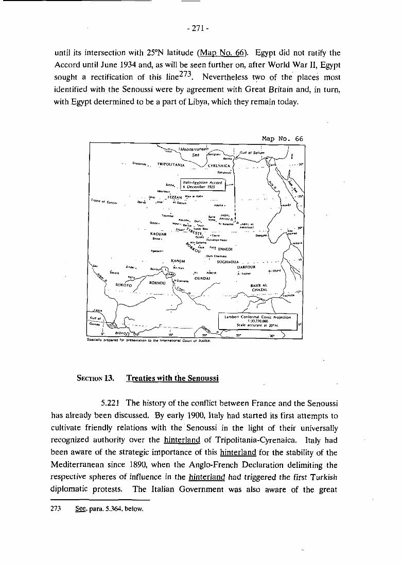
until its intersection witli 25'N latitude (Mao No. 66). Egypt did not ratify the
Accord until June 1934 and, as will be seen further on, after World War II, Egypt
sought a rectification of this Nevertheless t yo of the' places most
identified with the Senoussi were by agreement with Great Britain and, in turn,
with Egypt determined to be a part of Libya, which they remain today.
Map No. 6
SECTION 13. Trenties with the Senoussi
5.221 The history of the conflict between France and the Senoussi
has already been discussed. By early 1900, Italy had started its first attempts to
cultivate friendly relations with thesenoussi in the light of their universally
recognized authority over the hinterland of Tripolitania-Cyrenaica. Italy had
been aware of the strategic importance of this hinterland for the stability of the
Mediterranean since 1890, when the Anglo-French Declaration delimiting the
resprctive spheres of influence in the hinterland had triggered the first Turkish
diplornatic protests. The ltalian Government was also aware of the great
273 S. para. 5.36.1. below.

iinportance of the position of the Senoussi in this hinterland. It has been said tliat
"in the Eastern Sahara and the Central Sudan ... the Senoussi became the most 274 powerful Sheikh, acquiring the authority of a territorial sovereign" .
5.222 In 1907, Italy's Prime Minister Giolitti sent envoys to Koufra
to discuss entering into an agreement with the Senoussi. This was at a time when
the French inoves from the south had started to intensib. In 1911, in a letter
addressed to the "Civil Nations" and published in a nuinber of European
n e w ~ ~ a ~ e r s ~ ~ ~ , the Head of Senoussi, Sayyid Ahmad al-Sharif, denounced the
acts of violence being carried out by the French against the Order, its zawivas and
against the Senoussi ~ r i b e s ~ ~ ~ . The letter, while stressing the religious and
peaceful character of the Order, set the principles for the political struggle, first
against the French, then against the Italians in the years to corne. It also
contained an acknowledginent of allegiance of the Senoussi to the Sultan.
5.223 Under the terms of the Treaty of Ouchy, the Turks were to
withdraw their forces from Tripolitania: but in fact they left in Cyrenaica a few
officers who, under the leadership of the Turk, Enver Bey, helped to orgnnize, 277 along with the Senoussi, the tribal resistance. According to some sources ,
Enver Bey is said to have asked the Head of the Senoussi to continue the war in
the name of the Sultan. Some Italian authors go so far as to Say that Enver Bey 278 delivered to him a firman investing the Senoussi with semi-sovereign powers .
Whatever may actualIy have occurred, it is known that when Enver Bey left
Cyrenaica at the end of 1912 he left behind a small Turc«-Senoussi army that he
274 Encvclooacdia Briiannica, Elcvenlh Edition. 191 1, vol. 24. p. 649.
275 11 Giornale d'lialia, 6 August 191 1. (A copy of this document is attached as Exhihit 47.)
276 One paraçraph of this letter concerns the French attacks on the -:
"The French attacked the Zawiya of Jannit, killing the students and ulemas whom they found there, tearinç il up and trampling il underfoot and then seized the arms and everything else they could; they did the same t« the Züwiya of Kauar. The? attacked that ai Kanem without warning and killed most of the people whom they found there, subscquently removing the hooks and whatcver there was of value. France did no1 cease from ils atiacks and we were obliged to delend ourselvrs in any way we could. trusting in Cod that he would give us vici0ry.-
277 Evans-Pritchard, 9. a.. p. 115,
278 B. Del Boca, A.: Gli Iialiani in Lihia. Trioiili bel suol d'amore, 1860-1922, Rome. Latcrza, Vol. 1. 1988, pp. 200-202.

had assembled. The Senoussi resistance to ltalian occupation developed into a
war that continued until 1914, consisting of a series of guerilla operations and
skirmishes. But the war went badly for the Lihyan peoples: by the end of July
1914, al1 the main zawvias of Western and Central Cyrenaica had been destroyed
by the Italians.
5.224 With the outbreak of World War 1, the Senoussi found
themselves allied with Turkey and Germany, receiving frum them lielp and
military supplies to carry on the struggle against Italy. In July 1915, the Head of
the Senoussi had been appointed hy firman of the Sultan to govern Tripolitania 279 and dependent regions and had proclaimed a holy war against al1 infidels .
Pressed to act hy their Turkish allies, the Senoussi attacked Great Britain in
Egypt, but they were quickly defeated by the British forces.
5.225 Meanwhile, Italy and Great Britain had initiated discussions
with a view to adopting a common political line in dealing with the Senoussi in
Fehruary 1915. An understanding was reaçhed on 31 July 1916, to wliich France
adhered on 18 March 1917~". In the exchange of letters that constituted this
understanding, it was agreed to recognize Idris as the Head of the Order. But it
was also agreed (i) not to accord any territorial concessions to hiin and (ii) not to
accord him independence or autonoiny or in any way infringe the sovereignty of
Italy. At the same time, it was considered possible to accord to the Head of the
Order administrative autonomy over certain oases always under the sovereignty
of the State in possession. The parties thus sought to avoid any recognition of the
Senoussi Head as a temporal leader and carefully to reserve sovereignty to the
"state in possession", limiting al1 exceptions to an undefined administrative
autonomy that remained under the discretionary control of the occupying Power.
5.226 From that time on, until Libyan independence in 1951, the
dealings of Great Britain, France and Italy with the Senoussi continued to reveal
their serious concern over according recognition to the Senoussi as an
autonomous, even sovereign, entity. This concern during the period is reflected in
the records of the British Foreign Office; it was evidently a source of constant
worry to the British. But this very fact demonstrates that the Senoussi were
279 Evans-Priichard. u. d., p. 126.
280 UnUerstanding between ltaly and Great Britain of 31 July 1916, International Accords and Aereernenis Annex. No. 13.

indeed a force possessing temporal powers that had to be reckoned with on the
political level. At the end of the day, it was this political force that, under the
auspices of the United Nations, was chosen to head the new Libyan State.
5.227 While the understanding just mentioned was being reached,
trilateral discussions were underway at al-Zuwaitina in Libya among the Head of
the Senoussi, Colonel Milo Talbot, wlio represented Great Britain in the
negotiations, and the Italian delegates, Colonel Villa and Comm. Piacentini. In
the face of Senoussi efforts to enter into negotiations with the British alone in
order to reach a separate agreement that did not include Italy, the British took
the position that lasting peace in the region could only be achieved through an
agreement among al1 the parties involved, and they rejected any proposal thet
excluded Many Libyans then, as today, considered what ensued as not a
bright chapter in Libyan history; for Idris was too easily influenced by the British
and ended up in a sense capitulating to the Italians. But what ensued has legal
relevance to this case, nevertheless, for it bears directly on the title held by the
Libyan peoples to their territory, which was passed on to the State of Libya in
1951 with the creation of a constitutional Senoussi monarchy.
5.228 Characteristically, the instructions from the British War
Office directed that great care be taken to make no statement that would refer to
Idris as the leader of a temporal Power. The dispatches show that Colonel Talbot
was well aware of the delicacy of this issue, which concerned sovereignty. At the
same time, he sympathized with Idris' refusal to recognize publicly Italian
sovereignty or to assist in disarming the population. For the Senoussi influence in
the region was essential to the maintenance of peace, and Talbot feared that a
weakening of Idris's prestige could have repercussions al1 over the Islamic
community. Talbot believed that, since ltalian sovereignty had been recognized
by al1 the European Powers, it was unnecessas. to reaffirm it.
5.229 It soon appeared clear that the positions of Italy and the
Senoussi were difficult to reconcile in a way that would result in a detïnitive
settlement of their respective claims. ltaly sought recognition of its sovereignty
over Libyan territories, the dissolution of Senoussi military forces and the return
of Italian prisoners detained in Djaraboub. The Senoussi had comparable claims:
the creation of a State of Cyrenaica, the maintenance of Senoussi armed forces
281 Evans-Pritchard, a. d., pp. 134-141; Del Boca, a. a.. pp. 336-337.

and the right to mint inoney. On one point, however, the parties agreed: they
both were anxious to put an end to the hostilities. Thus, they agreed to attempt to
reach a compromise based on commercial relations, on the security of the
territories and on the release of ltalian prisoners.
5.230 The Italian Government came to consider the terms of the
proposed coinpromise humiliating. They took the position that Italy's delegates
at al-Zuwaitina were not empowered to sign any such agreement, and the
discussions came to a halt. Negotiations were thereafter suspended for some
months.
5.231 Talks resumed in December 1916 at Acroms. The Italian
delegates had changed, as had the general atinosphere of the negotiations - for
the worse. Among the problems was the fact that there was no real
understanding between the British and the Italian delegates. The British were
open to concessions, provided they could reach a conclusion as promptly as
possible to put an end to the unpleasant memory of a war that had cost England
80 million pounds. The Italians, on the other hand, were adamant in their
positions and did not show any disposition to act quickly, for they were
deterinined not to abandon the fundamental issues they had come to resolve.
5.232 On the Italian side, two trends emerged in the course of the
negotiations: the line adopted by the ltalian delegation and the government of Cyrenaica; and the position of the Government in Rome. The Italian delegation
believed it to be unreasonable to expect from Idris any engagement that would
decrease his authority as Head of the Order. To the delegation the primary
objectives were to assure peace in the colony and to allow pacific penetration into
the country and the effective exercise of sovereignty. For the Italian Government
in Rome, the terins of the agreement had ta be rigorous282. The approach of the
delegation prevailed, and the Treaty of Acroma was signed on 17 April 1917~'~.
5.233 Sliortly before, on 14 April 1917, the Head of the Senoussi
had agreed to the terms proposed by the British and signed with them an
agreement regulating the exchange of prisoners from the Egyptian war, and the
- - - -
282 Del Bocü. 9. &., p. 338.
283 Treaiy of Acroma of 17 April 1917. Internaiional Accords and Aereemenis Annex. No. 16.

dissolution of Senoussi armed forces and Senoussi lodges in Egyptian
t e r r i t ~ r y ~ ~ ~ . Both parties were satisfied with the provisions of the Agreement:
Great Britain obtained the military security it sought, the Senoussi remained in
control of most of Cyrenaica. Idris was to be treated almost as the "secular ruler 2 8 5 ~ of an independent people .
5.234 The Treaty of Acroma was composed of a dual
vivendc and, while setting the basis for the establishment of peaceful relations
between the parties, it left unresolved the main political issue that both parties
were anxious to ciarify: the competing claims to sovereignty. Effectively, the
Treaty was a compromise that contained a fundamental contradiction: Italy had
signed the agreement without giving up its sovereignty over Cyrenaica while. in effect, recognizing in the modus vivendi the sovereignty and independence of the
Senoussi in the same region.
5.235 In the Treaty, Italy recognized the de facto sovereignty of
the Senoussi throughout most of Cyrenaica, with the exception of the territories
effectively occupied by Italy. The relationship resembled that between the
Senoussi and the Ottoman Empire that had preceded it:
"The authority of the Italians was limited. as that of the Turks had been, to the coastal towns and a few inland posts and the rest of the country came under Sanusiya administration. The Order recognized their de facto control of the tow and they recognized 2%. the de facto rule of the Order in the country .
So the price of a peaceful settlement for ltaly was an armistice and a division of
Cyrenaica into two areas to be governed by two different powers: Italy and the
Senoussi.
5.236 This is not the place to attempt a political assessment of the
Treaty of Acroma. While it may have enhanced the prestige of Idris, it was not
well received by many of the Senoussi sheikhs. His predecessor, Sayyid Ahmed
al-Sharif, in the wake of these political events, of which he disapproved, took
284 Agreement hetween Great Britain and the Senoussi of 14 April 1917. International Accords and Acreements Annex, No. 15.
285 Evans-Pritchard, Q. d.. p. 144. (A copy of this page is attached as -48.)
2% m., p. 146. (A copy of this page is attached as Exhihit 48.)

refuge in Constantinople, and formally abdicated in favour of his 27-year old
cousin. Idris.
5.237 As the end of World War 1 approached, the Italian press
and various governmental bodies started to give consideration to Libya and its
future. Discussions concerning the Libyan hinterland and in particular, Borkou
and Tibesti - perceived as a "legitimate reintegration of the Tripolitanian
hinterland" - were energetically r e ~ u m e d ~ ~ ~ . Italian writers asserted that access
to Lake Chad was a justifiable claim based on Italy's succession to the Ottoman
Empire's rights in the area, which had been codified in the Treaty of ~ u c h ~ ~ ~ ~ .
5.238 A new liberal trend developed in Italy as retlected in a
report of the Minister of the Colonies, Colosimo, to the Italian Chamber of
Deputies in 1918, affirmed that Ruine intended to govern the country with the
cooperation of the indigenous chiefs which has been summarized in this way -
"... while rejectjng the theory of 'refoulement' and assimilation, (it) put into effect a policy of a s s o c i ~ ~ , ai~ning at bringing closer together the Italians and the natives .
Italian policy was in effect split between the ideals of Wilsonian liberalism aiid
Italy's imperialistic ambitions. This was particularly evident in Tripolitania,
where, notwithstanding the presence of 80.000 men ready for the occupation of
the territory, the Italian Government opted for a peaceful solution and entered
into the Agreement of Kallet-al-Zaituna with Arab leaders.
5.239 This Agreement was signed in the spring of 1919 and its
terms were further implemented in the summer by a Constitutional Charter thut
granted to the inhabitants of Triuolitania a number of privileges, which included:.
- Italian citizenship to the people of Tripolitania;
- A Parliament composed of representatives elected by the population;
287 &.Rosso. G.A.: 1 Diritti d'Italia Oltremare. Rome. I'ltaliano, 1916. p. 31
288 a. gcncrally. para. 5.158, ahove.
289 Alti Parlameniari. Legislatura XXIV. 23 Fehruary 1918. Camera dei Depuiati - N. LV. p. 19. (A copy of ihis page is atiached as Exhihii 49.)

Tu exemption.
In reality, these attributes of democracy were window dressing; and ltalian
citizenship was hardly an attractive opportunity to many Libyans. The Parliament
did not even have the same powers of initiation, ratification and deliberation as
Western parliaments, and its funetions were extremely limited.
5.240 On 31 October 1919, Italy issued a Royal Decree extending
to Cyrenaica the political privileges already granted to the neighbouring region of
~ r i ~ o l i t a n i a ~ ~ ~ . The Senoussi were irritated by the Decree, for it implicitly
affirmed Italian sovereignty over Cyrenaica. The sheikhs of Cyrenaica issued a
manifesto declaring that Italien occupation could only be recognized in the
coastal region and then only for cornrnercial purposes. This manifesto, later
perceived by writers close to the Fascist regime as an overt rebellion against
Italian sovereignty, opened the way in 1919 to new negotiations between Italy and
the Head of the Senoussi resulting in the al-Rajma Treaty of 25 October 1920, which superseded the modus vivendi of ~ c r o m a ~ ~ l .
5.241 If there were doubts about its benefits for the Libyan
people, the al-Rajma Treaty certainly was beneficial to Idris. It conferred on hirn
the hereditary title of "Senoussi Emir" and the status of "Head of the autonomous
administration of the oases of Djaraboub, Aujila, Jalu and Koufra, with the
possibility of adopting Ajadabiya as the seat of the administration of those oases"
While the Emir had the obligation to raise the Italian flag over those territories, at
the saine tiine, the Treaty conferred a number of privileges and honours on both
the Emir and his farnily such as rnonthly allowances, the salute of the guns for the
Emir during official visits, the place of honour after the Governor at officia1
ceremonies, u. The Italian Government undertook to grant the Emir full liberty
of rnovement, the right to use his own flag in the autonomously adrninistered
areas, and the right to give his advice every time the Italian Governrnent
proposed to issue a new legislative measure concerning the oases. Italy also was
to allow the population to keep their arms and to continue to be exempt from
taxation as well as from the military service.
2YU A copy of the Decrees over Tripolitania and Cyrenaica are altached as Exhihi(50.
291 Trealy of al-Rajma o i 25 Oclober 1920, International Accords and Aereements Annex, No. 19.


its authority over- the country without Senoussi cooperation. In practice, the
administration of the country was left almost entirely under Senoussi control.
However, the Bu-Maryam Treaty became the last act under Italy's policy of
pacification; for with the advent of Fascism in 1922, a new colonial era began for
ltaly - an era of military conquest.
5.246 On 6 March 1923, the ltalians seized the "mixed camps" and
took half of the Senoussi soldiers prisoners. On 1 May 1923. the new Governor of
Libya, General Bongiovanni, form;illy declared nuIl and void al1 the agreements
made between the ltalian Government and the Senoussi. Idris, who at that time
was in Cairo, remained in exile; before he iled the country, he had been
proclaimed Emir of al1 Libya by Tripolitanian leaders293. The proclamation of
Idris as Emir of Libya, not just by the notability of Cyrenaica, but by the
Tripolitanian leadership, symbolised the fact that the Senoussi leadership
extended to al1 of Libya. On the eve of the second Jtalo-Senoussi war, which
lasted from 1923 to 1932, the Senoussi had achieved the status of a virtually
autonomous governinent. This was confirined by the fact, as noted in Part IV,
that the Senoussi were in the forefront of the fight of the Libyan people against
the attempt by the Fascist leadership of Italy to subjugate them. Such Senoussi
heroes as Omar el-Mukhtar - the sheikh of a Senoussi zawiyia - led the battle
against the Italian forces; and in the face of adversity, the identity and autonoiny
of the Libyan people under the Senoussi banner was strengthened as Libya began
its rnarch to freedoin and independence, finally to be achieved in 1951.
Section 14. Continuine Franco-Italian Negotiations (1920-19341
5.247 In the meantime, the upshot of the meetings in 1919 of the
Colonial Commission, convened to consider what to offer Italy under Article 13 of
the 1915 secret Treaty of London, was that Great Britain was considered by Italy
to have satisfied its obligations. In fact, Great Britain was to make one more
boundary concession to ltaly in the 1934 Italo-Anglo-Egyptian Accord as to the
Libyan-Sudan boundary, which will be taken up in the next Section. France, on
the other hand, had not offered what ltaly considered to be very much during the
Colonial Cominission discussions, and the matter was left for direct negotiations
between Italy and France. This had led to the 12 September 1919 Accord
between France and Italy concerning the Algerian frontier from Ghadamès to
Toummo. However, that Accord specifically stated that other boundary
293 &, Evans-Pritchard, 9. a., pp. 152-155.

questions remained to be considered between the parties294, for the Accord had
not discharged France's obligations to Italy under Article 13. Italy made this very
clear at the time; and the records of the Quai d'Orsay reveal that the French
Governinent knew full well that other boundary questions remained to be
discussed and that the rectification of the Algerian frontier in the 12 September
1919 Accord had not really constituted a concession to Italy since the need for
soine adjustment of that frontier had already been recognized by France as far
back as 1 9 1 4 ~ ~ ~ . The best evidence of this is the fact that, right up until the 1935
Treaty of Rome, France and Italy engaged in an almost continuous series of
negotiations that concerned, inter alia' the southern boundary of Libya. This kict
also showed that, regardless of the statements it made publicly, the French
Government was well aware that this boundary had not been fixed.
5.248 It bears repeating that, although these discussions between
ltaly and France were conducted generally within the framework of Article 13,
this did not imply that existing boundaries were the subject of discussion and that
the negotiations concerned the question of additional compensation to Italy
under Article 13 by rectifving these boundiiries in Italy's favour. As already
pointed out296, Article 13 was aimed primarily at resolving in Italy's favour
unresolved boundarv auestions rather than at making gratuitous offers of
compensation in the form of boundary rectifications.
5.249 According to the records of the Quai d'Orsay, Italiaii
Foreign Minister Tittoni and French Ambassador Barrère met i n Rome on 25
June 1919, on which occasion Tittoni conceded that Italy's request for Djibouti
had been a mistake. He proposed to formulate certain new Italian proposals
respecting Tibesti and ~ o r k o u ~ ~ ~ . After Barrère reported this, the French
Ministry of Colonies was charged with conducting a study, described as follows - .
"... d'étudier les tracés de frontière qui pourrait être éventuellement choisis, en vue d'élargir le territoire italien, sans compromettre la
294 -,para. 5.16Y.g-q.. ahove.
295 &. gg.. para. 5.120. abovc.
296 a, para. 5.152. g -q., above.
297 &, para. 5.166. ahuve.

liaison entre I 'Afrm, , Occidentale fransaise et I 'krique Equatoriali française .
The study cttine up with six different possible boundary lines, none of which were recommended. In fact, no concrete proposals resulted froin the study at the t h e .
However, over the next several yesrs, the boundary question was given a good
deal of study hy both French and ltalian experts in preparation for further
negotiations that were to begin soon.
5.250 It is of interest to note that Lt. Colonel Tilho. who
conducted the French stiidy, had recently cornpleted work for the Mission de
l'Institut de France (1912-1917), which involved the detailed exploration and
mapping of the regions of Tibesti, Borkou, Erdi and Ennedi. This work led to the
publication of a map, which is reproduced here (Man No. 67). On Tilho's map, affixed to the southeast line of Article of the 1899 Declaration, as shown on tliat
map, there appears the legend "frontikre théorique". Tilho's work was cumplrted
before Fr:incr sought to transform the "thiorique" character of the southeast line
into a definitive boundary hy the "interpretation" of the soiitheast line in the final
paragraph of the Anglo-Frencli Convention of 8 September 1919, but the direction of the line on his map seems to coincide with the 1919 line. As already noted, Great Britain continued to regard this line as only indicating the limits of
zones of influence29y, and Tilho's characterization of the line as "théorique"
would appear to accord with the British view.
(a) Alternntive ltalinn Proernms
5.251 In Rome, proposals were being considered in the form of a maximum, medium and minimum program300. These were illustrated on maps
issued by the Italian Ministry of Colonies based on the technical studies of the
cartographie section of the Ministry of Colonies (M. Dardano). Replicas of these
maps appear here as ( M a ~ s Nos. 68. 70 and 71). These maps have also been reproduced on Base Mau B so as to portray more clearly the main features of the
298 Thc iask was assigned to none other than former Capi. (now Lt. Col.) Tilho. S. para. 5.122 g -q.. ahove. regarding an expedition into Tihesti hy Tilho ihat was proposed huc disapproved hy the French Governmeni in 1Y07.
299 W. gcncrally, paras. 5.174-5.217, ahovc.
300 a. relevani exiracts from ihe note o l the Italian Ministry of Colonies of 30 March 1028. ltalian Archives Annex. p. J6.

Lg 'ON dm


original map and to identitj and comment on certain of the Iines. The basic
Italian map on which the medium and minimum programs are shown is dated
1926 and is on a scale of 1:4,000,000. This map shows no boundary at al1 to the
east of Toummo. This was an official indication by the ltalian Governmeni at the
time that in the view of ltaly no conventional boundary existed to the east of
Toummo.
5.252 The maximum program, shown on Mau No. 68, is compared
on the map with the Ottoman Empire's claim of 1890, showing it to be roughly
comparable. On the reproduction of this map, the 1890 Ottoman claim is
illustrated by a dashed green line; the italian program, by a solid red line. The
ltalian maximum program line and the Ottoman line are also compared on Mar> No..
Map NO. 69
5.253 The medium Italian program (Mao No. 70) would have
followed the existing boundary south from Ras Ajdir on the Mediterranean to its
intersection with 1ü'E longitude (between Djanet and Ghat), descending south
from there along that line of longitude to its intersection with the Nigerian

boundary (that is, the Say-Barroua line); then east through Lake Chad so as to
leave Kanein on the Libyan side; then southeast to approximately 12"N latitude
(in the vicinity of N'Djamena); then east along that line of latitude so as to leave
Ouadaï on the Libyan side. The line would then have followed an irregular
northeast line, corresponding to the boundary under Article 2 of the 1899
Declaration as delirnited in 1919, to the point of intersection of Wadi Howa
(1So45'N latitude) and 24"E longitude which, as shown on the map, is also the
approximate point of intersection of a strict southeast line from the Tropic of
Cancer (at 16"E longitude) and 24"E longitude. The proposed line would then
follow 24"E north to what appears to be 19"30'N and then east to 25"E, whicli it
would follow north to the point of intersection with the 1925 Italo-Egyptian 301 delimitation .
5.254 The rniniinuin program is shown on M ~ D No. 71. The line
descending south along 1ü'E longitude, as under the medium progniml would
stop at lSON latitude. It would then turn east, stopping short of Aïn Galakka, and
then descend in a southeast direction to 15"N latitude, where it would join up with
the eastern boundary of the medium program slightly to the south of Wadi Howa.
This would incorporate iiito Libyan territory much of Kaouer, including Biltna,
most of Borkou, and al1 of Ennedi, Tibesti and Erdi; and it would leave to France
the oases of Agadem in Kaouar, as well as Kanem Baguirmi, Ouadaï and
Soghaoua. The Italian Foreign Ministry's position as stated in its memorandum
of 30 March 1928 was that the minimum prograrn was acceptable but that any
proposal for less should be firmly refused.
5.255 Nevertheless, a fourth, more modest, alternative was
prepared shortly thereafter by the ltalian Colonial 0ffice302. This proposal was
also illustrated by a map, a replica and reproduction of which appear here as Map
W. This would have incorporated into Libya the oasis of Djado (south of Toumrno), a proposal shortly to be made by France. Then the boundary would
follow a sinuous line along the watershed or liene des crêtes of the Tibesti &f
and descend southeastward, so as to divide in similar fashion the massif of the
Ennedi, to about 17"N latitude, turning then northward to rejoin the 1924 Libya-
Ekypt boundary. This would have divided Tibesti between France and Italy,
301 Mao No. 70. in laci, shom ihe 1924 line extended south io 22"N latitude so as to coincide wiih the Egypt-Sudan houndary.
302 -. note aflached lo Bertheloi-Manzoni telegram of 25 June 1930. Iialian Archives m, p. 72.


nature, not proposais advanced in negotiations with France. As a res~ilt, they
were relatively free of political considerations and the sorts of trade-offs that were
later to play such an important role. The maximum program was constructed
around tlie 1890 Ottoman claim; the inediuin program took into account other
boundaries that had been agreed in the meantime, such as the Nigerian and
Cameroon boundaries; the minimum program bore a strong resemblance to the
internal proposal made by the of Tripoli in 1911 to reduce the 1890
Ottoman claiins in the boundary negotiations expected to be commenced with
Friince that reflected the situation in the region at the t i ~ n e ~ ' ~ . The main
difference between the minimum Itiilian program of 1928 and the internal
proposal of the of Tripoli of 1911 was that the Italian proposal would have
attributed to ltaly (Libya) a large sector of Kaouar (which is now territory of the
State of Niger), whereas the w s proposai was more modest in this respect.
Mar, No. 73 compares the w s proposal with the Italian minimum program.
(b) French Studies
5.258 As this was going on in Rome, several French studies were
being prepared in Paris. One was undertaken by M. Saint, France's Resident
General in Tunis. The second was a study hy the Secretary General of National
Defence (General Serrigny). In return for "une levée de l'hypothèque pesant sur
la Tunisie", M. Saint raised the possibili!y of offering a boundary line from
Toummo south to the intersection of 14"E longitude and 13"N latitude, a line that
crosses Lake Chad, and from there to the Ebypt-Sudan boundary, leaving to ltaly
al1 of Tibesti, Borkou and ~nned i~" . However, M. Saint expressed a preference
for compensating ltaly in Ethiopia, instead. General Serrigny's report suggested
for consideration tlie ceding of al1 of the Tibesti to Italy. Neither suggestion was
acceptable to the Ministry of Colonies; and, in any event, it was felt that these
offers would not be enough to satisfy Italy. So the Ministry sided with the
alternative of compensating Italy in Ethiopia.
307 S. para. 5.114, above, and Man No. 52 appearing ihere.
308 Fur an analysis of M. Saint's report, g. note o f ihe Minisier of Colonies tu ihe Minisier of Foreign Nfairs, 30 May 1928. French Archives Annex. p. 336.
would have left Borkou largely to France, Ounianga to Italy, would have divided
Ennedi and would have left Erdi to Italy. The suggested line is shown on the map
in juxtaposition to a strict southeast line and to the 1919 "interpretation" of the
1899 line303.
5.256 The Italian Ambassador in Paris, Manzoni, let the Quai
d'Orsay know generally of the extent of Italy's proposed ,daim3 and was
subseqiiently informed that when it was made known to the French Cabinet that
ltaly claiiined down to Lake Chad it created quite a stir, and the claim was
considered totally inadmi~sible~'~. (Apparently, the minimum proposal had not
been described by Manzoni since its line did not descend south of 18'N latitude.)
Mussolini, acting also as Foreign Minister at the time, when informed by Manzoni
of the French reaction, responded as follows to his Ambassador in Paris:
"1 approve the fact that your Excellency has based the negotiations on the ltalian desire to advance to Chad, since, although the expression of such desire has geatly surprised the French Cabinet, it has however eliininated the illusion of the possibility to conclude the negotietions at a ludicrous price and it will focus the attention of this Government on the actual importance of the problem of Italo-French relations and on the sacrifices necessary to achieve a satisfaictory solution. On the other hand, for tactical reesons, i t should eventiially he easi5bpr us, after our maximum request, to fall back on medium lines ."
5.257 These programs forinulated by the Italian Ministry of
Colonies deserve to be accorded a special status in this case. They were prepared
at a time when the Italian experts had carefully studied the relevant background,
history and geography and had acquired much more knowledge concerning the
indigenous peoples; in particular they had examined the Italian heritage of rights
and titles from the Ottoman Empire; and thus they were more representative of
the background and realities of the situation than were the programs asseinbled
just after World War I ~ ~ ~ . These were interna1 Italian studies of a preparatory
303 The map's legend erroneously descrihes the 1919 line (1T30'N latitude) as beinç the 1899 line, as shown on the Livre iaune map ( l T N latitude).
3W Manzoni-Mussolini icleçram No. 2351B991207 o f 23 April 1928, ltalian Archives Annex. p. 52.
305 &. rekrence tu tliis dcxument (Telegram No. 2010 of27 April 1928) in Fuotnote ( 1 ) ol Manzoni-Mussolini telegram of 23 April 1928, as translated into English from Iialian, Iialian Archives Anncx, p. 54.


Map No. 74

5.259 General Serrigny's report of 12 October 1928 is of special
interest, for it analyses the question of "rectification de la frontière"309 in the light
of the security interests of Friince. An important fact emerges from this report:
only the oases of Aïr, Djado, and those in Borkou and Ennedi, were said at the
time to be permanently occupied by French troops. As to Borkou, Ennedi and
Tibesti, General Serrigny's report said this:
"Le BORKOU et I'ENNEDI sont occupés par nos postes de & Galakha - Fava - Ouanyanea dont la mission est la protection directe des territoires du Ouadaï et du Darfour anglais contre les rezzous venant du Tibesti ou du Nord.
Le TIBESTI n'est pas actuellement occupé en permanence, il est p:ircouru de temps en temps ;Ir nos unites méharistes, notre ligne de couverture englobant le l orkou, laisse le Tibesti en dehors - toutefois sur les demandes réitérées du Gouverneur Général de I'A.E.F., u n poste d'une 3 ~ ~ x l g n i e doit être installé en 1929 3 Zouarka au sud de Bardaï .
Although General Serrigny could envisage ceding al1 of the region of Tibesti to
Italy, he felt, like M. Saint, that this would be unlikely to satisfy 1t:ily311. In a
subsequent note of 13 November 1928, General Serrigny inentioned that one
reason for occupying Tibesti was the fact that some of the Senoussi had rnoved
into the Tibesti again in the face of Italian advances. (This was slightly naïve since
the indigenous Senoussi tribes had never left the region; only the Senoussi Order
had been obliged to move its center further to the north). The particular point of
importance brought out by the Serrigny report was that the purpose of the French
presence in Borkou, Ennedi and Tibesti was defensive and not with a view to
colonization: it was in order to protect Ouadaï and Darfour that French troops
had been sent to Borkou and Ennedi (as General Serrigny put it: "dont la mission
est la protection directe des territoires du Ouadaï et du Darfour"); and in order to
protect Borkou, French forces had been sent interrnittently to Tibesti.
3UY French officiais ai the lime tended to use this phrase rather locxely and no1 in thc sense «f Article 13 of the 1915 Treaty of London. which dealt with compensating Italy "notamment dans le rfglcmcnl cn sa faveur dcs questions concernant Ics frontikres dcs Colonies Lialiennes (with the neighhouring colonies of Great Britain and France)". Article 13 did n«t necessarily involve "rectilication"; it contemplated ("nolamment"). the resolution of existine boundsrv auestions. which implies delimitation. no1 rectilication. See. para. 5.172. g M., ahove. -
310 General Serrigny's Report, 12 Decemher 1928. French Archives Annex. p. 379.
31 1 m.. French Archives Annex. p. 377.

(c) France's 1928 Proposal
5.260 On 6 August 1928, at a meeting with Mussolini, Ambassador
Beaumarchais presented on an informal basis a draft treaty for study by the two
Governments. It contained a specific proposal to cede the oasis of Djado to
ltaly312. This proposal had apparently been suggested by Mussolini hiinself the
month before313. The area covered by the proposal is shown on Mao No. 74, a
replica of a sketch map prepared by the British Foreign Office, which was heing
kept abreast of the discussions by the ~ r e n c h ~ l ~ . Beaumarchais said that, in exchange for Djado, France wanted Italy's recognition that the French
Government "avait satisfait aux exigences du Pacte de Londres de 1915". He
added that France also wanted Italy's recognition of the 1899 Anglo-French
Declaration. Beaumarchais' conditions show that the French Governinent was
aware that, prior to the Djado proposal, France had not discharged its obligations
to Italy under Article 13 of the Treaty of London. Of particular interest is the
othrr condition attachrd to ceding Djado: that Italy recognise the Anglo-French
Declaration of 1899 "relatif aux frontières de la Tripolitaine". This was an
admission that, notwithstanding France's argiiinents concerning the tneaning of
the 1900-1902 Franco-Itelian Accords, the application of the 1899 Anglo-French
Declaration to the boundaries of Tripolitania was by no means certain, and that,
accordingly, France wanted Italy to recognize that the Declaration did establish
these boundaries. A final condition concerning the boundary was that ltaly
effectively occupy Djado. This condition brings out the extent to which France
had been unable to suppress the hostility of the indigenous tribes. Other matters
relating to Tunisia were discussed as part of the package. Mussolini was said to
have listened attentively but not to have stated his views at the time.
5.261 After this meeting, the proposed offer was given further
consideration by the French Minister of ~ o l o n i e s ~ l ~ . The latter took the
following position, as explained to Arnbassador Beauinarchais by the Quai
d'Orsay:
312 a, Beaumarchais-Briand Letter. 7 August 1928, French Archives Annex, p. 360.
313 See, note of 12 July 1928 as annexed to ietter of 23 August 1928, French Archives p. 368.
314 &,the map atiached to the interna1 Foreign Office memorandurn on ihe Franco-Iialian negotiaiions, daied 23 Ociober 1930, British Archives Annex. p. 197.
3 5 &, ieiter to Beaumarchais of 23 August 1928. French Archives Annex. p. 366.

"Comme vous le verrez, M. Léon Perrier n'admettrait de céder l'oasis de Djado à I'ltalie que le jour où cette Puissance serait en mesure d'occuper l'oasis. Si une rectification de frontière sans obli~ation d'occupation immédiate devait être' consentie, mon collegue la rechercherait plutôt du côté du Tibesti.
Le Ministre des Colonies insiste d'ailleurs pour que l'arrangement i conclure, quel qu'il soit, comporte la reconnaissance par le Gouvernement italien de l'interprétation donnée par la Convention franco-anglaise cJy& septembre 1919 à l'article 3 de la Déclaration du 21 mars 1899 .
So the Minister of Colonies (M. Perrier) wanted to go one step further; he also
wanted Italy's recognition of the interpretation of Article 3 of the 1899 Declaration contained in the last paragraph of the Anglo-French 1919 Convention. With the prospect of obtaining Italy's signature on a boundary
concession in its favour, the various private doubts of the French experts over
publicly announced theories concerning the Libyan boundary were coming to the
surface, for they saw here an opportunity of settling these questions once and for
all. The ever-vigilant French Colonial Ministry obviously knew where the weak
spots were in its thesis as to the southern boundciry of Libya, and it wanted to
resolve them in this treaty with Italy.
5.262 Apparently, by October 1928 the Minister of Colonies had
come to accept the cession of Djado to Italy, although he expressed doubts that
this would satisfy 1taly317. In this regard, Ambassador Beaumarchais made this
interesting observation to the French Minister of Foreign Affairs, M. Briand:
"M. le Ministre des Colonies désirerait également voir reconnaître par le Gouvernement italien la ligne fixée par la Convention franco-anglaise du 8 septembre 1919. Je lui ai exposé que cette concession risquait de nous être refusée par les services de M. Mussolini: la ligne indiquée par la déclaration additionnelle du 21 mars 1899 à la Convention franco-anglak du 14 juin 1898, et tracée sur la cane annexée au Livre jaune n'est plus intangible, puisque nous avons admis une modifications à notre avantage. Les Italiens ont, dans ces conditions, un semblant de droit à demander qu'une modification favorable à leur interprétation soit substituée à linterprétation du 8 septembre 1919.
316 M.
317 Beaumarchais Letter, to Quai d'Orsay. 20 Octoher 1928, French Archives Annex, p. 372.
318 Evidenlly Beaumarchais knew no map had been annexed Io the Declaration itself.

M. Léon Perrier en a convenu et i l ne paraît pas irréductiblement hostile au principe d'un arbitrage sur ce point, si l'heureuse issue de tous les pourparlers devait résulter d une concession sur cette partie de la négotiation. II demeure bien entendu que je commencerai par demander la reconnaissance de .la ligne fixée par la Convention franco-anglaise du 8 septembre 1919 et que je ne me départirai pas de cette attitude sans l'autorisation expresse du Gouvernement".
This revelation of Beaumarchais shows how insecure the French Government was
as to the "interpretation" of the 1899 Declaration set out in the 1919 Convention
that resulted in the southeast line being shifted northward so as to intersect 24"E
longitude at 19'30'N latitude3''. For according to Article 13 of the 1915 Treaty
of London, this was the sort of boundary question to be resolved in Italy's favour.
Yet i t had been resolved in France's favour by an agreement between Great
Britain and France in 1919 as to which ltaly had not been informed and only
becamc awcire of in 1921.
5.263 In a verbale addressed to the Itülian Prime Minister
dated 21 December 1928, Ainbassador Beaumarchais formally presented
France's offer, to which two draft treaties were attached - one concerning Tunisia,
the other concerning the Tripolitanian b o ~ n d e r y ~ ~ ~ . The territory "ceded" by
France under Article 1 of the draft boundary treaty would have resulted in a
modification of the boundary that had been fixed by the Franco-ltalian Accord of
12 September 1919 so as to leave In Ezzam in French territory and Djado and
Toummo in Italian territory. The proposed boundary was shown on an annexed
map321. It also was sketched out on a map prepared by the British War Office in
1930, which appears here in two forms: as a replica of the original (Man No. 75A)
and as a reproduction on Base Man B (Man No. 7 5 ~ ) ~ ~ ~ . The new boundary,
according to Article 1 of the draft treaty, would meet up with "la frontière tracée
319 Beaumarchais' report wasconfirmed hy Perrier in a Dispatch to the Minisier of Foreign Alfairs daled 4 November 1928, French Archives Annex. p. 375.
320 Beaumarchais Note Verbale of 21 December 1928, ltalian Archives Annex. p. 55
321 To date, this map has no1 been uncovered in the archives.
322 -. Memorandum on Franco-ltalian negolialions and aitached map. 23 Octohcr 1930, FO 37lIlJJffi. British Archives Anncx. p. 1W. The British Foreign Office was following the Franco-ltalian discussions closely.


,323 sur la carte jointe à la Déclaration franco-britannique du 21 mars 1899 . Articles 2 and 3 merit particular attention. Article 2 read as follows:
"Les Hautes Parties Contractantes déclarent qu'en ce qui les concernent la clause formant I'article XII1 du Traité signé à Londres le 26 avril 1915 a reçu complète satisfaction."
Article 3 read as follows:
"Les Hautes Parties Contractantes conviennent que la ligne qui, à l'est de Tuinmo, marque Iii limite des possessions fr:inc;aises, est la ligne dkfinie par l'Accord franco-britannique du 9 septembre 1919, portant interprétation de la Déclaration franco-britannique du 21 mars 1899, reconnue ar I'ltalie en vertu de l'Accord franco-italien du ler novembre 190t"
Thus, France proposed a formal, bilateral treaty in which it would be agreed (i)
that Article 13 had received full satisfaction; and (ii) that not only had Libya's
southern frontier been established by the line contained in the 1899 Declaration
but by that line as "interpreted" in the 1919 Convention; and - in a further
addition - that the 1899 line had been "reconnue par I'ltalie en vertu de I'Accord
franco-Italien du ler novembre 1902". In this way, the French Government
aimed to have al1 of its doubts cleared up, including those concerning the 1902
Accord.
(d) Italv's 1929 Counterpraposal
5.264 Mussolini, acting as Foreign Minister, replied to the French
proposal by note verbale of 29 June 1 9 2 9 ~ ~ ~ . He rejected the French proposal
and the attached draft treaties which "ne répondaient pas entièrement à mon
attente"325. Mussolini described Djado as a small oasis with only 600 inhabitants
surrounded by an absolutely unusable zone of sand. He said that under Article 13
ltaly should be given equitable compensation of real value. The note also
rejected linking the Tunisian question and the boundary questions, as France
sought to do.
323 Aitachmcni to Beaumarchais Noie Verbale 01 21 Decemher 1928, "Traite entre la ~ r a k e ei I'lialie", Italian Archives Annex, p. 57. The French Government persisied in making lhis erroneous siaiement abuut the map.
324 Mussolini-Beaumarchais, 29 June 1929. Italian Archives Annex. p. 59.
325 *... non corrispondevano del tutio alla mia aspeitativa."

5.265 Mussolini then made an alternative proposal as to the
course of the frontier. It is also shown on Maos Nos. 75A and 75B, which
illustrates the other related lines established by earlier agreements as well es the
caravan routes, whicli it was a primary objective of ltaly to retain on the Libyan
side of the boundary. If this proposal is compared to the minimum program
formiilated by the Italian Ministry of Colonies in 1928 , as is demonstrated by
Man No. 76, it can be seen that the entire southern boundary of Mussolini's 1929
proposal was drawn alung 1S0N latitude and that the southeast salient down to
15"N latitude of the minimum program had been dropped, thus dividing Borkou
and Ennedi between Italy and France.
Map No. 76 ,
5.266 Ambassador Beaumarchais replied to Mussolini on 22 July
1929. As to the frontier, he pointed out that the French proposal of ceding the
oasis of Djado had in fact been proposed earlier by Mussolini himself. He went
on to say that the ~ r e n c h Government felt it had already satisfied its obligations
under Article 13 -


"... en ahandonnant à l'Italie. à l'ouest et au sud de la Tripolitaine, des territoires que ne le cèdent pÿl en étendue ii ceux dont 6 l'Angleterre s'est dessaisie en Afrique ."
He stressed the importance of Djiido in view of its strategic location from the
standpoint both of trade and of policing a vast areii; and he asserted that France
could go no further without jeopardising the security of its possessions and
communications between the A.O.F. (French West Africa) and the A.E.F.
(French Equatorial Africa). This was a considerable exaggeration; for if the
ltalian 1929 proposal is superiinposed on a map showing the A.O.F. and the
A.E.F., as has been done on Map No. 77, it can be seen that the Italian proposal
would not have interfered at al1 with cominunications between these two French
possessions327. Moreover, Beaumarchais' assertion that the Franco-Italian
Accord of 12 September 1919 had satisfied France's obligations to ltaly under
Article 13 of the 1915 Treaty of London is not only belied by the text of the
Accord itself - for the Accord specifically contemplated the examination in the
future of other boundary questions - but also is shown to be suspect in the light of
France's insistence that the treaty containing the Djado proposal include a
specific provision to the effect that Article 13 had been satisfied.
5.267 In this regard, it is interesting to note the British Foreign
Office's reaction to these negotiations, which it was closely following. The
following is an extract from an interna1 Foreign Office memorandum of 30
January 1930:
'The question arises whether the negotiations are likely to be successful when they are resumed, and how far both countries are likely to go in the direction of reconciling their views. The French Government declared in their note of the 22nd July, 1929, that, in offering the triangle on the southern frontier, they had reached the limit of concession coiiipatible with the security of their communications and territories in that part of Africa. But there is no need to regard this very definite statement as final. A glance at the map will show that the triangle projects such a short distance into the French possessions that its effect on French security is negligible. Even if France were to concede the maximum of territory demanded by Italy, she would still dispose of a tract 400 kilorn. wide between Lake Chad and the Libyan boundary. This
326 Beaumarchais-Mussolini, 22 July 1929, ltalian Archives Annex. p. 69.
327 In his reply of 7 Oclober 1929 Io Beaumarchais, Mussolini expressed the same thought: that there would he no threat i« France's security or communications. This brings io mind Lord Salisbury's "horseshoe" comment IO Ambassador Cambon back in 18W. &. para. 5.21, above. and Man No. 43 appearing ihere. &. reference to noie 01 7 Ociobcr 1929 in note of 14 Ociober 1929, French Archives Annex. p. 381.

would leave her ample elbow-room in which to develop her cominunications and strengthen her defences. However, France is not likely to concede inuch inore; and if an agreement is to be reached, Italy must submit her official demands to a Procrustean operation ~ & h will considerably reduce . their present propositions ."
5.265 In a Quai d'Orsay note of 14 October 1929 analyzing the
Italian proposal and discussing the merits of several alternative French proposüls,
the thought was advanced of "ceding" part of Tibesti instead of ~ j a d o ~ ~ ~ .
However it was feared that an offer of a part of Tibesti would encounter the
fierce resistance of the Colonial Office:
"II est à craindre, pour peu que nous voulions offrir aux Italiens un avantage substantiel, que nous nous heurtions à la résistance vigoureuse des milieux coloniaiix. Bien que le Tibesti semble être de population très clairsemée (8 ou 10.000 habitants d'après le Commandant Rotier) et que ses ressources minières dont auciin indice n'a révélé jusqu'ici l'existence seraient vraisemblablement inexploitahles, ses trésors cachés font partie de la mvstiuue coloniale. Le Conseil des Ministres a décidé récemment d'occuper en permanence le territoire et Ir Président de IjSFépublique prend personnellement un grand intrrêt à la question ."
This interna1 French document confirins the fact th-üt as of October 1929 France
had not effectively occupied the region of Tibesti; and it suggests thsit France's
claim to title over the region of Tibesti was the product of "la mystique coloniale".
(e) Militarv Moves of Italv and France; Diplumatic Exchanges
5.269 In early 1930, Italy learned that France had moved into
Tibesti. This action followed on the heels of Italy's occupation of Mourzouk in
~ e z z a n ~ ~ l , and the news that two influential Senoussi leaders had submitted to
328 Memo OC 23 Octoher 1930 (in continuation of that of 18 January 1930). Annex 1 in No. 1. p. 5, FO 371/14406, British Archives Annex, p. 193.
329 &. note of 14 October 1929, French Archives Annex. p. 381. The French 1928 proposÿl did in fact involve "ceding" Djado Io Itiily since i l would have been a modilication of ihc Franco-ltalian Accord of 12 Septemher 1919. Howevcr, the Tibesti concerned territory no1 covered by a conventional boundary, and hence was the sort of boundary question specifically contemplaied hy Article 13 of the 1915 Treaty of London. Terms such as "ceding" or "reciifying" would he incurrectly applied to the resolution in Italy's favuur'of such boundary quesiions.
330 m. (Emphasis added.) French Archives Annex, p. 384.
331 a, Dispatch {rom French Counsul in Tripoli io Minister oTForeign Aflairs. 2 Fchruary 1930, French Archives Annex. p. 356.

the Italians. The Italian Ainbassador in Paris (Manzoni) notitïed the Quai . d'Orsay on 3 March 1930 that Italian troops had occupied the region of Toummo
and that contact with French troops inight o ~ c u r ~ ~ ~ . According to the French
note verbale of 5 March 1930 in response, Anbassador Manzoni was concerned - that this might happen -
"... dans des régions où la frontière franco-italienne à été fixée conventionellement, inais non delimitée, ce qui est le cas à l'ouest de Tuinino, ou n'auraient encore, de l'avis du Gouvernement Royal, fait l'objet d'aucune indication bilatérale."
The official French reply included this statement:
"Le Ministère croit d'ailleurs devoir rappeler à l'Ambassade que, dans l'opinion d ~ i Gouvernement Fransais la ligne qui, à I'est de Tummo, marque la limite des possessions fransaises est la ligne définie par l'accord franco-britannique du [9 in text] 8 septembre 1919 portant interprétation de la déclaration franco-britannique du 21 mars 1899, reconnue p:ir31;tfalie en vertu de l'accord frsnco- italien du ler Novembre 1902 .
5.270 Thus, in the 5 March note the French Government asserted
that in the 1902 Accord Italy had recoçnized the southeast line of the 1899
Declaration, as portrayed on the map referred to in 1902 as having been annexed
to the Declaration, and, further, that the 1919 "interpretation" of this line was
binding on Italy. On this basis, France maintained, and was to continue to do
thereafter, that there was a conventional boundan, binding on Italv east of
Toummo that followed the line established by Great Britain and France in the
Convention of 8 September 1919, an agreement made behind Italy's back 17
years after the 1902 Franco-Italian Accord. This was a truly remarkable position
to take; and it was al1 the more so in the light of the interna] records of the Quai
d'Orsay, such as Anbassador Beaumarchais' dispatch of 20 October 1928, quoted
from above at paragraph 5.262, which reveal that the French Government was
well aware that such a position was very tenuous indeed.
5.271 Starting in November 1929, French troops from Bilma were
stationed in Bardaï in Tibesti. In 1930, Tibesti was detached from the A.O.F. and
332 &, rcference in Telegram of 5 March 1930. French Archives Annex. p. 389.
333 Note of 5 March 1930, llalian Archives Annex. p. 70,

reattached to the A . E . F . ~ ~ ~ . In the meantime, the flurry of military activity and
diplomatic correspondence provided hy Italy's move into Fezzan, and the various
Italian public statements concerning Italy's claiins south of there, continued. In a
dispatch of 11 March 1930335, Ambassador Beaumarchais pointed out to the
French Foreign Minister that the Libyan boundary east of the intersection of the
Tropic of Cancer and 16"E longitude was suhject to three different
interpretations: (i) what he called "our interpretation" of the line set out in Article
3 of the 1899 Declaration, as shown on the Livre iaune map; (ii) the ltalian
interpretation of the line, that is a strict southeast line; and (iii) the line resulting
from the 1919 Anglo-French Convention, which pushed the end point of the line
north to 19"30'N latitude. Beaumarchais added these other observations:
That he had been authorized to renounce in favour of ltaly
the difference hetween the line as shown on the Livre iaune
map and the line resulting from the 1919 Convention, but
that he had not yet done so;
- That he had proposed submitting to arbitration the
ownership of the territory that lay between the Livre iaune
line and the strict Italian interpretation of Article 3 of the
1899 Declaration, but that the Minister of Colonies had
formally opposed the suggestion;
That the current Italian map on a scale of 1:4,000,000
showed certain other differences from the French view;
That when World War 1 broke out, France and Italy were on
the verge of delimiting these frontiers, but the war had
brought this attempt to a halt.
5.272 This dispatch makes it evident that the French Government
recognized that a boundary question existed, although the focus at the time was
on what direction the southeast line of Article 3 of the 1899 Declaration should
take. Italy's view as to the southern boundary east of Toummo was set out on the
official map issued by the ltalian Ministry of Colonies in 1926. It is this map, on
334 %, Mav No. 3, referred IV in para. 1.33. ahove.
335 Beaumarchais-Briand Dispaich. 11 March 1930, French Archives Annex. p. 391.

which were placed its medium and minimum programs referred to above (& Nos. 70 and 71). The 1926 ltalian map portrayed no existing boundary at al1 east
of Toummo.
5.273 There then followed a note verbale from the ltalian
Embassy in Paris to the French Ministry of Foreign Affairs dated 19 May
1 9 3 0 ~ ~ ~ . This was Italy's answer to France's n«te verbale of 5 ~ a r c h ~ ~ ' .
Referring to the 1900-1902 Accords, the note observed that France had thrre
recognized that the 1899 Anglo-French Declaration establishes the limits of
France's s ~ h e r e of influence and that, in so far as Tripolitanian and Cyrenaica
were concerned, France had no intention to go beyond these Iimits.
5.274 The Italian n«te then turned to the 1919 Anglo-French
Convention, which had several times been protested by Italy. It süid that the 1919
agreement could not be recognized by Italy because it had (i) transformed the
legal character of the 1899 Declaration froin a zone of influence to a boundary
line, and (ii) moved northward to the detriment of Tripolitania and Cyrenaica the
limits of the territory which France had undertaken not to exceed in the 1900-
1902 Accords. The ltalian Embassy informed the French Government that ltaly
considered territories located north of the southeast line set out in Article 3 of the
1899 ~ e c l a r a t i o n ~ ~ ~ as forming part of Tripolitania and Cyrenaica, but without
prejudice to any rights it might have under Article 13 of the 1915 Treaty of
London, as to which it had in recent negotiations formulated claims.
5.275 On 25 June 1930, M. Berthelot, on behalf of the Quai
d'Orsay, passed on the French Government's response to Italy's note verbale of
19 ~ a ~ ~ ~ ~ . The French reply observed that ltaly sought to ignore the 1919
"interpretation" of the 1899 Declaration and had suggested that the
"interpretation" conflicted with France's undertaking to Italy of 1902. This was
not possible, France argued, since the limits that France undertook not to exceed
in the 1900-1902 Accords were the boundaries of Tripolitania as shown on the
map annexed in to the 1899 Declaration. The southeast line, on the other hand,
336 Italian Note Verbale. 19 May 1930. French Archives Annex, p. 393.
337 &, para. 5.270, above.
338 ltaly considered this line to be a strict souiheast line.
339 See. Berthelot Note ol 25 June 1930. as annexed 10 lelegram of 8 July 1930, Iialian z h i v e s Annex, p 72.

which the 1919 Convention "interpreted", and the territory that this line divided,
lay entirely outside the Tripolitanian boundary as shown on the map. Therefore,
the 1919 Convention could not have transgressed any rights of Italy.
5.276 This was a replay of the argument set out in France's formal
response of 7 Fehruary 1923 to Italy's protest against the Anglo-French
Convention of 8 Septernber 1919, discussed a b o ~ e ~ ~ ~ . As has already been
pointed out, this line of argument was entirely different from, and even
inconsistent with, the other line of argument of the French Government, as set
out in the French note verbale of 5 March 1 9 3 0 ~ ~ ~ ~ which relied on the
contention that in the 1902 Accord, ltaly had recognized the southeast line. In short, in its 25 June 1930 note, the French Government asserted that the 1902
Accord did not concern the territory divided by the southeast line; yet in its noie of 5 March 1930, it said quite the reverse - that in the 1902 Accord Italy had
expressly recognized the southeast line.
5.277 Once agein, the French position relied on a map said to
have been annexed to the 1899 Declaration, which the French Government
privately knew to be incorrect. Consequently, the Italian Government started to
look for this map. Ambassador Manzoni in Paris was asked to i n ~ e s t i g a t e ~ ~ ~ .
The Italian Ambassador in London was also asked to join the search. Manzoni
was only able to find a copy of the Livre iaune containing the 1899 Declaration
and selected documents related thereto, including a rnap. He proceeded to study
the documents published in the Livre iaune and concluded from his study of the
travaux that the southeast line referred to in Article 3 of the 1899 Declaration was
intended to strike as closely as possible the intersection of 15"N latitude and 21°E
longitude343, and hence to follow a strictly southeast direction. However, no
otlier map than that published in the Livre iaune was uncovered.
34iJ S. para. 5.21U. g-q.. above.
341 S. paras. 5.269-5.270, ahove.
342 S. Guariglia-Manzoni dispatches, 16 July 1930. Italian Archives Annex, p. 79.
343 His analysis was not unlike ihat set ou1 al para. 5.38, g-q., above.


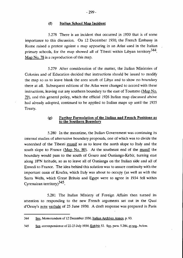
(f) Itnlian Schaol Mnp Incident
5.278 There is an incident that occurred in 1930 that is of sorne
importance to this discussion. On 12 December 1930, the French Embassy in
Rome raised a protest against a map appearing in an Atlas' used in the Italian 344 primary schools, for the map showed al1 of Tibesti within Libyan territory- .
Mao No. 78 is a reproduction of this map.
5.279 After consideration of the matter, the Italian Ministries of
Colonies and of Education decided that instructions should be issued to rnoditjr
the map so as to leave blank the area south of Libya and to show no boundary
there at all. Subsequent editions of the Atlas were changed to accord with these
instructions, ieaving out any southern boundary to the east of Toummo ( M ~ D No.
79), and this general policy, which the official 1926 ltalian inap discussed above - ' had already adopted, continued to be applied to ltalian maps up until the 1935
Treaty.
(g) Further Formulation of the Itnlinn und Fmnch Positions ns to the Southern Boundnry
5.280 In the meantirne, the ltalian Government was continuing its
interna1 studies of alternative boundary proposais, one of which was to divide the
watershed of the Tibesti massif so as to leave the north slope to ltaly and the
south slope to France (Mao No. 80). At the southeast end of the massif the
boundary would pass to the south of Gouro and Ounianga-Kebir, turning east
along 1S0N latitude, so as to leave al1 of Ounianga on the Italian side and al1 of
Ennedi to France. The idea behind this solution was to assure continuity with the
important oasis of Koufra, which Italy was about to occupy (as well as with the
Sarra Wells, which Great Britain and Egypt were to agree in 1934 fell within 345 Cyrenaican territory) .
5.281 The ltalian Ministry of Foreign Affairs then turned its
attention to responding to the new French arguments set out in the Quai
d'Orsay's note verbale of 25 June 1930. A draft response was prepared in Paris
344 B, Mcmorandum of 12 Decçmhcr 1930. Italiun Archives Anncx, p. 93.
345 g. correspondcncc of 22-23 July 1930, Exhihic 52. SE, para. 5.283, -M.. hclow.

by Ambassador Manzoni on 18 May 1 9 3 2 ~ ~ ~ . I t underwent some revision in
Roine and was dispatched to the French Government on 1 July 1932~'". The
main points of the note were these:
The starting point of the boundary question was the 1900-
1902 Accords;
In the Accords a bilateral agreement between ltaly and
France had been reached that the limits of France's sphere
of influence in relation to Tripolitania - Cyrenaica, which
France agreed not to go beyond, were the limits set out in
the Anglo-French Declaration of 1899 - that is the southeast
line provided for in Article 3 - a strict southeast line;
Since the geographic direction of the line was southeast, any
deviation by way of interpretation would be invalid so far as
Italy was concerned;
As to the Tripolitanian frontier, it was generally shown on
the map rnentioned in the 1902 Accord and then delimited
as far east as Tournmo in the bilateral Franco-ltalian Accord
of 12 September 1919; but no agreed boundary agreement
existed east of Toummo;
- Thus, according to the 1899 Declaration and the 1902
Accord, French expansion was to reach, east of Toiimmo, its
rnost northerly and northeasterly point at the intersection of
the Tropic of Cancer with 16"E longitude348 from where it
turned southeast;
Territory beyond this point, thus, was not territory in which
France could have an interest;
346 a. the 18 May 1932 drafl. 52.
347 ltalian Noie Verbale of 1 July 1932. 52. For re\isions. S. draft of 14 June 1932. Exhibii 52.
348 The note says, erroneously, 14"E longiiudc.

- Hence, Italy was not able to modify the conclusions set out
in its notes of 3 March and 19 June 1930 to the effect that
north and northeast of a strict southeast line was territory
belonging to Tripolitania - Cyrenaica.
The note went on to say that these conclusions were without prejudice to the
negotiations going on under Article 13 to examine other points as contemplated
by the Accord of 12 September 1919; and it reaffirmed the 1900-1902 Accords not
only as to the limits they placed on French expansion in relation to Tripolitania - Cyrenaica but also in respect to the reference in these Accords to "les
communications commerciales établies par les voies caravanières de Tripoli avec
les regions visées par la Convention Franco-Anglaise du 21 mars 1899".
5.282 This carefully prepared n«te made it clear that ltaly
considered no conventional boundary to exist east of Toummo. Rather than
asserting that the 1900-1902 Accords did not concern the sector east of Toummo,
however, the note took a different tack: it invoked the Accords to limit France's
expansion north and northeast of a strict southeast line. However, it did so
without prejudice to the Article 13 discussions in progress. Since the southeast
line of the 1899 Declaration limiting France's zone of influence was not a
boundary line binding on Italy, the Article 13 negotiations were not restricted by
this line. But France could not go beyond the southeast line because it had
undertaken in the Accords with Italy not to do so. In addition, France wiis
reminded of the large area covered by the caravan routes, whose protection has
been embraced by the 1900-1902 Accords. It will be recalled that Italy's 1929 proposal (portrayed on Maos Nos. 75A and 75B referred to in paragraph 5.263) would have enclosed these routes within Libyan territory south to 18"N latitude.
So Italy's reply left a good deal of room in which to manoeuvre during the on-
going negotiations.
5.283 The Italian note of 16 July 1932 provoked no immediate
response from the French Government, and several years passed without
incident. Then on 9 June 1934, the Italian Embassy in Paris sent a _note verbale to
the French Foreign Ministry protesting, inter alia. the establishment of a French military garrison at Tekro. As the map shows, Tekro is north of the 1899
southeast line, which Italy considered to be a strict southeast line, and hence was
deemed to be in Cyrenaica (Mao No. 81). The French Government replied on 24 August 1934, stating that it had carefully examined Italy's earlier _note of 16 July
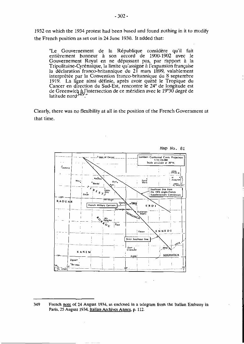
1932 on which the 1934 protest had been based and found nothing in it to modify
the French position as set out in 24 June 1930. lt added that:
"Le Gouverneinent de la République considère qii'il fait entièrement honneur à son accord de 1900-1902 avec le Gouvernement Royal en ne dépassant pas, par mpport à la Tripolitaine-Cyrénaique, la limite qu'assigne à l'expansion fran~aise la déclaration franco-britannique du 21 mars 1899, valahleinent interprétée par ia Convention franco-britannique du 8 septembre 1919. La ligne ainsi définie, après avoir quitté le Tropique du Cancer en direction du Sud-Est, rencontre le 24" de longitude est de Greenwict&,l'intersection de ce méridien avec le 19'30 degré de latitude nord ."
Clearly? there was no flexibility at al1 in the position of the French Government at
that time.
349 French note 01 24 August 1934. as enclosed in a telegram [rom the ltalian Emhassy in Paris, 25 August 1934, Italian Archives Annex, p. 112

SECTION 15. Italo-Anglo-Eeyptian Accord of 20 July 1934 Relating to the Libya-Sudan Buundary
5.284 The negotiations leading, up to .the conclusion of the
exchange of notes constituting this Accord provide further evidence of the
consistent position of the British Government, as one of the parties to the Anglo-
French Declaration of 1899, as "interpreted" by the Anglo-French Convention of
1919, that the liiie indicated in that Declaration as so "interpreted", was not a
frontirr or boundary line but sirnply a line dividing spheres of influence350. As
will be demonstrated again, the British view, already enunciated in their response
to Ottoman and ltalian protests and representations in the period irnrnediately
following the conclusion of the 1899 Declaration, and repeated in the British
Government's reply to the ltalian protest of 18 December 1921 against the terrns
of the 1919 Anglo-French t on vent ion^^'? continued to be that the line indicated
in the 1899 Declaration as interpreted by the 1919 C«nvention was net a line that
purported to allocate territory as between the parties to these two instruments,
but simply operated as an indication of the limits of territories which either party
nj&t acquire in the future (with due regard to the rights of third parties) without
incurring protest from the other.
5.285 This consistent British position is evidenced de novo by the
relaxed attitude which the British Government took in 1933 and 1934 to the
"occupation" by Italian forces of territory in the vicinity of the Sarra wells. The
negotiations leading up to the conclusion of the Accord of 20 July 1934 are also of
interest as dernonstrating the continuing reliance of the Italian Government on
the Tripolitanian "hinterland" claim of the Ottoman Empire, as buttressed by the
Turkish occupation of the regions of Borkou, Ennedi, Ounianga and Tibesti, in
the period immediately preceding the outbreak of the war between Italy and
Turkey in 1911.
5.286 The area of the Sarra wells (or "Sarra triangle") formed,
until 1934, the northwest corner of the Sudan. At that time, the precise point at
which the boundaries of the Anglo-Egyptian Sudan, the French Sudan, Libya and
Egypt converged was in dispute. As between Egypt and the Sudan, the boundary
had run, since 1899, in an east-west direction along 22"N latitude (Mau No. 82).
350 The Italo-Anglo-Egyptian Accord of 20 July 1934 is atrached as International Accords and Aereements Anncx. No. 24.

As hetween Egypt and Lihya, the frontier ran in a northlsouth direction along
2S0E longitude as far as 22"N latitude, this by virtue of the Italian-Ebyptian
Agreement of 6 December 1925. The "line" dividing the Anglo-Egyptian Sudan
from the French Sudan was the line resulting from the 1899 Anglo-French
Declaration as interpreted by the Anglo-French Convention Of 1919. This left a
triangle, bounded to the north by latitude 22" (if the line of 2FN latitude is
hypothetically extended westward of 25"E longitude), to the east by longtitude
2S0E, and to the south by the line resulting from the 1899 Anglo-French
Declaration as interpreted by the Anglo-French Convention of 1919. The
triangle, known as the "Sarra triangle" because of the presence within it of the
Sarra wells, fell within the British "sphere of influence" as defined in these two
instruments.
5.287 In early 1931, Italian troops, seeking to exercise control over
those parts of Libya, captured Koufra, and began sending patrols to tlie south.
The question of the ownership of the Sarra triangle thus became active. It had until then been shown on British, Sudanese and Egyptian maps as appertaining to
the Sudan, it being assuined, without any legal justification, that the boundary line
between Egypt and the Sudan laid down in 1899 extended due westwards along
22"N latitude to its junction with the line resulting from the 1899 Anglo-French
Declaration as interpreted by the Anglo-French Convention of 1919. In 1932, the
then British Ambassador in Rome had, on instructions, sent a note to the ltalian
Foreign Ministry warning of an expedition which a Major Bagnold was to
undertake in the area of the Sarra triangle. The ltalians promised al1 facilities for
the expedition but reserved their position explicitly about the ownership of the
Sarra triangle area by stating they were - .
"... unable to consider ... that the territory hf the Sudan includes either the locality of Sarra Wells situated at latitude 21°39'40" and longtitude 2l050 36". tlie Tibesti and Ennedi foothills or, generally speaking, the territory to the north of the line starting from the intersection of the Tropic of Ca r with longtitude 16"E and 9% 3 , following a south-easterly direction .
The ltalians add that they claimed that territory as belonging to the zone "of
Koufra and ... part of the territory of Libya".
352 &, Foreign Office Memorandum "The Sarra Triangle", 12 April 1933. British Archives m. p 204.
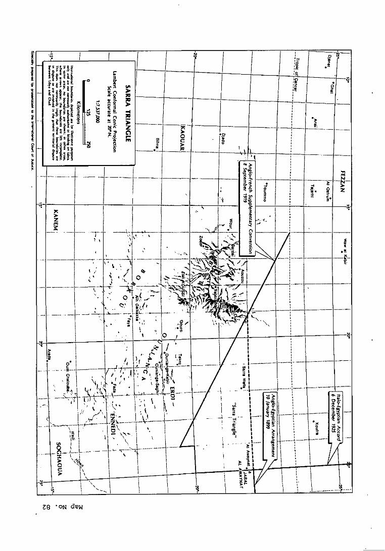
18 'ON dew
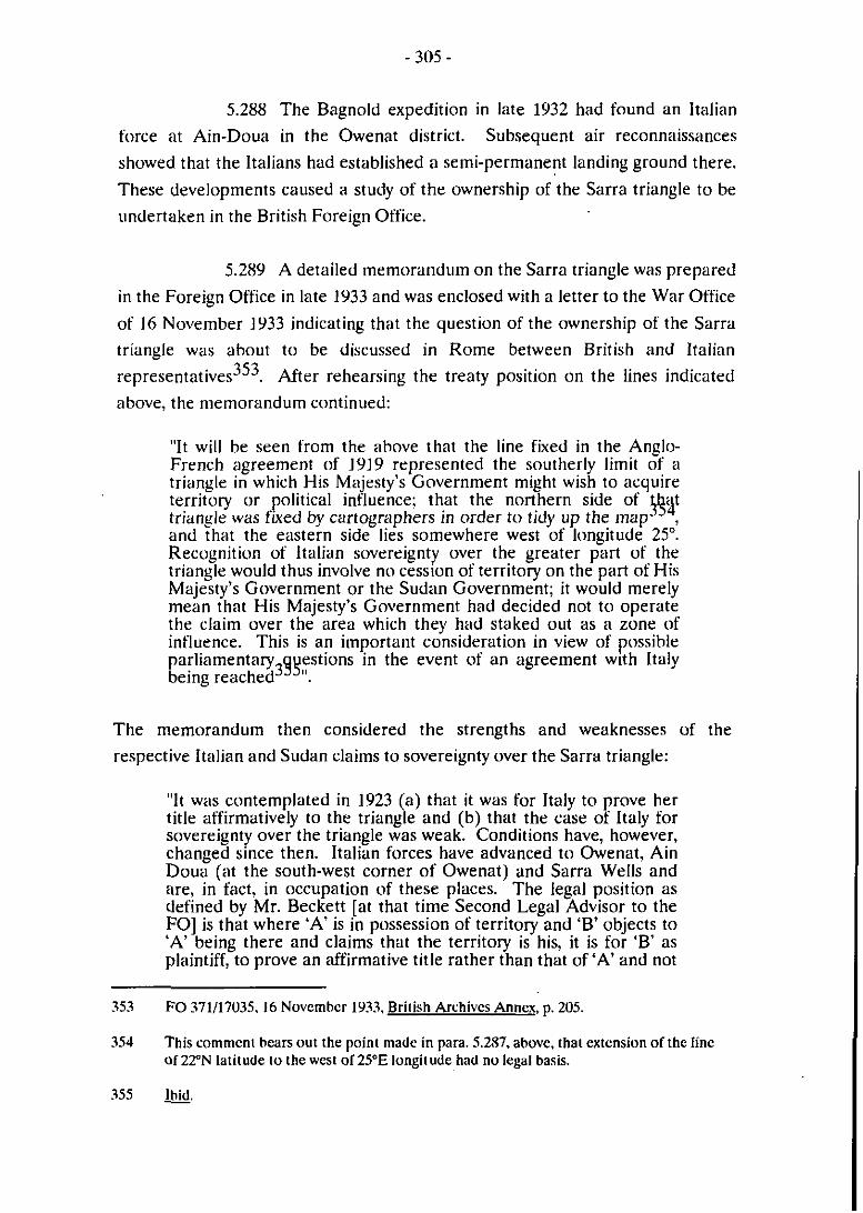
5.288 The Bagnold expedition in late 1932 had found an Italian
force at Ain-Doua in the Owenat district. Subsequent air reconnaissances
showed that the Italians had established a semi-permanent landing ground there.
These developments caused a study of the ownership of the Sarra triangle to be
undertaken in the British Foreign Office.
5.289 A detailed inemorandum on the Sarra triangle was prepared
in the Foreign Office in late 1933 and was enclosed with a letter to the War Office
of 16 November 1933 indicating that the question of the ownership of the Sarra
triangle was about to be discussed in Rome between British and ltalian
representatives353. After rehearsing the treaty position on the lines indicated
above, the memorandum continued:
"It will be seen from the ahove that the line fixed in the Anglo- French agreement of 1919 rrpresented the southerly limit of a triangle in which His Majesty's Government might wish to acquire territory or political influence: that the northern side of \lxit triangle was fked by cartogriiphers in order t» tidy up the inap- , and that the eastern side lies soinewhere West of longitude 25". Recognition of Italian sovrreignty «ver the greater part of the triangle would thus involve no cession of territory on the part of His Majesty's Government or the Sudan Government; it would merely mean that His Majesty's Governinent had decided not t« operate the claim over the area which they had staked out as a zone of influence. This is an important consideration in view of possible parliamentary estions in the event of an agreement with Italy
3YYll being reached .
The memc~randum then considered the strengths and weaknesses of the
respective Italian and Sudan claims to sovereignty over the Sarra triangle:
"It was contemplated in 1923 (a) that it was for ltaly to prove her title affirmatively to the triangle and (b) that the case of Italy for sovereignty over the triangle was weak. Conditions have, however, changed since then. Italian forces have advanced to Owenat, Ain Doua (at the south-west corner of Owenat) and Sarra Wells and are, in fact? in occupation of these places. The legal position as defined by Mr. Beckett [at that time Second Legal Advisor to the FOI is that where 'A' is in possession of territory and 'B' objects to 'A' being there and claims that the territory is his, it is for 'B' as plaintiff, to prove an affirmative title rather than that of 'A' and not
353 FO 371/17035,16 Novemhcr 1933, British Archives Annex, p. 205.
354 This comment hears out the point made in para. 5.287, above. thai extension of the fine of 22"N latiiude to the West ol25"E longitude had no legal basis.

for 'A' to prove it. Possession is good as against anybody else who cannot show a better title. The resent position is thet Italy has definitely claimed the territory as f . talian, or at any rate the greater part of it? and is in physicel possession of it. She will, therefore, not nor need she) accept the position that it is for her rather than the k udan to prove affirmatively the right of sovereignty. What sort of
an affirmative case for sovereignty can be made out for the Sudan? The answer seems to he no case at ail. The résumé above of the note sent to the ltalian Ambassador in 1924 &: the year was in fact 19231 shows that no case can he founded on the 1899 and 1919 agreements with France. The ma s which exist probably carry no weight with Italy; and the Sudan C! overnment cannot prove (i) that thry actually edministered iind occupied the territory hefore the ltalians went there, or (ii) that this territory definitely was part of thosr Turkish provinces which e allotted by the old Ottoman
#!! Empire to the Khedive of Ebypt .
The memorandum then suggested a possible line to take with the ltalians in the
negotiations in Rome; namely, the argument "that the triangle was never
occupied or administered by the Turks and that, tlierefore, the ltalians cannot
claim it as inheritors of Turkey".
5.290 O n 4 December 1933, the British negotiators (Mr. Peterson
and Wing-Commander Penderel) submitted a written report on their
conversations in Rome with Italian negotiators between 27 and 30 November
1933 on the Sarra triangle357. Several points of interest emerge from this report.
At the opening session, the British negotiators staked out their initial position:
"The line which we took was, briefly, that it was not our fault that we could not point to an agreed and recognised frontier West of the tri-junction point between Egypt, Libya and the Sudan, since, until quite recently, we had had no one with whom to agree such a frontier: short of that, and in the absence of any proof in support of the ltalian claims, which we understood to be based on those inherited from Turkey, but for a statement of which we had hitherto asked in vain, we had a perfect right to assume that the northern frontier of the Sudan continued along the 22nd parallel West of the tri-junction point. As regards the uestion how far the Sudan frontier extended westward along the 2 % nd parallel, we felt that we had acted reasonably and practically in prolonging it on our maps to the point at which it joined the line of influence, which we had agreed with the French in 1899 and again in 1919: we might, it seemed to us, have even prolonged the Sudan frontier to the West by a line drawn from the tri-junction point to the northern point of the Anglo-French line of influence, where the. 16th meridian of
357 The conversations of 27. 28 and 29 Novemher 193.1 referred to are found in Report or 4 Decemher 193.1, F0 371/170.15, British Archives Annex. p. 224. &. ülso, the nota taken by the ltalians of these discussions, W. a.. pp. 240-260.

longitude intersected the Tropic of Cancer: we agreed, indeed, that we had ourselves admitted that the Anglo-French line did not in itself constitute a frontier, but marked the limits of zones ot influence: nevertheless, we thought it reasonable to maintain that the north-western extrernity of that line represented a point which in one way or another we were entitled to join up with the tri- junction point: and oiir method of effecting this might well have been such as t o $ ~ ~ l u d e an even larger area of the territory now claimed by Libya ."
5.291 This toiigh opening statement provoked a response from the
Italian negotiators stressing the extent of Turkish penetration southwiirds during
the early 1900s:
"At the second meeting, on the 28th November, the Italians opened with a lengthy dissertation upon the extent southwards of the Turkish occupation of Libya, a subject upon which they had touched only lightly at the first meeting. Mentioning particularly Guro and Ain Galaka, tliey maintained that Turkish occupation had in effect extended south of the 16th parallel. Thev declared thiit thrv possessed in their militan, archives ordrrs issued bv the Tiirkish Hich Command i n the north of Cvrenaica to the scatterrd detachments in the south. recalling them on the outbreak of the Italo-Turkish war: these orders showed conclusivelv that the Turkish forces in the extreme south were reeulars and in no wa merelv Senussi or nomads. They added that there had been regular Turkish mudir in charge of the administration of Kufra at t h z time. In a word, and as 6etween the French and the Italians, while the French claim that these Tiirkish incursions in Tibesti and Borku were of the nature of raids which were quickly dealt with and the raiders expelled by the French themselves, the Italian claim is that these Turkish detachments only returned to the north on the specific instructions of their suptj$grs and for the purpose of resisting the Italian attack on Libya ."
In response, the British negotiators "were prepared to concede short-lived
Turkish penetration as far as f i n Galaka and possibly other places", but, while
anxious not to interfere in a question which lay between the Italians and the
French more than might be absolutrly necessary for the purpose of discussing the
Sarra triangle, felt that "the Italian claims had been seriously compromised by the
358 W.
359 M. Emphasis added.
Prinetti-Barrère conversations in 1902 and by the declarations of Signor Tittoni in
1 9 1 ~ 3 6 ~ .
5.292 At this point, the British negotiators put fonvard a proposal
on the following lines:
"(a) The northern frontier of the Sudan should, as from now, be fixed as following: froin east to West, the 22nd parallel as far as the 24th meridian.
(b) The western frontier of the Siidan should be left undertermined until the moment when Italy and France have settl'ed their dispute over Borku.
(c) Should Italy establish its title to the region of Borku, the western frontier of the Sudan shall be fked as following the 24th meridian.
In thejipterim, ltaly and the Sudan would both use the Sarra wells ."
5.293 At the third meeting, on 30 November, the Italian
negotiators defined their own proposal -
"... that the Sudan frontier with Libya should start from the point of intersection of the 27th meridian and the 22nd parallel and should follow that meridian south to the 19th parallel, when the line - in order, as they said, and as an act of grace, tu leave the Sudan Bir Natrun, of which they understood we were in effective occiipation - would gf,,south-west to joint the French frontier at the 16th parallel .
The British negotiators found this proposal completely unacceptable, and broke
off the conversations:
"We had, we said in conclusion, come ta Rome for the purpose of deciding the fate of territory to the West of the 25th meridian to which some doubt might attach; we were quite unable t o accept a position in which not only were our claims to any part of such territory to be brushed aside, but a large part of the Anglo-Egyptian
36U The British negoliaion were cltrdrly well hriefed as 1 0 the French position and as to the siratagem which had guided ihe British and French Governments in an attempt IO
reconcile their opposing views in responding to the ltalian protest agdinst thc Anglo- French Convention of 8 Septemher 1919.
361 m.. p. 3. as translatçd from ihc French. British Archives Anncx. p. 226.

Siidan dernanded in addition ygyn grounds which we could not regard as in any way substantial ."
5.294 The French had been warned in advance about the
proposed Anglo-ltalian conversations on the Sarra Upon the return
of the British negotiators froin Roine, the French Ernbassy in London left a
memorandum with the Foreign Office making two points:
"1. From the French point of view, it wotild be necessary that the possible Anglolltalian agreement should not put in issiie the interpretation which the AngloIFrench Convention of 8 September, 1919, has given to the line defined by the Declaration of 21 March. 189% neither of the two contracting parties should, without the consent of the other, give up this interpretation towards a third power.
2. It would equally be necessary that the new arrangement, if it acknowledged Italian rights of sovereignty, occupation or usage over the disputed territory, should refrain froin basing these concessions on geographical, economic, political or historical arguments wliich could contribute t« strengthening, directly or indirectly, the claiins in certain ltalian c' cles over certain of the French positions in Central Africa36f
5.295 Initially, it was thought in the Foreign Office that satisfaction
of these two French conclusions would debar the British from ceding the Sarra
triangle to ltaly without French consent. But the Foreign Office legal advisers
thought othenvise. In a minute of 18 December 1933, Mr. Beckett stated that he
did not read the French conclusions in this sense. He went on to say:
"If the French did contend as 1 think they do not) that H.M.G. could not cede the k arra Triangle to ltaly without their consent, and if they based this contention on the ground that it was contrary to the 1899 and 1919 Agreements to do so, 1 think that the French would clearly be wrong. There is not a word in either of these Agreements binding either Power in fact to occupy and establish its sovereignty up to the agreed line, across which they undertake not to go, nor is there a word about recognising rights of
364 &, Letter from the French Ministty of Foreign Affairs to the French Ambassadur in London. 27 November 1933. British Archives Annex, p. 210.
365 Memoründum of the French Amhassador. as translated from the French, 16 December 1933. FO 371117036. British Archives Annex. p. 230.

other Powers in, or ceding territory to other Powers i e area 36% which each of the two Powers marked out for themselves .
Sir Williain Malkin, chief legal adviser to the Foreign Office, expressed a siinilar 367 point of view in his subsecluent minute of 19 December 1933 .
5.296 By early May 1934, the British Government had concluded
that another attempt should be made to reach an accommodation with ltaly over
the Sarra triangle. The British were prepared to renolince any claim to
sovereignty over the triangle, having ascertained that the Sudan Government was
content not to insist that the triangle was Sudan territory. There were still
problems of formulation, however, some of which are referred to in the following
extract from Mr. Beckett's minute of 17 May 1934:
"Paragraph 2 is more difficult? because it purports to be defining the boundary between Italian Libya and the Sudan and ought, therefore. to stop at the point on the Sudan boundary where Italian Libya cesses and French territory begins, but we do not know where this point is, but on the other hand will get into trouble with the French if we draft this paragraph in such a way that suggests that we think ltalian Libya goes further south than the French themselves think it does, and 1 gather that the French themselves do not think it goes further south than the lY'3U' parallel; but the Italians will not necessarily admit that ltalian Libya stops there. Secondly, 1 think that we shall raise possibly unnecessary difficulties with ,& Italians if we refer to the Anglo-French Convention of 1919 ."
5.297 By the end of May 1934, the Italians had agreed to a
resumption of the Anglo-Italian negotiations on the Sarra triangle. O n 2 June
1934, Sir E. Drummond (British Ambassador in Rome) was instructed to propose
a new basis of settlement: that the "frontier" should follow the 25th rneridian
southwards from its point of intersection with the 22nd parallel until it reached
latitude 19"30'N, at which point the frontier would turn due west to meet and
follow the Franco-Sudanese boundary southwards along the 24th ner ri di an^^'. The British were für from confident that the Italians would accept this proposal;
accordingly, Sir E. Drummond was instructed to propose submission of the
366 Beckett's Minute of 18 Deccmber 1933, FO 371117036, British Archives Annex. p. 233.
367 Malkin's Minute of 19 Decemher 1933, FO 371117036. British Archives Annex. p. 234.
3G8 Beckett's Minute of 17 May 1934. FO 371118034. British Archives Annex. p. 262.
369 &. Simon-Drummond Dispatch, 2 June 1934. FO 371/18035. British Archives Annex. p. 266.

dispute on agreed terms of reference to either the Permanent Court of
International Justice or to ad arbitration as a fall-back position.
5.298 On 11 and 12 June 1934, Sir E. Drummond had
conversations with Signor Suvich (Italian Under-Secretary of State for Foreign Affairs). On 12 June, he left with Signor Suvich the British proposal, which he
made quite clear was a final offer:
"His Majesty's Governnient to renounce al1 claiin to territory West and north of line following the 25th meridian soiithwards from its point of intersection with the 22nd parallel until it reaches latitude 19"30', thence due West to meet and follow the Franco-Sudanese boundary southwards along the 24th meridian.
The Italian Government, on their side, to renounce al1 claim to territories east and south of line defined in previous paragraph.
N.B. - The present conversations are w ~ ~ ~ i i t prejudice to existing claims on the part of either Government ."
5.299 Much to the surprise of the Foreign Office, the Italians were prepared to accept this proposal in principle, maintaining only that the step in the
line (from the 25th to the 24th meridian) should be at latitude 20" rather than at
latitude 19"30' ( M ~ D No. 82 referred to at paragraph 5.286 above). This was
clearly intended to avoid any recognition by the Italians of the Anglo-French
Convention of 1919, as indeed the ltalians themselves admitted in further
conversations with the First Secretary of the British Embassy in Rome:
'This solution Signor Guarnaschelli pointed out has the advantage that it compromises neither British nor ltalian positions vis-à-vis the French: moreover it would be seen that result of this modification would be accession to His Majesty's Government of a small rectangle of territory beyond that contained within line put forward in their proposal. Signor Gu~irnaschelli insisted several times on point that modification had been suggested solely in ord O avoid 551 any compromising of Italian case (these) vis-à-vis French ".
The British Government willingly accepted this slight modification, consequently,
the Anglo-Italian Exchange of Notes of 20 July 1934 provides that the line of
frontier between Libya and the Sudan is fiied as follows:
370 Drummond-Simon Dispatch. 15 June 1934. Annex Io Enclosure No. 2 in No. 1. FO 371118035, Briiish Archives Annex, p. 270.
371 Drummond's telegram, of 23 June 1934. F0 371118035, Briiish Archives Annex, p. 271

"2. Starting from the point of intersection of 25th meridian east of Greenwich with parallel 22" north. the frontier follows the 25th line of meridian in a southerly direction as far as its intersection with parallel 20" north; from this point it follows parallel 20" north in a westerly direction as far as its intersection with 24th meridian east (if Greenwich; from this point it follows 24th meridian east of Greenwich in a southerly direction as far as its junction with the frontier of French possessions.
3. His Majesty's Government in the United Kingdom renounce al1 claim on the part of the Sudan to territury to the West and north of the line of the frontier as set out above; the Italian Governinent, for their part, reno e al1 claim to territory south and east of the 3% said line of frontier .
5.300 Additional confirmation of the Foreign Office view that the
Anglo-ltalian Exchange of Notes of 20 Jiily 1934 did involve any cession of
British territory is provided by a neeative piece of evidence. According to
McNair: .
"Tliere is a practice. now amounting probably to a binding constitutional convention, whereby treaties involving the cession of British territory are subrnitted for the j~pgroval of Parliament, and its approval takes the from of a statute .
McNair concedes that the question of the circumstances in which Parliamentary
sanction is actually required by law for the cession of British territory is
controversial. He finds considerable authority for the view that the Crown niay,
by a treaty of peace at the end of a war and as a part of the arrangement of terms
of peace, cede British territory by virtue of the prerogative and without the
sanction of Parliament. He also draws attention to an assertion by a former
Attorney-General in 1854 that Parliamentary sanction is not required, as a matter
of strict law, for the cession or abandonment of territory which had been acquired
by conquest or by cession, and which has never been the subject of legislation by
~ a r l i a r n e n t ~ ~ ~ . He gors on to mention a number of instances of the cession of
372 Drummond-Mussolini. 20 July 1934. Enclosure I in No. 1 of Drummond-Simon Dispatch o f21 July 1934, FO 371/18035. British Archives Aniiex. p. 272.
373 McNair: Law of Treaties. Oxford, Clarendon Press, 1961, p. 94. (A copy of this page is attached as Exhihii 52.)
374 This was a siaiement hy Sir A. Cockhurn. in defending in the House ot Commons on 9 May 1854 the abandonment by the Crown of sovereignty over the Orange River Territory wiihout the approval of Parliament. Sir A. Cockhurn drew a disiinçiion beiween territory acquired by txcul~diion and territory acquired hy conquest, going on to state:
"The legül proposition of the power of the Crown therefore rested upon ihis - that whac the Crown had acquired by cession or conquest, and over which il had

territory forming part of the Crown's former possessions in India (most of thein
being cessions of territory to lndian native States and not to foreign Powers)
without Parliamentary sanction. Having shown that the practice in this respect up
until the late 19th Century was far from being uniform and admitted of certain
limited exceptions, McNair goes on to say:
"But, at any rate from 1890 onwards, there are several precedents of treaties of cession receiving Parliamentary sanction in the form of a statute. These are the Anglo-German Agreement Act, 1890, sanctioning the cession to Germany of Heligoland; the Anglo- French Convention Act, 1904, where the treaty for the cession of certain British territory to France was made "subject to the I proval of their respective Parliainents"; the Anglo-ltalian Treaty (E ast Africen Territories) Act, 1925, which gave approval to a treaty involving, as a consequence of the rectification of a frontier, a cession of British- rotected territory; the Straits Settlements and Jahore Territorial & aters (Agreement) Act, 1928; the Dindiiigs Agreements (Approval) Act, 1934; and the Anglo-Venezuelan gsland of PilJy~) Act, 1942, approving the Treaty of Cession by
reat Britain ."
5.301 Now, one would have expected that, if the Anglo-Italian
Exchange of Notes of 20 July 1934 had been thought to involve a cession of
British territory (in right of the Anglo-Egyptian Sudan) to Italy, it would have
been submitted for Parliamentary approval in the United Kingdom in the form of
a statute. However, it was net so submitted. This negative evidence is al1 the
more compelling in the light of the statute that had been adopted as recently as
1925 to approve the Treaty of 15 July 1924, between the United Kingdom and
ltaly regulating certain questions concerning the boundaries of their respective
territories in East Africa. Accordingly, the absence of any British statute to
approve the Anglo-Italian Accord of 20 July 1934 represents further convincing
evidence that the British Government did not at the time view the Accord as
involving a cession or abandonment of territory over which the United Kingdom,
in right of the Anglo-Egyptian Sudan, exercised sovereignty. That view had of
course already been foreshadowed in the detailed memorandum on the Sarra
triangle prepared by the Foreign Office in late 1933~'~. The significance of this
ahsolute sovereigniy, the Crown could deal with without the intervention or the co-operation of Parliament."
Ihid.. pp. 95-96. (A copy o f these pages is atiached as -53.) - 375 McNair. op. &., p. 96. (A copy o f this page is atachcd as 53.)
376 &. para. 5.289, g-q.. above.

is, of course, that it reveals that the British Government took a formal legal
position that the 1899 Anglo-French Declaration and the 1919 Anglo-French
Convention had not established a conventional boundary, for had they done so,
the agreement with ltaly over the Sarra triangle would have constituted a
"cession" of British territory requiring Parliamentary approval:
5.302 Two other points of interest emerge froin this brief account
of the 1933-34 Anglo-Italian negotiations on the Sarra triangle:
- In negotiating an agreement for the renunciation of
Sudanese claims to the Sarra triangle with the Italian
representatives, the British representatives were careful to
take into account the two French "conclusions" presented to
the Foreign Office in December 1933377, so as not to
precipitate an Anglo-French dispute over the manner in
which Britain would in effect "transfer" to ltaly ownership of
the Sarra triangle (although, in British eyes, it was net seen
as a transfer of territory to Italy but rather as a simple
renunciation of Sudanese claims to the territory);
- The British representatives were equally careful to take
Italian susceptibilities and sensitivities into account by:
- - not fixing the southern terminal point of the Libya-
Sudan frontier other than by use of the vague and
unspecific formula "... as far as its junction with the
frontier of French possessions"; and
- - not referring to the Anglo-French Convention of
1919 in the description of the Libya-Sudan frontier.
SIX:TIOS 16. The Final Phase of the Fnnco-ltnlinn Neeotiatiuns Relating to the Southern Bnundarv of Libva (1934-193s)
5.303 After a short pause, the Franco-ltalian negotiations were
resuined in the spring of 1934 with vigour, owing largely to the return of Pierre
Laval to the French Foreign Ministry at the beginning of October 1934. Like his
377 &. para. 5.294, above.

immediate predecessor, Barthou, Lviil had for a long time been convinced of the
need for a clear ra~prochement between France and Italy, and he immediately
pressed for the rapid conclusion of an agreement that would allow the entirety of
the existing Franco-ltalian dispute t« be closed, including the "African" dispute.
The autumn of 1934 witnessed intense diplomatic activity between the two
countries, the principal protagonists heing Ainbassador Chambrun, on the French
side, and, the Under-Secretary of Sttite: Suvich, on the Italian side. However, hoth
Mussolini and Laval intervened personally in the discussions, especially in the
final phase, during which there was even a meeting between the two of them with
neither witnesses nor interpreters378. That meeting took place on 6 January
1935, the eve of the soleinn signature of the relevant instruments379.
5.304 It should be rememhered that the Italian Fascist authorities
also wished at that tirne to forge closer ties with France going far beyond the mere
settlement of the colonial disputes between the two States. It was therefore not a
question of simply disposing of the long outstanding matter of the "fair
coinpensation" dur to Italy by France by virtue of Article 13 of the Treaty of
London of 1915; it was an attempt to construct at the saine tiine a privileged
relationship between Paris and Rome designed (from the Italian point of view) to
make France more independent of British influence and (from the French point
of view) to prolong and stabilise the cooling off of the relationship between Italy
and Germany, which at that time was in a very critical state as a result, in
particular, of the current German poli~y with respect to Austria and the
assassination of Chancellor Dollfuss by a group of Hitler's sympathisers on 25 July
1934.
5.305 Among Mussolini's main concerns at the end of 1934 was
the desire to "have his hands free" for an attack on Ethiopia, which the ltalians
were actively preparing for. In order to ohtain from Laval an assurance of
France's absence of any interest with respect to Ethiopia (which was to be the
subject of a secret exchange of letters between the two men, also on 7 January
1935), Italy was prepared to sacrifice to a great extent its colonial aspirations and
claims in favour of France with respect to both "compensation" in Libya and the
Somalia and the Tunisian matters. In fact, Italy was .prepared to accept very
378 Mikge J . L: L'lmwrialisme Colonial Iialien de 1870 à nos iours. (Reedrds sur l'Histoire), Paris. SociktC d'Wiiion d'Enseignement SupCricur, 19G8.
379 See. Ladreit de Lacharriere. J.: "L.E. circonstances et les formes des Accords de Rume". F ~ f r i q u e francaise, 1935, p. 7, ett., for an excellent account of this episode.

rnodest results in respect to the boundary question and these other matters if this
would allow it, as Arnbassador Charnbrun had predicted with a great deal of
finesse, to -
"... sauver la face en Lihve en obtenant Dar ailleurs de nous des facilités la réalishiun d'une pc;litique plus active en Abyssinie .
5.306 It should be borne in mind that, besides the general motives
that have just been mentioned tbere was a specific reason why ltaly was receptive
to a solution for Libya that was very conservative when cornpared with the extent
of the earlier claims and the juridical titles upon which those claims had been
based. In 1930, General Badoglio, who at the tiine was Governor of Libya, had set
out his views with respect to the southern bounditry of ~ i h y a ~ ~ l . In his letter - which made a deep impression on Mussolini - Badoglio pointed out that the areas
clairned by Italy to the south of Tournrno were to a large extent desen areas and,
in his view, of minimal econornic interest; and he ernphasized the enormous suins
that would have to be invested in order effectively to administer and control these
vast expanses of land often overrun by r e z z o u ~ ~ ~ ~ and situated hundreds and
even thousands of kilometres from the important centres of northern Libya. He
therefore invited the Italian Governrnent to seek territorial advantages "in other
more profitable directions" and put al1 the authority that he enjoyed in Libya
(because of the vigorous and successful carnpaigns conducted under his command
that had led to the bloody repression of the native rebellion and to the
"pacification" of Libya) behind the following conclusion:
"We have had enough in Tripolitania of hundreds of kilornetres of scarcely productive desert territory to want any inore."
5.307 These remarks were later echoed by Mussolini, who was to
seize various opportunities to declare that he did not wish to be a "collector of
380 Telegram 0127 September 1934 io the Foreign Minisiry, French Archives Annex, p. 3YY.
381 Report hy Badoglio De Bono (Colonial Minister). transmiiled hy De Bono io Mussolini on 2 October 1930, ltalian Archives Annex. p. M.
382 Raids hy nomad desert iribes.

de sert^^^^". What Mussolini meant was that the "arpents de sable tt384 of
southern Libya could in no way satisfj the needs for what was known, in fascist terms, as Lebensraum for Italy. But just as the French had, the ltalians igiiored
the peoples of the region, as if they were desert animals whose welfare was of no
consequence.
5.308 With respect to the matter of the "fair compensation" still
due from France to Italy under Article 13 of the 1915 Treaty of London, the true
starting point of the final phase of the negotiations that were to culininate in the
Treaty of 1935 was marked by an intensive series of meetings between Suvich and
Chambrun in September 1934. At the outset, ltaly again asserted its claim put
fonvard by Mussolini in 1929 (as far south as 18"N latitude)3S5, but qiiickly
zigreed t« return to less ambitious proposais, including that relating to the "Djado
triangle", which the French had offered in 1928. It was implied that the Italian
claims might subsequently be reduced even more on condition that ltaly obtained
satisfaction elsewhere, principally by means of the surrender of the French Somali
Coast, excluding ~ j i b o u t i ~ ~ ~ . This request was unacceptable to the French,
despite the fact that they at first showed a certain degree of willingness to discuss
it.
5.309 From the various reports of these meetings it is clear that
after the meeting of 24 September 1934, the French negotiator began skillfully to
play what was to be the winning card: Ethiopia. The Suvich Report describes the
appearance of this factor, which was to prove the key to the subsequent
negotiations, in these words:
"He [Ambassador Chambrun] is still holding out to see if another solution can be found; he thinks, for example, that Italy might be interested in a French withdrawal from Abyssinia, thus favouriiig Italien expansion in that country."
383 See. Laval's speech Io the Chamhre des d6putQ. 2nd session of 28 December 1935. =.R.F.. 29 December 1935. p. 2865.
384 Lanne, 9. a., p. 107. (A copy of this page is aitached as 45.)
385 a. para. 5.264, sa., above,
386 Noies prepared for the Under-Secretary of State hy the Italian Foreign Minisiry (in IO. 12, 17, and 21 September 1934: Suvich Repori of 24 Sepiemher 1934. ltalian Archives m. pp. 113-146, p. 152. Chambrun Telegram of 27 September 1934, French Archives m. p. 150.

5.310 An undated meinorandum of the same period, prepared by
the Foreign Ministry for the Italian negotiator, clearly shows that the enticement
of Ethiopia appeared irresistible to the Italian authorities, who concentrated their
efforts upon obtaining a secret document with satisPactory contents:
"The French counter-proposais mention Ethiopia for the first time. France appears to be telling us that it is liiniting its interests in Ahyssinia to those of an econumic nature and even these t« a stretch along the railway and t« those parts which are of interest to the railway concerned (France kas requested the reatest secrecy of this part of the negotiations ...). This partfttjhe rench counter- proposais needs to be detailed and clarified. ".
F
5.311 It is in this context that one should read the demands
formulated unofficially in writing a few days later by Suvich, at the invitation of
Chambrun, who wanted to obtain a text that could he examined as a whole by his
Government, but who also desired to place ltaly in the position of making the
demands and, thus, to negotiate on the basis of the ltalian demands and not of the
French offers. After studying the matter (as mentioned in various notes prepared
by the competent departments of the Foreign Ministry, and in particular the note
signed by Buti on 26 September), Suvich presented a docuinent on 28 September
1934 concerning the "fair compensation", in which the Lihyan factor (which in the
light of other Fascist demands, as has been seen, was felt to be the least
important) was very clearly sacrificed in the hope of gaining satisfaction
elsewhere. The text of the ltalian demands was as follows:
"Io Tunisie - Prorogation pendant I O années des conventions de 1896 appliquées dans un esprit bienveillant.
2" Comoensation coloniales - L'Italie qui avait proposé en 1928 la cession d'un territoire au Sud de la Lybie compris entre les l lème et le 24ème méridien E.Gr. et le 18ème parallèle nord, ayant rencontrk des oppositions propose maintenant:
a) au Sud de la Lybie fiation de la frontière qui éliminerait le saillant à l'est de Tumno et rencontrerait une ligne médiane entre la ligne de la convention franco-britannique de 1919 et la ligne du sud-est dite "mathkmatique" de fason à laisser B I;I Lybie des localités et des points d'eau en vue de faciliter notamment la suweillance de la frontière.
387 &, Buti-Suvich undaied notc, ltalian Archives Annex. p. 150.

h) Cession de la Côte française des Som F à l'exception de %38v Cibuti et d'un territoire environnant la ville.
5.312 Faced with this proposal, al1 the subsequent negotiations
inevitably concentrated on the Tunisian and Somali questions, given that Italy's
conservative demand concerning the southern boundary of'lihya immediately
appeared entirely acceptable to the French negotiators, despite the resistance of
those with a colonial background infected hy "la mystique coloniale38Y". Indeed,
now that Italy had assumed the role of the party rnaking the demands, French
negotiators had the skill to make their acceptance of the Italian proposal
concerning Libya appear to be a victory for ltaly and concentrated their efforts on
the other two matters by playing to the hilt the "Carte Abyssinie", which was the
expression used in a note for the French Minister dated 1 October 1934390. That
note contained the following passage concerning the tactics to be adopted
thereafter:
"On suggère la tactique suivante:
Accepter la conversation pour une rectification des frontieres méridionales de la Libye à l'est de Touinmo, étant entendu que l'Italie reconnaît n'avoir plus aucune revendication à formuler au titre de l'art. 13 du Pacte de Londres.
N'accepter en aucun cas la prolongation des Conventions de '96.
Jouer le carte Abyssinie pour ohtenir lev6e de I'hypotliSque italienne sur la Tunisie, c'est-6-dire ne faire aucune concession territoriale ni politique en Abyssinie ou dnns la Côte des Somalis si nous sommes obligés de maintenir en Tunisie le statu auo."
5.313 The ltalian negotiators now found themselves in a very
tineasy position: the French had accepted their very unambitious demand
concerning Libya, and were refusing to compensate for this deliberate sacrifice by
any relinquishment in the area where Italy had its ambitions: French Somalia.
The situation was described as follows in an Italian document of that periud:
"We must remeher that the reason why in our proposais we have al1 but dropped our claims for coinpensation to the south of Libya is that we have sought - as the French have suggested - tu centre these
358 Note by Suvich on a c»nversation with Amhassador Chambrun of 28 Scptemhcr 1934, Italiün Archives Annex. p. 160.
389 f&. para. 5.265, ahove.
3g0 Noie lor the Minister, 1 Ocioher 1934, French Archives Annex, p. JW.

compensations on East Africa. If, now, France fails to accept our demands in East Africa, their acceptance of our proposais concergbp the southern frontiers of Libyzi has a particularly ironic flavour ."
5.314 However, despite the "psrticularly ironic taste" of the
situation, Italy was in the final analysis prepared to accept the dual sacrifice: rhe
question of having its "hands free" in Ethiopia was quite clearly regarded as
having a quite special importance at the top of the hierarchy!
5.315 Indeed, the "Abyssinian card" subsequently proved to be
even more profitable for France over and above the Libyan concessions: it led
Italy, first, to abandon its request concerning the Somali Coast and to content
itself with a modest territorial inodification of some 800 square kilometres to the
advantage of Eritrea; and, second, to accept a coinplex settleinent, in France's
favour, of the Tunisian question. In exchange for the many significant sacrifices
agreed to by ltaly as compared with its initial demands, France undertook to give
it the assurances that it wanted so much - the absence of any French interest in
Ethiopia.
5.316 There is a well-known controversy ainong historians, which
is yet to be settled, as to whether these assurances were contained only in the
secret exchange of letters mentioned above, or whether other "verbal" assurances
were obtained by Mussolini at the meeting with Laval at which there were no
witnesses (as the former was to claim subsequently, but which was denied by the
latter until his trial after the war which led to his execution). Whatever the answer
may be, Ambassador Chambrun's prediction was completely borne out, as he
himself had noted in the m e a n t i ~ n e ~ ~ ~ . In a cable of 1 January 1935, Chambrun
reported to Laval, with respect to the "formule de désintéressement en Ethiopie",
the hllowing:
"C'est là, ainsi que votre Excellence le prévoyait en me remettant mes instructions et comme je n'ai cessé de le constater au cours de mes entretiens, le point fondamental de la négoci ilJHI. M. Mussolini me l'a d'ailleurs dit dans les termes les plus nets.
Y Undated note [rom Buti to Suvich, ltalian Archives Annex..p. 150.
392 &.para. 5.305. above.
393 Tclegram from Chambrun to Laval of 1 January 1935. French Archives Annex, p. 416.

5.317 Of course, ltaly also agreed to add to the "package" the famous "release" to be given to France concerning the fulfillment of the
obligations arising out of Article 13 of the 1915 Treaty of London.
5.318 As has been inentioned, France's agreement in principle to Italy's demand, as presented by Suvich on 28 September 1934, had provisionally
settled the question of the Libyan boundaries, subject to the determination of a
precise formulation acceptable to both parties and, of course, to an agreement to
be reached upon al1 the q~iestions under discussion. After various exchanges, on
28 December 1934, France proposed a draft "African Treaty" whose Article 2
read as follows:
"La frontière sé arant la Lihye de l'Afrique occidentale française et de l'Afrique Equatoriaie Fransaise ii l'est de Tummo, pr~iiit terminal de la ligne f iée par l'accord de Paris du 12 septembre 1919, sera déterminée ainsi qu'il suit:
Une ligne directe partant de Tummo et rejoignant L'EHI DOMAR DOBA,
De L'EHI DOMAR DOBA, une ligne droite rejoignant l'extrémité Nord-Est de L'EH1 DOGO LOGA;
De L'EHI DOGO LOGA, une ligne droite rejoignant L'ENNERI TURKOU en un point situé en aval du confluent de celui-ci avec L'ENNERI GUESSO, de telle sorte que le tronçon DOGO LOGA-ENNERI TURKOU de la piste caravanière du Fezzan vers Bardai reste en territoire français;
De ce point, une ligne droite rejoignant le confluent de L'ENNERI BARDAGUE avec L'ENNERI MOMOGOI ou OFOUNI;
De ce confluent. la liene des hauteurs sénarant L'ENNERI BARDAGUE ~ ~ ' L ' E N ~ ~ E R I MOMOGOI o; OFOUNI. ~ u i s la - - ~~ - ~ - - ~ - - - - . ~- - - -
- 7 , ~ ~~
ligne des crêtes jusqu'à L'EHI MADOU, de telle sorte affluents de droite de L'ENNERI BARDAGUE-ZOU x? ERI, les notamment les ENNERI ODRI TINAA, OUADAME, ARAYE, MECHEUR, TIRENNO, AGUESKE. KAYAGA. ABECHE. restent en territoire français;
De ce point la ligne des hauteurs les plus rapprochées de la rive gauche de L'EDRI SOU, puis la ligne des crêtes du TARSO AOZI jusqu'au point géodésique AOZ1;

D e ce point, une ligne droite rejoignant l'intersection du 24ème degré de longitude est Greenwich et du 18èine degré 45' de latitude nord.
Ce tracé est indiqué sur la carte No. 1 jointe au présent traité. 3 9 4
5.319 Mussolini immediately demanded a marginal change, as
referred to in Ambassador Chambrun's cable of I January 1935. For Mussolini, it
was important that the course of the line (which in general was acceptable to
Italy) should include on the Italian side a few more inhabited points. Chambrun
commented:
"II semble qu'une très légère concession sur ce point, marquant notre bonne volonté, suffirait."
5.320 Indeed, on 2 Januiiry 1935, France agreed to replace the 6th
and 7th paragraphs of the above text hy two new paragraphs reading as 395. foll»ws .
"De I'Ehi Madou. iine ligne droite rejoignant Yebigue, à I O kiloinètres en amont de Yebbi-Souma;
D e ce point, une ligne droite rejoignant le point géodésique d' Aozi."
The line thus agreed is portrayed on Mao No. 83, a reproduction of a map
appearing in a thesis concerning the 1935 ~ r e a t ~ ~ ' ~ . The data on this müp has
also been put on Base Map D, which shows the topography of the Tibesti massif.
5.321 The text of Article 2 was not subsequently modified, despite
a very late attempt initiated on 5 January by the ltalian negotiators (in the
presence of Mussolini and Laval), who were aware of the scale of the sacrifice
represented by the wording of Article 2 as compared with the claims that had
been made for so many years by Italian diplomats. No doubt they were
concerned over the criticisins such a timid attitude was certain to arouse. A
detailed report of the meetings between Mussolini and Laval of 5 and 6 January
394 Drafi "African Treaiy", 28 December 19.14. French Archives Annex, p. J(W.
395 Tclegram from Laval io Chambrun. 2 January 1935, French Archives Annex, p. 420.
396 Goiffou, P.: Les clauses Coloniales dans les Accords Franco-Italiens du 7 ianvier 1935. These pour le Doctorat en Droii. Universiié de Lyon, 1936, p. 140. (Pursuant io Article 50. paragraph 2 of the Rulïs of Court. a copy of this thesis kas becn depositcd with thc Regisirar.)

was drziwn up by Chambrun. With respect to the last-minute discussions, thtit
report contains the following account:
"Aux objections particulièrement vives formulées par M. Suvich et qui portaient sur l'ensemble de dispositions dont beaucoup cependant nous paraissaient acquises, M. Laval a répondu de la inaniire la plus directe et la plus décisive ... Toiit en faisant ressortir que Iti valeur économique des territoires compris dans la rectification de la frontière libyenne était pratiquement nulle, ... M. Mussolini s'est abstenu de prendre part à le discussion assez âpre qui a suivi entre M. Laval et M. Suvich ... Les terines dans lesquels M. Laval a parlé du désistement économique de la France dans les régions de 1'Ethiopie ... ont fait visiblement impression sur M. Miissolini et o efficacement 947 ?* préparé l'entente qui a pu s'établir dans la soirée ... .
5.322 Another account of the süme episode, supplying certain
additional details, is contained in a French report of 24 January on the Roine
Accords. This document affords an even better understanding of the fact that
there had been a real risk that signature of the Rome Accords might have been
jeopürdised by the Libyan aspect that the Italians tried, without success, to
reopen. Indeed, it is very clear that the Italians had become aware - but Par too
late - just how excessive the sacrifice of their interests relating to Libya had been.
The relevant passage of that document reads as follows:
"(L)es négociateurs italiens ont donc insisté très vivement pour obtenir l'amélioration du tracé par I;i cession d'Afafi, point d'eau situé au sud-est de Touinmo, de Bardaï et de Tekro. La délégation a opposé un refus catégorique à ces demandes ... Mais il a fallu l'intervention personnelle du Ministre [Laval] auprès de M. Mussolini pour faire échec sur ce point aux revendications italiennes et il n'est pas douteux que les milieux coloni;~ u4&,, I" Péninsule conserveront de ce résultat une déception durable .
5.323 With the knowledge provided by the above account, it is
possible to see just how fundamental the role played by the "Abyssinian card" was
froin the beginning until the end of the final phase of the negotiations. In order to
have its "hands free" in Ethiopia, ltaly exchanged what it had always put forward
as its indisputable territorial rights over southern Libya for an undertaking hy
France to close its eyes to the imminent attack against a third country. Putting it
bluntly, the Rome Accords of 1935 were a trur pactuln scrleris.
397 Chamhrun telegram or7 January 1935. French Archives Annex. p. 422.
398 French Report. 24 January 1934. French Archives Anncx. p. 429.

5.324 The travaux ~réparatoires of the 1935 Rome Accords are
most instructive as to what led Italy to reduce to such an extent the claims it had
:ilw:iys maintained against France. at least after 1912, with respect to the extent of
Libyan territory towards the south. But at the same time, these travaux show that
the French admitted privately what they had refused to admit publicly in their
diplomatic exchanges with Italy: the southern boundaw of Libva had never been
validlv determined previouslv. either between the Porte and France or between
France and Italy. A note of 1 January 1935, setting forth the status of the ongoing
negotiations, contained the following passage:
"Sur les confins sud de Libye il ne s'agissait pas de cession de territoire, ni même à proprement parler de rectification de frontière, car à l'est de To~imrno, point terminal de la ligne définie par l'Arrangement de 1919. il n'y a pas usqu'ici de frontière déterminée d'un commun accord entre les d ouvernements italien et franqais. Cette situation, qui interdit les relations normales de bon voisinage entre les Autorités des deux pays, n'est pas sans nous gêner pour I':idininis~$i«n de nos Colonies. Au cours de la négociation actuelle ... ."
5.325 At le:ist the Rome Accords had the virtue of harinonising
the "public" and "private" French positions, if only for a brief moment during
which the French believed that they had finally settled the differences between
the two countries relating to Libya. Indeed, as can be seen when those Accords
are analysed, on the basis of both the text of the Treaty itself and the official
declarations relating thereto that were made by the representatives of the French
Governinent, it was admitted de ~ l a n o that prior to 1935 no boundary had been
determined to the east of Toummo. Then, once it became clear that the exchange
of ratifications of the 1935 Treaty would never take place, France would revert to
the "public" position it had previously defended according to which the 1899 line,
as allegedly recognized by Italy in 1900-1902 and "jnterpreted" by the Anglo-
French Convention of 1919, represented the boundary between the territories of
Libya and of the French colonies.
SECTION 17. The 1935 Frnnco-Italian Treatv (Treatv of Rome)
5.326 The Treaty of Rome of 7 January 1935 (whose full title is
'Traité entre la France et l'Italie relatif au règlement de leurs intérêts en
399 Noic on Franco-lialian nc2o:otiations of 1 J a n u a v 1935, Frcnch Archives Annex. p. 419.

Afrique") is one of eight documents signed on the same dey by Mussolini and
aval^^^. In addition to the Treaty, the General Declaration and the secret
exchange of letters relatiiig to France's renunciation of any interest in Ethiopiti,
Mussolini and Laval signed Minutes relating to Central Europe, a Protocol on
Arms, a Prcitocol attached to the "African" trecity, reliiting to freedom of ptisscige
through the Strait of Bab-el-Mandeb, a Special Protocol on Tunisian questions,
and a second exchange of letters concerning the Franco-Etliiopian railway. Only
the first two of these eight documents are relevant to the present dispute and
need to be examined here. However, to these should be added the official press
comrnuniq~ié issued the day after the formal signature and which, it inay
legitiinately he assurned, is an accurate representation of the events i t describes,
perticularly since its text was also negotiated by the two delegations and was
officially distributed in both France and Italy.
5.327 The press communiqué contains a synthesis of the contents
of certain of the eight above-mentioned documents. With respect to the "African"
treaty, it is noted that it -
"... déliinite les frontières entre la Libye et les colonies franseises limitrophes et entre I'ErythrSe et la Côte frti&jiise des Soinalis en application de l'art. 13 du Pacte de Londres ... "
Thus, it indicated in genertil terms that the Treaty was essentially a houndary
delimitation treaty, the term being applied in the case of both Libya and Somalia.
However, in the ensuing paragraphs different terminology was applied to each
case. With respect to the boundary between Eritrea and French Sornalia, care
was taken to state that this houndary "est rectifiée", and the saine formulation was
repeated when the results of "cette rectification" were set out. Therefore, as to
Eritrea and French Somalia, it was recognized that a boundary already existed
and that the Treaty had the effect of modiijing it. With respect to Libya,
completely different language was used. There, the boundary -
"...est déterminée par une ligne qui part de To~immo, point final du tracé fixé par l'accord italo-français du 12 septembre 1919, et rejoint la frontière ouest du Soudan ... ."
JiNJ See. Franco-lralian Treaty (Treaty of Rome) of 7 January 1935, International Accords and Acrecments Anncx. No. 25.
JO1 Franco-ltalian Prcss Relcasc puhlishcd on 7 January 1935 in Les accords Franco-ltalicns de Rome. "Le Monde Colonial Illusiré", No. 139. February 1935. ( A copy or ihis document is aiiached as Evhjbit 54.)

This language makes it clear that the object in the case of Libya's boundary was to
"determine" a boundary that had not previously been determined. This
distinction is made again in a carefully drafted sentence describing the area
covered and the main oases (Aozou and Ouezenti) of the "territoires ainsi
reconnus coinme appartenant à la Libye". In other words, since this was not a
"rectification" but a "determination" of the boundary, it was correct to say that the
territories in question were "recognised" as belonging to Ljbya rather than
"transferred" to Libya.
5.328 The officia1 press communiqué of 8 January was an
expression of the recognition by France and Italy of the situation on the ground at
the tiine the 1935 Treaty was signed: the two States recognised in the clearest
possible terms that to the east of Toummo no boundary had been determined
before that date. The fact that ratifications of the Treaty were not subsequently
exclianged, and thus that the boundary it established did not thereafter acquire
the status of a boundary established hy treaty, in no way detracts from the legal
significance of that recognition insofar as the situation prior to 1935 is concerned.
5.329 In a more condensed manner, the difference between the
two delimitations may also be discerned in the wording of the relevant provisions
of the Treaty. The press communiqué was therefore in perfect harmony with the
text of those provisions, whose meaning it accurately reproduced.
5.330 For example, with respect to the boundary between Eritrea
and the Somali Coast, Article 4 provides that -
"[lie tracé suivant sera substitué à la d6limitation établie ... par les Protocoles de Rome en date du 24 janvier 1900 et 10 janvier 1901 ... .
The question of modification of a boundary was therefore explicitly involved,
since the new one was to replace the earlier one. As a result, the failure of the
parties to satisfy the condition required for the 1935 Treaty to enter into force
and, as a result, establish a boundary meant that the previously-established
boundary was tu continue in effect.
5.331 Article 2 of the Treaty, relating to Libya, is quite different:

"La frontière séparant la Libye de l'Afrique occidentale franpise et de I'Afrique équatoriale française à l'est de Toummo, point terminal de la ligne f i é e par I Accord de Paris du 12 septembre 1919, sera déterminée ainsi qu'il suit:
Une ligne directe partant de Toummo et rejoignant 1'Ehi Doinar Doha;
De I'Ehi Doinar Doba, une ligne droite rejoignant l'extrémité iiord- est de 1'Ehi Dogo Loga;
De 1'Ehi Dogo Loge' une ligne droite rejoignant I'Enneri Turkou en u n point situ6 en aval du confliient de celui-ci avec 1'Enneri Guesso. de telle sorte que le tronçon Dogo Loga-Enneri Ti~rkou de la piste caravanière du Fezzan vers Bardai reste en territoire français;
De ce point, une ligne droite rejoignant le confluent de 1'Enneri Bardague avec 1'Enneri Momogoi ou Ofouni;
De ce confliient, la ligne des hauteurs séparant I'Enneri Bardague de 1'Enneri Momogoi ou Ofouni, puis la ligne des crêtes jusqu':~ 1'Ehi Madou. de telle sorte que les affluents de droite de I'Enneri Bardague-Zoumeri. notamment les Enneri Odri, Tinaa, Ouadake, Arave, Mecheur! Tirenno, Agueake, Kayaga, Abeche, restent en territoire français:
De I'Ehi Madou, une ligne droite rejoignant Yebigue, à 10 kilomètres en amont de Yebbi-Souma;
De ce point, une ligne droite rejoignant le point géodésique d'Aozi; De ce point, une ligne droite rejoignant l'intersection du 24èiiie degré de longitude est Greenwich et du 18eme degré 45' de latitude nord.
Ce tracé est indiqué sur la carte No. 1 jointe au présent traité."
5.332 The introductory paragraph of Article 2 speaks of the
"determination" and not of the "modification" of the boundary. This is becaiise
here, unlike the situation referred to in Article 4, there was no previoiis
agreement that could have been modified; to the contrary, the "accord de Paris du
12 septembre 1919" is referred to in order to recall that that agreement had
drawn the boundary only West of Toummo and not to its east. This shows that the
reason why the 1935 Treaty spoke of the "determination" of the boundary to the
east was because it had not previously been determined. As a result, the failure of
the 1935 Treaty to establish a conventional boundary necessarily meant that the status auo - that is, a situation where the boundary had not been determined - was inaintained.

5.333 It will be recalled that the preamble to the 1935 Treaty
contains the famous "release" given by Italy to France concerning the question of
"fair compensation", stating that the aim of the Treaty was -
"... de régler d'une maniPre définitive les questions pendantes au sujet ... de l'Accord de Londres du 26 avril 1915, en son art. 13 ... ."
Two observations may be made with respect to this wording. mt both States
thereby explicitly acknowledged that prior to 1935 France had not entirely
discharged its obligations towards Italy resulting from Article 13 of the 1915
Treaty of London, for it was expressly indicated that France was to discharge
them by means of the 1935 ~ r e a t ~ ~ " . Second? there is an obvious corollary to
this acknowledgment; the result of the failure of the 1935 Treaty to establish a
boundary was that such obligations continued to exist, since the event that was
supposed to extinguish them did not occur.
5.334 The saine remarks may be made about the General
Declaration, another of the eight documents signed on 7 January 1935, which
contained si~nilar wording according to which -
"... les conventions en date de ce jour ont assuré le règlement des principales questions que les accords antérieurs laissaient pendiintes entre eux et. notamment, de toutes les questions relatives \J&plication de i'art. 13 de l'accord de Londres du 26 avril 1915 .
5.335 This conclusion drawn from this analysis of the 1935 Treaty
and of the related documents - that they constituted the recognition by Italy and
by France that there had been no previous conventional boundary separating
Libya from the French colonies east of Toummo - is confirmed by the French
parliamentary materials that are part of the travaux uré~aratoires.
5.336 The decisive confirmation is to be found in several parts of
the Exnosé des motifs accompanying the draft law, which was submitted to the
French Parliament in the rame of the President by the Foreign Minister (Laval)
402 Of course. Italy's rights and tillcs inhcritcd from the Ottoman Empirc. rccognized in Article 10 of the Treaty of London. reinained unafCected.
403 J.O.R.F.. 22 March 1935, p. 1202. (A copy of ihis page is atiached as Exhihii 55.)
and the Colonial Minister ( ~ o l l i n ) ~ ' ~ . It is fully spelt out there, in making
reference to the Franco-ltalian Accord of 12 Septemher 1919 that had rectified
the western and southwestern boundaries as far as Touinmo, (i) that "l'accord ne
piit aller au-delà"; (ii) that this was officially acknowledged by the parties to the
1919 Accord, who reserved "d'autres points pour un prochain examen"; and (iii)
that therefore:
"[ll'arrangement du 12 septembre laissait I'ltalie et la France sans frontière conventuelle [si; read "conventionnelle"l à l'Est de Tuinmo, le cabinet de Rome s'étant toujours refusé a reconnaître que la ligne de démarctitiun fixée par les accords franco-anglais de 1899 et de 1919 entre les zones d'influence de la France et la Grande Bretagne pùt valoir à I'égard de l'Italie comme frontière politique entre territoires de souveraineté."
5.337 A little further on in the siime document it is mentioned that
after 1928, the date of Italy's occupation of the Fezzan -
"... il apparut cliie l'absence de frontières gênerait les autorités locales des deux pays pour coordonner leur action de police et de contrôle des tribus."
5.338 Finally, in another passege, it is reaffirmed that the 1919
Franco-British line "...n'avait, il convient de le rrpéter, jamais été reconnue par
l'Italiew.
5.339 When he addressed the Senate in response to criticisms
from the opposition, Laval made a very carefully worded statement that once
iigain confirms the French Government's acknowledgment that there had been no
delimitation of the boundary to the east of Tournino prior to 1935. The stateinent
is al1 the more significant in that its aim was to correct the imprecise language
used by certain members of parliament who had accused the government of
"surrendering" too much to Italy concerning Libya. The Minister's statement
contained the following passage (session of 26 March 1935, p. 389):
"C'est ainsi que nous avons fait cette rectification de frontières, gg plutôt cette délimitation de frontières." (Emphasis added.)
In the same speech, Laval made clear, in very carefully chosen terms, that the
French governmeiit co~ild not be reproached for excessive generosity towards
JOJ J.O.R.F.. Documents parlementaires, Chamhre. session ordinaire. seance du 26 fCvricr 1935, annexe no 4317. p. 374-375. (A copy of these pages is aiiached as 56.)

Italy, but tliat to the contrary, Italy's success was in the end very slight and that
Mussolini had settled for very little compared with Italy's earlier claims:
"Pour ces 114.000 kilomètres c:irrks~ combien d'habitants? II y en a en tciii t 900; i l y en aurait davantage, que je ne le regretterais pas. On a dit qu'il y avait quelques palmeraies: je regrette qu'il n'y en ait pas davantage. J e regrette que la cession que mon ~ a v s a faite à I1lt;ilie ne constitue oas une cession plus avantaeeiise. Ce que je sais, c'est que M. Mussolini, avec cet esprit de dkcision que j'ai admiré lors de nos entretiens, n'a pas hésité à accepter la proposition que je lui faisais et qu'il a considéré c#&!!e inettait un terine à la réclamation du Gouvernement italien ... .
Of course, Laval did not dare explain to the Senate why Muss«lini had accepted a
proposal that was so little to Italy's advantage!
5.340 It is interesting to note thet, at the tiine, the British Foreign
Office considered that the 1935 Treaty had "determined" the boundary between
Libya and the French colonies, which prior thereto had not been "determined".
This constitutes a particularly significant confirmation when it is rememhered that
Great Britain was not simply a bystander in relation to the territorial dispiite in
question, but that British diploinats had been amung the most active protagonists
in the area, and had assumed the responsibility of participating in the drafting of a
number of international acts bearing on the outcome of this dispute. Not only
that, the two critical treaties cited by France to support the contention that such a
boundary did exist prior to 1935 - the 1899 Declaration and the Convention of 8 September 1919 - were treaties to which Great Britain was party.
5.341 In fact, not the slightest hesitation appeared in the British
documents at that time when it came to explaining the rneaning of Article 2: they
considered that the Article established for the first time a boundary in a region
where no boundary had previously existed:
"Under the Lihyan Agreement. Italian sovereignty has heen recognised by France over a quadrilateral strip of territory, of some 114.000 square kilom.. in the area where Southern Libya iiieets French Equatorial Africa. The frontier in this area had previously
405 Emlihasis added. The passage quoicd reveals utter disregard for ihe iiihahicanis o f the rcgion. Even though there müy only Iiüvc hecn 900 inhnhiianis, ihcy wçrc slill human heings.

not heen- determined, and the territory in question was in disp~te"~."
Then, a few lines further on in the same document, it is added that:
"This arrangement, together with the cession of the Sarra triangle by the Sudan to Libya in July 1934, coninletes Libya's borders and makes the colony a well-rounded-off geographical unit." (Emphasis added).
An earlier memorandum on the 1935 Treaty contains the following passage,
which is also very explicit:
"The frontier in tliis area hed never previously been demarcated and the effect of the agreement is th;it France has now definitely recognised as ltalian ter@qv the ownership of whicli had not been previously determined ... ."
5.342 The main conclusions to be drawn from the 1935 Treaty and
the French parliamentary travaux préparatoires are these:
First, irrespective of the entry into force of the Treaty, France - acknowledged in 1935 that the boundaiy between Libya and the
French colonies had never previously been determined east of
Toummo.
Second, France also acknowledged that the line resulting from the
Anglo-French Declaration of 1899 and the Anglo-French
Convention of 1919 had never been recognised hy ittily as
establishing to the east of Toummo the course of a "frontière
politique entre territoires de souverainet&"' despite the Franco-
ltalian Accords of 1900-1902.
m, France admitted that the 1935 Treaty of Rome was
historically the first convention to determine the southern boundary
of Libya to the east of Toummo; and since the Treaty did not
406 Memorandum respeciing Franco-lialian Rçlaiions, 22 February 1935. p. 6, R 1177/1/67. (Eml)hasis added.) British Archives Anncx. p. 281.
407 FO hricling memorandum on the 1935 Franco-Italian Agreements. p. 3, date unclcür hui daiing ïrom 1935. FO 371119492, British Archives Annex. p. 284. II is clear from the coniext and from the laler memorandum firsl quoled from that "deindrcsied" in ihe quuted passage was used in ihe sense of "delimited" or "determined".

formally enter into force, the previous status q g ~ , which was
maintained, necessarily eliminates the possibility of any
conventional boundary.
=, France acknowledged that it was Italy that had made
significant concessions as to the boundary - a sort of application of
Article 13 of the Treaty of London of 1915 in reverse.
Fifth, the foregoing acknowledgments and admissions were made - forinally and officially by the French Government.
SI.:CTION 18. Events Followine the 1935 Treaîv
5.343 The first panrgraph of Article 7 of the Treaty of Rorne read
as follows:
"Le présent Traité sera ratifié et les ratifications seront échangées à Rome dans le plus bref délai possible. Il entrera en vigueur le jour de l'échange des ratifications."
Thus, the parties chose ratification as the appropriate way of expressing their
consent to be bound by the Treaty, and made the entry into force of the Treaty
conditional upon the exchange of such ratifications.
5.344 As will be seen, the exchange of ratifications never took
place due to the significant changes affecting international relations between
France and Italy after the Treaty of Rome was signed. Therefore, the boundary
determined in Article 2 did not acquire the status of a conventional boundary
between Libya and the French colonies.
5.345 This observation does not detract from the fact that in both
France and ltaly al1 the procedures had been accomplished, and al1 the legislative
measures adopted, necessary under the municipal Iaw of each country for the
authorization of the respective governments to ratify and exchange instruments of
ratification. However, such authorizations could not take the place «f the
exchange of ratifications specifically required by the Treaty. Indeed, the
exchange did not occur because, as a result of events unrelated to the boundary

question, Italy considered the Treaty "historiquement dépassé"408. Nevertheless,
the fact that each State went as far as it did toward putting the Treaty into effect
is not without significance in terms of their conduct in respect to the boundary at
the time.
5.346 The very terms of the i~iunicipal laws in bot11 France and
ltaly made it clear that in the circumstances neither State would be bound. The
French law approving the Treaty stated in its single article that "le Président de la
République est autorisé à ratifier" the Treaty of Rome, and to execute it if
applicable409. Therefore, by its very wording the law did not express France's
intention to be bound by the Treaty but only Parliament's decision to authorize
the President to bind France by means of the establishment and coinmunicetioii
of the instrument of ratification. As Par as Italian law is concerned410, i t is true
that Article 1 of the Treaty provided for "full and entire executi«nU of the 1935
Treaty (using the tr;iditional constitutional formula). However, Article 2 of the
saine law expressly linked the domestic iinplementation of the Treaty to its entry
into force on the international level:
"The present liiw shall enter into force in the manner and at the time laid down in Article 7 of the Treaty mentioned in the preceding article."
5.347 It only remains now to recall briefly the well-known events
that led ltaly on 17 December 1938 to communicate officially to France what Iiad
hy then become its final decision not to ratify the Treaty of Rome. Indeed, the ink
had barely dried on the agreements before relations between the two countries
became greatly strained due to the Ethiopian affair, which had becorne Italy's
main concern. Italy criticised France because, during the 1935 Spring Session at
the League of Nations, France had failed to adopt the attitude it had promised.
In addition, Italy could not forgive France for voting in favour of what the Fascist
authorities called the "inique sanzioni" (unfair sanctions) that had been adopted
by the Council of the League of Nations on 14 October of that year, twelve days
after Italy had unleashed its attack on Ethiopia. The few periods of calm
408 &. para. 5.350. below.
409 A copy of the law was lonvarded to ihe Foreign Oflice from the British Emhassy, Paris, in Dispatch No. JW. 28 March 1935, FO 371119498, British Archives Annex, p. 286.
410 h w No. II87 or 13 Julie 193.5 (G.U. 11 July 1935, No. 160). (A copy of ihis law is aitached as Exhihi( 57.)

occurring in Franco-Italian relations subsec]uently were too short and superficial
for ratification of the Treaty to be seriously contemplated, especially since, in the
ineantime, the Italian press had spoken out against the Treaty, which in its view
sacrificed ltalian interests to France.
5.348 The changes in the general political scene and. in particular,
the Rome-Berlin axis that had been proclaimed in Noveinber 1936 and was
further consolidated in the ensuing years, led inevitability to a decision finally to
reject the 1935 Accords, despite countless approaches and numerous gestures of
good will on the French side. The last of these gestures was the accreditation of a
new French ainbassador to the King of ltaly and "Emperor of Ethiopia" in
October 1938 (relations having been kept at the level of chargés d'affaires so long
as France had refused to use this title). This finally brought François-Poncet to
Rome as Arnbassador.
5.349 On 2 December 1938, François-Poncet presented a
verbale to Ciano, the Foreign Minister, with a view to obtaining clarification as to
Italy's position on the Rome ~ c c o r d s ~ l l . By diplomatic of 17 December
1 ~ 3 8 ~ ' ~ ~ Ciano replied that there could be no further h«pe of any ratificiition by
ltaly because of the unfriendly attitude adopted by France since 1935. François-
Poncet responded in a & from the French Government, dated 26 December
1 9 3 ~ ~ ~ ~ ~ in which Ciano's criticisms of France were rejected and an attempt was
made (notwithstanding the obvious finality of the Italian decision) to keep the
matter open.
5.350 The Italian note of 17 December 1938 consisted of two
parts: one of a legal nature; the other related to political considerations. Insofar
as the legal aspect was concernrd, the note said that -
"...[o]n a bien entamé immédiatement après la signature 1;s procédures constitutionnelles préparatoires à la ratification, mais
411 French Note Verhale to Ciano, 2 Decemher 1938. This document (and the ones mentioned in the next two footnotes) are on microfilm al the Italian diplomatic archives. Reproduction is not allowed for technical reasons: hut the tex1 of hoth documents has hcen widely puhlished. &. fvr examl>le. the French tex1 of the exchange of leticrs and a suhsequent note setiing out ihe resuliing position o l the French Government iaken [rom the British Foreign Office files: FO 371R242Y. a copy ofwhich is attached as m. 58.
412 Ciano's Reply or 17 Decemhcr 1938.

LIBIA Map No. 3

celle-ci n'a jamais été effectuée ... Le Traité ... n'a donc jamais été parachevé.'
Ainoiig the various political considerations rnentioned, the main one should he
particularly noted: that the "notable sacrifices" agreed to by ltaly with respect to
its colonial interests should have been compensated by, whàt the note called, a
"fair understiinding" by France of "ltiily's needs for expansion in eiistern Africti".
According to Italy, France's subsequent attitude towards its policy in Ethiopia was
the reverse of what Italy was entitled. and had been led to expect. This was why
the 1935 Accords were to he considered as "vidés de contenu" and
"historiquement dépass6s".
5.351 It is apparent, therefore, that the Ethiopkin question had ii
critical influence on the 1935 Treaty, its contents at the tiine of the negotiations,
iind its ultimate failure to enter into force. Since the sceleris had not been
honoured by one party, it was not to be honoured by the other.
5.352 The foregoing analysis inevitably leads to the cclnclusion thiit
the boundary to the east of Toumrno reinained undelimited after 1935. Itsly's
position as to this boundary is indicated on a map published by the lnstituto
Geografico de Agostini-Novara in August 1939, which is reproduced here as Map W. It shows no boundary east of Toumrno. Consequently, in the absence of
any subseqiient delimitation agreements, when Libya acceded to independence in
1951, it exercised its sovereignty over a territory whose southern boundary east of
Toummo remained to be determined. Similarly Chad, upon achieving
independence in 1960, exercised its sovereignty over a territory whose northern
boundary remained to be determined. As Italy's successor, Libya retained the
same rights and titles as Italy and was in a position to put fonvard exactly the
same claiins as to the way in which such a delimitation should be carried out,
given that there had never been any convention settling the question validly and
that, as France acknowledged in 1935, Italy had at no time waived its territorial
rights and titles.
5.353 A second conclusion rnay also be drawn. The solution
adopted by the 1935 Treaty concerning the southern boundary of Libya involved ii
notable sacrifice by ltaly of its Libyan interests for reasons tliat it is no
exaggeration to cal1 crirninal. However, the sacrifice had no relation at al1 to the
legal titles by which the delimitation should have heen guided. From this point of
view, it is in fact fortunate that the 1935 Treaty never entered into force, since

Libya and the peoples of the region were not made victims of this perfidous act of
Italy and France; and, as a result, the relevant legal titles can now prevail in the
search for a just solution. The welfare and desires of the indigenous peoples,
which was ignored by France and Italy, may now come into play in resolving this
dispute.
Sec~ios 19. Libva During World War II: the Senoussi Alliance with the
5.354 Libya was the theatre of the longest campaign of the war;
and Fascist rule in Tripolitania did not end until the spring of 1943. I t was a
devasting war for Libya. In the words of one authority -
"... Libya, and particularly northern Cyrenaica, suffered al1 the iniseries of being repeatedly fought over. Compared with densely populated Europe, there was relatively little to be broken, but what was breakahle - the towns and ports, the villages, airfields, roads, and installations built up by the Italians - was wrec&$, and with it the hope of successful Italian colonisation in Africa ."
5.355 The Senoussi played a major role for Libya during the war.
In October 1935, a group of 51 Tripolitania and Cyrenaica leaders representing
some 18,000 Libyan exiles met in Alexandria to discuss a common course of
action. This was followed by a second meeting in Cairo on 4 August 1940, at
which resolutions were adopted to participate in the war with the British army
under the leadership of the Senoussi Emirate, which was proclaimed at the same
meeting. The Libyan Arab Force thus came into being; it actively participated in
support of the Allies in the long campaign, fighting under its own flag. The
undertaking of the Senoussi to organise such a force was set out in an agreement
of 3 August 1940 with the British Government represented by Colonel Bromilow,
Assistant Military Secretary, British Troops in Egypt, and signed by Emir 1dris415.
5.356 Although the matter of Libyan independence was raised at
the time with the British, the issue was postponed. However, in a statement in the
House of Commons on 8 January 1942, the British Foreign Secretary, Anthony
--
414 Wright, J: W. London, Ernest Benn Limiled. 1969, p. 185. (A copy of tliis page is attdched as Euhibii 59.)
415 Khadduri. M.: Modern Libva. Baltimore. John Hopkins Press, 1963. p. 30. 1t is noted hcre thai Idris wds deposed in 1969 as King of Libya.

Map No. 85.1

Eden, paid tribute to the Senoussi contribution to the war effort, adding the
following:
"His majesty's Government is determined that at the end of the war the Senoussis in Cvf,,aica will in no circumstances again fa11 under ltalian domination ."
This famous declaration was to intluence significantly events up iintil Libya's
independence in 1951. It also was a recognition by Great Britain of the special
status of the Senoussi.
5.357 When the war ended, British troops were in Tripo1it;inie and
Cyrenaica and French troops, which had come from the south, were in a large
area that included Koufra in Cyrenaica, Fezzan and the Libya-Chad borderlands.
Under an agreement between General Alexander and General Leclerc, the
British were to administer in Cyrenaica and Tripolitania and the French were tu
adrninister Fezzan. The administrative dividing line is shown on Mao No. 85.1.
The question of Libya's southern frontier was given little attention during the war or post-war period of military administration. The important questions at the
time were over the boundaries between French and British military jurisdiction
and this, in turn, led to the question of the location of the northlsouth boundary
between Tripolitania and Cyrenaica and the northern limits of Fezzan. Although
the French had occupied Koufra initially, General Leclerc yielded to British
insistence that it be administered by them, thereby earning a rebuke, according to
the British, from General de Gaulle in London.
5.358 Thus, right up to the time of Libyan independence, France's
position as to the southern territorial limits of Libye was conditioned by the fact
that French forces were occupying al1 of the territory south of Tripolitania and
wanted to stay there. The situation from the standpoint of the Libyan peoples
was that al1 the interested Powers - including Italy and even Egypt - wanted a
piece of their lands and were quarreling over who should get what, or be charged
with the administration of what.
416 House of Coinmons Ollicial Report. Parliameniary Debaies. Hansard, London, Vol. 377, cols. 77-78.8 January 1942.

5.359 British inaps generally in use at the tiine portrayed Libya's
southern boiindary as following the 1935 line417. No one, really knew, or indeed
had studied, what the status of the 1935 Treaty was, although France had stated
its views, which in the light of the past history were entitled to be considered with
soine scepticisin. Libya Iiad no knowledge of these matters'at the time. I i i its
Atlas, first piiblished in 1978, the boundary was shown in a fashion similar to thet
appearing on the maps issued by the United Nations at the time - a boundary
similar to the 1935 Treaty line but not at al1 the line of the 1919 Anglo-French 418 Convention .
5.360 As between Italy and France, the boundary question did
arise in the context of the Italian Armistice Commission. In considering the liinits
of the demilitarized zone under negotiation, the Vichy Governinent took the
position, and gave corresponding instructions, that since allegedly the Frenco-
Italian Treaty of 1935 never went into effect? the 1899 line as "interpreted" in 1919 marked the southern boundary of Libya, and that Italy had recognised this line in
the 1900-1902 Accords. As seen above, this may have heen good policy; but i t was
bed law.
5.361 The Italian delegation disagreed. Although they expressed
the view that the 1935 Treaty had been "denounced" by Italy, they considered the
line adopted by France and ltaly in 1935, whatever its legal status might be, as a
more appropriate interim line for purposes of marking a demilitarized zone than
the 1899-1919 line established in an agreement to which Italy had not been a
party. General Grossi expressed Italy's view in these words:
"Même si, à la siiite de la dénonciation italienne du traité du 7 janvier 1935, la question de la frontière est restée suspendue et si, par suite, son tracé peut Stre considéré, en droit strict, coinme discutable, il est évident que la Partie italienne lorsqu'elle a fixé à l'article II1 de la Convention d'Armistice, la limite extérieure de la zone démilitarisée à deux cents kilomètres des confins de la Lybie méridionale, elle ne pouvait considirer comme ligne de base que celle qui, selon sa propre interprétation, devait être la frontière; certainement pas celle résultant d'un traité qui ne portait pas sa signature ...
417 a. a. para. 5.365. below. The boundary line on Mav No. 85.1. taken lrom the Lihyan Allas, is simildr.
418 The U.N. maps contained the cusiomary disclaimer as Io iniernaiional houndaries depicicd ihereon. Four maps issucd hy the United Nations both belore and alter Lihya's independence may be lound al the end of ihis Chapter. The last map (1958) was issued aller signature o l the 1955 Tracy between Libya and France.

Ceci évidemment sans préjudice de la déliinitation définitive de la frontière? a$i%~tion qui dépasse la compétence de cette Commission ."
The statement of General.Grossi, thus, left open the legal status of the 1935 line
and clearly indicated that tlie delimitation of this boundary had yet to be
accomplished.
SECTION 20. Post-War Debate: 1947 Treatv of Pence with Italv; Activities a t the United Nations Leadine to Libva's Independence
5.362 By the end of the World War II, the Soviet Union and the
United States had joined the administering Powers, Great Britain and France, as
the principal Powers having an interest in the fate of Libya. The question of
Italy's colonies was touched on at the Potsdam Conference in 1945, but it wes not
until the Council of Foreign Ministers met in Septeinber 1945 in London thet the
matter was given serious attention. ltaly had aspirations that Libya might be
returned to it.
5.363 It is not necessary to review here the various proposais made with regard to Libys ;it these meetings and at those held in Paris in April
1946, the initial concept being a trusteeship under the United Nations. The
British felt that because of the promises made during the ~ a r ~ ~ ' , they could not 42 1 agree to an Italian trusteeship over territory occupied by the Senoussi tribes .
In fact, the first proposal to grant independence was made by Great Britain at the
Paris meetings, but the issue was deferred in the final text of what became Article
23 of the 1947 Itÿlian Peace Treaty, which read as follows:
"1. Italy renolinces :il1 right and title to the Italian territorial possessions in Africa, Le., Libya, Eritrea, and Italian Somaliland.
2. Pending their fin;il disposal, the said possessions shall continue under their present administration.
3. The final disposal of these possessions shall be determined jointly by tlie governments of the Soviet Union, of the United Kingdorn, of the United States of America, and of France within one year from
419 Noie lrom Gen. Grossi io the French Deleyation, 12 Mareh 1941, French Archives W. p. 164.
420 &. declaration of Anihony Eden quotcd ahove in para. 5.356
421 &. Whitemen. M.: Diecst of International Law, Vol. 3. p. 1 I

the coming into force of the present Treaty, in the manner laid down in the joint d t i w t i o n of February 10, 1947 issued by the said Governments ... - ."
The joint Declaration of the Four Powers was incorporated as Annex XI to the
Treaty. Its text was as follows:
"1. The Governments of the Union of Soviet Socialist Republics, of the United Kingdom of Great Britain and Nortliern Ireland, of the United States of America, and of France cigree thet they will, within one year from the coming into force of the Treaty of Peace with Italy bearing the date of February 10, 1947, jointly determine the final disposal of Italy's territorial possessions in Africa, to which. in accordance with Article 23 of the Treaty, ltaly renounces al1 right and title.
2. The final disnosal of the territories concerned and the appropriate adiustinent of their boundaries shall be made bv the f i u r -Powers in the livht ot' the wishes and weltare 05 the iiih~ibitants and the iiiterests ot peace and securitv. takinc into consideration the views of other interested Governments.
3. If, with respect to any of these territories, the Four Powers are unable to agree upon their disposa1 within one year from tlie coming into force of the treaty of peace with Italy, the matter shall be referred to the General Assembly of the United Nations for a recommendation and the Four Powers agree t« accept the recominendation and to take appropriate measures for giving effect to it.
4. The Deputies of the Foreign Ministers shall continue the consideration of the question of the disposal of the former Italian colonies with a view to submitting to the Council of Foreign Ministers their recommendations on this rnatter. They shall also send out cominissions of investigation to any of the former Italian colonies in order to supply the Deputies with the necessary da 4%'; this question and to ascertain the views of the local population .
I t is of particular interest to note that paregraph 2 expressly required that the
"wishes and welfare of the inhabitantsu be taken into account in determining the
final disposition of the territories concerned.
5.364 There was a wide range of reaction to the Treaty in Libya,
and rnany different views emerged as to how to organise Libya's future. But there
was general agreement in favour of the independence. of a united Tripolitania,
422 Treaty of Peace with Italy. 10 Fehruary 1947. United Nations: Treatv Series, No. 747, vol. 49, 1950. International Accords and Aercernents Anncx, No. 26.
423 m. (Ernl)hasis added.)
Cyrenaica and Fezzan. The Council of Foreign Ministers formed a Four-Power
Commission to ascertain the views of the local population. It arrived in Libya in
the spring of 1948. The Cominission's report was taken up by the Conference of
Deputy Foreign Ministers in London in the summer of 1948. Its results have been
summarized as follows:
"The commission's report ... put on record the almost unanimous Lihyan desire for coinplete indeperidence, but concluded that Ljbya was neither42ficonomically self-supporting nor ready for independence ."
As required hy the Peace Treaty, the views of "interested governinents" were
solicited. Italy wanted Libya to be placed under Italian administration in the
United Nations trusteeship system. For a time, this had French and Russi~in
support. Egypt supported Libyan unity and independence but, if a trusteeship
were to be decided, E ~ p t opted to he the administering power. In addition
Ekypt presented certain specific territorial claims: at first? the plateau of Sollum
and the oasis of Djaraboub; later it claimed Bardia, on the Mediterranean, and
tliree oases including the Sarra Wells. According to Khadduri, no specific 425 territorial claims were made by any other "interested government" .
5.365 However, certain proposais were in fact made by France at
the tiine. At the meetings of Deputies in 1948, the French Deputy put forward
claims for frontier revision that would have placed the areas of Ghadainès and
Ghat within French territory, according to British Foreign Office sources426. The
French claims relating to the southern frontier of Libya, according to the Foreign
Office -
"... would not only restore the pre-1935 Franco-Lihyan (Italian) frontier but would add three triangular pieces of territory in the Tummo and Tibesti areas to France thus straightening the frontier which would run along the Tropic of Cancer, as far as longitude 20"...."
424 Wright, Lihva. 00. &.. p. 199. (A copy of this page is aitached as Ewhibii 59.)
425 Khadduri, 9. a.. p. 125.
426 Memorandurn on thc Froniiers of Lihya, 20 Ociober 1949, and aiiached rnap. FO 371/73813. British Archives Annex, p. 291.

These proposals were illustrated on a miip attached to a report prepared by the
Reseerch Department of the Foreign Office in October 1 9 4 ~ ~ ~ ~ ~ which also
showed the bounciaries in Libya between areas of French and British
Administration and between the three Libyan provinces. On the east, there is
shown the Egyptian proposal to revise that boundary. This map has been
reproduced as M ~ D No. 85. The existing international boundary as shown on this
inap follows: the lines agreed, as to the Algerian frontier between France and
Italy on 12 September 1919; and in the south, the 1935 Franco-Italian Treaty line.
5.366 Another French proposal bearing a date of 1946 appears on
a inap found in the Archives Historiques of the Ministère des Armées. There, a
new line was proposed to replace the 1919 "interpretation" line. The line would
start at the intersection of 20°E longitude and the Tropic of Cancer and descend
in a southeastern direction to the intersection of 19'30'N latitude and 24"E
longitude. Exactly when and how this proposal was made has yet to be
uncovered; so far, the only reference is this inap, reproduced here as M ~ D No. 86.
5.367 The British Foreign Office report went on to say this about
the 1945 French proposal:
"lt had originally been intended by the French that the Four Power Commission should examine these qtiestions of frontier adjustment on the spot. This was not however done.
The matter was not raised at the Spring Assembly nor has it arisen since, but presumably the French claiins stand."
The British report summed up the situation this way:
"There now seems to he general aveement that the question of revision c ~ f the external frontiers of Libya sho~ild be left over until a decision on the disposal of the Libyan Territories has been reached, and that thereafter the question of frontiers should be settled hy a Boundary Commission set up by the United Nations. This
rocedure would b e 4 4 e most satisfactory from the United nngdom point of view ."
428 The word "revision" uscd here was used properly: the Frcnch proposals involvcd no1 only a revision of thc houndary estahlishcd in the Anglo-Frcnch Accord of 12 Scpicmhcr 1919 hut also a revision of the houndary that thc French Government maintains cxisied hy virtue of thc 189Yand 1919 agreements.

MaD No.

Map No. 86

This was al1 quite in line with the British view of the frontier problem at the time
the 1935 Treaty was signed. 429
5.368 Thus, the French ~ove rnmen t sought, just three years
before Libya's independence, to have the United Nations awatd it large chunks of
Libyan territory between Libya and Algeria on the West and between Libya and
France's territories on the south. Furthermore, France did not propose to
negotiate this cession of territoiy with an independrnt Libya; it preferred a fait accomnli before the status of Libya had been determined. In any event, France's
claims were clearly at odds with the principle of &i possidetis, since on no basis
were the French proposals justified by prior international agreement «r any other
jiiridical basis. In facr, its proposal concerning the Algerian frontier with Libya
was flatly contrary to the Franco-Italian Accord of 12 September 1919. At the
time, the French Governinent was apparently not motivated by the principle of
the intangibility of frontiers inherited from the colonial period.
5.369 Under the terms of the Joint Declaration of the Four
Powers accompanying the Peace Treaty, the Council of Foreign Ministers was to
refer the Libyan question to the General Assembly if agreement could not he
reached within a year. No such agreement was reached, and the matter was
referred to the U.N. and taken up at the Third Session of the General Assembly
in April 1949, where it was referred to the First Committee and to Subcommittee
15. Once again, the various proposals, such as the Bevin-Sforza ~ l a n ~ ~ ' , which
was only narrowly defeated on 18 May 1949, need not be reviewed here for they
have only marginal reference to the territorial dispute in this case. Shortly after
that Plan's defeat, Idris, with British approval, announced the independence of
Cyrenaica and his assumption of authority as Emir. The Cyrenaican constitution
was adopted on 11 October 1949, with the Emir as head of State and commander
of the armed forces.
5.370 There was no discussion of Libya's boundaries during the
meetings of the First Committee or of Subcommittee 15 during the fall of 1949.
But on 11 October 1949, another Committee, made up of 21 members, which was
designated Subcommittee 17, was appointed to consider al1 proposals concerning
429 S. yenerally. Section 15, ahove. startiny a! para 5.284.
430 Under Ihe Plan. Lihya was to gain independence in 10 years: hut in the mcantiine irusteesliips were t he accorded Great Briiain in Qrenaica. Italy in Tripolitania, aiid France in Feuan.

the disposal of the former Italian colonies. Subcommittee 17 left no formal
minutes of its 29 sessions held between 1 1 October and 1 Novemher; however a
general account may be found in Adrian Pelt's book431. One thing that stands
out froin this account is the importance, in the course of these discussions?
accorded to Anthony Eden's declaration to the Senoussi in 1 9 4 2 ~ ~ ~ .
Subcommittee 17 issued its report on 1 November 1949, which was taken up at
once by the First Coininittee.
5.371 One episode during the proceedings of Subcommittee 17
concerned Libya's eastern frontiers. In the light of Ebypt's earlier recluests for
rectification of its boundkiry with Lihya, the Pakistani member suggested that this
be a task assigned to the proposed U.N. Commissioner and Council. The
following is Pelt's accoiint of the rejection of this proposal:
"The USSR representative strongly opposed this proposal, argiiing that this was a historical tactic for the partitioning of colonies which, in the case at issue, would encourage attempts to grah areas of Libyan territory. He siigested that any demarcation of Libya's frontiers should be carried out by the future Libyan Government in conjunction with its neighboiirs. The French, United States, and United Kingdom representatives having also raised objections, the Pakisteni prciposal was rejected. At a later meeting, the Egyptien representative again raised the question, insisting that, under paragraphs 2 and 3 of Annex XI to the Treaty of Peace with Italy, the question of the adjustment of frontiers, as distinct from delimitation, had been left to the "Big Four" and therefore had subseqiiently been referred to the General Assembly, together with the other issues involved, on tlieir failure tu agree ainong themselves. In the face of continued opposition, and in the absence of any further action by the Sub-Committee, h~ eserved the right
35 to raise the matter in the First Cominittee itself ."
5.372 The report of Subcominittee 17 recommended that Lihys be
established as a single independent State comprised of Cyrenaica, Tripolitania
and Fezzan. Neither the United Kingdom nor France, however, were ready to
431 Pcli. A.: Libvan lndcnendence and the United Nations. New Haven and New London. Yalc University Press. 1970. p. 891. M. Pelt was appointed United Nations Commissioner in Lihya pursuant to Uniied Naiions Resol. 289 (iv) of 21 Novemher 1949. Uniied Naiions. Ollicial Records «f ihe Fourth Session ofthe General kçsemhly. Plenary Meetings, 250th Meeiing. 21 Novemher 1949. (A copy o l ihe iexi ol' the Resolution is atiached as Exhihii 6U.)
432 &. para. 5.356. ahovc.
433 Pelt, W. &.. p. 98. (A copy of ihis pagc is aiiachcd as -61.)

promote a united ~ i b ~ a ~ ~ ~ . After full debate; on 19 November 1949 the First
Committee reported its resolution to the General Assembly, which was adopted
in its plenary session on 21 Noveinber 1949 as Resolution 289 (IV). Wliile
abstainirig from a vote on the resolution 21s a whole, France declared its
acceptance of the verdict of the United Nations and pledged thatit would give its 435 iinplementation a11 the assistance required .
5.373 Resolution 289 (IV) was divided into three sections, Section
A and C being of pertinence here. The preamble and initial paragraphs of
Section A provided as follows:
In accordance with Annex XI, paragraph 3, of the Treety of Peiice with Italy, 1947, whereby the Powers concerned have agreed to accept the recommendatiun of the General Assembly on the disposal of the former ltalian colonies and to take appropriate ineasures for giving effect to it,
Havine taken note of the report of the Four Power Commission of Investigation, having hezird spokesmen of organizations representing substantial sections of opinion in the territories concernrd, and having taken into consideration the wishes and welfare of the inhabitants of the territories, the interests of pe;ice and security. the views of the interested Governments and the relevant provisions of the Charter,
A. With resoect to Libva. recommends:
1. That Libya, comprising Cyrenaica, Tripolitania and the Fezzan, shall be constituted an independent and sovereign State;
2. That this independence shall become effective as soon as possible and in any case not later than 1 January 1952;
3. That a constitution for Libya, including the form of the government, shall be deterrnined hy representatives of the inhabitants of Cyrenaiça, Tripolitania and the Fezzan meeting and consulting together in a National Assembly ... ."
5.374 There are two remarks to make here about this text. First,
the unified and independent State of Libya was created as a true child of the
United ~ a t i o n s ~ ~ ~ . Never before had States pledged to accept in advance the
434 W., p. 100.
435 W.. p. 108.
436 &, however. para. 1.31. Q S., above.

recommendations of the General Assembly, a delegation of virtually legislative
power. But it might be said that it was appropriate that Libya be selected for such
a unique birth. For Libya had existed as an entity for over a hundred years; it had
not been artificially created by a colonial power on the basis of administrative
convenience. Its existence and its boundaries were not to be decided at the whiin
of the States whose territories or possessions bordered it.
5.375 The second aspect of the Resolution is that it evolved in part
from an attempt to take into consideration the "wishes and welfare of the
inhah~tants of the territories". This, indeed, had been mandated by Annex XI to
the Italian Peace Treaty. In the determination of the attribution of territory as
between Libya and Chad in the present case, this factor must certainly have
relevance. Section A also provided for the appointment of a United Nations
Commissioner in Libya and a Council to advise him.
5.376 Section C of the Resolution is directly pertinent:
"The General Asseinbly,
Considering its recoinmendations regarding the disposal of the former ltalian colonies,
Calls uDon the interim Committee of the General Assemhiy to study the procedure to be adopted to delimit the boundaries of the former colonies in so fat as they are not already fixed hy international agreement, and report wi onclusions to the fifth 6 9 f V regular session of the General Assembly .
According to Pelt, the boundary question had already been taken up at three
sessions of Subcommittee 17. What emerged was the conclusion, concurred in by
the First Cornmittee, that the General Assembly's task was to fix a procedure for
delimiting the boundaries of the former Italian colonies rather than itself to
delimit or adjust It was this task that Resolution 289 (IV) assigned to
the Interim Committee. After a rather protracted technical discussion, the
lnterim Committee addressed the task in January 1950. In drawing ~ i p the
437 AIAC.18/103. 27 Janiiaq 1950. "Siudy of the Procedure Io Delimit Buundaries of the Former ltalian Colonies". United Naiiuns, Oflicial Records of the Third Session of the General kssemhly. Interim Cummittec, 1950, p. 2 (A copy of the Siudy is aitachcd as a 62. j
438 Pelt. op. a.. p. 420. However, the French representative on Suhcommiitee 17. fur one, expressed the view thai the Gcncral k~semhly did have the powcr tu delimit houndaries no1 thcn dctermined or dclimiled.

L I B Y A

ground-rules of the Committee, on the suggestion of France, it was made clear
that the task in hand was to delimit not to the boundaries in question.439
Professing its ignorance of the various boundary questions involved, the 440' Committee asked the Secretariat to study the problem .
5.377 The Secretariat's memorandum to the lnterim Coinmittee
containing the Study is dated 27 January 1 9 5 0 ~ ~ ' . In the introduction it is stiited
that the determination of whether individual boundaries are "alre:idy fixed hy
international agreement" was fur the Interim Committee to make. The study then
turned to the question of "existing international agreements regarding the
boundaries of the former Italian colonies". lllustrative sketch maps were
annexed, one of which concerned Libya's boundaries. M ~ D No. 87 is ii
reproduction of the annexed map "Libya: Sketch Map of Frontiers", identified as
Map No. 241, United Nations, January 1950. The southern boundary is shown,
east of Toummo, as a dashed line with question marks. The course of the liiie on
the map is certainly not that of the 1919 Anglo-French Convention and is closer
to the 1935 Treaty line, elthough it appears not to be identical to it.
5.378 As to Libya's boundary with Tunisia, the Study stated that
the boundary was fixed by the Franco-Ottoman Convention of 1 9 1 0 ~ ~ ~ ~ and that
no claims or questions had been raised with regard to it. Libya's boundary on the
east with Sudan was dealt with in much the same wsy since it, too, had been fixed
by international agreement. As to the "southern part of the western frontier and
southwestern frontier (with Algiers and French West Africa)", the Study said that
this frontier was fixed by an exchsnge of notes between Italy and France on 12
September 1919, rectifying the former boundary "somewhat in Libya's favaur",
and that, here too, no claims or questions had been raised. From this it would
appear either that France had decided to drop its 1948 proposai443, or that the
439 Thcre was n o further mention hy France. ai that time. o f ils 194s proposai, which clcarly involved boundary adiustment.
440 Pelt, S. G.. p. 420.
441 P c I I , ~ . &
442 &. para. 5.1 11, fi M.. abovc.
443 &.para. 5.365,G-q.. ahove.
Secretariat was unaware of the proposai444. As will he seen fitrther on, however,
a French proposal for rectifying this 1919 boundary was to be tabled again shortly.
5.379 The Study then moved to the "southern frontier (with
French West Africa and French Equatorial Africa)". Its concllisions are quoted in
ful l below since wliat was said gave rise to a controversy. The Study said:
'This frontier was f i e d by the so-called "Roine Agreement" of 7 January 1935, between France and Italy. However, the French delegation? in a notation on a niap attached to the report of the Four Power Commission of Inquiry regarding Libya, has pointed out that this Agreeinent never came into force as it was never ratified, and that it furthermore was formally denounced by the Italian Governinent in 1938. The boundary in question is, therefore, according to this French notation, still governed by the "Franco-Italian Protocol for the delimitation of the frontier hetween Libya on the one hand, and French West Africa on the other hand, which was signed on 10 January 1924 and which remains in force". The Protocol is not to be found in any collection of treaties nor is any allusion to its existetg to be found in standard reference books or in articles on Libya ... ."
5.380 Before examining this comment in greater depth, it remains
to be mentioned that the Study then set out in some detail the Egyptian claitns on
the east and the basis advanced for thein. It reported, however, that Egypt
regarded its claims to have been made in the context of proposais for seperate
trusteeships for Libya, but that now Egypt felt that "it was in a position to
negotiate similar frontier adjustments in ü friendly spirit of friendship and mutual
co-operation with a sister nation, the independent Libya of the future".
5.381 To revert to Libya's southern boundary, the Secretariat's
Study in the passage quoted above referred to a notation on a map attached tu
the Report of the Four Power Commission. Two versions of this map and notes
have been reproduced here. Mar, No. 88 is a copy of the map attached to the
Commission's Report. Mau No. 89 is a map attached to the version of the Report
published by the French Government. A third map, Mar, No. 90, is a French map
furnished to the Commission. There were two notes to the map of the
Commission (Map No. 88). The first appears to be a note of the Commission
itself, which reads:
4 4 i As will he seen. al para. 5.390 bclow, thc claim to adjust the Libyan-Algeriün boundary was resurrectcd lalcr in the year by France.
445 United Nations Document A/AC.l8/103/«p. a., p. 5. -62.

88 'ON ~ P W

tinonB!r. uo
<!ViuQl 0JIUD.U ' s 6 1 UO UOIIOII ) W U I O W M q 1- *>UOUPP )UOWOllDY1105
ln) inb la u o ~ ~ o a l l ~ o i opr!wel OU PB m m (02 T E ~ L JO:AU~I 1 8)
u o ! l ~ l ~ ~ u o w o u i a ~ o r ) 01 10 q o ) u o ~ ~ 4ww-3 el WIW npuoa proam un
rns oroq et onbluuoi~iq JO~QW-IOB.~ ope¶ 01 rnr eJn6) 1nb w p ~ ~ u o r j 01
.rnonOlr. uo
oio>uo lro '9261 JOIAUO~ 01 01 *uBlt p) (nb *~c~o lo id q -pea oi1no.p
.j .3 v.1 1' 'j 'O v.1 'rd 0un.p *&n 01 *JIU@ ~~PIIWJJ m p uollronb el ~ 1 6 ) ~ tnb u o ~ l o ~ ~ s ~ u e i ) olo>olord 01 rod oiulpp 919 (nb ollaa (ro olip6lv.l op lorpupr) ( u o w u e ~ o r ) 01 rod ollqo(? wm q l m une) InB y ~ ( u o i ) q
7OlUOlO~ Sap
ua!lell oi(irlulW 01 ~ ~ 6 1 uo m m r p a!) onb ollo> tumlnr owqw-alle e!lqel?
anb!uuel~Jq i o l o ~ . ~ o ~ ~ . p evoa ol op uolpnpoidoi *un jm ollonbel 'poade~ -1 tuop 0~n61j Inb *110> tprdo.p e?J.Jl Pl? 0 O~)ri*la OIJW q - '0 'N
68 'ON de^ -

t.iap No. 30

"This rnap is a reproduction of the British Ordnance map made in accordÿnce with the rnap printed by the Italian Ministry of Colonies in 1937.
The southern frontier of Fezzan according to this British Ordnance mep is shown by the dotted line thus:
According to the French inap printed hy the Gouvernement général de l'Algérie in Februxry 1948, the frontier runs dong a line which has been approximately represented OII&IS inap, thus:
. . . . . . . . . . . . . . . . . . . . . . . . . .
These lines sppear on the rnap (modified for purposes of clarity). As can be seen,
the French version of the line only runs from Ghat, thro~igh Toummo, to the
Tropic of Cancer and then southeast to lVE longitude, where it stops447. I t does
not appear t« be an accurate rendition of the line agreed between ltaly and
France in the Accord of 12 September 1919, which in any event projected the
agreed boundary no further east than Toummo. The British version of the
boundaly appears to be similar to the 1935 Treaty line. The French rnap
furnished to the Commission (Mao No. 90) is of interest since it indicates where
the boundary between Libya and Algeria lay in the view of the French
Government at the tiine.
5.382 The note added to the commision's map by the French
delegation reads as follows:
"Note bv the French Deleaation
The Frontier shown on the map printed by the Gouvernement général d'Algérie is in accordance with the Franco-ltulian protocol for the delimitation of the boundary between Libys, on the one hand and French West Africa and French Equatorial Africa, on the other hand, which was signed on the 10th of January 1924 and which remains in force.
The frontier shown on the British Ordnance map is based on an agreement concluded between the French Government and the Italian Government on January ïth, 1935. This agreement never
6 The map allached io the Reporl appears as Exhjbji 63.
447 I I stops ihcre for a good redson: 18"E longitude marked the eastMest hounddry helween Fezzan and Cyrenaica: and where the houndary was 10 ihe cas1 of thdt linc conccrncd the hinterland of Cyrenaicü and, hence. was a matier ofconcern Io the British. noi ilie French.

came into force as it was never rat&$ and was formally denounced by the ltalian Governinent in 1938 ."
The problem with the French note is that there was no Franco-ltalian protocol of
IO January 1924. There was a Franco-ltalian Accord of 12 Septeinber 1919,
which revised the boundary as far east as Toumino; and there was a Protocol of
10 January 1924, the same date as the reference, but i t concerned the delimitation
of the first sector of the 1899 Declaration line on the east, which the Prot«col
extended north along 24"E longitude to 19'30'N latitude as a result of the Anglo- French Convention of 8 September 1 9 1 9 ~ ~ ~ . The French delegation had
obviously made a inistaken reference - the sort of thing readily underst;ind:ihle in
such a complex situation. In the circuinstances, it would appear that the analysis
in the Secretariat's Study was the best that could have been made in the
circumstances. The Secretariat's view as to the southern frontier of Libya was
depicted on the annexed sketch inap (Mao No. 87): showing a dashed line with
qiiestion marks east of Tournmo. As will be noted further on, the French
Government soon acted to correct their mistake.
5.383 After commenting on the matter of existing international
agreements regarding the boundaries of the former Italian colonies, the
Secretariat's Study then addressrd the question of the competence of the Generkil
Assembly to decide on international frontiers. The Study summarized the
detailed discussion of this question during meetings of Subcominittee 17 over
three days in October 1949, and nt a subsequent meeting of the First Committee,
and concluded as follows:
That the view generally held was that the General Asseinhly
had no competence under the Charter to delimit or adjust
international frontiers;
Tliat it was generally agreed that there was a distinction to
be made between the competence to delimit and the
competence to adiust a boundary;

- That there was a division of opinion over whether Annex XI
of the Italian Peace Treaty had referred to the Generiil
Assembly the question of boundary adiustinents: and
- That the U.S. and French representatives felt that the
General Assembly's competence to delimit wes inherent in
its authority to dispose of the Italian colonies, whereas the
representative of several other States had doubts, the Soviet
Union suggesting that the problein need not be dealt with by
the General Asseinbly since most boundaries had already
been fived by international agreement and that any further
delimitation "could be and ought to be left to the parties
concerned".
5.384 The Secretariat's Study then turned to the procedures thet
had been suggested be followed at the Fourth Session for "settling the question of
the boundaries". Three alternatives had been discussed: (i) to establish a
boundary commission; (ii) to refer the matter (specifically concerning the Egypt-
Libya frontier) to the U.N. Commissioner and Council; (iii) to leave boundary yuestions to be resolved hy direct negotiations between the States concerned.
The last proposal seemed to have the most support; but the First Committee took
no decision and recommended that the question be referred to the Interim
Committee for study.
5.385 The Study summarized the five boundary questions that had
arisen or been raised, two of which concerned Libya. As to Libya's eastern
frontier with Ebypt, the Study said this:
"The Interim Committee will have to determine whether the Agreement of 6 December 1925 between Egypt and ltaly fixed the boundary in the sense of the General Assembly resolution, and if not, to study the procedure for delimiting this boundary."
The agreement referred to is the Italo-Egyptian Accord of 6 December 1925~~' .
The Secretariat did not elaborate on what was meant by a boundary being fixed
"in the sense of Resolution 289 (IV)". As to the southein boundary of Libya, the
Study said:
450 B. para. 5.218,el-q.. ahove.

"It is not clear whether and to what extent this frontier has been delimited or demarcated. Further information will be required to enable the Interim Committee to determine whether the frontier is fixed in the sense of the General Assembly resolution, and if not, to study the procedure for its delimitation."
So the Study suggested that the lnterim Committee had,' first? to deal with
whether the boundary (or frontier) had been fixed "in the sense of Resolution 289 (IV)", and if not, second, to study the procedure for its delimitation.
5.386 On 7 February 1950, the Interim Committee took up the
question of boundaries in the light of the Secretariat's Study but deferred it until
its 15 September meeting. At thet meeting the United States tabled a draft
resolution, the pertinent portion of which read as follows:
"That the portion of its bound2iry with French territory not already fiied by international agreement be deliinited, upon Libya's achievement of independence, by negotiation between the Libyan and French Governments, assisted upon the request of either party by a third person to be selected by them or. fajling their agreement, to be a p p i n t e d by the Secretary-General of the United Nations .
In part due to lack of time, no agreement was reached on the U.S. resolution, but 452 the Committee decided to append it to its report to the Fifth Session .
However, at the same meeting of the Interim Committee the French
representative stated that -
"... his government reserved the right to put hefore the Assembly at the proper time the question of the delimitation of the boundaries of its territories and of Libya. The French Government had not thought it necessary to ask for the inclusion of this question as a separate item in the provisional agenda of the fifth regular session of the General Assernbly because item 21 (f) of that agenda covered al1 the specific cases of delimitation of' the boundaries of the former Italian colonies. Consequently, the French delegation would statejj3views on the question when the Assembly considered item 21 (f). "
451 United Nations. Oflicial Records of the Third Session of the General Assemhlv. lnlerim Committee. 1950. A/AC.I8/118/Rev. 1. 15 Seytember 1950. U.S.A.: Draft Resolution. p. 2. (A copy of this page is atidchcd as Euhihi( 64.)
452 United Nations. Official Records of the Fifth Session of the General Assemhly. 1950. Suppl. No. 14 (N13W). Annex C.
453 This quotation is taken from thc official summ:iry of thc Committec's procccdings and not [rom a verbatim transcript. The same commeni applics to other staicments quoted in the succecding paragraphs.

5.387 The Ad Hoc Political Committee then took up the boundary
question in the light of the Interim Committee's report on 13 December 1950 at
its 81st meeting. The United States tabled the resolution it had introdiiced tit the
15 September session of the lnterim Committee, inodified ta replace the phrase
"not already fixed by international agreement" by the phrase "not already
delimited by international agreement", a change which, according to ~ e l t ~ ~ ~ , had
the effect of "stressing once again the majority view that the General Assembly
should not itself adjust or rectifj frontiers". Of course the change also
reemphasized that the draft resolution of the United States was not intended to
iipply to the adiustment or rectification of existing Libyan boundtiries but to the
situation where there was no conventional boundary between Libya and French
territory and hence where the delimitation of a boundary in the area remained tu
be negotiated between Libya and France.
5.388 This distinction was well understood by Mr. Naudy, France's
delegate to the Ad Hoc Political Committee, for at this session he stressed the
need to distinguish between -
"... the concept of delimiting a boundary by international agreement, that of a demarcation on the spot of a boundary already fixed by convention, and that of rectification of a boundary, in view of paragraphs 2 and 3 of Annex XI of the Peace Treaty with Italy."
The French delegate went on to express the regret of his delegation that the
lnterim Committee had failed to shed more light on the subject, particularly as to
the competence of the General Assembly to make rectifications in boundaries, a
competence which the French delegation considerrd the General Assembly to 455 have. As Pelt pointed out, this was not the majority view .
5.389 At the outset of this meeting of the Ad Hoc Political
Committee, the U.S. representative explained why the United States had tabled
the resolution. She (Mrs. Sampson) explained that although thinly-populated, desert areas might be involved, "the interests of the local population required that
the task should be carried out equitably". It was such a long and difficult task that
454 Pelt, W. d.. p. 426. (A copy of ihis pagc is atiached as Wiibii 61.)
455 W.

it seeined best not to saddle the General Asseinbly with such a responsihility.
That was why, she said -
"... that boundaries which had not yet been delïmited should be deliinited by negotiations between the States concerned."
And Mrs. Sampson added that her delegation -
"... emphasized that the contemplated procedure was appliclihle only to the deliinitation of the boundaries and not to tlieir rectification."
Although the response of the French representative to the U.S. proposal was not
enthusiastic, and included the stateinent quoted above as to the various
distinctions to be made in respect to the terms relating to boundaries, he ended
up by saying that "his delegation cuuld therefore see no major objection to the
adoption of the draft resolution".
5.390 The French representative then proceeded to present a
claim for rectification of the frontier between Libya and Algeria in the region of
Ghat and Serdeles as well as to correct the mistake made earlier by the French 456 delegation .
5.391 The proposed rectification was based on the alleged,
repeatedly-expressed wishes of one of the Tuareg tribes in this region (the Azghar
tribe) to be reunited with kinsmen in the Djanet region of Algeria. The French
delegate set out certain claimed rvidence in support of this claim, adding the
following:
"ln any case his delegation wished to inform the Committee thet Iiis government reserved the right to settle the question in a friendly spirit by direct negutiation with the Libyan Government; it wuuld follow the same procedure to solve al1 similar probleins of boundary rectification which might arise in connexion with the former Italian colonies."
As can be seen, the French delegation made clear that the Algerian boundary
question concerned rectification - as was certainly the case. It was equally clear
tliat i t fell outside the scope of the draft U.S. resolution, which concerned
456 -. para. 5.386. above.

delimitation. Such a fine distinction had, in fact, been introduced into the
discussions by the French delegation itself.
5.392 Then the French representative proceeded to correct what
lie termed "a mistake which appeared to have found its wayn'into the Secretariat
Study, which is mentioned above in parapraph 5.382. He did so in the following
statement:
"The truth was that the provisions of the Franco-ltslian Agreement of 7 January 1935 fixing the boundary of Libyi with French West Africa (later Touinmo) and with French Equatorial Atrica had never come into force, since that agreement had not been ratified and the Italian Governinent hnd denounced it on 27 December 1938.
In those circumstances retèrence should be made to previoiis provisions fixing that section of the boundary. Those were contained in the Franco-ltiilian Agreenient of 1 Novemher 1902, since the Agreement of 12 Septeniber 1919 dealt only with the boundary between Ghadamès and Toummo. According to the Agreement of 1902, the boundary in question was the boundary of Tripolitania indicated in the ma, annexed t« the Additional Statement of 21 March 1899 to the b ranco-British Convention of 14 June 1898. That Additional Statement had been completed hy n supplementary Franco-British Convention signed on 8 Septemher 1919 and by n Franco-British Declaration of 21 January 1924 relating to a protocol of 10 January of the same year. The matter was therefore governed at present by al1 the texts he had just quoted."
5.393 The U.S. draft resolution was then put to a vote and
adopted hy the Committee. Two days later, on 15 December 1950, the resolution
wes adopted by the General Assembly, during its Fifth Session, as Resolution 392
(V). The text of the pertinent part of the Resolution as adopted is as folollows:
"That the norticin of its boundarv with French territorv not alreadv - ~~ ~~~- r~ ~ -~~
delimited by internationiil agreement be delimiid, hpon ~ i b & y s achieveinent of independence, by negotiation between the Lihvan and French Governments, assistéd on-the request of either parti by a third person to be selected by them cy5fi!ling their agreement, to be appointed by the Secretary General .
5.394 If the French Governinent had helieved that the boundary
between Libya and French West Africa and French Equatoriül Africzi was already
delimited by the agreements mentioned in the French representative's corrective - -
457 Resolution 392 (V) of 15 Decemher 19.50. United Nations. Official Records of the FiAh Session of the General Assemhly. Supplcment No. 20 (N17.3). 1950. Exh-ii 2.

stateinent, France's representative at the United Nations would certainly have
been obliged to object to the U.S. resolution both in Committee and before the
General Assembly, or at the very least to qualify France's vote in favour ofit. For
there was, according to the French thesis developed over the years, no Libyan
southern boundary to delimit: the boundary had already been delimited,
according to this thesis, by the agreements referred to by the French
representative. And the Algerian sector of the boundary clearly involved
boundary rectification, which the Resolution did not embrace. Furthermore, in his corrective statement the French representative was notably unassertive, if not
ambiguous. All he said was that the "matter was therefore governed at present by
al1 the texts" referred to by him. If the French Government had believed these
agreements resulted in the southern boundary of Libya being delimited, it was
incuiribent on its representative to Say so at this very critical moment45Y. No such
statement appears on the record.
5.395 Therr are two other points to be made before moving on.
The French representative had corrected the erroneous reference made earlier
by his delegation before Resolution 392 (V) was adopted. Thus, before the vote
was taken - both in Coinmittee and before the General Assembly -, France had
cleared up the mistake, and the other delegations voted in the full light of
France's correction of the record. However, in correcting the record, the French
Government, in the statement of its representative quoted from in paragraph
5.392 above, once more falsely stated that a map had been annexed to the 1899
Declaration.
5.396 Froin that time until Libya's independence, there are only a few other matters that deserve mention here. On 17 November 1950, in the light
of the First Annual Report of the United Nations Commission in Libya and the
reports of the Administering Powers, Resolution 387 (V) was adopted reaffirming
Resolution 289(A) (IV), and calling for the establishinent of a Provisional
Government by 1 April 1951. This was followed by Resolution 515 (VI) of
1 February 1952, after the establishment of the United Kingdom of Libya as an independent and sovereign State on 24 December 1951, in which the General
Assembly stated tliat it:
458 The houndary rcclilication claims or E ~ y p t were ullimatcly deali wilh in a Gencral Assemhly resolution adoplcd on 28 J;inuary 1952. which rccugnized Egypi's intcni to enter iniu negolialions with Libya.


"Considers, since the United Kingdom of Libya had heen established as an independent and sovereign State and has applied for inembership in the United Nations, that it should now be admitted t« the United Nations in accordance with Article 4 of the Charter an$#e General Assembly's previous recommendations on the subject ."
5.397 The Constitution of the United Kingdom of Libya
proinulgated on 7 October 1951 contained a provision as to the boundaries of
Libya. This was Article 4, which providrd:
"The houndaries of the United Kingdoin of Lihya are: On tlie north, the Mediterranean Seii; On the east, the hotindaries of the Kingdom of Egypt and of the Anglu-Egyptian Sudan; On the south, the Anglo-Ebyptian Sudan, French Equatorial Africa, French West Africa and the Alg~hijin Desert; On the West, the boundaries of Tunisia and Algeriai ."
It will be noted that the eastern and western houndaries are identified as the
"boundaries" with the neighbouring State or French territory. The northern
boundary, with the Mediterranean, and the southern boundary are not so
described. This is an indication thet at the time of its independence Libya
regarded that in the south its boundary remained to he delimited, thus reaffirming
the saine conclusion reached by the General Assemhly in adopting Resolution
392 (V).
CHAPTER II. FROM 1952 TO 1990
5.398 The period covered by this Chapter, which extends from
Lihyan independence in 1951 to the notification of the Accord-Cadre to the Court
in 19YO, was filled with major events for Libya and Chad; but, in large part they
were events having no direct bearing on this case. Events subsequent to Libya's
independence in 1951 might have been relevant in resolving the present dispute
had they altered the situation that prevailed in 1951: if a subsequent agreement
had established a boundary east of Toummo, or if either Libya or Chad had
acquiesced in the fixing of such a boundary. Neither situation occurred in this
period. What the events and the conduct of the Parties during this period do
demonstrate is the absence of such a boundary.
459 Res. 515 (VL), 1 Fehruary 1952. as appcars in Pelt, oq. &., Annex 1, p. %KI-901. Exhihit 65.
460 A copy of the Constiiuiion is attachcd as Exhihit 3.

SECTIOX 1. The Events Between ~ ibya ' s Independence in 1951 and the Evacuation of French Forces from Fezzan in 1956 Piirsuant to the Treaty of Amity Between Libya and France
(a) The Conditions Facine Libya in 1951 as a Newly- lndeaendent State
5.399 Few States have experienced, within so short a time after
achieving independence, changes in their economic and political life as great as
occurred in Libya within a relatively few years of 1951. It is, thus, easy to overlook
the conditions that faced Libya at the time its independence was proclaimed and
to think only of Libya's present economic situation.
5.400 Overshadowing this early period of its history was the fact
that Libya was occupied by foreign military forces. As one of the world's puorest
nations, it was entirely dependent on those occupying powers - Great Britain, the
United States and France - for economic and material support. Moreover,
Libya's independence was declared at a tense moment in world affairs. The "Cold
War" had started. This period also saw the development of movements to
einancipate the people and territories of Africa and Asia from colonial
domination. The Bandoeng Conference of April 1955 marked the entry of the
"Third World" on the international scene, with its three leaders: Nasser, Nehru
and Tito, and its ideology of neutralism in international relations. The new State
of Libya, itself the result of decolonization, could not have remained unaffected
by these events. Moreover, it had neighbourly ties to the Egypt of Nasser; and the
two States were bound together by their common Arab heritage.
5.401 France's relations with the Arab world were at a low ebb at
the tiine; accordingly, France viewed with great concern its position in Libya,
which it regarded as likely to influence its status in the neighbouring countries of
Tunisia, Algeria and Morocco. Al1 these factors directly influenced the post-
independence development of Libya and the circurnstances in which France and
Libya entered into the 1955 Treaty of Amity. Questions concerning the location
and status of Libya's frontiers with French West Africa and French Equatorial
Africa were not at all, in 1951, on the Libyan agenda; and France was occupying
the southern part of Libya and the Libya-Chad borderlands and had no intention
of leaving, thus making any questions of boundaries between French territories
and Libya of minor importance to France as well.

5.402 The problems facing Libya were immense. It was not at al1
taken for granted by the occi~pying powers that Libya was going to be able to
make a go of it. If France, at the time, may have been indifferent as to whether
the Libyan experiment would work, nevertheless, France viewed with great alarni
the prospect that Algeria might one day have Egypt as its neighbour. So the
buffer provided by Libya was critical to French interests. John Wright lias
described the Libyan predicament in 1951 in these words:
"In addition to its grave economid and social problems, the new state had to steer a passage hetween the~zft l la of interna1 disunity and the Charybdis of foreign domination .
(b) The Militarv and Ecunomic Agreements with the United Kingdom, the United States and France
5.403 The United Kingdom and France entered into economic
arrangements with Libya in December 1951, just before Libya's
independence462. O n 24 December 1951, the very day on which Libya's
independence was proclaimed, a provisional military agreement between Libya
and France was signed. It was for a renewable term of six months; and the
agreement was thereafter renewed seven times. It provided the sole leg~il basis
for France's troops to remain in ~ e z z ü n ~ ~ ~ .
5.404 France had several reasons for wishing to remain in the
southern part of Libya. They are well summarized by ~ e l t ~ ~ ~ . If the paramount
factor, according to Pelt, was the French fear of the "chain reactions which might
be triggered in the French Maghreb territories as a result of Libya's gaining its
independence too quickly", there was-also the presence of "a smell of oil in the
Saharan air"465. There was the factor of national pride as well, for it was from
461 Wright: m. S. g.. p. 229. (A copy of this page is attached as 59.)
462 Pelt. m. pp. 832-834.
463 h n n e , &, 1986. p. 2M): m. also. Le Monde. 11 Decemher 1954, article 01 Wouard Sahlicr. To Libyu's knowledge, the tex1 of this provisional miliiaiy agreement was never puhlishcd.
4G4 Pelt. or>., pp. 833-834.
465 It will hc sccn hclow that this "smell of «il" was a motivuting factor hchind thc 1956 Agreemcni hetwccn Lihya aiid France rectiuying the Algcrian b«und;iry. an agreement on which the ratification of the 1955 agreement depended. &, para. 5.89. eu., below.

the region of Lake Chad that General Leclerc had leunched his Free French
desert columns northward into Libya in World War II.
5.405 There is no need to go into the military agreements in detail.
They have no direct bearing on the present dispute, except that while France
remained in the south of Libya and the borderlands the question of Libya's
boundaries witli the adjoining French territories was not of current concern.
5.406 In the light of Libya's strategic location, the United
Kingdoin, United States and French governments sought military alliances with
Libyzi. The British were the first to obtain such an agreement466. This
agreement, which combined elements of military, economic and material
assistance, was referred to by U.S. Ambassador Villard in this way:
"Libya signed a inilita~y agreement with Great Britain in 1953 despite an almost frantic efiort by Egypt to prevent it. In any case, it would be difficult for Libya to becorne anti-Western, owing to its absolute depend%gcle on the West for economic aid - which tneans its very existence ."
Negotiating an agreement with the United States took longer; it was not signed
until September 1954, but it entitled U.S. forces to remain at the Wheelus airbase
and at other bases until the end of 1970. In return, the United States undertook
to pay Libya $42 million in various forms of assistance and to deliver $3 million
worth of grain for immediüte drought relief.
5.407 Ambassador Villard, who negotiated this agreement,
subsequently wrote a book entitled Libva: The New Arab Kinadom of North
Africa. It is a bitter cominentary on the turn of events to note that, at the time, it
was the United States that stood head and shoulders above the other Powers in espousing Libyan independence. But, then, Libya was one of the poorest nations
on earth; and oil had not yet been discovered in commercial quantities.
5.408 At that bright moment in U.S.-Libyan relations, when
Ambassador Villard wrote his book, a book that revealed an understanding and
466 Agreement hetween Lihya and the United Kingdom iif 29 July 1953, lntcrnational Accords and Acreements Annex, No. 27.
4G7 Villard. H.S.: Libva: The New Arah Kincdom of North Africa. Ithaca. New York, Cornell University Prcss, 1956, p. 159. (A copy of ihis page is attached as 06.)

sympathetic interest in this new State, he included a mep. The map showed the
1935 Franco-ltalian Treaty line as the southern Libyan boundary - not the
southeast line that emanated f ro~n the 1899-1919 Anglo-French agreements. This
apparently retlected the view of the boundary question held by the U.S. 468 Government at the time .
5.409 The French Government was offended that the United
Kingdom and the United States entered into military arrangements with Libya
while France was left with only a six-month, mutually renewahle military
arrangement. As early as June 1952, the French Government had prepared and
submitted to Libya a draft treaty of alliance and friendship. It had been based on
the British mode]. This draft was the first step leading to the 1955 Treaty between
Libya and France, which was to fall far short of the military alliance that France
sought.
(c) The Treatv of Arnitv of 10 August 1955 Between Libva and Frnnce
5.410 The special circumstances in which the 1955 Treaty was
concluded must be kept in mind in evaluating its provisions469. These
circumstances included not only the prevailing international climate, but also the
relationship that the two signatory States had to each other when Libya achieved
independence, as well as the particular reasons each State had for wanting to
conclude a treaty.
(i) Relations Between France and Libva. 1951-1955
5.411 Relations between Libya and France got off to a had start.
France had not been in ftivour of creating a new State, and this position had been
made clear during the United Nations debates leading to Libyan independence.
5.412 To make matters worse, France considered that it had rights
over the southern part of Libya where French forces were in occupation, and fully
4% W., p. 3. The views concerning the Lihyan houndaria Iater expresse* hy the Geographer of the U.S. State Dep:irtment regrcttahly appwr Io have hcen more a relieciion o l the U.S. Governmcnt's changes in policy in respect io Lihya rathcr ihan an impartial view of the huundary question.
&9 The Trcaty's text may hc round in International Accords and Aerecments Annex, No. 28. The provisions of the Treaiy arc taken up heluw starling al para. 5.462.

intended to continue to maintain a military presence there. France's attitude had
a triple aspect: (i) a sentimental aspect, the result of the 1942 actions of the Free
French units under General ~ e c l e r c ~ ~ ' ; (ii) an economic aspect, for mineral
resources were hoped to exist there - and in particular oil; and (iii) a strategic
aspect, for Fezzan and the Libya-Chad borderlands adjoined several French 47 1 territories whose defense France Iiad guaranteed .
5.413 Relations between Libya and France continued to
deteriorate in the 1951-1955 period in the light of two other factors: first, developments affecting France's North African policy; second, Libya's situation in
relation to the Arab countries.
5.414 In North Africa, the French Government had been
confronted with tnounting nationalist claims in Tunisia and Morocco since 1950.
470 In a report to the Assemblée de l'union Franpise. setiing out France's interests in Fezzan. Mr. Gorse said:
"Ce hilan des intérets franyais serai1 incomplci si nous ne mentionnions les licns sentimentaux qui unisseni au Fe7an les anciens comhatiants des forces franqaises lihres .... Est-il besoin de rappeler dans quelles conditions s'effectua la conquete du Fezwn par les forces fransaises libres. et de souligner le caractere glorieux de cette conquete'! Le seul fait d'ouvrir un nouveau front, dans une zone d'accks au%i difficile. consiiiuoil lin exploit et Ic rAle joué par les forces franqaises lihrcs, tant au Fez7;in que sur l a autres théâtres d'opkrations en Lihye. occupe encore une place importante dans l'esprit des anciens comhaitants de la derniere guerre." J.O.R.F. Documents. Assemhlée de l'union Francaise. Session de 1955. séance du 31 mars 1955, Annexe No. 11 1. p. 202. (A copy of this report is attached as A copy of this page is attached as 67.)
471 In an "avis" given on hchalf of the Commission de la DCfense de I'Assemhléc de l'union Franyise. M. Schneider underlined the straicgic interest of F e m n in the following tcrms:
"Notre presence militiiire au Feuan nous permet d'assurer à moindres frais. par une c«uverlure 6loignkc. la sécurité des frontiércs franco-lihyennw du Sud-algérien. de l'Afrique occidentale et équatoriale. Celte occupaiion nous rberve en outre la possihilitk d'une couverture indirecte de la Tunisie. à la poignée d'éventail des pistes reliant ces frontikres à la Tripolitaine, permettant la surveillance de cette province et son occupation en cas d'agression venant de l'Est. qui nous ohligeraii à porter la delense de l'Afrique du Nord à hauteur du désert de Syrie.
De plus. le Fezmn. par sa piste No. 5 et ses terrains d'aviation. constitue la hase de manoeuvre la plus directe pour une intervention de nos [orces d'Afrique du Nord. à hauteur du Tchad. pris en tenaille entre le Soudan anglo-kgvptien. la Lihye et la Nigéria. que Les Anglais s'appretent à évacuer.
L'ahandon de cette position cl& aux frontikres mal définies, inverserait ces possihiliiés et rendrait e?rtr&mement difficile la police du désert ... ." J.O.R.F. Documents. Acsemhlée de l'Union Franpise. session de 1955. séance du 12 mai 1955. Annexe No. 124 p. 214. (A copy of this page is attached as Exhihii 68)

Tunisia's claiins had been inscribed on the United Nations General Assembly's
agenda in 1952. Above all, starting on the first of November 1954, France found
itself faced with armed insiirrection in Algeria. This quickly led to the Algerian
war of independence. This matter, too, was inscribed on the United Nations
agenda, in Septeinber 1955.
5.415 Libya hastened to support these rnovements toward
independence in the Maghreb. Its support was consolidated when Libya joined
the Arab League in March 1953. Following the revolution of July 1952 in Egypt
and the coming to power of Nasser in 1954, the pressures of Arab nationalisrn
that opposed the French policies in North Africa were openly supported and
encouraged by Libya.
( i i ) The Pnrticulnr Circumstances Leadine to the Conclusion of the 1955 Trenty
5.416 As mentioned above, the provisional rnilitary arrangement
between Libya and France, which sanctioned the stationing of French troops in
certain locations of southwest Lihya, was signed on the very day of Libya's
independence472. Renewed seven tiines, the last tiine being on 29 June 1954,
this arrangement was to expire on 31 December 1954. However, since June 1952,
the French Government had sought to replace this temporary arrangement with a
definitive agreement, and had prepared and presented to the Libyan Government
a proposed draft of a treaty of alliance and friendship based on the U.K. model.
5.417 France had initially sought to have the British and French
negotiations take place in tandem. But this did not occur; and in March 1953
Libya separated the British negotiations, signing that agreement in July 1953.
The United States then entered into negotiations with Libya, and this agreement
was signed in September 1954. In the face of these developments, a new French
drctft was prepared and presented at the end of 1953. It proposed to replace the
treaty of "alliance and friendship" with a treaty of "friendship and neighbourly
relations", which included a package of arrangements comprised of financial,
military, economic and cultural elements. The "neighbourly" aspect of the
relationship arose from the fact that, at the time, Algeria was not a colony or
possession of France but a part of metropolitan France. This fact resulted in the
472 At ihc timc. the prescnce of Frcnch troops in F c m n was the way this prohlcm was rcfcrred Io and il will hc discusscd hclow in ihese terms. However, Frcnch iroops were also in the Lihya-Chad borderiands.
Algerian boundary being hy Far the most important of the Libyan boundaries
€rom the French standpoint.
5.418 In March 1954, Libya's Priine Minister made it known that it
would not be possible for either the Cabinet or the Parliament of Libya tu
approve a military agreement with France that allowed inaintaining of French
forces in Fezzan. He proposed replacing the French draft with a technical 473 agreement under which air bases in Libya would be leased to France .
5.419 Apparently, the French Governinent was prepared to
accede to the Libyan view, for on 27 October 1954 a draft technical agreement
along these lines was submitted to Libya. The French draft was once more
rejected by the Libyan Government on 13 November 1954, which declared that it
refused to negotiate an agreement that contemplated the maintenance of French
forces in Fezzan. It was at that time that Libya made it clear that it did not intend
tu review the provisional agreement of 24 Deceinber 1951 and that it wished
French forces to leave Fezzan. At the same time, the Lihyan Governrnent
proposed to conclude with France en economic agreement, a cultural agreement
and a good neighbour agreement.
5.420 The French Ministry of Foreign Affairs replied on 22
Noveinber 1954 tu the Libyan note of 13 November. It took the position that the
status auo was tu be maintained in Fezzan unless, and until, altered by some other - arrangement.
5.421 The negotiations took a new turn in December 1954 when
Pierre ~ e n d è s - ~ r a n c e ~ ~ ~ inforined the Libyan Prime Minister that the French
Government desired to open serious negotiations as soon as possible and that,
sensitive to the legitimate aspirations of the Arab World, France sought to enter
into a general, definitive agreement that would satisfy both sides. Having
received assurances that these negotiations would have as their point of departure
the evacuation of French troops t'rom Fezzan, Prime Minister Ben Halim decided
personally to lead the Libyan delegation.
473 This was conlirmrd during a meeting belareen the Lihyan Prime Minister and the French Sccrctary Gencral of Foreign Afhirs in Paris on 26 Junc 1954.
474 Prkident du Conseil and Ministre des Affaires Elrangeres.

5.422 I t was under these conditions that negotiations between
Libya and France opened in Paris. They lasted from 3 to 6 January 1955 and
were resumed in Tripoli sterting on 18 July 1955. Before exainiiiing their course,
it is necessary to focus on the aims of each party in the negotiations.
(iii) The Obiectives of the Parties in the Neaotiations
5.423 For Libya, the sine aiia non of any treaty with France wkis
the withdrawal of French forces from Fezzan: and there could be no departure
from this principle without serious interna1 and international repercussions.
5.424 Internslly, the Libyan Parliament had made it perfectly clear
on several occasions diiring 1953 and 1954 thet it was entirely oiit of the question
to negotiate a permanent agreement with France tliat conteinplated Ieaving
French forces in Fezziin. The situation was reflected in a cahle sent by the U.S.
Amhassador in Tripoli to the U.S. State Department on 30 December 1954,
which read: in part, as follows:
"No Libvan Government coiild survive reaction Parliament and ainst agreement for continued French occupation
ezzan .
5.425 Externally, the Libyan Government was subject to heavy
pressures from other Arab States, particularly Egypt, to secure the departure of
French forces from Fezzan. Libya had had some difficulty in gaining the
acceptance of Arab opinion over the U.K. and U.S. military arrangements.
France was a different story: there could be no compromise in k a b eyes over the
evacuation of Fezzan. This was, therefore, the overridding aim of Libya in the
negotiations with France.
5.426 For France, the perspective was quite different, at Ieast at
the official level. France took the view that when the 1951 provisional military
agreement was signed with Libya it had entered into a sort of pactum de
contrahendo. An echo of this position may be found in the declaration made by
Mendès-France to the Assemblée Nationale on 3 February 1955:
"Nous n'avons pas cessé de rappeler au Gouvernement libyen depuis cette époque qu'en vertu de cette convention de décembre
475 %. U.S. Departmeni UT Siate incciming telegram (Conirol Nu. 12694) of 30 December 1954. (A copy ufihis document is aildched as &Jij& 69.)

1951 à laquelle j'ai fait allusion, le G o u v $ ~ , m e n t libyen est tenu de conclure avec nous un accord définitif ... .
5.427 Thus, there was a basic clash between the Libyan and
French viewpoints over the principle of stationing French troops in Fezzan. This
fact was later given recognition by M. Maurice ~ a u r e ~ ? ? during the debates over
ratification of the 1955 Treaty, when he said:
"Le seul engagement que la Libye avait contracté, c'était celui de négocier? mais bien évidemment le négociation a débouché sur ce qui était le point de rencontre entre la volonté libyenne et la volonté fran~aise? et ce point de rencontre n'a malheureusement pas été u aité d'alliance mais un traité d'amitié et de bon '4$8 !4 voisinage ... .
5.428 Nevertheless, once the Mendès-France Government was
prepared at the end of 1954 to accommodate the Libyan point of view and to
open up tliis principle for discussion, the negotiations were able to begin in earnest. But the French negotiators sought to obtain compensation as a result.
The two areas where compensation was souçht concerned, first of all, security,
and, secondly, the matter of frontiers.
(iv) Cnmwnsntion to France with Respect tn Security
5.429 France sought in the first instance to obtain certain
puarantees to take effect after the withdrawal of its troops from Fezzan. For France, the cornerstone of the negotiations concerning security rested on the dual
principles of "non-substitution" and "reactivation". On the one hand, in time of
peace, France did not want forces other than Libyan forces to replace the
evacuated French troops. On the other hand, in time of war or international
crisis, France wanted to be able to "reactivate" and hence to put back in use the
bases in Fezzan that it had agreed to abandon.
476 J.O.R.F.. Déhats, Asseinhlée Nationale, 2ème séance du 3 février 1955, p. 687. 70.
477 M. Faure was at the time Secretaire d'Ela1 aux affaires etrang2res.
478 J.O.R.F.. Dehats, Assemblée Nationale, lkre seance du 22 novembre 1956. p. 5024. 71.

5.430 It was to these guarantees that the head of the French
Governinent referred in his statement of 3 February 1955 to the Assemblée
Nationale:
"La défense du Fezzan en teinps de guerre nous concerne, en effet, au premier chef, étant donné la position straté ique occupée par f . . cette region au centre même, non seulement de Atrique mais plus précisément de I'Afriqiie f r dn 4. aise. Des voies de communic:itions aériennes et terrestres ont éte organisées entre le Tchad et Tunis après la conquête du Fezzan sur les Italiens par la colonne Leclerc ... dans des conditions qui ont été justement rappelkes hier. L'importance stratégique de ces voies de coininunications a été reconnue sur le plan intern;itional, notamment i la conférence de Dakar. Leur iitilisation, leur organisation technique. leur sécurité ne peuvent pas être assurees sans la France qui doit donc rester
résente sous une forme indéterminée & Ghat, Ghadamès et gebha."
And the Président du Conseil added:
"Je précise une nouvelle fois (...) qu'il ne saurait être question pour nous d'évacuer le Fezzan si nos intérêts légitimes, que je viens de définir dans leurs grandes lignes, ne sont pas satisfaits et si nous ne recevons pas Ayypranties que nous estimons indispensables pour notre sécurité .
5.431 France sought more than this. It wanted facilities, as well.
In particular, it wanted the free use of airstrips in Fezzan and recognition of
France's right to use certain caravan routes that crossed Libya. In a report
submitted by M. Gorse in March 1955 to the Assemblée de l'union Fran~aise, the
following point was emphasized:
"Au nombre des garanties minima que l'on est en droit d'attendre d'une négociation figurent notamment: l'entretien permanent des aérodromes du Fezzan par des techniciens fran~ais, ces derniers pouvant être employes en qualité de fonctionnaires du Gouvernement libyen; le droit de transit sur certaines pistes dont l'usage a permis depuis la guerre de raccourcir considerablement nos comrnuniçations (...).
II s'agit là, non de rectifications de frontières, mais de commodités pratiques&;!nées à épargner aux Sahariens des trajets difficiles et épuisants .
-
479 J.O.R.F., DCbats. Assemblée Nationalc. 2eme séance du 3 février 1955. p. 687. Exhihil 70.
480 J.O.R.F. Documents. Açsemhldc de l'union Franpisc, Session de 1955, SCaiice d u 31 mars 1955, Annexe No. 111, p. 206. Exhihit 67.

5.432 For the French authorities, it was beyond questioning that
such facilities had to be obtained in order to maintain adequate communications
between the French military posts in southern Algeria and to establish an efficient
defense position at the frontier of Libya, in anticipation of the possible extension
of the conflict that had just errupted in Algeria. Such considerations were al1 the
more important in the light of French fears of the development of arms traffic in the area in support of the Algerian nationalists.
5.433 The same concern - to impede any assistance to the
Algerian war of liberation - led the French Government also to try to obtain from
Libya an undertaking regarding the security of the frontier area. This involved
not only not encouraging, but also suppressing in Libya's own territory, any
activity that could lead to trouble in the neighbouring French territories of
Tunisia and Algeria.
(v) Compensation to France with Reswct to Frontiers
5.434 It will be recalled that as early as 1948, while the fate of the
former ltalian colonies was being studied, France had presented claims for
substantial rectifications of the boundaries on the west and south between Libya
and the adjoining French territories4". These claims were renewed by France at
the United Nations during the meeting of the Ad Hoc Political Committee in
December 1 9 5 0 ~ ~ ~ . At that time, the rectification sought by France concerned
the frontier on the West between Libya and Algeria in the region of Ghat. A motion of this character had been adopted by the Conseil de la République on 16
March 1950, and the French Ministry of Foreign Affairs had also espoused such a
rectification in a statement made to the Foreign Affairs Committee of the Union
Française on 21 March 1950. The Corse Report, mentioned above, made to the
same body in March 1955, referred specifically to such a rectification, in these
terms:
"L'idée d'une rectification de frontière, plaçant sous le contrôle fransais les oasis, très extérieures au Fezzan proprement dit, de GhAt et Ghadainès, avec les pistes qui font coinmunic~uer Ghadamès, Ghât, Serdelés et Toummo, ourrait apparaître a la ?, rigueur coinme une compensation à 1 evacuation du Fezzan
481 a, para. 5 .365 ,g -q . . above.
482 a. para. 5.390. et&.. above.
propre478ejnt dit, et peut-être comine le moyen terine d'un accord ."
I t should be noted that the report did not deal with the.part of Libya's frontier
lying east of Toummo and, hence, did not suggest coinpensation in relation to
fixing Libya's southern boundary.
5.435 The Gorse Report also mentioned the situation concerning
Libya's southern buundary, saying the following:
"II est indispensable, par contre, que la question des frontières méridionales soit définitivement réglée par tout accord à intervenir entre les Gouvernements frangriis et libyen. II serait fâcheux qu'lin doute subsistât sur la validité de notre thèse, qui donnerait prétexte à d'éventuels litiges et à de nouvelles revendications (... .)
[Nlous ne croyons pas que l'interprétation française puisse être serieusement contestée, mais étant donné les hésitations des cartes anglaises e t d g ~ ~ n n e s , il serait bon que l'affaire fût une fois pour toute réglée .
5.436 What the Gorse Report failed to mention was that General
Assembly Resolution 392(V) of 15 December 1950, which France had voted for,
specifically called upon France and Libya to negotitite to delimit those portions of
the boundary between Libya and French territory "not already delimited by
international agreement"485. This Resolution had been adopted by both the &.i
Hoc Political Committee and the General Assembly after the French - representation had corrected the earlier "bévue" made as to France's position on
the boundaries between its former territories and ~ i b ~ a ~ ' ~ . In the course of
correcting this "bevue", the French representatives to the Ad Hoc Political
Coinmittee explained the French "thesis" referred to by M. Gorse. Resolution
392(V) was nevertheless enacted, indicating that the French "thesis" had not
disposed of the question of delimiting these boundaries.
483 S. In. 478 ahove, for ciiation and &!&& reference. The Gorse Report conlirmed the evenü of 16 and 21 March 1950 mentioncd ahove.
JXJ m. 4% S. para. 5.389. et-y., ahove.
486 a, para. 5 . 3 9 2 . ~ . sol.. ahove.

5.437 The warning conteined in the Gorse Report was echoed in a
letter dated 2 May 1955 from the Governor General of French Equatorial M i c a
to the Ministre de la France d ' o u t r e - ~ e r ~ ~ ' . The letter mentioned - "... la nécessité de faire reconnaitre par ce pays (lii Libye) les frontières résultant de la déclaration franc«-britannique de 1899."
The letter then proceeded to set out the French thesis that had first been
developed in its fully articulated form in 1921-1922 in formulating a response to 488. the ltalian protest against the 1919 Anglo-French Convention .
- That Lihya should he considered to be a successor State to
ltaly not to Turkey;
That Libya's southern houndaries were deterinined by the
1899 Anglo-French Additional Declaration, as modified by
the 1919 Anglo-French Convention;
That Itely had forinally recognized the 1899 Additional
Declaration in the 1900-1902 Franco-Italian Accords, and
- That Libya could base no claiin on the 1935 Treaty because
these accords "n'ont jamais été exécutés".
This was essentially the same analysis suggested by the French representative to
the Ad Hoc Political Committee in December 1950, in spite of which Resolution
392(v) had been adopted.
5.438 This letter of the Governor General of the A.E.F. then
warned the French authorities in Paris of the potential risk that the French
negotiators would run if the boundary question were put on the table during the
negotiations. He expressed the risk in this way:
"Je ne pense pas pour autant qu'il faille, de notre propre initiative, ouvrir des pourparlers sur un point qui ne souffre aucune discussion.
4 7 Leiier 012 May 1955, French Archives Annex. p. 169.
&Y8 &. par;). 5.192. g-q.. ahove.

Demander à lii Lihye de reconnaître les frontières actuelles risquerait de faire supposer que nous doutons de la valeur de nos droits, nous mettre plus iiu moins en position de demandeurs à l'égard di1 Gouvernement lihyen et nous exposer à un refus qui donnerait une apparence de buse juridique .aux éventuelles revendications de Tripoli.
Or, si la Lihye s'est livrée À quelques sondages (affaires d'Aouzoii notainment), pour autant que je sache, elle n'a pas encore élevé officielleinent la moindre revendication territoriale à notre igard."
Thus, he advised that the matter be dealt with cautiously ("avec la plus grande
prudence") and that any question of delimitation between Libya and the A.E.F.
be brought up only in the context of the future demarcation of the frontier. To
again quote from this letter:
"Laisser planer le moindre équivoque sur les limites de 1'A.E.F. et de la Libye' serait donc fâcheux sur le plan politique coinme pour la sécurité des confins.
En conséquence? j'estiine que les poiirparlers engagés en vue de la conclusion du futur traité franco-libyen devront être conduits avec la plus grande prudence et éviter toute discussion sur le tracé des frontières. 11 semble que cette question ne devrait être évoquée dans les accords que pour poser le principe d'une dklimitation sur le terrain à entreprendre dans l'avenir, mais en prenant pour seules bases les traités en vigueur à la date de la création de 1'Etat Libyen."
5.439 In short, the advice contained in this letter was to not
attempt to delimit the frontier in negotinting the proposed treaty, but rather to set
out the principles that should govern a delimitation in the future. It suggested
that the sole basis for such a delimitation should be the treaties in force on the
date of creation of the Libyan State. But this advice did not contemplate that
Libya would be asked to agree that these treaties fixed a boundary or as to the
location of the boundary they allegedly fixed, for this would run the risk of
encountering Libyan non-agreement. As will be seen below, the French
negotiators of the 1955 Treaty generally followed this advice as to the southern
part of the frontier east of Toummo. .There was no attempt to negotiate the
delimitation of this sector of the boundary; only the sector of the boundary with
Algeria bttween Ghat and Toummo, which was rectified in Annex 1 to the 1955 Treaty, was dealt with in the 1955 negotiations. ~ubsequen t l~ the segment of the
Algeria frontier between Ghadamès and Ghat was rectified by a separate

agreement, the 1956 Agreement between ~ i b y a and rance^^'. Thus, the
compensation that France sought in respect of the boundaries of Libya was
achieved by two rectifications of tlie Libya-Algeria boundaries then fked by
international agreement; one rectification accomplished by Annex 1 of the 1955
Treaty; the other in the 1956 Agreement. Both rectifications related to the
boundary west of Toummo.
(vi) Other General Political Aims of France
5.440 France's aims in the negotiations went beyond seeking
certain compensation for its agreement to evacuate Fezzan. For France
considered that its Western allies were leaving it outside the political - inilitary
arrangements that were being created to cover the Near East and Africa. This
was apparent in the drawing iip of the Baghdad Pact of 24 February 1955. It wiis
also apparent froin the inore favourable arrangements that the United Kingdom
and the United States had been able to negotiate with Libya. The point was
expressed in this way in the course of the French debates in mid-1955:
"La 'petite' affaire du Fezzan emprunte beaucoup de son iinportance au fait qu'elle est, après d'autres, une sorte de test de 1':illiance atlantique. L'opinion française comprend mal que nos alliés aient passé avec le gouvernement libyen des accords satisfaisants pour eux-mêmes, et que nous nous voyions refuser aujourd'hui des accords infiniment plus modestes. Car ce qu'il y a d'irritant, ce n'est pas que les Libyens nous demandent d'evacuer un territoire qui a été reconnu comme leur, c'est que l'on garde en France 1') nion confuse qu'on a été dupés tout au long de 49d !! l'affaire ... .
5.441 The broader objective of French diplomacy in the
negotiations with Libya was to avoid "losing face". The end of France's military
presence in Fezzan came at a time when it was widely perceived that there had
been a loss of French prestige in the world. Moreover, it was imperative for
France not to give the impression of having capitulated before a member State of
the Arab League while the League actively supported the nationalists in Tunisia
489 &. Agrccmcni (Exchange of Leitcrs) hciwecn Lihya and France signcd in Tripoli, 26 Deccrnber 1956, Iniernational Accords and Agreements Annex, No. 29.
4Yü J.O.R.F. Débais. Assemblée de l'Union Fransaise. séance du 26 mai 1955, p. 557. Exhihi( 72.

and Morocco and the Algerian national liberation m o ~ e m e n t ~ ~ ' . This symbolic
aspect of the problein facing the French negotiators assumed particular
importance at the time in the eyes of French public opinion.
(vii) The Course of the Negotiations
5.442 The travaux leading to the final text of the 1955 Treaty is by
no ineans complete on either the French or the Libyan side. However, there are
sufficient elements of travaux to support the following conclusions:
- That there were no ineaningful negotiations to delimit the
Libyan boundary east of Toummo in the sense
contemplated by Resolution 392(V);
- That at the tiine, the Libyan negotiators were uninformed as
to the Libyan boundaries or the various international
agreements to which the French made references, were not
technically equipped to negotiate on this subject and had no
intention of doing so; and France was well aware of this; and
- That, in respect to the frontier east of Toummo. the French
negotietors generally followed the advice of the Governor
General of the A.E.F. and avoided any direct negotiation
over the delimitation of that part of Libya's boundaries with
the French territories; yet as to the portion of the boundary
between Ghat and Toummo, which, in contrast to Libya's
southern boundary, had already been f i e d by international
agreement (the Franco-Italian Accord of 12 September
491 In an "avis" prescnted in May 1955 by M. Schneider of the Assemblée de l'union Cranpise, this consideration was expressedin the following way:
" ... abaisser notre pavillon dans cette région névralgique serait oublier la révolte sénoussisie de 1916 qui s'est propagée jusqu'au Hoggar. Ce nouveau recul. apr& notre repli d'Indochine ei des Indes. aurai1 les plus graves rkpercussions à I'cxtéricur el à I'intéricur de nos frontières africaines. C'est ainsi que déjà nous avons été conduiis à rcnforccr par deux unités saharicnncs Pa sécurité du Hoggar troublée par l'annonce de notre dépürt. Tandis qu'au lendemain du retour à Tripoli de M. Ben Halini. veiiu négocier à Paris. la presse lihyenne ecriwit en suhstan~x que le petii Etat lihyen, b peine indépendani, obligeait la France à capituler d e ~ d n t la Ligue arabe".
Ibid., (A copy of the "avis" is atiachcd as E x m 72) -

lYlY), the French negotiators pressed for a rectification of
the b o ~ n d a r y ~ ~ * .
5.443 The available French files have not yielded much specific
infortnation regarding the intentions of the French Government other than as set
out in the letter of the Governor Generel of the A.E.F. However, French
diplomats were in close touch with their British and American colleagues diiring
these negotiations, since the French Governinent put considerable pressure on
the British and American Governments to siipport France in these negotiations.
Similarly, the Libyan Government was informing the British of what wes
transpiring during the negotiations. Thus, there is some revealing travaux of this
kind. There is also a certain amount of travaux on the Lihyan side.
5.444 The first phase of the negotiations, comprisiiig six sessions,
took place in Paris froin 3 to 6 January 1955. Essentially, this phase consistrd of
an exchange of views, at the end of which the French side presented draft minutes
summarizing the views of each party on the various matters discussed. It was
proposed that this draft be signed by both parties, but the Lihyan team indicated
it was nvt prepared to do so at that time. With the fall of the Mendès-France
government in February 1955 and the accession of M. Edgar Faure as the new
Président du Conseil, there was no prospect that an agreed text of the ininutes
would be arrived at covering the first phase of negotiations. The new French
Government, in fact, set about reexamining France's position, including the 493 matter of the evacuation of Fezzan .
5.445 On 10 May 1955, the French Embassy in London gave the
British Foreign Office a two-page document entitled "Extraits du Projet de
Procès-Verbal, ~ r a n c o - ~ i h ~ e n " ~ ~ ~ . It covered four separate issues discussed at
the January negotiations, and it set out the elernents of agreement and divergence
between the Libyan and French negotiators. Under the heading "Frontières", the
following text appeared in these extracts from the French draft minutes:
492 There was. however. a dispuie over ihe Accord's interpreiaiion in ihe light of the way in which France sought io apply ils tcrms.
493 &. Tcleyram of 14 April 1955. FO 37111 13892. Briiish Archives Anncx. p. 305.
494 B. Exiraci from "Projet de Procb-Vcrhal Franco-Lihven". 10 May 1955. FO 3711113893, British Archives Annex. p. 312

"Les deux Goiivernements conviennent de s'en tenir. en ce qui concerne le tracé des frontières separant les territoires français et libyen, aux stipulations générales des textes internationaux en vigueur à la date de la création de I'Etat libyen.
La déliniitation exacte sur la carte sera entreprise aussitfit que possible.
Proposition française Proposition libvenne
de inanikre à Stre sans toutefois que la terminée avant la con- conclusion du traité clusion du traité. puisse lui être
subordonnée."
This extract from the French draft minutes reveals that Lihya took the position at
the January negotiations that the matter of frontier delimitation was to be settfed
separately, and not as one of the conditions of the treaty entering into force. It is
clear from this text, prepared by the French side, that the delimitation
contemplated by both sides was to be a separate exercise, in any event, and not an
integral part of the treaty. The point of divergence was over whether this
separate delimitation was to be agreed before or after the conclusion of the
treaty.
5.446 The intentions of the parties were summarized in an earlier
dispatch €rom the British Embassy in Paris to the Foreign Office of 5 January
1955, based on information provided by Mr. Jerbi of the Libyan delegation, who
was keeping the British informed as to the progress of the negotiation~~'~.
According to this summary, the French Government had taken the view at the
outset of the January negotiations that France was willing to withdraw'its forces
from Fezzan provided certain relüted cluestions were settled at the same time,
one of them being that "the frontier between the Fezzan and French territory
must be properly deli~nited"~'~. The Libyan Prime Minister had replied in the
following manner at the meeting -
"... he said that his Government were imperfectly informed, not having received al1 the ltalian archives relating to the Laval-
495 Dispatch of 5 January 1955, FO 371/113890. British Archives Annex. p. 295.
496 Aitcnlion is drdwn Io the reference Io Femn. Ar will he seen hel«w. the conCern of lhe Frcnch Government was wiih the common houndary hciween Fc7mn and Algcria on the West. no1 wirh Libya's southern houndery. This was quiie understandable hccause. jiilçr alia, most of the southern boundaly of Lihya concerned the hinterland of Cyrenaica. - which was of British cciiicern, since i t fell within Great Brilain's spherï of inlluence under lhe 18YY Anglo-French Dedaraiion.

Mussolini Agreement of 1935. He undertook, however, to study the question, which would take soine time, and said that it could hardly be settled in the context of the present negotiations."
5.447 In the meantime, the Foreign Office was in touch with both
the French and the Libyan Ambassadors in London. Here is the Foreign Office
account of the Libyan Ambassador's visit, asking for British support of Libya in
the negotiations:
"The Lihyan Amhassador called iigain on the Minister of State yesterday and referred to the frontier questig&raised by the French (paragreph 2(a) (ii) of your telegram No. 8 ). The Ainbassador said that the Libyan Prime Minister took a grave view of this matter since in his view the frontier had been delirnited and Libya had moreover resisted Egyptian pressure over her eastern frontier. He hinted that he would like our help with the French on this. The Minister of State subsequently saw the French Arnbassador and suggested that it was unwise to inject this difficult issue into the negotiations at this stage. M. Massigli denied that the frontier had been fully delirnited and said that the Egyptian precedent was irrelevant; the French simply wanted to know where the frontier was. But he undertook to get into touch with Paris again. Shortly after ca the news referred to in your telegrain under 958 !l reference .
As will emerge from subsequent documents, the sector of the frontier that both
Libya and France were discussing only concerned the Libyan-Algerian frontier,
which France sought to r e ~ t i f y ~ ~ ' ; the southern frontier was not dealt with at the
time.
5.448 The following day, 6 January, the French Ambassador
dropped in again to the Foreign Office, having been in touch with Paris
concerning the boundary question, which had corne up during the negotiations in
Paris between Libya and France. The following is taken from the Foreign Office
summary of that meeting:
"The French Ambassadur called again this afternoon about the Libyan negotiations. He said he had made enquiries in Paris about the frontier question (... .)"
497 This is a reference to the dispatch of 5 January jus1 discussed.
498 Telegram 01 7 January 1955, FO 3711113890, British Archives Annex, p. 303.
499 In fact. al the opening session, M. Mendès-France had even hrought up the Tunisisn Ironiier.

O n the frontier question His Excellency said that M. Mendès- France was in no sense making this a precondition of an agreement. There was no reason for the Libyans to get excited about it. Al1 that the French were trying to do was to establish where the frontier was between Ghat and Tuinin«: a stretch.of soine 300-400 iniles in the dessert (sic). Under previous agreements with the ltalians the frontier had been supposed to follow a line of hills, but unfortunately it turned out that there were no hills for it to follow. So the French thought that somethin&should be done to rectify this anomaly. 1 (Anthony Nutting of the oreign Otfice) said 1 was glad to hear that the proposal was so innocent as this. None the less 1 Iioped the French would bear in mind Libyan susceptibilities and would keep any disciissions about frontiers as quiet as possible for fear that the Ebyptians inight get to w , , o f it and make fresh difficulties about Lihya's Eastern border .
This sector of the border was ultimately dealt with in Annex 1 to the 1955 Treaty;
and this wzis the only part of the boiindaiy specifically dezilt with in the 1955
Treaty, although it is apparent that it concerned a rectification of the boundary
already established between France and Italy in the Accord of 12 September
1919501.
5.449 With the Faure government in power in France in Februziry
1955, the question arose as to what, if any, changes in policy the Frencli
Government intended to adopt. It has already been noted that the question of
evacution of Fezzan was under review. The British Foreign Office was following
these events closely. A Foreign Office report of 11 May 1955 to the British
Ambassador in Tripoli set out the latest information the British had obtained
from the French Government. O n the inatter of the Libyan boundaries, the
report had this to say:
'The Quai d'Orsay applirentty considers that the French frontier to the south of Libya ought to extend northwards to embrace the whole of the Tibesti Massif. This of course is bound up with the Laval-Mussolini Agreement of 1935 which was übrogated by the Italians in 1938. The French Emhassy will pr«bahly he letting 11s have soine maps showing what it is that they want. My personal
500 Note of A. Nutting or6 January 1955. FO 371/113890. British Archives Annex. p. 300.
501 a. para. 5.Je. 3-q.. helow. a. also. Note of 18 April 1955. FO 3711113893, lor a Foreign Olfice evaluation of ihe outcome ol the firsi phase of ihe negolialions on ihis houndary question. British Archives Annex, p. 307. The Foreign Olfice saw the matier as concerning houndary "reçiifications". The analysis given hy the French Amhassador to M. Nutting the Foreign Ofice at the 6 January nieeiing was no1 correct. As will he demonsiraicd helow. ihc provisions of Annex 1 of the 1955 Trcaiy brought ahoul major changes in the boundary üxed by the 1919Accord.

view is that we should be well advised to k out of the potentially 5% !! awkward question of frontier rectifications .
5.450 A few diiys before, on 9 May 1955, M. de la Chevalerie of
the French Embassy in London had handed Mr. Bromley of the Foreign Office a
"Pour-Memoire" concerning the "Franco-Libyan frontier question in the
~ezzan""~. The note was entitled "Frontière méridionale de la Libye". I t made
essentially two points: first, that the "texte de base" in the matter was the 1902 Barrère-Prinetti exchange of letters, in which reference was made to the 1899 Anglo-French Additional Declaration, and it quoted froin Article 3 of the
Declaration and from the 1902 exchange; and second, that the 1935 Treaty of
Rome had never entered into force. It will be noted that no reference was made
in the note to the Anglo-French Convention of 8 September 1919 fixing the point
of intersection of the southeast line (described in Article 3 of the 1899 Convention) with 24"E longitude at 19" 30'N latitude. Nor was there any
reference to the 12 September 1919 Franco-ltalian Accord that had delimited a
portion of the western boundary of Libya as far south as Toummo. This note was
followed up on 26 May 1955 by a visit to the Foreign Office by M. de la
Chevalerie, during which lie brought up the boundary question. According to Mr.
Ramsden:
"He then referred to the French desire to rectifi the southern frontier of Libya and seid that the French were hoping for the s u p w of her Majesty's Government with the Libyans over that ."
5.451 Following this, on 7 June 1955, a new note was handed the 0!505 Foreign Office by the French Embassy to replace the 9 May "Pour-Memoire .
It was identical except that it added a paragraph referring to the Anglo-French
Convention of 8 September 1919, which had been omitted from the earlier paper.
Nevertheless, the 1902 exchange remained the "texte de base". There was still no
reference to the 12 September 1919 Accord between France and Italy, however,
even though part of that boundary was certainly "meridionale" to Libya. The
significance of these notes given to the British Government by the French Foreign
-- -
502 Bromley-Graham, 11 May 1955, FO 3711113893. British Archives Annex. p. 315.
503 Chevalerie Memorandum of 9 May 1955. FO 3711113893. British Archives Annex p. 310,
5W Ramsden's Minute oc26 1955, FO 37111 13893. British Archives Annex. p. 320.
505 Chevalerie new note o f 7 June 1955. FO 3711113893, Brilish Archives Annex. p. 322.


Ministry is, of course, that they set out the position of the French Government as
to the southern boundary of Libya during the negotiations leading to the 1955 Treaty. This was that, hased on the international agreements referred to, a
conventional boiindary binding on Libys and France already existed.
5.452 Meanwhile, there Iiad been no resuinption of negotiations,
and the Lihyan Government grew restive since this only resulted in delaying the
withdrawal of French troops froin Fezzan. It was at first agreed by the two
Governments to resume the negotiations on 9 June in Tripoli. The French
Government asked that this be moved back, citing the cliinate of tension that
existed in Algeria. Then 20 June was picked, and this date was postponed t« 26
June hy the French. The Lihyan Governinent lost piitience and threatened to
take the question of the evacuation of Fezzan to the United Nations. Finally,
negotiations resumed on 19 July and continued for three weeks. The final texts of
the series of documents making up the passage of agreements were signed on 10
Augiist 1955.
5.453 The real reason behind this delay in resumption of
negotiations had been France's desire to secure a military agreement with the
British Government concerning the defense of Fezzan in wartime hefore signing a
treaty with Libya. During the period between the two phases of the Lihya-France
negotiations, the British and French had heen engaged in working out tliese
arrangements. Such a military agreement was entered into by the French and
British Governments on 3 August 1955, thus opening the way for signing the 1955 Treaty a few days later. The terms of this Anglo-French military agreement,
which was never published, are not germane to the present territorial dispute.
5.454 There are important travaux relating to the second phase of
negotiations, as well. It will he recalled that in May 1955 the Foreign Office had
anticipated receiving some maps from the French ~ m b a s s ~ ~ " , which was
attempting to enlist British support for the French position on boundaries in the
negotiations. On 12 July, M. de la Chevalerie delivered two maps to Mr.
Ramsden, identified as Map A and Map g507. These are reproduced here as
Maas Nos. 91 and 92, respectively. Map A is very familiar: it was a reproduction
506 &. pissagc quootcd in para. 5.JJY. ahove.
507 Noie o f Ramsden of 12 July 1955. wiih Maps A and B. FO 371/113907, British Archives u. p. 324.

of the 1899 Livre iaune map, although froin Mr. Ramsden's notation in the upper
right-hand corner it appears that he had been incorrectly informed that the map
had been annexed to the 1899 ~ e c l a r a t i o i i ~ ~ ~ .
5.455 Mtip B was a map specially prepared'by the Geognipliic
Section of the French Ministry of Foreign Atfairs, setting out the French "thesis"
as to Lihya's boundaries - indicated on the map by a thick, solid line. Starting at
the northwest of the map appears the Tunisia-Libya boundary delitnited by the
1910 Convention as far south as Ghadamès. From there the solid line purports tu
follow the line deliinited by the Franco-ltalian "Arrangement" of 12 September
1919 as Far south as Toummo. In fact, parts of this line deviated substantially
from that line. For example, the entire area comprising the EdjélS oilfields is
placed on the Algerian side of the line5".
5.456 In addition to the solid line depicting the French "thesis" as
to Lihya's western boundaly, Map B (Map No. 92) contained a dotted line
entitled "Frontière de la Tripolitaine indiquée sur la carte annexée à la
Déclaration de 2 mars 1899 et envisagée dans les lettres Btirrère-Prinetti du ler
novembre 1902". The solid line follows the dotted line in the sector of the
boundaiy between Toummo and the intersection of 16"E longitiide with the
Tropic of Cancer, apparently relying on the "carte annexée" for this sector. The
line running southeast from that point.to the intersection of 24"E longitude and
lY'30'N latitude then completes the frontier. This line is entitled: "Convention franco-britannique du 8 septembre 1919 portant interprétation de la Déclaration
franco-britannique du 21 mars 1899 et Accord franco-italien du le r novembre
1902." So the 1902 Accord is used both to complete the Toummo - Tropic of
Cancer part of the line and to support the French thesis concerning the southeast
line, as modified in 1919, a modification that occurred 17 years after the 1902
letters were exchanged! Map B brings out with singular cltirity the fact that the
southeast line from the Tropic of Cancer concerned the hinterland of Cyrenaica
not of Tripolitania. It also constitiites another occasion on which the French
Government misinforrned the British Government that a rnap had been annexed
to the 1899 Anglo-French Declaration.
SUS The question mark appearing in Mr. Ramsden's notation in the upper right-hand corner of Mal) Asuggests ihai he had his douhls about ihis.
509 Thcse devi:ili»ns will he dcmonstratcd hclow when the reciilicaiiuns of the Ghat- Toumnio scctor u~~onlpi i~h~d hy Anncx 1 Io Ihc 1955 Trcaly and by I h ï 1956 Agrccmcnt are considered.

5.457 On 20 July 1955, Mr. Ramsden of the Foreign Office was
given another paper by M. de la Chevalerie of the French ~ i n b a s s y ~ ~ ~ ' . It
summarized the unresolved points in the negotiations then in their second phase
in Tripoli. Item 5 related to frontiers and is quoted below: .
"Délimitation des Frontières
Le Gouvernement français estime que les deux parties devraient convenir de s'en tenir en ce qui concerne le tracé des frontikres skparant les territoires francais et libyen, aux stipulations gknkrales des textes internationaux en vigueur à la date de la creation de I'Etat libyen.
Le Gouvernement francais considkre que les principes de cette délimitation devraient être définis avec suffisamment de prkcision avant la conclusion du traité pour que I'aborneinent ultérieur sur le terrain ne soulève pas de difficultés."
If reference is made to the extract from the minutes prepared after the first phase
of negotiations in January and set out in paragraph 5.447 above, i t will be seen
that the first paragraph of this paper was very close to the comparable paragraph
of the draft minutes. The second paragraph of the paper indicated that the
French wished to have the principles to govern delimitation sufficiently defined,
prior to conclusion of the treaty, so that demarcation could readily be
accomplished.
5.458 The next day, in a subsequent note, Mr. Ramsden records
certain new information received from the French Embassy:
"The French have abandoned their original thesis that the Treaty should not corne into effect until delimitation of the frontier had been car???,, out. (This was in any case a totally unrealistic demand).
5.459 It is now appropriate to consider the quite limited Libyan
records relating to phase two of the negotiations. These consist priinarily of
unsigned From these, it appears that at the opening session on 19
51U a, atiachrnent to Ramsdçn's Minute o l 2 0 July 1955. FO 371/113896, British Archives Anncx, p. 333. -
511 Ramsden note. 21 July 1955. FO 371f113896, British Archives Annex. p. 337.
512 The ~)ortions orthe Lihyan records referred Io here in their English iranslations arc annexcd as ExJ&Q 73.

July the French delegation presented a draft treaty in ~rench'l-?. As to the
discussion of boundaries that ensued, the following entry appears for 20 JUS,
translated from the Arabic:
"Ambassador Dejean:
H e proposed an exchange of memoranda with maps attached to thern indicating the demarcation of the frontiers. H e indicated that the question is a very simple one. H e also proposed that later on a mixed corninittee be set up to fix the frontirrs and driiw thein precisely. However, for the present tiine it is sufficient to say that the f q ~ t i e r passes a number of points which have been agreed upon . The Prime Minister:
The question of the frontiers has no connection with the Treaty and it must not he linked with it, especi;illy since the drawing of the frontiers requires experts and specialists who are not currently :ivailable in Lihya. However, the inatter will he studied and we shall return to it in the near future."
5.460 The saine ininutes contain entries for the sessions held on 26
J~ily, and 28 July. For 26 July appears the following:
"The frontiers: The two parties agreed to an interpretative letter relating to the frontiers, and siiiiilarly they agreed to the formation of a Franco-Libyan committee to demarcate the frontier."
For 28 July, the following entry appears:
"The Frontiers
The Prime Minister:
(He said) that the question was not free from difficulty since the ltalians had occupied rnany centres behind the exisiting frontier.
Ambassador Dejean:
(He explained) that it had actually heen done hut in an illegal rnanner and that ltaly had exploited France's weakness during the last war to ensconce itself in its lands and that it had crossed over the borders which had been agreed upon under the Agreement of
- -
513 Most of the Libyan teüni neiiher read nor spoke French.
514 It is cleür thai the French Amhassador was rcferring here to that portion of thc Lihyan- Algeriün frontier ullimately deali wiih in Annex 1 of the Tracy.

1 9 1 ~ ~ ' ~ which were still valid at the present time. As far as the Agreement of 1935 was coiicerned, it had not been riitified by the French parliiip~c#~t and was thus illegal and had no value internationally .
The Priine Minister:
(I-Ie proposed) that the cluestion of the frontiers he dkferred at the present tiine until the Libyan side had had time to study the subject, and then experts could be dispatched to work with French experts to reach en agreement on deliinitation and he asked thiit it be considered sufficient to say tli>it the Agreement of 1919 wiis acceptable and that the implementation of it be left to the near future.
Ambassadur Dejean:
(He insisted) that it was not possible to conclude the Treaty without >in agreement on the frontiers and he proposed that an agreement be reached on three points through which the frontier passed betwrrn Ghat and Toumino, and that the deinarcation be lrft until later.
The Prime Minister:
(He proposed) that they should be satisfied with 39 points only south of Ghat, namely Anaï and Denvat Al Jamal . He stated that he was unable t« accept another point north of Ghat until the line drawing had been agreed upon. After lengthy discussions the French delegation accepted the two points proposed by the Libyan side which were Anaï and Dewat Jamal."
5.461 During the course of the negotiations, a joint expedition had
been made to the Ghat-Toummo region by a small Libyan-French team, which
met with members of the Tuareg tribe and examined maps of the area. Libya's
Colonel Senoussi a l - ~ t i o u s h ~ ' ~ , who made the trip, subsequently reported on
this visit. What the teams were concerned with was described in his report in this
way -
"At 5.30 in the morning of 2 August 1955 we took the same rnilitary aircraft, with me were two of the Touareg: one of them is a memher of the legislative counsel representing that area. We began to
515 The reference here is clearly to the Franco-ltalian Accord of 12 Septemher 1919 concerning ihe boundary wiih Algcria as far south as Toummo, as the ensuing exchdnge makes clear.
516 This incorrect siarcmeni illustraies how the Lihyan delegaiion, which had noi siudicd the boundary question. was niisled hy the French during the negotiations.
517 This is an example 01 an Arabic place name. which in ihis case means "camel's hump"
515 The then acting çhiefof the Libyan Army Sidff and in charge of the General Siaff.

siirvey and look for peaks of the iiiount;iins and the direct rciutes between Ghat and Toummou. We also tlew a little over the boundary proposed by the French between the those two points Ghat and Toutnmo. Then we went to the French-Algerian post in Djannet where the aircraft landed at the airport. We mcived to the area which is 25 kilometers from the airport where we had been received by the French officer. Then we took the aircraft to Ghat, surveying the mountains and valleys lying between Ghat and Djannet iirgJdhe frontier proposed hy the French between those two points ."
The al-Atioush Report went on to say the following:
"After, 1 explained to the Touareg meinbers the questions of the frontiers on the map, proposed by the French side, and, after, 1 explained to them that we. the Libyan side, will decide our frontier with the French side, on the basis of the Franco-Italian Agreement of the year 1919 which 1 read to them and explained its contents. And 1 inforined thein about discussions of the frontier between ltaly and France in the year 1935. Although the French gave from their side a portion of the land to Italy, that Agreement did not reach it's International legal statiis and was not approved of because Italy was not satisfied with it, and this sit~iation drove us and the French to negotiations on the basis of the 1919 Agreement.
The Report then made certain recominendations, which included the following:
"To review the Franco-Libyan frontiers anew, on the basis that Libya asserts the previous ltalian claiins which cover al1 the lands where the Turkish forces and the Senoussi Zawaiya had been stationed, and because of il's justification the Frenc reed to h86 cede, more than once, parts of those territories to Italy. .
5.462 What this expedition and subsequent report emphasized
was that the only boundary to which any attention was being given during the
negotiations was Libya's western boundary as far south as Toummo. It was
apparent that the French were not satisfied with the delimitation set «ut in the
Franco-Italian Accord of 12 September 1919 and sought a rectification of it
between Ghat and Tournmo. This was accomplished by Annex 1 of the 1955 Treaty. Subsequently, and as a condition of rati€ying the 1955 Treaty, France was
t« seek a rectification of the Ghadamès-Ghat segment of the boundary with
Algeria. This was accomplished by the 1956 Agreement between Libya and
France, the signature of which was a condition of French ratification of the 1955 Treaty. With the exception of these rectifications of the boundaries that had been
519 The relevant portions o f thc report. translstcd into English. are anncxed as -74.
520 W.

fixed hy an international agreement in force at the time of Libya's independence,
namely the Franco-Italian Accord of 12 September 1919, there were no boundary
deliinitation negotiations hetween Lihya and France leading up to the 1955 Treaty. Thus, the obligation iinposed on France and Libya under Res«liitioii
392(V), which concerned boundary delimitation not rectifications2', was in no
way carried out by the 1955 Treaty: the Lihyan boundary to the east of Toummo
was not dealt with at all, and the boundaries West of Toummo concerned
rectifications and, hence, fell outside the scope of the Resolution.
(viii) The Provisions of the 1955 Treatv Concerning Boundnries
5.463 An ensemble of agreements were concluded hetween Libya
and France on 10 August 1955 following the negotpations discussed above. These
included:
- A Treaty of Ainity and Good Neighbourly Relations;
An Agreement relating to the withdrsiwiil of French forces froin Fezzan;
An Agreement of Good Neighbourly Relations;
- An Economic Cooperative Agreement;
A Cultural Agreement; and
- Eight exchanges of letters set out in Annexes.
The various treaties and agreements expressly required ratification by the two
Governments.
5.464 Before proceeding to an analysis of the 1955 Treaty, it is
again to be observed that this case is no1 a dispute over the meaning of tliis Treaty
or of a boundary line alleged to have emanated from the Treaty; it is a territorial
dispute in circumstances where no conventional boundary east of Toummo exists.
The 1955 Treaty is a part of the history of relevant events; and like other events
mentioned earlier, it constitutes further evidence of the absence of a conventional
boundary today between Libya and Chad.

5.465 Turning to the provisions of the 1955 Treaty, the question of
Libya's boundaries with Tunisia, Algeria, French West Africa and French
Equatorial Africa concerned primarily Article 3 and Annex 1 t h e r e t ~ ~ ~ ~ . The
French texts of Article 3 and of Annex 1 are set out below, starting with Article 3523.
"Les deux Hautes Parties Contractantes reconnaissent que les frontières séparant les territoires de la Libye d'une part, des territoires de la Tunisie, de l'Algérie' de l'Afrique Occidentale Française de l'Afrique Equatoriale Française d'une part, du territoire de la Libye d'autre part. sont celles qui résultent des actes internationaux en vigueur à la date de la constitution du Royaume- Uni de Libye tels qu'ils sont définis dans l'échange de lettres ci- jointes (Annexe l)."
Annex 1 consisted of the following: (i) a list of the "actes internationaux" to which
Article 3 referred; (ii) a provision relating to the course of the boundary line
between Chat and Toummo, which had been fked by the Franco-ltalian Accord
of 12 Septernber 1919; (iii) a provision for demarcation that, from the context,
must certainly relate only to the Chat-Toummo segment.
5.466 The enumeration of the "actes internationaux" in Annex 1 was as follows:
"II s'agit des textes suivants:
- la convention franco-britannique du 14 juin 1898;
- la déclaration additionnelle, du 21 mars 1899, à la convention précédente;
les accords franco-italiens du ler novembre 1902;
la convention entre la République Française et la Sublime Porte du 12 mai 1910;
la convention franco-britannique du 8 septembre 1919;
l'arrangement franco-italien du 12 septembre 1919."
5.467 The provision of Annex 1 concerning the Chat-Toummo
sector read as follows:
522 At the lime, Algeria was part of metropolitan France.
523 Both the French and Arahic versions were rccognized as authentic texts.

"En ce qui concerne ce dernier iirrangernent et conformément aux principes qui y sont énoncés, il a i t é reconnu par les deux' délégations qu'entre Ghat et Toummo la frontière passe. par les trois points suivants, à savoir: la Trouée de Takharkhouri, le col d'Anai et le point côté 1010 (Caret Derouet el Djeinel)."
5.468 The provision of Annex 1 as to demarcation read as follows:
"Le gouvernement fransais est prêt Ü désigner des experts qui pourraient faire partie d'une commission mixte franco-libyenne chargée de procéder à I'aborneinent de la frontière partout oii ce travail n'a pas encore été effectué et où l'un des deux gouvernements l'estimerait nécessaire.
En cas de désaccord au cours des opérations d'ahornement, les deux parties désigneront chacune un arbitre neutre et, en cas de désaccord entre les arbitres, ces derniers disigneront un surarbitre également neutre qui tranchera le differend."
5.469 After the conclusion of the 1955 Treaty, the French
Government professed that the question of Libya's boundaries had been
definitively settled. However, the Treaty contained no indication in Article 3, or
Annex 1, or elsewhere, that these provisions were in implementation of
Resolution 392(V) and constituted the result of negotiations between Libya and
France with respect to "that portion of (Libya's) boundary with French territory
not already delimited by international agreement". It kas been shown above that
there were no such delimitation negotiations, certainly not as to the boundary east
of Toummo. The only detailed boundary discussions related to the sector of the
Libya-Algeria boundary between Ghat and Toummo, which in any event are
properly characterised as involving a boundary rectification not a boundary
delimitation. Nevertheless, in the "Exposé des motifs" of the law authorizing the
President of France to ratify the 1955 Treaty, the following statement of the
French Government appears:
"Certains problèmes frontaliers, nés de l'imprécision des textes internationaux qui régissent la matière, ont éte résolus par l'article 3 du traité, en particulier dans le secteur compris entre Ghât et Tummo, où I'accès de la France à trois points essentiels jusqu'à présent contestés, a été expressément admis; par le même article, la Libye renonce à se prévaloir des accords conclus en 1935 entre MM. Laval et Mussolini et accordant à I'ltalie la partie septentrionale du Tibesti, tandis qu'une procédure d'arbitrage est

instituée d'un commun accord en vue de trancher les diffi tés ui q pourraient s'élever au cours des opérations d'abornement .
The clear implication of this statement was that the French Government
considered the Libyan boundary West of Toummo to have been resolved. As to
the boundary east of Toummo, the French Government'relied on what it
described as Libya's renunciation of the 1935 Treaty.
5.470 But by what wave of the inagic wand hild cluestions over
Libya's boundary been resolved? For with the exception of the Ghat-Toiimmo
segment, al1 that Article 3 and Annex 1 accomplished was a renvoi to certain
"actes internationaux" in force at the time of Libya's independence. The words of
Article 3 that Libya and France "reconnaissent ... que les frontières ... sont celles
qui résultent des actes internationaux en vigueur" on the date of Libyan independence were a reflection of France's confidence in its "thesis" that a
conventional boiindary already existed in 1951. This "thesis" had not been
accepted at the United Nations: if it had, Resolution 392(V) woiild have been
superfluous. Nor had this "thesis" been accepted by Libya, which had made no
study of the texts and considered the question of boundary delimitation to be a
quite separate exercise outside of the scope of the 1955 Treaty. The "thesis"
leaves coinpletely unexplained the question how in 1955 a conventional boundary
existed on the basis of "actes internationaux" predating 1920 when, in 1935, in
urging the French Parliament to authorize ratification of the 1935 Treaty, the
French Government informed the Parliament that there was no such 525 boundary .
5.471 There is another striking aspect of the French E x ~ o s é des
motifs. If France was so anxious to have confirmed that the boundary fixed by the
1935 Treaty was not recognized by Libya or France to apply, why did Article 3 or
Annex 1 not include a specific renunciation of the 1935 boundary? The answer
seems clearly to be that the French Government followed the advice of the
Governor General of the A.E.F. and exercised "la plus grande prudence" in
discussing the boundary between the A.E.F. and Libya (that is, the southern
boundary east of Toummo). As a result, even the 1935 Treaty boundary was not
524 J.O.R.F. Documents Parlcmcntaires. ksscmhl6e Nationale. Session ordinaire de 19.56- 1957, séance du 13 novcmhre 1956, Annexc No. 3212, p. 426. (A copy ol tliis page is üitached as 75.)
525 B. para. 5.336, ahove.

then conduct the necessary research to find out just which agreements were in
effect in 1951. If, for example, the Libyan Government concluded that the 1935 Treaty boundary applied, contrary to what the French negotiators had told the
Libyan team, then that boundary would apply. The omission of the 1935 Treaty
froin the list set out in Annex 1 would, in such circumstances, be of no
consequence.
5.474 T o pursue this point further, it is clear that (i) the "actes
internationaux" listed in Annex 1 were not intended to be an exclusive listing of
possibly relevant agreements and (ii) a boundary established in any particular one
of the listed "actes internationaux" was not necessarily acceptable or sufficiently
precise to serve as the delimitation of the boundary conteinplated to be
undertaken by the parties in 1955. Each of these points will be considered
separately.
5.475 That the listing was not exclusive seems clear enough from
the words "tels qu'ils sont définis" in Article 3530. But any doubt on this score was
resolved by Chad in its Application to the Court filed on 3 Septeinber 1990, for in
listing the series of agreements from which the "tracé des frontières" was alleged
to have been inherited by Libya and Chad, two agreements not listed in Annex 1
make their appearance: the Protocol of 10 January 1924 and the Declaration of
21 January 1924. This fact, in and of itself, establishes that no boundary
delimitation was intended to emerge from Article 3 and that the Article was only
meant to indicate the basis for a subsequent, and quite separate, boundary
delimitation which, for the portion of the boundary east of Toummo, never took
place.
5.476 The second point emerges from the fact that even the
Franco-ltalian Accord of 12 September 1919, which a delimit the Ghadamès-
Toumino sector of the Libyan boundary, was not found acceptable by France,
which sought (and obtained) a rectification of it between Ghat and Toumrno (in
Annex 1 to the 1955 Treaty) and between Ghadamès and Ghat (in the 1956
Treaty). Even accepting, solely for the purposes of argument, the French view
that Annex 1 was only a clarification of the 1919 Accord, it is evident that the 1919 Accord, standing alone, was not an adequate basis for delimitation of the
boundary in the opinion of the French Government. Thus, the references to
530 I t is clear ihüt "définis" relers io the "actes internaiionaux" and no1 io "les frontières".

these "actes internationaux" was intended merely to create the frainework for the
subsequent delimitation negotiations that were contemplated. The ormula was a
satisfactory one for Libya since it could postpone dealing with the question of
what agreements were in effect in 1951 untilafter it had been able to obtain and
to study al1 the documents in question. For Libya, the matter of urgent
importance was the evacuation of the French forces.
5.477 Even if the French Government had been confident in 1955
that tlie "actes internationaux en vigueur" in 1951 fived the Lihyan boundaries
with the French possessions, no such confidence was shared by the Libyan side.
They had not even studied the question nor did they propose to do so then. So
Libya could not have acquiesced in the French view of the boundary sitiiation;
and there is no evidence at al1 to show that Article 3 itselfwas intendrd to delimit
the boundary east of Toummo. lt was contemplated that such a deliinitation
would follow as a separate exercise -an exercise that never took place.
5.478 Aside from the general ambiguity of Article 3 and Annex 1 - for they hardly can be regarded as the sort of boundary provisions that one would
expect to find in a treaty that purported to delimit a boundary - there is a more
specific ambiguity that arises from the use of the term "actes" in Article 3 and the
term "textes" in Annex 1. This problem was noted by Sir Gerald Fitzmaurice as
rlipporteur on the law of treaties for the International Law Commission. In the
discussion there of Article 14 - the treaty considered as text and as legal
transaction - the following comment appears:
"Forinal validity has two constituents, the text and the forma1 acts giving the text tlie charncter of a lepal transaction. Considered purely as a w, the treaty is a document, rather than a legal act or transaction. In al1 talk of treaties there is this ambiguity - a treaty is both the document embodying an agreement, and the agreement itself. In the former sense, there can be a treaty although it is not in force. or has ceased to be in force ... (l)f the text does not itself ccinstitute in law the agreement, it is nevertheless the indispensable, and usually the sole, evidence of what that agreement is."
5.479 But considered either as "actes" or as "textes" the
agreements considered in Annex 1, other than the Franco-ltalian Accord of 12 September 1919 that concerned the portion of Libya's frontier hetween
Ghadamès and Toummo, did not result in a boundary binding or Libya.

(ix) The Relevance of the 1935 Franco-Italian Treatv of Rome in Understandine the 1955 Treaîy
5.480 The 1935 Treaty of Rome has an important bearing on
understanding the meaning and effect of the 1955 Treaty. The French "thesis",
now adopted by Chad, was that the boundary agreed between' France and ltaly in
the 1935 Treaty never took effect between them due to the failure of the Treaty
to enter into force. As a resiilt, according to this "thesis", the boundeiy east of
Toummo reverted to that of the 1919 line - that is to the modified line agreed
between Great Britain and France in the Agreement of 8 September 1919 in
"interpreting" Article 3 of the Anglo-French Declaration of 1899.
5.481 I t has been amply demonstrated above that no boundary
binding on Italy einerged from eithrr the 1899 or the 8 Septeinber 1919
agreements. In 1935, the French Government formally and officially adinitted
that east of Touinmo no conventional boundary existed that was biiiding on Italy.
This admission appears in the Exoosé des motifs that acc«mpanied the draft law,
presented by the French Ministers of Foreign Affairs and of Colonies to the
French Parliament, to authorize ratification of the Treaty. This document has
been examined a b ~ v e ~ ~ ' , but it is useful to consider again here the text of a
portion of this official statement by the French Government:
"L'arrangement du 12 septembre (1919) laissait l'Italie et le France sans frontière conventionelle à l'Est de Toummo, le cabinet de Rome s'étant toujoiirs refusé à reconnaître que la ligff de démarcation fixée par les accords franco-anglais de 1898 . et 1919 entre les zones d'influence de la France et de la Grande- Bretagne pût valoir à l'égard de I'italie comme frontière politique entre territoires de souveraineté."
5.482 This was no mere slip of the pen. In the same Exoosé the
same point is repeated twice more. In his appearance before the French Senate
to answer questions concerning the Treaty, Pierre Laval, on behalf of the French
Government, made the same point: that the 1935 Treaty accomplished a
531 g, para. 5.333, et=., ahove.
532 Omission or reference t» thc 1 8 9 Declaraiion may he explained hy the laci that the Dcclaration amcndcd and hccame an intcgral part of the 1898 Convcniion, and was ratifid ai the same lime.

deliinitation of the frontier, not the rectification of a pre-existing deliinited
b o n ~ i e r ~ ~ ~ .
5.483 If, in 1935, the French Government admitted that no
cclnventional frontier existed between the ltalian and French possessions ezist of
Toummo - the end point of the delimitation accomplished by the Franco-Italian
Accord of 12 Septemher 1919 - it is impossible to see how, in 1955, the French
Government could plausibly claiin to regard the same frontier to exist on the hasis
of "actes internationaux" that were in force in 1951. It is impossible to see how it
could plausibly be claimed that Libya in 1955 had, in Article 3 and Annex I of the
1955 Treaty, agreed to a specific deliinitation of this boundary based on those
"actes".
(d) The Agreement uf 26 December 1956 Behveen Libvn and Fmnce RlodiBine Pari of Libvn's Frontier with Aleerin
5.484 The entering into of the 1956 Agreement and the
ratification of the 1955 Treaty were closely cunnected events. They will he taken
up here chronologically - the ratification of the Treaty depended on agreement to
the undertakings of the 1956 Agreement being reached first. Ratifications were
not exchiinged until 20 February 1957, at which time the 1955 Treaty entered into
force.
5.485 The 1956 Agreement concerned the Algerian-Libyan
frontier between Ghadamès and Ghat. It is relevant to the territorial dispute
between Libya and Chud because it hüs an important bearing on the 1955 Treaty,
just as does the provision of Annex 1 of the 1955 Treaty, which concerned the
sector of the Libyan frontier further south, between Ghat and Toummo. Since
neither frontier sector concerned the present frontier area between Libya and
Chad, the rectifications of these sectors of the Libyan boundary are not part of the territorial dispute between Libya and Chad. To the extent Libya has any
questions concerning the boundaries that resulted from the 1956 Agreement or
from the provisions of Annex 1 of the 1955 Treaty, these are matters to be taken
up by Libya witli the Sttite concerned and are not part of the case submitted to
the Court by Libya and Chad.
533 W. para. 5.339. ahuve.

5.486 The exchange of letters constituting the 1956 Agreement
was drafted by the French Government so as to appear to concern "the
delimitation of the Algerian-Libyan frontier between Ghat and Ghadamès, as
indicated in the Franco-ltalian Arrangement of 12 ~ e ~ t e m b e r 1 ~ 1 ~ ~ 3 4 . In
siinilar fashion, the provision of Annex 1 to the 1955 Treaty, relating to the
boundary between Ghat and Toummo, was made to appear to be a precision of
the 1919 boiindary "conforinéinent ailx principes qui y sont énoncées". In hoth
cases, the form of the arrangement is deceptive. For both the 1956 Agreement
and that provision of Annex 1 to the 1955 Treaty accomplished rectifications in
the pre-existing boundary delimited in 1919. They were France's auid pro uuo for
the evacuation of its troops from Libya's territory pursuant to the 1955 Treaty.
These rectifications of Libya's frontier in favour of France had been sought as far
back as 1 9 4 8 ~ ~ ~ .
5.487 But there are two additional points to be made. The first is the observation, which has been made earlier, that these rectifications were the
& boundary matters that were disciissed between the parties in negotiating the
1955 Treaty for they concerned the boundaries changes that the French
Government insisted should be agreed before the Treaty took effect. As long as
the changes in the boundary desired by France between Ghat and Tournrno could
be agreed before signing the 1955 Treaty, the deliinitation of the southern
boundary could be left for accomplishment at a later date without being made a
condition of the Treaty itself. But it turned out that the French negotiators did
not rectify enough of Libya's western boundaiy by Annex 1 of the 1955 Treaty to
satisfy the new French Government and the French Parliament. Thus, additional
boundary modifications accomplished by the 1956 Agreement were imposed as a
condition of ratification of the 1955 Treaty (and hence of the evacuation of
French forces from Fezzan).
5.488 The second point concerns the extent to which these
rectifications deviated from the boundary delimited in 1919. This may he
demonstrated on a map. Taking first the Ghat-Toummo segment of the
boundary, dealt with in Annex 1, Map No. 93 is a sketch depicting the
approximate extent of the divergence of the boundary that passes through the
534 A copy of ihe 1956 Agrccmeni is contained in lnlernational Accords and Aerecmcnts m x , No. 29.
535 &,S. para. 5.365, above.


Map NO. 94
j *'
- Frontier delirnited by accord of 12 Septernber 1919.
. . . . -. . . .. . . Principle caravan route.
- - - Variant of. caravan route.
Scale 1 :3,500,000.
: 4
i . i 2 . i 0 Ain Azar i .
Tropique du Cancer
Tounono
N 1 G E ' R

- Frontier of 12 September 1919
........... principle caravan route
Variant (secondary route)
- - Frontier 8f treaty of 1955 and of accord of 6 December 1956
Scale 1 :3,500,000.

three points designated in Annex 1 (Takharkhouri, Anaï and Point 1010), shown
by a dashed line, from the approximate boundary that resulted from the 1919
Accord, shown by a solid line. This divergence is the result of two factors: (i) tlie
1919 Accord provided that the line should pass dong the "crête des montagnes"
between Ghat and Toummo, whereas tlie three points designated in Annex 1 lie
to the northeast of these peaks; (ii) the 1919 Accord contained a second,
overriding criterion: "et en attribuant toutefois z i 1'Italie les lignes de
coinmunications directes entre ces mêmes localités", whereas the Annex 1 line, ils
delimited by the mixed commission by the drawing of straight lines between the
three points, leaves miich of the caravan route south of Ghat, on the Algerian side
of the line.
5.489 Two other maps have been prepared to show the divergence
froin the 1919 delimitation accomplished by the 1956 Agreement: Mao No. 94,
which shows the 1919 line in relation to the two caravan routes ("principale" and
"variante"); and Mao No. 95, on which the lines resulting froin botli the 1956
Agreement and Annex 1 to the 1955 Treaty are shown as t i r south as Point 1010.
On Mao No. 95, the principal and secondary caravan routes are shown by a small
and by a large dotted line. The revision of the 1919 boundery accomplished by
Annex 1 is shown by a dashed line. It can be seen that much of the caravan route
has been shifted froin the Libyan to the Algerian side of the bound;iry. Aside
from this, the new line had the effect of switching two wells located about 40
kilometres south of Ghadamès, from the Libyan to the Algerian side of the
boundary; and they placed the entire Edjelé oil field, where substantial oil wns
found in 1955, on the Algerian side of the boundary.
5.490 1t is not necessary to go further into these two rectifications
of the 1919 boundary on the western side of Libya. Any diîficulties that exist
either have or will be taken up directly by Libya with the State concerned. What
these divergences show, however - and this is relevant to the present territorial
dispute between Libya and Chad - is that, far from respecting the only boundaries
of Libya that were delimited by international agreements in force at the time of
Libya's independence, namely the boundaries on Libya's western frontier
delimited by the 1919 Franco-ltalian Accord of 12 September 1919, the French
Government in 1955 and 1956 used the presence of French troops on Libyan
territory as a lever to force Libya to accept the boundary rectifications that
France wanted in this sector. In doinr! so. France disreearded the verv standard it
had ~rooosed in Article 3 of the 1955 Treatv: that the boundaries were those that

einereed from the "actes internationaux" in force at the tirne of Lihva's
independence. The Accord of 12 September 1919 was one of those ."actesw listed
in Arinex 1' and France Iiastened to have the boundary delimited in this Accord
changed in two respects, as just noted.
(e) Ratification of the 1955 Trenty
5.491 The delay in the exchange of instruments of ratification ~intil
20 Fehruary 1957, inore than a year and a half after signature. was the result of
serious misgivings in France over whether to ratify the Treaty. The "projet de loi"
~iuthorizing the Treaty's ratification was not even presented to the Assemblée
Nationale until 13 Noveinber 1956, some 15 months after signature536. This
drlay gave rise to a certain number of difficulties. For according to Article 1 of the Convention joined to the Treaty that dealt with the evacuation of Fezzan,
French troops were to leave within 12 months of signature but no Iater than 30
November 1956.
5.492 The ratification came at another difficult time fur France.
The Suez crisis had intrrvened, with the landing of French and British troops in
Ebypt. At the same tiine, France had increased its war effort in Algeria in its battle against the National Liberation Front, and this incurred the further hostility
of the members of the Arab League.
5.493 The debates over ratification in the French Parliament shed
light on the meaning of the Treaty's provisions concerning the frontiers. In the
course of his report on behalf of the Defense Comrnittee of the Union Française,
M. Georget specifically brought up the inatter of b ~ u n d a r i e s ~ ~ ~ . He noted that
the Comrnittee's recomrnendations had not been followed in Annex 1 of the
Treaty concerning certain parts of the Ghat-Toumrno boundary. However, he
also noted that the Treaty provided for arbitration if problems of demarcation
arose and, hence, that there still remained the possibility of negotiations over the
boundary.
5.494 In his analysis of the texts submitted to the Parliament, M. Jacques Soustrlle said the following:
536 J.O.R.F. Documents Parleincntaires, Assemblke Nationale. 13 novemhre 1956. pp. 426- 431. Exhil>il 75.
537 J.O.R.F., Assemblée de l'Union Franpise. 20 novemhre 1956, p. 1051. Exhibii 76.

"Dans u n ensemhle lissez vague que constitilent les textes soiiinis h notre appréciation, il y a tout de même quelque chosede trSs précis, c'est l'évacuation duJ3yzan - on pourrait même dire que c'est la seule chose précise ... ' ".
M. Soustelle also drew attention to a declaration of Libyan Prime Minister Ben
Haliin on 14 October 1955, as quoted by Agence France-Presse:
"Le traité franco-libyen est un accord d'évacuation pur et simple qui n'engage en rien la Libye".
M. Soustelle posed this question in the light of this declaration:
"On en vient à se deinander. dans ces conditions, si le traité qui est soumis aiijourd'hui à nos s y y ~ g e s n'a pas été violé avant même d'être définitivement conclu ".
5.495 Proceeding further in his analysis of the Treaty, M. Soustelle
expressed concern over the reference in Annex 1 to the French-Itsilian Agreement
of 12 Septernher 1919 in respect of the Toiimino-Ghat segment of the houndtiry,
wliich now was to be rectified. For the inatter was to be left to a inixed
commission and possibly to arbitration. Did this mean, he asked, that the
b«undary in this area was to remein that set out in the 1919 Agreement, which
h;id ncit been followed in practice? The tenor of these remarks leaves no doubt
that in his mind rectification of the 1919 delimitation was intended to be carried
out in this segment of the boundary.
5.496 Then Maurice Faure (Minister of Foreign Affriirs) explained
the Treaty to the Assemblke Nationale. This is what he said about Libya's
bounckaries:
"J'en tirrive à Izi qiiestion de Iti frontière. Le problème de sa fixation, nul ne l'ignore, a été. particulièrement complexe dans cette région. Différents textes pouvaient, en effet, être invoqués, qui avaient plus ou moins une valeur juridique.
Le problème vient d'être simplifié et mis s u point. En ce qui concerne la frontière Sud, tout d'abord, la Libye renonce à se prévaloir des stipulations qui lui étaient favorables de I'accord de
538 J.O.R.F. DChats, AsscniblCc Nationale. Ikrc seancc d u 22 novcmhrc 1956, p. 5020. Exhihii 71. -
539 M., p. 5023.

1935 connu sous le nom d'accord Laval-Mussolini. Nos r ts sur le !!d?j Tibesti sont, par conséquent, définitivement sanctionnés ."
5.497 In other words, acc«rd,ing to M. Faure, the Treaty would
reinove the cloud over French title emanating from the 1935 Treaty. This, of
course, was a statement of the French "thesis". Moreover, it ignored totally what
the French Government had said in 1935 to the French Parliament in the Exnosé
des motifs accompanying the draft law to authorize ratification of the 1935 ~rea t~ ' " . Those listening to M. Faure no doubt were under the impression tliat
Lihya had explicitly renounced the 1935 Treaty, not that the so-callrd
"renunciation" had been brought about by sleight of hand: by leaving the 1935 Treaty off the list of "actes internationaux" in Annex 1 to the Treaty.
5.498 M. Faure then moved on to talk about the Chat-Toummo
sector of the Libyan boundary, which he said had been largely resolved to the
satisfaction of the French military in Annex 1, once again a clear reflection that a
rectification of the boundary was involved there. Turning to the portion of the
boundery south of the Ghadames, he noted its importance in the light of the
Edjelé oil field. He predicted that the negotiations over that sector then in
progress would end satisfactorily. But he added:
"D'ailleurs, le Gouvernement prend l'engagement de ne déposer et de n'échanger les instruments de ratification du traité que Iorsqu'il aura des garanties précises et définitives sur la fixation de la frontière entre la France et la Libye. 11 accepte donc à l'avance I'amendemep~2que M. lsorni vient de déposer sur le bureau de I'Assemblée . '
5.499 The Isorni amendment referred to by him, which was
promptly adopted (433 votes in favour of the ainendment, 150 votes against),
added the following article to the proposed law authorizing ratification:
"Les instruments de ratification seront déposés lorsque sera intervenu I'accorg 'ixant la frontière entre le Royaume-Uni de
41 Libye et l'Algérie ."
542 J.O.R.F. Débats. AssemblCe Nationale. lere séance du 22 novembre 1956. p. 5025. E~ l~ ib i t 71. - .
543 J.O.R.F. Débats, Conseil de la Répuhlique. séance du 29 novembre 1956, p. 2365. Euhibii 77.

Thus, it is evident that M. Faure's cominitment was only to cover the Algerian
segment of the boundary - for it concerned metropolitan France.
5.500 During the last day of Parliainentary dehates (29 November
1Y56), M. Faure again took the floor before the Conseil de la République. He
devoted quite a few words to the boundary question544. The following are
extracts from what he said at that time:
"Je voudrais ici éclaircir un petit point d'histoire. C'est au début de l'année, lorsque le Gouvernement est entré en fonction, que nous avons amorcé la négociation sur la fixation de la frontière, mais vous savez que, dans le inonde international, les choses ne vont pas toujours aussi vite que nous le voudrions. C'est en juin que nos experts devaient se rendre à Tripoli. Que s'est-il passé? II s'est passé ... que la Libye n'avait pas d'expert, qu'elle a dû en chercher en Suisse, 3 5 si u'au dernier inoment, cet expert s'est trouvk indisponible .
What M. Faure was ralking about, of course, were the negotiations to rectify
Libya's boundary with Algeria, subsequently incorporated in the 1956 Agreement.
He went on to discuss the siibsequent difficulties in accomplishing this task before
the deadline of 30 November 1956 for the evacuation of Fezzan, saying the
following:
"Si, du plan de la haute politique, nous voulons maintenant descendre dans le lan concret, le motif pour lequel nous vous demandons de reti /' ier le traité, c'est précisément pour permettre d'aboutir à un réglement favorable de la question frontaliere.
Je sais et je voudrais tout de suite le dire à M. Debré, qu'en vous demiindant cette nitificati<in, je n'ai pas la possibilité, à I'heiire où je vous parle, de vous dire que j'ai la certitude que nous aurons ce que j'appellerai une bonne frontière, mais, par contr i vous ne 5-48 Y! ratifiez pas, nous sommes sûrs d'en avoir une mauvaise .
Once more, M. Faure was referring to the frontier with Algeria.
5.501 A few minutes later, M. Faure returned to the matter of the
boundary in another, rather long statement:

"Je voudr~iis maintenant ahorder le prohlèrne de la frontière et dire qu'il se présente sous u n aspect éminemment complexe pour deux raisons: une raison géographique et une raison diplomatique ou historique.
Lzi raison géographique, c'est que nous ne sommes pas dziiis un pays semblable à nos vieux Etats européens où l'implantation humaine est extrêmement dense et serrée et où l'on suit à quelqiies mètres près le tracé de la frontière. Nous sommes dans une région où le tracé de la frontière est fixé par référence à des points, des oasis, des passages géographicliies naturels, distants parfois les uns des autres de plusieurs centaines de kilomètres et il est incontestable que l'imprécision est dans la nature même des choses. Mais cette imprécision est aecravée parce au'au oint de vue historiuue et diplomatique on peut faire référence à plusieurs textes q u i sont, sinon contradictoires. du moins successifs et im~rkcis. ce qui ouvre évidemment toute grande la porte à un contentieux et à un arbitrage international do 1 est difficile de ai dire à l'avance dans quel sens il se prononcerait . Je prétends que sur ce point, si importent, de la fixation de la frontière, le trait6 nous apporte d'abord un apaisement, ensuite un espoir.
Un apaisement, en ce qui concerne IZI fixation de le frontière méridionale où il est prévu qu'entre Ghât et Toummo la frontière limitrophe entre le Fezzan et l'Afrique occidentale française sera fixée par référénce à trois points géogrliphiques demandés précisement par la France.
Apaisement aussi en ce sens que le traité stipule l'abandon définitif par la Libye des prétentions qu'à I'époqiie de Miissolini, et en vertu des accords signes Pierre Laval, i'ltalie avait pu faire valoir sur la région du Tibesti . Mais le traité nous apporte aussi un espoir, celui de voir régler favorablement à nos intérêts le problème de la frontière entre la Libye et l'Algérie. C'est ici que je reviens aux propos que je vous tenais tout à l'heure. Deux oints sont im ortants: le premier, est E . P celui du massif pétrolier d' djel6 et de 1 aérodrome de Maison- Rouge; le second, celui de la piste qui suit la bordure orientale du massif des Adjer.
J'ai dit :I l'Assemblée nationale, et je répète ici en fonction de renseignements qui m'ont été confirmés dans les tout derniers jours, que le Gouvernement avait bon espoir - je ne peux pas en dire davantage - d'obtenir satisfaction sur ces deux points.
547 m., p. 2365. (En1l)hasis added.)
548 As notcd ühove. neither Article 3 nor Annex 1 of the 1955 Tre;ity coniained any relereiicc 10 ille 1935 Trcaiy. let rilone an express repudiarion of il; so il is a considerahle exaggeratioii to refcr Io "i'ahandon définitif par la Lihye". Il has also heen nord Ihat the 1935 Treaty was no1 the only one ol the "acres internaiionaux" leCt off the list.

En tout cas, si, par votre vote tout à l'heure, vous nous permettez de ratifier le traité, je demanderai demain niatin à l'un de nies collaborateurs de partir pour Tripoli afin d'accélérer au maxiinuin le rèqleinent frontalier, etaiit donné qiie désorinais la Libye n'eura pliis a nous objecter précisrment ce prStexte du .refus fren .ais de $, ratification et clue nous aurons iiiis de notre coté le bon droit.
5.502 M. Faure's main preoccupetion was with the frontier with
Algeria. But his stateinent contains an admission that the various relevant
agreements were contradictory, overlapping and imprecise. He appeared to
water down considerably the French "thesis" that getting rid of the ghost of the
Laval-Mussolini Treaty of 1935 wouId restore the 1899-1919 borindary alleged to
apply, for he used the term "apaisement", hardly the word to lise to indicate a
definitive resolution of a boundary.
5.503 After the adoption of the proposed iaw authorizing the
ratification on 22 Noveinber 1956 in the Assemblée Nationale (411 votes to 120)
and on 29th Noveinber in the Conseil de la République (196 votes to 92), the law
üiithorizing the President to ratiîj the Treaty and its agreements and annexes wiis
proinulgated on 6 December 1 ~ 5 6 ~ ~ ~ . In closing this discussion of the 1955
Treaty, it is necessziry to point out that the Treaty was entered into by Libya under
conditions of duress and on the basis of misrepresentations by France. French
forces were in occupation of large areas of Libya at the time and refused to leave
until en arrangement satisfactory to France was signed. Then, a second condition
was imposed: that the boundary between Libya and Algeria Jeliinited in 1919 be
rectified by a separate agreement before the 1955 Treaty would be ratified hy France. Thus, the part of the 1955 Treaty that fixed a boundary - the sector
between Toummo and Ghat dealt with in Annex 1 - was agreed under duress.
This part of Libya's boundary does not, however, concern territory in dispute in
the present claim between Libya and Chad. Regrettably, the whole boundary
question was obscured by the misrepresentations made by France as to the effect
of the "actes internationaux" in force in 1951.
(f) The Failure of the French Government To Reeister the 1955 Trentv Under Article 102 of the United Nations Charter Until1991
5.504 In Part I I above, the conduct of the French Governrnent in
failing to take steps to have the 1955 Treaty registered under Article 102 of the
549 Lui no 56-1235 du 6dérembre 1956. J.O.R.F.. 7 décemhrc 1956, p. 11680. Exhihi\ 78.

United Nations Charter, until early 1991, was touched on, based on information
that lias coine to Lihya's attention. Hopefully, a full elucidation of the matter will
appear in Chad's Meinorial and the relevant documents will be produced.
5.505 Libya understands that the text of the T'reaty was furnished
to the United Nations Secretariat sometime in 1960 in order that it be registered
under Article 102, htit that in so doing al1 of the requirements to effect
registration were not satisfied. It is further understood that when informed by the
Secretariat tliat until certain additional d«cuinentation was furnished the Treaty
would not be registered tinder Article 102? the French Government took no
further action to permit registration.
5.506 Libya has been inforined that in 1972 the Secretciriat again
recninded the French Governinent that the 1955 Treaty hcid not been registered
iinder Article 102 due to the insufficiency of the documentlition furnished hy
France. Notwithstanding this reminder, it appears that the French Governinent
took no action at that time, either, to permit the registration of the Treaty.
However, after the notification of the Accord-Cadre, upon the reqiiest of the
Government of Chad, it is understood that France finally did take steps to permit
the Trecity's registraticin uiider Article 102 to be made. Libya has been informed
that this was on 26 February 1991 - over 34 years after the Treaty had been sigiied
and six months after the commencement of this case!
5.507 This conduct serves to confirm the conclusions set out above
concerning the intended scope and effect of the 1955 Treaty. It will be recalled
that the Treaty had a liinited term (20 years); thereafter, it could be terminated by
either Libya or France upon one year's notice. One is struck at once with the
inappropriateness of using an instrument of this kind as a vehicle for establishing
ci permanent internationcil boundary, let alone a subsidiary basis of jurisdiction.
As has been seen, the 1955 Treaty was not intended to serve such a purpose . . insofar as the boundary between Libya and Chad was ~ o n c e r n e d ~ ~ ~ ' .
550 Article II ol'the 1955 Treaiy provided iliai consuliaiions hetween the parties wiih ;i view to iis revisioii could Lake place a i any iinie: ai ihe end or10 years. such consuliaiiuiis heoime uhligülory. Thus. consultaiions should have occurred alter 20 Fehruiiry 1967 ( I O ycirs aflcr the Trc;ity's eflcciive date') and the Trtïiiy could have heen termin;iicd aftcr 20 Fcbrua- 1977 (2Uycars alicr ils ellcctive date). None of ihesc events occurrcd; and the Lihyan presence in the horderlands. wliich Chad alleges Io have begun in 1971. provoked neitlier consuliaiion nor iermiii:iiion. These lacis reinlime the evidence of the French Guvernmcnt's indilfcrençc io the 1955 Tre;iiy thai ihc hisiory ofits failurc tu hÿvc it rcgistcrcd undcr Articlc 102 of tlic U.N. Chürter dcmonstraled.

5.508 Nevertheless, France (and now Chad) have relied on the
1955 Treaty as having settled the boundary. Yet it is very difficult to understand
how a Treaty that both France end Chad claiin had' soinehuw resolved the , question of where Lihya's southern boundary lay could be. treated in siich an
ot'fhand fashion by the French Government - in 1960 and again in 1972, and
thereafter until, apparently at Chad's request, France finally acted to try to
remedy its registration siihmission in early 1991, after this case was already before
the Court.
5.509 France's conduct in relation to the 1955 Treaty is al1 the
inore striking when its actions in relation to the 1956 Agreement, modifying the
Libya-Algerian boundary estabfished in 1919, are considrred. For this
Agreement really did puport to establish an international boundary. The 1956 Agreement had been entered into on 26 December 1956. It was promptly filed by
the French Governrnent with the Secretariat for registration under Article 102 - with no slip ups this time - the registration taking effect on 19 May 1958? two years
before the 1955 Treaty was half-heartedly furnished to the Secretariat for 551 registration .
5.510 Not only did the 1956 Agreement establish a boundary; it
had the effect of moving the Edgelé oil fields onto Algerian territory. So, although Annex 1 of the 1955 Treaty also modified part of the 1919 boundary, it
did so in an area of no special importance to France, and in any event not in a
sector thüt concerned Chad. It cannot be seriously considered, therefore, that the
1955 Treaty was intended to estahlish a boundary east of Toummo or to do more
than to set certain ground rules for a future delimitation, which in the event has
never taken place.
(g) Other Contemaoram Events
5.511 Several events occurring around the same time as the
signing of the 1955 Treaty and its ratification deserve to be mentioned in
connection with it. These were: (i) the Moya incident; (ii) the incident relating to
the proposed Anglo-Libyan manoeuvres near ~ibesti ;( i i i) the discovery of oil,
and (iv) the issuance by Libya of its 1955 Petroleum Law.
551 Il was given the rcgistrütion nurnber 4340.

(i) . The Mnvn Incident
5.512 This incident, which took place on 28 Febr~cary 1955, in
between the two phases of the negotiations between Libya and France, has been
described this way by Bernard Lanne:
"Peu après éclata l'incident de Moy6;~lui prouva que la Libye continuait de contester les frontières . Le 28 février 1955. un groupe de trois jeeps transportant en tout dix-neuf personnes dont un officier, un caporal et onze soldats libyens, fut arrêt6 à Moya au nord d'Aoz«~i par le poste franpis. Le sous-officier francais commandant le poste invita les Libyens à regagner la frontière. Le chef de la mission libyenne demanda à voir le chef de poste d'Aozo~c à qui il annonc;a cl~i 'il avait inissi<in de recenser 1;i population et de la faire visiter par Lin médecin. Ce dernier, le Dr. Chanawani, un E~yptien spécialiste des Nations Unies pour le recensement, montra une carte italienne qui portait Aozou en territoire libyen. Les Libyens restèrent un quart d'heure B Aozoii et furent reconduits à la frontikre s incident. Les troupes !YS !! libyennes escortaient une mission civile .
5.513 Lanne reports that official French protests were Iodged in
Tripoli after the incident and that the Director of the United Nations aid mission
in Libya paid a visit to the French delegation in Tripoli to apologize. It inust be
said that there was really nothing to apologize about. The boundary in the erea
had not been delimited, and the recommendation that this be done contained in
Resolution 392(V) had yet to be dealt with. Moreover, United Nations maps
issued at the time showed a line that resembled the 1935 line not the 1919 line.
On these maps Aouzou (and Moya) were located on Libyan territory, although
the maps contained the custoinary disclaimer as to the authenticity of the
boundaries ~ h o w n ~ ~ ~ . As noted a b o ~ e ~ ~ ~ , U.S. Ainbassador Villard's book
written in 1956 included a map that showed a boundary similar to that appearing
on the United Nations inaps.
5.514 The French reaction to this incident may be found in a
memorandum dated 12 April 1955 prepared by the Ministère d'outre-Mer
552 Relerring tu the January 1955 negotiations in Paris. Footnotes deleted.
553 Lanne, B.: Tchad-Lihve: La uuerelle des frontières, 9. $.. p. 210. (A c»py of chis page is atiached as Exhihii 45.)
554 &, the reproductions of four U.N. maps appearing al the end of Chaptcr 1 of this Parc.
555 &. para. 5.408, ahove.

analysing the Moya incident556. The opening paragraph of this document reads
as follows:
"L'incident d'Aozou est l'expression de visées anglo-saxonnes d'ordre économique, s'appuyant sur des revendications libyennes d'ordre territorial frivorisées par I'iinprécision de notre.frontière."
This brings out not only the French Government's economic interests in the
region but also its lack of certainty regarding the boundary. The Governor-
General of the A.E.F., in his letter clated 2 May 1955 already discussed above i n
regard to its bearing on the ineaning of Article 3 of the 1955, alsu referred to this
incident end mentioned the possible economic value of this region:
"La récente mission d'explorrition géologique au Tibesti ri révélé. précisement dans la région d'A«uzou, des indices qui permettent de supposer I'exist y.~,y:,, de minerais divers et notamment de gisements uranifkres .
5.515 The analysis of the Ministère d'Outre-Mer of 12 April 1955
tied the Moya incident to an earlier one. For it recounts that the Lihyan Foreign
Minister in September 1954 ripproved a plan of the of Cyrentiica to occupy
Aouzou. The note says that the French Minister in Tripoli did not learn this until
15 February 1955, saying:
"Le Ministre de France à TRlPOLI n'en était informé que le 15 Février 1955 et, réfutant l'argument libyen que Les nomxies avaient déclaré que les autorites françaises avaient abandonné 1s localité apr2s avoir précisé aux habitants qu'ils devaient désormais se considérer comme nationaux libyens, demandait au gouvernement Libyen d'inviter les autorités cyrénéennes h renoncer à leur projet.
En d6pit de ces 'représentations', une mission libyenne se p r é s e y t le 28 février 1955 au poste d'Aozou, occupé par nos forces ."
The note goes on to describe the Libyan party that arrived at Aouzou a little more
fully than Bernard Lanne did in the passage from his book quoted above. This
description begins with the composition of the Libyan mission.
556 &. Noie iI'inTurm:~iion of 12 April 1955. French Archives Anncx. p. 166.
557 Lciicr 012 M;iy 1955. Frciich Archivcs Annex. p. 171.
558 Note d'inforniaiioii ol12 April 1955. French Archives Annex, p. 166.

"Elle comprenait:
Le Coininissaire de KOUFRA 1 Officier et 15 policiers libyens armés (dont 3 Toubous de KOUFRA) I Médecin 1 agent recenseur des services de I'O.N.U., spécialiste des questions de referendum.
Le Secrétaire Libyen à l'Intérieur devait: primitivement, faire partie de l'expédition.
La présence de Touhhous était d'autre part significative, si l'on tient compte des rumeurs concernant l'intention qu'aiiraient les Toubbous d'A.E.F. de se rSclamer de I'Etat-Libyen.
Une protestation Officielle était faite le 4 Mars par le Ministre de France.
559 t7 L'entreprise est donc stoppée dans l'immédiat .
5.516 This French analysis then proceeded to set out evidence said
to confiim the "indiscutables visées anglo-saxonnes sur" the Fezzan-A.E.F.
frontier area, particularly the activities of oil companies. I t concluded that -
"... le raid Libyen sur Aozou prenait donc volontiers figure d'un essai pour juger nos réactions et ccimrne le premier acte d'une épreuve où les prétentions libyennes auraient été non plus appuyées par un agent de loO.N.U. mais par un bataillon britannique."
The latter reference refers to the proposed joint Libyan-British manoeuvres to be
discussed in the next section. The note also concluded that there was,
unquestionably, collusion between the Libyans and the "Anglo-Saxons" -
"... sur les revendications territoriales Libyennes que rend possible l'imprécision de notre frontière."
I t was urged that the frontier be fixed urgently "par un texte formel".
5.517 This interna1 dispatch suggests that the French Governrnent
may have been far less certain regarding the existence of a conventional boundary
along the southern frontier of Libya than the. Government's outward
demonstration of confidence in the French "thesis" suggested. ' This sarne insecurity is reflected in the next incident. Both incidents, it should be noted,
occurred while the negotiations between Libya and France leading to the 1955
Treaty were underway. The Maya incident is of significance for another resson: i t
was at tliis time - not in 1971-1972 - that the governinent of newly independent
Libya first took steps to install the machinery of Governinent in the Lihya-Chad
borderlands. But French military forces resisted this initiative; and for Libya it
was not possible to force the issue at the time with the French forces occupying
this area.
(ii) Aneto-Libyan Manoeuvres Near Tibesti
5.518 In the mind of the French Government this next incident
was connected with the Moya incident and was also indicative of Anglo-saxon - Libyan collusion against France. What had been planned by the British, as
reflected in a Foreign Office dispatch of 16 May 1 ~ 5 5 ~ ~ ' ~ was a roi~tine
inanoeuvre to give experience in desert conditions. The party wns to Consist of
about 300 inen, including some Libyans, end 100 vehicles. The following is the
Foreign Office account of what transpired:
"Briefly, the French Einhassy some little tiine ago came to ils and said that they had heard that we were sending a sinall body of iiien duwn tu the south of Libya on manoeuvres this summer, with vehicules. In view of the delicacy of Franco-Lib dn relations & kuncertaintv F they wot~ld he greteftil if we could so arrange it tliat this party did its inanoeuvring elsewherr. We spokr to the War Office who said th:it they could aminge for the party not to go nearer to the Tibesti mountains than some 80 or Y0 miles. The French Embassy however, calne hack to us and said that this would still present thein with difficulties, particularly if there were any Libyans in the party, since the presence of the pzirty in the southern part of the Fezzan would any way be awkwrir They made it clear that they were oiily 96 1 concerned about this year .
We thought it rather rnuch that the French should continue to press us about this since it is our responsibility to defend Libyi but we went tu the War Office again who have now agreed that the party should proceed from Tripoli .... with a g a c e called Bzeina, ;hg; 100 kiloinetres northwest of the Kufra asis! as its objective this route the party will not pass closer to Sebha (Fort Leclerc) on the northeast, than about 180 kilometres.
... We conveyed our decision to the French Embassy orally retlier than in writing as we felt disinclined to go formaly on record about
560 Emphasis odded. S. Bromley-Beith leiter of 16 May 1955, FO 371/113893. British Arcliives Annex. p. 317.
SG1 Ai the time. French troops occupied Fewn but were io depari within a year.

the change of a plan which we had a perfect right to make and we thought that it inight be ;iwkward with the Libyans if by any mischance some written coinmunication which we had madewere to leak out. But we iigreed to meet the French because we t'elt that this was one small matter on whicli we could show our willingness to be helpful."
5.519 Like the Moya incident, this affair suggests a rather different
interna1 assessinent by the French Government as to Libya's southern bo~indary
at the tiine than the attitude of confidence outwardly portrayed. It also was
another illustration of Libya's attempts, against French military resistance, to
install Libyan administration in the borderlands.
(iii) Discovery of Oil
5.520 Except for the Edjelr field, oil was not found in Libys in
commercial quantities until 1961. The Edjelé discovery has been described in this
way by one oil expert:
"At the end of 1955 substantial oil was fo~ind at Edjele, in Algeria, contiguous to the Libyan border. This directed attention to the area of Libye next to this border, and Concession No. 1 was granted to Esso Standard Libya covering this part. The first drilling operkitions, begun in 1956, were carried out by Libyan-American in northern Cyrenaiça and by Esso in Western Libya. The former drilled three dry holes, and the latter, though finding some oil, adjudged it far too insignificant to justitl commercial development in view of the logistic?& this far-away place of difficult terrain even for the Libyan desert ."
The above passage from this book written in 1980 assumed the Edjelé field to lie
in Algerian territory, and this was indeed the effect of the 1956 Agreement. Libya
considers, however. that the shift of this field to Algeria was the result of a
rectification of the 1919 delimitation. What the passage quoted above indicates is
that on the post-1956 Libyan side of the boundary oil did not materiialize - it was
al1 on the Algerian side.
5.521 Libya considers this rectification to have been agreed
between Libya and France on the basis of incorrect maps made available to the
commission, a matter that kas been raised with Algeria. Any dispute relating to
tliis rectification, however, is not before the Court in the present case.
562 Waddams, F.C.: The Lihvan Oil Industy. London. Croom Helm Ltd.. 1980, p. 29. (A cupy ollhis page is atiached as -79.)

Nevertheless, this example illustrates how fragile the principle of respect for
Libya's boundaries at the time of its independence proved to be when important
economic considerations intervened.
5.522 The British Foreign Office records contain a few dispatches
<if interest concerning the matter. On 17 July 1956, the French Minister in Tripoli
visited the British Embassy there. He was reported to have said that "immense
q~iantities of oil" had been discovered along the "old 1919 Franco-ltalian line",
rnaking the delimitation of the frontier vrry urgent563. In October 1956, the British Ainbass:idor in Tripoli reported a conversation with Libyan Prime
Minister Ben Halim in which the latter had said the following concerning the 1956
negotiations then in progress:
"The French had hinted that if the Libyans were helpful civer the frontier question they in their turn would inake no difficulties over the evacuation. But this would be submitting to blackinail, and Libya held that the two questions were en t i rq~~separa te . The frontier question must be deült with on ils merits ."
5.523 Thus, the discovery of oil in this sector of the boundary was
a prime factor affecting both ratification of the 1955 Treaty and the location of
the boundary fixed in the 1956 agreement.
(iv) Issuonce of the 1955 Petruleum Lnw bv Libvo
5.524 Libya issued its first Petroleum Law on 21 April 1955. It was
published in the Official Gazette of Libya on 19 June 1955, that is, almost two rnonths prior to signature of the 1955 Treaty. Petroleum Regulation No. 1 issued
under this Law was promulgated on 16 June 1955 and published in the Official
Gazette on 14 August 1955, four days after the Treaty's signature.
5.525 Article 1 of Petroleum Regulation No. 1 provided as follows:
"There shall be an official map of Libya for the iirposes of the Petroleum Law 1955 to a scale of 1:2,000.000, ca f led Map No. 1, which is attached as the first Schedule hereto. On this map the
563 &. Aubrcy-Watson Dispatch. 17 July 1956. FO 371/119718. British Archives Annex. p. 339.
564 Dispatch of 30 October 1956, F 0 37111 19718, British Archives Annex, p. .ZJ.Z.
internatiq& frontiers, petroleum zones and the grid shall be indicated ."
Published in the Official Gazette 14 A L I ~ L I S ~ . 1955 dong with the Regulation was
the officiiil innp, M;ip No. 1, which lias heen reproduced here together with its
cover page (Mao Nos. 96 and 97). The line shown on the map for the southern
boundary of Lihya did not accord at al1 with the 1899-1919 line espoused by
France but resembled the line shown on United Nations maps, although on such a
smüll scüle (1:2,000,000) the line is only a general approximation of a bvundury
line.
5.526 The significance of the publication of this map at this rather
critical moment is two-fold: (i) had Libya considered that four days hefore, in
signing the 1955 Treaty, it had accepted the 1919 line for its southern boundary,
the officia1 map would not have portrayed the line it did; and (ii) the fact that the
French Government did not protest or coinment on this map, which certainly
came to its attention in the light of the intense interest France hed in oil prospects
in the region, is a further indication of the fact that it was the western boundary of
Libya that concerned the French .Government and that Libya's southern 566 boundary was intended to be dealt with separately and subsequently .
SECTION 2. The Events Behveen 1957 and 1977: Chad's Inde~endence in 1960, and the Cornplnint Broueht bv Chad before the Oreanisation of Africnn Unitv (OAU) in 1977
5.527 The 1956 Suez crisis had several effects of relevance here.
Libya had supported Egypt; and as a result it sought (and obtained) assurances
that troops stationed in Libya were not being used in that conflict egainst Ebypt.
This event started the trend to seek the evacuation of al1 foreign troops from
Libya.
565 Pciroleum Reçulation No. 1 of 16 June 1955. The Oflicial Gazette of the Unitcd Kinedom of Libva. No. 7, 14 Augusi 1955 - 25 Thul Hidjah 1374, Vol. V. (A copy of ihe Regulaiion as transldied from arabic and olficial map are altached as Exhihii 80.)
566 The inicnse inicrcst the French Governmeni look in 1930 in the mdp appearinç in ihc ltalian Atlas used in Iialian schools at ihe lime (B. paras. 5.275-5.276. ahove) conlrasls sharply wiih the apparent lack ofconcern on the pari of ihe French Governmeni in 1955 over Lihya's official peiri~leum mnp. The mdp itselfbears ihe signalure ol'a Minisier ol' rhc Lihyan Govcrnmcnt.


Map No. 97
L A Y Ji; 4 .:
" ;..a a..--,1 .: J iI.-
.: ,f ,>..; .+ .. 4- ..
d > $ I d+'J**&>> a... -<O .o. Y.< <I<<".SO. O* ,il .<-*O.L"- L..
c ,...,...: \ ,k>b-~ 4 j 7 ~ J W \ > < r i < . . 1000000 o a v f , 16 ,ui< ~9.3
4 i j -J < S'A' <MSCIO"L nt*
L ÇOUIU: m1ac1.1 14 ~ u p u s t zinc 1 ~ . n -0.1 ~iar..

5.528 A second effect of the crisis was to generate increased
interest in oil exploration in areas lying West of Suez. This led to the acceleration
of exploration activity in Libya.
5.529 Also affectiiig the question of frontiers was the fact thcit.
although French troops withdrew from Fezzan in 1956, they were not evacuatrd
froni Chad and the Libya-Chad horder1;inds until 1965. Therefore, the French
troops stationed in the Libya - Chad borderlands were on territory. the attribution
of which, either to the French A.O.F. and A.E.F. (and subseq~iently to Clicid) or
to Libya, had never been determined by international agreement. As a result, just
21s when French troops were in Fezzan, there was little iiicentive on the part of
France (or Chad) to try to drfine these frontiers at the time. But the French
presence there was inhibiting for Libya, which was in no position to have a
confrontation with France.
5.530 Along the western frontier of Libya there occurred a series
of border incidents with the French sfter 1956. Since they have only ci limited
relevaiice to the Libya-Chad territorial dispute, and since they relate more to
boundary questions that may exist between Libya and Algeria, these incidents
have not been further disciissed here.
5.531 It is unnecessary to go into any of the detail concerning the
path that led to Chad's independence. Chad adopted its first Constitution on 31
March 1959. In the legislative elections that followed, 85 Deputies were chosen,
only two of whom represented the area coinprising Borkou, Ennedi and Tibesti,
or wliat Chad refers to as the "B.E.T.".
5.532 Chad was proclaimed an independent State on 11 August
1960. The differences between Libya and Chad at the tirne each became an
independent State has been discussed above in Part 1. Even apart from these
great differences, Libya at the time of its independence was a very different State
frorn the French territory that became Chad. The contrast has been described in
this way:
"Libya at independence in 1951 was a federation of three disparate and im overished territories belonging neither to the Arab Meshriq from zwpt enstw2irds. nor to the Amh Maahrib t'roin Tiinisici westwards. But Cyrenaica, Tripolitania and Fezzan, in their unrasy

iinion under the Sanusi crown, at least had the advantages «f a coininon Areb or Arab-Berher heritage and a near-uiiiversal acceptance of Islain, the Arabic language and of Areb culture. A certain sense of nationalism had been gained diiring the 'anti- colonialist struggle' aiid national iinity was. in due course consolidated throiigli the inflow of oil revenues and their inore or Iess eveii distribution ainoiig the population.
Chad in 1960 was. by contrast. an artificial by-product of French political and strtitegic priorities elsewhere. brought into being largely hecause its constituent territories filled the 'left-over spaces' between the tliree wings of the French einpire in Africa. So long 21s the French were in control. Chad had a certiiin enforced cohesion; but the divisions and tensions between inherently incompatible peoples and cultiires were still apparent. The in«st obvioiis divide was hctween a noin>idic-pastoral Muslim north and centre and 21
settletl aniinist-Christian soiith. While not oi-iginelly responsib 4%P such divisions, France exploited rather than aineliorated them .
5.533 There were no declarations made at the tiine of Chad's
independence regarding its boundaries ncir was the matter broached in the new
Constitution adupted hy Chad in 1962. In the 1962 elections, M. Toinbalbaye was
elected President and Chief of State.
(b) The 1960 and 1964 French Militarv Aereements Relatine to Chad -
5.534 A four-party defense agreement (France, Chad, Central
Africa and Republic of Congo) was entered into in 1960 concerning their
d e f e n ~ e ~ ~ ' . France undertook to provide the aid necessary for the constitution of
the arined forces of the signatory States, and France was assured of free use of
military bases there. In presenting the views of the Comrnittee on National
Defense and the Armed Forces regarding this agreement to the Assemblée
N:itionale on 12 November 1 9 6 0 ~ ~ ~ ~ M. Bourgund described the general situation
in Chad, with whose defense this agreement was concerned, in the followiiig way:
"Le Tchad, pays le plus peuplé d'hommes dont les capacités physiques en faisaient le réservoir du recrutement pour l'armée et
567 Wright. Libva. Chad and the Central Sahara, m. p. 127. (A copy of this page is attachcd as 16.)
568 %, Four-Party Agrccmcnt of 12 July 1960. International Accords and Aerccmcnts Anncx. No. 30. -
569 J.O.R.F.. Duciimci~ls de I'/lrsemhl(: Nation:ile, Aiinexes aux P r t ~ e s Verbaux des Seances. Ièrc session ordinaire de 1960-61, SCancc du 12 novembre 1960, Annexe No. 949, pp. 1062- 1063, SI.

les grands travaux, est coupé en deux par la religion et par le désert de sable, en trois par les races.
Au Nord et à l'Est se trouve lin groupement islamisé de d'un inillion d'hoinmes, le Sud et l'Ouest - aux densités de population plus fortes - étant tenants de loaniinisine et des religions chrktiennes.
II existe. au Nord, un groupement racial. les Toubous. nomades dont la zone de déplacement couvre, certes le Borkou, I'Ennedi et le Tibesti mais eiissi le Nord du Niger, le Fezzan et la Cyrenaiq~ie. Son pûle d'attraction commercial et religieux est en Cyrenaique, à Koufra et peut même être recherché jusqu'à Djaraboud.
Au Sud, par contre, un groupe noir, les Saras, habite la forêt savane qui couvre le Moyen-Ch;iri et le Logone. De ce groupe est issu le parti actuellement au pouvoir.
Au Centre, une vaste bande sahélienne, à cheval sur les 13" ya~illèle, relie le Nord du Cameroun au Siidan. Elle est de ce fait 1 ohjet de sollicitations inskifërs par les maîtres du Co~nmtinwealth qui voudraient relier le igeria au Sudan et uyées par des 5Wt arguments d'attraction économique très sérieux .
After making these rernarks, M. Bourgund concluded that each of these States had its own special defense concerns, saying:
"Le Tchad a les yeux fixés sur le Soiidan dont Varinée est relativement forte et pourrait appuyer la subversion de la Ligue arabe, mais aussi vers le Nord orienté vers la Cyrenaique ainsi qu'on l'a vu précédemment ... Je ne serais pas complet si j'omettais de mentionner enfin que des désordres peuvent survenir dans cha ue Etat, qui appelleraient Vintervention &un ou plusieurs autres Ztats.
Ceci implique que le France, régulatrice des forces d'intervention dispose de hases solides dans chacun de ces Etats. Il y e tout lieu de penser que les bases existantes seront maintenues ou déplacées en fonction des impératifs stratégiques.
C'est en tout cas ce qui ressort de la lecture des textes signés, mais on aurait pu souhaiter plus de précision dans leur définition."
He added:
"C'est pourquoi, fort de I'ap ui unanime de la commission, je p . . . . rappelle ici celles de nos conc usions qui se rapportent à l'Afrique équatoriale.
L'implantation qui figurera dans les accords doit faire état:
- des bases d'importance stratégique et tactique;
des bases de couverture frontalière;
des bases de transit.
Pour l'ensemble Tchad-République centrafricaine, la hase stratégique et tactique doit être, sans conteste, Fort-Lamy, adaptée à la fois sur Fort Iainy et sur Souar. Mais on ne doit pas nrgliger - bien qu'il se trouve sur le territoire de l'ex-AOF - le Niger, clé de voûte du dispositif général face au Nord et avec Niamey coinilie base principale.
Comme hases secondaires aéroterrestres, et hases de coiiverture, Largeau et ses antennes du Tibesti et de I'Ennedi, et Abéché.
571 Coinme hase de transit: Bangui ."
5.535 Thus? M. Bourgund's explanation made clear that France's
bases in Tibesti, Borkou and Ennedi were of secondary importance, their object
being to cover the frontier. The need for such bases is f~irther evidence of the
realisation by France and Chad that the frontier was not fixed. Moreover, these
defense agreements could provide no legal besis for either France or Chad to
maintain inilitary forces there unless Chad had title to the territory concerned.
The presence of French forces in the area until 1965, succeeded by the short-
lived, nominal militas. administration of the Chadian Government, was soon
displaced by the turmoil of the rebellion and civil war in Chad. Neither the
French nor the Chadian military administrations, could have had the effect of
changing the situation as to rights and titles existing at the time of Libya's
independence.
5.536 In addition to this four-party agreement, France and Chad
entered into a military and technical assistance agreement in 1 ~ 6 0 ~ ' ~ . It was
paragraph 6 of this agreement that later was to be invoked to justitj France's
subsequent military interventions in the area. However, this Article was quite
limited in scope:
"Les forces armées de la République du Tchad peuvent faire appel, pour leur lutien logistique, au concours des forces armées
5 8 !? franpises .
571 W., p. 1062.
572 Internalional Accords and Acreements Annex, No. 31,
573 W.

The agreement contained an annex concerning the status of. French forces
stationed on Chadian territory.
5.537 France may have been concerned over Chad's security
hecause of the threat tliat could be posed to its other former possessions; but
Libya's concerns regarding security, in the increasingly unstable conditions that
developed atier Chad's independence, were far more direct. For the security of Libya's southern frontier was at stake, not that of some far-oft; former colonies.
The fact thzit the boundary had never been deliinited contributed to the instability
of the froritier. Mureuver, Libya wzis concerned over the threat to the security to
the indigenous peoples of the borderlands, whose lives and welftire were greetly
at risk.
5.538 ln 1964, additional agreements entitled "conventions
militaires techniques" were entered into between France and Chad. However, in
April 1964, the Chadian National Asseinbly called for the withdrawal of the 3,000
French troops stationed in Chad, and in Janiiary 1965 French inilitary
administration in the northern half of Chad was noininally turned over to Chadian
military administration. In October of 1965, the rebellion in the Libya-Chad
borderlands broke out, although it had been simmering ever since the "coupure
historique" between north and south on 16 September 1963. This created a new,
and potentially dangerous, situation for Libya. For in 1961 Libya Iiad stiirted t«
produce oil in commercial quantities froin fields and facilities Iying south of the
Gulf of Sirt and north of the Libyti-Chad borderlands. In 1966, the && of
Tibesti (the religious leader of the Toubou) left to such exile in Libya, and by 1968
the ful l force of the rebrllion had hit the Libya-Chad borderlands.
5.539 In the light of these events, the Government of Chad called
upon France for assistance, invoking the 1960 agreement with France. France
responded and sent a military mission under General Arnaud, which was to
operate in Chad until June 1971 and to involve between 2,500 and 3,000 French
troops. Thereafter, a cadre of soine 600 French troops remained in Cliad.
France also sent an administrative reform mission (the MRA) to Chad in 1969,
the last director of which was M. Claustre, a naine that was to become
internationally known in 1974 when "l'Affaire Claustre" created a crisis i n Franco-
Cliadian relations lasting until ils resolution with the help of Libya in 1977.

(c) The 1966 Libva-Chad Accord
5.540 The 1966 Accord was part of a bundle of economic
arrangements made between Libya and Chad. Appropriately, the Accord was
signed by Libya's Econoinic ~ i n s i t e r s ~ ~ ~ . The Accord itself, signed on 2 Marcli
1966, decilt with the saine cluestions as addressed in the Convention de bon
voisinage of 1955 between Libya and France, which had been part of the package
«f agreements accompanying the 1955 Treaty. The 1966 Accord contained no
provision purporting to delimit the boundary between Libya and Chad; it inede
no reference to Article 3 or Aniiex 1 of the 1955 Tretity; it was preceded hy no
boundary negotiations: and after it entered into effect, it was followed by no
boundary negotiations to deliinit or deinarcate a boundary. Its purpose was to
deal with probleins of security and cross-frontier circulation of the populations of
each State. In the latter respect, its ernphzisis shifted away from the
transhuinanism and noinadism reflected in the Libyan-French Convention to a
policy, favoured by both States, of encouraging the tribes to adopt inore sedentary
habits.
5.541 Iii dealing with these questions. the 1966 Accord inade
references to a Libya-Chad "frontiSreM. For example, Article 1, dealing generally
with frontier security, started off:
"Sur Is frontière séparant le territoire du Royaume-Uni de Libye de celui de la Republique du Tchad ...".
And in Article 2, under which each party promised to make available facilities for
the circulation of their populations within a defined geographical area, the
following provision is to be found -
"... aux populations installées de part et d'autre de le frontière à l'intérieur des zones géographiques délimitées par les points ci- dessous ...."
The points designated to define this geographical area were these:
For Libva: Koufra, Gatroun, Mourzouk, Oubari and Ghat.
574 Treaiy of Amiiy beiweeii Lihya and Chad of 2 March lY(6, International Accords and Acreenienis Annex, No. 32. A1 ihe same lime. agreements concerniny air irdnspori and commercial rclaii«ns wcrc signed. Agreement on Commercial Exchange hetwecn Lihya and Chad of 2 March 1966. International Accords and Arrcements Anncx, No. 33.

For Chad: Zouar, Largeau and Fada.
Tliese points may be found on Man No. YS, on which lines have been drawn
connectiny the points to show this geographical area.
Map No. 98
5.542 These provisions of Articles 1 and 3 of the 1966 Accord
repluced similar provisions to be found in Articles 1 and 9 of the 1955 Convention
de bon voisinage. Thus, it is necessnry to examine those provisions as well.
Article 1 of the 1955 Convention, also dealing with frontier security, began as
follows:
"Sur les frontières, telles que définies l'article 3 du Traité d'amitié et de bon voisinage, séparant le Royiume-Uni de Libye des territoires dont la France assume la défense (as defined in Article 5

of the i9535Treaty, that is Tunisia, Algeria, and the A.O.F. and A.E.F.) ... ."
As lias been set out above in the Section devoted to the ,1955 Treaty, Article 3 of
the Treaty (and its related Annex 1) did fix one sector of the Libyan boundary: the
sector between Ghat and Toummo, which had already hein deliinited by an
international Sitnilarly, the Tunisian and Alyerian bound;iries
south to Ghat had been delimited by international agreements. Article 3 of the
1955 Treaty reaffirmed these international boundaries (although in the 1956 Convention the Ghadamès-Chat section of the boundary between Libya and
Algeria was also rectified). East of Toummo, however, there was no conventional
boundary, and Article 3 of the 1955 Treaty did not alter that situation. When the
1955 Treaty took effect, Libya and France had still to sit down to negotiate that
part of the boundary, as they were called on to do by Resolution 392(V). So far
as Libya's southern frontier was concerned, therefore, this reference in Article 1
of the 1955 Convention to Article 3 of the 1955 Treaty was necessarily to a
boundary that had never been fiied by international agreement and, thus, had yet
to be delimited.
5.543 Three other provisions of the 1955 Convention are relevziiit
to this discussion, Articles 9, 10 and 11. Article 9 dealt with the circulation of
nomadic tribes -
"... de part et d'autre de la frontière séparant d'une part l'Algérie, 1'Afrique Occidentale Française et l'Afrique Equatoriale Franfaise, d'autre part la Libye afin de maintenir les courants caravaniers traditionnels qui existent entre les régions du Tibesti, de I'Ennedi, dii Borkou, de Bilrna et des Aiers d'une part, et celles de Koufra, Mourzouk, Oubari, Ghat, Edri et Ghadarnes d'autre part."
The regions mentioned above may be found on M ~ D No. 99. Under Article 10: a
zone was created on either side of "la frontière" that was open for nomades
carrying the appropriate card to circulate. The limits of the zone, first as to its
southern extent on "territoire française" and then as to its northern extent on
"territoire libyen", were defined in the Article by a line connecting a number of
named points. This line and these points appear on Mao No. 99. Finally, Article
575 Convention de bon voisinage of 10 August 1955 between Lihya and France. Internaiional Accords and Acreernenls Annex, No. 28. The 1955 Convention is to be dislinguished liorn the 1955Tre:icv. descrihd i t i prior paragrüphs.
576 Il h e d this boundary by reciifying thc boundary dclimited in 1919. %. u. para. 5 . 4 9 . et W.. above. -

11 set out the locations wliere circulation cards were to be issued, in the following
way:
On Freiicli territoiy (the administrative authorities lit): Fort
Flatters, Fort Polgnac, Djanel, Bilma, Zouar, Largeau and Fada.
On Libvan territor\! (the administrative authorities at): Ghadamès,
Ghat, Mourzouk, Koufra and of the Touareg (Tuareg) Oraghen.
Tliese locations also lippear on the mtip.
1.1ap. No. 99
5.544 The 1955 Convention concerned the entire frontier area
between Libya and the adjoining territories, the defense of which France had
assumed responsibility for; hence it related to Libya's western frontier as well as
to its southern frontier. The 1966Accord was limited to the Libya-Chad frontier.
Whether a conventional boundary existed, or where it lay, were not within the doinain of either of those agreements. They were only concerned with the
practical ineasures necessary for assuring frontier security and for assisting cross-

frontier circulation. There was no question that the Libya-Chad borderlands
were territories for whose defense France was responsible, just as France had
been responsible for the defense of Fezzan prior to the 1955 Treaty; but heing
responsible for the drfense of 21 region and having legal title to it were entirely
separnte incitters. The areas designated as being Libyan and French or Libyan
and Chadian were based on the situation prevailing at the time relating to
responsibility for their defense. not the respective rights and titles to the areas. In
1955, the French forces were in Fezzan, Tibesti, Ennedi and Borkou. They were
preparing to evacuate Fezzan, which they also had occupied, although it was
uncontestably Libyan territory. None of this bore on the question of where the
boundary was located; it only concerned the creation of a security zone.
5.545 Where the French inilitary f«rces were located had ii direct
bearing on the practical measures to be taken to assure frontier security iind to
facilitate circulation across frontiers. The geographic zones and the points said to
fall within the territory of one party or the other were defined solely for that
piirpose and not in order to define a boundary that Article 3 of the 1955 Treaty - which did concern the matter of boundaries - had failed to do.
5.546 The 1966 Accord, though it narrowed the focus and changed
the einphasis of the 1955 Convention, was not entered into under essentially
different circumstances. The practicalities of the situation necessarily had to
govern these adininistriitive arrangements for assuring frontier security and cross-
frontier circulation. The creation of certain geographic areas as security zones
and making certain territorial allocations for purposes of carrying out the security
and circulation provisions of the 1966 Accord had no more effect on the
delimitation of the international boundary between Libya and Chad than did the
1955 Convention de bon voisinage. Since Libya and France had not agreed on
these boundaries - and Libya and Chad had not yet even discussed the matter
together - a practical solution was required to deal with the real problems of the
moment. The practical solution found in the 1966 Accord also reilected the state
of Libya's knowledge at the time, prior to having conducted a study of the
boundary question and relying to a considerable extent on misrepresentations of
the French authorities as to the effect of the "actes internationaux" on the status
of the Libya-Chad frontier.

(d) Replacemen t of t h e Mt>nnrchv bv the Libvan A r a b R e ~ u b l i c on 1 Seatember 1969
5.547 Iminediately after King Idris had been deposed, on 1
Septeinher 1969, the atlibassadors of foreign governinents were advised by Lihya
tliat the changes were interna1 in character and that existing treaties and
agreements remained in e f f e ~ t ~ ~ ' . Nevertheless, ainong the first objectives of the
new regime under the leadership of Colonel Kadhafi was to secure the complete
evacuation from Libyan territory of al1 foreign forces and the abrogation by
mutual agreement of the various agreements with the United Kingdom and the
United States. This had al1 been accoinplished hy early 1972.
5.548 In this respect, the situation in Libya was very different from that in Chad. Having started to acquire a certain measure of economic
independence, Libya was in a position to rid itself of foreign control and
influence. Chad, racked by rebellion, was forced repeatedly to seek French
assistance. The turbulence in the Lihya-Ch;id borderlands became an incre~ising
source of concern to Libya. not least of al1 in the light of hreigii interventioiis
there57? The indigenous peoples, who in Libya's view were Libyan, were
sufferiiig from serious deprivation and their lives were at risk.
577 Nyrup. R. F.; Anihony. J. D.; Blenderly B. J.; Cover, W. W.; Parker, N. B.; Telcki, S.: Arca Handhook fur Lihyii. American Univcrsity, 2 4 . 1973, p. 39. (A eopy of this pige is attache* as -82.) The 1955 Trwty helween Lihya and France rcmaincd in clleci: hut as noted ahove in para. 5.506. g -q., when the French Governmeni was again noiilicd in 1972 hy the U.N. Secretariiit thai ihe 1955 Treaiy had no1 yei heen registercd under Article 102 of ihe U.N. Charter. the French Governmeni tuuk no açiiun lu have ii registcred.
578 At lirst these inierventions were restricied io France: hut Iater th- were to involve othcr Arrican Siaies and the United Staies. a l a lime when the latier had begun ils massive anii-Lihya canipaign.

(e) Ruaturr and Reconciliation Behveen Libya and Chad
5.549 In August 1971, diplomatic relations were broken between
Ched and ~ i h y a ~ ~ ' . O n 6 October 1971, the Foreign Minister of Chad presented 580 a statement to the United Nations General Assembly attacking Libya .
5.550 France and Niger attempted to mediate this dispute. At
Niomey on 22 April 1Y72? under the aegis of Nigerian President Diori, diplomatic
relations were restored. This amrlioration in relations between Libya and Chad
in 1972 has been described in this way hy one authority -
"... i n April 1972, hoth sides were for different reasons retidy to reach a 'tactical armistice' in which the French role may have been more one of persu~ision than of mediation, although the ostensible inediator was President Diori Haiiiani of Niger. Diplointitic relations were resuined, and in retiirn for renewed Lihytin friendship, withdrawal of official support for Frolinat (Abha Siddick was inoved from Tripoli to Algiers), and the pledge of suhstantial financial aid, President Toinhalbaye was persusded to break off relatic 5 with Israel, which in frict had no important 31 tt interests in Chad .
5.551 To revert to the statenient of Chad's Foreign Miiiister to the
General Assembly on 6 October 1971, in his speech he inentioned a inap recently
issued by Libya:
"1 said a short time ago that one of the principles of the O A U is respect for the sovereignty and the territori:il integrity of each State. The Libyan Arah Republic, discarding this principle, did not hide its expansionist aims on iin officiiil road inap which wiis published in ltaly in 1970. We can see with some astonishment that quite a sizable part of our national territory was included in the Lihyan Arah Republic as heing national Lihyan soil. Biit our surprise and our astonishment did not stop thrre. The Irgeiid oii this inap indicated that the international frontiers which were traced on it should not he considered as final, that they were [iahle to he changed. This map is readily available to everyone at the Studi Cartografici Piiblishing Company, via Sidoli 7, Milan, and is
579 In the mcantimc. in 1968. under ihc rifht of :isylum provisions of the 1966 Accord. the Derde of Tibesti had sought and been given refuge in Libya. as had some of ihe leaders of - the Frolinat. The Frolinat (le Front de libération nationale du Chad) was formed on 22 June 1966 al Myala (Sudan).
580 United Nations. 0llici;il Records of the 26th Session of the General Asscmbly. Plcna. Meetings. 1955th nieelinp. 6 October 1971, Agcnda Item Y, para. 47. (A copy of tliis page is aitachcd as &Jhi~ 83.)
581 Wright. Libva. Chad and the Ccntral Sahara. 9. &.. pp. 129-130.

distributed by the Fergiani hookshop in I t f k J have a copy of this map for those who would like to refrr to it ."
I t is not clear how sucli a inap could he c1iaracterized.a~ "official"; but in any
event. in the confused state of affairs resulting from the failure of Libya aiid
France to delimit Libya's southern boundary in 1955 - and, th;s in the absence of
a conventional boundary there - it is not surprising that maps issued should show
various boundaries. The official map of Libya issued with Petroleum Regulation
No. 1 of 1955 has been mentioned a b ~ v e ~ ~ ~ . Libya hcis no evidence that this inap
was ever protested by France. It showed a line close to that appearing on United
Nations maps at the time (although the latter always contained the customiiry
disclaimer thüt Chad's Foreign Minister, püradoxically, found to be offensive).
5.552 Various maps were subsequently to be issued in Libya
relating to its petroleum concessions. These were largely prepared in the United
States by the United States Geological Survey. Some of these maps showed the
1935 line or the line appearing on the U.N. maps; others set out the 1899-1919
line; still others showed both linrs. All of them contained the customary
disclaimer. As to the reliahility of such concession inaps on boundaries, as well as
whether they took on an official character, there are several points to be made.
Concession maps may be expected to be conservative in designating international
frontiers; and boundaries that may be undecided or in controversy will normally
be shown in such a way as to ensure that oil companies relying on these maps do
not transgress the boundary. Thus, for example, the 1899-1919 line is, for a
concession rnap of Libya, a safer line to show as the international boundary than
the 1935 line, subject of course to a disclaimer. And since maps have to show
some line for every boundary, it is the wiser course to show a boundary, coupled
with a disclaimer, that will not lead the oil companies into difficulty. The only
official Libyan map was that issued in 1955 with Petroleum Regulation No. 1.
Wlien the Libyan Atlas was issued in 1978, it showed a southern boundary closely
resembling the boundary appearing on U.N. maps as well as the boundary shown
on the official map of Libya of 1955. The line shown on the Libyan Atlas for
Libya's boundary with Chad was also much closer to the 1935 line than to the
1899-1919 line. But even the Libyan Atlas, first published in 1978, contained the
following disclaimer:
582 W., fn. 124, :ibove.
583 B. para. 5.525, -m.. abovc. and Mar> No. 96,

"ln producing this Atlas, recourse was made to many references for drawing up the boundaries which have been marked in their existing form and status and are thus considered unbinding."
Although this text has suffered sornewhat in the translation from Arabie, the
provision is clearly a disclaimer as to the location of houndaries. It must also be
pointed out that up to that tiine no serious study of Libya's southern boundary
, situation had heen conducted by Libya. Thus, so far as the Atlas was concerned,
it was a question of placing on the map an interim boundary line based on exisling
precedents but without siny commitment by Libya, as the disclaimer made clear.
5.553 The reconciliation between Libya and Chad, mentioned
earlier, led to a numher of events, which will now be dealt with chronologic>illy.
What these events al1 show is the tacit acknowledgement of Chad (as well as
Libya) hy its conduct that the boundary east of Toummo remained to be
deliinited.
(f) Conduct of Chad (and Libva) Constituting Acknowledgement that the Libva-Chad Buundary Remained To Be Delimited
(i) The 1972 Libva-Chad Agreement of Friendshia and Cuoaeration
5.554 The context of this Treaty, signed on 23 December 1972
during meetings in Tripoli, should first be considered. Significant numbers of
Libyans, including military forces, were in various parts of the borderlands. In
October 1971, the Foreign Minister of Chad had spoken out against Libya at the
United Nations accusing Libya of expansionist aims based on a map prepared and
distributed in ~ t a l ~ ~ ' ~ . Then the two countries became reconciled and
reestablished diploinatiç relations. Meanwhile, the French military mission under
General Arnaud had arrived to help Chad, which had a major rebellion on its
hands. However, there was not a word of protest about the Libyün presence in
the borderlands.
5.555 There was not a single word in the 1972 Treaty mentioning
frontiers or boundaries. Al1 of its provisions were general in character, calling for
mutual efforts to settle disputes and to develop cooperative programs in a broad
range of areas. Expressive of the spirit of the Treaty is Article 6:
5SJ &. para. 5.553, above.

"The two contracting parties undertake to make every effort to avoid disputes that may arise brtween the two countries, doing so by direct cominunications and mutual consultations between theriiselves. They shall work towards the peacefulresolution of any problrins that may arise between theiii. so as to accord witli the spirit of the chkirter of the Organisation of Africiin Unity and the United Nations Organisation."
This Treaty was entered into by Chad in ful l knowledge of the presence and
activities of Libya in the borderlands.
5.556 These events were followed by the creation of closer ties
between Libya and France. Colonel Kadhafi made an official visit to Paris at the
invitation of President Pompidou, on 13 Frbruary 1974, and agreements of
cooperation were entered into, followed by an oil agreement with France's
Compagnie Française de Pktrole. At the tiine, the French Government, too, was
not unaware of Libya's presence and activities in the borderlands.
(ii) The 1974 Protocole d'Accord
5.557 In March 1974, Colonel Kadhafi made an official visit to
N'Djamena, and the warm relations prevailing between the two countries was
much in evidence. Following this, a Protocole d'Accord was signed on 12 August
1 9 7 4 ~ ~ ' . The 1974 Protocole dealt with the süme subjects of frontier security and
cross-frontier circulation of populations as the 1966 Accord had treated. The four
articles comprising the 1974 Protocole are set out below:
Article 1
"The two sides emphasise their intention tu maintain f ~ i l l cooperation in the light of the historical connections between their fraternal people, and to frustrate al1 attempts to hinder this mutual cooperation and closeness."
585 Protocole d'Accord between Libya and Chad of 12 Augutl 1974, International Accords and Aereeinenls Annex. No. 35. Jusi hchrc the Prot«cole was signed scvcral oihcr ;cgreernenls werc entered inio concerning ec«nomic. commerci:il and culiural rn:iticrs. Likc the 19% Lihya-Chüd Accord, thc 1974 Proiocolc was not conccrncd ;il al1 wiih territorial houndaries but had a quite purpusc: the drawing up of arrangements concerning c»oper;ition hetween the Iwo States. The Protocole was signed hy tlic Minisicrs o l Ink~rrnalioii, on each sidc: il was nol preccded or follo~wcd hy an? boundary discussions olany kind.
Article 2
"The frontier between the two countries is a colonial conception in wliicli the two peoples end nations had no hand, and this inatter should not obstruct their cooperation and fraternal relations."
The seiitiinent expressed Iiere is that this "colonial conception" should not forin
an obstacle to the close relations between the two countries. The Article
suggested guidelines for future negotiations to delimit the houndery, where the
principle would be the establishinent of good relations not the arbitrarily drawn
lines of zones of influence determined by the Chanceries in London and Paris,
none of which lines in any event constituted conventional boundaries binding on
the parties.
Article 3
"It is agreed that there shall he coordination hetween the local iiuthorities in both countries to provide the necrssary services tu the inhabitants of the border areas and to maintein their security. This can be achieved by exchange visits between the Governor of Sahha (Sebha) and the Governor of the Northern Region in Chad, wlio should draw up a programme accordingly."
This provision covers the same ground as the more specific provisions of the 1966 Convention, in which regions and zones and specific locations had been
mentioned. The formulation here, referring only generally to "border areas" and
relying on coordination between the two Governors, was more appropriate to a
frontier situation in which the boundaries were undecided.
Article 4
"A joint Libyan Arzib-Chüdian cornmittee is to be formed whose task shall be to lay down the basis for the regulation of movenient of the inhabitants of the two coiintries and exchange of information. The two Governments shall agree on the level and membership of this committee, which shall hold its meetings regularly every six months alternatel in Tripoli, and N'Djamena, and whenever circumstances require. ,Y
Similarly, this provision was a more general and more appropriate :ipproach to
regulating the movement of people across frontiers yet to be defined, than that
found in the 1966 Convention.

Map No. 100
Les frontikres ap* 1900.


SECTION 3. The Events After 1977
5.558 The post-1977 period can be dealt with here sumrnarily; only
a few events are relevant to the case. But two significzirit aspects of these events
should he noted:
- The Libya-Chad territorial dispute (habitually celled the
"Aouzou Strip dispute") became a political football in the
interna1 political struggles of Chad;
The Lihyan presence in tlie Libya-Cliad borderlands was not
protested by Chad before any international organization
until 1977 and not otherwise publicly protested before 1975;
5.559 As to the first point, it is helpful to digress for 21 moment to
examine whüt was ineant hy the plirase "Aouzou strip" or bande d'AouzouU. wliicli
gsined such currency. The term is helieved to have originated in the French
press. It is now widely iised as a short-hand way to refer to the territorial dispiite
between Ljbya and Chad. It is. regrettably, as misleading as it is useful, for it had
as its origin a mistaken notion - that the Libya-Chad dispute was «ver that strip of
land lying between the 1899-1919 line and the 1935 line, which tlie precediiig
parts of this Mernorial have deinonstrated is not ;it al1 the case. This conception
of the "bande dAouzou". as portrayed in a 1982 book on ~ h a d ~ ~ ~ , is set out in
Mao No. 100. Another conception of the "bande d7Aouzou" appears on a map
incliided in a book of R. L. Touze, puhlished in 1989, entitled: "370 jours d'un
ambassadeur au m ch ad"'^^. As the title suggests, M. Touze was the French Ambassador to Chad, hetween 22 April 1974 and the end of April 1975. The
version of this strip of land shown on the map in his book appears as Mar, No.
101. This man, very well informed on the matter in question, showed Wour and - Bardaï as within the "bande", whereas on Man No. 100 they are outside of it.
5.560 As to the second point, concerning the long delay before any
protest was made over Lihya's presence in the borderlands, the French
Ambassador to Chad between April 1974 and April 1975, whose book has just
been mentioned, kept a journal of the daily events of that year, which his book
5% Bouquet. C.: Tchad-Gçnèse d'un conilil. Paris. L'Harmattan. 1952, carie 3. (A copy of this müp is altüçhed üs -84).
587 Touzc, R. L.: 370 iours d'un Ambassadcur au Tchad. Paris. France-Empirc. 1989.
yuotes from. It is a useful source of information. For example, on 27 May 1974,
he paid a visit to the Libyan Ambassador to Chad. His book contains this passage
froin tlie entiy for that day, in the course of inentioning the "bande d'Aouzou" and
Libya's claiins further to the south:
:'Il est connu ici que les rebelles ont actuelleinent de hons contacts avec les Libyens et trouvent chez eux, depuis longtemps, asile et appui. Aouzou est maintenant dotée d'une garnison libyenne, sans avoir pour tant entraîné réaction du gouvernement de
5,#!! Tombalbaye .
Thus, more than two years after a Lihyan presence had been noted by Chad
(according ta subsequent Chadian reports) in what the former French
Ainbassador calls the "bande d'Aouzou" no protest of any kind had been made by
tlie Governinent of Chad. To the contrary what had transpired were the 1972 and
1974 agreements between Libya and Chad. The Ambassador failed to add that
there was no protest from France, either, and that France, too, had just entered
into agreements with Libya.
5.561 Then came the first public reactions of the Governinent of
Chad concerning the alleged occupation by Libya of its territory. On 26
September 1975, General Malloum reportedly took note of the presence of what
he referred to as Lihyan troops in territory he claimed to be chadian5". This is
believed to be the first such public utterance by Chad's Government, even
though, according to Chad, this "occupation" began to occur in 1971. Rumours
started to be published of a secret accord over the sale to Libya of Chadian
t e r r i t o~y~~ ' . Then, Chad placed the question before the OAU at the 14th
Summit Meeting in Libreville, 10-12 August 1977. Nat long thereafter, the matter was referred to the U.N. Security Council by Chad. These steps were not
conducive to settlement of the territorial dispute, however, since hoth
international bodies were Par more concerned over the interna1 strife within Chad.
It was clear that raising the territorial dispute between Libya and Chad before
these international forums, under the guise of Libya's alleged occupation of the
-
5% Tuuze, @. a., 13.74. (A copy of this page is aitached as- 85.)
589 &. Crozeiière. P.: "Tchad". AnnCe Africaine. 1975. p. 657. (A copy of this page is aiiaçhed as 86.) General Mallum, former Chef d'Etat - major de l'Armée Tchadienne, lias jus1 dcposcd Tonib~lbaye.
590 a. Marchés Truvicaux, 10 Octobei' 1975. (A copy of ihis document is altachcd as Euhibii 87.)
"Aouzou strip", claimed hy Chad to be its territory, was part and parcel of the civil
war between the different factions in Chad then raging.
5.562 Chad's cornplaint to OAU led to the iippointment hy the
OAU of an Ad Hoc Committee, which in turn appointed; inAugtist 1977, a
subcommittee of experts "chargé d'étudier le problSine frontalier posé dans tous
ses ;ispects". Also adopted at the same OAU summit meeting in Libreville was
Resolution AHGRes. 85(XIV), which can only be read as condemning the
French militaiy presence in Chad. It is interesting to note that during this same
period, in a decliiration made by the Secretary General of the OAU on 19
October 1977, the following was said coticerning the principle of the intangibility
of frontiers inherited frotn tlie colonial past:
"Le respect des frontières héritées de la colonisation n'est plis un principe siicro-saint. Certes c'est une hase de travail irrempl:ic;:ihle, mais qui doit être depassée ou révisSe dans le cadre d lin vaste consensus, car faut tenir compte à long terme du droit à I'auto-
5g1 dktermination ."
5.563 Then on 4 February 1978, for the first tirne, Chad took the
matter to the Security Council in a telegrain describing what was terined Libya's
aggression and military occupation of northern ~ h a d ~ ' ~ . Libya responded by
vigourously denying the allegations and asserting that the matter should be dealt
with by negotiations between Libya and Chad or in the context of the O A U ~ ~ ~ . 594 On 17 February 1978, the first Security Council debate on the rnatter opened .
It lasted for one day only, for on 22 February Chad withdrew its cornplaint to the
Security Council following restoration of relations between Libya and hii id^^^.
~-
591 Rousseau, C.: "Chronique des bits internationaux", Revue Generale de droit iniernetional puhlic, No. 1-2. 1978. PI?. 697-698. (A copy of this page is uiiachcd as
S.)
592 See. United Nations. Security Council. Document SI12554 of 9 Fehruary 1978. (A copy x h i s document is aitached as 89.)'
593 See. United Nations. Security Council. Dwument SI12560 of 14 Februüry 1978. (A copy z h i s documenl is aitached as Exhibjt 90.)
594 L, Llnifed Nations, Securitv Council Offici;~l Records. 2Mûth Meeting, 17 Fehruary 1978, Exhihii 91.
595 g. United Nations. Security Council, Dwument SI12572 of 22 February 1978. (A copy ol ihis document is aiiached as 92.)
5.564 Certain remarks, quoted below, of the Lihyan delegate
during the 17 February 1978 session of the Security Council. reveal the
conciliatory attitude of Libya:
"If there is a frontier problein. we would be very pleased to discuss it witli yoti. We say we are in oiir country, you say we are in yours. You say it is Chad. We say it is Libya. This is a classic frontier problem. You say there is aggression and occupation by Libya. Biit this kind of problein exists on frontiers throughout the world, particularly in regions that are underpopulated (...)
Frontier problrms are not easy to resolve. Nobody. be it Colonel Al-Qadhafi or anyone else, can sign a paper saying that Chad is
It is impossible. And we well understand tliat Generkil #%tlm cannot do that for Chad. And that is true for al1 countrieî But those are things that inust be exaiiiiiied and
' 596 t j discussed .
5.565 On 15 June 1980, the G U N T ~ " as the Government of
Chad (with Goukouni Oueddei as President) entered into a Treaty of Amity and
Alliance with ~ i b ~ a ~ " . It was made public in September and registered tinder
Article 102 of the United Nations Charter in October 1980. The Chadiaii
Government invoked this Treaty in early October asking for Libyan assistance in
N'Dj;imena and in the northern borderlands or "B.E.T." in its struggle egainst tlie
forces of the FAN 'led by H. Habré. It is again clear that entering iiito such a
Treaty was entirely inconsistent with any notion that at the time Lihya was
violating Chad's sovereignty by occupying its territory. It would have beeii absurd
for Chad to enter into an agreement with Libya to protect its integrity in
circumstances in which Chad helieved Lihya was violating the very integrity it was
being called on to protect. But the 1980 Treaty was entirely consistent with the
situation that prevailed, namely, that a territorial dispute prevailed that the two
States wished to resolve when such a task became feasible.
5.566 Such a conclusion emerges from the very nature of the
Treaty, involving not only the promotion of amity but an alliance between Libya
596 United Nations, Securitv Council Olficial Records. 2060ih Meeting, 17 February 1978. para. 67and 71. (Acopy ofthese pages isaitaclied as-91.)
597 Thc "Gouverncmeni d'union Nationale dc Transition" lormcd ai firsi Kano Confcrencc in Mürch 1979.
598 Treaiy 01 Friendship and Alliance, 15 June IYYO, Iniernational Accords and Aereements m, No. 37.

and Chad, under which Libya was committed in certain circumstances to coine to
the aid of Chad. Article 7 of the Treaty provided as follows:
"The Republic of Chad undertakes not t« permii the presence of any foreign base or imperkilist coloni;ilist forces on its territory, and reserves the irght to cal1 upon the Socialist People's .Libyan Arab Jatnahiriya if its independence, territorial integrity or interna1 security is tlireatened in accordaiice with the provisions of Article 1."
I t was clearly not Libya thet Chad was concerned would retain or estahlish bases
in Chad. On 22 Januiiry 1980, the Chadien Governtnent called on France to
withdraw its forces from N'Djamena, and on 27 April 1980, France announced
that the evacuation had been accomplished.
5.567 On 6 January 1981, the "Accord de fusion" betweeii Lihya
and Chad was ~ i ~ n e d ~ ~ ' . This, in fact, was a misnomer, as Colonel Kadhafi leter
pointed out. It was directed at the union of friendly neighbouring people and not
the organic unity of two States or the annexation of a former French colony. The
Accord was accompanied by a number of economic and technical assistance
agreements. The "Accord de fusion" wss promptly opposed by France and, at a
meeting in Lomé a few days later, by 12 African States. The Lomé coinmuniq~ié
indicated that the withdrawal of Libyan forces had been called for, it being
recalled that Libya had intervened militarily at the request of the Chadian
Government pursuant to the 1980 Treaty of Amity and Alliance. Libyan forces
were withdrawn from N'Djamena on 30 November 1981 at the request of the
Chadian Government. Libya remained, however, in the region of northern
Tibesti, which was part of the borderlands region, title to which remained to be
resolved.
5.568 In early August 1983, France intervened once more in a
major way through what wüs called "Opération Manta". The French Operation
announced the drawing of a line acrnss Chad, the "ligne rouge", which initially
followed 15"N latitude; it was intended to act as a sort of "cordon sanitaire". The
French Government to«k the position that its military forces were there not to be
directly involvrd in fighting but as a show of force. The "ligne rouge" was to be
the southern liinit of action that would be permitted from the north. The
deployment of forces below this line is shown on M ~ D No. 102, the reproduction
599 Accord hetween Lihy;~ and Chad of 6 January 1981. Internalional Accords and Acreemenls Annex. No. 38.


Septembre 1983 Map No. 102

Janvier 1984 Map No. 103

Situation en septembre 1984 Map No. 104
CAMEROUN 1 \
CONGO
f ) O mbn / - Giiw>mtr C A R T
ARMEE FRANCAISE GUM ET ARMEE LIWYENNE 2 738 c o r n b m n ~ app.nananl 4 rinfinlsris d i mirine. la Ibpion Emimn 5 000 cornbarnnu + un nombre indbtemin6 d'ix-soldats a. 4iiinpàrs. aux troumr s6rooonki i v r iasoi. camions. blind6s i'im6. nationah Ila p l u~an otiginaim du iudl. Idpin A M X IO-RC. ERC. Sapia et b ravialion I694n d# r a m k a. EnwDn 2 000 soldats libyen, ou IM~iOn~aims islamiques B. 1.m (quipl. d ' h 6 L a ~ l h Gazella a1 hm.. Ou immic twn IiWoni Imin-atm md-coréen. ou cevlamis. %Ion L ' a m k d i vair avec 510 hommes. hs Mimgi F 1 et kr Jaguar. Washinpionl. Ld rnstirn a- 41 wmnnsls. Amern.nt modern.. orpues d i Stalirn. R E . semns Sffi.
Aviation: Mig-TuwIw-SukhOi libvcm plus suionl de tr inswns iibyan3.
setting out Chad's position on the territorial dispute to the United Nations.
Libya, on the other hand, supplied certain documents and a limited and tentative
coinmentary. Libya wished not to be obstructive of the subcommittee's work, but
i t did not consider this to be the proper or cornpeten; forum to resolve such
coinplex l e p l inatters.
5.574 The resulting two reports of the subcommittee performed
the useful function of starting to collect the müteriüls relevant to resolving the
territorial dispute and making a preliminary analysis. The reports, however,
called for a political solution of the dispute. In the absence of that, the
subcoinmittee recoinmended tliat the OAU cal1 on the parties to refer the dispute
to the Court for resolution. One of the reasons given for this recommendation
was the following:
' l e s Parties au conflit ont soulevé des moyens articulés sur des consicl2r;itions jiiriiliilues rr2s complexes pour la conniiissiince desquels il serait jiidicieux de saisir une juridiction internationtile."
5.575 In Resolutions adopted in July 1 ~ 8 7 ~ ' ~ ~ in May 1 9 ~ 8 ~ ' ~ ~
and in 26 July 1 9 5 ~ ~ ~ ~ ~ the OAU continued the mandate of the Ad Hoc
Committee to attempt to find a political solution to what was described as the
Libya-Chad "différend or "différend territorial". It is clear from the record,
however, that neither the OAU a Hoc Comrnittee nor its technical
subcommittee attempted to resolve the legül issues concerned in the territorial
dispute.
5.576 The Accord-Cadre was signed on 31 Aug~ist 1 9 8 ~ ~ ' ~ . It
called for a political solution in the .first instance, as had the OAU Resolutions
mentioned above, but it set a one-yeer time limit, after which the Parties agreed
to refer the dispute to the Court. It is Libya's view that the Accord-Cadre now
notified to the Court, following expiration of the one-year in period without a
political agreement, presents the entire territorial dispute to the Court for its
consideration ab initio, and that any conclusions relating either to the hcts or to -- - --
601 AHG/Res. 167 (XXIII). (A copy of ihis Rçsoluiion is aitached as -94.)
602 AHGIRas. 174 (XXIV). Exhihii 95.
603 AHGIRcs. ISJ (XXV). Exhihii 96.
604 Accord-Cadre hetween Libya and Chad of 31 August 1989. lnlernalional Accords and Arreements Annex. No. 39.

the law either suggested or hinted at in the reports of the OAU s~ibcornmittee of
experts are neither binding nor persuasive in the case. These questions were
never siibjectrd t» profound study by the subcommittee or to an edvers~iri~il
exchange of views between the Parties.

PART V1 THE LAW AND ITS APPLICATION TO THE FACTS
CHAPTER 1. INTRODUCTION - FACTUAL CONCLUSIONS
6.01 It is useful in order to identify the rules of law relevant to the
present dispute to state the main conclusions that the facts discussed in the
previous chapters of this Memoriel lead to, and the particular issues to which the
rules o f law should be applied.
SECIION 1. The Absence of n Conventionnl Boundaw East of Toummo
6.02 The first and inost significant conclusion to be derived froin
the evidence of events bearing upon the territorial dispute between L i S a aiid
Chad is that at the tiine of Libya's independence in 1951 no conventional
boiindary existed as between Libya and Chad to the east of Toummo. Certainly,
the only powers capable of entering into a binding boundary agreement - the
indigenous peoples, the Ottoman Empire and ltaly - never did so? eitlier with
France or any other State. Since that date, there has been no agreement to
modify that situation; and the conduct of Libya, France and Chad silice tlien lias
not altered the status ouo at the lime of Libya's independence, but rather has
confirmed it. These conclusions are based, inter alia, on the following:
With respect to the various trenties, nereements and nccords:
- With respect to the Ottoman Empire. no international
agreement affecting the rights and titles held and asserted by it
over territories embracing the Libya-Chad borderlands was ever
entered into by the Ottoman Empire; these rights and titles were
passed on in full to Italy, by the Treaty of Ouchy in 1912, as
France and Great Britain confirmed on several subsequent
occasions, without any resewütion, such as in Article 10 of the
1915 Treaty of London.
- With respect to Italy, prior to the 1935 Treaty of Rome between
it and France, Italy had not entered into any agreement that
affected in any way thesr rights and titles inherited from the
Ottoman Empire: and Italy and France failed tu take the final
steps in the ratification process required by the 1935 Treaty;

upon achieving independence, Libya inherited the full rights and
titles that ltaly had held over the Libya-Chad borderlünds.
- The 1900-1902 Accords between ltaly and France did not
concern the regions comprising the LibyazChad borderlands;
they only related to the boundary of Tripolitania proper
(excluding its hinterland) as that boundary was then conceived
and as portrayed on a map referred to in the 1902 Accord; in the
Accords, France undertook not to extend its zone of influence so
as to encroach on Tripolitania as thus defined; thus, the Accords
cannot be construed as agreements under which Italy forfeited
any rights or titles over the borderlands regions, either present
or prospective; however, in these Accords, in a unilaterel
declaration to Italy, France also undertook not to extend its zone
of influence to the north or east of the line set out in Article 3 of
the 1899 Anglo-French Declaration, a line that was intended to
meet the end point of the first segment of the boundary
established under Article 2 of the 1899 Declaration and, hence,
to follow almost a true northwest/southeast direction.
- The 1902 Anglo-ltalian Accord a directly concern the Libya-
Chad borderlands, unlike the 1900-1902 Franco-Italian Accords,
for the borderlands fell largely within the Cyrenaican hinterland
and, hence, concerned the British, rather than the French,
sphere of influence; this difference between these Accords
deinonstrated the more limited scope of the Franco-Italian
Accords of 1902; in the exchange of documents that constituted
this Accord, Great Britain formally assured Italy that the 1899
Anglo-French Declaration did not involve a territorial boundary
north of 15"N latitude, only a zone of influence as between Great
Britain and France.
- The 1955 Treaty between Libya and France was not intended to,
and did not, establish any territorial boundaries except in the
sector West of Toummo (which does not concern territory in
dispute in the present case); as to that sector, Annex 1 of the
1955 Treaty brought about a rectification of the pre-existing

boundary delimited by the Franco-Italian Agreement. of 12 September 1919.
- Other than to accoinplish a further boundary rectification - in
the Libya-Algeria frontier between Ghadamès and Toumino,
which was the object of the Agreement of 26 Decernber 1956
between Libya and France - no further negotiations concerning
Libya's territorial boundaries took place between Libya and
France following the 1955 Treaty; and there have been no
subsequent negotiations with Chad leading to agreement on any
such boundary east of Toiimmo, the boundaries referred to in
the 1955 Convention de bon voisinage and the 1966 Libya-Chad
Accord concerning only administrative arrangements for frontier
security and the movement of the populations in the borderlands
pending agreement on where the boundary lay.
With respect to the relevant State conduct:
- The conduct of France repeatedly confirmed the absence of any
conventional boundary east of Toummo:
- France explicitly ccinfirmed there was no such boundary in 1935 in the exoosé des motifs of the 1935 Treaty, in which
the French Governrnent forrnallv and officially declared, in explaining to the French Parliainent the effects of the 1935
Treaty, that no conventional boundary had existed prior to
1935.
- Equally confirmatory of the absence of such a boundary was
France's support, without reservation, of General Assembly
Resolution 392(v) of 15 December 1950, in which the
United Nations recognized that Libya's southern boundary
remained to be delimited.
- In proposing (and even scheduling) negotiations, first with
the Ottoman Empire (in 1911) and then with ltaly (in 1914)
- neither of which took place due to intervening events -, the
French Government acknowledged that no boundary
existed, inter alia, east of Tournmo (as the Ottoman and the
ltalian Governments also acknowledged).
At other ti~nes, France confirmed that no such boundary
existed, such as: (i) when Ambassador Cambon, fully aware
of the limited effect of the 1899 Declaration, prciposed in
1907 the Tilho expedition into the Tibesti, a proposal that
was vetoed by the French Government in the light of
Ottoman assertions of rights and titles; (ii) in the French
Government's attempts in 1921-1922 to concoct 21 story hiiilt
around the 1900-1902 Franco-Italian Accords that relied on
the famous "missing map" - a stoiy that Ambassador Barrère
in Rome, who negotiated these Accords, did not even hint at
in two definitive summaries he made of these agreements
for the French Government in 1902 and in 1912 - in order to
be able to put together a coherent reply to Italy's protest
against the Anglo-French Convention of 8 September 1919,
in the light of Great Britain's clear position that neither the
1899 nor the 1919 agreements had created a boundary (as
distinguished from a zone of influence) or were opposable
to Italy (or to the Ottoman Empire in the case of the 1899
Declaration); (iii) as reflected in the "arrangement passager"
or modus vivendi between France and the Ottoman Empire
under which, until after the Treaty of Ouchy, French forces
remained south of a de facto line dong approximately 15"N
latitude running between the most northerly French posts of
Ziguei (in northern Kanem, near Bir Aiali) and Arada (in
southern Ennedi on the 15"N parallel); (iv) in the repeated
attempts during the discussions with Italy following World
War 1, relating to disçharging France's obligations under
Article 13 of the Treaty of London, to secure Italy's
recognition of the alleged effect of the 1899 and 1919
agreements and of the 1900-1902 Accords in creating a
boundary binding on Italy, which the French Government,
as shown from interna1 documents now available from the
French archives, had strong private doubts about and hoped
in this w.ay to resolve; (v) in 1955, while the 1955 Treaty was
under negotiation, in the dispatch of the Governor General

of the A.O.F. (French West Africa) cautioning a prudent
approach to the boundary question and recommending that
it not be put on the table at the negotiations in order to
avoid a confrontaticin with Libya on the issue; (vi) in the
treatmrnt by the French Government after World War II of
the Libya-Chad borderlands as regions largely to be ignored
economically in favour of the more fertile and more
populated regions at the latitude of Lake Chad and further
to the ~011th; and (vii) in 1983-1984, when France intervened
militarily in Chad in "Opération Manta", in the drawing of
the "ligne rouge" et 15"N (and then 16"N) latitiide rather
than at or near whrre France had publicly claimed the
boundary to lie.
- The conduct of Great Britain consistently demonstrated the
absence of a boundary arising out of agreements to which it was
a party (the 1899 and 1919 agreements): (i) in responding to
Ottoman protests, such as in 1890 and 1899, and to ltalian
inquiries and protests in 1899 and 1921; (ii) in the 1902 Accord
with Italy referred to above and the accompanying documents, in
which the British position was made clear to Italy that no
territorial boundziry was involved above 15ON latitude; (iii) in
internal Foreign Office documents and notes verbales, notably in
1921-1922, when attempting to reconcile the entirely divergent
positions of France and Great Britain on the question of Libya's
southern boundary in order to respond to Italy's protest against the Anglo-French Convention of 8 September 1919; (iv) in the
fact that in agrreing that the "Sarra triangle" was within Libyan
territory the British Government took the position thnt no
Parliamentary approval was required - a clear indication that the
1899 and 1919 agreements only concerned spheres of influence,
not boundaries; (v) in the Foreign Office's consideration of the
boundary effects of the 1935 Treaty, where the view was
expressed in internal papers that, prior to 1935, there had been
no southern Libyan boundary; (vi) in the clear indications in the
Foreign Office files that British support of the French position
on the boundary question during the negotiations with Libya in
1955 leading to the 1955 Treaty was due only to political

consideretions (and consider;ihle French pressure to support
France against Libya, which at the time it was politically
expedirnt for the British Government to accede to).
- The conduct of the Ottoman Empire contradicted the French
claims: (i) in the Porte's vigorous and repeated protests to the
1890 and 1899 agreements that encroached on the Ottoman
hinterland to which the ot toman Empire had explicitly laid
claim (shrugged off by the French Government in Gallic fashion
as being "platonic"); (ii) by its post-1906 occupation of the
borderlands in order to reassert this hinterland clairn; (iii) in its
agreement in 1911 to commence delimitation negotietions over
this boundary with France; and (iv) hy its willingness, in
anticipation of boundary negotiations with the French in 1911, to
reduce the 1890 Ottoman claim in order to facilitate agreement
on a boundary delimitation.
- The conduct of Italy repeatedly demonstrated tliat no sucli
boundary existed: (i) in its insistent inquiries in 1899 - when it
was reassured hy Great Britain that, north of 15"N latitude, the
1899 Declaration only concerned Iimits to zones of influence and
was, in any event, res inter alia acta -, and in its strong, sustained
protests against the Anglo-French 1919 Convention; (ii) in its
agreement with France to negotiate a boundary agreement in
1914, which was cut short by World War 1; (iii) in the course of
conduct of the ltalian Government from 1919 to 1935, in
forrnulating alternative programs and in making proposals to
France (and receiving French proposals) al1 aimed at reaching
agreement on a yet-to-be defined boundary; (iv) as highlighted
by the 1930 ltalian School Atlas incident in which the ltalian
Government ordered the Atlas changed, following a protest
from the French Embassy, so as to delete the boundary line that
had been drawn south of Tibesti and to show no boundary at al1
east of Toumino; (v) in the very fact that Italy negotiated and
signed the 1935 Treaty with France, which, for the first time (as
the Treaty's text made clear) brought about a delimitation of
such a boundary; (vi) as demonstrated by post-1938 Italiaii
maps, after it was clear that the Treaty would not be completed,

on which no boundary east of Toummo was shown; (viijfinally,
in the armistice talks with France over the location of a
demilitarized zone line, hy the clear statement of Italy's General
Grossi that Italy did not recognize the existence of any such
boundary (assuming that the 1935 line was not legally binding).
- The ~ost-indeuendence acts of Libva and Chad cannot he held
to the same standard of conduct as that of the European Powers
with their experienced and well-staffed foreign ministries;
moreover, the conduct of both States concerning their frontier
was conditioned by what they had been incorrectly told by the
French Government at a time when neither State was in a
position to study the question; but more to the point, the
question of the presence or absence of any such boundary was a
matter to be resolved based on the period up to the time of
Libya's independence, and the "actes internationaux" then in
force, as Libya and France agreed in the 1955 Treaty; as a result,
the conduct of Libya and Chad is relevant only if it constituted a
subsequent agreement modiQing the status (30 by clearly
establishing a boundary, which it did not.
- The conduct of the United Nations, although not State conduct
as such, is nevertheless of importance, as revealed by the
following: (i) the special study of the United Nations Secretariat
concerning the boundaries of Italy's former African Colonies,
concluding that it was not clear whether such a boundary had
been delimited; (ii) the adoption, after France had corrected
the "b6vue" made by its delegation, of Generül Assembly
Resolution 392(v) of 15 December 1950, calling for delimitation
of the portion of Libya's boundary with French territory not
already delimited, a Resolution clearly aimed at Libya's southern
boundary east of Toummo; (iii) the tentative drawing on United
Nations maps (subject to the customary disclaiiner) of a
boundary resembling the 1935 line (and in the case of the map
annexed to the Secretariat's study, of such a line accompanied by
question marks).

Si.c.rios 2. Resolution of the Dispute Concems the Attribution of Territorv Between the Two States
6.03 The second conclusion to be drawn follows logically [rom
the first. If no conventional boundary exists today (or has ever existed) fixing or
determininç the limits of Libya or Chad east of Toummo; then the present
dispute is a dispute about the course of a boundary in this area, but rather a
dispute about the attribution of territory. to be determined on the basis of which
State (Libya or Chad) has the better claim to title to the area in dispute. This
leads to these subsidiary questions. What factors in this case determine the area
in dispute? What are the factual elements that establish that Libya has clear title
to the territory within that part of the borderlands described in the Submissions'!
6.04 As indicated at the beginning of the Memorial, and as
specifically identified in the Submissi«ns that follow, Libya considers that the area
to be attributed by the Court lies within what has been called here the Libya-Chad
borderhnds, regions lying generally north of 15"N latitude and comprisiny
northern Kanem, Borkou, Ennedi, Tibesti, Ounianga and Erdi. Why this is so and
why Libya has the better claim to title to this area are related questions that can
be dealt with together.
6.05 The line 15"N has not been picked out of the air: it
corresponds to realities. It is a natural line of division to which the facts of this
case point, including not only the historical events, but also geographical factors
such as the physical features and the underlying geology, the change in climatic
zones, the contrasting economic factors and the ethnic mix of the inhabitants.
This is not merely a fortuitous coincidence: for such geographical factors had a
direct bearing on the make up of the peoples of these regions, their economic
lives and their long history. A geographical-geological feature such as the Tibesti-
Ennedi Divide, for example, is relevant to this dispute, not as a feature in itself,
but as a confirmation of a basic division between the Libya-Chad borderlands and
the regions to their south and of the linkage of the borderlands to the regions and
peoples to the north. It was the same 15" line that became the de facto boundary
between France and the Ottoman Empire prior to the 1912 Treaty of Ouchy. At
the origin of this division - now seen in al1 aspects of these regions and their
peoples - were the underlying geographical-geological elements and the results
they caused - principally that these regions are largely areas of desert or semi-
desert, or are barren mountainous regions, suitable for the Muslim nomad and
semi-nomad Libyan tribes that inhabit them.

6.06 The conclusions concerning the factual elements discussed
in earlier chapters that help to identiQ the regions in dispute and to establish
Libya's claim to title are suinmarized below. The factuel conclusions in this case
that are relevant to identifling the disputed regions and tu evaluating Libya's
claim to title are, inter alia. the following:
- The existence in the Central Sahara and the Sudan, when the
impact of European colonial expansion was felt in the late 19th
Century, of political entities and organized societies, closely
linked (i) by transaharian trade, (ii) by Islamic and Arab culture,
and (iii) by a common Muslim belief and heritage, with the
of Tripoli and the mutassarrifiva of Benghazi (which were
under the rule and sovereignty of the Ottoman Empire, which
had established garrisons south of Tripoli at Ghadamès (1862),
Mourzouk (1865) and Chat (1875)).
These coininercial, religious and culturril ties were the basis of
the rights and titles of the Ottoman Empire in the area, to which
the Porte in 1890 formally laid claim as being a part of the
Tripolitanian hinterland extending south so as to includr the northlsouth trade routes and the regions controlled by the
Sultanates.
- At the time when the 1899 Anglo-French Declaratiun
recognized (as between Great Britain and France) :I French
sphere of influence down to the Say-Barroua line along an
east/west line of appruximately 14"N latitude, which overl:ipped
and encroached on the Tripolitanian hinterland to which the
Ottoman Empire laid claiin, France, unlike the Ottoman
Empire, had no ties at al1 to these regions, no presence there and, accordingly, no basis for a claim to any such sphere of
influence.
- On the eve of European colonial expansion, the political entities
and organized societies in the region included the Sultanates and
the tribes or confederations of tribes such as the Tuareg and the Toubou, of ancient origin in these regions, and the Awlad

Sulaiman and other Arab tribes that had penetrated south froin
Tripolitania and Cyrenaica; and in the face of the onslaught of
French forces that had started to invade their lands after 1900,
the disparate tribal groups, which had become followers of the
Senoussi Order, accepted the Senoussi as an organizing force
against the French forces.
- The Senoussi Order, which was established in Lihyi, founded
zawivas throughout Tripolitanian, Cyrenaican and the
borderlands region starting around 1850, from which the
exercise of its religious and temporal authority over the trihal
groups was coordinated; the zawivas were established generally
in oases on or near the major trade routes: in Kaouar, just north
of Bilma, in 1866; in Kanem at Bir Alali (south of lSON latitude)
in 1895; and thereafter in the Libya-Chad borderlands, such as at
Aïn-Galakka (Borkou), ;it Gouro (Ounianga) - which for a while
was the centre of Senoussi leadership in organizing the trihes in the striiggle against the French forces - at Bardaï (Tibesti), at
Fada (Ennedi), and even as far south as Abéché (Ouadaï).
- Aside froin orginizing and directing the resistance of the
indigenous peoples against the French forces invading their
lands, the Senoussi Order's authority over these peoples
extended to such matters as arbitrating inter-tribal disputes,
organizing the protection of trade along the caravan routes,
providing education (reading, writing and arithmetic in the
zawiva schools), and collecting alins to support the operations of
the zawivas and of the Order.
- The effective power thus exercised by the Senoussi before and
during the period 1900-1913 in the Libya-Chad borderlands
extended south to roughly the latitude of 15"N; even after the
destructioii by French forces of the züwiva at Bir Alali, the
French did not move north of approximately 1S0N to challenge
the Senoussi until after the Treaty of Ouchy (1912).
- In the light of French inilitary advances into the region of Lake
Chad and then north into ICaouar, the Ottoman authorities

moved substantial Turkish forces into the horderlands regions,
starting in 1908; and they cooperated with the Senoussi and the
Senoussi trihes in the common objective of attempting to halt
the French advances.
- Ottoman forces dispatched from the Ottoman garrison post kit
Mourzouk (in Fezzan) occupied Tibesti (Aouzou, Bardaï,
Zouar), Borkou (Ain-Galakka and Friya), Ounianga and Ennedi,
(Fada, Baki and Ouin Chalouba); and together witli the
Senoussi, they effectively controlled these regicins iintil their
withdrawal was ordered by the Porte following the Treaty of
Ouchy (at the end of 1912).
- During the period 1910-1913, a modus vivendi existed between
the French and Ottoman authorities under which the French
forces reinained south of a de facto line between Ziguei in northern Kanem and Arada in Ouadaï, a line, again, that
approximately followed the parallel 15"N latitude.
- The claiin to rights and titles of the Ottoman Empire over these
regions, held in conjunction with the local inhabitants, was
passed on by the Ottoman Empire to Italy in 1912 under the
Treaty of Ouchy before French forces had advanced north of the
de facto line of approximately 15"N latitude; and the peoples of -- these regions, comprised of the tribes and tribal groups who
acknowledged the religious and temporal authority of the
Senoussi Order, fought the French forces that attempted to
invade their lands after the Treaty of Ouchy, as they had before.
- When, after the Treaty of Ouchy, French forces advanced north
into Borkou, Ennedi, Tibesti and Ounianga, it was a defensive
military rnove to protect the regions actiially occupied by the
French in the Lake Chad region and in the regions lying south of
there; in the northern sector of the borderlands, and in
particular Tibesti, French forces were withdrawn starting in 1914
and did not return until 1929-1930, and then, once more, only for
defensive military purposes - in the light, this time, of ltalian
advances from the north.

- In contrast, the Ottoman Empire and the of Tripoli
approached tlie hinterland of Tripolitania and Cyreniica as
lands and peoples over which they had sovereignty; the v&g
sought to protect the trade routes, which were crucial to the
economy of Tripoli; the French, on the other hand, tried to
divert the trade routes to Algiers, and in the end disrupted them
totally, a condition from which these routes recovered only after
Libya's independence; the occupation of the borderlands by
Ottoman forces after 1908 was? in part, a defensive military
move in the face of the French advances, but it also was a
reassenion of pre-existing Ottoman rights and titles.
- The Senoussi Order came into the borderlands area, not as a
military force, but as missionaries and civilisers, and their
zawivas were educational centres, equipped with libraries, in which reading, writing and arithinetic were taught, over and
above religious instruction; it was only in organizing the
resistance of the Senoussi tribes to the advances of the French
forces into their lands that the zawivas in the borderlands also
became armed fortresses; the contrast between the religious,
educational and secular roles of tlie Senoussi and the purely
defensive military mission of the French forces during this period
is brought out by an incident recounted in the official French
military history of Chad and commented on by General Tilho in
a talk before the Royal Geographical Society sorne years later:
in 1915 a Lieut. Fouché, serving under Tilho, advanced north of
the 1899-1919 southeast Iine that France claiined to be the
boundary, up to the Sarra well, which had been dug and installed
under the direction of the Senoussi Order over a period of 20
months in 1898 in this othenvise barren? rernote area of the
desert; having arrived there, the French contingent studied how
best to destroy the well in order to prevent large raids being
Iaunched from Koufra (where the Senoussi leadership had
withdrawn to) against Tibesti, Ennedi and Borkou - hardly the
act of a would-be coloniser1.
1 - See. para. 5.116, ahove.

- At the time the rights and titles of the Ottoinan Empire were
passed on to ltaly under the Treaty of Ouchy, the Sultan in the
accornpanyirig Firman granted autonomy to the inhabitants of
Tripolitania and Cyrenaica; and in the instruments rnaking up
the Treety, Italy undertook in administering Lihya to respect the
autonomy of the Libyan peoples; this was a recognition of the
personal as well as the territorial dimension of the rights and
titles of the Ottoman Empire and of the indigenous peoples; i t
was the Libyan peoples, led by the Senoussi, that fought the
ltalian occupation leading the way ultimately to independence
under a constitutional hereditary rnonarchy, with the Head of
the Senoussi as the first King of Libya ("an independent Senoussi
~ i n ~ d o r n " ~ ) ; thus, in iidditicin to inheriting via ltaly the Ottoman
rights and titles, Libya inherited such rights and titles as the
peoples of the hinterlands of Tripolitania and Cyrenaica had
held; and the evidence points to the fact that this included a
major part of the borderlands and their peoples - the indigenous
tribes; finally, it was the rights and titles of the indigenous tribes
and tribal confederations - who, under Senoussi leadership, had
fought the French colonial invasion in the south and the ltalian
colonial invasion in the north, and who had fought alongside the
British during World Wiir II, in the long voyage toward the
independence of Libya - which co~lesced into the sovereign
rights and titles of the new State of Libya inherited frorn the
Ottoman Empire and passed on by Italy.
CHAPTER Il. THE LAW
SECCION 1. Introduction
6.07 The identification of the rules of law relevant to the
particular issues involved in the present dispute assumes that those issues are
clear. In practice, however, this mey not be so; and it is therefore useful, at the
outset, to claritj what these issues are.
2 Wrighi: Lihva. Chad and ihe Cenird1 Sahara. m., p. 123. In his speech ofaccepiance on 17 Decemher 1950. King Idris referred to ihe Lihyan State as "comprising ihree terriioriçs, Cyrenaica, Tripoliianiu and the Fezzün, wiihin iheir naiural boundories". (Emphasis added.) &, Pcli. p. 459, 4.

First, the issue in this case is not one of delimitation. of. a territorial - boundary (and even less one of demarcation) but rather one of
attribution of territory3. Esseniially the issue is: to which of the two
Parties does the disputed territory belong? It is, in short? an issue
of m.
Second, the titles claimed by the two Parties are not original but
rather derivative titles. For both Parties are relatively new
sovereign States and they have succeeded to the titles they now
claim. Chad, it would seem, claims title by succession to France,
which was in fact at most a disputed claim; Libya claims by
succession to Italy and the Ottoman Empire and as the State in
which the title of the peoples to this territory is vested.
m, the titles in question being derivative. the passing of the titles
presupposes that the date of the passing, or "critical daten4, can be
identified, and may therefore Vary from one title to another; end,
further, that the title was a valid title at the time of ~assing.
m, and as a consequence of the foregoing, the issues of this
case involve not one, simple legal principle but rather a complex of
interrelated legal principles. The matter cannot be resolved by one
simple postulate - such as "the sanctity of territorial boundaries" or
"effective occupation confers title". For, as will presently be shown,
such postulates or principles a11 assume the validity of the title in
question. The assumption necessarily presupposes that other
relevant rules which govern and control the validity of a title are
equally relevant. From this it follows that, so far as concerns the
acquisition or transfer of legal title to territory during most of the
3 ïh i s is no1 to dispute the view of the Couri in the Frontier Dispute, Judement. I.C.J. R e ~ o r t s 1986. p. 563, para. 17 that the diflerence is one ol degree. But. in the praent case. the area of disputed territory is large. and the situation is no1 one in which the Parties are agreed lhat a houndary resulted (rom a particular treaiy and are arguing over wherc that houndary l ia . Rather. the dispute touches upon the whole of the claim hy Chad. inhcritcd [rom France. in the Lihya-Chad borderlands, so that it is more properly characterizcd as a dispute over "attribution".
4 Biit, S. note 22, helow, for the suggestion ihat. in the present case, "critiwl period" may be more apt than a spcciEc date.

20th Century, the prohibition of the use of force and the obligation
to respect the right of self-determination of peoples are legal
principles fortning part of the complex of legal rules relevant to
disputes over the attribution otterritory.
S~;c.rio\ 2. n i e Integritv of Territorial Bounderies and the Role of the Rules of State Succession and Uti Possidetis Juris
6.08 Territorial integrity is one of the inost fundainental precepts
of the law and, understandably, this precept has, as its corollaries, the notions of
stability and finality of boundaries. As the Court said in the Temule of Preah
m r case:
"ln general, when two coiintries establish a frontier between them, one of the primary objects is to achieve stability and finality. This is impossible if the line so established can, at any moment, and on the basis of a continuously available process, be called in qiiestion, and its rectification claimed. whenever any inaccuracy by rrference to a clause in the parent treaty is discovered. Such a process could continue indefinitely, and finality would never be reached so long as possihle errors still remained tu he discovered. Such froiitier, so h r from being stable, would be completely precarious. fqq
6.09 It was to a certain extent in recognition. of this principle of
stability that, in 1964 at the Cairo Summit Conference, the Heads of State of the
Organisation of Africiin Unity adopted the well-known resolution on frontiers,
opposed only by Morucco and Somalia, that "al1 Member States pledge
themselves to respect the borders existing on their achievement of national
independence.6"
5 Temnlc of Preah Vihear. m. Judement. I.C.J. Revorts 1962, p. .W. &. also. ihe views of the Permanent Court of Internaiional Justice in the -relation of Article 3, Paraciraoh 2, ol the Treaiv of Lausanne, Adiisow Opinion, 1925. P.C-I.J. Series B. No. 12, pp. 19-20. Olher cases wherein ihe World Couri recognized ihe impurlance of - stahility and linality include ihe Jaworzine. Advisow 0i)inion. 1923. P.C.I.J.. Series B, No. and the MOnaSte~ of Saint-Naoum. Advison Ovinion. 1924. P.C.I.J., Series B. No. 9, And Arhiiral Trihunals have taken the same view: $ee. for example, the Award in The - Beaelc Channel Arhitration (Arecntina v. Chile). reprintcd in Int'l. k g . Mût.. Vol. XV11. 1978. ai p. 634.
6 OAU Dtx. AHGRcs. Ih(1). Exhihii 1. For a rejection or any siipposed disiinciion hctween a Latin American ;ind an African &i possidetis. S. the Disseniing Opinion of Judgc Bedjaoui in the Award of 31 Julv 1989 hctween Guineo-Bissau and Scneml. paras. 19-20.

6.10 And it is as a reflection of that same principle that Article
62(2) of the Vienna Convention on the Law of Treaties provides that: "a
fundainental change of circuiiistances may not be invoked as a ground for
terminating or withdrawing from a treaty: (a) if the treaty establishes a 77, boundary ... .
6.11 But, however fundamental this principle may be. it js not
without qualification. m, it can apply only when the limits or bounderies of the 8 State's territory are settled, and can be defined with certainty . The principle of
stability cannot, of its own force, deprive a State of a legitiinate claiin to territory
or transfer, to one State, territory that legitimately helongs to another State. Thus
there is no inconsistency between the 1964 OAU resolution and the present
Libyan claiin, for there was no border east of Tuommo, existing at the date of
Libyan independence. This was clearly reflected in General Assembly Resolution
2XY(IV), for the Assembly's recognition of the need for a delimitation excluded
any idea that the boundary pre-existed Libya's independence. Nor did the OAU
itself see any incompatibility between the Libyan position and the 1964 Cairo
resolution. On the contrary, the OAU supported the Accord-Cadre and
recognised that there was a dispute appropriate for reference to the Court.
Second, the principle of stability ciinnot override the principle of the prohibition
of the use of force. For the latter principle has been part of positive law since
19 19, and in contemporary times is part of the JUS copens. Thus an occupation of
territory, or a claim of title to that territory, based upon an unlawful use of force,
cannot ground a valid title so as to be protected by the principle of stability.
Territorial integrity and the prohibition of the use of force are inseparable. To
affirm the principle of territorial integrity - or stability of boundaries - whilst at the
same time rejecting the prohibition of the use of force as a means of acquiring a
valid title is to make a nonsense of the law.
7 The Court has held thai Art. 62 of the Vienna Conveniion may hc considcred 21s a cixlilication of existing customary internaiional law. Fisheries Jurisdiction (United Kinedom v. Iccland), Jurisdiction of the Cnurt. Judement, I.C.J. Reports 1973. p. 18, para. 36.
Y Verzij. J.: International Lüw in Historical Pers~ective, 1970, V«I. II. p. 51.3; Adami: National Frontiers iii Rclation to lnirrnaiion~il Law, 1927. p. 3 Boggs: International Bouiidaries, 1940, p. 5: Shaw: Title io Tcrritorv in Aïrica. 19%. p. 221: Cukwurah: The Seiilcmcnt of Boundarv Dis~utcs in International Law. 1967. pp. 9-10, 92: dc Visschcr: Thçories et Réülités eii Droit International Puhlic. 1960. pp. 252-254.

6.12 This remains equally true for a situation in which States
claim as successors-in-title. As we shall see in the sections that follow, whether a
State claims by vjrtue of rules of State succession or by virtue of @i possidetis, the
claiin cannot ignore a defect in the original title or claim. A title illegally acquired
cannot be "cured" and converted into a good title simply by the fact of succession.
(n) The Rules uf Stnte Succession
6.13 In principle, a successor State inherits the territory of its
predecessor as it stands. The boundaries attoched to the predecessor State are
assumed to remain unchanged: for this is the essence of the principle of stability
and finality of boundaries.
6.14 The principle operates independently of whether the
boundaries are established by long possession, or by treaty. Where o boundary is
settled by treaty, the treaty acts like a conveyance of land in private law, so it is Y binding on al1 successors-in-title . The 1978 Vienna Convention on Succession of
States in respect of Treaties provides that bilateral treaties do not normally bind
newly-independent States iinless they consent thereto expressly or by implication
from their conductlO, but then provides a specific exception to this general rule in the following terms:
"Article 11 - Boundarv régimes
A succession of States does not as such affect:
(a) A buundan, estublished bv a treatv; or
(b) Obligations and rights established by a treaty and relating to the régime of a boundary."
6.15 It is recognised in theory and in Stüte prnctice that, upon
ratification of a boundary treaty, the agreement becomes executed and thereafter
operates as a kind of conveyance. "A successor State then succeeds not to the
9 O'Connell. D.P.: The Law of State Succession. 1956, pp. 49-50 and 56-57.
10 U.N. Doc. A/CONF.80131. adopted 23 August 1978; reprint& in Am. J . lnt'l. L, Vol. 72. 1978, p. 971.

treaty as such but to the boundaries of its territory, as it does to the other facts of
its international lifel*".
6.16 But, again, these rules of State succession operate on the
assumption (i) that the territory of the predecessor State is validly possessed, (ii)
that the treaty establishing the boundary is validly concluded and, most
importantly here, (iii) that the treaty in fact f i e d a boundary. These rules cannot
convert a bad title into a good title. Put in other terms, where a territorial claim
exists, that claiin survives the inheritance, and the new State must oppose that
claim on its inerits: it cannot contend that its own accession to independence has
extinguished the claim of another State in respect of the territory it has inherited.
Similarly, the rules of State succession cannot create a boundary where none was
ever agreed or fixed before.
6.17 This is clearly so in the practice of States. For example, the
claim by Guatemala to part of the territory of Belize, formerly British Honduras,
and based upon the alleged right of Guatemala to terminate the 1859 Great
Britain/Guatemala Treaty, has been maintained despite the accession hy Belize to
independence in 1981l2. China's claim to the Paracel group of islands in the
South China Seas kas been maintained, notwithstanding the accession to
independence of vietnam13. Nigeria evidently maintains claims to certain islands
in Lake Chad against Chad, notwithstanding the latter's accession to
independence, and even though the regulation of these lake frontiers goes back to
the period 1880-191414. And the Case Concernine the Frontier D i s~u te between
Burkina Faso and Mali, resolved by the Court's Judgment of 22 December 1986,
demonstrates convincingly that a dispute pre-dating independence is not 15 terminated by the fact of accession to independence .
11 Lester. A. P.: "State Succession Io Treaties in the Commonwealth", 12I.C.LQ.. 1963. pp. 475-507.
12 a. the statement by the Minister of Foreign Afiairs of Guatemala ai the 30th Session of the U.N. General Assembly, 1975, G.A.O.R., Plenaq Migs.. 2372nd - Mig. And for the background Io ihis claim see ihe Guatemalan publication by the Ministry of Foreign Aflairs. A brief resume of Guatemala's dispute with Great Britain over ihe Belize Territoiv f 1783-19771. Guatemala. C.A. 1978.
3 a. Choon-Ho Park: East Asia and ihe Law o l the Sea. 1983, pp. 209-21 1.
14 "Chronique des laits intcrnationaux", (R.G.D.I.P.. 87), 1983, pp. 893-894, rcporting armed clashes between the two States.
15 Frontier Disvute, Judement, 1.C.J. R e ~ o r t s 1986, p. 589, g-q.. para. 67. g-q.
- 453 -
(b) The Doctrine of Uti Possidetis Juris
6.18 The concept of the integrity or intangibility of frontiers also
lies at the root of the doctrine of dpossidetis W. In the Frontier Disnute case,
the Court said:
"lt is a general principle, which is logically connected with the phenornenon of the obtaining of independence, whenever it occurs. Its ohvious purpose is to prevent the independence and stability of new States being endangered by fratrieidal struggles provoked by the challenge of figntiers following the withdrawal of the administering power. "
The Court described the principle in these terms:
"The essence of the principle lies in its primary airn of securing respect for the territorial boundaries at the moment when independence is achieved. Such territorial boundaries might he no more than deliinitations hetween different administrative divisions or colonies al1 subject to the same sovereign. Ln that case, the application of the principle of titi ~ossidetis resulted in administrative boundaries being transformed into international frontiers in the full sense of the terin. This is true both of the Saites which took shape in the regions of South America which were dependent on the Spanish Crown, and of the States Parties to the present case, which took shape within the vast territories of French West Africa. Uti possidetis, as a principle which upgraded former administrative delimitations, estahlished during the coloni;il period, to international frontiers, is therefore a principle of a general kind which is logically onnected with this forrn of decolonization wherever it occurs. 1 CI!,
6.19 Moreover, the Court expressly recognised the link between
this principle and the policy of the African States reflected in the 1964 Cairo
Resolution of the O.A.U. referred to above. The Court said:
"... at their first siimmit conference after the creation of the Organization of African Unity, the African Heads of State, in their Resolution mentioned above (AGHIRes. 16 (1)), adopted in Cairo in July 1964, deliberately defined and stressed the princi le of ossidetis iuris cont. ned only in an implicit sense in the harter of
fheir organizÿtiun. ,,f$ 2'
16 W.. p. 565, para. 20.
17 m.. p. 566. para. 23. &. also. The Indo-Pakistan Western Boundüw Case. Inùia v. Pakistan (Rann of Kuich). Award of 19 Fehruarv 1968. rrprinled in 5UI.LR.2.409-423.
18 Fronlier Disvuie. Jud~menl. I.C..J. Renoris 1986, p. 565. para. 22.

The Court went on to state:
"The territorial boundaries which have to be respected mziy also derive from international frontiers which previously divided a colony of one State from a colony of another, or indeed a colonial territory from the territory «fan independent State, or one which was under protectorate. but had retained its international personzility. There is no do~ibt that the obligation to respect pre- existing international frontiers in the event of a State succession derives from a general rule of international law, whether or not the rule is expressed in the forinula uti oossidetis. Hence the numerous solemn affirinations of the intzingibility of the frontiers existing at the tirne of the independence of African States, whether made hy senior African statesinen or by organs of the Organization of African Unity itself. are evidently declaratory rather than constitutive; they recognize and confirin an existing principle. and do not seek to consecrate a new principle or the exte on to Africa r4. of a rule previously applied only in another continent.
6.20 But this doctrine, like the rules on State succession, has
never operated so as to confer upon a new State a ya&i title over territory in
circuinstances in which the title of the predecessor Stzite can be shown to be
invalid. A fortiori, this doctrine cannot operate to confer title over territory in a
situation where, as here, title is claiined on the basis of conventional boundaries
that, in fact, were never established. Indeed, the term "uti possidetis juris" itself
indicates that what was envisaged was a lawful inheritance, an inheritance of a
title wliich could be dernonstrated to derive from the lawful acts of the previous
sovereign.
6.21 It was for this reason that acts of occupation ("effectivités")
by a Stüte which did a have lawful title, and which transgressed against the
lawful title of another State, were regarded as of no effect in law. As the Swiss
Federal Council said in the Colurnbiaffenezuela Case in its Award of 24 March
1924:
"Encroachments and inopportune attempts at colonization from the other side of the frontier, together with de facto occupations, wer5"neen as without significance or without consequences in law.
19 m., p. 51% para. 94.
20 U.N.R.I.A.A.. Vol. 1, 17. 228. &, also. the Award of 23 Januam 1933 hy Chie1 Justice Hughes of the United Staie Supreme Court in thc GuatemalaMonduras Case, referring Io :idmiiiisir;iii\~e conlrol il1 t h ï ahsïnce ol tiile as "mue usurpaiion". (U.N.R.I.A.A., Vol. II, p. 1324.)

6.22 The relevance of this to the present case is clear. Assuming,
as we must, that Chad could inherit no better claim to the disputed territory than
France itsetf possessed, the question then becomes one of deciding what claim
France liad, or what, to borrow from the Court's language in the Frontier Dispute
case, was the "photograph of the territorial situation then existing" at the relevailt 2 1 lime .
6.23 The French claim was based on the existence of an alleged
conventional boundary. More than that, in the 1955 Treaty, France agreed that
the "actes internationaux" in force at the tirne of Lil7ya.s independence in 1951
were to be the sole basis for establishing thc boundary east of Touinrno in the
negotietions with Libya foreseen to foll<iw the Treety to fix that boundary. I t is clear that, contrary to France's publicly-stated view at the time, the "actes
internationaux" then in force established no bocindiiry east of Toummo, so the
cleim based on a conventional boundary fülls. Therefore, it is necessary t»
examine the status of the disputed area during the relevant tiine tu ascertain
where title lay. It is to this question that the discussion now turns.
22 SECTION 3. The Status of the Territory during the Critical Perivd- 11890- 1960)
(a) The Libva-Chad Borderlands Were Not Terra Nullius
6.24 It can hardly be questioned that the territories comprising
either the North African Arab States on the shores of the Mediterranean, such as
Tripoli, or the Sudanic Sultanates or Kingdoms south of the Sahara were not terra m. This has been fully demonstrated in Part IV. These developed Nation-
States may not have had precisely defined territories and exclusive jurisdiction
within tliose territories that would fit the pattern of European States at the tiine.
Nevertheless, they were sophisticated societies that enjoyed government, hws,
social systems and recognition of their territorial limits. The North African State
of Tripoli was under undisputed Ottoman sovereignty, in any event, and this
21 Froniier Disi~uie, Judemeni. 1.CJ. Reports 1YS6, p. 560, para. 30.
22 The cvncepi of a critical (as oppused to a critical date) was adopied hy the Trihunal in the Award in Buundam Djsvuie concernine ihe Taha Areü. 29 Septemher 1988, para. 172. reprinied in Ini'l. k g . Mat.. Vol. XXVII. p. 1469. In Lihya's suhmission, - il is a more approprialc concepi when, as in this case, the Court has to consider ihe vülidiiy of acis of ihe Parlies. nui on one particular daic hut over an cxtended period. This vicw is sirengthcned hy the Couri's own prcferencc for a "period" in Wesicrn Sahara. Advisorv Oninion, 1.C.J. Revorls 1975. p. 38. para. 77.

sovereignty was extended southward to Ghadamès (1862), Mourzouk (1865) and
Ghat (1875), as shown on Map No. 53 (appearing at paragraph 4.14.above); and
after 1908 this sovereignty was extended throughout al1 the borderlands regions
except northern Kanem until the war with l tdy and the Treaty of Ouchy.
6.25 The regions lying between the North Africa Arab States and
the Sudanic Kingdoms, which embrace the Libya-Chad borderlands in dispute
here, were inhabited by tribes or tribal confederations. These, too, have been
described in detail in previous chapters. Some, like the Tuareg (a confederation
of tribes) and the Toubou, were of ancient origin in these regions, Other ancient
tribes, such as the Awlad Sulaiman, had corne south from the Gulf of Sirt region
of Tripolitania-Cyrenaica. There seeins little doubt that these tribes and tribal
confederations were "tribes or people having a social and political org;inisationU,
to quote from the Western Sahara case23. Therefore, as the Court said there, the
territories inhabited by them were not terra nullius. If there were any doubt es to
such a conclusion, it would have been dispelled when the leadership and authority
of the Senoussi Order, coming south from Cyrenaica, were established
throughout the area, and when zawivas were located on or near the caravan
routes. This organized Senoussi network was in place and functioning well before
the incursions of the French forces into the borderlands (Map No. 2 1 ) ~ ~ . It is not
necessary to repeat here the factors that gave the Senoussi Order many of the
attributes of a sovereign power and led to the recognition of its very special status
by France, Great Britain, Italy and the Ottoman Empire at the time.
6.26 There is yet a further element of relevance to the status of
this territory: this is the Turkish presence in, and claim to, this territory. The
Turkish claim was manifest in 1 8 9 0 ~ ~ , and was repeated in the Turkish notes of
29 March and 19 May 1899, and 12 March 1 9 0 2 ~ ~ .
6.27 The relationship between this Turkish claim and the actual
control over the territory by the Senoussi is perhaps best described as one of
"mutual accommodation". For what is clear is that Turkey responded to the
23 Western Sahara. Advisuw Opinion. I.C.J. Renorts 1975. p. 39, para. 80.
24 MJP Nu. 21 ülsu appeürs ahuve ai paras. 3.53 and 4.90.
25 a, for more detailed discussion, para. 5.80. G a . , ahove.
26 &. para. 5.48. e t -q . . abuve.
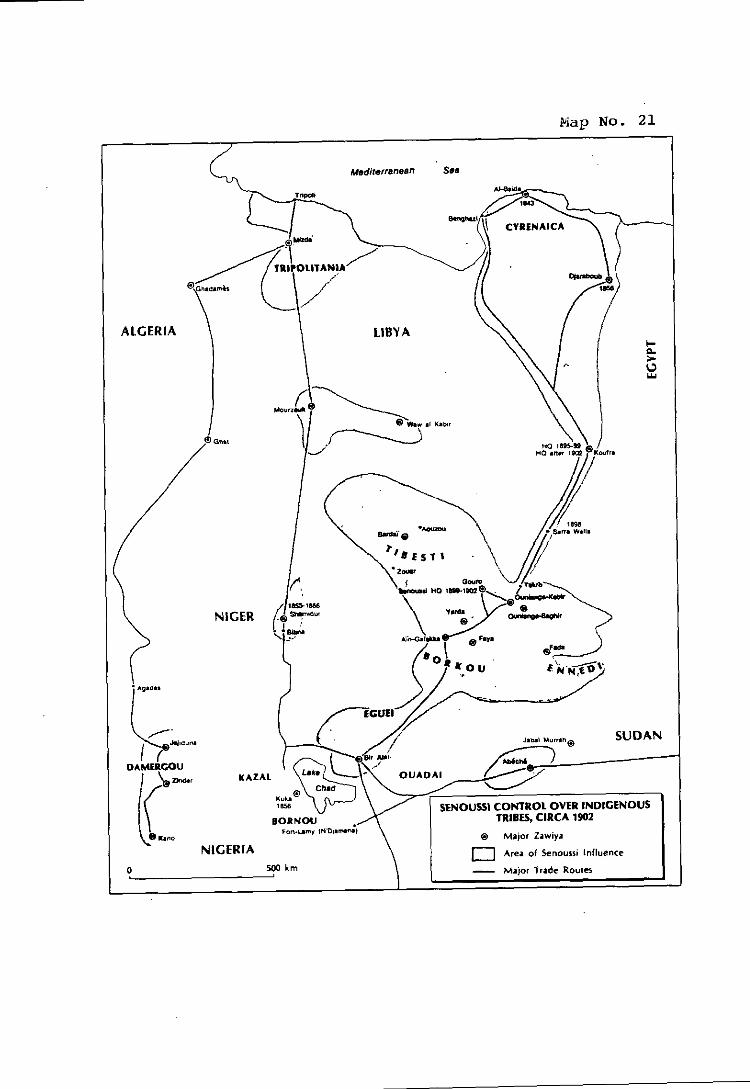

perceived threat of French encroachment by despatching troops to Tibesti, and 27 that these troops allied themselves with the Senoussi forces to fight the French .
A Turko-Senoussi rnilitary outpost was established at Aïn-Galakka, Turkish arms
were sent to the Toubou tribes (who fought under a Turkish tlag)28, aiid in 1908 the Head of the Senoussi recognised Turkish sovereignty over the three northern
29 regions of the borderlands .
6.28 The clear conclusion is that the borderlands regions were
not terra nullius, and certainly not at the time the French forces invaded thein
after 1900. Of the effectiveness of the Senoussi control - exercised in conjunction
with the local tribes - there can be no douht. Thus, it matters not whether
sovereignty lay with Turkey or with the Senoussi. Reülistically, the situation might
best be viewed as one of shared sovereignty - for the essential point was that
sovereignty could not be claimed by France by virtue of occupation of lerra -. This view is consistent with precedent.
6.29 In the Western Sahara case, in its Advisory Opinion of 16
October 1975, the Court rejected the view that territories of this kind could be
regarded as terra nullius, open to occupation by European Powers during the
period in question. The Court stated:
"Whatever differences of opinion there may have been ariiong jurists, the State practice of the relevant period indicates that territories inhabited by tribes or peoples having a social and political organization were not regarded as terrae nullius. It shows that in the case of such territories the acquisition of sovereignty was not generülly considered as effected unilaterally through 'occupation' of terra nullius by original title but through agreements cancluded with local rulers. On occasion, it is true, the word 'occupation' was used in a non-technical sense denoting siinply acquisition of sovereignty; but that did not signiîj that the acquisition of sovereignty through such agreements with authurities of the country was regarded as an 'occupation' of a terra nullius in the proper sense of these terms. On the contrary, such agreements with local rulcrs, whether or not considered as an actual 'cession' of
27 Wrighi: Ubva. Chad and the Central Sahara .a . a., p. 113.
2% Decalo. S.: Historical Dictionan. of Chad. 1977. p p 2W-285. Wrighc. 9. G. pp. 118- 119. Turkish iruops wcrc ülhu sent 10 Bardai. Zuar. Ain-Galakka and Oum Chülouba.
29 Wrighi: Libva. Chad and the Ceniral Sahara. op. a.. p. 118.

the territory, were regarded as derivative roots of e, and not original titles obtained by occupation of terrae nullius. $8,
6.30 The factors identified as relevant by the Court in relation to
the Western Sahara were that the territory ' b a s inhabited by peoples which, if
nomadic, were socially and politically organised in tribes and under chiefs
cumpetent to represent them", and that European Powers proceeded with their
plans to colonise, not on the basis of occupation of terra nullius but of
"agreements which had been entered into with the chief of the local t r i b e ~ . ~ ' "
6.31. If this is true of the peoples of the Western Sahara, it must
equally be true of the peoples of the area north of Lake Chad. Unlike in the
Western Sahara, however, in the Libya-Chad borderlands there were no
agreements entered into by France with the local rulers. And from this it follows
that any claim to title to the territory by France miist rest on conauest, not on
occupation of terra nullius or on local agreements.
(b) Title Rested with the Indipenous Peoples and with the Ottoman Empire and, Later, ltnly
6.32 The title of the indigenous peoples led by the Senoussi in the
borderlands regions has been amply demonstrated in Parts IV and V. By the
early part of this century, the Senoussi Order had firmly established itself in the
borderlands as an organizing and administrative force.
6.33 By 1900, for example, the Order had rnoved its headquarters
to Gouro just south of the Tibesti massif. Zawivas had also been established at
Faya, Ain Galakka and Bir Alali.
6.34 Local tribes and confederations, such as the Tuareg, paid
their allegiance to the Senoussi, and the Senoussi inediated disputes between the - Tuareg and the Awlad ~ u l a i m a n ~ ~ . The Senoussi Order exerted other forms of
30 Wesicrn Sahara. Advison Opinion. I.C.J. Reoorts 1975. p. 39. para. 80. And see the siriciures of Judge Ammoun in his Scparate Opinion: "ln short. the concept of terra nullius. employed at al1 periods. Io the brink of the iweniieth century. 10 justi. cvnquest - and civilisalion, stands condemnrd." (at p. 86). 11 is noteworthy thai the French Judge, Andrk Gros. shared the same view as the m:ijority: "1 consider that the indepcndent irihes travelling over the ierritory, or stopping in ceriain places. exercised a de auihority which was sufficiently recognised I«r thcre Io have hccn no tcrra nullius" (p. 75).
Ihid., p. 39, para. 81. 31 - 32 a, para 4.09.3 a. above.

administrative control, such as the establishment of zawivas; and they organized
the resistance by the indigenous tribes to the French invasions as well..
6.35 The title of the indiienous peoples co-existed with :I
compatible title that resided in the Ottoman Empire. As.early as 1890, the
Ottomans had made known to both France and Great Britain that they had rights
over the horderland areas as part of the Tripolitanian h i n t e r ~ a n d ~ ~ . These claims
were repeated in a note verbale that was handed by a Turkish representative to
the French Minister of Foreign Affairs on 29 March 1899 and followed up egain
in a fuither note on 14 May 1 ~ 9 9 ~ ~ .
6.36 Prior to 1900, the extent of Ottoman Ernpire's interests in
the disputed area was :ils0 well documented. For example, the report prepiired
by Maharnrnad Basala in 1894 recorded how several of the tribes were holders of
Firmans issued by the porte3'j. And by 1908, the Ottomans had occupied key oases throughout the area in strength, including at locations in Borkou and
Ennedi.
6.37 As has heen seen, by 191 1 negotiations coinmenced between
France and Turkey to delimit the area between Tripolitania and the French possessions. This led to a de facto line of separation between Borkou, Ennedi
and Tibesti, on the Ottoman side, and Kanem and Ouadaï, where French forces 36 remained . One year later, the Ottoman Sultan granted autonomy to the
indigenous people of Tripolitania and Cyrenaica in the Firman that was made
part of the Treaty of Ouchy.
6.38 A similar modus vivendi arose between the French and the
Senoussi, as reflected in the instructions given by the French Minister of Colonies
to the French emissary, M. Bonne1 de Mézières. Among other things, the French proposed to yield Gouro, where an important had been established, to the ~ e n o u s s i ~ ~ .
33 S. the Ottoman Note of 30 Ociober 1890; Italian Archives Annex. p. 3.
34 &. para. 5.50 - 5.52. above.
35 &. para. 4.123 - 4.124 above.
36 a. para 4.150, above.
37 a, para. 4.153 - 4.165.
6.39 What the facts show is that the indigenous peuples
possessed an existing legal title based on their long-established presence and
effective administration and settlement in the disputed areas. This title came to
co-exist witli Ottoman rights and title in the ares as well. The titlrs of botli the
Senoussi and the Ottomans pre-dated the French military incursion into the area,
and indeed both fought against the French. Moreover, at various times, both the
Senoussi and Ottoman presence was recognized by the French in a series of & facto arrangements under which the French forces were restricted to areas south - of 15"N latitude, until after the 1912 Treaty of Ouchy had entered into force.
SECTION 4. The Basis of French Claims in the Disauted Area
(a) Lack of a Conventional Boundarv or of Conquest
6.40 In contrast to the titles of the indigenous peciples and the
Ottomans (as passed on to Italy), French claims in the disputed area rested on
essentially two bases. First and foremost, France's claim hinged on the alleged
existence of a conventional boundary. This theory has already been shown to he
wrong.
6.41 There is, however, another theory on which the French
claim might have been advanced - that the borderlands were, in fact, acquired
conuuest. Libya considers that conquest is ruled out as well. Whatever might
have been the ability of a State to acquire title to territory by conquest prior to
1920 - and Libya does not accept that conquest could have established a valid title
- the section that follows will demonstrate that conquest was clearly outlawed by
international law as a legitimate basis for acquiring title after 1920. In as much as
the borderland regions could not have been said to have been conquered by
French forces before that time - and Libya denies that French incursions into the
borderlands ainounted to conauest even after 1920 - a valid French title to the
area in dispute did not exist. The burden of proof to show otherwise falls on
Chad.
6.42 The dates concerned here are important. As noted above, it
was only after 1912 that French forces moved into the borderlands, destroying the
great at Aïn Galakka in 1913. They seized Fada in Ennedi in 1914.
Ounianga (Ouniaga Kebir) was taken in 1913; but the French left that region in

1916. Bardaï in Tibesti was seized in 1914, but the French left Tibesti in 1916, and did not return until 1929. At no stage did France introduce civiladministration
or, indeed, any territorial administration in the truc sense. Thus, it cannot be said
that, prior to 1929, there had been anything more than a defensive rnilitary incursion into the borderlands; certainly nothing that couid be called either
effectivit6 or even conquest.
6.43 Whatever the degree of "effectiveness" of the French
occupation rney have been, or whatever the extent of conquest - both matters as
to which Chad w«uld have the burden of proof - neither occupation nor conyuest could ground a legal title if contrary to rules of jus coeens.
(b) The Leeal Limitations on the Power of France To Acauire Territory bv Force or Conauest
(i) The Covenant of the Learrue of Nations
6.44 Article X of the Covenant of the League provided as
follows:
"The Members of the League undertake to respect and preserve as against external aggression the territorial integrity and existing political independence of al1 rnernbers of the League ...."
The Covenant came into force on 10 January 1920 so that France was bound by
this obligation long before French forces had returned to a large part of the
borderlands regions or could have been said to have either occupied or
conquered any of it. As Article X prevented France from acquiring territory by
way of force, it is clear that in fact she had not becorne the sovereign in this region
before 1920? and was legelly prevented from changing the status of this region by
way of force after 1920.
6.45 It might be argued that this position is not correct inasmuch
as Article X of the League's Covenant only protects "the territorial integrity and
existing political interdependence" and does not add explicit language to the
effect that the use of force will not be recognised as a means of acquiring title. On this view, although the use of force might be illicit, on the practicül level the result
of a total assertion of control over peoples and the territory in question would hiive to be accepted. Thus, the argument might run: aggression is strictly
forbidden; but once it has occurred, its fruits will accrue to the aggressor.

6.46 It is not difficult to see why the system of international law
was bound to reject such a viewpoint. If such a rule were upheld, it would be
tentamount to admitting that the legal order would negate and ignore the very
basis and purpose of the prohibition of aggression. Not surprisingly, tlie logical
linkage between the prohibition to use force, the guarantee of territorial integrity
and the reqiiirement to refuse recognition to the effect of the use of force, on the
level of law, in relation to the territorial status of the area subject to aggression,
was clearly recognised by the leading commentators during the existence of the 38 League and subsequently .
6.47 O n tlie most general and fundamental level, the issue has
been posed and answered in a succinct manner by Jennings:
"This question has heen the suhject of some debate; but reason suggests only one answer. T o brand as illegal the use of force against the 'territorial integrity' of a State, and yet at the same time to recognize a rape of another's territory by illegal force as being itself a root of legal title to the sovereignty over it. is surely to risk bringing the law into contempt. For it is not simply a question whether it is possible to allow a title which cannot be pleaded without incidentally exhibiting the illegality. Nor is it merely a question of the limits of the mzuim ex injuria ius non oritur. The question is whether an international crime of the first order can itself be pleaded as title because its perpetration has been attended - with success. It is not, so to speiik, a question whether the thief is to he allowed, as indeed he is allowed i n English law at least, tu have some sort of possession recognized by the law; the question is whether he is to be permitted to plead the very fact of violent rapine as being itself a root of title erea omnes. A wrong w,: frequently result in a change of title: it can hardly be itself a title .
38 a. Wright, Q.: Amcrican Poliiical Science Review. Nov. 1919, Vol. 13. p. 559; Lauterpacht, H.: Recoenition in International Law, Cambridge 1947. p. 417; Fauchille, P.: Traité de Droit Internaiional Puhlic. 8th ed.. Vol. 1. Part II. p. 769; Spin>poulos, J.: Traité de Droit International Public (1933). p. 178: Schücking. W. and Wchherg: Kommeniar zur Satzune des Volkerhundes (1921). p. 274 Schatzl. W.: Die Annexion im Volkerrecht. Archiv des Vülkerrechis, vol. 2. (1950). p. 18; Scelle. G.: "Quelques réflexions sur l'abolition de la compétence de guerre" (Revue Générale de Droit International Public. 1954. p. 16): Garner. "Non-Recognition of Illesal Territorial Annexations", (Am. J. Ini'l. L. 1936. p. 679); Brownlie. 1.: International Law and the Use of Force bv Siates. 1963. p. 418 ("The mininium conteni of Article 10 involved such an obligation" viz. no1 to recognise forcihle acquisition of icrriiory): Report of Adaici and de Visscher. Annuaire de I'lnsliiut de Droii Iniernaiiunal. 20 (1923) Bruxelles. p. 26.
39 Jennings. R.: The Acquisiiion oI Territow in Iniernational Law, Manchesier. University Press. 1963.

6.48 The travaux ~ rk~ara to i r e s confirin that Article X was
designed to protect existing boundaries against any effort to change themby the
use of force40. U.S. President Wilson Iiad taken a spec&l interest in the subject
matter, and the draft presented hy the United States was accepted in the
deliberations on the Covenant without substantial change. The m i n discussions
over this article concerned the question as t<i procedures by which existing
boundaries could be changed in case they were considered inappropriate and
unjust. The principle of the illegality of the use of force for the acquisition of
territory was not in dispute.
6.49 After the Covenant had entered into force, Canada
proposed to amend the Covenant and to delete Article X. The issue was under
disciission before various bodies between December 1920 and September 1923. ln the course of these debates, the idea of an amendment was dropped in favour
of an interpretative Resolution intended to interpret the Covenant. Such a
Resolution, as well as an ainendment, could only be passed by a unanimous vote;
in 1923, a vote failed to gain unanimous support, and the deliberations came to an
end. The substance of the discussions had centred on the issues (i) as to whether
the Leiigue's Council ought to take into account the geographic situation and the
special circuinstances in the case of an aggression; and (ii) as to the freedom of
each Member State to determine whether unilateral action was required or no1 in order to fulfil the obligations under the Covenant. In the course of the
deliberations, the Commission charged with the preparation of amendments of
the Covenant turned to another Commission (chaired by Stuyeken) for a review
of the meaning of Article X. In the Report of this latter ~omrniss ion~ ' , it is
clearly highlighted, again,that the object and purpose of Article X was to prevent
any forcible change of boundaries.
6.50 The League was not faced with any situation covered by
Article X in the first decade of its existence. However, in Iate 1931 and 1932, Japan forcefully occupied Manchuria, then a part of China. The first formal
action taken against the Japanese aggression was taken by the United States,
which issued the famous Stimson letter stating that the United States did not
JO &, Schiicking, W. and Wehberg: Die Satzuncdcs Volkerbundes, 2nd cd., 1924, pp. 449- 450.
J I Doc. A.24(1) 1921. p. 10.
intend to "recognize the legality of any situation de facto" created by ~ a ~ a n ? ; not
being a inember of the League, the United States made reference to the Kellogg-
Briand Pact as the legal basis of its position rather than Article X of the
Covenant.
6.51 However, on 16 January 1932, al1 members of the Council of
the League other than China and Japan, signed and sent the following note to the
Government of Japan.
"The twelve rnernhers of the Council recall the terms of Article X of the Covenant, by which al1 members of the League have undertaken to respect and preserve the territorial integrity and existing political independence of other members. It is their friendly right t« direct attention to this provision, particularly as it zippears to them to follow that no infringement of the territorial integrity and no change in the political independence »f any member of the League hrought ;ihout in disregard of this ought to be recogniz& as valid and effectua1 by the members of the League of Nations.
6.52 Remarkably, in response, Japan did not claim any right to
attack the territorial integrity of China, but instead denied that such an attack h;id 44 occurred . Finally, the League Assembly pleced the issue on its agenda. The
Assembly squarely and directly addressed the legal issue which had arisen under
Article X and decided that the members were obliged not to recognize the
consequences of an aggression:
"The Assemhly, considering that the provisions of the Covenant are entirely applicable to the present dispute declares that it is incuinbent upon the members of the League of Nations not to recognize any situation? treaty, or agreement which may be brought about by means contrary tu the Covenant of the League of Nations or to the Pact of Paris."
6.53 As to the applicability of this Resolution, both its wording
and its legislative history clearly show that it was meant to express a general rule 45 and was not limited to the Manchurian situation . Also, the wording chosen y...
42 Am. J . Ini'l. L, Vol. 26, 1932, p. 342.
43 u, p. 343.
Ihid. 44 - 45 Leaçue oiNaiions, Ollicial Journal. Special Supplemeni 101.

it is incumbent") clearly shows that the Resolution expressed a legal obligation 46 rather than a political commitment .
6.54 The fact that the Resolution of March 11, 1932, expressed 21
general rule valid under the Covenant was underlined when the League Council
explicitly recalled its applicability in the context of the so-called Leticia dispute 47 between Peru and Columbia .
6.55 While it is true that the League did not subsequently spell
out and apply Article X with the same precision in the case of Ethiopia, it inust be
recalled thüt the Resolution of 1932 was never rescinded and thtit,
correspondingly Ethiopia reinained an official member of the ~ e ~ i g u e ~ ~ . The
oggressions that occurred in 1939 or in the immediately preceding period cannot
be meaningfully reviewed under Article X of the Covenant inastnuch as the
League was in the process of disintegration and dissolution, performing its last
iicts in 1939. Thus, the prohibition of forcible acquisition of territory as reflected
in Article X of the Covenant and the 1932 Resolution of the Cotincil will have to
be considered, for al1 legal purposes, as the rule governing during the period
between 1920 until 1945 when the United Nations Charter replaced the
Covenant.
6.56 Of course, it might be objected in this context that hostilities
directed agüinst territory of the Senoussi peoples were not aggression apinst the
territory of a Member of the League and that France therefore had no obligation
in relation to such territory. But it would be inconsistent if the system of
international law governing war and peace were applied in such a way as to allow
the use of force in relation to some territories and to disallow it in relation to
others. In modern terminology, rules fundamental to the legal order itself, have a
See Shnrp: Non-Recocniiion as a Leeal Ohlieaiion 1775-1934. p. 191: Garner: "Non- 43 -, Recogniiion of lllegal Territorial Annexaiions" Am. J. Ini'l. L.. Vol. 30, 1936. p. 679; Lauterpacht. H.: "Regles Génerales du Droii dc Paix". (Hague Recueil 162: 1937. p. 29.1); see also Schindler. D.: Die Verbindlichkeit der Beschlüsse des Volkerbundes. 1927, p. 14; the opposiie view of Brierly, J. L.:, "The Meaning and Legal Effect or the Resolution o f the Lcague or Nations of March II" (192. U L Vol.. 16. 1935. p. 159). has lound no support.
See, Resolution ol March 18. 1933. Lçacue of Nations, Ollicial Journal 1933, p. 526. 47 - See. k a e u e Dwuments. Memhers ol the k a e u e and Commition of the Counci!, 48 - Sentemher 21 1938. p. 2.

hinding nature s a o m n e ~ ~ ~ . Key provisions of the Covenant itself confirtn this
view. According to Article X, any war or threat of war was declared a matter of
concern t o the whole ~ e a g u e , "whether iinmediately affecting any of the
Members of the League or not". Thus, the reaction of the League did not at al1
depend upon membership of the League by the parties to the war. This schemr
necessarily implied that members and non-inembers were, as regards the
obligations in Article X, subject to the same (~bligation. The saine principle
iinderlies the rules embodied in Article XVII and Article XVI. Article XVII
concerned disputes between members and non-members of the League. ln such
a case. the League would require the non-member "to accept the obligations of
membership in the League for the purposes of such dispute". ln case the non-
meinber declined such an obligation and chose to resort to war "the provisions of
Article XVI shall be applicable as against the state taking such actions". Article
XVI provided for sanctions on the part of al1 members of the League in case of an
attack against any member. Thus, the fundamental idea that with regard to war
and peace al1 subjects of international faw enjoy the same rights and obligations
forms the basis of the applicable rules contained in the Covenant itself.
6.57 In summary, it is clear that the legal order as it evolved after
1919 and as it was explicitly laid down in Article X of the League's Coveniint,
prohibited France from acquiring new territory in a forcible manner in and after
the 1920s.
(ii) The General Treah. for the Renuncintion of War of 1928 -
6.58 It inay be recalled that the 1928 Kellogg-Briand Pect, or General Treaty for the Renunciation of War, sprang from a French initiative5'.
So far as France was concerned, the proposed treaty would not be a new
obligation, since it reiterated the principle of the prohibition of war clearly
49 &, the concept of crm ornes ohligations as expressed hy the Court in the Barcclona Traction case. I.C.J. Renorts 1970, p. 32. para. 33: and S. also. Article 19 of the I.L.C. Dralt on State Rcsponsibiliiy.
French Amhassador Io the U.S. Secretay of State. 5 Januaw 1928: U.S. For. Rel. (1928). 1. 1). 1: France originally envisagcd a hilateral treaty. and the U.S. pruposed a general trcaty.

contained in the League ~ o v e n a n t . ~ ~ It was a new obligatjon for States not parties to the Covenant, such as the United States. The final text of the Treaty, as
agreed, provided in Article 1:
'The High Contracting Parties solemnly declare in the names of their respective peoples thet they cvndemn recourse to war for the solution of international controversies, and renounce it as5ÿn instrument of national policy in their relations with one sinother. -"
France ratified the Treaty on 22 April 1929.
6.59 In fact M. Briand later took the view that the 1928 Kellogg-
Briand Pact went beyond the Pact of the League: for the latter allowed recourse
to war for fulfilling the requirements of pacific settlement imposed by the Pact, . 5 L whereas under the General Treaty "le Pacte de Paris met la guerre hors le loi.
6.60 In the present case the difference between the obligations of
France under the two instruments has no practical relevance. For France did not
çhoosr to treat its hostilities ageinst the Senoussi peoples as a "dispute" to be
referred to either legel or political settlement under Article XII1 of the League Covenant. The hostilities were illegal -, under both instruments. Nor was
that illegality affected by the absence of protest, for the prohibition of war was,
subject to the obligations of peaceful settlement and the right of self-defence, othenvise absolute.
6.61 The implications of both the Pact of Paris and the Covenant of the League for the legality of an armed incursion into the territory of another
State, otherwise than in self-defence, were both clear and supported by France:
such arined incursions were illegal.
6.62 Thus, on 7October 1935, France subscribed to the Report
of the Cornmittee of Six to the Council of the League, concluding that in invading
51 French Amhassador tu U.S. Secrelsry of Siaie. 21 January 1928: m., p. 7: "...the ierms of ihe muliipariiie ireaiy are inspirecl hy lhe formula which kas already gained the umnimous adhercncc ofall of the Slate menthers of the Lwgue of Naiions ...".
53 Journal Officiel. Débets parlemeniaires. Sénat. 1929. p. 21.

Ethiopia, ltaly had violated both treatiess4. The official French communiqué,
published on 1 A~igust 1936 following Hailie Selassi's address to the League
Assembly, recorded that France could not -
"... donner son acquiescement h une action qtielconqlie de l'Italie portant atteinte a l'intégrité territoriale à l'indépendance 33 !! politique de I'Ethiopie, garanties par le Pacte .
6.63 It is not clear how France sought to reconcile its own use of
force against the Senoussi peoples with its forthright condemnation of the ltalian
use of force against the Ethiopians. I t could not be on the basis of Ethiopian
meinbership in the League for, as mentioned earlier, the obligations of both the 56 Covenant and the 1928 Pact are properly regarded as obligations erca omnes .
Nor could it be on the basis of timing: that the use of force by France occurred
before the obligations were assumed by France. I t has already been shown that,
prior to 1920, French forces had only made military incursions into the
borderlands regions. There had been no occupation, or conquest. Thus, any
claim of occupation or conquest must rest on the use of force after that date.
6.64 What happened after 1920 was "inere usurpation", based on
conqiiest, and thus contrary to international law. The re-occupation of parts of
the borderlands by France occurred because of the influx of refugees into the
:ire:i, fleeing southwards from the ltalian advance in Tripolitania. As the officia1
French military history explains it:
"L'avance italienne en Tripolitaine insoumise provoqua dès 1928 un exode de populations nombreuses qui vinrent se rkfugier en territoire frenfais.
Pour éviter la formation au Tibesti de rassemblements non controlés, l'occupation de ce massif fut decidée et confiée aux troupes de 1'Aîrique équatoriale fransaise.
- - -
54 R.G.D.1.P. (1936), Vol. 43. Documents. pp. 103-105.
55 Cited in Rousseau, C.: "Le conflit italo-ethiopien". p. 587.
56 For the concept of e rw omnes obligations. as ohliçations owed io the commiiniiy ai large. and cnforccahlc hy any membcr of that community. m. Jusic Ruiz: "Las obligaciones erga omnes en derecho iniernacionül puhlico" (Estudios de derecho internacional. Honienaie al nrofessor Mkiia de la Muela, 1979, p. 230); Tanzi: "1s Damage a Disiinci Condition for the Exisicncc of an Internationally Wrongful Ac1 ?" (U.N. Codification of Siaie Responsihility. Spinedi and Simma Eds, 1987, pp. 15-20). And E. the Barcelona Traction, Licht and Power Com~anv, Limited. Second Phase. Judeement 1.C.J. Reiicirts 1970. p. 32, para. 34.

De décemhre 1928 ri mars 1929, le chef de bataillon Auhert, commandant la circonscription du Borkou, avec le groupe nomade de la 7ème compagnie, sous les ordres du lieutenant Mear, effectua iine reconnaissance du Tibesti dans des conditions exceptionnelleinent difficiles. II opéra sa liaison près de Bardüï avec le chef de bataillon Rottier venu de Bilma.
Une compagnie fut créée pour occuper Bardaï et 'un nouveau rroupe nomade fu t chargé d'ass r la sécurité du versant b , . . 3 y,, meridional du Tibesti d'Ab0 à Zouar .
6.65 Thus, there was no doubt that this was a rnilitary occupation,
a taking (if the territory hy force after France was bound by the League Covenant
and the Pact of Paris. lt was in no sense a creation of a civil administration: it was
a rnilitary invasion, pure and simple. The fact that, on this occasion, it seems to
have met with no organised, armed resistance does not affect its illegality, any
more tlian the German invasions of Austria and Czechoslovakia some few years
later were affected by the lack of armed resistance. Such acts remain acts of
aggression (even if not aggressive war)SS and are illegal whether or not they met
with armed resistance. 59
6.66 Moreover, the notion of "inter-temporiil" law is clearly
relevant. As developed by Judge Huber in the Palinas Island caseoo, and now
generally accepted, it requires a State asserting title over territory to maintain that
title in accordance with the changing requirements of the law. So that, even if
France had acquired a valid title to the territory prior to 1920 - which is not
accepted - it would have still been incumbent on France to maintain that title in accordance with the evolving requirements of the law after that date. Thus, as the
prohibitions of the League Covenant, the Pact of Paris and, finally, the United
Nations Charter came into effect and prohibited the use of force against the
territorial integrity of another, so a title maintained by force would cease to have
validity. And there is no doubt that, until 1960 (indeed, until 1965), France
57 Histoire Militaire de I'Afrique Equatoriale Francaise. (19.11). p. 480. (A copy of this page is aitached as Euhibi< 26.)
58 &, Mcmorandum submiltcd hy thc Secrciay-General, the Charter and Judgment of the Nuremberg Tribunal, Ncw York (1949). p. 48.
59 1. fcor examplc. the Seçurity Council's c«nvïntion «I "repeated acts of aggression' hy Sciuthcrn Rhodesia againsi Zamhia, in milimry incursions which met wiih no armcd opposition, in S.C. Resol. 455 (1979) of 23 Novemhcr 1979.

inaintained control over this territory by force, after which time rebellion and civil
war broke out.
6.67 Thus, we are faced with the same evolution of the law that
required the eliinination of colonialism as an alien control over ariother's territory
tnaintained by force. In most ciises the validity of a "colonial" title by reference tu
the legal rules of the Ilth, 18th: or 19th Century was unquestioned. But it became
highly questionable hy reference to tlie contemporary rules of the 20th Century,
in particulür the prohibition of the use of force as a means of acquiring territory,
or retaining it! contrary to the wishes of the indigenous inhabitants.61 Thus, it can
be seen that France had no legal title over the borderlands region to transfer in
1960 - whether to Chad or anyone e l ~ e ' ~ .
6.68 There is yet a further factor. France has asserted that its
title rested on "actes internationaux" in force in December 1951. This French
view was wrong: under these "actes", no conventional title existed at that time east
of Toummo. Thus, the only other basis for a claim to title by France would have
heen conqiiest (not occ~ipation of terra niillius). But in fact conquest - ineaning
the annihilation of the enerny forces and the completion of control of the territory
- did not, under traditional law, serve to confer a legal title to the t e r r i t ~ r y ~ ~ ; a
"subjugation" had to occur, evidenced by the forrnal annexation of the territory
subsequent to a treaty. This did not occur.
SECHON 5. The Role of "Effectivité"
6.69 In view of the status of the disputed area during the relevant
period and the absence of a valid French title to these areas, it remains to
61 - See. the Declaralion on Principles of Iiitcrnationnl LAW concerning Fricndly Rclaiions, U.N.G.A. Res. 2625 (XXV): "Every Siate has the duty io refrain from any forcihle action which deprives peoplcs ... of their right . I o self determination and freeduni and independence." Also the declaralion on the Granting of Independence to Colonial Peoples and Territoria. U.N.G.A. Res. 1514 (XV). espec., para. 4.
62 This view would accord with the general lheory that a colonial power cannot determine the entity to which title is transferred on de-colonisaiion. Thc iitle cxists in the indisenous peoples. and il is iheir right, as part of the right of self-deiermination, IO
decide which entity shall hc the territorial sovereign for the future. &, the examplcs of ihe cases of Eritrea. West Irian. British Togoland, British Cameroons, Mauriiania, discussed hy Rigo Sureda: The Evolution of the Riehi of Self-Determination, 1973. pp. 133-172.
63 - See. kir example. Oppenheim, L.: Intcriiati«nal h w , Vol. II, Sixth Ediiion, 1940. pp. 466-8.

examine the relationship between "effectivité", on the one hand, and legal title, on
the other.
6.70 This relationship was carefully examined by the Court in its
1986 Judgment on the Frontier Dispute case. I t said:
" ... a distinction must he driiwn among several eventualities. Where the act corresponds exactly to law, where effective administration is additional to ihe uti oossidetis iuris, the only role of effectivité is to confirrn the exercise of the rieht derived t'rom a leeal title. Where -..~~- ~ -
the iict does notcorrespond t« the law, where the Grritory which is the subject of the dispute is effectively administered by a State other than the «ne possessing the legal title, preference should be given tr) the holder of the title. In the event that the effectivité does not co-exist with any legal title, it inust invariably be tiiken into consideration. Finally, there are cases wherr the legal title is not capable of showing exactly the territorial expanse to which it relates. The effectivités can then pla an essential role in showing
84 how the title is interpreted in practice .
6.71 Following this reasoning, it is apparent that effectivité
cannot play a dispositive role in this case for at least four reasons:
The legal title t« the area in dispute has been shown
to have resided in the indigenous Senoussi peuples,
the Ottoman Empire and, later, Italy. This is the title
thrit Libya inherited. Inasmuch as there is a valid,
pre-existing legal title, the role of effectivité would
only be to contïrm that title. Moreover, even if
French effectivité in the area could be demonstrated,
which is not the case, preference would still be given
to the holder of the title: Libya;
- France never, in tact, effectively occupied the Libya-
Chad borderlands (whether by occupation or by
conques) until after 1929, by which time occupation
by way of force was invalid under international law;
- France's repeated position, in particular as explained
to the U.N. and as set forth in the 1955 Treaty, was
that the international agreements in force were the
64 Fronlier Disoule. Judgment, I.C.J. Re~orts 19%. pp. 586-587, para. 63,
sole basis of establishing the boundary east of - Toummo, thus rejecting colonial effectivité as a basis
of title; and
In any event, the territories in .question were not
terra nullius, so that France's alleged occupation of -- the region was? in the words of Chief Justice Hughes
of the United States Supreme Court, "mere
usurpation"65
6.72 I t must he pointed out that Libya does not base its claiin in
this case on colonial effectivité. The part of the borderlands to which Libya
asserts it has clear title comprises regions, title to which lay in the indigenous
peoples. Libya inherited this title when it became an independent State in 1951.
These same regions fell within the Tripolitanian hinterland claimed by the
Ottoman Empire based on the close links (administrative, religioiis, legal,
cultural, economic and commercial) between these regions and the regions to the
north, which were under Ottoman sovereignty. This claim was reasserted by the
Ottoman Empire when its forces occupied the borderlands between 1908 and
1912, withdrawing only as a result of the war with Italy and the 1912 Treaty of
Ouchy. These rights and title were passed on to Italy in 1912 by the Treaty of
Ouchy and coalesced with the parallel title of the peoples, which Libya inherited
in 1951.
6.73 Nonetheless, to the extent that there was effectivité in the disputed area during the critical period, it was exercised by the peoples and the
Ottomans who, unlike the French, were not intent on destroying or subjugating
the local populace, but who contributed to the political, military, commercial,
legal and religious administration of the area.
SECTION 6. The Attem~ts to Dis~ose of Title to the Libva-Chad Borderlands
6.74 I t follows from the preceding that the attempt by France to dispose of title to this territory by the Franco-Italian Treaty of 1935 could have no
effect in law, for the reason that France had no lawful title to dispose of. In the
65 &. ln. 20, ahove. 11 may he added. as noted in paras. 5.06-5.07, that ihe General Act of the Congress of Berlin of 1885 had no application to these tcrritorics.

absence of conventional title or of any agreements with the local rulers, France
could found its title only on conquest, but any such conquest, even had it
occurred, would have arisen - and hence French title would have been
"established" - at a time when international law no longer perinitted the
acquisition of title to territory by conquest.
6.75 The position of Italy was different for, as explained in Part V
abuve, the Ottomnn rights and titles had been transferred to Itely hy the Treaty of
Ouchy in 1912. And since this transfer of title occurred prior to the League
Covenant, it is not possible to regard the transfer as invalidated by reference to
the rules of law prohibiting the acquisition of territory by war or the use of force.
In any event, the Ottoman rights and titles (and hence those of Italy) were not
based on the acquisition of the regions by the use of force.
6.76 If, ns seen above, France had no lawful title to the
borderlands regions to dispose of in 1935, or to pass on to Chad in 1960, where
did title to these regions reside? The answer is two-fold. m, and foremost, it
resided in the indigenous peoples who inhabited these regions. Second, ii parallel
and compatible title resided in the Ottoman Empire, since the borderlands Iüy witliin the territories claimed by the Ottoman Empire on the basis of religjous,
legil, cultural and commercial ties going hack a long time, and confirmed by their
presence and their understandings with the indigenous peoples.
6.77 It is not necessary to attempt to define the relationship
between these two parallel titles, for they were not only compatible but also
interdependent - much like the relationship between the Ottomans and the
Senoussi in the period after 1900, when they united their forces to oppose the
French invasion. In the letter addressed in 1911 by the Head of the Senoussi to
the "Civil Nations" referred to above in paragraph 5.222, protesting the acts of
violence being carried out by the French against the Order, the zawivas and the
Senoussi peoples, Sayyid Ahmad al-Sharif specifically acknowledged the Senoussi
Order's allegiance ta the A year later, in the Firman made pan of the
Treaty of Ouchy, the Sultan granted automony to the inhabitants of Tripolitünia-
Cyrenaica, who included the Senoussi peoples in the borderlands regions forming
the hinterland of Tripolitania-Cyrenaica. ln the Treaty itself, ltaly undenook to
Exhibit 47 66 -

respect the autonomy so granted to the inhabitantso7. Thus, the title inherited by
Italy continued to coexist with the title of the peoples in the Libya-Chad
borderlands, j~ist as the Ottoman title had. When Libya attained independence in
1951, these two titles coalesced into the title of the State o f ~ i b ~ a .
S~crios 7. The Riaht of Self Determination of Peovles
6.78 Libya became >in independent State in 1951 efter the
peoples of Tripolitania, Cyrenaica and Fezzan had been consulted on the
question of Libya's independence as a unified State by the Four Power
Commission, as called for in Annex XI of the 1947 Italian Peace Treaty. But the
boundaries of Libya were not brought tip at that time.
6.79 This consultation with the Libyan peoples retlected the right
of self-determination, which today is a rule of JUS coeens. In the Arbitral Award
of 31 July 1989 between Guinea-Bissau and Senegal, the majority saw a need to
identify a point in tiine at which "the norm which limits the capacity of the State to
conclude treaties upon the initiation of a process of liberation" begins to take
effect6'. The Award identified that point in time as "the moment from which its 69 (the liberation movements) activity acquired an international impact" .
6.80 The right of self-determination here reposes in the
indigenous peoples inhabiting the Libya-Chad borderlands. The point in time
rnentioned in the Arbitral Award, at which this right of these peoples, who were
led by the Sensoussi Order, began to take effect, was at least by 1919. For by then
the Senoussi Order - under whose leadership the iight by the indigenous peoples
was conducted against the military invasions of the French in the south and
against the Italians in the north - had been accorded recognition as a de facto
government and virtually a sovereign power by a number of States: - by the Ottoman Empire at the end of the 19th Century;
by Great Britain and ltaly in the series uf agreements
entered into with the Head of the Senoussi prior to 1919;
67 W . para. 5.134, t!l!t., ahove.
Award. para. 52: English translation in the Annex to the Application olGuinea Bissau io the 1.C.J.. 23 Augusi 1989.
69 - Ibid.. para 51.
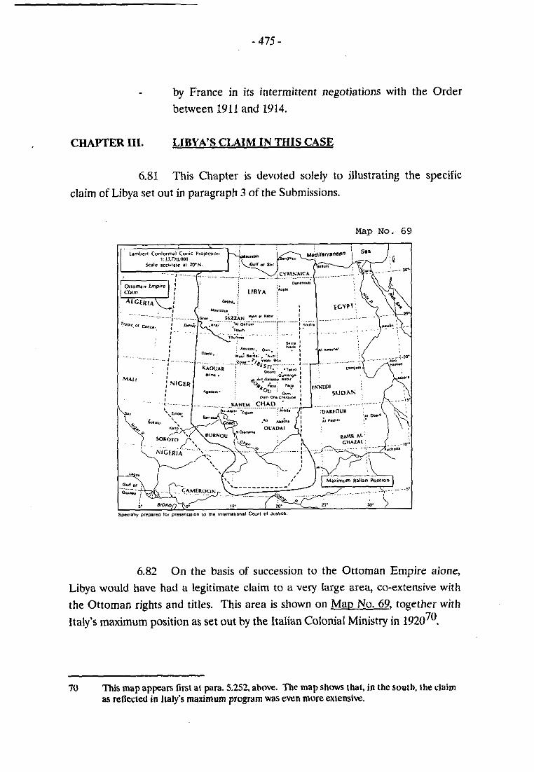
- by France in its intermittent negotiations with the Order
between 1911 and 1914.
CHAPTER III. LIBYA'S CLAIM IN THIS CASE
6.81 This Chapter is devoted solely to illustrating the specific
claim of Libya set out in paragraph 3 of the Submissions.
Map No. 69
6.82 On the basis of succession to the Ottoman Empire alone,
Libya would have had a legitimate claim to a very large are$ co-extensive with
the Ottoman rights and titles. This area is shown on Mao No. 69, together with
Italy's maximum position as set out by the ltalian Colonial Ministry in 1920~'.
70 This mop appean lïrsc ai para. 5.252. ahove. nie m a p s h m thal. in the south. the clzüim as reflected in Italy's maximum program was even more extensive.

6.83 Since the time the Ottoman claim was asserted in 1890,
there has been an evolution of events, including the coming into existence of other new States, as well as Chad, that must be taken into account. Certainly the
situation as to Chad is different from these other States, for at least three reasons.
First, the Ottoman Empire had legitimate rights and titles over the entire area, - which it reasserted with respect to the borderlands by its presence up until the
Treaty of Ouchy. These were legally transferred to Italy hy the Treaty and
rventually to Libya. Second, the title over these areas held by the indigenous
peoples led by the Senoussi remained intact. m, the French military
encroachinents north of 15"N latitude did not generally occur until after 1920, by
which time France was bound by solemn treaty commitments not to acquire
territorial title by force. And, in fact, France never did estahlish control north of
15"N latitude - with the possible exception of the north of Kanem - so as to
receive recognition and acceptance of such control by the world community.
Accordingly, Libya submits that, as to the part of the territory lying north of the
boundary illustrated on Mao No. 105, Libya has clear title. As Maos Nos. 106 to
109 demonstrate, the area to which Libya claims it has clear title is a practical - reflection of the de facto situation as it developed since the Ottoman claim was
first made in 1890, both on the ground and in the claims, proposals and
agreements of the various interested parties.
6.84 M ~ D No. 105 sets out the sirea to which Libya asserts it lias
clear title. The boundary would start at the intersection of the eastern boundary
of Niger and 1S"N latitude. From there it would follow a precise southeast line tu
15"N latitude, following then that parallel to the existing boundary between Chad
and Sudan.
6.85 Maos Nos. 106. 107, 108 and 109 compare Libya's claim to
four other relevant lines:
- The de facto line between Ottoman and French forces in the
period 1910-1913 (Mao No. 1 0 6 ) ~ ~ ;
- The line proposed by the of Tripoli to the Porte in 1911 in preparation for the negotiations expected to take
" -. See para. 4.142 gm.. ahwe.

Map No. 105


blap No. 108

Map No. 109

place shortly with France to delimit this boundary (Mar> No.
1 0 7 ) ~ ~ ; -
The line set out in the Minimum Program of the ltülian
Colonial Ministry in 1928 (Mao No. 1 0 8 ) ~ ~ ; and
- The lignes rouges of 15"N htitude, and then 16"N, agreed
with France in 1984 (Man No. 1 0 9 ) ~ ~ .
6.86 These four lines demonstrate two common elements, both
of which are reflected in Libya's claim. The first is that the evolution of events in the area discloses the acceptance of 15"N latitude as a de facto bocindary line,
north of which the title of the Senoussi peoples was never displüced. The
element concerns the western sector of the borderlands - that is the northern part
of Kanem - an area that in 1900 was under firm Senoussi control when the
at Bir Alali was a tlourishing center of religion and learning and a focal point of
Senoussi administration (and of necessity a military stronghold of the Senoussi tribes in their struggle against the French invasion of their lands). After the
destruction of this & by French forces, it was occupied by them. This forced
the Senoussi center of control to be moved north to Aïn Galakka from where it
took instructions from the Senoussi leadership in Gouro.
6.87 When Ottoinan forces occupied the borderlands, starting in
1908, in the western sector of the borderlands they did not descend south of 18"N
latitude - the east/west fine on which Aïn Galakka is locnted. On the other hand,
in the east, they went much funher south - to Oum Chalouba (south of 16%' latitude). As is retleçted in Maos Nos. 107 and 108. the recommendation of the
v- of Tripoli in 1911 and the Italian Colonial Ministry's Program of 1928 reflected this fact, and would have left al1 of the region of Kanem to France . Similarly, Libya's claim would leave Kanem to Chad while placing al1 of Ennedi,
Borkou, Ounianga, Tibesti and Erdi in Libya.
72 - Sec. para. 5.114. ahove.
73 - See. para. 5.254. ahove.
74 a. para. 5.568. above.

SUBMISSIONS
Havine regard to the various international treaties, agreements,
accords and understandings and their effect or lack of effect on the present
dispute, as set out in preceding parts of this Memorial;
In view of the other facts and circuinstances having a bearing on
this case, as discussed above;
In the lirht of the conduct of the Parties, of the conduct of uther
States or political, secular or religious forces, whose conduct bears on the rights
and titles claimed by the Parties, and of the conduct of the indigenous peoples
whose territories are the subject of this dispute;
In a~nlication of the principles and rules of international law of
relevance to this dispute;
Mav it ~ l e a s e the Court, rejecting al1 contrsiry claims and
subinissions:
To adiudee and declare, as follows:
1. That there exists no boundary, east of Toumrno, between
Libya and Chad hy virtue of any existing international
agreement.
2. That in the circumstances, therefore, in deciding upon the
attribution of the respective territories as between Libya and
Chad in accordance with the rules of international law
applicable in the matter, the following factors are relevant:
(i) that the territoiy in question, at al1 relevant tirnes,
was not terra nullius;
(ii) that title to the territory was, at al1 relevant timrs,
vested in the peoples inhabiting the territory, who
were tribes, confederations of tribes or other peoples
owing allegiance to the Senoussi Order who had

accepted Senoussi leadership in their fight against
the encroachments of France and Italy on their lands;
(iii) that these indigenous peoples were, at al1 relevant
times, religiously, culturally, economically and
politically part of the Libyan peoples;
(iv) that, on the international plane, there existed a
cominunity of title between the title of the indigenous
peoples and the rights and titles of the Ottoman
Empire, passed on to Italy in 1912 and inheritrd hy
Lihya in 195 1;
(v) that any clairn of Chad rests on the çlairn inherited
from France;
(vi) that the French clairn to the area in dispute rested on
"actes internationaux" that did not create a territorial
boundiiry east of Toummo, and that there is no valid
alternative basis to support the French claiin to the
area in dispute.
3. That, in the light of the above factors, Libye has clear title to
al1 the territory north of the line shown on Map 105, that is to say the area bounded hy a line that starts at the
intersection of the eastern boundary of Niger and ISON
latitude, continues in a strict southeast direction until it
reaches 15" N latitude, and then follows this parallel
eastwards to its junction with the existing boundary between
Chad and Sudan.
(Signed) ...................................................... Abdullati Ibrahim El-Obeidi
Agent of the Socialist People's
Libyan Arab Jamahiriya