What does Spatial Data Infrastructure mean to Pakistan
20
1 What does Spatial Data Infrastructure mean to Pakistan? Asmat Ali Survey of Pakistan [email protected] Abstract The term Spatial Data Infrastructure (SDI) has been defined, redefined and still is being refined. Understanding needs and rationales for SDI development cannot be exactly the same for developed and developing countries though it may have some commonalities. Therefore, time has come when it needs to be translated into tangible benefits according to local needs of specific regions for its smooth and successful implementation. Some of such benefits include natural resources management (NRM), homeland security and disaster management. Natural resources are a vital asset to any economy. Developing countries like Pakistan depend more on natural resources and less on industry for its economy. The rapid consumption of the natural resources due to ever increasing population adds value to the importance of these resources and demands strategies for better study, understanding and forecast of our environment and its relation to natural resources. Moreover, there is a dire need for the country such as Pakistan to address the most significant issues like environmental degradation and natural disasters that are a great threat to its natural resources. But to formulate effective and implementable strategies for the protection and extraction of these reserves and resources through efficient planning, require information that has been evaluated and synthesized persuasively. Information that is developed or accumulated from multiple sources and is objective, reliable, accessible and usable. This is one of the reasons that many countries are developing Spatial Data Infrastructure (SDI) so, that sharing of information could be made possible from multiple sources to effectively manage their natural resources. Therefore, this paper explores and determines rationale for SDI development with focus on natural resources of Pakistan. The paper determines “where are we” and not “how to get there” (Georgiadou, 2006). In this context, this paper briefly describes the need for natural resources management (NRM) for Pakistan’s sustainable development. Further, the supporting role of Spatial Data Infrastructure (SDI) for NRM is briefly elaborated. Key words: Spatial Data Infrastructure, Natural Resources Management, Pakistan 1. Introduction The concept of Spatial Data Infrastructure (SDI) has been with us for more than a decade now. The term SDI has been defined, redefined and still is being refined. Differences may be found in the definition of SDI. Some definitions of SDI are mainly focused on technical and technological developments. However other authors such as Georgiadou think that socio-economic considerations shall be involved in SDI developments and implementations, not just its technological development. Therefore, there is not yet a generally agreed upon definition of SDI due to its multiplicity, complexity and dynamic nature as finds De Man (2007), “…understanding SDI is still in its infancy..”, (p.25). Hence, technical people such as engineers and scientists for example define it in technical terms and propose technical solutions for SDI implementation. Where as, journalists, vendors and economists emphasize on economic benefits. Researchers interested in social impacts underscore political, institutional, organizational and information sharing aspects. Indeed all these definitions and understandings of different researchers
-
Upload
independent -
Category
Documents
-
view
0 -
download
0
Transcript of What does Spatial Data Infrastructure mean to Pakistan

1
What does Spatial Data Infrastructure mean to Pakistan?
Asmat Ali Survey of Pakistan
Abstract The term Spatial Data Infrastructure (SDI) has been defined, redefined and still is being refined. Understanding needs and rationales for SDI development cannot be exactly the same for developed and developing countries though it may have some commonalities. Therefore, time has come when it needs to be translated into tangible benefits according to local needs of specific regions for its smooth and successful implementation. Some of such benefits include natural resources management (NRM), homeland security and disaster management. Natural resources are a vital asset to any economy. Developing countries like Pakistan depend more on natural resources and less on industry for its economy. The rapid consumption of the natural resources due to ever increasing population adds value to the importance of these resources and demands strategies for better study, understanding and forecast of our environment and its relation to natural resources. Moreover, there is a dire need for the country such as Pakistan to address the most significant issues like environmental degradation and natural disasters that are a great threat to its natural resources. But to formulate effective and implementable strategies for the protection and extraction of these reserves and resources through efficient planning, require information that has been evaluated and synthesized persuasively. Information that is developed or accumulated from multiple sources and is objective, reliable, accessible and usable. This is one of the reasons that many countries are developing Spatial Data Infrastructure (SDI) so, that sharing of information could be made possible from multiple sources to effectively manage their natural resources. Therefore, this paper explores and determines rationale for SDI development with focus on natural resources of Pakistan. The paper determines “where are we” and not “how to get there” (Georgiadou, 2006). In this context, this paper briefly describes the need for natural resources management (NRM) for Pakistan’s sustainable development. Further, the supporting role of Spatial Data Infrastructure (SDI) for NRM is briefly elaborated. Key words: Spatial Data Infrastructure, Natural Resources Management, Pakistan 1. Introduction The concept of Spatial Data Infrastructure (SDI) has been with us for more than a decade now. The term SDI has been defined, redefined and still is being refined. Differences may be found in the definition of SDI. Some definitions of SDI are mainly focused on technical and technological developments. However other authors such as Georgiadou think that socio-economic considerations shall be involved in SDI developments and implementations, not just its technological development. Therefore, there is not yet a generally agreed upon definition of SDI due to its multiplicity, complexity and dynamic nature as finds De Man (2007), “…understanding SDI is still in its infancy..”, (p.25). Hence, technical people such as engineers and scientists for example define it in technical terms and propose technical solutions for SDI implementation. Where as, journalists, vendors and economists emphasize on economic benefits. Researchers interested in social impacts underscore political, institutional, organizational and information sharing aspects. Indeed all these definitions and understandings of different researchers

2
contribute to SDI development and implementation. For example, the technological understanding coupled with research and development (R&D) efforts will accelerate the ability of decision makers to handle as well as integrate massive geospatial data with its incredible temporal and spatial dimensions to make sound decisions. It is argued that understanding, needs and rationales for SDI development cannot be exactly the same for developed and developing countries though it may have some commonalities. However, time has come when it needs to be translated into tangible benefits according to local needs of specific regions for its smooth and successful implementation. Masser (2005) while arguing SDI developments finds, “SDIs are dynamic innovations as they are likely to be re-invented during the diffusion process to meet the needs of different national circumstances” (p.21). One of such needs for SDI development includes natural resources management (NRM) in the national context of Pakistan as SDI can offer a stronger foundation for uncovering, exploring and exploiting the many stressors that affect NRM. . In Pakistan, geospatial sector received little or no attention by the successive governments in the past. However, Government of Pakistan (GOP) has started realizing needs of geospatial data for socio-economic development in the country. The launch of E-government program in 2003, which included GIS for Agriculture, Natural Resources & Urban Property of Pakistan, Mapping & Database of National Cartographic data is the first example. Second example is the establishment of National Disaster Management Authority (NDMA) in 2006 that requires different kinds of geospatial data for rescue operations. Another example includes establishment of Land Records Management Information System as E-government initiative. These actions of GOP are healthy sings for geospatial sector and its stakeholders. But without cross-agency coordination (Lance et.al 2008) for data sharing and disseminating every organization is collecting, maintaining and managing geospatial data sets. The data sets have different format, data model and projection etc due to specific mandate of every organization. Therefore, one can see these geospatial data sets as islands of information that are not discoverable, shareable, accessible and re-usable for rest of the user community except the custodian organization. Though special characteristic of spatial data is that it can be shared and used for many other purposes than the one, for which, it was originally produced (asmat, 2008). But, without cross-agency coordination duplication of efforts in collecting, maintaining and managing the same geospatial data is taking place as Fernández et.al (2008, p.2) argues. 2. Natural Resources of Pakistan Although Pakistan is developing rapidly and becoming industrialized, the country is still very much dependent on its natural resources for its economy. Ministry of Petroleum and Natural Resources in Pakistan was created in April 1977. Prior to that, the subjects of Petroleum and Natural Resources were part of the Ministry of Fuel, Power and Natural Resources (Ministry of Petroleum & Natural Resources Year Book 2006-2007). It means natural resources have always been important in governmental framework of Pakistan. These resources include land, extensive natural gas reserves, petroleum, coal, iron ore, copper, salt, and limestone etc. A brief overview of some of these resources is described below: Energy Resources Pakistan is endowed with enormous potential of energy resources, but remains still an energy deficient country due to inappropriate policies of the government. The growing economy, a high birth rate and rising urbanization has put the present

3
energy resources under high pressure. Efforts are being made to exploit the existing energy resources to build a strong indigenous and production base. The major sources of energy supplies in Pakistan include coal, hydel power, oil and natural gas. Natural Gas: It accounted for 29 percent of the total energy supply during 1996-97 and 41 percent of the total energy supply during 2006-07 as displayed in figure 1 and 2. It is a cheap source of energy for domestic consumer, a feed stock for chemical fertilizers as well as a major source of energy for thermal power and cement plants. The country has recoverable gas reserves of 20.814 trillion cubic feet. The average production of gas during July-March 1996-97 was 1909 million cubic feet per day. All the gas fields of Pakistan are situated in the Lower Indus Basin. The majority occurs in the centre of the Sui Gas zone which includes eight gas fields, namely, Zin, Sui, Uch, Jacobabad, Kandhkot, Mari, Mazarani and Khairpur. Besides, there are three small fields in the southern part near Karachi at Sari Sang, Hundi and Kothar. Sui is the largest field followed by Mari, Uch, Khairpur and Kandhkot. Oil: Oil is the largest source of energy supply accounting for 48 percent of total supply during July-March 1996-97. Marine sedimentary rocks of Paleozoic, Mesozoic and Tertiary ages are present in Pakistan and basinal setup is ideal for petroleum to have been formed. The source-reservoir-cap rock combinations are present. The region is nearby to the oil producing areas of Persian Gulf. Inspite of all these favourable factors, the scale of petroleum discoveries to date not has been a substantial one. The reason, above all, may be that no enough drilling has been done. Coal: The important coal fields are located at Dandot, Pidh, Makarwal in Salt Range, Khost-Shahrig Harnai, Mach and Sor Range-Degari in Baluchistan and in Sind, Lakhra, Thar, and Badin coal fields. Total production estimated at 2366000 tonnes in 1996-97. The coal reserve has been estimated at over 183 billion tonnes. Liquefied Petroleum Gas (LPG): Liquefied Petroleum Gas (LPG) is a domestic fuel. Its contribution is about 0.5% of country’s total energy supply mix. The use of LPG as a domestic fuel is being encouraged to slow the on-going deforestation in the areas where supply of natural gas is technically not viable(Pakistan’s Economic Survey 2007-08). Electricity: Due to shortage and poor quality coal, Pakistan is meeting its energy requirements through the development of hydroelectricity. It met 14 percent of total supply during July-March 1996-97. Luckily, rivers in Pakistan are snow fed and have a perennial flow. They also have benefit of topography and geology upon which dams can easily be built for the production of hydroelectricity. Most of the dams are multipurpose which, besides hydroelectricity, also regulate water for canal irrigation. At the time of independence there were only Malakand and Rasool projects. After that, eight more bydel power stations have been built which are Warsak, Mangla, Tarbela, Chichoki Mallian, Shadiwal, Nandipur and Kurram Garhi. Tarbela is a magnificent, largest earth-filled dam of the world built on Indus river. It is about 445 feet high. It is a multipurpose project, primarily built under the Indus Water Treeaty to compensate the water of the eastern rivers for irrigation. The generating capacity of Tarbela is 3478 MW of electricity. Mangla is also a multipurpose project located on Jhelum river and produces 1000 MW. Warsak on the Kabul river near Peshawar produces about 240 MW.

4
Hydel policy was introduced in May, 1995. WAPDA (Water and Power Development Authority) will continue to undertake the construction of the big hydroelectric power plants on the main rivers which involves the construction of dams/ reservoirs. This policy stipulates that projects of upto 300 MW be allowed on canals and tributaries provided they do not disturb the right of the water users downstream. The policy also permits that 2000 MW will be allowed to be generated by the end of the 9th Five Year Plan Ghazi-Barotha Project is one example under which about 1450 MW of electricity will be produced. The work on Chashma Low Head project of 180 MW capacities is also going a pace and is scheduled for completion by 1999.
Figure 1: Energy Consumption by Source (1996-97)
Source: Hydrocarbon Development Institute of Pakistan (HDIP)
Coal
6%
Gas
29%
LPG
1%Electricity
15%
Oil
48%
Figure 2: Energy Consumption by Source (2006-07)
Source: Hydrocarbon Development Institute of Pakistan (HDIP)
Coal
12%
LPG
2%Electricity
16%
Oil
29%
Gas
41%
It is clear from figure 1 and 2 that exploitation of natural resources such as coal and gas has increased tremendously due to increase in oil prices. It is a matter of serious concern as these resources in Pakistan are limited and demand to be consumed carefully but no viable policies exist to stop their rapid consumption.

5
Water Resources Pakistan is a dry country. It gets much less rain than some other countries of the world such as Bangladesh. The country has five major rivers named Indus, Ravi, Jhelum, Chenab and Sutlej which provide water to vast areas of the country. This means that many farmers use water from these rivers. They can not depend on the rain because there is very little rain in Pakistan. But the water management and distribution bodies like INDUS RIVER SYSTEM AUTHORITY (IRSA) fail every year to solve disputes over water distribution among the provinces. The main reasons for this situation include a poor strategy and action plan to monitor and manage water resources of Pakistan. Today, in Pakistan many tube wells exist which pump out water from deep below the surface to the surface by diesel or electric motors. However, tube wells are not as suitable for irrigating large areas as rivers. Natural Vegetation Natural vegetation includes various types of forests, shrubs and grasses the growth of which is determined by climatic conditions and soil types. Climatically, Pakistan is too dry to have a forest growth except in some parts of the northern mountains and sub-mountainous areas. Due to climatic and human intervention, deforestation has been going on for the last few years which have also resulted in the accelerated erosion. The total forest area of Pakistan is estimated at 4.20 million hectares or 4.8 percent of the total geographical area of the country which is much below the desirable ratio of 20 to 30 percent. The per capita forest area of 0.037 hectare is much below the world average of about 1 hectare. The forest sector contributed about 0.2 percent in the GDP during 1995-96 (Atlas of Pakistan, 2005). In Pakistan, due to financial and social constraints, progress in increasing forest area has been limited. The government have launched social forestry program with attractive incentives in the form of subsidized supply of planning stock, free protection of planted area for a limited period of time and fair return to the farmers. Mineral Resources The structural geology of Pakistan ensures the presence of significant mineral resources. Six regions have been earmarked for exploitation of minerals (1) The Salt Range and Makarwal region for rock salt, gypsum and coal (2) The potohar Plateau for natural oil and gas (3) North East Baluchistan and adjacent parts of Waziristan for coal, chromite, copper and marble (4) Lower Indus Plain for coal and natural gas (5) Chitral for iron and (6) Hazara for bauxite. Other minerals of economic importance are limestone, dolomite, marble, silica sand, magnesite and china clay. Although, the first National Mineral Policy was announced on 23rd September, 1995. It aimed basically at increasing the share of mineral sector in the national economy and reducing the cost of mineral exploration. But the policy needs to be revised to match with current times and implemented but so far, it is lacking in terms of revision and implementation. Metallic Ores About ten metallic ores are known from Pakistan out of which only chromite has been exploited on a substantial scale. It is widely distributed in Pakistan but the one which has commercially been exploited on a large scale lies in the Zhob valley around the town of Muslimbagh, 120 km north east of Quetta. Production in 1947 was 9000 tonnes. Iron ore: Reserves of all types of iron ores have been calculated to be about 430 million tonnes. They occur in Baluchistan Basin and north west mountains.

6
Copper ore: Deposits occur in Eruptive Zone of Baluchistan and in Saindak in the extreme west of Baluchistan near Pak-Iran border. Copper Deposits have also been indicated in various localities in Chitral, Dir and Gilgit. Nonmetallic Ores Pakistan has unlimited reserves of limestone, exposed in many places, right from Karachi in the south to Khyber in the north. As a raw material, the cement industry has a very bright future to develop. With limestone there are also thick deposites of Dolomite. Gypsum and Anhydrite are widely distributed in the Salt Range. Sulaiman Range, Mari-Bugti hills, Kohat and Sakesar. Rock Salt is found extensively in Salt Range, and Bahadur Khel area. Potash deposits are associated with rock salt in the Salt Range. Rock phosphate used in fertilizer industry is currently being derived from near Abbotabad. Marble, used as building and decorative stone, is being derived from Nowshera, Swabi and Khyber Agency. Table 1 displays growth performance of components of Gross National Products of Pakistan and decreasing share of natural resources.
3. Need for Natural Resources Management The study up till now reveals that Pakistan is rich in terms of natural resources but these resources have to be explored, refined and transported before these can be used. Before the resources are explored and exploited, a study has to be made to find out if it is worth exploring or not. Pakistan lacks in terms of such institutions that can coordinate all these activates. That’s why some of these resources have not been exploited yet due to data sharing, modern technology, skilled manpower and infrastructure constraints. More over, resources especially coal, oil and gas are difficult to explore and exploit as most of these resources are located in remote areas of the country as displayed in figure 3.

7
Figure 3: Mineral Map of Pakistan Source (http://www.gsp.gov.pk/resources/index.html)
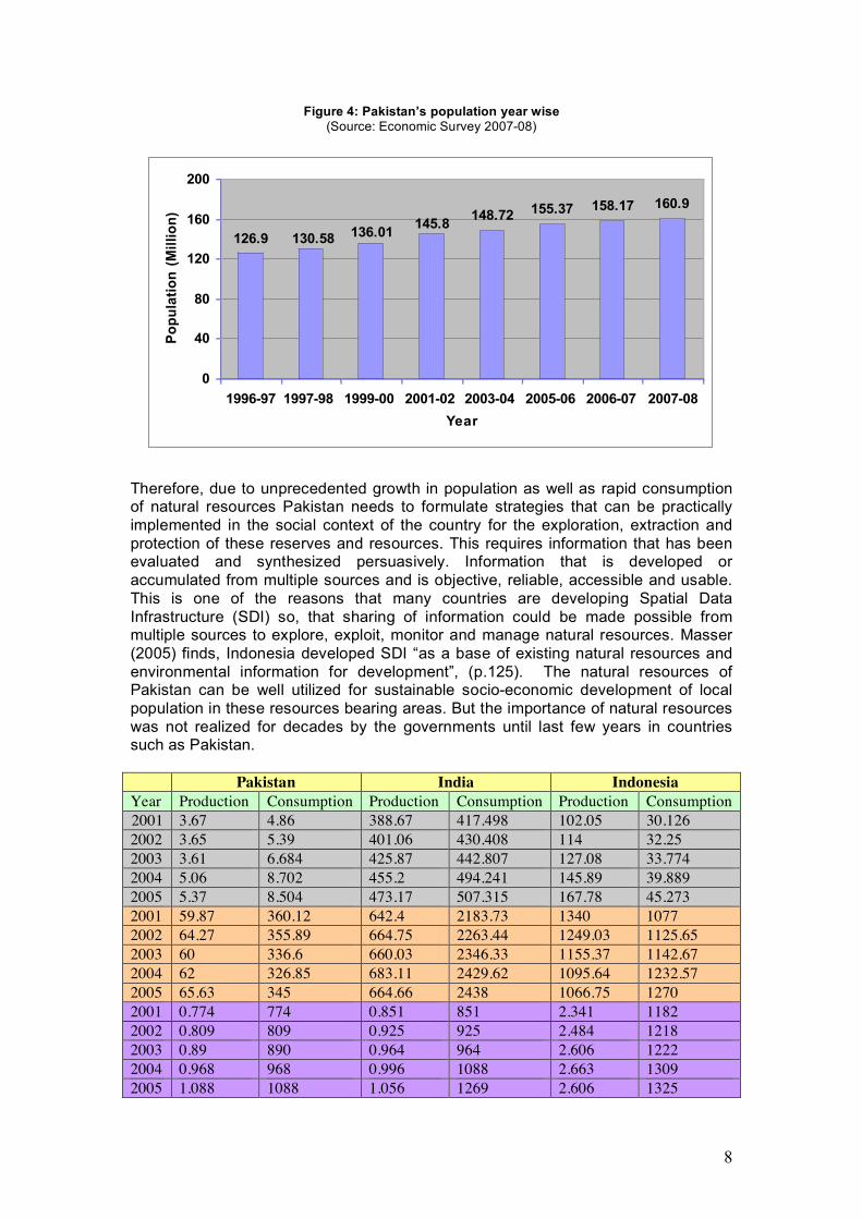
These resources contribute in GDP of the country but their contribution to GDP has declined considerably as mentioned in recently published Pakistan’s Economic Survey report for the year 2007-08. For example, agriculture sector contributed only 0.3 percentage points or 5.6 percent to GDP growth in 2007-08 as against 0.8 percentage points or 12 percent contribution last year. The main reasons for this decline include unplanned industrialization, urbanization, lack of modern technology, powerless local communities, lack of skilled personnel and none sharing of information among organizations. Pakistan is currently witnessing changes in its demographic structure as population of the country is increasing rapidly as depicted in figure 4. This growing population has put pressure on natural resources in terms of their rapid consumption. Sterner (2002) while arguing impact of growing population on natural resources finds, “This population growth poses considerable challenge for resource and environment management” (p.1). A report published by USAID program warns, “……uncontrolled population growth puts ever-increasing pressures on the country’s natural resource base (USAID/Pakistan Interim Strategic Plan FY 2003-2005).
8
Figure 4: Pakistan’s population year wise (Source: Economic Survey 2007-08)
148.72 155.37 158.17 160.9
145.8136.01130.58126.9
0
40
80
120
160
200
1996-97 1997-98 1999-00 2001-02 2003-04 2005-06 2006-07 2007-08
Year
Po
pu
lati
on
(M
illi
on
)
Therefore, due to unprecedented growth in population as well as rapid consumption of natural resources Pakistan needs to formulate strategies that can be practically implemented in the social context of the country for the exploration, extraction and protection of these reserves and resources. This requires information that has been evaluated and synthesized persuasively. Information that is developed or accumulated from multiple sources and is objective, reliable, accessible and usable. This is one of the reasons that many countries are developing Spatial Data Infrastructure (SDI) so, that sharing of information could be made possible from multiple sources to explore, exploit, monitor and manage natural resources. Masser (2005) finds, Indonesia developed SDI “as a base of existing natural resources and environmental information for development”, (p.125). The natural resources of Pakistan can be well utilized for sustainable socio-economic development of local population in these resources bearing areas. But the importance of natural resources was not realized for decades by the governments until last few years in countries such as Pakistan. Pakistan India Indonesia Year Production Consumption Production Consumption Production Consumption 2001 3.67 4.86 388.67 417.498 102.05 30.126 2002 3.65 5.39 401.06 430.408 114 32.25 2003 3.61 6.684 425.87 442.807 127.08 33.774 2004 5.06 8.702 455.2 494.241 145.89 39.889 2005 5.37 8.504 473.17 507.315 167.78 45.273 2001 59.87 360.12 642.4 2183.73 1340 1077 2002 64.27 355.89 664.75 2263.44 1249.03 1125.65 2003 60 336.6 660.03 2346.33 1155.37 1142.67 2004 62 326.85 683.11 2429.62 1095.64 1232.57 2005 65.63 345 664.66 2438 1066.75 1270 2001 0.774 774 0.851 851 2.341 1182 2002 0.809 809 0.925 925 2.484 1218 2003 0.89 890 0.964 964 2.606 1222 2004 0.968 968 0.996 1088 2.663 1309 2005 1.088 1088 1.056 1269 2.606 1325

9
2001 0 0 3.86 3.86 5.73 5.73 2002 0 0 4.31 4.31 5.93 5.93 2003 0 0 5.2 5.2 6 6 2004 0 0 6.08 6.08 6.32 6.32 2005 0 0 7.68 7.68 6.27 6.27 Legend Coal Crude Oil Natural Gas Others (Wind & Solar etc)
Figure 5: Comparison of production and consumption of Pakistan’s natural resource to other countries
4. SDI Components-Pakistani Scenario In September 2007, a field study was conducted to collect information about “SDI-supporting initiatives” Masser (2005, p.258) in Pakistan. The study was carried out in three major cities i.e. Islamabad, Rawalpindi, and Lahore. The information was collected through questionnaires, interviews, policy documents and site visits. In total seven organizations were visited as displayed in table 2. Table 2: Organizations visited
Public sector Private sector Other
Survey of Pakistan (SOP)
Geomatics & Engineering Services
Geological Survey of Pakistan
MYCO
Soil Survey of Pakistan NESPAK
Institute of Geographical Information Systems (IGIS)
Major findings of the field study and discussions Data Types Produced The first step in the development of a Spatial Data Infrastructure (SDI) is the documentation of existing data .The study reveals that both sectors i.e. public and private are producing spatial data such as topographic, cadastre, soil, geology, hydrology, ortho imagery and crops as played in figure 6.

10
Figure 6: Data types produced
Geology
9%
Crops
7%
Soil
5%
Cadastre
18%
Ortho
Imagery
14%
Hydrology
14%
Topographic
33%
Most of this data is being produced by public sector organizations as a mandated responsibility. But mandate differ from organization to organization as a result, the type of data produced varies, too. The different type of data collected and maintained by some of the public sector organizations, its form (e.g. analogue or digital) and its dissemination mode is summarized in Table 3. Table 3: Public sector organizations producing spatial data Data Type Responsible
Organization Responsible
Ministry Analogue
Data Digital Data
Website Use of web site for data
dissemination Topographic Survey of
Pakistan Defence Yes Yes No No
Soil Soil Survey of Pakistan
Food and Agriculture
No Yes No No
Geological Geological Survey of Pakistan
Petroleum and Natural
Resources
Yes Yes Yes No
Remote Sensing
SUPARCO Scientific and Technological
Research
No Yes Yes No
Landuse Pakistan Agricultural
Research Council
Food, Agriculture
and Livestock
No Yes Yes No
Digital data produced is large but only 40% public sector organizations included in the study permit citizens to access entire data sets. The main reason for this partial access is outdated policies that hamper the full exploitation and utilization of available spatial data. The outdated nature of such policies was mentioned during interviews and informal talks with the officials of the public sector organizations and

11
also by the private sector experts. GIS expert of a leading private sector organization during interview said, “We have spatial data but don’t have spatial data policy”. Standards, Metadata and Database In many cases now the problem is not lack of data/information, but the selection and process of data to generate meaningful and timely information that can support better management of resources, Sharifi (2002, p.1). To ease selection and ultimately processing of data to generate meaningful and timely information standards play a pivotal role. The need for standards in successful implementation of SDIs is also recognized in the literature (e.g. Crosswell 2000). Therefore, to overcome heterogeneity problems of data, 56% private sector while 60% public sector organizations are producing data on various standards.
Figure 7: Organizations in private and public sector implementing standards
60
56
0
10
20
30
40
50
60
70
Private Public
% O
rga
niz
ati
on
s
In private sector 44% organizations are creating metadata. 60% GI private sector organizations have managed half of their data in a database whereas 40% organizations have quarter of their data in a database. Communication Network Communication is the backbone of every infrastructure. Internet as communication tool is being benefited by 23% organizations in the private sector followed by intranet which is in use by 22% organizations. New approaches in communication network such as Global System for Mobile Communications (GSM) and General Packet Radio Service (GPRS) is relatively low and is in use by few private sector organizations which provide Location Based Services (LBS) such as vehicle tracking system. 11% private sector organizations are equipped with GSM and GPRS communication tools.

12
Figure 8: Communication network in use
LAN
22%
WAN
11%
Internet
23%
GPRS
11%
GSM
11%
Intranet
22%
OGC and Value Added Services 56% private sector organizations are providing value added services which are basically Location Based Services (LBS) such as vehicle tracking system. Web Map Server (WMS) service specifications have been implemented by 22% organizations as OGC specifications. Private Sector’s Capacity for Development SDIs are usually victim of public sector. Therefore, role of private sector was given significant consideration especially its capacity to develop innovative and new services. It was observed that 67% private sector organizations responded to GIS Portal development with interface in English language where as 47% organizations responded to the development of GIS portal in national language. A GIS portal offers metadata to extract data from databases which need not only database development capability but also expertise to develop data extraction tools. 44% organizations responded to metadata creation capability, 56% responded to develop databases while 44% organizations responded to development of data extraction tools. A GIS portal by National Disaster Management Authority Pakistan (NDMA, http://ndma.gov.pk/) has been developed. The portal was developed and is maintained by a consortium of experts drawn from the World Bank, American and Pakistani universities and the private sector, with support from the government of Pakistan according to the website of GSDI (http://lists.gsdi.org/pipermail/sdi-asiapacific/2005-November/000075.html).

13
Figure 9: Private sector’s capacity to develop SDI technical components
Capacity for Development
56
44
33
44
67
44
0 20 40 60 80
Database
Data Tools
Data Tools in national language
Metadata
GIS Portal
Portal interface in national language
% Response
Stakeholders Support Contrary to GIS, SDI has many stakeholders such as academia and research institutes, NGOs, public and private sectors. All these stakeholders were considered and contacted during the study. Replying to the question, “what is the potential of SDI development in Pakistan?” NGOs graded potential of SDI development in Pakistan 100% as “Good” followed by 80% from public sector and 71% from private sector. This reflects the positive attitude of key stakeholder groups of SDI in Pakistan.
Figure 10: Stakeholders support for SDI development in Pakistan
17 20
100
80
71
5050
0
20
40
60
80
100
Very Good Good Low
% S
up
po
rt Public
Private
NGOs
Academia
IT-GIS projects The study revealed that a number of Information Technology (IT) projects have been developed and are being developed in the country. These projects are being implemented by Federal Government as E-Government initiative, local governments, private companies and NGOs. Table 4 summarizes some of the projects.

14
Table 4: GIS and IT Projects in Pakistan Implemented By GIS IT
E-Gov Source: http://www.pak.gov.pk/e_government.aspx 05 29 IPDF Source: IPDF Newsletter Oct-Dec 2007 00 02 Local Govt. of Punjab Source: http://www.pitb.gov.pk/current_projects.aspx 03 28 Local Govt. of NWFP Source:http://www.nwfp.gov.pk/ST_IT/Department/index.php 02 29 Local Govt. of Sind Source: http://www.karachicity.gov.pk/ 00 06 Local Govt. of Baluchistan Source: http://www.balochistan.gov.pk/New%20Folder/it.htm 00 14
Private Company (NESPAK) http://www.nespak.com.pk/projects/major.asp?Ar=2§or=9 13 50 NGOs (WWF-P) Source: http://www.wwfpak.org/projects.php 34 00 Total 57 158
It is believed that the number of projects both in GIS and IT sectors would boom with the passage of time as GOP has offered investment opportunities in IT, GIS and mapping disciplines in its investment policy (http://www.pakboi.gov.pk/pdf/IT%20&%20Telecom.pdf).
Interviews
One to one contact plays significant role for information exchange. Therefore, GI stakeholders from private and public sector organizations were interviewed to know their opinion towards SDI development. As capacity building is an important part of SDI development therefore, in this context employees of academia engaged in GI related teaching were also interviewed. A total of five structured and semi structured interviews were recorded. Some of the main points of interviews conducted are summarized as below:
Not all data is open to public yet due to map policy (SOP)
Survey of Pakistan can serve as umbrella organization for such initiative (SDI) by providing guide lines and coordinating with other organizations (SOP)
Survey of Pakistan can help to define standards for geographic data (SOP)
Now good awareness can be seen among people and relevant professionals (IGIS)
Same data is being prepared by many organizations (NESPAK) There is no data sharing and the cost of mapping a city is huge (NESPAK) In Pakistan, surveying and mapping was a very neglected field but today the
conditions are better due to the foreign consultants (MYCO) SOP has old policy not to issue data but every body can get satellite imagery
(MYCO)

15
Ever since, the arrival of satellite imagery, the world is like an open book (Geomatics & Engineering Services)
Organizations visited
In order to have a direct observation, some private companies and government offices were visited during field study. This provided an opportunity to have a direct observation of organizations operating in spatial domain in the country. Public sector organizations
Three public sector organizations operating in geospatial domain were visited i.e. Survey of Pakistan (SOP) at Rawalpindi, Soil Survey of Pakistan (SSP) and Geological Survey of Pakistan (GSP) both at Lahore. All these organizations are on the supply side producing and providing spatial data within their mandated role. Being funded by the government no user oriented products are being considered. SOP is rich in human and technical resources and is presently a member of the most renowned international mapping project ‘Global Mapping’ a UN project funded and supervised by International Steering Committee for Global mapping (ISCGM). Global Map published data of Pakistan on its website (http://www.iscgm.org).
Private sector organizations
Two GI private sector organizations were visited. National Engineering Services Pakistan (Pvt.) Limited (NESPAK) located in Islamabad and MYCO Surveys (Pvt.) Limited in Lahore. NESPAK is a consultancy organization and provides services in the fields of GIS and IT in addition to other infrastructure development project services. One of the GIS expert of the organization during interview criticized Survey of Pakistan for not giving access to data which is no doubt a common complaint by most of the users. MYCO provides services for topographic and engineering surveys and also take part in capacity building programs. During the visit, it was revealed that a GIS project related with route planning for bullet train was under process.
Academia, research institutes and NGOs
To explore the role being played by academia, research institutes and non-governmental organizations (NGOs) one organization from each domain was directly observed through personal visits. Among academia and research institutes, Institute of Geographical Information Systems (IGIS) located in Islamabad was visited. The institute offers a number of programs from basic short courses to degree level such as MS and PhD in GIS and Remote Sensing. The institute organizes seminars, workshops and symposiums regularly to create awareness about spatial sciences and technologies among people of the country. For example in 2006, an International Conference on Advances in Space Technologies “ICAST 2006” was arranged by the institute and now a days, 2nd International Conference on Advances in Space Technologies “ICAST 2008” is being announced which is likely to be held on October 25-26, 2008 at Islamabad, Pakistan (http://www.icast2008.com).
One of the winners of GSDI 2007 Small Grants (http://www.gsdi.org/proj+progr.asp), World Wildlife Fund-Pakistan (WWF-P) is a non governmental organization. WWF-P is one component of the WWF international family and is playing its role for conservation of nature in Pakistan. The NGO is establishing a Spatial Data Infrastructure (SDI), previously known as data clearinghouse, for sharing conservation information, data and expertise, (GSDI Small Grant Summaries 2006-2007 Funding Cycle, p.9). During discussion, it was revealed that a survey was conducted titled “SWOT analysis of partners and stakeholders to assess their
16
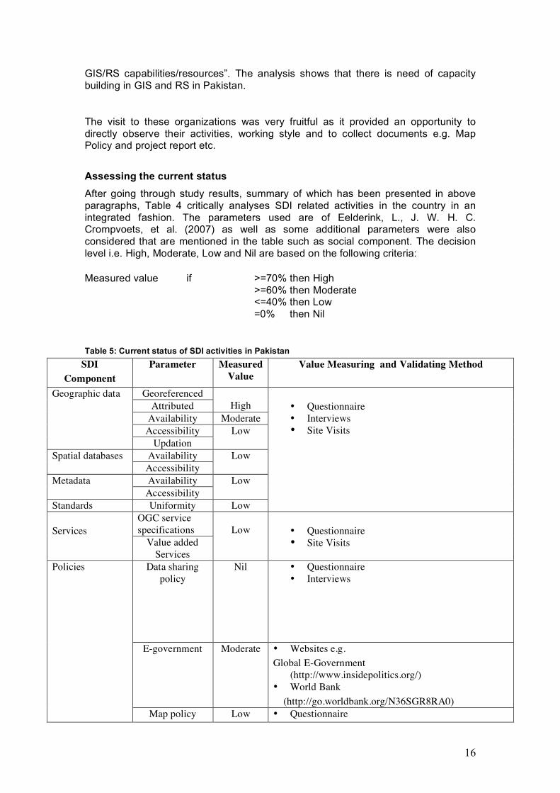
GIS/RS capabilities/resources”. The analysis shows that there is need of capacity building in GIS and RS in Pakistan.
The visit to these organizations was very fruitful as it provided an opportunity to directly observe their activities, working style and to collect documents e.g. Map Policy and project report etc. Assessing the current status After going through study results, summary of which has been presented in above paragraphs, Table 4 critically analyses SDI related activities in the country in an integrated fashion. The parameters used are of Eelderink, L., J. W. H. C. Crompvoets, et al. (2007) as well as some additional parameters were also considered that are mentioned in the table such as social component. The decision level i.e. High, Moderate, Low and Nil are based on the following criteria: Measured value if >=70% then High >=60% then Moderate
<=40% then Low =0% then Nil
Table 5: Current status of SDI activities in Pakistan
SDI Component
Parameter Measured Value
Value Measuring and Validating Method
Georeferenced Attributed
High
Availability Moderate Accessibility
Geographic data
Updation Low
Availability Spatial databases Accessibility
Low
Availability Metadata Accessibility
Low
Standards Uniformity Low
• Questionnaire • Interviews • Site Visits
OGC service specifications
Services
Value added Services
Low
• Questionnaire • Site Visits
Data sharing policy
Nil • Questionnaire • Interviews
E-government Moderate
• Websites e.g. Global E-Government
(http://www.insidepolitics.org/) • World Bank (http://go.worldbank.org/N36SGR8RA0)
Policies
Map policy Low • Questionnaire

17
• Interviews • Documents collected
Environment protection
policy
Moderate • Policy documents e.g. National Environment Protection Policy of Pakistan
http://www.environment.gov.pk/nep/policy.pdf • Websites e.g. Cleaner Production Program http://www.cpp.org.pk/index.shtml
Academic Education Level
Professional Education Level
Moderate
• Questionnaire • Websites e.g. • Sustainable Development Policy Institute, Pakistan (http://www.sdpi.org/)
Courses Moderate • Questionnaire • Interviews • Websites e.g. -Pakistan Society of Geographic Information Systems (http://www.psgis.org/) -Higher Education Commission, Pakistan (http://www.hec.gov.pk/new/index.htm) -Centre for Geographic Information System (GIS), Pakistan (http://www.pu.edu.pk/departments/default.asp?deptid=65)
Capacity Building
Awareness Low • Interviews
Access Network Mode of delivery
Low • Questionnaire • Websites e.g. GSP (http://www.gsp.gov.pk/)
Willingness High • Questionnaire • Interviews
Partnerships
Public-Private Partnership
Low • Questionnaire • Websites e.g.
http://www.pak.gov.pk/e_government.aspx Hardware ICT
Software
High • Questionnaire • Documents collected e.g. summary of SWOT
Analysis 2006 by World Wildlife Fund-Pakistan • Websites e.g. Pakistan Software Export Board http://www.pseb.org.pk/page.php?pid=1
Community protection initiative
Moderate • Websites e.g.( http://ndma.gov.pk/) • Online documents (e.g. http://books.icimod.org/)
Social component
Involvement of NGOs
Low • Questionnaire • Documents collected (e.g. project list) • Websites (e.g http://www.cpp.org.pk/index.shtml)

18
Private sector’s capacity for development
GIS portal/tools Moderate • Questionnaire • Site visit
Above table reflects a potentially healthy environment to establish SDI in Pakistan though not an ideal situation as described by some of the SDI gurus in literature. Because a gap among dreamers and doers of SDI would likely to exist for a long time. Therefore, Pakistan should come forward to implement SDI, as all of its benefits are not yet known fully even to SDI community. Conclusion Natural resources are closely linked with socio-economic development of a country. These resources not only contribute in a country’s GDP such as Pakistan but also can help to reduce poverty of local communities. National policies as well as socio-technical environment in Pakistan though aim to promote SDI culture gradually as pressure on natural resources and land is immense due to rapidly increasing population and changing geopolitical situation in the region. But issues such as institutional arrangements and policy framework for the establishment of spatial data infrastructure remains to be addressed though organizations in public and private sectors are ambitious to take off for SDI in the country. In this context, the national mapping organization (SOP) can play a pivotal role by bringing key stakeholder groups of spatial data on a unified platform for the implementation of an effective spatial data infrastructure (SDI) which is dire need of the day. Moreover, tangible socio-economic benefits of SDI implementation in the form of NRM would not only attract political support with out which SDI implementation can only be dreamed of and not materialized in developing countries but public support as well that is essential for a sustainable SDI.

19
REFERENCES Asmat Ali (2008): Is Indian NSDI an example to follow? Available at:
http://mycoordinates.org/indian-nsdi-april08.php Biological Diversity and Tropical Forestry Analysis USAID/Pakistan Interim Strategic
Plan FY 2003-2005 Crosswel, P.L. (2000). The role of standards in support of GDI. In R. Groot & J.
McLaughlin (Eds.) Geospatial data infrastructure; concepts, cases and good practice. Oxford: Oxford University Press, pp. 57-83.
de Man, W. H. E. (2007). The multi-faceted nature of SDIs and their assessment –
dealing with dilemmas. Presented at workshop Multi-view framework to assess national spatial data infrastructures, Wageningen University, 23-25 May 2007, Wageningen, The Netherlands.
Eelderink, L., J. W. H. C. Crompvoets, et al. (2007). Towards key variables to assess
national spatial data infrastructures NSDIs in developing countries : powerpoint. Presented at workshop Multi-view framework to assess national spatial data infrastructures, Wageningen University, 23-25 May 2007, Wageningen, The Netherlands. 18 slides.
GSDI Small Grant Summaries 2006-2007 Funding Cycle, p.9. Available at
http://www.gsdi.org/docs2007/GSDISmGrtSums06-07.pdf. Ian Williamson, Abbas Rajabifard and Mary-Ellen F. Feeney 2004, Developing
Spatial Data Infrastructure From concept to reality Joep Crompvoets (2006). National Spatial Data Clearinghouses: Worldwide
Development and Impact Lance, K. T., P. Y. Georgiadou, et al. (2009). Cross - agency coordination in the
shadow of hierarchy : joining up government geospatial information systems. International journal of geographical information science = IJGIS. 23.
Sharifi, M. A. (2002). Integrated planning and decision support systems for
sustainable watershed development : resource paper. Presented at a study meeting on watershed development organized by the Asian Productivity Organization & The Iranian Ministry of Agriculture, 12-17 October 2002, Tehran, Iran. pp. 32.
Masser, I. (2005). GIS worlds : creating spatial data infrastructures. Redlands, ESRI. Pakistan E-Government
http://www.pak.gov.pk/e_government.aspx
20
Pakistan’s National Disaster Management Authority http://ndma.gov.pk/
Tatiana Delgado Fernández, Joep Crompvoets (2008). Evaluating Spatial Data
Infrastructures in the Caribbean for sustainable development --------------------------------------------------