Wetlands help maintain wetland and dryland biodiversity in the Sahel, but that role is under threat:...
18
This article was downloaded by: [Joost Brouwer] On: 18 July 2014, At: 00:07 Publisher: Taylor & Francis Informa Ltd Registered in England and Wales Registered Number: 1072954 Registered office: Mortimer House, 37-41 Mortimer Street, London W1T 3JH, UK Biodiversity Publication details, including instructions for authors and subscription information: http://www.tandfonline.com/loi/tbid20 Wetlands help maintain wetland and dryland biodiversity in the Sahel, but that role is under threat: an example from 80 years of changes at Lake Tabalak in Niger Joost Brouwer a , Hamadou Amadou Abdoul Kader b & Thomas Sommerhalter c a Brouwer Environmental & Agricultural Consultancy, Wildekamp 32, 6721 JD Bennekom, The Netherlands b Pastoralism and Livestock Projet Manager, GRDR Kaédi/Mauritanie, BP 136, Quartier Latin, Kaédi, Mauritania c 362 Nutgrove Avenue, Dublin 14, Ireland Published online: 15 Jul 2014. To cite this article: Joost Brouwer, Hamadou Amadou Abdoul Kader & Thomas Sommerhalter (2014): Wetlands help maintain wetland and dryland biodiversity in the Sahel, but that role is under threat: an example from 80 years of changes at Lake Tabalak in Niger, Biodiversity, DOI: 10.1080/14888386.2014.934714 To link to this article: http://dx.doi.org/10.1080/14888386.2014.934714 PLEASE SCROLL DOWN FOR ARTICLE Taylor & Francis makes every effort to ensure the accuracy of all the information (the “Content”) contained in the publications on our platform. However, Taylor & Francis, our agents, and our licensors make no representations or warranties whatsoever as to the accuracy, completeness, or suitability for any purpose of the Content. Any opinions and views expressed in this publication are the opinions and views of the authors, and are not the views of or endorsed by Taylor & Francis. The accuracy of the Content should not be relied upon and should be independently verified with primary sources of information. Taylor and Francis shall not be liable for any losses, actions, claims, proceedings, demands, costs, expenses, damages, and other liabilities whatsoever or howsoever caused arising directly or indirectly in connection with, in relation to or arising out of the use of the Content. This article may be used for research, teaching, and private study purposes. Any substantial or systematic reproduction, redistribution, reselling, loan, sub-licensing, systematic supply, or distribution in any form to anyone is expressly forbidden. Terms & Conditions of access and use can be found at http:// www.tandfonline.com/page/terms-and-conditions
-
Upload
independent -
Category
Documents
-
view
5 -
download
0
Transcript of Wetlands help maintain wetland and dryland biodiversity in the Sahel, but that role is under threat:...
This article was downloaded by: [Joost Brouwer]On: 18 July 2014, At: 00:07Publisher: Taylor & FrancisInforma Ltd Registered in England and Wales Registered Number: 1072954 Registered office: Mortimer House,37-41 Mortimer Street, London W1T 3JH, UK
BiodiversityPublication details, including instructions for authors and subscription information:http://www.tandfonline.com/loi/tbid20
Wetlands help maintain wetland and drylandbiodiversity in the Sahel, but that role is under threat:an example from 80 years of changes at Lake Tabalakin NigerJoost Brouwera, Hamadou Amadou Abdoul Kaderb & Thomas Sommerhalterc
a Brouwer Environmental & Agricultural Consultancy, Wildekamp 32, 6721 JD Bennekom,The Netherlandsb Pastoralism and Livestock Projet Manager, GRDR Kaédi/Mauritanie, BP 136, Quartier Latin,Kaédi, Mauritaniac 362 Nutgrove Avenue, Dublin 14, IrelandPublished online: 15 Jul 2014.
To cite this article: Joost Brouwer, Hamadou Amadou Abdoul Kader & Thomas Sommerhalter (2014): Wetlands help maintainwetland and dryland biodiversity in the Sahel, but that role is under threat: an example from 80 years of changes at LakeTabalak in Niger, Biodiversity, DOI: 10.1080/14888386.2014.934714
To link to this article: http://dx.doi.org/10.1080/14888386.2014.934714
PLEASE SCROLL DOWN FOR ARTICLE
Taylor & Francis makes every effort to ensure the accuracy of all the information (the “Content”) containedin the publications on our platform. However, Taylor & Francis, our agents, and our licensors make norepresentations or warranties whatsoever as to the accuracy, completeness, or suitability for any purpose of theContent. Any opinions and views expressed in this publication are the opinions and views of the authors, andare not the views of or endorsed by Taylor & Francis. The accuracy of the Content should not be relied upon andshould be independently verified with primary sources of information. Taylor and Francis shall not be liable forany losses, actions, claims, proceedings, demands, costs, expenses, damages, and other liabilities whatsoeveror howsoever caused arising directly or indirectly in connection with, in relation to or arising out of the use ofthe Content.
This article may be used for research, teaching, and private study purposes. Any substantial or systematicreproduction, redistribution, reselling, loan, sub-licensing, systematic supply, or distribution in anyform to anyone is expressly forbidden. Terms & Conditions of access and use can be found at http://www.tandfonline.com/page/terms-and-conditions
thomas.sommerhalter
Sticky Note
http://www.tandfonline.com/doi/full/10.1080/14888386.2014.934714#tabModule http://www.tandfonline.com/doi/pdf/10.1080/14888386.2014.934714
Wetlands help maintain wetland and dryland biodiversity in the Sahel, but that role is underthreat: an example from 80 years of changes at Lake Tabalak in Niger
Joost Brouwera*, Hamadou Amadou Abdoul Kaderb** and Thomas Sommerhalterc***aBrouwer Environmental & Agricultural Consultancy, Wildekamp 32, 6721 JD Bennekom, The Netherlands; bPastoralism and
Livestock Projet Manager, GRDR Kaédi/Mauritanie, BP 136, Quartier Latin, Kaédi, Mauritania; c362 Nutgrove Avenue, Dublin 14,Ireland
(Received 28 March 2014; final version received 11 June 2014)
Wetlands in arid and semi-arid regions are enormously important for the biodiversity of the surrounding drylands, andfor the humans living there. Increasing human populations put increasing pressure on the dryland resources as well ason those wetlands. This case study of Lake Tabalak in Niger shows the changes that have taken place there over 80years. From a tree-covered depression with a traditional well, it changed to a 1.150 ha lake in the 1970s. From this lake,where pastoralists and their livestock had free access to water and fodder all year round, it developed into a depressionwith almost wall-to-wall market gardens. In April–June, the end of the dry season, herders now have to pay large sumsto have their animals feed on what there is of crop residues at the lake, before continuing to the natural grasslands fur-ther north once the rains have arrived. What little is left of the teeming wildlife in that region around 1940 is not comingto the lake anymore. The lake’s usefulness for trans-Saharan migratory birds has demonstrably decreased over the past20 years. This lake, a key component in the dryland system it belongs to, facilitating year-round use of the drylands thatsurround it and connecting dry season grazing areas in the south to rainy season grasslands in the north, has become, oris becoming, degraded for all uses, not least wetland and dryland biodiversity. Increasing pressures over the coming dec-ades will cause similar dryland systems elsewhere to suffer the same fate and lose important parts of their functionalityand their biodiversity, if adequate countermeasures are not taken. Such countermeasures must concern the wetland sys-tems rather than the individual wetlands that the dryland systems contain, and lead to participative integrated naturalresource management involving all stakeholders, for instance through multi-stakeholder fora.
Keywords: agriculture; multi-stakeholder management; natural resource management; pastoralism; Sahel
Introduction
One of the key characteristics of much of the biodiver-sity of dryland regions is its ability to survive under verydry circumstances. All the same, for many birds andlarge mammals in dryland regions, access to open waterfor drinking during the dry season is a key factor influ-encing their distribution. Access to food that is found inwetlands, or that congregates at wetlands, can be veryimportant, too. Access to open water is also key formigratory birds that migrate to or via dryland areas, inparticular water birds.
Because wetlands are areas were water and nutrientsare concentrated, they are areas of relatively high biolog-ical production potential and relatively low productionrisk. As a result, wetlands are of great value not only tobiodiversity, but also to farmers, pastoralists, fishermenand collectors of natural products. That value is evengreater in dryland regions, where the production potentialof the surrounding uplands is generally relatively low
and the production risk high. An overview of howisolated wetlands in Niger are used for different purposesat different times of year, what their economic values areand how the various uses interact amongst themselvesand with uses of associated drylands is given by Brouwer(2009, 2010, 2014).
As the population increases the human pressure onwetlands in drylands also increases, to the detriment oflocal biodiversity. Other factors that can lead to increasedpressure on wetlands in dryland areas include climatechange and changes in upstream catchments. In this paper,we describe and analyse developments over the past 80years at Lake Tabalak in Niger, including changes in itshydrology, changes in its use by people and changes inselected components of the wetland and dryland biodiver-sity dependent on the lake. Based on those historicaldevelopments, we make recommendations for the future,both for Lake Tabalak and for other wetlands in drylandregions that have not yet changed so dramatically.
*Corresponding author. Email: [email protected]; former Principal Scientist, ICRISAT Sahelian Centre, Niger.**Former pastoralism technical assistant PPILDA, Niger.***Former pastoralism adviser with SNV and LUCOP, Niger.
© 2014 Biodiversity Conservancy International
B I O D I V E R S I T Y , 2 0 1 4http://dx.doi.org/10.1080/14888386.2014.934714
Dow
nloa
ded
by [
Joos
t Bro
uwer
] at
00:
07 1
8 Ju
ly 2
014
Lake Tabalak’s hydrological history
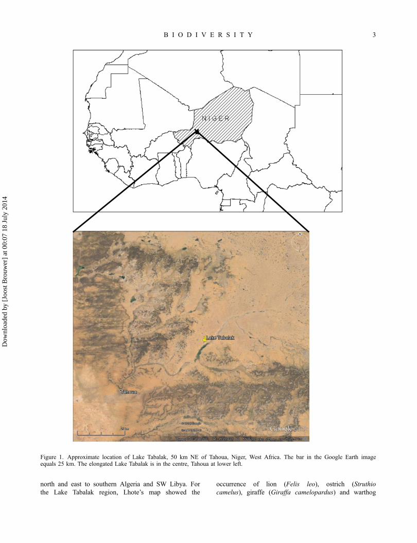
Lake Tabalak, a Ramsar Wetland of International Impor-tance since 2004 (Ramsar Bureau 2004), lies in theRepublic of Niger, 50 km NE of Tahou, at 15.11° N5.67° E and 400 m above sea level (Figure 1). Withinthe Tahoua Region, it falls under the Arrondisements ofAbalak, Tahoua and Keita (Oumarou et al. 2009). Aver-age annual rainfall in this sandy and rocky part of Nigeris only about 300 mm/yr, falling mostly during the shortrainy season of July–September (Mullié and Brouwer1994; Direction Agricole à Abalak, personal communica-tion 2007).
As recently as 1953, where Lake Tabalak is now,there was only a seasonally flooded depression withstands of Acacia nilotica and Balanites aegyptiaca trees.Land use changes in its catchment apparently graduallycaused that depression to receive more run-off. Poorrainfall in the early 1970s (cf. Zwarts et al. 2009, 22)probably led to the protective vegetative cover in theLake Tabalak watershed becoming much reduced. Subse-quent torrential rains created large amounts of run-off,which led to a barrier at Ibaga, SE of Tabalak, beingruptured (Ramsar Bureau 2004). The ensuing flood filledthe depression and created Lake Tabalak. Other largelakes in Niger that were formed in the early 1970s in asimilar fashion include Lake Dan Doutchi (15.07° N5.41° E, maximum extent 1500 ha; Brouwer and Mullié1994a) and Lake Akadané (15.38° N 7.05° E, maximumextent 500 ha).
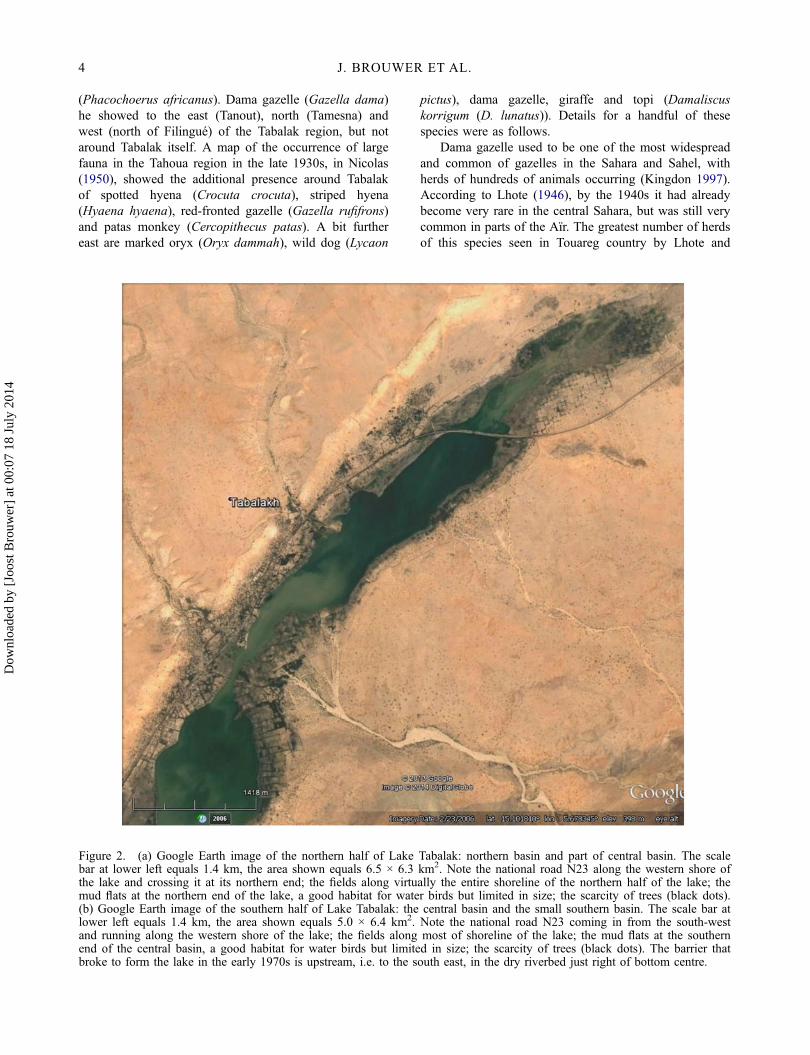
Once Lake Tabalak had been formed, run-off fromits catchment each rainy season was enough to keep thelake in existence (Ramsar Bureau 2004). Local peoplemoved in to exploit the opportunities the new lake pro-vided, as did people from Birni N’Konni and from Nige-ria further south. Upgrading of the road to transporturanium from the mines in the north of Niger providedadditional work opportunities. Thus the village of Tabal-ak came into being (Ramsar Bureau 2004). Figure 2shows a Google Earth image of Lake Tabalak.
The maximum extent of the permanent lake formedaround 1970 is about 1150 ha. Its actual extent dependson the time of year, and on the rainfall of the precedingrainy season. During the national water bird counts in1992–1995, in the middle of the dry season, it variedbetween 1150 ha (January 1995, following a wet 1994)and 650 ha (January 1994, following poor local rainfallin 1993) (African Waterbird Census data). In February2006, following poor rainfall in the preceding year, itwas also approximately 600 ha, as the Google Earthimage in Figure 2 shows. In 1996 the lake dried up com-pletely, due to very poor rainfall in 1995 (RamsarBureau 2004). Whether the lake is functionally perma-nent or not has of course a big effect on its ecology andassociated management options.
According to local farmers, the lake held more waterduring the early 1990s than before then, because degra-dation of the vegetation in its catchment led to increasedrun-off to the lake. In January 1993, when its extent wasapproximately 1000 ha, the average depth in the middleof Lake Tabalak was about 2.6 m (Mullié and Brouwer1994). Over the past 20 years, Lake Tabalak’s hydrologyhas changed again. Due to silting up because of a furtherreduction in vegetative cover and increased erosion in itscatchment, and/or due to reduced inflow because ofdiversion of surface flow upstream, by 2012 depth of thelake in March had been reduced to 0.6–0.7 m (AK,unpublished data).
Utilisation, management and threats pre-1950
While still a wooded depression, Lake Tabalak was usedby Bororo and other pastoralists to let their livestockfeed on branches, leaves and pods, and perhaps also towater the livestock while there was standing wateramong the trees. In 1930 the pastoralists established atraditional well for watering (Traoré 2010). As popula-tion pressure was low, with less than 1000 people livingnear the lake, relatively little management was neededand there were few or no threats.
Biodiversity pre-1950
In describing the changes over the past 80 years in thebiodiversity at and around Lake Tabalak, we focus on(woody) vegetation, large mammals and water birds.This is because these are the only biodiversity compo-nents about which information is available from a num-ber of moments in time. This information comes fromboth general descriptions (vegetation, large mammals)and detailed counts (water birds).
Vegetation
Vegetation-wise, the stands of Acacia nilotica and Bala-nites aegyptiaca trees, present at Tabalak until at leastthe 1950s, stand out. Similar seasonally flooded depres-sions with Acacia nilotica trees in their lowest parts canstill be found in various parts of the Sahel.
Large mammals
No complete survey is known of the large mammals for-merly found in the Tabalak area, but observations in dif-ferent publications give impressions, from which wepresent a selection here. Lhote (1951) included a mapthat shows which large game species occurred whereduring the 1940s in the area where Touaregs lived, fromMopti in Mali and Niamey and Zinder in southern Niger,
2 J. BROUWER ET AL.
Dow
nloa
ded
by [
Joos
t Bro
uwer
] at
00:
07 1
8 Ju
ly 2
014
north and east to southern Algeria and SW Libya. Forthe Lake Tabalak region, Lhote’s map showed the
occurrence of lion (Felis leo), ostrich (Struthiocamelus), giraffe (Giraffa camelopardus) and warthog
Figure 1. Approximate location of Lake Tabalak, 50 km NE of Tahoua, Niger, West Africa. The bar in the Google Earth imageequals 25 km. The elongated Lake Tabalak is in the centre, Tahoua at lower left.
B I O D I V E R S I T Y 3
Dow
nloa
ded
by [
Joos
t Bro
uwer
] at
00:
07 1
8 Ju
ly 2
014
(Phacochoerus africanus). Dama gazelle (Gazella dama)he showed to the east (Tanout), north (Tamesna) andwest (north of Filingué) of the Tabalak region, but notaround Tabalak itself. A map of the occurrence of largefauna in the Tahoua region in the late 1930s, in Nicolas(1950), showed the additional presence around Tabalakof spotted hyena (Crocuta crocuta), striped hyena(Hyaena hyaena), red-fronted gazelle (Gazella rufifrons)and patas monkey (Cercopithecus patas). A bit furthereast are marked oryx (Oryx dammah), wild dog (Lycaon
pictus), dama gazelle, giraffe and topi (Damaliscuskorrigum (D. lunatus)). Details for a handful of thesespecies were as follows.
Dama gazelle used to be one of the most widespreadand common of gazelles in the Sahara and Sahel, withherds of hundreds of animals occurring (Kingdon 1997).According to Lhote (1946), by the 1940s it had alreadybecome very rare in the central Sahara, but was still verycommon in parts of the Aïr. The greatest number of herdsof this species seen in Touareg country by Lhote and
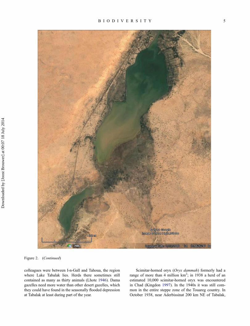
Figure 2. (a) Google Earth image of the northern half of Lake Tabalak: northern basin and part of central basin. The scalebar at lower left equals 1.4 km, the area shown equals 6.5 × 6.3 km2. Note the national road N23 along the western shore ofthe lake and crossing it at its northern end; the fields along virtually the entire shoreline of the northern half of the lake; themud flats at the northern end of the lake, a good habitat for water birds but limited in size; the scarcity of trees (black dots).(b) Google Earth image of the southern half of Lake Tabalak: the central basin and the small southern basin. The scale bar atlower left equals 1.4 km, the area shown equals 5.0 × 6.4 km2. Note the national road N23 coming in from the south-westand running along the western shore of the lake; the fields along most of shoreline of the lake; the mud flats at the southernend of the central basin, a good habitat for water birds but limited in size; the scarcity of trees (black dots). The barrier thatbroke to form the lake in the early 1970s is upstream, i.e. to the south east, in the dry riverbed just right of bottom centre.
4 J. BROUWER ET AL.
Dow
nloa
ded
by [
Joos
t Bro
uwer
] at
00:
07 1
8 Ju
ly 2
014
colleagues were between I-n-Gall and Tahoua, the regionwhere Lake Tabalak lies. Herds there sometimes stillcontained as many as thirty animals (Lhote 1946). Damagazelles need more water than other desert gazelles, whichthey could have found in the seasonally flooded depressionat Tabalak at least during part of the year.
Scimitar-horned oryx (Oryx dammah) formerly had arange of more than 4 million km2; in 1938 a herd of anestimated 10,000 scimitar-horned oryx was encounteredin Chad (Kingdon 1997). In the 1940s it was still com-mon in the entire steppe zone of the Touareg country. InOctober 1938, near Aderbissinat 200 km NE of Tabalak,
Figure 2. (Continued)
B I O D I V E R S I T Y 5
Dow
nloa
ded
by [
Joos
t Bro
uwer
] at
00:
07 1
8 Ju
ly 2
014
a herd of 400–500 was seen, probably attracted by theavailability of water there during the dry season (Lhote1946).
In historic times the subspecies peralta of the giraffestill occurred throughout the Sahel, from Senegal and
Mauritania eastwards to the Nile (Kingdon 1997).Around 1909, 90 were killed in the Gao region in justone year by one Touareg, who was guarding the tele-graph line from Timbuktu to Niamey, which the giraffeswith their long necks used to break about every week
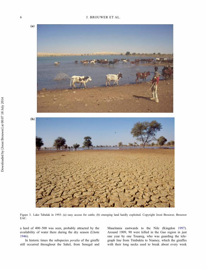
Figure 3. Lake Tabalak in 1993: (a) easy access for cattle; (b) emerging land hardly exploited. Copyright Joost Brouwer, BrouwerEAC.
6 J. BROUWER ET AL.
Dow
nloa
ded
by [
Joos
t Bro
uwer
] at
00:
07 1
8 Ju
ly 2
014
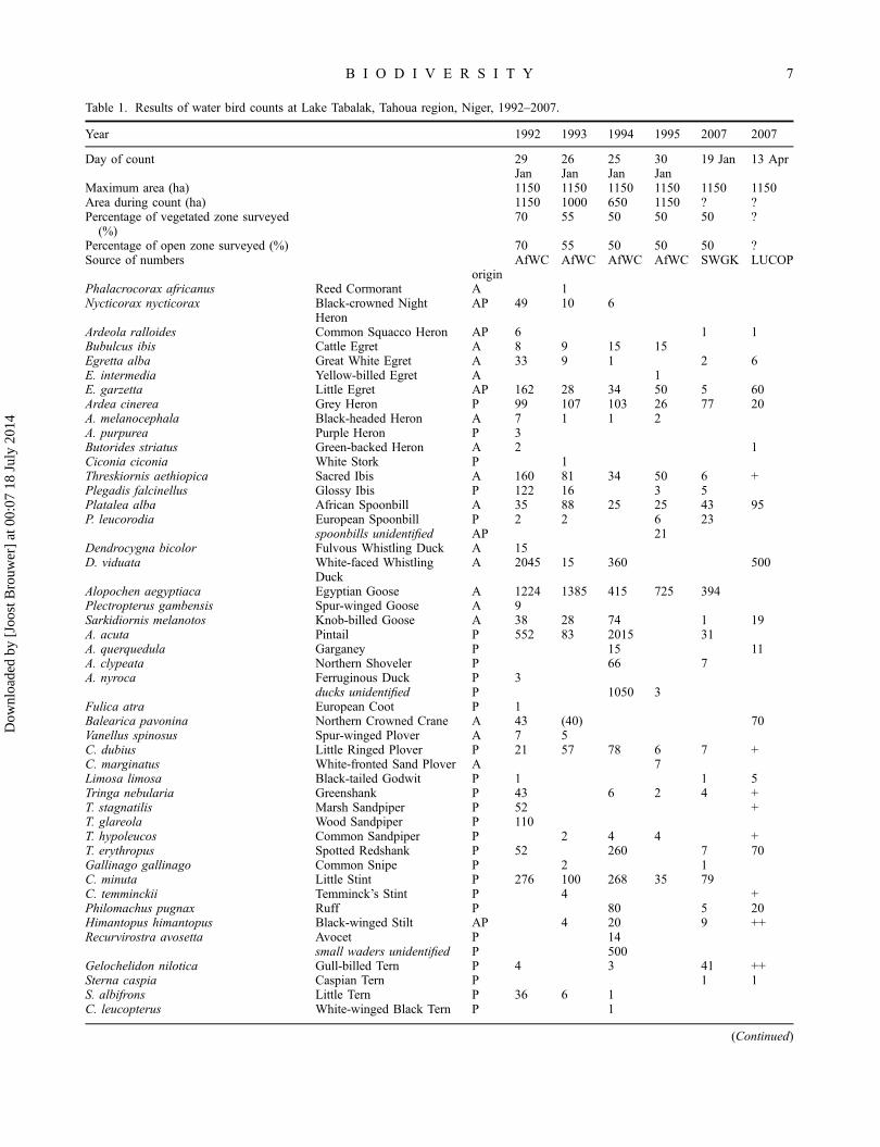
Table 1. Results of water bird counts at Lake Tabalak, Tahoua region, Niger, 1992–2007.
Year 1992 1993 1994 1995 2007 2007
Day of count 29Jan
26Jan
25Jan
30Jan
19 Jan 13 Apr
Maximum area (ha) 1150 1150 1150 1150 1150 1150Area during count (ha) 1150 1000 650 1150 ? ?Percentage of vegetated zone surveyed
(%)70 55 50 50 50 ?
Percentage of open zone surveyed (%) 70 55 50 50 50 ?Source of numbers AfWC AfWC AfWC AfWC SWGK LUCOP
originPhalacrocorax africanus Reed Cormorant A 1Nycticorax nycticorax Black-crowned Night
HeronAP 49 10 6
Ardeola ralloides Common Squacco Heron AP 6 1 1Bubulcus ibis Cattle Egret A 8 9 15 15Egretta alba Great White Egret A 33 9 1 2 6E. intermedia Yellow-billed Egret A 1E. garzetta Little Egret AP 162 28 34 50 5 60Ardea cinerea Grey Heron P 99 107 103 26 77 20A. melanocephala Black-headed Heron A 7 1 1 2A. purpurea Purple Heron P 3Butorides striatus Green-backed Heron A 2 1Ciconia ciconia White Stork P 1Threskiornis aethiopica Sacred Ibis A 160 81 34 50 6 +Plegadis falcinellus Glossy Ibis P 122 16 3 5Platalea alba African Spoonbill A 35 88 25 25 43 95P. leucorodia European Spoonbill P 2 2 6 23
spoonbills unidentified AP 21Dendrocygna bicolor Fulvous Whistling Duck A 15D. viduata White-faced Whistling
DuckA 2045 15 360 500
Alopochen aegyptiaca Egyptian Goose A 1224 1385 415 725 394Plectropterus gambensis Spur-winged Goose A 9Sarkidiornis melanotos Knob-billed Goose A 38 28 74 1 19A. acuta Pintail P 552 83 2015 31A. querquedula Garganey P 15 11A. clypeata Northern Shoveler P 66 7A. nyroca Ferruginous Duck P 3
ducks unidentified P 1050 3Fulica atra European Coot P 1Balearica pavonina Northern Crowned Crane A 43 (40) 70Vanellus spinosus Spur-winged Plover A 7 5C. dubius Little Ringed Plover P 21 57 78 6 7 +C. marginatus White-fronted Sand Plover A 7Limosa limosa Black-tailed Godwit P 1 1 5Tringa nebularia Greenshank P 43 6 2 4 +T. stagnatilis Marsh Sandpiper P 52 +T. glareola Wood Sandpiper P 110T. hypoleucos Common Sandpiper P 2 4 4 +T. erythropus Spotted Redshank P 52 260 7 70Gallinago gallinago Common Snipe P 2 1C. minuta Little Stint P 276 100 268 35 79C. temminckii Temminck’s Stint P 4 +Philomachus pugnax Ruff P 80 5 20Himantopus himantopus Black-winged Stilt AP 4 20 9 ++Recurvirostra avosetta Avocet P 14
small waders unidentified P 500Gelochelidon nilotica Gull-billed Tern P 4 3 41 ++Sterna caspia Caspian Tern P 1 1S. albifrons Little Tern P 36 6 1C. leucopterus White-winged Black Tern P 1
(Continued)
B I O D I V E R S I T Y 7
Dow
nloa
ded
by [
Joos
t Bro
uwer
] at
00:
07 1
8 Ju
ly 2
014
(Lhote 1946). By the 1940s, a survey of the shoemakersin Tahoua and Agadez showed that together theyreceived seven to ten giraffe skins per year, which weremuch prized and competed for because shoes made ofgiraffe leather fetched two or three times the price ofshoes made of cattle leather (Lhote 1946). This indicatesthat there were at that time still giraffes in the Tabalakarea, albeit in reduced numbers.
In the late 1930s, lion still occurred throughout theSahel, up to about 100 km north of Tabalak (Nicolas1950). They were still common in the Aderbissinatregion 200 km to the north-east, were they congregatednear the local wetland during the dry season, dispersingagain when the rains started, like their prey. Touaregs ofthe Kel Gossi tribe in nearby eastern Mali hunted lionon horseback and on foot (Lhote 1946).
In the 1940s, spotted hyena were also still presentthroughout the Sahel zone. Around Menaka in Mali, 200km NW of Tabalak, hunting after dark from a hideyielded two or three hyenas each night (Lhote 1946).
Warthog used to occur all the way to well north ofTabalak, living in depressions and wooded valleys likeLake Tabalak used to be (Nicolas 1950).
During the rainy season, topi used to come north asfar as Lake Bagam, north-east of Tabalak; it liked toenter ponds (Nicolas 1950).
African elephant (Loxodonta africana) occurred asfar north as the Azawar, several hundred km north of Ta-houa, until the 1880s.
Birds
Not a lot is known about the historical occurrence ofmost bird species in the Tabalak area. Nicolas (1950)mentions Touareg names from the Tahoua region foralmost 100 bird species, but it is not clear which of theseoccurred around Tabalak at that time. One exception isthe ostrich, which according to Nicolas (1950) was quitenumerous NE of Tahoua. It was hunted by Touareg with
traps or on foot, with two or three teams in relay. Thefinal kill was executed with a spear or, to avoid damag-ing the skin, a stick. Ostrich were also hunted with dogs,who at the end of the dry season, when the Ostrich wasweak, managed to get hold of it or at least make it stop.In addition to the skin the fat was used, to make oint-ments against rheumatism, but neither meat nor eggswere eaten by the Touareg, only by the Arabs (Nicolas1950).
Also according to Nicolas (1950), the head of thesecretary bird (Sagittarius serpentarius), or an imitationthereof, was used as a decoy by Touareg hunters. Theyput it on their own head, with the crest accentuated usingthe black feathers of a male Ostrich. On their protectedknees they slowly approached a single antelope, imitat-ing the stately gait of the secretary bird as they did so,until they were close enough to shoot it with bow andarrow (Nicolas 1950). This indicates that the secretarybird must have been during a period before 1940 a rea-sonably regular occurrence in the Tahoua region.
Utilisation, management and threats 1950s–1990s
After the depression had become a permanent lake in theearly 1970s, pastoralists began to settle around the lakeinstead of only visiting it seasonally. Following thedrought of 1983–1984, the government encouraged thesettlement of Peulh, Haussa and Touareg at the lake sothat they could practice market gardening and recoverfrom their drought-related losses (Oumarou et al. 2009;Traoré 2010). A 50 ha irrigation area, exploited by localfarmers, was installed at the south-western end of thelake in 1986–1987 (Ramsar Bureau 2004; Traoré 2010;Abdoul Kader 2012).
Increases in utilisation of Lake Tabalak were not onlycaused by migration to the lake. Between 1950 and2010, the population of Niger grew by a factor five,from 3.2 million to almost 16 million. This implies anaverage annual growth rate of 2.7% and a doubling of
Table 1. (Continued)
Year 1992 1993 1994 1995 2007 2007
C. hybrida Whiskered Tern P 17 5 16 ++small terns unidentified P 10
Larus ridibundus Black-headed Gull P 30gulls unidentified P 1
Number of species of water bird 33 26 27 16 23 23Number of afro-tropical water birds 3626 1582 925 825 446 879+Number of palaearctic water birds 1450 397 4485 88 309 ?Total number of water birds 5250 2061 5464 982 766 [700+]
Source of numbers: AfWC = African Water Bird Census (JB, Wim Mullié and other colleagues); SWGK = Netherlands Montagu’sHarrier Foundation (JB and Leen Smits); Origin A = Afro-tropical; P = Palearctic; AP = a combination of the two.
8 J. BROUWER ET AL.
Dow
nloa
ded
by [
Joos
t Bro
uwer
] at
00:
07 1
8 Ju
ly 2
014
the population every 26 years. At present, the nationalpopulation growth rate in Niger is estimated at 3.3%,which means a doubling in less than 22 years (InstitutNational de la Statistique 2012). At Lake Tabalak, thegrowth from less than 1000 people in the 1930s to35,000 in 2009 (Abdoul Kader 2012), implies a doublingin population every 15 years. This is equivalent to anaverage annual population growth rate of 4.7%, due tobirths and immigration combined.
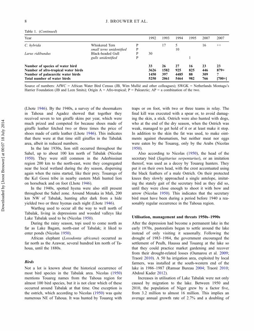
According to Mullié and Brouwer (1994), by theearly 1990s Lake Tabalak was heavily used for wateringof livestock from the surrounding drylands. The live-stock also browsed on the surrounding vegetation and,after the harvest, on crop residues remaining on thefields along the shores of the lake. Only an estimated20% of Lake Tabalak’s perimeter of close to 30 km, orroughly 300–600 ha, was taken up by market gardens,used for growing cassava, beans, gourds, melons, etc.;the other 80% was available for access by livestock(Figure 3; Mullié and Brouwer 1994). Note that this stripof market gardens 100–200 m wide would in part havebeen moving as the dry season progressed and the lakelevel dropped. Higher-lying land would dry out and beharvested, while lower-lying land would be becomeavailable for cropping.
According to Ramsar Bureau (2004) and Oumarouet al. (2009), restocking with fish of Lake Tabalak tookplace in the mid to late 1960s, and then in 1974/1975,1977, 1982, 1986/1887, 1988 and 1989, organised byvarious organisations including the local fishermen them-selves. By the early 1990s, the estimated yield was90–100 tonnes of fish per year.
In the early 1990s there did not appear to be anycoordinated management of Lake Tabalak and/or its sur-roundings (Mullié and Brouwer 1994).
Threats to Lake Tabalak in the early 1990s included,according to Mullié and Brouwer (1994), sedimentationand encroachment of sand dunes, possible salinisation/al-kalinisation, due to evaporation of water and the saltsleft behind not being removed by leaching or run-offand, for the water birds, serious disturbance by the localpopulation, especially the fishermen.
Biodiversity in the 1990s
Vegetation
Following the formation of the lake, the trees in the cen-tre of the depression all disappeared, due to its beingflooded permanently. Only around the edges stands oftrees remained. In 1993, the trees the lake used to haveat its northern end, Acacia nilotica, A. albida and Bala-nites aegyptiaca, were mostly cut by local inhabitants.JB was told at the time that they did this out of spite,
because they were angry with the local Department ofEnvironment staff for enforcing unwelcome regulations.The 2006 Google Earth image shows that 12 years laterthere had not yet been any significant regeneration ofthese tree stands.
Large mammals
By the early 1990s, almost all large mammals had disap-peared from the Tabalak area. There were rumours of theodd hyena still being around, and also some red-frontedgazelles and patas monkeys (local information to JB andcolleagues during the water bird censuses). That wasabout it. There may still have been enough unoccupiedlake shore at the time for these animals to drink at thelake. Development of Lake Tabalak cannot be the maincause of the disappearance of all the other large mam-mals from the area, but the increased disturbance fromhuman activity would not have helped. See the discus-sion section below.
Birds
Water bird counts were carried out at Lake Tabalak atthe end of January from 1992–1995, as part of the Nigercomponent of the African Waterbird Census. While therewas already significant disturbance due to human activ-ity, the lake was at that time a good place to see waterbirds. An average of 4000 Palaeartic and Afro-tropicalwater birds of up to 32 species were seen per count. SeeTable 1, Mullié and Brouwer (1994) and the Niger BirdDatabase (2013).
Variation between years in numbers of water birdscounted can be explained in part by variation in regionalrainfall in the year before each count. For instance, rain-fall in 1993 was quite poor, which meant that small wet-lands in the region dried out quickly. By January 1994only the larger wetlands like Lake Tabalak still containeda fair amount of water, which led to water birds beingconcentrated there, especially Palearctic ducks. Almost5500 water birds were counted that year. The rainyseason of 1994, on the other hand, was very plentifuland filled many wetlands to the brim. As a result, a lotof wetlands in southern Niger still contained water inJanuary 1995, water birds remained dispersed and lessthan 1000 were counted at Tabalak. See Mullié et al.(1999) for a more detailed discussion of rainfalleffects on water bird distribution in the Sahel zone ofNiger.
This being said, there was a notable steady declineduring those four years of counts in afro-tropical waterbird numbers at Lake Tabalak, from 3600 to 800. Nottoo much should be read into the results from a short
B I O D I V E R S I T Y 9
Dow
nloa
ded
by [
Joos
t Bro
uwer
] at
00:
07 1
8 Ju
ly 2
014
series of counts at one wetland, but for someafro-tropical species the decline in numbers counted at
Lake Tabalak during the 1990’s is matched by anapparent national decline. A case in point is the Egyptian
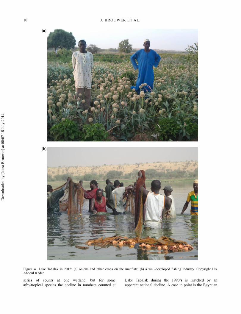
Figure 4. Lake Tabalak in 2012: (a) onions and other crops on the mudflats; (b) a well-developed fishing industry. Copyright HAAbdoul Kader.
10 J. BROUWER ET AL.
Dow
nloa
ded
by [
Joos
t Bro
uwer
] at
00:
07 1
8 Ju
ly 2
014
goose (Alopochen aegyptiacus), which during1992–1995 declined from 1200 to 700 at Lake Tabalak,while the national population estimate declined fromabout 20,000 to about 8000 (background data toBrouwer and Mullié 2001). The decline at Lake Tabalakwill have had a large influence on the decline in thenational population estimates, but there were declines atother wetlands in Niger as well. It remains unclearwhether the apparent decline was due to (a combinationof) increased disturbance, increased harvesting, reducedbreeding or other causes.
Utilisation, management and threats by 2004
The Ramsar site information sheet (Ramsar Bureau2004), mentioned that the height of the dam under themain road at the north-east end of the lake had beenincreased at an unspecified time, which also increasedthe storage capacity of the lake. As the dam alsoincludes a bridge section, it is not clear to us how itsbeing raised increased the lake’s storage capacity. Inaddition, vegetation had been planted to fix the dunessurrounding the lake. In 1976 an international consul-tant had written a proposal for the development of thelake aimed at rational use of its resources, notably byintensification and diversification of its agriculturaluses, without mentioning any specific conservationmeasures. The actions suggested in the report wereonly beginning to be realised by 2004 and were notharmonised with other development actions, accordingto Ramsar Bureau (2004).
The Ramsar information sheet gives the impressionthat pastoralism was not considered very important any-more at Lake Tabalak. It is only mentioned once, in anoff-hand way. See however, the importance for pastoral-ism accorded to the lake in LUCOP (2007), further on inthis article.
Agricultural activities on the other hand, directly onthe lake, were mentioned to occupy 600 ha, benefitting5400 people in 12 villages around the lake. All the arableland was deemed to be cultivated, also further away fromthe lake, and agriculture was extending into marginal landon the surrounding plateaux (Ramsar Bureau 2004).
Water from the lake was used for drinking and cook-ing. Fish production was estimated by Ramsar Bureau(2004) at 100–300 tonnes per year, worth € 50,000 to €150,000 locally (and 5–10 times that amount in the capi-tal Niamey 500 km away, Brouwer (2010)).
Management was said to be shared by the stateand local organisations (Ramsar Bureau 2004). Localstructures (the Fishermen’s Cooperative, the Committeeof Farmers and Market Gardeners of the lake, the FishMerchants’ Association, the Women’s Group) played avery important role in the prevention and managementof conflicts between the different users of the lake’s
resources and organise access to those resourcestogether with the traditional leaders. Responsible forthe management of the Ramsar site was the local dis-trict Department of Environment based at Abalak,which came under the Ministry for Water, Environmentand Combatting Desertification (Ramsar Bureau 2004).Note that the Ramsar Bureau does not mention herderorganisations. Eight years later, Abdoul Kader (2012)saw this lack of organisation among herders as a seri-ous problem.
The following threats to Lake Tabalak were men-tioned (Ramsar Bureau 2004):
� climate change;� unsuitable agricultural practices leading to erosion;� illegal cutting of trees and shrubs;� the use of illegal means of fishing leading to
depletion of the fish stock, related to a lack of edu-cation of the fishermen in spite of the existence oftheir cooperative;
� overgrazing, particularly on the sand dunes sur-rounding the lake.
Biodiversity by 2004
By 2004 the remaining trees surrounding the wetlandwere being used for construction and as firewood.Regarding large mammals, the Ramsar site descriptionsheet only mentions Dorcas gazelle (Gazella dorcas) andwarthog, which were very rarely encountered near thelake (Ramsar Bureau 2004). All other large fauna wasapparently gone, in line with the findings in the 1990s.The water bird count results for 2002 included as anannex to Ramsar Bureau (2004) are unusually high, e.g.8327 Egyptian geese, 204 black-crowned cranes, 750sacred ibis and 510 knob-billed geese. Because the num-bers are so high, and the identity and expertise of thecounters is not known, these count results are notincluded in Table 1.
Utilisation, management and threats by 2007
According to a mission for LUCOP (2007), Lake Tabalakwas at that time still quite important to livestock. Live-stock were watered at the lake, fodder was cut from thesurrounding vegetation and there was direct grazing ofcrop residues remaining in the fields along the shorelinewere recession agriculture was practiced. The missionnoted strong agricultural and market gardening pressureround the lake. A second market gardening area, of 240ha, had been established in 2006, including a pumpingstation, irrigation and drainage canals, and access roads(Traoré 2010; Abdoul Kader 2012). According toBrouwer (2010), by 2007, 80% of the perimeter was
B I O D I V E R S I T Y 11
Dow
nloa
ded
by [
Joos
t Bro
uwer
] at
00:
07 1
8 Ju
ly 2
014
taken up by market gardens, up from 20% in the early1990s. Livestock access possibilities had diminishedaccordingly.
Regarding management, the LUCOP (2007) missionnoted that neither the local elected officials nor theusers of Lake Tabalak appeared to be aware of its sta-tus of Ramsar Wetland of International Importance, orof the consequences of that status for management ofthe lake. Ramsar status demands sustainable manage-ment of a wetland, also in respect of its biodiversity.Certainly the off-take of 3 million m3 of water forirrigation would appear to be in conflict with theRamsar status, as it was considered likely to lead todrying up of the southern-most of the three basins ofLake Tabalak. This is the deepest of the three basinsand thus the one that holds water longest. The missionreport proposed bringing the different interest groupstogether to improve their knowledge of the lake andeach other, so that they could work in cooperativefashion towards sustainable management of the lakeand the surrounding uplands. This could include takingadvantage of the Ramsar status of the lake by install-ing information panels and a bird observation hide, aswell as training local eco-guides to show around tour-ists and school groups (LUCOP 2007).
Threats mentioned by LUCOP (2007) included cut-ting of what remained of the Acacia nilotica stands,upstream erosion leading to silting up of the lake basinand, most importantly, (developing) off-take of 3 millionm3 of water every year for the 240 ha market gardendevelopment, which increased the risk of the lake dryingup during the dry season. Thousands of pastoralist andtheir families were negatively affected by this (LUCOP2007; Abdoul Kader 2012).
Biodiversity by 2007
The LUCOP (2007) mission to Lake Tabalak in mid-April 2007 counted more than 700 water birds of 23 spe-cies. This is very similar to the 766 water birds of 23species counted by an expedition of the DutchMontagu’s Harrier Foundation ten weeks earlier (Table 1).Notable were the continued importance of Lake Tabalakfor 70 black-crowned crane (a threatened species), andfor African and European spoonbills, though by Aprilthe European spoonbills had already gone north to theirbreeding areas. Lake Tabalak is by far the most impor-tant known site for both species of spoonbill in Niger(Niger Bird DataBase 2013).
The LUCOP mission found the most important sitesfor birds to be an island at the northern end of the lake,which accommodated the black-crowned cranes as wellas a duck roost; and the nearby mud flats and grassylake shores. At the southern end of the southern basin ofthe lake there were similar mudflats (LUCOP 2007).
Utilisation, management and threats by 2010–2012
By 2009, the municipality or ‘commune’ of Tabalak had35,000 inhabitants, up from less than 1000 in the 1930s,with an average household size of 10.7 people. The totalannual budget was 25,000 euros and the investment bud-get 5335 euros (Abdoul Kader 2012). The municipalitycovered 666 km2 to the north, east and south-east of theLake plus almost all of the lake itself. It included 54 vil-lages and hamlets (Oumarou et al. 2009).
Traoré (2010) describes the effects of agriculturaldevelopment of depressions and wetlands, includingLake Tabalak, on the survival of small pastoralists. Hevisited the area in May 2010, when there were manytranshumant herders at Lake Tabalak because the rainsand the new pasture growth in the grasslands up northhadn’t started yet. Only the smaller of the basins of LakeTabalak still contained water. The entire depression wascovered with market gardens (Figure 4(a)). Average mar-ket garden size was between 1.5 and 2.5 ha and a verywide range of crops and sometimes fruit trees weregrown (Abdoul Kader 2012). Only five access routes toentire lake still existed for livestock, four of them 30 mwide and one 20 m (Oumarou et al. 2009). Livestockwere grazing everywhere. Market gardeners were sellingaccess to crop residues, for grazing, in plots of 200–300 m2.This second ‘harvest’ was said to be more lucrative forthem than the agricultural produce itself, bringing in13,000–15,000 FCFA, or 20–23 euros, per 100 m2
(Abdoul Kader 2012). The transhumance pastoralistsindicated that they had no choice but to accept having topay for this grazing of crop residues, and hope for anearly start to the rainy season. Their problems werefurther exacerbated by the reduced availability of dryseason grazing further south, forcing them to come backnorth to the Lake Tabalak area earlier than in the past(Traoré 2010).
Some market garden plots at Lake Tabalak lookedmore like attempts at raking in money from the pastoral-ists than like real market gardens. Because of problemsin gaining access to fodder resources, pastoralists mighthave to sell livestock at the time of year when prices arelowest and eventually abandon this livelihood altogether(Traoré 2010).
There were, in 2010, 8300 cattle, 14,500 sheep,11,500 goats, 12,400 donkey, 11,500 camels (dromedar-ies) and 200 horses owned by people living in themunicipality of Tabalak. Transhumance livestock, ownedby people who don’t live in the community of Tabalak,but who do use the lake for watering, is not included inthese numbers. The livestock of the municipality ofTabalak in part also goes north to graze for the rainyseason (Abdoul Kader 2012).
The government appears to have done little to stopthe conversion of this traditional end-of-dry-season
12 J. BROUWER ET AL.
Dow
nloa
ded
by [
Joos
t Bro
uwer
] at
00:
07 1
8 Ju
ly 2
014
grazing area and fallback zone with relatively good qual-ity forage into market gardens where pastoralists have topay high prices to graze the crop residues of mediocrequality. Article 2 of Government Decree no. 87/077/PLMS/MI of 1987, which defines areas reserved for pas-toralism, can be read as a formalisation in disguise ofthe previous unofficial appropriation of grazing areas foragricultural purposes (Abdoul Kader 2012).
Similarly, ‘cash for work’ soil conservation projectshave helped convert surrounding upland traditional graz-ing areas into agricultural fields. To give a quantitativeperspective on these changes, in the Commune of Tabal-ak, between 1975 and 2009, upland agriculture increasedfrom 24,000 ha to 46,000 ha; during the same period thearea of grazing land decreased from 35,000 ha to 6600ha, according to Oumarou et al. (2009). Although thenumbers don’t quite add up (6000 ha have disappeared),it is clear that there has been an enormous loss of graz-ing land in the surroundings of Lake Tabalak. With anestimated fivefold increase in population over those 34years (annual increase of 4.7%), this was only to beexpected.
Fishing continues to be a very important source ofrevenue to the community, bringing in € 87.000 in oneyear with only very simple equipment (Figure 4(b);Abdoul Kader 2012). By 2012 there were nine fishingcooperatives which formed a single fishermen’s union.Fishing was well regulated by the state, with a fishingpermit being required for each fisherman, certain fishingequipment prohibited, and a well-defined closed seasonof seven months to allow the fish to spawn and grow.Small fish were never put back, the size of fish caughtbeing regulated only by mesh size of the nets. Regula-tions were enforced by the government and the presi-dents of the fishing cooperatives. During years ofdrought and towards the end of the fishing season smal-ler mesh sizes were allowed. Fish prices per kg of eachspecies were fixed at the start of the fishing season in ameeting of the government, fish merchants, fishermenand consumers. Income was divided between fishermen,merchants and the cooperative, using fixed percentagesthat differed slightly between species. No chemicals wereused to catch fish (Abdoul Kader 2012).
Other uses of Lake Tabalak in 2012 included brickmaking, carting of water for construction purposes andbird hunting (Abdoul Kader 2012).
In relation to management, Abdoul Kader (2012)mentions the poor organisation of, and frequent conflictsbetween, the various parties that use the lake, eventhough there are various management efforts, includingby the Commission Foncière Communale (Cofocom,Communal Land Tenure Commission), and the Comitéde Gestion Concertée de la mare de Tabalak (CGC, formanagement of the lake). Agriculture, livestock raisingand fisheries are still by far the most important economic
activities around Lake Tabalak and are generally prac-tised in some sort of combination: 24% of the populationonly farms, 11% only raises livestock, 29% combineslivestock with market gardening, 11% combines marketgardening with fishing and 26% practices all three. Thereare no pure fishermen, and livestock raising and fishingare not combined as such (Abdoul Kader 2012).
Pastoralists tend to be the most transient and the leastorganised of the users of Lake Tabalak. They generallyconsider changes to the lake to be acts of God and notsomething that people can do anything about. Fisher-men-market gardeners see themselves as fishermen firstand complain about the negative effects of market gar-dening on the lake. Even so, during the dry season theagricultural fields are fertilised by having the local live-stock, and where possible the transhumance livestock,camp on them at night (Abdoul Kader 2012). Livestockalso bring nutrients to the lake through dropping theirmanure and urine when being watered This increases theproductivity of the lake and benefits farmers and fisher-men, as well as water birds (Brouwer and Mullié 1994b;Mullié et al. 1999; Brouwer 2010).
Local inhabitants are of course very much aware ofwhat Lake Tabalak gives to them. Too often, however,they see the lake as a resource for themselves to use,with others making that usage more difficult. Of thoseinterviewed, 45% recognised that there are conflictsbetween the different users, mostly concerning damageby animals and non-respect of regulations. Local repre-sentatives of the various ministries as well as the munici-pality are responsible for controlling the cutting of trees,for controlling fisheries (together with the fishing cooper-atives), for controlling invasive weeds (together withlocal inhabitants), and for public awareness (AbdoulKader 2012; TS pers. obs.).
Local inhabitants are also aware that the level ofLake Tabalak is now often much lower than it ever wasbefore, and that there is a serious risk of it disappearing‘in ten years’ if no corrective action is undertaken. Oneproblem is considered to be the lack of technical educa-tion of the users of the lake, whatever their source ofincome. At the same time all envisage expanding theiractivities around the lake, which is already over-used,given the continuing degradation of its natural resources(Abdoul Kader 2012).
According to Abdoul Kader (2012), threats to LakeTabalak included market gardening practices that are notsuitable for the environment, such as using motor pumpsfor irrigation, inappropriate use of chemical fertilisersand pesticides and the construction of field boundariesthat trap wind-blown sand and/or are a point of entry forinvasive plants. Other threats are abandonment of thepractice of fallowing and over-utilisation of the vegeta-tion in the catchment of the lake, leading to increasedupstream erosion en thus silting up of the lake basin.
B I O D I V E R S I T Y 13
Dow
nloa
ded
by [
Joos
t Bro
uwer
] at
00:
07 1
8 Ju
ly 2
014
From 1975 to 2009, the area of gullies or ‘koris’increased from 900 to 3100 ha, according to Oumarouet al. (2009).
In addition, the return of emigrants from Ivory Coastand Libya, because of the upheaval in those countriessince the turn of the century, increased the human pres-sure on, and exploitation of, Lake Tabalak. Poor rainfallwas also seen as a threat by the local population,although the general tendency since the early 1980s hasbeen for an increase in rainfall (Abdoul Kader 2012).
A number of the local people also realise that theyneed to work together to achieve a solution: each villageor group or person for it- or him- or herself won’t work.That being said, they also feel that outside finance willbe needed and, of course, the cooperation of the govern-ment, development organisations and other non-users ofthe lake. Better access to outside markets, to credit facili-ties and to means of conserving their produce, includingfish and meat, would also help to achieve sustainableparticipative integrated natural resource management(PINReM), as required by its Ramsar status (AbdoulKader 2012).
Biodiversity by 2012
By 2011, almost all the indigenous trees in and aroundLake Tabalak were either gone or heavily used for vari-ous purposes, including pruning for livestock feed. Theexotic thorny, woody invasive weed Prosopis julifloracompeted with what was left. Due to the conversion tomarket gardens, the original fringing and aquatic non-woody vegetation was also either gone or under heavypressure, replaced in part by introduced species such asneem (Azadirachta indica), mango trees (Mangiferaindica) and eucalypts (Eucalyptus sp.; Abdoul Kader2012; TS, pers. obs.).
For large wild mammals as well as for water birds, thesituation at Lake Tabalak has not improved since 2007.That means that large wild mammals are all but gone fromthe area, and that the numbers of water birds using thelake during the dry season are well down on the numbersof 20 years ago. The recommencement of hunting of birdsat the lake, mentioned by Abdoul Kader (2012), legalagain since 1996 with a permit and during a specified sea-son, will not have helped. Good numbers of threatenedblack-crowned cranes and of African and Europeanspoonbills may still make dry season use of the lake.
SWOT analysis 2012
A slight modification of a SWOT analysis (strengths,weaknesses, opportunities and threats) of Lake Tabalakand its users, by Abdoul Kader (2012), brings out thefollowing.
Strengths:
� the large number of local organisations� the local presence of government services� the presence of a Communal Land tenure Commis-
sion (Cofocom), e.g. to resolve conflicts and deter-mine property rights
� the motivation of locals to contribute labour� the status of Lake Tabalak as public land, requiring
everyone who uses it to contribute to its manage-ment, upkeep and proper functioning.
Weaknesses:
� the poor administrative and financial capacity oflocal organisations
� the lack of interest by the Ministry of Agricultureand Animal Production in the lake
� the inexperience of local organisations, partlycaused by personnel changes following each localelection
� the lack of power and of recognition of local or-ganisations, such as the Comité de Gestion Con-certée de la mare (CGC)
� the divergence of the interests of different stake-holders.
Opportunities:
� decentralisation, if the community takes advantageof the openings for participative integrated naturalresource management that decentralisation provides
� the interest of development organisations in facili-tating sustainable use of the natural resources ofthe Lake Tabalak area
� the Ramsar status of the wetland, if the nationalgovernment commits itself to striving for the sus-tainable management of Lake Tabalak that itsRamsar status requires.
Threats:
� little recognition of the needs of local inhabitantsin national legislation and in the text of theRamsar Convention
� poor communication between the national govern-ment and the Ramsar Convention and the localinhabitants
� the lack of benefit to local inhabitants of manyexternal initiatives
� the risk of the Ramsar status being withdrawn� the lack of long-term commitment by technical and
financial partners, including the national govern-ment.
14 J. BROUWER ET AL.
Dow
nloa
ded
by [
Joos
t Bro
uwer
] at
00:
07 1
8 Ju
ly 2
014
What the effects will be of climate change, oftenseen as a threat, remains unclear.
Abdoul Kader (2102) ends by proposing an approachfor arriving at sustainable PINReM, including all stake-holders and modern as well as traditional power struc-tures. Additional income could be gained fromecotourism (e.g. to see migratory birds), development or-ganisations, parties to the Ramsar Convention, levies onproducts from the lake, contributions by user organisa-tions and development of external markets.
Conclusions and recommendations
As we have shown, over the past 80 years Lake Tabalakand surroundings have developed
� from a well-wooded depression, mostly used sea-sonally use by pastoralists, and with probablymuch less than 1000 inhabitants,
� to, around 1970, a lake of 1150–1200 ha at maxi-mum extent, much favoured by pastoralists andwater birds,
� and from there to what is now an area with 35,000inhabitants, with as most important local economicactivities market gardening (from shore to shore bythe end of the dry season) and fish production.
The situation for biodiversity at and around Tabalak haschanged enormously accordingly. Most of the woodyvegetation has been cut; most of the remainder is heavilypruned each year for livestock fodder and fence making.The main reason for disappearance of the thousands oflarge mammals of many species from the surroundingdrylands is no doubt overhunting. Scimitar-horned oryxhas been hunted to extinction in the wild (Durant et al.2013). Hunting has also caused the dama gazelle tobecome critically endangered, with perhaps only 300individuals left in 4–5 isolated populations in Niger(Termit, the Aïr) and Chad (Durant et al. 2013). Lhote(1946) already indicated that the advent of motorisedtransport and of automatic weapons had led to a greatreduction in numbers of addax antelope (Addax nasoma-culatus). However, for certain species decreasing accessto fodder or prey, and to water, due to land use changesand increased disturbance at wetlands, has no doubtplayed a role as well. This also goes for water birds:their numbers at Lake Tabalak probably rose after thelake became permanent in the 1970s, but they have beendecreasing over the past twenty years.
As agriculture, especially market gardening,increased at Lake Tabalak, pastoralism has lost muchaccess to its resources. It must not be crowded out com-pletely. If that happened there would be no more trans-humance pastoralists from the Tabalak area to utilise theproduction capacity of the dryland grazing areas further
north. Nutrient transfer by livestock from surroundingdryland grazing lands to Lake Tabalak would also cease,negatively affecting that same agriculture as well as fishproduction.
Planned increased off-take of water, to benefit newirrigation projects, will cause further drying out of LakeTabalak and is likely to lead to serious conflicts withpresent users of the lake.
The main cause of the present problems at LakeTabalak appears to be what is known as ‘the tragedy ofthe commons’. The area where Lake Tabalak was formedbelonged to no one, or was considered to belong to noone. So individual people, responsible to their own fami-lies and own groups first, took what they needed withoutconsidering longer-term sustainability and coordinatingwith others. Those that settled at the lake to farm or fishhad the most to say, those that only passed by season-ably with their livestock were crowded out. In addition,the lake and its direct surroundings were and are part ofthree communes in three different districts, which makescoordinated management more complicated.
To make the Lake Tabalak resource last as long aspossible, benefiting of as many people as possible,PINReM, involving all stakeholders, must be imple-mented as soon as possible. Fortunately, as Oumarouet al. (2009) and Abdoul Kader (2012) show, therealready is local awareness of the need for such coordi-nated, sustainable management, and of the necessity tocontribute if one wants to continue to profit. A case inpoint is the coordinated management of the fisheriesthroughout the lake, though coordination with otheractivities is still poor or lacking. Abdoul Kader’s SWOTanalysis is a good starting point for working towards thedesired integrated PINReM. The multi-stakeholder for-ums promoted by the LUCOP Project in the pastoralareas around Tabalak and further north in Niger(Sommerhalter 2008; Rabeil, Newby, and Harouna2014), can help achieve this.
The situation at Lake Tabalak is already such thateven PINReM is unlikely to bring back much of the largemammal biodiversity that once existed there and in thesurrounding drylands, even if those surrounding drylandspermitted such a return. That the developments at LakeTabalak are not unique is shown in Table 1 of Brouwer(2010), in which developments over some twelve years atLake Tabalak and nine other isolated wetlands in Nigerare summarised. At all of them there has been much deg-radation and biodiversity loss, from one of the isolatedwetlands waterbirds have disappeared completely. Thesame thing happened at Lake Madarounfa near Maradialready twenty years earlier (JB, pers. obs.) These devel-opments makes it all the more urgent to avoid, at otherwetlands in the Sahel that are not quite as damaged yet, arepeat of the environmental and social problems that
B I O D I V E R S I T Y 15
Dow
nloa
ded
by [
Joos
t Bro
uwer
] at
00:
07 1
8 Ju
ly 2
014
occurred at Lake Tabalak. To achieve this, at all thesewetlands in drylands:
� PINReM should be worked towards as soon aspossible, before outside interests become much lar-ger; outside interests being the interests of peoplethat are not traditional users of the lake or do notlive locally.
� In developing PINReM, account must also betaken of the interests of those who are present atthe wetland only part of the year, such as transhu-mant pastoralists.
� The interests of biodiversity must be taken intoaccount as well.
� Proper valuation of all the services provided bythe wetland ecosystems concerned is essential inthis process, and should be carried out soonerrather than later.
� Recognition and valuation of the interactionsbetween the wetlands and the associated drylandsshould be an important part of this.
� It should also be taken into account that in drylandareas, wetlands function as wetland systems, notindividual wetlands. Depending on spatial and tem-poral distribution of rainfall, one wetland may beimportant for pastoralists and waterbirds one year,another wetland the next year.
� Any proposed change to a wetland should beaccompanied by an all-encompassing environmen-tal impact assessment.
In addition to mutual benefits, such as transfer ofnutrients to wetlands by livestock that use a wetland,there can also be conflicts of interest between, e.g. pasto-ralists, farmers, fishermen, collectors of natural productsand those who want to conserve biodiversity and/or use itwisely. This is especially so when the interests of one ormore groups become large in relation to the size of thewetland. This is another reason why these wetlandsshould not be managed individually, but rather as a sys-tem of wetlands, with perhaps certain interests prevailingat one wetland and other interests at other, nearby wet-lands. Management of all wetlands in a region as onesystem also allows reserving some of the wetlands asfall-back resources during the inevitable times of drought.
Good management of the wetlands in dryland areasis not sufficient for conservation of the associated wet-land and dryland biodiversity, but it is definitely anessential component.
AcknowledgementsWe would like to thank the following individuals and organisa-tions for their much appreciated assistance in various ways: theWildlife and Fisheries Service (DFPP) of the Ministry of Envi-
ronment and Hydraulics of Niger, Nicolas Antione-Moissiaux(Health Economics and Animal Production, Tropical VeterinaryInstitute, University of Liège, Belgium), Sylvain Garraud,GTZ-LUCOP German Cooperation, Pierre Hiernaux,IUCN-Niger, Adam Manvell, Traoré Nata of SNV-NetherlandsCooperation, Watakane Mohamed (consultant in Abalak), ourcolleagues water bird counters – in particular Wim Mullié –and two anonymous referees.
References
Abdoul Kader, H. A. 2012. “Gestion de la Mare de Tabalak/Niger, Analyse des Interactions entre Acteurs.” Master’sthesis, Universités de Liège et de Gembloux.
Brouwer, J. 2009. “The Seasonal Role of Isolated Wetlands inthe Sahel: Key Resources for People and Biodiversity,Under Pressure from Global Change.” Paper presented at‘Seasonality Revisited’, an International Conference organ-ised by the Future Agricultures consortium at the Instituteof Development Studies, Brighton, UK, July 8–10.
Brouwer, J. 2010. “Climate Change in Dryland and WetlandEcosystems in the Sahel Region.” In Building Resilience toClimate Change: Ecosystem-based Adaptation and Lessonsfrom the Field, edited by A. Andrade Pérez, B. HerreraFernandez, and R. Cazzolla Gatti, 32–45. Gland, Switzer-land: IUCN.
Brouwer, J. 2014. “Are the Most Valuable Resources in Dry-land Areas Isolated Wetlands?” Planet@Risk 2: 47–57.
Brouwer, J., and W. C. Mullié. 1994a. “The Importance ofSmall Wetlands in the Central Sahel.” IUCN Wetlands Pro-gramme Newsletter 9: 12–13.
Brouwer, J., and W. C. Mullié. 1994b. “Potentialités pourl’Agriculture, l’Élevage, la Pêche, la Collecte des ProduitsNaturels et la Chasse dans les Zones Humides du Niger.”[“The Potential of Wetlands in Niger for Agriculture, Live-stock, Fisheries, Natural Products and Hunting.”] In Ateliersur les Zones Humides du Niger, edited by P. Kristensen,27–51. Niamey, Niger: IUCN-Niger.
Brouwer, J., and W. C. Mullié. 2001. “A Method for MakingWhole Country Water Bird Population Estimates, Appliedto Annual Water Bird Census Data from Niger.” Ostrich(Supplement 15): 73–82.
Durant, S. M., T. Wacher, S. Bashir, R. Woodroffe, P. DeOrnellas, C. Ransom, J. Newby, et al. 2013. “Fiddling inBiodiversity Hotspots While Deserts Burn? Collapse of theSahara’s Megafauna.” Diversity and Distributions 20: 1–9.
Institut National de la Statistique. 2012. Annuaire Statistiquedu Niger 2007–2011. http://www.stat-niger.org/statistique.
Kingdon, J. 1997. The Kingdon Field Guide to African Mam-mals. London: A&C Black.
Lhote, H. 1946. “Observations sur la Repartition Actuelle et lesMoeurs de Quelques Grands Mammiferes du Pays Toua-reg.” Mammalia 10 (1): 26–56.
Lhote, H. 1951. La Chasse Chez les Touaregs. Paris: Amiot-Dumont.
LUCOP. 2007. Suite de l’Etat des Lieux des Mares dans laZone Pastorale. Rapport de mission pour le Projet Luttecontre la Pauvreté Tillabéri et Tahoua Nord (LUCOP) de laCoopération Nigéro-Allemande, Programme RégionalTahoua Nord, Bureau Régional à Agadez.
16 J. BROUWER ET AL.
Dow
nloa
ded
by [
Joos
t Bro
uwer
] at
00:
07 1
8 Ju
ly 2
014
Mullié, W. C., and J. Brouwer. 1994. Water Birds and Wetlandsin the Sahel: A Threatened Resource. Results of ThreeYears Monitoring (1992–1994) in the Republic of Niger.Niamey, Niger: IUCN-Niger.
Mullié, W. C., J. Brouwer, S. F. Codjo, and R. Decae. 1999.“Small Isolated Wetlands in the Sahel: A Resource SharedBetween People and Birds.” In Strategies for ConservingMigratory Water Birds, edited by A. Beintema, and J. vanVessem, 30–38. Wetlands International Publication 55.Wageningen, The Netherlands: Wetlands International.
Nicolas, F. 1950. Tamesna, Les Ioullemmeden de l’Est. Notesde Linguistiques et d’Ethnographie Berbères. Paris:Imprimerie Nationale.
Niger Bird DataBase. 2013. www.nibdab.orgOumarou, A., J. N. Senou, S. Idrissa, A. Ag Irrichid, A.
Mohamed, and W. Mohamed. 2009. Etude sur la Mise enPlace des Mécanismes de Gestion Concertée et DurableAutour des Ressources Naturelles de la Mare de Tabalak.Rapport pour le Projet Lutte contre la PauvretéTillabéri et Tahoua Nord (LUCOP) de la Coopération
Nigéro-Allemande, Programme Régional Tahoua Nord,Bureau Régional à Agadez.
Rabeil, T., J. Newby, and A. Harouna. 2014. “Innovation, Tra-ditional Knowledge and Awareness Lead to Good Practicesto Avoid Biodiversity Loss in the Sahara.” Biodiversity thisissue.
Ramsar Bureau. 2004. “Site Information Sheet for LakeTabalak.” http://ramsar.wetlands.org/Database/SearchforRamsarsites/tabid/765/Default.aspx
Sommerhalter, T. 2008. “Multi-Stakeholder Forums for Co-Management of Pastoralism in Niger.” Nomadic Peoples12: 165–177.
Traoré, N. 2010. Les Pasteurs Face à la Crise Fourragère:l’Impact des Aménagements de Bas-Fonds et Mare sur laSurvie des Petits Pasteurs. Niamey, Niger: SNV-Niger,Netherlands Development Organisation.
Zwarts, L., R. G. Bijlsma, J. van der Kamp, and E. Wymenga.2009. Living on the Edge: Wetlands and Birds in a Chang-ing Sahel. Zeist, The Netherlands: KNNV Publishing.
B I O D I V E R S I T Y 17
Dow
nloa
ded
by [
Joos
t Bro
uwer
] at
00:
07 1
8 Ju
ly 2
014