wares of knowledge and history: social inter-regional interaction
271
WARES OF KNOWLEDGE AND HISTORY: SOCIAL INTER-REGIONAL INTERACTION IN THE JUBONES RIVER BASIN, ECUADOR (CA. 1,000 BCE) By MIRIAM EDITH DOMINGUEZ A DISSERTATION PRESENTED TO THE GRADUATE SCHOOL OF THE UNIVERSITY OF FLORIDA IN PARTIAL FULFILLMENT OF THE REQUIREMENTS FOR THE DEGREE OF DOCTOR OF PHILOSOPHY UNIVERSITY OF FLORIDA 2017
-
Upload
khangminh22 -
Category
Documents
-
view
0 -
download
0
Transcript of wares of knowledge and history: social inter-regional interaction

WARES OF KNOWLEDGE AND HISTORY: SOCIAL INTER-REGIONAL INTERACTION
IN THE JUBONES RIVER BASIN, ECUADOR (CA. 1,000 BCE)
By
MIRIAM EDITH DOMINGUEZ
A DISSERTATION PRESENTED TO THE GRADUATE SCHOOL
OF THE UNIVERSITY OF FLORIDA IN PARTIAL FULFILLMENT
OF THE REQUIREMENTS FOR THE DEGREE OF
DOCTOR OF PHILOSOPHY
UNIVERSITY OF FLORIDA
2017

© 2017 Miriam Edith Domínguez

To Jacob

4
ACKNOWLEDGMENTS
This dissertation has come to fruition thanks to several individuals and organizations. I
must first thank my adviser, Neill Wallis, who took me on as a student even though we have
different geographic areas of specialization and guided me through the process of fieldwork and
dissertation writing. This work has taken form thanks to Neill‘s advice and assurance. For this
and Neill‘s generosity and collegiality I thank him. I am also indebted to my committee
members, Ken Sassaman, Michael Moseley and Mark Brenner who guided me through this
process with enthusiasm, encouragement and useful critique. I am, however, responsible for any
errors or omissions in this work.
In Uzhcurrumi, Ecuador, I enjoyed the trust, friendship and assistance of the owners of
Potrero Mendieta, Doña Rosa Chávez and her son Luis Mendieta. The fieldwork was carried out
with the help of Marco Asanza and Manuel Sánchez who shared with me shoulder to shoulder
the joys and travails of the field investigation. Joel Sánchez was instrumental in the
identification of the site and I am grateful to him and to his mother, Doña Barbarita Velepucha,
who lodged us during our time in Uzhcurrumi. I must also acknowledge the moral support
throughout the field seasons at Potero Mendieta provided by the Uzhcurrumi‘s town council ―La
Junta Parroquial.‖ The permit to perform these investigations was granted by the Institute of
Cultural Patrimony, Region 7; archaeologist Cecivel Abril inspected these investigations and
visited the site the field seasons of 2014 and 2015.
After fieldwork, the petrographic analysis of a sample of the ceramics was performed by
Ann Cordell, from the Florida Museum of Natural History. I am grateful to Ann for her
generosity with her expertise and tremendous patience throughout the process. Ryan Morini,
from the Samuel Proctor Oral History Program at UF, provided insightful commentary and
discussion on the theoretical portion of this research. Michael Perfit and John Jaeger from the

5
Department of Geological Sciences at UF helped me by identifying the volcanic tephra from the
deposits after the first field season, and Dr. Perfit also provided advice during the petrographic
analyses. I also thank Will Gilstrap, formerly at MURR, for his work with the NAA analysis.
I want to heartily thank the individuals who have helped me one way or another to
manage the hurdles of this process, especially Larry Burton from Burton Instruments, Juanita
Bagnall from the Department of Anthropology at UF, and in the Jubones my friends Doña
Matilde Serrano, Don Honorio Ordoñez and Doña Graciela Sánchez. Also, at the University of
Florida, I have been encouraged and revitalized by the friendship of my colleagues Ryan Morini,
Ashley Sharpe, Andrea Palmiotto and Michelle Eusebio.
My parents and mother-in-law have seen me through my academic career and have been
as supportive and patient as they can be. My mother, Miriam Seminario, has continuously
supported my efforts and even helped fund five of the six AMS dates. Finally, I thank my
husband, Jacob Lawson who has not only provided support at the home front, but shared with me
the investigations in the Jubones and the fieldwork in Potrero Mendieta. Jacob, who is not a
professional archaeologist, involved himself with the totality of this project, from the logistics of
the field to the discussions on the research design. I am humbled by his intellectual and practical
input in all this – to him, I dedicate this work, with love and gratitude.
The investigations of Potrero Mendieta were partially funded by the Center for Latin
American Studies Tinker Foundation Research Grant, the Paul and Polly Doughty Research
Award from the Anthropology Department at UF, the MURR subsidy program sponsored by
NSF grant #1415403, and personal funds.

6
TABLE OF CONTENTS
page
ACKNOWLEDGMENTS ...............................................................................................................4
LIST OF TABLES ...........................................................................................................................9
LIST OF FIGURES .......................................................................................................................11
ABSTRACT ...................................................................................................................................15
CHAPTER
1 INTRODUCTION ..................................................................................................................17
The Elusive Modes of Interaction and Mobility in the Andes ................................................18 Organization of the Dissertation .............................................................................................20 From Field Research to Interpretation ....................................................................................22
2 REGIONAL BACKGROUND ...............................................................................................23
Forming the Ecuadorian Formative ........................................................................................23 The Southern Ecuadorian Highlands ...............................................................................27 The Central and Southern Ecuadorian Coast ...................................................................40 The Northern Ecuadorian Andes .....................................................................................47 The Amazonian Piedmont ...............................................................................................48
The Social Emergence of the Physical World ........................................................................55 The Physical World in Time ...................................................................................................59 Geological Setting of the Jubones River Basin ......................................................................66 The Jubones Basin During the Formative ..............................................................................68
3 SITE DESCRIPTION AND FIELD REPORT .......................................................................70
The Site ...................................................................................................................................70 Disambiguation of the Archaeology of the Jubones River Basin ...........................................72 The Fieldwork .........................................................................................................................77
Identification and Preservation State of the Site .............................................................77 Team of Investigators ......................................................................................................79 Mapping of the site ..........................................................................................................80 Layout of the Architectural Complex ..............................................................................80 Archaeological Excavations ............................................................................................84 Structure 1 .......................................................................................................................89 Structure 2 .......................................................................................................................94 Structure 3 .....................................................................................................................103 Trench BF -71, BF -72: The Pavement ........................................................................109 Sector BQ -51; BR -51; BQ -52; BR -52 ......................................................................113 STP 10: The Reservoir ..................................................................................................116

7
Test Unit FX 83 .............................................................................................................119 STP 11: Unit αH 1 .........................................................................................................119
Dating of the Site ..................................................................................................................121 Samples ..........................................................................................................................121 Interpretation of the Results ..........................................................................................121
Artifacts Overview ................................................................................................................124 The Construction Practices at Potrero Mendieta ..................................................................132 Notes .....................................................................................................................................133
4 SOCIAL INTERACTION AND GEOLOGICAL KNOWLEDGE: AN APPLICATION
OF CERAMIC PETROGRAPHIC ANALYSIS OF THE WARES AND CLAYS
FROM THE POTRERO MENDIETA SITE (~1,000 BCE) ................................................134
Petrographic Analysis of Pottery and Clay Samples from Potrero Mendieta ......................134 Preparations of the Sample and Analytical Procedures .................................................135 Prominent Mineralogical Constituents ..........................................................................136 Temper Categories .........................................................................................................137
Felsic Temper .........................................................................................................138 Mafic Temper .........................................................................................................140 Volcanic Temper ....................................................................................................142
Clay Samples .................................................................................................................146 Discussion of the Results ......................................................................................................147
Petrographic Fabric Groups ...........................................................................................154 Summary and Conclusions ...................................................................................................159 Notes .....................................................................................................................................161
5 NEUTRON ACTIVATION ANALYSIS: THE RENDERINGS OF KNOWLEDGE
AND HISTORY IN THE JUBONES RIVER BASIN .........................................................164
Neutron Activation Analysis (NAA) ....................................................................................166 Neutron Activation Analysis of the Samples from Potrero Mendieta ...........................167 Interpretation of the Chemical Data: Methods ..............................................................167
Results ....................................................................................................................169 Comparison with petrographic data .......................................................................172 Discussion ..............................................................................................................174
Comparative Analysis ...........................................................................................................178 Comparisons with the Datasets Analyzed by MURR ...................................................178 Neutron Activation Analysis of Ceramics of Burials at Palmitopamba, Ecuador.........179 Neutron Activation Analysis of Ceramics of Loma de los Cangrejitos, Ecuador .........179 Comparative Analysis ...................................................................................................180 Discussion and comparison with petrographic data ......................................................183 Comparisons between the datasets analyzed by MURR and the McMaster dataset .....183
Summary and Discussion of the Compositional Analyses ...................................................185 Chemical Compositions and their Geological Relationships ........................................185 Chronology and Compositional Variability ..................................................................187 Local Versus Non-Local Pottery ...................................................................................188
Vessels of History: Narratives of Context and Composition ................................................189

8
Notes .....................................................................................................................................191
6 CONCLUSION.....................................................................................................................194
Potrero Mendieta as an Enclave of Inter-regional Interaction ..............................................195 Summary of the Findings......................................................................................................199 The Potrero Mendieta Case-Study: Conclusions and Future Directions ..............................202 Notes .....................................................................................................................................203
APPENDIX
A PETROGRAPHIC ANALYSIS ...........................................................................................204
B NEUTRON ACTIVATION ANALYSIS .............................................................................227
LIST OF REFERENCES .............................................................................................................244
BIOGRAPHICAL SKETCH .......................................................................................................271

9
LIST OF TABLES
Table page
2-1 Formative Period Chronology for the Western Ecuadorian Lowlands ..............................32
3-1 AMS dates and 2 sigma calibration. ................................................................................122
3-2 Summary of artifacts recovered during the field seasons of 2014 and 2015. ..................126
3-3 Piece plotted artifacts .......................................................................................................127
A-1 List of samples for petrographic analysis. .......................................................................205
A-2 Gross temper category descriptions. ................................................................................206
A-3 Other physical properties identified in the samples and statistical comparisons of
fabric and temper. ............................................................................................................207
A-4 Petrographic data by temper and petro-fabric categories, and statistical comparisons
of temper and petro-fabric categories ..............................................................................210
A-5 Particle size data by temper and petro-fabric categories, and statistical comparisons
of temper and petro-fabric categories ..............................................................................212
A-6 Raw point counts..............................................................................................................213
A-7 Particle size. .....................................................................................................................216
A-8 Percentages ......................................................................................................................220
A-9 Particle size index. Silt counts included with very fine in clay samples in bold. ............223
A-10 Key to the headings and abbreviations for petrographic data. .........................................226
B-1 List of samples for NAA analysis ....................................................................................228
B-2 Principal component analysis of the Potrero Mendieta ceramic assemblage ..................230
B-3 Mahalanobis distance–based probabilities (p) of group membership for DOM-1 ..........231
B-4 Total Variation Matrix .....................................................................................................232
B-5 Principal component analysis of the combined ceramic assemblages produced at
MURR from Guayas, Palmitopamba, and Potrero Mendieta ..........................................234
B-6 Group Classification using Mahalanobis Distance in the Ecuadorian samples
analyzed at MURR from Guayas and Palmitopamba, and Potrero Mendieta. ................235

10
B-7 Total Variation Matrix calculations for the combined datasets from Guayas,
Palmitopamba and Potrero Mendieta ...............................................................................240

11
LIST OF FIGURES
Figure page
2-1 Lacay flat stone (Photo by Jacob Lawson). .......................................................................56
2-2 Germania Ordoñez guiding the tracing of the carvings (Photo by Jacob Lawson). ..........57
2-3 A sun shaped carving .........................................................................................................58
2-4 Mr. Luis Pesántez, member of the village council of San Rafael (~ 1800 m asl). ............62
2-5 Mrs. Estela de Guayasaca and Jacob Lawson enjoying cocoa pods during a hike ............65
2-6 Detail of the granodiorite boulder on the hillslope on the way to Potrero Mendieta .........65
3-1 Uzhcurrumi from the southern hillside on the path to Potrero Mendieta ..........................71
3-2 Doña Rosa Chávez showing a worked chert fragment to her grandchildren. ....................72
3-3 The extent of the Jubones valley after Verneau and Rivet (1912) .....................................76
3-4 The central Jubones riverbed from the town of Lacay. .....................................................77
3-5 Overview of the site ...........................................................................................................78
3-6 Mr. Joel Sánchez at Potrero Mendieta ...............................................................................78
3-7 From left to right: Marco Asanza, Manuel Salazar, Miriam Domínguez, and Jacob
Lawson ...............................................................................................................................80
3-8 Marco Asanza using an auger to reach beyond sterile level at one of the paved
structures in the site ...........................................................................................................82
3-9 Topographic map of Potrero Mendieta at 0.5 meter intervals. ..........................................83
3-10 Photographs of the volcanic tephra at 10 X .....................................................................86
3-11 Worked lithic fragment with pressure flaked edges ..........................................................87
3-12 Unit labeling schemata .......................................................................................................88
3-13 Grid of 1 x1 meter units for Structure 1. ............................................................................89
3-14 Unit DL24, north wall profile ............................................................................................90
3-15 Rim PM_EC2014_08. ........................................................................................................91
3-16 Units DM 23 and DN23, north wall profile. ......................................................................92

12
3-17 Excavation in progress of units DM23 and DN23. ............................................................93
3-18 West-east view of units DL23, DM23 and DN23 ..............................................................93
3-19 Grid of 1 x1 meter units for Structure 2. ............................................................................95
3-20 Units CT-10, CT-9, CT-8 and CT-7 ..................................................................................98
3-21 Mosaic-like placement of rock after the backfilling event in Structure 2. .........................99
3-22 Top layer of the rock mound. .............................................................................................99
3-23 Lowest level of mounded rocks with blue pigmented rock at the center .........................100
3-24 Rock with blue pigment. ..................................................................................................100
3-25 Red ochre. ........................................................................................................................101
3-26 Fragment of a chert flake # CT-10_4572 Stratum 6. .......................................................101
3-27 Lithic débitage CT-9, Stratum 6. ....................................................................................102
3-28 Units CT-7 and CT-8 .......................................................................................................102
3-29 Line of rocks immediately south of where the mound of rocks was placed ....................103
3-30 Grid of 1 x1 meter units for Structure 3. ..........................................................................105
3-31 Units BV50 and BW50. ...................................................................................................105
3-32 Unit BX50. .......................................................................................................................106
3-33 Units BY50. .....................................................................................................................106
3-34 East-west view of structure 3. Note the collapsed concentric walls. ...............................107
3-35 Tephra in unit BV50. .......................................................................................................108
3-36 Unworked jadeite nugget, unit BX50, Stratum 1. ............................................................109
3-37 Postmold BW50. ..............................................................................................................109
3-38 Grid of 1 x1 meter units for the pavement. ......................................................................111
3-39 Units BF-71 and BF-72, east wall profile. .......................................................................111
3-40 BF-72 with spiral pavement. ............................................................................................112
3-41 BF-71 sterile level. ...........................................................................................................112

13
3-42 Manuel Salazar holding an unworked quartz flake. .........................................................113
3-43 Grid of 1 x1 meter units for sector BQ and BR. ..............................................................114
3-44 Units BQ-51, BR-51, BQ-52 and BR-52. ........................................................................114
3-45 Units BQ-51, BR-51, BQ-52 and BR-52 with auger tests. ..............................................115
3-46 Marco Asanza excavating STP10 in the center of the reservoir ......................................118
3-47 Pottery sherds recovered at 85 cm DBS in STP10 ..........................................................118
3-48 Probability histograms for the six calibrated AMS assays ..............................................124
3-49 Representative profiles of the pottery sherds recovered from Potrero Mendieta ............125
4-1 Photomicrographs of illustrative samples of temper and fabric groups ..........................138
4-2 In comparison to the pattern identified in the felsic samples, the mafic group is
relatively homogeneous with respect to the variability in particle size ...........................141
4-3 Most of the felsic-tempered samples, the constituents are predominantly angular to
sub-rounded, with angular to sub-angular morphology ...................................................142
4-4 The matrix color variation identified in most of the mafic samples show that these
wares were made from reddish-firing iron rich clays ......................................................145
4-5 Mean thickness of the samples ........................................................................................145
4-6 Ternary plot of bulk compositions ...................................................................................149
4-7 Ternary diagram plots the percentages of matrix, silt (microfossils) and very fine and
fine sand ...........................................................................................................................152
4-8 Ternary plot of bulk aplastic particle size variability illustrates the relative
homogeneity in this sample .............................................................................................153
4-9 Ternary plot of gross constituent composition.................................................................153
4-10 Ternary plot of mineralogical composition......................................................................154
4-11 The three petrographic fabric groups ...............................................................................155
4-12 Matrix color variability in the pottery samples ................................................................156
4-13 Bulk composition by petro-fabric category .....................................................................157
4-14 Bulk particle size by petro-fabric category ......................................................................158

14
4-15 Ternary plot of gross temper composition illustrates that petro-fabric variability. .........158
4-16 These ternary plots of gross mineralogical composition reflect a greater variability
within and between fabric groups ....................................................................................159
5-1 Sample MED005. .............................................................................................................176
5-2 Sample MED008. .............................................................................................................177
5-3 Sample MED015. .............................................................................................................177
5-4 Sample MED019. .............................................................................................................178
B-1 Principal component biplot of first two components (56.7 % total variance) showing
clays and ceramic samples ...............................................................................................242
B-2 Bivariate plot comparing Manganese (Mn) and Chromium (Cr) concentrations
(ppm). ...............................................................................................................................242
B-3 Bivariate plot comparing Cesium (Cs) and Scandium (Sc) concentrations (ppm) ..........243
B-4 Principal component biplot of first two components (51.6 % total variance) from the
three MURR datasets .......................................................................................................243

15
Abstract of Dissertation Presented to the Graduate School
of the University of Florida in Partial Fulfillment of the
Requirements for the Degree of Doctor of Philosophy
WARES OF KNOWLEDGE AND HISTORY: SOCIAL INTER-REGIONAL INTERACTION
IN THE JUBONES RIVER BASIN, ECUADOR (CA. 1,000 BCE)
By
Miriam Edith Domínguez
December 2017
Chair: Neill J. Wallis
Major: Anthropology
This dissertation examines inter-regional interaction and human mobility in the Jubones
River Basin, southwestern Ecuador, during the first millennium B.C.E. Three seasons of
archaeological field investigations at the site Potrero Mendieta generated a snapshot of human
occupations in the trans-Andean Jubones River Valley and yielded material remains in the form
of architectural structures, ceramic wares, and lithic artifacts. In this monograph results from the
Neutron Activation Analyses (NAA) and petrographic analyses of pottery and clay samples from
Potrero Mendieta we used to interpret the processes of social interaction and travel associated
with this biogeographic context and other coeval social formations on the Ecuadorian coast and
in the highlands.
Previous archaeological research on this period, known as the Formative, tackled inter-
regional interaction as having been synonymous with the presence of exotic materials from
biogeographically diverse and remote regions. It also associated these long-distance exchange
networks with bourgeoning social and political complexity.
This archaeological analysis departs from the notion that the ―physical world‖ and the
―social world‖ are and have always been mutually constituted. As such, inter-regional social
interaction is not only materially demonstrable through the unequivocal presence of foreign

16
objects, but also through the knowledge of the physical world acquired by travelling across the
landscape that is rendered in the materials used to manufacture pottery. Here, the application of
archaeological sciences to analyze materials at the compositional level generated data suitable
for the interpretation of the historical processes of human mobility and social interaction and
foregrounded materials and their physical qualities as participants and mediators of history.

17
CHAPTER 1
INTRODUCTION
Mobility is an integral part of human history. The social relationships and engagements
through practice with the physical world are dynamic acts that reference the past. The
archaeological investigations at the site Potrero Mendieta (ca. ~1,000 BCE), in southwestern
Ecuador, yielded archaeological evidence that is suitable to explain mobility and social
interaction in a biogeographic corridor. This corridor, the Jubones inter-Andean valley, provides
one of just a few easily travelable passages between the western and eastern lowlands.
Preliminary archaeological fieldwork at Potrero Mendieta revealed monumental
architecture and ceramic artifacts that denote cultural associations with both the Formative
period (ca. 4400 – 300 BCE) populations from the Pacific coast of Ecuador and those of the
eastern lowlands. Potrero Mendieta is the largest recorded site from the Formative in the region.
The construction of the structures distributed throughout the two-hectare site required a
significant amount of labor. Whether the construction and the occupation of Potrero Mendieta
was intended for ceremonial purposes, or was itself an act that gathered people from different
regions, it is likely to have been a center of pilgrimage or assembly. The location of Potrero
Mendieta in an ecotone between the Andes and the lowlands would have played a role in the
social engagements and had historical significance for the social formations that were associated
with this enclave.
The chemical and petrographic analyses performed on the pottery fragments recovered at
Potrero Mendieta offer empirical evidence of the wide-ranging and varied technological choices
made by the communities associated with the site. The technological choices identified in these
analyses were informed by interactions of different people in this region and by travel to other
locales during the Formative. Previous studies on this culture-historical period, characterized by
18
the flourishing of ceramic production, have yielded data demonstrating dynamic networks of
inter-regional interaction and this study investigates broader archaeological questions of social
interaction using different lines of evidence such as compositional analyses.
The historical processes that have produced and continue to shape social relations involve
a constant negotiation of practices that reference the changing and/or emergent situations brought
about by intercultural and/or inter-regional interactions. Archaeological studies of multicultural
interregional interaction highlight how the nuanced and complex processes of both place-making
and emergence of identities are indelibly linked to the mobility of people.
The Elusive Modes of Interaction and Mobility in the Andes
In this dissertation, the questions generated from the archaeology of Potrero Mendieta
have been geared towards understanding social interaction as processes mediated by the practical
and social engagement with the physical world. The materials identified at or recovered during
field research at Potrero Mendieta comprise significant architectural structures and the
fragmented remains of ceramic vessels and other material culture. The physical properties of
these materials and their biogeographic context are the analytical vectors from which the
researcher can infer the character of mobility through the landscape and the interaction of
knowledge through traveling. These lines of inquiry are, however, not novel. Numerous
researchers have tackled the investigation of pre-Hispanic social interaction and mobility in the
Andes from different epistemological, ontological and methodological positions. Archaeological
studies in South America have provided important and incrementally more precise data on
several fronts. The topics of research have included ancient environmental conditions (Pearsall
et al. 2016; Sandweiss 1996; Sandweiss et al. 1996), the intense anthropogenic transformations
to the landscape prior to European contact (Denevan 2001), and analysis of the varied human
responses to the ever-transforming physical world (Moseley 1974; Stothert et al. 2003). But

19
even before the widespread use of techniques from the physical, biological and chemical
sciences, social scientists sought to characterize social systems in the context of the
environmental and biogeographic conditions associated with a determined temporal setting.
These characterizations also influenced archaeological interpretations. For example, the
intensive bioanthropological studies on twentieth-century human populations from the high-
altitude montane Andean ecosystems (Little 1981; Monge 1948) have been persuasive in
archaeological examinations that apply to biological adaptive strategies in antiquity (Aldenderfer
1999).
In Andean studies, characterizations of the physical world have also influenced
anthropological and archaeological explanations for interregional interaction in the Andes.
Perhaps the most notable scholarly contribution addressing Andean economic strategies in
relation to the diverse Andean landscape is the ―Vertical Archipelago Model,‖ devised by
anthropologist John Victor Murra. Murra (1972) asserted that Andean societies instituted
outposts in various, and even non-contiguous, ecological zones to create a self-sufficient and
diversified access to goods. Verticality was not only an ecological model, but also an anti-
market model oriented by two theoretical strands: the historical materialism of Heinrich Cunow
(Cunow 1933[1896]; Murra 1981), and the studies of non-industrial market economies by the
economist Karl Polany (1968[1944]). Cunow characterized Andean political economies as
rooted in agrarian practices, community cooperation, and kinship relations (Cunow 1933[1896]),
and Polany asserted that ancient societies maintained archetypical modes of redistribution and
reciprocity that are based on kin relations and centralized in religious and political authority
(Polany (1968[1944]). At the intersection of these two currents, Murra (1972) developed a
model that explicates pre-European Andean economies as unified by reciprocal and

20
redistributive mechanisms that operate throughout the vertically varied ecological niches of the
Andes. Archaeologist Mary Van Buren (1986) has criticized the broadly functionalist
underpinnings of this model as it circumscribes the management and redistribution of goods to a
centralized political authority within a relatively well-balanced system (Van Buren 1996:340).
Anthropologist Enrique Mayer has also noted that Murra disregarded any substantiation that
would support the existence of a market economy in the Andes, even when presented with
evidence of barter (Mayer 2013:309-311). Murra resolutely maintained his proposition that
Andean societies were organized as centralized systems that drove economy through reciprocity,
by means of a resourceful and sustainable ecological mosaic (Masuda et al. 1985; Murra 1972).
Five decades before the development of the verticality model for the Andes, Marcel
Mauss (1922) had already argued against the generalized characterization of non-Western
societies as ‗barter‘ economies with underdeveloped market strategies and identified that these
so-called ―primitive societies‖ were structured on a system of ―gift giving.‖
In this dissertation, inter-regional interaction was examined as a dynamic process that is
identifiable through the presence of non-local artifacts and materials and the configuration and
construction of an architectural complex. The hypothesis that all pottery remains are locally
made can be tested, at the micro-level, through compositional analysis of ceramic and, at the
macro-level, through comparisons with other compositional datasets.
Organization of the Dissertation
The chapters in this monograph have been organized to contextualize Potrero Mendieta
within the archaeology of the Formative. This will include addressing the natural background of
the region, the archaeological fieldwork undertaken, and the reports and interpretation of the
compositional analysis of the ceramics and clays recovered from Potrero Mendieta. Finally, the

21
conclusion is a synthesis of the findings and the interpretations of the data gathered through these
investigations.
The first section introduces the research questions and objectives that have driven this
research program. In Chapter 2, the research of Potrero Mendieta will be situated within the
scholarly output on the archaeology of the culture-historical period known as the Formative. The
physical setting of these archaeological investigations is also integrated into the discussion of the
social implications of the natural history and geography of the valley. This survey of the region,
mainly of the geology of the region, serves as the background for the ensuing chapters that cover
the compositional analyses of samples of the ceramic wares and clays recovered from Potrero
Mendieta. Chapter 3 covers the pilot field research in the Jubones Valley and the identification
and archaeological excavations at Potrero Mendieta. Chapter 4 comprises the petrographic
analysis that evaluates both the compositional and textural variability of the samples of pottery
and clays from Potrero Mendieta to assess the possible sources of the materials used to produce
these wares. The petrographic analyses are compared with an extant petrographic dataset from
coastal Ecuador. In chapter 5, the petrographic analyses are discussed in tandem with the
Neutron Activation Analyses. The report and interpretation of the Neutron Activation analyses
performed at the Missouri Nuclear Reactor includes the comparisons of the Potrero Mendieta
materials with the chemical compositional groups from other studies of Ecuadorian coastal and
highland archaeological ceramics. These compositional analyses helped determine probable
provenance of the ceramics used at Potrero Mendieta around the first millennium BCE and the
constituents associated with their composition. The final chapter offers a critical synthesis of the
research presented in this monograph.

22
From Field Research to Interpretation
The investigations at Potrero Mendieta attend to the relational character of social life and
the physical world. They do so first by considering the ancient inhabitants of the Jubones River
Basin to have been keen observers of the natural world through which they moved and, second,
by integrating the empirically demonstrable characteristics of the material renderings of that
knowledge in the interpretation of social practice.
The archaeological investigation of Potrero Mendieta is a labor of the present in that this
archaeological project has been informed by the relationships and cooperation that have been
established throughout the project. The impending upsurge in infrastructure (e.g. the
construction of the hydro-electric dam on the Jubones River) highlights the urgency of research
in the area and offers an opportunity to reflect on archaeology‘s emerging role in the current
affairs of local communities. Throughout the course of the project there has been a constant
engagement with the local stakeholders, ranging from quotidian interactions and conversations to
more structured presentations and workshops in the villages. Additionally, the author has had
the opportunity to conduct interviews with numerous people from the hamlets and villages of the
Jubones Valley. Whereas these interviews are not discussed in this monograph, these
contemporary histories are also marked by the intense traveling up and down the jagged
mountains, from east to west through the valleys that connect the eastern and western lowlands.
Furthermore, the experience of migration and the connections of present-day inhabitants of the
Jubones with other regions in the country and abroad provide a productive reconceptualization of
the many ways in which mobility and social interactions have shaped knowledge and social
relations.

23
CHAPTER 2
REGIONAL BACKGROUND
Throughout the history of archaeological research in southwestern Ecuador and northern
Peru, archaeologists have offered a plethora of interpretations that highlight the existence of
interregional connections between the coast and the interior. The Jubones Basin has been of
great archaeological interest for its geographic location between the western Andean cordillera
and the lowlands (Hocquenghem et al. 2003; Grieder et al. 2009; Stahl 2005). The Potrero
Mendieta project is the first long term investigation in the region and the site is so far the largest
that has been identified in the Jubones River Basin. The archaeological data from Potrero
Mendieta have yielded evidence for inter-regional interaction. In the context of the Formative
Period (ca. 4400 -300 BCE) in the southern Ecuadorian Andes, what role did Potrero Mendieta
play in inter-regional social interaction and how did the biogeographic configuration of the
Jubones River Basin facilitate human mobility across diverse natural regions?
To address this question, this chapter outlines the archaeology of the region, specifically,
the archaeology of the Ecuadorian Formative. The archaeological research that preceded
investigations at Potrero Mendieta is critical for the contextualization of the newly obtained
evidence. This chapter also presents a general survey of the biogeography, the ecology and the
geology of the Jubones River Basin.
Forming the Ecuadorian Formative
Ecuadorian archaeology or archaeology practiced in present-day Ecuador is grounded in
culture-history (Meggers 1966). Culture, in culture-history explanatory models, is
conceptualized as the collection of traits identified in the material renderings of past human
activity. And thus, cultural categories are units of analyses that are inductively identified,
organized in relation to chronological and spatial distribution and employed as the basis upon

24
which theoretical models, methods, and techniques have been developed to explain local or
regional culture change. The improvements in archaeological techniques, such as in dating
methods, have contributed to the refinement and refurbishment of chronological taxonomies and
explanations for social and historical processes, and such re-assessments have continued to
mirror the long-established culture-history delineations (Hill 1974, Moore 2010, Valdez 2013,
Zeidler 2008).
In the beginning of the twentieth century, South American archaeology was deeply
influenced by intellectual currents from Western Europe and their response to social
evolutionism as an explanatory model for social change. This was the historical context that
informed the approach espoused by one of the founding figures of South American archaeology,
the German archaeologist Max Uhle (Tantaleán 2014:30-31). Jacinto Jijón y Caamaño, an
affluent Ecuadorian historian, politician and gentlemen archaeologist, invited Uhle to Ecuador to
expand upon the archaeological investigations that he [Uhle] had already started in Peru and
Bolivia, when they both met at the XVII International Congress of Americanists in Buenos Aires
in 1910 (Bruhns 2007:176-177). Uhle‘s archaeological explorations, specifically in the southern
Ecuadorian highlands (Uhle 1922a, 1922b, 1922c, 1922d, 1936) were informed by the then
favored explanatory modes for cultural change of diffusionism and migration, which in turn
became the foundation of the culture-history categories under which archaeological research
programs have been developed in Ecuador ever since.
The approaches inspired by diffusionist thinking shared many correspondences with
evolutionary explanations (Trigger 2006:217-222); these correspondences are latent in the
chronology delineated for Ecuadorian archaeological contexts by American archaeologist Betty
Meggers. Along with her husband, archaeologist Clifford Evans, Meggers was invited to

25
Ecuador by a well-connected businessman from Guayaquil, Emilio Estrada. Estrada conveyed
his interest in archaeology by amassing a large collection of looted artifacts from the Ecuadorian
coast and by seeking Meggers‘s and Evans‘s collaboration for the investigation of the early
ceramic sites from which his collections were obtained (Bruhns 2007:182). Based on the diverse
cultural manifestations that she identified throughout her work in the Ecuadorian coast, Meggers
promoted explanations for social change that were based on notions of cultural evolution
determined by environmental impact and natural selection (Meggers 1966, 1983, 1991).
Whereas Max Uhle embraced an early twentieth century diffussionist vision by interpreting pre-
Inca cultures as having a proto-Maya origin (Uhle 1922a, 1922b), Meggers proved to be a far
more fervent diffusionist. She hypothesized a trans-Pacific introduction of early ceramics to
South America, around the fifth millennium BCE, from the Japanese Middle Jōmon tradition
(Meggers 1987, 1992, 1997, 2005). From Uhle to Meggers, migration was used as an
explanation for the professed likeness between the Olmec and Chavín styles of art, and the
appearance of pottery on the Ecuadorian coast was interpreted as the consequence of transpacific
travel (Politis 1999:5). Meggers‘s arguments have long been refuted by archaeological evidence.
In fact, most Valdivia experts would assert that early Valdivia ceramics were developed locally
and derived from gourd vessels and basketry (Marcos 2003; Zeidler 2008).
On the Ecuadorian coast Emilio Estrada (1957) established a cultural sequence based on
his fieldwork in the province of Manabí. This cultural sequence was later refined based on
absolute chronologies developed in other areas of Western Ecuador, specifically the more
intensely studied Guayas Province (Evans and Meggers 1961; Meggers 1966). In this order,
three main developmental periods were delineated, with one internal subdivision: the Formative
period, subdivided into the Early Formative period (3000 – 1500 BCE) and the Late Formative

26
period (1500 – 500 BCE); the Regional Development period (500 BCE – 500 CE); and the
Integration period (500 -1500 CE) (Evans and Meggers 1961:149; Meggers 1966:25-26). Even
though Meggers‘s chronological scheme has been widely criticized by many archaeologists who
work in Ecuador (Bruhns 2007; Rowe 2014; Zeidler et al. 1998), it continues to influence the
schematization of pre-Hispanic archaeology in Ecuador.
But the category of Formative period, defined by the emergence of ceramic production
and agriculture, did not originate directly from the work of Evans and Meggers. Gordon Willey
and Philip Phillips first adopted the term Formative in their 1958 publication and subsequently
this classification was promoted by James S. Ford (1969) to refer to the archaeological period
that encapsulates innovations such as plant and animal domestication, sedentism and pottery
production in the Americas. Evidently, this suite of attributes is comparable to those that V.
Gordon Childe had defined as the foundation for the Early Neolithic in the Old World (Marcos
2003:7; Zeidler 2008:459). Ford (1969:9) also argued for a unitary model of Formative
development in which Formative period elements, such as ceramic and maize agriculture, were
―diffused and welded into the socioeconomic life of the people living in the region extending
from Peru to the eastern United States.‖ Although most credit for the exploration and pursuit of
unitary diffusionist models has been given to James Ford, these approaches were first proposed
by Herbert Spinden (1917, 1928) and also appear in some of the writings of Donald Lathrap
(Lathrap 1974, 1977, 1985, 1987; Lathrap et al. 1975). In the archaeology of the Ecuadorian
Formative, recent research has demonstrated that the professed Formative was neither, as James
Ford (1969) would put it, the product of diffusion from a single source nor the product of the
‗psychic unity of mankind‘ (Zeidler 2008:459). James Zeidler further observes that while
Formative societies have been interpreted through diffusionist models and, in recent years, as

27
social transformations in discrete environmental contexts akin to specific historical processes,
―no simple unitary model of Formative development is now tenable… [T]he New World
Formative is currently viewed as anything but simple‖ (Zeidler 2008:460). Throughout the
history of archaeology in South America diffusionism, along with the not so dissimilar
evolutionary models, was not only central to archaeological practice, but also served to
reproduce ―internal colonialism‖ (sensu Gnecco 2008), which is the interpretative approach that
uses spatial and evolutionary comparisons to establish connections with civilized others from
abroad to elevate the civilized others from within (Gnecco 2008:1106). Although in this
dissertation the term ―Formative‖ has been used as shorthand for the chronological placement of
Potrero Mendieta, it is pertinent to emphasize that the body of archaeological work framed as the
Ecuadorian Formative is important for this research and will be discussed by region, from
southern Ecuador to northern Peru.
The Southern Ecuadorian Highlands
In the southern Ecuadorian highlands, where Potrero Mendieta is located, the first wave
of archaeological investigations began with Max Uhle (1922a), and was followed by the work of
Donald Collier and John Murra (1943), and Wendell Bennett (1946). From these research
programs, Survey and Excavations in Southern Ecuador (1943) by Donald Collier and John V.
Murra has been the most influential treatise on the southern Ecuadorian highlands for the
development and refinement of subsequent studies in the area. The surveys by Collier and Murra
(1943) brought to the attention of other researchers the biogeographic relevance of inter-Andean
river basins in relation to the archaeological manifestations of the coast and the eastern lowlands.
Robert Braun (1982), in his ceramic analysis of the wares from Cerro Narrío in Cañar, which
was first excavated by Collier and Murra (1943), proposed that the ecological boundaries
between the eastern and western lowlands that were once considered barriers to population

28
movement, were instead a conduit for population movement across diverse biogeographic
regions. Braun noted that overland travel in these areas could be easily achieved by either
crossing river basins that do not surpass the 3,000 m asl or navigating the southern Ecuadorian
river systems (Braun 1982:43). These characteristics for inter-regional movement are manifest
in the Cañar River inter-montane basin, which is one of the better-known archaeological areas in
Ecuador, mainly because of the presence of the Inca site of Ingapirca (Franch 1978; Fresco
1984). Here I will focus on the pre-Inca contexts, specifically the Formative site of Cerro
Narrío, which was first noted in academic publications in the early 1920s by Max Uhle. During
Max Uhle‘s archaeological explorations of the southern Ecuadorian highlands, he offered
diffusionist interpretations for contexts such as Cerro Narrío, and Chaullabamba, which have
long been rejected through later archaeological research (Oyuela-Caycedo et al. 2010: 359). But
what is still notable about Uhle‘s work, beyond the issues that are relevant to the history of
archaeological practice in the region, is that he endeavored to establish chronological sequences
and introduced comparative approaches to ceramic analysis.
Prior to Uhle‘s arrival, and throughout the documented history of the area, the site of
Cerro Narrío has and continues to be a cultural referent and ancestral place to the
contemporaneous Cañari societies. Oyuela-Caycedo and colleagues (2010:360) noted that the
local population of Cañar has always been aware of the existence and archaeological significance
of Cerro Narrío. In fact, for most places, it is safe to say that local populations were privy to this
kind of knowledge prior to any validation provided by archaeologists. Uhle (1922b), Collier and
Murra (1943:35), Oyuela-Caycedo, Stahl and Raymond (2010), Raymond and Delgado (2009),
and Zarrillo (2012) have remarked that the site has been disturbed and looted for at least more
than a century. Oyuela-Caycedo and colleagues (2010) highlight the fact that Uhle‘s mentor,

29
Alphons St bel (between 1871-1873), visited the region and collected objects such as copper
bars, personal adornments made of gold, gold beads, red beads (made of Spondylus sp.), copper
axes, ear spools, earrings and pectorals made of gold for the Ethnographic Museum in Leipzig
(St bel, eiss, Koppel and Uhle 1889; c.f. Oyuela-Caycedo et al. 2010:360). In a publication
about early looting in the area, Frank Salomon (1987) commented on the looting practices that
led to the site‘s state of destruction. One account indicates that a chief looter, who had
experience digging tombs in the northern Andes, decided to concentrate his looting efforts on
Cañari cemeteries situated in mounds after an unsuccessful looting expedition around the
Ingapirca complex (Salomon 1987:213-223).
Although Uhle did not carry out excavations at Cerro Narrío, his explorations and
observations of numerous materials that had been looted in the area served as a reference for the
surveys by Donald Collier and John V. Murra (1943), which were sponsored by the Field
Museum of Chicago. Cerro Narrío, as described by Collier and Murra, is a steep-sided hill
approximately 100 meters high, almost a kilometer west from the town of Cañar, at an elevation
of 3,100 m asl (Collier and Murra 1943:35). At the time that Collier and Murra arrived, the hill
already showed the ravages of years of looting. Over the course of a month Collier, Murra, and a
crew of eight workers dug sixteen trenches and test pits in various sectors of the hill (Collier and
Murra 1943:35). Their excavations provided a relative chronology that was organized into two
broad periods: Early Cerro Narrío and Late Cerro Narrío (Collier and Murra 1943:79-85). The
absolute chronologies for these two periods have not been determined and a source of dispute
among researchers (Braun 1982; Bruhns 1989, 2003; Bruhns et al. 1990; Lathrap et al. 1975;
Raymond and Delgado 2009). There is, however, a sample from unknown provenience that was
recovered at Cerro Narrío that yielded a date of 2580-2200 cal. BCE (Burleigh et al. 1977).

30
Also, Sonia Zarrillo, recovered three ceramic charred residue samples that yielded dates ranging
from 900 to 550 cal BCE, one charcoal sample that returned a date of 780 - 410 cal. BCE, and a
charcoal sample that yielded a date of 810 to 670 cal. BCE (Zarrillo 2012: 241-242).
Though they did not consider having enough archaeological evidence to support the
occurrence of wide ranging inter-regional social interaction, Collier and Murra did not discount
the possibility of the existence of exchange networks between Cerro Narrío and their
contemporaneous counterparts in northern Peru, such as the Chimú (Collier and Murra 1943:66).
In their surveys north of Cañar, in the town of Alausí in the Chimborazo province, Collier and
Murra identified and described ceramic wares that had been extracted from a pit in the vicinity
and then stored in a Salesian convent; some of the ceramic materials described from this
collection present many similarities in form and style to those recovered from Cerro Narrío
(Collier and Murra 1943:23-25). Pedro Porras (1977) corroborated those observations in his
surveys in the Alausí region in 1974. Likewise, following the survey and documentation of
eighteen sites in the region of Cuenca, Wendell Bennett (1946) identified two ceramic styles
analogous to the Cerro Narrío tradition: Monjashuaico and Huacarcuchu.
Among the plethora of ceramic, metal, bone, and shell artifacts excavated at Cerro
Narrío, there was a rather salient find in the upper levels of the excavation: two fragments of
carbonized stingray spines (Collier and Murra 1943:68). Although it is impossible to be sure of
this, these spines appear to come from a freshwater stingray, and the use of these spines as
projectiles dipped in poison has been observed among indigenous peoples from the Río Upano
(northwest Amazon) (Wallace 1853:486; c.f. Collier and Murra 1943:69). At Cerro Narrío, the
evidence of artifacts made from species that originated in the Eastern lowlands, in addition to the
ubiquity of artifacts carved from Spondylus sp. from the Pacific, warrants the consideration of

31
interregional interaction and agrees with Braun‘s (1982) proposition that inter-montane basins
are corridors that facilitated the movement of people and their things. Furthermore, Braun
(1982), in his reassessment of the stratigraphy and seriation of Cerro Narrío in relationship to the
materials recovered in Cuenca, Macas, the Guayas Basin, and from the Upper Huallaga and
Middle Ucayali regions of Peru, adopted a geographical proposition to support the hypothesis of
a possible eastern origin for the early ceramics of the Pacific coast. He also proposed that early
Valdivia and Machalilla societies from the coast were in contact with Andean groups at Cerro
Narrío (Braun 1982).
In Collier and Murra‘s work the terminology attributed to coastal archaeological cultures
is not used, notwithstanding that archaeological investigations in the southwestern Ecuadorian
Andes that have taken place in the last six decades use the broad temporal category Formative
(Table 2-1, after Zeidler 2008). Our limited understanding of the Formative societies in highland
Ecuador has been attributed to the presumption that human settlements are dispersed and small,
and that the volcanic deposits overlying these contexts make discovery and excavation difficult
(Moore 2014:197). Despite the relative scarcity of long-term and extensive archaeological
research in the southern Ecuadorian highlands that would contribute to the interpretation of the
architecture and the spatial organization of sites (Bruhns 2010:686-687), the region has been
declared by its researchers to represent a ―part of a single cultural sphere of ceramics, economy,
and, as best as we can tell, settlement patterns‖ (Bruhns 2003:139).
Around the time of the publication of the Handbook of South American Indians (Steward,
ed. 1946), it was widely accepted among the archaeological establishment that the origin of
ceramic technology could be traced to the highlands. Wendell Bennett, one of the contributors to
the handbook, further divided the Ecuadorian Andes into four sub-regions based on ethnohistory,

32
archaeology, linguistic affiliation, environment and geography: northernmost, northern, central
and southern regions (Bennett 1946:72-74). From this sub-division, the southern highland
territories that cover the provinces of Cañar, Azuay and Loja, were considered the cradle of
ceramic technologies (Staller 2007:518-519). Subsequent archaeological investigations on the
coast revealed that the ceramic technology associated with the cultural manifestation of Valdivia
actually represents one of the earliest ceramic technologies in the Pacific coast, and predates the
known ceramic production in the highlands (Bischof and Viteri 1972; Braun 1982; Damp and
Vargas 1995; Estrada 1956, 1957; Lathrap et al. 1975; Meggers et al. 1965; Staller 2007:520;
Zeidler 2003). Thus, in the past six decades, the southern Ecuadorian highlands have been
characterized in a culture-history scheme that makes direct reference to the Formative
chronology devised for the western Ecuadorian lowlands (Table 2-1). Regardless of how
archaeologists have interpreted and systematized the ‗emergence‘ of technologies in these
contexts based on artifacts, it is important to examine the strategic location of the southern
highlands in the emergence of expansive exchange networks, particularly the corridors formed
by the valleys of the Cañar River and the Jubones River. The case for an early emergence of
technological inter-regional associations does not abide to diffusionist explanations that attribute
preeminence of certain regional technological developments above others; instead it underlines
the ‗complexity‘ of social processes in response to myriad historical circumstances.
Table 2-1. Formative Period Chronology for the Western Ecuadorian Lowlands (after Zeidler
2008:460).
Sub-Period Cultural
Manifestation Range B.C.
Early Formative Valdivia 4400-1450 cal BCE
Middle Formative Machalilla 1430-830 cal BCE
Late Formative Chorrera 1300-300 cal BCE

33
Although there is evidence of specialized industries from a few of the Formative contexts
in southern Ecuador, most of these sites are small and it is probable that much of the population
dwelt in dispersed settlements (Bennett 1946:14; Bruhns 2003:148-153; Bruhns 2010:685).
Bennett speculated that the dwellings associated with these early human occupations were built
with perishable materials such as wood and thatched roofs (Bennett 1946:14). These statements
assume both that structures of public or ceremonial character were built of more stable materials
and that through time social formations became more stratified (Damp 1984; Raymond 2003;
Zeidler 1988).
In the southern highlands, the Late Formative site of Pirincay (ca. 1st millennium BCE),
situated in the Paute valley, about 25 km due northeast of the city of Cuenca, presents evidence
of diversified technological specialization, inter-regional interaction, and enduring architecture.
After preliminary investigations in the Paute Valley (Bruhns et al. 1990), Karen Olsen Bruhns,
James Burton and George Miller investigated the occupational history of this settlement located
in the sector where the Paute River initiates its descent into the lowlands (Bruhns et al. 1990). At
Pirincay, the earliest architectural structure (the initial dates of occupation are in the 1500 to
1400 BCE range) consists of a platform made of stone and mud with a floor made of clay
(Bruhns 2010: 686). The structures located in the upper archaeological levels employed backfill
and leveling of the pavement in the central sector of the site, which Bruhns describes as the
structural foundation for a complex of small plazas (Bruhns 2010:686). The early plazas were
paved with clay, but the later plazas were overlaid with a calcium carbonate mixture (CaCO3).
Bruhns (2010:686) maintains that the calcium carbonate found in these structures was one of the
items involved in long-distance exchange networks. In the area around Pirincay there are several
sources from which calcium carbonate was extracted for the pavement of these floors; however,

34
there is no clear indication that the calcium carbonate (lime) was an exchange item as suggested
by Bruhns (2003:150). Even though lime has been used since Valdivia times as an additive to
chew coca leaves, the timing of the emergence of this tradition in the highlands has not been
clearly established (Ontaneda and Espíndola 2003), and the inter-regional exchange of this
otherwise ubiquitous compound (e.g. to use in coca-chewing) is difficult to validate. On the
other hand, the ―altars‖ identified by Uhle (1922a:4-25) in Chaullabamba were overlain with
white pavement, in a similar fashion as the flooring uncovered by Bruhns and colleagues in
Pirincay.
The workshops associated with the local production of quartz beads (Bruhns 2010:688)
provide circumstantial evidence for the long-distance exchange of these beads with coastal social
formations. At the Pirincay workshops, the production of white slate, chalcedony and serpentine
beads clearly indicates the predominance of local technological practices (Bruhns et al. 1990;
Bruhns 2003, 2010); however, the inter-regional connections claimed by the researchers cannot
solely be based upon the presence of similar beads in far-flung contexts, it needs to be
corroborated with compositional analysis (e.g. petrography, NAA, XRF analysis) or more
detailed stylistic/technological evaluations (e.g. operational sequence methods). Although
Bruhns and colleagues uncovered metal artifacts associated with the late phase of Pirincay (ca.
1st century AD), which include a silver-rich gold crucible, a gilded nose copper ornament in one
of the three burials that were excavated, and a copper or bronze bar, they did not identify
evidence of metallurgy workshops (Bruhns et al. 1990: 231-232). Some of the ceramic wares
recovered at Pirincay bear resemblance to the satin-like Chorrera and the fine glossy black wares
that are associated with types identified within the coastal cultural manifestation of Chorrera;
35
also, a single sherd of incised red and yellow on black has stylistic similarities with northern
Chavín styles found in Piura (Bruhns 2003:163-165).
The prevalence of camelid remains in the assemblages associated with the later phases of
occupation at Pirincay suggests that these domesticates replaced the consumption of wild taxa
(Bruhns et al. 1990:132). At Pirincay, these faunas were not exclusively used as sustenance, as
evidenced by the charred remains of a sacrifice of a young llama, which were found in
association with three ceramic vessels and carbonized maize (?) seeds. Bruhns and colleagues
see this sacrificial context as a ―central Andean trait‖, which in turn supports their working
hypothesis that Formative societies from southern Ecuador were included in a single interaction
sphere associated with the final expansion of the Chavín societies from northern Peru (ca. sixth
to second centuries BCE) (Bruhns et al. 1990:232).
The site of Putushío in the province of Loja has also yielded evidence of early metallurgy
in the southern highlands. The site, first investigated by Mathilde Temme (1992), is in the upper
section of one of the tributaries of the Jubones River, the Oña River. Putushío sits on a natural
landform about 500 m high, 100 km due west from the coast known as ―Loma de Putushío.‖
Putushío‘s strategic location on a dry transversal valley might have also facilitated the access to
the upper gold-bearing tributaries of the Amazon Basin (Rehren and Temme 1994:268).
Putushío was occupied from the Late Formative through the beginning of the sixteenth century
C.E., when the place was finally abandoned. Metallurgical activity, mainly gold smelting,
intensified around 200 B.C.E. (Rehren and and Temme 1994), during a chronological window
that has traditionally been classified as belonging to the Regional Development period. The
ceramic evidence and the presence of remains of marine mollusks at Putushío have been
interpreted as indicators of widespread and constant social interactions with coastal Ecuador and

36
northern Peru. Thilo Rehren and Mathilde Temme indicate that by the end of the Regional
Development period these contacts were extended to the north, probably all the way to what are
known today as parts of southern Colombia, and likely east towards the Amazon basin (Rehren
and Temme 1994: 270).
Two archaeological areas in the southern Andes were occupied throughout all the
Formative phases, Early, Middle and Late: Challuabamba, in the province of Azuay, and
Catamayo in the province of Loja. In the early part of the twentieth century Max Uhle kicked off
the exploration of archaeological contexts north of the city of Cuenca. From these observations,
specifically from the site of Chaullabamba, Uhle described the eponym ―Chaullabamba Horizon‖
(Uhle 1922a, 1922c, 1922d, 1936). The characteristic piles of river stones observed in
Chaullabamba (Uhle 1922a), some of them covered with red and yellow ochre, resembled the
structures described by Collier and Murra (1943) from Cerro Narrío (Staller 2007: 522). Similar
markers made of stone were identified at the site of Real Alto (Marcos 1978), and stones covered
with ochre were also identified as funerary offerings in the Valdivia ceremonial center of La
Emerenciana by John Staller (Staller 2007: 522). At the burials of Chinguilanchi, in the Loja
province, Uhle (1922a) observed a pattern resembling Cerro Narrío‘s internments. The burial
offerings include anthropomorphic and zoomorphic representations made of human and animal
bone, the mollusk Spondylus sp., and beads made of seashell or uyucuya, and green stones (Jijón
y Caamaño 1952:147; Tellenbach 1998:Plate 35).
The Chaullabamba area is situated at about 2,300 m asl and enjoys a rather benign
weather that is moderately rainy and cool. To reach the Pacific Ocean, the ancient inhabitants of
Chaullabamba would have had to cross a low pass toward the southwest to reach the Jubones
River that is the closest route to the coast. When Max Uhle visited Chaullabamba in the 1920s,

37
the village was largely comprised by farmsteads on the southern bank of the Tomebamba River;
presently, Chaullabamba lies under one of the sprawling suburbs of the city of Cuenca. Terence
Grieder (2009:1) notes that the modern bridge over the Tomebamba River is nowadays an
important connection to a wide network of motorways leading to the northern and southern
Andes and to the eastern and western lowlands (Stahl 2005). Whereas this transportation
infrastructure is a relatively recent construction, the web of inter-regional mobility that it enables
follows ancient roads and river systems that encompass broad swathes of the land west of the
mountains and finally unite and lead into a gorge through the eastern piedmont of the Andes
towards the Amazon basin (Stahl 2005:316).
From the latest archaeological research project at Chaullabamba, Grieder and associates
(2009) identified four-phase ceramic components, based on five radiocarbon dates, spanning
from the Early to the Late Formative: Period I (ca. 2000 – 1800 BC), which is contemporary
with Phase 7 of the Valdivia sequence on the coast; Period II (ca. 1800 – 1600 BC); Period III
(ca. 1600 – 1400 BC); and Period 4 (ca. 1400 – 1200 BC). The chronological placement of
Chaullabamba closely compares with the four radiocarbon assays from Chaullabamba from the
investigations by the British Museum that range between 1100 B.C. and 950 B.C. (Carmichael
1981:176). The radiocarbon dates on wood charcoal obtained by Grieder and colleagues yield
dates between 2334 B.C. and 1340 B.C., and the AMS dates on bone obtained in the same
project range between cal. 1260 B.C. and 815 B.C. (Grieder et al. 2009:21-22). The ceramic
material culture identified at Challuabamba is related to the types described by Wendell Bennett
(1946: 20-40) from Huancarcuchu, specifically in two general forms: constricted-mouth bowls,
and open bowls. The wares from Chaullabamba described by their slip color and method of
firing include the types red-on-cream, red-and-black, burnished black/gray, and matte orange

38
(Grieder et al. 2009: 27-32). The configuration of the incised designs bears resemblance to the
Valdivia coastal tradition; Grieder maintains that the simplicity of these designs vouches for their
universality or perhaps are the result of hallucinations caused by psychoactive substances
(Grieder 1982; Stahl 1985, 1986; Grieder et al. 2009:62).
By the time Grieder started working at Chaullabamba there were no visible architectural
features from the pre-Columbian settlement at Chaullabamba as the ones described by Uhle
(1922b), Collier and Murra (1943) and Bennett (1946), so the wall and floor patterns that were
eventually excavated were identified through magnetometer and ground-penetrating radar (GPR)
mapping. The excavation of these structures revealed clusters of waterworn boulders from the
river. These structures are situated in an area high above the riverbank, which indicates that the
builders transported these boulders. These rock clusters were bound together with bajareque
(mud plaster), similar to the quincha material described from Formative sites in northern Peru,
some of which show marks from cord and wooden posts (Grieder et al. 2009:18-19). Max Uhle
(1922b: 207-208) described the structures that he identified at Chaullabamba, Huancarcuchu, and
Carmen as outlines of ancient buildings. Dominique Gomis reported the presence of house
foundations made of river boulders and arranged in circular and square patterns, also with
evidence of fragments of floors and fired clay (Idrovo Urigüen 1999:123). These large stone
arrangements appear to have supported earthen platforms for buildings; in the most recent
excavations by Grieder and coworkers (2009:19), small areas of clay floors were also identified.
The buildings from Chaullabamba bear some resemblance to structure II at the La Vega site,
investigated by Jean Guffroy (1987: Plates 15, 16), in the Catamayo river Basin, except for the
origin of the stone; the La Vega stones were quarried and the Chaullabamba stones were sourced
from the riverbed (Grieder et al. 2009:20). At Chaullabamba, however, the researchers were

39
only able to localize one posthole, in contrast with the many postholds identified by Villalba
(1988) at the Cotocollao site in the northern Ecuadorian highlands (Grieder et al. 2009:20).
In the Catamayo River Basin in the southern province of Loja, Jean Guffroy and
colleagues developed one of the most productive archaeological research programs on a
Formative cultural manifestation in the Loja Province, where they identified a series of seven
Formative Period sites, Trapichillo, El Tingo 3, El Guayabal, Quebrada Los Cuyes 1, Quebrada
Los Cuyes 3, La Vega, and Pucara, which extend back into the early Formative (Guffroy 1987).
The four-phase sequence devised by Guffroy is organized as follows: Catamayo A (ca. 2000 –
1400 BC); Catamayo B (ca. 1200 – 900 BC); Catamayo C (ca. 900 – 500 BC); Catamayo D (ca.
500 – 300 BC).
The four Formative phases defined by Guffroy (1987) for the Catamayo valley have been
manifested at the site of La Vega.). Structure 1 was discovered in one of the surveys performed
during the 1981 season in La Vega. The construction of this structure is described as relatively
simple; it consists of a wall of approximately 20 to 40 cm in height, composed of carved stones
that are no larger than 30 cm in length, and glued together with a mortar made of gray clay. The
wall divides a semi-circular structure that at the time of the excavations stood at approximately
40 to 50 cm in height and covers an eight-meter area. Guffroy (1987) suggests that this wall was
never plastered. In the center of the structure, the researchers identified a circular area that
measures 40 cm in diameter and is formed by hardened sediment of a different composition than
the surrounding archaeological strata (Guffroy 1987:153-173). It is possible that this feature
belongs to a central post (Guffroy 1987:153). The distance between this post and the wall is of
less than three meters. Although there were no other traces of post molds identified during the

40
excavations of La Vega, Guffroy and colleagues devised a reconstruction of the structure
covered by a conical thatched roof (Guffroy 1987:155).
Structure II is described as larger and more complex than structure I. The excavation
uncovered the preserved portion of a semi-circular wall formed with large stones that were
placed vertically and cemented together with a mortar made of grayish clay. The exterior wall,
which faces west, was covered with a mortar of similar quality, but finely polished. The
preserved portion of this wall is of approximately 55 cm in height. On the eastern side of the
structure there is a stone alignment about a meter long that is in a plane perpendicular to a double
line of large rocks oriented on an East-West axis. These structures are about 20 cm in height and
are separated from each other by a 40-cm void. The stones that form the interior portion of the
structures are not joined together with mortar. At the west side of the structure II, there is a
small platform made of clay with at least one pit dug therein (Guffroy 1987:180-181).
The Central and Southern Ecuadorian Coast
One of the oldest ceramic cultural traditions in the Americas is the Valdivia culture
(4400-1450 cal. BCE), which represents the beginnings of settled village life during the early
Formative on the central Ecuadorian coast. The archaeological evidence of Valdivia settlements
was first recognized by Emilio Estrada (1956, 1958) in the identification of the type site (G-31)
close to the estuary at the mouth of the Valdivia River on the Pacific seashore in the coastal
Guayas Province. Smithsonian Institution archaeologists Betty Meggers and Clifford Evans
defined the Valdivia culture by their pottery style and the stylized anthropomorphic depictions
dubbed as ―Venus figurines‖ (Zeidler 2008:461). Meggers and her associates were keen on
explaining the existence of pottery-making societies on the basis of diffusion and migration (e.g.
trans-pacific migration; c.f. Meggers 1987, 1992, 1997, 2005). At the other end of the
interpretative spectrum, Donald Lathrap (1970:67) maintained that Valdivia encapsulates a

41
―tropical forest culture‖ subsistence strategy that originated from the early population migrations
from the Amazon basin and was dependent on inland riverine resources. At that time, the
assertions made by Lathrap (1970) were a more sensible interpretation than the extreme
diffusionism advocated by Meggers. Although the Tropical Forest template has been a
productive premise in the archaeology of the coastal Formative, Karen Stothert (2003:343)
cautions that suggesting the existence of a tropical forest-style shamanism, based upon the
ethnographic known peoples of the neotropics, would be more suitable for archaeological
interpretations if historical continuity between the Formative and present-day indigenous groups
of the eastern lowlands could be established. Besides, because of the slower speeds of travel and
therefore a more localized nature of communities in the past, there was surely a vaster variability
in cultural practices than what we see today. This Amazonian/ Tropical Forest characterization,
which has been based on ecological determinism and cultural evolution, has also been restrictive
for archaeological interpretations in that, as Sarah owe (2014:131) comments, it ―[…] suggests
a simple mapping of a widely shared (and uncontested) Amazonian mental template onto the
coastal landscape.‖
The littoral location of the Valdivia sites and their obvious reliance on maritime and
estuarine resources oriented the leading interpretations of these occupations as semi-sedentary;
however, later research in coastal sites such as San Pablo, Real Alto and Salango, and at inland
sites such as Loma Alta, Colimes, and San Lorenzo del Mate, has provided subsistence data that
show a mixed subsistence economy that included horticultural production in the floodplains of
maize, beans, root crops, cotton, chili peppers, and gourds (Pearsall 2003; Perry et al. 2007) in
addition to the gathering of wild crops, shellfish, fishing and hunting (Zeidler 2008:462).

42
The detailed stratigraphic excavations at the site of Real Alto have also changed our
understandings of Valdivia society, revealing progressive shifts in population density,
agricultural practices, funerary and ritual activity (Damp 1984, 1988; Lathrap et al. 1977; Marcos
2003; Zeidler 1984, 1991, 2008). The early Real Alto village was laid out in a U-shaped plan
surrounded by dwellings of elliptical shape, which were identified by the presence of small post
molds and daub fragments (Zeidler 1984). This U-shaped configuration shifted into an elliptical
plan. With this shift in the village‘s plan, the house structures became larger, as they were
probably built as extended family dwellings (Zeidler 1984). At the center of the elliptical plan
there are two small opposing mounds. On one of them there was a funerary facility or ―charnel
house‖ that yielded archaeological evidence of ritual activity from late Valdivia times (Zeidler
2008:464). The studies on skeletal biology at Real Alto by Douglas Ubelaker (2003) reveal a
decline in health and life expectancy from the pre-ceramic to the Formative periods, in addition
to a high incidence in bone trauma suggesting intergroup conflict, or even domestic violence
(Zeidler 2008:464). By the Middle Valdivia period (Phase 3), the settlements identified at the
Plata Island and Puná Island strongly indicate the development of watercraft suitable for open-
sea voyaging, and, by phase 6/7, there was an expansion of Valdivia settlements due north, east,
west, and south of the Gulf of Guayaquil (Zeidler 2008:464). By Terminal Valdivia times
(Phase 8), large ceremonial centers are found at inland locations such as the San Isidro site in the
Jama Valley in the northern part of Manabí (Piquigua Phase, 2030 – 1880 cal. BC) (Pearsall and
Zeidler 1994), and the La Emerenciana site in El Oro Province (Jelí Phase, 1850 -1650 cl BC)
(Staller 1991, 2001a).
The Machalilla culture represents the Middle Formative of coastal Ecuador and was first
identified by Geoffrey Bushnell (1951) in the Santa Elena Peninsula, and designated by Emilio

43
Estrada (1958) after the type-site of Machalilla on the southern Manabí coast. The spatial
distribution of Machalilla sites extends along the coast from the Chone River in the central part
of Manabí Province through the Punta Arenas Peninsula in the south of the Guayas Province.
There is also a discontinuous distribution of Machalilla archaeological contexts in northern
Manabí and the southern edge of the Esmeraldas province (Villalba et al. 2006, c.f. Zeidler
2008:466), and south of the Arenillas River in the El Oro Province (Staller 2001; Zeidler
2008:466). The chronological placement of Machalilla by Estrada (1958) describes this as a
cultural tradition that emerged from Valdivia, specifically in terms of ceramic styles, which has
been corroborated by the investigation at the sites of San Lorenzo de Mate, south of the Guayas
Province (Cruz and Holm 1982; Marcos 1989), and La Emerenciana in El Oro Province (Staller
1994, 2001a).
Several researchers have commented upon the relationships between the coastal
Machalilla components and the ceramic material culture identified in the highland sites of
Cotocollao in the province of Pichincha (Villalba 1988), Alausí in the province of Chimborazo
(Porras 1977), Cerro Narrío in the province of Cañar (Bruhns 1989), and Catamayo B in the
province Loja (Guffroy 1987). These similarities, in terms of material culture (e.g. similarities in
pottery assemblages, presence of marine mollusks, obsidian and other highland stones), suggest
long-distance trade relations. The coastal Machalilla settlements show no evidence of having
been large ceremonial centers or of having had mound building; the sites are generally found on
higher grounds immediately adjacent to riverine floodplains (Lippi 1983; Schwarz and Raymond
1996) or in the littoral region looking over the sea.
The Chorrera culture represents the Late Formative of coastal Ecuador in the Guayas
River basin and was described after the type-site of La Chorrera (R-B-1), located by the

44
Babahoyo River (Evans and Meggers 1957 and on the Guayas coast at the site of La Carolina
(OGSE-46D or Engoroy Cemetery) in the Santa Elena Peninsula (Bushnell 1951). Chorrera is
the most extensive of the archaeological pre-Hispanic cultures identified in Ecuador, for which it
has been argued that Chorrera represents a true ―cultural horizon‖ expressed by a consistent style
in ceramic manufacture encompassing the coastal lowlands and the Andean highlands. It has
also been suggested that the regional variation during Chorrera times should be understood as
independent Late Formative regional expressions (Zeidler 2008:468).
Those variants have been defined archaeologically. The northern variants consist of the
Mafa phase in the Esmeraldas Province, the Tachina phase in southern Esmeraldas Province, and
the Tabuchila Phase in northern Manabí Province (Cummins 2003; Engwall 1992, 1995 [c.f.
Zeidler 2008:470]; Pearsall 2003, 2004; Stahl 2003; Zeidler and Sutliff 1994). From the central
to the southern Ecuadorian coast the variants include the Engoroy Phase on the Santa Elena
Peninsula and the Guayas coast (Lunniss 2001), ―Chorrera Proper‖ located in central and
southern Manabí and in the Guayas basin, the site of Putushío in Azuay Province and the
Arenillas Phase in El Oro Province (Zeidler 2008: 468). In the highlands Chorrera influences
have been identified in the Late Cotocollao Phase in the Quito basin, Early Narrío Phase at the
sites of Cerro Narrío, Pirincay and Challuabamba in Azuay and Cañar provinces, and Catamayo
Phase C in Loja Province. The stylistic unity that has been claimed for these Late Formative
cultural expressions has been mostly emphasized in terms of ceramic manufacture, represented
by zoomorphic and phytomorphic effigy bottles with whistling spout-and-strap handle, and in the
large mold-made anthropomorphic figurines (Beckwith 1996; Cummins 2003; Staller 2001a,
2001b).

45
The survey in the Jama Valley of northern Manabí Province by Zeidler and associates
(Pearsall and Zeidler 1994; Zeidler and Isaacson 2003) resulted in the identification of the
Chorrera Tabuchila Phase (ca. 3000-2050 BP). The Tabuchila phase presents the most interesting
shift in settlement expansion pattern at the Jama Valley. According to the researchers the
settlement of the Jama Valley was made possible as a result of valley ―in-filling‖ of the major
alluvial pockets on the main Jama River channel. This inland settlement may also indicate a
shift to the agricultural practice of long-fallow swiddening on the upland terrain (Pearsall 2004;
Pearsall and Zeidler 1994). The variation in the ceramic tradition of Tabuchila has been
interpreted by Corey Hermann as a manifestation of ―deeper processes of emergent social
complexity and early attempts at establishing inequality‖ (Hermann 2016: ii,148-162). Chorrera
societies located in the equatorial latitude were radically transformed by the eruption of the
Pululahua volcano around 467 BC, whose ash fall blanketed a large portion of the western
Ecuadorian lowlands from southern Esmeraldas Province, through Manabí and the upper Guayas
basin (Zeidler and Isaacson 2003).
In the El Oro-Tumbes Region, on the Ecuadorian side of the border, during the 1980s
Patricia Netherly identified eleven Early/Middle Formative Period sites (Staller 1994). Three of
these sites are over 10 hectares in size, which is quite uncommon in the region during this period.
The largest of these sites is La Emerenciana (2200 BC and 1850–1650 BC), located 2 km south
of the active shoreline along the Buenavista River. The site is over 12 hectares in size and
comprises two platform mounds overlain with wattle-and-daub on top of which there possibly
were built structures (Staller 1994, 2000, 2001b). The four burials that were uncovered at the
first platform were wrapped in cloth and placed in a flexed upright position in pits filled with
midden deposits with few to no burial goods (Staller 2001). John Staller (1994) proposes that

46
the prominence of this region was not only attained by the successful reliance on marine and
agricultural resources, but also by the central-pattern of ceremonial centers associated with
habitational sites, which in turn suggest a non-egalitarian social organization (Staller 1994).
In the northern Peruvian-Ecuadorian border, at the coastal department of Tumbes in Peru,
Jerry Moore (2010) uncovered evidence of Archaic and early Formative village life in the sites
of El Porvenir and Santa Rosa. At an inland settlement in El Porvenir, on the Peruvian side of
the Zarumilla River, the remains of a circular pole-and-thatch house dating 4700 – 4300 BC,
measuring approximately 18 m2, indicates a permanent occupation that dated back to the Archaic
(Moore 2010). The Santa Rosa site (3500 and 2900 cal. BC) offers evidence for the use and
consumption of squash, as well as hunting of deer and fishing, however there is no clear
evidence of agriculture and pottery production (Moore 2008, 2010). The funerary activities at
Santa Rosa have been uncovered at one of the clay-lined basins measuring two meters across
(Moore 2010). Here, Moore and colleagues found scattered and burnt human skeletal fragments
from what appears to have been a funerary rite in which the bones were collected and placed in
low cairns of stones along with offers made of spondylus shell, after the flesh was consumed by
the fire (Moore 2010). At the excavations of the site of Uña de Gato (2200 – 800 BC), Moore
and colleagues identified the remains of substantial domestic and public architecture, which
corroborate that there was a clear shift from the construction of elliptical structures to rectangular
structures during the Late Formative at Uña de Gato. From the four mounds identified at Uña de
Gato, Mound I was increasingly built up throughout the occupation; it started up as a small
stepped platform that was expanded and remodeled (Moore 2010; Moore 2014:194-196). Moore
(2008) has interpreted this evidence as the earliest example of human architecture associated
with sedentary village life in northern South America.
47
The Northern Ecuadorian Andes
One of the most remarkable Formative archaeological remains in the northern highlands
is Cotocollao. This large village site, located nearby the city of Quito, was investigated by
Marcelo Villalba (1988). These investigations revealed domestic architecture that comprised
rectangular dwellings with interior hearths and storage features, ceramic wares that have been
associated with Machalilla and Chorrera traditions, lithic toolkits made of obsidian, a variety of
ground and pecked stone tools, and ground stone bowls made of andesite and serpentine that
were interpreted as ceremonial vessels (Villalba 1988). Since there is no evidence of public
architecture, ritual activities were probably centered on funerary contexts (Villalba 1988:108).
At Cotocollao, subsistence was largely based on the cultivation of the highland crops maize,
chochos, beans, achira, oca, potato and quinoa (Villalba 1988; Pearsall 2003) and complemented
with animal proteins that include white-tailed deer, rabbit, dove, parrot, weasel, guinea pig, and
paca (Villalba 1988; Stahl 2003).
It has been maintained that in the northern highlands it would be difficult to point out
significant similarities among sites based solely on their ceramic assemblages. This is the case at
sites such as La Chimba, in the province of Imbabura at 55 km northeast of Quito (Athens 1995)
and Cotocollao (Athens 1995; Lippi 2003:532; Villalba 1988). At La Chimba, there is well-
defined material evidence for interregional interaction with groups from other highland locales
and the western and eastern lowlands. This evidence includes marine shell (Spondylus sp. and
Strombus sp.), coastal Chorrera ceramics, Cosanga ceramics from the Amazon Basin, and
obsidian from the Mullumica source located in the Quito basin; also, the figurine iconography
has suggested the consumption of coca, a product imported from the eastern lowlands (Athens
1995; Zeidler 2008:472). In the central highlands, the sites of Loma Pucara and El Tingo in
Chimborazo (Arellano 1999) present some affinities in their ceramic assemblages. For example,

48
in both contexts contain thin ―eggshell‖ bowls and ollas as well as other heavier ceramic forms
and burnished black-wares (Bruhns 2003: 139-140).
The Amazonian Piedmont
Archaeological investigations in the Amazonian region, from the upper forest in the
piedmonts of the eastern Andean cordillera to the lower forest in the Amazon basin, have a
relatively brief history in contrast to the research programs developed in the coastal areas and in
the highlands. The investigations in southern Ecuadorian and northern Peruvian Amazonia have
generally supported the premise held by both Julio César Tello (1942, 1960) and Donald Lathrap
(1970), that Andean civilizations originated in the eastern lowlands and that the cultural
achievements reached in Amazonia contributed to the successful resource exploitation strategies
elsewhere and expanded inter-regional exchange (Valdez 2007:552). These ideas were initially
explored in the early part of the twentieth century when Julio Tello identified the coastal site of
Chavín de Huántar, located in the present-day Ancash region of Peru at the headwaters of the
Marañon river between the coast and the jungle. Several researchers have proposed that many of
the iconographic designs recorded at archaeological sites on the coast and in the Andes index
imagery of Amazonian plants and animals such as the harpy eagle (Harpia harpyja), caiman
(Caiman sp.) and jaguar (Panthera onca) (Burger 1992; Lathrap 1970; Tello 1960).
From the investigations by Pedro Porras on the Huasaga River in the province of Morona
Santiago (Porras 1975), followed by the work of Stephen Athens (1986) at the site of
Pumpuentsa on the Macuma River, the interstitial region between the Andes and the Lower
Amazon known as ―ceja de montaña,‖ or cloud-forest, has yielded significant archaeological
evidence of human occupations during the Formative. Among the sites in the piedmont of the
Cordillera Oriental that were investigated by Porras (1978), located at around 800 m asl, is
Cueva de los Tayos (cave of the oil birds, Seatornis sp.). This cave, situated on the southern

49
edge of the province of Zamora Chinchipe yielded material evidence of a disturbed burial
context that comprised offerings of four spondylus valves, over forty carved pendants made of
mother-of-pearl (Pinctata mazatlantica), and beads made from the marine mollusk Conus sp.
Among the ceramics identified in the Cueva de los Tayos context there are fragments of a
stirrup-spout bottle with an anthropomorphic head modeled in the short tube spout (Porras 1978).
Both Porras (1978) and Lathrap (1970) noted the resemblance of the stylistic motifs found in
these pieces of Upper Amazonian pottery with those of the Middle and Late Formative traditions
of the eastern Andes. In his interpretations of the archaeological evidence of early settlements
situated in the piedmont of the eastern Andean cordillera, specifically in the basin of the Mayo
and Chinchipe rivers, Francisco Valdez (2013) has also emphasized the material expressions of a
transmission of Amazonian cosmology into the Andean region through inter-regional interaction.
The Mayo and Chinchipe rivers originate in the eastern watershed of the Andes, in
Zamora Chinchipe, Ecuador, and continue their course onto the highland jungle towards the
town of Bagua, in the department of Cajamarca, Peru, where they disembogue into the Marañon
River, the principal source of the Amazon River. The portion of the basin located within the
modern Ecuadorian political borders has been studied since the early 2000s by a French-
Ecuadorian team formed by the Institut de Recherche pour le Développement (IRD), or Institute
for the Investigation of Development, and the Instituto Nacional de Patrimonio Cultural (INPC),
or the National Institute of Cultural Patrimony. The preliminary investigations by a team lead by
IRD archaeologists, Jean Guffroy and Francisco Valdez, focused on the identification of
archaeological sites in the eastern cloud forest of Zamora Chinchipe. Archaeologically speaking,
cloud forests are intriguing biogeographic regions for the identification of past human activity.
These mosaic environments are characterized by ecotones that transition throughout different

50
altitudes. And thus, through surveying different biomes at different elevations, the
archaeologists identified over 500 sites that have been associated with the later Bracamoro
societies (ca. 1000 – 1500 C.E.) who are known to have produced corrugated ceramics (Guffroy
2008). At the highest elevations, in the localities of Valladolid, Palanda, San Francisco del
Vergel and the lower Isimanchi River basin, there is evidence of older archaeological vestiges
associated with thin-walled ceramic vessels; this Upper Amazon Formative cultural
manifestation was labeled as the Mayo-Chinchipe-Marañon Culture (Valdez et al. 2005).
Francisco Valdez and colleagues systematically investigated one of the early occupations
situated in the eastern slopes of the Andes, the site of Santa Ana-La Florida (ca. 3000 to 200
BCE). The archaeological evidence from Santa Ana-La Florida (SALF) comprises a collection
of public architecture, aesthetically remarkable ceramic production, skillful crafting of other
materials, and paleoethnobotanical data that reveals the early utilization of historically valuable
plants, from cacao (Theobroma sp.) to coca (Erythroxylum sp.) (Valdez 2007, 2008, 2013;
Valdez et al. 2005). Although the assemblages associated with the Mayo-Chinchipe-Marañon
culture from the site Santa Ana-La Florida are coeval with the Valdivia components from the
coastal site of Real Alto, there is no stylistic correspondence between these two traditions.
Santa Ana-La Florida is an architectural complex adjoined by a cobble-line walkway that
frames a plaza with paved rectangular floors. The plaza is surrounded by ten to fifteen circular
structures that may be directly associated with the ceremonial portion of the site. The ceremonial
sector of the site, as defined by Valdez (2013), consists of spiraling stonewalls that coil into a
hearth. The excavations of the sector surrounding the hearth uncovered a collection of funerary
offerings dedicated to two individuals that include greenstone beads, pendants, beads, a fine
ceramic vessel, and a bi-partite placement of the conch shell (Strombus sp.) where each valve

51
was allocated in association with an individual (Valdez 2007, 2008, 2013; Valdez et al. 2005).
Jean Guffroy (2008: 892) remarks that the evidence of coca-leaf chewing in the stirrup-spout
bottles excavated from Santa Ana-La Florida predates the use of this plant in the Peruvian
highlands of Pacobamba, on the northern coast at Cupisnique (Burger 1984), as well as the use of
coca among Chavín societies (Burger 2008). The later evidence for the consumption of coca
leaves from other Formative contexts, such as the coastal Machalilla sites, and the Andean sites
of Cotocollao and La Chimba, has been mainly inferred through figurine iconography (Athens
1995; Villalba 1988). Valdez (2007, 2008, 2013) and Guffroy (2008:892-893) have commented
extensively on the rich iconography represented in the material culture from Santa Ana-La
Florida, and offer reasonable comparisons between the material identified at SALF with the
avian and snake depictions found in the textiles from site of Huaca Prieta (Bird 1948; Pozorski
and Pozorski 2008) and La Galgada in Peru (Burger 1992; Grieder et al. 1988).
Archaeological investigations in the Mayo-Chinchipe expanse situated within the modern
Peruvian political border have been ongoing since the 1970s. During the 1970s and 1980s,
archaeologists Ruth Shady and Hermilio Rosas La Noire (1979) investigated the area of Bagua in
the Amazonas region. From the Bagua project, Shady (1971) produced a cultural sequence for
the region in which she established the regional relationships between the archaeological sites
from the Pacific coast, the Andes and the eastern lowlands. In her later work, Shady (1999)
defined the relationships between the materials identified in Bagua and indicated the stylistic
similarities between Bagua I and La Peca and with other ceremonial centers such as Pacopamba
and Kunturwasi, from the Middle and Late Formative, respectively. Shady estimates that during
the El Salado de Bagua phase (ca. 400-200 B.C.E.), the region was fully engaged in the Chavín
interaction sphere, and that the effects and influence of this larger interaction network in places

52
as far as the northern highlands of Ecuador and the southern highlands of Peru can be identified
archaeologically in the Upper Amazon (Shady 1987, 1999).
In the lower valleys of the rivers Utcubamba and Chinchipe, Quirino Olivera (1998)
uncovered artifactual and architectonic archaeological evidence that indicate a close relationship
between the social formations of the Peruvian Upper Amazon with the Formative cultures of
Ecuador, specifically with the material renderings from the early Formative site of Santa Ana-La
Florida. In terms of biogeography, the territory of the Bagua and Jaén provinces in Peru
encompass semi-xerophytic environments that transition into typical rainforest biomes. The
semi-xerophytic contexts have proven to be rather advantageous for the preservation of
archaeological sites.
Among the sites investigated by Olivera (2014), the occupations at San Isidro (1410-1450
B.C.E), Montegrande (ca. 510-390 B.C.E.) and Causal (A.D. 50-70) span a pre-Hispanic human
presence from at least the Middle through the Terminal Formative (Olivera 2014: 195-196). At
Montegrande, Olivera and his team excavated what appeared to be a natural mound of
approximately 16 meters in diameter. These excavations revealed a group of platforms and
architecture that were probably built during the late pre-ceramic period. The alignment of the
rocks placed inside this circular structure followed a concentric and spiral orientation. The
skeletal remains of a male individual facing east were identified on the southeast side of the
enclosure, immediately under the circular wall. The only burial offerings associated with this
interment are two perforated human teeth, which may have been part of a necklace (Olivera
2014:88, 96-97). Although it appears that the deceased individual was buried before the
construction of the circular structure, Olivera (2014) interprets the placement of these human
remains, and the mixture of ash and loose dirt placed at the center of the structure, as offerings

53
placed prior to a ritual architectural event associated with the last construction phase of this
edifice (Olivera 2014:88). Between the walls that form the spiral configuration of the structure,
the excavators uncovered the burial of a male individual placed in a flexed position (Olivera
2004:96, 99). At the north site of the Montegrande spiral structure, three children/infant burials
were identified along with their corresponding funerary offerings. These skeletal elements were
highly fragmented and commingled. It appears that they were arranged in a bundle held together
with mud, a configuration that can be interpreted as secondary burials. One of the children was
buried with a copper needle, whereas the other burial was enclosed with aligned pebbles and
associated with a few ceramic fragments (Olivera 2014:94). The researchers of Montegrande
presume that the monumental enclosure was constructed and occupied during the Pre-Ceramic
period and that the ceramic sherds associated with the burials represent disturbances from later
periods. Three of the complete ceramic pots and some sherds documented from the burials and
the backfilling event at Montegrande share similar forms and styles with those associated with
the Valdivia cultural manifestation from coastal Ecuador. According to Olivera, these ceramic
wares are not associated with the architecture and were likely deposited there when the structure
was sealed right before it was abandoned, or were presented as offerings at later times (Olivera
2014:98-107).
The site of San Isidro is an archaeological mound located at 1.67 kilometers from
Montegrande. The excavations at San Isidro revealed two floors paved with stone rubble, ashes,
and burnt soil and, located underneath these floors, a semi-circular stone structure that predates
the material above it. Olivera (2014:116) suggested that the structures that predate the placement
of the floors were constantly renewed by the ritual of fire. At the summit of the mound,
archaeological excavations revealed enclosed rectangular structures that fence a group of burials

54
associated with ceramic fragments, bird bones, guinea pig bones, land snails and objects made
with spondylus shell from the Pacific coast (Olivera 2014:116). These enclosures were backfilled
before abandonment; the backfilled matrix included ceramic fragments, human skeletal remains
and soil mixed with ash. In one of these enclosures the archaeologists identified ash and
tramped yellow clay, a mortar and a stone axe, as well as plaster fragments with visible marks of
having been placed over a cane or bamboo-like structure (Olivera 2014:120). During the
excavations, the researchers identified a total of 22 funerary contexts situated on top of the
mound. The individuals buried within these structures included newborns, infants, young
children and adolescents. Macaw bones (Ara macaw) have been uncovered from the vicinity of
these burials; however, there is no clear association between these assemblages and the human
funerary contexts (Olivera 2014:126-141).
The ceramic wares found at the San Isidro site only appear in the backfill layers and in
association with the burials at the top of the mound. Considering that the only complete vessels
were identified in association with burials 21 and 22, the remains of elaborately sculptured
bottlenecks and carved polychrome pottery styles seem to have been expressly placed as burial
offerings (Olivera 2014: 144). These ceramic fragments and whole vessels, characterized by
their uniform temper paste and well-achieved firing, are decorated with exquisite depictions of
abstract human and feline motifs, equidistant etched lines and geometric forms (Olivera 2014:
142-153).
The excavations at the archaeological mound in Causal, situated in the Bagua region,
uncovered walls made of quincha (mud with crushed cane) and plastered with a layer of a fine
clay paste. Some segments of the walls were painted in white, red, yellow and black (Olivera
2014:162-167). The funerary contexts investigated at Causal include two ceramic urns that

55
contained human remains (Olivera 2014:170). From later archaeological contexts, human
burials inside urns have been considered part of a Tropical Forest tradition, such as the funerary
assemblages identified around the delta of the Amazon River from the Marajoara phase (ca. A.D.
800 -1400) (Barreto 2008; Roosevelt 1991).
The Social Emergence of the Physical World
The history of the non-anthropogenic Jubones River Basin has been tightly linked to the
various human historical processes in the region. Practices associated with subsistence and
economics in the region are largely concentrated on agriculture and the exploitation of mineral
resources. Not surprisingly, the physical landscape of the basin has also been integrated into
social life through practices that are not solely relegated to subsistence and economics; for
instance, landforms have also been considered points of reference for travelling, land parceling,
and sources of memory. One of our friends and informants in the village of Chilcaplaya, Doña
Matilde Serrano, told us about a large flat stone on which, a couple of decades ago, she and other
farmers used to dry the coffee beans that they harvested. She recalled that this large stone was
covered with myriad engravings, some that were parallel lines, some that were curving dotted
lines, and that were spiral-shaped and resembled large snails. Doña Matilde spoke fondly of her
youth, when she worked as an itinerant crofter at various farmsteads throughout the year. And,
despite the hardships associated with farming, she was nostalgic about the places that she can no
longer visit such as the table-like rock in the hamlet of Lacay, on the other side of the river.
Lacay is located directly across from Chilcaplaya and remains relatively accessible by
way of a bridge that was built by a Spanish company during the 1970s, as we were told by Don
Honorio Ordoñez, a Lacay resident. I do not have any other source of verification on when
exactly and by whom this bridge was built, but it clearly made a difference in the lives of the
children who had to cross the river to attend school; as far as I understand the elementary school

56
in Lacay proper was built recently. Don Honorio showed us the large stone described by Doña
Matilde, which coincidentally sits by the land that he donated for the construction of the school.
This granodioritic boulder lies flat on a promontory, forming a platform that is no more than two
meters in height from the ground and over ten meters in length. Germania, Don Honorio‘s
teenage daughter, helped us with the tracing of the petroglyphs, some of which were hard to see
because of the weathering of the stone and our untrained eye (Figure 2-1; 2-2).
Figure 2-1. Lacay flat stone (Photo by Jacob Lawson).

57
Figure 2-2. Germania Ordoñez guiding the tracing of the carvings (Photo by Jacob Lawson).
In the village of Sarayunga, located east of Chilcaplaya, we were shown another
collection of petroglyphs that were also carved in granodiorite boulders (Figure 2-3). Most of
these carved boulders are located on the farm of Mr. Edgar Saritama. We photographed some of
engravings with the help of the children who live nearby, but alas, when we returned the
following day, Mr. Saritama asked us for a fee to document the stones on his property. Because
of this and other uncomfortable interactions, we chose not to stay in Sarayunga.
At our home-base in Uzhcurrumi, we were also informed about the existence of a large
boulder with engravings of spirals, faces and serpents; sadly, the boulder was dynamited by a
landowner who was none too keen on the idea of local tourism or any sort of meddling in and
around her farm. We never saw the boulder, or what remained of it, and did not have the
opportunity to interview the person who was blamed for its destruction.

58
Figure 2-3. A sun shaped carving, probably done by pecking on the granodiorite outcrops at Mr.
Saritama‘s farm (Photo by Jacob Lawson).
The numerous carved stones located throughout the geological complex south of the
Jubones River Basin have already been identified and documented by vocational archaeologists
and historians (Murillo Carrión 2011), as well as by pseudo-researchers who have put forth a
variety of questionable surmises about their use and significance, such as the proposition that
these engravings were done by extraterrestrial beings (Domínguez 2015). Enlarged photographs
of the carved boulders are frequently found on billboards by the side of the road that borders the
Jubones and along the entrances to the villages that advertise the glyphs as touristic attractions.
In one of our first visits, we were asked if we were in any way associated with a group of New
Age esoterics who had been walking around the river banks looking for carved boulders. These
ongoing engagements with the anthropogenic and physical world are not only prompted by the
quotidian connections between the present-day Jubones Basin inhabitants with their place and by

59
archaeological or other scientific pursuits, but also by the locals‘ current aspirations to develop a
tourism economy and by the non-locals‘ interests in alternative mysticisms and/or in extra-
terrestrial and paranormal activities. Setting aside any critical assessment of these pursuits, it
must be recognized that these engagements are associated with the physicality of the historical
landscape and are part of the constantly emergent, mutually constituted character of the social
and natural histories in the region. The temporal dimensions in which practices such as admiring
a carved stone, events such as blowing up a stone with dynamite, and unpredictable conditions
such as charging researchers a fee to document the engraved stones at one‘s farm, are integrated
in the emergence of the present condition.
The Physical World in Time
The first documented descriptions of the Jubones River Basin, in the form of travelogues
or scientific annotations (e.g. Arias Dávila 1897 [1582]; Caldas 1912; Verneau and Rivet 1912)
require a wider contextualization in terms of the biogeographical surroundings of the Jubones.
With respect to the archaeology of the region, it is important to note that the southeastern
territories, directly south from the Jubones headwaters, are xerophytic. This might have been
advantageous for the preservation of archaeological remains through millennia, as we have seen
in the reports by Caldas (1912), Wolf (1892), and Verneau and Rivet (1912). Despite being
sparsely populated because of the aridity of the soil, the archaeological evidence reported in the
last two hundred years is undetectable by simple observation. This might be the result of many
decades of looting.
With respect to the biogeography of the Jubones basin, specifically of the central and
western zones where the Jubones is at its largest course, it is essential to recognize the variability
in climatic regimes and ecosystems of this inter-Andean corridor in relation to three large

60
ecological regions: Costa (coastal or western lowlands), Sierra (Andean highlands), and Oriente
(eastern lowlands leading to Amazonia).
The western lowlands encompass an ecologically disaggregated region. The northern and
southern littoral are fringed by the rapidly disappearing mangrove forests, except for the
moderately arid Santa Elena Peninsula, which is edged by dramatic tablazo formations (uplifted
Pleistocene marine floors). Not surprisingly, the rich sequence of cultural developments for
which Ecuadorian archaeology is mostly known, took place in this inviting and attractive setting
on the Pacific coast. Towards the east, the hilly flanks of the western Andean piedmonts
gradually rise and cut across the coastal plains that some time ago – before urban development
and large-scale monoculture – were covered by dense tropical forests. The Andean highlands,
characterized by their high peaks and volcanoes, are also formed by transversal cordilleras,
known as nudos (en. knots), which form enclosed valleys of various elevations or hoyas (en.
depression surrounded by mountains). These vertical landscapes undergo, within short distances,
different atmospheric pressures and changes in air temperature and humidity, which in turn result
in a biogeographic mosaic.
The easternmost edge of the Andes is characterized by the steep slopes of the eastern
cordillera that drop into a biogeographic region known as the ―cloud forest.‖ It is not
uncommon to be blinded by the dense clouds that cover the ecotone that leads to the tropical
forest region that Donald Lathrap (1970) described as The Upper Amazon. From here on, as the
elevation decreases towards the lower piedmonts, from 3,000 m asl to 500 m asl, the changes in
temperature and the rapid increase in humidity are tangible. This biogeographical mosaic that
characterizes the inter-Andean Jubones River does not differ greatly from the ecological
patchwork characteristic of the eastern and western tropical forested piedmonts of the Andes.

61
Like the eastern cloud forest or ceja de montaña (en. mountain brow), the Jubones River Basin
encapsulates, in a relatively small geographic region, a dramatic environmental variation
correlated to changes in elevation.
In the Jubones River Basin, whereas the low elevation area can be described as a tropical
forested environment, the areas located in the rain shadow present semi-arid to arid conditions
(Vanacker et al. 2003), particularly at the headwaters of the Jubones, on the watershed of the
rivers León and Rircay. The coldest ecological zone is located at ~ 2,800 – 3,600 m asl; the
towns of Pucará in the northern side of the river, and Guanazán in the southern side are located at
this elevation. This zone presents a gradual shift between the inter-Andean temperate forest
vegetation and the páramo (en. moorlands). The annual average temperature varies between 6° -
12°C. The vertical extent of páramo is from 3,300 to 3,500 m asl. At this elevation, the air
temperature is relatively cold, and the weather is overcast and damp. Approximately 1,500
millimeters of precipitation falls annually on the upper slopes of the eastern cordillera, and
between 2,500 to 3,000 millimeters on the western cordillera. The landscape of the páramo is
characterized by rolling slopes covered with dense clumps of coarse grasses. This environment
supports the cultivation of Andean tubers and protein-rich quinoa (Salomon 1986:36-38).
As elevation decreases, at approximately at 1,200 – 2,800 m asl, the páramo transitions
into an ecological zone that in the Jubones is associated with the villages of San Rafael on the
northern side of the river, and Abañín on the southern side (Figure 2-4). This zone is
characterized by an evergreen montane forest, registers annual average temperatures of 12°–
18°C, and receives between 1,000 and 2,000 millimeters of precipitation per year. Since pre-
Columbian times these environs have been optimal for the cultivation of maize, however it
should not be assumed that the current vegetation cover and general land use resemble that in

62
antiquity, particularly since extensive agriculture has displaced what was previously a forested
climax ecosystem (Salomon 1986:39).
The easternmost portion of the Jubones is associated with the catchment of Santa Isabel,
a region of reduced rainfall on the lee side of the Southern Ecuadorian Andes. Here the climatic
regime fluctuates from semi-arid to arid. The mean annual precipitation increases with elevation
from 250 to 500 mm. In the Santa Isabel area, the elevation increases from approximately 800 m
asl at the catchment outlet, to about 2000 m asl at the drainage divide (Vannacker et al. 2003:
331). This precipitation pattern is like the coastal mono-modal regime and registers its highest
intensity from the months of January to April (Bossuyt et al. 1997). The mean annual air
temperature registered between 1967 and 1990 was 19 °C at Santa Isabel (1550 m asl) and 21°C
at Minas de Huascachaca (1040 m asl) (Bacuilima et al. 1999).
Figure 2-4. Mr. Luis Pesántez, member of the village council of San Rafael (~ 1800 m asl).
(Photo by Jacob Lawson).

63
In the western portion of the Jubones course towards the Pacific, one can appreciate how
the extremely broken and steep terrain on the mountain faces morphs into rounded foothills that
gradually meld into the littoral plain. This area is characterized by tropical forest vegetation.
The western portion of the Jubones is as rainy, and even warmer, as the eastern ‗cloud forest,‘
with annual average temperatures between 18° and 24°C (Salomon 1986:42). The southern bank
of the Jubones River Basin, surrounding the village of Uzhcurrumi and the smaller sub-basins of
Chillayacu, Quera and Casacay, forms an uneven terrain with dramatic changes of elevation
from 300 to 1,200 m asl. The site Potrero Mendieta is situated in what can be described as part of
the Chillayacu sub-basin, directly north of the Chillayacu River.
The sub-basin of the Chillayacu River has two climatic regimes: The páramo, which
covers the southern extents of the sub-basin towards the Cordillera of Chilla, and the tropical
sub-humid to humid, which comprises the southern banks of the Jubones and the western
floodplains. In páramo environments (~ 3,000 m asl), where elevation and exposure are the
factors that influence air temperature and precipitation patterns, the maximal temperatures
surpass 20° C and the minimal temperatures can drop to values below 0 °C. The annual median
temperatures fluctuate between 4 and 8 °C. The annual precipitation is 800 - 2000 mm, and most
of the showers are characterized for their long duration and low intensity. The relative humidity
is always above 80 %. As the elevation increases, shrubs and a thick vegetation blanket
saturated with water gradually replace the vegetation associated with the lower ecological zones
(Pourrut 2005:23).
Below 3,000 m asl, the Chillayacu sub-basin is preponderantly a tropical semi-humid to
humid zone. The median annual temperatures are between 12 and 20° C, although they can
occasionally be lower in the areas surrounding the streams that are less exposed to the sun. The

64
lowest temperatures rarely drop below 0° C, and the highest temperatures do not tend to increase
above 30 °C. Depending upon the elevation and the exposure, the relative humidity falls
between 65% and 85%. The annual precipitation patterns fluctuate between 500 and 2000 mm
and are distributed in two seasons, the season between February and May and the season
between October and November. While the dry season between June and September is generally
predictable, the duration and intensity of the rainy season is variable. The native vegetation of
this zone has been generally replaced by pasture grasses and other cultivars such as cereals,
maize and potato (Pourrut 2005:23).
Potrero Mendieta is in the rural parish of Uzhcurrumi, where the subsistence base of its
inhabitants is almost exclusively based on farming as is the case throughout the Jubones Basin.
Agricultural production is focused on cacao, plantain, maize, and short-cycle crops such as
orange, tangerine, quince, cassava, among other cultivars. The climate has also made this zone
apt for raising cattle. Throughout the year, the cattle ranchers move their animals to different
pastures to allow the regeneration of grasslands.
The slopes that lead from the village of Uzhcurrumi to Potrero Mendieta (~ 300 – 600 m
asl) have been used to cultivate bananas for local consumption, and cacao (Theobroma cacao).
Nearly everyone I know in Uzhcurrumi, including the field archaeologists in this project, Marco
Asanza and Manuel Salazar, are cocoa farmers. One of the distinctive smells in a warm day in
Uzhcurrumi is that of the freshly extracted cocoa pods that are laid on the patios to sun-dry
before being sold in the cocoa market in the town of Pasaje. The refreshing and sweet flavor of
the cocoa seeds was such a soothing and energizing treat throughout our hike up to the site
(Figure 2-5).

65
Figure 2-5. Mrs. Estela de Guayasaca and Jacob Lawson enjoying cocoa pods during a hike
through the village of Sarayunga, in the northern banks of the Jubones.
Figure 2-6. Detail of the granodiorite boulder on the hillslope on the way to Potrero Mendieta,
by the cocoa patch of Mr. Augusto Aguilar, member of the Uzchurrumi village
council. The carving has the shape of a snake-like creature with a head at each end,
and is protected from the elements by a makeshift tent.

66
The presence of venomous snakes in the area is not only highly commented upon, but
also easily verifiable. Throughout my time in the Jubones, I met a few of these reptiles without
having purposely sought such encounters. Snake-like representations also appear engraved in the
boulders, such as those located a few hundred meters up the hillside that leads to Potrero
Mendieta (Figure 2-6). But most of the animals with which one interacts in the field do not
generate the allure and fear associated with snakes, better known as ―la sin orejas‖ (en. the
earless one). The fields and farms in the Jubones are dominated by old-world faunas such as
cows, donkeys, mules, horses, chickens, ducks, and other domesticates. Since Potrero Mendieta
is now used as a cow pasture, every day during our fieldwork we interacted with these rather
curious and gentle bovids.
Geological Setting of the Jubones River Basin
The Jubones Basin is part of the Northern Andes segment located directly north of the
Huancabamba deflection, in the general area where the Central Andes and the Northern Andes
diverge (Gansser 1973). The Huancabamba region is a hilly area of northern Peru and southern
Ecuador, characterized by complex relief, tectonically multifarious and with distinctive terrains
and two transverse mega-shears. Here the older Central Andes and younger Northern Andes
fragment into ranges usually less than 3500 m high, which are separated by valleys situated
between 1000 – 2000 m asl. The Huancabamba region has facilitated the movement of animal
and plant taxa between the Amazon and the Pacific basins (Gentry 1982; Cadle 1991; Patterson
et al. 1992). The eastern side of the Huancabamba Deflection presents significant changes in the
overall geology of the Andes, as the Marañon River turns eastward into the Amazon Basin
(Sillitoe 1974; Clapperton 1993:779).
The greater Jubones River Basin is characterized by the presence of lava flows and
pyroclasts that date back to the Pliocene-Miocene epochs, and the most recent deposits are from

67
the Quaternary period. The topographies of the northern and southern sectors of the valley
present a landscape carved by waterways that originate in the high elevations; these watercourses
descend from the high peaks and cut into the hillsides forming undulating slopes. The low areas
in the banks of the Jubones are characterized by eroded foothills dissected by steep cliffs, which
were formed by massive flows of andesitic and basaltic lavas (Yaguachi 2013:35). The geology
of the general region consists of the Oligocene (33.9 – 23 MYA) to the Miocene (ca. 23.03 – 5.3
MYA) age andesitic to dacitic ash-flow tuffs associated with the Saraguro Formation. The
Jubones Formation, a major rhyolitic ash-flow tuff unit that originated from major caldera-type
eruptions and ash-flows, overlies the Saraguro Formation (Vera 2013; Figure 2-11).
Potrero Mendieta is located directly north from the sub-basin of the Chillayacu River, on
the western portion of the Jubones. This area comprises the costal flatlands of the province of El
Oro and the foothills and ridges of the Cordillera Occidental, also referred to herein as the
Cordillera of Chilla. This topographic configuration affects the climate and vegetation of the
zone.
The regional geological context of the Jubones River Basin is associated with the El Oro
metamorphic complex, a distinct geological region located in southwestern Ecuador immediately
east of the Tumbes region of present-day Peru. The complex was formed in the territories that
are now politically defined as the El Oro province, south from the natural border with the Azuay
province, which is the Jubones River. The outcrops that form the complex extend to the south of
the Rio Puyango/Pindo, westward into Peru, and eastwards into the Loja Province covering in
area of about 2400 Km2
(Aspden et al. 1995). The climate of the region is determined mostly by
the effect of altitude that throughout the region is generally below 1500 m asl, although the
variability in elevation is dramatic in some areas of the complex. The elevation can vary from

68
less than 100 m asl in the northwestern floodplains, to more than 3,000 m in the east. The effects
of the Humboldt and El Niño marine currents of the southern Pacific influence the climatic
conditions.
Gold mining has had considerable economic significance in documented history. The
Zaruma mita was one of the oldest and most durable gold-mining camps instituted in the
Americas by the Spanish crown. The small mountain town of San Antonio de Zaruma has
probably been the longest-running hard-rock camp in the Western hemisphere since the 1550s
(Anda Aguirre 1960; Caillavet 1988, 2000; Lane 2002, 2004). Throughout its history as an
auriferous deposit, in a tropical and isolated mountain range characterized by a geology of
mesothermal/epithermal polymetallic veins of the Portovelo/Zaruma and Ayapamba mining
districts that account for most of the hard rock production, including a free gold-beating breccia
pipe that are also now being worked by artisanal miners (Aspden et al. 1995:46).
The Jubones Basin During the Formative
In the context of the Formative, Potrero Mendieta is the largest site identified in southern
Ecuador that shares architectural elements with the early Formative site of Santa Ana La Florida,
and other similitudes in the configuration of individual circular structures, as the ones identified
in Catamayo and Bagua. The location of Potrero Mendieta, in relative proximity to sites with
artefactual evidence of widespread exchange networks, such as Challuabamba and Pirincay can
be considered as a node of social networks.
The significance of the biogeography of the Jubones Basin and the geology of El Oro
metamorphic complex is twofold. First, in chapters 4 and 5 the results of the compositional
analysis of a sample of the ceramic wares of Potrero Mendieta through petrography and NAA,
provide a dataset from which the compositional and textural variability of the samples, and the
possible sources of pottery from the mineralogical and petrographic composition of the matrices

69
and tempers used in the elaboration of these wares are evaluated. And second, the interpretive
possibilities afforded by the physical world produce a rather nuanced and complex reading of the
processes of mobility and knowledge generation in this biogeographic context, and in relation to
other regions.

70
CHAPTER 3
SITE DESCRIPTION AND FIELD REPORT
This chapter will cover the field investigations in Potrero Mendieta. This exposition will
include a brief review of the research programs adjacent to the area, a general summary of the
archeological investigations, and a discussion on the structures identified at the site during the
excavation and mapping projects. This discussion will present estimates on the labor that was
involved in making the structures and how this gathering of labor suggests that Potrero Mendieta
was a meeting enclave or a pilgrimage center for peoples from different regions connected by the
Jubones drainage.
The Site
Potrero Mendieta is situated in the Jubones River Basin, on the southern banks of the
Jubones River in the general area of the Chillayacu sub-basin. The northern side of the basin is
bordered by the transverse cordillera Nudo Portete and the southern side by the Nudo
Guagrahuma and the cordillera of Chilla. The site lies on top of a hill overlooking the hamlet of
Uzhcurrumi (Figure 3-1), covers an area of approximately 1.7 hectares, and is situated between
592 and 602 m asl. The coordinates of the site are WGS 84 / UTM zone 17S E 655899, N
9631767: E 656186, N 963195. These fields are used as a cow pasture by its owner, Doña Rosa
Chávez de Mendieta, and can only be accessed directly via a makeshift path from Uzhcurrumi
that climbs steeply and circuitously up the hill. The hill can also be climbed by a rider on
horseback or by mules or donkeys carrying loads. Uzhcurrumi itself can be accessed from either
the east or west via the Girón-Pasaje highway headed toward Pasaje or Cuenca, respectively,
with the village being located four km south of the highway. Coming from the south,
Uzhcurrumi can be accessed through the road from Chilla. Potrero Mendieta was identified as
an archaeological site in 2012.

71
The preliminary investigations began in 2013 and were followed by field research during
the summers of 2014 and 2015. The archaeological features identified thus far include five
circular structures built from large river stones each measuring 8 m in diameter, at least two of
which have concentric circular walls. These circular structures are arranged around a central
plaza in front of which is a large rectangular platform. Beyond the plaza area there is an
anthropogenic reservoir and a region that was paved with fire-cracked cobble stones. The
earliest human occupation of the site dates from the first millennium B.C.E. The excavations
were authorized by the owners of the site, the Mendieta-Chávez family (Figure 3-2), and the
Instituto Nacional de Patrimonio Cultural, Region 7.
Figure 3-1. Uzhcurrumi from the southern hillside on the path to Potrero Mendieta (Photo by
Jacob Lawson).

72
Figure 3-2. Doña Rosa Chávez showing a worked chert fragment to her grandchildren (Photo:
Jacob Lawson).
Disambiguation of the Archaeology of the Jubones River Basin
The Jubones River basin has been mentioned in a plethora of publications
on archaeological research, but there have never been any long-term archaeological
investigations conducted in the Jubones River Basin (sensu stricto), and many of the sites that
have been referred to as being along the Jubones are not, in fact, located in the valley of the
Jubones at all, but in regions that are adjacent (Figures 3-3 and 3-4). There have, however, been
archaeological sites documented throughout the actual Jubones River Valley. Some of the most
remarkable contexts were identified in the beginning of the twentieth century by Julio Matovelle,
Federico González Suárez and René Verneau and Paul Rivet (1912), but unfortunately, these
sites rapidly deteriorated completely to the point of no longer being identifiable. In the wake of
the demise of the structures and features observed by Matovelle and company it is not
uncommon to come across archaeological artifacts scattered loosely on freshly tilled ground.

73
The observations made by Federico González Suárez (1903) contain the earliest records
of archaeological ruins associated with the sites of Chahuahurcu, located northeast of the Río
Rircay. Uhle (1922a, 1922b) characterized the sites of Chahuarurcu, Río Naranjo, Lunduma, Río
ircay, uinas de Minas and Hacienda Uchucay as part of the ―Chaullabamaba Civilization.‖ It
is important to note that the architectural ruins of Rircay and Minas are not directly associated
with the Jubones Valley, but with its tributaries. Among the most notable edifications
associated with the Chaullabamba horizon in the region are the platforms identified in Hacienda
Uchucay, which consisted of five promontories that measure between 6 and 17 meters in
diameter and 1.5 meters in height (Uhle 1922b: lám 3. Fig 5).
In the archaeological literature, the Jubones River Basin has generally been invoked
within the context of the southern Ecuadorian Andes, the southern Ecuadorian coast, and
northern Peru. These accounts are not associated with localized investigations in the actual
Jubones River Basin, except for the radiocarbon dates obtained by Elizabeth Carmichael,
Warwick Bray, and John Erickson (1979) in two homesteads by the Río Rircay (a tributary of the
Jubones): Villa Jubones and Hacienda Sumaypamba. Elizabeth Carmichael (1981) reported a
radiocarbon date for each one of these sites a couple of years later. Sumaypamba was described
by Verneau and Rivet (1912:108-109) as an architectural complex, located on top of a
promontory, that covered an area of between 13 and 14 hectares. At that time, the walls that
once stood there were reduced to debris and were almost at ground level. When Carmichael and
colleagues (1979:143-144) worked at Sumaypamba they detected scant remnants of the
construction. The ceramics recovered at Sumaypamba were associated with the forms and styles
identified at Chaullabamba. One of the assays from Sumaypamba yielded a calibrated date of
398 BCE (Carmichael 1981:176).

74
The title of the doctoral dissertation by oss Christensen (1956) ―An archaeological
study of the Illescas-Jubones coast of northern Peru and southern Ecuador‖ implies an
archaeological survey that comprised the Jubones River Valley to the Cerro Illescas in northern
Peru, but instead Christensen‘s investigations were mostly based on the Hacienda Chusís, in the
Piura department of Peru, approximately 300 kilometers south from the Jubones River. The
archaeological sites and artifacts mentioned by Christensen for the province of El Oro are, for the
most part, unprovenienced archeological artifacts recovered during hasty unregulated
excavations of mound sites. The excavations in Hacienda La Esperanza that were reported by
the author were one such excavation and, while they were located a few kilometers inland, they
were not in the Jubones Basin (Christensen 1956:44-48).
Elizabeth Currie (1989) in her doctoral dissertation on her investigations of the sites of
Guarumal and Punta Brava, located at an estuary in the littoral of the El Oro Province
approximately 50 kilometers to the southwest of the Jubones Valley, indicates that the site of
Guarumal was first identified by the engineering company Sir William Halcrow and Partners
during their 1976 feasibility study for a dam in the Jubones River (Currie 1989:27). Nowadays,
the archaeological evidence associated with the estuaries and mangrove ecosystems of the
province of El Oro, and a great part of coastal Ecuador, has been destroyed and replaced by
shrimp farms and pipelines for petroleum.
Anne-Marie Hocquenghem, Jaime Idrovo, Peter Kaulicke, and Dominique Gomis (1993)
have explored the inter-regional networks between the social formations of the Jubones River in
Southern Ecuador and the Río Olmos in northern Peru between 1500 B.C.E. and 600 C.E. The
hypothetical model proposed by these authors outlines the possible relationship between the
culture-history entities of Valdivia in Ecuador and Huaca Prieta in Peru (Hocquenghem et al.

75
1993:464). These inferences are mainly based on the presence of Spondylus shells in Formative
contexts, which has been interpreted as a proxy of an early system of exchange.

76
Figure 3-3. The extent of the Jubones valley after Verneau and Rivet (1912). The scale and the location of the archaeological edifices
does not fully correspond to recent cartographic representation of the Jubones Basin. The ruins, however, have long been
destroyed but there are consistent written accounts for their former existence from at least a century ago.

77
Figure 3-4. The central Jubones riverbed from the town of Lacay (Photo by Jacob Lawson).
The Fieldwork
Identification and Preservation State of the Site
I first visited Potrero Mendieta in May 2012 and was shown the site by Joel Sánchez, a
member of the parish of Uzhcurrumi council (Figures 3-5 and 3-6). When we first visited
Potrero Mendieta, Mr. Sánchez informed us that there were rocks in the shape of a circle on the
ground, but because the grass was over five feet tall, we were unable to see them and so he
indicated the placement of the rocks by hitting the ground with his machete. He also indicated
that after the cows had thoroughly grazed the pasture one could see the circles located on top of
slightly mounded hills of earth. Augusto Aguilar, another member of the parish council, was
aware of the archaeological significance of the site because his family owned that land over
thirty years ago. The site was officially registered with the Institute of Cultural Patrimony by the
author.

78
Figure 3-5. Overview of the site. This picture was taken from the rectangular platform located in
the westernmost side of the hill, looking across the central plaza towards the circular
structures to the east (Photo by Jacob Lawson).
Figure 3-6. Mr. Joel Sánchez at Potrero Mendieta, pointing to the northern side of the Jubones
canyon where the hills of Mullepungo are located (Photo by Jacob Lawson).

79
Team of Investigators
In the summer of 2011, I visited the villages of Sarayunga and Chilcaplaya, in the
province of Azuay and inquired about the procedures for obtaining permits from the Institute of
Cultural Patrimony, Regional 6, to start a more comprehensive survey in the moorlands of the
township of Pucará, on the north side of the Jubones. The visits in 2011 and 2012 were brief and
largely focused on establishing relationships with the people from the area and planning a
proposal to request the appropriate permits to start the work. In 2013 I was granted a permit by
the Institute of Cultural Patrimony, Region 6, and additional permits from the municipalities of
Pucará, Zaruma and Pasaje.
During the field season of 2013, after having mapped a portion of the site, we dug five
shovel test pits. Because the soil was extremely hard we used a hand auger. Based upon these
excavations and the topographic map that we generated, I identified the location of three circular
structures at the site. During the seasons of 2014 and 2015 I hired two local farmers who I
trained to work on the project as field archaeologists, Marco Asanza and Manuel Salazar. My
partner Jacob Lawson assisted us with the fieldwork logistics and excavations (Figures 3-7 and
3-8).

80
Figure 3-7. From left to right: Marco Asanza, Manuel Salazar, Miriam Domínguez, and Jacob
Lawson.
Mapping of the site
During the field season of 2013 we initiated a topographic survey of Potrero Mendieta
(Figure 3-9). The purpose of this survey was to gather spatial data to model elevations and
grading features of anthropogenic and natural features of the land. We used a theodolite
integrated with an electronic distance measurement device to collect the points that were used to
build the map. Prior to the topographic survey we established a datum that was used throughout
the fieldwork. In addition to collecting elevation data, we mapped rocks that we suspected
delineated the structures that were identified in our pedestrian survey.
Layout of the Architectural Complex
On the west edge of the site there is a rectangular structure that measures 9 x 14 meters
and sits approximately two meters above the datum. Although we call it a ―rectangular
structure,‖ it differs from other structures at the site in that the large stones placed in lines do not

81
appear to belong to walls. Also, our survey did not identify the fourth wall of the rectangle.
That is, the 14 meter line of rocks that runs north to south faces the large open plaza. At both
ends of this line there is a line of rocks headed away from the plaza at a 90 degree angle for a
distance of at least 9 meters. Beyond this point, the hill begins to descend and the landscape is
curved. These stones, then, effectively delineate an area on the top of the promontory that is
visible from all the identified structures and is perched on the western edge of the hill. This
structure lies on the bedrock of the hill and is surrounded by boulders of granodiorites that are
mineralogically and lithologically characteristic of the Taqui and Quera Chico units (Aspden et
al. 1995:24). A notable feature on the western side of the structure, where the hill drops down, is
the presence of a carved and pecked boulder. It is impossible to assess the antiquity of the
weathered petroglyphs. However, it is notable that another large boulder covered with
petroglyphs sits at the eastern edge of Potrero Mendieta and is similar to those identified at the
edge of the Jubones‘ banks in the villages of Lacay and Sarayunga. Inside the rectangular
structure there were two large looting holes. According to the anecdotes told by the persons who
made these holes and the hearsay from other locals, those treasure hunting endeavors were futile.
The rectangular platform faces the eastern extent of the site and for first 100 meters in that
direction there is a flat open area, slightly lower than the platform and the circular structures that
surround it.
The circular structures, that were the principal foci of the field research, are distributed
around the perimeter of the plaza area. To the south there is a slightly lower elevation area in
which the pavement was identified and further to the east, beyond the circular structures, there is
a reservoir that we determined was constructed in antiquity, possibly in conjunction with the rest
of the complex. This was determined through the identification of the base of the circular wall

82
from Structures 1 and 2 that dated around 3,000 years BP. It is likely that human occupation
preceded these edifications based on the presence of pottery sherds below the floor of the
structures. The area just beyond the reservoir was established as the eastern border of our
investigations.
Figure 3-8. Marco Asanza using an auger to reach beyond sterile level at one of the paved
structures in the site.

83
Figure 3-9. Topographic map of Potrero Mendieta at 0.5 meter intervals.

84
Archaeological Excavations
The topographic map of the site was created during the field seasons of 2013, 2014 and
2015. Through the mapping of the site, we identified the general configuration of the site and
the distinctive circular structures that measure between seven and nine meters in diameter. The
stones that comprise the structures at the site are readily distinguishable from high grass on
which the cows feed when poked with a machete (the technique we were originally shown), but
many of the stones are entirely below the surface of the field and, therefore, challenging to
locate. In search of something superior to a machete for probing the ground, we commissioned
two metal probes with narrow pointed rods that dramatically improved our ability to locate
stones below the surface. This aided us locating the structures amidst the tall grass. During the
field season of 2013, since there were no surface artifacts to be collected, we excavated five
auger tests around the site to corroborate the presence of cultural material.
For the auger tests, we used an AMS brand regular soil auger of 4 inches in diameter,
which is commonly used for obtaining disturbed soil samples at or near the surface and for
boring to depths where soil samples may be obtained with a separate soil sampler or soil core
sampler. The bits of the regular soil auger are open to allow entry of small soil clumps and
relatively small rocks and particles.
In the first auger test, STP1, at 45 cm below the surface, we recovered small ceramic
sherds and lithic débitage. We used a ¼ inch screen to recover smaller pieces of débitage and
ceramic sherds. At 70 cm below the surface we hit a layer of white and chalky sediment that
appeared to be calcium carbonate. After this deposit, we hit the sterile layer that was formed by
sandy clay mottled with white and red sediments. The auger hit rocks below the sterile stratum.

85
In the second auger test, STP2, at 24 cm below the surface, we only had a small piece of
red chert (0.5 cm), and around 75 cm we hit a sterile layer of clay mottled with yellow-orange
sediment and white sediment. Further auger excavation was stopped by the presence of rocks.
The third auger test, STP3, was placed within the wall of Structure 2, right next to the
rocks that appeared to delineate the structure. No cultural materials were recovered from this
auger test and at 62 cm below the surface we hit a rocky surface.
For STP4, we set aside the auger and proceeded with trowels to excavate a test pit on the
south side of Structure 2. The dimensions of the pit are approximately 60 x 80 centimeters. The
test pit was dug straddling the wall of the circular structure, which helped reveal the stones and
identify that below them were more stones and that they were, in fact, part of a wall. At 20 cm
below the surface, the sediment was a gray sandy loam with a few small pottery sherds. At 36
cm, the sediment appeared to have conglomerations of what appeared to be calcium carbonate
and sandstone. At 46 cm, we hit the sterile layer.
The last test pit excavated in 2013 was STP5. STP5 is a 1 x 1 meter test unit excavated
in the southern margin of Structure 1. STP 5 is also known as unit DL23 (see the naming
scheme in Figure 3-12). The strata of this test unit appear as follows:
Stratum I (Surface – 15 cm): 7.5 YR 6/1
Stratum II (15 – 28 cm): 7.5 YR 3/2
Stratum III (28 – 54 cm): 7.5 YR 2.5/1
Stratum IV (54 – 75 cm): 7.5 YR 3/1
Stratum V (75 – 85 cm): 7.5 YR 8/1
Stratum VI (85 – 102 cm): 7.5 YR 4/2
At 12 cm below the surface we encountered a few pieces of ceramic sherds and plotted a
granodiorite river stone that appeared to be part of the circular wall. The excavation was

86
difficult because of the presence of conglomerates that appeared to be calcium carbonate.
Following the 2014 season, I brought a sample of these white sediments from the preliminary
excavations to Drs. Michael Perfit and John Jaeger in the department of Geological Sciences at
the University of Florida. Upon initial examination they believed the material to be calcium
carbonate, but were then surprised to find that chemical testing disproved this assumption. When
examined under a microscope they concluded that the material was volcanic tephra comprised of
glass and/or phenocrysts of feldspar (M. Perfit and J. Jaeger, personal communication,
September 2014) (Figure 3-10). Furthermore, they stated that for the tephra to appear as it had, in
very fine particles, it must have been from an eruption some significant distance away. We
would later discover that there are large deposits of tephra underneath portions of the site and
that tephra was mined and repurposed by the inhabitants.
Figure 3-10. Photographs of the volcanic tephra at 10 X. The image on the left was taken
using only one polarizer, or ―plane polarized light‖ (PPL). The image on the right
was taken using two polarizers at 90° to each other; no light can pass through. The
cross polarizers are called ―cross polarized light‖ (XPL) (Photos by Ann Cordell).
From the screened sediment excavated at approximately 33 cm, we encountered a few
pieces of chert (unaltered) and two sherds of pottery. At around 50 cm, the soil matrix changed
into a darker more chocolaty brown color. In this stratum we recovered several pieces of
(a) (b)

87
degraded pottery. These very fragile sherds were mixed with the matrix. Below this layer we
recovered a piece of worked lithic material (Figure 3-11). This worked lithic artifact resembles a
scraper-like tool and is made of a brownish-gray microcrystalline sedimentary rock that is rich in
silica. The sterile stratum is located at 102 cm below the surface where we encountered what we
believed to be the sterile layer. It consisted of solid soft white rock. We backfilled the unit and
lined it with plastic with the intention of uncovering it again the following year. We were
interested in removing a large and light boulder of what we thought was calcium carbonate that
was placed on top of what we now know to be the ash floor. In 2014 we returned to Structure 1
and opened STP5. The grid was laid out and the naming convention for the units was based on
the location of the datum.
Figure 3-11. Worked lithic fragment with pressure flaked edges.

88
Figure 3-12. Unit labeling schemata. Each unit is labeled based on its location in relation to the
datum. In this coordinate graph the East-West axis is represented by the x axis, and
the North-South axis is represented by the y axis. The unit name is the southwestern
corner of each 1x1 meter unit. For example, the southwest corner of a unit that is
located at 3 meters east from the datum and at 6 meters north from the datum will be
plotted in the coordinate graph as (3,6). The coordinates east from the datum are
represented with a combination of two letters of the Latin alphabet. One meter east
from the datum will be AA, 2 will be AB, and so on. After the 26 letters have been
combined with the letter A, the combination BA will follow. In this example, the
coordinate north from the datum, or y, is represented by number 6. So, the southwest
corner on the graph (3,6) will be AC6. An example of a unit located in the southwest
quadrant will follow a similar pattern, but the coordinates west from the datum, or x,
are represented with a combination of two letters, the first from the Greek alphabet
and the second from the Latin alphabet. And so, -1-meter west from the datum will
be αA, -2 will be αB, and so on. After the 26 Latin letters have been combined with
the letter α, ßA will follow. The coordinate south from the datum, or y, is represented
by -10. So on the example from the graph (-5,-10) will be αE-10.

89
Structure 1
In 2014 we returned to Structure 1 and opened STP5. The grid was laid out and the
naming convention for the units was based on the location of the datum (Figure 3-13). Based on
this naming convention STP5 is DL 23. During the field season of 2014 we excavated the
adjoining units in Structure 1 to uncover a portion of a circular wall: DL 24; DM 23 and DN 23.
Figure 3-13. Grid of 1 x1 meter units for Structure 1.
The stratigraphic profile of the north wall of unit DL 24 is representative of the
stratigraphy observed in Structure 1 (Figure 3-14).
Stratum I (Surface – 10 cm): 7.5 YR 4/1, sandy soil laden with grass roots and two
fragments of quartz.
Stratum II (~ 10 – 25 cm): 7.5 YR 6/1, sandy soil with gravel.
Stratum III (~ 25 – 40 cm): 7.5 YR 3/2, clay matrix.
Stratum IV (~ 40 – 60 cm): 7.5 YR 2.5/1, clay matrix. Strata III and IV also present what
at first appeared to be microstratigraphic deposition and ceramic sherds mixed with
calcite and clay agglomerates. This association might be attributed to a backfilling
episode.
Stratum V (~ 60 – 80 cm): 7.5 YR 3/1. This stratum is characterized by the greater
density of cultural materials recovered in situ, among which there are small lithic artifacts
made of chert.
Stratum VI (~ 80 – 85 cm): 7.5 YR 8/1. This stratum is formed by a thin deposit of
compacted volcanic tephra. From the preliminary excavations, we documented the

90
presence of a thin (2.5 -3.5 cm thick) layer of tephra comprised of glass and/or
phenocrysts of feldspar (Drs. Michael Perfit and John Jaeger [personal communication,
September, 2014]) located at a depth of 85 cm below the surface, inside Structure 1. The
presence of volcanic ash presents us with another line of inquiry that will be explored. In
fact, Rodbell and colleagues (2002) identified widespread tephras in the glacial lakes of
El Cajas National Park (approximately 50 miles from Potrero Mendieta) that were
deposited ∼9900, 8800, 7300, 5300, 2500, and 2200 cal yr BP. If the tephra found at
Potrero Mendieta can be matched to the tephras recovered by Rodbell and colleagues
(2002), the archaeological deposits that are immediately associated with it could be
chronologically contextualized.
Stratum VII (~ 85 – 95 cm): 7.5 YR 4/2. This stratum is formed by a compact soil matrix
of sandy clay, and lays directly below the ash floor. The artifacts associated with this
stratum are thin red-slipped pottery sherds (~ 3mm thick).
Stratum VIII (~ 95 – 115 cm): 7.5 YR 5/3, sandy soil. At a depth of 115 cm was found
the only stylistically diagnostic ceramic rim, which bears resemblance to pottery from
early Valdivia, Phase 2 (2650-2400 BCE) (Lathrap et al. 1975; Peter Stahl [personal
communication, August 2014]) (Figure 3-15). Below this stratum there was no cultural
material.
Figure 3-14. unit DL24, north wall profile.

91
Figure 3-15. Rim PM_EC2014_08.
At the beginning of the field season of 2014 we removed the backfill of DL 23 and
opened the unit located directly to the north, DL 24, and the unit directly to the east, DM 23
(Figures 3-16, 3-17 and 3-18). By excavating DL 24 we were able to confirm that the large rock
in the north wall of DL 23 was in fact a boulder of ash and not a natural feature of the landscape.
We proceeded to remove it and, underneath where the ash boulder had been, we encountered
disintegrated pottery mixed with charcoal. Some of this charred material, recovered at 92 cm
below the surface, was sent for AMS dating and yielded a calibrated date of 3326 to 3071 BP.
Our purpose in excavating DM23 was to expose the wall of the circular structure. DL 24
was excavated to 115 cm, DM 23 was only excavated to a depth of 92 centimeters because I
feared that the wall would collapse had we continued digging through the base. This depth still
allowed us to clearly expose the construction of the wall and demonstrate the continuity of the
ash floor layer. Our concern with maintaining the integrity of the wall informed our planning
throughout the excavation and was perhaps most notable in our decision to only excavate DN 23
to 40 centimeters in depth. DN 23, one unit to the east of DM 23, straddles the outside of the

92
wall and, we hoped, would give us a small picture of what lay immediately outside the circular
structures. Our topographic survey had suggested that there are concentric circular walls outside
of Structure 2 and our excavations demonstrated collapsed concentric walls in Structure 3. In
DN 23 we encountered smaller stones, some of which had been fractured, that appeared to be a
collapsed concentric wall. Determining this with certainty would require opening a unit further
to the east or removing the smaller stones from DN 23 which may destabilize the larger, primary
wall. The stratigraphy of trench DM 23 and DN 23 is consistent with the north wall profile of
DL 24 (Figure 3-15).
Figure 3-16. Units DM 23 and DN23, north wall profile.

93
Figure 3-17. Excavation in progress of units DM23 and DN23.
Figure 3-18. West-east view of units DL23, DM23 and DN23. Note the configuration of the
circular wall.

94
Structure 2
During the field season of 2014 we started excavations of circular Structure 2. We began
by opening two contiguous 1 x 1 m units: CT -7 and CT -8. CT -7 is located on the northern side
of the structure and overhangs part of the wall, unit CT -8 is oriented towards the center of the
structure (Figure 3-19).
The stratigraphic profile of Structure 2, as observed in the east wall of units CT -7 and
CT -8, is as follows (Figure 3-20):
Stratum I (Surface – 24 cm): 7.5 YR 4/1, sandy soil with few scattered pottery sherds and
gravel. Also in this stratum, we started to see the river rocks that form the wall. The
coloration of the granodioritic rocks is GY 1 5/10Y, greenish gray.
Stratum II (~ 24 – 42 cm): 7.5 YR 3/2, sandy soil with gravel and scattered ceramics
Stratum III (~ 42 – 62 cm): 7.5 YR 2.5/1, clay matrix mottled with orange and white.
Stratum IV (~ 62 – 80 cm): 7.5 YR 3/1, very dark gray soil matrix mottled with charcoal,
white conglomerates, and disintegrated ceramics. In unit CT -8 we excavated a hearth
from which a charred sample was recovered and sent for AMS dating. This assay yielded
a radiocarbon calibrated date of 2995 to 2855 B.P. This charcoal lens was identified at
77 cm below the surface.
Stratum V (~ 80 – 82 cm): 7.5 YR 7/8 clay matrix mottled with 7.5 YR 7/8 reddish
yellow, 8/6, 8/1, 8/2, and soft white rock. This is a sterile stratum.
To begin the 2015 field season we removed the backfill that had been placed at the end of
2014 from units CT -8 and the partially excavated CT -7 and opened a trench comprised of CU -
8, CU -9, and CU -10. The stratigraphic profile of the eastern wall of the trench is:
Stratum I (Surface – 18 cm): 10 YR 5/2, sandy soil with few scattered pottery sherds and
gravel. Also in this stratum, we started to see the river rocks that form the wall. The
coloration of the granodioritic rocks is GY 1 5/10Y, greenish gray.
Stratum II (~ 18 – 32 cm): 10 YR 6/2, sandy soil with gravel and scattered ceramics
Stratum III (~ 32 – 54 cm): 10 YR 4/3, clay matrix mottled with 10 YR 8/1, 6/8, 8/6.
Stratum IV (~ 54 – 70 cm): 10 YR 4/2, mottled with 10 YR 8/1, 6/8, 8/6.

95
Stratum V (~ 70 – 78 cm): 10 YR 3/2. The matrix of both strata IV and V is clay mixed
with calcium carbonate, volcanic ash and conglomerates of sandstone.
Stratum VI (~ 78 – 84 cm): 10 YR 7/8 clay matrix mottled with 10 YR 7/8, 6/8, 8/6. This
is a sterile stratum.
Figure 3-19. Grid of 1 x1 meter units for Structure 2.
In 2014 we opened CT -7 to confirm that the rocks observed in STP 4 were the top layer
of a wall similar to that which we had fully excavated at Structure 1 earlier in the season. After
~40cm were excavated it was determined that the wall was indeed of similar construction (large
river rocks piled without mortar to what appeared to be a similar height) so instead of continuing
to sterile, we moved to CT -8 with the intention of seeing the full stratigraphy of Structure 2. At
80cm we encountered a charcoal lens ~30cm in diameter with extensive fragmented ceramics.
We took samples and continued excavating CT -8. Below the charcoal lens we encountered a
sterile layer of striated orange and dark brown clay. To confirm there were no further

96
archaeological levels beneath, we continued to excavate a further 40 cm and then did a hand
auger test finding nothing but the orange and brown clay.
In 2015, prior to opening a trench on the east side of units CT -7 and CT -8, we removed
the backfill from 2014 and continued with the excavation of unit CT -7 to reach the base of the
wall and the sterile strata. The wall in this portion of Structure 2 extended to 82 cm below the
surface. From this point on we encountered a thick and hard sterile layer of yellowish clay
mottled with whitish rock conglomerates (these conglomerates will be discussed later).
We next excavated a north-south trench comprised by units CU -8 (contiguous to the east
side of unit CT -8), CU -9, and CU -10. In our excavations, we followed the natural depositional
levels and at around 20-25 cm depth the entire trench was free of any cultural material except for
a notable conglomeration of rocks in unit CU -9 and CU -10 (Figure July 10). This
conglomeration strikingly contrasted with the lack of cultural material or any kind of rock
deposition in the rest of the trench. What is more, these rocks were attached to one another by
what appeared to be a mortar made of volcanic ash and clay. After drawing and photographing
the cluster of rocks we removed them and continued excavating. At 58 cm it was evident that a
very large boulder of ash was protruding into CU -9 and CU -10 and it would be expedient to
open units further to the west in order to remove it. We chose to open two half units in that
direction: the east half of CT -9 and CT -10. As we suspected, once again we found clustered
rocks that were a continuation of the rock pattern we saw in the unit CU -9 at ~25 cm in depth.
We had been removing the clustered rocks after drawing and photographing them, hence
we realized a bit late that these placements were probably mosaic-like representations that were
laid on top of the structure (Figure 3-21). We were able to reconstruct the pattern of the
placement of these stones by superimposing the drawings and the pictures of the units prior to
97
the removal of the stones from CU -9 and CU -10. Based on the radiocarbon dates obtained
from this structure, ranging between 1381 to 1131 cal BP from the earliest depositional contexts
to 1114 to 935 cal BP from the shallow stratum (25cm) in which the rocks of the mosaic were
placed, the stratigraphy of the structure, and the scarcity of a patterned placement of cultural
materials, I suspect that the depositional pattern of Structures 1 and 2 are the product of a backfill
episode(s) that was associated with either the abandonment or the refurbishment of the complex.
Future horizontal excavations, at least of one circular structure in its entirety, will help to better
support or change this conjecture.
Returning to the excavation of the trench, the soil matrix that appeared to be introduced
in the structure as backfill contained very fragmented pottery sherds and occasional small lithics
(Figure 3-27). At 30 cm, a large ash boulder with a carved groove began to appear sticking out
of the west wall of CT -9 and CT -10. At approximately 40 cm an agglomeration of rocks began
to be apparent and extended vertically down to approximately 85 cm below the surface, at the
same stratum in which the charcoal lens was found in CT -8.
At the bottom of the excavation, between the floor and the sterile strata, at ~ 85 cm, we
found a line of medium-large rocks (45cm in diameter) that run straight east-west between units
CU -9 an CU -10 (Figures 3-28 and 3-29). Also at the bottom of the excavation in unit CT -9, on
the northern side of the line of rocks, we identified an angular granodioritic pecked rock that was
40 cm long. At the same stratum on unit CT -10 between the dark sandy soil and the sterile
orange clay sediment we recovered two pieces of translucent light orange chert that had been
worked (Figure 3-26).
Towards the end of the 2015 field season we opened the west half of unit CT -9 and the
adjacent unit to the west, CS -9. Then we excavated the ―pile of rocks‖ where we uncovered a

98
rock pecked in a shape that resembles a reptilian head, perhaps a snake (Figure 3-22). Of course,
that is a personal impression based on the shape. So, this ―snakehead-shaped rock‖ was laid on
top of black polished diorite rock. Directly below these rocks was a blue rock that has a flat top
that was coated or painted with a greenish-blue pigment. This blue rock lay on the bottom of the
excavation right above the orange clay sterile level (Figures 3-23, 3-24).
Once the units CT -9 west and CS -9 were excavated, we were able to see the western
edge of the monticule of rocks. At 63 cm depth we identified a piece of red chert that clearly is a
lithic core from which flakes were once extracted. At the western edge of the monticule, in unit
CS -9, at the bottom of the excavation and opposite the blue rock that was on the east side, we
recovered a ball of red ochre approximately the size of a large grapefruit (Figure 3-25).
Figure 3-20. Units CT-10, CT-9, CT-8 and CT-7, west wall profile with central feature
consisting of mounded rocks.

99
Figure 3-21. Mosaic-like placement of rock after the backfilling event in Structure 2.
Figure 3-22. Top layer of the rock mound.

100
Figure 3-23. Lowest level of mounded rocks with blue pigmented rock at the center
(immediately left from the north arrow), and straight line of rocks place east to west
(parallel to measuring stick).
Figure 3-24. Rock with blue pigment.

101
Figure 3-25. Red ochre.
Figure 3-26. Fragment of a chert flake # CT-10_4572 Stratum 6.

102
Figure 3-27. Lithic débitage CT-9, Stratum 6.
Figure 3-28. Units CT-7 and CT-8. At the northwest corner of the unit, the large river stones are
part of the circular structure. At the base of CT-7 is the heart PM_ST2_CT-8_77 that
dates to Cal BP 3067 to 2878.

103
Figure 3-29. Line of rocks immediately south of where the mound of rocks was placed. These
boulders were inset 20 centimeters below the floor of the backfill episode.
Structure 3
This structure is located in the northernmost sector of the site and overlooks the hill face
that drops down to Uzhcurrumi and the road that follows the Jubones River Canyon (Figure 3-
30). The excavation of the topsoil down to approximately 20 centimeters in depth yielded thin-
walled ceramic sherds, 2-3 mm in thickness, some of which were coated with red slip. Also at
this stratum, the river rocks that were used to build the structure started to become apparent.
When we conducted the topographic survey and were identifying stones that likely
belonged to structures, we were also probing below the surface of the soil and identified what

104
appear to be concentric circular walls outside of the principal wall of Structures 1 and 2.
However, our sampling strategy and priorities did not allow us the time to confirm this through
excavation. Structure 3, on the other hand, appeared from our probe-based topographic work to
be ovular in shape, but as we started excavating the top soil of these units, we uncovered river
stones that formed at least two collapsed concentric circles. It is probable that the perceived
ovular shape in the topographic survey was, in fact, a function of where stones from the
collapsed walls were located during the survey and that the structure was originally circular in
shape. Furthermore, the shallow stratigraphy suggests that, unlike Structures 1 and 2, Structure 3
was never backfilled and this decreased the stability of the walls leading to collapse. The strata
of the east-west trench BV 50; BW 50; BX 50; BY 50 is displayed as follows (Figures 3-31, 3-
32, 3-33, 3-34):
Stratum I (Surface – 14 cm): 10 YR 5/2 sandy clay with pottery sherds.
Stratum II (14 – 25 cm): 10 YR 6/2 mottled with 10 YR 6/8, 6/1, sandy clay with pottery
sherds
Stratum III (25 – 40 cm): 10 YR 4/2 sandy clay mottled with 10 YR 6/8, 6/1.
Stratum IV – only from BV 50 (40 – 82 cm): 10 YR 7/2 volcanic ash mottled with 10 YR
6/1 (Figure 3-35).
The soil matrix in this trench was compacted and we were still concerned with
maintaining the integrity and stability of the archaeological features. To this end, we only
excavated around the collapsed walls with trowels to better expose the pattern of the
construction. As in the excavation of Structure 1, we did not remove the river rocks but
numbered, drew and photographed them so that, in case they were accidentally dislodged, they
could easily be returned to the positions in which they were found at the time of the excavation.

105
Figure 3-30. Grid of 1 x1 meter units for Structure 3.
Figure 3-31. Units BV50 and BW50.

106
Figure 3-32. Unit BX50.
Figure 3-33. Units BY50.

107
Figure 3-34. East-west view of structure 3. Note the collapsed concentric walls.
The easternmost unit of this trench is BV 50 and it lies entirely within the collapsed walls
of Structure 3. We excavated this unit as deep as 130 centimeters (90 cm beyond the sterile
level) to understand the stratigraphy of this sector. The deposits below the archaeological levels
consisted entirely of compacted volcanic ash that was likely deposited through aeolian action
before human occupation. The volcanic ash found in the floor of Structure 1 might have been
quarried from these deposits. Other evidence of the inhabitants having quarried and repurposed
the ash deposits are the large, hewn boulders of ash inside the circular structures, the use of ash
as a component of mortar for construction purposes and as an additive to pottery paste recipes.
In unit BW 50 at 15 cm in depth we found a small nugget of unworked jadeite (Figure 3-36).
This mineral is found in the lithology of the Late Jurassic – Early Cretaceous La Chilca Unit (see
biogeography chapter). The La Chilca Unit is located approximately 60 kilometers southwest of
the Jubones Valley.

108
Figure 3-35. Tephra in unit BV50.
In unit BX 50, at around a depth of 40 cm from the surface, we recovered a charcoal
sample that yielded a calibrated radiocarbon age of 3330 – 3080 BP. In units BW 50 and BX 50
we could see that there are at least two lines of rocks from the fallen walls. Beyond 25
centimeters in depth there was no cultural material, but conglomerates of rock, ash and clay. At
25 cm in BW 50 the color of the soil darkened in the shape of a circular feature. We believed the
incipient feature, with its diameter of ~25cm, might have been a postmold, but we wanted to
confirm that the discoloration of the soil continued vertically (Figure 3-37). To this end we
bisected the void that had been filled with darker earth and continued to excavate vertically. By
exposing this cross-section, we could clearly see that the feature extended 40 cm below where it
was detected. The location of this postmold, just inside the principal wall of the circular
structure, hints at how a roof may have been constructed. The lack of any evidence of mortar in

109
the circular walls, combined with the location of this postmold, suggests that the walls were not
load bearing.
Figure 3-36. Unworked jadeite nugget, unit BX50, Stratum 1.
Figure 3-37. Postmold BW50.
Trench BF -71, BF -72: The Pavement
This location of this trench was chosen in part because it is situated beyond the southern
edge of the plaza in a region of that site that had not been investigated in detail (Figure 3-38). In
this sector the field drops gently in elevation by approximately 1.5 meters. Test Units BQ -51,

110
BR -51, BQ -52 and BR -52 also lie in this zone. BF-71 and BF -72, however, are positioned at
the edge of a 3 meter hill and it was this drop off that I chose to use as the southern border of the
site. When we mapped and probed the ground in 2013 we detected, right along the edge of the
aforementioned hill, a surface covered with stones that did not conform to the circular pattern of
Structures 1, 2, and 3. The extent of this pattern was obliterated by the presence of tall grass and
quince trees, but we were able to determine that there appeared to be a line of large stones
running north to south. Hence we investigated two north-south units right on the edge of the so-
called pavement: BF -71 and BF -72 (Figure 3-39). The strata of this trench appear as follows:
Stratum I (Surface – 8 cm): 7.5 YR 5/4. Brown sandy loam with six ceramic sherds that
are not stylistically diagnostic.
Stratum II (~ 8 – 20 cm): 7.5 YR 4/3. Sandy loam and small pieces of quartz (Figure 3-
42). The quartz did not appear to have been worked, but it was notable to find those
nodules in this part of the site. At around 14 centimeters in depth there is a layer of small
stones, 10 – 20 cm in diameter, that are place in close proximity to each other to form a
sort of pavement in unit BF -72. This pavement is mostly made of granodiorite cobbles
from the river that, to be placed in the ground tidily, were fractured to obtain a flat side –
probably using heat (Figure 3-40).
Stratum III (~20 – 40 cm): Dark brown clay 7.5 YR 3/2, mottled with 7.5 YR 6/8 reddish
yellow clay. No archaeological remains were found in this depositional unit.
Stratum IV (~ 40 – 108 cm): Dark brown clay 7.5 YR 3/2, mottled with 7.5 YR 6/8
reddish yellow clay, 8/1 white, 8/2 and pinkish white conglomerates. This is also a sterile
stratum (Figure 3-41).
The pavement identified in BF -72 is notable in that it demonstrates how significant
anthropogenic features that do not broach the ground surface are likely to go unnoticed. The
extent of the pavement is unknown as is the age as no datable organic material was located.
However, the transition to a sterile level at ~ 30 cm suggests that, with such shallow stratigraphy,
it is feasible the construction of the pavement could have been coeval with that of the circular
structures.

111
Figure 3-38. Grid of 1 x1 meter units for the pavement.
Figure 3-39. Units BF-71 and BF-72, east wall profile.

112
Figure 3-40. BF-72 with spiral pavement.
Figure 3-41. BF-71 sterile level.

113
Figure 3-42. Manuel Salazar holding an unworked quartz flake.
Sector BQ -51; BR -51; BQ -52; BR -52
The field season of 2015 started on June 23rd
. We laid out a grid north from the paved
sector (excavated in the field season of 2014). In this grid the excavated units were: BQ -51; BR
-51; BQ -52; BR -52. In this sector, we also excavated auger test pits to determine the
stratigraphy and compare it with the stratigraphy of the structures (Figures 3-43, 3-44, 3-45).

114
Figure 3-43. Grid of 1 x1 meter units for sector BQ and BR.
Figure 3-44. Units BQ-51, BR-51, BQ-52 and BR-52.

115
Figure 3-45. Units BQ-51, BR-51, BQ-52 and BR-52 with auger tests.
The soil matrix of the first natural level in these units was approximately 10 to 15
centimeters deep and was mixed with river cobbles; however, it does not appear to be a paved
structure. Beyond the first stratum we encountered a sterile level and decided to proceed with
auger tests pits to determine the presence or absence of cultural material beyond the sterile level.
PM_STP6, placed within unit BQ -51, presented the following stratigraphic relationships:
Surface – 20 cm: 10 YR 4/2; sandy soil and undecorated and coarse pottery.
20 – 35 cm: 10 YR 4/1, 6/6, 8/3, 8/1; mottled clay.
35 – 95 cm: 10 YR 6/4, clay matrix.
Bottom: 10 YR 7/2; light beige volcanic ash. Beyond this sterile level it was impossible
to penetrate the ground with the auger alone.
PM_STP7, placed within unit BQ -51, presented the following stratigraphic relationships:
Surface – 20 cm: 10 YR 4/2; sandy soil and pottery.
20 – 35 cm: 10 YR 4/1, 6/6, 8/3, 8/1; mottled clay.
35 – 95 cm: 10 YR 6/4, clay matrix.

116
Bottom of the auger test, 95 – 120 cm: 10 YR 7/2; light beige volcanic ash. With this
auger test pit, we were able to access the ash depositional unit a bit further than in the
previous STP.
PM_STP8, placed within unit BQ -52 was excavated to a depth of 87 centimeters below
the surface and the excavations were stopped by a hardened ash deposit.
PM_STP9, also placed within unit BQ -52 was excavated to a depth of 1 meter below the
surface and the excavations were stopped by a hardened ash deposit.
This sector (BQ -51; BR -51; BQ -52; BR -52) was characterized by an abundance of
thick (8-10 mm) and highly fragmented sherds on the surface and within the topsoil. There was
no charred or other datable material associated with these deposits. However, we recovered
samples of the volcanic ash.
STP 10: The Reservoir
During the summer of 2015 the anthropogenic reservoir, located in the northeastern
corner of the site in line with Structure 1 and the rectangular platform on the westernmost side of
Potrero Mendieta, was dry. This reservoir was dug out and ringed with very large (70 cm and
larger) river rocks during ancient times, probably by the same people who built the other stone
structures before the first millennium BCE. The reservoir, also known as the lake, measures
approximately 20 x 12 meters in length and width, respectively, and covers an area of around
188 m2. Every year, during the rainy season, the reservoir, which is approximately three meters
deep, gets filled with water to various levels depending on the amount of precipitation. The
cattle ranchers drain most of this water and divert it for irrigation of the cacao fields and leave
some of it in the reservoir for the cows to drink. In 2015 the region had an inordinately dry rainy
season and, by the summer, the reservoir was dry. This was a good opportunity for us to
excavate a test pit in the center of it.

117
Marco Asanza excavated test pit PM_STP10_2015 (Figure 3-46). After removing the
cow dung and the incipient grass, Marco excavated a 1 x1 m unit, STP10. While the first 50 cm
consisted of thick, clay-rich mud, at 60 cm DBS we identified a clean clay deposit of light gray
color (10YR 7/2) and took a sample that appears in both the NAA and petrographic reports as
MED-10/MD10. At 85 cm DBS we recovered a couple of pottery sherds that appeared to be
from same vessel, but were not suitable for refitting; this pottery sample appears in both the
NAA and petrographic reports as MED-12/MD12 (Figure 3-47). At 110 cm DBS we identified a
clean clay deposit of a similar coloration and took a sample that appears in both the NAA and
petrographic reports as MED-11/MD11. Just before we reached the archaeologically sterile
deposits, at 130 cm DBS we recovered a large sherd of approximately 20 by 10 cm that appeared
to have been part of the base of a vessel; in both the NAA and petrographic reports as MED-
13/MD13.
Surface – 60 cm: 10 YR 4/2; sandy soil.
65 – 95 cm: charcoal and white conglomerates (calcium carbonate? / volcanic ash?) and
ceramic sherds
95 – 110 cm: 10 YR 3/2, mottled with sand 5 YR 5/8 and white rocks
110 – 140 cm: 2.5 Y 5/3, clay matrix mottled with clay veins colored 10 YR 6/8, 8/8, 5/1,
and 5GY 5/2.

118
Figure 3-46. Marco Asanza excavating STP10 in the center of the reservoir.
Figure 3-47. Pottery sherds recovered at 85 cm DBS in STP10.

119
Test Unit FX 83
This test unit is located in the easternmost portion of the site, on top of a hill that forms
the eastern bank of the reservoir. The elevation of this area is around 5 meters higher than the
reservoir. When we first laid out this unit, I made a mistake in the nomenclature and called it
GH 83. Once the mistake was caught, I amended the field notes.
The northern and western ―boundaries‖ of the site were derived from the landscape, in
that there are steep drop-offs in those two directions, but the choice of where to draw the
southern and eastern borders of the site were more subjective. The location of FX 83, above and
to the east of the reservoir, is also in close proximity to a large boulder covered in petroglyphs
and directly north from the easternmost structure identified. This north-south line, from structure
to petroglyphs, to hilltop, seemed a logical line of delineation at the east end of the potrero. The
process for choosing the southern border is detailed in the presentation of the excavation of BF -
71, BF -72.
FX 83 contained no anthropogenic materials and the hill on which it sits likely consists of
the soil that was extracted to build the reservoir. From the surface to 25 centimeters, the soil
color is 7.5 YR 3/4 dark brown, mottled with pebbles and soil conglomerates that range from 10
R 6/8 light red, to 7.5 R 8/3 light pink. Beyond this natural level the soil matrix is formed by
orange and reddish clay and sandstone of a color that approximates to 10 R 6/8 mottled with 7.5
R 8/3. With the help of the auger we cut through the clay and the sandstone to a depth of 60
centimeters and encountered no cultural material.
STP 11: Unit αH 1
After excavating Structure 3, unit BV 50, we came to realize that a significant deposition
of volcanic ash occurred before the construction of the structures at Potrero Mendieta. Based on
the discovery that some of the paste recipes for the ceramic wares included ash, on the presence

120
of large boulders of ash being placed within the circular structures, and, notably, on the use of
ash for the construction of the floor in Structure 1, it is evident that volcanic ash was quarried for
a variety of uses from the deposits located at the site. However, the deposition of tephra at the
site appears to be very uneven, with a layer at least 2m in depth at BX50 and at least 1m at BQ -
51 whereas BF -71, Structure 1 and Structure 2 show no evidence of tephra. With the intention
or determining the consistency of tephra deposition along the northern edge of the site, we
excavated a phone booth, αH1, in an inconspicuous area 8 meters west from the datum.
In the first 20 centimeters, we recovered some highly fragmented and thick ceramic
sherds that were not stylistically identifiable. The top soil was sandy and easy to excavate.
Between 20 – 45 centimeters the soil matrix was formed of a dark grayish brown soil mottled
with yellowish brown and very pale brown and red clusters of clay. As we expected from our
experience in trench BV 50, BW 50, BX 50, BY 50 we began, from this point on, to see ash
mixed with light brownish gray soil at around 75-95 centimeters in depth. Using the auger we
continued to dig to a depth of 220 centimeters, all of which proved to be one stratum comprised
of volcanic ash of a fine consistency and a pale yellow color. We were not able to reach any
deeper with the auger.
Stratum I (Surface – 20 cm): 10 YR 5/2
Stratum II (20 – 45 cm): 10 YR 3/2, mottled with 10 YR 5/8, 8/3
Stratum III (45 – 75 cm): 2.5 Y 6/2
Stratum IV (75 – 95 cm): 2.5 Y 6/3, mottled with 10 YR 5/8, 8/3, 2.5 YR 5/8
Stratum V (95 – 220 cm): 5 Y 7/3

121
Dating of the Site
Samples
Six charred samples were submitted to two laboratories for radiocarbon dating. The first
sample was submitted to Beta Analytic Inc.1 This sample was recovered during the 2014 field
season from the charcoal lens identified in Structure 2. The other five samples, obtained from
Structures 1, 2, and 3, were submitted to Direct AMS. These results were corrected for isotopic
fractionation with 13C values measured on the prepared graphite using the AMS spectrometer.
The 13C value of -16. 3 in sample PM_ST1_DL24_92 may indicate the presence of C4 plants.
Presently, food crops such as maize and grasses (Poaceae sp.) are commonplace in the region.
Sonia Zarrillo (2012) in her analysis of charred residues from a sherd dated from the Middle
(1430-830 Cal BCE) to Late Formative (1300-300 BCE) site La Vega (Guffroy 1987) presented
a strong 13C signature (-14.4%) for C4 plants (Zarrilo 2012: 230-231). La Vega is located 200
km south of Potrero Mendieta.
Interpretation of the Results
Six radiocarbon dates from charred material recovered during the archaeological
excavations of Potrero Mendieta chronologically situate this context within the Formative
Period, between the Late and Middle Formative culture-historical sub-periods (Table 3-1;
Figures 3-48). During the field seasons of 2014 and 2015, we recovered 125 samples that were
analyzed according to context, viability of material, and funding to subsidize the AMS analyses.
Unfortunately, due to these factors it was not possible to obtain more AMS dates.

122
Table 3-1. AMS dates and 2 sigma calibration.
Direct AMS
/ Beta
Analytic
Inc. IDs
Sample ID
(13
C)
Conventional
Radiocarbon Age
2 Calibrated
result 95%
probability
per
mil
BP
1 error
Beta-389575
PM_ST2_CT-
8_77
-23.8
2860
30
Cal BP 3067 to
2878
D-AMS 013543
PM_ST2_CT-
9_40
-
24.3
285
9
25
Cal BP 3063 to
2884
D-AMS 013544
PM_ST2_CT-
9_81
-
19.4
301
0
25
Cal BP 3330 to
3080
D-AMS 013545
PM_ST2_CT-
10_89
-
28.2
280
5
30
Cal BP 2996 to
2804
D-AMS
013547
PM_ST3_BX50_
30
-
24.0
243
3
32
Cal BP 2700 to
2355
D-AMS
014351
PM_ST1_DL24_
92
-16.3
2996
31
Cal BP 3326 to
3071
In his archaeological research on the Formative of the South American tropics, James
Zeidler noted that the generalized ―intercept method‖ for obtaining calibrated dates, as used by
the leading AMS facilities and in the statistical software for calibration, only provides a temporal
range for one radiocarbon assay and that this issue can be remedied by employing probabilistic
calibration methods that take into account the Gaussian distribution of the uncalibrated results
(Zeidler et al. 1998:162-163). Bayesian statistical methods consider the entire range of the
normal distributions that represent real-value random variables that span the uncalibrated
chronological information on the calendrical time scale (Naylor and Smith 1988, Litton and
Leese 1991, Buck et al. 1991, Buck et al. 1992, and Buck et al. 1996). Thus far, in the

123
radiocarbon dataset obtained from Potrero Mendieta, we are not able to apply a Bayesian model
because we do not have a comprehensive dataset from which we can determine phases or
horizons, based on a priori chronological information, from which we can estimate the beginning
and end of the calendric dates for each phase.
In Structure 2, the highly fragmented and un-patterned presence of ceramic sherds found
between 30 cm and 65 cm, considered in conjunction with the presence at 80 cm, the same depth
as the ash floor in Structure 1, of a planned arrangement of stones in the center of the structure
and the overlap in the uncalibrated chronological distribution of the samples from the bottom and
upper strata of the deposits strongly suggest that after the intentional creation of the stone mound
a refill event occurred. This interpretation, that ~45 cm of backfill was deposited within
Structure 2 for a total depth of approximately 80 cm, agrees with the stratigraphy outside the
circular structures where repeatedly, after approximately 40 cm, either volcanic ash or a sterile
layer of orange and brown clay were encountered. This stratigraphy of natural deposition being
altered by backfill may or may not be the case in Structure 1, for which we only have one
radiocarbon date. What is more, if the decorated ceramic rim that is stylistically cogent with
Valdivia, Phase 2 (2650-2400 BCE) ceramic style found below the ash floor in structure 1 were
in fact associated with an occupation that precedes the backfill of the structures by at least 1500
years, the antiquity of the human occupation in the Jubones Basin would be coeval with the early
ceramic societies of northern Andes and the South American lowlands.
Structure 3 is an example of how Bayesian statistical models in a larger dataset would be
useful to calibrate a Gaussian distribution as the one from sample PM_ST3_BX50_30 with such
a spread range. This date was recovered from a shallow context associated with the fallen wall.

124
Figure 3-48. Probability histograms for the six calibrated AMS assays.
Artifacts Overview
During the field seasons of 2014 and 2015 we recovered 322 artifacts that include 273
ceramic sherds and 49 lithic fragments (Tables 3-2 and 3-3). The ceramics are very fragmented
and therefore there were very few rims suitable for drawing. In figure 3-49 are depicted the
representative profiles of the samples that underwent compositional analysis. The form, function
and style of the wares recovered at Potrero Mendieta cannot be readily inferred until further
archaeological excavations yield the remains of more surface area of the ceramic wares.
The lithic material consists of débitage or fragments of tools made from a variety of
cherts. Again, the style and function of these findings are difficult to infer. Three of these
fragments that are made from a very dark, translucent and glasslike chert were sent in 2014 to
Dr. Steven Shackley, Geoarchaeological XRF Laboratory for analysis. In these samples SiO2 is
above 90%, which is typical of secondary siliceous sediments such as chert and chalcedony.
There are also scattered veins of these sediments in the geomorphological El Oro complex.
Other source materials for the stone tools include a light orange translucent chert and an opaque

125
red jasper. On the northern side of the Jubones, specifically in the moorlands of the hamlet of La
Dolorosa de Chuqui, which as the crow flies is located approximately 25 kilometers north of
Uzhcurrumi, we located a vein of jasper that resembles the débitage recovered at the site.
Figure 3-49. Representative profiles of the pottery sherds recovered from Potrero Mendieta: a)
PM_EC2014_06 b) PM_EC2014_04 c) PM_EC2014_08 d) PM_EC2015_08 e)
PM_EC2014_03 f) PM_EC2015_04 g) PM_EC2015_05 h) PM_EC2014_09 i)
PM_EC2014_07.

126
Table 3-2. Summary of artifacts recovered during the field seasons of 2014 and 2015.
Number
of
samples
Type Z
Coordinates
Unit/Structure Field
season
91 ceramic Y DL24 2014
21 ceramic N DL24 2014
10 lithic N DL24 2014
29 ceramic Y CT-7 2014
5 ceramic Y CT-7 2014
1 lithic N CT-7 2014
12 ceramic Y CT-8 2014
10 ceramic N CT-8 2014
10 lithic N CT-8 2014
19 ceramic Y DM23 2014
9 ceramic N DM23 2014
1 lithic N DM23 2014
14 ceramic Y DN23 2014
2 ceramic N DN23 2014
10 ceramic Y BF-71 2014
7 ceramic N BF-71 2014
4 ceramic Y BF-72 2014
4 ceramic N BF-72 2014
2 lithic N BF-72 2014
2 ceramic N FX83 2014
10 ceramic N DL23 2014
6 lithic N DL23 2014
5 lithic N CT-9 2015
4 lithic N CS-9 2015
2 lithic N CU-8 2015
1 lithic N CU-9 2015
2 lithic N CU-10 2015
2 lithic N CT-10 2015
2 lithic N BV50 2015
1 lithic N BW50 2015
18 ceramic N Structure 2 2015
4 ceramic N Structure 3 2015
2 ceramic N STP10 2015

127
Table 3-3. Piece plotted artifacts. Sample IDs are assigned to the artifacts analyzed
petrographically and chemically.
Sample ID Type Point # Unit Stratum DBS Z
Ceramic 3383 DL24 Stratum I 0-5 3.513
Ceramic 3384 DL24 Stratum I 0-5 3.496
PM_EC2014_27 Ceramic 2528 CT-7 Stratum I 0-10 3.46
Ceramic 2585 CT-8 Stratum I 0-8 3.458
Ceramic 2535 CT-7 Stratum I 0-10 3.455
Ceramic 2568 CT-7 Stratum I 0-10 3.455
Ceramic 2566 CT-7 Stratum I 0-10 3.454
Ceramic 2567 CT-7 Stratum I 0-10 3.451
Ceramic 2534 CT-7 Stratum I 0-10 3.45
Ceramic 2570 CT-7 Stratum I 0-10 3.445
Ceramic 2533 CT-7 Stratum I 0-10 3.444
PM_EC2014_24 Ceramic 2584 CT-8 Stratum I 0-8 3.443
Ceramic 2532 CT-7 Stratum I 0-10 3.441
Ceramic 2586 CT-8 Stratum I 0-8 3.44
Ceramic 2583 CT-8 Stratum I 0-8 3.439
Ceramic 2576 CT-7 Stratum I 0-10 3.437
Ceramic 2531 CT-7 Stratum I 0-10 3.435
Ceramic 2588 CT-8 Stratum I 0-8 3.435
PM_EC2014_09 Ceramic 2589 CT-8 Stratum I 0-8 3.435
Ceramic 2527 CT-7 Stratum I 0-10 3.434
Ceramic 2572 CT-7 Stratum I 0-10 3.43
Ceramic 2571 CT-7 Stratum I 0-10 3.428
Ceramic 2573 CT-7 Stratum I 0-10 3.423
PM_EC2014_30 Ceramic 2587 CT-8 Stratum I 0-8 3.422
PM_EC2014_29 Ceramic 2574 CT-7 Stratum I 0-10 3.42
Ceramic 2569 CT-7 Stratum I 0-10 3.418
Ceramic 2582 CT-7 Stratum I 0-10 3.418
Ceramic 2525 CT-7 Stratum I 0-10 3.417
Ceramic 2529 CT-7 Stratum I 0-10 3.417
Ceramic 2575 CT-7 Stratum I 0-10 3.416
Ceramic 2530 CT-7 Stratum I 0-10 3.415
Ceramic 2579 CT-7 Stratum I 0-10 3.407
Ceramic 2581 CT-7 Stratum I 0-10 3.405
Ceramic 2526 CT-7 Stratum I 0-10 3.403
Ceramic 2565 CT-7 Stratum I 0-10 3.403

128
Table 3-3. Continued.
Sample ID Type Point # Unit Stratum DBS Z
Ceramic 2564 CT-7 Stratum I 0-10 3.397
Ceramic 2563 CT-7 Stratum I 0-10 3.389
Ceramic 2580 CT-7 Stratum I 0-10 3.386
Ceramic 2590 CT-8 Stratum I 0-10 3.261
Ceramic 3419 DL24 Stratum III 30-40 3.222
Ceramic 3405 DN23 Stratum I 0-10 3.159
Ceramic 3414 DN23 Stratum II 10-20 3.116
Ceramic 3406 DN23 Stratum I 0-10 3.111
Ceramic 3412 DN23 Stratum I 0-10 3.104
Ceramic 3411 DN23 Stratum I 0-10 3.097
PM_EC2014_20 Ceramic 3407 DN23 Stratum I 0-10 3.091
Ceramic 3444 DL24 Stratum IV 40-50 3.076
Ceramic 3415 DN23 Stratum II 10-20 3.075
Ceramic 3447 DL24 Stratum IV 40-50 3.074
Ceramic 4215 DL23 Stratum III 30-40 3.0513
Ceramic 4214 DL23 Stratum III 30-40 3.0503
Ceramic 3446 DL24 Stratum III 30-40 3.047
Ceramic 3464 DL24 Stratum V 50-55 3.047
Ceramic 3445 DL24 Stratum VI 55-60 3.045
Ceramic 3453 DL24 Stratum VI 55-60 3.041
Ceramic 3410 DN23 Stratum I 0-10 3.037
Ceramic 3420 DM23 Stratum I 0-10 3.036
Ceramic 3449 DL24 Stratum VI 55-60 3.033
Ceramic 3454 DL24 Stratum VI 55-60 3.032
Ceramic 3448 DL24 Stratum VI 55-60 3.03
Ceramic 3451 DL24 Stratum VI 55-60 3.023
Ceramic 3450 DL24 Stratum VI 55-60 3.018
Ceramic 3408 DN23 Stratum I 0-10 3.016
Ceramic 3413 DN23 Stratum I 0-10 3.016
Ceramic 3456 DL24 Stratum VI 55-60 3.007
Ceramic 3409 DN23 Stratum I 0-10 3.007
PM_EC2014_21 Ceramic 3418 DN23 Stratum II 10-20 2.999
Ceramic 3463 DL24 Stratum VI 55-60 2.993
PM_EC2014_19 Ceramic 3455 DL24 Stratum VI 55-60 2.99
Ceramic 3457 DL24 Stratum VI 55-60 2.99
Ceramic 3452 DL24 Stratum VI 55-60 2.982

129
Table 3-3. Continued.
Sample ID Type Point
#
Unit Stratum DBS Z
Ceramic 3417 DN23 Stratum II 0-10 2.972
Ceramic 3416 DN23 Stratum II 0-10 2.971
Ceramic 3458 DL24 Stratum VI 55-60 2.963
Ceramic 3459 DL24 Stratum VI 55-60 2.954
Ceramic 3465 DL24 Stratum VI 55-60 2.939
Ceramic 3462 DM23 Stratum VI 55-60 2.936
Ceramic 3460 DL24 Stratum VI 55-60 2.928
Ceramic 3461 DM23 Stratum VI 55-60 2.917
PM_EC2014_03 Ceramic 3471 DL24 Stratum VI 55-60 2.912
Ceramic 3468 DL24 Stratum VI 55-60 2.89
Ceramic 3476 DM23 Stratum VI 55-60 2.883
Ceramic 3469 DL24 Stratum VI 55-60 2.879
Ceramic 3474 DM23 Stratum VI 55-60 2.879
Ceramic 3473 DM23 Stratum VI 55-60 2.876
Ceramic 3467 DL24 Stratum VI 55-60 2.873
Ceramic 4569 CT-7 Stratum V 65-75 2.873
Ceramic 3472 DL24 Stratum VI 55-60 2.872
Ceramic 4597 CS-9 Stratum V 65-75 2.872
Ceramic 3484 DL24 Stratum VI 55-60 2.871
Ceramic 3486 DL24 Stratum VI 55-60 2.868
Ceramic 3466 DL24 Stratum VI 55-60 2.866
Ceramic 3480 DL24 Stratum VI 55-60 2.864
Ceramic 3479 DM23 Stratum VI 55-60 2.862
Ceramic 3503 DL24 Stratum VI 55-60 2.855
Ceramic 3475 DM23 Stratum VI 55-60 2.854
Ceramic 3500 DL24 Stratum VI 55-60 2.853
Ceramic 3470 DM23 Stratum VI 55-60 2.852
Ceramic 3504 DL24 Stratum VI 55-60 2.845
Ceramic 3478 DM23 Stratum VI 55-60 2.845
Ceramic 2984 CT-8 Stratum V 65-75 2.844
Ceramic 3487 DL24 Stratum VI 55-60 2.84
Ceramic 3482 DL24 Stratum VI 55-60 2.838
Ceramic 3485 DL24 Stratum VI 55-60 2.838
Ceramic 3502 DL24 Stratum VI 55-60 2.834
Ceramic 3483 DL24 Stratum VI 55-60 2.832
Ceramic 2985 CT-8 Stratum V 65-75 2.83

130
Table 3-3. Continued.
Sample ID Type Point # Unit Stratum DBS Z
Ceramic 3493 DL24 Stratum VI 55-60 2.824
Ceramic 3481 DL24 Stratum VI 55-60 2.823
Ceramic 4614 CS-9 Stratum V 60-65 2.822
PM_EC2014_15 Ceramic 3499 DL24 Stratum VI 55-60 2.819
Ceramic 3477 DM23 Stratum VI 55-60 2.819
Ceramic 3495 DL24 Stratum VI 55-60 2.813
Ceramic 3494 DL24 Stratum VI 55-60 2.811
Ceramic 3501 DL24 Stratum VI 55-60 2.811
PM_EC2014_22 Ceramic 2990 CT-8 Stratum V 65-75 2.808
Ceramic 3496 DL24 Stratum VI 55-60 2.806
Ceramic 3492 DL24 Stratum VI 55-60 2.803
Ceramic 3491 DL24 Stratum VI 55-60 2.802
Ceramic 3498 DL24 Stratum VI 55-60 2.797
PM_EC2014_23 Ceramic 2991 CT-8 Stratum V 65-75 2.794
Ceramic 3497 DL24 Stratum VI 55-60 2.78
Ceramic 3490 DL24 Stratum VI 55-60 2.776
Ceramic 3488 DL24 Stratum VI 55-60 2.774
Ceramic 3505 DL24 Stratum VI 55-60 2.76
Ceramic 3489 DM23 Stratum VI 55-60 2.759
Ceramic 3507 DL24 Stratum VI 55-60 2.743
Ceramic 3506 DL24 Stratum VI 55-60 2.738
Lithic 4572 CT-10 Stratum VI 75-85 2.725
Ceramic 3630 DL24 Stratum VII 82-90 2.67
Ceramic 3617 DL24 Stratum VII 82-90 2.668
Ceramic 3629 DL24 Stratum VII 82-90 2.667
Ceramic 3641 DL24 Stratum VII 90-95 2.663
Ceramic 3620 DL24 Stratum VII 82-90 2.662
Ceramic 3628 DL24 Stratum VII 82-90 2.66
Ceramic 3618 DL24 Stratum VII 82-90 2.659
Ceramic 3640 DL24 Stratum VII 90-95 2.659
Ceramic 3644 DL24 Stratum VII 90-95 2.658
Ceramic 3639 DL24 Stratum VII 90-95 2.657
Ceramic 3642 DL24 Stratum VII 90-95 2.656
Ceramic 3643 DL24 Stratum VII 90-95 2.656
Ceramic 3638 DL24 Stratum VII 90-95 2.654
Ceramic 3646 DL24 Stratum VII 90-95 2.652
Ceramic 3624 DL24 Stratum VII 82-90 2.647

131
Table 3-3. Continued.
Sample ID Type Point # Unit Stratum DBS Z
Ceramic 3619 DL24 Stratum VII 82-90 2.646
Ceramic 3623 DL24 Stratum VII 82-90 2.639
Ceramic 3625 DL24 Stratum VII 82-90 2.639
Ceramic 3627 DL24 Stratum VII 82-90 2.637
Ceramic 3621 DL24 Stratum VII 82-90 2.632
Ceramic 3645 DL24 Stratum VII 90-95 2.624
Ceramic 3626 DL24 Stratum VII 82-90 2.622
Ceramic 3632 DL24 Stratum VII 90-95 2.614
Ceramic 3633 DL24 Stratum VII 90-95 2.611
Ceramic 3622 DL24 Stratum VII 82-90 2.61
Ceramic 3637 DL24 Stratum VII 90-95 2.609
Ceramic 3634 DL24 Stratum VII 90-95 2.608
Ceramic 3631 DL24 Stratum VII 90-95 2.605
Ceramic 3635 DL24 Stratum VII 90-95 2.603
Ceramic 3636 DL24 Stratum VII 90-95 2.603
PM_EC2014_11 Ceramic 3648 DL24 Stratum VII 95-100 2.572
PM_EC2014_12 Ceramic 3649 DL24 Stratum VII 95-100 2.569
PM_EC2014_10 Ceramic 3647 DL24 Stratum VII 95-100 2.554
PM_EC2014_14 Ceramic 3651 DL24 Stratum VII 95-100 2.554
PM_EC2014_13 Ceramic 3650 DL24 Stratum VII 95-100 2.547
Ceramic 2198 BF-71 Stratum I 0-8 -1.593
Ceramic 2194 BF-71 Stratum I 0-8 -1.597
Ceramic 2197 BF-71 Stratum I 0-8 -1.601
Ceramic 2193 BF-71 Stratum I 0-8 -1.604
Ceramic 2196 BF-71 Stratum I 0-8 -1.612
Ceramic 2195 BF-71 Stratum I 0-8 -1.654
Ceramic 2268 BF-71 Stratum I 0-8 -1.659
Ceramic 2192 BF-71 Stratum I 0-8 -1.68
Ceramic 2302 BF-71 Stratum II 8 to 20 -1.706
Ceramic 2305 BF-72 Stratum II 8 to 20 -1.721
Ceramic 2267 BF-71 Stratum I 0-8 -1.74
Ceramic 2303 BF-72 Stratum II 8 to 20 -1.776
Ceramic 2304 BF-72 Stratum II 8 to 20 -1.809
Ceramic 2384 BF-72 Stratum II 8 to 20 -1.823
Ceramic 2991 CT-8 Stratum V 65-75 2.808
Ceramic 2990 CT-8 Stratum V 65-75 2.797
Ceramic 2984 CT-8 Stratum V 65-75 2.844

132
Table 3-3. Continued.
Sample ID Type Point # Unit Stratum DBS Z
Ceramic 2985 CT-8 Stratum V 65-75 2.83
The Construction Practices at Potrero Mendieta
Although only three structures were sampled during the archaeological excavation of
Potrero Mendieta, one can extrapolate, based on the dimensions of the circles and the weights of
the boulders, the amount of labor (transport and construction) that was entailed in the
construction of each structure. The circumference of the structure is approximately 25 meters
and each boulder measures between 20 and 40 centimeters in their longest side. The walls are
approximately one meter in height and required the assembly of at least 5 rows of river rocks.
As such, there should be between 300 and 600 river stones in each individual circle, without
counting the concentric walls. Each boulder weighs approximately 40 pounds. It is plausible
that a strong person could carry one boulder each trip from the river, up the steep and treacherous
hill to the field. Each trip would have taken approximately one hour by foot, that is, without
carrying much weight. We can speculate that building one wall of a structure would have
required 600 man-hours. There are at least 5 structures that likely have multiple walls. The
excavations at Structure 3 showed the existence of 3 concentric walls. If the five identified
structures all are of a similar construction, there would be necessary at least 9,000 man-hours –
only to build the known circular structures. A hundred individuals would have needed at least 10
days to build the structures, in the best of circumstances. At this point of the investigation it is
not possible to assess whether transient visitors or locals assembled these edifications or the pace
of these labors.

133
Regarding the interior of the structures, the ash infill in structure 2 and the ash floor in
structure 1 suggest two different depositional practices. The infill appears to be an episode of
closure of the structure, and the ash floor might have had a longer life history while the structures
were in use. The Valdivia sherd that was recovered from below the ash floor might have been an
heirloom from the coast, a piece of a place (sensu Bradley 2000) that referenced a historical
association with a different region. The ceramics and clays recovered at Potrero Mendieta also
offer a line of evidence to substantiate inter-regional interaction that was not simply the result of
an exchange economy but of symbolic associations with other places.
Notes
1 From the Beta Analytic Inc. Radiocarbon Dating Result For Sample PM_CT-8_77/388396 SUPPLEMENT,
sample Beta-389575:
―Dates are reported as CYBP (radiocarbon years before ―present‖ = AD 1950). By international
convention, the modern reference standard was 95% the 14C activity of the National Institute of Standards
and Technology (NIST) Oxalic Acid (SRM 4990C) and calculated using the Libby 14C half-life (5568).
Quoted errors represent 1 relative standard deviation (68% probability) counting errors based on the
combined measurements if the sample, background, and modern reference standards. Measured
13C/12/12C ratios (delta 13C) were calculated relative to the PDB-1 standard. The Conventional
Radiocarbon Age represents the Measured Radiocarbon Age corrected for isotopic fractionation, calculated
using the delta 13C. The Conventional Radiocarbon Age is not calendar calibrated. When available the
Calendar Calibrated result is calculated from the Conventional adiocarbon Age and is listed as the ―Two
Sigma Calibrated esult‖ for each sample.‖ (Beta Analytic Inc. 2014)

134
CHAPTER 4
SOCIAL INTERACTION AND GEOLOGICAL KNOWLEDGE: AN APPLICATION OF
CERAMIC PETROGRAPHIC ANALYSIS OF THE WARES AND CLAYS FROM THE
POTRERO MENDIETA SITE (~1,000 BCE)
This chapter comprises the data from the compositional analyses of samples of the
pottery and clays recovered from Potrero Mendieta. The null hypothesis that is tested through
the compositional analysis is that the ceramics recovered at Potrero Mendieta were of local
provenance, notwithstanding the location of the site in an ecotone that connects different
biogeographic regions. The alternative hypothesis states that the analyzed sample of ceramics
and clays from Potrero Mendieta do not represent components of local origin. All analyses were
carried out and reported by Ann Cordell (2017) in the Florida Museum of Natural History
Ceramic Technology Laboratory (FLMNH-CTL). These analyses evaluate both the
compositional and textural variability of the samples and consider the possible sources of pottery
from the mineralogical and petrographic composition of the matrices and tempers used in the
elaboration of these wares. The result of these analyses are compared with an extant
petrographic analysis from coastal Ecuador by Maria Masucci and Allison Macfarlane (1997)
and discussed in terms of the geological configuration of the region and the archaeological
contexts from which the samples were recovered.
Petrographic Analysis of Pottery and Clay Samples from Potrero Mendieta
Through the petrographic analysis of 18 pottery sherds and two comparative clay
samples, this study evaluates both the compositional and textural variability in the samples and
the possible sources of pottery (Table A-1). The explanation of the methods and the summary of
the temper categories reference directly the analyses and the report produced by Cordell (2017).
The 18 pottery samples were chosen from 273 sherds and represent 36% of the samples chosen
for NAA analysis. Most of the samples recovered from Potrero Mendieta are highly fragmented

135
and disintegrate to the touch. The samples that were analyzed were recovered from each one of
the sectors sampled during the archaeological excavations in the seasons of 2014 and 2015:
Circular structure 1, circular structure 2, circular structure 3 and the reservoir (structure 4) (Table
A-1). The two clay samples were chosen because they represent the largest and most uniform
clay deposits encountered at the site. The two clay samples were recovered from the reservoir
located in the eastern sector of the site.
Preparations of the Sample and Analytical Procedures
First, the samples were thin sectioned to make them suitable for the microscopic analysis,
and the clay samples were fired into briquettes to facilitate the thin sectioning.1 The samples
were then rough sorted into temper categories. These categories were determined on the basis of
gross visual differences (Table A-2). In order to quantify the relative abundance of temper and
other inclusions in the samples, the point-counting procedure was done using a petrographic
microscope with a mechanical stage 2 as recommended by Stoltman (1989, 1991, 2001). The
counting intervals used at this stage were of 1 mm by 1mm or 1 mm by 0.5 mm, depending on
the total area of the sherd represented in the thin section. Each point or stop of the stage was
assigned to one of the following categories: clay matrix, void, silt particles, and very fine through
very coarse aplastics of varying compositions. The size of the points in the aplastics category
was estimated with an eyepiece micrometer in direct reference to the Wentworth Scale (Rice
2015:42). For cases in which fewer than 175 points were counted (more than half of the
samples analyzed from Potrero Mendieta), the thin sections were rotated 180o on the mechanical
stage and counted a second time (after Stoltman 2001:306). Most of the point counts were made
using the 10X objective.
The thin sections were examined again for assessing the relative frequency of minor
accessory minerals. Here the 25X objective was used to search for presence and relative

136
frequency of siliceous microfossils. The relative frequency of minor accessory minerals and
siliceous microfossils are recorded in Table A-3. The thin sections were also examined to
evaluate sorting and roundness of aplastics, matrix color,3 and sherd thickness (Table A-3). By
convention, the total point counts exclude the number of counted voids (Stoltman 1991:107).
The raw point-count data are listed in tables A-6 and A-7, and the percentage data are listed in
Table A-8. The point-count data from these analyses were used to calculate a variant of
Stoltman‘s sand size index (2001:314) for bulk composition particle size. This variant considers
the size difference between very fine and fine inclusions.4 The particle size data and the indices
are listed in Table A-9.
Prominent Mineralogical Constituents
The prominent monocrystalline minerals in the assemblage include quartz, untwined
feldspar, plagioclase, amphibole, and biotite mica. The first three minerals have felsic
compositions, rich in silica, whereas the latter two have mafic compositions, rich in iron and
magnesium. The monocrystalline minerals in some samples represent phenocrysts eroded out of,
or otherwise disassociated from, parent porphyritic volcanic rock.
The prominent rock fragments are igneous plutonic and volcanic in origin. Igneous
plutonic rock fragments include polyminerallic grains composed of two or more mineral species
of those listed above, and polycrystalline (but monominerallic) grains composed of quartz,
feldspar, plagioclase, and amphibole. Most of these plutonic igneous rock fragments have felsic
(granitic) to intermediate (granodioritic) compositions. A few grains identified in some of the
samples may have metamorphic origin, but remain minor constituents. The volcanic rock
fragments include homogeneous and porphyritic textures with siliceous (rhyolitic) to
intermediate (andesitic) compositions. A few grains may have more mafic compositions.

137
Accessory constituents in many samples include muscovite mica, epidote, and black
opaque minerals as well as ferric nodules. Siliceous microfossils such as phytoliths and sponge
spicules, which may be naturally present in some clays, are prevalent in a few samples. Two
samples have rare grog temper.
Dr. Michael Perfit, Distinguished Professor of Geology at the University of Florida,
provided both corroboration to findings by Cordell (2017) and insight regarding the
identification of some rock fragments. Overall, there is overlap with some temper types
described for pottery samples examined from southwest coastal Ecuador (Masucci and
Macfarlane 1997), however the present sample lacks the prevalence of sedimentary rock
fragments.
Temper Categories
The 18 pottery samples were sorted into three temper groupings. These categories were
determined on the basis of mineral and rock fragment composition as: felsic, mafic, and volcanic.
The temper sources for the felsic and mafic groups have igneous plutonic geological origins
(n=13 samples), and the temper source for the volcanic group has igneous volcanic origins (n=5
samples) (Table A-2). The individual temper categories are summarized in Table A-2. Other
physical properties are listed in Table A-3 and petrographic data are summarized by gross temper
in Table A-4. Representative photomicrographs of pottery and clay samples, taken at 2.5x
magnification, are provided in figure 4-1.

138
Figure 4-1. Photomicrographs of illustrative samples of temper and fabric groups: a) Felsic AB
(MD09); b) Felsic A (MD02); c) Mafic A (MD03) d) Mafic AB (MD13); e) Volcanic
A (MD01); f) Volcanic B (MD05); g) Clay B (MD10); h) Clay A (MD11) (Photos by
Ann Cordell).
Felsic Temper
The intermediate and silica-rich igneous plutonic rocks, such as granodiorite and granite
are the primary temper source for the felsic group. The principal constituents include
granordiorite/granitic rock fragments, and monocrystalline and polycrystalline grains of quartz,
and monocrystalline grains of feldspar, plagioclase, with mafic amphibole as the principal
accessory mineral constituents (Table A-4; Table A-8). Muscovite mica, ferric nodules and
black constituents are also minor accessory constituents in many samples. Siliceous microfossils
(a) (b)
(d)
(e) (f)
(g) (h)
(c)

139
are absent in this grouping except for two samples. Volcanic rock fragments are a minor
accessory constituent in two samples; this suggests that the temper supply had a few random
constituents of different geologic origin.
Most felsic samples show poor sorting with multimodal occurrence of the size ranges
(Table A-3; A-9). This means that the distribution of grain size of sediments is mixed and
presents a continuous probability distribution with two or more modes; each mode represents a
size range for a grain of sediment. Most samples are relatively homogeneous in relation to
particle size variability and exhibit nearly equal proportions of very fine and fine versus medium
through coarser grain sizes. The mean bulk particle size index is 1.66 (Table A-5). For most of
the felsic-tempered samples, the constituents are predominantly angular to sub-rounded, with
angular to sub-angular morphology being the most common (Table A-3; Figure 4-3). The matrix
color variation indicates that reddish-firing iron rich clays are represented by the group (Figure
4-4). The mean thickness for the felsic grouping is 7.4 mm (Table A-3; Figure 4-5).
Within the Felsic group there is some degree of composition variability. For instance,
she indicates that for three samples (MD02, MD17, MD18) the parent rock may be more felsic
(granitic) than intermediate (granodioritic). Mafic amphibole and biotite grains have higher
relative frequency in other samples, indicating more intermediate compositions. Some samples
have more amphibole (MD07, MD09, MD12, MD14), whereas others have more biotite (MD02,
MD06). Variation in relative abundance of felsic and mafic components of intermediate
granordiorite composition can account for much of the observed differences in most of these
other felsic samples. However, it is likely that more felsic granitic rocks were in the temper
source mix, possibly accounting for the abundance of quartz in most of the samples (Table A-4,
Table A-8). Whereas these compositional subgroups have been determined on the basis of

140
petrographic variability, it is unlikely that such subgroups could have been distinguished
macroscopically or with low (10x).
Mafic Temper
Mafic-rich intermediate igneous plutonic rocks such as granodiorite or diorite are the
principal temper source(s) for four samples. The temper constituents include a few felsic rock
fragments, and common quartz, feldspars, amphibole, biotite, and variable plagioclase (Table A-
4 and Table A-8). Biotite is especially common in two samples (MD03 and MD04) and occurs
in relatively coarse particle sizes. It is likely, however, that tonalite, an intermediate igneous
plutonic variant of granodiorite, is the temper source rock in these specific samples (Figure 1-P,
Mafic Group, MED03). The rock source for biotite would have appeared dark and sparkly; this
may have played a role in the selection of biotite outcrops as a temper source. Plutonic igneous
rocks of more felsic compositions may be present in most samples, likely as incidental
constituents to the primary temper source. Intermediate andesitic volcanic rock fragments are
also frequent in MD03. The percentage of volcanics is less than the sum of the mafic and felsic
grains. That said, the amount present in the temper might signify intentional addition rather that
an incidental component in the temper source. Siliceous microfossils were occasional
constituents in one of the four samples. The predominance of mafic constituents would be likely
recognizable with low magnification; at least, the dark mafic constituents should appear different
from the lighter colored felsic constituents. The predominance of mafic constituents would
surely be identifiable with low magnification, because at least the dark mafic constituents should
look different from the light-colored felsic constituents. Siliceous microfossils were identified in
one of the four samples, MED013. Figure 1-P provides representative images of mafic pastes,
texture and composition.

141
Most mafic samples show poor sorting with multimodal occurrence of the size ranges
(Table A-3). In comparison to the pattern identified in the felsic samples, the mafic group is
relatively homogeneous with respect to the variability in particle size, and exhibits nearly equal
proportions of very fine through coarser particle sizes (Figure 4-2). Likewise, there is nearly an
equal division between very fine and fine versus medium through coarser particle size. The mean
bulk particle size index is 1.61 (Table A-5). For most mafic-tempered samples, the constituents
are mostly sub-rounded with angular and sub-angular morphologies being the most common
(Table A-3; Figure 4-3). The matrix color variation identified in most of the mafic samples show
that these wares were made from reddish-firing iron rich clays (Figure 4-4). The mean thickness
for this grouping is 5.8 mm (Table A-3, Figure 4-5).
0.0
10.0
20.0
30.0
40.0
50.0
60.0
70.0
80.0
felsic mafic volcanic clays
%vf
%f
%med
%cvcg
Sample%
Figure 4-2. In comparison to the pattern identified in the felsic samples, the mafic group is
relatively homogeneous with respect to the variability in particle size.

142
0.0
10.0
20.0
30.0
40.0
50.0
60.0
70.0
80.0
90.0
100.0
felsic mafic volcanic clay
R to SA
SR to SA
SA to SR
A to SR
SA, A to SR
Sample%
Figure 4-3. For most of the felsic-tempered samples, the constituents are predominantly angular
to sub-rounded, with angular to sub-angular morphology being the most common.
Volcanic Temper
The principal temper sources for the third grouping is intermediate (andesitic) to siliceous
(rhyolitic) volcanic rocks. Four of the five samples identified as volcanic tempers contain
occasional to frequent siliceous microfossils. Two of the samples have rare grog temper. Most
of the monocrystalline grains of quartz, feldspars, plagioclase, and amphibole that were
identified in these samples probably represent phenocrysts that eroded out of an intermediate
porphyritic volcanic parent rock such as andesite. Some of the samples exhibit ferric nodules and
opaque grains, which likely represent altered, oxidized volcanic rock fragments and mafic grains.
Felsic and/or intermediate plutonic igneous rocks are present in most samples; these are probably
incidental constituents to the primary temper source. Their presence in the temper mix may
account for a few grains of such rock types and an abundance of quartz in some samples. The
volcanic temper group is otherwise heterogeneous in gross volcanic composition.

143
Two of the volcanic samples, MD15 and MD08, are characterized by volcanic rock
fragments and mafic amphibole grains and rock fragments containing amphibole (Figures 3a and
3b) (Table A-4, Table A-9). Some volcanic fragments may have more mafic or basaltic
composition in which some phenocrysts have transformed into epidote. These latter rock
fragments account for the ―mafic rock‖ point counts listed in Tables A-6 -A-8. Siliceous
microfossils are occasional to frequent constituents in both samples.
A third volcanic-tempered sherd (MD19) is similar to these samples, except that it is
present in fewer mafic grains. An intermediate porphyritic volcanic source such as andesite is a
plausible temper source for this sample. MD19 is characterized by the prominence of
monocrystalline phenocrysts of zoned plagioclase (Table A-4; Table A-8). Zoning is a texture
developed in solid-solution minerals that can be identified optically by the color of the extinction
angle of the mineral from the core to the rim. Siliceous microfossils are occasional to frequent
constituents in this sample. This sample also displays a very coarse grog fragment (or cluster of
three smaller fragments) in its paste; this may represent an incidental or accidental addition to the
clay during paste preparation.
In two samples (MD01 and MD05), several unusual intermediate to siliceous volcanic
rock fragments were identified. In crossed polars, the rock fragments show an unusual
micrographic texture that is prevalent in plutonic igneous rocks. Michael Perfit asserts that the
rock fragments have volcanic origin but that they have undergone some degree of
recrystallization that resulted in atypical volcanic textures (M. Perfit, personal communication,
October 2016). In fact, most grains in these samples were recorded as felsic igneous rock
fragments during point counting (Tables A-6 and A-7), which explains the relatively high
percentage listed for these samples in Table A-4 and Table A-8. Both samples show alteration of

144
some grains to epidote, especially sample MD05. Epidote is a mineral of secondary origin. In
this case, it might be the product of hydrothermal alteration that recrystallized siliceous rocks
into intermediate volcanics. Siliceous microfossils are occasional to frequent constituents in one
of the two samples. Sample MD01 also has a single very coarse grog fragment in its paste; this
may represent an incidental or accidental addition to the clay during paste preparation.
In comparison to most felsic and mafic samples, three of the five volcanic samples are
more moderately sorted, but still exhibit multimodal size distributions (Table A-3, Table A-9).
Most of these samples have higher percentages of very fine through medium grain sizes and
significantly lower percentages of coarser sizes (Table A-5 and Figure A-1). The mean bulk
particle size index is 1.46 (Table A-5). In these volcanic samples, roundness is mostly sub-
angular to sub-rounded and presents relatively fewer occurrences of definitively angular grains
(Table A-3 and Figure 4-3). The variation of color in the matrix indicates that clays that are
represented in the sample have variable iron content (Table A-3). For instance, two of these
samples appear to have produced a reddish-firing corresponding to felsic and mafic samples,
whereas the other three appear to have lower iron content (Figure 4-4). The mean thickness for
members of the volcanic member group is 5.0 mm (Table A-3, Figure 4-5).

145
0.0
10.0
20.0
30.0
40.0
50.0
60.0
70.0
80.0
90.0
100.0
felsic mafic volcanic clay
high iron
low iron?
Sample%
Figure 4-4. The matrix color variation identified in most of the mafic samples show that these
wares were made from reddish-firing iron rich clays.
0.0
10.0
20.0
30.0
40.0
50.0
60.0
3-4 mm 5 mm 6 mm 7-8 mm >9 mm
felsic
mafic
volcanic
Sample%
Figure 4-5. Mean thickness of the samples.
Microscopic observation, with low magnification, permits us to distinguish the volcanic
rock temper from crystalline felsic and mafic tempers based on shape/roundness because this

146
temper exhibits a more amorphous and granular texture than the other groups. Considering the
preponderance of monocrystalline grains in MD19, this sample could have been initially
categorized as felsic if it were only observed macroscopically or with low magnification lenses.
Clay Samples
Two clay samples were recovered from the center of the reservoir associated with the
architectural complex at Potrero Mendieta. The reservoir was plausibly constructed in direct
association to the rest of the complex in antiquity. Presently, during the dry season, the
Mendieta family fills the reservoir to a depth of approximately two feet so the cows that are
pasturing can drink from it. From May through August of 2015 the area suffered an inordinate
dry spell. In addition, seeing the reservoir dry during fieldwork, the cows were moved to a
different pasture across the river at some point, so Marco Asanza and I managed to excavate
STP10, located at the approximate center of the reservoir. After removing the cow dung and the
incipient grass, Marco excavated a 1 x1 m unit, STP10. At 60 cm DBS we identified a clean
clay deposit of light gray color (10YR 7/2) and took a sample that appears in both the INAA and
petrographic reports as MED-10/MD10. At 85 cm DBS we recovered a couple of pottery sherds
that appeared to be of the same composition, albeit there were not suitable refits; this pottery
sample appears in both the INAA and petrographic reports as MED-12/MD12. At 110 cm DBS
we identified a clean clay deposit of a similar coloration and took a sample that appears in both
the INAA and petrographic reports as MED-11/MD11. Before we reached the archaeologically
sterile deposits, at 130 cm DBS we recovered a large sherd of approximately 20 by 10 cm that
appeared to have been part of the base of a vessel; in both the INAA and petrographic reports as
MED-13/MD13 (Figures 2.16, 2.17, 2.18). Two clay samples (MD10, MD11) were fired into
briquettes at the Ceramic Technology Lab in the FLMNH to obtain thin sections that were
subsequently analyzed for comparison to the pottery samples. Both samples are characterized by

147
a very small percentage of aplastics, relative to the pottery, with most being silt-sized grains5
(Table A-4, Table A-8). Larger aplastics represent less than 10% in the compositions of these
two clay samples. Most the few coarser grains that were observed in these samples appear to be
polycrystalline grains of felsic composition, which might be volcanic in origin. Monocrystalline
feldspar and ferric nodules were observed in MD11, whereas monocrystalline grains in MD10
were not intersected during point counting. These two samples, although of close provenience,
had some notable differences in other respects. Sample MD10 is white-firing, which indicates
low iron content, and has frequent siliceous microfossils (phytoliths, sponge spicules and rare
diatoms) (Table A-3). Based on the presence of sponge spicules and diatoms the context from
which the sample was recovered was partially or periodically aquatic, corroborates. In contrast,
sample MD11 is red-firing, indicating higher iron content, and generally lacks siliceous
microfossils (one possible phytolith was observed).
Discussion of the Results
The diversity in temper composition described in the petrographic analysis is obscured,
for most cases, in a ternary plot of bulk compositions (after Graham and Midgley 2000 in which
the percentages of matrix,6 very fine and fine ―sand‖ and temper are compared (Figure 5-6). In
this diagram, the categories of ―sand‖ and ―temper‖ are strictly particle size designations and do
not account for composition. Very fine and fine Wentworth sizes make up the ―sand‖
component; the coarser sizes (medium through very coarse and granule sizes) are classified as
―temper‖ (see discussions in ice 2015:85-87 and Stoltman 1989:149-150; 1991:109-111). This
ternary plot shows that most of the pottery, apart from one volcanic tempered sample, is
homogeneous in terms of grain sizes, with most samples plotting in the same region of the
triangle. The two clay samples are clearly distinguishable from the pottery, because of their finer
texture and absence of ―temper.‖ Although there are significant compositional differences in the

148
pottery samples, this bulk composition diagram indicates a gross homogeneity in desired or
achieved paste recipes, even when the compositions differ markedly. Despite this homogeneity,
there are statistically significant differences in the mean matrix percentages between felsic and
volcanic samples and between mafic and volcanic samples; the volcanics, however, exhibit
higher matrix percentages (Table A-4).
Generally, homogeneity in pottery increases when the additive or ―temper‖ is removed
from the analysis (fabric or paste composition, after Stoltman 1991), as shown in Figure 4-7,
where the pottery plots closer together and their position shifts towards the matrix region of the
triangle. This ternary diagram plots the percentages of matrix, silt (microfossils) and very fine
and fine ―sand,‖ of which the latter might be considered hypothetically to be a naturally
occurring constituent of clay sources. Despite that this plot presents a hypothetical scenario in
which the composition of the matrix or fabric of the clays is separated from the temper, the clays
used for the elaboration of pottery are still coarser than the comparative samples. However,
when the fine sands are excluded from the analysis, the pottery and clay samples cluster more
closely together (Figure 4-7). These similarities in fabric between the samples and the
comparative clays should not be taken as unambiguous evidence that these clays were collected
to produce these wares.

149
% matrix+
% vff “sand”% temper
bulk composition by
temper category
felsic
mafic
volcanic
clay samples
Figure 4-6. Ternary plot of bulk compositions (after Graham and Midgley 2000) in which the
percentages of matrix, very fine and fine ―sand‖ and temper are compared. In this
diagram, the categories of ―sand‖ and ―temper‖ are strictly particle size designations
and do not account for composition.
The relative homogeneity in this sample is also illustrated in the ternary plot of bulk
aplastic particle size variability (Figure 4-8; also see Figure 4-2, Table A-5, Table A-9). The
apexes of the triangle indicate the percentages of very fine and fine sizes (vff), medium and
coarse through granule sizes (cvcg). Most of the samples, particularly volcanics, are relatively
homogenous in relation to particle size variability. Of the three temper categories, the volcanic
is the most diverse with respect to particle sizes. Such homogeneity, which is also manifested in
the sorting and roundness in the felsic and mafic samples, is apparent in desired or achieved
paste recipes. Most of the analyzed samples present poor sorting with multimodal occurrence of
the grain size ranges (Table A-3, Table A-9). The percentages of very fine, fine, medium, and
coarser constituents are remarkably similar especially within and between felsic and mafic

150
samples (Figure 4-2). Although three of the five volcanic samples are moderately sorted, they
still show multimodal size distributions. The multimodal particle size distributions suggest that a
wide range of sizes was acceptable in the elaboration of pottery, even if the variation in particle
size was not an intentional addition to the recipes for these pastes. In sum, the felsic and mafic
samples exhibit larger particle sizes than the volcanics (Table A-5). Perhaps these differences in
mean bulk particle size indices ae not statistically significant owing to small sample size; the
mean percentages in the coarser size range are, however, statistically different for the
comparison between felsic and volcanic samples.
The subtle distinction between igneous-plutonic versus igneous volcanic samples extends
to roundness in temper/aplastic constituents and matric color variation (Table A-3; Figure 4-3).
For most felsic and mafic samples, the constituents are largely angular to sub-rounded, with
angular to sub-angular being the most common morphological characteristic. For the volcanic
samples, roundness is mostly sub-angular to sub-rounded, with less frequent occurrences of
angular grains. This variability in the volcanic rock may be due the lengthy sedimentary
transport that would result in increased roundness in the volcanic tempers due to such mechanic
processes. On the other hand, the relative angularity present at least in the igneous-plutonic
samples indicates different mechanical process from those of transport, that may have involved
the crushing of the temper source rocks. The occurrence of microcrystalline mineral grains
might also be associated with such physical processes. These processes of disintegration might
have also been natural, which would explain the relative frequency of sub-rounded constituents
and would also have contributed to the relative abundance of monocrystalline grains.
Matrix color indicates homogeneity within the felsic and mafic samples, and
heterogeneity within the volcanic samples (Figure 4-3). The matrix color variation for felsic and

151
most mafic samples indicates that reddish-firing iron-rich clays are widely represented in these
two datasets, whereas the volcanic samples present lower iron contents (Table A-3).
The variability among the gross temper types is generally depicted in a ternary plot of
gross constituent composition (Figure 4-9). This diagram plots percentages of felsic constituents
(mineral grains and rock fragments combined) and mafic constituents (mineral grains and rock
fragments). The volcanic-tempered pottery plots clearly separate from felsic and mafic samples,
except for one mafic sample that also contains volcanic temper. The felsic and most mafic
samples plot along the felsic-mafic side of the triangle and illustrate some compositional overlap,
such that some felsic and mafic samples may represent points along a continuum of available
tempers. Indeed, he volcanic samples present a notable diversity of constituent composition.
The abundance of monocrystalline components relative to volcanic rock fragments in the
volcanic temper sample MD19, justifies its position closest to the felsic region of the ternary
plot. Both felsic and mafic samples differ drastically from the volcanics in mean percentage of
volcanic rocks (Table A-4).
In the ternary plot of mineralogical composition (Figure 4-10) we can appreciate the
overlapping compositions within categories based on the percentages of felsic minerals (quartz
and feldspars, including plagioclase), amphibole and biotite. Regardless of the overlap, there are
significant statistical differences between the groups such as: felsic and mafic samples differ
significantly in mean percentage of amphibole (Table A-4); mafic and volcanic samples differ
significantly in mean percentages of amphibole and biotite (TableA-4); felsic and volcanic
samples differ significantly in mean percentage of biotite (Table A-4). In contrast, the ternary
plot of felsic mineral composition (Figure 4-10) illustrates relative homogeneity for most

152
samples. The differences between felsic and volcanic groups are indicated in the mean
percentages of quartz and polycrystalline quartz (Table A-4).
Mean thicknesses of the temper groups are 7.4 mm, 5.8 mm, and 5.0 mm, for felsic,
mafic, and volcanic groups, respectively (see Table A-3, Figure 4-5). The data indicate that
felsic pottery is generally thicker than mafic and especially volcanic-tempered pottery. However
only the difference in means for felsic and volcanic groups is statistically significant (Table A-3).
% matrix
% silt+% vff
B)
% matrix
% silt+% vff
A)
(2 mafic samples hidden
behind volcanic samples)
matrix composition
by temper category
felsic
mafic
volcanic
clay samples
Figure 4-7. This ternary diagram plots the percentages of matrix, silt (microfossils) and very fine
and fine ―sand,‖ of which the latter might be considered hypothetically to be a
naturally occurring constituent of clay sources. Generally, homogeneity in pottery
increases when the additive or ―temper‖ is removed from the analysis (fabric or paste
composition, after Stoltman 1991), as shown in figure A, where the pottery plots
closer together and their position shifts towards the matrix region of the triangle.
When the fine sands are excluded from the analysis, the pottery and clay samples
cluster more closely together, as shown in figure B.

153
% vff
% medium% cvcg
bulk particle size
by temper category
felsic
mafic
volcanic
clay samples
Figure 4-8. This ternary plot of bulk aplastic particle size variability illustrates the relative
homogeneity in this sample.
% felsic
% mafic% volcanic
temper composition
by temper category
felsic
mafic
volcanic
clay samples
Figure 4-9. This ternary plot of gross constituent composition depicts the variability among the
gross temper types. This diagram plots percentages of felsic constituents.

154
felsic mineral
composition by
temper category
mineral composition
by temper category
Clay MD10 excluded owing to lack on
monocrystalline grains in point counts.
felsic
mafic
volcanic
clay samples% quartz
% feldspar% plagioclase
% felsics
% amphibole% biotite
A)
B)
Figure 4-10. In the ternary plot of mineralogical composition (A) we can appreciate the
overlapping compositions within categories based on the percentages of felsic
minerals (quartz and feldspars, including plagioclase), amphibole and biotite. In
contrast, the ternary plot of felsic mineral composition (B) illustrates relative
homogeneity for most samples.
Petrographic Fabric Groups
The primary criterion for defining three petrographic fabric groups for the pottery
samples was the occurrence of siliceous microfossils in the paste (Tables 2 and 3). Fabric A was
defined in terms of the absence or scarcity of siliceous microfossils. This group comprises 11
pottery samples that include most felsic and mafic samples, one volcanic sample, and clay
sample MD11. Fabric B is characterized by frequent siliceous microfossils. This group
comprises four pottery samples, all of which have volcanic tempers, and clay sample MD10.
The fabric designation AB includes three pottery samples that are intermediate between the

155
former groups, and contain occasional siliceous microfossils. Two of the AB samples have felsic
tempers and one has mafic temper (Figure 4-11).
0.0
10.0
20.0
30.0
40.0
50.0
60.0
70.0
80.0
felsic mafic volcanic clays
A
B
AB
Sample%
Figure 4-11. The three petrographic fabric groups. Fabric A was defined in terms of the absence
or scarcity of siliceous microfossils. Fabric B is characterized by frequent siliceous
microfossils. The fabric designation AB includes three pottery samples that are
intermediate between the former groups, and contain occasional siliceous
microfossils.
There are statistically significant differences between fabrics A and B in terms of
percentages of matrix, quart, and polycrystalline quartz. The statistically significant differences
between fabrics AB and B are evident in the percentages of matrix, and polycrystalline quartz.
Despite the small sample, pottery with fabric A and AB paste displays more aplastics than
pottery with fabric B paste (Table A-4).
As noted in the discussion on temper composition, matrix color variability in the pottery
samples (Table A-3) indicates iron-rich components in the paste of these wares. It is likely that
pottery within petro-fabric A (Figure 4-12) were made of an iron-rich clay source, comparable to
clay sample MD11. On the other hand, matrix color variability in the pottery samples associated

156
with petro-fabric B shows the selection of clay sources with relatively lower iron content,
comparable to clay sample MD10. But based on the iron concentrations from NAA data these
wares were made with iron-rich clays.
Fabric A pottery is generally thicker than pottery of fabric B. Mean thickness of petro-
fabric groups is 7.3mm, 4.5 mm, and 5.7 mm, for groups A, B, and AB, respectively (Table A-
3).
Figure 4-12. Matrix color variability in the pottery samples (see also Table A-3).
The three petro-fabrics exhibit relatively homogeneous bulk composition (Figure 4-13).
Petro-fabric A is homogeneous in terms of particle size (Figure 4-14), having larger particle size
than pottery with B paste. The petro-fabrics B and AB present more variability in the distribution
of particle size. There are statistically significant differences in bulk particle size indices (larger
in A), mean percentage of very fine to fine particles (higher in B), mean percentages of medium
0.0
10.0
20.0
30.0
40.0
50.0
60.0
70.0
80.0
90.0
100.0
A B AB
high iron
low iron?
Sample%

157
grains (somewhat higher in B) and mean percentage of coarser grains (much higher in A) (Table
A-5).
The ternary plot of gross temper composition (Figure 4-15) illustrates that petro-fabric
variability bears close correspondence with the pattern of temper variability plotted in Figure 4-
9. Gross mineralogical composition reflects a greater variability within and between fabric
groups (Figure 4-16). Most members of fabric A and AB display a relatively homogeneous
felsic mineral composition (Figure 4-16), in contrast to the members of petro-fabric B that shows
a heterogeneous felsic composition. As was the case with matrix composition for the temper
categories (Figure A-6), there is no separation of petrographic fabrics (Figures A-16 and A-16),
and all the samples plot closely together.
% matrix+
% vff "sand"% temper
bulk composition by
petro-fabric category
fabric A
fabric A clay
fabric B
fabric B clay
fabric AB
Figure 4-13. Bulk composition by petro-fabric category. The three petro-fabrics exhibit a
relatively homogeneous bulk composition.

158
% vff
% medium% cvcg
bulk particle size by
petro-fabric category
fabric A
fabric A clay
fabric B
fabric B clay
fabric AB
Figure 4-14. Bulk particle size by petro-fabric category.
% felsic
% mafic% volcanic
gross temper
composition by
petro-fabric category
fabric A
fabric A clay
fabric B
fabric B clay
fabric AB
Figure 4-15. This ternary plot of gross temper composition illustrates that petro-fabric variability
bears close correspondence with the pattern of temper variability plotted in Figure A-
8.

159
Fabric B clay MD10 excluded owing to lack
on monocrystalline grains in point counts.
felsic mineral
composition by
petro-fabric category
mineral composition by
petro-fabric category
fabric A
fabric A clay
fabric B
fabric B clay
fabric AB
% felsics
% amphibole% biotite
A)
% quartz
% feldspar% plagioclase
B)
Figure 4-16. These ternary plots of gross mineralogical composition reflect a greater variability
within and between fabric groups. Most members of fabric A and AB display a
relatively homogeneous felsic mineral composition, in contrast to the members of
petro-fabric B that show a heterogeneous felsic composition.
Summary and Conclusions
The petrographic analyses of the pottery sample presented gross homogeneity in terms of
proportions of clay matrix and gross particle size components, particularly for the members of
the felsic and mafic groups. This pattern suggests relative homogeneity in desired or achieved
paste recipes, despite the variability in terms of compositions. Felsic and mafic samples also
present a relative homogeneity in terms of roundness of aplastics and matrix color. It is evident
that red-firing clays were selected for the elaboration of wares, and that igneous plutonic rocks,
possibly from detrital deposits, were processed and added as temper in comparable quantities.

160
Since most felsic and mafic samples were made of petro-fabric A pastes, it is likely that
these wares were locally made. This assumption is supported, to a certain degree, by clay
sample MD11, which is comparable to the pottery sample in terms of the relative iron content
and absence of siliceous microfossils. The incidence of felsic and mafic samples intermediate
between fabrics A and B in terms of presence/frequency of siliceous microfossils may indicate
the likelihood of compositional variability within the local clay sources, perhaps along horizontal
and/or vertical dimensions within the clay deposits. Indeed, both examined clay samples were
extracted from the same area. MD10, the sample characterized by relatively low iron levels and
the presence of siliceous microfossils was collected from the same general area and directly
overlies the deposit from which sample MD11 was collected.
The volcanic-tempered pottery is described as finer in texture and lower in thickness.
The proportion of aplastics is lower and particle sizes are generally smaller than those of felsic
and mafic samples. If multiple clay sources with variable iron content were selected and
volcanic rocks, most likely from weathered detrital deposits were added as temper, local
manufacture would not be likely if the volcanic rock tempers are not locally available. Also, if
clays that contain siliceous microfossils such as MD10 do not have a wide geographic
distribution and volcanic tempers are not prevalent in the area, the presence of volcanic tempered
pottery may be attributed to a wider geographic distribution.
In the ceramic petrology and provenance study of wares from coastal Ecuador, dated
between 100 B.C.E. and 800 C.E (Regional Development Period for Ecuadorian culture-history),
Maria Masucci and Allison Macfarlane (1997) identified a compositional group (Ceramic Class
5) that does not present a clear correspondence with the context from which the samples were
recovered (Masucci and Macfarlane1997:780). In this group, the distinguishing element in

161
composition is a high modal percentage of quartz, plagioclase feldspar, biotite and muscovite,
and volcaniclastic fragments that are characteristic of the Piedras mafic complex (as described by
Aspden et al. 1995). The principal outcrop of this Tertiary formation is in Loma de Taqui,
located 2 km south from Potrero Mendieta. In addition, biotite and muscovite are present only as
accessory minerals in the sediments, which is unusual in the production observed in the ceramics
analyzed from the costal Santa Elena peninsula (Masucci and Macfarlane 1997:786-787). What
is more, these vessels display white-on-red decorations that are pervasive in a wide geographical
area from northern Peru to southern Ecuador during the Late Formative and Regional
Developmental Periods (Estrada et al. 1964; Izumi and Terada 1966; cf. Masucci and Macfarlane
1997:789). Some archaeologists have suggested that these white-on-red vessels may have been
associated with ritual functions (Bushnell 1951; Estrada et al.1964; Izumi and Terada 1966).
Although the sample of 18 sherds is unquestionably small, the differences between the
igneous plutonic and igneous volcanic tempers in clay selection, temper texture, and wall
thickness may indicate functional differences among different wares in the pottery assemblage.
The Neutron Activation analyses performed at the Missouri Nuclear Reactor and the
comparisons with the chemical compositional groups from other studies of Ecuadorian coastal
and highland archaeological ceramics yields probable provenances for the ceramics, or the
constituents associated with the recipes used at Potrero Mendieta around 3000 years ago.
Notes
1 The clay samples used for the petrography and INAA analyses were processed by Ann Cordell and Gerald Kidder
in the Florida Museum of Natural History Ceramic Technology Laboratory (FLMNH-CTL) following the protocol
published by Cordell and colleagues (2017):
―Each one of the clay samples was given an FLMNH accession number and clay number, then the samples were
fumigated and divided into two portions. For each sample, the first portion is made into test bars, which are cut into
briquettes for firing. The second portion is for grain-size analysis in which a sample is wet-sieved through a
graduated series of ASTM International approved sieves. Both steps are taken to assess the sample‘s plasticity,
shrinkage, and firing behavior; particle size and proportion; and aplastic composition. The recommended minimum

162
sample is generally more than sufficient for making two test bars and subsampling for grain-size analysis.‖ (Cordell
et al. 2017:95).
―The dried test bars are cut or broken into small briquettes (approximately 3 cm x 2 cm in size) for firing. A
hacksaw or hammer and chisel may be required in some cases, but scoring facilitates this process. In some cases,
scored bars snap apart along score lines with minimal effort. Briquettes are then fired in an electric furnace to a
series of increasing temperatures to record change in color and oxidation of primary colorants (organic materials and
iron compounds) with temperature (Rice 2015:288–289). Five firing temperatures are used, ranging from 400°C to
800°C at intervals of 100°C, and each temperature level is maintained for 30 minutes (soak or dwell period). The
atmosphere is oxidizing and is not intended to replicate conditions of original pottery firings. The furnace
temperature is initially set at 275°C and held for 10 minutes with the furnace door opened slightly to allow for
escape of residual mechanically combined water as vapor. The furnace door is then shut completely after the 10-
minute dwell, and the temperature is increased to the desired temperature. The kiln door is opened slightly again
after completion of the firing. When firing briquettes of a given sample together, a briquette is pulled from the
furnace with tongs after completion of each desired temperature (draw trials) and placed in the drying oven to cool
slowly.‖ (Cordell et al. 2017:99).
―[…] briquettes of many samples are fired together at one temperature at a time. The total firing time for 800°C
firing is approximately 85 minutes from start to finish. Total firing times for the 400°C through 700°C firings range
from approximately 65 to 80 minutes, respectively. Upon completion of firing, briquettes are broken for recording
Munsell colors and the presence or absence of dark coring to note when constituent organics appear to be
completely oxidized. The 800°C briquettes are often used in color comparisons with pottery that has been refired to
800°C. Refiring the pottery is necessary to eliminate the effects of original firing conditions, thereby standardizing
the basis for color comparisons between samples. This allows us to assess the relative iron content of clay samples
and pottery as a way to infer gross clay resource differences (Beck 2006; Rice 2015:288–289; Shepard 1976:105).‖
(Cordell et al. 2017:99).
―Fired briquettes are labeled with firing temperature and boxed or bagged for curation. Firing temperature is written
directly on fired briquettes with archival pens or a pen and India ink. But it is usually necessary first to paint a
swatch of clear coat lacquer on the briquette before labeling. Firing temperature and sample clay number are written
on zipper bags for crumbly or disintegrated briquettes.‖ (Cordell et al. 2017:99).
[For the petrographic analysis] ―We use the 600°C briquette for thin sectioning, as it most closely approximates, or
just exceeds, the suspected maximum firing temperature of much of the pottery that is analyzed at FLMNH-CTL.
Half of the 600°C briquette is sent off for thin sectioning, and the other half is retained for curation.‖ (Cordell et al.
2017:100).
―A portion of the 800°C briquette is reserved for Neutron Activation Analysis (NAA).‖ (Cordell et al. 2017:100).
The thin section preparation at Spectrum Petrographics (http://www.petrography.com/) included vacuum embedding
(with EPOTEK 301), standard slide format (27x46mm) and thickness (30 μ), and acrylic mounting with a permanent
glass coverslip. 2 Petrographic microscope is a Leitz Laborlux 11 Pol with a mechanical stage to conduct the Glagolev-Chayes point-
counting procedure (Galehouse 1971:389).
3 Munsell Soil Color Charts were used to record matrix/core colors (Key in Table A).
4 Very fine grains are given a value of 0.5 while fine grains retain the value of 1.
5 Silt counts were added to very fine counts for clay samples in calculation of particle size in tables and figures.

163
6 Silt and siliceous microfossils were included in the percentage of matrix.

164
CHAPTER 5
NEUTRON ACTIVATION ANALYSIS: THE RENDERINGS OF KNOWLEDGE AND
HISTORY IN THE JUBONES RIVER BASIN
Following the petrographic analyses this chapter will cover the chemical compositional
analyses of the ceramics and clays from Potrero Mendieta, conducted by William Gilstrap (2017)
at the University of Missouri Nuclear Reactor. In order to test the null hypothesis that states that
these wares were of local origin, the results of the NAA will be compared with the datasets from
the ceramics and geological samples recovered from the following Ecuadorian archaeological
contexts and projects with the dataset from Potrero Mendieta: the Guayas dataset from the
project in the central coast of Ecuador directed by Maria Masucci (Neff 2000a), the northern
Andes dataset from the Palmitopamba project directed by Ronald Lippi and Alejandra Gudiño
(Ferguson and Michael Glascock 2009), and the Colonial Ecuadorian Andes project directed by
Ross Jamieson (Jamieson, Hancock, ,Beckwith and Pidruczny 2013). The closing section will
address the findings and shortcomings of the compositional and inter-site comparative analysis,
The Material Constitution of History
Inter-regional interaction cannot be defined simply by the unambiguous material
evidence of exotic materials but also by the knowledge associated with the manufacture and
movement of those materials. Based on the myriad human historical trajectories associated with
social and environmental contingencies, it is reasonable to consider the movement of people and
their things as resulting from a variety of processes that are not exclusively associated with
deliberate exchange (exchange of gifts or commodities). Interregional interaction in pre-Hispanic
Andean contexts has been investigated by identifying the presence of foreign material culture
from distant regions, and inter-group exchange has been explained with models such as
verticality, or ―zonal complementarity‖ (Bandy 2005; Dillehay 1976; Goldstein 2005; Masuda et
al. 1985; Owen 2005; cf. Dillehay 2013: 296). These mobility and interaction strategies have

165
been interpreted as resource sharing (Dillehay 1976, 1979), alliance building (Berenguer 2004;
Salomon 1986; Topic and Topic 1983,1985), long-distance trade (Salomon 1986); production
zones, diaspora and migration, warfare and other incursions (Arkush 2008; Arkush and Stanish
2005); expansion and occupation (Mayer 2002), and barter markets (Stanish and Coben 2013; cf.
Dillehay 2013: 296). The modes in which these strategies operated must have changed over
different spans of times and likely operated simultaneously (Dillehay 2013: 296).
Archaeologists and anthropologists have relied on the material proxies of social
processes of human mobility along with their things (possessions, essential, tokens, gifts,
merchandise) to explicate the current narratives on past social interactions. The technical act of
making pots as well as the social act of being a potter has been situated in the embodied
knowledge, social norms and traditions associated with a social formation (e.g. Bourdieu 1977;
Dobres 1999, 2000, 2010; Lemonnier 1992). These embodied and learned practices are also
historically constituted and challenge structure (e.g. Giddens 1984), and the objects produced by
these technical and social acts become active agents in social life and interaction (e.g. Gell
1998). And thus, the physical properties of these materialized practices, which include human
and non-human agents, are not unmovable facts or culturally specific interpretations, but part of
the histories of social interaction (Ingold 2000, 2007, 2012).
This study in the Jubones River Basin considers the multifaceted historical character of
mobility and interaction. Whereas such an approach might be applicable to many sites, it is
particularly appropriate here considering that the analyses do not yield a clear configuration that
might be attributed to a specific type of social interaction. Archaeological investigations in the
Jubones River Basin are in a nascent stage and there is still the need to implement a survey and
sample collection program that will increase the geographical scope and the variability of clays

166
and archaeological pottery samples. The samples used for this investigation were exclusively
recovered at Potrero Mendieta, which is a limiting factor in the strength of the analyses.
Neutron Activation Analysis (NAA)
Neutron activation analysis (NAA) is a nuclear process used to determine the
concentration of trace and major elements in a variety of materials. This technique allows for the
discreet sampling of chemical elements because it focuses only on the nucleus of the element.
The sample, in this case the pulverized ceramic sherd or clay briquette, is subjected to a neutron
flux causing the elements to produce radioactive isotopes. As these radioactive nuclides decay,
they emit gamma rays with a measure of energy that is specific for each nuclide. Since the
radioactive decays for each element are known, these emissions produce a quantitative measure
of the concentration of each nuclide that can be compared with the gamma rays emitted by a
standard sample.
NAA and petrography also provide a quantifiable and descriptive dataset that can be
compared with other datasets that have been analyzed using similar techniques. Of course, the
interpretative strength of these analyses is dependent upon the sample size. NAA in tandem with
petrographic analysis has been employed successfully in the study of social interactions in pre-
Columbian contexts of Nasca, southwestern Peru (e.g. Vaughn and Van Gijseghem 2007), in
colonial contexts of the Ecuadorian Andes (e.g. Jamieson et al. 2013), the North American
southeast (e.g. Wallis 2011), the North American southwest (e.g. Ownby et al. 2014), Southern
Veracruz, Mexico (e.g. Stoner et al. 2008), Mesoamerica (e.g. Neff et al. 2006), and a number of
other archaeological research projects that use these techniques on artifacts from museum
collections as well as geological samples and archaeological artifacts from field research.

167
Neutron Activation Analysis of the Samples from Potrero Mendieta
The specimens were prepared for NAA using procedures established at the Archaeometry
Laboratory (Glascock 1992, Glascock and Neff 2003).1 From the (n=273) of specimens
recovered in the excavations at Potrero Mendieta, during seasons of 2014 and 2015, the 48
specimens were selected based on the degree of preservation and provenience. The ceramic
specimens for the compositional analysis by NAA were selected from four discrete structures –
Structure 1 (n = 20); Structure 2 (n= 20); Structure 3 (n = 3); and Structure 4 (n = 3) – at
different depths of deposition. The other two samples were made of fired briquettes from the
clays recovered in STP10 at 60 cm and at 110 cm below the surface level, respectively (Table B-
1). From these assays were identified four tentative compositional groups, two outliers, and
several unassigned samples. In the analysis performed at MURR, one of the goals was to
identify compositional similarities through comparison with reference groups from the
Ecuadorian coast established in the unpublished dataset of Maria Masucci (n.d.), and from the
Ecuadorian Andes established previously by Jamieson et al. (2013) and unpublished reference
groups from Ronald Lippi from the Palmitopamba archaeological research project. The NAA
did not yield a match with any previously existing reference group from Lippi or Masucci. The
compositional groups published by Jamieson et al. (2013) were produced at the nuclear reactor in
McMaster University and, without an inter-laboratory calibration factor, these findings are not
directly compatible with the data produced at MURR. The procedures used for the irradiation
and gamma-ray spectroscopy follow established MURR Archaeometry Laboratory protocol
(Glascock 1992; Glascock and Neff 2003; Neff 2000b).2
Interpretation of the Chemical Data: Methods
The analyses at MURR for the Potrero Mendieta dataset consistently produce elemental
concentration values for 34 elements.3 The interpretation of compositional data obtained from

168
the analysis of archaeological materials is discussed in detail elsewhere (e.g., Baxter and Buck
2000; Bieber, et al. 1976; Bishop and Neff 1989; Glascock 1992; Harbottle 1976; Neff 2000b)
and will only be summarized here. The main goal of the data analysis at MURR was to identify
distinct homogeneous groups within the analytical database. Based on the provenance postulate
of Weigand et al. (1977), different chemical groups may be assumed to represent geographically
restricted sources. The locations of sources can also be inferred by comparing unknown
specimens (e.g., ceramic artifacts) to knowns (e.g. clay samples) or by indirect methods such as
the ―criterion of abundance‖ (Bishop et al. 1982) or by arguments based on geological and
sedimentological characteristics (e.g. Steponaitis, et al. 1996). The ubiquity of ceramic raw
materials usually makes it impossible to sample all potential ―sources‖ intensively enough to
create groups of knowns to which unknowns can be compared
Compositional groups can be viewed as ―centers of mass‖ in the compositional
hyperspace described by the measured elemental data. Groups are characterized by the locations
of their centroids and the unique relationships (e.g. correlations) between the elements.
Decisions about whether to assign a specimen to a particular compositional group are based on
the overall probability that the measured concentrations for the specimen could have been
obtained from that group.
Initial hypotheses about source-related subgroups in the compositional data can be
derived from non-compositional information (e.g. archaeological context, decorative attributes)
or from application of various pattern-recognition techniques to multivariate chemical data.
Some pattern recognition techniques used to investigate archaeological datasets are cluster
analysis (CA), principal components analysis (PCA), and discriminant analysis (DA). PCA is
the technique that transforms the data from the original correlated variables into uncorrelated

169
variables most easily. Principal component analysis of chemical data is scale dependent, and
analyses tend to be dominated by those elements or isotopes for which the concentrations are
relatively large. For these compositional analyses, one of the main advantages of PCA, as
discussed by Baxter (1992), Baxter and Buck (2000), and Neff (1994; 2002), is that it can be
applied as a simultaneous R- and Q-mode technique, with both variables (elements) and objects
(individual analyzed samples) displayed on the same set of principal component reference axes.4
Whether a group can be discriminated easily from other groups can be evaluated visually in two
dimensions or statistically in multiple dimensions. A metric known as the Mahalanobis distance
(or generalized distance) makes it possible to describe the separation between groups or between
individual samples and groups in multiple dimensions.5 When group sizes are small,
Mahalanobis distance-based probabilities can fluctuate dramatically depending upon whether
each specimen is assumed to be a member of the group to which it is being compared or not.
Harbottle (1976) calls this phenomenon stretchability in reference to the tendency of an included
specimen to stretch the group in the direction of its own location in elemental concentration
space. This problem can be circumvented by cross-validation, that is, by removing each
specimen from its presumed group before calculating its own probability of membership (Baxter
1994; Leese and Main 1994).6
Results
Before any statistical analysis could be performed it was necessary to remove the element
Nickel (Ni) from the entire dataset as the majority of samples registered values lower than the
limits of detection in the laboratory. Two other elements, arsenic (As) and antimony (Sb), an
element often associated with As, were removed because of their high degrees of solubility in
soils and potential for contamination of ceramic material during post-depositional phases. The
removal of these elements is a measure to avoid any potential skewing of the data during the

170
statistical investigations. With the removal of As, nickel (Ni) and Sb, the dataset was evaluated
for the total variation of each element by calculating a total variation matrix (Aichenson 1986;
Buxeda i Garrigós 1999; Buxeda i Garrigós et al. 2001; Buxeda i Garrigós and Kilikoglou 2003;
Kilikoglou et al. 2007). A total variation matrix (TVM) is constructed of a table composed of
log-transformed data where each element is expressed as a ratio of all other elements in the
dataset (See Table B-4).
Examination of the TVM has provided several pieces of key information for subsequent
sample grouping and overall archaeological interpretation of the dataset. One of the main
functions of the TVM is to demonstrate which variables (elements) have the most or least
amount of variation within a dataset. In this case, the transition metal chromium (Cr) shows the
most variation whereas aluminium (Al), a transition metal and major component of clays and
soils, has the least amount of variation in the dataset. Chromium is an element that is often used
to discriminate compositional groups in ceramic studies as it can relate to very specific
geological components. Second, the TVM has a calculated variation (vt) value of 3.911. Total
variation is the sum of all variances in the variation matrix divided by twice the number of
elements in the matrix (Buxeda i Garrigós and Kilikoglou 2003:186). This value provides a
metric to evaluate variability in a chemical dataset, which is compatible with both variances and
Euclidean distances. This value is significant to the evaluation of ceramic composition studies as
it is an indicator of what is referred to as monogenic or polygenic datasets. A low value
indicates a monogenic dataset. For a study of ceramic composition, this translates to a group
made from chemically indiscrete raw materials (a group from a single origin). Polygenic
datasets suggest that there is more than one discernible composition group in the dataset. Often
the integer is equivalent to the number of groups present in a single dataset, e.g. a vt value of

171
3.045 suggests that there are at least three compositionally discrete groups present in a dataset.
The high vt value of 3.911 suggests that this dataset is polygenic and consists of multiple groups
deriving from either discrete geological source materials or different production practices that
result in altered chemical compositions (e.g. clay mixing, use of temper, etc.). With the removal
of these problematic elements, the dataset was subjected to a Principal Component Analysis
(PCA). This test demonstrated that greater than 91% of the cumulative variance can be explained
by the first eight principal components (Table B-2). Principal component (PC) 1 is only slightly
positively loaded on the alkali elements potassium (K) and rubidium (Rb) and the rare-earth
element uranium (U). PC 1 has heavy negative loading on several elements including
manganese (Mn), calcium (Ca) and zinc (Zn). The second component, PC 2 is positively loaded
on chromium (Cr), showing consistency with the TVM above, and negatively loaded on sodium
(Na). A biplot of these first two PCs displays the general structure of the dataset while
accounting for over 56% of the cumulative variance (Figure B-1). The structure illustrated by
Figure B-1 suggests that there are upwards of four compositional groups with several outliers
that can be discriminated from the original dataset. This result is consistent with the results of the
TVM described above indicating that the dataset is indeed polygenic. The resulting groups are
described immediately below.
Group 1(DOM-1) consists of more than half of the samples with 26 group members.
DOM-1 is characterized mainly by elevated levels of Ca and Mn (Figure B-2), and elevated
levels of actinide elements (REEs). Groups DOM-2 (n = 4) and DOM-2A (n= 2) have
comparatively elevated concentrations of alkali elements: potassium (K), rubidium (Rb) and
caesium (Cs) (Figure B-3), in addition to higher concentrations of uranium (U) and thorium (Th).
Group DOM-3 is set apart from all other samples with very high levels of chromium (Cr).

172
Sample MED017 was separated as an outlier because of elevated Na and low Cr concentration
values. Sample MED020 was also separated because of very low Na and Ca concentrations.
Twelve ceramic samples and both clay samples were left unassigned (DOM-UNK).
These samples vary in chemical composition and could not be grouped together or with any of
the compositional groups. Samples from all four structures were not assigned to any specific
grouping. It is notable that MED017 exhibits a chemical signature completely different from
other samples in the MED dataset. MED035, and MED039 often plot within the confidence
ellipse of DOM-1 (Figure B-3), but do not meet the 1% group membership probability cutoff
(Table B-3). MED015 and MED016 show 2% and 18% group membership probabilities, but
have been kept separate from DOM-1 because of differences in several elements; they are
considered associated members.
All the established groups and unassigned samples were tested against all groups
identified in the unpublished study by Lippi (Ferguson and Glascock 2009) and by Masucci
(Neff 2000a) and against the study of Jamieson et al (2013) with no clear matches. Additionally,
no compositional group matched either of the locally sampled clays submitted for comparison.
Comparison with petrographic data
Samples MED001 to MED020 were selected for additional petrographic analysis carried
out by Ann Cordell at the Florida Museum of Natural History. Petrographic results indicate that
there are three different ceramic fabrics as determined by the felsic, mafic and volcanic nature of
the inclusions (called ―temper‖ in Cordell‘s study). Most the samples in the Mafic and Felsic
petro-groups were assigned to chemical group DOM-1 with the exception of MED002, MED016
and MED018. Both MED002 and MED018 were assigned to chemical group DOM-2, while
MED016 has been identified as an associated member of DOM-1. DOM-2 corresponds with the
petrographic fabric group A. Fabric A was defined by Cordell (2017:14) in terms of the absence

173
and scarcity of siliceous microfossils in the paste. In the petrographic sample, there are only two
members of Fabric A. Both members, MED002 and MED018 also fall into the felsic group of
tempers. These are rich in elements that form feldspar and quartz such as potassium (K), sodium
(Na) and calcium (Ca).
Looking at the chemistry of the larger assemblage, it seems likely that compositional
groups DOM-2, DOM-2A and DOM-3 are composed of raw materials different from DOM-1.
DOM-2 contains two samples from the felsic group of the petrographic study, MED002 and
MED018. It seems that when compared against a greater number of samples, these two sherds
were more readily distinguishable from the main group. As these samples are granitic in nature,
they may have been produced from a combination of mineralogically similar, but chemically
different raw materials. DOM-2A and DOM-3 are, chemically speaking, very different from
DOM-1 and likely represent material brought in from elsewhere. Unfortunately, none of the
samples that make up these chemical groups were present in the petrographic study.
The chemical link between the felsic and mafic petro-groups is likely a consequence of
heterogeneity of the samples themselves. The descriptions of the groups show a grading of rock
material from felsic to intermediate (probably dependent on the occurrence of ferromagnesian
minerals biotite and hornblende amphibole) and intermediate to felsic (probably dependent on
the occurrence of biotite, hornblende and the lack of quartz and/or alkali feldspars). Both petro-
fabrics appear to consist of, at least partially, intermediate igneous plutonic rock fragments such
as granodiorite. Perhaps the variation seen in the relatively small fragments in the vessels are
variants of the same intermediate rock formation. This statement is only a hypothesis and must
be investigated further. There is evidence for geological outcrops of all petrographically
identified materials present in the ceramic fabrics (Longo and Baldock 1982) and it may be that

174
the potters of this region collected similar-looking rocks from these different outcrops to use as
tempering materials. It may be that these rocks are difficult to distinguish chemically as they are
composed of similar mineralogical suites.
Discussion
The results of the chemical study in comparison with the petrographic study suggest that
most of the pottery was made using locally available raw materials such as volcanoclastic rock,
granite and granodiorite as temper. Although neither clay submitted for analysis was a chemical
match for any of the resulting chemical groups, Cordell‘s petrographic study suggests that they
could have been used for production given similarities in the presence/absence of siliceous
microfossils. The results are still inconclusive. In terms of chemistry alone, the clays without
rock temper added may have a significantly different chemical signature from the ceramic fabric.
There are important differences between the clays and the pottery samples in terms of the
elements that form the minerals present in the tempers. In the petrography analysis by Cordell
(2017), MED005, MED008, MED015 and MED019 were grouped into Fabric B, which is
characterized by the presence of siliceous microfossils (Figures 5-1, 5-2, 5-3 and 5-4). This
petro-fabric is the same as the one identified in clay sample MED10. All the analyzed pottery
with petro-fabric B has been enriched with volcanic temper. The clay sample has a higher
content of cerium (Ce) than the pottery sample. Because cerium often occurs together with
calcium in phosphate minerals, it can be a hospitable environment for the preservation of
siliceous microfossils (phytoliths, sponge spicules and rare diatoms). The elements iron (Fe),
cobalt (Co), arsenic (As), strontium (Sr), and calcium (Ca) were present in relatively higher
concentrations in the pottery samples than in the clay samples. Enrichment in most of these
elements seems likely to be correlated with the volcanic tempers. The volcanic origin of these
tempers is an intriguing finding, particularly since Potrero Mendieta is located approximately

175
between 200 and 300 kilometers south from the closest strato-volcanoes that contributed the
volcanic ash identified in the petrographic analyses.
As discussed in Chapter 3 in the preliminary excavations on 2014, we documented the
presence of a thin (2.5 -3.5 cm thick) layer of tephra, located at a depth of 90 cm below the
surface, inside structure 1. Geologists Michael Perfit and John Jaeger from the Department of
Geological Sciences at the University of Florida inspected the sample and identified the presence
of glass and/or phenocrysts of feldspar (personal communication, September, 2014). Below this
deposit, at a depth of 115 cm below the surface, we found the only stylistically diagnostic
ceramic rim, MED008, which bears a resemblance to pottery from early Valdivia, Phase 2
(2650-2400 BCE) (see Figure 5-2., Lathrap et al. 1975; Peter Stahl, personal communication,
August 2014). Unfortunately, the charred samples associated with this level were not viable for
AMS dating and we are still not able to corroborate an earlier occupation at Potrero Mendieta.
The stylistic correspondence with the Formative coastal tradition of Valdivia needs to be
explored with compositional analyses from those contexts. The presence of volcanic ash in the
floor of Structure 1 offers two possible explanations for the presence of this deposit: the
deposition of volcanic ash from northern eruptions transported by aeolian processes, or the
anthropogenic placement of volcanic ash in the floor of the structure. This first proposition was
explored by sampling structures 2 and 3. In these excavations we did not find ash accumulations
at the same stratigraphic associations. Also, we have not identified an anthropogenic placement
of the ash within the structures that resembles the floor in structure 1.
Although the ash deposit we identified at Potrero Mendieta is at the sterile level (see
Chapter 3), this ash may have been mined for the manufacture of pottery. If that were the case,
members of petro-fabric B grouping could be considered of local origin. Compositionally
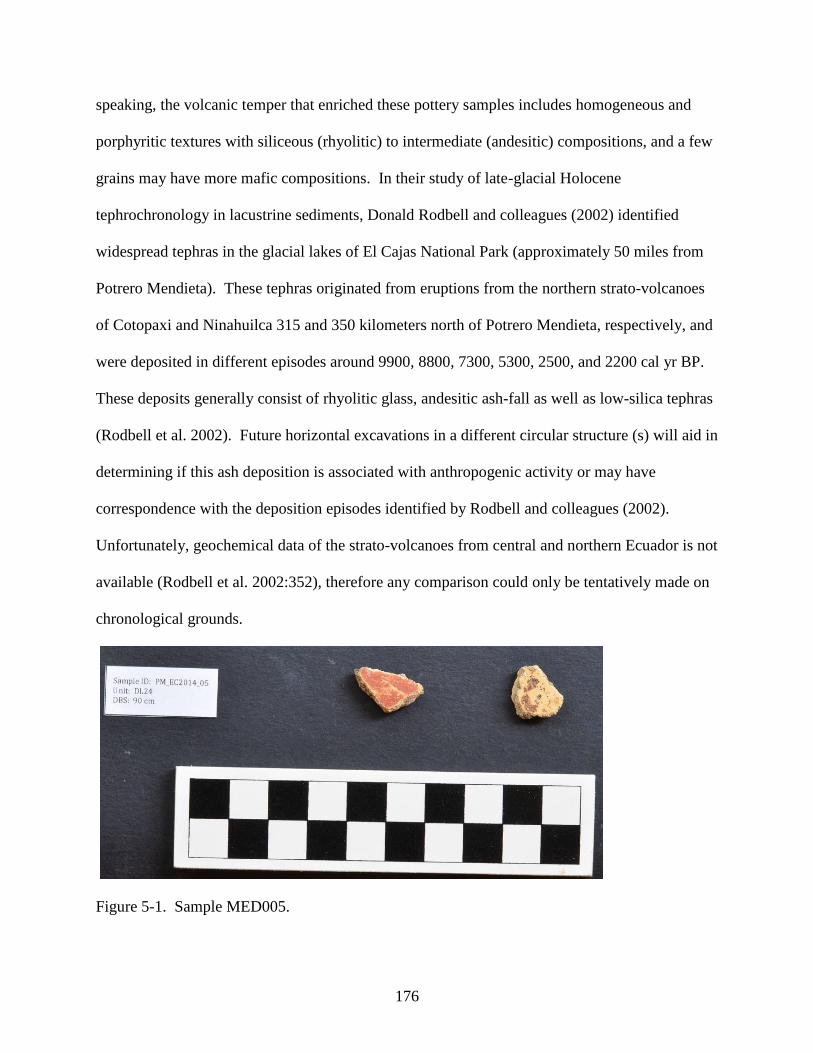
176
speaking, the volcanic temper that enriched these pottery samples includes homogeneous and
porphyritic textures with siliceous (rhyolitic) to intermediate (andesitic) compositions, and a few
grains may have more mafic compositions. In their study of late-glacial Holocene
tephrochronology in lacustrine sediments, Donald Rodbell and colleagues (2002) identified
widespread tephras in the glacial lakes of El Cajas National Park (approximately 50 miles from
Potrero Mendieta). These tephras originated from eruptions from the northern strato-volcanoes
of Cotopaxi and Ninahuilca 315 and 350 kilometers north of Potrero Mendieta, respectively, and
were deposited in different episodes around 9900, 8800, 7300, 5300, 2500, and 2200 cal yr BP.
These deposits generally consist of rhyolitic glass, andesitic ash-fall as well as low-silica tephras
(Rodbell et al. 2002). Future horizontal excavations in a different circular structure (s) will aid in
determining if this ash deposition is associated with anthropogenic activity or may have
correspondence with the deposition episodes identified by Rodbell and colleagues (2002).
Unfortunately, geochemical data of the strato-volcanoes from central and northern Ecuador is not
available (Rodbell et al. 2002:352), therefore any comparison could only be tentatively made on
chronological grounds.
Figure 5-1. Sample MED005.

177
Figure 5-2. Sample MED008.
Figure 5-3. Sample MED015.

178
Figure 5-4. Sample MED019.
Comparative Analysis
Comparisons with the Datasets Analyzed by MURR
There are two datasets from archaeological contexts in present-day Ecuador that
previously were analyzed at the University of Missouri Nuclear Reactor (MURR). These
datasets yielded compositional groups for the ceramics and clays from contexts located in the
northern Ecuadorian Andes and in the central coast of Ecuador (Ferguson and Glascock 2009;
Neff 2000a). The Palmitopamba materials were analyzed for the project of Ronald D. Lippi and
Alejandra Gudiño in the northern highlands, and the Loma de los Cangejitos materials are part of
the research program in the Santa Elena peninsula by Maria Masucci. Although these
archaeological materials are not coeval with the ones analyzed from Potrero Mendieta, the results
obtained by MURR are applicable for comparison from the standpoint of chemical composition
and their association with the lithological sources. What is more, the analytical protocols applied
to these datasets are consistent with the ones applied to the analysis of the Potrero Mendieta
dataset.

179
Neutron Activation Analysis of Ceramics of Burials at Palmitopamba, Ecuador
The site of Palmitopamba, located in the western ceja de montaña (cloud forest) of the
province of Pichincha (Ecuador) comprises a monumental center occupied for several centuries
by the Yumbos, one of the local indigenous groups. Ronald Lippi investigated the material
traces associated with the arrival of the Incas in this region (~ 1500 C.E.) and the relationship
between the Incas and this tropical forest chiefdom (Lippi 1998, 2004). In 2002, Ronald Lippi
and Tamara Bray first submitted 54 ceramic and 2 clay samples to MURR for analysis by NAA
(Speakman and Glascock 2004). These ceramics were sampled from Pucará de Palmitopamba, a
prehistoric hilltop fortress located 45 km northwest of Quito. The site is atypical because of the
presence of Inca-style pottery. An Inca presence at Palmitopamba is considered unusual since
the Inca conquest of Peru and most other regions of the Andes was primarily a highland
expansion and typically did not include tropical forest elevations at less than 1500 meters above
sea level (Lippi and Bray 2002). The samples submitted for analysis include Inca-style pottery,
Yumbo pottery which is presumably of local manufacture, and a sample of Cosanga (or
Panzaleo) pottery which is hypothesized to be a ―ritual‖ ceramic imported from the eastern
lowlands. All but one of the last samples of all 140 that were submitted for the subsequent
analysis by NAA is either assigned or closely related to the Palmitopamba group, which suggests
that these ceramics could have been locally made. The sole exception is RDL139, which may be
an example of a trade item from another part of the Inca Empire (Ferguson and Glascock 2009).
Neutron Activation Analysis of Ceramics of Loma de los Cangrejitos, Ecuador
The focus of the archaeological study by Maria Masucci in southwestern coastal Ecuador
was determining intrasite or inter-site relationships using compositional analysis in the ceramics
and clays from the culture-history Guangala phase, chronologically placed in the Regional
Developmental Period spanning 100 B.C.E. - 800 C.E. (Paulsen 1970; Masucci 1992). The

180
compositional evidence of Guangala fine ware bi-chrome and polychrome ceramics indicates
multiple production sites that do not correlate with the site where the pottery was identified
(Masucci 2001, 2008:499). Masucci proposes a model of trade that elucidate this pattern based
on the occurrence of vessels from the same site that display a range of compositions that suggests
―the circulations or gifting of festival containers‖ (Masucci 2008:499).
The results of NAA, which also include the petrography dataset (see Masucci and
Macfarlane 1997) agree with the picture of compositional variation that had surfaced from earlier
analyses of coastal Ecuadorian ceramics. Ceramics produced along the southern flanks of the
Colonche Hills are largely homogeneous and as such they constitute a single compositional
group. One of the smaller groups, White-on-Red, is possibly derived from a source south of the
Gulf of Guayaquil. It is possible that the source is from the mafic Piedras Formation in the El
Oro metamorphic complex, the geological formations associated with Potrero Mendieta.
Comparative Analysis
The combined datasets from Palmitopamba (n=140), Guayas (n=338) and Potrero
Mendieta (n= 40) were compiled using the software GAUSS from the University of Missouri
Research Reactor. These three datasets were analyzed using the same protocols developed by
MURR and described above. The reports from Palmitopamba and Guayas have not been
published hence I will not discuss the compositional groups identified for these datasets but will
compare their compositional groups with the ones identified for Potrero Mendieta.
With the compiled data of the archaeological ceramics from Ecuador analyzed by
MURR, the first statistical routine performed in GAUSS was Principal Component Analysis
(PCA). In addition to calculating the principal components for the dataset based on the chemical
load for each element, PCA can also project other datasets into the principal components space.
In the PCA for the Potrero Mendieta sample, the element nickel (Ni) was removed because most

181
of the samples registered values lower than the limits of detection in the MURR laboratory. For
the PCA of the compiled dataset I removed nickel, but left the two other elements that were
removed from the analysis of the Potrero Mendieta sample, arsenic (As) and antimony (Sb),
because they were not removed for the analysis of the other Ecuadorian datasets. The
compositional loading of arsenic and antimony is significant as we will see in the Total Variation
Matrix (Table B-7), hence relevant for comparison with other datasets. Still, it is important to be
aware of the high degrees of solubility of these elements (As and Sb) in soils, which may alter
the composition of ceramic materials during post-depositional phases. In the El Oro geological
study by Aspden and colleagues (1995), they measured the presence of arsenic in stream
sediments by inductively coupled plasma mass spectrometry (ICP-MS), and their results ranged
from less than 5 ppm (detection limit) to more than 2000 ppm. However, most of the sediments
contained less than 30 ppm (Aspden et al. 1995:49). In general, there appears to be a good
correlation between arsenic and gold and as such the highest values were recorded from samples
near the contact zone of the El Oro metamorphic complex and the Tertiary volcano-plutonic
complex south of the Jubones (Aspden et al. 1995:49-51; see chapter 4 for a discussion on the
contact zone of the Tertiary volcano-plutonic complex associated where Potrero Mendieta is
located).
The Principal Component Analysis demonstrates that greater than 90% of the cumulative
variance can be explained by the first ten principal components (Table B-5). PC 1 is positively
loaded at a percentage greater than 0.25 on the alkali elements rubidium (Rb) and caesium (Cs),
the metalloid element antimony (Sb), the transitional metal tantalum (Ta), lanthanum (La),
cerium (Ce), and the rare-earth elements thorium (Th) and uranium (U). PC 1 has a negative
loading on sodium (Na), calcium (Ca), manganese (Mn), cobalt (Co) and strontium (Sr). The

182
second component, PC 2 is positively loaded on rubidium (Rb) and scandium (Sc), and
negatively loaded with manganese (Mn), iron (Fe), cobalt (Co), samarium (Sm), europium (Eu),
terbium (Tb), and ytterbium (Yb). The total variation matrix for this dataset (Table B-7) shows
that Cr is the element contributing to the dataset variation, however Cr shows higher percentages
in PC 3-10 than in the first two PCA. As shown in table B-5, Cr accounts for more than 70
percent of the variation in PC5. Variances I PC1 and PC2 are very evenly divided among many
elements. A biplot of the first two PCs displays the general structure of the dataset while
accounting for 51.6 % of the cumulative variance (Figure B-4). The structure illustrated by
Figure B-4 depicts the three datasets as separate groups, and they show significant overlaps on
the first two principal components. The outliers from Potrero Mendieta that fall out of the three
groups are MED010, MED011, MED017 MED040.
The principal component analysis was performed in a dataset that includes each
individual group (of 11 members or more) from the three MURR Ecuadorian projects. The
Mahalanobis distance routine was performed to assess the spatial distance between a data point
and a distribution that measures the number of standard deviations between the data point and
the mean of the distribution. For this study the Mahalanobis distance was calculated with the
first eight principal components extracted from the variance-covariance or correlation matrix of
the compiled compositional groups from each site assemblage. For the Mahalonobis distance the
compositional groups from the Palmitopamba project (Ferguson and Glascock 2009) and the
Guayas project (Neff 2000a), each sample was projected onto the 11 groups from those three
sites. From the Potrero Mendieta sample, DOM-1 is the only group that has enough samples to
be considered a compositional group onto which samples can be projected for comparison. Table
B-6 shows the membership probabilities of the groups (with sufficient members) from the other

183
two projects in relation to DOM-1. The clays for each one of the projects were included as
unassigned members. The resulting outliers from Potrero Mendieta and the overlapping members
of Potrero Mendieta with the Palmitopamba and Guayas groups will be discussed in the
following sections.
Discussion and comparison with petrographic data
In the MU report for onald Lippi and Alejandra Gudiño‘s Palmitopamba sample,
Jeffrey Ferguson and Michael Glascock (2009) indicate that ethnic affiliation based on
compositional analysis will be difficult to determine because there appears to be local production
of both Inca and Yumbo ceramics from compositionally similar clays except for one sample that
may have been produced at a different locale of the Inca empire. This sample does not present a
significant membership probability with any of the other datasets analyzed in MURR. The
samples from the Palmitopamba project that reflect a closer association to the compositional
groups from Potrero Mendieta are not statistically significant in their percentages for
membership probabilities.
In the MU report for Maria Masucci‘s Guayas sample, Hector Neff (2000a) indicates
that the relatively fine-textured groups, White-on-Red, Anomalous MFP, and Fine Gray are
enriched by trace elements that are likely present in the clay matrix, specifically by the presence
of lanthanum and thorium. Neff (2000a) concludes that the White-on-Red members might have
been imports from southern localities, or more specifically, the direction the Potrero Mendieta is
in relation with the province of Guayas. In fact, the concentration of arsenic in the White-on-red
sherds is higher than in all the clay samples recovered from the Santa Elena Peninsula.
Comparisons between the datasets analyzed by MURR and the McMaster dataset
The 114 ceramics studied by Ross Jamieson and colleagues as part of an ongoing
research project on the Spanish colonial Period in Ecuador is comprised by a sample of ceramics

184
from the city of Cuenca, in the southern Ecuadorian highlands (Jamieson and Hancock 2004),
and by samples collected during excavation in the Central Highlands, in the environs of the
colonial city of Riobamba (know today as Silcapa/Cajabamba). The latest analysis by Jamieson
and colleagues (2013) focuses on the sourcing of the ceramics recovered in Riobamba in relation
to other colonial samples to interpret the differences of ceramic production and outside sourcing
in different colonial cities in what is presently Ecuador.
Since the compositional analyses of these samples were produced at the McMaster
Nuclear Reactor in McMaster University, Ontario, Canada, the results are not directly
compatible with the data produced at MURR. With the permission of Ross Jamieson to use the
raw compositional data for comparative purposes, and acknowledging this limitation, I have
incorporated the dataset into the large raw data compilation of the Ecuadorian datasets analyzed
at MURR. This last set of comparisons are analytical exercises and the results here presented
should not be considered directly compatible with the compositional groups identified at MURR
but could be used to orient future comparative analyses in the region. From the samples of the
McMaster dataset, the sample that shares greater correspondence with the groups identified for
Potrero Mendieta is sample number 125, associated with the intra-group Cuenca. Sample 125 is
one of the two sherds in this study that are Inca-style polychromes that probably were produced
locally in the Inca city of Tomebamba, present-day Cuenca (Jamieson et al. 2013:206). This
sherd from Cuenca shares a similar compositional signature with sample MED046 from the
intra-group DOM-3 of Potrero Mendieta. Most members of group DOM-3 are set apart from all
other samples because of their very high levels of Cr. Sample MED017 was separated as an
outlier due to elevated sodium (Na and low chromium (Cr) concentration values. Sample
MED020 was also separated out due to very low sodium Na and calcium (Ca) concentrations.

185
Summary and Discussion of the Compositional Analyses
Chemical Compositions and their Geological Relationships
Four compositional groups and one set of unassigned members were identified within the
Potrero Mendieta sample. Group DOM-1 presents high levels of alkali metals such as K, Rb, Cs.
This felsic composition that characterizes granite, quartz, muscovite mica, and orthoclase
feldspars is locally present in the Moromoro Granitoid Complex. This Late Triassic (ca. 250 -
200 MYA) formation is present as tectonic inclusions at the Quera Chico geological unit, a few
kilometers south from Potrero Mendieta. Based on the petrographic analyses it is plausible that
felsic granitic rocks were in the temper source mix, possibly accounting for the abundance of
quartz in most of the samples (see Table A-4, Table A-7, Appendix C for representative images
of this grouping‘s texture and composition, c.f. Cordell 2017). Moreover, the AMS assays of
samples MED021-MED025, which are associated with the felsic tempered sherd MED007,
yielded an uncalibrated date of 2996 ± 31 BP that likely represents one of the earliest human
occupations associated with the architectural structures from Potrero Mendieta. The presence of
rare-earth elements, lanthanum (La) and yttrium (Y), with values that range between 3 to 64
ppm, is comparable with the chemical signature of the granitoids of the Quera Chico Unit
(Aspden et al. 1995:59). These concentrations also correspond with the values of the White-on-
Red group from the Guayas sample.
The members of the mafic temper group (after Cordell 2017) are easily identifiable with
low magnification because mafic minerals such as olivine, pyroxene, amphibole, biotite mica
and the plagioclase feldspars are generally dark in color. These rocks present quite high loading
of heavier elements such as magnesium (Mg) and iron (Fe). The intermediate igneous plutonic
rocks of the Piedras Mafic Complex are characterized by the presence of dark and sparkly
biotite. The Taqui Unit is part of the Piedras Mafic Complex and is located along the northern

186
edge of the Quera Chico unit with which it is in tectonic contact (Aspden et al. 1995:34). The
Taqui unit is basically the hill that is located directly south from Potrero Mendieta and the biotite
outcrops have been identified by Aspden and colleagues (1995) in the contact zone of the Quera
Chico and Taqui units. Based on the mean thickness of these samples (5.8 mm), these wares
were larger and sturdier than the wares of felsic and volcanic composition and were probably
produced locally.
The AMS assay of the sediment associated with the mafic sample MED016, yielded an
uncalibrated radiocarbon date of 2433 ± 32 BP that is coeval with the south Andean
archaeological site of Pirincay dated by Burleigh and colleagues (1977) and investigated by
Karen Olsen Bruhns, James Burton and George Miller (1990). In her 2003 publication Bruhns
indicates that the paste analyses of pottery from the southern highlands from the sites of Pirincay,
Chaullabamba and Cerro Narrío has yielded evidence for pottery exchange or the exchange of
other goods that were deposited in these vessels. Unfortunately, there are no reports on these
results. Bruhns claims that the source areas for the vessels excavated from Pirincay are based
not only on style but on composition, and offer evidence for interregional contact within the
southern Andes and as far as the central Ecuadorian Andes (Bruhns 2003:162-163). Bruhns also
associates the presence of beads made of a green stone, in two publication called turquoise
(Bruhns et al. 1990; Bruhns 2003) and in another called serpentine (Bruhns 2010) to an unknown
source located in the Jubones. Although these claims are not based in actual geological
evidence, Bruhns‘s proposition is interesting because it addresses social interaction throughout
the Andean valleys deflecting the focus from marine shells from the coast or from Amazonian
imports and redirecting it towards raw material provenance.

187
Chronology and Compositional Variability
The AMS dates associated with the ceramics were assayed from charred samples
recovered from the excavation contexts. The pottery samples that were directly associated with
the features and levels of these dated samples are outlined in table B-AMS. The pottery samples
associated with charred material dated 3330-3080 cal. BP, 3064-2885 cal. BP, 3058- 2867 cal.
BP, and 2996-2801 cal. BP were excavated from structure 2. As we can see, all the NAA group
memberships identified for Potrero Mendieta are represented within this structure. From these
members, the samples that were analyzed by Ann Cordell (2017) fall into petro-fabric groups A
and B, and have been enriched with felsic and volcanic tempers, respectively. Although the
sample is surely small, the few sherds that were identified within structure 2 appear to have been
introduced through an episode of backfill. This may explain the comingling of sediments and
pottery from different compositional groups, which may be the result of accumulation and
discard.
In structure 1, the members of the NAA group DOM-1 are prevalent at the deeper
archaeological deposits, superimposing the volcanic ash floor in structure 1 that overlies the last
archaeological level and probably predates the construction of the circular structures. DOM-1
likely represents a local chemical signature, largely constituted by ceramics of petro-fabric A.
However, the widespread variability in the temper inclusions may be associated with the
technological choices in ceramic elaboration circumscribed to the geological regions immediate
to the Jubones River Basin. The only dates available for structure 1 are coeval with the northern
highlands contexts of Cotocollao B (Porras 1982) in the Pichincha province, the costal Chorrera
culture, Tabuchila Phase in the Manabí province (Engwall 2000; Zeidler et al. 1998), and with
the southern highlands sites of Chaullabamba (Grieder et al. 2009), Pirincay (Bruhns et al. 1990)

188
in the Azuay province, and Putushío (Temme 1999) and La Vega (Guffroy 1987) sites in the
Loja province.
The ceramic sherds recovered from structure 3, the ovoid structure located in the northern
edge of the site, are associated with sediments dated between 2701and 2356 cal. BP, which is
placed in the terminal phases of the Formative period chronology. The stratigraphy at this sector
of the site differs from the patterns identified in structures 1 and 2, and the compositional
variability may be attributed to wider inter-regional interaction networks, diversification in
technological choices, or both.
Local Versus Non-Local Pottery
Because there is only compositional information for two clay samples that were
recovered from the site, the characterization of local vs. non-local production rests on the validity
of the archaeological criterion of abundance, as evaluated within a chronological perspective
(Bishop et al. 2002:604). Chemical group DOM-1 is found to be in abundance at the site from
the earlier through subsequent occupations, whereas the other compositional groups are sparsely
represented. This presents a sampling issue that can only be partly resolved by both an intensive
survey of raw materials throughout the El Oro geological sub-regions and the sampling of
archaeological ceramics from contexts contemporaneous with Potrero Mendieta.
In the Mahalonobis Distance analysis (Table B-6) it is shown that there are no samples
from each of the groups (Guayas, Palmitopamba and Potrero Mendieta) that are potential
members of groups local to another locale. Nevertheless, had there been chemical
correspondence between these groups, a social or historical relationships would be difficult to
infer because the sites are not contemporaneous. Keeping in mind these limitations, the groups
identified in the Potrero Mendieta sample, and the individual members of the unassigned group
(DOM-UNK) were projected directly onto the well-defined groups from Guayas and

189
Palmitopamba. None of the members of the groups identified for these two projects share
chemical correspondence with DOM-1 and the unassigned samples MED05, MED06, MED15,
MED19, MED39, and MED43 fall into the White-on-red group. We can also see that all DOM2
and DOM2A members have some affinity for Guayas white-on-red. Sample MED11 (clay) also
has a slight affinity. It is also plausible that there is a similarity in the chemistry of resources
local to the two areas (Guayas and PM).
Vessels of History: Narratives of Context and Composition
In addressing provenance, the compositional groups of pottery reflect the historical
contingency of the formation processes of archaeological contexts. While wares may have been
transported from places far away from Potrero Mendieta, the contexts from which the samples
were recovered do not reflect an explicit treatment for this pottery. The sherds that were
recovered during the excavation were mixed with the backfill soil, so probably they had been
previously discarded.
In their discussion of the Shipibo-Conibo discard and refuse practices, DeBoer and
Lathrap (1979:135) pointed out that the archaeological record illustrates the behavior that
produced refuse rather than the behavior that produced a cultural system (contra Binford
1964:425, emphasis mine). Because of constant sweeping and racking of broken vessels,
particularly in secondary refuse areas, where weather may have also altered the distribution of
sherds, the discard patterns of many of the Shipibo-Conibo vessels were obscured, which was
probably the intention behind these acts of discard (DeBoer and Lathrap 1979:129). Events that
ensue in the accumulation of refuse would not be apparent in contexts that are decidedly meant
to be undisturbed (e.g. in burials), or in high traffic areas (e.g. houses, workshops), where there
may be a clearly organized spatial patterning for refuse, as documented by DeBoer and Lathrap
(1979) for the Shipibo-Conibo primary refuse contexts. At Potrero Mendieta, in circular

190
structure 2, the pottery sherds that were recovered from the strata closest to the surface, at
approximately 30 cm DBS, were associated with charcoal sediments that yielded uncalibrated
dates of 2859 ± 25 years BP. The bottom strata at approximately 80 to 90 cm DBS yielded AMS
uncalibrated dates of 2805 ± 30 BP, 2860 ± 30 BP and 3010 ± 25 BP, which, in addition to the
stratigraphic relationships within the structure suggest the pottery found within the structure was
mixed with the backfill or the structure in an event of abandonment or repurposing of the
architectural feature (see Chapter 3).
In the context of an enclave characterized by architecture, which at least for its
construction and maintenance required the simultaneous assemblage of many able bodies, the
documented ceramic distribution patterns can be rather defined as non-patterns, at least in terms
of manufacture, use, and discard of these objects. The absence of whole vessels, or at least, of
large portions of fragments from which style and function could be determined, suggests that
Potrero Mendieta was not associated with the permanence of a homogenous and relatively
sedentary group as the modern Shipibo-Conibo. Further excavations at Potrero Mendieta might
uncover contexts with more discernible patterns that would provide other connections between
the compositional groups identified, and other social relations involved with secondary
production of pottery (e.g. decoration) and style and function.
The findings from Potrero Mendieta reveal that the pottery fragments found in the
backfill events were likely produced using clays gathered at the site or from the immediate
surroundings. This does not preclude the possibility that clays were obtained from other regions;
alas the dataset is too small to make such an assertion. On the other hand, the tempers acquired
to produce these wares were obtained from sources that cover an area of 2400 Km2, mainly
associated with the El Oro metamorphic complex and the outcrops in and around the Jubones

191
fault. The fabric and temper of fine wares produced such as the White-on-Red identified in
contexts from the Regional Developmental Period (ca. 100 B.C.E. - 800 C.E.) in the Ecuadorian
coast share compositional characteristics, in terms of both lithology and temper, with the wares
produced, or at least mobilized in and around Potrero Mendieta.
Although additional compositional datasets of archaeological ceramics analyzed by NAA
would provide a larger comparative dataset, this study will be refined through a clay collection
survey beyond the Potrero Mendieta context. Further excavations at Potrero Mendieta would
also expand our understanding of the spatial configuration of ceramic artifacts within and around
the architectural structures.
Notes
1 Fragments of about 1 cm2 were removed from each sherd and abraded using a silicon carbide burr in order to
remove surface treatments (e.g. glaze, slip, paint) and adhering soil, thereby reducing the risk of measuring
contamination. The specimens were washed in deionized water and allowed to dry in the laboratory. Once dry, the
individual sherds were ground to powder in an agate mortar to homogenize them. Archival portions were retained
from each sherd (when possible) for future research. Two analytical samples were prepared from each specimen.
Portions of approximately 150 mg of powder were weighed into high-density polyethylene vials used for short
irradiations at MURR. At the same time, 200 mg aliquots from each sample were weighed into high-purity quartz
vials used for long irradiations. Individual sample weights were recorded to the nearest 0.01 mg using an analytical
balance. Both vials were sealed prior to irradiation. Along with the unknown samples, standards made from National
Institute of Standards and Technology (NIST) certified standard reference materials of SRM-1633b (coal fly ash)
and SRM-688 (basalt rock) were similarly prepared, as were quality control samples (e.g. standards treated as
unknowns) of SRM-278 (obsidian rock) and Ohio Red Clay (a standard developed for in-house applications)
(Glascock 1992; Glascock and Neff 2003). Daniel Lee was responsible for preparation and irradiation of all project
specimens (Gilstrap 2017:2). The clay samples used for the NAA analyses were previously processed by Ann
Cordell and Gerald Kidder in the Florida Museum of Natural History Ceramic Technology Laboratory (FLMNH-
CTL) where they were placed in a drying oven for 24 hours at 100 degrees C by and subsequently fired at 800
degrees C with a soak time of 30 minutes in order to drive off water and other volatile substances (see for example
Wallis et al. 2015:33).
2 Neutron activation analysis of ceramics at MURR, which consists of two irradiations and a total of three gamma
counts, constitutes a superset of the procedures used at most other NAA laboratories (Glascock 1992; Glascock and
Neff 2003; Neff 2000b). As discussed in detail by Glascock (1992), a short irradiation is carried out through the
pneumatic tube irradiation system. Specimens in the polyvials are sequentially irradiated, two at a time, for five
seconds by a neutron flux of 8 × 10¹³ n cm-2 s-1. The 720-second count yields gamma spectra containing peaks for
nine short-lived elements aluminum (Al), barium (Ba), calcium (Ca), dysprosium (Dy), potassium (K), manganese
(Mn), sodium (Na), titanium (Ti), and vanadium (V). The specimens are encapsulated in quartz vials and are
subjected to a 24-hour irradiation at a neutron flux of 5 × 10¹³ n cm-2 s-1. This long irradiation is analogous to the
single irradiation utilized at most other laboratories. After the long irradiation, specimens decay for seven days, and
then are counted for 1800 seconds (the "middle count") on a high-resolution germanium detector coupled to an
automatic sample changer. The middle count yields determinations of seven medium half-life elements, namely
arsenic (As), lanthanum (La), lutetium (Lu), neodymium (Nd), samarium (Sm), uranium (U), and ytterbium (Yb).

192
After an additional three- or four-week decay, a final count of 8500 seconds is carried out on each specimen. The
latter measurement yields the following 17 long half-life elements: cerium (Ce), cobalt (Co), chromium (Cr),
caesium (Cs), europium (Eu), iron (Fe), hafnium (Hf), nickel (Ni), rubidium (Rb), antimony (Sb), scandium (Sc),
strontium (Sr), tantalum (Ta), terbium (Tb), thorium (Th), zinc (Zn), and zirconium (Zr). The element concentration
data from the three measurements were tabulated in parts per million using Microsoft® Office Excel (Gilstrap
2017:3).
3 In the current sample, some of these elements are present at or below the detection limits for neutron activation
using the current procedures at the University of Missouri Nuclear Reactor. If greater than 50% of specimens are
missing a value for a particular element, this element is removed from consideration in the analysis. Statistical
analyses are carried out on base -10 logarithms of elemental concentrations. Use of log concentrations rather than
raw data compensated for differences in magnitude between the major elements, such as sodium (Na), and trace
elements, such as the rare earth or lanthanide elements (REEs). Transformation to base -10 logarithms also yields a
more normal distribution for many trace elements.
4 As Neff and Glascock explain (2001:4): ―The two dimensional plot of element coordinates on the first two
principal components is the best possible two-dimensional representation of the correlation or variance-covariance
structure in the data: Small angles between vectors from the origin to variable coordinates indicate strong positive
correlation; angles close to 90o indicate no correlation; and angles close to 180o indicate negative correlation.
Likewise the plot of object coordinates is the best two-dimensional representation of Euclidean relations among the
objects in log-concentration space (if the PCA was based on variance-covariance matrix) or standardized log-
concentration space (if the PCA was based on the correlation matrix). Displaying objects and variables on the same
plots [i.e., biplots] make it possible to observe the contributions of specific elements to groups separation and to the
distinctive shapes of the various groups. Such a plot is called a ―biplot‖ in reference to the simultaneous plotting of
objects and variables.‖
5 The Mahalanobis distance of a specimen from a group centroid (Bieber et al. 1976, Bishop and Neff 1989) is
defined by:
𝐷𝑦,2= [𝑦− 𝑋 ]𝑡 𝐼𝑥 [𝑦−𝑋 ] where y is the 1 × m array of logged elemental concentrations for the specimen of interest, x is the n × m data matrix
of logged concentrations for the group to which the point is being compared with 𝑋 being it 1 × m centroid, and Ix is
the inverse of the m × m variance–covariance matrix of group x. Because Mahalanobis distance takes into account
variances and covariances in the multivariate group it is analogous to expressing distance from a univariate mean in
standard deviation units. Like standard deviation units, Mahalanobis distances can be converted into probabilities of
group membership for individual specimens. For relatively small sample sizes, it is appropriate to base probabilities
on Hotelling‘s T2, which is the multivariate extension of the univariate Student‘s t test (Glascock 1992).
6 This is a conservative approach to group evaluation that may sometimes exclude true group members. Small
sample and group sizes place further constraints on the use of Mahalanobis distance: with more elements than
samples, the group variance-covariance matrix is singular thus rendering calculation of Ix (and D2 itself) impossible.
Therefore, the dimensionality of the groups must somehow be reduced. One approach would be to eliminate
elements considered irrelevant or redundant. The problem with this approach is that the investigator‘s
preconceptions about which elements should be discriminated may not be valid. It also squanders the main
advantage of multi-element analysis, namely the capability to measure a large number of elements.
An alternative approach is to calculate Mahalanobis distances with the scores on principal components extracted
from the variance-covariance or correlation matrix for the complete data set. This approach entails only the
assumption, entirely reasonable in light of the above discussion of PCA, that most group-separating differences
should be visible on the first several PCs. Unless a data set is extremely complex, containing numerous distinct
groups, using enough components to subsume at least 90% of the total variance in the data can be generally assumed
to yield Mahalanobis distances that approximate Mahalanobis distances in full elemental concentration space.
Lastly, Mahalanobis distance calculations are also quite useful for handling missing data (1975). As Glascock
(1992:19) explains: ―When analyzing many hundreds of specimens for a large number of elements, it is almost

193
certain that a few concentrations will be missed for some specimens. This occurs more frequently when the
concentration for an element is near its detection limit in a group of specimens. Rather than eliminate such
specimens from consideration, it is possible to substitute a missing value by choosing a value that minimizes the
Mahalanobis distance for the specimen from the group centroid. Thus, those few specimens which are missing a
concentration can be included in all group calculations.‖

194
CHAPTER 6
CONCLUSION
The archaeological investigations of the Potrero Mendieta site provide a glimpse of how
inter-regional interaction can be manifested as knowledge of the physical world. The field
research program that led to the identification and archaeological excavations of Potrero
Mendieta had the investigation of the Jubones River Basin as one of its main objectives. This
basin is a natural corridor in the western cordillera of the Andes that connects the highlands with
the Pacific coastal plains.
This corridor also connects to valleys that lead to the eastern cordillera and the
Amazonian cloud forest. The location of the site is characterized by an ecological mosaic with
diverse climatic zones ranging from tropical floodplains in the west to moorlands at high
altitudes. In present times the physical configuration of this region facilitates the movement of
people and goods from the highlands to the coast, but this relatively low transverse cordillera has
been intensely transited for millennia. In fact, Potrero Mendieta is the largest Formative site
identified in the region and its location likely played a significant role in the historical processes
of inter-regional interaction during the Formative.
The construction of the extensive architectural complex at Potrero Mendieta would have
required a tremendous amount of human labor to transport the river stones used to build the
structures. The uses of the site cannot be unequivocally interpreted; however there is evidence
that suggests connections with distant locales were symbolically referenced at Potrero Mendieta.
A notable example is a sherd in the style of Valdivia phase II identified in Structure 1. Other
ritual acts may have been associated with the backfilling event of Structure 2 and its patterned
arrangement of pecked and pigmented stones at the center of the structure. In the following
section, I will argue for interpreting the site as a dynamic regional node where ritual and

195
quotidian activities converge. Finally, I will offer a summary of the results of the compositional
analyses and recommendations for future research in the region.
Potrero Mendieta as an Enclave of Inter-regional Interaction
One of the lines of evidence that has been addressed in these investigations is
monumental architecture. In this monograph, I referred to a few interpretations of architecture
and settlement patterns in Ecuador and northern Peru. I will now present two examples that are
far-removed both geographically and chronologically. They are germane to the discussion of
Potrero Mendieta in that they address ritual activity and pilgrimage as modes of interaction and
as referents of history. I will then present one example of present-day ritual practices in
Southwestern Ecuador. The first example is the archaeological site of Göbekli Tepe, situated on
the Gemus Mountains, in southeastern Turkey, which exemplifies, in its material vestiges,
processes of social interaction and monumental construction mediated by a social order that
defied the traditional characterizations of pre-agricultural societies (Dietrich et al. 2012; Schmidt
2001).
Göbekli Tepe comprises a collection of massive structures that include more than 200 T-
shaped pillars within 20 walled circular enclosures built by hunter-gatherer groups that
congregated there approximately 11,000 years ago (Dietrich et al. 2012; Schmidt 2001). These
structures display zoomorphic and anthropomorphic three-dimensional depictions that follow
divergent orientations. E. B. Banning (2011) proposes that the structures at Göbekli Tepe had
diversified uses throughout their history, which were neither exclusively domestic nor ritual.
Banning (2011) asserts that in cataloguing archaeological contexts perceived as ―unusual‖ or
―exceptional‖ as ritual, there is an inclination to follow models that agree with the Western post-
Enlightenment sacred-profane dichotomy. He, and others, advocate caution when making these
distinctions (Boyd 2005:26; Br ck 1999). In fact, in both non-Western and Western
196
cosmologies, the ritual and the secular are more intertwined than we tend to recognize (Banning
2011:637; Bradley 2000; Verhoeven 2004). A notable challenge in the interpretations of
Göbekli Tepe is in the description of elements that have been framed as ritual. In the initial
analyses of the site, Klaus Schmidt (2001), and Oliver Dietrich and colleagues (2012) interpreted
the monumentality of the spatial contexts at Göbekli Tepe as neatly sacred. These interpretations
perhaps overlooked the possibility that the practices and meanings associated with these
structures were generated through the building of the complex, even during the initial use of the
structures as domestic places (Banning 2011:637). Marc Verhoeven (2004) argues that the
symbolic relations between humans and the animate and inanimate world emerged during the
early periods of human occupation in the region. He further asserts that the rituals and
symbolism generated by early human societies served to sustain and transform such continuous
symbolic relations (Verhoeven 2004:265).
In North America, the monumental earthworks at the Poverty Point site have had an
enduring social life connected to archaeological research and the politics of heritage management
(Gibson 2000:16-17, 20-21). The Late Archaic Poverty Point Complex located in the American
Southeast presents an elusive context of social interaction among hunter-gatherer groups who
engaged in the construction of large earthen mounds and congregated in the complex around
3,600 years ago (Kidder 2011). Ken Sassaman (2012) has interpreted the construction of these
works as the outcomes of the cooperative, discursive practices that were projected towards future
conditions. Although the construction of Poverty Point was relatively rapid, its material reality
conjures the historical associations of those involved in the concerted practices that materially
connected diverse historical experiences (Sassaman 2005:336). Monumental complexes such as
Göbekli Tepe and Poverty Point facilitated the processes of mobility and assembly of human

197
groups, and are simultaneously ordinary and special. This gathering of agencies and
materialities was not timeless, rather it referenced history and created history.
In present-day Ecuador, sites of religious pilgrimage that are dedicated to saints and the
numerous iterations of the Virgin Mary draw believers from different regions to a single sacred
space localized at a sacred locale or edifice. In shrines and altars at Roman Catholic temples the
material manifestations of religiosity can be observed in the symbolic attachment to flower
offerings, scapulars, pictures, and other mementos left by the faithful as physical reminders of
their prayers. In their comparative study of pilgrimages, Simon Coleman and John Elsner (1995)
have noted that pilgrims are invested in collecting a piece of the charisma of a pilgrimage center
as much as in engaging in the pilgrimage experience itself. This ‗piece of the place‘ will in turn
retain the potency of the pilgrimage center after the traveler has returned home (Coleman and
Elsner 1995:100; Bradley 2000). In southern Ecuador, for example, it is not uncommon to see
all types of vehicles, passenger, cargo and even construction equipment, displaying decals from
the pilgrimage to the Basilica of Our Lady of El Cisne. Many of the faithful join the pilgrimage
to El Cisne to fulfill a promise to the virgin1 and to have their vehicle blessed in order to prevent
transit accidents and other mishaps on the roads. These decals retain the potency of the
pilgrimage and the promise of protection. In these modern pilgrimages the ‗mundane‘ and the
‗exceptional‘ are interconnected.
As illustrated in the contemporary pilgrimage to El Cisne, ritual practice is a process not
a physical object. Physical objects, such as an edification or a memento, may render evidence of
these processes in relation to their engagement in social life but are not literal accounts of
practice. The feasibility of interpreting past ritual processes through material remains, such as
the architectural structures identified at Potrero Mendieta, is dependent upon two general factors:

198
the degree to which taphonomic processes obscure or obliterated representative elements of the
life history of the structure, and the anthropogenic activity that inadvertently or forcefully
obliterated a physical rendering of previous activities. Catherine Bell (1992:74) argues that ritual
practice is relational and needs to be examined through the human agencies that create the
differentiations between the ritual and non-ritual, and proposes that ―ritual activities are
themselves the very production and negotiation of power relations‖ (Bell 1992:196). So, the
mere characterization or the reading of a structure as a proxy of an activity ignores the relational
and historical dynamism of practice. Edifications of any kind may refer to certain aspects of a
historical past and be used in a manner that is more suitable for the emergent present and the
projected future. The possible transitions and mediations that occurred at Potrero Mendieta
during a specific time and context involved practices that were neither exclusively secular nor
sacred.
The excavations of the architectural structures at Potrero Mendieta revealed a notable
scarcity of organic and artefactual remains. Most of the pottery sherds that were recovered in the
excavations were associated with a backfill event that occurred around 2860 ± 30 BP, which
largely obliterated any evidence of the previous use of the structures and suggested that their
subsequent use might not have been associated with activities such as food processing, dwelling
or craft manufacture. Here we see a marked readjustment in the use of the edifications, in which
the previous construction was maintained but its use was changed. The archaeological evidence
from contexts contemporaneous with the earliest occupation identified at Potrero Mendieta
elucidates plausible connections in terms of architectural style. Certainly, the connections and
architectural relationships among coeval archaeological sites from Northern Peru, the Southern
Ecuadorian highlands and western lowlands, and the Formative manifestations from the eastern

199
Andean cloud forest and lowlands that might have been established through travel facilitated by
the inter-Andean corridors such as the Jubones Valley, were significant in the historical process
of the region but cannot be read as proxies for social, political, religious and economic orders, or
as universal cognitive processes.
The material traces of Potrero Mendieta (ca. 1,000 BCE) are renderings of historical
processes that were not insular in time and space. These processes are partially accessible
through the material relationships apparent in the ceramic vessels identified at Potrero Mendieta.
The application of compositional analysis to the pottery sherds recovered from the excavation, an
optimal technique considering the fragmentary nature of the material evidence from Potrero
Mendieta, yield evidence of the relationships of artisans with places. Some of these relationships
are apparent in the material constitution of the ceramic remains, and elucidate connections with
far-flung places and knowledge of and connection with nearby locales. To date, materials that
are explicitly from remote locales have not been identified at Potrero Mendieta, except for the
possible association of two pottery sherds with clay sources from the coast of the Gulf of
Guayaquil.
Summary of the Findings
Potrero Mendieta has been protected throughout the years by its lack of accessible paths
and abundant vegetation. Indeed, the difficulty accessing the site and the degree to which the
architectural features are not identifiable to the naked eye complicated the identification process.
However, this also has led to excellent preservation of the structures. This collection of
architectural structures covers at least two hectares of the hill where the site lies. These
structures were built with granodioritic boulders brought from the Jubones river bed, the path
from which requires one to travel, as the crow flies, approximately one kilometer to the south
and ascend 300 vertical meters to arrive in the field at around 600 meters above sea level. The

200
circular structures in the complex bear resemblance to architectural structures from contexts of
the same period, specifically from the highland sites of La Vega (Guffroy 1987) and
Chaullabamba (Grieder et al. 2009), and from the eastern cloud forest site of Santa Ana La
Florida (Valdez 2007, 2008, 2013). The paucity of artifacts in the depositional contexts within
the structures does not present clear evidence of them being either domestic or public structures.
Ritual and quotidian practices are relational and temporal and thus it is plausible that these
structures might have had different uses throughout their life history. The artifacts identified and
recovered at Potrero Mendieta mainly include highly fragmented pottery sherds and a few lithic
fragments and débitage. However, the excavations detailed in this monograph amount to
perhaps two percent of the identified circular structures and a mere fraction of a percent of the
entire complex. This being the case, the potential for future research to uncover cultural
materials of interest is very great.
The depositional units in the excavations within the circular structures indicate that said
structures were treated differently throughout the history of occupations that dated between cal.
3330 to 2355 B.P. In Structure 1 we identified a floor made of volcanic ash, which overlies an
older depositional unit for which we do not have an absolute date. Above the ash floor there
were no patterned distributions of artifacts. The artifacts and the charred material used for AMS
dating were associated with backfill deposits. Probably the floors were cleaned before the
backfill, which obliterated information on the initial use of the structure. The trench that was
excavated in Structure 2 revealed a depositional event that consisted of the assemblage of a
mound of rocks, some that were modified through pecking or painting (see Chapter 3). This
event was associated with a hearth at the base of the structure and the placement of stones in a
patterned manner after the backfilling event.

201
A sample of the pottery sherds recovered from the excavation was compositionally
analyzed employing NAA and petrography. The results of these analyses were compared with
compositional analyses of pottery from coastal Ecuador and the northern Ecuadorian Andes. The
patterns documented in the petrographic analysis present relative variability in the composition
of the paste recipes. By and large, red-firing clays are predominant in the sample, and igneous
plutonic rocks were processed as temper. The provenience of temper that contain quartz,
plagioclase feldspar, biotite and muscovite, and volcaniclastic fragments are found throughout
the 24,000 Km2
area of the El Oro metamorphic complex in south-west Ecuador. The geological
composition of the greater southern region of the Jubones Basin is part of the El Oro
metamorphic complex, which comprises rock types/assemblages of different ages, divergent
metamorphic histories and of both continental and oceanic correspondences (Aspden et al. 1995).
If the sources for the volcanic-tempered samples and those with siliceous microfossils were
gathered from weathered detrital deposits, the presence of pottery with these additives is unlikely
to be of local production. From the comparisons made to the petrographic analysis from the
peninsula of Santa Elena, one of the compositional groups identified by Masucci and Macfarlane
(1997), class 5, does not present clear affinities with the clays sampled from the surroundings of
the sites where these samples were recovered, but with the composition of clays from mafic
sources in the El Oro metamorphic complex. Whereas the samples from coastal Ecuador date
between 100 BCE and 800 CE, one can hypothesize there to have been continuity in the
movement of these wares across the Andes to the coast. The white-on-red decorations of these
vessels, from Formative contexts in northern Peru and southern Ecuador, have been associated in
the literature with ritual activities (Bushnell 1951; Estrada et al. 1964; Izumi and Terada 1966;
Masucci and Macfarlane 1997).

202
The NAA yielded four compositional groups DOM-1, DOM-2, DOM-2A, DOM-3. All
the NAA group memberships identified for Potrero Mendieta are represented within Structure 2.
The presence of all the compositional groups in this structure may be the result of backfill with
sediment laden with an accumulation of discarded pottery. In Structure 1, the members of the
NAA group DOM-1 are present in the older archaeological deposits, below the volcanic ash
floor, therefore these wares may predate the construction of the circular structures. DOM-1
likely represents a local chemical signature. The prevalent variability in the temper inclusions in
this group may be correlated with the technological choices constrained to the geological regions
immediate to the Jubones River Basin, specifically the El Oro metamorphic complex.
The ceramic sherds recovered from Structure 3, the structure with collapsed concentric
walls located in the northern edge of the site, are associated with sediments dated between 2701
and 2356 cal. BP, which is placed in the terminal phases of the Formative period chronology.
The stratigraphy at this sector of the site differs from the patterns identified in structures 1 and 2,
and the compositional variability may be attributed to wider inter-regional interaction networks,
diversification in technological choices, or both. DOM-2 and DOM-2A members have some
affinity with the coastal white-on-red. Whereas these wares may have been transported to the
coast from the Jubones valley, there might be a similarity in the chemistry of resources local to
the two areas.
The Potrero Mendieta Case-Study: Conclusions and Future Directions
Because of budgetary constraints and the determination that it would be most expedient
to first understand the more unambiguous components of the site, the circular structures, we were
not able to sample all of the different components of Potrero Mendieta. For future
investigations of the site I recommend a geophysical survey, specifically using multiplexed
resistivity, to identify anthropogenic structures that are otherwise obscured by sediment and

203
vegetation. In terms of archaeological excavation, a horizontal excavation of at least fifty
percent of a circular structure would help us further understand distribution of space and the
depositional patterns that are not entirely evident when only excavating trenches. Because there
is no solid research precedence in the area, the continuation of the project is important to help
understand the chronology of human occupations in the Jubones Basin and so, it would benefit
from obtaining additional radiocarbon dates for the charred material that has been recovered
during the excavations. Lastly, compositional analysis through petrography and NAA of an
extensive set of clay samples from the area, sourced from outside the site location, would enable
further information to be gleaned from the artifacts analyzed thus far.
Notes
1 In 1595, the image of the Virgin of El Cisne was commissioned to the sculptor Diego de Robles to fulfill a promise
made by the indigenous farmers to follow the Roman Catholic cult to the Virgin Mary after having been affected by
a lengthy and devastating drought (Alvarado 1982). Nowadays, the promise consists of keeping the pilgrimage alive
every year from August the 10th
to September the 12th
.

204
APPENDIX A
PETROGRAPHIC ANALYSIS

205
Table A-1. List of samples for petrographic analysis.
Sample # MEDID
Item
category Unit
DBS
(cm) Point #
Temper
Group
Matrix
Fabric
MED-01 PM-EC2014-01 pottery DL24 10-30 . volcanic A
MED-02 PM-EC2014-02 pottery DL24 55-60 . felsic A
MED-03 PM-EC2014-03 pottery DL24 60-65 28 mafic A
MED-04 PM-EC2014-04 pottery DL24 70-80 . mafic A
MED-05 PM-EC2014-05 pottery DL24 90 . volcanic B
MED-06 PM-EC2014-06 pottery DL24 90-94 . felsic A
MED-07 PM-EC2014-07 pottery DL24 100-115 . felsic AB
MED-08 PM-EC2014-08 pottery DL24 115 . volcanic B
MED-09 PM-EC2014-09 pottery CT-8 0-8 7 felsic AB
MED-10 PM-EC2015-01 clay STP10 60 sample 1 na B
MED-11 PM-EC2015-02 clay STP10 110 sample 2 na A
MED-12 PM-EC2015-03 pottery STP10 85 . felsic A
MED-13 PM-EC2015-04 pottery STP10 130 . mafic AB
MED-14 PM-EC2015-05 pottery BW50, BY50, BX50
0-10 . felsic A
MED-15 PM-EC2015-06 pottery BX50 20 . volcanic B
MED-16 PM-EC2015-07 pottery BX50, BY50 35-37 . mafic A
MED-17 PM-EC2015-08 pottery CU-8, CU-9, CU-10 27-32 . felsic A
MED-18 PM-EC2015-09 pottery CU-8, CU-9, CU-10 32-38 . felsic A
MED-19 PM-EC2015-10 pottery CS-10, CT-9 west half
15-27 . volcanic B
MED-20 PM-EC2015-11 pottery CS-9, CT-9 west
half 60-66 . felsic A

206
Table A-2. Gross temper category descriptions. temper/paste
groups composition
n of
cases petro-fabric sample #s comments
felsic felsic to intermediate igneous plutonic (granitic to
granodiorite), composed of quartz, plagioclase, uid
feldspar, and lesser but variable biotite, lesser amphibole; muscovite mica is rare
9 most fabric A;
2 fabric AB
MD02, MD06, MD07,
MD09, MD12, MD14,
MD17, MD18, MD20
#6-some pxQ could be metamorphic; #18 and #20
have muscovite; #18 might have metamorphic pxQ;
muscovite mica is rare
mafic intermediate to mafic igneous plutonic
(granodiorite/diorite/tonalite), with equal amphibole,
biotite, quartz, plagioclase, uid feldspar; some more felsic igneous plutonic rocks in the temper mix
4 most fabric A;
1 with some
overlap with fabric B
MD03, MD04, MD13,
MD16
#3 tonalite (variety of granodiorite) can account for
large grains of biotite and amphibole#3 also has
some intermediate volcanics; large biotite grains might have been culturally selected
volc A mixed volcanic and felsic igneous rocks, with plagioclase
(zoned in one case), feldspar, variable quartz, lesser but
significant amphibole
2 fabric B MD08, MD15 #15 intermediate volcanics, monocrystalline grains
are phenocrysts; some epidote could have plutonic
origin
volc B mixed volcanic and/or felsic igneous rocks, with feldspar,
and lots of alteration to epidote
1 fabric B MD19 volcanic origin; altered intermediate to siliceous
with recrystallization, but lots of epidote
volc C mixed volcanic and felsic igneous rocks, with feldspar,
lesser but significant epidote?
2 fabric A MD01, MD05 rock frags with micrographic textures might be
recrystallized siliceous volcanics; some similarity to
MD05
clay samples
clay MD10 frequent silt; occasional larger aplastics including quartz, polycrystalline quartz, possibly volcanic
1 fabric A MD10 red firing; only rare siliceous microfossils
clay MD11 frequent silt; occasional larger aplastics including quartz,
polycrystalline quartz, possibly volcanic
1 fabric B MD11 pale firing; frequent siliceous microfossils red
firing; only rare to occasional possible siliceous microfossils
petro-fabrics composition pottery n clay n temper groups sample #s
A none to rare siliceous microfossils 12 1 (MD11) 7 felsic, 3 mafic, 1 volcanic
MD01, MD02, MD03, MD04; MD06, MD12, MD14, MD16, MD17, MD18, MD20
B frequent siliceous microfossils 5 1 (MD10) all volcanic MD05, MD08, MD15, MD19
AB intermediate--occasional to frequent siliceous microfossils 3 . 2 felsic, 1 mafic MD07, MD09, MD13

207
Table A-3. Other physical properties identified in the samples and statistical comparisons of fabric and temper.
Sample # Item Category
Temper
Group
Likely temper
source Petro-fabric
Phyto-
liths spc Diatoms Sorting
Size
modes
Size
modes
Rounded-
ness
Color of
matrix
Sherd
thickness
MED-01 pottery volc C siliceous volcanic A rare . . poor 4-modal c,f,m,vf SA to SR 4d 7.0
MED-02 pottery felsic granite A rare . . poor 4-modal c,vf,m,f SA, A to
SR 4d 6.0
MED-03 pottery mafic granodiorite,
tonalite A . . . poor 4-modal m,c,f,vf
SA, A to
SR 4c 7.0
MED-04 pottery mafic granodiorite,
tonalite A . . . poor 4-modal vf,c,f,m A to SR 2a 6.0
MED-05 pottery volc C siliceous volcanic B freq occ . poor 3-modal f,m,vf R to SA 2b 5.0
MED-06 pottery felsic granodiorite,
granite A rare . . poor 4-modal c,f,m,vf A to SR 4c 6.0
MED-07 pottery felsic granodiorite AB occ . . moderate
to poor 4-modal f,m,vf,c
SA, A to
SR 4d 6.0
MED-08 pottery volc A intermediate
volcanic B freq occ .
moderate
to poor 3-modal vf,f,m
SA, A to
SR 2a 3.0
MED-09 pottery felsic granodiorite AB ocfr rare . poor 3-modal f,vf,m A to SR 4d 6.0
MED-10 clay na na B freq rare? occ good 1-modal silt-vf SR to SA 1 na
MED-11 clay na na A rare . . good 1-modal silt-vf SR to SA 4a na
MED-12 pottery felsic granodiorite A rare . . poor 4-modal f,m,c,vf A to SR 4d 9.0
MED-13 pottery mafic granodiorite, diorite AB ocfr rroc . moderate
to poor 3-modal f,m,vf A to SR 4b 5.0
MED-14 pottery felsic granodiorite A rroc . . poor 3-modal c,m,f SA, A to
SR 4e 12.0
MED-15 pottery volc A intermediate
volcanic B freq ocfr .
moderate
to poor 3-modal m,vf,f SA to SR 2b 4.0
MED-16 pottery mafic granodiorite, diorite A . . . poor 4-modal m,f,c,vf A to SR 4b 5.0
MED-17 pottery felsic granite A rroc . . poor 4-modal f,c,vf,m SA, A to
SR 4c 8.0
MED-18 pottery felsic granite A rare . . poor 4-modal f,c,vf,m SA, A to
SR 4e 6.0

208
Table A-3. Continuation.
Sample # Item Category Temper Group
Likely temper source
Petro-fabric
Phyto-liths spc Diatoms Sorting
Size modes
Size modes
Rounded-ness
Color
of matrix
Sherd thickness
MED-19 pottery volc B intermediate
volcanic B freq occ .
moderate
to poor 4-modal m,f,vf,c SA to SR 4e 6.0
MED-20 pottery felsic granodiorite, granite A rare . . poor 4-modal f,m,c,vf A to SR 4e 8.0
Statistical comparisons
relative iron Yates chi
square df p
felsic vs. volcanic 3.771 df =1 p=0.05215
fabric A vs B 3.581 1 0.05844
fabric mean
thickness
Yates chi
square
statistical
comparison t df p
A 7.3 mm 5.0-12.0 A v B 2.61 13 0.022
B 4.5 mm 3.0-6.0 A v AB 1.37 12 0.20
AB 5.7 mm 5.0-6.0 B v AB 1.43 5 0.21
temper mean
thickness
Yates chi
square
statistical
comparison t df p
felsic 7.4mm 6.0-12.0 felsic v mafic 1.54 11 0.15
mafic 5.8mm 5.0-7.0 felsic v volcanic 2.28 12 0.041
volcanic 5.0 mm 3.0-7.0 mafic v volcanic 0.828 7 0.43
clay . .

209
Table A-3. Continuation.
Key
matrix
color
category
Munsell color relative iron
content
Roundedness
key Description
1 10YR 7/2 low iron A angular
2a 10YR 6/4 low iron? R rounded
2b 10YR 7/2.5 with 10YR 4/2 core low iron? SA Sub-angular
4a 2.5YR 3/6 with 5YR 3/2.5 core high iron SR Sub-rounded
4b 10YR 3-3.5/1.5 to 2.5 with reddish/
brownish edge(s)
high iron
4c 5YR 4.5/5 high iron
4d 5YR 4.5/5 with 10YR 6/3-4 core high iron
4e 5YR 4.5/5 with 10YR 4/3 core high iron

210
Table A-4. Petrographic data by temper and petro-fabric categories, and statistical comparisons of temper and petro-fabric categories.
Gross temper
n of
cases Statistic % voids % matrix % silt
%
quartz %pxq %plag
%
feldspar %felsic rock
%mafic
rock
%volcanic
rock
%
biotite
%
amphib % Fe
felsic 9 mean 8.6 59.1 2.5 10.8 2.8 3.0 6.0 8.0 1.1 0.1 2.3 2.0 2.1
std dev 1.5 3.6 0.8 3.9 2.4 3.0 3.2 3.7 1.2 0.2 1.7 2.3 1.5
range 5.4-10.5 54.1-64.1 1.6-3.7
7.1-19.3
0.3-8.6 0.0-8.9 0.6-10.1 2.2-12.9 0.0-4.0 0.0-0.7 0.5-6.2 0.0-6.3 0.3-4.8
mafic 4 mean 7.5 59.0 4.0 8.6 0.9 2.6 4.6 5.8 2.0 (1 at 6.3) 5.1 4.6 1.1
std dev 1.3 3.8 1.4 2.7 0.4 2.2 1.1 2.6 0.5 . 4.6 1.3 1.3
range 5.9-8.9 53.5-61.8 2.9-5.9
6.3-12.3
0.5-1.4 0.6-5.4 3.5-5.9 2.9-8.9 1.4-2.5 0-6.3 1.6-11.8
2.9-5.7 0-2.9
volc A 2 mean 5.0 69.8 2.6 3.4 0.2 1.4 4.2 1.6 2.6 6.0 . 1.8 4.8
std dev 3.7 7.6 1.6 4.7 0.2 0.5 1.3 1.2 3.7 0.4 . 0.8 0.6
range 2.3-7.6 64.4-75.2 1.4-3.7 0-6.7 0-0.3 1.0-1.7 3.4-5.0 0.7-2.4 0-5.3 5.7-6.3 . 1.3-2.4 4.4-5.3
volc B 1 percentage 7.2 67.3 2.7 7.3 . 9.1 4.5 0.5 0.9 2.7 . 0.5 3.2
volc C 2 mean 8.6 61.1 3.0 3.8 1.2 0.5 4.0 14.7 0.8 7.2 0.2 . 1.6
std dev 6.3 0.4 0.4 5.3 1.1 0.7 1.8 1.6 0.2 2.6 0.2 . 1.6
range 4.1-13.0 60.8-61.4 2.7-3.3 0-7.5 0.5-2.0 0-1.1 2.7-5.3 13.6-15.8 0.7-1.0 5.4-9.1 0-0.3 . 0.5-2.7
T volc 5 mean 6.8 65.8 2.8 4.3 0.6 2.6 4.2 6.6 1.6 5.8 0.1 0.8 3.2
std dev 4.1 5.8 0.9 3.9 0.8 3.7 1.1 7.5 2.1 2.3 0.1 1.0 1.8
range 2.3-13.0 60.8-75.2 1.4-3.7 0-7.5 0-2.0 0-9.1 2.7-5.3 0.5-15.8 0-5.3 2.7-9.1 0-0.3 0-2.4 0.5-5.3
clay MD10
(fabric B) 1 percentage 11.2 90.3 5.1 . . . . . . 3.0 . . .
clay MD11 (fabric A)
1 percentage 2.4 83.7 7.4 . 0.5 . 2.5 0.5 . 1.0 . . 2.5

211
Table A-4. Continuation.
Statistical comparisons
felsic vs. mafic t df p felsic vs. volcanic t df p mafic vs. volcanic t df p
%amphibole -2.11 11 0.0591 %matrix -2.67 12 0.0204 %matrix -2.01 7 0.0841
%quartz 2.99 12 0.0112 %volcanic -2.36 7 0.0501
%pxq 1.92 12 0.0784 %biotite 2.49 7 0.0414
%volcanic -7.69 12 <0.0001 % amphibole 4.88 7 0.0018
%biotite 2.96 12 0.012
fabric
n of
cases statistic % voids % matrix % silt % quartz %pxq %plag
%
feldspar
%felsic
rock
%mafic
rock
%volcanic
rock
%
biotite
%
amphib % Fe
A 11 mean 8.9 59.4 2.6 9.6 2.5 2.1 5.1 8.5 1.2 1.1 3.3 2.4 2.0
std dev 1.9 3.6 0.8 3.5 2.3 2.3 3.0 3.8 1.1 2.4 3.3 2.6 1.5
range 5.9-13.0 53.5-64.1 1.6-4.3 6.3-19.3
0.3-
8.6 0-7.3 0.6-10.1 2.2-13.6 0-4.0 0-6.3
0.3-
11.8 0-6.3 0.3-4.8
AB 3 mean 7.5 58.7 4.4 11.3 1.0 5.1 6.1 5.1 1.4 0.2 1.9 3.1 1.3
std dev 1.9 3.3 1.3 3.8 0.6 3.3 1.5 2.2 0.9 0.4 0.07 1.9 1.1
range 5.4-9.0 55.2-61.8 3.5-5.9 7.1-14.5
0.5-
1.7 3.0-8.9 4.9-7.8 2.9-7.4 0.7-2.5 0-0.7 1.1-2.5 1.4-5.1 0-2.0
B 4 mean 5.3 66.9 2.8 3.5 0.2 3.0 4.6 4.8 1.8 6.0 . 1.0 3.4
std dev 2.5 6.1 1.0 4.0 0.2 4.2 0.8 7.3 2.4 2.6 . 1.0 2.1
range 2.3-7.6 60.8-75.2 1.4-3.7 0-7.3 0-0.5 0-9.1 3.4-5.3 0.5-15.8 0-5.3 2.7-9.1 . 0-2.4 0.5-5.3
A vs.B t df p
AB vs. B t df p
%matrix -2.99 13 0.0105
%matrix -2.07 5 0.0936
%quartz 2.84 13 0.0139
%quartz 2.58 5 0.492
%pxq 1.99 13.0 0.1
%pxq 2.24 5.0 0.1

212
Table A-5. Particle size data by temper and petro-fabric categories, and statistical comparisons of
temper and petro-fabric categories. Silt counts were included in with very fine grain
in particle size calculations. gross temper n statistic BPSI.5 %vff % medium %cvcg
felsic 3 mean 1.66 51.6 23.9 24.6
std dev 0.18 7.8 3.4 6.3
range 1.35-1.94 40.5-66.7 19.2-27.9 14.2-32.1
mafic 4 mean 1.61 50.5 26.8 22.7
std dev 0.16 6.8 3.5 6.4
range 1.42-1.80 42.4-58.5 21.6-29.2 13.8-28.8
volcanic 5 mean 1.46 57.4 28.9 13.6
std dev 0.27 11.5 8.4 12.2
range 1.11-1.80 46.2-70.2 20.0-42.0 0-30.2
clay MD10 (fabric B)
1 value/ percentage
0.76 89.5 5.3 5.3
clay MD11 (fabric A)
1 value/ percentage
0.88 82.8 10.3 6.9
Statistical comparisons
felsic vs. volcanic t df p
%cvcg 2.25 12 0.0443
petro-fabric n statistic BPSI.5 %vff % medium %cvcg
A 11 mean 1.72 48.3 24.6 27.1
std dev 0.12 5.0 3.3 3.4
range 1.60-1.94 40.5-55.0 19.4-29.2 22.0-32.2
AB 3 mean 1.42 60.5 24.8 14.7
std dev 0.06 5.5 4.9 1.3
range 1.35-1.50 56.2-66.7 19.2-27.7 13.8-16.2
B 4 mean 1.38 60.2 30.2 9.5
std dev 0.22 11.1 9.0 9.1
range 1.11-1.65 49.2-70.2 20.0-42.0 0-21.5
A vs. B t df p
BPSI 3.92 13 0.0018
%vff -2.97 13 0.0108
%medium -1.84 13 0.0894
%cvcg 5.58 13 <0.0001

213
Table A-6. Raw point counts
sample # MEDID
P
a
s t
e
g
r
o u
p
c
o u
n
t i
n
g
interval
v
o
i d
s
m a
t
r i
x
a p
l
a s
t
i c
s
s
i l
t
a
p
l a
s
t i
c
s –
silt+
vf
qua r
tz
f
q u
a
r t
z
m
e
d
q
c
o
a r
s
e
q
v
c
q u
a
r t
z
q u
a
r t
z
i t
e
f e
r
r i
c
op
q
p
l a
g
f
e
l d
s
p a
r
f e
l
s i
c
rck
-
ign volc
sed
fels
i
g n
e
o u
s
m
a
f i
c
rck
-A
m
a
f i
c
rck
-Fe
m
a f
i
c
rck
-Ep
x
m
a
f i
c
rck
-B
MD-001 PM-EC2014-01 3b 1x1x2 44 181 114 8 106 12 8 1 1 . 6 5 3 3 8 2 38 0 1 . 1
MD-002 PM-EC2014-02 1 1x.5x2 26 168 103 5 98 7 3 5 5 . 5 5 . 7 19 . 35 .
. .
MD-003 PM-EC2014-03 2 1x1x1 17 104 71 5 66 5 1 3 2 . 1 5 . 1 7 . 8 2
1 .
MD-004 PM-EC2014-04 2 1x1x2 18 154 134 9 125 4 4 8 10 . 4 . 1 3 17 1 18 4
. .
MD-005 PM-EC2014-05 3b 1x.5x2 9 127 82 7 75 . . . . . 1 . 1 . 11 30 3 .
2 .
MD-006 PM-EC2014-06 1 1x1x2 25 163 94 4 90 2 6 9 6 . 22 6 2 1 6 . 11 2
. .
MD-007 PM-EC2014-07 1 1x1x2 28 167 115 10 105 4 9 7 . . 2 1 4 25 22 . 21 2
1 .
MD-008 PM-EC2014-08 3a 1x.5x2 7 224 74 11 57 . . . . . 1 12 1 5 15 1 1 .
. .
MD-009 PM-EC2014-09 1 1x1x2 17 164 133 11 120 11 22 7 3 . 5 4 2 9 17 . 15 2
. .
MD-010 PM-EC2015-01 4B 1x.5x1 30 214 23 12 7 . . . . . . . . . . . . .
. .
MD-011 PM-EC2015-02 4A 1x1x1 5 169 33 15 18 . . . . . 1 5 . . 5 1 . .
. .
MD-012 PM-EC2015-03 1 1x1x1 20 146 124 6 118 6 8 7 10 . 6 12 1 6 10 . 24 3
. .
MD-013 PM-EC2015-04 2 1x.5x1 18 126 78 12 65 3 10 9 3 . 1 . . 7 10 . 6 5
. .
MD-014 PM-EC2015-05 1 1x1x1 42 222 176 8 168 7 10 14 5 . 1 4 . 29 35 . 32 14
. .
MD-015 PM-EC2015-06 3a 1x.5x2 17 134 74 3 69 4 5 5 . . . 9 2 2 7 2 3 . 5 5 .
MD-016 PM-EC2015-07 2 1x1x2 20 158 100 11 89 6 6 6 . . 3 1 2 14 9 . 23 3
1 .
MD-017 PM-EC2015-08 1 1x1x2 28 182 120 9 111 8 12 6 4 . 10 1 . 5 24 . 32 3
. .
MD-018 PM-EC2015-09 1 1x1x2 28 138 100 7 93 5 9 5 4 . 8 . 1 3 24 . 30 .
1 .
MD-019 PM-EC2015-10 3c 1x.5x1 17 148 72 6 65 3 7 4 2 . . 5 2 20 10 . 1 .
. .
MD-020 PM-EC2015-11 1 1x1x1 19 116 65 4 61 8 9 9 8 1 5 6 . . 1 . 4 .
. .

214
Table A-6. Continued
sample # MEDID
opq/
mix
Tmafic
rock
trach
volc
rhyo
lite
porph
volc amphb
e
p i
d
o t
e biotite
m u
s
c o
v
i t
e
p
h
y t
o
spc or
isot
c l
a
y
l
u m
p grog uid total
T w/
voids silt TQ
q u
a
r t
z
i t
e
T fels
rock
m u
s
c o
v
i t
e
T
fels
MD-001 PM-EC2014-01 . 2 0 9 7 0 P 1 P . . P . 295 339 8 22 6 38 . 77
MD-002 PM-EC2014-02 1 1 . . . 1 . 5 . . . . . 271 297 5 20 5 35 . 86
MD-003 PM-EC2014-03 1 4 . 1 10 10 . 8 P . . . . 175 192 5 11 1 8 . 28
MD-004 PM-EC2014-04 . 4 . . . 16 . 34 1 . . . . 288 305 9 26 4 19 1 70
MD-005 PM-EC2014-05 . 2 . 19 . . 8 . . P . . . 209 218 7 0 1 3 . 15
MD-006 PM-EC2014-06 . 2 . . . 1 . 16 P . . . . 257 282 4 23 22 11 . 63
MD-007 PM-EC2014-07 . 3 . . . 4 P 3 . P . . . 282 310 10 20 2 21 . 90
MD-008 PM-EC2014-08 . 0 . 17 . 4 . . . 6 . . . 298 305 11 0 1 1 . 22
MD-009 PM-EC2014-09 . 2 . 2 . 15 . 6 . 2 . . . 297 313 11 43 5 15 . 89
MD-010 PM-EC2015-01 . 0 . 7 . . . . . 4 . . . 237 267 12 0 . 0 . 0
MD-011 PM-EC2015-02 . 0 . 2 . . . . . . 4 . . 202 207 15 0 1 1 . 7
MD-012 PM-EC2015-03 . 3 . . . 17 . 8 . . . . . 270 290 6 31 6 24 . 77
MD-013 PM-EC2015-04 . 5 . . . 6 . 5 . 1 . . . 204 222 12 25 1 6 . 49
MD-014 PM-EC2015-05 2 16 . 1 . 12 P 2 P . . . . 398 440 8 36 1 32 . 133
MD-015 PM-EC2015-06 1 11 2 11 . 5 1 . . 2 . . . 208 225 3 14 . 3 . 26
MD-016 PM-EC2015-07 . 4 . . . 11 . 4 . . . . . 258 278 11 18 3 23 . 67
MD-017 PM-EC2015-08 . 3 . . . P . 6 . . . . . 302 330 9 30 10 32 . 101
MD-018 PM-EC2015-09 . 1 . . . P . 3 P . . . . 238 266 7 23 8 30 . 88
MD-019 PM-EC2015-10 2 2 1 1 4 1 . . . 1 2 P . 220 237 6 16 . 1 . 47
MD-020 PM-EC2015-11 . 0 . . . 2 . 5 1 . 1 . 1 181 200 4 35 5 4 1 46

215
Table A-6. Continued
sample # MEDID
T mafic
rock
mafic
mins tmafic Tvolc
clay
lump limonite
Tapl for
size
p
h
y t
o
spc or
isot T aplastics
mafic
rck-A amphb
t
ambib
mafic
rck-B Tbiotite
MD-001 PM-EC2014-01 2 1 3 18 . . 106 . 114 0 0 0 1 2
MD-002 PM-EC2014-02 1 6 7 0 . . 98 . 103 . 1 1 . 5
MD-003 PM-EC2014-03 4 18 22 11 . . 66 . 71 2 10 12 . 8
MD-004 PM-EC2014-04 4 50 54 0 . . 125 . 134 4 16 20 . 34
MD-005 PM-EC2014-05 2 8 10 49 . . 75 . 82 . . 0 . 0
MD-006 PM-EC2014-06 2 17 19 0 . . 90 . 94 2 1 3 . 16
MD-007 PM-EC2014-07 3 7 10 0 . . 105 . 115 2 4 6 . 3
MD-008 PM-EC2014-08 0 4 4 18 . . 57 6 74 . 4 4 . 0
MD-009 PM-EC2014-09 2 21 23 2 . . 120 2 133 2 15 17 . 6
MD-010 PM-EC2015-01 0 0 0 7 . . 7 4 23 . . 0 . 0
MD-011 PM-EC2015-02 0 0 0 2 4 . 14 . 33 . . 0 . 0
MD-012 PM-EC2015-03 3 25 28 0 . . 118 . 124 3 17 20 . 8
MD-013 PM-EC2015-04 5 11 16 0 . . 65 1 78 5 6 11 . 5
MD-014 PM-EC2015-05 16 14 30 1 . . 168 . 176 14 12 26 . 2
MD-015 PM-EC2015-06 11 6 17 15 . . 69 2 74 . 5 5 . 0
MD-016 PM-EC2015-07 4 15 19 0 . . 89 . 100 3 11 14 . 4
MD-017 PM-EC2015-08 3 6 9 0 . . 111 . 120 3 . 3 . 6
MD-018 PM-EC2015-09 1 3 4 0 . . 93 . 100 . . 0 . 3
MD-019 PM-EC2015-10 2 1 3 6 2 . 65 1 72 . 1 1 . 0
MD-020 PM-EC2015-11 0 7 7 0 1 1 61 . 65 . 2 2 . 5

216
Table A-7. Particle size.
sample # MEDID pxq ferric opq plag feldspar
felsic rock (ign, volc,
sed)
MD-001 PM-EC2014-01 6 (1vf2f1m1c1vc) 5 (2vf1f2m) 3 (1vf2f) 3 (1vf1f1m) 8 (5vf2f1m) 2 (1f1vc)
MD-002 PM-EC2014-02 5 (2f3m) 5 (3vf2f) . 7 (2vf4f1c) 19 (9vf4f4m2c) .
MD-003 PM-EC2014-03 1f 5 (1vf1f2m1c) . 1f 7 (4vf2f1vc) .
MD-004 PM-EC2014-04 4 (1f2c1vc) . 1f 3 (1vf1f1c) 17 (11vf6f) 1m schisty ss
MD-005 PM-EC2014-05 1f . 1m . 11 (4vf6f1m) 30 (2vf13f9m5c1vc)
MD-006 PM-EC2014-06 22 (1vf2f6m10c3vc) 6 (5vf1f) 2f 1f 6 (4vf2f) .
MD-007 PM-EC2014-07 2f 1f 4 (3vf1m) 25 (6vf9f7m3c) 22 (8vf11f2m1c) .
MD-008 PM-EC2014-08 1m or volc 12 (4vf3f5m) 1f 5 (1vf2f2m) 15 (8vf5f2m) 1m meta?
MD-009 PM-EC2014-09 5 (1f2m2c) 4 (1vf1f2m) 2 (1vf1m) 9 (2vf6f1m) 17 (7vf9f1c) .
MD-010 PM-EC2015-01 . . . . . .
MD-011 PM-EC2015-02 1f 5 (1f2m2c) . . 5vf 1f
MD-012 PM-EC2015-03 6 (1f3m2c) 12 (4vf5f2m1c) 1vf 6 (1vf5f) 10 (5vf5f) .
MD-013 PM-EC2015-04 1c . . 7 (4vf2f1m) 10 (8vf2f) .
MD-014 PM-EC2015-05 1c 4 (1vf2f1c) . 29 (3vf10f7m9c) 35 (9vf19f7m) .
MD-015 PM-EC2015-06 . 9 (1vf2f6m) 2 (1vf1m) 2vf 7 (6vf1f) 2 (1vf1f)
MD-016 PM-EC2015-07 3 (1vf1f1m) 1c 2f 14 (2vf6f5m1c) 9 (6vf1f2m) .
MD-017 PM-EC2015-08 10 (1f4m4c1vc) 1vf . 5 (3vf1f1m) 24 (11vf11f2m) .
MD-018 PM-EC2015-09 8 (3vf2f1m1c1vc) . 1f 3 (1f2m) 24 (15vf5f3m1c) .
MD-019 PM-EC2015-10 . 5 (1f3m1c) 2 (1vf1f) 20 (4vf4f8m3c1vc) 10 (4vf2f1m3c) .
MD-020 PM-EC2015-11 5 (2f1m2c) 6 (1vf2f2m1c) . . 1vf .

217
Table A-7. Continuation
sample # MEDID fels igneous mafic rck-A mafic rck-Fe mafic rck-Epx mafic rck-B trach volc
MD-001 PM-EC2014-01 38 (7f15m12c4vc) . 1vc altered composite? . 1m .
MD-002 PM-EC2014-02 35 (5f10m19c1vc) . . . .
MD-003 PM-EC2014-03 8 (4m3c1vc) 2m (1 w Q) 1c . .
MD-004 PM-EC2014-04 18 (1f7m9c1vc) 4 (2m2c) . . .
MD-005 PM-EC2014-05 3 (2f1m) . 2 (1f1m) . .
MD-006 PM-EC2014-06 11 (1f2m7c1vc) 2 (1m1vc) . . .
MD-007 PM-EC2014-07 21 (2f11m8c) 2 (1c1vc) 1c w pxr . .
MD-008 PM-EC2014-08 1m . . . .
MD-009 PM-EC2014-09 15 (1f9m5c) 2c . . .
MD-010 PM-EC2015-01 . . . . .
MD-011 PM-EC2015-02 . . . . .
MD-012 PM-EC2015-03 24 (1vf5f9m8c1vc) 3 (1m1c1vc) . . .
MD-013 PM-EC2015-04 6 (1f3m2c) 5 (2m3c) . . .
MD-014 PM-EC2015-05 32 (1f10m13c7vc1gr) 14 (1f3m6c4vc) . . .
MD-015 PM-EC2015-06 3 (2m1c) . 5 (1f4m) 5 (1f3m1c) . 2 (1f1c)
MD-016 PM-EC2015-07 23 (4f8m11c) 3c 1c px? . .
MD-017 PM-EC2015-08 32 (7f10m12c3vc) 3vc . . .
MD-018 PM-EC2015-09 30 (7f6m16c1vc) . 1c . .
MD-019 PM-EC2015-10 1m . . . 1f
MD-020 PM-EC2015-11 4 (2m2c) . . . .

218
Table A-7. Continuation
sample # MEDID rhyolite porph volc amphb epidote biotite m mica
MD-001 PM-EC2014-01 9 (2f1m6c) 7 (1f1m5c) . . 1m .
MD-002 PM-EC2014-02 . . 1f . 5 (4vf1f) .
MD-003 PM-EC2014-03 1f or chert 10 (1m8c1vc) 10 (3vf3f4m) . 8 (1vf4f2m1c) .
MD-004 PM-EC2014-04 . . 16 (5vf3f4m4c) . 34 (15vf13f5m1c) 1c
MD-005 PM-EC2014-05 19 (3vf12f2m1c1vc) . . 8 (5vf3f) . .
MD-006 PM-EC2014-06 . . 1f . 16 (3vf8f4m1c) .
MD-007 PM-EC2014-07 . . 4 (2vf2c) . 3 (1vf1f1m) .
MD-008 PM-EC2014-08 17 (6vf7f4m) . 4 (3vf1m) . . .
MD-009 PM-EC2014-09 2 (1c1vc) . 15 (8vf5f1m1c) . 6 (3vf1f1m1c) .
MD-010 PM-EC2015-01 7 (3vf2f1m1c) . . . . .
MD-011 PM-EC2015-02 2 (1vf1m) . . . . .
MD-012 PM-EC2015-03 . . 17 (3vf7f6m1c) . 8 (3vf3f1m1c) .
MD-013 PM-EC2015-04 . . 6 (2vf3f1m) . 5 (3f2m) .
MD-014 PM-EC2015-05 1m . 12 (3vf2f1m4c2vc) . 2 (1m1c) .
MD-015 PM-EC2015-06 11 (1vf4f5m1c) . 5 (1vf1f3m) 1vf . .
MD-016 PM-EC2015-07 . . 11 (3vf3f3m2c) . 4 (1vf1f1m1c) .
MD-017 PM-EC2015-08 . . . . 6 (3vf3f) .
MD-018 PM-EC2015-09 . . . . 3 (2f1m) .
MD-019 PM-EC2015-10 1vf 4 (1vf1f1m1c) 1f . . .
MD-020 PM-EC2015-11 . . 2f . 5 (2f2m1c) 1vf

219
Table A-7. Continuation
sample # MEDID opq/mix clay lump limonite
MD-001 PM-EC2014-01 . . .
MD-002 PM-EC2014-02 1m . .
MD-003 PM-EC2014-03 1m . .
MD-004 PM-EC2014-04 . . .
MD-005 PM-EC2014-05 . . .
MD-006 PM-EC2014-06 . . .
MD-007 PM-EC2014-07 . . .
MD-008 PM-EC2014-08 . . .
MD-009 PM-EC2014-09 . . .
MD-010 PM-EC2015-01 . . .
MD-011 PM-EC2015-02 . 4 (1m3vc) .
MD-012 PM-EC2015-03 . . .
MD-013 PM-EC2015-04 . . .
MD-014 PM-EC2015-05 2m . .
MD-015 PM-EC2015-06 1f . .
MD-016 PM-EC2015-07 . . .
MD-017 PM-EC2015-08 . . .
MD-018 PM-EC2015-09 . . .
MD-019 PM-EC2015-10 2 (1m1c) 2 (1c1vc) .
MD-020 PM-EC2015-11 . 1m 1vf

220
Table A-8. Percentages
sample # MEDID
M
a t
r
i x
fabric
P
a s
t
e G
r
o u
p
% v
o
i d
s
%
m a
t
r i
x total
a p
l
a s
t
i c
s
a
p l
a
s t
i
c s -
silt+
%
a p
l
a s
t
i c
s
%
T
a p
l
a s
t
i c
s
%
silt % Q
%
PXQ
%
plag % feld Tfeld
T
%feld
% felsic
rock
(ign, volc,
sed)
%fels
igneous
MD-001 PM-EC2014-01 A 3b 13.0 61.4 295 114 106 35.9 38.6 2.7 7.5 2.0 1.0 2.7 11 3.7 0.7 12.9
MD-002 PM-EC2014-02 A 1a 8.8 62.0 271 103 98 36.2 38.0 1.8 7.4 1.8 2.6 7.0 26 9.6 0.0 12.9
MD-003 PM-EC2014-03 A 2 8.9 59.4 175 71 66 37.7 40.6 2.9 6.3 0.6 0.6 4.0 8 4.6 0.0 4.6
MD-004 PM-EC2014-04 A 2 5.9 53.5 288 134 125 43.4 46.5 3.1 9.0 1.4 1.0 5.9 20 6.9 0.3 6.3
MD-005 PM-EC2014-05 B 3b 4.1 60.8 209 82 75 35.9 39.2 3.3 0.0 0.5 0.0 5.3 11 5.3 14.4 1.4
MD-006 PM-EC2014-06 A 1b 8.9 63.4 257 94 90 35.0 36.6 1.6 8.9 8.6 0.4 2.3 7 2.7 0.0 4.3
MD-007 PM-EC2014-07 AAB 1c 9.0 59.2 282 115 105 37.2 40.8 3.5 7.1 0.7 8.9 7.8 47 16.7 0.0 7.4
MD-008 PM-EC2014-08 B 3a 2.3 75.2 298 74 57 19.1 24.8 3.7 0.0 0.3 1.7 5.0 20 6.7 0.3 0.3
MD-009 PM-EC2014-09 AB 1c 5.4 55.2 297 133 120 40.4 44.8 3.7 14.5 1.7 3.0 5.7 26 8.8 0.0 5.1
MD-010 PM-EC2015-01 B 4B 11.2 90.3 237 23 7 3.0 9.7 5.1 0.0 0.0 0.0 0.0 0 0.0 0.0 0.0
MD-011 PM-EC2015-02 A 4A 2.4 83.7 202 33 18 8.9 16.3 7.4 0.0 0.5 0.0 2.5 5 2.5 0.5 0.0
MD-012 PM-EC2015-03 A 1c 6.9 54.1 270 124 118 43.7 45.9 2.2 11.5 2.2 2.2 3.7 16 5.9 0.0 8.9
MD-013 PM-EC2015-04 AB 2 8.1 61.8 204 78 65 31.9 38.2 5.9 12.3 0.5 3.4 4.9 17 8.3 0.0 2.9
MD-014 PM-EC2015-05 A 1c 9.5 55.8 398 176 168 42.2 44.2 2.0 9.0 0.3 7.3 8.8 64 16.1 0.0 8.0
MD-015 PM-EC2015-06 B 3a 7.6 64.4 208 74 69 33.2 35.6 1.4 6.7 0.0 1.0 3.4 9 4.3 1.0 1.4
MD-016 PM-EC2015-07 A 2 7.2 61.2 258 100 89 34.5 38.8 4.3 7.0 1.2 5.4 3.5 23 8.9 0.0 8.9
MD-017 PM-EC2015-08 A 1a 8.5 60.3 302 120 111 36.8 39.7 3.0 9.9 3.3 1.7 7.9 29 9.6 0.0 10.6
MD-018 PM-EC2015-09 A 1a 10.5 58.0 238 100 93 39.1 42.0 2.9 9.7 3.4 1.3 10.1 27 11.3 0.0 12.6
MD-019 PM-EC2015-10 B 3c 7.2 67.3 220 72 65 29.5 32.7 2.7 7.3 0.0 9.1 4.5 30 13.6 0.0 0.5
MD-020 PM-EC2015-11 A 1b 9.5 64.1 181 65 61 33.7 35.9 2.2 19.3 2.8 0.0 0.6 1 0.6 0.0 2.2

221
Table A-8. Continuation
sample # MEDID
%
mafic rck-A
%
m a
f
i c
rck
-
E
p
x o
r
o t
h
e r
% T volc
opq/mix
%
opq/mix
T
Feopq
%
tFeopq
a m
p
h b
%
a m
p
h b
% e
p
i d
o
t e total
% b
i
o t
i
t e
% other
%
phyto
spc or isot
Tfels rock
%
Tfels rock
T mafic rock
%T
mafic rock
MD-001 PM-EC2014-01 0.0 0.7 5.4 0 0.0 8 2.7 0 0.0 . 295 0.3 0.0 0.0 40 13.6 2 0.7
MD-002 PM-EC2014-02 0.0 0.0 0.0 1 0.4 5 1.8 1 0.4 . 271 1.8 0.0 0.0 35 12.9 1 0.4
MD-003 PM-EC2014-03 1.1 0.6 6.3 1 0.6 5 2.9 10 5.7 . 175 4.6 0.0 0.0 8 4.6 4 2.3
MD-004 PM-EC2014-04 1.4 0.0 0.0 0 0.0 1 0.3 16 5.6 . 288 11.8 0.3 0.0 19 6.6 4 1.4
MD-005 PM-EC2014-05 0.0 1.0 9.1 0 0.0 1 0.5 0 0.0 3.8 209 0.0 0.0 0.0 33 15.8 2 1.0
MD-006 PM-EC2014-06 0.8 0.0 0.0 0 0.0 8 3.1 1 0.4 . 257 6.2 0.0 0.0 11 4.3 2 0.8
MD-007 PM-EC2014-07 0.7 0.4 0.0 0 0.0 5 1.8 4 1.4 . 282 1.1 0.0 0.0 21 7.4 3 1.1
MD-008 PM-EC2014-08 0.0 0.0 5.7 0 0.0 13 4.4 4 1.3 . 298 0.0 0.0 2.0 2 0.7 0 0.0
MD-009 PM-EC2014-09 0.7 0.0 0.7 0 0.0 6 2.0 15 5.1 . 297 2.0 0.0 0.7 15 5.1 2 0.7
MD-010 PM-EC2015-01 0.0 0.0 3.0 0 0.0 0 0.0 0 0.0 . 237 0.0 0.0 1.7 0 0.0 0 0.0
MD-011 PM-EC2015-02 0.0 0.0 1.0 0 0.0 5 2.5 0 0.0 . 202 0.0 2.0 0.0 1 0.5 0 0.0
MD-012 PM-EC2015-03 1.1 0.0 0.0 0 0.0 13 4.8 17 6.3 . 270 3.0 0.0 0.0 24 8.9 3 1.1
MD-013 PM-EC2015-04 2.5 0.0 0.0 0 0.0 0 0.0 6 2.9 . 204 2.5 0.0 0.5 6 2.9 5 2.5
MD-014 PM-EC2015-05 3.5 0.0 0.3 2 0.5 4 1.0 12 3.0 . 398 0.5 0.0 0.0 32 8.0 16 4.0
MD-015 PM-EC2015-06 0.0 4.8 6.3 1 0.5 11 5.3 5 2.4 0.5 208 0.0 0.0 1.0 5 2.4 11 5.3
MD-016 PM-EC2015-07 1.2 0.4 0.0 0 0.0 3 1.2 11 4.3 . 258 1.6 0.0 0.0 23 8.9 4 1.6
MD-017 PM-EC2015-08 1.0 0.0 0.0 0 0.0 1 0.3 0 0.0 . 302 2.0 0.0 0.0 32 10.6 3 1.0
MD-018 PM-EC2015-09 0.0 0.4 0.0 0 0.0 1 0.4 0 0.0 . 238 1.3 0.0 0.0 30 12.6 1 0.4
MD-019 PM-EC2015-10 0.0 0.0 2.7 2 0.9 7 3.2 1 0.5 . 220 0.0 0.9 0.5 1 0.5 2 0.9
MD-020 PM-EC2015-11 0.0 0.0 0.0 0 0.0 6 3.3 2 1.1 . 181 2.8 1.7 0.0 4 2.2 0 0.0

222
Table A-8. Continuation
sample # MEDID mafic mins % mafic mins
MD-001 PM-EC2014-01 1 0.3
MD-002 PM-EC2014-02 6 2.2
MD-003 PM-EC2014-03 18 10.3
MD-004 PM-EC2014-04 50 17.4
MD-005 PM-EC2014-05 8 3.8
MD-006 PM-EC2014-06 17 6.6
MD-007 PM-EC2014-07 7 2.5
MD-008 PM-EC2014-08 4 1.3
MD-009 PM-EC2014-09 21 7.1
MD-010 PM-EC2015-01 0 0.0
MD-011 PM-EC2015-02 0 0.0
MD-012 PM-EC2015-03 25 9.3
MD-013 PM-EC2015-04 11 5.4
MD-014 PM-EC2015-05 14 3.5
MD-015 PM-EC2015-06 6 2.9
MD-016 PM-EC2015-07 15 5.8
MD-017 PM-EC2015-08 6 2.0
MD-018 PM-EC2015-09 3 1.3
MD-019 PM-EC2015-10 1 0.5
MD-020 PM-EC2015-11 7 3.9

223
Table A-9. Particle size index. Silt counts included with very fine in clay samples in bold.
sample # MEDID paste group BPSI.5 BPSI1
vf quartz
vf other
f quartz
f other med q
m other
coarse q
c other
vc quartz
vc other gr
gr other silt
T vf .5/1
MD-001 PM-EC2014-01 3b 1.80 1.91 12 10 8 19 1 24 1 24 . 7 . 0 22
MD-002 PM-EC2014-02 1 1.69 1.82 7 18 3 19 5 18 5 22 . 1 . 0 25
MD-003 PM-EC2014-03 2 1.80 1.91 5 9 1 13 3 16 2 14 . 3 . 0 14
MD-004 PM-EC2014-04 2 1.60 1.74 4 32 4 26 8 19 10 20 . 2 . 0 36
MD-005 PM-EC2014-05 3b 1.35 1.44 . 14 . 38 . 15 . 6 . 2 . 0 14
MD-006 PM-EC2014-06 1 1.86 1.94 2 13 6 18 9 13 6 18 . 5 . 0 15
MD-007 PM-EC2014-07 1 1.50 1.61 4 20 9 26 7 22 . 16 . 1 . 0 24
MD-008 PM-EC2014-08 3a 1.11 1.30 . 22 . 18 . 17 . 0 . 0 . 0 22
MD-009 PM-EC2014-09 1 1.35 1.48 11 22 22 25 7 16 3 13 . 1 . 0 33
MD-010 PM-EC2015-01 4B 0.76 1.16 . 3 . 2 . 1 . 1 . 0 . 0 12 15
MD-011 PM-EC2015-02 4A 0.88 1.24 . 6 . 3 . 3 . 2 . 0 . 0 15 21
MD-012 PM-EC2015-03 1 1.60 1.70 6 18 8 31 7 22 10 14 . 2 . 0 24
MD-013 PM-EC2015-04 2 1.42 1.55 3 14 10 11 9 9 3 6 . 0 . 0 17
MD-014 PM-EC2015-05 1 1.94 2.01 7 16 10 35 14 32 5 35 . 13 . 1 23
MD-015 PM-EC2015-06 3a 1.41 1.54 4 14 5 13 5 24 . 4 . 0 . 0 18
MD-016 PM-EC2015-07 2 1.63 1.74 6 13 6 18 6 20 . 20 . 0 . 0 19
MD-017 PM-EC2015-08 1 1.64 1.76 8 18 12 23 6 17 4 16 . 7 . 0 26
MD-018 PM-EC2015-09 1 1.63 1.75 5 18 9 18 5 13 4 19 . 2 . 0 23
MD-019 PM-EC2015-10 3c 1.65 1.75 3 11 7 11 4 15 2 10 . 2 . 0 14
MD-020 PM-EC2015-11 1 1.69 1.79 8 4 9 8 9 8 8 6 1 0 . 0 12

224
Table A-9. Continued
sample # MEDID
T fine
1
T med
2
T coarse
3
T vc
4
T gr
5
T
grains sum.5 sum1 T vf
T
fine
T
med2
Tc-
vcg %vf %f %med %cvcg
MD-001 PM-EC2014-01 27 25 25 7 0 106 191 202 22 27 25 32 20.8 25.5 23.6 30.2 4-modal
MD-002 PM-EC2014-02 22 23 27 1 0 98 165.5 178 25 22 23 28 25.5 22.4 23.5 28.6 4-modal
MD-003 PM-EC2014-03 14 19 16 3 0 66 119 126 14 14 19 19 21.2 21.2 28.8 28.8 4-modal
MD-004 PM-EC2014-04 30 27 30 2 0 125 200 218 36 30 27 32 28.8 24.0 21.6 25.6 4-modal
MD-005 PM-EC2014-05 38 15 6 2 0 75 101 108 14 38 15 8 18.7 50.7 20.0 10.7 3-modal
MD-006 PM-EC2014-06 24 22 24 5 0 90 167.5 175 15 24 22 29 16.7 26.7 24.4 32.2 4-modal
MD-007 PM-EC2014-07 35 29 16 1 0 105 157 169 24 35 29 17 22.9 33.3 27.6 16.2 4-modal
MD-008 PM-EC2014-08 18 17 0 0 0 57 63 74 22 18 17 0 38.6 31.6 29.8 0.0 3-modal
MD-009 PM-EC2014-09 47 23 16 1 0 120 161.5 178 33 47 23 17 27.5 39.2 19.2 14.2 3-modal
MD-010 PM-EC2015-01 2 1 1 0 0 19 14.5 22.0 15 2 1 1 78.9 10.5 5.3 5.3 1-modal
MD-011 PM-EC2015-02 3 3 2 0 0 29 25.5 36.0 21 3 3 2 72.4 10.3 10.3 6.9 1-modal
MD-012 PM-EC2015-03 39 29 24 2 0 118 189 201 24 39 29 26 20.3 33.1 24.6 22.0 4-modal
MD-013 PM-EC2015-04 21 18 9 0 0 65 92.5 101 17 21 18 9 26.2 32.3 27.7 13.8 3-modal
MD-014 PM-EC2015-05 45 46 40 13 1 168 325.5 337 23 45 46 54 13.7 26.8 27.4 32.1 3-modal
MD-015 PM-EC2015-06 18 29 4 0 0 69 97 106 18 18 29 4 26.1 26.1 42.0 5.8 3-modal
MD-016 PM-EC2015-07 24 26 20 0 0 89 145.5 155 19 24 26 20 21.3 27.0 29.2 22.5 4-modal
MD-017 PM-EC2015-08 35 23 20 7 0 111 182 195 26 35 23 27 23.4 31.5 20.7 24.3 4-modal
MD-018 PM-EC2015-09 27 18 23 2 0 93 151.5 163 23 27 18 25 24.7 29.0 19.4 26.9 4-modal
MD-019 PM-EC2015-10 18 19 12 2 0 65 107 114 14 18 19 14 21.5 27.7 29.2 21.5 4-modal
MD-020 PM-EC2015-11 17 17 14 1 0 61 103 109 12 17 17 15 19.7 27.9 27.9 24.6 4-modal

225
Table A-9. Continued
sample # MEDID sorting size modes BPSI.5 Tvff
MD-001 PM-EC2014-01 poor c,f,m,vf 1.80 49
MD-002 PM-EC2014-02 poor c,vf,m,f 1.69 47
MD-003 PM-EC2014-03 poor m,c,f,vf 1.80 28
MD-004 PM-EC2014-04 poor vf,c,f,m 1.60 66
MD-005 PM-EC2014-05 poor f,m,vf 1.35 52
MD-006 PM-EC2014-06 poor c,f,m,vf 1.86 39
MD-007 PM-EC2014-07 moderate to poor f,m,vf,c 1.50 59
MD-008 PM-EC2014-08 moderate to poor vf,f,m 1.11 40
MD-009 PM-EC2014-09 poor f,vf,m 1.35 80
MD-010 PM-EC2015-01 good to moderate silt-vf 0.76 17
MD-011 PM-EC2015-02 good to moderate silt-vf 0.88 24
MD-012 PM-EC2015-03 poor f,m,c,vf 1.60 63
MD-013 PM-EC2015-04 moderate to poor f,m,vf 1.42 38
MD-014 PM-EC2015-05 poor c,m,f 1.94 68
MD-015 PM-EC2015-06 moderate to poor m,vf,f 1.41 36
MD-016 PM-EC2015-07 poor m,f,c,vf 1.63 43
MD-017 PM-EC2015-08 poor f,c,vf,m 1.64 61
MD-018 PM-EC2015-09 poor f,c,vf,m 1.63 50
MD-019 PM-EC2015-10 moderate to poor m,f,vf,c 1.65 32
MD-020 PM-EC2015-11 poor f,m,c,vf 1.69 29

226
Table A-10. Key to the headings and abbreviations for petrographic data. Abbreviation Description
sample Ann Cordell's id numbers for the samples submitted by Miriam Domínguez
PM-EC-year-# Miriam Domínguez id numbers that indicate site name, country, year, and sample number DBS depth bellow surface
point # number assigned to the piece plotted samples during the field campaign.
UID unique identifier df degrees of freedom in a Student‘s t or χ2 distribution
p probability value
t Student‘s t or χ2 distribution freq frequent
occ occurrence
ocfr frequent occurrence rroc rare occurrence
std dev standard deviation (or s.d.)
BPSI bulk sand size index BPSI.5 bulk sand size index (with very fine grains counting as .5)
BPSI1 bulk sand size index (with very fine counting as 1)
m, med medium
c, crs coarse
f fine
vf very fine vff very fine and fine
cvcg coarse and very coarse granule
g, gr granule pb pebble
A angular R rounded
SA sub-angular
SR sub-rounded polyxQ, pxQ polycrystalline quartz or quartzite
amphib amphibole
plag plagioclase kspar microcline or potassium feldspar
felsicR felsic or granitic rock fragment
Q, QTZ quartz Tqtz total quartz
Tqpq sum of quartz and polyx quartz
UID feld UID feldspar Feld sum of feldspars
heavy UID minerals
heavy sum sum of amphibole, epidote and UID minerals other sum of feldpsars, polyxQ and heavies
ferric ferric concretions or nodules
Fe sand ferric with imbedded quartz
aplast aplastics sand sum of quartz, polyx quartz, feldspars, and heavies
nonsand non sum of other aplastics (mica, ferric, spc, etc.)
spc sponge spicules phyt phytoliths
SSI.5 sand size index (with very fine grains counting as .5)
SSI1 sand size index (with very fine counting as 1) mica relative frequency of mica (P=present, rare; b=biotite or pleochroic mica)
1x.5 counting interval 1mm by .5mm, counted once
1x1 counting interval 1mm by 1mm, counted once 1x1x2 counting interval 1mm by 1mm, counted twice
CHAR charcoal temper
GROG grog temper SAND sand temper
CLAY clay sample
P present, rare, <1% . not observed
N not observed
L low (present, rare to occasional, up to 1%) LM low to moderate (occasional to frequent, 1-3%)
M moderate (frequent, >3%)
L present, rare

227
APPENDIX B
NEUTRON ACTIVATION ANALYSIS

228
Table B-1. List of samples for NAA analysis by William Gilstrap (2017). The samples associated with AMS assays have the
conventional radiocarbon dates reported by Beta Analytic (*) and Direct AMS. These are dates of charred material from
associated excavation levels. This list includes the temper groups and matrix fabric groups identified by Ann Cordell‘s
petrographic analysis of the first 20 samples.
Sample # MEDID
Item
category Unit Structure DBS (cm) Point # Level
INAA Group
Membership
Temper
Group
Matrix
Fabric AMS
MED001 PM_EC2014_01 Ceramic DL24 1 10-30 2 DOM-1 volcanic A MED002 PM_EC2014_02 Ceramic DL24 1 55-60 6 DOM-2 felsic A
MED003 PM_EC2014_03 Ceramic DL24 1 60-65 3471 (28) 7 DOM-1 mafic A
MED004 PM_EC2014_04 Ceramic DL24 1 70-80 9 DOM-1 mafic A MED005 PM_EC2014_05 Ceramic DL24 1 90 10 DOM-UNK volcanic B
MED006 PM_EC2014_06 Ceramic DL24 1 90-94 12 DOM-UNK felsic A
MED007 PM_EC2014_07 Ceramic DL24 1 100-115 14 DOM-1 felsic AB MED008 PM_EC2014_08 Ceramic DL24 1 115 14 DOM-UNK volcanic B
MED009 PM_EC2014_09 Ceramic CT-8 2 0-8 2589 (7) 1 DOM-1 felsic AB
MED010 PM_EC2015_01 Clay STP10 Reservoir 60 Clay na B MED011 PM_EC2015_02 Clay STP10 Reservoir 110 Clay na A
MED012 PM_EC2015_03 Ceramic STP10 Reservoir 85 DOM-1 felsic A
MED013 PM_EC2015_04 Ceramic STP10 Reservoir 130 DOM-1 mafic AB MED014 PM_EC2015_05 Ceramic BW50, BY50, BX50 3 0-10 1 DOM-1 felsic A
MED015 PM_EC2015_06 Ceramic BX50 3 20 3 DOM-UNK volcanic B
MED016 PM_EC2015_07 Ceramic BX50, BY50 3 35-37 5 DOM-UNK mafic A 2433 ± 32 BP MED017 PM_EC2015_08 Ceramic CU-8, CU-9, CU-10 2 27-32 5 DOM-1 felsic A
MED018 PM_EC2015_09 Ceramic CU-8, CU-9, CU-10 2 32-38 6 DOM-2 felsic A 2859 ± 25 BP MED019 PM_EC2015_10 Ceramic CS-10, CT-9 West half 2 15-27 2 DOM-UNK volcanic B
MED020 PM_EC2015_11 Ceramic CS-9, CT-9 West half 2 60-66 5 DOM-1 felsic A
MED021 PM_EC2014_10 Ceramic DL24 1 95-100 3647 (87) 13 DOM-1 2996 ± 31 BP MED022 PM_EC2014_11 Ceramic DL24 1 95-100 3648 (88) 13 DOM-1 2996 ± 31 BP
MED023 PM_EC2014_12 Ceramic DL24 1 95-100 3649 (89) 13 DOM-1 2996 ± 31 BP
MED024 PM_EC2014_13 Ceramic DL24 1 95-100 3650 (90) 13 DOM-1 2996 ± 31 BP MED025 PM_EC2014_14 Ceramic DL24 1 95-100 3651 (91) 13 DOM-1 2996 ± 31 BP
MED026 PM_EC2014_15 Ceramic DL24 1 70-75 3499 (48) 9 DOM-2
MED027 PM_EC2014_16 Ceramic DL24 1 0-5 3389 (2) 1 DOM-1 MED028 PM_EC2014_17 Ceramic DL24 1 0-5 3386 (4) 1 DOM-1
MED029 PM_EC2014_18 Ceramic DL24 1 0-5 3387 (5) 1 DOM-1
MED030 PM_EC2014_19 Ceramic DL24 1 45-50 3455 (15) 4 DOM-1 MED031 PM_EC2014_20 Ceramic DN23 1 0-5 3407 (3) 1 DOM-UNK
MED032 PM_EC2014_21 Ceramic DN23 1 5-10 3418 (14) 2 DOM-1
MED033 PM_EC2014_22 Ceramic CT-8 2 75-80 2990 (11) 7 DOM-1 2840 ± 30 BP* MED034 PM_EC2014_23 Ceramic CT-8 2 75-80 2991 (12) 7 DOM-2A 2840 ± 30 BP*
MED035 PM_EC2014_24 Ceramic CT-8 2 65-75 2984 (9) 6 DOM-UNK
MED036 PM_EC2015_12 Ceramic CU-10, CT-10 East half 2 82-89 13 DOM-1 2805 ± 30 BP MED037 PM_EC2015_13 Ceramic CU-8, CU-9, CU-10 2 73-82 12 DOM-1 2805 ± 30 BP
MED038 PM_EC2015_14 Ceramic CT-7 2 67-77 8 DOM-1
MED039 PM_EC2014_25 Ceramic CT-9, CT-10 2 73-82 6 DOM-UNK 3010 ± 25 BP MED040 PM_EC2014_26 Ceramic CS-9, CT-9 West half 2 66-77 6 DOM-2A 3010 ± 25 BP

229
Table B-1. Continued
Sample # MEDID Item
category
Unit Structure DBS (cm) Point # Level INAA Group
Membership
Temper
Group
Matrix
Fabric
AMS
MED041 PM_EC2015_15 Ceramic CU-10, CT-10 East half 2 73-82 6 DOM-1 MED042 PM_EC2015_16 Ceramic CS-9 2 60-66 5 DOM-2
MED043 PM_EC2014_27 Ceramic CT-7 2 0-10 2528 (4) 1 DOM-UNK
MED044 PM_EC2014_28 Ceramic CT-7 2 0-10 11 1 DOM-1 MED045 PM_EC2014_29 Ceramic CT-7 2 0-10 2574 (23) 1 DOM-1
MED046 PM_EC2014_30 Ceramic CT-8 2 0-10 2587 (5) 1 DOM-3
MED047 PM_EC2015_17 Ceramic CU-8, CU-9, CU-10 2 20-25 3 DOM-3 MED048 PM_EC2014_31 Ceramic BF-72 4 8-20 1 2 DOM-UNK
MED049 PM_EC2014_32 Ceramic BF-71 4 8-20 2 DOM-1
MED050 PM_EC2014_33 Ceramic BF-71 4 20-25 3 DOM-UNK

230
Table B-2. Principal component analysis of the Potrero Mendieta ceramic assemblage. The first
eight PCs are shown accounting for more than 91% of the cumulative variance in the
dataset. Strong elemental loading of individual components values are shown in bold. Variable PC1 PC2 PC3 PC4 PC5 PC6 PC7 PC8
% Var. 38.27 18.44 12.01 7.03 5.73 4.02 3.32 2.43
Cum. % Var. 38.27 56.71 68.72 75.75 81.48 85.50 88.82 91.25 Eigenvalues: 0.531 0.256 0.167 0.098 0.080 0.056 0.046 0.034
K 0.139 0.083 0.049 0.274 0.221 0.134 -0.161 -0.013
Rb 0.137 0.116 0.128 0.168 0.081 0.266 -0.185 -0.098
U 0.115 0.242 -0.076 0.176 0.226 -0.012 0.322 -0.138 Th 0.093 0.201 0.043 0.092 0.068 0.054 0.126 -0.237
Cs 0.084 -0.001 0.233 -0.011 -0.311 0.393 -0.109 -0.143
Hf 0.072 0.068 0.079 0.063 0.075 0.007 0.103 -0.189 Ta 0.065 0.102 0.061 0.024 -0.018 0.057 0.113 -0.058
Zr 0.054 0.098 0.077 0.039 0.130 -0.036 0.102 -0.236
Na 0.045 -0.214 -0.171 0.167 0.039 0.010 -0.348 0.035 Ba -0.029 0.080 0.005 0.301 -0.183 0.345 0.246 0.384
Al -0.034 -0.024 -0.040 0.053 -0.005 0.024 0.013 0.167
Lu -0.062 0.076 0.212 0.164 -0.046 -0.213 -0.166 -0.064 Ti -0.067 -0.022 0.057 -0.089 -0.024 0.076 0.163 -0.072
Cr -0.070 0.505 -0.258 -0.237 0.119 0.012 -0.221 0.110
Fe -0.078 0.001 0.066 -0.136 -0.054 0.143 -0.005 -0.018 Ce -0.083 0.172 0.020 0.170 -0.043 -0.061 0.085 -0.006
La -0.084 0.177 -0.022 0.209 -0.084 -0.042 0.051 -0.023
Yb -0.097 0.075 0.161 0.170 -0.060 -0.262 -0.114 -0.067 V -0.108 0.008 0.058 -0.147 -0.013 0.152 0.040 -0.117
Dy -0.147 0.042 0.123 0.194 -0.060 -0.216 -0.052 0.041
Sm -0.149 0.113 0.041 0.200 -0.084 -0.150 0.021 0.023 Nd -0.150 0.175 0.013 0.117 -0.110 -0.151 0.230 0.057
Sc -0.170 0.055 0.094 -0.051 -0.132 -0.027 -0.120 -0.035
Co -0.172 0.000 0.108 -0.088 0.045 0.119 0.008 -0.182 Sr -0.179 -0.093 -0.391 0.193 0.014 0.171 0.159 -0.059
Eu -0.179 0.058 -0.044 0.198 -0.059 -0.117 0.038 0.039
Tb -0.187 0.063 0.147 0.151 -0.178 -0.166 -0.137 -0.118 Zn -0.209 0.126 0.038 0.051 -0.224 0.208 -0.092 0.088
Ca -0.281 -0.096 -0.198 0.042 0.046 0.022 -0.107 -0.354
Mn -0.340 -0.093 0.246 -0.005 0.452 0.077 0.016 0.218

231
Table B-3. Mahalanobis distance–based probabilities (p) of group membership for DOM-1. *
denotes DOM-1 associated members. Mahalanobis distances calculated using first ten
PCs (94.4% total variance).
DOM-1 p Clay p DOM-2 p DOM-2A p DOM-3 p DOM-
UNK p
MED001 1.57 MED010 0.00 MED002 0.11 MED034 0.01 MED046 0.00 MED005 0.05
MED003 96.52 MED011 0.31 MED018 0.85 MED040 0.00 MED047 0.00 MED006 0.22
MED004 49.63 MED026 0.03 MED008 0.21
MED007 21.03 MED042 0.26 MED015 2.57
MED009 88.01 MED016* 18.41
MED012 7.32 MED019 0.15
MED013 37.04 MED031 0.00
MED014 26.82 MED035 0.01
MED021 43.36 MED039 0.72
MED022 70.83 MED043 0.12
MED023 76.05 MED048 0.00
MED024 15.24 MED050 0.79
MED025 75.37
MED027 99.49
MED028 16.96
MED029 42.10
MED030 93.32
MED032 4.18
MED033 15.23
MED036 82.92
MED037 63.83
MED038 96.60
MED041 52.99
MED044 89.62
MED045 4.70
MED049 25.17

232
Table B-4. Total Variation Matrix Na Al K Ca Sc Ti V Cr Mn Fe Co Zn Rb Sr Zr
Na 0 0.157 0.258 0.409 0.368 0.247 0.298 0.852 0.735 0.254 0.376 0.5 0.316 0.301 0.289 Al 0.157 0 0.181 0.272 0.117 0.054 0.098 0.502 0.449 0.067 0.132 0.186 0.198 0.222 0.115
K 0.258 0.181 0 0.681 0.4 0.269 0.326 0.613 0.828 0.282 0.404 0.497 0.046 0.565 0.115
Ca 0.409 0.272 0.681 0 0.199 0.262 0.236 0.718 0.33 0.265 0.182 0.247 0.695 0.141 0.482 Sc 0.368 0.117 0.4 0.199 0 0.084 0.066 0.473 0.311 0.06 0.054 0.089 0.354 0.318 0.219
Ti 0.247 0.054 0.269 0.262 0.084 0 0.025 0.536 0.384 0.02 0.077 0.186 0.243 0.281 0.112
V 0.298 0.098 0.326 0.236 0.066 0.025 0 0.491 0.352 0.016 0.062 0.173 0.291 0.299 0.167
Cr 0.852 0.502 0.613 0.718 0.473 0.536 0.491 0 1.01 0.487 0.558 0.483 0.582 0.688 0.469
Mn 0.735 0.449 0.828 0.33 0.311 0.384 0.352 1.01 0 0.379 0.243 0.387 0.836 0.563 0.612
Fe 0.254 0.067 0.282 0.265 0.06 0.02 0.016 0.487 0.379 0 0.071 0.157 0.239 0.307 0.137 Co 0.376 0.132 0.404 0.182 0.054 0.077 0.062 0.558 0.243 0.071 0 0.155 0.368 0.311 0.217
Zn 0.5 0.186 0.497 0.247 0.089 0.186 0.173 0.483 0.387 0.157 0.155 0 0.442 0.328 0.328
Rb 0.316 0.198 0.046 0.695 0.354 0.243 0.291 0.582 0.836 0.239 0.368 0.442 0 0.629 0.11 Sr 0.301 0.222 0.565 0.141 0.318 0.281 0.299 0.688 0.563 0.307 0.311 0.328 0.629 0 0.448
Zr 0.289 0.115 0.115 0.482 0.219 0.112 0.167 0.469 0.612 0.137 0.217 0.328 0.11 0.448 0
Cs 0.382 0.245 0.288 0.691 0.309 0.22 0.266 0.808 0.833 0.205 0.326 0.389 0.161 0.673 0.225 Ba 0.371 0.172 0.284 0.515 0.267 0.209 0.248 0.622 0.666 0.219 0.299 0.296 0.264 0.354 0.266
La 0.348 0.118 0.257 0.313 0.133 0.145 0.169 0.366 0.526 0.151 0.186 0.144 0.246 0.307 0.155
Ce 0.37 0.107 0.248 0.314 0.116 0.13 0.157 0.372 0.481 0.138 0.165 0.148 0.231 0.33 0.134 Nd 0.483 0.161 0.399 0.307 0.119 0.154 0.163 0.409 0.458 0.163 0.175 0.157 0.393 0.33 0.231
Sm 0.359 0.106 0.318 0.228 0.064 0.119 0.134 0.45 0.371 0.126 0.127 0.11 0.322 0.278 0.185
Eu 0.327 0.098 0.371 0.151 0.074 0.124 0.137 0.486 0.338 0.139 0.122 0.111 0.392 0.186 0.233 Tb 0.422 0.19 0.449 0.261 0.066 0.167 0.162 0.604 0.358 0.162 0.134 0.141 0.423 0.384 0.261
Dy 0.333 0.113 0.331 0.253 0.061 0.117 0.136 0.574 0.321 0.126 0.122 0.156 0.336 0.329 0.199 Yb 0.33 0.128 0.274 0.326 0.075 0.127 0.147 0.545 0.404 0.13 0.142 0.192 0.267 0.411 0.153
Lu 0.326 0.142 0.239 0.395 0.097 0.136 0.16 0.571 0.444 0.137 0.154 0.233 0.217 0.484 0.143
Hf 0.259 0.106 0.105 0.496 0.235 0.108 0.173 0.521 0.645 0.138 0.244 0.331 0.087 0.449 0.022 Ta 0.274 0.1 0.132 0.506 0.215 0.095 0.155 0.449 0.664 0.118 0.235 0.301 0.091 0.438 0.042
Th 0.374 0.193 0.134 0.625 0.314 0.196 0.244 0.416 0.809 0.213 0.338 0.399 0.109 0.544 0.067
U 0.482 0.274 0.17 0.741 0.465 0.319 0.391 0.439 0.956 0.365 0.466 0.541 0.203 0.564 0.151
τ.ι 10.801 5.001 9.467 11.239 5.723 5.145 5.742 16.093 15.694 5.273 6.446 7.806 9.089 11.461 6.287 vt/
τ.ι
0.362 0.782 0.413 0.348 0.683 0.76 0.681 0.243 0.249 0.742 0.607 0.501 0.43 0.341 0.622
r.vτ. 0.586 0.938 0.516 0.371 0.789 0.935 0.875 0.251 0.332 0.916 0.736 0.69 0.534 0.394 0.738
Table B-4. Continued

233
Cs Ba La Ce Nd Sm Eu Tb Dy Yb Lu Hf Ta Th U
Na 0.382 0.371 0.348 0.37 0.483 0.359 0.327 0.422 0.333 0.33 0.326 0.259 0.274 0.374 0.482
Al 0.245 0.172 0.118 0.107 0.161 0.106 0.098 0.19 0.113 0.128 0.142 0.106 0.1 0.193 0.274 K 0.288 0.284 0.257 0.248 0.399 0.318 0.371 0.449 0.331 0.274 0.239 0.105 0.132 0.134 0.17
Ca 0.691 0.515 0.313 0.314 0.307 0.228 0.151 0.261 0.253 0.326 0.395 0.496 0.506 0.625 0.741
Sc 0.309 0.267 0.133 0.116 0.119 0.064 0.074 0.066 0.061 0.075 0.097 0.235 0.215 0.314 0.465 Ti 0.22 0.209 0.145 0.13 0.154 0.119 0.124 0.167 0.117 0.127 0.136 0.108 0.095 0.196 0.319
V 0.266 0.248 0.169 0.157 0.163 0.134 0.137 0.162 0.136 0.147 0.16 0.173 0.155 0.244 0.391
Cr 0.808 0.622 0.366 0.372 0.409 0.45 0.486 0.604 0.574 0.545 0.571 0.521 0.449 0.416 0.439
Mn 0.833 0.666 0.526 0.481 0.458 0.371 0.338 0.358 0.321 0.404 0.444 0.645 0.664 0.809 0.956
Fe 0.205 0.219 0.151 0.138 0.163 0.126 0.139 0.162 0.126 0.13 0.137 0.138 0.118 0.213 0.365
Co 0.326 0.299 0.186 0.165 0.175 0.127 0.122 0.134 0.122 0.142 0.154 0.244 0.235 0.338 0.466 Zn 0.389 0.296 0.144 0.148 0.157 0.11 0.111 0.141 0.156 0.192 0.233 0.331 0.301 0.399 0.541
Rb 0.161 0.264 0.246 0.231 0.393 0.322 0.392 0.423 0.336 0.267 0.217 0.087 0.091 0.109 0.203
Sr 0.673 0.354 0.307 0.33 0.33 0.278 0.186 0.384 0.329 0.411 0.484 0.449 0.438 0.544 0.564 Zr 0.225 0.266 0.155 0.134 0.231 0.185 0.233 0.261 0.199 0.153 0.143 0.022 0.042 0.067 0.151
Cs 0 0.291 0.339 0.325 0.449 0.375 0.435 0.372 0.358 0.305 0.261 0.188 0.155 0.248 0.456
Ba 0.291 0 0.179 0.184 0.237 0.197 0.214 0.306 0.233 0.26 0.252 0.247 0.189 0.27 0.347 La 0.339 0.179 0 0.013 0.076 0.051 0.076 0.153 0.112 0.105 0.128 0.161 0.134 0.15 0.246
Ce 0.325 0.184 0.013 0 0.077 0.045 0.076 0.146 0.099 0.097 0.116 0.141 0.121 0.148 0.245
Nd 0.449 0.237 0.076 0.077 0 0.053 0.079 0.146 0.104 0.118 0.161 0.24 0.215 0.274 0.359 Sm 0.375 0.197 0.051 0.045 0.053 0 0.019 0.06 0.023 0.045 0.082 0.196 0.179 0.248 0.349
Eu 0.435 0.214 0.076 0.076 0.079 0.019 0 0.08 0.043 0.088 0.136 0.248 0.232 0.313 0.392
Tb 0.372 0.306 0.153 0.146 0.146 0.06 0.08 0 0.048 0.072 0.102 0.287 0.271 0.372 0.529 Dy 0.358 0.233 0.112 0.099 0.104 0.023 0.043 0.048 0 0.022 0.048 0.207 0.2 0.293 0.413
Yb 0.305 0.26 0.105 0.097 0.118 0.045 0.088 0.072 0.022 0 0.015 0.162 0.16 0.224 0.354 Lu 0.261 0.252 0.128 0.116 0.161 0.082 0.136 0.102 0.048 0.015 0 0.144 0.143 0.211 0.339
Hf 0.188 0.247 0.161 0.141 0.24 0.196 0.248 0.287 0.207 0.162 0.144 0 0.022 0.061 0.168
Ta 0.155 0.189 0.134 0.121 0.215 0.179 0.232 0.271 0.2 0.16 0.143 0.022 0 0.056 0.172 Th 0.248 0.27 0.15 0.148 0.274 0.248 0.313 0.372 0.293 0.224 0.211 0.061 0.056 0 0.12
U 0.456 0.347 0.246 0.245 0.359 0.349 0.392 0.529 0.413 0.354 0.339 0.168 0.172 0.12 0
τ.ι 10.576 8.457 5.485 5.274 6.688 5.22 5.72 7.127 5.708 5.678 6.015 6.392 6.061 7.965 11.014
vt/ τ.ι
0.37 0.462 0.713 0.742 0.585 0.749 0.684 0.549 0.685 0.689 0.65 0.612 0.645 0.491 0.355
r.vτ. 0.673 0.818 0.904 0.922 0.827 0.864 0.752 0.78 0.855 0.926 0.921 0.72 0.731 0.591 0.448
vτ 3.911

234
Table B-5. Principal component analysis of the combined ceramic assemblages produced at
MURR from Guayas (Neff 2000), Palmitopamba (Ferguson and Glascock 2009), and
Potrero Mendieta (Gilstrap 2017). The first ten PCs are shown accounting for more
than 90.74% of the cumulative variance in the dataset. Strong elemental loading of
individual components values is shown in bold. Variable PC1 PC2 PC3 PC4 PC5 PC6 PC7 PC8 PC9 PC10
% Var. 36.639 14.960 10.033 7.931 7.177 4.523 3.190 2.610 2.079 1.601
Cum. % Var. 36.639 51.599 61.633 69.565 76.742 81.265 84.456 87.067 89.146 90.748
Eigenvalues: 0.515 0.210 0.141 0.111 0.100 0.063 0.044 0.036 0.029 0.022
Na -0.1046 0.0218 0.1199 0.2231 -0.2369 0.0546 -0.1738 -0.0790 -0.0413 0.3254 Al 0.0080 -0.0597 0.0408 -0.1318 -0.0071 0.1554 0.0304 0.0977 0.1999 -0.1337
K 0.1116 0.1786 0.0247 0.3348 -0.0304 -0.2660 0.2927 -0.0613 -0.0568 0.4329 Ca -0.1556 -0.0946 0.1172 0.3079 -0.3217 0.2336 -0.3075 0.02697 0.1405 0.1574
Sc -0.0015 -0.2346 -0.1641 0.0297 0.0418 -0.0837 0.1058 0.0519 0.2864 0.0146
Ti 0.0651 -0.1861 -0.1018 -0.0871 -0.0573 0.0924 0.0221 -0.0131 0.1637 0.1789 V 0.0302 -0.2492 -0.1254 -0.0203 -0.0335 -0.0453 0.0628 0.1117 0.3085 0.1744
Cr 0.0238 -0.1190 -0.1970 0.4001 0.7157 0.1494 -0.1617 0.3185 -0.1537 0.0769
Mn -0.0405 -0.2810 0.0073 -0.0106 -0.3647 0.0673 0.2311 0.5329 -0.3126 -0.0265 Fe 0.0008 -0.1790 -0.1223 -0.0043 -0.1254 0.0053 0.0695 0.1660 0.2215 0.1301
Co -0.0172 -0.3172 -0.121 0.0783 -0.0699 0.0100 0.0732 0.2594 -0.0960 0.0581
Zn 0.0752 -0.1328 0.0205 0.1499 0.0856 -0.0141 0.0257 0.1005 0.3766 -0.0670 As 0.1834 0.1256 -0.5660 0.1043 -0.2907 0.3385 -0.0660 -0.1277 -0.0453 -0.1543
Rb 0.2698 0.2449 0.0742 0.2193 -0.1191 -0.3720 -0.0106 0.2253 -0.0296 0.1677
Sr -0.11348 0.0831 0.2879 0.4882 -0.0884 0.2970 -0.1111 -0.0531 0.1325 -0.1109 Zr 0.1462 -0.0478 0.0141 -0.1211 0.0272 0.0965 -0.0999 -0.0923 -0.1055 0.2927
Sb 0.3019 0.1447 -0.4583 0.1179 -0.0665 0.1172 -0.1130 -0.0688 -0.0978 -0.0002
Cs 0.3254 0.2750 0.0060 0.0641 -0.1423 -0.2697 -0.1633 0.3421 0.2808 -0.3380 Ba 0.0471 0.1589 0.0320 0.2137 0.0353 0.2881 0.7793 -0.1103 0.0835 -0.0984
La 0.2659 -0.0612 0.2266 0.0360 0.0256 0.0877 -0.0287 0.0227 -0.1117 -0.1412
Ce 0.2607 -0.0908 0.2199 -0.0097 0.0034 0.1422 0.0123 0.0931 -0.1602 -0.0966 Nd 0.2139 -0.1331 0.2044 0.0463 -0.0041 0.0447 -0.0082 -0.0322 -0.1517 -0.1677
Sm 0.1787 -0.1826 0.1202 0.0592 -0.0280 0.0147 -0.0139 -0.0948 -0.0729 -0.1049
Eu 0.1025 -0.2184 0.1274 0.0701 -0.0582 0.0439 -0.0341 -0.1137 -0.0547 -0.1585 Tb 0.1257 -0.2620 0.0170 0.1304 0.0226 -0.1333 -0.0061 -0.22 0.0580 -0.1227
Dy 0.1637 -0.249 -0.0267 0.1206 -0.0288 -0.1186 -0.0144 -0.2406 -0.0687 -0.0473
Yb 0.1596 -0.2360 -0.0370 0.1005 -0.0371 -0.2227 0.0088 -0.2146 -0.0520 -0.036
Lu 0.1587 -0.1986 -0.0636 0.0894 -0.0086 -0.1938 0.0340 -0.2273 0.0167 0.0218
Hf 0.1393 -0.0179 0.0148 -0.1420 0.0180 0.1244 -0.0475 -0.0493 -0.1348 0.2070
Ta 0.2693 -0.0339 0.0984 -0.1807 -0.0248 0.1511 0.0228 0.0190 0.0252 0.3160 Th 0.3577 0.1190 0.1304 -0.1446 0.0484 0.2213 -0.0047 0.1419 -0.0404 0.1397
U 0.2422 0.0233 0.1477 -0.1297 0.1257 0.2100 -0.0472 -0.0469 0.4260 0.1448

235
Table B-6. Group Classification using Mahalanobis Distance in the Ecuadorian samples analyzed at MURR from Guayas (Neff 2000)
and Palmitopamba (Ferguson and Glascock 2009), Potrero Mendieta (Gilstrap 2017). The first ten PCs are shown
accounting for 90.74 % of the cumulative variance in the dataset. Membership probabilities (%) for samples in group: DOM1
Probabilities calculated after removing each sample from group. ANID DOM_1 GUAYAS_CLAY GUAYAS_CORE GUAYAS_
SALANGO 2
GUAYAS_
SECO 1
GUAYAS_
SECO
GUAYAS_
WHITE-ON-RED
MED001 7.391199704 0.004541982 4.63862E-12 0.004459122 0.054384873 0.015472457 2.177105186
MED003 92.90848733 0.000663566 4.96944E-10 0.005563112 0.092107621 0.174140103 0.725258416
MED004 32.63088408 0.008646827 2.61107E-08 0.011920087 0.082223974 0.08830652 0.753466667
MED007 0.731635946 3.54518E-08 2.40275E-16 0.000808565 0.014206417 0.003073508 0.852037021
MED009 81.94204429 0.046613821 2.99782E-05 0.011760135 0.299793216 0.86760941 0.836758505
MED012 9.973870135 0.000277729 2.11792E-10 0.002663111 0.018840552 0.00573699 21.36183159
MED013 22.11505667 0.028220717 7.16145E-06 0.004157412 0.047945941 0.018788506 19.04222939
MED014 6.389462963 0.894240922 3.42199E-05 0.006160681 0.070413261 0.40111283 1.428757802
MED021 55.73335432 3.88567E-09 2.99547E-19 0.001035282 0.016212903 0.002801799 1.160859478
MED022 55.85850121 0.000750722 5.47592E-13 0.004055672 0.121736575 0.172127648 0.382241826
MED023 51.73103303 9.97258E-08 3.3862E-17 0.001528417 0.012547689 0.001893591 6.118464701
MED024 13.16245556 0.000336301 4.11407E-11 0.001308204 0.050386507 0.03219568 0.737980749
MED025 73.69631865 0.000103988 2.88853E-11 0.00149978 0.22657728 0.839560741 0.405216418
MED027 99.24413448 0.000314073 3.12398E-09 0.010329121 0.109642991 0.144794915 0.998761158
MED028 8.036742029 1.98603E-07 7.84521E-16 0.001932654 0.091787547 0.012812102 0.790888786
MED029 67.94767443 1.56343E-05 4.08554E-12 0.003767282 0.054091915 0.024510977 1.697602433
MED030 86.37507374 0.011176189 1.33485E-09 0.01260339 0.090587213 0.152205674 0.826075682
MED032 40.90881289 6.2476E-07 2.59216E-15 0.004929057 0.017433204 0.00168258 4.879687438
MED033 73.18095995 0.000547701 6.30261E-08 0.013733534 0.088356712 0.090177409 3.382015783
MED036 99.49453133 6.01768E-05 8.31553E-12 0.003572971 0.070020415 0.067853776 1.084763309
MED037 60.65336511 0.001964617 2.71789E-11 0.011744596 0.053382772 0.057150502 1.534009985
MED038 92.73192127 0.000483637 3.09101E-11 0.008684477 0.065918521 0.075676546 0.923696665
MED041 88.60031206 0.004339367 1.05371E-08 0.009348145 0.142271593 0.164217164 0.734261633
MED044 62.41602075 0.180521655 8.41688E-05 0.032946597 0.204938838 0.760434742 1.05113429

236
Table B-6. Continuation
ANID DOM_1 GUAYAS_CLAY GUAYAS_CORE GUAYAS_
SALANGO 2
GUAYAS_
SECO 1
GUAYAS_
SECO
GUAYAS_
WHITE-ON-RED
MED045 4.051007328 1.98216E-07 4.52418E-15 0.021243349 0.013719868 0.002273611 14.4669065
MED049 41.7346723 2.74961E-06 5.54562E-14 0.005298009 0.097513636 0.126986964 0.528689733
ANID PALMITOPAMBA_
CLAY
PALMITOPAMBA_
COSANGA
PALMITOPAMBA_
PALM
PALMITOPAMBA_
SIERRA 1
Best Group
MED001 1.859063676 5.10892E-08 2.55556E-07 1.072777811 DOM_1
MED003 15.66483801 3.21596E-06 1.04037E-07 1.305258638 DOM_1
MED004 6.374006308 2.97275E-05 1.10221E-07 1.363449772 DOM_1
MED007 0.047885546 1.03676E-09 1.24809E-07 1.908811053 PALMITOPAMBA_SIERRA 1
MED009 41.76915637 8.90477E-06 0.000194823 1.356781364 DOM_1
MED012 0.494479934 1.30393E-06 2.0695E-08 1.105303183 GUAYAS_WHITE-ON-RED
MED013 0.533278267 3.46334E-06 4.5999E-08 0.976337475 DOM_1
MED014 0.690994943 0.000818225 2.07348E-07 1.75408744 DOM_1
MED021 0.0103051 2.79766E-11 2.53102E-08 1.174898342 DOM_1
MED022 2.7529485 2.87691E-09 4.54134E-05 1.891816195 DOM_1
MED023 0.03912867 5.87884E-10 7.29614E-09 0.91642222 DOM_1
MED024 0.055867217 2.56907E-07 5.45459E-08 1.561642406 DOM_1
MED025 16.66805812 1.35679E-07 1.06063E-05 1.486203389 DOM_1
MED027 18.05650143 1.16235E-06 3.73397E-06 1.493394377 DOM_1
MED028 0.735764051 2.74046E-09 2.59544E-07 1.501048196 DOM_1
MED029 3.773923009 7.48398E-07 7.35177E-08 1.334542172 DOM_1
MED030 15.46235522 2.75512E-06 3.57344E-07 1.345389988 DOM_1
MED032 0.022904006 4.81684E-08 1.76623E-09 1.246430207 DOM_1
MED033 13.93393584 9.42903E-07 2.39672E-05 1.69452469 DOM_1
MED036 8.856527259 1.58612E-07 2.34556E-06 1.572442083 DOM_1
MED037 4.009106376 9.95536E-07 5.76717E-09 1.216480288 DOM_1
MED038 6.662728901 1.00932E-06 4.60244E-08 1.374210443 DOM_1
MED041 27.87651267 1.13327E-06 5.37441E-05 1.480444917 DOM_1

237
Table B-6. Continuation
ANID PALMITOPAMBA_
CLAY
PALMITOPAMBA_
COSANGA
PALMITOPAMBA_
PALM
PALMITOPAMBA_
SIERRA 1
Best Group
MED044 40.62333766 1.17445E-05 0.000590042 1.921422382 DOM_1
MED045 0.009899433 2.09807E-09 2.94056E-08 1.237062152 GUAYAS_WHITE-ON-RED
MED049 3.239767666 3.23855E-09 4.1712E-06 2.426084008 DOM_1
Membership probabilities (%) for samples in group: DOM2 Probabilities calculated after removing each sample from group.
ANID DOM_1
GUAYAS_
CLAY
GUAYAS_
CORE
GUAYAS_
SALANGO 2
GUAYAS_
SECO 1 GUAYAS_SECO
GUAYAS_
WHITE-ON-RED
MED002 0.013363978 1.608E-05 1.86789E-13 0.47995117 0.018959523 0.014222177 6.650740906
MED018 0.201544809 9.75158E-11 6.9798E-20 0.008533753 0.006670268 0.000654773 3.219719015
MED026 0.001062259 1.50098E-05 7.34408E-13 0.762830503 0.017486202 0.019232971 7.885276976
MED042 0.052307395 0.000168522 2.73012E-12 0.645033647 0.024496512 0.026896503 6.355540616
ANID PALMITOPAMBA_ CLAY
PALMITOPAMBA_ COSANGA
PALMITOPAMBA_ PALM
PALMITOPAMBA_ SIERRA 1 Best Group
MED002 0.002240516 1.12867E-10 8.32661E-08 1.593633384 GUAYAS_WHITE-ON-RED
MED018 1.73546E-05 1.21168E-11 4.59879E-11 1.38357542 GUAYAS_WHITE-ON-RED
MED026 0.000957656 7.40807E-11 6.81917E-08 1.282220438 GUAYAS_WHITE-ON-RED
MED042 0.018148967 2.9167E-10 7.83011E-07 1.657368811 GUAYAS_WHITE-ON-RED
Membership probabilities (%) for samples in group: DOM2A
Probabilities calculated after removing each sample from group.
ANID DOM_1 GUAYAS_CLAY GUAYAS_CORE
GUAYAS_
SALANGO 2 GUAYAS_SECO 1 GUAYAS_SECO
GUAYAS_
WHITE-ON-RED
MED034 0.000309609 2.48391E-06 3.38847E-15 0.399083684 0.021322756 0.019033825 3.534879759
MED040 7.31496E-05 3.08827E-06 1.23786E-14 0.411566586 0.022049748 0.032002833 3.019624739
ANID
PALMITOPAMBA_
CLAY
PALMITOPAMBA_
COSANGA
PALMITOPAMBA_
PALM
PALMITOPAMBA_SIERRA
1
Best Group
MED034 0.000165784 1.80013E-12 6.29762E-08 1.194838434 GUAYAS_ WHITE-ON-RED
MED040 0.000243739 1.25215E-12 1.09358E-06 1.044575416 GUAYAS_WHITE-ON-RED

238
Table B-6. Continuation
Membership probabilities (%) for samples in group: DOM3
Probabilities calculated after removing each sample from group.
ANID DOM_1 GUAYAS_CLAY GUAYAS_CORE
GUAYAS_
SALANGO 2 GUAYAS_SECO 1 GUAYAS_SECO
GUAYAS_WHITE-
ON-RED
MED046 0.053739814 0.011674157 2.13067E-05 0.000548621 0.073244651 0.106373314 0.365149451
MED047 0.004913515 0.001215129 2.23662E-05 4.33747E-05 0.045630015 0.010753156 1.379767246
ANID
PALMITOPAMBA_
CLAY
PALMITOPAMBA_
COSANGA
PALMITOPAMBA_
PALM
PALMITOPAMBA_
SIERRA 1 Best Group
MED046 0.009137174 1.36523E-06 4.67528E-11 0.947338774 PALMITOPAMBA_ SIERRA 1
MED047 0.003733401 1.22305E-05 3.84229E-11 0.655909521 GUAYAS WHITE-ON-RED
Membership probabilities (%) for samples in group: DOM_CLAY
Probabilities calculated after removing each sample from group.
ANID DOM_1 GUAYAS_CLAY GUAYAS_CORE
GUAYAS_
SALANGO 2 GUAYAS_SECO 1 GUAYAS_SECO
GUAYAS_WHITE-ON-
RED
MED010 2.92532E-05 0.712079547 2.96234E-10 0.022771151 0.013871573 0.023702856 0.625088187
MED011 0.005838506 1.820536217 2.61052E-09 0.001891134 0.009876046 0.009509542 1.177671283
ANID
PALMITOPAMBA_
CLAY
PALMITOPAMBA_
COSANGA
PALMITOPAMBA_
PALM
PALMITOPAMBA_
SIERRA 1 Best Group
MED010 0.003064819 8.61481E-09 1.20768E-12 0.726084309 PALMITOPAMBA_SIERRA 1
MED011 0.000127318 4.11122E-05 2.901E-15 0.667744228 GUAYAS_CLAY
Membership probabilities (%) for samples in group: DOM_UNASSIGNED
Probabilities calculated after removing each sample from group.
ANID DOM_1 GUAYAS_CLAY GUAYAS_CORE
GUAYAS_
SALANGO 2 GUAYAS_SECO 1 GUAYAS_SECO
GUAYAS_
WHITE-ON-RED
MED005 2.279331168 0.000141028 1.84285E-10 0.040188048 0.028172662 0.009699716 23.70246103
MED006 0.913704903 4.29314E-06 1.13499E-13 0.083283364 0.021276387 0.009576358 9.919555781
MED008 9.677108706 0.000139751 2.74701E-13 0.004891267 0.056446944 0.004139144 9.608154242
MED015 0.645416708 7.21244E-05 2.7702E-09 0.086708512 0.013939796 0.011210129 10.37801392
MED016 13.33227535 2.11611E-07 1.83257E-10 0.003621275 0.071667453 0.061782162 3.48208567
MED019 0.030242446 5.89E-09 1.12862E-17 0.027676345 0.008514267 0.002384226 4.591581965
MED031 0.039881885 0.036049694 1.99071E-09 0.034981182 0.079257105 0.099071416 0.563366494
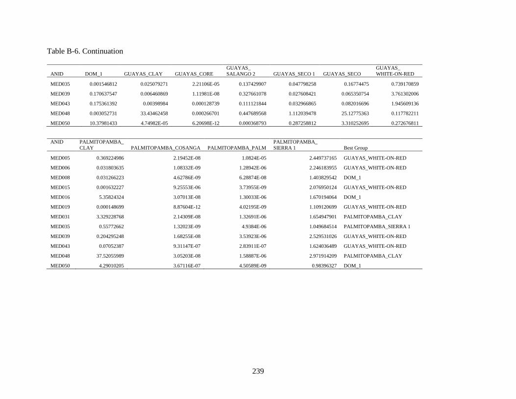
239
Table B-6. Continuation
ANID DOM_1 GUAYAS_CLAY GUAYAS_CORE
GUAYAS_
SALANGO 2 GUAYAS_SECO 1 GUAYAS_SECO
GUAYAS_
WHITE-ON-RED
MED035 0.001546812 0.025079271 2.21106E-05 0.137429907 0.047798258 0.16774475 0.739170859
MED039 0.170637547 0.006460869 1.11981E-08 0.327661078 0.027608421 0.065350754 3.761302006
MED043 0.175361392 0.00398984 0.000128739 0.111121844 0.032966865 0.082016696 1.945609136
MED048 0.003052731 33.43462458 0.000266701 0.447689568 1.112039478 25.12775363 0.117782211
MED050 10.37981433 4.74982E-05 6.20698E-12 0.000368793 0.287258812 3.310252695 0.272676811
ANID PALMITOPAMBA_
CLAY PALMITOPAMBA_COSANGA PALMITOPAMBA_PALM
PALMITOPAMBA_
SIERRA 1 Best Group
MED005 0.369224986 2.19452E-08 1.0824E-05 2.449737165 GUAYAS_WHITE-ON-RED
MED006 0.031803635 1.08332E-09 1.28942E-06 2.246183955 GUAYAS_WHITE-ON-RED
MED008 0.031266223 4.62786E-09 6.28874E-08 1.403829542 DOM_1
MED015 0.001632227 9.25553E-06 3.73955E-09 2.076950124 GUAYAS_WHITE-ON-RED
MED016 5.35824324 3.07013E-08 1.30033E-06 1.670194064 DOM_1
MED019 0.000148699 8.87604E-12 4.02195E-09 1.109120699 GUAYAS_WHITE-ON-RED
MED031 3.329228768 2.14309E-08 1.32691E-06 1.654947901 PALMITOPAMBA_CLAY
MED035 0.55772662 1.32023E-09 4.9384E-06 1.049684514 PALMITOPAMBA_SIERRA 1
MED039 0.204295248 1.68255E-08 3.53923E-06 2.529531026 GUAYAS_WHITE-ON-RED
MED043 0.07052387 9.31147E-07 2.83911E-07 1.624036489 GUAYAS_WHITE-ON-RED
MED048 37.52055989 3.05203E-08 1.58887E-06 2.971914209 PALMITOPAMBA_CLAY
MED050 4.29010205 3.67116E-07 4.50589E-09 0.98396327 DOM_1

240
Table B-7. Total Variation Matrix calculations for the combined datasets from Guayas (Neff 2000), Palmitopamba (Ferguson and
Glascock 2009) and Potrero Mendieta (Gilstrap 2017). The element contributing MOST to dataset variation is Chromium
(Cr) The element contributing LEAST to dataset variation is Samarium (Sm). Na Al K Ca Sc Ti Cr Mn Fe Co Zn As Rb Sr Zr
Na 0 0.242 0.363 0.167 0.327 0.32 0.725 0.372 0.243 0.326 0.316 0.729 0.573 0.203 0.375
Al 0.242 0 0.382 0.351 0.127 0.105 0.555 0.267 0.102 0.198 0.139 0.557 0.499 0.395 0.154 K 0.363 0.382 0 0.587 0.41 0.414 0.645 0.61 0.378 0.509 0.29 0.585 0.181 0.456 0.335
Ca 0.167 0.351 0.587 0 0.39 0.409 0.818 0.364 0.322 0.364 0.39 0.875 0.836 0.241 0.531
Sc 0.327 0.127 0.41 0.39 0 0.091 0.437 0.265 0.055 0.094 0.115 0.565 0.586 0.532 0.238
Ti 0.32 0.105 0.414 0.409 0.091 0 0.555 0.268 0.077 0.132 0.139 0.49 0.507 0.537 0.121
Cr 0.725 0.555 0.645 0.818 0.437 0.555 0 0.87 0.552 0.506 0.408 0.9 0.861 0.715 0.576
Mn 0.372 0.267 0.61 0.364 0.265 0.268 0.87 0 0.189 0.167 0.352 0.784 0.764 0.587 0.412 Fe 0.243 0.102 0.378 0.322 0.055 0.077 0.552 0.189 0 0.09 0.136 0.491 0.517 0.468 0.208
Co 0.326 0.198 0.509 0.364 0.094 0.132 0.506 0.167 0.09 0 0.196 0.647 0.679 0.529 0.292
Zn 0.316 0.139 0.29 0.39 0.115 0.139 0.408 0.352 0.136 0.196 0 0.59 0.401 0.398 0.186 As 0.729 0.557 0.585 0.875 0.565 0.49 0.9 0.784 0.491 0.647 0.59 0 0.607 0.983 0.502
Rb 0.573 0.499 0.181 0.836 0.586 0.507 0.861 0.764 0.517 0.679 0.401 0.607 0 0.725 0.351
Sr 0.203 0.395 0.456 0.241 0.532 0.537 0.715 0.587 0.468 0.529 0.398 0.983 0.725 0 0.574 Zr 0.375 0.154 0.335 0.531 0.238 0.121 0.576 0.412 0.208 0.292 0.186 0.502 0.351 0.574 0
Sb 0.852 0.602 0.503 1.041 0.594 0.478 0.797 0.912 0.572 0.703 0.539 0.257 0.41 1.058 0.41
Cs 0.766 0.533 0.398 1 0.675 0.557 1.025 0.893 0.611 0.809 0.475 0.59 0.12 0.919 0.404 Ba 0.431 0.318 0.293 0.588 0.424 0.397 0.674 0.592 0.402 0.519 0.343 0.632 0.51 0.419 0.393
La 0.527 0.271 0.354 0.703 0.406 0.28 0.678 0.547 0.367 0.445 0.231 0.667 0.265 0.613 0.161
Ce 0.532 0.254 0.388 0.706 0.393 0.265 0.695 0.49 0.348 0.412 0.237 0.667 0.305 0.633 0.154 Nd 0.445 0.219 0.343 0.585 0.307 0.219 0.627 0.425 0.276 0.334 0.179 0.656 0.313 0.552 0.141
Sm 0.372 0.165 0.319 0.495 0.202 0.138 0.567 0.343 0.19 0.233 0.124 0.58 0.33 0.51 0.111 Eu 0.29 0.125 0.354 0.373 0.158 0.113 0.557 0.267 0.145 0.162 0.112 0.622 0.428 0.41 0.134
Tb 0.401 0.227 0.379 0.495 0.155 0.16 0.527 0.377 0.195 0.209 0.143 0.645 0.46 0.561 0.208
Dy 0.411 0.234 0.348 0.522 0.161 0.133 0.542 0.368 0.187 0.203 0.149 0.541 0.394 0.6 0.161 Yb 0.42 0.242 0.328 0.541 0.153 0.147 0.566 0.36 0.181 0.206 0.153 0.558 0.366 0.625 0.169
Lu 0.41 0.224 0.298 0.54 0.139 0.133 0.534 0.377 0.168 0.21 0.14 0.513 0.346 0.61 0.146
Hf 0.35 0.122 0.322 0.522 0.232 0.109 0.57 0.388 0.193 0.288 0.18 0.474 0.336 0.547 0.033 Ta 0.595 0.276 0.43 0.789 0.412 0.228 0.814 0.577 0.357 0.478 0.295 0.595 0.322 0.791 0.134
Th 0.808 0.435 0.489 1.053 0.659 0.459 0.909 0.843 0.591 0.759 0.464 0.642 0.3 0.948 0.256
U 0.634 0.273 0.423 0.808 0.464 0.347 0.71 0.708 0.43 0.595 0.293 0.653 0.37 0.718 0.195
τ.ι 13.526 8.593 12.116 7.405 9.767 8.328 19.917 14.738 9.041 11.293 8.112 18.597 13.663 17.854 8.066 vt/ τ.ι 0.427 0.672 0.477 0.332 0.592 0.694 0.29 0.392 0.639 0.512 0.712 0.311 0.423 0.324 0.716
r.vτ 0.38 0.845 0.535 0.268 0.731 0.891 0.307 0.603 0.744 0.656 0.902 0.158 0.418 0.19 0.942

241
Table B-7. Continued
Sb Cs Ba La Ce Nd Sm Eu Tb Dy Yb Lu Hf Ta Th U
Na 0.852 0.766 0.431 0.527 0.532 0.445 0.372 0.29 0.401 0.411 0.42 0.41 0.35 0.595 0.808 0.634
Al 0.602 0.533 0.318 0.271 0.254 0.219 0.165 0.125 0.227 0.234 0.242 0.224 0.122 0.276 0.435 0.273 K 0.503 0.398 0.293 0.354 0.388 0.343 0.319 0.354 0.379 0.348 0.328 0.298 0.322 0.43 0.489 0.423
Ca 1.041 1 0.588 0.703 0.706 0.585 0.495 0.373 0.495 0.522 0.541 0.54 0.522 0.789 1.053 0.808
Sc 0.594 0.675 0.424 0.406 0.393 0.307 0.202 0.158 0.155 0.161 0.153 0.139 0.232 0.412 0.659 0.464 Ti 0.478 0.557 0.397 0.28 0.265 0.219 0.138 0.113 0.16 0.133 0.147 0.133 0.109 0.228 0.459 0.347
Cr 0.797 1.025 0.674 0.678 0.695 0.627 0.567 0.557 0.527 0.542 0.566 0.534 0.57 0.814 0.909 0.71
Mn 0.912 0.893 0.592 0.547 0.49 0.425 0.343 0.267 0.377 0.368 0.36 0.377 0.388 0.577 0.843 0.708 Fe 0.572 0.611 0.402 0.367 0.348 0.276 0.19 0.145 0.195 0.187 0.181 0.168 0.193 0.357 0.591 0.43
Co 0.703 0.809 0.519 0.445 0.412 0.334 0.233 0.162 0.209 0.203 0.206 0.21 0.288 0.478 0.759 0.595
Zn 0.539 0.475 0.343 0.231 0.237 0.179 0.124 0.112 0.143 0.149 0.153 0.14 0.18 0.295 0.464 0.293 As 0.257 0.59 0.632 0.667 0.667 0.656 0.58 0.622 0.645 0.541 0.558 0.513 0.474 0.595 0.642 0.653
Rb 0.41 0.12 0.51 0.265 0.305 0.313 0.33 0.428 0.46 0.394 0.366 0.346 0.336 0.322 0.3 0.37
Sr 1.058 0.919 0.419 0.613 0.633 0.552 0.51 0.41 0.561 0.6 0.625 0.61 0.547 0.791 0.948 0.718 Zr 0.41 0.404 0.393 0.161 0.154 0.141 0.111 0.134 0.208 0.161 0.169 0.146 0.033 0.134 0.256 0.195
Sb 0 0.363 0.627 0.485 0.502 0.525 0.485 0.584 0.565 0.467 0.468 0.422 0.388 0.43 0.423 0.517
Cs 0.363 0 0.635 0.312 0.355 0.386 0.41 0.524 0.552 0.49 0.468 0.44 0.382 0.342 0.273 0.37 Ba 0.627 0.635 0 0.441 0.449 0.424 0.401 0.399 0.475 0.47 0.484 0.437 0.347 0.48 0.556 0.48
La 0.485 0.312 0.441 0 0.023 0.04 0.067 0.136 0.225 0.179 0.195 0.194 0.152 0.111 0.144 0.164
Ce 0.502 0.355 0.449 0.023 0 0.049 0.067 0.131 0.23 0.183 0.201 0.199 0.138 0.099 0.141 0.167 Nd 0.525 0.386 0.424 0.04 0.049 0 0.031 0.074 0.155 0.119 0.134 0.138 0.136 0.146 0.232 0.204
Sm 0.485 0.41 0.401 0.067 0.067 0.031 0 0.025 0.087 0.051 0.064 0.071 0.108 0.149 0.28 0.218 Eu 0.584 0.524 0.399 0.136 0.131 0.074 0.025 0 0.086 0.066 0.082 0.093 0.133 0.23 0.414 0.288
Tb 0.565 0.552 0.475 0.225 0.23 0.155 0.087 0.086 0 0.068 0.075 0.081 0.204 0.292 0.483 0.375
Dy 0.467 0.49 0.47 0.179 0.183 0.119 0.051 0.066 0.068 0 0.028 0.034 0.169 0.242 0.421 0.343 Yb 0.468 0.468 0.484 0.195 0.201 0.134 0.064 0.082 0.075 0.028 0 0.017 0.178 0.254 0.435 0.346
Lu 0.422 0.44 0.437 0.194 0.199 0.138 0.071 0.093 0.081 0.034 0.017 0 0.154 0.235 0.405 0.305
Hf 0.388 0.382 0.347 0.152 0.138 0.136 0.108 0.133 0.204 0.169 0.178 0.154 0 0.111 0.221 0.194 Ta 0.43 0.342 0.48 0.111 0.099 0.146 0.149 0.23 0.292 0.242 0.254 0.235 0.111 0 0.099 0.174
Th 0.423 0.273 0.556 0.144 0.141 0.232 0.28 0.414 0.483 0.421 0.435 0.405 0.221 0.099 0 0.175
U 0.517 0.37 0.48 0.164 0.167 0.204 0.218 0.288 0.375 0.343 0.346 0.305 0.194 0.174 0.175 0
τ.ι 16.977 16.077 14.041 9.382 9.415 8.413 7.194 7.517 9.096 8.285 8.444 8.014 7.683 10.486 14.318 11.942
vt/ τ.ι 0.34 0.359 0.412 0.616 0.614 0.687 0.803 0.769 0.635 0.697 0.684 0.721 0.752 0.551 0.404 0.484
r.vτ 0.247 0.359 0.488 0.795 0.821 0.911 0.966 0.939 0.93 0.946 0.943 0.947 0.932 0.764 0.514 0.697
vτ 5.779

242
Figure B-1. Principal component biplot of first two components (56.7 % total variance) showing
clays and ceramic samples. Elemental loading vectors are shown and labeled.
Figure B-2. Bivariate plot comparing Manganese (Mn) and Chromium (Cr) concentrations
(ppm). Ellipses are drawn at the 90% confidence interval.

243
Figure B-3. Bivariate plot comparing Cesium (Cs) and Scandium (Sc) concentrations (ppm).
Ellipses are drawn at the 90% confidence interval.
Figure B-4. Principal component biplot of first two components (51.6 % total variance) showing
clays and ceramic samples from the three MURR datasets. Elemental loading vectors
are shown and labeled.

244
LIST OF REFERENCES
Adelaar, Willem F.H. with P.C. Muysken
2004 The Languages of the Andes. Cambridge University Press, Cambridge.
Aichenson, John
1986 The Statistical Analysis of Compositional Data. Monographs on Statistics and
Applied Probability. Chapman and Hall, New York.
Aldenderfer, Mark
1999 An archaeological perspective on the human use of cold montane environments in
Andean South America. Revista de Arqueología Americana:75-96.
Alvarado, Pío Jaramillo
1982 Historia de Loja y su provincia. H. Consejo Provincial de Loja, Departamento de
Relaciones Públicas, Loja.
Anda Aguirre, Alfonso
1960 Zaruma en la Colonia. Casa de la Cultura, Quito.
Arellano López, Jorge
1999 Primeras evidencias del Formativo Tardío en la sierra central del Ecuador. In
Formativo Sudamericano: Una Revaluación, edited by P. Ledergerber-Crespo, pp.
160-175. Abya-Yala, Quito.
Arias Dávila, Pedro
1582 Pacaibamba ó Leoquina. In Relaciones Geográficas de Indias, Tomo III, edited by M.
Jimenez de la Espada, pp. 177-181. Ministerio de Fomento, 1897, Madrid.
Arkush, Elizabeth
2008 War, chronology, and causality in the Titicaca Basin. Latin American Antiquity 19:
339-373.
Arkush, Elizabeth, and Charles Stanish
2005 Interpreting Conflict in the Ancient Andes: Implications for the Archaeology of
Warfare. Current Anthropology 46(1): 3-28.
Aspden, J. A., W. Bonilla, and P. Duque
1995 The El Oro metamorphic complex, Ecuador: geology and economic mineral deposits.
Overseas Geology and Mineral Resources No. 67. British Geological Survey,
Keyworth, Nottingham.
Athens, J. Stephen
1986 The Site of Pumpuentsa and the Pastaza Phase in Southestern Lowland Ecuador.
Ñawpa Pacha: Journal of Andean Archaeology 24: 111-24.

245
1995 Relaciones interregionales prehistóricas en el norte de los Andes: evidencia del sitio
La Chimba en el Ecuador septentrional. In Perspectivas Regionales en la Arqueología
del Suroccidente de Colombia y Norte del Ecuador, edited by C. Gnecco, pp. 3–29.
Editorial Universidad del Cauca, Popayán, Colombia.
Bacuilima, F.L., J. C. Bacuilima., and W. A. Bermeo
1999 Caracterización de clima por microcuencas en el Austro Ecuatoriano. Unpublished
Environmental Engineering Thesis, Facultad de Ingeniería, Universidad de Cuenca,
Cuenca.
Bandy, Matthew S.
2004 Trade and social power in the southern Titicaca Basin Formative. Archeological
Papers of the American Anthropological Association 14(1): 91-111.
Banning, E. B.
2011 So fair a house: Göbekli Tepe and the identification of temples in the Pre-Pottery
Neolithic of the Near East. Current Anthropology 52(5): 619–60.
Barreto, Cristiana Nunes Galvao de Barros
2008 Meios místicos de reprodução social: arte e estilo na ceramic funerária de Amazônia
Antiga. Unpublished Ph.D. dissertation, Museu de Arqueologia e Etnologia,
Universidade de São Paulo, São Paulo.
Baxter, Mike J.
1992 Archaeological Uses of the Biplot—A Neglected Technique? In Computer
Applications and Quantitative Methods in Archaeology, 1991, edited by G. Lock and
J. Moffett, pp. 141-148. BAR International Series. vol. S577. Tempvs Reparatvm,
Oxford.
1994 Exploratory Multivariate Analysis in Archaeology. Edinburgh University Press,
Edinburgh.
Baxter, Mike J. and Caitlin E. Buck
2000 Data Handling and Statistical Analysis. In Modern Analytical Methods in Art and
Archaeology, edited by E. Ciliberto and G. Spoto, pp. 681-746. John Wiley and Sons,
New York.
Beck, Margaret E.
2006 Linking Finished Ceramics to Raw Materials: Oxidized Color Groups for Lowland
Desert Clays. Kiva: The Journal of Southwestern Anthropology and History
72(1):93–118.
Beckwith, Laurie A.
1996 Late Formative Period Ceramics from Southwestern Ecuador. Ph.D. dissertation.
Department of Archaeology, University of Calgary, Calgary, Canada.

246
Bell, Catherine
1992 Ritual theory, ritual practice. Oxford University Press, Oxford.
Bennett, Wendell C.
1946 Excavations in the Cuenca Region, Ecuador. Yale University Publications in
Anthropology, No. 35. Yale University Press, New Haven.
Berenguer, José R.
2004 Caravanas, interacción y cambio en el desierto de Atacama. Museo Chileno de Arte
Precolombino, Santiago.
Binford, Lewis R.
1964 A consideration of archaeological research design. American Antiquity 29(4): 425-
441.
Bieber, A. M. J., D. W. Brooks, G. Harbottle and E. V. Sayre
1976 Application of Multivariate Techniques to Analytical Data on Aegean Ceramics.
Archaeometry 18:59-74.
Bird, Junius B.
1948 Preceramic cultures in Chicama and Viru. Memoirs of the Society for American
Archaeology 4:21-28.
Bischof, Henning, and Julio Viteri Gamboa
1972 Pre-Valdivia Occupations on the Southwest Coast of Ecuador. American Antiquity
37(4):548-551.
Bishop, Ronald L., and M. James Blackman
2002 Instrumental neutron activation analysis of archaeological ceramics: scale and
interpretation. Accounts of Chemical Research 35(8):603-610.
Bishop, Ronald L. and Hector Neff
1989 Compositional Data Analysis in Archaeology. In Archaeological Chemistry IV, edited
by R. O. Allen, pp. 576-586. Advances in Chemistry. vol. 220. American Chemical
Society, Washington, D.C.
Bishop, Ronald L., Robert L. Rands and George R. Holley
1982 Ceramic Compositional Analysis in Archaeological Perspective. Advances in
Archaeological Method and Theory 5:275-330.
Björck, Svante, and Barbara Wohlfarth
2001 14
C chronostratigraphic techniques in paleolimnology. In Tracking environmental
change using lake sediments.Vol. 1. Basin analysis, coring, and chronological
techniques, edited by W.M. Last and J.P. Smol, pp. 205–245. Kluwer Acad. Publ.,
Dordrecht, Holland.

247
Bossuyt, Bea, Gerd Dercon, Bert De Biévre, Felipe Cisneros, and Jozef Deckers
1997 Agro-ecological zoning of the Austro Ecuatoriano: diagnostic planning for nature
conservation and sustainable land use. The Land 1(3): 45– 63.
Bourdieu, Pierre
1977 Outline of a Theory of Practice. Cambridge University Press, Cambridge.
Boyd, Brian
2005 Some comments on archaeology and ritual. Neolithics 2/05:25-27.
Bradley, Richard
2000 An Archaeology of Natural Places. Routledge, London.
Braun, Robert
1982 Cerro Narrío reanalyzed: The Formative as seen from the Ecuadorian highlands. In
Primer Simposio de Correlaciones Antropológicas Andino-Mesoamericanas, edited
by J. G. Marcos and P. Norton, pp. 41–99. Espol, Guayaquil.
Bronk Ramsey, C.
2009 Bayesian analysis of radiocarbon dates. Radiocarbon, 51(1), 337-360.
Brück, Joanna
1999 Ritual and Rationality: Some Problems of interpretation in European Archaeology.
European Journal of Archaeology 2(3):313-344.
Bruhns, Karen Olsen
1989 Intercambio entre la Costa y la Sierra en el Formativo Tardío: Nuevas Evidencias del
Azuay. In Relaciones Interculturales en el Área Ecuatorial del Pacífico Durante la
Época Precolombina, edited by J. F. Bouchard and M. Guinea, pp. 57-74. British
Archaeological Reports, International Series 503, Oxford.
2003 Social and Cultural Development in the Ecuadorian Highlands and Eastern Lowlands
During the Formative. In Archaeology of Formative Ecuador, edited by J. S.
Raymond and R. L. Burger, pp. 125-176. Dumbarton Oaks Research Library and
Collection, Washington. D.C.
2007 Una serie de catastróficas desdichas. La curiosa historia de la arqueología del
Ecuador. In II Congreso Ecuatoriano de Antropología y Arqueología, Balance de la
última década: Aportes, Retos y nuevos temas, Tomo I, edited by F. García S., pp.
175-194. Abya-Yala, Quito.
2010 Patrones de asentamiento, rutas de comunicación y mercancías de intercambio a larga
distancia en el Formativo Tardío del Austro Ecuatoriano. Bulletin de l'Institut
Français d'Études Andines 39(3):683-696.
Bruhns, Karen Olsen, James H. Burton, and George R. Miller
1990 Excavations at Pirincay in the Paute Valley of Ecuador, 1985-1988. Antiquity 64:
221-233.

248
Buck, C. E., J. B. Kenworthy, C. D. Litton, and A. F. M. Smith
1991 Combining Archaeological and Radiocarbon Information: A Bayesian Approach to
Calibration. Antiquity 65: 808-821.
Buck, C. E., C. D. Litton, and A. F. M. Smith
1992 Calibration of Radiocarbon Results Pertaining to Related Archaeological Events.
Journal of Archaeological Science 19:497-512.
Buck, C. E., W. G. Cavanagh, and C. D. Litton
1996 Bayesian Approach to Interpreting Archaeological Data. John Wiley and Sons,
Chichester, England.
Burger, Richard L.
1984 The Prehistoric Occupation of Chavín de Huántar, Peru. University of California
Publications in Anthropology, Vol. 14. University of California Press, Berkeley.
1992 Chavín and the Origins of Andean Civilization. Thames and Hudson, London.
2008 Chavín de Huántar and Its Sphere of Influence. In Handbook of South American
Archaeology, edited by H. Silverman and W. Isbell, pp. 681-706. Springer, New
York.
Burleigh, Richard, Andrew Hewson, and Nigel Meeks
1977 British Museum Natural Radiocarbon Measurements IX. Radiocarbon 19(2):143-160.
Bushnell, Geoffrey Hext Sutherland
1951 The archaeology of the Santa Elena Peninsula in south-west Ecuador. Occasional
Papers of the Cambridge University Museum of Archaeology and Ethnology, No.1.
Cambridge University Press, Cambridge.
Buxeda i Garrigós, J.
1999 Alteration and Contamination of Archaeological Ceramics: The Perturbation
Problem. Journal of Archaeological Science 26:295-313.10
Buxeda i Garrigós, J, Cau Ontiveros, M. A. and V. Kilikoglou
2003 Chemical variability in Clays and Pottery from a Traditional Cooking Pot Village:
Testing Assumptions in Pereruela. Archaeometry 45:1-17.
Buxeda i Garrigós, J. and V. Kilikoglou
2003 Total Variation as a Measure of Variability in Chemical Datasets. In Patterns and
Process, a Festschrist in Honor of Dr. Edward V. Sayre, edited by L. Van Zelst. pp.
185-198. Smithsonian Center for Materials Research and Education, Washington
D.C.
Buxeda i Garrigós, J., Kilikoglou, V. and P. M. Day
2001 Chemical and Mineralogical Alteration of Ceramics from a Late Bronze Age Kiln at
Kommos, Crete: The Effect on the Formation of a Reference Group. Archaeometry
43:349-371.
249
Cadle, John E.
1991 Systematics of lizards of the genus Stenocercus (Iguania: Tropiduridae) from northern
Peru: new species and comments on relationships and distribution patterns.
Proceedings of the Academy of Natural Sciences of Philadelphia 143:1-96.
Caillavet, Chantal
1988 Los mecanismos económicos de una sociedad minera: intercambios y crédito, Loja:
1550–1630. Revista Ecuatoriana de Historia Económica 2(3):19–62.
2000 Los grupos étnicos pre-hispánicos del sur de Ecuador. In Étnias del Norte:
Etnohistoria e historia de Ecuador, edited by Chantal Caillavet. Abya-Yala, IFEA,
Quito.
Caldas, Francisco Jos , and Eduardo Posada
1912 Obras de Caldas. Imprenta Nacional, Bogot , Colombia.
Carmichael, Elizabeth
1981 Datación mediante el carbon 14 de muestras de carbón de sitios de ceramic fina
provenientes del altiplano del Ecuador. Revista de Antropología (Núcleo del Azuay
de la Casa de Cultura Ecuatoriana, Cuenca) 7 (November):176-177.
Carmichael, Elizabeth, Warwick Bray, and John Erickson
1979 Informe preliminar de las investigaciones arqueológicas en al área de Minas, Río
Jubones, Ecuador. Revista de Antropología (Núcleo del Azuay de la Casa de Cultura
Ecuatoriana, Cuenca) 6 (July):130-144.
Clapperton, Chalmers M.
1993 Quaternary geology and geomorphology of South America. Elsevier, Amsterdam.
Coleman, Simon, and John Elsner
1995 Pilgrimage: past and present in the world religions. Harvard University Press,
Cambridge, MA.
Collier, Donald and John V. Murra
1943 Survey and Excavations in Southern Ecuador. Anthropology Series 62. Field
Museum of Natural History, Chicago.
Colwell-Chanthaphonh, Chip, Thomas J. Ferguson, Dorothy Lippert, Randall H. McGuire,
George P. Nicholas, Joe E. Watkins, and Larry J. Zimmerman
2010 The premise and promise of indigenous archaeology. American Antiquity 75(2):228-
238.
Cordell, Ann S.
2017 Petrographic analysis of pottery and clay samples from Potrero Mendieta, Ecuador:
Explanation of Methods and Summary of Temper Categories. Report on file, Florida
Museum of Natural History.

250
Cordell, Ann S., Neill J. Wallis, and Gerald Kidder
2017 Comparative Clay Analysis and Curation for Archaeological Pottery
Studies. Advances in Archaeological Practice 5(1): 93-106.
Christensen, Ross Taylor
1956 An archaeological study of the Illescas-Jubones coast of northern Peru and southern
Ecuador. Unpublished Ph.D. dissertation, Department of Anthropology, University
of Arizona, Tucson.
Cruz, Felipe, and Olaf Holm
1982 Un informe muy preliminar: San Lorenzo del Mate, Provincia del Guayas.
Unpublished manuscript. Museo Antropológico del Banco Central del Ecuador,
Guayaquil, Ecuador.
Cummins, Tom
2003 Nature as culture‘s representation: a change of focus in Late Formative iconography.
In Archaeology of Formative Ecuador, edited by J. Scott Raymond and Richard L.
Burger, pp. 423–464. Dumbarton Oaks Research Library and Collection, Washington,
D.C.
Cunow, Heinrich
1896 La organización social del Imperio de los Incas, translated by Maria Woitscheck.
Editorial Peruana de Domingo Miranda, 1933, Lima.
Damp, Jonathan E.
1984 Architecture of the early Valdivia village. American Antiquity 49: 573–585.
1988 La Primera Ocupación Valdivia de Real Alto: Patrones Económicos, Arquitectónicos
e Ideológicos. Biblioteca Ecuatoriana de Arqueología, 3. Escuela Superior Politécnica
del Litoral, Guayaquil. Corporación Editora Nacional, Quito.
Damp, Jonathan E. and S. Patricia Vargas
1995 The many contexts of early Valdivia ceramics. In The Emergence of Pottery, edited
by W. K. Barnett, and J. W. Hoopes, pp. 157–168. Smithsonian Institution Press,
Washington, D.C.
DeBoer, Warren R., and Donald W. Lathrap
1979 The Making and Breaking of Shipibo-Conibo Ceramics. In Ethnoarchaeology:
Implications of Ethnography for Archaeology, edited by C. Kramer, pp. 102-138.
Columbia University Press, New York.
Denevan, William M.
2001 Cultivated Landscapes of Native Amazonia and the Andes. Oxford University Press,
Oxford.
Diamond, Jared
2005 Collapse: How societies choose to fail or succeed. Penguin, London.

251
Dietrich, Oliver, Manfred Heun, Jens Notroff, Klaus Schmidt, and Martin Zarnkow
2012 The Role of Cult and Feasting in the Emergence of Neolithic Communities. New
Evidence from Göbekli Tepe, South-Eastern Turkey. Antiquity 86(333):674-695.
Dillehay, Tom D.
1976 Competition and cooperation in a prehispanic multi-ethnic system in the Central
Andes. Unpublished Ph.D. diss., University of Texas, Austin.
1979 Pre-Hispanic resource sharing in the Central Andes. Science 204(6): 24-31.
2013 Economic Mobility, Exchange, and Order in the Andes. In Merchants, Markets, and
Exchange in the Pre-Columbian Andes, edited by K. Hirth and J. Pillsbury, pp. 283-
308. Dumbarton Oaks, Washington D.C.
Dobres, Marcia-Ann
1999 The social dynamics of technology: Practice, politics, and world views. Smithsonian
Institution Press, Washington D.C.
2000 Technology and social agency. Blackwell, London.
2010 Archaeologies of technology. Cambridge Journal of Economics 34:103–114.
Domínguez, Miriam E.
2015 We Are Not Looking For Gold: On Archaeology as Myth. Archaeology: Myths
within and without. Spec. Issue of the Archaeological Review from Cambridge
30(2): 43-55.
Drennan, Robert D.
2009 Statistics for Archeologists: A Commonsense Approach. Second Edition. Springer,
New York.
Engwall, Evan
1992 Archaeological Investigations of Chorrera Culture: Tabuchila Phase Ceramics from
Northern Manabí, Ecuador. Paper presented at the 57th Annual Meeting of the
Society for American Archaeology, Pittsburgh, Pennsylvania.
1995 The Tabuchila Phase: Late Formative Chorrera Culture in the Jama River Region,
Manabí, Ecuador. Paper presented at the 60th Annual Meeting of the Society for
American Archaeology, Minneapolis, Minnesota.
Estrada, Emilio
1956 Valdivia, un Sitio Arqueológico Formativo en la Provincia del Guayas, Ecuador.
Museo Arqueológico Víctor Emilio Estrada, Publicación No. 1, Guayaquil.
1957 Últimas Civilizaciones Pre-Históricas de la Cuenca del Río Guayas. Museo
Arqueológico Víctor Emilio Estrada, Publicación No. 4, Guayaquil.
1958 Las Culturas Pre-Clásicas, Formativas o Arcaicas del Ecuador. Museo Arqueológico
Víctor Emilio Estrada, Publicación No. 5, Guayaquil.
Estrada, Emilio, and Betty J. Meggers
1961 A Complex of Traits of Probable Transpacific Origin on the Coast of Ecuador.
American Anthropologist 63(5):913-939.

252
Estrada, Emilio, Betty J. Meggers, and Clifford Evans
1964 The Jambelí Culture of South Coastal Ecuador. Proceedings of the U.S. National
Museum, Smithsonian Institution 115: 483–558.
Evans, Clifford, and Betty J. Meggers
1957 Formative Period Cultures of the Guayas Basin, Coastal Ecuador. American Antiquity
22:235-247.
1961 Cronología relativa y absoluta en la costa del Ecuador. Cuadernos de Historia y
Arqueología, Año XI, Vol. I, No. 27. Guayaquil.
Ferguson, Jeffrey R., and Michael D. Glascock
2009 Instrumental Neutron Activation Analysis of Ceramics from Burials at Palmitopamba,
Ecuador). Final report. Report on file, Research Reactor Center, University of
Missouri, Columbia.
Ford, James A.
1969 A Comparison of Formative Cultures in the Americas: Diffusion or the Psychic Unity
of Man. Smithsonian Institution Press, Washington, D.C.
Franch, José Alcina
1978 Ingapirca: arquitectura y áreas de asentamiento. Revista española de antropología
americana: 127-146.
Fresco Gonz lez, Antonio
1984 r r r t r r r r tr
materiales. Comisi n del Castillo de Ingapirca, Consejo de Gobierno del Museo
Arqueol gico del Banco Central del Ecuador, Cuenca.
Galehouse, J.
1971 Point Counting. In Procedures in Sedimentary Petrology, edited by Robert E. Carver,
pp. 385-408. Wiley Interscience, New York.
Gansser, A.
1973 Facts and theories on the Andes. Geological Society of London Quarterly Journal
129: 93-131.
Garcilaso de la Vega, El Inca
1612 Royal Commentaries of the Incas and General History of Peru, translated and
edited by H. V. Livermore [1966]. University of Texas Press, Austin.
Gell, Alfred
1998 Art and agency: An anthropological theory. Oxford University Press, Oxford.

253
Gentry, A. H.
1982 Phytogeographic patterns as evidence for a Chocó refuge. In Biological
diversification in the tropics, edited by G. T. Prance, pp. 112-136. Columbia
University Press, New York.
Glascock, Michael D.
1992 Characterization of Archaeological Ceramics at MURR by Neutron Activation
Analysis and Multivariate Statistics. In Chemical Characterization of Ceramic Pastes
in Archaeology, edited by H. Neff, pp. 11-26. Prehistory Press, Madison, WI.
Glascock, Michael D. and Hector Neff
2003 Neutron Activation Analysis and Provenance Research in Archaeology. Measurement
Science and Technology 14:1516-1526.
Gibson, Jon L.
2000 The Ancient Mounds of Poverty Point: Place of Rings. University Press of Florida
Gainesville, Florida.
Giddens, Anthony
1984 The constitution of society: Outline of the theory of structuration. University of
California Press.
Gilstrap, William D.
2017 Compositional Analysis of Formative Period Ceramic and Geological Materials from
Potrero Mendieta in the Jubones River Basin, Southwester Ecuador, (ca. 4400 -300
BCE). Preliminary Ceramic Compositional Analysis, First Report. Report on file,
Research Reactor Center, University of Missouri, Columbia.
Gnecco, Cristóbal
2008 Modernity and Politics in Colombian Archaeology. In Handbook of South American
Archaeology, edited by H. Silverman and W. H. Isbell, pp. 1103-1114. Springer, New
York.
Goldstein, Paul
2005 Andean Diaspora: The Tiwanaku Colonies and the Origins of South American
Empire. University Press of Florida, Gainesville.
Gomis, Dominique
1999 La cerámica Formativa Tardía de la sierra austral del Ecuador. In Formativo
Sudamericano: Una Revaluación, edited by P. Lederberger-Crespo, pp.139-159.
Abya-Yala, Quito.
Gonz lez Su rez, Federico
1890-1903 Hist r r r. 7 volúmenes y Atlas. Imprenta
del Clero, Quito.

254
Graham, David J., and Nicholas G. Midgley
2000 Graphical Representation of Particle Shape using Triangular Diagrams: An Excel
Spreadsheet Method. Technical Communication in Earth Surface Processes and
Landforms 25:473–1477.
Grieder, Terence
1982 Origins of Pre-Columbian Art. University of Texas Press, Austin.
Grieder, Terence (editor)
2009 The art and archaeology of Challuabamba, Ecuador. University of Texas Press,
Austin.
Grieder, Terence, Alberto Bueno Mendoza, C. Earle Smith, Jr. and Robert M. Malina
1988 La Galgada, Peru: A Preceramic Culture in Transition. University of Texas Press,
Austin.
Guffroy, Jean
2008 Cultural Boundaries and Crossings: Ecuador and Peru. In Handbook of South
American Archaeology, edited by H. Silverman and W. H. Isbell, pp. 889-902.
Springer, New York.
Guffroy, Jean (editor)
1987 Loja Préhispanique, Recherches Archéologiques dans les Andes Méridionales de
’É t r. Éditions Recherche sur les Civilisations, ―Synthèse‖ No. 27, Paris.
Harbottle, Garman
1976 Activation Analysis in Archaeology. Radiochemistry 3(1):33-72.
Herrmann, Corey A.
2016 Ceramic analysis of the Tabuchila Complex of the Jama River Valley, Manabí,
Ecuador. M.A. Thesis. Department of Anthropology Colorado State University, Fort
Collins.
Hill, Betsy D.
1972–1974 A new chronology of the Valdivia ceramic complex from the coastal zone of
Guayas province, Ecuador. Ñawpa Pacha 10–12: 1–32.
Hocquenghem, Anne-Marie, Jaime Idrovo, Peter Kaulicke and Dominique Gomis
1993 Bases del intercambio entre las sociedades norperuanas y surecuatorianas: una zona
de transición entre 1500 A.C. y 600 D.C. Bulletin de L'Institut Francaise d' Études
Andines 22(2):443-466.
Idrovo Urigüen, Jaime
1999 El Formativo en la Sierra Ecuatoriana. In Formativo Sudamericano: Una
Revaluación, edited by P. Ledergerber-Crespo, pp. 114-123. Abya-Yala, Quito.

255
Ingold, Tim
2000 The perception of the environment: Essays on livelihood, dwelling and skill.
Routledge, London and New York.
2007 Materials against materiality. Archaeological Dialogues 14(1):1–16.
2012 Toward an ecology of materials. Annual Review of Anthropology 41:427–442.
Izumi, Seiichi and Kazuo Terada
1966 Andes 3: Excavations at Pechiche and Garbanzal, Tumbes Valley, Peru 1960.
Kadokawa, Tokyo.
James, William, Fredson Bowers, and Ignas K. Skrupskelis
1975 The meaning of truth. Vol. 2. Harvard University Press, Cambridge.
Jamieson, R.W., and Hancock, R. G. V.
2004 Neutron activation of colonial ceramics from Southern Highland Ecuador.
Archaeometry 46: 569–83.
Jamieson, R. W., R.G.V. Hancock, L. A. Beckwith and A. E. Piedruczny
2013 Neutron Activation Analysis of Inca and Colonial Ceramic from Central Highland
Ecuador. Archaeometry 55(2):198-213.
Jijón y Caamaño, Jacinto
1952 Antropología Prehispánica del Ecuador. La Prensa Católica, Quito.
Kennerley, John B.
1980 Outline of the geology of Ecuador. Overseas Geology and Mineral Resources 55.
Kidder, Tristram R.
2011 Transforming hunter-gatherer history at Poverty Point. In Hunter-Gatherer
Archaeology as Historical Process, edited by K.E. Sassaman, D.H. Holly, pp. 95–
119. University of Arizona Press, Tucson.
Kilikoglou, V., Grimanis, A. P., Tsolakidou, A., Hein, A., Malamidou, D. and Z. Tsirtsoni
2007 Neutron Activation Patterning of Archaeological Materials at the National center for
Scientific esearch ‗Demokritos‘: The Case of Black on red Neolithic Pottery from
Macedonia, Greece. Archaeometry 49:301-319.
Lane, Kris
2004 Unlucky strike: gold and labor in Zaruma, Ecuador, 1699–1820. Colonial Latin
American Review 13(1):65-84.
2002 Quito, 1599: City & colony in transition. University of New Mexico Press,
Albuquerque.
Lathrap, Donald W.
1970 The Upper Amazon. Praeger Publishers, New York.

256
1974 The Moist Tropics, the Arid Lands, and the Appearance of Great Art Styles in the
New World. In Art and Environment in Native America, edited by M. E. King and I.
R. Traylor, pp. 115-158. Museum of Texas Tech University, Lubbock.
1977 Our Father the Cayman, Our Mother the Gourd: Spinden Revisited, or a Unitary
Model for Emergence of Agriculture in the New World. In Origins of Agriculture,
edited by C. A. Reed, pp. 713-751. Mouton Publishers, Hague.
1985 Jaws: the control of power in the early nuclear American ceremonial center. In Early
Ceremonial Architecture in the Andes, edited by C. B. Donnan, pp. 241-267.
Dumbarton Oaks Research Collection and Library, Washington, D.C.
1987 The introduction of maize in prehistoric eastern North America: the view from
Amazonia and the Santa Elena Peninsula. In Emergent Horticultural Economies of
the Eastern Woodlands, edited by W. F. Keegan, pp. 345–371. Southern Illinois
University at Carbondale, Center for Archaeological Investigations, Occasional Paper
No. 7., Carbondale.
Lathrap, Donald W., Donald Collier, and Helen Chandra
1975 Ancient Ecuador: Culture, Clay and Creativity, 3000-300 B.C. Field Museum of
Natural History, Chicago.
Leese, M. N. and P. L. Main
1994 The Efficient Computation of Unbiased Mahalanobis Distances and their
Interpretation in Archaeometry. Archaeometry 36:307-316.
Lemonnier, Pierre
1992 Elements for an anthropology of technology. Anthropological Papers, Museum of
Anthropology, No. 88. University of Michigan, Ann Arbor.
Lippi, Ronald D.
1983 La Ponga and the Machalilla Phase of Coastal Ecuador. Unpublished Ph.D.
dissertation, Department of Anthropology, University of Wisconsin, Madison.
1998 Una exploración arqueológica del Pichincha Occidental, Ecuador. Museo Jacinto
Jijón y Caamaño de la Pontificia Universidad Católica del Ecuador, Consejo
Provincial de Pichincha, Quito.
2003 Appendix B: Formative Period chronology for the northern and central highlands of
Ecuador. In Archaeology of Formative Ecuador, edited by J. S. Raymond and R. L.
Burger, pp. 529–537. Dumbarton Oaks Research Library and Collection, Washington,
D.C.
2004 Tropical forest archaeology in Western Pichincha, Ecuador. Case Studies in
Archaeology, Thomson/Wadsworth, Belmont, California.
Little, Michael A.
1981 Human populations in the Andes: the human science basis for research
planning. Mountain Research and Development 145-170.

257
Litton, C. D., and M. N. Leese
1991 Some Statistical Problems Arising in Radiocarbon Calibration. In Computer
Applications and Quantitative Methods in Archaeology 1990, edited by K. Lockyear
and S. Rahtz, pp. 101-109. BAR International Series 565. British Archaeological
Reports, Oxford.
Longo, Rafael and John W. Baldock
1982 Geology of Ecuador. Explanatory Bulletin of the National Geological Map of the
Republic of Ecuador. 1:1,000,000. Ministerio de Recursos Naturales y Energéticos,
Quito, and Institute of Geological Sciences, Natural Environment Research Council,
London.
Lunniss, Richard M.
2001 Archaeology at Salango, Ecuador: An Engoroy Ceremonial Site on the South Coast
of Manabí. Ph.D. Dissertation, Institute of Archaeology, University of London.
Marcos, Jorge G.
1978 The Ceremonial Precinct at Real Alto: Organization of Time and Space in Valdivia
Society. Unpublished Ph.D. diss., University of Illinois, Urbana-Champaign.
1989 Proyecto San Lorenzo del Mate: Informe Arqueológico. Informe submitted to the
Instituto Nacional de Patrimonio Cultural, Guayaquil, Ecuador.
2003 A Reassessment of the Ecuadorian Formative. In Archaeology of Formative Ecuador,
edited by J. S. Raymond and R. L. Burger, pp. 7-32. Dumbarton Oaks Research
Library and Collection, Washington, D.C.
Masucci, Maria A.
1992 Ceramic Change in the Guangala Phase, Southwest Ecuador: A Typology and
Chronology. Ph.D. dissertation. Department of Anthropology, Southern Methodist
University, Dallas, TX.
2001 Defining ceramic change and cultural interaction: results of typological,
chronological, and technological analyses of Guangala Phase ceramics. Andean Past
6: 175–208.
2008 Early Regional Polities of Coastal Ecuador. In Handbook of South American
Archaeology, edited by H. Silverman and W. Isbell, pp. 489-503. Springer, New
York.
Masucci, Maria A. and Allison Macfarlane
1997 An Application of Geoloical Survey and Ceramic Petrology to Porvenance Studies of
Guangala Phase Ceramics of Ancient Ecuador. Geoarchaeology 12(7):765-793.
Masuda, Shōzō, Craig Morris, and Izumi Shimada
1985 Andean Ecology and Civilization: An Interdisciplinary Perspective on Andean
Ecological Complementarity. University of Tokyo Press, Tokyo.
Mauss, Marcel
1925 The Gift. W.W. Norton, 1966, New York.

258
Mayer, Enrique
2013 In the Realm of the Incas. In Merchants, Markets and Exchange in the Pre-
Columbian World, edited by K. Hirth and J. Pillsbury, pp. 309-317. Dumbarton Oaks,
Washington, D.C.
Meggers, Betty J.
1966 Ecuador. Praeger, New York.
1983 Explaining the Course of Human Events. In How Humans Adapt: A Biocultural
Odyssey, edited by D. J. Ortner, pp. 163-190. Smithsonian Institution
Press,Washington, DC.
1987 El origen transpacífico de la cerámica Valdivia: una revaluación. Boletín del Museo
Chileno de Arte Precolombino 2: 9-31.
1991 Cultural Evolution in Amazonia. In Profiles in Cultural Evolution: Papers from a
Conference in Honor of Elman R. Service, edited by A. T. Rambo and K. Gillogly,
pp. 191-216. Museum of Anthropology, University of Michigan, Ann Arbor.
1992 Jomon-Valdivia similarities: Convergence or contact? New England Antiquities
Research Association (NEARA) Journal 27 (Summer-Fall): 23-32.
1997 La cerámica temprana en América del Sur: Invención o difusión? Revista de
Arqueología Americana 13: 7-40.
2005 The subversive significance of transpacific contact. New England Antiquities
Research Association (NEARA) Journal 39 (2): 22–30.
Meggers, Betty J., and Clifford Evans
1962 The Machalilla Culture: An Early Formative Complex on the Ecuadorian Coast.
American Antiquity 28(2): 186-192.
Meggers, Betty J., Clifford Evans, and Emilio Estrada
1965 The Early Formative Period of Coastal Ecuador. Smithsonian Institution Press,
Washington, D.C.
Monge, Carlos
1948 Acclimatization in the Andes: historical confirmations of climatic aggression in the
development of Andean man. In Acclimatization in the Andes: historical
confirmations of climatic aggression in the development of Andean man. Blaine
Ethridge-Books.
Moore, Jerry D.
2008 El Periodo Intermedio Tardío en el Departamento de Tumbes. Revista del Museo de
Antropología, Arqueología e Historia, Universidad Nacional de Trujillo, Peru
10:155-175.
2010 Architecture, settlement, and formative developments in the equatorial andes: new
discoveries in the department of Tumbes, Peru." Latin American Antiquity 21 (2):
147-172.
2014 A prehistory of South America: Ancient cultural diversity on the least known
continent. University Press of Colorado, Boulder.

259
Moseley, Michael E.
1974 The maritime foundations of Andean civilization. Benjamin-Cummings Publishing
Company, San Francisco.
Murillo Carrión, Rodrigo
2011 Provincia de El Oro: Monumento Arqueológicos. Universidad Técnica de Machala,
Machala.
Murra, John V.
1956 The Economic Organization of the Inka State. Supplement 1 Research in
Economic Anthropology. JAT Press, 1980, Greenwich, CT.
1972 El Control Vertical de Un Máximo de Pisos Ecológicos en la Economía de las
Sociedades Andinas. In Formaciones Económicas y Políticas del Mundo Andino,
edited by J. V. Murra, pp. 59-115. Instituto de Estudios Peruanos, 1975, Lima.
1981 Discussion of Reciprocity and the Inca State: From Karl Polanyi to John V. Murra, by
N. Wachtel. 4:51-54.
1985 ―El Archipi lago Vertical‖ evisited. In Andean Ecology and Civilization: An
Interdisciplinary Perspective on Andean Ecological Complementarity, edited by S.
Masuda, C. Morris, and I. Shimada, pp. 3-14. University of Tokyo Press, Tokyo.
Naylor, J. C., and A. F. M. Smith
1988 An Archaeological Inference Problem. Journal of the American Statistical
Association 83:588-595.
Neff, Hector
1994 RQ-mode Principal Component Analysis of Ceramic Compositional Data.
Archaeometry 36:115-130.
2000a Instrumental Neutron Activation Analysis of Ceramics from Loma de los Cangrejitos,
Ecuador). Report on file, Research Reactor Center, University of Missouri, Columbia.
2000b Neutron Activation Analysis for Provenance Determination in Archaeology. In
Modern Analytical Methods in Art and Archaeology, edited by E. Ciliberto and G.
Spoto, pp. 81-134. John Wiley and Sons, New York.
2002 Quantitative Techniques for Analyzing Ceramic Compositional Data. In Ceramic
Source Determination in the Greater Southwest, edited by D. M. Glowacki and H.
Neff. Monograph 44. Cotsen Institute of Archaeology, Los Angeles.
Neff, Hector, Ronald L. Bishop, and Edward V. Sayre
1988 A Simulation Approach to the Problem of Tempering in Compositional Studies of
Archaeological Ceramics. Journal of Archaeological Science 15: 159-172.
1989 More Observations on the Problem of Tempering in Compositional Studies of
Archaeological Ceramics. Journal of Archaeological Science 16: 57-69.
Ogburn, Dennis Edward
2001 The Inca Occupation and Forced Resettlement in Saraguro, Ecuador. Ph.D.
Dissertation, University of California, Santa Barbara.

260
Olivera Nuñez, Quirino
1998 Evidencias Arqueológicas del Período Formativo en la Cuenca Baja de Río
Utcubamba y Chinchipe. Perspectivas regionales del período formativo en el Perú.
Boletín de Arqueología PUCP 2: 105-112.
2014 Arqueología Alto Amazónica: Los Orígenes de la Civilización en el Perú. Apus
Graph Ediciones, Lima.
Ontaneda, Santiago and Gustavo Espíndola
2003 El uso de la coca en el antiguo Ecuador. Ediciones del Banco Central del Ecuador,
Quito.
Ortega Toledo, Berónica C. and Angel P. Barros Duchi
2011 Estudio Antropológico y Etnográfico de la Virgen de El Cisne: Sus Romerías,
Significados y Repercusiones. Unpublished Licenciatura thesis, Facultad de Filosofía,
Letras y Ciencias de la Educación, Escuela de Historia y Geografía, Universidad de
Cuenca, Cuenca.
Orton, Clive, and Mike Hughes
2013 Pottery in archaeology. Cambridge University Press, Cambridge.
Osborne, James F. (editor)
2014 Monuments and Monumentality. SUNY Series, The Institute for European and
Mediterranean Archaeology Distinguished Monograph Series, Albany.
Owen, Bruce D.
2005 Distant colonies and explosive collapse: The two stages of the Tiwanaku diaspora in
the Osmore drainage. Latin American Antiquity (16): 45-80.
Ownby, Mary F., Deborah L. Huntley, and Matthew A. Peeples
2014 A Combined Approach: Using NAA and Petrography to Examine Ceramic
Production and Exchange in the American Southwest. Journal of Archaeological
Science 52:152-162.
Oyuela-Caycedo, Augusto, Peter Stahl, and J. Scott Raymond
2010 Cerro Narrío y Max Uhle arqueólogo como agente del desarrollo de la arqueología
ecuatoriana. In Max Uhle (1856-1944): Evaluaciones de sus investigaciones y obras,
edited by P. Kaulicke, M. Fischer, G. Wolff and P. Masson, pp. 359-377. Fondo
Editorial de la Pontificia Universidad Católica del Perú, Lima.
Patterson, Bruce D., Victor Pacheco, and Mary V. Ashley
1992 On the origins of the western slope region of endemism: systematics of fig-eating
bats, genus Artibeus. In Biogeografía, ecología y conservación del bosque montano
en el Perú. Memorias del Museo de Historia Natural, Universidad Nacional Mayor
de San Marcos 21, edited by K. R. Young and N. Valencia, pp. 189-205, Lima.

261
Pauketat, Timothy R.
2013 An archaeology of the cosmos: rethinking agency and religion in ancient America.
Routledge, London.
Paulsen, Allison C.
1974 The Thorny Oyster and the Voice of God: Spondylus and Stombus in Andean
prehistory. American Antiquity 39: 597–607.
1970 A Chronology of Guangala and Libertad Ceramics of the Santa Elena Peninsula in
South Coastal Ecuador. Ph.D. Dissertation, Columbia University, New York.
Pearsall, Deborah M.
2003 Plant food resources of the Ecuadorian Formative: an overview and comparison to the
Central Andes. In Archaeology of Formative Ecuador, edited by J. S. Raymond and
R. L. Burger, pp. 213–257. Dumbarton Oaks Research Library and Collection,
Washington, DC.
2004 Plants and People in Ancient Ecuador: The Ethnobotany of the Jama River Valley.
Wadsworth/Thomsen Learning, Belmont, CA.
Pearsall, Deborah M. and James A. Zeidler
1994 Regional environment, cultural chronology, and prehistoric subsistence in northern
Manabí. In Regional Archaeology in Northern Manabí, Ecuador, Volume 1:
Environment, Cultural Chronology, and Prehistoric Subsistence in the Jama River
Valley, edited by J. A. Zeidler and D. M. Pearsall, pp. 200–215. University of
Pittsburgh Memoirs in Latin American Archaeology, No. 8. University of Pittsburgh,
Pittsburgh and Ediciones Libri Mundi, Quito.
Pearsall, Deborah M., Neil A. Duncan, John G. Jones, Dorothy E. Friedel, Cesar I. Veintimilla,
and Hector Neff.
2016 Human–environment interactions during the early mid-Holocene in coastal Ecuador
as revealed by mangrove coring in Santa Elena Province. The Holocene 26, no. 8
(2016): 1262-1289.
Perry, Linda, Ruth Dickau, Sonia Zarrillo, Irene Holst, Deborah M. Pearsall, Dolores R. Piperno,
Mary Jane Berman, Richard G. Cooke, Kurt Rademaker, Anthony J. Ranere, J. Scott Raymond,
Daniel H. Sandweiss, Franz Scaramelli, Kay Tarble and James A. Zeidler
2007 Starch fossils and the domestication and dispersal of chili peppers (Capsicum spp. L.)
in the Americas. Science 315 (5814): 986-988.
Polanyi, Karl
1944 The Great Transformation. Rinehart, 1968, New York.
Politis, Gustavo G.
1999 Introduction, Latin American Archaeology: An inside view. In Archaeology in Latin
America, edited by B. Alberti and G. G. Politis. Routledge, New York.

262
Pourrut, Pierre
2005 El Agua En El Ecuador: Clima, precipitaciones, escorrentía. Estudios de Geografía,
Vol. 7. Corporación Editora Nacional, Quito.
Porras G., Pedro I.
1977 Fase Alausí. In Estudios Arqueologicos: Ecuador, Antillas, y Tierras Bajas de Sud
America, edited by P. I. Porras, pp. 89–159. Pontificia Universidad Católica del
Ecuador, Centro de Publicaciones, Quito.
1978 Arqueología de la Cueva de los Tayos. Centro de Publicaciones, Pontificia
Universidad Católica del Ecuador, Quito.
Pozorski, Shelia and Thomas Pozorski
2008 Early Cultural Complexity on the Coast of Peru. In Handbook of South American
Archaeology, edited by H. Silverman and W. Isbell, pp. 607-632. Springer, New
York.
Ramos, Alcida Rita
2012 The politics of perspectivism. Annual Review of Anthropology 41: 481-494.
Raymond, J. Scott
1998 Beginnings of Sedentism in the Lowlands of North Western South America. In
Advances in the Archaeology of the Northern Andes, edited by A. Oyuela-Caycedo
and J. S. Raymond, pp. 10-19. Institute of Archaeology Monograph Vol. 39.
University of California, Los Angeles.
2003 Social Formations in the Western Lowlands of Ecuador During the Early Formative.
In The Archaeology of Formative Ecuador, edited by J. S. Raymond and R. L.
Burger, pp. 33-67. Dumbarton Oaks, Washington, D.C.
Raymond, J. Scott, and Burger, Richard L.
2003 Introduction. In The Archaeology of Formative Ecuador, edited by J. S. Raymond and
R. L. Burger, pp. 1-6. Dumbarton Oaks Research Library and Collection,
Washington, D.C.
Raymond, J. Scott and Florencio Delgado
2008 Rescuing Cerro Narrío, Cañar Province, Ecuador: Report on Investigations at Cerro
Narrío, Ecuador July 1 to August 15, 2008. Project Grant Report to Dumbarton Oaks,
Washington, D.C.
Raymond, J. Scott, Jorge G. Marcos, and Donald. W. Lathrap
1980 Evidence of Early Formative Settlement in the Guayas Basin, Ecuador. Current
Anthropology 21(5):700-701.
Rehren, Thilo and Matilde Temme
1994 Pre-Columbian gold processing at Putushío, South Ecuador: the archaeometallurgical
evidence. In Archaeometry of Pre-Columbian Sites and Artifacts, edited by D. A.
Scott and P. Meyers, pp. 267–284. Getty Conservation Institute, Malibu.

263
Reimer, P.J., Bard, E., Bayliss, A., Beck, J.W., Blackwell, P.G., Ramsey, C.B., Buck, C.E.,
Cheng, H., Edwards, R.L., Friedrich, M., Grootes, P.M., Guilderson, T.P., Haflidason, H.,
Hajdas, I., Hatté, C., Heaton, T.J., Hoffmann, D.L., Hogg, A.G., Hughen, K.A., Kaiser, K.F.,
Kromer, B., Manning, S.W., Niu, M., Reimer, R.W., Richards, D.A., Scott, E.M., Southon, J.R.,
Staff, R.A., Turney, C.S.M., Plicht, J.
2013 IntCal13 and Marine13 radiocarbon age calibration curves 0–50,000 years cal BP.
Radiocarbon 55, 1869–1887.
Reitz, Elizabeth J., Susan D. deFrance, Daniel H. Sandweiss, and Heather E. McInnis
2015 Flexibility in Southern Peru Coastal Economies: A Vertebrate Perspective on the
Terminal Pleistocene/Holocene Transition. The Journal of Island and Coastal
Archaeology 10(2):155-183.
Rice, Prudence M.
1987 Pottery Analysis: A Sourcebook. University of Chicago Press, Chicago.
2015 Pottery Analysis: A Sourcebook, Second Edition. University of Chicago Press,
Chicago.
Rodbell, Donald T., Stefan Bagnato, Jeffrey C. Nebolini, Geoffrey O. Seltzer, and Mark B.
Abbott
2002 A Late Glacial-Holocene Tephrachronology for Glacial Lakes in Southern Ecuador.
Quaternary Research 57: 343-354.
Roosevelt, Anna C.
1991 Moundbuilders of the Amazon: Geophysical Archaeology on Marajó Island, Brazil.
Academic Press, Cambridge, Massachusetts.
Rowe, Sarah M.
2014 Community and Memory at the Late Valdivia Site of Buen Suceso, Ecuador.
Unpublished Ph.D. dissertation, Department of Anthropology, University of Illinois
at Urbana-Champaign, Urbana.
Salberg, D. J., Michael D. Glascock and Jeffrey R. Ferguson
2010 Instrumental Neutron Activation An analysis of Ceramics from the Han River region
of South Korea (Unpublished report). Missouri University Research Reactor.
Salomon, Frank
1978 Pochteca and mindalá: a comparison of long-distance traders in Ecuador and
Mesoamerica. Journal of the Steward Anthropological Society 9 (1-2): 231-247.
1985 Potential of Complementarity Concept. In Andean Ecology and Civilization: An
Interdisciplinary Perspective on Andean Ecological Complementarity, edited by S.
Masuda, C. Morris, and I. Shimada, pp. 511-531. University of Tokyo Press, Tokyo.
1986 Native Lords of Quito in the Age of the Incas: The Political Economy of North-
Andean Chiefdoms. Cambridge University Press, Cambridge and New York.
1987 Ancestors, Grave obbers, and the Possible Antecedents of Cañari ―Inca-ism‖.
Etnologiska Studier 38:207-232.

264
1991 Introduction. In The Huarochirí Manuscript: A testament of Ancient and
Colonial Andean Religion, edited by F. Salomon and J. Urioste. University of
Texas Press, Austin.
Sandweiss, Daniel H.
1996 Environmental change and its consequences for human society on the Central Andean
Coast: a malacological perspective. Case studies in environmental
archaeology (1996): 127-146.
Sandweiss, Daniel H., James B. Richardson III, Elizabeth J. Reitz, H. B. Rollins, and K. A.
Maasch
1996 Geoarchaeological Evidence from Peru for a 5,000 Years B. P. Onset of El Niño.
Science 273: 1531-1533.
Sassaman, Kenneth E.
2005 Poverty Point as Structure, Event, Process. Journal of Archaeological Method and
Theory 12:335-64.
2011 History and Alterity in the Eastern Archaic. In Hunter-Gatherer Archaeology as
Historical Process, edited by K. E. Sassaman and D. Holly, pp. 187-208. University
of Arizona Press, Tucson.
2012 Futurologists look back. Archaeologies 8, no. 3: 250-268.
Sayre, Edward V.
1975 Brookhaven Procedures for Statistical Analyses of Multivariate Archaeometric Data.
Brookhaven National Laboratory Report BNL-23128.
Schmidt, Klaus
2000 Göbekli Tepe, Southeastern Turkey: A Preliminary Report on the 1995-1999
Excavations. Paléorient: 45-54.
Schwarz, Frederick A. and J. Scott Raymond
1996 Formative settlement patterns in the Valdivia Valley, southwest coastal Ecuador.
Journal of Field Archaeology 23 (2): 205–224.
Shady, Ruth
1971 Bagua, Una Secuencia del Período Formativo en la Cuenca inferior de Utcubamba.
Unpublished Bachiller thesis, Universidad Nacional de San Marcos, Lima.
1987 Tradición y cambio en las sociedades Formativas de Bagua. Revista Andina 5:457-
487.
1999 Sociedades Formartivas de Bagua-Jaén y sus relaciones Andinas y Amazónicas. In
Formativo Sudamericano: Una Revaluación, edited by P. Ledergerber-Crespo, pp.
203-213. Abya-Yala, Quito.
Shady, Ruth and Hermilio Rosas La Noire
1979 El Complejo Bagua y el Sistema de Establecimientos durante el Formativo en la
Sierra Norte de Perú. Ñaupa Pacha 17:109:142.

265
Shepard, Anna O.
1976 Ceramics for the Archaeologist. Carnegie Institution of Washington Publication, Vol.
609. Washington, D.C.
Sillitoe, Richard H.
1974 Tectonic segmentation of the Andes: Implications for magmatism and metallogeny.
Nature 250: 542-545.
Speakman, R. J. and Michael D. Glascock
2003 Instrumental Neutron Activation Analysis of Ceramics and Clays for the
Palmitopamba Archaeology Project. Report on File at MURR.
Spinden, Herbert J.
1917 The origin and distribution of agriculture in America. Proceedings of the XIX
International Congress of Americanists, pp. 269–276. Washington, D.C.
1928 Ancient Civilizations of Mexico and Central America. American Museum of Natural
History Handbook Series, No. 3., New York.
Stahl, Peter W.
1985 The Hallucinogenic Basis of Early Valdivia Phase Ceramic Bowl Iconography.
Journal of Psychoactive Drugs 17(2):105-123.
1986 Hallucinatory Imagery and the Origin of Early South American Figurine Art. World
Archaeology 18(1):134-150.
2003 The Zooarchaeological Record from Formative Ecuador. In Archaeology of
Formative Ecuador, edited by J. S. Raymond and R. L. Burger, pp. 175-221.
Dumbarton Oaks Research Library and Collection, Washington D.C.
2005 Selective faunal provisioning in the southern highlands of formative Ecuador. Latin
American Antiquity 16(3):313-328.
Staller, John E.
1994 Late Valdivia Occupation in Southern Coastal El Oro Province, Ecuador: Excavations
at the Early Formative Period (3500-1500 B.C.) Site of La Emerenciana. Unpublished
Ph.D. diss., Department of Anthropology, Southern Methodist University, Dallas.
2000 Political and Prehistoric Frontiers: How History Influences Our Understanding of the
Past. In The Entangled Past: Integrating History and Archaeology, Proceedings of
the 30th Annual Chacmool Archaeological Conference, edited by M. Boyd, J. Erwin,
and M. Hendrickson, pp. 242-257. Calgary.
2001a The Jelí Phase Complex at La Emerenciana, a Late Valdivia Site in Southern El Oro
Province, Ecuador. Andean Past 6:117-174.
2001b Reassessing the developmental and chronological relationships of the Formative of
coastal Ecuador. Journal of World Prehistory 15 (2): 193–256.
2007 Un revaluación del papel de la ideología en el intercambio temprano a larga distancia
en los orígenes de la civilización andina. In II Congreso Ecuatoriano de Antropología
y Arqueología, Balance de la última década: Aportes, Retos y nuevos temas, Tomo I,
edited by F. García S., pp. 511-548. Abya-Yala, Quito.

266
Stanish, Charles, and Lawrence Coben
2013 Barter markets in the pre-hispanic Andes. In Merchants, Markets, and Exchange in
the Pre-Columbian Andes, edited by K. Hirth and J. Pillsbury, pp. 419-434.
Dumbarton Oaks, Washington D.C.
Stark, Miriam T.
1998 Technical Choices and Social Boundaries in Material Culture Patterning: An
Introduction. In The Archaeology of Social Boundaries, edited by M.T. Stark, pp.1-
11. Smithsonian Institution Press, Washington, D.C.
Stark, Miriam T., Jeffrey J. Clark, and Mark D. Elson
1995 Social Boundaries and Cultural Identity in the Tonto Basin. In The Roosevelt
Community Development Study: New Perspectives on Tonto Basin Prehistory,
Anthropological Papers 15, edited by M.D. Elson, M.T. Stark, and D.A. Gregory, pp.
343–368. Center for Desert Archaeology, Tucson.
Steponaitis, Vincas, M. James Blackman and Hector Neff
1996 Large-scale Compositional Patterns in the Chemical Composition of Mississippian
Pottery. American Antiquity 61(3):555-572.
Steward, Julian H. (editor)
1946 Handbook of South American Indians. Bureau of American Ethnology, Smithsonian
Institution, Washington, D.C.
Steward, Julian H., and Louis C. Faron
1959 Farm villages of the Tropical Forests: general features. In Native Peoples of South
America, edited by J H. Steward and L. C. Faron, pp. 284-318. McGraw-Hill, New
York.
Stoltman, B. James
1989 A Quantitative Approach to the Petrographic Analysis of Ceramic Thin Sections.
American Antiquity 54(1):147-160.
1991 Ceramic Petrography as a Technique for Documenting Cultural Interaction: An
Example from the Upper Mississippi Valley. American Antiquity 56 (1):103-120.
2001 The Role of Petrography in the Study of Archaeological Ceramics. In Earth Sciences
and Archaeology, edited by Paul Goldberg, Vance T. Holiday, and C. Reid Ferring,
pp.297-326. Kluwer Academic/Plenum Publishers.
Stoner, Wesley D., Christopher A. Pool, Hector Neff, and Michael D. Glascock
2008 Exchange of Coarse Orange Pottery in the Middle Classic Tuxtla Mountains,
Southern Veracruz, Mexico. Journal of Archaeological Science 35(5): 1412-1426.
Stothert, Karen E.
2003 Expression of Ideology in the Formative Period of Ecuador. In Archaeology of
Formative Ecuador, edited by J. S. Raymond and R. L. Burger, pp. 337-421.
Dumbarton Oaks Research Library and Collection, Washington, D.C.

267
Stothert, Karen E., Dolores R. Piperno, and Thomas C. Andres
2003 Terminal Pleistocene/early Holocene human adaptation in coastal Ecuador: the Las
Vegas evidence. Quaternary International 109: 23-43.
St bel, Alphons, Wilhem eiss, E. B. Kopper, and Max Uhle
1889 t r tr r r r. Tomes I and II. Verlag von A. Asher
& Co., Berlin.
Tantale n, Henry
2014 Peruvian Archaeology: A Critical History. Translated by Charles Stanish. Left Coast
Press, Walnut Creek, CA.
Tellenbach, Michael
1998 Acerca de las investigaciones de Max Uhle sobre las culturas tempranas de
Surecuador. Indiana 15:269-353.
Tello, Julio César
1942 Origen y Desarrollo de las Civilizaciones Prehistóricas. Actas del XXVII Congreso de
Americanistas (1939). Librería e Imprenta Gil, Lima.
1960 Chavín: Cultural matriz de la civilización andina. Archivo Julio C. Tello, UNMSM,
Lima.
Temme, Mathilde
1999 El Formativo en Putushío – sierra sur del Ecuador. In Formativo Sudamericano: Una
Revaluación, edited by P. Ledergerber-Crespo, pp. 124–138. Abya-Yala, Quito.
Tōkyō, Daigaku, Seiichi Izumi, and Toshihiko Sono
1963 Andes 2 excavations at Kotosh, Peru, 1960. Kadokawa Pub. Co., Tokyo.
Topic, John R., and Theresa L. Topic
1983 Coast-highland relations in northern Peru: some observations on routes, networks,
and scales of interaction. In Civilization in the Ancient Americas: Essays in Honor of
Gordon R. Willey, edited by Richard Leventhal and Alan L. Kolata, pp. 237-260.
University of New Mexico Press, Albuquerque.
1985 Coast-highland relations in northern Peru: The Structure and Strategy of Interaction.
In Status, Structure, and Stratification: Current Archaeological Reconstructions;
Proceedings of the Sixteenth Annual Conference, edited by Mark Thompson, María
Teresa García, and François J. Kense, pp. 55-66. University of Calgary
Archaeological Association, Calgary.
Trigger, Bruce G.
2006 A History of Archaeological Thought. Cambridge University Press, Cambridge.

268
Ubelaker, Douglas H.
2003 Health issues in the Early Formative of Ecuador: skeletal biology of Real Alto. In
Archaeology of Formative Ecuador, edited by J. S. Raymond and R. L. Burger, pp.
259–287. Dumbarton Oaks Research Library and Collection, Washington, D.C.
Uhle, Max
1922a Influencias Mayas en el Alto Ecuador. In Boletín de la Academia Nacional de
Historia, vol. 5, Nos. 10-11:205-240. Imprenta de la Universidad Central, Quito.
1922b Sepulturas ricas de oro en la provinzia del Azuay. In Boletín de la Academia
Nacional de Historia,vol. 4, No. 9:108-114. Imprenta de la Universidad Central,
Quito.
1922c The excavations at Cañar. The Panamerican Magazine, vol 34, No. 4. London.
1922d Las Huacas de Cañar. Journal de la Societé des Americanistes de Paris, vol. 14: 242-
244. Paris.
1936 Las antiguas civilizaciones del Ecuador y Perú. In Boletín de la Academia Nacional
de Historia, vol. 13, Nos. 36-39.
Valdez, Francisco
2007 Un formative insospechado en la ceja de selva: el complejo cultural Mayo Chinchipe.
In II Congreso Ecuatoriano de Antropología y Arqueología, Balance de la última
década: Aportes, Retos y nuevos temas, Tomo I, edited by F. García S., pp. 549-576.
Abya-Yala, Quito.
2008 Inter-Zonal Relationships in Ecuador. In Handbook of South American Archaeology,
edited by H. Silverman and W. H. Isbell, pp. 865-888. Springer, New York.
2013 Primeras Sociedades de la Alta Amazonia: La Cultura Mayo Chinchipe-Marañón.
Institut de Recherche pour le Développement - IRD, Quito.
Valdez, Francisco, Jean Guffroy, Geoffrey de Saulieu, Julio Hurtado, and Alexandra
Yépez
2005 D couverte d‘un site c r moniel formatif sur le versant oriental des Andes. Comptes
endus de l‘Academie des Sciences de l‘Institut de France. Paleovol 4:369-374.
Vanacker, Veerle, Gerard Govers, Jean Poesen, Jozef Deckers, Gerd Dercon, and George
Loaiza
2003 The impact of environmental change on the intensity and spatial pattern of water
erosion in a semi-arid mountainous Andean environment. Catena 51: 329- 347.
Van Buren, Mary
1996 Rethinking the vertical archipelago: ethnicity, exchange, and history in the south-
central Andes. American Anthropologist 98(2):338–351.
2001 The archaeology of El Niño events and other natural disasters. Journal of
Archaeological Method and Theory 8:129–149.
Vaughn, Kevin J., and Hendrik Van Gijseghem
2007 A Compositional Perspective on the Origins of the ―Nasca Cult‖ at Cahuachi. Journal
of Archaeological Science 34(5): 814-822.

269
Vera, Ramón
2013 Geology of Ecuador. Iberia, Quito.
Verneau, René and Paul Rivet
1912 Ethnographie Ancienne de Equateur. Mission du Service Géographique de l'Armée
pour la Mesure d'un Arc de Méridien Equatorial du Sud sous le Contrôle Scientifique
de l'Académie de Sciences (1899-1906), Volume 6. Gauthier-Villars, Paris.
Verhoeven, Marc
2004 Beyond boundaries: nature, culture and a holistic approach to domestication in the
Levant." Journal of World Prehistory 18, no. 3: 179-282.
Villalba, Marcelo
1988 Cotocollao: una aldea formativa del valle de Quito. Miscelánea Antropológica
Ecuatoriana 2, Museo del Banco Central del Ecuador, Quito.
Villalba, Marcelo, Minard Hall, and Patricia Mothes
2006 Cultural occupation sequence from the Formative Period (2700-1500 BC) up to the
Integration Period (1500 AD) and the intercalated volcanic ashes: implications of the
stratigraphic analysis at Tonsupa, (Atacames), Esmeraldas Province—northern coast
of Ecuador. Poster presented at the Cities on Volcanoes 4 Conference, Symposium
VIII: History, Archaeology, and Legends. Quito, Ecuador. January 23–27, 2006.
Wallace, Alfred R.
1853 A narrative of travels on the Amazon and Rio Negro. Reeve and Co., London.
Wallis, Neill J.
2011 The Swift Creek gift: vessel exchange on the Atlantic Coast. University of Alabama
Press, Tuscaloosa.
Wallis, Neill J., Zackary I. Gilmore, Ann S. Cordell, Thomas J. Pluckhahn, Keith H. Ashley, and
Michael D. Glascock
2015 The ceramic ecology of Florida: compositional baselines for pottery provenance
studies. STAR: Science & Technology of Archaeological Research 1(2): 30-49.
Weigand, Phil C., Garman Harbottle and Edward V. Sayre
1977 Turquoise Sources and Source Analysis: Mesoamerica and the Southwestern U.S.A.
In Exchange Systems in Prehistory, edited by T. K. Earle and J. E. Ericson, pp. 15-34.
Academic Press, New York.
Willey, Gordon R., and Philip Phillips
1958 Method and Theory in American Archaeology. University of Chicago Press, Chicago.
Wolf, Theodor
1892 r r r r r r
r r r . Tipografía de F.A. Brockhaus, Leipzig.

270
Yaguachi Cuenca, Tania M.
2013 Diagnóstico Ambiental y desarrollo del Plan de Manejo y Conservación de la
Subcuenca del río Chillayacu de la Cuenca Media del río Jubones en la provincia de
El Oro. Unpublished Environmental Engineering thesis, Facultad de Ingeniería en
Geología, Minas, Petróleos y Ambiental, Universidad Central del Ecuador, Quito.
Zarrillo, Sonia
2012 Human Adaptation, Food Production, and Cultural Interaction during the Formative
Period in Highland Ecuador. Unpublished Ph.D. dissertation, Department of
Anthropology, University of Calgary, Calgary.
Zeidler, James A.
1984 Social Space in Valdivia Society: Community Patterning and Domestic Structure at
Real Alto, 3000-2000 BC. Unpublished Ph.D. diss., University of Illinois, Urbana-
Champaign.
1991 Maritime Exchange in the Early Formative Period of Coastal Ecuador: Geopolitical
Origins of Uneven Development. Research in Economic Anthropology 13:247-268.
2003 Appendix A: Formative Period Chronology for the Coast and Western Lowlands of
Ecuador. In Archaeology of Formative Ecuador, edited by J. S. Raymond and R. L.
Burger, pp. 487-527. Dumbarton Oaks Research Library and Collection, D.C.
2008 The Ecuadorian Formative. In The Handbook of South American Archaeology, edited
by H. Silverman and W. H. Isbell, pp. 459-488. Springer, New York.
2016 Modeling cultural responses to volcanic disaster in the ancient Jama–Coaque
tradition, coastal Ecuador: A case study in cultural collapse and social
resilience. Quaternary International 394:79-97.
Zeidler, James A., and Marie J. Sutliff
1994 Definition of ceramic complexes and cultural occupation in the Jama Valley. In
Regional Archaeology in Northern Manabí, Ecuador, Volume 1: Environment,
Cultural Chronology, and Prehistoric Subsistence in the Jama River Valley, edited by
James A. Zeidler and Deborah M. Pearsall, pp. 111–130. University of Pittsburgh
Memoirs in Latin American Archaeology, No. 8. University of Pittsburgh, Pittsburgh,
and Ediciones Libri Mundi, Quito.
Zeidler, James A., Caitlin E. Buck, and Clifford D. Litton
1998 The Integration of Archaeological Phase Information and Radiocarbon Results from
the Jama River Valley, Ecuador: A Bayesian Approach. Latin American Antiquity
9(2):160-179.
Zeidler, James A, and John S. Isaacson
2003 Settlement process and historical contingency in the western Ecuadorian Formative.
In Archaeology of Formative Ecuador, edited by J. S. Raymond and R. L. Burger, pp.
69–123. Dumbarton Oaks Research Library and Collection, Washington, D.C.
Zevallos Mendoza, Carlos, and Olaf Holm
1960 Excavaciones arqueológicas en San Pablo. Ciencia y Naturaleza 3(2-3):62-95.

271
BIOGRAPHICAL SKETCH
Miriam Edith Domínguez was born and raised in Cuenca, Ecuador. She first left Ecuador
in 1998 and has lived an itinerant life ever since. While learning English at Nassau Community
College, she became interested in anthropology and went on to earn a B.A. in anthropology and
French at SUNY Stony Brook in 2005. She attended SUNY Binghamton, where she received an
M.A. in anthropology in 2010. At the University of Florida, Miriam found her way back to
Ecuador to conduct archaeological research and received a Ph.D. in anthropology in 2017. Since
2007, she has been married to Jacob Lawson and they currently live in Gainesville, Florida, with
their daughter, Beatrice, and their cat, Teacup.