Walk and Cycle Plan for Muswellbrook and Denman
88
Muswellbrook Shire Council Walk and Cycle Plan for Muswellbrook and Denman Final Report STRATEGIC LEISURE GROUP LEISURE PLANNING + MANAGEMENT CONSULTANTS November 2009
-
Upload
khangminh22 -
Category
Documents
-
view
3 -
download
0
Transcript of Walk and Cycle Plan for Muswellbrook and Denman
Muswellbrook Shire Council
Walk and Cycle Plan for
Muswellbrook and Denman
Final Report STRATEGIC LEISURE GROUP LEISURE PLANNING + MANAGEMENT CONSULTANTS
November 2009
Muswellbrook Shire Council
Walk and Cycle Plan for
Muswellbrook and Denman
Final Report Prepared by: STRATEGIC LEISURE GROUP LEISURE PLANNING + MANAGEMENT CONSULTANTS Brisbane Office Suite 8, 29 Mt Cotton Road | PO Box 1358 Capalaba QLD 4157 T: 07 3823 5688 F: 07 3823 5689 E: [email protected] W: www.strategicleisure.com.au Document Status Rev No Date Doc Version Reviewer Recipient
0 21 Jan 2009 Draft Report SO MSC – K.Scholes
1 2 March 2009 Final Report SO MSC – K.Scholes
2 30 Nov 2009 Final Report v2 SO MSC – D.Graf
November 2009 © 2009 Strategic Leisure Pty Ltd t/a Strategic Leisure Group. This document may only be used for the purposes for which it was commissioned and in accordance with the terms of engagement for the commission. Unauthorised use of this document in any form whatsoever is prohibited.
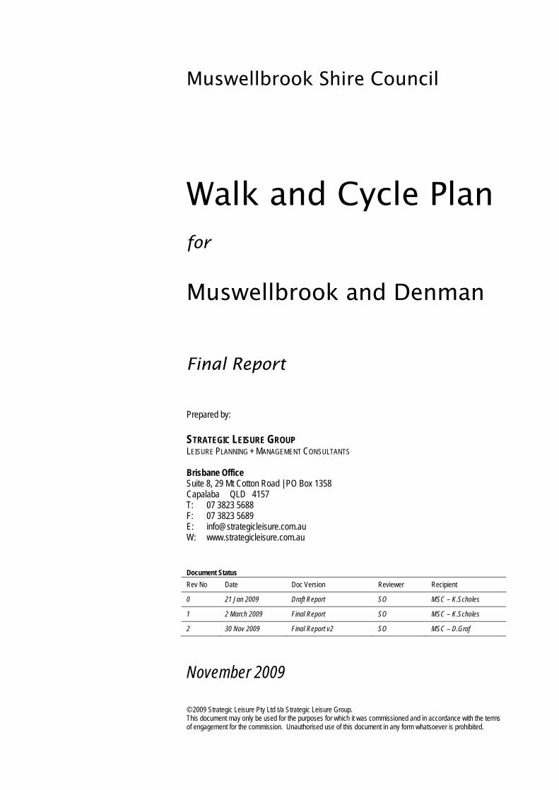
TABLE OF CONTENTS 1. INTRODUCTION .............................................................................................................................................................. 2
1.1. STUDY BACKGROUND ................................................................................................................................................ 2 1.2. STUDY PURPOSE AND SCOPE .................................................................................................................................... 2 1.3. STUDY PROCESS ....................................................................................................................................................... 3 1.4. STUDY AREA ............................................................................................................................................................. 5
2. STRATEGIC CONTEXT ................................................................................................................................................... 7 2.1. SHARED PEDESTRIAN AND CYCLE PATHS FOR MUSWELLBROOK, 1998 ......................................................................... 7 2.2. DENMAN CYCLEWAY PLAN, 1991 ............................................................................................................................... 9 2.3. OTHER BACKGROUND INFORMATION ........................................................................................................................ 10
3. WALKING AND CYCLING ENVIRONMENT ................................................................................................................. 13 3.1. EXISTING PATHWAYS AND BIKEWAYS ........................................................................................................................ 13
3.1.1. Muswellbrook ................................................................................................................................................... 13 3.1.2. Denman ............................................................................................................................................................ 18
3.2. STATE CONTROLLED ROADS .................................................................................................................................... 22 3.3. TRIP GENERATORS AND ATTRACTORS ...................................................................................................................... 22 3.4. CRASH STATISTICS .................................................................................................................................................. 25
3.4.1. Total Crashes ................................................................................................................................................... 25 3.4.2. Pedestrian and Bicycle Crashes ...................................................................................................................... 25
4. DEMOGRAPHIC AND TRAVEL TRENDS .................................................................................................................... 29 4.1. POPULATION SNAPSHOT .......................................................................................................................................... 29
4.1.1. Current Population ........................................................................................................................................... 29 4.1.2. Age Structure ................................................................................................................................................... 30 4.1.3. Future Population Projections .......................................................................................................................... 32
4.2. TRAVEL DATA ......................................................................................................................................................... 33 4.2.1. Journey to Work ............................................................................................................................................... 33 4.2.2. Journey to School ............................................................................................................................................ 35 4.2.3. Recreational Walking and Cycling.................................................................................................................... 35 4.2.4. Sports Cycling and Touring .............................................................................................................................. 36
5. STAKEHOLDER CONSULTATION ............................................................................................................................... 37 5.1. MUSWELLBROOK SHIRE COUNCIL ............................................................................................................................. 37 5.2. ROADS AND TRAFFIC AUTHORITY (RTA) .................................................................................................................... 39 5.3. SCHOOLS ................................................................................................................................................................ 40
6. THE STRATEGY ............................................................................................................................................................ 43 6.1. OVERVIEW .............................................................................................................................................................. 43 6.2. DESIGN GUIDELINES ................................................................................................................................................ 43
6.2.1. Austroads ......................................................................................................................................................... 43 6.2.2. Local Application .............................................................................................................................................. 44
6.3. RECOMMENDED NETWORKS .................................................................................................................................... 47 6.3.1. Muswellbrook ................................................................................................................................................... 47 6.3.2. Denman ............................................................................................................................................................ 53
6.4. NETWORK IMPLEMENTATION PLAN............................................................................................................................ 55 6.4.1. Network Implementation Plan for Muswellbrook .............................................................................................. 56 6.4.2. Network Implementation Plan for Denman....................................................................................................... 68
6.5. FUNDING THE NETWORK .......................................................................................................................................... 71 6.6. OTHER ACTIONS TO SUPPORT THE NETWORK ........................................................................................................... 71
APPENDIX A – NETWORK MAPS: MUSWELLBROOK APPENDIX B – NETWORK MAPS: DENMAN

Walk and Cyc le P lan f o r Mus w e l l b rook and Denman (F ina l ) 1
ACKNOWLEDGEMENTS The Strategic Leisure Group is grateful for the support of several Council officers for their input and assistance throughout this study, notably:
Neil Pope – Director, Community Infrastructure. Gary Dean – Recreation Manager. Kellie Scholes – Senior Design Coordinator.
The assistance and cooperation of other Council officers, Elected Representatives, RTA Hunter Region and local schools consulted is also acknowledged.
Walk and Cyc le P lan f o r Mus w e l l b rook and Denman (F ina l ) 2
1. INTRODUCTION
1.1. STUDY BACKGROUND
Muswellbrook Shire is located in the Upper Hunter Region of New South Wales (NSW), approximately 230km north-west of Sydney and 130km north-west of Newcastle. The Shire has a total area of 3,402km2 and a current population of about 15,000. The main urban centre is Muswellbrook, with a smaller township at Denman and several smaller villages.
As part of Muswellbrook Shire Council’s commitment to achieve a safer, integrated and sustainable transport system, it prepared walking and cycling network strategies for the communities of Muswellbrook and Denman in the 1990’s. These studies provided the catalyst for focussed local area planning and pathway construction.
In more recent years, the pressures of population growth and change, new residential subdivisions, and a growing awareness of active and healthy living, have prompted the need for a more contemporary network strategy.
On this basis, Council commissioned consultants, the Strategic Leisure Group, to prepare the new Walk & Cycle Plan for Muswellbrook & Denman.
Given their size and existing pathway coverage, Muswellbrook and Denman are generally well suited to walking and cycling. Council and the community can expect positive outcomes from ongoing investment in the walk and cycle network. These will range from health and safety improvements, to mobility, environmental and lifestyle benefits.
1.2. STUDY PURPOSE AND SCOPE
The overall purpose of this study is:
To formulate a realistic, connective and safe network of walking and cycling facilities, supported by a prioritised schedule of works.
It focuses on trip patterns, infrastructure location and implementation, as well as integration with the road network, open space system and land use fabric.
Major outcomes of this study are:
Assessment of existing conditions for walking and cycling. An updated strategy to guide Council’s development of the pedestrian and cycle
network in Muswellbrook and Denman over the next 10 years.
Walk and Cyc le P lan f o r Mus w e l l b rook and Denman (F ina l ) 3
Prioritised implementation plan to provide a logical and coordinated staging of proposed works.
This study is intended to provide a “strategic framework” or starting point from which more detailed investigations can be conducted by Council in future, including preparation of design standards, infrastructure costing and community consultation.
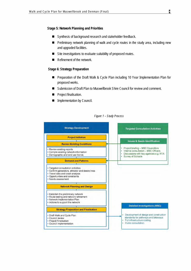
1.3. STUDY PROCESS
The study process comprised six integrated stages:
Stage 1: Project Inception and Data Gathering
Inception meeting with Council’s Project Manager and other relevant officers. Collection and review of background information and previous studies to set the Plan in
context.
Stage 2: Review of Existing Conditions for Walking and Cycling
Review of existing walking and cycling environments in Muswellbrook and Denman, considering land use patterns, road network, travel trends, crash statistics and facility audits.
Preliminary site inspections to visually assess local conditions and existing facilities (pathway standards, coverage, safety etc).
Confirmation of major trip generators and attractors to identify the “magnets” for walking and cycling activity.
Review of population data and future forecasts to identify implications for walking and cycling demand in Muswellbrook and Denman.
Stage 3: Consultation with Council and the Roads & Traffic Authority (RTA)
Project briefing presentation to Muswellbrook Shire Council. Discussions with key Council officers to identify critical issues, opportunities and
constraints for network planning. Discussions with the Roads & Traffic Authority (Hunter Region) regarding improvements
for walking and cycling on State Controlled Roads.
Stage 4: Survey of Schools
Surveys inviting input from local primary schools and Muswellbrook High School to determine problem areas, safety issues and infrastructure priorities in school zones.
Walk and Cyc le P lan f o r Mus w e l l b rook and Denman (F ina l ) 4
Stage 5: Network Planning and Priorities
Synthesis of background research and stakeholder feedback. Preliminary network planning of walk and cycle routes in the study area, including new
and upgraded facilities. Site investigations to evaluate suitability of proposed routes. Refinement of the network.
Stage 6: Strategy Preparation
Preparation of the Draft Walk & Cycle Plan including 10 Year Implementation Plan for proposed works.
Submission of Draft Plan to Muswellbrook Shire Council for review and comment. Project finalisation. Implementation by Council.
Figure 1 – Study Process
Walk and Cyc le P lan f o r Mus w e l l b rook and Denman (F ina l ) 5
1.4. STUDY AREA
The scope of this study focuses on the urban areas of Muswellbrook and Denman townships.
Muswellbrook
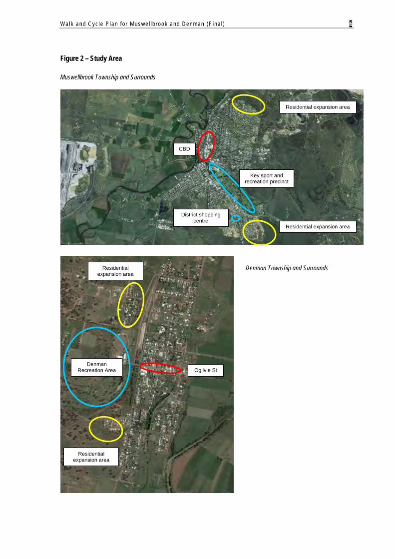
Muswellbrook is located on the Hunter River and is the Shire’s primary urban centre, with a current population of approximately 10,000 persons. Muswellbrook is serviced by a broad range of community facilities and services, including five schools and TAFE college. The town is expanding to the outer south, east and north, with future residential development earmarked for these areas (subject to approvals).
Muswellbrook is an expanding service centre due to the employment opportunities provided by the eight coalmines in the district, the presence of the Liddell and Bayswater Power Stations, and a flourishing wine grape industry1.
Denman
Denman is a small centre servicing the western part of Muswellbrook Shire. The town is located about 25km west of Muswellbrook and has a current population of about 1,500 persons. The town’s main community focal points are the business centre (Ogilvie Street), two schools, hospital, retirement village, and Denman Recreation Area.
There are also many agricultural ventures nearby. Although the Denman area was once known for its dairy farms, horse and cattle studs, in more recent times, there has been significant growth in local vineyards and associated tourism activity.
1 www.walkabout.com.au
Walk and Cyc le P lan f o r Mus w e l l b rook and Denman (F ina l ) 6
Figure 2 – Study Area
Muswellbrook Township and Surrounds
Denman Township and Surrounds
Residential expansion area
Residential expansion area
Residential expansion area
CBD
Ogilvie St
District shopping centre
Denman Recreation Area
Residential expansion area
Key sport and recreation precinct
Walk and Cyc le P lan f o r Mus w e l l b rook and Denman (F ina l ) 7
2. STRATEGIC CONTEXT
A number of Council’s previous plans and strategies have informed this study, most notably the Shared Pedestrian & Cycle Paths for Muswellbrook (1998) and Denman Cycleway Plan (1991).
A summary of these documents is presented below to help “set the scene” for the new Walk & Cycle Plan.
2.1. SHARED PEDESTRIAN AND CYCLE PATHS FOR MUSWELLBROOK, 1998
This provided a 10 year plan for the provision of shared pedestrian and cycle facilities in the Muswellbrook urban area. The overall goal of the strategy was:
“To provide a system of pathways and to provide safe, convenient access for residents as well as a recreational facility.”
This goal was underpinned by five objectives:
To progressively extend the existing pathway system and complete it within 10 years. To give preference to development of pathways near schools and major sporting
facilities. To provide a system of recreational pathways. To seek funding assistance wherever possible. To provide the basis for planning of pathways in new subdivision areas including
provision for Section 94 Charges.
The Plan comprised a Program of Work for completion over a 10 year period. This was supported by three standard design treatments for on-road and off-road facilities based on Austroads guidelines2, namely:
On-road bicycle lanes (with shared parking); On-road bicycle lanes (exclusive/ no parking); and Off-road cycle paths (shared or exclusive).
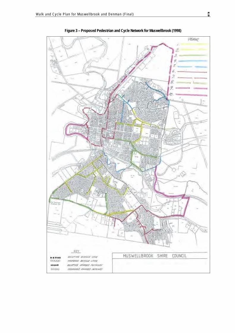
The recommended network is shown in Figure 3. It utilised local roads (for on-road and off-road facilities) and public open space. It also capitalised on the use of reserves adjacent to natural waterways, which offered flat grades and ample space to develop recreational pathway circuits.
2 Austroads Guide to Traffic Engineering Practice – Part 14, Bicycles
Walk and Cyc le P lan f o r Mus w e l l b rook and Denman (F ina l ) 8
Figure 3 – Proposed Pedestrian and Cycle Network for Muswellbrook (1998)
Walk and Cyc le P lan f o r Mus w e l l b rook and Denman (F ina l ) 9
2.2. DENMAN CYCLEWAY PLAN, 1991
This Plan was developed in 1991 to provide direction for the future development of bicycle facilities in the Denman urban area.
It recommended a local area network of new and upgraded bikeways, including engineering concepts for on-road and off-road improvements, cost estimates and staging of works.
The key drivers for the plan were to improve cycling conditions and safety, coinciding with Denman’s population growth and increasing traffic volumes.
Key target groups or high priorities for Plan implementation were:
Children riding to school; and People riding to local sports facilities and the town’s commercial area on Ogilvie Street.
The 1991 Plan recommended seven key routes for the Denman bicycle network, as follows:
Stage 1 – Virginia St. Stage 2 – Paxton St. Stage 3 – Ogilvie St. Stage 4 – Virginia St Culvert, Turtle St and Macauley St. Stage 5 – North Denman Park. Stage 6 – Arbor Park. Stage 7 – Denman Creek / Paxton St.
Although some projects have not been implemented, the 1991 Plan has guided network construction in Denman with pathways now servicing much of the township’s central area.
Walk and Cyc le P lan f o r Mus w e l l b rook and Denman (F ina l ) 10
2.3. OTHER BACKGROUND INFORMATION
Building on these two strategies, a number of other key planning and policy documents have been reviewed to inform this Walk & Cycle Plan. They are:
Making Muswellbrook Shire – Strategic Plan 2004-2006. Muswellbrook Local Environmental Plan 2008 (Public Exhibition Draft). Muswellbrook Shire Social Plan 2005-2010. Muswellbrook Traffic Study & Roadworks Plan, September 2008. West Denman Road Strategy, 2006 (Ver04).
The final three documents are most relevant to this study, as outlined below.
Muswellbrook Shire Social Plan 2005-2010
This study demonstrates the community’s need for improved accessibility via local pathways. Of particular relevance, key issues and needs identified for specific groups were:
Children Increase accessibility of local parks, playgrounds and schools for people with disabilities, mothers with
prams and children on bikes by establishing footpaths.
Young People Transport is one of the main limitations for young people accessing some of the available recreational
facilities in Muswellbrook or neighbouring areas.
Older People The condition and provision of footpaths are a major problem for older people and people with a
disability, particularly uneven surfaces, gutters, and lack of safe crossing points on major roads.
Existing pathway conditions or lack of provision is a barrier to access facilities/ services for some sectors of the community.
Need to encourage a healthy lifestyle for older people, particularly walking.
Ensure future developments and residential expansion areas have adequate pedestrian access.
Muswellbrook Traffic Study & Roadworks Plan
The objectives of this study were to:
Understand traffic growth and the need for management and infrastructure development in the Muswellbrook urban area; and
Develop a traffic strategy for Council to manage the impacts of development in the Muswellbrook urban area, covering developer contributions, traffic management and road safety.
Walk and Cyc le P lan f o r Mus w e l l b rook and Denman (F ina l ) 11
It includes a proposed 5 year works program to address future capacity and safety concerns. This also briefly considered pedestrian safety. Importantly, this study provided insight to future road network planning and augmentation for Muswellbrook’s urban area.
West Denman Road Strategy
This strategy was prepared to support Council’s review of the Muswellbrook Shire LEP. It specifically focuses on an area west of the rail line and north of the Denman Recreation Area, earmarked for possible future development.
As illustrated overleaf, the document identifies required road network extensions and upgrades, together with new cycleways, to support the town expansion area. Importantly, the strategy notes that:
“The development of this area will very much depend on mining and other industries developing in the Shire and on future demographic trends both locally, regionally and statewide.”
The strategy recommends eight cycleway projects for West Denman, as follows:
Project Description Cost
Turner St (Ogilvie – Bell) 2.0m concrete cycleway $50,000
Bell St (Almond – Pony Club) 2.0m concrete cycleway $80,000
Bell St (Turner – Almond) 2.0m concrete cycleway $20,000
Almond St (Bell – Bray) 2.0m concrete cycleway $40,000
Almond St (Bray – Kenilworth) 2.0m concrete cycleway $35,000
Bray St (Almond – Turner) 2.0m concrete cycleway $20,000
Turner St (Bray – Kenilworth) incl. railway crossing 2.0m concrete cycleway $50,000
Pine Ridge Rd for the length of development 2.0m concrete cycleway $150,000
Total $445,000
Walk and Cyc le P lan f o r Mus w e l l b rook and Denman (F ina l ) 12
Walk and Cyc le P lan f o r Mus w e l l b rook and Denman (F ina l ) 13
3. WALKING AND CYCLING ENVIRONMENT
3.1. EXISTING PATHWAYS AND BIKEWAYS
The purpose of this section is to provide a “snapshot” of existing provision and conditions for walking and cycling in Muswellbrook and Denman. Although both communities exhibit different levels of network construction, they are generally well serviced by local pathways – this provides a good starting point for future network extensions and improvements. Existing networks are primarily off-road systems which are quite fragmented. The provision of formal on-road bikeways is limited in both communities.
The extent of the existing pathway and bikeway network is described below and shown in Figures 4 to 6. These observations are based on:
Brief review of facility audit information compiled by Council; Site investigations and route suitability assessments conducted by the study team; and Discussions with Council officers and other stakeholders.
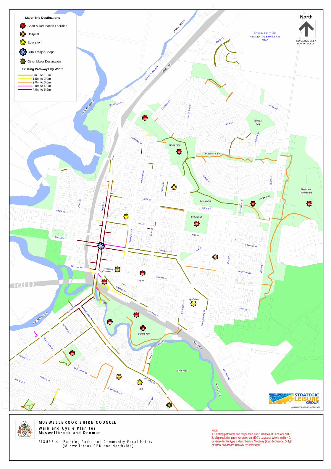
3.1.1. MUSWELLBROOK
Muswellbrook’s path network covers a total distance of approximately 30km. Key branches of the network connect the CBD to surrounding residential areas via Maitland, Sydney and Bridge Streets. Localised networks have been also established within Northside and Southside communities. These comprise:
Short, discontinuous stretches of concrete footpaths of varying widths, particularly radiating from local schools.
Recreational paths and trails meandering through parkland reserves. Limited network legibility due to a lack of signage and connectivity.
Most paths are 1m-2m wide and are concrete. A large majority are designed to cater for pedestrians only, rather than shared facilities. To date, there is no formal provision for full on-road bike lanes in Muswellbrook, with the exception of some bike lane signs.
Walk and Cyc le P lan f o r Mus w e l l b rook and Denman (F ina l ) 14
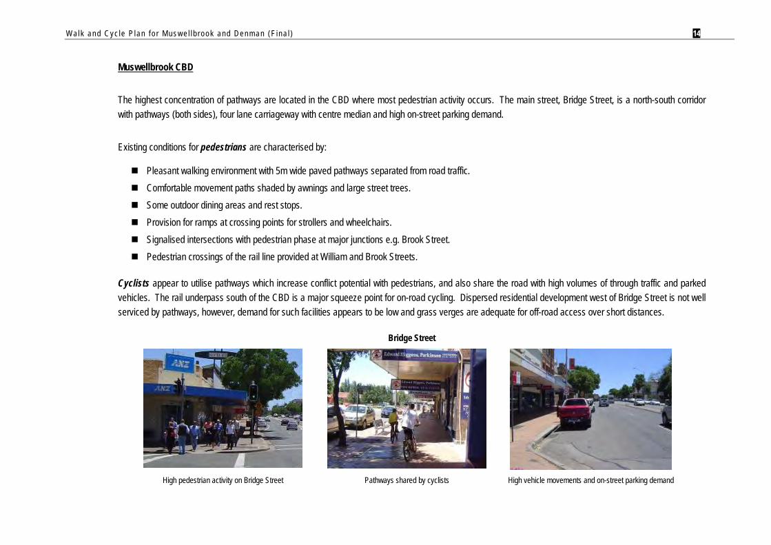
Muswellbrook CBD
The highest concentration of pathways are located in the CBD where most pedestrian activity occurs. The main street, Bridge Street, is a north-south corridor with pathways (both sides), four lane carriageway with centre median and high on-street parking demand.
Existing conditions for pedestrians are characterised by:
Pleasant walking environment with 5m wide paved pathways separated from road traffic. Comfortable movement paths shaded by awnings and large street trees. Some outdoor dining areas and rest stops. Provision for ramps at crossing points for strollers and wheelchairs. Signalised intersections with pedestrian phase at major junctions e.g. Brook Street. Pedestrian crossings of the rail line provided at William and Brook Streets.
Cyclists appear to utilise pathways which increase conflict potential with pedestrians, and also share the road with high volumes of through traffic and parked vehicles. The rail underpass south of the CBD is a major squeeze point for on-road cycling. Dispersed residential development west of Bridge Street is not well serviced by pathways, however, demand for such facilities appears to be low and grass verges are adequate for off-road access over short distances.
Bridge Street
High pedestrian activity on Bridge Street Pathways shared by cyclists High vehicle movements and on-street parking demand
Walk and Cyc le P lan f o r Mus w e l l b rook and Denman (F ina l ) 15
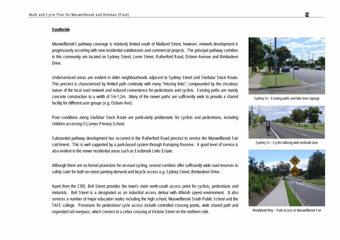
Southside
Muswellbrook’s pathway coverage is relatively limited south of Maitland Street, however, network development is progressively occurring with new residential subdivisions and commercial projects. The principal pathway corridors in this community are located on Sydney Street, Lorne Street, Rutherford Road, Osborn Avenue and Bimbadeen Drive.
Underserviced areas are evident in older neighbourhoods adjacent to Sydney Street and Skellatar Stock Route. This precinct is characterised by limited path continuity with many “missing links”, compounded by the circuitous nature of the local road network and reduced convenience for pedestrians and cyclists. Existing paths are mainly concrete construction to a width of 1m-1.2m. Many of the newer paths are sufficiently wide to provide a shared facility for different user groups (e.g. Osborn Ave).
Poor conditions along Skellatar Stock Route are particularly problematic for cyclists and pedestrians, including children accessing St James Primary School.
Substantial pathway development has occurred in the Rutherford Road precinct to service the Muswellbrook Fair catchment. This is well supported by a park-based system through Kurrajong Reserve. A good level of service is also evident in the newer residential areas such as Eastbrook Links Estate.
Although there are no formal provisions for on-road cycling, several corridors offer sufficiently wide road reserves to safely cater for both on-street parking demand and bicycle access e.g. Sydney Street, Bimbadeen Drive.
Apart from the CBD, Bell Street provides the town’s main north-south access point for cyclists, pedestrians and motorists. Bell Street is a designated as an industrial access detour with 40km/h speed environment. It also services a number of major education nodes including the high school, Muswellbrook South Public School and the TAFE college. Provisions for pedestrian/ cycle access include controlled crossing points, wide shared path and separated rail overpass, which connect to a zebra crossing at Victoria Street on the northern side.
Sydney St – Existing paths and bike lane signage
Sydney St – Cyclist utilising wide kerbside lane
Woollybutt Way – Path access to Muswellbrook Fair
Walk and Cyc le P lan f o r Mus w e l l b rook and Denman (F ina l ) 16
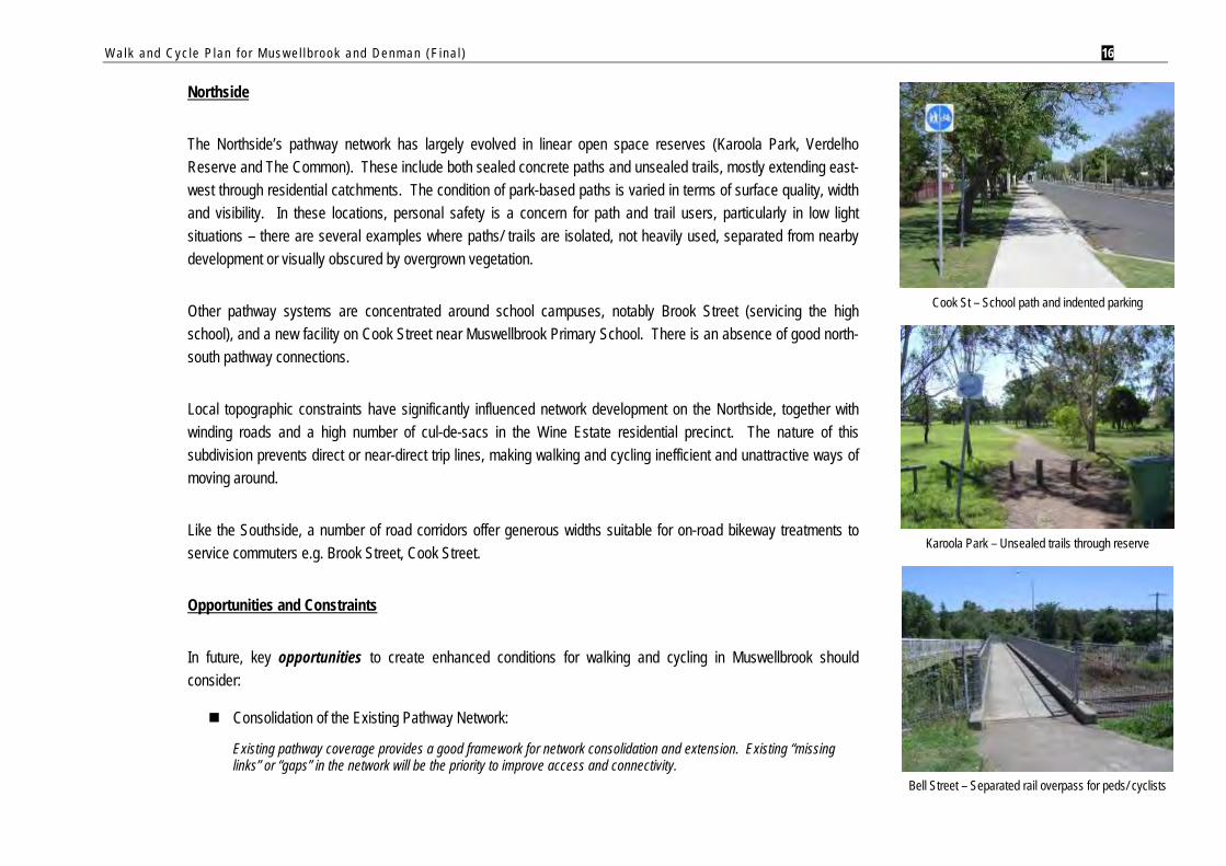
Northside
The Northside’s pathway network has largely evolved in linear open space reserves (Karoola Park, Verdelho Reserve and The Common). These include both sealed concrete paths and unsealed trails, mostly extending east-west through residential catchments. The condition of park-based paths is varied in terms of surface quality, width and visibility. In these locations, personal safety is a concern for path and trail users, particularly in low light situations – there are several examples where paths/ trails are isolated, not heavily used, separated from nearby development or visually obscured by overgrown vegetation.
Other pathway systems are concentrated around school campuses, notably Brook Street (servicing the high school), and a new facility on Cook Street near Muswellbrook Primary School. There is an absence of good north-south pathway connections.
Local topographic constraints have significantly influenced network development on the Northside, together with winding roads and a high number of cul-de-sacs in the Wine Estate residential precinct. The nature of this subdivision prevents direct or near-direct trip lines, making walking and cycling inefficient and unattractive ways of moving around.
Like the Southside, a number of road corridors offer generous widths suitable for on-road bikeway treatments to service commuters e.g. Brook Street, Cook Street.
Opportunities and Constraints
In future, key opportunities to create enhanced conditions for walking and cycling in Muswellbrook should consider:
Consolidation of the Existing Pathway Network:
Existing pathway coverage provides a good framework for network consolidation and extension. Existing “missing links” or “gaps” in the network will be the priority to improve access and connectivity.
Cook St – School path and indented parking
Karoola Park – Unsealed trails through reserve
Bell Street – Separated rail overpass for peds/ cyclists
Walk and Cyc le P lan f o r Mus w e l l b rook and Denman (F ina l ) 17
Road Reserve Width / Available Space:
A number of roads through Muswellbrook’s urban area have ample on-street space with wide road shoulders and/ or low traffic volumes to accommodate parking and on-road bikeways e.g. Sydney, Maitland, Cook Streets. These routes have good potential to formalise bicycle access in the road space for cross-town and CBD access.
Future Town Growth:
Town growth presents a strategic opportunity for extension of the walk and cycle network. It is desirable that pathways and bikeways in Muswellbrook be concurrently developed with residential subdivision projects. Council’s development approval process provides a valuable opportunity to ensure a coordinated approach is taken to integrate pathways and bikeways as new development occurs.
Future road improvements by Council and the RTA will also provide opportunities for enhanced pedestrian and cycle movements e.g. new signalised intersections on Maitland Street, planned upgrade of Skellatar Stock Route.
Major constraints for walking and cycling in Muswellbrook will be:
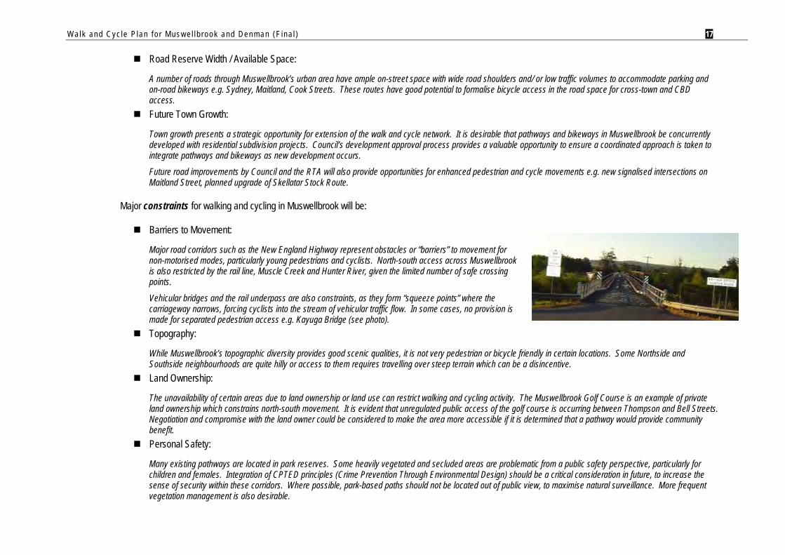
Barriers to Movement:
Major road corridors such as the New England Highway represent obstacles or “barriers” to movement for non-motorised modes, particularly young pedestrians and cyclists. North-south access across Muswellbrook is also restricted by the rail line, Muscle Creek and Hunter River, given the limited number of safe crossing points.
Vehicular bridges and the rail underpass are also constraints, as they form “squeeze points” where the carriageway narrows, forcing cyclists into the stream of vehicular traffic flow. In some cases, no provision is made for separated pedestrian access e.g. Kayuga Bridge (see photo).
Topography:
While Muswellbrook’s topographic diversity provides good scenic qualities, it is not very pedestrian or bicycle friendly in certain locations. Some Northside and Southside neighbourhoods are quite hilly or access to them requires travelling over steep terrain which can be a disincentive.
Land Ownership:
The unavailability of certain areas due to land ownership or land use can restrict walking and cycling activity. The Muswellbrook Golf Course is an example of private land ownership which constrains north-south movement. It is evident that unregulated public access of the golf course is occurring between Thompson and Bell Streets. Negotiation and compromise with the land owner could be considered to make the area more accessible if it is determined that a pathway would provide community benefit.
Personal Safety:
Many existing pathways are located in park reserves. Some heavily vegetated and secluded areas are problematic from a public safety perspective, particularly for children and females. Integration of CPTED principles (Crime Prevention Through Environmental Design) should be a critical consideration in future, to increase the sense of security within these corridors. Where possible, park-based paths should not be located out of public view, to maximise natural surveillance. More frequent vegetation management is also desirable.
et)Plan)
CLE
ND
INN
ING
ST
MAITLAND ST
SYDNEY ST
VICTORIA ST
DO
LAH
ENY
ST
KING ST
MARKET ST
WILLIAM ST
BRENTWOOD ST
WILLIAM ST
WILLIAM ST
QU
EEN
ST
DOYLE STBROOK ST
SOW
ERBY
ST
BREC
HT
ST
BOWMAN ST
HILL ST
HILL ST
CAR
L ST
BROOK ST
BRID
GE
ST
COOK ST
SEM
ILLO
N S
T
LOWER HILL ST
FOR
D S
T
RO
GER
ST
COOK ST
QU
EEN
ST
SOW
ERBY
ST
SHIRAZ ST
MANNING ST
CAB
ERN
ET S
T
QUEEN ST
LEXIA ST
HU
MPH
RIE
S ST
COUSINS S
T
ABERDEEN ST
MAITLAND ST
TINDALE STANZAC PDE
BELL
ST
FORBES ST
VICTORIA ST
SKELLATAR ST
BELL ST
SKELLATAR ST
MITCHELL ST
RUTH WHITE AV
SHAW
CR
NEW E
NGLAND H
WY
QUEEN ST
S1S1S1S1S1S1S1S1S1
S1S1S1S1S1S1S1S1S1
S2S2S2S2S2S2S2S2S2
S3S3S3S3S3S3S3S3S3
S4S4S4S4S4S4S4S4S4
S8S8S8S8S8S8S8S8S8
S9S9S9S9S9S9S9S9S9
S11S11S11S11S11S11S11S11S11
S13S13S13S13S13S13S13S13S13
S12S12S12S12S12S12S12S12S12
S15S15S15S15S15S15S15S15S15
E1E1E1E1E1E1E1E1E1
E2E2E2E2E2E2E2E2E2
E3E3E3E3E3E3E3E3E3
E5E5E5E5E5E5E5E5E5
E6E6E6E6E6E6E6E6E6
B1B1B1B1B1B1B1B1B1
C1C1C1C1C1C1C1C1C1
C2C2C2C2C2C2C2C2C2
C3C3C3C3C3C3C3C3C3
North
SL360/MAPPING/EXISTING REV1.WOR
INDICATIVE ONLYNOT TO SCALE
M U S W E L L B R O O K S H I R E C O U N C I LW a l k a n d C y c l e P l a n f o rM u s w e l l b r o o k a n d D e n m a n
Karoola ParkKaroola ParkKaroola ParkKaroola ParkKaroola ParkKaroola ParkKaroola ParkKaroola ParkKaroola Park
Karoola ParkKaroola ParkKaroola ParkKaroola ParkKaroola ParkKaroola ParkKaroola ParkKaroola ParkKaroola Park
Verdelho ReserveVerdelho ReserveVerdelho ReserveVerdelho ReserveVerdelho ReserveVerdelho ReserveVerdelho ReserveVerdelho ReserveVerdelho Reserve
VolunteerVolunteerVolunteerVolunteerVolunteerVolunteerVolunteerVolunteerVolunteerParkParkParkParkParkParkParkParkPark
WeeramanWeeramanWeeramanWeeramanWeeramanWeeramanWeeramanWeeramanWeeramanSporting FieldsSporting FieldsSporting FieldsSporting FieldsSporting FieldsSporting FieldsSporting FieldsSporting FieldsSporting Fields
Victoria ParkVictoria ParkVictoria ParkVictoria ParkVictoria ParkVictoria ParkVictoria ParkVictoria ParkVictoria Park
Golf CourseGolf CourseGolf CourseGolf CourseGolf CourseGolf CourseGolf CourseGolf CourseGolf Course
Olympic ParkOlympic ParkOlympic ParkOlympic ParkOlympic ParkOlympic ParkOlympic ParkOlympic ParkOlympic Park
TAFETAFETAFETAFETAFETAFETAFETAFETAFE
POSSIBLE FUTUREPOSSIBLE FUTUREPOSSIBLE FUTUREPOSSIBLE FUTUREPOSSIBLE FUTUREPOSSIBLE FUTUREPOSSIBLE FUTUREPOSSIBLE FUTUREPOSSIBLE FUTURERESIDENTIAL EXPANSIONRESIDENTIAL EXPANSIONRESIDENTIAL EXPANSIONRESIDENTIAL EXPANSIONRESIDENTIAL EXPANSIONRESIDENTIAL EXPANSIONRESIDENTIAL EXPANSIONRESIDENTIAL EXPANSIONRESIDENTIAL EXPANSION
AREAAREAAREAAREAAREAAREAAREAAREAAREA
Karoola ParkKaroola ParkKaroola ParkKaroola ParkKaroola ParkKaroola ParkKaroola ParkKaroola ParkKaroola Park
High School
HUNTER RIVER
HUNTER RIVER
HUNTER RIVER
HUNTER RIVER
HUNTER RIVER
HUNTER RIVER
HUNTER RIVER
HUNTER RIVER
HUNTER RIVER
HUNTER R
IVER
HUNTER R
IVER
HUNTER R
IVER
HUNTER R
IVER
HUNTER R
IVER
HUNTER R
IVER
HUNTER R
IVER
HUNTER R
IVER
HUNTER R
IVER
SANDY CREEK
SANDY CREEK
SANDY CREEK
SANDY CREEK
SANDY CREEK
SANDY CREEK
SANDY CREEK
SANDY CREEK
SANDY CREEK
MU
SCLE C
KM
USC
LE CK
MU
SCLE C
KM
USC
LE CK
MU
SCLE C
KM
USC
LE CK
MU
SCLE C
KM
USC
LE CK
MU
SCLE C
K
PCYC
RAIL LINE
RAIL LINE
RAIL LINE
RAIL LINE
RAIL LINE
RAIL LINE
RAIL LINE
RAIL LINE
RAIL LINE
RAIL LIN
E
RAIL LIN
E
RAIL LIN
E
RAIL LIN
E
RAIL LIN
E
RAIL LIN
E
RAIL LIN
E
RAIL LIN
E
RAIL LIN
E
F I G U R E 4 - E x i s t i n g P a t h s a n d C o m m u n i t y F o c a l P o i n t s [ M u s w e l l b r o o k C B D a n d N o r t h s i d e ]
Major Trip Destinations
Sport & Recreation Facilities
Hospital
Education
CBD / Major Shops
Other Major Destination
Existing Pathways by Width
0m to 1.5m1.5m to 2.0m2.0m to 3.0m3.0m to 4.0m4.0m to 5.6m
Note:1. Existing pathways and major trails are current as at February 2009.2. Map excludes paths recorded on MSC's database where width = 0,or where facility type is described as "Footway (Kerb & Channel Only)",or where "No Pedestrian Access Provided"
( g )path (future)
SKELLATAR STOCK ROUTE
BLOODWOOD RD
RUTHERFORD RD
THOMPSON ST
OSBO
RN
AVE
SKELLATAR ST
SKELLATAR ST
SYDNEY ST MAITLAND ST
BELL ST
WOLLOMBI RD
NEW ENGLAND HWY
STO
CK
RTE
BIMBAD
EEN D
R
CALGAROO AV
ACACIA DR
ADAM
S ST
CASSIDY AVE
KAMILAROI ST
MAITLAND ST
TINDALE ST
VICTORIA ST
RUTH WHITE AV
SHAW
CR
CLE
ND
INN
ING
STVICTORIA ST
DO
LAH
ENY
ST
KING ST
ARKET ST
ANZAC PDE
FORBES ST
SYDNEY ST
S3S3S3S3S3S3S3S3S3
S4S4S4S4S4S4S4S4S4
S5S5S5S5S5S5S5S5S5
S6S6S6S6S6S6S6S6S6
S7S7S7S7S7S7S7S7S7
S10S10S10S10S10S10S10S10S10
S11S11S11S11S11S11S11S11S11
S13S13S13S13S13S13S13S13S13
E2E2E2E2E2E2E2E2E2
E3E3E3E3E3E3E3E3E3
E5E5E5E5E5E5E5E5E5
E4E4E4E4E4E4E4E4E4
B2B2B2B2B2B2B2B2B2
C3C3C3C3C3C3C3C3C3
S16S16S16S16S16S16S16S16S16
SL360/MAPPING/EXISTING REV1.WOR
North
INDICATIVE ONLYNOT TO SCALE
M U S W E L L B R O O K S H I R E C O U N C I LW a l k a n d C y c l e P l a n f o r M u s w e l l b r o o k a n d D e n m a n
F I G U R E 5 - E x i s t i n g P a t h s a n d C o m m u n i t y F o c a l P o i n t s [ M u s w e l l b r o o k S o u t h s i d e ]
Highbrook ParkHighbrook ParkHighbrook ParkHighbrook ParkHighbrook ParkHighbrook ParkHighbrook ParkHighbrook ParkHighbrook Park
WollombiWollombiWollombiWollombiWollombiWollombiWollombiWollombiWollombiParkParkParkParkParkParkParkParkPark
ShowgroundsShowgroundsShowgroundsShowgroundsShowgroundsShowgroundsShowgroundsShowgroundsShowgrounds
BrennanBrennanBrennanBrennanBrennanBrennanBrennanBrennanBrennanPkPkPkPkPkPkPkPkPk
Kurrajong Reserve
Kurrajong Reserve
Kurrajong Reserve
Kurrajong Reserve
Kurrajong Reserve
Kurrajong Reserve
Kurrajong Reserve
Kurrajong Reserve
Kurrajong Reserve
Golf CourseGolf CourseGolf CourseGolf CourseGolf CourseGolf CourseGolf CourseGolf CourseGolf Course
Golf CourseGolf CourseGolf CourseGolf CourseGolf CourseGolf CourseGolf CourseGolf CourseGolf Course
Olympic PkOlympic PkOlympic PkOlympic PkOlympic PkOlympic PkOlympic PkOlympic PkOlympic Pk
Bowman PkBowman PkBowman PkBowman PkBowman PkBowman PkBowman PkBowman PkBowman Pk
TAFETAFETAFETAFETAFETAFETAFETAFETAFECollegeCollegeCollegeCollegeCollegeCollegeCollegeCollegeCollege
High School
POSSIBLE FUTUREPOSSIBLE FUTUREPOSSIBLE FUTUREPOSSIBLE FUTUREPOSSIBLE FUTUREPOSSIBLE FUTUREPOSSIBLE FUTUREPOSSIBLE FUTUREPOSSIBLE FUTURERESIDENTIAL EXPANSIONRESIDENTIAL EXPANSIONRESIDENTIAL EXPANSIONRESIDENTIAL EXPANSIONRESIDENTIAL EXPANSIONRESIDENTIAL EXPANSIONRESIDENTIAL EXPANSIONRESIDENTIAL EXPANSIONRESIDENTIAL EXPANSION
AREAAREAAREAAREAAREAAREAAREAAREAAREA
POSSIBLE FUTURERESIDENTIAL EXPANSION
AREA
HUNTER RIVER
HUNTER RIVER
HUNTER RIVER
HUNTER RIVER
HUNTER RIVER
HUNTER RIVER
HUNTER RIVER
HUNTER RIVER
HUNTER RIVER
MUSCLE CK
MUSCLE CK
MUSCLE CK
MUSCLE CK
MUSCLE CK
MUSCLE CK
MUSCLE CK
MUSCLE CK
MUSCLE CK
RAIL LINE
RAIL LINE
RAIL LINE
RAIL LINE
RAIL LINE
RAIL LINE
RAIL LINE
RAIL LINE
RAIL LINE
Note:1. Existing pathways and major trails are current as at February 2009.2. Map excludes paths recorded on MSC's database where width = 0,or where facility type is described as "Footway (Kerb & Channel Only)",or where "No Pedestrian Access Provided"
Major Trip Destinations
Sport & Recreation Facilities
Hospital
Education
CBD / Major Shops
Other Major Destination
Existing Pathways by Width
0m to 1.5m1.5m to 2.0m2.0m to 3.0m3.0m to 4.0m4.0m to 5.6m
Walk and Cyc le P lan f o r Mus w e l l b rook and Denman (F ina l ) 18
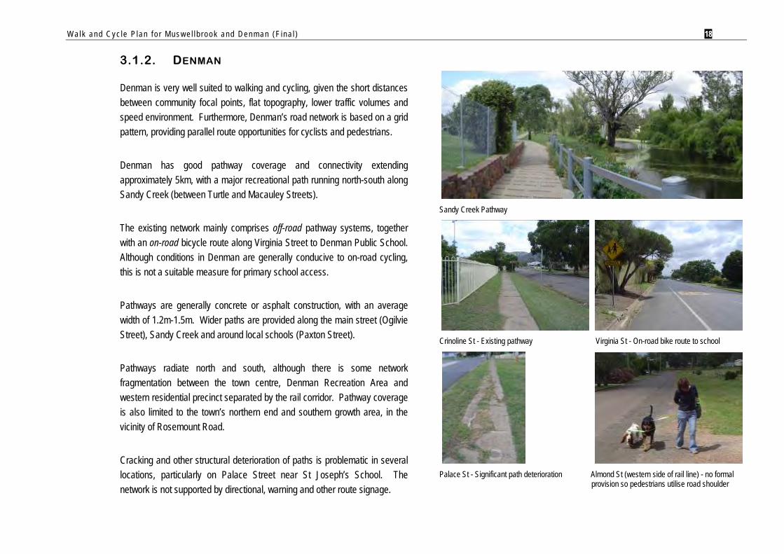
3.1.2. DENMAN
Denman is very well suited to walking and cycling, given the short distances between community focal points, flat topography, lower traffic volumes and speed environment. Furthermore, Denman’s road network is based on a grid pattern, providing parallel route opportunities for cyclists and pedestrians.
Denman has good pathway coverage and connectivity extending approximately 5km, with a major recreational path running north-south along Sandy Creek (between Turtle and Macauley Streets).
The existing network mainly comprises off-road pathway systems, together with an on-road bicycle route along Virginia Street to Denman Public School. Although conditions in Denman are generally conducive to on-road cycling, this is not a suitable measure for primary school access.
Pathways are generally concrete or asphalt construction, with an average width of 1.2m-1.5m. Wider paths are provided along the main street (Ogilvie Street), Sandy Creek and around local schools (Paxton Street).
Pathways radiate north and south, although there is some network fragmentation between the town centre, Denman Recreation Area and western residential precinct separated by the rail corridor. Pathway coverage is also limited to the town’s northern end and southern growth area, in the vicinity of Rosemount Road.
Cracking and other structural deterioration of paths is problematic in several locations, particularly on Palace Street near St Joseph’s School. The network is not supported by directional, warning and other route signage.
Sandy Creek Pathway
Crinoline St - Existing pathway Virginia St - On-road bike route to school
Palace St - Significant path deterioration Almond St (western side of rail line) - no formal
provision so pedestrians utilise road shoulder
Walk and Cyc le P lan f o r Mus w e l l b rook and Denman (F ina l ) 19
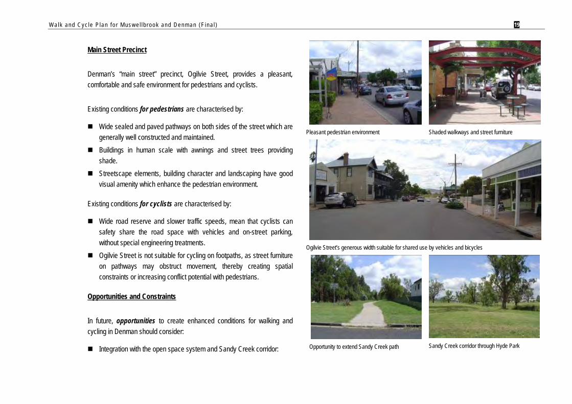
Main Street Precinct
Denman’s “main street” precinct, Ogilvie Street, provides a pleasant, comfortable and safe environment for pedestrians and cyclists.
Existing conditions for pedestrians are characterised by:
Wide sealed and paved pathways on both sides of the street which are generally well constructed and maintained.
Buildings in human scale with awnings and street trees providing shade.
Streetscape elements, building character and landscaping have good visual amenity which enhance the pedestrian environment.
Existing conditions for cyclists are characterised by:
Wide road reserve and slower traffic speeds, mean that cyclists can safety share the road space with vehicles and on-street parking, without special engineering treatments.
Ogilvie Street is not suitable for cycling on footpaths, as street furniture on pathways may obstruct movement, thereby creating spatial constraints or increasing conflict potential with pedestrians.
Opportunities and Constraints
In future, opportunities to create enhanced conditions for walking and cycling in Denman should consider:
Integration with the open space system and Sandy Creek corridor:
Pleasant pedestrian environment
Shaded walkways and street furniture
Ogilvie Street’s generous width suitable for shared use by vehicles and bicycles
Opportunity to extend Sandy Creek path
Sandy Creek corridor through Hyde Park
Walk and Cyc le P lan f o r Mus w e l l b rook and Denman (F ina l ) 20
Continuation of the Sandy Creek Path south to Hyde Park utilising public open space, offers a logical extension of Denman’s main pathway system. It may also provide new access opportunities to the southern end of town, together with enhanced scenic and recreational values for residents and visitors.
A secondary opportunity exists to formalise an existing pedestrian desire line through Arbor Park adjacent to Virginia Street. This may provide improved access to facilities at Denman Recreation Area, and an enhanced parkland setting close to the main street and retirement village.
Alternative options in “low use” situations:
Where paths are not provided in low use situations around the town, wide grass verges or road shoulders may provide adequate access for pedestrians and cyclists, and some separation from motorised vehicles.
Existing pedestrian desire line through Arbor Park
Improving Denman’s network legibility and safety with signage:
Signage is cost effective and can be deployed quickly to improve conditions in the short-medium term.
Major constraints for walking and cycling in Denman will be:
Golden Highway (Palace / Crinoline Streets):
Sections of the Golden Highway are hazardous for cyclists and pedestrians where it passes through Denman. Related issues are:
Increased traffic volumes, including haulage route for quarry and other industrial traffic.
Lack of available space for pathway construction along some sections, due to presence of utility poles, drainage channels and reduced verge width.
Debris and cracking on road shoulders for cyclists.
Safe crossing points, particularly in school zones e.g. Crinoline/ Palace Street intersection.
Wide grass verges
Pathway constraints on Palace St
Walk and Cyc le P lan f o r Mus w e l l b rook and Denman (F ina l ) 21
Rail Crossing:
Rail corridors typically represent a barrier to bicycle and pedestrian movement. There are two formal crossings of the Muswellbrook-Merriwa Railway at Ogilvie and Kenilworth Streets.
A priority will be to strengthen the east-west pathway link over the rail crossing between Ogilvie Street and Denman Recreation Area. This will also benefit the growing residential area on the western side of town.
Although an existing pedestrian crossing facility is provided, the rail corridor is a significant safety consideration, and there is a need to ensure movement paths are of high standard, and effectively channel path users to designated crossing points.
Pedestrian crossing of rail line at Ogilvie St
DENMANDENMANDENMANDENMANDENMANDENMANDENMANDENMANDENMANRECREATION AREARECREATION AREARECREATION AREARECREATION AREARECREATION AREARECREATION AREARECREATION AREARECREATION AREARECREATION AREA
GOLFGOLFGOLFGOLFGOLFGOLFGOLFGOLFGOLFCOURSECOURSECOURSECOURSECOURSECOURSECOURSECOURSECOURSE
OGILVIE ST
TURTLE ST
ROSEMOUNT RD
VIR
GIN
IA S
T
PALA
CE
ST
MERINO ST
PAXT
ON
ST
OGILVIE ST
TUR
NER
ST
PALA
CE
ST
PAXT
ON
ST
CRINOLINE ST
MACAULEY ST
BELL ST
VIR
GIN
IA S
T
BABBINGTON ST
MERTON ST
VIR
GIN
IA S
T
ALM
ON
D S
T
PALA
CE
ST
BRIGHT ST
YARRAWA RD
SOUTH ST
G
KENILWORTH ST
MARTINDALE ST
S1S1S1S1S1S1S1S1S1
S2S2S2S2S2S2S2S2S2
S3S3S3S3S3S3S3S3S3
R1R1R1R1R1R1R1R1R1
R2R2R2R2R2R2R2R2R2
R3R3R3R3R3R3R3R3R3
E1E1E1E1E1E1E1E1E1
E2E2E2E2E2E2E2E2E2
C1C1C1C1C1C1C1C1C1
C2C2C2C2C2C2C2C2C2
B1B1B1B1B1B1B1B1B1
C4C4C4C4C4C4C4C4C4
North
SL360/MAPPING/EXISTING REV1.WOR
INDICATIVE ONLYNOT TO SCALE
M U S W E L L B R O O K S H I R E C O U N C I LW a l k a n d C y c l e P l a n f o r M u s w e l l b r o o k a n d D e n m a n
F I G U R E 6 - E x i s t i n g P a t h s a n d C o m m u n i t y F o c a l P o i n t s [ D e n m a n ]
Major Trip Destinations
Sport & Recreation Facilities
Hospital
Education
CBD / Major Shops
Other Major Destination
Existing Pathways by Width
0m to 1.5m1.5m to 2.0m2.0m to 3.0m3.0m to 4.0m4.0m to 5.6m
HUNTER RIVER
HUNTER RIVER
HUNTER RIVER
HUNTER RIVER
HUNTER RIVER
HUNTER RIVER
HUNTER RIVER
HUNTER RIVER
HUNTER RIVER
RAIL LINE
RAIL LINE
RAIL LINERAIL LINE
RAIL LINERAIL LINE
RAIL LINE
RAIL LINE
RAIL LINESA
ND
Y C
REE
KSA
ND
Y C
REE
KSA
ND
Y C
REE
KSA
ND
Y C
REE
KSA
ND
Y C
REE
KSA
ND
Y C
REE
KSA
ND
Y C
REE
KSA
ND
Y C
REE
KSA
ND
Y C
REE
K
RAI
L LI
NE
RAI
L LI
NE
RAI
L LI
NE
RAI
L LI
NE
RAI
L LI
NE
RAI
L LI
NE
RAI
L LI
NE
RAI
L LI
NE
RAI
L LI
NE
Note:1. Existing pathways and major trails are current as at February 2009.2. Map excludes paths recorded on MSC's database where width = 0,or where facility type is described as "Footway (Kerb & Channel Only)",or where "No Pedestrian Access Provided"
Walk and Cyc le P lan f o r Mus w e l l b rook and Denman (F ina l ) 22
3.2. STATE CONTROLLED ROADS
There are three State Controlled Roads (SCR) in Muswellbrook Shire:
New England Highway which passes through Muswellbrook. Entering into the Muswellbrook CBD from the south, it is called Maitland Street, turns right at Sydney Street, left onto Bridge Street and then is renamed New England Highway on departure of the township. The whole road is State controlled.
Golden Highway which runs through Denman. Entering the township from the west, it follows Crinoline Street, turns right onto Palace Street and on departure of the township is again called Golden Highway. The whole length is State controlled.
There is a road which runs from the New England Highway at Muswellbrook to the Golden Highway east of Denman. This is State controlled. The RTA refer to it as “MR209”, however it is shown on maps as “Highway 84”.
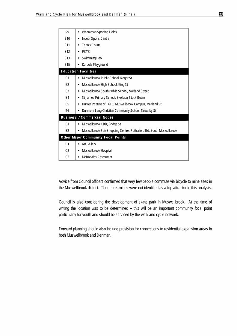
3.3. TRIP GENERATORS AND ATTRACTORS
The identification of land uses and natural landscape features which attract and generate walking and cycling activity is necessary so the proposed network reflects trip patterns and community needs. These will provide the “anchor points” of the walk and cycle network.
Major trip generators and attractors will include:
Residential areas – existing and future. Education facilities – primary, secondary, tertiary. Employment nodes. Shopping / commercial precincts. Major parks, sport and recreation facilities. Other community focal points e.g. hospital.
Major trip attractors for Muswellbrook and Denman are summarised the tables below.
Table 3.1 – Trip Attractors in Muswellbrook (See Figures 4 and 5)
Major Parks , Spor t and Recrea t ion Fac i l i t i es
S1
S2
S3
S4
S5
S6
S7
S8
Karoola Park
Victoria Park
Olympic Park
Bowman Park
Wollombi Park
Brennan Park
Highbrook Park
Simpsons Park
Walk and Cyc le P lan f o r Mus w e l l b rook and Denman (F ina l ) 23
S9
S10
S11
S12
S13
S15
Weeraman Sporting Fields
Indoor Sports Centre
Tennis Courts
PCYC
Swimming Pool
Karoola Playground
Educa t ion Fac i l i t i es
E1
E2
E3
E4
E5
E6
Muswellbrook Public School, Roger St
Muswellbrook High School, King St
Muswellbrook South Public School, Maitland Street
St James Primary School, Skellatar Stock Route
Hunter Institute of TAFE, Muswellbrook Campus, Maitland St
Dunmore Lang Christian Community School, Sowerby St
Bus iness / Commerc ia l Nodes
B1
B2
Muswellbrook CBD, Bridge St
Muswellbrook Fair Shopping Centre, Rutherford Rd, South Muswellbrook
Other Ma jo r Communi ty Foca l Po in ts
C1
C2
C3
Art Gallery
Muswellbrook Hospital
McDonalds Restaurant
Advice from Council officers confirmed that very few people commute via bicycle to mine sites in the Muswellbrook district. Therefore, mines were not identified as a trip attractor in this analysis.
Council is also considering the development of skate park in Muswellbrook. At the time of writing the location was to be determined – this will be an important community focal point particularly for youth and should be serviced by the walk and cycle network.
Forward planning should also include provision for connections to residential expansion areas in both Muswellbrook and Denman.
Walk and Cyc le P lan f o r Mus w e l l b rook and Denman (F ina l ) 24
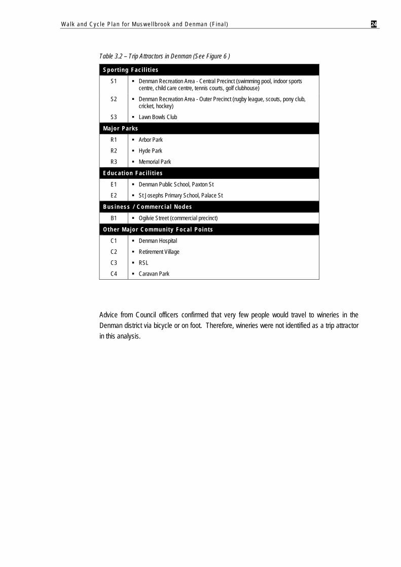
Table 3.2 – Trip Attractors in Denman (See Figure 6 )
Spor t ing Fac i l i t i es
S1 Denman Recreation Area - Central Precinct (swimming pool, indoor sports centre, child care centre, tennis courts, golf clubhouse)
S2 Denman Recreation Area - Outer Precinct (rugby league, scouts, pony club, cricket, hockey)
S3 Lawn Bowls Club
Major Parks
R1
R2
R3
Arbor Park
Hyde Park
Memorial Park
Educa t ion Fac i l i t i es
E1
E2
Denman Public School, Paxton St
St Josephs Primary School, Palace St
Bus iness / Commerc ia l Nodes
B1 Ogilvie Street (commercial precinct)
Other Ma jo r Communi ty Foca l Po in ts
C1
C2
C3
C4
Denman Hospital
Retirement Village
RSL
Caravan Park
Advice from Council officers confirmed that very few people would travel to wineries in the Denman district via bicycle or on foot. Therefore, wineries were not identified as a trip attractor in this analysis.
Walk and Cyc le P lan f o r Mus w e l l b rook and Denman (F ina l ) 25
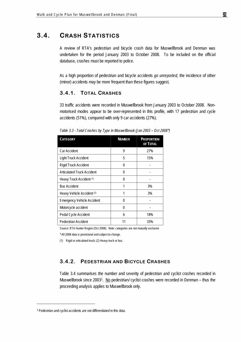
3.4. CRASH STATISTICS
A review of RTA’s pedestrian and bicycle crash data for Muswellbrook and Denman was undertaken for the period January 2003 to October 2008. To be included on the official database, crashes must be reported to police.
As a high proportion of pedestrian and bicycle accidents go unreported, the incidence of other (minor) accidents may be more frequent than these figures suggest.
3.4.1. TOTAL CRASHES
33 traffic accidents were recorded in Muswellbrook from January 2003 to October 2008. Non-motorised modes appear to be over-represented in this profile, with 17 pedestrian and cycle accidents (51%), compared with only 9 car accidents (27%).
Table 3.3 - Total Crashes by Type in Muswellbrook (Jan 2003 – Oct 2008*)
CATEGORY NUMBER PROPORTION OF TOTAL
Car Accident 9 27%
Light Truck Accident 5 15%
Rigid Truck Accident 0 -
Articulated Truck Accident 0 -
Heavy Truck Accident (1) 0 -
Bus Accident 1 3%
Heavy Vehicle Accident (2) 1 3%
Emergency Vehicle Accident 0 -
Motorcycle accident 0 -
Pedal Cycle Accident 6 18%
Pedestrian Accident 11 33% Source: RTA Hunter Region (Oct 2008). Note: categories are not mutually exclusive
* All 2008 data is provisional and subject to change.
(1) Rigid or articulated truck; (2) Heavy truck or bus.
3.4.2. PEDESTRIAN AND BICYCLE CRASHES
Table 3.4 summarises the number and severity of pedestrian and cyclist crashes recorded in Muswellbrook since 20033. No pedestrian/ cyclist crashes were recorded in Denman – thus the proceeding analysis applies to Muswellbrook only.
3 Pedestrian and cyclist accidents are not differentiated in this data.
Walk and Cyc le P lan f o r Mus w e l l b rook and Denman (F ina l ) 26
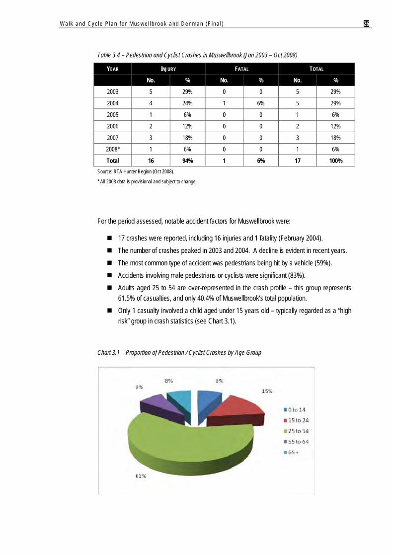
Table 3.4 – Pedestrian and Cyclist Crashes in Muswellbrook (Jan 2003 – Oct 2008)
YEAR INJURY FATAL TOTAL
No. % No. % No. %
2003 5 29% 0 0 5 29%
2004 4 24% 1 6% 5 29%
2005 1 6% 0 0 1 6%
2006 2 12% 0 0 2 12%
2007 3 18% 0 0 3 18%
2008* 1 6% 0 0 1 6%
Total 16 94% 1 6% 17 100% Source: RTA Hunter Region (Oct 2008).
* All 2008 data is provisional and subject to change.
For the period assessed, notable accident factors for Muswellbrook were:
17 crashes were reported, including 16 injuries and 1 fatality (February 2004). The number of crashes peaked in 2003 and 2004. A decline is evident in recent years. The most common type of accident was pedestrians being hit by a vehicle (59%). Accidents involving male pedestrians or cyclists were significant (83%). Adults aged 25 to 54 are over-represented in the crash profile – this group represents
61.5% of casualties, and only 40.4% of Muswellbrook’s total population. Only 1 casualty involved a child aged under 15 years old – typically regarded as a “high
risk” group in crash statistics (see Chart 3.1).
Chart 3.1 – Proportion of Pedestrian / Cyclist Crashes by Age Group
Walk and Cyc le P lan f o r Mus w e l l b rook and Denman (F ina l ) 27
42% of crashes occurred between 3pm and 6pm, coinciding with afternoon school and work commuting times.
A majority of crashes occurred on a Wednesday (41%) or a Friday (24%). Only 1 crash (6%) occurred on a weekend.
In terms of location type: Only 6 crashes (35%) occurred at an intersection. A majority of recorded cases involved a pedestrian crossing the road (59%).
In respect to crash conditions: Most crashes occurred in daylight (71%), with the balance occurring at dusk or in
darkness (29%). 15 crashes occurred in fine weather (88%). Only 2 occurred in rain or overcast
conditions (12%).
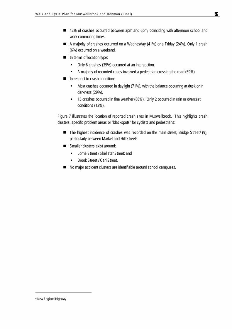
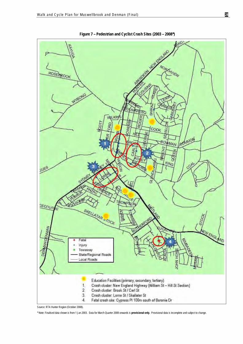
Figure 7 illustrates the location of reported crash sites in Muswellbrook. This highlights crash clusters, specific problem areas or “blackspots” for cyclists and pedestrians:
The highest incidence of crashes was recorded on the main street, Bridge Street4 (9), particularly between Market and Hill Streets.
Smaller clusters exist around: Lorne Street / Skellatar Street; and Brook Street / Carl Street.
No major accident clusters are identifiable around school campuses.
4 New England Highway
Walk and Cyc le P lan f o r Mus w e l l b rook and Denman (F ina l ) 28
Figure 7 – Pedestrian and Cyclist Crash Sites (2003 – 2008*)
Source: RTA Hunter Region (October 2008).
* Note: Finalised data shown is from 1 Jan 2003. Data for March Quarter 2008 onwards is provisional only. Provisional data is incomplete and subject to change.
Walk and Cyc le P lan f o r Mus w e l l b rook and Denman (F ina l ) 29
4. DEMOGRAPHIC AND TRAVEL TRENDS
4.1. POPULATION SNAPSHOT 4.1.1. CURRENT POPULATION
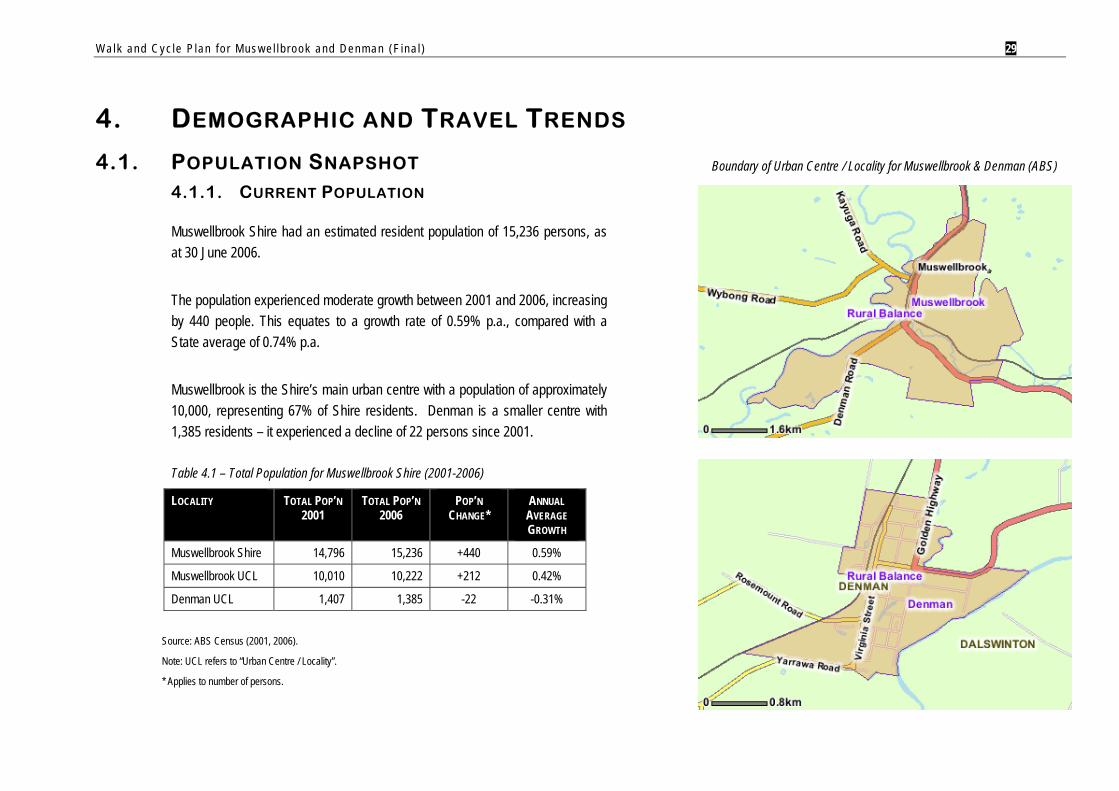
Muswellbrook Shire had an estimated resident population of 15,236 persons, as at 30 June 2006.
The population experienced moderate growth between 2001 and 2006, increasing by 440 people. This equates to a growth rate of 0.59% p.a., compared with a State average of 0.74% p.a.
Muswellbrook is the Shire’s main urban centre with a population of approximately 10,000, representing 67% of Shire residents. Denman is a smaller centre with 1,385 residents – it experienced a decline of 22 persons since 2001.
Table 4.1 – Total Population for Muswellbrook Shire (2001-2006)
LOCALITY TOTAL POP’N 2001
TOTAL POP’N 2006
POP’N CHANGE*
ANNUAL AVERAGE GROWTH
Muswellbrook Shire 14,796 15,236 +440 0.59%
Muswellbrook UCL 10,010 10,222 +212 0.42%
Denman UCL 1,407 1,385 -22 -0.31%
Source: ABS Census (2001, 2006).
Note: UCL refers to “Urban Centre / Locality”.
* Applies to number of persons.
Boundary of Urban Centre / Locality for Muswellbrook & Denman (ABS)
Walk and Cyc le P lan f o r Mus w e l l b rook and Denman (F ina l ) 30
4.1.2. AGE STRUCTURE
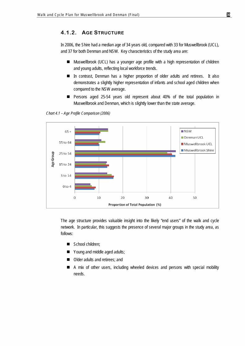
In 2006, the Shire had a median age of 34 years old, compared with 33 for Muswellbrook (UCL), and 37 for both Denman and NSW. Key characteristics of the study area are:
Muswellbrook (UCL) has a younger age profile with a high representation of children and young adults, reflecting local workforce trends.
In contrast, Denman has a higher proportion of older adults and retirees. It also demonstrates a slightly higher representation of infants and school aged children when compared to the NSW average.
Persons aged 25-54 years old represent about 40% of the total population in Muswellbrook and Denman, which is slightly lower than the state average.
Chart 4.1 – Age Profile Comparison (2006)
The age structure provides valuable insight into the likely “end users” of the walk and cycle network. In particular, this suggests the presence of several major groups in the study area, as follows:
School children; Young and middle aged adults; Older adults and retirees; and A mix of other users, including wheeled devices and persons with special mobility
needs.
Walk and Cyc le P lan f o r Mus w e l l b rook and Denman (F ina l ) 31
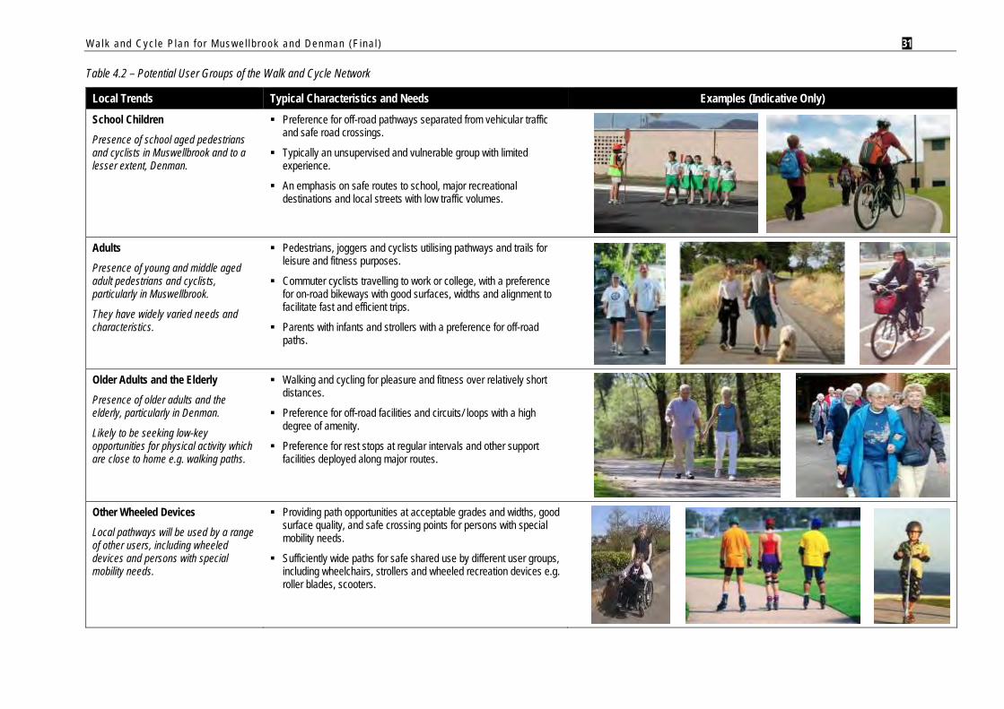
Table 4.2 – Potential User Groups of the Walk and Cycle Network
Local Trends Typical Characteristics and Needs Examples (Indicative Only) School Children
Presence of school aged pedestrians and cyclists in Muswellbrook and to a lesser extent, Denman.
Preference for off-road pathways separated from vehicular traffic and safe road crossings.
Typically an unsupervised and vulnerable group with limited experience.
An emphasis on safe routes to school, major recreational destinations and local streets with low traffic volumes.
Adults
Presence of young and middle aged adult pedestrians and cyclists, particularly in Muswellbrook.
They have widely varied needs and characteristics.
Pedestrians, joggers and cyclists utilising pathways and trails for leisure and fitness purposes.
Commuter cyclists travelling to work or college, with a preference for on-road bikeways with good surfaces, widths and alignment to facilitate fast and efficient trips.
Parents with infants and strollers with a preference for off-road paths.
Older Adults and the Elderly
Presence of older adults and the elderly, particularly in Denman.
Likely to be seeking low-key opportunities for physical activity which are close to home e.g. walking paths.
Walking and cycling for pleasure and fitness over relatively short distances.
Preference for off-road facilities and circuits/ loops with a high degree of amenity.
Preference for rest stops at regular intervals and other support facilities deployed along major routes.
Other Wheeled Devices
Local pathways will be used by a range of other users, including wheeled devices and persons with special mobility needs.
Providing path opportunities at acceptable grades and widths, good surface quality, and safe crossing points for persons with special mobility needs.
Sufficiently wide paths for safe shared use by different user groups, including wheelchairs, strollers and wheeled recreation devices e.g. roller blades, scooters.

Walk and Cyc le P lan f o r Mus w e l l b rook and Denman (F ina l ) 32
4.1.3. FUTURE POPULATION PROJECTIONS
Projections prepared by the NSW Department of Planning suggest the Shire’s population will experience negative growth in future.
State Government projections suggest the Shire will drop below 15,000 persons by 2026 at a rate of -0.09% p.a., in comparison to NSW’s average growth at 0.79% p.a (2006-2026)5. This equates to almost 200 less people in the Shire over the next 18 years.
Table 4.3 – Population Projections for Muswellbrook Shire4
1
Council anticipates that growth will be positive and exceed these estimates. Council and its consultants have analysed ABS data and State Government projections to develop revised population forecasts, as part of the Shire’s recent Integrated Water Cycle Management Concept Study.
At the time of writing, the projections were not available for analysis, however, it is understood that Council forecasts positive growth for the Shire, with new residents primarily settling in the Muswellbrook urban area. More subdued change will expected in Denman and smaller communities, with population decline likely in some cases.
As noted in previous research6, significant drivers for population growth in the Shire will include:
Approved development applications for large scale mining projects.
Approved development application for the Mecure Hotel and conference centre in Muswellbrook.
Potential construction of a third coal generated power station.
Possible relocation of large electricity users into the “industry zone” at Macquarie generation power site south of Muswellbrook.
Lack of rental accommodation in the Shire.
Population migration from metropolitan areas (primarily Sydney), prompted by residential land costs and those in search of a lifestyle change i.e. “tree change”.
5 NSW Department of Planning (2005), New South Wales Statistical Local Area Population Projections 2001-2031. (Note: Projections are based on 2001 ABS Census Data. Revised projections not available until 2009). 6 Muswellbrook Shire Council (Feb 2008), Ms D. Di Rollo – Economic Development Manager.
2006 2011 2016 2021 2026
Muswellbrook Shire 15,150 15,080 15,040 15,010 14,960
Walk and Cyc le P lan f o r Mus w e l l b rook and Denman (F ina l ) 33
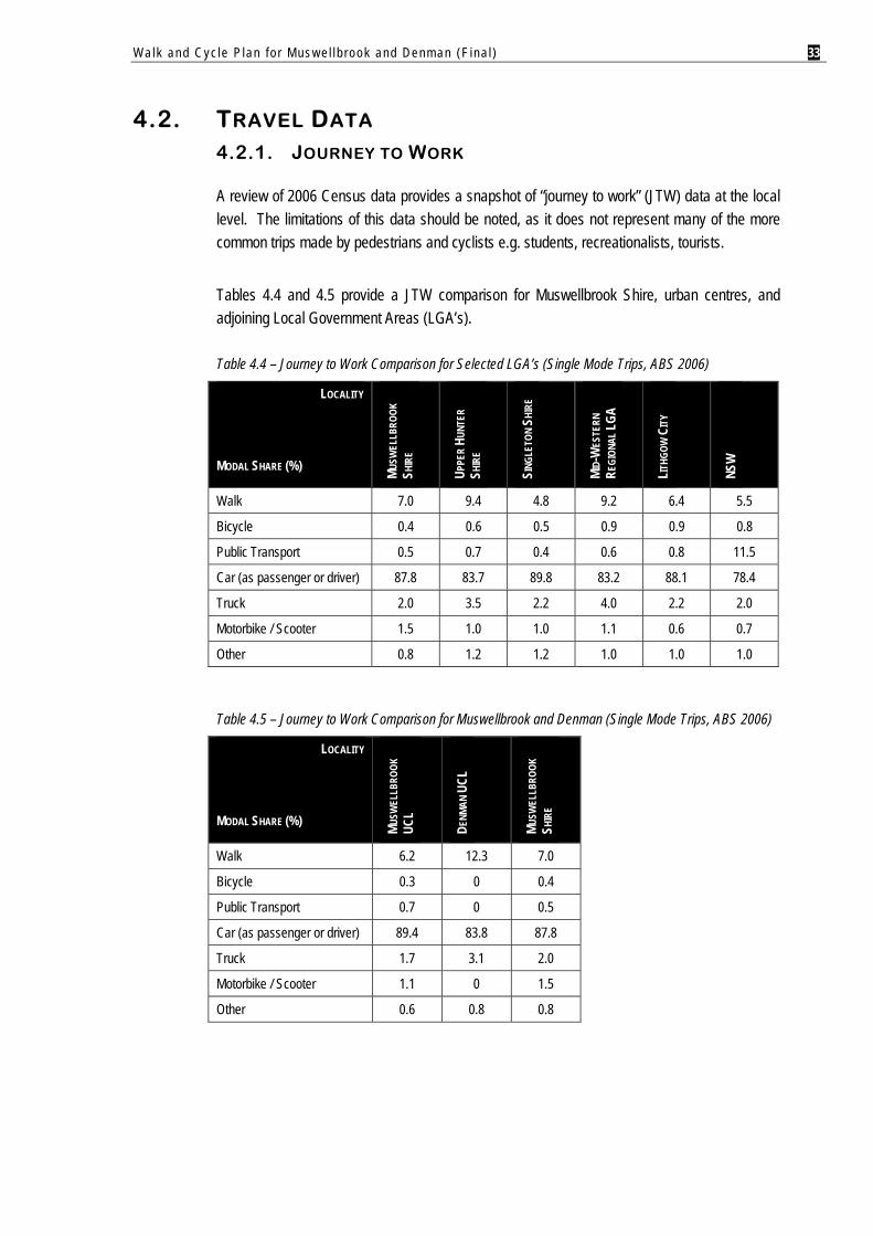
4.2. TRAVEL DATA 4.2.1. JOURNEY TO WORK
A review of 2006 Census data provides a snapshot of “journey to work” (JTW) data at the local level. The limitations of this data should be noted, as it does not represent many of the more common trips made by pedestrians and cyclists e.g. students, recreationalists, tourists.
Tables 4.4 and 4.5 provide a JTW comparison for Muswellbrook Shire, urban centres, and adjoining Local Government Areas (LGA’s).
Table 4.4 – Journey to Work Comparison for Selected LGA’s (Single Mode Trips, ABS 2006)
LOCALITY
MODAL SHARE (%) MUSW
ELLB
ROOK
SH
IRE
UPPE
R HU
NTER
SH
IRE
SING
LETO
N SH
IRE
MID-
WES
TERN
RE
GION
AL LG
A
LITHG
OW C
ITY
NSW
Walk 7.0 9.4 4.8 9.2 6.4 5.5
Bicycle 0.4 0.6 0.5 0.9 0.9 0.8
Public Transport 0.5 0.7 0.4 0.6 0.8 11.5
Car (as passenger or driver) 87.8 83.7 89.8 83.2 88.1 78.4
Truck 2.0 3.5 2.2 4.0 2.2 2.0
Motorbike / Scooter 1.5 1.0 1.0 1.1 0.6 0.7
Other 0.8 1.2 1.2 1.0 1.0 1.0
Table 4.5 – Journey to Work Comparison for Muswellbrook and Denman (Single Mode Trips, ABS 2006)
LOCALITY
MODAL SHARE (%) MUSW
ELLB
ROOK
UC
L
DENM
AN U
CL
MUSW
ELLB
ROOK
SH
IRE
Walk 6.2 12.3 7.0
Bicycle 0.3 0 0.4
Public Transport 0.7 0 0.5
Car (as passenger or driver) 89.4 83.8 87.8
Truck 1.7 3.1 2.0
Motorbike / Scooter 1.1 0 1.5
Other 0.6 0.8 0.8
Walk and Cyc le P lan f o r Mus w e l l b rook and Denman (F ina l ) 34
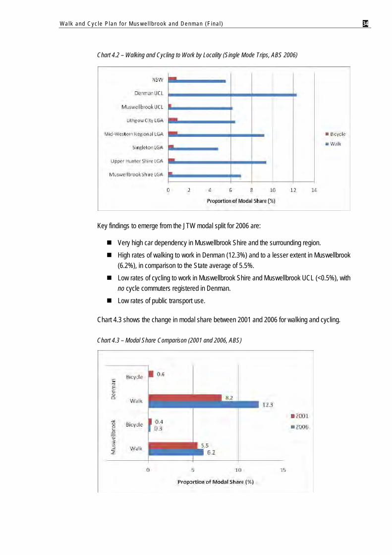
Chart 4.2 – Walking and Cycling to Work by Locality (Single Mode Trips, ABS 2006)
Key findings to emerge from the JTW modal split for 2006 are:
Very high car dependency in Muswellbrook Shire and the surrounding region. High rates of walking to work in Denman (12.3%) and to a lesser extent in Muswellbrook
(6.2%), in comparison to the State average of 5.5%. Low rates of cycling to work in Muswellbrook Shire and Muswellbrook UCL (<0.5%), with
no cycle commuters registered in Denman. Low rates of public transport use.
Chart 4.3 shows the change in modal share between 2001 and 2006 for walking and cycling.
Chart 4.3 – Modal Share Comparison (2001 and 2006, ABS)
Walk and Cyc le P lan f o r Mus w e l l b rook and Denman (F ina l ) 35
Notable findings for this inter-censal period are:
For Denman, cycling to work appears to have ceased, although there was substantial growth in walking which represented 12.3% of the modal share (+4.1%).
For Muswellbrook, cycling to work was generally stable (-0.1% change), coinciding with a small rise in walking (+0.7%).
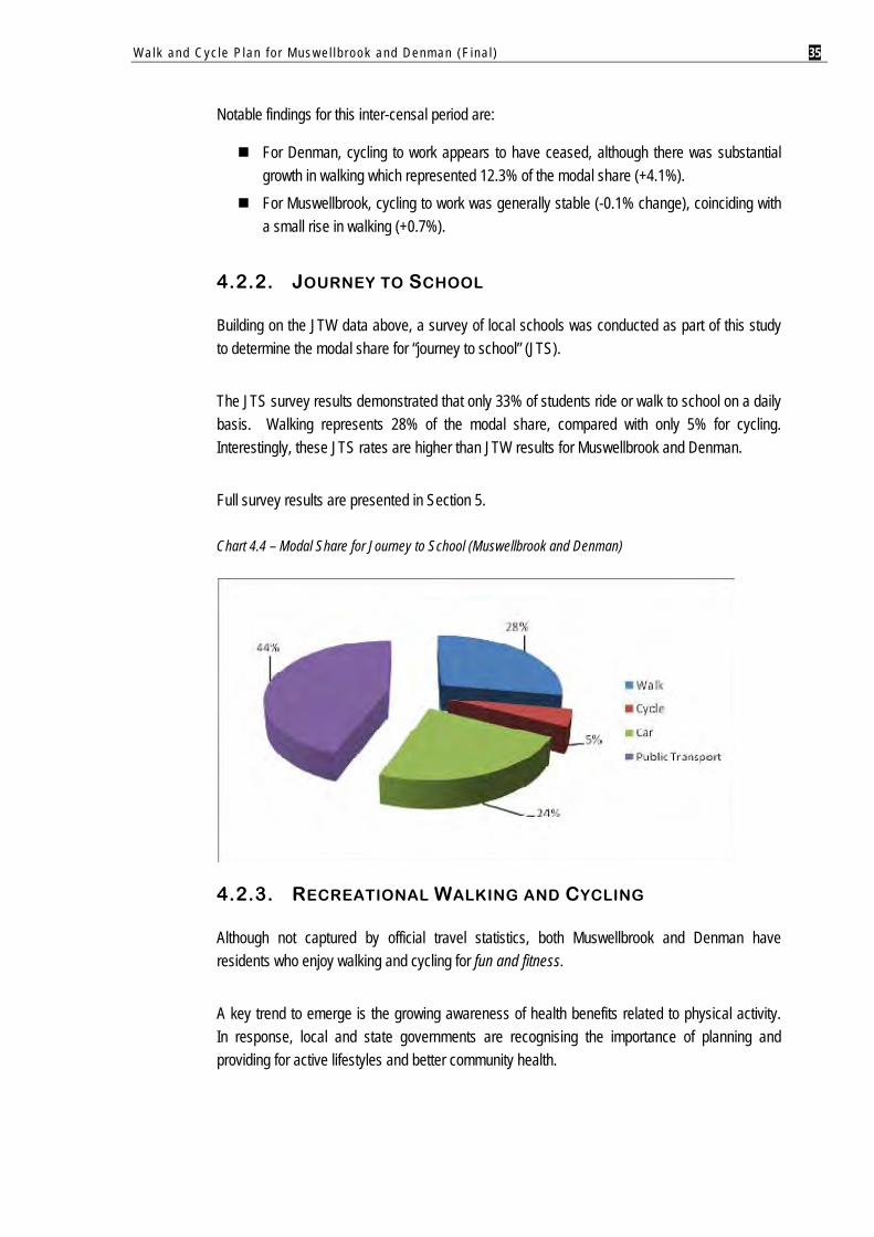
4.2.2. JOURNEY TO SCHOOL
Building on the JTW data above, a survey of local schools was conducted as part of this study to determine the modal share for “journey to school” (JTS).
The JTS survey results demonstrated that only 33% of students ride or walk to school on a daily basis. Walking represents 28% of the modal share, compared with only 5% for cycling. Interestingly, these JTS rates are higher than JTW results for Muswellbrook and Denman.
Full survey results are presented in Section 5.
Chart 4.4 – Modal Share for Journey to School (Muswellbrook and Denman)
4.2.3. RECREATIONAL WALKING AND CYCLING
Although not captured by official travel statistics, both Muswellbrook and Denman have residents who enjoy walking and cycling for fun and fitness.
A key trend to emerge is the growing awareness of health benefits related to physical activity. In response, local and state governments are recognising the importance of planning and providing for active lifestyles and better community health.
Walk and Cyc le P lan f o r Mus w e l l b rook and Denman (F ina l ) 36
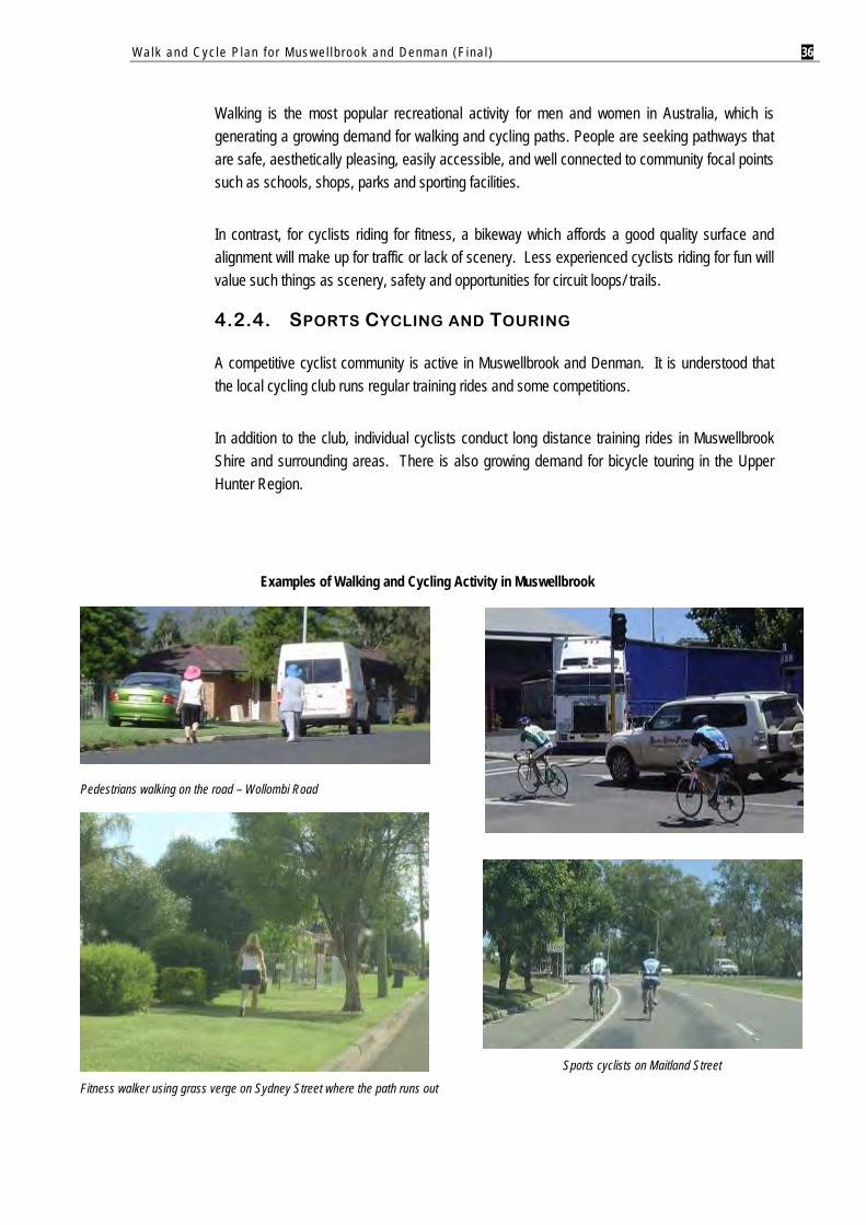
Walking is the most popular recreational activity for men and women in Australia, which is generating a growing demand for walking and cycling paths. People are seeking pathways that are safe, aesthetically pleasing, easily accessible, and well connected to community focal points such as schools, shops, parks and sporting facilities.
In contrast, for cyclists riding for fitness, a bikeway which affords a good quality surface and alignment will make up for traffic or lack of scenery. Less experienced cyclists riding for fun will value such things as scenery, safety and opportunities for circuit loops/ trails.
4.2.4. SPORTS CYCLING AND TOURING
A competitive cyclist community is active in Muswellbrook and Denman. It is understood that the local cycling club runs regular training rides and some competitions.
In addition to the club, individual cyclists conduct long distance training rides in Muswellbrook Shire and surrounding areas. There is also growing demand for bicycle touring in the Upper Hunter Region.
Examples of Walking and Cycling Activity in Muswellbrook
Pedestrians walking on the road – Wollombi Road
Fitness walker using grass verge on Sydney Street where the path runs out
Sports cyclists on Maitland Street
Walk and Cyc le P lan f o r Mus w e l l b rook and Denman (F ina l ) 37
5. STAKEHOLDER CONSULTATION
A targeted consultation approach was conducted for this study, involving three principal stakeholder groups:
Muswellbrook Shire Council: Project briefing session with the newly elected Council (November 2008). Discussions with Council officers (ongoing throughout the study).
Roads and Traffic Authority – Hunter Region; and Local schools in Muswellbrook and Denman.
Council determined that consultation with the general community was beyond the scope of this study, and may be conducted at a later stage7. Although the consultation was quite focussed, it provided insight into the major issues and opportunities across the study area. Notable findings are summarised below.
5.1. MUSWELLBROOK SHIRE COUNCIL
Major issues and needs raised by Muswellbrook Shire Council were:
1. Project Briefing Session with Councillors
Muswellbrook:
Pathway circuits in parks are desirable, particularly for families with young children. There is growing demand for longer distance bicycle touring between communities. Pathway design should consider users with special mobility needs. Growing recognition of the need for formalised on-road bikeways catering for
experienced cyclists e.g. travelling to work or TAFE. Address the “dead end” path along Muscle Creek in the vicinity of the Bridge Street
rail bridge. Major pathways should be well lit (including solar options) to afford safety and
security to users. Denman:
Extend the Sandy Creek Path to Hyde Park. Create new walking and cycling links into the Denman Recreation Area in
accordance with the site’s Master Plan. Existing on-road bikeways near schools are not suitable for young children who are
required to cycle with traffic and around parked cars e.g. Virginia Street.
7 Note: Muswellbrook Shire Council placed the Walk and Cycle Plan on public exhibition in mid 2009. This version of the report has been amended to reflect community feedback to the study.
Walk and Cyc le P lan f o r Mus w e l l b rook and Denman (F ina l ) 38
Upgrade off-road paths in the Virginia/ Paxton Street area to improve school access and safety.
Path link to Rosemount Road is needed.
2. Discussions with Council Officers
Network Planning and Design:
The existing off-road pathway network provides good coverage in Muswellbrook and Denman.
Priority for future planning is to focus on network completion e.g. missing links. Desirable for major shared paths to be 2.0m wide. Where schools located are on highways, investigate off-road options for rear
property access. Additional funding would be beneficial to assist with future network development
and maintenance. Muswellbrook – Issues and Needs:
Some major corridors with wide road reserves offer good scope for improved on-road bikeways e.g. Sydney, Queen, Maitland, Aberdeen Streets.
Several “squeeze points” for cyclists exist on the highway e.g. rail underpass. New signals are programmed for several intersections on highway through
Muswellbrook. Key trip destinations include the CBD, TAFE, schools and McDonalds restaurant. Commuter cyclists unlikely to ride to industrial estates or mines located outside the
Muswellbrook urban area. Also, potential for conflict with trucks on haulage routes. Significant topographic constraints in northern part of Muswellbrook curb walking
and cycling activity. Extend network development to new residential subdivision areas in southern
Muswellbrook. Denman – Issues and Needs:
Tourism industry is strengthening in this area – encourage visitors to utilise the local walking and cycling network.
The Bicentennial Trail passes through Sandy Hollow8 – integrate bicycle touring opportunities.
8 Note: Sandy Hollow is located outside the study area.
Walk and Cyc le P lan f o r Mus w e l l b rook and Denman (F ina l ) 39
5.2. ROADS AND TRAFFIC AUTHORITY (RTA)
Major points raised by the RTA were9:
1. Works programmed by RTA for pathway and bikeway projects in Muswellbrook Shire:
The RTA carried out a bikeway/ pathway project with Council during the 2007/08 financial year. This involved construction of a 600m off-road shared path connecting from the work done by the developer of Eastbrook Links Estate to Rutherford Road.
During the 2008/09 financial year, the RTA has a project to install pedestrian refuges on New England Highway (i.e. Maitland Street) in the vicinity of Lorne Street.
The RTA is yet to finalise its 2009/10 program. However, it does not have any transport infrastructure works planned for Muswellbrook Shire in the near future.
2. RTA advice on funding of new and upgraded off-road pathways located in State Controlled Road (SCR) corridors:
Funding is generally on a case by case basis, and is determined by the reason for the project and the location of the project. There are recent examples of joint funding with MSC, although the RTA also has cases where projects have been fully funded by them, or Council funded or even developer funded.
Often local Councils submit requests for RTA contribution – the RTA assesses these on where they lie in relation to its available funding and list of priorities.
3. RTA’s position in respect to on-road bikeways on SCR’s (generally):
The RTA supports the installation of these facilities subject to the requirements of Austroads Part 14 and the NSW Bicycle Guidelines being met.
4. RTA’s position in respect to on-road bikeways on SCR’s in Muswellbrook (Bridge, Maitland and Sydney Streets):
It appears there would be benefits in providing on-road cycle lanes along these corridors.
However, there are numerous conflicts that would need to be further investigated, such as side streets, development accesses, on-street parking and squeeze points
9 RTA Hunter Region (Nov 2008): Pers. comm. (Ken Saxby – Manager, Road Safety & Traffic Services; Adam Thomas - Planning & Analysis Manager)

Walk and Cyc le P lan f o r Mus w e l l b rook and Denman (F ina l ) 40
5.3. SCHOOLS
There are seven schools located in the study area. Each school principal was invited to complete a survey on behalf of their students for input to the Walk & Cycle Plan.
The survey sought to determine:
The proportion of students who walk or cycle to school; Principal desire lines for walking and cycling to school; Problem areas or “blackspots” for young pedestrians and cyclists in school zones; The reasons why students do not walk or cycle to school; and Priority routes for new or upgraded bicycle and pedestrian facilities in school zones.
As shown in the table overleaf, the response was supportive with 5 schools participating in the survey (71% response rate).
Table 5.1 – Response to School Survey
SCHOOL NAME STUDENT ENROLMENT
(2008)
RESPONSE RECEIVED
Denman
Denman Public School # - St Joseph’s Primary School 38
Muswellbrook
Dunmore Lang Christian Community School * - Muswellbrook Public School 580 Muswellbrook South Public School 395 St James Primary School 300 Muswellbrook High School 730
# Declined to participate in survey.
* Could not be contacted via telephone, email or post.
Notable findings of the survey are summarised below.
1. Modal Share
33% of students ride or walk to school on a daily basis. Walking represents 28% of the modal share, compared with only 5% for cycling - based on current school enrolments, this equates to almost 700 students travelling to school on foot or by bike.
60% of respondents indicated that the proportion of school pedestrians and cyclists had remained stable since 2003. 40% recorded a decline. Importantly, no schools reported an increase in walking or riding to school in the last 5 years.
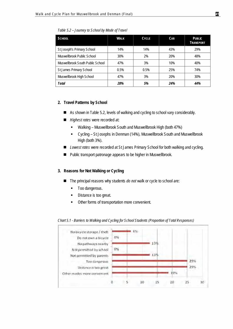
Walk and Cyc le P lan f o r Mus w e l l b rook and Denman (F ina l ) 41
Table 5.2 – Journey to School by Mode of Travel
SCHOOL WALK CYCLE CAR PUBLIC TRANSPORT
St Joseph’s Primary School 14% 14% 43% 29%
Muswellbrook Public School 30% 2% 20% 48%
Muswellbrook South Public School 47% 3% 10% 40%
St James Primary School 0.5% 0.5% 25% 74%
Muswellbrook High School 47% 3% 20% 30%
Total 28% 5% 24% 44%
2. Travel Patterns by School
As shown in Table 5.2, levels of walking and cycling to school vary considerably. Highest rates were recorded at:
Walking – Muswellbrook South and Muswellbrook High (both 47%) Cycling – St Josephs in Denman (14%), Muswellbrook South and Muswellbrook
High (both 3%). Lowest rates were recorded at St James Primary School for both walking and cycling. Public transport patronage appears to be higher in Muswellbrook.
3. Reasons for Not Walking or Cycling
The principal reasons why students do not walk or cycle to school are: Too dangerous. Distance is too great. Other forms of transportation more convenient.
Chart 5.1 - Barriers to Walking and Cycling for School Students (Proportion of Total Responses)
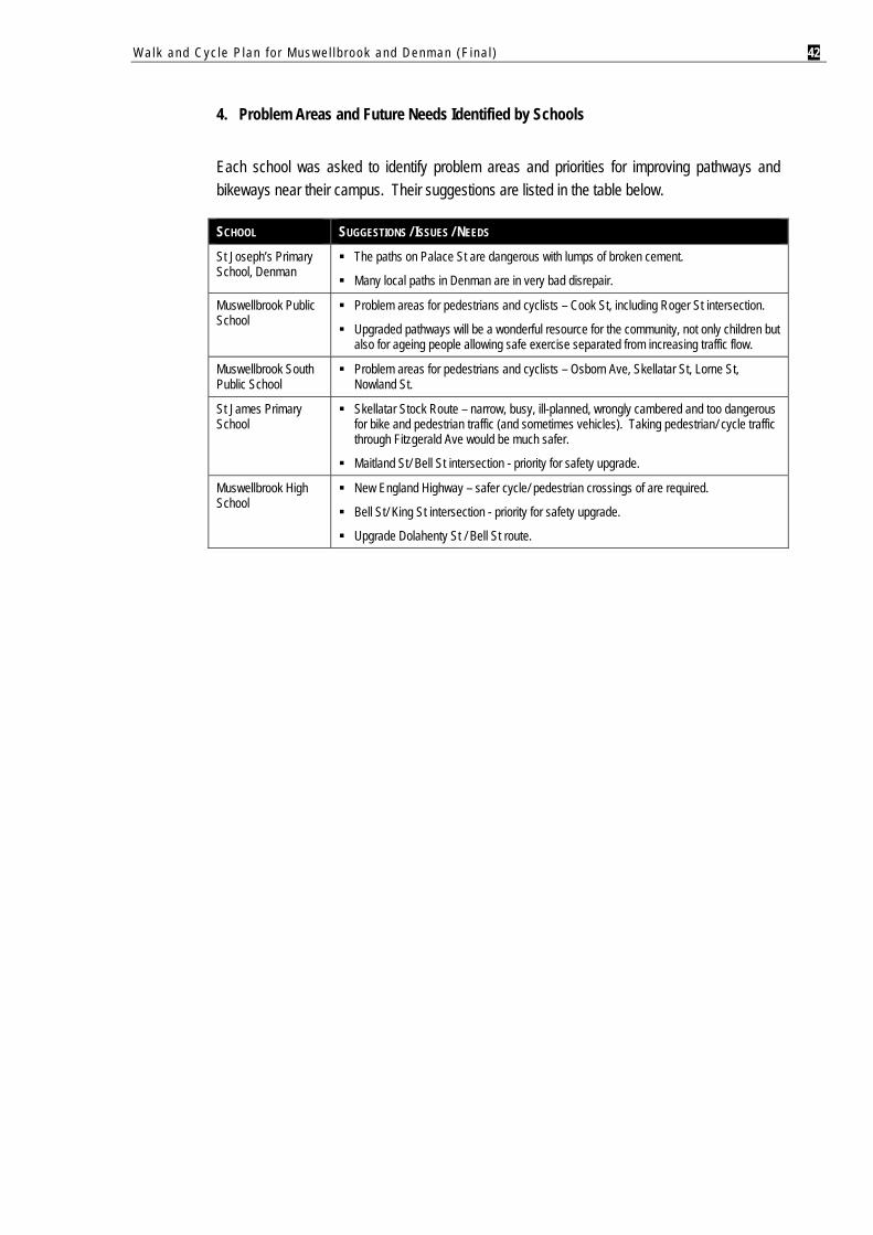
Walk and Cyc le P lan f o r Mus w e l l b rook and Denman (F ina l ) 42
4. Problem Areas and Future Needs Identified by Schools
Each school was asked to identify problem areas and priorities for improving pathways and bikeways near their campus. Their suggestions are listed in the table below.
SCHOOL SUGGESTIONS / ISSUES / NEEDS
St Joseph’s Primary School, Denman
The paths on Palace St are dangerous with lumps of broken cement.
Many local paths in Denman are in very bad disrepair.
Muswellbrook Public School
Problem areas for pedestrians and cyclists – Cook St, including Roger St intersection.
Upgraded pathways will be a wonderful resource for the community, not only children but also for ageing people allowing safe exercise separated from increasing traffic flow.
Muswellbrook South Public School
Problem areas for pedestrians and cyclists – Osborn Ave, Skellatar St, Lorne St, Nowland St.
St James Primary School
Skellatar Stock Route – narrow, busy, ill-planned, wrongly cambered and too dangerous for bike and pedestrian traffic (and sometimes vehicles). Taking pedestrian/ cycle traffic through Fitzgerald Ave would be much safer.
Maitland St/ Bell St intersection - priority for safety upgrade.
Muswellbrook High School
New England Highway – safer cycle/ pedestrian crossings of are required.
Bell St/ King St intersection - priority for safety upgrade.
Upgrade Dolahenty St / Bell St route.
Walk and Cyc le P lan f o r Mus w e l l b rook and Denman (F ina l ) 43
6. THE STRATEGY
6.1. OVERVIEW
This section presents the proposed Walk & Cycle Network for the communities of Muswellbrook and Denman. The overall aim of proposed network is to:
“Provide walking and cycling facilities in Muswellbrook and Denman to improve mobility, recreation and physical activity choices for all age groups.”
The proposed network builds on existing pathway infrastructure to improve connectivity, coverage and safety. It also seeks to create linkages and circuits that encourage walking and cycling activity, whilst minimising the reliance on private vehicles.
The Walk & Cycle Network comprises four key components:
Overview of design guidelines for on-road and off-road facilities. Description of proposed networks for Muswellbrook and Denman. Implementation Plan describing proposed works for each section of the network,
including: Route location and approximate distance. Type of works proposed i.e. on-road and off-road treatments. Priority/ timing of works. Responsibility for project implementation (Council, State, developer).
Other critical actions to support development of the walk and cycle network.
6.2. DESIGN GUIDELINES 6.2.1. AUSTROADS
Whilst the preparation of design guidelines was beyond the scope of this study, suggested facility treatments for the study area are largely based on Austroads Guide to Traffic Engineering Practice (Part 13 – Pedestrians; and Part 14 – Bicycles).
Austroads guidelines are widely accepted by local government in Australia, however, it should be noted that they are not intended as absolute standards. Therefore, Council is encouraged to implement the guidelines as practicably as possible, subject to local conditions which may require modifications or reduced facility widths e.g. spatial constraints, low demand routes, funding availability.
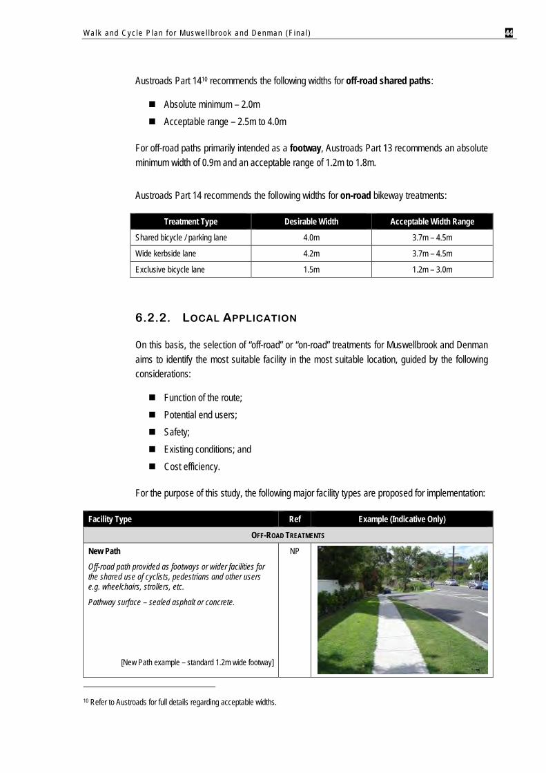
Walk and Cyc le P lan f o r Mus w e l l b rook and Denman (F ina l ) 44
Austroads Part 1410 recommends the following widths for off-road shared paths:
Absolute minimum – 2.0m Acceptable range – 2.5m to 4.0m
For off-road paths primarily intended as a footway, Austroads Part 13 recommends an absolute minimum width of 0.9m and an acceptable range of 1.2m to 1.8m.
Austroads Part 14 recommends the following widths for on-road bikeway treatments:
Treatment Type Desirable Width Acceptable Width Range
Shared bicycle / parking lane 4.0m 3.7m – 4.5m
Wide kerbside lane 4.2m 3.7m – 4.5m
Exclusive bicycle lane 1.5m 1.2m – 3.0m
6.2.2. LOCAL APPLICATION
On this basis, the selection of “off-road” or “on-road” treatments for Muswellbrook and Denman aims to identify the most suitable facility in the most suitable location, guided by the following considerations:
Function of the route; Potential end users; Safety; Existing conditions; and Cost efficiency.
For the purpose of this study, the following major facility types are proposed for implementation:
Facility Type Ref Example (Indicative Only)
OFF-ROAD TREATMENTS
New Path
Off-road path provided as footways or wider facilities for the shared use of cyclists, pedestrians and other users e.g. wheelchairs, strollers, etc.
Pathway surface – sealed asphalt or concrete.
[New Path example – standard 1.2m wide footway]
NP
10 Refer to Austroads for full details regarding acceptable widths.
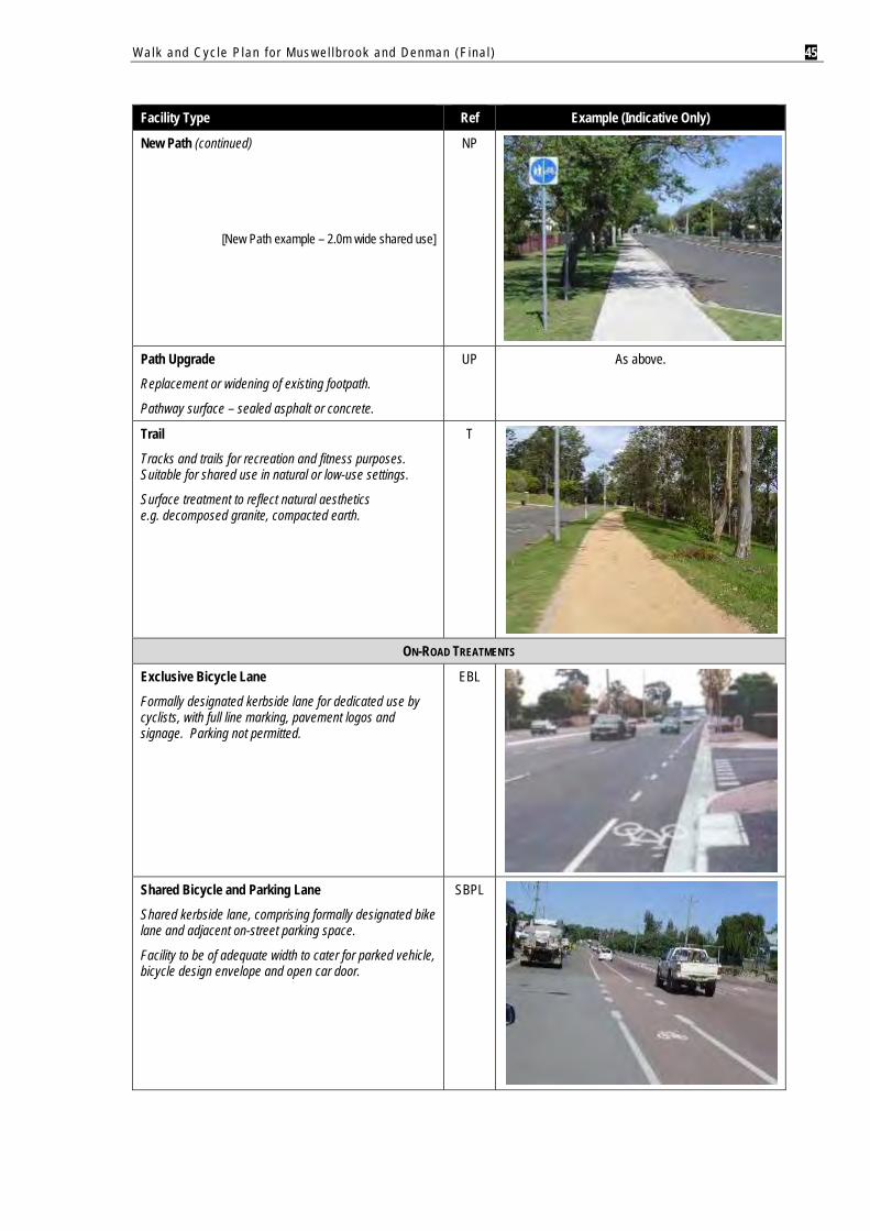
Walk and Cyc le P lan f o r Mus w e l l b rook and Denman (F ina l ) 45
Facility Type Ref Example (Indicative Only)
New Path (continued)
[New Path example – 2.0m wide shared use]
NP
Path Upgrade
Replacement or widening of existing footpath.
Pathway surface – sealed asphalt or concrete.
UP As above.
Trail
Tracks and trails for recreation and fitness purposes. Suitable for shared use in natural or low-use settings.
Surface treatment to reflect natural aesthetics e.g. decomposed granite, compacted earth.
T
ON-ROAD TREATMENTS
Exclusive Bicycle Lane
Formally designated kerbside lane for dedicated use by cyclists, with full line marking, pavement logos and signage. Parking not permitted.
EBL
Shared Bicycle and Parking Lane
Shared kerbside lane, comprising formally designated bike lane and adjacent on-street parking space.
Facility to be of adequate width to cater for parked vehicle, bicycle design envelope and open car door.
SBPL
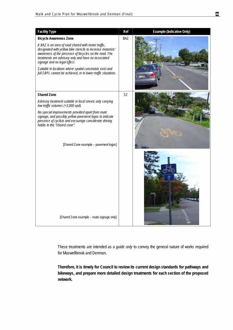
Walk and Cyc le P lan f o r Mus w e l l b rook and Denman (F ina l ) 46
Facility Type Ref Example (Indicative Only)
Bicycle Awareness Zone
A BAZ is an area of road shared with motor traffic, designated with yellow bike stencils to increase motorists' awareness of the presence of bicycles on the road. The treatments are advisory only and have no associated signage and no legal effect.
Suitable in locations where spatial constraints exist and full SBPL cannot be achieved, or in lower traffic situations.
BAZ
Shared Zone
Advisory treatment suitable in local streets only carrying low traffic volumes (<3,000 vpd).
No special improvements provided apart from route signage, and possibly yellow pavement logos to indicate presence of cyclists and encourage considerate driving habits in this “shared zone”.
[Shared Zone example – pavement logos]
SZ
[Shared Zone example – route signage only]
These treatments are intended as a guide only to convey the general nature of works required for Muswellbrook and Denman.
Therefore, it is timely for Council to review its current design standards for pathways and bikeways, and prepare more detailed design treatments for each section of the proposed network.
Walk and Cyc le P lan f o r Mus w e l l b rook and Denman (F ina l ) 47
6.3. RECOMMENDED NETWORKS
This section provides a description of the proposed networks for each community. This provides the basis for the Network Implementation Plan in Section 6.4, which details specific works for each route.
6.3.1. MUSWELLBROOK
Muswellbrook already has a reasonable pathway network. This strategy will aim to build on existing facilities to significantly enhance pedestrian and cycle movement, through:
Upgrading and extending off-road pathways. Targeted development of formal on-road bikeways along key corridors to facilitate
continuous, convenient and safer travel for experienced commuter cyclists. Minimising barriers to pedestrian and cycle movement. Improving the legibility of pathways and trails located in parkland. Strategic integration of pathways and bikeways with future residential subdivision,
rather than retrofitting facilities at a later stage for higher cost. Provision of recreation and fitness trails to support more healthy and active lifestyles.
In summary, major actions for Muswellbrook’s Walk & Cycle Network are:
CBD Access and Cross-Town Routes
Formalise the presence of experienced commuter and sports cyclists sharing the roads with motor vehicles. Establish on-road bike lanes and advisory treatments along three major corridors to create “cross-town” routes between the CBD and suburbs, via:
Maitland Street; Sydney Street; and Bridge Street.
Support the primary corridors above with secondary links to facilitate on-road cycling in suburban catchments, via:
Southside – Rutherford Road, Bimbadeen Drive and Skellatar Stock Route. Northside – Cook, Brook, Brecht and Queen Streets.
Close the “dead end” path along Muscle Creek, where it terminates beneath the rail underpass for public safety and risk management reasons. The strategy recommends other measures to improve the legibility of existing paths at street level, to facilitate enhanced pedestrian and cycle access across the rail line and creek.
As the standard of existing pathways in the CBD is generally good, target future improvements on path connectivity, linkages to adjoining residential areas and maintenance.
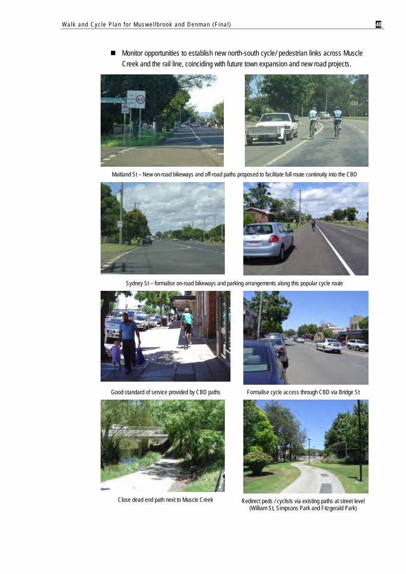
Walk and Cyc le P lan f o r Mus w e l l b rook and Denman (F ina l ) 48
Monitor opportunities to establish new north-south cycle/ pedestrian links across Muscle Creek and the rail line, coinciding with future town expansion and new road projects.
Maitland St – New on-road bikeways and off-road paths proposed to facilitate full route continuity into the CBD
Sydney St – formalise on-road bikeways and parking arrangements along this popular cycle route
Good standard of service provided by CBD paths Formalise cycle access through CBD via Bridge St
Close dead end path next to Muscle Creek
Redirect peds / cyclists via existing paths at street level
(William St, Simpsons Park and Fitzgerald Park)
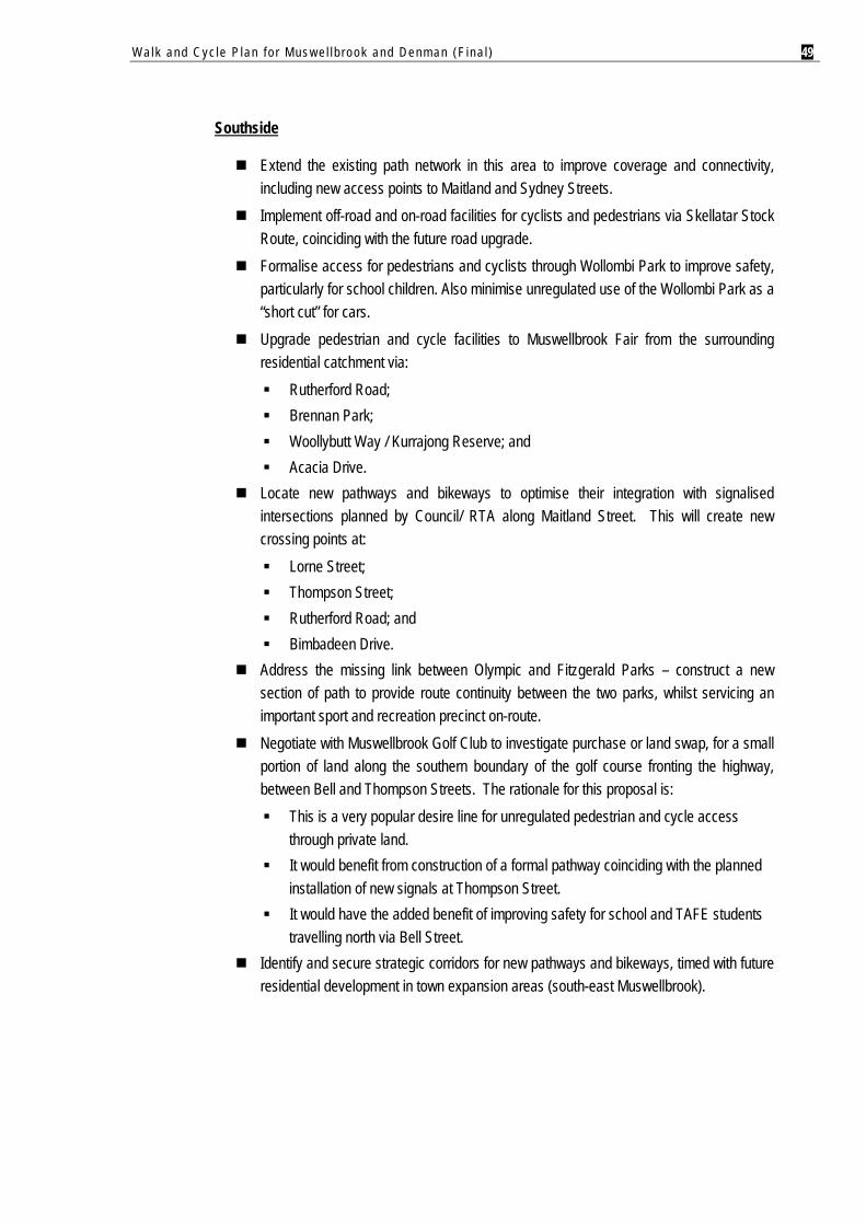
Walk and Cyc le P lan f o r Mus w e l l b rook and Denman (F ina l ) 49
Southside
Extend the existing path network in this area to improve coverage and connectivity, including new access points to Maitland and Sydney Streets.
Implement off-road and on-road facilities for cyclists and pedestrians via Skellatar Stock Route, coinciding with the future road upgrade.
Formalise access for pedestrians and cyclists through Wollombi Park to improve safety, particularly for school children. Also minimise unregulated use of the Wollombi Park as a “short cut” for cars.
Upgrade pedestrian and cycle facilities to Muswellbrook Fair from the surrounding residential catchment via:
Rutherford Road; Brennan Park; Woollybutt Way / Kurrajong Reserve; and Acacia Drive.
Locate new pathways and bikeways to optimise their integration with signalised intersections planned by Council/ RTA along Maitland Street. This will create new crossing points at:
Lorne Street; Thompson Street; Rutherford Road; and Bimbadeen Drive.
Address the missing link between Olympic and Fitzgerald Parks – construct a new section of path to provide route continuity between the two parks, whilst servicing an important sport and recreation precinct on-route.
Negotiate with Muswellbrook Golf Club to investigate purchase or land swap, for a small portion of land along the southern boundary of the golf course fronting the highway, between Bell and Thompson Streets. The rationale for this proposal is:
This is a very popular desire line for unregulated pedestrian and cycle access through private land.
It would benefit from construction of a formal pathway coinciding with the planned installation of new signals at Thompson Street.
It would have the added benefit of improving safety for school and TAFE students travelling north via Bell Street.
Identify and secure strategic corridors for new pathways and bikeways, timed with future residential development in town expansion areas (south-east Muswellbrook).
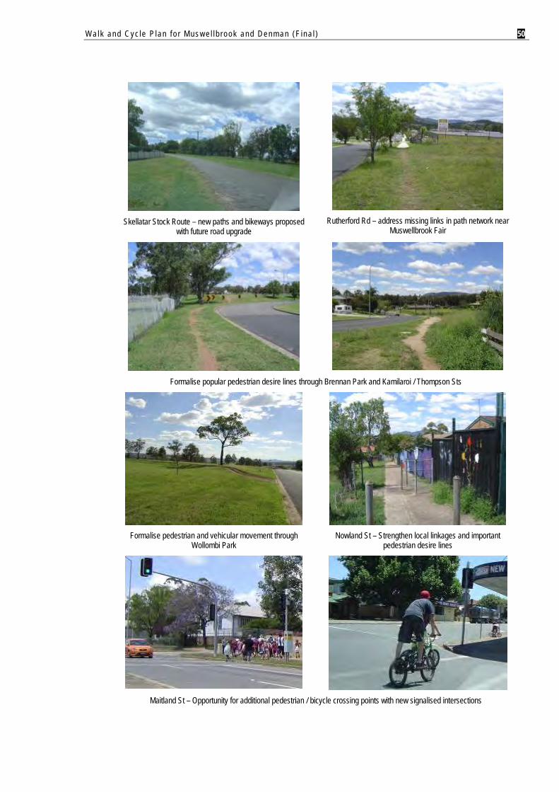
Walk and Cyc le P lan f o r Mus w e l l b rook and Denman (F ina l ) 50
Skellatar Stock Route – new paths and bikeways proposed
with future road upgrade
Rutherford Rd – address missing links in path network near
Muswellbrook Fair
Formalise popular pedestrian desire lines through Brennan Park and Kamilaroi / Thompson Sts
Formalise pedestrian and vehicular movement through
Wollombi Park Nowland St – Strengthen local linkages and important
pedestrian desire lines
Maitland St – Opportunity for additional pedestrian / bicycle crossing points with new signalised intersections
Walk and Cyc le P lan f o r Mus w e l l b rook and Denman (F ina l ) 51
Northside
Provide new off-road and on-road facilities via routes which bypass topographic barriers. Improve the level of service in the high school zone – key works are:
New off road path via Dolahenty Street and safety measures at the Victoria Street pedestrian crossing (approaching hillcrest and Bell St rail bridge).
New on-road bikeway via Brook Street, between the school campus and CBD. Address missing links in the path network around Muswellbrook Public School at:
Roger Street; Cook Street; Dumaresq Street; and Access points to Karoola Park.
Formalise the existing pedestrian desire line along Carl Street between the PCYC and Cook Street. This will help improve safety along this busy route, given higher traffic speeds and the incidence of crashes involving cyclists and pedestrians.
Remove or upgrade the existing pedestrian access point in the fenceline from Bridge Street to Aberdeen Street. Treatment of this informal trail down a steep bank requires resolution for risk management reasons.
Deploy signage and conduct maintenance on paths and trails through Karoola Park and Verdelho Reserve. Also extend the Karoola Park trail to the netball courts and playground (Hunter Street end).
Improve path coverage in the Wine Estate by upgrading park-based trails, supported by strategic development of new local paths via Lexia, Cabernet and Semillon Streets.
As a long range objective, extend new off-road and on-road facilities north via Queen Street to service town expansion areas.
Recreational Paths and Trails
Upgrade the existing paths and trails located in the town’s parks and linear reserves, through:
Path/ trail maintenance including resurfacing and selective removal of vegetation for better visual surveillance e.g. The Common.
Deployment of highly visible and informative signage along major trails and at access points, including direction, distance and destination information. This will significantly improve network legibility and public awareness.
Establish trail circuits in key parks, to formalise existing desire lines, and provide new recreation/ fitness opportunities for residents of all ages. Recommended sites are:
Brennan Park; Victoria Park; and Volunteer Park.
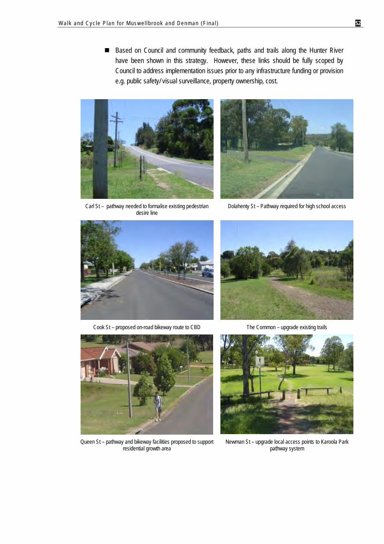
Walk and Cyc le P lan f o r Mus w e l l b rook and Denman (F ina l ) 52
Based on Council and community feedback, paths and trails along the Hunter River have been shown in this strategy. However, these links should be fully scoped by Council to address implementation issues prior to any infrastructure funding or provision e.g. public safety/ visual surveillance, property ownership, cost.
Carl St – pathway needed to formalise existing pedestrian
desire line
Dolahenty St – Pathway required for high school access
Cook St – proposed on-road bikeway route to CBD The Common – upgrade existing trails
Queen St – pathway and bikeway facilities proposed to support
residential growth area Newman St – upgrade local access points to Karoola Park
pathway system
Walk and Cyc le P lan f o r Mus w e l l b rook and Denman (F ina l ) 53
6.3.2. DENMAN
The objectives for the proposed Walk & Cycle Network in Denman are to:
Complete the off-road pathway network in Denman’s central area. Improve connectivity and safety for local trips. Create new pathway extensions and loops utilising public open space and the road
network.
Major features of the proposed Walk & Cycle Network are:
Town Loop System
Targeted pathway development over short distances to: Address “missing links” in the existing network; Create a continuous “loop” system around the town; and Strengthen east-west link for pedestrians and cyclists across the rail line.
School Zones
Targeted network extensions and upgrades of off-road paths in the vicinity of Denman Public School and St Joseph’s School.
Priority works include: Removal of on-road bikeway along Virginia St, replacing it with an off-road shared
path. New off road shared paths – Merton and Palace Streets. Path upgrades – Paxton St and Palace St (between St Josephs School and
Crinoline St). New zebra crossing treatment at the Paxton / Ogilvie St intersection.
Recreational Paths and Trails
Extension of the town’s major recreational pathway system via Sandy Creek from Turtle Street to Hyde Park.
New north-south path meandering through Arbor Park complimented by other landscape improvements, to:
Formalise an existing pedestrian desire line through the reserve. Improve public access to the town centre, Denman Recreation Area, and hospital/
retirement village. Create a new destination park for Denman residents and visitors.
New trail circuit around Denman Recreation Area for walking and fitness.
Walk and Cyc le P lan f o r Mus w e l l b rook and Denman (F ina l ) 54
Town Expansion Areas
Strategic routes identified for pathways as a longer range objective, to improve connectivity between Denman and town expansion areas to the outer west and south.
Subject to timing of future development, key links for longer term provision will be: Rosemount Road; Turner Street; Bell Street;
Almond Street; and Bray Street.
Given the town’s low-key nature and traffic environment, special engineering solutions for on-road bikeways are not considered necessary.
Proposed extension of Sandy Creek Pathway to Hyde Park and the playground
Excellent opportunity for new pathway connection via Arbor Park to create recreational loop
Path widening and replacement proposed for the school zone (Paxton St / Palace St)
Walk and Cyc le P lan f o r Mus w e l l b rook and Denman (F ina l ) 55
6.4. NETWORK IMPLEMENTATION PLAN
Implementation details for the Walk & Cycle Network are presented in the proceeding tables and maps (see Appendices A and B). These provide the key operational components of the Plan.
It is anticipated that recommended works will occur in a number of stages, so they can be implemented in a logical and coordinated sequence over time:
High Priority: Years 1 to 3. Medium Priority: Years 4 to 6. Low Priority: Years 7 to 9. Very Low Priority: Years 10+. Timed Priority: Coinciding with road upgrades or future residential development.
Principal determinants of network staging have been:
Priority to missing links in the existing network near schools, the CBD and major desire lines.
Priority to key corridors to establish a basic framework of complete and continuous routes between the CBD, Northside and Southside (Muswellbrook).
Priority to blackspot locations. Priority to low cost improvements and renewal of existing facilities e.g. route signage.
It is evident that some network elements would be beyond the capacity and/ or responsibility of Council to fund, and implementation will be influenced by the availability of Council funds, external funding opportunities, or partnership opportunities with other agencies (e.g. RTA). Consequently, some works may be subject to rescheduling.
The type and location of facilities proposed within State Controlled Roads (e.g. widened road shoulders, bike lanes, crossing points), should be confirmed in liaison with the RTA.
Recommended works for Muswellbrook have been categorised according to location, as follows:
Southside; Northside; New England Highway / Maitland Street; and New England Highway / Bridge Street.
Walk and Cyc le P lan f o r Mus w e l l b rook and Denman (F ina l ) 56
6.4.1. NETWORK IMPLEMENTATION PLAN FOR MUSWELLBROOK
ROUTE NUMBER
ROUTE NAME ROUTE SECTION APPROX LENGTH (M)
FACILITY TYPE
IMPLEMENTATION COMMENTS PRIORITY RESPONSIBILITY
From To
S o u t h s i d e
M1-A Sydney St Maitland St Skellatar St 880
(total / both sides)
SBPL Establish shared parking and bike lane on both sides of Sydney St, with full line marking, pavement logos and signage. The generous road width provides excellent scope to formalise the on-road treatment.
High RTA
M1-B Sydney St Skellatar St Wollombi St 1,000 SBPL Continue the shared parking and bike treatment on the eastern side where sufficient space exists.
High RTA
1,000 EBL Implement an alternative treatment, exclusive bicycle lane, on the western side due to spatial constraints and absence of on-street parking demands. Improve edge and road shoulder coinciding with future maintenance, to facilitate a smoother cycling surface.
High RTA
M1-C Sydney St Wollombi St Skellatar Stock Route 460
(total / both sides)
EBL Apply exclusive bike lane treatments on both sides where the shoulder width decreases, south of Wollombi St.
Shoulder widening and resealing is required over this short distance to improve conditions for on-road cycling.
High RTA
M1-D Sydney St Tarakan Ave Wollombi Rd 290 NP Provide 1.2m wide path on southern side to address “gap” in existing pathway.
High MSC / RTA
M1-E Sydney St Dalwood Pl / Brook Park Skellatar Stock Route 25 NP Provide a 1.2m wide path on the southern side, for a short distance between Skellatar Stock Route and the existing path at Dalwood Pl.
High MSC / RTA
M2 Wollombi Park Wollombi Rd Skellatar Stock Route 250 T Formalise a pedestrian/ cycle access trail through Wollombi Park (eastern side) for local access to St James Primary School and cross-neighbourhood trips.
Motorised vehicles use Wollombi Park as a “short cut”, therefore improved safety is warranted to minimise conflict potential, particularly given the likelihood of children using this route. Bollarding of the park may also be appropriate to manage unregulated vehicle access.
Medium MSC
M3 Wollombi Rd Sydney St Patterson Pl (easement path)
1,210 NP Establish a 1.2m wide path on the southern side, providing a connection to the easement path in Patterson Pl. The southern side is largely unconstrained for much of its length.
Medium MSC
M4-A
M4-B
Skellatar Stock Route Sydney St St James Primary School
1,135
2,320
(total / both sides)
NP
SZ
Implement formal provisions for pedestrians and cyclists, coinciding with future upgrades of Skellatar Stock Route. Key works are:
Off-road path (northern side) connecting to the existing 2.0m wide path.
On-road shared zone treatment with pavement logos and signage to service commuter cyclists on the southside.
Timed with future road
upgrade
MSC / Developer
M4-C Skellatar Stock Route St James Primary School Rutherford Rd 1,700
(total / both sides)
SZ Extend on-road shared zone treatment (both sides) to Rutherford Rd to provide commuter access.
Timed with future road
upgrade
MSC / Developer
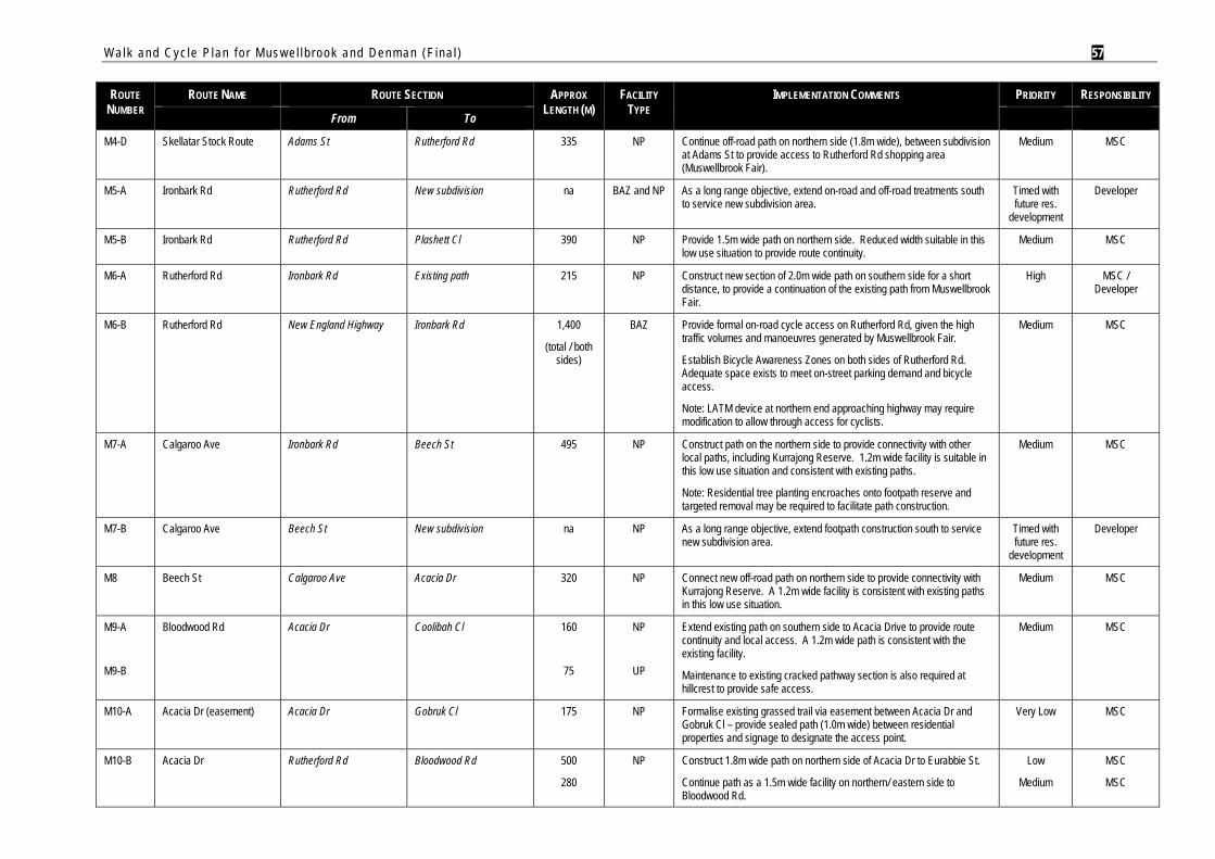
Walk and Cyc le P lan f o r Mus w e l l b rook and Denman (F ina l ) 57
ROUTE NUMBER
ROUTE NAME ROUTE SECTION APPROX LENGTH (M)
FACILITY TYPE
IMPLEMENTATION COMMENTS PRIORITY RESPONSIBILITY
From To
M4-D Skellatar Stock Route Adams St Rutherford Rd 335 NP Continue off-road path on northern side (1.8m wide), between subdivision at Adams St to provide access to Rutherford Rd shopping area (Muswellbrook Fair).
Medium MSC
M5-A Ironbark Rd Rutherford Rd New subdivision na BAZ and NP As a long range objective, extend on-road and off-road treatments south to service new subdivision area.
Timed with future res.
development
Developer
M5-B Ironbark Rd Rutherford Rd Plashett Cl 390 NP Provide 1.5m wide path on northern side. Reduced width suitable in this low use situation to provide route continuity.
Medium MSC
M6-A Rutherford Rd Ironbark Rd Existing path 215 NP Construct new section of 2.0m wide path on southern side for a short distance, to provide a continuation of the existing path from Muswellbrook Fair.
High MSC / Developer
M6-B Rutherford Rd New England Highway Ironbark Rd 1,400
(total / both sides)
BAZ Provide formal on-road cycle access on Rutherford Rd, given the high traffic volumes and manoeuvres generated by Muswellbrook Fair.
Establish Bicycle Awareness Zones on both sides of Rutherford Rd. Adequate space exists to meet on-street parking demand and bicycle access.
Note: LATM device at northern end approaching highway may require modification to allow through access for cyclists.
Medium MSC
M7-A Calgaroo Ave Ironbark Rd Beech St 495 NP Construct path on the northern side to provide connectivity with other local paths, including Kurrajong Reserve. 1.2m wide facility is suitable in this low use situation and consistent with existing paths.
Note: Residential tree planting encroaches onto footpath reserve and targeted removal may be required to facilitate path construction.
Medium MSC
M7-B Calgaroo Ave Beech St New subdivision na NP As a long range objective, extend footpath construction south to service new subdivision area.
Timed with future res.
development
Developer
M8 Beech St Calgaroo Ave Acacia Dr 320 NP Connect new off-road path on northern side to provide connectivity with Kurrajong Reserve. A 1.2m wide facility is consistent with existing paths in this low use situation.
Medium MSC
M9-A
M9-B
Bloodwood Rd Acacia Dr Coolibah Cl 160
75
NP
UP
Extend existing path on southern side to Acacia Drive to provide route continuity and local access. A 1.2m wide path is consistent with the existing facility.
Maintenance to existing cracked pathway section is also required at hillcrest to provide safe access.
Medium MSC
M10-A Acacia Dr (easement) Acacia Dr Gobruk Cl 175 NP Formalise existing grassed trail via easement between Acacia Dr and Gobruk Cl – provide sealed path (1.0m wide) between residential properties and signage to designate the access point.
Very Low MSC
M10-B Acacia Dr Rutherford Rd Bloodwood Rd 500
280
NP Construct 1.8m wide path on northern side of Acacia Dr to Eurabbie St.
Continue path as a 1.5m wide facility on northern/ eastern side to Bloodwood Rd.
Low
Medium
MSC
MSC
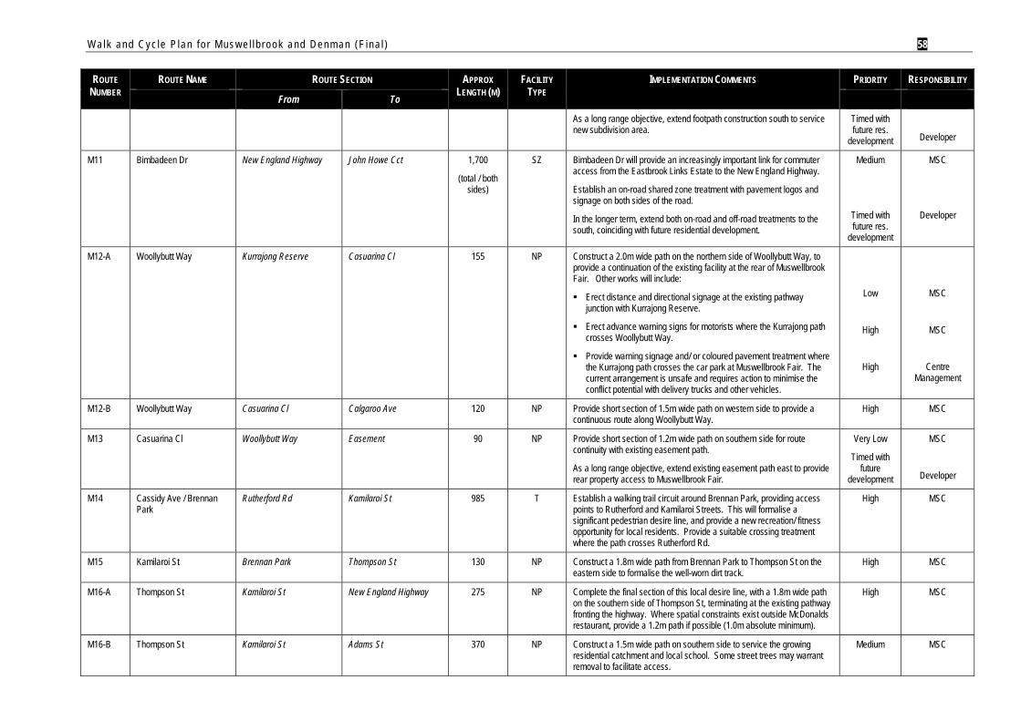
Walk and Cyc le P lan f o r Mus w e l l b rook and Denman (F ina l ) 58
ROUTE NUMBER
ROUTE NAME ROUTE SECTION APPROX LENGTH (M)
FACILITY TYPE
IMPLEMENTATION COMMENTS PRIORITY RESPONSIBILITY
From To
As a long range objective, extend footpath construction south to service new subdivision area.
Timed with future res.
development
Developer
M11 Bimbadeen Dr New England Highway John Howe Cct 1,700
(total / both sides)
SZ Bimbadeen Dr will provide an increasingly important link for commuter access from the Eastbrook Links Estate to the New England Highway.
Establish an on-road shared zone treatment with pavement logos and signage on both sides of the road.
In the longer term, extend both on-road and off-road treatments to the south, coinciding with future residential development.
Medium
Timed with future res.
development
MSC
Developer
M12-A Woollybutt Way Kurrajong Reserve Casuarina Cl 155 NP
Construct a 2.0m wide path on the northern side of Woollybutt Way, to provide a continuation of the existing facility at the rear of Muswellbrook Fair. Other works will include:
Erect distance and directional signage at the existing pathway junction with Kurrajong Reserve.
Erect advance warning signs for motorists where the Kurrajong path crosses Woollybutt Way.
Provide warning signage and/ or coloured pavement treatment where the Kurrajong path crosses the car park at Muswellbrook Fair. The current arrangement is unsafe and requires action to minimise the conflict potential with delivery trucks and other vehicles.
Low
High
High
MSC
MSC
Centre Management
M12-B Woollybutt Way Casuarina Cl Calgaroo Ave 120 NP Provide short section of 1.5m wide path on western side to provide a continuous route along Woollybutt Way.
High MSC
M13 Casuarina Cl Woollybutt Way Easement 90 NP Provide short section of 1.2m wide path on southern side for route continuity with existing easement path.
As a long range objective, extend existing easement path east to provide rear property access to Muswellbrook Fair.
Very Low
Timed with future
development
MSC
Developer
M14 Cassidy Ave / Brennan Park
Rutherford Rd Kamilaroi St 985 T Establish a walking trail circuit around Brennan Park, providing access points to Rutherford and Kamilaroi Streets. This will formalise a significant pedestrian desire line, and provide a new recreation/ fitness opportunity for local residents. Provide a suitable crossing treatment where the path crosses Rutherford Rd.
High MSC
M15 Kamilaroi St Brennan Park Thompson St 130 NP Construct a 1.8m wide path from Brennan Park to Thompson St on the eastern side to formalise the well-worn dirt track.
High MSC
M16-A Thompson St Kamilaroi St New England Highway 275 NP Complete the final section of this local desire line, with a 1.8m wide path on the southern side of Thompson St, terminating at the existing pathway fronting the highway. Where spatial constraints exist outside McDonalds restaurant, provide a 1.2m path if possible (1.0m absolute minimum).
High MSC
M16-B Thompson St Kamilaroi St Adams St 370 NP Construct a 1.5m wide path on southern side to service the growing residential catchment and local school. Some street trees may warrant removal to facilitate access.
Medium MSC
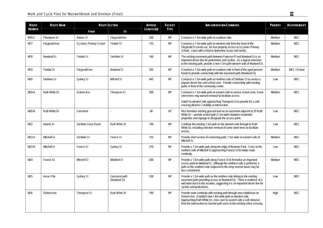
Walk and Cyc le P lan f o r Mus w e l l b rook and Denman (F ina l ) 59
ROUTE NUMBER
ROUTE NAME ROUTE SECTION APPROX LENGTH (M)
FACILITY TYPE
IMPLEMENTATION COMMENTS PRIORITY RESPONSIBILITY
From To
M16-C Thompson St Adams St Fitzgerald Ave 240 NP Construct a 1.5m wide path on southern side. Medium MSC
M17 Fitzgerald Ave St James Primary School Tindale St 135 NP Construct a 1.5m wide path on western side from the head of the Fitzgerald St cul-de-sac, for rear property access to St James Primary School. Liaise with school to determine issues and needs.
Medium MSC
M18 Nowland St Tindale St Skellatar St 160 NP The existing easement path between Paterson Pl and Nowland St is an important desire line for pedestrians and cyclists. As a logical extension to the existing path, provide a new 1.5m path western side of Nowland St.
Medium MSC
M19 Tindale St Fitzgerald Ave Nowland St 295 NP Construct a 1.5m wide path on southern side in front of the aged persons hostel to provide connectivity with the easement path (Nowland St).
Medium MSC / School
M20 Skellatar St Sydney St Mitchell St 445 NP Construct a 1.5m wide path on northern side of Skellatar St to service a popular desire line and school zone. Provide connectivity with existing paths in front of the community centre.
Low MSC
M20-A Ruth White Dr Osborn Ave Thompson St 590 NP Construct a 1.5m wide path on eastern side to service school zone. Some street trees may warrant removal to facilitate access.
Switch to western side approaching Thompson St to provide for a safe crossing distance / visibility at intersection.
Medium MSC
M20-B Ruth White Dr Easement - 40 UP Also formalise existing grassed trail via an easement adjacent to 29 Ruth White Dr – provide sealed path (1.2m wide) between residential properties and signage to designate the access point.
Low MSC
M22 Adams St Skellatar Stock Route Ruth White Dr 740 NP Continue the existing 1.5m path on the western side through to Ruth White Dr, including selective removal of some street trees to facilitate access.
Low MSC
M23-A Mitchell St Skellatar St Francis St 155 NP Provide short section of connecting path, 1.5m wide on eastern side of Mitchell St.
Medium MSC
M23-B Mitchell St Francis St Sydney St 370 NP Provide a 1.5m wide path along the edge of Bowman Park. Cross to the northern side of Mitchell St approaching Francis St for better route continuity.
Low MSC
M24 Francis St Mitchell St Maitland St 200 NP Provide a 1.5m wide path along Francis St to formalise an important access point to Maitland St. Although the northern side is preferred, a path on the southern side (adjacent to the army reserve base) may be less constrained.
Medium MSC
M25 Anzac Pde Sydney St Easement path (Nowland St)
530 NP Provide a 1.2m wide path on the northern side linking to the existing easement path (providing access to Nowland St). There is evidence of a well worn track in this location, suggesting it is an important desire line for cyclists and pedestrians.
Low MSC
M26 Osborn Ave Thompson St Ruth White Dr 190 NP Provide route continuity with existing path through new subdivision on Osborn Ave. Establish new 1.8m wide path on western side. Approaching Ruth White Dr, cross over to eastern side a safe distance from the intersection to channel path users to the existing zebra crossing.
High MSC
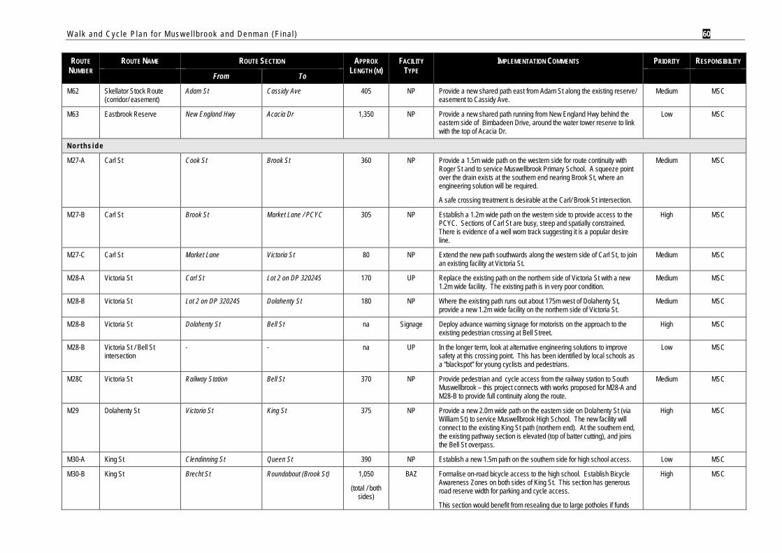
Walk and Cyc le P lan f o r Mus w e l l b rook and Denman (F ina l ) 60
ROUTE NUMBER
ROUTE NAME ROUTE SECTION APPROX LENGTH (M)
FACILITY TYPE
IMPLEMENTATION COMMENTS PRIORITY RESPONSIBILITY
From To
M62 Skellator Stock Route (corridor/ easement)
Adam St Cassidy Ave 405 NP Provide a new shared path east from Adam St along the existing reserve/ easement to Cassidy Ave.
Medium MSC
M63 Eastbrook Reserve New England Hwy Acacia Dr 1,350 NP Provide a new shared path running from New England Hwy behind the eastern side of Bimbadeen Drive, around the water tower reserve to link with the top of Acacia Dr.
Low MSC
N o r t h s i d e
M27-A Carl St Cook St Brook St 360 NP Provide a 1.5m wide path on the western side for route continuity with Roger St and to service Muswellbrook Primary School. A squeeze point over the drain exists at the southern end nearing Brook St, where an engineering solution will be required.
A safe crossing treatment is desirable at the Carl/ Brook St intersection.
Medium MSC
M27-B Carl St Brook St Market Lane / PCYC 305 NP Establish a 1.2m wide path on the western side to provide access to the PCYC. Sections of Carl St are busy, steep and spatially constrained. There is evidence of a well worn track suggesting it is a popular desire line.
High MSC
M27-C Carl St Market Lane Victoria St 80 NP Extend the new path southwards along the western side of Carl St, to join an existing facility at Victoria St.
Medium MSC
M28-A Victoria St Carl St Lot 2 on DP 320245 170 UP Replace the existing path on the northern side of Victoria St with a new 1.2m wide facility. The existing path is in very poor condition.
Medium MSC
M28-B Victoria St Lot 2 on DP 320245 Dolahenty St 180 NP Where the existing path runs out about 175m west of Dolahenty St, provide a new 1.2m wide facility on the northern side of Victoria St.
Medium MSC
M28-B Victoria St Dolahenty St Bell St na Signage Deploy advance warning signage for motorists on the approach to the existing pedestrian crossing at Bell Street.
High MSC
M28-B Victoria St / Bell St intersection
- - na UP In the longer term, look at alternative engineering solutions to improve safety at this crossing point. This has been identified by local schools as a “blackspot” for young cyclists and pedestrians.
Low MSC
M28C Victoria St Railway Station Bell St 370 NP Provide pedestrian and cycle access from the railway station to South Muswellbrook – this project connects with works proposed for M28-A and M28-B to provide full continuity along the route.
Medium MSC
M29 Dolahenty St Victoria St King St 375 NP Provide a new 2.0m wide path on the eastern side on Dolahenty St (via William St) to service Muswellbrook High School. The new facility will connect to the existing King St path (northern end). At the southern end, the existing pathway section is elevated (top of batter cutting), and joins the Bell St overpass.
High MSC
M30-A King St Clendinning St Queen St 390 NP Establish a new 1.5m path on the southern side for high school access. Low MSC
M30-B King St Brecht St Roundabout (Brook St) 1,050
(total / both sides)
BAZ Formalise on-road bicycle access to the high school. Establish Bicycle Awareness Zones on both sides of King St. This section has generous road reserve width for parking and cycle access.
This section would benefit from resealing due to large potholes if funds
High MSC
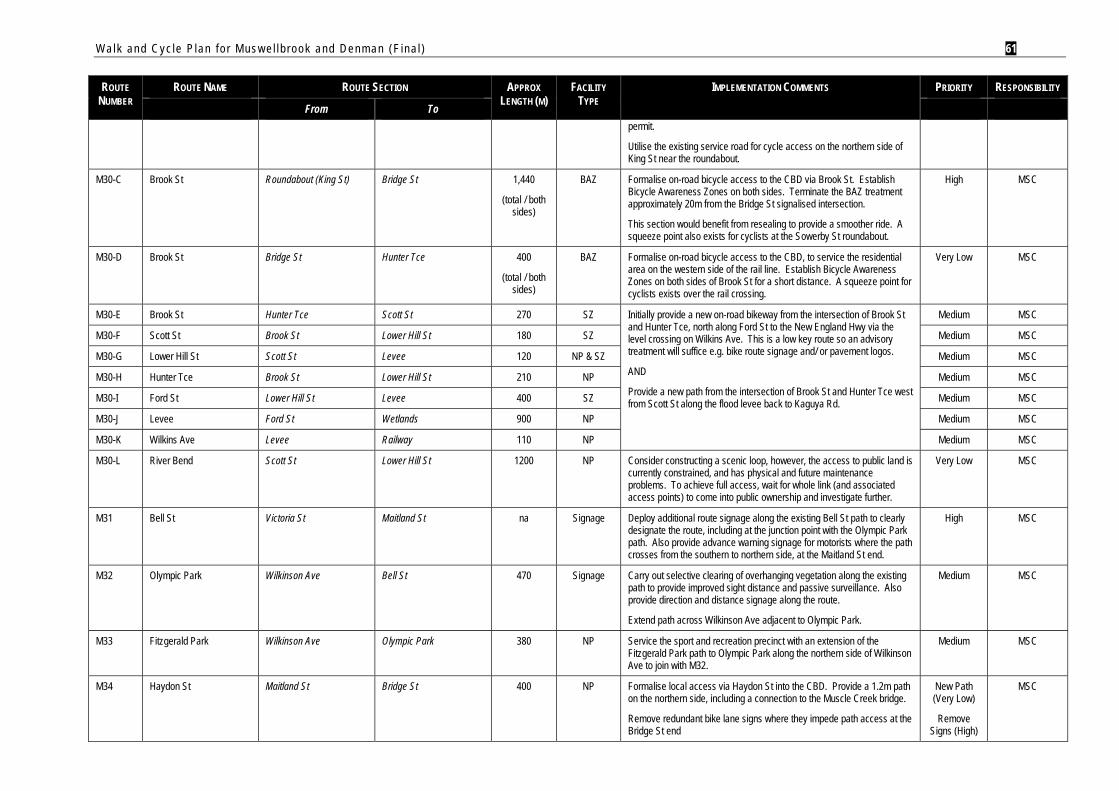
Walk and Cyc le P lan f o r Mus w e l l b rook and Denman (F ina l ) 61
ROUTE NUMBER
ROUTE NAME ROUTE SECTION APPROX LENGTH (M)
FACILITY TYPE
IMPLEMENTATION COMMENTS PRIORITY RESPONSIBILITY
From To permit.
Utilise the existing service road for cycle access on the northern side of King St near the roundabout.
M30-C Brook St Roundabout (King St) Bridge St 1,440
(total / both sides)
BAZ Formalise on-road bicycle access to the CBD via Brook St. Establish Bicycle Awareness Zones on both sides. Terminate the BAZ treatment approximately 20m from the Bridge St signalised intersection.
This section would benefit from resealing to provide a smoother ride. A squeeze point also exists for cyclists at the Sowerby St roundabout.
High MSC
M30-D Brook St Bridge St Hunter Tce 400
(total / both sides)
BAZ Formalise on-road bicycle access to the CBD, to service the residential area on the western side of the rail line. Establish Bicycle Awareness Zones on both sides of Brook St for a short distance. A squeeze point for cyclists exists over the rail crossing.
Very Low MSC
M30-E Brook St Hunter Tce Scott St 270 SZ Initially provide a new on-road bikeway from the intersection of Brook St and Hunter Tce, north along Ford St to the New England Hwy via the level crossing on Wilkins Ave. This is a low key route so an advisory treatment will suffice e.g. bike route signage and/ or pavement logos.
AND
Provide a new path from the intersection of Brook St and Hunter Tce west from Scott St along the flood levee back to Kaguya Rd.
Medium MSC
M30-F Scott St Brook St Lower Hill St 180 SZ Medium MSC
M30-G Lower Hill St Scott St Levee 120 NP & SZ Medium MSC
M30-H Hunter Tce Brook St Lower Hill St 210 NP Medium MSC
M30-I Ford St Lower Hill St Levee 400 SZ Medium MSC
M30-J Levee Ford St Wetlands 900 NP Medium MSC
M30-K Wilkins Ave Levee Railway 110 NP Medium MSC
M30-L River Bend Scott St Lower Hill St 1200 NP Consider constructing a scenic loop, however, the access to public land is currently constrained, and has physical and future maintenance problems. To achieve full access, wait for whole link (and associated access points) to come into public ownership and investigate further.
Very Low MSC
M31 Bell St Victoria St Maitland St na Signage Deploy additional route signage along the existing Bell St path to clearly designate the route, including at the junction point with the Olympic Park path. Also provide advance warning signage for motorists where the path crosses from the southern to northern side, at the Maitland St end.
High MSC
M32 Olympic Park Wilkinson Ave Bell St 470 Signage Carry out selective clearing of overhanging vegetation along the existing path to provide improved sight distance and passive surveillance. Also provide direction and distance signage along the route.
Extend path across Wilkinson Ave adjacent to Olympic Park.
Medium MSC
M33 Fitzgerald Park Wilkinson Ave Olympic Park 380 NP Service the sport and recreation precinct with an extension of the Fitzgerald Park path to Olympic Park along the northern side of Wilkinson Ave to join with M32.
Medium MSC
M34 Haydon St Maitland St Bridge St 400 NP Formalise local access via Haydon St into the CBD. Provide a 1.2m path on the northern side, including a connection to the Muscle Creek bridge.
Remove redundant bike lane signs where they impede path access at the Bridge St end
New Path (Very Low)
Remove Signs (High)
MSC
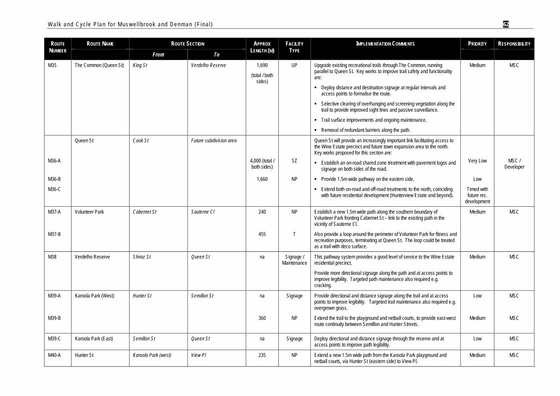
Walk and Cyc le P lan f o r Mus w e l l b rook and Denman (F ina l ) 62
ROUTE NUMBER
ROUTE NAME ROUTE SECTION APPROX LENGTH (M)
FACILITY TYPE
IMPLEMENTATION COMMENTS PRIORITY RESPONSIBILITY
From To
M35 The Common (Queen St) King St Verdelho Reserve 1,690
(total / both sides)
UP Upgrade existing recreational trails through The Common, running parallel to Queen St. Key works to improve trail safety and functionality are:
Deploy distance and destination signage at regular intervals and access points to formalise the route.
Selective clearing of overhanging and screening vegetation along the trail to provide improved sight lines and passive surveillance.
Trail surface improvements and ongoing maintenance.
Removal of redundant barriers along the path.
Medium MSC
M36-A
Queen St Cook St Future subdivision area
4,000 (total / both sides)
SZ
Queen St will provide an increasingly important link facilitating access to the Wine Estate precinct and future town expansion area to the north. Key works proposed for this section are:
Establish an on-road shared zone treatment with pavement logos and signage on both sides of the road.
Very Low
MSC / Developer
M36-B
M36-C
1,660 NP Provide 1.5m wide pathway on the eastern side.
Extend both on-road and off-road treatments to the north, coinciding with future residential development (Hunterview Estate and beyond).
Low
Timed with future res.
development
M37-A Volunteer Park Cabernet St Sauterne Cl 240 NP Establish a new 1.5m wide path along the southern boundary of Volunteer Park fronting Cabernet St – link to the existing path in the vicinity of Sauterne Cl.
Medium MSC
M37-B 455 T Also provide a loop around the perimeter of Volunteer Park for fitness and recreation purposes, terminating at Queen St. The loop could be treated as a trail with deco surface.
M38 Verdelho Reserve Shiraz St Queen St na Signage / Maintenance
This pathway system provides a good level of service to the Wine Estate residential precinct.
Provide more directional signage along the path and at access points to improve legibility. Targeted path maintenance also required e.g. cracking.
Medium MSC
M39-A Karoola Park (West) Hunter St Semillon St na Signage
Provide directional and distance signage along the trail and at access points to improve legibility. Targeted trail maintenance also required e.g. overgrown grass.
Low MSC
M39-B 360 NP
Extend the trail to the playground and netball courts, to provide east-west route continuity between Semillon and Hunter Streets.
Medium MSC
M39-C Karoola Park (East) Semillon St Queen St na Signage Deploy directional and distance signage through the reserve and at access points to improve path legibility.
Low MSC
M40-A Hunter St Karoola Park (west) View Pl 235 NP Extend a new 1.5m wide path from the Karoola Park playground and netball courts, via Hunter St (eastern side) to View Pl.
Medium MSC
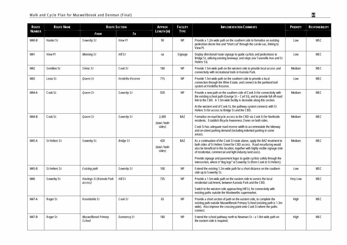
Walk and Cyc le P lan f o r Mus w e l l b rook and Denman (F ina l ) 63
ROUTE NUMBER
ROUTE NAME ROUTE SECTION APPROX LENGTH (M)
FACILITY TYPE
IMPLEMENTATION COMMENTS PRIORITY RESPONSIBILITY
From To
M40-B Hunter St Sowerby St View Pl 90 NP Provide a 1.2m wide path on the southern side to formalise an existing pedestrian desire line and “short cut” through the cul-de-sac, linking to View Pl.
Low MSC
M41 View Pl Manning St Hill St na Signage Deploy directional/ route signage to guide cyclists and pedestrians to Bridge St, utilising existing laneways and steps (via Turanville Ave and St Heliers St).
Low MSC
M42 Semillon St Shiraz St Cook St 180 NP Provide 1.5m wide path on the western side to provide local access and connectivity with recreational trails in Karoola Park.
Medium MSC
M43 Lexia St Queen St Verdelho Reserve 715 NP Provide 1.5m wide path on the southern side to provide a local connection through the Wine Estate, and connect to the parkland trail system at Verdelho Reserve.
Low MSC
M44-A Cook St Queen St Sowerby St 920 NP Provide a new path on the southern side of Cook St for connectivity with the existing school path (George St – Carl St), and to provide full off-road link to the CBD. A 1.5m wide facility is desirable along this section.
At the western end of Cook St, the pathway system connects with St Heliers St for access to Bridge St and the CBD.
Medium MSC
M44-B Cook St Queen St Sowerby St 2,400
(total / both sides)
BAZ Formalise on-road bicycle access to the CBD via Cook St for Northside residents. Establish Bicycle Awareness Zones on both sides.
Cook St has adequate road reserve width to accommodate the bikeway and on-street parking demand (including indented parking in some areas).
Medium MSC
M45-A St Heliers St Sowerby St Bridge St 420
(total / both sides)
BAZ As a continuation of the Cook St route above, apply the BAZ treatment to both sides of St Heliers Street for CBD access. Road resurfacing would also be beneficial in this location, together with highly visible signage (mix of residential, commercial and light industry land uses).
Provide signage and pavement logos to guide cyclists safely through the intersection, where it “dog legs” at Sowerby St (from Cook to St Heliers).
Medium MSC
M45-B St Heliers St Existing path Sowerby St 100 NP Extend the existing 1.2m wide path for a short distance on the southern side up to Sowerby St.
Low MSC
M46 Sowerby St Hastings St (Karoola Park access)
Hill St 735 NP Provide a 1.5m wide path on the eastern side to service the local residential catchment, between Karoola Park and the CBD.
Switch to the western side approaching Hill St, for connectivity with existing paths outside the Woolworths supermarket.
Very Low MSC
M47-A Roger St Koombahla St Cook St 65 NP Provide a short section of path on the eastern side, to complete the existing path outside Muswellbrook Primary School (existing path is 1.3m wide). Also improve the crossing point onto Cook St where the paths connect.
High MSC
M47-B Roger St Muswellbrook Primary School
Dumaresq St 180 NP Extend the school pathway north to Newman St – a 1.8m wide path on the eastern side is required.
High MSC
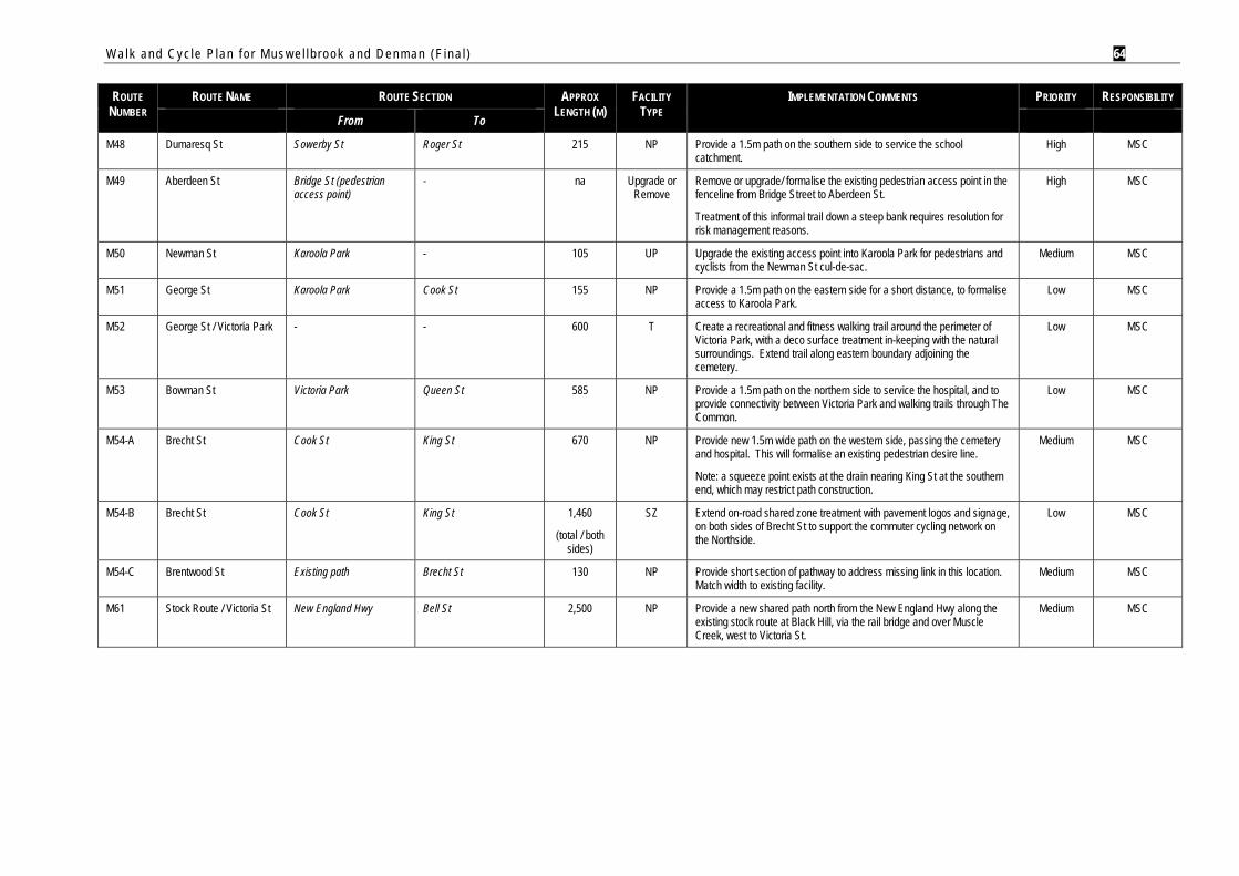
Walk and Cyc le P lan f o r Mus w e l l b rook and Denman (F ina l ) 64
ROUTE NUMBER
ROUTE NAME ROUTE SECTION APPROX LENGTH (M)
FACILITY TYPE
IMPLEMENTATION COMMENTS PRIORITY RESPONSIBILITY
From To
M48 Dumaresq St Sowerby St Roger St 215 NP Provide a 1.5m path on the southern side to service the school catchment.
High MSC
M49 Aberdeen St Bridge St (pedestrian access point)
- na Upgrade or Remove
Remove or upgrade/ formalise the existing pedestrian access point in the fenceline from Bridge Street to Aberdeen St.
Treatment of this informal trail down a steep bank requires resolution for risk management reasons.
High MSC
M50 Newman St Karoola Park - 105 UP Upgrade the existing access point into Karoola Park for pedestrians and cyclists from the Newman St cul-de-sac.
Medium MSC
M51 George St Karoola Park Cook St 155 NP Provide a 1.5m path on the eastern side for a short distance, to formalise access to Karoola Park.
Low MSC
M52 George St / Victoria Park - - 600 T Create a recreational and fitness walking trail around the perimeter of Victoria Park, with a deco surface treatment in-keeping with the natural surroundings. Extend trail along eastern boundary adjoining the cemetery.
Low MSC
M53 Bowman St Victoria Park Queen St 585 NP Provide a 1.5m path on the northern side to service the hospital, and to provide connectivity between Victoria Park and walking trails through The Common.
Low MSC
M54-A Brecht St Cook St King St 670 NP Provide new 1.5m wide path on the western side, passing the cemetery and hospital. This will formalise an existing pedestrian desire line.
Note: a squeeze point exists at the drain nearing King St at the southern end, which may restrict path construction.
Medium MSC
M54-B Brecht St Cook St King St 1,460
(total / both sides)
SZ Extend on-road shared zone treatment with pavement logos and signage, on both sides of Brecht St to support the commuter cycling network on the Northside.
Low MSC
M54-C Brentwood St Existing path Brecht St 130 NP Provide short section of pathway to address missing link in this location. Match width to existing facility.
Medium MSC
M61 Stock Route / Victoria St New England Hwy Bell St 2,500 NP Provide a new shared path north from the New England Hwy along the existing stock route at Black Hill, via the rail bridge and over Muscle Creek, west to Victoria St.
Medium MSC
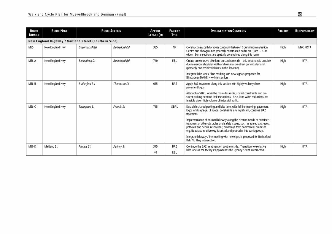
Walk and Cyc le P lan f o r Mus w e l l b rook and Denman (F ina l ) 65
ROUTE
NUMBER ROUTE NAME ROUTE SECTION APPROX
LENGTH (M) FACILITY
TYPE IMPLEMENTATION COMMENTS PRIORITY RESPONSIBILITY
N e w E n g l a n d H i g h w a y / M a i t l a n d S t r e e t ( S o u t h e r n S i d e )
M55 New England Hwy Baybrook Motel Rutherford Rd 335 NP Construct new path for route continuity between Council Administration Centre and showgrounds (recently constructed paths are 1.8m – 2.0m wide). Some sections are spatially constrained along this route.
High MSC / RTA
M56-A New England Hwy Bimbadeen Dr Rutherford Rd 740 EBL Create an exclusive bike lane on southern side – this treatment is suitable due to narrow shoulder width and minimal on-street parking demand (primarily non-residential uses in this location).
Integrate bike lanes / line marking with new signals proposed for Bimbadeen Dr/ NE Hwy intersection.
High RTA
M56-B New England Hwy Rutherford Rd Thompson St 615 BAZ Apply BAZ treatment along this section with highly visible yellow pavement logos.
Although a SBPL would be more desirable, spatial constraints and on-street parking demand limit the options. Also, lane width reductions not feasible given high volume of industrial traffic.
High RTA
M56-C New England Hwy Thompson St Francis St 715 SBPL Establish shared parking and bike lane, with full line marking, pavement logos and signage. If spatial constraints are significant, continue BAZ treatment.
Implementation of on-road bikeway along this section needs to consider treatment of other obstacles and safety issues, such as raised cats eyes, potholes and debris in shoulder, driveways from commercial premises e.g. Beaurapairs driveway is raised and protrudes into carriageway.
Integrate bikeway / line marking with new signals proposed for Rutherford Rd / NE Hwy intersection.
High RTA
M56-D Maitland St Francis St Sydney St 375
40
BAZ
EBL
Continue the BAZ treatment on southern side. Transition to exclusive bike lane as the facility it approaches the Sydney Street intersection.
High RTA
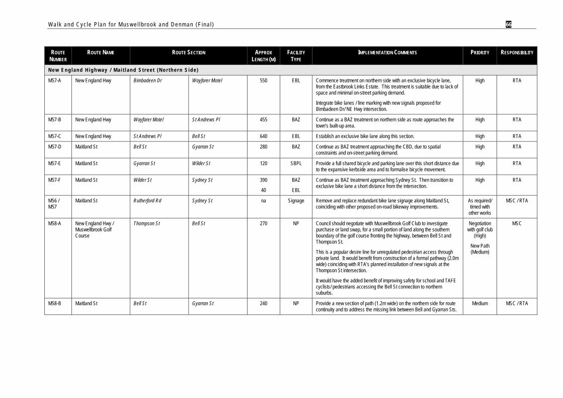
Walk and Cyc le P lan f o r Mus w e l l b rook and Denman (F ina l ) 66
ROUTE
NUMBER ROUTE NAME ROUTE SECTION APPROX
LENGTH (M) FACILITY
TYPE IMPLEMENTATION COMMENTS PRIORITY RESPONSIBILITY
N e w E n g l a n d H i g h w a y / M a i t l a n d S t r e e t ( N o r t h e r n S i d e )
M57-A New England Hwy Bimbadeen Dr Wayfarer Motel 550 EBL Commence treatment on northern side with an exclusive bicycle lane, from the Eastbrook Links Estate. This treatment is suitable due to lack of space and minimal on-street parking demand.
Integrate bike lanes / line marking with new signals proposed for Bimbadeen Dr/ NE Hwy intersection.
High RTA
M57-B New England Hwy Wayfarer Motel St Andrews Pl 455 BAZ Continue as a BAZ treatment on northern side as route approaches the town’s built-up area.
High RTA
M57-C New England Hwy St Andrews Pl Bell St 640 EBL Establish an exclusive bike lane along this section. High RTA
M57-D Maitland St Bell St Gyarran St 280 BAZ Continue as BAZ treatment approaching the CBD, due to spatial constraints and on-street parking demand.
High RTA
M57-E Maitland St Gyarran St Wilder St 120 SBPL Provide a full shared bicycle and parking lane over this short distance due to the expansive kerbside area and to formalise bicycle movement.
High RTA
M57-F Maitland St Wilder St Sydney St 390
40
BAZ
EBL
Continue as BAZ treatment approaching Sydney St. Then transition to exclusive bike lane a short distance from the intersection.
High RTA
M56 / M57
Maitland St Rutherford Rd Sydney St na Signage Remove and replace redundant bike lane signage along Maitland St, coinciding with other proposed on-road bikeway improvements.
As required/ timed with
other works
MSC / RTA
M58-A New England Hwy / Muswellbrook Golf Course
Thompson St Bell St 270 NP Council should negotiate with Muswellbrook Golf Club to investigate purchase or land swap, for a small portion of land along the southern boundary of the golf course fronting the highway, between Bell St and Thompson St.
This is a popular desire line for unregulated pedestrian access through private land. It would benefit from construction of a formal pathway (2.0m wide) coinciding with RTA’s planned installation of new signals at the Thompson St intersection.
It would have the added benefit of improving safety for school and TAFE cyclists/ pedestrians accessing the Bell St connection to northern suburbs.
Negotiation with golf club
(High)
New Path (Medium)
MSC
M58-B Maitland St Bell St Gyarran St 240 NP Provide a new section of path (1.2m wide) on the northern side for route continuity and to address the missing link between Bell and Gyarran Sts.
Medium MSC / RTA
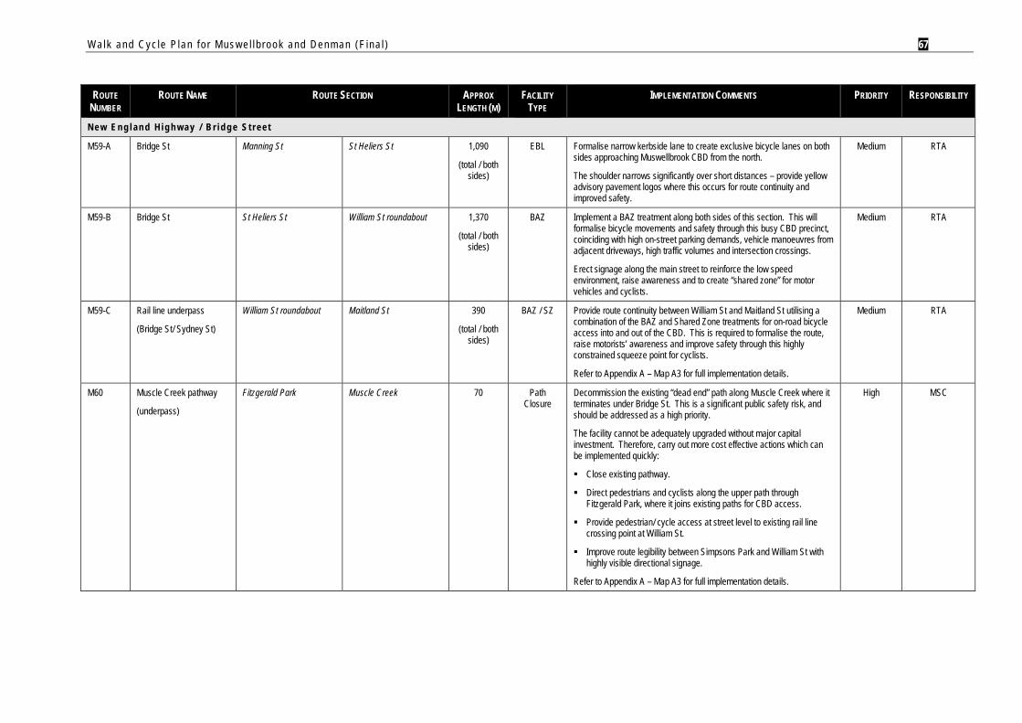
Walk and Cyc le P lan f o r Mus w e l l b rook and Denman (F ina l ) 67
ROUTE
NUMBER ROUTE NAME ROUTE SECTION APPROX
LENGTH (M) FACILITY
TYPE IMPLEMENTATION COMMENTS PRIORITY RESPONSIBILITY
N e w E n g l a n d H i g h w a y / B r i d g e S t r e e t
M59-A Bridge St Manning St St Heliers St 1,090
(total / both sides)
EBL Formalise narrow kerbside lane to create exclusive bicycle lanes on both sides approaching Muswellbrook CBD from the north.
The shoulder narrows significantly over short distances – provide yellow advisory pavement logos where this occurs for route continuity and improved safety.
Medium RTA
M59-B Bridge St St Heliers St William St roundabout 1,370
(total / both sides)
BAZ Implement a BAZ treatment along both sides of this section. This will formalise bicycle movements and safety through this busy CBD precinct, coinciding with high on-street parking demands, vehicle manoeuvres from adjacent driveways, high traffic volumes and intersection crossings.
Erect signage along the main street to reinforce the low speed environment, raise awareness and to create “shared zone” for motor vehicles and cyclists.
Medium RTA
M59-C Rail line underpass
(Bridge St/ Sydney St)
William St roundabout Maitland St 390
(total / both sides)
BAZ / SZ Provide route continuity between William St and Maitland St utilising a combination of the BAZ and Shared Zone treatments for on-road bicycle access into and out of the CBD. This is required to formalise the route, raise motorists’ awareness and improve safety through this highly constrained squeeze point for cyclists.
Refer to Appendix A – Map A3 for full implementation details.
Medium RTA
M60 Muscle Creek pathway
(underpass)
Fitzgerald Park Muscle Creek 70 Path Closure
Decommission the existing “dead end” path along Muscle Creek where it terminates under Bridge St. This is a significant public safety risk, and should be addressed as a high priority.
The facility cannot be adequately upgraded without major capital investment. Therefore, carry out more cost effective actions which can be implemented quickly:
Close existing pathway.
Direct pedestrians and cyclists along the upper path through Fitzgerald Park, where it joins existing paths for CBD access.
Provide pedestrian/ cycle access at street level to existing rail line crossing point at William St.
Improve route legibility between Simpsons Park and William St with highly visible directional signage.
Refer to Appendix A – Map A3 for full implementation details.
High MSC
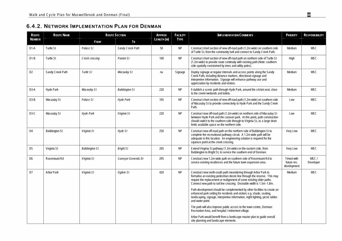
Walk and Cyc le P lan f o r Mus w e l l b rook and Denman (F ina l ) 68
6.4.2. NETWORK IMPLEMENTATION PLAN FOR DENMAN
ROUTE NUMBER
ROUTE NAME ROUTE SECTION APPROX LENGTH (M)
FACILITY TYPE
IMPLEMENTATION COMMENTS PRIORITY RESPONSIBILITY
From To
D1-A Turtle St Palace St Sandy Creek Path 50 NP Construct short section of new off-road path (1.2m wide) on southern side of Turtle St, from the community hall and connect to Sandy Creek Path.
Medium MSC
D1-B Turtle St Creek crossing Paxton St 100 NP Construct short section of new off-road path on northern side of Turtle St (1.2m wide) to provide route continuity with existing path (Note: southern side spatially constrained by trees and utility poles).
High MSC
D2 Sandy Creek Path Turtle St Macaulay St na Signage Deploy signage at regular intervals and access points along the Sandy Creek Path, including distance markers, directional signage and interpretive information. Signage will enhance pathway use and appreciation by residents and visitors.
Medium MSC
D3-A Hyde Park Macaulay St Babbington St 220 NP Establish a scenic path through Hyde Park, around the cricket oval, close to the creek/ wetlands and toilets.
Medium MSC
D3-B Macaulay St Palace St Hyde Park 105 NP Construct short section of new off-road path (1.2m wide) on southern side of Macaulay St to provide connectivity to Hyde Park and the Sandy Creek Path.
Low MSC
D3-C Macaulay St Hyde Park Virginia St 220 NP Construct new off-road path (1.2m wide) on northern side of Macaulay St between Hyde Park and the caravan park. At this point, path construction should switch to the southern side through to Virginia St, as a large drain limits available space on the northern side.
Low MSC
D4 Babbington St Virginia St Hyde St 250 NP Construct new off-road path on the northern side of Babbington St to complete the recreational pathway circuit. A 1.2m wide path will be adequate in this location. An engineering solution is required for the squeeze point at the creek crossing.
Very Low MSC
D5 Virginia St Babbington St Bright St 205 NP Extend Virginia St pathway (1.2m wide) on the eastern side, from Babbington to Bright St, to service the southern end of Denman.
Very Low MSC
D6 Rosemount Rd Virginia St Surveyor Generals Dr 295 NP Construct new 1.2m wide path on southern side of Rosemount Rd to service existing residences and the future town expansion area.
Timed with future res.
development
MSC / Developer
D7 Arbor Park Virginia St Ogilvie St 420 NP Construct new north-south path meandering through Arbor Park to formalise an existing pedestrian desire line through the reserve. This may require the replacement or realignment of some existing older paths. Connect new path to rail line crossing. Desirable width is 1.5m -1.8m .
Path development should be complemented by other facilities to create an enhanced park setting for residents and visitors e.g. shade, seating, landscaping, signage, interpretive information, night lighting, picnic tables and water point.
The path will also improve public access to the town centre, Denman Recreation Area, and hospital / retirement village.
Arbor Park would benefit from a landscape master plan to guide overall site planning and landscape elements.
Medium MSC
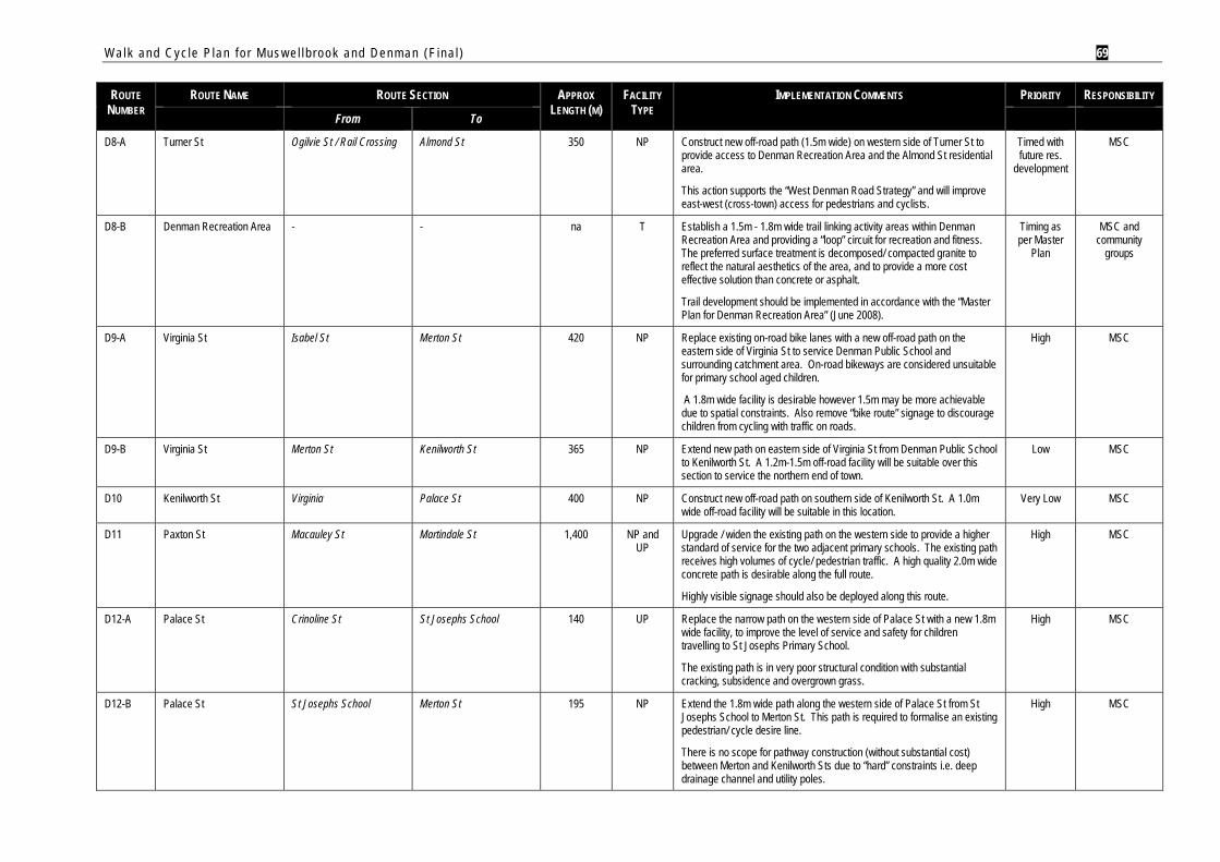
Walk and Cyc le P lan f o r Mus w e l l b rook and Denman (F ina l ) 69
ROUTE NUMBER
ROUTE NAME ROUTE SECTION APPROX LENGTH (M)
FACILITY TYPE
IMPLEMENTATION COMMENTS PRIORITY RESPONSIBILITY
From To
D8-A Turner St Ogilvie St / Rail Crossing Almond St 350 NP Construct new off-road path (1.5m wide) on western side of Turner St to provide access to Denman Recreation Area and the Almond St residential area.
This action supports the “West Denman Road Strategy” and will improve east-west (cross-town) access for pedestrians and cyclists.
Timed with future res.
development
MSC
D8-B Denman Recreation Area - - na T Establish a 1.5m - 1.8m wide trail linking activity areas within Denman Recreation Area and providing a “loop” circuit for recreation and fitness. The preferred surface treatment is decomposed/ compacted granite to reflect the natural aesthetics of the area, and to provide a more cost effective solution than concrete or asphalt.
Trail development should be implemented in accordance with the “Master Plan for Denman Recreation Area” (June 2008).
Timing as per Master
Plan
MSC and community
groups
D9-A Virginia St Isabel St Merton St 420 NP Replace existing on-road bike lanes with a new off-road path on the eastern side of Virginia St to service Denman Public School and surrounding catchment area. On-road bikeways are considered unsuitable for primary school aged children.
A 1.8m wide facility is desirable however 1.5m may be more achievable due to spatial constraints. Also remove “bike route” signage to discourage children from cycling with traffic on roads.
High MSC
D9-B Virginia St Merton St Kenilworth St 365 NP Extend new path on eastern side of Virginia St from Denman Public School to Kenilworth St. A 1.2m-1.5m off-road facility will be suitable over this section to service the northern end of town.
Low MSC
D10 Kenilworth St Virginia Palace St 400 NP Construct new off-road path on southern side of Kenilworth St. A 1.0m wide off-road facility will be suitable in this location.
Very Low MSC
D11 Paxton St Macauley St Martindale St 1,400 NP and UP
Upgrade / widen the existing path on the western side to provide a higher standard of service for the two adjacent primary schools. The existing path receives high volumes of cycle/ pedestrian traffic. A high quality 2.0m wide concrete path is desirable along the full route.
Highly visible signage should also be deployed along this route.
High MSC
D12-A Palace St Crinoline St St Josephs School 140 UP Replace the narrow path on the western side of Palace St with a new 1.8m wide facility, to improve the level of service and safety for children travelling to St Josephs Primary School.
The existing path is in very poor structural condition with substantial cracking, subsidence and overgrown grass.
High MSC
D12-B Palace St St Josephs School Merton St 195 NP Extend the 1.8m wide path along the western side of Palace St from St Josephs School to Merton St. This path is required to formalise an existing pedestrian/ cycle desire line.
There is no scope for pathway construction (without substantial cost) between Merton and Kenilworth Sts due to “hard” constraints i.e. deep drainage channel and utility poles.
High MSC
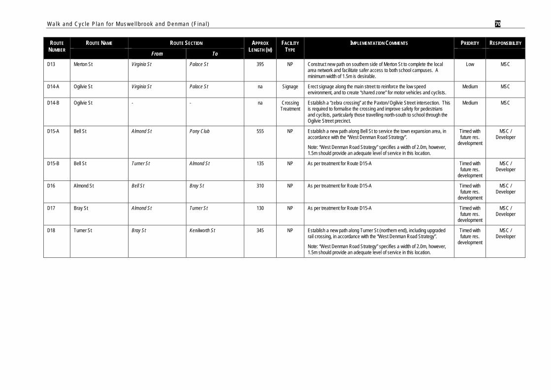
Walk and Cyc le P lan f o r Mus w e l l b rook and Denman (F ina l ) 70
ROUTE NUMBER
ROUTE NAME ROUTE SECTION APPROX LENGTH (M)
FACILITY TYPE
IMPLEMENTATION COMMENTS PRIORITY RESPONSIBILITY
From To
D13 Merton St Virginia St Palace St 395 NP Construct new path on southern side of Merton St to complete the local area network and facilitate safer access to both school campuses. A minimum width of 1.5m is desirable.
Low MSC
D14-A Ogilvie St Virginia St Palace St na Signage Erect signage along the main street to reinforce the low speed environment, and to create “shared zone” for motor vehicles and cyclists.
Medium MSC
D14-B Ogilvie St - - na Crossing Treatment
Establish a “zebra crossing” at the Paxton/ Ogilvie Street intersection. This is required to formalise the crossing and improve safety for pedestrians and cyclists, particularly those travelling north-south to school through the Ogilvie Street precinct.
Medium MSC
D15-A Bell St Almond St Pony Club 555 NP Establish a new path along Bell St to service the town expansion area, in accordance with the “West Denman Road Strategy”.
Note: “West Denman Road Strategy” specifies a width of 2.0m, however, 1.5m should provide an adequate level of service in this location.
Timed with future res.
development
MSC / Developer
D15-B Bell St Turner St Almond St 135 NP As per treatment for Route D15-A Timed with future res.
development
MSC / Developer
D16 Almond St Bell St Bray St 310 NP As per treatment for Route D15-A Timed with future res.
development
MSC / Developer
D17 Bray St Almond St Turner St 130 NP As per treatment for Route D15-A Timed with future res.
development
MSC / Developer
D18 Turner St Bray St Kenilworth St 345 NP Establish a new path along Turner St (northern end), including upgraded rail crossing, in accordance with the “West Denman Road Strategy”.
Note: “West Denman Road Strategy” specifies a width of 2.0m, however, 1.5m should provide an adequate level of service in this location.
Timed with future res.
development
MSC / Developer
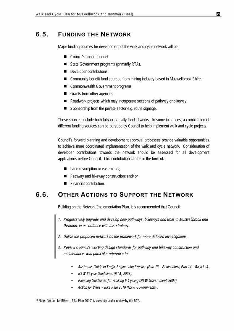
Walk and Cyc le P lan f o r Mus w e l l b rook and Denman (F ina l ) 71
6.5. FUNDING THE NETWORK
Major funding sources for development of the walk and cycle network will be:
Council’s annual budget. State Government programs (primarily RTA). Developer contributions. Community benefit fund sourced from mining industry based in Muswellbrook Shire. Commonwealth Government programs. Grants from other agencies. Roadwork projects which may incorporate sections of pathway or bikeway. Sponsorship from the private sector e.g. route signage.
These sources include both fully or partially funded works. In some instances, a combination of different funding sources can be pursued by Council to help implement walk and cycle projects.
Council’s forward planning and development approval processes provide valuable opportunities to achieve more coordinated implementation of the walk and cycle network. Consideration of developer contributions towards the network should be assessed for all development applications before Council. This contribution can be in the form of:
Land resumption or easements; Pathway and bikeway construction; and/ or Financial contribution.
6.6. OTHER ACTIONS TO SUPPORT THE NETWORK
Building on the Network Implementation Plan, it is recommended that Council:
1. Progressively upgrade and develop new pathways, bikeways and trails in Muswellbrook and Denman, in accordance with this strategy.
2. Utilise the proposed network as the framework for more detailed investigations.
3. Review Council’s existing design standards for pathway and bikeway construction and maintenance, with particular reference to:
Austroads Guide to Traffic Engineering Practice (Part 13 – Pedestrians; Part 14 – Bicycles).
NSW Bicycle Guidelines (RTA, 2003).
Planning Guidelines for Walking & Cycling (NSW Government, 2004).
Action for Bikes – Bike Plan 2010 (NSW Government)11. 11 Note: “Action for Bikes – Bike Plan 2010” is currently under review by the RTA.
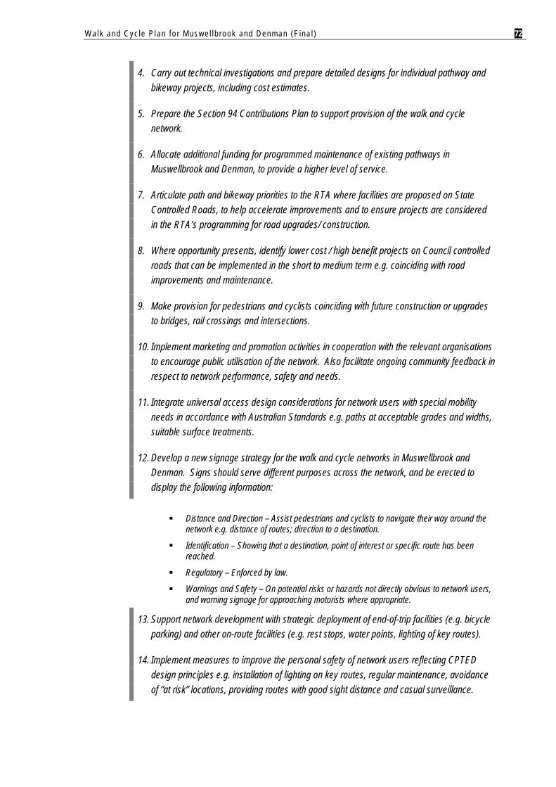
Walk and Cyc le P lan f o r Mus w e l l b rook and Denman (F ina l ) 72
4. Carry out technical investigations and prepare detailed designs for individual pathway and bikeway projects, including cost estimates.
5. Prepare the Section 94 Contributions Plan to support provision of the walk and cycle network.
6. Allocate additional funding for programmed maintenance of existing pathways in Muswellbrook and Denman, to provide a higher level of service.
7. Articulate path and bikeway priorities to the RTA where facilities are proposed on State Controlled Roads, to help accelerate improvements and to ensure projects are considered in the RTA’s programming for road upgrades/ construction.
8. Where opportunity presents, identify lower cost / high benefit projects on Council controlled roads that can be implemented in the short to medium term e.g. coinciding with road improvements and maintenance.
9. Make provision for pedestrians and cyclists coinciding with future construction or upgrades to bridges, rail crossings and intersections.
10. Implement marketing and promotion activities in cooperation with the relevant organisations to encourage public utilisation of the network. Also facilitate ongoing community feedback in respect to network performance, safety and needs.
11. Integrate universal access design considerations for network users with special mobility needs in accordance with Australian Standards e.g. paths at acceptable grades and widths, suitable surface treatments.
12. Develop a new signage strategy for the walk and cycle networks in Muswellbrook and Denman. Signs should serve different purposes across the network, and be erected to display the following information:
Distance and Direction – Assist pedestrians and cyclists to navigate their way around the network e.g. distance of routes; direction to a destination.
Identification – Showing that a destination, point of interest or specific route has been reached.
Regulatory – Enforced by law.
Warnings and Safety – On potential risks or hazards not directly obvious to network users, and warning signage for approaching motorists where appropriate.
13. Support network development with strategic deployment of end-of-trip facilities (e.g. bicycle parking) and other on-route facilities (e.g. rest stops, water points, lighting of key routes).
14. Implement measures to improve the personal safety of network users reflecting CPTED design principles e.g. installation of lighting on key routes, regular maintenance, avoidance of “at risk” locations, providing routes with good sight distance and casual surveillance.
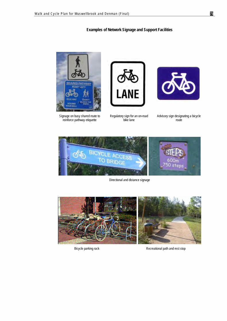
Walk and Cyc le P lan f o r Mus w e l l b rook and Denman (F ina l ) 73
Examples of Network Signage and Support Facilities
Signage on busy shared route to reinforce pathway etiquette
Regulatory sign for an on-road bike lane
Advisory sign designating a bicycle route
Directional and distance signage
Bicycle parking rack Recreational path and rest stop

Walk and Cyc le P lan f o r Mus w e l l b rook and Denman (F ina l )
APPENDIX A
Network Maps – Muswellbrook
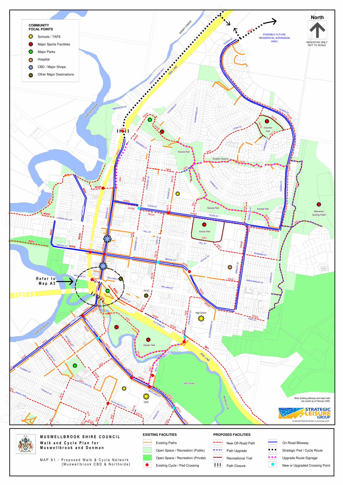
Proposed concrete shared path (04/05 budget)Proposed concrete shared path (04/07 Mgt Plan) MARKET ST
WILLIAM ST
MAITLA
ND
ST
VICTORIA ST
CLE
ND
INN
ING
ST
DO
LA
HE
NY
ST
KING ST
WILLIAM ST
BRENTWOOD ST
DOYLE ST
BROOK ST
HILL ST
SO
WE
RB
Y S
T
BOWMAN ST
BR
EC
HT
ST
CA
RL S
T
QU
EE
N S
T
WILLIAM ST
FO
RD
ST
BR
IDG
E S
T
BROOK ST
SYDNEY ST
LOWER HILL ST
HILL ST
COOK ST
COOK ST
SE
MIL
LO
N S
T
RO
GE
R S
TSO
WE
RB
Y S
T
SHIR
AZ S
T
QU
EE
N S
T
MANNING ST
QUEEN ST
CA
BE
RN
ET
ST
LEXIA ST
HU
MP
HR
IES
ST
COUSIN
S ST
ABERDEEN ST
MAITLAND ST
RUTH WHITE AV
SH
AW
CR
BE
LL S
T
BELL S
T
VIC
TO
RIA
ST
SKELLATAR ST
SKELLA
TAR
ST
TINDALE ST
MIT
CH
ELL S
T
FORBES ST
ANZAC PDE
QUEEN ST
NEW
ENG
LAND H
WY
M56D
M56D
M56D
M56D
M56D
M56D
M56D
M56D
M56D
M59C
M59C
M59C
M59C
M59C
M59C
M59C
M59C
M59C
M59C
M59C
M59C
M59C
M59C
M59C
M59C
M59C
M59C
M30B
M30B
M30B
M30B
M30B
M30B
M30B
M30B
M30B
M54
BM
54
BM
54
BM
54
BM
54
BM
54
BM
54
BM
54
BM
54
B
M52M52M52M52M52M52M52M52M52
M44AM44AM44AM44AM44AM44AM44AM44AM44A
M4
7A
M4
7A
M4
7A
M4
7A
M4
7A
M4
7A
M4
7A
M4
7A
M4
7A
M45BM45BM45BM45BM45BM45BM45BM45BM45B
M4
1M
41
M4
1M
41
M4
1M
41
M4
1M
41
M4
1
M4
7B
M4
7B
M4
7B
M4
7B
M4
7B
M4
7B
M4
7B
M4
7B
M4
7B
M40
BM
40B
M40
BM
40B
M40
BM
40B
M40
BM
40B
M40
B
M59A
M59A
M59A
M59A
M59A
M59A
M59A
M59A
M59A
M50
M50
M50
M50
M50
M50
M50
M50
M50
M36
AM
36
AM
36
AM
36
AM
36
AM
36
AM
36
AM
36
AM
36
A
M56C
M56C
M56C
M56C
M56C
M56C
M56C
M56C
M56C
M21B
M21B
M21B
M21B
M21B
M21B
M21B
M21B
M21B M
57CM
57CM
57CM
57CM
57CM
57CM
57CM
57C
M57C
M31
M31
M31
M31
M31
M31
M31
M31
M31
M57D
M57D
M57D
M57D
M57D
M57D
M57D
M57D
M57D
M58BM58BM58BM58BM58BM58BM58BM58BM58B
M56D
M56D
M56D
M56D
M56D
M56D
M56D
M56D
M56D
M57F
M57F
M57F
M57F
M57F
M57F
M57F
M57F
M57F
M1A
M1A
M1A
M1A
M1A
M1A
M1A
M1A
M1A
M1A
M1A
M1A
M1A
M1A
M1A
M1A
M1A
M1A
M28C
M28C
M28C
M28C
M28C
M28C
M28C
M28C
M28C
M3
0H
M3
0H
M3
0H
M3
0H
M3
0H
M3
0H
M3
0H
M3
0H
M3
0H
M30EM30EM30EM30EM30EM30EM30EM30EM30E
M30J
M30J
M30J
M30J
M30J
M30J
M30J
M30J
M30J
M30GM30GM30GM30GM30GM30GM30GM30GM30G
M3
0F
M3
0F
M3
0F
M3
0F
M3
0F
M3
0F
M3
0F
M3
0F
M3
0F
M30LM30LM30LM30LM30LM30LM30LM30LM30L
M30I
M30I
M30I
M30I
M30I
M30I
M30I
M30I
M30I
M30KM30KM30KM30KM30KM30KM30KM30KM30K
M61
M61
M61
M61
M61
M61
M61
M61
M61
M1B
M1B
M1B
M1B
M1B
M1B
M1B
M1B
M1B
M1B
M1B
M1B
M1B
M1B
M1B
M1B
M1B
M1B
M3M3M3M3M3M3M3M3M3
M16A
M16A
M16A
M16A
M16A
M16A
M16A
M16A
M16AM16C
M16CM16CM16CM16CM16CM16CM16CM16C
M17
M17
M17
M17
M17
M17
M17
M17
M17
M19
M19
M19
M19
M19
M19
M19
M19
M19
M18
M18
M18
M18
M18
M18
M18
M18
M18
M20M20M20M20M20M20M20M20M20
M21AM21AM21AM21AM21AM21AM21AM21AM21A
M22
M22
M22
M22
M22
M22
M22
M22
M22
M23B
M23B
M23B
M23B
M23B
M23B
M23B
M23B
M23B
M23A
M23A
M23A
M23A
M23A
M23A
M23A
M23A
M23A
M24
M24
M24
M24
M24
M24
M24
M24
M24
M26
M26
M26
M26
M26
M26
M26
M26
M26
M2
7A
M2
7A
M2
7A
M2
7A
M2
7A
M2
7A
M2
7A
M2
7A
M2
7A
M2
7B
M2
7B
M2
7B
M2
7B
M2
7B
M2
7B
M2
7B
M2
7B
M2
7B
M27C
M27C
M27C
M27C
M27C
M27C
M27C
M27C
M27C
M28AM28AM28AM28AM28AM28AM28AM28AM28A
M28BM28BM28BM28BM28BM28BM28BM28BM28B
M29
M29
M29
M29
M29
M29
M29
M29
M29
M30B
M30B
M30B
M30B
M30B
M30B
M30B
M30B
M30B
M30CM30CM30C
M30CM30C
M30CM30CM30CM30C
M32
M32
M32
M32
M32
M32
M32
M32
M32
M33
M33
M33
M33
M33
M33
M33
M33
M33
M3
4M
34
M3
4M
34
M3
4M
34
M3
4M
34
M3
4
M35
M35
M35
M35
M35
M35
M35
M35
M35
M36B
M36B
M36B
M36B
M36B
M36B
M36B
M36B
M36B
M36CM36CM36CM36C
M36CM36CM36CM36CM36C
M37A
M37A
M37A
M37A
M37A
M37A
M37A
M37A
M37A
M42
M42
M42
M42
M42
M42
M42
M42
M42
M37B
M37B
M37B
M37B
M37B
M37B
M37B
M37B
M37B
M43M43M43M43M43M43M43M43M43
M44BM44BM44BM44BM44BM44BM44BM44BM44B
M45AM45AM45AM45AM45AM45AM45AM45AM45A
M39B
M39B
M39B
M39B
M39B
M39B
M39B
M39B
M39B
M40A
M40A
M40A
M40A
M40A
M40A
M40A
M40A
M40A
M48M48M48M48M48M48M48M48M48
M51
M51
M51
M51
M51
M51
M51
M51
M51
M53
M53
M53
M53
M53
M53
M53
M53
M53
M5
4A
M5
4A
M5
4A
M5
4A
M5
4A
M5
4A
M5
4A
M5
4A
M5
4A
M38M38M38M38M38M38M38M38M38
M39C
M39C
M39C
M39C
M39C
M39C
M39C
M39C
M39C
M39A
M39A
M39A
M39A
M39A
M39A
M39A
M39A
M39A
M54CM54CM54CM54CM54CM54CM54CM54CM54C
M35M35M35M35M35M35M35M35M35
M56B
M56B
M56B
M56B
M56B
M56B
M56B
M56B
M56B
M58A
M58A
M58A
M58A
M58A
M58A
M58A
M58A
M58A
M57E
M57E
M57E
M57E
M57E
M57E
M57E
M57E
M57E
M60
M60
M60
M60
M60
M60
M60
M60
M60
M5
9C
M5
9C
M5
9C
M5
9C
M5
9C
M5
9C
M5
9C
M5
9C
M5
9C
M60
M60
M60
M60
M60
M60
M60
M60
M60
M29
M29
M29
M29
M29
M29
M29
M29
M29
M25M25M25M25M25M25M25M25M25
M4
6M
46
M4
6M
46
M4
6M
46
M4
6M
46
M4
6
M30AM30AM30AM30AM30AM30AM30AM30AM30A
M30DM30DM30DM30DM30DM30DM30DM30DM30D
M59B
M59B
M59B
M59B
M59B
M59B
M59B
M59B
M59B
M4
6M
46
M4
6M
46
M4
6M
46
M4
6M
46
M4
6
M37B
M37B
M37B
M37B
M37B
M37B
M37B
M37B
M37B
M49M49M49M49M49M49M49M49M49
Existing Paths
Open Space / Recreation (Public)
Open Space / Recreation (Private)
Existing Cycle / Ped Crossing
EXISTING FACILITIES
New Off-Road Path
Path Upgrade
Recreational Trail
Path Closure
PROPOSED FACILITIES
On-Road Bikeway
Strategic Ped / Cycle Route
Upgrade Route Signage
New or Upgraded Crossing Point
North
INDICATIVE ONLYNOT TO SCALE
COMMUNITY
FOCAL POINTS
Schools / TAFE
Major Sports Facilities
Major Parks
Hospital
CBD / Major Shops
Other Major Destinations
�������������������������������������������������
�������������������������������������������������
�������������������������������������������������
�������������������������������������������������
�������������������������������������������������
M U S W E L L B R O O K S H I R E C O U N C I L
W a l k a n d C y c l e P l a n f o rM u s w e l l b r o o k a n d D e n m a n
M A P A 1 - P r o p o s e d W a l k & C y c l e N e t w o r k
[ M u s w e l l b r o o k C B D & N o r t h s i d e ]
�������������������������������������������������
�������������������������������������������������
�������������������������������������������������
�������������������������������������������������
�������������������������������������������������
�������������������������������������������������
�������������������������������������������������
�������������������������������������������������
�������������������������������������������������
��������������������������������������������������
�������������������������������������������������
�������������������������������������������������
�������������������������������������������������
�������������������������������������������������
�������������������������������������������������
�������������������������������������������������
�������������������������������������������������
�������������������������������������������������
R e f e r t oM a p A 3
Karoola ParkKaroola ParkKaroola ParkKaroola ParkKaroola ParkKaroola ParkKaroola ParkKaroola ParkKaroola Park
Karoola ParkKaroola ParkKaroola ParkKaroola ParkKaroola ParkKaroola ParkKaroola ParkKaroola ParkKaroola Park
Verdelho ReserveVerdelho ReserveVerdelho ReserveVerdelho ReserveVerdelho ReserveVerdelho ReserveVerdelho ReserveVerdelho ReserveVerdelho Reserve
VolunteerVolunteerVolunteerVolunteerVolunteerVolunteerVolunteerVolunteerVolunteer
ParkParkParkParkParkParkParkParkPark
WeeramanWeeramanWeeramanWeeramanWeeramanWeeramanWeeramanWeeramanWeeraman
Sporting FieldsSporting FieldsSporting FieldsSporting FieldsSporting FieldsSporting FieldsSporting FieldsSporting FieldsSporting Fields
Victoria ParkVictoria ParkVictoria ParkVictoria ParkVictoria ParkVictoria ParkVictoria ParkVictoria ParkVictoria Park
Golf CourseGolf CourseGolf CourseGolf CourseGolf CourseGolf CourseGolf CourseGolf CourseGolf Course
Olympic ParkOlympic ParkOlympic ParkOlympic ParkOlympic ParkOlympic ParkOlympic ParkOlympic ParkOlympic Park
TAFETAFETAFETAFETAFETAFETAFETAFETAFE
POSSIBLE FUTUREPOSSIBLE FUTUREPOSSIBLE FUTUREPOSSIBLE FUTUREPOSSIBLE FUTUREPOSSIBLE FUTUREPOSSIBLE FUTUREPOSSIBLE FUTUREPOSSIBLE FUTURE
RESIDENTIAL EXPANSIONRESIDENTIAL EXPANSIONRESIDENTIAL EXPANSIONRESIDENTIAL EXPANSIONRESIDENTIAL EXPANSIONRESIDENTIAL EXPANSIONRESIDENTIAL EXPANSIONRESIDENTIAL EXPANSIONRESIDENTIAL EXPANSION
AREAAREAAREAAREAAREAAREAAREAAREAAREA
Karoola ParkKaroola ParkKaroola ParkKaroola ParkKaroola ParkKaroola ParkKaroola ParkKaroola ParkKaroola Park
High School
HU
NTE
R R
IVER
HU
NTE
R R
IVER
HU
NTE
R R
IVER
HU
NTE
R R
IVER
HU
NTE
R R
IVER
HU
NTE
R R
IVER
HU
NTE
R R
IVER
HU
NTE
R R
IVER
HU
NTE
R R
IVER
HUNTER R
IVER
HUNTER R
IVER
HUNTER R
IVER
HUNTER R
IVER
HUNTER R
IVER
HUNTER R
IVER
HUNTER R
IVER
HUNTER R
IVER
HUNTER R
IVER
SANDY C
REEK
SANDY C
REEK
SANDY C
REEK
SANDY C
REEK
SANDY C
REEK
SANDY C
REEK
SANDY C
REEK
SANDY C
REEK
SANDY C
REEK
MU
SC
LE
CK
MU
SC
LE
CK
MU
SC
LE
CK
MU
SC
LE
CK
MU
SC
LE
CK
MU
SC
LE
CK
MU
SC
LE
CK
MU
SC
LE
CK
MU
SC
LE
CK
��������������������������������������������������
PCYC
RAIL LIN
E
RAIL LIN
E
RAIL LIN
E
RAIL LIN
E
RAIL LIN
E
RAIL LIN
E
RAIL LIN
E
RAIL LIN
E
RAIL LIN
E
RAIL
LIN
E
RAIL
LIN
E
RAIL
LIN
E
RAIL
LIN
E
RAIL
LIN
E
RAIL
LIN
E
RAIL
LIN
E
RAIL
LIN
E
RAIL
LIN
E
Note: Existing pathways and major trails
are current as at February 2009.
SL360/MAPPING/NETWORK V3 (NOV2009).WOR
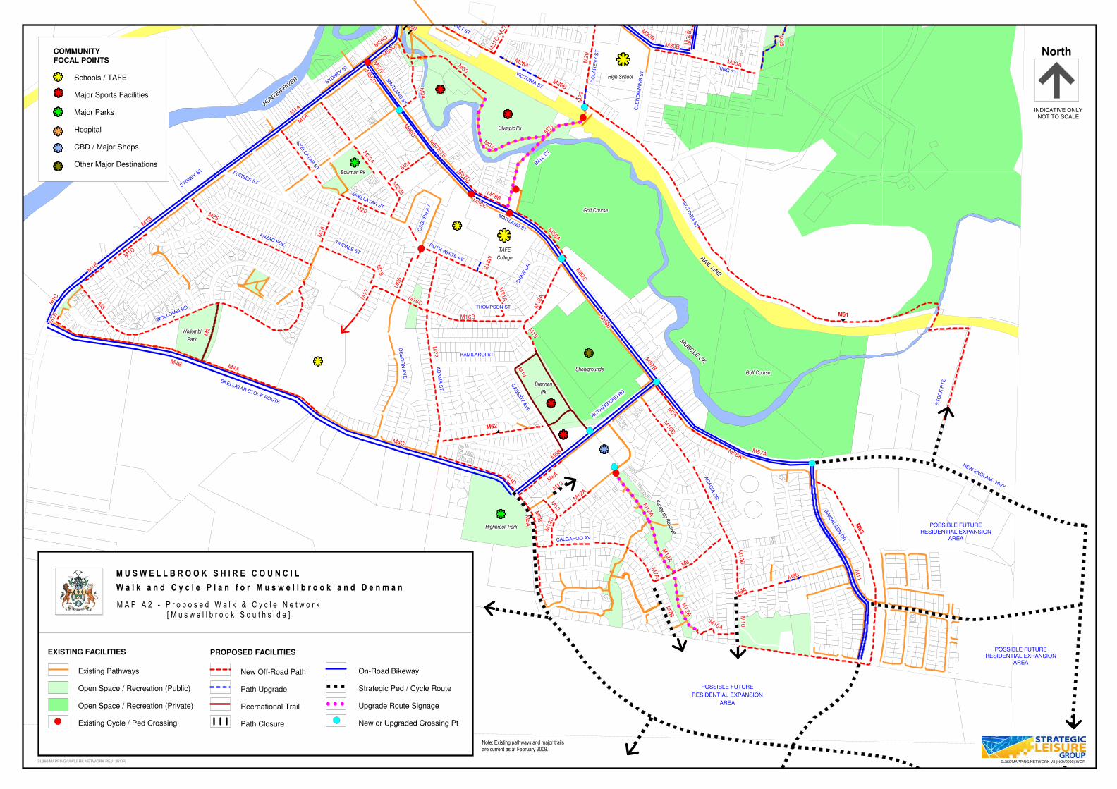
Proposed concrete shared path (04/07 Mgt Plan)Proposed concrete shared path (future)
CA
SS
IDY
AV
E
BIM
BAD
EE
N D
R
RUTH WHITE AV
SH
AW
CR
MAITLAND ST
SKELLATAR ST
OS
BO
RN
AV
BELL S
T
TINDALE ST
SKELLA
TAR
ST
FORBES ST
ANZAC PDE
OS
BO
RN
AV
E
THOMPSON ST
KAMILAROI ST
AD
AM
S S
T
SKELLATAR STOCK ROUTE
RUTHERFORD RD
VIC
TO
RIA
ST
AC
AC
IA D
R
MAITLA
ND
ST
SYDNEY ST
CLE
ND
INN
ING
ST
WOLLOMBI RD
CALGAROO AV
ST
OC
K R
TE
NEW ENGLAND HWY
SYDNEY ST
VICTORIA ST
DO
LA
HE
NY
ST
KING ST
MARKET ST
M21B
M21B
M21B
M21B
M21B
M21B
M21B
M21B
M21B
M21A
M21A
M21A
M21A
M21A
M21A
M21A
M21A
M21A
M56CM56CM56CM56CM56CM56CM56CM56CM56C
M58BM58BM58BM58BM58BM58BM58BM58BM58B
M20M20M20M20M20M20M20M20M20
M57D
M57D
M57D
M57D
M57D
M57D
M57D
M57D
M57D
M16CM16CM16CM16CM16CM16CM16CM16CM16C
M22
M22
M22
M22
M22
M22
M22
M22
M22
M16BM16BM16BM16BM16BM16BM16BM16BM16B
M57C
M57C
M57C
M57C
M57C
M57C
M57C
M57C
M57C
M56B
M56B
M56B
M56B
M56B
M56B
M56B
M56B
M56B
M57B
M57B
M57B
M57B
M57B
M57B
M57B
M57B
M57B
M55
M55
M55
M55
M55
M55
M55
M55
M55
M6A
M6A
M6A
M6A
M6A
M6A
M6A
M6A
M6A
M56AM56AM56AM56AM56AM56AM56AM56AM56A
M56D
M56D
M56D
M56D
M56D
M56D
M56D
M56D
M56D
M4AM4AM4AM4AM4AM4AM4AM4AM4A
M1A
M1A
M1A
M1A
M1A
M1A
M1A
M1A
M1A
M2
M2
M2
M2
M2
M2
M2
M2
M2
M1D
M1D
M1D
M1D
M1D
M1D
M1D
M1D
M1D
M1B
M1B
M1B
M1B
M1B
M1B
M1B
M1B
M1B
M1B
M1B
M1B
M1B
M1B
M1B
M1B
M1B
M1B
M3
M3
M3
M3M3
M3
M3
M3
M3
M4BM4BM4BM4BM4BM4BM4BM4BM4B
M5
AM
5A
M5
AM
5A
M5
AM
5A
M5
AM
5A
M5
A
M57F
M57F
M57F
M57F
M57F
M57F
M57F
M57F
M57FM
56DM
56DM
56DM
56DM
56DM
56DM
56DM
56D
M56D
M1A
M1A
M1A
M1A
M1A
M1A
M1A
M1A
M1A
M59
C
M59
C
M59
CM
59C
M59
CM
59C
M59
C
M59
C
M59
CM
59C
M59C
M59C
M59C
M59C
M59C
M59C
M59C
M59C
M61
M62
M63
M1C
M1C
M1CM1C
M1CM1C
M1C
M1C
M1C
M4D
M4D
M4D
M4D
M4D
M4D
M4D
M4D
M4D
M6B
M6B
M6B
M6B
M6B
M6B
M6B
M6B
M6B
M5B
M5B
M5B
M5B
M5B
M5B
M5B
M5B
M5B
M7A
M7A
M7A
M7A
M7A
M7A
M7A
M7A
M7A
M7B
M7B
M7B
M7B
M7B
M7B
M7B
M7B
M7B
M8M8M8M8M8M8M8M8M8
M9AM9AM9AM9AM9AM9AM9AM9AM9A
M9BM9BM9BM9BM9BM9BM9BM9BM9B
M10B
M10B
M10B
M10B
M10B
M10B
M10B
M10B
M10B
M10B
M10B
M10B
M10B
M10B
M10B
M10B
M10B
M10B
M10
M10
M10
M10
M10
M10
M10
M10
M10
M11
M11
M11
M11
M11
M11
M11
M11
M11
M12A
M12A
M12A
M12A
M12A
M12A
M12A
M12A
M12A
M12B
M12B
M12B
M12B
M12B
M12B
M12B
M12B
M12B
M13
M13
M13
M13
M13
M13
M13
M13
M13
M15
M15
M15
M15
M15
M15
M15
M15
M15
M16A
M16A
M16A
M16A
M16A
M16A
M16A
M16A
M16AM
17
M17
M17
M17
M17
M17
M17
M17
M17
M19
M19
M19
M19
M19
M19
M19
M19
M19
M18
M18
M18
M18
M18
M18
M18
M18
M18
M23B
M23B
M23B
M23B
M23B
M23B
M23B
M23B
M23B
M23A
M23A
M23A
M23A
M23A
M23A
M23A
M23A
M23A
M24
M24
M24
M24
M24
M24
M24
M24
M24
M26
M26
M26
M26
M26
M26
M26
M26
M26
M27B
M27B
M27B
M27B
M27B
M27B
M27B
M27B
M27B
M27C
M27C
M27C
M27C
M27C
M27C
M27C
M27C
M27C
M28AM28AM28AM28AM28AM28AM28AM28AM28A
M28BM28BM28BM28BM28BM28BM28BM28BM28B
M29
M29
M29
M29
M29
M29
M29
M29
M29
M30BM30BM30BM30BM30BM30BM30BM30BM30B
M30B
M30B
M30B
M30B
M30B
M30B
M30B
M30B
M30B
M31
M31
M31
M31
M31
M31
M31
M31
M31
M32M32M32M32M32M32M32M32M32
M33
M33
M33
M33
M33
M33
M33
M33
M33
M3
4M
34
M3
4M
34
M3
4M
34
M3
4M
34
M3
4
M35
M35
M35
M35
M35
M35
M35
M35
M35M
54A
M5
4A
M5
4A
M5
4A
M5
4A
M5
4A
M5
4A
M5
4A
M5
4A
M54
BM
54
BM
54
BM
54
BM
54
BM
54
BM
54
BM
54
BM
54
B
M57AM57AM57AM57AM57AM57AM57AM57AM57A
M58A
M58A
M58A
M58A
M58A
M58A
M58A
M58A
M58A
M57E
M57E
M57E
M57E
M57E
M57E
M57E
M57E
M57E
M57F
M57F
M57F
M57F
M57F
M57F
M57F
M57F
M57F
M60
M60
M60
M60
M60
M60
M60
M60
M60
M29
M29
M29
M29
M29
M29
M29
M29
M29
M25M25M25M25M25M25M25M25M25
M13
M13
M13
M13
M13
M13
M13
M13
M13
M1E
M1E
M1E
M1E
M1E
M1E
M1E
M1E
M1E
M12A
M12A
M12A
M12A
M12A
M12A
M12A
M12A
M12A
M12A
M12A
M12A
M12A
M12A
M12A
M12A
M12A
M12A
M12A
M12A
M12A
M12A
M12A
M12A
M12A
M12A
M12A
M14
M14
M14
M14
M14
M14
M14
M14
M14
M30AM30AM30AM30AM30AM30AM30AM30AM30A
M4CM4CM4CM4CM4CM4CM4CM4CM4C
M10AM10AM10A
M10AM10A
M10AM10AM10AM10A
Existing Pathways
Open Space / Recreation (Public)
Open Space / Recreation (Private)
Existing Cycle / Ped Crossing
EXISTING FACILITIES
New Off-Road Path
Path Upgrade
Recreational Trail
Path Closure
PROPOSED FACILITIES
On-Road Bikeway
Strategic Ped / Cycle Route
Upgrade Route Signage
New or Upgraded Crossing Pt
SL360/MAPPING/MWLBRK NETWORK REV1.WOR
North
INDICATIVE ONLYNOT TO SCALE
COMMUNITY
FOCAL POINTS
Schools / TAFE
Major Sports Facilities
Major Parks
Hospital
CBD / Major Shops
Other Major Destinations
�������������������������������������������������
�������������������������������������������������
�������������������������������������������������
�������������������������������������������������
�������������������������������������������������
M U S W E L L B R O O K S H I R E C O U N C I L
W a l k a n d C y c l e P l a n f o r M u s w e l l b r o o k a n d D e n m a n
M A P A 2 - P r o p o s e d W a l k & C y c l e N e t w o r k
[ M u s w e l l b r o o k S o u t h s i d e ]
�������������������������������������������������
������������������������������������������������� �������������������������������������������������
�������������������������������������������������
�������������������������������������������������
�������������������������������������������������
�������������������������������������������������
�������������������������������������������������
�������������������������������������������������
�������������������������������������������������
�������������������������������������������������
�������������������������������������������������
�������������������������������������������������
�������������������������������������������������
Highbrook ParkHighbrook ParkHighbrook ParkHighbrook ParkHighbrook ParkHighbrook ParkHighbrook ParkHighbrook ParkHighbrook Park
WollombiWollombiWollombiWollombiWollombiWollombiWollombiWollombiWollombi
ParkParkParkParkParkParkParkParkPark
ShowgroundsShowgroundsShowgroundsShowgroundsShowgroundsShowgroundsShowgroundsShowgroundsShowgrounds
BrennanBrennanBrennanBrennanBrennanBrennanBrennanBrennanBrennan
PkPkPkPkPkPkPkPkPk
Kurrajong R
eserve
Kurrajong R
eserve
Kurrajong R
eserve
Kurrajong R
eserve
Kurrajong R
eserve
Kurrajong R
eserve
Kurrajong R
eserve
Kurrajong R
eserve
Kurrajong R
eserve
Golf CourseGolf CourseGolf CourseGolf CourseGolf CourseGolf CourseGolf CourseGolf CourseGolf Course
Golf CourseGolf CourseGolf CourseGolf CourseGolf CourseGolf CourseGolf CourseGolf CourseGolf Course
Olympic PkOlympic PkOlympic PkOlympic PkOlympic PkOlympic PkOlympic PkOlympic PkOlympic Pk
Bowman PkBowman PkBowman PkBowman PkBowman PkBowman PkBowman PkBowman PkBowman Pk
TAFETAFETAFETAFETAFETAFETAFETAFETAFE
CollegeCollegeCollegeCollegeCollegeCollegeCollegeCollegeCollege
High School
POSSIBLE FUTUREPOSSIBLE FUTUREPOSSIBLE FUTUREPOSSIBLE FUTUREPOSSIBLE FUTUREPOSSIBLE FUTUREPOSSIBLE FUTUREPOSSIBLE FUTUREPOSSIBLE FUTURE
RESIDENTIAL EXPANSIONRESIDENTIAL EXPANSIONRESIDENTIAL EXPANSIONRESIDENTIAL EXPANSIONRESIDENTIAL EXPANSIONRESIDENTIAL EXPANSIONRESIDENTIAL EXPANSIONRESIDENTIAL EXPANSIONRESIDENTIAL EXPANSION
AREAAREAAREAAREAAREAAREAAREAAREAAREA
POSSIBLE FUTURERESIDENTIAL EXPANSION
AREA
POSSIBLE FUTURERESIDENTIAL EXPANSION
AREA
HU
NTE
R R
IVER
HU
NTE
R R
IVER
HU
NTE
R R
IVER
HU
NTE
R R
IVER
HU
NTE
R R
IVER
HU
NTE
R R
IVER
HU
NTE
R R
IVER
HU
NTE
R R
IVER
HU
NTE
R R
IVER
MUSCLE
CK
MUSCLE
CK
MUSCLE
CK
MUSCLE
CK
MUSCLE
CK
MUSCLE
CK
MUSCLE
CK
MUSCLE
CK
MUSCLE
CK
RAIL LIN
E
RAIL LIN
E
RAIL LIN
E
RAIL LIN
E
RAIL LIN
E
RAIL LIN
E
RAIL LIN
E
RAIL LIN
E
RAIL LIN
E
�������������������������������������������������
Note: Existing pathways and major trails
are current as at February 2009.
SL360/MAPPING/NETWORK V3 (NOV2009).WOR
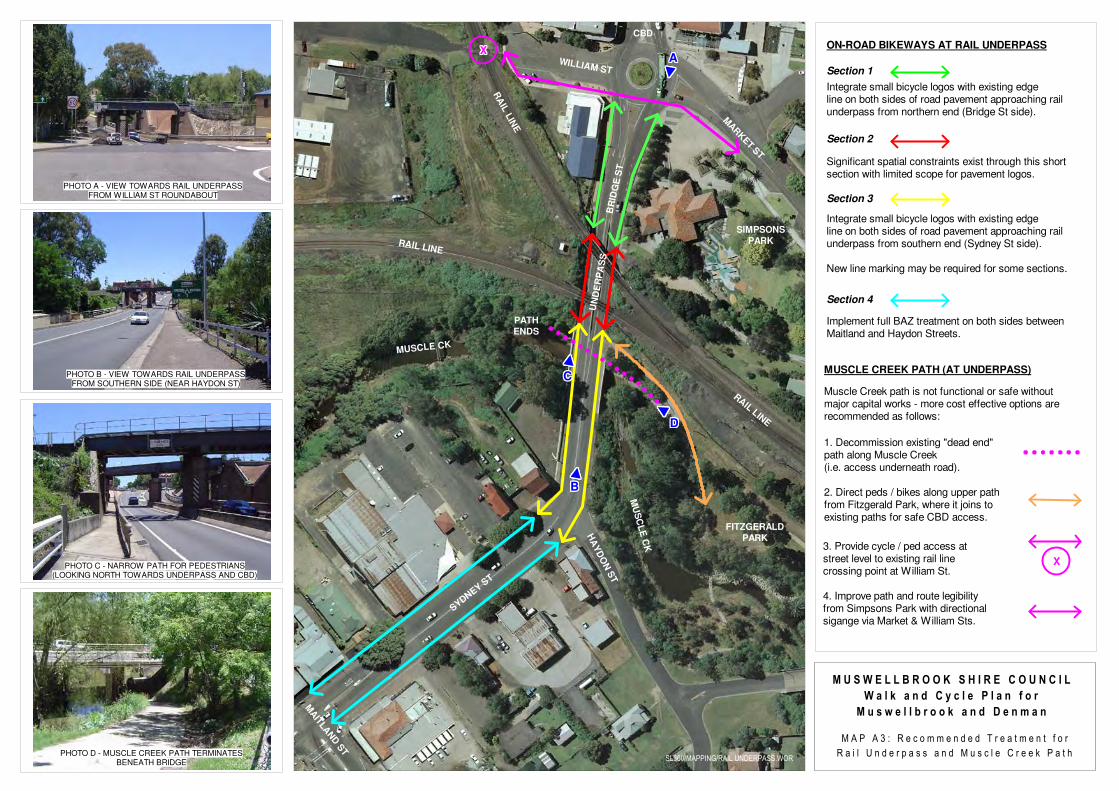
AAAAAAAAA%%%%%%%%%%%%%%%%%%%%%%%%%%%%%%%%%%%%%%%%%%%%%%%%%
BBBBBBBBB
%%%%%%%%%%%%%%%%%%%%%%%%%%%%%%%%%%%%%%%%%%%%%%%%%
CCCCCCCCC
%%%%%%%%%%%%%%%%%%%%%%%%%%%%%%%%%%%%%%%%%%%%%%%%%
DDDDDDDDD
%%%%%%%%%%%%%%%%%%%%%%%%%%%%%%%%%%%%%%%%%%%%%%%%%
PHOTO A - VIEW TOWARDS RAIL UNDERPASSFROM WILLIAM ST ROUNDABOUT
PHOTO D - MUSCLE CREEK PATH TERMINATESBENEATH BRIDGE
Section 1
Section 2
Section 3
Section 4
RAIL L
INE
RAIL LINE
RA
IL L
INE
MARKET S
T
WILLIAM ST
HA
YD
ON
ST
MAIT
LAND
ST
SYDN
EY S
T
BR
IDG
E S
T
MUSCLE CK
MU
SC
LE
CK
Integrate small bicycle logos with existing edge line on both sides of road pavement approaching railunderpass from northern end (Bridge St side).
Significant spatial constraints exist through this shortsection with limited scope for pavement logos.
Integrate small bicycle logos with existing edgeline on both sides of road pavement approaching railunderpass from southern end (Sydney St side).
New line marking may be required for some sections.
Implement full BAZ treatment on both sides between Maitland and Haydon Streets.
MUSCLE CREEK PATH (AT UNDERPASS)
1. Decommission existing "dead end"path along Muscle Creek (i.e. access underneath road).
2. Direct peds / bikes along upper pathfrom Fitzgerald Park, where it joins toexisting paths for safe CBD access.
Muscle Creek path is not functional or safe withoutmajor capital works - more cost effective options arerecommended as follows:
ON-ROAD BIKEWAYS AT RAIL UNDERPASS
SIMPSONS
PARK
XXXXXXXXX
XXXXXXXXX
3. Provide cycle / ped access atstreet level to existing rail line crossing point at William St.
4. Improve path and route legibilityfrom Simpsons Park with directionalsigange via Market & William Sts.
M U S W E L L B R O O K S H I R E C O U N C I LM U S W E L L B R O O K S H I R E C O U N C I LM U S W E L L B R O O K S H I R E C O U N C I LM U S W E L L B R O O K S H I R E C O U N C I LM U S W E L L B R O O K S H I R E C O U N C I LM U S W E L L B R O O K S H I R E C O U N C I LM U S W E L L B R O O K S H I R E C O U N C I LM U S W E L L B R O O K S H I R E C O U N C I LM U S W E L L B R O O K S H I R E C O U N C I L
W a l k a n d C y c l e P l a n f o rW a l k a n d C y c l e P l a n f o rW a l k a n d C y c l e P l a n f o rW a l k a n d C y c l e P l a n f o rW a l k a n d C y c l e P l a n f o rW a l k a n d C y c l e P l a n f o rW a l k a n d C y c l e P l a n f o rW a l k a n d C y c l e P l a n f o rW a l k a n d C y c l e P l a n f o r
M u s w e l l b r o o k a n d D e n m a nM u s w e l l b r o o k a n d D e n m a nM u s w e l l b r o o k a n d D e n m a nM u s w e l l b r o o k a n d D e n m a nM u s w e l l b r o o k a n d D e n m a nM u s w e l l b r o o k a n d D e n m a nM u s w e l l b r o o k a n d D e n m a nM u s w e l l b r o o k a n d D e n m a nM u s w e l l b r o o k a n d D e n m a n
M A P A 3 : R e c o m m e n d e d T r e a t m e n t f o rM A P A 3 : R e c o m m e n d e d T r e a t m e n t f o rM A P A 3 : R e c o m m e n d e d T r e a t m e n t f o rM A P A 3 : R e c o m m e n d e d T r e a t m e n t f o rM A P A 3 : R e c o m m e n d e d T r e a t m e n t f o rM A P A 3 : R e c o m m e n d e d T r e a t m e n t f o rM A P A 3 : R e c o m m e n d e d T r e a t m e n t f o rM A P A 3 : R e c o m m e n d e d T r e a t m e n t f o rM A P A 3 : R e c o m m e n d e d T r e a t m e n t f o r
R a i l U n d e r p a s s a n d M u s c l e C r e e k P a t hR a i l U n d e r p a s s a n d M u s c l e C r e e k P a t hR a i l U n d e r p a s s a n d M u s c l e C r e e k P a t hR a i l U n d e r p a s s a n d M u s c l e C r e e k P a t hR a i l U n d e r p a s s a n d M u s c l e C r e e k P a t hR a i l U n d e r p a s s a n d M u s c l e C r e e k P a t hR a i l U n d e r p a s s a n d M u s c l e C r e e k P a t hR a i l U n d e r p a s s a n d M u s c l e C r e e k P a t hR a i l U n d e r p a s s a n d M u s c l e C r e e k P a t hSL360/MAPPING/RAIL UNDERPASS.WOR
UN
DE
RP
AS
S
PATH
ENDS
CBD
PHOTO B - VIEW TOWARDS RAIL UNDERPASSFROM SOUTHERN SIDE (NEAR HAYDON ST)
PHOTO C - NARROW PATH FOR PEDESTRIANS(LOOKING NORTH TOWARDS UNDERPASS AND CBD)
FITZGERALD
PARK
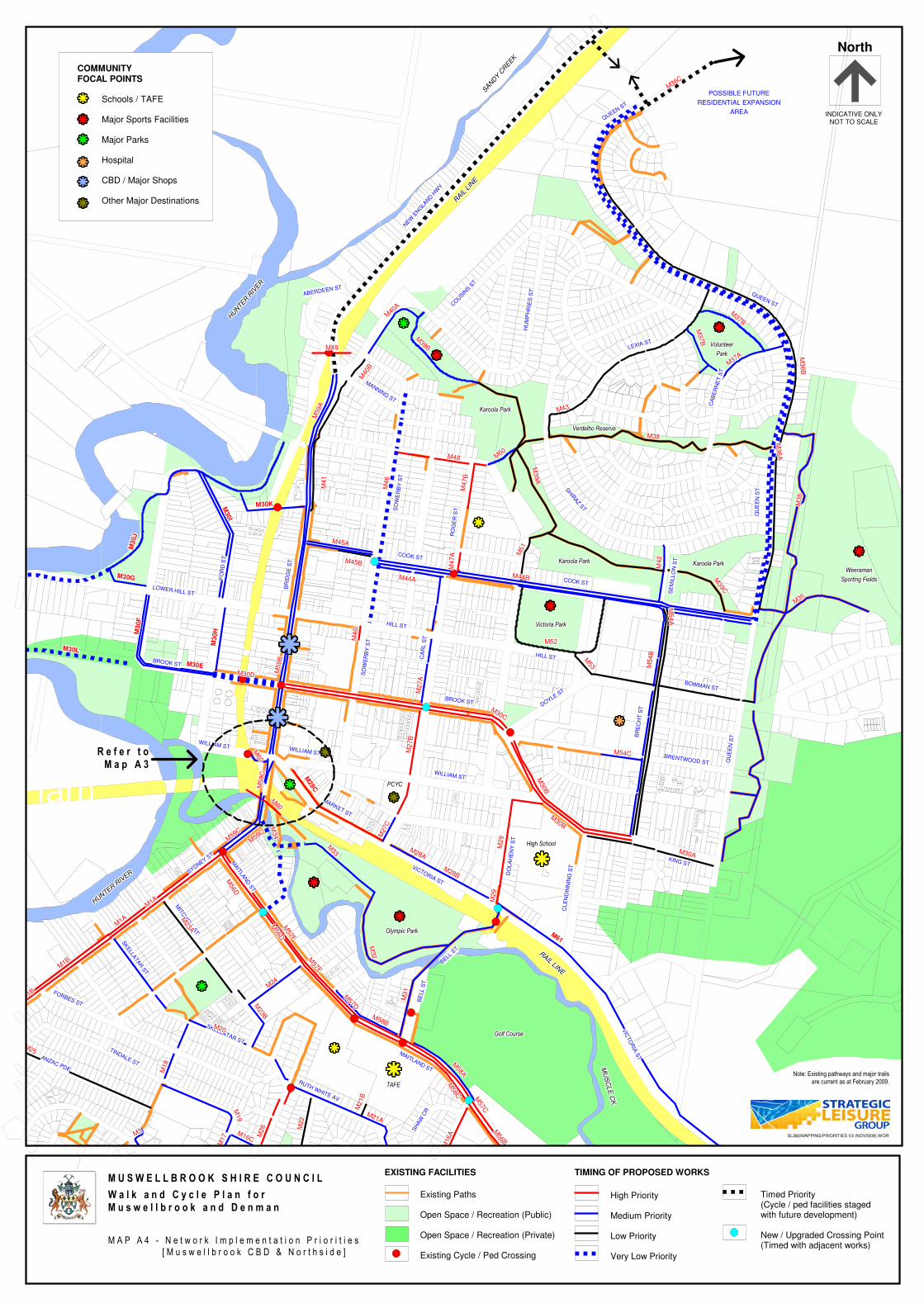
Proposed concrete shared path (04/05 budget)Proposed concrete shared path (04/07 Mgt Plan) MARKET ST
WILLIAM ST
MAITLA
ND
ST
VICTORIA ST
CLE
ND
INN
ING
ST
DO
LA
HE
NY
ST
KING ST
WILLIAM ST
BRENTWOOD ST
DOYLE ST
BROOK ST
HILL ST
SO
WE
RB
Y S
T
BOWMAN ST
BR
EC
HT
ST
CA
RL S
T
QU
EE
N S
T
WILLIAM ST
FO
RD
ST
BR
IDG
E S
T
BROOK ST
SYDNEY ST
LOWER HILL ST
HILL ST
COOK ST
COOK ST
SE
MIL
LO
N S
T
RO
GE
R S
TSO
WE
RB
Y S
T
SHIR
AZ S
T
QU
EE
N S
T
MANNING ST
QUEEN ST
CA
BE
RN
ET
ST
LEXIA ST
HU
MP
HR
IES
ST
COUSIN
S ST
ABERDEEN ST
MAITLAND ST
RUTH WHITE AV
SH
AW
CR
BE
LL S
T
BELL S
T
VIC
TO
RIA
ST
SKELLATAR ST
SKELLA
TAR
ST
TINDALE ST
MIT
CH
ELL S
T
FORBES ST
ANZAC PDE
QUEEN ST
NEW
ENG
LAND H
WY
M56D
M56D
M56D
M56D
M56D
M56D
M56D
M56D
M56D
M59C
M59C
M59C
M59C
M59C
M59C
M59C
M59C
M59C
M59C
M59C
M59C
M59C
M59C
M59C
M59C
M59C
M59C
M30B
M30B
M30B
M30B
M30B
M30B
M30B
M30B
M30B
M54
BM
54
BM
54
BM
54
BM
54
BM
54
BM
54
BM
54
BM
54
B
M52M52M52M52M52M52M52M52M52
M44AM44AM44AM44AM44AM44AM44AM44AM44A
M4
7A
M4
7A
M4
7A
M4
7A
M4
7A
M4
7A
M4
7A
M4
7A
M4
7A
M45BM45BM45BM45BM45BM45BM45BM45BM45B
M4
1M
41
M4
1M
41
M4
1M
41
M4
1M
41
M4
1
M4
7B
M4
7B
M4
7B
M4
7B
M4
7B
M4
7B
M4
7B
M4
7B
M4
7B
M40
BM
40B
M40
BM
40B
M40
BM
40B
M40
BM
40B
M40
B
M59A
M59A
M59A
M59A
M59A
M59A
M59A
M59A
M59A
M50
M50
M50
M50
M50
M50
M50
M50
M50
M36
AM
36
AM
36
AM
36
AM
36
AM
36
AM
36
AM
36
AM
36
A
M56C
M56C
M56C
M56C
M56C
M56C
M56C
M56C
M56C
M21B
M21B
M21B
M21B
M21B
M21B
M21B
M21B
M21B M
57CM
57CM
57CM
57CM
57CM
57CM
57CM
57C
M57C
M31
M31
M31
M31
M31
M31
M31
M31
M31
M57D
M57D
M57D
M57D
M57D
M57D
M57D
M57D
M57D
M58BM58BM58BM58BM58BM58BM58BM58BM58B
M56D
M56D
M56D
M56D
M56D
M56D
M56D
M56D
M56D
M57F
M57F
M57F
M57F
M57F
M57F
M57F
M57F
M57F
M1A
M1A
M1A
M1A
M1A
M1A
M1A
M1A
M1A
M1A
M1A
M1A
M1A
M1A
M1A
M1A
M1A
M1A
M30LM30LM30LM30LM30LM30LM30LM30LM30L
M28C
M28C
M28C
M28C
M28C
M28C
M28C
M28C
M28C
M3
0H
M3
0H
M3
0H
M3
0H
M3
0H
M3
0H
M3
0H
M3
0H
M3
0H
M30EM30EM30EM30EM30EM30EM30EM30EM30E
M30J
M30J
M30J
M30J
M30J
M30J
M30J
M30J
M30J
M30GM30GM30GM30GM30GM30GM30GM30GM30G
M3
0F
M3
0F
M3
0F
M3
0F
M3
0F
M3
0F
M3
0F
M3
0F
M3
0F
M30I
M30I
M30I
M30I
M30I
M30I
M30I
M30I
M30I
M30KM30KM30KM30KM30KM30KM30KM30KM30K
M61
M61
M61
M61
M61
M61
M61
M61
M61
M1B
M1B
M1B
M1B
M1B
M1B
M1B
M1B
M1B
M1B
M1B
M1B
M1B
M1B
M1B
M1B
M1B
M1B
M3M3M3M3M3M3M3M3M3
M16A
M16A
M16A
M16A
M16A
M16A
M16A
M16A
M16AM16C
M16CM16CM16CM16CM16CM16CM16CM16C
M17
M17
M17
M17
M17
M17
M17
M17
M17
M19
M19
M19
M19
M19
M19
M19
M19
M19
M18
M18
M18
M18
M18
M18
M18
M18
M18
M20M20M20M20M20M20M20M20M20
M21AM21AM21AM21AM21AM21AM21AM21AM21A
M22
M22
M22
M22
M22
M22
M22
M22
M22
M23B
M23B
M23B
M23B
M23B
M23B
M23B
M23B
M23B
M23A
M23A
M23A
M23A
M23A
M23A
M23A
M23A
M23A
M24
M24
M24
M24
M24
M24
M24
M24
M24
M26
M26
M26
M26
M26
M26
M26
M26
M26
M2
7A
M2
7A
M2
7A
M2
7A
M2
7A
M2
7A
M2
7A
M2
7A
M2
7A
M2
7B
M2
7B
M2
7B
M2
7B
M2
7B
M2
7B
M2
7B
M2
7B
M2
7B
M27C
M27C
M27C
M27C
M27C
M27C
M27C
M27C
M27C
M28AM28AM28AM28AM28AM28AM28AM28AM28A
M28BM28BM28BM28BM28BM28BM28BM28BM28B
M29
M29
M29
M29
M29
M29
M29
M29
M29
M30B
M30B
M30B
M30B
M30B
M30B
M30B
M30B
M30B
M30CM30CM30C
M30CM30C
M30CM30CM30CM30C
M32
M32
M32
M32
M32
M32
M32
M32
M32
M33
M33
M33
M33
M33
M33
M33
M33
M33
M34
M34
M34
M34
M34
M34
M34
M34
M34
M35
M35
M35
M35
M35
M35
M35
M35
M35
M3
6B
M3
6B
M3
6B
M3
6B
M3
6B
M3
6B
M3
6B
M3
6B
M3
6B
M36CM36CM36CM36C
M36CM36CM36CM36CM36C
M37A
M37A
M37A
M37A
M37A
M37A
M37A
M37A
M37A
M42
M42
M42
M42
M42
M42
M42
M42
M42
M37B
M37B
M37B
M37B
M37B
M37B
M37B
M37B
M37B
M43M43M43M43M43M43M43M43M43
M44BM44BM44BM44BM44BM44BM44BM44BM44B
M45AM45AM45AM45AM45AM45AM45AM45AM45A
M39B
M39B
M39B
M39B
M39B
M39B
M39B
M39B
M39B
M40A
M40A
M40A
M40A
M40A
M40A
M40A
M40A
M40A
M48M48M48M48M48M48M48M48M48
M51
M51
M51
M51
M51
M51
M51
M51
M51
M53
M53
M53
M53
M53
M53
M53
M53
M53
M5
4A
M5
4A
M5
4A
M5
4A
M5
4A
M5
4A
M5
4A
M5
4A
M5
4A
M38M38M38M38M38M38M38M38M38
M39C
M39C
M39C
M39C
M39C
M39C
M39C
M39C
M39C
M39A
M39A
M39A
M39A
M39A
M39A
M39A
M39A
M39A
M54CM54CM54CM54CM54CM54CM54CM54CM54C
M35M35M35M35M35M35M35M35M35
M56B
M56B
M56B
M56B
M56B
M56B
M56B
M56B
M56B
M58A
M58A
M58A
M58A
M58A
M58A
M58A
M58A
M58A
M57E
M57E
M57E
M57E
M57E
M57E
M57E
M57E
M57E
M60
M60
M60
M60
M60
M60
M60
M60
M60
M5
9C
M5
9C
M5
9C
M5
9C
M5
9C
M5
9C
M5
9C
M5
9C
M5
9C
M60
M60
M60
M60
M60
M60
M60
M60
M60
M29
M29
M29
M29
M29
M29
M29
M29
M29
M25M25M25M25M25M25M25M25M25
M4
6M
46
M4
6M
46
M4
6M
46
M4
6M
46
M4
6
M30AM30AM30AM30AM30AM30AM30AM30AM30A
M30DM30DM30DM30DM30DM30DM30DM30DM30D
M59B
M59B
M59B
M59B
M59B
M59B
M59B
M59B
M59B
M4
6M
46
M4
6M
46
M4
6M
46
M4
6M
46
M4
6
M37B
M37B
M37B
M37B
M37B
M37B
M37B
M37B
M37B
M49M49M49M49M49M49M49M49M49
Existing Paths
Open Space / Recreation (Public)
Open Space / Recreation (Private)
Existing Cycle / Ped Crossing
EXISTING FACILITIES
High Priority
Medium Priority
Low Priority
Very Low Priority
TIMING OF PROPOSED WORKS
Timed Priority(Cycle / ped facilities stagedwith future development)
New / Upgraded Crossing Point(Timed with adjacent works)
North
INDICATIVE ONLYNOT TO SCALE
COMMUNITY
FOCAL POINTS
Schools / TAFE
Major Sports Facilities
Major Parks
Hospital
CBD / Major Shops
Other Major Destinations
�������������������������������������������������
�������������������������������������������������
�������������������������������������������������
�������������������������������������������������
�������������������������������������������������
M U S W E L L B R O O K S H I R E C O U N C I L
W a l k a n d C y c l e P l a n f o rM u s w e l l b r o o k a n d D e n m a n
M A P A 4 - N e t w o r k I m p l e m e n t a t i o n P r i o r i t i e s
[ M u s w e l l b r o o k C B D & N o r t h s i d e ]
�������������������������������������������������
�������������������������������������������������
�������������������������������������������������
�������������������������������������������������
�������������������������������������������������
�������������������������������������������������
�������������������������������������������������
�������������������������������������������������
�������������������������������������������������
��������������������������������������������������
�������������������������������������������������
�������������������������������������������������
�������������������������������������������������
�������������������������������������������������
�������������������������������������������������
�������������������������������������������������
�������������������������������������������������
�������������������������������������������������
R e f e r t oM a p A 3
Karoola ParkKaroola ParkKaroola ParkKaroola ParkKaroola ParkKaroola ParkKaroola ParkKaroola ParkKaroola Park
Karoola ParkKaroola ParkKaroola ParkKaroola ParkKaroola ParkKaroola ParkKaroola ParkKaroola ParkKaroola Park
Verdelho ReserveVerdelho ReserveVerdelho ReserveVerdelho ReserveVerdelho ReserveVerdelho ReserveVerdelho ReserveVerdelho ReserveVerdelho Reserve
VolunteerVolunteerVolunteerVolunteerVolunteerVolunteerVolunteerVolunteerVolunteer
ParkParkParkParkParkParkParkParkPark
WeeramanWeeramanWeeramanWeeramanWeeramanWeeramanWeeramanWeeramanWeeraman
Sporting FieldsSporting FieldsSporting FieldsSporting FieldsSporting FieldsSporting FieldsSporting FieldsSporting FieldsSporting Fields
Victoria ParkVictoria ParkVictoria ParkVictoria ParkVictoria ParkVictoria ParkVictoria ParkVictoria ParkVictoria Park
Golf CourseGolf CourseGolf CourseGolf CourseGolf CourseGolf CourseGolf CourseGolf CourseGolf Course
Olympic ParkOlympic ParkOlympic ParkOlympic ParkOlympic ParkOlympic ParkOlympic ParkOlympic ParkOlympic Park
TAFETAFETAFETAFETAFETAFETAFETAFETAFE
POSSIBLE FUTUREPOSSIBLE FUTUREPOSSIBLE FUTUREPOSSIBLE FUTUREPOSSIBLE FUTUREPOSSIBLE FUTUREPOSSIBLE FUTUREPOSSIBLE FUTUREPOSSIBLE FUTURE
RESIDENTIAL EXPANSIONRESIDENTIAL EXPANSIONRESIDENTIAL EXPANSIONRESIDENTIAL EXPANSIONRESIDENTIAL EXPANSIONRESIDENTIAL EXPANSIONRESIDENTIAL EXPANSIONRESIDENTIAL EXPANSIONRESIDENTIAL EXPANSION
AREAAREAAREAAREAAREAAREAAREAAREAAREA
Karoola ParkKaroola ParkKaroola ParkKaroola ParkKaroola ParkKaroola ParkKaroola ParkKaroola ParkKaroola Park
High School
HU
NTE
R R
IVER
HU
NTE
R R
IVER
HU
NTE
R R
IVER
HU
NTE
R R
IVER
HU
NTE
R R
IVER
HU
NTE
R R
IVER
HU
NTE
R R
IVER
HU
NTE
R R
IVER
HU
NTE
R R
IVER
HUNTER R
IVER
HUNTER R
IVER
HUNTER R
IVER
HUNTER R
IVER
HUNTER R
IVER
HUNTER R
IVER
HUNTER R
IVER
HUNTER R
IVER
HUNTER R
IVER
SANDY C
REEK
SANDY C
REEK
SANDY C
REEK
SANDY C
REEK
SANDY C
REEK
SANDY C
REEK
SANDY C
REEK
SANDY C
REEK
SANDY C
REEK
MU
SC
LE
CK
MU
SC
LE
CK
MU
SC
LE
CK
MU
SC
LE
CK
MU
SC
LE
CK
MU
SC
LE
CK
MU
SC
LE
CK
MU
SC
LE
CK
MU
SC
LE
CK
��������������������������������������������������
PCYC
RAIL LIN
E
RAIL LIN
E
RAIL LIN
E
RAIL LIN
E
RAIL LIN
E
RAIL LIN
E
RAIL LIN
E
RAIL LIN
E
RAIL LIN
E
RAIL
LIN
E
RAIL
LIN
E
RAIL
LIN
E
RAIL
LIN
E
RAIL
LIN
E
RAIL
LIN
E
RAIL
LIN
E
RAIL
LIN
E
RAIL
LIN
E
Note: Existing pathways and major trails
are current as at February 2009.
SL360/MAPPING/PRIORITIES V3 (NOV2009).WOR

Proposed concrete shared path (04/07 Mgt Plan)Proposed concrete shared path (future)
CA
SS
IDY
AV
E
BIM
BAD
EE
N D
R
RUTH WHITE AV
SH
AW
CR
MAITLAND ST
SKELLATAR ST
OS
BO
RN
AV
BELL S
T
TINDALE ST
SKELLA
TAR
ST
FORBES ST
ANZAC PDE
OS
BO
RN
AV
E
THOMPSON ST
KAMILAROI ST
AD
AM
S S
T
SKELLATAR STOCK ROUTE
RUTHERFORD RD
VIC
TO
RIA
ST
AC
AC
IA D
R
MAITLA
ND
ST
SYDNEY ST
CLE
ND
INN
ING
ST
WOLLOMBI RD
CALGAROO AV
ST
OC
K R
TE
NEW ENGLAND HWY
SYDNEY ST
VICTORIA ST
DO
LA
HE
NY
ST
KING ST
MARKET ST
M21B
M21B
M21B
M21B
M21B
M21B
M21B
M21B
M21B
M21A
M21A
M21A
M21A
M21A
M21A
M21A
M21A
M21A
M56CM56CM56CM56CM56CM56CM56CM56CM56C
M58BM58BM58BM58BM58BM58BM58BM58BM58B
M20M20M20M20M20M20M20M20M20
M57D
M57D
M57D
M57D
M57D
M57D
M57D
M57D
M57D
M16CM16CM16CM16CM16CM16CM16CM16CM16C
M22
M22
M22
M22
M22
M22
M22
M22
M22
M16BM16BM16BM16BM16BM16BM16BM16BM16B
M57C
M57C
M57C
M57C
M57C
M57C
M57C
M57C
M57C
M56B
M56B
M56B
M56B
M56B
M56B
M56B
M56B
M56B
M57B
M57B
M57B
M57B
M57B
M57B
M57B
M57B
M57B
M55
M55
M55
M55
M55
M55
M55
M55
M55
M6A
M6A
M6A
M6A
M6A
M6A
M6A
M6A
M6A
M56AM56AM56AM56AM56AM56AM56AM56AM56A
M56D
M56D
M56D
M56D
M56D
M56D
M56D
M56D
M56D
M4AM4AM4AM4AM4AM4AM4AM4AM4A
M1A
M1A
M1A
M1A
M1A
M1A
M1A
M1A
M1A
M2
M2
M2
M2
M2
M2
M2
M2
M2
M1D
M1D
M1D
M1D
M1D
M1D
M1D
M1D
M1D
M1B
M1B
M1B
M1B
M1B
M1B
M1B
M1B
M1B
M1B
M1B
M1B
M1B
M1B
M1B
M1B
M1B
M1B
M3
M3
M3
M3M3
M3
M3
M3
M3
M4BM4BM4BM4BM4BM4BM4BM4BM4B
M5
AM
5A
M5
AM
5A
M5
AM
5A
M5
AM
5A
M5
A
M57F
M57F
M57F
M57F
M57F
M57F
M57F
M57F
M57FM
56DM
56DM
56DM
56DM
56DM
56DM
56DM
56D
M56D
M1A
M1A
M1A
M1A
M1A
M1A
M1A
M1A
M1A
M59
C
M59
C
M59
CM
59C
M59
CM
59C
M59
C
M59
C
M59
CM
59C
M59C
M59C
M59C
M59C
M59C
M59C
M59C
M59C
M61
M62
M63
M1C
M1C
M1CM1C
M1CM1C
M1C
M1C
M1C
M4D
M4D
M4D
M4D
M4D
M4D
M4D
M4D
M4D
M6B
M6B
M6B
M6B
M6B
M6B
M6B
M6B
M6B
M5B
M5B
M5B
M5B
M5B
M5B
M5B
M5B
M5B
M7A
M7A
M7A
M7A
M7A
M7A
M7A
M7A
M7A
M7B
M7B
M7B
M7B
M7B
M7B
M7B
M7B
M7B
M8M8M8M8M8M8M8M8M8
M9AM9AM9AM9AM9AM9AM9AM9AM9A
M9BM9BM9BM9BM9BM9BM9BM9BM9B
M10B
M10B
M10B
M10B
M10B
M10B
M10B
M10B
M10B
M10B
M10B
M10B
M10B
M10B
M10B
M10B
M10B
M10B
M10
M10
M10
M10
M10
M10
M10
M10
M10
M11
M11
M11
M11
M11
M11
M11
M11
M11
M12A
M12A
M12A
M12A
M12A
M12A
M12A
M12A
M12A
M12B
M12B
M12B
M12B
M12B
M12B
M12B
M12B
M12B
M13
M13
M13
M13
M13
M13
M13
M13
M13
M15
M15
M15
M15
M15
M15
M15
M15
M15
M16A
M16A
M16A
M16A
M16A
M16A
M16A
M16A
M16AM
17
M17
M17
M17
M17
M17
M17
M17
M17
M19
M19
M19
M19
M19
M19
M19
M19
M19
M18
M18
M18
M18
M18
M18
M18
M18
M18
M23B
M23B
M23B
M23B
M23B
M23B
M23B
M23B
M23B
M23A
M23A
M23A
M23A
M23A
M23A
M23A
M23A
M23A
M24
M24
M24
M24
M24
M24
M24
M24
M24
M26
M26
M26
M26
M26
M26
M26
M26
M26
M27B
M27B
M27B
M27B
M27B
M27B
M27B
M27B
M27B
M27C
M27C
M27C
M27C
M27C
M27C
M27C
M27C
M27C
M28AM28AM28AM28AM28AM28AM28AM28AM28A
M28BM28BM28BM28BM28BM28BM28BM28BM28B
M29
M29
M29
M29
M29
M29
M29
M29
M29
M30BM30BM30BM30BM30BM30BM30BM30BM30B
M30B
M30B
M30B
M30B
M30B
M30B
M30B
M30B
M30B
M31
M31
M31
M31
M31
M31
M31
M31
M31
M32M32M32M32M32M32M32M32M32
M33
M33
M33
M33
M33
M33
M33
M33
M33
M3
4M
34
M3
4M
34
M3
4M
34
M3
4M
34
M3
4
M35
M35
M35
M35
M35
M35
M35
M35
M35M
54A
M5
4A
M5
4A
M5
4A
M5
4A
M5
4A
M5
4A
M5
4A
M5
4A
M54
BM
54
BM
54
BM
54
BM
54
BM
54
BM
54
BM
54
BM
54
B
M57AM57AM57AM57AM57AM57AM57AM57AM57A
M58A
M58A
M58A
M58A
M58A
M58A
M58A
M58A
M58A
M57E
M57E
M57E
M57E
M57E
M57E
M57E
M57E
M57E
M57F
M57F
M57F
M57F
M57F
M57F
M57F
M57F
M57F
M60
M60
M60
M60
M60
M60
M60
M60
M60
M29
M29
M29
M29
M29
M29
M29
M29
M29
M25M25M25M25M25M25M25M25M25
M13
M13
M13
M13
M13
M13
M13
M13
M13
M1E
M1E
M1E
M1E
M1E
M1E
M1E
M1E
M1E
M12A
M12A
M12A
M12A
M12A
M12A
M12A
M12A
M12A
M12A
M12A
M12A
M12A
M12A
M12A
M12A
M12A
M12A
M12A
M12A
M12A
M12A
M12A
M12A
M12A
M12A
M12A
M14
M14
M14
M14
M14
M14
M14
M14
M14
M30AM30AM30AM30AM30AM30AM30AM30AM30A
M4CM4CM4CM4CM4CM4CM4CM4CM4C
M10AM10AM10A
M10AM10A
M10AM10AM10AM10A
Existing Pathways
Open Space / Recreation (Public)
Open Space / Recreation (Private)
Existing Cycle / Ped Crossing
EXISTING FACILITIES
High Priority
Medium Priority
Low Priority
Very Low Priority
TIMING OF PROPOSED WORKS
Timed Priority(Cycle / ped facilities stagedwith future development)
New / Upgraded Crossing Point(Timed with adjacent works)
North
INDICATIVE ONLYNOT TO SCALE
COMMUNITY
FOCAL POINTS
Schools / TAFE
Major Sports Facilities
Major Parks
Hospital
CBD / Major Shops
Other Major Destinations
�������������������������������������������������
�������������������������������������������������
�������������������������������������������������
�������������������������������������������������
�������������������������������������������������
M U S W E L L B R O O K S H I R E C O U N C I L
W a l k a n d C y c l e P l a n f o r M u s w e l l b r o o k a n d D e n m a n
M A P A 5 - N e t w o r k I m p l e m e n t a t i o n P r i o r i t i e s
[ M u s w e l l b r o o k S o u t h s i d e ]
�������������������������������������������������
������������������������������������������������� �������������������������������������������������
�������������������������������������������������
�������������������������������������������������
�������������������������������������������������
�������������������������������������������������
�������������������������������������������������
�������������������������������������������������
�������������������������������������������������
�������������������������������������������������
�������������������������������������������������
�������������������������������������������������
�������������������������������������������������
Highbrook ParkHighbrook ParkHighbrook ParkHighbrook ParkHighbrook ParkHighbrook ParkHighbrook ParkHighbrook ParkHighbrook Park
WollombiWollombiWollombiWollombiWollombiWollombiWollombiWollombiWollombi
ParkParkParkParkParkParkParkParkPark
ShowgroundsShowgroundsShowgroundsShowgroundsShowgroundsShowgroundsShowgroundsShowgroundsShowgrounds
BrennanBrennanBrennanBrennanBrennanBrennanBrennanBrennanBrennan
PkPkPkPkPkPkPkPkPk
Kurrajong R
eserve
Kurrajong R
eserve
Kurrajong R
eserve
Kurrajong R
eserve
Kurrajong R
eserve
Kurrajong R
eserve
Kurrajong R
eserve
Kurrajong R
eserve
Kurrajong R
eserve
Golf CourseGolf CourseGolf CourseGolf CourseGolf CourseGolf CourseGolf CourseGolf CourseGolf Course
Golf CourseGolf CourseGolf CourseGolf CourseGolf CourseGolf CourseGolf CourseGolf CourseGolf Course
Olympic PkOlympic PkOlympic PkOlympic PkOlympic PkOlympic PkOlympic PkOlympic PkOlympic Pk
Bowman PkBowman PkBowman PkBowman PkBowman PkBowman PkBowman PkBowman PkBowman Pk
TAFETAFETAFETAFETAFETAFETAFETAFETAFE
CollegeCollegeCollegeCollegeCollegeCollegeCollegeCollegeCollege
High School
POSSIBLE FUTUREPOSSIBLE FUTUREPOSSIBLE FUTUREPOSSIBLE FUTUREPOSSIBLE FUTUREPOSSIBLE FUTUREPOSSIBLE FUTUREPOSSIBLE FUTUREPOSSIBLE FUTURE
RESIDENTIAL EXPANSIONRESIDENTIAL EXPANSIONRESIDENTIAL EXPANSIONRESIDENTIAL EXPANSIONRESIDENTIAL EXPANSIONRESIDENTIAL EXPANSIONRESIDENTIAL EXPANSIONRESIDENTIAL EXPANSIONRESIDENTIAL EXPANSION
AREAAREAAREAAREAAREAAREAAREAAREAAREA
POSSIBLE FUTURERESIDENTIAL EXPANSION
AREA
POSSIBLE FUTURERESIDENTIAL EXPANSION
AREA
HU
NTE
R R
IVER
HU
NTE
R R
IVER
HU
NTE
R R
IVER
HU
NTE
R R
IVER
HU
NTE
R R
IVER
HU
NTE
R R
IVER
HU
NTE
R R
IVER
HU
NTE
R R
IVER
HU
NTE
R R
IVER
MUSCLE
CK
MUSCLE
CK
MUSCLE
CK
MUSCLE
CK
MUSCLE
CK
MUSCLE
CK
MUSCLE
CK
MUSCLE
CK
MUSCLE
CK
RAIL LIN
E
RAIL LIN
E
RAIL LIN
E
RAIL LIN
E
RAIL LIN
E
RAIL LIN
E
RAIL LIN
E
RAIL LIN
E
RAIL LIN
E
�������������������������������������������������
Note: Existing pathways and major trails
are current as at February 2009.
SL360/MAPPING/PRIORITIES V3 (NOV2009).WOR

Walk and Cyc le P lan f o r Mus w e l l b rook and Denman (F ina l )
APPENDIX B
Network Maps – Denman
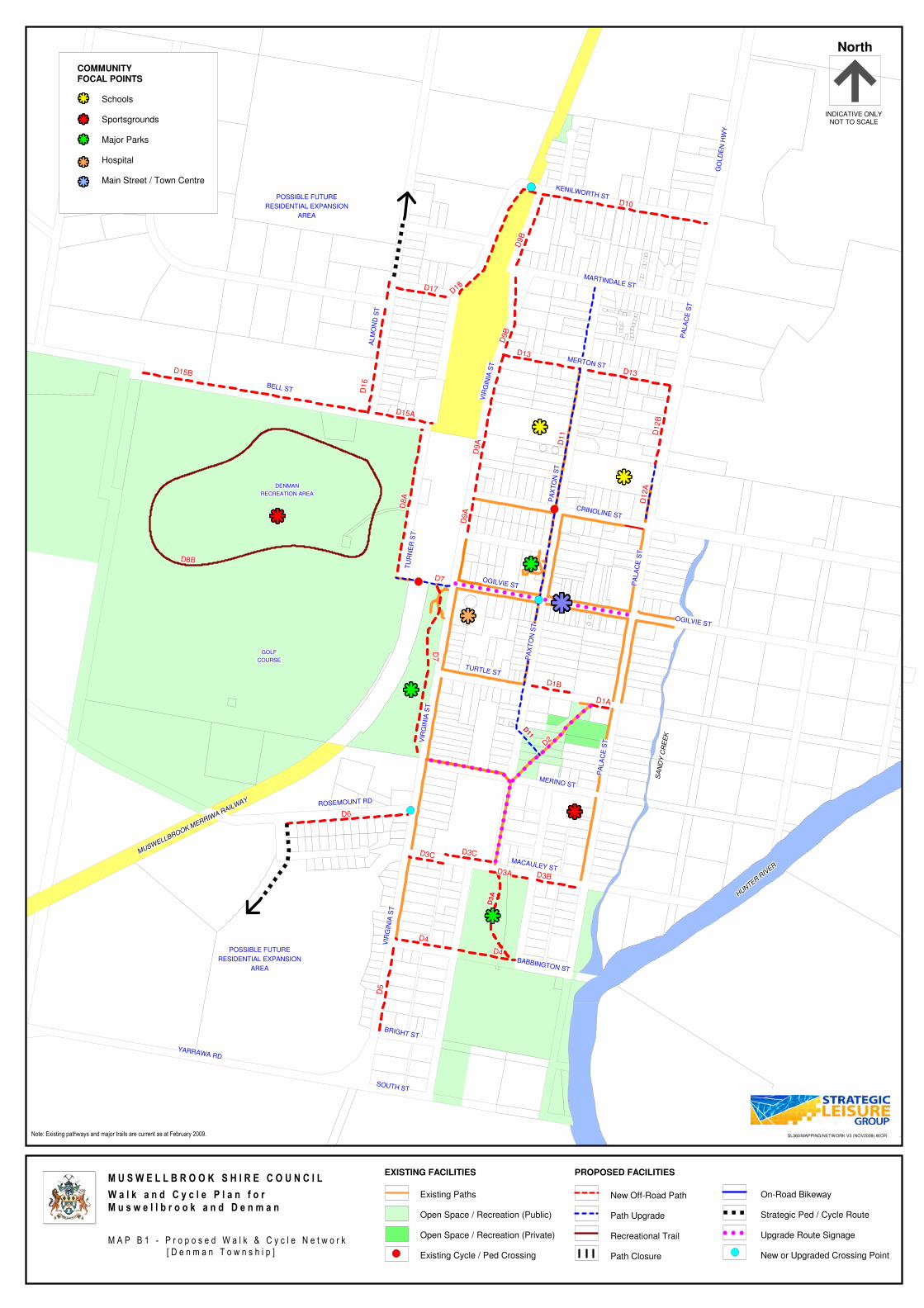
�������������������������������������������������
�������������������������������������������������
�������������������������������������������������DENMANDENMANDENMANDENMANDENMANDENMANDENMANDENMANDENMAN
RECREATION AREARECREATION AREARECREATION AREARECREATION AREARECREATION AREARECREATION AREARECREATION AREARECREATION AREARECREATION AREA
GOLFGOLFGOLFGOLFGOLFGOLFGOLFGOLFGOLF
COURSECOURSECOURSECOURSECOURSECOURSECOURSECOURSECOURSE
�������������������������������������������������
�������������������������������������������������
�������������������������������������������������
�������������������������������������������������
�������������������������������������������������
��������������������������������������������������
PA
XT
ON
ST
OGILVIE ST
PA
LA
CE
ST
PA
XT
ON
ST
CRINOLINE ST
MERTON ST
OGILVIE ST
PA
LA
CE
ST
TURTLE ST
ROSEMOUNT RD
VIR
GIN
IA S
T
MERINO ST
BELL ST
TU
RN
ER
ST
VIR
GIN
IA S
T
MACAULEY ST
AL
MO
ND
ST
PA
LA
CE
ST
VIR
GIN
IA S
T
BABBINGTON ST
BRIGHT ST
YARRAWA RD
SOUTH ST
GO
LD
EN
HW
Y
KENILWORTH ST
MARTINDALE ST
D7D7D7D7D7D7D7D7D7
D15BD15BD15BD15BD15BD15BD15BD15BD15B
D16
D16
D16
D16
D16
D16
D16
D16
D16
D13D13D13D13D13D13D13D13D13
D11
D11
D11
D11
D11
D11
D11
D11
D11
D3A
D3A
D3A
D3A
D3A
D3A
D3A
D3A
D3A
D5
D5
D5
D5
D5
D5
D5
D5
D5
D4D4D4D4D4D4D4D4D4
D4D4D4D4D4D4D4D4D4
D3AD3AD3AD3AD3AD3AD3AD3AD3A D3BD3BD3BD3BD3BD3BD3BD3BD3B
D1BD1BD1BD1BD1BD1BD1BD1BD1B
D1AD1AD1AD1AD1AD1AD1AD1AD1A
D7
D7
D7
D7
D7
D7
D7
D7
D7
D6D6D6D6D6D6D6D6D6
D9A
D9A
D9A
D9A
D9A
D9A
D9A
D9A
D9A
D8A
D8A
D8A
D8A
D8A
D8A
D8A
D8A
D8A
D9A
D9A
D9A
D9A
D9A
D9A
D9A
D9A
D9A
D13D13D13D13D13D13D13D13D13
D12A
D12A
D12A
D12A
D12A
D12A
D12A
D12A
D12A
D11
D11
D11
D11
D11
D11
D11
D11
D11
D9B
D9B
D9B
D9B
D9B
D9B
D9B
D9B
D9B
D9B
D9B
D9B
D9B
D9B
D9B
D9B
D9B
D9B
D10D10D10D10D10D10D10D10D10
D3CD3CD3CD3CD3CD3CD3CD3CD3CD3CD3CD3CD3CD3CD3CD3CD3CD3C
D12B
D12B
D12B
D12B
D12B
D12B
D12B
D12B
D12B
D8BD8BD8BD8BD8BD8BD8BD8BD8B
D2
D2
D2D2
D2D2
D2
D2D2
D15AD15AD15AD15AD15AD15AD15AD15AD15A
D17D17D17D17D17D17D17D17D17 D18
D18
D18D18
D18D18
D18
D18D18
Existing Paths
Open Space / Recreation (Public)
Open Space / Recreation (Private)
Existing Cycle / Ped Crossing
EXISTING FACILITIES
New Off-Road Path
Path Upgrade
Recreational Trail
Path Closure
PROPOSED FACILITIES
On-Road Bikeway
Strategic Ped / Cycle Route
Upgrade Route Signage
New or Upgraded Crossing Point
M U S W E L L B R O O K S H I R E C O U N C I L
W a l k a n d C y c l e P l a n f o rM u s w e l l b r o o k a n d D e n m a n
M A P B 1 - P r o p o s e d W a l k & C y c l e N e t w o r k
[ D e n m a n T o w n s h i p ]
North
SL360/MAPPING/NETWORK V3 (NOV2009).WOR
INDICATIVE ONLYNOT TO SCALE
POSSIBLE FUTUREPOSSIBLE FUTUREPOSSIBLE FUTUREPOSSIBLE FUTUREPOSSIBLE FUTUREPOSSIBLE FUTUREPOSSIBLE FUTUREPOSSIBLE FUTUREPOSSIBLE FUTURE
RESIDENTIAL EXPANSIONRESIDENTIAL EXPANSIONRESIDENTIAL EXPANSIONRESIDENTIAL EXPANSIONRESIDENTIAL EXPANSIONRESIDENTIAL EXPANSIONRESIDENTIAL EXPANSIONRESIDENTIAL EXPANSIONRESIDENTIAL EXPANSION
AREAAREAAREAAREAAREAAREAAREAAREAAREA
MUSWELLBROOK M
ERRIWA R
AILWAY
MUSWELLBROOK M
ERRIWA R
AILWAY
MUSWELLBROOK M
ERRIWA R
AILWAY
MUSWELLBROOK M
ERRIWA R
AILWAY
MUSWELLBROOK M
ERRIWA R
AILWAY
MUSWELLBROOK M
ERRIWA R
AILWAY
MUSWELLBROOK M
ERRIWA R
AILWAY
MUSWELLBROOK M
ERRIWA R
AILWAY
MUSWELLBROOK M
ERRIWA R
AILWAY
SA
ND
Y C
RE
EK
SA
ND
Y C
RE
EK
SA
ND
Y C
RE
EK
SA
ND
Y C
RE
EK
SA
ND
Y C
RE
EK
SA
ND
Y C
RE
EK
SA
ND
Y C
RE
EK
SA
ND
Y C
RE
EK
SA
ND
Y C
RE
EK
HU
NTE
R R
IVER
HU
NTE
R R
IVER
HU
NTE
R R
IVER
HU
NTE
R R
IVER
HU
NTE
R R
IVER
HU
NTE
R R
IVER
HU
NTE
R R
IVER
HU
NTE
R R
IVER
HU
NTE
R R
IVER
COMMUNITY
FOCAL POINTS
Schools
Sportsgrounds
Major Parks
Hospital
Main Street / Town Centre
�������������������������������������������������
�������������������������������������������������
�������������������������������������������������
�������������������������������������������������
�������������������������������������������������POSSIBLE FUTUREPOSSIBLE FUTUREPOSSIBLE FUTUREPOSSIBLE FUTUREPOSSIBLE FUTUREPOSSIBLE FUTUREPOSSIBLE FUTUREPOSSIBLE FUTUREPOSSIBLE FUTURE
RESIDENTIAL EXPANSIONRESIDENTIAL EXPANSIONRESIDENTIAL EXPANSIONRESIDENTIAL EXPANSIONRESIDENTIAL EXPANSIONRESIDENTIAL EXPANSIONRESIDENTIAL EXPANSIONRESIDENTIAL EXPANSIONRESIDENTIAL EXPANSION
AREAAREAAREAAREAAREAAREAAREAAREAAREA
Note: Existing pathways and major trails are current as at February 2009.
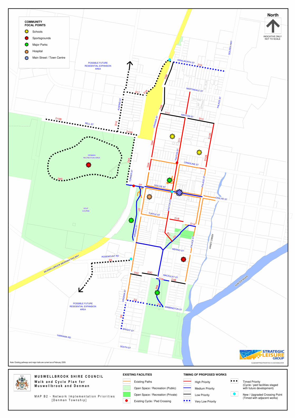
�������������������������������������������������
�������������������������������������������������
�������������������������������������������������DENMANDENMANDENMANDENMANDENMANDENMANDENMANDENMANDENMAN
RECREATION AREARECREATION AREARECREATION AREARECREATION AREARECREATION AREARECREATION AREARECREATION AREARECREATION AREARECREATION AREA
GOLFGOLFGOLFGOLFGOLFGOLFGOLFGOLFGOLF
COURSECOURSECOURSECOURSECOURSECOURSECOURSECOURSECOURSE
�������������������������������������������������
�������������������������������������������������
�������������������������������������������������
�������������������������������������������������
�������������������������������������������������
��������������������������������������������������
PA
XT
ON
ST
OGILVIE ST
PA
LA
CE
ST
PA
XT
ON
ST
CRINOLINE ST
MERTON ST
OGILVIE ST
PA
LA
CE
ST
TURTLE ST
ROSEMOUNT RD
VIR
GIN
IA S
T
MERINO ST
BELL ST
TU
RN
ER
ST
VIR
GIN
IA S
T
MACAULEY ST
AL
MO
ND
ST
PA
LA
CE
ST
VIR
GIN
IA S
T
BABBINGTON ST
BRIGHT ST
YARRAWA RD
SOUTH ST
GO
LD
EN
HW
Y
KENILWORTH ST
MARTINDALE ST
D7D7D7D7D7D7D7D7D7
D15BD15BD15BD15BD15BD15BD15BD15BD15B
D16
D16
D16
D16
D16
D16
D16
D16
D16
D13D13D13D13D13D13D13D13D13
D11
D11
D11
D11
D11
D11
D11
D11
D11
D3A
D3A
D3A
D3A
D3A
D3A
D3A
D3A
D3A
D5
D5
D5
D5
D5
D5
D5
D5
D5
D4D4D4D4D4D4D4D4D4
D4D4D4D4D4D4D4D4D4
D3AD3AD3AD3AD3AD3AD3AD3AD3A D3BD3BD3BD3BD3BD3BD3BD3BD3B
D1BD1BD1BD1BD1BD1BD1BD1BD1B
D1AD1AD1AD1AD1AD1AD1AD1AD1A
D7
D7
D7
D7
D7
D7
D7
D7
D7
D6D6D6D6D6D6D6D6D6
D9A
D9A
D9A
D9A
D9A
D9A
D9A
D9A
D9A
D8A
D8A
D8A
D8A
D8A
D8A
D8A
D8A
D8A
D9A
D9A
D9A
D9A
D9A
D9A
D9A
D9A
D9A
D13D13D13D13D13D13D13D13D13
D12A
D12A
D12A
D12A
D12A
D12A
D12A
D12A
D12A
D11
D11
D11
D11
D11
D11
D11
D11
D11
D9B
D9B
D9B
D9B
D9B
D9B
D9B
D9B
D9B
D9B
D9B
D9B
D9B
D9B
D9B
D9B
D9B
D9B
D10D10D10D10D10D10D10D10D10
D3CD3CD3CD3CD3CD3CD3CD3CD3CD3CD3CD3CD3CD3CD3CD3CD3CD3C
D12B
D12B
D12B
D12B
D12B
D12B
D12B
D12B
D12B
D8BD8BD8BD8BD8BD8BD8BD8BD8B
D2
D2
D2D2
D2D2
D2
D2D2
D15AD15AD15AD15AD15AD15AD15AD15AD15A
D17D17D17D17D17D17D17D17D17 D18
D18
D18D18
D18D18
D18
D18D18
North
SL360/MAPPING/PRIORITIES V3 (NOV2009).WOR
INDICATIVE ONLYNOT TO SCALE
POSSIBLE FUTUREPOSSIBLE FUTUREPOSSIBLE FUTUREPOSSIBLE FUTUREPOSSIBLE FUTUREPOSSIBLE FUTUREPOSSIBLE FUTUREPOSSIBLE FUTUREPOSSIBLE FUTURE
RESIDENTIAL EXPANSIONRESIDENTIAL EXPANSIONRESIDENTIAL EXPANSIONRESIDENTIAL EXPANSIONRESIDENTIAL EXPANSIONRESIDENTIAL EXPANSIONRESIDENTIAL EXPANSIONRESIDENTIAL EXPANSIONRESIDENTIAL EXPANSION
AREAAREAAREAAREAAREAAREAAREAAREAAREA
MUSWELLBROOK M
ERRIWA R
AILWAY
MUSWELLBROOK M
ERRIWA R
AILWAY
MUSWELLBROOK M
ERRIWA R
AILWAY
MUSWELLBROOK M
ERRIWA R
AILWAY
MUSWELLBROOK M
ERRIWA R
AILWAY
MUSWELLBROOK M
ERRIWA R
AILWAY
MUSWELLBROOK M
ERRIWA R
AILWAY
MUSWELLBROOK M
ERRIWA R
AILWAY
MUSWELLBROOK M
ERRIWA R
AILWAY
SA
ND
Y C
RE
EK
SA
ND
Y C
RE
EK
SA
ND
Y C
RE
EK
SA
ND
Y C
RE
EK
SA
ND
Y C
RE
EK
SA
ND
Y C
RE
EK
SA
ND
Y C
RE
EK
SA
ND
Y C
RE
EK
SA
ND
Y C
RE
EK
HU
NTE
R R
IVER
HU
NTE
R R
IVER
HU
NTE
R R
IVER
HU
NTE
R R
IVER
HU
NTE
R R
IVER
HU
NTE
R R
IVER
HU
NTE
R R
IVER
HU
NTE
R R
IVER
HU
NTE
R R
IVER
COMMUNITY
FOCAL POINTS
Schools
Sportsgrounds
Major Parks
Hospital
Main Street / Town Centre
�������������������������������������������������
�������������������������������������������������
�������������������������������������������������
�������������������������������������������������
�������������������������������������������������POSSIBLE FUTUREPOSSIBLE FUTUREPOSSIBLE FUTUREPOSSIBLE FUTUREPOSSIBLE FUTUREPOSSIBLE FUTUREPOSSIBLE FUTUREPOSSIBLE FUTUREPOSSIBLE FUTURE
RESIDENTIAL EXPANSIONRESIDENTIAL EXPANSIONRESIDENTIAL EXPANSIONRESIDENTIAL EXPANSIONRESIDENTIAL EXPANSIONRESIDENTIAL EXPANSIONRESIDENTIAL EXPANSIONRESIDENTIAL EXPANSIONRESIDENTIAL EXPANSION
AREAAREAAREAAREAAREAAREAAREAAREAAREA
Note: Existing pathways and major trails are current as at February 2009.
Existing Paths
Open Space / Recreation (Public)
Open Space / Recreation (Private)
Existing Cycle / Ped Crossing
EXISTING FACILITIES
High Priority
Medium Priority
Low Priority
Very Low Priority
TIMING OF PROPOSED WORKS
Timed Priority(Cycle / ped facilities stagedwith future development)
New / Upgraded Crossing Point(Timed with adjacent works)
M U S W E L L B R O O K S H I R E C O U N C I L
W a l k a n d C y c l e P l a n f o rM u s w e l l b r o o k a n d D e n m a n
M A P B 2 - N e t w o r k I m p l e m e n t a t i o n P r i o r i t i e s
[ D e n m a n T o w n s h i p ]