Walcha Council Ordinary Meeting Wednesday, 28 April 2021
94
Walcha Council Ordinary Meeting Wednesday, 28 April 2021 Item 6.1 – Development Application 10.2020.3 – Brooklyn / 1643 Oxley Highway Walcha – Basalt Quarry – Attachments Part 3 Attachments: 5. Statement of Environmental Effects – Appendix K-M 6. Neighbour – Letter of Support 7. Submission – James Norton 8. Submission – Janet Norton 9. Submission – Norton & Chevrot 10. Submission – Omega Planning 11. Transport NSW Response 12. Geological Survey of NSW – Mining, Exploration & Geoscience Response 13. Development Assessment Report 14. Development Engineers Assessment Report 15. Aboriginal Heritage Information Management System (AHIMS) March 2021 - Ordinary Meeting - Item 6.1 Attachments Part 3 Page 1 of 94
-
Upload
khangminh22 -
Category
Documents
-
view
1 -
download
0
Transcript of Walcha Council Ordinary Meeting Wednesday, 28 April 2021
Walcha Council Ordinary Meeting Wednesday, 28 April 2021
Item 6.1 – Development Application 10.2020.3 – Brooklyn / 1643 Oxley Highway Walcha – Basalt Quarry – Attachments Part 3
Attachments: 5. Statement of Environmental Effects – Appendix K-M6. Neighbour – Letter of Support7. Submission – James Norton8. Submission – Janet Norton9. Submission – Norton & Chevrot10. Submission – Omega Planning11. Transport NSW Response12. Geological Survey of NSW – Mining, Exploration & Geoscience Response13. Development Assessment Report14. Development Engineers Assessment Report15. Aboriginal Heritage Information Management System (AHIMS)
March 2021 - Ordinary Meeting - Item 6.1 Attachments Part 3 Page 1 of 94

Item 3.1 - Attachment 5
March 2021 - Ordinary Meeting - Item 6.1 Attachments Part 3 Page 2 of 94

March 2021 - Ordinary Meeting - Item 6.1 Attachments Part 3 Page 3 of 94

March 2021 - Ordinary Meeting - Item 6.1 Attachments Part 3 Page 4 of 94

Strathleigh Grazing Pty Ltd
C/- 137 Beardy St
Armidale NSW 2350
Ph: 0413 206 090
To whom it may concern,
Quarry – “Brooklyn”, Walcha
We are writing as the neighbouring landholder of “Brooklyn” Walcha, the property in question which
is subject of a DA with Walcha Council currently being applied for.
As a director of Strathleigh Grazing Pty Ltd, I can confirm that I have consulted with Mr John
Boughton, shareholder and director of the company with regard to the matter of the quarry on the
neighbouring property.
We are both in support of the proposed quarry, based on the information received to date.
Should you require further information, please contact my mobile.
Regards
Nathan Gilbody
Director – Strathleigh Grazing Pty Ltd
March 2021 - Ordinary Meeting - Item 6.1 Attachments Part 3 Page 5 of 94

Item 3.1 - Attachment 7
March 2021 - Ordinary Meeting - Item 6.1 Attachments Part 3 Page 6 of 94

Janet Norton Mount Pleasant
1531 Oxley Highway Walcha NSW 2354
Letter of Objection Submission from Janet Norton, resident at “Mt Pleasant”, concerning Development Application No: 10.2020.3 for a Basalt Quarry
I was in complete shock when I received a phone call from Matthew Goodwin who alerted me to my next door neighbour’s intention to build a basalt quarry on his property, “Brooklyn”. While I now realise that ’extractive industries’ are ‘permissible’ with consent on Rural zoned lands - I strongly object to the quarry development because it will have significant adverse groundwater impacts, dust impacts, noise impacts and traffic/road safety impacts.
As my home is due east of the proposed site and my property boundary 1 km away, my property would be most immediately affected by this development.
The basis for my objections to the DA are as follows.
1. Groundwater
The Statement of Environmental Effects (SEE) lodged in support of the DA does not recognise or address any impacts that the development will have on the existing bores and underground aquifers. The groundwater systems are relied upon heavily by my property and neighbouring farms for stock and domestic water supply. The current systems play an integral role in improving stock health and enhancing grazing and groundcover management. Use of these groundwater systems has been supported by government with financial assistance for infrastructure. These systems have allowed the community and myself to better manage our farms, particularly in times of stress and water scarcity.
The SEE fails to assess any risk that the water supplies could be compromised as a result of the development. If these systems were jeopardised, it would have a devastating impact on the long and short term functionality of our local farm enterprises and significantly impact broader community. My farm, like so many others is heavily reliant on bore water and the trough watering infrastructure that it enables. This water resource allows for improved stock health, improved grazing and groundcover management, and better decision making and resilience in times of stress such as the very recent/current drought. The SEE is not supported by any hydrology report and fails to assess the aquifers in relation to location, extent, depth and recharge areas.
Recently, I spoke with two locals who are familiar with my farm and others surrounding the proposed quarry site. During these conversations, we discussed the cave-like voids that exist underground along the higher ridges to the north of Brooklyn property, their possible susceptibility to vibration from blasting and their connection to water flows. On the property Brooklyn itself I was told that at times, the water rises up to the basalt outcrop and forms shallow pools on the surface. It is
Item 3.1 - Attachment 8
March 2021 - Ordinary Meeting - Item 6.1 Attachments Part 3 Page 7 of 94

remarkable that this occurs given that the property is located at such a high point, however it clearly demonstrates that there is there is movement in the groundwater at the proposed quarry site. The SEE fails to undertake any detailed expert assessment of this issue, or any adequate consultation with local stakeholders in relation to the operation of the groundwater and aquifer systems in the area.
2. Soil profiling
I visited the proposed quarry site on Saturday 18th April 2020 with Warwick Sivell (geologist) and the author of the SEE, Matthew Goodwin. We looked over the exploratory trenching that had been done on site and examined the rocks and soil that had been thrown up by the excavator. Matt told us that no drilling had been done to assess the actual depth and range of the basalt cap, nor the quality and usefulness of the resource. Accordingly, there are no soil profiles that have been done in relation to the site. The soil descriptions in the SEE are generalised and/or only represent expected profiling, rather than actual profiling. It is unacceptable that these standard initial steps have not been undertaken and I fail to see how a DA can be approved to allow the mining of a resource that has not yet been defined.
3. Dust The proposed quarry site is located on top of the Great Divide; a high point that is highly exposed to wind. The SEE has only assessed impacts of dust and noise using data taken from the Woolbrook weather station. The Woolbrook weather station is 7.4km west of the proposed quarry site and over 200m lower in elevation. This data does not describe the wind conditions at the proposed site, nor indicate the likely impact of dust and noise that would be produced by the quarry. Accordingly, the conclusion drawn in the SEE that there will be no significant dust impacts is incorrect. I am perplexed as to how a quarry can operate on a windy hill and have no dust. Based on my knowledge of the area and having visited the site, prevailing westerlies will carry dust from blasting and crushing activities and from the movement of heavy machinery and trucks, that will impact my property and other adjacent landholders in the region.
4. Noise On still days and particularly in mornings and evenings, the noise produced by quarry activities will carry for kilometres. As it is, I can already often hear gears changing in trucks 2-3 km away from my home, brakes being applied or released and dogs barking on the back of utes. Quarry activity will be extremely loud and clear at my property and so many others in the region. In rural areas, sounds can carry for many kilometres and it seems obvious that noise produced by quarry activities will be heard by neighbouring farms, and probably the residents at Walcha Road. No reasonable attempt has been made in the SEE to determine the actual noise impact on my property and whether it could be reduced to an acceptable level.
5. Traffic and road safety Approval for a heavy vehicle entrance from Oxley Highway to the proposed site will be required, prior to the commencement of any quarrying activity. I presume that the
March 2021 - Ordinary Meeting - Item 6.1 Attachments Part 3 Page 8 of 94

NSW RMS will need to be involved before the DA can move forward. Any concession will be hazardous to other road users. The entry/access road will create an imposition on other road users and cause increased traffic on the highway. It must be recognised that the entry will not be used for occasional large truck as with normal farming enterprises but will need to be built based on carting out 34 tonne loads of material on a frequent and regular basis. It is a trucking business as much as a mining one. Accordingly, the requirement to install and maintain signage is inadequate and will cause a risk to other road users. Proper traffic assessments must be undertaken by the Applicant to determine whether for example, a passing or slip lane should be constructed as part of the entrance requirements, to ensure the safety of the community and employees of the quarry. The proposed future purpose-built entrance to the quarry, west of the current Brooklyn one, is very close to the top of Walcha Road Hill. This section of road is notoriously known for its blind spots travelling East in the early morning and for travelling West in the late afternoon. This section of road is already quite dangerous and the increase in large trucks and traffic will only make it worse, particularly when there are slippery conditions on frosty mornings and after snowfalls. To help alleviate this hazard, a passing or waiting lane would be needed at the proposed entry point. My house is just 140m from the Oxley Highway and I am very aware of roads and traffic. I have serious concerns that the existing road is not suitable to cater for the increased number of large trucks and inevitable increase in overall traffic that will be caused by the quarry. Currently, there are no passing lanes on the Oxley Highway between Walcha and Bendemeer and I do not believe that the road is wide enough for large quarry trucks to be regularly entering and exiting the highway. On this basis, the development and operation of the quarry poses road safety issues for both the community and road users generally. This impact has not been addressed in the SEE.
I object to the development of the basalt quarry being approved as there are a number of unknowns and impacts which will significantly impact my property, the Walcha community and our surrounding environment.
Janet Norton
Email: [email protected]
Phone : 0427773917 and 02 6775928
March 2021 - Ordinary Meeting - Item 6.1 Attachments Part 3 Page 9 of 94

Danielle Norton & Paul Chevrot 32 Fowler Crescent
Maroubra, NSW, 2035
Letter of Objection Submission from Danielle Norton and Paul Chevrot, joint owners of “Mt Pleasant”, concerning Development Application No: 10.2020.3 for a Basalt Quarry
I am writing on behalf of my husband Paul, and I, to express our objection to the quarry development application No 10.2020.3 on “Brooklyn”, the property next door to our property “Mt Pleasant”. Our property boundary is only 1km away from the proposed quarry site, and the “Mt Pleasant” residence only 1.5km due East from the proposed site.
Paul and I took over the ownership of “Mt Pleasant” from my mother, Janet Norton, in February 2020. My mother continues to reside on the property and my brother, James Norton, has a 5 year lease (+ 5 year option) on the main part of the property. My husband and I intend on moving to Walcha to live on “Mt Pleasant” with our two daughters in 5-10 years. I am concerned that the proposed quarry development could have adverse affects for us, as owners and future residents of “Mt Pleasant”, but also for my mother as current resident, and my brother as lessee.
Our objection is primarily based on our concerns that the Statement of Environmental Effects (SEE) lodged in support of the DA does not adequately address the potential impacts the proposed development could have on the aquifers in the region, and therefore to the bore water on our property. The SEE does not include a hydrology report and does not assess the effects of the blasting to the aquifers in the area. Both the experts we have engaged, Dr Peter Flood (Hydrogeologist) and professor Warwick Sivell (Geologist) have categorically said that the proposed development could well affect the aquifers in the area, and thus adversely affect the security and reliability of the bore water on Mt Pleasant, and other nearby farms.
This information is of upmost concern to us as my mother went to a lot of trouble and expense in 2014 to re-equip the bore on Mt Pleasant and to reticulate the water to troughs in each paddock on the farm. This bore has proven to be totally reliable for around 50 years, even during the severe drought experienced last year. The bore and the watering system play an integral role in improving stock health and enhancing grazing and groundcover management, particularly during drought.
My husband and I decided to take over the ownership of the property with the understanding that the bore fed watering system in place was a secure and reliable one. The current operations on the property (including the running of stock by James the lessee) are reliant on this bore water. Indeed my brother James signed the 5 year lease (+5 year option) based on the continuity of this secure and reliable water source. If the proposed quarry development negatively affected the aquifer that feeds our bore, this 5 year lease (and 5 year option) would be put into jeopardy – thus leading to a potential problem with our mortgage which is dependent upon this lease.
The SEE for the proposed quarry development does not adequately address the potential noise and dust pollution that will affect the residents at Mt Pleasant. The SEE only briefly assessed the potential impacts of dust and noise using data taken from the Woolbrook weather station, a station that is 7.4km west of the proposed quarry site and over 200m lower in elevation. This data does not describe the wind conditions at the proposed site, nor does it indicate the likely impact of dust and noise that would be produced by the quarry. Any conclusions drawn from this data are therefore insufficient.
What is more, we feel that the potential impacts of this proposed quarry development are unable to be assessed due to insufficient detail in relation to project duration (no end date), and size of development (depth of quarry, volume of aggregate to be extracted, and frequency of blasting etc).
Item 3.1 - Attachment 9
March 2021 - Ordinary Meeting - Item 6.1 Attachments Part 3 Page 10 of 94

We are also concerned that the that the limited information provided in the SEE is vague and ‘conceptual’ (using “ideal” and best-case scenarios etc) which results in uncertainty as to what would actually come to pass (including the impact on our ground water and the noise and dust levels etc) should the quarry be allowed to be developed. We also object to the inadequacy of this SEE in so far as it claims that the applicant will deal with any potential issue at a later stage after development consent has been granted. In terms of water security, this is not nearly sufficient, as we understand that once aquifers have been disturbed or drained, it is near impossible to rectify the problem. As for future uses of the farm - my husband Paul and I plan to move to Mt Pleasant with our two daughters in the next 5-10 years and live in the residence currently occupied by my mother. We have plans to further develop the business on the farm, all while respecting the food and fibre history of land use in the area. This may include truffle orchards, grass fed pork, beekeeping, native tree plantations and foliage business, or wool fibre/yarn production (or a combination of these). We are looking at a few possibilities but all these future plans are dependent on our secure and reliable aquifer fed bore watering system, and a dust free environment. Our plans also include on farm agritourism and/or eco-tourism...which I would hope could deliver benefits to the community with potential employment opportunities and additional tourism in the district. We fear that regular blasting and possible dust/noise pollution from a quarry are not favourable to developing a successful agritourism/eco-tourism business.
We are also upset about the proposed quarry development as we feel it is in conflict with the rural character of the land in the district. My husband and I took over the ownership of Mt Pleasant with the view to handing the farm down to our daughters in the future. We love the area for its traditional rural characteristics of extensive grazing, the peace and quiet with only intermittent traffic, clean air, picturesque landscapes and sense of community. These are also features of the district that visitors value and talk about. If diminished, these characteristics and the future value and tourism potential of the area are put at risk.
We are also concerned for the health of the current and future occupants of the Mt Pleasant residents should this quarry development go ahead. We fear that the noise and dust pollution from such a quarry would have an adverse affect on the mental health of my mum as she holds dear the peace and quiet of life at the farm. We are also worried that the potential dust pollution from such a development will affect our youngest daughter who suffers from asthma and various respiratory problems. At present we visit Mt Pleasant with our daughters every school holidays for 1-2 weeks (as we have done for the last 8 years). We value the clean air and serenity during our visits to the farm. We are concerned that any dust pollution from a quarry on “Brooklyn” could lead to my daughter having asthma attacks and could further impact her already fragile lungs.
In summation, we object to the development of this quarry on the basis that the SEE provided is inadequate in its assessment of the potential impacts to the aquifers in the region and thus cannot demonstrate that there is no threat to the security and reliability of the bore water on Mt Pleasant (and other farms within the vicinity). This puts the current farming enterprises, and also our future plans for the property, in jeopardy. We also object to this development because the SEE does not adequately evaluate the potential noise and dust pollution for the (current and future) residents on Mt Pleasant. We also think that the project is incompatible with the rural character of the land and current and future rural-residential, agricultural and tourism uses in its vicinity. As such, we feel that the project warrants a much more comprehensive assessment of these matters before any DA can be accepted.
Sincerely, Danielle Norton
For Danielle Norton and Paul Jean Andre Chevrot - Joint owners of the property “Mt Pleasant”
Email: [email protected] / Tel: 0405 605 022
March 2021 - Ordinary Meeting - Item 6.1 Attachments Part 3 Page 11 of 94

29 April 2020
By email: [email protected]
Anne Modderno
General Manager
Walcha Council
2W Hamilton St
Walcha NSW 2354
Copy to:
Libby Cumming, Council Planning Officer
Dear Ms Modderno
Letter of Objection
DA 10.2020.3 - Proposed Basalt Quarry at Brooklyn, 1643 Oxley Highway, Walcha
We have been engaged to lodge a submission on the DA on behalf of the owners and occupiers of
the property at Mount Pleasant, located at 1531 Oxley Highway, Walcha. Danielle Norton and Paul
Chevrot own the property to which Ms Norton’s mother, Janet Norton, is the primary resident.
Further, Danielle Norton’s brother, James Norton, holds a lease over part of the property to carry
out cell grazing activities.
The Development Site is located about 1km from the western boundary of our client’s property.
Our clients are greatly concerned about the potential impact of the proposed quarry on local
aquifers, and the potential for this to have material adverse impacts on the reliable bore water
that has continued to deliver good quality stock and domestic water to our clients’ property (even
during the drought) and adjacent properties in the locality. This bore water provides our clients’
primary source of water for the property – with Janet Norton relying on the groundwater for
domestic purposes and James Norton relying on it to carry out cell grazing activities under his
lease. As such, any disruption or contamination of the aquifer would cause serious social,
economic and environmental impacts in the locality arising from the sterilisation of existing
agricultural use of that land, adverse impacts to our clients’ amenity and any likely proposed
future uses of the land that will deliver benefits in the locality (such as bee keeping, livestock
grazing, plant nurseries, roadside stalls and the potential for an eco-tourist facility). Our clients’
are also concerned about the potential adverse dust and noise impacts on the amenity of the
property – particularly for Janet Norton who resides at the property.
For the detailed reasons set out in this submission, we submit that the DA should be refused for
the following key reasons:
Item 3.1 - Attachment 10
March 2021 - Ordinary Meeting - Item 6.1 Attachments Part 3 Page 12 of 94

(a) the proposed quarry will give rise to unacceptable adverse groundwater impacts,
dust impacts, noise impacts and traffic safety impacts;
(b) the proposed quarry is not in the public interest;
(c) the DA is ‘designated development’ under the Environmental Planning and
Assessment Act 1979 (EP&A Act);
(d) the DA contains insufficient information in relation to:
(i) extraction rates and area – there is uncertainty in relation to the maximum
depth of the quarry and the lifespan of the quarry;
(ii) justification of the need for the proposed quarry – including the size and
quality of the basalt resource, market demand and alternative sites analysis;
(iii) quantitative and qualitative impacts of groundwater impacts, dust impacts,
noise impacts and traffic safety impacts; and
(iv) social and economic impacts in the locality.
As part of the review of the DA, we have sought the expert opinion of Emeritus Professor Peter
Flood (Hydrogeologist) (Attachment ‘A’), Dr Warwick Sivell (Geologist) (Attachment ‘B’) and Ben
Fuller (Gilbert + Tobin Lawyers) (Attachment ‘C’).
PART 1. MERIT ISSUES
Section 2.2 – Resource and Section 3.2 Geology There is an obvious lack of geological investigations at the site and inadequate information
provided by the Applicant on both the quantity of the purported basalt deposits as well as its
quality. Statements such as “Geological and geophysical observations suggest that there is likely
to be a profile of usable rock of about 30 metres”, and in “ideal circumstances there may be up to
about 450,000 cubic metres of rock and gravel that could be extracted”. Clearly, no in depth
studies have been undertaken of the stratigraphy, and there is no evidence of any test boreholes
having been done. This leads to much uncertainty in this proposal including:
The size and quality of the usable resource and thus the potential demand and need, if any,
for the resource in the locality – including whether it can be used by ‘local users for
concrete production, road sealing, road base and similar purposes’; and
uncertainty surrounding the scope of activities proposed at the site and thus the extent of
noise, dust generation and traffic impacts.
Dr Sivell notes in his report that the proposed quarry site (and indeed the region more broadly)
comprises an ‘aquifer of relatively unconsolidated Tertiary sediments… immediately underlying
basalt flows and fragmental basaltic pyroclastics (ash tuff and volcanic agglomerate)’. In respect of
the basalt flows, Dr Sivell has stated that the ‘basalt appears very fine grained, indeed glassy, due
to rapid quenching, and therefore likely to weather very rapidly, further detracting from its
viability’.
Having regard to this, it is apparent that necessary studies have not been undertaken at the site,
as the SEE does not sufficiently detail the quantity and quality of the proposed resource in light of
its proposed end-use. Therefore, the assessment of other components of the proposal, such as the
social and economic benefits put forward in the SEE, are similarly flawed.
March 2021 - Ordinary Meeting - Item 6.1 Attachments Part 3 Page 13 of 94

Section 2.3 – Extraction Methods. The proposal states “Under ideal conditions the quarry will reach a maximum depth of 30 metres
and a surface area disturbance of 1.98ha”. It is not clear what “ideal conditions” are. Indeed, in
the absence of any bore samples, it is possible that usable rock could be found at depths greater
than 30 metres, thus posing an even more threatening process to local aquifers. The ambiguity in
the SEE regarding the amount of cubic meters to be extracted further highlights the uncertainty as
to the impacts of the proposal and the measures that would be required to mitigate such impacts.
For example, extraction will involve blasting, and this is obviously a source of noise nuisance. It is
noted that the proposed quarry is at a relatively high altitude, and at least one nearby property,
Mount Pleasant, has no landforms (hills) between it and the proposed site to attenuate noise. The
frequency and extent of extraction measures would therefore greatly influence the noise impacts
associated with the proposal.
No technical assessments as to likely noise levels at different receptor points have been provided
in the proposal – such information will need to be provided in order for Council to undertake a
proper assessment of the noise impacts of the proposal.
The SEE seeks to justify the proposed quarry by reference to the ‘likely market for gravel and
aggregate’ which is not supported by any empirical analysis.
Section 2.4 – Processing. The onsite processing of rock (splitting and crushing) will also be a source of noise generation. As
detailed in my discussion of Section 2.3 above, no attempt has been made to quantify the likely
noise generation of such machinery which can, in this author’s experience, be quite significant.
The SEE does not provide sufficient detail on the proposed processing to occur, simply detailing
that ‘the site will be subject to some form of processing’ including the use of ‘hydraulic splitters
and/or hydraulic hammers’ as well as ‘crushing’.
Section 2.7 – Traffic. Whereas the applicant indicates the need for a new highway access point to be constructed and
indeed proposes this, it is not clear if this is to happen prior to operation of the proposed site. The
SEE suggests that certain road safety upgrades will only occur once the quarry is economically
viable (that exceeds 100,000 cubic metres). This approach to traffic safety impacts is not
acceptable for a quarry. Information about the road corridor provided by my client is that the
existing property access would be unsafe for use by heavy vehicles, and that the new access would
be needed before operations commence.
No adequate traffic safety analysis has been carried out by the applicant. In particular, the
Applicant has not provided any detailed assessment of traffic impacts and associated mitigation
measures, including a proper assessment of the proposal against the ‘vehicular access
requirements’ at clause 4.5 of the Walcha Development Control Plan 2019. Additionally, the
Applicant has not undertaken any traffic surveys or provided a proposed traffic management plan,
which would be necessary for a development of this nature. No consultation has been carried out
with RMS even though the access road is a main road.
March 2021 - Ordinary Meeting - Item 6.1 Attachments Part 3 Page 14 of 94

This presents an unacceptable safety risk given the proposed access located on Oxley Highway is
notorious for low visibility when travelling east in the early morning, when travelling west in the
late afternoon, and for slippery and icy road conditions on frosty mornings and after snow.
In relation to internal access the proposed all-weather soil and gravel access road will be a point of
dust generation which is of concern to our clients. This is addressed further in a subsequent
section.
Section 2.8 Economic Impacts The SEE’s analysis of this issue is limited to referring to potential social and economic benefits –
which are not supported by any empirical analysis of the quality of the resource or market
demand in the area.
In particular, the SEE states that ‘Currently all high quality aggregate is sourced from other towns
in the region…. A local quarry could be expected to significantly reduce such costs’. There is no
empirical study or evidence of stakeholder consultation which supports that statement.
There is no attempt by the SEE to consider potential adverse social and economic impacts in the
locality that may arise from the proposed quarry such as, among other matters, sterilisation of
agricultural land or impacts to existing and likely future land uses in the vicinity of the
Development Site.
Section 2.10 End Date The SEE provides no comfort about the lifespan of the proposed quarry and notes that extraction
rates are likely to be highly variable. This will result in a void potentially existing at the property for
many decades. The property (and adjacent properties) are currently being used for cattle and
sheep grazing. There is no consideration of the potential adverse impacts of the sterilisation of the
agricultural use of the land, or adverse impacts to adjacent agricultural uses.
Section 2.11 – Alternatives The SEE’s assessment of alternative sites is materially deficient. It is limited to a consideration of
alternative sites within the “Brooklyn” property only. A proper assessment of alternative sites
should not be limited in this manner for the purposes of the EP&A Act. There is no consideration
of alternative sites within the locality, or analysis of the ‘do nothing’ scenario.
Section 3.3 – Climate. Observations for wind speed and direction are provided from the Woolbrook weather station
approximately 7km away. It is noted that it is also quite a bit lower in the landscape at 910m
(compared to 1160m of the proposed quarry). Local advice is that the prevailing southwest to
northwest winds can be quite a bit stronger than those recorded in the valley at Woolbrook. This
has the potential to spread any dust plumes much more significantly than the more modest winds
at Woolbrook.
Section 3.4 – Water. Of perhaps most concern in this proposal, is the absence of any substantive test data on the
presence (or otherwise) of aquifer(s) that could be at risk from the proposed quarrying operations.
The recent drought has reminded us of the extreme importance of reliable good-quality water
sources and any proposal which could put these at risk needs to be carefully vetted. This risk is of
March 2021 - Ordinary Meeting - Item 6.1 Attachments Part 3 Page 15 of 94

pivotal importance for our clients, who are reliant upon the groundwater resource for both stock
and domestic uses.
The key issue with the SEE is that it fails to provide any adequate assessment of the groundwater
and likely impacts associated with the proposal. To the extent that any statements are made in the
SEE they are inconsistent with our clients’ expert evidence on this issue made by Professor Flood
and Dr Sivell, being experts in this field.
For example, the author of the SEE, Matthew Goodwin, makes the assertion that “no rock units
with significant porosity have been identified on or near the quarry site”, despite having no
hydrogeological qualifications. Professor Flood on the other hand has advised that “Basalt flows
commonly have a high level of conductivity i.e. ability for groundwater flow.”
Mr Goodwin has also stated that “there are no nearby permanent watercourses, wetlands, springs
or other features suggesting the presence of a near surface aquifer”. However, he has failed to
identify and plot the location of nearby bores that are relied upon by other landowners,
evidencing the presence of groundwater. Further, he fails to make relevant geological
observations which actually indicate the presence of near surface groundwater. For example, Dr
Sivell has observed that the old stream channels of tertiary sediment deposits (where
groundwater would be present) ‘are likely to be meandering and erratic beneath the basalts.’
Further, Dr Sivell observes that ‘in places, tertiary sediments crop out at the surface’. This
highlights the need for a proper assessment to determine whether, and at what level,
groundwater is present at the site, so that the Council can understand the impacts on any
groundwater arising from the proposed quarry.
In terms of impacts, Professor Flood has stated that if ‘there is a water table and it is above the
1120m level the pit would impact on the groundwater because the cone of depression around the
pit… would result in a radial flow in the surrounding area to the North and East of the pit. This
could impact on any water bore or water well in the immediate vicinity’.
As stated by Dr Sivell, disruption to the aquifer could have ‘catastrophic’ consequences for
dependent bores such as our clients’ – in circumstances where remediation of a damaged aquifer
is ‘fraught with difficulty, extraordinarily expensive, and generally impossible.’
Therefore, the possibility of adverse impact on the aquifer(s) is of major concern, and we contend that the Applicant has not adequately investigated this risk, nor indicated how they would mitigate it. Section 4.15 of the Environmental Planning and Assessment Act 1979 No 203 (the EP&A Act) requires, among other things, that consideration must be given to “… the likely impacts of that development, including environmental impacts on both the natural and built environments, and social and economic impacts in the locality…”. Further, the Walcha Local Environment Plan 2012 has the aims:
(a) to encourage the orderly management, development and conservation of resources by
protecting, enhancing and conserving—
(i) land of significance for agricultural production, and
(ii) timber, minerals, soils, water and other natural resources,…
Clearly, based on the above legislation and environmental planning instrument, it is a requirement that natural resources, and in particular water in this case, must be protected, enhanced and
March 2021 - Ordinary Meeting - Item 6.1 Attachments Part 3 Page 16 of 94
conserved. Significant and irreversible damage to the aquifer(s) would clearly not satisfy this criterion.
Section 4.1.3 – Dust from excavation and crushing operations. As noted earlier, the prevailing afternoon winds from a general westerly direction (southwest
through northwest) can be quite strong at times (much more so than recorded at the Woolbrook
weather station). There is potential for dust to adversely affect our clients’ property because Mt
Pleasant is located east by north east of the proposed quarry at a distance of around 1,500
metres. The Applicant has undertaken no adequate quantitative or qualitative analysis of dust
impacts.
Section 4.1.4 – Noise. No attempt has been in the SEE at undertaking quantitative or qualitative assessment of the likely
noise impacts. Blasting and the use of rock crushing/processing equipment will generate
significant noise. The homesteads at both Brooklyn and Yarooga appear from topographic
mapping to be shielded by landform (hills intervening) from the proposed quarry, however our
clients’ premises does not have any such topographic shielding and could well suffer significant
noise nuisance.
Section 4.3.1 – Access and Dust. A new unsealed access road is proposed for hauling from the extraction site to the access road
(Oxley Highway). It is proposed to employ four limited strategies to reduce dust generation
including the use of a water cart during dry and windy conditions. However, higher traffic volumes
during such conditions could generate quite a lot of dust and, as we have seen during recent
drought conditions, water sources can be compromised such that no water is available for such
purposes. This could lead to significant dust plumes being created and transported during dry and
windy weather.
Section 5.5 Consultation No meaningful consultation with our client has occurred.
Section 6.1.2 Mining SEPP 2007 No adequate assessment of impact on land uses has been undertaken for the purposes of the
Mining SEPP 2007. The SEE and attached Land Use Conflict Risk Assessment at Appendix A is
materially deficient for the following key reasons:
it fails to identify:
1. existing, approved and likely preferred land uses in the vicinity;
2. whether or not the development is likely to have a significant impact on the uses that, in
the opinion of the consent authority having regard to land use trends, are likely to be the
preferred uses of land in the vicinity of the development;
3. any ways in which the development may be incompatible with any of those existing,
approved or likely preferred uses;
fails to evaluate and compare the respective public benefits of the development and the land
uses referred to above; and
fails to put forward and evaluate any measures proposed to avoid or minimise any
incompatibility.
March 2021 - Ordinary Meeting - Item 6.1 Attachments Part 3 Page 17 of 94

The SEE states that the proposed quarry is compliant with clause 15 of the SEPP because it will
‘extract rock in an orderly manner subject to demand’. That is not the matter for consideration
under clause 15 – but rather clause 15 requires Council to consider the efficiency of the
development in terms of resource recovery. As set out above, the SEE provides no certainty about
extraction rates, area of lifespan of the quarry. Accordingly, the efficiency of the development is
unknown.
The SEE also fails to adequately address the requirements of clauses 14, 16 or 17 of the SEPP.
Section 7.1. Biodiversity Offsets Scheme Threshold. The applicant incorrectly states that as “there is less than 0.5 hectare of remnant woodland … the
proposal will not exceed the area clearing threshold”. In fact, “native vegetation” is taken to be
defined as follows for the purposes of the Biodiversity Legislation:
60B Meaning of “native vegetation”
(1) For the purposes of this Part, native vegetation means any of the following types of plants
native to New South Wales—
(a) trees (including any sapling or shrub or any scrub),
(b) understorey plants,
(c) groundcover (being any type of herbaceous vegetation),
(d) plants occurring in a wetland.
(Local Land Services Act 2013 No 51).
As native vegetation includes understorey plants and groundcover, then the area of the whole
development site (1.98ha) needs to be taken into consideration. This exceeds the trigger area of 1
ha thus triggering the need for formal assessment under this legislation.
PART 2. LEGAL ISSUES
I have sought legal advice form Gilbert + Tobin Lawyers with respect to the proposed quarry. The
advice provided has raised 2 key legal issues of concern for Council in its assessment of the
development application, discussed below.
Approval Pathway
In the letter of advice received from Gilbert + Tobin Lawyers (see attachment C), it is stated that
the SEE has erroneously concluded (at section 6.5.2) that the DA is not a form of ‘designated
development’ for the purpose of the EP&A Act and the Environmental Planning and Assessment
Regulation 2000 (EP&A Regulation). The advice provides that, on a proper construction of the
definition of ‘designated development’, the proposed development triggers the threshold for
designated development and therefore, must be assessed as such.
Inadequate information
Gilbert + Tobin have separately advised that the development application, as currently put to
Council, fails to provide sufficient information on the nature of the proposed quarry and
associated impacts.
Under clause 50(1)(a) of the EP&A Regulation, a development application must provide relevant
and sufficient supporting information to allow the consent authority to undertake a proper
assessment, before any lawful grant of consent.
March 2021 - Ordinary Meeting - Item 6.1 Attachments Part 3 Page 18 of 94

A development application will be rendered ineffective, incomplete and incapable of approval, if it
does not contain the information required under the relevant planning and environmental
legislation. Therefore, the subject development application in its current form (notwithstanding all
other issues raised in this submission) must be refused.
Specifically, the proposal as detailed in the SEE fails to provide sufficient information on how the
proposal will operate, and associated impacts, relating to:
the quality and quantity of the basalt resource proposed to be extracted;
extraction methods and processing;
traffic;
dust emissions;
groundwater; and
noise.
Concluding Comments In this submission, we have made the case that the proposed quarry has the potential to give rise
to material adverse groundwater, noise, traffic safety and dust impacts. Further, that insufficient
investigation has been made of those potential impacts of the development. As such, we submit
that Council should refuse the development application, given the serious social and
environmental impacts of the proposal and the legal issues with respect to the development
application.
Yours faithfully
John Wolfenden
Principal Planner
March 2021 - Ordinary Meeting - Item 6.1 Attachments Part 3 Page 19 of 94

Comment on STATEMENT of ENVIRONMENTAL EFFECTS, DA
Brooklyn Quarry, NSW dated February 2020
By Emeritus Professor Peter G Flood
MSc (UNE), PhD (UQ), IEM (Harvard), MAusIMM Consulting Hydrogeologist
28 April, 2020
OVERIVEW This Report addresses the requested Brief to comment on:
(a) whether the Proposed Quarry has the potential to adversely impact groundwater (including groundwater resources on Danielle Norton’s property located at 1531 Oxley Highway, Walcha);
(b) whether the SEE has adequately assessed potential groundwater impacts of the Proposed Quarry – including whether it has demonstrated compliance with applicable groundwater planning controls;
(c) what matters would need to be assessed by the Proponent to undertake a proper assessment of groundwater impacts for the purpose of the EP&A Act; and
(d) any other matters that are considered relevant to the Council’s assessment of groundwater impacts arising from the Proposed Quarry for the purposes of the EP&A Act.
SUMMARY The short answers to the Questions are:
(a) The Proposed Quarry has the potential to adversely impact groundwater currently used at Ms Norton’s property (and other properties in the immediate vicinity of the quarry pit), depending on the level of the Water Table;
(b) The SEE does not provide an adequate assessment of the potential groundwater impacts of the Proposed Quarry, including any potential impact on the groundwater resource at Ms Norton’s property;
(c) The proponent would need to, among other matters, determine the presence and elevation of the Water Table in order to then undertake a proper assessment of groundwater impacts; and
(d) The Applicant will need to determine the hydraulic parameters of the 30m thick basalt unit, in order for Council to undertake any assessment of groundwater impacts arising from the Proposed Quarry.
March 2021 - Ordinary Meeting - Item 6.1 Attachments Part 3 Page 20 of 94
John
Typewritten Text
Attachment A

INADEQUATE DATA/ASSESSMENT The following comments relate to the inadequate discussion of hydrological impacts associated with the Proposed Quarry to be developed at “Brooklyn” adjacent to the property “Mount Pleasant”, West of Walcha, NSW.
1. The Statement of Environmental Effects Report is silent regarding the presence of the Water Table and its elevation. The bottom of the pit is to be about 30m below the ground surface or at an elevation of 1120m ASL (Attachment 1). If there is a water table and it is above the 1120m level the pit would impact on the groundwater because the cone of depression around the pit (attachment 2) would result in a radial flow in the surrounding area to the North and East of the pit (Attachment 3). This could impact on any water bore or water well in the immediate vicinity of the pit, including the water well at Ms Norton’s property.
2. If the water table across the project site of the Proposed Quarry is below 1120m elevation then the Proposed Quarry would likely have minimal impact on groundwater.
3. Based on site observations and a preliminary geological assessment undertaken by Dr Warwick Sivell (geologist), it is likely that the aquifer under the site is comprised of relatively unconsolidated tertiary sediments (pebbly sandy layers likely created from old stream channels) immediately underlying basalt flows. The distribution of these old stream channels are likely to be both regionally extensive as well as meandering and erratic beneath the basalt flows – making it a possibility that the Proposed Quarry could impact on the groundwater resource at Ms Norton’s property.
4. There needs to be a study undertaken to determine the level of the water table across the project site, so as to determine and mitigate potential impacts, given that any impacts are potentially significant for the Ms Norton’s groundwater resource.
5. It is not possible for Council to understand the potential groundwater impacts of the proposed quarry based on the information contained in the SEE.
6. There exist standard operational procedures (Reverse Circulation Drilling a vertical hole to 30m) to ascertain the presence of the Water Table and potential groundwater flow and drawdown (Modflow Technique - see Attachment 4) caused by the proposed pit.
Peter G Flood [email protected] 0421903519
March 2021 - Ordinary Meeting - Item 6.1 Attachments Part 3 Page 21 of 94
Attachments
1. Topography Map 2. Cone of Depression 3. Possible Radial Drainage 4. Example (from Google) of Hydrogeological Study by Golders 5. Reference 1; acknowledgement of contribution to IESC consideration of
“the Water Trigger” 6. Reference 2; acknowledgement in assisting the NT Inquiry into Fraccing
in the exploitation of Shale Gas and impacts on water resources.
March 2021 - Ordinary Meeting - Item 6.1 Attachments Part 3 Page 22 of 94

March 2021 - Ordinary Meeting - Item 6.1 Attachments Part 3 Page 23 of 94

March 2021 - Ordinary Meeting - Item 6.1 Attachments Part 3 Page 24 of 94

March 2021 - Ordinary Meeting - Item 6.1 Attachments Part 3 Page 25 of 94

Dear Leon
This letter provides a short overview of the “Geohydrological Report for the Proposed Opencast Mining
Operation on the Farm Groenvlei and a Portion of the Farm Lakenvlei” prepared by Geo Pollution
Technologies Gauteng,. The report ref. is MeGR-11-158 dated June 2011.
The review has been prepared at the request of Leon Krynauw, a property owner in the same area as the proposed mining development.
1.0 LOCATION OF PROPOSED MINE The proposed William Patrick Bower (WPB) opencast is located on portion 12 of the farm Lakenvlei 355JT and in the far NW corner of the farm Groenvlei 353JT. The proposed open pit itself will be approximately 75ha in extent with a SW-NE axis. The depth of the pit is not mentioned in the report; however, it is judged from the depth to water table and reported drawdown anticipated that the pit will be about 30m deep. The pit footprint lies between 3 abandoned (small) coal mines.
The proposed mine area lies on the watershed between B41A (Olifants catchment) and X21F (Nkomati catchment). The Elandsfonteinspruit lies approximately 1km to the east of the mine area and flows south traversing Groenvlei. An unnamed drainage line rises on Lakenvlei within the mining area and flows south joining the Elandsfonteinspruit on portion 17 of Groenvlei.
The elevation of the opencast mine is about 1900mamsl and is located some 5km N and upslope of the property owned by Leon Krynauw, which lies at an elevation below 1800mamsl.
2.0 BASIS OF REPORT The report reviewed describes the geological and hydrogeological situation at the mine and immediately surrounding area. Impacts on the surface and groundwater are described for the operational, decommissioning and post mining phases. The impact assessment has been prepared on the basis of a desk study of available information, a hydrocensus of 8 boreholes and 2 surface water bodies, analyses of water samples collected from the boreholes and surface water, ABA of one sample collected from an
24 April 2012 Project No. 99500
Mr Leon Krynauw P O Box 11732 Queenswood Pretoria 121
PROPOSED NEW OPENCAST COAL MINE ON GROENVLEI AND LAKENVLEI
REVIEW COMMENTS ON THE GEOHYDROLOGICAL REPORT.
March 2021 - Ordinary Meeting - Item 6.1 Attachments Part 3 Page 26 of 94

unknown exploration corehole, and numerical groundwater flow and solute transport modelling using Modflow. No field work (beyond the hydrocensus and sampling) was done.
3.0 BRIEF OVERVIEW OF THE REPORT FINDINGS
The hydrocensus covers an area approximately 2km around the mine site. Importantly no boreholes were surveyed to the south of the proposed mine.
The area is characterised by shallow <12m water table.
The analyses of the water samples collected indicate the water is generally Class 1 (SANS 241:2006), with poorer quality in the area of the old coal workings.
The aquifer is classified as comprising a minor aquifer system, with medium vulnerability requiring a medium level of protection. The classifications are based upon the DWA classification system and are realistic.
The rock and tailings material (overburden) are described as non-acid generating. This is based upon one rock sample on which Acid Base Accounting (ABA) and Nett Acid Generation (NAG) tests were carried out. Drawing this conclusion from one test result implies a high level of uncertainty; this is noted in the report and a more extensive geochemical study is recommended. The mitigation actions recommended in the report assumes AMD will occur.
The life of mine is not stated.
A mine plan showing annual depth development of the open pit over the footprint was not available to assist with the numerical modelling.
Numerical modelling has been undertaken using Modflow, a finite difference modelling code, widely used for groundwater studies.
The Modflow model covers an area of 131km2. The model boundaries selected are sufficiently far from the open pit to not influence the results obtained from the mining. The model comprises 3 layers and is based upon a suitable conceptual hydrogeological model.
Inflow into the pit during the operational phase has been calculated as 638m3/d based upon the assumption that the entire opencast is dewatered. This is a worst case situation. It appears the flow modelling has been undertaken using a steady state simulation, although this is not stated.
A maximum of 22m of water level drawdown is predicted at the pit. The cone of depression is calculated as extending approximately 1km from the pit perimeter.
During the operational phase no groundwater quality impacts are anticipated since the groundwater flow will be towards the pit.
After closure the pit water levels will recover in the pit. With no mitigation it is reported that decant will occur in the SE portion of the pit footprint at a rate of between 80 and 120m3/d. The quality of the decant is not reported but according to the contamination modelling could well be in excess of 600mg/l as SO4.
Modelling of plume development and groundwater quality impacts during the post mining phase has been undertaken using SO4 as a marker. A starting SO4 concentration of 2 000mg/l has been assumed from the flooded pit. This would appear to be a realistic concentration.
The plume development is shown as following the topographic gradient migrating mostly to the SE. The maximum extent of the plume is between 1 and 1.5km SE towards the Elandsfonteinspruit after about 50 years. The slow spread of the plume is due to the low permeability of the aquifer strata. A critical assumption made is that there are no preferential flow paths.
The impact assessment rating for the mine is given as 85 (High impact) with no mitigation and 56 (medium impact) with mitigation.
March 2021 - Ordinary Meeting - Item 6.1 Attachments Part 3 Page 27 of 94

Several realistic mitigation interventions are recommended to reduce impacts. These include setting up a baseline monitoring programme.
4.0 COMMENTS ON REPORT The report is well written. It covers all aspect normally considered in preparing an impact assessment. The report acknowledges the limitations inherent in the information gathered and makes recommendations for additional studies, update of the modelling and refinement of the impact assessment and mitigation options, once this information is available.
The report is based upon limited data and the findings. The impact assessment and mitigation recommendations made are preliminary.
Further work is required to confirm the impacts, as recommended by the report authors. This work should include:
a rigorous geochemical assessment,
extension of the hydrocensus to the south,
a thorough definition of the structural network and identification of preferential flow paths,
drilling and test pumping of boreholes in and around the mining area. These boreholes would then be used for baseline and long term monitoring,
updating of the numerical model with the new information and final mine plans
review and confirmation of the mitigation actions.
5.0 HIGH RISK ASPECTS RELATED TO GROUNDWATER AND SURFACE WATER IMPACTS
A number of high risk aspects were identified in the evaluation of the geohydrological report , that could impact on the proposed project sustainability from an environmental and water resources perspective:
Project location – the proposed project is located at the headwaters of two significant catchments, the Olifants River catchment and the Nkomati catchment. The Nkomati catchment has not been impacted by coal mining operations and this proposed mining development presents a specific threat to a relative pristine water resource. The catchment water resource at the headquarters is particularly sensitive since little if any assimilative capacity exists due to the small base flows and the high and unbuffered water quality of the local streams. Even a small amount of mining related pollution would have a significant impact on the downstream water resource and will probably impact the natural aquatic environment and other sensitive water users.
Mine water quality - Little geochemical information is available to indicate whether acid mine drainage (AMD) would be produced by the proposed project. This is a key consideration in the proposed mining development. The limited work done on a single rock sample is not representative of the full geological column and could be misleading. It is, however significant to note that the single water quality sample taken at the proposed mine site is already acidic (Table 6).
If any form of acid mine drainage is generated, it would mobilise the full spectrum of very undesirable pollutants including metals, with potentially devastating impacts on the downstream ground and surface water resources. The poor and deteriorating water quality of the streams and rivers in the Highveld and Belfast coalfields area is testimony to this.
Mine water balance - The water modelling for the mining and post mining scenarios is based on the DWA weather station located at Nooitgedacht Dam. This weather station is remote from the proposed project site and it is recommended to source climate data from a local weather station. The local rainfall
March 2021 - Ordinary Meeting - Item 6.1 Attachments Part 3 Page 28 of 94
records indicate a higher rainfall and lower evaporation compared to Nooitgedacht Dam. This will result in a higher ingress and recharge of water to the project area and increased mine water production. Also, the post mining scenario water modelling is based on an assumption of 15% Mean Annual Rainfall (MAR) recharged to the rehabilitated mined areas. This is optimistic and the range of recharge to rehabilitated opencast mining in the Highveld Coalfields area is in the range of 15 to 25% of MAR. It is our opinion that the post mining excess water production is under estimated and needs confirmation.
The single biggest water resource and environmental issue remains the production of a subsurface or surface decant of acid mine drainage from the mining area. The evidence in the Highveld Coalfields area is that all opencast mining operations produce excess and decant water of poor quality over time. The local water environment has no assimilative capacity to receive mine water, except if treated to a very high level corresponding to the current background water quality. Even in the scenario of treating excess and decant mine water for discharge, several impacts will remain for a very long time: a) unnatural stream flow patterns are set up due to the unnatural pattern of recharged to mined areas, compared to the natural seasonal surface run-off pattern, b) change in the seasonal temperature profile in the local streams which could have an impact on the aquatic and fish life, c) change in the natural chemistry of the water which is still an aspect poorly understood by aquatic chemists and limnologists.
GOLDER ASSOCIATES AFRICA (PTY) LTD.
Graham Hubbert Dr Andre van Niekerk Principal Hydrogeologist PrSciNat Principal. GH/AVN/
d:\documents\comment.docx
March 2021 - Ordinary Meeting - Item 6.1 Attachments Part 3 Page 29 of 94

March 2021 - Ordinary Meeting - Item 6.1 Attachments Part 3 Page 30 of 94

Professor Peter Flood Emeritus Professor University of New England
[email protected] Dear Peter RE: HYDRAULIC FRACTURING INQUIRY COMMUNITY MEETINGS On behalf of the Scientific Inquiry Panel I would like to express our gratitude regarding your involvement in the community meetings held from 6-9 March 2017 for the Scientific Inquiry into Hydraulic Fracturing in the Northern Territory. Your presentation and knowledge on Hydraulic Fracturing was of vital importance to the various communities’ understanding and provided the perfect platform for their involvement in the community engagement process. The subsequent observations made by the public and the information gathered during the engagement process will be of significant benefit to the Inquiry going forward. Yours sincerely
THE HON JUSTICE RACHEL PEPPER Chair 28 March 2017
March 2021 - Ordinary Meeting - Item 6.1 Attachments Part 3 Page 31 of 94

Report of Dr Warwick J Sivell BSc (Hons), PhD (1982)
Re: Development Application 10.2020.3 (DA) Proposed Brooklyn Quarry, 1643 Oxley Highway, Walcha This Report sets out my comments on whether the proposed quarry has the potential to adversely impact bore water in the vicinity of the quarry site.
In preparing this Report I have reviewed the DA and supporting Statement of Environmental Effects dated February 2020 (SEE). I have also had the benefit of an inspection of the quarry site on Monday, 20 April 2020.
I am a geologist and have taught at the University of New England for over 30 years. I have written and contributed to numerous research studies and publications including papers relating to the metamorphism and crustal considerations in the Harts Range in Australia, Geotechnical and Nd-isotopic systematics of the Permo-Traissic Gympie Group and branded amphilbolites of the harts range meta-igneous complex.
The key issue is that the Tertiary rocks and unconsolidated Tertiary sediments which most likely comprise the aquifer which is the continuous and presently reliable long-term source of groundwater (bore water) for the Mount Pleasant property (and adjacent properties in the region) and which traverse directly beneath the proposed quarry, should not be disrupted in any way.
A. Geomorphology and groundwater overview
It is likely, but by no means certain without undertaking expensive drilling, that the aquifer is comprised of relatively unconsolidated tertiary sediments (pebbly sandy layers), immediately underlying basalt flows and fragmental basaltic pyroclastics (ash tuff and volcanic agglomerate) both at the proposed quarry site and the broader region.
At some locations, the tertiary sediments are very distinctive, which likely represents old stream channels prior to basalt eruption. The sediments have transformed into very hard impermeable red silicified “ironstone” in which the grains and pebbles are cemented together by silica and iron oxides due to percolating fluids. The inspection of these sediments clearly highlights some of the locations of the old stream channels.
The distribution of these old channels and the Tertiary sediment deposits, although regionally extensive, are likely to be meandering and erratic beneath the basalts. It is probable that only a particular former channel is actually tapped by any one bore, making disruption to that part of the aquifer potentially catastrophic for dependent bores.
The precise distribution, lateral connectivity/continuity, and thickness of the likely aquifer deposits are not known and have not been adequately considered in the SEE. In addition, the geographic location of the zone of recharge (surface or near surface) for the groundwater in the aquifer is also unknown as has not been considered in the SEE.
B. Potential groundwater and contamination impact
In certain locations, the tertiary sediments crop out at the surface, for example directly beneath the basalt at the proposed quarry site. In addition, there is the possibility that porous and permeable fragmental basaltic pyroclastics, of the sort encountered at the proposed quarry site, form part of the recharge infrastructure for and above the aquifer. These easily weathered fragmental pyroclastics appear to make up a significant proportion of the basalt resource at the proposed quarry site. In my opinion, this would detract considerably from the resources’ product quality and value. The basalt
March 2021 - Ordinary Meeting - Item 6.1 Attachments Part 3 Page 32 of 94
John
Typewritten Text
Attachment B

resource at the proposed quarry site also appears to be very fine grained and glassy, due to rapid quenching. The excavated resource is therefore likely to weather very rapidly, further detracting from its viability.
The surface water flow in the area is to the east and south from the proposed site. It is understood that the groundwater movement in the aquifer sediments would shift similarly, flowing toward Mount Pleasant and other surrounding properties.
Any thought of possible remediation of a damaged aquifer (due to drilling, blasting of basalt immediately overlying the aquifer rocks, or removal of overburden) is fraught with difficulty, extraordinarily expensive, and generally impossible. Given the immense dependence of presently successful rural properties on the bore water, any risk of aquifer degradation should not be entertained, especially in view of the somewhat suspect quality (fragmental weathered phreatomagmatic eruptives) of some of the basalt resource likely to be exploited.
C. Conclusion
I conclude that the proposed quarry has the potential to cause significant adverse impacts to the existing aquifer which would have detrimental and long-term impacts on the bore water supply for the Mount Pleasant property and other properties in the region. There is no reasonably likelihood of being able to repair any such damage to the aquifer. The SEE does not undertake any adequate assessment of groundwater impacts from the proposed quarry.
Dr Warwick Sivell, Geologist
28 April 2020
March 2021 - Ordinary Meeting - Item 6.1 Attachments Part 3 Page 33 of 94

Partner Ben Fuller Contact Ben Fuller
T +61 2 92 Our ref BF:1040785
24 April 2020
By email: [email protected]
Copy to: Danielle Chevrot-Norton John Wolfenden Principal Planner Alpha Omega Town Planning 5 Dorothy Avenue Armidale NSW 2350
Dear John
Proposed Basalt Quarry – Designated Development Advice DA 10.2020.3 (DA) 1643 Oxley Highway, Walcha NSW 2354
We refer to your request for advice in relation to the construction and operation of a new basalt quarry (the Proposed Quarry) located at 1643 Oxley Highway, Walcha NSW 2354, comprising:
Lot 47 on Deposited Plan 1082562;
Lot 2 on Deposited Plan 1173956; and
Lot 103 on Deposited Plan 753846,
(together, the Site).
We have been asked to advise on whether the Proposed Quarry is ‘designated development’ under the Environmental Planning and Assessment Act 1979 (NSW) (EP&A Act).
1 Definition of ‘Designated Development’
The term ‘designated development’ is defined in section 4.10 of the EP&A Act as follows:
‘(1) Designated development is development that is declared to be designated development by an environmental planning instrument or the regulations.
(2) Designated development does not include State significant development despite any
such declaration.’
Clause 4(1) of the Environmental Planning and Assessment Regulation 2000 (NSW) (EP&A Regulation) provides that development described in Part 1 of Schedule 3 to the
March 2021 - Ordinary Meeting - Item 6.1 Attachments Part 3 Page 34 of 94

EP&A Regulation is declared to be designated development for the purposes of the EP&A Act.
Clause 19 of Schedule 3 to the EP&A Regulation provides that extractive industries are designated development if the following threshold tests are satisfied:
(1) Extractive industries (being industries that obtain extractive materials by methods
including excavating, dredging, tunnelling or quarrying or that store, stockpile or process
extractive materials by methods including washing, crushing, sawing or separating):
(a) obtain or process for sale, or reuse, more than 30,000 cubic metres of extractive material per year, or
(b) disturb or will disturb a total surface area of more than 2 hectares of land by –
(i) the clearing or excavating, or
(ii) constructing dams, ponds, drains, roads or conveyors, or
(iii) storing or depositing overburden, extractive material or tailings, or
(c) are located –
(i) in or within 40 metres of a natural waterbody, wetland or an environmentally sensitive area, or
(ii) within 200 metres of a coastline, or
(iii) in an area of contaminated soil or acid sulphate soil, or
(iv) on land that slopes at more than 18 degrees to the horizontal, or
(v) if involving blasting, within 1,000 metres of a residential zone or within 500 metres of a dwelling not associated with the development, or
(vi) within 500 metres of the site of another extractive industry that has operated during the last 5 years.’
Is the Proposed Quarry designated development?
The DA was accompanied by a Statement of Environmental Effects dated February 2020 (SEE).
The SEE’s analysis of whether the Proposed Quarry is designated development is limited to the following statements [at section 6.5.2]:
‘The nearest known extractive industry site is a quarry in the 9 Mile Stock Reserve, located
about 3.4 kilometres to the East, operated on a sporadic basis for road gravel.
The proposed quarry will not exceed any threshold for “designated development”.
March 2021 - Ordinary Meeting - Item 6.1 Attachments Part 3 Page 35 of 94

Therefore, other than a high-level analysis of the threshold trigger in clause 19(1)(c)(vi), the SEE does not give any detailed consideration of any of the other potential triggers in Clause 19, of Schedule 3 to the EP&A Regulation.
Case law provides that the process of determining whether a development application is designated development involves the task of characterising the development application in the context of the list of development declared to be designated (Penrith City Council v Waste Management Authority (1990) 72 LGRA 376, Residents Against Improper Development Inc v Chase Property Investments Pty Ltd [2006] NSWCA 323). Further, questions of fact and degree are involved in assigning a particular development proposal to a category of development identified in Schedule 3 (S J Connelly CPP Pty Ltd v Ballina Shire
Council [2010] NSWLEC 128 at paragraph [28]).
It is without doubt that the Proposed Quarry is characterised as an extractive industry for the purposes of the broad category of development captured by clause 19 of Schedule 3 to the EP&A Regulation because it will comprise obtaining extractive materials by methods of quarrying.
In light of the above, it is necessary to consider each of the threshold triggers contained within clause 19(1)(a) to (c) to determine whether it is ‘designated development’. In this regard, and as set out above, clause 19(1)(b) provides that an extractive industry will be designated development if it will:
‘(b) disturb or will disturb a total surface area of more than 2 hectares of land by –
(i) the clearing or excavating, or
(ii) constructing dams, ponds, drains, roads or conveyors, or
(iii) storing or depositing overburden, extractive material or tailings, or’
Section 2.3.1 of the SEE states that the Proposed Quarry will have a ‘surface disturbance area of 1.98 hectares’.
However, that assessment does not reflect the actual surface area of land that will be disturbed for the purposes of the Proposed Quarry as it does not include the area being disturbed to construct the ‘new
access road’. Section 2.7.1 of the SEE provides that the Proposed Quarry will comprise the construction of a ‘new access road’. The SEE provides that the ‘new access road’ will consist of ‘an all-weather
surface at least 4m wide’ (section 2.7.1) and about ‘0.9km long’ (section 2.7.2). Based on the dimensions set out in the SEE, the construction of the new road will disturb a total surface area of about 3,600m2 (which is equivalent to .36 hectares).
In our view, the ‘new access road’ is clearly a ‘road’ captured by clause 19(1)(b)(ii) of Schedule 3 to the
EP&A Regulation because it is a new road being constructed solely for the purposes of the Proposed Quarry, and construction of the new road will result in the disturbance of the surface area of the land. That is, the ‘new access road’ forms part of the Proposed Quarry for the purposes of determining
whether the DA is designated development pursuant to clause 19(1) of Schedule 3 to the EP&A Regulation (Penrith City Council v Waste Management Authority (1990) 71 LGRA 376 ).
In light of the above, the actual surface area of land that will be disturbed by the Proposed Quarry for the purposes of clause 19(1)(b) of Schedule 3 to the EP&A Regulation is 2.34 hectares - which exceeds the 2 hectare threshold trigger for designated development. Further, the exclusions set out in Parts 2 and 3 of Schedule 3 do not apply.
March 2021 - Ordinary Meeting - Item 6.1 Attachments Part 3 Page 36 of 94

The effect of the above is that the Proposed Quarry will exceed the two-hectare threshold and is properly characterised as ‘designated development’ for the purposes of the EP&A Act. Further, the DA must (among other matters) be accompanied by an Environmental Impact Statement. In the absence of any Environmental Impact Statement it would be open to Council to lawfully reject, or refuse, the DA in its current form under the EP&A Act.
Yours faithfully Gilbert + Tobin Ben Fuller Partner T +61 2 9263 4171 [email protected]
Ben Hayward Lawyer T +61 2 9263 4772 [email protected]
March 2021 - Ordinary Meeting - Item 6.1 Attachments Part 3 Page 37 of 94

Transport for NSW 76 Victoria Street, Grafton, NSW 2460 | PO Box 576, Grafton NSW 2460 W transport.nsw.gov.au
26 May 2020
File No: NTH00/00103/02 Your Ref: DA 10.2020.3
The General Manager Walcha Council PO BOX 2 WALCHA NSW 2354
Attention: Libby Cummings – Contract Planning Officer
Dear Sir / Madam,
Re: Development Application 10.2020.3 – Extractive Industry, Basalt Quarry 1643 Oxley Highway, Walcha Road
I refer to your email of 5 May 2020 requesting comment from Transport for NSW in relation to the abovementioned development application.
Roles and Responsibilities
From 1 December 2019, all functions and responsibilities of Roads and Maritime Services will now be vested in an integrated Transport for NSW (TfNSW). Our key interests are for the safety and efficiency of the transport network, the integrity of State infrastructure and the integration of land use and transport in accordance with Future Transport Strategy 2056.
Oxley Highway is a classified (State) road under the Roads Act 1993 (Roads Act). Walcha Council is the Roads Authority for all public roads (other than freeways or Crown roads) in the local government area pursuant to Section 7 of the Roads Act. TfNSW is the roads authority for freeways and can exercise roads authority functions for classified roads in accordance with the Roads Act. Any proposed works on a classified (State) road will require the consent of TfNSW and consent is provided under the terms of a Works Authorisation Deed (WAD).
In accordance with Clause 101 of the State Environmental Planning Policy (Infrastructure) 2007 (ISEPP) the Consent Authority is to have consideration for the safety, efficiency and ongoing operation of the classified road as the development has frontage to a classified road.
In accordance with Clause 16 of the State Environmental Planning Policy (Mining, Petroleum Production and Extractive Industries) 2007, TfNSW is given the opportunity to review and provide comment on the subject development application.
Transport for NSW Response
TfNSW understands Council has requested further information from the applicant and has received a further updated SEE. It is noted that the SEE is not supported by a formal Traffic Impact Assessment, prepared in accordance with the Austroads Guide to Traffic Management Part 12: Traffic Impacts of Developments and RTA Guide to Traffic Generating Developments.
Item 3.1 - Attachment 11
March 2021 - Ordinary Meeting - Item 6.1 Attachments Part 3 Page 38 of 94

Transport for NSW 76 Victoria Street, Grafton, NSW 2460 | PO Box 576, Grafton NSW 2460 W transport.nsw.gov.au
Notwithstanding, TfNSW has reviewed the referred information and provides the following comments to assist the consent authority in making a determination;
The development application does not provide sufficient detail of measures to mitigate the impacts of the proposed development on the classified road. TfNSW recommends that the Consent Authority should be satisfied that the application has sufficiently explained the impacts of the development and justified all proposed mitigation measures.
The SEE identifies trip generation for the development in terms of annual, monthly and weekly vehicle movements. It is considered likely the trips generated by the proposed development will vary in response to demand for extracted materials. Typically, the impact on the site access to the classified road, should be considered in terms of daily and peak hourly movements, and that campaigns can be distributed entirely to the East or the West of the site access. TfNSW recommends the consent authority condition the maximum daily and hourly movements generated by the development.
The SEE proposes a new rural property access driveway to replace the existing residential property access. Given the proposed development is of a commercial nature and will generate regular heavy vehicle movements, further consideration must be given to the impact of vehicles entering and leaving the property within the context of background traffic. The design of the access needs to be appropriate for the frequency of heavy vehicles accessing the site and provide appropriate treatments to manage the safety of vehicles turning to and from the classified road. TfNSW recommends that the Consent Authority request an assessment of turn treatment warrants in accordance with the Austroads Guide to Traffic Management Part 6 and Austroads Guide to Road Design Part 4A for the site access, identifying the existence of the minimum basic turn treatments and addressing the need for any warranted higher order treatments. TfNSW further recommends the consent authority condition all redundant accesses to be legally and physically closed prior to commencement of use of the new access.
Strategic (2D) design drawings of all proposed improvements to public roads and the site access to mitigate the traffic and road safety impacts of the development should be submitted to Council prior to the Consent Authority’s determination. These drawings should demonstrate the functionality and constructability of the access and road improvements, available sight distances, and swept path analysis for the design vehicle.
The SEE states that Clause 16 of the State Environmental Planning Policy (Mining, Petroleum Production and Extractive Industries) 2007, requires the Consent Authority to consider the imposition of conditions relating to transport.
TfNSW recommends that the Consent Authority condition that a Traffic Management Plan (TMP) be developed addressing the construction, operation and decommission phases of
March 2021 - Ordinary Meeting - Item 6.1 Attachments Part 3 Page 39 of 94

Transport for NSW 76 Victoria Street, Grafton, NSW 2460 | PO Box 576, Grafton NSW 2460 W transport.nsw.gov.au
the proposed development. It is recommended that any TMP include a Driver Code of Conduct that includes;
A map of the primary haulage route/s highlighting critical locations.
Safety initiatives for impacts residential areas and/or school zones.
An induction process for vehicle operators and regular toolbox meetings.
A complaint resolution and disciplinary procedure.
Any community consultation measures proposed for peak periods.
Council should consider the need for any regulatory signage (truck turning signs) and where
necessary seek the endorsement of the Local Traffic Committee prior to Council approval the signage. Please refer to A guide to the delegation to councils for the regulation of traffic.
Any future roadwork on the classified (State) road will need to be designed and constructed in accordance with the current Austroads Guidelines, Australian Standards and TfNSW Supplements. The developer will be required to enter into a Works Authorisation Deed (WAD) with TfNSW for any roadwork deemed necessary on the classified (State) road. The developer will be responsible for all costs associated with the roadwork and administration for the WAD. It is recommended that developers familiarise themselves with the requirements of the WAD process. Further information can be accessed using the following link: http://www.rms.nsw.gov.au/projects/planning-principles/index.html Advice to the Consent Authority TfNSW highlights that in determining the application under the Environmental Planning and Assessment Act 1979, it is the Consent Authority's responsibility to consider the environmental impacts of any road works which are ancillary to the development. This includes any works which form part of the proposal and/or any works which are deemed necessary to include as requirements in the conditions of project approval. Upon determination of the application it would be appreciated if Council could forward a copy of the approval for our records. If you have any further enquiries regarding the above comments please do not hesitate to contact Katrina Wade, Development Assessment Officer on (02) 6640 1362 or via email at: [email protected] Yours faithfully,
for Matt Adams Manager Land Use Assessment, Northern
March 2021 - Ordinary Meeting - Item 6.1 Attachments Part 3 Page 40 of 94

Elizabeth Cumming
Walcha Council
PO Box 2
Walcha NSW 2354
Emailed: via Planning Portal
26 February 2021
Our ref: DOC21/109670
Your ref: DA 10.2020.3
Dear Elizabeth
Subject: Development Application Referral – DA 10.2020.3 Proposed Brooklyn Quarry
Thank you for the opportunity to provide advice on the above matter. This is a response from the NSW Department of Regional NSW – Mining, Exploration & Geoscience (MEG) – Geological Survey of NSW (GSNSW).
GSNSW has reviewed the Statement of Environmental Effects for the above DA and have no issues or concerns to raise. We request that the proponent provide annual production data to the Department for the site as a condition of consent. Queries regarding the above information should be directed to the GSNSW - Land Use team at [email protected].
Yours sincerely,
Steven Palmer
Manager, Land Use Assessment
Geological Survey of NSW – Mining, Exploration & Geoscience.
Item 3.1 - Attachment 12
March 2021 - Ordinary Meeting - Item 6.1 Attachments Part 3 Page 41 of 94

Development Assessment Report DA Number: 10.2020.3 Council: Walcha
Location: 1643 Oxley Highway, Walcha Road
Development Description: Basalt Rock Quarry - 29,000m3/annum
Title Details: Lot 103 DP753846, Lot 2 DP1173956, Lots 46 & 47 DP1082562
Proposal Overview
The proposed development is a production – total resource may consist of 450,000m3. Will be developed further if market demand is founded. This will require additional DA approval.
It is planned to market gravel and aggregate within a radius of about 100 kilometres of the quarry. More distant customers are unlikely given significant transport costs and the availability of alternative sources of quarry products.
Maximum disturbance areas arising from quarry related operations will be 1.9878 hectares.
DOMAIN DISTURBANCE DIMENSIONS AREA (Ha)
Quarry Quarry void, stockpiles, crushing equipment, office/amenities
Odd shape shown in Figure 3.
1.6455
Access track Quarry access track from Brooklyn boundary to edge of quarry site
Existing 928m.
3.5m wide
0.3248
Access track passingbays
Passing bays at 185m intervals along quarry access track.
50m long & 3.5m wide.
Five bays
0.0175
TOTAL 1.9878
Excavation of the basalt rock will be undertaken using earth-moving machinery such as an excavator, front-end loader and/or bulldozer, on a sporadic basis in response to customer orders. It will be necessary to drill and blast all rock prior to excavation.
The quarry void will reach a maximum:
• Depth of 30 metres.• Surface extent about 100 metres (east-west) by 160 metres (north-south), with a
roughly rectangular shape.
The maximum expected frequency of blasting is once per week. No on site explosives storage is proposed.All explosives will be delivered to the site for immediate, or following day, use. Delivery will be via a dangerous goods licensed, purpose built truck, operated by a commercial explosives supplier.
Initially it is proposed to establish quarry benches about 5 metres high by 5 metres wide, although it is expected that bench height will probably be increased over time to 10 metres. Bench heights will only be changed after consideration of all relevant factors, including:
Geotechnical issues:- Ground stability is determined by a combination of factors includinglayering (thickness, composition & strength), jointing (natural crack patterns) and faults/fractures.
Worker safety.
Productivity.
Most of the basalt excavated will be subject to processing, including one or more of the following:
Using grizzly bars to separate over size boulders from soil and rock.
Splitting over size boulders using hydraulic splitters and/or hydraulic hammers.
Crushing and screening to produce a range of sized aggregates.
Item 3.1 - Attachment 13
March 2021 - Ordinary Meeting - Item 6.1 Attachments Part 3 Page 42 of 94

Material that may be stockpiled within the quarry site includes:
Excavated basalt, gravel, soil and processed aggregate.
Waste rock that is not suitable for sale. This material may be useful forrehabilitation, such as battering the edges of the quarry.
Top soil, for future rehabilitation.
Initially staff amenities will consist of a portable toilet and/or ATCO style portable lunch room/amenities building (<25 square metres). If subsequent circumstances warrant, an office area (<25 square metres) may be added (or combined) with the amenities area.
Actual traffic volumes will depend on the demand for quarry products, which is expected to fluctuate significantly from year to year and cannot be reliably predicted at this time.
Estimated quarry traffic at various production levels.
The applicants propose to establish a new access driveway from the Oxley Highway into Brooklyn that will improve vehicle visibility, access and safety. The existing access will be decommissioned and fenced off. The design has been developed to be consistent with Transport for NSW requirements documented in a letter to Walcha Council dated 26 May 2020.
The proponent is committed to establishing the new highway access consistent with Council and Traffic
for NSW requirements within 6 months of the quarry achieving 5,000m3 in commercial sales.
The threshold is proposed on the basis that it would be unreasonable to require compliance with all Traffic for NSW standards prior to significant commercial activity, when:
• The initial impacts of the development on the highway will be relatively minor during thecommencement phases of the development.
• Staged compliance will facilitate the viability of the development.
The 5,000m3 threshold is equivalent to about 12,500 tonnes of quarry product at a density of about 2.5tonnes per cubic metre. If the product is shipped within a year, this equates to about 337 trucks per year (~37 tonnes each) or 1.3 trucks per working day (~250 work days/year).
Several trees in the immediate vicinity of the proposed new Oxley Highway access will impair visibility between the access track and Highway.
Clearing of trees for rural infrastructure, such as fences and tracks, is permitted on the “Brooklyn” holding without any other approval under Part 5A and schedule 5A of the Local Land Services Act 2013. Item 31(b) in schedule 5A allows 30m clearing for fence, effectively 15m within “Brooklyn” holding.
Initial activities will be undertaken on a sporadic basis in response to orders, hence there may be significant periods of negligible or relatively small scale activities. If a consistent demand for quarry products can be developed, then activities will be maintained in a manner consistent with the maximum hours in Table below.
Proposed maximum hours of operation.
ACTIVITY MON TO FRI SAT & SUN PUBLIC HOLIDAYS
Blasting 8:00 to 17:00 No activity No activity
Drilling, extraction & processing Daylight hours
Loading trucks & product shipping
Maintenance 24 hours per day, when required
March 2021 - Ordinary Meeting - Item 6.1 Attachments Part 3 Page 43 of 94

Property Details/History
Checked Comments
File History Yes ☒ No ☐
It is assumed this has been checked by Council administration staff at lodgement.
Title Plan Yes ☒ No ☐
Check Ownership
Yes ☒ No ☐
Application Type
Is this application an Integrated Development Application? Yes ☐ No ☒
Is this application a Designated Development Application? Yes ☐ No ☒
Is this application for State Significant Development? Yes ☐ No ☒
Is this application submitted by/on behalf of a Public Authority? Yes ☐ No ☒
Is this application a staged Development? Yes ☐ No ☒
Is this application a section 96 amendment? Yes ☐ No ☒
Date of original development consent:
Concurrence/Referral Section 4.13 – EP & A Act
Does this application require concurrence referral? Yes ☒ No ☐
Does this application require courtesy comment? Yes ☒ No ☐
Department Concurrence Courtesy Comments/Issues Raised
Geological Survey of NSW – Mining,
Exploration & Geoscience
Yes ☐ No ☒ Yes ☒ No ☐ GSNSW has reviewed the Statement of Environmental Effects for the above DA and have no issues or concerns to raise. They requested that the proponent provide annual production data to the Department for the site as a condition of consent.
Transport for NSW
Yes ☒ No ☐ Yes ☐ No ☒ TfNSW highlights that in determining the application under the Environmental Planning and Assessment Act 1979, it is the Consent Authority's responsibility to consider the environmental impacts of any road works which are ancillary to the development. This includes any works which form part of the proposal and/or any works which are deemed necessary to include as requirements in the conditions of project approval. No objection to the development with the following recommendations: The Consent Authority:
should be satisfied that the application hassufficiently explained the impacts of the development and justified all proposed mitigation measures.
condition the maximum daily and hourlymovements generated by the development.
request an assessment of turn treatmentwarrants in accordance with the Austroads Guide to Traffic Management Part 6 and Austroads Guide to Road Design Part 4A for the site access, identifying the existence of the minimum basic turn treatments and addressing the need for any warranted higher order treatments.
March 2021 - Ordinary Meeting - Item 6.1 Attachments Part 3 Page 44 of 94

condition all redundant accesses to be legallyand physically closed prior to commencement of use of the new access.
prior to determination have strategic (2D)design drawings of all proposed improvements to public roads and the site access to mitigate the traffic and road safety impacts of the development.
condition that a Traffic Management Plan(TMP) be developed addressing the construction, operation and decommission phases of the proposed development.
consider the need for any regulatory signage(truck turning signs) and where necessary seek the endorsement of the Local Traffic Committee prior to Council approval the signage.
any future roadwork on the classified (State)road will need to be designed and constructed in accordance with the current Austroads Guidelines, Australian Standards and TfNSW Supplements. The developer will be required to enter into a Works Authorisation Deed (WAD) with TfNSW for any roadwork deemed necessary on the classified (State) road. The developer will be responsible for all costs associated with the roadwork and administration for the WAD.
The above response was forwarded onto the developer who included information to address these issues in the revised Statement of Environmental Effects.
Does this application require referral for decision by Council? Yes ☒ No ☐
Local Environmental Plan Section 4.15(1)(a)(i) and Section 4.15(a((ii) – EP & A Act
This land is zoned: RU1 Primary Production
Development as per Standard Definitions:
This development is considered to be an extractive industry.
extractive industry means the winning or removal of extractive materials (otherwise than from a mine) by methods such as excavating, dredging, tunnelling or quarrying, including the storing, stockpiling or processing of extractive materials by methods such as recycling, washing, crushing, sawing or separating, but does not include turf farming.
Note — Extractive industries are not a type of industry—see the definition of that term in this Dictionary.
extractive material means sand, soil, gravel, rock or similar substances that are not minerals within the meaning of the Mining Act 1992.
List the relevant clause/clauses applicable under the LEP
Clause Compliance Comment
Land Use Table
Yes ☒ No ☐ This is permissible development.
6.1 Earthworks
Yes ☒ No ☐ An erosion & Sediment Control Plan was submitted as part of the application. It was reviewed by GSNSW who had not comment to make regarding any deficiency.
Is there a draft LEP or draft LEP amendment which may affect this proposal? Yes ☐ No ☒
Do ‘existing use’ provisions (Sections 4.65-4.70 of the EP&A Act) apply to this development?
Yes ☐ No ☒
March 2021 - Ordinary Meeting - Item 6.1 Attachments Part 3 Page 45 of 94

Development Control Plan Section 4.15(1)(a)(iii) & Section 4.15(3A) – EP & A Act
Is there a DCP which applies to this land/proposal? Yes ☒ No ☐
List the relevant clause/clauses under the applicable DCP
Clause Control Compliance Comment
4.4(i) Sewage Yes ☒ No ☐ A Section 68 Application will be required.
4.4(j) Bushfire Yes ☒ No ☐ No residential use of the quarry site will occur, most of the provisions of Planning for Bushfire Protection, published by the NSW Rural Fire Service, are not relevant to this proposal. However those applicable have been complied with.
4.4 (l) Koala Habitat Yes ☒ No ☐ Site contains remnant mature Red Stringy Bark (Eucalyptus macrorhyncha) and woolybutt (Eucalyptus banksii) trees. Neither species identified as a koala feed tree in Schedule 2 of State Environmental Planning Policy 44. Highly disturbed nature of site means that site is quite unlikely to be used by species in any ongoing manner.
4.5 Vehicular Access
Requirements
Yes ☒ No ☐ Compliance can be achieved with the use of appropriate conditioning. See comments from TfNSW and Engineering Assessment
4.6 (a) Slopes >20% Yes ☒ No ☐ Maximum slope of site along southern boundary is 18% (10°).
4.8 Land Use Buffers
Yes ☒ No ☐ The closest unrelated residences are:
“Yarooga Park”, more than 1,150 metres to the north.
“Mt Pleasant”, more than 1,500 metres to the northeast.
“Yarooga”, more than 1,700 metres to the north west.
Village of Walcha Road, more than 2,200 metres to thenorth west.
The proposed quarry site is not visible from any dwelling or the Oxley Highway due to natural screening by a mix of topography (Appendix L) and vegetation (Appendix M & Appendix K).
The NSW Department of Primary Industries recommends a minimum buffer of 1,000m between extractive industries using blasting and neighbouring unrelated residences as a conflict avoidance strategy. This proposal is clearly compliant with the NSW Department of Primary Industries recommendation.
Has a variation to the DCP been requested? Yes ☐ No ☒
Is there a draft DCP which may affect this proposal? Yes ☐ No ☒
Regional Environmental Plan
There is no REP applicable to this area.
March 2021 - Ordinary Meeting - Item 6.1 Attachments Part 3 Page 46 of 94

State Environmental Planning Policy
Is this proposal affected by a SEPP? Yes ☒ No ☐
List all relevant SEPPs
SEPP Compliance Comment
SEPP 19 — Bushland in Urban Areas
Not Applicable ☒
Applicable ☐
The SEPP aims to protect and preserve bushland within the urban areas because of its value to the community as part of the natural heritage, its aesthetic value, and its value as a recreational, educational and scientific resource.
SEPP 21 – Caravan Parks
Not Applicable ☒
Applicable ☐
The SEPP ensures that where caravan parks or camping grounds are permitted under an environmental planning instrument, movable dwellings, as defined in the Local Government Act 1993, are also permitted.
SEPP 33 — Hazardous and Offensive Development
Not Applicable ☐
Applicable ☒
The SEPP provides considerations for consent for hazardous & offensive development.
Complies Yes ☐ No ☐ Comment Only ☐
Definition
hazardous industry means a development for the purposes of an industry which, when the development is in operation and when all measures proposed to reduce or minimise its impact on the locality have been employed (including, for example, measures to isolate the development from existing or likely future development on other land in the locality), would pose a significant risk in relation to the locality—
(a) to human health, life or property, or
(b) to the biophysical environment.
offensive industry means a development for the purposes of an industry which, when the development is in operation and when all measures proposed to reduce or minimise its impact on the locality have been employed (including, for example, measures to isolate the development from existing or likely future development on other land in the locality), would emit a polluting discharge (including, for example, noise) in a manner which would have a significant adverse impact in the locality or on the existing or likely future development on other land in the locality.
A hazardous industry’ under SEPP 33 is one which, when all locational, technical, operational and organisational safeguards are employed continues to pose a significant risk.
A proposal is ‘potentially offensive industry’ consent authorities need to determine whether, in the absence of safeguards, the proposal would emit a polluting discharge which would cause a significant level of offence.
This development is not considered to be either offensive all hazardous as all impact can be controlled with mitigation measures.
SEPP 36 – Manufactured Homes Estates
Not Applicable ☒
Applicable ☐
The SEPP helps establish well-designed and properly serviced manufactured home estates in suitable locations.
March 2021 - Ordinary Meeting - Item 6.1 Attachments Part 3 Page 47 of 94

SEPP 44 — Koala Habitat Protection
Not Applicable ☐
Applicable ☒
This SEPP applies to land across NSW that is greater than one (1) hectare and is not a National Park or Forestry Reserve. The SEPP encourages the conservation and management of natural vegetation areas that provide habitat for koalas to ensure permanent free-living populations will be maintained over their present range.
Complies Yes ☒ No ☐ Comment Only ☐
This policy applies to this Local Government Area as it is listed in Schedule 1 of this SEPP and the property is more than 1 ha in area.
Site contains remnant mature Red Stringy Bark (Eucalyptus macrorhyncha) and woolybutt (Eucalyptus banksii) trees. Neither species identified as a koala feed tree in Schedule 2 of State Environmental Planning Policy 44. Highly disturbed nature of site means that site is quite unlikely to be used by species in any ongoing manner.
SEPP 47 – Moore Park Showground
Not Applicable ☒ Applies to the land shown edged heavy black on the map marked “Moore Park Showground Amendment No 1.”
SEPP 50 Canal Development
Not Applicable ☒
Applicable ☐
This SEPP bans new canal estates from the date of gazettal, to ensure coastal and aquatic environments are not affected by these developments.
SEPP 55 — Remediation of Land
Not Applicable ☐
Applicable ☒
This SEPP applies to land across NSW and states that land must not be developed if it is unsuitable for a proposed use because of contamination.
Complies Yes ☒ No ☐ Comment Only ☐
This SEPP requires consideration of whether there have been any activities carried out on land in the past that may have resulted in contamination. If contamination may be present, the proponent is required to undertake suitable investigation and, if necessary, remediation works.
It is considered that there have been no prior contaminating land uses and the site is suitable for the proposed use.
No significant sources of contamination were observed on the proposed development site or nearby during inspections. A targeted search was made for evidence of issues commonly associated with grazing land, such as:
Rubbish & rubbish dumps (eg tyres, lead batteries,wire, glass, car bodies, asbestos buildingmaterials, herbicide containers, pesticidecontainers, etc).
Sheep/cattle dips (contamination from arsenic,organophosphates, etc).
Fuel tanks/workshops (oil and diesel spills).
SEPP 64 — Advertising and Signage
Not Applicable ☒
Applicable ☐
The SEPP aims to ensure that outdoor advertising is compatible with the desired amenity and visual character of an area, provides effective communication in suitable locations and is of high-quality design and finish.
SEPP 65 — Design Quality of Residential Flat Development
Not Applicable ☒
Applicable ☐
The SEPP relates to residential flat development across the state through the application of a series of design principles. Provides for the establishment of Design Review Panels to provide independent expert advice to councils on the merit of residential flat development.
March 2021 - Ordinary Meeting - Item 6.1 Attachments Part 3 Page 48 of 94

SEPP 70 – Affordable Housing (Revised Schemes)
Not Applicable ☒
Applicable ☐
This SEPP identifies that there is a need for affordable housing across the whole of the State and describes the kinds of households for which affordable housing may be provided and makes a requirement with respect to the imposition of conditions relating to the provision of affordable housing.
Aboriginal Land 2019 Not Applicable ☒
Applicable ☐
This SEPP provides for development delivery plans for areas of land owned by Local Aboriginal Land Councils to be considered when development applications are considered, and declares specified development carried out on land owned by Local Aboriginal Land Councils to be regionally significant development.
Affordable Rental Housing 2009
Not Applicable ☒
Applicable ☐
The SEPP provides for an increase in the supply and diversity of affordable rental and social housing in NSW.
Building Sustainability Index: BASIX 2004
Not Applicable ☒
Applicable ☐
The SEPP provides for the implementation of BASIX throughout the State.
Coastal Management 2018
Not Applicable ☒
Applicable ☐
This SEPP promotes an integrated and co-ordinated approach to land use planning in the coastal zone in a manner consistent with the objects of the Coastal Management Act 2016, including the management objectives for each coastal management area.
Concurrences 2018 Not Applicable ☒ This SEPP allows the Planning Secretary to act as a concurrence authority.
Educational Establishments and Child Care Facilities 2017
Not Applicable ☒
Applicable ☐
This SEPP facilitates the effective delivery of educational establishments and early education and care facilities across the state.
Exempt and Complying Development Codes 2008
Not Applicable ☒
Applicable ☐
The SEPP provides exempt and complying development codes that have State-wide application, identifying, in the General Exempt Development Code, types of development that are of minimal environmental impact that may be carried out without the need for development consent; and, in the General Housing Code, types of complying development that may be carried out in accordance with a complying development certificate.
Gosford City Centre 2018
Not Applicable ☒ This SEPP applies to the Gosford City Centre.
Housing for Seniors or People with a Disability 2004
Not Applicable ☒
Applicable ☐
The SEPP aims to encourage provision of housing for seniors, including residential care facilities. The SEPP provides development standards.
Infrastructure 2007 Not Applicable ☐
Applicable ☒
The SEPP provides a consistent approach for infrastructure and the provision of services across NSW, and to support greater efficiency in the location of infrastructure and service facilities.
Complies Yes ☒ No ☐ Comment Only ☐
The Oxley Highway is a NSW Roads and Maritime Services "classified road", hence Council is required to comply with clause 101 of State Environmental Planning Policy (Infrastructure) 2007 when considering this Development Application. Sub-clause 101(2) is the most relevant part, as reproduced below:
(2) The consent authority must not grant consent to development on land that has a frontage to a classified road unless it is satisfied that—
(a) where practicable and safe, vehicular access to the land is provided by a road other than the classified road, and
March 2021 - Ordinary Meeting - Item 6.1 Attachments Part 3 Page 49 of 94

(b) the safety, efficiency and ongoing operation of the classified road will not be adversely affected by the development as a result of—
(i) the design of the vehicular access to the land, or
(ii) the emission of smoke or dust from the development, or
(iii) the nature, volume or frequency of vehicles using the classified road to gain access to the land,
Matters arising from sub-clause 101(2) are:
(2)(a) – There is no alternative road via whichvehicular access is practicable.
(2)(b)(i) – The proponent has outlined a proposal forimproved Oxley Highway access in section 2.6 andprovided preliminary designs (Appendix I) consistentwith Transport for NSW requirements (AppendixH).
(2)(b)(ii) – The proposed quarry site is located morethan 700 metres (direct line) from the OxleyHighway at the closest point, hence significant dustimpacts from quarry operations are quite unlikely.Potential dust from trucks transporting quarryproducts through the “Brooklyn” property onto theOxley Highway will be managed as outlined insection 4.3.1.
(2)(b)(iii) – Quarry traffic estimates have for variouslevels of production have been prepared andincluded as Appendix G. The actual number isexpected to fluctuate significantly from year to yeardepending on the actual number of orders and thevolume of product required, as noted previously.These estimates have been used to prepareappropriate designs for highway access (Appendix1)
Kosciuszko National Park – Alpine Resorts 2007
Not Applicable ☒ This SEPP applies to part of Kosciuszko national park, and to Kosciuszko Road and the Alpine Way. The part of Kosciuszko Park to which the policy applies is the land described as the ski resort area in Part 8A of Schedule 6 to the Act.
Kurnell Peninsula 1989
Not Applicable ☒ This SEPP applies to land within the Shire of Sutherland, known as Kurnell Peninsula, and adjacent waterways.
Mining, Petroleum Production & Extractive Industries 2007
Not Applicable ☐
Applicable ☒
The SEPP aims to provide proper management of mineral, petroleum and extractive material resources and ESD.
Complies Yes ☒ No ☐ Comment Only ☐
Clause 12 of State Environmental Planning Policy (Mining, Petroleum Production and Extractive Industries) 2007 requires the consent authority, Walcha Council, to consider the compatibility of the proposed quarry with existing, approved and likely preferred land uses in the vicinity, amongst other things. The proposal is compatible with such uses given that:
The quarry is located within a RU1 PrimaryProduction zone.
Council does not have any publicly availableplanning proposals or policy documentsindicating that it is considering rezoning anyland in the vicinity.
March 2021 - Ordinary Meeting - Item 6.1 Attachments Part 3 Page 50 of 94

On a local, regional and state wide basis quarries are predominantly located in RU1 Primary Production zones along with a mix of agricultural, forestry and resource extraction industries.
The quarry will provide a source of gravel and aggregate for the local community.
The quarry has a substantial buffer of more than 1 kilometre to the nearest unrelated dwelling.
Clause 15 of the SEPP requires the consent authority to consider the efficiency the development in terms of resource recovery. The proposed quarry will extract rock in an orderly manner subject to demand, which is typical of such quarries in similar settings.
Clauses 14, 16 and 17 require the consent authority to consider the imposition of conditions relating to natural resource management, environmental management, transport and rehabilitation.
Miscellaneous Consent Provisions 2007
Not Applicable ☒
Applicable ☐
This SEPP provides for the erection of temporary structures and the use of places of public entertainment while protecting public safety and local amenity.
Penrith Lakes Scheme 1989
Not Applicable ☒ This SEPP applies to the land shown edged heavy black on the structure plan relating to Penrith Lakes.
Primary Production and Rural Development 2019
Not Applicable ☐
Applicable ☒
This SEPP facilitates the orderly economic use and development of lands for primary production; reduce land use conflict and sterilisation of rural land.
Complies Yes ☒ No ☐ Comment Only ☐
The development would meet the aims of this SEPP particularly (b) in that the site is located where there will be minimal land use conflict or sterilisation of primary production land.
State and Regional Development 2011
Not Applicable ☒
Applicable ☐
This SEPP identifies development that is State significant development or State significant infrastructure and critical State significant infrastructure and to confer functions on joint regional planning panels to determine development applications.
State Significant Precincts 2005
Not Applicable ☒
Applicable ☐
This SEPP facilitates the development, redevelopment or protection of important urban, coastal and regional sites of economic, environmental or social significance to the State so as to facilitate the orderly use, development or conservation of those State significant precincts for the benefit of the State, and facilitates service delivery outcomes for a range of public services and to provide for the development of major sites for a public purpose or redevelopment of major sites no longer appropriate or suitable for public purposes.
Sydney Drinking Water Catchment 2011
Not Applicable ☒
Applicable ☐
This SEPP provides for healthy water catchments that will deliver high quality water while permitting compatible development.
Sydney Region Growth Centres 2006
Not Applicable ☒ This SEPP co-ordinates the release of land for residential, employment and other urban development in the Orth West Growth Centre, the South West Growth Centre and the Wilton Growth Area.
Three Ports 2013 Not Applicable ☒ This SEPP provides a consistent planning regime for the development and delivery of infrastructure on land in Port Botany, Port Kembla and the Port of Newcastle
March 2021 - Ordinary Meeting - Item 6.1 Attachments Part 3 Page 51 of 94

Urban Renewal 2010 Not Applicable ☒
Applicable ☐
This SEPP establishes the process for assessing and identifying sites as urban renewal precincts, and facilitates the orderly and economic development and redevelopment of sites in and around urban renewal precincts,
Vegetation in Non-Rural Areas 2017
Not Applicable ☒
Applicable ☐
This SEPP protects the biodiversity values of trees and other vegetation in non-rural areas of the State, and to preserves the amenity of non-rural areas of the State through the preservation of trees and other vegetation.
Western Sydney Employment Area 2009
Not Applicable ☒ This SEPP protects and enhances the land known as the Western Sydney Employment Area for employment purposes.
Western Sydney Parklands 2009
Not Applicable ☒ This SEPP puts in place planning controls that will enable the Western Sydney Parklands Trust to develop the Western Parklands into a multi-use urban parkland for the region of western Sydney.
List all relevant Draft SEPPs
SEPP Compliance Comment
SEPP 55 — Remediation of Land
Not Applicable ☐
Applicable ☒
The proposed SEPP will provide a state–wide planning framework for the remediation of land; require consent authorities to consider the potential for land to be contaminated when determining development applications; clearly list the remediation works that require development consent; and introduce certification and operational requirements for remediation works that can be undertaken without development consent.
Complies Yes ☒ No ☐ Comment Only ☐
See Comment above.
SEPP - Environment Not Applicable ☒
Applicable ☐
This consolidated SEPP proposes to simplify the planning rules for a number of water catchments, waterways, urban bushland, and Willandra Lakes World Heritage Property. Changes proposed include consolidating the following seven existing SEPPs:
State Environmental Planning Policy No. 19 – Bushland in Urban Areas
State Environmental Planning Policy (Sydney Drinking Water Catchment) 2011
State Environmental Planning Policy No. 50 – Canal Estate Development
Greater Metropolitan Regional Environmental Plan No. 2 – Georges River Catchment
Sydney Regional Environmental Plan No. 20 – Hawkesbury-Nepean River (No.2-1997)
Sydney Regional Environmental Plan (Sydney Harbour Catchment) 2005
Willandra Lakes Regional Environmental Plan No. 1 – World Heritage Property.
SEPP – Housing Diversity
Not Applicable ☒
Applicable ☐
This SEPP aims to facilitate the delivery of diverse and affordable housing to meet the needs of the State’s growing population and support the development of a build-to-rent sector. It introduces new definitions for build-to-rent housing, student housing and co-living;
amends some state-level planning provisions, particularly for boarding house and seniors housing development;
amends some state-level planning provisions to
March 2021 - Ordinary Meeting - Item 6.1 Attachments Part 3 Page 52 of 94

support social housing developments undertaken by the NSW Land and Housing Corporation (LAHC) on government-owned land; and
consolidates three housing-related SEPPs o State Environmental Planning Policy (Affordable
Rental Housing) 2009 o State Environmental Planning Policy (Housing for
Seniors and People with a Disability) 2004 o State Environmental Planning Policy No 70 –
Affordable Housing (Revised Schemes).
SEPP (State & Regional Development)
Not Applicable ☒
Applicable ☐
The proposed changes will:
Remove the $30 million capital investment value criteria for upgrades of water treatment facilities associated with an existing facility.
Fast-track the approval process so drought related water treatment facility upgrades can be delivered quicker.
Allow Sydney Water to respond to future drought conditions.
The proposed changes will allow facilities unlikely to have a significant environmental impact on the environment to be assessed by water supply public authorities, instead of a longer State Significant Infrastructure assessment process.
Any new water treatment facilities will still be assessed as State Significant infrastructure. The proposed changes won’t apply to desalination plants, new water treatment facilities or water storage facilities.
SEPP (Infrastructure) Not Applicable ☒
Applicable ☐
This amendment aims to clarify and streamline the planning assessment for the extension and maintenance of the Wild Dog Fence.
The proposed amendment includes:
Extension: amend Clause 132 to allow an extension of the fence to be considered as State Significant Infrastructure (subject to a detailed assessment) replacing the need to seek multiple government approvals for different parts of the fence.
Maintenance: include provisions under Clause 132 that permit routine maintenance of the fence to be carried out as exempt development.
Planning Agreement Section 4.15(1)(a)(iiia) – EP & A Act
Is there a Planning Agreement in force under section 93F of the EP&A Act? Yes ☐ No ☒
Has a Planning Agreement been offered under this development? Yes ☐ No ☒
Local Strategic Planning Statement
Walcha Community Strategic Plan Alignment Applicable
Transport
CSP 1.1 Walcha will be serviced by an integrated and efficient transport network. Yes ☒ No ☐
March 2021 - Ordinary Meeting - Item 6.1 Attachments Part 3 Page 53 of 94

Business & Jobs
CSP 2.1 - Commercial and tourist development will be promoted and encouraged to grow in harmony with the natural environment, to take maximum advantage of commercial opportunities and to increase local employment.
Yes ☒ No ☐
Health
CSP 3.1 - Health services and facilities will be provided and where appropriate managed locally to meet the needs of the community.
Yes ☐ No ☒
CSP 3.2 - The public health and wellbeing of the community will be protected and enhanced.
Yes ☐ No ☒
Education and Training
CSP 4.1 - Education and training opportunities will be provided that deliver the skills and knowledge needed to advance the community.
Yes ☐ No ☒
Stronger Community
CSP 5.1 - Social services will be planned, maintained and coordinated so that they meet the current and future needs of all groups in the community.
Yes ☐ No ☒
CSP 5.2 - The existing strong community spirit and pride will be protected and promoted. Yes ☐ No ☒
CSP 5.3 - Walcha’s cultural identity will be enhanced. Yes ☐ No ☒
CSP 5.4 - Walcha’s Aboriginal communities will be supported and strengthened. Yes ☐ No ☒
CSP 5.5 - Young people will be retained and supported to live in Walcha. Yes ☐ No ☒
CSP 5.6 - People of all ages and abilities will be encouraged to participate in cultural, recreational and sporting activities.
Yes ☐ No ☒
CSP 5.7 - Community members will be given the opportunity to develop their leadership skills so that they can better participate in the leadership of the community.
Yes ☐ No ☒
Local Environment & Liveable Communities
CSP 6.1 - Walcha’s distinct and diverse natural and built environment will be protected and enhanced.
Yes ☒ No ☐
CSP 6.2 - Solid waste will be managed in a sustainable manner with a continuing reduction in waste generation and disposal to landfill.
Yes ☐ No ☒
CSP 6.3 - Water supply and sewerage services will be physically and environmentally sensitive.
Yes ☐ No ☒
CSP 6.4 - Walcha will increase the use and production of renewable energy. Yes ☐ No ☒
CSP 6.5 - Agricultural activities will be environmentally sustainable. Yes ☐ No ☒
CSP 6.6 - The character of Walcha and its surrounding villages will be maintained while protecting the productivity of our rural land.
Yes ☐ No ☒
Keeping People Safe
CSP 7.1 - Police stations and staff numbers will be provided to effectively control and reduce crime and antisocial behaviour and to keep our community safe.
Yes ☐ No ☒
CSP 7.2 - Emergency Services will be provided to ensure the safety of our community and visitors.
Yes ☐ No ☒
Better Government
CSP 8.1 - Walcha Council will exemplify good leadership, mutual respect and trust by being inclusive, ensuring open information and communication and encouraging active anticipation at all levels.
Yes ☐ No ☒
CSP 8.2 - Council rate funding for local government projects will be supplemented by income generated from other sources.
Yes ☐ No ☒
March 2021 - Ordinary Meeting - Item 6.1 Attachments Part 3 Page 54 of 94

CSP 8.3 - The boundaries of the Walcha Local Government Area will be modified to reflect existing and developing communities of interest.
Yes ☐ No ☒
Planning Priority Applicable
PP 1 - Encourage diversification in grazing agriculture, horticulture and agribusiness to grow these sectors and respond to domestic and international opportunities
Yes ☐ No ☒
PP 2 -Foster resilience and diversification in the agricultural industry to respond to the ageing farming workforce and climate change
Yes ☐ No ☒
PP 3 -Expand nature-based adventure and cultural tourism places and enhance visitor experiences
Yes ☐ No ☒
PP 4 - Deliver a variety of housing options in Walcha and promote development that contributes to the unique character of Nowendoc, Walcha Road and Woolbrook
Yes ☐ No ☒
PP 5 - Raise the area’s profile and awareness of employment, business development and lifestyle opportunities, particularly for younger people and provide services for the ageing population
Yes ☐ No ☒
PP 6 -Continue to develop access and logistics infrastructure on appropriate sites to encourage new industry opportunities
Yes ☒ No ☐
PP 7 - Protect and celebrate our unique sense of place Yes ☐ No ☒
PP 8 - Identify and promote wind, solar and other renewable energy production opportunities; manage and support the transition to renewable energy
Yes ☐ No ☒
New England North West Regional Plan Alignment Applicable
Direction 1 - Expand agribusiness and food processing sectors Yes ☐ No ☒
Direction 2 – Build agricultural activity Yes ☐ No ☒
Direction 3 - Protect and enhance productive agricultural lands Yes ☒ No ☐
Direction 4 – Sustainably manage mineral resources Yes ☐ No ☒
Direction 5 - Grow New England North West as the renewable energy hub of NSW Yes ☐ No ☒
Direction 6 – Deliver new industries of the future Yes ☐ No ☒
Direction 7 - Build strong economic centres Yes ☒ No ☐
Direction 8 – Expand tourism and visitor opportunities Yes ☐ No ☒
Direction 9 – Coordinate growth in the cities of Armidale and Tamworth Yes ☐ No ☒
Direction 10 - Sustainably manage and conserve water resources Yes ☐ No ☒
Direction 11 – Protect areas of potential high environment value Yes ☐ No ☒
Direction 12 – Adapt to natural hazards and climate change Yes ☐ No ☒
Direction 13 - Expand emerging industries through freight and logistics connectivity Yes ☐ No ☒
Direction 14 - Enhance transport and infrastructure networks Yes ☒ No ☐
Direction 15 – Facilitate air and public transport infrastructure Yes ☐ No ☒
Direction 16 – Coordinate infrastructure delivery Yes ☐ No ☒
Direction 17 – Strengthen community resilience Yes ☐ No ☒
Direction 18 - Provide great places to live Yes ☐ No ☒
Direction 19 – Support healthy, safe, socially engaged and well connected communities
Yes ☐ No ☒
Direction 20 - Deliver greater housing diversity to suit changing needs Yes ☐ No ☒
Direction 21 - Deliver well planned rural residential housing Yes ☐ No ☒
March 2021 - Ordinary Meeting - Item 6.1 Attachments Part 3 Page 55 of 94
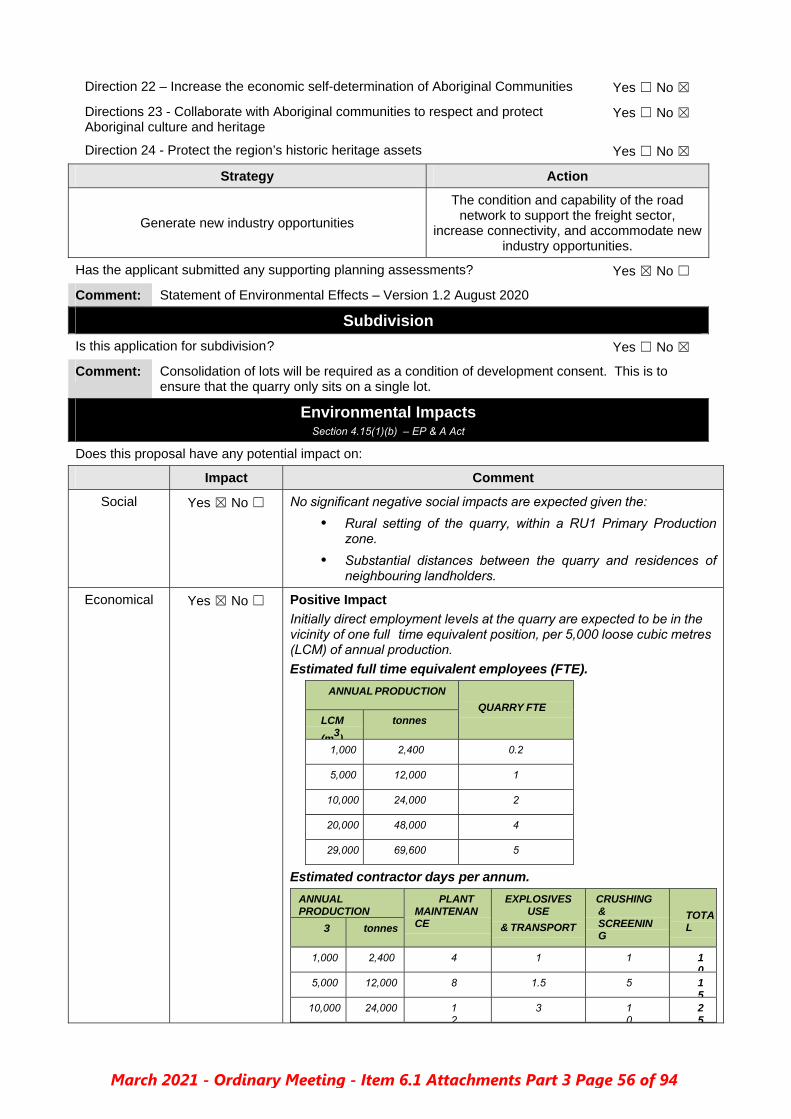
Direction 22 – Increase the economic self-determination of Aboriginal Communities Yes ☐ No ☒
Directions 23 - Collaborate with Aboriginal communities to respect and protect Aboriginal culture and heritage
Yes ☐ No ☒
Direction 24 - Protect the region’s historic heritage assets Yes ☐ No ☒
Strategy Action
Generate new industry opportunities
The condition and capability of the road network to support the freight sector,
increase connectivity, and accommodate new industry opportunities.
Has the applicant submitted any supporting planning assessments? Yes ☒ No ☐
Comment: Statement of Environmental Effects – Version 1.2 August 2020
Subdivision
Is this application for subdivision ? Yes ☐ No ☒
Comment: Consolidation of lots will be required as a condition of development consent. This is to ensure that the quarry only sits on a single lot.
Environmental Impacts Section 4.15(1)(b) – EP & A Act
Does this proposal have any potential impact on:
Impact Comment
Social Yes ☒ No ☐ No significant negative social impacts are expected given the:
• Rural setting of the quarry, within a RU1 Primary Production zone.
• Substantial distances between the quarry and residences of neighbouring landholders.
Economical Yes ☒ No ☐ Positive Impact
Initially direct employment levels at the quarry are expected to be in the vicinity of one full time equivalent position, per 5,000 loose cubic metres (LCM) of annual production.
Estimated full time equivalent employees (FTE).
ANNUAL PRODUCTION
QUARRY FTE LCM
(m3)
tonnes
1,000 2,400 0.2
5,000 12,000 1
10,000 24,000 2
20,000 48,000 4
29,000 69,600 5
Estimated contractor days per annum.
ANNUAL PRODUCTION
PLANT MAINTENANCE
EXPLOSIVES USE
& TRANSPORT
CRUSHING & SCREENING
TOTAL 3 tonnes
1,000 2,400 4 1 1 10
5,000 12,000 8 1.5 5 15
10,000 24,000 12
3 10
25
March 2021 - Ordinary Meeting - Item 6.1 Attachments Part 3 Page 56 of 94

20,000 48,000 16
6 20
42
29,000 69,600 20
9 30
59
A local quarry will substantially reduce freight costs, hence the overall cost of construction for any project requiring significant amounts of aggregate or road base. For example, transport costs for aggregate used to manufacture concrete at Walcha are expected to be reduced by more than 80%.
Siting & Configuration
Yes ☐ No ☒ The proposal is consistent with NSW Department of Primary Industries recommended minimum buffer of 1,000m between extractive industries using blasting and neighbouring residences. Setbacks Yes ☐ No ☒
Privacy Yes ☐ No ☒
Overshadowing
Yes ☐ No ☒
Solar Access Yes ☐ No ☒
Visual Yes ☐ No ☒ The quarry is not visible from the Oxley Highway, nor is it visible from any nearby dwellings. When standing in the proposed quarry site, no dwellings can be seen.
Significant Views
Yes ☐ No ☒
Water Yes ☐ No ☒ Water will be used from the dams on Brooklyn for dust suppression.
Significant groundwater flows area unlikely to be encountered by the quarry under typical operating conditions given that:
There are no nearby permanent watercourses, wetlands, springs or other features suggesting the presence of a near surface aquifer.
No rock units with significant porosity have been identified on or near the quarry site.
The quarry is located on the edge of an elevated ridge that forms part of the Great Dividing Range.
A detailed Groundwater Impact Assessment, including the drilling of 5 bore holes, has been undertaken and is the subject of a detailed report.
Ground Doctor Pty Ltd – Groundwater Impact Assessment – 11 August 2020
5 Conclusion
The proposed quarry will be excavated to a maximum depth of 1130 AHD. Groundwater was identified in basalt within the quarry footprint at a maximum elevation of approximately 1146m AHD. The proposed development would intersect the water table and is an aquifer interference activity as defined by the NSW Aquifer Interference Policy (2012).
Ground Doctor assessed the site setting and available groundwater data to identify existing groundwater users, environmental receptors and culturally sensitive groundwater features within a 2km radius of the site.
High priority groundwater dependent ecosystems or high priority cultural groundwater sites were not identified within 2km of the proposed quarry.
Four existing groundwater works were identified within a 2km radius of the proposed quarry excavation. The identified bores were located more than 1500m from the proposed excavation. Available data for the identified bores indicated that standing water levels in the bores were at least 20m lower than the maximum proposed depth of excavation. The bore identified within “Mt Pleasant” was separated from the proposed quarry by the Great Dividing Range and was within a different catchment and a different groundwater management unit to the proposed quarry.
March 2021 - Ordinary Meeting - Item 6.1 Attachments Part 3 Page 57 of 94

Five monitoring bores were installed within or close to the footprint of the proposed quarry excavation. Groundwater levels were measured at each bore. Failing head and rising head slug tests were performed on four of the five bores to assess hydraulic conductivity of aquifer material within and surrounding the proposed quarry excavation.
A conceptual site model was developed based on available groundwater and topographical data. The proposed quarry excavation would be located approximately 200m south of the Great Dividing Range. The ground surface around the proposed quarry falls steeply to the south east, south and west. The surface elevation was more than 100m below the base of the proposed excavation less than 500m to the south east and south of the quarry. Groundwater elevation data showed a steep groundwater gradient to the south east, south and west of the proposed quarry, consistent with steeply sloping surface topography.
An analytical model was adopted to predict steady state drawdown impacts and groundwater inflow to the open excavation at the completion of quarrying. The model predicted drawdown impacts would extend approximately 132m north of the proposed excavation. Groundwater inflow was estimated to be 1.16m³ /day.
Model prediction showed good agreement with observed real world drawdown in basalt within the quarry footprint, which was already draining to the south due to the presence of natural void (a deep valley) to the south.
The modelled groundwater inflow to the excavation is less than the expected evaporation rate from the open excavation. There is also potential for any groundwater inflow to drain through the floor of the excavation, as the base of the proposed excavation remains elevated above the valley to the south. Mechanical dewatering of the excavation is unlikely to be required. Any water accumulation in the excavation could be used in quarry operations or used as stock water at the completion of the development.
Direct take (eg: pumping for beneficial use) or indirect take of groundwater (eg: losses to evaporation) are required to be licenced. The annual groundwater inflow to the open excavation would be less than 2ML. The Applicant would need to source commercial use entitlement to take 2ML from the New England Fold Belt (Murray Darling Basin) groundwater management unit prior to intersecting the water table. The NSW Department of Industry Planning and Environment website (https://www.industry.nsw.gov.au/water/allocations-availability/water-accounting/usage-dashboard , 7 August 2020) indicates that there is 11384ML allocated within the New England Fold Belt (Murray Darling Basin) groundwater unit. It would be possible for the Applicants to obtain the required groundwater entitlement prior to intersecting the water table.
The project involves blasting, crushing and screening of excavated rock. The proposed activities have little if any potential to add contaminants that could adversely change groundwater quality. Operation of plant and machinery and use of nitrogen containing explosives poses a similar risk to groundwater quality as existing agricultural use of the Site and adjoining land. Potential risks to water quality can be managed by implementing appropriate procedures for storage and use of chemicals, refuelling and maintenance of plant and machinery and implementing appropriate spill response plans.
The information presented in this report indicates that the groundwater impacts associated with the proposed development would not exceed the Level 1 “minimum impact consideration” outlined in the NSW Aquifer Interference Policy (NSW DPI, 2012b). Therefore, groundwater impacts associated with the project are acceptable.
Dust Yes ☒ No ☐ NSW Health advice indicates that the vast majority of dust from mining/quarry activities consists of coarse particles (around 40 per cent) and particles larger than PM10, generated from natural activities such
March 2021 - Ordinary Meeting - Item 6.1 Attachments Part 3 Page 58 of 94

mechanical disturbance of rock and soil materials, for example by blasting, crushing and vehicles driving on dirt roads. Particles are also generated when wind blows over bare ground and different types of stockpiles. Larger particles can have amenity impacts as well as health impacts.
Fine particles from vehicle exhausts and mobile equipment are also produced at mine/quarry sites, though they only account for about 5 per cent of the particles emitted during the mining process. Fine particles are manly from vehicle and mobile equipment exhausts.
It is expected that the primary sources of dust associated with the operation of the proposed quarry will be:
• Drilling rock. • Blasting rock (see section 4.7 for more information). • Crushing & screening rock. • Transport trucks accessing the site.
Basalt will be the primary material being excavated, which is comparatively hard. There are no significant amounts of friable rock or earth present in the geological profile below about 2 metres.
To ensure worker safety a mixture of dust mitigation measures will be applied and amended in response to weather conditions, rock moisture content, plant location, etc. Those measures will be consistent with industry standards and include:
• Application of chemical surfactants. • Enclosing conveyor transfer points. • Implementation of water truck procedures. • Installation of sprays at conveyor transfer points. • Operator training and fit testing for respiratory protective
equipment. • Programmed maintenance of spray nozzles, pumps and
plumbing. • Regular inspections of operating dust controls.
The performance objective will be to ensure that:
• Quarry operations are conducted in accordance with the NSW Resource Regulator's 2020 workplace safety standards specified in the “Dust Safety in the Metals and Extractives Industries” document.
• No significant dust resulting from quarry operations is present more than 500 metres from the site boundary.
Trucks hauling quarry products via the access track within the property is a potential source of dust that could impact residents of the “Brooklyn” dwelling. The proposed track passes within 290m of the dwelling, hence it will need to need to be used and maintained in an appropriate manner to avoid impacts, especially in dry and windy conditions.
Strategies that will be used to minimise potential dust impacts associated with the quarry access track include:
Constructing and maintaining the track with a firm all weather surface. Signposting and restricting quarry truck speeds to a maximum of
20km/h on the track. Mandatory site induction for all staff which highlights compulsory
signposted speed limit for quarry site and access road. If the above measures become inadequate during dry and/or windy
conditions, then additional strategies will be applied, including one or more of the following: o Reducing quarry truck speeds to a maximum of 10km/h o Using a water cart to suppress dust along sections of the track
which may impact the “Brooklyn” dwelling or neighbours.
March 2021 - Ordinary Meeting - Item 6.1 Attachments Part 3 Page 59 of 94

Applying a dust suppression coating to the track, such as a polymer or bitumen based emulsion.
The performance objective will be to ensure that no significant dust resulting from quarry traffic is present more than 500 metres from the quarry access track, or on the site of any dwelling.
Noise Yes ☒ No ☐ EPA Noise Policy
Noise associated with new developments is regulated under the ‘Noise Policy for Industry’, published in 2017 by the NSW Environmental Protection Authority (NSW EPA). A key intent of the policy is to apply all feasible and reasonable measures to reduce predicted noise levels to the “project noise trigger levels” when predicted noise levels are above these levels.
The “project noise trigger level” is the lower (most stringent) value of two different noise levels:
1. An “intrusiveness noise level” which limits the extent to which a noise source can exceed the background level (that is, background plus 5 decibels [dB]) above a minimum threshold.
2. A “project amenity noise level” provides an overall noise-level cap for different land uses.
In this case the levels are:
1. “Intrusiveness noise level” – Determined by rating background level (RBL) plus 5 dBA. The minimum RBL is 40 dBA during daylight hours in a RU1 Primary Production zones (Policy Table 2.1). The final intrusiveness noise level in this case is 45 dBA.
2. “Noise amenity level” – During daylight hours is 50dBA when measured at an unrelated rural residential dwelling (Policy Table 2.2). Cumulative industrial noise is not relevant in this case as further industrial development is unlikely in the area.
Ultimately the relevant “project noise trigger level” for this development, measured at unrelated rural dwellings, is the 45 dBA “Intrusiveness noise level”.
It is relevant to note the NSW EPA ‘Noise Policy for Industry’ states:
“The reaction to noise varies widely from individual to individual. Because of this, it is not possible to set noise levels that will guarantee no one will experience an impact.
There will usually be some members of the community who find any noiseunacceptable, regardless of whether it meets the project noise trigger level, and others who will not be bothered by noise even if it is above the project noise trigger level.”
Access
At the peak level of quarry operations ……. Over an 8 hour day this will result in about 1 truck movement each 30 minutes and occasionally multiple vehicles would use the access at a similar time.
Indicative maximum noise levels from single and multiple vehicles accessing the quarry are:
Maximum expected vehicle noise from quarry access
EQUIPMENT USINGESS
SWL LAeq(dB(A))
SPL @7m(dB(A))
SPL @ 300m L Aeq (15 min) (dB(A))
1 Truck (>20 tonne) 106
81
40
1 Light vehicle (eg 4WD) 103
78
37
2 trucks & 1 light vehicle 110
82
44
March 2021 - Ordinary Meeting - Item 6.1 Attachments Part 3 Page 60 of 94

For this development the “Project noise trigger level” measured at unrelated rural dwellings is 45 L Aeq (15 min) (dB(A))
As noted in section 2.6.1, 2011 NSW Roads and Maritime traffic volume data for the Oxley Highway indicates that there are about 105 truck movements per day in either direction. If the quarry reaches peak production levels, then there will be an average of about 15 additional truck movements per day along the highway, increasing truck movements by up to 14%.
Overall the available information indicates that transport activities associated with the quarry on the access road and highway are quite unlikely to substantially increase existing noise levels in the vicinity.
Strategies that will be used to minimise potential noise impacts from use of the quarry access track include:
• Only transporting quarry products during daylight hours.
• Signposting and restricting all quarry truck speeds to a maximum of 20km/h on the track.
• Ensuring a consistent moderate gradient on the access track and highway access point to minimise the potential need for the use of exhaust braking.
Quarry Machinery
Quarry machinery and related noise will primarily arise from excavation, crushing and screening activities.
Expected quarry machinery noise levels
An estimate of maximum quarry noise level over a 15 minute interval at dwellings in the vicinity has been prepared using the NSW RMS Construction and Noise Estimator Tool
Maximum quarry noise at dwellings
SCENARIO / LOCATION
DISTANCE
metres
ATTENUATION dB(A) SPL L Aeq (15 TYPE LIKELY APPLIED
All quarry machinery listed inTable 12 operatingsimultaneously
7 Nil
Nil Nil 102
“Brooklyn” dwelling 660 Ridge 5-10 Nil 50
“Yarooga Park” dwelling >1,150 Ridge 5-10 Nil 43
“Mount Pleasant” dwelling >1,500 Ridge & trees
5-10 Nil
“Yarooga” dwelling >1,700 Ridge & trees
>10 Nil
Walcha Road village 2,200 Ridge & trees
>10 Nil
The “Project noise trigger level” measured at unrelated rural dwellings is 45 L Aeq (15 min)(dB(A))
Based on the indicative modelling data within Tables 12 and 13, the “Intrusiveness Noise Level” specified by the NSW EPA will not be exceeded at any unrelated dwellings.
Furthermore, the modelled levels are likely to be significantly overestimated given that no provision was made for attenuation (reduction) of noise levels by land-form or vegetation. There is no line of sight between the quarry site and any dwellings, hence no direct path for sound to travel.
March 2021 - Ordinary Meeting - Item 6.1 Attachments Part 3 Page 61 of 94

Noise associated with the operation of quarry machinery will be mitigated by:
• Only using excavating and processing machinery duringdaylight hours, as outlined in Table 3.
• Restricting days of operation, as noted previously in Table 3.• Ensuring all machinery is fitted and maintained with suitable
mufflers.
These strategies can be ensured by the use of conditioning in that the mitigation measures and recommendations as stated in the Statement of Environmental Effects are undertaken.
Land Degradation
Yes ☒ No ☐ Upon cessation of quarry operations the void will be rehabilitated to create a safe and stable landform consistent with the landowner’s requirements. This is expected to involve one or more of the following strategies:
Pre-stripping and stockpiling top soil from the site. This soil will beused to facilitate re-vegetation of disturbed areas.
Battering the edges of the quarry void to reduce the slope of walls,either by excavation or by suitable placement of waste rock.
Ripping and/or applying a veneer of topsoil to any areas ofcompacted soil associated with the quarry void.
Using the quarry void to retain water for domestic livestock todrink from. This may require some earthworks to facilitateappropriate access paths and slopes.
Using appropriate earthworks to ensure surface water flows do notcause significant soil erosion after cessation of operations.
Tree Loss Yes ☐ No ☒ The proposed development will not significantly remove, modify or fragment any established vegetation as:
• No habitat of a threatened species or ecological community hasbeen identified on the site or proposed access track.
• Less than 0.5 hectare of scattered mature trees will becleared from a highly disturbed area.
• Existing isolated trees are quite vulnerable to dieback prompted byvarious factors including insect attack, mistletoe, ringbarking bylivestock, wind, altered soil structure & chemistry, etc.
• No significant fragmentation or isolation will occur as a result ofthe proposed development.
A review of the Areas of Outstanding Biodiversity Value (AOBV) Register on 31 January 2020 showed four areas, none of which are located within 200km of the proposed development site. In that context the proposal is very unlikely to have any adverse effect, either directly or indirectly.
Conclusion: The proposed development or activity is unlikely to significantly affect any threatened species or ecological communities, or their habitats. In that context a biodiversity development assessment report is not warranted in this case.
Flora Yes ☐ No ☒
Fauna Yes ☐ No ☒
Has a Threatened Species Impact Assessment been prepared? Yes ☒ No ☐
Are there any species/communities listed under the TSC Act? Yes ☐ No ☒
Are there any key threatening processes? Yes ☒ No ☐
March 2021 - Ordinary Meeting - Item 6.1 Attachments Part 3 Page 62 of 94

Comment: Given the scale, type and context of the proposed development, it is unlikely to make anysignificant adverse environmental impact for a listed key threatening process.
THREATENING PROCESS
COMMENTS
Aggressive exclusion of birds from woodland & forest habitat by abundant Noisy Miners, Manorina melanocephala
Development is unlikely to facilitate any significant opportunities for this species.
Anthropogenic Climate Change.
Currently all aggregate used in the Walcha Shire is transported via trucks from other local government areas. A new local aggregate source will substantially reduce diesel fuel consumption associated with aggregate consumption in the Walcha Shire.
In these circumstances the development is expected to make a small reduction in carbon dioxide and other diesel exhaust pollutants within the Walcha Shire.
Bushrock removal (as described in the final determination of Scientific Committee).
“Bushrock removal” involves the disturbance and extraction of weathered outcrops of rock that provide habitat niches for animals. The listing does not apply to “the removal of rock from approved mining or quarrying activities”.
The impact on bushrock and associated species will not be significant as:
There is no scree, sheet like rock, or other rock formations likely to provide significant shelter niches for flora or fauna.
Basalt rock does outcrop and occur loose in the soil, but it lacks significant cracks, voids, slab like structures or scree formations that provide significant habitat niches for vertebrate animals.
No flora or fauna species listed in the final determination as threatened species which would be adversely affected by “bushrock removal” are known from the site.
Clearing of native vegetation (as described in the final determination of the Scientific Committee).
Proposed development will remove about 12 mature Eucalyptus sp. trees in a highly disturbed habitat. Overall this is unlikely to significantly increase the extent or magnitude of the impact of this key threatening process.
Competition and grazing by the feral European Rabbit, Oryctolagus cuniculus.
Development is unlikely to facilitate any significant change in existing local population of this species.
Invasion of native plant communities by exotic perennial grasses.
Of the exotic perennial grass species listed in the declaration, serrated tussock (Nassella trichotoma) is the most significant one known to occur in the Northern Tablelands. Landholder advises that he is not aware of any occurrences of this species on “Brooklyn” or adjoining properties.
The proposed development is not expected to facilitate the establishment or spread of any exotic perennial grasses.
Loss of hollow-bearing trees.
Development will remove about 12 mature Eucalyptus sp. trees in a highly disturbed habitat. Overall this is unlikely to significantly increase the extent or magnitude of this key threatening process.
Predation by the European Red Fox, Vulpes vulpes.
Development unlikely to facilitate predation by this species.
Predation by the Feral Cat Felis catus.
Development is unlikely to facilitate predation by this species.
Removal of dead wood and dead trees
Development will remove a small amount of dead wood and trees in a highly disturbed habitat. Overall this is unlikely to significantly increase the extent or magnitude of this key threatening process.
Does the proposed development require approval under the EPBC Act Yes ☐ No ☒
Heritage Impact Comment
European Yes ☐ No ☒
Aboriginal Yes ☐ No ☒ An Aboriginal Heritage Information Management System (AHIMS) search was carried for the land including a 50metre buffer. No sites are recorded or places declared either on the land or within the 50 metre buffer. See Attachment.
March 2021 - Ordinary Meeting - Item 6.1 Attachments Part 3 Page 63 of 94

Is this land classified as containing an item of environmental heritage? Yes ☐ No ☒
Is there an impact on and adjoining or in close vicinity to an item of environmental heritage?
Yes ☐ No ☒
Is this proposal in a heritage conservation Zone? Yes ☐ No ☒
Is this proposal in an adjoining or in close vicinity to a conservation zone? Yes ☐ No ☒
Has a Heritage Impact Statement been prepared for this proposal? Yes ☐ No ☒
Has an Archaeological Survey been prepared for this proposal? Yes ☐ No ☒
Flooding Section 4.15(1)(b) – EP & A Act
Is this property flood affected? Yes ☐ No ☒
Bush Fire Prone Land Section 4.15(1)(b) – EP & A Act
Is this property bush fire prone as per the Bush Fire Prone Map? Yes ☒ No ☐
Is this property bush fire prone as per any draft Bush Fire Prone Map? Yes ☒ No ☐
Has a Bush Fire Management Plan been Prepared? Yes ☐ No ☒
Does this development comply with Planning for Bushfire 2019? Yes ☒ No ☐
Contaminated Land Section 4.15(1)(b) – EP & A Act
Has this land been identified as being contaminated land by Council? Yes ☐ No ☒
Does this land require remediation? Yes ☐ No ☒
Has a Contaminated Land Site Investigation been completed? Yes ☒ No ☐
Is a referral required to NSW Environment Protections Authority? Yes ☐ No ☒
Is it a possibility this land may be contaminated? Yes ☐ No ☒
Is this land in the close vicinity or adjoining a known contaminated site? Yes ☐ No ☒
Infrastructure Section 4.15(1)(b) – EP & A Act
Is an engineering assessment required? Yes ☒ No ☐
Has an engineering assessment been completed? Yes ☒ No ☐
Who completed the Engineering Assessment?
Engineering Department ☒ Assessing Officer ☐ Other ☒ Peter Murray
Does this proposal have any potential impact on:
Impact Comment
Sewer Yes ☐ No ☒
Water Yes ☐ No ☒
Drainage Yes ☒ No ☐ Minimal.
Stormwater will be managed through out the site. This can be maintained by the use of appropriate conditioning.
Surface water drainage from the site flows to the east and south into the Surveyors Creek catchment, then the MacDonald River about 6.5km down slope of the site.
The quarry access track through “Brooklyn” will be constructed from gravel and raised above natural ground level, hence there
March 2021 - Ordinary Meeting - Item 6.1 Attachments Part 3 Page 64 of 94

will be some change to natural stormwater flow paths.
Table drains and culverts along the proposed access tracks will be used to direct stormwater flows into existing natural drainage hollows and existing dams on the “Brooklyn” holding.
Diversion channels and/or earth bunds will be used to divert stormwater flows around the perimeter of the quarry into existing, and/or new, dams for domestic livestock. Stormwater redirection will be necessary to prevent the quarry void filling with water, as well as minimising potential soil erosion and sedimentation issues.
Diversion channels and/or earth bunds will be used to divert stormwater flows around the perimeter of the quarry into existing, and/or new, dams for domestic livestock. Stormwater redirection will be necessary to prevent the quarry void filling with water, as well as minimising potential soil erosion and sedimentation issues.
Key strategies that will be applied include ensuring that stormwater diversion channel:
Beds are predominantly composed of bedrock, wherefeasible.
Where bedrock is absent and the channel has arelatively high gradient, the bed and sides are lined withsuitable rock.
Flows into a dam, or existing gully with a natural base inbedrock.
Stormwater within the quarry site may contain elevated levels of sediment derived from soil and aggregate stockpiles. No significant contaminants are known, or are likely, within the basalt rock or associated soils that will be disturbed by the quarry.
All stormwater flows from the quarry site will directed to, and held within, a sump in the quarry floor. Sediment will be able to settle within the sump and the water used for dust suppression activities. The sump will be relocated within the site over time as quarry operations progress.
Access Yes ☒ No ☐ See comments above from TfNSW. Engineering assessment agreed with TfNSW and incorporated wording as per their recommendation.
Engineering Assessment
The SEE further proposes that:
1. Existing access continues despite the limited site distance onOxley Highway until the 5000m3 threshold is reached.
2. The access is relocated to a location approximately 150mwest of the existing within 6 months of achieving 5000m3 ofquarry sales. With regard the access standard, the SEEstates: “separate letter and plans from Planit Consultingdated 24-7-2020 providing Turn Warrants Assessment and2D concept drawing for proposed site access into theproposed Brooklyn Quarry off the Oxley Highway in responseto Transport for NSW letter dated 26 May 2020” Whilst anemail was received on 7/9/2020, the attachments were notdownloaded when TRIM’ed and are no longer available
However given that the SEE states that the “Visibility between this access and the highway is partially obscured by trees and the rising slope will impede trucks entering the highway” it is difficult to support the proposed staging concept given the additional truck movements generated.
March 2021 - Ordinary Meeting - Item 6.1 Attachments Part 3 Page 65 of 94

Consequently, I recommend the following conditions in addition to those detailed in the Transport for NSW letter dated 26 May 2020:
1. Prior to quarry production commencing, a “Typical RuralAccess Standards – Articulated Driveways” access is to be constructed at the location at approximately 150m west of the existing access.
2. Within 6 months of the facility producing 5,000m3 of quarryproducts from production commencing, the access is to be upgraded to a Basic Right Turn (BAR) intersection meeting AUSTROADS Part 4 of the Guide to Road Design (Austroads 2017a).
Kerb & Gutter Yes ☐ No ☒
Upgrade Existing Road
Yes ☒ No ☐ See Comment Above
Road Network Yes ☒ No ☐ Contribution applied to cater for the increased traffic generation created by this development. See below.
Existing
Easements Yes ☐ No ☒
Electricity Yes ☐ No ☒
Telecommunications Yes ☐ No ☒
Pedestrian Access Yes ☐ No ☒
Loading & Unloading
Yes ☐ No ☒
Parking Yes ☐ No ☒
Energy Conservation
Yes ☐ No ☒
Does the development require any new easements? Yes ☐ No ☒
Has an Erosion and Soil Control Plan been submitted? Yes ☐ No ☒
Comment: This will be conditioned.
Construction Assessment
Is a Construction Certificate Required? Yes ☐ No ☒
Section 68 Assessment
Is a section 68 assessment required? Yes ☒ No ☐
Has a section 68 assessment been completed? Yes ☒ No ☐
Was a section 68 application submitted with this application? Yes ☐ No ☒
What is required? Onsite sewer management
Does this system require connection to a Council maintained system? Yes ☐ No ☒
Developer Contributions
Does this proposal require any Developer Contribution? Yes ☒ No ☐
Is the contribution for a subdivision? Yes ☐ No ☒
Is the contribution for a special purpose relating only to this proposal? Yes ☒ No ☐
Comment: Traffic Generation on Oxley Highway and local road.
March 2021 - Ordinary Meeting - Item 6.1 Attachments Part 3 Page 66 of 94

Contribution Plan
Levy
Rate
($)
Comment
Not Applicable Tonne
or
M3
$0.20
Or
$0.60
This is contribution rate is applicable only to this development and is to be used for the maintenance of Oxley Highway and impacted local roads due to the increased traffic generation created by this development.
Signage
Does this proposal require signage? Yes ☒ No ☐
Has this application included signage? Yes ☐ No ☒
Should a restriction be placed on the amount/type of signage? Yes ☒ No ☐
Comment: 1. Business Identification Signage 2. Emergency Contact Signage 3. Truck Entering Signage
Notification
Does this application require notification/advertising? Yes ☒ No ☐
Is this application an advertised development application under the EP & A Act? Yes ☐ No ☒
Was this application notified/advertised as per the provisions of?
☐ EP& A Act ☐ LEP ☒ CCP Yes ☒ No ☐
Was this application notified/advertised for public interest purposes only? Yes ☐ No ☒
Dates Notification Undertaken Commenced 2 April 2020 Finished 29 April 2020
Were there any written submissions received? Yes ☒ No ☐
If Yes, what was the number of submissions received? 4
Did the applicant have the opportunity to respond to the issues raised within the submission/s?
Yes ☒ No ☐
Comment: A modified Statement of Environmental Effects was submitted to Council which addressed the issues raised within the submissions.
Submission Maker:
James Norton – Objection
Lessee of Property Known as Mt Pleasant
Issue: Quarry will pose a risk of interference to the aquifer that supports the Mt Pleasant bore.
Applicant Response:
The quarry will have a maximum depth of 30m and will expose layers (flows) of basalt, possibly with minor volcanic ash and agglomerate, as indicated in section 3.2. Significant groundwater flows area unlikely to be encountered by the quarry under typical operating conditions given that:
There are no nearby permanent watercourses, wetlands, springs or other features suggesting the presence of a near surface aquifer.
No rock units with significant porosity have been identified on or near the quarry site.
The quarry is located on the edge of an elevated ridge that forms part of the Great Dividing Range.
A detailed Groundwater Impact Assessment, including the drilling of 5 bore holes, has been undertaken and is the subject of a detailed report.
Ground Doctor Pty Ltd – Groundwater Impact Assessment – 11 August 2020
5 Conclusion
The proposed quarry will be excavated to a maximum depth of 1130 AHD. Groundwater was identified in basalt within the quarry footprint at a maximum elevation of approximately 1146m AHD. The proposed development would intersect the water table and is an aquifer interference activity as defined by the
March 2021 - Ordinary Meeting - Item 6.1 Attachments Part 3 Page 67 of 94

NSW Aquifer Interference Policy (2012).
Ground Doctor assessed the site setting and available groundwater data to identify existing groundwater users, environmental receptors and culturally sensitive groundwater features within a 2km radius of the site.
High priority groundwater dependent ecosystems or high priority cultural groundwater sites were not identified within 2km of the proposed quarry.
Four existing groundwater works were identified within a 2km radius of the proposed quarry excavation. The identified bores were located more than 1500m from the proposed excavation. Available data for the identified bores indicated that standing water levels in the bores were at least 20m lower than the maximum proposed depth of excavation. The bore identified within “Mt Pleasant” was separated from the proposed quarry by the Great Dividing Range and was within a different catchment and a different groundwater management unit to the proposed quarry.
Five monitoring bores were installed within or close to the footprint of the proposed quarry excavation. Groundwater levels were measured at each bore. Failing head and rising head slug tests were performed on four of the five bores to assess hydraulic conductivity of aquifer material within and surrounding the proposed quarry excavation.
A conceptual site model was developed based on available groundwater and topographical data. The proposed quarry excavation would be located approximately 200m south of the Great Dividing Range. The ground surface around the proposed quarry falls steeply to the south east, south and west. The surface elevation was more than 100m below the base of the proposed excavation less than 500m to the south east and south of the quarry. Groundwater elevation data showed a steep groundwater gradient to the south east, south and west of the proposed quarry, consistent with steeply sloping surface topography.
An analytical model was adopted to predict steady state drawdown impacts and groundwater inflow to the open excavation at the completion of quarrying. The model predicted drawdown impacts would extend approximately 132m north of the proposed excavation. Groundwater inflow was estimated to be 1.16m³ /day.
Model prediction showed good agreement with observed real world drawdown in basalt within the quarry footprint, which was already draining to the south due to the presence of natural void (a deep valley) to the south.
The modelled groundwater inflow to the excavation is less than the expected evaporation rate from the open excavation. There is also potential for any groundwater inflow to drain through the floor of the excavation, as the base of the proposed excavation remains elevated above the valley to the south. Mechanical dewatering of the excavation is unlikely to be required. Any water accumulation in the excavation could be used in quarry operations or used as stock water at the completion of the development.
Direct take (eg: pumping for beneficial use) or indirect take of groundwater (eg: losses to evaporation) are required to be licenced. The annual groundwater inflow to the open excavation would be less than 2ML. The Applicant would need to source commercial use entitlement to take 2ML from the New England Fold Belt (Murray Darling Basin) groundwater management unit prior to intersecting the water table. The NSW Department of Industry Planning and Environment website (https://www.industry.nsw.gov.au/water/allocations-availability/water-accounting/usage-dashboard , 7 August 2020) indicates that there is 11384ML allocated within the New England Fold Belt (Murray Darling Basin) groundwater unit. It would be possible for the Applicants to obtain the required groundwater entitlement prior to intersecting the water table.
The project involves blasting, crushing and screening of excavated rock. The proposed activities have little if any potential to add contaminants that could adversely change groundwater quality. Operation of plant and machinery and use of nitrogen containing explosives poses a similar risk to groundwater quality as existing agricultural use of the Site and adjoining land. Potential risks to water quality can be managed by implementing appropriate procedures for storage and use of chemicals, refuelling and maintenance of plant and machinery and implementing appropriate spill response plans.
March 2021 - Ordinary Meeting - Item 6.1 Attachments Part 3 Page 68 of 94

The information presented in this report indicates that the groundwater impacts associated with the proposed development would not exceed the Level 1 “minimum impact consideration” outlined in the NSW Aquifer Interference Policy (NSW DPI, 2012b). Therefore, groundwater impacts associated with the project are acceptable.
Comment: To quantify this concern, Geological Survey of NSW – Mining, Exploration & Geoscience were asked to review the full application and submissions. Their response was:
GSNSW has reviewed the Statement of Environmental Effects for the above DA and have no issues or concerns to raise.
It is therefore assumed that the applicant has adequately addressed this matter.
Submission Maker:
Janet Norton – Objection
Resides on Property Known as Mt Pleasant
Issue: Groundwater
SEE fails to address risk to water supplies There is no hydrology report. No adequate consultation with local stakeholders in relation to the operation of
the groundwater and aquifer systems in the area.
Comment: Please see applicant response and comment above for James Norton.
Issue: Soil Profiling
No drilling had been undertaken to assess the actual depth and range of the basalt cap, nor the quality and usefulness of the resource.
Applicant Response:
Drilling and costeaning work combined with geological and geophysical observations indicate there is a profile of usable rock of more than 30 metres. Under ideal circumstances there may be up to about 450,000 cubic metres of rock that could be extracted…….
Trenching and drilling of the quarry site has a generally shallow reddish clay soil immediately overlying relatively fresh (unweathered) Tertiary basalt, as represented in Figure 8 and Plate 3 below. Five drill holes were drilled during July 2020 at the locations shown Figure 7. They showed that the basalt is up to 37.0 metres (hole MB 1) in the immediate vicinity of the quarry site.
All of the basalt is likely to be suitable for commercial use, unless there are significant geological variations. Known variations include some minor proportions of volcaniclastic/pyroclastic rocks (ash and agglomerate) exposed during test trenching and drilling.
Drilling indicates there is a relatively persistent layer of clay underlying the basalt at about 1124m ASL on the quarry site. The clay typically shows a mottled colour and texture similar to highly weathered volcaniclastic rocks observed in excavator costeans. This clay layer is about 7m below the maximum depth of the proposed quarry.
Comment: To quantify this concern, Geological Survey of NSW – Mining, Exploration & Geoscience were asked to review the full application and submissions. Their response was:
GSNSW has reviewed the Statement of Environmental Effects for the above DA and have no issues or concerns to raise.
It is therefore assumed that the applicant has adequately addressed this matter.
Issue: Dust
SEE has only assessed impacts of dust and noise using data taken from the Woolbrook weather station. The Woolbrook weather station is 7.4km west of the proposed quarry site and over 200m lower in elevation. This data does not describe the wind conditions at the proposed site, nor indicate the likely impact of dust and noise that would be produced by the quarry.
Applicant Response:
NSW Health advice indicates that the vast majority of dust from mining/quarry activities consists of coarse particles (around 40 per cent) and particles larger than
March 2021 - Ordinary Meeting - Item 6.1 Attachments Part 3 Page 69 of 94

PM10, generated from natural activities such mechanical disturbance of rock and soil materials, for example by blasting, crushing and vehicles driving on dirt roads. Particles are also generated when wind blows over bare ground and different types of stockpiles. Larger particles can have amenity impacts as well as health impacts.
Fine particles from vehicle exhausts and mobile equipment are also produced at mine/quarry sites, though they only account for about 5 per cent of the particles emitted during the mining process. Fine particles are manly from vehicle and mobile equipment exhausts.
It is expected that the primary sources of dust associated with the operation of the proposed quarry will be:
• Drilling rock.• Blasting rock (see section 4.7 for more information).• Crushing & screening rock.• Transport trucks accessing the site.
Basalt will be the primary material being excavated, which is comparatively hard. There are no significant amounts of friable rock or earth present in the geological profile below about 2 metres.
To ensure worker safety a mixture of dust mitigation measures will be applied and amended in response to weather conditions, rock moisture content, plant location,
etc. Those measures will be consistent with industry standards9 and include:
• Application of chemical surfactants.• Enclosing conveyor transfer points.• Implementation of water truck procedures.• Installation of sprays at conveyor transfer points.• Operator training and fit testing for respiratory protective equipment.• Programmed maintenance of spray nozzles, pumps and plumbing.• Regular inspections of operating dust controls.
The performance objective will be to ensure that:
• Quarry operations are conducted in accordance with the NSW ResourceRegulator's 2020 workplace safety standards specified in the “Dust Safetyin the Metals and Extractives Industries” document.
• No significant dust resulting from quarry operations is present more than500 metres from the site boundary.
Trucks hauling quarry products via the access track within the property is a potential source of dust that could impact residents of the “Brooklyn” dwelling. The proposed track passes within 290m of the dwelling, hence it will need to need to be used and maintained in an appropriate manner to avoid impacts, especially in dry and windy conditions.
Strategies that will be used to minimise potential dust impacts associated with the quarry access track include:
Constructing and maintaining the track with a firm all weather surface. Signposting and restricting quarry truck speeds to a maximum of 20km/h on the
track. Mandatory site induction for all staff which highlights compulsory signposted
speed limit for quarry site and access road. If the above measures become inadequate during dry and/or windy conditions,
then additional strategies will be applied, including one or more of the following:o Reducing quarry truck speeds to a maximum of 10km/ho Using a water cart to suppress dust along sections of the track which may
impact the “Brooklyn” dwelling or neighbours. Applying a dust suppression coating to the track, such as a polymer or bitumen
based emulsion.
The performance objective will be to ensure that no significant dust resulting from quarry traffic is present more than 500 metres from the quarry access track, or on the site of any dwelling.
March 2021 - Ordinary Meeting - Item 6.1 Attachments Part 3 Page 70 of 94

Comment: To quantify this concern, Geological Survey of NSW – Mining, Exploration & Geoscience were asked to review the full application and submissions. Their response was:
GSNSW has reviewed the Statement of Environmental Effects for the above DA and have no issues or concerns to raise.
It is therefore assumed that the applicant has adequately addressed this matter.
These strategies can be ensured by the use of conditioning in that the mitigation measures and recommendations as stated in the Statement of Environmental Effects are undertaken.
Issue: Noise
No reasonable attempt has been made in the SEE to determine the actual noise impact on my property and whether it could be reduced to an acceptable level.
Applicant Response:
Access
At the peak level of quarry operations ……. Over an 8 hour day this will result in about 1 truck movement each 30 minutes and occasionally multiple vehicles would use the access at a similar time.
Indicative maximum noise levels from single and multiple vehicles accessing the quarry are:
Maximum expected vehicle noise from quarry access
EQUIPMENT NG ACCESS
SWL LAeq (dB(A)) SPL @7m (dB(A)) SPL @ 300m L Aeq (15 min) (dB(A))
1 Truck (>20 tonne)
106 81 40
1 Light vehicle (eg 4WD)
103 78 37
2 trucks & 1 light vehicle
110 82 44
For this development the “Project noise trigger level” measured at unrelated rural dwellings is 45 L Aeq (15 min) (dB(A))
As noted in section 2.6.1, 2011 NSW Roads and Maritime traffic volume data for the Oxley Highway indicates that there are about 105 truck movements per day in either direction. If the quarry reaches peak production levels, then there will be an average of about 15 additional truck movements per day along the highway, increasing truck movements by up to 14%.
Overall the available information indicates that transport activities associated with the quarry on the access road and highway are quite unlikely to substantially increase existing noise levels in the vicinity.
Strategies that will be used to minimise potential noise impacts from use of the quarry access track include:
• Only transporting quarry products during daylight hours.
• Signposting and restricting all quarry truck speeds to a maximum of 20km/h on the track.
• Ensuring a consistent moderate gradient on the access track and highway access point to minimise the potential need for the use of exhaust braking.
Quarry Machinery
Quarry machinery and related noise will primarily arise from excavation, crushing andscreening activities.
Expected quarry machinery noise levels
An estimate of maximum quarry noise level over a 15 minute interval at dwellings in the vicinity has been prepared using the NSW RMS Construction and Noise Estimator Tool
March 2021 - Ordinary Meeting - Item 6.1 Attachments Part 3 Page 71 of 94

Maximum quarry noise at dwellings
SCENARIO / LOCATION
DISTANCE
metres
ATTENUATION dB(A) SPL L Aeq (15
min) (dB(A))
TYPE LIKELY APPLIED
All quarry machinery listed in Table 12 operating simultaneously
7 Nil Nil Nil 102
“Brooklyn” dwelling 660 Ridge 5-10 Nil 50
“Yarooga Park” dwelling >1,150 Ridge 5-10 Nil 43
“Mount Pleasant” dwelling >1,500 Ridge & trees
5-10 Nil 39
“Yarooga” dwelling >1,700 Ridge & trees
>10 Nil 37
Walcha Road village 2,200 Ridge & trees
>10 Nil 17
The “Project noise trigger level” measured at unrelated rural dwellings is 45 L Aeq (15 min) (dB(A))
Based on the indicative modelling data within Tables 12 and 13, the “Intrusiveness Noise Level” specified by the NSW EPA will not be exceeded at any unrelated dwellings.
Furthermore, the modelled levels are likely to be significantly overestimated given that no provision was made for attenuation (reduction) of noise levels by land-form or vegetation. There is no line of sight between the quarry site and any dwellings, hence no direct path for sound to travel.
Noise associated with the operation of quarry machinery will be mitigated by:
• Only using excavating and processing machinery during daylight hours, as outlined in Table 3.
• Restricting days of operation, as noted previously in Table 3. • Ensuring all machinery is fitted and maintained with suitable mufflers.
Comment: To quantify this concern, Geological Survey of NSW – Mining, Exploration & Geoscience were asked to review the full application and submissions. Their response was:
GSNSW has reviewed the Statement of Environmental Effects for the above DA and have no issues or concerns to raise.
It is therefore assumed that the applicant has adequately addressed this matter.
These strategies can be ensured by the use of conditioning in that the mitigation measures and recommendations as stated in the Statement of Environmental Effects are undertaken.
Issue: Traffic & Road Safety
The development and operation of the quarry poses road safety issues for both the community and road users generally.
Comment: Transport for NSW (TfNSW) was consulted and are a concurrence authority for this development. This is due to the land fronting and accessing off the Oxley Highway. A copy of their response is attached to this report.
TfNSW response to Council; in determining the application under the Environmental Planning and Assessment Act 1979, it is Council’s responsibility to consider the environmental impacts of any road works which are ancillary to the development. This includes any works which form part of the proposal and/or any works which are deemed necessary to include as requirements in the conditions of project approval. They had no objection to the development with the following recommendations:
Council:
March 2021 - Ordinary Meeting - Item 6.1 Attachments Part 3 Page 72 of 94

should be satisfied that the application has sufficiently explained the impacts of the development and justified all proposed mitigation measures.
condition the maximum daily and hourly movements generated by the development.
request an assessment of turn treatment warrants in accordance with the Austroads Guide to Traffic Management Part 6 and Austroads Guide to Road Design Part 4A for the site access, identifying the existence of the minimum basic turn treatments and addressing the need for any warranted higher order treatments.
condition all redundant accesses to be legally and physically closed prior to commencement of use of the new access.
prior to determination have strategic (2D) design drawings of all proposed improvements to public roads and the site access to mitigate the traffic and road safety impacts of the development.
condition that a Traffic Management Plan (TMP) be developed addressing the construction, operation and decommission phases of the proposed development.
consider the need for any regulatory signage (truck turning signs) and where necessary seek the endorsement of the Local Traffic Committee prior to Council approval the signage.
any future roadwork on the classified (State) road will need to be designed and constructed in accordance with the current Austroads Guidelines, Australian Standards and TfNSW Supplements. The developer will be required to enter into a Works Authorisation Deed (WAD) with TfNSW for any roadwork deemed necessary on the classified (State) road. The developer will be responsible for all costs associated with the roadwork and administration for the WAD.
The above response was forwarded onto the developer who included additional information to address these issues in the revised Statement of Environmental Effects. Further the Engineering Assessment addressed these recommendations and the recommended conditions of development consent addressing these issues.
Submission Maker:
Danielle Norton & Paul Chevrot – Objection
Owners of Property Known as Mt Pleasant
Issue: Groundwater
The potential impacts the proposed development could have on the aquifers in the region.
Comment: Please see applicant response and comment above for James Norton.
Issue: Dust and Noise
The SEE only briefly assessed the potential impacts of dust and noise using data taken from the Woolbrook weather station, a station that is 7.4km west of the proposed quarry site and over 200m lower in elevation. This data does not describe the wind conditions at the proposed site, nor does it indicate the likely impact of dust and noise that would be produced by the quarry. Any conclusions drawn from this data are therefore insufficient.
Comment: See applicant response and comment above for Janet Norton.
Issue: Project Duration and Size of Development
The potential impacts of this proposed quarry development are unable to be assessed due to insufficient detail in relation to project duration (no end date), and size of development (depth of quarry, volume of aggregate to be extracted, and frequency of blasting etc).
Applicant Response:
See applicant response on soil profiling above for Janet Norton.
Project Duration
A specific end date for the operation of the quarry has not been proposed because:
Rural quarries tend to have highly variable and sporadic rates of extraction.
March 2021 - Ordinary Meeting - Item 6.1 Attachments Part 3 Page 73 of 94
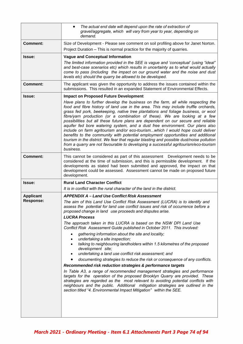
The actual end date will depend upon the rate of extraction ofgravel/aggregate, which will vary from year to year, depending ondemand.
Comment: Size of Development - Please see comment on soil profiling above for Janet Norton.
Project Duration – This is normal practice for the majority of quarries.
Issue: Vague and Conceptual Information
The limited information provided in the SEE is vague and ‘conceptual’ (using “ideal” and best-case scenarios etc) which results in uncertainty as to what would actually come to pass (including the impact on our ground water and the noise and dust levels etc) should the quarry be allowed to be developed.
Comment: The applicant was given the opportunity to address the issues contained within the submissions. This resulted in an expanded Statement of Environmental Effects.
Issue: Impact on Proposed Future Development
Have plans to further develop the business on the farm, all while respecting the food and fibre history of land use in the area. This may include truffle orchards, grass fed pork, beekeeping, native tree plantations and foliage business, or wool fibre/yarn production (or a combination of these). We are looking at a few possibilities but all these future plans are dependent on our secure and reliable aquifer fed bore watering system, and a dust free environment. Our plans also include on farm agritourism and/or eco-tourism...which I would hope could deliver benefits to the community with potential employment opportunities and additional tourism in the district. We fear that regular blasting and possible dust/noise pollution from a quarry are not favourable to developing a successful agritourism/eco-tourism business.
Comment: This cannot be considered as part of this assessment Development needs to be considered at the time of submission, and this is permissible development. If the developments as stated had been submitted and approved, the impact on that development could be assessed. Assessment cannot be made on proposed future development.
Issue: Rural Land Character Conflict
It is in conflict with the rural character of the land in the district.
Applicant Response:
APPENDIX A – Land Use Conflict Risk Assessment
The aim of this Land Use Conflict Risk Assessment (LUCRA) is to identify and assess the potential for land use conflict issues and risk of occurrence before a proposed change in land use proceeds and disputes arise.
LUCRA Process
The approach taken in this LUCRA is based on the NSW DPI Land Use Conflict Risk Assessment Guide published in October 2011. This involved:
gathering information about the site and locality; undertaking a site inspection; talking to neighbouring landholders within 1.5 kilometres of the proposed
development site; undertaking a land use conflict risk assessment; and
documenting strategies to reduce the risk or consequence of any conflicts.
Recommended risk reduction strategies & performance targets
In Table A3, a range of recommended management strategies and performance targets for the operation of the proposed Brooklyn Quarry are provided. These strategies are regarded as the most relevant to avoiding potential conflicts with neighbours and the public. Additional mitigation strategies are outlined in the section titled “4. Environmental Impact Mitigation” within the SEE.
March 2021 - Ordinary Meeting - Item 6.1 Attachments Part 3 Page 74 of 94

Table A3 – Recommended risk reduction strategies & performance targets.
POTENTIAL CONFLICT
MANAGEMENT STRATEGIES
REVISED RISK RANKING
PERFORMANCE TARGET
Noise from blasting Do not blast during early morning, dusk or during temperature inversions.
Ensure adequate depth & type of stemming in blast drill holes.
Dampening site to reduce dust, if dust issues arise.
(D 4) 5
No complaints to quarryoperator, Council orMines Inspectorate.
Dust from blasting (D 4) 5
Ground vibration from blasting
(D 4)
5
Flyrock from blasting
Provide “Highvale” property owner/manager with
≥ 48 hours notice of intended blasting dates and times.
No blasting undertaken if any non-quarry person is present with a 500 metre radius of site.
(C 4)
8
Noise from excavation
Excavation only undertaken during daylight hours.
(D 4) 5
No complaints to quarryoperator or Council
Dust from excavation
Dampening site to reduce dust, if issues arise.
(D 4) 5
Noise from transport
Haulage only undertaken during daylight hours.
(D 4) 5
Dust from transport Dampening access road, if dust issues arise.
(D 4) 5
Traffic from transport
Ensure quarry related trucks are not over loaded or driven at excessive speed when entering the Oxley Highway.
Maintain access drive way linking the Oxley Highway to the “Brooklyn” property with a firm all weather surface at same height as the highway.
Install & maintain quarry related signage requested by Council along the verge of the Oxley Highway.
(C 4)
8
No complaints to quarryoperator, Council orNSW Roads & MaritimeServices
The table titled “Potential conflict risk ranking for proposed Brooklyn Quarry” (Table A2) provides a structured assessment of the most likely conflict risks associated with the quarry operation.
The documented risks are typical for this type of development and can be managed by a competent quarry manager and shotfirer via the strategies listed in the table titled “Recommended risk reduction strategies & performance targets” (Table A3).In the event that they are not appropriately managed, various administrative and enforcement mechanisms are available to government authorities.
Comment: There will be no land use conflict if the strategies as listed in the SEE and relevant legislation are followed throughout the operation of the development. This will be conditioned.
Issue: Future Health Concerns
Concerned for the health of the current and future occupants of the Mt Pleasant residents should this quarry development go ahead.
Comment: This is a personal and emotive comment. It cannot be taken into consideration as it lacks a linkage to a planning merit that can be considered as part of this assessment.
Submission Maker:
Alpha Omega Town Planning - Objection
Consultant to Owners and Occupiers of Property Known as Mt Pleasant
Issue: Aquifer Impact
The potential impact of the proposed quarry on local aquifers, and the potential for
March 2021 - Ordinary Meeting - Item 6.1 Attachments Part 3 Page 75 of 94

this to have material adverse impacts on the reliable bore water that has continued to deliver good quality stock and domestic water to our clients’ property (even during the drought) and adjacent properties in the locality………
Lack of test data for Aquifers
Of perhaps most concern in this proposal, is the absence of any substantive test data on the presence (or otherwise) of aquifer(s) that could be at risk from the proposed quarrying operations……..it fails to provide any adequate assessment of the groundwater and likely impacts associated with the proposal’.
Comment: See applicant response and comment above for James Norton.
Issue: DA should be refused
The DA should be refused for the following key reasons:
a) the proposed quarry will give rise to unacceptable adverse groundwater impacts, dust impacts, noise impacts and traffic safety impacts;
b) the proposed quarry is not in the public interest; c) the DA is ‘designated development’ under the Environmental Planning and
Assessment Act 1979 (EP&A Act); d) the DA contains insufficient information in relation to:
i. extraction rates and area – there is uncertainty in relation to the maximum ii. depth of the quarry and the lifespan of the quarry; iii. justification of the need for the proposed quarry – including the size and
quality of the basalt resource, market demand and alternative sites analysis;
iv. quantitative and qualitative impacts of groundwater impacts, dust impacts, noise impacts and traffic safety impacts; and
v. (iv) social and economic impacts in the locality.
Applicant Response:
a) Please see applicant response above for James Norton. b) Public interest
This proposal has been developed on the basis that it should comply with all current land use planning standards and have no significant adverse impact on neighbours, the public, the environment or public infrastructure. Mitigation measures have been also been proposed that are appropriate for the scale of the quarry and the context in which it will be located.
The proponents believe that it is in the public interest that this development should proceed, given that it:
• Creates economic diversity via the establishment of a new extractive industry.
• Will reduce construction costs for local roads, buildings and infrastructure by enabling a local source of aggregate supply.
• Diversifies local employment opportunities. • Creates additional local jobs. • Reduces truck traffic on highways and regional roads to source
aggregate and quarry products from elsewhere. • It is quite unlikely to have any significant adverse impacts on the
environment, neighbours, community or public infrastructure.
c) designated development – SEE has shown that it will not exceed any local development standard that will turn the development into designated development.
d) modified the SEE to ensure these issues were addressed.
Comment: a) See applicant comment above for James Norton. b) The public interest is adequately dealt with by the applicant. c) This development is not designated development. d) There is enough information in the SEE to assess the application.
Issue: Lack of Detail to SEE to determine resource
Lack of geological investigations at the site and inadequate information provided by the Applicant on both the quantity of the purported basalt deposits as well as its quality……..the SEE does not sufficiently detail the quantity and quality of the
March 2021 - Ordinary Meeting - Item 6.1 Attachments Part 3 Page 76 of 94

proposed resource in light of its proposed end-use……. ambiguity in the SEE regarding the amount of cubic meters to be extracted further highlights the uncertainty as to the impacts of the proposal and the measures that would be required to mitigate such impacts.
Comment: Size of Development - See applicant response and comment on soil profiling above for Janet Norton.
Issue: Noise
The proposed quarry is at a relatively high altitude, and at least one nearby property, Mount Pleasant, has no landforms (hills) between it and the proposed site to attenuate noise. The frequency and extent of extraction measures would therefore greatly influence the noise impacts associated with the proposal…….No technical assessments as to likely noise levels at different receptor points have been provided in the proposal – such information will need to be provided in order for Council to undertake a proper assessment of the noise impacts of the proposal.
Comment: See applicant response and comment above for Janet Norton.
Issue: Traffic safety and Consultation with TfNSW
The SEE suggests that certain road safety upgrades will only occur once the quarry is economically viable (that exceeds 100,000 cubic metres). This approach to traffic safety impacts is not acceptable for a quarry……..No adequate traffic safety analysis has been carried out by the applicant………Additionally, the Applicant has not undertaken any traffic surveys or provided a proposed traffic management plan, which would be necessary for a development of this nature. No consultation has been carried out with RMS even though the access road is a main road…..
Comment: Transport for NSW (TfNSW) was consulted and are a concurrence authority for this development. This is due to the land fronting and accessing off the Oxley Highway. A copy of their response is attached to this report.
See applicant response and comment above for Janet Norton.
Issue: Lack of social and economic benefits
The SEE’s analysis of this issue is limited to referring to potential social and economic benefits – which are not supported by any empirical analysis of the quality of the resource or market demand in the area……There is no attempt by the SEE to consider potential adverse social and economic impacts in the locality that may arise from the proposed quarry such as, among other matters, sterilisation of agricultural land or impacts to existing and likely future land uses in the vicinity of the Development Site.
Applicant Response:
Social Impact
No significant negative social impacts are expected given the:
• Rural setting of the quarry, within a RU1 Primary Production zone.
• Substantial distances between the quarry and residences of neighbouringlandholders.
Economical Impact
Initially direct employment levels at the quarry are expected to be in the vicinity of one full time equivalent position, per 5,000 loose cubic metres (LCM) of annual production.
Estimated full time equivalent employees (FTE).
ANNUAL PRODUCTION
QUARRY FTE LCM
(m3)
tonnes
1,000 2,400 0.2
5,000 12,000 1
10,000 24,000 2
20,000 48,000 4
March 2021 - Ordinary Meeting - Item 6.1 Attachments Part 3 Page 77 of 94

29,000 69,600 5
Estimated contractor days per annum.
ANNUAL PRODUCTION
PLANT MAINTENANCE
EXPLOSIVES USE
& TRANSPORT
CRUSHING & SCREENING TOTAL
3 tonnes
1,000 2,400 4 1 1 10
5,000 12,000 8 1.5 5 15
10,000 24,000 12 3 10 25
20,000 48,000 16 6 20 42
29,000 69,600 20 9 30 59
A local quarry will substantially reduce freight costs, hence the overall cost of construction for any project requiring significant amounts of aggregate or road base.For example, transport costs for aggregate used to manufacture concrete at Walcha are expected to be reduced by more than 80%.
Comment: The applicant has adequately addressed both issues.
Issue: Lifespan of Project
The SEE provides no comfort about the lifespan of the proposed quarry and notes that extraction rates are likely to be highly variable…….There is no consideration of the potential adverse impacts of the sterilisation of the agricultural use of the land, or adverse impacts to adjacent agricultural uses.
Comment: See applicant response and comment above for Norton & Chevrot.
Issue: Alternative Sites
The SEE’s assessment of alternative sites is materially deficient. It is limited to a consideration of alternative sites within the “Brooklyn” property only. A proper assessment of alternative sites should not be limited in this manner for the purposes of the EP&A Act. There is no consideration of alternative sites within the locality, or analysis of the ‘do nothing’ scenario.
Applicant Response:
Several alternative sites were considered on the “Brooklyn” property but were rejected for one or more of the following reasons.
• Resource deficiency - A significant volume of rock (ie >250,000 cubicmetres) with suitable engineering properties is required to enable the establishment of a viable aggregate quarry. Geological and geophysical observations indicate that other parts of the “Brooklyn” property lack sufficient volumes of suitable rock.
• Higher environmental values - Parts of the property with relatively intactvegetation communities and higher vegetation density have been avoided as they have more significant environmental values.
• Topography - Establishing, operating and rehabilitating a quarry is typicallymore cost effective on the side of a ridge or hill. Other parts of the “Brooklyn” property were considered and discarded on the basis that they had minimal or excessive slope.
Consideration was given to establishing a quarry at various other sites within the Shire, but they were rejected for one or more reasons, including:
• There were unrelated dwellings within 1 kilometre.• A lack of reasonable proximity to Walcha township.• No evidence of a significant volume of basalt rock.• Likely access problems including public roads in poor condition and/or
located a significant distance from a public road.• Higher environmental values with significant stands of native vegetation, rock
outcrops or other factors.
A “do nothing” scenario involves the quarry not proceeding which would involve
March 2021 - Ordinary Meeting - Item 6.1 Attachments Part 3 Page 78 of 94

various “opportunity costs”, including losing a chance to:
• Increase economic diversity via the establishment of a new extractive industry. • Reduce construction costs for local roads, buildings and infrastructure by
enabling a local source of aggregate supply. • Diversify local employment opportunities. • Create new local jobs. • Enable a relatively isolated extractive industry proposal to proceed within a
setting where it is quite unlikely to have any significant adverse impacts on the environment, neighbours, community or public infrastructure.
Comment: The applicant has provided a comprehensive reply which addresses this issue.
Issue: Weather Data Location
Observations for wind speed and direction are provided from the Woolbrook weather station approximately 7km away.
Comment: All weather data has been taken from the nearest weather station. It is considered that this location is adequate for this assessment.
Issue: Dust
There is potential for dust to adversely affect our clients’ property because Mt Pleasant is located east by north east of the proposed quarry at a distance of around 1,500 metres. The Applicant has undertaken no adequate quantitative or qualitative analysis of dust impacts…….
A new unsealed access road is proposed for hauling from the extraction site to the access road (Oxley Highway). It is proposed to employ four limited strategies to reduce dust generation including the use of a water cart during dry and windy conditions. However, higher traffic volumes during such conditions could generate quite a lot of dust and, as we have seen during recent drought conditions, water sources can be compromised such that no water is available for such purposes. This could lead to significant dust plumes being created and transported during dry and windy weather.
Comment: See applicant response and comment above for Janet Norton.
Issue: Noise
No attempt has been in the SEE at undertaking quantitative or qualitative assessment of the likely noise impacts. Blasting and the use of rock crushing/processing equipment will generate significant noise.
Comment: See applicant response and comment above for James Norton.
Issue: Consultation
No meaningful consultation with our client has occurred.
Comment: The applicant is not legislatively required to consult with neighbours. Council did undertake neighbour notification as per the Walcha CPP and extended the time period for submissions as requested by this submission writer and Janet Norton.
“Meaningful consultation” with neighbours does not mean they have to give their permission for the development.
Issue: Mining SEPP 2007 Assessment
No adequate assessment of impact on land uses has been undertaken for the purposes of the Mining SEPP 2007…….is materially deficient for the following key reasons:
it fails to identify: 1. existing, approved and likely preferred land uses in the vicinity; 2. whether or not the development is likely to have a significant impact on the
uses that, in the opinion of the consent authority having regard to land use trends, are likely to be the preferred uses of land in the vicinity of the development;
3. any ways in which the development may be incompatible with any of those existing, approved or likely preferred uses;
fails to evaluate and compare the respective public benefits of the development
March 2021 - Ordinary Meeting - Item 6.1 Attachments Part 3 Page 79 of 94

and the land uses referred to above; and fails to put forward and evaluate any measures proposed to avoid or minimise
any incompatibility.
Comment: Adequate assessment has been undertaken throughout the SEE.
Issue: Legal Advice Sought
Have sought legal advice form Gilbert + Tobin Lawyers with respect to the proposed quarry. The advice provided has raised 2 key legal issues of concern for Council in its assessment.
Issue: DA not Designated Development
That the DA is not a form of ‘designated development’ for the purpose of the EP&A Act and the Environmental Planning and Assessment Regulation 2000 (EP&A Regulation).
Issue: Application fails to provide sufficient information
Gilbert + Tobin have separately advised that the development application, as currently put to Council, fails to provide sufficient information on the nature of the proposed quarry and associated impacts……… Specifically, the proposal as detailed in the SEE fails to provide sufficient information on how the proposal will operate, and associated impacts, relating to:
the quality and quantity of the basalt resource proposed to be extracted; extraction methods and processing; traffic; dust emissions; groundwater; and noise.
Comment: The applicant has provided a comprehensive reply which addresses all issues as raised within the submissions, and has provided adequate information for an appropriate level of assessment to be undertaken.
Submission Maker:
Strathleigh Grazing Pty Ltd – Support
Issue: Both Directors (Nathan Gilbody and John Boughton) have are in agreement with the information as provided by the applicant and support the development.
Section 88b Instrument
Does Council require a Section 88b instrument to be prepared? Yes ☐ No ☒
Public Interest
Does this proposal have any construction or safety issues? Yes ☐ No ☒
Is there any public health issues? Yes ☐ No ☒
Are there any other public interest issues? Yes ☐ No ☒
Site Suitability Section 4.15(1)(c) – EP & A Act
Is this a suitable site for this development? Yes ☒ No ☐
Assessing Officer General Comment
Comment: There are no outstanding issues that cannot be dealt with by the use of appropriate conditioning.
Recommendation
This development application be approved subject to the following conditions:
March 2021 - Ordinary Meeting - Item 6.1 Attachments Part 3 Page 80 of 94

RELEVANT PRESCRIBED CONDITIONS (under the Environmental Planning and Assessment Regulation 2000)
Nil
GENERAL CONDITIONS
1. The development shall be implemented in accordance with:
(a) All documentation and correspondence submitted by the applicant, or their agents, in support of the Development Application,
(b) the details set out on the plans approved and stamped by authorised officers of Council,
except as amended by the conditions of this development consent.
Note: Any proposal to modify the terms or conditions of this consent, whilst still maintaining substantially the same development to that approved, will require the submission of a formal application under Section 4.55 of the Environmental Planning and Assessment Act 1979 for Council's consideration. If amendments to the design result in the development not remaining substantially the same as that approved by this consent, a new development Application will have to be submitted to Council.
2. A copy of all stamped approved plans, specifications and documents must be kept on site at all times so as to be readily available for perusal by any officer of Council or the Principal Certifying Authority.
3. All management recommendations contained within the Statement of Environmental Effects by Matthew Goodwin, Version 1.2 dated August 2020 are to be complied with.
4. Annual production from the quarry is not to exceed 29,000m3 per year of extractive materials. Any increase in production or alteration to operations is to be the subject of a further Development Application.
5. The total surface area of the quarry shall not exceed 2 hectares of land including clearing or excavating, roads; or storing or depositing overburden, extractive materials or tailings.
6. A contribution is to be paid to Council on a quarterly basis and will be subject to annual CPI adjustment. This is calculated at $0.20 per tonne or $0.60 per m3 of gravelled hauled from site. The proponent is responsible for the provision of an annual audited Statement of Compliance from a qualified auditor.
7. The applicant must keep a legible record of all complaints made to the developer or any employee or agent of the developer in relation to dust or any activity to which this development consent relates. The record must include details of the following:
a) the date and time of the complaint; b) the method by which the complaint was made; c) any personal details of the complainant which were provided by the complainant or, if no
such details were provided, a note to that effect; d) the nature of the complaint; e) the action taken by the developer in relation to the complaint, including any follow-up
contact with the complainant; and f) if no action was taken by the quarry operator, the reasons why no action was taken.
The record of a complaint must be kept for at least three (3) years after the complaint was made.
Records of complaints must be produced on demand to authorised officers of Council or State Government authorities.
8. The use and occupation of the site, including that of construction plant and equipment being installed thereon, shall not give rise to any offensive noise or vibration within the meaning of the Protection of the Environment Operations Act, 1997.
9. The rehabilitation of the site will be as per the approved rehabilitation plan including:
a) No external material will be brought to site for rehabilitation. b) Topsoil will be stored within the bounds of the development and managed to maintain
quarry hygiene with regard to environmental weed species.
10. The applicant is to prepare a Quarry Management Plan for the site to summarise NSW Government legislative requirements, guidelines, and the conditions of this development consent. The Quarry Management Plan shall identify operational requirements relating to matters such as noise, water and erosion, air quality, vibration, access, traffic, transport, bushfires, hazardous
March 2021 - Ordinary Meeting - Item 6.1 Attachments Part 3 Page 81 of 94

materials, noxious weeds, rehabilitation, land care, community relations, monitoring and auditing, and waste; including measures to mitigate any adverse impacts to the environment, nearby residents and road users. This plan is to be available upon request of Council, and any other relevant state agency.
11. All erosion and sediment controls are to be designed and implemented in accordance with the publication Managing Urban Stormwater, Soils and Construction, Volume 2E Mines and Quarries published by the NSW Department of Environment and Climate Change in 2008.
12. Compliance with all requirements of the SafeWork NSW in relation to the transport, storage and handling of dangerous goods associated with the development is to be undertaken.
13. Compliance in relation to the National Parks and Wildlife Act, 1974 with regard to Aboriginal relics is to be ensured at all times.
14. If any Aboriginal archaeological relics are found or uncovered during the course of the work, then all works shall cease immediately in that area and the applicant shall contact NSW Environment & Heritage, and Council. Depending on the possible significance of the relics, an archaeological assessment and an excavation permit under the National Parks & Wildlife Act 1974 may be required before further works can be considered in that area.
15. Signage will be required to be installed at the expense of the developer for the developer. The nature and location is to be approved by Council prior to installation and is to consist of:
One business identification sign, A 24 hour emergency contact detail, and Truck entering and exiting signage as required.
16. Prior to quarry production commencing, a Typical Rural Access Standards – Articulated Driveways access is to be constructed at the location at approximately 150m west of the existing access.
17. Within 6 months of the facility producing 5,000m3 of quarry products from production commencing, the access is to be upgraded to a Basic Right Turn (BAR) intersection meeting AUSTROADS Part 4 of the Guide to Road Design (Austroads 2017a).
18. The access is to be constructed at the expense of the developer prior to quarry production commencing, and is to be approved by Transport for NSW and Council. It is to:
a “Typical Rural Access Standards – Articulated Driveways” access be located approximately 150m west of the existing access not block the existing table drain, in order to ensure this a reinforced concrete pipe must be
provided. the installed culvert must have a minimum diameter of 375mm, with sloped headwalls in order
to facilitate the continued effective drainage of water. water runoff from the access structure is to be directed away from the access into the table
drain of the Oxley Highway. be a sealed pavement surface from the boundary to the edge line of the Oxley Highway. have no permanent objects installed that will inhibit sight distance.
have any disturbed ground or vegetation suitably reinstated. 19. Within 6 months of the facility producing 5,000m3 of quarry products from production commencing,
the access is to be upgraded to a Basic Right Turn (BAR) intersection meeting AUSTROADS Part 4 of the Guide to Road Design (Austroads 2017a).
CONDITIONS AS REQUESTED BY TRANSPORT FOR NSW
20. A Traffic Management Plan (TMP) be developed addressing the construction, operation and decommission phases of the proposed development. It is recommended that any TMP include a Driver Code of Conduct that includes;
A map of the primary haulage route/s highlighting critical locations. Safety initiatives for impacts residential areas and/or school zones. An induction process for vehicle operators and regular toolbox meetings. A complaint resolution and disciplinary procedure. Any community consultation measures proposed for peak periods.
March 2021 - Ordinary Meeting - Item 6.1 Attachments Part 3 Page 82 of 94

21. The maximum daily traffic movements are to be undertaken as per the those containedwithin the Statement of Environmental Effects by Matthew Goodwin, Version 1.2 dated August2020.
22. The existing access is to be closed prior to the commencement of the new access.
CONDITION AS REQUESTED BY GEOLOGICAL SURVEY OF nsw – MINING, EXPLORATION & GEOSCIENCE
23. A register of sales of aggregate is to be maintained to verifying quantities transported and toensure annual reporting is met as per requirements of the NSW Resource Regulator.
CONDITIONS TO BE COMPLETED PRIOR TO OPERATION COMMENCING
24. The site access is to be upgraded and maintained throughout the life of the quarry operation. Theaccess must meet the required standard as approved by Council’s Director of Engineering.
25. Prior to commencement of any physical works within the road reserve of the Oxley Highway,approval is to be gained under S.138 of the Roads Act 1993.
26. The applicant is to make contact with the local ‘Inspector of Mines’, NSW Department of Industryand Investment, Mine Safety Operations Branch, prior to the commencement of operations oractivities at the quarry. This is to ensure registration through the NSW Resource Regulator.
27. Approval to carry out onsite sewer disposal work must be obtained, in accordance with section 68of the Local Government Act 1993, before works commence.
28. Lot 103 DP753846, Lot 2 DP1173956, and, Lots 46 & 47 DP1082562 are to be consolidated asingle lot to ensure the quarry is contained within a single lot.
CONDITIONS TO BE COMPLETED PRIOR TO SUBDIVISION COMMENCING
29. A Subdivision Certificate must be obtained, in accordance with cl.157 of the EnvironmentalPlanning and Assessment Regulation 2000, before work commences.
30. A surveyor’s plan must be submitted to Council prior to the expiry date of this developmentconsent so that the subdivision certificate on the plan can be signed by an authorised officer.
CONDITIONS RELATING TO ONGOING OPERATIONS
31. A further application is to be made for any change, enlargement or intensification of the land use,including the display / erection of any new structure such as signage, partition walls or building fit-out (unless the proposed work is exempt from the need for consent under State EnvironmentalPlanning Policy (Codes SEPP) 2008).
32. Whilst the quarry is not in operation the site access should be physically closed to restrict vehiclemovements from the public.
33. Trucks entering and leaving the premises that are carrying loads must be covered at all times,except during loading and unloading.
34. All vehicles are to enter and leave the site in a forward direction with no tracking of materials ontoOxley Highway for the duration of quarry life.
35. The hours of operation must be limited to 7.00am and 5.00pm, Monday to Friday and 8.00am to1.00pm Saturday. No work is to be carried out on Sunday or public holidays.
COUNCIL ADVICE ONLY
36. Covenant/s: The applicant / owner has the responsibility of being aware of any covenant whichmay affect the proposal.
37. Dial Before You Dig: Underground assets may exist in the area that is subject to your application.In the interests of health and safety and in order to protect damage to third party assets pleasecontact Dial Before You Dig at www.1100.com.au or telephone on 1100 before excavating orerecting structures (This is the law in NSW). If alterations are required to the configuration, size,form or design of the development upon contacting the Dial Before You Dig service, anamendment to the development consent (or a new development application) may be necessary.Individuals owe asset owners a duty of care that must be observed when working in the vicinity ofplant or assets. It is the individual’s responsibility to anticipate and request the nominal location of
March 2021 - Ordinary Meeting - Item 6.1 Attachments Part 3 Page 83 of 94

plant or assets on the relevant property via contacting the Dial Before You Dig service in advance of any construction or planning activities.
38. Telecommunications Act 1997 (Commonwealth); Telstra (and its authorized contractors) are theonly companies that are permitted to conduct works on Telstra’s network and assets. Any personinterfering with a facility or installation owned by Telstra is committing an offence under theCriminal Code Act 1995 (Cth) and is liable for prosecution. Furthermore, damage to Telstra’sinfrastructure may result in interruption to the provision of essential services and significant costs.If you are aware of any works or proposed works which may affect or impact on Telstra’s assets inany way, you are required to contact: Telstra’s Network Integrity Team on phone number 1800810 443.
39. New residential development and significant dwelling alterations should provide measures such asself-closing doors, fencing and gates (to prevent children from entering the garage and drivewayfrom the house.
Reasons For Conditions
1. To confirm and clarify the terms of Council’s approval.
2. To comply with all relevant legislation.
3. So that the impacts of any increase in the scale or duration of operations may be assessedand appropriately controlled. Section 19 (1) (b) of the Environmental Planning andAssessment Regulation 2000, as amended.
4. To prevent and/or minimise the likelihood of environmental harm and public nuisance.
5. To ensure the rehabilitation of the site.
6. To minimise the potential for adverse impacts on the environment or public as a result of thedevelopment.
7. To ensure waste is disposed of in an appropriate manner.
8. To ensure that public infrastructure is maintained.
9. To minimise the potential for detrimental impacts to buildings or neighbouring properties.
Conclusion
I confirm that I am familiar with the relevant heads of consideration under the Environmental Planning & Assessment Act and Local Government Act (if applicable) and have considered them in the assessment of this application.
I certify that I have no pecuniary or non-pecuniary interest in this application.
Additional Notes Attached
Engineering Assessment Aboriginal Heritage Information Management Search
Yes ☒ No ☐
Signed: …………………………………….
Elizabeth Cumming, Consultant Town Planner
Date: 11 April 2021
March 2021 - Ordinary Meeting - Item 6.1 Attachments Part 3 Page 84 of 94

Development Engineers Assessment DA: 10.2020.3 – Brooklyn / 1643 Oxley Highway Walcha Road
Our Ref: WO/21/1281
DA No 10.2020.3 Property 1643 Oxley Highway, Walcha Road BCA Classification
Proposal Proposed Rock Quarry Project Officer Libby Cumming Development Engineers Assessment completed by
Peter Murray
Assessment Component
Comments
Traffic Generation
The provided State of Environmental Effects (SEE) states:
The most recent publicly available and relevant NSW Roads and Maritime traffic volume data for the Oxley Highway is from 2011 at a monitoring site near Woolbrook (station 92702). Key aspects shown in the data include: •Average of 622 vehicle movements per day in either direction (web site 622,downloaded data 607). •Average of 105 truck movements per day in either direction (web site).•Peak movements occur between 8:00AM and 5:00PM typically averaging 40 to 53vehicles per hour (downloaded data). •Actual vehicle movements never exceeded 100 per hour (downloaded data).
Even allowing for traffic growth of say 2% pa for 10 years still indicates traffic volumes of around 750 vpd at the site.
The SEE also forecasts the following traffic generations at different levels of production:
The SEE further proposes that: 1. Existing access continues despite the limited site distance on Oxley Highway until
the 5000m3 threshold is reached. 2. The access is relocated to a location approximately 150m west of the existing
within 6 months of achieving 5000m3 of quarry sales. With regard the access standard, the SEE states: “separate letter and plans from Planit Consulting dated 24‐7‐2020 providing Turn Warrants Assessment and 2D concept drawing for proposed site access into the proposed Brooklyn Quarry off the Oxley Highway in response to Transport for NSW letter dated 26 May 2020” Whilst an email was received on 7/9/2020, the attachments were not downloaded when TRIM’ed and are no longer available
Item 3.1 - Attachment 14
March 2021 - Ordinary Meeting - Item 6.1 Attachments Part 3 Page 85 of 94

Development Engineers Assessment DA: 10.2020.3 – Brooklyn / 1643 Oxley Highway Walcha Road
Our Ref: WO/21/1281
However given that the SEE states that the “Visibility between this access and the highway is partially obscured by trees and the rising slope will impede trucks entering the highway” it is difficult to support the proposed staging concept given the additional truck movements generated.
Consequently, I recommend the following conditions in addition to those detailed in the Transport for NSW letter dated 26 May 2020:
1. Prior to quarry production commencing, a “Typical Rural Access Standards –Articulated Driveways” access is to be constructed at the location atapproximately 150m west of the existing access.
2. Within 6 months of the facility producing 5,000m3 of quarry products fromproduction commencing, the access is to be upgraded to a Basic Right Turn(BAR) intersection meeting AUSTROADS Part 4 of the Guide to Road Design(Austroads 2017a).
Roadworks In addition to the conditions detailed in the letter from Transport for NSW, dated 26 May 2020, the following conditions should apply:
Should works vary in any way you must advise Council. The access should not block the existing table drain, in order to ensure this a
reinforced concrete pipe must be provided. The culvert must have a minimumdiameter of 375mm, with sloped headwalls in order to facilitate the continuedeffective drainage of water.
Water runoff from the access structure should be directed away from theaccess into the table drain of the Oxley Highway.
The access surface shall be sealed from the boundary to the edge line of theOxley Highway.
No permanent objects are to be installed that will inhibit sight distance. Any disturbed ground or vegetation are to be suitably reinstated. A dial before you dig (DBYD) must be completed prior to commencing works.
Walcha Council cannot guarantee the location of services, additionally Councilis not responsible if services are encountered while constructing this access.
No condition requirements with regard internal roads proposed.
Flooding and Drainage
The “Roadworks” section above addresses drainage concerns associated with the property access. No other drainage or flooding concerns.
Utility Servicing
There will be no provision of services for this development.
Site Specific Development Control Plan
Not required
Securities Required
Not required
Haulage Levies
I was unable to locate a developer contribution plan for Walcha LGA but would expect a development of this type would pay a levy of around $0.20/tonne of quarry production, subject to annual CPI adjustment.
March 2021 - Ordinary Meeting - Item 6.1 Attachments Part 3 Page 86 of 94

AHIMS Web Services (AWS)Search Result Purchase Order/Reference : Lot 2
Client Service ID : 581657
Date: 07 April 2021Elizabeth Cumming
7 Vernon Street
Inverell New South Wales 2360
Dear Sir or Madam:
AHIMS Web Service search for the following area at Lot : 2, DP:DP1173956 with a Buffer of 50 meters,
conducted by Elizabeth Cumming on 07 April 2021.
Email: [email protected]
Attention: Elizabeth Cumming
The context area of your search is shown in the map below. Please note that the map does not accurately
display the exact boundaries of the search as defined in the paragraph above. The map is to be used for
general reference purposes only.
A search of the Office of the Environment and Heritage AHIMS Web Services (Aboriginal Heritage Information
Management System) has shown that:
0
0
Aboriginal sites are recorded in or near the above location.
Aboriginal places have been declared in or near the above location. *
Item 3.1 - Attachment 15
March 2021 - Ordinary Meeting - Item 6.1 Attachments Part 3 Page 87 of 94

If your search shows Aboriginal sites or places what should you do?
Important information about your AHIMS search
You can get further information about Aboriginal places by looking at the gazettal notice that declared it.
Aboriginal places gazetted after 2001 are available on the NSW Government Gazette
(http://www.nsw.gov.au/gazette) website. Gazettal notices published prior to 2001 can be obtained from
Office of Environment and Heritage's Aboriginal Heritage Information Unit upon request
Aboriginal objects are protected under the National Parks and Wildlife Act 1974 even if they are not recorded
as a site on AHIMS.
You must do an extensive search if AHIMS has shown that there are Aboriginal sites or places recorded in the
search area.
If you are checking AHIMS as a part of your due diligence, refer to the next steps of the Due Diligence Code of
practice.
AHIMS records information about Aboriginal sites that have been provided to Office of Environment and
Heritage and Aboriginal places that have been declared by the Minister;
Information recorded on AHIMS may vary in its accuracy and may not be up to date .Location details are
recorded as grid references and it is important to note that there may be errors or omissions in these
recordings,
Some parts of New South Wales have not been investigated in detail and there may be fewer records of
Aboriginal sites in those areas. These areas may contain Aboriginal sites which are not recorded on AHIMS.
This search can form part of your due diligence and remains valid for 12 months.
The information derived from the AHIMS search is only to be used for the purpose for which it was requested.
It is not be made available to the public.
3 Marist Place, Parramatta NSW 2150
Locked Bag 5020 Parramatta NSW 2220
Tel: (02) 9585 6380 Fax: (02) 9873 8599
ABN 30 841 387 271
Email: [email protected]
Web: www.environment.nsw.gov.au
March 2021 - Ordinary Meeting - Item 6.1 Attachments Part 3 Page 88 of 94

AHIMS Web Services (AWS)Search Result Purchase Order/Reference : Lot46
Client Service ID : 581659
Date: 07 April 2021Elizabeth Cumming
7 Vernon Street
Inverell New South Wales 2360
Dear Sir or Madam:
AHIMS Web Service search for the following area at Lot : 46, DP:DP1082562 with a Buffer of 50 meters,
conducted by Elizabeth Cumming on 07 April 2021.
Email: [email protected]
Attention: Elizabeth Cumming
The context area of your search is shown in the map below. Please note that the map does not accurately
display the exact boundaries of the search as defined in the paragraph above. The map is to be used for
general reference purposes only.
A search of the Office of the Environment and Heritage AHIMS Web Services (Aboriginal Heritage Information
Management System) has shown that:
0
0
Aboriginal sites are recorded in or near the above location.
Aboriginal places have been declared in or near the above location. *
March 2021 - Ordinary Meeting - Item 6.1 Attachments Part 3 Page 89 of 94

If your search shows Aboriginal sites or places what should you do?
Important information about your AHIMS search
You can get further information about Aboriginal places by looking at the gazettal notice that declared it.
Aboriginal places gazetted after 2001 are available on the NSW Government Gazette
(http://www.nsw.gov.au/gazette) website. Gazettal notices published prior to 2001 can be obtained from
Office of Environment and Heritage's Aboriginal Heritage Information Unit upon request
Aboriginal objects are protected under the National Parks and Wildlife Act 1974 even if they are not recorded
as a site on AHIMS.
You must do an extensive search if AHIMS has shown that there are Aboriginal sites or places recorded in the
search area.
If you are checking AHIMS as a part of your due diligence, refer to the next steps of the Due Diligence Code of
practice.
AHIMS records information about Aboriginal sites that have been provided to Office of Environment and
Heritage and Aboriginal places that have been declared by the Minister;
Information recorded on AHIMS may vary in its accuracy and may not be up to date .Location details are
recorded as grid references and it is important to note that there may be errors or omissions in these
recordings,
Some parts of New South Wales have not been investigated in detail and there may be fewer records of
Aboriginal sites in those areas. These areas may contain Aboriginal sites which are not recorded on AHIMS.
This search can form part of your due diligence and remains valid for 12 months.
The information derived from the AHIMS search is only to be used for the purpose for which it was requested.
It is not be made available to the public.
3 Marist Place, Parramatta NSW 2150
Locked Bag 5020 Parramatta NSW 2220
Tel: (02) 9585 6380 Fax: (02) 9873 8599
ABN 30 841 387 271
Email: [email protected]
Web: www.environment.nsw.gov.au
March 2021 - Ordinary Meeting - Item 6.1 Attachments Part 3 Page 90 of 94

AHIMS Web Services (AWS)Search Result Purchase Order/Reference : Lot 47
Client Service ID : 581660
Date: 07 April 2021Elizabeth Cumming
7 Vernon Street
Inverell New South Wales 2360
Dear Sir or Madam:
AHIMS Web Service search for the following area at Lot : 47, DP:DP1082562 with a Buffer of 50 meters,
conducted by Elizabeth Cumming on 07 April 2021.
Email: [email protected]
Attention: Elizabeth Cumming
The context area of your search is shown in the map below. Please note that the map does not accurately
display the exact boundaries of the search as defined in the paragraph above. The map is to be used for
general reference purposes only.
A search of the Office of the Environment and Heritage AHIMS Web Services (Aboriginal Heritage Information
Management System) has shown that:
0
0
Aboriginal sites are recorded in or near the above location.
Aboriginal places have been declared in or near the above location. *
March 2021 - Ordinary Meeting - Item 6.1 Attachments Part 3 Page 91 of 94

If your search shows Aboriginal sites or places what should you do?
Important information about your AHIMS search
You can get further information about Aboriginal places by looking at the gazettal notice that declared it.
Aboriginal places gazetted after 2001 are available on the NSW Government Gazette
(http://www.nsw.gov.au/gazette) website. Gazettal notices published prior to 2001 can be obtained from
Office of Environment and Heritage's Aboriginal Heritage Information Unit upon request
Aboriginal objects are protected under the National Parks and Wildlife Act 1974 even if they are not recorded
as a site on AHIMS.
You must do an extensive search if AHIMS has shown that there are Aboriginal sites or places recorded in the
search area.
If you are checking AHIMS as a part of your due diligence, refer to the next steps of the Due Diligence Code of
practice.
AHIMS records information about Aboriginal sites that have been provided to Office of Environment and
Heritage and Aboriginal places that have been declared by the Minister;
Information recorded on AHIMS may vary in its accuracy and may not be up to date .Location details are
recorded as grid references and it is important to note that there may be errors or omissions in these
recordings,
Some parts of New South Wales have not been investigated in detail and there may be fewer records of
Aboriginal sites in those areas. These areas may contain Aboriginal sites which are not recorded on AHIMS.
This search can form part of your due diligence and remains valid for 12 months.
The information derived from the AHIMS search is only to be used for the purpose for which it was requested.
It is not be made available to the public.
3 Marist Place, Parramatta NSW 2150
Locked Bag 5020 Parramatta NSW 2220
Tel: (02) 9585 6380 Fax: (02) 9873 8599
ABN 30 841 387 271
Email: [email protected]
Web: www.environment.nsw.gov.au
March 2021 - Ordinary Meeting - Item 6.1 Attachments Part 3 Page 92 of 94

AHIMS Web Services (AWS)Search Result Purchase Order/Reference : Lot 103
Client Service ID : 581655
Date: 07 April 2021Elizabeth Cumming
7 Vernon Street
Inverell New South Wales 2360
Dear Sir or Madam:
AHIMS Web Service search for the following area at Lot : 103, DP:DP753846 with a Buffer of 50 meters,
conducted by Elizabeth Cumming on 07 April 2021.
Email: [email protected]
Attention: Elizabeth Cumming
The context area of your search is shown in the map below. Please note that the map does not accurately
display the exact boundaries of the search as defined in the paragraph above. The map is to be used for
general reference purposes only.
A search of the Office of the Environment and Heritage AHIMS Web Services (Aboriginal Heritage Information
Management System) has shown that:
0
0
Aboriginal sites are recorded in or near the above location.
Aboriginal places have been declared in or near the above location. *
March 2021 - Ordinary Meeting - Item 6.1 Attachments Part 3 Page 93 of 94

If your search shows Aboriginal sites or places what should you do?
Important information about your AHIMS search
You can get further information about Aboriginal places by looking at the gazettal notice that declared it.
Aboriginal places gazetted after 2001 are available on the NSW Government Gazette
(http://www.nsw.gov.au/gazette) website. Gazettal notices published prior to 2001 can be obtained from
Office of Environment and Heritage's Aboriginal Heritage Information Unit upon request
Aboriginal objects are protected under the National Parks and Wildlife Act 1974 even if they are not recorded
as a site on AHIMS.
You must do an extensive search if AHIMS has shown that there are Aboriginal sites or places recorded in the
search area.
If you are checking AHIMS as a part of your due diligence, refer to the next steps of the Due Diligence Code of
practice.
AHIMS records information about Aboriginal sites that have been provided to Office of Environment and
Heritage and Aboriginal places that have been declared by the Minister;
Information recorded on AHIMS may vary in its accuracy and may not be up to date .Location details are
recorded as grid references and it is important to note that there may be errors or omissions in these
recordings,
Some parts of New South Wales have not been investigated in detail and there may be fewer records of
Aboriginal sites in those areas. These areas may contain Aboriginal sites which are not recorded on AHIMS.
This search can form part of your due diligence and remains valid for 12 months.
The information derived from the AHIMS search is only to be used for the purpose for which it was requested.
It is not be made available to the public.
3 Marist Place, Parramatta NSW 2150
Locked Bag 5020 Parramatta NSW 2220
Tel: (02) 9585 6380 Fax: (02) 9873 8599
ABN 30 841 387 271
Email: [email protected]
Web: www.environment.nsw.gov.au
March 2021 - Ordinary Meeting - Item 6.1 Attachments Part 3 Page 94 of 94