Grant to provide lighting at Greenway Park - Creative Circle ...
Upload
khangminh22Category
view
0download
0
2017
Prepared for Wake County Parks, Recreation and Open Space (PROS)Prepared by Alta Planning + Design, with Stewart
WAKE COUNTY GREENWAY SYSTEM PLAN

Acknowledgements
Thank you to the 2,300+ local residents, business leaders, developers, and government staff that participated in the development
of this Plan through meetings, events, comment forms, and plan review. Special thanks to those who participated as project
stakeholders, advisors, and committee members, listed below (project steering committee members are noted by asterisks).
PROJECT STAKEHOLDERS
Jerry Allen , Town of Morrisville*
Juliet Andes, Town of Cary*
Niles Barnes, East Coast Greenway Alliance
David Bergmark, Town of Wendell
Carolyn Couch, Town of Holly Springs
Jonathan Cox, Town of Fuquay-Varina
Christy Churchill, Duke Energy Corporation
Candace Davis, Town of Wake Forest*
Carl Davis, Harnett County
JG Ferguson, Town of Rolesville
Robert Finch, OSAPAC
Bill Flournoy, Triangle Greenways Council
Loren Gold, Greater Raleigh Convention & Visitors Bureau
George Hess, OSAPAC and NCSU
Chris Hills, Town of Knightdale*
Robert Hinson, OSAPAC and Triangle Greenways Council
John Hodges-Copple, Triangle J Council of Governments*
Adam Huffman, Town of Holly Springs*
Greg Johnson, Town of Zebulon
Justin Jorgensen, Granville County
Matthew Kirkland, Johnston County
Corey Liles, Research Triangle Foundation
Mark Macdonald, Arcadia Real Estate
Dale McKeel, City of Durham/DCHC MPO
Jay McLeod, Town of Clayton
Sara Merz, Wake Med/Advocates for Health in Action
Todd Milam, City of Raleigh
Rachel Pohlman, Poe Center for Health Education
Bryan Poole, NCDOT
Lisa Potts, City of Raleigh*
John Pucher, Rutgers University *
Smith Raynor, North Carolina State Parks
Angela Reincke, Town of Apex*
Chris Ray, Town of Zebulon
Kathryn Rhyne, Franklin County
Aspen Romeyn, Triangle J Council of Governments*
Sonya Shaw, Town of Garner
Mike Sorensen, Town of Fuquay-Varina
Danna Widmar, CAMPO
Kenneth Withrow, CAMPO*
HC Woody Woodward, OSAPAC
William Yadusky, Baker Residential
OSAPAC = Wake County Open Space and Parks Advisory Committee
WAKE COUNTY STAFF & PROJECT LEADERS
Bryan Coates, Wake County Planning, Development & Inspections*
Meagan Honnold, Wake County Capital Projects*
Sig Hutchinson, Wake County Board of Commissioners
Matt Roylance, Wake County Parks, Recreation and Open Space *
Bill Shroyer, Wake County Community Services*
Chris Snow, Wake County Parks, Recreation and Open Space*
Elizabeth Spender-Smith, Wake County Human Services
Eric Staehle, Wake County Facilities Design & Construction*
PROJECT CONSULTANTS
Stephen Bzomowski, Alta Planning + Design
Chuck Flink, Alta Planning + Design
Matt Hayes, Alta Planning + Design
Jason Reyes, Alta Planning + Design
Ed Lynch, Stewart
Iona Thomas, Stewart
PROJECT CONTACT
Eric O. Staehle, PLA
Senior Facilities Project Manager
Wake County Facilities Design & Construction
919-856-6369 | [email protected]
Prepared for Wake County Parks, Recreation and Open Space (PROS)
Prepared by Alta Planning + Design, with Stewart
2017
Wake County Greenway System Plan

Wake County Greenway System Plan
Table of Contents Executive Summary ...............................................................4
CHAPTER ONE: INTRODUCTION
Purpose .....................................................................................9
Project Overview.....................................................................9
Definitions for this Plan ...................................................... 10
Vision and Goals ...................................................................11
Benefits of Greenway Trails ............................................. 12
Greenways Create Value and Generate Economic Activity ...................................................... 12
Greenways Enhance Bicycle and Pedestrian Transportation Options ......................................... 14
Greenways Improve Health through Active Living ............................................................................ 14
Greenways Protect Waterways, Wildlife Habitat, and Natural Areas ..................................................... 16
Greenways Enhance Cultural Awareness and Community Identity ................................................. 18
The Planning Process. .......................................................... 19
CHAPTER TWO: EXISTING CONDITIONS
Overview ................................................................................ 21
Booming Greenway Trails in North Carolina’s Research Triangle ...................................................................................22
Existing Conditions Maps ................................................. 24
Public Process Overview ..................................................30
Stakeholder Comments on Existing Conditions ......... 32
Public Comments on Existing Conditions ................... 36
Support for Greenways in Existing Plans .................... 42
CHAPTER THREE: RECOMMENDATIONS
Overview ................................................................................ 49
Guiding Principles for Greenway Trails Development in Wake County ........................................................................ 49
Methodology for Greenway Trail System Planning .... 50
The Countywide Greenway Trail System ...................... 52
Greenway Trail System Recommendations by Project Category ................................................................................60
Prioritization Tools............................................................... 65
Cut-Sheets for Priority Projects ..........................................66
Summary Table .................................................................. 113
Improving Trail Users’ Experience ................................ 119
CHAPTER FOUR: IMPLEMENTATION STRATEGY
Overview ..............................................................................125
Organizational Framework for Implementation ....... 126
Project Funding Considerations ....................................127
Funding Strategies.............................................................128
Trail Policy Guidance .........................................................132
Trail Maintenance Guidance ...........................................134
Trail Design References and Resources ......................138
Implementation Action Steps Table .............................139
APPENDIX A: WAKE COUNTY GREENWAY SYSTEM PLAN BENEFIT IMPACT ANALYSIS
APPENDIX B: FUNDING RESOURCES
APPENDIX C: STANDARD TRAIL CROSS SECTIONS
INTENDED AUDIENCES
The intended audience for this document includes residents, elected officials, government planners, developers, and all people interested in active transportation, recreation, health, wellness, environmental stewardship, economic development, tourism, and overall quality of life in Wake County and North Carolina.
ADDITIONAL INFORMATIONPlease contact Wake County for additional information on this Plan and planning process:337 S Salisbury St #1000, Raleigh, NC 27601 919-856-6670 | www.wakegov.com/parks
Table of Contents | 3

Wake County Greenway System Plan
4 | Executive Summary
Executive Summary
Plan VisionThe vision for this Plan is to create a connected and comprehensive system of greenway trails that enhances quality of life throughout Wake County. There is no other single type of investment that can be made on a local and regional scale that provides such a wide range of positive impacts. Greenways improve quality of life by providing opportunities for transportation, recreation, public health, economic development, and environmental stewardship. This Plan serves as a clear guideline for trail planning and development, providing a framework for local governments and project partners to create a connected system of cross-county greenway trails.
WHAT IS A GREENWAY?
Greenways are defined as linear, natural areas which may be suitable for access. Some greenways benefit the community by remaining as undevel-oped open space, protecting water quality, provid-ing valuable buffers, environmental preserves, or wildlife corridors. Wake County has a well-estab-lished Open Space Plan and Program that is ded-icated to the protection of these types of natural corridors and systems throughout the County.
Some greenways also contain trails. These “green-way trails” enhance existing recreational oppor-tunities, provide routes for active transportation, and improve the overall health and quality of life in an area. They can be paved or unpaved, and can be designed to accommodate a variety of trail users.
FOCUS OF THIS PLAN
This particular plan is focused on establishing greenway trail connections. When planning trail routes, natural greenway corridors (such as those along waterways) are preferred over man-made corridors (such as roadways). However, roadway corridors are often necessary for routing trails to certain destinations and population centers, where other opportunities do not exist. The pref-erence for using natural corridors for trails is due not only to the preferred experience of the trail user (to be in nature), but also due to the many benefits associated with protecting our natural lands and waterways (see pages 16-17).
Wake County Greenway System Plan

Wake County Greenway System Plan
Executive Summary | 5
Plan GoalsThe projected impact of the proposed trail system is summarized on pages 57-59 (and quantified in Appendix A), based on several of these trail benefits/goals:
IMPROVE ACCESS TO OUTDOOR RECREATION FOR HEALTH AND WELLNESS
INCREASE CONNECTIVITY FOR MULTI-MODAL TRANSPORTATION
SUPPORT ECONOMIC DEVELOPMENT AND CAPITALIZE ON TRAIL-BASED TOURISM
PROTECT WATERWAYS, WILDLIFE HABITAT, AND NATURAL AREAS ALONG GREENWAYS
Public Process OverviewThe planning process began with a stakeholder workshop in late 2015. The draft plan was developed with input from the public and a Steering Committee in early 2016. The final plan was developed with further input and presentations throughout 2016.
KEY TYPES OF MEETINGS & PUBLIC INPUT:
GENERA
L PUB
LIC
STAKEHO
LDERS
STEERING
CO
MM
ITTEE
CommitteeMeetings
StaffMeetings
Regional Trails
Workshop
MunicipalMeetings
Draft & Final Plan
Presentations
PublicOutreach at Local Events
Outreach to Local Schools
ProjectWebsite
FacebookPosts by
Local Orgs
2,300+ Public
Comment Forms
Mass/Group
E-mails
E-mail and Phone Outreach
Wake County Greenway System Plan

Wake County Greenway System Plan
6 | Executive Summary
THE COUNTYWIDE GREENWAY SYSTEM
The Countywide Greenway System (opposite page and Map 3.0) was developed with these key steps:
1. Collect data.
2. Map all existing trails and trails proposed in previous plans.
3. Identify a system of regional connector trails.
4. Prioritize the overall system into sets of recommendations.
Rather than including all proposed trails from all existing plans (Map 3.0-B), this system focuses instead on corridors that offer the best potential for regional trail connectiv-ity. It is based primarily upon connections between existing trails and the ability to connect to destinations such as parks, lakes, and downtown/town centers.
THE GREENWAY SYSTEM BY PROJECT CATEGORIES
The overall system of recommendations is organized into the following set of project cat-egories in Chapter 3:
BRIDGE THE GAPS
The focus of these “Bridge the Gaps” priority projects is connectivity, featuring 48 miles of trail in 23 segments. The projects are spread throughout the county, with at least one project in each of Wake County’s 12 municipal-ities. These fill critical gaps within the exist-ing network of trails, and serve as catalyst projects where trails are currently lacking. For more on these projects, see the project cutsheets in Chapter 3 of the Plan.
CONNECT PARKS AND LAKES
This group of projects features 60 miles of trail in 12 segments, connecting to 15 parks (seven of which feature lakes). The idea of connect-ing to parks and lakes was driven by public feedback on desired destinations, in which people indicated a desire to connect with existing trails, parks, and natural areas as the top choices out of a range of destination types (see the public comment form results in Chapter 2).
CONNECT THE COMMUNITIES
With this group of projects, all 12 municipal-ities will be connected into the greenway system, with 19 miles of trail in six segments. These projects allow for key connections in Fuquay-Varina and Zebulon, plus more direct greenway trail connections between Raleigh, Cary, Apex, and Morrisville.
COMPLETE THE SYSTEM
There are 147 miles of proposed trail in this group, made up of over 30 project segments. These longer-term projects (like all projects) could be completed sooner, depending on how they are implemented and on the opportuni-ties that arise to complete the system in the coming years and decades. See Chapter 4 for more on the overall implementation strategy.
IMPLEMENTATION RESOURCESChapter 4 features information on the rec-ommended organizational framework for implementation. funding strategies, policy guidance, and detailed action steps.
MAP 3.4
MAP 3.2
MAP 3.3
MAP 3.1
Wake County Greenway System Plan

Wake County Greenway System Plan
Executive Summary | 7
COUNTYWIDE GREENWAY SYSTEM
BLUE JAYPOINT
HARRISLAKE
YATESMILL
CROWDERDISTRICT
PARK LAKEBENSON
LAKEMYRA
LAKEWHEELER
OAK VIEW
LANDFILLPARK
LAKECRABTREE
AMERICAN TOBACCO
TRAIL
MUDCATSSTADIUM
UMSTEAD
FALLS LAKE
ROBERTSON MILLPOND
RDU
Wake County Greenway System Plan

8 | Chapter 1: Introduction
Wake County Greenway System Plan
“Greenways highlight the best we have to offer as a vibrant, growing community. Supporting economic development, promoting active lifestyles, providing transportation options, allowing a connection with nature and giving us the opportunity to connect with our neighbors. We love our greenways as a representation of the active, loving, caring com-munity we are.” - Sig Hutchinson, Wake County Commissioner
1Introduction
American Tobacco Trail in Wake County8 | Chapter 1: Introduction

Wake County Greenway System Plan
Chapter 1: Introduction | 9
Introduction
PURPOSE
Wake County’s overall vision is to be a great place to live, work, learn and play! The purpose of this Plan is to provide a clear guideline for the development of a countywide network of greenway trails, furthering the benefits of greenway trails for all of Wake County.
PROJECT OVERVIEW
Wake County is one of the fastest growing coun-
ties in the United States (US Census Bureau 2012).
As its population continues to grow, the overall
demand on community resources and facilities
also grows. With a growth rate of 62 people per
day, the County and its municipalities must look
to the future to be strategic about how it will pre-
serve and enhance quality of life for current and
future generations. The Wake County Division of
Parks, Recreation and Open Space (PROS) is doing
its part through the service areas of open space,
recreation and leisure, and environmental and
cultural education. Their mission is, “To provide
outdoor recreation and educational opportunities
while promoting environmental and cultural stew-
ardship through a managed system of parks and
open spaces.” The Division operates nine park and
trail facilities with a combined annual visitation of
more than one million patrons. They also manage
an open space program, which has protected about
6,000 acres of land across Wake County to preserve
water quality.
In recent years, Wake County has also been involved
as a key partner in local greenway planning and
development. The need for such partnerships
comes from a desire for greater connectivity
between greenway trails, as evident in the hun-
dreds of miles of proposed trails in the adopted
plans of the County’s municipalities. In order to
be more proactively involved in this process, and
to address the growing interest in greenway trails,
PROS is stepping forward as the lead agency for
this Greenway System Plan. This Plan establishes
and communicates a broad vision for a countywide
system of greenway trails, and provides guidance to
Wake County and its partners, so that all involved
can collaboratively work towards and benefit from
realizing that vision.

10 | Chapter 1: Introduction
Wake County Greenway System Plan
DEFINITIONS FOR THIS PLAN
As the leading municipality in Wake County for gre-
enway planning, design, and construction, the City
of Raleigh offers a valuable framework to build upon,
not only in terms of trail infrastructure, but also in
terms of core concepts. Therefore, this Plan draws
upon Raleigh’s definitions of greenways and green-
way trails. The following are adapted from the City
of Raleigh’s 2014 Capital Area Greenway Planning and
Design Guide.
Greenways are defined as linear, natural areas which
may be suitable for access. Some greenways may
not be suitable for greenway trail development and
benefit the community by remaining as undeveloped
open space, providing valuable buffers, environmen-
tal preserves, or wildlife corridors. “Greenways” in this
sense are covered in Wake County by PROS, through
their open space program.
Greenway trails are the primary focus of this Plan.
They are constructed public access facilities within
greenways or public utility rights-of-way (where an
easement is present). Combined together, individual
greenway trails make up a larger network that con-
nects neighborhoods, schools, parks, downtown, and
commercial areas. Examples include the Neuse River
Trail and the Crabtree Creek Greenway. These are also
sometimes referred to as “multi-use trails”, “shared-
use trails”, and in the case of trails along roadways (as
pictured above, bottom-right), “side paths”.
On-road bicycle facilities and sidewalks outside
greenway trail corridors can connect users from
residential, civic, social, and employment areas to
the greenway trail network. These connections are
generally located on or along the streets. They include
bicycle lanes, signed bicycle routes, sharrows, bicycle
boulevards, sidewalks, paved shoulders, and sepa-
rated bicycle lanes. For definitions of these on-road
facilities, visit www.walkbikenc.com/plan-resources.
On-road facilities that connect directly to greenway
trails complement the network and are not intended
as an alternative to greenway trail development.
Clockwise from top left: Little Rock Trail (Raleigh), Abbotts Creek Trail (Raleigh), Rocky Branch Greenway (Raleigh), and the White Oak Greenway (Cary).

Chapter 1: Introduction | 11
Wake County Greenway System Plan
Plan Vision
Background image: American Tobacco Trail in Wake County Chapter 1: Introduction | 11
Plan Goals
SUPPORT ECONOMIC DEVELOPMENT AND CAPITALIZE ON TRAIL-BASED TOURISM Support economic development by marketing, promoting, and maintaining greenway trails in a way that increases tourism, enhances property values, and makes Wake County the centerpiece of North Carolina’s growing legacy as “The Great Trails State.”
PROTECT WATERWAYS, WILDLIFE HABITAT, AND NATURAL AREAS ALONG GREENWAYS Protect our water supply by keeping the land around our waterways in their natural state, thereby filtering pollutants from storm water runoff, while also providing essential plant and wildlife habitat as the region continues to grow.
IMPROVE ACCESS TO OUTDOOR RECREATION FOR HEALTH AND WELLNESS Improve health and wellness of residents by increasing access to trails, thereby offering more opportunities for recreation, physical activity and time spent outdoors and in nature.
INCREASE CONNECTIVITY FOR MULTI-MODAL TRANSPORTATION Increase transportation options by expanding upon existing trails, connecting key destinations, such as downtowns, parks, schools, shopping centers, transit hubs, employment centers, and neighborhoods.
A comprehensive and connected system of greenway trails will not only serve basic functions like those mentioned above, but it will also set the region apart from other fast-growing metropolitan areas. This type of initiative represents the forward-thinking planning that is needed to create a truly livable region. People value this region’s natural beauty, the function of natural lands and waters, and the connectivity provided by greenway trails. This is why a connected system of greenway trails is important to Wake County and the region.
The vision for this Plan is to create a connected and comprehensive system of greenway trails that enhances quality of life throughout Wake County. There is no other single type of investment that can be made on a local and regional scale that provides such a wide range of positive impacts. Greenway trails improve quality of life by providing opportunities for transportation, recreation, public health, economic development, and environmental stewardship. This Plan serves as a clear guideline for greenway planning and development, providing a framework for local governments and project partners to create a connected system of cross-county greenway trails.
Wake County Greenway System Plan
12 | Chapter 1: Introduction
Wake County Greenway System Plan
BENEFITS OF GREENWAY TRAILS
Communities across the U.S. and throughout the
world are investing in greenway trails as a key
factor of overall livability. They do this because
of their obligation to promote health, safety, and
welfare, and also because of the growing aware-
ness of the many benefits of having a connected
system of greenway trails.
GREENWAYS CREATE VALUE AND GENERATE ECONOMIC ACTIVITY
The economic benefits of trails are generated in
several ways. First, trails increase adjacent prop-
erty values, which benefits property owners, devel-
opers, and local government agencies that see
increased property tax revenues. Second, trails
attract both businesses and tourists, spurring
economic development that benefits all residents.
Third, improved trail access near businesses has
been shown to increase sales while reducing the
need for expensive parking. Fourth, if planned in a
way that also protects water quality through veg-
etated buffers along streams, greenways can also
reduce costs associated with water treatment and
flood damages. Finally, trails are far less expensive
to construct than roadways.
Greenways and Walkable, Bicycle-friendly, Mixed-use Communities Are Valued by Homebuyers
Businesses, residents, and visitors consider quality
of life factors like walkability and bikability when
choosing locations to settle. According to a 2013
survey by the National Association of Realtors
(NAR), the demand for the conventional suburban
development patterns that predominated in the
second half of the 20th century is shifting to more
walkable, mixed-use communities—especially
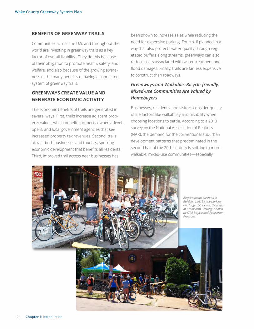
Bicycles mean business in Raleigh. Left: Bicycle parking on Hargett St. Below: Bicyclists at Crank Arm Brewing; photos by ITRE Bicycle and Pedestrian Program.

Chapter 1: Introduction | 13
Wake County Greenway System Plan
“Building our network of trails is an essential investment that enables the Research Triangle Park to remain globally competitive by allowing us to attract the type of workers that companies want with amenities professional workers demand.” - Liz Rooks, Former Executive Vice President of the Research Triangle Foundation
among the higher-educated work force that
Triangle-area businesses aim to attract and retain
in the region. The NAR survey also showed that walkability and shorter commutes are key to community preference, indicating that as the
demand for automobile-dependent development
decreases, communities should be built (and retro-
fitted) with greenway trail connectivity in mind.
Greenways Increase Real Property Values
There are many examples, both nationally
and locally, that affirm the positive connection
between trails, walkability, and property values.
For example, the report “Walking the Walk” by CEO’s for Cities, which looked at 94,000 real estate transactions in 15 markets, found that in 13 of those markets, higher levels of “walkability” were directly linked to higher home values. For other examples, see the Trust
for Public Land’s ‘Economic Benefits of Parks and
Open Space’ and the Rails-to-Trails Conservancy’s
‘Economic Benefits of Trails and Greenways,’ illus-
trating how trails have positively impacted prop-
erty values across the country.
Greenway Trails Offer Transportation Cost Savings
When looking at the returns on investment noted
above, it is also important to put into perspective
the massive differences in costs inherent in the
transportation decisions we make, both as indi-
viduals and as a region. Consider the individual
costs associated with various forms of transpor-
tation. Walking is virtually free and the cost of
operating a bicycle is far less than operating a
car. A study cited by the Victoria Transport Policy
Institute found that households in automobile-dependent communities devote 50 percent more of their income to transportation (more than $8,500 annually) than households in communities with more accessible land use and more multi-modal transportation systems (less than $5,500 annually). Bicycling
and walking are affordable forms of transportation,
and with the relatively low cost and high return
on investment for trails, it is hard to argue against
developing a regional system that creates value
and generates economic activity.
On a broader scale, consider the regional costs
of our transportation infrastructure investments.
According to the Federal Highway Administration,
the basic cost of a single mile of urban, four-lane
highway is between $20 million and $80 million.
For example, the Triangle Expressway cost $1
billion, going roughly 20 miles from the Research
Triangle Park to Holly Springs, coming to $50
million per mile. By contrast, the Neuse River
greenway cost about $1.2 million per mile, in 2016
dollars.

14 | Chapter 1: Introduction
Wake County Greenway System Plan
GREENWAYS ENHANCE BICYCLE & PEDESTRIAN TRANSPORTATION OPTIONS
Surveys by the Federal Highway Administration
show that Americans are willing to walk as far as
two miles to a destination and bicycle as far as five
miles. A complete system of trails in Wake County,
combined with other bicycle and pedestrian infra-
structure, will offer viable opportunities for walking
and biking to nearby destinations. Choosing to
bike or walk rather than to drive, however, is often
made difficult by the way our cities and towns have
developed. The sprawling land use patterns of
many communities in Wake County, combined with
roadway corridors designed for cars only, leaves
many residents with little choice but to drive, even
for short trips. This is not unique to Wake County,
as much of the urban and suburban growth in the
U.S. of the past half-century has been automobile-
dependent. In fact, about 40% of all driving trips made in the U.S. are shorter than two miles, indicating an opportunity to accommodate
those trips by providing the right environment for
people to make them by foot or by bicycle.
GREENWAYS IMPROVE HEALTH THROUGH ACTIVE LIVING
The physical design of communities can provide
permanent, sustainable environments that
support physical activity. For example, when
people are able to live near and get to destina-
tions such as work, shopping, and entertainment
without using automobiles, opportunities for
physical activity through active transport are
increased. The Centers for Disease Control (CDC)
determined that by creating and improving places in our communities to be physically active, there could be a 25 percent increase in the percentage of people who are physi-cally active at least three times a week. The
CDC also reviewed 12 studies on the effectiveness
of community scale urban design and land-use
policies and practices in supporting physical
activity and found an overall median effect size of
161% for some aspects of physical activity, such as
increases in the number of walkers or bicyclists.
This is significant considering that for people
who are inactive, even small increases in physical
activity can bring measurable health benefits. In Wake County, for example, almost two out of three adults (59.9%) is either overweight or obese, and 10% of residents do not engage in any physical activity. At the same time, 95 percent of respondents to this Plan’s public comment form said they would use green-ways more often if they were closer to them or if there were more of them.
Some related findings from the field of health
include:
• “An estimated 10.8 percent of all deaths in the
United States is attributable to physical inac-
tivity.” (Lee, et al.)
Most driving trips in the U.S. are for a distance of five miles or less. Chart from the Bicycle and Pedestrian Information Center, www.pedbikeinfo.org
Daily Trip Distances
Percentage of Travel
Distance Traveled
(in Miles)
10 or less
5 or less
3 or less
2 or less
1 or less
less than 1/2
79.4%
62.7%
48.8%
39.6%
27.5%
13.7%
Chapter 1: Introduction | 15
Wake County Greenway System Plan
• “Every $1 spent building biking trails and
walking paths can save about $3 in medical
expenses. Through GO NC!, BCBSNC hopes
to improve health and reduce obesity-related
medical costs in North Carolina.” (Brad Wilson,
BCBSNC president and CEO)
• “Every $1 investment in trails for physical activ-
ity led to $2.94 in direct medical benefit. The
sensitivity analyses indicated the ratios ranged
from 1.65 to 13.40. Therefore, building trails is
cost beneficial from a public health perspec-
tive.” (Cost-Benefit Analysis of Physical Activity
Using Bike/Pedestrian Trails)
• “From current evidence, we find that urban
river parkways can improve physical, mental,
and community health, and that they are
particularly important in offering opportu-
nity for ‘green exercise’—physical activity in
the presence of nature.” UCLA’s Center for
Occupational and Environmental Health
Greenways Provides Opportunities for Solace in Nature
Another way in which greenways affect health, par-
ticularly psychological health, is through exposure
to nature. Contact with nature has been linked to a
greater ability to cope with life stressors, improve
work productivity, reduce job-related frustration,
increase self-esteem, reduce levels of attention
deficit disorder in children, improve cognitive
ability, reduce aggressive behavior, and provide
greater life satisfaction (Frumkin) (Louv).
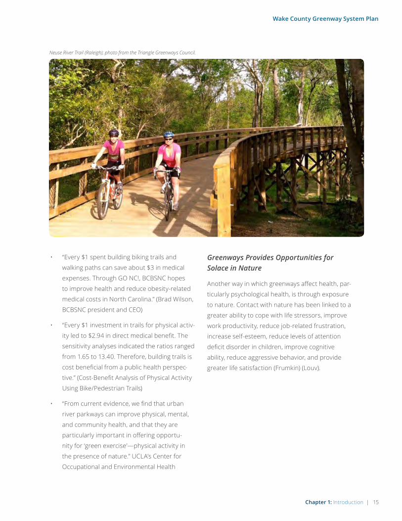
Neuse River Trail (Raleigh); photo from the Triangle Greenways Council.
16 | Chapter 1: Introduction
Wake County Greenway System Plan
GREENWAYS PROTECT WATERWAYS, WILDLIFE HABITAT, AND NATURAL AREAS
There are many environmental benefits from
greenways and open space that help to protect the
essential functions performed by natural eco-
systems. Some of these benefits include carbon
sequestration, airborne particulate capture,
oxygen generation, urban heat-island temperature
moderation, and surface water filtration & infiltra-
tion. As an educational tool, greenway trail signs
can be designed to educate people about their
environment, on topics such as the water cycle
and native plant and animal species. Similarly, a
greenway can serve as a hands-on environmental
classroom for people of all ages to experience
natural landscapes, conduct river clean-ups, and
further environmental awareness. Some of the
largest benefits, however, are those directly related
to water quality, wildlife, and reduced fuel con-
sumption, as described below.
Water Quality Benefits
Natural open spaces around greenway trails help
to protect water quality by creating a natural buffer
zone around streams, rivers, and lakes, preventing
soil erosion and filtering pollution caused by agri-
cultural and road runoff.
We need water for drinking, boating, swimming
and fishing, so improving our water quality by
buffering wetlands and streams is one of the most
powerful benefits of preserving open space. Rivers
become polluted when rainwater picks up motor
oils, fertilizers, litter, pesticides and other pollut-
ants and then “runs off” into streams and creeks,
which empty into rivers, lakes, estuaries and the
ocean. Every time a site is developed with parking
lots, roads and buildings, the amount of water that
soaks into the ground is reduced, and the amount
running off increases. Any land that remains
undisturbed does not contribute pollutants to
our streams and lakes. Open space, particularly
open space surrounding streams, lakes and rivers,
usually contains natural grasses and other veg-
etation that serve as filters, removing pollutants
before they are deposited into our water bodies.
Biodiversity & Wildlife Benefits
Greenways can protect and link fragmented
habitats and provide opportunities for protecting
plant and animal species. Biodiversity is simply
the diversity among and within plant and animal
species in an environment. Biodiverse systems
provide a wide range of ecosystem services, and
have a greater ability to withstand natural and/or
human caused disturbance (resiliency).
Many of the benefits of greenways and open space
depend upon biodiverse systems and the resulting
ecosystem services they provide, such as:
• Soil formation and protection
• Pollution breakdown and absorption
• Water resource protection
• Erosion and flood control
• Nutrient storage and recycling
• Climate stability
• Ecosystem resilience from unpredictable
events/disturbances
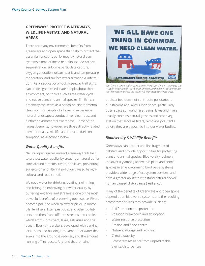
Sign from a conservation campaign in North Carolina. According to the Trust for Public Land, the number one reason that voters support open space measures across the country is to protect water resources.

Chapter 1: Introduction | 17
Wake County Greenway System Plan
Environmental Benefits Of Bicycling And Walking
Bicycling and walking are the two major non-fuel-
consuming, non-polluting forms of transporta-
tion. According to a national walking and bicycling
study by the U.S Department of Transportation
(Publication No. FHWA-PD-93-015), the greatest
environmental benefits of bicycling and walking are
that they conserve roadway and residential space;
avert the need to build, service, and dispose of
autos; and spare users of public space the noise,
speed, and intimidation that often characterize
motor vehicle use, particularly in urban areas. By
far the greatest environmental benefit of bicycling
and walking, according to the study, is that they
bypass need for fossil fuel, and the environmental
issues associated with the use of fossil fuel. Thus,
to the extent that bicycling and walking displace
trips that otherwise would have involved use of
motor vehicles, they enable society to reduce con-
sumption of fossil fuels and the associated pollu-
tion and other environmental damage.
To ensure species diversity, particularly for native species, it is critical to plan for
and protect intact core habitats and their connecting corridors.
CORE
CORE
CORE
CORRIDOR
LINK TO OTHER CORES
• Breeding stocks, population reservoirs
• Food production
• Medicinal resource production – pharmaceuti-
cal drugs
• Wood production
• Genetic diversity
In the 1960’s, ecologists began intensively studying
how habitats in disturbed or urbanized areas func-
tion. The concept of habitat “cores” and “corridors”
has become an accepted model for disturbed hab-
itats. The physical geometry of habitat cores and
corridors affects their overall habitat quality. Large
cores with wide, forested or naturally vegetated
corridors provide the best habitat in developed/
disturbed areas. As core size and corridor width
decreases, so does habitat quality. While corridors
that have no vegetative cover are poor in quality,
they are better than no corridor at all. Generally
speaking, the better the connectivity across cores
provided by corridors, the greater the possibilities
for higher biodiversity. The illustration below sum-
marizes this concept.
18 | Chapter 1: Introduction
Wake County Greenway System Plan
Greenways Protect People and Property from Flood Damage
The protection of open spaces associated with gre-
enway development can also protect natural flood-
plains along rivers and streams. According to the
Federal Emergency Management Agency (FEMA),
the implementation of floodplain ordinances is
estimated to prevent $1.1 billion in flood damages
annually. By restoring developed floodplains to
their natural state and protecting them as green-
ways, many riverside communities are preventing
potential flood damages and related costs.
GREENWAYS ENHANCE CULTURAL AWARENESS AND COMMUNITY IDENTITY
Trails, greenways, and open space can serve as
connections to local heritage by preserving historic
places and by providing access to them. They
provide a sense of place and an understanding
of past events by drawing greater public atten-
tion to historic and cultural locations and events.
Trails often provide access to historic sites such as
battlegrounds, bridges, buildings, and mills that
otherwise would be difficult to access or interpret.
Each community or region has its own unique
history, its own features and destinations, and
its own landscapes. For example, historic sites in
Wake County include Historic Oak View County
Park, Historic Yates Mill County Park, and more
than 200 sites on the National Register of Historic
Places. Cultural and historic groups like the Wake
County Historic Preservation Program could assist
in trail design and programming near historic sites.
By recognizing, honoring, and connecting these
features, the combined results serve to enhance
cultural awareness and community identity, poten-
tially attracting tourism. Being aware of the histori-
cal and cultural context when naming parks and
trails and designing features will further enhance
the overall trail and park user experience.
Finally, greenways and trails provide opportunities
for people to interact with one another outside of
work and their immediate neighborhood. Positive
interaction (such as through exercising, strolling, or
even just saying ‘hello’) among people from a wider
community helps to build trust and awareness
of others, which strengthens the overall sense of
community.
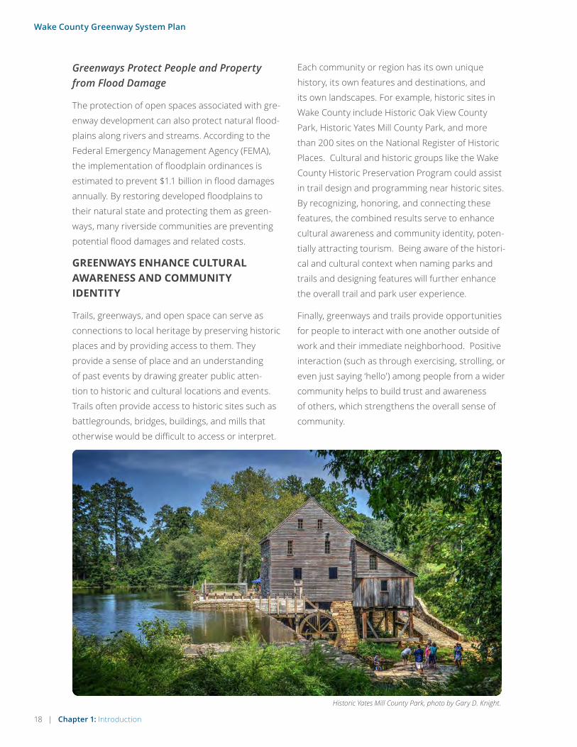
Historic Yates Mill County Park, photo by Gary D. Knight.

Chapter 1: Introduction | 19
Wake County Greenway System Plan
THE PLANNING PROCESS
The planning process included participation and
direction from project committee members,
stakeholders, input from the public, and public
hearing presentations to the Wake County Board of
Commissioners. The timeframe for these and other
steps are outlined at right.
Steering Committee and Stakeholders
The Steering Committee was made up of rep-
resentatives from the following agencies and
organizations:
• Capital Area Metropolitan Planning
Organization
• City of Raleigh
• Town of Apex
• Town of Cary
• Town of Holly Springs
• Town of Knightdale
• Town of Morrisville
• Town of Wake Forest
• Triangle J Council of Governments
• Wake County
Other project stakeholders also included rep-
resentatives from Fuquay-Varina, Garner,
Rolesville, Wendell, Zebulon, the Research Triangle
Foundation, surrounding counties, surrounding
municipalities, and organizations and agencies
related to public health, recreation, transportation,
and tourism.
Key Steps in the Process:
OCTOBER 2015 - Data Collection: GIS
analysis, Steering Committee kick-off
meeting, and launch of project website
and public comment form.
NOVEMBER 2015 - Opportunities &
Constraints: Research existing conditions,
base map production, and two public
input events.
DECEMBER 2015 - Countywide Trail
Coordination Workshop: 47 stakeholders
meet to discuss plan vision and
opportunities for a county-wide network
of trails.
JANUARY 2016 - Preliminary Draft
Plan: Development of draft plan chap-
ters, project prioritization based on
input to-date, and the second Steering
Committee meeting.
FEBRUARY & MARCH 2016 - Draft Plan
Review: Municipal coordination meetings;
Draft Plan released to public for review,
and additional input events.
APRIL-JUNE 2016 - Final Plan: Revisions
based on input to-date, third Steering
Committee; Final Plan presentations in
Spring & Summer 2016.

20 | Chapter 2: Existing Conditions
Wake County Greenway System Plan
“There are lots of great greenway trails; however, many are short in-out spurs. Few are loops that provide interesting, new scenery along its entire length.” - Public Comment
2Existing Conditions
Greenway Plan Public Workshop20 | Chapter 2: Existing Conditions

Chapter 2: Existing Conditions | 21
Wake County Greenway System Plan
OVERVIEW
This chapter summarizes the existing conditions for greenway trails in Wake County, through a regional snapshot, existing conditions maps, public comments, stakeholder feedback, and a summary of support for greenway trails in local and regional existing plans.
Most people feel safe and comfortable using
greenway trails in Wake County because they are
separated from traffic, wide, well-maintained, and
are usually very scenic. In fact, as illustrated in the
summary on the following pages, residents in Wake
County and its municipalities enjoy one of the most
extensive greenway trail systems in the country.
However, the key to a successful greenway trail
network is connectivity; as more greenway trails
are connected to one other, the benefits of any
particular greenway are greatly enhanced, whether
considering the transportation, recreation, health,
or economic aspects of the system. The current inventory of existing trails (see Map 2.4, page 29) shows nearly 300 miles of trail in Wake County, but much of that mileage is in smaller, disconnected sections of local trail, or trails
that are isolated within parks. The exceptions to
this include several large portions of continuously
connected trail, such as the Neuse River Greenway
and the East Coast Greenway route through Wake
County.
Existing Conditions
The American Tobacco Trail in Wake County is a popular section of the East Coast Greenway.

22 | Chapter 2: Existing Conditions
Wake County Greenway System Plan
BOOMING GREENWAY TRAILS IN NORTH CAROLINA’S RESEARCH TRIANGLEContributed by John Pucher, Professor Emeritus, Rutgers University
The Research Triangle of North Carolina (Raleigh-
Durham-Chapel Hill) has been one of the fastest-grow-
ing metropolitan areas in the country. Its population
increased seven-fold between 1970 (317,563) and 2014
(2,132,523). The area has experienced a corresponding
economic boom, thanks largely to the three renowned
universities at each corner of the Triangle: NC State
University in Raleigh, Duke University in Durham, and
the University of North Carolina at Chapel Hill. The
many research institutions and high-tech firms in the
area have attracted highly-educated professionals from
all over the country, so that the Triangle currently has
the highest ratio of doctorates per capita in the United
States.
Accompanying this stunning population and economic
growth, there has been increasing public support for
shared-use greenways. In numerous surveys con-
ducted in the Triangle, investment in greenway expan-
sion and improvement has consistently topped the
ranking of citizen preferences for government expen-
ditures. The widespread support for greenway trails
has also been reflected in voter approval of virtually
all bond referenda to fund more greenway trails. City
governments and the two metropolitan planning
organizations in the area (CAMPO and DCHC MPO)
have also dedicated increasing amounts of their capital
budgets for greenway trails. The NC Department of
Transportation has contributed to funding, often
derived from federal funds for pedestrian/bicycling
projects. In Cary, Knightdale, and Chapel Hill, devel-
opers have been required to build greenways as part
of new developments, and virtually all communities
require the dedication of easements on privately
owned land along rivers, creeks, and lakes to allow
greenway construction.
The result of increased funding and staffing for gre-
enway planning and construction is one of the largest
greenway networks in the country. In 2015, the Raleigh-
Durham- Chapel Hill metropolitan area had almost 300
miles of paved off-road, shared-use trails. The cities
of Raleigh (115 miles), Cary (71 miles), and Durham (30
miles) have the most greenways, but virtually every
community in the Triangle has one or more greenways,
and all of them have ambitious plans for future growth.
The increase in recreational cycling on greenways has
helped generate more on-road cycling as well, and
growing public support for more on-road cycling facili-
ties. In 2000, there were less than 10 miles of on-road
bike lanes in the Triangle, but by 2015, total center-line
mileage of bike lanes (blue lines on map) had grown
to 93 miles, mostly in Durham (36 miles), Chapel Hill-
Carrboro (32 miles), Cary (20 miles), and Raleigh (18
miles). Significant expansion is planned. For example,
Raleigh is planning to double its mileage of on-road
bike facilities by the end of 2016. Cary will increase its
mileage of bike lanes from 20 miles to 27 miles by 2017.
Given the polycentric, decentralized nature of the
Research Triangle, it is crucial to provide regional con-
nections between the greenway networks of individual
cities. The most important of these connecting routes
is the East Coast Greenway (ECG), which connects
Durham to Cary and Raleigh, and which connects the
Triangle Region to the rest of the East Coast via the
2,900- mile ECG route that runs from Maine to Florida.
Of all metropolitan areas the ECG route runs through,
the Triangle has the most complete stretch (95%) of off-
road, shared-use trails on the entire ECG route.
Triangle greenways are typically 10-14 feet-wide paved
trails in 50-150 feet-wide corridors of protected greens-
pace, running along rivers, creeks, and lakes. They were
developed as part of flood management plans, but
equally important, they preserve greenspace adjacent
to all major waterways and tributaries, protect aquatic
and edge habitats, and prevent development of ecolog-
ically sensitive lands. The greenways provide a series
of linear parks throughout each city, providing recre-
ational opportunities for residents and visitors. Many
greenways include playing fields, picnic areas, boating

Chapter 2: Existing Conditions | 23
Wake County Greenway System Plan
facilities, fishing spots, bird watching, nature trails,
outdoor sculpture, and community centers.
Only partial data are available on usage levels, but
an in-person survey of the 71-mile Cary greenways
estimated at least 1.1 million annual users just on
weekends, not including weekday use. Since Cary
has about a fourth of the total mileage of Triangle
Area greenways, that suggests over 4 million annual
users overall, which might be an underestimate
since the Cary survey only counted weekend use.
Indeed, on weekends with good weather, many
parts of the Triangle greenways are overcrowded,
not only with pedestrians, runners, and bicyclists
but also with dog walkers, parents with strollers,
skateboarders, in-line skaters, bird watchers, and
people fishing in the adjacent lakes from the exten-
sive wooden walkways and bridges.
A before-and-after study conducted by the
Institute for Transportation Research (ITRE) at
NC State University found more than a doubling
(133% growth) in walking and bicycling trips on
the American Tobacco Trail in Durham only three
months after the bicycle and pedestrian bridge
over Interstate 40 was completed, thus connecting
the northern and southern portions of the trail.
That dramatic jump in use between 2013 and 2014
demonstrates the importance of such connections
over roadways and waterways for the success of
greenways.
With widespread public support, it seems certain
that the Research Triangle will continue to have one
of the most extensive and best-integrated greenway
systems in the country, supplemented by a growing
network of on-road cycling facilities.
Sources: City departments of transportation and parks and recreation in Raleigh, Durham, Cary, Knightdale, Chapel Hill, and Carrboro; the Capital Area Metropolitan Planning Organization (CAMPO); the Triangle J Council of Governments (TJCOG); county parks, recreation, and transportation departments in Wake County, Orange County, and Durham County; East Coast Greenways; the Institute for Transportation Research and Education (ITRE) at NC State University; and the NC Department of Transportation.
KNOXVILLE CHARLOTTE
ATLANTA RICHMOND RALEIGH-DURHAM
113% 311% 210%
75% 105% 71%
NUMBER OF BICYCLE COMMUTERS IN THE SOUTHEAST U.S.2014
MEMPHIS
2001 % INCREASE
363
775
231
950
489
1517
1048
1837
1185
2431
2163
3689
Source: US Census Bureau, collected by John Pucher.

24 | Chapter 2: Existing Conditions
Wake County Greenway System Plan
EXISTING CONDITIONS MAPS
The existing conditions maps on the follow-
ing pages provide insight into the demographic,
environmental, and existing trail makeup of Wake
County, for purposes of a bigger picture under-
standing of regional need and opportunities.
Map 2.0 Wake County Study Area
The study area for this project, Wake County, is
857 square miles and just over 1 million in popula-
tion. Opportunities exist to connect the County’s
municipalities, regional parks, and lake features.
Challenges include trail connectivity across major
roadway corridors such as I-40/440, I-540, US 1,
US 70, and others.
Map 2.1 Social Equity/Community Assessment Index
When evaluating the need for greenway infrastruc-
ture, it is important to understand the makeup of
vulnerable populations and populations in need.
Greenway trails can serve multiple purposes for
these areas including access to transportation
choice for those without vehicles and opportu-
nities for healthy living for those who may trend
towards inactive lifestyles. This assessment was
used to help inform the overall list of trail recom-
mendations, as shown in Table 3.1 Summary of
Projects, in Chapter 4.
Map 2.2 Environmental Features
This map features the wide variety of land uses
ranging from undeveloped forests to higher
density development in cities. Sprawling devel-
opment has occurred in the county, leaving
undisurbed land as the exception to the rule.
Retrofitting greenway trails will be a challenge in
built-out landscapes. However, because of the
work of County and municipal planners, many
corridors have been protected for open space and
future greenway trail use.
In lesser developed areas and farmlands, such as
eastern Wake County, a desire for environmental
protection and maintaining the rural heritage will
be an important aspect of consideration for green-
way theming and development.
Map 2.3 Population and Destinations
Connecting population centers, where people live,
work, and play, is essential for consideration in the
development of a successful greenway system. It
will also be important to connect greenway trails
to key destinations when possible to promote
tourism. There are a number of municipal down-
towns, historic sites, transportation hubs, colleges,
parks, schools, shopping centers, and employ-
ment centers that would benefit from greenway
connections.
Map 2.4 Existing Trails
Wake County features almost 300 miles of existing
greenway trails, including over 100 miles in the City
of Raleigh and over 70 miles in the Town of Cary
alone. The East Coast Greenway spine traverses
the Triangle region, coming through Durham as
the American Tobacco Trail, and extending through
Cary and Raleigh, to the Neuse River Greenway.
Only a couple short sections are remaining to
complete the East Coast Greenway through this
region. At 33 miles, the Neuse River Greenway is
the longest continuous trail in the state of North
Carolina, connecting Wake County to Johnston
County. Dozens of miles of trail can also be found
in Umstead State Park and Falls Lake.

Chapter 2: Existing Conditions | 25
Wake County Greenway System Plan
WAKE COUNTY STUDY AREA
5-Mile/30 Minute Bike Ride to Center
10-Mile/60 Minute Bike Ride to Center
MAP 2.0

26 | Chapter 2: Existing Conditions
Wake County Greenway System Plan
SOCIAL EQUITY/VULNERABILITY ASSESSMENTMAP 2.1

Chapter 2: Existing Conditions | 27
Wake County Greenway System Plan
ENVIRONMENTAL FEATURESMAP 2.2
MIDDLE CREEK CORRIDOR
SWIFT CREEK CORRIDOR
FALLS LAKE
HARRIS LAKE
JORDAN LAKE
WALNUT CREEK CORRIDOR
CRABTREE CREEK CORRIDOR LITTLE RIVER CORRIDOR
MARKS CREEK CORRIDOR
NEUSE RIVER CORRIDOR

28 | Chapter 2: Existing Conditions
Wake County Greenway System Plan
POPULATION AND DESTINATIONSMAP 2.3

Chapter 2: Existing Conditions | 29
Wake County Greenway System Plan
EXISTING TRAILSMAP 2.4
WALNUT CREEK TRAIL
WHITE OAK GREENWAY
BEAVER CREEK GREENWAY
BASS LAKE GREENWAY
S GARNER TRAIL
JEFF WELLS TRAIL
ROCKY BRANCH TRAIL
CRABTREE CREEK GREENWAY
NEUSE RIVER TRAIL
NEUSE RIVER TRAIL
BLACK CREEK GREENWAY
SMITH CREEK GREENWAY
SANFORD CREEK GREENWAY
MINGO CREEK GREENWAY
AMERICAN TOBACCO TRAIL
REEDY CREEK TRAILUmstead State Park
RDU

30 | Chapter 2: Existing Conditions
Wake County Greenway System Plan
Public Process Overview
25 LOCAL ORGANIZATIONS CONTACTED THROUGH FACEBOOK
27 PUBLIC HIGH SCHOOLS CONTACTED FOR PLAN OUTREACH
2,300+ PUBLIC COMMENT FORMS
1,400+ UNIQUE VISITORS TO THE PROJECT WEBSITE
47 STAKEHOLDERS AT THE REGIONAL TRAILS COORDINATION WORKSHOP
5 OUTREACH SESSIONS AT LOCAL EVENTS
16 STEERING COMMITTEE MEMBERS, WITH 3 OFFICIAL MEETINGS
4 DRAFT AND FINAL PLAN PRESENTATIONS
KEY TYPES OF MEETINGS & PUBLIC INPUT:
GENERA
L PUB
LICSTAKEH
OLD
ERS
STEERING
CO
MM
ITTEE
CommitteeMeetings
StaffMeetings
Draft & Final Plan
Presentations
PublicOutreach at Local Events
Outreach to Local Schools
ProjectWebsite
FacebookPosts by
Local Orgs
PublicComment
Forms
Mass/Group
E-mails
30 | Chapter 2: Existing Conditions
Wake County Greenway System Plan
Regional Trails
Workshop
MunicipalMeetings
E-mail and Phone Outreach

Chapter 2: Existing Conditions | 31
Wake County Greenway System Plan
Images from the December 2015 Regional Trails Coordination Workshop.
“We live in one of the most beautiful places on
earth, and yet our past successes provide no
assurances of future successes. If we don’t start
planning now and protect our great quality of life
in Wake County, it will slowly start slipping away.”
- Sig Hutchinson, Wake County Commissioner
GENERA
L PUB
LIC

32 | Chapter 2: Existing Conditions
Wake County Greenway System Plan
STAKEHOLDER COMMENTS ON EXISTING CONDITIONS
In December 2015, nearly 50 project stakeholders
met for a countywide trail coordination work-
shop. The purpose of this inter-jurisdictional
workshop was to better understand local priori-
ties and opportunities for greenway connectivity.
The meeting was introduced by Wake County
Commissioner Sig Hutchison, highlighting a suc-
cessful and challenging history in greenway trail
development in Wake County. Greenway expert
Chuck Flink (FASLA) gave the opening presentation,
which focused on the emergence of regional trail
systems in other parts of the United States, and
touched on funding and partnership strategies for
implementation. After the opening presentation,
project consultants then facilitated discussions
in small groups, covering how to build support
for greenways, the challenges and opportunities
related to trail development, and the key factors to
consider for trail project prioritization.
Building Support for Greenway Trails in Wake County
For the first discussion topic, stakeholders were
asked, “What are the key messages needed to
build public support for greenway trails in Wake
County?” Stakeholder responses focused on com-
municating the benefits of trails and how trails will
make the region’s communities more livable. Some
stakeholders pointed out that the public support
for greenways is already there now, and that trail
proponents could be more aggressive in building
upon the current levels of support. “Connectivity”
was suggested as an overarching theme to focus
on, with the following other benefit-related topic
areas:
• Health, Wellness, and Happiness: Stakeholders
suggested the message should be very
positive, highlighting health, wellness, and
happiness.
• Safety: Examples included teaching how to ride
bicycles safely and communicating the need
for more “off-road” bicycle and pedestrian
facilities that do not require sharing space with
automobiles.
• Environmental Protection: Locals and visitors
alike should know this is a place that cares
about the environment, and the trail system
could be a way to promote that. The trail
system could be a tool for education in nature,
and for actual protection of water resources
and habitat along greenway corridors.
• Social Equity: Greenways should be places
that bring people together and build commu-
nity. Trail-related outreach and programming
events should be used to promote greenways
as inclusive public places for a diverse range of
people. Local art, history, culture, and native
plants could all be incorporated into certain
trail features or trail programs.
• Economic Benefits: Greenway planners should
focus on property values and how trails can
support local businesses. Mobile apps, paper
maps, wayfinding, and strategically located
trail heads (parking), can be used to promote
trail tourism in the region, and to direct trail
users to nearby businesses. Planners should
quantify the return on investment for the
trail system and communicate it to potential
funding partners, decision-makers, and voters.
• Communications: Salient examples of success-
ful greenway trails should be communicated,
focusing on what is already happening in
Wake County with respect to greenways. Key

Chapter 2: Existing Conditions | 33
Wake County Greenway System Plan
Many developers understand the positive impact of trails on property values, and they use them to market their projects; left and below are examples of two magazine advertisements from developers that focus their marketing on greenways. These images are from ads in North Carolina and Florida.
At the award-winning Fishhawk Ranch, nearly 30 miles of
trails weave throughout the community, connecting the
many parks, amenities, villages and neighbors. Soon to be
one of the largest community trail systems in the country, each pathway was carefully
positioned to minimize the impact on the existing plant life.
outreach efforts could center around a coor-
dinated campaign among local and regional
tourism and visitor bureaus, including a strong
social media component and an overall brand-
ing of the trail system for “brand recognition.”
Special effort should be made to reach out to
smaller communities to build support for trails.
Challenges and Opportunities for Trail Development in Wake County
The second discussion topic was on the key
challenges and opportunities to trail develop-
ment in Wake County. Key themes in stakeholder
responses included the topics of trails and devel-
opment, funding, and overcoming physical and
social barriers to trail development.
• Trails and Development: With several repre-
sentatives from the residential development
community, some discussions focused on
how developers can play a more active role in
greenway trail development. Some develop-
ers want to include greenway trails in devel-
opment, but some are still not interested.
A desire for mutual benefit was expressed,
using each other’s interests to find a solution.
Developers want to be compensated, credited,
or recognized for dedicating greenway space,
and dislike being singled-out to bear the costs
of greenway trail dedication. For example,
impervious surface calculations can limit
trails within some new developments, and a
credit or exception for trails would help offset
that barrier. Some developers also feel that

34 | Chapter 2: Existing Conditions
Wake County Greenway System Plan
existing landowners, in places that are already
developed, should somehow contribute to the
cost of providing the facility. From the munici-
pal perspective, they would like to see more
developers providing greenway trail infra-
structure, the same way they are required to
provide sidewalks and roadways. Ultimately,
both local governments and developers want
to see burden shared in some way – which
speaks to the inter-stakeholder effort needed
to create a regional greenway system. One
potential solution could be to highlight model
developer partnerships, model community
policies, and model incentives for developer-
driven construction. Communicating the
potential developer benefits was also men-
tioned, such as the potential increase in prop-
erty values and sales.
• Funding: The role of Wake County was brought
up several times in the discussion of funding,
and whether or not they would be able to play
a role in filling the gaps between municipalities
and between existing trails. The challenge of
“the last mile” was brought up, referring to the
difficulty in completing trail segments on the
fringes of communities (between municipali-
ties and between Wake and surrounding coun-
ties). There may be an opportunity for Wake
County to play a role in incentivizing those
connections at the edges of jurisdictions, and
at the very least, facilitating communication
and coordination across jurisdictions
• Physical Barriers: The discussion of physi-
cal barriers revolved around both natural
and man-made factors in trail development.
Natural barriers, such as crossing wetlands
and waterways present design challenges, par-
ticularly in finding solutions that are cost-ef-
fective. Similarly, man-made barriers, such as
railroads and major highways, present their
own design challenges, which are also often
expensive, such as trail overpasses and under-
passes. For example, the “Complete 540”
project is an example of a potential physical
barrier for trail connectivity, and US 64 is an
example of an existing barrier in connectivity
(for Apex and Cary). Other man-made fea-
tures may present opportunities for connec-
tivity, such as utility corridors. Public sewer
corridors are used as a key part of many trail
systems, and private utilities, such as power
and gas, have their own guidelines for trail
development within their corridors.
• Barriers Related to Operations, Management,
and Programming: Community trails some-
times face skepticism because of a lack of
understanding regarding the safe opportu-
nities that trails offer residents for recreation
and transportation, and the need to address
this misconception was brought up by project
stakeholders (see the opposite page for more
on trail safety and crime prevention). The most
common “not in my backyard” sentiments
towards trail development can be offset in
several ways. First and foremost, if trails are
built as part of new development, they are a
known factor from the start, and are seen as
an asset from the beginning. In the case of
“retrofitting” trails, or planning and construct-
ing them in a place that is already developed, a
comprehensive outreach and education effort
is often needed. In addition to the typical
communication about the benefits of trails
and the reality of crime on greenways, these
efforts could include testimony from residents
in other parts of the region that currently live
near trails and enjoy them. Particularly helpful
are those that were previously opposed to
trails that now support them in their own
community. For example, trail planners in
Wilmington, North Carolina, use video testi-
mony from such residents as a communication
tool.

Chapter 2: Existing Conditions | 35
Wake County Greenway System Plan
Stakeholder Input on Prioritization
The third discussion topic was about greenway
planning priorities, and what factors to consider in
prioritization. The main theme from stakeholder
responses to this question centered on the need
to make shorter, local connections first, filling gaps
in the existing trails system. This would be fol-
lowed by connections to downtowns and popula-
tion centers. The general consensus was to focus
on the “spokes” of the overall countywide gre-
enway system first, with at least one main artery
through each municipality, followed by the “outer
rings” of the system.
Another theme of the prioritization discussions
was on greenways for transportation versus rec-
reation, and destination-based priorities in rural
versus urban areas. Context-dependent criteria
was discussed, in which urban area priorities could
focus on trails as transportation, closing gaps
and making connections from neighborhoods
to trails and trailheads, so people do not have to
drive. Rural communities could then focus on
low-hanging fruit and trails as recreation, making
connections to local parks, schools, or day trip
destinations, such as regional parks and neighbor-
ing towns.
Stakeholder Input on Mapping and North Carolina as the “Great Trails State”
After the stakeholder group discussions, project
consultants then facilitated mapping exercises in
small groups, gathering input on a working draft
of proposed county connectors that was based
on existing trails and proposed trails from existing
plans. Input from that exercise is reflected in this
Plan’s existing conditions maps and recommenda-
tions maps. The meeting concluded with a presen-
tation from greenway expert Iona Thomas (AICP),
focusing on North Carolina’s potential as a “Great
Trails State,” with emphasis on local successes and
the need for trail marketing.
TRAIL SAFETY AND CRIME PREVENTION
The rate of crime on trails and greenways does not
exceed the rate of crime in the communities that
surround trails and greenways. In fact, a national
study of 372 trails demonstrated that serious and
minor crimes were much lower on urban, subur-
ban and rural trails than the national crime rates
for urban, suburban and rural areas. For example,
a study in Charlotte, North Carolina, examined
properties neighboring fourteen Charlotte gre-
enways and found the rates of property crimes
to be either insignificantly different or lower than
the rates in the surrounding neighborhoods.
Still, working with police remains an important part
of ensuring that a trail is safe to use. Regular police
involvement—especially patrols by bike—can deter
crime in many types of public spaces, including trails.
See this Plan’s Chapter 3, Recommendations, for more
on programs related to trail design and trail safety.
Sources:
• Martin, W., Ludden, T., Furuseth, O., and Nixon, S. “Preliminary assessment of crime risk along greenways in Charlotte, North Carolina.” 2004. Unpublished UNC-Charlotte study.
• Tracy, T., and Morris, H. “Rail-trails and safe communities: The experience on 372 trails”. 1998. National Rails-to-Trails Conservancy. Web. 4 December 2015.
• Rails-to-Trails Conservancy. “Police Work and Safety”. 2015. Web. 4 December 2015.

36 | Chapter 2: Existing Conditions
Wake County Greenway System Plan
PUBLIC COMMENTS ON EXISTING CONDITIONS
The public comment form was active between
November 2015 and March 2016. It was available
online through the project website and in hardcopy
at outreach events and meetings. People through-
out Wake County were encouraged to fill-out these
forms through the mass-email lists of project com-
mittee members and stakeholders, through social
media (Facebook), and through municipal website
announcements.
There were more than 2,300 respondents to the
public comment form. Although not statistically
valid, the results that follow still reflect the voices
of 1000s of Wake County residents who have an
interest in the region’s greenway trails. Summary
responses are displayed below; for full results,
please contact Wake County Parks, Recreation and
Open Space (PROS).
How important to you is the goal of creating more greenways in Wake County?
Public input through maps and public comment forms in Fall 2015.

Chapter 2: Existing Conditions | 37
Wake County Greenway System Plan
In your opinion, what are the most important benefits and uses of a greenway system? Select all that apply.
Transportation/Connectivity to
Destinations
Recreation/Fitness
Access to Nature/Outdoors
Habitat and Environmental
Protection/Awareness
Economic Development/
Quality of Life
How often do you use a greenway now?
Would you use greenways more often if you were closer to them, or if there were more of them?

38 | Chapter 2: Existing Conditions
Wake County Greenway System Plan
What destinations would you most like to get to by greenway? Select all that apply.
Place of Work
School
College/University
Shops and Restaurants
Public Transportation
Parks/Playgrounds
Natural Areas/Open Spaces
Other Greenways
Libraries or Recreation Centers
What do you think are the biggest factors that discourage greenway use? Select all that apply.
Lack of Safe Connections to Geenways
Lack of Information About Existing Greenways
Unsafe Street Crossings
Motor Vehicle Traffic
Lack of Interest
Lack of Time
Lack of Nearby Destinations
Personal Safety Concerns
Chapter 2: Existing Conditions | 39
Wake County Greenway System Plan
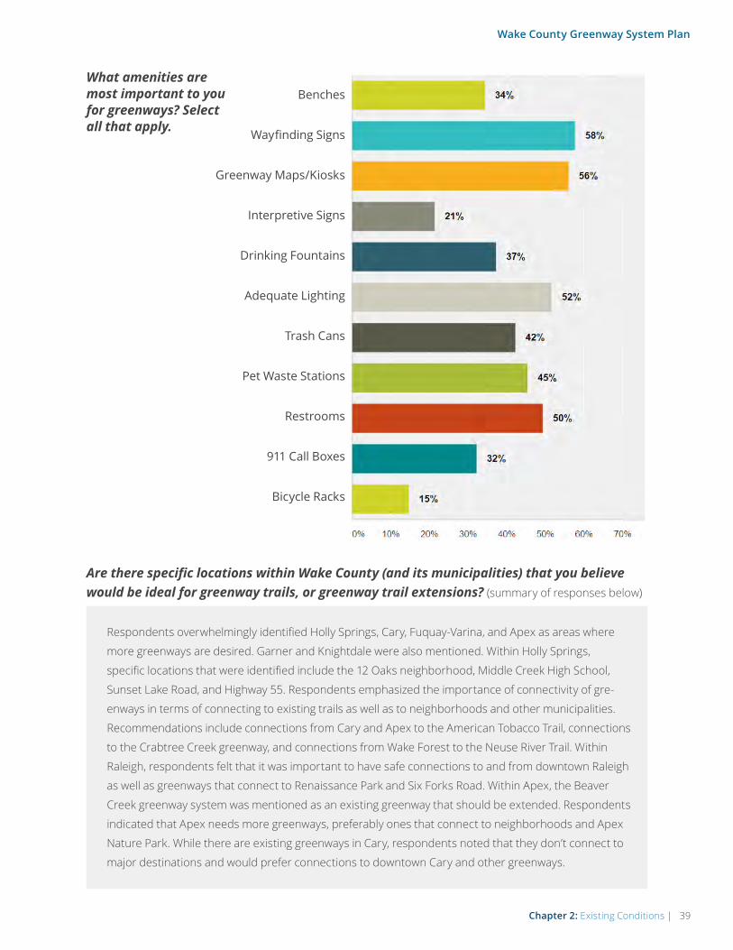
What amenities are most important to you for greenways? Select all that apply.
Benches
Wayfinding Signs
Greenway Maps/Kiosks
Interpretive Signs
Drinking Fountains
Adequate Lighting
Trash Cans
Pet Waste Stations
Restrooms
911 Call Boxes
Bicycle Racks
Are there specific locations within Wake County (and its municipalities) that you believe would be ideal for greenway trails, or greenway trail extensions? (summary of responses below)
Respondents overwhelmingly identified Holly Springs, Cary, Fuquay-Varina, and Apex as areas where
more greenways are desired. Garner and Knightdale were also mentioned. Within Holly Springs,
specific locations that were identified include the 12 Oaks neighborhood, Middle Creek High School,
Sunset Lake Road, and Highway 55. Respondents emphasized the importance of connectivity of gre-
enways in terms of connecting to existing trails as well as to neighborhoods and other municipalities.
Recommendations include connections from Cary and Apex to the American Tobacco Trail, connections
to the Crabtree Creek greenway, and connections from Wake Forest to the Neuse River Trail. Within
Raleigh, respondents felt that it was important to have safe connections to and from downtown Raleigh
as well as greenways that connect to Renaissance Park and Six Forks Road. Within Apex, the Beaver
Creek greenway system was mentioned as an existing greenway that should be extended. Respondents
indicated that Apex needs more greenways, preferably ones that connect to neighborhoods and Apex
Nature Park. While there are existing greenways in Cary, respondents noted that they don’t connect to
major destinations and would prefer connections to downtown Cary and other greenways.

40 | Chapter 2: Existing Conditions
Wake County Greenway System Plan
What is your connection to Wake County? Select all that apply.
Please share where you live, so we can better ensure broad participation in the comment form.
I I live in Wake County.
I work in Wake County.
I go to college in Wake County.
I own property in Wake County.
I own a business in Wake County.
I visit/spend time in Wake County.
Apex
Unicorporated Wake CountyZebulonWendell
Wake Forest
Rolesville
Raleigh
Cary
Holly Springs
Garner
Fuquay- Varina
Knightdale
Morrisville

Chapter 2: Existing Conditions | 41
Wake County Greenway System Plan
“My husband and I were just talking about how we would love to ride our bikes from home to downtown, the library, etc., but there is no safe way for us to get there. We currently live near Sunset Lake and Holly Springs Roads, and both include spots that are too dangerous for bikes so a greenway would be perfect.”
“Southern wake county (Garner) has little to no greenways or parks. The majority of these are centered around areas with higher income populations like Holly Springs, Cary, etc. The middle and lower income residents could benefit greatly to having a greenway connected to the larger system for use, recreation, and health benefits.”
“There are lots of great greenway trails; however, many are short in-out spurs. Few are loops that provide interesting, new scenery along its entire length. Also, many cross busy roads that are dangerous to get children across safely.”
“I would like more to connect in Cary. There are a few nice ones but most of them are short and don’t really go anywhere.”
“Apex does not have a continuous system of greenways so would love to see them extended and joined into one large greenway.”
“I would love to see better connections around schools. It just makes sense for students and school staff to be able to use greenways to walk/bike to school. The issue at the moment is that our greenways are not necessarily laid out with active student transportation in mind. I would especially love to see more of this around high schools, but all schools.”
“I think Raleigh has done a fabulous job with the greenway system and look forward to it expanding more.”
“More greenways where we can cycle or walk to the grocery store, restaurants etc are welcomed.”
“With traffic getting heavier through Fuquay, it would help to have increased connectivity through an extended greenway network. It would also help the area grow more sustainably.”
“The Greenway is one aspect of living in Raleigh that has increased my standard of living significantly. Please keep expanding, because I love to bike, but not on the road!”
“I’m very pleased to learn of expansion plans for the greenway system. As an active cyclist, I enjoy riding the greenways far more than the roads due to the enhanced safety compared to riding with vehicular traffic.”
“I really like the greenways. The more the greenways the better it is for the community.”
“Greenways are a great way to promote the outdoors and provide a safer place to walk, run, and bike.”
“I love the greenways and it’s a huge part of why I live here. Please connect more of them to increase the riding distance.”
“Greenways are a tremendous asset. Keep investing in them.”
Are there other comments you would like to share about the greenway plan?
Almost 30% of survey respondents provided additional comments about the greenway plan. Overall, responses were
positive and respondents are eager to see continued progress towards improving and building more greenways in
Wake County. A major theme was the emphasis on connectivity, especially in terms of connecting existing greenways in
Wake County. Due to increasing traffic congestion, respondents indicated that they would like to use the greenways for
commuting to work if they connected to major destinations and residential areas. Respondents believe that greenways
are a safer and more accessible option for biking, but indicated that they would prefer greenways to be separated from
traffic or busy roads. Another major theme that emerged was the recognition that greenways are a major boon for
tourism as well as property values. While there weren’t many negative comments, respondents indicated that mainte-
nance of greenways could be improved. In particular, wooden bridges and boardwalks tend to become slippery when
they are wet and pose safety hazards for bicyclists. Below are sample quotes from the responses to this question:

42 | Chapter 2: Existing Conditions
Wake County Greenway System Plan
SUPPORT FOR GREENWAYS IN EXISTING PLANS
Wake County and its municipalities have a long
history of greenway planning. The City of Raleigh’s
1972 Capital City Greenway report, by Bill Flournoy,
explained the greenway concept as it could be imple-
mented in Raleigh, and suggested how a program
might be created. Today, each of Wake County’s 12
municipalities have their own plans for greenways,
some in stand-alone citywide greenway master plans,
others as part of larger citywide transportation or rec-
reation planning initiatives. The table below provides
brief summaries and highlights from the most rele-
vant and current greenway planning initiatives in each
community, including some plans that are regional in
nature, or from neighboring jurisdictions.
These do not represent all plans in these communi-
ties, but rather the most relevant and recent plans that
address issues related to this Wake County Greenway
System Plan.
Cover of the 1972 Capital City Greenway report by Bill Flournoy.
SUPPORT FOR GREENWAYS IN EXISTING PLANS
WAKE COUNTYParks and Recreation Master Plan (2008)
The plan outlines goals and strategies for Wake County to focus on in order to
protect the environment and provide recreational opportunities for its residents.
Results from the citizen survey indicated that Lake Crabtree County Park was the
most visited park. In addition, walking and hiking trails were the highest rated new
facilities that citizens want. Three major trail projects were identified: Swift Creek
Greenway, Neuse River Greenway, and extension of the American Tobacco Trail
South. In this plan, Wake County also identified four potential future County Park
facilities. They are Lake Myra County Park, Little River County Park, Southeast Wake
County Park, and the Brady Jefcoat Property. Park Facility Master Plan Updates (2016)
The purpose of this plan is to update the Master Plans for each of the County’s
parks. One of the goals is to participate in the planning and collaboration of munici-
pal and regional trail and greenway plans. The plan includes an existing conditions
analysis of Wake County’s 6.5-mile portion of the American Tobacco Trail, along with
recommendations for improving the trail. Potential recommended improvements for
the ATT include: User orientation and wayfinding, access to water, parking, lighting,
shelters, and bike repair stations.

Chapter 2: Existing Conditions | 43
Wake County Greenway System Plan
Open Space Plan (2006)
This plan promotes the protection of at least 30% of Wake County’s land and water
as permanent open space. Five types of greenways are proposed: 1) no facility
development, 2) limited development, low-impact uses, 3) Multi-Use Unpaved Trail
Development, 4) Multi-Use Paved Trail Development, 5) bike and pedestrian facilities
in rights-of-way. Recommendations are outlined according to those adopted in open
space, greenways, and/or park plans for each municipality in Wake County.
Transit Plan (2015)
The transit plan focuses on enhanced transit within the county. Recommendations
include strengthening cross-county connections via a commuter rail line and
enhanced bus service, connecting all 12 municipalities, expanding the network and
BRT service, and increasing the frequency of service. There is no mention of con-
necting transit service to greenways or trails, although the plan prioritizes enhancing
transit service in urban cores and employment centers. Trails and Greenways of Wake County: pocket guide and community resource
This resource provides a listing of all the trails and greenways in each of the 12
municipalities of Wake County and provides maps of the parks, greenways, and trails.
This resource is currently out of print, but demand for these hardcopy maps has
remained consistently high.
CITY OF RALEIGHCapital Area Greenway Planning & Design Guide (2014)
This plan, by the Parks, Recreation and Cultural Resources Department, identifies
existing and proposed portions of the Capital Area Greenway System. The Capital
Area Greenway Trails Composite Map shows existing and proposed greenway trails.
The plan’s “Cross City Greenway Trails” are particularly relevant to regional connectiv-
ity, including the Reedy Creek Trail, Rocky Branch Trail, Crabtree Creek Trail, and the
Neuse River Trail.TOWN OF APEXParks, Recreation, Greenways, and Open Space Master Plan Map (2015)
According to this plan, “Greenways are the highest priority for Apex residents. They
desire easy access to greenways from their homes, and want to be able to travel to
parks, commercial centers, work, and schools on a system of well connected paths
and bicycle facilities.” Top trail priorities from this plan include: 1) American Tobacco
Trail (ATT) connections, including: Jaycee Park to Downtown (1,500 LF); Kelly Road
Park to Apex Nature Park (1.2 miles); and Apex Nature Park to American Tobacco
Trail (2.3 miles), 2) Middle Creek Greenway connection to ensure safe crossing at
the future I-540, and 3) White Oak Creek Greenway through Apex and to the ATT,
working in collaboration with the Town of Cary.

44 | Chapter 2: Existing Conditions
Wake County Greenway System Plan
TOWN OF CARYParks, Recreation, and Cultural Resources Master Plan (2012)
This plan details key trail connection corridors that link parks, schools, cultural
and business centers, open space, other trails, and adjacent jurisdictions. Primary
Greenway Trail Recommendations include: 1) Umstead to ATT, 2) RTP to Middle
Branch, 3) Umstead to Hemlock Bluffs, 4) Downtown to Raleigh, and 5) Crabtree to
ATT.
TOWN OF FUQUAY-VARINACommunity Pedestrian Master Plan (2013)
In this plan, the top priority shared use path project is the Angier Road Sidepath
(all other top projects are for sidewalks). This path would provide access to Fuquay
Mineral Spring Park, Fuquay-Varina Public Library, and the proposed Town walking
loop route.TOWN OF GARNERComprehensive Parks, Recreation, and Greenways Master Plan (2007)
This plan serves as a guide for expansion of future parks and recreation facilities and
programs. Residents who participated in the planning process listed walking and
pedestrian-related facilities as their highest priority. Walking is the highest ranked
activity that respondents would like to see the Town of Garner provide facilities
for over the next 10 years. Immediate greenway and sidewalk needs are: 1) North
Garner Greenway, 2) Downtown Pedestrian Route, 3) Garner Loop, and 4) North-
South Greenway. Near-term greenway and sidewalk needs include: 1) Timber Drive
Sidewalk Connector, 2) West Garner Connector, 3) East Garner Schools Connector, 4)
Mahler’s Creek Greenway, and 5) Swift Creek Greenway Phase 1.TOWN OF HOLLY SPRINGSParks, Recreation, and Open Space Master Plan (2007)
Greenway corridors have been identified along the Colonial Pipeline, along Sunset
Lake and Sunset Lake Road, from the White Oak greenway trail to Apex municipal
trails and to New Hill-Holleman Road at Friendship Park. Greenway trails would be
established from the Fuquay-Varina railroad corridor to other Fuquay-Varina green-
way trails and to Buckhorn Creek. Trails will also be established from Friendship Road
and New Hill-Holleman Road to the American Tobacco Trail corridor.TOWN OF KNIGHTDALEKnightdale Parks, Recreation, and Open Space Master Plan (2010)
The overaching goal of Knightdale is to be an active, engaged community and the
objectives outlined in this plan support this goal. The following greenway corridors
are recommended for improvement with a minimum 10-foot wide multi-purpose
paved trail: Mingo Creek, Beaverdam Creek, Mark’s Creek, Poplar Creek, Clark’s
Branch.
TOWN OF MORRISVILLEParks and Recreation Master Plan (2011)
The 2011 Parks and Recreation Master Plan focuses on the recreational needs of the
community and how to accommodate them for the next ten years. The main pro-
posed greenways are along Chapel Hill Road, McCrimmon Parkway, and Morrisville
Parkway.

Chapter 2: Existing Conditions | 45
Wake County Greenway System Plan
TOWN OF ROLESVILLERolesville Open Space and Greenways Plan (2002)
The purpose of the plan is to protect natural and cultural resources. The plan calls
for stream buffer zones, greenway corridors, bike routes, and scenic road desig-
nation for at least five corridors. Trails identified in the adopted map include the
Buffalo Creek Trail, Sanford Creek Trail, Toms Creek Trail, Cedar Fork Trail, and Perry
Creek Trail. TOWN OF WAKE FORESTWake Forest Open Space & Greenways Plan Update (2009)
The greenway system recommendations of the Wake Forest Open Space and
Greenways Plan are broken down into two primary phases for future development:
Phase 1 - Smith Creek and Dunn Creek Corridors (key north/south corridors that
connect Wake Forest with the Neuse River), and Phase 2 - Richland Creek, Sanford
Creek, and the NC 98 Bypass Corridors.TOWN OF WENDELLZebulon & Wendell Open Space Plan (2002)
This document is meant to be a visionary plan, which identifies potential open space
and greenway corridors throughout the study area. It is the Town of Wendell’s desire
to update this plan in the near future to account for changes which have occurred
since its adoption in 2002. One of the plan’s top objectives is to develop multi-pur-
pose recreational trails, specifically to acquire land for a Zebulon-Wendell Greenway
between the towns, and to acquire property for regional trail heads and a water
quality demonstration project along the Little River Corridor.TOWN OF ZEBULONZebulon Greenways Master Plan (2015)
Ten greenway corridors are recommended in this plan. The two priority projects
are Corridor 1 - Spiderlily Court cul-de-sac in the Taryn Meadows neighborhood to
Pippin Road (including the trail around Hendricks Pond in the Weavers Pond neigh-
borhood); and Corridor 3 - Wake County Branch Library and Eastern Regional Center
to the Zebulon Elementary School and the Boys and Girls Club (and adjacent residen-
tial development).REGIONAL PLANS/STAKEHOLDER ORGANIZATIONS & AGENCIES2040 Long Range Transportation Plan
The 2040 Long Range Transportation Plan (2040 LRTP) lists future highway, bus
transit, light rail, bicycle, pedestrian and other transportation projects to be imple-
mented through the year 2040. One of the goals of the plan focuses on the pedes-
trian and bicycle system that will support recreational opportunities and includes
off-road trails. The 2040 MTP recommends extensive integration of bicycle needs
into the design and construction of new highways and future and ongoing transpor-
tation projects. Maps included in the plan display off-road bicycle and pedestrian
facilities in conjunction with on-road facilities that will receive bicycle-pedestrian
accommodations only. Capital Area MPO Northeast Area Study (NEAS) (2014)
The Northeast Area study evaluated the multi-modal network and land use sce-
narios for northeastern Wake County, southern Franklin County, and Knightdale,
Wendell, Zebulon, Rolesville, Youngsville, Franklinton, Bunn, and parts of Raleigh and
Wake Forest.

46 | Chapter 2: Existing Conditions
Wake County Greenway System Plan
Capital Area MPO Southeast Area Study (SEAS)
This study includes portions of Wake County, including Garner and part of Raleigh.
The plan will update CAMPO’s overall Comprehensive Transportation Plan and will
produce project priorities to be included in the next Metropolitan Transportation
Plan. The study is currently underway. The top three planning themes that were
identified during the first public symposium are network connectivity, active trans-
portation, and economic vitality. Among the priorities identified, a common theme
was that “sidewalks, greenways, and bike facilities are needed to connect to activity
centers.”Capital Area MPO Southwest Area Study
The study seeks to create a long-term sustainable transportation strategy for the
area. The study area includes the southwestern portion of Wake County and north-
ern portion of Harnett County including the towns of Angier, Apex, Fuquay-Varina,
and Holly Springs. Key recommended greenways displayed in the proposed green-
ways map are along Middle Creek, Highway 55, Kenneth Creek, and Neills Creek.Center of the Region Enterprise (CORE) Pedestrian, Bicycle, Green Space Plan (2012/2016 Update)
This plan was prepared by the Triangle J Council of Governments (TJCOG). It is
intended to help the municipalities, counties and organizations, like the Research
Triangle Foundation, located in the CORE area of the Triangle, create a linked network
of pedestrian, bicycle, and green space facilities. According to the Plan’s Map 6: Bike
Top Priorities, the top projects in Wake County include the following (from north to
south): TW Alexander, Briar Creek/Lumley, Crabtree Creek Greenway, Davis Drive,
and the White Oak/Black Creek Greenway. A plan update was completed in February
2016.
WalkBikeNC (2013)
WalkBikeNC, North Carolina’s Bicycle and Pedestrian Plan, was adopted by the
NCDOT Board of Transportation in 2013. An evaluation of the existing NC bike route
system was conducted as part of the 18-month statewide planning effort. The follow-
ing state bike routes go through Wake County: Route 1 - The Carolina Connection,
Route 2 - The Mountains to Sea, and Route 5 - The Cape Fear Run. More information
on these routes can be found at www.ncbikeways.com.East Coast Greenway
The East Coast Greenway (ECG) is a developing trail system, linking many of the
major cities of the Eastern Seaboard between Canada and Key West. Over 30
percent of the route is already on traffic-free greenways, creating safe, accessible
routes for people of all ages and abilities. Of all metropolitan areas the East Coast
Greenway (ECG) route runs through, the Triangle has the most complete stretch
(95%) of off-road, shared use trails on the entire ECG route. Current goals for the ECG
in North Carolina include: Signing the route with ECG trail markers to raise aware-
ness and enhance the trail experience, designating trails, supporting connections
between existing greenway trails and gap areas, and hosting events.Research Triangle Park Master Plan (2011/2015)
The master plan’s initiatives include providing green open spaces as integral areas
of the development clusters at Triangle Commons, Park Center and Kit Creek Center.
The planning process for the RTP Park Center Master Plan is currently underway and
guiding principles were published in 2015.

Chapter 2: Existing Conditions | 47
Wake County Greenway System Plan
Mountains-to-Sea North Carolina State Trail Master Plan (2015)
The vision for the MST is an off-road hiking trail connecting Clingmans Dome on
North Carolina’s western border to Jockey’s Ridge State Park on its eastern Outer
Banks. In this master plan, the North Carolina Division of Parks and Recreation (DPR)
is focused on completing the trail. The designated segment of trail through Wake
County is complete, and is routed as follows: Unpaved trails in Falls Lake in east
Durham County and northern Wake County connect with the paved Neuse River
Greenway at the eastern edge of Falls Lake. The Neuse River Greenway travels south
alongside the Neuse River for 28 miles until it terminates near Clayton in Johnston
County at a trailhead parking lot. NCDOT: Complete 540
The proposed “Complete 540” project, also known as the Southeast Extension,
would extend the Triangle Expressway from the N.C. 55 Bypass in Apex to the
U.S. 64/U.S. 264 Bypass in Knightdale, completing the 540 Outer Loop around
the greater Raleigh area. As of early 2016, the Federal Highway Administration has
approved the Draft Environmental Impact Statement prepared for the Complete
540 project, and NCDOT has selected a preferred alternative (see Map 3.0 of this
Plan). Construction will likely be done in phases, and the time line for each phase will
depend on available funding.ADJACENT COUNTIES/COMMUNITIESDurham Trails and Greenways Master Plan (2011)
Goals for the greenway system include connectivity, accessibility, right-of-way preser-
vation, water quality protection, open space preservation, community education and
community involvement. The North/South Greenway has remained a top priority.
Town of Clayton Strategic Growth Plan (2008)
The Mountains-to-Sea Trail is a major proposed trail and it connects to downtown
Clayton. Several greenways and trails are proposed in Clayton to connect existing
parks and neighborhoods with the Mountains-to-Sea Trail. These proposed trails
include Sam’s Branch, Little Creek, Mark’s Creek, and Glen Laurel. The MST and other
proposed trails generally follow streams and rivers. Johnston County Mountains-to-Sea Trail Master Plan (2006)
The plan outlines why the trail is needed, what the trail will entail, and steps for
implementation. It is anticipated that the trail will be developed in phases, with initial
phases occurring in Clayton and Smithfield. Subsequent phases will occur in more
rural areas of Johnston County after trail right-of-way has been secured.
Granville County Greenway Master Plan (2006)
The goal of this plan was to develop an inventory of existing utility and rail ease-
ments, assess them for feasibility as greenways, and seek public input. Proposed
greenway corridors are listed in Section 2 of the plan. Local governments are encour-
aged to integrate the greenway master plan into their own plans as well as their local
land ordinances.Nash County Parks and Recreation Comprehensive Master Plan (2014)
This plan provides a ten-year vision for the Parks and Recreation Department. The
plan states that “the county may consider developing greenways in the future.”
Currently there are no greenways in the county, “but the Tar River offers great oppor-
tunities for trail development.”

48 | Chapter 3: Recommendations
Wake County Greenway System Plan
“In the past decades, all 12 municipalities, led by the City of Raleigh, have realized and embraced the enormous social, economic and envi-ronmental benefits of greenways. With this Wake County led plan, the process of “connecting the dots” can result in a long standing goal of having a truly regional greenway system.” - Robert Hinson, Chair of the
Wake County Open Space and Parks Advisory Committee (OSAPAC)
3Recommendations
48 | Chapter 3: Recommendations

Chapter 3: Recommendations | 49
Wake County Greenway System Plan
Recommendations
OVERVIEW
This chapter translates the vision for a regional system of connected greenway trails into a strategic set of recommendations, with proposed strategies for the development of wayfinding, trail amenities, and trail marketing.
GUIDING PRINCIPLES FOR GREENWAY TRAIL DEVELOPMENT IN WAKE COUNTY
The vision for this Plan is to create a con-nected and comprehensive system of gre-enway trails that enhances quality of life throughout Wake County. In order to begin
transforming this vision into reality, it is useful to
start by identifying the principles upon which the
future greenway system will be built. The following
guiding principles are derived from past planning
efforts throughout the U.S., and reflect some of the
best practices that can help guide future decisions
about the greenway system in Wake County.
• The greenway system should be safe. Bicycling and walking routes should be physi-
cally safe and perceived as safe by users. Safe
means minimal conflicts with vehicular traffic,
and use of clear pavement markings and
directional signage. Safe also means education
about trail safety and etiquette, and crime pre-
vention through environmental design.
• The greenway system should be accessible. Trails and trail crossings should
permit the mobility of residents of all ages
and abilities, employing principles of universal
design. Bicyclists have a range of skill levels,
and trails should be designed with a goal of
providing for inexperienced bicyclists (especially
children and seniors) to the greatest extent
possible.
• Greenway system improvements should be economical. Trail improvements should
achieve the maximum benefit for their cost,
including initial cost and maintenance cost, as
well as a reduced reliance on more expensive
modes of transportation. Where possible,
improvements in the right-of-way should
stimulate, reinforce and connect with adjacent
private improvements.
• Greenway trails should connect to places people want to go. The gre-
enway system should provide continuous
direct routes and convenient connections
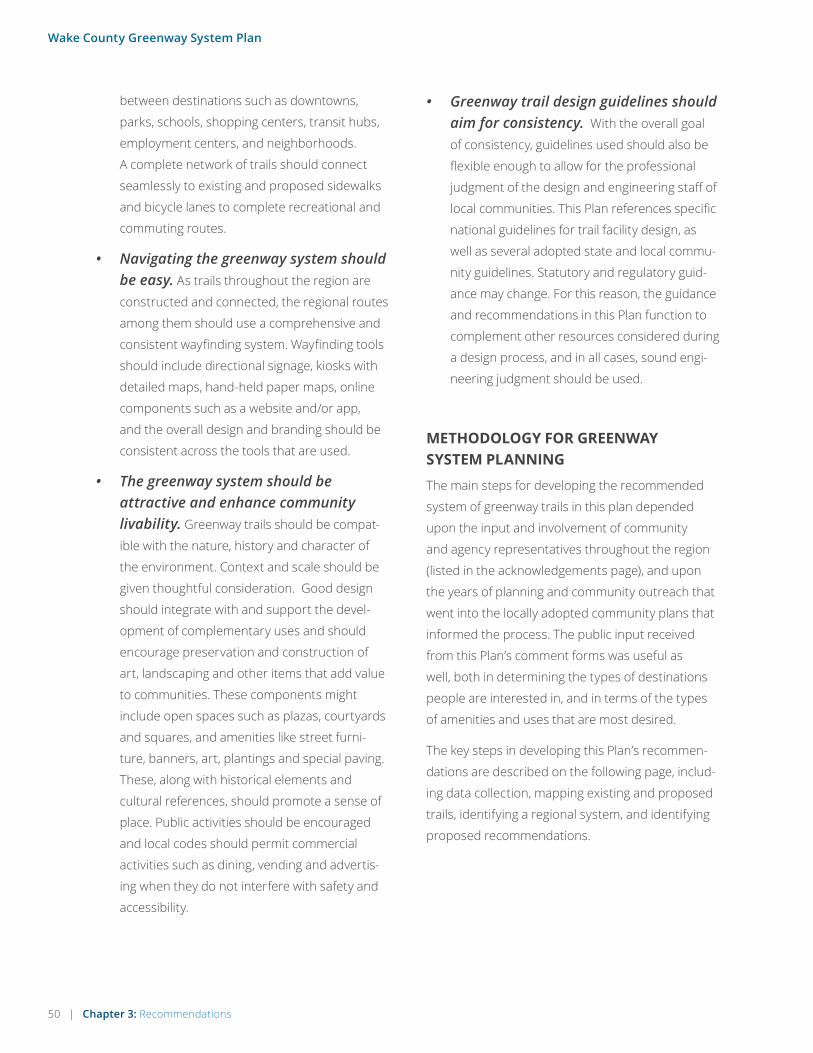
50 | Chapter 3: Recommendations
Wake County Greenway System Plan
between destinations such as downtowns,
parks, schools, shopping centers, transit hubs,
employment centers, and neighborhoods.
A complete network of trails should connect
seamlessly to existing and proposed sidewalks
and bicycle lanes to complete recreational and
commuting routes.
• Navigating the greenway system should be easy. As trails throughout the region are
constructed and connected, the regional routes
among them should use a comprehensive and
consistent wayfinding system. Wayfinding tools
should include directional signage, kiosks with
detailed maps, hand-held paper maps, online
components such as a website and/or app,
and the overall design and branding should be
consistent across the tools that are used.
• The greenway system should be attractive and enhance community livability. Greenway trails should be compat-
ible with the nature, history and character of
the environment. Context and scale should be
given thoughtful consideration. Good design
should integrate with and support the devel-
opment of complementary uses and should
encourage preservation and construction of
art, landscaping and other items that add value
to communities. These components might
include open spaces such as plazas, courtyards
and squares, and amenities like street furni-
ture, banners, art, plantings and special paving.
These, along with historical elements and
cultural references, should promote a sense of
place. Public activities should be encouraged
and local codes should permit commercial
activities such as dining, vending and advertis-
ing when they do not interfere with safety and
accessibility.
• Greenway trail design guidelines should aim for consistency. With the overall goal
of consistency, guidelines used should also be
flexible enough to allow for the professional
judgment of the design and engineering staff of
local communities. This Plan references specific
national guidelines for trail facility design, as
well as several adopted state and local commu-
nity guidelines. Statutory and regulatory guid-
ance may change. For this reason, the guidance
and recommendations in this Plan function to
complement other resources considered during
a design process, and in all cases, sound engi-
neering judgment should be used.
METHODOLOGY FOR GREENWAY SYSTEM PLANNING
The main steps for developing the recommended
system of greenway trails in this plan depended
upon the input and involvement of community
and agency representatives throughout the region
(listed in the acknowledgements page), and upon
the years of planning and community outreach that
went into the locally adopted community plans that
informed the process. The public input received
from this Plan’s comment forms was useful as
well, both in determining the types of destinations
people are interested in, and in terms of the types
of amenities and uses that are most desired.
The key steps in developing this Plan’s recommen-
dations are described on the following page, includ-
ing data collection, mapping existing and proposed
trails, identifying a regional system, and identifying
proposed recommendations.

Chapter 3: Recommendations | 51
Wake County Greenway System Plan
MAP ALL EXISTING TRAILS AND TRAILS PROPOSED IN PREVIOUS PLANS: Conduct outreach for all
12 of Wake County’s municipalities, neighboring jurisdictions, and regional entities; research
into existing plans and studies for proposed greenway routes on adopted plans.
IDENTIFY A SYSTEM OF REGIONAL CONNECTOR TRAILS: Examine proposed routes from
existing local and regional plans and identify routes
that offer the best potential for regional connectiv-
ity, based on connections to existing trails and the
ability to connect to destinations such as parks,
lakes, city and town centers; solicit input on the
draft network from a large group of stakeholders
at a countywide trail coordination workshop; follow
up with individual community planners and park
system managers to confirm regional routes in
their own communities.
PRIORITIZE THE OVERALL SYSTEM INTO SETS OF RECOMMENDATIONS: Divide proposed system into segments
based on logical end-points such as existing trails, parks, and town centers; Assign seg-
ments into project categories based on stakeholder and committee feedback (filling trail
system gaps first) and the results of public feedback on the types of desired destinations
(connecting to existing trails, parks, and natural areas).
The planning process incorporated input from nearly 50 local and regional stakeholders, and dozens of local and regional plans.
12
3
4
Key Steps in Developing Recommendations for this Plan
COLLECT DATA: Collect and assemble GIS data, existing community
plans, and maps; gather Steering Committee input on primary existing challenges and
opportunities; ask for public opinions on greenways through the comment form.

52 | Chapter 3: Recommendations
Wake County Greenway System Plan
THE COUNTYWIDE GREENWAY SYSTEM
Map 3.0 features the Countywide Greenway
System, which represents the overall recom-
mended system of regional connector trails in Wake
County. Rather than including all proposed trails
from existing plans, this system features only those
corridors that offer the best potential for regional
trail connectivity, based primarily upon connections
between existing trails and the ability to connect to
MILES OF EXISTING GREENWAYS IN THE COUNTYWIDE SYSTEM: This
figure includes only the existing trails in the countywide system (shown in
dark green on Map 3.0). Most of this mileage consists of well-established
greenway trail corridors, such as the Neuse River Trail, Reedy Creek Trail,
the Walnut Creek Trail, and the Black Creek Greenway. There are also an
additional approximately 150 miles of other local existing trails (shown in
light green on Map 3.0), but most of those are relatively short segments,
trail spurs, and trails within parks.
MILES OF TOTAL PROPOSED GREENWAYS IN THE COUNTYWIDE SYSTEM:
This figure includes the proposed trails in the countywide system (shown
in pink on Map 3.0). These proposed trails are broken into four categories
of recommendations, described in the following maps and pages.
MILES OF GREENWAYS IN DEVELOPMENT: This figure includes all trails
that were reported as funded, in design, or under construction as of
early 2016 (shown in blue on Map 3.0). These “in development” trails
are mostly within the towns of Morrisville, Cary, Apex, and Wake Forest,
among others.
BY THE NUMBERS
145
274
25
destinations such as parks, lakes, and downtown/
town centers. The Countywide Greenway System
is designed to make walking and bicycling for both
transportation and recreation more accessible,
practical, and enjoyable for more people, allowing
the region as a whole to benefit in terms of quality of
life and economic impact. These projected impacts
are quantified in Appendix A and are presented and
summarized on the following pages.

§̈¦40
Dur
ham
Ho
llySp
ring
s
Gar
ner
Ap
ex
Arc
her
Lod
ge
Ang
ier
Kni
ght
dal
e
Fuq
uay-
Var
ina
Loui
sbur
g
Car
y
But
ner
Ral
eig
h
Mo
rris
ville
Zeb
ulo
n
Ro
lesv
ille
Wen
del
lBun
n
Youn
gsv
ille
Fran
klin
ton
Cre
edm
oo
r
Cla
yto
n
Selm
a
Smit
hfie
ld
Wils
on'
sM
ills
Wak
eFo
rest
§̈¦540
§̈¦440
§̈¦540
£¤1
£¤401
£ ¤64
£¤64
£¤64B
§̈¦40
£¤264
£¤64B
£ ¤70
£¤70
£¤401
Coats
£¤1
¨̈96
Lilli
ngto
n
RTP
Pine
Leve
l
Bro
adw
ay
His
tori
cO
akvi
ew
Blu
e Ja
y
Poin
t
No
rth
Wak
e L
and
fill
Dis
tric
t P
ark
Fal
lsLa
ke
CHATHAM
HARNETT
CHATH
AM
LEE
CHATHAMWAKE
DURHAMWAKE
FRAN
KLIN
GRAN
VILLE
FRANKLINNASH
FRANKLIN
WAKE
GRANVILLE
WAKE
HARNETT
JOHNST
ON
HARNETTLEE
HARNETT
WAKE
JOHNSTON
WAKE
I0
36 M
iles
*NC
DO
T p
refe
rred
alt
erna
tive
as
of
Feb
ruar
y 20
16
Park
s
Hig
hway
s
Mun
icip
al
Bo
und
ary
(C
olo
r va
ries
)
Futu
re I-
540
*
Co
unty
wid
eG
reen
way
Net
wo
rk
In D
evel
op
men
t
Exi
stin
g -
Unp
aved
Exi
stin
g -
Pav
ed
Oth
er L
oca
l E
xist
ing
Tra
ils
Pro
po
sed
COU
NTY
WID
E G
REEN
WAY
SYS
TEM
(11X
17 F
OLD
OU
T M
AP)
MA
P 3
.0
BLU
E JA
YPO
INT
PARK
HAR
RIS
LAKE
PAR
K
YATE
SM
ILL
CRO
WDE
RDI
STRI
CTPA
RK
LAKE
BEN
SON
LAKE
MYR
A
ROBE
RTSO
N
MIL
LPO
ND
LAKE
WH
EELE
R
LAN
DFIL
LPA
RK
LAKE
CRAB
TREE
PAR
K
AMER
ICAN
TO
BACC
OTR
AIL
MU
DCA
TSST
ADIU
M
UM
STEA
DST
ATE
PARK
RDU
FALL
S LA
KE
OAK
VIE
WPA
RK
LAKE
JO
HN
SON
Chapter 3: Recommendations | 53
Wake County Greenway System Plan

§̈ ¦40
Dur
ham
Ho
llySp
ring
s
Gar
ner
Ap
ex
Arc
her
Lod
ge
Ang
ier
Kni
ght
dal
e
Fuq
uay-
Var
ina
Loui
sbur
g
Car
y
But
ner
Ral
eig
h
Mo
rris
ville
Zeb
ulo
n
Ro
lesv
ille
Wen
del
lBun
n
Youn
gsv
ille
Fran
klin
ton
Cre
edm
oo
r
Cla
yto
n
Selm
a
Smit
hfie
ld
Wils
on'
sM
ills
Wak
eFo
rest
§̈ ¦540
§̈ ¦440
§̈ ¦540
£¤1
£¤401
£¤64
£¤64
£¤64B
§̈ ¦40
£¤264
£¤64B
£¤70
£¤70
£¤401
Coats
£¤1
¨̈96
Lilli
ngto
n
RTP
Pine
Leve
l
Bro
adw
ay
His
tori
cO
akvi
ew
Blu
e Ja
y
Poin
t
No
rth
Wak
e L
and
fill
Dis
tric
t P
ark
Fal
lsLa
ke
CHATHAM
HARNETT
CHATH
AM
LEE
CHATHAMWAKE
DURHAMWAKE
FRAN
KLIN
GRAN
VILLE
FRANKLINNASH
FRANKLIN
WAKE
GRANVILLE
WAKE
HARNETT
JOHNST
ON
HARNETTLEE
HARNETT
WAKE
JOHNSTON
WAKE
I0
36 M
iles
Loca
lly P
rop
osed
Gre
enw
ay N
etw
ork
In D
evel
op
men
t
Exi
stin
g -
Unp
aved
Exi
stin
g -
Pav
ed
Pro
po
sed
Gre
enw
ays
fro
m
Exi
stin
g L
oca
l Pla
ns
Park
s
Hig
hway
s
Mun
icip
al
Bo
und
ary
(C
olo
r va
ries
)
LOC
ALL
Y PR
OPO
SED
GRE
ENW
AYS
(11X
17 F
OLD
OU
T M
AP)
MA
P 3
.0-
B
Dat
a So
urce
s- A
pex
- Acq
uire
d fr
om T
own
and
upda
ted
2015
- Car
y - A
cqui
red
from
Tow
n 20
15- F
uqua
y-Va
rina
- Ac
quir
ed fr
om T
own
2014
- Gar
ner -
Acq
uire
d fr
om T
own
2015
- Hol
ly S
prin
gs -
Acqu
ired
from
Tow
n 20
15- K
nigh
tdal
e - A
cqui
red
from
Tow
n 20
15- M
orri
svill
e - A
cqui
red
from
Tow
n 20
15- C
AMPO
- Ac
quir
ed N
EAS
data
from
201
2 pl
an- R
alei
gh -
Acqu
ired
from
Cit
y 20
15
- RTP
- Ac
quir
ed fr
om R
TP 2
015
- Rol
esvi
lle -
Acqu
ired
dra
ft d
ata
from
Tow
n 20
15
- Tri
angl
e J C
OG
- Ac
quir
ed d
raft
dat
a fr
om T
JCO
G in
201
5- W
ake
Fore
st -
Acqu
ired
from
Tow
n 20
15- W
ende
ll - A
cqui
red
from
Tow
n 20
15 w
ith u
pdat
es- Z
ebul
on -
Acqu
ired
dat
a fr
om 2
015
gree
nway
s m
aste
r pla
n
54 | Chapter 3: Recommendations
Wake County Greenway System Plan

§̈¦40
Dur
ham
Ho
llySp
ring
s
Gar
ner
Ap
ex
Arc
her
Lod
ge
Ang
ier
Kni
ght
dal
e
Fuq
uay-
Var
ina
Loui
sbur
g
Car
y
But
ner
Ral
eig
h
Mo
rris
ville
Zeb
ulo
n
Ro
lesv
ille
Wen
del
lBun
n
Youn
gsv
ille
Fran
klin
ton
Cre
edm
oo
r
Cla
yto
n
Selm
a
Smit
hfie
ld
Wils
on'
sM
ills
Wak
eFo
rest
§̈¦540
§̈¦440
§̈¦540
£¤1
£¤401
£ ¤64
£¤64
£¤64B
§̈¦40
£¤264
£¤64B
£ ¤70
£¤70
£¤401
Coats
£¤1
¨̈96
Lilli
ngto
n
RTP
Pine
Leve
l
Bro
adw
ay
His
tori
cO
akvi
ew
Blu
e Ja
y
Poin
t
No
rth
Wak
e L
and
fill
Dis
tric
t P
ark
Fal
lsLa
ke
CHATHAM
HARNETT
CHATH
AM
LEE
CHATHAMWAKE
DURHAMWAKE
FRAN
KLIN
GRAN
VILLE
FRANKLINNASH
FRANKLIN
WAKE
GRANVILLE
WAKE
HARNETT
JOHNST
ON
HARNETTLEE
HARNETT
WAKE
JOHNSTON
WAKE
I0
36 M
iles
*NC
DO
T p
refe
rred
alt
erna
tive
as
of
Feb
ruar
y 20
16
Park
s
Hig
hway
s
Futu
re I-
540
*
Co
unty
wid
eG
reen
way
Net
wo
rk
In D
evel
op
men
t
Exi
stin
g -
Unp
aved
Exi
stin
g -
Pav
ed
Oth
er L
oca
l E
xist
ing
Tra
ils
Pro
po
sed Lo
wer
Hig
her
Soci
al E
qui
tyA
sses
smen
t
*Are
as w
ith
hig
her
vuln
erab
ility
are
exp
ress
ed in
dar
ker
shad
es
of b
lue.
The
ran
ge
of
low
to
hig
h in
the
sca
le a
bov
e re
fers
to
a
sco
red
ass
essm
ent
of
vuln
erab
ility
tha
t ta
kes
into
acc
oun
tth
e fo
llow
ing
cat
ego
ries
:-
% A
ge
(und
er 1
8, o
ver
65)
- %
Ho
usin
g V
acan
cy-
% B
elo
w P
over
ty L
ine
-
% U
nem
plo
yed
- %
No
Dip
lom
a
SOCI
AL
EQU
ITY
DAT
A -
COU
NTY
WID
E G
REEN
WAY
SYS
TEM
OVE
RLAY
(11X
17 F
OLD
OU
T M
AP)
MA
P 3
.0-
C
Chapter 3: Recommendations | 55
Wake County Greenway System Plan

·Ê
··å
··å
!
!!
!
!
!
!
!
!
!
!
!
!
!
!
!!
!
!!
!
!
!
!
!
!
"Á
·Ê
!
!
!
!
!
!
!
!
!
!
!
!
!
!
!!
!
!
!
!
!
!!!
!
!
!
! !
!
!
!
!
!
!
!
!!
!
!
!
!
!
!
!
!
!
!
!
!
!
!
·Ê
!!
!
!
!
!
!
!!
!
!
!
!
!!
!
!
!
!
!
!
!
!
!
!
!
!
!
!
·Ê
·Ê
·Ê
·Ê
!
!
!
!
!
!
!
!
!
!
!
!
!!!
!!
!!
!
!
!
!
!!
·Ê
!
!
!
!
!
!
!
!
!
·Ê
!
!
!
!
!!
!
!
!
!
!
·Ê
·Ê
·Ê
·Ê
!
!
!
!
!
!!
!
!
!
!
!
!
··å
!
··å
·Ê
!!
··å··å
o
"Á
"¿
·Ê
·Ê
·5
·5
·5
·Ê
·5
··å
··å
··å
··å·Ê
!
! !
!
!
!
!!
!
!
!
!
!
·5
·5
·5
·5
·5
·5
·Ê
"¿ ·5
·Ê
·Ê
·Ê
!
!
!
!
!
!
!
!
!
!
"¿
·Ê
·5
§̈¦40
Dur
ham
Ho
llySp
ring
s
Gar
ner
Ap
ex
Arc
her
Lod
ge
Ang
ier
Kni
ght
dal
e
Fuq
uay-
Var
ina
Loui
sbur
g
Car
y
But
ner
Ral
eig
h
Mo
rris
ville
Zeb
ulo
n
Ro
lesv
ille
Wen
del
lBun
n
Youn
gsv
ille
Fran
klin
ton
Cre
edm
oo
r
Cla
yto
n
Selm
a
Smit
hfie
ld
Wils
on'
sM
ills
Wak
eFo
rest
§̈¦540
§̈¦440
§̈¦540
£¤1
£¤401
£ ¤64
£¤64
£¤64B
§̈¦40
£¤264
£¤64B
£ ¤70
£¤70
£¤401
Coats
£¤1
¨̈96
Lilli
ngto
n
RTP
Pine
Leve
l
Bro
adw
ay
His
tori
cO
akvi
ew
Blu
e Ja
y
Poin
t
No
rth
Wak
e L
and
fill
Dis
tric
t P
ark
Fal
lsLa
ke
CHATHAM
HARNETT
CHATH
AM
LEE
CHATHAMWAKE
DURHAMWAKE
FRAN
KLIN
GRAN
VILLE
FRANKLINNASH
FRANKLIN
WAKE
GRANVILLE
WAKE
HARNETT
JOHNST
ON
HARNETTLEE
HARNETT
WAKE
JOHNSTON
WAKE
I0
36 M
iles
*NC
DO
T p
refe
rred
alt
erna
tive
as
of
Feb
ruar
y 20
16
Hig
hway
s
Futu
re I-
540
*
Co
unty
wid
eG
reen
way
Net
wo
rk
In D
evel
op
men
t
Exi
stin
g -
Unp
aved
Exi
stin
g -
Pav
ed
Oth
er L
oca
l E
xist
ing
Tra
ils
Pro
po
sed
0 -
50
0
Po
pu
lati
on:
Peo
ple
/Sq
uare
Mile
by
Cen
sus
Blo
ck G
rou
p
(20
09
-20
13 A
CS
)
501
- 1,
079
(1,0
79 =
Wak
e C
oun
ty O
vera
ll)
1,0
80 -
5,0
00
5,0
00
+
Des
tina
tio
ns
oA
irp
ort
s
" ¿B
us
Sta
tio
ns
·ÊE
nter
tain
men
t
!S
cho
ols
·5S
hop
pin
g C
ente
rs
·ÊS
po
rts
Fac
iliti
es
" ÁTr
ain
Sta
tio
ns
··åU
niv
ersi
ties
/Co
lleg
es
Parks
MA
P 3
.0-
D
56 | Chapter 3: Recommendations
Wake County Greenway System Plan
PO
PULA
TIO
N &
DES
TIN
ATIO
N D
ATA
- CO
UN
TYW
IDE
GRE
ENW
AY S
YSTE
M O
VERL
AY (1
1X17
FO
LD O
UT
MAP
)

Chapter 3: Recommendations | 57
Wake County Greenway System Plan
Weighing Social Equity and Distribution of the Greenway System
Map 3.0-C, Social Equity Data - Countywide Greenway
System Overlay, uses U.S. Census data to show how
the proposed greenway system connects to and
within areas of varying degrees of equity. The data
is organized around geographic areas used by
the Census, called ‘block groups’. For each block
group, certain factors are analyzed such as the
percentages for people under age 18 and over 65,
housing vacancy, people below the poverty line, the
unemployed, and people with no diploma. Together,
this information is used to form the social equity
assessment, with higher areas of vulnerability
shown in darker shades of blue. The map is used to
show how and where these areas are served by the
existing and proposed system of greenways.
Map 3.0-D, Population & Destination Data -
Countywide Greenway System Overlay, is very similar
in purpose to the previous map, but rather than
displaying social equity information, it shows how
the existing and proposed system relates to the
County’s most populated areas, and several types
of destinations.
Quantifying the Benefits of the Countywide Greenway System
The full build-out of the Countywide Greenway
System will impact a variety of health, environ-
mental, and transportation factors that directly
affect the quality of life of Wake County residents
and visitors (see Chapter 1 for an overview of
these types of benefits). This Plan’s Benefit Impact
Analysis (Appendix A) uses a standard methodology
for calculating health, environmental, economic,
and transportation-related benefits in monetary
terms. The estimated monetary values (benefits) of
building the proposed system of greenways in Wake
County, are presented on the following two pages,
and should be considered order of magnitude esti-
mates, rather than exact amounts. As described
in Appendix A, the benefit analysis draws upon
comparisons to Wake County’s peer communities
in order to develop low, medium, and high range
projections for total benefits. The figures that follow
represent the mid-range of those projects, under
the argument that Wake County and its municipali-
ties should (and could) reach the goal of performing
at an at least average rate of its peer communities.
It is also important to note that there are many ben-
efits of a connected and comprehensive greenway
system in addition to those noted on the following
pages. These include protected wildlife habitat,
water quality protection from the preservation of
vegetated buffers along waterways, the mental
health benefits and reduced stress from increased
exercise and spending time in nature, the positive
impacts of access to parks and greenways on prop-
erty values and quality of life, and the potential for
increases in tourism associated with a world-class
system of greenways.
Shelly Lake in Raleigh, by ITRE Bicycle and Pedestrian Program.

58 | Chapter 3: Recommendations
Wake County Greenway System Plan
IN ANNUAL HEALTHCARE COST SAVINGSThat’s the equivalent of 2,400 trips to the doctor!
$4 MILLION 9.5
%
SAVINGS FROM REDUCED VEHICLE EMISSIONS PER YEAR$600,000
23 MILLION
85MILES BIKEDPER YEAR
MILES WALKED PER YEAR
TRIPS AROUNDTHE EARTH!
2.2 MILLION That’s the equivalent of
That’s the equivalent of
ANNUAL MILES WALKED
ANNUAL MILES BIKED
REDUCED VEHICLE EMISSIONS
REDUCED HEALTHCARE COSTS ANNUAL PHYSICAL ACTIVITY FROM BIKING & WALKING
OF WAKE COUNTY RESIDENTS MEETING THE CDC RECOMMENDED HOURS OF PHYSICAL ACTIVITY JUST FROM BICYCLING ( ~30 minutes/day)
8,000CROSS-COUNTRYROAD TRIPS
Below: Annual estimated benefits of a fully built-out greenway system in Wake County. See previous page and Appendix A form more information.

Chapter 3: Recommendations | 59
Wake County Greenway System Plan
$7 MILLION
IN REDUCED HOUSEHOLD VEHICLE OPERATION COSTS PER YEAR$11 MILLION
IN COST SAVINGS FROM REDUCED TRAFFIC CONGESTION
$1.6 MILLION
FEWER MILES TRAVELLED BY AUTOMOBILES EVERY YEAR
20 MILLIONIN REDUCED MOTOR VEHICLE COLLISION- RELATED COSTS
HOUSEHOLD VEHICLE OPERATION COSTS
CONGESTION COSTS
COLLISION COSTSVEHICLE MILES TRAVELED
MAINTENANCE COSTS
$3 MILLION IN REDUCED ROAD MAINTENANCE COSTS
Below: Annual estimated benefits of a fully built-out greenway system in Wake County. See page 57 and Appendix A form more information.

60 | Chapter 3: Recommendations
Wake County Greenway System Plan
GREENWAY SYSTEM RECOMMENDATIONS BY PROJECT CATEGORY
The overall system of recommendations is organized into the following set of project categories.
Project stakeholder feedback, public comment, and committee input all stressed the importance of
trail connectivity, hence the focus on bridging the gaps between existing trails. These project cate-gories will be approached by Wake County and its municipal partners with flexibility, taking into account the importance of both countywide connectivity and local priorities. Projects
that bridge gaps between communities for regional connectivity may do well in attracting funding
from regional partners, such as CAMPO. See Chapter 4 for more on project funding strategies.
1
2
3
4
BRIDGE THE GAPS: The focus of these “Bridge the Gaps” priority projects is connectivity, featuring 48 miles of trail in 23 segments. The projects are spread throughout the county, with at least one project in each of Wake County’s 12 municipalities. These fill critical gaps within the existing network of trails, and serve as catalyst projects where trails are currently lacking. For more on these projects, see the project cutsheets starting on page 66.
CONNECT TO PARKS & LAKES: This group of projects features 60 miles of trail in 12 segments, connecting to 15 parks (seven of which feature lakes). The idea of connecting to parks and lakes was driven by public feed-back on desired destinations, in which people indicated a desire to connect with existing trails, parks, and natural areas as the top choices out of a range of desti-nation types (see the public comment form results in Chapter 2).
CONNECT THE COMMUNITIES: With this group of projects, all 12 municipalities will be connected into the greenway system, with 19 miles of trail in six segments. These projects allow for key connections in Fuquay-Varina and Zebulon, plus more direct greenway trail connections between Raleigh, Cary, Apex, and Morrisville.
COMPLETE THE SYSTEM: There are 147 miles of proposed trail in this group, made up of over 30 project segments. These longer-term projects (like all projects) could be completed sooner, depending on how they are implemented and on the opportunities that arise to complete the system in the coming years and decades. See Chapter 4 for more on the overall implementation strategy.
48 mi.
60 mi.
19 mi.
147 mi.
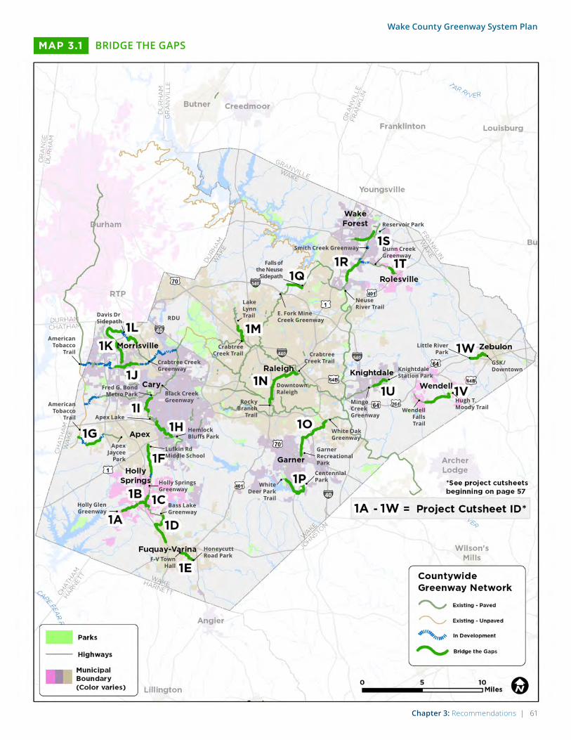
Chapter 3: Recommendations | 61
Wake County Greenway System Plan
BRIDGE THE GAPSMAP 3.1
Insert Map (Steve)
Wendell Falls Trail
Little River Park
White Deer Park
TrailHolly Glen Greenway
F-V Town Hall
Centennial Park
Honeycutt Road Park
Hugh T. Moody Trail
GSK/Downtown
Bass Lake Greenway
Mingo Creek Greenway
Knightdale Station Park
Holly Springs Greenway
Lufkin Rd Middle School
Hemlock Bluffs Park
Davis Dr Sidepath
Crabtree Creek Greenway
RDU
Black Creek Greenway
Fred G. Bond Metro Park
Apex Jaycee
Park
American Tobacco
Trail
American Tobacco
Trail
Lake Lynn Trail
Falls of the Neuse
Sidepath
Reservoir Park
Smith Creek Greenway Dunn Creek Greenway
E. Fork Mine Creek Greenway
Neuse River Trail
Crabtree Creek Trail
White Oak Greenway
Downtown Raleigh
Crabtree Creek Trail
Rocky Branch
Trail
Garner Recreational Park
Apex Lake
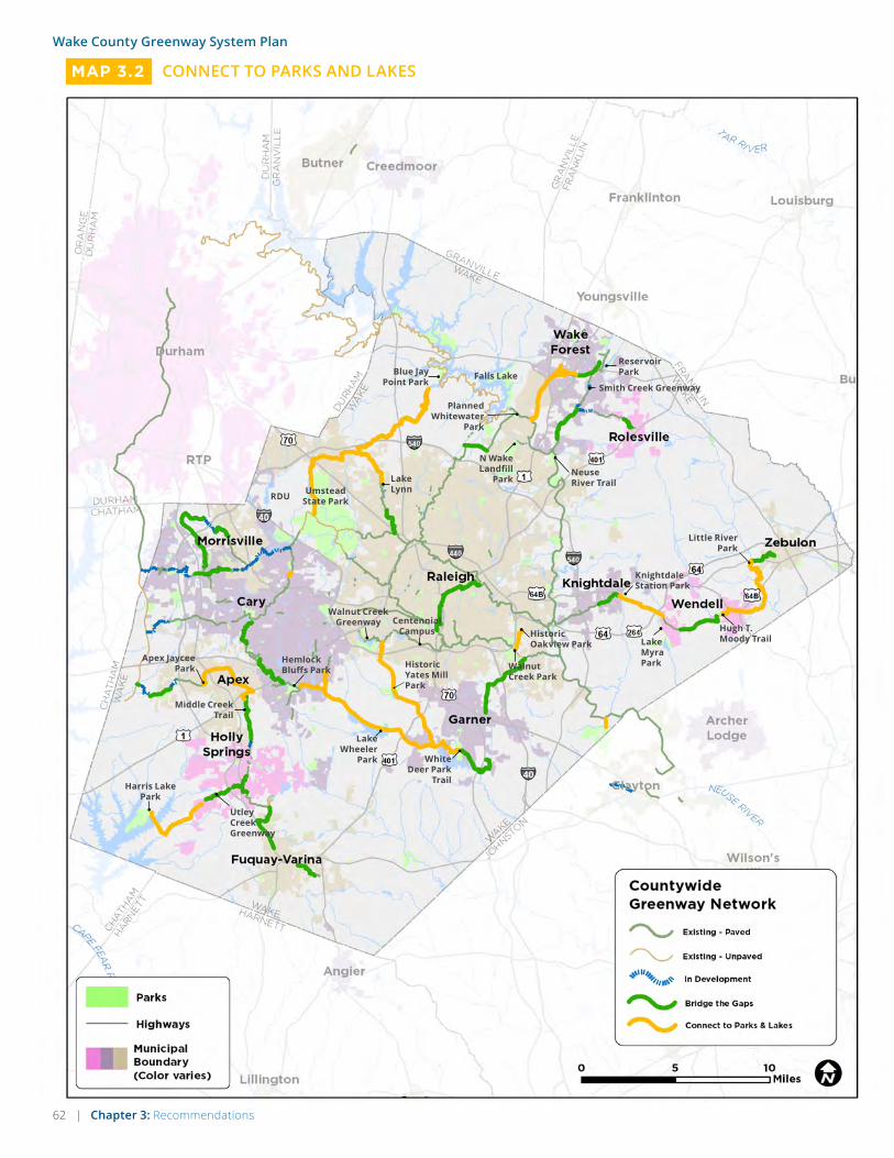
62 | Chapter 3: Recommendations
Wake County Greenway System Plan
CONNECT TO PARKS AND LAKESMAP 3.2
Lake Myra Park
Lake Wheeler
Park
Blue Jay Point Park
Middle Creek Trail
Knightdale Station Park
Hemlock Bluffs Park
Walnut Creek Greenway
Umstead State Park
Apex Jaycee Park
Harris Lake Park
Historic Oakview Park
Walnut Creek Park
Historic Yates Mill Park
Centennial Campus
Lake Lynn
Utley Creek Greenway
N Wake Landfill
Park
Planned Whitewater
Park
Reservoir ParkFalls Lake
Hugh T. Moody Trail
Smith Creek Greenway
Neuse River Trail
Little River Park
White Deer Park
Trail
RDU
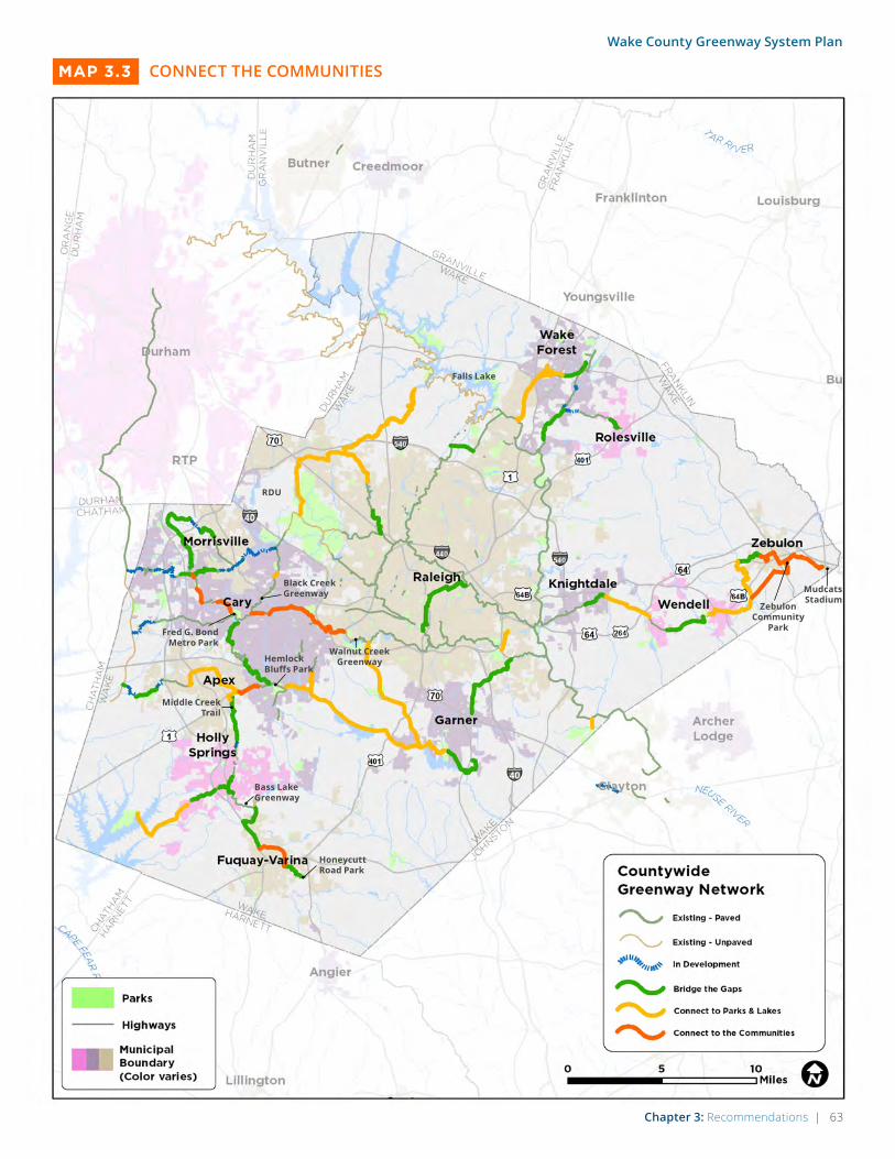
Chapter 3: Recommendations | 63
Wake County Greenway System Plan
CONNECT THE COMMUNITIESMAP 3.3
Middle Creek Trail
Hemlock Bluffs Park
Walnut Creek Greenway
Black Creek Greenway
Falls Lake
Mudcats Stadium
Zebulon Community
Park
Honeycutt Road Park
Bass Lake Greenway
Fred G. Bond Metro Park
RDU

64 | Chapter 3: Recommendations
Wake County Greenway System Plan
COMPLETE THE SYSTEMMAP 3.4
RDU

Chapter 3: Recommendations | 65
Wake County Greenway System Plan
PRIORITIZATION TOOLS
This plan is deigned as a long-term visionary
document that provides a general framework for
Wake County to move forward as a leader in trail
coordination and development. To that end, the
plan identifies the groups of projects described on
the previous page as a way of prioritizing the overall
system. Within each group of projects, the order
of actual project development may vary depending
upon available funding from local municipalities,
and upon funding awarded from state, federal, or
other sources (see Chapter 4 for more on funding
and implementation). Still, in order to make more
informed decisions about project development,
more detail is provided for each trail segment in the
sections that follow.
Cut-Sheets for Priority Projects
The following pages offer detailed information on
each of the “Bridge the Gaps” priority projects,
including individual project maps. These sheets
were designed based on the types of information
required by potential funding partners, such as the
Capital Area Metropolitan Planning Organization
(CAMPO), which uses similar sheets in their own
transportation planning.
Summary of Projects Table
The project table that follows the cutsheets is
designed to offer more information about all proj-
ects. Although not as detailed as the project cut-
sheets, it does offer valuable information to project
partners as they make decisions about individual
project selection.
How to Use the Estimated Costs on the Following Pages:
When reviewing the the estimated con-
struction and land acquisition costs in
the following cut sheets, please take into
account the following important notes
and caveats:
• The cost estimates represent
a planning-level of analysis and
therefore are listed in ranges.
• Costs will likely change as more
information becomes available in
the design phase.
• Costs are listed in the base year of
2016, and should be escalated at a
rate of 5% each year thereafter.
• Cost estimates for land acquisition/
ROW needs are based on Wake
County assessed property values,
and are an approximation only.
• Design costs are not listed per
cut-sheet, but they can range
between 10-15% of construction
costs. Higher ranges will be
encountered on projects utilizing
federal funds that require a high
level of regulatory compliance
and on projects that impact FEMA
regulated floodways that require
detailed flood modeling and
permitting. Small projects will also
see higher percentages for design
cost.

66 | Chapter 3: Recommendations
Wake County Greenway System Plan
1A. HOLLY SPRINGS SOUTHWEST GREENWAYBALLENRIDGE GREENWAY TO BRAXTON VILLAGE GREENWAY
This project connects the developing Ballenridge
and Braxton Village greenways in the southwest
section of Holly Springs. Half of the proposed gre-
enway connection follows Utley Creek. A key to this
project is an under crossing of NC 55 at the south-
western edge of the Ballenridge neighborhood and
existing greenway. Regionally, this project will help
to link Holly Springs and Harris Lake County Park
with further connectivity potential to Jordan Lake
and the American Tobacco Trail.
PROJECT AT A GLANCE• Project location: Holly Springs, Wake County
• Project type: Shared use path, on-road connec-tion (wayfinding and sidewalks)
• Length: 7,600 ft (1.4 miles)
• Total Connected Network: 1.7 miles
• Trip Generators:
» Holly Springs Cultural Center and Community Library
» Future Park at Mims Property » Ballenridge Neighborhood » Braxton Village » Harris Lake County Park (Connect Parks +
Lakes)
ESTIMATED CONSTRUCTION COST• 2016 construction estimates are in the range of
$1.6 million to $1.9 million
• Cost estimates should be escalated at a rate of 5% each year.
Cost estimate for land acquisition/ROW needs.
• Based upon Wake County assessed property values
acquisition estimates are approximately $63,000
POTENTIAL RIGHT-OF-WAY NEEDS• 2.6 acres estimated right-of-way acquisition
• 9 impacted parcels
• 8 distinct property owners
POTENTIAL PERMITTING NEEDS• Wake County/Holly Springs Floodplain
Development Permit
• Wake County/Holly Springs Stormwater Management (National Pollutant Discharge Elimination System General Permit)
• Wake County/Holly Springs Land Disturbance Permit
• North Carolina Department of Transportation Encroachment Permit
• FEMA Conditional Letter of Map Revision (CLOMR)
• FEMA Letter of Map Revision (LOMR)
• U.S. Army Corps of Engineers Section 401/404 Permit
PREVIOUS PLANNING• Holly Springs Parks, Recreation, and Open Space
Master Plan (2007)
• Holly Springs BIcycle Plan (2011)
POTENTIAL PARTNERSHIPS• Town of Holly Springs
• Ballenridge Homeowner’s Association
• Braxton Village Homeowner’s Association
• Duke Energy
POTENTIAL FUNDING MECHANISMS• CAMPO/LAPP funding
• NCDOT/STI funding
• Wake County CIP funding
• Holly Springs CIP
• Clean Water Management Trust Fund
• Duke Energy Water Resources Fund
• Duke Energy easement or land donation

Chapter 3: Recommendations | 67
Wake County Greenway System Plan
OPPORTUNITIES & CONSTRAINTS
The existing culvert under NC 55 can be formalized as a trail underpass. The cost estimate shown assumes lighting and other minor improvements are needed, but the size of the culvert is sufficient.
The segment would connect neighbor-hoods outside of NC 55 to the existing Ballenridge Greenway and destinations in central Holly Springs.
The trail’s location in the floodplain will increase permitting requirements.
Interim route would be along this funded greenway section (from CAMPO/LAPP funds) that connects to sidewalks along Avent Ferry Road.
Two bridge crossings of Utley Creek are required due to the proximity of the Creek to the Town’s wastewater treatment plant.
A third bridge crossing of the creek is required to connect the trail to Holly Glen.
An on-road connection using sidewalks and wayfinding signage is recommended along Evergreen View Drive and Avent Meadows Lane to complete the connection to the Braxton Village Greenway corridor at the southwest end of the segment.
The Braxton Village Greenway corridor is not currently maintained as a trail, yet the easement is in place. Consider continuing the on-road connection (sidewalk and way-finding signage on Avent Meadows Lane) as an alternative to Braxton Village Greenway, if necessary.
Ultimately, this corridor supports regional connectivity to Harris Lake County Park.
Greenway In Dev.
END: BRAXTON VILLAGE GREENWAY
START: BALLENRIDGE GREENWAY

68 | Chapter 3: Recommendations
Wake County Greenway System Plan
1B. HOLLY SPRINGS CENTRAL GREENWAYFROM BALLENRIDGE GREENWAY TO RALEIGH STREET
This project completes a link between the devel-
oping Ballenridge greenway toward central Holly
Springs. The eastern terminus at Raleigh Road links
to the proposed north/south connection between
Jones Park (north Holly Springs) and Womble Park
(south Holly Springs). This proposed trail through
central Holly Springs is a key component in con-
necting the heart of Holly Springs to Apex, Fuquay-
Varina, and Harris Lake County Park.
PROJECT AT A GLANCE• Project location: Holly Springs, Wake County
• Project type: Shared use path, on-street con-nection (wayfinding, shared lane markings, sidewalk)
• Length: 2,800 ft (0.5 miles)
• Total Connected Network: 0.8 miles
• Trip Generators:
» Ballenridge Neighborhood
» Holly Springs Cultural Center and Community Library
» Future Park at Mims Property
» Downtown Holly Springs Business District
» Town of Holly Springs offices
» Jones Park, Womble Park, Sugg Farm, and Bass Lake
ESTIMATED CONSTRUCTION COST• 2016 construction estimates are in the range of
$340,000 to $410,000
• Cost estimates should be escalated at a rate of 5% each year.
Cost estimate for land acquisition/ROW needs.
• Based upon Wake County assessed property values
acquisition estimates are approximately $7,200
POTENTIAL PERMITTING NEEDS• Wake County/Holly Springs Stormwater
Management (National Pollutant Discharge Elimination System General Permit)
• Wake County/Holly Springs Land Disturbance Permit
• U.S. Army Corps of Engineers Section 401/404 Permit
PREVIOUS PLANNING• Holly Springs Parks, Recreation, and Open Space
Master Plan (2007)
• Holly Springs BIcycle Plan (2011)
POTENTIAL PARTNERSHIPS• Town of Holly Springs
• Ballenridge Homeowner’s Association
• Holly Springs Chamber of Commerce
• Rex Hospital
• Avent Acres Community Association
POTENTIAL FUNDING MECHANISMS• Wake County CIP funding
• Holly Springs CIP
• Avent Acres Community Association easement or land donation
POTENTIAL RIGHT-OF-WAY NEEDS• 0.3 acres estimated right-of-way acquisition
• 3 impacted parcels
• 3 distinct property owners

Chapter 3: Recommendations | 69
Wake County Greenway System Plan
OPPORTUNITIES & CONSTRAINTS
PROJECT MAP [ALTA TO PROVIDE BASE]
• Proposed priority segment (inc. facility type(s))
• Existing trails
• Parcels
• Streets, water features, rail-road, and other features from base mapping
• Parks, Schools, and other destinations from base mapping
• Municipal boundaries
• Scale bar & north arrow
The segment connects to the proposed Holly Springs North/South Greenway on the east end, which connects Jones Park, Womble Park, Sugg Farm, and Bass Lake.
A small pedestrian bridge is required to cross Utley Creek where the segment transitions to a shared use path south of Ballentine Street.
Ballentine Road is a calm local street between Elm Road and Avent Ferry Road and is already comfortable for cyclists and pedestrians. Constraints to a side-path include right-of-way in the residential section and lighting and landscaping in the Town section. An on-street connec-tion using wayfinding signage and existing sidewalks is recommended.
Ballentine Road is a low-traffic, low-speed street with on-street parking between Avent Ferry Road and Raleigh Street. An on-street connection using wayfinding signage, shared-lane markings, and existing sidewalks will allow the Town to maintain this configuration while guiding trail users through the area.
The segment connects to the existing Ballenridge Greenway on the west end.
END: RALEIGH ST
START: BALLENRIDGE GREENWAY

70 | Chapter 3: Recommendations
Wake County Greenway System Plan
1C. HOLLY SPRINGS NORTH/SOUTH GREENWAYFROM JONES PARK TO WOMBLE PARK
This project completes a north/south link through
Holly Springs between Jones Park (north Holly
Springs) and Womble Park (south Holly Springs).
Existing trails through Jones Park extend north
through the Bridgewater subdivision toward a
developing connection to Apex. Existing trails con-
necting through Womble Park and Sugg Farm serve
as key regional links for proposed connectivity to
Fuquay-Varina.
ESTIMATED CONSTRUCTION COST• 2016 construction estimates are in the range of
$560,000 to $670,000
• Cost estimates should be escalated at a rate of 5% each year.
Cost estimate for land acquisition/ROW needs.
• Based upon Wake County assessed property values
acquisition estimates are approximately $31,000
POTENTIAL PERMITTING NEEDS• Wake County/Holly Springs Stormwater
Management (National Pollutant Discharge Elimination System General Permit)
• Wake County/Holly Springs Land Disturbance Permit
• North Carolina Department of Transportation Encroachment Permit
POTENTIAL PARTNERSHIPS• Town of Holly Springs
• Holly Springs Chamber of Commerce
• Rex Hospital
• Wake County Board of Education
• Windward Pointe Homeowners Association
POTENTIAL FUNDING MECHANISMS• CAMPO/LAPP funding
• NCDOT/STI funding
• Wake County CIP funding
• Holly Springs CIP
• Windward Pointe Homeowners Association easement or land donation
PROJECT AT A GLANCE• Project location: Holly Springs, Wake County
• Project type: Sidepath, on-street connection (bike boulevard and sidewalk), shared use path
• Length: 6,300 ft (1.2 miles)
• Total Connected Network: 4.1 miles
• Trip Generators:
» Holly Springs Elementary » Jones Park » Downtown Holly Springs Business District » Womble Park » Sugg Farm » Bass Lake Park, Retreat Center, and Trails
PREVIOUS PLANNING• Holly Springs Parks, Recreation, and Open Space
Master Plan (2007)
• Holly Springs BIcycle Plan (2011)
POTENTIAL RIGHT-OF-WAY NEEDS• 0.4 acres estimated right-of-way acquisition
• 5 impacted parcels
• 5 distinct property owners
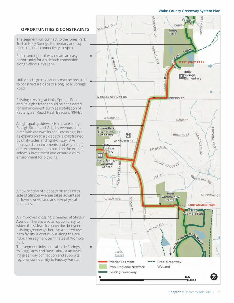
Chapter 3: Recommendations | 71
Wake County Greenway System Plan
OPPORTUNITIES & CONSTRAINTS
The segment will connect to the Jones Park Trail at Holly Springs Elementary and sup-ports regional connectivity to Apex.
Space and right-of-way create an easy opportunity for a sidepath connection along School Days Lane.
Utility and sign relocations may be required to construct a sidepath along Holly Springs Road.
Existing crossing at Holly Springs Road and Raleigh Street should be considered for enhancement, such as installation of Rectangular Rapid Flash Beacons (RRFB).
A high-quality sidewalk is in place along Raleigh Street and Grigsby Avenue, com-plete with crosswalks at all crossings, but its expansion to a sidepath is constrained by utility poles and right-of-way. Bike boulevard enhancements and wayfinding are recommended to build on the existing sidewalk investment and ensure a calm environment for bicycling.
An improved crossing is needed at Stinson Avenue. There is also an opportunity to widen the sidewalk connection between existing greenways here so a shared use path facility is continuous along the cor-ridor. The segment terminates at Womble Park.
A new section of sidepath on the North side of Stinson Avenue takes advantage of Town-owned land and few physical obstacles.
The segment links central Holly Springs to Sugg Farm and Bass Lake via an exist-ing greenway connection and supports regional connectivity to Fuquay-Varina.
END: WOMBLE PARK
START: JONES PARK

72 | Chapter 3: Recommendations
Wake County Greenway System Plan
1D. BROAD STREET GREENWAYFROM JUDD PARKWAY TO BASS LAKE
This project connects from Judd Parkway in north-
west Fuquay-Varina to Bass Lake in southeast Holly
Springs. From Judd Parkway, the route follows NC
55 to the Alston Pond neighborhood and connects
through a wooded area to existing trails at Sugg
Farm and Bass Lake. This project provides a direct
link to between Fuquay-Varina and Holly Springs.
ESTIMATED CONSTRUCTION COST• 2016 construction estimates are in the range of
$2.7 million to $3.2 million
• Cost estimates should be escalated at a rate of 5% each year.
Cost estimate for land acquisition/ROW needs.
• Based upon Wake County assessed property values
acquisition estimates are approximately $180,000
POTENTIAL PERMITTING NEEDS• Wake County/ Fuquay-Varina/ Holly Springs
Floodplain Development Permit
• Wake County/ Fuquay-Varina/ Holly Springs Stormwater Management (National Pollutant Discharge Elimination System General Permit)
• Wake County/ Fuquay-Varina/ Holly Springs Land Disturbance Permit
• North Carolina Department of Transportation Encroachment Permit
• FEMA Conditional Letter of Map Revision (CLOMR)
• FEMA Letter of Map Revision (LOMR)
• U.S. Army Corps of Engineers Section 401/404 Permit
POTENTIAL PARTNERSHIPS• Town of Fuquay-Varina, Town of Holly Springs
• Fuquay-Varina Chamber of Commerce, Holly Springs Chamber of Commerce
POTENTIAL FUNDING MECHANISMS• CAMPO/LAPP funding
• NCDOT/STI funding
• Wake County CIP funding
• Fuquay-Varina CIP, Holly Springs CIP
PROJECT AT A GLANCE• Project location: Fuquay-Varina, Holly Springs,
Wake County
• Project type: Sidepath, Shared-use path
• Length: 15,000 ft (2.8 miles)
• Total Connected Network: 8.8 miles
• Trip Generators:
» Bass Lake Park, Retreat Center, and trails
» Alston Ridge Park
» Alston Ridge, Springhill, Woodchase, and Sandy Springs Townhomes neighborhoods
» Broad Street Market shopping center
» Retail at Broad Street and Dickens Road
PREVIOUS PLANNING• Holly Springs Parks, Recreation, and Open Space
Master Plan (2007)
• Fuquay-Varina Community Pedestrian Master Plan (2013)
POTENTIAL RIGHT-OF-WAY NEEDS• 3.5 acres estimated right-of-way acquisition
• 36 impacted parcels
• 26 distinct property owners

Chapter 3: Recommendations | 73
Wake County Greenway System Plan
OPPORTUNITIES & CONSTRAINTS
PROJECT MAP [ALTA TO PROVIDE BASE]
• Proposed priority segment (inc. facility type(s))
• Existing trails
• Parcels
• Streets, water features, rail-road, and other features from base mapping
• Parks, Schools, and other destinations from base mapping
• Municipal boundaries
• Scale bar & north arrow
The alignment follows the edge of the Basal Creek floodplain but careful routing allows minimal impacts and no overlap with wet-lands in this area. The segement traversing the floodplain will increase permitting requirements.
The segment supports connectivity toward Fuquay-Varina via the proposed Judd Parkway greenway.
The segment supports trail connectivity toward Holly Springs via the existing Bass Lake Outfall Greenway.
The alignment follows Broad Street between Hilltop Needmore Road and Judd Parkway.
South of Wade Nash Road, an existing side-walk can be widened to a multi-use side-path. Because of proximity to the current sidewalk, many utility poles will require relocation at significant cost.
The project connects the Woodchase neighborhood.
The project connects to the existing Basil Creek Trail and the Alston Pond neighborhood.
START: JUDD PKWY
END: BASS LAKE
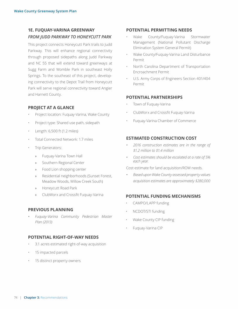
74 | Chapter 3: Recommendations
Wake County Greenway System Plan
1E. FUQUAY-VARINA GREENWAYFROM JUDD PARKWAY TO HONEYCUTT PARK
This project connects Honeycutt Park trails to Judd
Parkway. This will enhance regional connectivity
through proposed sidepaths along Judd Parkway
and NC 55 that will extend toward greenways at
Sugg Farm and Womble Park in southeast Holly
Springs. To the southeast of this project, develop-
ing connectivity to the Depot Trail from Honeycutt
Park will serve regional connectivity toward Angier
and Harnett County.
ESTIMATED CONSTRUCTION COST• 2016 construction estimates are in the range of
$1.2 million to $1.4 million
• Cost estimates should be escalated at a rate of 5% each year.
Cost estimate for land acquisition/ROW needs.
• Based upon Wake County assessed property values
acquisition estimates are approximately $280,000
POTENTIAL PERMITTING NEEDS• Wake County/Fuquay-Varina Stormwater
Management (National Pollutant Discharge Elimination System General Permit)
• Wake County/Fuquay-Varina Land Disturbance Permit
• North Carolina Department of Transportation Encroachment Permit
• U.S. Army Corps of Engineers Section 401/404 Permit
POTENTIAL PARTNERSHIPS• Town of Fuquay-Varina
• ClubWorx and Crossfit Fuquay-Varina
• Fuquay-Varina Chamber of Commerce
POTENTIAL FUNDING MECHANISMS• CAMPO/LAPP funding
• NCDOT/STI funding
• Wake County CIP funding
• Fuquay-Varina CIP
PROJECT AT A GLANCE• Project location: Fuquay-Varina, Wake County
• Project type: Shared use path, sidepath
• Length: 6,500 ft (1.2 miles)
• Total Connected Network: 1.7 miles
• Trip Generators:
» Fuquay-Varina Town Hall
» Southern Regional Center
» Food Lion shopping center
» Residential neighborhoods (Sunset Forest, Meadow Woods, Willow Creek South)
» Honeycutt Road Park
» ClubWorx and Crossfit Fuquay-Varina
PREVIOUS PLANNING• Fuquay-Varina Community Pedestrian Master
Plan (2013)
POTENTIAL RIGHT-OF-WAY NEEDS• 3.1 acres estimated right-of-way acquisition
• 15 impacted parcels
• 15 distinct property owners

Chapter 3: Recommendations | 75
Wake County Greenway System Plan
OPPORTUNITIES & CONSTRAINTS
Town Hall anchors the west end of the project, along with the nearby Southern Regional Center and Food Lion shopping center.
A sidepath on the north side of Old Honeycutt Road takes advantage of some Town-owned land and opportunities to set the sidepath back into the trees, creating a pleasant environment and avoiding the installation of curb and gutter.
Trail crossing improvements are needed at Old Honeycutt Road and Purfoy Road.
The alignment follows the east side of Purfoy Road as a sidepath and then cuts across several undeveloped properties to Ber Creek Drive. This section could likely be built as part of future development of this property.
East of Ber Creek Drive, there is an 80’ wide strip of land between water bodies that allows for a connection to existing trails at Honeycutt Road Park.
Honeycutt Park, with a variety of athletic facilities, anchors the east end of the project.
The segment supports connectivity toward Angier and Harnett County.
A redesign of Judd Parkway is under construction.
A Town easement is in place for this section.
END: HONEYCUTT PARK
START: JUDD PKWY

76 | Chapter 3: Recommendations
Wake County Greenway System Plan
1F. MIDDLE CREEK GREENWAYFROM LUFKIN ROAD MIDDLE SCHOOL TO SUNSET HILLS GREENWAY
The Middle Creek Greenway will complete a key
link in the developing connection between down-
town Apex and Holly Springs. To the north (the
center of Apex), future trail connectivity will include
a sidepath along Lufkin Road to Center Street and
the Apex Peakway, eventually linking to the Beaver
Creek Greenway. To the south, the Middle Creek
greenway will link into the Holly Springs greenway
system at Sunset Lake Road.
ESTIMATED CONSTRUCTION COST• 2016 construction estimates are in the range of
$3.4 million to $4.0 million
• Cost estimates should be escalated at a rate of 5% each year.
Cost estimate for land acquisition/ROW needs.
• Based upon Wake County assessed property values
acquisition estimates are approximately $330,000
POTENTIAL PERMITTING NEEDS• Wake County/Apex Floodplain Development
Permit
• Wake County/Apex Stormwater Management (National Pollutant Discharge Elimination System General Permit)
• Wake County/Apex Land Disturbance Permit
• FEMA Conditional Letter of Map Revision (CLOMR)
• FEMA Letter of Map Revision (LOMR)
• U.S. Army Corps of Engineers Section 401/404 Permit
POTENTIAL PARTNERSHIPS• Town of Apex
• Town of Holly Springs
• Wake County Board of Education
• Miramonte Homeowners Association
POTENTIAL FUNDING MECHANISMS• CAMPO/LAPP funding
• NCDOT/STI funding
• Wake County CIP funding
• Apex CIP
• Clean Water Management Trust Fund
• Duke Energy Water Resources Fund
• Miramonte Homeowners Association ease-ment or land donation
PROJECT AT A GLANCE• Project location: Apex, Wake County
• Project type: Shared use path, sidepath
• Length: 12,900 ft (2.4 miles)
• Total Connected Network: 2.4 miles
• Trip Generators:
» Lufkin Road Middle School
» Classic Road industrial and office park
» Residential developments (Pemberley, Miramonte, Camden Reunion Park Apartments, Sunset Hills, Twisted Creek Townhomes, Arbor Creek, Bridgewater)
» Veterans Park
» Holly Springs greenway system
PREVIOUS PLANNING• Apex Parks, Recreation, Greenways, and Open
Space Master Plan (2015)
POTENTIAL RIGHT-OF-WAY NEEDS• 7.7 acres estimated right-of-way acquisition
• 17 impacted parcels
• 16 distinct property owners

Chapter 3: Recommendations | 77
Wake County Greenway System Plan
OPPORTUNITIES & CONSTRAINTS
A short trail extension off of the regional network connects the project to Lufkin Road Middle School at the north end. The segment supports regional connectivity toward Apex and Cary to the north.
An existing sidewalk along Burma Drive can be expanded into a sidepath.
The alignment follows the east side of Middle Creek between Pristine Water Drive and the southern end.
A bridge crossing of Middle Creek is required.
The trail’s location in the floodplain will increase permitting requirements.
A short section of sidepath and an on-road crossing are needed at Pristine Water Drive.
A new crossing is required at Classic Road.
Boardwalk is required where the trail traverses wetlands near the second bridge. The alignment is generally located far enough east of Middle Creek to avoid wetlands wherever possible because of the high cost of boardwalk.
The segment supports regional connectiv-ity between Apex and Holly Springs.
Segment connects directly to a greenway trailhead at Sunset Lake Rd in Holly Springs.
END: SUNSET HILLS GREENWAY
START: LUFKIN ROAD MIDDLE SCHOOL
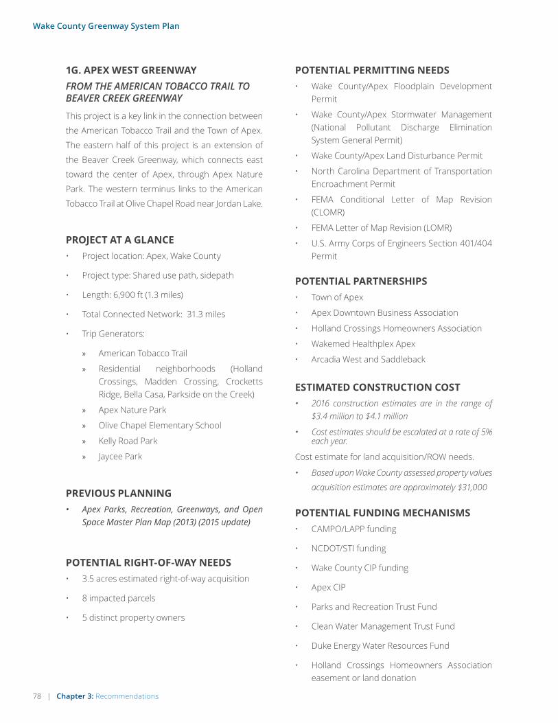
78 | Chapter 3: Recommendations
Wake County Greenway System Plan
1G. APEX WEST GREENWAYFROM THE AMERICAN TOBACCO TRAIL TO BEAVER CREEK GREENWAY
This project is a key link in the connection between
the American Tobacco Trail and the Town of Apex.
The eastern half of this project is an extension of
the Beaver Creek Greenway, which connects east
toward the center of Apex, through Apex Nature
Park. The western terminus links to the American
Tobacco Trail at Olive Chapel Road near Jordan Lake.
ESTIMATED CONSTRUCTION COST• 2016 construction estimates are in the range of
$3.4 million to $4.1 million
• Cost estimates should be escalated at a rate of 5% each year.
Cost estimate for land acquisition/ROW needs.
• Based upon Wake County assessed property values
acquisition estimates are approximately $31,000
POTENTIAL PERMITTING NEEDS• Wake County/Apex Floodplain Development
Permit
• Wake County/Apex Stormwater Management (National Pollutant Discharge Elimination System General Permit)
• Wake County/Apex Land Disturbance Permit
• North Carolina Department of Transportation Encroachment Permit
• FEMA Conditional Letter of Map Revision (CLOMR)
• FEMA Letter of Map Revision (LOMR)
• U.S. Army Corps of Engineers Section 401/404 Permit
POTENTIAL PARTNERSHIPS• Town of Apex
• Apex Downtown Business Association
• Holland Crossings Homeowners Association
• Wakemed Healthplex Apex
• Arcadia West and Saddleback
POTENTIAL FUNDING MECHANISMS• CAMPO/LAPP funding
• NCDOT/STI funding
• Wake County CIP funding
• Apex CIP
• Parks and Recreation Trust Fund
• Clean Water Management Trust Fund
• Duke Energy Water Resources Fund
• Holland Crossings Homeowners Association easement or land donation
PROJECT AT A GLANCE• Project location: Apex, Wake County
• Project type: Shared use path, sidepath
• Length: 6,900 ft (1.3 miles)
• Total Connected Network: 31.3 miles
• Trip Generators:
» American Tobacco Trail
» Residential neighborhoods (Holland Crossings, Madden Crossing, Crocketts Ridge, Bella Casa, Parkside on the Creek)
» Apex Nature Park
» Olive Chapel Elementary School
» Kelly Road Park
» Jaycee Park
PREVIOUS PLANNING• Apex Parks, Recreation, Greenways, and Open
Space Master Plan Map (2013) (2015 update)
POTENTIAL RIGHT-OF-WAY NEEDS• 3.5 acres estimated right-of-way acquisition
• 8 impacted parcels
• 5 distinct property owners

Chapter 3: Recommendations | 79
Wake County Greenway System Plan
OPPORTUNITIES & CONSTRAINTS
PROJECT MAP [ALTA TO PROVIDE BASE]
• Proposed priority segment (inc. facility type(s))
• Existing trails
• Parcels
• Streets, water features, rail-road, and other features from base mapping
• Parks, Schools, and other destinations from base mapping
• Municipal boundaries
• Scale bar & north arrow
The segment terminates at the American Tobacco Trail, connecting the Apex trail system to this regional amenity.
A section of the greenway is being funded and constructed through private development.
Boardwalk is recommended for the major-ity of the greenway to reduce impacts on the wetlands it traverses. The trail’s location in the floodplain will increase permitting requirements.
The alignment follows the south side of Beaver Creek, south of the Hollands Crossing neighborhood, with opportunities to connect into the Apex Nature Park.
The segment terminates at a segment of the Beaver Creek Greenway currently under development.
The alignment takes advantage of the Town-owned Apex Nature Park, reducing the required amount of property or ease-ment acquistions.
A short sidepath segment is needed along Olive Chapel Road to link the American Tobacco Trail and the portion of the green-way already under development.
The segment supports connectivity between the American Tobacco Trail and downtown Apex via the proposed network and greenways in development.
END: BEAVER CREEK
GREENWAY
START:AMERICAN TOBACCO TRAIL

80 | Chapter 3: Recommendations
Wake County Greenway System Plan
1H. LOWER WILLIAMS CREEK GREENWAY (SWIFT CREEK)FROM LAKE PINE DR TO SYMPHONY LAKE GREENWAY
This segment of greenway is approximately 2.6 miles
connecting Apex Community Park to the North
and Regency Park/Koka Booth Ampitheater to the
South. This project includes major bridge crossings
of US-1 and US-64. Although not currently a top
priority project in Cary, this segment could become
one with significant new funding sources.
PROJECT AT A GLANCE• Project location: Town of Cary, Wake County
• Project type: Greenway
• Length: 12,900 ft (2.4 miles)
• Total Connected Network: 11.6 miles
• Trip Generators: Apex Community Park, Regency Park and Koka Booth Amphitheater
ESTIMATED CONSTRUCTION COSTCost estimate for construction
• 2016 construction estimates are in the range of $7.5 million to $9 Million
• Cost estimates should be escalated at a rate of 5% each year.
Cost estimate for land acquisition/ROW needs.
• Based upon Wake County assessed property values acquisition estimates are approximately $800,000
POTENTIAL RIGHT-OF-WAY NEEDS• 9.4 acres of right of way needed.
• There will be six privately owned parcels impacted by the greenway.
POTENTIAL PERMITTING NEEDS• North Carolina Department of Transportation
Encroachment Permit
• NC Department of Environmental Quality
• US Army Corps of Engineers Section 401/404 Permit
PREVIOUS PLANNING• Town of Cary Parks, Recreation and Cultural
Resources Master Plan (2012)
• Construction plans completed from Apex Community Park to US-1. (final bridge designs for crossing US-1 and US-64 outstanding)
POTENTIAL PARTNERSHIPS• Town of Cary
• Town of Apex
• CAMPO
• Cary Auto Park
POTENTIAL FUNDING MECHANISMS• CAMPO/Local Adminstered Projects Program
(LAPP) funding
• NCDOT/STI funding
• Wake County CIP funding

Chapter 3: Recommendations | 81
Wake County Greenway System Plan
OPPORTUNITIES & CONSTRAINTS
This trail creates a vital recreational link between two of the larger parks in the region, Apex Community Park and Regency Park.
Joint partnerships opportunities may be available between the Town of Apex and the Town of Cary.
The Town of Cary owns a parcel of prop-erty located at the end of MacGregor Pines Drive that may be an ideal location for a trailhead.
Construction plans were completed in 2012 from Apex Community Park to US-1 (final bridge designs for crossing US-1 and US-64 outstanding.
Two major road crossings of US-1 and US-64 will require a large pedestrian bridge
Much of the alignment is located in non-residential areas. Easement acquisi-tion may cost more than typical.
END: SYMPHONY LAKE GREENWAY
START: LAKE PINE DR

82 | Chapter 3: Recommendations
Wake County Greenway System Plan
1I. SWIFT CREEK GREENWAY (UPPER WILLIAMS CREEK GREENWAY)FROM FRED BOND METRO PARK TO OLD APEX ROAD
The Swift Creek Greenway, also known as Upper Williams
Creek Greenway, connects two of the larger parks in
the Cary/Apex area. Fred Bond Metro Park and Apex
Communnity Park are large recreational destinations
therefore this stretch of trail is a vital recreational link.
This 1.5 mile stretch of greenway provides access to a
large number of residential neighborhoods in addition to
Laurel Park Elementary School. Although not currently a
top priority project in Cary, this segment could become
one with significant new funding sources.
PROJECT AT A GLANCE• Project location: Town of Cary and Town of
Apex Wake County
• Project type: Shared use path
• Length: 8,500 ft (1.6 miles)
• Total Connected Network: 147 miles
• Trip Generators: Apex Community Park, Fred Bond Metro Park and Laurel Park Elementary School
ESTIMATED CONSTRUCTION COSTCost estimate for construction
• 2016 construction estimates are in the range of $1.8 million to $2.2 million
• Cost estimates should be escalated at a rate of 5% each year.
Cost estimate for land acquisition/ROW needs.
• Based upon Wake County assessed property values acquisition estimates are approximately $51,000.
POTENTIAL RIGHT-OF-WAY NEEDS• An estimated 2 acres of easements and/or right
of way will be needed
• There will be seven properties impacted by the greenway.
POTENTIAL PERMITTING NEEDS• North Carolina Department of Transportation
Encroachment Permit
• NC Department of Environmental Quality
• US Army Corps of Engineers Section 401/404 Permit
PREVIOUS PLANNING• Town of Cary Parks, Recreation and Cultural
Resources Master Plan (2012)
• Town of Apex Parks, Recreation, Greenways and Open Space Master Plan (2015)
POTENTIAL PARTNERSHIPS• Town of Cary
• Town of Apex
• Wake County Public Schools
POTENTIAL FUNDING MECHANISMS• CAMPO/Local Adminstered Projects Program
(LAPP) funding
• NCDOT/STI funding
• Wake County CIP funding
• Parks and Recreation Trust Fund

Chapter 3: Recommendations | 83
Wake County Greenway System Plan
OPPORTUNITIES & CONSTRAINTS
MA
LDO
ND
R
ROTH
ES RD
KILMORY DR
SUTERLANDRD
KILARNEYRIDGE LOOP
KRONOS LN
W MARILYNCIR
BARCLADINECT
SM
OKEMONT DR
CASTLEG
AR
DE
NS
T
BR
OA
DF
OR
DD
R
WAXMYR TLE CT TR
AIL
ING
OA
K
B
E BINGTON
DR
GETTYSBU
RG
DR
AMB
ER
GLO
WPL
WIN
TE
RMIST DR
CH
AT
SW
OR
TH
ST
RAMBLEWOOD DR
RAV
ENN
A
WAY
TALLOWAY DR
YMCA DR
TARBERT DR
LO
STTREE
LN
ARVO LN
DU
NDA
LK WAY
CENTER
POINT
E DR
BU
RN
LE
YD
R
BAY
BOUQ
UETLN
WESTHIGH ST
LUXON PL
KIN
DR
ED
WAY
SWIS
SLA
KE
DR
LOCH LOMONDCIR
BETHABARA LN
NO
RH
AM
DR
SWE
ET
LAU
RE
LLN
STONELEIGH DR
TE
AL
IGH
T L
N
MO
RA
VIA
LN
COM MUNITY PARKDR
CU
STER
TRL
HEATHRIDGE LN
TR
AP
PE
RS
RUN DR
TRA
FALG
AR
LN
MACARTHUR DR
SALEM CHURCH RD
OLD APEX RD
N SALEM ST
W CHATHAM ST
LAU
RA
DU
NC
AN
RD
BOND LAKE
DR
SW
CARYPKW
Y
64
WilliamsCreek
Fred G. BondMetro Park
ApexCommunity
Park
WA
KE
CO
UN
TY
CA
RY
WAKE COUNTYAPEX
CARYAPEX
B LACK CREEK GREENWAY
BISH
OPS
GATEG
REE
NW
AY
WHIT
EOAK
CREEK GREENWAY
COMMUNITYLAKE TR AI L
OXXFO
RD
HUNT
G
REENWAY
LaurelPark Elem
Cra
btre
eCre
ek
CrabtreeCreek
Cra
btre
e C
reek
0 0.5Miles
Priority Segment
Prop. Regional Network
Existing Greenway
Prop. Greenway
100-Year Floodplain
Wetland
This trail creates a vital recreational link between two of the larger parks in the region, Fred Bond Metro Park and Apex Community Park.
A safe pedsestrian crossing will be needed at Cary Parkway. A possible rapid flashing beacon may be needed.
Wide multiuse path already exists on Cary Parkway.
Much of the trail can utilize existing utility easements.
Upgrades to the intesection at Old Apex Road will be needed.
Crossing the railroad and Old Aex Road presents a challenge for this project. Due to the proximity to Laurel Park Elementary School it is very important to provide a safe crossing.
END: OLD APEX RD
START: FRED BOND
METRO PARK

84 | Chapter 3: Recommendations
Wake County Greenway System Plan
1J. HATCHER CREEK GREENWAYFROM EXISTING TRAIL ON SEDGEFIELD PARK LANE TO MORRISVILLE COMMUNITY PARK
Hatcher Creek Greenway connects a large high
density area in western Wake County to the
American Tobacco Trail. This segment runs from
NC55 eastward to Davis Drive. This portion of trail
includes off road greenway and side street multiuse
trail. The total length of this project is 1.7 miles. Just
under 1/2 of a mile will be streetside multiuse trail
on Morrisville Parkway. The primary challenge to
this project is crossing the railroad at the west end
of the project. Carpenter Elementary School and
West Regional Library will have direct benefits from
this project. Although not currently a top priority
project in Cary, this segment could become one
with significant new funding sources.
PROJECT AT A GLANCE• Project location: Town of Cary, Wake County
• Project type: Shared use path
• Length: 11,100 ft (2.1 miles)
• Total Connected Network: 141 miles
• Trip Generators: American Tobacco Trail, Carpenter Elementary, West Regional Library, Morrisville Community Park, Panther Creek
Greenway
ESTIMATED CONSTRUCTION COSTCost estimate for construction
• 2016 construction estimates are in the range of $2.2 million to $2.8 million
• Grade separations at Davis Drive and NC 55 could add about $10 million to the project cost
• Cost estimates should be escalated at a rate of 5% each year.
Cost estimate for land acquisition/ROW needs.
• Based upon Wake County assessed property values acquisition estimates are approximately $680,000.
POTENTIAL RIGHT-OF-WAY NEEDS• An estimated 3.8 acres of easements and/or
right of way will be needed
• There will be nine properties impacted by the greenway.
POTENTIAL PERMITTING NEEDS• North Carolina Department of Transportation
Encroachment Permit
• NC Department of Environmental Quality
• US Army Corps of Engineers Section 401/404 Permit
• FEMA Conditional Letter of Map Revision (CLOMR)
PREVIOUS PLANNING• Town of Cary Greenway Parks, Recreation and
Cultural Resources Master Plan. (2012)
• Center of the Region Enterprise Plan (CORE) (2016)
POTENTIAL PARTNERSHIPS• Town of Cary
• Wake County Public Schools
• Wake County Public Library
• Carpenter Village HOA
POTENTIAL FUNDING MECHANISMS• CAMPO/Local Adminstered Projects Program
(LAPP) funding
• NCDOT/STI funding
• Wake County CIP funding
• Parks and Recreation Trust Fund
• Safe Routes to Schools

Chapter 3: Recommendations | 85
Wake County Greenway System Plan
OPPORTUNITIES & CONSTRAINTS
The crossing of Davis Drive already has a full traffic signal. Minor upgrades will be needed to accomodate pedestrian movement.
The Town of Cary owns a tract of land at Davis Drive that may be an opportunity for a trailhead.
This trail creates a connection to the trails in the Town of Morrisville to the east and eventually the American Tobacco Trail to the west.
Obtaining easements from Carpenter Village and Lakegrove Townhomes will be difficult.
A large portion of this project will be located witin the floodplain which will require a FEMA/CLOMR study.
Wetlands are located in the proximity of West Regional Library.
The project allows connection to Carpenter Elementary School and West Regional Library.
Crossing the existing railroad at grade pres-ents the major challenge for this project.
The trail can use existing right of way along Morrisville Parkway.
END: MORRISVILLE COMMUNITY PARK
START: SEDGEFIELD PARK LANE

86 | Chapter 3: Recommendations
Wake County Greenway System Plan
1K. LOUIS STEPHENS DRIVE GREENWAYFROM KIT CREEK ROAD TO KIT CREEK GREENWAY
This project connects RTP from the Louis Stephens
Drive/Kit Creek Road intersection to Cary at the
existing Kit Creek Greenway. From Kit Creek Road,
the route follows Louis Stephens Drive to its present
terminus to the south, then connects to the existing
Kit Creek Greenway by passing under the Triangle
Expressway and through wooded areas between
neighborhoods at the northern edge of Cary. This
project serves as a regional north/south link con-
necting Cary and RTP. Although not currently a top
priority project in Cary, this segment could become
one with significant new funding sources.
ESTIMATED CONSTRUCTION COST• 2016 construction estimates are in the range of
$3.3 million to $4.0 million
• Cost estimates should be escalated at a rate of 5% each year.
Cost estimate for land acquisition/ROW needs.
• Based upon Wake County assessed property values
acquisition estimates are approximately $550,000
POTENTIAL PERMITTING NEEDS• Wake County/ Cary Floodplain Development
Permit
• Wake County/Cary Stormwater Management (National Pollutant Discharge Elimination System General Permit)
• Wake County/Cary Land Disturbance Permit
• North Carolina Department of Transportation Encroachment Permit
• FEMA Conditional Letter of Map Revision (CLOMR)
• FEMA Letter of Map Revision (LOMR)
• U.S. Army Corps of Engineers Section 401/404 Permit
POTENTIAL PARTNERSHIPS• Research Triangle Park (RTP)
• Town of Cary, Town of Morrisville
• Cary Chamber of Commerce, Morrisville Chamber of Commerce
• McCrimmon at the Park HOA, McCrimmon at the Park HOA, Magnolia Estates HOA, Phillips Place HOA
• NetApp
POTENTIAL FUNDING MECHANISMS• CAMPO/LAPP funding
• NCDOT/STI funding
• Wake County CIP funding
• Cary CIP
• Magnolia Estates HOA, Phillips Place HOA ease-ment or land donation
PROJECT AT A GLANCE• Project location: Cary, Wake County
• Project type: Sidepath, Shared-use path
• Length: 19,200 ft (3.6 miles)
• Total Connected Network: 12.3 miles
• Trip Generators:
» Northwest Park
» Breckenridge, Wexford, Legacy at Carpenter Village, Carpenter Village, and Olde Carpenter neighborhoods
» Carpenter Elementary School
» West Regional Library
» Lake Betz
» Employers (NetApp, Cisco Systems)
PREVIOUS PLANNING• Center of Regional Enterprise (CORE) Pedestrian,
Bicycle, and Greenways Update (2016)
• Cary Comprehensive Transportation Plan
POTENTIAL RIGHT-OF-WAY NEEDS• 7.6 acres estimated right-of-way acquisition
• 21 impacted parcels
• 16 distinct property owners

Chapter 3: Recommendations | 87
Wake County Greenway System Plan
OPPORTUNITIES & CONSTRAINTS
PROJECT MAP [ALTA TO PROVIDE BASE]
• Proposed priority segment (inc. facility type(s))
• Existing trails
• Parcels
• Streets, water features, rail-road, and other features from base mapping
• Parks, Schools, and other destinations from base mapping
• Municipal boundaries
• Scale bar & north arrow
The alignment includes upgrading an exist-ing 8 foot-wide path along Louis Stephens Drive at the north end of the alignment to a 10 foot-wide multi-use path.
The segment supports connectivity toward Cary’s Panther Creek Trail corridor.
The segment supports trail connectivity toward Research Triangle Park.
The segment terminates at an existing greenway at the intersection of April Bloom Road and Grant Fores Lane.
The alignment terminates at the intersec-tion of Kit Creek Road and Louis Stephens Drive. Crossing improvements are needed here.
The alignment passes under NC 540 at an existing underpass.
The alignment connects Northwest Park and the Parkside Valley Drive greenway.
Between Parkside Valley Drive and April Bloom Lane, the alignment follows a stream corridor.
The alignment traverses floodplain, which will increase permitting requirements. A bridge is required at this stream crossing.
A bridge is required at this location.
START: KIT CREEK RD
END: KIT CREEK GREENWAY

88 | Chapter 3: Recommendations
Wake County Greenway System Plan
1L. KIT CREEK ROAD GREENWAYFROM LOUIS STEPHENS DRIVE TO SHILOH GREENWAY
This project runs from the Kit Creek Road/Louis
Stephens Drive intersection in RTP to the Shiloh
Greenway in Morrisville. From Louis Stephens
Drive, the route follows Kit Creek Road to the trail in
development along Davis Drive. The last section of
this project connects from Davis Drive at the Little
Drive intersection through a patch of woods to the
Shiloh Greenway. This project links RTP, Cary, and
Morrisville in the western edge of Wake County.
ESTIMATED CONSTRUCTION COST• 2016 construction estimates are in the range of
$1.8 million to $2.1 million
• Cost estimates should be escalated at a rate of 5% each year.
Cost estimate for land acquisition/ROW needs.
• Based upon Wake County assessed property values
acquisition estimates are approximately $230,000
POTENTIAL PERMITTING NEEDS• Wake County/ Morrisville Floodplain
Development Permit
• Wake County/ Morrisville Stormwater Management (National Pollutant Discharge Elimination System General Permit)
• Wake County/ Morrisville Land Disturbance Permit
• North Carolina Department of Transportation Encroachment Permit
• FEMA Conditional Letter of Map Revision (CLOMR)
• FEMA Letter of Map Revision (LOMR)
• U.S. Army Corps of Engineers Section 401/404 Permit
POTENTIAL PARTNERSHIPS• Research Triangle Park (RTP)
• Town of Morrisville, Town of Cary
• Morrisville Chamber of Commerce, Cary Chamber of Commerce
• Shiloh Grove HOA
• Duke Energy
• Research Triangle Foundation
POTENTIAL FUNDING MECHANISMS• CAMPO/LAPP funding
• NCDOT/STI funding
• Wake County CIP funding
• Wendell CIP
• Duke Energy and Research Triangle Foundation easement or land donation
PROJECT AT A GLANCE• Project location: Morrisville, Wake County
• Project type: Sidepath, Shared-use path
• Length: 11,500 ft (2.2 miles)
• Total Connected Network: 15.8 miles
• Trip Generators:
» Employers (NetApp, Cisco Systems)
» Church Street Park
» Shiloh Park
» Shiloh Grove and Hamlet in the Park neighborhoods
PREVIOUS PLANNING• Center of Regional Enterprise (CORE) Pedestrian,
Bicycle, and Greenways Update (2016)
POTENTIAL RIGHT-OF-WAY NEEDS• 4.5 acres estimated right-of-way acquisition
• 7 impacted parcels
• 6 distinct property owners

Chapter 3: Recommendations | 89
Wake County Greenway System Plan
OPPORTUNITIES & CONSTRAINTS
PROJECT MAP [ALTA TO PROVIDE BASE]
• Proposed priority segment (inc. facility type(s))
• Existing trails
• Parcels
• Streets, water features, rail-road, and other features from base mapping
• Parks, Schools, and other destinations from base mapping
• Municipal boundaries
• Scale bar & north arrow
An existing 8 foot-wide paved path exists along the east side of Kit Creek Road between Louis Stephens Drive and Davis Drive. The project includes upgrading this section to a 10 foot-wide multi-use path to meet current standards.
The segment supports connectivity to Morrisville.
The segment supports trail connectivity toward Research Triangle Park.
A multi-use path is currently under devel-opment between Davis Drive and Little Drive.
The alignment follows a future roadway corridor between Davis Drive and Kit Creek. Coordination should occur between greenway and roadway development.
The alignment follows Kit Creek down to the existing Shiloh Greenway and Church Street Park.
Lake Betz creates a constrained cross-sec-tion for 525 feet where a sidewalk is in place. This section is proposed to remain as-is with signage warning users as they approach the narrow section.
START: LOUIS STEPHENS DRIVE
END: SHILOH
GREENWAY

90 | Chapter 3: Recommendations
Wake County Greenway System Plan
1M. HARE SNIPE CREEK TRAILFROM WOOTEN MEADOW PARK TO CRABTREE CREEK GREENWAY
This 1.6 mile segment of Hair Snipe Creek Trail
connects Lake Lynn and Wooten Meadow Park to
Crabtree Creek Greenway. Most of the alignment
within Wooten Meadow Park is wetland, therefore
a low level boardwalk will be needed. The
alignment as a whole is within the flood plain.
The major challenge to the project is crossing
Glenwood Avenue. A tunnel crossing of at least
180 feet will be necessary.
PROJECT AT A GLANCE• Project location: City of Raleigh, Wake County
• Project type: Shared use path
• Length: 9,000 ft (1.7 miles)
• Total Connected Network: 147 miles
• Trip Generators: Lake Lynn, Wooten Meadow Park, Crabtree Greenway, Brookhaven Nature
Park and Crabtree Valley Mall
ESTIMATED CONSTRUCTION COSTCost estimate for construction
• 2016 construction estimates are in the range of $9 million to $10.8 million
• Cost estimates should be escalated at a rate of 5% each year
Cost estimate for land acquisition/ROW needs.
• Based upon Wake County assessed property values acquisition estimates are approximately $490,000. Acquisition of easements on non-resi-dential property along Glenwood Avenue increases acquisition costs
POTENTIAL RIGHT-OF-WAY NEEDS• An estimated 4.7 acres of easements and/or
right of way will be needed
• There will be five properties impacted by the greenway on of which is non-residential thus a higher acquisition value. Fortunately the remaining properties are undeveloped.
POTENTIAL PERMITTING NEEDS• North Carolina Department of Transportation
Encroachment Permit
• NC Department of Environmental Quality
• US Army Corps of Engineers Section 401/404 Permit
• FEMA Conditional Letter of Map Revision (CLOMR)
PREVIOUS PLANNING• City of Raleigh Parks, Recreation and Cultural
Resources System Plan (2014)
POTENTIAL PARTNERSHIPS• City of Raleigh
• Crabtree Valley Mall
POTENTIAL FUNDING MECHANISMS• CAMPO/Local Adminstered Projects Program
(LAPP) funding
• NCDOT/STI funding
• Wake County CIP funding
• Parks and Recreation Trust Fund

Chapter 3: Recommendations | 91
Wake County Greenway System Plan
OPPORTUNITIES & CONSTRAINTS
50
SUGAR BUSH RD
BAYSWATER TRLPICKWICK DR
HO
LLYRIDGE DR
GLEN FOREST DR
CARTWRIGHTDR
LARCHMONT DR
WATERSID
E
LN
BRADDOCK DR
WILDWOOD ST
WED
GEW
OO
DST
CA
LTO
N D
R
TAN
GL
EW
OO
DD
R
CH
ATF
OR
D
DR
MOREHEAD
DR
GLE
NLA
UR
EL
DR
PLEASANT VALLEY RD
FAIR
HIL
LD
R
DO
DSW
OR
TH D
R
FERN
WO
OD
DR
PAR
KWO
OD
DR
BR
OO
KH
AV
EN D
R
REMBERT DR
WIN
TH
RO
PD
R
MANOR VIL
LAG
EW
AY
MA
NO
RC
LUB
DR
MA
NO
R
VILLAGE
WAY
RE
ST H
AV
EN
DR
RIE
SE
DR
SHA
DE
TR
EE
LN
BA
YM
AR
DR
MA
RR
IOT
TD
R
ISA
BE
LLA
CA
NN
ON
DR
CA
RTE
RE
T
DR
GA
LAXDR
TRIBUTECEN
TER
DR
SHA
MRO
CK
DR
H
ERM ITAGE DR
PL
AZ
AP
L
DE
BLY
NA
VE
CREEDMOOR RD
WMILLBROOK RD
GLEN
WO
OD
AVE
70
CrabtreeCreek
WootenMeadow
Park
BrookhavenNature Park
HA
RE
SNIP
ECREEK
TRA
IL
YorkElementary
Hare Snipe
Creek
Crabtree Creek
Cabtree Creek
Crabtree Creek
Hare Snipe C
reek
Cabtree Creek
0 0.5Miles
Priority Segment
Prop. Regional Network
Existing Greenway
Prop. Greenway
100-Year Floodplain
Wetland
This trail creates a link from Lake Lynn and Wooten Meadow Park to Crabtree Creek Greenway.
The northern most portion of the trail is within wetlands requiring low level boardwalk.
A large portion of this project will be located within the floodplain which will require a detailed study area for FEMA/CLOMR.
The City already has several greenway ease-ments north of Glenwood Avenue.
Crossing Glenwood Avenue will be that greatest challenge for the project. A 180 foot long tunnel will be need to get across Glenwood Avenue.
START: WOOTEN
MEADOW PARK
END: CRABTREE CREEK GREENWAY

92 | Chapter 3: Recommendations
Wake County Greenway System Plan
1N. RALEIGH PIGEON HOUSE TRAIL CONNECTORFROM CRABTREE CREEK TRAIL TO ROCKY BRANCH TRAILThis project connects the existing Crabtree Creek Trail to the Rocky Branch Trail near downtown Raleigh. From the Rocky Branch Trail, the route follows through the Boylan Heights neighborhood, along West Street and eventually following the Capital Boulevard Corridor to the Crabtree Creek Trail. This project includes significant stream res-toration and would serve as a critical regional link through the heart of Raleigh. Greater detail on the section between Crabtree Creek Boulevard and Peace Street is provided in the Capital Boulevard Corridor Study, which analyzed that area in depth and recommended a greenway as part of broader improvements.
ESTIMATED CONSTRUCTION COST• This greenway project should be implemented as
part of comprehensive corridor improvements to Capital Boulevard. See the Capital Boulevard Corridor Study for more information on costs and codependent projects.
Cost estimate for land acquisition/ROW needs.
• Based upon Wake County assessed property values acquisition estimates are approximately
$2,000,000
POTENTIAL PERMITTING NEEDS• Wake County/ Raleigh Floodplain Development
Permit
• Wake County/ Raleigh Stormwater Management (National Pollutant Discharge Elimination System General Permit)
• Wake County/ Raleigh Land Disturbance Permit
• North Carolina Department of Transportation Encroachment Permit
• FEMA Conditional Letter of Map Revision (CLOMR)
• FEMA Letter of Map Revision (LOMR)
• U.S. Army Corps of Engineers Section 401/404 Permit
POTENTIAL PARTNERSHIPS• City of Raleigh
• Raleigh Chamber of Commerce, Raleigh Downtown Alliance
• Amtrak
• Boylan Heights Neighborhood Organization
• Businesses along West Street and Capital Boulevard
POTENTIAL FUNDING MECHANISMS• CAMPO/LAPP funding
• NCDOT/STI funding
• Wake County CIP funding
• Raleigh CIP
• Land easements/donations
PROJECT AT A GLANCE• Project location: Raleigh
• Project type: Sidepath, Shared-use path, On-road connection (separated bike lanes and sidewalks)
• Length: 24,700 ft (4.7 miles)
• Total Connected Network: 143 miles
• Trip Generators:
» Capital Boulevard/Crabtree Boulevard commercial corridors
» William Peace University » Downtown Raleigh » Downtown Raleigh neighborhoods » Raleigh Amtrak Station
PREVIOUS PLANNING• Raleigh Capital Area Greenway Planning and
Design Guide (2014)
• Raleigh Bike Plan Update (2016)
• Raleigh Capital Boulevard Corridor Study (2012)
POTENTIAL RIGHT-OF-WAY NEEDS• 9.6 acres estimated right-of-way acquisition
• 67 impacted parcels
• 48 distinct property owners

Chapter 3: Recommendations | 93
Wake County Greenway System Plan
OPPORTUNITIES & CONSTRAINTS
PROJECT MAP [ALTA TO PROVIDE BASE]
• Proposed priority segment (inc. facility type(s))
• Existing trails
• Parcels
• Streets, water features, rail-road, and other features from base mapping
• Parks, Schools, and other destinations from base mapping
• Municipal boundaries
• Scale bar & north arrow
The alignment along Capital Boulevard is proposed as part of a stream restoration and park project.
The segment terminates at the existing Rocky Branch Trail.
The segment terminates at the existing Crabtree Creek Trail on the northeast end.
Pedestrian crossing improvements are needed at the intersection of WAke Forest Road and Old Louisburg Road.
A super street is proposed for Capital Boulevard through this section. This reconfiguration will allow installation of a greenway along the existing commercial service road paralleling the boulevard.
The alignment continues along Pigeon House Branch to Peace Street through the proposed Devereux Meadows Park and Stream Restoration.
A short sidepath is proposed along Peace Street between Pigeon House Branch and West Street.
South of Peace Street, an on-road alignment is proposed along West Street including a separated bikeway and sidewalks, given constrained right-of-way. This section of the alignment links the heart of downtown Raleigh.
The alignment connects the Raleigh Amtrak Station, and then follows Cabarrus Street for two blocks with on-road bike markings, signage, and sidewalks.
The alignment follows a Rocky Branch tributary for the remaining portion and links the Lenoir Street Park. This section requires negotiation with several prop-erty owners.
Boardwalk is recommended north of Crabtree Boulevard.
START: CRABTREE CREEK TRAIL
END: ROCKY BRANCH TRAIL

94 | Chapter 3: Recommendations
Wake County Greenway System Plan
1O. CREECH ROAD GREENWAYFROM GARNER ROAD TO WALNUT CREEK GREENWAY
This project links the center of Garner to the Walnut
Creek Greenway in southeast Raleigh. From Garner
Road, the route travels past the Garner Senior
Center, through Garner Recreation Park to Creech
Road Elementary School and Creech Road before
connecting to, and following, a Walnut Creek tribu-
tary to the Walnut Creek Trail. This project provides
a direct link to Raleigh’s existing greenway system
and the heart of Garner.
ESTIMATED CONSTRUCTION COST• 2016 construction estimates are in the range of
$8.2 million to $9.8 million (excluding the pro-posed grade-separated crossing of I-40).
• Cost estimates should be escalated at a rate of 5% each year.
Cost estimate for land acquisition/ROW needs.
• Based upon Wake County assessed property values
acquisition estimates are approximately $110,000
POTENTIAL PERMITTING NEEDS• Wake County/ Garner/ Raleigh Floodplain
Development Permit
• Wake County/ Garner/ Raleigh Stormwater Management (National Pollutant Discharge Elimination System General Permit)
• Wake County/ Garner/ Raleigh Land Disturbance Permit
• North Carolina Department of Transportation Encroachment Permit
• FEMA Conditional Letter of Map Revision (CLOMR)
• FEMA Letter of Map Revision (LOMR)
• U.S. Army Corps of Engineers Section 401/404 Permit
POTENTIAL PARTNERSHIPS• Town of Garner, City of Raleigh
• Garner Chamber of Commerce, Raleigh Chamber of Commerce
• Hunter’s Mark HOA, Riverbrooke Community Watch, Quarry Pointe HOA
• South Citizens Advisory Council
• Federal Highway Administration (FHWA)
POTENTIAL FUNDING MECHANISMS• CAMPO/LAPP funding
• NCDOT/STI funding
• Wake County CIP funding
• Garner CIP, Raleigh CIP
• Riverbrooke Homeowner’s Association ease-ment or land donation
PROJECT AT A GLANCE• Project location: Raleigh, Garner, Wake County
• Project type: Sidepath, Shared-use path
• Length: 23,200 ft (4.4 miles)
• Total Connected Network: 142 miles
• Trip Generators:
» Walnut Creek Park » Walnut Creek Amphitheatre » Creech Road Elementary School & Park » Garner Recreational Park » Green Valley, Parrish Meadows, Quarry
Pointe, Gatewood neighborhoods
PREVIOUS PLANNING• Garner Comprehensive Parks, Recreation, and
Greenways Master Plan (2007)
• Raleigh Capital Area Greenway Planning and Design Guide (2014)
• Raleigh Bike Plan Update (2016)
POTENTIAL RIGHT-OF-WAY NEEDS• 12.3 acres estimated right-of-way acquisition
• 51 impacted parcels
• 42 distinct property owners

Chapter 3: Recommendations | 95
Wake County Greenway System Plan
OPPORTUNITIES & CONSTRAINTS
PROJECT MAP [ALTA TO PROVIDE BASE]
• Proposed priority segment (inc. facility type(s))
• Existing trails
• Parcels
• Streets, water features, rail-road, and other features from base mapping
• Parks, Schools, and other destinations from base mapping
• Municipal boundaries
• Scale bar & north arrow
The segment supports connectivity toward the heart of Garner.
The segment supports trail connectivity between Garner and the Walnut Creek entertainment complex in southeast Raleigh. It terminates at the existing Walnut Creek Trail
A bridge is required over Walnut Creek.
The alignment traverses wetlands and floodplain between the Walnut Creek Greenway and I-40. Boardwalk is proposed to reduce wetland impacts at significant cost. Additional bridges may be required in this section.
A grade-separated crossing of I-40 is required. This crossing requires further study and is not included in the planning level cost estimate provided.
A bridge is required where the alignment meets Creech Road and heads south.
Curb and gutter is recommended along Creech Road in order to reduce right-of-way acquisition through this residential section.
The project connects Creech Road Elementary School Park and Garner Recreational Park before terminating at Main Street.
A bridge is required west of the I-40 crossing.
An underpass is proposed at Rock Quarry Road. This location requires further study. As an alternative, the trail could cross at the intersection with Jones Sausage Road.
START: GARNER RD
END: WALNUT CREEK GREENWAY

96 | Chapter 3: Recommendations
Wake County Greenway System Plan
1P. BUFFALOE ROAD GREENWAYFROM WHITE DEER PARK TO CENTENNIAL PARK
This project provides a connection between
existing trails at Garner’s White Deer Park and
Centennial Park. From White Deer Park, the route
follows Buffaloe Road before connecting to the
eastern end of Lake Benson, eventually following
Mahlers Creek toward Centennial Park. This corri-
dor will eventually serve as a key regional link con-
necting Cary, Lake Wheeler, Lake Benson, Garner,
and Johnston County.
ESTIMATED CONSTRUCTION COST• 2016 construction estimates are in the range of
$3.4 million to $4.1 million
• Cost estimates should be escalated at a rate of 5% each year.
Cost estimate for land acquisition/ROW needs.
• Based upon Wake County assessed property values
acquisition estimates are approximately $81,000
POTENTIAL PERMITTING NEEDS• Wake County/Garner Floodplain Development
Permit
• Wake County/Garner Stormwater Management (National Pollutant Discharge Elimination System General Permit)
• Wake County/Garner Land Disturbance Permit
• North Carolina Department of Transportation Encroachment Permit
• FEMA Conditional Letter of Map Revision (CLOMR)
• FEMA Letter of Map Revision (LOMR)
• U.S. Army Corps of Engineers Section 401/404 Permit
POTENTIAL PARTNERSHIPS• Town of Garner
• Garner Chamber of Commerce
• Rosemoor Place Homeowners Association
POTENTIAL FUNDING MECHANISMS• CAMPO/LAPP funding
• NCDOT/STI funding
• Wake County CIP funding
• Garner CIP
• Clean Water Management Trust Fund
• Duke Energy Water Resources Fund
• Rosemoor Place Homeowners Association easement or land donation
PROJECT AT A GLANCE• Project location: Garner, Wake County
• Project type: Shared use path, sidepath
• Length: 15,800 ft (3 miles)
• Total Connected Network: 7.1 miles
• Trip Generators:
» White Deer Park
» Lake Benson Park
» Residential neighborhoods (Summer Walk, Autumn Oaks, Scarborough Ridge, Lynnshire, Dunhaven, Woodsdale, Jamestowne)
» Centennial Park
PREVIOUS PLANNING• Garner Comprehensive Parks, Recreation, and
Greenways Master Plan (2007)
POTENTIAL RIGHT-OF-WAY NEEDS• 3.6 acres estimated right-of-way acquisition
• 29 impacted parcels
• 25 distinct property owners

Chapter 3: Recommendations | 97
Wake County Greenway System Plan
OPPORTUNITIES & CONSTRAINTS
PROJECT MAP [ALTA TO PROVIDE BASE]
• Proposed priority segment (inc. facility type(s))
• Existing trails
• Parcels
• Streets, water features, rail-road, and other features from base mapping
• Parks, Schools, and other destinations from base mapping
• Municipal boundaries
• Scale bar & north arrow
The segment terminates at White Deer Park, linking into the extensive trail network in this park and the adjacent Lake Benson Park, and ultimately connecting west Garner and Lake Wheeler. The existing striped crosswalk at Aversboro Road should be updated with a pedestrian signal.
There’s an opportunity to partner with a homeowner’s association to site a sidepath farther from Buffaloe Road through existing trees.
Numerous residential driveways and lansdscaping within road right-of-way will complicate sidepath development for some sections of Buffaloe Road. Curb and gutter will be required to construct the sidepath within existing right-of-way.
The existing shoulder of the berm through Lake Benson is not wide enough for a sidepath. The berm must be widened to accommodate the sidepath.
Right-of-way for a sidepath is constrained at the end of Bufflaoe Road where the roadway widens to accommodate a left turn lane. An on-road facility with a physical separator may be required in this location.
An underpass of NC-50 is required where the alignment moves off-road to follow Swift Creek and then Mahlers Creek.Publicly owned land provides right-of-way between Benson Road and New Bethel Church Road.
An improved trail crossing is required at New Bethel Church Road.
There is potential for connections to the Glens at Bethel neighborhood.
The segment connects Centennial Park on the east end. It also supports regional con-nectivity to downtown Garner and eastern Wake County.
The trail’s location in the floodplain will increase permitting requirements.
START: WHITE DEER PARK
END: CENTENNIAL PARK

98 | Chapter 3: Recommendations
Wake County Greenway System Plan
1Q. DURANT ROAD TRAILFROM HONEYCUTT ROAD TO FALLS OF THE NEUSE ROAD
This trail will be one of the few opportunities in
North Raleigh to go east-west. Durant Road street
side multi-use trail is approximately 1.3 miles long.
PROJECT AT A GLANCE• Project location: Northern Wake County
• Project type: Street side Multi-Use path
• Length: 6,900 feet (1.3 miles)
• Total Connected Network: 139 miles
• Trip Generators: This trail links the Honeycutt
Creek Trail to Falls of Neuse Road. ESTIMATED CONSTRUCTION COSTCost estimate for construction
• 2016 construction estimates are between $1.6 million and $1.87 million.
• Cost estimates should be escalation should be 5% per year
Cost estimate for land acquisition
• Based upon Wake County assessed property values acquisition estimates are approximately $450,000
POTENTIAL RIGHT-OF-WAY NEEDS• The project will need up to 6.6 acres along the
frontage of Durant Road
• There will be ten properties impacted by this project.
POTENTIAL PERMITTING NEEDS• North Carolina Department of Transportation
Encroachment Permit
• NC Department of Environmental Quality
• US Army Corps of Engineers Section 401/404 Permit
PREVIOUS PLANNING• None
POTENTIAL PARTNERSHIPS• City of Raleigh
• NCDOT
• Wake County
POTENTIAL FUNDING MECHANISMS• CAMPO/Local Adminstered Projects Program
(LAPP) funding
• NCDOT/STI funding
• Wake County CIP funding

Chapter 3: Recommendations | 99
Wake County Greenway System Plan
OPPORTUNITIES & CONSTRAINTSH
ALF
HITC
H
TRLD
AW
NS
HIR
E
RD
BAYBUSHD
R
WE
LCH
LN
FI F E
BR
EWL
N
MORROCROFT DR
PAUMIER CT
CA
HIL
L R
D
FARMINGWOO D
LN
PEN
TLA
ND
CT
SWE
ETBRO
OK
LN
MANOR GLENW
AY
KES
TREL DR
LA MATISSE RD
LONIKER DR
LEMUELDR
GINGER T
RL
SWA
RT
HM
ORE
DR
BEL
LIN
GH
AM
CIR
STRADSHIRE DR
WIN
DCROSS DR
RAVENHURST DR
PAD
DLE
WH
EEL
DR
WIN
GF
OO
T D
R
CO
LESB
URY
DR
FALLS VALLEY DR
CREMSHAW
CT
RA
INW
OO
D
LN
VAUX
HIL
L
DR
TR
AP
PE
RS
CREEKDR
STO
NE
FALL
S
TRL
GR
EEN
FIELD
DR
BEAVER
PON
DLN
CARRINGTON DR
OAK CREEK RD
COXINDALE D R
T
HORPSHIRE DR
GR
EY
WAL
LS
L N
ENDERBURY DR
IMA
NDR
WO
OD
STONE DR
LAKE
T
REE D R
FO
XBRA
NCHCT
BENTHAM DR
AU
DU
BO
ND
R
AW
LSHA
VE
N
DR
FIE
STA
W
AY
HA
YM
AR
KE
TL
N
TREGO TRL
WY N NE
FO
RD
WA
Y
STONEGATE DR
BRASSFIELD RD
GRESHAM LAKE RD
KOU
PELA
DR
LITC
HFO
RD
RD
RAVENRIDGE RD
HARPS MILL RD
I 540 WB
I 540 EB
DURANT RD
FALL
SOF
NE
USE
RD
RA
INW
AT
ERR
D
DEE
RFO
RESTTR
L
BA
RTO
NS
CR
EEK
RD
HO
NE
YC
UT
TR
D
540
NEUSE RIVER (FallsLake below normalpool elevation)
UnnamedTributary at
Camp New Life
Perry Creek(Greshams
Lake)
HoneycuttPark
Anne L.WilkersonMD NaturePreserve
WAKE C
OUNTY
RALEIG
H
HO
NEY
CU
TTC
REE
KTR
AIL
WakeMedNorth
Healthplex
Honeycutt Creek
Hon
eycu
tt C
reek
0 0.5 1Miles
Priority Segment
Prop. Regional Network
Ex. Unpaved Greenway
Existing Greenway
Prop. Greenway
100-Year Floodplain
Wetland
A pedestrian bridge will be needed at the creek crossing.
Additional right of way may be needed depending on the design.
There is a significantly steep grade approaching Honeycutt Road.
This project will likely trigger curb and gutter with closed drainage.
There are a variety of utilities on both sides of the road.
The corridor is primarly filled with valuable residential real estate. Many of the devel-opments have existing landscaping buffers that may need to be replaced as a result of construction.
START: HONEYCUTT
ROAD
END: FALLS OF THE NEUSE ROAD

100 | Chapter 3: Recommendations
Wake County Greenway System Plan
1R. SMITH CREEK GREENWAYFROM HERITAGE SCHOOLS TO BURLINGTON MILLS ROAD
The next phase of Smith Creek Greenway runs from
the existing terminus near Heritage High southward
to Burlington Mills Road. The segment is approxi-
mately 2.2 miles long, has multiple creek crossings
and at least one bridge structure. Much of the trail
can utilize existing sanitary sewer easement. There
may be long stretches of boardwalk due to the pres-
ence of wetlands. South of this segment of Smith
Creek Greenway there is a bridge which directly
connects to the Neuse River Greenway.
PROJECT AT A GLANCE• Project location: Town of Wake Forest, Wake
County
• Project type: Asphalt Greenway
• Length: 11,600 ft (2.2 miles)
• Total Connected Network: 142 miles
• Trip Generators: Heritage Elementary, Heritage Middle School, Heritage High School and con-nection to Neuse River Greenway
ESTIMATED CONSTRUCTION COSTCost estimate for construction
• 2016 construction estimates are in the range of $3.2 million to $3.9 million
• Cost estimates should be escalated at a rate of 5% each year.
Cost estimate for land acquisition/ROW needs.
• Based upon Wake County assessed property values acquisition estimates are approximately $113,000
POTENTIAL PERMITTING NEEDS• North Carolina Department of Transportation
Encroachment Permit
• NC Department of Environmental Quality
• US Army Corps of Engineers Section 401/404 Permit
PREVIOUS PLANNING• Town of Wake Forest Open Space and Greenways
Plan (2009)
POTENTIAL RIGHT-OF-WAY NEEDS• An estimated 4 of acres of easement and right
of way will be needed for this project.
• This project impacts 7 properties, 4 of which are owned by the Town.
POTENTIAL PARTNERSHIPS• Wake County Public Schools
• Town of Wake Forest
POTENTIAL FUNDING MECHANISMS• CAMPO/Local Adminstered Projects Program
(LAPP) funding
• NCDOT/STI funding
• Wake County CIP funding
• Parks and Recreation Trust Fund
• Land and Water Conservation Fund
• Clean Water Management Trust Fund
• Safe Routes to Schools

Chapter 3: Recommendations | 101
Wake County Greenway System Plan
OPPORTUNITIES & CONSTRAINTS
WAKE DR
FOREST RD
CAPCOM AVE
FALC
ON
HU
RSTDR
STAR RD
PHILBECKLN
TAN
SLE
Y S
T
WH
ITERO
CKS
RD
CONNECTOR DR
ORCHARDORIOLE TRL
POLA
NSK
IDR
RAINSONG DR
RE
IND
EER
MO
SSD
R
MID
DLE
TOW
N D
R
GR
AN
DM
AR
KS
T
LEIGHTO
NRI
DG
ED
R
FOXWILD LN
ST
ICK
MA
NST
LAGERFELDW
AY
SILVER O
RE CT
OLD JONES RD
SEAWELL DR
ON
EW
ORLD
WAY
KA
PLAN
WO
ODS WAY
MEA
DST
ON
E W
AY
CA
LVAD
OS
DR
PRECIOUSSTONE DR
LINDE NBERGSQ
TRAW DENDR
CARRIAGE
MEA
DO
WS
DR
WHITE CARRIAGEDR
BRATTA
V E
LINSLADE
W
AYU
NIC
ON
DR
DANSFORESHIRE WAY
MA
RG
OT
SA
VE
IYAR
WAY
DARG
AN
HIL
LSD
R
POR
TOF
INO
AV
E
HEIGHTLN
STEE
PLE
RU
ND
R
BU
CK
RU
NT
RL
SA
NR
EM
OP
L
GROSS AVE
CORNW
ELLDR
OLD CRAWFORD RD
CHIMNEY
SWIFT
DR
SO
NG
SPA
RR
OW DR
MO
UN
TAIN
HILLDR
ROGERS RD
CA
PIT
AL
BLV
D
BURLINGTO
NM
ILLS
RD
LIGON MILL RD
FORESTV
ILLE RD
1
FuturePark
Heritage HighSchool ParkWAKE COUNTY
WAKE FOREST
SMITHCREEKG
RE
ENWA
Y
HeritageMiddle
HeritageHigh
CapitalGolf
Center
Sanfo
rd Creek
Smith
Cre
ek
Tom
sC
ree
k
Tom
s
Creek
Sanf
ord
Creek
NeuseRiver
Smith C
reek
Sm
ith
Cre
ek
Tom
s C
reek
0 0.5 1Miles
Priority Segment
Prop. Regional Network
Existing Greenway
Prop. Greenway
Greenway In Dev.
100-Year Floodplain
Wetland
Heritage Elementary, Middle and High School anchor the north end of the project.
There are segments of the trail already completed and more in design.
Much of the needed right of way is either in place or owned fee simple by the Town of Wake Forest.
NCDOT is in the design stage for a new bridge across Smith Creek on Ligon Mill Road. Construction scheduled for 2018.
A pedestrian culvert will be needed at Ligon Mill Road.
There are large wetland areas along the corridor requiring elevated boardwalks.
A large portion of the project is located within the floodplain. A CLOMR study will be needed.
There is a vacant tract of land at the intersection of Burlington Mills Road and One World Way. This property is an ideal location for a trailhead with parking
A tunnel underneath Burlington Mills Road is already in place.
There is an existing segment of the trail completed at the south end which con-nects to a future park site.
Heritage Elem.
START: HERITAGE SCHOOLS
END: BURLINGTON
MILLS ROAD

102 | Chapter 3: Recommendations
Wake County Greenway System Plan
1S. DR. CALVIN JONES GREENWAY/DUNN CREEK GREENWAYFROM CORPORATE CHAPLAIN MULTIUSE PATH TO LEMON GRASS LN
This project offers an off road safe bicycle and
pedestrian movement parallel to Dr. Calvin Jones
Highway. The trail is approximately 1.7 miles con-
necting the Corporate Chaplain Multiuse Path to the
Dunn Creek Greenway, then north to Lemongrass
Lane. Wake Forest has limited greenways oppor-
tunities to move east-west across Town. The trail
will need two bridges, one over the railroad and one
over Spring Branch.
PROJECT AT A GLANCE• Project location: Town of Wake Forest, Wake
County
• Project type: Shared use path
• Length: 9,000 ft (1.7 miles)
• Total Connected Network: 9.7 miles
• Trip Generators: Heritage Development and
Dunn Creek Greenway
ESTIMATED CONSTRUCTION COSTCost estimate for construction
• 2016 construction estimates are in the range of $2.5 million to $2.9 million.
• Cost estimates should be escalated at a rate of 5% each year.
Cost estimate for land acquisition/ROW needs.
• Based upon Wake County assessed property values acquisition estimates are approximately $200,000
POTENTIAL RIGHT-OF-WAY NEEDS• 5.6 acres of right of way needed.
• There will be eight privately owned parcels impacted by the greenway.
PREVIOUS PLANNING
None
POTENTIAL PARTNERSHIPS• Town of Wake Forest
POTENTIAL FUNDING MECHANISMS• CAMPO/Local Adminstered Projects Program
(LAPP) funding
• NCDOT/STI funding
• Wake County CIP funding
POTENTIAL PERMITTING NEEDS• North Carolina Department of Transportation
Encroachment Permit
• NC Department of Environmental Quality
• US Army Corps of Engineers Section 401/404 Permit

Chapter 3: Recommendations | 103
Wake County Greenway System Plan
OPPORTUNITIES & CONSTRAINTS
98
MIR
AC
LE D
R
E
NEL
SON
AVE
PEARCE AVE
OTW
AYR
D
WINDSOR D
R
CO
NIF
ER
FOREST LN
EPIN
E
AVE
TRAD
ITIO
NSGARD
EN LN
WHO
LDIN
GAVE
YELLOW POPLAR AVE
SEVENTHST
CARROLL
ST
SIENA
DR
PIN
ER
IDG
ECT
NALLEN
RD
LAKE
VIEW
AVE
SPRINGTIME FIELDS LN
MO
CKINGBIRD LN
WILDFLOWER RIDGE RD
SALLEN
RD
E HOLDING
AVE
DEACON
RID
GE
ST
ELM
AVE
FR
IEN
DS
HIP
CH
AP
EL
RD
SFRANKLIN
ST
RO
CK
VIL
LE R
D
BREW ER CI R
HIGHG
ATE CIR
LEM
ON
GR
ASS
LN
WOODLANDGROV
E
WAY
TI LLAMOO
K
DR
GA
TE
WA
YCO
MMONS CIR
JONES DAIRY RD
E JUNIPER AVE
CIM
ARRON
PKW
Y
TRADITIONS GRANDEBLVD
FORESTVILLE RD
HERITAGE LAKE RD
S WH
ITE ST
WAIT AVE
SM
AINST
DRCALV
INJO
NES
HW
Y
1
Smith Creek(Wake Forest
Reservoir)Wake Forest
ReservoirPark
TylerRunPark
AileyYoungPark
H LMillerPark
KiwanisPark
DU
NN
CREEK
GRE
ENWAY
RESERV
OIR
SOFT
T RAIL
WakeForest Branch
Library
Wake Forest Chamberof Commerce
Wake ForestPark and Ride
Wake Forest Town Hall
Wake ForestPublicWorks
Northern WakeSenior Center Northern Regional Center
0 0.5Miles
Priority Segment
Prop. Regional Network
Existing Greenway
Prop. Greenway
Greenway In Dev.
100-Year Floodplain
Wetland
Extension of Dunn Creek Greenway toward northern Wake Forest.
At grade crossing needed at Wait Avenue.
The Dunn Creek Greenway crossing under-neath Dr. Calvin Jones Hwy is already constructed.
This trail creates a safe east-west off road bicycle and pedestrian opportunity through Wake Forest.
The alignment crosses a jurisdictional stream which will require a detailed study area for FEMA/CLOMR.
The alignment should be considered for placement on the south side of the road, in order to connect with existing trail to the east and west. Grading at the toe of the slope or benching into the slope will be necessary. The north side could also be considered if opportunities or constraints revealed through further study make it more feasible.
Crossing the railroad will require a 100’ long prefabricated bridge. START:
CORPORATE CHAPLAIN MULTIUSE PATH
END: LEMON GRASS LN

104 | Chapter 3: Recommendations
Wake County Greenway System Plan
1T. SANFORD CREEK GREENWAYFROM EXISTING SANFORD CREEK GREENWAY TO MAIN STREET PARK
The Town of Wake Forest has already completed
almost 1.4 miles of Sanford Creek Greenway. The
total length of the proposed greenway when com-
plete will be approximately 2.4 miles. This pro-
posed segment is approximately one mile. There
are two crossing of the creek requiring bridges
approximate 30’ -40’ long with approach boardwalk
and a few small creek crossings.
PROJECT AT A GLANCE• Project location: Town of Rolesville, Wake
County
• Project type: Asphalt Greenway
• Length: 5,280 ft (1 mile)
• Total Connected Network: 9.9 miles
• Trip Generators: Sanford Creek Elementary School, Heritage High School, Rolesville Main Street Park, Mill Bridge Nature Park
ESTIMATED CONSTRUCTION COSTCost estimate for construction
• 2016 construction estimates are in the range of $1.25 million to $1.6 million.
• Cost estimates should be escalated at a rate of 5% each year.
Cost estimate for land acquisition/ROW needs.
• Based upon Wake County assessed property values acquisition estimates are approximately $98,000.
POTENTIAL RIGHT-OF-WAY NEEDS• An estimated 5.5 acres of easements and/or
right of way will be needed
• There will be five properties impacted by the greenway on of which is non-residential thus a higher acquisition value. Fortunately the remaining properties are undeveloped.
PREVIOUS PLANNING• The Town of Rolesville Open Space and Greenway
Plan (2002)
POTENTIAL PARTNERSHIPS• Town of Wake Forest
• Town of Rolesville
• Wake County Public Schools
• This project will ultimately connect several res-idential developments to the nearby schools and parks.
POTENTIAL FUNDING MECHANISMS• CAMPO/Local Adminstered Projects Program
(LAPP) funding
• NCDOT/STI funding
• Wake County CIP funding
• Parks and Recreation Trust Fund
• Land and Water Conservation Fund
• Clean Water Management Trust Fund
• Safe Routes to Schools
POTENTIAL PERMITTING NEEDS• North Carolina Department of Transportation
Encroachment Permit
• NC Department of Environmental Quality
• US Army Corps of Engineers Section 401/404 Permit

Chapter 3: Recommendations | 105
Wake County Greenway System Plan
OPPORTUNITIES & CONSTRAINTSMASSEY
BRANCH DR
FR
EE
MA
NFA
RM
WA
Y
BIG WILLOW WAY
GRANITE SADD
LE
DRGRA
N
ITECREEK DR
GRANITE FALLS BLVD
SMO
KE
WIL
LOW
WA
Y
BROWN
CIR
RO
GE
RS
RD
SanfordCreek
MainStreetPark
WA
KECO
UNTY
ROLE
SVIL
LE
SANFORD CREEKGR
EENW
AY
SanfordCreek
Elementary
Priority Segment
Prop. Regional Network
Existing Greenway
Prop. Greenway
Wetland
Once completed there will be a connec-tion from the existing section of Sanford Creek Greenway in Wake Forest to Main Street Park in Roleseville and Sanford Creek Elementary School.
Two stream crossings will likely require pre-fabricated bridges up to 40 feet long.
Sewer easements along the creek can be used for the location of the trail.
Rock identified near the south end of the trail.
Crossing Granite Falls Blvd will likely require a pedestrian safe haven.
END: MAIN STREET PARK
START: SANFORD CREEK GREENWAY

106 | Chapter 3: Recommendations
Wake County Greenway System Plan
1U. MINGO CREEK GREENWAYFROM MINGO CREEK PARK TO KNIGHTDALE STATION PARK
This next section of Mingo Creek Greenway is
approximetely 1.3 miles. Mingo Creek Greenway
is the primary cross Town greenway corridors. It
connects the existing Mingo Creek Greenway trail
to the new Knightdale Station Park. Much of the
corridor is within wetlands and floodprone prop-
erty. Although not currently the top priority project
in Knightdale, this segment could become one with
significant new funding sources.
PROJECT AT A GLANCE• Project location: Town of Knightdale, Wake
County
• Project type: Shared use path
• Length: 6,900 ft (1.3 miles)
• Total Connected Network: 138 miles
• Trip Generators: Existing Mingo Creek Greenway, Knightdale Station Park
ESTIMATED CONSTRUCTION COSTCost estimate for construction
• 2016 construction estimates are in the range of $2.5 million to $3 million
• Cost estimates should be escalated at a rate of 5% each year.
Cost estimate for land acquisition/ROW needs.
• Based upon Wake County assessed property values acquisition estimates are approximately $285,000. Using the existing power easement would lower acquisition costs.
POTENTIAL RIGHT-OF-WAY NEEDS• An estimated 4.6 acres of easements and/or
right of way will be needed
• There will be seven properties impacted by the greenway.
POTENTIAL PERMITTING NEEDS• North Carolina Department of Transportation
Encroachment Permit
• NC Department of Environmental Quality
• US Army Corps of Engineers Section 401/404 Permit
PREVIOUS PLANNING• Town of Knightdale Parks, Recreation and Open
Space Plan (2010)
POTENTIAL PARTNERSHIPS• Town of Knightdale
POTENTIAL FUNDING MECHANISMS• CAMPO/Local Adminstered Projects Program
(LAPP) funding
• NCDOT/STI funding
• Wake County CIP funding
• Parks and Recreation Trust Fund

Chapter 3: Recommendations | 107
Wake County Greenway System Plan
OPPORTUNITIES & CONSTRAINTS
RA
ILRO
AD
ST
SALLINGER STHESTER ST
CR
OS
ST
IEST
SILVERLIN ER
DR
FORESTDR
COSTMA
RY
LN
PINE
ST
KEITH ST
THIRD AVE
SUGARLN
MAPLEWOOD DR
NEWPORT COMMOND
R
FOURTH AVE
ST JOHNS ST
WILDER
NUR
SE
RY
TRL
VIL
LAG
EPA
RK
DR
IND
IAN
SP
RIN
GD
R
CARRINGTON DR
PARKSIDECO
MMONS DR
LA
UR
EN
SW
AY
ECAMEO
LN
TOPSAILCOMMON DR
AU
TU
MN
RID
GE
DR
PLO
WLA
N C
T
ARA
GO
ND
R
MINGOCRES T DR
BROOKFIELD DR
WALBURY DR
SECOND AVE
SOU
THA
MP
TON
DR
MCKNIGHTDR
MAIN S
T
OLD KNIGHT RD
RO
BER
TSO
NST
N SMITHFIELD RD SFIR
STA
VE
KNIG
HTD
ALE
STA
TIO
NR
UN
N FIRST AVE
KN
IGH
TDA
LEB
LVD
64
PoplarCreek
MingoCreek
Park
KnightdaleStation Park
HarperPark
KnightdaleChamber ofCommerceMingo Creek
Poplar Creek
Min
go
Cre
ek
Poplar Creek
0 0.5Miles
Priority Segment
Prop. Regional Network
Existing Greenway
Prop. Greenway
100-Year Floodplain
Wetland
Modifying the alignment slightly towards the power easement minimizes clearing and possibly uses more suitable soils for construction. This would save time and money during construction. Using the power easement will also save money for acquisition.
An at grade crossing on Smithfield Road presents site distance visibility conflicts. The crossing should be strategically placed for better visibility for the user.
A portion of the alignment as shown is located within wetlands and flood prone areas where low level boardwalk will be needed.
This project creates a wonderful con-nection between Mingo Creek Park and Knighdale Station Park. In addition to many residences along the route.
START: MINGO CREEK PARK
END: KNIGHTDALE
STATION PARK

108 | Chapter 3: Recommendations
Wake County Greenway System Plan
1V. WENDELL FALLS PARKWAY TRAILFROM MARTIN POND ROAD TO WENDELL PARK
This project connects the existing sidepath along
Wendell Falls Parkway with Wendell Park, serving
as a key east/west connection towards the center
of Wendell. This project enhances connectivity
between Knightdale and Wendell and will serve as a
key artery in eastern Wake County.
ESTIMATED CONSTRUCTION COST• 2016 construction estimates are in the range of
$2.0 million to $2.4 million
• Cost estimates should be escalated at a rate of 4% each year.
Cost estimate for land acquisition/ROW needs.
• Based upon Wake County assessed property values
acquisition estimates are approximately $180,000
POTENTIAL PERMITTING NEEDS• Wake County/ Wendell Floodplain Development
Permit
• Wake County/Wendell Stormwater Management (National Pollutant Discharge Elimination System General Permit)
• Wake County/Wendell Land Disturbance Permit
• North Carolina Department of Transportation Encroachment Permit
• FEMA Conditional Letter of Map Revision (CLOMR)
• FEMA Letter of Map Revision (LOMR)
• U.S. Army Corps of Engineers Section 401/404 Permit
POTENTIAL PARTNERSHIPS• Town of Wendell
• Wendell Falls Development – Newland Communities (Newland Real Estate Group, LLC) and Wendell Falls Homeowners Association
POTENTIAL FUNDING MECHANISMS• CAMPO/LAPP funding
• NCDOT/STI funding
• Wake County CIP funding
• Wendell CIP
PROJECT AT A GLANCE• Project location: Wendell, Wake County
• Project type: Shared use path, sidepath
• Length: 12,800 ft (2.4 miles)
• Total Connected Network: 8.9 miles
• Trip Generators:
» Wendell Falls
» Wendell Park
» Lake Myra County Park (Future)
» Lake Myra Elementary School
PREVIOUS PLANNING• Zebulon & Wendell Open Space Plan (2002)
POTENTIAL RIGHT-OF-WAY NEEDS• 6.6 acres estimated right-of-way acquisition
• 34 impacted parcels
• 18 distinct property owners

Chapter 3: Recommendations | 109
Wake County Greenway System Plan
OPPORTUNITIES & CONSTRAINTS
PROJECT MAP [ALTA TO PROVIDE BASE]
• Proposed priority segment (inc. facility type(s))
• Existing trails
• Parcels
• Streets, water features, rail-road, and other features from base mapping
• Parks, Schools, and other destinations from base mapping
• Municipal boundaries
• Scale bar & north arrow
Segment terminates at the existing section of the Wendell Falls Parkway greenway, which was built with the Wendell Falls development.
Significant right-of-way acquisition will be required along Wendell Falls Parkway.
The trail’s location in the floodplain will increase permitting requirements.
The alignment follows the east side of Buffalo Creek for ~1,500 feet.
A bridge crossing of Buffalo Creek is required.
The segment is anchored by Wendell Park and its trail network at the east end.
Much of the corridor along Wendell Falls Parkway is rural, so driveway conflicts and the number of property owners are minimized.
The segment supports connectivity toward Knightdale.
The segment supports trail connectiv-ity between Wendell Falls and downtown Wendell.
START: MARTIN
POND ROAD
END:WENDELL PARK
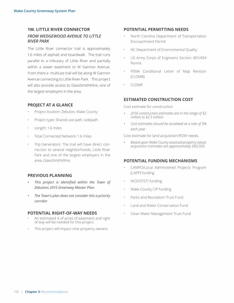
110 | Chapter 3: Recommendations
Wake County Greenway System Plan
1W. LITTLE RIVER CONNECTORFROM WEDGEWOOD AVENUE TO LITTLE RIVER PARK
The Little River connector trail is approximately
1.6 miles of asphalt and boardwalk. The trail runs
parallel to a tributary of Little River and partially
within a sewer easement to W Gannon Avenue.
From there a multiuse trail will be along W Gannon
Avenue connecting to Little River Park. This project
will also provide access to GlaxoSmithKline, one of
the largest employers in the area.
PROJECT AT A GLANCE• Project location: Zebulon, Wake County
• Project type: Shared use path, sidepath
• Length: 1.6 miles
• Total Connected Network: 1.6 miles
• Trip Generators: The trail will have direct con-nection to several neighborhoods, Little River Park and one of the largest employers in the area, GlaxoSmithKline.
ESTIMATED CONSTRUCTION COSTCost estimate for construction
• 2016 construction estimates are in the range of $2 million to $2.5 million
• Cost estimates should be escalated at a rate of 5% each year.
Cost estimate for land acquisition/ROW needs.
• Based upon Wake County assessed property values acquisition estimates are approximately $60,500.
POTENTIAL RIGHT-OF-WAY NEEDS• An estimated 4 of acres of easement and right
of way will be needed for this project.
• This project will impact nine property owners.
PREVIOUS PLANNING• This project is identified within the Town of
Zebulons 2015 Greenway Master Plan.
• The Town’s plan does not consider this a priority corridor
POTENTIAL FUNDING MECHANISMS• CAMPO/Local Adminstered Projects Program
(LAPP) funding
• NCDOT/STI funding
• Wake County CIP funding
• Parks and Recreation Trust Fund
• Land and Water Conservation Fund
• Clean Water Management Trust Fund
POTENTIAL PERMITTING NEEDS• North Carolina Department of Transportation
Encroachment Permit
• NC Department of Environmental Quality
• US Army Corps of Engineers Section 401/404 Permit
• FEMA Conditional Letter of Map Revision (CLOMR)
• CLOMR

Chapter 3: Recommendations | 111
Wake County Greenway System Plan
OPPORTUNITIES & CONSTRAINTS
97
WJU
DD
ST
CURRIN PERRY RD
YATES PL
SO
MER
SETDR
LANIER LN
KING MALCOLM LN
WEDGEWOOD AVE
STR
ATFO
RDDR
SEXTON AVE
SOU
THLA
ND
DR
SAN
PAD
EE
DRSM
OKEY
MO
UN
TAIN
DR
RIVERVIEW D
R
LAUREL LEAFRD
PIN
EV
IEW
DR
WORTH
HINTONRD
WF
RA
NK
LIN ST
SA
SSW
OO
DLN
ROYAL DEESIDE CT
CEDAR DR
BRAEMAR HIGHLAND
DR
SP
RU
CE
DR
GR
EE
NPA
CE
RD
US 64
HW
Y W
B
US 64
HW
Y EB
W G
AN
NO
N A
VE
WA
TE
RP
L AN
TRD
64
LittleRiverPark
WA
KE
CO
UN
TYZ
EB
ULO
N
Little River
0 0.5Miles
Priority Segment
Prop. Regional Network
Prop. Greenway
100-Year Floodplain
Wetland
This trail creates a direct connection to GlaxoSmithKline, the major employer in the area.
Wetland areas will require elevated boardwalk.
Most of the easements needed are located on undeveloped property or within existing sanitary sewer easements.
A large portion of this project will be located within the floodplain which will require a detailed study area for FEMA/CLOMR.
Adequate right of way is available along West Gannon Ave to construct a multiuse path.
South end is anchored by Little River Park.
START: WEDGEWOOD
AVENUE
END:LITTLE RIVER PARK

112 | Chapter 3: Recommendations
Wake County Greenway System Plan
112 | Chapter 3: Recommendations
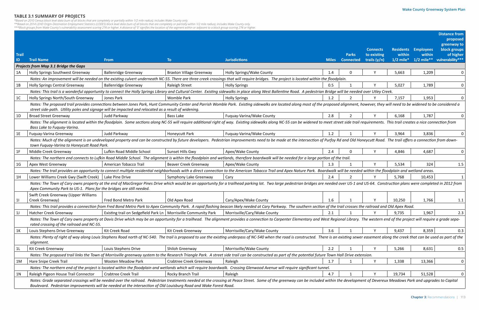
Chapter 3: Recommendations | 113
Wake County Greenway System Plan
TABLE 3.1 SUMMARY OF PROJECTS*Based on 2010 Census block level data (sum of all blocks that are completely or partially within 1/2 mile radius); includes Wake County only. **Based on 2014 LEHD Origin-Destination Employment Statistics (LODES) block level data (sum of all blocks that are completely or partially within 1/2 mile radius); includes Wake County only. ***Block groups from Wake County's vulnerability assessment scoring 274 or higher. A distance of '0' signifies the location of the segment within or adjacent to a block group scoring 274 or higher.
Trail ID Trail Name From To Jurisdictions Miles
Parks Connected
Connects to existing trails (y/n)
Residents within
1/2 mile*
Employees within
1/2 mile**
Distance from proposed
greenway to block groups
of higher vulnerability***
Projects from Map 3.1 Bridge the Gaps 1A Holly Springs Southwest Greenway Ballenridge Greenway Braxton Village Greenway Holly Springs/Wake County 1.4 0 Y 5,663 1,209 0
Notes: An improvement will be needed on the existing culvert underneath NC-55. There are three creek crossings that will require bridges. The project is located within the floodplain.1B Holly Springs Central Greenway Ballenridge Greenway Raleigh Street Holly Springs 0.5 1 Y 5,027 1,789 0
Notes: This trail is a wonderful opportunity to connect the Holly Springs Library and Cultural Center. Existing sidewalks in place along West Ballentine Road. A pedestrian Bridge will be needed over Utley Creek.1C Holly Springs North/South Greenway Jones Park Womble Park Holly Springs 1.2 2 Y 7,157 1,953 0
Notes: The proposed trail provides connections between Jones Park, Hunt Community Center and Parrish Womble Park. Existing sidewalks are located along most of the proposed alignment, however, they will need to be widened to be considered a street side-path. Utility poles and signage will be impacted and relocated as a result of widening.
1D Broad Street Greenway Judd Parkway Bass Lake Fuquay-Varina/Wake County 2.8 2 Y 6,168 1,787 0 Notes: The alignment is located within the floodplain. Some sections along NC-55 will require additional right of way. Existing sidewalks along NC-55 can be widened to meet street side trail requirements. This trail creates a nice connection from Bass Lake to Fuquay-Varina.
1E Fuquay-Varina Greenway Judd Parkway Honeycutt Park Fuquay-Varina/Wake County 1.2 1 Y 3,964 3,836 0 Notes: Much of the alignment is on undeveloped property and can be constructed by future developers. Pedestrian improvements need to be made at the intersection of Purfoy Rd and Old Honeycutt Road. The trail offers a connection from down-town Fuquay-Varina to Honeycutt Road Park.
1F Middle Creek Greenway Lufkin Road Middle School Sunset Hills Gwy Apex/Wake County 2.4 0 Y 4,846 4,687 0 Notes: The northern end connects to Lufkin Road Middle School. The alignment is within the floodplain and wetlands, therefore boardwalk will be needed for a large portion of the trail.
1G Apex West Greenway American Tobacco Trail Beaver Creek Greenway Apex/Wake County 1.3 1 Y 5,534 324 1.5Notes: The trail provides an opportunity to connect multiple residential neighborhoods with a direct connection to the American Tobacco Trail and Apex Nature Park. Boardwalk will be needed within the floodplain and wetland areas.
1H Lower Williams Creek Gwy (Swift Creek) Lake Pine Drive Symphony Lake Greenway Cary 2.4 2 Y 5,768 10,453 1Notes: The Town of Cary owns property at the end of MacGregor Pines Drive which would be an opportunity for a trailhead parking lot. Two large pedestrian bridges are needed over US-1 and US-64. Construction plans were completed in 2012 from Apex Community Park to US-1. Plans for the bridges are still needed.
1ISwift Creek Greenway (Upper Williams Creek Greenway) Fred Bond Metro Park Old Apex Road Cary/Apex/Wake County 1.6 1 Y 10,250 1,766 1.1Notes: This trail provides a connection from Fred Bond Metro Park to Apex Community Park. A rapid flashing beacon likely needed at Cary Parkway. The southern section of the trail crosses the railroad and Old Apex Road.
1J Hatcher Creek Greenway Existing trail on Sedgefield Park Ln Morrisville Community Park Morrisville/Cary/Wake County 2.1 1 Y 9,735 1,967 2.3Notes: The Town of Cary owns property at Davis Drive which may be an opportunity for a trailhead. The alignment provides a connection to Carpenter Elementary and West Regional Library. The western end of the project will require a grade sepa-rated crossing of the railroad and NC-55.
1K Louis Stephens Drive Greenway Kit Creek Road Kit Creek Greenway Morrisville/Cary/Wake County 3.6 1 Y 9,437 8,359 0.3 Notes: Plenty of right of way along Louis Stephens Road north of NC-540. The trail is proposed to use the existing underpass of NC-540 when the road is constructed. There is an existing sewer easement along the creek that can be used as part of the alignment.
1L Kit Creek Greenway Louis Stephens Drive Shiloh Greenway Morrisville/Wake County 2.2 1 Y 5,266 8,631 0.5 Notes: The proposed trail links the Town of Morrisville greenway system to the Research Triangle Park. A street side trail can be constructed as part of the potential future Town Hall Drive extension.
1M Hare Snipe Creek Trail Wooten Meadow Park Crabtree Creek Greenway Raleigh 1.7 1 Y 1,338 13,366 0 Notes: The northern end of the project is located within the floodplain and wetlands which will require boardwalk. Crossing Glenwood Avenue will require significant tunnel.
1N Raleigh Pigeon House Trail Connector Crabtree Creek Trail Rocky Branch Trail Raleigh 4.7 1 Y 19,734 51,528 0 Notes: Grade separated crossings will be needed over the railroad. Pedestrian treatments needed at the crossing at Peace Street. Some of the greenway can be included within the development of Devereux Meadows Park and upgrades to Capital Boulevard. Pedestrian improvements will be needed at the intersection of Old Louisburg Road and Wake Forest Road.

114 | Chapter 3: Recommendations
Wake County Greenway System Plan
Trail ID Trail Name From To Jurisdictions Miles
Parks Connected
Connects to existing trails (y/n)
Residents within
1/2 mile*
Employees within
1/2 mile*
Distance from proposed
greenway to block groups
of higher vulnerability***
1O Creech Road Greenway Garner Road Walnut Creek Greenway Raleigh/Garner/Wake County 4.4 2 Y 9,688 2,362 0 Notes: The trail will require multiple bridges over creeks and boardwalks within wetlands. It will also need an underpass of Rock Quarry Road and a bridge over I-40.
1P Buffaloe Road Greenway White Deer Park Centennial Park Garner/Wake County 3 2 Y 3,882 655 0Notes: The trail is proposed to be a street side path along Buffaloe Road which has many driveway crossings to accommodate. Buffalo Road across Lake Benson must be reconstructed to accommodate a trail. An underpass will be needed at NC-50.
1Q Durant Road Trail Honeycutt Road Falls of the Neuse Road Raleigh/Wake County 1.3 0 Y 4,014 1,303 1Notes: A pedestrian bridge or boardwalk crossing will be needed at the creek. Additional right of way will be needed or a closed drainage system. The corridor primarily consists of valuable residential developments with extensive landscaping that would be impacted by the project.
1R Smith Creek Greenway Heritage Schools Burlington Mills Road Wake Forest/Wake County 2.2 0 Y 6,096 1,491 0 Notes: Much of the needed right of way is already in place. A pedestrian culvert will be needed at Ligon Mill Road. The project is located within the floodplain and wetland areas which will require boardwalk.
1SDr. Calvin Jones Greenway/Dunn Creek Greenway Corporate Chaplin Multiuse Path Lemongrass Lane Wake Forest/Wake County 1.7 0 Y 7,329 2,108 0 Notes: Crossing the railroad will require a 100 foot long prefabricated bridge. Much of Calvin Jones Road is elevated with significant slopes on the sides. The greenway will need to be either benched into the slope or constructed at the toe of the slope.
1T Sanford Creek Greenway Existing Sanford Creek Greenway Main Street Park Rolesville 1 1 Y 2,061 770 0 Notes: The trail provides a continued connection between Rolesville and Wake Forest. There are two creek crossings that will require pre fabricated bridges up to 40 feet long. Significant rock was identified at the southern end of the trail.
1U Mingo Creek Greenway Mingo Creek Park Knightdale Station Park Knightdale 1.3 2 Y 6,360 2,353 0Notes: This project will create a nice connection between Mingo Creek Park and Knightdale Station Park. The trail is located within the floodplain and wetland areas which will require boardwalk.
1V Wendell Falls Parkway Trail Martin Pond Road Wendell Park Wendell/Wake County 2.4 1 Y 1,964 159 0 Notes: A bridge will be needed over Buffalo Creek. Right of way will be needed along Wendell Falls Parkway or a closed drainage system will be needed. Much of the street frontage along Wendell Falls Parkway is undeveloped and the trail can be built as part of the development of that corridor.
1W Little River Connector Wedgewood Avenue LIttle River Park Zebulon/Wake County 1.6 1 N 3,225 576 0Notes: The trail provides a direct connection to Glaxo-Smith-Kline, one of the major employers in the area. The floodplain and wetlands areas will require boardwalk. A prefabricated structure may be needed over the creek at West Gannon Road.
Projects from Map 3.2 Connect Parks and Lakes
2ALower Barton Ck/Hare Snipe Ck Green-way/Umstead Park Link Lake Lynn Park Six Forks Road & Umstead Park Raleigh/Wake County/NC Parks 16.5 2 Y 22,247 9,989 0Notes: Easements will be needed in older and valuable residential neighborhoods along the Hare Snipe Creek corridor. Westgate Road has two creek crossings that are prone to flooding. There are several industrial driveways on Westgate Road which create safety concerns for bicycle and pedestrian users. A grade separated crossing will be needed at I-540. Significant sight distance challenges crossing Creedmoor Road and Mt. Vernon Church Road. See the TJCOG CORE Bike/Ped Plan for more on the proposed Sycamore Greenway connection.
2B Richland Creek Greenway Neuse River Trail South Main Street Raleigh/Wake Forest/Wake County 5.5 0 Y 16,190 6,543 0Notes: Grade separated crossings are needed at Capital Blvd and NC-98. A high visibility signalized crossing will be needed on Falls of Neuse Road. The trail corridor is almost entirely within the floodplain.
2C Little River Greenway Southland Drive West Third Street Wendell/Zebulon/Wake County 6.2 2 N 6,374 1,244 0Notes: The Little River corridor has a wide floodplain and significant wetlands which will require boardwalk. Three at grade railroad crossings from Little River to downtown Wendell. Trail through downtown Wendell will have several driveway cross-ings.
2D Wendell Falls North Greenway North First Avenue Wendell Falls Greenway Knightdale/Wendell/Wake County 2.6 2 Y 3,365 1,135 0Notes: The trail follows an active railroad corridor. There is not enough shoulder on Wendell Falls Parkway bridge at US-264 for a bike/ped path, an independent bridge will be needed.
2E Dowling Road Sidepath Walnut Creek Trail Poole Road Raleigh/Wake County 1.1 1 Y 3,073 2,062 0Notes: Majority of the needed right of way is in place. Sidewalks and an at grade high visibility crossing will be needed on Old Poole Road.
TABLE 3.1 SUMMARY OF PROJECTS*Based on 2010 Census block level data (sum of all blocks that are completely or partially within 1/2 mile radius); includes Wake County only. **Based on 2014 LEHD Origin-Destination Employment Statistics (LODES) block level data (sum of all blocks that are completely or partially within 1/2 mile radius); includes Wake County only. ***Block groups from Wake County's vulnerability assessment scoring 274 or higher. A distance of '0' signifies the location of the segment within or adjacent to a block group scoring 274 or higher.

Chapter 3: Recommendations | 115
Wake County Greenway System Plan
Trail ID Trail Name From To Jurisdictions Miles
Parks Connected
Connects to existing trails (y/n)
Residents within
1/2 mile*
Employees within
1/2 mile*
Distance from proposed
greenway to block groups
of higher vulnerability***
2F Apex Loop Greenway Beaver Creek South Trail Burma Drive Apex/Wake County 4.9 2 Y 18,478 12,896 0Notes: Adequate right of way is available along Apex Peakway for a street side trail. A pedestrian bridge will be needed across US-1.
2G Swift Creek Greenway Kildaire Farm Road/Cary Parkway Lake Wheeler Road Cary/Wake County 6.9 2 Y 13,731 32,365 0Notes: Limited right of way available along Lochmere Drive and Lilly Adkins Road. Crossing the damn requires coordination with the ACOE. Trail alignment encroaches into the floodplain near Swift Creek.
2H Lake Johnson to Lake Benson Greenway Upper Walnut Creek Trail Old Stage Rd Raleigh/Garner/Wake County 6.9 1 Y 16,040 27,131 0Notes: Lake Dam Road over I-40 has a safe shoulder for bike/ped though some guardrails will be needed. Alignment crosses NC State property. A grade separated crossing will be needed at Fayetteville Road. Boardwalk needed at southern section of the project.
2I Braxton Village Greenway Harris Lake County Park Elm Stone Way Holly Springs/Wake County 4.1 1 N 3,770 165 0Notes: New Hill-Holloman Road does not have adequate right of way for a bike/ped trail. A widening or separate structure will be needed to cross the lake.
2J Black Creek Greenway North Cary Park West Dynasty Drive Cary 0.3 1 Y 6,722 1,909 0.7Notes: Bridge will be needed to cross Black Creek, triggering a flood study.
2K Clemmons Connector Trail Neuse River Trail Clemmons Educational Forest Wake County 0.4 1 Y 918 96 1.5Notes: There will be two tributary crossings and high visibility crossing on Old Baucom Road.
2L Swift Creek Greenway Lake Wheeler Road White Deer Park Garner/Wake County 4.9 1 Y 7,907 25,159 0Notes: Trail alignment is located within a floodplain which will trigger a flood study. See Swift Creek Greenway Master Plan.
Projects from Map 3.3 Connect the Communities3A Apex Cary Greenway Ten Ten Road Regency Parkway Apex/Cary/Wake County 1.2 0 Y 5,897 11,434 0
Notes: Alignment encroaches a Duke Power easement and power transfer station.3B Fuquay-Varina North Greenway North Broad Street East Academy Street Fuquay-Varina/Wake County 2.1 0 N 7,074 4,630 0
Notes: Bike/ped signalization will be needed at intersections and driveway crossings along Judd Parkway. Special treatments needed at the railroad crossing. 3C Walnut Creek Greenway Black Creek Greenway Lake Johnson Metro Park Cary/Raleigh 5.8 4 Y 31,397 14,977 0
Notes: Special pedestrian treatments will be needed at the railroad crossing on Old Apex Road. A high visibility crossing with beacon and pedestrian safe haven will be needed at SE Maynard Road. Bridge will be needed over both I-40 and I-440.3D North Bond Park Connector Trail Morrisville Parkway Crabtree Creek Greenway Cary/Wake County 2.1 3 Y 15,335 4,365 1.6
Notes: A street side trail along Louis Stephens Road will trigger a closed drainage system.3E Zebulon Greenway Wedgewood Avenue Carolina Mudcats Stadium Zebulon/Wake County 4.6 2 N 4,375 4,084 0
Notes: Franklin Street will need curb and gutter. A road diet may be needed on North Arendell Avenue. An at grade crossing with the railroad will need special bike/ped crossing treatments. Southern end in located within the floodplain and wetland areas which will require boardwalk.
3F South Zebulon Greenway Proposed Little River Greenway Zebulon Community Park Zebulon/Wake County 3.2 1 N 2,625 1,541 0Notes: Trail can utilize existing power easement.
TABLE 3.1 SUMMARY OF PROJECTS*Based on 2010 Census block level data (sum of all blocks that are completely or partially within 1/2 mile radius); includes Wake County only. **Based on 2014 LEHD Origin-Destination Employment Statistics (LODES) block level data (sum of all blocks that are completely or partially within 1/2 mile radius); includes Wake County only. ***Block groups from Wake County's vulnerability assessment scoring 274 or higher. A distance of '0' signifies the location of the segment within or adjacent to a block group scoring 274 or higher.
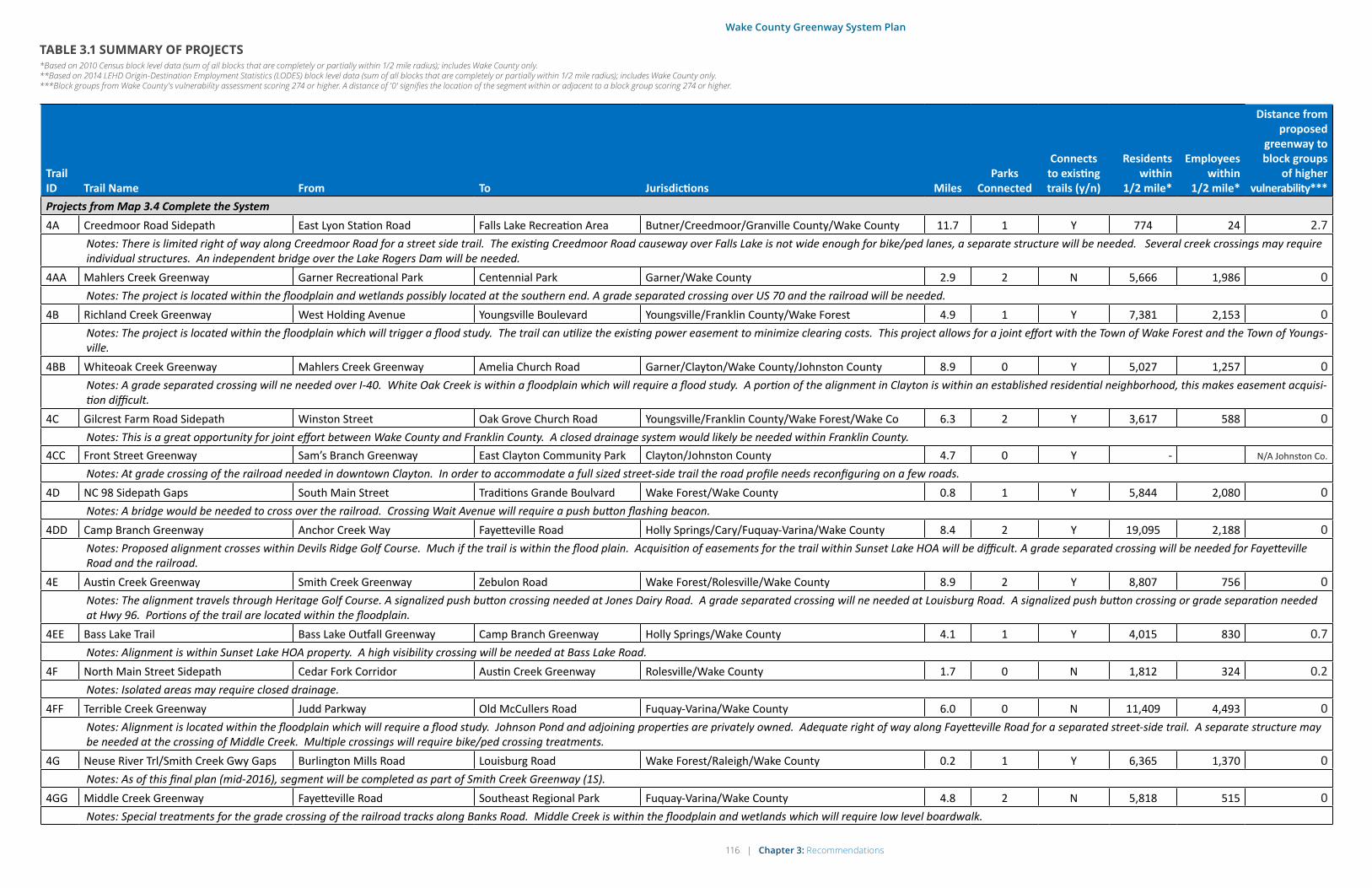
116 | Chapter 3: Recommendations
Wake County Greenway System Plan
Trail ID Trail Name From To Jurisdictions Miles
Parks Connected
Connects to existing trails (y/n)
Residents within
1/2 mile*
Employees within
1/2 mile*
Distance from proposed
greenway to block groups
of higher vulnerability***
Projects from Map 3.4 Complete the System4A Creedmoor Road Sidepath East Lyon Station Road Falls Lake Recreation Area Butner/Creedmoor/Granville County/Wake County 11.7 1 Y 774 24 2.7
Notes: There is limited right of way along Creedmoor Road for a street side trail. The existing Creedmoor Road causeway over Falls Lake is not wide enough for bike/ped lanes, a separate structure will be needed. Several creek crossings may require individual structures. An independent bridge over the Lake Rogers Dam will be needed.
4AA Mahlers Creek Greenway Garner Recreational Park Centennial Park Garner/Wake County 2.9 2 N 5,666 1,986 0Notes: The project is located within the floodplain and wetlands possibly located at the southern end. A grade separated crossing over US 70 and the railroad will be needed.
4B Richland Creek Greenway West Holding Avenue Youngsville Boulevard Youngsville/Franklin County/Wake Forest 4.9 1 Y 7,381 2,153 0Notes: The project is located within the floodplain which will trigger a flood study. The trail can utilize the existing power easement to minimize clearing costs. This project allows for a joint effort with the Town of Wake Forest and the Town of Youngs-ville.
4BB Whiteoak Creek Greenway Mahlers Creek Greenway Amelia Church Road Garner/Clayton/Wake County/Johnston County 8.9 0 Y 5,027 1,257 0Notes: A grade separated crossing will ne needed over I-40. White Oak Creek is within a floodplain which will require a flood study. A portion of the alignment in Clayton is within an established residential neighborhood, this makes easement acquisi-tion difficult.
4C Gilcrest Farm Road Sidepath Winston Street Oak Grove Church Road Youngsville/Franklin County/Wake Forest/Wake Co 6.3 2 Y 3,617 588 0Notes: This is a great opportunity for joint effort between Wake County and Franklin County. A closed drainage system would likely be needed within Franklin County.
4CC Front Street Greenway Sam’s Branch Greenway East Clayton Community Park Clayton/Johnston County 4.7 0 Y - N/A Johnston Co.
Notes: At grade crossing of the railroad needed in downtown Clayton. In order to accommodate a full sized street-side trail the road profile needs reconfiguring on a few roads. 4D NC 98 Sidepath Gaps South Main Street Traditions Grande Boulvard Wake Forest/Wake County 0.8 1 Y 5,844 2,080 0
Notes: A bridge would be needed to cross over the railroad. Crossing Wait Avenue will require a push button flashing beacon.4DD Camp Branch Greenway Anchor Creek Way Fayetteville Road Holly Springs/Cary/Fuquay-Varina/Wake County 8.4 2 Y 19,095 2,188 0
Notes: Proposed alignment crosses within Devils Ridge Golf Course. Much if the trail is within the flood plain. Acquisition of easements for the trail within Sunset Lake HOA will be difficult. A grade separated crossing will be needed for Fayetteville Road and the railroad.
4E Austin Creek Greenway Smith Creek Greenway Zebulon Road Wake Forest/Rolesville/Wake County 8.9 2 Y 8,807 756 0Notes: The alignment travels through Heritage Golf Course. A signalized push button crossing needed at Jones Dairy Road. A grade separated crossing will ne needed at Louisburg Road. A signalized push button crossing or grade separation needed at Hwy 96. Portions of the trail are located within the floodplain.
4EE Bass Lake Trail Bass Lake Outfall Greenway Camp Branch Greenway Holly Springs/Wake County 4.1 1 Y 4,015 830 0.7Notes: Alignment is within Sunset Lake HOA property. A high visibility crossing will be needed at Bass Lake Road.
4F North Main Street Sidepath Cedar Fork Corridor Austin Creek Greenway Rolesville/Wake County 1.7 0 N 1,812 324 0.2Notes: Isolated areas may require closed drainage.
4FF Terrible Creek Greenway Judd Parkway Old McCullers Road Fuquay-Varina/Wake County 6.0 0 N 11,409 4,493 0Notes: Alignment is located within the floodplain which will require a flood study. Johnson Pond and adjoining properties are privately owned. Adequate right of way along Fayetteville Road for a separated street-side trail. A separate structure may be needed at the crossing of Middle Creek. Multiple crossings will require bike/ped crossing treatments.
4G Neuse River Trl/Smith Creek Gwy Gaps Burlington Mills Road Louisburg Road Wake Forest/Raleigh/Wake County 0.2 1 Y 6,365 1,370 0Notes: As of this final plan (mid-2016), segment will be completed as part of Smith Creek Greenway (1S).
4GG Middle Creek Greenway Fayetteville Road Southeast Regional Park Fuquay-Varina/Wake County 4.8 2 N 5,818 515 0Notes: Special treatments for the grade crossing of the railroad tracks along Banks Road. Middle Creek is within the floodplain and wetlands which will require low level boardwalk.
TABLE 3.1 SUMMARY OF PROJECTS*Based on 2010 Census block level data (sum of all blocks that are completely or partially within 1/2 mile radius); includes Wake County only. **Based on 2014 LEHD Origin-Destination Employment Statistics (LODES) block level data (sum of all blocks that are completely or partially within 1/2 mile radius); includes Wake County only. ***Block groups from Wake County's vulnerability assessment scoring 274 or higher. A distance of '0' signifies the location of the segment within or adjacent to a block group scoring 274 or higher.

Chapter 3: Recommendations | 117
Wake County Greenway System Plan
TABLE 3.1 SUMMARY OF PROJECTS*Based on 2010 Census block level data (sum of all blocks that are completely or partially within 1/2 mile radius); includes Wake County only. **Based on 2014 LEHD Origin-Destination Employment Statistics (LODES) block level data (sum of all blocks that are completely or partially within 1/2 mile radius); includes Wake County only. ***Block groups from Wake County's vulnerability assessment scoring 274 or higher. A distance of '0' signifies the location of the segment within or adjacent to a block group scoring 274 or higher.
Trail ID Trail Name From To Jurisdictions Miles
Parks Connected
Connects to existing trails (y/n)
Residents within
1/2 mile*
Employees within
1/2 mile*
Distance from proposed
greenway to block groups
of higher vulnerability***
4H Cedar Fork Greenway Main Street Park MItchell Mill Park Rolesville/Wake County 4.5 2 Y 4,022 872 0Notes: A grade separated crossing will be needed over US-401. The project is located within the floodplain and likely wetland areas.
4HH Old Stage Road Sidepath Swift Creek Greenway Middle Creek Greenway Garner/Wake County 5.5 1 N 10,185 629 0Notes: The project has adequate right of way for a street side trail. Much of the project will need closed drainage to construct the trail. Creek crossings may need a headwall to construct the trail.
4I Park Center Extension American Tobacco Trail Glenwood Avenue Durham/Durham County/Raleigh/Wake County 10.5 0 Y 6,634 12,803 1.9Notes: Several creek crossings that require flood studies. Grade separated crossings needed at Glenwood Avenue and I-540. North of Brier Creek Parkway easements will be needed through residential areas of the golf course community.
4II South NC 55 Side Path Honeycutt Road Park Depot Street Fuquay-Varina/Angier/Wake County/Harnett County 5.8 1 Y 3,769 483 0Notes: Constructing a street side trail along NC-55 will require additional right of way or a closed drainage system with curb and gutter will be needed.
4J Perry Creek Greenway Marsh Creek Neuse River Trail Raleigh/Wake County 6.0 3 Y 22,789 12,840 0Notes: Grade separated crossings needed at Capital Boulevard, I-540 and the Railroad. The alignment goes through an older developed residential area and golf course community. Obtaining easements for construction may be challenging.
4K Harris Creek Greenway Neuse River Trail Cedar Fork Greenway Raleigh/Rolesville/Wake County 8.8 0 Y 9,037 888 0.2Notes: The trail is proposed to parallel Rolesville Bypass (US-401) which will require a separate easement or right of way. Cedar Fork is a jurisdictional floodplain.
4L Buffalo Creek Greenway US 401 East Wake High Trail Rolesville/Wake County 7.1 0 N 3,401 396 0Notes: This corridor is in a rural setting without any major road crossings. The alignment is almost entirely in the floodplain requiring a flood study.
4M Little River Greenway Fowlers Mill Creek Riverview Drive Zebulon/Wake County 8.6 2 N 4,362 313 0Notes: The Little River greenway is located entirely within the floodplain. A grade separated crossing will be needed over US 64. Little River has been studied for a potential reservoir. If the reservoir moves forward a detail study of recreational oppor-tunities on the lake including greenway trails should be prepared.
4N Park Center Loop Cornwallis Road Kit Creek Road Durham County/Wake County 4.6 0 N 150 7,265 0.4Notes: As of this final plan (mid-2016), segment is now complete.
4P East Wake High Trail Knightdale Eagle Rock Road LIttle River Knightdale/Wake County 8.9 0 N 3,403 730 0Notes: The alignment crosses multiple jurisdictional creeks. Each creek will require flood studies.
4Q Marsh Creek Greenway Spring Forest Road Buckeye Trail Raleigh/Wake County 6.0 2 Y 27,532 27,024 0Notes: There are many road crossings that will required grade separations including Capital Blvd and I-440. Additionally the trail crosses two separate railroad corridors. The trail also is located in the floodplain which will require a flood study.
4R Trinity Rd Street-Side Trail Walnut Creek Greenway Reedy Creek Road Cary/Raleigh/Wake County 3.6 2 Y 7,966 3,795 0Notes: Crossing Wade Ave/I-440 will require an individual structure. Trenton Road will require a closed drainage system or additional right of way. The crossing of the railroad should be grade separated. Crossing Walnut Creek will trigger a flood study.
4S Pirates Cove Greenway Greenwood Circle Johnes Franklin Road Cary/Raleigh/Wake County 3.1 2 Y 15,645 6,936 0Notes: The road profile on Western Blvd overpass of I-40 would have to be redesigned to accommodate a greenway. Further up Western Blvd may require a closed drainage system. A portion of this project will likely be constructed as part of the Western Blvd extension.
4T White Oak Creek Greenway Davis Drive MacArthur Drive Cary 0.4 1 Y 7,218 1,133 2.2Notes: The trail will be fully constructed within HOA common space. There is also a crossing of a railroad that will impact the constructability project.
4U Glengarry Sidewalk Connector Pirates Grove Greenway Macedonia Lake Loop Trail Cary/Wake County 1.7 2 Y 8,309 8,395 0Notes: Crossing the creek will require a flood study. The greenway should utilize the existing power easement.
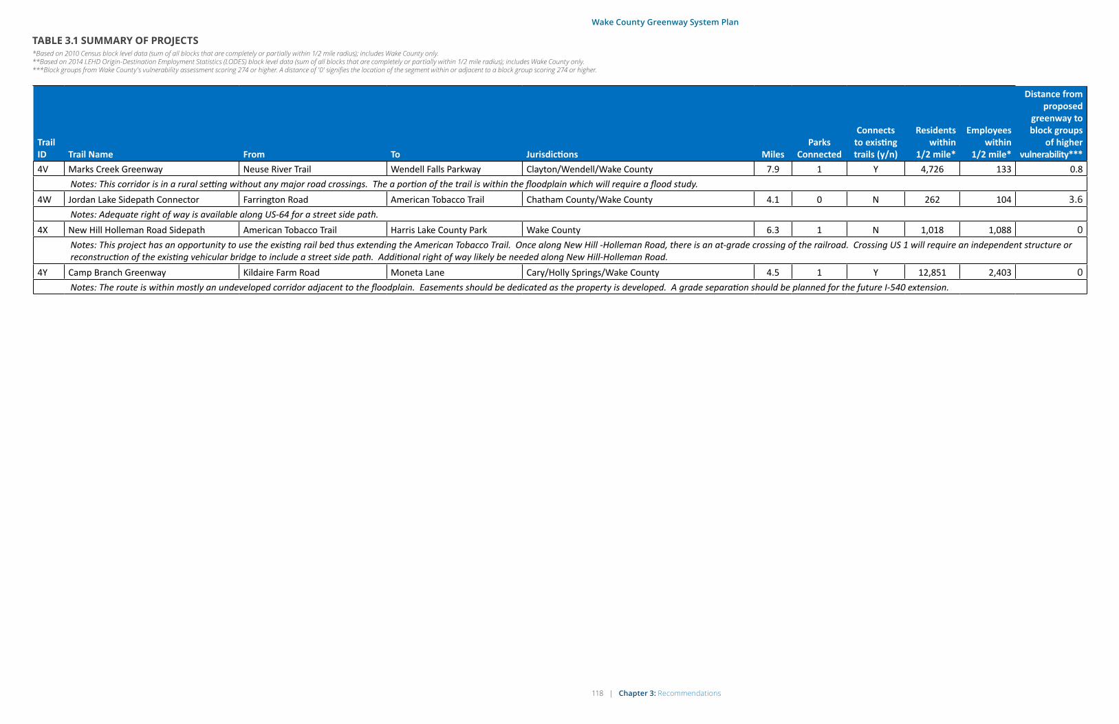
118 | Chapter 3: Recommendations
Wake County Greenway System Plan
TABLE 3.1 SUMMARY OF PROJECTS*Based on 2010 Census block level data (sum of all blocks that are completely or partially within 1/2 mile radius); includes Wake County only. **Based on 2014 LEHD Origin-Destination Employment Statistics (LODES) block level data (sum of all blocks that are completely or partially within 1/2 mile radius); includes Wake County only. ***Block groups from Wake County's vulnerability assessment scoring 274 or higher. A distance of '0' signifies the location of the segment within or adjacent to a block group scoring 274 or higher.
Trail ID Trail Name From To Jurisdictions Miles
Parks Connected
Connects to existing trails (y/n)
Residents within
1/2 mile*
Employees within
1/2 mile*
Distance from proposed
greenway to block groups
of higher vulnerability***
4V Marks Creek Greenway Neuse River Trail Wendell Falls Parkway Clayton/Wendell/Wake County 7.9 1 Y 4,726 133 0.8Notes: This corridor is in a rural setting without any major road crossings. The a portion of the trail is within the floodplain which will require a flood study.
4W Jordan Lake Sidepath Connector Farrington Road American Tobacco Trail Chatham County/Wake County 4.1 0 N 262 104 3.6Notes: Adequate right of way is available along US-64 for a street side path.
4X New Hill Holleman Road Sidepath American Tobacco Trail Harris Lake County Park Wake County 6.3 1 N 1,018 1,088 0Notes: This project has an opportunity to use the existing rail bed thus extending the American Tobacco Trail. Once along New Hill -Holleman Road, there is an at-grade crossing of the railroad. Crossing US 1 will require an independent structure or reconstruction of the existing vehicular bridge to include a street side path. Additional right of way likely be needed along New Hill-Holleman Road.
4Y Camp Branch Greenway Kildaire Farm Road Moneta Lane Cary/Holly Springs/Wake County 4.5 1 Y 12,851 2,403 0Notes: The route is within mostly an undeveloped corridor adjacent to the floodplain. Easements should be dedicated as the property is developed. A grade separation should be planned for the future I-540 extension.

Chapter 3: Recommendations | 119
Wake County Greenway System Plan
IMPROVING TRAIL USERS’ EXPERIENCE
Once more of the greenway projects outlined on
the previous pages have been put in place, and
once key gaps in the system have been filled,
further work should be done to promote the use
of greenways to both residents and visitors. With
increasing investment in greenways and trails,
North Carolina is poised to become a top destina-
tion for recreational tourism. The majority of Wake
County residents may be aware of improvements
to the greenway system, but those living outside
the county and even some county residents may
not be aware of all the greenways that Wake County
has to offer. As a regional leader, Wake County can
play a key role in coordinating efforts across three
main areas of trail development in addition to the
actual trail projects featured in the first part of this
chapter. Wake County should work with its partners
to establish a regional trail branding and wayfinding
program that can be used to promote the system
regionally and nationally, and encourage the place-
ment of key amenities along and throughout the
greenway system.
Regional Branding and Wayfinding
In order for greater numbers of people to enjoy
the greenways, Wake County should consider a
branding strategy that will market the greenways to
residents, visitors, and potential funders. A brand
tends to communicate what the user will experience
and is applied consistently throughout all materials,
messaging, and representation. It creates an emo-
tional association and incorporates the inherent
nature of an entity – its personality, character, and
style. Lastly, a brand enables an entity to distinguish
itself from similar options. For a greenway, a brand
includes user experience, logo, signage, purpose,
safety, comfort, programming, funding, sponsors,
and supporters.
Branding the greenway system has multiple bene-
fits, including:
• Creating awareness of the greenways
• Increased numbers of bicycle and walking trips
• A greater sense of security and comfort
• Improving navigation of the greenway system
• Defining the system within the larger context of
trails, bicycle routes, and pedestrian routes
One component of branding is to establish a logo
for the greenway system. The creation of a logo to
be placed on signs, brochures, and maps would
give the system a distinct identity. Branding of the
greenways would reflect the uniqueness of Wake
County and its municipalities. It will simultaneously
set the greenway system apart from trails and
greenways in other regions while also serving to
improve connectivity and navigation. Part of this
branding strategy would be to explore the charac-
ter of the greenway system and project an image
of how it should be represented. It is also critical
that it be designed and implemented in a way that
works well for both the County and the municipal
partners.
Aside from the benefit of increased of tourism,
branding the greenway system offers benefits from
a transportation perspective. Having signage in
place to alert motorists of crossings will improve
safety for pedestrians and bicyclists who use the
greenway. Once a branding strategy has been
identified, the next step would be to develop com-
prehensive wayfinding for the system. Wayfinding is
generally considered to be a system of visual cues
that help to orient people and give them a sense
of place. As the Wake County greenway system
expands, residents and visitors will have increased
access to longer recreation routes, schools, com-
mercial centers, and green spaces. Wayfinding
elements such as signage and mile markers will
help to draw visitors, help users to identify the
best routes, and enhance their ability to connect to
major destinations.
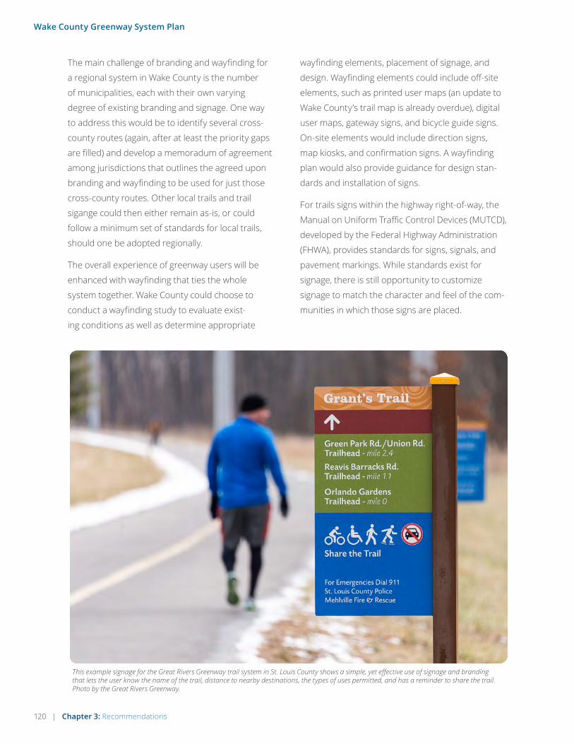
120 | Chapter 3: Recommendations
Wake County Greenway System Plan
The main challenge of branding and wayfinding for
a regional system in Wake County is the number
of municipalities, each with their own varying
degree of existing branding and signage. One way
to address this would be to identify several cross-
county routes (again, after at least the priority gaps
are filled) and develop a memoradum of agreement
among jurisdictions that outlines the agreed upon
branding and wayfinding to be used for just those
cross-county routes. Other local trails and trail
sigange could then either remain as-is, or could
follow a minimum set of standards for local trails,
should one be adopted regionally.
The overall experience of greenway users will be
enhanced with wayfinding that ties the whole
system together. Wake County could choose to
conduct a wayfinding study to evaluate exist-
ing conditions as well as determine appropriate
wayfinding elements, placement of signage, and
design. Wayfinding elements could include off-site
elements, such as printed user maps (an update to
Wake County’s trail map is already overdue), digital
user maps, gateway signs, and bicycle guide signs.
On-site elements would include direction signs,
map kiosks, and confirmation signs. A wayfinding
plan would also provide guidance for design stan-
dards and installation of signs.
For trails signs within the highway right-of-way, the
Manual on Uniform Traffic Control Devices (MUTCD),
developed by the Federal Highway Administration
(FHWA), provides standards for signs, signals, and
pavement markings. While standards exist for
signage, there is still opportunity to customize
signage to match the character and feel of the com-
munities in which those signs are placed.
This example signage for the Great Rivers Greenway trail system in St. Louis County shows a simple, yet effective use of signage and branding that lets the user know the name of the trail, distance to nearby destinations, the types of uses permitted, and has a reminder to share the trail. Photo by the Great Rivers Greenway.

Chapter 3: Recommendations | 121
Wake County Greenway System Plan
Trail Amenities
Functional greenway trails must feature appro-
priate amenities to create a complete, accessible,
and comfortable experience for a wide variety of
expected users. As longer, connected segments
of trail are built in Wake County, it will be import-
ant to accommodate longer-distance trips as well.
Elements such as restrooms, lighting, benches, and
other amenities create a unique identity but also
provide important functions. It is important that
the details work together to create a positive expe-
rience for users. The following key amenities are
described briefly with more information found in
the design resources listed at the end of Chapter 4.
Trailheads
Trailheads are arguably the most important amenity
of a greenway trail. Trailheads provide essential
access to the greenway and can include many
amenities in one location: automobile parking,
bicycle parking, restrooms, drinking fountains, trash
and recycle receptacles, dog waste stations, bicycle
repair stations, and greenway trail wayfinding and
informational signage. While there is no widely
accepted prescription for the frequency of trail-
heads, a report by the National Park Service (North
Country National Scenic Trail Handbook) suggests
a frequency of about 5-10 miles, depending on the
level of trail usage. User counts and surveys should
be conducted to analyze effectiveness of existing
trailheads in Wake County, and to determine current
levels of parking demand. Major trailheads should
be established where they are highly accessible and
visible, usually along a major transportation corri-
dor. Minor trailheads can be found at locally known
parks or at connections to residential or commercial
development.
Restrooms
Public restrooms are a critical building amenity
because they need to be responsive to a wide range
of human needs and abilities. Restrooms are often
selected as the most important trail amenity of the
general population. Careful consideration must
be given to a number of factors before locating
restrooms, including available land, size of trailhead,
utility availability, and user need. When locating
restrooms, prioritize them at trailheads within exist-
ing parks and review gaps for placement at other
trailheads or locations within the system (trailheads,
as noted above, are suggested at about 5-10 mile
intervals). Composting toilets, similar to what is
found at the current southern end of the American
Tobacco Trail, should be considered in remote areas
where utility connections are unavailable.
Composting restroom at the current southern end of the American Tobacco Trail in Wake County.
The New Hope Church Road Trailhead Park in northwest Cary.

122 | Chapter 3: Recommendations
Wake County Greenway System Plan
Drinking fountains are key amenities for a wide variety of the population including pets.
Utilitarian bench along the American Tobacco Trail. Seating placed in the shade is appropriate for users in warm weather.
Seating
Seating along greenway trails provides a place for
users to rest, congregate, and/or reflect. Benches
can be designed to create identity along the green-
way trail or be strictly utilitarian. Benches should be
located along the greenway where appropriate, or
where there is demand by users. Seating should be
provided at a minimum, every mile, and within 1/2
mile of trailheads.
Lighting
Lighting for greenway trails can improve visibility
along the greenway and at intersection crossings.
Lighting spacing along trails depends on the type
and intensity of lights, but 30-50 ft spacing is
common for pedestrian scale lighting. It may also
be necessary for day-time use in greenway tunnels
or underpasses. Lighting should be considered
on a case-by-case basis due to its expense and
maintenance commitment required. It is typically
not appropriate for greenway trails in remote
areas, trails with low use, or where there is little to
no development. Care should be taken to ensure
lighting does not negatively impact nearby resi-
dents in the form of light pollution.
Bike Repair Stations
Bike repair stations provide cyclists with an air
pump for filling up tires and tools for basic repairs
and adjustments. The City of Raleigh features
two bike repair stations currently. Ideal locations
would be at trailheads or adjoining parks.
Lighting is useful in areas where usage is expected to be higher and along trails that commuters typically use.
Repair stations provide basic amenities for bicyclists.
Drinking Fountains
Drinking fountains provide opportunities for users
to hydrate and potentially extend their trip. Long
distance runners and bicyclists require replen-
ishment and depend upon fountains to refill their
water bottles. Fountains are also particularly
desired by the elderly and come in handy for pets
as well. Drinking fountains should be located near
restrooms, at trailheads, parks, and other public
gathering places along the greenway trail. Space
drinking fountains 10-15 miles when potable or
treatable water is not otherwise available.

Chapter 3: Recommendations | 123
Wake County Greenway System Plan
MIle Markers
Mile markers serve two main purposes and are
often one of the most requested components of a
trail system. First, mile markers serve as import-
ant information for decision-making, especially
for those exercising and tracking their progress.
In addition, mile markers can provide a form of
“addressing” or locating for emergency response.
For the Wake County Greenway System, establish-
ing mile markers should occur after longer distance
cross-county connections can be made by filling
gaps between existing trails. This type of amenity
could be combined with an overall signage plan.
Mile markers are often placed every quarter mile,
although placement at tenth-mile intervals may be
preferable.
Edible Plants Along Greenways
Low maintenance edible plantings along greenways
are supported as an amenity to add to Wake County
residents’ experience of the greenways. Planting
edibles, primarily trees and berry bushes, in strate-
gic and visible areas of greenways is a way to both
minimize long term maintenance and management,
and add value to user experience. This plan recom-
mends a focus on native or locally adapted plants
which flourish in our Piedmont region, and grow
well and easily, requiring limited maintenance and
resources. There are already a number of edible
plants along Wake County greenways, and munici-
palities are encouraged to explore pilot projects to
incorporate these into greenways being installed or
upgraded. While there are many opportunities for
Mile marker on the American Tobacco Trail.
edibles along greenways, they are not recommended
within gas or electric easements, or near utility service
boxes or septic lines. Edibles can be included as part
of the overall project cost, especially as new greenway
segments are built and connections made with existing
greenways. Benefits include:
• Ecological benefit – edible plantings are sustain-
able. They are likely to flourish with limited mainte-
nance and without the use of chemicals.
• Improving the recreational experience – edibles
are one more tactile and sensory experience of
connecting greenway users with nature.
• Educational benefit – connecting kids with nature is
key to their healthy physical, mental and emotional
development. Data shows children who engage
with nature develop stronger executive functioning
skills. Edible plantings provide one more way for
kids to engage with nature on the greenways.
• Health benefit – eating more fruits and vegeta-
bles is one of 3 key chronic disease prevention
recommendations from the US Center for Disease
Control. Providing more visible ways to do this can
have a health benefit for our communities, even if
the volume is small.
• Economic benefit – edible plantings do not need
to cost more than traditional plantings, if installed
at the time a greenway is put in. Whenever the
installation occurs, native or locally adapted plants
may reduce maintenance and eliminate chemicals
needed, reducing costs for responsible jurisdic-
tions. Finally, in the long term, berry bushes and
fruit trees that greenway users can actually eat
from will have a minor economic benefit in terms of
free food. While the volume may be small initially,
long term this could be thousands of pounds of
food a year.
At least one pilot project is planned within Wake County
(at NC State), and strong interest has been expressed
in Holly Springs and Wake Forest. Other communities
already have such programs in place, such as in Black
Mountain, NC.

124 | Chapter 4: Implementation Strategy
Wake County Greenway System Plan
4 IMPLEMENTATION STRATEGY
“Greenways throughout Wake County are truly for everyone. I use the greenways almost every single day, and I see every conceivable age group, as many women as men, lots of different uses, every conceivable ethnicity and racial group, every income group. It is probably THE most important recreational/exercise/sports resource in Wake County ” - John Pucher, national leader on research for walking, bicycling, and urban transport, and local resident of Wake County.
Chapter 4: Implementation Strategy | 125
Wake County Greenway System Plan
IMPLEMENTATION STRATEGY
OVERVIEW
The proposed greenway system in this plan represents a major investment with enormous positive impacts for Wake County residents, businesses, and visitors. The effort put forth to implement this plan will require a high level of determination, coordination, and leadership on behalf of those who champion the plan.
This chapter lays the groundwork for implementa-
tion efforts, with a recommended framework and
set of action steps for establishing funding and
carrying out implementation. The organizational chart on the follow page outlines the suggested
key roles for project partners and stakeholders
involved in implementation. The actual roles and
responsibilities of each group will be more diverse
and may vary depending on how this Plan is imple-
mented over time.
The page opposite the organizational chart out-
lines an funding considerations and includes
goals for a project timeline. The basic strategy is
to establish a sum of “seed” funding that can then
be leveraged through local, state, Federal, and
private sources, with a goal of a 2:1 leverage on the
original sum.
Several key considerations went into developing
the recommended timing of the projects. These
include:
• The desire among project stakeholders and
the general public to complete these projects
in their lifetime, and ideally well-within their
lifetimes;
• The constraints involved with funding such a
large infrastructure investment (though small
relative to highway projects); and the time
needed to coordinate the leveraging of funds;
• The ability of local and regional agencies and
staff to manage and administer the amount of
trail construction; and
• The need to at least maintain the current level
of service for trails in Wake County over time.
The last bullet above can be explained further by
taking the current amount of existing trails in Wake
County (295 miles), and comparing that to the
current population (998,691). With a projected population of 1,203,335 by 2025, Wake County would need to add about 61 miles of new trail over the next nine years.

126 | Chapter 4: Implementation Strategy
Wake County Greenway System Plan
ORGANIZATIONAL FRAMEWORK FOR IMPLEMENTATION
Wake County Open Space and Parks Advisory Committee
Local Residents and Civic Organizations
Private Sector
Partners
Consultants
Trails sub-committee to assist county staff with certain action steps of this plan
Meet with project leadership & learn about partnership
opportunities
Assist county & municipal partners by providing guidance on project development, and by providing trail design and
construction services
CAMPO Municipal Partners
NCDOT Division 5 & NCDOT-DBPT
Regional Partners
Wake County Human Services
Wake County Facilities Design & Construction
Wake County Planning, Development & Inspections
Consider trail development policies & assist with public outreach for trail projects
Coordinate with Wake County and municipal partners on
leveraging funding opportunities through the LAPP program and the STI process; Incorporate this Plan’s projects into long-range
transportation plans
• Coordinate with Wake County and CAMPO to leverage local trail project funding
• Provide GIS updates to Wake County Community Services for trail projects in-development, and completed trail projects
• Promote public awareness and use of local and regional trails through and local tourism and economic development agencies
• After priority gaps are completed, coordinate with Wake County and other partners on a comprehensive regional wayfinding system and branding/marketing strategy for greenways
Technical support and review for trail-roadway crossings and trails
in NCDOT right-of-way
Continued support, coordination, & outreach for trails from:• Durham-Chapel Hill-Carrboro
Metropolitan Planning Organization (DCHC-MPO)
• Triangle J Council of Governments
• Research Triangle Foundation• Triangle Greenways Council• East Coast Greenway Alliance• North Carolina State Parks• Tourism & Visitors Bureaus• Healthcare Providers and
Advocates• Private Developers• Duke Energy Corporation• NCSU & Other Academic
Partners• Neighboring Jurisdictions
Wake County GIS
Maintain GIS database of trails that are existing, proposed, and in-development
Lead in outreach to potential private sector partners in the public health sector;
communicate health benefits of trails
• Work with regional and municipal partners on funding and development of priority greenway projects
• Lead on funding, as part of CIP and public-private partnerships• Coordinate implementation of this Plan’s Action Steps, working
directly with project partners
• Provide continuity from planning to implementation • Planning and implementation of Capital Projects including land
acquisition
Help build public support for trails and trail funding
Wake County Parks, Recreation & Open Space
Wake County Board of CommissionersRecognize the value of greenways by adopting this plan, thereby supporting quality of life for all in Wake County
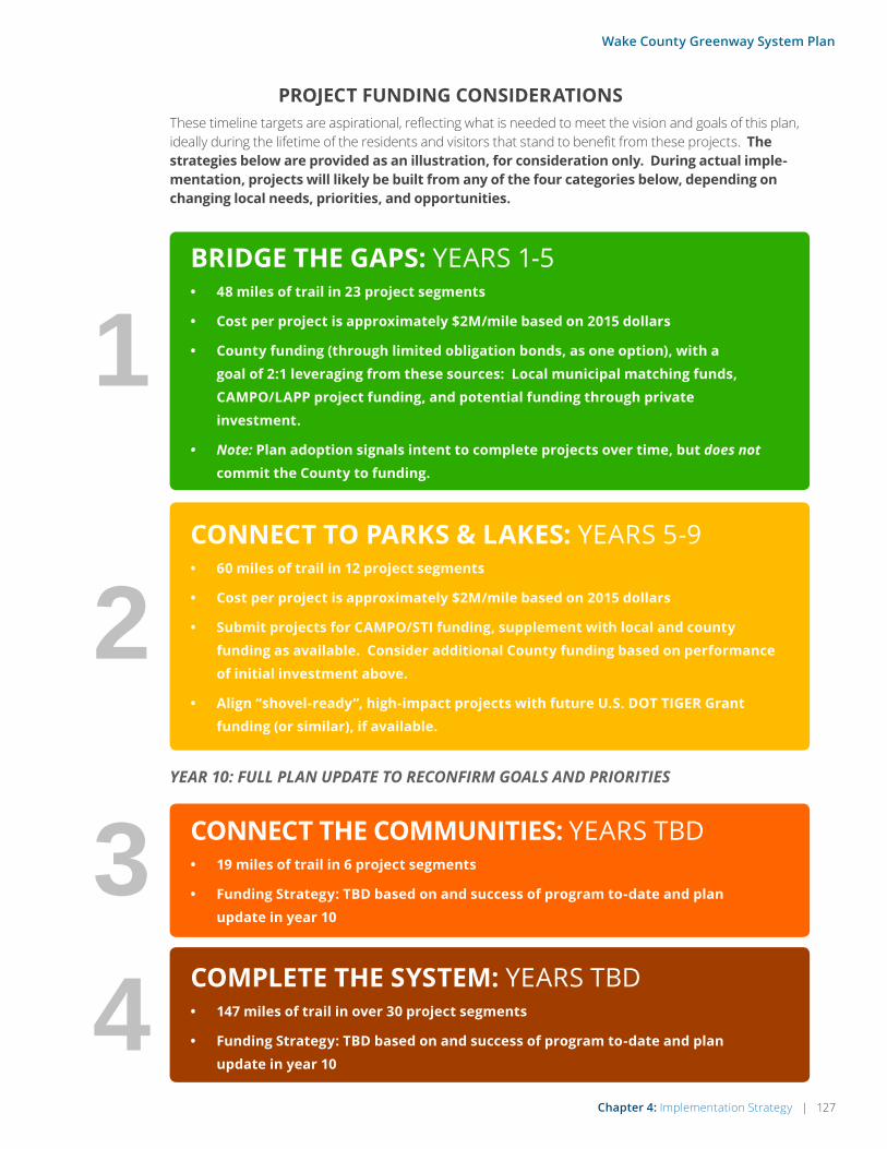
Chapter 4: Implementation Strategy | 127
Wake County Greenway System Plan
PROJECT FUNDING CONSIDERATIONS
YEAR 10: FULL PLAN UPDATE TO RECONFIRM GOALS AND PRIORITIES
1
2
4
BRIDGE THE GAPS: YEARS 1-5• 48 miles of trail in 23 project segments
• Cost per project is approximately $2M/mile based on 2015 dollars
• County funding (through limited obligation bonds, as one option), with a goal of 2:1 leveraging from these sources: Local municipal matching funds, CAMPO/LAPP project funding, and potential funding through private investment.
• Note: Plan adoption signals intent to complete projects over time, but does not commit the County to funding.
CONNECT TO PARKS & LAKES: YEARS 5-9• 60 miles of trail in 12 project segments
• Cost per project is approximately $2M/mile based on 2015 dollars
• Submit projects for CAMPO/STI funding, supplement with local and county funding as available. Consider additional County funding based on performance of initial investment above.
• Align “shovel-ready”, high-impact projects with future U.S. DOT TIGER Grant funding (or similar), if available.
COMPLETE THE SYSTEM: YEARS TBD• 147 miles of trail in over 30 project segments
• Funding Strategy: TBD based on and success of program to-date and plan update in year 10
3 CONNECT THE COMMUNITIES: YEARS TBD• 19 miles of trail in 6 project segments
• Funding Strategy: TBD based on and success of program to-date and plan update in year 10
These timeline targets are aspirational, reflecting what is needed to meet the vision and goals of this plan, ideally during the lifetime of the residents and visitors that stand to benefit from these projects. The strategies below are provided as an illustration, for consideration only. During actual imple-mentation, projects will likely be built from any of the four categories below, depending on changing local needs, priorities, and opportunities.

128 | Chapter 4: Implementation Strategy
Wake County Greenway System Plan
FUNDING STRATEGIES
County Funding as Leverage for Federal, State and Local Funding
Traditionally, Wake County has funded greenway
facility development using public sector funds, typ-
ically County funds matched with municipal, state
and federal funds. Below are several opportunities
for matching county funds. See Appendix B for more on Funding Resources.
• The Capital Area Metroplitain Planning Organization (CAMPO) Locally Administered Projects Program (LAPP): LAPP is the process the MPO uses to allocate
the federal dollars that are the direct respon-
sibility of the MPO. Each year, MPO members
submit project applications to compete
for these funds. The Locally Administered
Project Program includes the MPO’s Surface
Transportation Program - Direct Allocation
(STP-DA) funds and the Congestion Mitigation
for Air Quality (CMAQ) funds. For more infor-
mation on the LAPP process, contact Danna
Widmar of CAMPO.
• The CAMPO Transportation Improvement Program (TIP): The TIP outlines ten years
of planned capital expenditure on trans-
portation projects in the region. The TIP is
adopted by the MPO’s Executive Board and
is amended as needed to stay consistent
with the State Transportation Improvement
Program (STIP) adopted by the NCDOT Board
of Transportation. For more information on
the TIP, contact Alex Rickard of CAMPO.
• The TIGER VIII Grant: The U.S. Department
of Transportation announced $500 million for
transportation projects across the country
under an eighth round of Transportation
Investment Generating Economic Recovery
(TIGER) competitive grant program. Like
the first seven rounds, FY 2016 TIGER
discretionary grants will fund capital invest-
ments in surface transportation infrastructure
and will be awarded on a competitive basis for
projects that will have a significant impact on
the nation, a metropolitan area, or a region.
The 2016 TIGER grant program will focus
on capital projects that generate economic
development and improve access to reliable,
safe and affordable transportation for com-
munities, both urban and rural. It is likely that
the FY 2016 TIGER is out of reach for projects
in this Plan as of Spring 2016, but it is noted
here as a resource to look out for in future
years, should the TIGER program be contin-
ued. Other regions have successfully obtained
TIGER funding for greenway trails (see oppo-
site page), and Wake County could do the
same if a coordinated approach is taken to
getting key projects through the design phase,
making them more attractive for grants as
“shovel-ready” projects.
Engaging Private Funding
Across the United States, one of the fastest emerg-
ing funding sources for greenway development is
the private sector. Philanthropic organizations,
corporate and family foundations, non-profit
organizations and corporations have stepped up
their involvement in greenway facility develop-
ment in the form of financial support. Why has this
occurred? There are many varied reasons including
support for improvements to quality of life, health
and wellness, alternative transportation, conser-
vation of natural resources and economic develop-
ment. Most importantly, private financial support
has enabled the greenway development process
to move faster, so that facilities can be completed
more efficiently. Two exemplary projects illustrate
how this works:
1. In Northwest Arkansas, the Razorback
Regional Greenway was conceived by the
Northwest Arkansas Regional Planning
Commission as a network of primarily on-road

Chapter 4: Implementation Strategy | 129
Wake County Greenway System Plan
trails spanning the two-county region (Benton
and Washington counties). In 2009, the
Walton Family Foundation stepped in and
spearheaded a public-private partnership
that resulted in the development of a 36-mile,
primarily off-road, world class regional gre-
enway. The Razorback Regional Greenway
was funded from a combination of public
and private funds, including a USDOT TIGER
2 grant of $15 million, and a dollar for dollar
gift from the Walton Family Foundation of $15
million. Other grant funds were added later
bringing the total funding to more than $40
million. Without the lead gift from the Family
Foundation, the project would never have
happened. The Foundation based its gift on
two community goals: 1) improve the health
of local residents, and 2) support economic
development throughout the region to keep
Northwest Arkansas competitive for years
to come. The 36-mile Razorback Regional
Greenway was officially completed and opened
for use in May 2015.
2. In Memphis, Tennessee, the 36-mile Wolf River
Greenway has been the brainchild of the Wolf
River Conservancy (a non-profit land trust
based in Memphis) for more than 35 years.
Using a traditional approach of relying on
public sector leadership and funding to build
the project, the Conservancy became frus-
trated with the glacial pace of greenway facility
development – in 35 years, approximately 5
miles of trail had been completed. In 2014, the
Conservancy decided to fund the development
of 22 miles of the trail within the Memphis
city limits using private sector funds. As of
January 2016, the Conservancy has raised
approximately $45 million in support of facility
development, with almost half of that coming
from private sector sources. The Conservancy
has then leveraged the private sector support
to gain public sector support from the City of
Memphis and Shelby County. The Conservancy
expects to design, permit and build the entire
22 mile Memphis portion of the Greenway by
2019.
Grand opening of the Razorback Greenway, a regional trail project that benefited from $15M in USDOT funding.

130 | Chapter 4: Implementation Strategy
Wake County Greenway System Plan
These are just two examples of ways in which
private sector funding is used to support greenway
facility development. There are many more exam-
ples just like the ones mentioned above occurring
across the United States. What are the important
lessons learned from this approach? Assuming
that a worthy greenway project has been iden-
tified, there are four key steps in the process: 1)
develop the “pitch”, 2) make the ask, 3) leverage
the lead gift, and 4) invite private sector and public
sector groups to participate.
Step One: Develop the “Pitch”
The first step is to finalize the vision and scope of
the project, along with its benefits to the commu-
nity. The “pitch” is typically summarized in the form
of marketing materials, such as reports, digital
media presentations, and informational handouts
that define the important elements of the green-
way project.
The Carolina Thread Trail in the Charlotte Metro
Region offers an excellent example for “developing
the pitch.” The Catawba Land Conservancy (CLC)
and the Trust for Public Land (TPL) worked with
Greenways Incorporated to prepare a vision state-
ment and economic case statement that together
defined the goals and objectives of “The Thread
Trail,” a regional greenway project. The “pitch” was
carefully crafted so that it could be distilled into
simple terms and delivered through a concise
presentation. CLC and TPL worked with other
Charlotte based firms to develop graphic elements
of the pitch, including a logo that defined the
“brand” for the project. The combination of these
materials constituted “the pitch,” and enabled
CLC and TPL to take the next step in the process –
making the ask for financial support.
Likewise, both the Razorback Regional Greenway in
Northwest Arkansas and the Wolf River Greenway
in Memphis, Tennessee, undertook similar efforts
in developing the pitch. In Northwest Arkansas, a
compressed timeframe, centered around a design
charrette, produced the pitch. The Walton Family
Foundation funded the design charrette process
that resulted in the preparation of a vision, concep-
tual framework and economic case statement for
the Razorback Regional Greenway. In Memphis, the
Wolf River Conservancy used a similar approach,
and also commissioned Alta Planning + Design to
prepare an economic study regarding the benefits
of the Greenway to the regional community.
Step Two: Making the Ask
Once the pitch has been prepared, it is time to
“make the ask.” For greenway projects, making
the ask can occur in different ways. Generally, two
different strategies can be employed, one that
targets public funding sources and the other that
targets private funding sources.
For the Carolina Thread Trail, the major “ask”
occurred during a breakfast meeting of philan-
thropic and corporate groups. The invitation only
breakfast generated more than $15 million in
support of the Thread Trail project, and was the
catalytic event that launched the project. Both CLC
and TPL worked extremely hard in advance of the
breakfast to deliver the pitch to participants so
that when the time came for the ask, the results
were more or less expected.
Other “asks” can be more complicated. The
Razorback Regional Greenway went through a
protracted ask that involved an application for
federal funding. The Northwest Arkansas com-
munity applied for and received a TIGER 2 grant
of $15 million to build the project. The federal
grant was matched dollar for dollar by the Walton
Family Foundation, creating the opportunity for
full project development. In Memphis, the Wolf
River Conservancy has raised $24 million in private
sector funding to support an additional $16 million
in public sector funding. Sometimes, the “ask”
can stretch for months and more than a year.

Chapter 4: Implementation Strategy | 131
Wake County Greenway System Plan
Depending on the size of the greenway project,
raising large sums of money to support greenway
development takes time.
Step Three: Leverage the Lead Gift
All three of the projects used as examples in
this chapter utilized a “lead gift” as leverage for
raising additional funds. A lead gift is important for
several reasons. First, a lead gift from a prominent
and respected local project sponsor signifies the
importance of the project throughout the entire
community. Second, a lead gift is often used to
leverage other private funds. The lead sponsor will
often call upon other private funders to support
the greenway. Third, a lead gift may be used as
a matching source of funding for public sector
grants.
To secure a lead gift, it will be necessary to spend
time with a potential project sponsor to thoroughly
explain the merits and benefits of the greenway
project. Most importantly, the greenway benefits
must align with the interests and goals of the
sponsor, and represent an opportunity to fulfill a
specific mission of the sponsor.
Lead gifts typically are significant in order to be
effective. Some project sponsors will pledge a lead
gift premised on the ability to raise the balance of
funds within a defined time period. Some project
sponsors will specify that the lead gift must be
matched in a defined proportion to the balance of
funds raised.
Lead gifts are very important to the success of
fund raising as they typically establish credibility
for the greenway initiative and provide the first
tangible evidence of financial support.
Step Four: The Invite List
Which groups, organizations and entities are on
the “short list” of invitees to help fund greenway
projects in Wake County? The following is not a
complete list, but helps to narrow the field of likely
candidates for consideration.
• Foundation for the Carolinas: This foundation
strengthens regions through innovative com-
munity initiatives. Since 1958, Foundation for
the Carolinas has served as a catalyst for char-
itable good, connecting individuals, companies
and organizations to needs and philanthropic
opportunities across the region and beyond.
This community foundation is dedicated to the
collective strength of communities, working
in close partnership with donors, civic leaders
and nonprofits to help achieve a wide variety
of charitable goals and to inspire philanthropy
that will benefit generations to come. Today,
Foundation for the Carolinas is one of the
largest community foundations in the United
States.
• City of Oaks Foundation: The City of Oaks
Foundation is a nonprofit conservation and
youth development organization closely
aligned with Raleigh’s Parks, Recreation
and Cultural Resources Department. The
Foundation runs two programs: “Raleigh,
Naturally” land conservation to work with
landowners on a voluntary basis for long-term
stewardship of important natural areas; and
“Give Play” which underwrites scholarships for
children from low-income families to partici-
pate in summer camps and nature programs.
By focusing on land and water conservation as
well as connecting youth to nature, they aim to
keep green space in a rapidly-growing Raleigh
and instill a love of nature for generations to
come.
• Trust for Public Land (TPL): TPL’s mission is
to create parks and protect land for people,
ensuring healthy, livable communities for gen-
erations to come. Every park, playground, and
public space they create is an open invitation
to explore, wonder, discover, and play. TPL has
been connecting communities to the out-
doors—and to each other—since 1972. Today,
millions of Americans live within a 10-minute

132 | Chapter 4: Implementation Strategy
Wake County Greenway System Plan
walk of a park or natural area they helped
create, with more visitors every year.
• The Conservation Fund: The Conservation Fund
practices conservation to achieve environ-
mental and economic outcomes. Their staff
throughout the country create and imple-
ment innovative, practical ways to benefit the
natural world and the well-being of Americans
from every walk of life. Conservation takes
many forms, and The Fund’s programs inter-
pret and practice conservation in a mutual-
ly-reinforcing way - working in concert to make
sure the value of natural resources in America
remain essential to our prosperity. The Fund’s
focus is on conservation and communities -
creating as many pathways possible for people
and organizations to protect their natural
resources and save the places that matter
most - properties with ecological, historic and/
or cultural significance. They deliver conser-
vation and economic vitality through strong
partnerships with government, business and
colleague organizations.
• Blue Cross Blue Shield Foundation of North
Carolina: Their mission is to improve the
health and well-being of all North Carolinians.
They recognize that a North Carolina with
healthy people living in active communities
reduces health risks and improves health
outcomes. Health is a complex equation that
is as much determined by the environment as
it is by the individual. Their strategy is to look
ahead to get at the core drivers of poor health
and to support lasting system-wide changes.
• North Carolina Community Foundation: The
NCCF is the single statewide community foun-
dation serving North Carolina and has made
$101 million in grants since its inception in
1988. With more than $237 million in assets,
the NCCF sustains 1,200 endowments estab-
lished to provide long-term support of a broad
range of community needs, nonprofit organi-
zations, institutions and scholarships.
• Duke Energy Foundation: The Duke Energy
Foundation provides philanthropic support to
address the needs vital to the health of com-
munities. Annually, the Foundation funds more
than $25 million in charitable grants, with a
focus on education, environment, economic
and workforce development and community
impact.
TRAIL POLICY GUIDANCE
The establishment of policy ordinances is essential
for the successful development and expansion of
the countywide greenway system, especially con-
sidering the continued overall growth and develop-
ment in Wake County. The following are general
considerations for Wake County and its municipali-
ties regarding essential policies related to greenway
planning and development. These represent best
practices, and may vary upon implementation
locally, depending on political will and public inter-
est in each of Wake County’s 12 municipalities and
surrounding communities. Wake County and the 12
municipalities should work with developers when
possible to provide incentives and strong partner-
ship. When updating requirements, it will also be
important to communicate to developers the many
benefits to them to provide greenways for their
prospective buyers.
Developer Dedication of ROW and Construction for Trails
Wake County and its municipalities should strive
for consistency in their respective land use, subdi-
vision, zoning, and/or UDO ordinances related to
the requirement to set aside and construct gre-
enway trails, in addition to sidewalks. A summary
of current County and municipal policies is
described below with recommended guidance for
consideration.

Chapter 4: Implementation Strategy | 133
Wake County Greenway System Plan
Wake County
Wake County provides requirements for pedes-
trian, bicycle, and trail facilities but requirements
and standards differ between Short-Range Urban
Service Areas, Long-Range Urban Services Areas,
and Non-Urban Areas in recognition of the different
physical and built environments that exist across
the County. Also, this requirement is only in place
for residential subdivision development.
For the Short-Range Urban Services area, the
County requires off-road trail improvements when
1) improvements are shown on a Transportation
Plan and/or the Consolidated Open Space Plan, 2)
subject subdivision has access to or is adjacent to
existing or designated greenway corridors, or 3) the
subject subdivision is adjacent to another develop-
ment that includes off-road trail improvements.
For both the Long-Range Urban Services Area and
the Non-Urban Areas, the off-road trail improve-
ments MAY be required, under the same circum-
stances as described for the Short-Range Urban
Services Area, but must be authorized by the
Planning Director or Planning Board.
Guidance:
• Wake County should update the requirement to
include commercial development.
• Wake County should update the language
to include greenway requirements when
improvements are shown on this Wake
County Greenway Plan (in addition to the
Transportation Plan and Consolidated Open
Space Plan).
• Wake County should consider a mandatory
requirement for development outside the
Short-Range Urban Services areas, especially in
the circumstance of a recommended greenway
corridor through the site.
Municipalities
At the time of this study, the City of Raleigh, Town of
Cary, Town of Wake Forest, and Town of Knightdale,
as examples, have requirements for residential gre-
enway dedication only. The Town of Morrisville and
Town of Holly Springs, as examples, have greenway
requirements for both residential and commer-
cial dedication and construction. Example UDO
language from the Town of Holly Springs is provided
on the following page. The Town of Morrisville, for
example, requires all new development, except
individual lot development, incorporate into its
required open space, any greenway path or multi-
use path called for across the development site by a
Comprehensive Plan.
Guidance:
• Municipalities should require greenway dedi-
cation and construction as part of standard
development practice, irregardless of whether
a greenway is proposed through the area. In
addition, municipalities should require con-
struction of any proposed greenway corridor
segments that are part of a local plan or this
Wake County Greenway Plan along with pro-
viding high-quality pedestrian/bicyclist con-
nections from the development to the main
greenway corridor.
• Municipalities should require greenway
dedication and construction for all types of
development, not just residential. The same
requirements as the above bullet would apply.
Utility and Sewer Easements and Provision of Public Access within the Right-of-Way
With new development often comes expansion
of services such as water, sewer, electrical, and
gas. Wake County and its municipalities should
make it standard practice to allow public access
(trails) within those right-of-way corridors. It is
much easier to build this into future expansion
of systems as opposed to retroactively allowing
public access to easements.

134 | Chapter 4: Implementation Strategy
Wake County Greenway System Plan
Additional Greenway-Related Policy Considerations for Wake County and Municipalities:
• Use of native plants in greenway landscaping;
• Wildlife-friendly landscaping and maintenance
• Complete Street policies that would address
on-street connections, trail crossings, and
sidepaths
• Requirement of additional bicycle/pedestrian
friendly features in development to encourage
more walking and bicycling such as street con-
nectivity, strong bike/ped connectivity from the
subdivision/development to surrounding des-
tinations and greenways, minimization of cul-
de-sac streets, pedestrian/bicyclist cut-through
path connections, and greenway connections
to adjacent existing and proposed greenways.
TRAIL MAINTENANCE GUIDANCE
Maintenance Overview
Greenway maintenance is essential to the long-term
viability and sustainability of regional greenway trail
networks. Construction of greenway trails cannot
take place without a maintenance plan and priority
in place. Similar to national roadway maintenance
issues that have been well-documented, trails con-
structed over the past twenty years are in varying
states of needing maintenance. Monies have
poured into new roadways and trails across the
United States but maintenance has been a lower
priority. This Plan recommends a strong, collabora-
tive approach to maintenance.
Maintenance Principles
The regional greenway trail system should be
viewed and maintained as a public resource, serving
generations to come. The following guiding princi-
ples will help assure the preservation of a first class
system:
• Good maintenance begins with sound planning
and design.
• Foremost, protect life, property and the
environment.
• Promote and maintain a quality outdoor recre-
ation and transportation experience.
• Develop a management plan that is reviewed
and updated annually with tasks, operational
policies, standards, and routine and remedial
maintenance goals.
• Maintain quality control and conduct regular
inspections.
• Include field crews, police and fire/rescue per-
sonnel in both the design review and on-going
management process.
• Maintain an effective, responsive public feed-
back system and promote public participation.
• Be a good neighbor to adjacent properties.
• Operate a cost-effective program with sustain-
able funding sources.
Maintenance Responsibilities
Recommended greenways in this Plan traverse
twelve municipalities and unincorporated Wake
County. Most of the greenway trail corridors will
be off-road though some portions will be on-road
accommodating bicyclists and pedestrians on
sidepaths or bicycle lane/sidewalk combinations.
Because the network 1) traverses multiple munici-
pal boundaries and unincorporated Wake County,
2) includes a combination of street, stream, parks,
utility easements and other properties, and 3)
includes both on-road and off-road treatments,
multiple agencies within North Carolina, Wake
County, and the jurisdictions must play a role, be Parks and recreation volunteers in Raleigh, NC.

Chapter 4: Implementation Strategy | 135
Wake County Greenway System Plan
engaged, and be coordinated in ongoing trail opera-
tions and maintenance.
While each major jurisdiction has its own operations
and maintenance departments, a key to sustainable
quality greenways will be a consistency of stan-
dards, cooperation and coordination amongst the
communities and building enduring partnerships
engaging both public and private sector leadership.
Growing a successful greenway system in Wake
County will take capacity building and diversification
of skills and resources to meet this challenge in
those communities.
In order to meet the challenges, an intergovernmen-
tal organization and/or intergovernmental agree-
ment regarding the Wake County greenway system
is recommended. An organization or an agreement
would be in place to address not just maintenance,
but also funding, facilitating cooperation, organizing
volunteer groups, adopting/implementing stan-
dards, etc. Agencies to be involved would include
appropriate Wake County departments, municipali-
ties, CAMPO, and NCDOT.
A comprehensive and cooperative maintenance
management program will determine the activities,
maintenance levels and maintenance frequency of
the trail system based on expected trail use. The
program will identify tasks, operational policies and
procedures, standards, and routine and remedial
maintenance goals. At a minimum, the program
must identify cost estimates, funding sources, and
the party responsible for performing the work on
the trails. This will provide the basis for determining
annual funding and assignment of personnel and
equipment from trail to trail while providing for
necessary adjustments.
At the time of this study, it is recommended that
municipalities play the largest maintenance role
to expand upon their existing operations and
resources. However, Wake County could consider
offering financial assistance (on a case-by-case
basis) to supplement those municipal maintenance
crews when the trail traverses unincorporated Wake
County.
Types of Greenway Maintenance: Routine and Remedial
The remainder of this section focuses on general
routine and remedial maintenance responsibilities
for all greenway and trail facilities.
Routine Maintenance
Routine maintenance refers to the day-to-day
regimen of litter pick-up, trash and debris removal,
weed and dust control, trail sweeping, sign replace-
ment, tree and shrub trimming, and other regularly
scheduled activities. Routine maintenance also
includes minor repairs and replacements such as
fixing cracks and potholes or repairing a broken
hand railing.
Routine Maintenance Tasks
The following tasks should be performed on a
regular basis to keep all network facilities in good,
usable condition. Maintenance tasks should be
conducted more frequently for greenway, bike, and
pedestrian facilities where use is the most concen-
trated. Methods such as pedestrian and bicycle
counts, sketch plan analysis methods for estimat-
ing pedestrian and bicycle demand, public survey
results, and public meeting comments can be used
to determine which resources are the most heavily
used and may require the most maintenance
attention. The frequency of required maintenance
tasks should be established as new facilities are
implemented and should be reviewed and updated
annually to reflect any changes in usage, safety
issues, etc.
Facility Maintenance
Basic housekeeping of greenway and trail facilities
will ensure that the network is clean and func-
tional and will also improve the life of each facility.
Volunteer efforts should be utilized in the perfor-
mance of sweeping and trash removal.

136 | Chapter 4: Implementation Strategy
Wake County Greenway System Plan
Vegetation Management
To maintain a high quality network, regular attention
should be given to the surrounding landscape, both
natural and man-made. This not only improves the
aesthetic quality of the network but also improves
the users’ sense of safety, as well. Vegetation man-
agement tasks include the following:
• Tree and shrub trimming and pruning
• Mowing of vegetation
• Mulching and edging
• Invasive species control
Remedial Maintenance
Remedial Maintenance refers to correcting signif-
icant defects in the network, as well as repairing,
replacing or restoring major components that have
been destroyed, damaged, or significantly dete-
riorated from normal usage and old age. Some
items (“minor repairs”) may occur on a five to ten
year cycle such as repainting, seal coating asphalt
pavement or replacing signage. Major reconstruc-
tion items will occur over a longer period or after an
event such as a flood. Examples of major recon-
struction remedial maintenance include stabiliza-
tion of a severely eroded hillside, repaving a trail
surface or a street used for biking, or replacing a
footbridge. Remedial maintenance should be part of
a long-term capital improvement plan.
Remedial Maintenance Tasks
The following tasks should be performed on an as
needed basis to keep network facilities in good,
usable condition. The table below depicts the
average life of each facility type, as well as general
ancillary facilities, with normal wear and tear. The
repair or replacement of existing facilities should be
reflected in a projected budget for future mainte-
nance costs.
Longevity of Facilities• Mulch 2-3 years
• Granular Stone 7-10 years
• Asphalt 7-15 years
• Concrete 20+ years
• Boardwalk 7-10 years
• Bridge/Underpass 100+ years
Facility Repair or Replacement
All facilities will require repair or replacement at one
time or another. The time between observation
and repair/replacement will depend on whether the
needed repair is deemed a hazard, to what degree
the needed repair will affect the safety of the user,
and whether the needed repair can be performed
by an in-house maintenance crew or if it is so
extensive that the needed repair must be done
by outside entities or replaced completely. Some
repairs are minor, such as repainting or resurfacing
bicycle lanes and can be done in conjunction with
other capital projects, such as repaving the adjacent
street. The following are facility repair or replace-
ment activities:
• Replenish gravel, mulch, or other materials
• Repaint/restripe/stain
• Repave/seal
• Replace asphalt or concrete
• Remove encroaching debris along paved trail/
sidewalk edges
• Regrade to prevent or eliminate low spots and
drainage issues
• Add culverts, bridges, boardwalks, retaining
walls, etc. to prevent or eliminate drainage/
erosion issues
• Reroute trail, if necessary, to avoid environmen-
tally sensitive or overused areas and any safety
issues

Chapter 4: Implementation Strategy | 137
Wake County Greenway System Plan
Seasonal Maintenance
Seasonal tasks should be performed as needed.
When conditions cannot be improved to provide for
safe use, the facility should be closed to prevent the
risk of injury to facility users. Designated mainte-
nance crews would remove leaf debris, snow, and
ice from all network facilities as soon as possible.
Leaf debris is potentially hazardous when wet
and special attention should be given to facilities
with heavier usage. Ice control and removal of ice
build-up is a continual factor because of the freeze-
thaw cycle. Ice control is most important on grade
changes and curves. Ice can be removed or gravel/
ice melt applied. After the ice is gone, leftover gravel
should be swept as soon as possible.
Habitat Enhancement & Native Species
The presence/absence of vegetation and the type
of vegetation present in a greenway affects habitat
quality, the greenway’s effectiveness as a wildlife
corridor, ecological sustainability, and the aesthetic
experience for the trail user. Greenways are more
effective at providing wildlife habitat and corridors
when they have trees and shrubs present. Planting
native vegetation along greenways can enhance
the trail user’s feeling of “getting back to nature.”
However, planting woody vegetation may not be
an option on greenways whose alignments are
on sewer or power line rights-of-way based on
planting depth requirements. In locations where
trees and shrubs are lacking and can be planted,
native species are the most ecologically sustain-
able choice. As a group, native species require less
maintenance than horticultural plantings and often
provide wildlife with a food source.
The following activities and tasks should be utilized
to enhance and control wildlife habitats:
• Plant vegetation, such as trees and shrubs,
using native species whenever possible; con-
sider prohibiting the introduction of non-native
plants altogether
RANGE OF TRAIL MAINTENANCE COSTS
Reported annual maintenance costs from cities and
regions for shared-use trails range widely, from just
$500/mile to over $15,000/mile. As a local example,
the Town of Cary uses $6,000/mile for annual
mowing and trash pick up, and minor repairs like
replacing a fence rail; they budget asphalt and drain-
age repairs separately on case by case basis. Some
key factors affecting these wide ranges include:
• Quality of materials used, and frequency of
sealing and reconstruction of the path
• Amount of leaf drop affecting the trail that
requires concentrated sweeping
• Amount of flooding of the trail that has to be
cleaned up
• Amount of snow removal/grooming needed
• Whether or not mowing, irrigation, and other care
of adjacent open space is calculated in the cost
• Presence of waste receptacles
The largest factor affecting the annual maintenance
figures of different cities is whether or not the even-
tual trail reconstruction is accounted for in annual
maintenance budgets, as opposed to being consid-
ered as separate capital item.
Source: Alta Planning + Design, 2016.
• Take preventative measures to protect landscape
features from wildlife, such as installing fencing
around sensitive or newly planted materials
• Use herbicides sparingly, to eliminate problem plant
species only when necessary
• Deter interaction between facility users and facility
inhabitants, such as feeding the wildlife, etc.
• Consider launching a “pollinator species initiative”. By
supporting pollinators’ need for habitat, we support
our own needs for food and support biodiversity in
Wake County. See here for more information: www.
pollinator.org
• See recommendations for edible plants along green-
ways, on page 123.

138 | Chapter 4: Implementation Strategy
Wake County Greenway System Plan
TRAIL DESIGN REFERENCES AND RESOURCES
The following standards and guidelines may be
referred to for details on greenway design:
Capital Area Greenway Planning and Design Guide
Raleigh’s Capital Area Greenway Planning and
Design Guide (adopted in 2015) incorporates
existing City procedures with the standards and
best practices of public agencies and municipalities
nationwide. The document is designed to ensure
that the Capital Area Greenway System continues
to be a safe and accessible multi-use trail system
providing recreation and transportation opportuni-
ties, while preserving thousands of acres of natural
areas. The document will be reviewed regularly and
updated to meet new needs and priorities gener-
ated by the area’s growth, changing demographics
and shifts in development patterns. Wake County
should look to this document as a local reference
point for greenway design standards from one of
the leading municipal greenway systems in the
country.
AASHTO Guide for the Development of Bicycle Facilities, 4th Edition
Published by the American Association of State
Highway and Transportation Officials, this guide
provides information on how to accommodate
bicycle travel and operations in most riding envi-
ronments. The guide is intended to present sound
planning and design guidelines by referencing a
recommended range of design values and describ-
ing alternative design approaches. Some flexibility
is permitted to encourage designs that are sensi-
tive to local context and incorporate the needs of
bicyclists, pedestrians, and motorists. The guide
contains sections specific to shared-use paths.
The North Carolina Department of Transportation Complete Streets Planning and Design Guidelines
Released in 2012, these guidelines provide NCDOT
and municipality staff with a guide to planning and
designing streets that meet the needs of all users,
including pedestrians, bicyclists, and motor vehi-
cles. The guidelines include detailed information on
the processes, street types, and recommendations
for creating complete streets in North Carolina, and
also includes sections on shared-use paths.
NACTO Urban Bikeway Design Guide
Most relevant to on-road bicycle facility connectors
for Wake County’s regional greenway system, the
NACTO Urban Bikeway Design Guide is based on
the experience of the best cycling cities in the world.
The designs in the guide were developed specifi-
cally for urban settings, since unique urban streets
require innovative solutions. Most of these treat-
ments are not directly referenced in the current
version of the AASHTO Guide, although they are
virtually all permitted under the Manual on Uniform
Traffic Control Devices (MUTCD). All of the NACTO
Urban Bikeway Design Guide treatments are in use
internationally and in many cities around the US.
Manual on Uniform Traffic Control Devices (MUTCD)
Most relevant to greenway trail and roadway cross-
ings, the Federal Highway Administration’s MUTCD
is the primary source for guidance on lane striping
requirements, signal warrants, and recommended
signage and pavement markings.
Public Rights-of-Way Accessibility Guidelines (PROWAG)
Meeting the requirements of the Americans with
Disabilities Act (ADA) is an important part of any
bicycle facility project. The United States Access
Board’s proposed PROWAG and the 2010 ADA
Standards for Accessible Design (2010 Standards)
contain standards and guidance for the construc-
tion of accessible facilities.

Chapter 4: Implementation Strategy | 139
Wake County Greenway System Plan
IMPLEMENTATION ACTION STEPS TABLE
POLICY ACTION STEPS
# Task Lead Agency Support Details Phase
1
Present Plan to Board of Commissioners for adoption
Planning Consultants
Wake County PROS & FDC
The plan should be presented to elected officials in Spring 2016. Focus on the health and economic benefits of greenways (Chapter 1 & Appx A) and key trail recommendations (Chapter 3). Adoption signals intent to implement the plan over time; it does not commit County to funding the plan.
Short Term (2016)
2
Meet with NCDOT to introduce the Plan and coordinate on key recommendations
Wake County PROS & FDC
Staff + NCDOT Division 5
NCDOT-DBPT
This plan and the recommended trail routes should be officially recognized by NCDOT. For example, NCDOT should refer to this document when assessing the impact of future projects and plans, such as future trail crossings needed in relation to the “Complete 540” project (see page 53). Effort should be made between state and local partners to include parallel trail facilities on planned future roadways and roadway reconstruction projects, especially where they appear on adopted plans.
Short Term (2016)
3
Amend county and local development ordinances and technical standards
Wake County Planning,
Development & Inspections;
Municipal Partners
Wake County Planning
Board; Local Planning Boards
County and local development ordinances should be considered for amendment to ensure that, as developments are planned and reviewed, the recommended greenway trail corridors identified in this plan are protected. This would entail amending development regulations to have developers set aside land for trails whenever a development proposal overlaps with the proposed routes, as adopted. Local governments should also consider requirements and tools like dedicating easements, connections to adjacent land uses, issuing credits, and offering some form of recognition to developers who go above and beyond the requirements for trail development.
Short Term (2016)
4
Revise sewer, stormwater and utility easement policies
Wake County Planning,
Development & Inspections
Wake County Planning
Board
All new sewer, stormwater and utility easements should be considered for allowing public access as a matter of right. Such a consideration should allow for access that does not require landowner approval for each parcel the easement overlaps. As trails are developed, also review applicable existing easements for similar revision considerations.
Short Term (2016)
5 Develop a corporate sponsorship policy
Wake County PROS
Local Private Sector
Partners
For a comprehensive sponsorship policy example, see that of Portland Parks and Recreation: www.portlandonline.com/shared/cfm/image.cfm?id=155570 . For a sponsorship brochure example, see that of the ‘Mountains to Sound Greenway’: http://mtsgreenway.org/events-calendar/greenway-365-sponsorship-brochure
Short Term (2016)
6
Develop a coordinated operations & maintenance plan
Wake County PROS & FDC
Municipal Partners
This plan will help to apportion responsibility between agencies where facilities cross jurisdictional boundaries or where pooled efforts can reduce costs. See the maintenance section of this chapter for more information about best practices for operations and maintenance. See recommendations for use of native plants, pollinator plants, and edible landscaping along greenways on page 137.
Short Term (2016)

140 | Chapter 4: Implementation Strategy
Wake County Greenway System Plan
PROGRAM ACTION STEPS
# Task Lead Agency Support Details Phase
1
Update and re-release the “Trails & Greenways of Wake County Pocket Guide and Community Resource” booklet
Wake County PROS
Planning Consultant or In-House
Design
This popular booklet is one of the most highly requested resource materials by the public. Wake County PROS has distributed all current printed copies and the content is now also in need of an update for accuracy. Note that Raleigh and Cary are currently using a mobile app system for user maps; Wake County should consider providing a similar web-based and/or mobile component.
Short Term (2016)
2
Establish a directory of greenway stakeholder contacts for Wake County
Wake County PROS
All Project Stake-
holders
The group could include members from multiple Wake County departments, local municipalities, neighboring jurisdictions, CAMPO, TJCOG, and others listed in the acknowledgments of this plan. Individuals who participated in this planning process at the Stakeholder Workshop, the Steering Committee Meetings, and municipal meetings, should be including in the contact list. This list of contacts could either be maintained privately by those included, or could be made public, on a County-hosted greenways web page.
Short Term (2016)
3
Host a semi-annual Countywide Greenway Trails Workshop
Wake County PROS &
FDC
All Project Stake-
holders
The purpose of this event is to establish regional coordination for trail development with the members listed above. Meetings should evaluate implementation progress and set goals to be achieved before the following meeting. The group should also make necessary plan updates. Meetings could also feature tours of recently completed sections of trail, and special presentations by stakeholders and invited guests.
Short Term
(Fall 2016); Semi-
annual meetings thereafter
4
Share GIS data with the PBIN as updates are made to both existing and planned trail facilities in the County
Wake County
Community Services
Municipal Partners
The Pedestrian and Bicycle Infrastructure Network (PBIN) is a statewide Geographic Information System (GIS) inventory of existing and planned bicycling and walking facilities in North Carolina. The PBIN is maintained by the North Carolina Department of Transportation Division of Bicycle and Pedestrian Transportation and Institute for Transportation Research and Education (ITRE). More information can be found here: www.itre.ncsu.edu
Ongoing; Consider quarterly updates to match county zoning
updates
5 Conduct regular trail user counts
Wake County PROS
Planning Consultant
or Using In-House
Equipment
Trail usage data is needed to strengthen grant requests and influence policy and funding decisions. A complete picture of trail-user characteristics can be developed and outcomes can help to identify if additional amenities would improve the trail-user experience.
Short Term (2016-2017)
6Coordinate with school system on greenway issues
Wake County PROS &
Municipal Partners
Wake County Schools
Need better coordination with Wake County Schools, particularly around the topics of school siting and greenways as ‘essential’ versus simply ‘bonus’. Greenway connectivity must be considered on the front end of school site development.
Short Term (2016-2017)
7Continue efforts to reduce crime on greenways
Municipal Partner’s
PoliceDepartments
Volunteer Groups
Address personal safety concerns on trails. Continue, expand, and emulate programs such as the Raleigh Police Department’s Greenway Volunteer Program for personal safety: Any citizen interested in helping keep a watchful eye on greenway trails by reporting back to Parks officials any breach in safety, security or maintenance concerns is invited to apply to become a Greenway Volunteer.
Short Term (2016-2017)

Chapter 4: Implementation Strategy | 141
Wake County Greenway System Plan
Background image, back cover: Bridge over the Neuse River, by Kristy Jackson of the Institute for Transportation Research and Education (ITRE).
8
Establish a greenway branding and wayfinding system for trails and other points of interest throughout the region
Wake County PROS &
Municipal Partners
Planning Consultant or In-House
Design
A wayfinding system is recommended to create a cohesive and easy-to-use platform for navigating the regional trail system, once more of the longer-distance trails are connected throughout the County. The system should be designed so that it is flexible enough to be updated as new projects are completed, and should be implemented in conjunction with a statewide and national marketing strategy. See Chapter 3 for more information about signage, wayfinding, and marketing.
Medium Term (2017 -2018)
INFRASTRUCTURE ACTION STEPS
# Task Lead Agency Support Details Phase
1
Identify and secure specific funding sources for trail corridors (from “Bridge the Gap” projects OR other projects in this report) & begin design and construction phases as possible.
Wake County PROS
CAMPO and Municipal Partners
Partnerships for joint funding opportunities should be pursued, such as through CAMPO’s LAPP program. Combine financial and management resources for trail development with surrounding municipalities, regional entities (such as CAMPO), and private sector partners (see Private Sector Engagement section of this Chapter). Potential TIGER ready projects should be identified for the 1-5 year time frame. “Shovel-ready” designed projects should be prepared in the event that future federal stimulus funds become available.
Short Term
(2016); Ongoing
2
Gather further public support and input during the design phase for trail projects.
Wake County PROS &
Municipal Partners
OSAPAC and Local Advisory
Committees
Involve the general public and advisory groups, such as OSPAC and Raleigh’s Citizens Advisory Councils (CACs), in the design stage for trail development. Some such groups can help with both trail routing ideas and public support from specific neighborhoods.
Short Term
(2016); Ongoing
3
Develop a long term funding strategy; Consider limited obligation bonds to fund Wake County PROS projects, including trails.
Wake County PROS
CAMPO and Municipal Partners
To allow continued development of the overall system, capital funds for trail construction should be set aside every year, even if only a small amount; small amounts of local and county funding can be matched to outside funding sources, such as state, Federal, and private funds. Funding for an ongoing maintenance program should also be included in the local operating budgets. Cross-jurisdictional trail projects lend themselves well to collaboration on funding as coordinated multi-jurisdictional projects are looked upon more favorably by outside funding sources than single-jurisdiction applications.
Short Term
(2016); Ongoing
4
Make improvements to existing trails & expand marketing efforts for existing trails
Wake County
FDC
Municipal Partners
Make improvements to existing trails that enhance the overall experience for trail users. See the regional branding and trail amenities sections of this Plan in Chapter 3 for recommendations. Other examples include evaluating bicyclist speeds in certain areas, and enforcing trail speed limits for safety (Example: Neuse River Trail between Falls of the Neuse Rd and Capital Blvd, as reported through public input). Centerline striping could also be useful in certain areas, with occasional signage indicating that both walkers and cyclists (and everyone else) should keep to the right except when passing.
Medium Term (2016 -2017)
5Re-evaluate and re-confirm the near-term top priorities
Wake County PROS
CAMPO and Municipal Partners
Every year, reevaluate near-term top priorities based on what has been completed, and reconfirm the agenda of “priority” projects. Consider sticking with earlier projects that were not successful to-date, versus new trail opportunities that may have arisen or become more feasible since 2016.
Medium Term (2017-
ongoing)
6 Update this Plan
Wake County PROS &
FDC
Project Consultants
In 2021, reassess overall system-wide goals and reevaluate the overall approach to implementation. In 2026, complete a full plan update.
Long Term
(2021 & 2026)

142 | Chapter 4: Implementation Strategy
Wake County Greenway System Plan
2017
WAKE COUNTY GREENWAY SYSTEM PLAN
Copyright © 2022 FDOKUMEN