W o o d b r i d g e - the City of Vaughan
162
Final Document April, 2009 W o o d b r i d g e H e r i t a g e C o n s e r v a t i o n D i s t r i c t S t u d y a n d P l a n W
-
Upload
khangminh22 -
Category
Documents
-
view
0 -
download
0
Transcript of W o o d b r i d g e - the City of Vaughan

Final DocumentApril, 2009
W o o d b r i d g e H e r i t a g e C o n s e r v a t i o n D i s t r i c t
S t u d y a n d P l a n W
2
in association with: Goldsmith Borgal and Company Architects
Prepared for: The City of Vaughan
Prepared by: OfficeforUrbanism Goldsmith Borgal and Company Architects (GBCA)
3Woodbridge Heritage Conservation District
This study was initiated by the City of Vaughan in response to the Woodbridge community’s request, as well as the City’s concerns, for the conservation of heritage buildings and landscapes within the Kipling Avenue Corridor Study and in Woodbridge as a whole. Through both the Kipling Avenue Corridor Study, and this study, the community voiced their opinions and concerns and provided valuable input in both study processes.
This study process brought about a realization of the many interests within the Woodbridge Community that are extremely willing to share their history and knowledge and increase the awareness of the heritage value of the Woodbridge neighbourhood. There are many families that have resided in this community for generations, and they have played a major role in understanding the history of this place. They have shared their knowledge through the public consultation process, stakeholder meetings, and several guided tours through the community and have brought a renewed perspective of the value of the Woodbridge neighbourhood. We are extremely grateful for this level of community contribution and interest which has resulted in a better plan for the Heritage Conservation District (HCD) and a more comprehensive and enlightened set of recommendations for the Kipling Avenue Corridor Study.
In particular, we would like to express our many thanks to: All the Stakeholders that provided invaluable historic informationTour Leaders: Ken Maynard, Jamie Maynard, Martha Bell, Stephen Robinson
Thank you.
ACKNOWLEDGEMENTS
5Woodbridge Heritage Conservation District
TABLE OF CONTENTS
i. Preface 9ii. Introduction 11
Part 1 - The Study
1.0 Background and Context 15 1.1 Woodbridge Heritage Conservation District Study 15 1.2 HCD Study 17 1.3 HCD Study Area 17 1.4 HCD Study Process 21 1.5 Policy Context 25
2.0 District History 29 2.1 Historic Villages in Vaughan 29 2.2 Development and Built Form 29
3.0 Heritage Building Styles 41 4.0 Heritage Evaluation 49 4.1 Building Inventory 49
4.2 Analysis of Inventory 53
Part 2 - The Heritage Conservation District Plan 61
5.0 Heritage Conservation District Plan 63 5.1 Objectives 63 5.2 District Boundary 63 5.3 Heritage Character Statement 65 5.3.1 Woodbridge’s history and function within Vaughan and surroundings 65
5.3.2 Woodbridge’s unique sense of identity 67 5.3.3 Woodbridge’s unique elements 67 5.4 Reasons for Designation Under the Ontario Heritage Act 69 6.0 Heritage Attributes and District Guidelines 71 6.1 Heritage Character Areas 71 6.1.1 Woodbridge Avenue 71 6.1.2 Kipling Avenue North and South 71 6.1.3 Wallace Street 73 6.1.4 William Street and James Street 73 6.1.5 Clarence Street and Park Drive 75 6.1.6 The Fairgrounds Area 75 6.1.7 The Humber River Corridor 75 6.2 Approach: Conservation of Contributing Buildings 76 6.2.1 Standards and Guidelines for Conservation 76 6.2.2 Conservation Guidelines 76 6.2.3 Relocation of Contributing Buildings 77 6.2.4 Demolition of Contributing Buildings 77 6.2.5 Approach to Non-Contributing Buildings 77
6.2.6 Activities that are Subject to Review 77 6.2.7 Activities that are Exempt from Review 77 6.2.8 Appropriate Materials 78 6.2.9 Inappropriate Materials 78 6.3 Architectural Guidelines for New Buildings, Additions and Alterations 79 6.3.1 Replica / Reconstructed Buildings 79 6.3.2 Contemporary Design 80 6.3.3 Architectural Guidelines 81 6.4 Built Form Framework 83 6.4.1 Street Wall Setbacks 83 6.4.2 Street Wall Height and Scale 85
6
6.5 Transitions of New Buildings in Relation to Heritage Resources 86 6.6 Open Space Framework 89 6.6.1. Public Open Spaces, Parks, and Public Streets 89 6.6.2. Pedestrian Circulation 91 6.6.3. Tree Canopy and Vegetation 91 6.6.4. Views and Landmarks 93 6.7 Urban Design 95 6.7.1 Roads, Curbs, Sidewalks and Streetscape 95 6.7.2 Street Furniture and Pedestrian Amenities 96 6.7.3 Street Trees 96 6.7.4 Signage 97 6.7.5 Street Lighting 97 6.7.6 Parking 97 6.7.7 Bridges 97
7.0 Heritage Building 99 7.1 A Conservation Plan 99 7.1.1 Brick Masonry 99 7.1.2 Stone Masonry 102 7.1.3 Foundation 104 7.1.4 Stucco Siding 105 7.1.5 Wood Siding 106 7.1.6 Roofing 107 7.1.7 Gable Ends and Dormer Windows 109 7.1.8 Windows and Shutters 111 7.1.9 Doors 114 7.1.10 Porches 116 7.1.11 Projections 118 7.1.12 Paint 119 7.1.13 Gutters and Rain Water Leaders 120 7.1.14 Fences 121 7.1.15 Commercial Signage 122 7.1.16 Storefront 124 Bibliography 126
Part 3 - Implementation 127 8.0 Administration of the District 129 8.1 Overview 129 8.2 Required Permits 129 8.2.1 Demolition Control 129 8.2.2 Heritage Easements 129 8.3 Streamlining the Process 129 8.3.1 The Heritage Permit 130 8.3.2 Heritage Permit with Building Permit 131 8.3.3 Heritage Permit with Site Plan Approval 131
8.3.4 Review of Zoning Amendment and Committee of Adjustment Applications 132 8.4 Application Checklists 132 8.4.1 Heritage Permit Checklist 132 8.4.2 Heritage Permit with Building Permit Checklist 133 8.4.3 Heritage Permit with Site Plan Review Checklist 133 8.5 Resolving Issues and Appeals 133 8.6 Financial Incentives for Conservation 134 8.6.1 Tax Measures 134 8.6.2 Grants and Loans 134 8.7 Public Awareness 134 8.8 Plan Renewal 134
8.8.1 Reviewing Bodies 135 8.8.2 Regular Review 135
7Woodbridge Heritage Conservation District
8.8.3 Amendments 135 8.9 Enforcement 135 8.10 Additional Recommendations for Improvements 135 8.10.1 Community Improvement Area 135 8.10.2 Comprehensive Streetscape Master Plan 135 8.10.3 Landscape, Views and Natural Features Inventory 135 9.0 Properties Recommended for a Part IV Study 137 10.0 Updates to Existing Policy 138 Appendix 139
List of Contributing/Non-Contributing Buildings 141 Building Inventory Maps 146
8
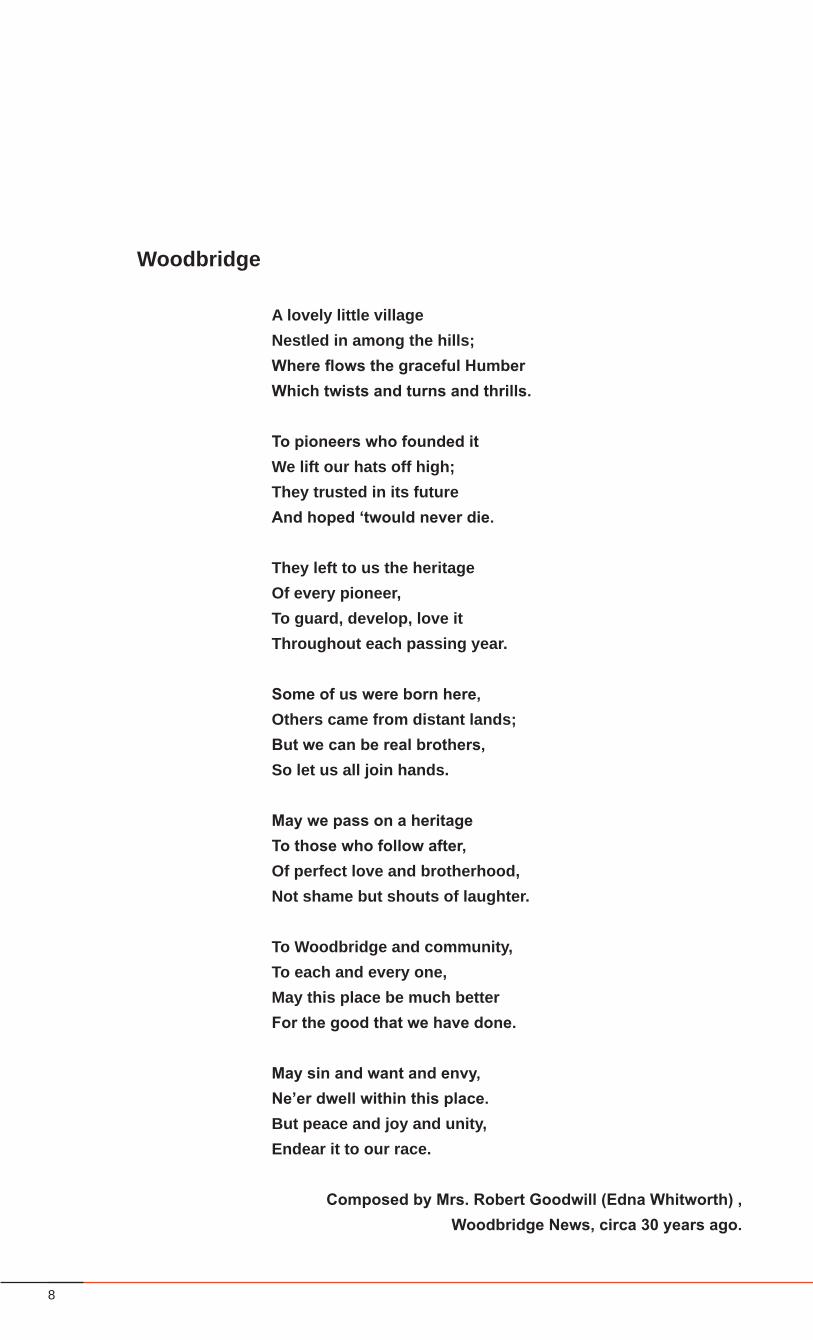
A lovely little villageNestled in among the hills;Where flows the graceful HumberWhich twists and turns and thrills.
To pioneers who founded it We lift our hats off high; They trusted in its future And hoped ‘twould never die.
They left to us the heritage Of every pioneer, To guard, develop, love itThroughout each passing year.
Some of us were born here, Others came from distant lands; But we can be real brothers, So let us all join hands.
May we pass on a heritage To those who follow after, Of perfect love and brotherhood, Not shame but shouts of laughter.
To Woodbridge and community,To each and every one, May this place be much better For the good that we have done.
May sin and want and envy, Ne’er dwell within this place. But peace and joy and unity, Endear it to our race.
Composed by Mrs. Robert Goodwill (Edna Whitworth) , Woodbridge News, circa 30 years ago.
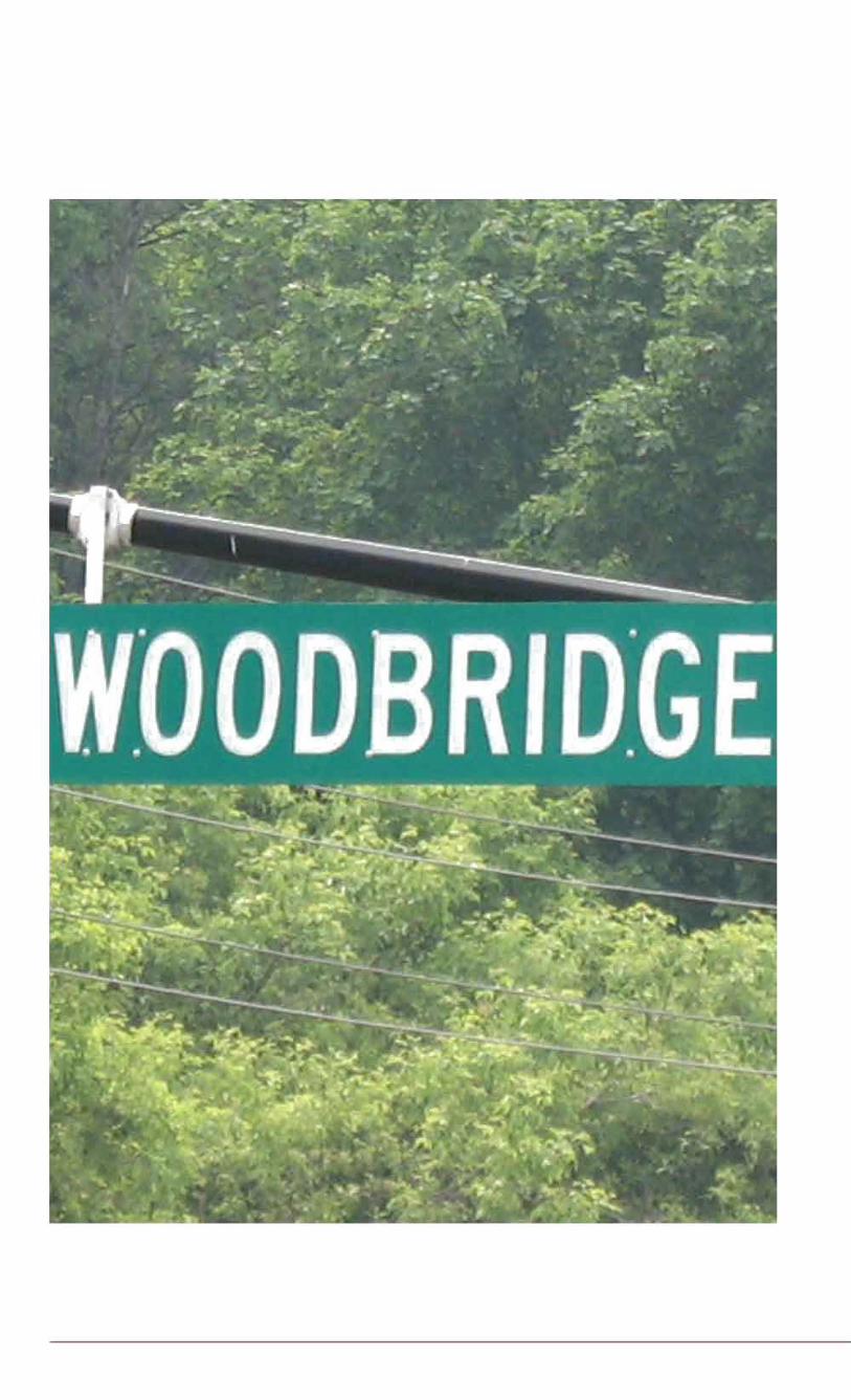
Woodbridge
9Woodbridge Heritage Conservation District
i. PREFACE
The Importance of this Plan to the City of Vaughan
The Ontario Heritage Act enables municipal councils to designate a Heritage Conservation District (HCD) “through adoption of a district plan with policies and guidelines for conservation, protection and enhancement of the area’s special character”. Woodbridge is currently the only historic village within the City of Vaughan without a Heritage Conservation District.
This is a unique tool that is set forth with the belief that “the value of the district as a whole is always greater than the sum of its parts”. This premise allows the City of Vaughan to recognize, in an area such as Woodbridge, that in addition to a collection of historic buildings, it is the cumulative character of the buildings, streetscape, landscape, and other cultural and urban features that definethecharacterofplaceandachieveasenseofidentity.
As Woodbridge undergoes a wave of development, the HCD Study provides an opportunity to spell out the aspects of the area that are valued and cherished as well as the things that are inappropriate for development, and to identify policies to encourage more of what is desirable to enhance Woodbridges’ special character.
The Woodbridge HCD Study was encouraged through the undertaking of the Kipling Avenue Corridor Study in which key stakeholders such as residents, businesses, property owners, and local heritage groups voiced the concern that the heritage character that is indicative of Woodbridge should not be lost in the current and future wave of development. All of the recommendations and guidelines set forth in the Plan have been amply discussed with the public through the Kipling Avenue Corridor and the HCD study’s public consultation processes. As a result, the process has not only increased awareness of the diversity of heritage resources (cultural and physical) of Woodbridge above and beyond the built form, but has brought about an awareness that the continued deterioration of any of the parts has a grave effect on the value of the district as a whole.
The importance of the HCD Plan cannot be overstated. For the City of Vaughan and the Woodbridge Community, this is a unique opportunity to appreciate the past, understand the present, and enable a successful future.
10
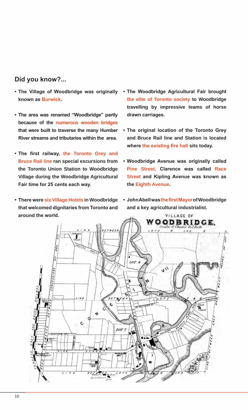
Did you know?...
• The Village of Woodbridge was originally known as Burwick.
• The area was renamed “Woodbridge” partly because of the numerous wooden bridges that were built to traverse the many Humber River streams and tributaries within the area.
• The first railway, the Toronto Grey and Bruce Rail line ran special excursions from the Toronto Union Station to Woodbridge Village during the Woodbridge Agricultural Fair time for 25 cents each way.
• There were six Village Hotels in Woodbridge that welcomed dignitaries from Toronto and around the world.
• The Woodbridge Agricultural Fair brought the elite of Toronto society to Woodbridge travelling by impressive teams of horse drawn carriages.
• The original location of the Toronto Grey and Bruce Rail line and Station is located where the existing fire hall sits today.
• Woodbridge Avenue was originally called Pine Street, Clarence was called Race Street and Kipling Avenue was known as the Eighth Avenue.
• John Abell was the first Mayor of Woodbridge and a key agricultural industrialist.
11Woodbridge Heritage Conservation District
The Value of a Heritage Conservation District
The ability of municipalities to designate areas as Heritage Conservation Districts is an important tool to assist in the conservation of unique neighbourhoods, streetscapes, and architectural features thatareemblematicofspecificerasandlocales.
During the creation of Heritage Conservation Districts, the City of Vaughan requires that the public be engaged in the legislative process. A wide range of stakeholders, community members, and City representatives are involved throughout the research and policy formulation phase, giving input on what heritage characteristics are valued in the district, and what set of guidelines can be put in place to guide the evolution of the district in support of the heritage character.
The benefits of designation through Heritage ConservationDistricts are many. Members of the community can preserve local values through the heritage resources, ensuring that treasured elements within the community are protected over the long term. Home owners, business owners, and the municipality itselfallstandtoenjoyeconomicandhistoricbenefitsfromthepreservation of a vibrant heritage district, whose unique cultural value attracts additional investment and visitors to the area. Importantly, designation can ensure that a District’s heritage attributes are not degraded by growth and change; but rather maintained, managed, preserved and promoted effectively over time.
For Woodbridge, the process of undertaking a Heritage Conservation District Study and the subsequent creation of an HCDhashadthebenefitof:• ensuringthatmembersofthecommunitybecameengagedin
the planning process;• developinganunderstandingandappreciationoftheheritage
resources within Woodbridge; • recognizingandcommemoratingthevaluesthatcansustain
a sense of place for Woodbridge into the future;• contributing, through enhanced awareness and defined
policy, towards the development of a rich physical and cultural environment;
• providingclarityandcertaintyregardingfuturedevelopmentsof the conservation of heritage resources for property owners, businesses and residents alike; and
• providingaframeworktomanagechange. The Unique Nature of Woodbridge
Woodbridge isbestdefinedby thehistoricnatureof itsquaintand diverse buildings and the expansive rich landscapes of the Humber River corridor that provide a unique topography and infrastructure. Woodbridge is known for the Fairgrounds, its village character; diversity of period architecture; and the village scale Woodbridge Commercial Core. These are all unique attractions that create a place for economic opportunities for businesses, and have a long history of drawing tourists to the area.
Woodbridge is experiencing growth pressures because of its continued popularity through history as an attractive place to live and work. Once it is designated as a Heritage Conservation District, the management and preservation of the heritage attributes of the buildings, the public realm and district open space assets that form the character of place will take priority, but this does not inhibit the opportunity for property owners and businessestobenefitfromchangeandinvestment.UndertheHCD, development change will be carefully managed in ordered to protect and maintain the existing heritage resources.
ii. INTRODUCTION
A Heritage Conservation District for Woodbridge
12
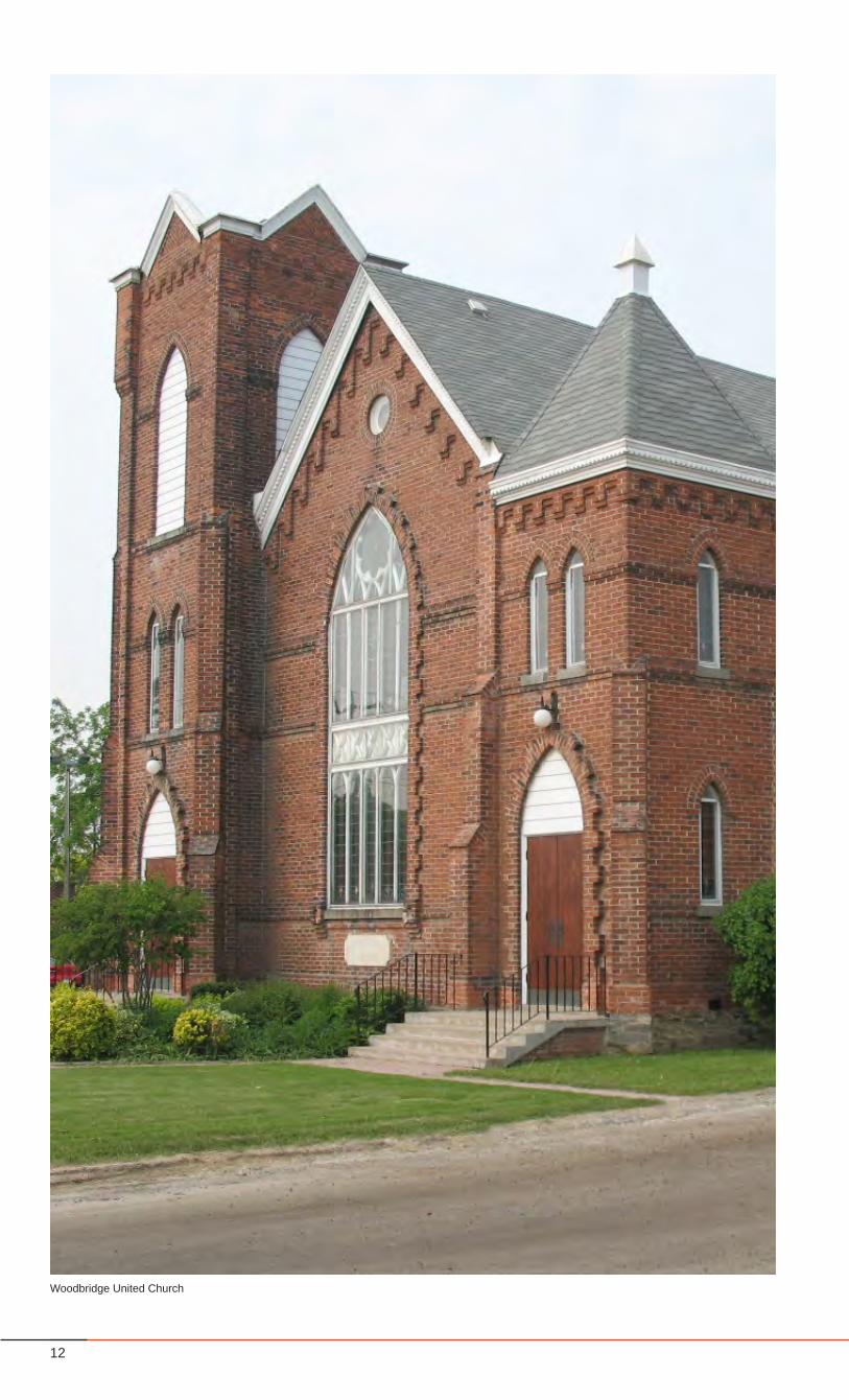
Woodbridge United Church
13Woodbridge Heritage Conservation District
Part 1 - The Study
14
districts
properties and
structures
landscapesand natural
features
15Woodbridge Heritage Conservation District
1.0 BACKGROUND AND CONTEXT
What is Heritage?
TheOntarioHeritagePolicyReview(1990)definesheritageas“All that society values and that survives as the living context – both natural and human – from which we derive our sustenance, coherence and meaning in our individual and collective lives.”
From the broad context of what constitutes heritage, this Heritage Conservation District Plan focuses mostly on the elements of built heritage (e.g. buildings and structures) and cultural heritage landscapes (e.g. parks and open spaces), that have a significancerelativetotheirhistory,designandcontext,andthatcontribute to a district heritage character.
This HCD Plan is based on the idea that heritage includes a broad range of building types, structures, uses and time periods, and that it includes landscapes, streetscapes, neighbourhoods and urban areas.
Why Does Heritage Matter?
Heritage conservation is not only about saving old buildings, it is also fundamentally about enhancing the meaning and quality of life, by maintaining a unique sense of place, as well as supporting the cultural and economic vitality that accompanies areas with strong conservation.
Areas of a city that have embraced heritage as part of contemporary urban life thrive, becoming cherished places for residents to live and work, and are rewarding destinations for
visitors.Vaughancanbenefitfromconservationinmanyways:from the sense of identity and character, from the memory and sense of history, and well as from quality environments.
What is a Heritage Conservation District?
A Heritage Conservation District (HCD) is a policy instrument, enabled by the Province of Ontario, through the Ontario Heritage Act.
An HCD is based on the premise that “it is important to understand that the value of the district as a whole is always greater than the sum of its parts” (Ontario Heritage Toolkit, 2006).
Whenanindividualpropertyisidentifiedashavingculturalheritagevalue, it is listed or designated on the Heritage Inventory. With an HCD, there is a recognition that sometimes there is a cultural heritage value that emerges from the collection of buildings, structures, landscapes and natural features, that form a district, and that on their own would not be necessarily designated. It is as a collection, within theircontext,thattheygainsignificance.
What is Included in an HCD?
• AnInventoryofheritageresourceswithintheStudyArea• AHeritageCharacterStatement• AclearlydefinedDistrictboundary• Alistofheritageattributes• Guidelinesforinterventions• Alistofcontributingandnon-contributingproperties
1.1 Woodbridge Heritage Conservation District Study
HERITAGETangible Intangible
Archaeology
Artifacts
Physical / Built Heritage
properties and
structures
landscapesand natural
featuresdistricts
associativeheritage
16
Steeles Avenue
King Road
Hwy 50
City of Vaughan
Woodbridge Heritage Conservation District
Study Area within City of Vaughan Context
Steeles AvenueHwy 50
407
City of Toronto
City of Vaughan
17Woodbridge Heritage Conservation District
BACKGROUND AND CONTEXT
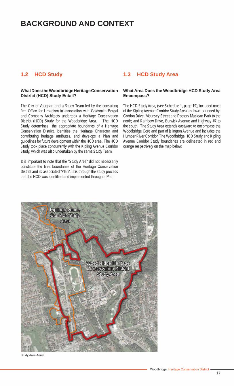
1.2 HCD Study
What Does the Woodbridge Heritage Conservation District (HCD) Study Entail?
The City of Vaughan and a Study Team led by the consulting firmOffice for Urbanism in associationwithGoldsmith Borgaland Company Architects undertook a Heritage Conservation District (HCD) Study for the Woodbridge Area. The HCD Study determines the appropriate boundaries of a Heritage Conservation District, identifies the Heritage Character andcontributing heritage attributes, and develops a Plan and guidelines for future development within the HCD area. The HCD Study took place concurrently with the Kipling Avenue Corridor Study, which was also undertaken by the same Study Team.
It is important to note that the “Study Area” did not necessarily constitute the final boundaries of the Heritage ConservationDistrict and its associated “Plan”. It is through the study process thattheHCDwasidentifiedandimplementedthroughaPlan.
1.3 HCD Study Area
What Area Does the Woodbridge HCD Study Area Encompass?
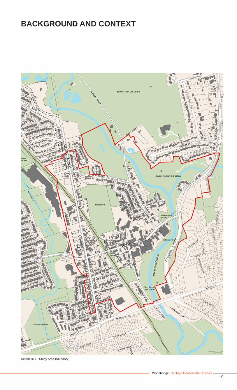
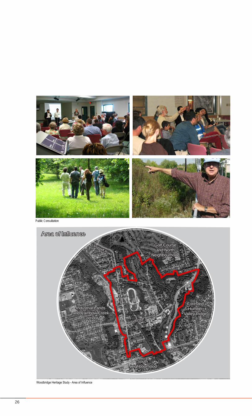
The HCD Study Area, (see Schedule 1, page 19), included most of the Kipling Avenue Corridor Study Area and was bounded by: Gordon Drive, Mounsey Street and Doctors Maclean Park to the north; and Rainbow Drive, Burwick Avenue and Highway #7 to the south. The Study Area extends eastward to encompass the Woodbridge Core and part of Islington Avenue and includes the Humber River Corridor. The Woodbridge HCD Study and Kipling Avenue Corridor Study boundaries are delineated in red and orange respectively on the map below.
Study Area Aerial
Woodbridge Heritage Conservation District
Study Area
Kipling Avenue Corridor Study
Area
18
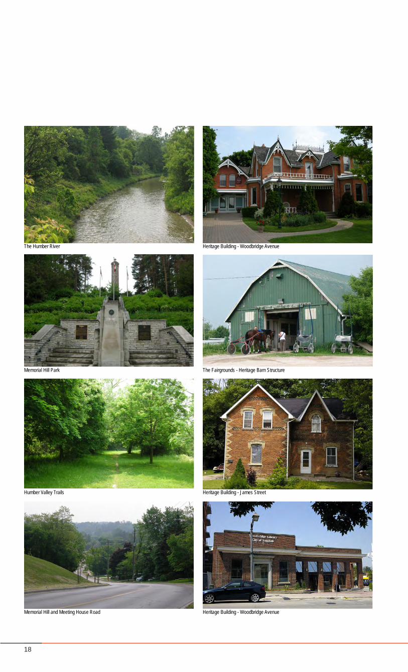
The Humber River Heritage Building - Woodbridge Avenue
Memorial Hill Park The Fairgrounds - Heritage Barn Structure
Humber Valley Trails Heritage Building - James Street
Memorial Hill and Meeting House Road Heritage Building - Woodbridge Avenue
19Woodbridge Heritage Conservation District
Schedule 1: Study Area Boundary
Nort JohnsonDistrict Park
OldFirehallParkette
Fairground
Hu
mb
er R
iver
Cor
rid
or
Rain
bow
Cre
ek
Rainbow Creek Park
RainbowCreek Park
Doctors Maclean District Park
Board of Trade Golf Course
Veterans Park
Fred ArmstrongParkette
BACKGROUND AND CONTEXT
20
Woodbridge Heritage Conservation District Plan
District Boundary
and HeritageAttributes
and Guidelines
Final Draft HCD Plan
Heritage Character Statement
and Guiding Principles
Kipling Avenue Corridor Study
Public Open House
Kick-Off
HCD # 3Public
meeting
Final HCD Plan
interviews
inventory
Final Draft Plan
Streetscape Master Plan
Forum # 2
HCDPublic Open
HouseKick-Off
Forum # 1
HCD # 1Public
meeting
Forum # 3
HCD # 2Public
meeting
Forum # 4
OPA
Final Kipling
CorridorStudy
Draft HCD Plan
21Woodbridge Heritage Conservation District
BACKGROUND AND CONTEXT
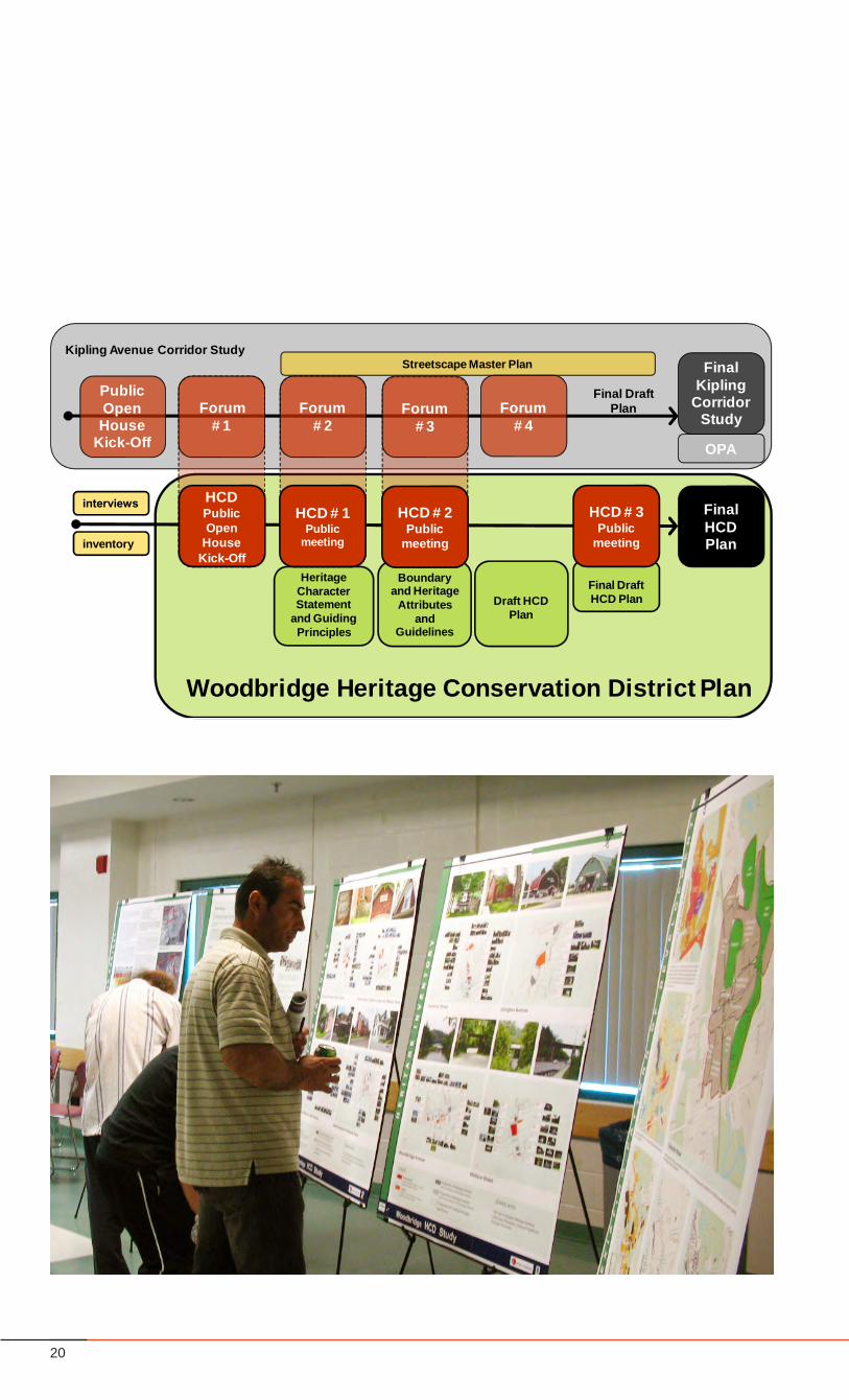
1.4 HCD Study Process
Initiation of the Process
The Woodbridge HCD Study was initiated by the City of Vaughan as a result of community encouragement during the introductory Kipling Avenue Corridor Study public event. Participants voiced their own aspirations and concerns for the preservation of Woodbridge’s unique heritage. It became obvious that an HCD Study for the area was a priority considering the current development within Woodbridge and the effects of change on the existing heritage fabric.
Stakeholder Interviews
A number of stakeholders were identified throughout theprocess. Residents, businesses, property owners and other interestedpeoplewere interviewed individually during the firstphase of the study. Stakeholder interviews continued throughout the process as additional interests and points of view emerged. These interviews were documented and served as a basis for understanding Woodbridge’s unique character, and to test different options for guidelines.
Public Open Houses
Open House # 1The first Public Open House Kick-off event for the HCDwasheld jointly with the Kipling Avenue Corridor Study. At this event, the consultant team was introduced to more of the community interested in protecting the heritage fabric of Woodbridge, including property owners, local residents, and business owners. The consultant team provided attendees with information on Heritage Conservation Districts, their purpose, and their impacts on ‘designated’ areas.
Once participants understood the general principles behind HCDs, they were introduced to this project in particular and the process for establishing an HCD for the Woodbridge Study Area. The consultant team then identified the existing studyarea, took the attendees through the study process and provided an overview of the area history. As well, the team introduced the building inventory for the study area, the draft objectives, theeight identifiedheritagecharacterareasand theemergingheritage character statement.
Attendees were invited to review the emerging HCD Plan on informative display panels and provide input on the key components through a Question and Answer Period, and through comment sheets. The information was also available to the public via the City’s web site before and after the open house events.
Open House # 2The second Public Open House event gave an overview of the process,objectives,andarefinementoftheheritagecharacterstatement. The approach to the heritage conservation of the Woodbridge Study Area was introduced which defined themeasure of assessing contributing verses non contributing heritage resources. This was followed by a thorough description and illustrative representation of the architectural guidelines as well as the heritage attributes, district guidelines and heritage building styles.
All of the above information was available on illustrative display panels for discussion with the consultant team.
Open House # 3In the final Public Meeting, the draft final HCD Plan waspresented to participants. The community had an opportunity to provide feedback on all aspects of the plan, the objective being toensurethatthefinalplanaccuratelyreflectedtheinterestsofthe public.
Developing a Heritage Character Statement
The Heritage Character Statement was developed through the research and analysis phase of this project. It was further informed by the public participation process in which oral and living histories were brought to bear on the subject of Woodbridge’s Heritage Character, especially during several walking tours throughout the study area hosted by volunteer community members. This “on-site” process allowed a firsthand experience and a measure of understanding through the eyes of the community, of the many important historic attributes and characteristics, both tangible and intangible, that defineWoodbridge today.
The HCD identifies elements that contribute to the distinctHeritage Character of the district. These include micro features, such as repetitive decorative elements and paving materials to macro elements like architectural styles, site placement, landscaping, and urban design elements. The HCD Plan also identifieselementsorareasthatareeitherbeneficial(Assets)ordetrimental (Problems) to the coherence of the district. Assets can be tangibles such as open spaces or compatible building styles and scale. They can be intangibles such as a vibrant and safe street life, and character and feel of place. In the same way, problems can be tangible or intangible and may include poormaintenanceofbothbuilt formand landscapes,modifiedbuilding style, complete loss of heritage structures, etcetera. By identifying these categories, the Design Guidelines can be tailored to either enhance the assets or to correct the problems over time. It is also an easy way for the public to understand issues that might otherwise seem unrelated and obscure.
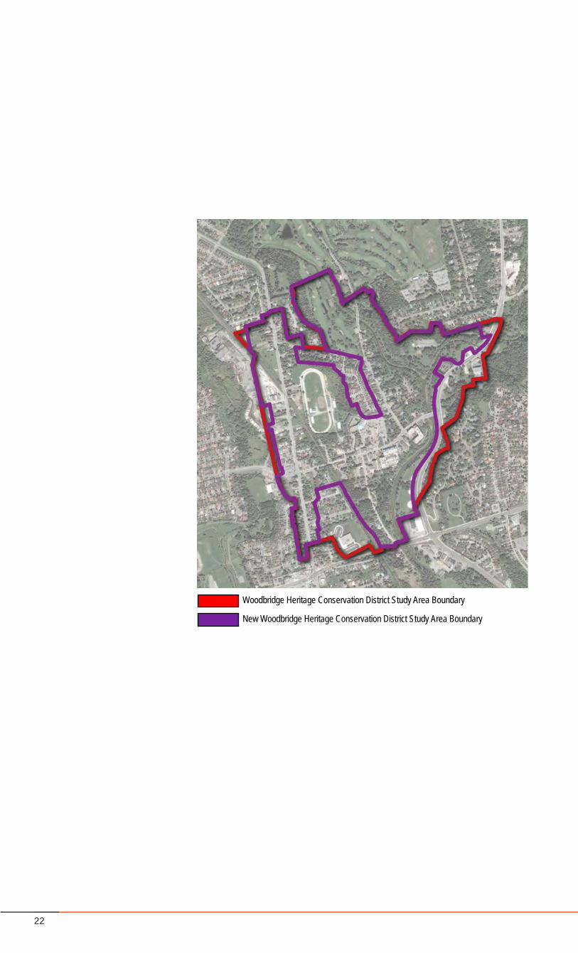
22
New Woodbridge Heritage Conservation District Study Area Boundary
Woodbridge Heritage Conservation District Study Area Boundary
23Woodbridge Heritage Conservation District
BACKGROUND AND CONTEXT
Defining District Boundaries
Once the inventory of buildings was conducted, and the Heritage Character Statement drafted, a new heritage boundary was defined to represent the Woodbridge Heritage ConservationDistrict.Thefinalboundarywasderivedusingtheresearchandanalysis and the public input that was received throughout the Study.ThedefinitionoftheboundaryoftheHCDisincludedinsection 5.2 (page 63) of this report.
Defining a Heritage Character Statement
The Heritage Character Statement (with boundaries) provides the basis of the Rationale for Designation under Part V of the Ontario Heritage Act.
Generating HCD GuidelinesThe HCD Design Guidelines establish the parameters and standards for managing change within the Heritage Conservation District as it relates to built form and landscapes. The guidelines were developed and edited through public consultation.
Developing Implementation Tools
The HCD Plan is rooted in implementation guidelines and presents methods in which the objectives of the HCD can be disseminated and understood in the public realm. Key recommendations of thePlanandGuidelineshavebeendefinedwithconsiderationfortheir implementation, including the approval process.
Notifications
Prior to each large public event the City conducted a mail-out to all property owners within the study area. Additionally, a variety of techniques were employed to notify the public several weeks prior to each event. These included:• mailed-out announcements to all tenants within the study
area; • contacting community and resident organizations in the
neighbouring area to notify their respective memberships and networks;
• announcingeacheventduringtheprecedingevent;• contacting individuals who signed-in during earlier events
directly;• contacting stakeholders that were identified by other
participants through the process;• posting the meeting information on the City website two
weeks prior to each meeting date; and,• placingadsinthelocalpapersforeachmeetingevent.
24
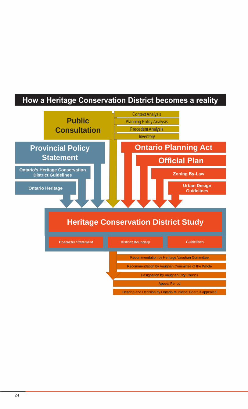
Recommendation by Heritage Vaughan Committee
Recommendation by Vaughan Committee of the Whole
Designation by Vaughan City Council
Appeal Period
Heritage Conservation District Study
Character Statement District Boundary Guidelines
Public Consultation
Planning Policy Analysis
InventoryPrecedent Analysis
Context Analysis
How a Heritage Conservation District becomes a reality
Ontario Heritage
Ontario’s Heritage Conservation District Guidelines
Provincial Policy Statement Official Plan
Zoning By-Law
Urban Design Guidelines
Ontario Planning Act
Hearing and Decision by Ontario Municipal Board if appealed
25Woodbridge Heritage Conservation District
1.5 Policy Context
Provincial Policy Statement (2005)
The Provincial Policy Statement, 2005 (PPS) is the document that outlines the Province’s current policy on planning and municipal land use that relates to provincial interests. The conservation of heritage resources, including Heritage Conservation Districts, is supported in the PPS. The PPS states that ‘Significant built heritage resources and significant culturalheritagelandscapesshallbeconserved’.Morespecificlanguageis included in actual legislation: the Ontario Planning Act and the Ontario Heritage Act.
The Woodbridge Heritage District Conservation Plan has identified heritage features in the study area and proposed guidelines to protect, use, and manage these cultural resources to preserve their heritage value. (See Part 2 - The Heritage Conservation District)
Ontario Planning Act
The Ontario Planning Act states that all planning decisions by municipalities ‘shall be consistent with’ the Provincial Policy Statement. The conservation of heritage resources is thereby required of municipalities. The Act permits municipalities to include more comprehensive conservation policies, that apply to local cultural landscapes, into the Official Plans and other policies regulating land use or development within the municipality.
The Woodbridge Heritage Conservation District Plan is an expression of municipal interest in a local cultural landscape. Its purpose is to create the framework for the Heritage Conservation District Plan as permitted by the Ontario Heritage Act and required by the PPS.
Ontario Heritage Act
The Ontario Heritage Act is the legislation that regulates heritage preservation in the province. Individual properties that are recognized as possessing heritage value can be ‘designated’ by Municipal Council. Similarly, entire streetscapes or neighbourhoods can be ‘designated’ for their heritage value. Under Part IV and V of the Act, the Province charges municipalities with the responsibility of identifying individual heritage properties or broader Heritage Conservation Districts.
Possessing jurisdiction over heritage preservation, the City of Vaughan has commissioned this Heritage Conservation District Study.
BACKGROUND AND CONTEXT
Ontario’s Heritage Conservation DistrictGuidelines
The Heritage Conservation District Guidelines is a document produced by the Ministry of Culture that provides clear instructions for development, implementation and management of Heritage Conservation Districts.
The Woodbridge Heritage Conservation District Plan was completed according to the process presented in the HCD Guidelines document. The Study exceeded the Guidelines’ requirements for consultation when it was seen that emerging guidelines would benefit from further input from local stakeholders and residents.
York Region Official Plan
The York Regional Official Plan contains a number of CulturalHeritage policies that support heritage preservation which were designed to promote cultural heritage activities and conserve cultural heritage resources within the Region. Section 4.2.4. in the Official Plan document encourages area municipalities todocumentsignificantheritageresourcesandtopromoteheritageawareness.
The Woodbridge Heritage District Conservation Plan further supports and reinforces the objectives and policies set out in the Region of York Official Plan for Cultural Heritage.
Toronto Region Conservation Authority (TRCA)
TheTRCApoliciesregulateswithinthefloodplainandconservationlands. The Woodbridge Heritage Conservation District includes parts of the Humber River and adjacent lands, which lie within the floodplainandalsoincludesconservationlands.
Under Ontario Regulation 166/06 (Development, Interference with Wetlands and Alterations to Shorelines) TRCA regulates developmentproposalsadjacenttonaturalareasandfloodplainareas and issues permits, if appropriate. Additionally, TRCA has the Valley and Stream Corridor Management Program that also providesdirectionondefiningvalleyandstreamcorridors.
City of Vaughan Official Plan Amendments
One of themajor goals of the The City of Vaughan’s OfficialPlan Amendments #240, #356, and #440 for Woodbridge, is to “Create a distinctive residential community of a scale and character which will relate well to the existing village quality of Woodbridge, and possess a strong sense of community identity”. OPA#440specificallyseekstopreservetheheritageresourceswithin the Woodbridge Heritage Commercial Centre, which
26
Public Consultation
WoodbridgeHeritageStudy-AreaofInfluence
Langstaff Road
Islin
gton
Ave
nue
Highway 7
Area of Influence
Kipling Avenue
Woodbridge Avenue
Industrial Lands and Rainbow Creek
Corridor
Golf Course and North
Neighbourhood
ForestedHumber
Valley Ridge
South Neighbourhood
27Woodbridge Heritage Conservation District
BACKGROUND AND CONTEXT
includes the Woodbridge Core, the majority of Kipling Avenue, the neighbourhoods,andtherivercorridor,andprotectsanddefinesthe role of its heritage resources in the future urban context of the City of Vaughan. There are policies which speak to:
preservation of the “Village” character of Woodbridge•preservation of buildings with architectural or historical interest•preservation of the characteristic 2-3 storey existing building •heightspreservationofsignificantlandscapes,treesandwoodlotareas•designation of a Special Policy Area for the protection and •managementofthefloodplainprotection and maintenance of the Humber River Corridor•
The Woodbridge Heritage Conservation District Plan includes a comprehensive set of design guidelines to steer future development and protect the unique character of the study area. The guidelines for the Kipling Avenue Corridor Study were developed in accordance to the guidelines of this study. A complete inventory of all buildings in the study area has been undertaken and is included as a separate appendix to this document.
Zoning By-Laws
Woodbridge is zoned as mixed-use consisting of primarily residential land use, ranging from single family housing to mixed use condominiums, with commercial, industrial, open space and open space conservation areas intermixed. The study area is governed by the City’s Zoning By-law.
Guidelines in the Woodbridge Heritage Conservation District Plan are generally in conformity with the Zoning By-law. Proposed changes to the Zoning By-law are outlined at the end of this document.
Urban Design Study (1994)
The Woodbridge Historic Commercial Centre Urban Design Study is a document of urban, architectural and landscape design guidelines established to implement the goals andobjectivesofAmendment#440totheVaughanOfficialPlan(WoodbridgeHistoricCommercialCentreOfficialPlan).Theintentis to preserve and enhance existing historical and architecturally significant buildings and ensure that new development isharmonious with the historical-architectural character, and that the heritage resources are accessible to the public.
The Woodbridge Heritage Conservation District Study guidelines are consistent with the goals and objectives of the Urban Design Study and particularly emphasize the goal of creating an accessible, walkable heritage environment for the community and a unique destination for all to enjoy.
Public Consultation
The Ontario Heritage Act requires one public meeting to be held prior to the passing of the Heritage Conservation District designating by-law. The Heritage Conservation District Guideline document recommends that a Heritage Conservation District Study include 3 or more public meetings before the draft HCD Plan and by-law are submitted for comment at the statutory public meeting.
The Woodbridge Heritage Conservation District Study undertook a varied program of public consultation including; community public open house sessions, one-on-one stakeholder meetings, residents group meetings, and informative guided tours throughout the study area and adjacent “areas of influence”. The goal of the public consultation was not only to receive meaningful input from all stakeholders, and to garner wide-spread support for the final Heritage Conservation District Plan, but also to educate and inform landowners of the process, outcomes and the benefits of heritage conservation. Public Meetings were well publicized and influenced by involved citizens. At each meeting, participants were given an update on the HCD Study process, were consulted on the emerging options for HCD guidelines, and were given the opportunity to provide feedback on key issues.
Contributing Policy Research
Heritage Conservation District Plans require a Heritage Character Statement, a Description of Heritage Attributes, and Policy Statements and Guidelines.
Heritage professionals, planners and urban designers contributed to the exhaustive context analysis, planning policy analysis, precedent study, and inventory, all of which were essential to the Woodbridge Heritage Conservation District Plan.
Approval Phase
The final Heritage Conservation District (HCD) Plan will bepresented to the Heritage Vaughan Committee to review. The plan is then presented at a Public Hearing for feedback and then subsequently presented back to the Heritage Committee as a Final Draft Plan. The Plan is then brought before Vaughan Committee of the Whole for approval. If approved, a by-law will be passed by Council establishing the boundaries of a Heritage Conservation District and giving effect to the District Plan including the guidelines. Any person has the right to appeal this by-law to the OMB.
28
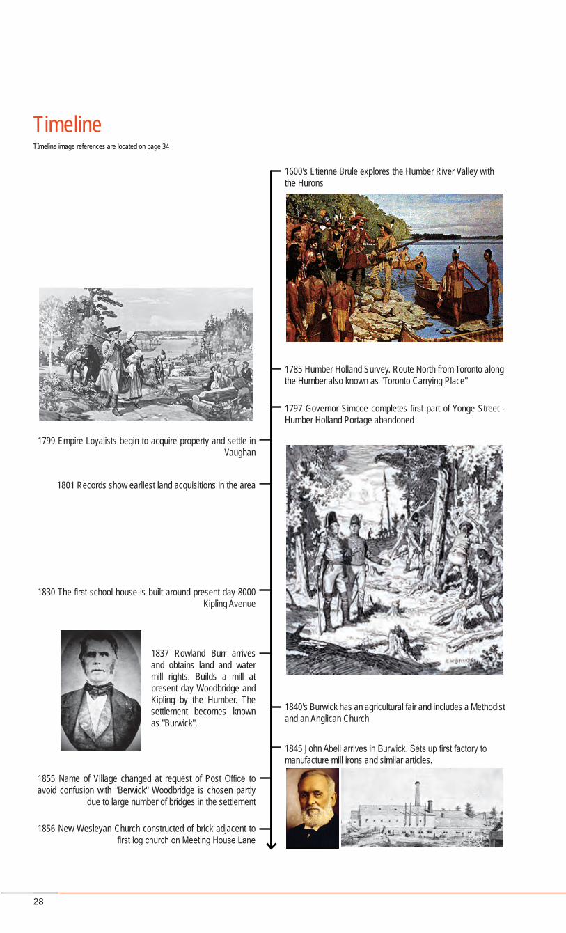
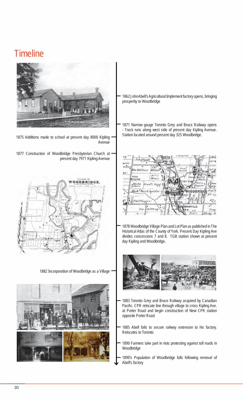
1600's Etienne Brule explores the Humber River Valley with the Hurons
1785 Humber Holland Survey. Route North from Toronto along the Humber also known as "Toronto Carrying Place"
1799 Empire Loyalists begin to acquire property and settle in Vaughan
1797 Governor Simcoe completes first part of Yonge Street - Humber Holland Portage abandoned
1801 Records show earliest land acquisitions in the area
1830 The first school house is built around present day 8000 Kipling Avenue
1837 Rowland Burr arrives and obtains land and water mill rights. Builds a mill at present day Woodbridge and Kipling by the Humber. The settlement becomes known as "Burwick".
1840's Burwick has an agricultural fair and includes a Methodist and an Anglican Church
1845 John Abell arrives in Burwick. Sets up first factory tomanufacture mill irons and similar articles.
1855 Name of Village changed at request of Post Office to avoid confusion with "Berwick" Woodbridge is chosen partly
due to large number of bridges in the settlement
1856 New Wesleyan Church constructed of brick adjacent to first log church on Meeting House Lane
1862 John Abell's Agricultural Implement factory opens, bringing prosperity to Woodbridge
1871 Narrow gauge Toronto Grey and Bruce Railway opens - Track runs along west side of present day Kipling Avenue. Station located around present day 325 Woodbridge.1875 Additions made to school at present day 8000 Kipling
Avenue
1878 Woodbridge Village Plan and Lot Plan as published in The Historical Atlas of the County of York. Present Day Kipling Ave divides concessions 7 and 8. TGB station shown at present day Kipling and Woodbridge.
1882 Incorporation of Woodbridge as a Village
1883 Toronto Grey and Bruce Railway acquired by Canadian Pacific. CPR relocate line through village to cross Kipling Ave. at Porter Road and begin construction of New CPR station opposite Porter Road.
1885 Abell fails to secure railway extension to his factory. Relocates to Toronto
1890 Farmers take part in riots protesting against toll roads in Woodbridge
1890's Population of Woodbridge falls following removal of Abell's factory
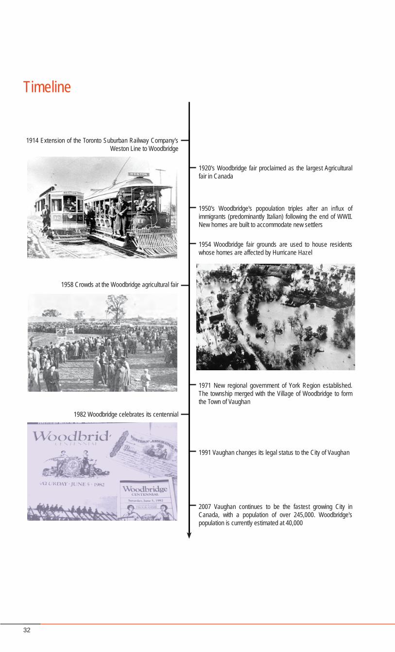
1914 Extension of the Toronto Suburban Railway Company's Weston Line to Woodbridge
1920's Woodbridge fair proclaimed as the largest Agricultural fair in Canada
1950's Woodbridge's popoulation triples after an influx of immigrants (predominantly Italian) following the end of WWII. New homes are built to accommodate new settlers
1954 Woodbridge fair grounds are used to house residents whose homes are affected by Hurricane Hazel
1971 New regional government of York Region established. The township merged with the Village of Woodbridge to form the Town of Vaughan
1991 Vaughan changes its legal status to the City of Vaughan
2007 Vaughan continues to be the fastest growing City in Canada, with a population of over 245,000. Woodbridge's population is currently estimated at 40,000
1958 Crowds at the Woodbridge agricultural fair
1982 Woodbridge celebrates its centennial
1877 Construction of Woodbridge Presbyterian Church at present day 7971 Kipling Avenue
TimelineTImeline image references are located on page 34
29Woodbridge Heritage Conservation District
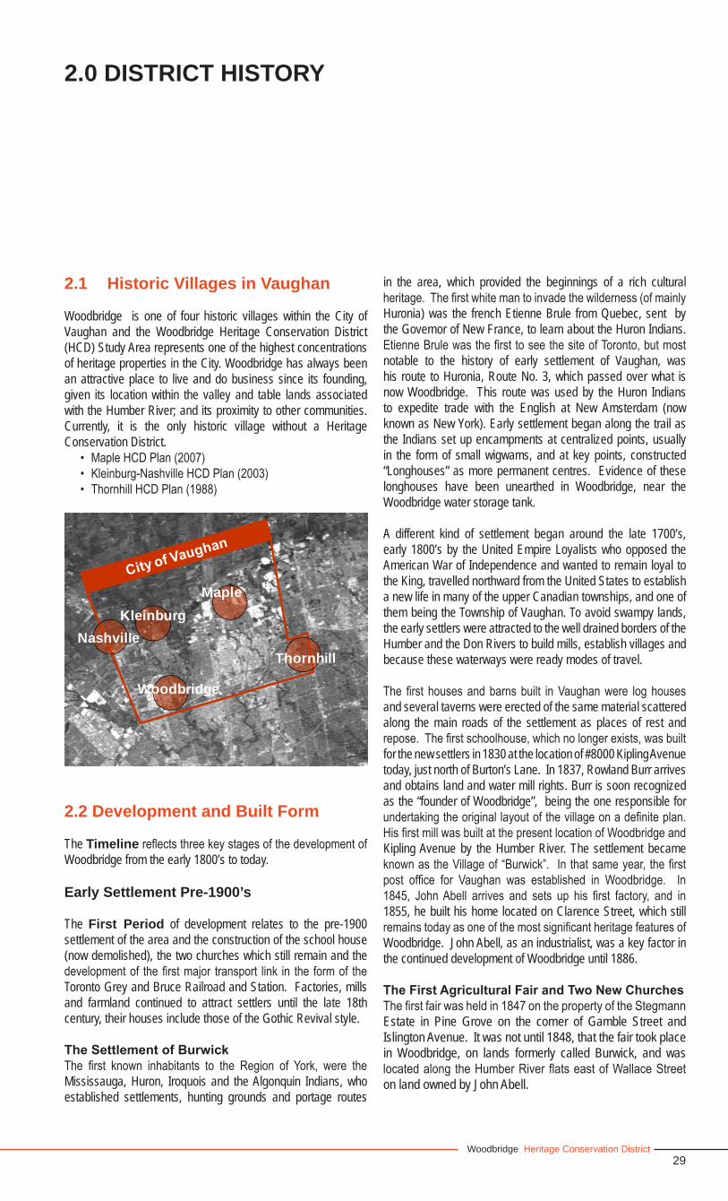
2.1 Historic Villages in Vaughan
Woodbridge is one of four historic villages within the City of Vaughan and the Woodbridge Heritage Conservation District (HCD) Study Area represents one of the highest concentrations of heritage properties in the City. Woodbridge has always been an attractive place to live and do business since its founding, given its location within the valley and table lands associated with the Humber River; and its proximity to other communities. Currently, it is the only historic village without a Heritage Conservation District.
• MapleHCDPlan(2007)• Kleinburg-NashvilleHCDPlan(2003)• ThornhillHCDPlan(1988)
2.2 Development and Built Form
The TimelinereflectsthreekeystagesofthedevelopmentofWoodbridge from the early 1800’s to today.
Early Settlement Pre-1900’s
The First Period of development relates to the pre-1900 settlement of the area and the construction of the school house (now demolished), the two churches which still remain and the developmentof thefirstmajor transport link in the formof theToronto Grey and Bruce Railroad and Station. Factories, mills and farmland continued to attract settlers until the late 18th century, their houses include those of the Gothic Revival style.
The Settlement of Burwick The first known inhabitants to the Region of York, were theMississauga, Huron, Iroquois and the Algonquin Indians, who established settlements, hunting grounds and portage routes
in the area, which provided the beginnings of a rich cultural heritage.Thefirstwhitemantoinvadethewilderness(ofmainlyHuronia) was the french Etienne Brule from Quebec, sent by the Governor of New France, to learn about the Huron Indians. EtienneBrulewasthefirsttoseethesiteofToronto,butmostnotable to the history of early settlement of Vaughan, was his route to Huronia, Route No. 3, which passed over what is now Woodbridge. This route was used by the Huron Indians to expedite trade with the English at New Amsterdam (now known as New York). Early settlement began along the trail as the Indians set up encampments at centralized points, usually in the form of small wigwams, and at key points, constructed “Longhouses” as more permanent centres. Evidence of these longhouses have been unearthed in Woodbridge, near the Woodbridge water storage tank.
A different kind of settlement began around the late 1700’s, early 1800’s by the United Empire Loyalists who opposed the American War of Independence and wanted to remain loyal to the King, travelled northward from the United States to establish a new life in many of the upper Canadian townships, and one of them being the Township of Vaughan. To avoid swampy lands, the early settlers were attracted to the well drained borders of the Humber and the Don Rivers to build mills, establish villages and because these waterways were ready modes of travel.
The first housesandbarns built inVaughanwere log housesand several taverns were erected of the same material scattered along the main roads of the settlement as places of rest and repose.Thefirstschoolhouse,whichnolongerexists,wasbuiltfor the new settlers in 1830 at the location of #8000 Kipling Avenue today, just north of Burton’s Lane. In 1837, Rowland Burr arrives and obtains land and water mill rights. Burr is soon recognized as the “founder of Woodbridge”, being the one responsible for undertakingtheoriginallayoutofthevillageonadefiniteplan.HisfirstmillwasbuiltatthepresentlocationofWoodbridgeandKipling Avenue by the Humber River. The settlement became knownastheVillageof“Burwick”. Inthatsameyear, thefirstpost office for Vaughan was established in Woodbridge. In1845, JohnAbell arrives and sets up his first factory, and in1855, he built his home located on Clarence Street, which still remainstodayasoneofthemostsignificantheritagefeaturesofWoodbridge. John Abell, as an industrialist, was a key factor in the continued development of Woodbridge until 1886.
The First Agricultural Fair and Two New ChurchesThefirstfairwasheldin1847onthepropertyoftheStegmannEstate in Pine Grove on the corner of Gamble Street and Islington Avenue. It was not until 1848, that the fair took place in Woodbridge, on lands formerly called Burwick, and was locatedalongtheHumberRiverflatseastofWallaceStreeton land owned by John Abell.
2.0 DISTRICT HISTORY
Thornhill
Woodbridge
KleinburgMaple
Nashville
30
1600's Etienne Brule explores the Humber River Valley with the Hurons
1785 Humber Holland Survey. Route North from Toronto along the Humber also known as "Toronto Carrying Place"
1799 Empire Loyalists begin to acquire property and settle in Vaughan
1797 Governor Simcoe completes first part of Yonge Street - Humber Holland Portage abandoned
1801 Records show earliest land acquisitions in the area
1830 The first school house is built around present day 8000 Kipling Avenue
1837 Rowland Burr arrives and obtains land and water mill rights. Builds a mill at present day Woodbridge and Kipling by the Humber. The settlement becomes known as "Burwick".
1840's Burwick has an agricultural fair and includes a Methodist and an Anglican Church
1845 John Abell arrives in Burwick. Sets up first factory tomanufacture mill irons and similar articles.
1855 Name of Village changed at request of Post Office to avoid confusion with "Berwick" Woodbridge is chosen partly
due to large number of bridges in the settlement
1856 New Wesleyan Church constructed of brick adjacent to first log church on Meeting House Lane
1862 John Abell's Agricultural Implement factory opens, bringing prosperity to Woodbridge
1871 Narrow gauge Toronto Grey and Bruce Railway opens - Track runs along west side of present day Kipling Avenue. Station located around present day 325 Woodbridge.1875 Additions made to school at present day 8000 Kipling
Avenue
1878 Woodbridge Village Plan and Lot Plan as published in The Historical Atlas of the County of York. Present Day Kipling Ave divides concessions 7 and 8. TGB station shown at present day Kipling and Woodbridge.
1882 Incorporation of Woodbridge as a Village
1883 Toronto Grey and Bruce Railway acquired by Canadian Pacific. CPR relocate line through village to cross Kipling Ave. at Porter Road and begin construction of New CPR station opposite Porter Road.
1885 Abell fails to secure railway extension to his factory. Relocates to Toronto
1890 Farmers take part in riots protesting against toll roads in Woodbridge
1890's Population of Woodbridge falls following removal of Abell's factory
1914 Extension of the Toronto Suburban Railway Company's Weston Line to Woodbridge
1920's Woodbridge fair proclaimed as the largest Agricultural fair in Canada
1950's Woodbridge's popoulation triples after an influx of immigrants (predominantly Italian) following the end of WWII. New homes are built to accommodate new settlers
1954 Woodbridge fair grounds are used to house residents whose homes are affected by Hurricane Hazel
1971 New regional government of York Region established. The township merged with the Village of Woodbridge to form the Town of Vaughan
1991 Vaughan changes its legal status to the City of Vaughan
2007 Vaughan continues to be the fastest growing City in Canada, with a population of over 245,000. Woodbridge's population is currently estimated at 40,000
1958 Crowds at the Woodbridge agricultural fair
1982 Woodbridge celebrates its centennial
1877 Construction of Woodbridge Presbyterian Church at present day 7971 Kipling Avenue
Timeline
31Woodbridge Heritage Conservation District
DISTRICT HISTORY
Two new churches were also established in Burwick in 1847, the Wesleyan Methodist Church and the Anglican Church. The first Methodist Church was located on Church Street,today called Meeting House Road. The Church was torn down in 1883 and the bricks and materials were used for the construction of the United Church in 1886, which still exists today at #8090 Kipling Avenue. As well, a stone memorial sits on the original location of the Methodist Church and the Pioneer Burying Ground along Meeting House Road.
Great Change for Burwick - Renamed “Woodbridge Village” In 1855, the settlement of Burwick was renamed Woodbridge mainly because there was continued confusion between another settlement called “Berwick”. The name Woodbridge was deemed appropriate for the area due to the large number of bridges needed to traverse the many streams and tributaries of the Humber River.
By 1862, John Abell had become quite a successful industrialist and established an agricultural implement plant known as the WoodbridgeAgriculturalWorks,which produced the first steamengine to be used in Vaughan and was the main supplier of farm implements for the area. His business encouraged economic prosperity for Woodbridge, providing jobs and encouraging new businessestoflourish.SeveraltavernssprungupalongKiplingAvenue and Woodbridge Avenue to service the plant.
Toronto Grey and Bruce Railroad and StationTheTorontoGreyandBrucenarrowgaugerailroadwasthefirstrailway to service Woodbridge and was built in 1871 just west of Kipling Avenue with a train station located south of Burton’s Lane. The rail linewas extensively used, carrying flour fromlocal mills and agricultural tools from the Abell and Patterson factories. The original line and train station were located where the rail line intersected Woodbridge Avenue, in the vicinity of the present location of the fire hall at KiplingAvenue andWoodbridge Avenue. The Dominion House (Hotel) was erected in 1874 at the north west corner of the intersection to service the train station. The intersection became the “ideal meeting place” for farmers especially on “implement delivery day” which usually encouraged the attendance of the Burwick Brass Band. Clusters of development continued to occur eastward, especially along Pine Street and Wallace Street where additional factories and mills were located. Most notably, was John Abell’s Woodbridge Agricultural Works, built in 1874. The original location of the HumberRiverflowedalong theeastwallof thebuildings.Therailway was eventually widened in 1882 and became part of C.P. Rail in 1884.
New Construction and Increased DevelopmentIn 1875, new additions were made to the original schoolhouse
and soon after, construction of the Woodbridge Presbyterian Church began in 1877, which is still located at present day #7971 Kipling Avenue, south of William Street. By 1878, increased development continued along Pine Street, now Woodbridge Avenue and Wallace Street. Development included Hotels, a bowlingalley,factories,mills,thepostofficeandtheOrangeHall.In1882,WoodbridgewasincorporatedasanofficialvillagewithJohnAbellasthefirstReeveandJoelReamanasthefirstClerk.In 1883, the Toronto Grey and Bruce Railway was acquired by C.P. Rail.
In 1885, after alternating between two locations of the Village of Weston and the Village of Woodbridge for several years, the Fairgrounds was permanently located at 100 Porter Avenue along Kipling Avenue where it exists today. The same year also saw the development of the Norton’s Brick Yard at the location of Church and Clarence Street.
Woodbridge’s Population DeclinesIt was also at this time that John Abell relocated his business out of Woodbridge to Toronto because of a lack of access to the Toronto Grey and Bruce Railway. He continued to supply Vaughan farmers with machinery but the businesses within Woodbridge suffered the loss of the factory presence and many area residents lost their jobs. To worsen the matter, in 1890, area farmers become outraged against the introduction of toll roads in Woodbridge. The effects of these two events caused the population of Woodbridge to decline to around 600. John Abell’s Woodbridge Factory was eventually taken over by Sr. W.H. Edwards in 1919 to start a tannery business until it was destroyedbyfirein1926.
The Turn of the 19th Century
The Second Period of development dates from the turn of the 19th Century. The new Canadian Pacific Railway (CPR)station continued to attract new settlers, although in smaller numbers after the departure of John Abell’s factory operations. Turn of the century development includes a number of Victorian and Queen Anne Revival properties.
Relocation of the RailwayIn 1907, the railway was moved further east of the original location crossing Kipling Avenue and Porter Avenue where the topography was more conducive to train travel and a new train station was built at the present location of the Woodbridge Foam property. 1914 saw the extension of the Toronto Suburban Railway Company Railway Line to Woodbridge. In 1914 to 1924, the Toronto Electric Railway Company operated a streetcar service that ran from Woodbridge to Keele and Dundas Street in Toronto.
32
1600's Etienne Brule explores the Humber River Valley with the Hurons
1785 Humber Holland Survey. Route North from Toronto along the Humber also known as "Toronto Carrying Place"
1799 Empire Loyalists begin to acquire property and settle in Vaughan
1797 Governor Simcoe completes first part of Yonge Street - Humber Holland Portage abandoned
1801 Records show earliest land acquisitions in the area
1830 The first school house is built around present day 8000 Kipling Avenue
1837 Rowland Burr arrives and obtains land and water mill rights. Builds a mill at present day Woodbridge and Kipling by the Humber. The settlement becomes known as "Burwick".
1840's Burwick has an agricultural fair and includes a Methodist and an Anglican Church
1845 John Abell arrives in Burwick. Sets up first factory tomanufacture mill irons and similar articles.
1855 Name of Village changed at request of Post Office to avoid confusion with "Berwick" Woodbridge is chosen partly
due to large number of bridges in the settlement
1856 New Wesleyan Church constructed of brick adjacent to first log church on Meeting House Lane
1862 John Abell's Agricultural Implement factory opens, bringing prosperity to Woodbridge
1871 Narrow gauge Toronto Grey and Bruce Railway opens - Track runs along west side of present day Kipling Avenue. Station located around present day 325 Woodbridge.1875 Additions made to school at present day 8000 Kipling
Avenue
1878 Woodbridge Village Plan and Lot Plan as published in The Historical Atlas of the County of York. Present Day Kipling Ave divides concessions 7 and 8. TGB station shown at present day Kipling and Woodbridge.
1882 Incorporation of Woodbridge as a Village
1883 Toronto Grey and Bruce Railway acquired by Canadian Pacific. CPR relocate line through village to cross Kipling Ave. at Porter Road and begin construction of New CPR station opposite Porter Road.
1885 Abell fails to secure railway extension to his factory. Relocates to Toronto
1890 Farmers take part in riots protesting against toll roads in Woodbridge
1890's Population of Woodbridge falls following removal of Abell's factory
1914 Extension of the Toronto Suburban Railway Company's Weston Line to Woodbridge
1920's Woodbridge fair proclaimed as the largest Agricultural fair in Canada
1950's Woodbridge's popoulation triples after an influx of immigrants (predominantly Italian) following the end of WWII. New homes are built to accommodate new settlers
1954 Woodbridge fair grounds are used to house residents whose homes are affected by Hurricane Hazel
1971 New regional government of York Region established. The township merged with the Village of Woodbridge to form the Town of Vaughan
1991 Vaughan changes its legal status to the City of Vaughan
2007 Vaughan continues to be the fastest growing City in Canada, with a population of over 245,000. Woodbridge's population is currently estimated at 40,000
1958 Crowds at the Woodbridge agricultural fair
1982 Woodbridge celebrates its centennial
1877 Construction of Woodbridge Presbyterian Church at present day 7971 Kipling Avenue
Timeline
33Woodbridge Heritage Conservation District
DISTRICT HISTORY
In 1921, the abandoned C.P. Rail buildings and part of the track were leased for 99 years to the Woodbridge Farmer’s CooperativeCompany.They located theirofficeandhardwarestore in the old station and warehouse, which was enlarged to stock a variety of merchandise.
The Fairgrounds Gets International RecognitionThe growing popularity of the Fairgrounds brought about change and development to the area. In the 20’s, the Fair was proclaimed as the largest Agricultural Fair in Canada. The fair, sponsored by the Woodbridge Agricultural Society, continued to support local businesses, culture and community events and was largely recognized as a stage for elite Toronto Society. The existence and success of the six hotels that were established in Woodbridge, are due in large part to the popularity of the Fair which brought local and district visitors as well as visitors from around the world. The Fair was considered the most important social event of the year.
New RoadsThe early 1900’s saw the disappearance of the toll roads and the development of new paved roads for Woodbridge, especially the newly created Provincial Highway 7, along Pine Street (Woodbridge) and Eighth Avenue (Kipling). In 1926, a new bridge over the Humber River was built on Highway 7. This encouraged a 25 percent increase in population in the 1930’s and Woodbridge became known as a suburb of Toronto. Many of the original building structures were demolished to make room for new roads. This time period also saw the availability of hydro power as well as the development of some of the large banks such as the Royal Bank and the Bank of Nova Scotia. The year 1946 saw an increased development of industry such as the Robinson Cotton Mills Factory (now the Woodbridge Foam Corporation), and the Edwards and Edwards furrier and tannery businesses. The 1940’s also saw the introduction of sub-division development, whereby subdivision development plans were inspected, regulated and registered by the municipality as a means of guiding future growth for the community.
The 1950’s Onward
The Third Period of development includes the Edwardian houses of the Inter War Period, and Victory Housing dating from the1950’s,whentheareasawalargeinfluxofimmigrantsfromEurope after WWII.
Woodbridge Population Continues to IncreaseInthe1950’s,thepopulationofWoodbridgetriplesafteraninfluxof immigrants (predominantly Italian) following the end of WWII. This encouraged a pattern of suburban expansion in housing development to accommodate the new settlers. Between 1951
and 1956, a total of 10 subdivisions were established. All areas of Woodbridge experienced a rapid increase in development and the population jumped to 3000 by the late 1950’s. The initial growth started from Islington east and later expanded west to Martin Grove Road and north east of Langstaff Road.
Hurricane HazelIn 1954, the Woodbridge Fairgrounds were used to house residents whose homes are destroyed by Hurricane Hazel especially those located at the northern end of Eighth Avenue. Portable housing was erected on the Fairgrounds so that people effected by the hurricane had shelter during the winter. Many business buildings were also damaged or destroyed by the hurricane. In 1958, the village library was renovated and later demolished in 1972 and the Abell Parkette is all that remains to identify the original location.
Progress - The Town of Vaughan is FormedBy the early 1960’s, the population in Woodbridge had reached 10,000 and in 1971 the new regional government of York Region is established. The Township is merged with the Village to form the Town of Vaughan. For a period between the 1960’s to the 1980’s, many of the original buildings structures within Woodbridge were demolished in the name of progress. The Woodbridge Dairy, originally located along the lane to the Fairgrounds, off of Pine Street was demolished in 1970 as a larger delivery area was needed to better service the facility. The Dominion Hotel, a solid brick hotel built in 1874 with its front verandahfacingEighthAvenue(nowKiplingAvenue),wasfirstrenovated into apartments and in 1979 demolished to make way for the development of the Nino D’Aversa Italian Bakery. The Bank of Nova Scotia Building, erected in 1918, was demolished in 1979 and replaced by the Fairground Lane Development Homes. In the same year, the old Woodbridge Farmer’s Train Station was also demolished to make room for the extension ofWoodbridgeAvenueandthenewfirehall.Suburbanhousingdevelopment continued to expand north to Langstaff Road and to central Woodbridge, where many of the older stores were converted to multi units. The population by mid 1980’s was about 40,000.
The City of Vaughan is EstablishedIn 1991, Vaughan changes its legal status to the City of Vaughan. Housing development continues to expand north and east. As well, industrial areas were established west, south and east of Woodbridge. Around 1996, condominium development began to appear,withthefirstconstructionnorthofWoodbridgeAvenueand the Humber River.
Woodbridge in the Context of Vaughan TodayVaughan continues to be the fastest growing city in Canada, with a population of over 245,000. Woodbridge’s population
34
is currently estimated to be over 100,000 and regardless of its growth,itstillmaintainsasignificantrepresentationofitshistoricpast and village character and quality today.
Heritage Landscapes and Open Space Amenities
The history of the Woodbridge Area is largely defined bythe predominant natural open spaces of the Humber River Corridor, its tributaries, and the Fairgrounds, which comprises a substantial amount of open space within the study area.
The Humber River Corridor and Rainbow CreekTributaryTheconfigurationoftheHumberRiveranditstributarieschangedover time, primarily due to Hurricane Hazel. The northern course of the Humber River ran through what is now the Board of Trade Golf Course and along the north side of Meeting House Road to continue northward beyond the boundaries of Woodbridge. One of the main tributaries branched across Meeting House Road south through what is now a recent neighbourhood development in the valley east of the Fairgrounds. The River continued its course parallel to Race Street, now called Clarence Street and split at the intersection of what is now Woodbridge Avenue and Clarence Street. This route no longer exists today. In 1960, the river was re-routed further east to accommodate a new bridge at the junction of Woodbridge Avenue and Islington Avenue.
The forests of the Humber River were quite expansive throughout Woodbridge prior to suburbanization. As well, an extensive amount of damage was done to the forest during the passing of Hurricane Hazel in the 1950’s. Today, apart from the forested river valley corridor, there are remnant pockets of mature tree stands throughout the study area, most notably along the residential streets such as William and Wallace Streets, on heritage properties. These mature tree stands should be preserved and enhanced with additional tree planting. The river valley corridor and the remnant forest pockets, in conjunction with the existing built heritage fabric, define a unique village character for theWoodbridge Community.
The FairgroundsToday, the fairgrounds still exists as “the Home of the Woodbridge Fall Fair”. It is host to a variety of uses for the communityandstillremainsasasignificantopenspaceassetto the Woodbridge Community and the City of Vaughan.
The Memorial TowerThe Memorial Tower was erected on the hilltop west of Wallace Street after WWI as a war memorial to honour the deceased and was unveiled in 1924 by Colonial Harry Cockshutt, Lieutenant Governor of Onatrio.
The Woodbridge and District Memorial ArenaSince 1925, the location of the Memorial Area has always been a place for community gathering. The site housed the Elm Park Pavilion which was a popular entertainment centre. On July 5, 1970 an Air Canada DC-8 crashed after aborting a landing at Toronto International Airport, killing all 100 passengers and 9 crew members. To this point in time, it was the second worst aviation accident in Canadian history. The arena served as a morgue for the victims of this crash. Today, the arena stands in memory of those who perished. In 1975, the Woodbridge Vaughan Pool opened on the site.
The BridgesSeven bridges exist today within the district and are ever-present and visible, often acting as gateways. The bridges stilldefineWoodbridgeasthe“placeofmanybridges”.(seeSchedule 13 of Part 2 - The Heritage Conservation District Plan)
Research Materials - Timeline and Historic Mapping References
The Woodbridge Story. Herb H. Sandon, 1960•A History of Vaughan Township, G. Elmore Reaman, 1971•A Report of Buildings Pre - 1900 in the Township of Vaughan, •Barbara Plander, 1975Roads, Walks and Streams in the Town of Vaughan, •University Women’s Club, 1974Woodbridge’s History, Binder #2, Transportation, Mary •Wood, 1963Woodbridge, A Heritage in Pictures, Vang W. Publishers •Library, 1995Pictorial Woodbridge, Mary Wood, 1984•The City of Vaughan Heritage Inventory•Ontario Heritage Properties Data Base•Population by Age and Community - 2001, City of Vaughan •web site. Retrieved 2006-04-12.Woodbridge Ontario. • Community Demographics. Industry Canada web site. Retrieved 2006-04-12A Brief History of Woodbridge, City of Vaughan Archives•YorkRegionOfficialPlan.Section4.2CulturalHeritage•
35Woodbridge Heritage Conservation District
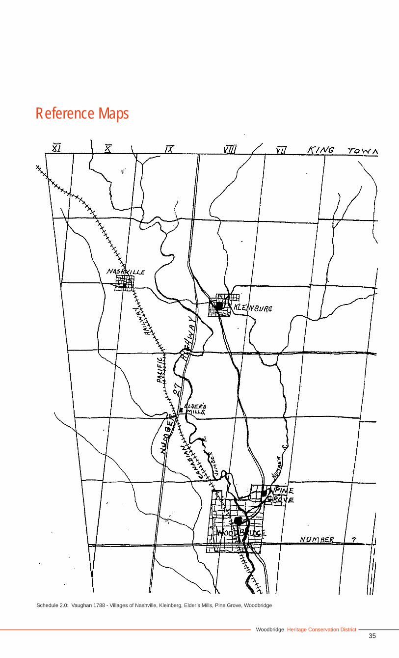
Schedule 2.0: Vaughan 1788 - Villages of Nashville, Kleinberg, Elder’s Mills, Pine Grove, Woodbridge
Reference Maps
36
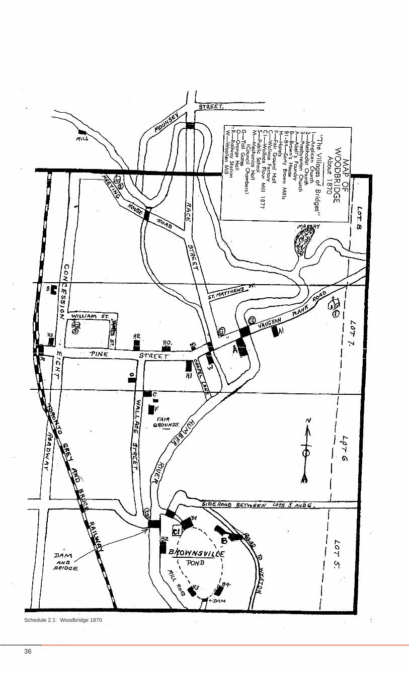
Schedule 2.1: Woodbridge 1870
37Woodbridge Heritage Conservation District
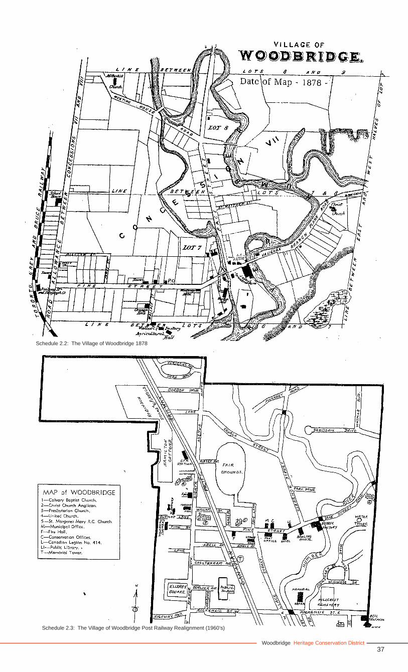
Schedule 2.2: The Village of Woodbridge 1878
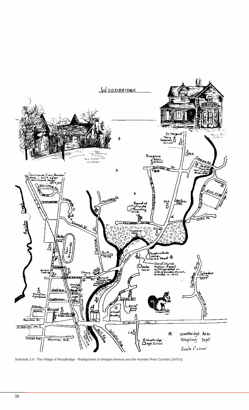
Schedule 2.4: The Village of Woodbridge Post Railway Realignment (1960’s)Schedule 2.3: The Village of Woodbridge Post Railway Realignment (1960’s)
38
Schedule 2.4: The Village of Woodbridge - Realignment of Islington Avenue and the Humber River Corridor (1970’s)
39Woodbridge Heritage Conservation District
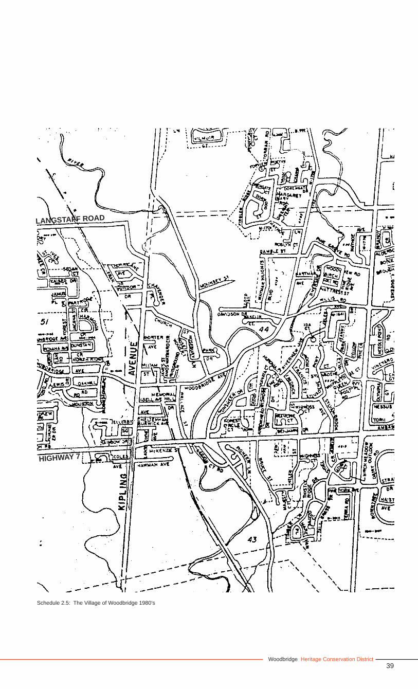
Schedule 2.5: The Village of Woodbridge 1980’s
HIGHWAY 7
LANGSTAFF ROAD
40
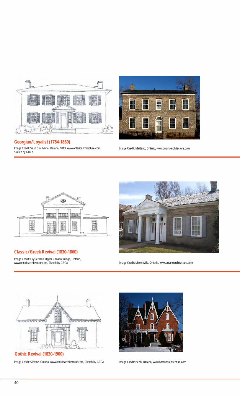
Classic/ Greek Revival (1830-1860)
Georgian/ Loyalist (1784-1860)Image Credit: Sault Ste. Marie, Ontario, 1813, www.ontarioarchitecture.comSketch by GBCA
Image Credit: Maitland, Ontario, www.ontarioarchitecture.com
Image Credit: Crysler Hall, Upper Canada Village, Ontario, www.ontarioarchitecture.com, Sketch by GBCA Image Credit: Merrickville, Ontario, www.ontarioarchitecture.com
Gothic Revival (1830-1900)Image Credit: Simcoe, Ontario, www.ontarioarchitecture.com, Sketch by GBCA Image Credit: Perth, Ontario, www.ontarioarchitecture.com
41Woodbridge Heritage Conservation District
167 Woodbridge Avenue, Woodbridge
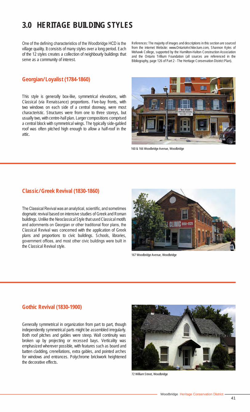
This style is generally box-like, symmetrical elevations, with Classical (via Renaissance) proportions. Five-bay fronts, with two windows on each side of a central doorway, were most characteristic. Structures were from one to three storeys, but usually two, with centre-hall plan. Larger compositions comprised a central block with symmetrical wings. The typically side-gabled roof was often pitched high enough to allow a half-roof in the attic.
Georgian/ Loyalist (1784-1860)
3.0 HERITAGE BUILDING STYLES
TheClassicalRevivalwasananalytical,scientific,andsometimesdogmatic revival based on intensive studies of Greek and Roman buildings. Unlike the Neoclassical Style that used Classical motifs andadornmentsonGeorgianorothertraditionalfloorplans,theClassical Revival was concerned with the application of Greek plans and proportions to civic buildings. Schools, libraries, governmentoffices,andmostothercivicbuildingswerebuilt inthe Classical Revival style.
Classic/ Greek Revival (1830-1860)
OneofthedefiningcharacteristicsoftheWoodbridgeHCDisthevillage quality. It consists of many styles over a long period. Each of the 12 styles creates a collection of neighbourly buildings that serve as a community of interest.
160 & 166 Woodbridge Avenue, Woodbridge
Generally symmetrical in organization from part to part, though independently symmetrical parts might be assembled irregularly. Both roof pitches and gables were steep. Wall continuity was broken up by projecting or recessed bays. Verticality was emphasized wherever possible, with features such as board and batten cladding, crenellations, extra gables, and pointed arches for windows and entrances. Polychrome brickwork heightened the decorative effects.
Gothic Revival (1830-1900)
72 William Street, Woodbridge
References: The majority of images and descriptions in this section are sourced from the internet Website: www.OntarioArchitecture.com, Shannon Kyles of Mohawk College, supported by the Hamilton-Halton Construction Association and the Ontario Trillium Foundation (all sources are referenced in the Bibliography, page 126 of Part 2 - The Heritage Conservation District Plan).
42
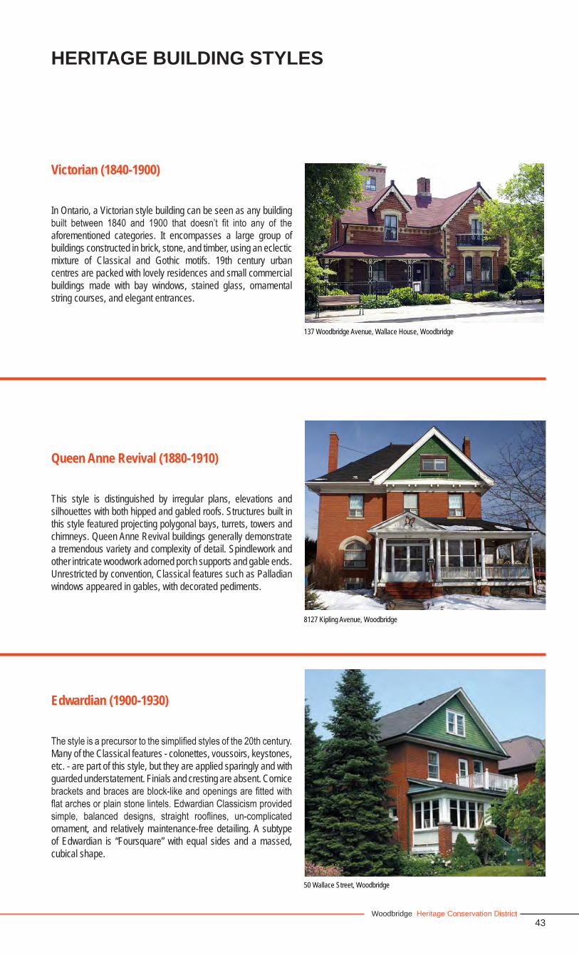
Victorian (1840-1900)
Queen Anne Revival (1880-1910)
Image Credit: Barrie, Ontario, www.ontarioarchitecture.com, Sketch by GBCA Image Credit: Winchester, Ontario, www.ontarioarchitecture.com
Image Credit: Picton, Ontario, www.ontarioarchitecture.com, Sketch by GBCA Image Credit: Toronto, Ontario, www.ontarioarchitecture.com
Edwardian (1900-1930)Image Credit: St. Catherines, Ontario, www.ontarioarchitecture.com, Sketch by GBCA
Image Credit: Peterborough, Ontario, Ontario Architecture, 1874 to the present, John Blumenson
43Woodbridge Heritage Conservation District
137 Woodbridge Avenue, Wallace House, Woodbridge
In Ontario, a Victorian style building can be seen as any building built between 1840 and 1900 that doesn’t fit into any of theaforementioned categories. It encompasses a large group of buildings constructed in brick, stone, and timber, using an eclectic mixture of Classical and Gothic motifs. 19th century urban centres are packed with lovely residences and small commercial buildings made with bay windows, stained glass, ornamental string courses, and elegant entrances.
Victorian (1840-1900)
This style is distinguished by irregular plans, elevations and silhouettes with both hipped and gabled roofs. Structures built in this style featured projecting polygonal bays, turrets, towers and chimneys. Queen Anne Revival buildings generally demonstrate a tremendous variety and complexity of detail. Spindlework and other intricate woodwork adorned porch supports and gable ends. Unrestricted by convention, Classical features such as Palladian windows appeared in gables, with decorated pediments.
Queen Anne Revival (1880-1910)
HERITAGE BUILDING STYLES
8127 Kipling Avenue, Woodbridge
50 Wallace Street, Woodbridge
Thestyleisaprecursortothesimplifiedstylesofthe20thcentury.Many of the Classical features - colonettes, voussoirs, keystones, etc. - are part of this style, but they are applied sparingly and with guarded understatement. Finials and cresting are absent. Cornice bracketsandbracesareblock-likeandopeningsarefittedwithflatarchesorplainstonelintels.EdwardianClassicismprovidedsimple, balanced designs, straight rooflines, un-complicatedornament, and relatively maintenance-free detailing. A subtype of Edwardian is “Foursquare” with equal sides and a massed, cubical shape.
Edwardian (1900-1930)
44
Bungalow (1900-1945)Image Credit: London, Ontario, www.ontarioarchitecture.com, Sketch by GBCA
Image Credit: Windsor, Ontario, Ontario Architecture, 1874 to the present, John Blumenson
Colonial Revival (1900-present)
Image Credit: Waterford, Ontario, www.ontarioarchitecture.com, Sketch by GBCA Image Credit: Toronto, Ontario, www.ontarioarchitecture.com
Art Moderne (1930-1945)
Image Credit: Tweed, Ontario, www.ontarioarchitecture.com, Sketch by GBCA Image Credit: Hamilton, Ontario, www.ontarioarchitecture.com
45Woodbridge Heritage Conservation District
7844 Kipling Avenue, Woodbridge
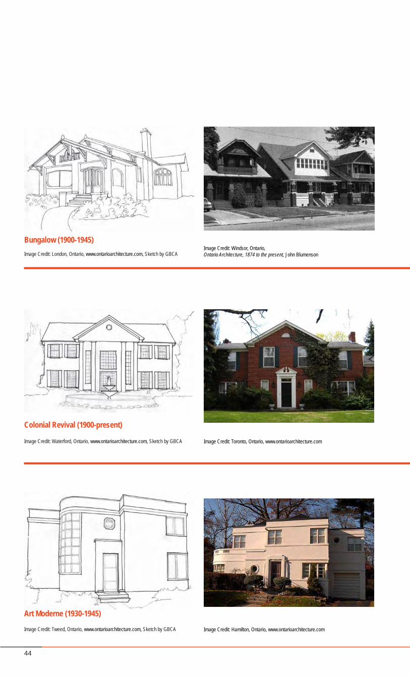
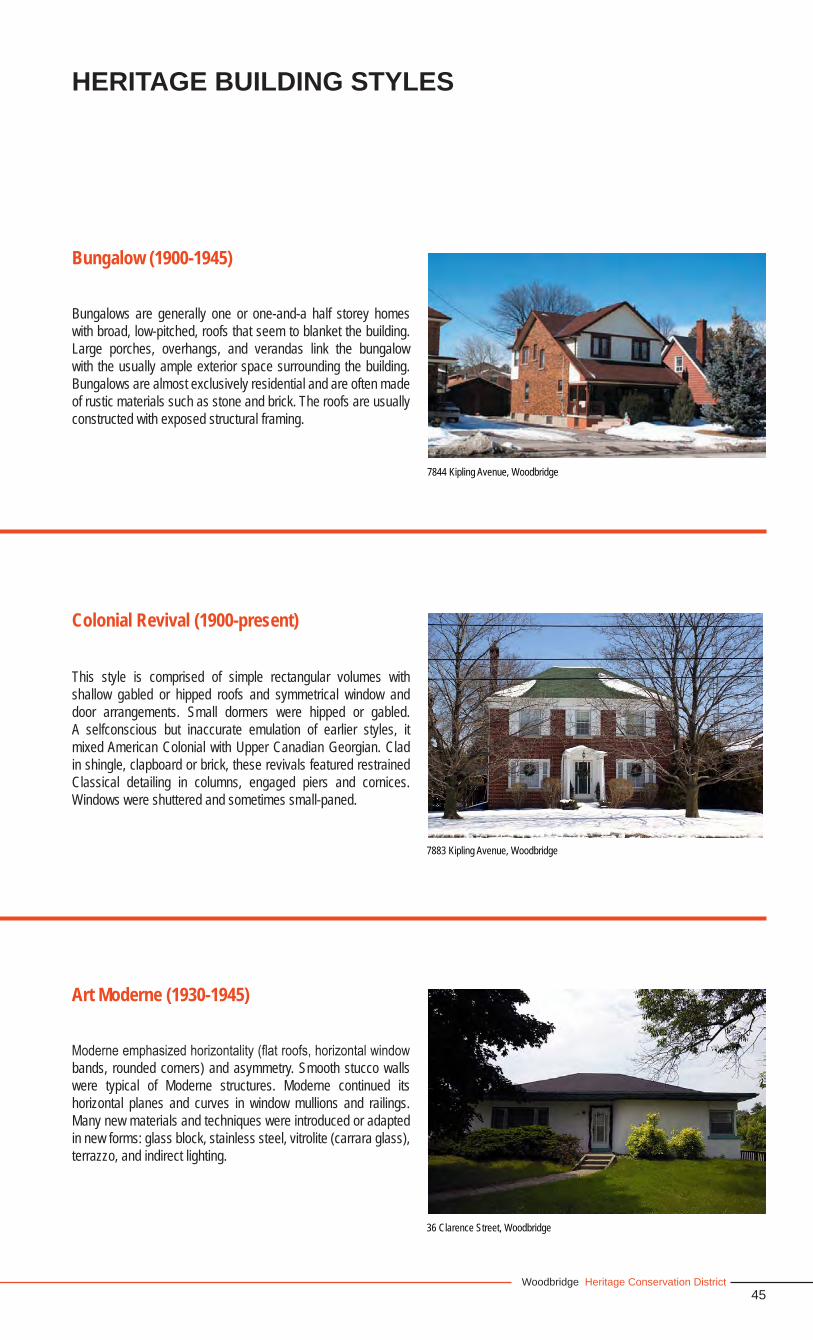
Bungalows are generally one or one-and-a half storey homes with broad, low-pitched, roofs that seem to blanket the building. Large porches, overhangs, and verandas link the bungalow with the usually ample exterior space surrounding the building. Bungalows are almost exclusively residential and are often made of rustic materials such as stone and brick. The roofs are usually constructed with exposed structural framing.
Bungalow (1900-1945)
HERITAGE BUILDING STYLES
7883 Kipling Avenue, Woodbridge
This style is comprised of simple rectangular volumes with shallow gabled or hipped roofs and symmetrical window and door arrangements. Small dormers were hipped or gabled. A selfconscious but inaccurate emulation of earlier styles, it mixed American Colonial with Upper Canadian Georgian. Clad in shingle, clapboard or brick, these revivals featured restrained Classical detailing in columns, engaged piers and cornices. Windows were shuttered and sometimes small-paned.
Colonial Revival (1900-present)
Moderneemphasizedhorizontality(flatroofs,horizontalwindowbands, rounded corners) and asymmetry. Smooth stucco walls were typical of Moderne structures. Moderne continued its horizontal planes and curves in window mullions and railings. Many new materials and techniques were introduced or adapted in new forms: glass block, stainless steel, vitrolite (carrara glass), terrazzo, and indirect lighting.
Art Moderne (1930-1945)
36 Clarence Street, Woodbridge
46
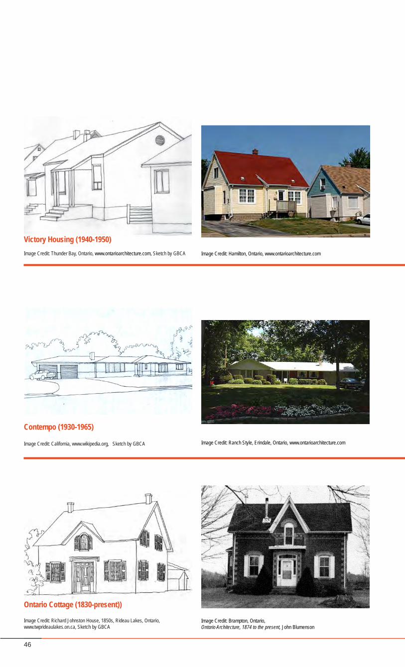
Victory Housing (1940-1950)Image Credit: Thunder Bay, Ontario, www.ontarioarchitecture.com, Sketch by GBCA Image Credit: Hamilton, Ontario, www.ontarioarchitecture.com
Ontario Cottage (1830-present))
Image Credit: Richard Johnston House, 1850s, Rideau Lakes, Ontario, www.twprideaulakes.on.ca, Sketch by GBCA
Image Credit: Brampton, Ontario,Ontario Architecture, 1874 to the present, John Blumenson
Contempo (1930-1965)
Image Credit: California, www.wikipedia.org, Sketch by GBCA Image Credit: Ranch Style, Erindale, Ontario, www.ontarioarchitecture.com
47Woodbridge Heritage Conservation District
HERITAGE BUILDING STYLES
8233 Kipling Avenue, Woodbridge
7845 Kipling Avenue, Woodbridge
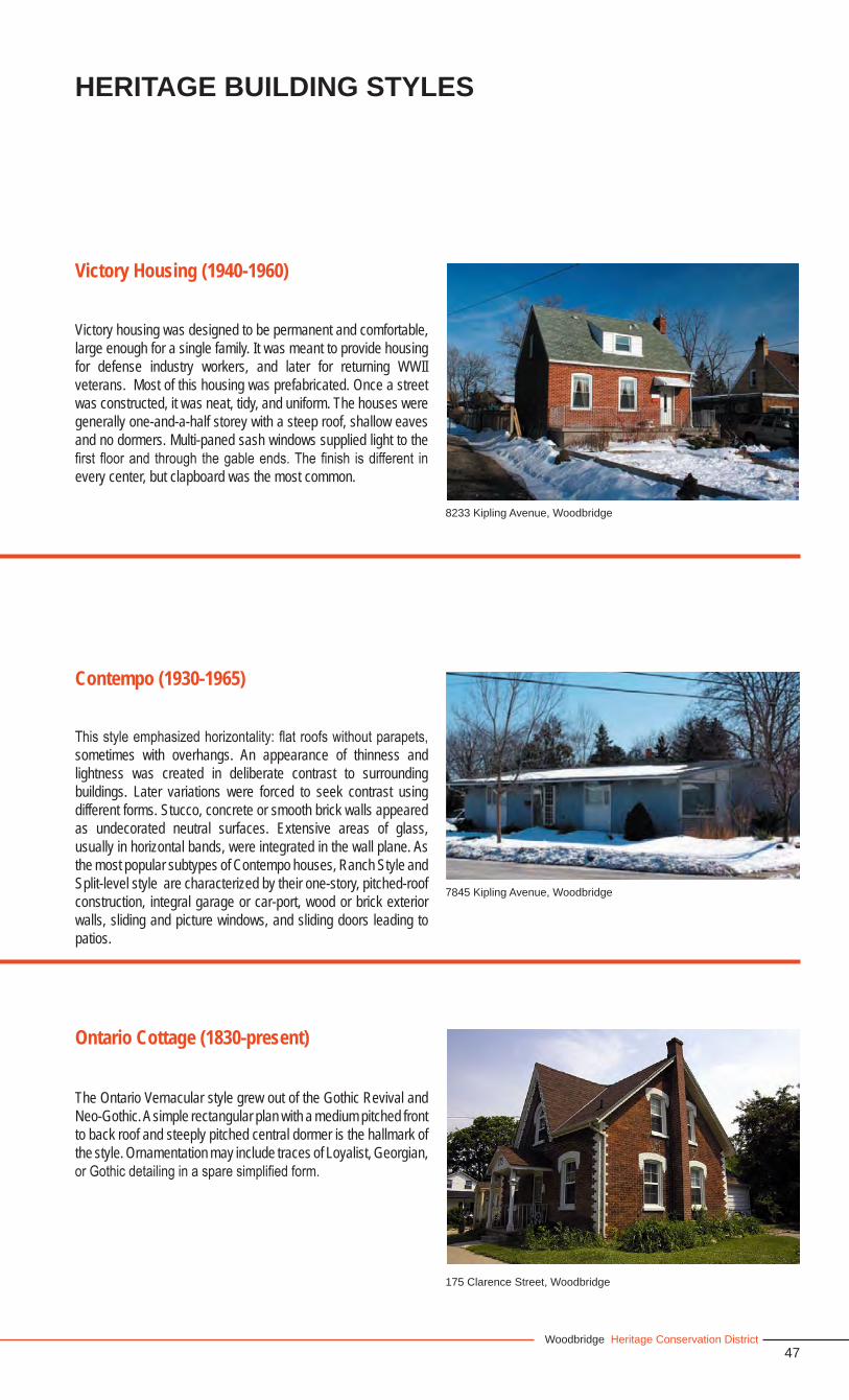
Victory housing was designed to be permanent and comfortable, large enough for a single family. It was meant to provide housing for defense industry workers, and later for returning WWII veterans. Most of this housing was prefabricated. Once a street was constructed, it was neat, tidy, and uniform. The houses were generally one-and-a-half storey with a steep roof, shallow eaves and no dormers. Multi-paned sash windows supplied light to the first floorand through thegableends.Thefinish isdifferent inevery center, but clapboard was the most common.
Victory Housing (1940-1960)
Thisstyleemphasizedhorizontality:flatroofswithoutparapets,sometimes with overhangs. An appearance of thinness and lightness was created in deliberate contrast to surrounding buildings. Later variations were forced to seek contrast using different forms. Stucco, concrete or smooth brick walls appeared as undecorated neutral surfaces. Extensive areas of glass, usually in horizontal bands, were integrated in the wall plane. As the most popular subtypes of Contempo houses, Ranch Style and Split-level style are characterized by their one-story, pitched-roof construction, integral garage or car-port, wood or brick exterior walls, sliding and picture windows, and sliding doors leading to patios.
Contempo (1930-1965)
Ontario Cottage (1830-present)
The Ontario Vernacular style grew out of the Gothic Revival and Neo-Gothic. A simple rectangular plan with a medium pitched front to back roof and steeply pitched central dormer is the hallmark of the style. Ornamentation may include traces of Loyalist, Georgian, orGothicdetailinginasparesimplifiedform.
175 Clarence Street, Woodbridge
48
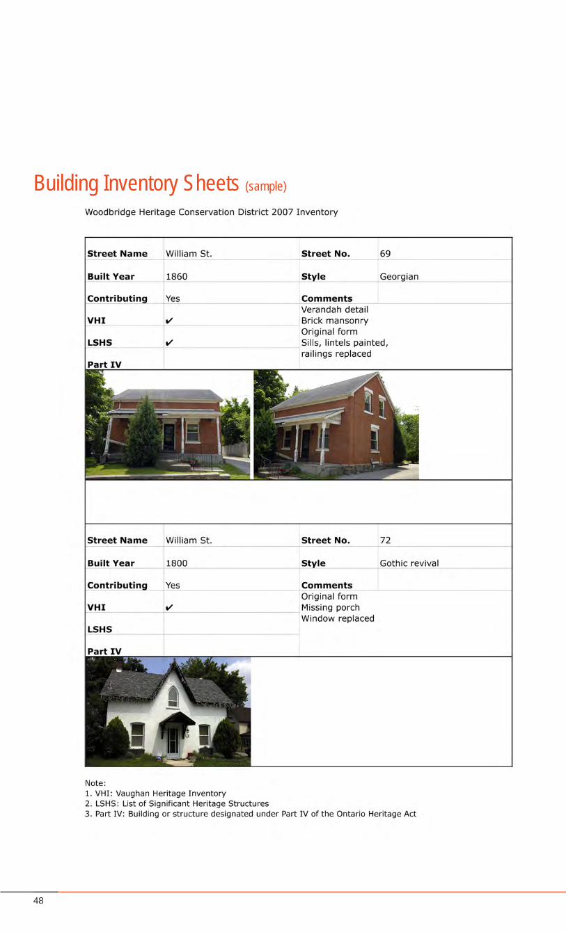
Building Inventory Sheets (sample)
49Woodbridge Heritage Conservation District
The Building Inventory is:• first,amethodofcompilinginformationproperty-by-property
to assist with determining the heritage attributes and character of the study area; and
• second,it isadocumentationofeachpropertyinthestudyarea that assesses whether or not the property and related landscape and structures are contributing to the heritage character.
The inventory of buildings within the Woodbridge Study Area was firstmappedoutandidentifiedintheirlocation(see sample page on the following page). The study area was sectioned into eight parts for documentation:
North Kipling Avenue•Central Kipling Avenue•Kipling Avenue and Woodbridge Avenue Intersection•South Kipling Avenue•Wallace Street•Woodbridge Avenue•Clarence Street•Islington Avenue•
The exterior front façade of each building in the study area was appraised by Goldsmith Borgal and Company Architects. Building Inventory sheets were created with the information gathered for eachbuilding.EachInventorySheet identifiesthebuildingandcontains information related to its age, style, height, material composition, and heritage contribution. The Inventory Sheets are one of the essential elements of the Woodbridge Heritage Conservation District Plan. Over time, additional information should continue to be gathered and added to the inventory for the purpose of achieving as complete an assessment as possible. The full set of Building Inventory sheets is presented as an appendix to the Plan, which include a photographic documentation of each building within the study area.
The Content of the Inventory Sheets
The characteristics used for the Inventory are described, below.
1. IdentificationThe name of the building, its civic address and its heritage status (if applicable) are described. Heritage status refers to a prior recognition of the heritage value of the property by the Province ofOntarioorbyCityCouncil.Thepropertyisfurtheridentifiedthrough current photographs of the building, and details of significant elements, if relevant. Its location is highlighted onbuilding inventory maps of the area.
2. ArchitectureThe various architectural attributes of the building, beginning with its height and the stylistic influences that contribute to itsappearance is described under “comments” of the inventory sheets. Any significant element particular to the building isdescribed.
3. Period of ConstructionThedateofconstruction(ifknown),andprincipalmodificationstothe building over time are detailed.
4. Contributing StatusA preliminary assessment of the building is made in terms of identifying a contributing verses non-contributing status is based on the collected inventory information. The contributing status of the building is further assessed in relation to the surrounding context to determine whether other characteristics such as the surrounding heritage landscape or the proximity to other contributing buildings would support it as a contributing building, and thus, be included within the heritage boundary.
Some buildings have undergone multiple renovation and often have lost some architectural detail along the way. However, buildings are considered contributing if they still display the architectural elements of the period and if missing elements are not too numerous and can reasonably be restored.
6. Exceptions Some exceptions stand out due to their architectural quality and/or their association to the history of the area. These contribute to the general diversity that characterizes the area.
4.1 Building Inventory
4.0 HERITAGE EVALUATION

50
1 - North Kipling AvenueThe illustrations below are a mapping of each heritage resource. The information within the
boxes, related to each resource, can be found in the Building Inventory Sheets in the Appendix.
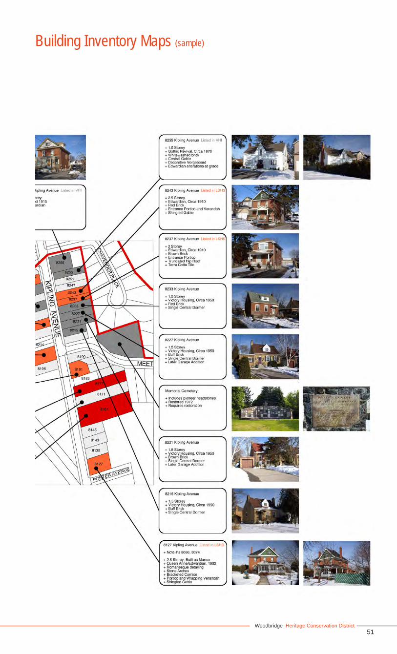
51Woodbridge Heritage Conservation District
Building Inventory Maps (sample)
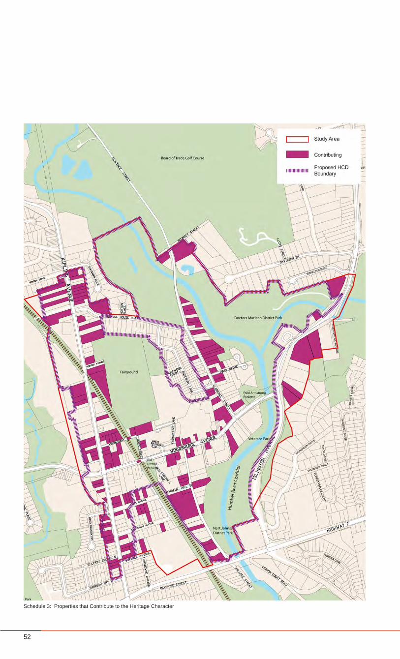
52
Schedule 3: Properties that Contribute to the Heritage Character
53Woodbridge Heritage Conservation District
HERITAGE EVALUATION
Contributing verses Non-Contributing
A primary objective of the Inventory Sheets is to understand which of the buildings within the study area contribute to the heritagecharacterofthedistrict.Theclassificationofbuildingsas‘contributing’ or ‘non-contributing’ arises from the consideration of multiple factors. Buildings that have been deemed ‘contributing’ (referred hereafter as “Contributing Buildings”) tend to be characterized by most, if not all, of the elements listed below. Buildings that are categorized as ‘non-contributing’ do not have a sufficientnumberoftherequiredattributes.
Factors that influencedtheclassificationofContributingvsnon-contributing properties:
listed and designated properties,•period or age of construction,•architectural style and material pallet (see Part 2 - section •6.3.3), building height (see Part 2 - Section 6.4.2),•culturalheritagesignificance-theassociationofpeopleand•events,environment•
The last factor, the environment, is the contribution of the property tothecharacteroftheareaandthesignificanceoftheelementsofthepropertyasalandmarkorsignificantfeatureofthearea.
The following maps present a summary of the analysis of the contributing and non-contributing properties.
Once the inventory was conducted and an understanding of the contributing verses non-contributing buildings within the study area was established, this allowed for a series of conclusions from the analysis about Woodbridge’s heritage resources as follows:
First, the total sum of the heritage resource “parts” within the studyareaconfirmsWoodbridgeasa“Village”,havingvillage-likequality and characteristics . It is the sum of parts that is stronger indefiningWoodbridgeasaVillage than the individualpartsorgroupings, due mainly because the heritage resources are very scattered throughout the study area.
Second, there is an HCD Heritage Character that emerges from the collection and association of landscapes, properties and structures within the district.
Third, there are a number of properties that contribute to the HCD Heritage Character. (see Schedule 3, page 52)
Fourth,therearesignificantclustersofpropertiesthatcontributeto the HCD Heritage Character. (see Schedule 8, page 58)
Fifth, there are a number of properties that individually do not contribute to the HCD Heritage Character, but given their location and proximity to contributing heritage resources, or similarity in characteristics such as scale, height, building materials; have the potentialtosignificantlyinfluencethelong-termheritagecharacterof the HCD. (see Schedule 8, page 58)
Sixth, the collection of ‘contributing’ and ‘non-contributing’ properties with the potential to significantly influence the HCDheritagecharacter,haveadistinctanddefinableboundary. (see Schedule 8, page 58)
Seventh, there are unique Heritage Character Areas, with unique Heritage Attributes as described in Part 2 - Section 6.1, that can be further identifiedwithin theHCD. (seeSchedule 9,page 59)
Eighth, open space is a large defining factor in the heritagecharacter of Woodbridge. Key open spaces within the study area havebeenidentifiedasheritagelandscapes,(seeSchedule17,page 90), and are described in terms of their particular heritage characteristics or features.
HCD Boundary and Character Areas
The analysis resulted in the creation of a distinct HCD boundary andintheidentificationofdistinctcharacterareas,withintheHCDBoundary. (see Schedule 10, page 62)
4.2 Analysis of Inventory
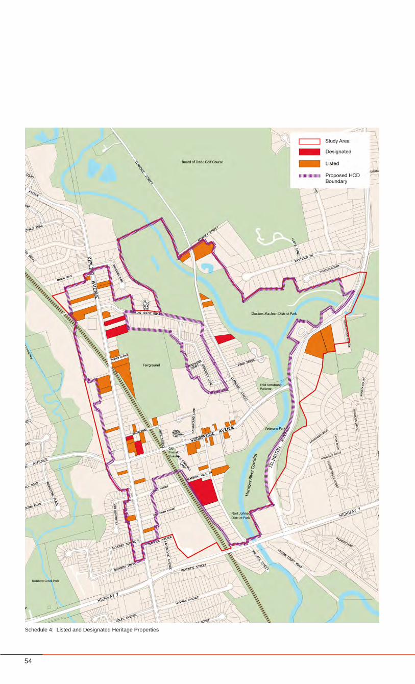
54
Schedule 4: Listed and Designated Heritage Properties
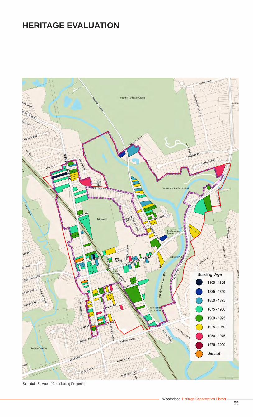
55Woodbridge Heritage Conservation District
HERITAGE EVALUATION
Schedule 5: Age of Contributing Properties
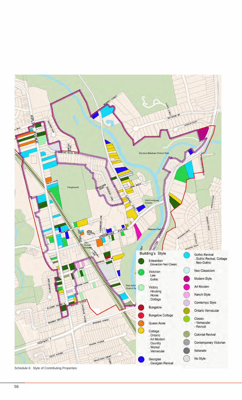
56
Schedule 6: Style of Contributing Properties
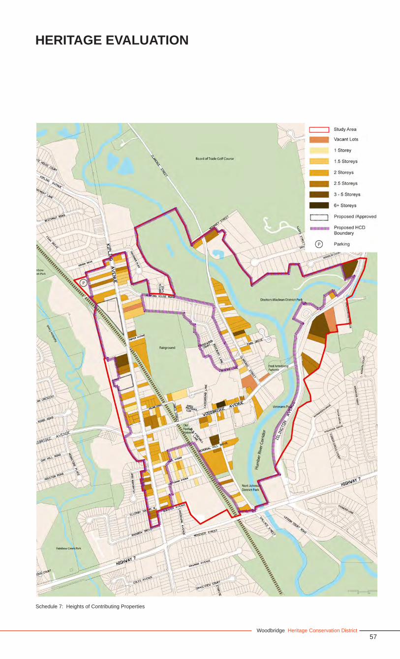
57Woodbridge Heritage Conservation District
HERITAGE EVALUATION
Schedule 7: Heights of Contributing Properties
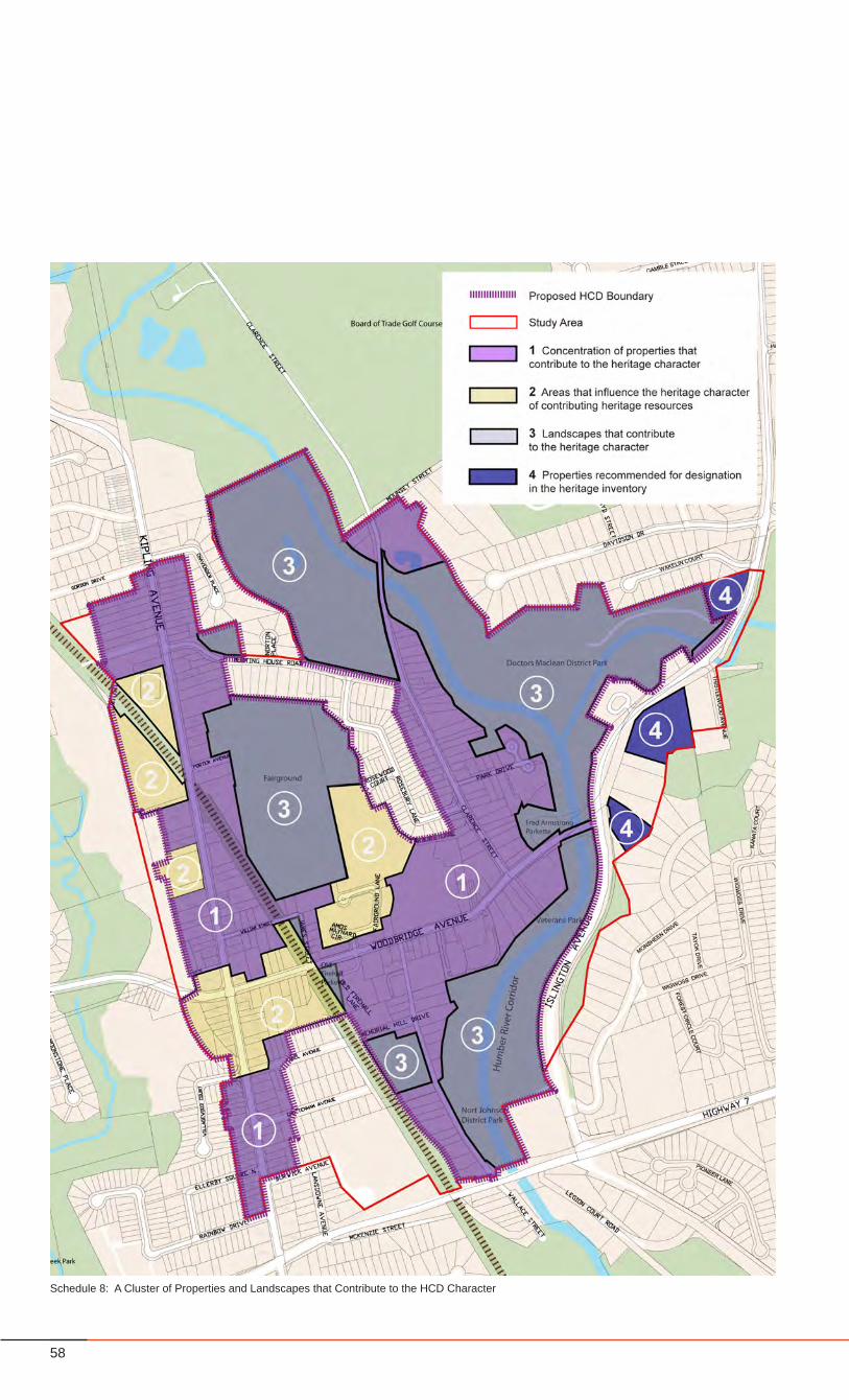
58
Schedule 8: A Cluster of Properties and Landscapes that Contribute to the HCD Character
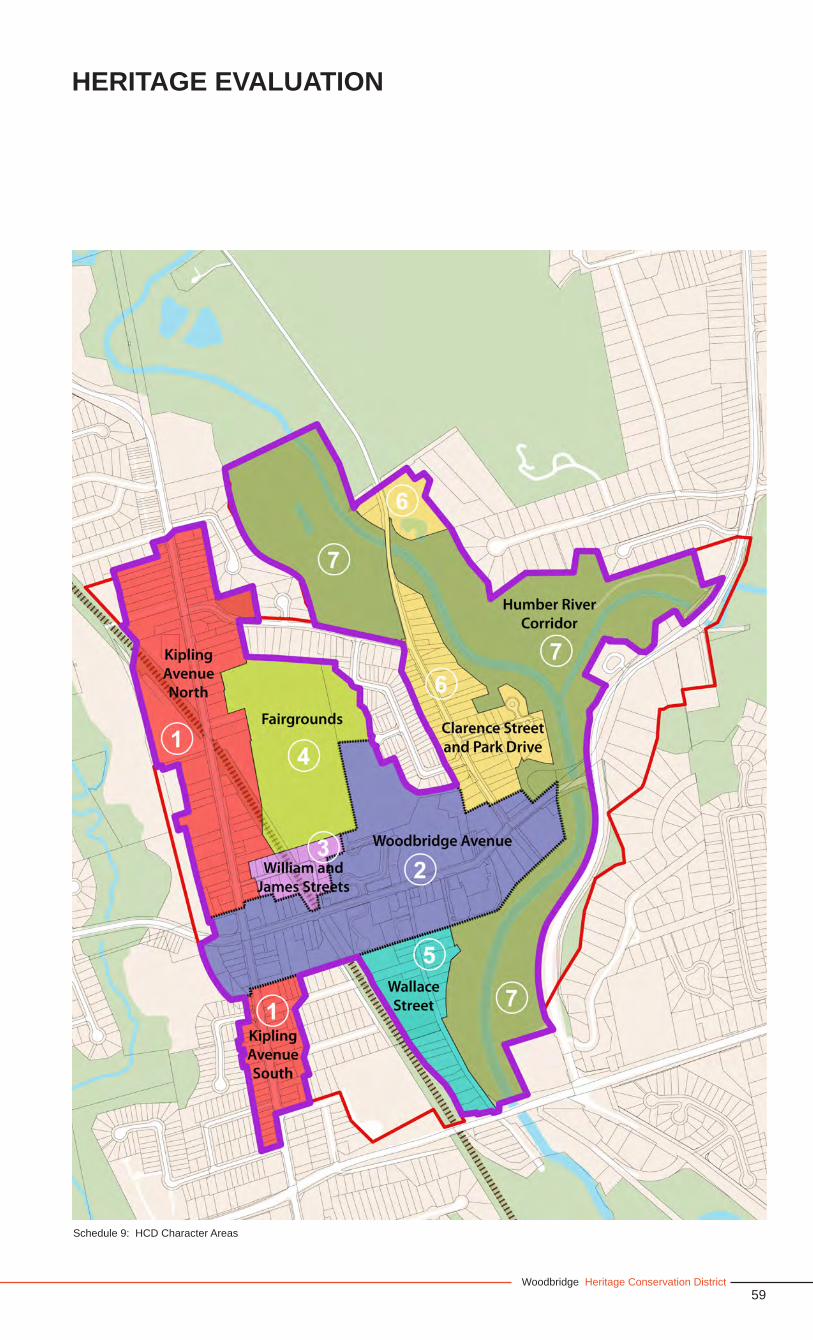
59Woodbridge Heritage Conservation District
HERITAGE EVALUATION
Schedule 9: HCD Character Areas
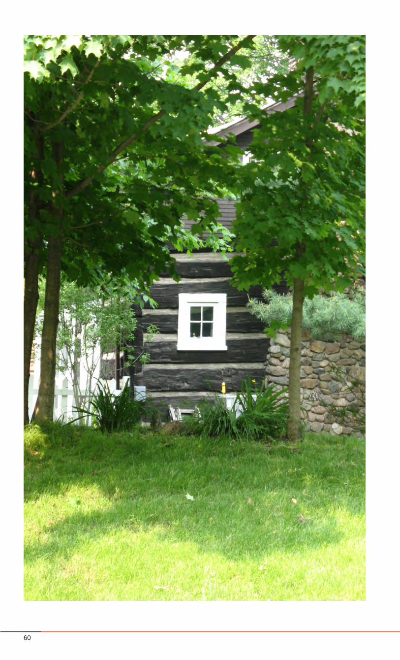
60
61Woodbridge Heritage Conservation District
Part 2 - The Heritage Conservation DistrictPlan
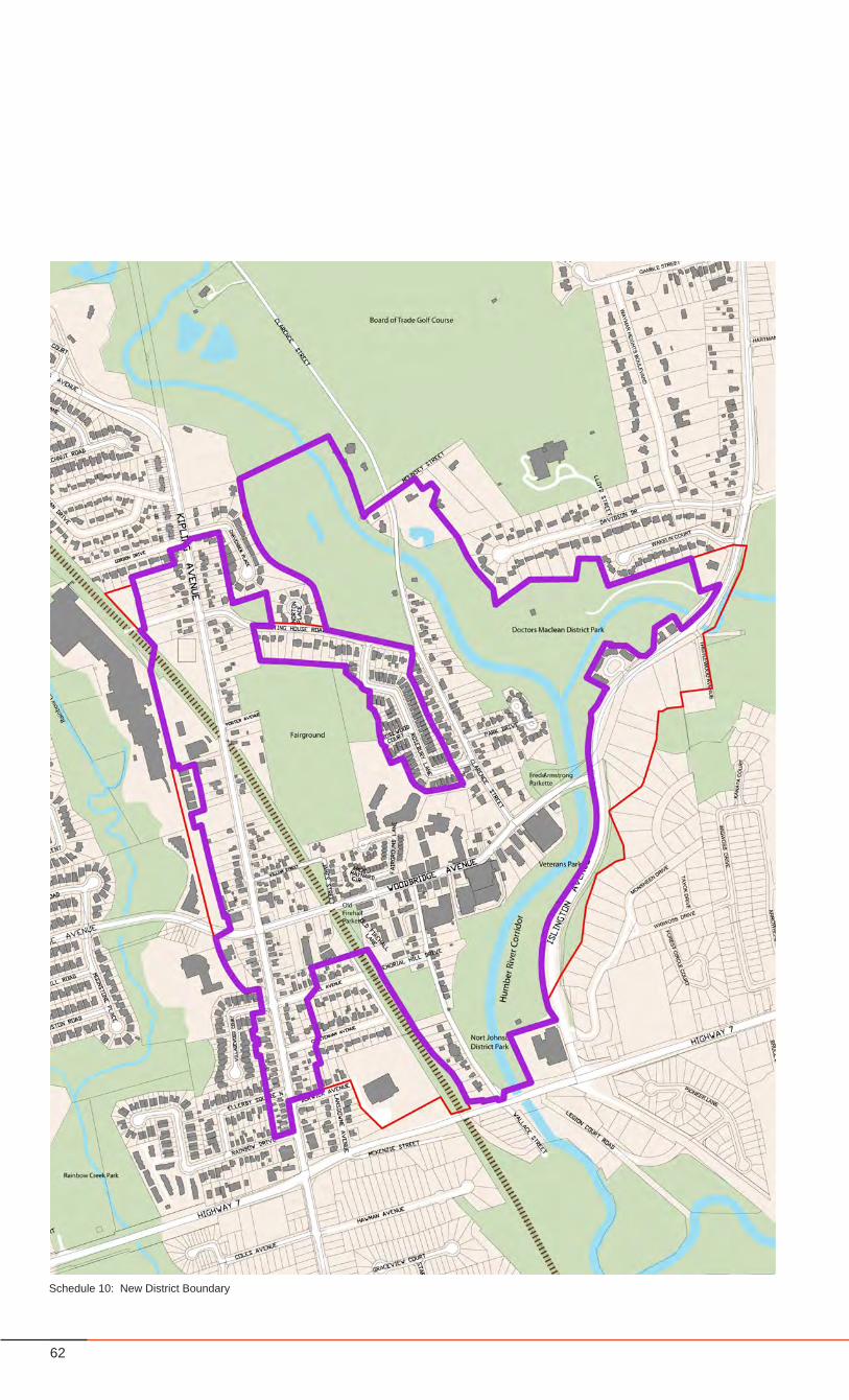
62
Schedule 10: New District Boundary
63Woodbridge Heritage Conservation District
5.0 HERITAGE CONSERVATION DISTRICT PLAN
5.1 Objectives
The purpose of the Proposed Heritage Conservation District is to:
1 Identify, document, maintain and restore the unique heritage village character of Woodbridge.
2 Conserve contributing buildings, landscapes, monuments and streetscapes.
3 Ensure new designs contribute to the Woodbridge heritage character.
4 Manage any development or redevelopment proposed within the district, in a manner that is sensitive and responsive to all aspects necessary to ensure the protection and conservation of the heritage resources, in order to maintain the village character of the Woodbridge District.
5 Ensure individual heritage structures and landscapes are maintained, and new development or redevelopment sensitively integrated, as part of a comprehensive district.
6 Maintain Woodbridge as both a local neighbourhood and a destination for residents of Vaughan and beyond.
7 Support a welcoming, interesting pedestrian environment by encouraging pedestrian amenities and by maintaining human-scaled development and connections to adjacent neighbourhoods.
8 Involve area residents, property and business owners, and interested individuals in the ongoing evolution of the HCD.
5.2 District Boundary
Areas within the District Boundary
The Woodbridge Heritage Conservation District Boundary has not changed radically from the existing study area boundary. The new district boundary includes: the majority of properties along Kipling Avenue, between Gordon Drive to the north and Rainbow Drive to the south, and including the fire hall and some properties along Burton’s Lane; some properties on Abell Avenue, Cheltenham Avenue and Burwick Avenue; all properties along William and James Streets, along Woodbridge Avenue - north to the Fairgrounds and south to Nort Johnson Park, Wallace Street, Park Drive, and Clarence Street north to Mounsey Street. As well, several landscapes are included, such as: the Fairgrounds and adjacent conservation lands east and south along James Street, Meeting House Road Memorial Parkette, Old Fire Hall Parkette, Memorial Hill Park, the Humber River Corridor and Parks, the southern portion of the Board of Trade Golf Course, and the ridge landscape east of Islington Avenue. (see Schedule 10, page 62)
Areas that have been excluded from the District Boundary
The new district boundary excludes: a portion of Meeting House Road, and all of Rosebury Lane and Rosewood Court properties; a few of the industrial properties west of Kipling Avenue; the properties east of Islington Avenue; and a portion of the southerly properties located east of Kipling Avenue and west of the rail corridor.
The West Industrial PropertiesOnly a few of the industrial properties within the study area are considered “contributing properties” to the Heritage Conservation District Boundary, namely a selection of workshops and sheds at the end of Burton’s Lane. These buildings are considered contributing because of their historical association with Toronto Grey and Bruce rail line and their former use as part of the Woodbridge Farmer’s Cooperative Company.
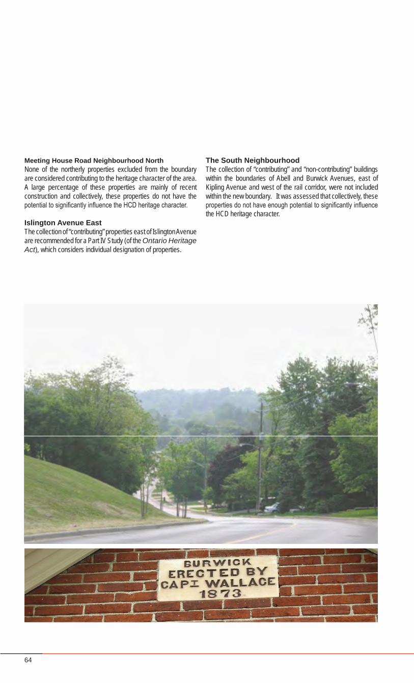
64
Meeting House Road Neighbourhood NorthNone of the northerly properties excluded from the boundary are considered contributing to the heritage character of the area. A large percentage of these properties are mainly of recent construction and collectively, these properties do not have the potential to significantly influence the HCD heritage character.
Islington Avenue EastThe collection of “contributing” properties east of Islington Avenue are recommended for a Part IV Study (of the Ontario Heritage Act), which considers individual designation of properties.
The South NeighbourhoodThe collection of “contributing” and “non-contributing” buildings within the boundaries of Abell and Burwick Avenues, east of Kipling Avenue and west of the rail corridor, were not included within the new boundary. It was assessed that collectively, these properties do not have enough potential to significantly influence the HCD heritage character.
65Woodbridge Heritage Conservation District
Woodbridge constitutes one of four historic villages within the City of Vaughan and has been an attractive place to live and to do business since its founding. This is mainly due to the village quality and character of the built and natural environment, its location within the valley and table lands associated with the Humber River, and its relative proximity to other communities. Woodbridge was historically a residential, industrial, commercial, social and community oriented destination within Vaughan. The village character and quality of the district should continue to be defined by:
• a mixture of residential, industrial, commercial and public amenities organized in a community oriented fashion, with main streets, a village core, open space and healthy neighbourhoods, all within an accessible and walkable environment;
• primarily a low density neighbourhood fabric with two to three storey building heights, with the exception of the Village Core (Woodbridge Avenue), having three to four storeys with some buildings stepping back to six storeys;
• lower density built form along Kipling Avenue with two to three storey building heights and a mixture of uses including residential, industry, open space and commerce;
• a concentration of increased height and density, and a mixed use built form at the village nodes of Kipling and Woodbridge Avenue and the valley portion of Woodbridge Avenue (the Woodbridge Core);
• a diversity and mixture of a minimum of 14 different architectural styles throughout the village;
• a variety of building setbacks, typically having deep frontages and sideyards;
• a “green” quality where the built form is generally integrated within the natural landscape and topography, with mature trees and tree canopies, creating a park-like development setting and context;
• tight tree canopied residential streets with varying single or double sided sidewalk conditions;
• significant views that capture the vast river corridor, the rolling topography, and the interplay of the natural landscape and the built form; and,
• the Fairgrounds as a major community open space.
In the context of this document, the Woodbridge (Commercial) Core is defined as the valley portion of Woodbridge Avenue from Wallace Street to Clarence Avenue. The Woodbridge Commercial Nodes are the two areas located at the intersection of Woodbridge and Kipling Avenues, and Woodbridge Avenue from Wallace Street to Clarence Avenue.
The heritage character of the Woodbridge HCD derives from the collection and association of its cultural heritage landscapes, properties and structures, and can be discerned from the following:
A. Woodbridge’s history and function, within Vaughan and surroundings
5.3 Heritage Character Statement
HERITAGE CONSERVATION DISTRICT
B. Woodbridge’s unique sense of identityC. Woodbridge’s unique elements
These categories are further described by their heritage attributes as follows:
5.3.1 Woodbridge’s history and function, within Vaughan and surroundings
5.3.1.1. Layered History• Many layers of history overlap in Woodbridge, from native
settlements, to a 1800s agricultural village, to a 1900s cotton mill village, to a present day mixed-use village, commercial core and destination for Vaughan.
• The existing built form includes and reflects the multiple layers of history, construction periods, and architectural styles.
5.3.1.2. Regional Function, Regional Destination• Woodbridge historically, has been the village hub within
the region for human settlements, human activity, and significant cultural events, and should continue to function as such.
• Woodbridge should continue to be a recreational and commercial destination for residents of Vaughan and beyond.
• The presence of the commercial core of activity shifted over time between the locations of Woodbridge Avenue and Kipling Avenue, Wallace Street and finally the valley portion of Woodbridge Ave. The hub of commercial activity should continue to grow at the Woodbridge Avenue and Kipling Avenue intersection as the commercial gateway and in the valley portion of Woodbridge Avenue, starting just west of Wallace Street and continuing to Clarence Street. Wallace Street, over time, has shifted to become solely residential and should continue in that manner.
• The recommendation for the commercial hub will be comprehensively reviewed, in terms of development activity within the Woodbridge Core and in terms of activity within the existing Special Policy Areas (SPA), as part of the Woodbridge Core Area Study, to be undertaken in 2009. The Woodbridge Core Area Study will determine the development capabilities of the area, especially within the areas of commercial activity.
• Any development approvals within the valley corridor, notwithstanding they may include heritage parcels, dwellings, or structures, need to get prior approvals from the TRCA and the City of Vaughan.
• The Fairgrounds should remain as the main open space, social, and recreational draw for the City of Vaughan and should broaden its use as a year round destination at its current location.
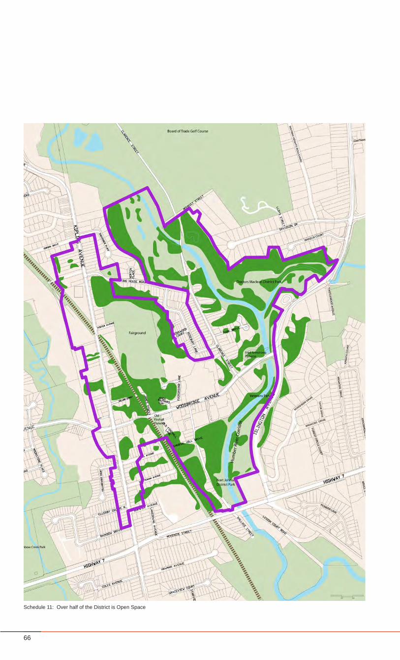
66
Schedule 11: Over half of the District is Open Space
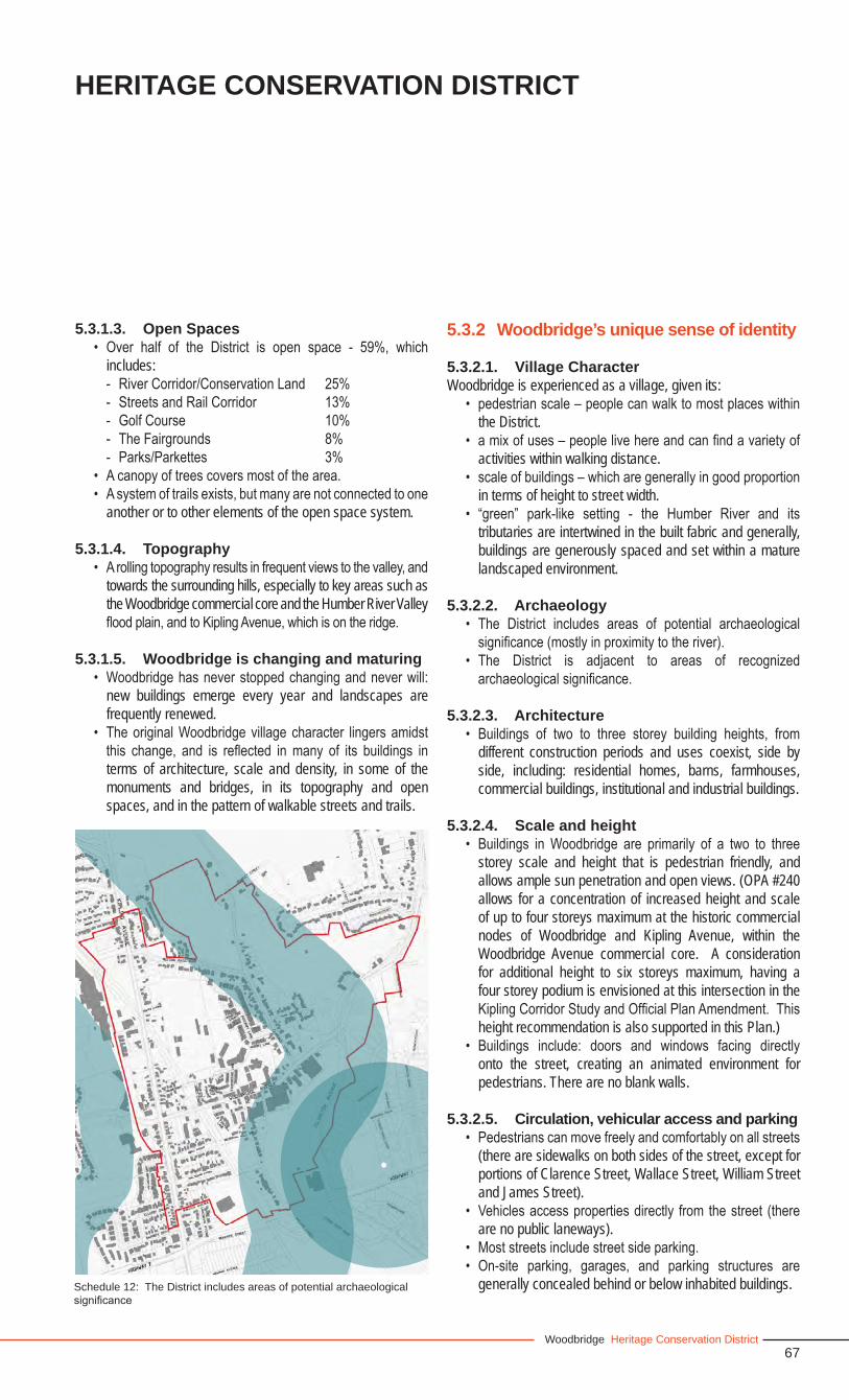
67Woodbridge Heritage Conservation District
5.3.1.3. Open Spaces• Over half of the District is open space - 59%, which
includes: - River Corridor/Conservation Land 25%- Streets and Rail Corridor 13%- Golf Course 10%- The Fairgrounds 8%- Parks/Parkettes 3%
• A canopy of trees covers most of the area.• A system of trails exists, but many are not connected to one
another or to other elements of the open space system.
5.3.1.4. Topography• A rolling topography results in frequent views to the valley, and
towards the surrounding hills, especially to key areas such as the Woodbridge commercial core and the Humber River Valley flood plain, and to Kipling Avenue, which is on the ridge.
5.3.1.5. Woodbridge is changing and maturing• Woodbridge has never stopped changing and never will:
new buildings emerge every year and landscapes are frequently renewed.
• The original Woodbridge village character lingers amidst this change, and is reflected in many of its buildings in terms of architecture, scale and density, in some of the monuments and bridges, in its topography and open spaces, and in the pattern of walkable streets and trails.
HERITAGE CONSERVATION DISTRICT
Schedule 12: The District includes areas of potential archaeological significance
5.3.2 Woodbridge’s unique sense of identity
5.3.2.1. Village CharacterWoodbridge is experienced as a village, given its:
• pedestrian scale – people can walk to most places within the District.
• a mix of uses – people live here and can find a variety of activities within walking distance.
• scale of buildings – which are generally in good proportion in terms of height to street width.
• “green” park-like setting - the Humber River and its tributaries are intertwined in the built fabric and generally, buildings are generously spaced and set within a mature landscaped environment.
5.3.2.2. Archaeology• The District includes areas of potential archaeological
significance (mostly in proximity to the river).• The District is adjacent to areas of recognized
archaeological significance.
5.3.2.3. Architecture• Buildings of two to three storey building heights, from
different construction periods and uses coexist, side by side, including: residential homes, barns, farmhouses, commercial buildings, institutional and industrial buildings.
5.3.2.4. Scale and height• Buildings in Woodbridge are primarily of a two to three
storey scale and height that is pedestrian friendly, and allows ample sun penetration and open views. (OPA #240 allows for a concentration of increased height and scale of up to four storeys maximum at the historic commercial nodes of Woodbridge and Kipling Avenue, within the Woodbridge Avenue commercial core. A consideration for additional height to six storeys maximum, having a four storey podium is envisioned at this intersection in the Kipling Corridor Study and Official Plan Amendment. This height recommendation is also supported in this Plan.)
• Buildings include: doors and windows facing directly onto the street, creating an animated environment for pedestrians. There are no blank walls.
5.3.2.5. Circulation, vehicular access and parking• Pedestrians can move freely and comfortably on all streets
(there are sidewalks on both sides of the street, except for portions of Clarence Street, Wallace Street, William Street and James Street).
• Vehicles access properties directly from the street (there are no public laneways).
• Most streets include street side parking.• On-site parking, garages, and parking structures are
generally concealed behind or below inhabited buildings.
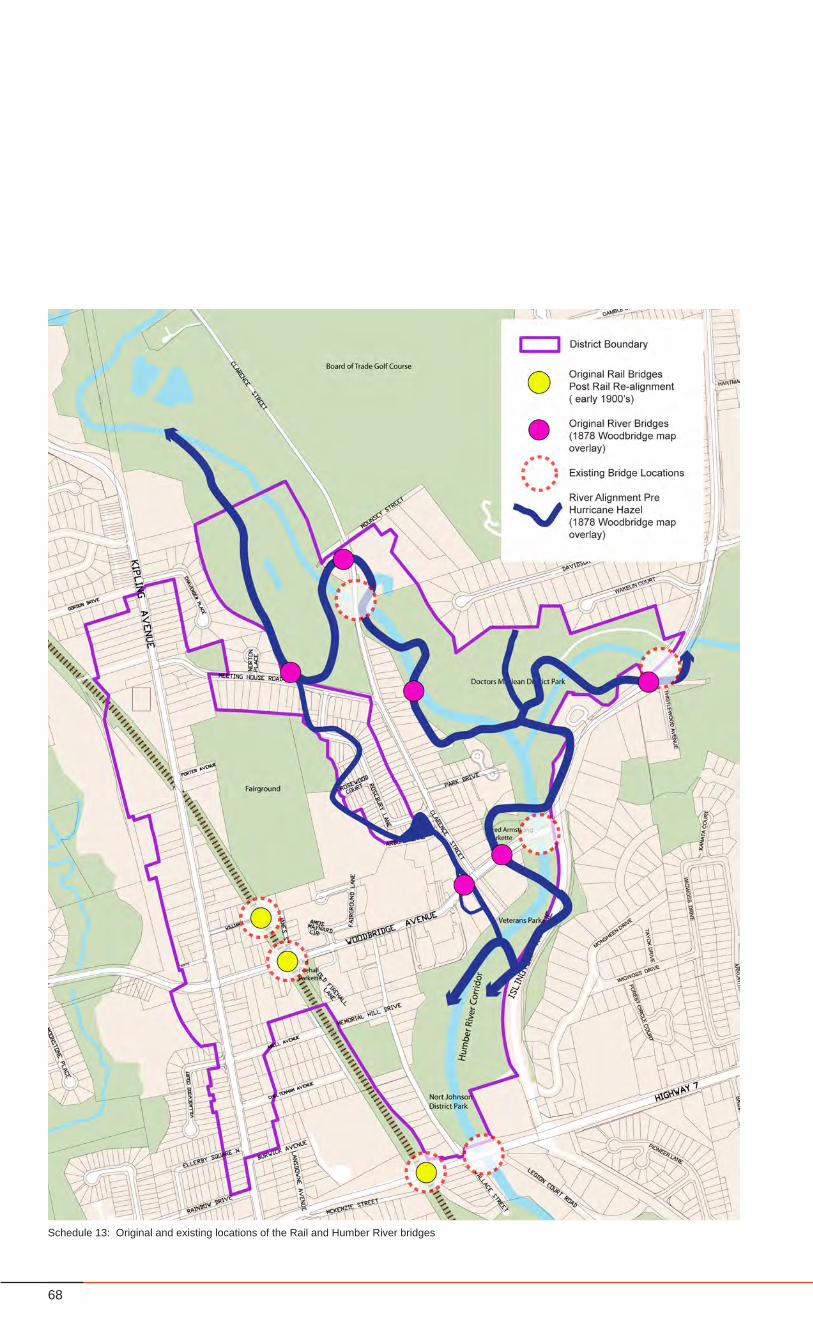
68
Schedule 13: Original and existing locations of the Rail and Humber River bridges
69Woodbridge Heritage Conservation District
HERITAGE CONSERVATION DISTRICT
5.3.3. Woodbridge’s unique elements
5.3.3.1. Character Areas• Woodbridge comprises several distinct ‘character areas’,
with distinct and intertwined identities:Kipling Avenue North and South1. William and James Streets2. The Fairgrounds3. Woodbridge Avenue4. Wallace Street5. Clarence Street and Park Drive6. The Humber River Corridor7.
• Each ‘character area’ contributes to the village experience of Woodbridge as a whole as described in Section 6.0.
5.3.3.2. Hidden Gems – special places and monuments
• The District includes several ‘hidden gems’, which contribute to the character and sense of place – including: The War Memorial, the bridges, the Humber trails and others.
5.3.3.3. Bridges• Woodbridge was formerly known as the “Town of Bridges”• 7 bridges can still be found within the area (3 CP Rail, 4
over the Humber - see Schedule 13, page 68).• Bridges are ever-present and visible and often act as
gateways.
5.3.3.4. StreetsStreets within the Study Area play a significant role in defining the village character of Woodbridge and can be generally defined as such:
• are walkable (albeit some have sidewalks on only one side of the street),
• have a tree canopy (less so on Woodbridge Avenue), and• have right-of-ways that range from 17.5m to 20m.
5.3.3.5. Open SpaceThere are several open spaces and open space systems within Woodbridge that are considered significant and contributing to the heritage character because of size, quality and character of landscape, and history, including:
• The Fairgrounds• Woodbridge Wesleyan Methodist Cemetery (Old Methodist
Church Cemetery) • Forested Conservation Land Areas• The Old Fire Hall Parkette• Memorial Hill Park• The Humber River Corridor, which includes parks, parkettes
and the Board of Trade Golf Course• The Humber River
5.3.3.6. The Humber River• The Humber River was designated as a Canadian Heritage
River in 1999, in recognition of its importance in the history of First Nations peoples, the early Euro-Canadian explorers and settlers of Upper Canada. Additionally, it contributed to the development of the Nation.
5.3.3.7. The Floodplain• Large portions of the district reside within the floodplain, as
outlined by the Toronto Regional Conservation Authority.
5.4 Reasons for Designation Under the Ontario Heritage Act
The Woodbridge HCD Study makes the following conclusions that, in summary, define Woodbridge as a “Village”, having a village quality and character as described in section 5.3 of this study.
• There is an HCD Heritage Character that emerges from the collection and association of properties of a certain age, architectural style and design, and of a particular density and scale. As well, there is an HCD Heritage Character that emerges from the collection and association of monumental structures and of landscapes. These elements in total, define Woodbridge as a “Village”.
• There are a number of properties that individually contribute to the HCD Heritage Character.
• There are significant clusters of properties that contribute to the HCD Heritage Character.
• There are a number of properties that individually do not contribute to the HCD Heritage Character because they may not have any or enough elements to represent a contributing heritage resource, but given their location, proximity, and characteristics have the potential to significantly influence the long-term heritage character of the HCD.
• The collection of ‘contributing’ and ‘non-contributing’ properties with the potential to significantly influence the HCD heritage character, have a definable boundary.
• There are unique Heritage Character Areas, with unique Heritage Attributes, that can be further identified within the HCD.
For this reason, the Study recommends designating the HCD, listing as the reasons for designation:
• The Heritage Character Statement; and• The Heritage Attributes of the District and of each Heritage
Character Area.
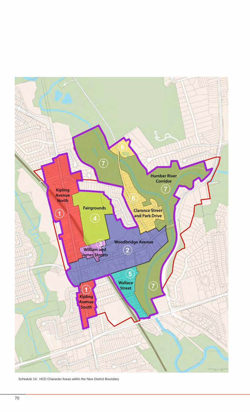
70
Schedule 14: HCD Character Areas within the New District Boundary
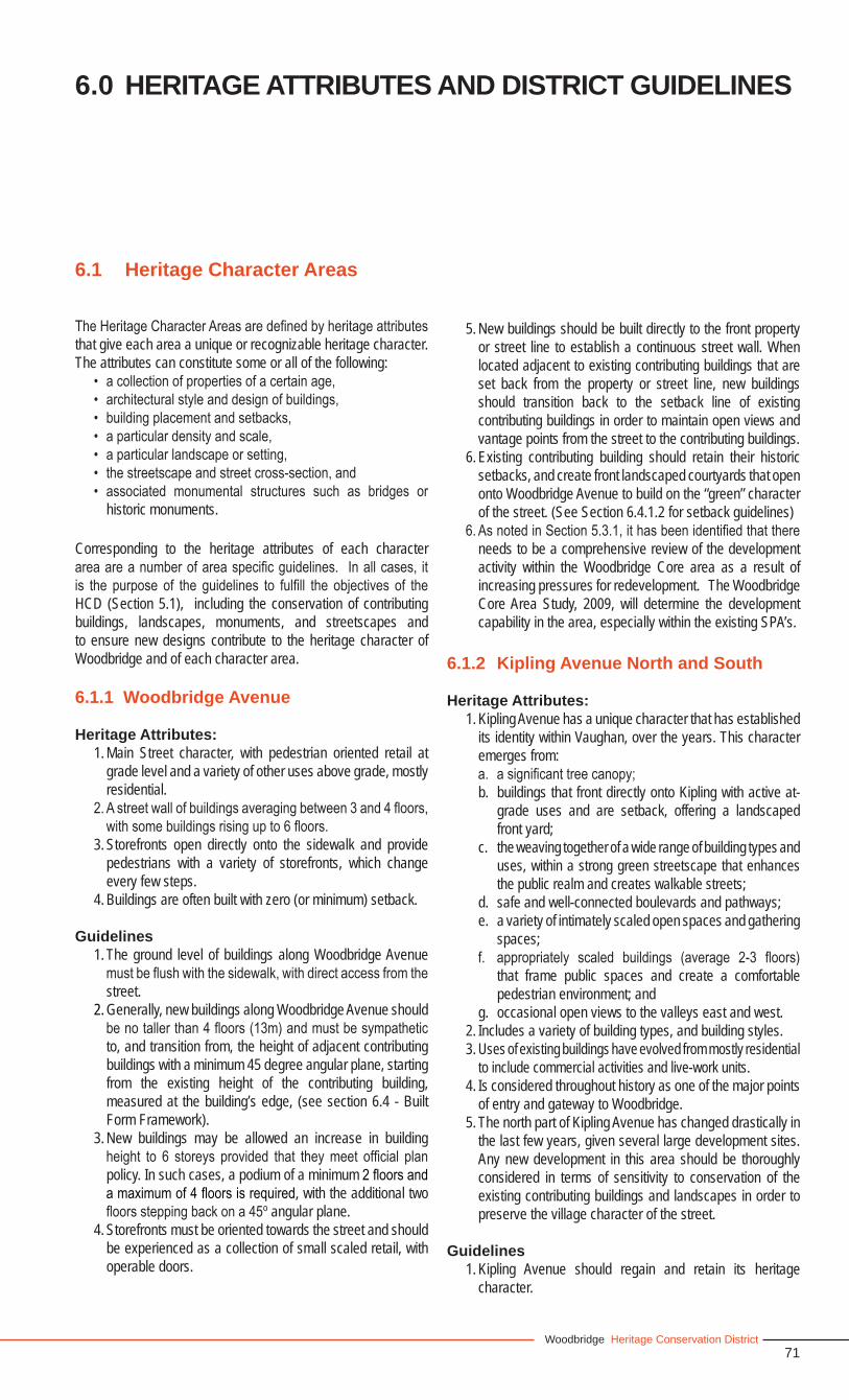
71Woodbridge Heritage Conservation District
6.1 Heritage Character Areas
The Heritage Character Areas are defined by heritage attributes that give each area a unique or recognizable heritage character. The attributes can constitute some or all of the following:
• a collection of properties of a certain age, • architectural style and design of buildings, • building placement and setbacks,• a particular density and scale, • a particular landscape or setting, • the streetscape and street cross-section, and• associated monumental structures such as bridges or
historic monuments.
Corresponding to the heritage attributes of each character area are a number of area specific guidelines. In all cases, it is the purpose of the guidelines to fulfill the objectives of the HCD (Section 5.1), including the conservation of contributing buildings, landscapes, monuments, and streetscapes and to ensure new designs contribute to the heritage character of Woodbridge and of each character area.
6.1.1 Woodbridge Avenue
Heritage Attributes:1. Main Street character, with pedestrian oriented retail at
grade level and a variety of other uses above grade, mostly residential.
2. A street wall of buildings averaging between 3 and 4 floors, with some buildings rising up to 6 floors.
3. Storefronts open directly onto the sidewalk and provide pedestrians with a variety of storefronts, which change every few steps.
4. Buildings are often built with zero (or minimum) setback.
Guidelines1. The ground level of buildings along Woodbridge Avenue
must be flush with the sidewalk, with direct access from the street.
2. Generally, new buildings along Woodbridge Avenue should be no taller than 4 floors (13m) and must be sympathetic to, and transition from, the height of adjacent contributing buildings with a minimum 45 degree angular plane, starting from the existing height of the contributing building, measured at the building’s edge, (see section 6.4 - Built Form Framework).
3. New buildings may be allowed an increase in building height to 6 storeys provided that they meet official plan policy. In such cases, a podium of a minimum 2 floors and a maximum of 4 floors is required, with the additional two floors stepping back on a 45o angular plane.
4. Storefronts must be oriented towards the street and should be experienced as a collection of small scaled retail, with operable doors.
5. New buildings should be built directly to the front property or street line to establish a continuous street wall. When located adjacent to existing contributing buildings that are set back from the property or street line, new buildings should transition back to the setback line of existing contributing buildings in order to maintain open views and vantage points from the street to the contributing buildings.
6. Existing contributing building should retain their historic setbacks, and create front landscaped courtyards that open onto Woodbridge Avenue to build on the “green” character of the street. (See Section 6.4.1.2 for setback guidelines)
6. As noted in Section 5.3.1, it has been identified that there needs to be a comprehensive review of the development activity within the Woodbridge Core area as a result of increasing pressures for redevelopment. The Woodbridge Core Area Study, 2009, will determine the development capability in the area, especially within the existing SPA’s.
6.1.2 Kipling Avenue North and South
Heritage Attributes:1. Kipling Avenue has a unique character that has established
its identity within Vaughan, over the years. This character emerges from:a. a significant tree canopy;b. buildings that front directly onto Kipling with active at-
grade uses and are setback, offering a landscaped front yard;
c. the weaving together of a wide range of building types and uses, within a strong green streetscape that enhances the public realm and creates walkable streets;
d. safe and well-connected boulevards and pathways;e. a variety of intimately scaled open spaces and gathering
spaces;f. appropriately scaled buildings (average 2-3 floors)
that frame public spaces and create a comfortable pedestrian environment; and
g. occasional open views to the valleys east and west.2. Includes a variety of building types, and building styles.3. Uses of existing buildings have evolved from mostly residential
to include commercial activities and live-work units.4. Is considered throughout history as one of the major points
of entry and gateway to Woodbridge.5. The north part of Kipling Avenue has changed drastically in
the last few years, given several large development sites. Any new development in this area should be thoroughly considered in terms of sensitivity to conservation of the existing contributing buildings and landscapes in order to preserve the village character of the street.
Guidelines1. Kipling Avenue should regain and retain its heritage
character.
6.0 HERITAGE ATTRIBUTES AND DISTRICT GUIDELINES

72
Kipling Avenue
Wallace Street
Woodbridge Avenue

73Woodbridge Heritage Conservation District
2. New and renovated buildings and landscapes must:a. conserve and enhance the tree canopy;b. front directly onto Kipling Avenue, and provide a
landscaped front yard that contributes to the overall streetscape;
c. contribute to the quality and connectivity of the pedestrian environment;
d. serve to enhance the overall system of trails, pathways and pedestrian walkways;
e. maintain the intimate scale of the street, through the building mass, the length of facades, and the detailing of architecture and landscape architecture;
f. be no taller than 3 floors (11 m); andg. conserve and enhance views to the valleys east and
west, as identified on Schedule 19, page 94.h. provide a design that is sympathetic with the character
of adjacent properties.3. New buildings must have a residential character and
should be conducive to a mix of uses, including small-scaled commercial uses.
4. All interventions within Kipling Avenue should contribute through structures and/or landscape to the design of significant points of entry and gateways.
5. Generally, new buildings should be built to a minimum 3m setback from the front property line or street line, and transition back to the setback line of existing contributing buildings, to maintain the character of the deep front yards.
6. Refer to Section 6.4.1.3 for further details on setback guidelines.
6.1.3 Wallace Street
Heritage Attributes:1. A residential street character, that is narrow in nature
and pedestrian oriented, and includes a broad variety of housing types fronting onto Wallace Street.
2.The existing street cross section consists of a R.O.W. of only 12 meters, and a roadway width of 9 meters. This narrow roadway is meant to carry traffic associated with the established low density residential neighbourhood.
3. Provides pedestrian access to Woodbridge Avenue, from the south. Provides access and views to public open spaces, since most of the street fronts directly onto either Memorial Hill or the Nort Johnson District Park (part of the Humber River Corridor).
4. In addition to the parkland, front yards provide a significant greenery and tree canopy. Houses on the west side are setback from the street, while houses on the east side are built directly on the property line.
5. Houses are predominantly 2 to 3 storeys in height on Wallace Street.
6. Side yards provide views towards the hillside on the west, and the river valley to the east.
Guidelines1. The Street should retain the existing residential character
with a single family detached building type and be designed to support a pedestrian streetscape. Where the Official Plan permits, duplexes, triplexes, and quadruplexes may be permitted provided they are carefully designed to appear as single detached dwelllings, sensitive to abutting contributing buildings and landscapes, and provided they maintain existing side yard and front yard setbacks, are of a similar building height, and are of a building frontage width which is consistent with adjacent single detached dwellings.
2. Pedestrian connections to and from Woodbridge Avenue and the park system must be protected, maintained and additional opportunities to increase connections should be secured when new development applications are considered. Views and public access to parkland must be protected and enhanced.
3. Consistent setbacks should provide opportunities for landscape on the west side of the street.
4. New buildings should be a minimum of 2 floors (8.5 m) high and a maximum of 3 floors (11 m).
5. Detached residential units must provide a side yard as per zoning with open east-west views.
6.1.4 William Street and James Street
Heritage Attributes:1. A rural residential street character, a quiet enclave,
sheltered from the activity of Woodbridge Avenue and Kipling Avenue. The streetscape has a rural character, with sidewalks only on one side of the street, at least 4.5m front yard setbacks from the right-of-way, and a large number of trees.
2. There is a proportional predominance of greenery over built structures.
3. The railway dissects this area, and provides residual pockets of greenery, which add to the rural character.
4. The bridge is a centre piece, and a key element of the street’s identity.
5. The Fairgrounds to the north offers a significant green buffer, currently inaccessible from this area.
Guidelines1. The streets should retain the existing residential character
with a single family detached building type and should retain the quiet rural street character, by preserving:a. the significant tree canopy;b. open views to the Fairgrounds towards the north;c. buildings that front directly onto the street, but are
setback (a minimum of 4.5 m), offering a landscaped front yard;
d. a tight street cross-section that minimizes hard surfaces by having minimum lane widths and maximum public realm and landscaping.
HERITAGE ATTRIBUTES AND DISTRICT GUIDELINES
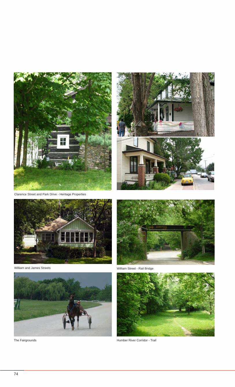
74
The Fairgrounds Humber River Corridor - Trail
William and James Streets
Clarence Street and Park Drive - Heritage Properties
William Street - Rail Bridge

75Woodbridge Heritage Conservation District
2. New buildings should be a minimum of 2 floors (8.5 m) high and a maximum of 3 floors (11 m).
3. New buildings should provide ample soft landscaping and trees, to support a rural street character.
4. A naturalized tree canopy should be maintained along the railway corridor and the triangular extension of the railway corridor at the southwestern corner of the intersection of William Street and James Street.
5. The bridge should be maintained and preserved as a key feature of the area’s identity.
6. The existing natural landscape and forest canopy at the edge of the Fairgrounds should be protected and maintained, and opportunities for pedestrian access sought.
6.1.5 Clarence Street and Park Drive
Heritage Attributes:1. A residential street character, that is pedestrian oriented
and includes a broad variety of housing types and styles fronting onto Clarence Street.
2. Provides access to Woodbridge Avenue, from the north.3. Provides access and views to the Humber River Corridor.4. In addition to the parkland, front yards provide a significant
greenery and tree canopy. 5. Houses are predominantly 2 to 3 floors high.6. Side yards provide views towards landscaped back yards
and the river valley to the east.
Guidelines1. The Street should retain the existing residential character
with a single family detached building type and be designed to support a pedestrian streetscape. Where the Official Plan permits, duplexes, triplexes, and quadruplexes may be permitted provided they are carefully designed to appear as single detached dwelllings, sensitive to abutting contributing buildings and landscapes, and provided they maintain existing side yard and front yard setbacks, are of a similar building height, and are of a building frontage width which is consistent with adjacent single detached dwellings.
2. Pedestrian connections to and from Woodbridge Avenue and the park system must be protected and their design enhanced. Views and public access to parkland must be protected and enhanced.
3. Consistent setbacks (of a minimum 4.5m), should provide opportunities for landscaping on both sides of the street.
4. New buildings should be a minimum of 2 floors (8.5 m) high and a maximum of 3 floors (11 m).
5. Detached residential units must provide a side yard as per zoning with open east-west views.
6.1.6 The Fairgrounds Area
Heritage Attribute:1. The Fairgrounds represents one of the earliest single uses
in the Woodbridge district. Its location and the activities associated with the Fairgrounds are intricately tied to the identity of Woodbridge within Vaughan and beyond. The Fairgrounds property includes significant greenery and tree canopy that conserves a rural character, which extends to the surrounding context.
2. The Fairgrounds functions as an important open space, which is at the end of several important pedestrian connections and trails.
3. Buildings located within the Fairgrounds property have a rural character and setting.
4. Currently the Fairgrounds is programmed during limited times of the year and attracts an audience that is mostly related to the Woodbridge Fall Fair.
Guidelines1. The Fairgrounds property and the Conservation Area to
the east must retain an open space function, and should retain a rural and natural landscape.
2. Pedestrian connections to and through the Fairgrounds Area should be supported and enhanced. New pedestrian connections should be established.
3. New and existing buildings should not detract from the open space functions. New buildings should retain a rural scale and not exceed 3 floors (11m) in height.
4. Year round activities should be encouraged.5. Pedestrian access from all sides should be improved.6. Porter Avenue should be landscaped as a prominent gateway.
6.1.7 The Humber River Corridor
Heritage Attribute:1. The Humber River Corridor is an open space, of regional
significance, that provides amenity spaces for residents and visitors alike. In the past, the Humber River Corridor contained industry and agricultural lands. Today, within the district, the Humber River Corridor functions as an amenity space, and as natural conservation land.
2. The forests of the Humber River have always been an extensive and notable part of Woodbridge. Although rerouted throughout history, residences, social amenities, commerce and industry were always strategically located adjacent to or with access to the river. Apart from the Fairgrounds, the river valley has been the open space amenity and playground for the Woodbridge community, and as such, there are few small neighbourhood scaled parks as part of Woodbridge’s history.
Guidelines1. The Humber River Corridor must remain as a publicly
accessible open space conservation zone, with public trail systems connecting to different areas within Woodbridge.
2. The portion of the Golf Course within the District must remain as an open space conservation zone. The trail systems alongside the Humber River should be extended where possible.
HERITAGE ATTRIBUTES AND DISTRICT GUIDELINES
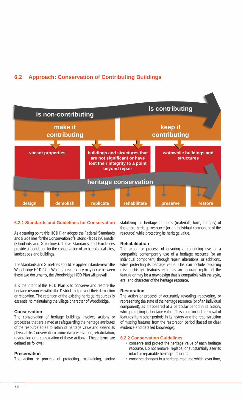
76
6.2.1 Standards and Guidelines for Conservation
As a starting point, this HCD Plan adopts the Federal “Standards and Guidelines for the Conservation of Historic Places in Canada” (Standards and Guidelines). These Standards and Guidelines provide a foundation for the conservation of archaeological sites, landscapes and buildings.
The Standards and Guidelines should be applied in tandem with the Woodbridge HCD Plan. Where a discrepancy may occur between these two documents, the Woodbridge HCD Plan will prevail.
It is the intent of this HCD Plan is to conserve and restore the heritage resources within the District and prevent their demolition or relocation. The retention of the existing heritage resources is essential to maintaining the village character of Woodbridge.
Conservation The conservation of heritage buildings involves actions or processes that are aimed at safeguarding the heritage attributes of the resource so as to retain its heritage value and extend its physical life. Conservation can involve preservation, rehabilitation, restoration or a combination of these actions. These terms are defined as follows:
PreservationThe action or process of protecting, maintaining, and/or
6.2 Approach: Conservation of Contributing Buildings
stabilizing the heritage attributes (materials, form, integrity) of the entire heritage resource (or an individual component of the resource) while protecting its heritage value.
RehabilitationThe action or process of ensuring a continuing use or a compatible contemporary use of a heritage resource (or an individual component) through repair, alterations, or additions, while protecting its heritage value. This can include replacing missing historic features either as an accurate replica of the feature or may be a new design that is compatible with the style, era, and character of the heritage resource.
RestorationThe action or process of accurately revealing, recovering, or representing the state of the heritage resource (or of an individual component), as it appeared at a particular period in its history, while protecting its heritage value. This could include removal of features from other periods in its history and the reconstruction of missing features from the restoration period (based on clear evidence and detailed knowledge).
6.2.2 Conservation Guidelines• conserve and protect the heritage value of each heritage
resource. Do not remove, replace, or substantially alter its intact or repairable heritage attributes.
• conserve changes to a heritage resource which, over time,
design demolish replicate preserve restorerehabilitate
vacant properties buildings and structures that are not significant or have
lost their integrity to a point beyond repair
wothwhile buildings and structures
heritage conservation
make itcontributing
keep itcontributing
is non-contributingis contributing
77Woodbridge Heritage Conservation District
HERITAGE ATTRIBUTES AND DISTRICT GUIDELINES
have become heritage attributes in their own right.• conserve heritage value by adopting an approach to
minimal intervention• evaluate the existing condition of heritage attributes to
determine the appropriate intervention needed. Use the gentlest means possible for any intervention.
• maintain heritage attributes on an ongoing basis to avoid major conservation projects and high costs.
• repair rather than replace heritage attributes using recognized conservation methods. Respect historical materials and finishes by repairing with like materials.
• replace using like materials any extensively deteriorated or missing parts of heritage attributes.
• undertake any work required to preserve heritage attributes physically and visually compatible with the character of the heritage resource as commonly found in the District.
6.2.3 Relocation of Contributing Buildings
Buildings and structures located within properties that are listed as contributing to the Woodbridge HCD Heritage Character should not be relocated and should remain in-situ within their existing context.
A threatened heritage building relocated to the District from another site should generally be compatible in style and type to the existing development patterns in the District.
6.2.4 Demolition of Contributing Buildings
Buildings and structures located within properties that are listed as contributing to the Woodbridge HCD Heritage Character shall not be demolished and shall remain in-situ within their existing context.
Cultural Services staff will assess all requests for demolition of buildings located within the District and evaluate them according to their current condition, and historical and architectural merit.
The City, under the Ontario Heritage Act, may refuse a demolition permit for either an individually designated building or a building located within the Heritage Conservation District.
6.2.5 Approach to Non-Contributing Buildings
Non-contributing buildings are not to be demolished until such time as a demolition permit has been issued.
Additions and alterations to non-contributing buildings can have an impact on contributing buildings and the overall character of Woodbridge. As non-contributing buildings are modified, and as new buildings are built, these should contribute to the heritage
character of Woodbridge as a whole, and specifically to the heritage character of adjacent contributing properties.
The City of Vaughan may require a Heritage Impact Assessment when it considers that cultural heritage value may exist, or be impacted by any new construction.
6.2.6 Activities that are Subject to Review
In accordance with Section 42.1 of the Ontario Heritage Act, the Goal and Objectives, Policies, and Design Guidelines in this document will be used to review the following types of activities in the District (other than those exempted below). In particular, as it relates to the review and approval of a Heritage Permit application:
• The erection, demolition, or removal of any building or structure, or the alteration of any part of a property other than the interior of a building or structure, other than activities described in Section 6.2.7, below. (A ‘Structure’ is anything built that is intended to be permanent, such as outbuildings, fences, signs, and infrastructure items such as utility boxes).
• All matters relating to the City of Vaughan Official Plan, and the regulation of zoning, site plan control, severances, variances, signage, demolitions, and building relocation.
• All municipal public works, such as street lighting, signs, landscaping, tree removal, utility locations and street and infrastructure improvements.
• All activities of the municipal and regional governments.
6.2.7 Activities that are Exempt from Review
Any person wishing to erect, demolish, or remove a building or structure located in a property within the Woodbridge HCD, or to alter the external portions of such a building or structure, shall submit a heritage permit application in writing to the City of Vaughan.
Heritage Vaughan must approve all applications for heritage permits that propose such changes to any building within the district. When an application is received, the Cultural Services Division will review the application with Heritage Vaughan and make recommendations as necessary.
A heritage permit is not required for some activities regarding the alterations to a building or structure located on a property within the Woodbridge HCD. In accordance with Section 41.1(5)(e) of the Ontario Heritage Act, the following classes of alterations that are minor in nature, are not required to obtain a heritage permit, and are not subject to review under this Plan: (See Section 8.0)
• any interior work unless the interior is identified in a Part IV Designation;
78
• any alteration that is not visible from the street or from any other public space;
• maintenance and repair of existing features (that do not alter the historic design or construction detailing, and appropriate materials as listed in the following section are used), including roofs, eavestroughs, chimneys, wall cladding, dormers, cresting, cupolas, cornices, brackets, columns, balustrades, porches, steps, entrances, foundations, and decorative wood, metal, stone or terra cotta;
• painting of wood or painted metal finishes;• caulking, window repair, weatherstripping, installation of
existing storm doors and storm windows;• minor installations, including small satellite dishes, lighting,
and flagpoles;• fencing, patios, garden and tool sheds, gazebos, dog
houses and other out buildings that do not require a Building Permit and are not visible from the street;
• planting and removal of trees smaller than 200mm caliper, measured at 1.5m above the ground, and any other vegetation on private property;
• extension of residential parking pads other than in front of flankage yards;
• ramps and railings to facilitate accessibility, gates installed for child safety that are located in such a manner as to not be visible from the public domain;
• temporary installations, such as basketball nets, planters, statues, seasonal decorations; and
• repair of utilities and public works, installation of public works that are in compliance with the Guidelines.
Although a permit is not required in the above instances, property owners and tenants are encouraged to meet with Cultural Services Staff to ensure alterations conform with the spirit and intent of the HCD Plan and guidelines, and to consider acquiring a heritage conservation plan to assist in the proper care of their buildings. (See Section 7.1 of the Plan)
6.2.8 Appropriate Materials
Exterior Finish: Smooth red clay face brick, with smooth buff clay face brick as accent, or in some instances brick to match existing conditions.
Exterior Detail: Cut stone or reconstituted stone for trim in brick buildings.
Shopfronts: Wood frames, glazing bars, and panels with glazed wood doors are preferred. Metal shop fronts, detailed and proportioned to be compatible with heritage shop fronts, are acceptable.Roofs: Hipped or gable roof as appropriate to the architectural style. Cedar, slate, simulated slate, or asphalt shingles of an
appropriate colour. Standing seam metal roofing, if appropriate to the architectural style. Skylights in the form of cupolas or monitors are acceptable, if appropriate to the style.
Doors: Wood doors and frames, panel construction, may be glazed; transom windows and paired sidelights with real glazing bars; wood french doors for porch entrances; single-bay, wood panelled garage doors.
Windows: Wood frames; single or double hung; lights as appropriate to the architectural style; real glazing bars, or high quality simulated glazing bars; vertical proportion, ranging from 3:5 to 3:7.
Flashings: Visible step flashings should be painted the colour of the wall.
6.2.9 Inappropriate Materials
Exterior Finish: Concrete block; calcite or concrete brick; textured, clinker, or wire cut brick, contemporary stucco applications, except where their use is consistent with existing conditions; precast concrete panels or cast-in-place concrete; prefabricated metal or plastic siding; stone or ceramic tile facing; “rustic” clapboard or “rustic” board and batten siding; all forms of wood “shake” siding (very rough form of cedar shingles).
Exterior Detail: Prefinished metal fascias and soffits; “stock” suburban pre-manufactured shutters, railings, and trims; unfinished pressure-treated wood deck, porches, railings, and trim.
Shopfronts: Standard metal shopfronts and prefinished metal spandrel material; frameless tempered glass shopfronts.
Roofs: Slopes or layouts not suitable to the architectural style; non-traditional metal roofing such as pre-finished metal, corrugated metal; modern skylights, when facing the street.
Doors: “Stock” suburban door assemblies; flush doors; sidelights on one side only; aluminum screen doors; sliding patio doors; double-bay, slab or metal garage doors generic or stock stained glass window assemblies for doorlights and sidelights.
Windows: large picture windows; curtain wall systems; metal, plastic, or fibreglass frames; metal or plastic cladding; awning, hopper, casement or sliding openers; casement windows may be appropriate on California Bungalow styled buildings; “snap-in” or tape simulated glazing bars.
Flashings: Pre-finished metal in inappropriate colours.
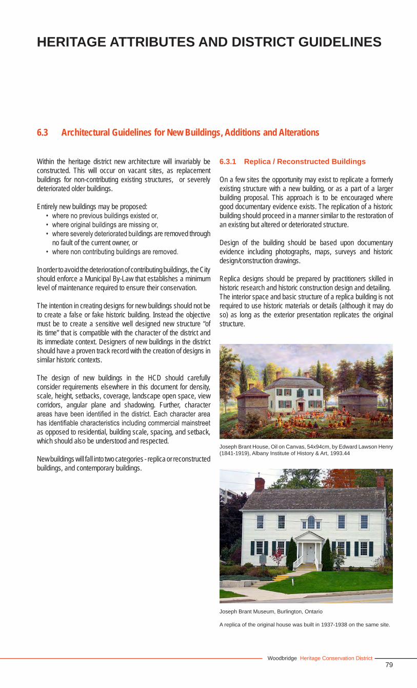
79Woodbridge Heritage Conservation District
6.3 Architectural Guidelines for New Buildings, Additions and Alterations
Within the heritage district new architecture will invariably be constructed. This will occur on vacant sites, as replacement buildings for non-contributing existing structures, or severely deteriorated older buildings.
Entirely new buildings may be proposed:• where no previous buildings existed or,• where original buildings are missing or,• where severely deteriorated buildings are removed through
no fault of the current owner, or • where non contributing buildings are removed.
In order to avoid the deterioration of contributing buildings, the City should enforce a Municipal By-Law that establishes a minimum level of maintenance required to ensure their conservation.
The intention in creating designs for new buildings should not be to create a false or fake historic building. Instead the objective must be to create a sensitive well designed new structure “of its time” that is compatible with the character of the district and its immediate context. Designers of new buildings in the district should have a proven track record with the creation of designs in similar historic contexts.
The design of new buildings in the HCD should carefully consider requirements elsewhere in this document for density, scale, height, setbacks, coverage, landscape open space, view corridors, angular plane and shadowing. Further, character areas have been identified in the district. Each character area has identifiable characteristics including commercial mainstreet as opposed to residential, building scale, spacing, and setback, which should also be understood and respected.
New buildings will fall into two categories - replica or reconstructed buildings, and contemporary buildings.
6.3.1 Replica / Reconstructed Buildings
On a few sites the opportunity may exist to replicate a formerly existing structure with a new building, or as a part of a larger building proposal. This approach is to be encouraged where good documentary evidence exists. The replication of a historic building should proceed in a manner similar to the restoration of an existing but altered or deteriorated structure.
Design of the building should be based upon documentary evidence including photographs, maps, surveys and historic design/construction drawings.
Replica designs should be prepared by practitioners skilled in historic research and historic construction design and detailing.The interior space and basic structure of a replica building is not required to use historic materials or details (although it may do so) as long as the exterior presentation replicates the original structure.
Joseph Brant House, Oil on Canvas, 54x94cm, by Edward Lawson Henry (1841-1919), Albany Institute of History & Art, 1993.44
Joseph Brant Museum, Burlington, Ontario
A replica of the original house was built in 1937-1938 on the same site.
HERITAGE ATTRIBUTES AND DISTRICT GUIDELINES
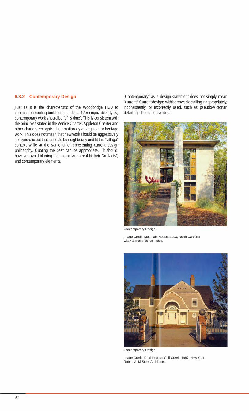
80
Contemporary Design
Image Credit: Mountain House, 1993, North CarolinaClark & Menefee Architects
Contemporary Design
Image Credit: Residence at Calf Creek, 1987, New YorkRobert A. M Stern Architects
“Contemporary” as a design statement does not simply mean “current”. Current designs with borrowed detailing inappropriately, inconsistently, or incorrectly used, such as pseudo-Victorian detailing, should be avoided.
6.3.2 Contemporary Design
Just as it is the characteristic of the Woodbridge HCD to contain contributing buildings in at least 12 recognizable styles, contemporary work should be “of its time”. This is consistent with the principles stated in the Venice Charter, Appleton Charter and other charters recognized internationally as a guide for heritage work. This does not mean that new work should be aggressively idiosyncratic but that it should be neighbourly and fit this “village” context while at the same time representing current design philosophy. Quoting the past can be appropriate. It should, however avoid blurring the line between real historic “artifacts”, and contemporary elements.
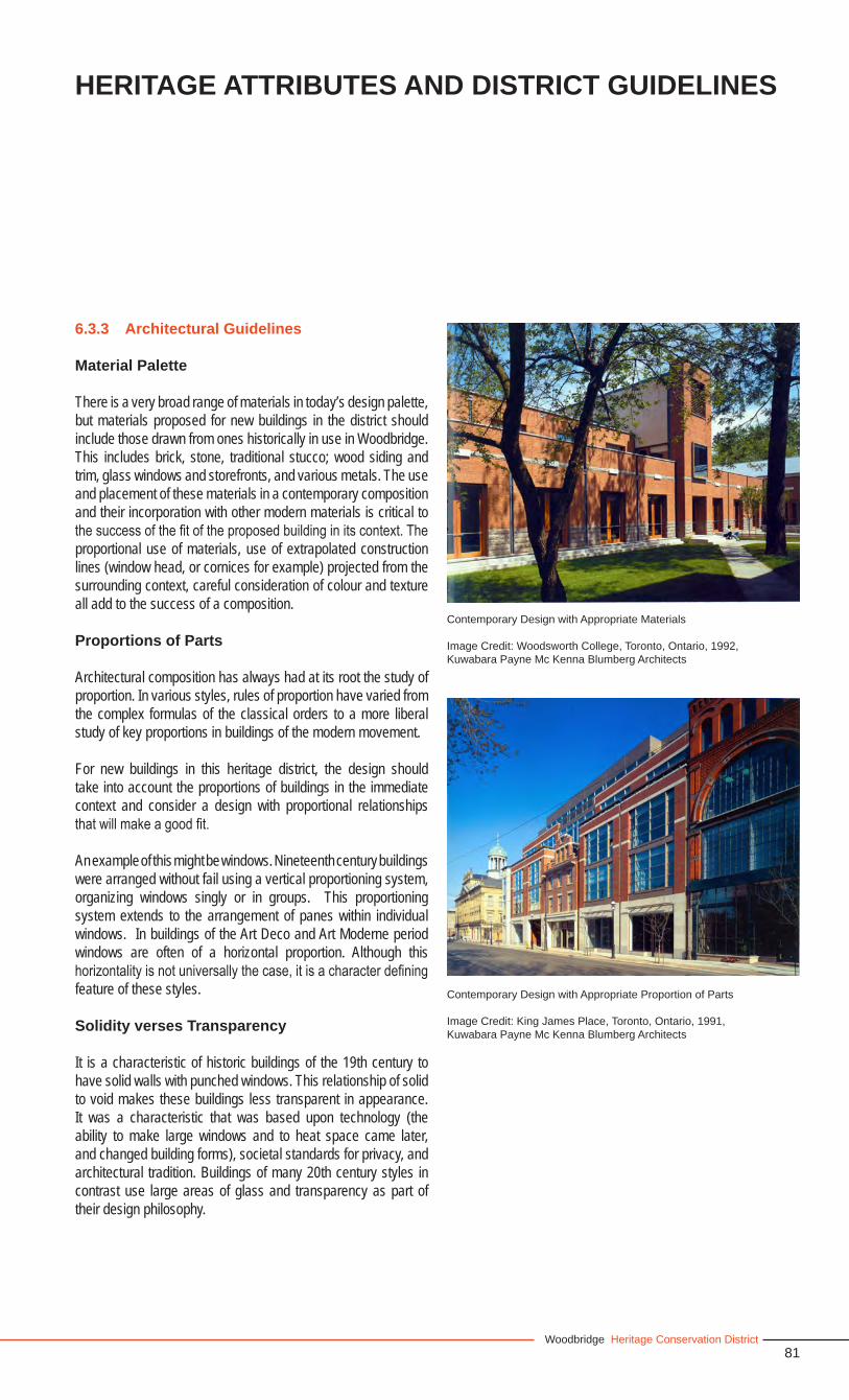
81Woodbridge Heritage Conservation District
6.3.3 Architectural Guidelines
Material Palette
There is a very broad range of materials in today’s design palette, but materials proposed for new buildings in the district should include those drawn from ones historically in use in Woodbridge. This includes brick, stone, traditional stucco; wood siding and trim, glass windows and storefronts, and various metals. The use and placement of these materials in a contemporary composition and their incorporation with other modern materials is critical to the success of the fit of the proposed building in its context. The proportional use of materials, use of extrapolated construction lines (window head, or cornices for example) projected from the surrounding context, careful consideration of colour and texture all add to the success of a composition.
Proportions of Parts
Architectural composition has always had at its root the study of proportion. In various styles, rules of proportion have varied from the complex formulas of the classical orders to a more liberal study of key proportions in buildings of the modern movement.
For new buildings in this heritage district, the design should take into account the proportions of buildings in the immediate context and consider a design with proportional relationships that will make a good fit.
An example of this might be windows. Nineteenth century buildings were arranged without fail using a vertical proportioning system, organizing windows singly or in groups. This proportioning system extends to the arrangement of panes within individual windows. In buildings of the Art Deco and Art Moderne period windows are often of a horizontal proportion. Although this horizontality is not universally the case, it is a character defining feature of these styles.
Solidity verses Transparency
It is a characteristic of historic buildings of the 19th century to have solid walls with punched windows. This relationship of solid to void makes these buildings less transparent in appearance. It was a characteristic that was based upon technology (the ability to make large windows and to heat space came later, and changed building forms), societal standards for privacy, and architectural tradition. Buildings of many 20th century styles in contrast use large areas of glass and transparency as part of their design philosophy.
Contemporary Design with Appropriate Proportion of Parts
Image Credit: King James Place, Toronto, Ontario, 1991, Kuwabara Payne Mc Kenna Blumberg Architects
Contemporary Design with Appropriate Materials
Image Credit: Woodsworth College, Toronto, Ontario, 1992, Kuwabara Payne Mc Kenna Blumberg Architects
HERITAGE ATTRIBUTES AND DISTRICT GUIDELINES
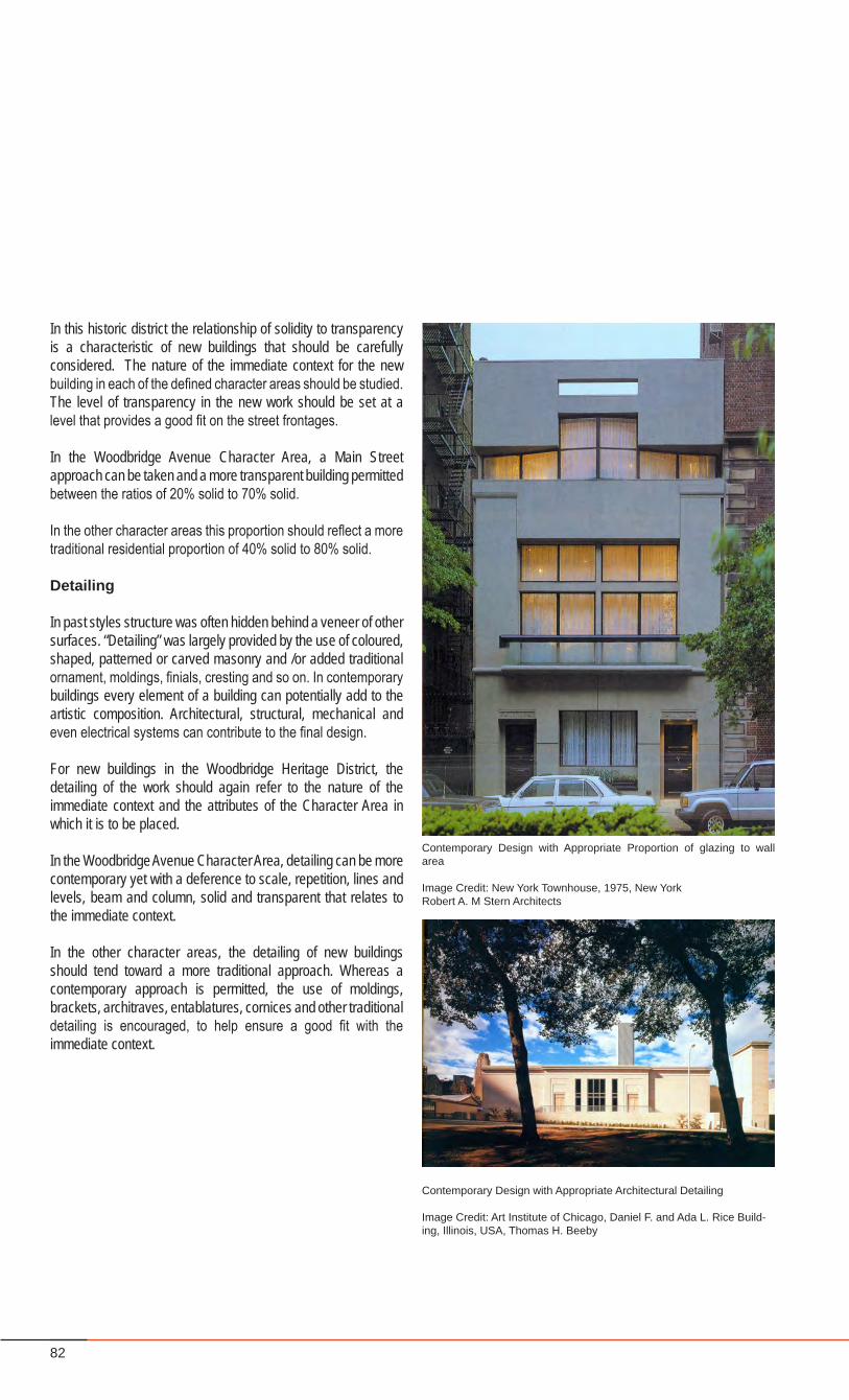
82
In this historic district the relationship of solidity to transparency is a characteristic of new buildings that should be carefully considered. The nature of the immediate context for the new building in each of the defined character areas should be studied. The level of transparency in the new work should be set at a level that provides a good fit on the street frontages.
In the Woodbridge Avenue Character Area, a Main Street approach can be taken and a more transparent building permitted between the ratios of 20% solid to 70% solid.
In the other character areas this proportion should reflect a more traditional residential proportion of 40% solid to 80% solid.
Detailing
In past styles structure was often hidden behind a veneer of other surfaces. “Detailing” was largely provided by the use of coloured, shaped, patterned or carved masonry and /or added traditional ornament, moldings, finials, cresting and so on. In contemporary buildings every element of a building can potentially add to the artistic composition. Architectural, structural, mechanical and even electrical systems can contribute to the final design.
For new buildings in the Woodbridge Heritage District, the detailing of the work should again refer to the nature of the immediate context and the attributes of the Character Area in which it is to be placed.
In the Woodbridge Avenue Character Area, detailing can be more contemporary yet with a deference to scale, repetition, lines and levels, beam and column, solid and transparent that relates to the immediate context.
In the other character areas, the detailing of new buildings should tend toward a more traditional approach. Whereas a contemporary approach is permitted, the use of moldings, brackets, architraves, entablatures, cornices and other traditional detailing is encouraged, to help ensure a good fit with the immediate context.
Contemporary Design with Appropriate Proportion of glazing to wall area
Image Credit: New York Townhouse, 1975, New YorkRobert A. M Stern Architects
Contemporary Design with Appropriate Architectural Detailing
Image Credit: Art Institute of Chicago, Daniel F. and Ada L. Rice Build-ing, Illinois, USA, Thomas H. Beeby
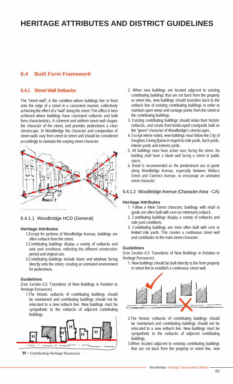
83Woodbridge Heritage Conservation District
HERITAGE ATTRIBUTES AND DISTRICT GUIDELINES
A coherent and uniform street wall
6.4 Built Form Framework
6.4.1 Street Wall Setbacks
The “street wall”, is the condition where buildings line or front onto the edge of a street in a consistent manner, collectively achieving the effect of a “wall” along the street. This effect is best achieved where buildings have consistent setbacks and built form characteristics. A coherent and uniform street wall shapes the character of the street, and provides pedestrians a clear streetscape. In Woodbridge the character and composition of street walls vary from street to street and should be considered accordingly to maintain the varying street character.
6.4.1.1 Woodbridge HCD (General)
Heritage Attributes1.Except for portions of Woodbridge Avenue, buildings are
often setback from the street.2.Contributing buildings display a variety of setbacks and
side yard conditions, reflecting the different construction period and original use.
3.Contributing buildings include doors and windows facing directly onto the street, creating an animated environment for pedestrians.
Guidelines (See Section 6.5: Transitions of New Buildings in Relation to Heritage Resources)
1.The historic setbacks of contributing buildings should be maintained and contributing buildings should not be relocated to a new setback line. New buildings must be sympathetic to the setbacks of adjacent contributing buildings.
2. When new buildings are located adjacent to existing contributing buildings that are set back from the property or street line, new buildings should transition back to the setback line of existing contributing buildings in order to maintain open views and vantage points from the street to the contributing buildings.
3. Existing contributing buildings should retain their historic setbacks, and create front landscaped courtyards built on the “green” character of Woodbridge’s streetscapes.
4. Except where noted, new buildings must follow the City of Vaughan Zoning Bylaw in regard to side yards, back yards, interior yards and exterior yards.
5. All buildings must have active uses facing the street. No building shall have a blank wall facing a street or public space.
6. Retail is recommended as the predominant use at grade along Woodbridge Avenue, especially between Wallace Street and Clarence Avenue, to encourage an animated street character.
6.4.1.2 Woodbridge Avenue (Character Area - CA)
Heritage Attributes1. Follow a Main Street character, buildings with retail at
grade are often built with zero (or minimum) setback. 2. Contributing buildings display a variety of setbacks and
side yard conditions.3. Contributing buildings are most often built with zero or
limited side yards. This creates a continuous street wall and contributes to the main street character.
Guidelines (See Section 6.5: Transitions of New Buildings in Relation to Heritage Resources)
1. New buildings should be built directly to the front property or street line to establish a continuous street wall.
2.The historic setbacks of contributing buildings should be maintained and contributing buildings should not be relocated to a new setback line. New buildings must be sympathetic to the setbacks of adjacent contributing buildings.
3.When located adjacent to existing contributing buildings that are set back from the property or street line, new
HH
HH H
H - Contributing Heritage Resources
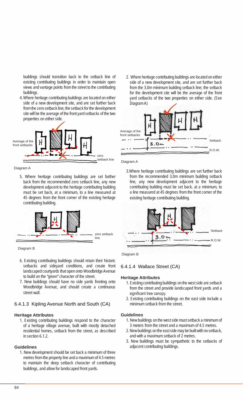
84
2. Where heritage contributing buildings are located on either side of a new development site, and are set further back from the 3.0m minimum building setback line; the setback for the development site will be the average of the front yard setbacks of the two properties on either side. (See Diagram A)
3.Where heritage contributing buildings are set further back from the recommended 3.0m minimum building setback line, any new development adjacent to the heritage contributing building must be set back, at a minimum, to a line measured at 45 degrees from the front corner of the existing heritage contributing building.
6.4.1.4 Wallace Street (CA)
Heritage Attributes1. Existing contributing buildings on the west side are setback
from the street and provide landscaped front yards and a significant tree canopy.
2. Existing contributing buildings on the east side include a minimum setback from the street.
Guidelines1. New buildings on the west side must setback a minimum of
3 meters from the street and a maximum of 4.5 metres. 2. New buildings on the east side may be built with no setback,
and with a maximum setback of 2 metres. 3. New buildings must be sympathetic to the setbacks of
adjacent contributing buildings.
buildings should transition back to the setback line of existing contributing buildings in order to maintain open views and vantage points from the street to the contributing buildings.
4. Where heritage contributing buildings are located on either side of a new development site, and are set further back from the zero setback line; the setback for the development site will be the average of the front yard setbacks of the two properties on either side.
5. Where heritage contributing buildings are set further back from the recommended zero setback line, any new development adjacent to the heritage contributing building must be set back, at a minimum, to a line measured at 45 degrees from the front corner of the existing heritage contributing building.
6. Existing contributing buildings should retain their historic setbacks and sideyard conditions, and create front landscaped courtyards that open onto Woodbridge Avenue to build on the “green” character of the street.
7. New buildings should have no side yards fronting onto Woodbridge Avenue, and should create a continuous street wall.
6.4.1.3 Kipling Avenue North and South (CA)
Heritage Attributes1. Existing contributing buildings respond to the character
of a heritage village avenue, built with mostly detached residential homes, setback from the street, as described in section 6.1.2.
Guidelines1. New development should be set back a minimum of three
metres from the property line and a maximum of 4.5 metres to maintain the deep setback character of contributing buildings, and allow for landscaped front yards.
Diagram B
Setback
R.O.W.
zero setback line
Diagram A
Average of the front setbacks
Diagram B
zero setback line
Diagram A
Setback
R.O.W.
Average of the front setbacks
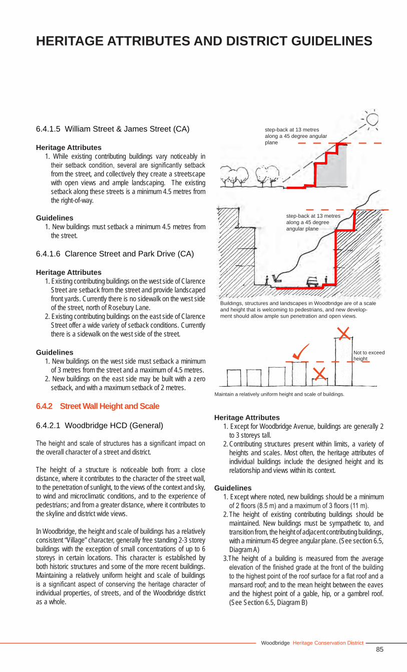
85Woodbridge Heritage Conservation District
HERITAGE ATTRIBUTES AND DISTRICT GUIDELINES
6.4.1.5 William Street & James Street (CA)
Heritage Attributes1. While existing contributing buildings vary noticeably in
their setback condition, several are significantly setback from the street, and collectively they create a streetscape with open views and ample landscaping. The existing setback along these streets is a minimum 4.5 metres from the right-of-way.
Guidelines1. New buildings must setback a minimum 4.5 metres from
the street.
6.4.1.6 Clarence Street and Park Drive (CA)
Heritage Attributes1. Existing contributing buildings on the west side of Clarence
Street are setback from the street and provide landscaped front yards. Currently there is no sidewalk on the west side of the street, north of Rosebury Lane.
2. Existing contributing buildings on the east side of Clarence Street offer a wide variety of setback conditions. Currently there is a sidewalk on the west side of the street.
Guidelines1. New buildings on the west side must setback a minimum
of 3 metres from the street and a maximum of 4.5 metres. 2. New buildings on the east side may be built with a zero
setback, and with a maximum setback of 2 metres.
6.4.2 Street Wall Height and Scale
6.4.2.1 Woodbridge HCD (General)
The height and scale of structures has a significant impact on the overall character of a street and district.
The height of a structure is noticeable both from: a close distance, where it contributes to the character of the street wall, to the penetration of sunlight, to the views of the context and sky, to wind and microclimatic conditions, and to the experience of pedestrians; and from a greater distance, where it contributes to the skyline and district wide views.
In Woodbridge, the height and scale of buildings has a relatively consistent “Village” character, generally free standing 2-3 storey buildings with the exception of small concentrations of up to 6 storeys in certain locations. This character is established by both historic structures and some of the more recent buildings. Maintaining a relatively uniform height and scale of buildings is a significant aspect of conserving the heritage character of individual properties, of streets, and of the Woodbridge district as a whole.
Heritage Attributes1. Except for Woodbridge Avenue, buildings are generally 2
to 3 storeys tall.2. Contributing structures present within limits, a variety of
heights and scales. Most often, the heritage attributes of individual buildings include the designed height and its relationship and views within its context.
Guidelines1. Except where noted, new buildings should be a minimum
of 2 floors (8.5 m) and a maximum of 3 floors (11 m). 2. The height of existing contributing buildings should be
maintained. New buildings must be sympathetic to, and transition from, the height of adjacent contributing buildings, with a minimum 45 degree angular plane. (See section 6.5, Diagram A)
3.The height of a building is measured from the average elevation of the finished grade at the front of the building to the highest point of the roof surface for a flat roof and a mansard roof; and to the mean height between the eaves and the highest point of a gable, hip, or a gambrel roof. (See Section 6.5, Diagram B)
Buildings, structures and landscapes in Woodbridge are of a scale and height that is welcoming to pedestrians, and new develop-ment should allow ample sun penetration and open views.
step-back at 13 metres along a 45 degree angular plane
step-back at 13 metres along a 45 degree angular plane
Not to exceed height
Maintain a relatively uniform height and scale of buildings.
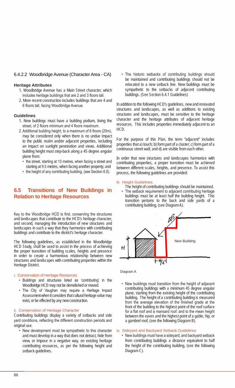
86
6.4.2.2 Woodbridge Avenue (Character Area - CA)
Heritage Attributes1. Woodbridge Avenue has a Main Street character, which
includes heritage buildings that are 2 and 3 floors tall.2. More recent construction includes buildings that are 4 and
6 floors tall, facing Woodbridge Avenue.
Guidelines1. New buildings must have a building podium, lining the
street, of 2 floors minimum and 4 floors maximum.2. Additional building height, to a maximum of 6 floors (20m),
may be considered only when there is no undue impact to the public realm and/or adjacent properties, including an impact on sunlight penetration and views. Additional building height must step-back along a 45 degree angular plane from: • the street, starting at 13 metres, when facing a street and
starting at 9.5 metres, when facing another property; and• the height of any contributing building, (see Section 6.5).
6.5 Transitions of New Buildings in Relation to Heritage Resources
Key to the Woodbridge HCD is first, conserving the structures and landscapes that contribute to the HCD’s heritage character, and second, managing the introduction of new structures and landscapes in such a way that they harmonize with contributing buildings and contribute to the district’s heritage character.
The following guidelines, as established in the Woodbridge HCD Study, shall be used to assist in the process of achieving the proper transition of building scales, heights and presence in order to create a harmonious relationship between new structures and landscapes with contributing properties within the Heritage District.
i. Conservation of Heritage Resources• Buildings and structures listed as ‘contributing’ in the
Woodbridge HCD may not be demolished or moved.• The City of Vaughan may require a Heritage Impact
Assessment when it considers that cultural heritage value may exist, or be effected by any new construction.
ii. Conservation of Heritage CharacterContributing buildings display a variety of setbacks and side yard conditions, reflecting the different construction periods and original use.
• New development must be sympathetic to this character and must develop in a way that does not detract, hide from view, or impose in a negative way, on existing heritage contributing resources, as per the following height and setback guidelines.
• The historic setbacks of contributing buildings should be maintained and contributing buildings should not be relocated to a new setback line. New buildings must be sympathetic to the setbacks of adjacent contributing buildings. (See Section 6.4.1 Guidelines)
In addition to the following HCD’s guidelines, new and renovated structures and landscapes, as well as additions to existing structures and landscapes, must be sensitive to the heritage character and the heritage attributes of adjacent heritage resources. This includes properties immediately adjacent to an HCD.
For the purpose of this Plan, the term “adjacent” includes properties that a) touch; b) form part of a cluster; c) form part of a continuous street wall; and d) are visible from each other.
In order that new structures and landscapes harmonize with contributing properties, a proper transition must be achieved between different scales, heights, and presence. To assist this process, the following guidelines are provided:
iii. Height Guidelines The height of contributing buildings should be maintained.• The setback requirement to adjacent contributing heritage
buildings must be at least half the building height. This transition pertains to the back and side yards of a contributing building, (see Diagram A).
• New buildings must transition from the height of adjacent contributing buildings with a minimum 45 degree angular plane, starting from the existing height of the contributing building. The height of a contributing building is measured from the average elevation of the finished grade at the front of the building to the highest point of the roof surface for a flat roof and a mansard roof; and to the mean height between the eaves and the highest point of a gable, hip, or a gambrel roof, (see the following Diagram B).
iv. Sideyard and Backyard Setback Guidelines• New buildings must have a sideyard, and backyard setback
from contributing buildings a distance equivalent to half the height of the contributing building, (see the following Diagram C).
Diagram A
New Building
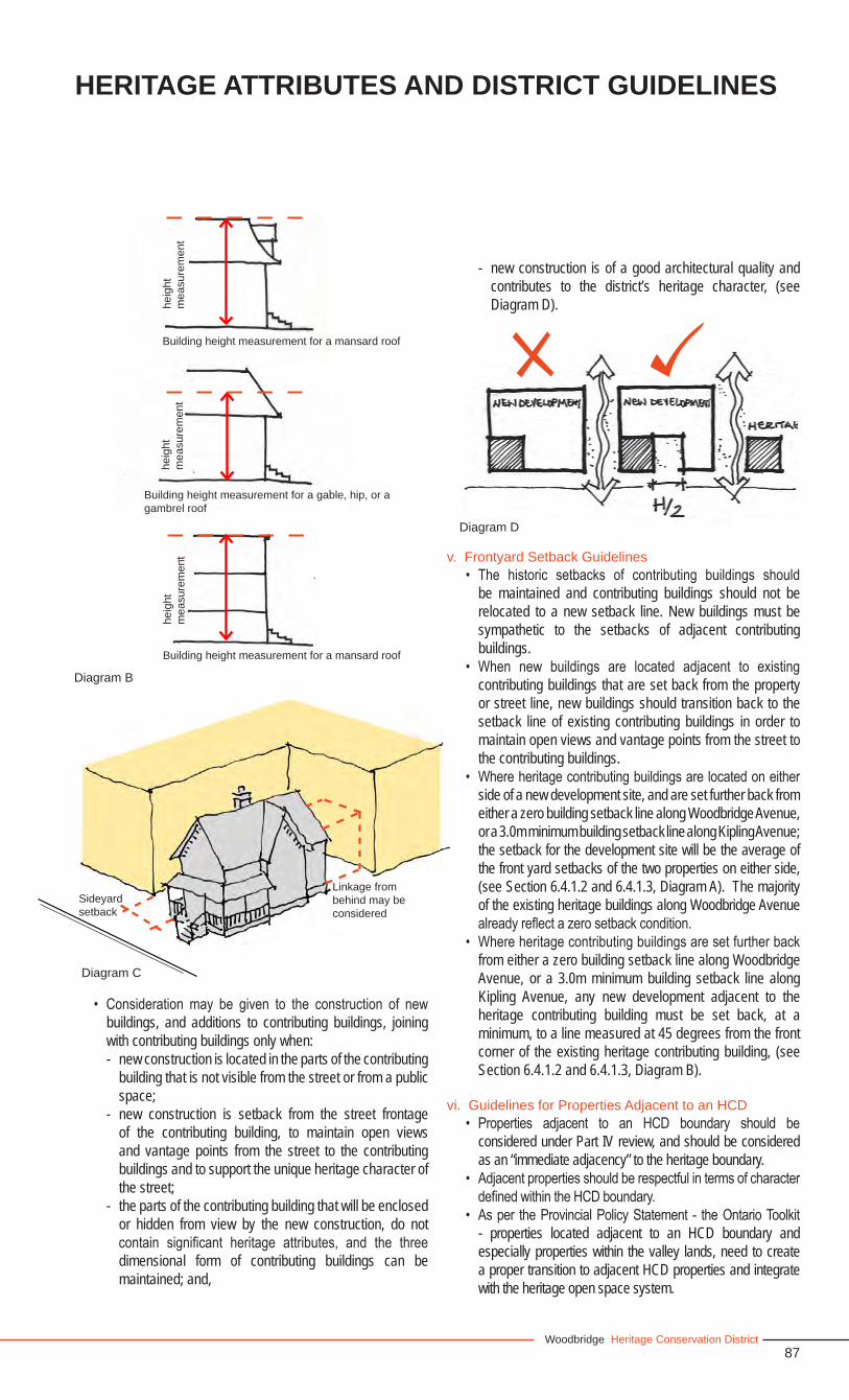
87Woodbridge Heritage Conservation District
HERITAGE ATTRIBUTES AND DISTRICT GUIDELINES
Linkage from behind may be considered
Sideyard setback
Diagram C
Diagram D
• Consideration may be given to the construction of new buildings, and additions to contributing buildings, joining with contributing buildings only when:- new construction is located in the parts of the contributing
building that is not visible from the street or from a public space;
- new construction is setback from the street frontage of the contributing building, to maintain open views and vantage points from the street to the contributing buildings and to support the unique heritage character of the street;
- the parts of the contributing building that will be enclosed or hidden from view by the new construction, do not contain significant heritage attributes, and the three dimensional form of contributing buildings can be maintained; and,
- new construction is of a good architectural quality and contributes to the district’s heritage character, (see Diagram D).
v. Frontyard Setback Guidelines• The historic setbacks of contributing buildings should
be maintained and contributing buildings should not be relocated to a new setback line. New buildings must be sympathetic to the setbacks of adjacent contributing buildings.
• When new buildings are located adjacent to existing contributing buildings that are set back from the property or street line, new buildings should transition back to the setback line of existing contributing buildings in order to maintain open views and vantage points from the street to the contributing buildings.
• Where heritage contributing buildings are located on either side of a new development site, and are set further back from either a zero building setback line along Woodbridge Avenue, or a 3.0m minimum building setback line along Kipling Avenue; the setback for the development site will be the average of the front yard setbacks of the two properties on either side, (see Section 6.4.1.2 and 6.4.1.3, Diagram A). The majority of the existing heritage buildings along Woodbridge Avenue already reflect a zero setback condition.
• Where heritage contributing buildings are set further back from either a zero building setback line along Woodbridge Avenue, or a 3.0m minimum building setback line along Kipling Avenue, any new development adjacent to the heritage contributing building must be set back, at a minimum, to a line measured at 45 degrees from the front corner of the existing heritage contributing building, (see Section 6.4.1.2 and 6.4.1.3, Diagram B).
vi. Guidelines for Properties Adjacent to an HCD• Properties adjacent to an HCD boundary should be
considered under Part IV review, and should be considered as an “immediate adjacency” to the heritage boundary.
• Adjacent properties should be respectful in terms of character defined within the HCD boundary.
• As per the Provincial Policy Statement - the Ontario Toolkit - properties located adjacent to an HCD boundary and especially properties within the valley lands, need to create a proper transition to adjacent HCD properties and integrate with the heritage open space system.
Building height measurement for a mansard roof
heig
ht
mea
sure
men
the
ight
m
easu
rem
ent
Building height measurement for a gable, hip, or a gambrel roof
Diagram B
heig
ht
mea
sure
men
t
Building height measurement for a mansard roof
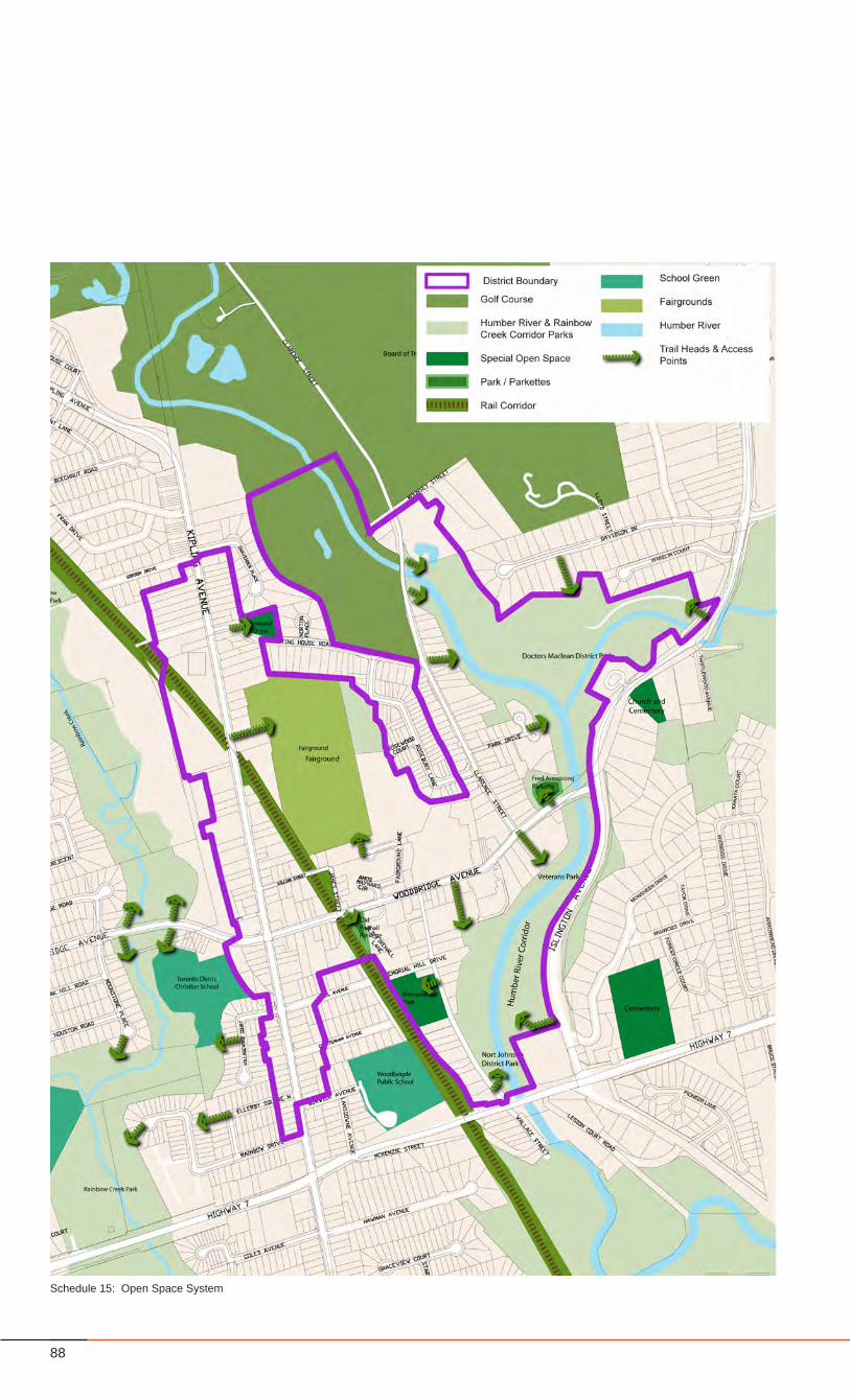
88
Schedule 15: Open Space System
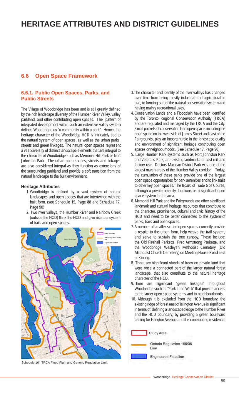
89Woodbridge Heritage Conservation District
6.6 Open Space Framework
6.6.1. Public Open Spaces, Parks, andPublic Streets
The Village of Woodbridge has been and is still greatly defined by the rich landscape diversity of the Humber River Valley, valley parkland, and other contributing open spaces. The pattern of integrated development within such an extensive valley system defines Woodbridge as “a community within a park”. Hence, the heritage character of the Woodbridge HCD is intricately tied to the natural system of open spaces, as well as the urban parks, streets and green linkages. The natural open spaces represent a vast diversity of distinct landscape elements that are integral to the character of Woodbridge such as Memorial Hill Park or Nort Johnston Park. The urban open spaces, streets and linkages are also considered integral as they function as extensions of the surrounding parkland and provide a soft transition from the natural landscape to the built environment.
Heritage Attributes1. Woodbridge is defined by a vast system of natural
landscapes and open spaces that are intertwined with the built form. (see Schedule 15, Page 88 and Schedule 17, Page 90)
2. Two river valleys, the Humber River and Rainbow Creek (outside the HCD) flank the HCD and give rise to a system of trails and open spaces.
3.The character and identity of the river valleys has changed over time from being mostly industrial and agricultural in use, to forming part of the natural conservation system and having mainly recreational uses.
4. Conservation Lands and a Floodplain have been identified by the Toronto Regional Conservation Authority (TRCA) and are regulated and managed by the TRCA and the City. Small pockets of conservation land open space, including the open space on the west side of James Street and east of the Fairgrounds, play an important role in the landscape quality and environment of significant heritage contributing open spaces or neighbourhoods. (See Schedule 17, Page 90)
5. Large Humber Park systems such as Nort Johnston Park and Veterans Park, are existing landmarks of past mill and factory use. Doctors Maclean District Park was one of the largest marsh areas of the Humber Valley corridor. Today, the cumulation of these parks provide one of the largest open space opportunities for park amenities and to link trails to other key open spaces. The Board of Trade Golf Course, although a private amenity, functions as a significant open space system for the area.
6. Memorial Hill Park and the Fairgrounds are other significant landmark and cultural heritage resources that contribute to the character, prominence, cultural and civic history of the HCD and need to be better connected to the system of parks, trails and open spaces.
7. A number of smaller-scaled open spaces currently provide a respite to the urban form, help weave the trail system, and serve to sustain the tree canopy. These include: the Old Firehall Parkette, Fred Armstrong Parkette, and the Woodbridge Wesleyan Methodist Cemetery (Old Methodist Church Cemetery) on Meeting House Road east of Kipling.
8. There are significant stands of trees on private land that were once a connected part of the larger natural forest landscape, that also contribute to the natural heritage character of the HCD.
9.There are significant “green linkages” throughout Woodbridge such as “Park Lane Walk” that provide access to the larger open space systems and to neighbourhoods.
10. Although it is excluded from the HCD boundary, the existing ridge of forest east of Islington Avenue is significant in terms of: defining a landscaped edge to the Humber River and the HCD boundary; by providing a green boulevard setting for Islington Avenue and the contributing residential
Schedule 16: TRCA Flood Plain and Generic Regulation Limit
HERITAGE ATTRIBUTES AND DISTRICT GUIDELINES
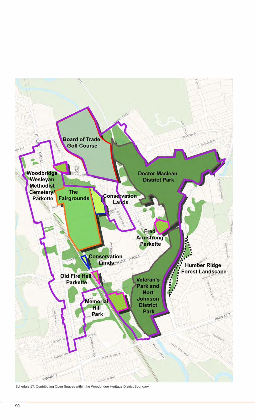
90
Schedule 17: Contributing Open Spaces within the Woodbridge Heritage District Boundary
91Woodbridge Heritage Conservation District
properties along the flats east of Islington Avenue; and by providing a natural landscaped view terminus from Woodbridge Avenue.
Guidelines1. The HCD Plan should conserve the inherent signature of
past environments, especially in the pattern and relationship of the open space to built form, and continue to promote Woodbridge as a community within a park.
2. The open spaces associated with the Humber River and Rainbow Creek river valleys must remain publicly accessible and connected through trails and pedestrian walkways and the natural setting of these landscapes must be respected and enhanced. New trail linkages and connections should be created where it is considered ecologically appropriate and would have to be reviewed by the TRCA.
3. The Humber River Corridor must be conserved and maintained as a significant natural system, remain publicly accessible, and accommodate passive open space recreational uses.
4. Any intervention in areas identified by TRCA as located within the flood line or as conservation lands (identified in Schedule 16) require the approval of the TRCA and the City of Vaughan. Natural conservation lands owned by the TRCA should be conserved.
5. Nort Johnston Park should become the hub of trail connections to the Humber Valley north, to the Woodbridge Core and to Wallace Street and Memorial Hill Park.
6. Accessibility to the park should be enhanced, especially from Woodbridge Avenue, Wallace Street, and Highway 7.
7. The landscape and features of Memorial Hill Park must be conserved, and public use and accessibility of the Park should be enhanced by improving the pedestrian linkages from Nort Johnston Park and potentially from Kipling Avenue via Abel Avenue, with a pedestrian bridge crossing over the rail corridor.
8. Existing small-scaled open spaces must be conserved. New small-scaled open spaces should be designed where possible. All open spaces must be publicly accessible, should be accessible from all directions and should be linked to the larger system of open spaces.
9. Existing “green linkages” throughout Woodbridge should be maintained and new opportunities should be established in various ways such as “wooden bridge” pedestrian connections over the rail corridor, in order to create a continuous “walk” throughout the HCD.
6.6.2 Pedestrian Circulation
The scale and development of Woodbridge has allowed it to be a walkable community throughout its history, with the ability to traverse the neighbourhoods, the core and the natural open
HERITAGE ATTRIBUTES AND DISTRICT GUIDELINES
space system via trails, streets and key linkages. There are opportunities to enhance circulation at a scale within the HCD as well as at a scale of the greater Woodbridge area that coincide with the proposed City of Vaughan’s Pedestrian and Bicycle Master Plan.
Heritage Attributes1. A system of trails has provided pedestrians, over the years,
a way to reach different open spaces, as well as a way to reach their places of residence, commerce, work, worship, and recreation.
2. Woodbridge Avenue and Meeting House Road provide the most significant east-west connection between the two sides of the river valleys.
3. Clarence Street and Wallace Street provide significant north-south connections and access to different parts of the Humber River Corridor and to the Woodbridge Core.
4. New north-south and east-west pedestrian connections should be sought and created wherever possible such as Memorial Hill Park to Abel Avenue, and the Fairgrounds to Rosewood Court, Rosebury Lane and James Street.
Guidelines1. All proposed trails within the area should connect to the
existing and proposed City of Vaughan’s Pedestrian and Bicycle Master Plan. Additional trails and trail connections identified on Schedule 18 (page 92) should be secured and created and must conform to the lay of the land and the vegetation pattern.
2. Woodbridge Avenue and Meeting House Road must be designed and managed to provide pedestrians with an attractive and safe connection, between public open spaces and the Woodbridge Core. New east-west pedestrian connections should be sought and created, wherever possible.
3. Clarence Street and Wallace Street must be designed and managed to provide pedestrians with an attractive and safe connection.
4. The accommodation of pedestrians will have priority over the accommodation of vehicles.
6.6.3 Tree Canopy and Vegetation
Much of the heritage “Village” character of Woodbridge derives from the character of the vegetation, landscape and topography. The conservation of mature vegetation, including trees and stands of trees is a key aspect of the HCD Plan as well as the conservation of the rolling land form, the remnant riverbeds and the distinct vegetative character that defines the valleylands. Most significant is the extensive tree canopy, which can be found in either:
1. stands of trees
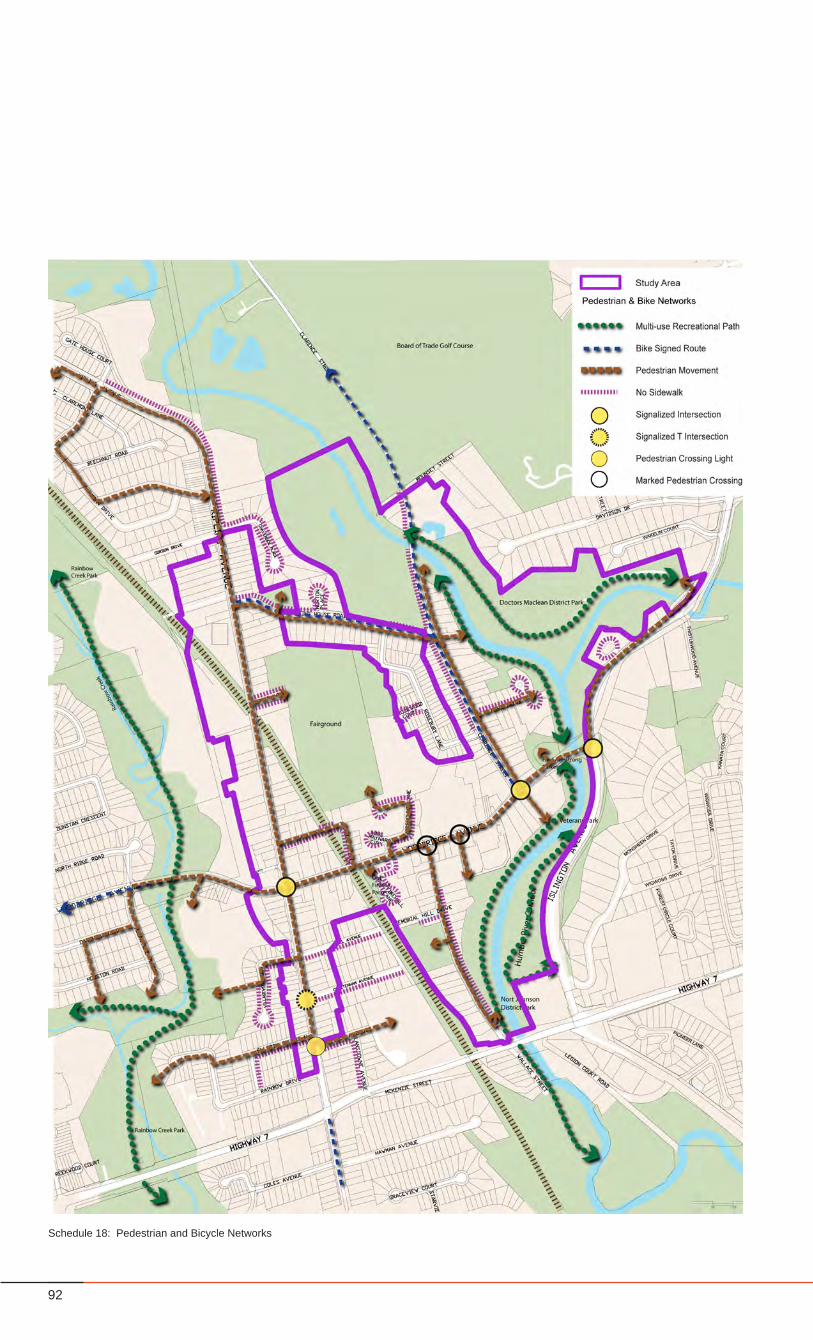
92
Schedule 18: Pedestrian and Bicycle Networks
93Woodbridge Heritage Conservation District
2. as part of the linear streetscape along the street right-of-way; or
3. as part of individual properties.
Heritage Attributes1. A substantial tree canopy and vegetation define the
character of Woodbridge and are found within the river corridors and the neighbourhoods that bound the river valleys, along the valley slopes of the Fairgrounds, the rail corridor, the golf course, and Memorial Hill Park. It is mainly these landscapes that play the largest role in contributing to the green character of Woodbridge.
2. The river valleys are defined by a diverse mixture of distinct landscapes and topography that represent and reflect the history of the area, particularly the mature stands of trees of the remnant forest, the flat grasslands and meadows that define the old river beds, and the cliff edges along the river banks.
3. There are selected areas such as Memorial Hill Park that have one of the few distinct remaining stands of Scots Pine within the study area, representative of the mature remnant forests of Woodbridge.
4. The natural and distinct rolling landscape of the area can be experienced through the views and topography of Meeting House Road Hill, Woodbridge Avenue and William Street Hill, as well as the stepped incline of Memorial Hill Park, and the sloped hillside of the Fairgrounds to the neighbourhood below.
Guidelines1. Existing natural forest stands or groupings of trees should
be conserved.2. Streetscapes should conserve the existing green canopy
and provide new tree planting where none exists, in order to create a continuous tree canopy along the street.
3. Trees on public and private property, having a tree diameter of twenty (20) centimetres or more or having a base diameter of twenty (20) centimetres or more, must be conserved, and the requirements of the City of Vaughan Tree Bylaw 185-2007 must be adhered to.
4. Prior to the issuance of a Heritage Permit, Building Permit or Site Plan approval, a tree conservation plan is required to be submitted and approved by the City.
5. An on-going tree maintenance and replacement strategy should be developed in order to maintain the extensive forest canopy, especially as maturing trees start to show signs of deterioration or stress.
6. The natural setting of the river valleys must be respected and maintained, and an on going planting strategy to protect and enhance the river’s edge and banks, and protect the scenic qualities should be established.
7. Existing natural topographical features and remnant
landscape forms such as the hills, the old river beds mainly evident within the Clarence Street Character Area and Nort Johnson Park, as well as the forested hillsides of Memorial Hill Park and surrounding the Fairgrounds, that reflect and contribute to the historic landscape and character of Woodbridge, should be preserved and maintained.
8. The forested character should be encouraged to expand within the urban context, within the neighbourhoods and especially along streets or trail routes in order to create a continuous system of open spaces, provide a “soft” transition to the built form and ensure that Woodbridge is continuously planned as “a community within a park setting”.
6.6.4 Views and Landmarks
The rolling topography of Woodbridge creates opportunities for frequent views into the valley, and up towards the surrounding hills. There are also key views to heritage landmark features and open spaces such as the bridges, the Fairgrounds and the memorial structures that are scattered throughout the District. The preservation of key views, view corridors, and landmarks are integral to ensuring the visibility and experience of heritage resources and in making them as accessible as possible.
Heritage Attributes1. Most of the important views take in the Humber River open
space resource and the heritage features that are part of that system.
2.There are several special landmark features that range from buildings, memorials, open spaces, and bridges. Some are only visually accessible from certain areas such as Memorial Hill Park. Others are hidden gems within the valley system.
Guidelines1. All views to the river valleys and to key sites as defined
on the adjacent map (Schedule 19: Views, Landmarks and Bridges) should be maintained and protected. Key view corridors, some of which are identified on Schedule 19, should remain open and free from obstruction.
3. Opportunities to identify key views in trail signage and in other mediums such as heritage mapping or as part of streetscaping measures should be considered.
4. The pedestrian and bike network should be integrated in order to experience the key views and view corridors within the District.
5. Additional view points and view corridors to natural features, to special landmarks, and to open spaces should be sought where possible and protected.
6. Further study and inventory of important views throughout Woodbridge should be undertaken at a later date as an addition to this Plan, to ensure that they are protected and conserved.
HERITAGE ATTRIBUTES AND DISTRICT GUIDELINES
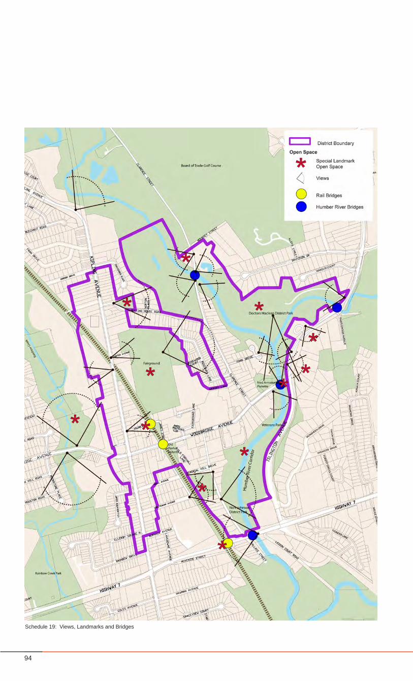
94
Schedule 19: Views, Landmarks and Bridges
95Woodbridge Heritage Conservation District
6.7 Urban Design
6.7.1 Roads, Curbs, Sidewalks and Streetscape
Several of the roads within Woodbridge are significant in defining the heritage character of Woodbridge and contribute in terms of function and layout as per the following descriptions:
• Kipling Avenue – the Heritage Avenue • Woodbridge Avenue – the Commercial Main Street• Meeting House Road – the Valley Drive• Clarence Avenue – the Park Drive• William and James Street, Wallace Street – Key
Neighbourhood Scale Roads• Neighbourhood Streets
Meeting House Road, Clarence Street, Woodbridge Avenue and Kipling Avenue together form a “Heritage Loop” – a key circulatory route within Woodbridge, connecting the Woodbridge Core to the western neighbourhoods and to Kipling Avenue. These streets are defined by the majority of the heritage fabric that characterizes Woodbridge and are used as a neighbourhood walking trail.
Heritage Attributes1. Kipling Avenue is the main north south route through
Woodbridge and can be defined as a “picturesque heritage avenue” that strongly supports the village qualities of Woodbridge, having a high percentage of 2-3 storey individual heritage contributing buildings that are generously spaced with deep front yards and varying setbacks, and a mature tree canopy for the most part. The avenue has a 20 metre right-of-way with generous sidewalks and some areas of mature remnant forest trees.
2. Woodbridge Avenue is the “commercial main street” of Woodbridge and is defined by a 20 metre right-of-way, with on-street parking at the commercial core, and zero building setbacks with the exception of several heritage buildings with deeper setbacks. The avenue is a mixture of old and new buildings with varying building heights from 2-3 storeys to 4-6 storeys in certain areas, with retail at grade. The commercial core is defined by special street paving along the sidewalks and the street crossings, and where there are pedestrian linkages to the river valley.
3. Meeting House Road is the “valley drive” of Woodbridge reflecting the natural topography characteristic of the valley lands, connecting the ridge of Kipling Avenue to the valley setting of Clarence Street. Meeting House Road is one of the “greenest” streets of the area, reflecting a significant amount of the mature forest landscape and providing views of the valley and the rolling hills. Meeting House Road also has a 20 metre right-of-way, including two travel lanes, and generous sidewalks and setbacks.
4. Clarence Street is characteristic of a “park drive” at a residential street scale. The narrow 17 metre right-of-way
with a two lane 8.5 metre roadway and the close proximity of buildings to street edge on the east side makes this street feel quite narrow and pedestrian in character. A good portion of the buildings on the east side are heritage contributing buildings and a considerable portion of the street is fronted by the Humber River Valley. The sidewalk along this street is discontinuous especially where it meets the valley edge.
5. William Street, James Streets, and Wallace Street are “neighbourhood streets” that are quite intimate in character and represent a prominence of heritage fabric. These streets are small in scale with setbacks that are generally tight to the street, and discontinuous sidewalks. These streets are more rural in character and private in nature having a continuous interplay of private manicured landscapes with the natural parkland and the close proximity of building face to the sidewalks – a character also prevalent on the east side of Clarence Street. These streets function as key linkages to the parklands and major open spaces.
Guidelines1. Kipling Avenue
• Should have a continuous planting of street trees on either side of the street and incorporate existing mature trees.
• Should have a continuous sidewalk on both sides of the street and should be set back from the roadway and buffered by a green planting edge where possible.
• Special paving materials should be used at key intersections and pedestrian oriented nodes.
• The street cross section should be maintained as a three to four lane roadway and allow for various modes of transit such as buses and bicycles, as well as on street parking.
• Properties with extensive front yards should remain transparent to the street and should be enhanced with gardens allowing for additional tree planting and landscaping.
• Dedicated left hand and right hand turn lanes should be avoided with the exception of the Kipling Avenue and Woodbridge Avenue intersection.
2. Woodbridge Avenue• Should continue to function as a mixed use commercial
street and promenade with commercial animation at grade.
• The street section should reflect a more formal landscape treatment and tree planting design that responds to at-grade retail amenities such as building shade canopies, cafe furnishings and ease of pedestrian movement. The sidewalks should have special paving to enhance the identity of the commercial core, and gateway treatments at the Kipling Avenue and Woodbridge intersection.
HERITAGE ATTRIBUTES AND DISTRICT GUIDELINES
96
• The sidewalks should be primarily hard surfaced to accommodate pedestrian traffic and there should be continuous sidewalk on both sides of the street.
• Should have a continuous enhanced paving treatment and palate of furnishings such as special lighting standards and benches that demarcate it as a “special street” and enhances the identity of the Woodbridge Core.
• Should accommodate on street parking where possible.
Meeting House Road, Clarence Street, Park Drive, William Street, James Street, and Wallace Street are unique and share different characteristics to that of Kipling Avenue and Woodbridge Avenue. These streets have strictly residential “street walls” intermixed with open space frontages, have small scale intimate street cross-sections, are less formal in streetscaping characteristics, have more “soft” landscaping qualities because of their relation to the river valley landscape and topography, and have a discontinuous double sided sidewalk condition. All buildings are single free standing structures of varying setbacks that seem to be “engulfed” in the forest landscape.
All of these streets have a single sided sidewalk cross-section for at least half of their street lengths, (see Schedule 18: Pedestrian and Bicycle Networks), and in all cases, have a relationship to the Humber River valley landscape. A change in sidewalk condition usually occurs where the river corridor meets the street edge. These streets are some of the oldest in Woodbridge’s street pattern and the single sided sidewalk attribute should be maintained as it reflects the remnant village character.
All new streets within the District should have a continuous double sided sidewalk condition.
3. Meeting House Road• Should be maintained as the main connection to the
valley from Kipling Avenue with a continuous planting of street trees set within a green planting edge.
• Additional tree planting should be encouraged on private property to contribute to the green canopy of the street.
• Views down to the valley from the top of the hill should be maintained and remain unobstructed.
4. Clarence Street and Park Drive• Should be maintained as a “Park Drive” with a two
travel lane cross section.• Should have a continuous planting of street trees. • Additional tree panting should be encouraged on
private property especially where street trees cannot be accommodated within the right-of-way.
5. William, James, Wallace Streets • Retain the small scale intimate and casual character
of the streets, maintaining a two lane roadway with streetscape parking.
• Should maintain open space linkages to Nort Johnston Park and the Fairgrounds.
• Should have a continuous planting of street trees on both sides of the street.
• Additional tree panting should be encouraged on private property, especially where street trees cannot be accommodated within the right-of-way.
6. All other residential streets• The same guidelines established for the above streets
should be applied. • For all other residential streets, a continuous double
sided sidewalk condition is recommended.7. Topography
• Maintain the alignment and hilled character of Meeting House Road, William Street, and Woodbridge Avenue in order to maintain the visual and physical experience of the rolling topography and the valley lands.
6.7.2 Street Furniture and PedestrianAmenities
• In order to maintain a consistent character and identity for Woodbridge, a palate of high quality durable materials should be established for street furnishing and pedestrian amenities such as benches, tree grates, garbage receptacles, bike racks, newspaper stands, bus shelters, signage as well as lighting standards and street paving materials and should reflect color and style uniformity as well as ease of maintenance.
• Any existing furnishings or characteristics may be of value should be retrofitted and incorporated into new design. The language of materials should be coordinated but should also vary to some degree to reflect the distinct characteristics of the different character areas, streets and old and new architecture. For example, a more formal and public approach to furnishing and paving materials should be applied to Woodbridge Avenue such as providing benches and bike racks; a formal rhythm of street tree planting to accommodate street furniture, pedestrian movement and provide shade; and using paving materials to define the avenue as a distinct public commercial area. A more scaled down and intimate approach should be considered for residential streets where the emphasis should be placed on maximizing the amount of “green” along the street, in terms of street tree and boulevard planting, and increasing the natural forest canopies and landscapes.
6.7.3 Street Trees
• In general, all streets should be well planted with street trees to enhance the green character of the District and extend the character of the surrounding parkland.
97Woodbridge Heritage Conservation District
• Further to this, the type, use, language and location of street trees should be carefully considered to support and enhance the heritage character and attributes that are fundamental to each street type as described in the above section 6.7.1. For example, streets such as Kipling Avenue that are considered “park drives” should, where the right-of-way allows, have a staggered double row of street tree planting. Clarence Street should also have a single row of trees that can provide a complete overhead canopy.
• Trees along commercial streets such as Woodbridge Avenue should be planted at grade, with urban street tree planting techniques that provide longevity to trees in a more urban and traversed context, including trench planting. It is important for streets such as Woodbridge Avenue with building heights up to six storeys, to have street trees that provide human scale comfort to the street.
6.7.4 Signage
• Should be expressive of the character and quality of Woodbridge, but designed to respectfully fit its “village” context, without being too idiosyncratic or “quaint”.
• Should be designed to direct visitors and the community to hidden features, heritage gems, and key built and open space features throughout Woodbridge.
• Should be used for wayfinding of trail and pedestrian routes such as the Woodbridge “heritage walk loop” and routes to the valley system.
• Commercial signage should be limited to ground level uses along woodbridge Avenue and Kipling Avenue and should remain flush with the building facade. Back-lit signage and third party signage are prohibited within the HCD.
6.7.4.1 Signage By-Law
The City of Vaughan By-Law 203-92 regulates signage in the City. Section 11 of the By-Law establishes “Special Sign Districts” in Thornhill, Kleinberg, Woodbridge, and Maple. Woodbridge should continue to be designated a Special Sign District.• The Woodbridge Special Sign District should be amended
to include the entire boundary of the Woodbridge Heritage Conservation District.
• The Sign By-Law should be amended to strengthen its protection of the heritage character in the Heritage District. In particular, internally illuminated signs and awnings should be required to be retractable, in the traditional profile and material.
• The Sign By-Law should be enforced
6.7.5 Street Lighting
• A hierarchy of street lighting standards should be established for the various street types and character areas to accommodate varying conditions such as pedestrian scaled lighting along more pedestrian oriented streets or trail walks, or a combination of pedestrian and vehicular lighting for the main streets.
• Placement of lighting should be coordinated and in keeping with the rhythm and placement of other streetscape features such as street trees, benches and other furnishings.
• Placement and style of lighting should achieve the necessary level of illumination required for the given streetscape and area.
• The style of lighting should be respectful of the heritage character of Woodbridge and should vary in scale according to the type and character of the street.
• Along Woodbridge Avenue and Kipling Avenue both street lighting and pedestrian scaled lighting should be applied as part of the streetscape furnishing and should also accommodate opportunities for additional features such as banners, signage or plant material.
• More pedestrian scaled lighting standards should be applied for Clarence Street, Wallace Street, William Street and James Street, and should also have the potential for additional embellishment that could provide unique features for the different character areas.
6.7.6 Parking
• On street parking is allowed along the main commercial and mixed use streets: Kipling Avenue and Woodbridge Avenue.
• Where the right-of-way permits, on street parking should be accommodated on one side of residential streets: Wallace Avenue, Clarence Street.
• As intensification occurs, publicly accessible structured parking along Woodbridge Avenue should be considered.
• On-site parking, including structured parking should not be visible from the street or from public spaces. Parking areas should be concealed and buffered with buildings with active uses.
6.7.7 Bridges(See Schedule 13, Page 68)
In 1855 the name “Woodbridge” was chosen for the settlement partially due to the number of wooden bridges within the community that were needed to cross the Humber River and tributaries running through the area. There are two distinct types
HERITAGE ATTRIBUTES AND DISTRICT GUIDELINES

98
of bridges present within the Woodbridge Heritage Boundary today:
• two C.P.R. bridge crossings – over William Street and at Woodbridge Avenue.
• three Humber River vehicular and pedestrian bridge crossings – Clarence Street north, at Woodbridge and Islington Avenues, and Islington Avenue north.
Heritage Attribute1. The bridges and concept of “bridging” is an inherent part
of the historical infrastructure that represents Woodbridge due to the natural landscape of the Humber River.
2. The bridges contribute as special features within the Heritage district and can typically be viewed and experienced in the context of the forested landscape.
3. The bridges provide opportunities to view the valley landscape, are an integral part of the valley trail experience in terms of scenic views, and function as unique art forms within the landscape.
Guidelines1. The rail bridges in Woodbridge have an historic quality
and should be maintained, and existing pedestrian access should also be maintained.
C.P. Rail Bridges Humber River Bridges
2. The Humber River bridges identified in Schedule 19 are fairly new and have minimal heritage character. If these bridges are ever replaced, bridges with some symbolic reference or artistic “heritage” quality should be considered.
3. Recognition of the original Humber River bridges should be considered in the form of signage or plaques, and should be provided at the original bridge locations or on the bridges that are still in or near the original locations.

99Woodbridge Heritage Conservation District
7.1 A Conservation Plan
7.0 HERITAGE BUILDINGS
The conservation of heritage buildings requires a sensitive and informed understanding of the building’s design, construction methods, history, and context. A Conservation Plan should be undertaken prior to any intervention in a heritage building, and as a means to prolong the building’s life span. A Conservation Plan undertaken by a qualified professional will provide valuable documentation of heritage resources and provide property owners with the necessary tools and knowledge to properly care for their buildings.
When undertaking heritage conservation work, this plan recommends following the Federal Standards and Guidelines for Heritage Conservation. An additional level of guidelines is provided in this section to inform conservation work within the Woodbridge HCD. These include guidelines for:
• Brick or Terra Cotta Masonry• Stone Masonry• Foundation• Traditional Stucco Siding• Wood Siding• Roofing• Gable Ends and Dormer Windows• Windows and Shutters• Doors• Porches• Projections• Paint• Gutters and Rain Water Leaders• Fences• Commercial Signages• Storefronts
Reference should be made to historical photos or other documentary evidence when available in order to gain information on a building’s elements, details and materials.
7.1.1 Brick Masonry
Historic Characteristics
Historically, brick was a popular choice for a permanent home, because it is durable, flexible, fireproof and attractive with various colours and shapes to choose from.
Brick is historically structural or loadbearing. Generally a wall consists of two wythes or rows of brick bonded together by ‘headers’ (bricks placed front to back across the two wythes). In larger or taller buildings there may be 3 or more wythes.
Surface patterns in brick walls are the result of this bonding. Bonding patterns fall into types by common usage (common bond, English bond, Flemish bond and so on). Further decorative work such as diaper work (diamond patterns on a brick wall) or brick shapes add interest to more sophisticated brick buildings.
The use of brick as a veneer started in the mid 20th century. In these buildings no bonding is visible and bricks are laid only in stretcher coursing. However, some historic brick walls appear to be veneer, but in fact have hidden bonding, and are actually traditional loadbearing brick walls, with two or more wythes of thickness.
Brick is damaged by: freezing and thawing when wet (ice action fractures the brick surface); rising damp (water drawn into the brick from damp soil); physical overload (causes crushing or fracturing); building movement (leads to cracking), aging (where mortar has weathered and lost its binders and strength) and improper installation or repair (pointing mortar is too hard).
Brick was very soft in early days of production and became harder and more colourful as industrial processes matured in the later 19th and early 20th Century.
Terra cotta is the name given to fired clay units that are generally very decorative, larger in scale often imitate stone and are generally hollow. They were built into walls as decorative items such as capitals, brackets, cornices and so on. Brick or terra cotta are attractive and enduring products which are essential character defining elements of a historic masonry building.
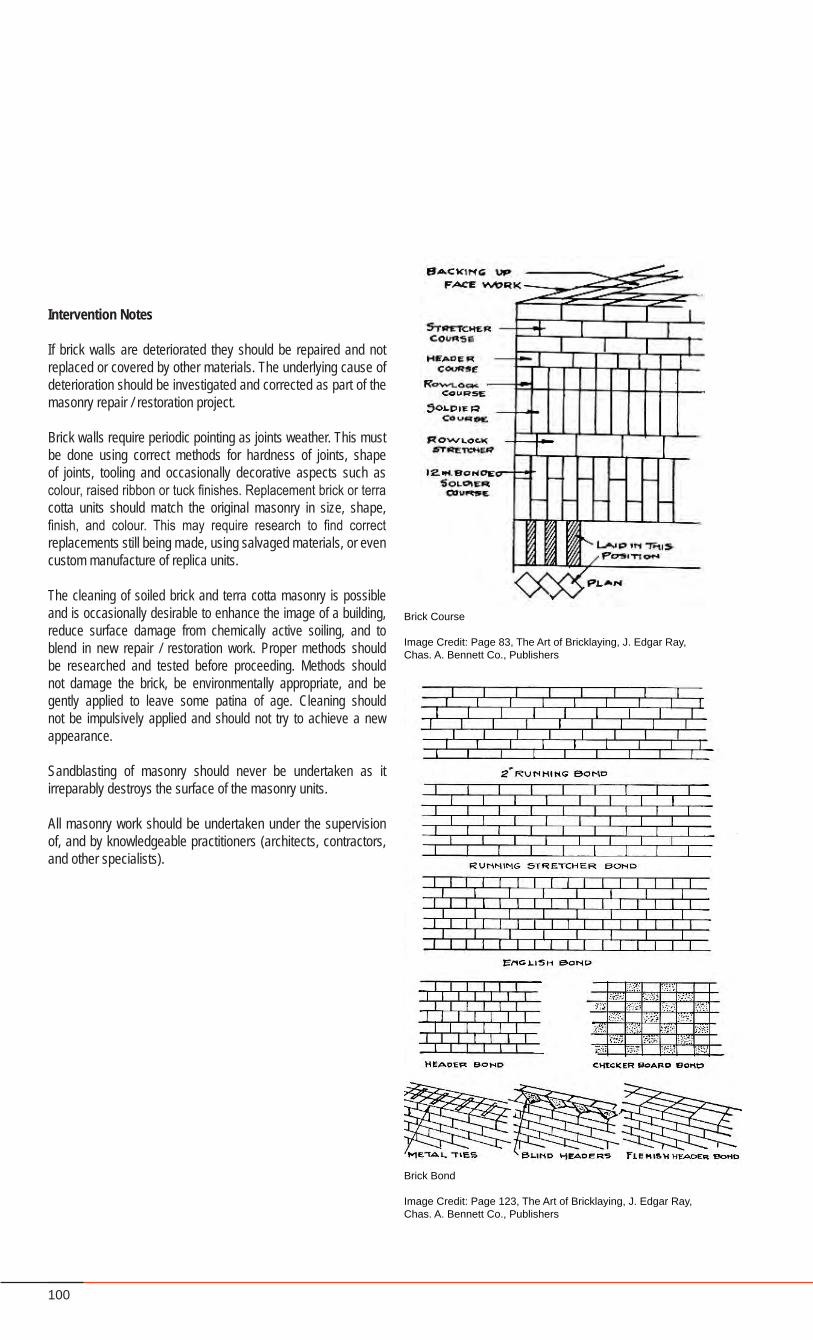
100
Intervention Notes
If brick walls are deteriorated they should be repaired and not replaced or covered by other materials. The underlying cause of deterioration should be investigated and corrected as part of the masonry repair / restoration project.
Brick walls require periodic pointing as joints weather. This must be done using correct methods for hardness of joints, shape of joints, tooling and occasionally decorative aspects such as colour, raised ribbon or tuck finishes. Replacement brick or terra cotta units should match the original masonry in size, shape, finish, and colour. This may require research to find correct replacements still being made, using salvaged materials, or even custom manufacture of replica units.
The cleaning of soiled brick and terra cotta masonry is possible and is occasionally desirable to enhance the image of a building, reduce surface damage from chemically active soiling, and to blend in new repair / restoration work. Proper methods should be researched and tested before proceeding. Methods should not damage the brick, be environmentally appropriate, and be gently applied to leave some patina of age. Cleaning should not be impulsively applied and should not try to achieve a new appearance.
Sandblasting of masonry should never be undertaken as it irreparably destroys the surface of the masonry units.
All masonry work should be undertaken under the supervision of, and by knowledgeable practitioners (architects, contractors, and other specialists).
Brick Course
Image Credit: Page 83, The Art of Bricklaying, J. Edgar Ray, Chas. A. Bennett Co., Publishers
Brick Bond
Image Credit: Page 123, The Art of Bricklaying, J. Edgar Ray, Chas. A. Bennett Co., Publishers
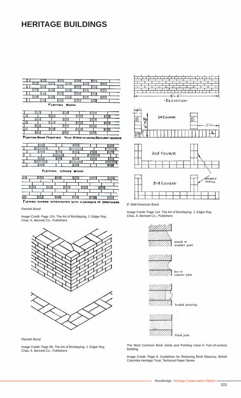
101Woodbridge Heritage Conservation District
Heritage Buildings
Flemish Bond
Image Credit: Page 99, The Art of Bricklaying, J. Edgar Ray, Chas. A. Bennett Co., Publishers
8” Wall American Bond
Image Credit: Page 114, The Art of Bricklaying, J. Edgar Ray, Chas. A. Bennett Co., Publishers
Flemish Bond
Image Credit: Page 124, The Art of Bricklaying, J. Edgar Ray, Chas. A. Bennett Co., Publishers
The Most Common Brick Joints and Pointing Used in Turn-of-century Building
Image Credit: Page 8, Guidelines for Restoring Brick Masonry, British Columbia Heritage Trust, Technical Paper Series
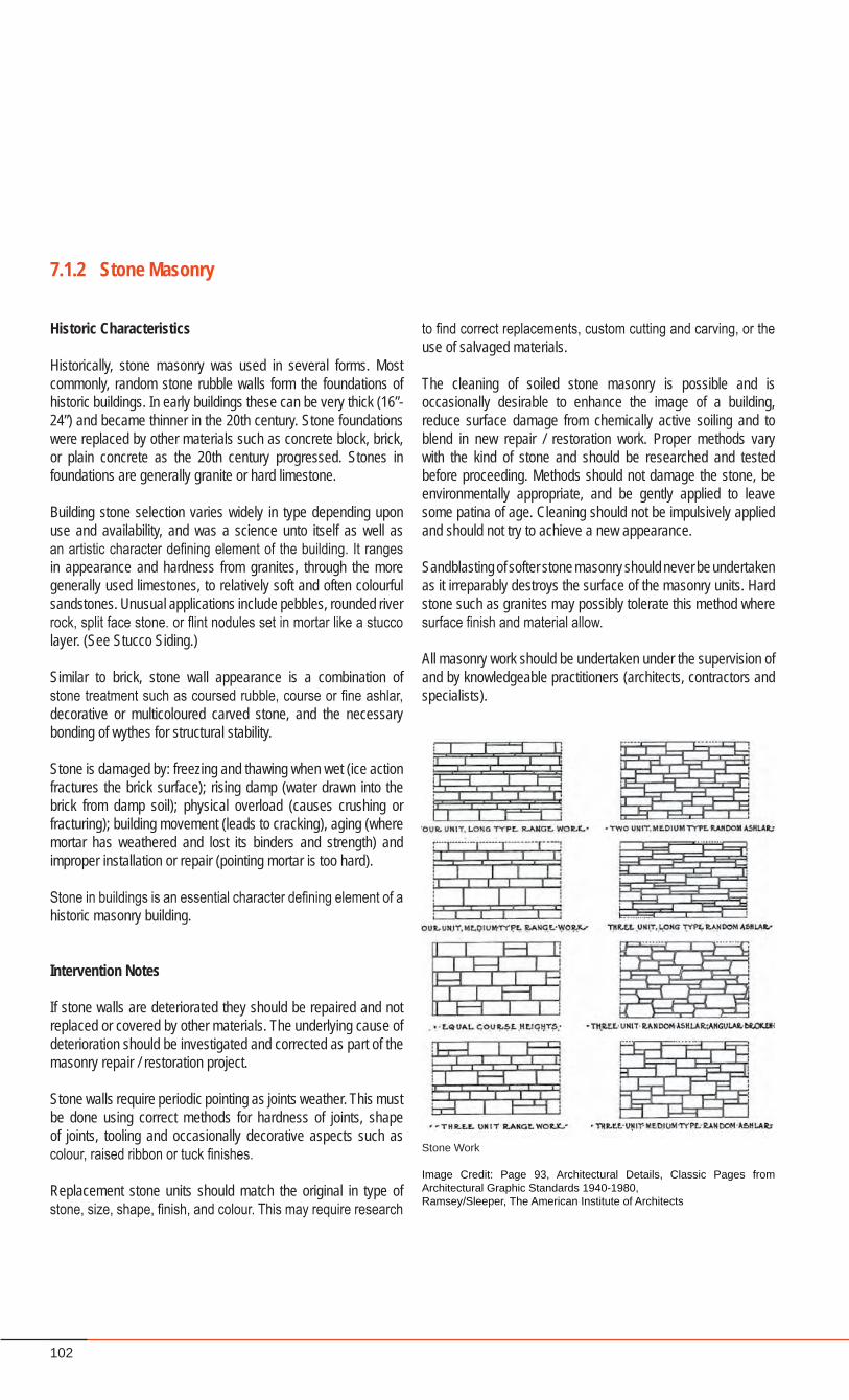
102
Historic Characteristics
Historically, stone masonry was used in several forms. Most commonly, random stone rubble walls form the foundations of historic buildings. In early buildings these can be very thick (16”-24”) and became thinner in the 20th century. Stone foundations were replaced by other materials such as concrete block, brick, or plain concrete as the 20th century progressed. Stones in foundations are generally granite or hard limestone.
Building stone selection varies widely in type depending upon use and availability, and was a science unto itself as well as an artistic character defining element of the building. It ranges in appearance and hardness from granites, through the more generally used limestones, to relatively soft and often colourful sandstones. Unusual applications include pebbles, rounded river rock, split face stone. or flint nodules set in mortar like a stucco layer. (See Stucco Siding.)
Similar to brick, stone wall appearance is a combination of stone treatment such as coursed rubble, course or fine ashlar, decorative or multicoloured carved stone, and the necessary bonding of wythes for structural stability.
Stone is damaged by: freezing and thawing when wet (ice action fractures the brick surface); rising damp (water drawn into the brick from damp soil); physical overload (causes crushing or fracturing); building movement (leads to cracking), aging (where mortar has weathered and lost its binders and strength) and improper installation or repair (pointing mortar is too hard).
Stone in buildings is an essential character defining element of a historic masonry building.
Intervention Notes
If stone walls are deteriorated they should be repaired and not replaced or covered by other materials. The underlying cause of deterioration should be investigated and corrected as part of the masonry repair / restoration project.
Stone walls require periodic pointing as joints weather. This must be done using correct methods for hardness of joints, shape of joints, tooling and occasionally decorative aspects such as colour, raised ribbon or tuck finishes.
Replacement stone units should match the original in type of stone, size, shape, finish, and colour. This may require research
7.1.2 Stone Masonry
to find correct replacements, custom cutting and carving, or the use of salvaged materials.
The cleaning of soiled stone masonry is possible and is occasionally desirable to enhance the image of a building, reduce surface damage from chemically active soiling and to blend in new repair / restoration work. Proper methods vary with the kind of stone and should be researched and tested before proceeding. Methods should not damage the stone, be environmentally appropriate, and be gently applied to leave some patina of age. Cleaning should not be impulsively applied and should not try to achieve a new appearance.
Sandblasting of softer stone masonry should never be undertaken as it irreparably destroys the surface of the masonry units. Hard stone such as granites may possibly tolerate this method where surface finish and material allow.
All masonry work should be undertaken under the supervision of and by knowledgeable practitioners (architects, contractors and specialists).
Stone Work
Image Credit: Page 93, Architectural Details, Classic Pages from Architectural Graphic Standards 1940-1980, Ramsey/Sleeper, The American Institute of Architects
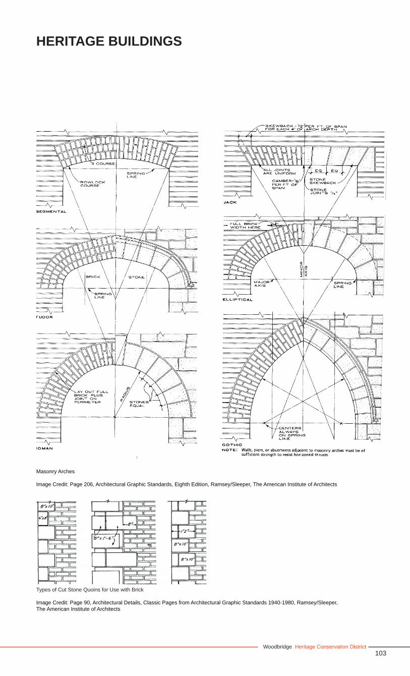
103Woodbridge Heritage Conservation District
Heritage Buildings
Masonry Arches
Image Credit: Page 206, Architectural Graphic Standards, Eighth Edition, Ramsey/Sleeper, The American Institute of Architects
Types of Cut Stone Quoins for Use with Brick
Image Credit: Page 90, Architectural Details, Classic Pages from Architectural Graphic Standards 1940-1980, Ramsey/Sleeper, The American Institute of Architects
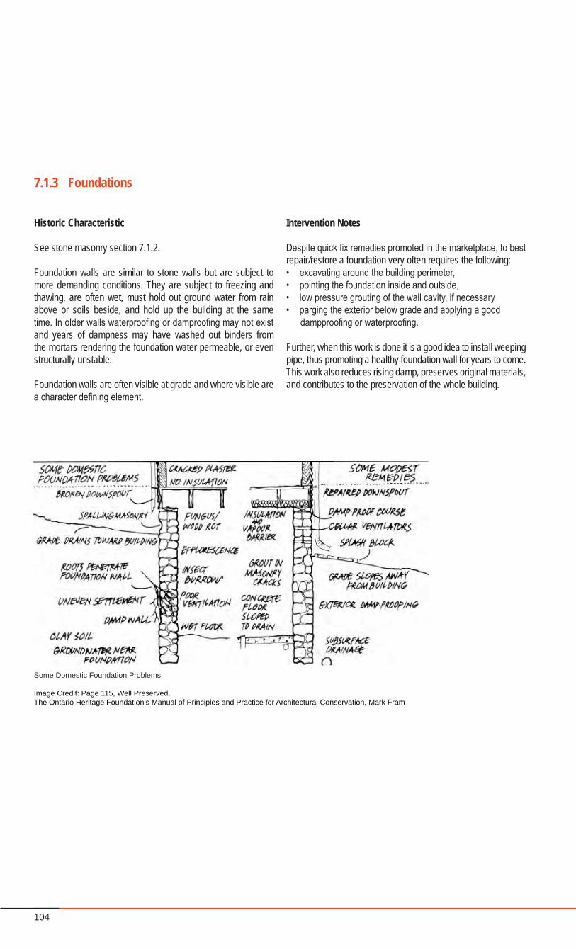
104
Historic Characteristic
See stone masonry section 7.1.2.
Foundation walls are similar to stone walls but are subject to more demanding conditions. They are subject to freezing and thawing, are often wet, must hold out ground water from rain above or soils beside, and hold up the building at the same time. In older walls waterproofing or damproofing may not exist and years of dampness may have washed out binders from the mortars rendering the foundation water permeable, or even structurally unstable.
Foundation walls are often visible at grade and where visible are a character defining element.
7.1.3 Foundations
Some Domestic Foundation Problems
Image Credit: Page 115, Well Preserved, The Ontario Heritage Foundation’s Manual of Principles and Practice for Architectural Conservation, Mark Fram
Intervention Notes
Despite quick fix remedies promoted in the marketplace, to best repair/restore a foundation very often requires the following:• excavating around the building perimeter, • pointing the foundation inside and outside, • low pressure grouting of the wall cavity, if necessary • parging the exterior below grade and applying a good dampproofing or waterproofing.
Further, when this work is done it is a good idea to install weeping pipe, thus promoting a healthy foundation wall for years to come. This work also reduces rising damp, preserves original materials, and contributes to the preservation of the whole building.
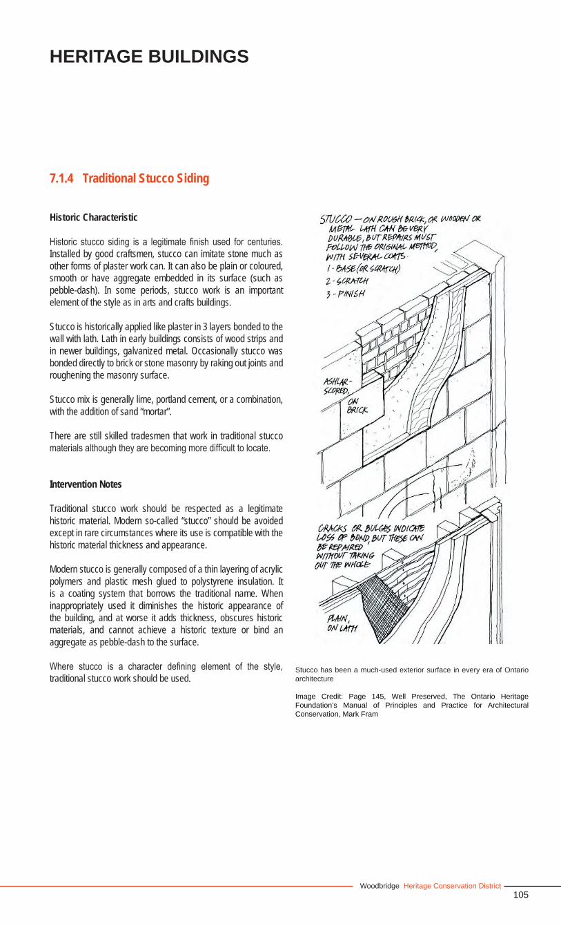
105Woodbridge Heritage Conservation District
Heritage Buildings
Historic Characteristic
Historic stucco siding is a legitimate finish used for centuries. Installed by good craftsmen, stucco can imitate stone much as other forms of plaster work can. It can also be plain or coloured, smooth or have aggregate embedded in its surface (such as pebble-dash). In some periods, stucco work is an important element of the style as in arts and crafts buildings.
Stucco is historically applied like plaster in 3 layers bonded to the wall with lath. Lath in early buildings consists of wood strips and in newer buildings, galvanized metal. Occasionally stucco was bonded directly to brick or stone masonry by raking out joints and roughening the masonry surface.
Stucco mix is generally lime, portland cement, or a combination, with the addition of sand “mortar”.
There are still skilled tradesmen that work in traditional stucco materials although they are becoming more difficult to locate.
Intervention Notes
Traditional stucco work should be respected as a legitimate historic material. Modern so-called “stucco” should be avoided except in rare circumstances where its use is compatible with the historic material thickness and appearance.
Modern stucco is generally composed of a thin layering of acrylic polymers and plastic mesh glued to polystyrene insulation. It is a coating system that borrows the traditional name. When inappropriately used it diminishes the historic appearance of the building, and at worse it adds thickness, obscures historic materials, and cannot achieve a historic texture or bind an aggregate as pebble-dash to the surface.
Where stucco is a character defining element of the style, traditional stucco work should be used.
7.1.4 Traditional Stucco Siding
Stucco has been a much-used exterior surface in every era of Ontario architecture
Image Credit: Page 145, Well Preserved, The Ontario Heritage Foundation’s Manual of Principles and Practice for Architectural Conservation, Mark Fram

106
Historic Characteristic
Ontario is a region traditionally rich in wood resources. As such, buildings of all periods and most styles have included a version based on wood siding. The use of wood in these buildings is an important character defining element.
Wood siding is primarily of two types, horizontal clapboarding or its variations and vertical board and batten siding. In some periods wood shingles were used as siding, often in panels such as gable ends or dormers (Queen Anne Revival or Arts and Crafts).
Wood siding is generally paint finished, however for shingle siding, stain and or oil were occasionally used.
Wood siding deteriorates by rotting from poor or failed detailing allowing water to penetrate the system; animal attacks (squirrels, bats, raccoons), physical damage, weathering and erosion. Well maintained wood siding can last a very long time, sometimes in excess of 100 years.
Intervention Notes
Where wood siding is in restorable or reusable condition it should be repaired and maintained. New pieces can be made to match existing profiles, and many historic profiles such as channel siding and wood shingles still exist. Maintaining roofing details, flashings, and sealants, protective coatings, and paint, is essential to long term survival.
Where it is necessary to replace fully deteriorated siding, new siding of matching material and profiles should be installed.
Imitation materials are often promoted for traditional material replacement. These include aluminium and vinyl siding and various cement board products. These should be avoided. When applied over historic wood materials they can disguise various forms of ongoing deterioration, on occasion promote deterioration by trapping moisture. They always diminish the historic appearance of the building.
7.1.5 Wood Siding
Some Types of Wood Siding
Image Credit: Page 137, Well Preserved, The Ontario Heritage Foundation’s Manual of Principles and Practice for Architectural Conservation, Mark Fram
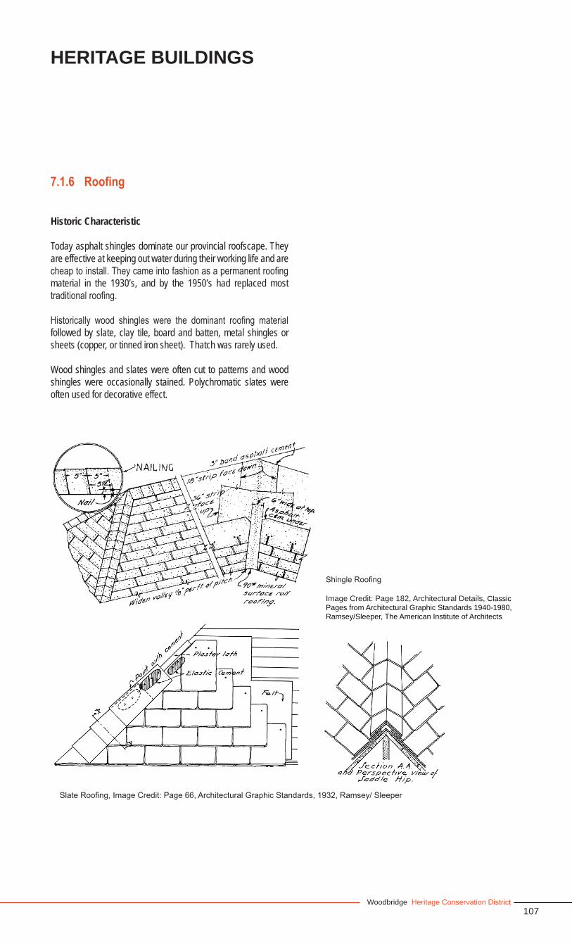
107Woodbridge Heritage Conservation District
Heritage Buildings
Historic Characteristic
Today asphalt shingles dominate our provincial roofscape. They are effective at keeping out water during their working life and are cheap to install. They came into fashion as a permanent roofing material in the 1930’s, and by the 1950’s had replaced most traditional roofing.
Historically wood shingles were the dominant roofing material followed by slate, clay tile, board and batten, metal shingles or sheets (copper, or tinned iron sheet). Thatch was rarely used.
Wood shingles and slates were often cut to patterns and wood shingles were occasionally stained. Polychromatic slates were often used for decorative effect.
7.1.6 Roofing
Slate Roofing, Image Credit: Page 66, Architectural Graphic Standards, 1932, Ramsey/ Sleeper
Shingle Roofing
Image Credit: Page 182, Architectural Details, Classic Pages from Architectural Graphic Standards 1940-1980, Ramsey/Sleeper, The American Institute of Architects
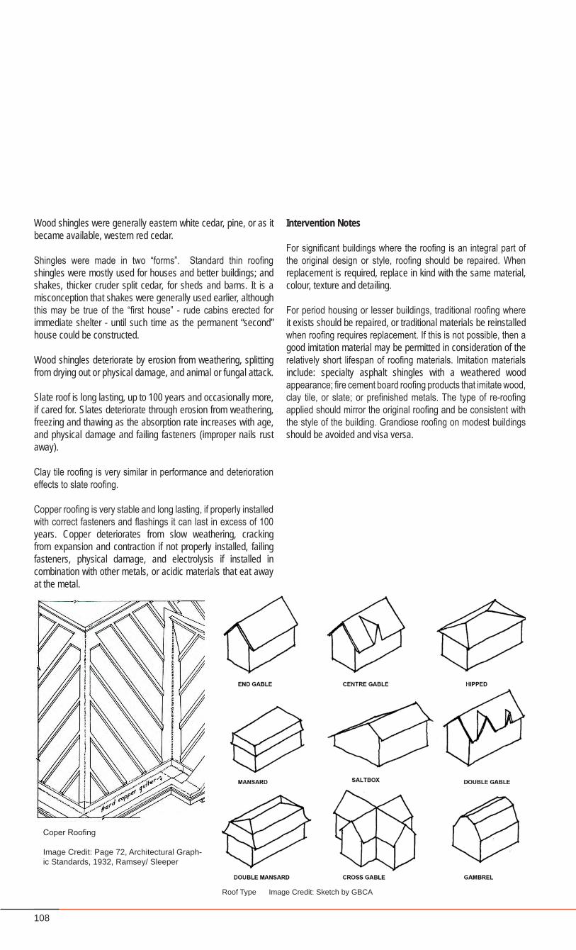
108
Wood shingles were generally eastern white cedar, pine, or as it became available, western red cedar.
Shingles were made in two “forms”. Standard thin roofing shingles were mostly used for houses and better buildings; and shakes, thicker cruder split cedar, for sheds and barns. It is a misconception that shakes were generally used earlier, although this may be true of the “first house” - rude cabins erected for immediate shelter - until such time as the permanent “second” house could be constructed.
Wood shingles deteriorate by erosion from weathering, splitting from drying out or physical damage, and animal or fungal attack.
Slate roof is long lasting, up to 100 years and occasionally more, if cared for. Slates deteriorate through erosion from weathering, freezing and thawing as the absorption rate increases with age, and physical damage and failing fasteners (improper nails rust away).
Clay tile roofing is very similar in performance and deterioration effects to slate roofing.
Copper roofing is very stable and long lasting, if properly installed with correct fasteners and flashings it can last in excess of 100 years. Copper deteriorates from slow weathering, cracking from expansion and contraction if not properly installed, failing fasteners, physical damage, and electrolysis if installed in combination with other metals, or acidic materials that eat away at the metal.
Intervention Notes
For significant buildings where the roofing is an integral part of the original design or style, roofing should be repaired. When replacement is required, replace in kind with the same material, colour, texture and detailing.
For period housing or lesser buildings, traditional roofing where it exists should be repaired, or traditional materials be reinstalled when roofing requires replacement. If this is not possible, then a good imitation material may be permitted in consideration of the relatively short lifespan of roofing materials. Imitation materials include: specialty asphalt shingles with a weathered wood appearance; fire cement board roofing products that imitate wood, clay tile, or slate; or prefinished metals. The type of re-roofing applied should mirror the original roofing and be consistent with the style of the building. Grandiose roofing on modest buildings should be avoided and visa versa.
Roof Type Image Credit: Sketch by GBCA
Coper Roofing
Image Credit: Page 72, Architectural Graph-ic Standards, 1932, Ramsey/ Sleeper
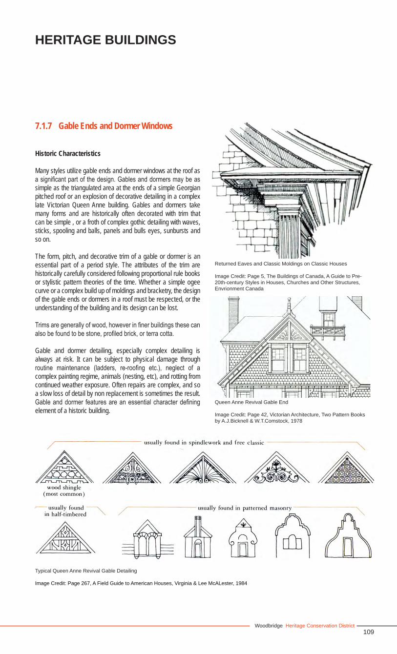
109Woodbridge Heritage Conservation District
Heritage Buildings
Historic Characteristics
Many styles utilize gable ends and dormer windows at the roof as a significant part of the design. Gables and dormers may be as simple as the triangulated area at the ends of a simple Georgian pitched roof or an explosion of decorative detailing in a complex late Victorian Queen Anne building. Gables and dormers take many forms and are historically often decorated with trim that can be simple , or a froth of complex gothic detailing with waves, sticks, spooling and balls, panels and bulls eyes, sunbursts and so on.
The form, pitch, and decorative trim of a gable or dormer is an essential part of a period style. The attributes of the trim are historically carefully considered following proportional rule books or stylistic pattern theories of the time. Whether a simple ogee curve or a complex build up of moldings and bracketry, the design of the gable ends or dormers in a roof must be respected, or the understanding of the building and its design can be lost.
Trims are generally of wood, however in finer buildings these can also be found to be stone, profiled brick, or terra cotta.
Gable and dormer detailing, especially complex detailing is always at risk. It can be subject to physical damage through routine maintenance (ladders, re-roofing etc.), neglect of a complex painting regime, animals (nesting, etc), and rotting from continued weather exposure. Often repairs are complex, and so a slow loss of detail by non replacement is sometimes the result. Gable and dormer features are an essential character defining element of a historic building.
7.1.7 Gable Ends and Dormer Windows
Typical Queen Anne Revival Gable Detailing
Image Credit: Page 267, A Field Guide to American Houses, Virginia & Lee McALester, 1984
Returned Eaves and Classic Moldings on Classic Houses
Image Credit: Page 5, The Buildings of Canada, A Guide to Pre-20th-century Styles in Houses, Churches and Other Structures, Envrionment Canada
Queen Anne Revival Gable End
Image Credit: Page 42, Victorian Architecture, Two Pattern Books by A.J.Bicknell & W.T.Comstock, 1978
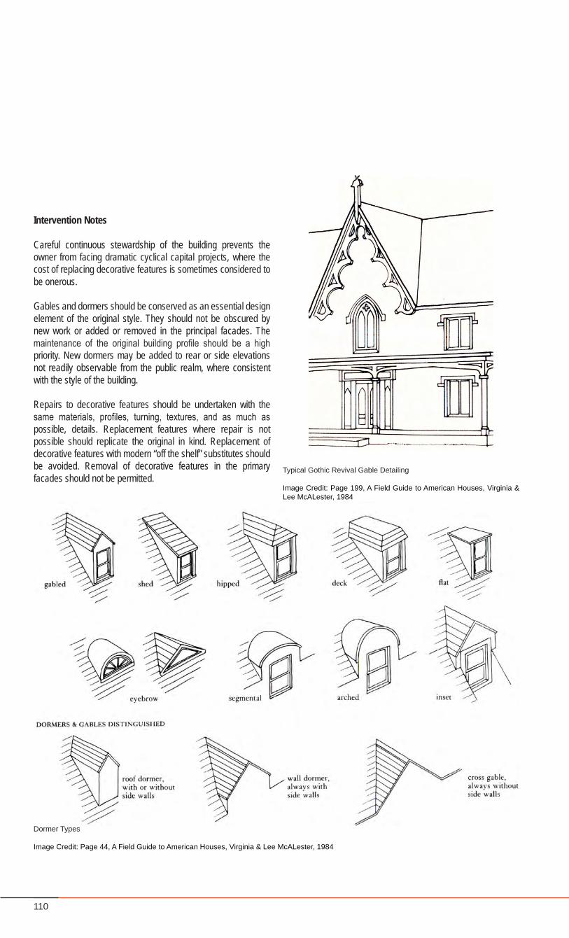
110
Dormer Types
Image Credit: Page 44, A Field Guide to American Houses, Virginia & Lee McALester, 1984
Typical Gothic Revival Gable Detailing
Image Credit: Page 199, A Field Guide to American Houses, Virginia & Lee McALester, 1984
Intervention Notes
Careful continuous stewardship of the building prevents the owner from facing dramatic cyclical capital projects, where the cost of replacing decorative features is sometimes considered to be onerous.
Gables and dormers should be conserved as an essential design element of the original style. They should not be obscured by new work or added or removed in the principal facades. The maintenance of the original building profile should be a high priority. New dormers may be added to rear or side elevations not readily observable from the public realm, where consistent with the style of the building.
Repairs to decorative features should be undertaken with the same materials, profiles, turning, textures, and as much as possible, details. Replacement features where repair is not possible should replicate the original in kind. Replacement of decorative features with modern “off the shelf” substitutes should be avoided. Removal of decorative features in the primary facades should not be permitted.
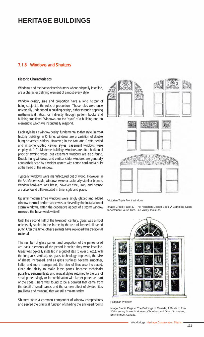
111Woodbridge Heritage Conservation District
Heritage Buildings
Historic Characteristics
Windows and their associated shutters where originally installed, are a character defining element of almost every style.
Window design, size and proportion have a long history of being subject to the rules of proportion. These rules were once universally understood in building design, either through applying mathematical ratios, or indirectly through pattern books and building traditions. Windows are the ‘eyes’ of a building and an element to which we instinctually respond.
Each style has a window design fundamental to that style. In most historic buildings in Ontario, windows are a variation of double hung or vertical sliders. However, in the Arts and Crafts period and in some Gothic Revival styles, casement windows were employed. In Art Moderne buildings windows are often horizontal pivot or awning types, but casement windows are also found. Double hung windows, and vertical slider windows are generally counterbalanced by a weight system with cotton cord and a pully at the head of the window.
Typically windows were manufactured out of wood. However, in the Art Modern style, windows were occasionally steel or bronze. Window hardware was brass, however steel, iron, and bronze are also found differentiated in time, style and place.
Up until modern times windows were singly glazed and added window thermal performance was achieved by the installation of storm windows. Often the decorative aspect of a storm window mirrored the base window itself.
Until the second half of the twentieth century, glass was almost universally sealed in the frame by the use of linseed oil based putty. After this time, other sealants have replaced this traditional material.
The number of glass panes, and proportion of the panes used are basic elements of the period in which they were installed. Glass was typically installed in a grid of lites (6 over 6, etc.), with the long axis vertical,. As glass technology improved, the size of sheets increased, and as glass surfaces became smoother, flatter and more transparent, the size of lites also increased. Once the ability to make large panes became technically possible, sentimentality and revival styles returned to the use of small panes singly or in combination with larger panes as part of the style. There was found to be a comfort that came from the detail of small panes and the screen effect of divided lites (mullions and muntins) that we still emulate today.
Shutters were a common component of window compositions and served the practical function of shading the enclosed rooms
7.1.8 Windows and Shutters
Palladian Window
Image Credit: Page 4, The Buildings of Canada, A Guide to Pre-20th-century Styles in Houses, Churches and Other Structures, Envrionment Canada
Victorian Triple Front Windows
Image Credit: Page 37, The, Victorian Design Book, A Complete Guide to Victorian House Trim, Lee Valley Tools Ltd.
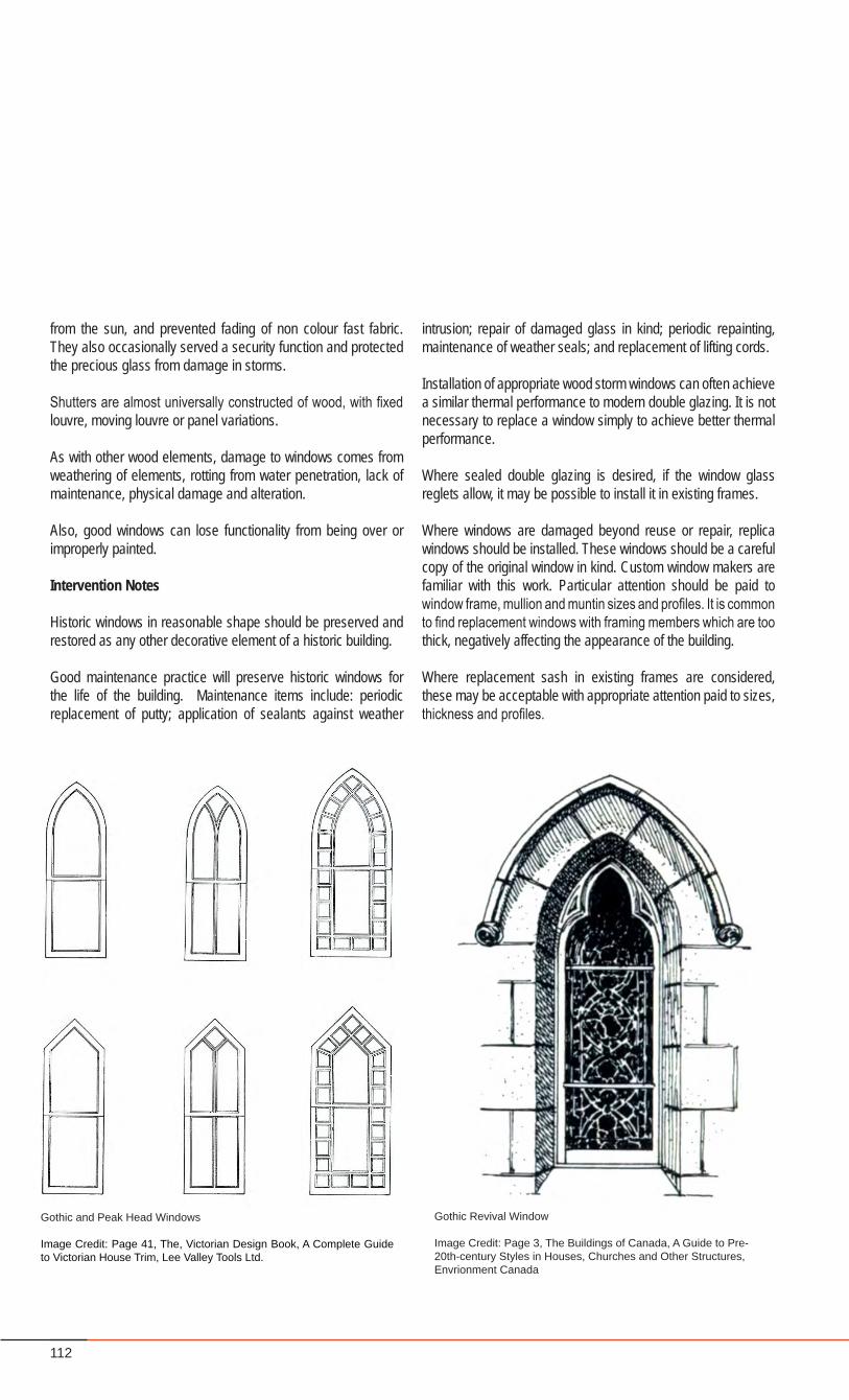
112
from the sun, and prevented fading of non colour fast fabric. They also occasionally served a security function and protected the precious glass from damage in storms.
Shutters are almost universally constructed of wood, with fixed louvre, moving louvre or panel variations.
As with other wood elements, damage to windows comes from weathering of elements, rotting from water penetration, lack of maintenance, physical damage and alteration.
Also, good windows can lose functionality from being over or improperly painted.
Intervention Notes
Historic windows in reasonable shape should be preserved and restored as any other decorative element of a historic building.
Good maintenance practice will preserve historic windows for the life of the building. Maintenance items include: periodic replacement of putty; application of sealants against weather
Gothic and Peak Head Windows
Image Credit: Page 41, The, Victorian Design Book, A Complete Guide to Victorian House Trim, Lee Valley Tools Ltd.
Gothic Revival Window
Image Credit: Page 3, The Buildings of Canada, A Guide to Pre-20th-century Styles in Houses, Churches and Other Structures, Envrionment Canada
intrusion; repair of damaged glass in kind; periodic repainting, maintenance of weather seals; and replacement of lifting cords.
Installation of appropriate wood storm windows can often achieve a similar thermal performance to modern double glazing. It is not necessary to replace a window simply to achieve better thermal performance.
Where sealed double glazing is desired, if the window glass reglets allow, it may be possible to install it in existing frames.
Where windows are damaged beyond reuse or repair, replica windows should be installed. These windows should be a careful copy of the original window in kind. Custom window makers are familiar with this work. Particular attention should be paid to window frame, mullion and muntin sizes and profiles. It is common to find replacement windows with framing members which are too thick, negatively affecting the appearance of the building.
Where replacement sash in existing frames are considered, these may be acceptable with appropriate attention paid to sizes, thickness and profiles.
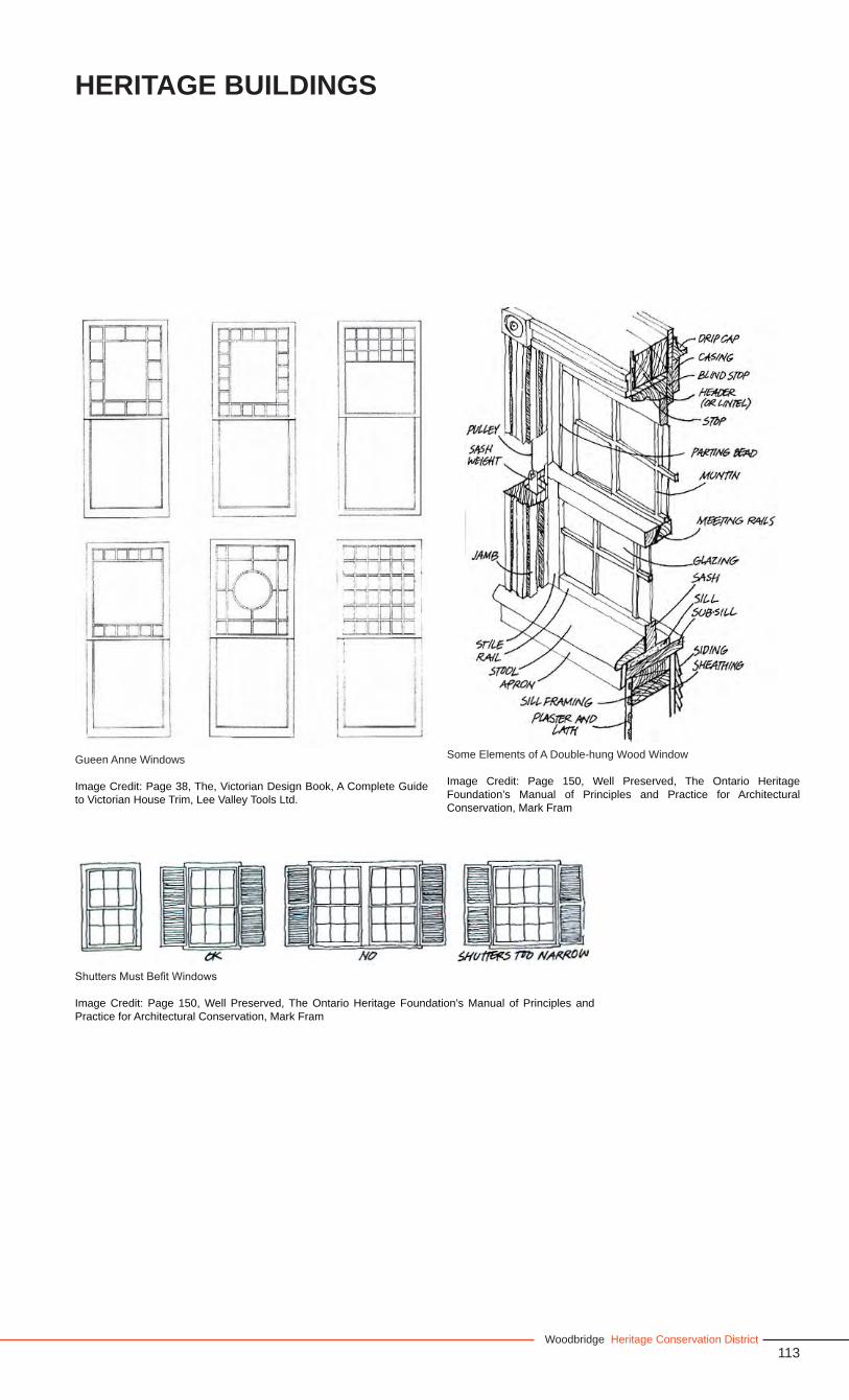
113Woodbridge Heritage Conservation District
Heritage Buildings
Gueen Anne Windows
Image Credit: Page 38, The, Victorian Design Book, A Complete Guide to Victorian House Trim, Lee Valley Tools Ltd.
Shutters Must Befit Windows
Image Credit: Page 150, Well Preserved, The Ontario Heritage Foundation’s Manual of Principles and Practice for Architectural Conservation, Mark Fram
Some Elements of A Double-hung Wood Window
Image Credit: Page 150, Well Preserved, The Ontario Heritage Foundation’s Manual of Principles and Practice for Architectural Conservation, Mark Fram
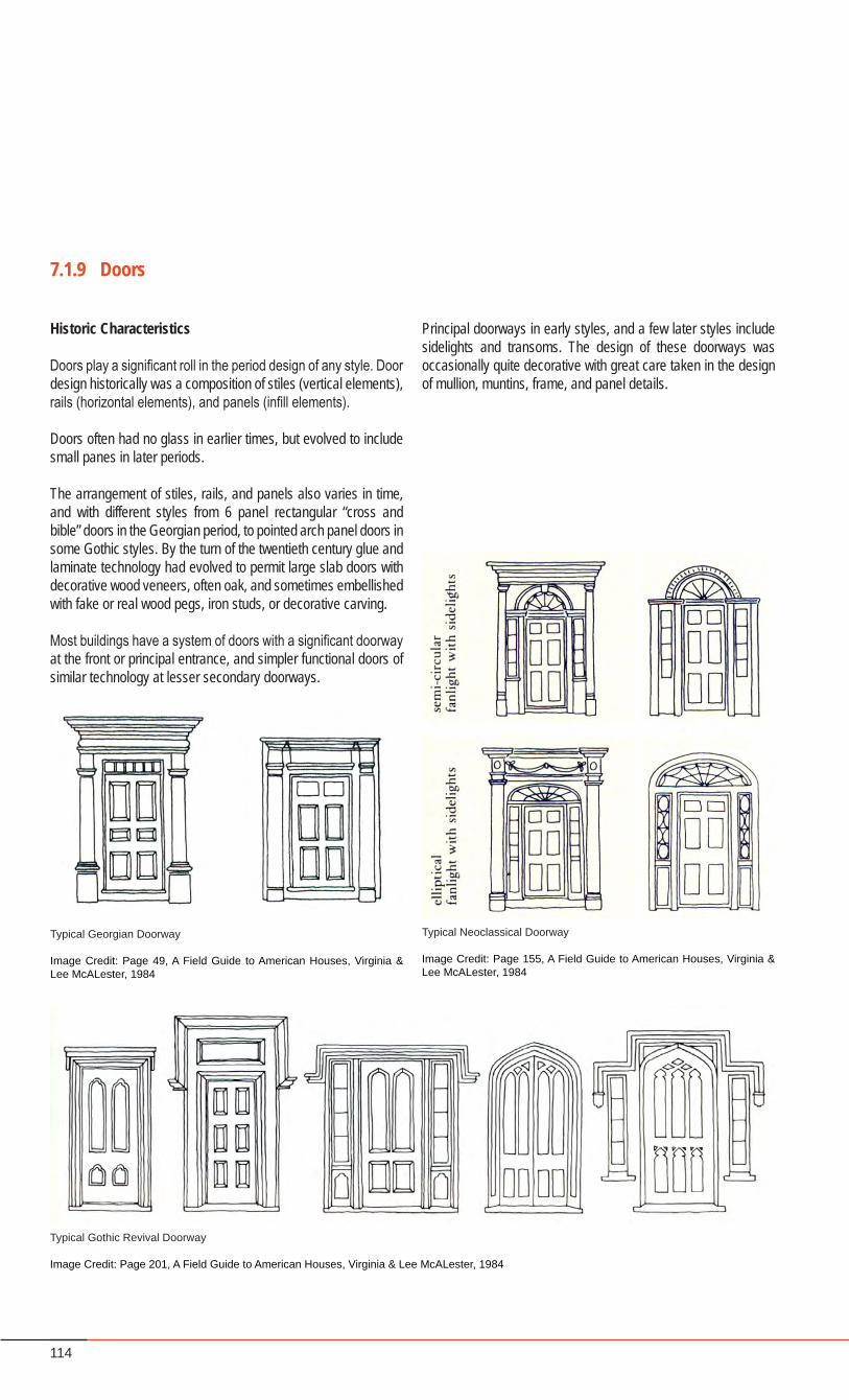
114
Historic Characteristics
Doors play a significant roll in the period design of any style. Door design historically was a composition of stiles (vertical elements), rails (horizontal elements), and panels (infill elements).
Doors often had no glass in earlier times, but evolved to include small panes in later periods.
The arrangement of stiles, rails, and panels also varies in time, and with different styles from 6 panel rectangular “cross and bible” doors in the Georgian period, to pointed arch panel doors in some Gothic styles. By the turn of the twentieth century glue and laminate technology had evolved to permit large slab doors with decorative wood veneers, often oak, and sometimes embellished with fake or real wood pegs, iron studs, or decorative carving.
Most buildings have a system of doors with a significant doorway at the front or principal entrance, and simpler functional doors of similar technology at lesser secondary doorways.
7.1.9 Doors
Typical Georgian Doorway
Image Credit: Page 49, A Field Guide to American Houses, Virginia & Lee McALester, 1984
Typical Neoclassical Doorway
Image Credit: Page 155, A Field Guide to American Houses, Virginia & Lee McALester, 1984
Typical Gothic Revival Doorway
Image Credit: Page 201, A Field Guide to American Houses, Virginia & Lee McALester, 1984
Principal doorways in early styles, and a few later styles include sidelights and transoms. The design of these doorways was occasionally quite decorative with great care taken in the design of mullion, muntins, frame, and panel details.
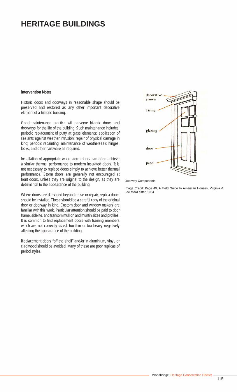
115Woodbridge Heritage Conservation District
Heritage Buildings
Intervention Notes
Historic doors and doorways in reasonable shape should be preserved and restored as any other important decorative element of a historic building.
Good maintenance practice will preserve historic doors and doorways for the life of the building. Such maintenance includes: periodic replacement of putty at glass elements; application of sealants against weather intrusion; repair of physical damage in kind; periodic repainting; maintenance of weatherseals hinges, locks, and other hardware as required.
Installation of appropriate wood storm doors can often achieve a similar thermal performance to modern insulated doors. It is not necessary to replace doors simply to achieve better thermal performance. Storm doors are generally not encouraged at front doors, unless they are original to the design, as they are detrimental to the appearance of the building.
Where doors are damaged beyond reuse or repair, replica doors should be installed. These should be a careful copy of the original door or doorway in kind. Custom door and window makers are familiar with this work. Particular attention should be paid to door frame, sidelite, and transom mullion and muntin sizes and profiles. It is common to find replacement doors with framing members which are not correctly sized, too thin or too heavy negatively affecting the appearance of the building.
Replacement doors “off the shelf” and/or in aluminium, vinyl, or clad wood should be avoided. Many of these are poor replicas of period styles.
Doorway Components
Image Credit: Page 49, A Field Guide to American Houses, Virginia & Lee McALester, 1984
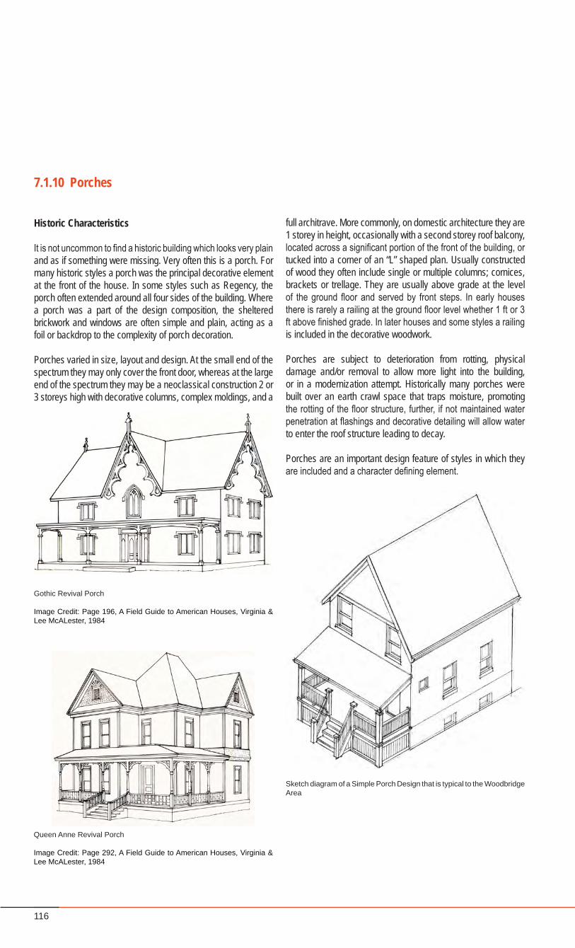
116
Historic Characteristics
It is not uncommon to find a historic building which looks very plain and as if something were missing. Very often this is a porch. For many historic styles a porch was the principal decorative element at the front of the house. In some styles such as Regency, the porch often extended around all four sides of the building. Where a porch was a part of the design composition, the sheltered brickwork and windows are often simple and plain, acting as a foil or backdrop to the complexity of porch decoration.
Porches varied in size, layout and design. At the small end of the spectrum they may only cover the front door, whereas at the large end of the spectrum they may be a neoclassical construction 2 or 3 storeys high with decorative columns, complex moldings, and a
7.1.10 Porches
Gothic Revival Porch
Image Credit: Page 196, A Field Guide to American Houses, Virginia & Lee McALester, 1984
Queen Anne Revival Porch
Image Credit: Page 292, A Field Guide to American Houses, Virginia & Lee McALester, 1984
full architrave. More commonly, on domestic architecture they are 1 storey in height, occasionally with a second storey roof balcony, located across a significant portion of the front of the building, or tucked into a corner of an “L” shaped plan. Usually constructed of wood they often include single or multiple columns; cornices, brackets or trellage. They are usually above grade at the level of the ground floor and served by front steps. In early houses there is rarely a railing at the ground floor level whether 1 ft or 3 ft above finished grade. In later houses and some styles a railing is included in the decorative woodwork.
Porches are subject to deterioration from rotting, physical damage and/or removal to allow more light into the building, or in a modernization attempt. Historically many porches were built over an earth crawl space that traps moisture, promoting the rotting of the floor structure, further, if not maintained water penetration at flashings and decorative detailing will allow water to enter the roof structure leading to decay.
Porches are an important design feature of styles in which they are included and a character defining element.
Sketch diagram of a Simple Porch Design that is typical to the Woodbridge Area
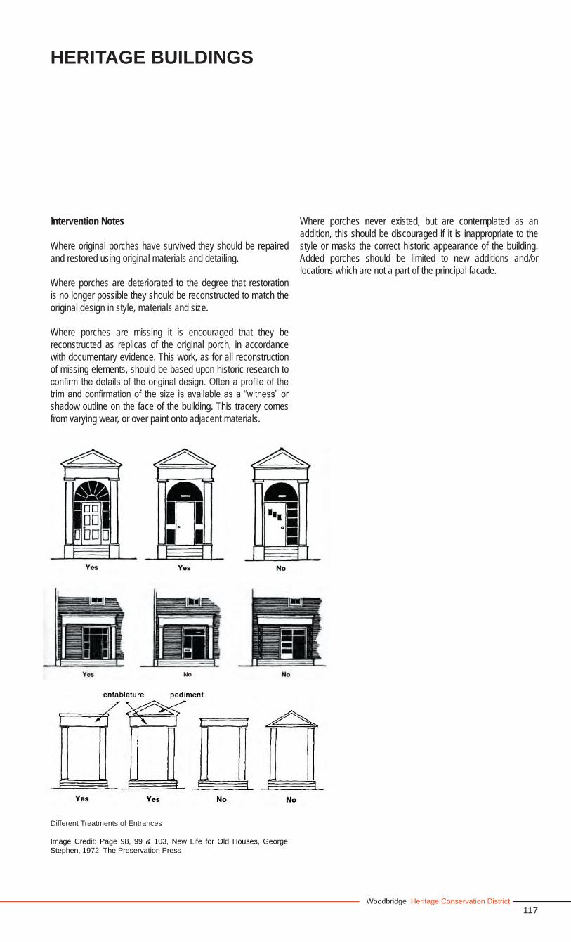
117Woodbridge Heritage Conservation District
Heritage Buildings
Intervention Notes
Where original porches have survived they should be repaired and restored using original materials and detailing.
Where porches are deteriorated to the degree that restoration is no longer possible they should be reconstructed to match the original design in style, materials and size.
Where porches are missing it is encouraged that they be reconstructed as replicas of the original porch, in accordance with documentary evidence. This work, as for all reconstruction of missing elements, should be based upon historic research to confirm the details of the original design. Often a profile of the trim and confirmation of the size is available as a “witness” or shadow outline on the face of the building. This tracery comes from varying wear, or over paint onto adjacent materials.
Where porches never existed, but are contemplated as an addition, this should be discouraged if it is inappropriate to the style or masks the correct historic appearance of the building. Added porches should be limited to new additions and/or locations which are not a part of the principal facade.
No
Different Treatments of Entrances
Image Credit: Page 98, 99 & 103, New Life for Old Houses, George Stephen, 1972, The Preservation Press
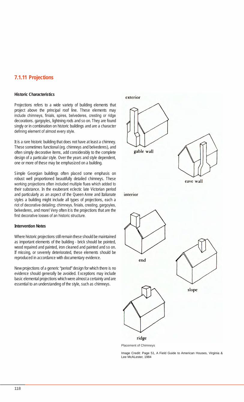
118
Historic Characteristics
Projections refers to a wide variety of building elements that project above the principal roof line. These elements may include chimneys, finials, spires, belvederes, cresting or ridge decorations. gargoyles, lightning rods and so on. They are found singly or in combination on historic buildings and are a character defining element of almost every style.
It is a rare historic building that does not have at least a chimney. These sometimes functional (eg. chimneys and belvederes), and often simply decorative items, add considerably to the complete design of a particular style. Over the years and style dependent, one or more of these may be emphasized on a building.
Simple Georgian buildings often placed some emphasis on robust well proportioned beautifully detailed chimneys. These working projections often included multiple flues which added to their substance. In the exuberant eclectic late Victorian period and particularly as an aspect of the Queen Anne and Italianate styles a building might include all types of projections, each a riot of decorative detailing; chimneys, finials, cresting, gargoyles, belvederes, and more! Very often it is the projections that are the first decorative losses of an historic structure.
Intervention Notes
Where historic projections still remain these should be maintained as important elements of the building - brick should be pointed, wood repaired and painted, iron cleaned and painted and so on. If missing, or severely deteriorated, these elements should be reproduced in accordance with documentary evidence.
New projections of a generic “period” design for which there is no evidence should generally be avoided. Exceptions may include basic elemental projections which were almost a certainty and are essential to an understanding of the style, such as chimneys.
7.1.11 Projections
Placement of Chimneys
Image Credit: Page 51, A Field Guide to American Houses, Virginia & Lee McALester, 1984
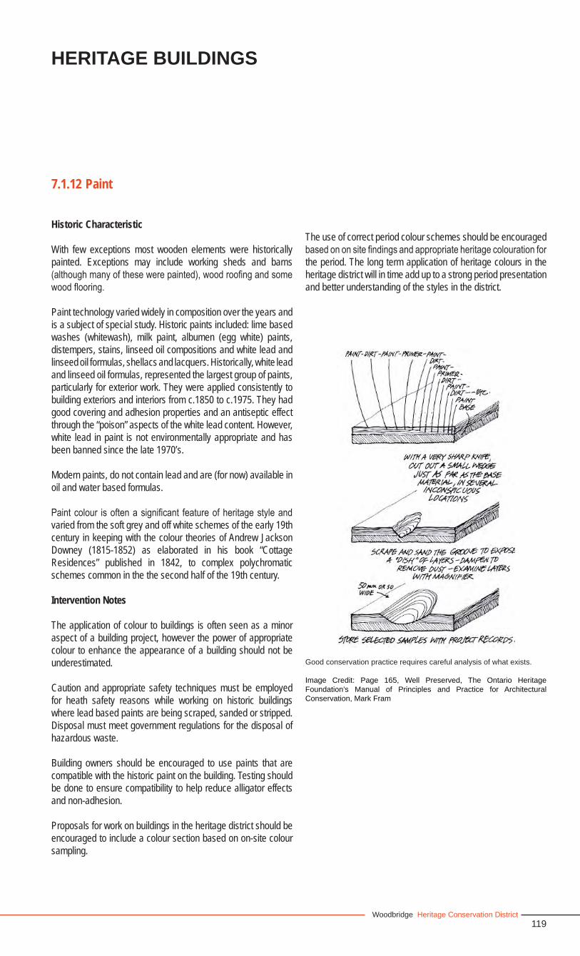
119Woodbridge Heritage Conservation District
7.1.12 Paint
Historic Characteristic
With few exceptions most wooden elements were historically painted. Exceptions may include working sheds and barns (although many of these were painted), wood roofing and some wood flooring.
Paint technology varied widely in composition over the years and is a subject of special study. Historic paints included: lime based washes (whitewash), milk paint, albumen (egg white) paints, distempers, stains, linseed oil compositions and white lead and linseed oil formulas, shellacs and lacquers. Historically, white lead and linseed oil formulas, represented the largest group of paints, particularly for exterior work. They were applied consistently to building exteriors and interiors from c.1850 to c.1975. They had good covering and adhesion properties and an antiseptic effect through the “poison” aspects of the white lead content. However, white lead in paint is not environmentally appropriate and has been banned since the late 1970’s.
Modern paints, do not contain lead and are (for now) available in oil and water based formulas.
Paint colour is often a significant feature of heritage style and varied from the soft grey and off white schemes of the early 19th century in keeping with the colour theories of Andrew Jackson Downey (1815-1852) as elaborated in his book “Cottage Residences” published in 1842, to complex polychromatic schemes common in the the second half of the 19th century.
Intervention Notes
The application of colour to buildings is often seen as a minor aspect of a building project, however the power of appropriate colour to enhance the appearance of a building should not be underestimated.
Caution and appropriate safety techniques must be employed for heath safety reasons while working on historic buildings where lead based paints are being scraped, sanded or stripped. Disposal must meet government regulations for the disposal of hazardous waste.
Building owners should be encouraged to use paints that are compatible with the historic paint on the building. Testing should be done to ensure compatibility to help reduce alligator effects and non-adhesion.
Proposals for work on buildings in the heritage district should be encouraged to include a colour section based on on-site colour sampling.
The use of correct period colour schemes should be encouraged based on on site findings and appropriate heritage colouration for the period. The long term application of heritage colours in the heritage district will in time add up to a strong period presentation and better understanding of the styles in the district.
Good conservation practice requires careful analysis of what exists.
Image Credit: Page 165, Well Preserved, The Ontario Heritage Foundation’s Manual of Principles and Practice for Architectural Conservation, Mark Fram
Heritage Buildings
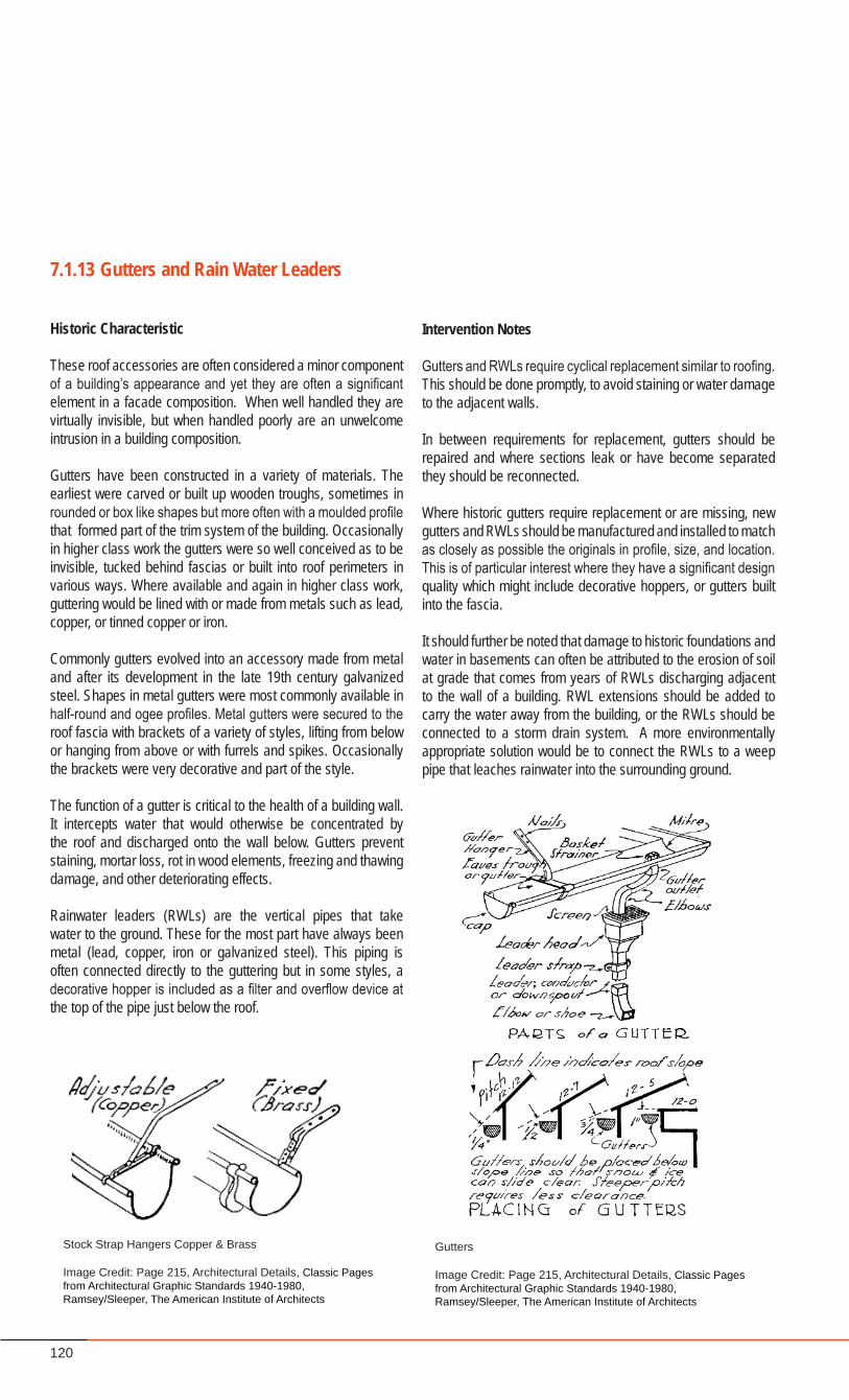
120
7.1.13 Gutters and Rain Water Leaders
Historic Characteristic
These roof accessories are often considered a minor component of a building’s appearance and yet they are often a significant element in a facade composition. When well handled they are virtually invisible, but when handled poorly are an unwelcome intrusion in a building composition.
Gutters have been constructed in a variety of materials. The earliest were carved or built up wooden troughs, sometimes in rounded or box like shapes but more often with a moulded profile that formed part of the trim system of the building. Occasionally in higher class work the gutters were so well conceived as to be invisible, tucked behind fascias or built into roof perimeters in various ways. Where available and again in higher class work, guttering would be lined with or made from metals such as lead, copper, or tinned copper or iron.
Commonly gutters evolved into an accessory made from metal and after its development in the late 19th century galvanized steel. Shapes in metal gutters were most commonly available in half-round and ogee profiles. Metal gutters were secured to the roof fascia with brackets of a variety of styles, lifting from below or hanging from above or with furrels and spikes. Occasionally the brackets were very decorative and part of the style.
The function of a gutter is critical to the health of a building wall. It intercepts water that would otherwise be concentrated by the roof and discharged onto the wall below. Gutters prevent staining, mortar loss, rot in wood elements, freezing and thawing damage, and other deteriorating effects.
Rainwater leaders (RWLs) are the vertical pipes that take water to the ground. These for the most part have always been metal (lead, copper, iron or galvanized steel). This piping is often connected directly to the guttering but in some styles, a decorative hopper is included as a filter and overflow device at the top of the pipe just below the roof.
Intervention Notes
Gutters and RWLs require cyclical replacement similar to roofing. This should be done promptly, to avoid staining or water damage to the adjacent walls.
In between requirements for replacement, gutters should be repaired and where sections leak or have become separated they should be reconnected.
Where historic gutters require replacement or are missing, new gutters and RWLs should be manufactured and installed to match as closely as possible the originals in profile, size, and location. This is of particular interest where they have a significant design quality which might include decorative hoppers, or gutters built into the fascia.
It should further be noted that damage to historic foundations and water in basements can often be attributed to the erosion of soil at grade that comes from years of RWLs discharging adjacent to the wall of a building. RWL extensions should be added to carry the water away from the building, or the RWLs should be connected to a storm drain system. A more environmentally appropriate solution would be to connect the RWLs to a weep pipe that leaches rainwater into the surrounding ground.
Gutters
Image Credit: Page 215, Architectural Details, Classic Pages from Architectural Graphic Standards 1940-1980, Ramsey/Sleeper, The American Institute of Architects
Stock Strap Hangers Copper & Brass
Image Credit: Page 215, Architectural Details, Classic Pages from Architectural Graphic Standards 1940-1980, Ramsey/Sleeper, The American Institute of Architects
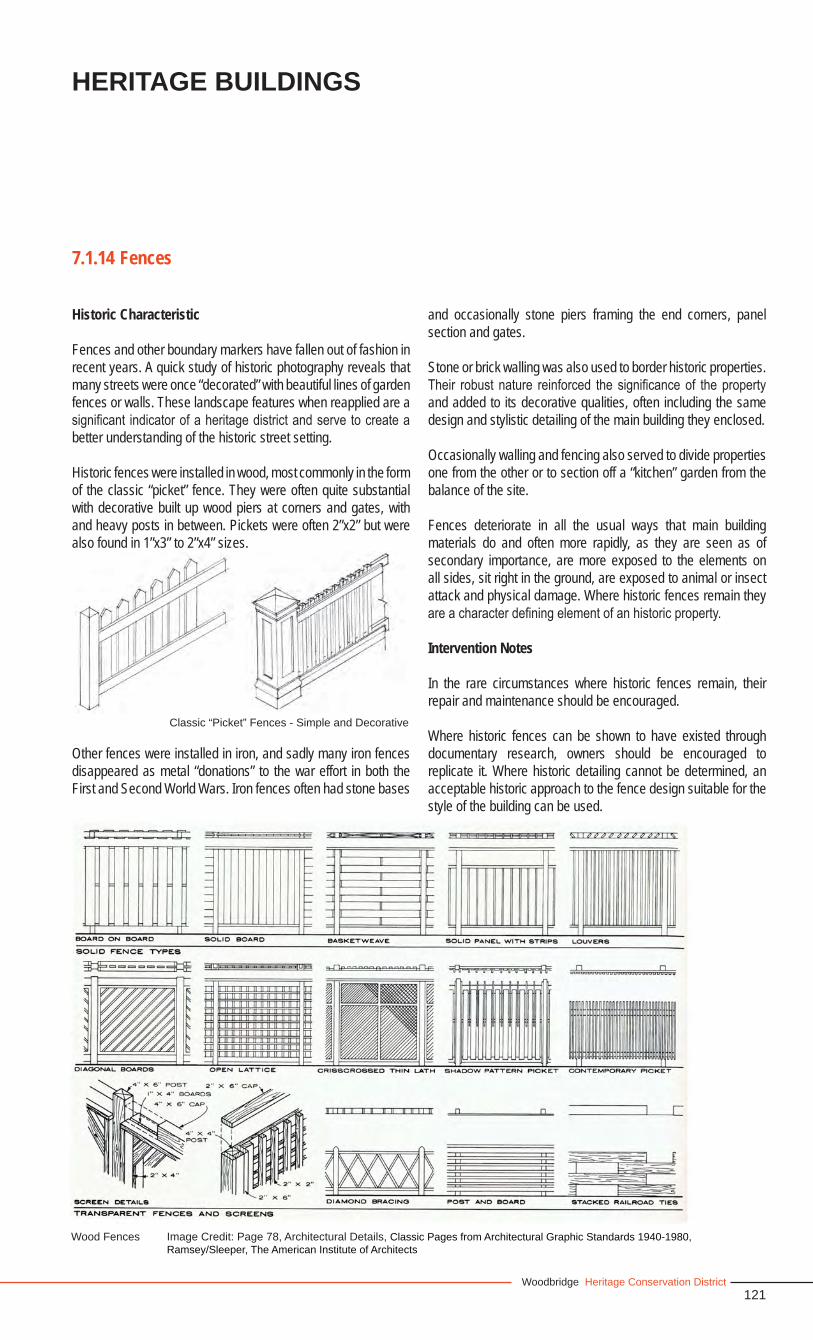
121Woodbridge Heritage Conservation District
7.1.14 Fences
Historic Characteristic
Fences and other boundary markers have fallen out of fashion in recent years. A quick study of historic photography reveals that many streets were once “decorated” with beautiful lines of garden fences or walls. These landscape features when reapplied are a significant indicator of a heritage district and serve to create a better understanding of the historic street setting.
Historic fences were installed in wood, most commonly in the form of the classic “picket” fence. They were often quite substantial with decorative built up wood piers at corners and gates, with and heavy posts in between. Pickets were often 2”x2” but were also found in 1”x3” to 2”x4” sizes.
Other fences were installed in iron, and sadly many iron fences disappeared as metal “donations” to the war effort in both the First and Second World Wars. Iron fences often had stone bases
Wood Fences Image Credit: Page 78, Architectural Details, Classic Pages from Architectural Graphic Standards 1940-1980, Ramsey/Sleeper, The American Institute of Architects
Heritage Buildings
and occasionally stone piers framing the end corners, panel section and gates.
Stone or brick walling was also used to border historic properties. Their robust nature reinforced the significance of the property and added to its decorative qualities, often including the same design and stylistic detailing of the main building they enclosed.
Occasionally walling and fencing also served to divide properties one from the other or to section off a “kitchen” garden from the balance of the site.
Fences deteriorate in all the usual ways that main building materials do and often more rapidly, as they are seen as of secondary importance, are more exposed to the elements on all sides, sit right in the ground, are exposed to animal or insect attack and physical damage. Where historic fences remain they are a character defining element of an historic property.
Intervention Notes
In the rare circumstances where historic fences remain, their repair and maintenance should be encouraged.
Where historic fences can be shown to have existed through documentary research, owners should be encouraged to replicate it. Where historic detailing cannot be determined, an acceptable historic approach to the fence design suitable for the style of the building can be used.
Classic “Picket” Fences - Simple and Decorative
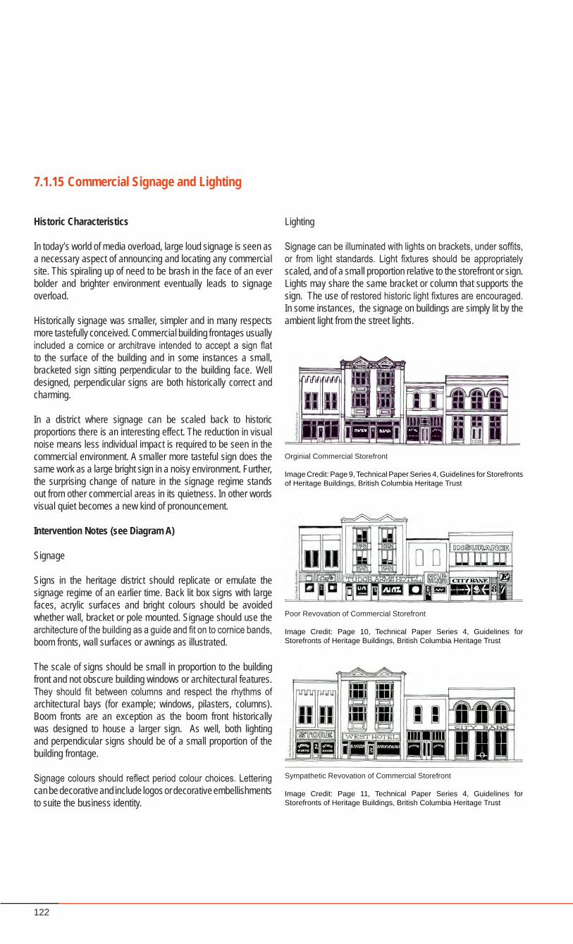
122
7.1.15 Commercial Signage and Lighting
Historic Characteristics
In today’s world of media overload, large loud signage is seen as a necessary aspect of announcing and locating any commercial site. This spiraling up of need to be brash in the face of an ever bolder and brighter environment eventually leads to signage overload.
Historically signage was smaller, simpler and in many respects more tastefully conceived. Commercial building frontages usually included a cornice or architrave intended to accept a sign flat to the surface of the building and in some instances a small, bracketed sign sitting perpendicular to the building face. Well designed, perpendicular signs are both historically correct and charming.
In a district where signage can be scaled back to historic proportions there is an interesting effect. The reduction in visual noise means less individual impact is required to be seen in the commercial environment. A smaller more tasteful sign does the same work as a large bright sign in a noisy environment. Further, the surprising change of nature in the signage regime stands out from other commercial areas in its quietness. In other words visual quiet becomes a new kind of pronouncement.
Intervention Notes (see Diagram A)
Signage
Signs in the heritage district should replicate or emulate the signage regime of an earlier time. Back lit box signs with large faces, acrylic surfaces and bright colours should be avoided whether wall, bracket or pole mounted. Signage should use the architecture of the building as a guide and fit on to cornice bands, boom fronts, wall surfaces or awnings as illustrated.
The scale of signs should be small in proportion to the building front and not obscure building windows or architectural features. They should fit between columns and respect the rhythms of architectural bays (for example; windows, pilasters, columns). Boom fronts are an exception as the boom front historically was designed to house a larger sign. As well, both lighting and perpendicular signs should be of a small proportion of the building frontage.
Signage colours should reflect period colour choices. Lettering can be decorative and include logos or decorative embellishments to suite the business identity.
Orginial Commercial Storefront
Image Credit: Page 9, Technical Paper Series 4, Guidelines for Storefronts of Heritage Buildings, British Columbia Heritage Trust
Poor Revovation of Commercial Storefront
Image Credit: Page 10, Technical Paper Series 4, Guidelines for Storefronts of Heritage Buildings, British Columbia Heritage Trust
Sympathetic Revovation of Commercial Storefront
Image Credit: Page 11, Technical Paper Series 4, Guidelines for Storefronts of Heritage Buildings, British Columbia Heritage Trust
Lighting
Signage can be illuminated with lights on brackets, under soffits, or from light standards. Light fixtures should be appropriately scaled, and of a small proportion relative to the storefront or sign. Lights may share the same bracket or column that supports the sign. The use of restored historic light fixtures are encouraged. In some instances, the signage on buildings are simply lit by the ambient light from the street lights.
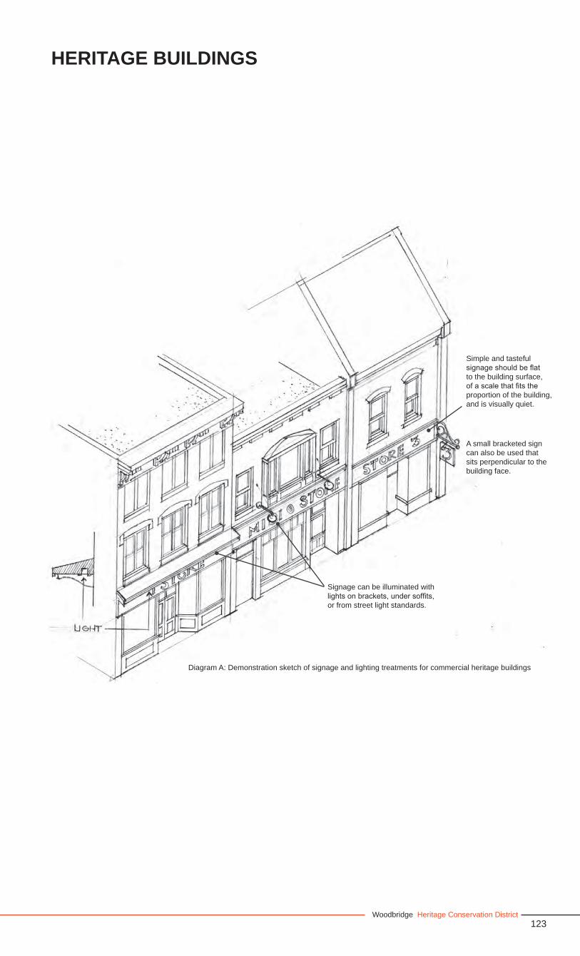
123Woodbridge Heritage Conservation District
Heritage Buildings
Diagram A: Demonstration sketch of signage and lighting treatments for commercial heritage buildings
A small bracketed sign can also be used that sits perpendicular to the building face.
Signage can be illuminated with lights on brackets, under soffits, or from street light standards.
Simple and tasteful signage should be flat to the building surface, of a scale that fits the proportion of the building, and is visually quiet.
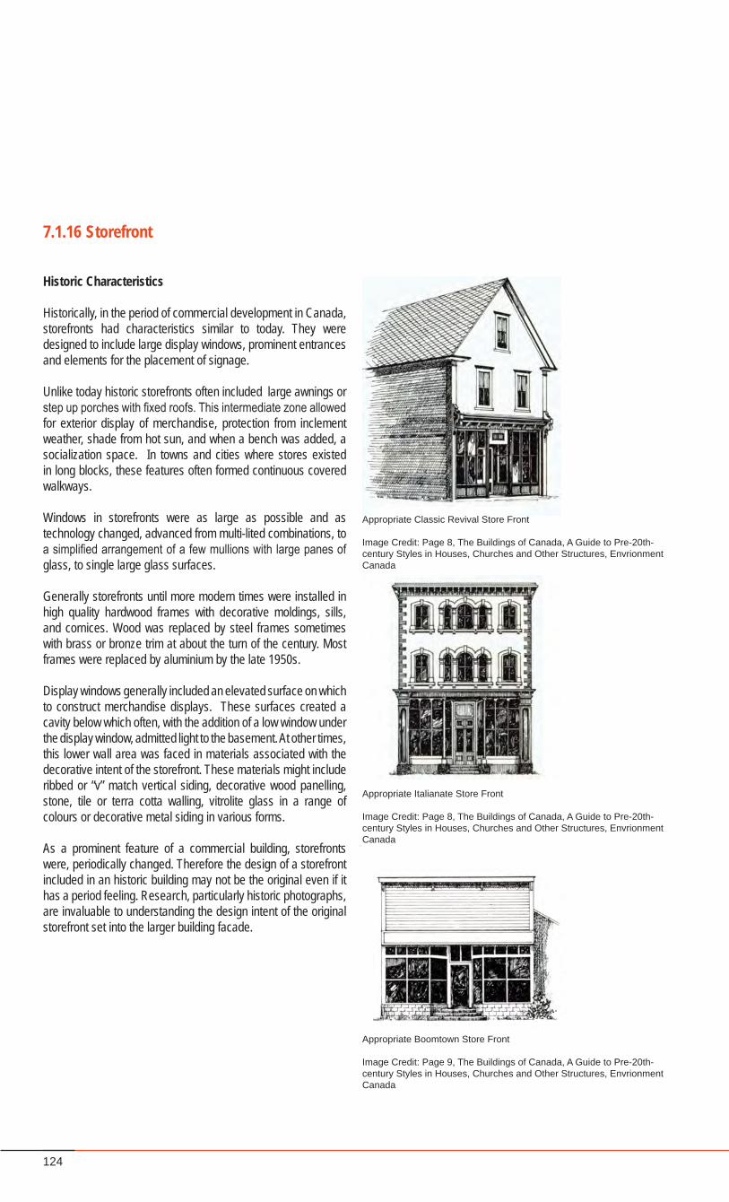
124
7.1.16 Storefront
Historic Characteristics
Historically, in the period of commercial development in Canada, storefronts had characteristics similar to today. They were designed to include large display windows, prominent entrances and elements for the placement of signage.
Unlike today historic storefronts often included large awnings or step up porches with fixed roofs. This intermediate zone allowed for exterior display of merchandise, protection from inclement weather, shade from hot sun, and when a bench was added, a socialization space. In towns and cities where stores existed in long blocks, these features often formed continuous covered walkways.
Windows in storefronts were as large as possible and as technology changed, advanced from multi-lited combinations, to a simplified arrangement of a few mullions with large panes of glass, to single large glass surfaces.
Generally storefronts until more modern times were installed in high quality hardwood frames with decorative moldings, sills, and cornices. Wood was replaced by steel frames sometimes with brass or bronze trim at about the turn of the century. Most frames were replaced by aluminium by the late 1950s.
Display windows generally included an elevated surface on which to construct merchandise displays. These surfaces created a cavity below which often, with the addition of a low window under the display window, admitted light to the basement. At other times, this lower wall area was faced in materials associated with the decorative intent of the storefront. These materials might include ribbed or “v” match vertical siding, decorative wood panelling, stone, tile or terra cotta walling, vitrolite glass in a range of colours or decorative metal siding in various forms.
As a prominent feature of a commercial building, storefronts were, periodically changed. Therefore the design of a storefront included in an historic building may not be the original even if it has a period feeling. Research, particularly historic photographs, are invaluable to understanding the design intent of the original storefront set into the larger building facade.
Appropriate Classic Revival Store Front
Image Credit: Page 8, The Buildings of Canada, A Guide to Pre-20th-century Styles in Houses, Churches and Other Structures, Envrionment Canada
Appropriate Italianate Store Front
Image Credit: Page 8, The Buildings of Canada, A Guide to Pre-20th-century Styles in Houses, Churches and Other Structures, Envrionment Canada
Appropriate Boomtown Store Front
Image Credit: Page 9, The Buildings of Canada, A Guide to Pre-20th-century Styles in Houses, Churches and Other Structures, Envrionment Canada
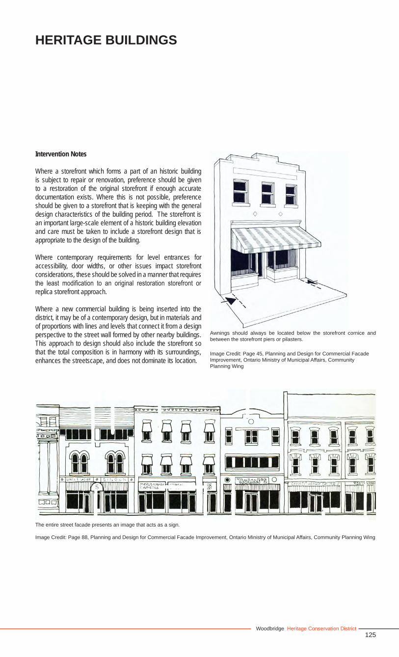
125Woodbridge Heritage Conservation District
Intervention Notes
Where a storefront which forms a part of an historic building is subject to repair or renovation, preference should be given to a restoration of the original storefront if enough accurate documentation exists. Where this is not possible, preference should be given to a storefront that is keeping with the general design characteristics of the building period. The storefront is an important large-scale element of a historic building elevation and care must be taken to include a storefront design that is appropriate to the design of the building.
Where contemporary requirements for level entrances for accessibility, door widths, or other issues impact storefront considerations, these should be solved in a manner that requires the least modification to an original restoration storefront or replica storefront approach.
Where a new commercial building is being inserted into the district, it may be of a contemporary design, but in materials and of proportions with lines and levels that connect it from a design perspective to the street wall formed by other nearby buildings. This approach to design should also include the storefront so that the total composition is in harmony with its surroundings, enhances the streetscape, and does not dominate its location.
The entire street facade presents an image that acts as a sign.
Image Credit: Page 88, Planning and Design for Commercial Facade Improvement, Ontario Ministry of Municipal Affairs, Community Planning Wing
Heritage Buildings
Image Credit: Page 45, Planning and Design for Commercial Facade Improvement, Ontario Ministry of Municipal Affairs, Community Planning Wing
Awnings should always be located below the storefront cornice and between the storefront piers or pilasters.
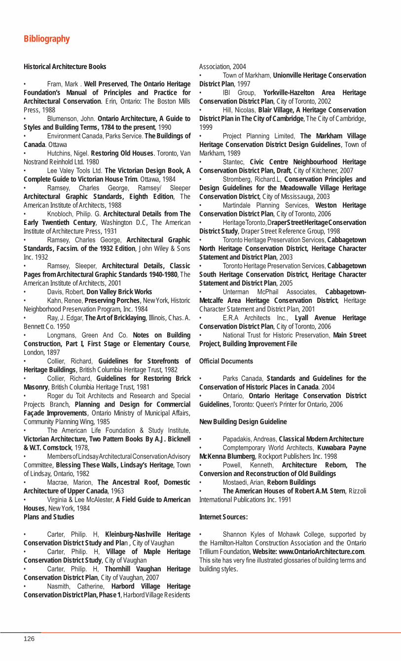
126
Historical Architecture Books
• Fram, Mark . Well Preserved, The Ontario Heritage Foundation’s Manual of Principles and Practice for Architectural Conservation. Erin, Ontario: The Boston Mills Press, 1988• Blumenson, John. Ontario Architecture, A Guide to Styles and Building Terms, 1784 to the present, 1990• Environment Canada, Parks Service. The Buildings of Canada. Ottawa• Hutchins, Nigel. Restoring Old Houses. Toronto, Van Nostrand Reinhold Ltd. 1980• Lee Valey Tools Ltd. The Victorian Design Book, A Complete Guide to Victorian House Trim. Ottawa, 1984• Ramsey, Charles George, Ramsey/ Sleeper Architectural Graphic Standards, Eighth Edition, The American Institute of Architects, 1988• Knobloch, Philip. G. Architectural Details from The Early Twentieth Century, Washington D.C, The American Institute of Architecture Press, 1931• Ramsey, Charles George, Architectural Graphic Standards, Facsim. of the 1932 Edition, John Wiley & Sons Inc. 1932• Ramsey, Sleeper, Architectural Details, Classic Pages from Architectural Graphic Standards 1940-1980, The American Institute of Architects, 2001• Davis, Robert, Don Valley Brick Works • Kahn, Renee, Preserving Porches, New York, Historic Neighborhood Preservation Program, Inc. 1984• Ray, J. Edgar, The Art of Bricklaying, Illinois, Chas. A. Bennett Co. 1950• Longmans, Green And Co. Notes on Building Construction, Part I, First Stage or Elementary Course, London, 1897• Collier, Richard, Guidelines for Storefronts of Heritage Buildings, British Columbia Heritage Trust, 1982• Collier, Richard, Guidelines for Restoring Brick Masonry, British Columbia Heritage Trust, 1981• Roger du Toit Architects and Research and Special Projects Branch, Planning and Design for Commercial Façade Improvements, Ontario Ministry of Municipal Affairs, Community Planning Wing, 1985• The American Life Foundation & Study Institute, Victorian Architecture, Two Pattern Books By A.J. Bicknell & W.T. Comstock, 1978, • Members of Lindsay Architectural Conservation Advisory Committee, Blessing These Walls, Lindsay’s Heritage, Town of Lindsay, Ontario, 1982• Macrae, Marion, The Ancestral Roof, Domestic Architecture of Upper Canada, 1963• Virginia & Lee McAlester, A Field Guide to American Houses, New York, 1984Plans and Studies
• Carter, Philip. H, Kleinburg-Nashville Heritage Conservation District Study and Plan , City of Vaughan• Carter, Philip. H, Village of Maple Heritage Conservation District Study, City of Vaughan• Carter, Philip. H, Thornhill Vaughan Heritage Conservation District Plan, City of Vaughan, 2007• Nasmith, Catherine, Harbord Village Heritage Conservation District Plan, Phase 1, Harbord Village Residents
Association, 2004• Town of Markham, Unionville Heritage Conservation District Plan, 1997• IBI Group, Yorkville-Hazelton Area Heritage Conservation District Plan, City of Toronto, 2002• Hill, Nicolas, Blair Village, A Heritage Conservation District Plan in The City of Cambridge, The City of Cambridge, 1999• Project Planning Limited, The Markham Village Heritage Conservation District Design Guidelines, Town of Markham, 1989• Stantec, Civic Centre Neighbourhood Heritage Conservation District Plan, Draft, City of Kitchener, 2007• Stromberg, Richard.L, Conservation Principles and Design Guidelines for the Meadowvalle Village Heritage Conservation District, City of Mississauga, 2003• Martindale Planning Services, Weston Heritage Conservation District Plan, City of Toronto, 2006• Heritage Toronto, Draper Street Heritage Conservation District Study, Draper Street Reference Group, 1998• Toronto Heritage Preservation Services, Cabbagetown North Heritage Conservation District, Heritage Character Statement and District Plan, 2003• Toronto Heritage Preservation Services, Cabbagetown South Heritage Conservation District, Heritage Character Statement and District Plan, 2005• Unterman McPhail Associates, Cabbagetown-Metcalfe Area Heritage Conservation District, Heritage Character Statement and District Plan, 2001• E.R.A Architects Inc., Lyall Avenue Heritage Conservation District Plan, City of Toronto, 2006• National Trust for Historic Preservation, Main Street Project, Building Improvement File
OfficialDocuments
• Parks Canada, Standards and Guidelines for the Conservation of Historic Places in Canada. 2004• Ontario, Ontario Heritage Conservation District Guidelines, Toronto: Queen’s Printer for Ontario, 2006
New Building Design Guideline
• Papadakis, Andreas, Classical Modern Architecture• Comptemporary World Architects, Kuwabara Payne McKenna Blumberg, Rockport Publishers Inc. 1998• Powell, Kenneth, Architecture Reborn, The Conversion and Reconstruction of Old Buildings• Mostaedi, Arian, Reborn Buildings• The American Houses of Robert A.M. Stern, Rizzoli International Publications Inc. 1991
Internet Sources:
• Shannon Kyles of Mohawk College, supported by the Hamilton-Halton Construction Association and the Ontario Trillium Foundation, Website: www.OntarioArchitecture.com.This site has very fine illustrated glossaries of building terms and building styles.
Bibliography

127Woodbridge Heritage Conservation District
Part 3 - Implementation
128
129Woodbridge Heritage Conservation District
8.0 ADMINISTRATION OF THE DISTRICT
Once Council has adopted the boundary and the Plan for the Heritage District and any appeals have been heard by the Ontario Municipal Board, a variety of measures are necessary to ensure the successful implementation of the District. These include: a) an application review process that is simple, efficient, and fair; b) a review body to provide advice on proposed alterations, new construction, demolitions in the District; c) the availability of the policies and guidelines for use by the public; d) the availability of financial assistance to assist in conservation initiatives; e) public awareness of the District concept, its objects, and its boundaries; and f) a mechanism to review and, if necessary, amend the District’s policies and procedures.
8.2 Required Permits
The designation of a Heritage Conservation District invokes Section 42 of the Ontario Heritage Act, which states:
“Erection, demolition, etc. 42. (1) No owner of a property situated in a heritage conservation district that has been designated by a municipality under this Part (Part V) shall do any of the following, unless the owner obtains a permit from the municipality to do so:
1. Alter, or permit the alteration of, any part of the property, other than the interior of any structure or building on the property.
2. Erect, demolish, or remove any building or structure on the property or permit the erection, demolition, or removal of such a building or structure.
Exception (2) Despite the subsection (1), the owner of a property situated in a designated heritage conservation district may, without obtaining a permit from the municipality, carry out such minor alterations of classes of alterations as are described in the heritage conservation district plan in accordance with clause 41.1 (5) (e) to any part of the property in respect of which a permit would otherwise be required under subsection (1).”
The classes of minor work exempted from the permit requirement are stated in Section 8.3.1.1.
8.1 Overview
8.2.1 Demolition Control
Recent amendments to the Ontario Heritage Act Allow Council to prohibit the demolition of a structure designated under the Act. All properties within a heritage conservation district are considered to be designated.
• Council will prevent the demolition of heritage buildings within the District.
8.2.2 Heritage Easements
A Heritage Easement Agreement requires the owner of a heritage building to secure approvals for any changes or alterations, reasonably maintain the structure to prevent any deterioration, and retain insurance on the building in an amount equal to its replacement.
• A Heritage Easement Agreement should be considered for major redevelopment projects in the District which involve the incorporation and restoration of a heritage building.
8.2.3 Council Approval Notwithstanding the policies and guidelines contained in this HCD Plan, Council may consider and approve different options and alternatives.
8.3 Streamlining the Process
In order to streamline and simplify procedures for permit applications and their review, the permit requirements for work in the district have been divided into classes, corresponding to the scale of the work being proposed, and have been integrated into the permit process for building and development.
Important! Owners are encouraged to discuss their proposed work with Cultural Services Staff at the earliest stages to determine what will be required. Minor work that is exempted from the requirement for a Heritage Permit in Section 8.3.1.1 of this Plan, may require a Heritage Permit Clearance Letter from Cultural Services, to verify that the proposed work is exempted. See section 8.3.1.1. below.
The classes of Heritage Permit are: • Heritage Permit, for minor work that does not require
a building permit;• Heritage Permit with the Building Permit, for
work that requires a building permit; • Heritage Permit with Site Plan Approval, for
work that requires planning approval.
130
The processes for these classes are described in Sections 8.3.1 through 8.3.3, below.
There will be no fees charged for Heritage Permits. Fees for Building Permits and Site Plan Approvals will be the same as for respective non-heritage applications.
In addition, Cultural Services will review applications for zoning amendments and applications to the Committee of Adjustment, for Minor Variances and Consents to Sever, or Convey Property in the District. These are not Heritage Permits, but are a service to applicants, allowing them to be aware of heritage issues prior to making an application for a Building Permit or (Heritage Permit). Refer to Section 8.7 for checklists for applications in the various classes.
In addition, Council may delegate authority for review and approval of smaller scale non-controversial Heritage Permits to City staff and/or Heritage Vaughan. Such delegated reviews and approvals are to be reported to Council. If outstanding issues in an application cannot be resolved, Council would review the application, inviting deputations from the applicant prior to its decision.
These arrangements should minimize the time required for issuing Heritage Permits. Applications for Building Permits or Site Plan Review will be circulated for heritage review in the same way they are already circulated for planning, zoning, and other approvals.
In most cases, when Policies and Guidelines of the Heritage Plan are followed, there will be little or no delay.
Pre-Review
To speed and simplify the permit process for all scales of work, applicants should become aware of the requirements for the work they propose to undertake. Cultural Services staff can give advice on the type of permit required, and provide guidance on interpreting Heritage Policies and Guidelines. Additional advice can be obtained from Heritage Vaughan, which may also be able to assist in historical and technical research.
The City may require the applicant to engage a heritage consultant to provide advice to both the City and the applicant at the review stage. This may be appropriate for larger developments.
8.3.1 The Heritage Permit
The following list identifies some of the types of projects which
require a Heritage Permit: • new or different cladding materials for both walls and roofs; • repair and restoration of original elements;• painting; or exterior structure• new or different windows or doors; new storm doors or new
storm windows• changes or removal of architectural decoration or features;• introduction of skylights or awnings; • masonry cleaning; • new or extended fences; • new or increased parking areas; • patios located in the fronts yard;• permanent lamp installations;• television satellite dishes that can be viewed from the
streetscape;• mechanical equipment that can be viewed from the
streetscape;• planting or removal of trees in the public right-of way;• hard landscaping such as retaining walls, rock gardens,
hard surfaced pathways, visible from the public domain; • all above-ground public works.
The list is not complete and any undertaking should be discussed with Cultural Services staff. In addition, applicants are requested to confirm their projects with the Building Standards Department to ensure that a Building Permit is not required. There is no fee for a Heritage Permit.
8.3.1.1 Exemptions
In keeping with Section 6.2.7 of this Plan, a Heritage Permit is not required for the following projects:
• any interior work, unless the interior is identified in a Part IV Designation;
• repair to roof, eavestroughs, chimneys; re-roofing using appropriate materials listed in Section 6.2;
• caulking, window repair, weatherstripping, installation of existing storm doors and storm windows;
• minor installations, including lighting and flagpoles;• fencing, patios, small satellite dishes, garden and tool
sheds, gazebos, dog houses and other small outbuildings that do not require a Building Permit and are not visible from the public domain;
• planting and removal of trees smaller than 200mm caliper, and any other vegetation on private property;
• extension of residential parking pads other than in front or flankage yards;
• ramps and railings to facilitate accessibility and gates installed for child safety provided they are not visible from the public domain;
• temporary installations, such as basketball nets, planters, statues and seasonal decorations;
• Repair of utilities and public works.
131Woodbridge Heritage Conservation District
ADMINISTRATION OF THE DISTRICT
Before performing such projects, it is encouraged that you confirm with Cultural Services staff, that the work you are planning to undertake is in an exempted class.
8.3.1.2 Heritage Permit Process
The procedure to be followed has been created to streamline and minimize the time and effort needed by the applicant to gain this approval. Council may delegate the approval of non-controversial Heritage Permits to Cultural Services staff.
Applicant: • Confirms with Building Standards whether a Building Permit
is required.• Conducts and pre-reviews project with Cultural Services Staff.• Sends a letter describing the project to Cultural Services.
Cultural Services: • Reviews application and forwards to Heritage Vaughan for
further review.• Provides Heritage Vaughan with regular summaries of its
actions and all applications.
Heritage Vaughan: • Reviews forwarded applications, and either approves
permit or refuses permit with comments. • Informs Council, in its regular minutes, of Cultural Services
and Heritage Vaughan actions on all applications, and forwards applications and reports to Council where outstanding issues cannot be resolved.
8.3.2 Heritage Permit with Building Permit
The Ontario Building Code requires that owners obtain a Building Permit for any work that involves structural changes, change of use, or change in occupancy loads. Types of projects requiring a Building Permit include:
• new construction or structural repairs to porches, chimneys, roofs, walls, etc.;
• demolition;• commercial signage;• chimneys; • porches; • additions to buildings (may also require site plan approval); • new building construction (may also require site plan
approval).
8.3.2.1 Heritage Permit with Building Permit Process
The City of Vaughan Building Standards Department requires that applicants for Building Permits or Demolition Permits must
provide all necessary clearances from other departments, including Cultural Services, before the application process can begin.
A Heritage Permit Approval is required for all Demolition Permits or Building Permits within a Heritage Conservation District.
There is no fee for a Heritage Clearance Letter or Heritage Permit.
Applicant: • Confirms with Building Standards staff that a building
permit is required. Confirms with development Planning Staff whether or not Site Plan Approval is required.
• Arranges for a pre-review with Cultural Services staff to confirm whether the proposed work requires a Heritage Clearance Letter or a Heritage Permit.
• Obtains Heritage Clearance letter, or completes Heritage Permit application, if required. See application checklists in Section 8.8, below.
Cultural Services: • Review heritage aspects of the project.• Forwards to Heritage Vaughan with recommendations for
further review. • Provides Heritage Vaughan with regular summaries of its
actions on all applications.
Heritage Vaughan: • Reviews forwarded applications, and either approves
permit or refuses permit with comments. • Informs Council, in its regular minutes, of Cultural Services
and Heritage Vaughan actions on all applications and forwards applications and reports to Council where outstanding issues cannot be resolved.
8.3.3 Heritage Permit with Site PlanApproval
Site Plan Approval is required, in addition to a Building Permit, for larger projects in the municipality. Generally, this will apply to new development and significant additions or alterations. Planning Staff can advise applicants when this approval isrequired. Requirements include detailed building plans and elevations, site plan, and landscape plan. Larger developments may require other supporting documents such as traffic impact studies, storm water management plans, and so on. In theDistrict, the application is handled like an ordinary Site Plan Approval, with the addition of a heritage review. City Planning Staff has been delegated the authority to approve small projects and minor amendments to existing site plan agreements. More complex Site Plan Approvals are always sent to Council for final decision.
132
8.3.3.1 Heritage Permit with Site Plan Approval Process
The ordinary process for Heritage Permits with Site Plan Approvals is outlined below:
Applicant • Confirms with Planning Department Staff that Site Plan
Approval is required. • Arranges for a Pre-review discussion with Cultural Services
and Policy Planning and Development Planning Staff.• Applies for Site Plan Approval, describing the work to be performed. All Site Plan Approval applications in the District will be forwarded to Cultural Services. • (See Application Checklist in Section 8.9.3, below.)
Planning/Urban Design: • Reviews application and provides comment.
Cultural Services: • Reviews site plan applications for compliance with the
Heritage Conservation District Plan, forwards comments to the Development Planning Department, and presents the comments to Heritage Vaughan for further review. When a Heritage Permit application is received by Cultural Services, they review and forward to Heritage Vaughan for approval.
• Provides Heritage Vaughan with regular summaries of its actions on all applications.
Heritage Vaughan: • Reviews forwarded application and either approves
Heritage Permit, with or without conditions or refuses Permit with comments.
• Forwards decisions, actions, and comments of Cultural Services Staff and/or Heritage Vaughan to Planning Department for inclusion in its report to Council on the application.
Council: • Acts on Development Review Application on the basis of
the Planning Department Report.
8.3.4 Review of Zoning Amendment andCommittee of Adjustment Applications Zoning Amendment and Committee of Adjustment applications do not deal with buildings or structures, per se, but with Zoning By-law issues, under the Planning Act. As such, they don’t require a Heritage Permit. However, they are steps on the way to future construction. It’s obviously inefficient, for both applicants
and the Committee, to deal with a proposal that will run afoul of District Policies and Guidelines when it subsequently moves to the Site Plan Approval and Building Permit stage. For example, later revision of plans to comply with the District Plan might call for other Variances than those originally applied for.
For these reasons, applications for Zoning Amendments and Minor Variances and Consents to sever or convey at the Committee of Adjustment will be reviewed for compliance with the District Plan. Formally, these are comments to the Committee of Adjustment. Pre-review discussions with Cultural Services Staff, described above for the various classes of Heritage Permits, are also a part of the application process for these applications. This allows applicants to be aware of heritage concerns, at the earliest possible stage of a project.
8.3.4.1 Process for Review of Zoning Amendment and Committee of Adjustment Applications
The ordinary process for this review is outlined below: Applicant:
• Arranges for a pre-review discussion with Development Planning, and Cultural Services Staff.
• Completes standard application forms for permissions sought. All applications in the District will be circulated to Cultural Services.
Cultural Services:
• Reviews heritage aspects of application, and comments to Council or Committee of Adjustment.
8.4 Application Checklists
The following checklists are provided to assist applicants in obtaining permits, and to assist staff in conducting pre-review and evaluating the applications.
8.4.1 Heritage Permit Checklist
For minor work, not ordinarily requiring a Building Permit: • Inspect the property description in the Record of the District’s
Built Form. Make note of any comments that indicate needed maintenance and repair. Proper maintenance and repair is the primary means of protecting the heritage character of the District. Applicants are strongly encouraged to include necessary maintenance tasks at the first opportunity.
• Show results of any historical research. For example: provide a chip of original paint, if possible, when repainting;
133Woodbridge Heritage Conservation District
ADMINISTRATION OF THE DISTRICT
or provide copies of historic drawings or photographs when replacing or restoring elements such as windows, signs, and awnings.
• Read and understand any required technical material. For example: obtain a copy of the relevant Preservation Brief document.
• Read and understand the relevant Policies and Guidelines in this Plan.
• In the case of more substantial work under a Heritage Permit, provide drawings that demonstrate compliance with the Policies and Guidelines of this plan and with other by-laws, such as the Sign By-Law. For a sign and storefront work, provide elevations at a minimum scale of 1:25, and details and profiles at a suitable large scale.
• For removal of a tree 200mm standard caliper or larger, the applicant must submit a report by a professional arborist, including species, size, and condition of the tree, and a conservation plan proposing replacement tree or trees.
8.4.2 Heritage Permit with Building PermitChecklist
For additions, renovations, and restoration: • Inspect the property description in the Record of the District’s
Built Form. Make note of any comments that indicated needed maintenance and repair. Proper maintenance and repair are the primary means of protecting the heritage character of the District. Applicants are strongly encouraged to include necessary maintenance tasks at the first opportunity. Also make note of comments that indicate steps that could be taken to restore heritage features or to remove unsympathetic later work.
• Show results of any historical research. For example: provide copies of historic drawings or photographs, or show results of investigation of conditions underlying unsympathetic later work.
• Read and understand any required technical material. For new construction, additions, renovation and restoration:
• Provide all documents ordinarily required for a building permit. These should include, as applicable for the scale of the work: outline specifications and drawing notes, indicating all materials visible from the exterior; elevations of all sides at a minimum scale of 1:50; elevations of storefronts at a minimum scale of 1:25; details and profiles, at a suitable scale, of cornices, signage and storefront elements, railings, trim, soffits and fascias, fences; an eye-level perspective, including adjacent buildings, for corner properties or free-standing buildings; a site plan showing building location, fencing, and planting. Elevations and perspectives should be “rendered” so that coursing, projecting elements, textures and fancy work are truly
represented. Vertical dimensions should refer to those of adjacent buildings for alignment of horizontal elements
For projects requiring Site Plan Approval, include copies of approved drawings for the Site Plan Approval process.
8.4.3 Heritage Permit with Site Plan Review Checklist
• Read and understand the relevant Policies and Guidelines in this Plan.
• Provide all documents ordinarily required for a Site Plan Approval. These should include: site plan, at a scale suitable to the size of the property, showing location of the building(s) and buildings on adjacent properties, fencing, planting, sidewalk and driveway paving, and porches, decks, and other exterior elements; elevations of all sides, at a scale suitable to the size of the project, and including adjacent properties; an eye-level perspective, including adjacent buildings, for corner properties or free-standing buildings; outline specifications and drawing notes should indicate all materials visible from the exterior. Elevations and perspectives should be “rendered” so that coursing, projecting elements, textures, and fancy work are truly represented.
• Provide photographs of adjacent buildings for comparison with elevations and perspectives. Provide photographs of nearby heritage buildings of a similar type, to demonstrate the architectural sympathy of the proposed building.
8.5 Resolving Issues and Appeals
The phrase “if outstanding issues cannot be resolved” appears in each of the heritage review processes listed above. The City is committed to making all reasonable efforts to resolve issues arising in the permit process, consistent with heritage policies and guidelines. And it is further committed to providing historical and technical assistance to applicants in preparing applications that will meet the requirements of the District Plan. Good faith on the part of applicants and reviewers should result in a resolution process that is conversational rather than confrontational. It may be useful to hold on-site discussions with applicants regarding design and details. The inspection of physical conditions is extremely valuable in assessing what level of restoration should be reasonably expected, and to what extent the work will affect the heritage character of the streetscape. The City may require the applicant to engage a heritage consultant to provide assistance in resolving issues.
134
If issues remain unresolved and are forwarded for action by Council, deputations from the applicant and his representatives will be invited before a Council decision is taken. Council may also request testimony from City Staff or Heritage Vaughan, in addition to the reports which it will have received on the matter, as outlined above.
The submission of an application for a heritage permit that is subject to site plan control shall include a letter prepared by a licensed architect who is a professional member of the Canadian Association of Heritage Professional Consultants (CAPHC), confirming that the proposed development conforms to the intent of the Policies and Design Guidelines of this Plan. At the discretion of the Cultural Services Staff, the applicant may also be required to have the proposed building design and the site plan application prepared by the same architect.
If Council decides to deny an application for a permit under the Heritage Act, the applicant may make a final appeal to the Ontario Municipal Board, as described in Section 44 of the Act. The Board has the authority to deny the appeal, or grant it, with or without such conditions and terms as the Board may direct.
8.6 Financial Incentives for Conservation
8.6.1 Tax Measures
Recent provisional legislation allows municipalities to enact property tax abatement for properties designated under Part IV and Part V of the Heritage Act. The City should evaluate this legislation to determine if it can be usefully applied to the District.
8.6.2 Grants and Loans
Other municipalities have found that modest grants or loans are very effective in encouraging repair and restoration of heritage attributes. The variety of programs includes outright grants, simple loans, and loans that are forgivable over time on a pro-rated basis until the sale of the property. Usually these incentives are 50% matching funds up to a fixed level of $10,000 or $20,000. The City should evaluate some of the programs in other municipalities to determine if such a program could be usefully applied to the District.
8.7 Public Awareness
Vaughan’s Official Plan recognizes the importance of the preservation of heritage character in Woodbridge. A successful Heritage District requires public awareness and participation, and a variety of steps should or might be taken to ensure the ongoing effectiveness of the District Plan. Among these are the following:
• Under Section 41.10.1 of the Ontario Heritage Act, the City Clerk must ensure that a copy of the Heritage Conservation District Designating By-law is registered at the appropriate land registry office.
• All City Staff whose work could potentially impact the District should be informed of The Boundary, Policies, and Guidelines for the District. This should include not only departments that administer the District or do physical work in it, but also departments that are involved in the promotion of the City, planning for special events, and so on.
• All property owners and tenants in the District should receive notice of the District designation and be given the opportunity to review or purchase copies of the District Study and Plan. The requirements for Heritage Permits should be explained in the notice.
• Heritage Vaughan should consider putting notices on vacant premises so that prospective tenants will be aware of the existence of the District and the need to inquire about requirements for any work on the premises.
• Copies of the Plan and Study should be sent to Heritage Vaughan, the B.I.A., the Historical Society, and other groups interested in heritage and town planning.
• Copies of the Plan and Study should be placed in all the major branches of the Vaughan Public Library for public reference and should be offered for sale to the public.
• Consideration should be given to physical demarcation of the District with Public Works. Street signs in the District might include a “Heritage District” tag. “Gateway” devices might reinforce the identity of the District.
• A system for marking heritage buildings should be instituted. The existing heritage plaque program for Part IV designations should be continued. Incised or engraved pavers in the sidewalk would be a simple and inexpensive way to mark other heritage buildings in the District, without involving private property.
8.8 Plan Renewal
The Village of Woodbridge District Plan refers to the past, but it is a plan for the future. The Plan recognizes that, while the
135Woodbridge Heritage Conservation District
ADMINISTRATION OF THE DISTRICT
future may to some extent be foreseen, it cannot be foretold, and that plans require ongoing review to meet changing conditions. The long-term success of the Heritage District depends on the continued renewal of this Plan, which should be reviewed over a ten year cycle as buildings age and time distances us from present values.
Over time, information regarding the contributing heritage resources within the District should continue to be added to the inventory for the purpose of achieving as complete an assessment as possible.
8.8.1 Reviewing Bodies Section 8.3, provides for a role in the review of Heritage Permit Applications by the Cultural Services Division and Heritage Vaughan. In addition, depending on the scale and scope of proposed work, both bodies may be delegated powers of approval of applications. It is important that these bodies thoroughly understand Part V of the Ontario Heritage Act, and the Policies and Guidelines in this Plan, and that everyone involved works from the basis of the same understanding.
It is recommended that the City organize an orientation session for members of the reviewing bodies, to review the act and this Study and Plan in proper detail. It is also recommended that similar sessions be held again, when the personnel turn-over of a reviewing body reaches 50%, and after any substantial amendments to the Plan, as described in Section 8.8.3, below. 8.8.2 Regular Review
The District Plan should be reviewed regularly by the City Staff in consultation with Heritage Vaughan, to ensure that the Boundary, Policies, Guidelines, and administrative methods remain effective and suitable for changing conditions.
8.8.3 Amendments
The policies and guidelines of this Plan may be amended by by-law after consultation, amendment circulation to potentially impacted parties, and public notice. Minor administrative and technical changes to the Plan may be implemented by a resolution of Council.
8.9 Enforcement
The City will enforce the requirements of the District Plan using the regulatory provisions of the Ontario Heritage Act, the Planning Act, the Building Code Act, and the Municipal Act.
8.10 Additional Recommendations for Improvements
8.10.1 Community Improvement Area
Once a Community Improvement Plan policy is contained within the City’s Official Plan, the City may review heritage conservation districts and other areas to ascertain what improvements may be made to enhance their appearance and implement such improvements as feasible.
Once a Community Improvement Plan Area is approved as part of an Official Plan Amendment, a number of tools to facilitate restoration, including grants and loans, may be utilized.
8.10.2 Comprehensive Streetscape Master Plan
A detailed streetscape master plan should be undertaken to describe a comprehensive and coordinated approach to all of the streetscape elements mentioned in Section 6.7 Urban Design, including:
• street furniture• pedestrian amenities• street trees and landscaping• signage• street lighting• parking• bridges
In addition, a costing and implementation plan should be undertaken.
These initiatives should build on the streetscape master plan and costing done through the Kipling Avenue Area Study, in order to complete the work for the balance of the Woodbridge Heritage District Study Area.
8.10.3 Landscape, Views and Natural Features Inventory
The inventory that is part of this Plan identifies mainly contributing heritage building resources. A further inventory of all the landscapes, views, and natural features should be documented in the same inventory process in order to ensure that they are not put at risk of being lost or compromised over time.
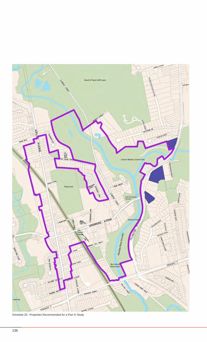
136
Schedule 20: Properties Recommended for a Part IV Study
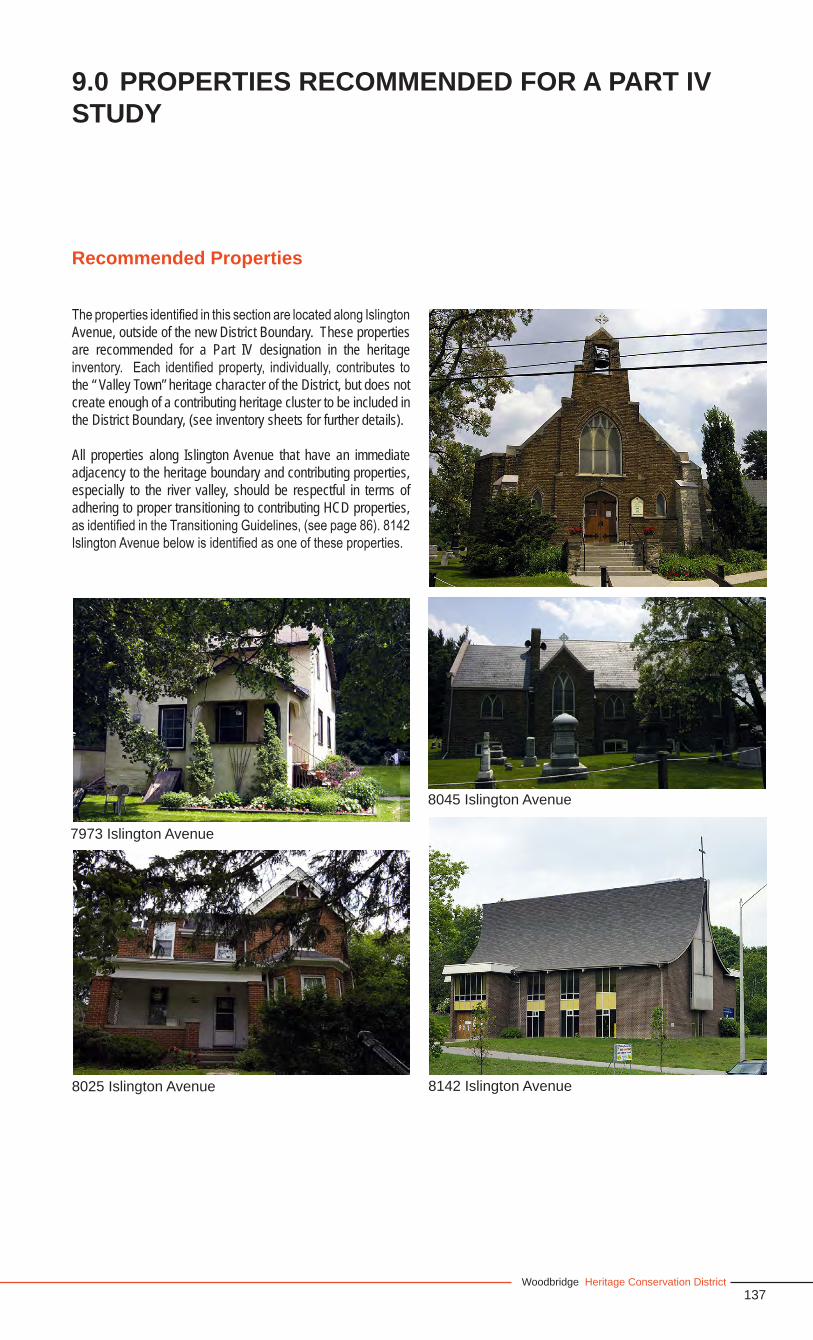
137Woodbridge Heritage Conservation District
The properties identified in this section are located along Islington Avenue, outside of the new District Boundary. These properties are recommended for a Part IV designation in the heritage inventory. Each identified property, individually, contributes to the “ Valley Town” heritage character of the District, but does not create enough of a contributing heritage cluster to be included in the District Boundary, (see inventory sheets for further details).
All properties along Islington Avenue that have an immediate adjacency to the heritage boundary and contributing properties, especially to the river valley, should be respectful in terms of adhering to proper transitioning to contributing HCD properties, as identified in the Transitioning Guidelines, (see page 86). 8142 Islington Avenue below is identified as one of these properties.
9.0 PROPERTIES RECOMMENDED FOR A PART IV STUDY
Recommended Properties
7973 Islington Avenue
8025 Islington Avenue
8045 Islington Avenue
8142 Islington Avenue
138
• Existing municipal policies regarding urban design should be reviewed, such as building setbacks from heritage structures, and changed as necessary to support the recommendations of the Heritage Conservation District Study.
• Changes to the Zoning By-Law in terms of the rezoning of land as recommended in this study, should be undertaken during the process of this HCD Study.
• Adoption of the Federal “Standards and Guidelines for the Conservation of Historic Places in Canada” that provide guidelines for restoration work should be undertaken in accordance with this HCD Study.
• All policies and guidelines established in this Study will be applied to the areas of the Kipling Avenue Corridor Study area that fall within the HCD District boundary and take precedence over the Kipling Avenue Corridor Official Plan.
• Guidelines in the Woodbridge Heritage Conservation District Plan are generally in conformity with the Zoning By-law. Proposed changes to the Zoning By-law are outlined as follows:
Along Woodbridge Avenue, new buildings should • have no side yards opening onto Woodbridge, and should create a continuous street wall with setbacks that are adjusted to be in alignment with the setback line of existing heritage buildings. This may result in a sinuous street wall that varies in setback as opposed to one continuous setback line.On-street parking should be encouraged along the • length of Woodbridge Avenue.
10.0 UPDATES TO EXISTING POLICY
Policy Changes

139Woodbridge Heritage Conservation District
Appendix
140
Abell Avenue
18 WB Non-Contributing 19 WB Non-Contributing 23 WB Contributing24 WB Contributing27 Non-Contributing28 WB Contributing32 WB Contributing33 Non-Contributing38 Non-Contributing41 Contributing44 Contributing45 Contributing50 Non-Contributing51 Contributing54 Contributing57 Non-Contributing62 Non-Contributing64 WB Non-Contributing65 Non-Contributing71 Non-Contributing
Armos Maynard Circle
None WB Non-Contributing
Arbors Lane
100 WB Non-Contributing
Burton’s Lane
1 WB Non-Contributing3 WB Contributing (Streetscape and Westerly Shed)
Burwick Avenue
20 WB Contributing26 Non-Contributing32 Non-Contributing38 Contributing (Approved for Demolition)44 Non-Contributing60 Non-Contributing
Chavender Street
32 WB Non-Contributing
Cheltenham Avenue
21 WB Non-Contributing22 WB Non-Contributing27 Non-Contributing30 Non-Contributing35 Non-Contributing36 Non-Contributing42 Non-Contributing43 Non-Contributing48 Non-Contributing51 Non-Contributing54 Contributing57 Non-Contributing60 Non-Contributing65 Non-Contributing66 Non-Contributing71 Contributing72 Non-Contributing77 Non-Contributing80 Non-Contributing81 Non-Contributing
Clarence Street
15 WB Contributing (Approved for Demolition)23 WB Non-Contributing30 WB Non-Contributing (Approval for Demolition) 31 WB Non-Contributing36 WB Contributing (Approved for Demolition) 43 WB Non-Contributing44 WB Contributing50 WB Contributing51 WB Non-Contributing57 WB Non-Contributing61 WB Contributing66 WB Non-Contributing69 WB Contributing (Demolished)70 WB Contributing77 WB Contributing78 WB Non-Contributing
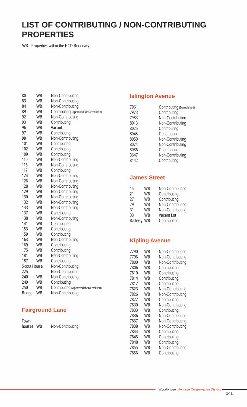
141Woodbridge Heritage Conservation District
80 WB Non-Contributing83 WB Non-Contributing84 WB Non-Contributing89 WB Contributing (Approved for Demolition)92 WB Non-Contributing93 WB Contributing96 WB Vacant97 WB Contributing98 WB Non-Contributing101 WB Contributing102 WB Contributing109 WB Contributing110 WB Non-Contributing116 WB Non-Contributing117 WB Contributing124 WB Non-Contributing126 WB Non-Contributing128 WB Non-Contributing129 WB Non-Contributing130 WB Non-Contributing132 WB Non-Contributing133 WB Non-Contributing137 WB Contributing138 WB Non-Contributing141 WB Contributing153 WB Contributing159 WB Contributing163 WB Non-Contributing169 WB Contributing175 WB Contributing181 WB Non-Contributing187 WB ContributingScout House Non-Contributing225 Non-Contributing240 WB Non-Contributing249 WB Contributing250 WB Contributing (Approved for Demolition)Bridge WB Non-Contributing
Fairground Lane
Town-houses WB Non-Contributing
Islington Avenue
7961 Contributing (Demolished)7973 Contributing7983 Non-Contributing8013 Non-Contributing8025 Contributing8045 Contributing8050 Non-Contributing 8074 Non-Contributing8086 Contributing3647 Non-Contributing8142 Contributing
James Street
15 WB Non-Contributing21 WB Contributing27 WB Contributing29 WB Non-Contributing31 WB Non-Contributing33 WB Vacant LotRailway WB Contributing
Kipling Avenue
7790 WB Non-Contributing7796 WB Non-Contributing7800 WB Non-Contributing7806 WB Contributing7810 WB Contributing7814 WB Contributing7817 WB Contributing7823 WB Non-Contributing7826 WB Non-Contributing7827 WB Contributing7830 WB Non-Contributing7833 WB Contributing7836 WB Non-Contributing7837 WB Non-Contributing7838 WB Non-Contributing7844 WB Contributing7845 WB Contributing7848 WB Contributing7855 WB Non-Contributing7856 WB Contributing
LIST OF CONTRIBUTING / NON-CONTRIBUTING PROPERTIES WB - Properties within the HCD Boundary

142
Kipling Avenue (continued) 7862 WB Non-Contributing7863 WB Non-Contributing7866 WB Contributing7871 WB Non-Contributing7872 WB Contributing7876 WB Vacant Lot7877 WB Non-Contributing7880 WB Contributing7883 WB Contributing7895 WB Contributing7909 WB Contributing7912 WB Contributing7913 WB Contributing (Demolished)7918 WB Non-Contributing7924 WB Contributing7925 WB Contributing (Demolished)7927 WB Contributing (Demolished)7929 WB Contributing (Demolished)7930 WB Non-Contributing7933 WB Contributing (Demolished)7934 WB Contributing7937 WB Non-Contributing (Demolished)7938 WB Contributing7944 WB Non-Contributing7945 WB Contributing (Demolished)7955 WB Contributing7960 WB Non-Contributing7971 WB Contributing7974 WB Contributing7981 WB Contributing7984 WB Contributing7985 WB Contributing 7988 WB Contributing7993 WB Non-Contributing7994 WB Non-Contributing8000 WB Contributing8001 WB Contributing8006 WB Contributing8009 WB Contributing8010 WB Non-Contributing8015 WB Non-Contributing8018 WB Non-Contributing8026 WB Non-Contributing8019 WB Non-Contributing8026 WB Non-Contributing8027 WB Non-Contributing8032 WB Non-Contributing8033 WB Non-Contributing
8039 WB Contributing8048 WB Non-Contributing8060 WB Non-Contributing8065 WB Non-Contributing8066 WB Contributing8071 WB Contributing8074 WB Contributing8090 WB Contributing8100 WB Non-Contributing8101 WB Contributing8109 WB Contributing8127 WB Contributing8135 WB Non-Contributing8143 WB Non-Contributing8145 WB Non-Contributing8158 WB Non-Contributing8161 WB Contributing8171 WB Non-Contributing (Demolished)8177 WB Contributing8183 WB Non-Contributing8191 WB Contributing8196 WB Non-Contributing8199 WB Non-Contributing8204 WB Contributing8214 WB Non-Contributing (Roadway)8215 WB Contributing8221 WB Contributing8222 WB Non-Contributing8227 WB Contributing8228 WB Contributing8233 WB Contributing8234 WB Non-Contributing8237 WB Contributing8238 WB Contributing8243 WB Contributing8246 WB Non-Contributing8247 WB Non-Contributing8248 WB Contributing8251 WB Non-Contributing8255 WB Contributing8258 WB Contributing8260 WB Non-Contributing8265 WB Contributing
143Woodbridge Heritage Conservation District
Meeting House Road
11 Non-Contributing17 Non-Contributing23 Non-Contributing29 Non-Contributing41 Non-Contributing47 Non-Contributing53 Non-Contributing57 Non-Contributing65 Non-Contributing75 Non-Contributing 79 Non-Contributing83 Non-Contributing93 Non-Contributing103 Non-Contributing111 Non-Contributing117 Non-Contributing121 Non-Contributing139 WB Non-Contributing140 WB Non-Contributing141 WB Non-Contributing150 WB Non-Contributing
Woodbridge Methodist Cemetery - WB Contributing
Memorial Hill Drive
1 WB Non-Contributing
Old Firehall Lane
7-19 WB Non-Contributing33-down Townhouses WB Non-Contributing
Park Drive
16 WB Non-Contributing 20 WB Contributing21 WB Non-Contributing25 WB Non-Contributing26 WB Non-Contributing30 WB Non-Contributing31 WB Non-Contributing
38 WB Non-Contributing40 WB Non-Contributing41 WB Non-Contributing42 WB Non-Contributing43 WB Non-Contributing45 WB Non-Contributing46 WB Non-Contributing47 WB Non-Contributing48 WB Non-Contributing 49 WB Non-Contributing50 WB Non-Contributing51 WB Non-Contributing52 WB Non-Contributing53 WB Non-Contributing54 WB Non-Contributing55 WB Non-Contributing56 WB Non-Contributing58 WB Non-Contributing
Porter Avenue (Fairgrounds)
100 WB Contributing
Rosebury Lane
14 Non-Contributing15 Non-Contributing18 Non-Contributing19 Non-Contributing22 Non-Contributing23 Non-Contributing26 Non-Contributing27 Non-Contributing30 Non-Contributing 32 Non-Contributing36 Non-Contributing40 Non-Contributing44 Non-Contributing47 Non-Contributing48 Non-Contributing50 Non-Contributing51 Non-Contributing54 Non-Contributing55 Non-Contributing59 Non-Contributing60 Non-Contributing63 Non-Contributing
LIST OF CONTRIBUTING / NON-CONTRIBUTING PROPERTIES
144
Rosebury Lane (continued)
67 Non-Contributing71 Non-Contributing75 Non-Contributing79 Non-Contributing81 Non-Contributing85 Non-Contributing88 Non-Contributing91 Non-Contributing92 Non-Contributing95 Non-Contributing97 Non-Contributing100 Non-Contributing101 Non-Contributing103 Non-Contributing105 Non-Contributing107 Non-Contributing109 Non-Contributing110 Non-Contributing111 Non-Contributing113 Non-Contributing114 Non-Contributing117 Non-Contributing118 Non-Contributing121 Non-Contributing122 Non-Contributing134 Non-Contributing140 Non-Contributing146 Non-Contributing151 Non-Contributing
Rosewood Court
4 Non-Contributing8 Non-Contributing9 Non-Contributing11 Non-Contributing12 Non-Contributing15 Non-Contributing16 Non-Contributing19 Non-Contributing20 Non-Contributing23 Non-Contributing
Wallace Street
15 WB Contributing19 WB Contributing24-36 WB Non-Contributing43 WB Non-Contributing (Heritage Clearance Approval achieved for Demo Permit Application)44 WB Contributing49 WB Non-Contributing (Heritage Clearance Approval achieved for Demo Permit Application)50 WB Contributing56 WB Contributing57 WB Contributing65 WB Non-Contributing (Heritage Clearance Approval achieved for Demo Permit Application)66 WB Contributing73 WB Non-Contributing (Heritage Clearance Approval achieved for Demo Permit Application)80 WB Contributing81 WB Non-Contributing95 WB Contributing110 WB Non-Contributing118 WB Contributing122 WB Non-Contributing128 WB Non-Contributing138 WB Non-Contributing142 WB Contributing148 WB Contributing158 WB Non-Contributing166 WB Contributing (Approved for Demolition)
William Street
36 WB Contributing38 WB Contributing61 WB Non-Contributing66 WB Contributing69 WB Contributing 72 WB Contributing75 WB Non-Contributing78 WB Contributing81 WB Non-Contributing84 WB ContributingVeteran’s Park and Nort Johnson District Park - WB - Contributing
145Woodbridge Heritage Conservation District
William Farr Lane
1-6 WB Non-Contributing12-22 WB Non-Contributing
Woodbridge Avenue
Woodbridge Avenue Railway Bridge - WB - Contributing31 WB Non-Contributing53 WB Non-Contributing56 WB Non-Contributing75 WB Non-Contributing83 WB Non-Contributing86 WB Contributing (Approved for Demolition) 93 WB Non-Contributing96 WB Contributing97 WB Contributing (Approved for Demolition) 106 WB Non-Contributing108 WB Non-Contributing110 WB Non-Contributing112 WB Contributing (Demolished)116 WB Contributing (Demolished)121-131 WB Non-Contributing124 WB Contributing(adjacent to 124) Non-Contributing * 137 WB Contributing140 WB Non-Contributing141 WB Non-ContributingPublic Park WB Contributing145 WB Non-Contributing150 WB Contributing153 WB Non-Contributing154 WB Non-Contributing159 WB Contributing165 WB Non-Contributing160 WB Non-Contributing166 WB Contributing167 WB Contributing174 WB Contributing177 WB Non-Contributing182-196 WB Non-Contributing185 WB Contributing197 WB Contributing206-226 WB Non-Contributing
LIST OF CONTRIBUTING / NON-CONTRIBUTING PROPERTIES
207-217 WB Non-Contributing232 WB Non-Contributing239 WB Old Building (Demolished)252 WB Non-Contributing (Demolished*)256 WB Non-Contributing (Demolished*)259 WB Non-Contributing260 WB Non-Contributing (sales pavilion)268 WB Contributing275 WB Non-Contributing281 WB Non-Contributing325 WB Non-Contributing
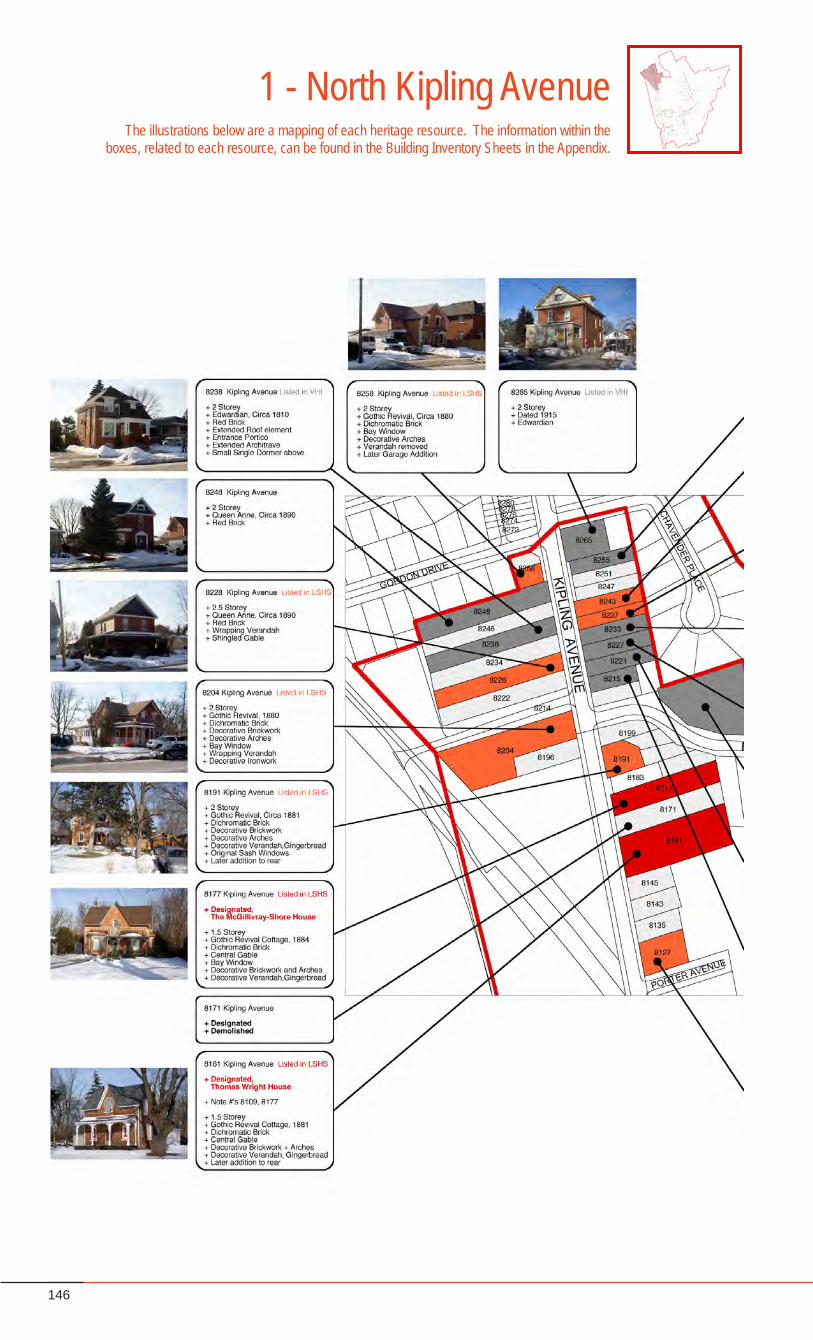
146
1 - North Kipling AvenueThe illustrations below are a mapping of each heritage resource. The information within the
boxes, related to each resource, can be found in the Building Inventory Sheets in the Appendix.
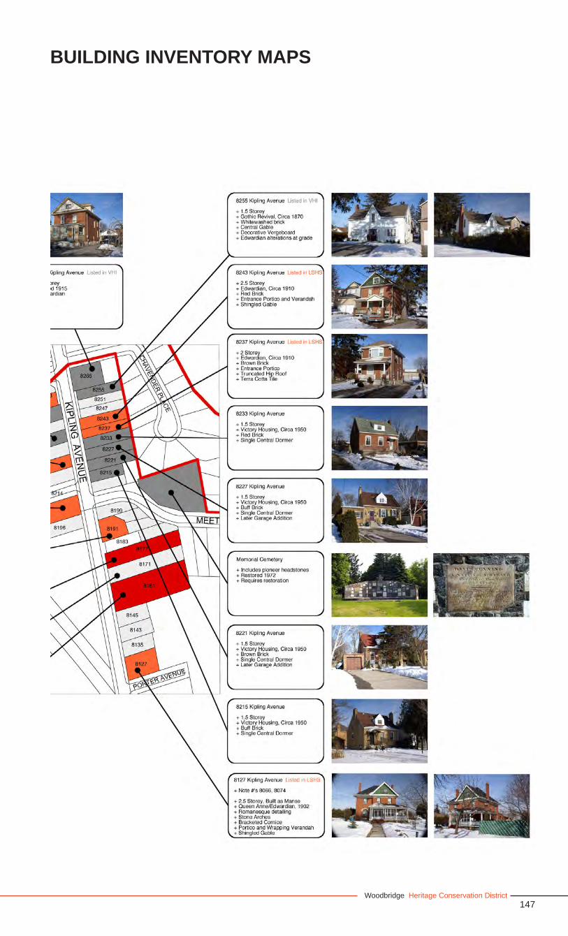
147Woodbridge Heritage Conservation District
BUILDING INVENTORY MAPS
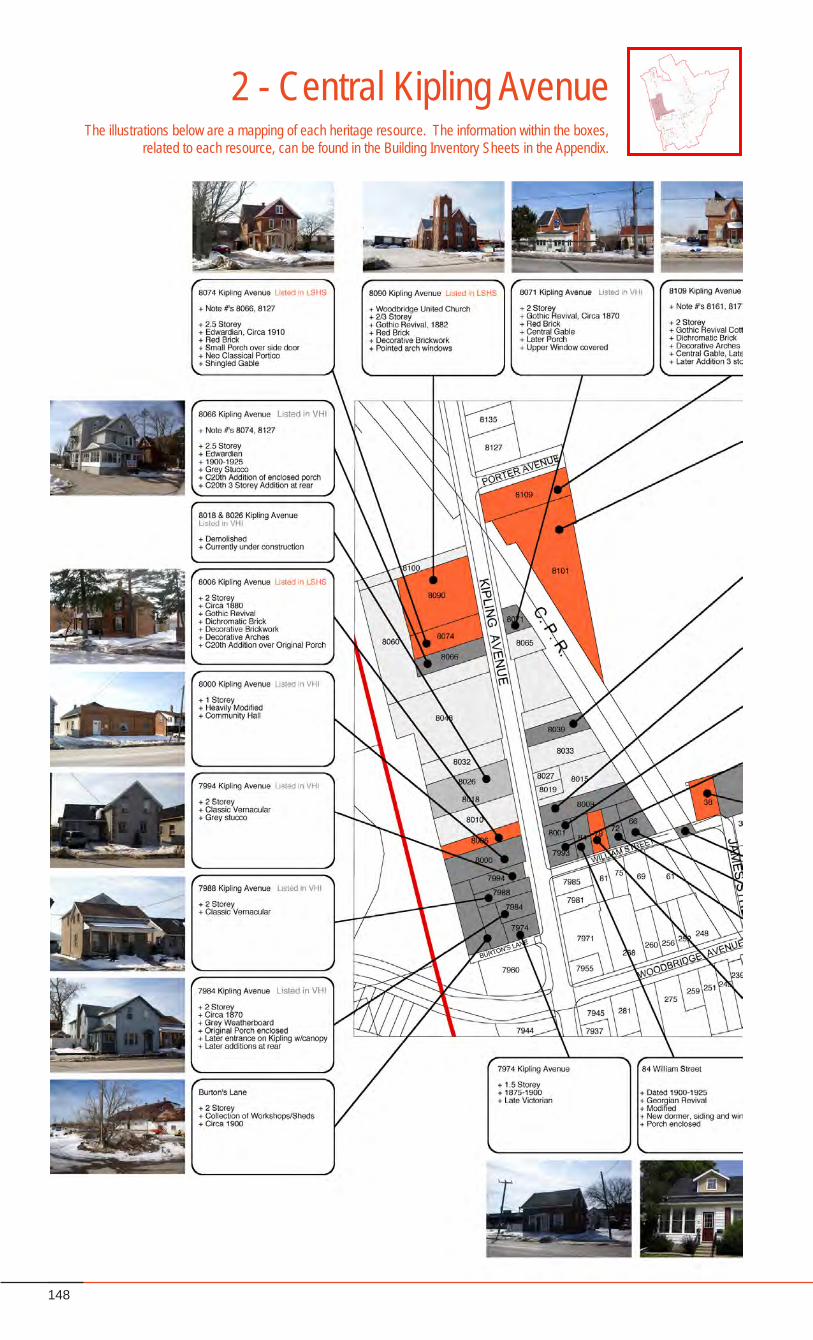
148
2 - Central Kipling AvenueThe illustrations below are a mapping of each heritage resource. The information within the boxes,
related to each resource, can be found in the Building Inventory Sheets in the Appendix.

149Woodbridge Heritage Conservation District
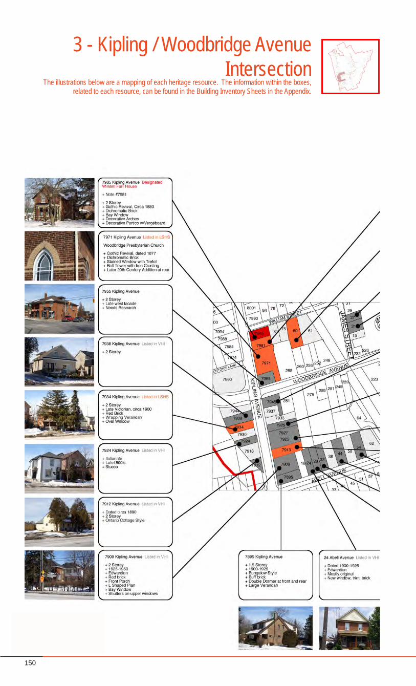
150
3 - Kipling / Woodbridge Avenue Intersection
The illustrations below are a mapping of each heritage resource. The information within the boxes, related to each resource, can be found in the Building Inventory Sheets in the Appendix.
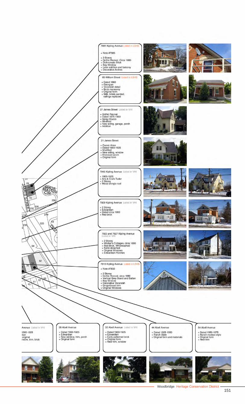
151Woodbridge Heritage Conservation District
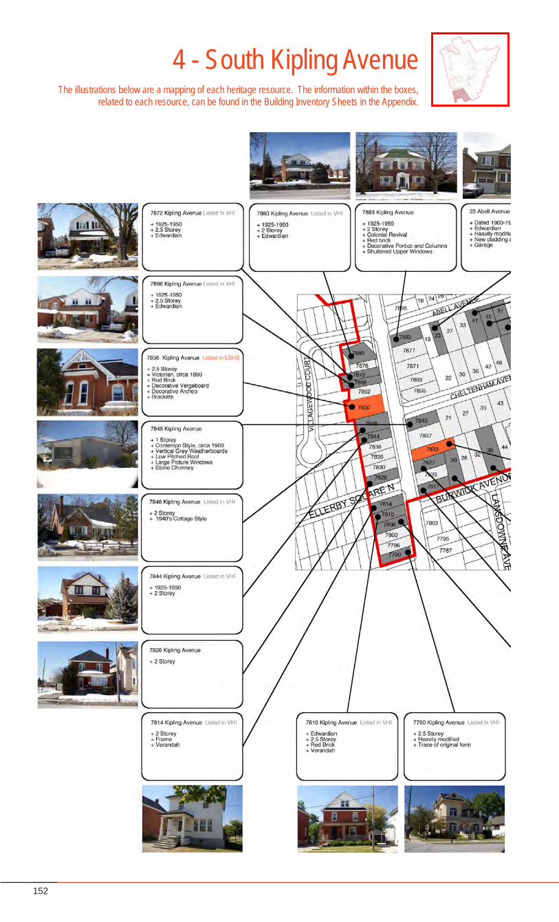
152
4 - South Kipling AvenueThe illustrations below are a mapping of each heritage resource. The information within the boxes,
related to each resource, can be found in the Building Inventory Sheets in the Appendix.
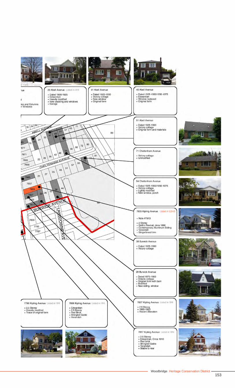
153Woodbridge Heritage Conservation District
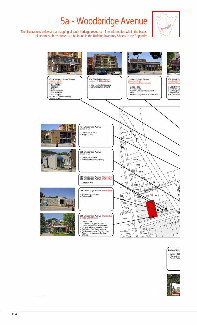
154
5a - Woodbridge AvenueThe illustrations below are a mapping of each heritage resource. The information within the boxes,
related to each resource, can be found in the Building Inventory Sheets in the Appendix.
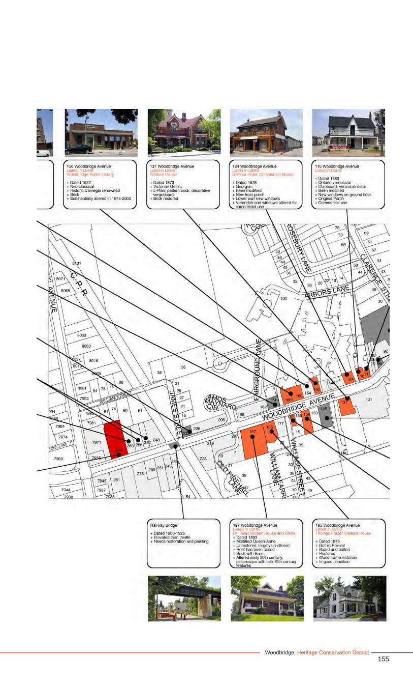
155Woodbridge Heritage Conservation District
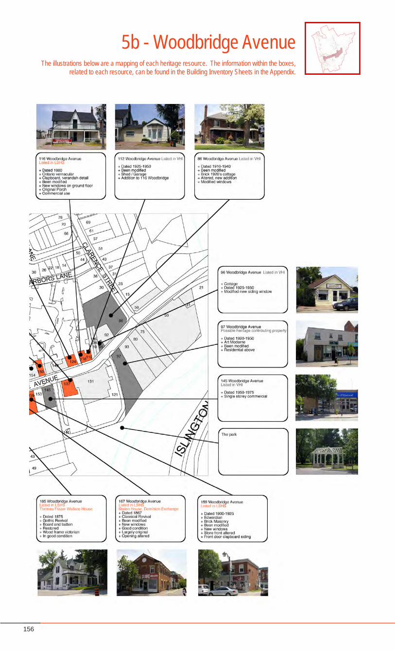
156
5b - Woodbridge AvenueThe illustrations below are a mapping of each heritage resource. The information within the boxes,
related to each resource, can be found in the Building Inventory Sheets in the Appendix.
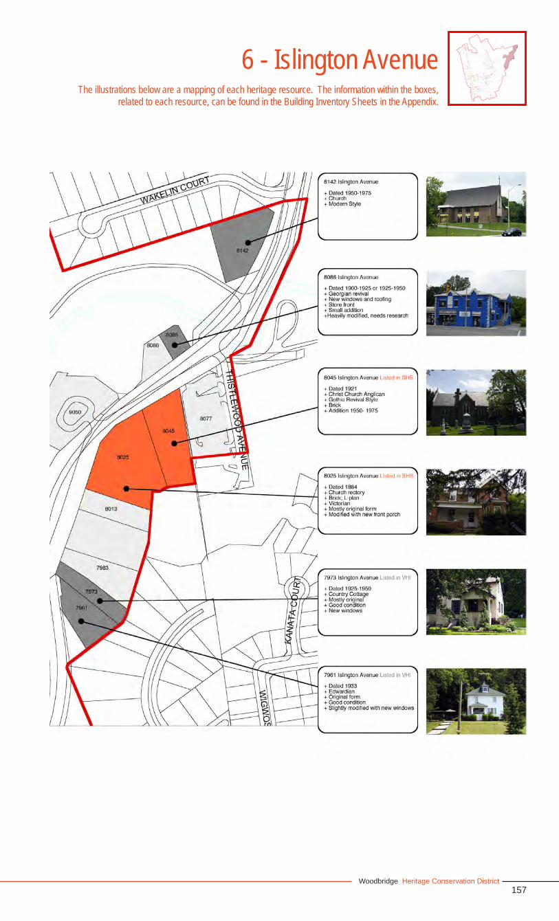
157Woodbridge Heritage Conservation District
6 - Islington AvenueThe illustrations below are a mapping of each heritage resource. The information within the boxes,
related to each resource, can be found in the Building Inventory Sheets in the Appendix.
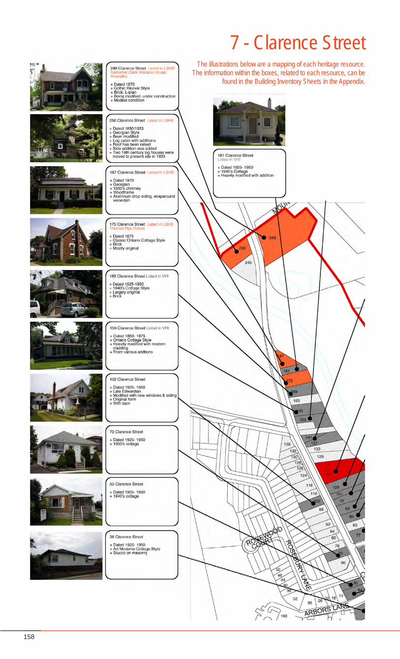
158
7 - Clarence StreetThe illustrations below are a mapping of each heritage resource.
The information within the boxes, related to each resource, can be found in the Building Inventory Sheets in the Appendix.
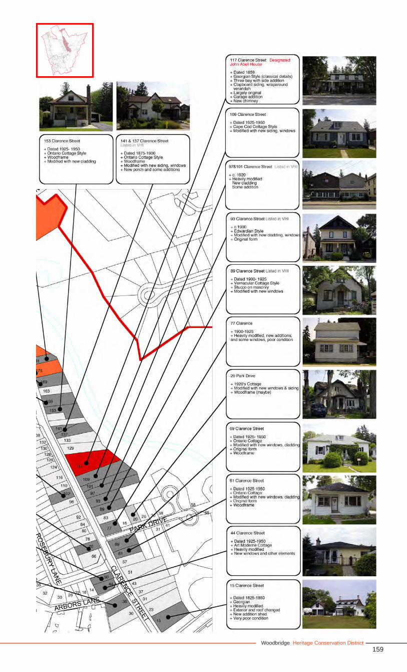
159Woodbridge Heritage Conservation District
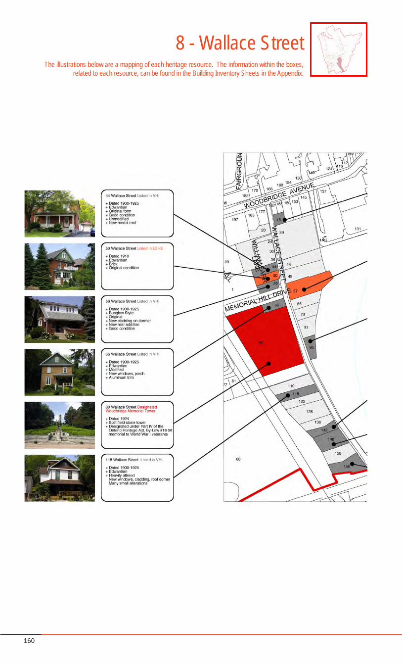
160
8 - Wallace StreetThe illustrations below are a mapping of each heritage resource. The information within the boxes,
related to each resource, can be found in the Building Inventory Sheets in the Appendix.
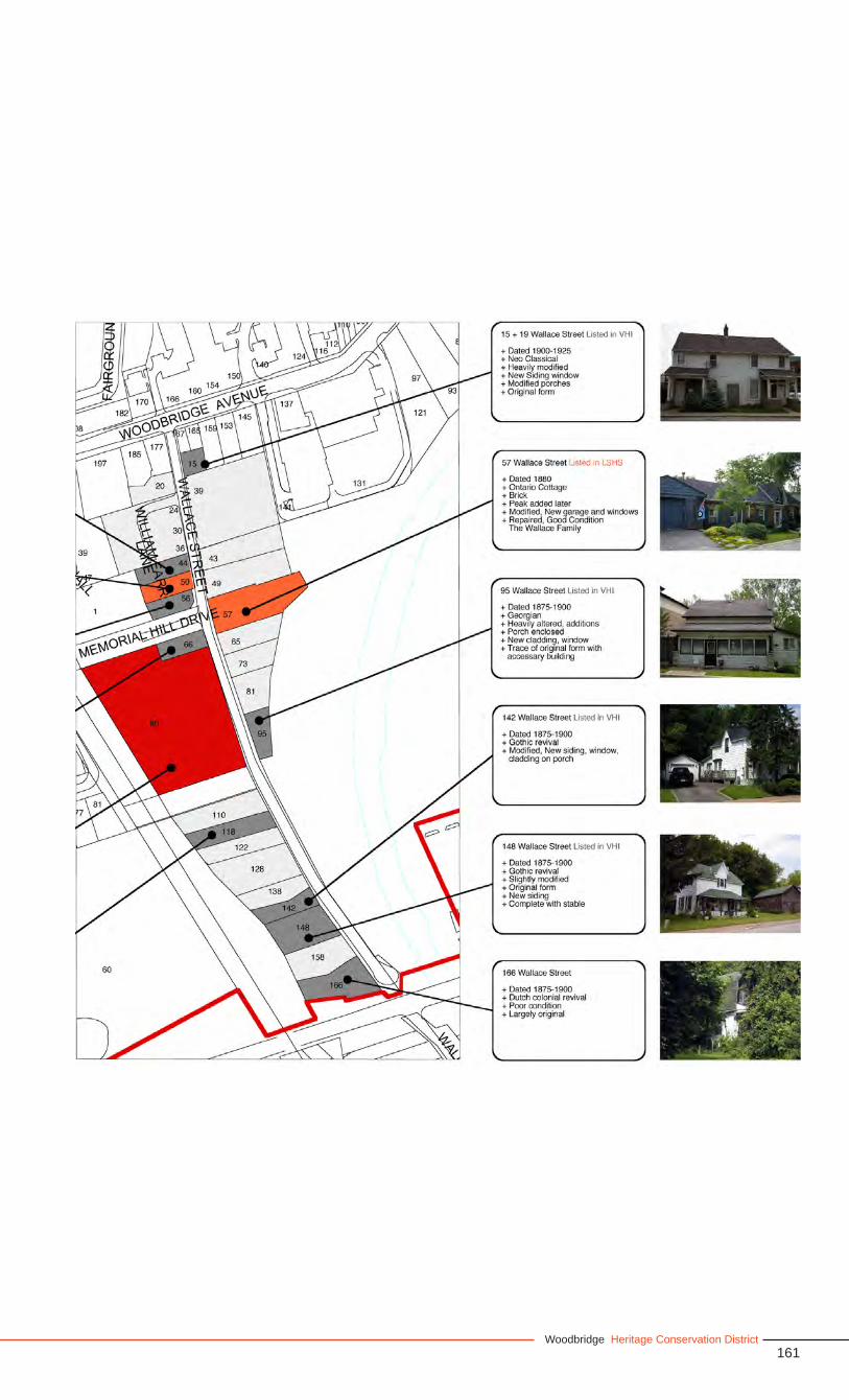
161Woodbridge Heritage Conservation District

W
in association with: Goldsmith Borgal and Company Architects