W. L. Friedrich, A. Højen Sørensen & S. Katsipis, Santorini Before the Minoan Eruption: The Ship...
10
AEGAEUM 37 Annales liégeoises et PASPiennes d’archéologie égéenne PHYSIS L’ENVIRONNEMENT NATUREL ET LA RELATION HOMME-MILIEU DANS LE MONDE ÉGÉEN PROTOHISTORIQUE Actes de la 14 e Rencontre égéenne internationale, Paris, Institut National d’Histoire de l’Art (INHA), 11-14 décembre 2012 Edités par Gilles TOUCHAIS, Robert LAFFINEUR et Françoise ROUGEMONT PEETERS LEUVEN - LIEGE 2014
Transcript of W. L. Friedrich, A. Højen Sørensen & S. Katsipis, Santorini Before the Minoan Eruption: The Ship...

AEGAEUM 37Annales liégeoises et PASPiennes d’archéologie égéenne
PHYSISL’ENVIRONNEMENT NATUREL
ET LA RELATION HOMME-MILIEUDANS LE MONDE ÉGÉEN PROTOHISTORIQUE
Actes de la 14e Rencontre égéenne internationale,Paris, Institut National d’Histoire de l’Art (INHA),
11-14 décembre 2012
Edités par Gilles TOUCHAIS,
Robert LAFFINEUR
et Françoise ROUGEMONT
PEETERSLEUVEN - LIEGE
2014
97631_Aegaeum 37 vwk.indd Sec1197631_Aegaeum 37 vwk.indd Sec11 11/12/14 08:2611/12/14 08:26

SANTORINI BEFORE THE MINOAN ERUPTION: THE SHIP FRESCO FROM AKROTIRI –
A GEOLOGICAL AND ARCHAEOLOGICAL APPROACH*
Introduction
The Ship Fresco, also known as the Flotilla Fresco, from Akrotiri on Thera is one of the most precious Bronze Age findings in the Aegean. (Pl. CXLVa) It shows a group of ships sailing from one harbour on the left to another harbour on the right of the fresco. In our opinion, the background of both harbours depicts elements of a volcanic landscape on Santorini with volcano-like hilltops, different types of lavas, and dykes.
Left Harbour
We consider that the left harbour was located in the swarm of 90 volcanic dykes situated below Megalo Vouno on Thera.1
We are of the opinion that the walls of some buildings in the left harbour town are volcanic dykes (Pl. CXLVb). Different types of rocks that are visible in the left fresco harbour could represent the different lava types on the Megalo Vouno caldera cliff (Pl. CXLVc). Furthermore, the red ground where people are standing, could fit well into the remaining volcano iconography, and a series of parallel lines resemble palisades or vegetation, but we think it could be small volcanic dykes which are often seen in this area. (Pl. CXLVIa) Moreover, freshwater, recognised by its clear blue colour in contrast to seawater, is running down a steep slope in two arch-like torrents.
Due to their hardness, volcanic dykes are more resistant to erosion and protrude relative to the weaker tuff. These dykes resemble man-made walls, and these “walls” must have attracted the inhabitants who were able to use them as walls for their houses. As can be seen in the left harbour town the existing dykes (walls) were closed with grey cut and dressed stones in a way that differs from the Akrotiri excavation where corners were built using headers and stretchers.2 Furthermore, the ground floor of the left building in the left harbour town of the fresco seems to be excavated into soft rock and not constructed as a façade.
Some groups of dykes form semi-globular structures on the caldera wall. Their shape resembles an apse. In periods of heavy rain, water will run down the wall of the caldera around the central, protruding part on both sides of these groups of dykes (Pl. CXLVc and CXLVIb). In our opinion, these volcanic structures resemble the left harbour of the fresco. We consider that the inhabitants created dwellings directly on the caldera wall beneath Megalo Vouno using the volcanic dykes as walls.3 (Pl. CXLVd)
En route to the Right Harbour
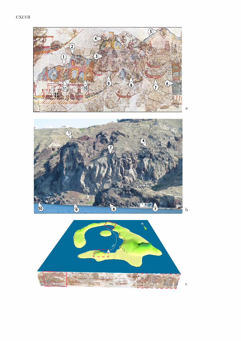
An area with no background is depicted between the two harbours in the fresco. This could be because the distance between the two harbours (Megalo Vouno and Balos) is about 13 km, and in some places the distance to the nearest caldera wall is about three km (Pl. CXLVIIc). Taking this distance into consideration, the artist was not able to see details in the caldera wall or alternatively he chose to put emphasis on the most important elements of his narrative.
* We thank James Richard Wilson for correcting the text, Kirsten Molly Søholm for assistance in the field, Grethe Storgaard and Mette Dybdahl for technical support.
1 W.L. FRIEDRICH and A. HØJEN SØRENSEN, “New light on the Ship Fresco from Late Bronze Age Thera,” PZ 85.2 (2010) 243-257.
2 C. PALYVOU, Akrotiri Thera; An Architecture of Affluence 3,500 Years Old (2005).3 FRIEDRICH and HØJEN SØRENSEN (supra n. 1).

476 Walter L. FRIEDRICH, Annette HØJEN SØRENSEN and Samson KATSIPIS
Right Harbour
We think that the painter focused here on the most important elements of the landscape.The right fresco harbour shows two bays: a sandy beach where boats could be hauled
ashore, and one with deeper water. The two bays are separated from each other by a rocky outcrop. In our opinion this rock represents the middle part of a black marginal dyke that is seen at three places in Balos harbour. To the right of this in the fresco, close to the first bay, there is a hill structure that resembles a knoll of volcanic tuff. This could be the Balos volcano. Even though in the fresco the structure is heavily reconstructed, we see the arch-like shape of the lava that can well represent the thick columnar lava at Balos which faces the sea (Pl. CXLVIIa). A house with three rooms is depicted on top of the lava flow. The fresco also shows a row of pyramid-like hills in the background of the right harbour. In our opinion, this landscape is comparable to the double harbour of Balos on the inner side of the caldera. Two houses have been excavated here: one on top of a columnar lava flow (PL. CXLVIIIa and b no. 17)4, and one situated on top of a pyramid-like hill (PL. CXLVIIIa and b no. 16).5
The physical setting of the Ship Fresco
Since the discovery of the Ship Fresco in Room 5 of the West House in the Akrotiri excavation on Thera in 1971, scholars have tried to understand the meaning of this precious document from the Late Bronze Age. The question of whether the location of this narration was on Santorini or not, was of great interest at that time. Spyridon Marinatos argued that the Left Harbour could be located in Libya and the Right Harbour on Santorini.6 At that time geologists and archaeologists were of the opinion that, prior to the Minoan eruption, the caldera did not exist and there was a huge mountain in the central part of Santorini.7 For that reason nobody speculated that the Ship Fresco could show an event taking place in the caldera of Santorini. In 1988 geologists proved that, prior to the Minoan eruption, a central mountain had already disappeared and the central part was a water-filled caldera.8 This fact was soon accepted by scholars working on Santorini.9 Even when Joseph Shaw in 1990 demonstrated that the right harbour was actually a double harbour,10 nobody thought that this harbour could be located on the inner side of the Santorini caldera. Archaeologists continued to argue that the right harbour town represents the Akrotiri excavation site. The first to connect the Santorini caldera with the Ship Fresco from Akrotiri were Grant Heiken and Floyd McCoy.11 In his opinion the mountain Profitis Elias could be seen in the background of the fresco. However, we do not support their opinion since Profitis Elias is not visible from sea level because the high caldera wall hinders the view, even when subtracting the pumice layer of the Minoan eruption. We assume that the painter of the fresco was sitting on a ship within the caldera where he sketched the scenery because all the items are painted from this perspective.
4 H. GORCEIX and H. MAMET, “Recherches et fouilles faites à Théra Santorin par MM. Mamet et Gorceix, membres de l’École française,” BCH 9 (1870) 187–191.
5 M. MARTHARI, “Raos and Chalarovounia: preliminary evidence from two new sites of the Late Cycladic I period on Thera,” ΑΛΣ 2 (2004) 61–65.
6 S. MARINATOS, Excavations at Thera VI (1974).7 C. DOUMAS, Santorin. Die Insel und Ihren Archaeologischen Schätze (1980). 8 W.L. FRIEDRICH, U. ERIKSEN, H. TAUBER, J. HEINEMEIER, N. RUD, M.S. THOMSEN, and B.
BUCHARDT, “Existence of a Water-filled Caldera prior to The Minoan eruption of Santorini, Greece,” Nat.wiss. 75 (1988) 567–569.
9 T.H. DRUITT and V. FRANCAVIGLIA, “An ancient caldera cliff line at Phira, and its significance for the topography and geology of Pre-Minoan Santorini”, in D.A. HARDY, C.G. DOUMAS, J.A. SAKELLARAKIS, and P.M. WARREN (eds), Thera and the Aegean World III (1990) 362–369; W.L. FRIEDRICH and C.G. DOUMAS, “Was there local access to certain ores/minerals for the Theran people before the Minoan eruption? An Addendum,” in HARDY et al. eds (this n.) 502-503.
10 J.W. SHAW, “Bronze Age Aegean Harborsides,” in HARDY et al. eds (supra n. 9) 420–436.11 G. HEIKEN and F. MCCOY, “Caldera development during the Minoan Eruption, Thira, Cyclades, Greece,”
Journal of Geophysical Research 89/B10 (1984) 8441-8462.

THE SHIP FRESCO.– A GEOLOGICAL AND ARCHAEOLOGICAL APPROACH 477
When in 2009 two of us rediscovered the old excavation site of Balos, close to Akrotiri on Thera, where the French scientists Gorceix and Mamet had excavated a house with three rooms during the late 19th century, it became evident that the natural double harbour of Balos could be the double harbour depicted in the Ship Fresco. This idea was presented in 2009 in Athens.12
In 2010 Thomas Strasser published his similar theory on the setting of both fresco harbours in the water-filled caldera of Santorini.13 He basically uses our reconstruction of the pre-Minoan shape of Santorini14 and places the two harbours on the inner side of the caldera close to the old French excavations of Balos and the excavation in the Alafousos quarry on Therasia (PL. CXLVIIIa and b no. 2). By doing so, he can place the scenery on the Ship Fresco inside the caldera and explain why there is an area of “open sea” in the fresco. However, we do not agree with this hypothesis for the following reasons. In the fresco the ships are sailing from the left to the right harbour, where the latter is clearly a double harbour, as shown by Shaw in 1990. However, in Strasser´s reconstruction the double harbour is depicted on the inner side of the caldera, while there is evidence that the harbour of the Alafousos site was on the outer side of the caldera facing south, not visible from his proposed viewpoint. His proposed double harbour on the inner side of the caldera does not exist today. The left harbour in Strasser’s reconstruction must be identical with the double harbour at Balos since he mentions the locality of Raos located on the cliff above Balos. (Pl. CXLVIIIa) We do, however, agree with Strasser that the right harbour (the destination locality) is not the archeaological site of Akrotiri.15
Here we show a solution where we place both fresco harbours on the inner side of the caldera wall on still-existing sites on Thera: the left harbour below Megalo Vouno on the northern part of Thera and the right harbour northwest of the present day village of Akrotiri at Balos double harbour. At Balos we see a ring-dyke, a thick columnar lava flow, and a red tuff/scoria knoll. Furthermore, on top of the lava flow there is a platform where Gorceix and Mamet excavated a house with three rooms in 1870.16
Especially on the right harbour it is evident that the artist tried to depict the landscape as naturally as possible.17 He emphasised the main visible objects: the thick columnar lava flow is painted in a way that we can see the columns with their characteristic arch-shape (Pl. CXLVIIa-b) and a partly red, protruding tuff/scoria knoll. The artist also differentiated between several volcanic rock types. He used a black colour for what we think is a marginal dyke and a different colour for the columnar lava flow which is the most prominent element in the landscape.
Moreover, we consider that the structure which was interpreted as a net by Shaw,18 represents a rack for drying fish with wooden beams to the left and fixed on the rocks to the right. These kinds of structures are normally located close to the sea where the fish can be cleaned immediately (decapitated and the internal organs removed), and prepared for drying (bundled) by hanging from their tails at a considerable height where they are secure from animals. A few decades ago on Santorini vinegar and salt were used before hanging the fish to dry. This would explain why this arrangement is located at the harbour in the Ship Fresco, and not in the vicinity of a settlement because of the strong malodour.
12 One of us (WLF) presented this idea in a talk in the Danish Institute in Athens in the autumn of 2009. In spring 2010 we had a note in the online journal www.videnskab.dk and the popular journal Aktuel Naturvidenskab and later that year we published our hypothesis in Praehistorische Zeitschrift (FRIEDRICH and HØJEN SØRENSEN [supra n. 1]).
13 T. STRASSER, “Location and Perspective in the Theran Flotilla Fresco,” JMA 23.1 (2010) 3-26.14 W.L. FRIEDRICH, Fire in the Sea (2000).15 STRASSER (supra n. 13) 8.16 F.A. FOUQUÉ, Santorin et ses éruptions (1889), translated and annotated by A.R. MCBIRNEY, Santorini and
its Eruptions (1998).17 Cf. for instance FRIEDRICH (supra n. 14) 198-39, figs 10.17-10.19 for a close parallel to rocks depicted in
Room 4 of the West House.18 SHAW (supra n. 10).

478 Walter L. FRIEDRICH, Annette HØJEN SØRENSEN and Samson KATSIPIS
The Santorini caldera in the Bronze Age
There is geological and archaeological evidence that the caldera existed prior to the Minoan eruption and was filled with seawater. (Pl. CXLVIIIa) There was an entrance to the caldera to the south and there was a circular island in the centre.19 This caldera had an area of about 85 km². The present day caldera of Santorini is quite similar to the Bronze Age caldera. By studying present day use of the caldera we get an idea of how this huge area was used in former times. Today there are several places on the inner side of the caldera where boats can be pulled ashore (Pl. CXLVIIIa). Moreover, numerous natural and artificial caves exist in the caldera wall, just above sea level. At present, some of them are used as churches and others as boat shelters. There is, for instance, a church on top of a marginal dyke at Balos (Ag. Nikolaos) – one of the places that we consider to be the harbour sites depicted in the fresco and a church in a cave below Megalo Vouno (Efta Pedes) close to the site we consider to be the locality of the left fresco harbour (Pl. CXLVIb).
The water-filled caldera gave the population of Bronze Age Santorini several advantages in a confined area. It also provides good protection from the strong wind. If it is windy in the open sea around Santorini it is often calm inside the caldera, providing the population with alternative harbours. Furthermore, there are places where warm water wells up, resulting in good fishing sites. Moreover, there was probably access to pigments20 and minerals21 e.g. talc and lead, since we consider that the sites between Cape Athinios and Cape Plaka on the inner side of the caldera where these minerals were found were accessible in the Bronze Age. Moreover, today certain building stones used in the Bronze Age town of Akrotiri are found on the caldera wall, e.g. the lava slabs used for paved floors in the houses, and the white-grey building blocks from Balos harbour (A1-tuff).
Conclusions
Several detailed geological observations in the landscape of Santorini enable us to claim that the two harbour towns were located on the inner side of the caldera wall on the island of Thera prior to the Minoan Eruption. This hypothesis is in agreement with the excavation sites of Balos and Raos. The painted landscape in the fresco is highly comparable to what is seen in the two harbour sites discussed above. The water-filled caldera gave the inhabitants additional advantages: several natural harbours, good fishing grounds, and mineral resources.
This new interpretation enables us to claim that the fresco shows a joyful scene where the inhabitants of Bronze Age Santorini celebrate the seasonal change in connection with the arrival of life-giving rainwater either at the beginning of spring or at the end of the sailing season in autumn (Pl. CXLVIIc).22
Walter L. FRIEDRICHAnnette HØJEN SØRENSENSamson KATSIPIS
19 FRIEDRICH et al. (supra n. 8).20 S.E. RASMUSSEN, S. GRUNDVIG and W. L. FRIEDRICH, “Composition of Pigments of Santorini Frescoes.
The Rietveld Method as an Aid,” Qualitative Phase Analysis. Journal of Powder Diffraction 19.1 (2004) 1-4.21 FRIEDRICH and DOUMAS (supra n. 9).22 FRIEDRICH and HØJEN SØRENSEN (supra n. 1); A. HØJEN SØRENSEN, W. L. FRIEDRICH, S. KATSIPIS
and K. M. SØHOLM, “Miniatures of Meaning: Interdisciplinary Approaches to the Miniature Frescos from the West House at Akrotiri on Thera,” in 1600, Tagungen des Landesmuseums für Vorgeschichte Halle 8, Halle/Saale (2013).

THE SHIP FRESCO.– A GEOLOGICAL AND ARCHAEOLOGICAL APPROACH 479
LIST OF ILLUSTRATIONS
Pl. CXLVa The Ship Fresco from the West House, Room 5, Akrotiri excavation (© Hellenic Ministry of Education and Religious Affairs, Culture and Sports/21st Ephorate of Antiquities).
Pl. CXLVb Left harbour of the Ship Fresco, enlarged (© Hellenic Ministry of Education and Religious Affairs, Culture and Sports/21st Ephorate of Antiquities).
Pl. CXLVc Group of dykes below Megalo Vouno forming a semi-globular apse-like structure. Ten darker lavas are visible on the left of the picture (Therasia lavas). The dykes look like man-made walls (Photo: W. L. Friedrich).
Pl. CXLVd Same photograph as Pl. CXLVc with inserted section of the left harbour in the Ship Fresco to show the similarity between the Ship Fresco and the volcanic landscape. Rainwater (darker blue on the fresco) runs down the cliff in two arch-like torrents (Photo: W. L. Friedrich; Ship Fresco: © Hellenic Ministry of Education and Religious Affairs, Culture and Sports/21st Ephorate of Antiquities).
Pl. CXLVIa Small dykes on the caldera wall (look like palisades and/or vegetation) in the left harbour (Photo: W. L. Friedrich).
Pl. CXLVIb Apse-like structure with dykes below Megalo Vouno. The upper third of the photo shows the darker Therasia lavas. Between the Therasia lavas and the underlying lavas is a series of caves. The church Efta Pedes is located in the larger cave on the left side at sea level. At present the inhabitants collect rainwater here in a cistern (Photo: W. L. Friedrich).
Pl. CXLVIIa Section of the right fresco harbour: 1. Tuff knoll, partly red; 2. Thick columnar lava flow; 3. Rack for drying fish; 4. House with three rooms; 5. Possible location of the Raos house; 6. Buildings erected against the natural cliff; 7. Right harbour basin with two boats; 8. Dark, rough rock separating the two harbour basins; 9. Left harbour basin with sandy beach where three minor boats are hauled on land; 10. Dark, rough rock like 8; 11. Large blocks lying in front of the columnar lava (© Hellenic Ministry of Education and Religious Affairs, Culture and Sports/21st Ephorate of Antiquities).
Pl. CXLVIIb Mining activity in the 1870ies have removed the upper pumice layer of the Minoan eruption. Balos double harbour south-west of Akrotiri village: 1. Balos red tuff/scoria knoll; 2. Thick columnar lava flow (16 m. thick); 4. Platform where Gorceix and Mamet excavated a house with three rooms; 7. Right harbour basin at present filled with blocks from the mining activities in the 1870s; 8. Dark, rough rock (marginal dyke) separating the two harbour basins; 9. Left harbour basin where boats can be hauled ashore; 10. Dark, rough rock like 8 (Photo: W. L. Friedrich).
Pl. CXLVIIc Reconstruction of the Santorini caldera prior to the Minoan eruption combined with the Ship Fresco from Akrotiri. Comparable harbour areas are marked with rectangles. The route of the ships is marked by a dotted line (Reconstruction: W. L. Friedrich).
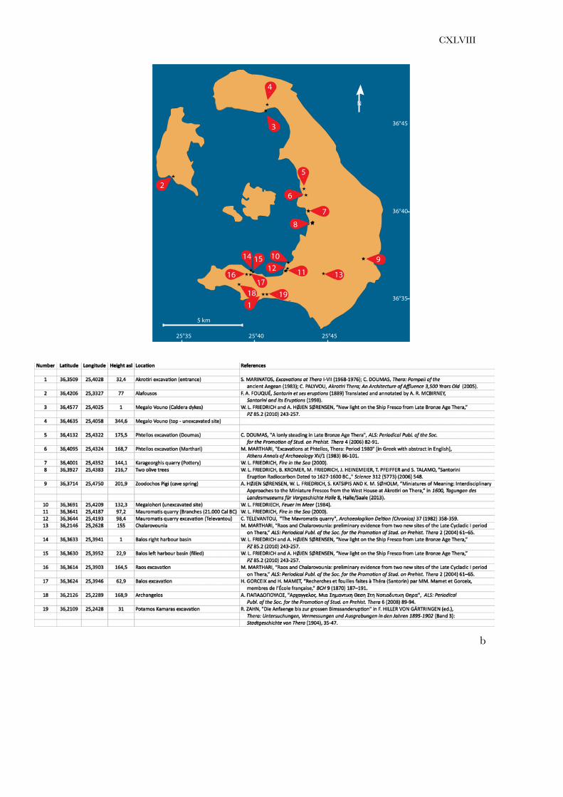
Pl. CXLVIIIa Locations of several Bronze Age sites on present day map of Santorini based on GPS measurements. See Pl. CXLVIIIb (© W. L. Friedrich and A. Højen Sørensen).
Pl. CXLVIIIb GPS coordinates of archaeological and geological sites. See Pl. CXLVIIIa (© W. L. Friedrich, A. Højen Sørensen and S. Katsipis).

a
b
c
d
CXLV

CXLVI
a
b
CXLVII
a
b
c
CXLVIII
a
b
N
36°40
36°45
36°35
25°40 25°4525°35
5 km
1
2
7
8
16
9
17
99999999910
12 11
6
13
1918
3
5
15
4
14
![«Landed Property and Taxation in Santorini in the 17th Century (with the collaboration of Maria Spiliotopoulou) [in Greek], Mnemon 18 (1996), 109-142](https://static.fdokumen.com/doc/165x107/6317aafe2b00f6ff4406add8/landed-property-and-taxation-in-santorini-in-the-17th-century-with-the-collaboration.jpg)