LIVING ON THE EDGE. PEOPLE AND PHYSIS IN PREHISTORIC IMATHIA, MACEDONIA, GREECE, Aegaeum 37, 2014
18
AEGAEUM 37 Annales liégeoises et PASPiennes d’archéologie égéenne PHYSIS L’ENVIRONNEMENT NATUREL ET LA RELATION HOMME-MILIEU DANS LE MONDE ÉGÉEN PROTOHISTORIQUE Actes de la 14 e Rencontre égéenne internationale, Paris, Institut National d’Histoire de l’Art (INHA), 11-14 décembre 2012 Edités par Gilles TOUCHAIS, Robert LAFFINEUR et Françoise ROUGEMONT PEETERS LEUVEN - LIEGE 2014
Transcript of LIVING ON THE EDGE. PEOPLE AND PHYSIS IN PREHISTORIC IMATHIA, MACEDONIA, GREECE, Aegaeum 37, 2014

AEGAEUM 37Annales liégeoises et PASPiennes d’archéologie égéenne
PHYSISL’ENVIRONNEMENT NATUREL
ET LA RELATION HOMME-MILIEUDANS LE MONDE ÉGÉEN PROTOHISTORIQUE
Actes de la 14e Rencontre égéenne internationale,Paris, Institut National d’Histoire de l’Art (INHA),
11-14 décembre 2012
Edités par Gilles TOUCHAIS,
Robert LAFFINEUR
et Françoise ROUGEMONT
PEETERSLEUVEN - LIEGE
2014
97631_Aegaeum 37 vwk.indd Sec1197631_Aegaeum 37 vwk.indd Sec11 11/12/14 08:2611/12/14 08:26
SOMMAIRE
Préface 11 A. Cadre naturel : Georgia KOURTESSI-PHILIPPAKIS, Local vs exogène ? L’impact du milieu naturel sur la composition des assemblages lithiques néolithiques en Grèce 15 Georgia STRATOULI, Anaya SARPAKI, Maria NTINOU, Eleni KOTJABOPOULOU, Tatiana THEODOROPOULOU, Vasilios MELFOS, Niels H. ANDREASEN, Panagiotis KARKANAS, Dialogues Between Bioarchaeological, Geoarchaeological and Archaeological Data: Approaches to Understanding the Neolithic Use of Drakaina Cave, Kephalonia Island, Western Greece 23 Erika WEIBERG, Timing, Perception and Response. Human Dimensions of Erosion and Sedimentation in the Greek Bronze Age 33 Evangelia STEFANI, Nikos MEROUSIS, Living on the Edge. People and Physis in Prehistoric Imathia, Macedonia, Greece 41 Mimoza SIDIROPOULOU, Eric FOUACHE, Kosmas PAVLOPOULOS, Maria TRIANTAPHYLLOU, Konstantinos VOUVALIDIS, George SYRIDES,Emanuele GRECO, Geomorphological Evolution and Paleoenvironment Reconstruction in the Northeastern Part of Lemnos Island (North Aegean Sea) 49 Thomas F. STRASSER, Anne P. CHAPIN, Geological Formations in the Flotilla Fresco from Akrotiri 57 B. Ressources naturelles : Katerina ATHANASAKI, A Serpentine Quarry-Scape in Gonies, North-Central Crete 67
Gerald CADOGAN, Water Worries and Water Works in Bronze Age Southern Crete 73 Jonathan M. FLOOD, Jeffrey S. SOLES, Water Management in Neopalatial Crete and the Development of the Mediterranean Dry-Season 79 Nagia SGOURITSA, Eleni SALAVOURA, The Exploitation of Inland Natural Resources on an Island Environment: The Case of the Mycenaean Settlement at Lazarides and the South/Southeast Aegina 85
Thomas G. PALAIMA, Harnessing Phusis: The Ideology of Control and Exploitation of the Natural World as Reflected in Terminology in the Linear B Texts Derived from Indo-European *bheh2u- ‘Grow, Arise, Be’ and *h2eg-ro- “The Uncultivated Wild Field’ and Other Roots Related to the Natural Environs 93
6 SOMMAIRE
C. Paysage et climat : Miriam G. CLINTON, Sarah C. MURRAY, Thomas F. TARTARON, Gis in Action: Analyzing an Early Bronze Age Coastal Landscape on the Saronic Gulf 103 Peter PAVÚK, Magda PIENIĄŻEK, Simone RIEHL, Troy and the Troad in the Second Millennium: Changing Patterns in Landscape Use 111 Fritz BLAKOLMER, Meaningful Landscapes: Minoan “Landscape Rooms” and Peak Sanctuaries 121 Vincenzo AMATO, Fausto LONGO, Maria BREDAKI, Amedeo ROSSI, Matthieu GHILARDI, David PSOMIADIS, Maxime COLLEU, Laetitia SINIBALDI, Doriane DELANGHE-SABATIER, François DEMORY, Christophe PETIT, Geoarchaeological and Palaeoenvironmental Researches in the Area of Ancient Phaistos (Crete, Greece): Preliminary Results 129 Christos DOUMAS, Le paysage côtier de la région d’Akrotiri, Théra, avant l’éruption volcanique du Bronze récent 141 Anne P. CHAPIN, Brent DAVIS , Louise A. HITCHCOCK , Emilia BANOU, The Vapheio Tholos Tomb and the Construction of a Symbolic Landscape in Laconia, Greece 145 Athanasia KRAHTOPOULOU, Rena VEROPOULIDOU, Linking Inland and Coastal Records: Landscape and Human Histories in Pieria, Macedonia, Greece 153 Assaf YASUR-LANDAU, Nurith GOSHEN, The Reformed Mountains: Political and Religious Landscapes in the Aegean and the Levant 159 Georgios FERENTINOS, Maria GKIONI, Maria GERAGA, Georgios PAPATHEODOROU, Neanderthal and Anatomically Modern Human Seafarers in the Aegean Archipelago, Mediterranean Sea 165 D. Iconographie : Fragoula GEORMA, Artemis KARNAVA, Irene NIKOLAKOPOULOU, The Natural World and its Representations: A View from Akrotiri, Thera 175
Andreas VLACHOPOULOS, Lefteris ZORZOS, Physis and Techne on Thera: Reconstructing Bronze Age Environment and Land-Use Based on New Evidence from Phytoliths and the Akrotiri Wall-Paintings 183 Elsa PAPATSAROUCHA, Minoan Landscapes: Plant Communities and their Artistic Representations 199 John G. YOUNGER, The “World of People”: Nature and Narrative in Minoan Art 211 Karen Polinger FOSTER, Fur and Feathers in Aegean Art 217 E. Agriculture : Georgia KOTZAMANI, Alexandra LIVARDA, Plant Resource Availability and Management in Palaeolithic and Mesolithic Greece 229

SOMMAIRE 7
Harriet BLITZER, Preliminary Notes on Olive Domestication and Cultivation in the Prehistoric Aegean 239 Orestes DECAVALLAS, Plant Oils from Neolithic Aegean Pottery: Chemical Proof of the Exploitation of Oleaginous Plants and the Question of “Early” Oil Production 245 Leonidas VOKOTOPOULOS, Gerhard PLATH, Floyd W. McCOY, The Yield of the Land: Soil Conservation and the Exploitation of Arable Land at Choiromandres, Zakros in the New Palace Period 251 Robert Angus K. SMITH, Mary K. DABNEY, Georgia KOTZAMANI, Alexandra LIVARDA, Georgia TSARTSIDOU, James C. WRIGHT, Plant Use in Mycenaean Mortuary Practice 265 Evi MARGARITIS, Katie DEMAKOPOULOU, Ann-Louise SCHALLIN, The Archaeobotanical Samples from Midea: Agricultural Choices in the Mycenaean Argolid 271 Evi MARGARITIS, Acts of Destruction and Acts of Preservation: Plants in the Ritual Landscape of Prehistoric Greece 279 Petra VAIGLOVA, Florent RIVALS, Amy BOGAARD, Rebecca FRASER, Armelle GARDEISEN, William CAVANAGH, Christopher MEE, Josette RENARD, Angela LAMB, Interpreting Ancient Crop and Animal Management Strategies at Neolithic Kouphovouno, Southern Greece: Results of Integrating Crop and Animal Stable Isotopes and Dental Micro- And Mesowear 287 Jörg WEILHARTNER, The Influence of Aegean Iconography on the Design of the Linear B Logograms for Animals, Plants and Agricultural Products 297 Marianna NIKOLAIDOU, Ernestine S. ELTER, Hunting, Fishing and Gathering at Sitagroi and Beyond: Strategies of Wild Resource Use in the Neolithic and Early Bronze Age 305 F. Ressources animales : Pietro MILITELLO, Wool Production in Neolithic and Early Bronze Age Aegean 317 Stavroula APOSTOLAKOU, Philip BETANCOURT, Thomas BROGAN, Dimitra MYLONA, Chrysa SOFIANOU, Tritons Revisited 325 Alexandra KARETSOU, Robert B. KOEHL, The Minoan Mastiffs of Juktas 333 Olga KRZYSZKOWSKA, Cutting to the Chase: Hunting in Minoan Crete 341 Anna Lucia D’AGATA, Sara DE ANGELIS, Minoan Beehives. Reconstructing the Practice of Beekeeping in Bronze Age Crete 349 Tatiana THEODOROPOULOU, Excavating the Sea: Recent Advances in Marine Zooarchaeology of the Prehistoric Aegean 359

8 SOMMAIRE
Nancy R. THOMAS, A Lion’s Eye View of the Greek Bronze Age 375 Ruth PALMER, Managing the Wild: Deer and Agrimia in the Late Bronze Age Aegean 391 Cyrille RIEAU, Armelle GARDEISEN, Florent RIVALS, Alimentation des troupeaux durant l’âge du Bronze à travers l’analyse des micro-usures dentaires, les exemples d’Angelohori et Archontiko (Macédoine, Grèce) 401 Aurélien CREUZIEUX, Armelle GARDEISEN, Evangelia STEFANI, L’exploitation du monde animal en Grèce septentrionale durant le Bronze récent : l’exemple d’Angelochori 409 Rena VEROPOULIDOU, Molluscan Exploitation in the Neolithic and Bronze Age Communities at the Former Thermaic Gulf, North Aegean 415 G. Peuplement et population : Pascal DARCQUE, Haïdo KOUKOULI-CHRYSSANTHAKI, Dimitra MALAMIDOU,Zoï TSIRTSONI, Laurent LESPEZ, Cécile GERMAIN-VALLÉE, The Impact of Environmental Changes on the Neolithic Settlement of Dikili Tash (Northern Greece) 425 Sylvie MÜLLER CELKA, Dario PUGLISI, Frédéric BENDALI, Settlement Pattern Dynamics and Natural Resources in MM-LM I Crete: The Case of Malia 431 Gert Jan VAN WIJNGAARDEN, Pavlos AVRAMIDIS, Nikolaos KONTOPOULOS, Dealing with Extreme Dynamics. Prehistoric Landscapes of Zakynthos 441 Michael L. GALATY, William A. PARKINSON, Daniel J. PULLEN, Rebecca M. SEIFRIED, Mycenaean -Scapes: Geography, Political Economy, and the Eastern Mediterranean World-System 449 H. Posters : Marcus J. BAJEMA, Mycenaean Snail-Lovers? 457 Dora CONSTANTINIDIS, Physis and Space: Aegean Bronze Age Depictions and their Architectural Context 459 Janice L. CROWLEY, Images of the Earth in Aegean Art 465 Mary K. DABNEY, Representations of Fig Cultivation in Aegean Art 469 Bryan FEUER, Environmental Aspects of the Northern Mycenaean Border in Thessaly 473 Walter L. FRIEDRICH, Annette HØJEN SØRENSEN, Samson KATSIPIS, Santorini Before the Minoan Eruption: The Ship Fresco from Akrotiri - A Geological and Archaeological Approach 475 Mercourios GEORGIADIS, The Physical Environment and the Beliefs at Leska, a New Peak Sanctuary on Kythera 481

SOMMAIRE 9
Effie GEMI-IORDANOU, The Meaning of Flowers: Symbolism and Interpretation of Flower Iconography in Minoan Art 485 Angelos GKOTSINAS, Angeliki KARATHANOU, Maria-Fotini PAPAKONSTANTINOU,Georgios SYRIDES, Konstantinos VOUVALIDIS, Approaching Human Activity and Interaction with the Natural Environment Through the Archaeobotanical and Zooarchaeological Remains from Middle Helladic Agia Paraskevi, Central Greece 487 Bernice R. JONES, Revisiting the Figures and Landscapes on the Frescoes at Hagia Triada 493 Dimitra KRIGA, Flora and Fauna Iconography on Strainers and Kymbai at Akrotiri: Theran Ceramic Vessels of Special Use and Special Iconography 499 Florence LIARD, Mineral Resources, Potting Techniques and Social Identities in Late Bronze Age Sissi, Crete 505 Stefanos LIGKOVANLIS, The Exploitation of the Thesprotian Wetlands (NW Greece) During the Middle and Early Upper Palaeolithic; Different Hominins yet ‘Similar’ Strategies? Reflections from the Material World 509 Joanne M.A. MURPHY, The Wealth of Nature and the Nature of Wealth: Aspects of Pylian Ideologies 513 Heleni PALAIOLOGOU, Water Management, Climatic, Social Changes and Agriculture in the Plain of Mycenae during the 13th C. B.C. and Later: The Case of Chania 517 Christina PAPOULIA, Confronting the Sea: Navigation Skills in Pre-Modern Human Societies 521 Vassilis P. PETRAKIS, The Religious Significance of Insects in the Aegean Bronze Age: Three Notes 525 Anna PHILIPPA-TOUCHAIS, Gilles TOUCHAIS, Oreste DECAVALLAS,Armelle GARDEISEN, Matthieu GHILARDI, Evi MARGARITIS, Odysseas METAXASSevi TRIANTAPHYLLOU, Efi TSIOLAKI, Environnement, alimentation, hygiène et mode de vie dans la Grèce mésohelladique : le cas de l’Aspis d’Argos 531 Maria ROUSSAKI, New Evidence in Minoan Pictorial Wall Painting: ‘The Swallows Fresco’ from the Knossos Area 539 Alessandro SANAVIA, How to Improve on Nature: Some Middle Minoan Triton Shells from Phaistos (Crete) 543 Robert SCHON, The Political Ecology of the Pylian State 547 Andrew SHAPLAND, After Naturalism: Human-Animal Relations in LMII-III Crete 555

10 SOMMAIRE
Giorgos VAVOURANAKIS, The Changing Significance of Nature within Minoan Society 559 I. En guise de conclusion ... Thomas G. PALAIMA, The Linear-B-Inscribed Triton PAR Ph 2012 and its Lessons about Phusis 563
LIVING ON THE EDGE. PEOPLE AND PHYSIS IN PREHISTORIC IMATHIA, MACEDONIA, GREECE
The place where people choose to live and let their dead rest is not a detached scene far away from them. On the contrary, the natural environment incorporates and completes human activity by supplying it with a multitude of elements: from raw materials for nutrition, house building to the “roads” or obstacles in communication, but also the ideas concerning their interrelations and the principles that preside over the organization of societies, as they are defined in space and time. Meanwhile, human societies, to a larger or smaller extent, intervene in their natural space and shape it according to their needs. Thus the landscape that surrounds us becomes a combination of natural and anthropogenic factors1.
If our aim is to acquire a spherical image of how the archaeological landscape was formed in the past, then we must resort to a “holistic” approach, which would examine a specific region’s ecosystem and geo-archaeology combining as many data as possible regarding the number, the extent and the organization of settlements, elements of economic activities (e.g. land exploitation strategies, roads, quarries etc.) as well as information and possible interpretations on the ritual and symbolic use of the space2. We thus realize that inter-disciplinary approaches are very crucial, as they offer us the opportunity to examine various parameters of landscape and human presence in it. Firstly, field surveys are a basic tool, as they allow us to examine the development and shape of human presence in a place through time as well as the changing relationship between people and their natural environment3. The number of sites, their size/extent, the continuity in habitation and the sites’ “character” are the most important categories of “testimonies” in this respect4.
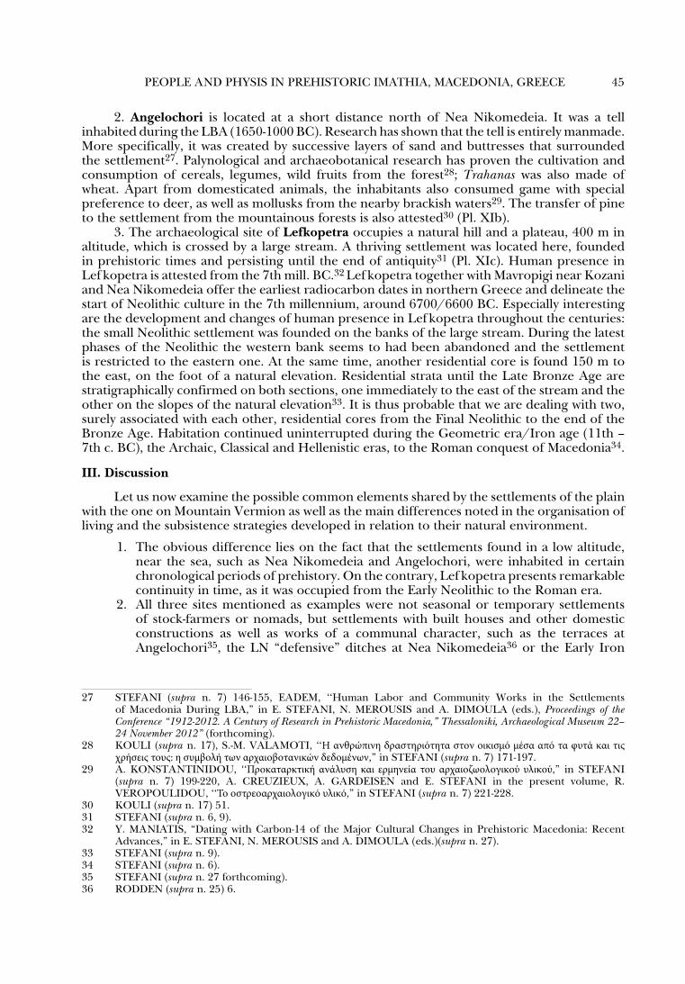
This paper will focus on the case of the Imathia Prefecture, Macedonia, aiming to shed light on the conditions and subsistence parameters of prehistoric communities in different, and, to an extent, marginal natural environments. The region now belonging to Imathia is the part of Macedonia bordered by the Axios River to the east, the Aliakmon River to the south, mount Vermion to the west and mounts Paiko and Voras to the north. The region enclosed within those mountains and rivers is nowadays a large plain (Pl. VIIIa-b).
Before we move on to the presentation of the region’s natural characteristics in prehistory, let us briefly mention the basic steps of prehistoric research in Imathia. Imathia became known in 1960 with Robert Rodden’s pioneer excavations of Nea Nikomedeia5. From then on until the 1990s, prehistoric research was “frozen”. In 1993 an extensive field survey began that carried on until 2003 and aimed to study human habitation and action in Imathia from the earliest
1 Abbreviation AEMΘ= Το Αρχαιολογικό Έργο στη Μακεδονία και Θράκη. Ch. TILLEY, A Phenomenology of Landscape. Places, Paths and Monuments (1994), A. FORBES, Meaning and
Identity in Greek Landscape (2007), 18-44. 2 W. ASHMORE and B.A. KNAPP, ‘‘Archaeological Landscapes: Constructed, Conceptualized, Ideational,” in
W. ASHMORE and B.A. KNAPP (eds), Archaeologies of Landscapes: Contemporary Perspectives (1999) 2, 13-16, K.F. ANSCHUETZ, R.H. WILSHUSEN and C.L. SCHEICK, ‘‘An Archaeology of Landscapes: Perspectives and Directions,” Journal of Archaeological Research 9.2 (2001) 157-211.
3 J. CHERRY, ‘‘Frogs Round the Pond : Perspectives and Late Archaeological Survey in the Mediterranean Region,” in D.R. KELLER and D.W. RAPP (eds), Archaeological Survey in the Mediterranean Area (1983) 375-416, FORBES (supra n. 1) 16-18.
4 For Prehistoric Macedonia: S. ANDREOU and K. KOTSAKIS, ‘‘Οι διαστάσεις του χώρου στην Κεντρική Μακεδονία: αποτύπωση της ενδοκοινοτικής και διακοινοτικής χωροοργάνωσης,” in Αμητός. Τιμητικός τόμος για τον καθηγητή Μ. Ανδρόνικο (1987) 57-88, IIDEM, ‘‘Counting People in an Artefact-Poor Landscape. The Langadas Case, Macedonia, Greece,” in J. BINTLIFF and K. SBONIAS (eds), Reconstructing Past Population Trends in Mediterranean Europe (3000 BC - AD 1800) (1999) 35-43. L. STEFANI, ‘‘To φυσικό και ανθρωπογενές τοπίο στη Μακεδονία,” in D. GRAMMENOS (ed.), Μελέτες για την προϊστορική Μακεδονία, ΠΡΟ-ΙΣΤΟΡΗΜΑΤΑ, Suppl. 1, 2013 (http://proistoria.wordpress.com).
5 G. PYKE and P. YIOUNI, Nea Nikomedeia I: The Excavation of an Early Neolithic Village in Northern Greece 1961-1964 Directed by R.J. Rodden. The Excavation and the Ceramic Assemblage (1996).
42 Evangelia STEFANI and Nikos MEROUSIS
prehistory to late antiquity (approximately 7th millennium BC– 4th c. AD)6. Excavations took place at the LBA settlement of Angelochori from 1994 to 20037, at LN site of Polyplatanos from 1997 to 20038, and at Lefkopetra, a site with continuous habitation (7th millennium BC-4th c. AD) from 2000 to 20049. The knowledge we have today through these excavations for human presence and action is much more significant than two decades ago. Nevertheless, there are still open issues regarding models of habitation as well as on how people managed the natural environment. We know now that the region’s early and continuous habitation from the 7th mill. BC to the end of the 2nd mill. BC is remarkable.
Our discussion will deal with the settlements of Nea Nikomedeia (Pl. VIIIc), Angelochori (Pl. VIIId) and Lef kopetra (Pl. VIIIe): the first two are located on very low altitude in the plain, while the third one is on the southwestern slopes of mount Vermion, above Aliakmon river on an altitude of approximately 400 metres. These settlements are found in completely different natural environments. With a modern look one might view the plain settlements as having better environmental conditions to develop, while the site on mount Vermion had to face difficult conditions, which could deter its development and duration. Examining the characteristics of these two different environmental regions we will try to detect the elements that affected and determined habitation in antiquity.
I. The natural environment
1. Plain (Nea Nikomedeia, Angelochori) The Central Macedonian plain, as it is known, has an average altitude of 10m above
sea-level and it is covered by alluvial deposits. The rivers Axios, Aliakmon, Loudias and their tributaries cross the plain. The region’s morphology changed significantly during the Holocene, affected by the rise of sea-level of the last 9500 years and the various alluvial deposits of the river systems (older riverbeds, banks, delta depositions etc.)10. Based on the bathymetry of the Thermaic gulf, the presence of an ancient valley is attested, which was initially covered as the sea level rose in the early Holocene and gradually a part of it was filled by river deposits forming
6 N. MEROUSIS and L. STEFANI, ‘‘Κατοίκηση και φυσικό περιβάλλον στην προϊστορική Ημαθία : συμπεράσματα και προοπτικές από την επιφανειακή έρευνα των ετών 1993-1996,” in Ancient Macedonia VI (1999) 735-751, N. MEROUSIS, ‘‘Settlement Patterns in Prehistoric Imathia and Pella, W. Macedonia, Greece,” Journal of Mediterranean Archaeology and Archaeometry 4.1 (2004) 73-82, E. STEFANI, ‘‘ ‘…όρος Βέρμιον άβατον υπό χειμώνος’ Landscape and Habitation in Semi-Mountainous Imathia,” in M. TIVERIOS, P. NIGDELIS and P. ADAM-VELENI (eds), ΘΡΕΠΤΗΡΙΑ. Studies on Ancient Macedonia (2012) 26-63.
7 E. STEFANI, Aγγελοχώρι Ημαθίας. Οικισμός της Ύστερης Εποχής του Χαλκού, Τόμος 1 (2010). 8 L. STEFANI and N. Merousis, ‘‘Ανασκαφική έρευνα στο νεολιθικό οικισμό Πολυπλατάνου Ημαθίας,” ΑΕΜΘ
11 (1997) 93-99, Ν. MEROUSIS and L. STEFANI, ‘‘Η ανασκαφή στο νεολιθικό οικισμό Πολυπλατάνου Ημαθίας,”ΑΕΜΘ 12 (1998) 383-393, L. STEFANI and N. MEROUSIS, ‘‘Ο νεολιθικός οικισμός στον Πολυπλάτανο Ημαθίας : η ανασκαφική έρευνα κατά το 2000,” ΑΕΜΘ 14 (2000) 555-561, N. MEROUSIS and L. STEFANI, ‘‘Ο νεολιθικός οικισμός στον Πολυπλάτανο Ημαθίας : η ανασκαφική έρευνα και η μελέτη του υλικού (2003-2004),”ΑΕΜΘ 18 (2004) 455-464.
9 L. STEFANI, ‘‘Ανασκαφή στον άξονα της Εγνατίας οδού: δύο προϊστορικές εγκαταστάσεις στην περιοχή της Λευκόπετρας Ημαθίας,” ΑΕΜΘ 14, 537-554, EADEM (supra n. 6) 38-40 (fn. 52-56 full bibliography).
10 T.H. VAN ANDEL and J.C. SHACKLETON, ‘‘Late Palaeolithic and Mesolithic Coastlines of Greece and the Aegean,” JFA 9:4 (1982) 445-454, K. ALBANAKIS, M. STYLLAS, K. VOUVALIDES and G. SYRIDES, ‘‘Γεωμορφολογικές μεταβολές στην περιοχή του Θερμαϊκού κόλπου σαν αποτέλεσμα της Ολοκαινικής ανόδου της στάθμης της θάλασσας,” Δελτίο Ελληνικής Γεωλογικής Εταιρείας 38 (2005) 77-85, Κ. VOUVALIDIS, G. SYRIDES, and K. ALBANAKIS, ‘‘Holocene Morphology of the Thessaloniki Bay. Impact of Sea Level Rise,” Zeitschrift für Geomorphologie, Suppl. 137 (2005) 147-158, M. GHILARDI, E. FOUACHE, F. QUEYREL, G. SYRIDES, K. VOUVALIDIS, S. KUNESCH, M. STYLLAS and S. STIROS, ‘‘Human Occupation and Geomorphological Evolution of the Thessaloniki Plain (Greece) Since Mid Holocene,” Journal of Archaeological Science 35.1 (2008) 111-125, K. PAVLOPOULOS and K. KOULI, ‘‘Παλαιογεωγραφία, κλίμα και βλάστηση στην πεδιάδα της Δυτικής Μακεδονίας,” in STEFANI (supra n. 7) 33-37.

PEOPLE AND PHYSIS IN PREHISTORIC IMATHIA, MACEDONIA, GREECE 43
its present morphology11.Struck in 190812 first attempted to reconstruct the palaeogeography of the delta plain of rivers Axios, Loudias and Gallikos, based on the study and interpretation of ancient sources and the descriptions of travellers and geographers of the 19th century. Much later, in 1974, Bottema13, while examining the evolution of the region’s vegetation, examined palynologically two cores from the Giannitsa area. Bintliff in 197614, within the frame of his study of the Neolithic settlement of Nea Nikomedeia, attempted to create a more complete palaeogeographic reconstruction of the Macedonian plain from Prehistory to the modern era.
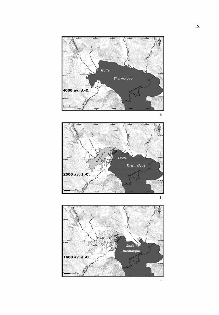
Ghilardi conducted the most updated examination of the region’s palaeogeography as he moved on to (a) a detailed documentation of modern and past geoforms, (b) an analytical sedimentological study and (c) the absolute dating of deposits by C1415. We now know that the rapid rise of sea level in the Aegean from the start of the Holocene to 6000 BP resulted to water rushing inland and creating the Thermaic gulf. Approximately 6000 BP (4000 BC) the Thermaic gulf stretched as far north as ancient Pella. The areas of Nea Nikomedeia and Angelochori were located along the edges of the gulf16. As the rise of sea level slowed down after 4000 BC, it led to a relative stabilization of the coastline. The Gulf’s southern part was changing due to the Aliakmon delta while the Axios delta to the north was less developed. The supply of fresh water on the river estuaries resulted to the creation of a system of brackish water micro-environments (Pl. IXa).
The constant advance of the Aliakmon delta to the north contributed to the creation of a pre-coastal barrier around 3000-2500 BC and the subsequent isolation of the sea to its west (Pl. IXb). Around 1600 BC, tectonic causes led to the gradual displacement of Aliakmon’s river bed to the east. The western part of the old lagoon was completely cut off from the sea and was converted into a shallow fresh water lake with rare inflow of brackish water. The settlement at Angelochori developed during this period, located in close proximity to the lake in order to exploit its natural resources, without the negative influence of the marshes17 (Pl. IXc). The modern northern branches of Aliakmon were flowing in the formed lake and offered running water for the settlement. To the south, the new Aliakmon estuary formed a system of lagoons separated by seasonal coastal barriers with the sea entering from time to time. Dunes formed at places in the plain behind these lagoons.
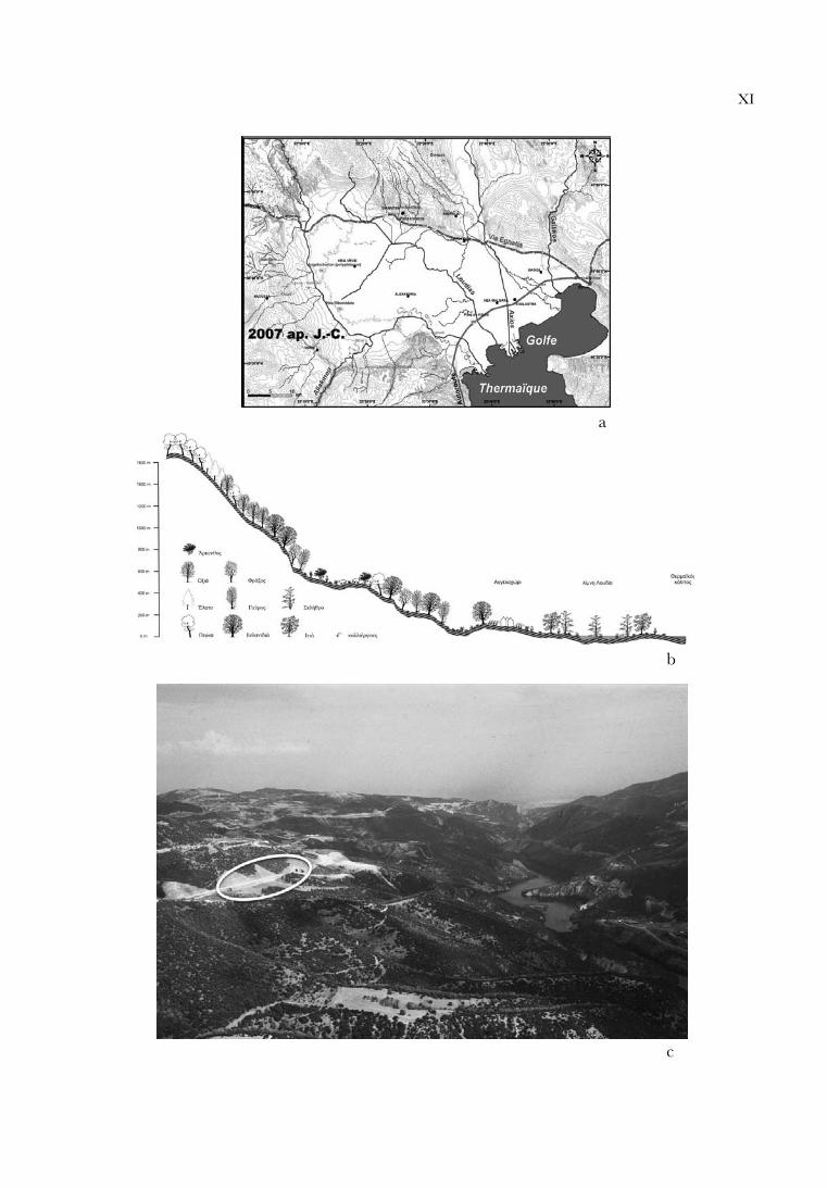
The displacement of the coast to the east resulted to the lake expanding towards the same direction. Thus, around 500-350 BC, the Loudias Lake occupied the central part of the modern-day western Macedonian plain (Pl. Xa). Around AD 300, the western Thermaic gulf was almost completely closed by the advance of estuary deposits, which had also limited the Loudias Lake18 (Pl. Xb). In the early 19th century, severe flood episodes of the Aliakmon river in the central and western plain of Macedonia resulted to the creation of the shallow Giannitsa lake, 16 km² in extent (Pl. Xc). The drainage projects of the 1930s changed the landscape and formed the modern plain of the Imathia and Pella prefectures (Pl. XIa).
11 V. LYKOUSIS and G. CHRONIS, ‘‘Mechanisms of Sediment Transport and Deposition: Sediment Sequences and Accumulation During the Holocene on the Thermaikos Plateau, the Continental Slope, and Basin (Sporades Basin), Northwestern Aegean Sea, Greece,”Marine Geology 87 (1989) 15-26, K. LAMBECK, ‘‘Sea-Level and Shore-Line Evolution in Aegean Greece since Upper Palaeolithic Time,” Antiquity 70:269 (1996) 588-611.
12 A. STRUCK, Makedonische Fahrten, II. Die Makedonischen Niederlande (1908).13 S. BOTTEMA, Late Quaternary Vegetation History of Northwestern Greece (Ph.D. University of Groningen, 1974).14 J. BINTLIFF, “The Plain of Macedonia and the Neolithic Site of Nea Nikomedeia,” PPS 42 (1976) 241-262,
esp. figure 10. 15 Μ. GHILARDI, Dynamiques spatiales et reconstitutions paléogéographiques de la plaine de Thessalonique (Grèce) à
l’Holocène récent (Ph.D. Paris XII, Val-de-Marne, 2007). 16 Angelochori : PAVLOPOULOS and KOULI (supra n. 10). Nea Nikomedeia : M. GHILARDI, D. PSOMIADIS,
S. CORDIER, D. DELANGHE-SABATIER, F. DEMORY, F. HAMIDI, T. PARASCHOU, E. DOTSIKA, and E. FOUACHE,‘‘The Impact of Rapid Early- to Mid-Holocene Palaeoenvironmental Changes on Neolithic Settlement at Nea Nikomedeia, Thessaloniki Plain, Greece,” Quaternary International 266 (2012) 47-61.
17 PAVLOPOULOS and KOULI (supra n. 10), K. KOULI, ‘‘Το παλαιοπεριβάλλον του οικισμού κατά την Ύστερη Εποχή του Χαλκού : τα αποτελέσματα της παλυνολογικής έρευνας,” in STEFANI (supra n.7) 47-51.
18 BINTLIFF (supra n. 14) Fig. 10, GHILARDI et al. (supra n. 10) Fig. 8.

44 Evangelia STEFANI and Nikos MEROUSIS
The region’s climate19 is characterised as Mediterranean with relatively mild and wet winters and dry, hot summers. The vegetation around the lake, where the settlements were located was low and herbaceous. Small willow and alder forests were located along the coast. Deciduous oak forests were found beyond the marshes, while hazel, ash and hornbeam trees occupied the higher grounds20.
2. Mount Vermion (Lefkopetra)
Mount Vermion mainly consists of limestone rock and dominates central Macedonia also forming the border towards western Macedonia21. In antiquity, Vermion was the border between Upper and Lower Macedonia. Its northern part is connected to the south edges of mount Voras, while its southern part is separated by the Pierian Mountains by Aliakmon River. Two plains surround Vermion from the east and west. Its highest peaks are found in the area above Naousa and their height exceeds 2,000 m. The mountain mainly occupies the western part of Imathia prefecture and small parts of the Pella and Kozani prefectures. Vermion is one of the Greek mountains that belong to the Dinaric branch of the Alpine chain. It belongs to the geotectonic zone of Axios (sub-zone of Almopia) and the Pelagonian zone.
As on most Greek mountains, its vegetation22 has been affected by human interference since antiquity. Most of the mountain is covered by rich vegetation and thick forests. Beech and pine forests predominate in high altitude, chestnut and ash trees are found in altitudes of 500 m to 1000 m while the middle and lower altitudes are occupied by oak trees and evergreen or deciduous bushes. The rich bushy and herbaceous vegetation has been limited to an extent due to over-grazing. The bushes found in lower altitude are considered by specialists as degraded oak forests due to logging and grazing23. The mountain’s total flora consists of 1070 taxa, several of which are endemic in Greece and the Balkans.
Vermion is considered one of the most water-bearing mountains in Greece. Its vegetation, rock formation and common precipitation create subterranean water deposits with smaller or larger springs. Its climate is characterised as an intermediate or transitional type between Mediterranean and mid-European. It has frequent rainfalls and snowfalls in high altitude, while these phenomena are milder in lower altitude. Vermion has rich game24 even nowadays. The most common mammals are boars (Sus scrofa), hares (Lepus europeus), foxes (Vulpes vulpes), wolves (Canis lupus) and deer (Capreolus capreolus).
II. Settlements in the environment
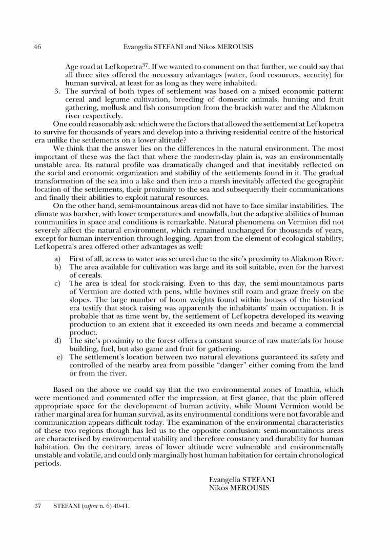
1. Nea Nikomedeia was located at the southwestern part of the Thermaic gulf. The settlement is a low, wide tell inhabited from a late EN phase (6190-6050 BC), while a second habitation phase dates to the LN (5th mill. BC)25. Buildings were constructed of wattle and daub with timber frames. The inter-disciplinary research conducted has shown that the inhabitants cultivated and consumed legumes and cereals. Collecting fruit and mollusks from the brackish waters surrounding the settlement, as well as hunting supplemented the population’s diet26.
19 Generally for the climatic characteristics of the area see R. VEROPOULIDOU, Όστρεα από τους οικισμούς του Θερμαϊκού κόλπου. Ανασυνθέτοντας την κατανάλωση των μαλακίων στη Νεολιθική και την Εποχή του Χαλκού (unpublished Ph.D., Department of History and Archaology, Aristotle University of Thessaloniki, 2011) 129-133.
20 KOULI (supra n. 17). 21 S. CHOCHLIOUROS, Χλωριδική και φυτοκοινωνιολογική έρευνα του όρους Βερμίου – Οικολογική προσέγγιση
(unpublished PH.D., Department of Biology, University of Patra, 2005) 10, map 1.22 CHOCHLIOUROS (supra n. 21) 132-134.23 S. DAFIS, ‘‘Ταξινόμησις της δασικής βλαστήσεως της Ελλάδος,” Επιστημονική Επετηρίς της Γεωπονικής και
Δασολογικής Σχολής του Πανεπιστημίου Θεσσαλονίκης 15/2 (1973) 75-91, CHOCHLIOUROS (supra n. 21) 175.24 CHOCHLIOUROS (supra n. 21) 300.25 R. RODDEN, ‘‘Introduction,” in PYKE and YIOUNI (supra n. 5) 6. 26 J. SHACKLETON, ‘‘Stable Isotope Analysis of the Palaeoenvironment of the Neolithic Site of Nea Nikomedeia,
Greece,” Nature 227/5261 (1970) 943-944, BINTLIFF (supra n. 14) 260-261, P. YIOUNI, ‘‘The Early Neolithic Pottery : Functional Analysis,” in PYKE and YIOUNI (supra n. 5) 191.
PEOPLE AND PHYSIS IN PREHISTORIC IMATHIA, MACEDONIA, GREECE 45
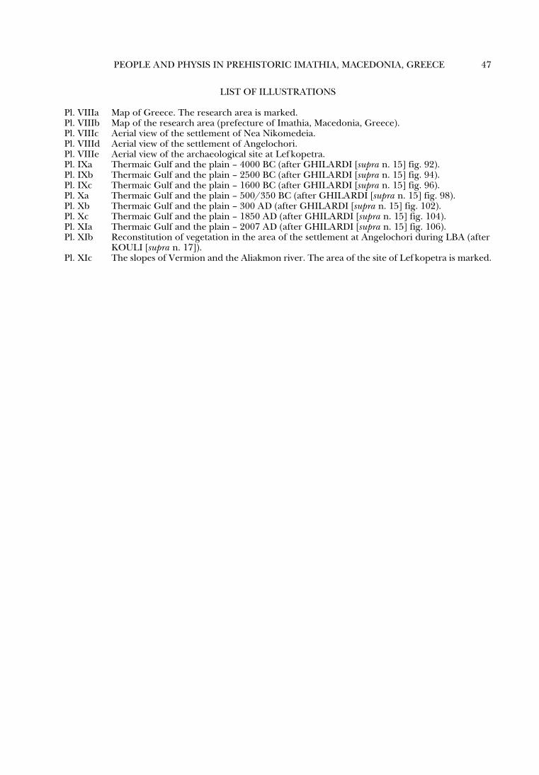
2. Angelochori is located at a short distance north of Nea Nikomedeia. It was a tell inhabited during the LBA (1650-1000 BC). Research has shown that the tell is entirely manmade. More specifically, it was created by successive layers of sand and buttresses that surrounded the settlement27. Palynological and archaeobotanical research has proven the cultivation and consumption of cereals, legumes, wild fruits from the forest28; Trahanas was also made of wheat. Apart from domesticated animals, the inhabitants also consumed game with special preference to deer, as well as mollusks from the nearby brackish waters29. The transfer of pine to the settlement from the mountainous forests is also attested30 (Pl. XIb).
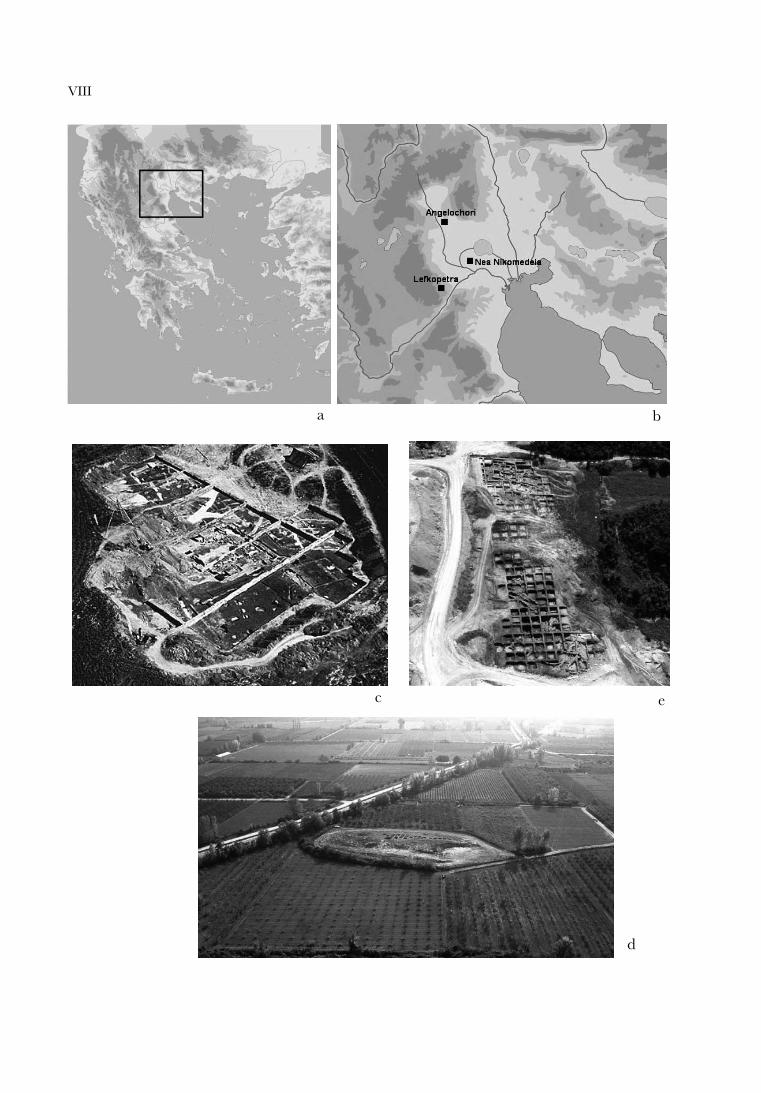
3. The archaeological site of Lefkopetra occupies a natural hill and a plateau, 400 m in altitude, which is crossed by a large stream. A thriving settlement was located here, founded in prehistoric times and persisting until the end of antiquity31 (Pl. XIc). Human presence in Lef kopetra is attested from the 7th mill. BC.32 Lef kopetra together with Mavropigi near Kozani and Nea Nikomedeia offer the earliest radiocarbon dates in northern Greece and delineate the start of Neolithic culture in the 7th millennium, around 6700/6600 BC. Especially interesting are the development and changes of human presence in Lef kopetra throughout the centuries: the small Neolithic settlement was founded on the banks of the large stream. During the latest phases of the Neolithic the western bank seems to had been abandoned and the settlement is restricted to the eastern one. At the same time, another residential core is found 150 m to the east, on the foot of a natural elevation. Residential strata until the Late Bronze Age are stratigraphically confirmed on both sections, one immediately to the east of the stream and the other on the slopes of the natural elevation33. It is thus probable that we are dealing with two, surely associated with each other, residential cores from the Final Neolithic to the end of the Bronze Age. Habitation continued uninterrupted during the Geometric era/Iron age (11th – 7th c. BC), the Archaic, Classical and Hellenistic eras, to the Roman conquest of Macedonia34.
III. Discussion
Let us now examine the possible common elements shared by the settlements of the plain with the one on Mountain Vermion as well as the main differences noted in the organisation of living and the subsistence strategies developed in relation to their natural environment.
1. The obvious difference lies on the fact that the settlements found in a low altitude, near the sea, such as Nea Nikomedeia and Angelochori, were inhabited in certain chronological periods of prehistory. On the contrary, Lef kopetra presents remarkable continuity in time, as it was occupied from the Early Neolithic to the Roman era.
2. All three sites mentioned as examples were not seasonal or temporary settlements of stock-farmers or nomads, but settlements with built houses and other domestic constructions as well as works of a communal character, such as the terraces at Angelochori35, the LN “defensive” ditches at Nea Nikomedeia36 or the Early Iron
27 STEFANI (supra n. 7) 146-155, EADEM, ‘‘Human Labor and Community Works in the Settlements of Macedonia During LBA,” in E. STEFANI, N. MEROUSIS and A. DIMOULA (eds.), Proceedings of the Conference “1912-2012. A Century of Research in Prehistoric Macedonia,” Thessaloniki, Archaeological Museum 22– 24 November 2012” (forthcoming).
28 KOULI (supra n. 17), S.-M. VALAMOTI, ‘‘H ανθρώπινη δραστηριότητα στον οικισμό μέσα από τα φυτά και τις χρήσεις τους: η συμβολή των αρχαιοβοτανικών δεδομένων,” in STEFANI (supra n. 7) 171-197.
29 A. KONSTANTINIDOU, ‘‘Προκαταρκτική ανάλυση και ερμηνεία του αρχαιοζωολογικού υλικού,” in STEFANI (supra n. 7) 199-220, A. CREUZIEUX, A. GARDEISEN and E. STEFANI in the present volume, R. VEROPOULIDOU, ‘‘Το οστρεοαρχαιολογικό υλικό,” in STEFANI (supra n. 7) 221-228.
30 KOULI (supra n. 17) 51. 31 STEFANI (supra n. 6, 9). 32 Y. MANIATIS, “Dating with Carbon-14 of the Major Cultural Changes in Prehistoric Macedonia: Recent
Advances,” in E. STEFANI, N. MEROUSIS and A. DIMOULA (eds.)(supra n. 27).33 STEFANI (supra n. 9). 34 STEFANI (supra n. 6). 35 STEFANI (supra n. 27 forthcoming).36 RODDEN (supra n. 25) 6.
46 Evangelia STEFANI and Nikos MEROUSIS
Age road at Lefkopetra37. If we wanted to comment on that further, we could say that all three sites offered the necessary advantages (water, food resources, security) for human survival, at least for as long as they were inhabited.
3. The survival of both types of settlement was based on a mixed economic pattern: cereal and legume cultivation, breeding of domestic animals, hunting and fruit gathering, mollusk and fish consumption from the brackish water and the Aliakmon river respectively.
One could reasonably ask: which were the factors that allowed the settlement at Lef kopetra to survive for thousands of years and develop into a thriving residential centre of the historical era unlike the settlements on a lower altitude?
We think that the answer lies on the differences in the natural environment. The most important of these was the fact that where the modern-day plain is, was an environmentally unstable area. Its natural profile was dramatically changed and that inevitably reflected on the social and economic organization and stability of the settlements found in it. The gradual transformation of the sea into a lake and then into a marsh inevitably affected the geographic location of the settlements, their proximity to the sea and subsequently their communications and finally their abilities to exploit natural resources.
On the other hand, semi-mountainous areas did not have to face similar instabilities. The climate was harsher, with lower temperatures and snowfalls, but the adaptive abilities of human communities in space and conditions is remarkable. Natural phenomena on Vermion did not severely affect the natural environment, which remained unchanged for thousands of years, except for human intervention through logging. Apart from the element of ecological stability, Lef kopetra’s area offered other advantages as well:
a) First of all, access to water was secured due to the site’s proximity to Aliakmon River. b) The area available for cultivation was large and its soil suitable, even for the harvest
of cereals. c) The area is ideal for stock-raising. Even to this day, the semi-mountainous parts
of Vermion are dotted with pens, while bovines still roam and graze freely on the slopes. The large number of loom weights found within houses of the historical era testify that stock raising was apparently the inhabitants’ main occupation. It is probable that as time went by, the settlement of Lef kopetra developed its weaving production to an extent that it exceeded its own needs and became a commercial product.
d) The site’s proximity to the forest offers a constant source of raw materials for house building, fuel, but also game and fruit for gathering.
e) The settlement’s location between two natural elevations guaranteed its safety and controlled of the nearby area from possible “danger” either coming from the land or from the river.
Based on the above we could say that the two environmental zones of Imathia, which were mentioned and commented offer the impression, at first glance, that the plain offered appropriate space for the development of human activity, while Mount Vermion would be rather marginal area for human survival, as its environmental conditions were not favorable and communication appears difficult today. The examination of the environmental characteristics of these two regions though has led us to the opposite conclusion: semi-mountainous areas are characterised by environmental stability and therefore constancy and durability for human habitation. On the contrary, areas of lower altitude were vulnerable and environmentally unstable and volatile, and could only marginally host human habitation for certain chronological periods.
Evangelia STEFANINikos MEROUSIS
37 STEFANI (supra n. 6) 40-41.
PEOPLE AND PHYSIS IN PREHISTORIC IMATHIA, MACEDONIA, GREECE 47
LIST OF ILLUSTRATIONS
Pl. VIIIa Map of Greece. The research area is marked.Pl. VIIIb Map of the research area (prefecture of Imathia, Macedonia, Greece).Pl. VIIIc Aerial view of the settlement of Nea Nikomedeia.Pl. VIIId Aerial view of the settlement of Angelochori. Pl. VIIIe Aerial view of the archaeological site at Lef kopetra.Pl. IXa Thermaic Gulf and the plain – 4000 BC (after GHILARDI [supra n. 15] fig. 92).Pl. IXb Thermaic Gulf and the plain – 2500 BC (after GHILARDI [supra n. 15] fig. 94).Pl. IXc Thermaic Gulf and the plain – 1600 BC (after GHILARDI [supra n. 15] fig. 96).Pl. Xa Thermaic Gulf and the plain – 500/350 BC (after GHILARDI [supra n. 15] fig. 98).Pl. Xb Thermaic Gulf and the plain – 300 AD (after GHILARDI [supra n. 15] fig. 102).Pl. Xc Thermaic Gulf and the plain – 1850 AD (after GHILARDI [supra n. 15] fig. 104).Pl. XIa Thermaic Gulf and the plain – 2007 AD (after GHILARDI [supra n. 15] fig. 106).Pl. XIb Reconstitution of vegetation in the area of the settlement at Angelochori during LBA (after KOULI [supra n. 17]).Pl. XIc The slopes of Vermion and the Aliakmon river. The area of the site of Lef kopetra is marked.
VIII
a b
c
d
e
IX
a
b
c

X
a
b
c
XI
a
b
c