Volcano-stratigraphic and structural evolution of Brava Island (Cape Verde) based on 40Ar/39Ar, U-Th...
18
This article appeared in a journal published by Elsevier. The attached copy is furnished to the author for internal non-commercial research and education use, including for instruction at the authors institution and sharing with colleagues. Other uses, including reproduction and distribution, or selling or licensing copies, or posting to personal, institutional or third party websites are prohibited. In most cases authors are permitted to post their version of the article (e.g. in Word or Tex form) to their personal website or institutional repository. Authors requiring further information regarding Elsevier’s archiving and manuscript policies are encouraged to visit: http://www.elsevier.com/copyright
-
Upload
independent -
Category
Documents
-
view
1 -
download
0
Transcript of Volcano-stratigraphic and structural evolution of Brava Island (Cape Verde) based on 40Ar/39Ar, U-Th...
This article appeared in a journal published by Elsevier. The attachedcopy is furnished to the author for internal non-commercial researchand education use, including for instruction at the authors institution
and sharing with colleagues.
Other uses, including reproduction and distribution, or selling orlicensing copies, or posting to personal, institutional or third party
websites are prohibited.
In most cases authors are permitted to post their version of thearticle (e.g. in Word or Tex form) to their personal website orinstitutional repository. Authors requiring further information
regarding Elsevier’s archiving and manuscript policies areencouraged to visit:
http://www.elsevier.com/copyright
Author's personal copy
Volcano-stratigraphic and structural evolution of Brava Island (Cape Verde) based on40Ar/39Ar, U–Th and field constraints
José Madeira a,b,c,⁎, João Mata a,d, Cyntia Mourão a,d, António Brum da Silveira a,b,c, Sofia Martins a,d,Ricardo Ramalho b,e, Dirk L. Hoffmann f,1
a Faculdade de Ciências da Universidade de Lisboa, Departamento de Geologia (GeoFCUL), Campo Grande, Edifício C6, 1749-016 Lisboa, Portugalb LATTEX, Laboratório de Tectonofísica e Tectónica Experimental, Lisboa, Portugalc Instituto Dom Luiz, Laboratório Associado (IDL–LA), Lisboa, Portugald Centro de Geologia da Universidade de Lisboa (CeGUL), Lisboa, Portugale Department of Earth Sciences, University of Bristol, Wills Memorial Building, Queen's Road, Bristol, BS8 1RJ, UKf School of Geographical Sciences, University of Bristol, University Road, Bristol, BS8 1SS, UK
a b s t r a c ta r t i c l e i n f o
Article history:Received 2 February 2010Accepted 18 July 2010Available online 24 July 2010
Keywords:Cape VerdeBrava Island40Ar/39Ar datingvolcano-stratigraphyuplift
Three volcano-stratigraphic units were identified at Brava Island in the Cape Verde Archipelago on the basisof field relationships, geologic mapping and 40Ar/39Ar and U–Th ages. The Lower Unit comprises a 2-to-3 Ma-old submarine volcanic sequence that represents the seamount stage. It is composed of nephelinitic/ankaramitic hyaloclastites and pillow lavas, which are cut by abundant co-genetic dikes. Plutonic rocks of analkaline–carbonatite complex, which intruded the submarine sequence 1.8 to 1.3 Ma ago, constitute theMiddle Unit. A major erosional surface developed between 1.3 and ~0.25 Ma. The post-erosional volcanismrecorded in the Upper Unit started 0.25 Ma ago and is dominated by phonolitic magmatism. This phase ischaracterised by explosive phreato-magmatic and magmatic activity that produced block and ash flow,surge, and pyroclastic fall deposits and numerous phreato-magmatic craters. Effusive events are representedby lava domes and coulées. One peculiarity of Brava is the occurrence of carbonatites in both the plutoniccomplex and the post-erosional phase as extrusive volcanics. The intrusive carbonatites are younger thanthose occurring on Fogo, Santiago and Maio islands. Young (Upper Pleistocene to Holocene) extrusivecarbonatites occurring in the late stages of volcanism are unknown in other Cape Verde islands.The occurrence of pillow lavas and hyaloclastites above the present sea level (up to 400 m) and raised UpperPleistocene beaches indicates continuous uplift of Brava since the seamount stage. By dating raised marinemarkers, uplift rates were estimated at between 0.2 and 0.4 mm/a. The evolution of Brava was controlled byfaults with directions similar to those described for Fogo, suggesting a common stress field.A detailed geological map (1/25,000) of Brava is presented.
© 2010 Elsevier B.V. All rights reserved.
1. Introduction
Cape Verde has long been considered the result of lithosphereimpingement by a mantle plume (e.g. Crough, 1978). The role of amantle plume in causing intra-plate magmatism can be inferred fromthe spatial age distribution, which relies on high-quality agedatabases. Age data are also essential for understanding the building
processes on a specific island, dating and determining the rates oflithospheric vertical movements, and studying the geochemicaltemporal evolution of magmatism at either a specific island or thearchipelago scale.
Geochronology of the Cape Verde magmatism has improvedsignificantly with the publication of numerous 40Ar/39Ar ages forSanto Antão (Plesner et al., 2002), São Vicente, São Nicolau andSantiago (Bosse et al., 2007), São Nicolau (Duprat et al., 2007),Santiago, Sal and São Vicente (Holm et al., 2008), Santiago and SãoNicolau (Ramalho et al., 2010a) and Boavista (Dyhr and Holm, 2010).For Maio, 40Ar/39Ar ages were previously presented along with K/Arages (Mitchell et al., 1983). In addition, K/Ar ages were published forFogo (Lancelot and Allègre, 1974), Santiago, Brava andMaio (Bernard-Griffiths et al., 1975), Maio (Grunau et al., 1975), Sal (Torres et al.,2002) and Fogo (Madeira et al., 2005). Cosmogenic 3He exposuredating was performed on pre- and post-caldera collapse lavas of Fogo(Foeken et al., 2009).
Journal of Volcanology and Geothermal Research 196 (2010) 219–235
⁎ Corresponding author. Faculdade de Ciências da Universidade de Lisboa, Departa-mento de Geologia (GeoFCUL), Campo Grande, Edifício C6, 1749-016 Lisboa, Portugal.Tel.: +351 21750342; fax: +351 217500064.
E-mail addresses: [email protected] (J. Madeira), [email protected] (J. Mata),[email protected] (C. Mourão), [email protected] (A. Brum da Silveira),[email protected] (S. Martins), [email protected] (R. Ramalho),[email protected] (D.L. Hoffmann).
1 Present address: Geochronology Research Group, CENIEH, Paseo Sierra deAtapuerca s/n, 09002 Burgos, Spain.
0377-0273/$ – see front matter © 2010 Elsevier B.V. All rights reserved.doi:10.1016/j.jvolgeores.2010.07.010
Contents lists available at ScienceDirect
Journal of Volcanology and Geothermal Research
j ourna l homepage: www.e lsev ie r.com/ locate / jvo lgeores
Author's personal copy
Nevertheless, the geochronological data for Brava were scarceand inconsistent with field evidence. Bernard-Griffiths et al. (1975)presented K/Ar ages for a nephelinite (2.4±0.2 Ma) and a phonolite(5.9±0.1 Ma) that disagree with their relative volcano-stratigraphicposition. The only other age known to date was presented by Hoernleet al. (2002) for an intrusive granular calciocarbonatite (2.1 MabyK/Ar).
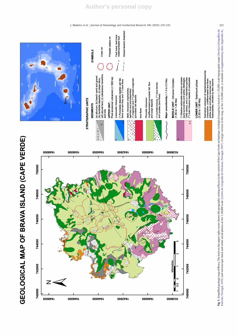
We present fourteen 40Ar/39Ar age determinations from rockscovering the entire exposed Brava sequence. Laser ablation U–Thdisequilibrium geochronology was used on three corals to date aQuaternary marine deposit. Field observations and geochronologicaldata allowed reconstruction of the volcano-stratigraphic evolution ofBrava. The tectonic structure of Brava is presented and uplift rates forthe island are inferred. This information is synthesised on a detailedgeological map of the island at a 1/25,000 scale (see Supplementarydata — Appendix A), which we consider a fundamental tool for futureresearch on the island. Fig. 1, a reduced version of this map, representsmajor volcano-stratigraphic units and volcanic and volcano-tectonicstructures.
Geochemistry is beyond the scope of this paper; it will be the mainfocus of a forthcoming paper. However, some data are presented hereto characterise the magmatic products building Brava Island.
2. Geological setting
The Cape Verde Archipelago (15–17°N, 23–26°W) is composed of10 islands and various islets that roughly form a westward-facinghorseshoe. They are located 600 to 900 km west of the African coast,on the southwestern part of the Cape Verde Rise, a swell ≈2.2 kmhigh and 1400–1600 km wide that is considered the largest oceanicintra-plate bathymetric anomaly (e.g., Lodge and Helffrich, 2006). Thearchipelago stands on old (120–140 Ma; Williams et al., 1990; Mülleret al., 2008) and thick (≈85 km; Cazenave et al., 1988) oceaniclithosphere. Crustal thickness is anomalously high (up to 22 km)beneath the islands, but normal (≈7 km) between them (Ali et al.,2003; Lodge and Helffrich, 2006; Pim et al., 2008).
The archipelago is also associated with important residual geoid,gravimetric and heat flow anomalies (e.g. Dash et al., 1976; Courtneyand White, 1986); elsewhere, these features are believed to resultfrom mantle plumes (e.g. Sleep, 1990). The genesis of Cape Verdefrom a deeply anchored mantle plume seems to be supported byseismic tomography studies (Montelli et al., 2006; Zhao, 2007) and byunradiogenic He isotope signatures obtained both from silicate andcarbonatitic rocks (R/Ra up to 15.7), which point to the contribution ofa high 3He/4He reservoir that could plausibly exist in the deepest partsof the lower mantle (cf. Christensen et al., 2001; Doucelance et al.,2003; Mourão et al., 2007; Mata et al., 2010). Notably, however, arecent analysis of P-to-S receiver functions showed that the timeseparation between the 410 and 660 km discontinuities is notmodified beneath Cape Verde (Helffrich et al., 2010).
Currently exposed volcanic sequences in the archipelago range inage from theMiocene to the present. The oldest published date for theCape Verde hotspot (≈26 Ma) was obtained for a submarine basaltfrom the basal complex of the Island of Sal (Torres et al., 2002). Themost recent eruption at Fogo Island occurred in 1995, when 0.054 to0.068 km3 of basanitic lava was emitted in a 55-day-long eruption(Madeira et al., 1997; Torres et al., 1997). The mean rate of meltcrustal emplacement for the archipelago (0.026 km3a−1) correspondsto ≈9% of the flux calculated for Hawaii (Holm et al., 2008). The longmagmatic history and the semi-stationary position of the lithosphere(Pollitz, 1991; Holm et al., 2008) explain how such a weak plumeproduced the world largest oceanic swell (e.g. Mata et al., 2010).
The region has been subjected to important vertical movements, asdemonstrated by the occurrence of MORB at Maio and Santiago (DePaepe et al., 1974; Gerlach et al., 1988; Millet et al., 2008), seafloorsediments of probable Lower Cretaceous age at Maio (Azéma et al.,1990; Holm et al., 2008) and uplifted submarine alkaline lavas on
several islands, which reach 450 mapsl (above present sea level) onSantiago Island (Serralheiro, 1976; Holm et al., 2008; Ramalho et al., inpress).
Cape Verde has been renowned for its abundant carbonatites,which occur on at least 6 of the 10 islands (including Brava; e.g.,Assunção et al., 1965; Allègre et al., 1971; Silva et al., 1981; Turbevilleet al., 1987; Hoernle et al., 2002; Mata et al., 2010; Mourão et al.,2010). Previously, “calcareous dikes” and “calcareous masses ofvolcanic origin” were mentioned by Bebiano (1932). Carbonatiticmelts, which act as mantle metasomatic agents, are believed toinfluence the geochemistry of some of the Cape Verde silicatemagmas(Martins et al., 2010).
Brava (64 km2) is the westernmost island of the NE–SW-alignedchain along with Maio, Santiago and Fogo. It is located 18 km west ofFogo, from which it is separated by depths in excess of 1400 m.Multibeam bathymetry and backscatter studies revealed a submarinefield of volcanic cones in the area between these islands (Massonet al., 2008; Grevemeyer et al., 2009).
The earliest geological study of Brava was conducted by Bebiano(1932), but the first serious effort to establish a stratigraphicsuccession for the island was made thirty-five years later (Machadoet al., 1968). These authors briefly described the petrography of themain lithotypes, including intrusive carbonatites, that were reportedearlier by Assunção et al. (1965) and Machado et al. (1967). Morerecently, the petrology and geochemistry of carbonatites andoccasionally their associated silica-undersaturated rocks have beendiscussed in papers by Kogarko (1993), Hoernle et al. (2002), Mourãoet al. (2010) and Mata et al. (2010).
Although no historical eruptions have occurred on Brava, theisland is seismically active. In contrast, Fogo, which is located just18 km to the East, has experienced at least 27 historical eruptions butmuch less seismicity (Bebiano, 1932; Heleno da Silva and Fonseca,1999). Recent data show that seismic activity originates offshore andis likely related to either the submarine volcanic field situated be-tween Fogo and Brava or the Cadamosto seamount, a growing 3-km-tall volcano located southwest of Brava (Heleno da Silva et al., 2006;Le Bas et al., 2007; Masson et al., 2008; Grevemeyer et al., 2009).
3. Methods
3.1. 40Ar/39Ar geochronology
Ages were determined for fourteen samples using the 40Ar/39Armethod at the Noble Gas Mass Spectrometry Laboratory, Oregon StateUniversity (USA). Samples were selected based primarily on theirstratigraphic position as well as their lithological and geochemicalcharacteristics (see Supplementary data— Appendix B). Thematerialsto be analysed within each sample were selected according to specificmineralogical constraints and the granularity and homogeneity of thesamples.
Whole-rock material was collected by a diamond-tipped drill bitewhich produced a 5-mm-diameter core that was divided into disks of100–300 mg. To recover groundmass and mineral separates, thesamples were crushed and sieved (fraction 250–500 μm), andphenocrysts were removed by magnetic methods. The samples werethen cleaned using a mild acid treatment (5% HNO3), washed in anultrasonic bath, rinsed with de-ionized water and dried in an oven.Finally, samples were hand-picked under a binocular microscope,washed with acetone and de-ionized water and oven-dried (Duncanand Keller, 2004).
In the TRIGA reactor at Oregon State University, samples wereirradiated with neutrons at 1 MW power for 6 h along with the FCT-3biotite standard (28.03±0.01 Ma age) to monitor the neutron flux.
A MAP 215-50 rare gas mass spectrometer was used toperform40Ar/39Ar analyses. Ar extraction by incremental step heatingwas achieved for whole-rock or groundmass/mineral separates with a
220 J. Madeira et al. / Journal of Volcanology and Geothermal Research 196 (2010) 219–235
Author's personal copy
Fig.
1.Simplified
geolog
icmap
ofBrav
a.Th
einseto
ntheup
perright
corner
show
sthe
geog
raph
icsettingof
Brav
ain
theco
ntex
tofthe
Cape
Verde
arch
ipelag
o.Geo
logicalm
apping
isba
sedon
1:25
,000
-scaletopo
grap
hicmap
s(Se
rviçoCa
rtog
ráfico
doEx
ército,P
ortuga
l,19
79)an
dstereo
scop
icblackan
dwhite
aerial
photos
atthe1:30
,000
scale(C
entrode
Geo
grafi
ado
Ultramar,P
ortuga
l,19
57).Alarger
versionof
themap
,atthe1:25
,000
scale,isav
ailableas
Supp
lemen
tary
data
(App
endixA).
221J. Madeira et al. / Journal of Volcanology and Geothermal Research 196 (2010) 219–235
Author's personal copy
Heine low-blank double vacuum resistance furnace and a Merchantek10-Watt continuous fire CO2 laser, respectively. Samples weredegassed during 10 to 16 temperature steps, depending on individualsample characteristics, from 400 °C to 1400 °C. Prior to age calcula-tion, all data were corrected for system blanks, mass fractionation andinterfering argon isotopes generated by Ca, K and Cl duringirradiation, and the decay and J-value were calculated.
Sample40Ar/39Ar ages were calculated using the ArArCALC v2.2software package (Koppers, 2002). The decay constant used through-out the step age calculation was λ=(5.530±0.097)×10−10 a−1, thecorrected value of Steiger and Jäger (1977) reported by Min et al.(2000). The initial Ar composition was assumed to be atmospheric(40Ar/36Ar=295.5) for plateau calculations. The data are presented asstep ages plotted against cumulative 39Ar released (“plateau”diagrams) or as isotope correlation diagrams (39Ar/40Ar vs. 36Ar/40Ar,inverse isochron diagrams), in which the slope of the collinear stepcompositions is equivalent to age and the
40Ar/36Ar intercept specifies
the initial Ar composition of the analysed material (Duncan and Keller,2004).
3.2. U–Th disequilibrium geochronology
Three fossil coral samples (CY-213a–c) from a Quaternary terracewere dated by laser ablation (LA) multi-collector (MC)-inductivelycoupled mass spectrometry (ICP-MS) U–Th disequilibrium techni-ques, following the method outlined by Hoffmann et al. (2009). AllMC-ICP-MS measurements were performed at the Bristol IsotopeGroup (BIG) laboratory using a ThermoFinnigan Neptune coupledwith a New Wave Research UP193HE ArF Excimer laser system.Samples were cut, polished, cleaned in an ultrasonic bath for 5 minand dried. Next, theywere placed in a laser sample cell togetherwith asecular equilibrium calcite ‘standard’ for correction of the instrumen-tal biases of LA U–Th isotope measurements on CaCO3. Potentialmatrix effects due to differences between aragonite and calcite arenegligible within the uncertainties achieved for U–Th isotopemeasurements using the LA technique (Hoffmann et al., 2009).
Ablation was done with He as the carrier gas, which was mixedwith the Ar sample gas and N2 in a quartz mixing cell before injectioninto the Ar plasma. Typical laser power density was 5 J/cm² at 70%power output. For the U–Th isotope LA measurements, a repetitionrate of 7 Hz and a spot size of 250 μmwere used. Material was ablatedfrom a 0.5-mm-long track in 6 passes by moving the laser spot at aspeed of 20 μm/s. A standard sample–standard bracketing procedurewas applied, and data collection and corrections were done accordingto Hoffmann et al. (2009).
3.3. Major and trace element analyses
During geological mapping, samples from all volcano-stratigraphicunits were collected for petrographic and geochemical studies. Sampleswere selected for bulk geochemistry analysis on the basis of theirpetrographic specificities and freshness. Samples were crushed byhydraulic press to remove all visible signs of alteration, and thenreduced in size by a jaw crusher and powdered in an agate swing mill.
Major and trace element whole rock analyses were performedat Activation Laboratories (Canada) according to Code 4Lithore-search+Code 4BINAA analytical packages (plus Code 4F forcarbonatites). Alkaline dissolution with lithium metaborate/tetra-borate, followed by nitric acid dissolution, was performed for allanalyses, except for the determination of Cd, Cu, Ni and Zn, whichwere achieved after acid digestion. Major element concentrationswere determined using Fusion-Inductively-Coupled Plasma (FUS-ICP) (except for fluorine in carbonatites, which was determined byFusion-Ion-Selective-Electrode, FUS-ISE). Trace element concentra-tions were determined using Inductively Coupled Plasma-MassSpectrometry (ICP-MS), except for zirconium in carbonatites,
which was determined by FUS-ICP. Duplicate measurements of thelowest-concentration sample for each type of technique give anestimate of the total reproducibility of the analyses. For whole-rocksamples, the reproducibility is: (i) on the order of 1% for majorelement contents, (ii) better than 3% for Rare Earth Elements (REE,except for Gd which gives 6.5%), (iii) around 5% for High FieldStrength Elements (HFSE) and (iv) better than 2% for elements thatare generally highly incompatible in the oceanic context (Rb, Ba, U,and Th). Detailed information on the analytical methods can befound at http://www.actlabs.com.
4. Volcano-stratigraphy of Brava Island
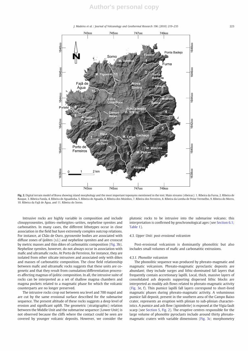
Brava is characterised by an irregular plateau between 300 and976 m above sea level, which is bounded by steep coastal cliffs and cutby fluvial incision in a generally radial drainage pattern (Fig. 2). Theplateau presents some aligned, hemi-spherical hills formed byphonolite lava domes, a number of closed depressions that corre-spond to recent phreato-magmatic craters, and several NNW–SSE toNW–SE fault scarps that define a 2.85-to-2.3-km wide grabenstructure in the southern part of the island (the Cachaço Graben;Figs. 1, Figure 2). In addition to constructive volcanic and tectonicprocesses, marine and fluvial erosion and mass wasting processescontributed to the present morphology of the island (Madeira et al.,2008).
Field observations revealed the presence of an older basementcomposed of a submarine volcanic sequence and an intrusive complexthat is unconformably covered by younger sub-aerial volcanicdeposits. These sequences allowed the definition of three majorvolcano-stratigraphic units designated Lower, Middle and Upper, asdescribed below.
4.1. Lower Unit: submarine volcanism
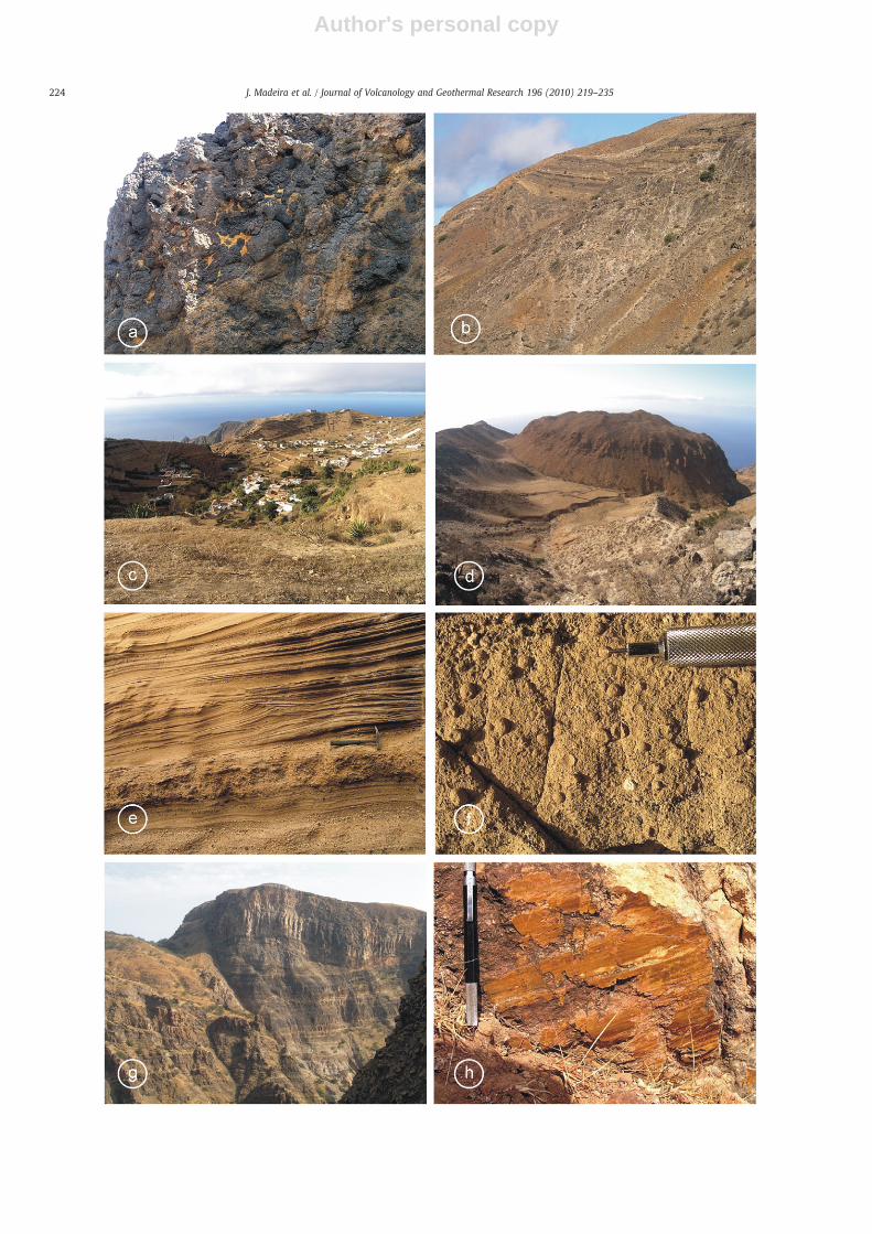
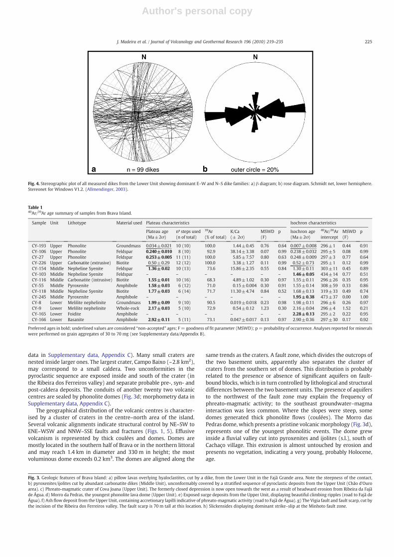
The northwestern littoral region of Brava (between Portete andSorno bays) hosts a sequence of alternating hyaloclastites, pillowbreccias, and pillow lava piles of nephelinitic/ankaramitic composi-tion (Fig. 3a). A small outcrop occurs on the NW coast, near Vinagre.The submarine sequence is cut by twomajor families of dikes trendingN–S and E–W (Fig. 4) that, based on field evidence and petrographic/geochemical considerations, are also integrated in this unit. Somedikes present deformation structures that are interpreted as the resultof small-scale submarine slides that were more or less contempora-neous with dike intrusion. These movements testify to the gravita-tional instability of the steep volcanic pile. The submarine volcanicsequences plunge to the northwest in the Fajã d'Água area and to thenorth in the Sorno region. The dips vary significantly but are generallysteep (30 to 40°), indicating that volcanism occurred on abruptsubmarine slopes. This explains the abundance of pillow brecciaaccumulations, which result from pillow detachment and fragmenta-tion. Locally, where submarine slopes were gentler, pillows were ableto accumulate and form densely packed piles that were almost devoidof sediment- or hyaloclastite-filled spaces. Although limited to a smallcoastal area, the outcrops suggest an outward (radial) dippingstructure of the submarine volcano. They are now raised to heightsof up to 400 mapsl; the highest known outcrop is located in theheadwall of the Fajã de Água valley.
Both the extrusive products and the dikes are truncated by anirregular erosive surface and covered, in angular unconformity, byproducts of primarily sub-aerial, recent volcanism (Upper Unit).
4.2. Middle Unit: intrusive complex
The southern andeastern littoral areasof Brava aremainly composedof plutonic rocks that form an alkaline–carbonatite complex.
222 J. Madeira et al. / Journal of Volcanology and Geothermal Research 196 (2010) 219–235
Author's personal copy
Intrusive rocks are highly variable in composition and includeclinopyroxenites, ijolites–melteigites–urtites, nepheline syenites andcarbonatites. In many cases, the different lithotypes occur in closeassociation in the field but have extremely complex outcrop relations.For instance, at Chão de Ouro, pyroxenite bodies are associated withdiffuse zones of ijolites (s.l.) and nepheline syenites and are crosscutby metric masses and thin dikes of carbonatitic composition (Fig. 3b).Nepheline syenites, however, do not always occur in association withmafic and ultramafic rocks. At Porto de Ferreiros, for instance, they areisolated from other silicate intrusives and associated only with dikesand masses of carbonatitic composition. The close field relationshipbetween mafic and ultramafic rocks suggests that these units are co-genetic and that they result from cumulation/differentiation process-es affectingmagmas of ijolitic composition. In all, the intrusive suite ofrocks can be interpreted as a set of shallow magma chambers andmagma pockets related to a magmatic phase for which the volcaniccounterparts are no longer preserved.
The intrusive rocks crop out between sea level and 700 mapsl andare cut by the same erosional surface described for the submarinesequence. The present altitude of these rocks suggests a deep level oferosion and significant uplift. The geometric (stratigraphic) relationbetween the Middle Unit and the submarine sequence (Lower Unit) isnot observed because the cliffs where the contact could be seen arecovered by younger volcanic deposits. However, we consider the
plutonic rocks to be intrusive into the submarine volcano; thisinterpretation is confirmed by geochronological ages (see Section 6.1;Table 1).
4.3. Upper Unit: post-erosional volcanism
Post-erosional volcanism is dominantly phonolitic but alsoincludes small volumes of mafic and carbonatitic extrusions.
4.3.1. Phonolite volcanismThe phonolitic sequence was produced by phreato-magmatic and
magmatic volcanism. Phreato-magmatic pyroclastic deposits areabundant; they include surges and lithic-dominated fall layers thatfrequently contain accretionary lapilli. Local, thick, massive layers ofconsolidated ash deposits supporting dispersed lithic blocks areinterpreted as muddy ash flows related to phreato-magmatic activity(Fig. 3e, f). Thin pumice lapilli fall layers correspond to short-livedmagmatic phases during phreato-magmatic activity. A voluminouspumice fall deposit, present in the southern area of the Campo Baixocrater, represents an eruption with plinian to sub-plinian character-istics. A pumice and ash flow (ignimbrite) is exposed at the Vigia faultscarp (see Section 5, Fig. 2). The eruptive centres responsible for thelarge volume of phonolite pyroclasts include around thirty phreato-magmatic craters with variable dimensions (Fig. 3c; morphometry
Fig. 2. Digital terrain model of Brava showing island morphology and the most important toponyms mentioned in the text. Main streams (ribeiras): 1. Ribeira da Furna, 2. Ribeira deRasque, 3. Ribeira Funda, 4. Ribeira de Aguadinha, 5. Ribeira de Aguada, 6. Ribeira dos Moinhos, 7. Ribeira dos Ferreiros, 8. Ribeira da Lomba de Peixe Vermelho, 9. Ribeira do Morro,10. Ribeira da Fajã de Água, and 11. Ribeira do Sorno.
223J. Madeira et al. / Journal of Volcanology and Geothermal Research 196 (2010) 219–235
Author's personal copy
224 J. Madeira et al. / Journal of Volcanology and Geothermal Research 196 (2010) 219–235
Author's personal copy
data in Supplementary data, Appendix C). Many small craters arenested inside larger ones. The largest crater, Campo Baixo (~2.8 km2),may correspond to a small caldera. Two unconformities in thepyroclastic sequence are exposed inside and south of the crater (inthe Ribeira dos Ferreiros valley) and separate probable pre-, syn- andpost-caldera deposits. The conduits of another twenty two volcaniccentres are sealed by phonolite domes (Fig. 3d; morphometry data inSupplementary data, Appendix C).
The geographical distribution of the volcanic centres is character-ised by a cluster of craters in the centre–north area of the island.Several volcanic alignments indicate structural control by NE–SW toENE–WSW and NNW–SSE faults and fractures (Figs. 1, 5). Effusivevolcanism is represented by thick coulées and domes. Domes aremostly located in the southern half of Brava or in the northern littoraland may reach 1.4 km in diameter and 330 m in height; the mostvoluminous dome exceeds 0.2 km3. The domes are aligned along the
same trends as the craters. A fault zone, which divides the outcrops ofthe two basement units, apparently also separates the cluster ofcraters from the southern set of domes. This distribution is probablyrelated to the presence or absence of significant aquifers on fault-bound blocks, which is in turn controlled by lithological and structuraldifferences between the two basement units. The presence of aquifersto the northwest of the fault zone may explain the frequency ofphreato-magmatic activity; to the southeast groundwater–magmainteraction was less common. Where the slopes were steep, somedomes generated thick phonolite flows (coulées). The Morro dasPedras dome, which presents a pristine volcanicmorphology (Fig. 3d),represents one of the youngest phonolitic events. The dome grewinside a fluvial valley cut into pyroxenites and ijolites (s.l.), south ofCachaço village. This extrusion is almost untouched by erosion andpresents no vegetation, indicating a very young, probably Holocene,age.
Fig. 4. Stereographic plot of all measured dikes from the Lower Unit showing dominant E–W and N–S dike families: a) β diagram; b) rose diagram. Schmidt net, lower hemisphere.Stereonet for Windows V1.2. (Allmendinger, 2003).
Table 140Ar/39Ar age summary of samples from Brava Island.
Sample Unit Lithotype Material used Plateau characteristics Isochron characteristics
Plateau age(Ma±2σ)
nº steps used(n of total)
39Ar(% of total)
K/Ca(± 2σ)
MSWD(F)
p Isochron age(Ma±2σ)
40Ar/36Arintercept
MSWD(F)
p
CY-193 Upper Phonolite Groundmass 0.034±0.021 10 (10) 100.0 1.44±0.45 0.76 0.64 0.007±0.008 296±1 0.44 0.91CY-106 Upper Phonolite Feldspar 0.240±0.010 8 (10) 92.9 38.14±3.38 0.07 0.99 0.238±0.032 295±5 0.08 0.99CY-27 Upper Phonolite Feldspar 0.253±0.005 11 (11) 100.0 5.85±7.57 0.80 0.63 0.248±0.009 297±3 0.77 0.64CY-226 Upper Carbonatite (extrusive) Biotite 0.50±0.29 12 (12) 100.0 3.38±1.27 0.11 0.99 0.52±0.73 295±1 0.12 0.99CY-154 Middle Nepheline Syenite Feldspar 1.36±0.02 10 (13) 73.6 15.86±2.35 0.55 0.84 1.30±0.11 303±11 0.45 0.89CY-103 Middle Nepheline Syenite Feldspar – – – – – – 1.46±0.05 434±14 0.77 0.51CY-116 Middle Carbonatite (intrusive) Biotite 1.55±0.01 10 (16) 68.3 4.89±1.02 0.30 0.97 1.55±0.11 296±26 0.35 0.95CY-55 Middle Pyroxenite Amphibole 1.58±0.03 6 (12) 71.0 0.15±0.004 0.30 0.91 1.55±0.14 308±59 0.33 0.86CY-118 Middle Nepheline Syenite Biotite 1.77±0.03 6 (14) 71.7 11.30±4.74 0.84 0.52 1.68±0.13 319±33 0.49 0.74CY-245 Middle Pyroxenite Amphibole – – – – – – 1.95±0.38 473±37 0.00 1.00CY-8 Lower Melilite nephelinite Groundmass 1.99±0.09 9 (10) 90.5 0.019±0.018 0.23 0.98 1.98±0.11 296±6 0.26 0.97CY-9 Lower Melilite nephelinite Whole-rock 2.17±0.03 5 (10) 72.9 0.54±0.12 1.23 0.30 2.16±0.04 296±4 1.52 0.21CY-165 Lower Foidite Amphibole – – – – – – 2.28±0.13 295±2 0.22 0.95CY-166 Lower Basanite Amphibole 2.92±0.11 5 (11) 73.1 0.047±0.017 0.13 0.97 2.90±0.36 297±30 0.17 0.92
Preferred ages in bold; underlined values are considered “non-accepted” ages; F= goodness of fit parameter (MSWD); p= probability of occurrence. Analyses reported for mineralswere performed on grain aggregates of 30 to 70 mg (see Supplementary data/Appendix B).
Fig. 3. Geologic features of Brava Island: a) pillow lavas overlying hyaloclastites, cut by a dike, from the Lower Unit in the Fajã Grande area. Note the steepness of the contact,b) pyroxenites/ijolites cut by abundant carbonatite dikes (Middle Unit), unconformably covered by a stratified sequence of pyroclastic deposits from the Upper Unit (Chão d'Ouroarea). c) Phreato-magmatic crater of Cova Joana (Upper Unit). The formerly closed depression is now open towards the west as a result of headward erosion from Ribeira da Fajãde Água. d) Morro da Pedras, the youngest phonolite lava dome (Upper Unit). e) Exposed surge deposits from the Upper Unit, displaying beautiful climbing ripples (road to Fajã deÁgua). f) Ash flow deposit from the Upper Unit, containing accretionary lapilli indicative of phreato-magmatic activity (road to Fajã de Água). g) The Vigia fault and fault scarp, cut bythe incision of the Ribeira dos Ferreiros valley. The fault scarp is 70 m tall at this location. h) Slickensides displaying dominant strike–slip at the Minhoto fault zone.
225J. Madeira et al. / Journal of Volcanology and Geothermal Research 196 (2010) 219–235

Author's personal copy
4.3.2. Mafic volcanismMafic volcanism is rare in the Upper Unit. Examples include the
strombolian cone of Alcatraz, the phreato-magmatic crater of Achadade Chão de Ouro and related deposits, and a few small lava flows thatare mostly located on the northeast slopes of Brava along withextrusive carbonatites. Of these, the Alcatraz eruption was the mostimportant event. It produced a major cinder cone and a lapilli fall.Mafic lapilli fall layers, probably related to the Alcatraz event, occur onthe summit of Monte Miranda dome, in the walls of the Achada deChão de Ouro crater and at the Vigia fault scarp. The Achada do Chãode Ouro event post-dates the Alcatraz eruption and produced aphreato-magmatic crater cut into syenites. This event covered thesurrounding area with a pyroclastic deposit that is rich in angular
lithic fragments of nepheline syenite, pyroxenite and carbonatite. Theproximal deposits contain abundant juvenile mafic spatter. In theSanta Bárbara–Furna area, several small-volume mafic lava flowsoccur at stratigraphically high positions in the volcanic sequence.
Although the Upper Unit is characterised by essentially the samemafic lithologies found in Lower Unit, it also includes more evolvedcompositions like tephrites and phonotephrites (Fig. 6).
4.3.3. Carbonatite volcanismThe occurrence of extrusive carbonatites was briefly mentioned by
Turbeville et al. (1987), Peterson et al. (1989) and Hoernle et al.(2002). More recently, Mourão et al. (2010) identified and mappedtwenty outcrops of extrusive carbonatites in the northwestern area of
Fig. 5. Geological sketch map of Brava showing the tectonic and volcano-tectonic structures superposed on the major stratigraphic units. G — Monte Gâmbia fault; S — Sorno faultzone; CG— Cutelo Gregório fault; M—Minhoto fault zone; C— Cachaço fault; V— Vigia fault; CO— Chão d'Ouro fault zone. Streographic plots of the main fault systems: a— Plot of 5faults and their slickensides from the Sorno Bay fault zone. Slickensides are partially coherent with riedel and anti-riedel fractures associated with a NW–SE left lateral shear;however, some planes bear superposed slickensides that are incompatible with a single stress field. b— Stereographic plot of 21 measurements of striated fault surfaces on the Vigiafault, obtained on the Boca de Porco and Monte Gratão areas, indicating dominant dip–slip. c — Stereographic plot of all faults (n=32) measured in the field; note that the plot isbiased by the high number of measurements obtained on the Vigia fault. d — Rose diagram representing the direction of all measured faults; concentric circles correspond to 5%intervals of the total number of fault measurements (5, 10, 15 and 20%) and the same note applies. Schmidt net, lower hemisphere. Stereonet for Windows V1.2. (Allmendinger,2003).
226 J. Madeira et al. / Journal of Volcanology and Geothermal Research 196 (2010) 219–235
Author's personal copy
the island around Nova Sintra, in the southwest near Campo Baixo,and in the south around Cachaço and Morro das Pedras. Stratigraphi-cally, the deposits are among the most recent of the Upper Unit. Mostof the extrusive carbonatites are pyroclastic; they comprise magmaticand/or phreato-magmatic ash and lapilli fall deposits, one pyroclasticflow, and a probable lava flow. Pyroclastic deposits are mostlyformed by fine to very fine ash (see Mourão et al., 2010, for detaileddescriptions).
4.4. Non-volcanic deposits
Sedimentary formations include marine sediments, mass wastingdeposits, current beach sand and gravel, talus deposits, and alluvia.
Several outcrops of marine sediments, which are usually fossilif-erous sand and/or conglomerate, mark the presence of raised beachesat different altitudes. In littoral cliffs in Sorno, Fajã de Água and Furnaareas the remains of marine sediments can be found at elevations ofabout 125 m, 90–100 m, 20–30 m, 10–15 m and 2–5 m. Some of theseoutcrops correspond to sediments preserved in notches in sea cliffs,while other deposits stand in narrow, wave-cut platforms. Along theroad to Fajã de Água, at an altitude of 100 mapsl, sediments from araised beach are intercalated in a phonolitic phreato-magmaticsequence, near the base of the Upper Volcanic Unit, just above theerosional surface cut on the hyaloclastites of the Lower Unit. Twonotches cut into the hyaloclastites at elevations of 98 m and 95 m (2and 5 m below the erosional surface) contain marine sand and gravel.Therefore, these beach deposits are interpreted as contemporaneouswith the beginning of the younger volcanism.
The lower marine event is marked by a narrow and discontinuouswave-cut platform and by notches cut into sea cliffs at approximately 2 to5 mapsl. Although these platforms are usually erosive surfaces that aredevoid of deposits, they locally support small patches of conglomeratecontaining shell fragments. At least in two areas, burrows excavated bysea-urchins, whichmark the top of the inter-tidal zone, are now exposedabove sea level. South of the village of Furna, marine sediments arepreserved at elevations of 4 to 5 mapsl in notches in the Ribeira de Rasquevalley, a few meters from the stream mouth. These are interpreted ascorrelative with the 2-to-5-mapsl wave-cut platform and notches. Thereare two outcrops: one is formed by gravel in a 40-to-80-cm-thick,bioclastic sand matrix and, contains a marine macrofauna of gastropods(e.g. Patella, Fissurella), bivalves, echinoderms (sea urchin spines),
crustaceans (balanus, crabs), and briozoarians; the other is a 60-cm-thick accumulation of rhodoliths, Patella shells, and coral heads in abioclastic sandmatrix. Three of these coral fragmentswere dated byU–Thdisequilibrium geochronology (see Section 6.2).
Accumulations of breccia, which are related to important massmovement events, occur at littoral cliffs, the slopes of deeply incisedfluvial valleys, and crater walls. The most voluminous deposits,ranging from 7×10⁶ to 3×10⁸ m3, are located in the slopes aboveSorno bay, in the sea cliffs of Fajã de Água, inside the fluvial valleys ofFajã de Água, Ferreiros and Portete creeks, and in Achada Figueirinhacrater (Madeira et al., 2008).
5. Faults and volcano-tectonic lineaments
Most volcanic centres (craters and domes) of the Upper Unit arealigned along or displaced by faults (Figs. 1, 5), indicating tectoniccontrol of volcanism. The most prominent morpho-tectonic featuresare the Vigia (Fig. 3g) and Cachaço fault scarps, which form a NNW–
SSE-trending graben in the southern part of the island.The main tectonic directions are NW–SE to NNW–SSE, NE–SW, N–S
and roughly E–W (Fig. 5C, D). These directions are similar to thosepreviously observed for the neighbouring island of Fogo (Brumda Silveiraet al., 1997a,b; Madeira and Brum da Silveira, 2005), suggesting that thefracture systems have regional significance. The NW–SE to NNW–SSE-trending Vigia Fault presents dip–slip striations that indicate normal faultkinematics (Fig. 5B). Anothermajor fault system, theMinhoto Fault Zone,crosses the island in a NE–SW direction. It is marked by fault breccia,slickensides, fault scarps, and linear fluvial valleys in the Minhoto–Baleiaarea (east slope) and by crater alignments on the plateau area. TheRibeiradosFerreirosvalleymayalsobecontrolledby this fault zone,whichplaysamajor role in the structure of the island. Indeed, the geographicaldistributionof the basement units defines a rectilinear contact zone that isinterpreted as a fault contact along the Minhoto fault zone. This structurewas responsible for significant vertical offset and contributed to theincreased uplift of the southeastern half of Brava, where plutonic rockscrop out, relative to the northwestern region of the island, wheresubmarine volcanic products occur. Still, observed slickensides indicatedominant dextral strike–slip (Fig. 3h). At Sorno Bay a WNW–ESE toWSW–ENE-trending fault zone presentsweakly dipping slickensides thatindicate dominant strike–slip. The reactivation of fault planes is indicatedby slickensides superposed on grooveswith different pitches. These faultsare compatible with roughly E–W maximum horizontal compression,which corresponds to a WNW–ESE left lateral shear zone with syntheticE–Wriedel (R) and antitheticWSW–ENE anti-riedel (R') shears (Fig. 5A).However, this stress field is incompatible with NW–SE to NNW–SSEnormal faulting (eg., the Vigia and Cachaço Faults), suggesting theinfluence of different stress fields in the region.
6. Geochronology results
6.1. 40Ar/39Ar incremental heating ages
The fourteen samples selected for dating by 40Ar/39Ar incrementalheating cover a large range of lithotypes (phonolites, nephelinesyenites, carbonatites, pyroxenites and basalts s.l.). Four samplesbelong to the Lower Unit, six samples belong to the Middle Unit, andfour samples belong to the Upper Unit.
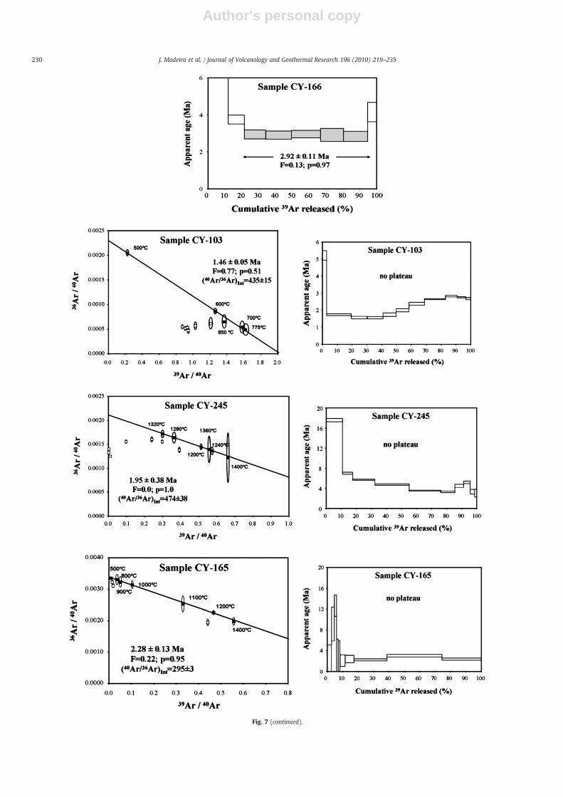
Detailed 40Ar/39Ar step-heating data for all of the analysed samplesare available as Supplementary data (Appendix B). Dating results aresummarised in Table 1 and Fig. 7. Plateaux are defined as sections ofthe age spectra carrying 50% or more of the total released 39Ar gascontained in at least three consecutive heating steps with overlappingages; uncertainty is defined at the 95% confidence level (Fleck et al.,1977; Baksi, 2003).
The Mean Square Weighted Deviate (MSWD=F), also reported inTable 1, is an F-statistic thatmeasures the scatter of the individual step
Fig. 6. Total alkali–silica (TAS) diagram (LeMaitre et al., 2002). The thick dashed line is acompositional divider between alkaline and subalkaline volcanics (MacDonald, 1968).According to Le Bas (1989) the normative content of albite and nepheline was used tocorrectly classify samples plotting in the “foidites” and “basanites/tephrites” fields:nephelinites have N20% normative Ne and melanephelinites and basanites have b20%.Melanephelinites have b5% normative Ab and basanites have N5% Ab.
227J. Madeira et al. / Journal of Volcanology and Geothermal Research 196 (2010) 219–235

Author's personal copy
ages. Although values below 2.5 are commonly considered acceptable,this value is dependent on the degrees of freedom of the data and sofurther statistical tests should therefore be performed (Baksi, 2003;Norman et al., 2010). To ensure the statistical reliability of the agedata, a chi-squared test was used. A chi-squared value is obtained bymultiplying the MSWD by the corresponding degrees of freedom ofthe data set (number of steps minus 1 or minus 2 for plateau orisochron ages, respectively). The result can be comparedwith relevantchi-squared tables to assess whether the data belongs to the samenormal distribution (Baksi, 2003, 2006; Ivanov et al., 2009; Table 1) ata 95% confidence level (probability of occurrence, P, above 0.05).
Eight of the analysed samples produced indisputable plateau agesbased on the above-mentioned requirements and do not need furthercomments. The remaining six results are discussed below.
Samples CY-193 and CY-226 show large errors due to limitedradiogenic 40Ar coupled with elevated atmospheric 40Ar. Theseuncertainties make the obtained age results “non-accepted”.
A reliable plateauwas not reached in sample CY-103, forwhich excess40Ar is evident from the 40Ar/36Ar intercept of 435±15. However, asignificant isochron (F=0.77; p=0.51) was attained with the first fiveconsecutive heating steps producing an age of 1.46±0.05 Ma.
Despite evidence of excess 40Ar, sample CY-118 has produced areliable plateau age (1.77±0.03 Ma) based on statistical parameters(F=0.84; p=0.52).
The plateau for sample CY-245 presents the common “U”-shapedpattern of excess Ar (40Ar/36Ar intercept of 473.7) and did not producea reliable age determination. The isochron age (1.95±0.38 Ma),obtained with the last six consecutive heating steps is therefore theprobable crystallisation age of the sample.
A seven steps isochron age of 2.28±0.13 Ma (F=0.22; p=0.95)was preferred for sample CY-165 owing to the irregular step-heatingspectrum.
For all of the obtained ages, P values (probability of occurrence)are between 0.2 and 1.0, well above the 0.05 threshold.
6.2. U–Th disequilibrium ages
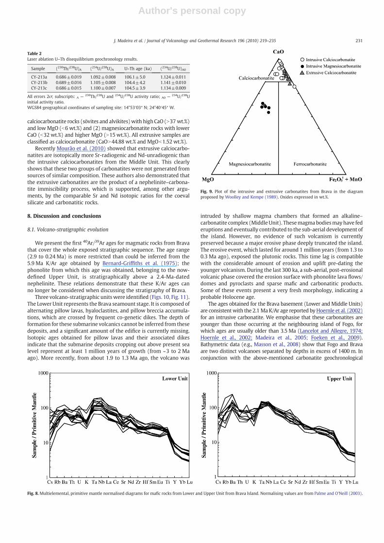
Isotope ratios and the resulting ages for samples CY-213a–c aresummarised in Table 2. All three samples are within the U–Th datingrangeandhave limitedvariability indicating small ornegligiblediageneticalteration of the corals. This is also confirmed by the initial 234U/238Uactivity ratios of the coral samples, which (within 2 sigma uncertainty)are in the range of modern corals (1.146±0.002; Edwards et al., 2003).The initial 234U/238U activity ratios of corals should remain within 10 to20‰ of the modern value for the last several hundred thousand years(Edwards et al., 2003). Thus, thedeposit is accurately attributed toMarineIsotope Stage 5c (MIS5c), at around 0.105 Ma.
7. Geochemistry of magmatic rocks
A detailed petrological and geochemical study of the Brava igneousrocks is beyond the scope of this work. However, given the lack ofinformation about the island, the main lithotypes from Brava arebriefly characterised from a geochemical point of view. Petrographicdescriptions of these rocks can be found in Machado et al. (1967,1968) and Mourão et al. (2010).
7.1. Silicate rocks
Despite the abundance of pyroclastic rocks, we focus on intrusiveand effusive rocks as they preserve better the chemical characteristicsof magmas because of their higher resistance to alteration.
Brava's silicate rocks are diverse, ranging from ultrabasic tointermediate compositions (SiO2=35.91% to 57.84%, on an anhy-drous basis; Fig. 6). Despite the cumulative character of most of theintrusive silicate rocks of the Middle Unit, these rocks were alsoplotted on the TAS diagram, to facilitate the preliminary comparisonwith extrusive rocks from the other units.
The majority of the submarine lavas and dikes forming the LowerUnit are ultrabasic foidites. Their highly silica-undersaturated char-acter is evidenced by normative compositions that typically presentnepheline, leucite and larnite (dicalcium silicate). Given the appre-ciable amount of normative larnite (up to 8.6%) in most rocks of thisunit, the predominant lithotype is melilite melanephelinite; basaniteis the second most abundant rock type. Some dikes are extremelyporphyritic with more abundant clinopyroxene than olivine pheno-chrysts, conferring an ankaramitic character to these rocks.
The Middle Unit is dominated by intrusive rocks that presenttextural evidence of cumulative processes. This is particularly true forpyroxenites, which are interpreted here as having formed at the base ofmagma chambers by pyroxene accumulation from ijolitic (s.l.)magmas.Differentdegreesof fractionation/accumulationof suchmagmas explainthe common association of pyroxenites, melteigites (clinopyroxe-neNnepheline), ijolites and urtites (nephelineNclinopyroxene) withinthe same intrusions. Silicate rocks are often intruded by carbonatiterocks, forming alkaline–carbonatitic associations similar to thosedescribed in continental (e.g., Le Bas, 1977; Wooley, 1979; Ray, 2009)and oceanic areas (Muñoz et al., 2005; De Ignacio et al., 2006).Carbonatites are also associated with hyper-solvus nepheline syenites.In some places, carbonatites caused fenitisation of the associated ijolitic(s.l.) and nepheline syenitic rocks, mainly producing clusters of largebiotite flakes.
Volcanic silicate rocks from the Upper Unit are bimodal. Themelanocratic pole is dominated by nephelinites (normative nephelineup to 27.4%; normative olivine up to 24.2%) but also includes tephrites(normative olivineb10%) and basanites (olivineN10%). These rockstend to be more silica-rich than melanocratic rocks from the LowerUnit. Based on the TAS diagram, mesocratic/leucocratic rocks can besubdivided into nephelinites (phonolitic nephelinites in the sense ofCox et al., 1979) and phonolites. These nephelinites are readilydistinguished from those forming the melanocratic pole of the UpperUnit by their lack of normative olivine. Hauyne–nosean is thedominant phenocryst phase of the studied phonolites.
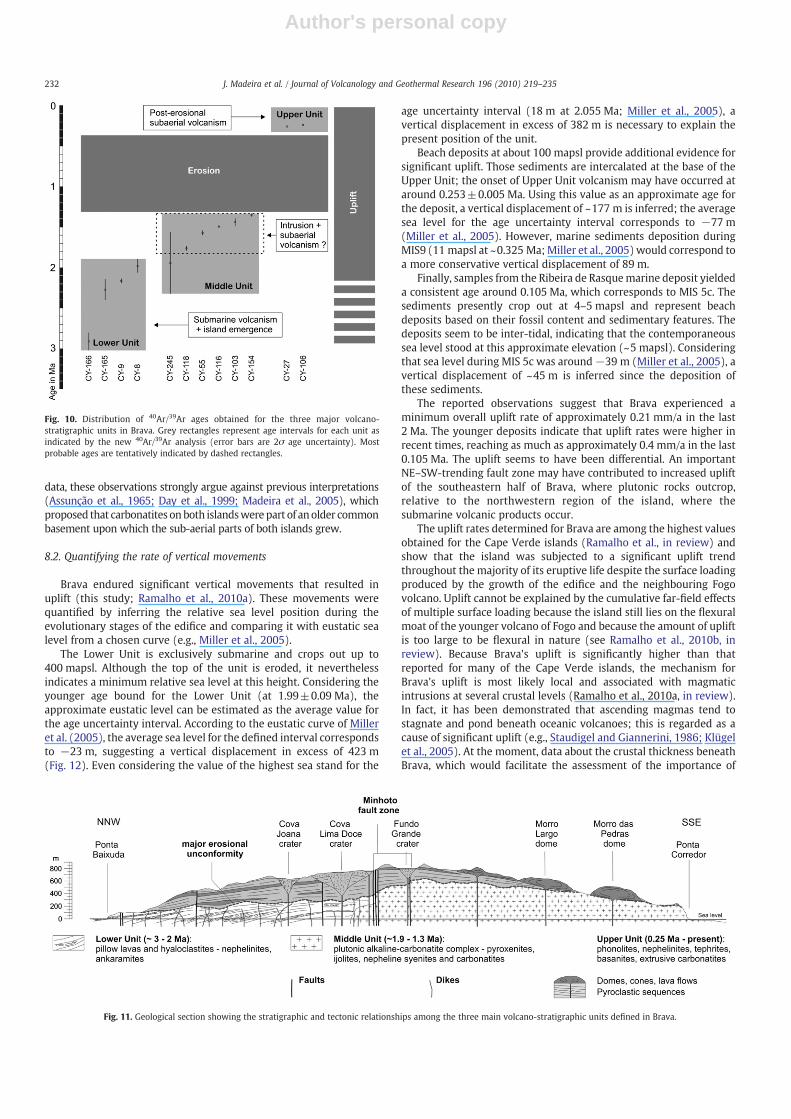
Mafic rocks from the Upper and Lower Units are also distinct interms of trace elements. Indeed, while lavas and dikes from the LowerUnit are characterised by well-marked negative K anomalies andsignificant Nb and Ta enrichment relative to both light rare earthelements (e.g., La and Ce) and large ion lithophile elements (e.g., Baand Rb), their counterparts of the Upper Unit are typically Ba-enriched and have less well-defined negative K anomalies (Supple-mentary data — Appendix D; Fig. 8). Considering that incompatibletrace element ratios tend to be unaffected by partial melting andfractional crystallisation processes (e.g., Allègre et al., 1977; Minsterand Allègre, 1978), these differences strongly suggest that melano-cratic rocks from these two units are derived from distinct types ofmagmas/mantle sources.
7.2. Carbonatitic rocks
Carbonatitic rocks occur in theMiddle and Upper Units as intrusiveand extrusive facies, respectively. Previous work on carbonatiticrocks (Assunção et al., 1965; Machado et al., 1967; Hoernle et al.,2002) has only described the occurrence of calciocarbonatite varieties.However, our data indicate two groups of carbonatites (Fig. 9): (1)
Fig. 7. Plateau and isochron ages for Brava Island. a— Step-heating 40Ar/39Ar apparent age spectrum. Reported errors are 2σ. Filled steps were included in the plateau age calculation.Goodness of fit parameter (F) and probability (p) are indicated. b — Inverse isochron diagrams for samples for which a plateau age was not attained (also shown). Filled squaresindicate the steps included in isochron calculation. Solid lines represent the calculated isochron. Goodness of fit parameter (F), probability (p) and 40Ar/36Ar intercept are indicated.
228 J. Madeira et al. / Journal of Volcanology and Geothermal Research 196 (2010) 219–235

Author's personal copy
229J. Madeira et al. / Journal of Volcanology and Geothermal Research 196 (2010) 219–235
Author's personal copy
Fig. 7 (continued).
230 J. Madeira et al. / Journal of Volcanology and Geothermal Research 196 (2010) 219–235
Author's personal copy
calciocarbonatite rocks (sövites and alvikites)with high CaO (N37 wt.%)and lowMgO (b6 wt.%) and (2) magnesiocarbonatite rocks with lowerCaO (b32 wt.%) and higher MgO (N15 wt.%). All extrusive samples areclassified as calciocarbonatite (CaON44.88 wt.% and MgOb1.52 wt.%).
Recently Mourão et al. (2010) showed that extrusive calciocarbo-natites are isotopically more Sr-radiogenic and Nd-unradiogenic thanthe intrusive calciocarbonatites from the Middle Unit. This clearlyshows that these two groups of carbonatites were not generated fromsources of similar composition. These authors also demonstrated thatthe extrusive carbonatites are the product of a nephelinite–carbona-tite immiscibility process, which is supported, among other argu-ments, by the comparable Sr and Nd isotopic ratios for the coevalsilicate and carbonatitic rocks.
8. Discussion and conclusions
8.1. Volcano-stratigraphic evolution
We present the first 40Ar/39Ar ages for magmatic rocks from Bravathat cover the whole exposed stratigraphic sequence. The age range(2.9 to 0.24 Ma) is more restricted than could be inferred from the5.9 Ma K/Ar age obtained by Bernard-Griffiths et al. (1975); thephonolite from which this age was obtained, belonging to the now-defined Upper Unit, is stratigraphically above a 2.4-Ma-datednephelinite. These relations demonstrate that these K/Ar ages canno longer be considered when discussing the stratigraphy of Brava.
Three volcano-stratigraphic unitswere identified (Figs. 10, Fig. 11).The Lower Unit represents the Brava seamount stage. It is composed ofalternating pillow lavas, hyaloclastites, and pillow breccia accumula-tions, which are crossed by frequent co-genetic dikes. The depth offormation for these submarine volcanics cannot be inferred from thesedeposits, and a significant amount of the edifice is currently missing.Isotopic ages obtained for pillow lavas and their associated dikesindicate that the submarine deposits cropping out above present sealevel represent at least 1 million years of growth (from ~3 to 2 Maago). More recently, from about 1.9 to 1.3 Ma ago, the volcano was
intruded by shallow magma chambers that formed an alkaline–carbonatite complex (MiddleUnit). Thesemagmabodiesmayhave federuptions and eventually contributed to the sub-aerial development ofthe island. However, no evidence of such volcanism is currentlypreserved because a major erosive phase deeply truncated the island.The erosive event, which lasted for around 1 million years (from 1.3 to0.3 Ma ago), exposed the plutonic rocks. This time lag is compatiblewith the considerable amount of erosion and uplift pre-dating theyounger volcanism. During the last 300 ka, a sub-aerial, post-erosionalvolcanic phase covered the erosion surface with phonolite lava flows/domes and pyroclasts and sparse mafic and carbonatitic products.Some of these events present a very fresh morphology, indicating aprobable Holocene age.
The ages obtained for the Brava basement (Lower and Middle Units)are consistentwith the 2.1 Ma K/Ar age reported byHoernle et al. (2002)for an intrusive carbonatite. We emphasise that these carbonatites areyounger than those occurring at the neighbouring island of Fogo, forwhich ages are usually older than 3.5 Ma (Lancelot and Allegre, 1974;Hoernle et al., 2002; Madeira et al., 2005; Foeken et al., 2009).Bathymetric data (e.g., Masson et al., 2008) show that Fogo and Bravaare two distinct volcanoes separated by depths in excess of 1400 m. Inconjunction with the above-mentioned carbonatite geochronological
Fig. 8.Multielemental, primitive mantle normalised diagrams for mafic rocks from Lower and Upper Unit from Brava Island. Normalising values are from Palme and O'Neill (2003).
Fig. 9. Plot of the intrusive and extrusive carbonatites from Brava in the diagramproposed by Woolley and Kempe (1989). Oxides expressed in wt.%.
Table 2Laser ablation U–Th disequilibrium geochronology results.
Sample (230Th/238U)A (234U/238U)A U–Th age (ka) (234U/238U)A0
CY-213a 0.686±0.019 1.092±0.008 106.1±5.0 1.124±0.011CY-213b 0.689±0.016 1.105±0.008 104.4±4.2 1.141±0.010CY-213c 0.686±0.015 1.100±0.007 104.5±3.9 1.134±0.009
All errors 2σ; subscripts: A — 230Th/238U and 234U/238U activity ratio; A0 — 234U/238Uinitial activity ratio.WGS84 geographical coordinates of sampling site: 14°53′03″ N; 24°40′45″ W.
231J. Madeira et al. / Journal of Volcanology and Geothermal Research 196 (2010) 219–235
Author's personal copy
data, these observations strongly argue against previous interpretations(Assunção et al., 1965; Day et al., 1999; Madeira et al., 2005), whichproposed that carbonatites onboth islandswerepart of anolder commonbasement upon which the sub-aerial parts of both islands grew.
8.2. Quantifying the rate of vertical movements
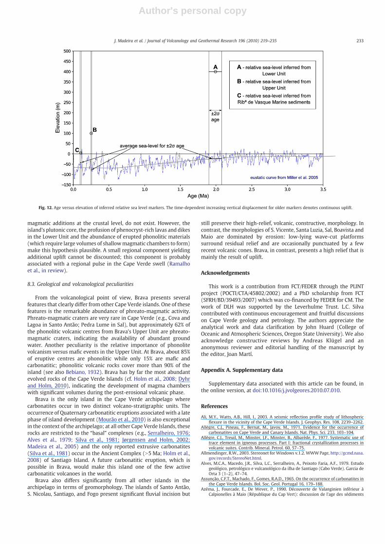
Brava endured significant vertical movements that resulted inuplift (this study; Ramalho et al., 2010a). These movements werequantified by inferring the relative sea level position during theevolutionary stages of the edifice and comparing it with eustatic sealevel from a chosen curve (e.g., Miller et al., 2005).
The Lower Unit is exclusively submarine and crops out up to400 mapsl. Although the top of the unit is eroded, it neverthelessindicates a minimum relative sea level at this height. Considering theyounger age bound for the Lower Unit (at 1.99±0.09 Ma), theapproximate eustatic level can be estimated as the average value forthe age uncertainty interval. According to the eustatic curve of Milleret al. (2005), the average sea level for the defined interval correspondsto −23 m, suggesting a vertical displacement in excess of 423 m(Fig. 12). Even considering the value of the highest sea stand for the
age uncertainty interval (18 m at 2.055 Ma; Miller et al., 2005), avertical displacement in excess of 382 m is necessary to explain thepresent position of the unit.
Beach deposits at about 100 mapsl provide additional evidence forsignificant uplift. Those sediments are intercalated at the base of theUpper Unit; the onset of Upper Unit volcanism may have occurred ataround 0.253±0.005 Ma. Using this value as an approximate age forthe deposit, a vertical displacement of ~177 m is inferred; the averagesea level for the age uncertainty interval corresponds to −77 m(Miller et al., 2005). However, marine sediments deposition duringMIS9 (11 mapsl at ~0.325 Ma;Miller et al., 2005)would correspond toa more conservative vertical displacement of 89 m.
Finally, samples from the Ribeira de Rasquemarine deposit yieldeda consistent age around 0.105 Ma, which corresponds to MIS 5c. Thesediments presently crop out at 4–5 mapsl and represent beachdeposits based on their fossil content and sedimentary features. Thedeposits seem to be inter-tidal, indicating that the contemporaneoussea level stood at this approximate elevation (~5 mapsl). Consideringthat sea level during MIS 5c was around−39 m (Miller et al., 2005), avertical displacement of ~45 m is inferred since the deposition ofthese sediments.
The reported observations suggest that Brava experienced aminimum overall uplift rate of approximately 0.21 mm/a in the last2 Ma. The younger deposits indicate that uplift rates were higher inrecent times, reaching as much as approximately 0.4 mm/a in the last0.105 Ma. The uplift seems to have been differential. An importantNE–SW-trending fault zone may have contributed to increased upliftof the southeastern half of Brava, where plutonic rocks outcrop,relative to the northwestern region of the island, where thesubmarine volcanic products occur.
The uplift rates determined for Brava are among the highest valuesobtained for the Cape Verde islands (Ramalho et al., in review) andshow that the island was subjected to a significant uplift trendthroughout the majority of its eruptive life despite the surface loadingproduced by the growth of the edifice and the neighbouring Fogovolcano. Uplift cannot be explained by the cumulative far-field effectsof multiple surface loading because the island still lies on the flexuralmoat of the younger volcano of Fogo and because the amount of upliftis too large to be flexural in nature (see Ramalho et al., 2010b, inreview). Because Brava's uplift is significantly higher than thatreported for many of the Cape Verde islands, the mechanism forBrava's uplift is most likely local and associated with magmaticintrusions at several crustal levels (Ramalho et al., 2010a, in review).In fact, it has been demonstrated that ascending magmas tend tostagnate and pond beneath oceanic volcanoes; this is regarded as acause of significant uplift (e.g., Staudigel and Giannerini, 1986; Klügelet al., 2005). At the moment, data about the crustal thickness beneathBrava, which would facilitate the assessment of the importance of
Fig. 11. Geological section showing the stratigraphic and tectonic relationships among the three main volcano-stratigraphic units defined in Brava.
Fig. 10. Distribution of 40Ar/39Ar ages obtained for the three major volcano-stratigraphic units in Brava. Grey rectangles represent age intervals for each unit asindicated by the new 40Ar/39Ar analysis (error bars are 2σ age uncertainty). Mostprobable ages are tentatively indicated by dashed rectangles.
232 J. Madeira et al. / Journal of Volcanology and Geothermal Research 196 (2010) 219–235
Author's personal copy
magmatic additions at the crustal level, do not exist. However, theisland's plutonic core, the profusion of phenocryst-rich lavas and dikesin the Lower Unit and the abundance of erupted phonolitic materials(which require large volumes of shallowmagmatic chambers to form)make this hypothesis plausible. A small regional component yieldingadditional uplift cannot be discounted; this component is probablyassociated with a regional pulse in the Cape Verde swell (Ramalhoet al., in review).
8.3. Geological and volcanological peculiarities
From the volcanological point of view, Brava presents severalfeatures that clearly differ from other Cape Verde islands. One of thesefeatures is the remarkable abundance of phreato-magmatic activity.Phreato-magmatic craters are very rare in Cape Verde (e.g., Cova andLagoa in Santo Antão; Pedra Lume in Sal), but approximately 62% ofthe phonolitic volcanic centres from Brava's Upper Unit are phreato-magmatic craters, indicating the availability of abundant groundwater. Another peculiarity is the relative importance of phonolitevolcanism versus mafic events in the Upper Unit. At Brava, about 85%of eruptive centres are phonolitic while only 15% are mafic andcarbonatitic; phonolitic volcanic rocks cover more than 90% of theisland (see also Bebiano, 1932). Brava has by far the most abundantevolved rocks of the Cape Verde Islands (cf. Holm et al., 2008; Dyhrand Holm, 2010), indicating the development of magma chamberswith significant volumes during the post-erosional volcanic phase.
Brava is the only island in the Cape Verde archipelago wherecarbonatites occur in two distinct volcano-stratigraphic units. Theoccurrence of Quaternary carbonatitic eruptions associated with a latephase of island development (Mourão et al., 2010) is also exceptionalin the context of the archipelago; at all other Cape Verde Islands, theserocks are restricted to the “basal” complexes (e.g., Serralheiro, 1976;Alves et al., 1979; Silva et al., 1981; Jørgensen and Holm, 2002;Madeira et al., 2005) and the only reported extrusive carbonatites(Silva et al., 1981) occur in the Ancient Complex (N5 Ma; Holm et al.,2008) of Santiago Island. A future carbonatitic eruption, which ispossible in Brava, would make this island one of the few activecarbonatitic volcanoes in the world.
Brava also differs significantly from all other islands in thearchipelago in terms of geomorphology. The islands of Santo Antão,S. Nicolau, Santiago, and Fogo present significant fluvial incision but
still preserve their high-relief, volcanic, constructive, morphology. Incontrast, the morphologies of S. Vicente, Santa Luzia, Sal, Boavista andMaio are dominated by erosion: low-lying wave-cut platformssurround residual relief and are occasionally punctuated by a fewrecent volcanic cones. Brava, in contrast, presents a high relief that ismainly the result of uplift.
Acknowledgements
This work is a contribution from FCT/FEDER through the PLINTproject (POCTI/CTA/45802/2002) and a PhD scholarship from FCT(SFRH/BD/39493/2007) which was co-financed by FEDER for CM. Thework of DLH was supported by the Leverhulme Trust. L.C. Silvacontributed with continuous encouragement and fruitful discussionson Cape Verde geology and petrology. The authors appreciate theanalytical work and data clarification by John Huard (College ofOceanic and Atmospheric Sciences, Oregon State University). We alsoacknowledge constructive reviews by Andreas Klügel and ananonymous reviewer and editorial handling of the manuscript bythe editor, Joan Martí.
Appendix A. Supplementary data
Supplementary data associated with this article can be found, inthe online version, at doi:10.1016/j.jvolgeores.2010.07.010.
References
Ali, M.Y., Watts, A.B., Hill, I., 2003. A seismic reflection profile study of lithosphericflexure in the vicinity of the Cape Verde Islands. J. Geophys. Res. 108, 2239–2262.
Allègre, C.J., Pineau, F., Bernat, M., Javoy, M., 1971. Evidence for the occurrence ofcarbonatites on Cape Verde and Canary Islands. Nat. Phys. Sci. 233, 103–104.
Allègre, C.J., Treuil, M., Minster, J.F., Minster, B., Albarède, F., 1977. Systematic use oftrace element in igneous processes. Part I: fractional crystallization processes involcanic suites. Contrib. Mineral. Petrol. 60, 57–75.
Allmendinger, R.W., 2003. Stereonet for Windows v.1.2. WWWPage, http://gcmd.nasa.gov/records/StereoNet.html.
Alves, M.C.A., Macedo, J.R., Silva, L.C., Serralheiro, A., Peixoto Faria, A.F., 1979. Estudogeológico, petrológico e vulcanológico da ilha de Santiago (Cabo Verde). Garcia deOrta 3 (1–2), 47–74.
Assunção, C.F.T., Machado, F., Gomes, R.A.D., 1965. On the occurrence of carbonatites inthe Cape Verde Islands. Bol. Soc. Geol. Portugal 16, 179–188.
Azéma, J., Fourcade, E., De Wever, P., 1990. Découverte de Valanginien inférieur àCalpionelles à Maio (République du Cap Vert): discussion de l'age des sédiments
Fig. 12. Age versus elevation of inferred relative sea level markers. The time-dependent increasing vertical displacement for older markers denotes continuous uplift.
233J. Madeira et al. / Journal of Volcanology and Geothermal Research 196 (2010) 219–235
Author's personal copy
associés aux laves de type MORB de ce secteur de l'Atlantique Central. C. R. Acad.Sci. Ser. II 310, 277–283.
Baksi, A., 2003. Critical evaluation of 40Ar/39Ar ages for the Central Atlantic MagmaticProvince: timing, duration and possible migration of magmatic centers. The CentralAtlantic Magmatic Province: Insight from Fragments of Pangea: AGU Monograph,136, pp. 77–90.
Baksi, A.K., 2006.Guidelines for assessing thereliability of 40Ar/39Arplateauages: applicationto ages relevant to hotspot tracks. WWW Page, http://www.mantleplumes.org.
Bebiano, J.B., 1932. A geologia do Arquipélago de Cabo Verde. Comun. Serv. Geol.Portugal 18, 1–275.
Bernard-Griffiths, J., Cantagrel, J.-M., Matos Alves, C., Mendes, F., Serralheiro, A.,Macedo, J.R., 1975. Données radiométriques potassium-argon sur quelquesformations magmatiques des îles de l'archipel du Cap Vert. C. R. Acad. Sci. Ser. D280, 2429–2432.
Bosse, V., Doucelance, R., Fornari, M., Mata, J., 2007. Temporal evolution of the CaboVerde archipelago: new constraints from 40Ar–39Ar data. Geochim. Cosmochim.Acta 71 (15S), A110.
Brum da Silveira, A., Madeira, J., Serralheiro, A., 1997a. A estrutura da ilha do Fogo, CaboVerde. 1st International Symposium “A erupção vulcânica de 1995 na ilha do Fogo,Cabo Verde”, Instituto de Investigação Científica Tropical and Ministério da Ciênciae Tecnologia, Lisboa, Portugal, pp. 63–78.
Brum da Silveira, A., Madeira, J., Serralheiro, A., Torres, P.C., Silva, L.C., Mendes, M.H.,1997b. O controlo estrutural da erupção de Abril de 1995 na ilha do Fogo. 1stInternational Symposium “A erupção vulcânica de 1995 na ilha do Fogo, CaboVerde”, Instituto de Investigação Científica Tropical and Ministério da Ciência eTecnologia, Lisboa, Portugal, pp. 51–61.
Cazenave, A., Dominh, K., Rabinowicz, M., Ceuleneer, G., 1988. Geoid and depthanomalies over ocean swells and troughs: evidence of an increasing trend of thegeoid to depth ratio with age of plate. J. Geophys. Res. 93, 8064–8077.
Centro de Geografia do Ultramar, 1957. Aerial photo coverage of Brava Island at the1:30,000 scale. Acquired in 1957 by Serviço de Fotogrametria of Centro deGeografia do Ultramar, Portugal.
Christensen, B.P., Holm, P.M., Jambon, A., Wilson, J.R., 2001. Helium, argon and leadisotopic composition of volcanics from Santo Antão and Fogo, Cape Verde Islands.Chem. Geol. 178, 127–142.
Courtney, R.C., White, R.S., 1986. Anomalous heat flow and geoid across the Cape VerdeRise: evidence for dynamic support from a thermal plume in themantle. Geophys. J.R. Astron. Soc. 87, 815–867.
Cox, K.G., Bell, J.D., Pankhurst, R.J., 1979. The Interpretation of Igneous Rocks. GeorgeAllen and Unwin, London.
Crough, S.T., 1978. Thermal origin of mid-plate hot-spot swells. Geophys. J. R. Astron.Soc. 55, 451–469.
Dash, B.P., Ball, I.M.M., King, I.G.A., Butler, L.W., Rona, F.P.A., 1976. Geophysicalinvestigation of the Cape Verde Archipelago. J. Geophys. Res. 81 (B29), 5249–5259.
Day, S.J., Heleno da Silva, S.I.N., Fonseca, J.F.B.D., 1999. A past giant lateral collapse andpresent-day flank instability of Fogo, Cape Verde Islands. J. Volcanol. Geotherm.Res. 94, 191–218.
de Ignacio, C., Muñoz, M., Sagredo, J., Fernández-Santín, S., Johansson, A., 2006. Isotopegeochemistry and FOZOmantle component of the alkaline–carbonatitic associationof Fuerteventura, Canary Islands, Spain. Chem. Geol. 232, 99–113.
De Paepe, P., Klerkx, J., Hertogen, J., Plinke, P., 1974. Oceanic tholeiites on the CapeVerde Islands: petrochemical and geochemical evidence. Earth Planet. Sci. Lett. 22,347–354.
Doucelance, R., Escrig, S., Moreira, M., Gariépy, C., Kurz, M.D., 2003. Pb–Sr–He isotopeand trace element geochemistry of the Cape Verde Archipelago. Geochim.Cosmochim. Acta 67, 3717–3733.
Duncan, R.A., Keller, R.A., 2004. Radiometric ages for basement rocks from the EmperorSeamounts, ODP Leg 197. Geochem. Geophys. Geosyst. 5, Q08L03.
Duprat, H.I., Friis, J., Holm, P.M., Grandvuinet, T., Sørensen, R.V., 2007. The volcanic andgeochemical development of São Nicolau, Cape Verde Islands: constraints fromfield and 40Ar/39Ar evidence. J. Volcanol. Geotherm. Res. 162, 1–19.
Dyhr, C.T., Holm, P.M., 2010. A volcanological and geochemical investigation ofBoa Vista, Cape Verde Islands; 40Ar/39Ar geochronology and field constraints.J. Volcanol. Geotherm. Res. 189 (1–2), 19–32.
Edwards, R.L., Gallup, C.D., Cheng,H., 2003.Uranium-series dating ofmarine and lacustrinecarbonates. In: Bourdon, B., Henderson, G.M., Lundstrom, C.C., Turner, S.P. (Eds.),Uranium-series Geochemistry. Mineral. Soc. Am., Washington D.C.
Fleck, R.J., Sutter, J.F., Elliot, D.H., 1977. Interpretation of discordant 40Ar/39Ar agespectra of Mesozoic tholieiites from Antarctica. Geochim. Cosmochim. Acta 41,15–32.
Foeken, J.P.T., Day, S., Stuart, F.M., 2009. Cosmogenic 3He exposure dating of theQuaternary basalts from Fogo, Cape Verdes: implications for rift zone andmagmatic reorganization. Quat. Geochronol. 4, 37–49.
Gerlach, D.C., Cliff, R.A., Davies, G.R., Norry, M., Hodgeson, N., 1988. Magma sources ofthe Cape Verdes Archipelago: isotopic and trace element constraints. Geochim.Cosmochim. Acta 52, 2979–2992.
Grevemeyer, I., Helffrich, G., Faria, B., Booth-Rea, G., Schnabel, M., Weinrebe, W., 2009.Seismic activity at Cadamosto seamount near Fogo Island, Cape Verde — formationof a new ocean island? Geophys. J. Int. 180 (2), 552–558.
Grunau, H.R., Lehner, P., Cleintaur, M.R., Allenback, P., Bakkar, G., 1975. New radiometricages and seismic data from Fuerteventura (Canary Islands), Maio (Cape VerdeIslands) and São Tome (Gulf of Guinea). Progress in Geodynamics. Royal Academyof Arts and Sciences, Amsterdam, pp. 90–118.
Heleno da Silva, S.I.N., Fonseca, J.F.B.D., 1999. A seismological investigation of theFogo Volcano, Cape Verde Islands: preliminary results. Volcanol. Seismol. 20,199–217.
Heleno da Silva, S.I.N., Faria, B.V.E., Bandomo, Z., Fonseca, J.F.B.D., 2006. Observations ofhigh-frequency harmonic tremor in Fogo, Cape Verde Islands. J. Volcanol.Geotherm. Res. 158, 361–379.
Helffrich, G., Faria, B., Fonseca, J.F.B.D., Lodge, A., Kaneshima, S., 2010. Transition zonestructure under a stationary hot spot: Cape Verde. Earth Planet. Sci. Lett. 289 (1–2),156–161.
Hoernle, K.A., Tilton, G., LeBas, M.J., Duggen, S., Garbe-Schönberg, D., 2002. Geochem-istry of oceanic carbonatites compared with continental carbonatites: mantlerecycling of oceanic crustal carbonate. Contrib. Mineral. Petrol. 142, 520–542.
Hoffmann, D., Spotl, C., Mangini, A., 2009. Micromill and in situ laser ablation samplingtechniques for high spatial resolution MC-ICPMS U–Th dating of carbonates. Chem.Geol. 259 (3–4), 253–261.
Holm, P.M., Grandvuinet, T., Friis, J., Wilson, J.R., Barker, A.K., Plesner, S., 2008. An 40Ar–39Ar study of the Cape Verde hot spot: temporal evolution in a semistationary plateenvironment. J. Geophys. Res. 113, B08201.
Ivanov, A., He, H., Yang, L., Nikolaeva, I., Palesskii, S., 2009. 40Ar/39Ar dating of intrusivemagmatism in the Angara–Taseevskaya syncline and its implication for duration ofmagmatism of the Siberian traps. J. Asian Earth Sci. 35, 1–12.
Jørgensen, J.Ø., Holm, P.M., 2002. Temporal variation and carbonatite contamination inprimitive ocean island volcanics from Sao Vicente, Cape Verde Islands. Chem. Geol.192, 249–267.
Klügel, A., Hansteen, T., Galipp, K., 2005.Magma storage andunderplatingbeneathCumbreVieja volcano, La Palma (Canary Islands). Earth Planet. Sci. Lett. 236, 211–226.
Kogarko, L.N., 1993. Geochemical characteristics of oceanic carbonatites from the CapeVerde Islands. S. Afr. J. Geol. 96, 119–125.
Koppers, A.A.P., 2002. ArArCALC — software for 40Ar/39Ar age calculations. Comput.Geosci. 28, 605–619.
Lancelot, J.R., Allegre, C.J., 1974. Origin of carbonatitic magma in the light of the Pb–U–Th isotope system. Earth Planet. Sci. Lett. 22, 233–238.
Le Bas, M.J., 1977. Carbonatite–Nephelinite Volcanism: An African Case History. JohnWiley, New York.
Le Bas, M.J., 1989. Nephelinitic and basanitic rocks. J. Petrol. 30, 1299–1312.Le Bas, T.P., Masson, D.G., Holtom, R.T., Grevemeyer, I., 2007. Slope failures of the flanks
of the southern Cape Verde Islands. In: Lykousis, V., Sakellariou, D., Locat, J. (Eds.),Submarine Mass Movements and their Consequences. 3rd International Sympo-sium. Springer, Dordrecht, Netherlands, pp. 337–345.
Le Maitre, R.W., Streckeisen, A., Zanettin, B., Le Bas, M.J., Bonin, B., Bateman, P., Bellieni,G., Dudek, A., Efremova, S., Keller, J., Lameyre, J., Sabine, P.A., Schmid, R., Sørensen,H., Woolley, A.R. (Eds.), 2002. Igneous Rocks: A Classification and Glossary ofTerms. Recommendations of the International Union of Geological SciencesSubcommission on the Systematics of Igneous Rocks. Cambridge University Press.
Lodge, A., Helffrich, G., 2006. Depleted swell root beneath the Cape Verde Islands.Geology 34, 449–452.
MacDonald, G.A., 1968. Composition and origin of Hawaiian lavas. Mem. - Geol. Soc.Am. 116, 477–522.
Machado, F., Azeredo Leme, J., Monjardino, J., 1967. O Complexo sienito-carbonatíticoda ilha Brava, Cabo Verde. Garcia de Orta 15 (1), 93–98.
Machado, F., Azeredo Leme, J., Monjardino, J., Seita, M.F., 1968. Carta geológica de CaboVerde, notícia explicativa da ilha Brava e dos ilhéus Secos. Garcia de Orta 16 (1),123–130.
Madeira, J., Brum da Silveira, A., 2005. Geomorphic and structural analysis of the Fogoisland volcano (Cape Verde). International Workshop on Ocean Island Volcanism,Sal, Cape Verde, p. 45.
Madeira, J., Brum da Silveira, A., Torres, P.C., 1997. Contradição aparente entre osvolumes finais dos derrames e a estimação das taxas de efusão: O caso da erupçãodo Fogo de 1995. 1st International Symposium “A erupção vulcânica de 1995 nailha do Fogo, Cabo Verde”. Instituto de Investigação Científica Tropical andMinistério da Ciência e Tecnologia, Lisboa, Portugal, pp. 153–163.
Madeira, J., Munhá, J., Tassinari, C.C.G., Mata, J., Brum da Silveira, A., Martins, S., 2005.K/Ar ages of carbonatites from the Island of Fogo (Cape Verde). VIII Congresso deGeoquímica dos Países de Língua Portuguesa, Aveiro, Portugal, pp. 475–478.
Madeira, J., Brum da Silveira, A., Mata, J., Mourão, C., Martins, S., 2008. The role of massmovements on the geomorphologic evolution of ocean islands: examples fromFogo and Brava in the Cape Verde archipelago. Comun. Geol. 95, 99–112.
Martins, S., Mata, J., Munhá, J., Mendes, M.H., Maerschalk, C., Caldeira, R., Mattielli, N.,2010. Chemical and mineralogical evidence of the occurrence of mantlemetasomatism by carbonate-rich melts in an oceanic environment (SantiagoIsland, Cape Verde). Mineral. Petrol. 99, 43–65.
Masson, D.G., Le Bas, T.P., Grevemeyer, I., Weinrebe, W., 2008. Flank collapse and large-scale landsliding in the Cape Verde Islands, off West Africa. Geochem. Geophys.Geosyst. 9 (7), Q07015.
Mata, J., Moreira, M., Doucelance, R., Ader, M., Silva, L.C., 2010. Noble gas and carbonisotopic signatures of Cape Verde oceanic carbonatites: implications for carbonprovenance. Earth Planet. Sci. Lett. 291 (1–4), 70–83.
Miller, K., Kominz, M., Browning, J., Wright, J., Mountain, G., Katz, M., Sugarman, P.,Cramer, B., Christie-Blick, N., Pekar, S., 2005. The Phanerozoic record of global sea-level change. Science 310 (5752), 1293–1298.
Millet, M.-A., Doucelance, R., Schiano, P., David, K., Bosq, C., 2008. Mantle plumeheterogeneity versus shallow–level interactions: a case study, the São NicolauIsland, Cape Verde archipelago. J. Volcanol. Geotherm. Res. 176, 265–276.
Min, K.W., Mundil, R., Renne, P.R., Ludwig, K.R., 2000. A test for systematic errors in40Ar/39Ar geochronology through comparison with U/Pb analysis of a 1.1-Garhyolite. Geochim. Cosmochim. Acta 64, 73–98.
Minster, J.F., Allègre, C.J., 1978. Systematic use of trace element in igneous processes.Part III: inverse problem of batch partial melting in volcanic suites. Contrib.Mineral. Petrol. 68, 37–52.
234 J. Madeira et al. / Journal of Volcanology and Geothermal Research 196 (2010) 219–235

Author's personal copy
Mitchell, J.G., Le Bas, M.J., Zielonka, J., Furnes, H., 1983. On dating the magmatism ofMaio, Cape Verde Islands. Earth Planet. Sci. Lett. 64, 61–76.
Montelli, R., Nolet, G., Dahlen, F., Masters, G., 2006. A catalogue of deep mantle plumes:new results from finite-frequency tomography. Geochem. Geophys. Geosyst. 7,Q11007.
Mourão, C., Mata, J., Moreira, M., Doucelance, R., Madeira, J., 2007. Further heliumisotopic evidence for a lower mantle contribution to the Cape Verde plume.Geochim. Cosmochim. Acta 71 (15S), 691.
Mourão, C., Mata, J., Doucelance, R., Madeira, J., Brum da Silveira, A., Silva, L.C., Moreira,M., 2010. Quaternary extrusive calcio-carbonatite volcanism in Brava Island (CapeVerde): a nephelinite–carbonatite immiscibility product. J. Afr. Earth Sci. 56 (2/3),59–74.
Müller, R.D., Sdrolias, M., Gaina, C., Roest, W.R., 2008. Age, spreading rates, andspreading asymmetry of the world's ocean crust. Geochem. Geophys. Geosyst. 9,Q04006.
Muñoz, M., Sagredo, J., de Ignacio, C., Fernández-Suárez, J., Jeffries, T.E., 2005. New data(U–Pb, K–Ar) on the geochronology of the alkaline–carbonatitic association ofFuerteventura, Canary Islands, Spain. Lithos 85, 140–153.
Norman, M.D., Duncan, R.A., Huard, J.J., 2010. Imbrium provenance for the Apollo 16Descartes terrain: argon ages and geochemistry of lunar breccias 67016 and 67455.Geochim. Cosmochim. Acta 74, 763–783.
Palme, H., O'Neill, H.St.C., 2003. Cosmochemical estimates of mantle composition. In:Carlson, R.W. (Ed.), The Mantle. Treatise on geochemistry, vol. 2. Elsevier-Pergamon, Oxford, pp. 1–38.
Peterson, A.L., Wolff, J.A., Turbeville, B.N., 1989. Eruption mechanisms of extrusivecarbonatites on an ocean island: Brava, Cape Verde islands. EOS Trans. Am.Geophys. Union 70, 1421.
Pim, J., Peirce, C., Watts, A.B., Grevemeyer, I., Krabbenhoeft, A., 2008. Crustal structureand origin of the Cape Verde Rise. Earth Planet. Sci. Lett. 272, 422–428.
Plesner, S., Holm, P.M., Wilson, J.R., 2002. 40Ar–39Ar geochronology of Santo Antão, CapeVerde Islands. J. Volcanol. Geotherm. Res. 120, 103–121.
Pollitz, F.F., 1991. Two-stage model of African absolute motion during the last30 million years. Tectonophysics 194, 91–106.
Ramalho, R., Helffrich, G., Schmidt, D., Vance, D., 2010a. Tracers of uplift and subsidencein the Cape Verde Archipelago. J. Geol. Soc. (London) 167, 519–538.
Ramalho, R., Helffrich, G., Cosca, M., Vance, D., Hoffmann, D., Schmidt, D.N., 2010b.Vertical movements of ocean island volcanoes: insights from a stationary plate.Mar. Geol. 275, 84–95.
Ramalho, R., Helffrich, G., Cosca, M., Vance, D., Hoffmann, D., Schmidt, D.N., in review.Episodic Hotspot swell growth from variable uplift of Cape Verde Islands Nat.Geosci.
Ray, J.S., 2009. Radiogenic isotopic ratio variations in carbonatites and associatedalkaline silicate rocks: role of crustal assimilation. J. Petrol. 50, 1955–1971.
Serralheiro, A., 1976. A geologia da ilha de Santiago: Bol. Museu Lab. Min. Geol.Faculdade Ciências Lisboa, 14. 218 pp.
Serviço Cartográfico do Exército, 1979. Carta da Ilha Brava, República de Cabo Verde.Topographic Maps at the 1:25,000 scale, sheets 40 and 44–45, produced by thePortuguese Army for the Republic of Cape Verde.
Silva, L.C., Le Bas, M.J., Robertson, A.H.F., 1981. An oceanic carbonatite volcano onSantiago, Cape Verde Islands. Nature 294, 644–645.
Sleep, N.H., 1990. Hotspots and mantle plumes: some phenomenology. J. Geophys. Res.95, 6715–6736.
Staudigel, H., Giannerini, F.G.G., 1986. The history of intrusive activity on the Island of LaPalma (Canary Islands). J. Volcanol. Geotherm. Res. 27, 299–322.
Steiger, R.H., Jäger, E., 1977. Subcommission on geochronology: convention on theuse of decay constants in geo- and cosmochronology. Earth Planet. Sci. Lett. 36,359–362.
Torres, P.C., Madeira, J., Silva, L.C., Brum da Silveira, A., Serralheiro, A., Mota Gomes, A.,1997. Carta geológica das erupções históricas da ilha do Fogo: revisão eactualização. 1st International Symposium “A erupção vulcânica de 1995 na ilhado Fogo, Cabo Verde”. Instituto de Investigação Científica Tropical andMinistério daCiência e Tecnologia, pp. 119–132.
Torres, P.C., Silva, L.C., Serralheiro, A., Tassinari, C., Munhá, J., 2002. Enquadramentogeocronológico pelo método K/Ar das principais sequências vulcano-estratigráficasda Ilha do Sal – Cabo Verde. Garcia de Orta 18 (1–2), 9–13.
Turbeville, B.N., Wolff, J.A., Le Bas, M.J., 1987. An oceanic nephelinite–phonolite–carbonatite association, Brava, Cape Verde Islands. EOS 68, 1522.
Williams, C.A., Hill, I.A., Young, R., White, R.S., 1990. Fracture zones across the CapeVerde Rise, NE Atlantic. J. Geol. Soc. (London) 147, 851–857.
Wooley, A.R., 1979. The spatial and temporal distribution of carbonatites. In: Bell, K.(Ed.), Carbonatites: Genesis and Evolution. Unwin Hyman, London.
Woolley, A.R., Kempe, D.R.C., 1989. Carbonatites: nomenclature, average chemicalcompositions, and element distribution. In: Bell, K. (Ed.), Carbonatites: Genesis andEvolution. Unwin Hyman, London, pp. 1–14.
Zhao, D., 2007. Seismic images under 60 hotspots: search formantle plumes. GondwanaRes. 12, 335–355.
235J. Madeira et al. / Journal of Volcanology and Geothermal Research 196 (2010) 219–235