Vew - Richfield, WI
131
V ew AGENDA PLAN COMMISSION MEETING RICHFIELD VILLAGE HALL 4128 HUBERTUS ROAD, HUBERTUS, WISCONSIN November 1, 2018 7:00 P.M. Pursuant to the requirements of Section 19.84, Wis. Stats., notice is hereby given of a meeting of the Village of Richfield Plan Commission, at which a quorum of the Village Board may attend in order to gather information about a subject which they have decision making responsibility. The meeting will be held at the above noted date, time and location. Notice of Village Board Quorum, (Chairperson to announce the following if a quorum of the Village Board is in attendance at the meeting: "Please let the minutes reflect that a quorum of the Village Board is present and that the Village Board members may be making comments under the Public Comments section of the agenda, during any Public Hearing(s) or if the rules are suspended to allow them to do so.") 1. Call to Order/Determination of quorum 2. Verification of Open Meetings Law compliance 3. Pledge of Allegiance 4. PUBLIC HEARING a. Discussion regarding a Conditional Use Permit application for Mr. and Mrs. Paul Craig for a ground- mounted solar panel array pursuant to Sec. 70.241(E)(2) for property located at 501 Scenic Road (Tax Key: V10_116400B) 5. DISCUSSION/ACTION a. Discussion and possible recommendation to the Board regarding a Conditional Use Permit application for Mr. and Mrs. Paul Craig for a ground-mounted solar panel array pursuant to Sec. 70.241(E)(2) for property located at 501 Scenic Road (Tax Key: V10116400B) b. Discussion/Action regarding a Site, Building and Plan of Operation petition for Kwik Trip gas station and convenience store, located at 2900 STH 167 (Tax Key: V10 034800A) c. Discussion and possible recommendation the Village Board regarding Resolution R2018-10-03, a Resolution vacating portions of Riverview Drive d. Discussion and possible recommendation to the Village Board regarding a proposed Two-Lot and One Out-Lot Certified Survey Map (CSM) for Steven Schmidt involving Tax Key: V10_008800D e. Discussion and possible recommendation to the Village Board regarding a proposed One-Lot CSM for Kenneth Schmidt involving Tax Key: V10_008800C f. Discussion and possible recommendation to the Village Board regarding a proposed Three-Lot CSM for the Germantown School District and Ralmar Properties, LLC, involving Tax Keys: V10_0914, V10_138600A, and V10_138600Z g. Discussion and possible recommendation to the Village Board regarding a rezoning petition for Mr. Steve Willis for property located at 2075 STH 175 (Tax Key: V10_0259) h. Discussion and possible recommendation to the Village Board regarding a proposed Ordinance Amendment to the Chapter 70 Zoning Code related to the repealing of Conditional Uses in all Village Zoning Districts 6. ADJOURNMENT Additional explanation of items on the agenda (Communication Forms) can be found on the village's website at www.richfieldwi.gov .Notification of this meeting has been posted in accordance with the Open Meeting Laws of the State of Wisconsin. It is possible that members of and possibly a quorum of members of other governmental bodies of the municipality may be in attendance at the above stated meeting to gather information,' no action will be taken by any governmental body at the above stated meeting other than the governmental body specifically referred to above in this notice. Requests from persons with disabilities who need assistance to participate in this meeting or hearing should be made to the Village Clerk's office at 628-2260 with as much advance notice as possible. 1
-
Upload
khangminh22 -
Category
Documents
-
view
0 -
download
0
Transcript of Vew - Richfield, WI

Vew
AGENDA PLAN COMMISSION MEETING
RICHFIELD VILLAGE HALL 4128 HUBERTUS ROAD, HUBERTUS, WISCONSIN
November 1, 2018 7:00 P.M.
Pursuant to the requirements of Section 19.84, Wis. Stats., notice is hereby given of a meeting of the Village of Richfield Plan Commission, at which a quorum of the Village Board may attend in order to gather information about a subject which they have decision making responsibility. The meeting will be held at the above noted date, time and location. Notice of Village Board Quorum, (Chairperson to announce the following if a quorum of the Village Board is in attendance at the meeting: "Please let the minutes reflect that a quorum of the Village Board is present and that the Village Board members may be making comments under the Public Comments section of the agenda, during any Public Hearing(s) or if the rules are suspended to allow them to do so.") 1. Call to Order/Determination of quorum 2. Verification of Open Meetings Law compliance 3. Pledge of Allegiance 4. PUBLIC HEARING
a. Discussion regarding a Conditional Use Permit application for Mr. and Mrs. Paul Craig for a ground-mounted solar panel array pursuant to Sec. 70.241(E)(2) for property located at 501 Scenic Road (Tax Key: V10_116400B)
5. DISCUSSION/ACTION a. Discussion and possible recommendation to the Board regarding a Conditional Use Permit application for
Mr. and Mrs. Paul Craig for a ground-mounted solar panel array pursuant to Sec. 70.241(E)(2) for property located at 501 Scenic Road (Tax Key: V10116400B)
b. Discussion/Action regarding a Site, Building and Plan of Operation petition for Kwik Trip gas station and convenience store, located at 2900 STH 167 (Tax Key: V10 034800A)
c. Discussion and possible recommendation the Village Board regarding Resolution R2018-10-03, a Resolution vacating portions of Riverview Drive
d. Discussion and possible recommendation to the Village Board regarding a proposed Two-Lot and One Out-Lot Certified Survey Map (CSM) for Steven Schmidt involving Tax Key: V10_008800D
e. Discussion and possible recommendation to the Village Board regarding a proposed One-Lot CSM for Kenneth Schmidt involving Tax Key: V10_008800C
f. Discussion and possible recommendation to the Village Board regarding a proposed Three-Lot CSM for the Germantown School District and Ralmar Properties, LLC, involving Tax Keys: V10_0914, V10_138600A, and V10_138600Z
g. Discussion and possible recommendation to the Village Board regarding a rezoning petition for Mr. Steve Willis for property located at 2075 STH 175 (Tax Key: V10_0259)
h. Discussion and possible recommendation to the Village Board regarding a proposed Ordinance Amendment to the Chapter 70 Zoning Code related to the repealing of Conditional Uses in all Village Zoning Districts
6. ADJOURNMENT Additional explanation of items on the agenda (Communication Forms) can be found on the village's website at www.richfieldwi.gov.Notification of this meeting has been posted in accordance with the Open Meeting Laws of the State of Wisconsin. It is possible that members of and possibly a quorum of members of other governmental bodies of the municipality may be in attendance at the above stated meeting to gather information,' no action will be taken by any governmental body at the above stated meeting other than the governmental body specifically referred to above in this notice. Requests from persons with disabilities who need assistance to participate in this meeting or hearing should be made to the Village Clerk's office at 628-2260 with as much advance notice as possible.
1

LI gt 5a.
2

VILLAGE OF RICHFIELD
PLAN COMMISSION COMMUNICATION FORM LI
MEETING DATE: November 1, 2018
SUBJECT: Conditional Use Permit for Solar Panel Array, 501 Scenic Road (Tax Key: V10_116400B)
DATE SUBMITTED: October 26, 2018
SUBMITTED BY: Jim Healy, Village Administrator
POLICY QUESTION,' DOES THE PLAN COMMISSION WISH TO RECOMMEND APPROVAL FOR THE PROPOSED CONDITIONAL USE
PERMIT FOR A GROUND-MOUNTED SOLAR PANEL ARRAY ON THE SUBJECT PROPERTY?
ISSUE SUMMARY:
The Village was petitioned earlier this month by All Energy Solar out of St. Paul, Minnesota, on behalf of Mr. and Mrs. Paul Craig, to place a solar panel array on their property at 501. Scenic Road. The petitioner has submitted a site plan indicating their desire to place a solar panel array at their property. Pursuant to Section 70.24 l(E)(2), solar and wind energy collection devices are permissible in all zoning districts as a Conditional Use. The last three (3) ground-mounted solar panel arrays the Village approved were for Mr. and Mrs. John Helt at 923 Oconobanks Drive, an RS-2 Single Family Residential District subdivision platted in the late 1970s, and Mr. Charlie Kluever an A-1, Exclusive Agricultural District property on Sherman Road and in 2017, Ms. Joy Zastrow on County Line Q.
As we've discussed with previous petitions, there have been changes in legislation by the Wisconsin State Legislature which limit the authority of municipalities to place "any restriction, either directly or in effect, on the installation or use of a solar energy system". Therefore, as we have seen with other types of "utilities" like cell tower and wind turbines, the Village's local control has been limited by the Legislature. This is no doubt tied to the growing trend nationwide on the utilization of renewable energy. In 2016, the US added about 125 solar panels every minute according to the Solar Energy Industry Association, with the number of residential solar installations increasing in Wisconsin steadily since 2010.
While this provision may become problematic in denser residential subdivisions, here we are talking about a subject property located on 5.00 acres of land, that is surrounded by other, larger, estate parcels. Its placement would be approximately 100' from the east property boundary line, 188' from the south property boundary line, 230' from the north property boundary line, and 330' from the west property boundary line. As evidenced by the attached Washington County GIS Aerial Overview, the subject property is heavily wooded and is well screened along Scenic Road and from neighboring properties. It is the opinion of Staff that the erection of this proposed solar panel array will not be a visual nuisance and will have little-to-no impact on the surrounding properties.
The solar panel array will be 38' long and 12'7" when tipped on its 35-degree axis. The Tesla panels themselves are 13'5" high. During the summer months, they will be placed more horizontal to capture as much sun as possible.
The Village published a Class II Public Hearing notice in the Daily News and notification was sent to surrounding property owners during the week of October 25th. At the time of this Communication Form, the Village has not received any comments, written or otherwise, regarding this petition.
FUTURE IMPACT AND ANALYSIS: REVIEWED BY:
Forward to Village Board: Yes Additional Approvals Needed: Yes Signatures Required: Yes
Village Deputy Clerk
3

Id VILLAGE OF RICHFIELD
PLAN COMMISSION COMMUNICATION FORM
MEETING DATE: November 1, 2018
SUBJECT: Conditional Use Permit for Solar Panel Array, 501 Scenic Road (Tax Key: V10_116400B)
DATE SUBMITTED: October 26, 2018
SUBMITTED BY: Jim Healy, Village Administrator
ATTACHMENTS:
1. DRAFT Conditional Use Permit for 501 2. Legal Notice sent to Daily News
Scenic Road
STAFF RECOMMENDATION:
Motion to recommend to the Village Board the approval of the proposed Conditional Use Permit for a ground-mounted solar panel array for Mr. and Mrs. Paul Craig for property located at 501 Scenic Road (Tax Key: V10_116400B) subject to the terms and conditions contained therein.
APPROVED FOR SUBMITTAL BY: VILLAGE CLERK USE ONLY BOARD ACTION TAKEN
Resolution No. Continued To: Village Staff Member
Ordinance No, Referred To: Approved Denied
Other File No. Village Administrator
4

STATE OF WISCONSIN VILLAGE OF RICHFIELD WASHINGTON COUNTY
CONDITIONAL USE PERMIT MR. AND MRS. PAUL CRAIG
GROUND-MOUNTED SOLAR ARRAY 501 SCENIC ROAD
(Tax Key V10-116400B)
The Village Board of the Village of Richfield, Washington County, Wisconsin,D0 ORDAIN AS FOLLOWS:
Whereas, Paul and Marilyn Craig ("property owner/petitioner."):OWg a 5.00-acre property located at 501 Scenic Road (Tax Key: V10-116400B) ("subject property" and hiS:'f'S.fibmitted a conditional use application to establish a ground-mounted solar panel array on the subject prOpertv: and
Whereas, Section 70.241(E) of the zoning code folt,;ifie Village of RichfieldIrOltows ground-mounted solar panel arrays in all zoning districts as a conditional use and
Whereas, Section 66.0401(1m) states that no political:subdiOsKinpay place anNA-estriction, either directly or in effect, on the installation or use of a solar eifergY system; and
Whereas, upon receipt of the applica0N,the Village ClerkMperly referred such petition to the Plan Commission for the Village of Richfield fO'dekirinination; and
Whereas, the Plan Commission for the V ;laage Rie field scheduled a public hearing thereon as soon as practical; and
Whereas, upon,,Wilicatiori'attie required "Nptice of Public Hearing" and mailing of said "Notice of Public Heattieto all property owners within 39,0 feet of the subject property, the Plan Commission for the Village.'ORichfied.,held a public hearing on November 1, 20178, as required by section 70.241 of the zoning cOde,:fai . .ill4g9,10";Richfield; and
. Wheras, meat 01:!.S,i:Qf the public at the public hearing were given ample opportunity to provide
commen ;:fand
441:44s, at the concliiAein of thi.',1 Public Hearing, the Plan Commission recommended approval to the VillagAgiard of the propiRed accessory structure.
THEREFORE, IT IS'ilDRDERED AS FOLLOWS:
Commencing upon the dleof signature of this approval by Village officials and the property owner, whichever occurs last, a4onditional use permit is hereby granted as more particularly described herein. This conditional use permit is subject to initial and continued compliance with each and every one of the following conditions, restrictions, and limitations.
A. This conditional use approval is granted subject to the following conditions:
1. Subject Property. This conditional use permit is limited to the subject property located at 501 Scenic Road (Tax Key: V10_116400B).
5
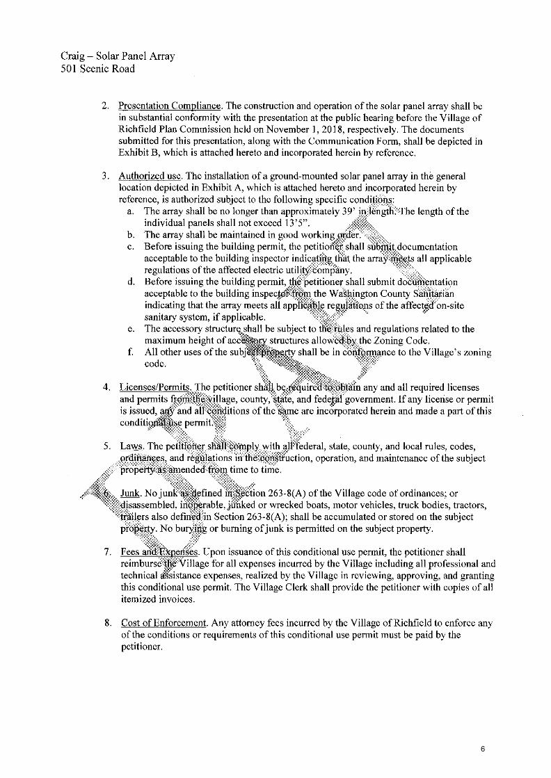
Craig — Solar Panel Array 501 Scenic Road
2. Presentation Compliance. The construction and operation of the solar panel array shall be in substantial conformity with the presentation at the public hearing before the Village of Richfield Plan Commission held on November 1, 2018, respectively. The documents submitted for this presentation, along with the Communication Form, shall be depicted in Exhibit B, which is attached hereto and incorporated herein by reference.
3. Authorized use. The installation of a ground-mounted solar panel array in the general location depicted in Exhibit A, which is attached hereto and incorporated herein by reference, is authorized subject to the following specific condifiOns;
a. The array shall be no longer than approximately 39' irr46rigtli.?The length of the individual panels shall not exceed 13'5".
b. The array shall be maintained in good workingprder. c. Before issuing the building permit, the petitioi1 shall siitirtii.cdocumentation
acceptable to the building inspector indica,04,,triat the array-=meets all applicable .regulations of the affected electric utilW6bmiYany.
d. Before issuing the building permit, the'''petitioner shall submit documentation acceptable to the building inspeetof*.m the WaWington County S'ariitarin indicating that the array meets all applibible reguldions of the affected on-site sanitary system, if applicable,
e. The accessory structure, shall be subject to Qi:fiiles and regulations related to the maximum height of accessory structures allowed.-byrhe Zoning Code.
f All other uses of the subject shall be in conformance to the Village's zoning code.
4. Licenses/Permits. The petitioner shall, be reiuire ,to:Olifiiin any and all required licenses and permits fro4,:tlie-....village, county, state, and federA government. If any license or permit is issued, a4- and all..ig431itions of the :Sp.me are incorporated herein and made a part of this conditionzilAkse permit
5. Laws. The petitropershil( comply, with alEfederal, state, county, and local rules, codes, ordiii4bees and r44ations ction, operation, and maintenance of the subject property *0-pende&kOw time to time
Junk. No jung'W4efined in.,.,.0Vtion 263-8(A) of the Village code of ordinances; or disassembled, iffOkrable,iiihked or wrecked boats, motor vehicles, truck bodies, tractors,
.stratlers also defiri-ed:in Section 263-8(A); shall be accumulated or stored on the subject property. No buryjiig or burning of junk is permitted on the subject property.
7. Fees an xperiges. Upon issuance of this conditional use permit, the petitioner shall reimburse,Village for all expenses incurred by the Village including all professional and
isr technical .assistance expenses, realized by the Village in reviewing, approving, and granting this conditional use permit. The Village Clerk shall provide the petitioner with copies of all itemized invoices,
8. Cost of Enforcement. Any attorney fees incurred by the Village of Richfield to enforce any of the conditions or requirements of this conditional use permit must be paid by the petitioner.
6

Craig — Solar Panel Array 501 Scenic Road
9. Revocation or Modification of Approval. Whenever the Village Board has reasonable cause to believe that any of the conditions herein imposed are being or have been violated, or any use of the subject property related to the operation becomes hazardous, harmful, noxious, offensive, or a nuisance to surrounding properties, the Village Board shall have the right to revoke or modify this conditional use permit, including, but not limited to, imposing stricter conditions upon the use and/or operation through a revised permit by the following the process as set forth in Section 70-241(D)(2) of the Village code of ordinances.
10. Acceptance. Within four months of when the Village Board approves this conditional use permit, the petitioner is required to accept the terms and conditi'ons of this approval in writing.
11. Effect of Approval on Heirs, Successors, and Assigns oTfie terms of this conditional use approval shall be binding on the owners of the subjet PropertY'aly1 their heirs, successors, and assigns.
12. Right of entry for inspection. The petitioneffiereby gives village officia s:employees, and authorized agents the right to enter the $16,164property:with reasonable m'it0.:for purposes of inspecting the premise to ensure complia#,Ith tWaiIns of this permiL:
B. Any use not specifically listed as p itted shall be conSid.00 to be prohibited except as may be otherwise specifically provided herein jn case of a question 4:to the classification of use the question shall be submitted to the Plan Commission for deterifilkation,;
C. No use is hereby authorized unless the uS0s conili ted in , a lawful, orderly, and peaceful manner. Nothing in this order shall be deemed to aii. thorigf any' pu private nuisance or to constitute a waiver, exemption,*ageption to any lak4dinance, order or rule of either the municipal governing body,,th coun ..0,tVashington, the state of Wisconsin, the federal government, or other duly copAitiked authority except only t(31:ithe extent that it authorizes the use of the subject property above dgg'0.1i.bc:d in specific respects herein, This order shall not be deemed to constitute.a.buil0g,:.:pftjknor shill this order constitute any other license or permit required ordin*e: or
conditionati*:liereby authorized. shall be confined to the subject property described, .Wittiout extension ore 0ansion other 'than as noted herein, and shall not vary from the purposes lieiii*mentioned unlaVe' xpresslk authorized in writing by the Plan Commission as being in corniANtice with all peiti4ent ordinances.
E. Should th6Pmitted conditional use be abandoned in any manner, or discontinued in use for twelve (12) riiii,i0s,..,-0- continued other than in strict conformity with the conditions of the original approvat.dr. should the petitioner be delinquent in payment of any monies due and owing to municipality,.& should a change in the character of the surrounding area or the use itself cause it to be no longer compatible with the surrounding area or for similar cause based upon consideration of public health, safety or welfare, the conditional use may be terminated by action of the Plan Commission, pursuant to the enforcement provisions of this conditional use order.
F. Any change, addition, modification, alteration and/or amendment of any aspect of this conditional use, including but not limited to an addition, modification, alteration and/or amendment to the use, premises (including, but not limited to, any change to the boundary limits of the subject
7

Craig — Solar Panel Array 501 Scenic Road
property), structures, lands other than as specifically authorized herein, shall require a new conditional use permit and all procedures in place at the time must be followed.
G. Unless this conditional use permit expressly states otherwise, plans that are specifically required by this conditional use order may be amended upon the prior approval of the Plan Commission if the Plan Commission finds the plan amendment to be minor and consistent with the conditional use permit. Any change in any plan that the Plan Commission feels, in its sole discretion, to be substantial shall require a new permit, and all procedures in place at the time must be followed.
H. Should any paragraph or phrase of this conditional use permit be detprMined by a court to be unlawful, illegal or unconstitutional, said determination as to theOfficular-phrase or paragraph shall not void the rest of the conditional use and the remainder sha11,,continue in full force and effect.
I. If any aspect of this conditional use permit or any asp4of any plan contemplated and approved under this conditional use is in conflict with any other aspect of the condition4 use or any aspect of any plan of the conditional use, the more restrictive provision shall be controlling as determined by the Plan Commission.
J. This conditional use may be reviewed by the Plan Coinnn0On at any time upon complaint or upon Plan Commission initiative akprovided in Section 70'241(d)(2) of the Village of Richfield Village Code and as amended from time-to-time.
Passed this 15th, day of November, 2018
John Jeffords, Village President
ATTEST:
Jim ta dministrator/C*k/Treasurer
ACCEPTANCE
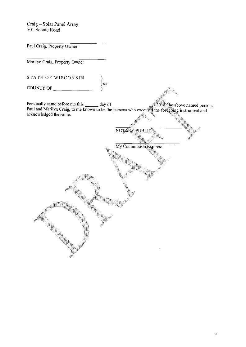
We, Paul and Marilyn Craig, accept the terms of this conditional use approval in its entirety.
Dated this day of , 2018
8
My Commission x g fres. „„.
NOTARY PUBLIC
Craig — Solar Panel Array 501 Scenic Road
Paul Craig, Property Owner
Marilyn Craig, Property Owner
STATE OF WISCONSIN )ss
COUNTY OF
Personally came before me this day of V201-8, the above named person, Paul and Marilyn Craig, to me known to be the persons who executed the foi4Oing instrument and acknowledged the same.
9

Craig — Solar Panel Array 501 Scenic Road
Exhibit A
(Site Plan)
10

11

Craig — Solar Panel Array 501 Scenic Road
Exhibit B
(Conditional Use Permit Submittal Documents)
12

POWER WA Li
Tesla Powerwall 2 is a fully-integrated AC battery system for
residential or light commercial use. Its rechargeable lithium-ion
battery pack provides energy storage for solar self-consumption,
load shifting, backup, and off-grid use.
Powerwall's electrical interface provides a simple connection to
any home or building. Its revolutionary compact design achieves
market-leading energy density and is easy to install, enabling
owners to quickly realize the benefits of reliable, clean power.
PERFORMANCE SPECIFICATIONS _ . . . ......... _
AC Voltage (Nominal) 208 V, 220 V, 230 V, 100/200 V, 120/240 V
___ _____ _ peed In Type Single & Split Phase
.... __ _ Grid Frequency
. . . 50 and 60 Hz .
Total Energy'
14 kWh
Usable Energy,
13.5 kWh
Real Power, max continuous, 5 kW (charge and discharge)
Real Power, peak (10s), 7 kW (discharge only)
Apparent Power, max continuous' 5.8 kVA (charge and discharge)
Apparent Power, peak (10 s}2 7.2 kVA (discharge only)
Imbalance for Single-Phase Loads 100%
Power Factor Output Range +/- 1,0 adlustable
Power Factor (full-rated power) +/- 0.85
Depth of Discharge 100%
Internal Battery DC Voltage 50 V
Round Ttip Efficiency" > 90%
Warranty 10 years
'Values provided for 25°C (77'9, 3.3 kW charge/discharge power, 'Values region-dependent. 'AO to battery to AC, at beginning of life.
COMPLIANCE INFORMATION
Safety UL 1642, UL 1741, UL 1973, UL 9540, UN 38,3, IEC 62109-1, IEC 62619, CSA G22.2.107.1
Grid Standards Worldwide Compatibility
Emissions FCC Part 16 Class B, ICES 003, EN 61000 Class B
Environmental
RoHS Directive 2011/65/EU, WEEE Directive 2012/19/EU, 2006/66/EC
Seismic AG156, IEEE 693-2005 (high)
MECHANICAL SPECIFICATIONS
Dimensions 1150 mm x 755 mm x 155 mm (45.3 in x 29.7 in x 6.1 in)
Weight 125 kg (276 lbs)
Mounting options Floor or wail mount
ENVIRONMENTAL SPECIFICATIONS
Operating Temperature -20°C to 50°C (-4°F to 122°F)
Operating Humidity (RH) Up to 100%, condensing
Maximum Altitude 3000 m (9843 ft)
Environment indoor and outdoor rated
Enclosure Type NEMA 3R
Ingress Rating IP87 (Battery & Power Electronics) IP66 (Wiring Compartment)
Noise Level 4 lm < 40 dBA at 30°C (86°F)
BACKUP GATEWAY SPECIFICATIONS
Dimensions 691 mm x 378 mm x 129 mm (27.2 in x 14.9 in x 5.1 In)
Weight 16,4 kg (38 Ibs)
Disconnect Current 200 A
Enclosure Type NEMA 3R
Ingress Rating 1P44
Overcurrent Protection Breaker' 100-200 A
User interface Tesla App
Connectivity WI-FL Ethernet, 304
AC Meter Revenue grade
Operating Modes Support for solar serf-consumption, load shifting, backup, and off-grid use
Backup Operation Automatic disconnect for seamless backup transition
Modularity Supports up to 10 AC-coupled Powerwalls
'Optional
T. SLn TIESL.A.COM/PNIERGY
13

5.4051 1613135. 10011516' 4555611.64745.55111. 1.244 1 PAX 5141
57-757.75510 www Issolar.corn LIM% ean re, fa erl pral 754 745 sem 17 eon:lama arsy tlliten•mae Ttir 1...awnaiamou Irr.r.at mamma 3.11, 4.1,111 1575
JA SOLAR JAM72S011 .171 .13357 1 . 6111V17.1655.544115 JA SOLAR
MECHANICAL DIAGRAMS
• 64453111•15.411 75716140 lam 5.576
SPECIFICATIONS OPERATING CONDITIONS
ELECTRICAL PARAMETERS AT STC
10055E
1561415445. Farm 454.0451 11153 C73. 9•.606 Noc3 M
1453.66535366)431 9675■ 5A71111.3554111.11/1 17135.7 5357,545355571111 55' Mods. 1515.5 .IC1 IT HI 5544.3441.7674 Tens57655,5557755 57.4673 53553.691,35547e151 5.16_3351 ters65.3553.3,55746 Pow. hympi 4531114475 STC W0Ii.. 15 0 0 61175.tI Sne 4.0273161 155
CHARACTERISTICS
65555,5445.7.4,11
471 I _ A
411665 110 45 II 17 10 .
ELECTRICAL PARAMETERS AT NOCT 5652531 775103'A1 176172501
44573 35335117 -15155 1757 Pam 13.515111 130 551 557 5,,„1c.,..26,..,. 57,40,5 1320 11. 1551 5113 13155751..117151135 1915 1521 32 511 55616445146.4471151151 114. 751 765 NI, 03544 CsArd II./ VI 1.95 114 !As
1!172504 45.11511
767111561 1511651
A ,
1.0*
Harvest the Sunshine Premium Cells, Premium Modules
201 111111 , 5, /e0
771
166 4.10 36., /re
731 57171
IMMO, 4261561
36 33 654
59 IT 15
115112263 351.1
3911 4765 16 55 970 SSA 1520
1.6031.6,14. 5637
5575. 7.55.5557
1.5.451.3513.
14.1%.,,,54171,516 1= ta
111.7
Pna P7134515345
App167541
13.1
PERC1UM 340-3E0 1500V Series
360W Mono Si 72 Cells
■ s,
14

Al ENERGY
COMPANY INFORMATION
ALL ENERGY SOLAR, INC 1842 CARROLL AVE ST PAUL, MN 55104
(100) 620-3370 INFoTALLENERGYSOLAR.coM
CLIENT INFORMATION
PAUL CRAIG 5111 SCENIC RD
COLGATE, WI 53017 PO 25212
SYSTEM DETAILS
NOTES
1. (24) JA SOLAR 3605 MODULES = 8.641,W
2. MOUNTINGTYPE GROUND MOUNT
3. (241ENPHASEIQTPLUS-72-2415 INVERTER(8)
4. ARRAY 1 35' TILT, 180' AZIMUTH
AZIMUTH
r.."-
REVISIONS LAST: 11928111 AN
PROJECT-PAGE TITLE
COVER PAGE
PAGE NUMBER
AO
15

/11 ENERGY
COMPANY INFORMATION
ALL ENERGY SOLAR, INC 11342 CARROLL AVE ST PAUL, MN 55104
1600)620.3370 INFEHMALLENF-RGYSOLAA SUM
CLIENT INFORMATION
PAUL CRAIG sal SCENIC RD
COLGATE, WI 53017 PO 25212
SYSTEM DETAILS
NOTES:
1_1241 ENPAASE IC7PELI5.72-2. US INVERTEFHS) maw AC
2, ARRAY I 140 AZIMUTH. 35.11LT (24) JA SOLAR MOW =13 S411W
AZIMUTH
REVISIONS LAST: SW24/14 AN
PROJECT•PAGE TITLE
PROPERTY MAP
PAGE NUMBER
Al
16
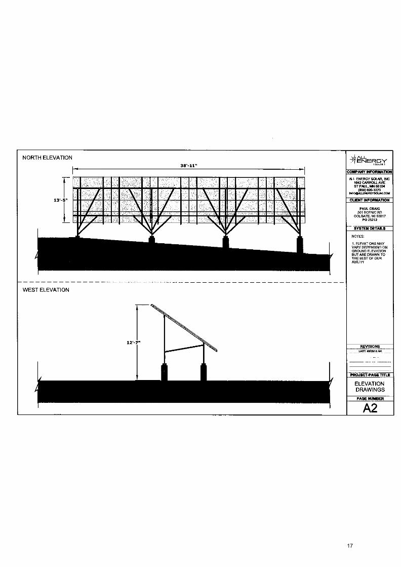
NORTH ELEVATION A,f ALL ENERMY
ISXMI 3W-11" COMPANY INFORMATION
ALL ENERGY SOLAR, INC 1642 CARROLL AVE ST PAUL, AC 56104
00)620-3370 INFOOAL
0LENERGYSMA . COM
13 5
PAUL CRAIG 501 SCENIC RD
COLGATE, WI 53017 PO 25212
=MI 111 II 1 11 minmalummlismolmil MI 1A pirMI
NOTES:
CUENT INFORMATION
SYSTEM DETAILS
1. ELEVATIONS MAY VARY DEPENDING ON GROUND ELEVATION BUT ARE DRAWN TO THE BEST OF OUR ABILITY
WEST ELEVATION
REVISIONS LAIR: aatrwa AH
PROJECT-PAGE 'RUE
ELEVATION DRAWINGS
PAGE NUMBER
A2
17

NOTES:
1. LOCATION OF SERVICE PANEL AND ELECTRICAL EQUIPMENT ARE SHOWN FINAL LOCATION MAY CHANGE
2. LOCATION OF SERVICE PANEL AND ADDITIONAL ELECTRICAL EQUIPMENT NOT DRAWN TO SCALE
3. AC DISCONNECT AND PRODUCTION METER WITHIN 10' OF MAIN SERVICE METERJED-DIRECTION AL METER. 2417 UNESCORTED KEYLESS ACCESS TO BE PROVIDED FOR UTILITY AC DISCONNECT & BI-DIRECTIONAL METER.
4. PV EQUIPMENT SHALL BE INSTALLED IN ACCORDANCE WITH NEC 6313 AND POSTED WiTH APPLICABLE WARNINGS. SIGNAGE. AND PLAQUES PER NEC 705.114 1390.17. &1340414 1h5).
CALL-OUTS:
1: SOLAR PANELS 2: MICRO INVERTERS 3: PV COMBINER 4: GENERATION PANEL 5: POWERWALL
UTILITY AC DISCONNECT 7: AUTOMATIC TRANSFER SWITCH 8: MAIN SERVICE PANEL 9: HEAVY LOAD PANEL 10: OUTGOING METER 11: INCOMING METER
ALL ENERGY
COMPANY INFORMATION
ALL ENERGY SOLAR, INC 1642 CARROLL AVE ST PAUL MN 55164
1600) 626.3370 INFOgiALIENERGYSOLAR.COM
CLIENT INFORMATION
PAUL CRAIG 501 SCENIC RO
COLGATE, WI 53017 PO 25212
SYSTEM DETAILS
NOTES
1.129) ENPHASE ro7pLus-7.25- US I NVERTERtS) 7.081W A
S ARAM 1 1NY: AZIMUTH. 3S' TILT NW; JA SOLAR ]ESA = 8.E411W
ACCOUNT: 1219-427.636 METER: B17134699
AZIMUTH
N
REVISIONS UST: 09111141 AM
PROJECT-PAGE TITLE
SITE MAP
PAGE NUMBER
A3
LABELS LOCATED ON PV PRODUCTION METER, BI-DIRECTIONAL METER, AC DISCONNECT, INVERTER(S), AND APPROPRIATE LABELS ON MAIN ELECTRIC SERVICE. ALL
LABELS ARE PERMANENT. WEATHERPROOF. AND DURABLE
THERE ARE NO CLEARANCE ISSUES DUE TO OVERHEAD POWERLINES.
WILLOW CREEK RD 650'
ARRAY 1
SCENIC RD
18

AR RAY
SNAP-N-RACK
PAUL CRAIG 501 SCENIC RD
COLGATE, WI 53017 PO 25212
SYSTEM DETAILS z SNAP-A-RACK MOUNTING HARDWARE:
1. {24) END CAPS
2 124) 80 ND ING PIPE CLAMP ASS EM SU ES
3 CLAMPS
(38)31113C.LAMPS
124/ IRMICLAMPS
4 RAIL LENGINS
Ill) 1521 RAILS
5.11) GROUND LUG ASSEMBLY
'STRINGING TO SE DETERMINED ON SITE
10,-10"
MODULE
▪ ALL - ENERGY.
COMPANY INFORMATION
ALL ENERGY SOLAR, INC 1642 CARROLL AVE ST PAUL, MN 55104
(BOO) 620-3370 INF05N-LENEFIGYSOLAR COM
CLIENT INFORMATION 12'-5"
3S'- 2."
(2.0.711 SOLAR 3211172501.36M2R HERD
)241 EMPHASE107PLUS-72-2-US INVElitEMS)
STRINGS:
(2)5161650 OF 12
LEGEND:
POSITIVE END
NEGATIVE END: •
AZIMUTH
REVISIONS
PROJECT-PAGE TITLE
RAIL AND STRINGING
DIAGRAM PAGE NUMBER
A4
LAST: OVUM BAH
19
NI nu_ -7-1" ENERGY
COMPANY INFORMATION
ALL ENERGY SOLAR, INC 1642 CARROLL AVE ST PAUL, MN 35104
(503)620-3370 114F00Au.ENERG^rSOLARcOm
CLIENT INFORMATION
PAUL CRAIG 501 SCENIC RD
COLGATE, WI 53017 PO 25212
CHECKLIST
RAKES a EAVES MEASUREMENTS
IMAGE 6 HEIGHT OF OBEIRUCT1ONS
1 OR 2 ROOF MEASUREMENTS
— METAL ROOF PROFILE (IF APPLICAHLE)
- SOLMETRIC REPORT (AROUND PERIMETER OR NOTE HEAVILY SHADED AREAS)
AZIMUTH
REVISIONS LAST: 0912515 AN
DESIGNER: ANTMONYRALL
ESE TECH: PETER DOVER
PROJECT-PAGE TITLE
ESV DRAWING
PAGE NUMBER
A5
20

(Class II Public Notice)
NOTICE OF PUBLIC HEARING
VILLAGE OF RICHFIELD
Thursday, November 1, 2018
PLEASE TAKE NOTICE:
Notice is hereby given, pursuant to Section 19.84, Wis. Stats., and provisions of the Village of Richfield
Code of Ordinances, that the Village of Richfield Plan Commission will conduct one (1) public hearing on
Thursday, November 1, 2018 at 7:00 p.m. at the Village Hall, located at 4128 Hubertus Road, Hubertus, WI
53033 to consider the following:
1) Conditional Use Permit Application by Mr. and Mrs. Paul Craig for a ground-mounted solar panel
array, pursuant to Section 70.241(E)(2) of the Zoning Code, on property located at 501 Scenic Road
(Tax Key: V10_1164-00B), which is located in the Rs-1, Country Estates District.
For information regarding this petition, please contact Jim Healy, Village Administrator at (262)-628-2260.
This application is available during normal business hours. All interested parties will be heard. Requests
from persons with disabilities who need assistance to participate in this meeting or hearing should be made to
the Village Clerk's Office at (262)-628-2260 with as much advanced notice as possible.
Dated this October 18, 2018
Publication Dates: October 20, 2018 October 25, 2018
Jim Healy Village Administrator Village of Richfield 4128 Hubertus Road Hubertus, WI 53033 (262)-628-2260
21

5b
22

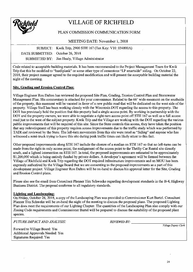
VILLAGE OF RICHFIELD
PLAN COMMISSION COMMUNICATION FORM
610
MEETING DATE: November 1, 2018
SUBJECT: Kwik Trip, 2900 5TH 167 (Tax Key: V10_034800A)
DATE SUBMITTED: October 26, 2018
SUBMITTED BY: Jim Healy, Village Administrator
POLICY QUESTION: DOES THE ARCHITECTURAL REVIEW BOARD WISH TO RECOMMEND TO THE PLAN COMMISSION THE
APPROVAL OF THE PROPOSED KWIK TRIP CONVENIENCE STORE AND GAS STATION?
ISSUE SUMMARY'
Approximately one year ago, the Village was approached by representatives from Kwik Trip regarding the redevelopment of the Exxon Mobile gas station located at 2900 STH 167. In the B-4, Highway Business District, fuel stations are considered Permitted Principle Uses, meaning they are allowed this "use" by right. Kwik Trip is proposing to construct a new retail convenience store with fueling canopy and a separate diesel fueling canopy. The proposed convenience store is 8,847sqft with an attached dumpster enclosure, gas fueling canopy, and detached storage shed.
The proposed method of operation for this development will be consistent with that of their existing convenience stores within the area as a 24-hour a day facility, seven (7) days a week. The types of products that will be sold are also similar to those in their existing stores, groceries, bakery and dairy, hot and cold food beverages, tobacco, lotto, convenience store merchandise, etc. The proposed store is projected to have between 28 and 35 full and part-time employees with 2-8 employees on-site at any given time,
Given the timing of the request, Village Staff worked with the members of the Architectural Review Board to hold a meeting on November 1, 2018 at 6PM, just before the Plan Commission to consider the architectural design of the building.
ARCHITECTURAL DESIGN DISCUSSION
The proposed architectural plan consists of a brick facade with a standing seam metal roof, which is common and typical of all Kwik Trip designs throughout Wisconsin. The building and canopy fascia ties-in with the franchise colors. The proposed bricks to be used are a red brick as the primary building material, with two (2) rows of tan soldier course vertical bricks at the waist height and as the top brick course on the building. Over the main entrance to the convenience store, there is a raised eyebrow arch to create architectural interest and to draw the eye to the above wall sign, The soldier course in this area is double-stacked. The standing seam metal roof is green in color, almond colored fascia, with red banding around the roofline. At our meeting on November 1st, samples of the proposed exterior building materials will be presented by representatives from Kwik Trip.
As proposed, the building has "man doors" on each elevation, some designed for customers and some for employees, only. The ones intended for the customers have glass transom windows over the top. The employee exits do not have exterior door handles. On the east elevation, the same thematic design element from the entryway is carried over for enhanced continuity of design. Please also note that this proposed design with soldier course banding is carried through on all four (4) sides of the build design, which even carries over to their dumpster enclosure. The proposed building has 18 single-hung windows with transoms over the top, and on the east elevation, two transom windows north of the mimicked gable peak design.
By all accounts, the primary structure and dumpster enclosure not only meets, but exceeds the design expectation of Village Staff. There is one element of this proposal that is not consistent with our Village Code and that is the exterior materials being proposed for the accessory structure. Vinyl siding is not permitted per Section 70.133 of the Village
23
VILLAGE OF RICHFIELD
PLAN COMMISSION COMMUNICATION FORM
MEETING DATE: November 1, 2018
SUBJECT: Kwik Trip, 2900 STH 167 (Tax Key: V10_034800A)
DATE SUBMITTED: October 26, 2018
SUBMITTED BY: Jim Healy, Village Administrator
Code related to acceptable building materials. It has been recommended to the Project Management Team for Kwik Trip that this be modified to "hardiplank" or some other type of cementous "LP smartside" siding. On October 22, 2018, their project manager agreed to the required modification and will present the acceptable building material the night of the meeting.
Site, Grading and Erosion Control Plan:
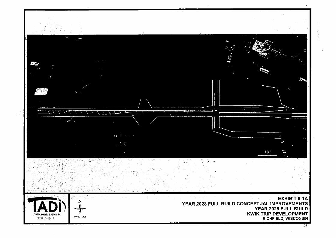
Village Engineer Ron Dalton has reviewed the proposed Site Plan, Grading, Erosion Control Plan and Stormwater Management Plan. His commentary is attached for your convenience. Related to the 66' wide easement on the southside of the property, this easement will be vacated in favor of a new public road that will be dedicated on the west side of the property. Village Staff has been working closely with the Wisconsin DOT regarding the access to this property. The DOT has previously held the position that this property had a single access point. By working in partnership with the DOT and the property owners, we were able to negotiate a right-turn access point off STH 167 as well as a full access road just to the west of the subject property. Kwik Trip and the Village are working with the DOT regarding the various public improvements that will be required of this site. Since the State controls this access, they have taken the position that any redevelopment of this property requires access improvements due to the traffic study which was performed by TADI and reviewed by the State. The left-turn movements from this site were rated as "failing" and anyone who has witnessed a semi-truck trying to leave this site during peak traffic times can likely attest to this fact.
Other proposed improvements along STH 167 include the closure of a median on STH 167 so that no left-turns can be made from the right-in only access point; the realignment of the access point to the Thrifty Car Rental site directly south, and a lighted intersection on STH 167. In total, the proposed improvements are estimated to be approximately $1,200,000 which is being entirely funded by private dollars. A developer's agreement will be formed between the Village of Richfield and Kwik Trip regarding the DOT required infrastructure improvements and an MOU has been expressly authorized by the Village Board that we are consenting to the proposed improvements as a part of this development project. Village Engineer Ron Dalton will be on-hand to discuss his approval letter for the Site, Grading and Erosion Control plans.
Please also see the email from Consultant Planner Tim Schwecke regarding development standards in the B-4, Highway Business District. The proposal conforms to all regulatory standards.
Lighting and Landscaping: On Friday, October 26, 2018, a copy of the Landscaping Plan was provided to Commissioner Kurt Bartel. Consultant Planner Tim Schweke will be on-hand the night of the meeting to discuss the proposed plans. The proposed Lighting Plan does meet the requirements of our Lighting Chapter. The quantities of the Landscaping Plan also comply with our Zoning Code requirements and Commissioner Bartel will be prepared to discuss the suitability of the proposed plant species.
FUTURE IMPACT AND ANALYSIS: REVIEWED BY:
Forward to Village Board: Yes Additional Approvals Needed: Yes Signatures Required: Yes
Village Deputy Clerk
24

weld
VILLAGE OF RICHFIELD -15
PLAN COMMISSION COMMUNICATION FORM
MEETING DATE; November 1, 2018
SUBJECT: Kwik Trip, 2900 STH 167 (Tax Key: V10_034800A)
DATE SUBMITTED: October 26, 2018
SUBMITTED BY: Jim Healy, Village Administrator
ATTACHMENTS: 1. SBOP Submittal documents from Kwik Trip 2. Letter dated October 19, 2018 from Village Engineer Ron Dalton 3. TADI Traffic Analysis and Design 2028 Full Build Conceptual Improvements 4. DRAFT Wisconsin DOT letter dated April 17, 2018 regarding the potential Kwik Trip development 5. Undated Tim Schwecke Review Letter
STAFF RECOMMENDATION:
Plan of Operation: for Kwik Trip Gas Station and Convenience Store located at 2900 STH
Review Board for the Kwik Trip Gas Station and Convenience as designed.
and Erosion Control Plans for Kwik Trip Gas Station and Convenience subject to the final review and approval of the Village Engineer
2018.
Planner Tim Schwecke for the approval of the proposed Lighting Store located at 2900 STH 167 (Tax Key: V10_038400A), as presented.
Planner Tim Schwecke for the approval of the proposed Landscaping Store located at 2900 STH 167 (Tax Key: V10_038400A), subject to by Commissioner Kurt Bartel.
Motion to approve the proposed Plan of Operation 167 (Tax Key: V10_038400A), as presented.
Architectural Designs: Motion to accept the recommendation of the Architectural Store located at 2900 STH 167 (Tax Key: V10_0384004
Site Grading and Erosion Control: Motion to approve the proposed Site, Grading Store located at 2900 STH 167 (Tax Key: V10_038400A) based on his written comments dated October 19,
Lighting Plan: Motion to accept the recommendation of Consultant Plan for Kwik Trip Gas Station and Convenience
Landscaping Plan: Motion to accept the recommendation of Consultant Plan for Kwik Trip Gas Station and Convenience the final review and approval of planting materials
APPROVED FOR SUBMITTAL BY: VILLAGE CLERK USE ONLY BOARD ACTION TAKEN
Resolution No. Continued To: Village StaffMember Ordinance No, Referred To:
Approved Denied Other File No.
Village Administrator
25

Cedar corporation
W61 N497 Washington Avenue Cedarburg, WI 53012
engineering l draNteature environmental l sorveying landscape arc.hillecture .1 planning eadromla development
262-204-2360 800-472-7372
FAX 262-375-2688 www.cedarcorp.corn
October 19.201'8
M. James Healy, Village Administrator Village of Richfield. 4128 Hubertus Road Hubertus, Wisconsin 53033
Kwik Trip Site Plan .and Storm Water Management Review
Dear Mr. Healy,
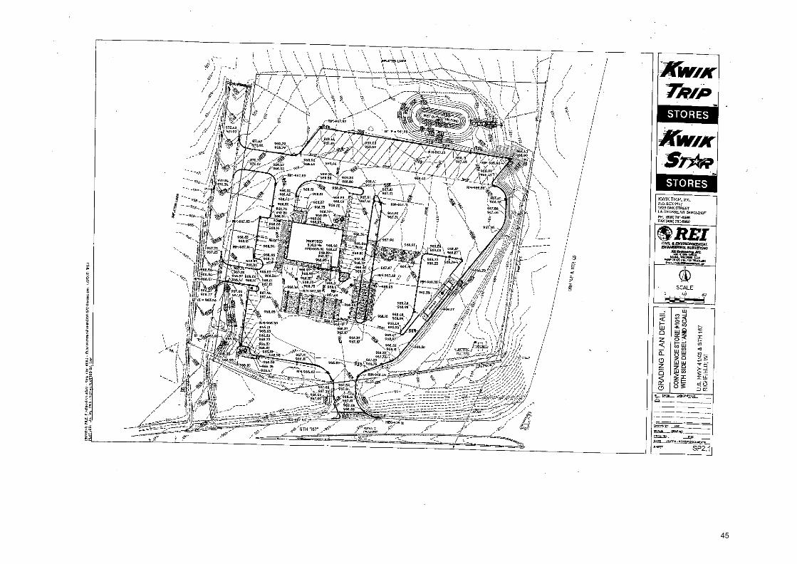
We have completed out review Of-Grading and Erosion Control Plans and a Storm Water Management Report for redevelopment of a Kwik. Trip at STH. 167 and.US Hwy 41/45 in. the Village. of Richfield. Plans were prepared by .REI Engineering, Inc. and received on October 4, 2018. We o.ffer the following comments.;.
Site Plan:
1. A 66 foot wide Road Easement is shown on the ALTA Survey. Site improvements are proposed within this easement, will it be vacated?
2. Improvements on STH 167 and the public roadway to the west will need to be completed prior to or in conjunction with the Kwik Trip Development. Will the Village require a financial surety to ensure the completion of these roadway improvements?
3. Design of site drainage and access improvements will need to be coordinated with the design of improvements at STH 167 and the public road west of Kwik Trip,
4, Provide a swale or permanent erosion control beyond the rip-rap of the Wet Detention Pond Outlet.
Storm. Water Management Report:
1. Provide certification from a Registered Professional Engineer in the State of Wisconsin, that all calculations and designs included in the final. Storm Water Management .Report have been, reviewed and approved as being in accordance with the requirements of the Village's Erosion Control and Storm Water Management Ordinances.
Cedarburg Green Bay Madison Menomonie
26

October 19, 2018 Village or Richfield. Site Plan and Storm Water Management Review Page 2
Please contact me at our Cedarburg office (phone 262-204-2341) if you require any additional information or if you have any questions.
Sincerely,
CEDAR CORPORATION
Ronald D. Dalton, P.L. Director/Office Manager
RDDIelv
on Jeff Osgood, Dev. Manager Store Engineering, Kwik Trip, Inc,
27
m
z
0
-n
a r
r
Ea
C)
0 z
311 -
= -n
g
•
co
On<
0
CII
PJP
c
• r
<
aO
rm
a3
o "a
E
0
E m
zm
cz5
4 co
z F
-
cn
28

Division of Transportation System Development Southeast Regional Office
E 141 N.W. Barstow Street P.O. Box 798 Waukesha, WI 53187-0798
Scott Walker, Governor Dave Ross, Secretary
Internet: www.dot.wisconsin.00v
Telephone: (262) 548-5903 Facsimile (FAX): (262) 548-5662
E-Mail: waukeshasltdadot.wloov
April 17, 2018
JIM HEALY VILLAGE OF RICHFIELD 4128 HUBERTUS RD HUBERTUS, WI 53033
Subject: Log #2710 — Development Submittal Business Park and Kwik Trip Developments WIS 167 & IH 41/US 45 Washington County
Dear Mr. Healy:
The Traffic Impact Analysis (TIA) performed by Traffic Arialysis and Design, Inc. (TAD1) covering the Business Park and Kwik trip development haSlllowed the Department to understand the impacts of the subject development and ideniitylthe necessary improvements. The attached lists the improvements that'are to be constructed 4ta_result of this development. This TIA did not include an x.development north_tif -POIK:Street:if the new roadway is extended such that it coniiictiAo or goes norlkof Polk Stiett, an update to the TIA will be required to account fCit the additional Valle:
There are three potential access options depending_on what development is constructed. The access option to be imPlementedlirlubject_to further and approval by the WisDOT Access Modification Committee least-rogiVide a written request to WisDOT for the preferred idaSiioption.
After, the access option -rOquest ha0)een submitted and approved, then the development can proceedito the Departmenti,Permit:Process. The permit plans will require design preparation (please see_attached plan requirements). All permits will be issued to the maintaining authority and_ design consultant will need to forward permit plans for review and submittal.
If you have any qUeStionplegarding traffic issues, please contact the undersigned at (262) 548-5626. Please direct ariplUestions regarding the Trans 233 process to Patricia Reikowski, Land Division Coordinator, at (262) 548-6704. Kevin Koehnke at (262) 548-5891 will coordinate any permit issuance for this project. Please reference the log number (#2710) when forwarding all correspondence.
29
Sincerely,
Art Baumann, P.E. Traffic Operations Engineer
Attachments
Cc: Tony Barth / Robert Elkin / Don Berghammer, DOT Dave Brantner / Cindy Vande Leest, DOT Tom Heydel / Rebecca Klein, DOT Michael Birschbach, Paul Derksen, DOT Roger Schaalma, WSOR Susan Voight / Kevin Koehnke / Patricia Reikowski I Chris Squires DOT Don Lee, TADi
30

Project:
Review Unit: Reviewer: Date:
Log #2710 Business Park and Kwik Trip Development WIS 167 & H 41/US 45, Washington County Traffic Operations Art Baumann, Samantha Pawlak — SE Region (262) 548-6707 April 17, 2018
Improvement Measures
General Notes
Design 1) Contact the WisDOT permit coordinator (Kevin Koehnke at - 2 -548-5891) prior to plan
submittal to identify the plans that are required and obtainAy-Upplemental design guidelines. Incomplete submittals will be returned without_r6ieW-_±-t_
2) The design for the improvements at all WisDOT intersections shall be prepared in accordance with the FDM requirements for design. and plan preparation?,-The design shall accommodate a WB-67 truck. All lanes are to be : a minimum of 12 feet iriTividth, unless otherwise specified (final width to be determiried -during design). All left-turiffanes should be opposing. All necessary drainage, utility, signageand pavement marking improvements shall be provided. Signing plan shall include sigq:cletails and ̀signs that require moving.
3) For questions regarding signing or pavement markinh,0106se contact Tom Heydel at [email protected] or (262) 548=6763. For queStions_regarding work zone traffic control plans please contact Tom Heydel oMhe.Ormit coordinati
4) For questions regarding work zone traffic Coritraptans, please. contact Rebecca Klein at [email protected] or (262) 548-8728 or the ;:permit coordinator.
5) Pedestrian/Bicycle accommodations an uieements shall be addressed where appropriate. Please contact Chris Squire OT Pedestrian/Bicycle Facilities Coordinator, at (262) 521-4417-br_christop [email protected] with questions regarding pedestrian/bicycle accommodations.
6) The roadway improvements at the railroad crossing of WIS 167 will need to be coordinated with the WisconsirlibtlSoutti.;erit Railroad (\A] SOR), please contact Roger Schaalma at [email protected] or (608) 620-2044.
Right,ofWay 1) -A-Orty other than the.,W
--isDOT shall acquire any required right-of-way for the
improvements.
Utilities 1) Utility coordination may:be:the responsibility of the municipality/developer consultant
representati*constrWing the work. 2) Utility relocatiaKiltiat &cur as a result of this work may not be covered under Wisconsin
Administrative Role-TRANS 220. The municipality/developer (or their consultant representative) requesting the work shall be responsible for all costs associated with the needed relocation of any utility facility as a result of the work.
Access 1) There are three potential access options depending on what development is constructed.
The access option to be implemented is subject to further review and approval by the WisDOT Access Modification Committee. Please provide a written request to WisDOT for the preferred access option.
a. Two access points to WIS 167, a right-in only access at the existing gas station
31

driveway and a public road connection near the west property line of the Kwik Trip development.
b. One public road connection to WIS 167 near the west property line of the Kwik Trip development.
c. One private driveway connection to WIS 167 at the current location of the existing gas station driveway. A public roadway connection west of the Kwik trip site is not constructed. Kwik Trip would be the only development for this scenario.
2) The municipality/developer (or their consultant representative) shall be responsible for notifying any offsite property or business owners whose*cess or operations will be impacted as a result of the proposed development"_ municipality/developer shall provide WisDOT with written" icumentation verifying that all impacted property or business owners have been contacted prior to permit submittal.
Traffic Signals 1) The WisDOT Traffic Operations team reservOthe right of first refusal to design the traffic
signal plans. Please contact Dave Brantner0tV62) 548-8736 to discuss who ill be responsible for designing the traffic signals. Traffic signal plans prepared by a-tbnsulting firm shall be submitted to Cindy Vande Leest for final approval by a WisDOT signal engineer. Upon receiving final approval, the consdiaq_shall submit an original signed and sealed hard copy to Dave Brantner at 548-8736. Traffic signal plans submitted for permit without a WisDOT signal engineer signature approval will be returned. Final electronic (AutoCAD) traffic signal plan files shall be subniitWto Cindy Vande Leest prior to issuance of permit. -
2) The design consultant retained by the developer/municipality shall contact Dave Brantner to schedule a scoping meeting prior to the'signaliclesign/updafe.
3) An engineering sop/ices agreeMent shall 153:required for the traffic signals work by WisDOT. This40ment will coiner WisDUrsignal design work and plan preparation (if any), the cost of any State furnithed,signal control equipment (above ground) and WisDOT staff time for site Aitt;,coadifiatioitieview, and inspection. Requests for the engineeritig services agreement shall bo_iMade to Dave Brantner a minimum of 15 days prior to the scoping'rneeting. The engineering services agreement shall be signed and submitted to Dave Brantner prior to the submission of the electronic
- intersection geoniefripplans, A signed Engineering Services Agreement shall be in place- prior to WisDOT;p_erforming any engineering services.
4) Traffic;signal plans shall - 4e prepared in accordance with MUTCD, FDM and TSDM (Traffic Signal 0,0ign Manual) standards for all signalized intersections (current or proposed) whose deiigin,and/or operational improvements will conflict with the location of existing traffic signal' $teminfraStructure (including, but not limited to conduit, pull boxes, cabinets, signallore$,- hardwire, and loop detectors), require readjustments to the current timing or phasing plans, or require the installation of additional or new signal infrastructure or hardware. Plans shall be submitted in the proper format per FDM standards requirements to WisDOT or the consultant firm preparing the traffic signal plans. Current template and block libraries can be found at http://www.dot.wisconsin.gov/business/enorserv/roadway-desiqn-civil3d.htm. Plans submitted shall be in the county coordinate system. If further verification of signal infrastructure or timing impacts based on recommended improvements is needed, questions or concerns should be directed to the WisDOT Signal Operations team (Dave
32

Brantner) prior to permit issuance. 5) If traffic signal loops are to be placed on private property as part of the signal installation, a
maintenance easement to the benefit of WisDOT shall be obtained from the private property owner. The easement shall allow the WisDOT to enter the property at its discretion to maintain the loops. The easement shall encompass an area equal to the width of the driveway and extend from the road right-of-way to 20 feet past the furthest loop detector.
Two Access Points to WIS 167 Option Two access points to WIS 167, a right-in only access at the existing gas station driveway and a public road connection near the west property line of the Kwik Trip dOvelopment.
Year 2018 Background Improvements No additional improvements.
Year 2018 Build Development Improvements The following improvements will be designed, constrUc ed and paid for by th6 -Yillage of Richfield/Developer at the time specified for each:
WIS 167 & I-41/ US 45 NB Ramps The following improvements shall be implemented prior the completion of Initial Build construction. :
1) Install an actuated-coordinated stgnal with eastbound-left-turn phase when warrants are met and with WisDOT approval.=-'-
2) No additional changes are recommended for this intersection.
WIS 167 & I-41/US 45 SBR-amps No changes are recommeridcr for this intersection:
WIS 167 & Existitia;Gas DriveWay The following improveltlents shall:beJmplementedprior to the completion of Initial Build construction.
1) Theexisting_drivewa_y:shall be reconfigured to provide right-in only access. 2) The medieri.bpening tikWIS 167 opposite this driveway shall be closed.
e east appfoach shall two lanes (through lane, exclusive right-turn lane). The right-turn lane shbil. temain-continuous to the I-41/US 45 SB Ramps intersection.
4) The_south approachShall bei4fdcated to align with the proposed road, the existing connection shall be qi)Sed.
5) No additional change6fo're recommended for this intersection.
STH WIS 167 &- Peoposed Road/Proposed Driveway The following impro-Veffients shall be implemented prior to the completion of Initial Build construction.
1) Construct the intersection at an agreed upon location with WisDOT. Install an actuated-coordinated signal with eastbound left-turn phases when warrants are met and with WisDOT approval.
2) The north approach shall be constructed with two lanes (an exclusive left-turn lane and shared through/ right-turn lane). The left-turn lane should have a minimum storage length of 130 feet plus taper.
3) The east approach shall have three lanes (exclusive left-turn lane, one through lane, exclusive right-turn lane). The left-turn lane shall have a minimum storage length of 225
33
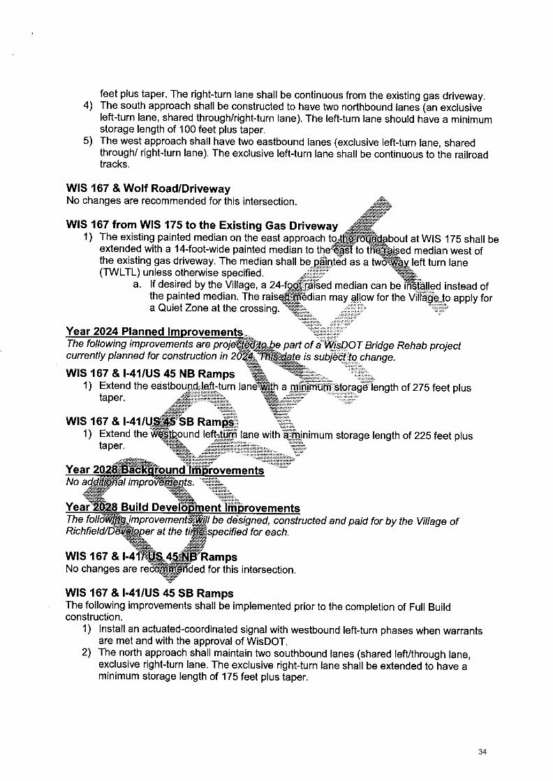
feet plus taper. The right-turn lane shall be continuous from the existing gas driveway. 4) The south approach shall be constructed to have two northbound lanes (an exclusive
left-turn lane, shared through/right-turn lane). The left-turn lane should have a minimum storage length of 100 feet plus taper.
5) The west approach shall have two eastbound lanes (exclusive left-turn lane, shared through/ right-turn lane). The exclusive left-turn lane shall be continuous to the railroad tracks.
WIS 167 & Wolf Road/Driveway No changes are recommended for this intersection.
WIS 167 from WIS 175 to the Existing Gas Driveway 1) The existing painted median on the east approach to the r uridabout at WIS 175 shall be
extended with a 14-foot-wide painted median to the east to the raised median west of the existing gas driveway. The median shall be_painted as a twO:Vriayleft turn lane (TVVLTL) unless otherwise specified. - -
a. If desired by the Village, a 24-fockraised median can be 'installed instead of the painted median. The raise 'Median may allow for the Village to apply for a Quiet Zone at the crossing.
Year 2024 Planned Improvements The following improvements are projecteato,tte part of a. WisDOT Bridge Rehab project currently planned for construction in 20 ate is subject to change.
WIS 167 & I-41/US 45 NB Ramps 1) Extend the eastbound left-turn lane-with a minimum storage length of 275 feet plus
taper.
WIS 167 & I-41/US 45 SB Ramps; 1) Extend the i((:estbound left-turn lane with a_ inimum storage length of 225 feet plus
taper.
Year 2028: Background ImProvements No additiiThal improvements.
Year 248 Build Development Improvements The follOwThg improvementS,-will be designed, constructed and paid for by the Village of Richfield/daVeloper at the tiMe specified for each
WIS 167 & I-411 US 454r1B Ramps No changes are recommended for this intersection.
WIS 167 & I-41/US 45 SB Ramps The following improvements shall be implemented prior to the completion of Full Build construction.
1) Install an actuated-coordinated signal with westbound left-turn phases when warrants are met and with the approval of WisDOT.
2) The north approach shall maintain two southbound lanes (shared left/through lane, exclusive right-turn lane. The exclusive right-turn lane shall be extended to have a minimum storage length of 175 feet plus taper.
34

3) No other changes are recommended for this intersection.
WIS 167 & Gas Driveway The following improvements shall be implemented prior to the completion of Full Build construction.
1) The west approach shall have two through lanes. 2) The east approach shall have three lanes (two through lanes, exclusive right turn). The
right turn lane shall remain continuous to the I-41/US 45 SB Ramps intersection. 3) No additional changes suggested for this intersection.
WIS 167 & Proposed Road/Proposed Driveway The following improvements shall be implemented prior to the pqnri-pfetion of Full Build construction. 1:;..:q1;
1) The north approach shall maintain two lanes (an exclusiVe left-turn lane and shared through/right-turn lane). The exclusive left-turn laiie shall be extended to have a minimum storage length of 290 feet plus taper. z _ 7 -gat%• ,-
2) The east approach shall have four westbound lanes (exclusive left-ttinVone, two through lanes, exclusive right-turn lane). The leftetiiin lane shall maintain a storageiength of 225 ,..t-
Driveway. 3)
The right-turn lane shall be continuous,from the G6,: Driveway. .,, 3) The west approach shall have three lanes (exClusive left-turn lane, through lane, shared
through/right-turn lane). The left-turn lane shall 60:continuous from the railroad tracks. 4) No additional changes are recommended for thisilltersection.
WIS 167 & Wolf Road/Driveway 1) The east approach shall be constructed with westbound-lanes (through lane, shared
through/right-turn lane)._-.]
2) The west approach shall two eastboUnd lanes (through lane, shared th rough/rig ht-turttiane).
3) The TWLTL median shall bejnaintained 4) No additional changes sug§Wed for this intersection.
WIS 167 4,1MS 175 The folloWing iffipn:Wements-shalt be implemented prior to the completion of Full Build . . _ construction. The roundabout shall be reconstructed with the following parameters:
1) The east approach'Shall ha4-two westbound lanes (shared left/through lane, shared through/right
2) Th6-West approach $hbll have two eastbound lanes (shared left/through lane, shared through/right lane),-7-==--
3) No additional changes are recommended for this intersection.
One Public Street Access Point to WIS 167 Option One public road connection to WIS 167 near the west property line of the Kwik Trip development.
Unless stated otherwise below, the improvements for each intersection will remain the same as previously stated under the Two Access Point Option.
Year 2018 Build Development Improvements The following improvements will be designed, constructed and paid for by the Village of
35

Richfield/Developer at the time specified for each.
WIS 167 & Existing Gas Driveway The following improvements shall be implemented prior to the completion of Initial Build construction.
1) The existing driveway shall be closed. 2) The median opening on WIS 167 opposite this driveway shall be closed. 3) The east approach shall have one through lane. The existing right-turn lane shall be
restriped based on the storage requirements for the Proposed Roadway intersection. 4) The south approach shall be relocated to align with the propdSed road, the existing
connection shall be closed. 5) No additional changes are recommended for this intersection.
WIS 167 & Proposed Road/Proposed Driveway The following improvements shall be implemented prior:tOthe completion of_lnitial Build construction. .., ::.- 7=.-
1 ) Construct the intersection at an agreed upqh:lbtation with WisDOT. Install an actuated- coordinated signal with eastbound left-turn—Phases whenwarrants are metand with _ WisDOT approval. - - - -- ,
2) The north approach shall be constructed with-Wo_laries (an exclusive left-turn lane and shared through/ right-turn lane) The exclusive left-turn lane shall have a minimum storage length of 130 feet pluslaper.
3) The east approach shall have three lahel_(exclusive left:turn lane, through lane, exclusive right-turn lane). The left-ti4rn 14tie khan have a minimum storage length of 225 feet plus taper. The right-turn lane'Shall have:a-niinimum storage length of 225 feet plus taper. — ----- ________-
4) The south approadh=-ShIFI*onstructed AO-have two northbound lanes (an exclusive left-turn lane,.,shaied throughtTight-turnlane). The left-turn lane shall have a minimum storage lengfrof 100 feet pittslaper. LI:=1,_
5) The west apPrOach shall have two eastbound lanes (exclusive left-turn lane, shared through/right-turalane e:exdlutiVeleft-turn lane shall be continuous to the railroad tracks
Year 2028 Build Developrnoitimprovements The follOwing improvements will be designed, constructed and paid for by the Village of Richfield/Developer at theilthe specified for each
WIS 167 &-PrOposed Road/Proposed Driveway The following ihiprovernentOViall be implemented prior to the completion of Initial Build construction.
1) The north approach shall maintain two lanes (an exclusive left-turn lane and shared through/right-turn lane). The exclusive left-turn lane should be extended to have a minimum storage length of 290 feet plus taper.
2) The east approach shall have four westbound lanes (exclusive left-turn lane, two through lanes, exclusive right-turn lane). The exclusive right-turn lane shall be extended to have a minimum storage length of 250 feet plus taper.
3) The west approach shall have three eastbound lanes (exclusive left-turn lane, through lane, shared through/right-turn lane). The left-turn lane shall remain continuous from the railroad tracks.
36

One Private Driveway Access to WIS 167 Option One private driveway connection to W1S 167 at the current location of the existing gas station driveway. A public roadway connection west of the Kwik trip site is not constructed. Kwik Trip would be the only development for this scenario.
Year 2018 Background Improvements No changes are recommended for this intersection.
Year 2018 Build Development Improvements The following improvements will be designed, constructed and paid.fOrby the Village of Richfield/Developer at the time specified for each.
WIS 167 & I-41/ US 45 NB Ramps The following improvements shall be implemented prior to_ the- compl6Wnrof Initial Build construction.
1) Install an actuated-coordinated signal with eastbound left-turn phase*hen warrants are met and with WisDOT approval.
2) No additional changes are recommended for this intersection.
WIS 167 & I-41/US 45 SB Ramps The following improvements shall be implemented prior -toihe completion of Initial Build construction.
1) The north approach shall maintainAwo southbound lartes'__(shared left/through lane, exclusive right-turn lane). The rigNt4turn laneinall be extended to have a storage length of 100 feet plus taper::_:,..
2) No additional changeS are -recommekTed:,fOr this intersection.
WIS 167 & Existing Gas Driveway The following improvements shall be implemented prior to the completion of Initial Build construction.
1) The driveways on the._nalh and south pproaches shall be reconfigured to provide right-_ inftight4Cittleft-in orilygO-Ccess.
2) 5_he'ikest apprbach shelLheye two eastbound lanes (exclusive left-turn lane, and shared through/right-tuilijane). The-±exclusive left-turn lane shall have a minimum storage length ,ifat225 feet plus taper.,„
3) The-median shall be--:feconstrubted to prevent left out and through movements from the driVeways.
4) No additional changere recommended for this intersection.
WIS 167 & Wolflitiad/Dtiveway No changes are recommended for this intersection.
WIS 167 from WIS 175 to the Existing Gas Driveway 1) The existing painted median on the east approach to the roundabout at WIS 175 shall be
extended with a 14-foot-wide painted median to the east to the raised median west of the existing gas driveway. The median shall be painted as a two-way left turn lane (TWLTL) unless otherwise specified. a. If desired by the Village, a 24-foot raised median can be installed instead of the
painted median. The raised median may allow for the Village to apply for a Quiet Zone at the crossing.
37

WIS 167 & WIS 175 The roundabout shall be reconstructed with the following parameters:
1) The east approach shall have two westbound lanes (shared left/through lane, shared through/right lane).
2) The west approach shall have two eastbound lanes (shared left/through lane, shared through/right lane).
3) No additional changes are recommended for this intersection.
Year 2024 Planned Improvements The following improvements are projected to be part of a WisDOT Bridge Rehab project currently planned for construction in 2024, This date is subject to=_Ohnge.
WIS 167 & I-41/US 45 NB Ramps 1) Extend the eastbound left-turn lane with a minimum storage lengtkof 260 feet plus
taper.
WIS 167 & I-41/US 45 SB Ramps 2) Extend the westbound left-turn lane with a Minimum storage length of 225 feet plus
taper.
Year 2028 Background Improveitientt No additional improvements.
Year 2028 Build Development Improvements The following improvement§TwilLbe designeiliConiWicted an Richfield/Developer at thai time sp—edified for each:
WIS 167 & 1-41/ U 45 NB Ramps No changes are recommended,faithis intersection
aid for by the Village of
WIS 167 &,I41/US 45 SBRamps The following improVernents shall_be implemented prior to the completion of Full Build _ _ _ construction.
1 install an actuateckOdordinatedisignal with westbound left-turn phases when warrants 8T metand with the approval of WisDOT.
2) Thiiibrth approach Sh011 maintain two southbound lanes (shared left/through lane, exclui0.:right-turn lene. The exclusive right-turn lane shall be extended to have a minimum storage length of 135 feet plus taper.
3) No other chahgeiWe recommended for this intersection.
WIS 167 & Gas Driveway No changes are recommended for this intersection.
WIS 167 & Wolf Road/Driveway No changes are recommended for this intersection.
WIS 167 & WIS 175 No changes are recommended for this intersection.
38

, maaln sw
ord alai im.by.r
all 3
13
3 5
15
1,6623-9i1.4 31149111133133
44
'g3 Fcr) 7)
U)
cc 0
U)
133HS 31111
IM '0121A
H311,1
L94 HIS
'8 94114 AM
H "S
"ri
MV
OS
ON
V 139310 3a1s H
JJM
CLO
W 3lI012 391+131N
3AN
O9 .11
„A
1 4,i2
iT4.! 41
4La hp,s1;
Tr.74
r64518.. ai8a8
,1?,
–1124052z8B88WtL'T
riA2222g-W48866'783P,
%WPRnarAg
g,q21g2;
gE.
Ui
cT) 0
O
IB
E Ley
dd F
ag M
11E
4P
oi !
! !gi
2 1
gii
-/
OV
P
OP
! 41.
6 5
Y-11
ggli g
.lA 1
4,1
kii3nel
b'
1°
16A1M
.04ai
l8lla
tima a
eg
gte
grik
S9E
nr.
tit.,!.- 5
ifaH
ge a
tr.229.4
4;1
99salP
it e4r5
?1.9
0
P
uJ
TOTAL SHEETS = 23
39

Val 'M
.444 WPS "W
4
114,1!il 1
1 1.
11.. 1111i:1111 1111b111111111'111'1 t"111!111.1
la
40

k.(C
ci) k's
4ga 114114
114
,(j).3 ' 1
u)
411c..N
.10114.„
,(7).(D
, ., i • Ep
,,:ski,,
LIS
a
Is
i li
- gi 6
1:
4
'
,Z
8 .
im'cn
RuH
aa
L.91, HIS
- '29t/ Gt, A
MH
's.n
aivos-apht -2sRia A
CIIS.FLUM
E
,0141 31101S a0F,InINR
AN
O0
I il
i . (
, ' i
1 1
4 1 '
..11 I
: 1
1
..7
coD̀
•,.'
NV- H 01120
1:0,3 .12 oa
LID
-L4W-N:b - BIC? "-C.:t
DB
:07W'
.01,12.04-691101.1,1■440.,:i.I1,21- VID14 dle 0 A.7.1 - 6N0.5514-1:50,, 0311.4
41

44
4.4
'. -
4Ig
114.
1 U
) C
n Linti
UJ
CC
1_ Lo
Cf)
6
d p:' ,!,. , 4,-,
„...;.--, gr..
gg/ l't
,-.,i.q'' a.
g :
g w , 1
. 4;
,`,.'
e .1
0
im 'if-wim
-lopl /94 RIS '8 91,/ LI,
AMH 'sri
aivos-aNv 11s31C
1 4:115 I-111M
E104# ai,1013391+1R
IN3A
NO
D '
1
! ill en67
NV
Id 3-LIS
. w4 1 ! 1
h i
42

W
En
111 LLI
CC CC
0
0
1— 1—
u) u)
74
.--- I
H..§` . Z.26R k.k. H
P'' s ..5.
li
!!
g . 1
5 g2
41
3 ..,,' in
IM `0131AHOld L91, HIS V 91,/ It A
MH
.s.n
5-peas.c1N
YIaslalcliS
HA
M
el() I# 101S 61V
IN2A
NO
9
k 1..j4 ; 1
I.
I I - 1 1 / ; 1- I k . i'E .,
(SaL
ON
A2N
) NV
id 3119
h•f,
.11.13yld 3/V7.-0 • TOO
,w 1+4'
Jil,11
VA
S, ..";1.15-1.15-04191.gr,
d0.4V11,110N
TOLd 0
51
• “QW.6.17- CM
IM;a Till gtx/Aulla
43

nru aleCP, IOC
ne oeW
,0-311014
2J5 w
0VP,,,,D,L,AS,5919,5.-1.),P4Vorrdlt1.11-
- ;IRA 5.11M
vIlfi
cc. 0
to
14 2, 1 N
Ylci ON
IC1V?AD
IM '12-191J1-1011.1
L91. HIS '5' S611V AM
H '.s.n
3-Nos a
r.N.-osgia 30151-W
M
6014 380.12 30N3IN
311NO
0
44
IM !CH
RIAI-{011,1
191. 1-1.1.5 R Stilt A
MI4 .s.n
ao~ 1$
.A
TWO
S ON
VI3S310 3015 FLU
M
C[014 aN
OIS R
ON
IN3A
NO
9
11V
130 N
Yld
DN
ICID
N11.14 11
11(6
0,1
ii...n.66-2ag-66050
■46,6.6■1
4,1
1o.1
1. • rIP
1.6
V1 rig
fu - 6
4151,4
1g 4
30,1. -r43 .61.114146-47
• • 4. L
O
cc. 0
U
)
rn cc 0
45

ri F
ti
IM '0131.41401e1
19' 91417 AMA 'en
.31VOS.O
NY1S310 3015 H
I1M
C10 4 3):1018 3O
N311.13ANO0
- 11VJ_30
IOdS
N'Ild JN
IQV
HJ
9
if .N.4.-..1. I ,i, ,/
.. ,•
, i
.- - 4 _,,,,,. .... - - /1. -t
. - ?1"?
. - /5-e` -7
V-7g'' -
"g --",r -1'1'?
-71,-.
;
. _ 1
1 .
., .• _
n
,..,:: :
_
- - -lg
. 'V'
7,''';-,i'''
/F
. (..-".' ,.
,7..._,'̀a
'si" i
ize. .'"
, - yg 1
--/' 7/5
riY
7:-.i."..%
":" ,..ciV
-;.1
,?-7,7V
;
/
!
' .1
.,.,'4,4„ ;34
--
Zal,! .__,-.2,e ...,.5/ .-.,;.. '
t
,_,,.....7.. ' ---,".,;-
.F-k,;-=-. `---,-.1-. ---7
: ,-/ -/- ,,......,---`!,..5"----1. /..' ....
.....,,..„ 0,,...,.
,... ...v,..- / -"
,,..r e
,....„ 71-!---75:-...-',..--b 7
1-e
-71
/ /..,,471?'-1
-/-./ge
,v; le
tt,//--A
1- 4-- -(5-z1',1
1f" -0 f.' .-.1-?., -114 -iii----':-1.4- --iw
- -i,f( Aft' Yo-..
r4
-i
, gi
, ,,
'''N., ,,,.
■ ,,
3 141V
it' 1
1
11 , ,
1 -iri--,?
:
P .1
.i,1:' 4
Et -erq-ri d
-1-JL- it
41- el.-k.--„0
i I- 1-
rri-; 4 .1,1-11-1,1--7.3.-11.--1,-
' ,, iii ? i
..I--X
;Li (
#. -
i'(-,1 . -
;-,.1.1
.1.-?'}--g
+.„1
.-,̀If
3,1
.4a..7
2,,,._
.;14
j_
,--i41 ?
;
)
-1
-1
,r-r 4.4] ,E./
4 '4 't/
I, ir r
l'_[-T
--1,---0-1-'1.
4°;11°‘',
, ,:.14
4•J , , ,
i L',,,,
, :ri., _i44-41;_r_.1. ,,,
II- 1
.1,t.1_4z44, .
pr, L Ar i L r4
:ill
.s.--71-i
jr
- -ti -?.. -8
11 , r''
r e .:'1; (1' g
! ,e: ' I ‘1. 1'1 I
'S't '
1 o-*
al 1,1
I a
l ,,,I /
-.i t
r' .
I '
- i
", 1 1
n,
,,,
, ,
1.
i:,,
' .., -,-4-.1
I,, 7
11
- F?,-1-
. r ,..-,
:1-
7.,,..4.4
. _L ' !
'
„---7- 14..e
/15 ..d
.1 A
it J-i-, , 5 if -i4-1.1-:(
1
-i131-1°' 1_
1-.--T
i-1/111 L
; j ; .
Tef 1.--,71,-,H.,
A q
.11Frel':-.?'''
-1 .7 1 1
1 -71 1.1 I
I N f_!7,11‘1,1:1:. i_
ftl_e..ill!?:,T
rf.1.5., 1 , [
91 i .1 1
ii ,i r
Va
tir&
it -F
111- 71
it (i'' 5- I ,.-,
Is) 141
1.11, 1
. .51-77
i11
, - ' 54 ,-.1.1-.1
V
'',i:i. Ii?: •1-4
hlilt
; Zr°
1
'31'1',:, 'IF
.,„,, ...1, '
9 ? -1,
, 1 s i
ill--:,r5J-- -'
4!
-1:1
! i
l-7420.1
'-e--t
:,14l
11
T■ -5
▪
1,
:1-.7...1-t!' -- .,
T- ..1,
1, 1
a r -4
.1-71 -"---5
-5-137'
I 1
g
it 7-Tsti 1 71- it4
4
tT174,1
,fti-
-
.
• • . ... 1 P 1'14
i .
.17:71' 4 er,,T9. -P
! '
' .4,1[-,b
-V--
111-i-'
-a- '6--6LY ,..,
0 -.
'''. rt"3
„ i-Y
tt (1-'il.:(1
1:-°
__
1-L
i 4;+
--
- 0 i,.;
1 1
3' ,
Zt -4 1 -T
(1 ..' 1 ?1 41 -,,A, - '. 1 ,-,1
1
., 4
- .11!.. - ■:;, i ' .. ..„;
tg 1
-'f?iti
'1
......;,A _ _ ' ill 7.411-1 -1..-t- '.4-1- 711:
...:= .
.
1 ""4- - -1
1- 411-4
;211
-til-1-4
i1
i7
d, g
:-?1,,- 'i
l
• - .1 .
.1,„..,:,,, .1 ,,,. ,f
,,g,141..7..1 ri' i r -4
-1 I- -m-3-y .311
: i -,.. ;, ,,,, -4:,,,.i:::..
,!,1,..._:_l.:..:
.„..,, 1
-r _
.it -?,11.--.177
11:41° 11, t ,--1',- It rt-(1-:rt11-
"gt '■'.'.7 ?1-511 51 'r 5' .;:,
i J ._.--,4,:..t
i (1-31--ri g.14
:1" .2
1i si '''''''
'...1[•-•-?'■ .iL
li'7'!"
:: ,
.,-, r
, 1 al _ i ,,L...1,_.....
, --- --,..t-,-1.---97--- -.
;i - -- 1
:7, _ it i f:(ip,rt - 11 ik
.;j il IL" -11j -
-:44--:-. -....1 .... .
1-1-- A1- 4 4
"'t;
- - ,-----lit r."- -3
1-
1 1
/.2 ,..
,
1 q
] I V ' 4
L. I '
..-7.•:4:
' 1 ,
:1.1-D1--10-C-..,?',- ,r,4-4, • 1.
.,,,,•-0 0 -‘11:11-4-'W11L
P'igi- .H
,..411, 4 _lc,-;
_.-; "..,
g g-
._.._ __; J- _7_,_
-,-1-- 3
7-1,-.1.-ft: A
t
F.-17t 11-Pr 5-1t5 '''''''° d
r1 .%
ii: .,
ki:_?... '-
1 0
141
l', 1 '
n 1- i
2.
_...
--`,-" ;, 8 .t, ,"g
• 5 ■
6- 11
3f
-ct -
.1',3
.
,,, . 1 M
. flit .1111-1- -A
ll:-
0 Li
:Fif _
I II 113:
1:.. i:L
(41V1
-..
yl: kl, - ?, - g ,
g.:' 3- , -1..1
1- , ,,
Si_ ., ,tt ,,,_ -',
,....
1-' °J -.74--1-1-7---i-
.glt-'.. '
. ,,.. ,- , s ,
.
1- --- -I -T
i
...1. , m
s's
, 1
1 i th
; ra,". ■
, ■ 1
1; al " , 1".".
1"." ,- R
--1- 7„ig4-", ,
1
-/--... ,1:' I 4
,4"l-F
".1 6
18 1 A
i ';
' .
.E6
__
_1
.& ?
___A
2_,
1-1
:1--\- if , 1 i r
i,!..j
iL i1
J i''-
i-1--=
'::11
- r'.-ii-'1
1-V
,--c' i!,_
'1,7
7't"
,..L-,j.j 1
4 g
-1--r
i ',1,7
..,-,i,'
\--
-it ,et--« i
.1,1 , ,
., :!_1„
--01
., ,, , -MT.' 1
g; 1 I a
" 1. 6 1
1
1 g
, a , 1
.1 -,_ J_,),,,,,-1.- ""-r,f-^,„ A-fj0
, , : 1 a
1 1
',_ A
..a.'i,
_,..,4
+,4
, 1
--.1- , ; g r ,., i°
ILg , .' 7
_.1..,.--_-..1..:- --g-;e4., -,-+ -6'1- -(111:4-
- -,,,.
g 'f .----.7.'-.4,--1---- V-,`,------
.3 -74-11 -
L.
r.--, 1 -1
r. I
6-"' '. i 1 1 -‘• I 1:. '
h f.A7-:'
4..., ,;
i 1-7 g-9 i '1
" Ng I
r- th
, ,.,
. J. ■
l.-
Ap, ,
4 , , ' 1 1 ,
' .._
,_
ri
t'',-,-
-.)
, :1
d i
ll" ■
A ■•
\ q i
' k_:,_
-_--:,1
-1---,,f-t-g
-7,"1
-3 1
1 r-,----.L ' a '
,,..... 4_1_..„..),..,"1-7,7,1i3 "-t
-?,-k- i. sr-4 g ;
' I" 1 .3
4 ' ' rd
, 1
,•47----.4-----s_f_- --A- -3-, - 1, s 1 - ',
\- 1 0
\ _■,_ ' '1 6-
.4 1"" -I - 40
-ii.dtlti2
414 r .17. '
.1
' 1 --'44-----. . 1
, ..1-1- ,}k.z.-" ,- ,̀-i"--',- -(Y„,,:q
r 1 .._e•
gr- i
1-!--?
IiiTt -g
-t--4.1
1
(1! ';''1-. ?1
11 1
Ii -1-. -
9- L7,1
---rr94-.-: .. ,' g ,4
4.!T.-.4.' --- --'7
:.---'"---e-i'r--'*- i''
.-,?-1.-.i - -k
.r4 -4 -1?Fq"-- -T.1%
1 11--
- '
r.-110 'I 311 '-.1
1 ..i- i l'... 1 !
1 %
f IL t ' 1
'
i' 0
.1 3
I'. ,
_. -1- P-
Nii.4-• ri"- """" --"-•
wv/1.4,E1 Sq11.01,11ivt, • EIN "GS 1G110-1.3
9177.15 11110).. -1 c4.1.0..171d51,5:14"11,rn,IV."11,,,R.1014 - Q1Nig 4.1 ..IN - 691,1.1,1R-f11,1111,,/ ;311. •=3,a0,11."1111
46
k -
4 A.
u)
U)
-k 4
W
S.
III
P_ 1--
VsliNic
')
w
KW1H-1111P, Inc. P.0_ 130%210/ IBM OAK SIRE, LA CROSSE. 54602-2/07 PFL (6(69,11111-6589 FAX(M) 7111-8960
;
IS
—
4r .1 i
IM '0131JHO
N /91, H
iS V 94/lt AM
's'n
TW
OS
ON
V19S
310 30IS I-LLIM
E
1.014 31:101.3 30N3IN
3AN
O0
,
i 1 1
- I 1 1 1 II I
,
I
J
ii
- ilVt3
C1
lO
dS
Wild
DN
IOV
2I-9
-Al
xrq :A
9 . l.1
. u
ru:p
&
OS
WC
43
11
0d
R
1'27,F
- S151a duu, xW
Y 691T
.609-0
19
,d'a
lld 9
NIP
.V0
47

IM 'C
l131dHO
rel 191. H
IS V
21,/ 1.1, AM
R
31VO
S O
NV
-msnia AC
IIS E
10
14
91
0.1
.S 3
GN
«
SliV
IDC
1 ON
ICIN
A:19
NN
VI, (IN
V A
dON
VO
A
IM
4V6 O
R11014 W
rs245. ,031.L0-1.3
Z'Z
'IN :1110401 .1 .-spuite$..z.-ogrd.m
v,d1,..aka 01)11! 016. .1 N
AN
- 69i0,61a-Paial, d , 011, 001m
w)0
48

h.,4IC LC
74 knoN
L
_ .
k kLI!
UH
ii
'k-
4. i N
OR
Nil i
t161 !I
141 i
• ' JP
' dw 2 .
im 'aiA
14-iola L
9I N
IS i' 917/E
4AN
SH
's'n
31v°cwsMoliassaciN34ial,IGAN
sFwmoo
I J I
A I
'
I ! 1
a Nil 1 I ,1 - 6 l `n N ,t-,
i N
Vid
--1E1ISSO
OV
.wa ,AR
- 'nr :41211.0
VadS
TDIP
691816519-doli1/41 UN
IM5110
49
IM `0111H
0124 /91 H
1S e 54/14 M
AH
"S'n
51Y3S
13531C1 5(315 1-11.1M
C
IA 40 M
OIS
39N3IN
AA
NO
O
NV
1d M9N
OS
VgdaLS
W13-1
/ V
Eg
El
1.07 )a.■ ,
mv
■ - -
44■14..4
5 2
.0 JO all V
FW w
vJrO - 8:32 01. -rr
.1.-■A
r1
- 0101$ dLJ. JW11 - 601g,O
K-011111,9-11.4 0NFAW
4.1
50
Sh HIS 0 .07, m
sn
RE
A!
o of
IM'0191J1-101L1
491 HIS 'V
9114 AN
tH • s'n
31VO
S ON
V 139310 30IS R
UM
£1,014311019 30N
3IN3A
N00
Ntrld A
inlin
iP
i '
1
E. III 0
!
i; E;
il !
Ili :
i Ii
d
ii
1g0 i
i 1
Iiii
ill '''
ih k
';
4i /
1 i l
:5 $;
N il
A!1!
'PO
'' '' q
tlg
11
! 1; ' W
'
IS=
1 l' i 170 f4
;' [1
1 i!!!!
q 1 :ll !I
r11 il 1
1 i!Jr
i'
III (I10
i I I
: 1
101 ilili
'1' ii!1
1
OW ,O 0 e1,1
i.:l' V
i'l !! 14 4' -
ill Of 0 51; Oi 5i
ill ;0 ; '.' irdi ill III iffl 0 d
0 .1
a+
ii
1 li till 4
i
i !P i
11
lia !!
.•LZ. !ill 1
ilh
Mil)li
i!
Ile I ill
'g
lil
Z ' ' Ilr: 11 341 l'O i
I.
1 ill
T i
l A !ill
h 'III
III;P
4- r; 1 4 iiil 11A !!l
11!
illg4 1! H '4
5;ii i ii OP
gluil!!
Pi
. fli„ 40"; q
• 64
1:1;1
0
.e
, kilo 15;11 , 0 : 0
'11:
. 11 i_g
,
n..,
1 !hill iii ifil 10101 211 i lai
i g
el
44h
'''
E
Ili;'
I,
iil
iW ; 1
iiiik
I Mig i
1 1!
!I'
;
III!! l : rili!1 r ! !; !I
III: :
i Jg r's
111 il i!lil 1 11 Iii 0 '1
l; li i iii!li ii r !1
liii! V
1 !
IC
7' ,. d
i T 1
41
.i
1 e
r - .n '
P
d : 1 1 0 1 5
l''
2
11:1
11
ii N
;i1
A
i
-4-
A lilld
li i iffill 4
1
!! !II T
A m
-'■061:0
46.1
,J1-1.
41S'D
10,1
10
1
..1444rutil.,-,5-69.414441.rtimc,413L
AP
PI -
69.11m4411,4101,, -4
ill 7A
M1W
,N1
74k3 111,0AV
I
51

4 2
44 . Lti3
. ,$
,. A
,. f:s
Oc N
.1(7)
--
ii.). c%
,, i ''.
,-,1$
HPs'r.g
ihM
4-11 0;
ii„ 11
wr-
n,,g. Agt
!,0.~
°
JM'alD
IJHO
N
404 HIS V
g17/ 4 AM
H .5.11
divas OW
135910 dais Kum
E 40 4# nO
.I.S 33NaltaA
NO
O
P. r ! 4' A
ll! 1 !
~~. 1
Ihl.r
1 ! if
H '; ,
I 4 C
O
hl ?.I -, SIIV
130 Ntflcr911S
Pro .4% a ulb-.3 u
r1,4
5 - 0
.72
'OS
I,' 03
11
.67
,4
S.%
91.11•91,c- - c-101g
•1101 • 691Aq-erv3-06:0,,:i:1!A
5N1rA
•1117
52

-9:9
z L
- N
IMY
- 6Se18!b618,1i1191 ,i 9/41itiV
M
fn
fY
O
rn S
lIVJA
CI N
Vld
AltS
31YO
S ON
V 138310 313f8 1-11.1M
C1,04 310.1.8 30N
31N3A
NO
0
IM 'C
LIM
IJHO
N
L9 G H
.1.88 54/44 AM
FI .s.n
53
C1-t1 A
10rd
D
I. His v-41, AM
-1
DA
VO
S M
Y 1383la 3Q
is HU
M
SlO
W M
AU
S 3O
N3IN
3AN
OD
71V83A
0 - Yeld 3dV
OS
1NY
1
4
Valikb ,A13 411.101W 1.+411.Z1 - -nr -0311014
1110'31 1.1103.)f1 ....13.11..7.0eDyvngrAmli All AW
N pvt.11,.....441...".60.k. 1hli1Prei0
•
0
w
0
54

.
u)
.0
6
LU
• ,..1
t. ,.
Cr
is Q
0
. 11,1'
ii,
, i
1$ °::'° W
;E- -,
kt--a-,; ggg' Kg. .'?
';' ti liftigl,
11 14.§(.1,1,3. /lii M
al 1 11.100:. glii P
ig ii ;a
.4,1-r,
471,5
p
.111
4
1 01 Eh
- 1
IM•G
lMJI-ID
IE1
t91. HIS
R 14 A
Mii
YlV
DS
OW
136310 3
015 R
UM
E
14:114 31.10.1.5RO
NN
INJA
NO
0 1 0 •N i I i i I . I g J 1"
1 ' 1' L '' 0 r- , •'—
, 1
VRerl DNIcnint] - NV1,1 SC:INV-1
413 cailci.o
•w0
00
l • oo
; o;
A31.616 ,,-APAY1
/WI mAtymy,, ,,v,t3, akruanry Di11,119V
55

O
'CnalAH
ON
LeL 415.8 4YAM
H
altiOS
aNy "osA
ia NO
IS H
UM
81.0141,10.15.3D
N31N
3AN
O0
SlrdIA
CI JdV
OS
ON
Ifl «Q
ifl
.1.1.0 :A9 0 a-6 ,41.21. IT
, DT . .C
.1101.1 •0S-0-1162 02101431.y
AYA m
ws.ja
56

FM 'alA
ld1-1011 L9I, H
IS 'a 4/;.4.,,M
H 's'n
30IS
I-LU
M
eIOi
3N
0.1
,S aoN
niNam
oo
NV
1d DN
I1Hell
DIM
1311010Hcl
;;;;;;;;;;;7
;;;P
A7
17
3.7
77
.3
2-3
2-2
._
7;;F
;;;;;;;;P
;;;;7
71
. 7-;;;;;;;;;77.7?,77
;;;;;;;;;;;;;;;;;;
;.7
'.7.7;;;;;;;;; 7
77
77
;;;;;;;;;;;;;-7
-7-4
-7137;;;;7
9.08490744;74,;;;;;. 7
7.77F
;;;;;;;;;;;;;;;;;;;;;;;
;;;;;A
777777;.72.77;;;;;;;;;;;;;;77777
-7
-7
_2
_;;;;;;A
fri.;7
77
7. 77
7 ,;;;;;;;;;;;•;;;;;;;;;;;;;A
A
AA
A7772177;;;;;;;;;;;;;;;;;;;;;;;;;;A
1;r2
-A
-7
-1
;?
;;;;;;?
?;?
;;;1
.);;;;;;;;;;?
;;. 7
.7111;
77
?;;;;;;;;;;;;;;;;;;;;;;;;;;;;;;;;;;;;;;;A
A1
77
7-V
2-7-7_;;;;;;;;A
?;;;;;;;;;;;;;A
;;;;;;;;;
77
77
.7
17
77
77
;7
;;;1
13
77
;;7
;;;1
;;;7
7;7
77
7;7
;;;P
1;;1
;7
11
"7
,;-;;7
;7
77
27
;;7
;1
31
17
17
7I7
77
A ;......7
_;7
77;;; 7
; 7 1
;;;;;; 777,7
177.7
))7.7
);7
7 7
; 7; 7
; 1 7
; 17;;;; 1
; a ?.1
7-2-4
...}7,7
7,7
7.77;77.7 7 1 ;P
;;;;;; ; ;
1;;.-e:;- 7
-;1737;;;;1;;;77117JA
;11A
17;;;;;;;;;;;P
;;;;;;;;;;;;;;;;-
2-4
4_
7;7
17
?;„;7
77
;;;7
17
AA
;
;W
A; ;A
777A
7770477777;;;7P
11743171;77;;;;;77777;1;;7773
-,271;;;7;7;;;7777A
;
A.,
77.4
.-A-A
..77,77,
77.7.--A.A
.,;;; 7
72.;A
;;;;;;;;;;;;;;;71.77;;;;;;;77117.7;;;;;;;;;;-7- 1
.. ;;;A
7
AP
AA
P.7
77
7;7
.77
7,7;;;;;;;?...7.
;7.7;;;;;;•;;;;;;;77.7
17.7
77077.7
A. 7
.77.7
; ;.1
; ; ; ;;;.-7
,7;;
;:';.1.7j'7
aeMm;s- A
;;;;;;;7
77
,7
,7
77
17
;;;;;;-.7
;0
77
.7
.7
.7
.7
.3
;.7
.7 7
;
;;;77.77.77.117777;777.77;;;;
A r7
n1;,;....e,
;;;;;A
7.7
.7.7
77
. 7,;;J;;A
Ppa. 7
7.7'
" "
-77,7 41
;7
A.7
.7
;;;;;;;;;A
pt;;;A
A.7
. 7.7)*
.;;;;;11
1";;;7771 2,,,,..r.A
.. Ay J
AA
JO
...;;
A 7
7;1̀
7;
"-A-1A-A
o 7
JA
AA
;;;;;;;;;;;;;;;;;;;A
rA
AA
;
A;;A
??2,71;;;;";,„!;;;;;k2.7
;;P
;;;A
.7
.77 . . . A 4, 7
A 7
A 7
7
7 .1
''r.77".1.77,0
.7. 7..4.-tx.„
, ;;;;;;;
AiA
;;;;A
;
;,,O,7
777
WM
; T,;;;;1;1/;41' :
!';
9 P
AA
7".7
-7;;7
;;;;;;;;;77,77.7.77?;;;),7",;7...
?;7
;.7
'
.7.2 ; ; A
A .7
; ; ; 7 ; A
17-7
"7.7
,4,2
...,,,,_. ; 1‘; ;; .;;;;;.; 1, ;„...;
.; ;11
.7.7.;;;;;;..1
77;7
7177.
F7
; ; ;
73
77
73
;7
7 1
7
:7
7.,7
77
77
77
0;;7
;;;7
1'r ; 4
;;;;;A
A A
e 7
,0
7
7.7
7.7
77,0
;2777,0
7
s1 JP
A
3
; 7
7
7;7
7.17
;;7
;
A
0 .; .7
1i7
.17
77
.77
1;;.1
7- ,,,1
rIk
FA
.1.1
.1.7
72
JA
7A
1;A
AA
:;;;;4;; '';; ;'7 77 P
;;;;;;;;;;
A 7
;;;;;;;7
7.7
;
FA
A
; ;;;;;;;;'
.f. 1.:;-1
'.";;
A,•."
.1.•
;; 71;777;
;;;;
;;;;3
77
a p
; A ; ;
;
13
.1.1
.1.7 7
7;
;;;i
1
,P,i7
A
.7.7`..P.1777
77
7.7
.7;
71
7 7
.7
?;;;
17777; 2
.; .7 7; 7
7,7
?;
A;;7
7
;
A .1
.17
.17
;;AV
A
A .?
; A A
A ;1, . .1
i. ; ;
71;;;;.1";;;
777"77
; ;.1
.t ; p,,,
•,4.,
;;;,;
3.7
7.7
1,7171;.;;;P
7
7
77
77
77
; •
7%
,..;.,7
7 7
77
; 7
;7
7.7
.7
7;;; .7
.
77
; 7
7;;;; I
1;;;;;;;;;
7-7.7 ;7
3.1
;7,7
;7
77.1
7;F
i ;
a.i,
=,, A
7 7
?
7.7
; 7 2
7 ; 3
A
T. • 7
. A
A ; 7
7
} A
; ; ; ,,,1
A 7
; 7 A
.; .7.1
I k ;;;;;';1
7
A; '7
'a P
A P
.;'
7 ;; 7
7,1
7.1
;777.1
72
1
; .7
,7 7;;;;;;;;
7 ;;;.,2
77.7
.77.7
, W
A; .;77
77
'77
P
P-A
;-
.77; -
..717;
7;;;;;7
77
.7
77
...
.....P 0..1,-., ; ;
; 7
.17
;;77
77
A
17
1.17
77
71
77
i
;7
;;
P t .7
) 1?;
.7.7
7;4
,77
7?
-1;7
7 ;;
1 ;
; ;)
...; ;';.; ; ; ; ; ; ; .7
.7.7
77
77
.,,.., A?)
'77 ;
;77
.77
;7;7
'7
.7;A
A 7
;70
,2 7.1
A.7
"4".7
7.1
7
A?
P
- A
I. P."
7
77
;;;;7
3.7
72
?);;;; 7
.7
.7
.7
7;' ..,
; 7,2,2
7 7
; a 7
7 7
; ; 7 7
; 71 A
A .2
7 7
; ; ; ,0
.., ;?;????; A
PA
.O
AP
A A
;;
'71
. 7 ,;;;;;J
A A
A' A
7727.7
7.:
A
;;;;';;;;;;;;; 7
, A
A 3
P
A 7
; ;;;;;7
PA
;;;;;;;;;;;;7
7tZ
.Z„. 7
7.17;;;
AA
;;;;;;;;A
AA
A'7
.7F
.;
P 7 ; 7;7
773;'
7;.7
;;;;;;;
11
?77
77
0
...1. ;
7,1
A
777A
7174;
7;4
' .7
.; P
77.7
;'..7
7 ;
A ; P
77
1;;;
,0.1
,17,7
;777\f a
A J
7
3x A
1'7
.7.;;A
;;; ; 4
a ; ; ; ;
TA
A
; P
;; ]
.7
1
aa
aa
aa
aa
affiP
ia
a;
p ip;
A;
;;;;,; ;;;1,;,
??
. >7
,4.1
;;;A
A
77777 ;;;;?.77;;M
..7%
;77
.77
,27
7
.1,7?
;;P;7
47
2,7
„;
7 7
Al
• P
1.. ('A"'''
,....aPp,,
:.=
o.,
zo
arA
AA
"
;72;2; .,
AA
A 47;
; 37
;7
; ; 1
;;;;;;7
7 a
;a
7„..„,
7
7777
77
; ;AO
PA
Pg;P
; A
; 7
1; ;;P
;;;.7
.7
7,7
A7
P ;
7.;.7
77
77
77
.77
.17
`70
7
A;a
o,w
77
77
. 77
77
77
;; 7
A
.1
AA
A 1
;;;;
;;P
.,71
; A
7 7 T 7 7 ?
A; 7
A ; ; 7
A 7
7:1
7 ;
;773;7
77
77
;a
7
7;3
72
;7
1
7 A
; A
;;
; ;;;;
;;;7
7
AA
7 7
7
.7
)1
37
13
11
;7
;t7
;')
A 7! 7
7: 7
7;;;;;;7
77
7 A a .
,77 ;;7
3;
•;;A
A ;,;;
;7
.;\;......P ; P
A
.. 3
;;3;P
;74.1
F7
.;7
71
77
;;;;;;;;; ;
P;P
AP
!
; ;
A 4
a a
;;; A
7;.7
7;
.7?
77
.;1;
-
p S
; 1; ; 773;;;;7;777:7777;'
A F
AF
AP
p.P
41,1
114ir
d0
A 4.W
..7.0
.ta
l A .7
? ; ; 7
3 ; A
;;;;;;;;;
A A
7P
1.7
;7.7
7
.7, ;;;;7;
'...7.1
77 71777;;;;;;;A
PP
Piliargefergakia
-ti,...7P
737777
; X
,,77.7
.1.7
;07;;;77.7
77.7
1;A
A
p.7
.77; ;;;A
7
NA
}i7
;;?
7 A
P.q
.7
7'; ' , 7
2.7
77
2; h
t"t4
:241 ;;;;;77
,7
7;-.7
. .;‘,„A
‘A,A
PA
PA
A
A f
r'214
WU
caie
6...fr;
;;:a.2
.2.p
a.;;P
2.•
;;A.P
; .P,;
7i
-;'. .A
7. ....„; ; A77
A A
A
17.7
.7;7
77aP
7;
.4;2
,7'X
A.7
.7); ;;;;;
-.01weup.-.A
, ;A
;
,... ;77
77;;;;;
7,2
PPX„.
A ?
??7; 7
7,0
7.7
.172
.„.7A„;;;;;7
.7.77
77
e
A
a7
?;
•P'-7
?7
72
2;;A
A ; ;2
' .P
; 7;;;;;.;;;
A. A
;;777 177 7177
.7:, A
70
;;;;;;P
AA
'4
..2 ;;;;A
; 1JA
; M
A
7 ;;;;;;7
a;
7‘•77 .„;
,7707
AY
p;
7 "-IA
;7
7.1
77
77
.1
A.7 7
1;7
77
7
77
.1
77
;
7--;
;
3 ; ; ; ; ; ,. ; a
J•;.; .; ., ;
17
' r., fig
; , 3
; a ; .1
7.7
7;
75
77
77
77;1
777117A
.773;;.;
lei 7",1
7.7
77
--;;
; .7;7777;77
77
.7.7
21
72
'77
1.
.1 A
-; A..;
77.770;7;7;
; 7 3
; A P
P..1
.1; ;
7.."
,)--",t. kn
Nii.
; .1%.14' .5
"4
. ; ; ; ; ; ; ; ; ;.
77.7
7.7
1;;P
AP
7
...c......?,0,....-.. 1
;;;;;; 7,77
7;
P ;P
P;
LP
;;;;;A
;;;;;P
, 7.
7 A
7
;3
7"
77
;7;7
;77
17
77
.7,7
.77
.77
.1A
21
73
.77
:7
AP
.17
071
PA
A
.1.1
PA
PP
A, 7
72
7.7
77
37
77
;}
77..7
;71 ;; .;
. ArA
Pil ;;;;;
4..„.
7; ; .,7
; ; ? ?, ; ; ; ,
1;7
.73
A
P;
?-7
.7..1
.71
4“.
A r r
,-° .7
.1.1
.7.7
17
7;7
7
PA
A;;;
.17
3;
77
;
.7.7;71. 1
P
A.;A
P
0A
PP
7.t7
7
;)?
; ;
.11;;;
; ;;;;;;;
;7;7;1;
,;;;;;1?
77;;7 p
; ; ; 2
2 ; I; ;
;1.7
1;p
a
$0
7. 7
7%;
OA
A- .7
.7,7
' ; P P
P.);
;
;;7.77;
;7.7
;77
;;;;77
77.7;;;
;;;A
PA
;W
AX
7.7
7.7
.7.7
) ;7
;7
77
;PAPP;
77;7;7
.47
;77
?
A;7
777
A7);;;;;;;;;
O;;;;;;;;-;-;;;;;A
AA
P
I
7A
;A
;;;;;;;;;;7
7.272,7
A
;;;;;;;71;;A
A;;;;;;;,
__
.; a A
;;;;;;;;1
;.3
77
07
;;;;;;;;;;;;;1
0;,
-7-7
-.7A
7;
;%•-;-;-_
__.
AP
PJP
7;;;;;P
AP
7E
77,772.7,7.7.77;A
XA
A71,772;;;A
AA
;;;;1;;
;;;;;
A?
7;;;;;;;;;A
;;;;.;;;;;;;.;;;;4
10
2;;;;;;;;;;;;;;;;;;;;;7
7-7
.7
77
77
7,1
7
;A
P
;;
P ;
, ; ;
;
; A
.777; R
;
A ;P
P;
.1F
;;;1
;;.;;;
A4
A7
1;1 4;
A
A
;;;;.-
A4 IP
A
;P
llakA
7
AA
JA
A,A
77
APApT;;;;; '4
77
;;;;17yA
,F
P
;;;;;;47);
7,7
777, 7
App.7.1
.7
.77
,7.1
.74
;;;.7
777.7
77
a A
; a
aa
aa
aa
aM
. AI.
p J
; ;;;;;;;A
N,A
A
AP
;;;;;;;A
;A
p‘
AJA
;;A
PA
PA
PA
Ali, A
AA
I
A;;;;;;;;A
F
1 ,p
,
»A
.77.7
)..7
771 ;P
;;;7
; W
7.1;33;177 ' F
1,7;;;;;;;;;;P
A A
.7.7.7;77;;;;;;
; ..7.7
.7N
,1A
;;P.A
lk
A
.1 1
; ;;;;;;;;;;;;;;;JA
JJA
AP
AA
--A
,AA
A,A
.....7.7
17
17
71
7;;;;;;;;;;.7
77
,17
,77
/7-7
,1F
;;;;F.F
1A
71
..41
;
;;;;;;;;;;;;;;;;;;;;;;;;;;;;;;;;;;;;;
.X%
V;;;;-1
.A
;„;;;;A
P-X
WA
A;;;;; ;;;;',;;;;J
O'A
.,;;;;• ;
;;;;;;;;;A
A);;;;;;»;;;;;;;;;;;;;;;;fiA
$1;;;;;;;;
-$1
-4-A
-X
AA
.A
;;;.;;;;;;;;;;04;;;;;;
-1.4
%,
-OF
F
;;;A
X;;;;;;;;;;;;;;;;;;;;A
;;;;;;;;;;;;1
;;;;;;;;;;;;;;;;;i4
-;-;,;--P
rO
-AA-
P-K
OV
A;;;;"
-P1-X
A
;;;;;;;;;;;;;;7
71
27
;;;;;;;;;A
s;;;;A
JA
AP
;;;;;;;;;;;;;;;A
.;;/;;A
;;;T
P7
-J-2
,7
7";;;;;;;; F
A
174,.77.277
PA
;))
21,. 77.77
;7
;;;;7
;1
;7
7;1
71
7;;3
';;;;7
10
7A
F7
2,7
;;;;;,..7
;
;;;7; A
;
;177.1
;A
P ;7
;7
7;
i ; ; ; ; ; ;
A ;
1.7
.17?? , A
7
77
J7
??
: 7
A
A1
77
7}4
A
AA
.17
,77
77
F
' 7
17
77
1;7
7
A ;...-P...P , ';
;;
7-7 ;
;;A
PP
;;;; ;
;.;;;;;;;77 ; ;
.;;;;2X
.;
;;
;7
A..p
.;;;;;27
;;;;
..p
,i;;;•.1,;.;;; A
P
7
.; A A
A; .7
,-.7 ;P
A
3 .7 ; ;
I
7;7;7
?P
A;
A A
; 7'
;PA
; A
...77;F
; ; 7
A
77
77
;;;;;; 7
.7
;2
A
AA
;;;;;; P
A
A
AA
,,F
;;V
;;A
?
2 „ApA.:7;;;;;;;
• ;A
;;;;;;;
2 A
-A
;;;;;Vpp,'
17;
;7?
57
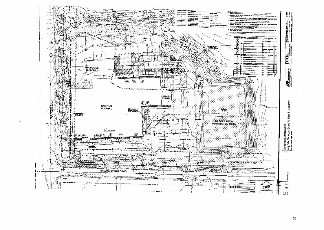
MIA
OW
IM
MO
ILIV
1111.1 '
4....11
..W....1
•10
....47
•■•• w
w.IP
.o.rowdaST
namv,.s,,,w.,0,41.06:4 I
suolleA
me6 V
sucfliPPVPN
.toS Aietuoulal aflaa A
ur H
1014s1T1001PS umolueule0 1"
-
------ - •
—
\
58
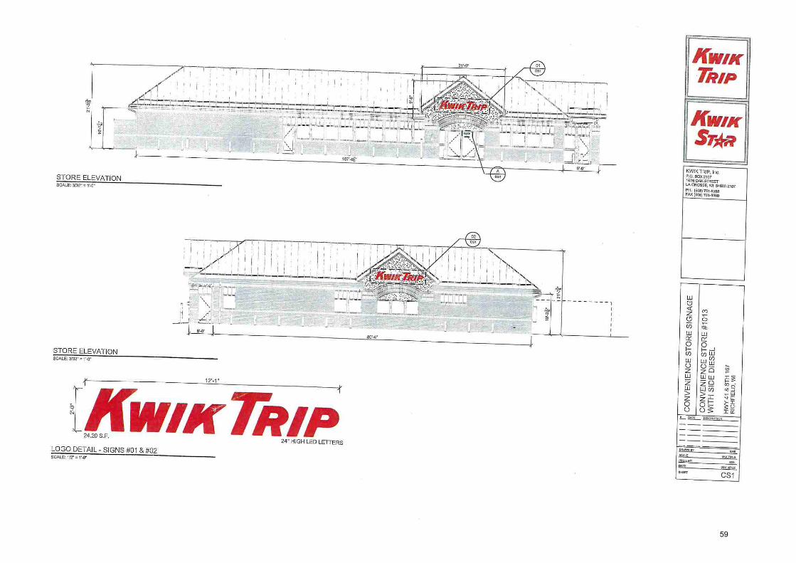
z
or?
gL2,
'0131A1-10N
1
LP
L H
IS'?
FbA
MH
.
73 -19sLia 3015 I-111N
4 E1,041t aLLO
IS 3D
N3IN
JAN
O0 l
30
VN
SIS
DH
OIS
3O
NM
UA
N0
0 u.1
11
H2
cV
59

9 O
0 9
-Al
5'
L
a
IM '0131d1-€01P
L9
t HIS
fl Lf A
MH
135E
I0 3
QIS
141IM
E
I-014 3
LIO
IS JO
N3IN
3A
N100
90
VN
UIS
9U
OIS
3D
IN3
INA
NO
0
60

1
k it I
sc rt 3t
KWIK TRIP, P.O. BOX 2107 1828 OAK STREET LX CROSSE, WI 54002.2807 PH. (6010111-89138 FAX / 8510 7818360
IAA 'CIAAIJHOM i91. HIS W
44 AMP
-US
310
C_Ils H
IIM
£1,0 4# E?:10IS
33N3IN
3AN
O0 .., !
Si ,i g i ,1
R 0
30VN
DIS
AdO
NV
O
0 D
x
7
CANOPY ELEVATION
i
ttl
CANOPY ELEVATION
ti
IP 24" HIGH LED Lt I I ERS
61

IM '0-01d1-1012,1 L91. HIS kb AMH
-3S310 D
OIS
HIIM
E
1+0 1-# ;A
DIR
30N3 M
N00
BSV
NISIS A
dON
VO
9
ti
N--
cJ 2 :="Z 0 0 0
SCALE 112" = l '.0"
.0
Lu
0
z
CALE 11114
I
9
8" HIGH LEO STRIPE
DI
ru
62

I Jap
e° PA
W", ,tp
t :T
ua.toxcridd 5 LL
O
O
O
a W C.
5'
KO
K
ozaz-ni (qos} xod IM
GZ23-49.4 i1109) 'kJ
el
A P
aqS
NM
I NM
/
ON
I' A S
IDD
111H
3H
N
NtIV
INV
A
63
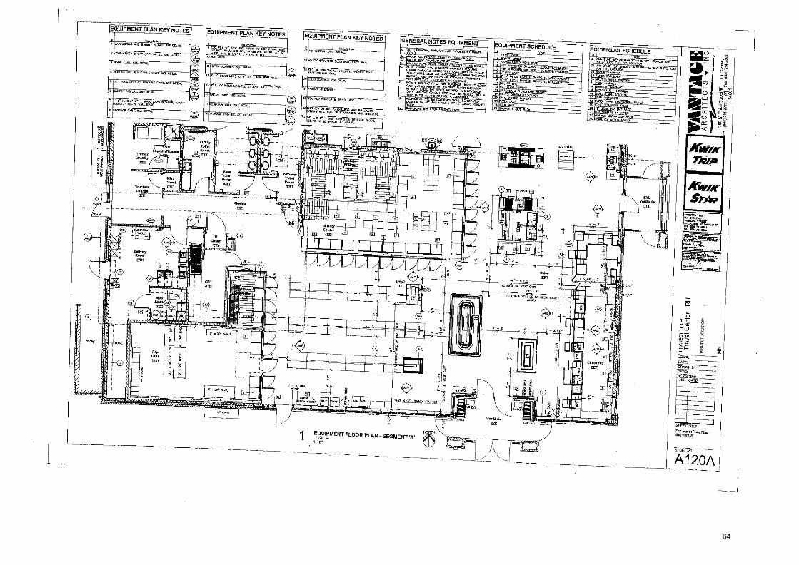
lr- -----
40863
ioeclrat lace} kru LM G
uelret (Posr ed
,....-r D
el
Illeee4S 1.141'N
LN4
-----,--..-w
r.......007
.—.....
rOrN
I A S
IO.D
1.11-10
991KIN
VA
m
NW
+1011VDorT LO
arckrd
Na -Jaw
e.D
;' rxiar. iparoad •IJ
EP,
-
g
a
a.
e-a
F.
r.r1.10.111F114:1141:01111.1:,1 IN11011411.
11
! raj
J
44 .34
4G
O 4
64

1.0945 M
t-461(9097 5M
-113L iB09)1
A-10.IS
09L
ON
E • S
10.1
1fH
MV
OfO
RIA
VA
NIN If
:NoiLVD
01 I
1
HN
-Je}uoo IGA
PJi 1
31111 i.04 road
65

4
z
Z
LO
M
Shay->
9L(B03)
x.4
IM
eza-n
u W
O)
255013 1..131.14LN
OS
L ep
3N
1 • S
i0311H
OV
619VANIVA kk
lk
44 I Os
5
66

1.0919 IM 'face) 7.9
A lefiLiti
9 I
A S
103111-T M
A IV
MI
C9 I
—J
0
wq
IA
67
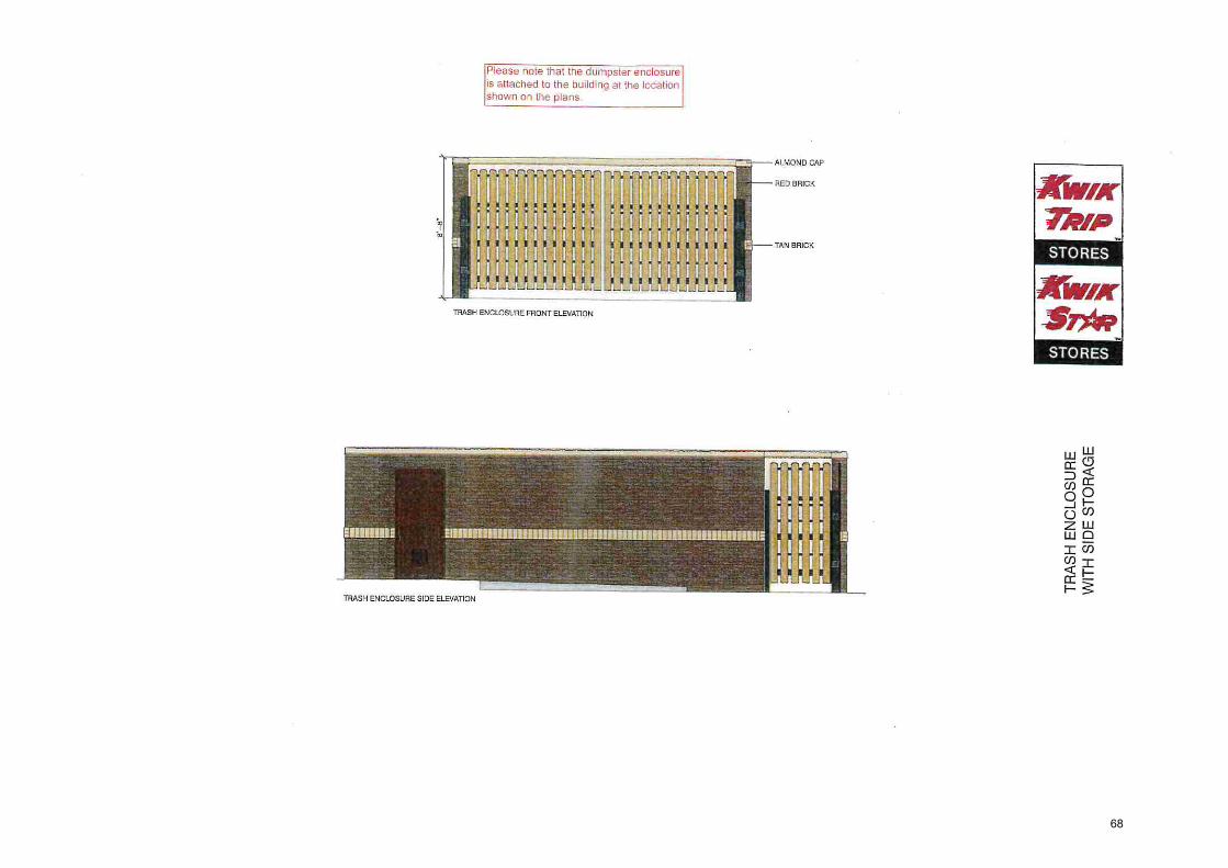
OVEIO
_LS 3CIIS 1-11IM
3}M
ISM
ON
9 HS
VE
LL ALMOND CAP
rF;
cn
o 4
L4 U)
w
0
F-
68

69

ki VILLAGE OF RICHFIELD c.,..„
PLAN COMMISSION COMMUNICATION FORM
MEETING DATE: November 1, 2018
SUBJECT: Vacating a portion of right-of-way on Riverview Drive — Resolution R2018-10-03
DATE SUBMITTED: October 26, 2018
SUBMITTED BY: Jim Healy, Village Administrator
POLICY QUESTION: DOES THE PLAN COMMISSION WISH TO RECOMMEND APPROVAL FOR THE PROPOSED RIGHT-OF-WAY VACATION ON RIVERVIEW DRIVE TO THE VILLAGE BOARD?
ISSUE SUMMARY:
Several months back, the Village Staff brought forward a proposal to the Village Board by two property owners on Riverview Drive who have expressed their desire to vacate a portion of Riverview Drive which abuts their home. Since that time, the Village has been approached by another property owner who desires to go about the same process. Rather than do these petitions independently, we are handling them both concurrently. Tonight, Village Staff is presenting a draft resolution which will be for your consideration to recommend approval to the Village Board on during the month of December when a Public Hearing is held.
In October, the following motion was made by the Village Board related to these petitions:
Motion by Trustee Collins to schedule a public hearing to be scheduled for December 20th, at 7p.m., or as soon thereafter as practicable, regarding the Resolution to vacate and discontinue a portion of Riverview Drive, which is beinghel.y-eb introduced at this meeting pursuant to Wisconsin Statutes Section 66.1003(4)(a); Seconded by Trustee Brandner; Motion passed without objection.
Prior to our last meeting at the Village Board level, Village Staff filed with the Washington County Register of Deeds the maps and legal descriptions for the areas to be vacated via a Lis Pendens. A copy is attached herein for your convenience. Additionally, we've gathered the list of all property owners and their addresses, whose property abuts or fronts upon the public road being discontinued, and sent by the time of our meeting a notice to the WisDOT which is required by law because they are within 1/4 of a mile of a State Trunk Highway.
It is important to note that this Resolution has already been introduced to the Village Board. They have directed this matter to the Plan Commission for review as required by law. The Village Board has set a date for the hearing on the Resolution. A Class III Public Hearing notice will be published in the Daily News and notice will be sent to those property owners 30 days in advance of said Hearing. Action that is being sought tonight is to determine the support of the Plan Commission for this road right-of-way vacation and for Staff to report back to the Village Board the night of the scheduled Public Hearing in December.
If you recall, the Village has been working independently with property owners for years regarding the boundary line locations and the difference of the road "as traveled" versus the road "as platted". It is the sincere hope of Village Staff that to the greatest degree possible, this administrative clean-up be handled prior to the end of 2018.
FUTURE IMPACT AND ANALYSIS: REVIEWED BY: Village Deputy Clerk
Forward to Village Board: Yes Additional Approvals Needed: Yes Signatures Required: Yes
70

ieeid VILLAGE OF RICHFIELD
PLAN COMMISSION COMMUNICATION FORM
MEETING DATE: November 1, 2018
SUBJECT: Vacating a portion of right-of-way on Riverview Drive — Resolution R2018-10-03
DATE SUBMITTED: October 26, 2018
SUBMITTED BY: Jim Healy, Village Administrator
ATTACHMENTS: 1. Notice of Pendency 1 Resolution R2018-10-03, A Resolution of the Village Board of the Village of Richfield to vacate and
discontinue a portion of Riverview Drive 3. DRAFT Letter to Mr. Dave Ross, WisDOT Secretary, RE: Discontinuance of Public Way 4. DRAFT Class III Public Hearing Notice
STAFF RECOMMENDATION:
Motion to recommend to the Village Board the passage of Resolution R2018-10-03, a Resolution Vacating Portions of Riverview Drive.
APPROVED FOR SUBMITTAL BY: VILLAGE CLERK USE ONLY BOARD ACTION TAKEN
Resolution No. Continued To: Village Staff Member Ordinance No. Referred To:
Approved Denied Other File No,
Village Administrator
71

NOTICE OF PENDENCY Dvagrai Nods,
Aiteui-14.14) SHARON A MARTIN
WASHINGTON COUNTY REGISTER OF DEEDS
Fee: $30.00
Pages: 6
Dated this 17 day of October, 2018.
STATE OF WISCONSIN
8...4 e Jim Healy age7.mini-r Village • Richfield
for
) ss.
Document 6 1461216 WASHINGTON COUNTY WISCONSIN
I0-15-2016 OMNI AM
NOTICE OF PENDENCY OF APPLICATION FOR VACATION OF A PORTION OF RIVERVIEW DRIVE RIGHT-OF-WAY IN THE
VILLAGE OF RICHFIELD
To Whom It May Concern: Notice is hereby provided pursuant to Wisconsin Statutes Section 840.11 that the Village Board of the Village of Richfield, upon its own Initiative pursuant to Wisconsin Statutes Section 66.1003(4), will introduce before the Village Board of the Village of Richfield on October 18, 2018, a resolution providing for the commencement of the process to discontinue a portion of Riverview Drive, as depicted on the map and description attached as Exhibit 1, which right-of-way abuts the properties Identified in attached Exhibit 2.
The Village Board will consider whether the public interest requires that said portion of said public right-of-way as described be discontinued. Proceedings after the introduction of said resolution will be held according to the provisions of Section 66.1003 of the Wisconsin' Statutes.
Iletenthq Am
(See .attached Exhibit 2) Pueel Identification Number (PIN)
Name and Return Address
Attorney John P. Macy 730 N. Grand Ave Washington, WI 53186
COUNTY OF WAUKESHA )
Personally came before me on this 17 day of October, 2018, the above-named Jim Healy executed the foregoing instrument and acknowledged the same.
W Ai A., ...
NO - : 11P. ' PU 117^ , TATE rint Name: Dklaet, .S""
My Commission Expires:
•
This document was prepared by: Attorney John P. Macy MUNICIPAL LAW 8. LITIGATION, GROUP, S.C, 730 N. Grand Avenue Washington, WI 53186 (262) 548.1340 WittyFilesVPMARectiletrAROW Vacatkalodee of Pendency 9.18.18.doca
72

NO PU rint Name:
My Commission Expires:
RY 14
NOTICE OF PENDENCY
Margo Wolin
NOTICE OF PENDENCY OF APPLICATION FOR VACATION OF A PORTION OF RIVERVIEW DRIVE RIGHT-OF-WAY IN THE
VILLAGE OF RICHFIELD
To Whom It May Concern: Notice is hereby provided pursuant to Wisconsin Statutes Section 840.11 that the Village Board of the Village of Richfield, upon its own initiative pursuant to Wisconsin Statutes Section 66.1003(4), will introduce before the Village Board of the Village of Richfield on October 18, 2018, a resolution providing for the commencement of the process to discontinue a portion,of Riverview Drive, as depicted on the map and description attached as Exhibit 1, which right-of-way abuts the properties identified in attached Exhibit 2.
The Village Board will consider whether the public interest requires that said portion of said public right-of-way as described be discontinued. Proceedings after the introduction of said resolution will be held according to the provisions of Section 66.1003 of the Wisconsin Statutes.
Dated this 17 day of October, 2018.
kmarinz Ana
Name and Return Address
Attorney John P. Macy 730 N. Grand Ave Washington, WI 53186
(See attached Exhibit 2) Parcel Identification Number (PIN)
/ Jim Healy age l• mini -rl'ator Village • Richfieldl
STATE OF WISCONSIN ) ss.
COUNTY OF WAUKESHA )
Personally came before me on this 17 day of October, 2018, the above-named Jim Healy executed the foregoing instrument and acknowledged the same.
This document was prepared by: Attorney John P. Macy MUNICIPAL LAW & LITIGATION GROUP, S.C. 730 N. Grand Avenue Washington, WI 53186 (262) 548-1340 CAMyFilea1JP1ARichflerchROW VacationWodee of Pendency 9.18.18.doex
B
73

Exhibit 1
Do*oho of *Wow Qdve, a Right of Ws olio he Wolf Pupa* bid Mows to aprons* sating roothay *a Ids band.
RYratrbw Ode vtikohe Wog Property wreaks 2 Pawls of Lan nag a pat WIN Noreinat X Who NortswietW of Sagan 17, Township 7 dot, Rasp 19 East, located b Si. Otago of RIchitald, Wastenglon Casty, VdsconsIn boursitod and ductal as allows
PARCEL k Coatinenciv at la florterest Caner a sad sedan liana Sat 00' t422. East on and sang lb Weal Ina of said); Sodlon, 33.00 dot is the South its ol &TM. "1137, hence Nab 091494/ East on Ind along sold Sat Ina 35028 tootle Ito pine of *hobo of doh desalplen;
Mena Sat 04' war E* 63,16 int lo a pant of aorta; Mon along be Oso d a Cam 0&24 Saltation Cuba ks Eastsitsootose Radius Is 30590 het, two Chord burs Sat 10'2822' Eall,110.11 fen b a point of byway, taro along lb Arc of Can 96,19 len whoa Cuter Las Wendy, nese Roan 176.52 bet nue Chad bens Scot 01 'OM' East, 95.00 bet to pond lanancy; liana dem la Arc of Ora 89.13 Wit Abu Coteries ticsbusterW, *owe Radius Is 110,00 het, nun Clad bears Sub W1652' West, RAO del a e Ontd tangency; two along la Arcola Curse 50.41 ten, Was Oster Ia Nobody, aim Radio Is 150,00 bet Una Chad boars San 75142' West, WM ten to a pint of Tanen": thence along le Arcot a Cos 40.341.21, abase Canis Uss Soullaily, abut Rados Is 90.00 bit, nun Chard ban South 74.18'16" West, 40,00 int b a pad of Tarnow Iona along Me An of a Cave 90.74 feed, nose canter las Santos**, whose Rada is 205,00 let tad Chad ban South 46'45'04" Wed, 90.00 bet le a palate of Trona* then% Stoll 36'0414* East 10428 fast to a point of Cu rate% Ono sang lb Arc ot a Curve 108.64 bet, ton Cain lot Holuestartootose Rada Is 175.10, toot Chad burs Sorb sruor West. 10519 bat Is a pen of Ingeincy; tun along Me Arc of a Cora 110.91 fast, Wan CarterinNorlrrly, whose Redua Is 29100 hot ston Chen bars Sat 83'41121bat, MOO het b a pan ti Tangency; tone Owl to Anal a Curre128.111eal, whose Coda los Habana*, whose Rata b 715.00 ten, whoa Chord ban Pat 781718" West, 128410 last b Me West be d Woe's Piwydr, Mews SO* 2131W46e East on and dog saki West Una 25.45 tad lo an Angle pad In Wolfs Props*: bode Scot 741640' Weston end alorq sold pp" 154.13 halo a print ben. 5048100'3010' Wad 00 and 03410 said Papery, 4392 led tea Pant betas Scot 111631' East rd and tag aid Propati, 2529 *lb a pobk boon nag la Ibrc al a Cara 62.72 loot atone Carlo les Soultientady, toga Radix a 1520 hat, Whose Chad bears North warts West, 6029 Met lo pail of *pro* tones along be An de Corn 8121 bet, when Carder les Southwark* otiose Rata 215.00 hat whose Chad boas Not 571690' East 0121 hells a ant id Tanen* berm along to An a a Ora 93.4 whose Caries Las Swink whose Raga
145,03 het *hose Chad bears Nab 04'15'38' East, 11200 feet lo a poke of Tarnow Mau Man the ke of Cons 92.04 Wooten Coda Um Worths*, ton Rats h 74000 *tabu Ctord beats Scot 113 512"Eat,SUMtealba paiddTangeowkeadorybteArcatCrw 12240 teat, whom Cabs this Hallanly, whose Radials 27520, nose Chad beau Nat S3'41'42' East 121.00 hot to a paint of Taman* heron aang be Au of a Cora 121.66 bet, Moo Carew Its tbfhwastalyothoss Radius Is 200.001.1, tows Chord tows Nab 53'31A2• Ent 120.00 teal k paid at Teroprar tonal Nat 3014414' East, 10428 hello a port analian how airing 1110 NC MOO 48,12 bet *Pon Conker las Soulwasiedy, whoa Rada 1150.00 bet, ttose Chad hears W01431413' East 48.00 bat lo a pant a Taegu* Ono Avg lw Axe a curse 51.13 eon Owe Caviar lea Swat sunk whose Radlus is 7093 kin whose Chad boors Worth wow E* 5000 bat to a pink lanai Scum 4.51607 East WO bat to pokt lismos Soulh 2211100' Was; 70X0 las4 b a aid di:wane; lanai Alcog An els oars 191.32 hot, whose Cattalo East*, whose Radius Is 2575621* *hoes Chord boa scut) orm r vossi. 18829 fest b a polnl allays*, thence along be Aro of a curva119.80 led, atone Cedar les balnoesle*, non Radbs 135,1101et %nose Chard haws Soot 3214'40' Eat 115,91 beta ■Onto/ Ungancy sold pen Is on Si. Sate* be of Wolk Pups* and now blown sePolnl A'; box* Nab 571600' East to and don said Souls* Sae, 53110 last le a print hum hict ?rear East anmad along old Southady be, 33.30 het lo an anal pond la said Wolfs Property; bum along the Arad a cum 219.1$ feet Masa Con las Usk*, tan Radius b 255090 bet, whose Chard ban Nab Oilleler East 219.11 Watt a point al Talmo% dance along be Arc as Cane 12154 feet, ohms Carla las Saihsesti, whose Radix is 28520 het, nose Chad bears Not 221703" Ent 12021 bet to a KU of Tarting: lance Noti 351600' EM 87 .77 1st IQ a Fdrit Ism along the Ave of a Can GM feet, stria Cons bas Nabinterty, Awe Rata b 201.50 pit, whom Chard bass Not 2r1742 Ent, 80,29 bet lo a part of Toros% tans Nab 171523' East 1513 hat 10 a pinta Oman; two low bobs of a sun, 106.11 feet Ono Carib Ns Want/. tan Radix b 17120 ton chord burs Norlh 0014'57' East 104.53 belie tint of Tanana"; Isnot along bo Ns a Win 1076014* whose Cubs les Ea** Wan Rados 127590 bat, *lose Chad ban Nab 05'3757' West 108.91 Seel b a pcbt d Tastancy, testa Nab 0519'35' East, 33.79 bet b a psint an the Sat Ina of &TX '167'; bras Sat eraroo• west ON Mid long said Scot ha 40.00 Owl In Oa plan ot Beginning.
The gross are ol wed pawl coats 41,851 Swan bet or 0/6075 Awn of land aeon aids
PARCEL I Commencing at Port 'A', bade Soulh 511090' Wait co and Wing Me Soulhody Ira cd be Wolfs pupa*, 145,06 leak Make South 491700' West on and tog said Salto* to 3037 het d a gold of Cinders and Si. pint damning of Ws descdpOors
Thant along ba ha ol a corool2,51 hat whose Cols is WO**, whin Radio Is 5090 tut, rhea Chord bins Nab 1191490' West 68.321 a pint ot Tangern; bona Nab 4r51'19' Wad 16301 fat to a pled mid point ace to Sat** Ono of Wolf's panty; taboo Sat 43'1510' East on and along slid Soutorly Properly Line, 12164 lest Is a polnk bane Sash 331921" Easton end sang saki Souk* Papard Line, 5524 kid to a Point tam Souls 44'18'00' Ent on ad along said Saute* Prcurty be, 1450 het to a point bane Not 1121390' Eaton and don add SoWlsilY eloPsiti IIPPA 51.11 last to a point bolos Hot 4913300" Eaton and along sad Southerly Pau* bo, 11.14 Oat b the pima ot *bring of this naalproa.
The gross ern lord prod coribles 2221 Square lest cs 0.0E099 Acios d tend more wins
74

Red Lines are Existing Dedicated Roads for
\ Riverview Ddve per Friess Lake Grove Subdivision
Blue Lines are New Proposed Dedl ted Roads
for Fdvervl w Dive
J
Heavy Sand {Ina ts the Subject Property
Other Road Right of Ways for Riverview Drive as
Described In Document No.: 1141759 are too
Ambiguous to identify and cannot be shown
N
w This map was drafted by: RRH
001111111111111////
\ C 0 N
RICK R. HILLMANN
5-3005
1 Exhibit 1
PROPERTY ADDRESS: EXHIBIT CLIENT: 4865 State Road 167 Road Right of Way Proposal Al Wolf
Hubertus Wisconsin 53033
PARCEL INFO: TAX KEY NUMBER: 045400A
PROJECT NO.: 20180112_CSM0002 SERVICE PERFORMED: XHT
It is the suggestion of the Surveyor that all Road Right of Ways within the Subject Property Shown hereon be Vacated and Simultaneously allow the
Future Certified Survey Map to Dedicate new Right of Ways for Riverview Drive that follow the existing Roads as traveled.
S.T.H. "167"
E
CONTINENTAL SURVEYING SERVICES LLC
S or 100' 200' 4W
SCALE: 1=200'
Main Office: 2059 Hwy 175, Suite 'A°
Richfield W. 53076
6 rardi By the Graces of God and the talents given to us, we strive to provide the mrLat Hnrukot and Raliahla I and Si irvAuinn Rpnrinac
Phone: (282) 389-9200 Websiter insw.cessurveys.oxn
Email: surveyaeessurreys.corn
75

WET
MOM WW1. go—NA MY
0 20 40 00 The ~ye Wail Woes fOohaold ShoeWn4 IOW We! Zees 1'.10'
Exhibit
Might—of— a}i Vietratict.rt Exhibit Lis Orw ity ond No 14 aieck0114 (il Lob 001$ 2troC21 lea Wow (4, aocaL TM4 pp lend pert or 11* Yowled 'el' Wet orellowl M Dowomora 144 11721116 Min RUN Labe OW& Wawa Lot *lois) or co14.4 444w4 Map me. 4524 0," so lawerand IOW Wo$107/104 0aunte Roaloiry lo Valowo 20 el Willed Sore" Woe re men 172-124 so Document He 01034, Wire *V
lho M6M LS al Oa 144 of Socace 17, Tow.* I Me& faro W ark, MIN. of Rio2642, Woordraten Grua% Moon&
Fes•
Sleet of 1
VangrA,Palr.
• 4 in 02 I I • lookaloa r011awfvoy lob. nodal
7,101 110,11,
• 1.•$•• Os WWI 1.114411m
and $14,
Lot 1 0.471 Acres 20E26 Se R.
ldt
441
----------------
jli.i,variaguLarue -----------
isitaatmek. It414 MIMI 'Wendel me imam) were lowww4 alr
• .1•0•100 $ trod We i•ps kula • • Wateles a 'Wad Ws*. bind wire Med. o -inago4.41.3•04x ir Irte pee *WO% 1 al bat
sot iot Iwo a pow** rent,
IherIngo on nOlotereel las ViliCtriln &do Phi* OPPIOnd• Ildd 9/61010. SOLO ?ma, tw *OW IM of the • *M too a add Ware 00.47011' W.
Ormeraelotelem. Lot I
[WM IL Kdoloo %Wow. 4025 RIver4wo NOW NI 63070
Owoloaftbdoldsr, Lot
OW4 War** await WS athwart paw RO441214 N 52076
&wooer
Clonold 1101114 AMIN* Sunairq a
ME41221. LaW WI saws
76

Exhibit
unpi re (r.a.) means "recorded as"
(meas.) means "measured as"
- indicates a 1.5"od iron pip
• - indicates a 1.3"od Iron pip
o - indicates a 1.3"od x 18" In set or set from a previous
Bearings are referenced to the V. Coordinate Grid System, South 2 NW 1/4 has a grid bearing of N 0
rall? PD. MAW 11- WOW C I Ithf lir
Point of Beginning said to be an original Iron stake
0 20 40 This property is within the
unplatted lands Village of Richfield Shoreland Scale in feet Zoning. 1" = 90'
oleas.isVa3e_ry_ .... DriVe ........ .... said to be
%pa,. - 72- an orkinal
77

EXHIBIT 2
2018.10 Addresses Abutting ROW
Vacation on Riverview Drive
V 10_045400A & 050900A LAVERN & BETTY JANE WOLF REV
TRUST 2775 AMANDA CT
RICHFIELD, WI 53076
V 1 0_045400Y THE FRUITFUL FAMILY FUND LLC
153 N CLINTON ELMHURST, IL 60126
VI 0_0457
V10048100A & 0509001 SCOTT J WOLF, NEILL WOLF
LAKEHOME TRUST
4811 RIVERVIEW DR
5421 SUMMERLAND DR HUBERTUS,WI 53033
APPLETON, WI 54913
V 10_045600A & 0499 RANDALL B ADAMSKI
4831 RIVERVIEW DR HUBERTUS, WI 53033
V10_0482 & 048300A & 050900B DARRELL & KRISTINE WOLTMANN
TRUST 4835 RIVERVIEW DR HUBERTUS, WI 53033
V10_0485 NANCI MILLER
APT 4 MODFIN ISRAEL 7172240 ISO
V10_048300B & 0484 DAVID & KATHERINE BUEHLER
4869 RIVERVIEW DR HUBERTUS, WI 53033
V10_048700B JOHN & DEBORAH SCHWENDEL ET AL
506 E PIONEER RD FOND DU LAC, WI 54935
V10_0486008 & 048700C & 048600A BADGER HOME BUILDERS INC
1323 POPLAR DR WAUKESHA,WI 53188
V10 0504 & 0505 JOHN & ERZSEBET TARCSAY
4786 RIVERVIEW DR HUBERTUS, WI 53033
V l 0_0487 DENNIS J ROSPLOCH 1673 FRIESS LAKE RD HUBERTUS, WI 53033
V10_0490 BLAIR & HELAYNE BURKETTE
1336 WESTERN AVE JACKSON, WI 53037
V10_0491 & 0509003
V10_0492 GORDON POOLE
ANN L COYLE, MICHAEL S COMPHER 4809 RIVERVIEW DR
499 BROADVIEW AVE. HUBERTUS, WI 53033
HIGHLAND PARK, IL 60035
V10_0497 IMP REVOCABLE LIVING
2825 FARVIEW DR RICHFIELD, WI 53076
V IO 0503 GROTHE RICHARD J GROTHE ROBERT W
2206 N 53 ST MILWAUKEE, WI 53208
78
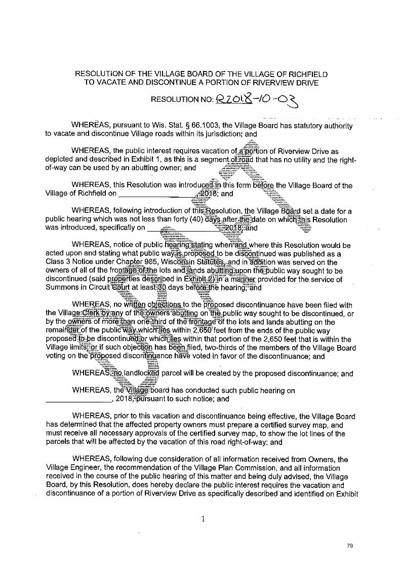
RESOLUTION OF THE VILLAGE BOARD OF THE VILLAGE OF RICHFIELD TO VACATE AND DISCONTINUE A PORTION OF RIVERVIEW DRIVE
RESOLUTION NO: 2Z.CAX10
WHEREAS, pursuant to Wis. Stat, § 66.1003, the Village Board has statutory authority to vacate and discontinue Village roads within its jurisdiction; and
WHEREAS, the public interest requires vacation of,a :Onion of Riverview Drive as depicted and described in Exhibit 1, as this is a segment Off4kd that has no utility and the right-of-way can be used by an abutting owner; and
WHEREAS, this Resolution was introducetilh this form befora the Village Board of the Village of Richfield on 2Q78, and
WHEREAS, following introduction of thig--13esolution, the Village .Borard set a date for a public hearing which was not less than forty (40) daYS.after_theldate on which is Resolution was introduced, specifically on and
WHEREAS, notice of public heann Aating wheri41-c,where this Resolution would be acted upon and stating what public wayis..,p604-00.,to be dia-Ontinued was published as a Class 3 Notice under Chapter 985, Wisconsin Statutes-=and in-addition was served on the owners of all of the frontageAthe lots andlAnds the public way sought to be discontinued (said properties described in EXt-libittfitVa niariber provided for the service of Summons in Circuitt.Nrt at least-V_ days baftireJhb hearing;--and
WHEREAS, no written objections to the 'pf6posed discontinuance have been filed with the Village Clerk. of 66,6kpets gbAting onI4.public way sought to be discontinued, or , . by the okiert - of more than one third of the frontage of the lots and lands abutting on the remairtfir'Of the publieWl'y.whiCiiii-§s within 2,650 feet from the ends of the public way proposetiObe discontintibilbr whio-fil7=-45 within that portion of the 2,650 feet that is within the Village limitS;--orif such objeftiOn has 1:f6-'6,-h.filed, two-thirds of the members of the Village Board voting on the proposed discontinuance KiVa voted in favor of the discontinuance; and
WHEREAS-jitio. landlocked parcel will be created by the proposed discontinuance; and
WHEREAS, the -Villagg'board has conducted such public hearing on , 2018-4A-rsuant to such notice; and
WHEREAS, prior to this vacation and discontinuance being effective, the Village Board has determined that the affected property owners must prepare a certified survey map, and must receive all necessary approvals of the certified survey map, to show the lot lines of the parcels that will be affected by the vacation of this road right-of-way; and
WHEREAS, following due consideration of all information received from Owners, the Village Engineer, the recommendation of the Village Plan Commission, and all information received in the course of the public hearing of this matter and being duly advised, the Village Board, by this Resolution, does hereby declare the public interest requires the vacation and discontinuance of a portion of Riverview Drive as specifically described and identified on Exhibit
1
79

VILLAGE_BOARD, VILLAGE OF RICHFIELD
Village President
ATTEST:
Donna CoxV1116-geApputy 'Cler
C:\t/IyFileOPWRichfield\ROW Vacatiolads re vacate'Riliaview Dr 9,18.18.de..t
1, and the Village Board further finds that the vacation and discontinuance of a portion of Riverview Drive will not landlock any property,
NOW THEREFORE, BE IT RESOLVED by the Village Board of the Village of Richfield, Washington County, Wisconsin, that a portion of Riverview Drive depicted in the attached Exhibit 1 is hereby discontinued pursuant to Wis. Stat. § 66.1003, provided that this Resolution shall not be effective unless and until the affected property owners prepare and present a certified survey map in a form approved by the Village Board, and which receives all necessary land division approvals, and which is recorded contemporaneously with this Resolution.
BE IT FURTHER RESOLVED, that the Village Clerkg.hall record a certified copy of this Resolution with the Washington County Register of DeOp-itOritemporaneously with the certified survey map which adjusts the lot lines as described_abOve.
PASSED AND ADOPTED by the Village Board of the VillageOfRichfield, Washington County, Wisconsin, this day of , 2018.
2
80

October 12, 2018
Mr. Dave Ross Department of Transportation Secretary Wisconsin Department of Transportation 4802 Sheboygan Avenue P.O. Box 7910 Madison, WI 53707
Re: Village of Richfield Discontinuance of a Public Way
Dear Mr. Ross:
Please be advised that I am the Village Attorney for the Village of Richfield, in Washington County, Wisconsin, Pursuant to Wisconsin Statutes Section 66.1003(8)(a), which may apply to the above-noted matter, enclosed please find a resolution which was introduced at the Village of Richfield meeting held on
If you should have any questions or concerns regarding this matter, please do not hesitate to contact me.
Yours very truly,
VILLAGE OF RICHFIELD
John P. Macy Village Attorney
Enclosure cc: Donna Cox, Village Deputy Clerk CAtlyFilesIJPMNRIchfleld \ROW Vacation \DOT Itr 9.18.18.docx
81
Publish (Class 3) on: , 20 • , .:-
, 20
Village of Richfield 4128 Hubertus Road Hubertus, WI 53033
NOTICE FOR PUBLICATION
_,.,-. The Village Board of the Village of Richfield will hold a .114aring on .--- 2018, at p.m. in the Village Hall of the Village_f_Of--kithfield, located at -_, „_._-_ _ , WI 53118, Wisconsin, uaoblhe resolution to discontinue a f.+7...,..,._- portion of Riverview Drive herein described and ,may act upon said resolution at said time and place. Said resolution was introduced bel6fe the Villag-64:If_Richfield Village Board ,.,, on the day of ;20-18, and proposesIcitliscontinue a portion of Riverview Drive.
Dated this day of 018.
onna Gox, Village Deputy Clerk t72
CAMyFiles1JPMIRichfleld\ROW VacationNotice for Publication 9.18.18,docx
82

83

VILLAGE OF RICHFIELD
PLAN COMMISSION COMMUNICATION FORM S-J MEETING DATE: November 1, 2018
SUBJECT:
DATE SUBMITTED:
SUBMITTED BY:
Two-Lot and One Out-Lot CSM for Steven Schmidt (Tax Key: V10_008800D) and One-
Lot CSM for Kenneth Schmidt (Tax Key: V 0_908800C)
October 26, 2018
Jim Healy, Village Administrator
POLICY QUESTION: DOES THE PLAN COMMISSION WISH TO RECOMMEND APPROVAL FOR THE PROPOSED CERTIFIED SURVEY
MAPS FOR BOTH STEVEN SCHMIDT AND KENNETH SCHAIIDT
ISSUE SUMMARY:
Since the Village has been working with Mr. Steven Schmidt for close to year on his proposed land division and rezoning, 1 will not summarize the series of past events regarding concept reviews, recommended rezoning petitions, and discussions this Body has had regarding proposed layouts and designs. What I will discuss is what has happened since the last action by the Plan Commission:
• The Village received correspondence from the Wisconsin DOT, pursuant to the request from the Plan Commission, that they have denied several times a request for a second access off of STH 164.
• Village Staff contacted Mr. Schmidt regarding the misinformation he has provided the Village regarding the access to the properties on STH 164.
• Mr. Schmidt proposed a shared driveway to the Village Staff and he was informed the Village generally is not in favor of shared driveways, particularly when they are only for the purpose of economic gain.
• Mr. Schmidt was advised to yet again change his survey to reflect the recent communication from the Wisconsin DOT. Meaning, instead of two (2) properties off of STH 164, he has combined them in favor of a single parcel.
• The Village Board was advised of the situation and at their October meeting voted to table the proposed rezoning until a proposed CSM was submitted that was consistent with the recommendation of Staff and the Wisconsin DOT.
• The right-of-way dedication for a temporary T-turnaround on Whitetail Run is consistent with our Village Code. There is no need for any easement outside
Steven Schmidt CSM
Consultant Planner Tim Schwecke's Comments:
• A revision date must be included on all of the sheets (missing on Sheet 3) and must be consistent on all of the sheets (ie: 9-24-2018 on Sheet 2 and October 18, 2018 on Sheet I)
• A building envelope should be shown on Lot 1 that would be located on the north side of the 100-year FEMA Floodplain,
• Along those same lines, I would recommend as single building envelope on Lot 2. • There should be a notation related to Out-Lot 1, generally as follows: "Out Lot 1 was created for the purpose
of conformity the Village's Lot Design regulations and may not be further subdivided or developed in any manner, Out Lot 1 shall be considered a part of Lot 1 for the purposes of ownership and neither parcel shall be sold independently of one another.
• Soil boring and testing date for both lots shall be provided to verift that there is a location suitable for a septic system.
• The surveyor should include all notations as required by TRANS 233, Wis. Slats,
84
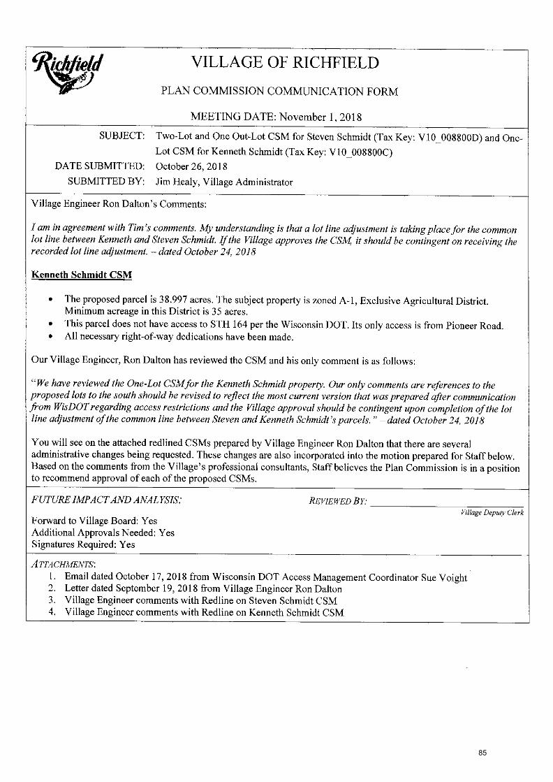
. _. . . VILLAGE OF RICHFIELD
/. PLAN COMMISSION COMMUNICATION FORM
MEETING DATE: November 1, 2018
SUBJECT: Two-Lot and One Out-Lot CSM for Steven Schmidt (Tax Key: V10_008800D) and One-
Lot CSM for Kenneth Schmidt (Tax Key: V10_008800C)
DATE SUBMITTED: October 26, 2018
SUBMITTED BY: Jim Healy, Village Administrator
Village Engineer Ron Dalton's Comments:
I am in agreement with Tim's comments. My understanding is that a lot line adjustment is taking place for the common lot line between Kenneth and Steven Schmidt. If the Village approves the CSM, it should be contingent on receiving the recorded lot line adjustment. — dated October 24, 2018
Kenneth Schmidt CSM
• The proposed parcel is 38.997 acres. The subject property is zoned A-1, Exclusive Agricultural District. Minimum acreage in this District is 35 acres.
• This parcel does not have access to STH 164 per the Wisconsin DOT. Its only access is from Pioneer Road. • All necessary right-of-way dedications have been made.
Our Village Engineer, Ron Dalton has reviewed the CSM and his only comment is as follows:
"We have reviewed the One-Lot CSMfor the Kenneth Schmidt property. Our only comments are references to the proposed lots to the south should be revised to reflect the most current version that was prepared after communication from WisDOT regarding access restrictions and the Village approval should be contingent upon completion of the lot line adjustment of the common line between Steven and Kenneth Schmidt's parcels." — dated October 24, 2018
You will see on the attached redlined CSMs prepared by Village Engineer Ron Dalton that there are several administrative changes being requested. These changes are also incorporated into the motion prepared for Staff below, Based on the comments from the Village's professional consultants, Staff believes the Plan Commission is in a position to recommend approval of each of the proposed CSMs.
FUTURE IMPACT AND ANALYSIS: REVIEWED BY.' Village Deputy Clerk
Forward to Village Board: Yes Additional Approvals Needed: Yes Signatures Required: Yes
ATTACHMENTS: 1. Email dated October 17, 2018 from Wisconsin DOT Access Management Coordinator Sue Voight 2. Letter dated September 19, 2018 from Village Engineer Ron Dalton 3. Village Engineer comments with Redline on Steven Schmidt CSM 4, Village Engineer comments with Redline on Kenneth Schmidt CSM
85

STAFF RECOMMENDATION:•
Steven Schmidt CSM:
Motion to recommend to the Village Board the approval of the Two-Lot and One Out-Lot Certified Survey Map (CSM) for the property indicated by Tax Key: V10_008800D subject to the General Conditions of Approval listed below:
General Conditions of Approval: 1. The subdivider shall satisfy all comments, conditions, and concerns of the Village Engineer, the Village
Planner, and all reviewing, objecting and approving bodies, including, but not limited to, the Wisconsin Department of Commerce per Ch. 236, Wisconsin Statutes and Ch. Comm. 85, Wisconsin Administrative Code; Wisconsin Department of Administration per Ch. 236, Wisconsin Statutes; and Washington County.
2. The subdivider shall, on demand, reimburse the Village all costs and expenses of any type that the Village incurs in connection with this development, including the cost of professional services incurred by the Village (including engineering, legal, planning and other consulting fees) for the review and preparation of required documents or attendance at meetings or other related professional services for this application, as well as to enforce the conditions in this conditional approval due to a violation of these conditions.
3. Any unpaid bills owed to the Village by the subject property owner or his or her tenants, operators or occupants, for reimbursement of professional fees (as described above); or for personal property taxes; of for real property taxes; or for licenses, permit fees, or any other fees owed to the Village; shall be placed upon the tax roll for the subject property if not paid within thirty (30) days of the billing by the Village, pursuant to Section 66.0627, Wisconsin Statutes. Such unpaid bills also constitute a breach of the requirements of this conditional approval that is subject to all remedies available to the Village, including possible cause for termination of this approval.
Kenneth Schmidt CSM:
Motion to recommend to the Village Board the approval of the One-Lot Certified Survey Map (CSM) for the property indicated by Tax Key: V l 0008800C subject to the General Conditions of Approval listed below:
General Conditions of Approval: I. The subdivider shall satisfy all comments, conditions, and concerns of the Village Engineer, the Village
Planner, and all reviewing, objecting and approving bodies, including, but not limited to, the Wisconsin Department of Commerce per Ch. 236, Wisconsin Statutes and Ch. Comm. 85, Wisconsin Administrative Code; Wisconsin Department of Administration per Ch. 236, Wisconsin Statutes; and Washington County.
2. The subdivider shall, on demand, reimburse the Village all costs and expenses of any type that the Village incurs in connection with this development, including the cost of professional services incurred by the Village (including engineering, legal, planning and other consulting fees) for the review and preparation of required documents or attendance at meetings or other related professional services for this application, as well as to enforce the conditions in this conditional approval due to a violation of these conditions.
3. Any unpaid bills owed to the Village by the subject property owner or his or her tenants, operators or occupants, for reimbursement of professional fees (as described above); or for personal property taxes; of for real property taxes; or for licenses, permit fees, or any other fees owed to the Village; shall be placed upon the tax roll for the subject property if not paid within thirty (30) days of the billing by the Village, pursuant to Section 66.0627, Wisconsin Statutes. Such unpaid bills also constitute a breach of the requirements of this conditional approval that is subject to all remedies available to the Village, including possible cause for termination of this approval.
APPROVED FOR SUBMITTAL BY:
Village Staff Member
Village Administrator
VILLAGE CLERK USE ONLY BOARD ACTION TAKEN
Resolution No. Continued To:
Ordinance No. Referred To:
Approved Denied
Other File No.
86
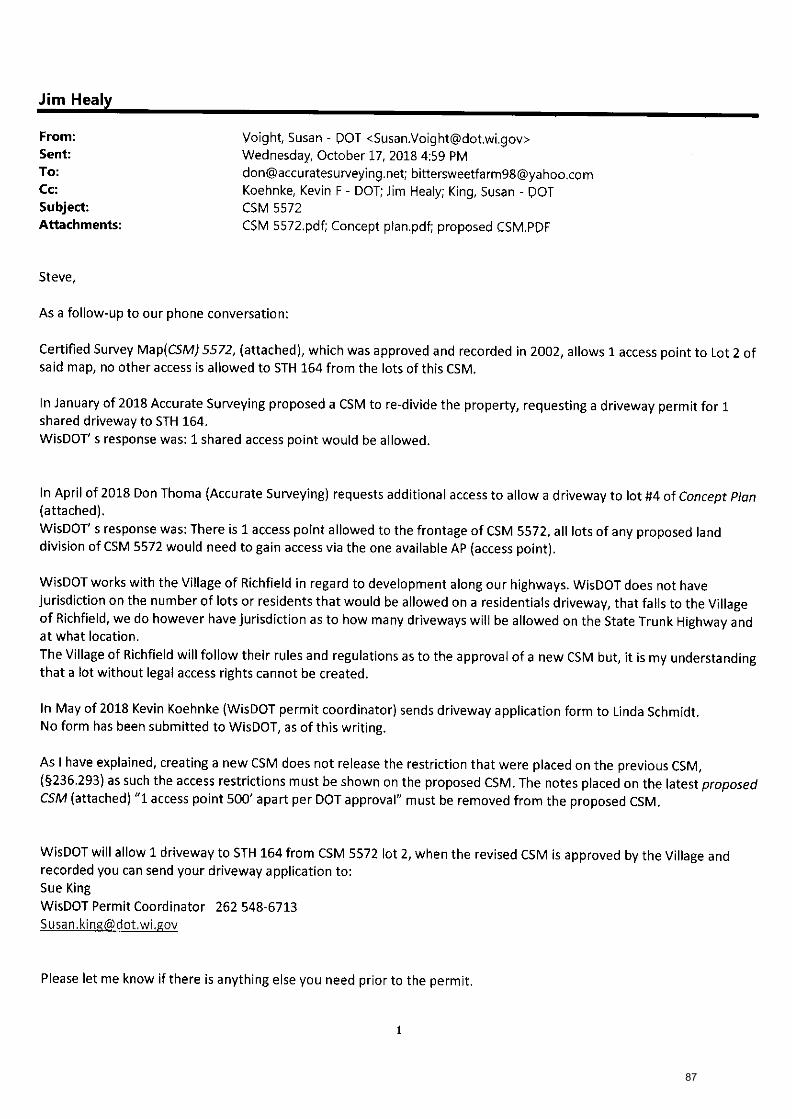
Jim Healy
From: Voight, Susan - DOT <[email protected]>
Sent: Wednesday, October 17, 2018 4:59 PM To: [email protected]; [email protected] Cc: Koehnke, Kevin F - DOT; Jim Healy; King, Susan - DOT
Subject: CSM 5572
Attachments: CSM 5572.pdf; Concept plan.pdf; proposed CSM.PDF
Steve,
As a follow-up to our phone conversation:
Certified Survey Map(CSM) 5572, (attached), which was approved and recorded in 2002, allows 1 access point to Lot 2 of
said map, no other access is allowed to 5TH 164 from the lots of this CSM.
In January of 2018 Accurate Surveying proposed a CSM to re-divide the property, requesting a driveway permit for 1
shared driveway to STH 164.
WisDOT' s response was: 1 shared access point would be allowed.
In April of 2018 Don Thoma (Accurate Surveying) requests additional access to allow a driveway to lot #4 of Concept Plan (attached).
WisDOT' s response was: There is 1 access point allowed to the frontage of CSM 5572, all lots of any proposed land division of CSM 5572 would need to gain access via the one available AP (access point).
WisDOT works with the Village of Richfield in regard to development along our highways. WisDOT does not have
jurisdiction on the number of lots or residents that would be allowed on a residentials driveway, that falls to the Village
of Richfield, we do however have jurisdiction as to how many driveways will be allowed on the State Trunk Highway and
at what location.
The Village of Richfield will follow their rules and regulations as to the approval of a new CSM but, it is my understanding
that a lot without legal access rights cannot be created.
In May of 2018 Kevin Koehnke (WisDOT permit coordinator) sends driveway application form to Linda Schmidt.
No form has been submitted to WisDOT, as of this writing.
As I have explained, creating a new CSM does not release the restriction that were placed on the previous CSM,
(§236.293) as such the access restrictions must be shown on the proposed CSM. The notes placed on the latest proposed CSM (attached) "1 access point 500' apart per DOT approval" must be removed from the proposed CSM.
WisDOT will allow 1 driveway to STH 164 from CSM 5572 lot 2, when the revised CSM is approved by the Village and
recorded you can send your driveway application to:
Sue King WisDOT Permit Coordinator 262 548-6713
Please let me know if there is anything else you need prior to the permit.
87

7 ..
September 19, 2018
@dor engineering. 1 architecture environmental i surveying
landscape architecture I planning I economic development
corporation
W61 N497 Washington Avenue Cedarburg, WI 53012
262-204-2360 800-472-7372
FAX 262-375-2688 www.cedarcorp.com
Mr. James Healy, Village Administrator Village of Richfield 4128 Hubertus Road Hubertus, .Wisconsin 53033
RE: 2 Certified Survey Maps (CSMs) and a Rezoning Map, At Steven Schmidt and Kenneth Schmidt Properties
Dear Mr. Healy,
We have completed our review of the two Certified Survey Maps and a Rezoning'Map received on September 17, 2018. The CSMs and Rezoning Map were prepared by Accurate Surveying & Engineering LLP, Donald J. Thoma, R.L.S. We have the following comments and recommendations:
Certified Survey Map which amends the common line between Lot 1 & 2 of CSM No. 5572:
• Amend the title to reference a re-division of CSM No. 5572.
• Will this CSM need to be recorded prior to the division of the new Lot 2?
• Should Steven Schmidt be included as an Owner/Subdivider?
• Is a Content of Corporate Mortgage required for this re-division?
• Show the overall acreage and square ft. for Lot 2.
Certified Survey Map which will divide Lot 2:
• This CSM will need to make reference to the new CSM which amends the common lot line of CSM No. 5572.
• Verify that more than 25,000 S.F. of area is at least 2 feet above the 100 Year Flood Elevation.
Please see the enclosure for illustration of the above comments.
Submitted data has been reviewed for conformance with generally accepted surveying practices and Village policies. Although this data has been reviewed, the surveyor is responsible for the thoroughness and accuracy of survey and supplemental data and for compliance with all state and local codes, ordinances, and procedures. Modification to the survey, etc. may be required should errors or changed conditions be found at a future date.
Cedarburg 1 Green Bay I Madison I Menomonie
89

2 Certified Survey Maps (CSMs) and a Rezoning Map Page 2
Please contact me at our Cedarburg office (phone 262-204-2341) if you require any additional information or if you have any questions.
Sincerely,
CEDAR CORPORATION
Ron Dalton, P.E. Director/Office Manager
RD/cv
Enclosure(s): As Noted
cc: Donald J. Thoma, R.L.S., Accurate Surveying & Engineering LLP, w/encl., via email
90

N 69'49'01- E 70.00'
S 00'10.59" E 66.00'
Whttetall Run extension (see dotal on Shoot 2) ondIeatal m ae pubtlefor toed
▪ purpeno1106 acroil.t2eno.11) ‘S'
N 59'49'01' EV6 70.0a
N 89'49'01" E 828.22'
1
Whitetail Run employ Ium-x.rotand eiserren111%51'
Eon Lot 1, CSM No. 6572
Owner! Subdivider
Sloven K. Schmid! Linda M. SctImdt wsaSe Oakwood Road Waupun, WI, 53963
Surveyor
Donald 3. Thorne Accurate Surveying &
ErigIrtoeling LLP. 2911 Wildlife Lane Richfield. WI 53076 O
unol
3. W
hice
tall
Hid
eaw
ay
0 • Pc p at 5-247
k"7Datedtile ,y of )e ea>20„. „
V.0.1224.89 In error per CSM 55721
11,
.... 111 r1,
5 C 0.
DONALD J.
......
i THOMA
4170ELO.
t7t 41 ,;;;=
LA RE-DIVISION 1--\\
Washington\ ,County Certified Sury Map par.444_,s1-0-,.7,i9.)4..--, ,' of Lot Two {2) of Certified Survey Map No. 552 as recorded In Volume 40 of Certified Survey Maps on pages 95-97, as Document No. 90030 =part of the NE 6 cfional 114 of the NE 114 and part or the SE 1/4 of the NE 114 an In Townshl 9 North, Range 19 East. Town of 6hlield, Washington County, VosoonsIn. '-'"---....... Lon 1 0 600 160 300
'S South Nader comer TBD 43/7/ Scale In feet I Sec. 52.10-19 Is.e // 1' = 300' I 1-02., i conc.monJbross cap found._ ,..,..„ „. t...,,,V.,„ Parcel 2
'-*I''''-t- 1 .11.7.! -r'844 .--144 Pioneer I .fload CSM .'2372 Lot 3 L CSM #5144 1, .,, - - -- - .,..° _grcr. SE ccr. IP S 114 Cs)r.) iSEITIZIMWJ-851' 4f._ _ _ __, 3— — -- --• _E.E.,,'-N E.0 b2-5:1/ 4 co= V3E-la-IT 16.2.T16-4.4 — _ s
1229.01' 89.7 ,V57 70- - ---- b E OS it.e.WW1
t,
z
CSM xxxx
a, 8-1
813 4m Lot 1 10.744 Acres cl
05 • The flood plain boundary was traced MI I s_2 467,998 Sq. Ft. freer FIRM Map No. S513100244E, fil0, dated 11-16-2015.
raD
N 859719' E 1229.71'
Lott North Quarter comet cat' #2288 Sec. 5-9-19 ccon..rnon.ilarass cap found
proposed. Lot 1 38.997 Acres 1,69E3,709 Sq. Ft.
Bearings are referenced to thee).11,sciansin Coordlnato Grid System. South Zone. The south are el the SE 114 of Sec 32.10.19 S B9112181 W.
Lok GSM No. 6,..72 - r
8-2 B-3
Lot 2 10.829 Acres 471,711 Sq. Ft.
• Sheet 1 of 3
47 °? -_ — Southeast corner V-. r7 i.q = .
Soc. 32-10-19 Iconc.monJhrass cap
4 Eli E: 2,453.065.55 N: 471.764.10
ib--7:t ;Stale Plano
Coordinates)
i3Z ii I Northeast comer °
Sec. 5-9-19 -47
— CenC.MOrihrass can
f I r....,
Lc .7. — a: -,- 5' _0, =
.0 '6 E: E-41 . ,o 0_, Nt•-' to = cn
sh = :'.': I 1 z 6
z rs- ...=.. 04 o.
Li = ,,,...,, -r------..._ el ci
'''' = ...,_ I +a ,-
_ 7..., t.
l 71
= g = a I 0 -. = ;‘, `n 1_ _ _ _ =
„ 1 -, Gc. 1 u.1 § I g
,L,..-••• r..
% • 'S
P 8 IC
iii I
a' 11' I Lot 1_ ri.'- 3 I CSM #4446 Z
.3. gl a_ O lol ■-i I 13::: 0:1 IR I ail
Flood - means 'recorded as'
P.0,8.- Point of Revii,40g t O . indicates a 1.3'ed X, 18" :I
Iron pipe weighing 1.69 lbs.(ft. set.
• - Indicates a 1 3'od Iron pipe 6 k), found unless noted. g° 429.00 N 82'491)7'E
I I 11 1 I II I - indicates no access. '5
627.65
r
semi , 1 rl, co 3_1___Ir...----- ? 13-2 m m B.../ 1
v, Wm '.1 "...- i '='
§ I [7,-;; 1 I 1 ... ,,51 CV
I 6 c, N
Z;' 0 - g.--"' on I LI •
I 1 ZI-Z) gl .k m
N. I Z I I 1" l, Flood 1 Ei.. ;...43 w L , 4,1 1-0. cs
8e*521.6' E r.
▪
8-3 311' I
1 g
8_01- ',.! 0.--oi I ..,... g ' ,..- 17L.2o
43t
Acres .44 S.4 a. fo ,„:1 ,c2 10 2 .. I I , ci
751.092 Sq. Ft. .3. t.,. o 1 c" o_
z EL
'' I C.' '91 ' EL 1•••
5' ,6
▪
1 0 0-0 a --1---_ _ Zo 0 6s Vi Flood Flood 0 c;
..u, to 1 Si
s 27'594'42079E. ."---...,, ZS.cvl I I
o_
..,.,„_,. .-. A= .M. I■ .... 042-06' ......, 77, oe..
Et:It:Nectar carner 12171 .201 utiot 2 iii 1 oc. 5-9-19
- Lot 30 1 Or I
conc.roon.flarass cap round
p) EAntej.0.19 3Peln.ori algebra's
z: cap used 1311321
(r.e. N 80'16'16" El Steeple View Estates This instrument was drafted by Donald J. Thorns, S-2470
=..., ,..,, .. - indicates soil boring. Isi z B-1 ;:i ls
Rs-1 zoning setbacks .f.° 7, OUt.10t. 1 p.., si Front • 12F S k) 21 Side -40' 3 2 ,,:f, 5.827 Acres
1:: Rear- SW :....., ..5 i" 253,1133 Sq. Ft. '
;I 5 .2
rei
8, _t..- 42913'
S 88'18"15"Ser 2632.43 - __
a Flood
91

.2tRi7sa
Out
let 3
, Whi
tetail Hid
eaw
ay
Whitetail Run [urinary Surniproond assemonl 33%51')5,....
c?„,"°4‘,5,9
g
Location Sketch NE 1/4 - Sec. 5-5-19
Scale: r = 2000'
(from SE oar. toS 114 cm) I s artZlErW 2837.48
Renee
Wr , r
W 283243
V RE-DIVISION \
Sheet 2 of 3
Washington County Certified Survey Map --* of Certified Surrey Map No. as recorded In
Volume .40 of Certified Survey Maps on pages 954/, as Document No. GS 013, being part Of the NEtractional 1/4 of the NE 114 and part a SE 1/4 of the NE 114 Section 5, 'the SE
North, Range 19 East, Town of Rich Id. Washington County, cousin. \—iTED-I
L76D I
Temporary Turn—a—round Detail:
This 33'X51' easement Is for the mnstruclion of an asphalt roadway that Is temporary turri-around far vehictes and will automatically terminate when Whitetail Rum Is extended and approved by the Village of Richfield.
..ntLic1/41_4
Ds. 3
temporary time-mond easement 337.C.51"
a ,
Su eyor's Cert'ficate:
N 0Y
0839
- E
Lot 1
7e.00' N 89'49'01' E
51'
2'
N 89'47'20° E 70.00'
lerripOrary tum-o-round easement =51'
51'
proposed Lot 1
IA RE-DIVISION
I 0 onald J. Thome, Profesptlonal Land Surveyor, hereby certify that by lino d rors of Steven K. Schmidt, I have surveyed, dl , end mapped the Ian own and described hereon, -part-cf-L-ot--Two-(2) of Certified Survey Map No. as recorded in Volume 40 of Certified Survey Maps on pages 9E47, as Document No. , being part or the NE Fractional
1/4 of the NE 1/4 and part of the SE 1/4 of the NE 114 all In Section 5, hip 9 North. Range • East, Town of Richfield, Washtngton County, Wisconsin, which Is bounded and described as foil
Commencing at the East quarter comer of said Section 5; thence S 881815' W, along the south Inc, of said NE 1/4, 45.01 feet, to a point In the westerly rIght-of.way tine of 5.T.H. '164' being the point of beginning of lands herein described; thence continuing S 8818'15' W, along said south line of the NEW, 127121 feet. to the southwest corner of said Lot 2 of Certified Survey Map No. 5572; thence N 00'10'50' W, alone the weal line of the H 112 of saki NE 114, 1800.30 feet, to a point In the norm Kim-of-way tine el WNIetali Run; thence N 89'49'01' E, along the easterly extension of said north right-of-way One of Whitetail Run, 70.00 feet thence 00°10'59" E, at right angles. 66.00 feet thence S 481538- E. 481.24 feet thence N 89'4991" E, E28.22 feet. to a point in said westerly right-of-way tine of S.T.H. "154'; thence S 00'0714' E. along said westerly right-of-way Urn. 98047 feel; thence S 01-1812" W, continuing along said westerly right-of-way line, 200.06 feet; thence S 00'07'34' E, continuing along said westerly right-of-way line, 250.00 feet; thence S 27'59'40' E, continuing along said westerly right-of-way tine. 42.79 feet, to the point of beginning.
Containing 44.749 acres (1.949.254 square feet) more or less.
I further certify that I have fully complied with the provisions of sec. 236.34 of Wisconsin Statutes and the Village of Richfield Land Division Ordinance in surveying, dividing, and mapping said land. and that lids map Is a correct representation of the exterior boundaries of the Is surveyed and a division of said lands.
Dated this t day of ?f 2018.
44)- scoro -------
:gitr / DONALD J. THOMA 5.2470 =
RICHFIELD, .1 4.= IM
/"q- .1"
''''''4nt+5l`'
Donald afiS-2470
S 00.10.59° E
88.00' Whitetail Run extension dedicated to the public ha toed purposes 0.106 acre P1.620 soft)
92

IA RE-DIVISION TOD
Sheet 3 of 3
Washington County Certified Survey Map -Pcq..oLko Volu of Certified Survey Maps on pages 95417, as Document No. • being Part
e E Fractional 114 of the NE 1/4 and part o he SE 1/4 of the NE 1/4 In Section 5. TOD , Township 9 North, Range 19 East, Town of Rich d, Washington County. W stn.
Owner's Certificate: ---ITOD I As owners, we hereby certify that we caused the land shown and described
surveyed, divided and mapped as represented on this Certified Survey Map. We also certify that this Certified Survey Map Is required to be submitted to the following for approval:
Village of Richfield Village Board
Steven K. Schmidt- Owner Linda M. Schmidt-Owner STATE OF WISCONSIN) WASHINGTON COUNTY)s.s
Personally came before me this day of 201 the above named owners are to me known to be the same persons who executed the foregoing Instrument and acknowledge the same.
(Notary Seal)
Notary Public, _ Wisconsin.
My commission expires
Village of Richfield Village Board Approval:
This land division is hereby approved and hereby accepted by the Village of Richfield
Village Board this day of 201 .
John Jetfords - Village President Jim Healy - Village Administrator/Clerk
Consent of Corporate Mortgagee:
a corporation duly organized and existing under and by virtue of the laws of the Slate of Wisconsin, mortgagee of the above described land, does
hereby consent to the surveying. dividing• mapping and dedication of the land described on this Certified Survey Map, and does hereby consent to the above certificate of Steven K. Schmidt and Linda M. Schmidt, owners.
IN WITNESS WHEREOF, the said has caused these
presents to be signed by , its Senior Vice President, and countersigned
by its Assistant(cashier), at
Wisconsin.
In the presence of: Corporate Name
Senior Vice President
Assistant or Cashier Date
STATE OF WISCONSIN) WASHINGTON COUNTY)s.s.
Personalty earns before me this day of 200 .
Senior Vice President. and
of said corporation, and acknowledge that they executed the foregoing instrument as such officers • as the deed or said corporation, by Its authority. tri....'OOTHN0AmALD J. '''..II.4::=.=
.........4s.t ,; . :I :: . ,,,,,,,,, ...... AssIstant(cashier) of the above named corporation, to into known to be the persons who executed ,. , sCONe, 1..,,
the foregoing instrument, and to me known to be such Senior Vice President and Assistant(cashier)
RICHFIELD. _
S-24
(Notary Seal) Notary Public, RIC1F1E D.
My commission expires i1;1. ..48VI) :
1
046 zdd
J. S 1,‘ 9. I:00e_
Dated thk; da
eyaf Sfi its 2018.
part-efl-Two-(2.) of Certified Survey Map No.S5 as recorded In
93

111111111i . Indicates no access. -a
ma • indicates soil boring. 13-1
11 Front • 125' is! Side .40' R! Rear - 50'
to! 1Center 1'2; Sec. 5-9-19 int 3' iron pipe/brass Z i cap found
or Rs-1 zoning setbacks g
0
O
a
2
Owner, Subdivider Steven It. Schmidt Linda M. Schmidt W6898 Oakwood Road Waupun, WI, 53963
Surveyor Conald J. Thome Accurate Surveying 8 Engineering Lt.P. 2911 Wildlife Lana Richfreici, Wt 53076
Whitetail Run tempory tum-e-room easement 331(51'
Out
iot 3
, Wh
itetail Hid
eaw
ay
.87titt4o. Run —rn•
Bearings are referenced to the Wisconsin Coordinate Grid System, South Zone. The south line al the SE 114 of Sec. 32.10-19 S 89'12'111" W
Out
lot 4, W
hite
tail Hid
ea
N 8992'18" E 1229.71' (r.a. 1224.89 in error per CSM 5572)
sC 0 N s
. DONALD J. THOMA S-2470
tP Tt. • 1:Ci•
D,
11. • SICIA , 5-2470 "
Dated this 6 day of 5eit.91-dle,, --, 2018. Revised this 18th day of 00 bar, 2018.
proposed Lot 1 38.997 Acres 1,698 709 Sq. Ft.
N 89°49'01" E 70.00'
S 00°10'59- E 66.00
part Lot 2 C M No. 5572
Lot 1 10.744 Acres
B-2 467,998 Sq. Ft.
Flood/
Of
N 89149'01" E or
429.001
Lot 2 28.072 Acres 1.222,803 Sq. Ft.
13-3
r-
0
O
N tv
in
0 rd or
N
‘‘r
0 b 0
co
0
Washington County Certified Survey Map Part of Lol One (1) and part of Lot Two (2) of Certified Survey Map No. 5572 as recorded in Volume 40 of Certified Survey Maps on pages 95-97, as Document No. 968308, being part of the NE Fractional 1/4 of the NE 114 and part of the SE 1/4 of the NE 114 all in Section 5, Township 9 North. Range 19 East, Town of Richfield, Washington County, Wisconsin,
0 150 300 600
South Quarter corner .,,,,Y, i Sec. 32-10-19 ,./ Scale in feet 1 i
Ai Parcel 2 I cone.mon !brass cap 1" = 300' : Lot 2 found 1 .'
I . CSM #5144 1 ' „•• 1 Q.%•I .1 GSM #5144 PiorLee 7'4 80 ad CSMI1(2372 Lot 3
,_ ,_ ikon S£ car ID S 1,4 owl iS-89•12'18' W g8,37,41' 1 11 II
1 , , i _ _____2___LconNIS01-AUL400!1_8119-1.7118:W.25.70M___ _i_o___ -
b '.. - 11-57 5CT —74 1229.01' pa. West)
191 1 North Quarter corner CSM #2288 Sec. 5-9-19 conc.mondbrass cap found
§
4,8 n1 20
w
0. So
9.74
13-3
tn
The flood plain boundary was traced co from FIRM Map No. 55131CO244E, dated 11•16-2015,
W° 1' W (r.a.) • means 'recorded as° F.,'
o 0 P.O.B.- Point of Beginning
5 88"18'15" W 2832.43 S 88°18'15" W This Instrument was dra ed b Donald J. Thome 5-2470 31P3112Y191"- .........
g a _indicates a 1.3"od r 18' 2'; ° kin pipe weighing 1.68 lbsift. set.
cr. • - indicates a 1.3"od iron pipe ;
found Unless noted.
(r a. N 88'18'18" E)
5
z
Whitetail Run extension docketed to the public for rose purposes 0.100 acre (4.520 Ka
5.SN part Lot 1, CSM No. 5572 70.00' N 89'49'01" E 76'
7
OUtiOt 1 5.827 Acres g; 253,833 Sq. Ft.
Flood
429.13'
Flood
N 89°49'01" E 828.22'
Lot so -11 Outtot 2
42.79' S 27°59'40" E
842.08' 1271.21
Flood
Flood
12 2
'CO
0 P.
ease field ewe
O
re o Z
g
60'
Sheet 1 of 3
.02 (Southeast corner tSec. 32-10-19
d I conc.monflorass cap : N: 471,764.10 E: 2,463,065.59
II (state Plane
i . 1 Coordinates)
1 i
Northeast comer
i, ; conc.rnon /brims cap
80', w 3
8 g_ at o
Lot 1 "ci CSM #4446 2
0;
re
65' 65' - -g 45.01
East Quarter corner Sec 5-9-19 conC.mon./brass cap found
to
to
Os g'!
0
0 clu
z
94

Sheet 2 of 3 Washington County Certified Survey Map
Part of Lot One (1) and part of Lot Two (2) of Certified Survey Map No. 5572 as recorded in Volume 40 of Certified Survey Maps on pages 95-97, as Document No. 968308, being part of the NE Fractional 1/4 of the NE 1/4 and part of the SE 114 of the NE 114 all in Section 5, Township 9 North, Range 19 East, Town of Richfield, Washington County, Wisconsin.
Location Sketch NE 1/4 - Sec. 5-9-19 Scale: 1" = 2000' (from SE car. to S 1/4 cor.)
lik IL
-1S 69° 1.2'12* W 2637.4 8')
- Pjaa -'.----- f
L, 88'1915 W 2632.43
Surveyor's Certificate: I, Donald J. Thorns, Professional Land Surveyor, hereby certify that by the direction of Steven K. Schmidt, have surveyed,
divided, and mapped the land shown and described hereon, Part of Lot One (1) and part of Lot Two (2) of Certified Survey Map No. 5572 as recorded in Volume 40 of Certified Survey Maps on pages 95-97, as Document No. 968308, being part of the NE Fractional 1/4 of the NE 114 and part of the SE 114 of the NE 1/4 all in Section 5, Township 9 North, Range 19 East, Town of Richfield, Washington County, Wisconsin, which Is bounded and described as follows: Commencing at the East quarter corner of said Section 5; thence S 88°18'15° W, along the south line of said NE 1/4, 45.01 feet, to a point in the westerly right-cif-way line of S.T.H. '164" being the point of beginning of lands herein described; thence continuing S 88°18'15" W, along said south line of the NE 114, 1271.21 feet, to the southwest corner of said Lot 2 of Certified Survey Map No.
5572; thence N 00°10'59'W. along the west line of the E 112 of said NE 1/4, 1888.35 feet, to a point in the north right-of-way fine of Whitetail Run; thence N 89°49'01" E, along the easterly extension of said north right-of-way Ilne of Whitetail Run, 70.00 feet; thence S 00°10'59" E, at right angles, 66.00 feet; thence S 48°25'38" E, 481.24 feet; thence N 89°4901" E, 828.22 feet, to a point In said westerly right-of-way line of S.T.H. "164% thence S 00°07'34" E, along said westerly right-of-way line, 980.47 feet; thence S 01°18'22" W, continuing along said westerly right-of-way line, 200.06 feet; thence S 00°07'34" E, continuing along said westerly right-of-way line, 250.00 feet; thence S 27°59'40" E, continuing along said westerly right-of-way line, 42.79 feet, to the point of beginning. Containing 44 749 acres (1,949,254 square feet) more or less. I further certify that I have fully complied with the provisions of sec. 236.34 of Wisconsin Statutes and the Village of Richfield Land Division Ordinance in surveying, dividing, and mapping said land, and that this map Is a correct representation of the exterior boundaries of the I d surveyed and the division of said lands.
Dated this day of GTa /72018. 24-2018
• ,i. DONALD J. THOMA
S-2470 RICHFIELD.
% WI - ( •
;141.6
\zz Donald J. Tho S-2470
95

Sheet 3 of 3
Washington County Certified Survey Map Part of Lot One (1) and part of Lot Two (2) of Certified Survey Map No. 5572 as recorded in Volume 40 of Certified Survey Maps on pages 95.97, as Document No. 968308, being part of the NE Fractional 114 of the NE 114 and part of the SE 114 of the NE 1/4 all in Section 5, Township 9 North, Range 19 East, Town of Richfield, Washington County, Wisconsin.
Owner's Certificate: As owners, we hereby certify that we caused the land shown and described
surveyed, divided and mapped as represented on this Certified Survey Map. We also certify that this Certified Survey Map is required to be submitted to the following for approval:
Village of Richfield Village Board
Steven K. Schmidt- Owner Linda M. Schmidt - Owner STATE OF WISCONSIN) WASHINGTON COUNTY)s.s
Personally came before me this day of , 201_, the above named owners are to me known to be the same persons who executed the foregoing instrument and acknowledge
the same.
(Notary Seal) , Notary Public, Wisconsin.
My commission expires
Village of Richfield Village Board Approval:
This land division is hereby approved and hereby accepted by the Village of Richfield
Village Board this day of 201
John Jeffords - Village President Jim Healy - Village Administrator/Clerk
Consent of Corporate Mortgagee:
a corporation duly organized and existing under
and by virtue of the laws of the State of Wisconsin, mortgagee of the above described land, does
hereby consent to the surveying, dividing, mapping and dedication of the land described on this
Certified Survey Map, and does hereby consent to the above certificate of Steven K. Schmidt and Linda M. Schmidt, owners
IN WITNESS WHEREOF, the said , has caused these
presents to be signed by , Its Senior Vice President, and countersigned
by . Its Assistant(cashier), at
Wisconsin.
In the presence of: Corporate Name
Senior Vice President
Assistant or Cashier Date
STATE OF WISCONSIN)
WASHINGTON COUNTY)s.s. Personally came before me this day of 200=
, Senior Vice President, and
Assistant(cashier) of the above named corporation, to me known to be the persons who executed
the foregoing instrument, and to me known to be such Senior Vice President and Assistant(cashier)
of said corporation, and acknowledge that they executed the foregoing Instrument as such officers
as the deed of said corporation, by its authority.
(Notary Seal) Notary Public, , Wisconsin.
/ tr.= ... DONALD J. -:. • THOMA
- S-2470 RICHFIELD
• WI
My commission expires
nalcl J. ornt, S-2 70
—1 Dated this day of kra/Y.." - 2018
96

to ;ea (r.e.) means "recorded as` 1: • - Point of Beginning F., o -Indicates a 1.3'od x 2!
Iron pipe weighing 1.68 lbs./ft. set.
* • indicates a 1.3"od Iron pipe th found unless noted.
go 1111111111 - Indicalos no access. %)
„,
Rs-1 zoning setbacks .2 1
8,
gn Frani • 125' ■ Slide - 40' • Rear - 50' • Center ▪ Sec. 5-9-10 01 3' Iron pipe/brass ▪ cap found
latozi
est E
no o
f the
E 1/
2 ot
Owner/ Subdivider Kenneth Schmidt Elaine Schmid t 30301-1111s1de Road Richfield, Wl, 53076 Surveyor
Donald J. Thome Aownite Surveying A, Engineering LLP. 2911 Wildlife Lane Richfield, WI 53076 Whitetail Run import him-a-road easement 33361'
Ou
dot 3
, Wh
itetail
Hid
eaw
ay
Bearings are roferenood to the WhoOrsle Coordinate Grid Sy ism, South Zone. The south line of the SE 1/4 or Soo 32.10-19 S 89.72'16• W.
zs proposed ,Lati 10. •,:A-cres 46-r; Stt,E!.
Lot 1 38.997 Acres 1.698,709 Sq. Ft.
os‘
▪ DONALD J. - THOMA ▪ S-2470 RICHFIELD. 1-•
WI •S'
Lot 2 show overall
acreage and Sq Ft.
We are making the assumption this
will be a re-division of CSM 5572, and
will be recorded prior to the division of
Lot 2.
/-1,4 RE-D VISION
Washingt ri County Certified Survey Map Perri-of LofOnil 0)- d-par..-' of-L-st-T-vm-(2) of Certified Survey Map No. 5572 as recorded in Volume 40 of Certified Survey Maps on pages 95.97. as Document No. 968308. being part of the NE Fractional t!4 of the NE 1/4 and part of the SE 1/4 of the NE 1(4 all In Section 5, Township 9 North, Range 19 East, Town of Rich6eid, Washington County, 4V1sconsIn. 0 150 300 600
South Quarter corner /40"I/ Scale In feet I Sec. 32.10-19 COnernO9 ThraSS cap found_ ,,,/e/7 Parcel 2 I 5 01•1544.• 5 <Loa r .-50a. I Lott 1 (ca. N 00Me54' Ej
l'arr2iL /.Q .1 / csm#.5144 PiOner I Road osm.,2372 _ 1911_ 1 CSM #5144 f f'
?)*
(Southeast corner Sec. 32-10-19 iconcarcnibrass cap N: 471,764.10 E 2,4E3,065.58 (State Plano Coordinates)
Northeiret comer Sec. 5-9-19 conomonlizass cap rI
CO .... 21 C- 0. - 1-• ig
•-.4= .4 t 8 rn ▪ E"'• 5r A a,
I -ul . rnr,
i T-----___,E. 01 gr
; .. -,
G ? i E, ' •N
.̀.... V) to;
. I I at, z 0
826.22' 1 2 1 ,,,
651 I
0' .,,.
11 1
1
1 °4
i. -I 1 ZS
• proposecitcid 115 t„, I I CSM #44716 Z 11162" ^t.A.•••S 2 a ''- 2
a
471,711 Sq. FL k 5 I
t.,..... ei . , -1- I 0, .. O .R
-.`"" I F, cL, a ' I, i
co I I
z I.-. ...- Ti I .... .,:i.e. _. Ir.,/ F.,Il -71 I 0,1 , L=' 1 g:
LB- ‘.. Strl • It Al NI 't P.21
A I I'Cr Et =1 a
.
•
I :-9. - 1 p .t, z 3 I I : roof -: g
. - P. I I • 'gi =2: =
= I l' ' .: no' - :i , 1,-7 a.'; f. , 1 1'1'1 ,
c._ , ... .,-,
.g 6% 651 4------- r: ca s I I g 46.01
I
L, I
12712-1 --1 Outiot 2
EfcvalChterter corner Sec. 5-549 conc.rroubraes cap Lot 30 1
_thorn SE oar. to 9 wil oxj 163.3*R18- W 29T7.413 3- - - - '- _-6 .ii-- _ _F.T4E....tS j r1 ito_ aarinfrWIVEAF___ _ ... _2_ _ 1257.70- r-T--_, - , 1229.01'
ira. Wert) cr." N 89'12'18" E 1229.71 d' lea
t, (r.a. 1224.89 In ern( per CSM 5572) ti 6'.1 Lot 1 ...r--to PS sr.
41. .7 North Quarter comer CSM #2248
, ,;,, co Sec. 6-9-19
2 0, ,-, c2 =mown harm cap found .1
s aria Sw2552.4,3 Steee View Estates Instrument was drafted by Donald J. ThOrna, S-2470
/IP
Moo' N 6349'01" E -ZO
‘," ‘.?6.
S 89'49'01- W 70.00'
429.13 s
N 00•L0'59" W 88.00'
Whantall Run tudeeelan {see detail on Sheet 2) dadontad iteerrry
Dona.i4dA,, ma, 5-2470 Dated this I ?day 2018.
tart Lot ;GSM No. 5572
S 8• 9'49'01 W
_part Lot 1. CSM No. 5572
642.08 _ _
47_79' S 27-5540- E -t a l s, o n
t4 Sc
;OP z
P 0 01
z .0
if 65
31
• Sheet 1 or 3
I-
cs,4
97

Out
let 3, W
hite
tail Hid
eaw
ay
N 0
1'e
8'3E
r E
Temporary Turn—a—round Detail: This 33X51' easement Is for the construction of an asphalt roadway that is temporary turn-a-round for vehicles and will automatically terminate when Whitetail Rum is extended and approved by the Village of Richfield.
Whitetail Run mew/ tian-s-roorsi easenent aTxsr
N 9'47'30- E 70.00'
temporary lum-a-round eaaeredel 33'X.51'
Lot 1
S 00'10'59* E 88.00'
Whitetail Run exteenuen dedicated to the public foe road purposes 0.100 acre )4,620 eq.6)
70.00' N 69'4901' E •1
temporary tem-a-round Basemen! 33X51'
proposed Lot 1
6.
A RE-DIVISION
o V1
Ig
IA RE-DIVISION I-- \
Washington \County Certified Survey Map p....Luz,,,,...(40.,....,...H.--a...i.2) of Certified Survey Map No. 5572 as recorded In Volume 40 of Certified Survey Maps on pages 95-97, as Document No. 968308, being part of the NE Fractional 114 of the NE 114 and part of the SE 1/4 of the NE 1/4 at In Section 5, Township 9 North, Range 19 East, Town of Richfield, Washington Courtly, Wisconsin.
Sheet 2 of 3
Location Sketch NE 1/4 - Sec. 5-9-19 Scale; 1' = 2000' Oren SE car. to S1}4 cor.)
I S 89"12-18'W 26.17.4fr
Surveyor's Certificate: I, Donald J. Thorne, Professional Land Surveyor, hereby certify the the direction of Kenneth Schmidt, I have surveyed, divided,
and mapped the land shown and described hereon, P part-of-L-M-Two-(2) of Certified Survey Map No. 5572 as recorded in Volume 48 of Certified Survey Maps on pageS 95.97, as Document No. 968306, being part of the NE Fractional 1/4 of the NE 1/4 and part of the SE 114 of the NE 114 alt in Section 5, Township 9 North, Range 19 East, Town of Richfield, Washington County, Wisconsin, which Is bounded and described as fotlows:
Commencing at the East quarter corner of said Section 5; thence N 00'07'34-W, along the east fine of said NE 1/4,2927.65 feet, to a concrete monument with a brass cap marking the Northeast caner of said Section 5; thence S 89'1218' W, along the north line of said Section 5, 89.74 feet: thence S 01'10'44' E.40.00 feet. to a 1.3 inch od iron pipe found marking the northeasterly corner of said Lot 1 of Certified Survey Map No. 5572 and a point in the westerly right-of-way One of 5.T.H. -164" being the point of beginning of lands herein doecribed; thence S 34•63'19' E, along said westerly right-of-wey Iline of S.T.H. 64"..8727 foot thence S 02'08'56" W, continuing along said westerly right-of-way fine. 397.01 feet; thence S 00'45'21- W, continuing along said westerly right-of-way line, 325.01 feat; thence S 00'0734" E. continuing along said westerly right-of-way line, 626.19 feet; thence S 89'49'01' W, 82822 feet; thence N 48'25.30"W, 48124 feet, to a point In the easterly extension of the south right-of-way One of Whitetail Run; thence N 0010'59'W, parallel with the west line of the E 112 of said NE 1/4 .66.00 feet, to a point in the easterly extension of the north right-of-way line of said WhItetall Run; thence S 89'49'01' W, at right angles and along said easterly extension, 70.00 feet, to a point In said west line of the E 1/2 of the NE 1(4; thence N 0010'59' W. along said west One of the E 1/2 of the NE 114,1019.97 feet, to the northwest corner of said Lot 1, and a point In the south right-of-way One of Pioneer Road; thence N 89'1218' E, along said south right-of-way One of Pioneer Road, 1229.71 feet, to the point of beginning.
Containing 38.997 acres (1,698,709 square feet) more or less.
I further certify that I have fully compiled with the provisions of sec. 236.34 of Wisconsin Statutes and the Village o1 Richfield Land Onrision Ordinance In surveying, dividing. and mapping said land, and that this map Is a correct representation of the exterior boundaries
-
of;14tin
4.4
d surveyed and the of said lands.
• Dated this / day of •-•0
'' ,`' '' ''''''''
4041-•:.•'
• • DONALD J. Donald J. T 2470
THOMA 5-2470
RICHFIELD. I -7 WI
4,6'
''1j1,1 ''''''''
98

A RE-DIVISION
(Notary Seal) Notary Public, ,Wisconsin.
Washington`County Certified Survey Map ftgcf-Lot-Ona-(4),Jad-parte Lot Two-(2) of Certified Survey Map No. 5572 as recorded In Volume 40 of Certified Survey Maps an pages 95-97, as Document No. 9613308, being part of the NE Fractional 1/4 of the NE 114 end part dale SE 114 of the NE 1/4 all in Seclion 5, Township 9 North, Range 19 East, Town of Richfield, Washington County, Wisconsin.
Owner's Certificate: As owners, we hereby certify that we caused the land shown and described
surveyed, divided end mapped as represented on this Certified Survey Map. We also certify that this Certified Survey Map is required to be submitted to the following for approval:
Village of Richfield Village Board
Kenneth Schmidt- Owner Elaine Schmidt -Owner STATE OF WISCONSIN) WASHINGTON COUNTY)s.s
Personally came before ma this day of 201 the above named owners ere to me known to be the same persons who executed the foregoing Instrument and acknowledge the same,
Sheet 3 of 3
My commission expires
Village of Richfield Village Board Approval:
This land division Is hereby approved and hereby accepted by the Village of Richfield
Village Board this day of 201 .
John Jeffords - Village President Jim Healy - Village Administrator/Clerk
00.•:11 ,,,,,,,
tr DONALD J.
THOMA S-2470 z
RICHFIELD.
e 4) "
40 ,,,,,,,,
This Instrument was drafted by Donald J. Thorns, S-2470
99

51
100

VILLAGE OF RICHFIELD
PLAN COMMISSION COMMUNICATION FORM
MEETING DATE: November 1, 2018
SUBJECT: Three-Lot CSM for the Germantown School District (Tax Keys: V10_0914 and
V10138600A) and Ralmar Properties, LLC (Tax Key: V10_138600Z)
DATE SUBMITTED: October 26, 2018
SUBMITTED BY: Jim Healy, Village Administrator
POLICY QUESTION: DOES THE PLAN COMMISSION WISH TO RECOMMEND APPROVAL TO THE VILLAGE BOARD FOR THE PROPOSED CERTIFIED SURVEY MAP?
ISSUE SUMMARY:
The purpose of the proposed CSM was to create a parcel on the south side of Willow Creek Road for the purposes of installing a septic system. Septic systems are permitted and approved by the Washington County Sanitarian without review from the Village of Richfield. The properties on the southside of Willow Creek Road are zoned Rs-2, Single Family Residential District. Lot 1 is zoned 1-1, Institutional District. Lot 1 is the site of Amy Belle School.
As a part of this process, the depicted Lot 2 was created without authorization of the Village. Its legal description was filed at the Washington County Register of Deeds without review from the Village of Richfield. Upon working with the Germantown School District, it was learned the parcel was created because the District and Ralmar Properties each owned to the centerline of Willow Creek Road. However, the Village takes the position that new lots cannot be created without a Certified Survey Map which has been reviewed and approved.
Immediately upon the Village giving notice to the Germantown School District of the potential misinterpretation of Code, a survey was prepared. The prepared Three-Lot Certified Survey Map (CSM) prepared by Deborah Fenney of TRIO Engineering, LLC with a revision date of September 20, 2018 is being submitted tonight for your review. The CSM was previously submitted to our Village Engineer on August 17, 2018. The contents of the August 23, 2018 letter have been addressed to the satisfaction of Village Staff.
Of interest are the following facts regarding the CSM:
• The Village does not allow "new" parcels to be zoned Rs-2, Single Family District. However, because this property presently exists a subdivision of the land was permissible.
• On Colgate Road on the western boundary of Lot 1, there is a 24.75' right-of-way which was historically exists and still exists today. It was the determination of the Village's Public Works Supervisor that the Village would not need the full 33' right-of-way dedication in this instance as all of the appropriate drainage occurs within our existing right-of-way.
• The full 33' was dedicated to the Village on Willow Creek Road for the parcels involved in the CSM. • The utilities have been appropriately capped. • The Three-Lot CSM creates lots which exceed minimum standards for net acreage and the building on Lot 1
complies with the Village's setback regulations.
In sum, the Three-Lot CSM creates two (2) parcels for the benefit of the Germantown School District and re-surveys the resultant Lot 3 for the benefit of Ralmar Properties, LLC. While not a part of the petition tonight, if the Germantown School District desires to install an open-air pavilion on Lot 2 of the proposed CSM for the purposes of an outdoor classroom, the property will need to be appropriately rezoned.
101
. . VILLAGE OF RICHFIELD
PLAN COMMISSION COMMUNICATION FORM
MEETING DATE: November 1, 2018
SUBJECT: Three-Lot CSM for the Germantown School District (Tax Keys: V10_0914 and
V1I)_138600A) and Ralmar Properties, LLC (Tax Key: V10_138600Z)
DATE SUBMITTED: October 26, 2018
SUBMITTED BY: Jim Healy, Village Administrator . .
FUTURE IMPACT AND ANALYSIS:
Forward to Village Board: Yes Additional Approvals Needed: Yes Signatures Required: Yes
REVIEWED BY: Pillage Deputy Clerk
ATTACHMENTS: 1, Letter dated August 23, 2018 from Village Engineer Ron Dalton 2, Revised CSM prepared by Deborah Fenney dated September 20, 2018
STAFF RECOMMENDATION:
Motion to recommend to the Village Board the approval of the Three-Lot Certified Survey Map (CSM) for the properties indicated by Tax Key: V10_0914, V10_138600A and V10_138600Z subject to the General Conditions of Approval listed below:
General Conditions of Approval: 1. The subdivider shall satisfy all comments, conditions, and concerns of the Village Engineer, the Village
Planner, and all reviewing, objecting and approving bodies, including, but not limited to, the Wisconsin Department of Commerce per Ch. 236, Wisconsin Statutes and Ch. Comm. 85, Wisconsin Administrative Code; Wisconsin Department of Administration per Ch. 236, Wisconsin Statutes; and Washington County,
2. The subdivider shall, on demand, reimburse the Village all costs and expenses of any type that the Village incurs in connection with this development, including the cost of professional services incurred by the Village (including engineering, legal, planning and other consulting fees) for the review and preparation of required documents or attendance at meetings or other related professional services for this application, as well as to enforce the conditions in this conditional approval due to a violation of these conditions.
3. Any unpaid bills owed to the Village by the subject property owner or his or her tenants, operators or occupants, for reimbursement of professional fees (as described above); or for personal property taxes; of for real property taxes; or for licenses, permit fees, or any other fees owed to the Village; shall be placed upon the tax roll for the subject property if not paid within thirty (30) days of the billing by the Village, pursuant to Section 66.0627, Wisconsin Statutes. Such unpaid bills also constitute a breach of the requirements of this conditional approval that is subject to all remedies available to the Village, including possible cause for termination of this approval.
APPROVED FOR SUBMITTAL BY: VILLAGE CLERK USE ONLY BOARD ACTION TAKEN
Resolution No, Continued To: Village Staff Member Ordinance No. Referred To:
Approved Denied Other File No.
Village Administrator
102

Cedar corporation
W61 N497 Washington Avenue Cedarburg, WI 530.12
August 23, 2018
engineering I architecture I environmental I surveying landscape architecture I planning economic development
262-204-2360 800-472-7372
FAX 262-375-2688 www.cedarcorp.com
Mr. James Healy, Village Administrator Village of Richfield 4128 Hubertus Road Hubertus, Wisconsin 53033
RE: Amy Belle Elementary School Certified Survey Map (CSM) Review
Dear Mr. Healy,
We have completed our review of the above referenced Certified Survey Map (CSM) received on August 17, 2018. The CSM was prepared by Deborah L. Penney, PLS., with Trio Engineering, LLC.
We have the following comments and recommendations:
Sheets 1 and 2:
• Provide minimum setback lines.
Sheet 2:
• Provide a measurement between the proposed lot lines and the out building.
Sheet 6:
• Remove "Village of Richfield Plan Commission" from Owner's Certificates; the Plan Commission is advisory only.
General Comments:
• The existing school building encroaches upon the 40-foot setback line for Colgate Road.
• An existing small out building straddles the south line of Lot 2.
• An existing out building approximately 25' x 50' encroaches upon the rear and side yard setbacks of Lot 2.
• Will the well on Lot 2 be abandoned?
Please see the enclosure for illustration of the above comments.
Submitted data has been,reviewed for conformance with generally accepted surveying practices and Village policies. Although this data has been reviewed, the surveyor is responsible for the thoroughness and accuracy of survey and supplemental data and for compliance with all state and local codes, ordinances, and procedures. Modification to the survey, etc. may be required should errors or changed conditions be found at a future date.
Green Bay Madison I Menomonie Cedarburg
103

Certified Survey Map (CSM) Review Page 2
Please contact me at our Cedarburg office (phone 262-204-2341) if you require any additional information or if you have any questions.
Sincerely,
CEDAR CORPORATION
Ron Dalton, P.E. Director/Office Manager
RD/cp
Enclosure(s): As Noted
cc: Deborah L. Fenney, P.L.S., with Trio Engineering, LLC (via email)
104

LOPIATIrD
W01.42S911.42/25_
N89'54.51-E 4 674.80 641.80
33.00 LOT 1 331,766 S.F. 7.6163 Ac.
COLGATE ROAD & WLLOW CREEK ROAD
,_E DEDICATED TD THE PUBLIC FOR STREET PURPOSES
116,441 S.F. (2.6731 hr.) 33.00
S89-54'51'2/ 641.80 • (i7A.A.0
OWNER (LOT 1&2): GERMANTOWN SCHOOL DISTRICT N104 W13640 DUNCES RAY ROAD GERMANTOWN. WI 53422
OWNER (LOT 3): RALMAR PROPERTIES, LLC 415 COLGATE ROAD COLGATE, WI 53017
PREPARED BY: TRIO ENGINEERING, LLC 12666 W. NORTH AVE., BLDG. 'D" BROOMFIELD. WI 53005 PHONE: 262-790-14E30
S. 1/4 CORNER. SEC. 25-9-19 WIS, STATE PLANE COORD. SYSTEM- SOUTH ZONE END. CONC. MON. VOWS CAP N-445,225.66 E-2,482,014.45
,S UNZ SR 1/4, SEC. 25-9- 9 (N89'54 '517 2645.95)
(1322.97)
3/4' Fma
v, 8
241
WILLOW NEUS4'61'E
CREEK ROAD 648.18
0 600.00
Ne9.54.51-E
LOT 2 149,981 S.F.
3.4431 Ac.
689.98
S 1289.98
2' LP. PO
N
33.00 far r
[Sit No,_Jigi
Village ordinance requires that minimum
setback lines be shown on the CSM.
CERTIFIED SURVEY MAP NO. BEING A PART OF THE SOUTHWEST 1/4 OF THE SOUTHWEST 1/4 OF SECTION 25 AND PART OF THE WEST HALF OF THE NORTHWEST 1/4 OF SECTION 36, TOWN 9 Non,
RANGE 19 EAST, IN THE VILLAGE OF RICHFIELD, WASHINGTON COUNTY, WISCONSIN.
OVERALL DETAIL SHEET
W. 1/4 CORNER, SEC. 25-9-19 WIS. STATE PLANE COORD. SYSTEM-SOUTH ZONE FWD. CONC. MON. AVBRASS CAP N-447,863.43 E-2.479,323.64
8
NOTES: * ALL BEARINGS ARE REFERENCED TO GRID NORTH
OF THE WISCONSIN STATE PLANE COORDINATE SYSTEM, SOUTH ZONE (NAD-27), IN WHICH THE SOUTH LINE OF THE S.W. 1/4 OF SECTION 23, TOWN 9 NORTH, RANGE 19 EAST, BEARS N89'54'51"E.
• ALL TELEPHONE UNES, ELECTRIC UNES, CABLE TELEVISION LINES, TELECOMMUNICATIONS LINES, AND OTHER SIMILAR UTIUTY SERVICES SHALL BE PLACED UNDERGROUND UNLESS THE APPLICANT OR UTILITY CAN DEMONSTRATE THAT UNDERGROUNDING IS NOT FEASIBLE.
tar Iv WILOACQF .400.
S89•54'511W 600.00
P.O.C., S.W. CORNER, SEC. 25-9-19 WIS. STATE PLANE COORD.
0 SYSTEM- SOUTH ZONE FND. CONC. MON. w/BRASS CAP N-445,221.90 E-2,479,368.79
ceE
1,436.486 S.F. LOT 3 32.9772 Ac.
33'
0 "' 00
for 195
zas W. 1/4 CORNER SEC. 36-9-19
IWIS, STATE PLANE COORD. SYSTEM—
_I SOUTH ZONE FND. CONC. MON.
To/BRASS CAP
E-2,479,414.94
NORTH SCALE:1"=300'
150 300
600
;01%111 I I
‘ o
,..,,OCOPI&A,
..... 444 "Y .44 .... ...- ■ ...
..... DEBORAH L ■ ..-
FENNEY *-=.1. .7.- S-2132 7......r. HAR yTTRO, iz.
0 4,Z,7 •°,4:0
or 5/ it 8UR‘14„‘ Irtiirsi-K /-41111i1141"`
CURVE DATA (C1): A = 369.00' R = 330.00' DELTA = 64'041:10" CB = N58'58'O5"W CH = 350.07' TAN IN = N20 56'0511i TAN OUT = S8.8•59.55 -W
77.59 go 417,3
c_vr, 7,1-os
LEGEND: - INDICATES Section Corner (See Plan for Details)
O - INDICATES 'Set' 13.750. D.D. X 18. long reinforcing bar weighing 1.502 lbs. per Tonal foot.
• - INDICATES 'Found' 1' iron pipe, unless noted otherwise.
SEIET59'55'2/ 33.00
30, cqoo
641-4
1.91"2?. ituvreArE ADO No. I
DRAFTED THIS 17TH DAY OF AUGUST, 2018 THIS INSTRUMENT WAS DRAFTED BY DEBORAH L FENNEY, 5-2132
JOB NO. 18-014-986-01 SHEET 1 OF 6
105

Village ordinance requires that minimum setback lines be shown on the CSM.
CERTIFIED SURVEY MAP NO. BEING A PART OF THE SOUTHWEST 1/4 OF THE SOUTHWEST 1/4 OF SECTION 25 AND PART OF THE WEST HALF OF THE NORTHWEST 1/4
OF SECTION 36, TOWN 9 NORTH, RANCE 19 DST, IN THE VILLAGE OF RtCHRELD, WASHINGTON mum WISCON.SN.
UNP1A17E0 LANDS IRIFiArTM !ANDS
N89'54'51'E 674.80 641.89
33.00
0 0 ONKNOM
MANHOLES
5,971C E 11 •
SEW TANKei, 19473. $
COVERS air a., o ‘Q.,_
g
i U1S77NC BRICK BUILDING
Asir BELLE ELEMENTARY SCHOOL)
33.57' LOT 1 331,766 S.F. 7.6163 k.
3/4- LP. ml.. 33'
pt of
1
0,
cog; COW? "'"
0 RaL HEAD
WILLOW CREEK ROAD
589'54'511V 1 641.80 (674.69) UNE. 5.1,6 1/4, SEC. 25-9-19 33•Da— N89.54'51E-';
(N89'5451E 264595) 648.18 N89'54'511 1289.95
0
600.00
WLLOW CREEK ROAD COLGATE ROAD &
DEDICATED TO ME NEM FOR STREET P6RPOS6
116.441 S.F. (2.6731 At.) LOT 2 149,981 S.F. 3.4431 M.
689.98
SEPTIC TANK COVERS KW
CONCRETE Li
NA4TION Li EMNANTS our
OffiLD11G
COO? & ----- WATER PUPP
Provide a measurement between the lot lines and the out building.
HA
ro
rVA
ORM
MI e
_ra, c......,
nc IA
SI
S89'54'51"W 600.09 OUT WILDING
BARN FOUNDATION
RESIAL41,73
Sao 0 iilloi
LOT 3 0
1,436,486 s.r. ... ‘se0/4/s4
... ..,
32.9772 At_ .... .. ... ..- DEBORAH L .....
FENNEY *SI" 5-2132
HARTFORD,
3416 SUR1
4/8/1111110'
DRAFTED THIS 17TH DAY OF AUGUST, 2018
JOB NO. 18-014-986-01 THIS INSTRUMENT WAS DRAFTED BY DEBORAH L FENNEY, S-2132
SHEET 2 OF 6
8
tl
33: 33 8
0 60
NORTH SCALE:1"=1 20'
120 240
S.W. CORNER, pg SEC. 25-9-19'
106

CERTIFIED SURVEY MAP NO, BEING A PART OF THE SOUTHWEST 1/4 OF THE.SOUTHWEST 1/4 OF SECTION 25 AND PART OF THE
WEST HALF OF THE NORTHWEST 1/4 OF SECTION 36, TOWN 9 NORTH, RANGE 19 EAST, IN THE VILLAGE OF RICHFIELD, WASHINGTON COUNTY, WISCONSIN.
SURVEYOR'S CERTIFICATE:
STATE OF WISCONSIN ) ss
COUNTY OF WASHINGTON )
1, Deborah L. Penney, Professional Land.Surveyor, do hereby certify:
That I have surveyed, divided and mapped a part of the Southwest 1/4 ate Southwest 1/4 of Section 25 and part of the West half of the Northwest I/4 of Section 36, Town 9 North, Range 19 East, in the Village of Richfield, Washington County, Wisconsin, now being more particularly bounded and described as follows:
Commencing at the Southwest corner of mid Section 25; said point being the place of beginning of lands hereinafter described;
Thence North 00°58'45" West and along the West line of the said Southwest 1/4 Section and the Centerline of "Colgate Road", 550.00 feet to a point; Thence North 89°54'51" East and parallel to the South line of the said Southwest 1/4 Section, 674.80 feet to a point; Thence South 00°58'45" East and parallel to the said West line of the said Southwest 1/4 Section, 550.00 feet to a point on the said South line of the said Southwest 1/4 Section and the Centerline of "Willow Creek Road"; Thence North 89°54'51" East and along the said South line of the said Southwest 1/4 Section and said Centerline, 648.18 feet to a point; Thence South 01°00'54" East and along the West line of Lot I of Certified Survey Map No. 3163 and then the West line of "Willowgate Addition No. I" (A Subdivision Plat of Record), 1454.07 feet to a point; Thence North 77°59'00" West and along the North line of Lot 2 of Certified Survey Map No, 2506, 417.31 feet to a point; Thence North 64'59.'00" West and along the North line of Lot 1 of said Certified Survey Map No. 2506, 495.46 feet to a point; Thence South 63°03'55" West and along the said North line of said Lot 1, 157.40 feet to a point on the Northeast Right-of-Way line of "Crosswind Court"; Thence Northwesterly 369.00 feet along the said Northeast Right-of-Way line and the arc of a curve, whose center lies to the Southwest, whose radius is 330.00 feet, whose central angle is 64°04'00", and whose chord bears North 58°58'05" West, 350.07 feet to a point of tangency; Thence South 88°59'55" West, 33,00 feet to a point on the West line of the said Northwest 1/4 Section and the Centerline of said "Colgate Road"; Thence North 01°00'05" West and along the said West line of the said Northwest 1/4 Section and said Centerline, 1047.03 feet to the point of beginning of this description.
The Gross area of said Parcel contains 2,034,674 Square Feet (or 46.7097 Acres) of land, more or less. The Net area of said Parcel after the road dedications of 'Colgate Road" and "Willow Creek Road" contains 1,918,233 Square Feet (or 44.0366 Acres) of land, more or less.
That I have made such survey, land consolidation and map by the direction of GERMANTOWN SCHOOL DISTRICT (Lots 1 and 2) and RALMAR PROPERTTES (Lot 3), owners of said lands.
That such map is a correct representation of all the exterior boundaries of the land surveyed and the land division thereof made,
That I have fully complied with the provisions of Chapter 236 of the Wisconsin Statutes and the subdivision regulations of the Village of Richfield in surveying, dividing and mapping the same.
Dated this day of 20
Deborah L Fermey, P.L.S. Professional Land Surveyor, S-2132 TRIO ENGINEERING, LLC 12660 West North Ave. Bldg. D Brookfield, WI 53005 Phone; (262)790-1480 Fax: (262)790-1481
Drafted this 17th Day of AUGUST, 2018 THIS INSTRUMENT WAS DRAFTED BY DEBORAH L. FENNEY, S-2132 14.081111AITOCSTOCUMENT04641 le 1441,0041MINd Sarmy AtrACIMAsay e.r Eloramer StIontAd
Job. No. 18-014-986-01 SHEET 3 OF 6
107

CERTIFIED SURVEY MAP NO.
BEING A PART OF THE SOUTHWEST 1/4 OF THE SOUTHWEST 114 OF SECTION 25 AND PART OF THE WEST HALF OF THE NORTHWEST 1/4 OF SECTION 36, TOWN 9 NORTH, RANGE 19 EAST, IN THE
VILLAGE OP RICHFIELD, WASHINGTON COUNTY, WISCONSIN.
CORPORATE OWNER'S CERTIFICATE OF DEDICATION:
GERMANTOWN SCHOOL DISTRICT, a Quasi-Municipal Corporation, duly organized and existing under and by virtue of the laws of the State of Wisconsin, as owner of Lots 1 and 2, does hereby certify that said Corporation caused the land described on this map to be surveyed, divided, mapped and dedicated as represented on this map in accordance with the provisions of Chapter 236 of the Wisconsin Statutes and the ordinances of the Village of Richfield, this day of ,20
GERMANTOWN SCHOOL DISTRICT
Bob Soderberg, School Board President
STATE OF WISCONSIN )
) ss COUNTY OF WASHINGTON )
Personally came before me this day of 20 , Bob Soderberg, School Board President of the above named Corporation, to me known to be the person who executed the foregoing instrument, and to me known to be the School Board President of said Corporation, and acknowledged that he executed the foregoing instrument as such officer as the deed of said Corporation, by its authority,
Print Name: Notary Public, County, WI My commission expires:
Drafted this 17th Day of AUGUST, 2018 Job. No. 18-014-986-01 THIS INSTRUMENT WAS DRAFTED BY DEBORAH L FENNEY, S-2132
SHEET 4 OF 6
LIALOB8YSAVPOOCISWORIMENTIVA11014.01500-Catillod 3onsy SWINCSM-Mmy Sae Etk...1.7 Seks*/**
108
CERTIFIED SURVEY MAP NO. BEING A PART OF THE SOUTHWEST 1/4 OF THE SOUTHWEST 1/4 OF SECTION 25 AND PART OF THE
WEST HALF OF THE NORTHWEST 1/4 OF SECTION 36, TOWN 9 NORTH, RANGE 19 EAST, IN THE VILLAGE OF RICHFIELD, WASHINGTON COUNTY, WISCONSIN.
CORPORATE OWNER'S CERTIFICATE OF DEDICATION:
RALMAR PROPERTIES, LLC, a Limited Liability Company duly organize' d and existing under and by virtue of the laws of the State of Wisconsin, as owner of Lot 3, does hereby certify that said Limited Liability Company has caused the land described on this map to be surveyed, divided, mapped and dedicated as represented on this map in accordance with the provisions of Chapter 236 of the Wisconsin Statutes and the Subdivision Regulations of the Village of Richfield, this day of , 20 .
RALMAR PROPERTIES, LLC
STATE OF WISCONSIN ss
COUNTY OF
Personally came before me this day of 20 of the above named Limited Liability Company, to me known to be the person who executed the foregoing instrument, and to me known to be the of said Limited Liability Company, and acknowledged that he executed the Foregoing instrument as such officer as the deed of said Corporation, by its authority.
Print Name Notary Public, County, WI My commission expires:
CONSENT OF CORPORATE MORTGAGEE:
a Corporation duly organized and existing under and by virtue of the laws of the State of Wisconsin, mortgagee of the above described land, does hereby consent to the surveying, dividing, mapping and dedicating of the land described on this Certified Survey Map, and does hereby consent to the above certi5cate of this day of 20
STATE OF WISCONSIN ) ss
COUNTY OF
Personally came before me this day of 20 of the above named Corporation, to me known to be the person who executed the foregoing instrument, and to me known to be
such of said Corporation, and acknowledged that she executed the foregoing instrument, as such officer as the deed of said corporation, by its authority.
Print Name: Notary Public, County, WI My commission expires:
Dralloct kith Day or pset-isT. 201$ Job. No. 18-014-986-01
711 iS lNSTRU MUNT WAS DRATD BY DEBoititH KINNEY, S-2132 SHEET S OF 6
ocomirsloonors‘oNvv,rortosiAise+Or311141.106i Sav kvi.e04.4.7 eek
109

This Certified Su this day of
ereby approved by the Planning Commission o of Richfield on 20
CERTIFIED SURVEY MAP NO. BEING A PART OF THE SOUTHWEST 1/4 OF THE SOUTHWEST 114 OF SECTION 25 AND PART OF THE
WEST HALF OF THE NORTHWEST 1/4 OF SECTION 36, TOWN 9 NORTH, RANGE 19 EAST, IN THE VILLAGE OF RICHFIELD, WASHINGTON COUNTY, WISCONSIN.
OF RICHFIELD PLANNING COMMISSION APPROV
James Otto, Chairman Date.
nna Cox, Secretary Date:
Remove Plan Commission Approval, Commission is advisory only.
VILLAGE OF RICHFIELD BOARD APPROVAL:
This Certified Survey Map is hereby approved by the Village Board of the Village of Richfield on this day of , 20
John Jeffords, Village President Date:
Donna Cox, Deputy Clerk Date:
Drafted this 17th Day of AUGUST, 2018 Job. No. 18-014-936-01 THIS INSTRUMENT WAS DRAFTED BY DEBORAH L. FENNEY, S-2132 SHEET 6 OF 6 L..1-011BYSAYYDOMINKUMFIVMS(o.1701.1-u15,10-CenilialSuncy Mort.C5M-hiiiy Iltl}c El'onentory Schonl.duc
110

24,75
(58EC58'55V) S88'59'55W 33.00
00j,
l?
,50;6) P* .5 0'4
4;00$05
CURVE DATA (C1): A = 369.00' R = 330,00' DELTA = 64'04'00" CB = N56'58'05'11 CH = 350.07' TAN IN = N26'56'05"W TAN OUT = S138'59'55.440
.W2_2Z W111011DITE 241. 1 0111111fIrrital
\‘‘se pis" •
4e4:19:19
LEGEND: - INDICATES Section Corner (See Plan for Odds)
0 - IMAMS "see 0.75r0.0. X 18. long reinforcing bar weighing 1.502 lbe. per lineal foot
• — INDICATES 'Found' 1' kw pipe, unless noted otherwise
tar L lst asgio,2505
f e t, 4,4-1 Sir tot) V:k:11 "."....■
/./ fit tiitte°
REVISED: SEPTEMBER 20, 2018 JOB NO. 18-014-986-01
SHEET 1 OF 6
W. 1/4 CORNER SEC. 36-9-19 WIS. STATE PLANE COORD. SYSTEM-SOUTH ZONE END. CONC, MON, w/BRASS CAP N-442,581.56 E- 2, 479, 414. 94
DRAFTED THIS 17TH DAY OF AUGUST, 2018 THIS INSTRUMENT WAS DRAFTED BY DEBORAH L FENNEY, S-2132
LOT 15 IIIILLOMVATE
CERTIFIED SURVEY MAP NO. BONG A PART OF THE SOUTHWEST 1/4 OF THE SOUTHWEST 1/4 OF SECTION 25 AND PART OF THE WEST HALF OF THE NORTHWEST 1/4 OF SECTION 36, TOWN 9 NORTH.
RANGE 19 EAST. II TIE MACE OF RICHFIELD, WASHNGTON comm. WISCONSIN.
OVERALL DETAIL SHEET
SOUTH UNE OF THE S.W. 1/4 OF SECTION 23, TOWN 9 NORTH, RANGE 19 EAST, BEARS N89'54'511 ALL TELEPHONE LINES, ELECTRIC LINES, CABLE TELEVISION LINES, TELECOMMUNICATIONS LINES, AND OTHER SIMILAR UTILITY SERVICES SHALL BE RACED UNDERGROUND UNLESS THE APPLICANT OR UTILITY CAN DEMONSTRATE THAT UNDERGROUNDING IS NOT FEASIBLE.
• (S89'05'E) DENOTES "RECORDED AS"
164131712140._ I [MGM4111JOS
641.80 ZONED; • 31 p,
24.75 "Ayr 1 J.J. n GROSS: 341,394 S.F.-7.8373 Ac.
NET: 371,095 S.F.-6,5192 Ac. i N
'4 rli
,p COLGATE ROAD & 8rz I
R WLLOW CREB( ROAD 713 ad 13 DEDICATED TO THE PUBLIC 1
FOR Sint' PURPOSES 106,813 S.F. (2.4521 Ac.) (N89'05114) V.. 24.7 S81/54'511V ' 650.05
I
NOTES: W. 1/4 CORNER, • ALL BEARINGS ARE REFERENCED TO GRID NORTH SEC, 25-9-19 OF THE WISCONSIN STATE PLANE COORDINATE WIS. STATE PLANE SYSTEM, SOUTH ZONE (HAD-27), IN WHICH THE COORD. SYSTEM-SOUTH ZONE END. CONC. MON. w/BRASS CAP • N-447,863,43 E-2,479,323.64
(589'05'E) N8£754'51*E
i I 674.80
WILLOW CREEK
1189'54'51T 648.18
PREPAREQ BY: TRIO ENGINEERING, LLC 12660 W. NORTH AVE., BLDG. "0* BROOKFIELD, WI 53005 PHONE: 262-790-1480
S. 1/4 CORNER, SEC. 25-9-19 WIS. STATE PLANE COORD. SYSTEM- SOUTH ZONE END, CONC. MON. w/BRASS CAP N-445,225.86 E -2,482,014. 45
ROAD LK, y at 25-9-19
N89'54'51 E 2645.95
(1322.97)
OWNER (LOT 18(2): GERMANTOWN SCHOOL DISTRICT N104 W13840 DONGES BAY ROAD GERMANTOWN, WI 53022
ZONING, I-1: 'MINIMUM FRONT YARD = 40 FT. • MINIMUM SIDEYARD = 30 FT, • MINIMUM REAR YARD = 25 PT. • MINIMUM SIDE & REAR ABUTTING
RESIDENTIAL USE PARCELS = 50 FT.
ZONING Rs-2: 'MINIMUM FRONT YARD = 50 FT. *MINIMUM SIDEYARD = 30 FT. •MINIMUM REAR YARD = 50 ET.
600.00 7.2NELLE=2 103914'51T
LOT 2 GROSS: 179,120 S.F.-4.1120 Ac.
NET: 149,981 S.F.-3.4431 Ac. S89'54'51"W 600.00
P.O.C., S.W. CORNER, SEC. 25-9-19 WIS. STATE PLANE COORD. SYSTEM- SOUTH ZONE END. CONC, MON. w/BRASS CAP N-445,221.90 E-2,479,368.79
1289.98 689.98
33.00.7 LP. Fib. -\
113
•
OWNER (LOT 3): RALMAR PROPERTIES, LLC 415 COLGATE ROAD COLGATE, WI 53017
LOT 3 CROSS: 1,484,459 S.F.-34.0785 Ac.
NET: 1,436,486 S.F.-32.9772 Ac.
BEM
S S 12E t c.s.m M 21
La/ 29
IWtcliEKa-61 NORTH
SCALE:1 "=300' S r—
•
0 150 300 600
111

O SOW TAW
COVENS 0
S.W. CORN 3
SEC. 25-9-19
6.4
lookl 010" lize0
CERTIFIED SURVEY MAP NO. BEING A PART OF THE SOUTHWEST 1/4 OF THE SOWHWEST 1/4 OF SECTION 25 AND PART OF THE WEST HALF OF THE NORTHWEST 1/4
OF SECTION 36, TOWN 9 NORTH, RANGE 19 EAST, IN THE VLLAGE OF RICHFIELD, WASHINGTON COUNTY, WISCONSIN.
NOTESt • (S89'05I) DENOTES "RECORDED AS
33' 33'
PIMP AMA
(S89'05'E) 1189'54'51-E
WIAtiED LN05
3/4' LP, INA 0
674.80 641.80
O 0 UNKNOWN
MANNotES
EXISTING WICK BUILDING AMY BELLE EIRIENTARY SCHOOL)
CONC. (71, COVER
SEPTIC 0 VENTS
LOT 1 NET: 341,394 S.F.
7.8373 Ac.
24.75
41.8'
a
47.7'
1411 (N89'05V) d S89'54'51'W
ru
64120
(67460) S LRLE SW. SEC. 25-9-19 (N89'5431'"E 2645,95)
N89'54'511 1289.98
24.75--• N89'54'51 t
648.16
WILOW CREEK ROAD
600.00 689.98
COLGATE ROAD & WLLOW WEEK ROAD
DEDICATED TO THE PUBLIC FOR SIRW PURPOSES
106.813 S.F. (2.4521 Ac.) LOT 2 NET: 149,981 S.F.
3.4431 Ac.
SEPTIC TANK COONS d VENT ts
Si
CONC. COVER &
WATER PUMP
569'54'51"W 600.00
'41! of
33' 33'
LOT 3 NET: 1,436,486 Si.
32.9772 Ac. NORTH
SCALE:1 "= 1 20'
60 120
240
LEGEND: — INDICATES Section Corner (See Plan for Details)
0 — INDICATES ter 0.750' 0.0. X 18" long reinforcing bar weighing 1.502 W per Ilneol foot
• — INDICATES "Found" r iron pipe, unless noted otherwise.
DRAFTED THIS 17T1-1 DAY OF AUGUST, 2018 THIS INSTRUMENT WAS DRAFTED BY DEBORAH L. FENNEY, S-2132
REVISED: SEPTEMBER 20, 2018 JOB NO. 18-014-986-01
SHEET 2 OF 6
112

That I have fully complied with the provisions of Chapter 236 of the Wisconsin Statutes and the subdivision regulations of the Village of Richfield in surveying, dividing and mapping the same.
Dated this In S4 4 day of ,20 a .
+41 U F1\1 ',‘■
Drafted this 17th Day of AUGUST, 2018 (REVISED 9/20/18) THIS INSTRUMENT WAS DRAFTED BY DEBORAH L. FENNEY, S-2132
"-*
-17
0011t11111111101/4/ 0C Ok, /4, DEBORAH ii:L
FENNEY 2132
HARTFORD, WI
rah L. Fenney, P.L.S. Professional Land Surveyor, S
*% TRIO ENGINEERING, LLC 12660 West North Ave. Bldg. D Brookfield, WI 53005 Phone: (262)790-1480 Fax: (262)790-1481
Job. No. 18-014-986-01 SHEET 3 OF 6
CERTIFIED SURVEY MAP NO. BEING A PART OF THE SOUTHWEST 1/4 OF THE SOUTHWEST 1/4 OF SECTION 25 AND PART OF THE
WEST HALF OF THE NORTHWEST 1/4 OF SECTION 36, TOWN 9 NORTH, RANGE 19 EAST, IN THE VILLAGE OF RICHFIELD, WASHINGTON COUNTY, WISCONSIN.
SURVEYOR'S CERTIFICATE:
STATE OF WISCONSIN ) ss
COUNTY OF WASHINGTON )
I, Deborah L. Fenney, Professional Land Surveyor, do hereby certify:
That I have surveyed, divided and mapped a part of the Southwest 1/4 of the Southwest 1/4 of Section 25 and part of the West half of the Northwest 1/4 of Section 36, Town 9 North, Range 19 East, in the Village of Richfield, Washington County, Wisconsin, now being more particularly bounded and described as follows:
Commencing at the Southwest corner of said Section 25; said point being the place of beginning of lands hereinafter described;
Thence North 00°58'45" West and along the West line of the said Southwest 1/4 Section and the Centerline of "Colgate Road", 550,00 feet to a point; Thence North 89°54'51" East and parallel to the South line of the said Southwest 1/4 Section, 674.80 feet to a point; Thence South 00°58'45" East and parallel to the said West line of the said Southwest 1/4 Section, 550.00 feet to a point on the said South line of the said Southwest 1/4 Section and the Centerline of "Willow Creek Road"; Thence North 89°54'51" East and along the said South line of the said Southwest 1/4 Section and said Centerline, 648,18 feet to a point; Thence South 01°00'54" East and along the West line of Lot 1 of Certified Survey Map No. 3163 and then the West line of "Willowgate Addition No. 1" (A Subdivision Plat of Record), 1454.07 feet to a point; Thence North 77°59'00" West and along the North line of Lot 2 of Certified Survey Map No. 2506, 417.31 feet to a point; Thence North 64°59'00" West and along the North line of Lot 1 of said Certified Survey Map No. 2506, 495.46 feet to a point; Thence South 63°03'55" West and along the said North line of said Lot 1, 157.40 feet to a point on the Northeast Right-of-Way line of "Crosswind Court"; Thence Northwesterly 369.00 feet along the said Northeast Right-of-Way line and the arc of a curve, whose center lies to the Southwest, whose radius is 330,00 feet, whose central angle is 64°04'00", and whose chord bears North 58°58'05" West, 350.07 feet to a point of tangency; Thence South 88°59'55" West, 33.00 feet to a point on the West line of the said Northwest 1/4 Section and the Centerline of said "Colgate Road"; Thence North 01°00'05" West and along the said West line of the said Northwest 1/4 Section and said Centerline, 1047.03 feet to the point of beginning of this description.
The Gross area of said Parcel contains 2,034,674 Square Feet (or 46.7097 Acres) of land, more or less. The Net area of said Parcel after the mad dedications of "Colgate Road" and "Willow Creek Road" contains 1,927,861 Square Feet (or 44.2576 Acres) of land, more or less.
That I have made such survey, land consolidation and map by the direction of GERMANTOWN SCHOOL DISTRICT (Lots 1 and 2) and RALMAR PROPERTIES (Lot 3), owners of said lands,
That such map is a correct representation of all the exterior boundaries of the land surveyed and the land division thereof made.
Wr6o-detaRlobby4WPDOC95DOCUMENM48651130 I 4-0 P.530.Certifitd Survey foletACSM-Amy Belk Elementary Seine Lem
113

Print Name: 10 .5-7- Notary Public, WhAehtie...-roe../County, WI My commission expires: 09- Re, 2
CERTIFIED SURVEY MAP NO. BEING A PART OF THE SOUTHWEST 1/4 OF THE SOUTHWEST 1/4 OF SECTION 25 AND PART OF THE
WEST HALF OF THE NORTHWEST 1/4 OF SECTION 36, TOWN 9 NORTH, RANGE 19 EAST, IN THE VILLAGE OF RICHFIELD, WASHINGTON COUNTY, WISCONSIN.
CORPORATE OWNER'S CERTIFICATE OF DEDICATION:
GERMANTOWN SCHOOL DISTRICT, a Quasi-Municipal Corporation, duly organized and existing under and by virtue of the laws of the State of Wisconsin, as owner of Lots 1 and 2, does hereby certify that said Corporation caused the land described on this map to be surveyed, divided, mapped and dedicated as represented on this map in accordance with the provisions of Chapter 236 of the Wisconsin Statutes and the ordinances of the Village of Richfield, this / day of C) > 20 /de
GERMANTOWN SCHOOL DISTRICT
Bob Soderberg, School cord President
STATE OF WISCONSIN ) ) ss
COUNTY OF WASHINGTON )
Personally came before me this day of C' (*IC 34-1t 20 I $ , Bob Soderberg, School Board. President of the above named Corporation, to me known to be the person who executed the foregoing instrument, and to me known to be the School Board President of said Corporation, and acknowledged that he executed the foregoing instrument as such officer as the deed of said Corporation, by its authority.
JAYNE BORST 0 Notary Public
State of Wisconsin •
SG ONStt ••0 r
S. 7 +40
„ 171#
Drafted this 17th Day of AUGUST, 2018 (REVISED 9/20/18) Job, No. 18-014-986-01 THIS INSTRUMENT WAS DRAFTED BY DEBORAH L. FENNEY, 8-2132
SHEET 4 OF 6
"Arlo-daieNobbylAVPDOCSOOCUMENT0110.18014-011530-Carthled Surrey Map',6M-A my Bent Elernernary SchooLdoc
114

nt Name: c2,./1? ?we /3012.3-7- Notary Public,4"or$Mov t live, County, WI My commission expires:eFid) 0/02/
CERTIFIED SURVEY MAP NO. BEING A PART OF THE SOUTHWEST 1/4 OF THE SOUTHWEST 1/4 OF SECTION 25 AND PART OF THE
WEST HALF OF THE NORTHWEST 1/4 OF SECTION 36, TOWN 9 NORTH, RANGE 19 EAST, IN THE VILLAGE OF RICHFIELD, WASHINGTON COUNTY, WISCONSIN.
CORPORATE OWNER'S CERTIFICATE OF DEDICATION:
RALMAR PROPERTIES, LLC, a Limited Liability Company duly organized and existing under and by virtue of the laws of the State of Wisconsin, as owner of Lot 3, does hereby certify that said Limited Liability Company has caused the land described on this map to be surveyed, divided, mapped and dedicated as represented on this map in accordance with the provisiTs of Chapter 23 of Wisconsin Statutes all the Subdivision Regulations of the Village of Richfield, this day of Ur, er- , 20
RALMAR PROPERTIES, LLC
STATE OF WISCONSIN ) ss
COUNTY OF
Personally came before me thiscT_4 day of , 20 Pr , LJdu6G.45 11-,,elit5ei-1iftd4) of the above named Limited Liability Company, to me known to be the person who executed the foregoing instrument, and to me known to be the aeit of said Limited Liability Company, and acknowledged that he executed the foregoing instrument as such officer as the deed of said Corporation, by its authority.
• -A-- — — — 4t, 't — — — — 1 — • 11
JAYNE BORST • Notary Public 0 State of Wisconsin
4 • 0
CONSENT OF CORPORATE MORTGAGEE:
a Corporation duly organized and existing under and by virtue of the laws of the State of Wisconsin, mortgagee of the above described land, does hereby consent to the surveying, dividing, mapping and dedicating of the land described on this Certified Survey Map, and does hereby consent to the above certificate of , owner, this day of , 20
STATE OF WISCONSIN ) ss
COUNTY OF
Personally came before me this day of , 20 , , of the above named Corporation, to me known to be the person who executed the foregoing instrument, and to me known to be such ‘001111 /1 1 ( 1 I tip/ said Corporation, and acknowledged that she executed the foregoing instrument as such officer as the de,ssOokela Ak.lay its authority.
...
'le .... 4' ..
,... .... *1 :t -
... .... ... --. — Print Name:
.:§.-: Notary Public, County, WI My commission expires:
Drafted thisfq thilWAUGUST, 2018 (REVISED 9/20/18) Job. No. 18-014-986-01 /i/
THIS INSTRUMENT WAS DRAFTED BY DEBORAH L. FENNEY, S-2132
SHEET 5 OF 6 Vatio-datenlobby0VPDOCSOOMIENP985;18014411530-Cerlitied Survey MNACSM-Amy Bee Elementary SeheaLdec
115

CERTIFIED SURVEY MAP NO. BEING A PART OF THE SOUTHWEST 1/4 OF THE SOUTHWEST 1/4 OF SECTION 25 AND PART OF THE
WEST HALF OF THE NORTHWEST 1/4 OF SECTION 34, TOWN 9 NORTH, RANGE 19 EAST, IN THE VILLAGE OF RICHFIELD, WASHINGTON COUNTY, WISCONSIN.
VILLAGE OF RICHFIELD BOARD APPROVAL:
This Certified Survey Map is hereby approved by the Village Board of the Village of Richfield on this day of , 20
John Jeffords, Village President Date:
Donna Cox, Deputy Clerk Date:
S /0/40 'tit ‘‘‘‘
7/20 1.6 Drafted this 17th Day of AUGUST, 2018 (REVISED 9/20/18) THIS INSTRUMENT WAS DRAFTED BY DEBORAH L. FENNEY, S-2132 Valid-deialgabbritWPDDMIOCUMENTr9B651 014,0i1530-Cerfirmi Suncy )4spCSIN Amy BelieEknolery School dal
Job. No, 18-014-986-01 SHEET 6 OF 6
116

117
VILLAGE OF RICHFIELD
PLAN COMMISSION COMMUNICATION FORM
MEETING DATE: November 1, 2018
SUBJECT: Rezoning Petition for 2075 STH 175 (Tax Key: V10_0259)
DATE SUBMITTED: October 26, 2018
SUBMITTED BY: Jim Healy, Village Administrator
POLICY QUESTION: DOES THE PLAN COMMISSION WISH TO RECOMMEND APPROVAL TO THE VILLAGE BOARD FOR THE PROPOSED REZONING?
ISSUE SUMMARY:
Back in August, Mr. Steven Willis, owner of the subject property approached the Village regarding his desire to expand his business located at 2075 STH 175. The subject property is currently zoned Rs-2, Single-Family Residential District. Given the fact that his zoning on his property is considered a legal, non-conforming use, the Village's Building Inspector denied his request and directed him to the Planning and Zoning Department. When Mr. Willis approached the Village, he was under the assumption that his property had always been commercial and the uses on his property were permitted. This is due, in part, because of a "Zoning Approval Letter" received by Mr. Willis prior to the purchase of the subject property back in 2003 as well as the assessment category the Village's Assessor places on his parcel which is "Commercial".
The confusion regarding assessment categorization is a common misnomer amongst property owners. But, truth be told, Assessors do not consider the Village's zoning map or make a 1:1 correlation when doing assessments. Properties are assessed and taxed at their "use" in the State of Wisconsin and sometimes that is congruent with zoning and sometimes not. The easiest example is a subdivision developer who has their property zoned Single-Family but still chooses to farm the land to receive the tax benefit of being taxed agriculturally.
Regarding the letter, it is indeterminable to Staff whether Mr. Retzlaff back in 2003 believes this property to be a legal, non-conforming use or whether this use was permitted as being a use allowable in his Zoning District which back in 2003 was still Rs-2. From speaking with Mr. Willis, it was his contention that the small machining shop existed in his building prior to him owning it and that is why it was desirable to him. In 1989 the Plan Commission did review a Plan of Operation for Cooper Signs and a cable television customer service and TV repair shop as well as the executive and administrative offices for Mid-North 1 Cable Systems Wisconsin Regional Office. This manufacturing/business use was approved without objection on August 24, 1989. The types of uses that were listed for this business were "manufacturing, wholesale, and retail".
In 2003, Mr. Retzlaff approved the use and stated as follows:
"Permitted activities include office uses, including the leasable area in 'front" of existing building, and the machining of small aluminum and cast iron parts within the "rear" portion of the existing building." - July 23, 2003
These uses have continued to today, although the Village does not have any record other than this document of his use being permitted. There were additional conditions placed on his use as well. They are as follows:
"All equipment operations and material storage shall be inside the existing building' no outside storage of materials or equipment (excluding personal vehicles) is permitted. All changes and/or additions to exterior lighting and signage will require additional review and approval".
Based on this letter received around the time of closing for Mr. Willis coupled with this misplaced belief that his assessment categorization was one in the same with his business/manufacturing use on his property, it is reasonable to
118

Wi :444VISOf VILLAGE OF RICHFIELD
PLAN COMMISSION COMMUNICATION FORM
MEETING DATE: November 1, 2018
SUBJECT: Rezoning Petition for 2075 STH 175 (Tax Key: V10_0259)
DATE SUBMITTED: October 26, 2018
SUBMITTED BY: Jim Healy, Village Administrator
assume that he believed his business operations were appropriately permitted- just as many might. However, if it is the prerogative that the Plan Commission would like to see Mr. Willis before them in December to review a new Plan of Operation review, that is your decision.
The petition before the Plan Commission tonight is for the continuation of his legal, non-conforming use on his property but to formally change, by ordinance, the actual zoning on his property, On the Village's adopted Future Land Use Map, this property is shown as "Commercial" therefore his request to rezone his property from Rs-2 to B-3 is permissible. Again, the purpose of his proposed rezoning petition is two-fold. One, to actually have his property zoned business which was his belief for the last 15 years and two, so that he may have an avenue to expand his business operations on his subject property. It is important to note that whether or not his business can actually expand is not before the Plan Commission tonight, only the proposed rezoning petition.
Based on the recommendation of Attorney John Macy, tonight the Village Staff is looking for a recommendation to bring before the Village Board the night of their scheduled Public Hearing which is set for November 15th at 7PM, A draft Ordinance regarding this proposed rezoning will be prepared by Staff, notification will be sent to property owners within 300' of the subject property and a Class II Public Hearing Notice will be published in the Daily News.
FUTURE IMPACT AND ANALYSIS:
Forward to Village Board: Yes Additional Approvals Needed: Yes Signatures Required: Yes
REVIEWED BY: Village Deputy Clerk
ATTACHMENTS: 1. Letter dated July 23, 2003 from Mr. Jeff Retzlaff, Planning and Zoning Administrator for the Town of Richfield 2. List of subject properties within 300' of subject property 3. Washington County GIS Aerial Overview of Subject Property
STAFF RECOMMENDATION:
Motion to recommend to the Village Board the approval of the proposed rezoning petition for the subject property located at 2075 STH 175 (Tax Key: V10_0259) from Rs-2 to B-3.
APPROVED FOR SUBMITTAL BY; VILLAGE CLERK USE ONLY BOARD ACTION TAKEN
Resolution No. Continued To: Village Staff Member Ordinance No. Referred To;
Approved Denied Other File No.
Village Administrator
119

P
dministrator
Town of
Richfield Washington County, Wisconsin
4128 HuberMs Road Hubert-us, WI 53033
(2102) 628-2260.Tel
(262) 628-2984 FAX
July 23, 2003 Steve Willis Master Machine Tool Service Ind N59 W14824 Bobolink Ave Menomonee Falls, W153022
RE Zoning Permit APPROVAL; 2075 STh 176
Mr, Willis:
Zoning permit approval for the proposed change of use of the above cited property is granted subject to the following conditions:
1. Permitted activities include office uses, including the leaseable area at "front" of existing building, and the machining of small aluminum and cast iron parts within the "rear portion of the existing building.
2. All equipment operations and material storage shall be inside the existing building; no outside storage of materials or equipment (excluding employee and company vehicles) is permitted.
3, All changes and/or additions to exterior lighting and si.gnage will require additional review and approval,
Please contact me if you have questions or concerns,
xc; John Frey, Building Inspector
120

I—in
(7) Mailing Address
WILLIS INVESTMENTS LLC
w E ru z
z U
-
DANIEL L DYKAS
EDWARD & BURDELLA STUESSER TR.
BANSE TRUST
DAVID J KUCZA, DIANE E MEYERS
V10 025500B
V10 025500) _
V10 025500H WOLFGANG STROHWIG, LARRY GLASS _
V10 025500G SARA HOLDINGS LLC _
V10 025900A SHARON COOPER, SHARE L LORBIECKI _
V10_ 025900B
V10_025500X
C)
Ln N
0
1 O
1-1 >
GERMANTOWN W N113W13836 PHEASANT LN
2024 MAYFIELD RD
3285 INDUSTRIAL RD
3200 PLEASANT HILL RD
PO BOX 186
3638 E CLIFFE DR
2089 STATE HWY 175
2065 STATE HWY 175
141 NW BARSTOW ST
2073 STATE HWY 175
2061 STATE HWY 175
2069 STATE HWY 175
CHARLES & SAMANTHA TARTER
KENNETH & PENNY WARANKA
ROBERT BRANDT
JAMES & DEBORAH STEELE
WISCONSIN STATE
2018.9 STEPHEN WILLIS REZONING REQUEST
2078 STATE HWY 175
2024 MAYFIELD RD
MAYFIELD RD
STATE HWY 175
PLEASANT HILL RD
2075 STATE HWY 175
2085 STATE HWY 175
2089 STATE HWY 175
2069 STATE HWY 175
2065 STATE HWY 175
2059 STATE HWY 175
1952 STATE HWY 175
N L
D ID
Lil L
O L
O L
D ID
LO
t.0
LU
LD
CO
C
L N
N
N
L
O N
N
N
N
N
N
N
N
0
0
— 0 0 0 0 0 0 0 0 0 0 0 0
%-1
1■Im c
n m
rn rn
m m
rn m
m m
m m
in
Lf"
) in L
n
Ln
Ln
Ln
Ln
L
I1 L
4) L
A U
) LtI
CI
Ci 0
a
in
C
I 0 C
I 0
CI 0
-I
J J
-I J
J
LU
WL
U L
LI L
IJ L
U L
U L
U U
J
LU
LU
U
. U- U
-
U- L
L L
L U
- U- U
- U- L
L
2 2
2 2 2 2 2 2 2
U U
<
1
< U
U
U
C.) U
U U
U
cC
c[
0 c
c rc
cc
cc cc
cc ce
ce
WAUKESHA
wr C
I X
0
co 0
ci_
1-1 N
CA
0
) t 0D
ID ID
LO
Cr
N N
N
N
m
0
0
C
o 0
0
M
il
0 0
0
0
0
> >
> >
>
121

ArcGIS WebMap
O
O
E
iN
O O
E
- O
- d
N-̂ O
O
O
— O
O ❑
I
D
I Cl) (1) CU ArcGIS WebApp Builder
Washington County, Washington County, Wisconsin PLSS Monument Current Parcel
PLSS Boundary
_Y 0
0
cs
O
CO
73
. C'73.
Meander Line Public Open Spaces
P
City, Village or Town Hall
CountyBoundary
October 27, 2018
122

STATE OF WISCONSIN VILLAGE OF RICHFIELD WASHINGTON COUNTY
ORDINANCE 2018- -
AN ORDINANCE TO REZONE THE FOLLOWING PARCEL V10-0259 VILLAGE OF RICHFIELD AND TO AMEND THE ZONING MAP OF THE VILLAGE OF RICHFIELD
PURSUANT TO SECTION 70.163 OF THE MUNICIPAL CODE
WHEREAS, the property owner is acting as the petitioner to rezone the following parcel of land: Tax Key: V10-0259 the Village of Richfield; and
WHEREAS, the subject properties contain approximately 1.02 acres; and
WHEREAS, the property owner is requesting to change the zoning from Rs-2, Single Family Residential District to B-3, General Business District; and
WHEREAS, the rezoning petition has been submitted to the Village of Richfield Plan Commission for report and recommendation; and
WHEREAS, the required public notice of the public hearing has been provided consistent with Section 62.23 of the Wisconsin Statutes and the Village's zoning regulations; and
WHEREAS, the Village Board conducted a public hearing on November 15, 2018; and
WHEREAS, the Plan Commission has recommended to the Village Board that the rezoning change be made; and of the recommendation of the Plan Commission, having determined that all procedural requirements and notice requirements have been satisfied, having given the matter due consideration, having determined that the rezoning is consistent with the Village's Comprehensive Plan, and having based its determination on the effect of granting of said rezoning on the health, safety, and welfare for the community, and the immediate neighborhood in which said use will be located, and having given due consideration to the municipal problems involved, as well as the impact on the surrounding properties as to the noise, dust, smoke, odor and others, has hereby determined that the rezoning will not violate the spirit or intent the zoning ordinance for the Village of Richfield, will not be hazardous, harmful, noxious, offensive or a nuisance by reason of noise, dust, smoke odor or other similar factors and will not for any other reason cause a substantial adverse effect on the property values and general desirability of the neighborhood as long as the development is conducted pursuant to the following conditions and is in strict compliance with the same.
NOW, THEREFORE, the Village of Richfield Village Board, Washington County, Wisconsin ordains as follows:
Section 1. Zoning Map Change The subject property is hereby rezoned as described above and depicted in Exhibit 1, attached hereto, and the zoning map of the Village of Richfield is hereby amended to incorporate the zoning of the subject properties.
123

Section 2. Effective Date This ordinance shall be in full force and effect from and after its passage and posting or publication as provided by law.
Adopted this day of , 2018
John Jeffords, Village President
Attest: Jim Healy, Village Administrator/Clerk
124

5h
125
VILLAGE OF RICHFIELD
PLAN COMMISSION COMMUNICATION FORM
'5h
MEETING DATE: November 1, 2018
SUBJECT: Discussion related to 2017 Act 67 and potential effects on the Village's zoning regulations
DATE SUBMITTED: October 26, 2018
SUBMrrIED BY: Jim Healy, Village Administrator / Tim Schwecke, Consulting Planner
POLICY QUESTION: DOES THE PLAN COMMISSION WISH TO RECOMMEND APPROVAL TO THE VILLAGE BOARD REGARDING THE
PROPOSED REZONING TO ELIMINATE (TEMPORARILY) CONDITIONAL USES IN ALL VILLAGE ZONING DISTRICTS?
ISSUE SUMMARY.'
The state legislature adopted 2017 Act 67 on November 27, 2017, which made various revisions to state statutes governing local zoning authority. Most notably, the Act made substantial revisions to how conditional uses are treated at the local level (Section 62,23(7)(de), Wis. Stats, attached),
Historically, conditional uses were reviewed on a case-by-case basis to determine if the proposed use fit the parcel and fit in with the surrounding land uses. If the use was deemed a good fit, it would be approved, potentially with conditions to address on-site and off-site impacts.
Under the new requirements, conditional uses must be approved unless the applicant does not show by "substantial evidence" they will comply with the conditional use standards for that particular use. This is obviously a significant change.
It might be a natural tendency to focus on having substantial evidence if the CU application is denied. However, the same thoughtful attention to detail must be paid in approving a CU because an aggrieved party could take the municipality to task if they believe there is not sufficient reasoning to support the approval.
At the October Plan Commission meeting, Village Staff was directed to prepare an Ordinance repealing all Conditional Uses in the Village's Zoning Code. At the time of this writing, Village Staff is still in the process of preparing the Ordinance amendment with the Village Attorney, but it will be distributed prior to Thursday's meeting. Given the fact that we are simply deleting uses, what is being reviewed now is simply to ensure our citations are correct and we are repealing the appropriate Sections.
70.188 A-1 Exclusive Agricultural District. 70.189 A-1A Transitional Agricultural District. 70.190 A-2 General Agricultural District. 70.191 Rs-1 Country Estate District. 70.191A Rs-1R Country Estate/Remnant Parcel District. 70.192 Rs-1A Single-Family Residential and Rural Preservation District, 70.193 Rs-1B Single-Family Cluster/Open Space Residential District. 70.194 Rs-2 Single-Family Residential District. 70.195 Rs-3 Single-Family Residential District. 70.195A Rs-4 Single-Family Residential District. 70.196 Rd-1 Two-Family Cluster/Open Space Residential District. 70.196A Rd-2 Two-Family Residential District. 70.197 B-1 Neighborhood Business District. 70.198 B-2 Community Business District. 70.199 B-3 General Business District.
126

VILLAGE OF RICHFIELD Voyd
PLAN COMMISSION COMMUNICATION FORM
MEETING DATE: November 1, 2018
SUBJECT: Discussion related to 2017 Act 67 and potential effects on the Village's zoning regulations
DATE SUBMITTED: October 26, 2018
SUBMITTED BY: Jim Healy, Village Administrator / Tim Schwecke, Consulting Planner
70.200 B-4 Highway Business District.
District. 70.200.513-5 Downtown Business District 70.201 M-1 General Wholesale Business/Warehousing 70.202 M-2 Limited Industrial District.
District.
70.203 M-3 General Industrial District. 70.204 M-4 Industrial Park District. 70.205 M-5 Extractive District. 70.206 I-1 Institutional District. 70.207 P-1 Park and Recreation District. 70.208 LC Lowland Conservancy District. 70.209 UC Upland Conservancy District. 70.210 F-1 Floodland District. 70.211 Shoreland-Wetland District. 70.212 WHD Walkable Hamlet District. 70.213 Floodplain District. 70.214 NAC-1 Neighborhood Activity Center 70.215 Office/Light Industrial Zoning District. 70.216 EMU Business Mixed Use Zoning District. 70.242(E)- Conditional Uses Allowed in All Zoning Districts
FUTURE IMPACT AND ANALYSIS:
Forward to Village Board: Yes Additional Approvals Needed: Yes Signatures Required: No
REVIEWED BY: Village Deputy Clerk
ATTACHMENTS 1. 2018-11-02, An Ordinance Repealing Listed Conditional Uses in the Village's Zoning Code (Forthcoming)
STAFF RECOMMENDATION:
Motion to recommend approval to the Village Board the passage of Ordinance 2018-11-01, An Ordinance Temporarily Repealing All Listed Conditional Uses in the Village's Zoning Code.
APPROVED FOR SUBMITTAL BY: VILLAGE CLERK USE ONLY BOARD ACTION TAKEN
Resolution No, Continued To: Village Staff Member Ordinance No. Referred To:
Approved Denied Other File No,
Village Administrator
127

STATE OF WISCONSIN VILLAGE OF RICHFIELD WASHINGTON COUNTY
ORDINANCE 2018-11-01
AN ORDINANCE TO AMEND MULTIPLE SECTIONS OF THE CHAPTER 70 ZONING CODE RELATED TO
CONDITIONAL USES
WHEREAS, the Wisconsin State Legislature adopted 2017 Act 67 on November 27, 2017 and on April 4, 2018, the Act was signed into law by Governor Scott Walker; and
WHEREAS, most notably, the Act made substantial revisions to how conditional uses are treated at the local level; and
WHEREAS, historically, conditional uses were reviewed on a case-by-case basis to determine if the proposed use fit the parcel and fit in with surrounding land uses. If the use was deemed a good fit, it would be approved, potentially with conditions, to address on-site and off-site impacts; and
WHEREAS, under the new law, conditional uses must be approved unless the applicant does not show by "substantial evidence" they will comply with the conditional use standards for that particular use; and
WHEREAS, in the end, how the Village deals with this new paradigm will depend and be dictated by the amount of "risk" it desires to take; and
WHEREAS, at the direction of the Plan Commission in October of 2018, the Village Staff was directed to delete all conditional uses from the Zoning Districts until such time as new legislation can be drafted to ensure the taxpayers are adequately protected; and
WHEREAS, the Village Board of the Village of Richfield having carefully reviewed the recommendation of the Village Plan Commission, being fully informed and advised, having determined that all procedural requirements and notice requirements have been satisfied, hereby determines that this ordinance is consistent with the public necessity, convenience, and general welfare and good zoning practice.
NOW, THEREFORE, the Village Board of the Village of Richfield, Washington County Wisconsin DO HEREBY ORDAIN AS FOLLOWS:
Section 1. Subsection 70.188(D) of Chapter 70 of the Village Code, titled "Conditional Uses (See Section 70.241). Conditional Uses in the A-1 District are as follows" is hereby deleted.
Section 2. Subsection 70.189(D) of Chapter 70 of the Village Code, titled "Conditional Uses (See Section 70.188(D)). Conditional uses in the A-lA district are the same as set forth in Section 70.188(D), except for the following:" is hereby deleted.
128

Section 3. Subsection 70.190(D) of Chapter 70 of the Village Code, titled "Conditional Uses (See Section 70.241) Conditional uses in the A-2 District are as follows", is hereby deleted.
Section 4. Subsection 70.191(D) of Chapter 70 of the Village Code, titled "Conditional Uses (See Section 70.241) Conditional uses in the Rs-1 District are as follows", is hereby deleted.
Section 5. Subsection 70.192(D) of Chapter 70 of the Village Code, titled "Conditional Uses (See Section 70.240 sic 70.241) Conditional uses in the Rs-lA District are as follows". is hereby deleted.
Section 6. Subsection 70.193(D) of Chapter 70 of the Village Code, titled "Conditional Uses (See Section 70.241) Conditional uses in the Rs-1B District are as follows". is hereby deleted.
Section 7. Subsection 70.194(D) of Chapter 70 of the Village Code, titled "Conditional Uses (See Section 70.241) Conditional uses in the Rs-2 District are as follows:". is hereby deleted.
Section 8. Subsection 70.196(D) of Chapter 70 of the Village Code, titled "Conditional Uses (See Section 70.241) Conditional uses in the Rd-1 District are as follows:". is hereby deleted.
Section 9. Subsection 70,196A(D) of Chapter 70 of the Village Code, titled "Conditional Uses (See Section 70.241) Conditional uses in the Rd-2 District are as follows:". is hereby deleted.
Section 10. Subsection 70.197(D) of Chapter 70 of the Village Code, titled "Conditional Uses (See Section 70.241) Conditional uses in the B-1 District are as follows:". is hereby deleted.
Section 11. Subsection 70.198(D) of Chapter 70 of the Village Code, titled "Conditional Uses (See Section 70.241) Conditional uses in the B-2 District are as follows:". is hereby deleted.
Section 12. Subsection 70.199(D) of Chapter 70 of the Village Code, titled "Conditional Uses. Conditional uses in the B-3 District are as follows:". is hereby deleted.
Section 13. Subsection 70.200(D) of Chapter 70 of the Village Code, titled "Conditional Uses". is hereby deleted.
Section 14. Subsection 70.200.5(D) of Chapter 70 of the Village Code, titled "Conditional Uses:". is hereby deleted.
Section 15. Subsection 70.201(D) of Chapter 70 of the Village Code, titled "Conditional Uses. Conditional uses in the M-1 District are as follows:". is hereby deleted.
Section 16. Subsection 70.202(D) of Chapter 70 of the Village Code, titled "Conditional Uses. Conditional uses in the M-2 District are as follows:", is hereby deleted.
Section 17. Subsection 70.203(D) of Chapter 70 of the Village Code, titled "Conditional Uses (See Section 70.241). Conditional uses in the M-3 District are as follows:". is hereby deleted.
129
Section 18. Subsection 70.204(D) of Chapter 70 of the Village Code, titled "Conditional Uses (See Section 70.241)."is hereby deleted.
Section 19. Subsection 70.205(D) of Chapter 70 of the Village Code, titled "Conditional Uses (See Section 70.241) Conditional Uses in the M-5 district are as follows:" is hereby deleted.
Section 20. Subsection 70.206(D) of Chapter 70 of the Village Code, titled "Conditional Uses (See Section 70.241) Conditional Uses in the 1-1 district are as follows:" is hereby deleted.
Section 21. Subsection 70,207(D) of Chapter 70 of the Village Code, titled "Conditional Uses (See Section 70.241 Conditional Uses in the P-1 district are as follows:" is hereby deleted.
Section 22. Subsection 70.208(D) of Chapter 70 of the Village Code, titled "Conditional Uses." is hereby deleted.
Section 23. Subsection 70.209(D) of Chapter 70 of the Village Code, titled "Conditional Uses (See Section 70.241)." is hereby deleted.
Section 24. Subsection 70.214(E) of Chapter 70 of the Village Code, titled "Conditional Uses. Conditional uses in the NAC-1 district are as follows:" is hereby deleted.
Section 25. Subsection 70.215(D) of Chapter 70 of the Village Code, titled "Conditional Uses." is hereby deleted.
Section 26. Subsection 70.216(D) of Chapter 70 of the Village Code, titled "Conditional Uses. Conditional uses in the Business Mixed Use District are as follows:" is hereby deleted.
Section 27. Subsection 70.241(E) of Chapter 70 of the Village Code, titled "Conditional Uses allowed in all zoning districts." is hereby deleted.
Section 28. Severability. Several sections of this ordinance are declared to be severable. If any section or portion thereof shall be declared by a court of competent jurisdiction to be invalid, unlawful, or unenforceable, such decision shall apply only to the specific section or portion thereof directly specified in the decision, and shall not affect the validity of any other provisions, sections, or portions thereof of the ordinance. The remainder of the ordinance shall remain in full force and effect. Any other ordinances whose terms are in conflict with the provisions of this ordinance are hereby repealed as to those terms that conflict.
Section 29. Effective Date. This ordinance shall become effective upon passage and publication/posting.
130

Adopted this day of , 2018.
Attest:
John Jeffords, Village President
Jim Healy, Village Clerk/Administrator
131