
Veni, Vidi, Vici: Why, How and to What Extent did Egypt Become a Frontier of the Roman Empire?
23
Veni, Vidi, Vici: Why, How and to What Extent Did Egypt Become A Frontier of the Roman Empire? By: Pilar Smyth
Transcript of Veni, Vidi, Vici: Why, How and to What Extent did Egypt Become a Frontier of the Roman Empire?

Veni, Vidi, Vici: Why, How andto What Extent Did Egypt BecomeA Frontier of the Roman Empire?
By: Pilar Smyth
Pilar Smyth
S1574779
Frontiers of the Roman Empire
1044E05Y-1415ARCH
Dr C. van Driel-Murray
University of Leiden, Faculty of Archaeology
31 March, 2015
Word Count: 2.981

Table of Contents Introduction ………………………………………………………………………………………………………………………..……. 1
The Battle of Actium ………………………………………………………………………………………………………………….1-2
Establishing the Frontier …………………………………………………..………………………………………………………. 2-3
The Roman Forts of Egypt ………………………………………………………………………………………………………….3-4
Water in the Sahara ...……………………………….……………………………………………………………………………….4-5
Trade in the Sahara and the Red Sea ….………………………...……………………………….….…………………..…. 5-7
Conclusion ……………………………………………………………………………………………………………………..…………. 7
Bibliography …………………………………………………………………………………………………………………..……….... 8
Figures ………………………………………………………………………………………………………………………………………. 9-13
~ 0 ~
IntroductionFor over five millennia, Egypt has captivated mankind. Scholars
have dedicated their entire professional lives to uncovering just
one of Ancient Egypt’s many secrets; from agriculture and
horticulture practices, to military tactics, to religious
traditions, to food and clothing preferences, to the complexities
of the various dynasties – the areas of research are practically
endless! Some areas of research have been extensively studied and
reported on and some areas not quite as much. I will focus on one
of those ‘not quite as much’ areas. This essay will give a brief
introduction to why, how and to what extent Egypt became a frontier
of the Roman Empire during the late 1st century BC to the 3rd century
AD. In the coming pages I will discuss how Egypt was not taken by
Rome simply to expand into a new region and conquer the locals, but
that it was done so for strategic and economic reasons relative to
the trade routes throughout eastern Africa and, thereby, into Asia.
The Battle of ActiumThe Roman occupation of Egypt has a long and complicated origin,
but what sealed Egypt’s fate, put the final nail into the coffin so
~ 1 ~
to speak and ended an age of Egyptian pharaohs and dynasties was
the Battle of Actium.
Marc Antony, whom had been responsible for turning the Senate
against the murderers of Julius Caesar and had unsuccessfully
attempted to succeed Caesar a year or so after his murder, had
allied himself with the then twenty-year-old Octavian (who would
later become Caesar Augustus) and would eventually become his
lieutenant. Octavian had been adopted into his great-uncle Caesar’s
will as his sole heir and probably even his son (Tucker 2011, 72),
so Antony’s alignment with such a significant and powerful person
must have been very strategic on his part. Together, the two of
them formed a partnership that was meant to reform the state and
enact vengeance and justice on those who had killed Caesar. They
did this by executing some 2.000 people, including 300 senators and
Cicero (whom had persuaded the Senate to rally against Antony’s
efforts to succeed as Caesar) and by defeating the republican
armies at the Battle of Philippi in Macedonia in 42 BCE. This
significant battle is what lead to the suicide of two of the main
conspirators in Caesar’s murder, Brutus and Cassius (ibid).
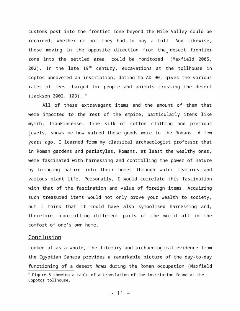
With justice served, Octavian and Antony entered into what
would be called by historians the Second Triumvirate in which
Octavian, Antony and Marcus Aemilius Lepidus (the pontifex maximus)
governed over three separate parts of the Republic: Octavian had
everything west of the Ionian Sea, Antony had everything east of
~ 2 ~
the Ionian Sea and Lepidus had northern Africa.1 However, this
Second Triumvirate did not last long and was broken up for three
main reasons: first, Lepidus’s failed attempt at rising against
Octavian and his subsequent loss of power of northern Africa to
Octavian; second, Octavian’s rising concern over the threat of
Cleopatra VII and her son, Caesarion (whom Cleopatra had boasted
was the son of Julius Caesar); and third, once Antony had decided
to abandon his wife and sister of Octavian, Octavia, and
officially enter into a relationship with Cleopatra and become a
de facto stepfather to Caesarion. The third reason was perhaps the
most significant, for Antony could not have thrown a stronger blow
at Octavian than by entering into cahoots with two of Octavian’s
most powerful enemies. All of these perceived issues culminated on
2nd September, 31 BCE during the naval Battle of Actium, a battle
that Antony and Cleopatra lost and that lead to both of them
committing suicide (Tucker 2011, 72-75).
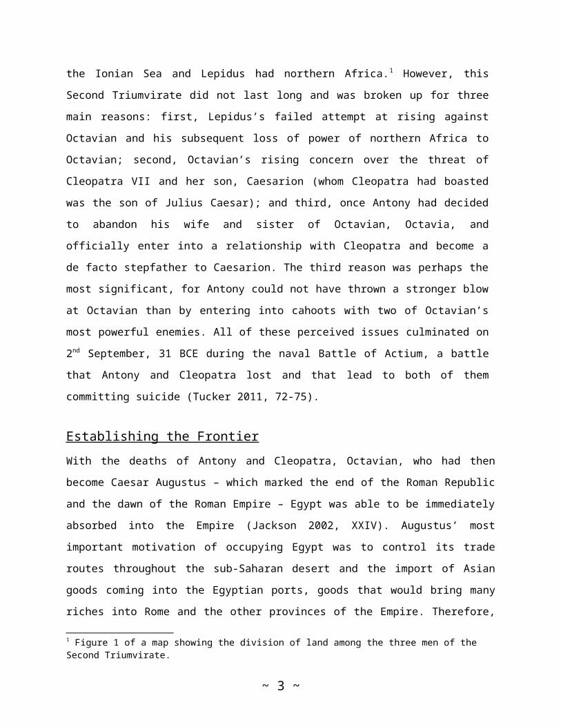
Establishing the FrontierWith the deaths of Antony and Cleopatra, Octavian, who had then
become Caesar Augustus – which marked the end of the Roman Republic
and the dawn of the Roman Empire – Egypt was able to be immediately
absorbed into the Empire (Jackson 2002, XXIV). Augustus’ most
important motivation of occupying Egypt was to control its trade
routes throughout the sub-Saharan desert and the import of Asian
goods coming into the Egyptian ports, goods that would bring many
riches into Rome and the other provinces of the Empire. Therefore,
1 Figure 1 of a map showing the division of land among the three men of the Second Triumvirate.
~ 3 ~
Augustus acted immediately on controlling his new territory. The
first things that he initiated were to assign a trusted Roman
governor to manage the region and send in a substantial amount of
the newly fashioned Roman Imperial soldiers to protect it from any
internal and external adversaries, as well as three Roman legions,
each of which consisted of 5.600 men to occupy the province (ibid).
By the time of Hadrian, only one legion remained in Alexandria and
the rest of the troops were spread throughout the province,
especially along the Nile (Breeze 2011, 129). By the time of the
later period of the Roman occupation of Egypt (early 4th century AD
onward), the region east of the Nile was styled a limes, however
this may have been the case prior to the fourth century as well
(Bard 1999, 683-684). Despite at some point being designated a
limes, I do not feel that Roman Egypt truly followed the model of
linear barriers expressed in David Breeze’s book, The Frontiers of
Imperial Rome, because, as it will be demonstrated throughout this
essay, the Roman occupation of Egypt and the forts that were set up
along the trade routes were meant to oversee, protect and control
these trade routes, meaning that the Romans were economically
motivated by the value of the items that were brought through the
desert trade routes and on their way to the rest of the Roman
Empire.
Although one of their chief concerns was maintaining control
over the trade routes and ensuring peace between the Egyptians and
the Jews in the more populous areas, the soldiers were also engaged
in a myriad of public works, such as building bridges, roads,
canals and serving as supervisors in the mines and quarries of the
~ 4 ~
Eastern Desert (ibid; Jackson 2002, XXIV). The soldiers were also
commissioned with building Roman forts near the ports, the various
oases and, most particularly, along key points of the trade routes,
which would aid in overseeing them.
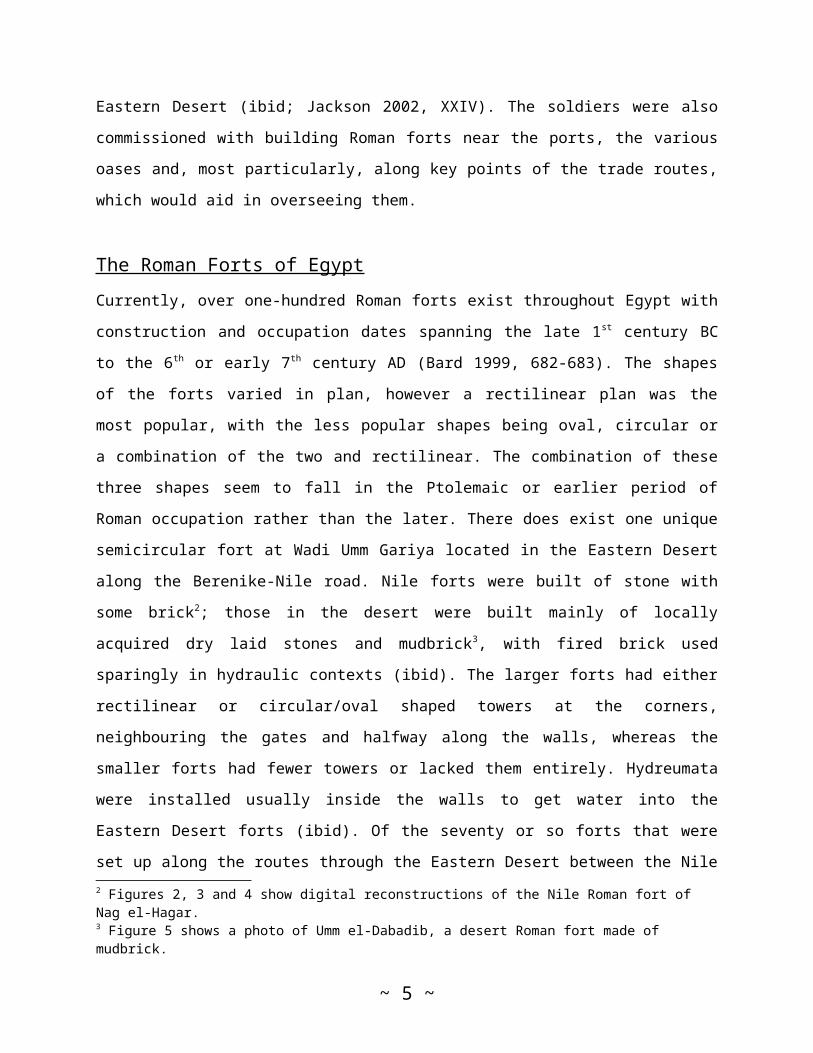
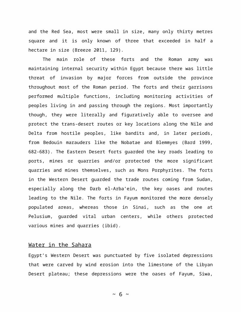
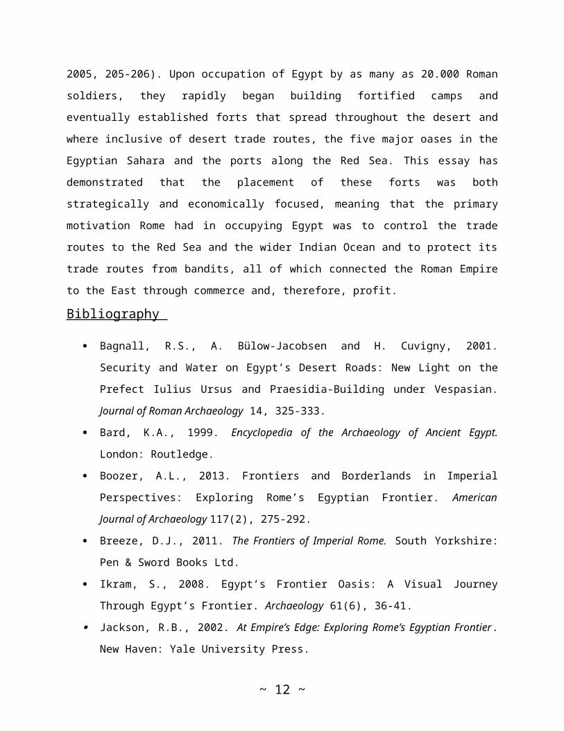
The Roman Forts of EgyptCurrently, over one-hundred Roman forts exist throughout Egypt with
construction and occupation dates spanning the late 1st century BC
to the 6th or early 7th century AD (Bard 1999, 682-683). The shapes
of the forts varied in plan, however a rectilinear plan was the
most popular, with the less popular shapes being oval, circular or
a combination of the two and rectilinear. The combination of these
three shapes seem to fall in the Ptolemaic or earlier period of
Roman occupation rather than the later. There does exist one unique
semicircular fort at Wadi Umm Gariya located in the Eastern Desert
along the Berenike-Nile road. Nile forts were built of stone with
some brick2; those in the desert were built mainly of locally
acquired dry laid stones and mudbrick3, with fired brick used
sparingly in hydraulic contexts (ibid). The larger forts had either
rectilinear or circular/oval shaped towers at the corners,
neighbouring the gates and halfway along the walls, whereas the
smaller forts had fewer towers or lacked them entirely. Hydreumata
were installed usually inside the walls to get water into the
Eastern Desert forts (ibid). Of the seventy or so forts that were
set up along the routes through the Eastern Desert between the Nile2 Figures 2, 3 and 4 show digital reconstructions of the Nile Roman fort of Nag el-Hagar.3 Figure 5 shows a photo of Umm el-Dabadib, a desert Roman fort made of mudbrick.
~ 5 ~
and the Red Sea, most were small in size, many only thirty metres
square and it is only known of three that exceeded in half a
hectare in size (Breeze 2011, 129).
The main role of these forts and the Roman army was
maintaining internal security within Egypt because there was little
threat of invasion by major forces from outside the province
throughout most of the Roman period. The forts and their garrisons
performed multiple functions, including monitoring activities of
peoples living in and passing through the regions. Most importantly
though, they were literally and figuratively able to oversee and
protect the trans-desert routes or key locations along the Nile and
Delta from hostile peoples, like bandits and, in later periods,
from Bedouin marauders like the Nobatae and Blemmyes (Bard 1999,
682-683). The Eastern Desert forts guarded the key roads leading to
ports, mines or quarries and/or protected the more significant
quarries and mines themselves, such as Mons Porphyrites. The forts
in the Western Desert guarded the trade routes coming from Sudan,
especially along the Darb el-Arba’ein, the key oases and routes
leading to the Nile. The forts in Fayum monitored the more densely
populated areas, whereas those in Sinai, such as the one at
Pelusium, guarded vital urban centers, while others protected
various mines and quarries (ibid).
Water in the SaharaEgypt’s Western Desert was punctuated by five isolated depressions
that were carved by wind erosion into the limestone of the Libyan
Desert plateau; these depressions were the oases of Fayum, Siwa,
~ 6 ~
Bahariya, Farafra, Dakhla and Kharga (Jackson 2002, 159). These
oases range in depth from thirty to 120 metres above sea level and
the porous sandstone that underlies the limestone is fairly close
to the surface, thereby making the water trapped within the
sandstone accessible either by digging and installing wells or,
occasionally, simply by tapping natural springs that flowed through
the area. The water itself came from rain that had fallen far to
the south in the Sudan and from outflow that occurred in the upper
stretches of the Nile River. In both instances, this water
permeated the sandstone and drifted northwards under the
depressions of Egypt’s Western Desert where, when tapped, it
facilitated substantial populations of people to live in these
oases and support themselves by farming (ibid). This is why some of
the larger desert Roman forts, such as at Siwa, can be found around
these oases.4
When not within an oases vicinity, the Romans and the
Ptolemy’s before them were still able to recover water in more
inhospitable areas of the Western Egyptian Desert by digging deeper
into the desert sand and installing wells and cisterns that could
sustain a significantly smaller population than the areas around
the oases. Therefore the Romans were able to have smaller forts and
outposts installed and successfully manned in the more remote areas
of the desert trade routes. To make these remote areas even more
fiscally successful by means of the trade routes, the Romans and
the Greeks before them, constructed or rebuilt hydreumata, which
were fortified watering stations, that both commercial and military
travellers, independent traders and camel caravans had access to4 Figures 6 and 7 of Siwa Oasis and its archaeological remains.
~ 7 ~
while passing through. Another function of these hydreumata, along
with the watchtowers that were often near them, was to defend the
vital wells from attacks by marauding desert peoples (Jackson 2002,
98).
Trade in the Sahara and the Red Sea“The Eastern Desert, a hyper-arid area devoid of permanent,
agricultural habitation, was an area of intense commercial
activity-trade with the East and South via the Red Sea ports
(Myos Hormos and Berenike) and exploitation of the rich
mineral resources of the Red Sea Mountains. Protection and
control of this commerce accounts for the plethora of small
military posts which line the roads and oversee the quarries”
(Maxfield 2005, 201).
The minimal literary evidence that remains and, most importantly,
the archaeological excavations in Egypt and elsewhere in the Red
Sea-Indian Ocean region suggest that in the early Roman occupation
maritime commerce with Southern Arabia, India, Sri Lanka and
coastal sub-Saharan Africa reached its zenith (Bard 1999, 685). The
Asian goods coming in from the Red Sea had to be brought in through
one of the seven main Egyptian ports: Clysma, Abu Sha'ar,
Philoteras, Leukos, Limen, Myos Hormos, Nechesia, and
Berenike. Most of these ports were established by the Ptolemies,
but the Romans were responsible for largely expanding their
economic significance (Jackson 2002, 76). All of these ports had
routes connecting them to emporia on the Nile and all the trans-
desert Red Sea-Nile routes had way-stations, many of which were
~ 8 ~
hydreumata, that were closely monitored by the Roman military (Bard
1999, 685).
One of the most vital of these Egyptian Red Sea ports was
Berenike. Since excavations began at Berenike over twenty years
ago, archaeologists have uncovered many fascinating artefacts that
span nearly eight centuries. These artefacts include “papyrus
fragments, ostraca, Persian Gulf and Indian pottery, enameled
glass, Axumite (Ethopian) Indiana and Sri Lankan beads, coins,
Indian resist-dye textiles, coconut, rice, teak wood, pieces of
shell jewelry, an ivory bracelet, emeralds, and several fake
emeralds made of chloride” (Jackson 2002, 87). There is also
evidence which shows that goods brought into Berenike constituted
the bulk of Asian and Sub-Saharan merchandise that the Romans
imported to other parts of the empire along the desert trade
routes. Some of these items include from Ethiopia – ivory (such as
rhinoceros horns), tortoise shells and myrrh; from northern Somalia
– myrrh, frankincense and slaves; from Arabia – myrrh, white
marble, aloe and frankincense; from northwestern India – nard (a
type of perfume), myrrh, indigo, turquoise, lapis lazuli, onyx,
agate, ivory, cotton cloth, fine cotton garments, silk cloth and
yard, Chinese pelts and pepper; and from
south and southwestern India – malbathron, pearls, transparent
gems, diamonds, sapphires and fine cotton garments (Jackson 2002,
87). All of these imported goods nurtured the Romans taste for
showy extravagance of expensive items (Jackson 2002, 88).
Loaded with such luxurious goods, the cargo of one single ship
could earn merchants astonishing profits, regardless of the 25% tax
~ 9 ~
imposed on all goods imported into Berenike. One remaining papyrus
concerning a shipment from Muziris, India to Alexandria included
some 700 to 1.700 pounds of nard, more than 4.700 pounds of ivory,
and 790 pounds of textiles all of which valued at 131 talents,
which would have been enough to purchase 2.400 acres of the finest
farmland in Egypt! Perhaps most outstanding of all was that this
shipment was only a small portion of the entire cargo (ibid)!
Acquiring ethnic material riches from the south of Egypt and
Asia into the Empire from the various Red Sea ports and along the
desert trade routes was certainly beneficial to the Roman economy,
but the most important product was the grain that was produced in
the extremely fertile Delta, Nile Valley and in the large western
oases. With often providing two or three harvests per year (Jackson
2002, 158) the annual output of the grain in these parts of Egypt
would provide approximately one-third of Rome’s total grain
consumption (Jackson 2002, XXIV). Although not now as verdant as in
antiquity, since much of the water supply has disappeared, the
various oases, particularly Kharga, operated as a rich agricultural
center that was capable of producing wheat, barley, a wide variety
of fruits and vegetables all of which began its venture to other
parts of the Roman Empire on the desert trade routes of Egypt.
The maintenance and protection of the trade routes and
hydreumata in the Easter Desert was expensive for the Roman
military. To compensate for these expenses, the Romans established
the Coptos Tariff for all people who used the desert trade routes.
“While the purpose of the toll was clearly fiscal, the mechanism by
which it was enforced will have meant that all who passed by the
~ 10 ~
customs post into the frontier zone beyond the Nile Valley could be
recorded, whether or not they had to pay a toll. And likewise,
those moving in the opposite direction from the desert frontier
zone into the settled area, could be monitored” (Maxfield 2005,
202). In the late 19th century, excavations at the tollhouse in
Coptos uncovered an inscription, dating to AD 90, gives the various
rates of fees charged for people and animals crossing the desert
(Jackson 2002, 103). 5
All of these extravagant items and the amount of them that
were imported to the rest of the empire, particularly items like
myrrh, frankincense, fine silk or cotton clothing and precious
jewels, shows me how valued these goods were to the Romans. A few
years ago, I learned from my classical archaeologist professor that
in Roman gardens and peristyles, Romans, at least the wealthy ones,
were fascinated with harnessing and controlling the power of nature
by bringing nature into their homes through water features and
various plant life. Personally, I would correlate this fascination
with that of the fascination and value of foreign items. Acquiring
such treasured items would not only prove your wealth to society,
but I think that it could have also symbolised harnessing and,
therefore, controlling different parts of the world all in the
comfort of one’s own home.
ConclusionLooked at as a whole, the literary and archaeological evidence from
the Egyptian Sahara provides a remarkable picture of the day-to-day
functioning of a desert limes during the Roman occupation (Maxfield5 Figure 8 showing a table of a translation of the inscription found at the Copotos tollhouse.
~ 11 ~
2005, 205-206). Upon occupation of Egypt by as many as 20.000 Roman
soldiers, they rapidly began building fortified camps and
eventually established forts that spread throughout the desert and
where inclusive of desert trade routes, the five major oases in the
Egyptian Sahara and the ports along the Red Sea. This essay has
demonstrated that the placement of these forts was both
strategically and economically focused, meaning that the primary
motivation Rome had in occupying Egypt was to control the trade
routes to the Red Sea and the wider Indian Ocean and to protect its
trade routes from bandits, all of which connected the Roman Empire
to the East through commerce and, therefore, profit.
Bibliography
Bagnall, R.S., A. Bülow-Jacobsen and H. Cuvigny, 2001.
Security and Water on Egypt’s Desert Roads: New Light on the
Prefect Iulius Ursus and Praesidia-Building under Vespasian.
Journal of Roman Archaeology 14, 325-333.
Bard, K.A., 1999. Encyclopedia of the Archaeology of Ancient Egypt.
London: Routledge.
Boozer, A.L., 2013. Frontiers and Borderlands in Imperial
Perspectives: Exploring Rome’s Egyptian Frontier. American
Journal of Archaeology 117(2), 275-292.
Breeze, D.J., 2011. The Frontiers of Imperial Rome. South Yorkshire:
Pen & Sword Books Ltd.
Ikram, S., 2008. Egypt’s Frontier Oasis: A Visual Journey
Through Egypt’s Frontier. Archaeology 61(6), 36-41.
Jackson, R.B., 2002. At Empire’s Edge: Exploring Rome’s Egyptian Frontier.
New Haven: Yale University Press.
~ 12 ~
Karelin, D.A., 2011. Imaging of the Late Roman Castrum.
Hypothetical Computer Reconstruction of Nag el-Hagar in Egypt.
Architecture and Modern Information Technologies 2(15), 1-20.
Kirwan, L.P., 1957. Rome Beyond the Southern Egyptian
Frontier. The Geographical Journal 123(1), 13-19.
Maxfield, V., 2005. Organisation of a desert limes: The case
of Egypt. In: Z. Visy (ed), Limes XIX, Proceedings of the XIXth
International Congress of Roman Frontier Studies, September 2003. Pécs,
Hungary, 201-210.
Tucker, S.C., 2011. Battles That Changed History: An Encyclopedia of World
Conflict. Santa Barbara: ABC-CLIO, LLC.
Wiseman, R., 2011. On the Back of the Army: A Comparative Study of
Romanization in Britain and Egypt. Las Vegas (unpublished MA thesis
University of Nevada, Las Vegas).
Figures
~ 13 ~
Figure 1: The division of the Second Triumvirate(http://dustinsimmons.blogspot.nl/2011/09/too-crowded-at-top-antony-octavian.html).
~ 14 ~
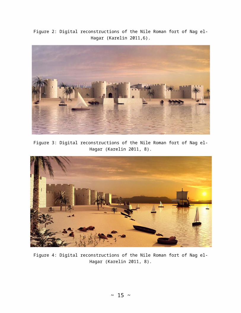
Figure 2: Digital reconstructions of the Nile Roman fort of Nag el-Hagar (Karelin 2011,6).
Figure 3: Digital reconstructions of the Nile Roman fort of Nag el-Hagar (Karelin 2011, 8).
Figure 4: Digital reconstructions of the Nile Roman fort of Nag el-Hagar (Karelin 2011, 8).
~ 15 ~
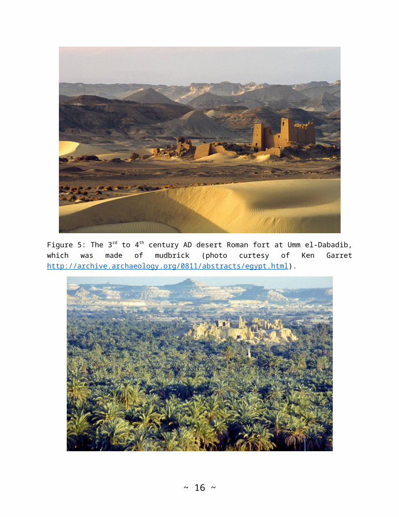
Figure 5: The 3rd to 4th century AD desert Roman fort at Umm el-Dabadib,which was made of mudbrick (photo curtesy of Ken Garrethttp://archive.archaeology.org/0811/abstracts/egypt.html).
~ 16 ~
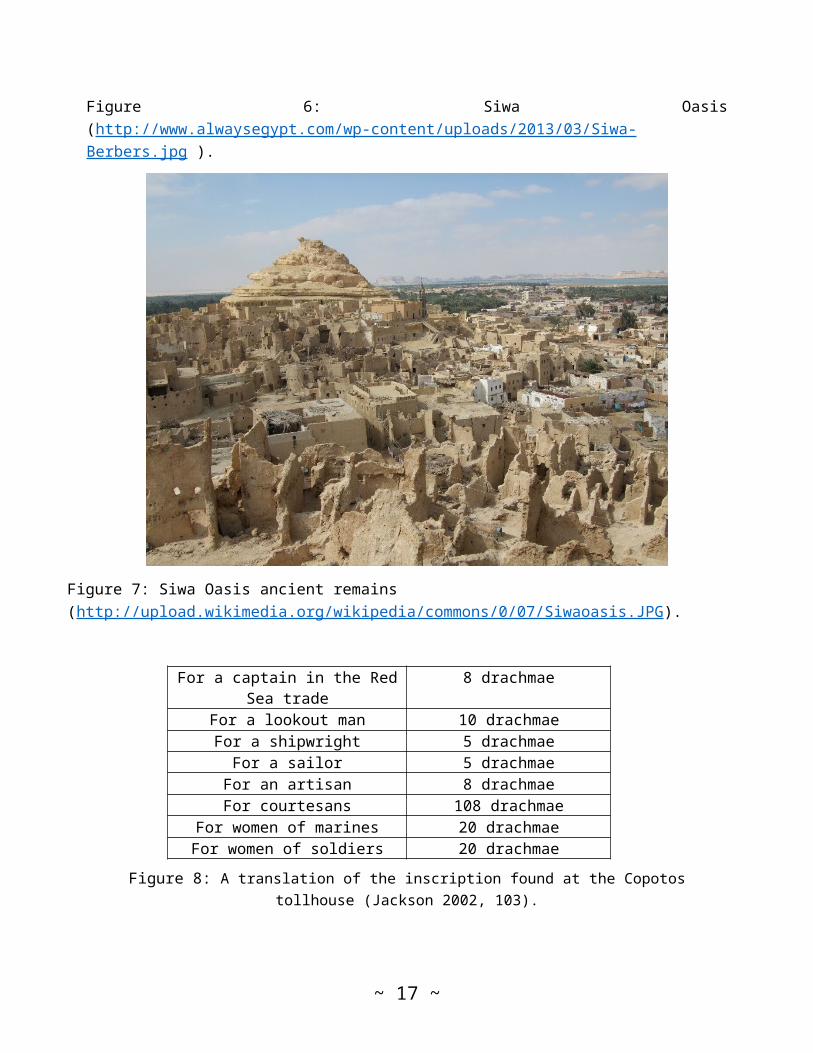
Figure 6: Siwa Oasis(http://www.alwaysegypt.com/wp-content/uploads/2013/03/Siwa-Berbers.jpg ).
Figure 7: Siwa Oasis ancient remains (http://upload.wikimedia.org/wikipedia/commons/0/07/Siwaoasis.JPG).
For a captain in the RedSea trade
8 drachmae
For a lookout man 10 drachmaeFor a shipwright 5 drachmae
For a sailor 5 drachmaeFor an artisan 8 drachmaeFor courtesans 108 drachmae
For women of marines 20 drachmaeFor women of soldiers 20 drachmae
Figure 8: A translation of the inscription found at the Copotostollhouse (Jackson 2002, 103).
~ 17 ~
~ 18 ~

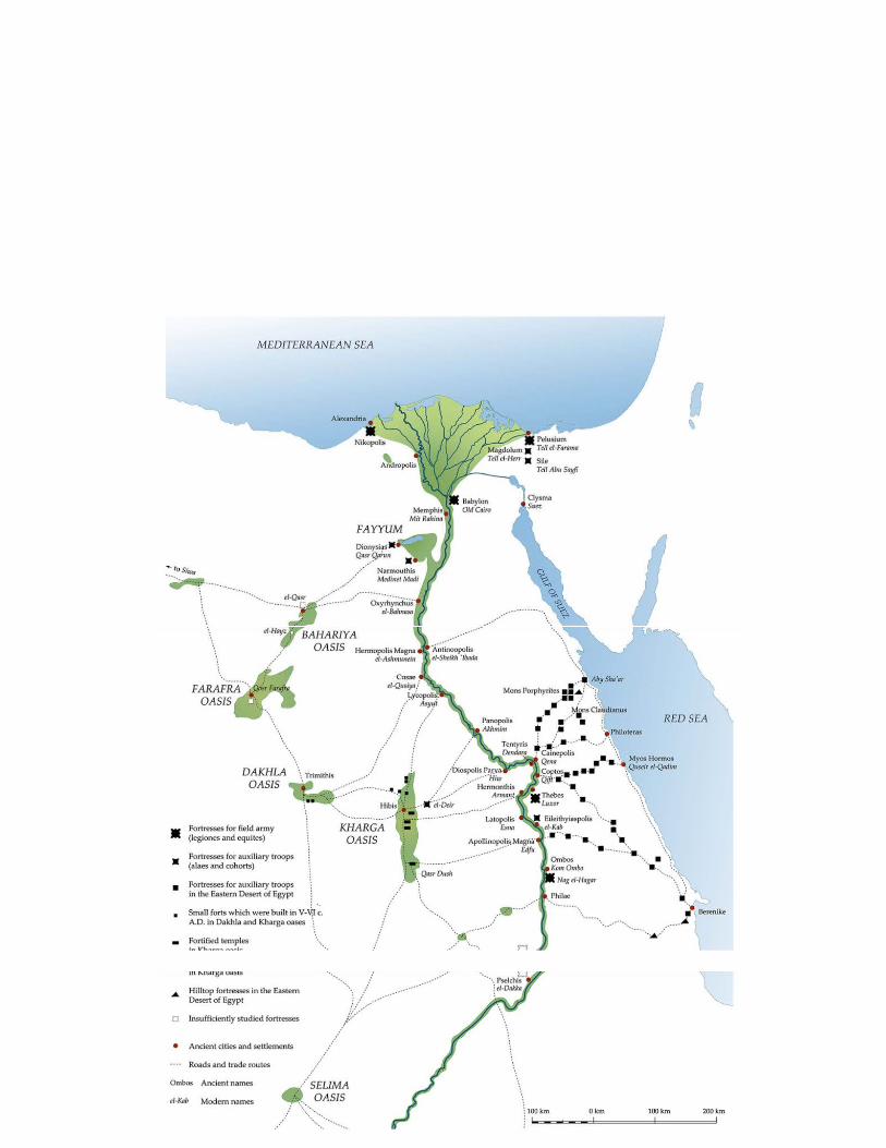
Figure 9: Map of Roman forts, oases and trade routes (Karelin 2011,3).
~ 19 ~