United States Department of the Interior
178
United States Department of the Interior FISH AND WILDLIFE SERVICE Texas Coastal Ecological Services Field Office 4444 Corona Drive, Suite 215 Corpus Christi, Texas 78411 361/994-9004 / (FAX) 361/994-8262 In Reply refer to: 02ETCC00-2012-F-0186-R001 May 12, 2022 Stacey Zee Office of Commercial Space Transportation Federal Aviation Administration 800 Independence Ave, SW Washington, DC 20591 Subject: SpaceX Starship/Super Heavy Launch Vehicle Program at the SpaceX Boca Chica Launch Site, Cameron County, Texas Dear Ms. Zee: This document transmits the U.S. Fish and Wildlife Service’s (Service) final biological and conference opinion (BCO) based on our review of the effects of the Federal Aviation Administration (FAA)’s proposed issuance of an experimental permit and/or vehicle operator license to SpaceX for the Starship/Super Heavy Launch Vehicle Program at the Boca Chica Launch Site in Cameron County, Texas. The conference opinion refers to proposed red knot critical habitat. SpaceX’s program requires an experimental permit and/or a vehicle operator license from the FAA. The BCO analyzes the potential effects of the issuance of those permits and/or licenses on the endangered northern aplomado falcon (Falco femoralis septentrionalis), Gulf Coast jaguarundi (Herpailurus yagouaroundi cacomitli), ocelot (Leopardus pardalis), Kemp’s ridley sea turtle (Lepidochelys kempii), hawksbill sea turtle (Eretmochelys imbricata), leatherback sea turtle (Dermochelys coriacea) and threatened loggerhead sea turtle (Caretta caretta), green sea turtle (Chelonia mydas), piping plover (Charadrius melodus) and piping plover critical habitat, red knot (Calidris canutus rufa) and proposed red knot critical habitat, pursuant to section 7(a)(2) of the Endangered Species Act of 1973 (Act), as amended (16 U.S.C. 1531 et seq.). Your request for formal consultation was received on June 21, 2021. We initiated consultation on October 6, 2021. The FAA determined the Proposed Action may affect but was not likely to adversely affect the threatened West Indian manatee (Trichechus manatus), eastern black rail (Laterallus jamaicensis ssp. jamaicensis) and those concurrences are given in Appendix A. The FAA further determined the Proposed Action would have no effect on the endangered South Texas ambrosia (Ambrosia cheiranthifolia) and Texas ayenia (Ayenia limitaris). The Service does
-
Upload
khangminh22 -
Category
Documents
-
view
0 -
download
0
Transcript of United States Department of the Interior

United States Department of the Interior FISH AND WILDLIFE SERVICE
Texas Coastal Ecological Services Field Office 4444 Corona Drive, Suite 215 Corpus Christi, Texas 78411 361/994-9004 / (FAX) 361/994-8262
In Reply refer to: 02ETCC00-2012-F-0186-R001
May 12, 2022
Stacey Zee Office of Commercial Space Transportation Federal Aviation Administration 800 Independence Ave, SW Washington, DC 20591
Subject: SpaceX Starship/Super Heavy Launch Vehicle Program at the SpaceX Boca Chica
Launch Site, Cameron County, Texas
Dear Ms. Zee:
This document transmits the U.S. Fish and Wildlife Service’s (Service) final biological and conference opinion (BCO) based on our review of the effects of the Federal Aviation Administration (FAA)’s proposed issuance of an experimental permit and/or vehicle operator license to SpaceX for the Starship/Super Heavy Launch Vehicle Program at the Boca Chica Launch Site in Cameron County, Texas. The conference opinion refers to proposed red knot critical habitat. SpaceX’s program requires an experimental permit and/or a vehicle operator license from the FAA. The BCO analyzes the potential effects of the issuance of those permits and/or licenses on the endangered northern aplomado falcon (Falco femoralis septentrionalis), Gulf Coast jaguarundi (Herpailurus yagouaroundi cacomitli), ocelot (Leopardus pardalis), Kemp’s ridley sea turtle (Lepidochelys kempii), hawksbill sea turtle (Eretmochelys imbricata), leatherback sea turtle (Dermochelys coriacea) and threatened loggerhead sea turtle (Caretta caretta), green sea turtle (Chelonia mydas), piping plover (Charadrius melodus) and piping plover critical habitat, red knot (Calidris canutus rufa) and proposed red knot critical habitat, pursuant to section 7(a)(2) of the Endangered Species Act of 1973 (Act), as amended (16 U.S.C. 1531 et seq.). Your request for formal consultation was received on June 21, 2021. We initiated consultation on October 6, 2021.
The FAA determined the Proposed Action may affect but was not likely to adversely affect the threatened West Indian manatee (Trichechus manatus), eastern black rail (Laterallus jamaicensis ssp. jamaicensis) and those concurrences are given in Appendix A. The FAA further determined the Proposed Action would have no effect on the endangered South Texas ambrosia (Ambrosia cheiranthifolia) and Texas ayenia (Ayenia limitaris). The Service does
2
not provide concurrences on no effect determinations and these species will not be further addressed in this BCO.
The monarch butterfly (Danaus plexippus) is a candidate species under consideration for official listing. On December 15, 2020, the Service issued a 12-month finding on a petition to list the monarch butterfly under the Act. Based on a thorough review of the monarch’s status, the Service determined that listing is warranted but precluded by higher priority listing actions. The decision is the result of an extensive status review of the monarch that compiled and assessed the monarch’s current and future status. The monarch is now a candidate under the Act and its status will be reviewed annually until a listing decision is made. There are generally no section 7 requirements for candidate species, but we encourage all agencies to take advantage of any opportunity they may have to conserve the species. Possible actions that may assist in the conservation of the monarch are listed in the Conservation Recommendations.
This BCO is based on information provided in the Biological Assessment (BA) SpaceX Starship/Super Heavy Launch Vehicle Program at the SpaceX Boca Chica Launch Site, Cameron County, Texas, October 2021, the Draft Programmatic Environmental Assessment (PEA) for the SpaceX Starship/Super Heavy Launch Vehicle Program at the SpaceX Boca Chica Launch Site in Cameron County, Texas, September 2021 (PEA), the March 2022 Administrative Final PEA, telephone conversations and correspondence with SpaceX and FAA and, field investigations, meetings, workshops and other sources of information. Literature cited in this BCO is not a complete bibliography of all literature available on the species of concern, and its effects, or on other subjects considered in this opinion. A complete administrative record of this consultation is on file at the Texas Coastal Ecological Field Office located in Corpus Christi, Texas.
The SpaceX Boca Chica Launch Site is located in Cameron County, Texas, near the cities of Brownsville and South Padre Island (Figure 1 and Figure 2). The Boca Chica Launch Site consists of:
• the Vertical Launch Area (VLA), a 47.4-acre parcel of land owned by SpaceX located along the south side of SH 4 just inland from Boca Chica Beach;
• a Launch and Landing Control Center (LLCC), which is a two-story building (referred to as Stargate) located on the north side of State Highway (SH) 4 approximately 2 miles west of the VLA;
• a solar farm located on the north side of SH 4 approximately 1.5 miles west of the VLA; and
• a parking lot on SpaceX-owned land on the north side of SH 4 across from the VLA.
SH 4 provides the only land access to the Boca Chica Launch Site, as well as Boca Chica Beach, Texas Parks and Wildlife Department’s (TPWD) Boca Chica State Park, and other land.

3
Activities subject to the FAA’s issuance of an experimental permit and/or a vehicle operator license to SpaceX for the Starship/Super Heavy Launch Vehicle Program at the Boca Chica Launch Site include, as described in more detail below:
• New construction at the VLA that expands the previously developed area by approximately 23 acres and improves the surface of an existing parking lot on the north side of SH 4;
• New construction to expand the existing solar farm by 1.7 acres, building a payload production facility on previously developed land near the existing production and manufacturing area; and use of a SODAR system;
• New construction within the SH 4 existing right-of-way between the VLA and LLCC to add pull-offs and to install additional trenched utilities; and
• Annual launch-related operations that include tests, launches, and landings of the Starship and/or Super Heavy launch vehicles (Table 3).
The activities summarized above have consequences that contribute to effects of the action considered in this BCO. In addition, effects of the action may also arise from responses to anomalies that may occur with launch-related operations, such as debris removal, and from increased personnel and activity related to the day-to-day use, maintenance, monitoring, and security of the facilities at the Boca Chica Launch Site.
SpaceX previously constructed and continues to use facilities at the VLA, parking lot on the north side of SH 4, solar farm, and production and manufacturing area (which is located on the north side of SH 4 approximately 2 miles west of the VLA, and near the LLCC) for purposes that are not related to the Proposed Action. Some of these facilities and uses were related to the SpaceX Falcon/Falcon Heavy launch program addressed in the original BCO from 2013 (Consultation No. 02ETCC00-2012-F-0186). These previously constructed facilities and related uses would occur even in the absence of the Proposed Action. The previously constructed SpaceX facilities and related uses are part of the environmental baseline of the Action Area considered in this BCO.
The Boca Chica Launch Site is located in a sparsely populated coastal area adjacent to the Gulf of Mexico, characterized by sand dunes, beach, wind tidal flats, and lomas, or ancient clay dunes. The VLA is approximately 2.2 miles north of the U.S./Mexico border and the LLCC is approximately 1.3 miles north of the U.S./Mexico border. The VLA lies south of Boca Chica State Park, Brazos Island State Park, and parts of the Lower Rio Grande Valley National Wildlife Refuge (LRGVNWR), and east of the Palmito Ranch Battlefield National Historic Landmark (NHL) (Figure 3).
CONSULTATION HISTORY Please see Appendix B for a more detailed consultation history.

4
BIOLOGICAL OPINION
DESCRIPTION OF PROPOSED ACTION
As the lead federal agency, the FAA is responsible for analyzing the potential environmental impacts of the Proposed Action. The Commercial Space Launch Act of 1984, as amended and codified at 51 U.S.C. §§ 50901–50923, authorizes the Secretary of Transportation to oversee, license, and regulate commercial launch and reentry activities, and the operation of launch and reentry sites within the United States or as carried out by U.S. citizens.
Regulations implementing the Act (50 CFR 402.02) define “action” as “all activities or programs of any kind authorized, funded, or carried out, in whole or in part, by federal agencies of the United States or upon the high seas.” The FAA’s Proposed Action is to issue one or more experimental permits and/or a vehicle operator license to SpaceX that would allow SpaceX to launch and return Starship/Super Heavy and operate additional facilities at the Boca Chica Launch Site. FAA’s environmental review includes the construction of launch related infrastructure. SpaceX’s goal is to use Starship/Super Heavy for low Earth orbit (relatively close to Earth’s surface), sun-synchronous orbit (traveling over the Polar Regions), geostationary transfer orbit (an elliptical orbit), and interplanetary missions (crewed or un- crewed missions to the moon or Mars) and provide greater mission capability to National Aeronautics and Space Administration, Department of Defense, and commercial customers.
Activities subject to the FAA’s issuance of an experimental permit and/or a vehicle operator license to SpaceX for the Starship/Super Heavy Launch Vehicle Program at the Boca Chica Launch Site include, as described in more detail below:
• New construction at the VLA that expands the previously developed area by approximately 23 acres and improves the surface of an existing parking lot on the north side of SH 4;
• New construction to expand the existing solar farm by 1.7 acres, build a payload production facility on previously developed land near the existing production and manufacturing area; and use of a SODAR system;
• New construction within the SH 4 existing right-of-way between the VLA and LLCC to add pull-offs and to install additional trenched utilities; and
• Annual launch-related operations that include tests, launches, and landings of the Starship and/or Super Heavy launch vehicles (Table 3).
In addition, effects of the action may also arise from responses to anomalies that may occur with launch-related operations, such as debris removal, and from increased personnel and activity related to the day-to-day use, maintenance, monitoring, and security of the facilities at the Boca Chica Launch Site.
Table 1 outlines the elements of the Proposed Action being analyzed in this BCO.

5
Table 1. Elements of the Proposed Action
FAA Proposed Action Elements of SpaceX’s Proposal
Brief Description
Issuance of Experimental Permit or Vehicle Operator License
Test and Launch Operations
• Starship Static Fire Engine Tests
• Super Heavy Static Fire Engine Tests
• Starship Suborbital Launch
• Super Heavy Launch • Starship landing at
the VLA, on a floating platform in the Gulf of Mexico or the Pacific Ocean, or expended in the Gulf of Mexico or Pacific Ocean
• Super Heavy landing at the VLA, on a floating platform in the Gulf of Mexico, or expended in the Gulf of Mexico
Tank Tests
Test the structural capability of the launch vehicle stages
Nominal Operational Access Restrictions
SpaceX anticipates the proposed operations would require 500 hours of annual access restriction of SH 4 and Boca Chica Beach
Anomaly Response Access Restrictions
If an anomaly occurred, SpaceX anticipates debris cleanup would require up to 300 hours of annual access restriction of SH 4 and Boca Chica Beach. The 300 hours are in addition to the 500 hours of Nominal Operational Access Restrictions.
Related Infrastructure • Redundant Launch
6
Construction Pad (Launch Pad B) and Commodities (approximately 15 vertical tanks)
• Redundant Landing Pad
• Integration Tower B • Tank Structural Test
Stands • Support Buildings
and Parking Lots • Trenching • Payload Processing
Facility • Expanded Solar Farm • State Highway 4
Pull-offs
The Proposed Action does not include the construction or operation of infrastructure related to non-licensed SpaceX activities in areas such as SpaceX’s private production and manufacturing area. The FAA considers the constructed and operational elements at the production and manufacturing area to have independent utility because the components being manufactured there can be shipped and utilized at other SpaceX launch sites.
One of the proposed 480-foot integration towers and orbital pad (see “A” on Figure 8) has already been constructed without federal involvement or section 7 consultation and only the operation of this tower will be evaluated in this BCO. The parking lot on the north side of SH 4 near the VLA was previously cleared and is currently being used for parking, which did not require federal involvement and did not undergo section 7 consultation. Only improvement of the parking lot surface is evaluated in the effects of the action.
The Service understands from ongoing coordination with FAA and SpaceX that SpaceX is no longer proposing to construct the desalination plant, power plant, liquefier, and natural gas pre- treatment system that were described in the October 2021 BA and the September 2021 draft PEA. These former elements of the Proposed Action are not evaluated in this BCO.
The following sections describe the elements of the Proposed Action and related activities that are effects of the Proposed Action. Additional details about these elements and activities occurs in the October 2021 BA and the March 2022 Administrative Final PEA.
Launch Vehicle While the manufacture and production of the Starship and Super Heavy launch vehicles are not part of the Proposed Action, understanding the characteristics of these vehicles is important context for understanding the effects of the action.

7
A fully integrated Starship/Super Heavy launch vehicle is comprised of two stages: Super Heavy is the first stage (or booster) and Starship is the second stage (Figure 4). The fully integrated Starship/Super Heavy launch vehicle is expected to be approximately 400 feet tall and 30 feet in diameter compared to the 224-foot Falcon 9 and Falcon Heavy proposed in the 2014 EIS. As designed, both stages are reusable, with any potential refurbishment actions taking place at existing and proposed SpaceX facilities. Both stages are expected to have minimal post-flight refurbishment requirements; however, they might require periodic maintenance and upgrades.
Super Heavy is expected to be equipped with up to 37 Raptor engines, and Starship would have up to six Raptor engines. The Raptor engine is powered by liquid oxygen (LOX) and liquid methane (LCH4) in a 3.6:1 mass ratio, respectively. Super Heavy is expected to hold up to 3,700 metric tons (MT) of propellant and Starship would hold up to 1,500 MT of propellant. Super Heavy, with all 37 engines, would have a maximum lift-off thrust of 74 Meganewtons, allowing for a maximum lift-off mass of approximately 5,000 MT. One Meganewton is exactly 1X10⁶ Newtons. One Newton is a force capable of giving a mass of one kilogram (kg) an acceleration of one meter per second. Launch propellant and commodities are currently stored at the VLA in aboveground tanks and this would continue under the Proposed Action. Commodities include liquid nitrogen (LN2), water, gaseous oxygen, gaseous methane, gaseous nitrogen, helium, hydraulic fluid, LOX, and LCH4.
Launch-related Annual Operations SpaceX would launch both orbital and suborbital missions. An orbital launch would consist of a fully integrated vehicle with the second stage (Starship) stacked on top of the booster (Super Heavy). A suborbital launch would include just the Starship. Super Heavy launch could be orbital or suborbital and could occur by itself or with Starship. Further environmental review of landing at sites not described in this document would be necessary if proposed in the future.
The Proposed Action would authorize SpaceX to conduct static fire engine tests, suborbital and orbital launches of Starship and Super Heavy, and landings of Starship and Super Heavy within specified operational limits (Table 2). Static fire engine tests of Starship or Super Heavy would only occur during the day (i.e., between the hours of 7:00 a.m. and 7:00 p.m.). SpaceX is planning to conduct most launches of Starship and/or Super Heavy during the day. However, there could be launch delays due to unforeseen issues with the launch vehicle, weather conditions, or certain mission that require launching at a specific time at night to achieve a particular orbital position. SpaceX conservatively estimates that no more than 20 percent of annual launches of Starship and/or Super Heavy (i.e., up to 2 launches per year) would occur at night.
Static fire engine tests would be very brief and the cumulative duration of such tests would not exceed 150 seconds per year for Starship or 135 seconds per year for Super Heavy (Table 2). SpaceX would perform up to 5 suborbital launches of Starship (i.e., launches not combined with Super Heavy) and up to 5 launches of Super Heavy. Super Heavy would be launched with Starship affixed to the top (Table 2). Since Starship could be launched, either alone (up to 5 times) or affixed to Super Heavy (up to 5 times), up to 10 landings of Starship could occur per year. Super Heavy landings could occur up to 5 times per year (Table 2).

8
Table 2. Proposed Annual Operations
Operation
Time
Operational Limit
Starship Static Fire Engine Test Day 150 seconds Super Heavy Static Fire Engine Test Day 135 seconds Starship Suborbital Launch Day or Night 5 launches Super Heavy Launch Day or Night 5 launches Starship Landing Day or Night 10 Super Heavy Landing Day or Night 5
The difference in operations during nighttime launch activity versus a daytime launch activity would be SpaceX requiring bright spotlighting for periods of time (sometimes days) when illuminating the launch vehicle on the launch pad. These spotlights are typically metal halide.
Static fire engine tests, suborbital launches, and orbital launches, and related landings, are scheduled and require intermittent, temporary access restrictions. Related ground support operations could occur 24 hours a day, 7 days a week, throughout the year continually illuminating the VLA and LLCC with white lighting at night to ensure the protection and safety of SpaceX personnel. Bright spotlighting, usually metal halide, also illuminates the launch vehicle on the launch pad and would be required in future activities. Per the terms and conditions of this BCO, SpaceX is required to update its Lighting Management Plan as facility design and plans progress and share the plan with the Service.
Sound Detection and Ranging (SODAR) SpaceX plans to use a SODAR device to collect weather data needed for launch and landing. The SODAR sends out a short sonic pulse every 15 minutes that can reach 92 decibels (dB) at the source and dissipates to 60 dB within 100 feet. The SODAR equipment would be located on a SpaceX private parcel in the production and manufacturing area. The exact location of the SODAR has not been identified.
SpaceX would also deploy weather balloons from a private parcel just prior to a launch to measure weather data that includes wind speeds, to create wind profiles to determine if it is safe to launch and land the vehicle. The balloons are made of latex and a radiosonde is attached to the balloon. The balloons would transmit data to SpaceX. After rising approximately 12-18 miles into the air, it would burst, shredding the balloon into pieces and falling to earth along with the radiosonde and landing in open marine waters where it would be expected to sink to the ocean floor.
Tank Tests Prior to conducting a static fire engine tests or suborbital launch of a Super Heavy or Starship prototype, SpaceX would conduct tank tests to ensure the tank’s reliability. This involves performing proof pressure tests to confirm the structural integrity of the launch vehicle. Proof pressure tests are broken into two main categories: pneumatic and cryogenic. Pneumatic proof pressure testing consists of pressurizing the launch vehicle’s tank with
9
gaseous media (either helium, nitrogen, oxygen, or methane) and holding pressure for an extended duration. Cryogenic proof pressure tests consist of loading the tank with a single propellant (typically LN2, LOX, or LCH4). The tanks are then pressurized past their rated limit to confirm their structural capability with appropriate safety factors. These proof pressure tests are designed to not release any propellant to the environment. All propellant is recycled back into the above ground system tanks after the test is completed.
In addition to the proof pressure tests, SpaceX may perform development tests on test tank articles to validate design improvements or characterize vehicle behavior. These development tests include hydrostatic and cryogenic break tests, in which the tanks are filled with water, LN2, or LOX, and pressurized to a specific limit or to deliberate failure to characterize the structural capability of the production vehicles. Break testing includes the deliberate release of the test media (water, LN2, or LOX) into the environment upon failure of the primary structure.
Tank tests could occur during the day or night. SpaceX is planning to conduct the tank tests described above for each Super Heavy and Starship prototype that is built until the test is successful. If a test is unsuccessful and results in damage to the test vehicle, a new test vehicle would be constructed and tested.
SpaceX is still determining the number of prototypes that it will build and test. For the purposes of the environmental impact analysis, SpaceX estimates a 10 percent rate of tank test anomalies; this is a conservative, upper bound estimate intended to capture the maximum potential impact. A tank test anomaly would result in an explosion. FAA’s regulatory definition of an anomaly means any condition during licensed or permitted activity that deviates from what is standard, normal, or expected, during the verification or operation of a system, process, facility, or support equipment (14 CFR 401.7). Based on analysis conducted by SpaceX, the probability of debris spreading outside of the launch pad boundary from an explosive tank test anomaly during a tank test is low and not anticipated. An anomaly during a tank test operation could result in an explosion of debris, but it is unlikely. For example, a failure could result in buckling of the tank only. If the test did result in an explosion of debris, the probability of debris spreading outside the launch pad boundary is low because this type of test does not involve mixing of explosive commodities. Given the rates above, SpaceX estimates that one tank test each month may result in a tank test anomaly and potentially an explosion.
Pre-flight Operations Pre-flight operations include mission rehearsals and static fire engine tests. The goal of mission rehearsals is to verify that all vehicle and ground systems are functioning properly, as well as to verify that all procedures are properly written. After final systems checkout, SpaceX would conduct a mission rehearsal without propellants on the launch vehicle (referred to as a dry dress rehearsal), followed by a mission rehearsal with propellants on the launch vehicle (referred to as a wet dress rehearsal) to verify full launch readiness. After completing rehearsals, SpaceX would conduct static fire engine tests. The goal of a static fire engine test is to verify engine control and performance. A static fire engine test is identical to a wet dress rehearsal, except engine ignition occurs. During a static fire engine test, the launch vehicle engines are ignited for approximately 5–15 seconds and then shut down.

10
Prior to a fully integrated Starship/Super Heavy launch, SpaceX may perform a Starship static fire engine test before being integrated with Super Heavy. SpaceX may also perform a Super Heavy static fire engine test, either by itself or with Starship integrated. SpaceX is proposing to conduct up to 135 seconds per year of static fire duration for Super Heavy and up to 150 seconds per year of static fire duration for Starship (Table 2). Static fires would only occur during the day. There may be occasions when a static fire engine test is attempted and is unsuccessful (e.g., the test results in a mishap or anomaly). If an engine test is unsuccessful, another attempt would be made.
During pre-flight operations, the launch vehicle would be connected to ground systems. After an operation involving propellant (i.e., wet dress rehearsal and static fire engine test), the propellant would be transferred back to the commodity tanks at the VLA. During an off- nominal operation (i.e., if the vehicle lost pneumatics and could not reconnect to the ground systems), SpaceX may release the LCH4 to the atmosphere. The amount of methane in the largest tank (Super Heavy) that could be released is approximately 814 tons. This represents the worst-case scenario and would be a rare, unplanned event.
Suborbital Launches SpaceX is proposing to conduct Starship suborbital launches. During a suborbital launch, Starship would launch from the VLA and ascend to high altitudes and then throttle down or shut off engines to descend, landing back at the VLA or at least 19 miles offshore and downrange either directly in the Gulf of Mexico or on a floating platform in the Gulf of Mexico. A sonic boom might be produced during descent as Starship lands downrange in the Gulf of Mexico, no closer than 19 miles from shore, but, the sonic boom would not impact land.
Following a suborbital launch, Starship would have LOX and LCH4 (approximately 10 metric tons) remaining in the tank. Remaining LOX would be vented to the atmosphere and remaining LCH4 would likely be released to the atmosphere. Due to risks to personnel, SpaceX is unable to reconnect the launch vehicle to ground systems when LCH4 remains on the vehicle. In the future, SpaceX may recycle LCH4 back into tanks at the VLA as technology and design develop.
SpaceX is proposing to conduct up to 5 Starship suborbital launches annually. Each launch would include a landing (Table 2). SpaceX will not exceed the 5 suborbital launches annually.
Orbital Launches SpaceX is proposing to conduct up to 5 Starship/Super Heavy orbital launches annually. Launches may occur during the day or night. Starship/Super Heavy missions would include cargo and human missions to various orbits, to the moon and Mars, and satellite payload missions to various orbits. Orbital launches would primarily be to low inclinations with flight north or south of Cuba that minimizes land overflight. Future launches may be higher,

11
70-degree inclination with limited overflight of remotely populated portions of Mexico. There could be multiple launches in close succession required to support a single mission (e.g., lunar resupply missions). SpaceX’s launch manifest (i.e., scheduled launches) is still being developed at this time but is expected to evolve as the Starship/Super Heavy program develops. SpaceX will not exceed five Starship/Super Heavy orbital launches annually.
Starship/Super Heavy would launch from the VLA. During a launch, the exhaust plume would surround the launch pad and surrounding areas. A heat plume would be generated from the launches and would travel away from the launch pad, with temperatures of about 300 degrees F reaching the edge of the VLA, 212 degrees F approximately 0.3 mile from the launch pad and temperatures reaching ambient (90 degrees F) 0.6 mile from the launch pad. The plume would appear clear and consist of heat (and steam if deluge water is used). If SpaceX uses a diverter, a metal structure under the launch mount to divert the rocket plume laterally away from the ground, the high temperatures would be focused in a single direction instead of extending radially from the center of the launch pad.
If deluge water is discharged on the plume during a launch or test, a cloud would form. The cloud generated would be temporary and minimal volume of water condensing from the exhaust cloud and would vaporize. If treatment or retention of stormwater or wastewater is required, water would be contained in retention ponds adjacent to the launch mount. The exact number, location, and size of the retention ponds within the VLA would be determined based on quantities of deluge water and final site plans
Orbital Landings Each Starship/Super Heavy orbital launch would include an immediate boost-back and landing of Super Heavy. Landing could occur down range in the Gulf of Mexico either on a floating platform or expended, no closer than approximately 19 miles off the coast, or at the VLA. During flight, Super Heavy’s engines would cut off at an altitude of approximately 40 miles and the Super Heavy booster would separate from Starship. Shortly thereafter, Starship’s engines would start and burn to the desired orbit location. After separation, Super Heavy would rotate and ignite to conduct the retrograde burn, which would place it in the correct angle to land. Once Super Heavy is in the correct position, the engines would be cut off. Super Heavy would then perform a controlled descent using atmospheric resistance to slow it down and guide it to the landing location. This is similar to current Falcon 9 booster landings at Cape Canaveral Space Force Station. Once near the landing location, Super Heavy would ignite its engines to conduct a controlled vertical landing and go into an automated safing sequence.
If a Super Heavy landing occurred downrange in the Gulf of Mexico on a floating platform, Super Heavy would be delivered by barge to the Port of Brownsville and transported the remaining distance to the Boca Chica Launch Site over the roadways. A floating platform would be a mobile vessel that would not attach to the seafloor.
For Super Heavy landings at the VLA and offshore, a sonic boom(s) would be generated. For landings at the VLA, the sonic boom would impact parts of Texas. Based on the modeling for Starship landings at the VLA, the sonic boom produced when landing downrange would not impact land (see Attachment 1 for the sonic boom report).

12
A maximum of 5 Super Heavy landings could occur each year (Table 2). Landings may occur during the day or night.
Similarly, each Starship/Super Heavy orbital launch would include a Starship landing after Starship completes its orbital mission. Starship landing could occur at the VLA or downrange in the Gulf of Mexico (on a floating platform or expended in the Gulf of Mexico), or Pacific Ocean (on a floating platform or expended in the Pacific Ocean) (Table 2). Starship would land vertically on the pad or platform in the Gulf of Mexico or Pacific Ocean and go into an automated safing sequence (i.e., put the vehicle in a safe state).
As Starship slows down during its landing approach, a sonic boom(s) would be generated and impact parts of Texas when landing at the VLA. Based on the modeling for Starship landings at the VLA, the sonic boom produced when landing downrange would not impact land (see Attachment 1 for the sonic boom report).
After Starship is in a safe state, a mobile hydraulic lift would raise Starship onto a transporter. If a Starship landing occurred downrange on a floating platform, it would be delivered by barge to the Port of Brownsville and transported the remaining distance to the Boca Chica Launch Site over roadways. If a Starship lands at the VLA the vehicle would be transported from the landing pad to the adjacent launch mount or to one of SpaceX’s production locations for refurbishment.
Following an orbital launch, Starship and Super Heavy would have remaining LOX and LCH4 in the vehicle. Remaining LOX would be vented to the atmosphere and remaining LCH4 would likely be released to the atmosphere. Due to risks to personnel, SpaceX is unable to reconnect the vehicle to ground systems when LCH4 remains on the vehicle. Super Heavy would have approximately 5 metric tons of LCH4 onboard following an orbital flight. In the future, SpaceX may recycle LCH4 back into tanks at the VLA as technology and design develops. The FAA assumes all residual LCH4 is released to the atmosphere. The LCH4 vented to the atmosphere would evaporate within hours.
During early-unmanned orbital launches, SpaceX may require expending Super Heavy or Starship downrange in the Pacific Ocean or Gulf of Mexico no closer than 19 miles offshore. If this occurs, SpaceX would not recover Super Heavy or Starship. SpaceX expects each stage would sink in the ocean. SpaceX expects most of the launch vehicle would sink because it is made of steel. Lighter items (e.g., items not made of steel, such as composite overwrapped pressure vessels) may float but are expected to eventually become waterlogged and sink. If there are reports of large debris, SpaceX would coordinate with a party specialized in marine debris to survey the situation and sink or recover any large floating debris. Personnel would follow notification processes and procedures to manage floating debris. Nominal Operational Access Restrictions Ground Access Restrictions Tanks tests, wet dress rehearsals, static fire engine tests, and launches (suborbital and orbital) would require temporarily restricting public access near the VLA and securing land and

13
water areas as part of public safety requirements. SpaceX refers to the areas on land that would be restricted to public access is referred to as the access restriction area (Figure 5). The access restriction area includes an area of Boca Chica Beach, ranging from the Brownsville Shipping Channel south to the U.S./Mexico border. The Brownsville Shipping Channel would be temporarily restricted during orbital launches and some suborbital launches, but not restricted during tank tests, wet dress rehearsals, or static fire engine tests. SpaceX would coordinate with the Port of Brownsville to establish the times that activity in the shipping channel would be restricted. In the event of an anomaly, SpaceX would also inform the Port of any continued hazards and effects to channel restrictions.
The FAA defines an access restriction as follows:
An access restriction begins when local law enforcement, under the direction of an order from the Cameron County Commissioners Court, shuts down SH 4 and Boca Chica Beach to support the FAA-permitted or FAA-licensed activity, which may include a tank test, wet dress rehearsal, static fire engine test, or launch. An access restriction ends when the operation is completed and local law enforcement opens SH 4 and Boca Chica Beach.
The FAA does not have a direct role in approving road and beach access restrictions. Therefore, access restrictions that are planned but not implemented (e.g., Cameron County revokes the access restriction) do not meet the FAA’s definition of an access restriction. For an operation requiring an access restriction, SpaceX would coordinate with Cameron County under the authority granted in the 2013 Memorandum of Agreement between the Texas General Land Office (TGLO) and Cameron County (TGLO 2013).
SpaceX will perform the following notifications prior to a planned access restriction and in accordance with SpaceX’s Access Restriction Notification Plan:
• Provide a forecast of planned access restrictions one to two weeks in advance of the access restriction on the County’s website and/or send via email to the agency distribution list. Information about the proposed access restriction will be available on Cameron County’s website https://www.cameroncounty.us/space-x/. The Cameron County judge issues a public notice of a Cameron County order to temporarily close Boca Chica Beach and SH 4 anywhere from a few hours to a few days after receiving SpaceX’s request to close (Figure 6).
• Send access restriction notifications to the regulatory and public land-managing agencies as plans finalize (typically 24–48 hours prior to the access restriction). The agencies will continue to receive updates immediately when the access restrictions go into place and when the access restrictions end, as well as cancellations of requested access restriction. SpaceX personnel at the LLCC will send these notifications to ensure the most up-to-date information is distributed.
• Send real time status and updates on access restriction through a text message alert service. Subscribers can text “BEACH” TO 1-866-513-3475 to receive updates.

14
If an agency or researcher associated with the agency needs to access an area within a planned access restriction window, the agency researcher associated with the agency is encouraged to contact SpaceX directly to find the best opportunity to access the area and avoid any conflict in operations.
There may be certain operations, anomalies, or emergencies that require notification of access restrictions to occur less than a week from the activity. In those instances, SpaceX will notify Cameron County Commissioner’s Court immediately with an access restriction request. SpaceX will post written notices of the date, time, and the proposed access restriction online at the Cameron County website. SpaceX will also coordinate with U.S. Customs and Border Protection, Cameron County and State of Texas law enforcement agencies, the U.S. Coast Guard, and Houston Air Route Traffic Control Center to ensure public safety and allow for the issuance of Notice to Mariners (NOTMAR) and Notice to Airmen (NOTAM). In addition, SpaceX will coordinate with the Secretariat of Communications and Transportation–Mexico if any land or water access restrictions in Mexico were required.
Prior to an operation requiring an access restriction, the public would be notified through local media and by NOTMARs and NOTAMs. SpaceX will also inform the cities of Brownsville and South Padre Island; NPS, including Palo Alto Battlefield National Historical Park; Service, including LRGVNWR; TPWD; TGLO; and Texas Department of Transportation (TxDOT) of the operation and associated access restriction schedules. Given the proximity of the LRGVNWR to the launch site, SpaceX has committed to work with the Service to fund additional resources or personnel necessary to enforce the access restrictions required for launch operations.
SpaceX proposes to limit public access at four pre-defined checkpoints on SH 4 to ensure that persons not authorized to enter remain out of the flight hazard area (Figure 5). The flight hazard area means any region of land, sea, or air that must be surveyed, controlled, or evacuated to ensure compliance with safety criteria in 40 CFR § 450.101. These checkpoints are similar to the checkpoints established during the 2014 EIS in coordination with the NPS and Service. The 2014 EIS included two checkpoints: a soft checkpoint (located east of the U.S. Customs and Border Patrol checkpoint) and a hard checkpoint (located near the LLCC). SpaceX is proposing a third checkpoint at Massey’s Way and a fourth checkpoint at Richardson Avenue between those two checkpoints.
A soft checkpoint would be located at the intersection of Oklahoma Avenue and SH 4, just east of Brownsville. Government personnel, SpaceX personnel, and anyone with property beyond this soft checkpoint would be allowed to pass, but the public would be denied access. The second checkpoint (referred to as “public hard checkpoint 1”) would be located at the intersection of Massey Way and SH 4. Only SpaceX personnel, government personnel, emergency personnel involved in SpaceX operations and anyone with property beyond this checkpoint would be able to pass this checkpoint. The third checkpoint (referred to as “public hard checkpoint 2”) would be located at the intersection of SH 4 and Richardson Avenue. Only SpaceX personnel and FAA launch support personnel would be able to pass this checkpoint. The final checkpoint (referred to as “all hard checkpoint”) would be located just west of the LLCC. No one would be able to pass this checkpoint (Figure 5).

15
The 2013 MOA between TGLO and Cameron County provides Cameron County with the authority to protect public safety and ensure that landowners and residents are absent from their property in the Safety Zone determined by the FAA flight safety analysis. Access restrictions for pre-launch operations, including tank tests, wet dress rehearsal, or static fire engine tests would be shorter than an access restriction for a launch (suborbital or orbital). The total number of access restrictions and access restriction hours for tank tests, wet dress rehearsals, static fire engine tests, and launches will not exceed 500 hours of closure per year for nominal operations. As of May 24, 2013, House Bill 2623 was signed by Texas Governor Rick Perry to amend the Texas Natural Resources Code Chapter 61 (Sec. 61.132) to allow for the TGLO and/or the Cameron County Commissioners Court to temporarily restrict access to public beaches for space flight activities, including launches. SpaceX would use reasonable efforts to avoid performing launch operations on weekends to the extent orbital mechanics and/or other operational issues do not conflict with or otherwise prevent such efforts. In addition, SpaceX will avoid performing launch operations on the following holidays: Memorial Day, Labor Day, July 4th, Martin Luther King Jr Day, Presidents’ Day, Texas Independence Day, Cesar Chavez Day, Emancipation Day in Texas (also referred to as Juneteenth), Veteran’s Day, Good Friday, Easter, Father’s Day, Mother’s Day, Thanksgiving Day, Christmas Eve, Christmas Day, New Year’s Eve and New Year’s Day.
Waterway Hazard Warnings All launch and reentry operations will comply with necessary notification requirements, including issuance of NOTMARs, as defined in agreements required for a launch license issued by the FAA. A NOTMAR provides a notification regarding a temporary hazard within a defined area (a Ship Hazard Area) to ensure public safety during proposed operations. A NOTMAR itself does not alter or close shipping lanes; rather, the NOTMAR provides a notification regarding a temporary hazard within a defined area to ensure public safety during the proposed operations. The Proposed Action would not require shipping lanes to be altered or closed. Launches and reentries would be infrequent, of short duration, and scheduled in advance to minimize interruption to ship traffic.
Airspace Closures All launch and reentry operations will comply with the necessary notification requirements, including issuance of NOTAMs, as defined in agreements required for a launch license issued by the FAA. The FAA issues a NOTAM at least 72 hours prior to a launch or reentry activity in the airspace to notify pilots and other interested parties of temporary conditions. Launches and reentries would be infrequent, of short duration, and scheduled in advance to minimize interruption to air traffic. The FAA conducts an analysis of the effects on airspace efficiency and capacity for each licensed launch operation. SpaceX would submit a Flight Safety Data Package to the FAA in advance of the launch or reentry. The package would include the launch/reentry trajectory and associated Aircraft Hazard Areas.
Personnel Levels Launch operations related to the Starship/Super Heavy launch program would result in an increase of permanent and temporary personnel active at the Boca Chica Launch Site. SpaceX expects a maximum of 450 full-time employees or contractors on site at any given

16
time, 24 hours a day, 7 days a week, to support the Starship/Super Heavy launch program. To minimize potential impacts to wildlife from vehicles and reduce the number of vehicles traveling along SH 4, SpaceX provides a shuttle from Brownsville to the launch site for employees. Approximately four shuttle runs are conducted in the morning between 5 a.m. and 10 a.m. and five shuttle runs are conducted in the evening between 5 p.m. and 11 p.m.
Anomalies A Starship/Super Heavy test operation or launch could fail (referred to as an anomaly). If an anomaly occurs on the launch pad, the result could be fire or the spread of debris. SpaceX expects the debris would be contained within a 700-acre area developed to assess potential effects of debris and debris retrieval within the FAA-approved hazard area, which would be contained within the “all hard checkpoint” area shown in Figure 5 (black dashed area represented as “no personnel”). SpaceX’s SN11 anomaly created the largest debris filed of all launch anomalies to-date and although debris spread outside the launch pad, it was contained to the 700-acre area. Reports of debris further from the VLA are unconfirmed as pieces of SpaceX launch vehicles from SN11. If the debris is from a SpaceX launch vehicle, it is also possible that the debris was carried away in the water and ended up at a further location from the 700-acre debris study area.
In the event of an anomaly, SpaceX will evaluate the level of response based on the situation and notify the appropriate emergency personnel and land-managing agencies. SpaceX will contact the LRGVNWR, Cameron County Emergency Management and Brownsville Fire Department. The U.S. Coast Guard will be contacted to report any impact to safety of waterways. SpaceX will also coordinate with the Cameron County Judge, the Cameron County Commissioner, and the Cameron County Fire Marshal to provide information on the anomaly. SpaceX will adhere to its Fire Mitigation and Response Plan, which includes the anomaly and fire measures outlined in the Terms and Conditions to prevent and respond to any fires.
SpaceX has entered into a MOA with TPWD to mitigate and restore any impacts from anomalies at Boca Chica State Park, Brazos Island State Park, and other TPWD land (Appendix C). The MOA provides a protocol for responding to events, recovering debris, and implementing, monitoring, and adapting restoration efforts to restore impacts. In the event of an anomaly, a limited number of SpaceX staff would enter the debris field on foot and conduct an initial evaluation. Following the initial evaluation of the area, SpaceX would coordinate with TPWD, TGLO, and the Service, as applicable, prior to cleanup, in order to minimize damage to sensitive resources. The method of debris removal would be assessed on a case-by-case basis and would be coordinated with applicable landowners or public land- managing agencies. SpaceX would consult TPWD and/or the Service prior to any activity that may impact sensitive wildlife habitat. SpaceX would enter properties on foot as much as possible and coordinate the use of vehicles with TPWD, TGLO, and the Service, as applicable, to minimize impacts. SpaceX would perform an initial assessment of the debris to geotag and pick up debris by hand.
Immediately following an anomaly, public access restriction near the VLA may be required to address any impacts and ensure public safety. SpaceX will request an extension of the access restriction from Cameron County. The anomaly access restriction would be released
17
when the area is deemed safe for the public by SpaceX and Cameron County. This determination by SpaceX and Cameron County would be made with input provided by public land-managing agencies (i.e., TPWD, TGLO, and/or the Service).
SpaceX estimates up to 300 anomaly access restriction hours could be needed to ensure public safety and debris removal. These hours would not count towards the nominal 500 operational access restriction hours and would be used, as needed, to address debris removal on public land. The hour count for nominal operations would stop when the launch operation is complete and the area is deemed safe for SpaceX or emergency personnel to enter. The anomaly-response hour count would start at that point to address debris removal and last until the area is deemed safe for the public and the access restrictions are released.
The access restriction area for an anomaly would be smaller than the access restriction area established for the launch (Figure 5). After securing the area, SpaceX would inform local law enforcement that they can open SH 4 up to the “all hard checkpoint.” The area within the “all hard checkpoint” (Figure 5) would remain closed until SpaceX determines the area is safe to open.
If SpaceX suspects debris fell on a foreign country’s land (i.e. Mexico), SpaceX would contact the U.S. Department of State. The State Department would lead any international coordination, and SpaceX would provide assistance as requested.
During a suborbital or orbital launch, the launch vehicle would be equipped with either a thrust termination or a destructive flight termination system, or both. In the event the vehicle varied from the planned trajectory, the vehicle would break up.
Construction SpaceX is proposing additional construction, including expanding the solar farm near the manufacturing and production site, parking lots, a payload processing facility, trenching, and pull-offs along SH 4. Construction activities are anticipated to occur intermittently over a period of 2 years. At the VLA, SpaceX is proposing to construct a redundant launch pad and commodities, a redundant landing pad, two integration towers, tank structural test stands and additional support buildings. Under the Proposed Action, development of the VLA would be expanded from 17 acres to a total of approximately 40 acres, with the remainder of the VLA parcel (i.e., the portion proximate to Boca Chica Beach) remaining undeveloped.
The VLA was re-surveyed and the boundary was adjusted. Figure 7 shows the survey- verified VLA parcel. Figure 8 shows the existing developed area (green) and the overall proposed VLA (blue). Figure 9 is a site overview of the proposed SpaceX facilities, including the VLA, the LLCC, and other infrastructure within the scope of the FAA-licensed activities, as well as infrastructure related to non-licensed SpaceX activities in the private production and manufacturing area. The proposed infrastructure and facilities at the launch site are discussed in the following sections.
Redundant Launch Pad and Commodities At the VLA, SpaceX is proposing to construct a redundant launch pad (denoted as “Orbital Launch Mount (‘Pad B’)” in Figure 8) adjacent to the existing launch pad (denoted as the
18
existing “Orbital Launch Mount (‘Pad A’)” in Figure 8); Pad A is already constructed and is part of the environmental baseline for the BCO). Pad B would be approximately 65 feet high with a similar footprint and layout, as Pad A. SpaceX is proposing install approximately 15 additional commodity tanks, each approximately 100 feet tall at the VLA. The tanks will hold LOX, LN2, water, helium, gaseous nitrogen, gaseous methane, and LCH4. The existing commodity tanks near Pad A were previously constructed under FAA’s 2014 ROD.
Redundant Landing Pad SpaceX is proposing to add a second landing pad in the southwest corner of the VLA. The pad would have similar dimensions as the existing landing pad (approximately 226 feet long by 226 feet wide). The redundant landing pad would be used when another launch vehicle is occupying the other landing pad or if the other landing pad is damaged by an anomaly.
Integration Towers SpaceX is proposing to construct an integration tower located at Pad B. A similar integration tower has already been constructed at the existing Pad A, without federal involvement and performed on private land and did not undergo section 7 consultation and constructed prior to the completion of this BCO. It is currently part of the environmental baseline for this BCO. The integration towers and launch mounts are each approximately 480 feet tall with a 10-foot lightning rod on top and includes black cladding (Figure 10).
Tank Structural Test Stands SpaceX currently performs structural tank tests, which includes pneumatic, hydrostatic, and cryogenic testing at the VLA on a concrete pad with temporary infrastructure. SpaceX is proposing to add infrastructure to the existing tank structural test stand and construct another structural test stand. The footprints for the tank structural test stands would be approximately 60 feet long by 60 feet wide and would be 10 to 20 feet tall.
Support Buildings and Parking Lots SpaceX is proposing to construct additional support buildings at the VLA. The buildings would be below 30 feet in height. SpaceX is also proposing to construct parking lots for personnel working at the launch site. The parking lots would be built in combination with existing parking areas to accommodate the staff supporting tests and launches. One of the proposed parking lots would be located across from the VLA along SH 4 on SpaceX-owned land that has been cleared but no permanent infrastructure has been built or developed. It is being used currently for employee parking. The ongoing use of this cleared, unpaved area for parking purposes is part of the environmental baseline for this BCO. The Proposed Action includes the improvement of this parking lot with the addition of asphalt, road base, concrete, or other permeable material surface.
Trenching Utility lines were installed along SH 4 as previously described in the 2013 BA (FAA 2013). The proposed Action will require additional utility lines that will be co-located with the existing utilities. The installation of these new utility lines will use trenching methods and involve previously disturbed lands within and along the SH 4 ROW. SpaceX will coordinate any modifications to SH 4 ROW with TxDOT and the Service, as the Refuge owns in fee the land beneath SH 4 for approximately 8.2 miles. The Refuge’s ownership begins at Palmetto Hill

19
Road, east to San Martin Blvd adjacent to the western edge of the SpaceX solar farms, with the exception of approximately 244 yards near Palmetto Hill Road, which is privately owned. For any modifications such as utility placements within that section and apart from TxDOT; SpaceX and any contractors will coordinate with the Service in a timely manner to determine permitting requirements for uses of the Refuge to include ROW permits and/or Special Use Permits.
Payload Processing Facility SpaceX is proposing to construct a payload processing facility at SpaceX’s manufacturing and production area (Figure 9). In 2013, SpaceX proposed constructing two payload- processing facilities, each up to 14,670 square feet in size and 65 to 85 feet tall. SpaceX is now proposing to construct one payload processing facility up to 22,000 square feet in size and up to 240 feet tall. The facility would be located on previously cleared, paved ground adjacent to the manufacturing and production area.
Expanded Solar Farm Currently, electricity at the VLA is provided by solar power from the SpaceX solar panels near the LLCC. The solar energy farm currently covers 5.4 acres and supplies approximately 1 MW of power, and there is a 3.87 MW-hour battery for energy storage. Power is distributed from solar farm underground along the SH 4 ROW to a transformer on the launch pad. The solar array currently provides all of the power demands to run the day-to-day operations at the VLA.
Figure 11 shows the proposed solar farm layout, which includes the previously approved area and the proposed expansion area. The 5.4-acre area (green) was assessed in the 2013 BO. Approximately 2.0 acres (white) of that has been developed with solar panels. SpaceX is proposing to increase the solar farm by 1.7 acres (blue) making the solar array a total of 7.1 acres. The proposed site nearest to San Martin Blvd. has begun clearing and leveling for construction. The solar farm consists of Trina solar panels and Tesla Power Pack batteries containing Lithium Ion rechargeable batteries for power storage. In conformity with the existing solar arrays, the new solar arrays would be about 6.5 feet tall and composed of non- highly reflective materials. Any new batteries would be housed in small structures, approximately 13 feet tall and 970 square feet in size.
The expansion of the solar farm would add an additional 750 kilowatts of power, for a total of 1.6 MWs of energy and an additional battery system at the solar farm with up to 8 MW-hours of storage. Though not expected and would be a rare occurrence, a potential hazardous material release associated with the solar array infrastructure could occur. Small amounts of lithium cobalite and lithium hexaflorophosphate could be released if the battery pack charges too fast or physical mechanical damage causes a battery fire. The solar panels consist of Silicon/Gallium photocells. The cells themselves are 99 percent glass and the chemicals in the panels consist of various salts of silicon, gallium, lead, and cadmium encased in glass. In the event the cell is crushed and not cleaned up, it is possible that those salts could leach into the ground through rainwater. Damaged panels would be handled at a Recyclable Hazardous Waste site and retired solar panels would be sent to a contracted battery recycler. In the event there is a rare and unexpected release of hazardous material, the solar array would be subject to the management procedures in SpaceX’s Anomaly Response Plan.
20
Pull-offs along State Highway 4 SpaceX would transport Starship or Super Heavy from the SpaceX production area to the VLA along SH 4. Due to the large size of the vehicles and transporter, SpaceX, in coordination with local law enforcement, must stop traffic to allow for the passage of the transporter. SpaceX proposes to add three pull-offs along SH 4 to allow traffic to pull onto a widened shoulder so the transporter can pass. The proposed locations of the three pull-offs are shown in Figure 9. The pull-offs would be approximately 75-feet long by 30-feet wide and would be within the SH 4 right-of-way. The transporter moves at 2 miles per hour. The proposed locations of the three pull-offs would create a maximum wait time of about 20 minutes for drivers instead of necessitating an access restriction of SH 4 in both directions. SpaceX will coordinate construction of the pull-offs with TxDOT and Cameron County.
Proposed Conservation Measures The following sections describe conservation measures that the FAA would ensure SpaceX will implement to avoid or minimize the effects of the action on listed species and designated piping plover and proposed red knot critical habitat, if FAA issues the requested license and SpaceX proceeds with the project. These measures are part of the Proposed Action and will be captured in the FAA’s Mitigated Finding of No Significant Impact or Record of Decision, which will be referenced as a term and condition of future licenses.
Construction Measures 1. In conjunction with final design and CWA permitting, SpaceX will update its Stormwater
Pollution Prevention Plans (SWPPP) to address the additional facilities proposed for the site and ensure compliance with its TCEQ stormwater permit. The updates will be completed before construction begins under the Proposed Action. The SWPPP identifies BMPs for erosion and sedimentation controls, including techniques to diffuse and slow the velocity of stormwater to reduce potential impacts (e.g., soil loss and sedimentation) to water quality during construction. All permitted construction activities with the potential to impact water quality from potential runoff from the site will be conducted in accordance with the stormwater permit, including measures identified in the SWPPP. SpaceX will provide a copy of the SWPPP for permitted construction activity under the Proposed Action to FAA and Service before such construction begins and will provide the Service and FAA with written notice of updates to the SWPPP on a quarterly basis. This conservation measure minimizes modification of habitat for the piping plover and red knot adjacent to the VLA.
2. Prior to entry into or exit from unpaved areas of the VLA, SpaceX will ensure that heavy
equipment (i.e., vehicles and machinery that are larger than a typical passenger truck) and vehicles to the maximum extent possible to traverses over a construction shaker or rumble plates or rock bed located at the VLA to remove any sediment and dirt for purposes of preventing the introduction and spread of non-native plant species. SpaceX will document the location(s) of the construction shakers or rumble plates installed at the VLA in its annual report to the Service. This conservation measure minimizes modification of habitat for the piping plover and red knot adjacent to the VLA.
3. SpaceX will implement a Spill Prevention, Control, and Countermeasure Plan (SPCCP).
SpaceX will provide a copy of the SPCCP for permitted construction activity under the Proposed Action to FAA and the Service before such construction begins and will provide

21
the Service and FAA with written notice of updates to the SPCCP on a quarterly basis. This conservation measure minimizes modification of habitat for the piping plover and red knot adjacent to the VLA.
4. SpaceX will not place excavated or fill material in delineated CWA Section 404 waters of the
United States except as authorized by a permit from the USACE. SpaceX, will ensure that discharged water associated with concrete mixing and placement activities does not reach surrounding water bodies or pools unless specifically authorized in a Department of Army permit. SpaceX will provide to USACE written notice documenting completion of the activity authorized under Section 404 of the CWA; compliance with all associated terms and conditions; and implementation of any required compensatory mitigation for impacts to waters of the United States. SpaceX will provide the notice to USACE within 30 days of completion of the activities authorized by the USACE and will include a copy of this notification in its annual report to the Service. This conservation measure minimizes the extent of habitat modification for the piping plover and red knot adjacent to the VLA.
5. SpaceX will continue contracting a qualified biologist to conduct pre-, during, post-
construction biological monitoring (vegetation and birds). This monitoring is ongoing and will continue to be conducted within 3 miles of construction areas. Monitoring reports will continue to be sent to the Service annually. This measure benefits the northern aplomado falcon, piping plover, and red knot by providing information helpful to monitoring the status of these species and habitats.
6. SpaceX will limit vehicle operation to existing paved and unpaved roads, parking areas, and
authorized construction sites. Vehicle operators within the VLA will not exceed 25 miles per hour.
Operational Measures 1. SpaceX will operate an employee shuttle between Brownsville and the project site and
between parking areas at LLCC and the VLA to reduce the number of project-related vehicles traveling to and from the project site. SpaceX will encourage employees to use the shuttle by providing information on shuttle operation in new hire onboarding materials, routine staff communications (such as staff meetings), and in contractor environmental trainings. Mandate use of shuttle will be as practicable. This measure will reduce opportunities for vehicle collisions with ocelots or jaguarundis on SH 4.
2. SpaceX will update its Lighting Management Plan to account for Starship/Super Heavy
launches and related infrastructure that is the subject of the Proposed Action. These updates will be completed at least 30 days before the beginning of sea turtle nesting season. Consistent with safety and security needs, SpaceX will initiate coordination with the Service and TPWD with the intent of incorporating the agencies’ recommendations for minimizing lighting effects on ESA-listed species. This measure will minimize the modification of sea turtle habitat and minimize the likelihood of false crawls and disoriented hatchlings. Upon agreement with the Service and TPWD, SpaceX will implement the updated Lighting Management Plan. At a minimum, the plan will include:
a. Directing, shielding, or positioning facility lighting to avoid or minimize visibility
22
from the beach, minimize lateral light spread, and minimize uplighting without compromising safety and security of personnel.
b. Turning off lights when not needed to maintain a safe and secure facility. c. Using low pressure sodium lights, to the extent practicable, during sea turtle nesting
season. Limitations to the use of low-pressure sodium include the use of white lighting required for protection and safety of SpaceX personnel for ground support operations performed 24/7 throughout the year and the use of bright spotlighting during nighttime launch activities.
d. Installing new lighting with multiple levels of control (i.e., some, all, or none of the lights can be turned on) so that lighting levels can be matched with specific activities.
e. Where lighting is not essential to safety or security of personnel, installing timers to switch lights off in the evening. Where applicable and not a threat to security, installing motion-detector switches.
3. SpaceX will continue contracting a qualified biologist to conduct pre- and post-launch
biological monitoring (vegetation and birds). Monitoring will be conducted within 1 mile of the VLA up to a week before a Starship or Super Heavy launch and the day after the launch. Monitoring reports will be sent to the Service within two weeks following compilation and analysis of the data. This measure benefits the northern aplomado falcon, piping plover and red knot by providing information helpful to monitor the status of these species and their habitats.
4. SpaceX will continue to collaborate with Sea Turtle, Inc. by supplying and storing field equipment and to provide sea turtle survey data within the Action Area to the Service annually. This measure supports activities that reduce the likelihood of death or injury to individual sea turtles.
5. Upon Service and SpaceX agreement of locations alongside SH 4 or other identified roads
where the footprint is disturbed, SpaceX will fund the purchase of vehicle barrier materials to prevent trucks or ATVs from entering the refuge. The amount needed in any given year will be determined by the Refuge and is not to exceed $10,000 annually. SpaceX will install the barriers and Refuge staff will perform general maintenance and repairs of the barriers. Funds will be issued within 3 months from the issuance of the BCO, and by March 1 of each year afterwards for the duration of the BCO. SpaceX will be responsible for replacing or restoring damaged barriers caused by SpaceX personnel or an anomaly. This measure will reduce the likelihood of habitat modification for ocelots, jaguarundis, piping plovers, and red knots.
6. In coordination with NWR staff, SpaceX will develop a protocol (e.g., Access Restriction
Notification Plan) providing as much advance notice as practicable to minimize disruption to refuge and land management activities. This measure would minimize traffic within the restricted zone during launch activities and minimize modification of habitat for sea turtles, ocelots, jaguarundis, piping plovers, and red knots.
Anomaly Measures 1. If an anomaly occurs, prior to taking action to recover debris on land outside the VLA,
SpaceX will notify the appropriate emergency personnel, land-managing agencies, and water regulatory authorities, as required. In addition, SpaceX will comply with the terms of the

23
Memorandum of Agreement (MOA) between TPWD and SpaceX, including coordinating with TPWD and the Service prior to debris removal and clean-up and consulting with TPWD and/or the Service prior to any anomaly-response activity that may impact sensitive wildlife habitat. This measure minimizes modification of habitat for ocelots, jaguarundis, northern aplomado falcons, piping plovers, red knots, and sea turtles.
2. If an anomaly occurs, SpaceX will comply with its Anomaly Response Plan, Security Plan,
and Fire Mitigation and Response Plan, as applicable. This measure minimizes modification of habitat for ocelots, jaguarundis, northern aplomado falcons, piping plovers, red knots, and sea turtles.
Environmental Worker Educational Briefings 1. SpaceX will develop educational training materials and submit to the Service for approval.
Once approved SpaceX will provide all on-site personnel, including staff and contractors, with an environmental worker education briefing(s) prior to the start of construction activities that will include the following topics: species identification, instruction on implementing the conservation measures described herein, wildfire prevention measures, information regarding noxious or invasive weeds, requirements for safe handling and disposal of hazardous waste, proper disposal of litter and garbage, and the shuttle. SpaceX will also provide this environmental worker education briefing on an ongoing basis to all new hires of on-site staff and contractors before starting on-site work and will offer refresher briefings to all on-site staff and contractors on an annual basis. SpaceX will document completion of these educational briefings in its annual report to the Service. This measure will promote the implementation of conservation measures and minimize habitat modification for ocelots, jaguarundis, northern aplomado falcons, piping plovers, red knots, and sea turtles.
Other Conservation Measures and Offsets SpaceX will implement as part of the proposed action the following conservation measures that may offset impacts to listed species, or address species that are not the subject of this consultation. The benefits of these conservation measures to listed species, may not be reasonably certain at this time. These conservation measures are considered in the Service’s analysis of effects or jeopardy.
1. SpaceX will initiate coordination with the Service within 60 days of the start of construction
under the Proposed Action to identify practicable opportunities to protect, restore, and/or enhance habitat for the ocelot, jaguarundi, piping plover, and/or red knot. SpaceX intends to continue coordination with the Service to complete one or more habitat protection, restoration, or enhancement projects to benefit the cats and the birds and contribute to the conservation of these species.
2. Within 6 months of the issuance the BCO, SpaceX will coordinate with the Service, the
USACE, and the TxDOT to determine the feasibility of constructing wildlife crossings along SH 4 west of the first public hard checkpoint to benefit the ocelot and jaguarundi. If a wildlife crossing is deemed feasible by each of the coordinating parties, pending regulatory or other approvals from applicable agencies. SpaceX will fund the construction on one wildlife crossing west of the first public hard checkpoint within 1 year of the mutual determination of feasibility.

24
3. SpaceX will make an annual contribution of $5,000 to the Friends of LANWR Adopt-an-
Ocelot Program within 3 months of the issuance of the BCO and by March 1 of each year thereafter for the duration of the BCO. Funds donated to the program are intended to pay for:
i. Wildlife guzzlers ii. Camera trapping sets
iii. Special events to raise awareness about the ocelot iv. Important supplies that allow biologist to monitor ocelot dispersal, behavior and
habitat needs.
4. SpaceX will make an annual contribution of $5,000 to the Peregrine Fund within 3 months of the issuance of the BCO and by March 1 of each year thereafter for the duration of the BCO. These funds will provide assistance with increased releases, repairing or replacing existing hack sites and/or nest boxes, or constructing new hack sites and/or nest boxes if falcons are observed in a new location.
5. If proposed construction activities under the Proposed Action occur during the avian breeding season (February 15 through August 31), a biologist will search the proposed areas of construction activities, including laydown areas, for nests (in shrubs and on the ground) one time no more than 2 days before the start of construction within the surveyed area. If the biologist finds an active nest, construction workers and activity, including the operation of vehicles, equipment, or tools, within 50 meters (164 feet) (NPS 2022) of the nest will be avoided until the biologist determines the nest is no longer in use. SpaceX will mark the avoidance zone with flagging, fencing, or similar signage within 24 hours of detecting the nest and will inspect the marking daily, repairing or replacing as needed, to ensure that it remains intact and visible through the duration of the nesting activity. SpaceX will document inspections and provide a summary of inspections and avoidance actions to the FAA and the Service with the annual report.
Action Area The Action Area is defined in 50 CFR § 402.02 as “all areas to be affected directly or indirectly by the Federal action and not merely the immediate area involved in the action.” For the Proposed Action, the Action Area is defined by those areas being directly impacted by construction and expansion activities at the VLA and LLCC, access restrictions for launches or testing activities, daily activities, traffic and noise (engine noise, sonic booms, overpressure, anomalies) during Starship/Super Heavy launches (which includes landings) and the access restriction for launches, testing, or anomaly response (closure area) (Figure 12). The Service analyzes effects for species within the U.S.; therefore, effects will not be evaluated beyond the Rio Grande into Mexico. Although the Action Area includes noise and sonic boom effects radially for 13 miles, analyses of effects will remain near shore for nesting sea turtles on the beach.
In accordance with the 2021 BA (FAA 2021), the engine noise component of the Action Area is defined by the 105 decibel (dB) maximum A-weighted sound level (LAmax) and is based on noise modeling conducted for the project. The 105 dB LAmax is estimated to extend approximately 5 miles from the launch pad over land (Figure 13).

25
A sonic boom is the sound associated with the shock waves created by a vehicle traveling through the air faster than the speed of sound. A sonic boom trace is an impulsive event that last for less than 300 milliseconds. SpaceX used PCBOOM to estimate single event sonic boom levels during Starship and Super Heavy descent. SpaceX’s sonic boom assessment is located in Appendix D of this BCO. For suborbital launches, Starship would not reach supersonic speed during descent towards the VLA and therefore would not generate a sonic boom. Predicted overpressure levels remaining after the sonic boom for a Starship suborbital landing range from 1.2 to 2.2 pounds per square foot (psf). The 2.2 psf contour is estimated to be offshore and not impact land. Overpressures between 2.0 and 1.0 psf are predicted to impact areas of South Padre Island. Populated areas in Mexico are not predicted to be impacted by Starship sonic booms (Figure 14).
Predicted overpressure levels for a Super Heavy landing at the VLA range from 2.5 psf to 15 psf. A very small area of Boca Chica State Park to the south of the VLA would experience up to 15 psf. A small portion of Brazos Island State Park and portions of Boca Chica State Park and Boca Chica Beach would experience levels up to 11-15 psf. Boca Chica Village would experience a maximum of 9 psf. The southern portion of South Padre Island is expected to experience 6 psf and Port Isabel and Laguna Heights are expected to experience 4-6 psf. The remainder South Padre Island is expected to experience between 2-4 psf, and Laguna Vista and Tamaulipas, Mexico is expected to experience a maximum of 2 psf (Figure 15).
For a Super Heavy booster landing in the Gulf of Mexico, predicted overpressure levels range from 0.2 psf to approximately 12 psf. The modeled sonic boom footprint for this scenario is entirely over water. People, located offshore within about 20 miles of the Gulf of Mexico landing site, such as oil rig workers, may hear the sonic boom.
Figure 12 shows the Action Area. In summary, the Action Area is delineated by the access restrictions (access restriction) area and areas that would be exposed to sonic booms with modeled overpressures of at least 1 psf (which includes the area exposed to engine noise levels of 105 dB LAmax).
The Action Area encompasses piping plover critical habitat Unit TX-1: South Bay and Boca Chica, Unit TX-2: Queen Isabella Causeway, Subunit TX-3A: South Padre Island and Gulf of Mexico Shoreline and Subunit TX-3B: South Padre Island Interior. It also encompasses all of proposed red knot critical habitat Unit TX-11: South Bay/Boca Chica. Proposed red knot critical habitat Unit TX-11 overlaps piping plover critical habitat Unit TX-1.
The only listed species that occurs offshore, which the Service has jurisdiction for is the West Indian manatee. The Service has concurred with FAA’s determination of “may affect, but is not likely to adversely affect” for the manatee. The Service only has jurisdiction for nesting sea turtles on land. Therefore, the Action Area terminates at the water’s edge.
The FAA has considered the potential for transboundary impacts and is consulting with the Mexican government through the State Department. National Marine Fisheries Service (NMFS) has responsibility for sea turtles that occur offshore. On January 31, 2022, NMFS issued a Programmatic Concurrence Letter for the launch and reentry vehicle operations in the marine environment and Starship/Super Heavy launch vehicles operations at SpaceX’s Boca Chica

26
Launch Site, Cameron County, TX. STATUS OF THE SPECIES AND CRITICAL HABITAT The ocelot was designated as an endangered species under the Act in 1982, a status that extended protections to the species throughout its range in 22 countries, including the U.S. (Texas and Arizona), Mexico, and Central and South America. Critical habitat has not been designated for the ocelot. Two subspecies occur in the U.S.: the Texas ocelot (Leopardus pardalis. albescens) and the Sonoran ocelot (L.p. sonoriensis). The Texas ocelot is isolated from the Sonoran ocelot by the Sierra Madre highlands in Mexico (Tewes and Schmidly 1987, Service 1990). The Service completed a revised Ocelot Recovery Plan in 2016 (Service 2016a).
Selected Life History The ocelot is a medium-sized cat, measuring up to three feet in body length and weighing twice as much as a large domestic cat. The ocelot is slender and its coat is covered with attractive, irregular-shaped rosettes and spots that run the length of their body. The ocelot's background coloration can range from light yellow, to reddish gray, to gold, to a grayish gold color. They have a white underside. The head has spots, two black stripes on the cheeks, four to five longitudinal black stripes on the neck and their back. Their ears have large white spots on the back. The tail has dark bars or incomplete rings. Although it resembles the margay (Leopardus wiedii), the ocelot is approximately twice the size of a margay with a slightly shorter tail (Murray and Gardner 1997, de Oliveira 1998).
The ocelot is primarily nocturnal, although some diurnal activity has been recorded (Navarro- Lopez 1985, Tewes 1986, Tewes and Schmidly 1987, Laack 1991, Caso 1994). Navarro-Lopez (1985) found ocelots in Texas to have two peaks of activity, one at about midnight and the other at daybreak. Ocelots are solitary hunters and eat a wide variety of prey, but mammals, especially rodents, make up the bulk of their diet (Bisbal 1986, Emmons 1987, Service 1990). Other items of prey include birds, armadillos, marsupials, monkeys, rabbits, bats, feral hogs, reptiles, fish, and crabs (Emmons 1987, Ludlow and Sunquist 1987, Service 1990, Booth-Bicznik et al. 2013).
The reproductive season is year-round, with spring or autumn breeding peaks noted in Texas and Mexico. The mating season varies from region to region. In the Yucatan, mating occurs in October and October-January peaks are reported from Paraguay and northeastern Argentina. Laack (1991) observed first reproduction in wild females between 30 and 45 months-of-age, but Eaton (1977) and Tewes and Schmidly (1987) estimated they may produce young at 18-30 months of age. Ocelots can produce young year round and have a gestation period of 70-80 days (Eaton 1977, Laack 1991). Litters contain one, two, and very rarely three kittens (Eaton 1977, Laack 1991). Laack et al. (2005) reported an average of 1.2 kittens per litter for 16 litters born to 12 female ocelots in Texas. Den sites are usually well hidden and include dense, thorny scrub, caves, hollows in trees or logs, and grass tussocks (Laack 1991, Tewes and Schmidly 1987). The mother provides extended parental care to the young because of the time it takes for them to become proficient at capturing prey. Males are believed to contribute little to direct parental care (Tewes 1986, Laack 1991).
Adults of both sexes tend to have home ranges exclusive of other adult individuals of the same sex, but there is considerable home range overlap between the sexes (Emmons 1988, Laack

27
1991). Adult males have larger home ranges than adult females. The home ranges of sub adult males and females tend to be similar in size to the home ranges of adult females until dispersal (Laack 1991). A number of studies have looked at the home range size of ocelots in Texas and Mexico, as determined from monitoring radio-collared individuals. Home range size generally varies from 0.77 to 6.9 square miles (Caso 1994, Ludlow and Sunquist 1987, Konecny 1989, and Dillon 2005). The established adult home ranges of ocelots in Laack's (1991) study of dispersing ocelots did not include semi-isolated patches, and transient home ranges were at times farther from the natal range than the animal's eventual home range.
In the lowland rainforest of Manu National Park in Peru, Emmons (1988) reported ocelot home ranges of approximately 2.3 and 3.1 square miles for males and approximately 0.6 and 1 square mile for females. In Cockscomb Basin Wildlife Sanctuary in Belize, home range was reported as 12 square miles for a male ocelot and 5.5 square miles for a female ( Konecny 1989). In seasonally flooded savanna woodland, Ludlow and Sunquist (1987) reported a home range of 3.6 and 4.3 square miles for 2 males and mean home range of 1.3 square miles for six adult females in the Venezuelan llanos. In the Brazilian Pantanal, the home range for two adult females over six months was reported to be 0.3 and 0.6 square mile (Crawshaw and Quigley 1989).
Ocelots live solitary lives except when a female is with kittens or when pairs come together briefly to breed. They disperse from the natal range at approximately two years of age. Young males always disperse from their natal areas, while young females may or may not leave their natal area. Laack (1991) reported on the dispersal of five male and four female subadult ocelots at Laguna Atascosa National Wildlife Refuge (LANWR). One ocelot dispersed at 14 months-of-age, another at 20 months-of-age, and five at 30-35 months-of-age, but only four lived to establish home ranges. Seven to 9.5 months elapsed between the leaving the natal range and establishing an independent home range. One female moved 1.6 miles (distance between home range centers) and the males moved 4.3 to 5.6 miles. During dispersal, the ocelots used narrow corridors of brush, between 16.4 and 328-feet wide, along resacas, drainage ditches, and small scrub patches within agricultural or pastureland. The ocelots tended to avoid areas occupied by other adults. According to Laack (1991), none of the dispersing ocelots successfully joined a population outside of LANWR.
Several studies have resulted in the estimation of various survival rates. Tewes (1986) reported a survival rate of 71 percent, based on four mortalities while monitoring 12 radio-tagged ocelots. Haines et al. (2005a) estimated an annual survival rate at 87 percent for resident adults and 57 percent for transient ocelots. For newborn ocelots, Laack et al. (2005) estimated a 68 percent annual survival rate.
Population Dynamics Tewes and Miller (1987) suggested that several factors may indicate the possibility of inbreeding, including: habitat islands saturated with resident ocelots, frustrated dispersal, and offspring that fail to leave parental home ranges. Habitat fragmentation reduces the ability of ocelots to interact freely, which may reduce the genetic viability of the species over time, and because ocelots have to cross-areas of little or no habitat to interact, it may also increase the risk of harm to individual ocelots. Genetic studies to determine genetic differentiation have been done on three ocelot populations: LANWR; Willacy County; and Tamaulipas and Vera

28
Cruz, in northern Mexico. Low variability was expected within the Texas populations because of range reduction and fragmentation. Inbreeding was detected in the three populations (Korn and Tewes 2013). The study showed the Willacy and Mexico populations were more closely related genetically than the LANWR population was to either. Walker (1997) suggested that the LANWR and Willacy populations have lost genetic variation when they became isolated from each other and from ocelots in Mexico. While some habitat in south Texas is managed for the ocelot, the quality and quantity of optimal habitat in Texas is on a downward trend and most likely supports a smaller ocelot population than that of the 1980's. The continued existence of the ocelot in its northern habitat is critical in stabilizing and reversing ocelot decline in Texas.
However, much of the area that could be restored to suitable habitat occurs on private lands. The Lower Rio Grande Valley is rapidly growing and agricultural lands are rapidly being developed (Wilkens et al. 2000). Opportunities for landowners to participate in economic incentive programs and Safe Harbor Agreements may enable the proactive conservation of the ocelot. Habitat Tamaulipan brushland is a unique ecosystem, found only in South Texas and northeastern Mexico. Characteristic vegetation of Tamaulipan brushland is dense and thorny; therefore, it is often referred to as thornscrub. It is estimated approximately 95 percent has been cleared for agriculture, urban development, road developments and expansions, and recreation (Service 1990, Jahrsdoerfer and Leslie 1988). Tewes and Everett (1986) found less than one percent of South Texas supported the extremely dense thornscrub used by ocelots. Tewes and Everett (1986) classified ocelot habitat in Texas according to the amount of foliar canopy. Class A, or optimal habitat, has 95 percent canopy cover, Class B, or suboptimal habitat, has between 75 to 95 percent canopy cover; and, Class C, considered inadequate habitat, and has less than 75 percent canopy cover. The most crucial habitat component is probably dense cover near the ground, less than three feet in height. Tewes and Everett (1986) found that core areas of ocelot home ranges on LANWR contained more thornscrub than peripheral areas of their home ranges. Jackson et al. (2005) suggest that the ocelot in Texas prefers closed canopy over other land cover types, but that areas used by this species tend to consist of more patches with greater edge. The ocelot is reported to occur along watercourses and will readily enter the water (Goodwyn 1970, as cited by Service 1990), but it is unclear if this proximity to water is a habitat requisite or simply an indication of where dense cover is most likely to occur.
Species composition of shrubs used by ocelots was quantified in three plant communities, two in Texas and one in Mexico (Shindle and Tewes 1998, Caso 1994). At the Texas sites, 45 woody species were found at the LANWR in Cameron County and 28 woody species on a private ranch in Willacy County (Shindle and Tewes 1998). The dominant species were granjeno (Celtis pallida), crucita (Eupatorium odoratum), Berlandier fiddlewood (Citharexylum berlandieri), honey mesquite (Prosopis glandulosa), and desert olive (Forestiera angustifolia) at LANWR, and honey mesquite and snake-eyes (Phaulothanmus spinescens) in Willacy County.
In Mexico, ocelot habitat use was 97.6 percent mature forest (heavy rain forest to sparse tropical deciduous forest) and 2.4 percent pasture-grassland (Caso 1994). In Veracruz, Hall and Dalquest

29
(1963) stated ocelots utilized the forests and jungles. Ocelots are known from the tropical forest of Belize, the lowland rain forest of Peru, and semideciduous forests and seasonally flooded marshes of Brazil (Ludlow and Sunquist 1987).
Status and Distribution Reason for Listing Habitat loss and fragmentation in addition to loss of connectivity are the primary reasons for ocelot decline in Texas. Ocelots rely upon thick vegetation along the Lower Rio Grande and the south Texas Tamaulipan brush community for foraging, resting, and establishing dens. They require corridors, such as riparian habitat along rivers, shorelines, and natural drainages to travel between optimal habitat areas. Destruction and fragmentation of habitat and travel corridors increases threats to the ocelot, as does incidental trapping, competition from feral dogs and cats, and primarily, mortality from vehicles. In Mexico, particularly in the northeast, ocelots suffer from habitat loss due to charcoal production, agriculture and livestock ranching. Human population increases and associated urban expansion and industrialization in the Lower Rio Grande Valley has resulted in brush clearing and increased pollution and water quality degradation (Service 1986). Thornscrub habitats have also been converted to rangeland using herbicides (Bontrager et al. 1979), root plowing, and fire (Hanselka 1980).
Pesticides can be incorporated into the food chain and are potentially harmful or fatal to terrestrial and aquatic organisms. Agriculture pesticides are used year-round in the Lower Rio Grande Valley and drift or overspray from aerial applications occurs periodically. In the Lower Rio Grande Valley, runoff from cultivated fields may concentrate pesticides and herbicides in permanent bodies of water. The types of pesticide chemical compounds and application rates have been extensive and heavy throughout the LRGV. As a result, pesticide accumulation) in the biota remains a major concern in management of thornscrub. Dichlorodiphenyldichloroethylene (DDE), polychlorinated biphenyls (PCBs), and mercury have been detected in ocelot blood and hair samples at low concentrations but are not believed to be a significant problem (Mora et al. 2000).
Although habitat loss in South Texas is mainly attributable to agricultural and urban expansion, other contributing factors include: human modifications of the Rio Grande with dams and reservoirs for flood control and hydroelectric power; floodway systems that remove water from the stream channel during peak flows; water diversions for irrigation, municipal, and industrial usage; and channel restriction and canalization (Coastal Impact Monitoring Program 1995).
As a result of increasing economic integration between the U.S. and Mexico, there is increasing pressure for new or improved highways and bridge infrastructure, as well as recently increasing national security concerns and the installation of border fences and lighting in the Texas/Mexico border region. There are 11 existing and one proposed international bridge along the Rio Grande between Falcon International Reservoir and the Gulf of Mexico. Local population growth and rapid industrialization on the Mexican side of the border have raised concerns regarding the placement of road and bridge infrastructure in the LRGV. Increased construction of these facilities may impact the Rio Grande floodplain and its riparian wildlife habitat, disrupting the continuity of the "wildlife corridor."
30
Importing and exporting skins of many spotted cats became illegal in the U.S. between 1967 and 1973 and the ocelot was added to the Convention on International Trade in Endangered Species of Wild Fauna and Flora (CITES) in 1989. Recommendations have been made by Tewes and Everett (1986) for selective methods of predator control and hunter education to avoid the accidental shooting of ocelots. In 1997, the Service entered into a Section 7 consultation with the U.S. Department of Agriculture's Animal Damage Control for the use of leg-hold traps, snares, and M-44s explosive predator baits in south Texas and provided for the protection of ocelots during their control practices.
Data is limited regarding disease in the ocelot, but several diseases and parasites have been documented. They include: Notoedric mange (Notoedres cati) (Pence et al. 1995); Hepatozoon in the blood; Cytauxzoon in their red blood cells; fleas (Pulex sp.); dog ticks (Dermacentor variabis); and Amblyomma ticks (Mercer et al. 1988). The tapeworm (Taenia taeniaeformis) (Service 1990) and helminthes (Pence et al. 1995) have been reported in ocelots.
Ocelot mortality has also been attributed to aggression and predation by other animals. Ocelots can be prey of domestic dogs, coyotes, snakes, alligators and bobcats (Service 1990). In the last 30 years, vehicular collisions are the greatest known cause of ocelot mortality in South Texas, accounting for 45 percent of deaths of 80 radio-tagged ocelots monitored by Haines et al. (2005a) between 1983 and 2002. Calculation of known ocelot mortality in the LANWR population since the mid-1990s indicates road mortality may be increasing. Of the 33 known ocelot deaths since 1994, 14 (42 percent) were the result of road mortality. Road mortality numbers may be even higher because ocelot carcasses may be depredated or removed from roadways by members of the public before officials can arrive to examine the remains (Pers. Comm., M. Sternberg, Zone Biologist for Region 2, 2013). In addition, if an ocelot's carcass is found after decomposition has started, it is often difficult to determine the animal's cause of death. Since 2007, six of the 10 known ocelot deaths (60 percent) have been the result of road mortality (Pers. Comm., H. Swarts, Wildlife Biologist, 2021).
The TxDOT has installed several wildlife underpasses and culverts for ocelot use as travel corridors in critical areas. The construction or improvements to several roads have undergone section 7 consultation, resulting in the placement of additional wildlife crossings. These wildlife crossings may allow ocelots to disperse between patches of suitable habitat and reduce genetic isolation of the populations.
The construction of approximately 70 miles of border fence in the LRGV, covering three counties (Cameron, Hidalgo, and Starr) has increased habitat fragmentation and reduced or eliminated habitat connectivity. In Hidalgo County, 22 miles of flood control wall/fence acts as a barrier to terrestrial wildlife, as does the 6.9 miles of concrete barrier installed as a safety measure on SH 100 in Cameron County. The fence proposal (14 miles) in Starr County would be constructed within the floodplain close to the Rio Grande River, the major water source for wildlife, and isolate wildlife from the river. The "wildlife corridor" for the ocelot and along the river riparian area that the Service has been developing since 1979, is severely impacted by the border fence.

31
Range-wide Trend The current population estimate for the ocelot is fewer than 80 individuals in south Texas. The population has been in decline in recent years. Tewes and Everett (1986) estimated the ocelot population in south Texas to be around 120 individuals, with the majority distributed in Cameron and Willacy counties. The Cameron County population located in and around LANWR was estimated to be about 30 individuals in 1991 (Laack 1991, Sternberg and Mays 2011). Habitat loss, fragmentation and road mortality continue to be the major causes of the ocelot population decline in Texas.
Critical Habitat Critical habitat has not been designated for this species.
Climate Change Variations in rainfall can also influence the ocelot prey base, and sea level rise can destroy loss of habitats and corridors used by ocelots (Service 2016a). Because of changes in the climate and changes in temperature and rainfall, predator-on-predator interactions may be rare, but may increase with time as they compete for water resources as witnessed in a video of a jaguar capturing an ocelot showed in https://scitechdaily.com/climate-change-induced-conflict-rare- footage-captured-of-jaguar-killing-ocelot-at-waterhole.
Gulf Coast jaguarundi The Service listed the Gulf Coast jaguarundi (jaguarundi) as an endangered species without critical habitat under the Act on June 14, 1976 (41 FR 24064). The jaguarundi is also listed in the CITES Appendix I, which bans international commerce. CITES offers some protection over much of its range. Hunting is prohibited in Argentina, Belize, Bolivia, Columbia, Costa Rica, French Guiana, Guatemala, Honduras, Mexico, Panama, Paraguay, Surinam, Uruguay, the United States and Venezuela. Hunting is regulated in Peru, while no legal protection is offered in Brazil, Nicaragua, Ecuador, El Salvador, and Guyana. In 2013, the Service finalized the Gulf Coast Jaguarundi Recovery Plan (Service 2013).
Selected Life History The jaguarundi is a small cat, it has a slender build, long neck, short legs, small and flattened head, long tail, and resembles a weasel. It is roughly twice the size of a domestic cat, weighting approximately 7 to 22 pounds, standing 10 to 14 inches at the shoulder, and can be up to 4 feet long from nose to tail tip, with the tail a third the length. The ears are short and rounded, and their eyes are small and set closely together. They have three distinct color phases, black, reddish-brown, and brownish-gray, although the latter phase has also been called blue. The phases are so distinct that at one time they were thought to be separate species. The black color phase does not occur in Texas (Goodwyn 1970).
Jaguarundis are primarily active during the day and hunt in the morning and evenings. Although some nocturnal activity has been recorded (Konecny 1989, Caso 1994), it does appear to be less nocturnal than the ocelot. They prey mainly on birds, small mammals, reptiles and fish (Goodwyn 1970; Tewes and Schmidly 1987; Davis and Schmidly 1994). Caso (1994) captured and radio collared jaguarundi in Tamaulipas, Mexico from 1991 to 2005. He found home range sizes averaged 3.8 and 3.2 square miles for males and females, respectively. Historical accounts from Mexico suggest that jaguarundis are good swimmers and enter the water

32
freely.
Little is known of jaguarundi reproduction in the wild. Den sites include dense thickets, hollow trees, spaces under fallen logs overgrown with vegetation, and ditches overgrown with shrubs (Tewes and Schmidly 1987, Davis and Schmidly 1994). Jaguarundis are usually observed to be solitary, except during mating season (November and December or when a female is raising kittens. The reported litter size is one to four young, born in March and August, with possibly two litters per year. Research in northern Mexico suggests that jaguarundis den between March and August and produce two to four young (Service 2013). Kittens are spotted at birth and lose their markings as they mature. Gestation (based on captive jaguarundi) varies from 63 to 75 days (Goodwyn 1970, Tewes and Schmidly 1987, Davis and Schmidly 1994). Jaguarundis communicate by calls of which 13 have been identified in captive animals and largest repertoire occurring during the mating season (Hulley 1976). Habitat Habitat requirements in Texas are thought to be similar to those for the ocelot: thick, dense thorny brushlands or chaparral. Approximately 1.6 percent of the land area in south Texas is this type of habitat (Tewes and Everett 1986). The thickets do not have to be continuous but may be interspersed with cleared areas. Jaguarundis possibly show a preference for habitat near streams (Goodwyn 1970, Davis and Schmidly 1994) and may be more tolerant of open areas than the ocelot. The jaguarundi uses mature forest (i.e., brush) and pasture-grassland (Caso 1994); habitat use was 53 percent mature forest and 47 percent pasture-grassland. Jaguarundi use open areas for hunting and sometimes resting, but if threatened with a potential danger they will seek cover in brush areas.
The most common plants occurring in habitats in the Lower Rio Grande Valley of south Texas where the jaguarundi has been known to occur are: huisache (Acacia farnesiana), blackbrush acacia (Acacia rigidula), prairie baccharis (Baccharis texana), chilipiquin (Capsicum annuwn), lotebush (Ziziphus obtusifolia), allthorn goatbush (Castela erecta), Texas persimmon (Diospyros texana), coyotillo (Karwinskia humboldtiana), common lantana (Lantana horrida), berlandier wolfberry (Lycium berlandier), javelina bush (Microrhammus ericoides), Texas prickly pear (Opuntia lindheimeri), retama (Parkinsonia aculeata), honey mesquite, cedar elm (Ulmus crassifolia), and lime prickly ash (Zanthoxylum fagara) (Goodwyn 1970).
In south Texas, jaguarundis may use dense thorny shrublands, additionally they will use bunchgrass pastures if dense brush or woody cover is nearby. Optimal habitat has 95 percent canopy cover; habitat with 75 to 95 percent cover is considered suboptimal and habitat with less than 75 percent canopy cover is considered inadequate habitat (summarized in Service 2013).
Jaguarundis use suitable habitat in Texas for foraging and other elements of their life history; using dense thornscrub thickets; strips of marginal habitat along resacas, irrigation canals, drainage ditches, fence lines, and road edges; dense riparian cover along the Rio Grande; and other dense habitats. The dense thornscrub thickets do not have to be continuous and may be interspersed with cleared areas. They possibly show a preference for habitat near streams (Goodwyn 1970; Davis and Schmidly 1994) and may be more tolerant of open areas than the ocelot. Jaguarundis use open areas for hunting and resting, but if threatened with a potential danger they will seek cover in brush areas.

33
Population Dynamics There are no known jaguarundi populations in the U.S. The last confirmed sighting of a jaguarundi in the U.S. was in April 1986, when a roadkill specimen was collected two miles east of Brownsville, Texas, and positively identified. Numerous unconfirmed sightings have been reported since then, including some sightings with unidentifiable photographs, but no U.S. reports since April 1986 have been confirmed as jaguarundi. The closest known jaguarundis to the U.S. border occur approximately 95 miles southwest in Nuevo Leon, Mexico (above summarized from Service 2013). However, on November 22, 2004, a Service biologist reported sighting two jaguarundis approximately 0.75 mile north of Farm to Market (FM) 106 and Buena Vista Road, which is the entrance road to LANWR (Reyes 2008). There have been no additional sightings in this area. Habitat loss and alteration and fragmentation due to brush-clearing activities, human encroachment and disturbance, border security activities, mortality from collisions with vehicles and any loss of riparian or other corridor habitat that compromises the movement of jaguarundis is also a threat (Service 1995). Tracts of at least 75 to 100 acres of isolated dense brush, brush interconnected with other habitat tracts by brush corridors, or smaller tracts adjacent to larger areas of habitat may be used by jaguarundi. Roads, narrow water bodies, and rights-of-way are not considered barriers to movements. Brush strips connecting areas of habitat, such as brushy fence lines and watercourses, are very important in providing escape and protective cover.
The recovery strategy for jaguarundis and ocelots involves assessing, protecting, reconnecting, and restoring sufficient habitat to support viable populations. South Texas counties are important to the travel and dispersal of the cats. The Service and partners are working on two strategic plans to identify priority areas to create wildlife corridors for the jaguarundi and ocelot. One is the Bahia Grande Coastal Corridor Project (BGCCP) (Figure 16); a bi-national, federal, state and private land acquisition is an effort to link the Laguna Madre region of South Texas with the Northern Mexico Gulf Coast. The other is a Thornscrub Protection, Enhancement and Restoration Cooperative Agreement to create a wildlife corridor connecting LANWR and LRGVNWR with ranchlands to the north (Figure 17). The Thornscrub Protection, Enhancement and Restoration Cooperative Agreement Conceptual Ocelot and Jaguarundi Corridor Map, shows six conceptual wildlife corridor areas for conservation efforts.
Thornscrub protection, enhancement and restoration will allow jaguarundis, as well as ocelots, to move around the landscape safely, while limiting risk of vehicle collisions and potentially creating the right conditions for reproduction. Additional, actions are needed to identify lands to support viable and self-sustaining habitat and coordinate land acquisition activities to establish a wildlife corridor to strengthen connectivity between populations.
Status and distribution Reason for Listing Loss of habitat is one of the main threats to the jaguarundi. Historically, dense mixed brush occurred along dry washes, arroyos, resacas, and the flood plains of the Rio Grande. A majority of brush land has been converted to agriculture and urban development. Unfortunately, for the jaguarundi, the best soil types used for agricultural crops also grow the thickest brush and

34
thus produce the best habitat for the jaguarundi. Less than five percent of the original vegetation remains in the Rio Grande Valley (Service 1990).
Range-wide trend Nothing is known of jaguarundi population estimates or demographics in the U.S. Based on the natural history of this species, it is anticipated that the same ecological pressures that affect ocelot population dynamics apply to the jaguarundi as well. These pressures primarily include habitat loss, habitat fragmentation, and road mortality.
Critical Habitat Critical habitat has not been designated for the jaguarundi Climate Change Variations in rainfall can influence the jaguarundi prey base, and sea level rise can destroy habitats and corridors used by jaguarundis (Service 2016a). Because of changes in the climate and changes in temperature and rainfall changes, predator-on-predator interactions may be rare, but may increase with time as they compete for water resources as witnessed in a video of a jaguar capturing a jaguarundi shown in https://scitechdaily.com/climate-change-induced- conflict-rare-footage-captured-of-jaguar-killing-ocelot-at-waterhole.
Sea Turtles The Service has jurisdiction for protecting sea turtles in inland waters and on the nesting beaches. The National Marine Fisheries Service (NMFS) has jurisdiction for protecting sea turtles in the marine environment. Five species of sea turtles are found in U.S. waters and nest on U.S. beaches: leatherback, hawksbill, loggerhead, green and Kemp’s ridley.
Climate Change Marine system changes are associated with rising water temperatures, changes in ice cover, salinity, oxygen levels and circulation. For all sea turtles rising sea levels is the most certain consequence of climate change (Titus and Narayanan 1995). These changes could result in shifts in ranges and changes in algal, plankton, and fish abundance which could affect sea turtle prey distribution and abundance (IPCC 2007). Sea turtles may also change their migratory behaviors because of increasing water temperatures. Nesting habitat could also be degraded by increased frequency and intensity of tropical storms and hurricanes and sea level results in increased erosion rate along nesting beach and could impact areas with low-lying beaches where sand depth is a limiting factor as it will inundate nesting sites and decrease nesting habitat. Erosion control structures can result in permanent loss of dry nesting beach or deter nesting females from reaching suitable nesting sites (National Research Council 1990). Increasing global temperatures may result in warmer incubation temperatures and may also affect sex ratios since they exhibit temperature-dependent sex determination (Glen and Mrosovsky 2004).
Kemp’s ridley Sea Turtle The Kemp’s ridley sea turtle was listed as endangered throughout its entire range on July 28, 1978 (43 FR 32800).
Selected Life History Kemp’s ridleys are the smallest of the sea turtles, reaching about 2 feet (0.6 meter) in length and

35
can weigh 70-100 pounds. The adult has an unusually broad, heart-shaped, keeled upper shell that is serrated behind the bridge or midsection, almost as wide as it is long, and is usually olive- gray. The upper shell has five pairs of scales or plates along the sides. In the bridge hooking the lower shell to the upper shell, there are four infra-marginal plates, each perforated by a pore. The lower shell is a light, yellowish color. The head has two pairs of prefrontal scales. The Kemp’s ridley has a triangular-shaped head with a somewhat hooked beak with large crushing surfaces. Juveniles have a dark-charcoal colored shell that changes to olive-green or gray with age. Kemp’s ridley sea turtles occurring in nearshore Gulf of Mexico waters, bays, and passes, where they feed mostly on crabs, some fish, sea jellies and mollusks. The Kemp’s ridley distribution is one of the most restricted (Wibbels and Bevan 2019). Kemp’s ridley nesting occasionally occurs in Florida, Alabama, Georgia, South Carolina and North Carolina. Although, approximately 71.2 percent of nesting occurs along a 19 mile stretch of beach at Rancho Nuevo, Mexico (Wibbels and Bevan 2019), more Kemp’s nest at Padre Island National Seashore than any other place in the United States. Nesting occurs primarily on beaches around Rancho Nuevo, Tamaulipas, Mexico, from April to June each year; however, Kemp’s ridley nests have been recorded in Mexico as early as March and as late as August (Gaskil 2018). During preferred nesting conditions, which are precipitated by strong winds, the females come ashore, often in groups called “arribadas.” Kemp’s ridleys are predominately daytime nesters. Although some females breed annually, this species is considered to nest biannually and may nest as many as three times in a single season (NMFS et al 2011), producing an average of 2.5 clutches. Clutch size averages between 100-110 eggs. Hatchlings emerge after approximately 50 days of incubation. Sexual maturity is believed to be reached between 10 to 15 years of age. Some fidelity to nesting sites has been shown by Kemp’s ridleys, both within one nesting season, and between nesting seasons (Gredzens and Shaver 2020). If conditions are unsuitable on a nesting beach or the female is disturbed, she may return to the water and attempt to nest elsewhere within several kilometers of the first site. The disturbance could also cause her to switch nesting beaches entirely (Gredzens and Shaver 2020). After the nesting season, adults migrate to feeding areas in the Gulf of Mexico and remain there until the next reproductive season. Hatchlings that successfully emerge from the nest and enter the ocean are essentially pelagic for approximately two years (Ernst et. al. 1994). Approximately 99.9 percent of known nests are found on the coastal beaches of Tamaulipas and Veracruz, with approximately 21,000 nests protected in 2011. In 2017, approximately 27,000 nests were documented with 353 in Texas, 24,586 in Tamaulipas, and 2,000 located in Veracruz, Mexico (Gaskil 2018). In 2020, 262 nests were found and protected along Texas beaches (Pers. Comm., D. Shaver, Sea Turtle Coordinator, NPS, 2021).
Habitat Habitat includes areas that shelter the turtle from high winds and waves, with forage areas that include seagrass, oyster reefs, sandy bottoms, mud bottoms, and rock outcroppings. Their diet consists primarily of crabs, shrimp, snails, sea urchins, sea stars, fish and occasionally marine plants. Preferred habitat for this species is shallow coastal and estuarine waters and occurs in the bays on the middle and upper Texas coast with regularity.
Population Dynamics Kemp’s ridley sea turtle numbers have precipitously declined since 1947, when more than 40,000 nesting females were estimated in a single arribada (Service and NMFS 2011). The
36
nesting population produced a low of 702 nests in 1985 (Service and NMFS 2011). Since the mid-1980s, the number of nests laid in a season has been steadily increasing, primarily due to nest protection efforts and implementation of regulations requiring the use of turtle excluder devices (TEDs) in commercial fishing trawls. Less than 300 females were found nesting in Mexico in 1985 (NMFS 2011) but current estimates include 5,500 females nesting in Mexico annually and about 55 females nesting in Texas annually. Declining populations increased 12-19 percent annually in Texas and Mexico from 1997 through 2009 (NMFS et al 2011). Reduced numbers were found in 2010, 2013, 2014, and 2015; the numbers found in 2011 and 2012 were similar to 2009 levels. In 2017, the maximum annual abundance of nests over the past several decades was 25,654, and has averaged 21,156 from 2016 to 2018 (Wibbels and Bevan 2019). The reasons for this decline is unknown but could possibly be related to fisheries bycatch, the 2010 Deepwater Horizon oil spill and current carrying capacity of the Gulf of Mexico (Wibbels and Bevan 2019).
Status and Distribution Reasons for Listing Several factors contributed to the decline of sea turtle populations along the Atlantic and Gulf coasts, including commercial over-utilization of eggs and turtle parts, incidental catches during commercial fishing operations, disturbance of nesting beaches by coastal housing, marine pollution, and entanglement and ingestion of debris (Service and NMFS 2011). Additional threats are expanding human populations adjacent to important nesting beaches, degradation of coastal foraging habitats, and the potential effects of global warming on sex ratios (NMFS and Service 2007, NMFS 2020a). Red tide, caused by harmful algal blooms as well as strandings threaten the Kemp’s ridley (NMFS and Service 2016).
Range-wide Trend Kemp’s ridley has no known subpopulations (Wibbels and Beven 2019). In 2007, the population seemed to be improving, however, in 2009 the population growth (measured by numbers of nests) stopped. In 2014, approximately 4,395 females nested at the three primary nesting beaches (Rancho Nuevo, Tepehuajes, and Playa Dos), not meeting the predicted downlisting criterion of 10,000 nesting females in a season predicted to occur by 2011. An unprecedented mortality in subadult and adult females post-2009 nesting season may have altered the 2009 age structure which impacted the annual nests numbers in 2011-2014. With the availability of long- term nests counts (as an index of population abundance), and comparing it to historic population estimates from 1947, the current nesting data indicates that the current population represents a greater than 80 percent reduction in historic population size (i.e. 82.6-88.3 percent) (Wibbels and Bevan 2019). The results indicate the population is not recovering and cannot meet recovery goals unless survival rates improve and qualifying the Kemp’s ridley as Critically Endangered under the International Union for Conservation of Nature and Natural Resources (IUCN) Red List Criterion A2BD.
Critical Habitat Critical habitat has not been designated for this species.
Loggerhead Sea Turtle The loggerhead sea turtle was listed as a threatened species on July 28, 1978 (43 Federal Register [FR] 32800).

37
Selected Life History The head is very large with heavy strong jaws and the brownish red carapace is bony without ridges and has a large, non-overlapping rough scutes (scales) with 5 lateral scutes. The carapace is heart shaped. Typically it is 2.5 to 3.5 feet in length and can weigh an average weight of about 200 pounds. It feeds mostly on shellfish that live on the bottom of the ocean. They eat horseshoe crabs, clams, mussels and other invertebrates. They prefer to feed in coastal bays and estuaries as well as shallow water along the continental shelves of the Atlantic, Pacific and Indian oceans. It occurs in temperate and tropical waters of both hemispheres. Historic nesting frequency on the Texas coast is poorly known.
Adult loggerhead sea turtles reach maturity in 25 to 30 years. Loggerheads are nocturnal nesters, although some daytime nesting occurs. They nest from one to seven times within a nesting season (average of approximately 4.1 clutches); clutch size averages 100-125 eggs along the southeastern U.S. coast (NMFS and Service, 1991b). Hatchling emergence typically occurs at night. In the Gulf of Mexico, there are distinct nesting populations on the coast of the Florida panhandle and the Yucatan Peninsula. Scattered nests can be found occasionally along other areas of the U.S. Gulf Coast from the Chandeleur Islands, Louisiana, south to the U.S./Mexico border.
Population Dynamics Florida’s long-term loggerhead nesting data (1989-2021) was analyzed. Observed nest counts on 27 core index beaches peaked at 65,807 in 20161998 to a low in 2007 of 28,876 (FWC 2021). These numbers do not represent Florida’s total annual nest counts because they are collected only on a subset of Florida’s beaches (27 out of 224) and only during a time window of 15 May through 31 August) (FWC 2021). Long-term loggerhead nesting data (1989-2021) showed three distinct phases: increasing (1989-1998), decreasing (1998-2007) and increasing (2007-2021). The fluctuations in annual nest counts are not fully understood. It may be a part of a long-term cycle (FWC 2021).
Status and Distribution Reason for Listing Threats include incidental take from channel dredging and commercial trawling, longline, and gill net fisheries; loss or degradation of nesting habitat from coastal development and beach armoring; disorientation of hatchlings by beachfront lighting; excessive nest predation by native and non-native predators; degradation of foraging habitat; marine pollution and debris; watercraft strikes; and disease.
Range-wide Trend Hildebrand (1981) suggested that loggerhead nesting along the Texas coast has occurred within the last 300 years, but the earliest loggerhead nest that he was able to confirm for Texas was found in 1977. Total estimated loggerhead nesting in the U.S. is approximately 68,000 to 90,000 nests per year (NOAA 2013a). Long-term nesting data show the population is declining in southeast Florida, North Carolina, South Carolina and Georgia. However, in Texas, during the last decade, nesting has remained stable, with 1-13 nests per year (Pers. Comm., D. Shaver, Sea Turtle Coordinator, NPS, 2013). Nesting in the Caribbean is sparse. In the Mediterranean, nesting is almost exclusively confined to the eastern portion of the Mediterranean Sea. In the Indian Ocean, most trends on loggerhead nesting populations are unknown. In Honduras,

38
Mexico, Colombia, Israel, Turkey, Bahamas, Cuba, Greece, Japan, and Panama loggerhead nesting population have been declining (NOAA 2013a).
Critical Habitat Critical habitat has not been designated for this species. Green Sea Turtle The green turtle (Chelonia mydas) was listed under the Act on July 28, 1978. Breeding populations of the green turtle in Florida and along the Pacific Coast of Mexico were listed as endangered; all other populations were listed as threatened.
Selected Life History Adult green sea turtles can grow to a shell length of 4 feet and range from 250 to 450 pounds. Hatchlings generally have a black carapace, white plastron, and white margins on the shell and limbs. The adult carapace is smooth, keelless, and light to dark brown with dark mottling; the plastron is whitish to light yellow. Adult heads are light brown with yellow markings. It is distributed circumglobally in tropical and sub-tropical waters. Adult green sea turtles reach maturity at 30 to 50 years of age. Females nest at night. From one to seven clutches are deposited within a breeding season (the average number is usually two to three clutches) (NMFS and Service 1991a). Average clutch size is usually 110-115 eggs. Hatchling emergence occurs at night. Nesting sites include southern Florida and scattered locations in Mexico, although a few nests are found in south Texas annually.
Habitat Green turtles are generally found in fairly shallow waters (except when migrating) inside reefs, bays, and inlets. The turtles are attracted to lagoons and shoals with an abundance of marine grass and algae. Open beaches with a sloping platform and minimal disturbance are required for nesting. Green turtles have strong nesting site fidelity and often make long distance migrations between feeding grounds and nesting beaches. Hatchlings have been observed to seek refuge and food in sargassum rafts.
Population Dynamics Within the U.S., green sea turtles nest in small numbers in the U.S. Virgin Islands, Puerto Rico, and Texas, and in larger and growing numbers along the east coast of Florida (NMFS and Service 1991a). Total population estimates for the green turtle are unavailable, however, green turtle nests on 27 index beaches ranged from less than 300 in 1989 to 41,000 in 2019. In 2021, green turtle nest counts on the 27 core index beaches reached more than 24,000 nests (FWC 2021). Nesting green turtles tend to follow a two-year reproductive cycle with wide year-to-year fluctuations in numbers of nests. Record highs were in 201, 2013, 2015, 2017 and 2091. These numbers do not represent Florida’s total annual nest counts because they are collected only on a subset of Florida’s beaches (27 out of 224) and only during a time window of 15 May through 31 August) (FWC 2021). Populations in Surinam, and Tortuguero, Costa Rica, may be stable, but there is insufficient data for other areas to confirm a trend. Status and Distribution Reason for Listing Major factors contributing to the green sea turtle's decline worldwide is commercial harvest for eggs and food, fibropapillomatosis or the development of multiple tumors on the skin and
39
internal organs, loss or degradation of nesting habitat from coastal development and beach armoring, disorientation of hatchlings by beachfront lighting, excessive nest predation by native and non-native predators, degradation of foraging habitat, marine pollution and debris, watercraft strikes, and incidental take from channel dredging and commercial fishing operations. Range-wide Trend Globally there is a declining trend, however green turtle population growth rates are variable among nesting populations and regions (NOAA 2013b). Most green turtles in Texas waters are juveniles and their numbers are increasing (Pers. Comm., D. Shaver, Sea Turtle Coordinator, NPS, 2013). The Hawaiian green turtle population has increased 53 percent over the last 25 years (NOAA 2013b). The Martine Turtle Specialist Group indicates populations in all major ocean basins have declined over the past 100-150 years (NOAA 2013b).
Critical habitat NMFS designated critical habitat for the green sea turtle on October 2, 1998. Critical habitat included waters extending seaward 3.5 miles from the mean high water line of Isla de Culebra (Culebra Island, Puerto Rico). Critical habitat has not been designated in Texas.
Atlantic Hawksbill Sea Turtle The hawksbill was listed as an endangered species on June 2, 1970 (35 FR 8491). It primarily occurs in tropical and subtropical seas of the Atlantic, Pacific, and Indian oceans inhabiting coastal waters of more than 108 countries. Young hawksbills occur with some regularity in Texas waters, since northern currents carry them from nesting beaches in Mexico (Hildebrand, 1981). Historic nesting by this species on the Texas coast is unknown.
Hawksbills have a hawk-like beak, from which their name originates. They are small to medium-sized marine turtles, ranging from 176 to 279 pounds. Hawksbills are usually brown with ornate shells, which are dark amber with radiating streaks of brown or black. Their shells are also known as bekko or carey. The name "tortoise shell" was also given to their carapaces, which are made into many types of objects such as tortoise shell jewelry, combs, eyeglass frames, and tabletops. A combination of characters distinguish the hawksbill from other sea turtles: the pairs of prefrontal scales; thick, posterior overlapping scutes on the carapace; four pairs of costal scutes; two claws on each flipper; a beak-like mouth and, when on land, it has an alternating gait, unlike the leatherback and green sea turtles.
The nesting season for hawksbills varies geographically and may extend from April through October in the Caribbean and along the Gulf Coast of Mexico. Female hawksbill sea turtles nest mostly during the night, but rare daytime nesting is known, usually on small isolated beaches above the high tide. They nest an average of 4.5 times per season (up to 12 clutches); clutch size averages approximately 140 eggs (NMFS and Service, 1993). Hatchling emergence occurs at night. Hawksbills nest on scattered islands and beaches between 25° North and 25° South latitudes, including beaches in southeastern Florida and the states of Campeche and Yucatan in Mexico. Nesting does not regularly occur on the Texas coast.
Habitat Atlantic hawksbills use different habitats, such as shallow coastal areas, lagoons and coral reefs, at different stages of their life cycle. Females exhibit strong fidelity in nesting sites (NMFS and

40
Service 2013). Post hatching hawksbills take shelter in weed lines at convergence zones and later re-enter coastal waters when their carapace length reaches to approximately 8 to 10 inches. Population Dynamics Since the 2007, trends and distribution of the species’ nesting populations in the eastern Pacific, Nicaragua, and western Caribbean appears to have improved, but throughout the globe largely is unchanged (NMFS and Service 2013c). The hawksbill turtle has declined in most areas over the last century and represents only a fraction of its historical populations (NMFS and Service 2013c). The populations were analyzed by ocean basin at 88 nesting sites in 10 different regions of the world. Historic trends for 25 sites were unknown and the remaining 63 sites declined year 20 to 100 years. Recent trend data available for 41 sites was more optimistic with 10 (24 percent) increasing, 3 (7 percent) stable, and 28 (68 percent) decreasing (NMFS and Service 2013c).
Status and Distribution Reason for Listing Threats to hawksbills in their nesting environment include poaching, beach erosion, erosion control methods, sand mining, landscaping of privately owned sites, artificial lighting, beach cleaning, increased human presence, beach vehicular driving, and nest depredation. Marine threats include entanglement, ingestion of marine debris, commercial and recreational fishing, watercraft collisions, sedimentation and siltation, sewage, agricultural and industrial pollution, illegal exploitation, oil and gas exploration, development, transportation and storage, anchoring and vessel groundings, and increases in international shipping traffic.
Range-wide Trend Determining population trends or estimates on nesting beaches is difficult since hawksbill sea turtles are solitary nesters. The largest populations are found in the Caribbean, the Republic of Seychelles, Indonesia, and Australia. The largest in the U.S. occurs in Puerto Rico and the U.S. Virgin Islands, with approximately 500-1000 nests on Mona Island, Puerto Rico and another 100-150 nests on Buck Island Reef National Monument off St. Croix in the U.S. Virgin Islands (NOAA 2013c). Nesting is restricted in the southeast coast of Florida and the Florida Keys. In addition a majority of nesting occurs in Mexico and Cuba with the largest nesting population of hawksbills in Australia, with approximately 2,000 nests on the northwest coast and 6,000 to 8,000 nests off the Great Barrier Reef each year (NOAA 2013c). Atlantic populations in general are doing better than in the Indian and Pacific Oceans and the Indian populations are doing better than the Pacific Ocean.
Critical Habitat NMFS designated critical habitat for the hawksbill turtle on October 2, 1998. Critical habitat only included waters extending seaward 3.5 miles from the mean high water line of Mona and Monito Islands, Puerto Rico. No critical habitat has been designated in Texas.
Leatherback Sea Turtle Description The leatherback sea turtle is federally listed as an endangered species. It ranges throughout the tropical waters of the Atlantic, Pacific, and Indian oceans, but has also been recorded from the North Atlantic, North Pacific, South Atlantic, South Pacific and Gulf of Mexico. Leatherbacks

41
are primarily found in the open ocean, as far north as Alaska and as far south as the southern tip of Africa and known to be active in water below 40° Fahrenheit. The leatherback is the largest and most pelagic sea turtle species and is normally found in the deeper waters of the Gulf of Mexico, where it may undertake extensive migrations, at times swimming over 10,000 miles a year between nesting and foraging grounds. They can also dive nearly 4,000 feet, deeper than most marine mammals.
Its shell is made of a layer of thin, tough, rubbery skin that looks like leather, thus the name leatherback. The carapace is about 1.5-inches thick, large, and elongated and strengthened by thousands of tiny bone plates. Seven narrow ridges run down the length of the carapace, which is typically black with many spots. The plastron is whitish to black and marked by five ridges. Weight can range from 500 to 1,500 pounds and length is about 5 to 6 feet. Both adults and hatchlings upper jaws have two tooth-like projections and each flanked by deep cusps. They feed almost exclusively on jellyfish.
Leatherback nesting grounds are distributed circumglobally. In the U.S. and Caribbean, nesting begins in February and continues through July. Nesting occurs primarily at night and diurnal nesting occurs only occasionally. They nest at intervals of two to three years and up to five to seven times per year, with an average clutch size between 110 to 116 eggs (NMFS and Service 1992). Eggs incubate for about 65 days. Hatchling emergence typically occurs at night.
Population Dynamics Leatherback sea turtles historic population levels are unknown but in 1982 an estimated 115,000 females were estimated to occur in the global population, with about half of all females nesting in Pacific Mexico (NMFS and Service 1992). Current population are not know well, however in the North Atlantic the population is estimated to be 34,000 and 94,000 adults (Service 2018). Over the past 30 years 99.4 percent of all leatherback nesting was recorded in Florida (10,005 to 10,065 nests) revealing the number of nest has increased by 10.2 percent per year since 1979 across the state (Stewart et al 2011). Over the past three generations it is estimated that the global population has declined 40 percent over the past three generations (https://www.fisheries.noaa.gov/species/leatherback-turtle#overview). An assessment of 11 Atlantic Ocean rookeries showed an increase of 3-24 percent per year, one had remained stable, and one was decreasing slightly (Stewart et al 2011). This increase may be due to both the implementation of conservation measures and variable ocean climates. In contrast, the eastern Pacific nesting beaches in Mexico and Costa Rica have not been as successful with populations decreasing in recent decades with approximately 90 percent decline in nesting (https://www.fisheris.noaa.gov/species/leatherback-turtle#overview). This may be attributed to longer intervals between nesting years and a less consistent foraging environment.
Status and Distribution Reason for Listing Threats to the leatherback nesting environment include direct harvest of turtles and eggs through poaching, beach erosion, loss of habitat, beach armoring beach nourishment, artificial lighting, beach cleaning, increased human presence, recreational beach equipment, beach vehicular driving and vessel strikes. Threats to the marine environment included entanglement or ingestion of marine debris, commercial fishing, oil and gas exploration, development, transportation and storage, boat collisions and pollution.

42
Range-wide Trend In other areas some population trends are increasing or stable. In the U.S., nesting trends have been increasing in recent years (NOAA 2013d). The International Union for Conservation notes that most leatherback populations have declined more than 80 percent in the Pacific (NOAA 2013d). Over the past 3 generations, the global population is estimated to have declined 40 percent. The Pacific populations have declined 80-97 percent over that time; the Eastern Pacific population that nests in Mexico – once considered the world’s largest leatherback nesting population – is now less than 1 percent of the size it was in 1980; Atlantic populations are smaller but are generally increasing (NMFS 2020b, Service 2018).
Critical Habitat No critical habitat has been designated for this species.
Piping Plover The piping plover was federally listed as endangered in the Great Lakes watershed, and as threatened elsewhere in its range, on January 10, 1986 (50 FR 50726) including migratory routes outside of the Great Lakes watershed and wintering grounds (Service 1985). Piping plovers were listed principally because of habitat destruction and degradation, predation, and human disturbance. Three separate breeding populations have been identified, each with its own recovery criteria: the northern Great Plains (threatened), the Great Lakes (endangered), and the Atlantic Coast (threatened). The piping plover winters in coastal areas of the U.S. from North Carolina to Texas, and along the coast of eastern Mexico and on Caribbean islands from Barbados to Cuba and the Bahamas (Haig and Elliott-Smith 2004). Piping plovers from the Great Lakes and northern Great Plains breeding populations as well as birds that nest along the Atlantic coast may winter in the same coastal areas. There may be some overlap of birds on the wintering grounds. Piping plovers from the Atlantic population usually winter on the Atlantic coast of the United States as do a majority of the Great Lake breeding population. Birds from the northern Great Plains winter along the Gulf coast and Texas and Mexico (Gratto-Trevor and Abbott 2011). Mississippi, Louisiana, and Texas coast harbored 71 percent of observed birds from the northern Great Plains and 88 percent from Prairie Canada (Service 2020a). Only 2 percent of Great Lakes breeders were documented. No plovers from the Atlantic population have been recorded in the action area (Pers. Comm., D. Newstead, Biologist, CBBEP, 2021). For the purpose of this BO, discussions will be focused on the Texas wintering piping plover population and its designated critical habitat.
Selected Life History The piping plover is a small North American shorebird approximately 7 inches (17.7 centimeters) long with a wingspread of about 15 inches (38.1 centimeters). Breeding birds have white under parts, light beige back and crown, white rump, and black upper tail with a white edge. In flight, each wing shows a single, white wing stripe with black highlights at the wrist joints and along the trailing edges. Breeding plumage characteristics are a single black breast band, which is often incomplete, and a black bar across the forehead. The black breast band and brow bar are generally more pronounced in breeding males than females. The legs and bill are orange in summer, with a black tip on the bill (Service 2003). Within the year, piping plovers are usually monogamous, but may nest with another female or

43
male if a nest is lost. Pairs do not usually migrate or winter together. They lay approximately four eggs over six days and both females and males incubate the eggs and hatch after 26-28 days. Chicks fledge in 21-35 days and then migrate to the wintering areas.
Piping plovers winter along southern Atlantic and Gulf Coasts of the United States and into Mexico, as well as in the Caribbean. Southward migration to the wintering grounds along the southern Atlantic coast and Gulf of Mexico shoreline extends from late July, August, and September. Piping plovers spend up to 10 months of their life cycle on their migration and winter grounds. They leave the wintering grounds and return north to breed as early as mid- February and as late as mid-May.
Behavioral observations of piping plovers on the wintering grounds suggest that they spend the majority of their time foraging (Nicholls and Baldisseri 1990, Drake 1999a, 1999b, Service 2003). When not foraging, plovers undertake various maintenance activities such as roosting, preening, bathing, aggressive encounters (with other piping plovers and other species), and moving among available habitat locations (Zonick and Ryan 1996).
Site fidelity appears to be strong on the wintering grounds and consists of Gulf beaches, and tidal flats. Individual plovers tend to return to the same wintering sites year after year (Nicholls and Baldassarre 1990, Drake 1999a, Service 2003). Breeding birds from the prairie Canada and the U.S. Great Plains winter on the Atlantic coast while the Canada and U.S. Great Plains primarily winter on the Gulf coast, Texas and Mexico (Gratto-Trevor and Abbott 2011). Piping plover’s usage of a particular habitat largely depends on its availability. If tidal flats are inundated they will move to the Gulf beach (Newstead and Hill 2021).
Habitat Atlantic Coast- Piping plovers breed mainly on gently sloping foredunes and behind primary dunes of coastal beaches and suitable dredge oil deposits (Service 1988).
Great Lakes – Piping plovers breed on sand and gravel shorelines and behind foredune among cobble and sparse vegetation on islands. In Michigan they preferred nesting near beach pools, lagoons or cuts (Cuthbert 1992).
Great Plains – Approximately 60 percent of breeding birds in this population used shorelines around small alkaline lakes, 18 percent in large reservoir beaches, 20 percent used river islands and sand pits, 2 percent used beaches on large lakes, and 0.4 percent used industrial pond shorelines (Haig and Plissner 1993).
Winter Habitat Wintering plovers are dependent on a mosaic of habitat patches and move among these patches depending on local weather and tidal conditions (Nicholls and Baldassarre 1990). Maddock et al. (2009) observed shifts to roosting habitats and behaviors during high-tide periods in South Carolina. In South Carolina, exposed intertidal areas were the dominant foraging substrate (accounting for 94 percent of observed foraging piping plovers) (Service 2009). Atlantic Coast and Florida studies highlighted the importance of inlets for non-breeding piping plovers. Almost 90 percent of observations of roosting piping plovers at ten coastal sites in

44
southwest Florida were on inlet shorelines (Lott et al. 2009). Piping plovers were among seven shorebird species found more often than expected at inlet locations versus non-inlet locations in an evaluation of 361 International Shorebird Survey sites from North Carolina to Florida (Harrington 2008). In Texas, high numbers of piping plovers are typically found along the sides of unjettied inlets (Bolivar Flats, San Luis, Wolf Island, Dacros Point, Cedar Bayou, Mansfield Pass) (Pers. Comm., R. Cobb, Biologist. Ecological Services, 2010). In Texas, plovers use ocean beaches and bay shorelines and flats depending on the season and weather conditions.
This species exhibits a high degree of intra- and inter-annual wintering site fidelity (Nicholls and Baldassarre 1990, Drake et al. 2001, Noel et al. 2005, Stucker and Cuthbert 2006). On the lower Texas coast, individual plovers are known to use areas about 3,000 acres in size, moving two miles or more between foraging sites as tidal movements shift the availability of productive tidal flats (TPWD 2000). Recent studies show significantly more stringent site fidelity with individual birds returning to more precise locations (+/-400 feet in lateral distance on the beach) each year.
Foraging Habitat Behavioral observation of piping plovers on the wintering grounds suggests that they spend the majority of their time foraging (Nicholls and Baldassarre 1990, Drake 1999a, 1999b). Feeding activities may occur during all hours of the day and night (Staine and Burger 1994, Zonick 1997), and at all stages in the tidal cycle (Hoopes 1993, Service 2009b). Wintering plovers primarily feed on invertebrates such as polychaete marine worms, various crustaceans, fly larvae, beetles, and occasionally bivalve mollusks (Bent 1929, Cairns 1977, Zonick and Ryan 1996). They peck these invertebrates on top of the sand or from just beneath the surface. Plovers forage on moist substrate features such as intertidal portions of ocean beaches, washover areas, mudflats, sand flats, algal flats, shoals, wrack lines, sparse vegetation, and shorelines of coastal ponds, lagoons, ephemeral pools and adjacent to salt marshes (Service 2009, Zivojnovich 1987, Nichols 1989, Nicholls and Baldassarre 1990, Loegering 1992, Zonick 1997, Service 2009).
Roosting Habitat Several studies identified wrack (organic material including seaweed, seashells, driftwood, and other materials deposited on beaches by tidal action) as an important component of roosting habitat for nonbreeding piping plovers. In South Carolina, 45 percent of roosting piping plovers were in old wrack, and 18 percent were in fresh wrack. The remainder of roosting birds used intertidal habitat (22 percent), backshore (defined as zone of dry beach from mean high water line up to the toe of the dune)(8 percent), washover (2 percent) and ephemeral pools (1 percent) (Service 2009).
Population Dynamics A consistent finding of all analyses of the demographic factors affecting the persistence and/or extinction of piping plover populations (Melvin and Gibbs 1994, Plissner and Haig 2000) is that vulnerability to extinction is greatly increased by even small declines in survival rates. Since piping plovers spend 55 to 80 percent of their annual cycle associated with wintering areas, factors that affect their well-being on the wintering grounds could substantially affect their survival and recovery (Service 1996).
45
Atlantic Coast - Between 2007 and 2008, the overall estimate of Atlantic Coast breeding pairs declined approximately 2 percent. Coast wide, 2008 productivity was slightly higher than in 2007, but remained below the long-term average. In 2010 Atlantic Coast piping plover population estimate was 1,782 pairs, more than double the 1986 estimate 790 pairs, increasing 86 percent between 1989 and 2010. In the Southern recovery unit, net growth was 54 percent between 1989 and 2010, with most of the increase occurring in 2003 to 2005. Annual productivity estimates were at their lowest in 2009 due to storm events, but rebounded in 2010, and remained low in New York (Service 2011). Atlantic Coast piping plovers rarely occur on Texas wintering grounds.
Northern Great Plains -The overall population on the U.S. Northern Great Plains remained relatively stable from 2007 to 2008. Adult numbers were down more than 10 percent in Nebraska in 2008, and the Kansas and Minnesota populations appear nearly extirpated. The 2009 reports from the Missouri River system and U.S. alkali lakes indicate a sharply declining net trend, with decreases on the Missouri River system substantially exceeding a gain on the alkali lakes. Approximately 10 percent of birds are banded. The northern Great Plains piping plover population size has increased, but remains below the recovery goals set out in the 1988 recovery plan. The Service is currently in the process of revising the recovery plan and associated recovery criteria.
Great Lakes – Approximately 200 piping plovers from the Great Lakes population have been banded. There were once nearly 800 pairs of piping plovers on the shores of the Great Lakes, but, dropped to 13 in the 1990s (https://www.greatlakespipingplover.org/). There are currently 71 breeding pairs in the Great Lakes population, but due to low abundance, limited distribution and threats from habitat degradation, human disturbance and predation remain in danger of extinction.
Status and Distribution Reasons for Listing Habitat destruction and degradation are pervasive and have reduced physically suitable habitat. Human disturbance and predators further reduce breeding and wintering habitat quality and affect survival. Contaminants, as well as genetic and geographic consequences of small population size, pose additional threats to piping plover survival and reproduction (Service 2003).
In the wintering grounds, the two greatest threats identified were habitat loss and degradation and human disturbance. For wintering birds along the Atlantic and Gulf coasts, loss of habitat to beach development and shoreline stabilization, beach grooming, beach nourishment, active vehicle use on the beach, dredging, dredge spoil placement, roads, oil and gas development, oil spills and disturbance by humans and dogs (Gratto-Trevor and Abbott 2011). In some areas, natural erosion of barrier islands may also result in habitat loss. If an oil spill occurred on the coasts of Louisiana, Mississippi, Alabama and northern Gulf coast of Florida, about 16 percent of the breeding population from the U.S. Great Plains and 9 percent of the prairie Canada population would be affected. If the spill reached the Texas coast, almost all of the U.S. Great Plains and Canadian Prairie birds would be affected.
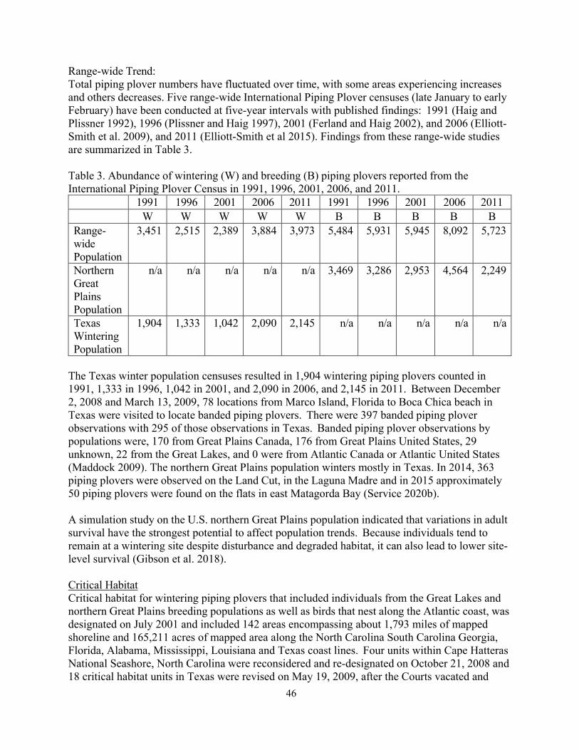
46
Range-wide Trend: Total piping plover numbers have fluctuated over time, with some areas experiencing increases and others decreases. Five range-wide International Piping Plover censuses (late January to early February) have been conducted at five-year intervals with published findings: 1991 (Haig and Plissner 1992), 1996 (Plissner and Haig 1997), 2001 (Ferland and Haig 2002), and 2006 (Elliott- Smith et al. 2009), and 2011 (Elliott-Smith et al 2015). Findings from these range-wide studies are summarized in Table 3.
Table 3. Abundance of wintering (W) and breeding (B) piping plovers reported from the International Piping Plover Census in 1991, 1996, 2001, 2006, and 2011. 1991 1996 2001 2006 2011 1991 1996 2001 2006 2011 W W W W W B B B B B Range- wide Population
3,451 2,515 2,389 3,884 3,973 5,484 5,931 5,945 8,092 5,723
Northern Great Plains Population
n/a n/a n/a n/a n/a 3,469 3,286 2,953 4,564 2,249
Texas Wintering Population
1,904 1,333 1,042 2,090 2,145 n/a n/a n/a n/a n/a
The Texas winter population censuses resulted in 1,904 wintering piping plovers counted in 1991, 1,333 in 1996, 1,042 in 2001, and 2,090 in 2006, and 2,145 in 2011. Between December 2, 2008 and March 13, 2009, 78 locations from Marco Island, Florida to Boca Chica beach in Texas were visited to locate banded piping plovers. There were 397 banded piping plover observations with 295 of those observations in Texas. Banded piping plover observations by populations were, 170 from Great Plains Canada, 176 from Great Plains United States, 29 unknown, 22 from the Great Lakes, and 0 were from Atlantic Canada or Atlantic United States (Maddock 2009). The northern Great Plains population winters mostly in Texas. In 2014, 363 piping plovers were observed on the Land Cut, in the Laguna Madre and in 2015 approximately 50 piping plovers were found on the flats in east Matagorda Bay (Service 2020b).
A simulation study on the U.S. northern Great Plains population indicated that variations in adult survival have the strongest potential to affect population trends. Because individuals tend to remain at a wintering site despite disturbance and degraded habitat, it can also lead to lower site- level survival (Gibson et al. 2018). Critical Habitat Critical habitat for wintering piping plovers that included individuals from the Great Lakes and northern Great Plains breeding populations as well as birds that nest along the Atlantic coast, was designated on July 2001 and included 142 areas encompassing about 1,793 miles of mapped shoreline and 165,211 acres of mapped area along the North Carolina South Carolina Georgia, Florida, Alabama, Mississippi, Louisiana and Texas coast lines. Four units within Cape Hatteras National Seashore, North Carolina were reconsidered and re-designated on October 21, 2008 and 18 critical habitat units in Texas were revised on May 19, 2009, after the Courts vacated and

47
remanded the original designation. Climate Change Loss of habitat would increase with sea level rise and hurricane activity could result in mortality of actual birds. Armoring and other shoreline alterations may increase erosion and drought and flooding can make wetlands unavailable and diminish the water supply. An increased demand for wind power may also impact piping plovers as they potentially collide with wind turbines during migration (Service 2009).
Red Knot There are six recognized subspecies of red knots, and on December 11, 2014, the Service published the final rule listing the rufa subspecies of red knot as a threatened species under the Act; that rule became effective on January 12, 2015.
Selected Life History The red knot is a medium-sized shorebird about 9 to 11 inches in length. The red knot is easily recognized during the breeding season by its distinctive rufous (red) plumage. Nonbreeding plumage is dusky gray above and whitish below. Juveniles resemble nonbreeding adults, but the feathers of the scapulars and wing coverts are edged with white and have narrow, dark bands, giving the upperparts a scalloped appearance (Davis 1983).
The red knot’s range spans 40 states and 24 countries and extends from the species’ breeding grounds in the Canadian Arctic, to its migration stopover areas along the Atlantic and Gulf coasts of North America, to its wintering grounds throughout the Southeastern U.S., the Gulf coast, and South America (reaching as far south as Tierra del Fuego at the southern tip of South America). Little information is available about nonbreeding red knots. Unknown numbers of nonbreeding red knots remain south of the breeding grounds during the breeding season, and many, but not all, of these red knots are 1-year-old (i.e., immature) birds (Niles et al. 2008). Nonbreeding red knots, usually individuals or small groups, have been reported during June along the U.S. Atlantic and Gulf coasts, with smaller numbers around the Great Lakes and Northern Plains in both the United States and Canada (Niles et al. 2008). There is also little information on where juvenile red knots spend their winter months (Service and Conserve Wildlife Foundation of New Jersey 2012), and there may be at least partial segregation of juvenile and adult red knots on the wintering grounds. All juveniles of the Tierra del Fuego wintering region are thought to remain in the Southern Hemisphere during their first year of life, possibly moving to northern South America, but their distribution is largely unknown (Niles et al. 2008). Because there is a lack of specific information on juvenile red knots, the Service uses the best available data from adult red knots to draw conclusions about juvenile foraging and habitat use.
Rufa red knots feed on invertebrates, especially small clams, mussels, and snails, but also crustaceans, marine worms, and horseshoe crab (Limulus polyphemus) eggs. On the breeding grounds, red knots mainly eat insects. Migrating red knots can complete non-stop flights of 1,500 miles or more, converging on vital stopover areas to rest and refuel.
Habitat Habitats used by red knots in migration and wintering areas are generally coastal marine and estuarine habitats with large areas of exposed intertidal sediments and seagrasses. In many

48
wintering and stopover areas, quality high tide roosting habitat (i.e., close to feeding areas, protected from predators, with sufficient space during the highest tides, free from excessive human disturbance) (Service 2015). The supra-tidal (above the high tide) sandy habitats of inlets provide important areas for roosting, especially at higher tides when intertidal habitats are inundated (Harrington 2008). In some localized areas, red knots will use artificial habitats that mimic natural conditions, such as nourished beaches, dredged spoil sites, elevated causeways, and impoundments; however, there is limited information regarding red knot use of such artificial habitats.
In North America, red knots are commonly found along sandy, gravel, or cobble beaches, tidal mudflats, salt marshes, peat banks, and shallow coastal impoundments, ponds, and lagoons along the Atlantic coast (Cohen et al. 2010; Cohen et al. 2009; Niles et al. 2008; Harrington 2001; Truitt et al. 2001). In Florida, the birds also use mangrove and brackish lagoons. Along the Texas coast, red knots forage on beaches, oyster reefs, and exposed bay bottoms and roost on high sand flats, reefs, and other sites protected from high tides. Red knots also show some fidelity to particular migration staging areas between years (Duerr et al. 2011; Harrington 2001).
Population Dynamics Except for localized areas, there have been no long-term systematic surveys of red knots in Texas or Louisiana, and no information is available about the number of knots that winter in northeastern Mexico. From survey work in the 1970s, Morrison and Harrington (1992) reported peak winter counts of 120 red knots in Louisiana and 1,440 in Texas, although numbers in Texas between December and February were typically in the range of 100 to 300 birds. Records compiled by Skagen et al. (1999) give peak counts of 2,838 and 2,500 red knots along the coasts of Texas and Louisiana, respectively, between January and June over the period 1980 to 1996, but these figures could include spring migrants. Morrison et al. (2006) estimated only about 300 red knots wintering along the Texas coast, based on surveys in January 2003 (Niles et al. 2008). Higher counts of roughly 700 to 2,500 knots have recently been made on Padre Island, Texas during October, which could include wintering birds (Newstead et al. 2013, Niles et al. 2009).
Foster et al. (2009) found a mean daily abundance of 61.8 red knots on Mustang Island, Texas, based on surveys every other day from 1979 to 2007. Similar winter counts (26 to 120 red knots) were reported by Dey et al. (2011a) for Mustang Island from 2005 to 2011. From 1979 to 2007, mean abundance of red knots on Mustang Island decreased 54 percent, but this may have been a localized response to increasing human disturbance, coastal development, and changing beach management practices (Newstead et al. 2013, Foster et al. 2009) (i.e., it is possible these birds shifted elsewhere in the region).
At several key sites, the best available data show that numbers of red knots declined and remain low relative to counts from the 1980s, although the rate of decline appears to have leveled off since the late 2000s. There are no current estimates for the size of the Northwest Gulf of Mexico wintering group as a whole (Mexico to Louisiana). The best available current estimates for portions of this wintering region are about 2,000 in Texas (Niles 2012a), or about 3,000 in Texas and Louisiana, with about half in each State and movement between them (Service 2015). Inferring long-term population trends from various national or regional datasets derived from volunteer shorebird surveys and other sources, Andres (2009) and Morrison et al. (2006) also concluded that red knot numbers declined, probably sharply, in recent decades.

49
Status and Distribution Reasons for Listing/Threats to Survival The Service has determined that the red knot is threatened due to loss of both breeding and nonbreeding habitat; likely effects related to disruption of natural predator cycles on the breeding grounds; reduced prey availability throughout the nonbreeding range; and increasing frequency and severity of asynchronies (‘‘mismatches’’) in the timing of the birds’ annual migratory cycle relative to favorable food and weather conditions. Main threats to the red knot in the United States include reduced forage base at the Delaware Bay migration stopover; decreased habitat availability from beach erosion, sea level rise, and shoreline stabilization in Delaware Bay; reduction in or elimination of forage due to shoreline stabilization, hardening, dredging, beach replenishment, and beach nourishment in Massachusetts, North Carolina, and Florida; and beach raking which diminishes red knot habitat suitability. These and other threats in Canada and South America are detailed in the final listing rule (Service 2014a). Unknown threats may occur on the breeding grounds.
Range-wide Trend Strong historical evidence indicates that red knots were severely depleted by hunting in the 1800s, but at least partially recovered by the mid-1900s. During the 2000s, red knots from the Southern wintering population experienced a sharp decline that is generally attributed to the overharvest of the horseshoe crab and a resulting food shortage in the Delaware Bay staging area. The horseshoe crab harvest is now scientifically managed to avoid further impacts on red knots, but the southern wintering population shows no signs of recovery to date. Although less reliant on Delaware Bay, the Northwestern Gulf of Mexico/Central American wintering population is also thought to have declined in recent decades. Two additional wintering populations, one on the north coast of South America and another in the Southeast United States and the Caribbean, are considered stable relative to the 1980s. Rufa Red Knot Species Status Assessment Report 25 stated the decline of the Southern population drove a decline of the subspecies as a whole. Although less reliant on Delaware Bay, the Northwestern Gulf of Mexico/Central American wintering population is also thought to have declined in recent decades, while the other two wintering populations are considered stable (Service 2020b).
Critical Habitat Critical habitat was proposed on July 15, 2021 for red knots (86 FR 37410). Currently the proposed critical habitat includes 120 units in Massachusetts, New York, New Jersey, Delaware, Virginia, North Carolina, South Carolina, Georgia, Florida, Alabama, Mississippi, Louisiana, and Texas. A total of approximately 649,066-ac (262,667-ha) were proposed to be designated critical habitat. There were 11 proposed critical habitat units [approximately 186,241-ac (75,369- ha) proposed to be designated in Texas. These areas were believed to contain the essential physical and biological elements for the conservation of red knots, and the physical features necessary for maintaining the natural processes that provides appropriate foraging, roosting, and sheltering habitat components.
Climate Change Red knot’s vulnerability to climate change indicates that loss or degradation of breeding habitat from artic warming and nonbreeding habitat, and loss of wintering habitat from sea level rise and increased frequency and severity of hurricanes increases the extinction rate (Service 2020b).

50
ENVIRONMENTAL BASELINE Regulations implementing the Act (50 CFR § 402.02) define the environmental baseline as the condition of the listed species or its designated critical habitat in the Action Area, without the consequences to the listed species or designated critical habitat caused by the Proposed Action. The environmental baseline includes the past and present impacts of all Federal, State, or private actions and other human activities in the Action Area, the anticipated impacts of all proposed Federal projects in the action that have already undergone formal or early section 7 consultation, and the impact of State or private actions which are contemporaneous with the consultation in process. The consequences to listed species or designated critical habitat from ongoing agency activities or existing agency facilities that are not within the agency’s discretion to modify are part of the environmental baseline.
The Lower Rio Grande Valley, also referred to as the Rio Grande Valley, or the Valley, is at the lower tip of Texas and the main counties include the Starr, Hidalgo, Willacy and Cameron. The Action Area is located in Cameron County within the Gulf Prairies and Marshes Ecoregion and the Rio Grande Valley region which has 11 biotic communities. The Action Area falls within the loma/tidal flats biotic community. This community is characterized by wooded islands surrounded by tidal flats that are periodically inundated by water from South Bay and the Gulf of Mexico. Lomas are unique features found in the coastal plains of eastern Cameron County and are characterized as scattered clay dunes that formed by windblown saline clay particles originating from local salt flats that are largely barren of vegetation. Lomas typically range from 5 to 30 feet above mean high tide and from 10 to about 250 acres in size (USDA 1977). Vegetation communities on lomas range from dense mixed thornshrub communities or grassland habitats to nearly barren ground, depending on factors such as soil salinity (which varies from low to very high), erosion, and grazing pressure. Loma systems located within the Action Area are: Loma de la Pita (closest to the VLA), Loma de la Lena Seca, Loma Plato, Loma de los Equios, Loma Silvan, Loma de las Gachupines, Loma del Potrero Cercado, Loma Tio Alejos, Loma de la Jauja and Loma de la Montusa Chica (Figure 18). The open water areas are fringed with black mangroves and vegetated with seagrasses. Dunes often form around the tidal flats.
The Action Area includes a large portion of a wide north-south coastal corridor along the Rio Grande delta with a matrix of native rangeland, wetlands and upland communities extremely valuable to wildlife. The Action Area is primarily used for recreation (Boca Chica State Park, Boca Chica Beach, LRGVNWR, South Bay Preserve, Brazos Island State Park, Isla Blanca Park, and Palmito Ranch Battlefield NHL). Major water bodies in the Action Area are South Bay, Laguna Madre, Rio Grande, and the Gulf of Mexico. The southern end of South Bay is approximately 0.5 mile north of the VLA and Boca Chica Bay is approximately 0.03 mile. Boca Chica Bay is a subdelta of the Rio Grande which is about 2 miles from the launch site. The Gulf of Mexico lies east of the VLA with miles of beach and dune habitats at the water’s edge and the Brownsville Ship Channel is approximately 4 miles north.
The property boundary of the VLA is immediately adjacent to a critical dunes area, and a portion of the property is designated as an undeveloped coastal barrier by the Coastal Barrier Resource Act. The VLA and LLCC are also located in the Federal Emergency Management Agency (FEMA) designated 100-year flood hazard areas (i.e., 1 percent annual chance flood events)

51
based on the Flood Insurance Range Map for Cameron County, the VLA is in Zone AE and Zone VE while the LLCC is in Zone AE. VE is designated as a special hazard area subject to inundation by 1 percent annual chance flood events with additional hazards subject to erosion and overtopping from high tides and waves during storms. The Service owns the next 8 miles beneath SH 4 within the ROW with the exception of 0.13 mile that is owned by the Port of Brownsville. Most stormwater runoff in the Action Area flows away from the Brownsville Ship Channel, across the flats, and into large depressional areas where it ponds until it evaporates. Based on the Cameron County soil survey, the depth to water table in the Action Area typically ranges from the surface to 12 inches in the low tidal flats, 20 to 48 inches in the flat coastal prairie covering most of the Action Area, and deeper on the lomas and areas containing dredged material deposits. The closest water well in the Action Area is approximately 2 miles south of the VLA and LLCC.
The LRGVNWR’s Boca Chica Tract is within the Action Area and adjacent to the VLA. The Boca Chica tract is 1,665.53 acres and the broader LRGVNWR is approximately 11,000 acres. The LRGVNWR is one of the state’s most pristine and undeveloped areas. SH 4 parallels the Boca Chica tract and VLA and ends at the entrance of Boca Chica Beach and crosses wide expanses of coastal grasslands, lomas, and runs along the edge of South Bay. Botteri’s sparrows (Peucaea botterii) can be observed at the Border Patrol Checkpoint. As many as 100 ospreys (Pandion haliaetus) may be seen perched on transmission lines. It is also a migration stopover site for peregrine falcons (Falco peregrinus) (Maechtle 1987) and supports breeding snowy plovers (Charadrius alexandrines) and Wilson’s plovers (Charadrius wilsonia) (Zdravkovic 2005). Snowy plovers and Wilson’s plovers nest in the flats that border the road and adjacent to the VLA. Piping plovers are common on the beach and tidal flats and spring migration brings red knots to the area along with other shorebirds. Aplomado falcons have been reintroduced to the area and nest and forage through the area.
Typical plants found in loma/tidal flats at and around the Boca Chica Launch site are comprised of scrub shrub and emergent wetlands. Vegetation is primarily comprised of saltgrass (Distichlis spicata), shoregrass (Monanthocloe littoralis), saltwort (Batis maritima), glasswort (Salicornia virginica), shoreline sea purslane (Sesuvium portulacastrum), sea ox-eye daisy (Borrichia frutescens), and gulf cordgrass (Spartina spartinae) (USACE 2012, 2021). Berlandier’s fiddlewood (Citharexlyum berlandieri), Texas ebony (Pithecellobium ebano) and yucca (Yucca treculeana) are on higher lomas (Jahrsdoerfer and Leslie 1988; Service 1997). Black mangrove was also observed during field surveys for the 2013 consultation.
Upland vegetation is typified by pricklypear (Opuntia engelmannii), honey mesquite (Prosopis glandulosa), little bluestem (Schizachyrium scoparium), bushy bluestem (Andropogon glomeratus), giant reed (Arundo donax) (a non-native invasive species), cuman ragweed (Ambrosia cumanensis), and golden tickseed (Coreopsis tinctoria).
On the eastern area of the Boca Chica Launch Site, dunes occupy the beach above the high tide mark about 1,000 feet from the VLA, and are characterized by marsh/barrier island subtype 4 (Seaoats- seacoast bluestem grassland). This vegetation type is generally dominated by beach croton (Croton punctatus), single-spike paspalum (Paspalum monostachyum), Pan American balsamscale (Elionurus tripsacoides), flat sedge (Cyperus spp.), sea purslane (Sesuvium portulacastrum), bulrush (Scirpus spp.), beach morning-glory

52
(Ipomoea imperati), goat’s foot morning glory (Ipomoea pes-caprae), sea rocket (Cakile edentula), and lime pricklyash (Zanthoxylum fagara) (McMahan et al. 1984).
Over the past six years, SpaceX has constructed launch facilities, a LLCC and VLA. Since completion of the 2013 consultation, SpaceX developed 16.8 acres (of the entire 47.4 acre- parcel) for the VLA. The developed part of the VLA has been improved for development by soil surcharging (i.e., layering soil to compact the lower layers to make it more conducive for foundations and pad development). Existing infrastructure at the VLA includes one launch pad with a launch mount (Pad A), one landing pad, two suborbital test pads, a test stand, access roads and parking areas, commodity storage areas, a water tank, crane and crane staging areas, temporary support infrastructure (e.g. office trailers), lighting and security fencing, and employee restrooms. The Integration Tower has been fully constructed at Pad A and is approximately 480 feet tall with a 10-foot lightning rod on top and includes black cladding. The 450-foot-tall crane used to integrate Starship/Super Heavy will be stored at the VLA and remain upright the majority of the time and lowered to approximately 250 feet during launches. Following construction of the integration towers, the crane would be used to move large articles such as vehicles and tanks. Adjacent to the VLA there is parking along SH 4 and a parking lot north of SH 4, has been cleared and in use . Since 2019, SpaceX has been conducting static fire tests and suborbital launches and landings of Starship prototypes under an existing licenses at the VLA as part of its Starship experimental test program (LRLO 20-119; FAA 2019a, 2019c, 2020a, and 2020b). This involves a series of up to 20 Starship suborbital launches per year from just a few inches above ground level to up to 30 kilometers (18 miles) above ground level and up to 420 seconds of static fire engine tests (FAA 2020a). Typical static fire duration is 15 seconds. Suborbital hops last several minutes and the test vehicle flies up to 30 km and then lands back at the VLA (FAA 2020a). Activities allowed under this the experimental test program will also include 3 Super Heavy launches, and 23 Starship land landings. Activity at the VLA also includes tank tests and day-to-day SpaceX maintenance activities, construction activities. These activities will occur even if the FAA does not license the Starship/ Super Heavy launch operations that are part of the Proposed Action. If the FAA issues a license for activities under the Proposed Action, that license would replace the license for the experimental test program. The license for activities under the Proposed Action would reduce the number of annual launches to 10 (5 orbital and 5 suborbital) and reduce the number of seconds of static fire to 285 seconds per year (each static fire would still be approximately 15 seconds).
The LLCC consists of the existing Stargate building where command and control of operations at the launch pad occur and the associated parking lot. The solar farm area was developed and currently consists of solar arrays and batteries for power storage. The solar arrays are 6.5 feet tall and composed of non-highly–reflective materials.
SpaceX also operates a private manufacturing and production area adjacent to the LLCC. Infrastructure and improvements at the adjacent SpaceX’s private manufacturing and production area include buildings and tents (ground fabrication building, propulsion building, dome/ring manufacturing tents, nosecone manufacturing tent, hydraulic press tent, storage tent), hydraulic, bays for storing stacked vehicle components (low bay, mid bay, high bay,

53
and wide bay), a wind profiler, satellite tracking station, Starlink ground station, air separation unit and 12 MW natural gas power plant. SpaceX also conducted site improvements on privately owned land related to employee housing (Boca Chica Village and Mars Pathfinder Recreational Vehicle Park), employee dining (Prancing Pony Restaurant) and employee transportation.
Additional environmental baseline is available in the PEA. The environmental baseline contributes to the status of the species in the Action Area.
Status of the Species within the Action Area
Ocelot and Jaguarundi
The ocelot and jaguarundi are treated together here because the two are thought to exhibit similar habitat preferences in South Texas, although information from Mexico indicates that the jaguarundi may be more tolerant of open areas such as grasslands and pastures than the ocelot (Campbell 2003). The cats also suffer from similar causes of population decline and are believed to benefit from similar recovery efforts. Ocelots are thought to utilize tracts of brush habitat within the Action Area, particularly along the irrigation canals, irrigation drains, natural drainages, shorelines, fence lines, and brushy road margins and lomas as travel or dispersal corridors. Jaguarundis may use this type of habitat as well if they moved into the area.
Except for the Boca Chica Launch Site, Boca Chica Village and SpaceX’s operations there, and the area north of the Brownsville Ship Channel that includes Port Isabel, Laguna Vista, and the Town of South Padre Island, SH 4, and several ranches and businesses, the majority of the land within the Action Area is undeveloped. The area lies within the Tamaulipan Biotic Province as described by Blair (1950). The dominant landforms in the area in and around VLA and LLCC include lomas (ridges or clay dunes) and tidal flats. The elevations of the lomas range from 5 to 30 feet above mean high tide and areas from 10 to about 250 acres in size (USDA 1977). The lomas are generally characterized by mixed thornshrub community and composed of dominant species such as Texas ebony (Pithecellobium flexicaule), honey mesquite, retama, brasil (Condalia hookeri), granjeno, lotebush, allthorn, acacias (Acacia spp.), and Spanish dagger (Yucca treculeana). The thornshrub on the lomas varies from dense thickets to nearly barren ground. The flats are broad, level and in some cases barren. Over 90 percent of this habitat in the Lower Rio Grande Valley has been altered by agriculture and urban development (Service 2016a) and one percent of south Texas supports the dense thornscrub used by ocelots. In addition to the loss of habitat, impacts to ocelots and jaguarundis include border activities, roadways, international bridges, night lighting effects, and increases in noise and pollution.
It was estimated there were 53 individual ocelots in two separate populations in south Texas (Service 2016a). One population occurs in Willacy and Kenedy counties and the other in eastern Cameron County on LANWR. A third larger population occurs in Tamaulipas, Mexico (Service 2016a). The LANWR supports a population of ocelots (10-25) on and adjacent to the Laguna Atascosa Unit of the refuge (Service 2010). Both Texas populations are isolated from each other by approximately 19 miles. Ocelots have been documented moving between the Willacy County and Cameron County ocelot populations in Texas (Service 2016a). Janecka et al. (2008, 2011) analyzed genetic variation of ocelots from Cameron and Willacy counties and Tamaulipas,

54
Mexico. Korn (2013) analyzed samples to establish pedigree relationships and both concluded ocelots have lost genetic diversity and are becoming increasingly isolated and inbreeding and genetic drift will be problems. This region is also part of the Bahia Grande Coastal Corridor Project (BGCCP) (Figure 16) a bi-national, federal, state and private land acquisition effort to link the globally significant Laguna Madre region of south Texas with the northern Mexico Gulf Coast (BGCCP 2014). Connectivity through migration of individual ocelots, with varying levels of genetic diversity and establishing north-south and east-west corridors with habitat improvements would increase range and may also facilitate ocelot population growth and reduce extinction risk (Service 2016a).
Agricultural land has been converted to urban development due to rapid population growth in south Texas’ LRGV, increasing land and habitat fragmentation (Service 2016a). The human population in the LRGV increased 39.8 percent from 1990 to 2000 and is projected to increase 130.1 to 181.1 percent from 2000 to 2040 (Service 2016a). Population numbers for the Valley were 1,402,512 in January 2021. (https://www.rgvhealthconnect.org/demographicdata?id=281259§ionId=935). The rapid population growth has increased further land and habitat fragmentation resulting in only 1 percent of dense thornscrub used by ocelots in south Texas and decreased opportunities to conduct habitat restoration and/or purchase lands for conservation (Service 2016a).
Besides habitat loss, collisions with motor vehicles in the Action Area are the most significant factor of ocelot and jaguarundi mortalities. Vehicular mortality accounted for 45 percent of deaths of 80 radio-tagged ocelots between 1983 and 2002 (Service 2016a). Over a 10-month period in 2015-2016, seven ocelots were killed by cars north of the Brownsville Ship Channel (TPWD 2017, 2018). Sixteen wildlife friendly crossings, with vegetation and fencing to funnel the cats and other wildlife under major roads, with known mortalities, were constructed as part of TxDOT planned roadwork. Of the sixteen, one was built under SH 48, nine on FM 106, four on SH 100, west of Port Isabel, and two on LANWR interior roads. The SH 100 underpass was completed in 2017 and the first underpasses opened in 2017 (TPWD 2017). Some of the others around LANWR were completed in July 2019. Early in 2020 a five-year old male ocelot, OM331, was caught on camera using a crossing under FM 106, traveling north to south (TPWD 2020). Other wildlife has been documented using the crossings, such as armadillos, bobcats, alligators and javelinas, but this is considered the first documented use of an ocelot using an underpass in the United States (TPWD 2020). The construction of those wildlife crossings are within or adjacent to the edges of the Action Area. Roads also may reduce successful dispersal between suitable habitat patches thus increasing genetic isolation of populations (Service 2016a).
Blanton & Associates (1998) reported a young male ocelot trapped and radio-collared in the area in April 1998, approximately 3.5 miles west of the proposed control center area. The ocelot was captured on an unnamed loma located between SH 4 and the Brownsville Ship Channel. The ocelot often traveled across extensive areas of open flats and the brush associated with the lomas along SH 4 and the Service’s Loma Ecological Preserve to move between lomas and north of the Brownsville Ship Channel, settling into an area south of LANWR. A recent study completed by Blanton & Associates for a proposed LNG, north of the VLA, but within the action area involving 36,000 camera trap nights found no ocelots. An ocelot roadkill occurred Approximately 2.3 miles north of SH 4 in 1989. Additional sightings of ocelots north of the Action Area include a 1970 sighting south-southwest of Laguna Larga, 2.5 miles north of SH 48.
55
Single ocelot roadkills occurred on FM 510 in 1984, 1986, 1987, 1995, and two were reported killed in 2001 between the towns of Laguna Vista and Bayview. In 1989, a road-killed ocelot was found on SH 48 near its intersection with San Martin Loma. The ocelot was not radio- collared, and its origin and landscape use were unknown. In 1992, an ocelot was also reported on SH 48, 3 miles from SH100. Ocelots occur near the Holly Beach community just south of the known LANWR population of ocelots. Holly Beach and LANWR are located between 5 and 10 miles north of SH 48, which is north of the Action Area. The Raymondville Chronicle (2014) reported four ocelots road mortalities documented on SH 100, with three killed 1999-2004.
A jaguarundi was killed on SH 4 near FM 511 east of Brownsville in 1986 (Service 2016a). A cat resembling a jaguarundi was photographed in 1989 at the Audubon Society’s Sabal Palm Sanctuary near Brownsville. There are no other confirmed sightings of jaguarundi in the U.S. nor known jaguarundi populations in the U.S. A viable jaguarundi population exists in the state of Tamaulipas, Mexico (which is approximately 150 miles from the Action Area), and suitable habitat exists within the Action Area, so the future occurrence of the jaguarundi in the Action Area cannot be ruled out.
These documented sightings of cats and the presence of ocelots on established refuge lands indicate that habitat is available in the Action Area to support ocelots and jaguarundis on lomas interspersed within the tidal flats and west of the VLA or LLCC. Many researchers (Ideker 1984, Tewes and Everett 1986,) and the Service (1990) believe that the continued existence of the isolated ocelot and jaguarundi populations depends upon protecting travel corridors connecting the existing main coastal populations of ocelots to the interior subpopulations, as well as to suitable habitat that they may occupy in the future. The Tamaulipas, Mexico population of jaguarundis make maintaining a north/south travel corridor between Mexico and Texas important for jaguarundi populations. The continued use of scarce habitat fragments makes these cats highly vulnerable to vehicle strikes, reduces genetic viability, and minimizes the likelihood of their survival and recovery in the wild.
Sea Turtles
The eastern boundary of the VLA perimeter fence is over 500 feet west of and separated by dunes from sea turtle nesting areas on Boca Chica Beach. South Padre Island beach surveys have been conducted on a regular basis since 1978. Under permit from the Service, sea turtle surveys in the Action Area are conducted by Sea Turtle, Inc. April through August of each year. The surveys are conducted using all-terrain vehicles (ATV). Surveys begin at sunrise. Turtle eggs are relocated and incubated within a fenced off corral for protection. Table 5 represents documented numbers of Kemp’s ridley, green, and loggerhead sea turtle nests by year over a 10- year period, 2012 to 2021. South Padre Island (SPI) is approximately 36 miles long, from Mansfield Pass to the Brazos Santiago Pass. The Action Area includes approximately 25 percent of SPI, about 8 miles, from the northern boundary of the Action Area boundary south to the northern side of Brazos Santiago Pass, and the number of nests in the column labeled .25SPI in Table 5 represents approximately 25 percent of all nests found within the SPI portion of the Action Area. The other section of beach is Boca Chica Beach (BCB). The BCB stretches south from Brazos Santiago Pass to the Rio Grande for a total of approximately 7.5 miles. The number of nests on the BCB represents 100 percent of nests found on BCB within the Action Area. The leatherback and hawksbill are not represented on the table because neither has a documented nest

56
within the Action Area.
According to Sea Turtle, Inc. data, there were no false crawls on BCB from 2011-2016, but there were a total of 11 false crawls from 2017-2021. A false crawl is when a sea turtle comes ashore and attempts to lay a clutch of eggs, dig a nest, but not actually depositing her eggs and returns to the water. The data did not indicate which species, but it is assumed all were Kemp’s ridley because there were no green or loggerhead sea turtles documented on BCB in the last 10 years. A total of 11 false crawls over five years represents a mean of 2.2 per year.
Table. 5. Sea turtle nest numbers by year and location on Boca Chica Beach and 25 percent of the Action Area on South Padre Island (SPI) (Bonka 2021). Kemp’s ridley Green Loggerhead
BCB SPI .25SPI BCB SPI .25SPI BCB SPI .25SPI 2012 10 59 14.75 0 2 .5 0 1 .25 2013 3 39 9.75 0 2 .5 0 1 .25 2014 2 21 5.25 0 0 0 0 0 0 2015 0 34 8.5 0 0 0 0 2 .5 2016 9 63 15.75 0 0 0 0 1 .25 2017 23 70 17.5 0 6 1.5 0 1 .25 2018 7 58 14.5 0 0 0 0 1 .25 2019 6 40 10 0 0 0 0 3 .75 2020 6 72 18 0 7 1.75 0 0 0 2021 5 61 15.25 0 0 0 0 0 0 TOTAL 71 517 129.25 0 17 4.25 0 10 2.5
Leatherback sea turtle In 2008, the first leatherback nest confirmed on the Texas coast since the 1930s was found on Padre Island National Seashore, approximately 24 miles north of the Action Area (Shaver 2009). On November 22, 2018, a 500-pound leatherback sea turtle was found injured on South Padre Island. It died after 48 hours of a traumatic head injury. In June 2021, a leatherback sea turtle nest was discovered on South Padre Island between mile marker 6 and 7, just outside the Action Area boundary. It was the first nest to be found in Texas and successfully produce hatchlings. The hatchlings were released in August 2021 (https://myrgv.com/local- news/2021/08/06/leatherback-hatchlings-leave-rescuers-overjoyed/).
Hawksbill sea turtle The only hawksbill nest documented on the Texas coast was in 1998 at Padre Island National Seashore, approximately 24 miles north of the Action Area (NPS 2012). The nest contained 140 eggs and 132 hatchlings from the nest were later released into the Gulf of Mexico (Shaver, 1999b). No hawksbill sea turtles have been recorded nesting in the Action Area (Sea Turtle, Inc. 2021). It is possible that additional nests were undetected, especially when patrols were not conducted or were less comprehensive.
Kemp’s ridley sea turtle In the United States, Kemp’s ridley nesting primarily occurs in Texas, especially at the Padre Island National Seashore, about 24 miles north of the Action Area (NMFS and Service 2015).

57
Within the Action Area, approximately 271 Kemp’s ridley sea turtle nests were located within the Action Area over the 10-year period 2012-2021, of which 20 were documented in 2021 (STI 2021).
Green sea turtle In Texas, green sea turtles are known to nest on the beaches of North Padre Island (approximately 24 miles north of the Action Area) and SPI. Over a 10-year period, 2012-2021, approximately 4 green sea turtle nests have been documented within the Action Area. No green sea turtles were found in 2021 (STI 2021).
Loggerhead sea turtle Loggerhead sea turtles have nested on the Texas coast. Over the 10-year period of 2012-2021 approximately 3 loggerhead nests have been documented within the Action Area. No loggerheads were documented to occur in 2021 (STI 2021)
Piping Plover
To date, various levels of survey effort have yielded piping plover numbers along the lower Texas coast. In 2009, migratory and winter surveys for piping plovers were conducted within the Lower Laguna Madre region in south Texas with 801 piping plovers observed during migratory surveys and 881 documented during wintering surveys. Numbers during the International Censuses at Boca Chica were 60 in 1991, 117 in 1996, 0 in 2001, and few in 2006. Maddock (2010) observed 239 piping plovers on the west and south sides of South Bay, within the Action Area and piping plovers were seen between South Bay on the north side of the road, on the south side of the road, and Boca Chica beach. During a visit to the SpaceX site on December 11, 2012, a Service biologist observed over 200 piping plovers in the flats along SH 4, which is also designated critical habitat. Biology students with the University Texas – Rio Grande Valley (UTRGV) performed surveys of piping plovers (and other avian species) at the Boca Chica Launch Site from May 2015 through November 2021 (Hicks, Alexander, and Berg 2015; Hicks, Gabler, and Berg 2017, 2018, 2019, 2020, and 2021), with monitoring reports shared annually with the Service. The UTRGV biologists reported piping plover detections along 4 survey routes along Boca Chica Beach, and in the flats to the north and south of SH 4 in the vicinity of the Boca Chica Launch Site, including information on survey date, time, location (route and coordinates), and group size. Their analysis found “some evidence of an effect of year on the abundance of target species, particularly Piping Plovers and Red Knots.” They noted that more years of data would be required to detect whether the downward trend was significant, but that as “more data are gathered, analysis will likely yield significant, negative temporal trends.” They also noted that the detection of a trend was hampered by issues of limited accessibility, and major delays in contracting that resulted in no surveys being conducted in 2020 until August. SWCA Environmental Consultants (SWCA) performed a preliminary analysis of the student observational data collected by UTRGV for potential trends in piping plover abundance over time (SWCA 2022). Based on the data collected by UTRGV, SWCA found little to no strong evidence of a downward trend in piping plover observations through time (Figure 19).
58
In the most rigorous study to date, biologists from the Coastal Bend Bays and Estuaries Program surveyed piping plovers in the LRGV NWR, Boca Chica State Park, Brazos Island State Park and state-owned submerged lands including the Gulf Beach, from 2018 to 2021 (Newstead and Hill 2021 and 2022). Newstead and Hill (2022) summarize the data collected from the field including detections of marked and unmarked piping plovers, the number of surveys, and the date range of surveys. Newstead and Hill reported modeled estimates of piping plover abundance, survival rates, and probability of detection for uniquely marked piping plovers. Newstead and Hill (2021) reported a 54 percent decline in piping plover abundance between 2018 and 2021 (from 308.0 piping plovers in 2018 to 141.8 piping plovers in 2021) and characterized the trend as significant due to non-overlapping confidence intervals in the abundance estimates. (Figure 20).
Incorporating additional survey data for the 2021 year gathered after the initial study, and inclusion of a covariate to account for between-year differences in launch activities, the updated analysis (Newstead and Hill 2022) continued to show evidence of decline in 2019 and 2020, when launch activities were frequent and ongoing throughout the wintering season. The mean estimate for 2021 – a year in which there were no launch activities – showed a slight increase in the population though it was not significantly different from the two previous years, and the 95 percent confidence interval overlapped partly with that of the “pre-launch” year 2018. The top model indicated that recruitment was negatively affected during launch years, which is of high concern for the persistence of the population in the future.
Critical Habitat Unit TX-1: South Bay and Boca Chica is comprised of 7,217 acres in Cameron County. The boundaries of the unit start at the Loma Ochoa, following the Brownsville Ship Channel to the northeast out into the Gulf of Mexico to mean lower low water, then south along a line describing mean lower low water to the mouth of the Rio Grande, proceeding up the Rio Grande to Loma de Las Vacas, then from that point along a straight line north to Loma Ochoa. The unit does not include densely vegetated habitat within those boundaries. It includes wind tidal flats that are infrequently inundated by seasonal winds and the tidal flats in South Bay. Beaches within the unit reach from the mouth of the Rio Grande northward to Brazos Santiago Pass, south of South Padre Island. The southern and western boundaries follow the change in habitat from wind tidal flat, preferred by the piping plover, to where densely vegetated habitat, not used by the piping plover begins and where the constituent elements no longer occur. The upland areas extend to where densely vegetated habitat not used by the piping plover begins and where the constituent elements no longer occur and include areas used for roosting by the piping plover. Portions of this unit are owned and managed by the LRGVNWR, the South Bay Coastal Preserve, Boca Chica State Park, and private citizens (Figure 21).
Unit TX-2: Queen Isabella Causeway unit, is comprised of 6 acres in Cameron County. The area extends along the Laguna Madre west of the city of South Padre Island. The southern boundary is the Queen Isabella State Fishing Pier, and the northern boundary is at the shoreline due west of the end of Sunny Isles Street. The Queen Isabella Causeway bisects the shore but is not included in critical habitat. The eastern boundary is where the developed areas and/or dense vegetation begin, and the western boundary is the mean lower low water line. This unit contains land known as wind tidal flats that are infrequently inundated by seasonal wind-induced tide events.
Unit TX–3: Padre Island is comprised of 29,983 acres in Cameron, Willacy, Kenedy, and

59
Kleberg counties. This unit consists of four subunits. Portions of two of the subunits, TX-3A and TX-3B, are in the Action Area.
Subunit TX-3A: The southern boundary of this subunit is at Andy Bowie County Park in South Padre Island, and the northern boundary is the south boundary of PAIS. The eastern boundary is MLLW in the Gulf of Mexico, and the western boundary is mean lower low water line in the Laguna Madre. Areas of dense vegetation are not included in critical habitat for this species. This subunit includes lands known as wind tidal flats that are infrequently inundated by seasonal winds.
Subunit TX-3B: The boundaries of this subunit extend from Rincon de la Soledad to the southeast point of Mesquite Rincon, continue from that point west to the Laguna Madre shoreline at its intersection with the King Ranch boundary, and from that point to Rincon de la Soledad. This subunit includes lands known as wind tidal flats that are infrequently inundated by seasonal winds.
Special management considerations or protections have been implemented to ameliorate the threats of discharging fresh water across unvegetated tidal flats; activities associated with residential and commercial development; recreational disturbance of foraging and roosting plovers by humans, vehicles, and domestic animals; increased predation due to recreational use; and modification and loss of habitat due to beach cleaning and nourishment for recreational use have been implemented.
Red Knot
Morrison et al. (2006) estimated only about 300 red knots wintering along the Texas coast, based on surveys in January 2003 (Niles et al. 2008). Higher counts of roughly 700 to 2,500 red knots have recently been made near the Action Area on Padre Island, Texas during October, which could include wintering birds (Niles 2009, Newstead et al. 2013). Foster et al. (2009) found a mean daily abundance of 61.8 red knots, approximately 100 miles north of the Action Area, on Mustang Island, based on surveys every other day from 1979 to 2007. Similar winter counts (26 to 120 red knots) were reported by Dey et al. (2011a) for Mustang Island from 2005 to 2011. From 1979 to 2007, mean abundance of red knots on Mustang Island decreased 54 percent, but this may have been a localized response to increasing human disturbance, coastal development, and changing beach management practices (Newstead et al. 2013, Foster et al. 2009) (i.e., it is possible these birds shifted elsewhere in the region).
During the migration period, although foraging red knots can be found widely distributed in small numbers within suitable habitats, birds tend to concentrate in those areas where abundant food resources are consistently available from year to year (Fraser et al. 2010; Cohen et al. 2010, Niles et al. 2008, Smith et al. 2008; Botton et al. 1994).
Several areas in Texas have been identified as important wintering and migration stop over areas for red knots. These areas are important because they meet most of the habitat characteristics needed by red knots and have consistent red knot observations over several years. One of the important areas is the Boca Chica area adjacent to the Boca Chica Launch Site. The red knot is not a transient winter visitor to BCB. Occurrences of the species in this area suggest it is much

60
more common and that it uses the Gulf beach and extensive tidal flats both north and south of SH 4.
As part of implementing the terms and conditions of the 2013 BO, UTRGV most recently conducted bird surveys between October 10, 2018, and November 25, 2019, on accessible U.S. soil within 3 miles of the Boca Chica Launch Site construction area. The surveyors observed red knots in the survey area; however, their presence was erratic and unpredictable. The surveyors recorded an average group size of 4.66 individuals in each quadrant, with a maximum group size of 15 individuals; however, UTRGV noted that this estimate may underestimate actual numbers of individuals. On one occasion in early May 2019, the UTRGV surveyors observed a large group of red knots (>150 individuals) on the Boca Chica route, but the survey could not be completed due to flooding. UTRGV also found that the species exhibited widespread use of the survey area during the study period and exhibited narrow time windows of occupancy during the year (UTRGV 2019).
On September 29, 2021, a Coastal Bend Bays and Estuaries Program biologist sighted a flock of approximately 1,225 red knots foraging and roosting in the flats north of the LLCC. Proposed critical habitat is based on an estimate of 4,631 birds during migratory seasons (spring and fall), with 3,000 of those remaining to winter in Texas. Based on that, the flock constituted 26.4 percent of the entire population relying on the Texas coast in the fall or over one fourth of the presumed migratory and wintering population in the western Gulf of Mexico (Pers. Comm., D. Newstead, Biologist, CBBEP, 2021).
The Boca Chica Launch Site is located within proposed red knot critical habitat Unit TX-11 (Figure 21). Unit TX–11 consists of approximately 15,400 acres of occupied habitat in Cameron County. The Boca Chica gulf shoreline portion of this unit begins south of the Brownsville Ship Channel and extends approximately 6.5 miles to the south. Within the South Bay, the northern boundary is south of Brownsville Ship Channel dredge spoil placement areas, and the southern boundary is north of the Rio Grande River. The eastern boundary is the back or bayside of the Boca Chica Beach up to where dense vegetation begins, and the western boundary is west of the loma islands up to where dense vegetation begins along the wind tidal flats. The unit includes wind tidal flats and all seagrass beds that are infrequently inundated and/or exposed at low tides, and the tidal flats within South Bay. Specific habitat types within this unit include: estuarine (bayside) seagrass mud or sand flats that are subtidal and are nearly flat areas with rooted vascular plants (seagrass) growing below the water surface in subtidal mud or sand substrate; estuarine (bayside) algal mud or sand flats regularly inundated by tides and that are nearly flat areas with a layer of algae growing on a moist mud or sand substrate and are otherwise devoid of vegetation; estuarine (bayside) algal mud or sand flats irregularly inundated by tides; estuarine (bayside) sandy shore (beach/sandbar) rarely exposed due to tidal fluctuation; estuarine (bayside) sandy shore (beach/sandbar) irregularly or regularly inundated by tides, depending upon the location; estuarine (bayside) sandy shore (beach/sandbar) spoils irregularly inundated by tides; and marine sandy coastline (beach) irregularly or regularly inundated by tides, depending upon the location. Lands within this unit include approximately 5,536 acres in Federal ownership (LRGVNWR), 4,080 acres in State ownership, and 5,784 acres in private/other ownership.

61
Northern Aplomado Falcon
Suitable foraging and nesting habitat for this species exists within the Action Area (Hunt et al 2013). Captive-bred aplomado falcon fledglings were released along coastal prairie of south Texas (839 birds from 22 sites during 1993-2004) and monitored by the Peregrine Fund. The releases yielded two nesting populations 15-18 pairs near Brownsville and 15 pairs on two islands near Rockport (Hunt et al 2013). The Brownsville population currently extends about 35 miles northward from the Mexican border through LANWR, all within the Action Area (Hunt et al 2013). Individual and breeding pairs were observed using coastal grasslands, coastal dunes and tidal flats for feeding, breeding, and sheltering. Approximately 65 artificial nest structures are maintained along the Texas coast. The closest platforms in the Action Area are 1 mile south of the LLCC, and 4.3 miles to the northwest and 9.3 miles west of the LLCC. The nearest known aplomado falcon territory is approximately 5-6 miles from the Boca Chica Launch site (Figure 22). Five aplomado falcon nestlings, a pair of adult falcons, and a female falcon were observed in 2011 and 2012 at two different nest structures. One structure was located approximately 4-5 miles northwest of the proposed SpaceX site and the other nest structure was along Highway 4, approximately 8 miles away (Pers. Comm., T. Anderson, Biologist, Ecological Services, 2013). However there is suitable habitat on the Mesa del Gavilan (just northwest and north of the Boca Chica Launch Site) and Loma de la Pita (south of the VLA and other lomas (southwest and west) within 3 miles from the proposed facility. Researchers observed approximately 65 falcons in 2019, along the Texas coast, down from the 100 observed in 2018, due to the losses from hurricane Harvey (TPWD 2019). No aplomado falcons were observed in the UTRGV bird surveys (UTRGV 2020).
The Service has been working closely with The Peregrine Fund to clear mesquite and huisache from grassland habitat in an established falcon territory on the LANWR, Bahia Grande Unit, but this type of landscape improvement is difficult and a slow process. Recent brush removal projects at Bahia Grande have restored approximately 2,500 to 2,700 acres of coastal prairie habitat for the aplomado falcon. The goal is to restore approximately an additional 1,000 to 1,500 acres in the Bahia Grande area. It is anticipated that such projects will help improve the falcon’s survival (Service 2014b). However, protection of existing suitable habitat within the historic salt prairie habitats is a key priority (pers. Comm., C. Perez, 2022)
Factors affecting species environment and designated critical habitat within the Action Area
Land Ownership Land in the Action Area is in private, state, or federal ownership or management. Those include private homes in Boca Chica Village, Brownsville Navigation District (BND), TPWD and Service NWR lands, and U.S. Border Patrol bridges and stations. Future land use in the project area is expected to be driven by the goals, objectives and mandates of these landowners and may have a direct relationship on the effectiveness of any structural conservation measures. SpaceX activities may negatively or eventually beneficially affect the species environment within the Action Area. Negative effects include land development, land management, Customs and Border Patrol activities, fragmentation of habitat, and conversion or loss of habitat. Brush clearing continues to be major limiting factor for feline populations in the Lower Rio Grande Valley (Collins 1984; Rappole 1986). The ocelot and jaguarundi also depend on densely

62
vegetated travel corridors along resacas, ramaderos, and between brush tracts (Rappole 1988). Such corridors facilitate dispersal through an otherwise cleared landscape. Vegetation removal associated with “clean farming” and water storage, delivery, and drainage has negatively affected felid populations by preventing travel between remnant brush tracts.
Habitat Acquisition and Management The South Texas Refuges Complex is situated in southernmost Texas and is made up of Santa Ana and the LRGVNWR. LANWR is managed separately and is located within the Action Area. A wide array of wildlife species and large numbers of individuals flourish in the extant diverse habitat of the Lower Rio Grande Valley, due in part to warm climate year-round, moderate amounts of precipitation, and the Rio Grande flowing into the Gulf of Mexico. This wildlife and habitat diversity is economically important to the international border region as approximately 200,000 tourists annually spend approximately $150 million. Because approximately 95 percent of the vegetation in the LRGV has been cleared or altered, NWRs, state parks and wildlife areas, properties purchased for conservation by nonprofit organizations, and some private holdings, are important links in the efforts to protect the tremendous biodiversity and related economics of the region. The Service established the South Texas Refuge Complex to preserve and manage remnants of these communities and attempt restoration of adjacent disturbed lands.
The Service is continuing to acquire and enhance native Tamaulipan brushland around LANWR to promote movements of endangered cats between known and suspected areas of occupation. The resource protection and management strategy consists of four integrated approaches to address complex resource needs. They include: concentration of biotic community needs; maintenance of a wildlife habitat corridor; safeguarding of anchor units of large size; and protection of strategically placed management units of smaller size.
The Mexican Government and a number of interested Mexican and U.S. conservation organizations are focusing their attention on the ecologically valuable areas to the south of the project, including the Laguna Madre of Tamaulipas, Mexico and the Sierra de los Picachos, Nuevo Leon, Mexico. The Service’s Lower Rio Grande/Rio Bravo Binational Ecosystem Team has been working with Mexico to establish a wildlife corridor along the Rio Grande within the Action Area and in Tamaulipas between Falcon Dam and the Laguna Madre to connect important ecologically valuable areas along both sides of the U.S./Mexico border. They are also working to connect these acres to the large blocks of intact habitat on the LANWR and on South Texas ranches to the north.
The use of corridors is becoming prevalent in reserve design (Noss 1987) in an attempt to maintain or restore natural landscape connectivity. Wildlife crossings provide avenues of safe passage for animals that need to cross heavily traveled roadways where there has been a loss of habitat connectivity. Increased connectivity, along with increased effective habitat area, counteracts habitat fragmentation (Noss 1987). Corridors facilitate gene flow and dispersal of individual animals (Soule and Simberoff 1986). Life histories of wide-ranging animals suggest that maintenance or restoration of landscape connectivity is a good management strategy (Noss 1987). A network of refuges connected by corridors may allow the persistence of far-ranging species that need more resources than are found in one refuge site.

63
Potential disadvantages of corridors, such as human disturbance, can be avoided by enlarging corridor width (Noss 1987). Necessary width depends on habitat structure and quality within the corridor, the surrounding habitat, human use patterns, and the particular species that are expected to use it (Noss 1987). The ideal corridor width along the Rio Grande would be wide enough for target species to access sufficient food, water, and cover. In this way, genetic exchange could occur along the corridor, and populations could be maintained even though density at any particular place in the corridor might be low.
International Boundary and Water Commission (IBWC) Activities Through a Biological Opinion (BO) and memorandum of understanding (MOU) between the Service and IBWC, the IBWC agreed to provide a 33-foot wide corridor in the Rio Grande Floodway and the Off-River Floodway System. The vegetated corridor was to be adjacent to the Rio Grande or the 75-foot mowed areas and could contain segments of less-than-mature/climax vegetation not less than 3-feet in height (e.g., native grasses, sunflower, some cactus species), only if these segments were not so long as to prevent the cats from utilizing the mature/climax vegetation corridor or the larger dense brush habitat “islands”. No take has been reported. The IBWC developed a plan to insure a viable ocelot/jaguarundi travel corridor to benefit both cat species by helping to avoid genetic isolation of populations and promoting their dispersal into suitable habitat.
The significance of this corridor is further enhanced by its connectivity to other narrow vegetation corridors associated with waterways such as irrigation canals and drainage ditches. However, in places along the river, the 33-foot-wide corridor contains only sparse vegetation less than 3 feet tall. In some areas, such as near and beneath the Gateway Bridge at Brownsville, the corridor is largely in private ownership, and, while the IBWC possesses easements allowing it to mow the vegetation in the corridor, it has not acquired permission from the landowners to plant vegetation. The only area at this time where the 33-foot wide corridor has been established is on the Service’s refuge lands.
It is important to note the 33-foot-wide corridor is not the sole avenue for ocelot/jaguarundi movement in the Action Area. In many places along the river, there are much wider, moderately to densely-vegetated patches of habitat on both public and private lands which augment the nominal cat corridor. These patches provide potential home range habitat, as well as travel routes. Even where the floodway narrows there is additional good cover from the river’s normal edge to the top of the adjacent river channel banks. Although IBWC mows the area within 75 feet of the river once a year, this riparian zone is covered by a nearly continuous patch of Carrizo cane, a combination of common and giant reed that regrows after mowing and fires from extensive rhizomes at a phenomenal rate, returning within weeks to the density associated with optimal ocelot habitat. Owing to its density and resilience, as well as its remoteness from the flood levee where most of the roads, human activity, and floodlights are located, this Carrizo cane zone an important travel corridor. An incidental take statement has been issued by the Service for one ocelot and one jaguarundi for the life of the project (20 years) in the 2003 BO prepared for the IBWC. Future federal actions that are unrelated to the proposed action are not considered in this section because they require separate consultation pursuant to section 7 of the Act. Past and present federal actions near the proposed action are discussed under the Environmental Baseline Section. No take has been reported.
64
U.S. Border Patrol (USBP) Activities Current and past USBP activities have affected the species habitat. Portable and permanent lighting incorrectly positioned illuminates brush vegetation and causes the species to avoid such areas. Clearing of brushland for patrol roads, drag roads, and construction of ports of entry (POEs) has resulted in fragmentation and loss of habitat. Multiple roads between the flood levee and the river further fragment the habitat. There are a number of roads traversing LRGVNWR tracts. Brush habitat along the toe of the levee is fragmented due to USBP vehicles going down the south side of the levee toward the river and cutting through the wildlife corridor. Development around the ports of entries also resulted in loss, avoidance or fragmentation of habitat. The construction of 56 miles of border fence/wall in Cameron and Hidalgo counties has impacted private landowners, TPWD, and NWR land. The Service issued an incidental take statement for one ocelot and one jaguarundi for the life of the project (20 years) in the 2003 BO prepared for the USBP Operation Rio Grande. No take has been reported.
U.S. Department of Agriculture Animal and Plant Health Inspection Service (APHIS) Activities The Service also issued a BO in August 28, 2013, for APHIS’s BA for the U.S. Department of Agriculture, Animal and Health Inspection Service, Veterinary Services Cattle Fever Tick Eradication Program Cooperative Agreement for Surveys for Tick Vectors of Equine Piroplasmosis in Wildlife in South Texas. APHIS will survey for the host range and geographic distribution of the tick Amblyomma cajennense in Texas that may serve as vectors of equine piroplasmosis. Surveys are to be conducted in Cameron County, which is in the Action Area. An incidental take statement was issued for one ocelot and/or jaguarundi because of potential trapping and vehicle mortality and one northern aplomado falcon from harm and harassment due to trapping and mist netting activities. No take has been reported.
On August 30, 2013, the Service issued a BO to USDA/APHIS under the Cattle Fever Tick Eradication Program. APHIS patrols the river trails along the Rio Grande to search for stray or smuggled potentially cattle fever tick-infested livestock and wildlife from Mexico. This project proposed trail clearing and maintenance of a sufficient width for safe passage of APHIS inspectors on horseback to seek and capture the animals. The Service issued incidental take for one ocelot and/or jaguarundi from harm and harassment due to trail maintenance activities. No take has been reported.
On July 7, 2015, the Service issued a BO for the APHIS Cattle Fever Tick Eradication Program’s Tick Control Barrier in Maverick, Starr, Webb, and Zapata counties, Texas plans to enhance the eradication effort against cattle fever ticks in South Texas. The Proposed Action includes installation of approximately 70 miles of non-contiguous game fencing along SH 83 from Roma, in Starr County to the beach area in Cameron County, under agreements for cost-sharing with landowners. Recurrent cattle fever tick outbreaks are increasing in locations either within the Permanent Tick Quarantine Zone or outside of the zone in the cattle fever tick-free area of South Texas. The proposed fence would also help prevent re-infestation of areas where the pest has been or is being eliminated. The Service issued incidental take for one ocelot or jaguarundi from harm and harassment due to fence construction and maintenance activities. No take has been reported.
On January 24, 2017, the Service completed formal section 7 consultation for APHIS proposing the use of IvomecA® or IvomaxA.® (lvermectin) pour-on cattle formulation mixed with whole

65
kernel corn bait in feeding stations on private properties to deliver a systemically active acaricide to control ticks in deer and prevent fever tick infestation in cattle. Incidental take for one ocelot or jaguarundi was authorized. No take has been reported.
On January 31, 2018, the Service completed formal section 7 consultation for the South Texas Refuge Complex to issue a Special Use Permit (SUP) to USDA-APHIS/ TAHC for experimentally grazing cattle treated with injectable acaricides, and feeding white-tailed deer ivermectin-treated corn from feeding stations at LANWR. Incidental take for one ocelot or jaguarundi was authorized in the event that a cat was harmed from placement and management of ivermectin (extra label use) in deer corn feeders or harmed or harassed by experimental cattle grazing activities. No take has been reported.
U.S. Army Corps of Engineers (USACE) Activities USACE permits some nourishment activities that can widen beaches, change sediments and stratigraphy, alter coastal processes, plug dune gaps, and remove overwash areas. Tractor tilling or scraping used to clean area beaches has increased and can artificially steepen beaches, destabilize dunes, and change sediment distribution patterns. This can alter the sea turtle nesting areas, disrupt or impact deposited nests and nesting sea turtles and cause hatchling mortality, as well as change roosting and sheltering areas used by plovers and knots. Both nourishment and scraping activities can bury and suffocate benthic fauna consumed by shorebirds and prolong benthic recruitment or re-establishment. Artificial dune systems are constructed and maintained to protect beachfront structures. Development and excessive recreational use of beaches and flats, such as walking jogging, walking pets unleashed and operating vehicles increases potential impacts to species utilizing these habitats. Such activities could result in a loss of habitat, interference in nesting for sea turtles, disorientation of adult sea turtles and hatchlings from artificial lighting on the beach. No take has been reported.
The Service prepared a BO for the issuance of a USACE Department of the Army permit and a Refuge SUP for beach maintenance activities on 6.22 miles of beach on South Padre Island and 7.48 miles of beach at Boca Chica by the Cameron County Parks and Recreation and the Cameron County Public Works Departments. Incidental take was issued for three adult Kemp’s ridley sea turtles and three nests per year, including all hatchlings and/or eggs (up to approximately 200 eggs), one adult loggerhead sea turtle and one nest per year, including all hatchlings and/or eggs (up to approximately 200 eggs) and one adult green sea turtle and one nest per year, including all hatchlings and/or eggs (up to approximately 200 eggs). No take has been reported.
Weather Hurricanes generally produce damaging winds, storm tides and surges, and rain and can result in severe erosion of the beach and dune systems. Hurricanes and other storms can result in the direct loss of sea turtle nests, either by washing away of nests by wave action or inundation or “drowning” of the eggs or hatchlings developing within the nest or indirectly through erosion of nesting habitat. Depending on their frequency and severity, storms can affect sea turtles on either a short-term (nests lost for one season and/or temporary loss of nesting habitat) or long- term basis (habitat unable to recover).

66
Climate Change and Sea Level Rise According to the Intergovernmental Panel on Climate Change Report (IPCC 2007), warming of the Earth's climate is unequivocal, as is now evident from observations of increases in average global air and ocean temperatures, widespread melting of snow and ice, and rising sea level. The IPCC Report (2007) describes changes in natural ecosystems with potential wide-spread effects on many organisms, including marine mammals, reptiles, and migratory birds. Average temperature is predicted to rise from 36°F to 41̊ F for North America by the end of this century (IPCC 2007). Species live within a narrow temperature range; changes in marine systems are associated with rising water temperatures, as well as related changes in ice cover, salinity, oxygen levels, and circulation (Esteban, N. et al 2018). Ocean acidification resulting from massive amounts of carbon dioxide and pollutants released into the air can have adverse impacts species which use calcium carbonate to build shells and reefs such as sea turtles (Esteban, N. et al 2018). Also, sea turtles exhibit temperature dependent sex determination and rapidly increasing global temperatures yield warmer incubation temperatures and highly female-biased sex ratios (Glenn and Mrosovsky 2004, Hawkes et al. 2009).
One of the most certain consequences of climate change is rising sea levels (Titus and Narayanan 1995). Montagna et al (2009) reports tide-gauge records in South Texas, including the effects of land subsidence, show relative sea level rising at a rate of 0.18 inches/year at Rockport since 1948, 0.08 inches/year at Port Mansfield since 1963, and 0.14 inches/year at South Padre Island since 1958. Rockport is approximately 200 miles north, Port Mansfield approximately 80 miles north, and South Padre Island approximately 40 miles north of the project area. Modeled projections in the IPCC (2007) report indicate that significant portions of the Texas coastline will be inundated and a major redistribution of coastal habitats is likely. After adding estimates for local land subsidence, the amount of projected relative sea-level rise by the year 2100 is 0.66 to 2.00 feet at Port Mansfield and 1.12 to 2.46 feet at South Padre Island (Montagna et al. 2009). In areas with low-lying beaches where sand depth and longshore transport of sand is a limiting factor, the sea would inundate sea turtle nesting sites and decrease available nesting habitat (Fish et al. 2005; Baker et al. 2006). The loss of habitat as a result of climate change could be accelerated due to a combination of other environmental and oceanographic changes such as an increase in the frequency of storms and/or changes in prevailing currents, both of which could lead to increased beach loss via erosion (Baker et al. 2006). On some undeveloped beaches, shoreline migration would have limited effects on the suitability of nesting habitat. Bruun (1962) stated that during a sea level rise; a typical beach profile would maintain its configuration but will be translated landward and upward. However, along developed coastlines, and especially in areas where erosion control structures have been constructed to limit shoreline movement, rising sea levels would cause severe effects. Erosion control structures can result in the permanent loss of dry nesting beach or deter nesting sea turtles from reaching suitable nesting sites (National Research Council 1990). Nesting females may deposit eggs seaward of the erosion control structures potentially subjecting them to repeated tidal inundation. The demand for both nourishment and the placement of hardened structures on the beach as management options for beach erosion are likely to increase in the future in the face of projected sea level rise and more intense storm activity associated with global climate change. Increasing storms and rising sea levels could damage or destroy sea turtle nests and nesting habitat, and temperature changes could skew sex ratios.
All of these actions or factors may have adverse effects on: ocelots, jaguarundis, northern

67
aplomado falcons, sea turtles, wintering non-breeding red knots, red knot proposed critical habitat, piping plovers and piping plover critical habitat by destroying, diminishing, or altering the habitats on which these species depend. Other Federal Actions
Several other federal actions have resulted in formal section 7 consultations with the Service and the issuance of incidental take for the ocelot, jaguarundi, aplomado falcon, piping plover, red knot, and sea turtles within the Action Area.
A formal section 7 consultation was conducted with Federal Highway Administration (FHWA) for SH 48 in 2004. The action included widening and improving approximately 9.7 miles of SH 48. The limits of the proposed construction were from SH 100 in Port Isabel to the Shrimp Basin near Brownsville. The highway was a two lane undivided road, with 12-foot wide main lanes, 8- foot-wide shoulders, and a 4- foot-wide flush median. The project expanded the roadway to a four-lane divided highway, with four 12-foot wide main lanes, two 10-foot wide outside shoulders, and two 4-foot wide inside shoulders with a concrete traffic barrier in the center. To avoid and minimize impacts to the endangered ocelot and jaguarundi TxDOT implemented a number of measures that included a bridge design wildlife crossing and associated diversion fencing on both sides of the highway. The BND granted the Service a 19-year conservation easement, 1,000-foot wide from the highway to the ship channel. Incidental take was provided for one ocelot and one jaguarundi. This project has been completed, and there has been no reported take of an ocelot or jaguarundi to date. Monitoring of the wildlife crossing, using camera traps, has not indicated any attempts to use the crossing by either an ocelot or a jaguarundi, although bobcats have used this crossing regularly.
A formal section consultation was completed for FHWA on improvements to FM 106 and Buena Vista Road in January 2005, and revised in June 2013. This project is located in the most northern end of the Action Area. This action included improving the existing two-lane roadway to meet State highway standards by resurfacing the existing lanes and adding shoulders and graded ditches for approximately 12 miles between FM 1847 and FM 510. The proposed improvements would provide a 44-foot wide rural roadway consisting of two 12- foot wide travel lanes with 10-foot wide shoulders. These improvements would require approximately 10 feet of additional ROW on either side of the road. Construction of this project was started in November 2015 and completed in fall of 2019. TxDOT proposed to install eight wildlife crossings on FM 106 and Buena Vista Road to avoid and minimize effects to the ocelot and jaguarundi and loss of travel corridor habitat. ROW fencing would also be installed and since installation of the crossings there has been documented use by ocelots. Currently 13 ocelot wildlife crossings are installed within the LANWR boundary. In the near future, there will be 25 ocelot wildlife crossings throughout the Rio Grande Valley in Hidalgo, Cameron, Willacy, and Kenedy counties. Incidental take was provided for an aggregate of four endangered cats over any five- year period related to the construction and use of FM 106. No take has been reported.
In 2010, the Service conducted a formal section 7 consultation with the Department of Homeland Security for the installation of a waterline for the Port Isabel Detention Center. The new 12-inch water line connected to an existing line at the corner of FM 2480 and FM 510. The new line followed FM 510 east to the intersection with FM 106, then turned north along FM 106 until it

68
reached the detention facility. Incidental take was provided for the harassment of one ocelot and one jaguarundi during construction. Lethal take was not provided. This project has been completed, and there has been no reported take of an ocelot or jaguarundi to date.
A 2013 formal consultation was completed with the Federal Aviation Administration (FAA) for the SpaceX Boca Chica Launch Site (previously referenced as the SpaceX Texas Launch Site). At that time the FAA proposed to issue launch licenses and/or experimental permits to authorize SpaceX to launch Falcon 9 and Falcon Heavy orbital or suborbital vehicles from the launch site. The proposed vertical launch area was to occupy 20 of the 56.5 acres owned or leased by SpaceX. The rest of the acreage was to remain undeveloped/open space. SpaceX has constructed facilities, structures, and utility connections to support and operate a vertical launch site on a 47.4 acre parcel, plus 1.7 acres at the solar field, of land in Cameron County. The Service authorized incidental take of two endangered cats (ocelots and/or jaguarundi), three adult Kemp’s ridley sea turtles and three nests per year, including all hatchlings and/or eggs (up to approximately 200 eggs), one adult loggerhead sea turtle and one nest per year, including all hatchlings and/or eggs (up to approximately 200 eggs), one adult green sea turtle and one nest per year, including all hatchlings and/or eggs (up to approximately 200 eggs), one adult leatherback sea turtle and one nest per year, including all hatchlings and/or eggs (up to approximately 200 eggs), one adult hawksbill sea turtle and one nest per year, including all hatchlings and/or eggs (up to approximately 200 eggs), one northern aplomado falcon, and direct and indirect loss of 6.18 acres from construction and the conversion of 8.66 acres of occupied piping plover critical habitat in Critical Habitat Unit TX-1, for a total take of 14.84 acres of piping plover critical habitat. The proposed construction is complete and launch operations have been conducted for several years, and there has been no reported take of any listed species to date.
On October 1, 2019, the Service issued a BO to the Federal Energy Regulatory Commission (FERC) for the proposed construction a natural gas liquefaction facility and liquefied natural gas (LNG) export terminal approximately 9.8 miles east of Brownsville and about 2.2 miles west of Port Isabel in Cameron County, along the north embankment of the Brownsville Ship Channel, and associated 135 mile long Rio Bravo Pipeline in Cameron, Willacy, Kennedy, and Kleberg counties which interconnects to Rio Grande LNG terminal in Cameron County. The Service issued incidental take one ocelot or jaguarundi in the form of harm and/or harassment from construction for the life of the project (30 years) on 750.4 acres of a 984.2-acre parcel and 73.3 acres of 135.9 acres for the pipeline. The Rio Grande LNG facility is not yet built, but is proposed for a location more than five miles from the SpaceX site and the Texas LNG is also not yet built but would be more than 6 miles from the SpaceX site. No take has been reported
On October 21, 2019, the Service conducted a formal section 7 consultation with the FERC to authorize the construction and operation of the Annova LNG Project. Incidental take was issued for the loss of ocelot/jaguarundi habitat, and one ocelot or jaguarundi may be harmed from the construction, and for the life of the project (30 years) on 491 acres of the 731-acre Brownsville Navigation District parcel. Annova subsequently surrendered their license to construct and operate an LNG facility. The Rio Grande LNG facility is not yet built, but is proposed for a location more than five miles from the SpaceX site and the Texas LNG is also not yet built but would be more than 6 miles from the SpaceX site. No take has been reported.

69
On April 21, 2021, the Service issued a BO to FERC for the proposed issuance of a permit to construct and operate the Texas LNG project on approximately 285 acres of a 625-acre parcel of land leased from the Brownsville Navigation District, with an additional 26.5 acres outside of the 625-acre parcel necessary to provide deepwater access to the Brownsville Ship Channel. The BO addressed impacts to the ocelot and jaguarundi and issued incidental take for the loss of ocelot/jaguarundi habitat and one ocelot or jaguarundi that may be harmed from the construction on the 285 acres of the 625-acre parcel from Brownsville Navigation District. Construction has not started on this project.
EFFECTS OF THE ACTION
In accordance with 50 CFR 402.02, effects of the action are all consequences to listed species or critical habitat that are caused by the Proposed Action, including the consequences of all other activities that are caused by the Proposed Action. A consequence is caused by the Proposed Action if it would not occur but for the Proposed Action and it is reasonably certain to occur. Effects of the action may occur later in time and may include consequences occurring outside the immediate area involved in the action (see §402.17).
Beneficial effects are those effects of the Proposed Action that are completely positive, without any adverse effects to the listed species or its critical habitat. Direct effects are the direct or immediate effects of the project on the species or its habitat. Indirect effects are those that are caused by the Proposed Action and are later in time, but still are reasonably certain to occur.
Beneficial effects The Proposed Action will result in beneficial effects to the ocelot, jaguarundi, sea turtles, piping plovers or its critical habitat, northern aplomado falcons, or red knots and proposed critical habitat by the installation of wildlife guzzlers and donations to the Friends of LANWR Adopt-an-Ocelot Program, the Peregrine Fund, and STI.
Adverse Effects Loss of Habitat The Boca Chica Launch Site is composed of approximately 47.4 acres. Currently, the entire developed area of the VLA is fenced in, totaling approximately 16.8 acres. The undeveloped portion of the VLA expansion area consists of vegetated wetlands and tidal flats that are inundated in high and Spring tides and fill from and drain to the southern portion of the site. Typical impacts from floodplain development and filling include increased flood levels because floodwaters have been obstructed or diverted to other areas. Stormwater discharges could also increase from new impervious surfaces. Invasive species may be introduced by construction equipment and operation activities and will degrade habitat by displacing native species. Launch failures could result in the spread of debris and/or fires from explosions removing habitat. Spills of hazardous materials could occur during transportation or flood events and adversely impact soil, surface water and ground water adjacent or downgradient from the vertical launch and control centers. Emergency cleanup of debris or spills could result in removal or degradation of habitat. Destruction, modification and loss of habitat continue affecting listed species in the Action Area. Direct and indirect loss of habitat reduces a species’ ability to reproduce, find food, find shelter, and survive.

70
Construction – At the VLA, solar farm, and parking lot areas, SpaceX proposes construction that would result in the permanent loss of 14.5 acres of upland and 17.16 acres of wetlands would be filled and converted to uplands. Of the 17.16 acres, 16.97 acres would be filled and converted at the VLA, 0.19 acres at the proposed parking lot, and no wetlands would be filled at the solar farm area (Figure 23, 24). In connection with this planned construction, SpaceX will need to obtain a Clean Water Act (CWA) Section 404 permit from the U.S. Army Corps of Engineers (USACE) for the Boca Chica Launch Site. USACE will issue its decision on SpaceX’s proposal after completion of its review and compliance with its own procedures.
The proposed addition of three pull-offs along SH-4 would be located alongside the highway on uplands (Figure 9). The pull-offs would be less than a quarter of an acre and would be adjacent to a paved two-lane highway. They would not likely result in the removal of listed species habitat, but depending on the design may result in runoff from the site into wind tidal flats in a large rainfall event.
The removal of 1.7 acres of land for the expansion of the solar farm consists of primarily mowed grass. In the event solar infrastructure leaks or hazardous material or battery malfunction, it would be difficult to predict how much, if any, impacts to wind tidal flats would result from runoff because of runoff direction and amount of leaks are unknown. However, in the event there is runoff from an infrastructure leak SpaceX will coordinate with the Service to address any potential impacts that may have occurred and implement corrective action.
Operational impacts – New impervious surfaces may result in an increase in stormwater discharges to adjacent wetlands could cause vegetation to grow within the wind-tidal flats or reduce available piping plover food and roosting habitat in piping plover Critical Habitat Unit TX-1. Critical Habitat Unit TX-2, 3a and 3b are also within the Action Area; however, no direct loss of habitat will occur in TX-2 and 3a as no construction is planned in those units but the units will be impacted by noise, sonic booms and vibration.
Anomalies and removal of debris impacts – An anomaly may result in the spread of rocket and potential infrastructure debris on the VLA and/or adjacent occupied piping plover and red knot habitat and designated and proposed critical habitat. Removal techniques may involve drones to document the location of debris, equipment (dozers, trucks, off-road vehicles (ORVs), helicopters) to remove or drag the debris off the wind tidal flats and/or beach. In 2008, Martin et al, used aerial photography and GIS to examine propeller and ORV scarring in seagrass and wind-tidal flats of the upper Laguna Madre in the Padre Island National Seashore (PINS), Texas. PINS provides critical habitat for many shorebirds, including the piping plover and red knot and ORV use on PINS create scars in adjacent wind- tidal flats. Damage from ORV tracks can destroy benthic organisms and alter organic matter recycling lowering nutrient levels in the sediments (Belnap 1995). ORV tracks can also alter the natural hydrology by channelizing water flow leading to increased runoff and erosion (Martin et al 2008, Belnap 1995, Hinckley et al 1993). The lack of studies on ORV track persistence on wind tidal flats are rare, but in a desert region algal crust recovery can range from 35-65 years and from soil compaction hundreds of years (Belnap 1995).

71
Ocelot and Jaguarundi: LANWR supports the largest known Texas population of the ocelot and portions of LANWR are 8 miles away, but, within the Action Area. The VLA and LLCC and surrounding tidal flats do not include suitable habitat for the ocelot and jaguarundi. However, there are lomas interspersed throughout the expansive wind tidal flats adjacent to the VLA. The lomas could act as a travel corridor as cats cross unsuitable habitat. The loss of 31.07 acres of upland habitat was estimated in the 2013 BCO. An additional 14.5 acres of uplands will be lost as part of construction under the Proposed Action. The loss of upland habitat fragments ocelot and jaguarundi habitat that could be used for the cats to travel through the area or hunt and rest. The spread of debris from an anomaly and its removal from lomas could result in death or injury to a cat if in the vicinity or loss of habitat on the lomas and the surrounding wind tidal flats. Northern Aplomado Falcon: Occupied nesting territories and foraging habitat occur within the Action Area. The three closest platforms are approximately 1 mile to the south, 2.7 miles to the southwest and 4.6 miles to the northwest of the LLCC (Service 2012b.) Although surveys performed by UTRGV for SpaceX reported no aplomado falcons had been recorded since the surveys began in 2015 (UTRGV 2020), on June 8, 2016 Service and Peregrine Fund staff documented an unpaired female falcon at the nest platform closest to the LLCC, which is within the Action Area. No falcons have been documented at that nest platform since that date. As of 2021, there were two occupied territories and four nest platforms within the Action Area. And, in past years, there have consistently been at least two to three active territories within the Action Area. The removal of habitat from construction activities at the VLA, LLCC or solar farm will not result in a loss of habitat for the falcon. However, the noise, heat, lights, and vibration generated from construction and operational activities could result in the falcons breeding or feeding in the area to abandon nests, hack sites and territories. This would result in the loss of that habitat because it has been rendered unsuitable for the aplomado falcon. Other areas within the Action Area that may be suitable for reintroductions and/or establishment of nest boxes for recovery will also be eliminated. Additionally, habitat loss and degradation on the breeding and wintering grounds of migratory birds negatively impact important avian prey species for aplomado falcons, such as mourning doves (Zenaida macroura) and meadowlarks (Sturnella spp.) (DeSante and George 1994; Gulf South Research Corporation and La Tierra Environmental Consulting 2013).
Sea Turtles: SpaceX’s most eastern property boundary is approximately 100 feet east of the Boca Chica Beach dune line. No construction is proposed to occur directly on Boca Chica Beach, however, noise, vibration, heat and lights radiating over the dunes may result in effects to sea turtles. Heat from the heat plume will repeatedly burn vegetation and will not be able to survive. Nesting sea turtles may false crawl because of the noise and vibration of an igniting rocket or lighting and noise associated with SpaceX 24-hour, 7 day a week work activities. Nesting sea turtles and/or hatchlings could also be injured if a heat plume advanced or anomaly debris fell on the beach during egg laying or and/or hatchlings emerging from a missed nest
Piping Plover, Piping Plover Critical Habitat, Red Knot and proposed Red Knot Critical Habitat: Piping plover critical habitat Unit TX-1 consists of 7,317 acres. Figure 26 identifies the Action Area within Unit TX-1, covering 903.65 acres in the debris and heat plume areas that could be impacted by SpaceX activities that generate noise, vibration, and overpressure. Of the 903.65 acres, 444.27 acres includes high use foraging and roosting habitat. This includes

72
unconsolidated shore, bare land, water and estuarine aquatic beds. These areas carry an increased risk of direct mortality, and habitat loss from thermal stress, falling debris from anomalies, damage from removal of debris, alteration of hydrology and erosion. The effects may also destroy or alter abundance and distribution of benthic organisms (Martin et al 2008, Belnap 1995). This will result in the loss and degradation of foraging and roosting habitat, which could result in decreased fitness and survivorship of wintering piping plovers. In addition, 40.61 acres of occupied piping plover habitat which is also piping plover critical habitat (within 903.65 acres identified above) will be permanently lost from the VLA expansion through construction and stormwater runoff (23.2 acres) from impervious cover. Red knot proposed critical habitat Unit TX-11 consists of 15,400 acres and contains important habitat for foraging, roosting and sheltering (86 FR 37410). TX-11 overlaps piping plover critical habitat Unit TX-1 and corresponds to the 444.27 acres previously identified in the action area for piping plovers. This 444.27 acres supports red knot foraging, roosting and sheltering and will be impacted by noise, vibration and overpressure. All 444.27 acres would be impacted from thermal stress, falling debris from anomalies, damage from removal of debris and alteration of hydrology and erosion and destroy or alter abundance and distribution of benthic organisms (Martin et al 2008, Belnap 1995). In addition, 23.2 acres (within the 444.27 acres identified above) of occupied red knot habitat and proposed critical habitat will be permanently lost from construction and stormwater runoff from impervious surfaces within the VLA expansion.
Considering the critical habitat designated for the piping plover and proposed for the red knot across their ranges in the United States, impacts to 903.65 acres and loss of 444.27 acres of piping plover Unit TX-1 and red knot habitat and proposed critical habitat in Unit TX-11 would not represent an adverse modification of piping plover critical habitat or red knot proposed critical habitat.
Measures to minimize: To minimize potential impacts to listed species and critical habitat units, SpaceX will implement Terms and Conditions outlined in the BCO and the practices outlined in associated management plans found in Appendix E attached associated plans. SpaceX agrees to continue to work with the Service and TPWD to select appropriate native plant species to revegetate temporarily disturbed areas. SpaceX will reduce impacts to vegetated wetlands and wind tidal flats include locating the parking area predominately in uplands and locating installing, and siting payload and processing facilities away from wetlands. SpaceX’s Spill Prevention, Control and Countermeasure Plan (SPCCP), Hazardous Material Management Plan (HMMP) and conservation measures to avoid and minimize erosion and sedimentation and to control the spread of invasive species will be implemented to help reduce potential adverse impacts.
SpaceX agrees to continue to work with the Service and TPWD to select appropriate native plant species to revegetate temporarily disturbed areas. SpaceX will reduce impacts to vegetated wetlands and wind tidal flats including locating the parking area predominately in uplands and locating, installing, and siting payload and processing facilities away from wetlands.
SpaceX will also continue working with the Peregrine Fund to monitor and identify suitable areas to reintroduce aplomado falcons and nests boxes. SpaceX will also continue working on a solar powered Starlink system to provide 24/7 video coverage of northern aplomado falcons and

73
their habitats. Starlink video cam help better understand apolmado falcon predators, habitat requirements in the coastal salt prairie, diet, and more ways to recover the aplomado falcons. These efforts are outlined in the Terms and Conditions of this BCO.
Reduced Dispersal, Fragmentation and Isolation Habitat fragmentation is the separation of a landscape into various land uses (development, agriculture, etc.) resulting in numerous small, disjointed habitat patches left for use by wildlife (van den Berg et al. 2001). Habitat fragmentation and habitat loss have negative effects on biodiversity such as species richness, population abundance and distribution. Donovan and Flather (2002) found species showing declining trends occur in areas with high loss of habitat. Habitat fragmentation has a larger number of small patches making it difficult for species to cross nonhabitat areas, isolating them to the matrix of patches, and increasing mortality and reduction of the overall population size. Habitat fragmentation also causes an edge effect where species leave the patch and enter the matrix and may increase mortality and reduce reproduction rate of the population (Fahrig 2002).
Ocelot and Jaguarundi: In Texas, 95.8 percent of land is privately owned. The Lower Rio Grande Valley has three large NWRs managed by the Service, LANWR, Santa Ana NWR, and the LRGVNWR. For over thirty years it has been the goal to develop a conservation corridor system linking these NWRs and other protected lands through a matrix of private lands (Stilley and Gabler 2021). The VLA and LLCC areas are located within the Rio Grande Valley Wildlife Corridor (Figures 16 and 17) which comprises a north-south coastal corridor on the eastern boundary of the Rio Grande delta that supports rangeland, wetland, and uplands that may be suitable for ocelot and/or jaguarundi movement. SpaceX construction and operational activities, and noise and disturbance can fragment the corridor that contains areas needed for breeding, feeding, and sheltering for species like the ocelot and jaguarundi that require large, unbroken blocks of habitat. Fragmentation of the corridor can isolate cats and reduce dispersal for breeding. Dispersal of cats may be temporarily impacted by proposed actions if the disturbance is such that the cats would return to Mexico and attempt to return at a later time to seek a new corridor. It is also possible cats may not return to the U.S. due to SpaceX activities and reduce the opportunities to increase or improve the genetic viability in Texas populations.
Northern Aplomado Falcon, Piping Plover, Red Knot: Current human population in the Lower Rio Grande Valley is 1.2 million (Source: 2010 Census), and approximately 25 percent increase over population levels in 2000 and an expected continued growth of about 4 percent per year. The population of aplomado falcons in the Brownsville area contains the majority of nesting territories, but is impacted by fragmented habitat among farms, ranches, brushlands, wind farms and development. Large ranches are converting into residential development, the Port that holds a lot of the prairie habitat, is planning a second-access highway to connect South Padre Island with the mainland, along with SpaceX existing and proposed development. The small habitat patches resulting from fragmentation often do not provide the food and cover resources for many species. This can result in an increased risk of death by predation if the animal has to venture beyond the cover of the patch to find new food resources, or potentially face starvation (USFS 2004).
Sea Turtles: Lighting, noise, vibration and or beach impacts from anomalies could cause adult females to false crawl or missed hatchlings to become disoriented, trapped in ruts, or be run over

74
and reduce nesting success and dispersal.
Piping Plover, Piping Plover Critical Habitat, Red Knot, and Red Knot proposed Critical Habitat: Banding efforts of the Northern Great Plains, Great Lakes, and Atlantic piping plovers populations suggest plovers wintering at Boca Chica are almost entirely associated with the Northern Great Plains population (Gratto-Trevor et al 2011, Newstead and Hill 2021). Plovers exhibited strong site fidelity to nonbreeding areas during a study that studied movements, habitat use, and survival rates of 49 radio-marked piping plovers overwintering in the Laguna Madre of Texas from August 1997 to February 1998. Piping plover and red knot use habitat at Laguna Madre seasonally. Plovers move between algal flats and beach. They used the algal flats more during fall and spring than during winter and used exposed sand flats more during winter than fall and spring (Drake et al. 2001). The piping plover’s preference for one habitat type or another largely depends on whether it is available given current wind and tide conditions (Newstead and Hill 2021). The Action Area has multiple types of habitat available for red knot and piping plover. Both species have small home ranges and exhibit wintering area site fidelity. Newstead and Hill (2021) suggest that these factors increase the importance of the area for this wintering population (Newstead and Hill 2021).
Gibson et al (2018) monitored banded piping plovers throughout their annual cycle to assess variation in body condition, true survival, and site fidelity related to disturbance regimes in eight nonbreeding areas along the southeastern Atlantic Coast from 2012 to 2016. Piping plovers in disturbed sites were 7 percent lighter than those in less disturbed sites and true annual survival was lower in more disturbed areas. They also found that individuals associated with disturbed habitat, during the nonbreeding season suffered physiological and demographic consequences and were more likely to leave the population through mortality than emigration influencing the sustainability of the piping plover population. The study also revealed that site fidelity to nonbreeding grounds was high even if disturbed and piping plovers were physiologically impaired and cautioned implementing management objectives based on the expectation that piping plovers will move to better nonbreeding habitats. Hatch-year individuals will continue to use the below-average sites and will remain attractive sinks to piping plovers. Management actions that limit human access to critical foraging or roosting areas during the nonbreeding season may increase functionally available habitat, thus improving body condition and survival rates.
Noise Prior to 2013 and the construction and operation of the Boca Chica Launch Site, noise levels were estimated at less than 49 A-weighted decibels (dBA), relative loudness to the human ear, which represented a quiet rural or remote setting. Table 6 estimates Day-Night Average Sound Level (DNL) for rural or remote areas and several different categories of suburban and urban residential land use which can be used to represent DNL for the land uses in the area. Currently, the Boca Chica Launch Site and the surrounding areas experience ongoing increased noise levels from SpaceX personnel working on-site, traffic, and SpaceX test and launch operations. Construction and modification of the VLA and solar farm is expected to occur over 24 months during the day and maybe at night if required. Construction noise, static fires, suborbital and orbital launches would be loudest at the VLA site and adjacent wind tidal flats, lomas, and Boca Chica beach.
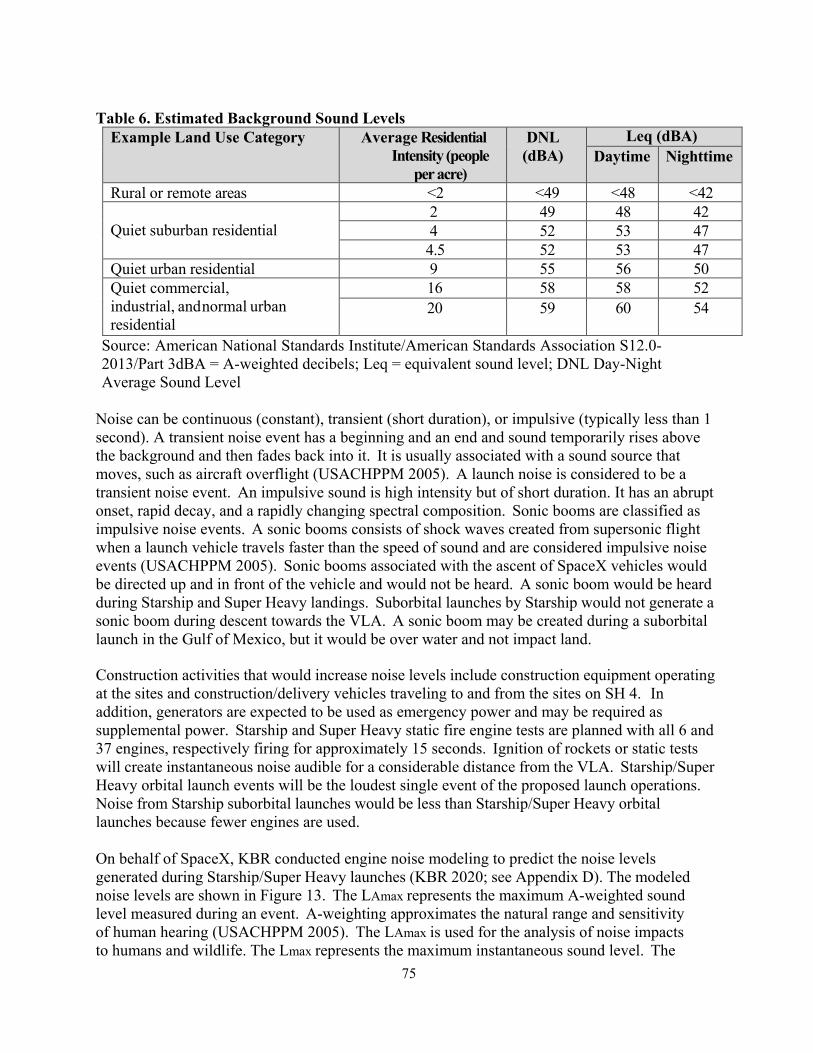
75
Table 6. Estimated Background Sound Levels
Example Land Use Category Average Residential Intensity (people
per acre)
DNL (dBA)
Leq (dBA) Daytime Nighttime
Rural or remote areas <2 <49 <48 <42 Quiet suburban residential
2 49 48 42 4 52 53 47 4.5 52 53 47
Quiet urban residential 9 55 56 50 Quiet commercial, industrial, and normal urban residential
16 58 58 52 20 59 60
54
Source: American National Standards Institute/American Standards Association S12.0- 2013/Part 3dBA = A-weighted decibels; Leq = equivalent sound level; DNL Day-Night Average Sound Level
Noise can be continuous (constant), transient (short duration), or impulsive (typically less than 1 second). A transient noise event has a beginning and an end and sound temporarily rises above the background and then fades back into it. It is usually associated with a sound source that moves, such as aircraft overflight (USACHPPM 2005). A launch noise is considered to be a transient noise event. An impulsive sound is high intensity but of short duration. It has an abrupt onset, rapid decay, and a rapidly changing spectral composition. Sonic booms are classified as impulsive noise events. A sonic booms consists of shock waves created from supersonic flight when a launch vehicle travels faster than the speed of sound and are considered impulsive noise events (USACHPPM 2005). Sonic booms associated with the ascent of SpaceX vehicles would be directed up and in front of the vehicle and would not be heard. A sonic boom would be heard during Starship and Super Heavy landings. Suborbital launches by Starship would not generate a sonic boom during descent towards the VLA. A sonic boom may be created during a suborbital launch in the Gulf of Mexico, but it would be over water and not impact land.
Construction activities that would increase noise levels include construction equipment operating at the sites and construction/delivery vehicles traveling to and from the sites on SH 4. In addition, generators are expected to be used as emergency power and may be required as supplemental power. Starship and Super Heavy static fire engine tests are planned with all 6 and 37 engines, respectively firing for approximately 15 seconds. Ignition of rockets or static tests will create instantaneous noise audible for a considerable distance from the VLA. Starship/Super Heavy orbital launch events will be the loudest single event of the proposed launch operations. Noise from Starship suborbital launches would be less than Starship/Super Heavy orbital launches because fewer engines are used.
On behalf of SpaceX, KBR conducted engine noise modeling to predict the noise levels generated during Starship/Super Heavy launches (KBR 2020; see Appendix D). The modeled noise levels are shown in Figure 13. The LAmax represents the maximum A-weighted sound level measured during an event. A-weighting approximates the natural range and sensitivity of human hearing (USACHPPM 2005). The LAmax is used for the analysis of noise impacts to humans and wildlife. The Lmax represents the maximum instantaneous sound level. The

76
maximum levels for each static fire, suborbital orbital launches, and orbital launches of Starship/Super Heavy range from LAmax of 90 decibels A-weighted (dBA) to 140 dBA. For static fire tests, the LAmax 90 dB contour extends about 2.5 miles west of the VLA. For orbital launches of Starship/Super Heavy, the higher LAmax contours (100-140 dBA) are located within about 7 miles of the VLA. The 100 dBA contour extends into parts of South Padre Island and Port Isabel, including the 90 DBA contour extends into Laguna Vista and eastern parts of Brownsville. Piping plover critical habitat units TX-1, 2, 3a, 3b and proposed red knot critical habitat unit TX-11 would also be in the 90-140 contours dBA sound contours for orbital launches. For suborbital Starship launches, the 90 dBA contour extends into Port Isabel.
Super Heavy booster and Starship landings at the VLA during orbital missions would generate lower sound levels than orbital launches because of the much lower total engine thrust used for landing operations. For Starship landings at the VLA, the 90 dB LAmax contour is about 5 miles from the VLA into Port Isabel and part of South Padre Island. Super Heavy landings at the same contour would be about 7 miles from the VLA. Residents of Brownsville may hear booster landing events above 60 dB, particularly nighttime landings. Visitors at Isla Blanca Park, approximately 5 miles north of the VLA, would experience elevated sound levels during a landing event. Noise during offshore Super Heavy landing events is not expected to be noticed by residents along the coast.
Max overpressure is the force left after a sonic boom and predicted overpressure levels for a Starship landing range from 1.2 to 2.2 pounds per square foot (psf). The 2.2 psf contour is estimated to be less than 1 nautical mile from land and overpressure between 2.20 and 1 psf are predicted to impact areas of South Padre Island. Overpressure levels for a Super Heavy landing at the VLA range from 2.5 psf to 15 psf. A very small area of Boca Chica State Park to the south of the VLA would experience up to 15 psf. A small portion of Brazos Island State Park and portions of Boca Chica State Park would experience levels of 11-15 psf. Boca Chica Village would experience 9 psf. The southern portion of South Padre Island is expected to experience 6 psf and Port Isabel and Laguna Heights are expected to experience 4-6 psf. The remainder of South Padre Island is expected to experience between 2-4 psf, and Laguna Vista and Tamaulipas, Mexico is expected to experience 2 psf. Mammals and birds would also potentially be startled and birds appear to be more affected behaviorally by a sonic boom than domestic mammals (Manci, K.M, at al. 1988). Overpressures less than 1 psf are not expected to adversely affect animals.
Overpressure levels range from 1 psf to 15 psf for a Super Heavy landing at the VLA). Brazos Island State Park, Boca Chica Bay, Boca Chica State Park, and portions of LRGVNWR would experience levels up to 15 psf. Boca Chica and the southern tip of South Padre Island are within the 6.0 psf contour. South Padre Island, Port Isabel, and the Port of Brownsville ship channel are included in the 4.0 psf contour. Sonic booms up to 1.0 psf would be expected to reach up to 15 miles from the VLA. If the magnitude is great enough, a sonic boom can cause building damage. Sonic booms with an over pressure of 0.5 to greater than 10 psf can cause structural damage to buildings. Sonic booms greater than 0.5 psf can also cause a startle effect on humans. People on South Padre Island would be expected to notice sonic booms from vehicle landings following an orbital mission. Mammals and birds would also potentially be startled and birds appear to be

77
more affected behaviorally by a sonic boom than domestic mammals (Manci, K.M, at al. 1988). Modeled overpressures for a Super Heavy booster landing that are greater than 1 psf extend about 13 miles from the launch pad (Figure 15). Beyond 13 miles, modeled overpressures are less than 1 psf. Overpressures less than 1 psf are not expected to adversely affect animals. The primary impact associated with noise generated from construction, traffic, and vehicle launches is the startle effect, when birds or other wildlife are surprised by sudden, unexpected loud noises and leave the area abruptly. Noise can cause stress in animals and the range of autonomic responses to noise could range from no reaction to alerting, disruption of feeding and/or breeding and flight. It could also arouse defensive behaviors or masking. Masking occurs when noise interferes with the perception of sounds of interest, such as predator avoidance or social signals (Bowles 1995). In response to sonic boom, birds may “occasionally run, fly, or crowd” (Manci et al 1998). Listed species in the Action Area would be exposed to sonic booms generated by Starship and Super Heavy up to ten times per year (sonic booms impacting land would only occur during Starship/Super Heavy orbital missions). The responses are also hard to predict because disturbance may depend on species.
Dorado-Correa et al (2018) investigated the effects of traffic noise on telomeres, a DNA-protein structures found at both ends of each chromosome, on zebra finches (Taenopygia guttata). Telomere loss can provide a link between early stress exposure and longevity. The study showed that chronic exposure to traffic noise increases rates of telomere loss in older juvenile zebra finches. It also suggests that anthropogenic noise increases telomere attrition rate and may be a biomarker for reduced long-term survival which may even effect population dynamics of birds in noise polluted areas.
For orbital launches of Starship/Super Heavy, the higher LAmax contour’s (100-140 dBA) are located within about 7 miles of the VLA. Table 2 shows that Starship suborbital launches are proposed to occur up to 5 times a year and Starship/Super Heavy orbital launches are proposed to occur up to 5 times a year, which would result in up to 10 Starship landings and 5 Super Heavy landings a year.
Ocelots and Jaguarundi: There are no known studies that specifically address the effects of noise on ocelots or jaguarundis, in fact, information about the effect of noise on felines is lacking. Therefore, we have used studies of the effects of noise on other mammals as a surrogate to analyze the effects of noise caused by SpaceX activities on ocelots and jaguarundis. Studies of terrestrial mammals have shown that noise levels of 120 dBA can damage mammal’s ears (NoiseQuest 2013). Levels at 95 dBA can cause temporary loss of hearing sensitivity (NoiseQuest 2013). Noise from aircraft has also affected large carnivores by causing changes in home ranges, foraging patterns, and breeding behavior (NoiseQuest 2013).
Ocelots and jaguarundis are known to use the lomas scattered throughout the Action Area to cross expansive tidal flats around and adjacent to the VLA. Noise levels at the lomas will reach between 100 and 120 dB, thereby possibly injuring the cat’s ears and hearing ability. Noise from testing and launches could also startle the cats causing a negative effect of running and avoidance behavior and increased energy use. It is reasonable to assume that the cats could display a range of responses to noise; they could have no reaction, become alert, stop foraging, alter travel routes, or become startled and flee the area. Startle effects and alteration of travel routes could increase chances of vehicular mortality along SH 4.

78
Northern Aplomado Falcon: Ellis et al (1991) looked at effects of low-level military jet aircraft and mid-to high-altitude sonic booms on nesting peregrine falcons. Peregrine falcons are similar in size and behavior to aplomado falcons and are appropriate to use as surrogates. Jet passes and sonic booms often caused noticeable alarm, and peregrine falcons demonstrated crouching, or rare flushing from the perch or nest. Ellis et al (1991) also noticed negative responses became rarer and peregrine falcons potentially became habituated to the noises or types of noises that occur and stop exhibiting the startle response. Foraging, nesting, and perching habitat for the northern aplomado falcon exists within the Action Area. The closest known nest occurs 1 mile, from the LLCC and the closest active nest is within approximately 4.3 miles of the VLA. For orbital launches of Starship/Super Heavy, the higher LAmax contours (100-140 dBA) are located within 7 miles of the VLA. These noise levels could cause adult aplomado falcons to flush from the nest leaving eggs or small chicks exposed to inclement weather or predators, although they may get habituated to the noise later in time. These noise levels may also reduce aplomado falcon foraging efficiency and feeding time. Falcons could also experience reduced communication ranges, interference with predator/prey detection, or habitat avoidance in the Action Area (NoiseQuest 2013). More intense impacts may include behavioral change, disorientation, or hearing loss if falcons are within closer range of the launch pad at the time of ignition of rockets.
Sea Turtles: Noise may cause sea turtles reaching nesting beaches to startle and return to the water, false crawl, and not lay eggs. The National Aviation Service conducted a study in 1990, on the impacts of the Zakynthos, Greece airport on nesting sea turtles. It revealed the disturbance of the low flying jets over loggerhead sea turtle nesting beaches caused females to return to the sea without successful laying (Euroturtle 2013). Given the distance between the launch pads and potential sea turtle nesting habitat on Boca Chica Beach is approximately 0.18 mile; noise levels at the nesting beach could reach 120 to 130 dBA and could adversely affect sea turtles.
Salas (2022) of Woods Hole Oceanographic Institution presented preliminary evidence of the effects of intense noise on aquatic turtles at the 2022 Ocean Science Meeting on 4 March 2022. Her findings were that underwater noise pollution can cause turtles to experience hearing loss that can last from minutes to days. The researchers focused their experiments on two non- threatened species of freshwater turtles and exposed them to noise. The induced noise caused a temporary threshold shift (TTS) which is the decrease in the animals hearing sensitivity due to noise. Turtles affected by the noise pollution in the wild would be less able to detect sounds in their environment for communication or detect approaching predators.
Piping Plover, Piping Plover Critical Habitat, Red Knot and Red Knot proposed Critical Habitat: Birds demonstrate startle effects when exposed to a sound pressure level (SPL) of 108 dBA (Burger 1981). Noise levels exceeding 108 dBA will occur during static fires, suborbital and orbital launches. High-noise events may cause birds to engage in escape or avoidance behavior and they may flush and expend energy that may affect survival or growth, or they may spend less time engaged in necessary activities like feeding and preening (NoiseQuest 2013).
Monitoring of snowy plovers at Vandenberg Air Force Base showed them to crouch and observe objects such as helicopters or launch vehicles that mimic avian predators, or flush at

79
launch but soon return to normal behavior (FAA 2013). Piping plovers are expected to have a startle response that interferes with normal behaviors such as feeding or roosting.
Laboratory findings show that if a bird is exposed to continuous noise level above 110 dBA SPL, hearing will likely be damaged (Dooling and Popper 2007). However, highway noise above 93 dBA SPL might mask important communication signals used by birds, and possibly lead to behavioral or physiological effects (Dooling and Popper 2007). Piping plovers in Critical Habitat Unit TX-1 will be impacted by noise from construction and launches. Critical Habitat Units TX-2, TX-3a and 3b will not be directly affected by construction. However, these critical habitat units may be impacted by noise generated by a launch of the Starship/Super Heavy because piping plovers and red knots may disperse and stop using CH for feeding and roosting.
Measures to minimize: To reduce impacts, SpaceX has contracted with Sea Turtle, Inc. to remove nests for protected incubation and to document false crawls and/or missed nests. Surveying the beach prior to and after static fires or launch events assists Sea Turtle, Inc. in documenting false crawls and or missed nests to SpaceX and the Service.
Rocket Heat Plume Ignition of the Starship and Super Heavy Raptor engines during static fire engine tests and launches (including landings) would generate a heat plume that would surround the launch pad and surrounding areas. The plume would appear clear and consist of heat (and steam if deluge water was used in the future) and extend radially from the center of the pad. The heat plume generated from Starship/Super Heavy orbital launches would travel away from launch pad, with temperatures of about 212 °F approximately 0.3 mile from the launch pad and temperatures reaching ambient temperatures (90 °F) approximately 0.6 miles from the launch pad (Figure 27). Orbital launches would create the largest and hottest plume from the ignition of all Super Heavy’s 37 Raptor engines. Static fire engine tests, landings, and suborbital launches would all require fewer engines and would generate a smaller, cooler plume compared to an orbital launch. The highest heat levels are expected to occur directly around the launch mount and are not expected to exceed 300 degrees outside of the VLA.
Individual animals in the heat plume danger area would likely disperse before the heat spreads out due to the noise associated with engine ignition. However, less mobile animals unable to disperse quickly could be exposed to the heat plume and die or be injured. Potential impacts from the vegetative changes due to the heat plume include loss of sensitive species, loss of plant community structure, reduction in total cover and replacement of some native species with weed species.
Ocelot and Jaguarundi: Rocket plumes may injure or kill individual cats if they within the .3- or .6-mile radius at the time of ignition. However, operational noise from the launch vehicle tank preparing to ignite could cause the cats to startle and leave the area prior to ignition. The ignition phase would last approximately 30 seconds.
Northern Aplomado Falcon: The heat plume from engine ignition could harm or kill individual falcons; however, operational noise (e.g., gas venting from the launch vehicle tank) could cause falcons that are located near the launch vehicle during an operation to fly

80
away prior to engine ignition. Sea Turtles: The heat plume is not expected to affect sea turtle nests that are missed on prelaunch surveys because the eggs are buried in the sand and Sea Turtle, Inc. patrols the beach pre-and post-launches to detect nests. Post launch patrols would find any dead turtles and potentially damaged nests. If a nest is found, the eggs would be relocated to a corral or facility. Nesting females and hatchlings could be affected by the heat plume if they were on the beach at the time of engine ignition. Kemp’s ridley is a daytime nester, although it has been known to nest at night occasionally. The remaining sea turtle species nest during the night when ongoing operations, static fires or launches occur, but not as often. Nests and hatchlings that are missed by patrollers will be subject to adverse effects including death or serious injury.
Piping Plover, Piping Plover Critical Habitat, Red Knot, and Red Knot proposed Critical Habitat: Piping plovers and red knots do not nest within the Action Area and so nesting would not be impacted. The heat plume generated by the Raptor engines would cause high temperatures to radiate from the launch pad. Temperatures would be temporary and not expected to cause permanent damage to the unvegetated flats used by piping plovers and red knots. However, piping plovers or red knots could be exposed directly to the exhaust plume and could be burned by the hot gas, but would need to be flying through the path of the exhaust plume at the time of ignition. It is also anticipated that the birds would startle and fly away by the noise of the launch engines. At this time no deluge water is being proposed, therefore an evaporative cloud is not anticipated that could result in the potential conversion of wind-tidal flats associated with piping plover Critical Habitat Unit TX-1 and red knot proposed Critical Habitat Unit TX-11.
Measures to minimize: The heat plume will last 2-3 seconds as it generated by the engines at launch. The rocket makes noise at is being prepared for launch and it is anticipated that cats, shorebirds and falcons will be startled and move away from the area. STI, will perform a pre- and post-launch survey for sea turtles that may be nesting or attempting to nest and launch will not occur until the sea turtle has completed nesting and the eggs removed. If a turtle was missed or a nest and hatchlings are seen emerging from a missed turtle prior to launch the launch will be delayed. If a missed turtle was injured and observed on a post- launch survey the Service will be notified and protocol followed.
Night Lighting Night lighting represents a potential stressor to nesting sea turtles on nearby Boca Chica Beach as well as migrating birds and nocturnal species. Light emissions are light sources that illuminate an area in the surrounding environment. Sources of light emissions include launch site lighting, employee/customer parking lighting, airborne and ground-based aircraft operations and roadway lighting. Glare is light emission being redirected off of a reflective surface such as window glass in a facility. There are no state or local regulations that govern visual resources and light emissions in Texas. SpaceX would attempt to conduct most launches and tests between the hours of 7:00 a.m. and 7:00 p.m. However, there could be delays or missions that require launching at a specific time at night to achieve a particular orbital position. During nighttime launch activity, SpaceX would require bright spotlighting for short durations when illuminating the launch vehicle. In addition to nighttime launch activity, SpaceX would need to perform

81
ground support operations 24/7 at the VLA throughout the year using white lighting for the safety of SpaceX personnel. SpaceX assumes that 20 percent of annual operations could occur at night.
Ocelot and Jaguarundi: Cats are predominately nocturnal, active overnight and at dawn and dusk and may avoid lit areas and seek other north-south travel corridors through the lomas, expending additional energy and increasing the potential for vehicular mortality on SH 4 if startled by lights or avoiding lighted areas of constructive or operational activities. Lighting could affect activity patterns of the ocelot and jaguarundis. Evening activity levels could be reduced or redirected to more dense vegetation reducing the availability of prey and restricting movements of the cats themselves (Grigione and Mrykalo 2004).
Northern Aplomado Falcon, Piping Plover, Piping Plover Critical Habitat, Red Knot and proposed Critical Habitat: Some birds may be attracted to light, especially when migrating during overcast nights, causing them to be disoriented and collide with buildings or other structures (FAA 2013). Aplomado falcons generally roost at night, so impacts should be minimal, however some falcons have exhibited some nighttime activity as they have been documented to hunt for insects under street lights in Palenque, Chiapas Mexico (personal comm. C. Perez, 2022). To minimize collisions with the four lightning towers and the water tower, these structures will be lit in accordance with the Federal Communications Commission’s (FCC) guidelines.
Sea Turtles: All five species of sea turtles have been recorded nesting within the Action Area. Kemp’s ridley sea turtles predominately nest during the day and is the most common species of sea turtle to nest in the Action Area. All other sea turtle species nest at night. Anthropogenic light sources have had documented negative effects on sea turtles. Adult females looking for nesting beaches seek dark stretches of suitable shoreline. Unshielded lights can deter females from crawling onto a beach to nest. When hatchlings emerge they seek the nearest available light source, which on an undeveloped beach is the horizon over the ocean. Lights shining in the vicinity of the nest can disorient emerging hatchlings, leading them away from the ocean making them more vulnerable to predation, desiccation, or crushing by vehicles. Hatchlings that have reached the surf can also become disoriented by lighting and have been documented to leave the surf (NMFS and Service 2007). Hatchlings whose sea-finding is disrupted by unnatural stimuli often die from exhaustion, dehydration, predation, or other causes (Witherington et al. 2014). Some of these behavioral effects on adult turtles and disorientation of young turtles are expected to occur.
Some structures within the launch complex, use amber LEDs or low pressure sodium bulbs for exterior night lighting. Most of these facilities are not located immediately adjacent to the beach, which limits the potential effects on listed species However they do contribute to elevated levels of ambient light and are some of the only lights on barrier islands within the Action Area. Such night lighting can negatively impact nesting sea turtles.
All sea turtle nests detected on Texas beaches are collected, and the eggs are incubated in facilities. However, it is possible that sea turtle patrol personnel could be unable to access the beach, thereby missing a sea turtle nest event and fail to collect and relocate eggs.

82
Piping Plover, Piping Plover Critical Habitat, Red Knot, and Red Knot proposed Critical Habitat: Anthropogenic lighting from construction or operation attracts migrating birds, especially during times of reduced visibility. Piping plovers and red knots effects can range in intensity from collisions with structures resulting in injury or mortality, to lesser effects including expenditure of energy or delay in arrival at wintering grounds (Gauthreaux and Belser 2006). Plover visual acuity and maneuverability are known to be good (Burger et al. 2011), including night vision (Staine and Burger 1994), suggesting that plovers may be able to identify and avoid structures in flight paths. Plover collisions with fixed structures in the coastal zones are rarely documented (Service 2008). Migrating red knots may be exposed to similar risks.
Measures to minimize: To minimize potential impacts SpaceX will implement the Lighting Management Plan (Appendix F) and doing regular inspections will help reduce the effects these lights have on turtles, but some adverse effects to sea turtles, either in the form of hatchling disorientations or reducing the likelihood of nesting may occur when launches occur within sea turtle nesting season.
Hazardous Materials Hazardous materials have the potential to impact the listed species and the piping plover’s critical habitat and red knot’s proposed critical habitat in the Action Area. Construction and operational activities would require the use of hazardous materials. Most of the hazardous materials expected to be used are common to construction activities and include diesel fuel, gasoline, and propane to fuel the construction equipment; hydraulic fluids, oils, and lubricants; welding gases; paints; solvents; adhesives; and batteries. Processing and maintenance of launch vehicles may generate small quantities of hazardous waste. Those include waste oils, spent solvents, paint waste, spill response materials, and used batteries. The solar array infrastructure may generate small amounts of lithium cobalite and lithium hexaflorophosphate by charging too fast or physical mechanical damage causing a fire. Stormwater or wastewater runoff also has the possibility of accumulating spilled hazardous material into the adjacent tidal flats or lomas, contaminating those areas or resulting in a loss of habitat and vegetation.
Ocelots and Jaguarundi, Northern Aplomado Falcon, Sea Turtles, Piping Plover, Piping Plover Critical Habitat, Red Knot, Red Knot and proposed Critical Habitat: An accidental release of hazardous materials during construction (e.g., equipment fuel spill) could affect individual listed species if they were exposed to the contaminant, which could cause injury, sickness, or death. Accidental spills could also affect vegetated habitat, including designated critical habitat, by damaging or killing plants, which could affect plant density and diversity.
Measures to minimize: To reduce potential impacts, SpaceX’s Spill Prevention, Control, and Countermeasures Plan (SPCC Plan) would be implemented in accordance with the Clean Water Act requirements included in 40 CFR Part 112 to outline proper management and spill response procedures for changes in the oils and fuels stored at the SpaceX Boca Chica Launch Site. Retired solar panels shall be handled as Recyclable Hazardous Waste and sent to a contracted recycler. If treatment or wastewater is needed, the water would be retained in retention ponds adjacent to the launch mount.
83
Ground Vibrations Some energy from rocket launches and static tests will manifest as vibration in the ground near the launch pad. Vibration may be significant from rocket launches and engine tests. Effects from vibrations are likely to add to species disturbance and cause abnormal behaviors. However, vibrations from launch operations would only last a few minutes.
Ocelot, Jaguarundi, Northern Aplomado Falcon, Piping Plover, Piping Plover Critical Habitat, Red Knot, and Red Knot proposed Critical Habitat: Ground vibrations could result from a launch or static fire, or vehicular motion during construction and operations. Species reactions could vary depending on their proximity to the launch site or construction/operation activities. These species may experience some startle effect and/or habitat avoidance. Impacts should last only a few minutes and normal behavior would resume afterwards.
Sea Turtles: Vibrations caused by moving maintenance vehicles and/or equipment, launches, and static fire near the beach could frighten nesting turtles, causing them to false crawl (NMFS and Service 1991a, 1991b, 1992; Ernest et al. 1998). Vibrations could also harm incubating eggs, but this is difficult to assess because scientific data are lacking to fully understand the level of impact on sea turtles from vibrations or noise. The closest nesting sea turtle habitat to the proposed launch pad is at Boca Chica Beach, a distance of approximately 800-900 feet, and vibration from the rocket launches could cause nesting turtles to abandon their nesting attempt and potentially harm incubating eggs.
All sea turtle nests detected on Texas beaches are collected, and the eggs are incubated in facilities. However, it is possible that sea turtle patrol personnel could be unable to access the beach, thereby missing a sea turtle nest event and fail to collect and relocate eggs.
Increased Traffic and Human Presence An increase in vehicle traffic during daily operations from construction and SpaceX operations personnel increases the potential for vehicle collisions with wildlife, including listed species. In addition, increased traffic and human presence could cause wildlife to avoid the area. Most of the traffic from construction and operations would occur during daylight hours. SpaceX anticipates that up to 55 construction vehicles a day would be associated with the construction period. In addition, up to 450 SpaceX staff vehicles would be expected per day in the area as well. The Proposed Action is anticipated to add up to 505 vehicles per day within the LRGVNWR and within SH 4 corridor providing access to Boca Chica Beach and the VLA. Table 7 provides data from TxDOT that illustrates steadily increasing traffic from 2013-2020. Data provided for cumulative vehicle activity period of October 1, 2021 to April 15, 2021 by CBP indicates the largest number of hourly vehicle crossings, leaving Boca Chica Beach traveling west towards Brownsville, occurs at 7 a.m. and 7 p.m., peak hours for species to be active (Figure 28). Increased traffic during these two time periods may be related to SpaceX shift changes.

84
Table 7. Daily Annual Average Traffic (AADT) (Traffic Web Viewer, TxDOT) Year at 31H55A (about.30 miles west of the CBP Checkpoint) 25.919946, -97.374726 Object ID_1 7119, Pharr District, Cameron County, TX
Daily Annual Average
Total Annual vehicles
AADT_2020 1,428 521,220 AADT_2019 745 271,925 AADT_2018 708 258,420 AADT_2017 537 196,005 AADT_2016 383 139,795 AADT_2015 326 118,990 AADT_2014 273 99,645 AADT_2013 285 10,4025
(Transportation Planning and Programming (TPP) Division’s Traffic section at TxDOT, Data Source: Statewide Traffic Analysis and Reporting System (STARS II) May 3, 2022) Ocelot and Jaguarundi: Although not documented for the ocelot and jaguarundi, several responses to human disturbance can be expected in felines. For example, Florida panthers shifted their habitat use area in response to hunters although no changes related to energy intakes (activity rates, movement rates or predation success) were noted (Janis and Clark 2002). In another study, lynxes were found to have a median tolerance limit to approaching humans of 164 feet and they tolerated a closer approach by humans when in denser habitats than in more open areas (Sunde et al 1998 as cited by Tempel et al 2006). In general, typical wildlife responses to human disturbance may be fleeing, increased vigilance, and changes in habitat selection (Frid and Dill 2002).
Ocelots have been seen crossing paved linear structures such as roads and have been documented on SH 4. Data indicates that vehicular collisions are a significant source of ocelot mortality, with 44 percent (12 of 27) of known ocelot mortalities from 1982 to 1996 likely being vehicle related (Hewitt et al. 1998) and 45 percent of the total ocelot mortality documented in South Texas between 1983 and 2002 likely being vehicle related (Haines et al. 2005) (Figure 29).
Peak ocelot activity is around sunset and sunrise with continued activity during the night hours, the exact time periods hourly vehicle crossings are at their peak. Heavy traffic at this time with other noise effects could startle the cats and/or lighting effects could cause the cats to adjust their feeding or transitioning habits and increase the risk of road mortality if forced to cross SH 4. Posting of wildlife crossing signs by TxDOT may educate workers and public about reducing speeds, however greater law enforcement presence is recommended.
Northern Aplomado Falcon: Mortality from bird-vehicular collisions are estimated at the lowest range to be between 62 and 275 million birds each year. Only predation by free ranging domestic cats and collisions with buildings and windows cause greater annual bird mortality in the United States (Loss et al. 2014, Service 2020c). Although possible, there has not been any documented vehicular mortality of the northern aplomado falcon within the Action Area.

85
Human presence and disturbance from testing or launches could also displace adult aplomado falcons from established nesting structures approximately 1 mile from the LLCC and 2.7 miles from the VLA. Disturbance during nesting may cause the adult to leave the nest, exposing eggs or small young to inclement weather or predators. Disturbance may also reduce foraging efficiency and feeding time. Human disturbance or noise from pre-launch operations would likely cause aplomado falcons to take flight prior to launch.
Sea Turtles: Vehicle collisions with sea turtle hatchlings during the daytime have been recorded near and adjacent to the VLA. Beach visitors found in situ nest hatching on Boca Chica Beach and attempted to provide safe passage, but some hatchlings were killed by passing vehicles driving on the beach and later taken by gulls (Pers. Comm., D. Shaver, Sea Turtle Coordinator, NPS 2006). Additionally, there was a report of a stranded turtle being hit by a vehicle on South Padre Island (Pers. Comm., D. Shaver, Sea Turtle Coordinator, NPS 2007).
Sea turtles reaching Boca Chica Beach, just 1,000 feet east of the VLA, to nest may return to the water, false crawl, and not lay eggs due to vehicular movement or human disturbance (Bonka 2021, FAA 2017, 2020). Operation of Sherriff patrols or SpaceX security vehicles during or after launch closures and during anomaly closures on the Boca Chica Beach can crush nesting turtles or stranded turtles, as well as eggs in and/or hatchlings emerging from a missed nest (Mann 1977; NMFS and Service 1991a, 1991b, 1992, 1993; Ernest et al. 1998). Adult loggerhead and green sea turtles nest at night and most female Kemp’s ridley nest during daylight hours and may be caught in the morning hours on the beach at some stage of nesting: oviposition, covering the nest, or exiting and returning to the ocean. Hatchlings may also emerge at night or early in the morning from any nests missed by the daily sea turtle patrols. Hatchlings could get disoriented by vehicular or construction and operational lights and turn away from the ocean or get caught in tire ruts possibly incurring dehydration, injury, or death.
Species which prey on sea turtle nests or young turtles, such as coyotes (Canis latrans), raccoons (Procyon lotor), skunks (Mephitis mephitis) and fire ants (Solenopsis invicta), may be attracted to the construction area by garbage generated by employees, and may increase in number as a result of the increased food resources provided by the garbage, thus posing a greater risk to the sea turtles
Piping Plover, Piping Plover Critical Habitat, Red Knot and proposed Critical Habitat: Driving is allowed in many areas of the piping plover and red knot wintering grounds in the Action Area from the mean low tide line to the line of vegetation on the shore. Increased vehicular access due to recreation or Sheriff or SpaceX security patrols may increase ruts or berms. SpaceX vehicles driving on the beach could cause injury to plovers that may be resting in ruts, or next to a berm, especially during inclement weather, and/or expose critical habitat to further erosion and removal of organic matter and food sources. Direct mortality from construction equipment may occur if plovers and red knots do not disperse prior to equipment or vehicular use during construction at the VLA.
Zonick and Ryan (1996) found that in Texas, human disturbance decreases the amount of undisturbed habitat and appears to limit local piping plover abundance. Piping plovers and red knots will likely be flushed from the Action Area expending energy and interrupting foraging or roosting. This is expected to be a temporary disturbance.

86
Measure to minimize impacts: SpaceX will educate its personnel on the potential for vehicle collisions with ocelots and jaguarundis and other endangered species and encourage personnel to utilize the employee shuttle and, if a personal or company vehicle must be used, encourage personnel to reduce speeds along SH 4. Vehicles would be restricted to existing paved and unpaved roads, parking areas, and authorized construction sites. Vehicle operators within the VLA would not exceed 25 miles per hour. Beach clearing activities prior to a closure are handled by Sheriff Deputies. SpaceX security patrols are only on the beach during anomaly events. When they are present on the beach they will use 4X4 pickup trucks and require their staff to travel at 10-15 mph.
Tall Structures The construction of new structures could pose a potential collision impact to birds. During the daytime, birds collide with windows because they see reflections of the landscape in the glass (e.g., clouds, sky, vegetation, or the ground); or they see through glass to perceived habitat (including potted plants or vegetation inside buildings) or to the sky on the other side (Service 2016b). Research indicates that collision mortality increases with structure height for most structures (e.g., communication towers and wind turbines) (Loss et al. 2014, Service 2020c). At night, during spring and fall bird migrations when inclement weather occurs, birds can be attracted to lighted structures resulting in collisions, entrapment, excess energy expenditure, and exhaustion (Manville 2009). Lighting could also attract raptors or other migratory birds to the vertical launch area for perching.
Ocelot and Jaguarundi: No impacts are expected from tall structures, unless lights from the tall structures are illuminating the lomas or travel corridor. Lighting could affect activity patterns of the ocelot and jaguarundis. Evening activity levels could be reduced or redirected to more dense vegetation reducing the availability of prey and restricting movements of the cats themselves (Grigione and Mrykalo 2004).
Northern Aplomado Falcon, Piping Plover, Piping Plover Critical Habitat, Red Knot, and Red Knot proposed Critical Habitat: The falcon could perch on taller structures seeking prey or collide with the structures and windows during flight. Piping plovers and red knots are subject to collisions with tall structures during flight, they may be attracted to the lights during foggy periods or during low light causing injury or mortality.
Sea Turtles: No direct impacts are expected from glass effects. However, lighting of the 480- foot tall integrated tower, rocket and other taller structures having lights on during the night may shine on onto the beach during sea turtle nesting season and cause a false crawl or cause hatchlings to get disoriented and result in injury or mortality.
Measures to minimize: To minimize potential impacts of incidental take from taller structures, lighting would be reduced by complying with established lighting plan (Appendix E) for minimizing disorienting effects on migratory birds. Nest building and perching will be discouraged by the use of visual fright devices and monopole technology.
Invasive Species Introductions Proposed construction activities have the potential to degrade habitat or change vegetation and habitat structure and spread invasive plants. Invasive species could be introduced to the

87
area through construction equipment brought to the launch site or from traffic associated with deliveries and shipments of supplies.
Ocelots and Jaguarundi: Lomas used by the cats to transit through the area may experience loss of vegetation or conversion to non-native species in the event an anomaly occurs and disturbed by efforts to remove fallen debris.
Northern Aplomado Falcon: Coastal prairie grasslands could experience changes in plant species composition or abundance including increased woody species thereby, reducing the coastal prairie foraging habitat for falcons. Fires and fallen debris change the landscape and plant community.
Sea Turtles: Construction will not be performed on the beach and is not expected to result in the loss of beach habitat for sea turtles. Piping Plover, Piping Plover Critical Habitat, Red Knot and proposed Critical Habitat: Project activities could convert wind tidal flats, which the piping plovers and red knots use for foraging, to vegetated flats. This could result in the loss of 444.27 acres of occupied piping plover critical habitat which occurs within the 903.65 acres of piping plover critical habitat to be impacted. Impacts would occur to 444.27 acres of red knot proposed critical habitat in TX-11 which overlays piping plover critical habitat Unit TX-1.
Measures to minimize: SpaceX would continue to perform routine inspections of construction areas to identify and remove any invasive plant species in an effort to reduce impacts and restrict the spread of invasive species within the Action Area. Vegetation monitoring will be implemented as outlined in the Biological Monitoring Plan and reported annually.
Anomaly Anomalies and removal of debris impacts – An anomaly may result in the spread of rocket and potential infrastructure debris on the VLA and/or adjacent occupied piping plover and red knot habitat and designated and proposed critical habitat. Removal techniques may involve drones to document the location of debris, equipment (dozers, trucks, off-road vehicles (ORVs), helicopters) to remove or drag the debris off the wind tidal flats and/or beach. In 2008, Martin et al, used aerial photography and GIS to examine propeller and ORV scarring in seagrass and wind-tidal flats of the upper Laguna Madre in the Padre Island National Seashore (PINS), Texas. PINS provides critical habitat for the piping plover and red knot and ORV use on PINS creates scars in adjacent wind-tidal flats. Damage from ORV tracks can destroy benthic organisms and alter organic matter recycling lowering nutrient levels in the sediments (Belnap 1995). ORV tracks can also alter the natural hydrology by channelizing water flow leading to increased runoff and erosion (Martin et al 2008, Belnap 1995, Hinckley et al 1993). The lack of studies on ORV track persistence on wind tidal flats are rare, but in a desert region, algal crust recovery can range from 35-65 years and recovery from soil compaction takes hundreds of years (Belnap 1995).
A Starship/Super Heavy test operation or launch could fail (referred to as an anomaly) and of 17 recorded Starship/Super Heavy tests and launch operations 11 different types of anomalies have occurred since SpaceX began its experimental activity. Seven anomalies have resulted in the

88
spreading of debris to state and refuge lands, including LRGVNWR and four occurred on the VLA. Piping plover and red knot wind tidal flat habitat and piping plover critical habitat and red knot proposed critical habitat was damaged by fallen rocket debris and removal efforts. If additional anomalies or explosions occur, listed species adjacent to the launch pad or within areas impacted by falling debris could be injured or killed. In addition, fires could start from an explosion which could result in a loss of habitat. The habitat would be lost until vegetation has been restored.
Ocelots and Jaguarundi: Cats in the area or passing through may be killed or injured by an explosion or by falling debris. They also could be startled and caused to disperse. Habitat on the lomas could be damaged or destroyed by falling debris, fires or the cleanup efforts. Measures to reduce damage from fire and anomalies are included in the Fire Management Plan and the Anomaly Response Plan (Appendix E). Northern Aplomado Falcon: Coastal prairie grasslands could experience changes in species composition or abundance because of falling debris, fires, and cleanup efforts reducing the foraging habitat for falcons. A falcon could also be killed, injured or startled from its nest site causing it to abandon chicks or eggs during an explosion or fire.
Sea Turtles: Debris and fire from anomalies has not occurred on the beach, but could in the future. Sea turtles on the beach at the time of the explosion or during debris removal could be killed or injured or a nest missed for protected incubation could be crushed.
Piping Plover, Piping Plover Critical Habitat, Red Knot, and Red Knot proposed Critical Habitat: Piping plover and red knot habitat and critical habitat could be reduced or lost or converted by debris and retrieval and removal of debris. This could result in the loss of 444.27 acres of piping plover critical habitat which occurs within the 903.65 acres of piping plover critical habitat to be impacted. Impacts would occur to 444.27 acres of red knot proposed critical habitat in TX-11 which overlays piping plover critical habitat Unit TX-1.
Measures to minimize: To reduce impacts, immediately following an anomaly, SpaceX would coordinate with TPWD and the Service prior to any attempt of cleanup to: minimize damage to the Refuge lands and sensitive historic, biological, and geological resources. SpaceX would also follow the emergency response and cleanup procedures outlined in the Hazardous Materials Emergency Response Plan and Fire Mitigation and Response Plan (if a fire occurs) and the Anomaly Plan.
Monitoring The intent of conducting frequent surveys, implementing area closures and posting signage, and similar actions is to reduce or avoid impacts to listed species by detecting them early. However, these activities, could result in some adverse effects to listed species because they result in increased human access and activity within the beach, loma and wind-tidal habitats.
Ocelots and Jaguarundi: The cats could be startled by human activity during monitoring, a temporary impact.
89
Northern Aplomado Falcon: Falcons could be disturbed and foraging or nesting activities interrupted. It is expected to be a temporary impact.
Sea Turtles: Sea Turtle, Inc. is experienced in performing sea turtle surveys and it is unlikely that there would be any effects to sea turtles from monitoring efforts. However, sea turtle patrollers may drive up on a sea turtle crawling onto the beach and trained monitors may have to dig into a nest and remove the eggs but these activities are currently covered under a Section 10(a)(1)(a) scientific permit.
Piping Plover, Piping Plover Critical Habitat, Red Knot and proposed Critical Habitat: Piping plovers and red knots are generally disturbed to some degree during monitoring. Habitat and critical habitat could be impacted if survey efforts result in an ATV or vehicle being used to perform the surveys veers off into the flats. Human disturbance could startle or flush the birds during foraging or roosting. Critical Habitat The total impact (construction and/or operational) of 903.65 acres within piping plover Units TX-1, TX-2, TX-3A and TX-3B represents .5 percent of all designated wintering critical habitat (165,211acres) in the United States. Considering the effects of SpaceX's activities being authorized by the issuance of FAA's experimental permit or launch license on these units of critical habitat, the fact that only 444.27 acres is being impacted together with the effects on the other 141 designated units, the overall effect on wintering piping plover critical habitat is expected to be minimal. The affected critical habitat would continue to serve its intended conservation role for the wintering piping plover and would retain the current ability for the physical and biological features and not appreciably reduce the conservation value of all proposed and designated critical habitat for the winter piping plover.
Red knot critical habitat is being proposed to be designated over 127 units (18 of which are further subdivided into 46 subunits) across 13 states totaling 683,405 acres (personal comm., Moni Belton, Service, 2022). The total impact of 444.27 acres of red knot proposed critical habitat Unit TX-11, and overlaps piping plover critical habitat Unit TX-1 represents 6.5 percent of all habitat across 13 states in the wintering and migration area of the red knot.
Measures to minimize: Biologist familiar with surveys for cats, sea turtles, aplomado falcons piping plovers and red knots will conduct required monitoring and will implement monitoring as outlined in the Biological Monitoring Plan. Results will be submitted annually to the Service for review and if necessary revised.
CUMULATIVE EFFECTS
Cumulative effects considered in this Opinion are those “effects of future State or private activities, not involving federal activities that are reasonably certain to occur within the Action Area of the Federal action subject to consultation” (50 CFR 402.02). Future federal actions that are unrelated to the proposed action are not considered in this section because they require separate consultation pursuant to section 7 of the Act. Past and present federal actions near the proposed action are discussed under the Environmental Baseline Section. The October 2021 BA

90
includes a review of future non-federal activities that are reasonably certain to occur in the Action Area and that may contribute cumulative effects relevant to the Services’ BCO, which is incorporated here by reference.
Wind energy projects have increased in the Rio Grande Valley and impact listed species habitat by clearing thornscrub habitat and fragmenting the landscape. Wind energy projects do not have a federal nexus and conservation measures are voluntary unless they pursue a Habitat Conservation Plan and receive an Endangered Species Act section 10(a)(1)(b) permit from the Service.
Urban development brings increased noise, light, fencing, and human disturbance. Customs and Border Protection operations that include roads with high speed traffic, drag roads, off-road traffic impacts, lights, fencing, and road maintenance will also likely result in the loss of habitat. Customs and Border operations were waived from federal consultation for the construction of the border wall.
Privately funded activities that include rehabilitation and construction of buildings and parking areas and rehabilitation of existing buildings such as at the Port of Brownsville (Port of Brownsville 2020) may not require federal permits or section 7 consultation.
The TxDOT is planning multiple transportation improvement projects within the Action Area that may result in potential cumulative effects to listed species or critical habitat when combined with the Proposed Action. Most of the projects consist of pavement rehabilitation and preventative maintenance activities on the existing roadway (SH 4). In addition, TxDOT proposes improvements at two locations along SH 4 entirely within TxDOT’s 200 foot-wide ROW. One location would involve a turn-around to be located approximately 750 feet west from the end of the existing roadway. The purpose is to create a turnaround for larger vehicles along the entrance to Boca Chica Beach, near the end of the state-maintained roadway. The second location would involve a proposed Cameron County pull-out parking area to be located approximately 1,120 feet further west of the proposed turnaround. The parking area will consist of approximately nine parking spaces to be entirely within TxDOT’s 200-foot–wide ROW. “No Parking” signs will be placed between the pull-out parking areas and the turnaround and west of the pull-out area/SpaceX launch area to the end of the State maintained roadway (Figure 25).
The City of South Padre Island is planning to improve Laguna Boulevard with 11 foot-travel lanes and an elevated 8-foot shared use path on the west side of the street. The project will improve the drainage and incorporate low impact development so the City can become more resilient (South Padre Island 2020). Road expansions to accommodate the Rio Grande Valley development and road network, North American Free Trade Agreement, and border crossings will likely increase loss and fragmentation of habitat and increase road mortality for the cats. Other SpaceX Activities As explained above, SpaceX has constructed launch-related infrastructure, including the VLA, the LLCC, a solar farm and other support infrastructure, and has been conducting licensed launch operations, including suborbital launches, since 2019. SpaceX has also built and continues to

91
operate a production and manufacturing facility on privately owned property near the LLCC. SpaceX has developed large production tents and support buildings and plans to build an additional production tent and high bays. Further west of the production area, SpaceX has developed office space, storage areas assembled for Starship and Super Heavy vehicles, and water wells. Both areas are operated 24 hours a day, 7 days a week, and are staffed by approximately 450 people.
SpaceX’s manufacturing and processing activities and associated development are occurring on private land, are privately funded, they do not require federal approval, and are planned to continue regardless of whether the FAA issues SpaceX licenses for Starship/Super Heavy operations. FAA determined it considers these ongoing and anticipated to have independent utility from the FAA’s Proposed Action. For example, the components manufactured and processed in Boca Chica could be shipped to support launch and test activities at any of SpaceX’s facilities, including Vandenberg Air Force Base; McGregor, Texas; or Cape Canaveral Air Force Station.
Climate Change The latest Intergovernmental Panel on Climate Change (IPCC) Report projects that in the coming two decades the global temperature may rise by 1.5 degrees Celsius (2.7 degrees Fahrenheit). For 1.5°C of global warming, there will be increasing heat waves, longer warm seasons and shorter cold seasons. At 2°C of global warming, heat extremes would more often reach critical tolerance thresholds for agriculture and health. (IPCC 2021)
Climate change has a multitude of different changes in different regions. These changes may include changes in wetness and dryness, to winds, snow and ice, coastal areas and oceans. Climate change is intensifying the water cycle bringing more intense rainfall and flooding as well as more intense drought in some areas. Changing rainfall patterns high latitudes, precipitation is likely to increase, while it is projected to decrease over large parts of the subtropics. Coastal areas will see continued sea level rise contributing to more frequent and severe coastal flooding in low-lying areas and coastal erosion. Further warming will amplify permafrost thawing, and the loss of seasonal snow cover, melting of glaciers and ice sheets, and loss of summer Arctic sea ice. Changes to the ocean, include warming, ocean acidification, and reduced oxygen levels. (IPCC 2021)
Climate changes are also projected to affect individual organism, populations, species distribution and ecosystem composition and function both directly through increases in temperature or precipitation, as well as sea level rise and storm surges in the case of marine and coastal ecosystems. Such changes will affect habitat loss, modification and fragmentation, and the introduction and spread of non-native species and the organisms to respond to climate change during migration (IPCC 2002).
The Texas coast is disappearing an average of 4.1 feet per year, though over 60 percent of the coast is losing over 6 feet per year and some areas lose 30 feet of beach every year (TGLO 2017). The TGLO Coastal Resiliency Master Plan is attempting to identify and implement projects that will reduce the region’s overall risk to coastal issues of concern, including climate change and sea level rise. The Texas General Land Office, Region 4 consists of three counties, Cameron, Kenedy and Willacy counties. The three top concerns outlined in the

92
Coastal Resiliency Master Plan for Region 4 are: 1) Gulf Shoreline change, 2) Degraded or lost habitat and 3) Degraded water quality. Some of the projects being considered in Cameron County are the Bahia Grande Hydrologic Restoration, Paso Corvinas Wetlands and Hydrologic Restorations, Development of the Lower Laguna Madre and Brownsville Ship Channel Watershed Protection Plan, South Padre Island Beach and Dune Management and Restoration, Bird and Heron Island Restoration, Restore Laguna Madre Rookery Islands, Bahia Grande Living Shorelines, Restore Barrier Island Bayside Wetlands on South Padre Island, City of South Padre Island Living Shoreline, and South Padre Island Park Development (TGLO 2017).
CONCLUSION AND EFFECT OF TAKE
Ocelot, Jaguarundi, Northern Aplomado Falcon, Piping Plover, Red Knot, Kemp’s ridley, Loggerhead, Hawksbill, Green and Leatherback sea turtles After reviewing the current status of each of the species above, the environmental baseline for the action area, the effects of the proposed action and the cumulative effects it is our BCO that the action as proposed, is not likely to jeopardize the continued existence of the species nor adversely modify piping plover critical habitat or modify red knot proposed critical habitat. We base this conclusion on the following:
1. The action area encompasses a relatively small portion of the rangewide habitat of
each of the species addressed in this opinion and small portion of each species’ population.
2. The proposed action includes a variety of protective measures that are intended to minimize incidental take of individual sea turtles or damage to habitat resulting from falling debris or removal of such. Some of the measures include:
a. implementing measures that lessen noise and lighting impacts, b. monitoring of species reactions or impacts to the species and/or their habitat, c. reducing impacts to habitat from anomalies and removal of debris, d. monitoring the effectiveness of the implemented measure, and e. partnering with the Service and its conservation partners to implement
recovery plan actions.
For these reasons, the effect of the take anticipated in this BCO is not expected to significantly affect the species considered.
Ocelot and Gulf Coast Jaguarundi The effect of the take anticipated in this BCO is not expected to significantly affect these species for the following reasons:
• The ranges of the ocelot and the jaguarundi are large. The ocelot ranges from extreme southern Texas and southern Arizona through the coastal lowlands of Mexico to Central America, Ecuador, and northern Argentina (Service 2016a). The jaguarundi ranges from southern Texas into the eastern portion of Mexico in the states of Coahuila, Nuevo Leon, Tamaulipas, San Luis Potosi, and Veracruz (Service 2013). The Action Area encompasses a very small portion of the ranges of these species at the very northern end of their respective ranges.

93
• The Service believes that the range-wide populations of the ocelot and jaguarundi are declining and the number of ocelots and jaguarundis that reside in Texas is a small proportion of the total populations of these species.
o The Service (2016a) estimates ocelot abundance in the United States and northern Mexico (only a portion of the species’ range) may include as many as 1,850 individuals. The Service (2016a) estimates that the current population of ocelots in Texas is approximately 53 individuals, with approximately 39 individuals in the Willacy/Kenedy County population and approximately 14 individuals in the Cameron County population. Only one ocelot mortality, which occurred in 1998, has been documented along State Highway 4 in the Action Area.
o The range-wide abundance of the jaguarundi is not known but no jaguarundis are currently proven to reside in Texas although much speculation exists that they are present. The last confirmed record of a jaguarundi in Texas was documented in 1986 with a road-killed individual near Brownsville, Texas (Service 2013).
• The Service issued a Biological and Conference Opinion on December 18, 2013, concluding that construction of the existing facilities at the Boca Chica Launch Site and operation of SpaceX’s Falcon 9 and Falcon Heavy orbital vertical launch vehicles were not likely to jeopardize the continued existence of the ocelot or the jaguarundi (Service 2013, Consultation No. 02ETCC00-2012-F-0186).
• The Action Area contains scattered patches of dense thornscrub and other densely vegetated strips of habitat that could support dispersal movements by ocelots and jaguarundis. But the Action Area lacks relatively large patches of dense thornscrub habitat comparable to those that support the Texas breeding population of ocelots (Service 2016a). Habitat for ocelots and jaguarundis in the Action Area is already fragmented by highways, ship channels, urban and other developed areas, and agricultural conversion. The effects of the action would result additional slight loss and physical fragmentation of ocelot or jaguarundi habitat.
• The effects of the action would increase the risk of ocelot and jaguarundi mortality from vehicle collisions on existing highways, particularly SH 4, through increased traffic to and from the VLA and LLCC. Other adverse effects would arise from exposure to the rocket heat plume and falling debris or anomaly-response activities. These effects would be minimized through the conservation measures included in the proposed action and the terms and conditions of the incidental take statement. Specific conservation measures that would minimize effects to ocelots and jaguarundis implemented by SpaceX include:
o Operation of an employee shuttle between Brownsville and the project site and between parking areas at the LLCC and the VLA. SpaceX will offer incentives to further encourage employees to take the shuttle.
o Installation of wildlife crossing signs along SH 4 to alert drivers to the risk of collision with ocelots and jaguarundis.
o Installation of vehicle barriers at select locations along SH 4 to deter vehicles or ATVs from driving into the refuge where ocelots or jaguarundis may be sheltered.
o Litter control and clean-up activities along SH 4 to avoid attracting prey to roadside areas.
o Coordination with TxDOT to help ensure timely right-of-way vegetation maintenance along SH 4.
o Restricting public access to the vicinity of the VLA during launch operations and providing notification of closures to refuge staff in advance of ground access

94
closures. o Sourcing gravel or topsoil from already disturbed areas or previously used sources
to minimize the extent of potential habitat loss or modification. o Environmental worker educational briefings to promote the implementation of
conservation measures and minimize habitat modification. • The activities contributing cumulative effects to this analysis involve existing facilities or
structures (e.g., existing TxDOT rights-of-way) and previously developed areas (e.g., activities at the Port of Brownsville or within the City of South Padre Island). Activities that do not otherwise have federal involvement but that would result in take of an ocelot or jaguarundi (such as wind energy developments or urban expansion) may seek incidental take authorization from the Service. Increased traffic on highways in the Action Area resulting from general urban expansion could increase the risk of vehicle collision mortality. The amount of any such increased vehicle collision mortality from activities not otherwise addressed by the Service is not known. But the risk of vehicle collision mortality would also be offset, at least in part, by ongoing recovery efforts to increase the number of wildlife crossing structures on highways that are expected to a significant improvement in the conservation of ocelots in Texas (Service 2016a).
For the above reasons, the Service does not expect that the proposed action will reduce the overall reproduction, numbers, or distribution of the ocelot or the jaguarundi so that the likelihood of survival and recovery in the wild of any of these species is appreciably reduced.
Kemp’s ridley, Loggerhead, Green, Hawksbill, and Leatherback Sea Turtles The effect of the take anticipated in this BCO is not expected to significantly affect these species for the following reasons:
• The status of sea turtles in the Action Area is monitored through counts of sea turtle nests on Boca Chica Beach and South Padre Island (Table 3). Kemp’s ridley account for 100 percent of the sea turtle nests on Boca Chica Beach and 95 percent of the sea turtle nests detected on South Padre Island in the last 10 years. All five sea turtle species have been documented nesting on South Padre Island in the last 10 years, but only Kemp’s ridley, loggerhead, and green sea turtles nested in the Action Area. Nests by loggerhead or green sea turtles in the Action Area over the last 10 years were relatively uncommon, representing less than 5 percent of all documented sea turtle nests in the Action Area, and were not detected every year.
• The Service issued a Biological and Conference Opinion on December 18, 2013, concluding that construction of the existing facilities at the Boca Chica Launch Site and operation of SpaceX’s Falcon 9 and Falcon Heavy orbital vertical launch vehicles were not likely to jeopardize the continued existence of these sea turtles (Consultation No. 02ETCC00-2012-F-0186).
• At baseline condition, there are approximately 15.5 miles of beach nesting habitat for sea turtles in the Action Area: 7.5 miles on Boca Chica Beach and 8 miles on South Padre Island. The beaches in the Action Area represent a relatively small portion of the nesting habitat for the Kemp’s ridley sea turtle, a species that is distributed throughout the Gulf of Mexico and U.S. Atlantic seaboard with 95 percent of nesting occurring in the state of Tamaulipas, Mexico (NMFS and Service 2015). The other four species of sea turtle considered in this BCO have larger ranges, being globally distributed throughout
95
subtropical and temperate regions. While each of these sea turtle species are declining range-wide, the proportion of these sea turtles that nest in Texas is a small proportion of the total populations of these species.
• The Service finds that the Proposed Action is likely to adversely affect each of the five species of sea turtles considered in this BCO. Adverse effects include increased noise, light, vibrations, heat, and vehicle traffic that may kill, wound, or harm adult or hatchling sea turtles or sea turtle nests or eggs. Adverse effects would be minimized by implementation of the conservation measures included in the proposed action and the terms and conditions of the incidental take statement.
o SpaceX will update and execute its Lighting Management Plan to account for Starship/Super Heavy launches and related infrastructure that is the subject of the Proposed Action. These updates will minimize the modification of sea turtle habitat by light pollution and minimize the likelihood of false crawls and disoriented hatchlings.
o SpaceX will continue to collaborate with Sea Turtle, Inc. by supplying and storing field equipment and to provide sea turtle survey data within the Action Area to the Service annually as described in the Sea Turtle Monitoring Plan. This measure supports activities that reduce the likelihood of death or injury to individual sea turtles, or their nests, eggs, and hatchlings. Sea Turtle, Inc.’s biological monitors inspect Boca Chica Beach daily during the nesting season and relocate all sea turtle eggs to a facility where they hatch. The hatchlings are then released directly to the ocean. This relocation minimizes the time and number of sea turtle nests, eggs, or hatchlings would be exposed to construction and operational activities associated with the Proposed Action.
o In coordination with NWR staff, SpaceX will develop a protocol (e.g., Access Restriction Notification Plan) providing as much advance notice as practicable to minimize disruption to refuge and land management activities. The access restrictions would also minimize traffic within the restricted zone during launch activities and minimize modification of habitat for sea turtles.
o If an anomaly occurs, SpaceX will comply with its Anomaly Response Plan, Security Plan, and Fire Mitigation and Response Plan, as applicable. This measure minimizes modification of habitat for sea turtles during beach clean-up.
o SpaceX will provide all on-site personnel, including staff and contractors, with environmental worker education briefings prior to construction activities, prior to onsite work, and periodically during operations. This measure will promote the implementation of conservation measures and minimize habitat modification for sea turtles. It will also minimize the potential for the take of adult sea turtles by educating SpaceX personnel about the risks of vehicle collisions with these animals.
With these conservation measures enacted, the remaining effects that can be reasonably anticipated are increased numbers of false crawls on Boca Chica Beach and the loss of nests, eggs, or hatchlings missed by the biological monitors. Adverse effects of the Proposed Action to sea turtles on South Padre Island are minimized by distance and more proximal existing disturbances.
• The activities contributing cumulative effects to this analysis involve existing facilities or structures (e.g., existing TxDOT rights-of-way) and previously developed areas (e.g., activities at the Port of Brownsville or within the City of South Padre Island). Activities

96
that do not otherwise have federal involvement but that would result in take of a piping plover or red knot (such as wind energy developments or urban expansion) would require incidental take authorization from the Service.
For the above reasons, the Service does not expect that the proposed action will diminish the number, reproduction, or distribution of Kemp’s ridley, loggerhead, green, hawksbill, or leatherback sea turtles so that the likelihood of survival and recovery in the wild of any of these species is appreciably reduced.
Northern Aplomado Falcon The effect of the take anticipated in this BCO is not expected to significantly affect these species for the following reasons:
• There are 2 to 3 mated pairs of northern aplomado falcons with territories in the Action Area. Two active territories were documented in 2021. Mated pairs reside in their territories year-round and will raise one brood of two chicks, on average, per season. The falcons do not currently occupy the immediate vicinity of the LLCC or VLA, where there are limited perching and nesting sites. Only one northern aplomado falcon has been recorded (in 2016) within 3 miles of the Boca Chica Launch Site since the Service initiated surveys in 2015 (UTRGV 2020). The nearest artificial nest platforms, neither of which have been used by nesting falcons, are approximately 1 mile and 4.3 miles from the LLCC.
• The Texas coast population was observed to be at least 65 falcons in 2019 (TPWD 2019). Threats to the northern aplomado falcon in the United States are identified as depredation by great horned owl, grassland degradation, and drying climatic conditions (Service 2014a). The latter two threats indirectly affect the falcon by negatively impacting avian species populations that are important prey for the northern aplomado falcon. While the aplomado falcon is rare in the United States and northern Mexico (the northern population), the global range of this species extends all the way south to Tierra Del Fuego, Argentina. At the global level, the IUCN lists the aplomado falcon as a species of Least Concern but notes a decreasing population trend (IUCN 2018).
• The Proposed Action could result in adverse effects to the falcons residing in the Action Area. Effects of the action that are reasonably certain to cause incidental take of one or more northern aplomado falcons are associated with habitat loss or modification in the form of noise, lighting, potential fires started by anomaly debris, and increased human activity that could (a) kill nestlings if they startle and fall from the nest or (b) injure individuals, including adults. Take would be minimized through the execution of the conservation measures included in the proposed action and the terms and conditions of the incidental take statement as follows:
o Conducting pre-, during, and post-construction biological monitoring within 1 mile of construction areas.
o Conducting pre- and post-launch biological monitoring. o Enhanced satellite monitoring via solar powered Starlink to the Peregrine Fund
for continuous video coverage of falcon habitat. o Monitoring will be conducted within 1 mile of the VLA up to a week before a
Starship or Super Heavy launch and the day after the launch. o If an anomaly occurs, complying with its Anomaly Response Plan Security Plan,

97
and Fire Mitigation and Response Plan, as applicable. o Providing all on-site personnel, including staff and contractors, with an
environmental worker education briefing(s) prior to the start of construction activities, prior to onsite work, and periodically during operations.
o Performing litter control, clean-ups, and containment at the VLA and along SH 4 to may attract animals that prey on or compete with falcons.
Due to minimal northern aplomado falcon presence in the Action Area, any effects from the Proposed Action that increase the above-mentioned threats would be limited to a few individual falcons. With these conservation measures enacted, which minimizes the effects to the resident falcons and address threats to the species outside the Action Area, it can be reasonably anticipated there will be no population level effect to the species.
• The activities contributing cumulative effects to this analysis involve existing facilities or structures (e.g., existing TxDOT rights-of-way) and previously developed areas. Activities that do not otherwise have federal involvement but that would result in take of a northern aplomado falcon (such as wind energy developments or urban expansion) would require incidental take authorization from the Service.
For the above reasons, the Service does not expect that the proposed action will diminish the number, reproduction, or distribution of northern aplomado falcon so that the likelihood of survival and recovery in the wild of this species is appreciably reduced.
Piping Plover and Piping Plover Critical Habitat and Red Knot and Proposed Critical Habitat The effect of the take anticipated in this BCO is not expected to significantly affect these species for the following reasons:
• The range of the piping plover extends from Canada through Mexico and the Caribbean. The range of the red knot extends from the Arctic regions of Canada through the Atlantic Coasts of Argentina and Chile. The Action Area contains only a very small portion of the ranges of these species and is only used for wintering, as a migration stopover, and/or (for some juvenile red knots) a potential temporary year-round residence (Service 2020a).
• Both species contain multiple sub-populations that provide redundancy and resiliency to the total range-wide populations of piping plovers and red knots. Piping plovers that winter or migrate through the Action Area are part of the Northern Great Plains breeding population, one of three identified sub-populations of the piping plover. Red knots that use the Action Area are part of the Western Gulf of Mexico/Central America wintering population, which is one of four identified wintering populations of this species.
• The Service believes that the range-wide population of red knots is declining, but the range-wide trend (if any) for the piping plover is unclear.
• The number of piping plovers and red knots that use the portions of the Action Area where the effects of the action are likely to cause incidental take is small compared to the total populations of these species.
o The range-wide breeding population of piping plovers in 2011 was estimated at 5,723 birds. The number of piping plovers that migrate through or winter in the Boca Chica/South Bay area has been estimated at between 308 and 142 birds (Newstead and Hill 2021); although this may be an overestimate of the true

98
number of piping plovers that use this area during the non-breeding season. Using the Newstead and Hill (2021) estimates, approximately 2 percent to 5 percent of the estimated range-wide breeding population would be affected by the Proposed Action.
o The range-wide population of red knots is estimated at approximately 63,600 birds (Service 2020a). Presence of red knots in the Boca Chica/South Bay area has been described as erratic and unpredictable. Many survey visits to the Boca Chica/South Bay area reported zero red knots (UTRGV 2019). But occasionally large groups are detected. A Coastal Bend Bays and Estuaries Program biologist reported a flock of approximately 1,225 red knots foraging and roosting in the flats north of the LLCC in 2021. A reliable estimate of the red knot population that uses the Action Area is not available, but the largest group of red knots reported in the Action (1,225 birds) could represent approximately 2 percent total range-wide population.
• The piping plover and red knot habitat that may be modified by the effects of the action (approximately 444.27 acres of habitat exposed to effects that may result in permanent or temporary habitat loss or habitat degradation) is a small portion of the total amount of wintering habitat available to these species, as measured by the area of their final (for piping plovers) or proposed (for red knots) critical habitat designations. The impacted habitat is less than 0.5 percent of the 165,211 acres of piping plover designated critical habitat used for wintering and .065 percent of the 683,405 acres of red knot proposed critical habitat used for wintering (personal comm., Moni Belton, Service, 2022).
• The effects of the action leading to incidental take through permanent or temporary habitat loss or habitat degradation would be minimized by conservation measures included in the proposed action and the terms and conditions of the incidental take statement. Specific measures to be implemented by SpaceX that would minimize adverse effects and incidental take include:
o Implementation of stormwater management and monitoring activities to minimize the transport of sediment or discharge of fresh stormwater runoff into the wind tidal flats adjacent to the VLA that could promote the growth of dense vegetation.
o Installation and use of construction shakers or rumble plates at construction entrances/exits to help prevent the introduction and spread of non-native plants that could modify habitat conditions.
o Marking site boundaries to ensure that construction limits are not exceeded and installing vehicle barriers along SH 4 to deter vehicles or ATVs from driving into the refuge where habitat for piping plovers and red knots occurs.
o Litter control and clean-up activities along SH 4 and Boca Chica Beach to avoid attracting predators.
o Restricting public access to the vicinity of the VLA during launch operations and providing notification of closures to refuge staff in advance of ground access closures.
o Constructing a barrier around a portion of the VLA to assist in keeping debris from entering the refuge, help deflect off-gassing of liquid nitrogen, reduce sound
99
transmission. o Abating noise from the use of generators at the VLA. o Sourcing gravel or topsoil from already disturbed areas or previously used sources
to minimize the extent of potential habitat loss or modification. o Environmental worker educational briefings to promote the implementation of
conservation measures and minimize habitat modification. • The activities contributing cumulative effects to this analysis involve existing facilities or
structures (e.g., existing TxDOT rights-of-way) and previously developed areas (e.g., activities at the Port of Brownsville or within the City of South Padre Island). Activities that do not otherwise have federal involvement but that would result in take of a piping plover or red knot (such as wind energy developments or urban expansion) would require incidental take authorization from the Service.
Critical Habitat Although piping plover critical habitat Unit TX-1 (7,217 acres) is one designated unit out of 141 total units totaling 165,211 acres, the Service must base its analysis on the value of critical habitat as a whole for the conservation of the listed species.
Our determination of no adverse modification is based on the fact that impact of 903.65 acres which includes loss of 444.27 acres within that total acreage (construction and/or operational) to piping plover critical habitat Unit TX-1 represents only .5 percent of all designated wintering critical habitat in the United States.
Red Knot Proposed Critical Habitat Although red knot proposed critical habitat Unit TX-11 is one designated unit out of 127 total units totaling 165,211 acres, the Service must base its analysis on the value of critical habitat as a whole for the conservation of the listed species.
Our determination of no adverse modification is based on the fact that the impact of 444.27 acres within that total acreage (construction and/or operational) to red knot proposed critical habitat Unit TX-11 represents only .065 percent of all designated and proposed wintering critical habitat in the United States.
For the above reasons, the Service does not expect that the proposed action will reduce the overall reproduction, numbers, or distribution of the piping plover or the red knot so that the likelihood of survival and recovery in the wild of any of these species is appreciably reduced.
INCIDENTAL TAKE STATEMENT
Section 9 of the Act and Federal regulations pursuant to section 4(d) of the Act prohibit the take of endangered and threatened species, respectively, without special exemption. “Take” is defined as to harass, harm, pursue, hunt, shoot, wound, kill, trap, capture or collect, or to attempt to engage in any such conduct. “Harm” is further defined (50 CFR § 17.3) to include significant habitat modification or degradation that results in death or injury to listed species by significantly impairing essential behavioral patterns, including breeding, feeding, or sheltering. “Harass” is defined (50 CFR § 17.3) as intentional or negligent actions that create the likelihood of injury to

100
listed species to such an extent as to significantly disrupt normal behavior patterns which include, but are not limited to, breeding, feeding or sheltering. “Incidental take” is defined as take that is incidental to, and not the purpose of, the carrying out of an otherwise lawful activity. Under the terms of section 7(b)(4) and section 7(o)(2), taking that is incidental to and not intended as part of the agency action is not considered to be prohibited taking under the Act provided that such taking is in compliance with the terms and conditions of this Incidental Take Statement. The measures described below are non-discretionary and must be undertaken by the FAA and/or SpaceX as appropriate, for the exemption in section 7(o)(2) to apply. The FAA has a continuing duty to regulate the activity covered by this incidental take statement. If the FAA (1) fails to assume and implement the terms and conditions or (2) fails to require SpaceX to adhere to the terms and conditions of the incidental take statement through enforceable terms that are added to the permit or license the protective coverage of section 7(o)(2) may lapse. In order to monitor the impact of incidental take, the FAA and/or SpaceX must report the progress of the action and its impact on the species as specified in the incidental take statement. [50 CFR §402.14(i)(3)].
AMOUNT OR EXTENT OF TAKE
Ocelot and Jaguarundi Incidental take of an ocelot and a jaguarundi is expected as a consequence of the proposed action. Effects of the action that are reasonably certain to cause incidental take of these species are associated with habitat modifications from increased noise and human activity in the vicinity of SH 4 that impair breeding, feeding, or sheltering activities, including dispersal movements, and cause injury through decreased fitness (i.e., harm). Incidental take is also expected through increased vehicle traffic on SH 4 that increases risk of death or wounding from vehicle collisions.
The Service estimates the amount or extent of incidental take of the ocelot and jaguarundi in terms of the number of individuals of each species that are detected (alive or dead) along SH 4 to the east of the CBP Station (soft checkpoint). Individuals detected along this section of SH 4 would be exposed to the effects of the action that are likely to cause incidental take. While no ocelots or jaguarundis are currently known to reside in habitat along this section of SH 4, it is possible for dispersing individuals to travel through the area and be at increased risk of death or wounding from vehicle collisions.
It is not practical to estimate take in terms of the actual number of ocelots or jaguarundis that would be taken by the Proposed Action because: 1) the species is wide-ranging, 2) elusive, 3) nocturnal, and 4) finding a cat that has been harmed due to injury from impaired essential behavioral patterns like breeding, feeding or sheltering is unlikely.
• Therefore, the Service estimates that no more than 1 individual of each species would be
taken by the proposed action via death, wounding, or harm.
Take would be exceeded if more than 1 ocelot or if more than 1 jaguarundi is detected (alive or dead) along SH 4 east of the soft checkpoint. Any such potential detections for this purpose
101
must be confirmed by the Service as an ocelot or jaguarundi. Unconfirmed detections will not count against the amount of take.
Sea Turtles During sea turtle nesting season, it is Sea Turtle Inc.’s practice to conduct daily inspections of Boca Chica Beach, where Kemps’ ridley, loggerhead, green, leatherback, or hawksbill sea turtles may lay eggs, and identify nests and collect eggs and bring them to a facility until they hatch. Sea Turtle Inc. then returns the hatchlings to Boca Chica Beach for release into the Gulf. Incidental take of adult sea turtles or nests, eggs, or hatchlings missed by Sea Turtle Inc.’s daily inspection of Boca Chica beach is expected as a consequence of the Proposed Action. Effects of the action that are reasonably certain to cause incidental take of one or more adult sea turtles or their missed nests, eggs, or hatchlings on Boca Chica beach are associated with increased noise, light, vibrations, and vehicle traffic that may kill, wound, or harm adult sea turtles using, or their missed nests and eggs, or hatchlings on, the beach. Killing or wounding of adult sea turtles or their missed nests, eggs would occur if increased security patrols or clean-up efforts on Boca Chica beach or increased public use of the beach connected with the Proposed Action cause a vehicle collision with a sea turtle adult, or missed nest, egg, or hatchling. Increased noise, light, and vibrations caused by the Proposed Action would harm sea turtles by degrading nesting and hatching habitat in ways that could lead to false crawls by adults seeking to nest on the beach or disorientation of hatchings that emerge from nests on the beach that increases their vulnerability to death by desiccation, exhaustion, or predation.
• Therefore, the Service estimates that no more than 2 individual adult Kemp’s ridley sea
turtles and 1 individual adult green, loggerhead, hawksbill or leatherback sea turtle would be taken by the proposed action via death or harm due to vehicular collisions or crushing by SpaceX security patrols or other SpaceX vehicles or machinery that may be necessary to use on the beach in the future.
The Service also estimated the amount or extent of incidental take of sea turtles caused by the Proposed Action using two surrogate metrics (false crawls and number of nests hatched from Boca Chica Beach) that are causally related to the take of individuals:
(a) the number of documented false crawls by adults on Boca Chica beach as a surrogate for the number of adult sea turtles harmed through habitat degradation leading to injury by decreased reproductive output, and
(b) the number of nests that hatch from Boca Chica beach (i.e., nests laid on Boca Chica beach that are not collected and relocated by Sea Turtle Inc.) as a surrogate for the number of hatchlings or eggs that may be killed or wounded by increased vehicle traffic or harmed by habitat degradation leading to injury by decreased survival.
The Service estimates take for each of the sea turtle species considered in this BCO as follows:
• Kemp’s ridley sea turtle o False Crawls: Up to 15 false crawls documented by Sea Turtle Inc. on Boca Chica
beach over the duration of the BCO. This estimate is calculated based on the 11 false crawls documented by Sea Turtle, Inc. between 2017 and 2021 (5 years), averaged by year (i.e., 2.2 false crawls per year), rounded up to the nearest whole number (i.e., 3 false crawls per year), and multiplied by 5 years as the duration of
102
this BCO (i.e., 3 false crawls per year multiplied by 5 years equals 15 false crawls over the duration of the BCO).
o Nests Hatched: Up to 5 hatched nests documented by Sea Turtle Inc. on Boca Chica beach over the duration of the BCO. This estimate is calculated based on the 71 nests documented and relocated by Sea Turtle, Inc. from Boca Chica beach between 2012 and 2021 (10 years), averaged by year (i.e., 7.1 nests per year), rounded up to the nearest whole number (i.e., 8 nests per year), and multiplied by 5 years as the duration of this BCO (i.e., 8 documented nests multiplied by 5 years equals 40 nests over the duration of the BCO). This estimate is then multiplied by 11 percent, which represents the amount of time each year that Boca Chica beach may be subject to access restrictions (i.e., 8,760 hours per year divided by 800 hours per year of access restrictions equals 11 percent), and then rounded up to the nearest whole number (i.e., 40 nests multiplied by 11 percent equals 4.4 nests, rounded up to 5 nests). The relative duration of the access restrictions relates to the amount of time in which biological monitors may miss sea turtle nesting attempts and fail to collect and relocate the eggs.
• Loggerhead sea turtle and green sea turtle o False Crawls: For each species, up to 5 false crawls documented by Sea Turtle
Inc. on Boca Chica beach over the duration of the BCO. This estimate is based on the observation that while neither the loggerhead nor the green sea turtle was observed nesting on Boca Chica beach between 2012 and 2021, both species were documented nesting elsewhere within the Action Area. Nesting on nearby South Padre Island makes it more likely that nesting by one or both of these species on Boca Chica beach could be attempted in the future. The Service assumes that at least 1 false crawl per year by each species could be documented by Sea Turtle Inc. for each year of the BCO (i.e., 1 documented false crawl per species multiplied by 5 years).
o Nests Hatched: For each species, up to 2 hatched nests documented by Sea Turtle Inc. on Boca Chica beach over the duration of the BCO. Neither loggerhead nor green sea turtles were observed nesting on Boca Chica beach between 2012 and 2021, but both species did nest elsewhere within the Action Area on nearby South Padre Island. The Service estimates the number of loggerhead or green sea turtle nests that may hatch from Boca Chica beach as approximately 50 percent of the number of estimated Kemp’s ridley sea turtle nests, rounded down to the nearest whole number (i.e., 5 hatched nests multiplied by 50 percent equals 2.5 nests, rounded down to 2 nests).
• Hawksbill sea turtle and leatherback sea turtle o False Crawls: For each species, up to 1 false crawl documented by Sea Turtle Inc.
on Boca Chica beach over the duration of the BCO. This estimate is based on the observation that neither species has ever been documented nesting on Boca Chica beach or elsewhere in the Action Area. However, both species have been documented nesting on South Padre Island outside of the Action Area and could use Boca Chica beach in the future.
o Nests Hatched: For each species up to 1 hatched nest documented by Sea Turtle Inc. on Boca Chica beach over the duration of the BCO. This estimate is based on the observation that neither species has ever been documented nesting on Boca Chica beach or elsewhere in the Action Area. However, both species have

103
been documented nesting on South Padre Island outside of the Action Area and could use Boca Chica beach in the future.
The Service acknowledges that each of the sea turtle species considered in this BCO has been documented nesting on South Padre Island and that the loggerhead and green sea turtles have nested on portions of South Padre Island that occur in the Action Area. Noise, light, and vibrations associated with the Proposed Action may be detected by individual sea turtles that use the portions of South Padre Island that occur within the Action Area. However, urban and commercial development and public use of the beaches on South Padre Island are a more proximate cause of noise, light, and vibration affecting sea turtles on South Padre Island, such that incidental take caused by the incremental effects of the Proposed Action is not reasonably certain to occur. Furthermore, none of the South Padre Island beaches will be affected by security patrols or beach clean-ups driving on the beach or the ground access restrictions that might cause biological monitors to miss sea turtle nesting attempts. Therefore, the Service estimates take of sea turtles caused by the Proposed Action in terms of nesting activities on Boca Chica beach only. Take of sea turtles that results from the monitoring, collection, and relocation of sea turtle nests is addressed by the enhancement of survival permits held by Sea Turtle Inc. It is not practicable to estimate or monitor the precise number of individual sea turtles (adults, hatchlings, or eggs) that are likely to be taken. First, not all nesting attempts (including false crawls) are likely to be detected by Sea Turtle Inc. since the loggerhead, green, leatherback and hawksbill sea turtles nest primarily at night and although the Kemp’s Ridley sea turtles primarily nest during the day, some have been known to nest at night. Second, not all nests are certain to be located because natural factors (such as rainfall, wind, and tides) and human-caused factors (such as pedestrian and vehicular traffic) may obscure crawls and some nests laid on the beach could be destroyed by vehicle traffic before the eggs hatch. Third, the total number of hatchlings per undiscovered nest is unknown and the number of hatchlings that do not make it to the sea after hatching is unknown. Finally, the number of adult females that may avoid Boca Chica beach and be forced to nest in a less optimal location is also unknown.
The estimated amount of take using the surrogate metrics provides a clear standard for understanding when take has been exceeded. Estimated take would be exceeded in the following circumstances:
• More than 15 false crawls or more than 5 hatched nests of the Kemp’s ridley sea turtle are detected by Sea Turtle Inc. on Boca Chica beach over the duration of the BCO.
• More than 5 false crawls or more than 2 hatched nests of the loggerhead sea turtle or green sea turtle are detected by Sea Turtle Inc. on Boca Chica beach over the duration of the BCO.
• More than 1 false crawl or more than 1 hatched nest of the hawksbill sea turtle or leatherback sea turtle are detected by Sea Turtle Inc. on Boca Chica beach over the duration of the BCO.
• More than 2 Kemp’s ridley and 1 green, loggerhead, hawksbill or leatherback sea turtles are killed or injured by SpaceX vehicles conducting security patrols on the beach and any other SpaceX vehicles or machinery that may traverse the beach in the future.
The estimated quantities of take are based on detections of sea turtle nesting activities made by Sea Turtle, Inc. biological monitors under an approved monitoring plan. Since these estimates
104
are based on the level of effort and methods prescribed by this monitoring plan, only detections of sea turtles by these biological monitors will count towards the estimated limits of take.
Northern Aplomado falcon Incidental take of the northern aplomado falcon is expected as a consequence of the Proposed Action. Effects of the action that are reasonably certain to cause incidental take of one or more northern aplomado falcons are associated with habitat loss or modification in the form of noise, lighting, potential fires started by anomaly debris, and increased human activity that could (a) kill nestlings if they startle and fall from the nest or (b) injure individuals, including adults, if normal foraging activities are disrupted.
The Action Area typically contains two or three nesting pairs of northern aplomado falcons each year. Mated falcon pairs remain within their home range year-round, typically raise no more than 1 brood per season, and have an average brood size of approximately 2 young. These nesting pairs and their offspring would be exposed to effects of the action that could rise to the level of take. However, the Service does not expect that all of the individuals exposed to effects that cause take will actually be taken due to the distance between the known and potential falcon nesting sites and the VLA (i.e., where the most intense effects of the action would occur).
• Over the duration of this BCO, the Service estimates that no more than 2 adult northern
aplomado falcons and three falcon chicks would be taken by harm, expressed as either actual death or injury of an individual, as a consequence of the Proposed Action.
Take would be exceeded if:
• More than 2 adult northern aplomado falcons are killed or injured. • More 3 falcon chicks are found to have fallen from an active nest within the Action Area
as a likely result of noise or increased human activity associated with the Proposed Action, anomaly debris or debris response activities, or fires started by anomaly debris.
• More than one active and previously successful northern aplomado falcon nest in the Action Area fails produce a clutch of eggs as a likely consequence of the Proposed Action (i.e., each of the two adults of the nesting pair would be taken via harm through injury expressed as reduced reproductive success).
Nest failures likely attributable to causes other than the Proposed Action would not be counted against the estimated take.
Piping Plovers and Piping Plover Critical Habitat Incidental take of piping plovers is expected as a consequence of the proposed action. Effects of the action that are reasonably certain to cause incidental take of one or more piping plovers are associated with permanent habitat loss, temporary habitat loss, or habitat degradation. Permanent habitat loss would occur with development of land for purposes of the Proposed Action. Temporary habitat loss would occur with episodic modifications to the habitat that make it unavailable for use by piping plovers temporarily. Habitat degradation would occur with a reduction in the suitability or quality of the habitat due to the Proposed Action.

105
Individual piping plovers exposed to such habitat loss or degradation may be killed, wounded, or harmed via impairment of essential behavior patterns, including breeding, feeding, or sheltering. The Service estimated the amount or extent of incidental take using the area of habitat loss or significant habitat modification as a surrogate for the number of piping plovers likely to be taken. This surrogate metric meets the regulatory requirements at 50 CFR 402.14(i)(1)(i) in that the surrogate metric is causally linked to the actual taking of piping plovers caused by the Proposed Action, as described below. It is not practicable to estimate or monitor the number of individual piping plovers likely to be taken (as described further below), and the surrogate metric sets a clear standard to determine if estimated take has been exceeded.
Permanent habitat loss is expected to occur at the VLA and at the parking lot under the Proposed Action. Expanded development at the VLA and at the parking lot would result in the loss of approximately 11 acres of unvegetated flats. This permanent habitat loss would permanently reduce the amount of feeding and roosting habitat available to piping plovers.
Temporary habitat loss or habitat degradation is expected to occur at locations within the rocket heat plume (i.e., a 0.6 mile radius around the VLA) and at locations where debris from anomalies may fall (i.e., within a 700-acre debris area). These areas partially overlap. Together, the rocket heat plume and the potential anomaly debris field are approximately 903.65 acres of land and coast. While the entire 903.65 acres of the rocket heat plume and potential anomaly debris field are within the boundary of piping plover critical habitat unit TX-1, the critical habitat designation does not include densely vegetated habitat within that boundary. The amount of piping plover habitat within the 903.65 acres of the rocket heat plume and potential anomaly debris field is 444.27 acres, as estimated by the extent of modeled land covers associated with estuarine aquatic beds, unconsolidated shore, water, and bare land shown in Figure 25. Excluding the 11 acres of habitat subject to permanently habitat loss, approximately 433.27 acres of piping plover habitat would be subject to temporary habitat loss and/or other habitat degradation from the Proposed Action. Within the 0.6-mile rocket heat plume radius static fire, launch, and landing operations would create temporary habitat loss when the rocket heat plume briefly increases the air temperature above ambient conditions (estimated to be 90 degrees Fahrenheit). In addition, static fire, launch, and landings would increase the amount of noise and human activity impacting piping plover habitat in this area. Any piping plovers using habitat within the rocket heat plume radius would be expected to temporarily relocate to other habitat areas within their individual home ranges (which can be as large as 3,000 acres) due to increased heat and increased noise and human activity. This temporary habitat loss would occur during each static fire, launch, and landing and would likely last less no more than a few days. This would result in a temporary loss of feeding and roosting habitat available to piping plovers.
Anomalies are not planned but are possible consequences of commercial space launches. If an anomaly occurs near the VLA, temporary habitat loss would occur if debris lands on piping plover habitat or debris removal activities impact such habitat. Temporary habitat loss associated with anomalies, if they occur, would result from any debris footprint or any footprint associated with debris removal, such as ruts. The potential anomaly debris field is approximately 700 acres and partially overlaps with the 0.6-acre rocket heat plume radius. Debris falls and response activities could occur anywhere within this area. Although anomalies are not planned,

106
piping plover habitat not converted to development could also be impacted by debris falls and response activities. For the purpose of this analysis, the Service assumes that temporary habitat loss associated with anomalies could impact the equivalent of all piping plover habitat in the anomaly debris field outside of the rocket heat plume (i.e., 36 acres) at least one time. All piping plover habitat within the 0.6-mile rocket heat plume radius is already assumed to experience permanent or temporary habitat loss as described above.
The 433.27 acres of temporary habitat losses are limited to a duration of no more than 800 hours under the Proposed Action each year, based on an assumption that the duration of static fire, launch, landing, and anomaly access restrictions approximate the time period in which increased noise, debris, and human activity, and heat plume disruptions would disrupt the feeding and sheltering activities of piping plovers.
Habitat degradation resulting from increased vegetation growth, including invasive or nonnative vegetation, in the wind tidal flats caused by potentially increased volumes of fresh stormwater or sediment discharged from the expanded development for the Proposed Action may occur. Ground surface disturbances (e.g., ruts) in piping plover habitat from debris footprints and the footprints of debris response activities may also cause increased vegetation growth by changing the microtopography of unvegetated flats. This could result in a reduction of the quality or suitability of feeding and roosting habitat used by piping plovers. Habitat degradation could impact any or all of the approximately 433.27 acres of piping plover habitat within the 0.6-mile rocket heat plume and potential anomaly debris field study area that was not permanently lost to development under the Proposed Action.
Given the site fidelity of piping plovers on their wintering grounds, it is not certain that piping plovers impacted by permanent habitat loss, temporary habitat loss, or habitat degradation would move to alternate wintering sites or modify their home range boundaries to replace the lost habitat resources. Thus, permanent habitat loss or temporary habitat loss or habitat degradation could reduce the fitness of the individuals that previously relied on the impacted habitat resources. The precise number of piping plovers either exposed to or actually injured as a consequence of this permanent habitat loss or temporary habitat loss or habitat degradation is not practicably determinable (as explained below).
Therefore, the Service estimates incidental take of the piping plover in an amount equivalent to (a) 11 acres of piping plover habitat permanently lost due to development of land for the Proposed Action, (b) the temporary loss and/or degradation of 433.27 acres of piping plover habitat from the rocket heat plume, potential anomalies, potential vegetation changes, and increased noise and human activity (approximately 399 acres within the rocket heat plume radius and 36 additional acres within the debris field study area). Temporary habitat losses are limited to no more than 800 hours under the Proposed Action each year, based on an assumption that the duration of static fire, launch, landing, and anomaly access restrictions approximate the time period in which increased noise, debris, and human activity, and heat plume disruptions would disrupt the feeding and sheltering activities of piping plovers. Other activities under the Proposed Action are not reasonably certain to rise to the level of take.

107
This measure of incidental take is causally connected to the circumstances wherein at least some individual piping plovers are reasonably certain to be taken via killing, wounding, or harm through habitat loss or significant habitat modification.
The Service acknowledges that the effects of the Proposed Action may have other adverse consequences on piping plovers in the Action Area (e.g., increased noise and activity on the beach due to security patrols or biological monitoring; fires in non-habitat vegetated areas caused by anomalies). While these adverse effect pathways are not discountable, they are also not reasonably certain to cause the actual death or injury of one or more piping plover because individual birds will be alerted and will take flight to other areas of the beach or tidal flats. As described in the effects of the action, adverse consequences are either too speculative or the impacts not significant enough to be reasonably certain that they would cause actual death or injury.
It is not practicable to express incidental take as the number of individual piping plovers that are likely to be taken as a consequence of the proposed action. The number of piping plovers that use the areas where habitat loss or degradation will occur is not known with precision and the number varies by year (individuals are lost from and recruited into the population each year), season (the action area is used by migrating and wintering individuals), and day (individuals move within their home ranges to utilize available habitat resources). Prior surveys of nonbreeding piping plovers in the vicinity of Boca Chica Beach and the South Bay also document substantial variation in the number of individuals detected, including years prior to SpaceX activities in the area. No dead or wounded piping plovers have been detected in connection with biological monitoring and other activity monitoring for SpaceX activities. Piping plovers travel thousands of miles each year between breeding and wintering habitat areas and are exposed to numerous threats that could result in death or injury independent of the proposed action. Therefore, changes in the number of piping plovers detected at Boca Chica Beach and South Bay, even if precise counts could be practicably made, is not a reliable measure of individuals that are likely to be taken.
In contrast, the expression of incidental take in terms of the acres of habitat exposed to habitat loss or habitat modification from certain elements of the proposed action does set a clear standard for understanding if the amount of estimated take has been exceeded.
Take would be exceeded in the following circumstances:
• SpaceX exceeds the 11 acres of piping plover permanent habitat loss associated with new construction activities under the Proposed Action.
• SpaceX exceeds 800 hours of access restrictions under the Proposed Action in a given year.
• Change detection monitoring concludes, with field verification, that more than 0.1 acre of piping plover habitat within the combined 0.6-mile rocket heat plume radius and the potential anomaly debris field area has become densely vegetated and is a permanent loss of habitat as a result of the Proposed Action.
Red Knot Incidental take of red knots is expected as a consequence of the proposed action. Effects of the action that are reasonably certain to cause incidental take of one or more red knots are the same

108
as those described for the piping plover (i.e., permanent or temporary habitat loss or habitat degradation). Individual red knots exposed to such habitat loss or modification may be killed, wounded, or harmed. Harm of individual red knots would be expressed as injury through decreased fitness and, therefore, decreased survivorship during migration to breeding grounds.
Given the similarity of effects leading to incidental take and the similarity of habitats used by piping plover and red knot in the Action Area, the Service applied the same surrogate metric and supporting rationale, and the same habitat-based estimate of incidental take described for piping plover to the red knot. The Service estimates incidental take of the red knot in an amount equivalent to the permanent loss of 11 acres of red knot habitat and the temporary loss and/or degradation of 433.27 acres of red knot habitat. Temporary habitat losses are limited to no more than 800 hours each year, based on an assumption that the duration of the ground access restrictions approximates the time period in which increased noise, human activity, and heat plume disruptions that would disrupt the feeding and sheltering activities red knots occur.
It is not practicable to express incidental take as the number of individual red knots that are likely to be taken as a consequence of the proposed action. The number of red knots that use the areas where habitat loss or significant habitat modification will occur is not known with precision and the number varies by year (individuals are lost from and recruited into the population each year), season (the action area is used by migrating and wintering individuals, as well as some potentially year-round residents), and day (individuals move within their home ranges to utilize available habitat resources). UTRGV researchers noted that the distribution of red knots in the vicinity of the VLA was erratic and unpredictable, that the species occurs at the site during narrow windows of time during the year. Red knot group sizes detected in the vicinity of the VLA vary from an average of 4.66 individuals per study area quadrant (UTRGV 2019) to a flock of 1,225 individuals (Pers. Comm., D. Newstead, Biologist, CBBEP, 2021). No dead or wounded red knots have been detected in connection with biological monitoring and other activity monitoring for SpaceX activities. Red knots travel thousands of miles each year between breeding and wintering habitat areas and are exposed to numerous threats that could result in death or injury independent of the proposed action. Therefore, changes in the number of red knots detected at Boca Chica Beach and South Bay, even if precise counts could be practicably made, is not a reliable measure of individuals that are likely to be taken.
As described for the piping plover, take of the red knot would be exceeded in the following circumstances:
• SpaceX exceeds the 11 acres of red knot permanent habitat loss associated with new
construction activities under the Proposed Action. • SpaceX exceeds 800 hours of access restrictions under the Proposed Action in a given
year.
Change detection monitoring concludes, with field verification, that more than 0.1 acre of red knot habitat within the combined 0.6-mile rocket heat plume radius and the potential anomaly debris field area has become densely vegetated and is a permanent loss of habitat as a result of the Proposed Action.
109
EFFECT OF THE TAKE In the accompanying BCO, we have determined that the level of anticipated take is not likely to result in jeopardy to the ocelot, jaguarundi, northern aplomado falcon, piping plover, red knot, Kemp’s ridley, green, loggerhead, hawksbill and leatherback sea turtles. Although we anticipate some incidental take to occur, the implementation of the conservation measures proposed should ultimately result in avoidance and minimization of adverse effects. We have also determined that there will be no adverse modification of piping plover critical habitat and proposed red knot critical habitat.
REASONABLE AND PRUDENT MEASURES AND TERMS AND CONDITOINS As part of the project description, the FAA and/or SpaceX will implement measures to avoid and minimize impacts to the ocelot, jaguarundi, northern aplomado falcon, piping plover, red knot and sea turtles. The Service believes the following reasonable and prudent measures are necessary and appropriate to minimize the impact (i.e., amount or extent) of incidental take on these species and to monitor incidental take to ensure that the anticipated amount or extent is not exceeded:
1. Minimize the extent, severity, frequency, and/or likelihood of modifying habitat for the ocelot, jaguarundi, northern aplomado falcon, piping plover, red knot, and sea turtles.
2. Minimize the risk of vehicle collisions by project-related traffic with ocelots or jaguarundis.
3. Monitor and report on the implementation of project activities that cause incidental take and the conservation measures included in the project description.
4. Monitor and report on the abundance of the listed species addressed in this consultation. 5. Monitor and report on the condition of vegetation adjacent to the project boundary that
contributes to habitat for the piping plover and red knot. 6. Establish a protocol to notify the Service of direct take of a federally threatened or
endangered species.
Terms and Conditions In order to be exempt from the prohibitions of section 9 of the Act, the FAA and/or SpaceX must comply with these terms and conditions, which implement the reasonable and prudent measures described above and outline required reporting/monitoring requirements. These terms and conditions are non-discretionary
1. FAA will ensure that any license or permit to SpaceX related to the Proposed Action will
include a condition that SpaceX implement all of the terms and conditions of the BCO.
2. SpaceX will implement the conservation measures, many of which include related monitoring and reporting measures, described in the Proposed Action that address aspects of construction, operation, anomaly response, educational briefings, and other conservation measures and voluntary offsets. These measures minimize habitat modification, which can cause take via harm, for the ocelot, jaguarundi, northern aplomado falcon, piping plover, red knot, and/or sea turtles. These conservation measures require implementation, with updates as described, of certain facility and operational plans:
a. Lighting Management Plan

110
b. Fire Mitigation and Response Plan c. Spill Prevention, Control, and Countermeasures Plan (SPCC) d. Stormwater Pollution Prevention Plan (SWPPP) e. Anomaly Response Plan f. Access Restriction Notification Plan g. Site Security Plan h. Traffic Control Plan i. Biological Monitoring Plan
SpaceX will provide the Service and FAA with written notice of updates to these plans on a quarterly basis.
3. In addition to implementing the conservation measures included in the Proposed Action,
SpaceX will also implement the following additional conservation measures proposed by the Service to implement the reasonable and prudent measures:
a. Litter Control, Clean-ups, and Containment
i. SpaceX will conduct quarterly SH 4 cleanup efforts east of the first public hard checkpoint to reduce garbage and litter along the road. The cleanup efforts will take place within the SH 4 right-of-way. SpaceX will keep all vehicles used to support clean-ups on designated roadways. SpaceX will report the dates of the cleanups in the annual monitoring report submitted to the Service. This measure minimizes the severity of habitat modifications (i.e., the presence of litter or garbage) that may attract animals that prey on or compete with northern aplomado falcons, piping plovers, red knots, or sea turtles. This measure also benefits ocelots and jaguarundis by minimizing the likelihood or severity of increased prey concentrations along SH 4 that could lead to increased vehicle collision mortality.
ii. SpaceX will ensure that staff and contractors place non-hazardous waste materials, litter, and other discarded materials, such as construction waste, on the VLA in containers until removed from the site. All trash containers will have predator-proof secured lids and be kept closed at all times and trash will be removed regularly. This measure minimizes the severity of habitat modifications (i.e., the presence of litter or garbage) that may attract animals that prey on or compete with northern aplomado falcons, piping plovers, red knots, or sea turtles. This measure also benefits ocelots and jaguarundis by minimizing the likelihood or severity of increased prey concentrations along SH4 that could lead to increased vehicle collision mortality.
iii. SpaceX will perform quarterly beach cleanups of Boca Chica Beach to reduce the likelihood of attracting predators (i.e., minimizing habitat modification) of the piping plover, red knot, and sea turtles to the beach. SpaceX will perform these beach cleanups for 1.5 miles north and south of the VLA. SpaceX will provide the opportunity for resource agencies (i.e., TGLO, Service) to participate and teach the community about the area’s wildlife, sensitive areas, beach debris, and beach cleanup. Space X will report the dates of the cleanups in the annual monitoring report submitted to the Service.

111
iv. SpaceX will coordinate with TxDOT to help ensure that the shoulders of SH 4 east of the first public hard checkpoint are maintained by regular mowing and trimming to keep vegetation shorter than 12 inches. SpaceX will notify TxDOT that maintenance may be warranted when vegetation along SH 4 exceeds approximately 9 inches. TxDOT will be responsible for performing roadway vegetation maintenance. This measure minimizes vegetation cover along SH 4 and minimizes the likelihood of vehicle collisions with ocelots or jaguarundis.
v. SpaceX will construct a barrier along the northern boundary of the VLA to assist in keeping debris from entering the refuge, help deflect off-gassing of liquid nitrogen, reduce sound transmission. Construction of the barrier wall will be completed prior to the start of launch operations. This measure will minimize the extent and severity of habitat modification for piping plovers and red knots that use areas adjacent to the VLA.
vi. Cryogenic testing and other pressure tanks used under the Proposed Action will be tethered by cables when practicable to the VLA site to help prevent debris from leaving the VLA. This measure will minimize the extent and severity of habitat modification for piping plovers and red knots that use areas adjacent to the VLA.
b. Noise and Lighting Management
i. SpaceX will minimize noise from generators that may be used during construction and/or operations at the VLA under the Proposed Action. SpaceX will ensure that generators are placed within baffle boxes (a sound-resistant box that is placed over or around a generator), have an attached muffler, or use another noise-abatement method consistent with industry standards. This measure minimizes the severity of habitat modification for piping plovers and red knots that use areas adjacent to the VLA.
ii. SpaceX will perform inspections of the lighting installed as part of the Proposed Action on a biweekly basis during the sea turtle nesting and hatching season (March 15 to October 1) to ensure that the minimization measures specified in the Lighting Management Plan are installed and in good working order. SpaceX will document compliance with the Lighting Management Plan and note any deviations. SpaceX will address deviations with the Service on a timely manner to implement corrective actions. SpaceX will report any deviations and responsive actions to the Service in its annual report. This measure minimizes the severity of habitat modification for sea turtles.
iii. SpaceX will monitor nighttime light levels on the beach within 1.5 miles of the VLA at least once before the start of the sea turtle nesting season and biweekly during the sea turtle nesting and hatching season (March 15 to October 1). SpaceX will perform this monitoring at least once per year at a time when there is a launch vehicle at the VLA (i.e., a condition when more lighting at the site is needed for safety and security), even if this monitoring event occurs outside of the sea turtle nesting and hatching season. SpaceX will perform this monitoring between 9:00pm and 5:00am. SpaceX will use the information to identify any practicable opportunities for modifying lighting at the VLA (with updates to the Lighting Management Plan, as appropriate) that reduce light levels at the beach while maintaining operational needs for safety and security. SpaceX will
112
document and summarize its monitoring and any responsive actions in the annual report to the Service. This measure minimizes the severity of habitat modification for sea turtles.
c. Stormwater Management and Monitoring
i. SpaceX will implement the water resources mitigation measures described in the final PEA. These measures address compliance with TCEQ Texas Pollution Discharge Elimination System permits, updates and/or implementation of its SPCC and SWPPPs, and development and implementation of associated water quality monitoring in coordination with TCEQ. These conservation measures are part of the proposed action and will minimize modification of habitat for piping plovers and red knots that use areas adjacent to the VLA (e.g., habitat modification resulting from discharges of sediment and freshwater runoff into the wind tidal flats adjacent to the VLA).
ii. SpaceX will seek input from the Service on updates to its SWPPP prior to the start of construction activities under the proposed action. SpaceX will ensure that the updated SWPPP includes best practices appropriate to coastal ecosystems that minimize the transport of sediment and the discharge of freshwater runoff outside of the VLA and maximize the retention or infiltration of runoff within the VLA. This measure will minimize modification of habitat for piping plovers and red knots that use areas adjacent to the VLA (e.g., habitat modification resulting from discharges of sediment and freshwater runoff into the wind tidal flats adjacent to the VLA).
d. Site Boundaries and Limits of Construction Disturbance
i. SpaceX will clearly demarcate the perimeter of all areas to be disturbed during construction activities under the Proposed Action using flagging or temporary construction fence and no disturbance outside that perimeter will be authorized. This measure minimizes the extent of habitat modification for the piping plover and red knot that use area adjacent to the VLA.
ii. SpaceX shall use areas within the project boundary or other area subject to prior disturbance for staging, parking, and equipment storage in connection with the Proposed Action. This measure minimizes the extent of habitat modification for the piping plover and red knot that use area adjacent to the VLA.
iii. SpaceX will obtain any gravel or topsoil needed during construction activities under the Proposed Action from existing developed or previously used sources, and not from undisturbed areas that provide habitat for the ocelot, jaguarundi, piping plover, or red knot. The measure minimizes the extent of habitat modification for ocelots, jaguarundis, piping plovers and red knots.
e. Erosion, Sedimentation, and Rutting
i. Consistent with TCEQ stormwater permit conditions, during construction activities associated with the Proposed Action SpaceX will ensure that best practices are applied at the VLA that minimize the deposit of eroded materials outside the boundary of the VLA. This measure minimizes the severity of habitat modification for the piping plover and red knot (via deposit of materials that could alter the microtopography of adjacent flats) that use areas adjacent to

113
the VLA.
f. Traffic and Trespass Management i. In coordination with TxDOT and the Service, SpaceX will install five signs
along SH 4 to inform the public on areas (such as sensitive areas of the Refuge and the dunes) where they may not watch ongoing activities and launches. Signs would be installed within 6 months of issuance of the BCO.
ii. SpaceX will initiate coordination with TxDOT within 30 days of issuance of the BCO regarding the installation of up to 5 additional wildlife crossing signs along SH 4 for a total of 10 signs (5 in each direction) to reduce the risk of collision mortality for ocelots and jaguarundis. SpaceX has already installed 5 wildlife crossing signs. Pending TxDOT approval, SpaceX will purchase and install the additional 5 signs. Installation of the signs will be completed within 6 months of issuance receiving TxDOT approval of the sign locations.
iii. SpaceX security patrol vehicles or other necessary SpaceX vehicles on Boca Chica Beach will be driven above the “wet line” (i.e., the line on the beach where waves reach and repeatedly wet the sand at the time the driver passes by) and at a speed not to exceed 15 mph. This measure minimizes the severity of habitat modification for piping plovers and red knots.
g. Biological Monitoring
i. SpaceX will continue to implement the SpaceX Boca Chica Launch Site Biological Monitoring Plan to survey for sea turtles, birds, and vegetation changes. Monitoring reports will be included as part of the SpaceX’s annual monitoring report submitted to the Service. After five years of monitoring, and when SpaceX applies for a renewal or extension of its license or permit, the Service, the FAA, and SpaceX will evaluate the need to modify, adapt, or discontinue the monitoring. Sea turtle monitoring on Boca Chica Beach will be conducted prior to implementation of access restrictions and security sweeps for, and as soon as practicable after, suborbital and orbital launches. Post-launch monitoring can be conducted by Sea Turtle Inc.; however, the use of drones is acceptable if Sea Turtle Inc. is unable to conduct monitoring in-person. Findings will be included in the annual report to the Service.
ii. SpaceX will continue to offer enhanced satellite monitoring via solar powered Starlink to the Peregrine Fund for continuous video coverage of northern aplomado falcon habitat to aid in biological monitoring.
iii. If sea turtle nests are discovered prior to closure and security sweeps, SpaceX will coordinate with Sea Turtle Inc. to remove eggs prior to launch. Findings will be included in the annual report to the Service.
iv. SpaceX will provide a dedicated space for Sea Turtle, Inc. volunteers on SpaceX property to monitor Boca Chica Beach use and to conduct pre-and post- launch surveys at Boca Chica Beach.
h. Annual Reporting and Coordination
i . If SpaceX plans to conduct more than 2 of the 10 annual launches under this Proposed Action at night during the sea turtle nesting and hatching season (March 15th – October 1st), SpaceX and the FAA will contact the Service within 30 days of the third nighttime launch (and any subsequent

114
nighttime launches planned during that year) to discuss if there is a need for additional take authorization.
ii. SpaceX will submit an annual monitoring report to the Service by March 1st for the preceding calendar year. The annual report will include monitoring results, measures implemented during project activities, success of such measures, incidences, and any recommendations on improvements to those measures. Reports should be sent to: U.S. Fish and Wildlife Service, Texas Coastal Ecological Services Field Office, ATTN: Field Supervisor, 4444 Corona, Suite 215, Corpus Christi, Texas 78411 or email to [email protected].
iii. If the FAA issues SpaceX a vehicle operator license for Starship/Super Heavy launch operations at the Boca Chica Launch Site, this BCO would expire concurrent with the expiration of the FAA’s license. SpaceX will notify the Service if SpaceX plans to continue FAA-licensed activities (i.e., applying for license renewal or a new license) no later than 6 months before FAA’s license expires. FAA would conduct its consultation obligations as required under ESA Section 7 as part of its evaluation of SpaceX’s license application.
Disposition of Dead or Injured Listed Species Upon locating a dead, injured, or sick listed species on refuge lands contact Refuge Law Enforcement, Iriz Elizondo-Navarro or Romeo Garcia at (956) 784-7520 located at 3325 Green Jay Road Alamo, Texas 78516. If the species is found off refuge contact Special Agent Alejandro Rodriguez at (956) 686-8591, 4500 N. 10th Street #400, McAllen, TX 78504, within three working days of its finding. Written notification must be made within five calendar days and include the date, time, and location of the animal, a photograph if possible, and any other pertinent information. The notification shall be sent to the Law Enforcement Office with a copy sent to: U.S. Fish and Wildlife Service, Texas Coastal Ecological Services Field Office, ATTN: Assistant Field Supervisor, 4444 Corona, Suite 215, Corpus Christi, Texas 78411. Care must be taken in handling sick or injured animals to ensure effective treatment and care, and in handling dead specimens to preserve the biological material in the best possible state.
CONSERVATION RECOMMENDATIONS
Section 7(a)(1) of the Act directs federal agencies to utilize their authorities to further the purposes of the Act by carrying out conservation programs for the benefit of endangered and threatened species. Conservation recommendations are discretionary agency activities to minimize or avoid adverse effects of a proposed action on listed species or critical habitat, to help implement recovery plans, or to develop information. 1) In coordination with the Service, SpaceX would identify and voluntarily acquire, protect,
and/or preserve suitable habitat in and near the SpaceX Action Area, for ocelots, jaguarundis, piping plover, and/or red knots and ensure management in perpetuity.
2) In coordination with the Service SpaceX would voluntarily implement various measures for
the monarch butterfly, a candidate species. Measures may include: • Seeding and planting native milkweed (Zizote family), to restore or create monarch
habitat. This should occur outside of the areas that could be affected by LLCC and VLA operations to avoid potential impacts to the restored or created habitat (e.g.,

115
outside areas that could be damaged falling debris or potential fire). • Implementing best management practices to control invasive plant species. An
example of such a measure could be to follow seed recommendations from the Caesar Kleberg Wildlife Research Institute. This would allow native plant species to outcompete any invasive plants.
• Working with various groups, such as Learning Landscapes and Friends of the Wildlife Corridor, to construct some outdoor pollinator gardens and plant pollinator rich plants. A good contact would be Allen Williams at (956) 460-9864.
3) Develop design specifications and monitoring for restoring, creating, and enhancing roosting
and foraging habitat for piping plovers and red knots.
The Service requests notification of the implementation of any conservation recommendations or actions minimizing or avoiding adverse effects or benefitting listed species or their habitats.
REINITIATION NOTICE
This also concludes the conference for the SpaceX Starship/Super Heavy Launch Vehicle Program. You may ask the Service to confirm the conference opinion as a BO issued through formal consultation if the proposed species is listed or critical habitat is designated. The request must be in writing. If the Service determines there have been no significant changes in the action as planned or in the information used during the conference, the Service will confirm the conference opinion as the BO for the project and no further section 7 consultation will be necessary.
After listing red knot proposed critical habitat any subsequent adoption of this conference opinion, the FAA shall re-initiate consultation if: 1) the amount or extent of incidental take is exceeded; 2) new information reveals effects of the agency action that may affect the species in a manner or to an extent not considered in the conference opinion; 3) the agency action is subsequently modified in a manner that causes an effect to the species that was not considered in this opinion or written concurrences; or 4) a new species is listed or critical habitat designated that may be affected by the action.
The incidental take statement provided in this conference opinion does not become effective until the red knot proposed critical habitat is listed and the conference opinion is adopted as the BO issued through formal consultation. At that time, the project will be reviewed to determine whether any take of the proposed red knot critical habitat has occurred. Modifications of the opinion and incidental take statement may be appropriate to reflect that take. No take of the proposed red knot critical habitat may occur between the listing of the species and the adoption of the conference opinion through formal consultation, or the completion of a subsequent formal consultation. Although not required, we recommend that the FAA implement the reasonable and prudent measures and terms and conditions herein prior to our final listing decision. If the species is subsequently listed, implementation of reasonable prudent measures and terms and conditions in any conference opinion adopted as a BO, is mandatory.

116
This concludes formal consultation on the SpaceX Starship/Super Heavy Launch Vehicle Program. As provided in 50 CFR §402.16, reinitiation of consultation is required where discretionary Federal agency involvement or control over the action has been retained (or is authorized by law) and if: (1) the amount or extent of incidental take is exceeded; (2) new information reveals effects of the agency action that may affect listed species or critical habitat in a manner or to an extent not considered in this opinion; (3) the agency action is subsequently modified in a manner that causes an effect to the listed species or critical habitat not considered in this BCO or written concurrence; or (4) a new species is listed or critical habitat designated that may be affected by the action. In instances where the amount or extent of incidental take is exceeded, any operations causing such take must cease pending reinitiation.
Please refer to the consultation number, 02ETCC00-2012-F-0186-R001 in future correspondence concerning this project. Should you require further assistance or if you have any questions please contact Dawn Gardiner at (361) 533-6765 or via email at [email protected].
Sincerely,
Charles Ardizzone Field Supervisor

117
LITERATURE CITED
Andres, B.A. 2009. Analysis of shorebird population trend datasets. Unpublished report by the U.S. Fish and Wildlife Service, Denver, CO.
Baker, J.D., C.L. Littnan, and D.W. Johnston. 2006. Potential effects of sea level rise on the
terrestrial habitats of endangered and endemic megafauna in the Northwestern Hawaiian Islands. Endangered Species Research 2:21-30.
Bahia Grande Coastal Corridor Project (BGCCP). 2014. RESTORE Act Bucket 2 Round 1
November 2014, Council Member Proposal-State of Texas, The Bahia Grande Coastal Corridor Project. URL=http://www.restorethegulf.gov/site s/default/files/BahiaGr andeCoastalCorridor.pdf. 2014b. State of Texas. Bahia Grande coastal corridor. Available at https://restorethegu lf.gov/sites/default/files/Bahia%20Grande%20Coastal%20Corridor O.QM.
Belnap. J. 1995. Surface disturbances: their role in accelerating desertification. Environ. Monit.
Assess. 37: 39-57.
Bent, A.C. 1929. Life histories of North American Shorebirds. U.S. National Museum Bulletin 146:236-246.
Bisbal, F.J. 1986. Food habits of some neotropical carnivores in Venezuela (Mammalia,
Carnivora). Mammalia
Blair, W.F. 1950. The biotic provinces of Texas. Tex.J.Sci.2(1):93-117.(LD)*
Blanton & Associates. 1998. Annual Trapping Survey - 1998 for the Endangered Ocelot and Jaguarundi, Port of Brownsville Proposed International Crossing. Prepared for Brownsville Navigation District, Brownsville, TX by Blanton & Associates, Inc. Austin, TX. October.
Bonka, A. 2021. Personal communication. Email to Mary Kay Skoruppa, U.S. Fish and
Wildlife Service, re: nest/false crawl data from SPI/BCB. Sea Turtle Inc. 11 December 2021.
Bontrager, O.E., C.J. Scifres, and D.L. Drawe. 1979. Huisache control by power grubbing. J.
Range Manage. 32:185-188.
Booth-Binczik, S.D., R.D. Bradley, C.W. Thompson, L.C. Bender, J.W. Huntley, J.A. Harvey, L.L. Laack, and J.L. Mays. 2013. Food habits of ocelots and potential for competitionwith bobcats in southern Texas. The Southwestern Naturalist 58(4):403- 410.
Botton, M.L., R.E. Loveland, and T.R. Jacobsen. 1994. Site selection by migratory shorebirds in
Delaware Bay, and its relationship to beach characteristics and abundance of horseshoe
118
crab (Limulus polyphemus) eggs. Auk 111:605-616.
Bowles, A.E. 1995. Responses of Wildlife to Noise. Pages 109-156 In R.L. Knight, and K.J. Gutzwiller (Eds). Wildlife and Recreationists: Coexistence Through Management and Research. Island Press, Covelo, CA.
Bruun, P. 1962. Sea-level Rise as a Cause of Shore Erosion. Journal of the Waterways and
Harbors Division 88:117-130.
Burger, J. 1981. Effect of human activity on birds at a coastal bay. Biological Conservation 21:231–241.
Cairns, W.E. 1977. Breeding biology and behavior of the piping plover Charadrius melodus in
southern Nova Scotia. M.S. Thesis. Dalhousie University, Halifax, Nova Scotia.
Campbell, Linda. 2003. Endangered and threatened animals of Texas, their life history and management. Texas Parks and Wildlife, Wildlife Division, 4200 Smith School Road, Austin.
Caso, A. 1994. Home range and habitat use of three neotropical carnivores in northeast Mexico.
M.S. thesis, Texas A&M University-Kingsville, Kingsville, TX.
Coastal Impact Monitoring Program. 1995. Report of Literature Review on Discharges from the Rio Grande and Arroyo Colorado and their Impacts. Texas General Land Office, Austin, Texas.
Cohen, J.B., S.M. Karpanty, J.D. Fraser, B.D. Watts, and B.R. Truitt. 2009. Residence
probability and population size of red knots during spring stopover in the mid-Atlantic region of the United States. Journal of Wildlife Management 73:939-945.
Cohen, J.B., S.M. Karpanty, J.D. Fraser, and B.R. Truitt. 2010. The effect of benthic prey
abundance and size on red knot (Calidris canutus) distribution at an alternative migratory stopover site on the US Atlantic Coast. Journal of Ornithology 151:355-364.
Collins, K. 1984. Status and management of native south Texas brushlands. U.S. Fish and
Wildlife Service, Ecological Service, Corpus Christi, TX.
Crawshaw, Jr., P.O., and H.B. Quigley. 1989. Notes on ocelot movement and activity in the Pantanal Region, Brazil. Biotropica 21:377-379.
Davis, W.B. and D.J. Schmidly. 1994. The mammals of Texas. Texas Parks and Wildlife Dept.
Distributed by University of Texas Press. 338. Austin.
Davis, T.H. 1983. 1, Loons to sandpipers. Pages 372-375 In J. Farrand, ed. The Audubon Society master guide to birding, Knopf, New York.
119
DeSante, D.F. and T.L. George. 1994. Population trends in the land birds of Western North America. Studies in Avian Biology 15:173–190.
Dey, A., L. Niles, H. Sitters, K. Kalasz, and R.I.G. Morrison. 2011. Update to the status of the
red knot Calidris canutus in the Western Hemisphere, April, 2011, with revisions to July 14, 2011. Unpublished report to New Jersey Department of Environmental Protection, Division of Fish and Wildlife, Endangered and Nongame Species Program.
Dillon, A. 2005. Ocelot home range and density in Belize, Central America: camera trapping and
radio telemetry. M.S. thesis, Virginia Polytechnic Institute and State University, Blacksburg, Virginia.
Donovan TM, Flather CH. 2002. Relationships among North American songbird trends, habitat
fragmentation, and landscape occupancy. Ecol. Appl. 12:364–74
Dooling, R.J. and A.N.Popper. 2007. The effects of highway noise on birds. Prepared for The California Department of Transportation, Sacrament CA.
Dorado-Correa, A.M., Zollinger, S., Heidinger, B. et al. Timing matters: traffic noise accelerates
telomere loss rate differently across developmental stages. Front Zool 15, 29 (2018). https://doi.org/10.1186/s12983-018-0275-8
Drake, K. L. 1999a. Time allocation and roosting habitat in sympatrically wintering piping
and snowy plovers. M. S. Thesis. Texas A&M University-Kingsville, Kingsville, TX.
Drake, K.R. 1999b. Movements, habitat use and survival of wintering piping plovers. M.S. Thesis. Texas A&M University-Kingsville, Kingsville, TX.
Drake, K.R., J.E. Thompson, K.L. Drake and C. Zonick. 2001. Movements, habitat use, and
survival of nonbreeding Piping Plovers. Condor 103:259-267
Duerr, A.E., B.D. Watts, and F.M. Smith. 2011. Population dynamics of red knots stopping over in Virginia during spring migration. Center for Conservation Biology technical report series. College of William and Mary and Virginia Commonwealth University, CCBTR- 11-04, Williamsburg, VA.
Eaton, R. 1977. Breeding biology and propagation of the ocelot [Leopardus (Felis) pardalis].
Zool. Garten. 47:9-23.
Elliott-Smith, E., S.M. Haig, and B.M. Powers. 2009. Data from the 2006 International Piping Plover Census: U.S. Geological Survey Data Series 426.
Ellis, D.H., C.H. Ellis, and D.P. Mindell. 1991. Raptor Responses to Low-Level Jet Aircraft and
Sonic Booms. Environmental Pollution 74:53-83.

120
Elliott-Smith, E., Bidwell, M., Holland, A.E., and Haig, S.M. 2015. Data from the 2011 International Piping Plover Census: U.S. Geological Survey Data Series 922. 296 pp. http://dx.doi.org/10.3133/ds922.
Emmons, L. H. 1987. Comparative feeding ecology of felids in a neotropical rainforest.
Behavioral Ecology and Sociobiology, 20:271-283Laack, L.L. 1991. Ecology of the ocelot in south Texas. M.S. thesis, Texas A&M University Kingsville, Kingsville, TX. .
Emmons, L.H. 1988. A field study of ocelots (Felis pardalis) in Peru. Rev. Ecol. (Terre Vie)
43:133-157.
Ernest, R.G., R.E. Martin, and K.A. Duhring. 1998. Beach Driving and Sea Turtles: What Kind of Risk? In: Proceedings of the Seventeenth Annual Symposium on Sea Turtle Biology and Conservation, March 4-8, 1997, Orlando, Florida, p. 50-53. S.P. Epperly and J. Braun (compilers). NOAA Tech. Memo. NMFS-SEFSC-415.
Esteban, N., Laloë, JO., Kiggen, F.S.P.L. et al. Optimism for mitigation of climate warming
impacts for sea turtles through nest shading and relocation. Sci Rep 8, 17625 (2018). https://doi.org/10.1038/s41598-018-35821-6 https://www.nature.com/articles/s41598- 018-35821-6#citeas
Euroturtle (2013) Case study of airport noise in Zakynthos. Downloaded from
http://www.euroturtle.org/35.htm on 12/13/2013. FAA (Federal Aviation Administration) 2017. SpaceX commercial launch site annual summary report to
the U.S. Fish and Wildlife Service: 2017. December 2017. FAA (Federal Aviation Administration) 2020. SpaceX commercial launch site annual summary report to
the U.S. Fish and Wildlife Service: 2020. December 2020. Fahrig L. 2002. Effect of habitat fragmentation on the extinction threshold: a synthesis. Ecol.
Appl. 12:346–53
Ferland, C.L. and S.M. Haig. 2002. 2001 International piping plover census. U.S. Geological Survey, Forest and Rangeland Ecosystem Science Center, Corvallis, Oregon.
Foster, C., A. Amos, and L. Fuiman. 2009. Trends in abundance of coastal birds and human
activity on a Texas barrier island over three decades. Estuaries and Coasts 32:1079-1089.
Fraser, J.D., S.M. Karpanty, and J.B. Cohen. 2010. Shorebirds forage disproportionately in horseshoe crab nest depressions. Waterbirds 33(1):96-100.
Frid, A. and L.M. Dill. 2002. Human-caused disturbance stimuli as a form of predation risk.
Conservation Ecology. 6(1):11-26.
FWC (Florida Fish and Wildlife Conservation Commission) 2021. Index nesting beach survey totals (1989-2021). https://myfwc.com/research/wildlife/sea-

121
turtles/nesting/beach-survey-totals/ . Accessed: January 21, 2021.
Gibson, D., M.K. Chaplin, K.L. Hunt, J.J. Friedrich, C.E., Weithman, et al. 2018. Impacts of anthropogenic disturbance on body condition, survival, and site fidelity of nonbreeding piping plovers. BioOne Complete. Published by American Ornithological Society. The Condor, 120(3): 566-580 URL: https://doi.org/10.1650/CONDOR-17-148.1
Glenn, F. and N. Mrosovsky. 2004. Antigua revisited: the impact of climate change on sand and
nest temperatures at a hawksbill turtle (Eretmochelys imbricata) nesting beach. Global Climate Change Biology 10:2036-2045.
Goodwyn, F. 1970. Behavior, life history and present status of the jaguarundi, Felis
yagouaroundi (Lacepede), in south Texas. M.S. thesis, Texas A&I University, Kingsville, Texas. 63 pp.
Gratto-Trevor, C., Amirault-Langlais, D., D. Catlin, F. Cuthbert, J. Fraser, S. Maddock, E. Roche
and F. Shaffer. 2011. Connectivity in Piping Plovers: Do breeding populations have distinct winter distributions? Journal of Wildlife Management 76(2):348-355.
Gredzens, C., & Shaver, D. J. (2020). Satellite Tracking Can Inform Population-Level Dispersal
to Foraging Grounds of Post-nesting Kemp’s Ridley Sea Turtles. Frontiers in Marine Science, 7. doi:10.3389/fmars.2020.00559
Grigione, M. M. and R. Mrykalo. 2004. Effects of artificial night lighting on endangered ocelots
(Leopardus paradalis) and nocturnal prey along the United States-Mexico border: a literature review and hypotheses of potential impacts. Urban Ecosystems, 7:65-77, 2004.
Gulf South Research Corporation and La Tierra Environmental Consulting. 2013. Draft Final
Northern Aplomado Falcon Species Report for Fort Bliss Training Complex. Submitted to: Directorate of Public Works, Environmental Division, Fort Bliss Training Complex, Fort Bliss, Texas, and U.S. Army Corps of Engineers, Tulsa District, 1645 S. 101st E. Avenue, Tulsa, Oklahoma 74128-4609.
Haig, S. M., and J. H. Plissner. 1992. 1991 International Piping Plover Census. Report to U.S.
Fish and Wildlife Service, Region 3, Division of Endangered Species, Fort Snelling, Minnesota.
Haig, S.M., and J.H. Plissner 1993. Distribution and abundance of Piping Plovers: results and
implications of the 1991 international census. Condor 95:145-156.
Haines A.M., Tewes M.E. & Laack L.L. 2005. Survival and Sources of Mortality in Ocelots. Journal of Wildlife Management 69, 255-263.
Hall, E.R. and W.W. Dalquest. 1963. The mammals of Veracruz. Museum of Natural History,
University of Kansas, Lawrence, Kansas.
Hanselka, C.W. 1980. The historical role of fire on south Texas rangelands. Pages 2-18in C.W.
122
Hanselka, ed. Prescribed range burning in the Coastal Prairie and eastern Rio Grande Plains of Texas. Tex. Agric. Exp. Stn. Contr. No. TA 16277. (BCFI, VE, VI)*
Harrington, B. A. 2001. Red Knot (Calidris canutus). In The Birds of North America, No. 563
(A. Poole and F. Gill, eds.). The Birds of North America, Inc., Philadelphia, PA.
Harrington, B.R. 2008. Coastal inlets as strategic habitat for shorebirds in the Southeastern United States. DOER Technical Notes Collection. ERDC TN-DOER-E25. Vicksburg, MS: U.S. Army Engineer Research and Development Center. Http://el.erdc.usace.army.mil/dots/doer/.
Hawkes, L.A., A.C. Broderick, M.H. Godfrey, and B.J. Godley. 2009. Climate change and marine turtles. Endangered Species Research 7:137-154Hildebrand, H.H. 1981. A historical review of the status of sea turtle populations in the western Gulf of Mexico. In: Biology and Conservation of Sea Turtles, November 26-30, 1979. Washington, D.C., p. 447-453. K. Bjorndal (editor). Smithsonian Institution Press, Washington, D.C.
Hewitt, D.G., A. Cain, V. Tuovila, D.B. Shindle, and M.E. Tewes. 1998. Impacts of an
expanded highway on ocelots and bobcats in southern Texas and their preferences for highway crossings.
Hicks, D.W., H. Alexander, and K. Berg. 2015. Commercial Launch Site Pre-construction
Species Monitoring Survey. Prepared for Space Exploration Technologies (SpaceX). Prepared by University of Texas – Rio Grande Valley, Brownsville, Texas.
Hicks, D.W., C.A. Gabler, and K. Berg. 2017. Commercial Launch Site Pre-construction-phase
Species Monitoring Survey. Prepared for Space Exploration Technologies (SpaceX). Prepared by University of Texas – Rio Grande Valley, Brownsville, Texas.
Hicks, D.W., C.A. Gabler, and K. Berg. 2018. Commercial Launch Site Construction-phase
Species Monitoring Survey. Prepared for Space Exploration Technologies (SpaceX). Prepared by University of Texas – Rio Grande Valley, Brownsville, Texas.
Hicks, D.W., C.A. Gabler, and K. Berg. 2019. Commercial Launch Site Construction-phase
Species Monitoring Survey. Prepared for Space Exploration Technologies (SpaceX). Prepared by University of Texas – Rio Grande Valley, Brownsville, Texas.
Hicks, D.W., C.A. Gabler, and K. Berg. 2020. Commercial Launch Site Construction-phase
Species Monitoring Survey. Prepared for Space Exploration Technologies (SpaceX). Prepared by University of Texas – Rio Grande Valley, Brownsville, Texas.
Hicks, D.W., C.A. Gabler, and K. Berg. 2021. Commercial Launch Site Construction-phase
Species Monitoring Survey. Prepared for Space Exploration Technologies (SpaceX). Prepared by University of Texas – Rio Grande Valley, Brownsville, Texas.
Hildebrand, H.H. 1981. A historical review of the status of sea turtle populations in the western
Gulf of Mexico. In K.A. Bjorndal (ed.) Biology and Conservation of Sea Turtles, pp

123
447-453. Smithsonian Inst. Press. Washington, D.C. Hinckley, B.S., R.M. Iverson and B. Hallet. 1983. Accelerated water erosion in ORV-use areas.
In: (R.H. Webb and H.G. Wilshire, eds) Environmental effects of off-road vehicles: impacts and management in arid regions. Springer-Verlag, New York. pp. 81–96
Hulley, J.T. 1976. Maintenance and breeding of captive jaguarundi (Felis yagouaroundi) at
Chester Zoo and Toronto. Int. Zoo. Yearb. 16:120-122.
Hunt, W.Grainger, J.L. Brown, T. Cade, J Coffman, M. Curti, E Gott, William Heinrich, J.Peter Jenny, Paul Juergens, Albert Macias-Duarte, Angel B Montoya, Brian Mutch, Cal Sandfort. 2013. Restoring aplomado falcons to the United States. BioOne Complete. Journal of Raptor Research, Vol 47. Issue 4.
Ideker, J. 1984. Documentation of the status of neotropical felids along the Lower Rio Grande
Valley wildlife corridor in South Texas: October 10, 1984-Spetember 30, 1985. Santa Ana/Rio Grande Valley National Wildlife Refuge Complex, Alamo, Texas.
IPCC. (Intergovernmental Panel on Climate Change). 2002. Climate Change and Biodiversity.
Technical Paper. Working Group II Technical Support Unit. ISBN: 92-9169-104-7.
IPCC. 2007. IPCC, 2007: Climate Change 2007: Synthesis Report. Contribution of Working Groups I, II and III to the Fourth Assessment Report of the Intergovernmental Panel on Climate Change [Core Writing Team, Pachauri, R.K and Reisinger, A. (eds.)]. IPCC, Geneva, Switzerland.
IPCC. 2021. https://www.ipcc.ch/site/assets/uploads/2021/08/IPCC_WGI-AR6-Press-
Release_en.pdf Accessed: Nov 22, 2021.
IUCN. 2018. https://www.iucnredlist.org/species/22696450/131940332#assessment-information
Jackson, V.L., L.L. Laack, and E.G. Zimmerman. 2005. Landscape metrics associated with habitat use by ocelots in South Texas. Journal of Wildlife Management 69:733-738.
Jahrsdoerfer, S.E. and D.M. Leslie, Jr. 1988. Tamaulipan brushland of the Lower Rio Grande
Valley of south Texas: description, human impacts, and management options. U.S. Fish Wildlife Service, Biological Report 88(36).
Janečka, J.E., M.E. Tewes, L.L. Laack, A. Caso, L.I. Grassman, A.M. Haines, D.B. Shindle,
B.W. Davis, W.J. Murphy, and R.L. Honeycutt. 2011. Reduced genetic diversity and isolation of remnant ocelot populations occupying a severely fragmented landscape in southern Texas. Animal Conservation 14:608–619.
Janis, M.W. and J.D. Clark. 2002. Responses of Florida panthers to recreational deer and hog
hunting. The Journal of Wildlife Management 66(3): 839-848.
Konecny, M.J. 1989. Movement patterns and food habits of four sympatric carnivore species in

124
Belize, Central America. In: K.H. Redford and J.F. Eisenberg (editors), Advances in Neotropical Mammalogy. Sandhill Crane Press, Gainsville, Florida.
Korn, J. 2013. Genetic pedigree and prey dynamics of ocelot and fine-scale movement patterns
of bobcat in south Texas. Dissertation, Texas A&M University - Kingsville, Kingsville, Texas, USA.
Korn, J.M., and M.E. Tewes. 2013. Genetic pedigree and prey dynamics of ocelot and fine- scale
movement patterns of bobcat in south Texas. Ph.D. Dissertation, Texas A&M University- Kingsville, Kingsville, Texas.
Laack, L.L. 1991. Ecology of the ocelot in south Texas. M.S. thesis, Texas A&M University
Kingsville, Kingsville, Texas.
Laack, L. L., M. E. Tewes, A. H. Haines, J. H. Rappole. 2005. Reproductive ecology of ocelot (Leopardus pardalis) in southern Texas. Acta Theriologica 50:505-514.
Loegering, J.P. 1992. Piping plover breeding biology, foraging ecology and behavior on
Assateague Island National Seashore, Maryland. M.S. Thesis. Virginia Polytechnic Institute and State University, Blacksburg, Virginia.
Loss, S.R., T.Will, P.P. Marra. 2014. Estimation of bird-vehicle collision mortality on U.S.
roads. The Journal of Wildlife Management 78(5):763-771; 2014; DOI: 10.1002. 20 May 2014
Ludlow, M. E., and M.E. Sunquist. 1987. Ecology and behavior of ocelots in Venezuela.
National Geographic Research, 3:447-461.
Maddock, S.B. 2010. Wintering Piping Plover Surveys 2008-2009 Boca Chica, Texas to Marco Island, Florida, December 2, 2008 - March 13, 2009, Final Report. Unpublished report prepared for the Canadian Wildlife Service, Environment Canada, Edmonton, Alberta. Vi + 34 pp.
Maechtle, T.L. 1987. Migratory Peregrine Falcon survey Playa Del Rio Property, near
Brownsville, Texas. Unpublished Report.
Manci, K. M., D.N, Gladwin, R. Villella, R., and M.G. Cavendish. 1988. Effects of Aircraft Noise and Sonic Booms on Domestic Animals and Wildlife: A Literature Synthesis. Fort Collins: U.S. Fish and Wildlife Service.
Mann, T.M. 1977. Impact of developed coastline on nesting and hatchling sea turtles in
southeastern Florida. Unpublished M.S. Thesis. Florida Atlantic University, Boca Raton.
Manville, A.M. 2009. Towers, turbines, power lines, and buildings – steps being taken by the U.S. Fish and Wildlife Service to avoid or minimize take of migratory birds at these structures. In Tundra to tropics: Connecting habitats and people. Proceedings of the 4th

125
International Partners in Flight Conference (eds. T.D. Rich, C. Arizendi, D. Demarest, and C. Thompson). Pp. 1-11.
Martin, S.R., C.P. Onuf and K.H. Dunton, 2008. Assessment of propeller and off-road vehicle
scarring in seagrass beds and wind-tidal flats of the southwestern Gulf of Mexico. Articl in Botanica Marina 51(2008: 78-91). Walter de Gruyter, Belin, New York. DOI 10.1515/BOGTT.2008.015.
McMahan, C.A., R.G. Frye, and K.L. Brown. 1984. The Vegetation Types of Texas, including
Cropland. Wildlife Division, Texas Parks and Wildlife Department.
Melvin, S.M. and J.P. Gibbs. 1994. Viability analysis for the Atlantic Coast population of piping plovers. Unpublished report to the U.S. Fish and Wildlife Service, Sudbury, Massachusetts.
Mercer, S.H., L.P. Jones, J.H. Rappole, D. Twedt, L.L. Laack, and T.M. Craig. 1988.
Hepatozoon sp. in wild carnivores in Texas. Journal of Wildlife Diseases 24:574-576.
Montagna, P. A, E. M. Hill, and B. Moulton. 2009. Role of science-based and adaptive management in allocating environmental flows to the Nueces Estuary, Texas, USA. In: Brebbia, C. A. and E. Tiezzi (eds.), Ecosystems and Sustainable Development VII, WIT Press, Southampton, UK, pp. 559-570. doi 10.2495/ECO090511
Mora, M.A., L.L. Laack, M.C. Lee, J. Sericano, R. Presley, P.R. Gardinali, L. R. Gamble, S.
Robertson, and D. Frank. 2000. Environmental contaminants in blood, hair, and tissues of ocelots from the Lower Rio Grande Valley, Texas, 1986-1997. Environmental Monitoring and Assessment 64:447-492.
Morrison, R.I.G., and B.A. Harrington. 1992. The migration system of the red knot Calidris
canutus in the New World. Wader Study Group Bulletin 64:71-84.
Morrison, R.I.G., B.J. McCaffery, R.E. Gill, S.K. Skagen, S.L. Jones, W. Gary, C.L. Gratto- Trevor, and B.A. Andres. 2006. Population estimates of North American shorebirds. Wader Study Group Bull. 111:67-85.
Murray, J.L. and G.L. Gardner. 1997. Leopardis pardalis. Mammalian Species No. 548.
National Research Council. 1990. Decline of the sea turtles: causes and prevention. National Academy Press; Washington, D.C.
Navarro-Lopez, D. 1985. Status and distribution of the ocelot in South Texas. M.S. Thesis.
Texas A&M University, Kingsville, Texas.
Newstead, D.J., Niles, L.J., Porter, R.R. Dey, A.D., Burger, J. & Fitzsimmons, O.N. 2013. Geolocation reveals mid-continent migratory routes and Texas wintering areas for Red Knots Calidris canutus rufa. Wader Study Group Bull. 120(1):53-59.

126
Newstead, D. and B. Hill 2021. Piping plover population abundance, trend and survival at Boca Chica 2018-2021. Report by Coastal Bend Bays & Estuaries Program. 22 October 2021.
Newstead, D. and B. Hill. 2022. Piping Plover Abundance and Survival at Boca Chica, 2018-
2021: Extended Analysis Incorporating Additional Data. Prepared by Coastal Bend Bays & Estuaries Program. 10 pp.
Nicholls, J.L. and G.A. Baldassarre. 1990. Habitat associations of piping plovers wintering in the
United States. Wilson Bulletin 102:581-590.
Niles, L.J., H.P. Siiters, A.D. Dey, P.W. Atkins, A.J. Baker, K.A. Bennett, K.E. Clark, N.A. Clark, C.Espoz, P.M. Gonzalez, B.A. Harrington, D.E. Hernandez, K.S. Kalasz, R. Matus, C.D. Minton, R.I. Morrison, M.K. Peck, and I.L. Serrano. 2008. Status of the Red Knot (Calidris canutus rufa) in the Western Hemisphere. May.
Niles, L.J., H.P. Sitters, D. Newstead, J. Sitters, A.D. Dey, and B. Howe. 2009. Shorebird project
on the gulf coast of Texas: Oct 3-11, 2009. Unpublished report. <http://www.sfu.ca/biology/wildberg/4WHSG/WHSGProgramFinal.pdf>.
Niles, L. 2012. Consulting Biologist/Leader. E-mails of November 19 and 20, 2012.
International Shorebird Project, Conserve Wildlife Foundation of New Jersey. Greenwich, NJ.
Niles, L.; Burger, J.; Porter, R.; Dey, A.; Koch, S.; Harrington, B.; Iaquinto, K.; Boarman, M. 2012a. Migration pathways, migration speeds and non-breeding areas used by northern hemisphere wintering Red Knots Calidris canutus of the subspecies rufa. Wader Study Group, 119(3), 195-203.
NMFS and Service. 1991a. (National Marine Fisheries Service) and USFWS (U.S. Fish and
Wildlife Service). Recovery Plan for U.S. Population of Atlantic Green sea turtle (Chelonia mydas). National Marine Fisheries Service, Washington, D.C.
NMFS and Service. 1991b. Recovery plan for U.S. population of loggerhead turtle (Caretta
caretta). National Marine Fisheries Service, Washington, D.C.
NMFS and Service. 1992. Recovery Plan for Leatherback Turtles (Dermochelys coriacea) in the U.S. Caribbean, Atlantic, and Gulf of Mexico. National Marine Fisheries Service, Washington, D.C.
NMFS and Service. 2007. Kemp’s ridley sea turtle (Lepidochelys kempii) 5-year review:
summary and evaluation. National Marine Fisheries Service Silver Spring, MD and U.S. Fish and Wildlife Service, Albuquerque, NM.
127
NMFS et al. 2011. National Marine Fisheries Service (NMFS), U.S. Fish and Wildlife Service (USFWS), and SEMARNAT. 2011. Bi-National Recovery Plan for the Kemp's Ridley Sea Turtle (Lepidochelys kempii), Second Revision. NMFS. Silver Spring, Maryland. .
NMFS 2013. 5-Year Review: Summary and Evaluation of Leatherback Sea Turtle (Dermochelys
coriacea). November.
NMFS and USFWS. 2015. Kemp’s Ridley Sea Turtle (Lepidochelys kempii) 5-year Review: Summary and Evaluation. July.
NMFS and USFWS. 2016. 5-Year Review: Summary and Evaluation of Kemp’s Ridley Sea
Turtle (Lepidochelys kempii)
NMFS. 2020. Leatherback Sea Turtle (Dermochelys coriacea) species page. Retrieved from http://www.nmfs.noaa.gov/pr/species/turtles/leatherback.htm.
NMFS. 2020a. Kemp’s Ridley Sea Turtle (Lepidochelys kempii) species page. Retrieved from https://www.fisheries.noaa.gov/species/kemps-ridley-turtle.
NOAA 2013a. National Oceanic and Atmospheric Administration. http://www.nmfs.noaa.gov/pr/species/turtles/loggerhead.htm 11/26/2013.
NOAA 2013b. National Oceanic and Atmospheric Administration. http://www.nmfs.noaa.gov/pr/species/turtles/green.htm 11/26/2013.
NOAA 2013c. National Oceanic and Atmospheric Administration. http://www.nmfs.noaa.gov/pr/species/turtles/hawksbill.htm 11/26/2013.
NOAA 2013d. National Oceanic and Atmospheric Administration. http://www.nmfs.noaa.gov/pr/species/turtles/leatherback.htm 11/26/2013
Noisequest 2013. What does noise affect? http://www.noisequest.psu.edu/noiseaffect- wildlife.html
NPS. 2012. National Park Service. Hawksbill Sea Turtle. http://www.nps.gov/pais/naturescience/hawksbill.htm. Accessed: July 3, 2020.
NPS 2022.
(https://parkplanning.nps.gov/showFile.cfm?projectID=13331&MIMEType=application%252F pdf&filename=102805%20USGS%20Protocols%20%2D%20Piping%20Plover%2Epdf&sfid=17 974
Noss, R.F. 1987. Corridors in real landscapes: a reply to Simberloff and Cox. Conserv. Biol. 1:159-164.
Pence, D.B., M.E. Tewes, D.B. Shindle, and D.M. Dunn. 1995. Notoedric mange in an ocelot
128
(Felis pardalis) from southern Texas. Journal of Wildlife Diseases 31(4): 558-561.
Plissner, J.H. and S.M. Haig. 1997. 1996 International Piping Plover Census. Report to U.S. Geological Survey, Biological Resources Division, Forest and Rangeland Ecosystem Corvallis, Oregon. Science Center, Dermochelys coriacea.
Plissner J.H. and S.M. Haig. 2000. Metapopulation models for piping plovers (Charadrius
melodus). Biological Conservation 92:163-173.
Port of Brownsville. 2020. Key Projects. https://www.portofbrownsville.com/about/key- projects/. Accessed: September 22, 2020
Rappole, J.H. 1986. An intensive study for ocelots and jaguarundi on the Tres Corrales Ranch,
Hidalgo County, Texas. Final report, Caesar Kleberg Wildlife Resource Institute, Kingsville, Texas.
Rappole, J.H. 1988. “Ocelots’ last stand.” Defenders Magazine. Jan/Feb: 63(1):30-35.
Raymondville Chronicle News. 2014. Fourth ocelot killed on Highway 100. July 23, 2014. http://www.raymondville-chronicle.com/news/2014-07-23/News/Fourth_ ocelot_ killed on_Highway_100.html.
Reyes, E. 2008. Email from Alamo Sub Office to Corpus Christi Ecological Services Field
Office, U.S. Fish and Wildlife Service.
Salas, A.K, A. Capuano, C. A. harms, W.E.D. Piniak, T. A. Mooney. 2022. Consequences of the anthropogenic soundscape: underwater noise-induced hearing loss in aquatic turtles. Scientific Session, ME-Marine Ecology and Biodiversity, ME09 Exploring and Characterizing Deep and Coastal Ocean Sound Scapes. Oral presentation. March 4, 2022.
Shindle, D.B. and M.E. Tewes. 1998. Woody species composition of habitats used by ocelots
(Leopardus pardalis) in the Tamaulipan biotic province. Caesar Kleberg Wildlife Research Institute, Texas A&M University, Kingsville, TX. Southwest. Nat. Vol. 43. No. 2.
Skagen, S.K., P.B. Sharpe, R.G. Waltermire, and M.B. Dillon. 1999. Biogeographical Profiles of
Shorebird Migration in Midcontinental North America: U.S. Geological Survey Biological Science Report 2000-0003.
Smith, F.M., A.E. Duerr, B.J. Paxton, and B.D. Watts. 2008. An investigation of stopover
ecology of the red knot on the Virginia barrier islands. Center for Conservation Biology Technical Report Series, CCBTR-07-14, College of William and Mary, Williamsburg, VA, Available at <http://www.deq.virginia.gov/Portals/0/DEQ/CoastalZoneManagement/task10-02- 06a.pdf>.
129
Soule, M.E. and D. Simberloff. 1986. What do genetics and ecology tell us about the design of nature reserves? Biol. Conserv. 35:19-40.
South Padre Island. 2020. Planning Department.
http://www.myspi.org/department/index.php?structureid=23. Accessed: September 22, 2020.
Sternberg, M. and J.L. Mays. 2011. Ocelot survey in and around Laguna Atascosa National
Wildlife Refuge. U.S. Fish and Wildlife Service, South Texas Refuge Complex, Alamo, Texas.
Stewart, K., Sims, M., Meylan, A., Witherington, B., Brost, B. and Crowder, L. B., 2011.
Leatherback nests increasing significantly in Florida, USA; trends assessed over 30 years using multilevel modeling. Ecological Applications.
Stilley, J.A., Gabler, C.A. 2021. Effects of patch size, fragmentation and invasive species on
plant and Lepidoptera Communities in southern Texas, Insects 2021, 12,777.
Sunde, P.S. Stener, and T. Kvam. 1998. Tolerance to humans of resting lynxes Lynx in a hunted population. Wildlife Biology 4(3):177-183.
SWCA Environmental Consultants. 2022. Preliminary Avian Population Abundance, Trend and
Survival at Boca Chica 2015 – 2021. Prepared for Space Exploration Technologies Corp. (SpaceX). 11 pp.
Tewes, M. 1986. Ecological and behavioral correlates of ocelot spatial patterns. Ph.D.
dissertation, Univ. of Idaho, Moscow, Idaho.
Tewes, M. and D. Everett. 1986. Status and distribution of the endangered ocelot and jaguarundi in Texas. Pages 147-158 in S.D. Miller and D.D. Everett, editors Cats of the World: biology, conservation, and management National Wildlife Federation, Washington, D.C.
Tewes, and S.D. Miller. 1987. Future research for the endangered ocelot population of the
United States. Pp. 164-166 In Proceedings of the Third Southeastern Nongame and Endangered Wildlife Symposium (Odom, R.R., K.A. Riddleberger, and J.C. Ozier, eds.). Georgia Dept. of Nat. Res., Athens, GA.
Tewes, M. and D. Schmidly. 1987. The neotropical felids: jaguar, ocelot, margay and jaguarundi.
In Wild Furbearer Management and Conservation in North America (M. Novak and J. Baker, eds.). Ontario Ministry of Nat. Resources, Toronto. 1,150 pp.
Texas DOT (Department of Transportation). 2020. TxDOT Project Tracker.
https://apps3.txdot.gov/apps-cq/project_tracker/. Accessed: October 16, 2020.
130
TGLO (Texas General Land Office) 2017. Protecting the Texas Coast: A case for the coastal resiliency master plan. March 22, 2017. Accessed: Dec 30, 2021.
TPWD 2017. Texas Parks and Wildlife Magazine. TP&W magazine on Facebook. December
2017. 6 days in the Valley.
TPWD 2018. TPWD Wildlife Magazine. TP&W magazine on Facebook. October 2018. How did the wildlife cross the road?
TPWD 2019. Endangered aplomado falcon chicks fledging at Mustang Island State Park.
TPWD News June 10, 2019. https://tpwd.texas.gov/newsmedia/releases/?req=20190610a Accessed: January 21, 2002.
TPWD 2020. Texas Parks and Wildlife Magazine. TP&W magazine on Facebook. May 2020.
Ocelots using wildlife crossings.
Titus, J.G. and V.K. Narayanan. 1995. The probability of sea level rise. U.S. Environmental Protection Agency EPA 230-R-95-008.
Truitt, B.R., B.D. Watts, B. Brown, and W. Dunstan. 2001. Red knot densities and invertebrate
prey availability on the Virginia barrier islands. Wader Study Group Bulletin 95:12.
USACE. 2012. Jurisdictional Wetland Determination – Environmental Impact Statement for the SpaceX Texas Launch Site. July 3.
USACE. 2021. Jurisdictional Wetland Determination – Environmental Assessment for
SpaceX Starship/Super Heavy Launch Vehicle Program at SpaceX Boca Chica Launch Site in Cameron County, Texas.
USACHPPM (U.S. Army Center for Health Promotion and Preventive). 2005. Operational Noise
Manual: An Orientation for Department of Defense Facilities. Prepared by Operational Noise Program, Directorate of Environmental Health Engineering, Center for Health Promotion and Preventive Medicine, Aberdeen Proving Ground, MD. November.
USDA. (U.S. Department of Agriculture). 1977. Soil Survey of Cameron, County Texas.
USFS. (U.S. Forest Service). 2004. Fish Lake National Forest (N.F.) Reissuance of Term
grazing Permits on Eight Cattle Allotments, Beaver Mountain Tushar Range: Environmental Impact Statement.
USFWS (Service). 1986. Preliminary survey of contaminant issues of concern on National
Wildlife Refuges. Div. Refuge Manager, Washington, D.C. 162 pp. (LD, AG,PT,VI,WI,UR,WD)*
USFWS (Service). 1990. Listed cats of Texas and Arizona Recovery Plan (with emphasis on the
ocelot). U.S. Fish and Wildlife Service, Albuquerque, New Mexico. .

131
USFWS (Service). 1995. Threatened and endangered species of Texas. Austin, Texas. June 1995.
USFWS (Service). 1996. Piping plover (Charadrius melodus), Atlantic Coast population,
revised recovery plan. Hadley, Massachusetts
USFWS (Service). 1997. Lower Rio Grande Valley and Santa Ana National Wildlife Refuges. Interim Comprehensive Management Plan. September. Available: https://www.fws.gov/uploadedFiles/LRGV%20CCP_2008.pdf.
USFWS (Service). 2003. Recovery Plan for the Great Lakes Piping Plover (Charadrius
melodus). Ft. Snelling, Minnesota. viii + 141 pp.
USFWS (Service). 2009. Piping plover (Charadrius melodus) 5-Year review: summary and evaluation. Northeast Region, Hadley Massachusetts and the Midwest Region’s East Lansing Field Office, Michigan with major contributions from North Dakota Field Office, Panama City, Florida Field Office, Corpus Christi, Texas Field Office, September 2009.
USFWS (Service) 2010. Laguna Atascosa National Wildlife Refuge Comprehensive
Conservation Plan. National Wildlife Refuge System, Southwest Region, Division of Planning, Albuquerque, NM. September.
USFWS (Service) 2011. Abundance and productivity estimates-2010 update: Atlantic Coast
piping plover population. Sudbury, Massachusetts.
USFWS (Service) and Conserve Wildlife Foundation of New Jersey. 2012. Cooperative Agreement. Project title: Identify juvenile red knot wintering areas.
USFWS (Service) 2013. Gulf Coast jaguarundi (Puma yagouaroundi cacomitli) Recovery Plan,
First Revision. U.S. Fish and Wildlife Service, Southwest Region. Albuquerque, NM
USFWS. (Service) 2014a. Rufa Red Knot Background Information and Threats Assessment. U.S. Fish and Wildlife Service, Pleasantville, New Jersey.
USFWS (Service) 2014b. Northern aplomado falcon (Falco femoralis septentrionalis) 5-year
review: summary and evaluation. Albuquerque, NM August 26, 2014.
USFWS. (Service) 2015. Status of the species – red knot. November 2015.
USFWS (Service) 2016a. Recovery Plan for the Ocelot (Leopardus pardalis), First Revision. U.S. Fish and Wildlife Service, Southwest Region, Albuquerque, New Mexico.
USFWS. (Service) 2016b. Reducing Bird Collisions with Buildings and Building Glass Best
Practices.

132
https://www.fws.gov/migratorybirds/pdf/management/reducingbirdcollisionswithbuilding s.pdf. Accessed: October 16, 2020.
USFWS (Service) 2018. Leatherback sea turtle (Dermochelys coriacea). U.S. Fish and Wildlife
Service, North Florida Ecological Service Office. https://www.fws.gov/northflorida/seaturtles/turtle%20factsheets/PDF/Leatherback-Sea- Turtle.pdf. Last updated February 7, 2018. Accessed January 17, 2022.
USFWS. (Service) 2020a. Species status assessment report for the rufa red knot (Calidris canutus rufa). Version 1.1. Ecological Services New Jersey Field Office, Galloway, New Jersey.
USFWS (Service) 2020b. 5-Year Review Summary and Evaluation of the Piping Plover
(Charadrius melodus). U.S. Fish and Wildlife Service, Hadley, Massachusetts.
USFWS. (Service) 2020c. Collisions. https://www.fws.gov/birds/bird-enthusiasts/threats-to- birds/collisions.php. Accessed: October 16, 2020.
UTRGV (University of Texas Rio Grande Valley). 2019. Commercial Launch Site Construction- Phase Species Monitoring Survey. Annual monitoring report, unpublished. December.
UTRGV. 2020. Commercial Launch Site Construction-Phase Species Monitoring Survey.
Annual monitoring report, unpublished. November.
Van den Berg L. J L, Bullock JM, Clarke RT, Langston RHW, Rose RJ. 2001. Territory selection by the Dartford warbler (Sylvia undata) in Dorset, England: the role of vegetation type, habitat fragmentation and population size. Biol. Conserv. 101:217–28
Walker, C.W. 1997. Patterns of genetic variation in ocelot (Leopardus pardalis) populations for
south Texas and northern Mexico. Texas A&M University, College Station. 117
Wibbels, T. & Bevan, E. 2019. Lepidochelys kempii (errata version published in 2019). The IUCN Red List of Threatened Species 2019: e.T11533A155057916. http://dx.doi.org/10.2305/IUCN.UK.2019-2.RLTS.T11533A155057916.en
Wilkins, R.N., R.D. Brown, R.J. Conner, J. Engle, C. Gilliland, A. Hays, R.D. Slack, and D.W.
Steinbach. 2000. Fragmented lands: Changing land ownership in Texas. The Agriculture Program, Texas A&M University, College Station, Texas.
Witherington, B. E., R. E. Martin, and R. N. Trindell. 2014. Understanding, assessing, and
resolving light pollution problems on sea turtle nesting beaches, revised. Florida Fish and Wildlife Research Institute Technical Report TR-2. vii + 83 p. Available: https://f50006a.eos-intl.net/ELIBSQL12_F50006A_Documents/TR-2Rev2.pdf. Accessed: February 12, 2021.
133
Zdravkovic, M. 2005. 2004 Coastal Texas Breeding Snowy and Wilson’s Plover Census and Report. Coastal Bird Conservation Program, National Audubon Society, Science Dept., New York, NY.
Zivojnovich, M. 1987. Habitat selection, movements and numbers of piping plovers wintering in coastal Alabama. Alabama Department of Conservation and Natural Resources. Project Number W-44-12.
Zonick, C. and M. Ryan. 1996. The ecology and conservation of piping plovers (Charadrius
melodus) wintering along the Texas Gulf Coast. Department of Fisheries and Wildlife, University of Missouri, Columbia, Missouri 65211. 1995 Annual Report.
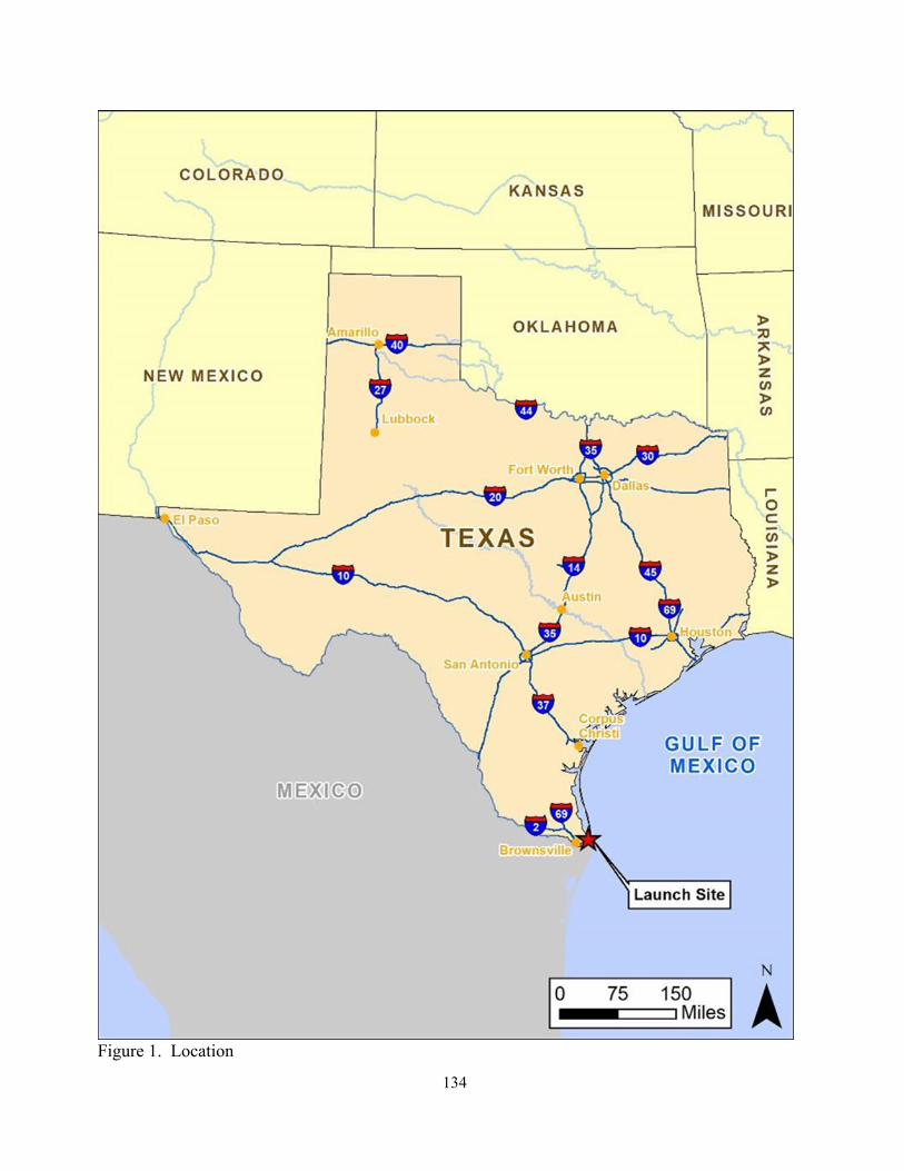
134
Figure 1. Location

135
Figure 2. Location of Vertical Launch Area and Launch and Landing Control Center

136
Figure 3. Landownership

137
Figure 4. Starship/Super Heavy Design Overview

138
Figure 5. Closure Area/Checkpoints in Relation to National Wildlife Refuges

139
Figure 6. Example of Temporary Closure Order

140
Figure 7. Survey-Verified Vertical Launch Area Parcel

141
Figure 8. Proposed Vertical Launch Area Layout
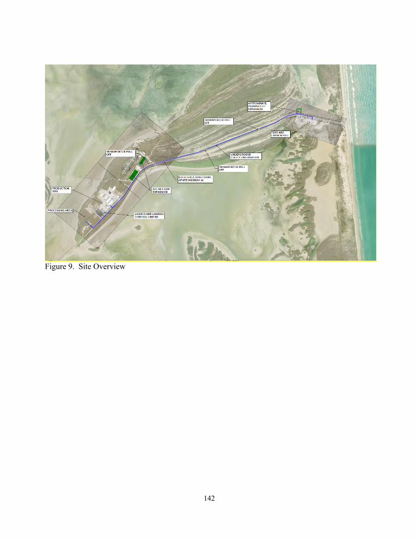
142
Figure 9. Site Overview

143
Figure 10. Launch Mount, Launch Vehicle, and Integration Tower
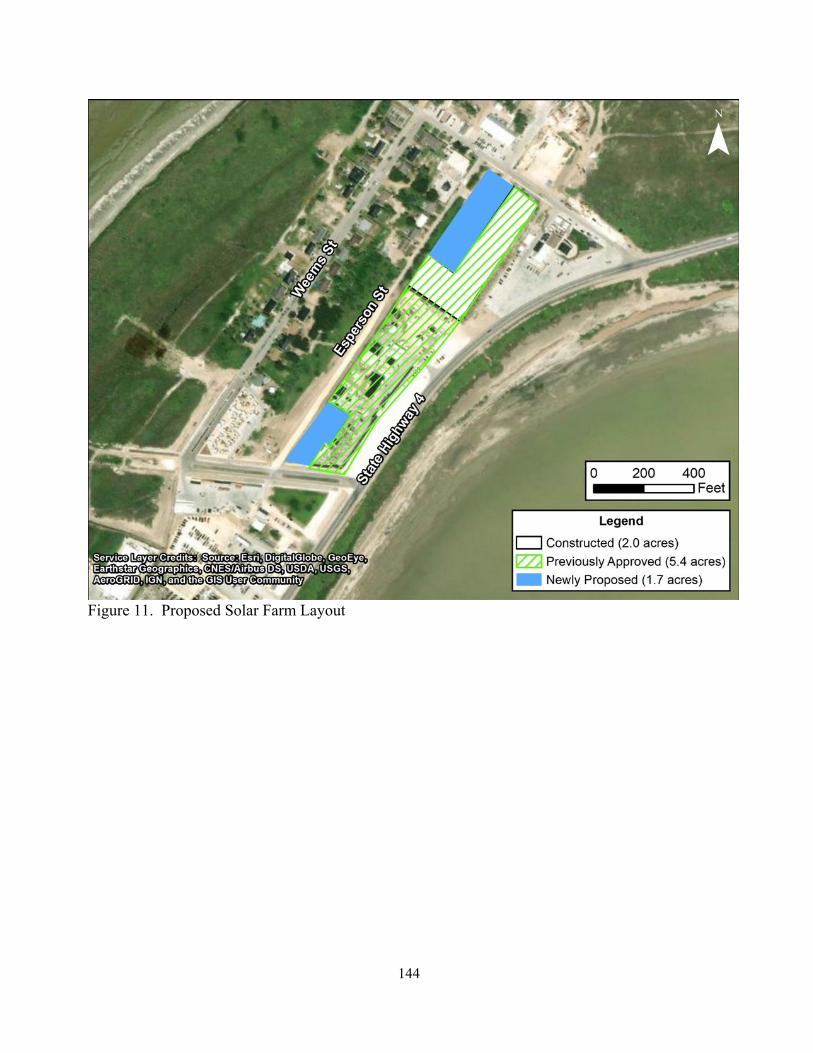
144
Figure 11. Proposed Solar Farm Layout

145
Figure 12. Action Area

146
Figure 13. Starship/Super Heavy Launch from the Boca Chica Launch Site: Maximum A-Weighted Sound Levels
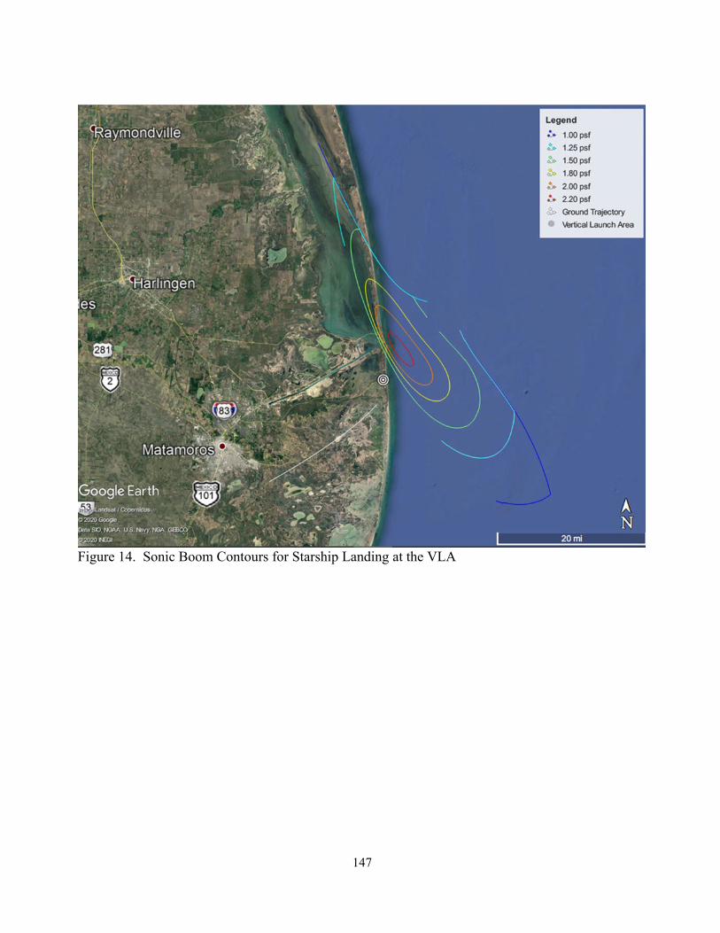
147
Figure 14. Sonic Boom Contours for Starship Landing at the VLA

148
Figure 15. Sonic Boom Contour for Super Heavy Landing at the VLA

149
Figure 16. Bahia Grande Coastal Corridor, Texas (BGCCP)

150
Figure 17. Thornscrub Protection, Enhancement and Restoration Cooperative Agreement Conceptual Ocelot and Jaguarundi Corridor Map
151
Figure 18. Lomas of the Bahia Grande

152
Figure 19. UTRGV. Predicted mean counts of piping plover (expressed as the number of piping plovers observed per 100 m of survey route traveled) by biological year from the discrete Poisson Model. From SWCA (2022).

153
Figure 20. N&H. Population estimates (N-hat) and 95 percent confidence intervals for Boca Chica 2018-2021 based on the top model. “Year” is the calendar year of the beginning of the nonbreeding period (i.e. “2018” is fall and winter beginning 2018, ending 2019). From Newstead and Hill (2022).

154
Figure 21. Piping Plover Critical Habitat

155
Figure 21. Red Knot Proposed Critical Habitat
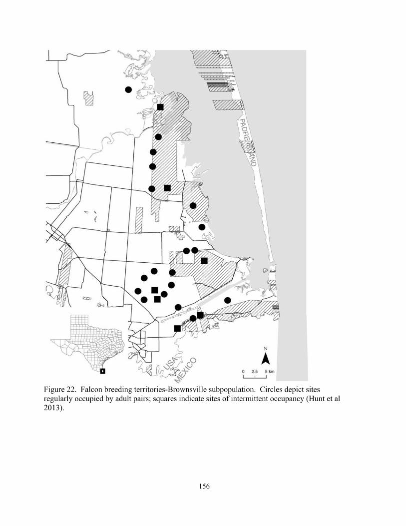
156
Figure 22. Falcon breeding territories-Brownsville subpopulation. Circles depict sites regularly occupied by adult pairs; squares indicate sites of intermittent occupancy (Hunt et al 2013).

157
Figure 23. U.S. Army Corps of Engineers Jurisdictional wetland determination – VLA

158
Figure 24. Solar Expansion Sites Wetland Delineation Results SE1 1.15 acres, SE2 0.06 acres

159
Figure 25. SH 4 Boca Chica Turnaround

160
Figure 26. Impacted Piping Plover Habitat and Critical Habitat and Red Knot Habitat and Proposed Critical Habitat

161
Figure 27. Heat Plume and Debris Field

162
Figure 28. Annual number of vehicles passing through the Customs and Border Patrol Checkpoint Station (P14) by hour October 1-April 14, 2021. (Data provided by: Pedro Caballero III, (A) Special Operations Supervisor, Fort Brown Station, TX, April 14, 2021).

163
Figure 29. Ocelot Road Mortality

164
Appendix A Concurrences

165
Appendix A. Concurrences Species Determination Occurrence Conservation
Measures West Indian Manatee
May affect, but is not likely to adversely affect
About 90 percent of manatees occur in Florida but occasionally seen about once every other year as they travel from Florida and Mexico heading towards warmer waters for the winter. Seagrasses and warm water attract them into the jetties or ports. Manatees have been spotted within the Action Area in and around South Padre Island and Port Isabel in 2004, 2005, 2006, 2014, 2018, July 26, South Padre Island. https://www.mysanantonio.com/lifestyle/travel- outdoors/article/Texas-captain-sees-rare- manatee-South-Padre-Island-16345753.php The most current occurrences of manatees have been reported on December 16, and 17, 2021 on SPI and another on December 21, 2021 in Port Mansfield Harbor Marina. Based on photographs, it appears the SPI manatee reported on the 16th and 17th and the Port Mansfield manatee are different individuals. There was also a manatee in Port Aransas that had an injured flipper and a manatee was rescued from the Houston area earlier. Therefore, five manatees reported in 2021. Other sightings have occurred in Corpus Christi and along the upper coast in similar years. It is possible more have occurred within the Action Area just not been documented. Potential effects include increased boat traffic on launch days, which could result in boat strikes, damage to seagrass beds and reduced food source. However, sightings are sporadic and SpaceX access restriction procedures includes notification of the Coast Guard to clear boats from the area prior to launches, and they are willing to implement conservation measures to reduce the effects.
Educational outreach program to inform vessel operators about manatees in the area and why to avoid them.
Employees will a. be advised that manatees may approach the proposed Action Area, b) be provided materials, such as a poster, to assist in identifying the mammal, c) be instructed not to feed or water the animal, and d) contact the Service and the Texas Marine Mammal Stranding Network (TMMSN) if a manatee is sighted.
Eastern black rail
May affect but is not likely to adversely affect
Potential suitable habitat occurs within the Action Area and there is a possible presence of eastern black rail in Cameron County. Noise and human presence from construction and operations may temporarily disturb or displace eastern black rails and the heat plume could injure or kill black rails if it was present within
If an eastern black rail was recorded within the action are, the FAA would

166
0.6 miles of the vertical launch area during a Starship/Super Heavy launch. Effects to the black rail could be reduced because of a lack of habitat at and near (within 0.6) the vertical launch area and there is no recent documented presence of eastern black rain the Action Area. No recent indication there is breeding in Cameron County.
immediately reinitiate section 7 consultation with the Service.
South Texas ambrosia
No effect Suitable habitat does not occur within the Action Area where construction would occur.
None
Texas ayenia
No effect Suitable habitat does not occur within the Action Area where construction would occur.
None
The FAA determined the Proposed Action may affect but was not likely to adversely affect the threatened West Indian manatee and eastern black rail. With the implementation of conservation measures to avoid and minimize potential impacts outlined in the associated SpaceX Starship/Super Heavy Launch Vehicle Program at the SpaceX Boca Chica Launch Site, Cameron County, Texas, June 2021 BA, amended October 2021, the Service believes potential impacts are insignificant and discountable and therefore concurs with FAA’s determination of “may affect but is not likely to adversely affect”. The Service provided this concurrence on October 6, 2021.
The FAA further determined the Proposed Action would have no effect on the endangered South Texas ambrosia and Texas ayenia. The Service does not provide concurrences with no effect determinations but by making a determination the Service believes the FAA has complied with section 7(a)(2) of the Act.

167
Appendix B. Consultation History

168
CONSULTATION HISTORY
December 18, 2013 – Service transmitted the Final BCO to the FAA for launch licenses and or experimental permits for SpaceX to launch Falcon 9 and Falcon Heavy at Boca Chica, Cameron County, TX.
May 29, 2014 - FAA published the Final Environmental Impact Statement for the SpaceX Texas Launch Site and Record of Decision (ROD).
December 22, 2014 – Letter from FAA requesting the Service to confirm its 2013 BCO as a BO for the red knot as the red knot was listed. April 20, 2015 – The Service agreed via letter to adopt the BCO as a BO including red knot. December 30, 2016 – FAA submitted SpaceX Annual Report via email.
January 25, 2017 – USACE requested FAA reinitiate consultation with the Service for SpaceX’s 404 permit. FAA determined SpaceX would not increase take in the BO and terms and conditions would avoid or minimize potential effects to listed species.
December 19, 2017 – FAA submitted 2017 annual report for BO via email.
November 5, 2018 – Letter from FAA to the Service regarding SpaceX’s plans for a suborbital test program and the development of (Big Falcon Ship and experimental vehicle test program. The Service requested reinitiation of consultation. Service recommended SpaceX consider a section 10 Habitat Conservation Plan for any additional development on the manufacturing and production site.
February 19, 2019 – FAA committed to reinitiating section 7 consultation in phone conversation. April 3, 2019 - The Service provided written comments on a written Re-evaluation and recommended the BO be amended to reflect the proposed action. Nighttime construction had exceeded the 2-week period allowed in the BO and inspections had not been occurring as outlined in the BO.
March 23, 2019 – Email to FAA from the Service stating closure notification system was not being implemented correctly and future closures should not occur until corrected. April 3, 2019 - The Service provided written comments on a written Re-evaluation and recommended the BO be amended to reflect the proposed action. Nighttime construction had exceeded the 2-week period allowed in the BO and inspections had not been occurring as outlined in the BO.
April 30, 2019 – Letter from FAA to Service responding to concerns about Starship construction and operation. They were willing to address and resolve issues. November 29, 2019 – FAA request Service review another written Re-evaluation to support

169
FAA’s decision to issue launch licenses and/or experimental permits to SpaceX.
March 2, 2020 – Letter from the Service to FAA reviewing the written Re-evaluation for experimental test program to develop Starship and Super Heavy. The Service did not concur and recommended a new BA be prepared and consultation reinitiated.
March 4, 2020 – The Service noted inconsistencies with closure notices, tallying of closure hours, length of closure, nighttime activities and stated a new or amended BO was needed. April 3, 2019 – The Service recommended amendment of the BO. April 5, 2019 – Email to FAA from the Service that vegetation monitoring may need revisiting, closures were not being implemented correctly and requested they cease. May 29, 2020 – Email to FAA from Service informing them that SN4 had exploded. The Service did not have a full report as of yet but assumed debris had fallen on the Refuge again. Reiterated need for reinitiation to address explosions, noise generated 24/7, night illumination and traffic on SH 4. December 2, 2020 – Species Monitoring Report received. December 13, 2020 – FAA’s 2019 Annual Summary Report was received. June 21, 2021 – FAA requested initiation of formal section 7 consultation on the issuance of a launch license to SpaceX at the Boca Chica Launch Site for the Starship/Super Heavy Launch Vehicle Program and provided a BA to the Service. July 15, 2021 – Service requested additional information before consultation could be initiated.
July 23, 2021 – FAA forwarded Management Plans and requested by August 23. September 15, 2021 –Consultation workshop: FAA notified of salt flats that seem to be vegetating from runoff. September 27, 2021 – SpaceX Agency update meeting. October 5, 2021 – Site visit and meeting. October 6, 2021 – The Service initiated formal consultation.
October 13, 2021 – FAA delivers an amended Final BA to the Service. October 14, 2021 – Letter to FAA from the Service committing BCO by December 31, 2021, contingent on regular coordination with FAA and SpaceX and no substantial changes to the Proposed Action. October 20, 2021 – FAA provided a revised BA and Terms and Conditions.

170
October 25, 2021 – SpaceX Starship/Super Heavy at Boca Chica Launch Site ESA section 7 consultation meeting to discuss proposed action, status of the species, effects, terms and conditions, monitoring, and schedule. November 1, 2021 – DOI provided FAA comments on the Starship/Super Heavy PEA. November 2, 2021 – Provided FAA information on the Monarch Butterfly and asked if FAA and SpaceX could include it in the consultation. FAA agreed. November 4, 2021 – The Service emailed draft language for a term and condition regarding land acquisition for FAA/SpaceX review and approval. November 8, 2021 – FAA provided comments on draft proposed project section. Notified SpaceX of a video of a UTV on SpaceX site driving in flats. December 2, 2021 – FAA emailed request for update on BO sections for review and offered assistance from ICF consultants. December 3, 2021 – Service emailed FAA the Status of the Species section for their review. December 6, 2021 – SpaceX section 7 consultation working session. FAA provided comments on the Cumulative Effects section. December 9, 2021- Email from the Service to FAA requesting updated management plans December 10, 2021 – Service requested status of updated plans. Email response from FAA to the Service stating they had not received the plans from SpaceX. December 16, 2021 – Emailed FAA, SpaceX and ICF a draft copy of the baseline for their review and comment. December 20, 2021 – SpaceX section 7 consultation working session. Service requested specific dates for receiving the updated plans. December 27, 2021 – SpaceX section 7 consultation working session. January 3, 2022 – SpaceX provided power plant details. Weekly SpaceX section 7 consultation workshop was held. January 4, 2022 – SpaceX provided information, requested on Dec. 31, 2021, on solar array and potential hazardous material. January 6, 2022 – TxDOT informed Service of plans for a turnaround in ROW at the end of SH4 and a small parking area near it. January 12, 2022 – Service informed FAA of proposed TxDOT turnaround.
171
January 18, 2022 – Weekly FAA SpaceX section 7 consultation discussion, draft BCO due to FAA by January 31st. January 24, February 7, February 14, February, 2022– SpaceX section 7 weekly consultation workshops. February 25, 2022 – Letter to FAA regarding from the Service regarding documentation of agreed upon extensions to the consultation timeline.
February 28, 2022 – The Service delivers draft BCO to FAA for review and comment. March 7, March 14, 2022 – SpaceX section 7 weekly consultation workshop to discuss timeline and status of review. March 15, 2022 – FAA gave draft BCO comments to the Service. March 16, 2022 – The Service requested an extension for FAA to complete Monitoring Plans and to finalize the BCO and requested a due date of March 28, 2022.
March 21, 2022 – SpaceX section 7 weekly consultation workshop meeting. Discussed the Draft BCO comments. March 24, April 4, and April 18, 2022 – SpaceX section 7 workshops to discuss BCO.
April 22, 2022 – Final BCO sent to FAA. April 28, 2022 – FAA and SpaceX provided comments on the Final BCO. May 9, 2022 – The Service responded to FAA/SpaceX comments. FAA sent the Service the completed 2021 Annual Report. May 10, 2022 – FAA accepted the Service’s responses. SpaceX provided an updated Biological Monitoring Plan. May 12, 2022 - Revised Final BCO sent to FAA.

172
Appendix C Memorandum of Agreement
Between Texas Parks and Wildlife Department and Space Exploration Technologies Corporation
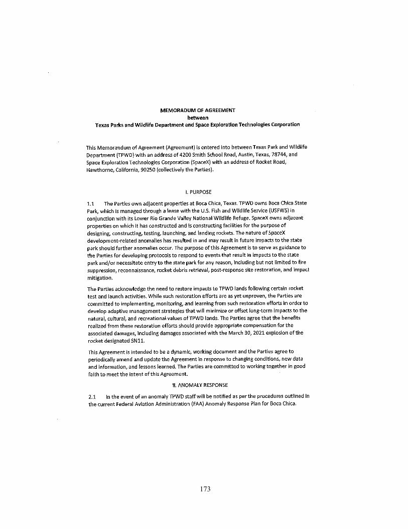
173

174
175

176
Appendix D Noise Assessment
(Please refer to Appendix B in FAA’s Programmatic Environmental Assessment)

177

178
Appendix E. Plans