Understanding ATC Airspace
16
Airspace On Sectional Charts G. White
-
Upload
independent -
Category
Documents
-
view
0 -
download
0
Transcript of Understanding ATC Airspace

Airspace On Sectional Charts
G. White

Airspace Recognition on Sectionals
• Does Not Cover:
– WX
– Communication
– Clearances
– Equipment
– Speed
• For These See Airspace Link on My Website
– http://w5gw.com/images/Airspace.pdf

Class A
• Not Depicted on Sectional Charts
• IFR Only
• Private Pilot
• 18,000’ to 60,000’ MSL
– Referred to as Flight Level, in Hundreds of Feet
– E.g., FL 350 = 35,000’
Drop the hundreds digits

Class G
• The Only ‘Uncontrolled’ Airspace
• Nominally Surface to 1200’ AGL
– May Extend to Higher Altitude (up to 14,500’) in Sparsely Populated Areas
• Technically, Not Depicted on Sectional Chart, But

Class G (cont.)
• The Blue Shaded Line Shows Class E Floor
– On ‘Hard’ Side E Down to 14,500’ MSL
– On ‘Soft’ Side Down to 1200’ AGL

Class G (cont.)
• May Also Have a Blue ‘Zipper’ For Other Altitudes
• Here the Base of Class E Goes Down to 13,700 MSL

Class E
• Lower Normal Base to 700’ AGL
– Around Many Airports With No Control Towers

Class E • May Also Extend Base
to Surface – Note Dashed Magenta
– A weather observer or automated weather observation equipment (ASOS or AWOS) must be available at airports surrounded by surface-based Class E.

Class D
• Dashed Blue Line Around Airports With Control Towers
• Surface to Nominally 2,500’ AGL – See 31 in Brackets for KHYI
– So D Airspace Extends from Surface to 3,100 MSL
– Likely Includes a Class E Transition Zone

Class C
• Magenta Solid Lines
– Inner Circle to ~ 4,000’ AGL
– Outer Shelf
• Will Have TRACON
– Approach and Departure Control

TRSA
• Terminal Radar Service Area (TRSA)
• Black Lines • Similar to Class C
– Tower Has Responsibility for RADAR in Class D
– TRACON Assists Tower – TRACON Responsible for
TRSA
• Always Has a Class D Airport
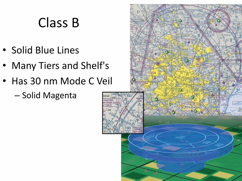
Class B
• Solid Blue Lines
• Many Tiers and Shelf's
• Has 30 nm Mode C Veil
– Solid Magenta

SUA
• Special Use Airspace
– E.g., Prohibited Areas
– Use Legend for Altitude, Times and Controlling Agency, and Frequencies

SUA (cont.)
• Warning Areas
• Restricted Areas

SUA (cont.)
• Military Operations Areas (MOAs)
• Alert Areas

Typical Questions
• What Airspace is KFTW Located In?
• What Airspace is at 3,300’MSL Over KFTW?
• What Airspace is at 4,100’ MSL Over KFTW?