TREE HOUSE AFFORDABLE HOUSING - City of Palo Alto
80
Initial Study/Negative Declaration (CEQA) and Environmental Assessment (NEPA) TREE HOUSE AFFORDABLE HOUSING Prepared by the City of Palo Alto December 2008
-
Upload
khangminh22 -
Category
Documents
-
view
4 -
download
0
Transcript of TREE HOUSE AFFORDABLE HOUSING - City of Palo Alto

Initial Study/Negative Declaration (CEQA) and
Environmental Assessment (NEPA)
TREE HOUSE AFFORDABLE HOUSING
Prepared by the
City of Palo Alto
December 2008

City of Palo Alto IS/EA Tree House Affordable Housing i December 2008
PREFACE This combined Initial Study/Negative Declaration (IS/ND) and Environmental Assessment/Finding of No Significant Impact (EA/FONSI) has been prepared by the City of Palo Alto to satisfy the requirements of both the California Environmental Quality Act (CEQA) and the National Environmental Protection Act (NEPA).

City of Palo Alto IS/EA Tree House Affordable Housing ii December 2008
TABLE OF CONTENTS PREFACE
1.0 ENVIRONMENTAL ASSESSMENT......................................................................................1
2.0 STATEMENT OF PURPOSE AND NEED FOR THE PROPOSAL ......................................5
3.0 STATUTORY CHECKLIST ..................................................................................................11
4.0 ENVIRONMENTAL ASSESSMENT CHECKLIST.............................................................12
5.0 EXISTING CONDITIONS AND TRENDS, CHECKLIST, AND DISCUSSION OF IMPACTS................................................................................................................................15 5.1 AESTHETICS............................................................................................................15 5.2 AGRICULTURAL RESOURCES ............................................................................17 5.3 AIR QUALITY..........................................................................................................18 5.4 BIOLOGICAL RESOURCES ...................................................................................22 5.5 CULTURAL RESOURCES ......................................................................................26 5.6 GEOLOGY AND SOILS ..........................................................................................32 5.7 HAZARDS AND HAZARDOUS MATERIALS......................................................35 5.8 HYDROLOGY AND WATER QUALITY...............................................................39 5.9 LAND USE................................................................................................................44 5.10 MINERAL RESOURCES .........................................................................................47 5.11 NOISE........................................................................................................................48 5.12 POPULATION AND HOUSING..............................................................................55 5.13 PUBLIC SERVICES .................................................................................................56 5.14 RECREATION ..........................................................................................................59 5.15 TRANSPORTATION/TRAFFIC ..............................................................................60 5.16 UTILITIES AND SERVICE SYSTEMS ..................................................................67 5.17 MANDATORY FINDINGS OF SIGNIFICANCE ...................................................70
6.0 ALTERNATIVES TO THE PROPOSED ACTION..............................................................74 6.1 NO PROJECT ALTERNATIVE ...............................................................................74 6.2 REDUCED DENSITY ALTERNATIVE..................................................................74 6.3 LOCATION ALTERNATIVES ................................................................................74
7.0 REFERENCES.......................................................................................................................75
8.0 AUTHORS AND CONSULTANTS......................................................................................76
FIGURES
Figure 2-1: Regional Map................................................................................................................6 Figure 2-2: Vicinity Map .................................................................................................................7 Figure 2-3: Aerial Map ....................................................................................................................8 Figure 2-4: Site Plan ........................................................................................................................9 Figure 5-1: Archaeological and Historical APE Map....................................................................30

City of Palo Alto IS/EA Tree House Affordable Housing iii December 2008
TABLES
Table 2.8-1: Trees to be Preserved.......................................................................................................10 Table 5.3-1: Summary of Air Quality for Downtown Redwood City .................................................18 Table 5.4-1: Summary of On-site Trees...............................................................................................23 Table 5.15-1: Signalized Intersection Level of Service Definitions ....................................................61 Table 5.15-2: Existing Intersection Levels of Service.........................................................................61 Table 5.15-3: 2010 Background Intersection Levels of Service..........................................................62 Table 5.15-4: Project Trip Generation Summary.................................................................................64 Table 5.15-5: 2010 Background Plus Project Intersection Levels of Service......................................65
APPENDICES
APPENDIX A Tree Survey APPENDIX B Cultural Resources APPENDIX C Geotechnical Investigation APPENDIX D Hazardous Materials Reports APPENDIX E Stormwater APPENDIX F Noise Analysis APPENDIX G Traffic Impact Analysis APPENDIX H Utilities

City of Palo Alto IS/EA Tree House Affordable Housing 1 December 2008
1.0 ENVIRONMENTAL ASSESSMENT Responsible Entity: City of Palo Alto
Certifying Officer: Curtis Williams, Interim Director of Planning & Community
Environment
Project Name: Tree House Affordable Housing
Project Location: North side of West Charleston Road, between El Camino Real and Wilkie Way, Palo Alto, California
Estimated Total Project Cost: $13.2 million
Grant Recipient: Palo Alto Housing Corporation
Recipient Address: 725 Alma Street, Palo Alto, CA 94301
Project Representative: Eric T. Keller
Project Representative Telephone Number:
(650) 321-9709
CONDITIONS OF PROJECT APPROVAL: Air Quality BAAQMD has prepared a list of feasible construction dust control measures that can reduce construction impacts to a level that is less than significant. The following construction practices will be implemented during all phases of construction on the project site: • Use dust-proof chutes for loading construction debris onto trucks. • Water to control dust generation during demolition of structures and break-up of pavement. • Cover all trucks hauling soil, sand, and other loose materials or require all trucks to maintain
at least two feet of freeboard. • Sweep daily (with water sweepers) all paved access roads, parking areas, and staging areas at
construction sites. • Sweep streets daily (with water sweepers) if visible soil material is carried onto adjacent
public streets. • Enclose, cover, water twice daily, or apply non-toxic soil binders to exposed stockpiles (dirt,
sand, etc.). • Install erosion control measures to prevent silt runoff to public roadways. • Replant vegetation in disturbed areas as quickly as possible.

City of Palo Alto IS/EA Tree House Affordable Housing 2 December 2008
• If concrete or pavement is recycled on-site, misters and/or other water sources will be used to avoid generation of visible dust plumes
Biological Resources • The nesting season for raptors extends from February 1 through August 31. If the start of
construction and removal of trees can be scheduled before February 1 or after August 31, a preconstruction survey for nesting raptors is not required. If construction (i.e., grading, tree removal, or tree pruning) is scheduled to start during the nesting season, a preconstruction survey for nesting raptors will be completed. The preconstruction survey (if necessary) will be completed no more than 30 days prior to any tree removal, pruning of limbs or grading scheduled during the nesting season. If active nests are present, a buffer zone will be established to protect raptor adults and nestlings from construction disturbances. The designation of buffer zones will be determined in consultation with the California Department of Fish and Game, based on the species involved and site conditions.
Cultural Resources • A qualified archaeologist shall be retained to inspect the property for possible prehistoric
archaeological deposits after removal of the existing structures, pavement and all other ground obscuring materials.
• In the event archaeological deposits are discovered, further earthmoving work shall halt
within parcel borders and the City of Palo Alto shall complete its Section 106 responsibilities per 36 CFR Part 800, including the following:
The State Historic Preservation Officer (SHPO) shall be notified within 48 hours of
discovery. The notification shall describe the agency official's assessment of National Register
eligibility of the property and proposed actions to resolve the adverse effects. SHPO shall respond within 48 hours of the notification with recommendations
regarding National Register eligibility and the proposed actions to resolve the adverse effects.
The City of Palo Alto shall take into account SHPO’s recommendations regarding National Register eligibility and proposed actions to resolve the adverse effects and carry out the appropriate actions.
The agency official shall provide SHPO a report of the actions when they are completed.
Hazards and Hazardous Materials • National Emissions Standards for Hazardous Air Pollutants (NESHAP) guidelines require
that all potentially friable asbestos-containing materials be removed prior to activities that may disturb the materials.
• Requirements in the California Code of Regulations will be followed during demolition
activities, including employee training, employee air monitoring, and dust control. Any debris or soil containing lead-based paint or coatings will be disposed of at landfills that meet acceptance criteria for the waste being disposed.

City of Palo Alto IS/EA Tree House Affordable Housing 3 December 2008
Noise
Outdoor Use Area • When refining the project’s site plan, locate noise-sensitive outdoor use areas at least 140 feet
from the center of West Charleston Road or shield outdoor use areas with buildings or noise barriers. Six to eight-foot noise barriers would be required to reduce exterior noise levels throughout the terrace to 60 dBA Ldn or less. The final detailed noise control plan, including the heights and limits of proposed noise barriers, shall be completed at the time that the final grading plan is submitted.
Interior Noise Levels
• Project-specific acoustical analysis is required to confirm that interior noise levels will be
reduced to 45 dBA Ldn or lower. Building sound insulation requirements would need to include the provision of forced-air mechanical ventilation for units proposed within 140 feet of the center of West Charleston Road, so that windows could be kept closed at the occupant’s discretion to control noise. The specific determination of what treatments are necessary will be conducted on a unit-by-unit basis. The results of the project-specific acoustical analysis, including the description of the necessary noise control treatments, will be submitted to the City along with the building plans and approved prior to issuance of a building permit.
Construction Noise
• Noise-generating activities at the construction site or in areas adjacent to the construction site
associated with the project in any way shall be restricted to the hours of 8:00 a.m. to 6:00 p.m., Monday through Friday, and 9:00 a.m. to 6:00 p.m. on Saturdays. No construction activities will occur Sundays or holidays. Allowable hours of construction will be clearly posted at the construction site.
• No individual piece of equipment shall produce a noise level exceeding one hundred ten dBA
at a distance of twenty-five feet. If the device is housed within a structure on the property, the measurement shall be made outside the structure at a distance as close to twenty-five feet from the equipment as possible.
• The noise level at any point outside of the property plane of the project shall not exceed one
hundred ten dBA. • Equip all internal combustion engine driven equipment with intake and exhaust mufflers that
are in good condition and appropriate for the equipment. • Unnecessary idling of internal combustion engines will be strictly prohibited. • Locate stationary noise generating equipment such as air compressors or portable power
generators as far as possible from sensitive receptors. Construct temporary noise barriers to screen stationary noise generating equipment when located near adjoining sensitive land uses.
• Utilize "quiet" air compressors and other stationery noise sources where technology exists.

City of Palo Alto IS/EA Tree House Affordable Housing 4 December 2008
• Control noise from construction workers’ radios to a point that they are not audible at existing residences bordering the project site.
• The contractor shall prepare a detailed construction plan identifying the schedule for major
noise-generating construction activities. The construction plan shall identify a procedure for coordination with the adjacent noise sensitive facilities so that construction activities can be scheduled to minimize noise disturbance.
• Designate a "disturbance coordinator" who will be responsible for responding to any local
complaints about construction noise. The disturbance coordinator will determine the cause of the noise complaint (e.g., starting too early, bad muffler, etc.) and will require that reasonable measures warranted to correct the problem be implemented. Conspicuously post a telephone number for the disturbance coordinator at the construction site and include it in the notice sent to neighbors regarding the construction schedule.
FINDING:
Finding of No Significant Impact (The project would not result in a significant impact on the quality of the human environment)
Finding of Significant Impact (The project may significantly affect the quality of the human environment) Preparer Signature: Date: Title/Agency: David J. Powers & Associates, Inc. RE Approving Official Signature: Date: Title/Agency: Curtis Williams, Interim Director of Planning & Community Development

City of Palo Alto IS/EA Tree House Affordable Housing 5 December 2008
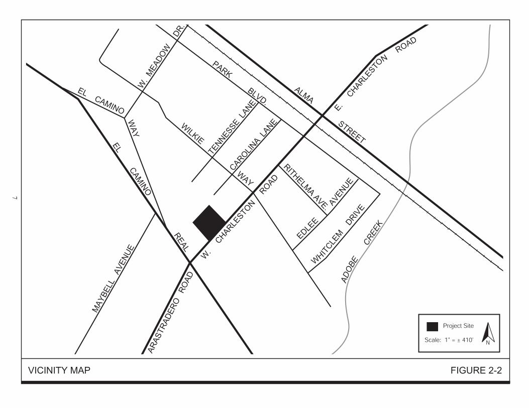
2.0 STATEMENT OF PURPOSE AND NEED FOR THE PROPOSAL 2.1 PROJECT LOCATION The approximately 0.70-acre project site is located on the north side of West Charleston Road, between El Camino Real and Wilkie Way, in the City of Palo Alto. A regional map and a vicinity map of the site are shown on Figure 2-1 and 2-2, respectively. The project site is comprised of Santa Clara County Assessor's Parcel Number 132-46-072. The project site is currently developed with a single-family residence that has been converted into an audio recording studio for the blind and dyslexic. An aerial photograph of the project site and the surrounding area is shown on Figure 2-3. 2.2 PROJECT DESCRIPTION The project site’s existing zoning is Planned Community (PC) 2565, which specifically allows for the existing use (i.e., an audio recording studio for the blind and dyslexic) on the site. The project proposes to rezone the project site Planned Community (PC), which would specifically allow for the redevelopment of the site with the proposed 35-unit apartment building. The proposed apartment building would offer workforce rental housing opportunities to very-low and extremely-low income households, and it may also integrate a small number of units for special needs populations (e.g., seniors and/or young adults that are aging out of foster care). The apartment building would include ancillary uses such as a community room, laundry room, common bathroom, and offices. Prior to construction, the existing single-family residence on the project site would be demolished and removed from the site. The conceptual site plan for the proposed project is shown on Figure 2-4. 2.2.1 Apartment Building The proposed apartment building would include 32 studios and three one-bedroom units. Each unit would include a full kitchen and a bathroom, and would be approximately 400 square feet in size. The proposed building would be four stories tall with a maximum height of approximately 44 feet (40-foot tall building with parapet roof to shield rooftop HVAC equipment), and set back at least 20 feet from the front property line and at least 51 feet from the side and rear property lines. 2.2.2 Open Space As shown on Figure 2-4, the project includes a landscaped outdoor common open space area and an indoor community room for the project residents. The outdoor area includes benches, pathways, and a barbeque area. The community room includes a full kitchen, computer alcove, and seating areas. 2.2.3 Parking Thirty-one on-site parking spaces are proposed by the project, which would be located along the northern and eastern perimeter of the site. Per Section 18.52.050 of the Zoning Code, the 31 on-site parking spaces proposed by the project are sufficient to serve the project with approval of the Director of Planning & Community Environment. 2.2.4 Access One driveway at the southeast corner of the project site would provide vehicular ingress and egress to the proposed parking garage from West Charleston Road. A centrally located pathway would provide pedestrian access to the proposed project from West Charleston Road.


City of Palo Alto IS/EA Tree House Affordable Housing 10 December 2008
2.2.5 Demolition of Existing Structures The existing single-family residence, detached garage, and other associated development (driveways, parking areas, walkways, etc.) on the project site would be demolished and removed from the site prior to construction of the proposed project. 2.2.6 Trees There are a total of 25 trees on the project site, 13 of which are regulated by the City of Palo Alto Tree Ordinance. As shown on Figure 2-4, 15 existing trees on the project site have been incorporated into and would be preserved by the proposed project, 12 of which are protected by the City’s Tree Preservation Ordinance. All but one of the 13 regulated trees would be preserved by the proposed project. The condition of the one regulated tree that would be removed by the project was rated poor/questionable in the tree survey completed for the project site. The trees to be preserved by the project are listed in Table 2.8-1, below.
Table 2.8-1: Trees to be Preserved
Common Name Diameter (Inches) Condition Valley Oak* 38.3 Fair
Coast Live Oak* 12.6 Good Chinese Pistache 10.5 Good Chinese Pistache 8.0 Fair to Good Coast Redwood 9.5 Good Coast Live Oak* 14.4 Good Coast Redwood* 22.4 Fair to Good
Valley Oak* 43.6 Fair Coast Live Oak* 31.2 Good Coast Redwood* 25.6 Fair Coast Live Oak* 13.4 Very Good Coast Live Oak* 18.0 Good Coast Live Oak* 34.2 Good Coast Live Oak* 25.7 Fair to Good Coast Live Oak* 19.4 Fair
* Protected Tree 2.3 OBJECTIVES The objectives of the proposed project are to provide affordable rental housing that is consistent with the City of Palo Alto Comprehensive Plan and is compatible with the surrounding land uses. 2.4 REQUIRED PROJECT APPROVALS
Rezoning Architectural Review Building Permit Grading Permit

City of Palo Alto IS/EA Tree House Affordable Housing 11 December 2008
3.0 STATUTORY CHECKLIST
Factors A/B1 Supporting Documentation
Historic Preservation B See the discussion starting on page 26.
Floodplain Management A See the discussion starting on page 39.
Wetlands Protection A See the discussion starting on page 22.
Coastal Zone A The project site is not within a coastal zone.
Sole Source Aquifers A The project site is not within an area designated by the EPA a being supported by a sole source aquifer. [Source: EPA Designated Sole Source Aquifer List, 1992]
Endangered Species A See the discussion starting on page 22.
Wild and Scenic Rivers A The project site is not within a mile of a wild/scenic river.
Air Quality A See the discussion starting on page 18.
Farmland Protection A See the discussion starting on page 17.
Environmental Justice A See the discussion starting on page 44.
HUD ENVIRONMENTAL STANDARDS Noise Abatement and Control (24CFR 51B)
B See the discussion starting on page 48.
Explosive and Flammable Operations (24CFR 51C)
A See the discussion starting on page 35.
Toxic Chemicals/ Radioactive Materials (HUD Notice 79-33)
A See the discussion starting on page 35.
Airport Clear Zones and Accident Potential Zones (24 CFR 51D)
A Per the Santa Clara County Airports Land Use Commission Land Use Plan, the project site is not located within any airport clear zones or accident potential zones.
1 Status A applies when no formal consultation, permit or agreement is required. Status B applies when the project requires formal consultation steps, a permit or agreement, or when it may have an effect on the resources protected by the statute.

City of Palo Alto IS/EA Tree House Affordable Housing 12 December 2008
4.0 ENVIRONMENTAL ASSESSMENT CHECKLIST Introductory Note: For documentation of impacts, FIELD refers to a conclusion based upon a site visit. CONTACT refers to a personal contact with a source or official knowledgeable in a given area of expertise. PRINTED refers to a public document. EXPERIENCE refers to the expertise and professional judgment of the environmental specialist preparing this assessment. STUDY refers to a special report undertaken for this project.
Impact Categories No
Impa
ct A
ntic
ipat
ed
Pot
entia
lly B
enef
icia
l Im
pact
Req
uire
s Doc
umen
tatio
n O
nly
Pot
entia
lly A
dver
se R
equi
res
Mor
e St
udy
Nee
ds M
itiga
tion
Req
uire
s Pro
ject
Mod
ifica
tion
Source or Documentation Land Development Conformance with Comprehensive Plans and Zoning
X
PRINTED
Compatibility and Urban Impact
X EXPERIENCE, FIELD
Slope X FIELD, PRINTED
Erosion X FIELD, PRINTED
Soil Suitability X PRINTED
Hazards and Nuisances, Including Site Safety
X PRINTED
Energy Consumption X PRINTED, EXPERIENCE
Noise Effects of Ambient Noise on Project and Contribution to Community Noise Levels
X
STUDY
Air Quality Effects of Ambient Air Quality on Project and Contribution to Community Pollution Levels
X
PRINTED

City of Palo Alto IS/EA Tree House Affordable Housing 13 December 2008
Impact Categories No
Impa
ct A
ntic
ipat
ed
Pot
entia
lly B
enef
icia
l Im
pact
Req
uire
s Doc
umen
tatio
n O
nly
Pot
entia
lly A
dver
se R
equi
res
Mor
e St
udy
Nee
ds M
itiga
tion
Req
uire
s Pro
ject
Mod
ifica
tion
Source or Documentation Environmental Design and Historic Values Visual Quality: Coherence, Diversity, Compatible Use and Scale
X FIELD, EXPERIENCE
Historic, Cultural, and Archaeological Resources
X
STUDY
Socioeconomic Demographic Character Changes
X EXPERIENCE
Displacement
X EXPERIENCE
Employment and Income Patterns
X EXPERIENCE
Community Facilities and Services Educational Facilities
X FIELD, EXPERIENCE
Commercial Facilities X FIELD, EXPERIENCE
Health Care
X FIELD, EXPERIENCE
Social Services
X FIELD, EXPERIENCE
Solid Waste
X FIELD, EXPERIENCE
Waste Water
X STUDY
Storm Water
X STUDY
Water Supply
X STUDY

City of Palo Alto IS/EA Tree House Affordable Housing 14 December 2008
Impact Categories No
Impa
ct A
ntic
ipat
ed
Pot
entia
lly B
enef
icia
l Im
pact
Req
uire
s Doc
umen
tatio
n O
nly
Pot
entia
lly A
dver
se R
equi
res
Mor
e St
udy
Nee
ds M
itiga
tion
Req
uire
s Pro
ject
Mod
ifica
tion
Source or Documentation Public Safety: Police, Fire, and Emergency Medical X STUDY
Open Space and Recreation: Open Space, Recreational, and Cultural Resources
X
STUDY
Transportation X STUDY
Natural Features Water Resources
X FIELD
Surface Water
X FIELD
Floodplains X PRINTED
Wetlands
X FIELD
Coastal Zone
X FIELD
Unique Natural Features and Agricultural Lands
X FIELD, PRINTED
Vegetation and Wildlife
X FIELD, EXPERIENCE, STUDY

City of Palo Alto IS/EA Tree House Affordable Housing 15 December 2008
5.0 EXISTING CONDITIONS AND TRENDS, CHECKLIST, AND DISCUSSION OF IMPACTS This section describes the existing environmental conditions on and near the project site as well as environmental impacts associated with the proposed project. The environmental checklist recommended in the California Environmental Quality Act (CEQA) Guidelines was used to identify environmental impacts that could occur if the proposed project is implemented. The right-hand column in the checklist identifies the source(s) for the answer to each question. The sources cited are identified at the end of the checklist. This section clearly identifies all potential environmental impacts from the project, including an explanation for those issues determined to be less than significant. Mitigation measures are identified and described for all potentially significant impacts, and evaluated briefly for the expected effectiveness/feasibility of these measures, where necessary. 5.1 AESTHETICS 5.1.1 Setting The approximately 0.70-acre project site is located on West Charleston Road in the City of Palo Alto. In the project area, West Charleston Road is a four-lane arterial (two lanes in each direction). Development in the project area includes a mix of newer residential and commercial buildings up to three and one-half stories tall with lighted sidewalks, driveways and streets and reflective surfaces such as windows. Three- and three and one/half-story multi-family residential buildings are located south of the site, across West Charleston Road and adjacent to the western boundary of the site, respectively. Two-story single- and multi-family residential buildings are located adjacent to the eastern and northern site boundaries, respectively. One- and two-story commercial buildings are located to the west of the site along El Camino Real. The flat project site is developed with an older one-story residential building with a detached garage and paved driveway that is used for commercial office space. Numerous large trees are located around the perimeter of the site, which screen the existing development on the site. Due to the flat topography of the project area, the large trees on the project site, and the existing surrounding development that is up to three and one/half stories tall, views of the project site are limited to the immediate vicinity. The site is not located in a scenic view corridor or visible from a designated state scenic highway.
5.1.2 Environmental Checklist AESTHETICS
Potentially Significant
Impact
Less Than Significant
With Mitigation Incorporated
Less Than Significant
Impact
No Impact
Beneficial Impact
Information Source(s)
Will the project:
1. Have a substantial adverse effect on a scenic vista?
1,2
2. Substantially damage scenic resources, including, but not limited to, trees, rock outcroppings, and historic buildings within a state scenic highway?
1,2

City of Palo Alto IS/EA Tree House Affordable Housing 16 December 2008
AESTHETICS
Potentially Significant
Impact
Less Than Significant
With Mitigation Incorporated
Less Than Significant
Impact
No Impact
Beneficial Impact
Information Source(s)
Will the project:
3. Substantially degrade the existing visual character or quality of the site and its surroundings?
1,2
4. Create a new source of substantial light or glare which will adversely affect day or nighttime views in the area?
1,2
5.1.3 Aesthetic Impacts The project site and parcels adjacent to the project are developed with residential buildings up to three and one/half stories tall. The proposed project would replace the existing one-story single family residence on the project site with a four-story apartment building. The development proposed by the project would be similar in height and mass to the existing development adjacent to the project site. As described in Section 2.0, the project proposes to retain most of the existing large trees located around the perimeter of the site. The project would be reviewed by the City’s Architectural Review Board to ensure compatibility with the surrounding neighborhood. Compared to the existing development in the project area, the proposed project would include similar lighting and reflective surfaces. Consistent with City policy, outdoor lighting on the site would be shielded so that the direct light does not extend beyond the site. For these reasons and those stated above, the proposed project would not have a substantial adverse effect on a scenic vista or views from a designated state scenic highway, would not substantially degrade the existing visual character or quality of the project site and its surroundings, and would not create a new source of substantial light or glare. 5.1.4 Conclusion The proposed project would not substantially degrade the existing visual character or quality of the site and its surroundings. Development of the proposed project would have a less than significant aesthetic impact. (Less than Significant Impact)

City of Palo Alto IS/EA Tree House Affordable Housing 17 December 2008
5.2 AGRICULTURAL RESOURCES 5.2.1 Setting The project site is located in an urban area of Palo Alto and is surrounded by residential and commercial development. The project site is currently developed with a single-family residence that is used for commercial office space. The site is not used for agricultural purposes. The site is not designated by the Department of Conservation as Farmland of any type, and is not the subject of a Williamson Act contract. There is no property used for agricultural purposes adjacent to the project site.
5.2.2 Environmental Checklist AGRICULTURAL RESOURCES
Potentially Significant
Impact
Less Than Significant
With Mitigation
Incorporated
Less Than Significant
Impact
No Impact
Beneficial Impact
Information Source(s)
Will the project: 1. Convert Prime Farmland, Unique Farmland, or Farmland of Statewide Importance (Farmland), as shown on the maps prepared pursuant to the Farmland Mapping and Monitoring Program of the California Resources Agency, to non-agricultural use?
4
2. Conflict with existing zoning for agricultural use, or a Williamson Act contract?
1,2
3. Involve other changes in the existing environment which, due to their location or nature, could result in conversion of Farmland, to non-agricultural use?
1,4
5.2.3 Agricultural Resources Impacts The project site is currently developed and is not used for agricultural purposes. The site is not designated by the Department of Conservation as Farmland of any type, and is not the subject of a Williamson Act contract. None of the properties adjacent to the project site are used for agriculture. 5.2.4 Conclusion The project would have no adverse impact on agricultural land or agricultural activities. (No Impact)

City of Palo Alto IS/EA Tree House Affordable Housing 18 December 2008
5.3 AIR QUALITY 5.3.1 Setting In recognition of the adverse effects of degraded air quality, Congress and the California Legislature enacted the Federal and California Clean Air Acts, respectively. As a result of these laws, the U.S. Environmental Protection Agency (EPA) and the California Air Resources Board (CARB) have established ambient air quality standards for what are commonly referred to as “criteria pollutants”, because they set the criteria for attainment of good air quality. Criteria pollutants include carbon monoxide, ozone, nitrogen dioxide, sulfur dioxide, and particulate matter. Three criteria pollutants are known to exceed the state and federal standards in the project area; ozone, particulates (PM10), and carbon monoxide. Both ozone and PM10 are considered regional pollutants, because their concentrations are not determined by proximity to individual sources, but show a relative uniformity over a region. Carbon monoxide is considered a local pollutant, because elevated concentrations are usually only found near the source (e.g., congested intersections). 5.3.1.1 Regional and Local Air Quality The project site is within the San Francisco Bay Area Air Basin. The Bay Area Air Quality Management District (BAAQMD) is the regional government agency that monitors and regulates air pollution within the air basin. BAAQMD monitors air quality at several locations within the San Francisco Bay Air Basin. The monitoring site closest to the project site is in Redwood City. According to the most current available data available from BAAQMD, neither state nor federal standards for ozone or carbon monoxide were exceeded in 2005, 2006, or 2007. The particulate matter (PM10) state standard was exceeded on two days in 2005 and 2006 and one day in 2007. A summary of the air quality for Redwood City is shown in Table 5.3-1, below.
Table 5.3-1: Summary of Air Quality for Downtown Redwood City
Days Exceeding Standard in: Pollutant Standard 2005 2006 2007
Ozone State/Federal 0 0 0 Carbon Monoxide State/Federal 0 0 0 PM10 State/Federal 2/0 2/0 1/0
The Federal Clean Air Act and the California Clean Air Act require that the CARB, based on air quality monitoring data, designate portions of the state where the federal or state ambient air quality standard are not met as “nonattainment areas”. Because of the differences between the national and state standards, the designation of nonattainment areas is different under the federal and state legislation. The Bay Area is designated as an “attainment area” for carbon monoxide, nitrogen dioxide, and sulfur dioxide. The region is classified as a “nonattainment area” for both the federal and state ozone standards, although a request for reclassification to “attainment” of the federal standard is currently being considered by the U.S. EPA. The area does not meet the state standards for particulate matter; however, it does meet the federal standards.

City of Palo Alto IS/EA Tree House Affordable Housing 19 December 2008
Sensitive Receptors The Bay Area Air Quality Management District (BAAQMD) defines sensitive receptors as facilities where sensitive receptor population groups (children, the elderly, the acutely ill and the chronically ill) are likely to be located. These land uses include residences, schools playgrounds, child-care centers, retirement homes, convalescent homes, hospitals, and medical clinics. Sensitive receptors in the project area include the surrounding residences. 5.3.2 Environmental Checklist
AIR QUALITY
Potentially Significant
Impact
Less Than Significant
With Mitigation
Incorporated
Less Than Significant
Impact
No Impact
Beneficial Impact
Information Source(s)
Will the project:
1. Conflict with or obstruct implementation of the applicable air quality plan?
1,5
2. Violate any air quality standard or contribute substantially to an existing or projected air quality violation?
1,5
3. Result in a cumulatively considerable net increase of any criteria pollutant for which the project region is classified as non-attainment under an applicable federal or state ambient air quality standard including releasing emissions which exceed quantitative thresholds for ozone precursors)?
1,5
4. Expose sensitive receptors to substantial pollutant concentrations?
1,5
5. Create objectionable odors affecting a substantial number of people?
1,5
5.3.3 Air Quality Impacts 5.3.3.1 Long-Term Air Quality Impacts BAAQMD has established thresholds for what could be considered a significant impact on existing air quality. A project that generates more than 80 pounds per day of reactive organic gases (ROG) would have a significant impact on regional air quality, according to BAAQMD CEQA guidelines. BAAQMD generally does not consider that a project generating less than 2,000 vehicle trips per day is likely to exceed their adopted thresholds of significance, and does not recommend preparation of a detailed air quality analysis. The Transportation Impact Analysis completed for the proposed project determined that the project would generate 235 trips per day, which is substantially below the BAAQMD criteria stated above.

City of Palo Alto IS/EA Tree House Affordable Housing 20 December 2008
For this reason, the proposed project would not result in a significant long-term air quality impact and a detailed air quality analysis was not prepared for the project. The proposed development does not include any processes that would generate objectionable odors. 5.3.3.2 Short-Term Air Quality Impacts Project construction has the potential to result in short-term air quality impacts resulting from dust generating activities, and the use of solvents, paints and other construction materials that tend to volatilize into the atmosphere. Construction-related air quality impacts associated with the proposed project are the result of dust creating activities, and exhaust emissions from construction equipment. Due to the negligible amount and the short duration of these impacts, all are considered to be less than significant, except for the dust generating construction activities. Construction activities such as excavation and grading operations and construction vehicles driving over and wind blowing over exposed earth, generate fugitive particulate matter that would affect local and regional air quality. The effects of these dust generating activities would be increased dustfall and locally elevated levels of PM10 downwind of construction activity. Construction dust has the potential for creating a nuisance.2 Impact AQ-1: During construction, the proposed project would result in significant short-term air
quality impacts as a result of dust generation. 5.3.4 Mitigation and Avoidance for Air Quality Impacts MM AQ-1: The BAAQMD has prepared a list of feasible construction dust control measures that
can reduce construction impacts to a level that is less than significant. The following construction practices will be implemented during all phases of construction on the project site: • Use dust-proof chutes for loading construction debris onto trucks. • Water to control dust generation during demolition of structures and break-up
of pavement. • Cover all trucks hauling soil, sand, and other loose materials or require all
trucks to maintain at least two feet of freeboard. • Sweep daily (with water sweepers) all paved access roads, parking areas, and
staging areas at construction sites. • Sweep streets daily (with water sweepers) if visible soil material is carried
onto adjacent public streets. • Enclose, cover, water twice daily, or apply non-toxic soil binders to exposed
stockpiles (dirt, sand, etc.). • Install erosion control measures to prevent silt runoff to public roadways.
2The word nuisance is used in this Initial Study to mean “annoying, unpleasant or obnoxious” and not in its legal sense.
City of Palo Alto IS/EA Tree House Affordable Housing 21 December 2008
• Replant vegetation in disturbed areas as quickly as possible. • If concrete or pavement is recycled on-site, misters and/or other water sources
will be used to avoid generation of visible dust plumes 5.3.5 Conclusion The proposed project would not result in significant long-term local or regional air quality impacts. Short-term air quality impacts associated with construction would be reduced to less than significant levels with the inclusion of standard BAAQMD mitigation measures. (Less than Significant Impact with Mitigation)

City of Palo Alto IS/EA Tree House Affordable Housing 22 December 2008
5.4 BIOLOGICAL RESOURCES The following discussion is based in part upon a tree survey completed for the proposed project by McClenahan Consulting, LLC on April 3, 2007. The arborist report is included as Appendix A of this Initial Study/Environmental Assessment. 5.4.1 Setting 5.4.1.1 Habitat and Special Status Species The project site is located in an urban area that is developed with attached and detached single-family residences and various commercial uses. The project site is developed with a single-family residence, a detached garage, landscaped areas, and a large asphalt driveway and parking area. There are numerous large trees on the site, mostly around its perimeter. The habitat provided by the project site has minimal capacity to support sensitive biological resources, with the exception of a chance for raptors to nest in the large trees on the project site. 5.4.1.2 City of Palo Alto Tree Preservation Ordinance The Tree Preservation Ordinance is the City's primary regulatory tool to provide for orderly protection of specified trees. The Regulated Trees of Palo Alto refer to all those trees or groups of trees included in the following three categories: 1) Protected Trees; 2) Street Trees; and 3) Designated Trees. There are City regulations regarding maintaining the health of and removal of these trees (Palo Alto Municipal Code, Title 8, Trees and Vegetation). The Protected Trees category includes all Coast Live Oak and Valley Oak trees that are 11.5 inches or greater in diameter (36 inches in circumference) measured at 54 inches above natural grade and Coast Redwood trees that are 18 inches or greater in diameter (57 inches in circumference) measured at 54 inches above natural grade and any tree designated a Heritage Tree by City Council. A list of designated Heritage Trees is kept at the Planning Division offices. The Street Trees category includes all trees growing within the street right-of-way (publicly-owned), outside of private property. A permit from the Public Works Department is required prior to any work on or within the dripline of a Street Tree. The Designated Trees category includes all trees, when associated with a development project, that are specifically designated by the City to be saved and protected on a public or private property that is subject to a discretionary development review (such as a variance, home improvement exception, architectural review, site and design, subdivision, etc.). The tree survey completed for the proposed project identified a total of 25 trees on the site, 13 of which fall under the category of Protected Trees. There are no Street Trees planted along the site’s street frontage and none of the trees on the project site have been designated a Heritage Tree by the City Council. Table 5.4-1, below, summarizes the results of the tree survey. The complete tree survey is included as Appendix A of this Initial Study/Environmental Assessment.

City of Palo Alto IS/EA Tree House Affordable Housing 23 December 2008
Table 5.4-1: Summary of On-site Trees
Tree # Common Name Diameter1 Condition Project Impact
1* Coast Live Oak 32.8 Poor/Questionable Remove 2 Coast Live Oak 8.9 Fair Remove
3* Valley Oak 38.3 Fair Preserve 4 Coast Redwood 10.6 Good Remove 5 Aleppo Pine 33.6 Fair Remove
6* Coast Live Oak 12.6 Good Preserve 7 Chinese Pistache 10.1 Fair to Good Remove 8 London Plane 16.8 Fair to Good Remove 9 Coast Redwood 14.9 Good Remove
10 Coast Redwood 12.7 Good Remove 11 Chinese Pistache 10.5 Good Preserve 12 Chinese Pistache 8 Fair to Good Preserve 13 Coast Redwood 9.5 Good Preserve 14 Coast Redwood 11.8 Good Remove 15 Mock Orange 7.8, 7.4, 7.4 Poor Remove 16* Coast Live Oak 14.4 Good Preserve 17* Coast Redwood 22.4, 19.7 Fair to Good Preserve 18* Valley Oak 43.6 Fair Preserve 19* Coast Live Oak 31.2 Good Preserve 20* Coast Redwood 25.6 Fair Preserve 21* Coast Live Oak 13.4 Very Good Preserve 22* Coast Live Oak 18 Good Preserve 23* Coast Live Oak 34.2 Good Preserve 24* Coast Live Oak 25.7 Fair to Good Preserve 25* Coast Live Oak 19.4 Fair Preserve
1The measurement is in inches and was measured at 54 inches above natural grade. *Regulated under the City of Palo Alto Tree Peservation Ordinance as a Protected Tree.
5.4.2 Environmental Checklist BIOLOGICAL RESOURCES
Potentially Significant
Impact
Less Than Significant
With Mitigation
Incorporated
Less Than Significant
Impact
No Impact
Beneficial Impact
Information Source(s)
Will the project:
1. Have a substantial adverse effect, either directly or through habitat modifications, on any species identified as a candidate, sensitive, or special status species in local or regional plans, policies, or regulations, or by the California Department of Fish and Game or U.S. Fish and Wildlife Service?
1,2

City of Palo Alto IS/EA Tree House Affordable Housing 24 December 2008
BIOLOGICAL RESOURCES
Potentially Significant
Impact
Less Than Significant
With Mitigation
Incorporated
Less Than Significant
Impact
No Impact
Beneficial Impact
Information Source(s)
Will the project:
2. Have a substantial adverse effect on any riparian habitat or other sensitive natural community identified in local or regional plans, policies, regulations, or by the California Department of Fish and Game or U.S. Fish and Wildlife Service?
1,2
3. Have a substantial adverse effect on federally protected wetlands as defined by Section 404 of the Clean Water Act (including, but not limited to, marsh, vernal pool, coastal, etc.) through direct removal, filling, hydrological interruption, or other means?
1,2
4. Interfere substantially with the movement of any native resident or migratory fish or wildlife species or with established native resident or migratory wildlife corridors, impede the use of native wildlife nursery sites?
1,2
5. Conflict with any local policies or ordinances protecting biological resources, such as a tree preservation policy or ordinance?
1,2,3
6. Conflict with the provisions of an adopted Habitat Conservation Plan, Natural Community Conservation Plan, or other approved local, regional, or state habitat conservation plan?
1,2
5.4.3 Impacts to Biological Resources The project site is developed and located within an area of urban development. The project site is not within a migratory corridor or the boundary of a Habitat Conservation Plan or similar type plan. The habitat provided by the developed project site is highly disturbed and has minimal capacity to support sensitive biological resources, with the exception of a slight chance for raptors to nest in the large trees on the project site. No rare, threatened, endangered or special status plant or animal species are known or expected to occur on the site. The project site does not include nor is it adjacent to riparian habitat, wetlands or any other sensitive habitat. The proposed project would not have any impact, direct or indirect, on any wetlands or other sensitive habitat.
5.4.3.1 Ordinance Size Trees There are 25 existing trees on the project site; 13 trees are regulated by the City of Palo Alto Tree Preservation Ordinance and 12 are non-regulated trees. The proposed project would preserve 12 of

City of Palo Alto IS/EA Tree House Affordable Housing 25 December 2008
the existing regulated trees on the project site and three of the existing non-regulated trees on the site. Therefore, the proposed project would result in the removal of one regulated and nine non-regulated trees. The regulated tree that would be removed by the project is a 32.8-inch coast live oak, and its condition was rated poor/questionable in the tree survey completed for the project site (refer to Appendix A). The trees to be removed and preserved by the project are listed in Table 5.4-1. In accordance with the City of Palo Alto Tree Preservation Ordinance, the regulated tree removed by the project would be replaced. The replacement tree would be a 60-inch box oak with a five year monitoring plan to ensure the survival of the tree. The replacement tree would be identified on the project’s landscape plan, which would be reviewed by the City’s Architecture Review Board to ensure that adequate landscaping is provided by the project in addition to the trees preserved and planted by the project. 5.4.3.2 Nesting Raptors Red-shouldered hawks, Cooper’s hawks, and other raptors are known to nest in larger trees throughout the City of Palo Alto. Tree removal and/or the start of construction during the nesting season (February 1 through August 31) could disturb or destroy occupied nests. The disturbance of a nesting raptor that causes loss of life or failure of the reproductive effort is a significant impact. Impact BI-1: The proposed project could result in significant impacts to tree-nesting raptors. 5.4.4 Mitigation and Avoidance Measures for Impacts to Biological Resources MM BI-2: The nesting season for raptors extends from February 1 through August 31. If the
start of construction and removal of trees can be scheduled before February 1 or after August 31, a preconstruction survey for nesting raptors is not required. If construction (i.e., grading, tree removal, or tree pruning) is scheduled to start during the nesting season, a preconstruction survey for nesting raptors will be completed. The preconstruction survey (if necessary) will be completed no more than 30 days prior to any tree removal, pruning of limbs or grading scheduled during the nesting season. If active nests are present, a buffer zone will be established to protect raptor adults and nestlings from construction disturbances. The designation of buffer zones will be determined in consultation with the California Department of Fish and Game, based on the species involved and site conditions.
5.4.5 Conclusion Implementation of the proposed project, with the mitigation measure described above, would not result in significant impacts to biological resources. The proposed project would not have a significant impact on special status species or sensitive habitat. This project complies with Executive Order 11990, Protection of Wetlands, because it would not affect wetlands. The project also complies with the Endangered Species Act, because it would not affect any candidate or listed species, or any habitat used by these species. (Less than Significant Impact with Mitigation)

City of Palo Alto IS/EA Tree House Affordable Housing 26 December 2008
5.5 CULTURAL RESOURCES The following discussion is based upon a Historic Property Survey Report (HPSR) completed for the proposed project by Urban Programmers on June 18, 2008, an Archaeological Survey Report (ASR) completed by Holman and Associates on December 13, 2007, a Historic Resource Evaluations completed for the project site by Garavaglia Architects on July 23, 2007 and LSA on June 28, 2007. Copies of the HPSR and ASR are included in Appendix B. 5.5.1 Setting 5.5.1.1 Archaeological Resources
Prehistoric Archaeological Resources A field survey and literature review was completed for the project site by an archaeologist. Most of the project site is paved and/or covered with buildings. Therefore, surface reconnaissance of the project site was limited to the small areas of exposed soil on the site. No evidence of historic or prehistoric archaeological materials was observed at the project site. Archival research for the project area was completed at the Northwest Center of the California Historical Resource Information System. The project site has not been surveyed in the past and there are no recorded sites on the site. There are, however, recorded archaeological sites in the project area. There are three recorded archaeological site sites within 2,000 feet of the project site. For this reason, the project site is located in an area that has a moderate to high potential for buried prehistoric archaeological resources to be present.
Historic Archaeological Resources Historic archaeological resources are typically found in trash dumps, wells, and privy pits. Trash dumps were usually located far from the house. Given the small size of the site, it is highly unlikely that trash dumps are located on the site. Wells and privy pits are also not expected, given the construction date (1928) of the house, by which time municipal services were available. For these reasons, there is a low potential for buried historic archaeological resources to be present at the project site. 5.5.1.2 Historic Structures CEQA Guidelines §15064.5 define significant historic resources, as the following: (1) A resource listed in, or determined to be eligible by the State Historical Resources Commission, for listing in the California Register of Historical Resources. (2) A resource included in a local register of historical resources. (3) Any object, building, structure, site, area, place, record, or manuscript which a lead agency determines to be historically significant or significant in the architectural, engineering, scientific, economic, agricultural, educational, social, political, military, or cultural annals of California. (4) The fact that a resource is not listed in, or determined to be eligible for listing in the California Register of Historical Resources, not included in a local register of historical resources, or identified

City of Palo Alto IS/EA Tree House Affordable Housing 27 December 2008
in an historical resources survey does not preclude a lead agency from determining that the resource may be an historical resource. In addition to the above, a historic resource listed on the National Register of Historic Places is by default a significant historic resource under CEQA, because it is automatically eligible for listing in the California Register of Historic Places. The criteria for the California Register of Historic Places and the National Register of Historic Places are provided below.
California Register of Historical Resources The California Register of Historic Places is the official list of properties, structures, districts, and objects significant at the local, state or national level. California Register properties must be 50 years old and have significance under one of the four following criteria.
(A) Is associated with events that have made a significant contribution to the broad patterns of California's history and cultural heritage; (B) Is associated with the lives of persons important in our past; (C) Embodies the distinctive characteristics of a type, period, region, or method of construction, or represents the work of an important creative individual, or possesses high artistic values; or (D) Has yielded, or may be likely to yield, information important in prehistory or history.
National Register of Historic Places
The National Register of Historic Places is the official list of properties, structures, districts, and objects significant in American history, architecture, archaeology, engineering, and culture. National Register properties must be 50 years old and have integrity and significance under the following criteria:
Criterion A: properties significant for their association or linkages to events. Criterion B: properties significant for their association to persons important to the past. Criterion C: properties significant as representatives of the fabricated expression of culture or technology. Criterion D: properties significant for their ability to yield important information about prehistory or history.
Integrity is the measure by which properties are evaluated for National Register eligibility. To retain integrity, a property must have most of the following seven aspects of integrity:
1. Location - Location is the place where the historic property was constructed or the place where the historic event occurred.
2. Design - Design is the combination of elements that create the form, plan, space, structure, and style of a property.
3. Setting - Setting is the physical environment of the historic property. 4. Materials - Materials are the physical elements that were combined or deposited
during a particular period of time and in a particular pattern or configuration, form a historic property.
5. Workmanship - Workmanship is the physical evidence of the crafts of a particular culture or people during any given period in history or prehistory.
6. Feeling - Feeling is a property's expression of the aesthetic or historic sense of a particular period of time.

City of Palo Alto IS/EA Tree House Affordable Housing 28 December 2008
7. Association - Association is the direct link between an important historic event or person and a historic property.
Structures on the Project Site Structures on the project site include a single-family residence with a detached garage originally used as a farmhouse. The residence and garage were constructed in 1928 and were converted into an audio recording studio for the blind and dyslexic in 1968. The site is not listed on the National Register of Historic Places, California Register of Historic Places, Palo Alto Historic Properties Directory, or the Santa Clara County Historic Heritage Inventory. The period of significance for the existing structures on the project site is from 1928 (the build date) to approximately 1950 (when farming in the area ceased). The site lacks sufficient integrity to convey its association with a working farm and is not associated with an important person or event. The structures on the site are not exceptional examples of workmanship or architectural style and there is no indication that the site would yield important information about prehistory or history. For these reasons and those further detailed in the cultural resource evaluations prepared for the site, the site and structures do not appear eligible for the California Register of Historic Places or the National Register of Historic Places. Structures Adjacent to the Project Site There are three properties that abut the project site or are directly across public streets from the project site. These include a multi-story condominium building west of the project site that was constructed in 1985, a multi-family development north of the site and a single-family house east of the site that were constructed in 1992, and a multi-family residential development south of the site that was constructed in 2008. These buildings are not eligible for listing in the National Register or the California Register of Historic Places because they are substantially less than 50 years old and lack significant historical or architectural associations. 5.5.2 Environmental Checklist
CULTURAL RESOURCES
Potentially Significant
Impact
Less Than Significant
With Mitigation
Incorporated
Less Than Significant
Impact
No Impact
Beneficial Impact
Information Source(s)
Will the project:
1. Cause a substantial adverse change in the significance of an historical resource as defined in §15064.5?
7,22
2. Cause a substantial adverse change in the significance of an archaeological resource as defined in §15064.5?
7,22
3. Directly or indirectly destroy a unique paleontological resource or site, or unique geologic feature?
1,2
4. Disturb any human remains, including those interred outside of formal cemeteries?
1,2,7

City of Palo Alto IS/EA Tree House Affordable Housing 29 December 2008
5.5.3 Impacts to Cultural Resources 5.5.3.1 Archaeological Resources For archaeological resources, the Area of Potential Effects (APE) is the parcel upon which ground disturbance would occur (i.e., the entire project site). The APE for the proposed project includes the entire project site. A map showing the archaeological APE is shown on Figure 5-1. No evidence of historic or prehistoric archaeological materials was found on the project site during the field inspection, but the literature review produced records which suggest that the site has a moderate to high potential for containing buried prehistoric archaeological materials. For this reason, there is the potential that prehistoric archaeological resources could be uncovered during construction of the proposed project. There is a low potential for historic archaeological resources to be uncovered during construction of the project. If any historic materials were discovered during future clearing of the parcel, they would probably fail to be considered significant, because neither the house nor its occupants are considered to be significant under State or Federal guidelines. Impact CU-1: Construction of the proposed project could damage or destroy prehistoric
archaeological resources. 5.5.3.2 Historic Resources For historic resources, the APE includes the parcel upon which the project is located (i.e, entire project site) and all parcels abutting the project site. Because West Charleston Road is five lanes wide and the proposed apartment building would be four stories tall with a maximum height of 44 feet, the project would not affect historic resources (if they existed) across West Charleston Road. Therefore, the historic resources APE does not extend across West Charleston Road. A map showing the above-ground historic resources APE is shown on Figure 5-1. The structures on the project site lack sufficient integrity to convey their association with a working farm and are not associated with an important person or event. The on-site structures are not exceptional examples of workmanship or architectural style and there is no indication that the site would yield important information about prehistory or history. There are also no historic resources on the parcels that abut the project site or located across West Charleston Road. This is because all the structures on the abutting parcels are substantially less than 50 years old and lack of significant historical or architectural associations. For these reasons, the proposed project would not impact historic resources. 5.5.4 Mitigation and Avoidance Measures for Impacts to Cultural Resources MM CU-1: The following measures are included in the project to reduce impacts to prehistoric archaeological resources to a less than significant level:
• A qualified archaeologist shall be retained to inspect the property for possible prehistoric archaeological deposits after removal of the existing structures, pavement and all other ground obscuring materials.
• In the event archaeological deposits are discovered, further earthmoving work
shall halt within parcel borders and the City of Palo Alto shall complete its Section 106 responsibilities per 36 CFR Part 800, including the following:


City of Palo Alto IS/EA Tree House Affordable Housing 31 December 2008
The State Historic Preservation Officer (SHPO) shall be notified
within 48 hours of discovery. The notification shall describe the agency official's assessment of
National Register eligibility of the property and proposed actions to resolve the adverse effects.
SHPO shall respond within 48 hours of the notification with recommendations regarding National Register eligibility and the proposed actions to resolve the adverse effects.
The City of Palo Alto shall take into account SHPO’s recommendations regarding National Register eligibility and proposed actions to resolve the adverse effects and carry out the appropriate actions.
The agency official shall provide SHPO a report of the actions when they are completed.
5.5.5 Conclusion Based upon the above discussion and the mitigation measures proposed by the project, the proposed project would not result in a significant adverse impact to cultural resources. A Finding of No Historic Properties Affected is warranted since the undertaking would not affect any historic properties within or adjacent to the APE that are listed, eligible, or evaluated as eligible for inclusion on the National Register of Historic Places (36 CFR Part 800.4 and 800.5). The historic report prepared for the project with a letter requesting concurrence with the Finding of No Historic Properties Affected was sent to the State Historic Preservation Officer (SHPO). On August 6, 2008 the SHPO sent a letter to the City of Palo Alto stating the SHPO does not object with the Finding of No Historic Properties Affected. (Less than Significant Impact with Mitigation)

City of Palo Alto IS/EA Tree House Affordable Housing 32 December 2008
5.6 GEOLOGY AND SOILS The following discussion is based upon a geotechnical investigation prepared for the proposed project by Bay Area Geotechnical Group on August 8, 2007. The report is included as Appendix C of this Initial Study/Environmental Assessment. 5.6.1 Setting 5.6.1.1 Topography, Soil, and Groundwater The project site is located at an elevation of approximately 50 feet above sea level. The topography of the site is relatively flat. Because the site is flat, the potential for landslides and erosion is low. The project site is not located within a landslide hazard zone. Analysis of the soil borings from the site indicates the soil on the site does not have a high shrink/swell potential. Groundwater was encountered at 21 feet below the ground surface (BGS). 5.6.1.2 Seismicity The project site is located within the seismically active San Francisco Bay region. The Uniform Building Code designates the entire Bay Area as Seismic Activity Zone 4, the most seismically active zone in the United States. There are no known active earthquake faults or fault traces crossing the site. Therefore, primary ground rupture on the site is unlikely. The most significant seismic hazard affecting the site would be shaking caused by an earthquake on one of the major faults in the region. The closest active fault is the Monte Vista – Shannon, which is located approximately three miles to the southwest of the project site. The San Andreas Fault is located approximately six miles to the southwest of the project site. The site is not located in an Alquist-Priolo Special Study Zone or within a fault hazard zone. 5.6.1.3 Liquefaction Liquefaction is a seismic hazard in which soils are temporarily transformed into a liquid state during the stress of an earthquake. Soils most susceptible to liquefaction are clean, loose, saturated, and uniformly graded, fine grained sands. Analysis of the soil borings from the site indicates the project site is not susceptible to liquefaction and the site is not located in a liquefaction hazard zone. 5.6.1.4 Lateral Spreading Lateral spreading is the horizontal displacement of soil during a seismic event towards an open face such as a body of water, channel, or excavation. There are no open faces near the project site. For this reason, the probability of lateral spreading occurring on the project site during a seismic event is considered to be low.

City of Palo Alto IS/EA Tree House Affordable Housing 33 December 2008
5.6.2 Environmental Checklist GEOLOGY AND SOILS
Potentially Significant
Impact
Less Than Significant
With Mitigation
Incorporated
Less Than Significant
Impact
No Impact
Beneficial Impact
Information Source(s)
Will the project: 1. Expose people or structures to potential substantial adverse effects, including the risk of loss, injury, or death involving:
a) Rupture of a known earthquake fault, as described on the most recent Alquist-Priolo Earthquake Fault Zoning Map issued by the State Geologist for the area or based on other substantial evidence of a known fault?
b) Strong seismic ground shaking? c) Seismic-related ground failure,
including liquefaction? d) Landslides?
2. Result in substantial soil erosion or the loss of topsoil?
3. Be located on a geologic unit or soil that is unstable, or that will become unstable as a result of the project, and potentially result in on- or off-site landslide, lateral spreading, subsidence, liquefaction or collapse? 4. Be located on expansive soil, as defined in Table 18-1-B of the Uniform Building Code (1994), creating substantial risks to life or property? 5. Have soils incapable of adequately supporting the use of septic tanks or alternative wastewater disposal systems where sewers are not available for the disposal of wastewater?
5.6.3 Geology and Soils Impacts The project site is not located within a geologic hazard zone. No open faces are located near the project site that would allow lateral spreading on the project site. Soils on the site are not expansive or susceptible to liquefaction. The potential for landslides or erosion on or adjacent to the project site is low, because the project area is flat. Soil disturbance during construction could result in erosion, however.

City of Palo Alto IS/EA Tree House Affordable Housing 34 December 2008
Standard Measure: The project proposes to implement the following standard measure to reduce soil erosion impacts during construction: • Prior to obtaining a grading permit, the project will submit an erosion control plan to the City
for review/approval. The erosion control plan will include standard grading and best management practices to prevent substantial erosion and siltation during project construction.
Due to its location within a seismically active region, the proposed project would likely be subject to at least one moderate to major earthquake. Standard Measure: The project proposes to implement the following standard measure to reduce seismic-related impacts: • The proposed project shall be designed and constructed in conformance with the Uniform
Building Code guidelines for Seismic Zone 4 to avoid or minimize potential damage from seismic shaking.
4.6.4 Conclusion With implementation of the standard measures described above, the proposed project would not result in significant geology and soil impacts. (Less than Significant Impact)

City of Palo Alto IS/EA Tree House Affordable Housing 35 December 2008
5.7 HAZARDS AND HAZARDOUS MATERIALS The following discussion is based upon a Phase I Environmental Site Assessment, Limited Asbestos and Lead-Based Paint Surveys, and Limited Soil Testing completed for the project site by Schutze & Associates, Inc. on July 31, 2007. The reports are included as Appendix D of this Initial Study/Environmental Assessment. 5.7.1 Setting 5.7.1.1 Current Site Uses
The project site is currently developed with a single-family residence and a detached garage with associated landscaped areas, and asphalt driveways and parking areas. The single-family residence has been converted into an audio recording studio for the blind and dyslexic. The detached garage is used for storage.
5.7.1.2 Historic Site Condition Based on historic aerial photographs and topographic maps, the project site and surrounding area was historically used for agriculture (i.e., orchard). The existing single-family residence was constructed on the project in 1928 and the area surrounding the project site was developed with urban land uses starting in the late 1940s. 5.7.1.3 Possible On-Site Sources of Contamination
Regulatory Database Search Preparation of the Phase I Environmental Site Assessment included a review of regulatory agency files and databases to obtain information about hazardous material use, storage, and contamination in the project vicinity. The site was not listed in any of the regulatory agency databases or files.
Asbestos-Containing Materials and Lead-Based Paint Due to the age of the structures on the property, asbestos and lead sampling was completed on the site during the preparation of the Phase I Environmental Site Assessment. Both the single-family residence and the detached garage contain asbestos containing materials (ACMs) and lead-based paint.
Pesticides The project site was historically used for agricultural production. Shallow soil samples from the site were analyzed for the presence of organochlorine and organophosphorous pesticides. DDT and DDE were detected in the soil samples at concentrations up to 0.18 mg/kg and 0.21 mg/kg, respectively, which is below the residential soil screening level of 1.6 mg/kg set forth by the Regional Water Quality Control Board (RWQCB). Based on these laboratory results for pesticide in shallow soil, the historic use of pesticides has not significantly impacted the project site.

City of Palo Alto IS/EA Tree House Affordable Housing 36 December 2008
5.7.1.4 Potential Off-Site Sources of Contamination
Regulatory Database Search The regulatory database search completed for the project site identified two sources of groundwater contamination in the project area. Both sources of contamination were leaking underground storage tanks (LUSTs). The status of both LUST cases is “closed”. 5.7.2 Environmental Checklist HAZARDS AND HAZARDOUS MATERIALS
Potentially Significant
Impact
Less Than Significant
With Mitigation
Incorporated
Less Than Significant
Impact
No Impact
Beneficial Impact
Information Source(s)
Will the project:
1. Create a significant hazard to the public or the environment through the routine transport, use, or disposal of hazardous materials?
1,9
2. Create a significant hazard to the public or the environment through reasonably foreseeable upset and accident conditions involving the release of hazardous materials into the environment?
1,9
3. Emit hazardous emissions or handle hazardous or acutely hazardous materials, substances, or waste within one-quarter mile of an existing or proposed school?
1,9
4. Be located on a site which is included on a list of hazardous materials sites compiled pursuant to Government Code Section 65962.5 and, as a result, will it create a significant hazard to the public or the environment?
1,9
5. For a project located within an airport land use plan or, where such a plan has not been adopted, within two miles of a public airport or public use airport, will the project result in a safety hazard for people residing or working in the project area?
1,2,14
6. For a project within the vicinity of a private airstrip, will the project result in a safety hazard for people residing or working in the project area?
1,2

City of Palo Alto IS/EA Tree House Affordable Housing 37 December 2008
HAZARDS AND HAZARDOUS MATERIALS
Potentially Significant
Impact
Less Than Significant
With Mitigation
Incorporated
Less Than Significant
Impact
No Impact
Beneficial Impact
Information Source(s)
Will the project:
7. Impair implementation of, or physically interfere with, an adopted emergency response plan or emergency evacuation plan?
1,2
8. Expose people or structures to a significant risk of loss, injury or death involving wildland fires, including where wildlands are adjacent to urbanized areas or where residences are intermixed with wildlands?
1,2
5.7.3 Hazards and Hazardous Materials Impacts The project site was not listed in any of the regulatory databases searched to determine hazardous material use, storage, and contamination in the project area. Due to the “closed” status of both of the reported LUSTs in the project vicinity, the groundwater contamination from the LUSTs is not expected to impact the project site. Based on a reconnaissance of the project area, there are no above ground storage tanks located in the project area that are considered to be an explosion hazard under 24 CFR Part 51C or the HUD Guidebook, Siting of HUD-Assisted Projects Near Hazardous Facilities. For this reason, it is concluded that the project complies with 24 CFR Part 51, Subpart C, as well as HUD Notice 79-33. The project site is not located within a runway clear zone or accident potential zone of any civil or military airfield, is not a designated evacuation route, and is not subject to wildfires. Asbestos containing materials (ACMs) and lead containing paint were found within both structures on the site. These materials can be a hazard to human health if improperly handled. This is a significant impact. Impact HZ-1: The existing buildings on the project site contain ACMs and lead-based paint.
Demolition of these structures could expose construction workers or other persons in the vicinity to harmful levels of asbestos and/or lead.
5.7.4 Mitigation and Avoidance Measures for Hazardous Materials Impacts MM HZ-1: Conformance with the following regulatory measures will reduce health risks
associated with friable asbestos and lead paint to a less than significant level:
• National Emissions Standards for Hazardous Air Pollutants (NESHAP) guidelines require that all potentially friable asbestos-containing materials be removed prior to activities that may disturb the materials.

City of Palo Alto IS/EA Tree House Affordable Housing 38 December 2008
• Requirements in the California Code of Regulations will be followed during demolition activities, including employee training, employee air monitoring, and dust control. Any debris or soil containing lead-based paint or coatings will be disposed of at landfills that meet acceptance criteria for the waste being disposed.
5.7.5 Conclusion With the inclusion of the mitigation measures described above, the proposed project would not result in significant hazardous materials impacts. On the basis of the above discussion, it is concluded that the project complies with 24 CFR Part 51, Subpart C, as well as HUD Notice 79-33. (Less than Significant Impact with Mitigation)

City of Palo Alto IS/EA Tree House Affordable Housing 39 December 2008
5.8 HYDROLOGY AND WATER QUALITY The following discussion is based in part upon an existing/proposed impervious surface analysis prepared for the proposed project by Kier & Wright Civil Engineers and Surveyors, Inc. The analysis is included as Appendix E of this Initial Study/Environmental Assessment. 5.8.1 Setting 5.8.1.1 Drainage Approximately 13,139 square feet (or approximately 43 percent) of the existing project site is covered with impervious surfaces (e.g., buildings, walkways, and paved driveways and parking areas). Stormwater runoff from the project site either flows onto pervious surfaces and percolates into the ground or flows onto West Charleston Road and into the City’s stormwater system. 5.8.1.2 Hydrology and Flooding The project site is located approximately 1,500 feet north of Adobe Creek in the City of Palo Alto. The project site is not located within a 100-year flood plain. According to the Flood Insurance Rate Map (FIRM) prepared by the Federal Emergency Management Agency (FEMA) for the project area, the site is located within Zone X, areas determined to be outside of the 500-year floodplain. The project site is not located within a Dam Failure Inundation zone. 5.8.1.3 Ground Water Recent soil borings completed on the project site encountered groundwater at a depth of 21 feet below the ground surface (bgs). Historically, groundwater in the project area has been as high at 10 feet bgs. The project site is not a designated groundwater recharge area. 5.8.1.4 Water Quality The water quality of waterways in the project area is directly affected by pollutants contained in stormwater runoff from a variety of urban land uses. Stormwater from urban uses contains metals, pesticides, herbicides, and other contaminants, including oil, grease, asbestos, lead, and animal wastes.
Santa Clara Valley Urban Runoff Pollution Prevention Program The Santa Clara Valley Urban Runoff Pollution Prevention Program (SCVURPPP) was developed by the RWQCB to assist co-permittees in implementing the provisions of the NPDES permit. This program was also designed to fulfill the requirements of Section 304(1) of the Federal Clean Water Act, which mandated that the Environmental Protection Agency develop NPDES application requirements for stormwater runoff. The Program’s Municipal NPDES stormwater permit includes provisions requiring regulation of storm water discharges associated with new development and development of an area-wide watershed management strategy. Any project that creates, replaces, or adds 10,000 square feet of impervious surface must comply with the provisions of the NPDES permit.

City of Palo Alto IS/EA Tree House Affordable Housing 40 December 2008
5.8.2 Environmental Checklist HYDROLOGY AND WATER QUALITY
Potentially Significant
Impact
Less Than Significant
With Mitigation
Incorporated
Less Than Significant
Impact
No Impact
Beneficial Impact
Information Source(s)
Will the project: 1. Violate any water quality standards or waste discharge requirements?
1,2
2. Substantially deplete groundwater supplies or interfere substantially with groundwater recharge such that there will be a net deficit in aquifer volume or a lowering of the local groundwater table level (e.g., the production rate of pre-existing nearby wells will drop to a level which will not support existing land uses or planned uses for which permits have been granted)?
1,2
3. Substantially alter the existing drainage pattern of the site or area, including through the alteration of the course of a stream or river, in a manner which will result in substantial erosion or siltation on-or off-site?
1,2
4. Substantially alter the existing drainage pattern of the site or area, including through the alteration of the course of a stream or river, or substantially increase the rate or amount of surface runoff in a manner which will result in flooding on-or off-site?
1,2,17
5. Create or contribute runoff water which will exceed the capacity of existing or planned stormwater drainage systems or provide substantial additional sources of polluted runoff?
1,2,17
6. Otherwise substantially degrade water quality?
1,2
7. Place housing within a 100-year flood hazard area as mapped on a Federal Flood Hazard Boundary or Flood Insurance Rate Map or other flood hazard delineation map?
10
8. Place within a 100-year flood hazard area structures which will impede or redirect flood flows?
10

City of Palo Alto IS/EA Tree House Affordable Housing 41 December 2008
HYDROLOGY AND WATER QUALITY
Potentially Significant
Impact
Less Than Significant
With Mitigation
Incorporated
Less Than Significant
Impact
No Impact
Beneficial Impact
Information Source(s)
Will the project: 9. Expose people or structures to a significant risk of loss, injury, or death involving flooding, including flooding as a result of the failure of a levee or dam?
1,2,23
10. Be subject to inundation by seiche, tsunami, or mudflow?
1,2
5.8.3 Hydrology and Water Quality Impacts 5.8.3.1 Flooding Based on the FEMA flood insurance maps for the City of Palo Alto, the project site is not located within a 100-year floodplain. For this reason, the project would have no impact on 100-year flows and would not expose people to flood hazards associated with the 100-year flood. The site is not subject to seiche or tsunami or flooding as the result of dam or levee failure. 5.8.3.2 Water Quality
Construction Construction activities on the site would include grading, excavation, and vegetation removal, which could expose soils to the erosive forces of wind and rain. Erosion of soil (dust and sediment) adversely affects water quality and contaminates runoff from the site. Construction activities that generate litter, oil, paint, and other pollutants could also affect water quality. Standard Measure: The project proposes to implement the following standard measure to reduce water quality impacts during construction: • The project shall comply with the Palo Alto Grading and Erosion and Sediment Control
requirements that are outlined in Chapter 16.28 of the Municipal Code. This chapter sets forth rules and regulations to control land disturbances, land fill, soil storage, and erosion and sedimentation resulting from such activities and establishes procedures for issuance, administration, and enforcement of grading permits. Erosion and sediment control plans shall be submitted to the Public Works Department for review and approval, prior to issuance of a grading permit.
• The following erosion and sediment control measures, based upon Best Management Practices recommended by the Regional Water Quality Control Board, shall be included in the project to reduce potential construction related water quality impacts:

City of Palo Alto IS/EA Tree House Affordable Housing 42 December 2008
Stormwater inlet protection consisting of burlap bags filled with drain rock shall be installed around storm drain inlets to keep sediment and other debris out of the stormwater drainage system.
All exposed or disturbed soil surfaces shall be watered at least twice daily to control dust.
Earthmoving or other dust-producing activities shall be suspended during periods of high wind.
Soil stockpiles or other materials that can be blown by the wind shall be watered or covered.
All trucks hauling soil, sand, and other loose materials shall be covered and all trucks shall maintain two feet of freeboard.
All paved access roads, parking areas, and staging areas adjacent to the construction site shall be swept daily with water sweepers.
Vegetation in disturbed areas shall be replanted as quickly as possible.
Post-Construction Approximately 13,139 square feet (or approximately 43 percent) of the existing project site is covered with impervious surfaces (e.g., buildings, walkways, and paved driveways and parking areas). The total impervious area for the proposed project is 19,697 square feet (or approximately 65 percent). Therefore, the proposed project would increase impervious surfaces on the site approximately 6,558 square feet (or approximately 22 percent), which would increase the rate and amount of runoff generated by the project site, compared to existing conditions. The increased rate and amount of runoff can contribute to erosion/siltation downstream of the project site. Vehicle use and human activity would incrementally increase at the project site due to the increased density of residential development on the project site. The amount of pollution carried by runoff from the proposed project would, therefore, also increase. Standard Measure: The project proposes to implement the following standard measure to reduce water quality impacts after construction: • The project shall comply with the Municipal Storm Water NPDES permit issued to the City
of Palo Alto and other co-permittees of the SCVURPPP which requires the City to take steps within their authority to reduce or eliminate pollutants in stormwater during and after construction to the maximum extent practicable. Specifically, the project shall comply with Provision C.3 of the NPDES permit, which provides enhanced performance standards for the management of stormwater for new development. These enhanced performance standards include reducing post-development runoff discharges to pre-development levels and treating all stormwater runoff prior to discharge from the site.
• The project shall prepare a Stormwater Management Plan (SMP) for the site, which will be reviewed by a third party and will show how the project will comply with C.3 stormwater treatment requirements. The SMP will demonstrate how the rate and amount of runoff from the site will be reduced to existing conditions and how pollutants will be removed from the runoff prior to exiting the site and entering the public stormwater system.
• As part of the C.3 treatment measure, media filtration system is proposed by the project to filter stormwater runoff prior to discharge from the site.

City of Palo Alto IS/EA Tree House Affordable Housing 43 December 2008
• The project shall prepare and submit an annual post-construction maintenance agreement to the Public Works Department for review and approval prior to issuance of grading or building permits.
5.8.4 Conclusion With implementation of the mitigation measures described above, the proposed project would not result in hydrology and water quality impacts. (Less than Significant Impact with Mitigation)

City of Palo Alto IS/EA Tree House Affordable Housing 44 December 2008
5.9 LAND USE 5.9.1 Setting 5.9.1.1 Existing Land Uses
The approximately 0.70 project site is currently developed with a single-family residence, detached garage, driveways, parking, and landscaping including mature trees. The single-family residence has been converted into an audio recording studio for the blind and dyslexic. The detached garage is used for storage. 5.9.1.2 Surrounding Land Uses Land uses in the project area include residential and commercial uses. Multi-family residential land uses are located directly adjacent to the site’s western and northern boundaries and are also located south of the project across West Charleston Road. A single-family residence is located directly adjacent to the eastern boundary of the project site. Commercial uses are located less than 100 feet west of the project site along El Camino Real. An aerial photograph of the project site with surrounding land uses is shown on Figure 2-3. 5.9.1.3 Existing Zoning and Comprehensive Plan Land Use Designation The project site is zoned Planned Community (PC) 2565, which allows for the specific use of the site as an audio recording studio for the blind and dyslexic. The project site’s Comprehensive Plan land use designation is Multiple Family Residential. The permitted number of housing units under the Multiple Family Residential land use designation varies by area, depending on existing land uses, proximity to major streets and public transit, distance to shopping, and environmental problems. Net densities range from eight to 40 units (or up to 90 persons per acre). Density should be on the lower end of the scale next to single family residential areas. Densities higher than what is permitted by zoning may be allowed where measurable community benefits would be derived, services and facilities are available, and the net effect would be compatible with the overall Comprehensive Plan. 5.9.2 Environmental Checklist
LAND USE
Potentially Significant
Impact
Less Than Significant
With Mitigation
Incorporated
Less Than Significant
Impact
No Impact
Beneficial Impact
Information Source(s)
Will the project:
1. Physically divide an established community? 1,2 2. Conflict with any applicable land use plan, policy, or regulation of an agency with jurisdiction over the project (including, but not limited to the general plan, specific plan, local coastal program, or zoning ordinance) adopted for the purpose of avoiding or mitigating an environmental effect? 1,2,3

City of Palo Alto IS/EA Tree House Affordable Housing 45 December 2008
LAND USE
Potentially Significant
Impact
Less Than Significant
With Mitigation
Incorporated
Less Than Significant
Impact
No Impact
Beneficial Impact
Information Source(s)
Will the project:
3. Conflict with any applicable habitat conservation plan or natural community conservation plan?
1,2
5.9.3 Land Use Impacts 5.9.3.1 Comprehensive Plan Except for the proposed density (i.e., 50 dwelling units per acre), the project is consistent with the City of Palo Alto Comprehensive Plan. The project would provide the community with needed affordable housing and the project site is located near commercial uses and transit on El Camino Real (refer to Section 5.15 Transportation and Traffic). The applicant anticipates that the proposed residences be occupied with mostly singles. Therefore, the net density of persons per acre would likely be substantially less than 90 persons per acre. For these reasons, the residential density proposed by the project (i.e., 50 dwelling units per acre) is not expected to result in a significant land use impact. 5.9.3.2 Zoning The proposed project is not consistent with the project site’s existing Planned Community (PC) 2565 zoning, which specifically allows for the existing use (i.e., an audio recording studio for the blind and dyslexic) on the site. For this reason, the project proposes to rezone the project site to Planned Community (PC), which would specifically allow for the development and operation of the proposed project. 5.9.3.3 Land Use Compatibility Similar to the proposed project, multi-family land uses are located directly adjacent to the site’s western and northern boundaries and are also located south of the project across West Charleston Road. A single-family residence is located directly adjacent to the eastern boundary of the project site. The project site is surrounded by residential land uses. The 35-unit apartment building proposed by the project would be setback at least 20 feet from East Charleston Road, and at least 51 feet from the eastern, western, and northern property lines. As shown on the site plan (refer to Figure 2-4), most of the large trees located around the perimeter of the site would be retained by the proposed project. The proposed setbacks in combination with the large existing trees around the perimeter of the site that would be preserved by the project would ensure that the project would not affect surrounding land uses and vice-versa. 5.9.3.4 Conservation Plans The project site is not located in an area that is protected by an adopted Habitat Conservation Plan, Natural Community Conservation Plan, or other approved local, regional, or state conservation plan. Therefore, the proposed project would not conflict with any such plans.

City of Palo Alto IS/EA Tree House Affordable Housing 46 December 2008
5.9.3.4 Environmental Justice The proposed project would not cause adverse health or environmental effects on any minority or low-income populations. On the contrary, the project would provide affordable housing to the very-low income and extremely-low income population in an area of existing residential development. The project would not result in any impacts related to environmental justice. The project, therefore, would comply with Executive Order 12898, (February 11, 1994). 5.9.5 Conclusion The proposed project is consistent with the site’s existing Comprehensive Plan land use designation and would not divide an established community; nor would it conflict with any applicable habitat conservation plan or natural community conservation plan. The proposed project would not result in any significant environmental impacts related to non-conformance with a local or regional plan. The project would not result in any impacts related to environmental justice; therefore, the project would comply with Executive Order 12898, (February 11, 1994). (Less than Significant Impact)

City of Palo Alto IS/EA Tree House Affordable Housing 47 December 2008
5.10 MINERAL RESOURCES 5.10.1 Setting The project site is completely developed and located in a developed urban area. The site does not contain any known or designated mineral resources. 5.10.2 Environmental Checklist MINERAL RESOURCES
Potentially Significant
Impact
Less Than Significant
With Mitigation
Incorporated
Less Than Significant
Impact
No Impact
Beneficial Impact
Information Source(s)
Will the project:
1. Result in the loss of availability of a known mineral resource that will be of value to the region and the residents of the state? 1,2 2. Result in the loss of availability of a locally-important mineral resource recovery site delineated on a local general plan, specific plan or other land use plan? 1,2 5.10.3 Conclusion The project would not result in a significant impact from the loss of availability of a known mineral resource. (No Impact)

City of Palo Alto IS/EA Tree House Affordable Housing 48 December 2008
5.11 NOISE The following discussion is based on a noise analysis prepared for the proposed project by Illingworth & Rodkin in August 2008. The report is included as Appendix F of this Initial Study/Environmental Assessment. 5.11.1 Setting 5.11.1.1 Background Information Noise is measured in “decibels” (dB) which is a numerical expression of sound levels on a logarithmic scale. A noise level that is ten dB higher than another noise level has ten times as much sound energy and is perceived as being twice as loud. Sounds less than five dB are just barely audible and then only in the absence of other sounds. Intense sounds of 140 dB are so loud that they are painful and can cause damage with only a brief exposure. These extremes are not commonplace in our normal working and living environments. An “A-weighted decibel” (dBA) filters out some of the low and high pitches which are not as audible to the human ear. Thus, noise impact analyses commonly use the dBA. Because excessive noise levels can adversely affect human activities (such as conversation and sleeping) and human health, governmental agencies have set criteria or planning goals to minimize or avoid these effects. The noise guidelines are almost always expressed using one of several noise averaging methods such as Leq and Ldn. Ldn (also referred to as DNL) stands for Day-Night Level and is a 24-hour average of noise levels, with a 10 dB penalty applied to noise occurring between 10:00 p.m. and 7:00 a.m. Leq stands for the Noise Equivalent Level and is a measurement of the average energy level intensity of noise over a given period of time such as the noisiest hour. As a general rule of thumb where traffic noise predominates, Ldn is typically within two dBA of the peak-hour Leq. Lmax is the maximum sound level (dB) during a particular noise event. 5.11.1.2 Applicable Noise Standards and Policies
HUD Noise Compatibility Criteria HUD environmental noise regulations are set forth in 24CFR Part 51B (Code of Federal Regulations). The following exterior noise standards for new housing construction would be applicable to this project. • 65 dBA Ldn or less – acceptable. • exceeding 65 dBA Ldn but not exceeding 75 dBA Ldn – normally unacceptable (appropriate
sound attenuation measures must provide an additional 5 decibels of attenuation over that typically provided by standard construction in the 65 dBA Ldn to 70 dBA Ldn zone; 10 decibels additional attenuation in the 70 dBA Ldn to 75 dBA Ldn zone)
• exceeding 75 dBA Ldn – unacceptable The HUD noise standards apply, “… at a location 2 meters from the building housing noise sensitive activities in the direction of the predominant noise source…” and “…at other locations where it is determined that quiet outdoor space is required in an area ancillary to the principal use on the site.”

City of Palo Alto IS/EA Tree House Affordable Housing 49 December 2008
A goal of 45 dBA Ldn is set forth for interior noise levels and attenuation requirements are geared toward achieving that goal. It is assumed that with standard construction, any building would provide sufficient attenuation to achieve an interior level of 45 dBA Ldn or less, if the exterior level is 65 dBA Ldn or less.
2007 California Building Code
Multi-family housing in the State of California is subject to the environmental noise limits set forth in the 2007 California Building Code (Chapter 12, Appendix Section 1207.11.2). The noise limit is a maximum interior noise level of 45 dBA Ldn. Where exterior noise levels exceed 60 dBA Ldn, a report must be submitted with the building plans describing the noise control measures that have been incorporated into the design of the project to meet the noise limit.
City of Palo Alto Comprehensive Plan Goals and policies addressing noise issues in the community are contained in Chapter 5 (Natural Environment) of the Palo Alto Comprehensive Plan. This plan identifies policies and programs that the City shall implement during the environmental review of projects in order to minimize noise throughout the community. Supporting policies establish exterior and interior noise level standards for various land use types. Policy N-39 encourages proposed land uses to be compatible with the on-site noise environment. The City’s exterior noise level goal in exterior use areas of residential land uses is 60 dBA Ldn. This guideline is primarily applied where outdoor use is a major consideration (e.g., backyards in single family housing developments and recreational areas in multiple family housing projects). Interior noise levels must not exceed 45 dBA Ldn. Additionally, interior maximum instantaneous noise levels should be limited to 50 dBA in bedrooms and 55 dBA in other habitable rooms. Policy N-41 establishes significance criteria to evaluate substantial increases in ambient noise. According to Policy N-41, a project would cause a significant degradation of the noise environment if it meets any of the following criteria: • The project would cause the average 24-hour noise level (Ldn) to increase by 5.0 dB or more
in an existing residential area, even if the Ldn would remain below 60 dB; • The project would cause the Ldn to increase by 3.0 dB or more in an existing residential area,
thereby causing the Ldn in the area to exceed 60 dB; • The project would cause an increase of 3.0 dB or more in an existing residential area where
the Ldn currently exceeds 60 dB.
City of Palo Alto Municipal Code The Palo Alto Municipal Code regulates noise generated by project construction activities. Section 9.10.060, Special Provisions, states that construction on a residential property shall be prohibited on Sundays and holidays and is prohibited on all other days except during the hours of eight a.m. and six p.m. Monday through Friday, and nine a.m. and six p.m. on Saturday, provided that the construction, demolition or repair activities during those hours meet the following standards: • No individual piece of equipment shall produce a noise level exceeding one hundred ten dBA
at a distance of twenty-five feet. If the device is housed within a structure on the property, the measurement shall be made outside the structure at a distance as close to twenty-five feet from the equipment as possible.

City of Palo Alto IS/EA Tree House Affordable Housing 50 December 2008
• The noise level at any point outside of the property plane of the project shall not exceed one hundred ten dBA.
5.11.1.3 Existing Noise Environment The noise environment in the project vicinity results primarily from vehicular traffic on West Charleston Road. The sounds of train horns from the Caltrain corridor are also intermittently audible but do not make a significant contribution to the overall noise environment. A long-term noise measurement was made at a distance of 60 feet from the centerline of West Charleston Road to determine the existing noise level at the setback of the proposed residential building. The 24-hour average Ldn at this location was 66 dBA. 5.11.1.4 Existing Ambient Vibration Levels The project site is not exposed to substantial vibration; there are no railways or other sources of vibration near the project site. 5.11.2 Environmental Checklist NOISE
Potentially Significant
Impact
Less Than Significant
With Mitigation
Incorporated
Less Than
Significant Impact
No Impact
Beneficial Impact
Information Source(s)
Will the project result in: 1. Exposure of persons to or generation of noise levels in excess of standards established in the local general plan or noise ordinance, or applicable standards of other agencies?
11
2. Exposure of persons to, or generation of, excessive groundborne vibration or groundborne noise levels?
11
3. A substantial permanent increase in ambient noise levels in the project vicinity above levels existing without the project?
11
4. A substantial temporary or periodic increase in ambient noise levels in the project vicinity above levels existing without the project?
11
5. For a project located within an airport land use plan or, where such a plan has not been adopted, within two miles of a public airport or public use airport, will the project expose people residing or working in the project area to excessive noise levels?
11

City of Palo Alto IS/EA Tree House Affordable Housing 51 December 2008
NOISE
Potentially Significant
Impact
Less Than Significant
With Mitigation
Incorporated
Less Than
Significant Impact
No Impact
Beneficial Impact
Information Source(s)
Will the project result in: 6. For a project within the vicinity of a private airstrip, will the project expose people residing or working in the project area to excessive noise levels?
11
5.11.3 Noise Impacts 5.11.3.1 Noise Impacts to the Project
Future Exterior Noise Environment The future noise environment at the site would continue to result primarily from vehicle traffic along West Charleston Road. Exterior noise levels at the façades of units nearest the roadway are calculated to be 68 dBA Ldn assuming future traffic volumes expected with the build-out of the Comprehensive Plan. The proposed project includes two outdoor areas. A small deck is proposed above the lobby at the second floor of the building and a ground level terrace is proposed along the western side of the building. Given its small size and infrequency of use by residents, the small exterior deck is not considered an area where quiet outdoor space is required. The terrace is considered to be a location where quiet outdoor space is required. Exterior noise levels are calculated to be 65 dBA Ldn at the southernmost portion of the terrace. Exterior noise levels would meet the acceptable HUD noise compatibility level (i.e., 65 dBA Ldn), but would not meet the City of Palo Alto exterior noise standard of 60 dBA Ldn. This is a significant impact. Impact NO-1: Exterior noise levels would not meet the City of Palo Alto exterior noise standard of
60 dBA Ldn.
Future Interior Noise Environment Residential units proposed nearest to West Charleston Road would be exposed to future exterior noise levels of 68 dBA Ldn. Standard building construction with the windows closed provides 20 decibels of attenuation. Therefore, future interior noise levels at the residential units nearest West Charleston Road would be 48 dBA Ldn, which exceeds the HUD, Palo Alto, and state noise standard of 45 dBA Ldn. This is a significant impact. Impact NO-2: Interior noise levels would exceed the HUD, Palo Alto, and state noise standard of 45
dBA Ldn.

City of Palo Alto IS/EA Tree House Affordable Housing 52 December 2008
5.11.3.2 Noise Impacts from the Project
Project-Generated Traffic The proposed project would generate 235 total daily trips on the local roadway network. During the AM and PM peak traffic hours, the project would generate 18 and 22 trips, respectively. All trips would access the site from West Charleston Road, which has current peak hour volumes ranging from about 1,800 to 2,100 vehicles per hour. Typically, traffic volumes on a roadway must double to result in a substantial noise increase. Roadway volumes in the project area would not double as a result of the proposed project. Therefore, traffic generated by the proposed project would not result in a significant noise impact.
Construction Noise The project would be constructed over a period of about 18 months. Demolition activities and site grading would require two weeks each to complete. The installation of utilities and paving activities would require three months to complete. Foundation construction would be completed within one month and building framing would require six to seven months to complete. These noisiest phases of construction would be completed in one year or less. Construction finishing activities would then move indoors for a period of about three months, which would be followed with site wrap-up activities (e.g., installation of landscaping) for a period of three to four months. Construction activities generate noise. Development of the proposed project would temporarily increase noise levels at the adjacent residential uses. Typical hourly average noise levels during busy construction periods range from 75 dBA to 80 dBA measured at a distance of 100 feet from the construction site. These noise levels drop off at a rate of six dBA per doubling of distance (i.e., a noise of 86 dBA measured at a distance of 50 feet would measure 80 dBA at a distance of 100 feet.). Noise levels produced by heavy-equipment may interfere with normal residential activities during busy construction periods. This is a potentially significant noise impact. Impact NO-3: Implementation of the proposed project would result in an increase of noise levels in
the project area during construction activities, which would result in a significant temporary noise impact.
5.11.4 Mitigation and Avoidance Measures for Noise Impacts 5.11.4.1 Outdoor Use Area MM NO-1: When refining the project’s site plan, locate noise-sensitive outdoor use areas at least
140 feet from the center of West Charleston Road or shield outdoor use areas with buildings or noise barriers. Six to eight-foot noise barriers would be required to reduce exterior noise levels throughout the terrace to 60 dBA Ldn or less. The final detailed noise control plan, including the heights and limits of proposed noise barriers, shall be completed at the time that the final grading plan is submitted.
5.11.4.2 Interior Noise Levels MM NO-2: Project-specific acoustical analysis is required to confirm that interior noise levels
will be reduced to 45 dBA Ldn or lower. Building sound insulation requirements would need to include the provision of forced-air mechanical ventilation for units proposed within 140 feet of the center of West Charleston Road, so that windows

City of Palo Alto IS/EA Tree House Affordable Housing 53 December 2008
could be kept closed at the occupant’s discretion to control noise. The specific determination of what treatments are necessary will be conducted on a unit-by-unit basis. The results of the project-specific acoustical analysis, including the description of the necessary noise control treatments, will be submitted to the City along with the building plans and approved prior to issuance of a building permit.
5.11.4.3 Construction Noise MM NO-3: The following mitigation shall be included in the construction plan:
• Noise-generating activities at the construction site or in areas adjacent to the construction site associated with the project in any way shall be restricted to the hours of 8:00 a.m. to 6:00 p.m., Monday through Friday, and 9:00 a.m. to 6:00 p.m. on Saturdays. No construction activities will occur Sundays or holidays. Allowable hours of construction will be clearly posted at the construction site.
• No individual piece of equipment shall produce a noise level exceeding one
hundred ten dBA at a distance of twenty-five feet. If the device is housed within a structure on the property, the measurement shall be made outside the structure at a distance as close to twenty-five feet from the equipment as possible.
• The noise level at any point outside of the property plane of the project shall
not exceed one hundred ten dBA. • Equip all internal combustion engine driven equipment with intake and
exhaust mufflers that are in good condition and appropriate for the equipment.
• Unnecessary idling of internal combustion engines will be strictly prohibited. • Locate stationary noise generating equipment such as air compressors or
portable power generators as far as possible from sensitive receptors. Construct temporary noise barriers to screen stationary noise generating equipment when located near adjoining sensitive land uses.
• Utilize “quiet” air compressors and other stationery noise sources where
technology exists.
• Control noise from construction workers’ radios to a point that they are not audible at existing residences bordering the project site.
• The contractor shall prepare a detailed construction plan identifying the
schedule for major noise-generating construction activities. The construction plan shall identify a procedure for coordination with the adjacent noise sensitive facilities so that construction activities can be scheduled to minimize noise disturbance.

City of Palo Alto IS/EA Tree House Affordable Housing 54 December 2008
• Designate a “disturbance coordinator” who will be responsible for responding to any local complaints about construction noise. The disturbance coordinator will determine the cause of the noise complaint (e.g., starting too early, bad muffler, etc.) and will require that reasonable measures warranted to correct the problem be implemented. Conspicuously post a telephone number for the disturbance coordinator at the construction site and include it in the notice sent to neighbors regarding the construction schedule.
5.11.5 Conclusion Noise levels on the project site would comply with both City of Palo Alto and HUD guidelines, because the project’s design includes mitigation measures to attenuate ambient noise levels and to reduce construction noise impacts of the proposed project to a less than significant level. (Less than Significant Impact with Mitigation)

City of Palo Alto IS/EA Tree House Affordable Housing 55 December 2008
5.12 POPULATION AND HOUSING 5.12.1 Setting The project site is currently developed with a single-family residence and a detached garage. The single-family residence has been converted into an audio recording studio for the blind and dyslexic. The detached garage is used for storage. 5.12.2 Environmental Checklist POPULATION AND HOUSING
Potentially Significant
Impact
Less Than Significant
With Mitigation
Incorporated
Less Than Significant
Impact
No Impact
Beneficial Impact
Information Source(s)
Will the project:
1. Induce substantial population growth in an area, either directly (for example, by proposing new homes and businesses) or indirectly (for example, through extension of roads or other infrastructure)?
1,2
2. Displace substantial numbers of existing housing, necessitating the construction of replacement housing elsewhere?
1
3. Displace substantial numbers of people, necessitating the construction of replacement housing elsewhere?
1
5.12.3 Population and Housing Impacts The proposed redevelopment of the project site with a 35-unit apartment building would not induce substantial population growth in the project area. The project is consistent with the City of Palo Alto Comprehensive Plan land use designation for the project site and, therefore, is consistent with the City’s population and growth assumptions. The proposed project would not require the construction of replacement housing due the loss of housing or the displacement of people. Therefore, the proposed project would not directly or indirectly induce substantial population growth. 5.12.4 Conclusion The proposed redevelopment of the project site with a 35-unit apartment building would not result in significant adverse impacts on population and housing in the City or region. (Less than Significant Impact)

City of Palo Alto IS/EA Tree House Affordable Housing 56 December 2008
5.13 PUBLIC SERVICES 5.13.1 Setting 5.13.1.1 Police Service Palo Alto Police Department (PAPD) provides law enforcement services within the City limits. The PAPD has 92 sworn officers, 30 marked cars, and eight motorcycles. Officers patrolling the project area are dispatched from police headquarters, located at 275 Forest Avenue. 5.13.1.2 Fire Service Fire protection to the project area is provided by the Palo Alto Fire Department. The Fire Department responds to all fires, hazardous material spills, and medical emergencies (including injury accidents) in the project area. The Fire Department staffs seven full time stations located strategically throughout the City. To provide coverage in the sparsely developed hillside areas, an additional fire station in the foothills is operated during summer months when fire danger is high. The City has mutual aid agreements with the Cities of Woodside, Menlo Park, Los Altos, and Mountain View. The nearest fire station to the project site is Station #5, located at 600 Arastradero Road, approximately 0.3 miles southwest of the site.
5.13.1.3 Schools The project site is located within the Palo Alto Unified School District (PAUSD). The District consists of twelve elementary schools, three middle schools and two high schools. In addition, the District currently operates a pre-school, Young Fives program, a self-supporting adult school, the hospital school at Stanford’s Lucille Packard Children’s Hospital, and summer school. 5.13.1.4 Parks The nearest parks to the project site are Juana Briones Park and Terman Park. Juana Briones Park is located at the intersection of Clemo Avenue and Maybell Avenue, approximately 0.3 miles southwest of the site. Terman Park is located approximately 0.5 miles southwest of the project site on Arastradero Road.
5.13.1.5 Libraries The Palo Alto Public Library System consists of five libraries. The library nearest to the site is the Mitchell Park Library, located at 3700 Middlefield Road, approximately 1.3 miles northeast of the site.

City of Palo Alto IS/EA Tree House Affordable Housing 57 December 2008
5.13.2 Environmental Checklist PUBLIC SERVICES
Potentially Significant
Impact
Less Than Significant
With Mitigation
Incorporated
Less Than Significant
Impact
No Impact
Beneficial Impact
Information Source(s)
Will the project:
1. Result in substantial adverse physical impacts associated with the provision of new or physically altered governmental facilities, the need for new or physically altered governmental facilities, the construction of which could cause significant environmental impacts, in order to maintain acceptable service ratios, response times or other performance objectives for any of the public services: Fire Protection? Police Protection? Schools? Parks? Other Public Facilities?
1,18 1,19 1,2 1,2 1,2
5.13.3 Impacts to Public Services 5.13.3.1 Fire and Police Protection The redevelopment of the project site with a 35-unit apartment building would result in an incremental increase in demand for fire and police protection, as a result of increased use of the site. The project would be constructed in conformance with current codes, including features that would reduce potential fire hazards. The project design would also be reviewed to ensure that it incorporates appropriate safety features to minimize criminal activity. Although the project would incrementally increase the demands of the fire and police services, it would not require the development of new fire or police facilities and, therefore, would not result in a significant impact related to the provision of fire and police protection.
5.13.3.2 Schools Based on the unit mix (i.e., 32 studios and three one-bedroom apartments), it is anticipated that the proposed project would be mostly occupied by singles. For this reason, the proposed project is not anticipated to generate a substantial number of students, if any. Therefore, the proposed project would not impact schools in the project area, such that new schools would need to be constructed. 5.13.3.3 Parks Due to the relatively small size of the proposed project, it is not expected to substantially increase the usage of the parks in the area such that they would deteriorate or require new park facilities. The proposed project includes a landscaped outdoor common open space area and an indoor community room for the project residents. The outdoor area includes benches, pathways, and a barbeque area. The community room includes a full kitchen, computer alcove, and seating areas.

City of Palo Alto IS/EA Tree House Affordable Housing 58 December 2008
5.13.3.4 Libraries Due to the relatively small size of the proposed project, it is not expected to substantially increase demand on libraries in the project area. The project includes a computer alcove for use by its residents. 5.13.4 Conclusion The redevelopment of the project site with a 35-unit apartment building would not result in substantial adverse physical impacts associated with a need for new government, school, park, or library facilities in order to maintain acceptable levels of service or to meet the performance objectives for public services. The proposed project would, therefore, result in a less than significant impact upon public services. (Less than Significant Impact)

City of Palo Alto IS/EA Tree House Affordable Housing 59 December 2008
5.14 RECREATION 5.14.1 Setting The City of Palo Alto has 29 neighborhood and district parks that total approximately 190 acres. These parks vary in size, and recreational facilities generally include playgrounds and grass areas. Three district parks also provide playing fields, picnic grounds, and community centers. The City also has several large open space preserves, including Foothills Park, Montebello Open Space Preserve, and Arastradero Preserve. These large open spaces provide opportunities for hiking, biking, fishing, picnicking, camping, nature study, and non-motorized boating. Because most of the City is built out, it is unlikely that many new parks would be created within the City. Maintenance and rehabilitation of existing recreation facilities is the City’s primary concern. The nearest parks to the site are Juana Briones Park and Terman Park. Juana Briones Park is located at the intersection of Clemo Avenue and Maybell Avenue, approximately 0.3 miles southwest of the site. Terman Park is located approximately 0.5 miles southwest of the site on Arastradero Road. 5.14.2 Environmental Checklist RECREATION
Potentially Significant
Impact
Less Than Significant
With Mitigation
Incorporated
Less Than Significant
Impact
No Impact
Beneficial Impact
Information Source(s)
Will the project: 1. Will the project increase the use of existing neighborhood and regional parks or other recreational facilities such that substantial physical deterioration of the facility will occur or be accelerated?
1,2
2. Does the project include recreational facilities or require the construction or expansion of recreational facilities which might have an adverse physical effect on the environment?
1,2
5.14.3 Impacts to Recreational Facilities The proposed residences would result in the use of public parks and recreational facilities in the City by new residents; however, the proposed 35 residential units would not require the construction of new public parks or result in substantial physical impacts to existing facilities. The proposed project includes an on-site outdoor area that includes pathways, benches, and a barbeque area. This outdoor area could reduce the use of public parks by the project residents. For these reasons, the proposed project would not result in a significant recreation impact. 5.14.4 Conclusion The proposed project would not result in any significant impacts on the environment as a result of the use or construction of recreational facilities. (Less than Significant Impact)
City of Palo Alto IS/EA Tree House Affordable Housing 60 December 2008
5.15 TRANSPORTATION/TRAFFIC The following discussion is based upon a Traffic Impact Analysis completed for the proposed project by DMJM Harris on May 9, 2008. The report is included as Appendix G of this Initial Study/Environmental Assessment. 5.15.1 Setting The purpose of this analysis is to identify the potential impacts of the proposed development on the transportation system in the vicinity of the project site. Project impacts were evaluated following the guidelines of the City of Palo Alto and the Santa Clara Valley Transportation Authority (VTA), which is the congestion management agency for Santa Clara County. The following key intersections were analyzed for this project: • Alma Street/Charleston Road • El Camino Real/Charleston Road 5.15.1.1 Existing Traffic Volumes and Lane Configurations The key intersections were analyzed under existing conditions for the weekday AM and PM peak-hour of traffic. Peak conditions usually occur during the morning and evening commute periods between 7:00 and 9:00 am, and between 4:00 and 6:00 pm, respectively. Intersection operations were evaluated for the one hour during each of these periods with the highest measured traffic volumes. 5.15.1.2 Methodology The level of service methodology approved by the City of Palo Alto and the VTA evaluates an intersection’s operation based on the average stopped vehicular delay calculated using methods described in Chapter 9 of the 1985 Highway Capacity Manual with adjusted saturation flow rates. The average delay for signalized intersections is calculated using the TRAFFIX analysis software and is correlated to a level of service designation as shown in Table 5.15-1. LOS is a qualitative description an intersection’s operation. An LOS of A equals free flow conditions and an LOS of F equals gridlock. The level of service standard for City of Palo Alto intersections is LOS D. 5.15.1.3 Existing Intersection Levels of Service Current operations of the study intersections were evaluated with the existing volumes, existing lane configurations, and signal phasings/timings used as inputs to the TRAFFIX level of service calculation program. The results are presented in Table 5.15-2. The level of service calculation sheets are contained in Appendix G of this Initial Study/Environmental Assessment. Both study intersections are operating at an acceptable level of service under existing conditions.

City of Palo Alto IS/EA Tree House Affordable Housing 61 December 2008
Table 5.15-1: Signalized Intersection Level of Service Definitions
Level of
Service Description
Average Stopped Delay
Per Vehicle (Seconds)
A Operations with very low delay occurring with favorable progression and/or short cycle length. ≤ 10.0
B Operations with low delay occurring with good progression and/or short cycle lengths. 10.1 to 20.0
C Operations with average delays resulting from fair progression and/or longer cycle lengths. Individual cycle failures begin to appear.
20.1 to 35.0
D
Operations with longer delays due to a combination of unfavorable progression, long cycle lengths, and high V/C ratios. Many vehicles stop and individual cycle failures are noticeable.
35.1 to 55.0
E Operations with high delay values indicating poor progression, long cycle lengths, and high V/C ratios. Individual cycle failures are frequent occurrences.
55.1 to 80.0
F Operations with delays unacceptable to most drivers occurring due to over-saturation, poor progression, or very long cycle lengths.
> 80.0
Source: VTA, Traffic Level of Service Analysis Guidelines, June 2003, and Transportation Research Board, Highway Capacity Manual, 2000.
Table 5.15-2: Existing Intersection Levels of Service
Intersection Peak Hour
Critical V/C Delay1 LOS2
Alma Street/Charleston Road AM PM
0.751 0.797
44.8 46.0
D D
El Camino Real/Charleston Road AM PM
0.792 0.913
28.0 33.0
C C-
1 Average stopped delay in seconds for the entire intersection. 2 LOS = Level of service calculations performed using TRAFFIX software and the 2000 Highway Capacity Manual (HCM) methodology for signalized intersections.
5.15.1.4 Existing Transit Service The Santa Clara Valley Transportation Authority (VTA) operates local bus service in the project vicinity. The project site is served directly by local bus Line 88. Line 88 is a community bus service that operates along Charleston Road. Lines 22 and 522 provide regional bus service. Line 22 is a 24-hour service that operates along El Camino Real. Line 522 is a limited stop rapid transit service that operates along El Camino Real.

City of Palo Alto IS/EA Tree House Affordable Housing 62 December 2008
Caltrain is a commuter rail service between San Francisco and Gilroy. The nearest stations are located along Alma Street at California Avenue and San Antonio Road. 5.15.1.5 Existing Pedestrian and Bicycle Facilities Pedestrian facilities comprise sidewalks, crosswalks, and pedestrian signals. Sidewalks are provided on both sides of El Camino Real and Charleston Road and along the east side of Alma Street. Crosswalks and pedestrian signals are provided at the signalized intersection of El Camino/West Charleston Road-Arastradero Road and West Charleston/Alma Street. Bicycle facilities comprise bike paths, bike lanes, and bike routes. Bike paths are paved trails that are separated from the roadways. Bike lanes are lanes on roadways designated for use by bicycles by striping, pavement legends, and signs. Bike routes are roadways that are designated for bicycle use with signs. In the project area, bike lanes exist along Charleston Road, Middlefield Road, Cowper Street, and Loma Verde Drive. 5.15.1.6 2010 Background Conditions 2010 Background Conditions are defined as expected conditions without the proposed development. Traffic volumes for 2010 Background Conditions were obtained from the City of Palo Alto travel demand model and used to complete LOS calculations for the study intersections. The results are presented in Table 5.15-3. The intersection of Alma Street/Charleston Road operates unacceptably (LOS F) during both the AM and PM peak hours. The intersection of El Camino Real/Charleston Road operates acceptably during both the AM and PM peak hours.
Table 5.15-3: 2010 Background Intersection Levels of Service
Intersection Peak Hour
Critical V/C Delay1 LOS2
Alma Street/Charleston Road AM PM
1.150 1.520
104.9 216.6
F F
El Camino Real/Charleston Road AM PM
0.890 0.949
32.9 37.6
C- D+
Notes: 1Average stopped delay in seconds for the entire intersection. 2LOS = Level of service calculations performed using TRAFFIX software and the 1985 Highway Capacity Manual (HCM).

City of Palo Alto IS/EA Tree House Affordable Housing 63 December 2008
5.15.2 Environmental Checklist TRANSPORTATION/TRAFFIC
Potentially Significant
Impact
Less Than Significant
With Mitigation
Incorporated
Less Than Significant
Impact
No Impact
Beneficial Impact
Information Source(s)
Will the project:
1. Cause an increase in traffic which is substantial in relation to the existing traffic load and capacity of the street system (i.e., result in a substantial increase in either the number of vehicle trips, the volume to capacity ratio of roads, or congestion at intersections)?
12
2. Exceed, either individually or cumulatively, a level of service standard established by the county congestion management agency for designated roads or highways?
12
3. Result in a change in air traffic patterns, including either an increase in traffic levels or a change in location that results in substantial safety risks?
1,2
4. Substantially increase hazards due to a design feature (e.g., sharp curves or dangerous intersections) or incompatible land uses (e.g., farm equipment)?
12
5. Result in inadequate emergency access?
12
6. Result in inadequate parking capacity?
12
7. Conflict with adopted policies, plans, or programs supporting alternative transportation (e.g., bus turnouts, bicycle racks)?
12
5.15.3 Transportation and Traffic Impacts 5.15.3.1 Significant Impact Criteria For the purposes of this Initial Study/Environmental Assessment, the proposed project would result in a significant traffic impact if the project would: • Cause a local (City of Palo Alto) intersection to deteriorate below LOS D, • Cause a local intersection already operating at LOS E or F to deteriorate in the average
control delay for the critical movements by four seconds or more, and the critical volume/capacity ratio (V/C) value to increase 0.01 or more,
• Cause a regional intersection to deteriorate from LOS E or better to LOS F, • Cause a regional intersection already operating at LOS F to deteriorate in the average control
delay for the critical movements by four seconds or more, and the critical volume/capacity ratio (V/C) value to increase 0.01 or more,

City of Palo Alto IS/EA Tree House Affordable Housing 64 December 2008
• Impede the development or function of planned pedestrian or bicycle facilities, or • Create operational safety hazards. 5.15.3.2 2010 Background Plus Project Conditions The amount of traffic associated with a project is estimated using a three-step process: (1) trip generation, (2) trip distribution, and (3) trip assignment. In the first step, the amount of traffic entering and exiting the project site is estimated on a daily and peak-hour basis. In the second step, the directions the trips use to approach and depart the site are determined. The trips are assigned to specific street segments and intersection turning movements in the third step. The results of this process for this analysis are described below.
Trip Generation The trip generation rates for the proposed project are based on the apartment rate published in the Institute of Transportation Engineers, Trip Generation Manual, 7th Edition. On an average weekday, the proposed project is expected to generate 235 daily trips with 18 occurring during the AM peak hour and 22 occurring during the PM peak hour. A summary of the trip generation rates and estimates are presented in Table 5.15-4.
Table 5.15-4: Project Trip Generation Summary
AM Peak Hour PM Peak Hour Dwelling
Units Daily Trips
Trips In
Trips Out
Total Trips
Trips In
Trips Out
Total Trips
35 235 4 14 18 14 8 22
Trip Distribution The trip distribution pattern for the proposed residential development was estimated based on existing travel patterns in the vicinity of the site and the relative locations of complementary land uses in the area. The major directions of approach and departure for the project site are provided in Appendix G of this Initial Study/Environmental Assessment.
Trip Assignment Trips generated by the proposed project were assigned to the roadway system based on the directions of approach and departure described above. Project trips were added to 2010 Background volumes to estimate volumes under 2010 Background Conditions plus project.
2010 Background Plus Project LOS Intersection level of service calculations were completed to evaluate the operating conditions of the intersections with project traffic and the potential impacts of the proposed project on the local roadway system. The results of the intersection level of service calculations for 2010 Background Plus Project Conditions are summarized in Table 5.15-5.

City of Palo Alto IS/EA Tree House Affordable Housing 65 December 2008
Table 5.15-5: 2010 Background Plus Project Intersection Levels of Service
Intersection Peak Hour
Critical V/C Delay1 LOS2
Alma Street/Charleston Road AM PM
1.152 1.522
105.6 217.5
F F
El Camino Real/Charleston Road AM PM
0.890 0.950
33.1 37.8
C- D+
Notes: 1Average stopped delay in seconds for the entire intersection. 2LOS = Level of service calculations performed using TRAFFIX software and the 1985 Highway Capacity Manual (HCM).
The results of the LOS analysis for 2010 Background Plus Project Conditions show that the intersection of El Camino Real/Charleston Road would continue to operate at an acceptable level of service. Therefore, per the City of Palo Alto significance criteria, the project would not significantly impact this intersection. The results of the LOS analysis for 2010 Background Plus Project Conditions show that compared to 2010 Background Conditions (Table 5.15-3) the increase in delay is less than one second and the increase in critical volume to capacity ratio is less than 0.01 during both peak hours at the intersection of Alma Street/Charleston Road. Therefore, per the City of Palo Alto significance criteria, the project would not significantly impact this intersection. 5.15.3.3 Freeway Segment Level of Service Analysis According to CMP guidelines, freeway segments to which a proposed development would add trips equal to or greater than one percent of the freeway segment’s capacity must be evaluated. The proposed project would add substantially less than one percent of the segment capacity to freeway segments in the project area. Therefore, freeway segments were not evaluated and impacts to freeway segments are considered less than significant. 5.15.3.4 Proposed Parking Using the City’s Zoning Code for studio and one-bedroom apartments, the project would be required to provide 49 parking spaces. Section 18.52.050 of the Zoning Code, however, allows the parking requirements for the proposed project to be reduced by 40 percent, because the project proposes extremely low income and single room occupancy affordable housing and is well served by transit. Using this 40 percent reduction, the proposed project would be required to provide 30 on-site parking spaces. The proposed project includes 31 on-site parking spaces. Therefore, the 31 on-site parking spaces proposed by the project are sufficient to serve the project.
5.15.3.5 Site Access and Circulation Site access and on-site circulation was reviewed by the project’s traffic engineer. Based on the driveway configuration and the distribution of parking throughout the site, access to the site would not result in any safety issues, and pedestrian access to the project site is considered adequate.

City of Palo Alto IS/EA Tree House Affordable Housing 66 December 2008
5.15.4 Conclusion The proposed project would not result in significant transportation impacts. (Less than Significant Impact)

City of Palo Alto IS/EA Tree House Affordable Housing 67 December 2008
5.16 UTILITIES AND SERVICE SYSTEMS The following discussion is based upon a utility service letter prepared for the proposed project by Kier & Wright Civil Engineers & Surveyors, Inc. on July 8, 2008 and a sanitary sewer flow monitoring and capacity study completed for the proposed project by V&A Consulting Engineers in May 2008. The letter and study are included in Appendix H of this Initial Study/Environmental Assessment. 5.16.1 Setting The project site is currently developed and is served with sanitary sewer, storm drainage, and water service. Electricity, gas, and solid waste collection service is also currently provided to the site. 5.16.1.1 Water The City’s drinking water is provided by the City of Palo Alto Utilities (CPAU) and is purchased from the San Francisco Water Department’s Hetch Hetchy system. The City also owns five groundwater wells. The wells are available in case the Hetch Hetchy system cannot meet the City’s needs in times of drought or emergency. There are two existing water mains located along West Charleston Road, an eight-inch main and 18-inch main. 5.16.1.2 Sanitary Sewer/Wastewater Treatment The CPAU is responsible for the existing wastewater collection system. There is an existing eight-inch sanitary sewer main along West Charleston Road. A sanitary sewer flow monitoring and capacity study was completed for the project area in May 2008, which demonstrated there is substantial capacity remaining in the system. The study is included in Appendix H of this Initial Study/Environmental Assessment. The treatment of the sewage collected and delivered to the Regional Water Quality Control Plant (RWQCP) is the responsibility of the City of Palo Alto Public Works Department. The treatment plant is designed to have a dry weather capacity of 39 million gallons per day (mgd), a wet weather capacity of 80 mgd, and a peak flow of 55 mgd. The City of Palo Alto is allocated 14.5 mgd capacity at the treatment plant. In 2004, the City of Palo Alto contributed an average of approximately 7.9 mgd.3 5.16.1.3 Storm Drainage The City’s Utilities Department is responsible for the existing storm drainage system. There is an existing 12-inch storm drain line along West Charleston Road, which eventually empties into Adobe Creek. 5.16.1.4 Solid Waste Solid waste collection and disposal services are provided under exclusive franchises overseen by the City of Palo Alto Public Works Department. Solid waste from the City that is not recycled is taken
3 City of Palo Alto, San Antonio Road Project, February 2006.

City of Palo Alto IS/EA Tree House Affordable Housing 68 December 2008
to two primary landfills, the Palo Alto Refuse Disposal Center and the Kirby Canyon Landfill, and several secondary landfills. 5.16.1.5 Electricity and Gas The CPAU is responsible for electricity and natural gas service in the City of Palo Alto. Electric and gas utility lines are present in the project area to serve the site. 5.16.2 Environmental Checklist UTILITIES AND SERVICE SYSTEMS
Potentially Significant
Impact
Less Than Significant
With Mitigation
Incorporated
Less Than Significant
Impact
No Impact
Beneficial Impact
Information Source(s)
Will the project: 1. Exceed wastewater treatment requirements of the applicable Regional Water Quality Control Board?
1,2
2. Require or result in the construction of new water or wastewater treatment facilities or expansion of existing facilities, the construction of which could cause significant environmental effects?
1,2
3. Require or result in the construction of new stormwater drainage facilities or expansion of existing facilities, the construction of which could cause significant environmental effects?
15
4. Have sufficient water supplies available to serve the project from existing entitlements and resources, or are new or expanded entitlements needed?
1,2
5. Result in a determination by the wastewater treatment provider which serves or may serve the project that it has adequate capacity to serve the project’s projected demand in addition to the provider’s existing commitments?
1,2
6. Be served by a landfill with sufficient permitted capacity to accommodate the project’s solid waste disposal needs?
1,2
7. Comply with federal, state, and local statutes and regulations related to solid waste?
1,2
5.16.3 Utility and Service System Impacts 5.16.3.1 Water Using a rate of 105 gallons per day (gpd) per unit and 0.125 gpd per square foot of office space, the proposed project would incrementally increase demand by approximately 3,400 gallons per day,

City of Palo Alto IS/EA Tree House Affordable Housing 69 December 2008
compared to the existing demand generated by the existing use on the site on the site.4 This is not a substantial increase in demand and is consistent with the demand projected by the City’s General Plan. For these reasons, the proposed project would not result in significant water supply impacts. 5.16.3.2 Sanitary Sewer/Wastewater Treatment Generally, sewage generation is 85 percent of water usage; therefore, the proposed project would generate a net increase of approximately 2,890 gallons of sewage per day. This amount of sewage would not exceed the capacity of existing sanitary sewer lines or the wastewater treatment plant. 5.16.3.3 Storm Drainage The proposed project would increase impervious surfaces on the site approximately 6,558 square feet (or approximately 22 percent), which would incrementally increase the rate and amount of stormwater runoff generated by the project. As discussed in Section 5.8 Hydrology and Water Quality, mitigation measures are identified that would reduce the rate and amount of stormwater runoff generated by the project site to existing conditions. For this reason, the existing stormwater facilities in the project area are sufficient to serve the proposed project. 5.16.3.4 Solid Waste The proposed project would incrementally increase the amount of solid waste generated by the project site. It is estimated that the project would generate approximately 1,250 pounds of garbage per week and 160 pounds of recycling per week.5 This is not a substantial increase and would not result in a significant solid waste impact. 5.16.3.5 Electricity and Gas Compared to the existing use, the proposed project would incrementally increase demand for electricity and gas service. The project design would be consistent with City’s Green Building Ordinance, which would reduce the use of electricity and gas. The incremental increase in demand for electricity and gas service would not result in a significant utilities and service systems impact. 5.16.4 Conclusion The proposed project would not exceed the capacity of existing utility systems, and would not result in a significant impact. (Less than Significant Impact)
4 City of Palo Alto, San Antonio Road Project, February 2006. 5 Based on City of San Jose waste generation rates, which are 35.8 pounds of garbage per unit per week and 4.6 pounds of recycling per unit per week.

City of Palo Alto IS/EA Tree House Affordable Housing 70 December 2008
5.17 MANDATORY FINDINGS OF SIGNIFICANCE
Potentially Significant
Impact
Less Than Significant
With Mitigation
Incorporated
Less Than Significant
Impact
No Impact
Beneficial Impact
Information Source(s)
1. Does the project have the potential to degrade the quality of the environment, substantially reduce the habitat of a fish or wildlife species, cause a fish or wildlife population to drop below self-sustaining levels, threaten to eliminate a plant or animal community, reduce the number or restrict the range of a rare or endangered plant or animal or eliminate important examples of the major periods of California history or prehistory?
1,2
2. Does the project have impacts that are individually limited, but cumulatively considerable? (“Cumulatively considerable” means that the incremental effects of a project are considerable when viewed in connection with the effects of past projects, the effects of other current projects, and the effects of probable future projects)?
1,2,7,22
3. Does the project have environmental effects which will cause substantial adverse effects on human beings, either directly or indirectly?
1-23
As described in their respective sections, mitigation and avoidance measures are included in the proposed project to avoid or reduce impacts to less than significant level. With these mitigation and avoidance measures, the proposed project would not result in impacts to biological or cultural resources, achieve short-term environmental goals to the disadvantage of long-term environmental goals, result in impacts that area individually limited but cumulatively considerable, or substantially adversely affect human beings directly or indirectly. 5.17.1 Global Climate Change Global climate change is the alteration of the Earth’s weather including its temperature, precipitation, and wind patterns. The world’s leading climate scientists have reached consensus that global climate change is underway and is very likely caused by humans.6 Agencies at the international, national, state, and local levels are considering strategies to control emissions of gases that contribute to global warming. There is no comprehensive strategy that is being implemented on a global scale that addresses climate change; however, in California steps are being taken to address climate change. A multi-agency “Climate Action Team” has identified a range of strategies and the Air Resources Board, under Assembly Bill (AB) 32, is designated to adopt
6 IPCC, 2007: Summary for Policymakers. In: Climate Change 2007: The Physical Science Basis. Contribution of Working Group I to the Fourth Assessment Report of the Intergovernmental Panel on Climate Change [Solomon, S., D. Qin, M. Manning, Z. Chen, M. Marquis, K.B. Averyt, M. Tignor and H.L. Miller (eds.)]. Cambridge University Press, Cambridge, United Kingdom and New York, NY, USA. Available at: http://www.ipcc.ch/.

City of Palo Alto IS/EA Tree House Affordable Housing 71 December 2008
the main plan for reducing California's greenhouse gas (GHG) emissions by January 1, 2009, and regulations and other initiatives for further reducing GHG emissions by January 1, 2011. AB 32 requires achievement of a statewide GHG emissions limit by 2020 equivalent to 1990 emissions, and the adoption of rules and regulations to achieve the maximum technologically feasible and cost-effective GHG emissions reductions. By 2050, the state plans to reduce emissions to 80 percent below 1990 levels. While the state of California has established programs to reduce GHG emissions, there are no established standards for gauging the significance of GHG emissions. Neither CEQA nor the CEQA Guidelines provide any methodology for analysis of GHG. Given the global scope of global climate change, the challenge under CEQA is for a Lead Agency to translate the issue down to the level of a CEQA document for a specific project in a way that is meaningful to the decision making process. Under CEQA, the essential questions are whether a project creates or contributes to an environmental impact or is subject to impacts from the environment in which it would occur, and what mitigation measures are available to avoid or reduce impacts. The primary sources of GHG emissions from the proposed project would be the combustion of fossil fuels for vehicle trips to and from the site, the GHG emissions from power plants supplying electricity to the proposed apartment building and the use of natural gas for heating. Electricity would also be used to pump potable water to the project site, and energy will be consumed treating sewage generated by the new development. There are several features inherent to the proposed project that reduces energy use and associated GHG emissions. The project site is well served by transit, bicycle, and pedestrian facilities and is located within walking distance of numerous neighborhood services (e.g., library, parks, restaurants, etc.). The proposed project is the redevelopment of an infill site with a high density residential use. In addition to the features inherent to the project listed above, project design would be consistent with City’s Green Building Ordinance, which would also reduce energy use and associated GHG emissions. Examples of the project’s green building design features include covered bicycle parking, outdoor gathering areas, tree preservation, native drought tolerant landscaping, Energy Star appliances, radiant heat, and water efficient fixtures. At least 50 percent of project’s demolition waste would be recycled and at least 25 percent of the aggregate used by the project would be recycled (i.e., crushed) concrete. Overall, the proposed residences would be at least 20 percent more energy efficient than standard residential construction in conformance with Title 24 of the California building code. Although GHG emissions generated by the project would contribute to global climate change, to determine whether the proposed project would have a significant impact on global climate change is speculative, particularly given the fact that there are no existing numerical thresholds to determine an impact. However, in an effort to make a good faith effort at disclosing environmental impacts and to conform with the CEQA Guidelines [Section 16064 (b)], it is the City’s position that, because the project is the redevelopment of an infill site with a high density residential use that would be consistent with the City’s Green Building Ordinance and the project site is well served by transit, bicycle, and pedestrian facilities, the project would not impede the state’s ability to reach the emission reduction limits/standards set forth in AB 32. For these reasons, the project would not make a cumulatively considerable contribution to global climate change associated with GHG emissions.

City of Palo Alto IS/EA Tree House Affordable Housing 72 December 2008
5.17.2 Conclusion Based on the discussion above and with the implementation of the mitigation measures included in the project and described in the specific sections of this Initial Study/Environmental Assessment (refer to Section 5.0 Existing Conditions and Trends, Checklist, and Discussion of Impacts), the proposed project would not result in cumulatively considerable significant environmental impacts or adverse effects on human beings.

City of Palo Alto IS/EA Tree House Affordable Housing 73 December 2008
CHECKLIST SOURCES
1. CEQA Guidelines 2008 - Environmental Thresholds (Professional judgment and expertise and review of project plans).
2. City of Palo Alto, Palo Alto Comprehensive Plan, 1998-2010. 3. City of Palo Alto Zoning Ordinance, August 2008. 4. California Department of Conservation, Santa Clara County Important Farmlands Map
2006, August 2007. 5. Bay Area Air Quality Management District, CEQA Guidelines, 2001. 6. McClenahan Consulting, LLC, 488 Charleston Road, Palo Alto, California, April 3, 2007. 7. Holman and Associates, Archaeological Literature Review and Field Inspection of 488 West
Charleston Road, Palo Alto, Santa Clara, California, December 13, 2007. 8. Bay Area Geotechnical Group, Geotechnical Engineering Investigation Proposed Affordable
Rental Units 488 West Charleston Road Palo Alto, California, August 2007. 9. SCHUTZE & Associates, Inc., Phase I Environmental Site Assessment (ESA), Limited
Asbestos and Lead-Based Pain (LBP) Surveys, and Limited Soil Testing 488 West Charleston Road, Palo Alto, California, July 31, 2007.
10. Federal Emergency Management Agency, Flood Insurance Rate Map, Community Panel No. 060348-0005E, June 2, 1999.
11. Illingworth & Rodkin, Inc., Tree House Court 488 West Charleston Road, Environmental Noise Assessment, Palo Alto, California, August 21, 2008.
12. DMJM Harris, Tree House Development Traffic Impact Analysis, May 15, 2008. 13. Association of Bay Area Governments (ABAG), Dam Failure Inundation Maps,
www.abag.ca.gov, August 2008. 14. Airport Land Use Commission, Land Use Plan for Areas Surrounding Santa Clara County
Airports, September 1992. 15. V&A, Sanitary Sewer and Flow Monitoring Study, May 2008. 16. City of Palo Alto, 901 San Antonio Road Project DEIR, February 2006. 17. Kier & Wright, Tree House Utility Service Letter 488 West Charleston Road, July 8, 2008. 18. Palo Alto Fire Department, www.city.palo-alto.ca.us 19. Palo Alto Police Department, www.city.palo-alto.ca.us 20. Palo Alto Libraries, www.city.palo-alto.ca.us 21. Santa Clara County, Geologic Hazard Maps, February 2002. 22. Urban Programmers, Evaluation of Historic Resources in Compliance with the National
Historic Preservation Act of 1976, June 18, 2008. 23. Association of Bay Area Governments (ABAG), Dam Failure Inundation Maps,
www.abag.ca.gov, Accessed March 21, 2007.

City of Palo Alto IS/EA Tree House Affordable Housing 74 December 2008
6.0 ALTERNATIVES TO THE PROPOSED ACTION 6.1 NO PROJECT ALTERNATIVE
The No Project Alternative consists of leaving the site in its present condition, developed with the single-family residence converted for use as an audio recording studio for the blind and dyslexic. Under this alternative, both the potentially beneficial and adverse impacts of the proposed project would be avoided. Adverse impacts which would be avoided would include the generation of additional traffic to and from the site, air pollutant emissions associated with increased traffic, construction impacts, potential disturbance of nesting raptors, and the increased demands on urban services. It should be noted, however, that the magnitude of these adverse impacts associated with the proposed project would be less than significant. Thus, the No Project Alternative would not avoid any significant environmental impacts, because none are expected if the proposed 35-unit affordable housing project is constructed.
The No Project Alternative would not meet the goals and objectives of the proposed project which are to provide affordable rental housing on the project site in a manner that is consistent with the goals and plans of the City of Palo Alto and is compatible with the surrounding land uses.
6.2 REDUCED DENSITY ALTERNATIVE
An alternative to the proposed project would be to reduce the density of the development by reducing the number of the apartment units. A reduction in density would have the effect of proportionally reducing the impacts associated with the project as it is now proposed. For example, reducing the number of units would decrease traffic, air pollutant emissions associated with traffic, and demands upon urban services. As is discussed in this Initial Study/Environmental Assessment, however, none of these impacts would be significant under the proposed project. Construction impacts would be similar to the proposed project. Thus, a Reduced Density Alternative would not avoid any significant environmental effects which would otherwise occur. A Reduced Density Alternative would result in fewer individuals provided with affordable housing, compared to the proposed project. Reducing the density would also result in underutilization of the land and an increase in the cost per dwelling unit. Thus, while the basic goals and objectives of the project would still be realized under a Reduced Density Alternative, the attainment of those goals and objectives is greater under the proposed project.
6.3 LOCATION ALTERNATIVES
Location alternatives were not evaluated, since the proposed project would not result in any significant environmental impacts at the site where it is proposed, and because the project at the proposed site is compatible with the surrounding uses. Evaluation of alternative locations is normally warranted when a project has significant impacts at a given site and there is a possibility that an alternative site(s) would avoid those impacts.

City of Palo Alto IS/EA Tree House Affordable Housing 75 December 2008
7.0 REFERENCES Association of Bay Area Governments (ABAG), Projections 2007, December 2006. Association of Bay Area Governments (ABAG), Dam Failure Inundation Maps, www.abag.ca.gov,
Accessed March 21, 2007. Bay Area Geotechnical Group, Geotechnical Engineering Investigation Proposed Affordable Rental Units 488 West Charleston Road Palo Alto, California, August 2007. Bay Area Air Quality Management District, CEQA Guidelines, 2001. California Department of Conservation, Santa Clara County Important Farmlands Map 2006,
August 2007. City of Palo Alto, 901 San Antonio Road Project DEIR, February 2006. City of Palo Alto, Palo Alto Comprehensive Plan, 1998-2010. City of Palo Alto Zoning Ordinance, August 2008. DMJM Harris, Tree House Development Traffic Impact Analysis, May 15, 2008. Federal Emergency Management Agency, Flood Insurance Rate Map, Community Panel No.
060348-0005E, June 2, 1999. Holman and Associates, Archaeological Literature Review and Field Inspection of 488 West
Charleston Road, Palo Alto, Santa Clara, California, December 13, 2007. Illingworth & Rodkin, Inc., Tree House Court 488 West Charleston Road, Environmental Noise
Assessment, Palo Alto, California, August 21, 2008. Kier & Wright, Tree House Utility Service Letter 488 West Charleston Road, July 8, 2008. McClenahan Consulting, LLC, 488 Charleston Road, Palo Alto, California, April 3, 2007. Palo Alto Fire Department, www.city.palo-alto.ca.us Palo Alto Police Department, www.city.palo-alto.ca.us Palo Alto Libraries, www.city.palo-alto.ca.us Santa Clara County, Geologic Hazard Maps, February 2002. SCHUTZE & Associates, Inc., Phase I Environmental Site Assessment (ESA), Limited Asbestos and
Lead-Based Pain (LBP) Surveys, and Limited Soil Testing 488 West Charleston Road, Palo Alto, California, July 31, 2007.
V&A, Sanitary Sewer and Flow Monitoring Study, May 2008.

City of Palo Alto IS/EA Tree House Affordable Housing 76 December 2008
8.0 AUTHORS AND CONSULTANTS Authors: City of Palo Alto Curtis Williams, Interim Director of Planning & Community Development Chitra Moitra, Planner Consultants: David J. Powers & Associates, Inc. Jodi Starbird, Principal Demetri Loukas, Project Manager Stephanie Grotton, Graphic Artist Illingworth & Rodkin, Inc. Michael Thill Urban Programmers Bonnie Bamburg Holman & Associates Miley Holman