Transboundary Diagnostic Analysis for the La Plata Basin.pdf
306
-
Upload
khangminh22 -
Category
Documents
-
view
0 -
download
0
Transcript of Transboundary Diagnostic Analysis for the La Plata Basin.pdf


Transboundary Diagnostic Analysis for the La Plata Basin
TDA
December 2016


Transboundary Diagnostic Analysis for the La Plata Basin
TDA

Comité Intergubernamental Coordinador de los Países de la Cuenca del PlataTransboundary Diagnostic Analysis for the La Plata River Basin - TDA. - 1a edición especial -
Ciudad Autónoma de Buenos Aires : Comité Intergubernamental Coordinador de los Países de la Cuenca del Plata - CIC ; Estados Unidos : Organización de los Estados Americanos - OEA, 2017.
Libro digital, PDF
Archivo Digital: descarga y onlineISBN 978-987-4187-01-7
1. Gestión de los Recursos Hídricos. 2. Recursos Hídricos. CDD 333.91

Index
13 Preface
17 Presentation
21 Executive Summary
37 Chapter 1: Characterization of the La Plata Basin
37 1.1 Location
40 1.2 Socioeconomic Characteristics 40 1.2.1 Demography41 1.2.2 Socioeconomic Indicators 43 1.2.3 Health
45 1.3 General Description45 1.3.1 Characterization of the Sub-basins49 1.3.2 Climate50 1.3.3 Geology51 1.3.4 Soils52 1.3.5 Principal Wetlands55 1.3.6 Aquatic Biodiversity: the Ichthyofauna55 1.3.7 Fisheries in the La Plata Basin56 1.3.8 Ecosystems and Anthropogenic Pressure58 1.3.9 Protected Areas60 1.3.10 Sediment Production and Transport62 1.3.11 Critical Biomes
63 1.4 Water Resources63 1.4.1 Availability of Water Resources63 1.4.1.1 Meteoric Waters63 1.4.1.2 Surface Water74 1.4.1.3 Groundwater79 1.4.2 Water Resource Users79 1.4.2.1 Urban Services82 1.4.2.2 Agricultural Sector84 1.4.2.3 Industry85 1.4.2.4 Mining85 1.4.2.5 Hydroelectricity89 1.4.2.6 Navigation89 1.4.2.7 Protection of Ecosystems89 1.4.2.8 Ecotourism92 1.4.3 Quantitative Estimation of Claims93 1.4.3.1 Lawsuit Considerations in the La Plata Basin

95 1.4.4 Availability-Demand Ratio95 1.4.4.1 General Qualitative Evaluation
98 1.5 Monitoring, Alert, and Hydroclimate Prediction Systems98 1.5.1 Hydro-meteorological Monitoring Systems98 1.5.1.1 Meteorological Observations98 1.5.1.2 Hydrological Observations99 1.5.1.3 Observation Networks99 1.5.1.4 Meteorological Radar in the La Plata Basin102 1.5.1.5 Meteorological Satellites102 1.5.1.6 WMO Integrated Global Observing System (WIGOS)103 1.5.2 Hydro Climatic Warning and Prediction Systems103 1.5.2.1 By Country, and Systems Throughout the Basin109 1.5.2.2 WMO Climate Forums and Services110 1.5.2.3 Numeric Weather Predictions for Hydrological Purposes
111 1.6 Legal-institutional Framework111 1.6.1 La Plata Basin System
115 Chapter 2: Climate Variability and Change in the La Plata Basin
115 2.1 Key Systems and Processes115 2.1.1 Climatic Variability119 2.1.2 Climate Change122 2.1.2.1 Projections with Climate Change Models129 2.1.3 Climatic Extremes132 2.1.4 Conclusions and Recommendations
135 2.2 Forecasting Socioeconomic Impacts
137 2.3 Conferences of the Parties137 2.3.1 United Nations Convention to Combat Desertification137 2.3.2 United Nations Framework Convention on Climate Change
141 Chapter 3: Legal-institutional Framework
141 3.1 State of Legal and Institutional Knowledge in the La Plata Basin
143 3.2 General Characteristics143 3.2.1 Agreements at the Global Level143 3.2.2 Agreements at the Regional Level144 3.2.3 National Standards145 3.2.4 Regional Institutions146 3.2.5 National and Interjurisdictional Institutions146 3.2.6 National Plans
147 3.3 Legal-institutional Framework: Specific Characteristics147 3.3.1 Extreme Hydrological Events148 3.3.2 Water Quality Degradation

149 3.3.3 Sedimentation of Water Bodies and Courses150 3.3.4 Alteration and Loss of Biodiversity151 3.3.5 Unsustainable Use of Fishery Resources152 3.3.6 Unsustainable Use of Aquifers in Critical Areas153 3.3.7 Conflicts Over Water Use and the Environmental Impact of Irrigated Crops155 3.3.8 Lack of Disaster Contingency Plans156 3.3.9 Water Quality Degradation and Deterioration of Environmental Health157 3.3.10 Navigation159 3.3.11 Hydroelectricity
163 Chapter 4: Critical Transboundary Issues
163 4.1 Introduction
168 4.2 Extreme Hydrological Events168 4.2.1 Flooding168 4.2.1.1 Presentation of the Topic168 4.2.1.2 Environmental, Social, and Economic Impacts170 4.2.1.3 Activities Developed170 4.2.1.4 Knowledge Expansion and Updating173 4.2.1.5 Influence of Climate Variability and Change176 4.2.2 Droughts176 4.2.2.1 Presentation of the Topic177 4.2.2.2 Environmental, Social, and Economic Impacts177 4.2.2.3 Activities Developed178 4.2.2.4 Knowledge Expansion and Updating178 4.2.2.5 Influence of Climate Variability and Change179 4.2.3 Legal and Institutional Considerations180 4.2.4 Primary Detected Causes 181 4.2.5 Recommendations
182 4.3 Water Quality Degradation182 4.3.1 Presentation of the Topic182 4.3.2 Activities Developed182 4.3.3 Knowledge Expansion and Updating186 4.3.4 Legal and Institutional Considerations188 4.3.5 Primary Detected Causes189 4.3.6 Recommendations
190 4.4 Sedimentation of Water Bodies and Courses190 4.4.1 Presentation of the Topic190 4.4.2 Environmental, Social, and Economic Impacts190 4.4.3 Activities Developed190 4.4.4 Knowledge Expansion and Updating193 4.4.5 Influence of Climate Variability and Change

193 4.4.6 Legal and Institutional Considerations194 4.4.7 Primary Detected Causes 195 4.4.8 Recommendations
196 4.5 Alteration and Loss of Biodiversity196 4.5.1 Presentation of the Topic196 4.5.2 Activities Developed197 4.5.3 Knowledge Expansion and Updating200 4.5.4 Influence of Climate Variability and Change200 4.5.5 Legal and Institutional Considerations201 4.5.6 Primary Detected Causes202 4.5.7 Recommendations
204 4.6 Unsustainable Use of Fishery Resources204 4.6.1 Presentation of the Topic204 4.6.2 Activities Developed204 4.6.3 Knowledge Expansion and Updating206 4.6.4 Influence of Climate Variability and Change206 4.6.5 Legal and Institutional Considerations207 4.6.6 Primary Detected Causes208 4.6.7 Recommendations
209 4.7 Unsustainable Use of Aquifers in Critical Areas209 4.7.1 Presentation of the Topic209 4.7.2 Activities Developed209 4.7.3 Knowledge Expansion and Updating213 4.7.4 Influence of Climate Variability and Change213 4.7.5 Legal and Institutional Considerations214 4.7.6 Primary Detected Causes215 4.7.7 Recommendations
216 4.8 Conflicts Over Water Use and the Environmental Impact of Irrigated Crops216 4.8.1 Presentation of the Topic216 4.8.2 Activities Developed216 4.8.3 Knowledge Expansion and Updating218 4.8.4 Influence of Climate Variability and Change218 4.8.5 Legal and Institutional Considerations219 4.8.6 Primary Detected Causes220 4.8.7 Recommendations
221 4.9 Lack of Disaster Contingency Plans 221 4.9.1 Presentation of the Topic 221 4.9.2 Activities Developed221 4.9.3 Knowledge Expansion and Updating221 4.9.4 Legal and Institutional Considerations222 4.9.5 Primary Detected Causes223 4.9.6 Recommendations

224 4.10 Unhealthy Water and Deterioration of Environmental Health224 4.10.1 Presentation of the Topic224 4.10.2 Activities Developed224 4.10.3 Knowledge Expansion and Updating225 4.10.4 Legal and Institutional Considerations226 4.10.5 Primary Detected Causes 227 4.10.6 Recommendations
228 4.11 Limitations on Navigation228 4.11.1 Presentation of the Topic228 4.11.2 Activities Developed228 4.11.3 Knowledge Expansion and Updating231 4.11.4 Influence of Climate Variability and Change231 4.11.5 Legal and Institutional Considerations232 4.11.6 Primary Detected Causes233 4.11.7 Recommendations
234 4.12 Development of Hydroelectric Potential234 4.12.1 Presentation of the Topic234 4.12.2 Activities Developed234 4.12.3 Knowledge Expansion and Updating235 4.12.4 Influence of Climate Variability and Change235 4.12.5 Legal and Institutional Considerations235 4.12.6 Primary Detected Causes235 4.12.7 Recommendations
237 4.13 Main Problems Detected by Sub-Basin
253 Chapter 5: TDA Conclusions as Contributions to the SAP
259 Appendix: Supplementary Information
269 Glossary
275 References
277 List of Figures
279 List of Tables
283 List of Acronyms
291 Photography Credits
293 Institutional References


13
Preface
The La Plata Basin is one of the most im-portant in the world, due to its surface area and socioeconomic characteristics. It en-compasses over three million square kilo-metres, is currently inhabited by over 110 million people and produces over 70% of the GDP of the five Basin countries.
The Basin is a hydrological system with a re-markable biological diversity and produc-tivity; it is home to the largest wetland cor-ridor in South America and it is recognised as one of the most important basins in the world as a result of the amount, variety and endemism of its ichthyofauna. In spite of its richness, it is one of the most socially and economically affected basins by cyclic flood-ing and persistent drought periods. The rela-tionship between hydrology, changes in land use and the uncertainties with respect to the future climate poses a number of challeng-es to reduce the vulnerability to natural di-sasters and address environmental man-agement and the needs of the economically marginalised people. In this scenario, the required social and economic development, within the regional integration framework that contains it, suggests the need for a great effort in the valuation, awareness and edu-cation in relation to nature.
In 2001, the governments of the five coun-tries that make up the Coordinating Inter-governmental Committee of the La Plata Basin Countries (CIC) decided to incorpo-rate into the organisation the technical ca-pacities to address these challenges and agree upon an Action Plan to guide man-agement, where water resources, includ-ing the relationship between surface and ground waters and their links with land use and climate, play a key role. In this ef-fort, which, for the first time, developed an integrated approach, the participating in-stitutions agreed on the need to strength-en a common Basin vision, with the goal of identifying and prioritising common prob-lems and their main causes so as to address them on a joint and coordinated basis.
Based on this background, and with the support of the GS/OAS and UNEP, funding was requested and obtained from the Glob-al Environment Facility (GEF) to conduct the Framework Programme for the sustain-able management of the water resourses of the La Plata Basin, with respect to the effects of variability and climate change (Framework Programme). The Programme was created as a long-term management process, to be executed by the five countries in a coordi-

14
Transboundary Diagnostic Analysis for the La Plata Basin (TDA)
nated way, within the framework of the CIC. During the initial phase of the project for-mulation (2003-2005), and based on a par-ticipatory process, the main challenges at basin level were identified and the prelimi-nary management proposals aimed at solv-ing or mitigating the identified problems were drafted.
In phase 1 of the Framework Programme - executed between 2010 and 2016 - the conducted diagnosis was expanded, and the Basin problems were characterised more precisely and thoroughly, thus ob-taining a comprehensive vision of the sta-tus of the hydrological systems. Using this better knowledge, the Transboundary Di-agnosis Analysis (TDA) was consolidated and the Strategic Action Programme (SAP) was formulated as a document of priori-ty policies and actions agreed upon by the five countries to solve the main identi-fied problems, particularly those of trans-boundary character.
The tasks were carried out with the ac-tive participation of each country's na-tional institutions, through specialists ap-pointed to constitute the Thematic Groups, which acted as the platform of planning and technical consensus in the implemen-tation of the different sub-components in which the execution of the Framework Programme was organised. The products obtained from this effort are sumarised
in a series of publications - to which the present document belongs.
The Coordinating Intergovernmental Com-mittee of the La Plata Basin Countries would like to thank every person and institution that supported and participated in the ex-ecution of the Framework Programme for their commitment and effort. It also recog-nises the valuable cooperation and contri-bution made by the Organisation of Amer-ican States (OAS), through its Department of Sustainable Development, which collab-orated and supported the CIC in the Pro-gramme execution, and the United Nations Environmental Programme (UNEP), which acted as the implementing agency of the Global Environment Facility (GEF).
The work developed during this first phase of the Framework Programme was a pio-neer experience, where over 150 institutions and 1,500 experts of the region were able to articulate each country's interests and wills in search of a common interest, aimed at the integrated water resources manage-ment within the context of variability and climate change. It its expected that the management experience and the developed technical tools will nurture and strengthen the will for regional cooperation and inte-gration so as to make progress towards the goal of achieving sustainable development and the well-being of the inhabitants of the La Plata Basin countries.


17
Presentation
During the IV Inter American Dialogue on Water Management (Foz de Iguazu, Brazil, 2001), the countries of the La Plata Basin (LPB) —through representatives from their foreign ministries, authorities, and tech-nicians from entities related to water re-source management—agreed to carry out a regional program to advance the integrated management of water resources in relation to climate in the Basin.
Based on this interest and within the framework of the Intergovernmental Coor-dinating Committee of the Countries of the La Plata Basin (CIC), they secured funding from the GEF for the preparation and im-plementation of the Framework Program for the Sustainable Management of La Plata Ba-sin’s Water Resources, with respect to the effects of climate variability and change (hereinaf-ter referred to as the Framework Program). The activities were supported by techni-cal and administrative assistance from the Department of Sustainable Development of the General Secretariat of the Organization of American States (DSD-GS/OAS), within the framework of a collaborative agreement signed with the CIC and United Nations En-vironment Programme (UNEP), as the GEF implementing agency.
The overall objective of the project is to strengthen cross-border cooperation be-tween the governments of Argentina, Bo-livia, Brazil, Paraguay, and Uruguay to ensure the integrated and sustainable management of the shared water resources of the Basin in the context of climate vari-ability and change, capitalizing on devel-opment opportunities.
During the formulation phase of the Frame-work Program (2003-2005), a preliminary analysis of the main environmental prob-lems in the LPB and the barriers to over-come was elaborated. Through a broad par-ticipatory process, the state and behavior of water systems were characterized, syn-thesizing the main current and emerging critical transboundary issues (CTIs), their associated causal chains, preliminary pro-posals for solutions, and information gaps. As presented in the Macro- Transboundary Diagnostic Analysis (MAC-TDA), the main CTIs of the Basin are: i) Extreme hydrolog-ical events linked to climate variability and change; ii) Water quality degradation; iii) Sedimentation of waterways and bodies of water in the Basin; iv) Disruption and loss of biodiversity; v) Unsustainable use of fishery resources; vi) Unsustainable use of aqui-

18
Transboundary Diagnostic Analysis for the La Plata Basin (TDA)
fers in critical areas; vii) Water use conflicts and the environmental impact of irrigat-ed crops; viii) Lack of disaster contingency plans; and ix) Poor water health and the de-terioration of environmental sanitation.
In Phase 1 of the project, it was decided to incorporate navigational limitations and the development of hydroelectric potential as CTIs—topics that were already covered by other components of the Framework Program—as two fundamental socioeco-nomic sectors for regional integration.
Phase 1 made it possible to deepen knowl-edge to characterize the CTIs in a more pre-cise and detailed way, obtaining an integral vision of the state of the transboundary hy-drological system, which facilitates the de-velopment of strategies for the integrated management of water resources.
The activities were carried out with the ac-tive involvement of specialists and author-ities from the various governmental and academic institutions linked to the man-agement of water resources, the environ-ment, and the climate of each country. At the national level, the designated specialists formed National Project Units (NPUs) led by a National Coordinator responsible for the monitoring and coordination of project ac-tivities in each country. At the regional level, specialists from institutions in each coun-try were grouped according to the differ-ent topics (hydrological balance, land deg-radation, ecosystems, water quality, etc.), forming Working Groups (WGs) responsible for the formulation, implementation, and monitoring of project activities in the dif-ferent components, within the framework of the project document guidelines and res-olutions of the Steering Committee.
After an initial period of data collection and analysis, technical studies were devel-
oped to cover information gaps and to con-solidate the work and results of the WGs. Consolidation efforts were initially under-taken for each component of the project and then integrated into thematic pillars, grouping the themes of water resourc-es, environment and climatology, and the Transboundary Diagnostic Analysis (TDA) foundations presented here.
The Framework Program also includ-ed the development of Demonstrative Pi-lot Projects and priority projects focusing on critical problem solving in select ar-eas and sub-basins, carried out by local actors, including the main governmental and non-governmental organizations. The objective was to lay the foundation for the sustainable use of the Basin’s land, water, and biological resources as input for the formulation of the Strategic Action Pro-gram (SAP), including a plan for adapta-tion measures.
On the other hand, there was a Fund for Promoting Public Participation (FPPP) aimed at promoting greater involvement of civil society organizations whose profile were related to specific project activities. Twelve initiatives related to Demonstra-tive Pilot Projects were implemented in this way, consolidating the participation of civil society organizations and academic insti-tutions at the local level, providing a local view of the CTIs.
The TDA, as a result of this process, served not only to update and provide depth to the CTI analysis that affects the develop-ment of the Basin, but it also provided the technical-scientific and legal-institution-al basis for the formulation of the Strate-gic Action Program. As a management ex-perience, the TDA managed to articulate more than 500 specialists and 150 institu-tions in the Basin, contributing concrete-

19
Transboundary Diagnostic Analysis for the La Plata Basin (TDA)
ly to the construction of policies aimed at strengthening transboundary cooperation, recognizing that it is only possible to solve
common and shared problems through the coordinated action and joint work of the Basin countries.


21
Executive Summary
Description of the La Plata Basin
The La Plata Basin (LPB) is one of the largest basins in the world, with an area of approx-imately 3.1 million km�. It is formed by three main water systems: the Paraguay, Paraná, and Uruguay river systems, draining ap-proximately one fifth of the territory of the South American continent. The LPB can be subdivided into 7 sub-basins: Upper Para-guay, Lower Paraguay, Upper Paraná, Lower Paraná, Upper Uruguay, Lower Uruguay, and the sub-basin of the La Plata River.
The current population of the Basin is more than 110 million people, and it includes the capitals of all five countries that compose it: Argentina, Bolivia, Brazil, Paraguay, and Uruguay. The richness of mineral resourc-es, the value of its forests, and the fertili-ty of its soils have made the LPB a region of strong population attraction that today favors its economic development, which translates into a concentration of 70 per-cent of the GDP of these countries.
The countries of the Basin present a dis-parate Human Development Index, which shows the diversity of its social and eco-nomic conditions.
In some urban and rural settlements in the Basin there are health situations caused by biological contamination due to the lack of adequate sanitation facilities and treatment services. Epidemics of waterborne diseas-es such as diarrhea, cholera, malaria, and dengue are common in certain regions.
From the hydro climatic point of view, the LPB has an important diversity of cli-mates, ranging from the dry and very hot ones of the western Chaco—with less than 600 mm/year of precipitation—to the hu-mid regions of southern Brazil and south-east Paraguay—with more than 2,000 mm/year of precipitation. These climates have an inter-seasonal or inter-annual variabil-ity that often results in extreme events of droughts or flood. In particular, its precip-itation is conditioned by the La Niña and El Niño phenomena, as it is one of the regions most affected in the world by the latter.
Over the last 30 years, rainfall in the Basin has increased on average between 10 and 15 percent, resulting in larger increases in riv-er water levels, which reached 30 percent, a change that may have been influenced by the considerable transformation in land use that took place in the last two decades. Around

22
Transboundary Diagnostic Analysis for the La Plata Basin (TDA)
40 percent of the original coverage has been replaced by areas of human use. Agriculture and livestock cause the greatest changes, followed by deforestation and urbanization.
In the LPB there are two large geological basins of tectonic origin, the Paraná Basin and the South American Gran Chaco Basin, which house the most important aquifer systems in the region.
As a result of the geological and climatic evolution, a great diversity of soils has been developed in the Basin. As with the vast majority of soils in Latin America, those in this region are poor in nutrients, acidic, af-fected by erosion and surface washing, and high in concentrations of iron and alumi-num oxides in the subsurface. The Basin is responsible for a wide variety of production in various agricultural and forestry prod-ucts, including soybeans, maize, wheat, coffee, beef, and other food by-products. The current problems related to soil re-sources are due to inadequate enabling sys-tems and changes in land use, which have led to deforestation and overexploitation of natural resources.
The LPB hosts the largest river wetland system on the planet of almost 3,500 km�, connected by the axis of the great Para-guay, Paraná, and La Plata Rivers, which determines a hydrological and biological continuum from the great Pantanal in the Upper Paraguay to the Paraná Delta and the La Plata River estuary.
The Basin is recognized as one of the most important in the world for the quantity, va-riety, and endemism of fish species. Its rich ichthyofauna reaches 908 species, 40 per-cent of which have socio-economic rele-vance. Some of the species (sábalo, surubí, dorado) are undergoing intense exploita-tion in some stretches.
Deforestation due to agriculture has re-duced the soil’s ability to capture and store carbon and water and to anchor soils, lead-ing to increases in erosion rates in some ar-eas and sedimentation in others.
In the Basin, 601 protected areas have been created covering 22.8 million hectares, rep-resenting a protection of 7.2 percent of its total area. Considering the Aichi Targets from the Convention on Biological Diversity (CBD)—which aim to reach 17 percent pro-tected areas for the period 2011-2020—the current percentage of protected areas is low, practically one-third of the target. There are also 29 Ramsar sites covering almost 85,000 km� and 18 Biosphere Reserves (MAB-Unes-co) covering almost 361,000 km�.
Regarding sediment production, the ma-jority comes from the upper basins of the Bermejo and Pilcomayo rivers. They are the main cause of the need to clarify the water for consumption by the riparian cities, as the sediment is deposited into the naviga-ble channels and causes the progressive ad-vance of the Parana River Delta over the La Plata River. Another determining process in sediment production and transport is relat-ed to anthropogenic land use activities.
The Selva Misionera Paranaense (SMP) is part of the Atlantic Forest ecoregion complex, originally covering an area of 47,000,000 ha. Since the mid-twentieth cen-tury there has been a gradual loss of forest mass with the aim of replacing it with pas-tures, agricultural crops, and forest planta-tions, leading to extraordinary soil degrada-tion, alterations to the hydrological cycles, and causing local climatic fluctuations. This ecoregion continues to be one of the most diverse biological ecosystems on the plan-et, internationally considered a high priori-ty for conservation because of the ecological importance of its remnants.

23
Transboundary Diagnostic Analysis for the La Plata Basin (TDA)
Water Resources
With regard to the hydrometeorologi-cal balance in the Basin, the Upper Par-aguay presents alternating of mean val-ues of excesses in summer and autumn and deficits in winter-spring. In the Low-er Paraguay, the right-margin contribu-tion areas present deficit balances towards the west, while the left-margin contribu-tion zones present excess balances. In the Upper Paraná region there is a deficit in winter and part of spring, but there is bal-ance annually. Also in the Lower Paraná the areas of right-margin contribution, which to the west have deficient balances, and left-margin contribution, where they are positive, can be differentiated. In the whole basin of the Uruguay River, balances are generally positive, although there are months with deficits.
The results of the studies carried out on climate change projections and their pos-sible impact on the water level of the riv-ers of the LPB—for the periods 2011-2040, 2041-2070, and 2071-2100—indicate an in-crease in average and minimum water lev-els in the Uruguay and Iguazú rivers and an initial reduction in average water lev-el followed by a subsequent increase in the northern region of the Paraná basin—mostly in the basin of the Paranaíba Riv-er—and in the Upper Paraguay region. On the other hand, a reduction in minimum water levels is foreseen.
The projections also indicate an increase in the average and minimum water levels in the Chaco region, represented by the Ber-mejo and Pilcomayo rivers, and an initial reduction of the average water level, fol-lowed by an increase with respect to the reference period in the Paraná River, in Itaipu. The same is true for minimum wa-ter levels. In the middle and lower reaches
of the Paraná River, it is expected that both average and lower water levels initially de-crease, and then increase in the future.
The LPB is also rich in groundwater re-sources. It coincides in large part with the Guaraní Aquifer System (GAS), one of the largest groundwater reservoirs in the world. To the west of the Basin is the Yrendá-To-ba-Tarijeño Aquifer System (YTTAS), which coincides mainly with the semi-arid zone of the Gran Chaco Americano.
The natural development of urban and ru-ral populations associated with the sharp increase in agricultural and industrial ac-tivities has significantly increased the use of water resources, particularly those of underground origin.
The main activities related to water use in the Basin are urban services and those of the agricultural, industrial, mining, en-ergy (hydroelectric generation), transport (navigation), ecosystem protection, and tourism sectors.
The demand for potable water is satisfied by the large rivers of the Basin, by small surface-level sources close to cities, or by groundwater. With the growth of cities, wa-ter supplies are often overexploited or pol-luted, with a consequent risk to the health of the population.
Agriculture is the main economic activi-ty carried out in the La Plata Basin and is the one that generates the greatest changes in land use. The main crops correspond to annual cycles: soybeans, wheat, maize, and rice. Rice is produced with flood irrigation and is one of the major consumers of water.
Industrial activity is diversified and is par-ticularly related to the main urban centers in Argentina and Brazil, such as the metro-

24
Transboundary Diagnostic Analysis for the La Plata Basin (TDA)
politan areas of São Paulo and Buenos Aires. In these regions, the most important in-dustrial production is related to automotive development and petroleum derivatives.
The production of the mining industry oc-cupies an important place among the eco-nomic activities of the countries of the LPB, although it is not a high-production mineral area.
The LPB has a very important hydropow-er generation capacity. Its use is a signifi-cant portion of the energy generation in the countries involved.
Navigation is carried out on the Para-guay-Paraná waterway, the main route that connects the Basin countries; the Uruguay River; the section downstream of the Salto Grande dam; and Tietê-Paraná, where nav-igation takes place within Brazil due to the lack of sluices in the Itaipú dam.
The Basin comprises a region with remark-able ecosystems, from the Iguazu Falls to the huge wetland corridor that connects the Pantanal with the Paraná Delta, at its mouth in the La Plata River, constituting an important freshwater reserve with a rich biological and cultural diversity, extremely appropriate for the implementation of sus-tainable development strategies which in-clude ecotourism programs and projects.
Regarding demands, quantitative estimates identified areas of the Basin with existing or potential conflicts, such as the Pilcomayo and Bermejo rivers, due to the diffuse wa-ter contamination from crops and mining; the Tiete River—the São Paulo Metropolitan Region—due to the high demand for wa-ter, polluted springs, low water levels and, therefore, low assimilation capacity of urban pollution in the headwaters of the basin; and high demand for irrigation water in Brazil,
Uruguay, and Argentina, with potential con-flicts with urban uses, among others.
Hydro-meteorological Monitoring Systems
Hydro-meteorological observation and forecasting is one of the main activities of the meteorological services of the five Ba-sin countries. The private sector and non-governmental organizations also partici-pate in hydro-meteorological observations.
In Bolivia, meteorological services also in-clude hydrological observations, but in the other four countries these are carried out by other national institutions as well as re-gional or provincial and national entities that require information for specific pur-poses, such as the energy sector. Since hy-dro-meteorological information is gen-erated by networks operated by different actors, there exists a challenge for inte-grating information.
The hydrological parameters and wa-ter quality monitoring network in the LPB shows a marked asymmetry both in terms of quality and quantity. The number of stations, their characteristics, distribu-tion, and density of the network present important differences, especially at the sub-basin level.
The LPB process of radar installation is underway. In Argentina in 2011, the Na-tional Meteorological Radar System (SINARAME) was launched, with the ob-jective of developing and constructing meteorological radar and designing and implementing an Operations Center with capacity to receive, process, and analyze the respective data. In Brazil, one of the strategic objectives of the National Plan for Managing Risks and Responses to Natural Disasters is to expand the net-

25
Transboundary Diagnostic Analysis for the La Plata Basin (TDA)
work that observes weather and climate conditions in the national territory; the radar is part of a system of prevention and warning of extreme climatic conditions, a network that is being amplified by the acquisition of new radar with the latest technology. In Paraguay, a meteorological radar is operating in Asunción and plans are underway to extend the radar network in the middle of the eastern region of the country in order to obtain better regional coverage. The possibility of meteorolog-ical radar operating in Uruguay, and re-gionally integrated, would help to close the gaps in meteorological radar observa-tion in the Basin.
In the LPB there are several sources of in-formation that update meteorological sat-ellite data and images every 30 minutes. Meteorological services in the region pro-cess information from the GOES-13, which is available in real time. Various types of images are available in an operative form throughout the day (infrared image, visi-ble image, cloud top, and water vapor), use-ful information for defining the state of the situation and climatic prognosis. Products from other satellites, generally polar orbit, are available with additional complemen-tary information, such as precipitable wa-ter and instability indexes.
The WMO Integrated Global Observing Sys-tem (WIGOS) is an integrated proposal to improve and develop the World Meteoro-logical Organization (WMO) observation system. WIGOS-SA/CP is the implementa-tion of WIGOS in southern South America/La Plata Basin, whose main objective is “to create a homogeneous hydro-meteorolog-ical network in southern South America, with the participation of the five countries of the Basin and their respective meteoro-logical and hydrological services and or-ganisms dealing with water issues, the CIC
and WMO.” The implementation of WIGOS will allow its members, in coordination and collaboration with other national agencies, to better respond to natural disasters, im-prove monitoring and prediction services, and adapt to climate change.
In September 2015, the Third Workshop on Hydro-meteorological Networks of the La Plata Basin was held in Brasilia, with the aim of establishing proposals for the SAP and to follow up on the WIGOS program. Amongst the important conclusions of the Workshop, among other things, is defin-ing basic strategic hydro-meteorological networks for the LPB with a regional vi-sion and creating Regional (virtual) Ap-plied Hydro-meteorological Centers as in-tegration entities.
For its part, the Regional Climate Center for Southern South America (CRC-SAS)—a virtual organization, constituted in the form of a network according to the prin-ciples defined by the WMO—is in its initial phase of implementation and offers cli-mate services in support of national me-teorological and hydrological services and to other users in the countries of Southern region of the continent.
The Global Framework for Climate Ser-vices (GFCS) is an initiative of the Unit-ed Nations led by the WMO to guide the development and application of scientific information and climate services to sup-port decision-making in climate-sensi-tive sectors. The priority areas for GFCS are, among others, agriculture and food security, energy, disaster risk reduc-tion, health, and water. In the LPB, the CRC-SAS could help strengthen region-al and sub-regional collaborative capaci-ties, identify user needs, identify research units, and generate products that support the projects in execution.

26
Transboundary Diagnostic Analysis for the La Plata Basin (TDA)
In the Basin, the National Institute of Me-teorology (INMET) and the Center for the Prediction of Weather and Climate Studies (CPTEC) in Brazil, and the National Me-teorological Service (SMN) in Argentina have operational models for making nu-merical climatic predictions for hydrolog-ical purposes.
Institutional Characteristics
The La Plata Basin System is the set of bod-ies created to meet the objectives of the La Plata Basin Treaty, which formally includes the meeting of Foreign Ministers, the In-tergovernmental Coordinating Committee of the Countries of the La Plata Basin, the Intergovernmental Committee of the Par-aguay-Parana Waterway (CIH), and the La Plata Basin Financial Development Fund (FONPLATA).
The La Plata Basin Treaty (TCP), which came into force in 1970, highlights the search for a better and more rational utili-zation of water resources and for their sus-tainable development.
The CIC, created in February 1967, became the permanent organ of the Basin, in ac-cordance with the TCP. Since its incep-tion, the CIC has concentrated on areas of common interest in the five countries, fa-cilitating studies, programs, and infra-structure works on hydrology, natural re-sources, transport and navigation, land, and energy. The need for technical man-agement capacity in the LPB was recog-nized in December 2001 in the agreements from the meeting of Foreign Ministers of the Basin held in Montevideo, which ap-proved a new Statute for the CIC that in-corporates two representatives per coun-try—one political, with plenipotentiary authority, and a second technical repre-sentative. The technical representatives of
the countries constitute the Project Unit of the La Plata Basin System.
In addition to the CIC, a number of comple-mentary agreements have been integrat-ed and signed within the framework of the TCP, leading to the creation of different in-stitutions and agencies with specific com-petencies in the Basin, such as FONPLA-TA, its financial instrument, and CIH, in charge of the Paraguay-Parana Waterway. The Treaty also recognizes the possibility of other independent binational or tri-na-tional agreements to address issues of spe-cific interest to the parties, giving rise to numerous agencies.
In 1995, the institutional framework for regional integration was strengthened by the Treaty of Asuncion, which creat-ed Mercosur, designed to encourage in-traregional and international trade among member countries.
Climate Variability and Change in the La Plata Basin
The tropical and subtropical part of South America is characterized by the South American Monsoon System, a seasonal at-mospheric circulation system conditioned by seasonal solar radiation, with a marked influence on the hydroclimatic regime of the LPB. One of its main characteristics is the well-defined annual cycle of precipita-tion in most of the Basin, with maximums in summer and minimums in winter.
This seasonality is more accentuated in the sub-basins of the Paraguay and Paraná riv-ers, attenuating a little in those of the Uru-guay and in the La Plata River. The total annual precipitation is very variable in the Basin, increasing from west to east, with greater precipitation in the sub-basins of the Upper Paraná and Upper Uruguay, with

27
Transboundary Diagnostic Analysis for the La Plata Basin (TDA)
nuclei that exceed 2500 mm, while the dry zone is in the region of the Gran Chaco Americano, with nuclei less than 600 mm.
During spring and the austral summer, dominant systems are observed that con-nect the Amazon to Southeastern South America, the South Atlantic Convergence Zone (SACZ) —a convective cloud band that stretches from the southern Amazon to southeastern Brazil and the South Amer-ican Low-Level Jet (SALLJ). These systems act producing rains.
Systematic increases in precipitation and runoff since the mid-1970s are consistent with the increase in the frequency of SALLJ events, which is corroborated by observa-tions indicating extreme events of more frequent rainfall in the last 30 years.
The development of El Niño and La Niña events, phenomena related to the sur-face temperature of the Tropical Pacific Ocean, has marked effects on the climate of the better part of the LPB, especially on the scale of interannual time, affecting the variability of rainfall. In El Niño years, in-tense precipitation and runoff have been observed, as in 1982-1983 and 1997-1998. In La Niña years, a tendency toward rainfall deficit or drought has been observed. The relationship of rainfall to these events is a predictor of rainfall for future months, as they can be detected early.
On the other hand, deforestation and changes in land use as a result of human ac-tivity increased rapidly in the last 60 years, and there is evidence that these anthropo-genic actions modify the thermodynamic characteristics of the lower atmosphere due to complex interactions between climate, hydrology, vegetation, and the manage-ment of water and land resources. Among the changes detected are increases in rain-
fall and river water level, as well as changes in atmospheric surface circulation and ex-treme temperatures, which could be linked to climate change.
On the one hand, the LPB has experienced extreme precipitation events with increas-ing frequency and intensity and, on the oth-er hand, there has been a tendency in the central and northern part of the Basin to de-lay the beginning of the austral spring or an increase in the extension of the dry season.
Between autumn and spring, the incursion of extratropical cyclones is frequent in the LPB, responsible for much of the precipita-tion occurring in the winter in the eastern part of the Basin and in the sub-basins of the Lower Paraná, the Uruguay, and in the La Plata River itself, coinciding with a re-duction in the precipitation in the sub-ba-sins of the Paraguay.
The year 2015 was the warmest since the mid-nineteenth century, when tempera-ture measurements became available. Ac-cording to WMO data, the global mean sur-face temperature beat all previous records by a surprisingly high margin, 0.76 ± 0.1°C above the 1961-1990 average. In the LPB, a higher than average temperature was ob-served, between 0.5°C and 1.5°C. The com-monly used tools for assessing the current situation and climate projections are cli-mate models: Global Atmospheric or Global Coupled Ocean-Atmosphere. However, the horizontal atmospheric resolution used by these models is rather gross, and the re-gional climate in many parts of the world may be affected by circulations occurring on a smaller scale. That is why the region-alization technique is useful for improv-ing the information of the global models. Downscaling using regional climate mod-els has a reputation for being a very useful tool for generating climate change scenar-

28
Transboundary Diagnostic Analysis for the La Plata Basin (TDA)
ios in high resolution for studies of climate impacts and adaptation to climate change.
Extreme weather projections from climate models still have a large component of un-certainty. Even so, the knowledge of the variability observed in the climate, at the most extensive time scales possible, serves as a foundation for analyzing the future climate, trying to separate observed natu-ral variability from that which is a conse-quence of anthropogenic action.
Forecasting with Climate Change Models
As part of the project activities, during Stage 1 simulations with the ETA regional climate model were carried out, for the RCP 4.5 (moderate) scenario comprising the pe-riod 1960-2100, which reproduced a current climate with seasonal precipitation and air temperature fields that could be considered acceptable in comparison with the data ob-served for the same period.
ETA climate modeling has enabled regional results to be derived from scenarios estab-lished by the Intergovernmental Panel on Climate Change (IPCC) and translated into other indicators such as risk, water lev-els, soil moisture, and erodability. Although the conclusions are important and indica-tive of the possible impacts, it is considered that the approach has limitations, since in the light of the current uncertainties of the global climate models the most advis-able thing for managing future scenarios is to use a set of models (instead of a single model, as in this case) to then consider the “assembly” of results.
Seasonal precipitation was generally repro-duced acceptably, with a tendency to un-derestimate summer precipitation in the SACZ, whereas in winter and spring the
tendency is to overestimate precipitation in the eastern part of the Basin (Upper Paraná and Upper Uruguay). With respect to the temperature of the current climate, a good reproduction can be observed, although it underestimates the temperature in the summer and autumn in the southeast (Up-per Uruguay) and in the winter in the cen-tral-west of the Basin (Lower Paraguay and Lower Paraná), while somewhat overesti-mating the temperature in the aforemen-tioned SACZ model.
Regarding future climates, seasonal pre-cipitation and air temperature fields were analyzed for the periods 2011-2040, 2041-2070, and 2071-2100, which are compared with the present climate.
Future precipitation, according to the mod-el, presents differences or anomalies for different periods in relation to the reference period, 1961-1990. In 2011-2040 it is possi-ble to observe a trend of negative anomaly of precipitation in much of the LPB, mainly during the summer and, to a lesser extent, in autumn and spring. This negative anom-aly extends over the entire SACZ, from the Atlantic coast of the Southeastern region to the Midwest region, where the analyzed domain ends. It is worth noting the strong negative anomalies of the summer in the Upper Paraná sub-basin. The decrease in precipitation is also observed in the winter season (June, July, and August/JJA) over the southeastern part of Brazil, albeit to a less-er extent. Meanwhile, there is a trend of in-creasing precipitation in the Upper Uruguay sub-basin during spring and autumn, ex-tending to the La Plata River.
On the other hand, the future climate tem-perature for the analyzed periods shows a persistent warming trend with respect to the reference period in the whole Basin. In 2011-2040, the biggest anomalies are ob-

29
Transboundary Diagnostic Analysis for the La Plata Basin (TDA)
served in the Upper Paraguay (Pantanal) sub-basin, especially in the summer, when the anomalies reach 3.5°C. In the same re-gion, maximums are also observed in au-tumn and spring, with winter being the season with softer anomalies, although with significant values of 2°C or higher. In 2041-2070, climate warming continues to rise, with anomalies between 2.5°C to 4.0°C in spring and summer, with milder increas-es in autumn and winter, from 2.5°C to 3.0°C for the whole Basin, the warmest area being the Pantanal region in the Upper Paraguay.
In spite of the negative precipitation trend and positive temperature anomalies being more pronounced than in other models, it is possible to say that the ETA model can be considered a valid guide for the analysis of future climatic scenarios.
When considering immediate climatic sce-narios, the period 2011-2041 presents situ-ations such as a decrease in precipitation in much of the Basin and a considerable in-crease in temperature. This scenario could affect water resources in the LPB. In a sce-nario with lower precipitation and higher temperature, the regional hydrologic bal-ance could lead to decreasing average wa-ter levels, facilitating the occurrence of ex-treme events such as the greater possibility of droughts and forest fires.
With a scenario in which soil moisture is declining or in permanent deficit, it could cause a strong impact on agriculture and livestock production and, consequently, socio-economic damage. At the same time, the reduction of surface and groundwater resources would compromise the supply of potable water for human consumption, while the decrease in the average water levels could also affect the quality of the water in the transboundary rivers. The ad-vance of the agricultural frontier could in-
crease the concentration of pollutants in watercourses, as well as sediment trans-port and deposit.
Even without regard to climate change, di-saster risk will continue to increase in many countries, provided that more vulnerable people and goods are exposed to climat-ic extremes. Given the results of the ETA model, consecutive dry days would decline during the 21st century, while consecutive wet days would increase in the same peri-od, keeping consistent with the annual pre-cipitation trend. The occurrence of extreme events also tends to be manifested in rain-fall intensity, since the days with heavy rains would be increasing in the present century, especially in the southeastern region of the Basin, as well as days of heavy rain.
Forecast of Socio-economic Impacts
In the next 30 years, which are the most important considering the useful life of the projects, rainfall and water level rates should decrease in the upper sub-basins of the Paraná, Paraguay, and Uruguay rivers in Brazil in the rainy months (December, January, and February/DEF). Rainfall and water level in the lower basin of these riv-ers would tend to increase.
The main impact on urban development is observed in reduced water security, espe-cially in those cities that are in the headwa-ters of the rivers and with very large popu-lations; in addition, the reduction in water level rates aggravates the ability to dilute untreated effluents.
With regard to rural development, the countries of the region are important play-ers in the global community of agricultural commodities. In the scenario of reduced pre-cipitation and water level in the upper ba-sins, grain production is affected, mainly in

30
Transboundary Diagnostic Analysis for the La Plata Basin (TDA)
the central-western region of Brazil, which is currently the region with the highest ag-ricultural production. On the other hand, it improves the water availability for agricul-tural production in the lower basins of Ar-gentina and Uruguay.
Also, the reduction of precipitation and wa-ter level in the upper basins directly affects hydroelectric generation, considering that 60 percent of its generation is concentrat-ed in southeastern Brazil and, in turn, that a large part of the water levels that feed hydroelectric projects in the international stretches originate in the upper basins.
For navigation, which depends on wa-ter levels in the upper basins, consider-ing the climate change scenarios present-ed, the impact may represent a significant increase in costs, mainly in the middle and upper reaches of the Paraguay River, in or-der to permit for navigation with adequate draft over time.
The most critical conditions for extreme events are increases in droughts in the up-per watersheds due to reduced rainfall, while for the environment the main impacts will be due to the lower water quality of the headwaters due to lower water levels and the reduction of effluent dilution; and re-duced water water levels, which will impact wildlife and the elevation of the water table in the Pampa, due to increased rainfall.
Legal-institutional Framework
There is sufficient legal framework in the five LPB member countries for the man-agement and protection of natural resourc-es and, in particular, of water resources, which is integrated with constitutional, le-gal, and regulatory provisions at the na-tional, provincial, state, or municipal lev-el, including climate change in some cases.
However, there is a gap between the legal framework and its practical application. Except for specific cases, the normative ad-vances have not been accompanied by ef-fective regulation and implementation of management instruments that require the corresponding allocation of financial, hu-man, and logistical resources.
The five countries of the Basin have rati-fied the Ramsar Convention on Wetlands, the United Nations Framework Conven-tion on Climate Change, and the Conven-tion on Biological Diversity, among oth-er global agreements. Among the regional ones, mention may be made, among oth-ers, of the Convention on the Use of the Uruguay River Rapids in Salto Grande (Ar-gentina-Uruguay), the Treaty of Itaipú (Brazil-Paraguay), and the Mercosur Envi-ronmental Framework Agreement (Argen-tina-Brazil-Paraguay-Uruguay).
All countries have national standards in this field, such as the General Environ-mental Law (Argentina); The Mother Earth Law, which incorporates a framework on climate change (Bolivia); The Water Law (Brazil); The Law on Water Resources (Par-aguay); and the Law on National Water Policy (Uruguay).
There are multilateral organizations that operate within the LPB, such as the In-tergovernmental Coordinating Commit-tee of the Countries of the La Plata Ba-sin (1967), the Administrative Commission for Rio de la Plata (1973), the Tri-nation-al Commission for the Development of the Pilcomayo River Basin (1995), and the Bi-national Commission for the Development of the Upper Bermejo and Río Grande de Tarija Basin (1995), among others. This in-cludes both national and inter-jurisdic-tional institutions, as well as national or basin-wide plans in all countries.

31
Transboundary Diagnostic Analysis for the La Plata Basin (TDA)
The legal-institutional framework on specific issues, such as extreme hydro-logical events, is made up of agreements, such as those referencing Combating De-sertification in Countries Affected by Se-vere Drought (1994); national standards such as Brazil’s National Law on Protec-tion and Civil Defense, and national plans such as the Federal National Flood Control Plan of Argentina.
Regarding the water quality degradation, the countries have ratified the Stockholm Convention on Persistent Organic Pollut-ants (1989) and have their own regulations, such as the Law on the granting of efflu-ent discharges (Brazil). In terms of sedi-mentation of watercourses and bodies, one example is Paraguay’s law on restoration of forests protecting the watercourses of the Eastern Region and their conservation.
To the broad normative panorama—of which only the main examples have been cited—agreements and specific norms on other topics such as navigation, hydroelec-tricity, contingency plans for disasters, al-teration and loss of biodiversity, sustainable use of fishery resources, and the sustain-able use of aquifers in critical areas, among other topics should be added.
Critical Transboundary Issues
The Transboundary Diagnostic Mac-ro-Analysis (Macro-TDA), developed during the period 2003-2005, identified, on a scientific and social basis, the current and emerging critical transboundary issues (CTIs) in the LPB and their causal chains.
The critical issues identified were: extreme hydrological events linked to climate vari-ability and change; water quality degrada-tion; sedimentation of waterways and bod-ies of water in the Basin; disruption and loss
of biodiversity; unsustainable use of fishery resources; unsustainable use of aquifers in critical areas; water use conflicts and the environmental impact of irrigated crops; lack of disaster contingency plans; and poor water health and the deterioration of envi-ronmental sanitation, later adding naviga-tional limitations and the development of hydroelectric potential.
As part of the initial activities of the sub-sequent process, the project document was updated and the causal channels of each CTI were reviewed, making corresponding adjustments.
The execution of the project from 2011 to 2016 made it possible to develop activities aimed at deepening knowledge on the issues to consolidate and update the diagnostic.
The process was developed with the in-volvement of different Working Groups (WG), with representation from govern-mental and academic institutions of the five countries of the Basin with competence in each subject. Demonstrative pilot proj-ects and priority projects for the resolution of critical problems in the Basin were also developed to provide local management ex-periences and information for the prepara-tion of this TDA and the SAP, catalyzing ex-isting initiatives in the countries involved.
Causes and recommendations
The main causes of extreme hydrologi-cal events include: lack of urban and ter-ritorial planning, poor coordination of in-formation on extreme events, and lack of regional disaster prevention policies and education and awareness processes. In light of this, it is recommended to consol-idate, expand, and improve coordination between the various systems of monitor-ing, information, climate prediction, and

32
Transboundary Diagnostic Analysis for the La Plata Basin (TDA)
early warning; to improve urban and ter-ritorial planning to increase resilience and reduce vulnerability to extreme events; to promote the development of regional poli-cies and to strengthen the legal framework for the prevention and management of such events and exchange experiences with re-search, awareness, and environmental ed-ucation programs, among other issues.
In terms of water quality degradation, the following are the main causes: inadequate treatment of wastewater, lack of training of environmental managers, lack of develop-ment policies that encourage the use of clean technology and waste minimization, and the lack of compliance with existing regu-lations. For mitigation, it is recommended, principally, to seek funding sources for the construction and operation of domestic and industrial wastewater treatment plants, to promote the implementation of sustainable agricultural practices and the rational use of agrochemicals, and to develop programs to train environmental managers.
As for the sedimentation of waterways and bodies of water, the main causes of this problem have been: the inadequate use and management of land (expanding agricultur-al activity, use of marginal soils, elimination of natural pastures, overgrazing); the lack of incentives, extension policies, and train-ing to apply sustainable agricultural tech-niques to technical-economic weakness by state agencies. To this end, it is recommend-ed: to promote the development and har-monization of standards for the protection and use of natural resources; to develop land use planning and agro-ecological zoning; to strengthen institutional capacities for land-use management; to implement land rec-lamation and erosion control programs in priority areas; and to develop training and extension programs in soil management and conservation techniques.
The main causes detected for the alter-ation and loss of biodiversity were: the re-placing of natural ecosystems with pro-ductive activities; the lack of incentives for the care and conservation of natural sys-tems; the lack of protocol for the control of invasive species; and the lack of social awareness about the value of water re-sources and biodiversity. In light of this, it is recommended to establish cooperation mechanisms among countries in the field of biodiversity conservation; to develop river and coastal ecological corridors and other forms of participatory conservation; to encourage the development of trans-boundary protected areas; and to promote the adoption of regional minimum budgets for biodiversity conservation.
Regarding the unsustainable use of fishery resources, the main causes are: the over-exploitation of species of objective com-mercial interest; the lack of technical and political coherence in the design and im-plementation of fishery policies; the lack of harmonious and integrated policies for the protection of aquatic life through-out the Basin; and the use of unsustain-able techniques and difficulty in accept-ing new technologies. Recommendations include the promotion of integrated poli-cies, standards, and compatible criteria for the protection and sustainable use of fish-ery resources throughout the Basin; the strengthening of management and con-trol tools and mechanisms; the execution of vulnerability studies of priority river-ine habitats, and the implementation of awareness-building and training programs on sustainable production techniques.
Regarding the unsustainable use of aqui-fers in critical areas, the main causes are: the existence of contaminant outbreaks from agriculture and household and indus-trial drainage; the lack of groundwater use

33
Transboundary Diagnostic Analysis for the La Plata Basin (TDA)
management; the lack of transboundary in-stitutional coordination for shared control and management; and low social partici-pation. The main recommendations in this area are: to develop integrated and partici-patory management tools; to carry out vul-nerability studies to identify areas of risk at the regional and local levels; and to develop regional inventories and databases and en-courage greater social participation.
As for water use conflicts and the envi-ronmental impact of irrigated crops, the main causes are: the scarce or poor infor-mation available on shared water resourc-es (inventory of uses and availability); the lack of joint management bodies for shared water resources; asymmetries in legal-in-stitutional structures for the integrated management of shared resources; and lack of social awareness about the value of re-sources and their limited availability. With regard to the recommendations, the main ones are: to promote agreements and the development of common legal frameworks for water use management; to strength-en the management capacity and institu-tional coordination of relevant agencies in the five countries; to generate information and facilitate public access to data of inter-est for managing supply and demand; and to establish strategies for communication, diffusion of information, and public aware-ness about management.
Regarding the lack of disaster contingen-cy plans, the main causes have been: the risk of breaks due to errors in dam opera-tion; the lack of review of the dams’ safe-ty criteria, taking into account the impacts of climate change; the absence of nation-al and transnational regulations governing dam safety; and the lack of awareness sur-rounding the risk to the populations locat-ed downstream of these types of works and to the operating companies themselves. For
this reason, the main recommendations: are to establish common safety standards and criteria, considering the incidence of climate variability and change; to devel-op and adopt national and transnational safety and operational standards for emer-gencies; to develop or update contingen-cy plans and programs in the event of dam rupture; and to develop awareness-raising measures amongst citizens on prevention and risk reduction.
The main causes of poor water health and the deterioration of environmental sani-tation include: the lack of information on waterborne diseases; the inefficiency of control over industrial changes and ag-rochemicals; the asymmetry of legal and technical criteria for the management of water resources and public health; and re-sistance to changing habits. Recommen-dations include: strengthening research and the generation and dissemination of data on waterborne diseases; promoting policies and programs for the treatment of solid waste, industrial waste, and the management of agrochemicals; strength-ening the capacity of local managers and the articulation and institutional coordi-nation of organisms and institutions in the water and sanitation sectors of the coun-tries; and to promote education and pub-lic awareness programs on environmental hygiene and health.
For navigational limitations, the main causes are: the lack or insufficiency of in-frastructure to overcome natural critical points; inadequate joint institutional man-agement; asymmetries and weaknesses in country regulations; and the preference for land transport. In response, it is funda-mentally important to harmonize region-al policies for river transport; to adapt the legal and institutional framework for river navigation; to develop transboundary plans
34
Transboundary Diagnostic Analysis for the La Plata Basin (TDA)
for the maintenance and dredging of inland waterways; and to promote an integrated transport system.
Regarding the development of the hydro-electric potential, the respective analy-sis of its causes was not carried out. How-ever, the recommendations that stand out are: to make agreements for energy inte-gration between the countries of the Basin; to integrate hydro-meteorological moni-toring networks from hydraulic use to oth-er information systems; and to take actions to take advantage of the regional intercon-nected communications system in order to improve the transmission of information for early warning hydrological systems.
TDA Conclusions as a Contribution to the SAP
The development of each of the Critical Transboundary Issues makes it possible to understand the hydro-environmental be-havior of the La Plata Basin, both from a historical point of view and from one pro-jected for the future. In order to under-stand natural phenomena, better knowl-edge of the anthropic activities that have affected this hydro-environmental be-havior must be cultivated, particularly surrounding the change in land use, es-pecially driven by the development of the agriculture and livestock industries and the increase in urbanization. Such hy-dro-environmental behavior, modified by the actions of humans, is the direct or rel-atively more indirect basis for the analyz-ing each one of the CTIs.
Based on the analysis of the main caus-es identified for the CTIs and the recom-mendations arising from the execution of this phase of the project, the following are the general recommendations to be con-sidered for the Strategic Action Program
(SAP), grouped into technical, econom-ic-managerial, political-institutional, and socio-cultural points:
Technical recommendations:
• Promote joint monitoring of the quan-tity and quality of shared water re-sources.
• Encourage coordination between ob-servation and warning systems in the face of extreme events (floods and droughts) in the Basin countries.
• Improve urban and territorial planning to increase resilience and reduce vul-nerability to extreme events.
• Exchange experiences on risk manage-ment among national, bilateral, and multilateral agencies.
• Develop or update contingency plans and programs in the event of broken dams and other accidents.
• Promote structural, maintenance, and operations improvements in ports.
• Promote actions to reduce the vulnera-bility of river transport.
• Develop cross-border plans for main-tenance and dredging of inland wa-terways.
Economic and managerial recommendations:
• Develop river and coastal ecological corridors and other forms of participa-tory conservation.
• Establish mechanisms for cooperation among countries in the field of biodi-versity conservation.
• Establish common safety standards and criteria, considering the incidence of climate variability and change.
• Promote the exchange of information

35
Transboundary Diagnostic Analysis for the La Plata Basin (TDA)
and experiences related to dam opera-tion and safety.
Institutional-political recommendations:
• Promote institutional cooperation and coordination throughout the Basin, in-cluding the consolidation of the CIC as a coordinating body.
• Harmonize legal frameworks for the management of transboundary water resources.
• Promote the adoption of region-al minimum budgets for biodiversity conservation.
• Develop and apply protocols for the control and management of invasive species.
• Make regional policies compatible and adjust the legal and institutional framework for river navigation.
• Make regional policies for hydroelectric development compatible.
Socio-cultural recommendations:
• Promote greater participation of soci-ety in actions aimed at solving common problems in the Basin.
• Develop and exchange experiences on research, education, and citizen aware-ness programs on water resources and other environmental considerations.
• Promote education and citizen aware-ness programs about specific environ-mental problems in the Basin.


37
Chapter 1: Characterization of La Plata Basin
1.1 Location
The La Plata Basin (LPB), geographically located between 14 and 37 degrees south latitude and 43 and 67 degrees west lon-gitude, is one of the most extensive ba-sins in the world, with an area of approx-
imately 3.1 million km�. It is the second largest in South America and fifth larg-est on the planet. It covers almost all the south-central Brazil, southeastern Bolivia, a large part of Uruguay, the entire territo-ry of Paraguay, and a large area of central and northern Argentina. The La Plata Ba-
The falls on the Iguazú River, on the border between Argentina and Brazil, in the middle of the Selva Misionera Paranáense, is one of the most emblematic landscapes of the Basin.

38
Transboundary Diagnostic Analysis for the La Plata Basin (TDA)
Figure 1.1.1
General map of the La Plata Basin
sin corresponds to 25 percent of the total area of the five countries.
The Basin is formed by three main water systems, those of the Paraguay, Paraná, and Uruguay rivers, draining approxi-
mately one fifth of the territory of the South American continent. The last two form the La Plata River, which water levels into the South Atlantic Ocean (Figure 1.1.1). Table 1.1.1 shows the LPB’s land distribu-tion by country and by water system.
P P
P
P
P
Ü
BRAZIL
ARGENTINA
PARAGUAY
BuenosAires La Plata
River
Paraná
R iver
Paraná R iver
Uruguay R iver
A T L A N T I CO C E A N
0 250 500Km
P arag u
ayRiv
er
BOLIVIA
URUGUAY
Montevideo
Asunción
Brasilia
Sucre

39
Transboundary Diagnostic Analysis for the La Plata Basin (TDA)
Table 1.1.1
Distribution of the area of La Plata Basin by country and by water system
Area of water systems (km²)
Total area by country (km²)Country Paraná Paraguay Uruguay
The La Plata River itself (*)
Argentina583,885 186,051 63,584 150,535 984,056
38.7% 16.6% 18.0% 79.2% 30.9%
Bolivia -221,994
- -221,994
19.8% 7.0%
Brazil877,385 362,434 174,199
-1,414,018
58.1% 32.4% 49.3% 45.6%
Paraguay53,000 353,752
- -406,752
3.5% 31.5% 12.8%
Uruguay - -115,668 39,577 155,245
32.7% 20.8% 4.9%
Total area by water system 1,510,513 1,120,154 353,451 190,113 3,182,064
% of the La Plata Basin 47.6% 35.3% 11.1% 6.0% 100.0%
Extension of the principal rivers (km) 4,800 2,600 1,800 700
(*) The total area includes the surface of the La Plata River, 30,325 km2, shared by Argentina and Uruguay.

40
Transboundary Diagnostic Analysis for the La Plata Basin (TDA)
1.2 Socioeconomic Characteristics
1.2.1 Demography
In the LPB, where the current popula-tion exceeds 110 million people, there are at least 20 cities with more than 500,000 inhabitants, including the capi-tals of four of the countries that make up the Basin: Buenos Aires, Brasilia, Asun-ción, and Montevideo. Sucre, the consti-tutional capital of Bolivia, is also located in the Basin; and one of the largest meg-alopolis and industrial concentrations in the world, the city of São Paolo (Brazil), which houses more than 20 million peo-ple, is located on one of the tributaries of the Paraná River.
Table 1.2.1.1 shows the population and den-sity indicators for the Basin countries as a whole. The average density is 20.2 hab/km�. The urban population is 86.3 percent, with Argentina, Uruguay, and Brazil being the countries with the highest percentage of urban population.
Regarding the data at the level of the whole Basin, a population estimate was carried out with census data between 2010 and 2012, de-pending on the country in question. The re-sults indicate a total population of 111,400,482 inhabitants, corresponding to 26.1 percent in Argentina, 1.8 percent in Bolivia, 63.3 percent in Brazil, 6.0 percent in Paraguay, and 2.8 percent in Uruguay. The corresponding de-tails are shown in Table A.1 of the Appendix.
São Paulo and Buenos Aires, the bigest cities in the Basin

41
Transboundary Diagnostic Analysis for the La Plata Basin (TDA)
Table 1.2.1.1
Area, population, and urban population by country
Country (*)
Area (in millions
of km²)
Population (in millions of
inhabitants)Density
(Inhabitants/km²)% Urban
population
Argentina 2,780 41,775 15,0 94,0
Bolivia 1,099 10,598 9,6 68,3
Brazil 8,616 201,497 23,4 86,3
Paraguay 0,407 6,888 16,9 64,1
Uruguay 0,176 3,418 19,4 92,8
Total 13,078 264,176 20,2 86,3
(*) The data in the table refers to the Basin countries as a whole, not only to the portion corresponding to the La Plata Basin.
Source: Statistical Yearbook for Latin America and the Caribbean. ECLAC, 2014.
1.2.2 Socioeconomic Indicators
The richness of mineral resources, the val-ue of its forests, and the fertility of its soils have made the LPB a region of strong pop-ulation attraction that today favors its eco-nomic development, which translates into a concentration of 70 percent of the GDP of these countries.
Table 1.2.2.1 shows the Gross Domes-tic Product of each country and the cor-responding per capita value. It should be noted, however, that per capita income in Brazil has great variation, as it is lower in the northern and northeastern states than in the south, southeastern, and midwestern states, where the Basin is located.
The economies of Argentina, Brazil, and Uruguay, with a strong agricultural and livestock component, also show significant industrial production and services, while
Bolivia’s economy is based on its miner-al resources and Paraguay’s maintains its development based on agro and hydro-electric power.
Table 1.2.2.2 shows the distribution of the employed population by economic sec-tor in 2011. Following a worldwide trend, the greatest employment is concentrated in services, although Bolivia and Paraguay have an important part of their population turning to agricultural activity.
As for the share of each sector of the econ-omy within the GDP, agriculture has a rel-atively small impact on the economies of the countries, with the exception of Par-aguay. The water and energy sectors ac-count for between one and 10 percent of the economies, while the combination of water-related sectors (agriculture, trans-port, and energy) varies between 16 per-cent and 35 percent. Table A.2 of the Ap-

42
Transboundary Diagnostic Analysis for the La Plata Basin (TDA)
Table 1.2.2.2
Total employed population, by sector
Country (*) Ag
ricu
ltu
re/
Live
stock
Ind
ust
rial
Serv
ices
Argentina 1.2 23.8 74.4
Bolivia 31.6 18.9 44.1
Brazil 15.3 21.9 62.7
Paraguay 25.5 17.8 56.6
Uruguay 10.1 21.5 68.4
In percentages, data from 2011.
(*)The data in the table refers to the Basin countries as a whole, not only to the portion corresponding to the La Plata Basin.
Source: Statistical Yearbook for Latin America and the Caribbean. ECLAC, 2013.
Table 1.2.2.1
Gross Domestic Product by country
Country (*)
GDP (in millions of dollars)
% of total
GDP of the 5
countries
GDP per capita
(**) (in dollars)
Argentina 477,028.3 16.9 11,614.4
Bolivia 27,035.1 1.0 2,625.1
Brazil 2,249,090.9 79.5 11,3348
Paraguay 24,595.3 0.9 3,684.7
Uruguay 49,918.7 1.8 14,703.3
Total 2,827,668.3 100
(*)The data in the table refers to the Basin countries as a whole, not only to the portion corresponding to the La Plata Basin.
(**) According to market prices in 2012.
Source: Statistical Yearbook for Latin America and the Caribbean. ECLAC, 2013.
Cattle-ranching, an activity of great importance in the La Plata Basin.

43
Transboundary Diagnostic Analysis for the La Plata Basin (TDA)
pendix shows a breakdown of each sector as a percentage of GDP.
The Human Development Index (HDI) in the states, provinces, or departments of the LPB countries varies between 0.806 and 0.899 for Argentina, between 0.514 and 0.689 for Bolivia, between 0.725 and 0.824 for Brazil, is 0.659 for all of Paraguay, and between 0.706 and 0.841 for Uruguay.
The illiteracy rates for the same jurisdic-tions vary between 3.6 and 11.0 percent for Argentina, between 6.2 and 11.9 percent for Bolivia, between 4.1 and 8.5 for Brazil, 4.7 for all of Paraguay, and between 0.9 and 3.5 for Uruguay. Table A.3 and A.4 of the Ap-pendix show the corresponding details of the last two indices mentioned.
1.2.3 Health
The health-related situation in the coun-tries of the LPB can be analyzed in general terms by indicators such as life expectan-cy at birth and infant mortality rates. Such indicators not only provide information on health, but also, indirectly, on the popula-tion’s living conditions and their access to and quality of health services.
Life expectancy at birth in the respective departments, states, or provinces varies between 70.9 and 77.2 years for Argentina, between 62.0 and 69.5 years for Bolivia, be-tween 74.2 and 76.2 for Brazil, 72.5 years for all of Paraguay, and between 75.1 and 77.2 years for Uruguay.
On the other hand, infant mortality rates vary between 8.9 and 14.9 percent for Ar-gentina, between 37.2 and 65.5 percent for Bolivia, between 9.8 and 17.7 percent for Brazil, 15.2 percent for all of Paraguay, and between 5.4 and 11.4 percent for Uru-guay. Tables A.5 and A.6 of the Appendix
show the corresponding details for these last two indices.
The serious situation in the urban and ru-ral settlements of the Basin caused by bi-ological contamination related to the lack of sanitation facilities and wastewater treatment services should be noted. Epi-sodes of waterborne diseases such as di-arrhea, cholera, malaria, and dengue are common in certain regions. Table 1.2.3.1 shows the percentages of the population with access to potable water and sanita-tion in the Basin countries. Although the figures appear to indicate a good situa-
Laying water systems.

44
Transboundary Diagnostic Analysis for the La Plata Basin (TDA)
tion at the country level, it should be re-membered that the concept of “access to improved sources” involves systems of very diverse quality in terms of availabil-ity of services.
With regard to potential health risks in drinking water sources, a number of blue-green algae blooms or toxigenic cy-anobacteria have been recorded in differ-ent river systems in recent years. If they grow disproportionately, these organ-isms produce cyanotoxins that may af-fect the health of the population—since potable water treatment systems are not adapted for their removal—as well as the health of domestic and wild animals (fish mortality) and of livestock, by contam-inating troughs. It is, therefore, a pub-lic health problem that requires action to minimize its negative effect on at-risk populations.
It is also worth considering schistosomi-asis (especially in Brazil), a parasitic wa-terborne disease transmitted by freshwa-ter snails, which, according to the World Health Organization (WHO), is the second most important parasitic disease after ma-laria because of the damage it causes to the health and the economies of the countries that are plagued by it.
As for more specific problems, it is import-ant to note that in several areas of Argentina the population must consistently use water with a high arsenic content –a natural ele-ment found in the earth’s crust– above ac-ceptable limits for drinking water standards. Although significant efforts have been made to minimize or eliminate this contaminant in drinking water through physio-chemical treatments, the problem has arisen in many localities, especially in populations without potable water service networks.
Table 1.2.3.1
Access to improved sources of potable water and sanitation
Country (*)
Drinking water Sanitation
Country total Urban Rural Country total Urban Rural
Argentina 99 99 98 97 97 99
Bolivia 88 96 72 46 57 24
Brazil 98 100 76 81 87 49
Paraguay 94 100 83 80 96 53
Uruguay 99 100 95 96 96 96
In percentages. Data from 2012.
(*)The data in the table refers to the Basin countries as a whole, not only to the portion corresponding to the La Plata Basin.
Source: Statistical Yearbook for Latin America and the Caribbean. ECLAC, 2014.

45
Transboundary Diagnostic Analysis for the La Plata Basin (TDA)
1.3 General Description
1.3.1 Characterization of the Sub-basins
The La Plata Basin can be subdivided into seven sub-basins, which are identified and whose main geographical features are de-
tailed, respectively, in Figures 1.3.1.1 and 1.3.1.2. Their most outstanding features are:
The Upper Paraguay (until its confluence with the Apa River): Includes two large en-vironments: the Planalto and the great Pantanal wetland. The formation of the
P P
P
P
P
Ü
BRAZILPARAGUAY
BuenosAires La Plata
River
Paraná
R iver
Paraná R iver
Uruguay R iver
P arag u
ayRiv
er
BOLIVIA
URUGUAY
Montevideo
Asunción
Brasilia
Sucre
Upper ParanáSub-basin
Lower ParanáSub-basin
Upper ParaguaySub-basin
Lower ParaguaySub-basin
La Plata Riverown sub-basin
Upper UruguaySub-basin
Lower UruguaySub-basin
ARGENTINA
* For the purposes ofexhibiting different topics,this document uses thedivision between theupper and lower sub-basinsfor each of the basins of themain rivers (Paraguay, Para-guay, and Uruguay), as wellas the sub-basin of theLa Plata River. In other FP documents, the"average sub-basin" isreferred to, which here isknown as part of thelower sub-basin.
Figure 1.3.1.1
Map of sub-basins (*)

46
Transboundary Diagnostic Analysis for the La Plata Basin (TDA)
Figure 1.3.1.2
Geographic characteristics of the sub-basins
P P
P
P
P
Ü
BRAZIL
ARGENTINA
PARAGUAY
BuenosAires La Plata
River
Paran
á Rive
r
Paraná RiverA T L A N T I C
O C E A N
BOLIVIA
URUGUAY
Montevideo
Asunción
Brasilia
Sucre
Gran ChacoAmericano
Rio Grande do Suland Santa CatarinaPlateau
Tieté River
Iguaz ú R iver
Pil comayo RiverBerm ejo River
Pantanal
Ñambucú
Iberá
ParanáDelta
Cuareim-Quaraí R.
Corrientes
Itaipú
Yacyretá
SaltoGrande
Garabí
Planalto
Parag
uay R
iver
Apa R.Aquidaban R.
Jejui R.
Tebicuary R.
LowerPilcomayo R.
Aguaray R.
Negro R.
CamposSulinos
U rug uay R i v e r

47
Transboundary Diagnostic Analysis for the La Plata Basin (TDA)
The Pantanal, in the Upper Paraguay River Basin.
Pantanal acts as a large water reservoir at the head of the La Plata system, which also retains increasing amounts of sediment, caused by the agriculture in the Planal-to region. The sedimentation constitutes a strong threat to the ecosystem because of the great variety of species whose nat-ural habitat is in this wetland. Maintain-ing the slow drainage of the Pantanal is key to avoiding a higher incidence of flooding downstream of the Paraguay River and in the already heavily affected Paraná River.
The Lower Paraguay (from the confluence with the Apa River to the confluence with the Paraná): the Paraguay River, in spite of the contributions it receives in its up-per basin, has a negative water balance in part of this section, if only considering its
right margin tributaries –as indicated lat-er in Table 1.4.1.1.1– since their overwater level does not return to the main channel, recharging lateral depressions in which the water is retained until it evaporates. Never-theless, its left margin tributaries—Aquid-aban, Jejui, Aguaray, and Tebicuary—gener-ate important contributions. Along the main course of Paraguay is the city of Asunción, the capital of Paraguay, affected by frequent floods. This section is an important part of the Paraguay-Paraná Waterway and re-ceives, from its right margin, two tributar-ies: the Pilcomayo and Bermejo rivers.
The Pilcomayo River basin is particularly critical because of centuries-long mining pollution in the upper basin, with signif-icant environmental liabilities. It is note-

48
Transboundary Diagnostic Analysis for the La Plata Basin (TDA)
worthy that the heavy sediment load has caused, in its middle section, the extinc-tion of its channel by tunneling, which is why its waters overwater level to its right or left margins, forming baths. Down-stream, the so-called Lower Pilcomayo, which appears hydrologically disconnect-ed from the upper river, is one of the nu-merous streams that drain the Chaco and water level into the Paraguay River, with a much lower water level than in its upper section, upstream of the tunneling.
As for suspended sediment production levels, the Bermejo River basin has a sim-ilar behavior. The Bermejo River is cur-rently the source of more than 70 per-cent of the sediments transported by the Paraná River in Corrientes (Argentina), which affect the channels of the waterway and the ports of Buenos Aires and Monte-video. To the west of the Basin is the Gran Chaco Americano region, which is an im-portant area of semi-arid lands, where the presence of good quality fresh water aqui-fers with saltwater aquifer interferences has been observed. Altogether, the system is called the Yrendá-Toba-Tarijeño Aquifer System (YTTAS).
The upper Paraná (up to the confluence with the Iguazú River): Both urban and rural anthropogenic impacts are detect-ed throughout its extension. It is the ba-sin most influenced by the construction of dams, deforestation, and the presence of large cities. As noted below (see section 1.4.2.6), this section of the Paraná River is navigable upstream from the Itaipu dam, together with its tributary, the Tietê River.
The lower Paraná (from the Iguazu Riv-er to its mouth in the La Plata River): The characteristics of this region are the great flood plains and the wetland corridors, some quite large such as the Ñambucú,
the Iberá, and the Paraná Delta. There are wetland areas under protection such as the Iberá Estuary in Argentina, but there is no common and integrated management pol-icy between countries, as they are strong-ly dependent on the surface water system and, eventually, the groundwater. The Ya-cyretá dam constitutes partial interference for fish migrations that move upstream for reproduction, as it has a fish elevator that allows them to be transported to their reservoir. The lower part constitutes the backbone for navigation through the Par-aguay-Paraná waterway. Along its banks are important cities, periodically affect-ed by the floodwaters of the Paraná, which has led to the implementation of alert sys-tems, particularly in Argentina.
The upper Uruguay (up to the section set for the Garabí dam): The basin passes from a basaltic spill cover, represented by the Rio Grande do Sul and Santa Catari-na Plateau, to the Campos Sulinos, where the lows are predominant with chang-es in land use. Maize, soybean, and wheat farms predominate in the upper part, while in the lower section, rice cultivation by flooding predominates. In this part of the basin there is an important produc-tion of pigs and birds that generate major pollution problems.
The lower Uruguay (from Garabí to the mouth of the La Plata River): In this part of the basin some conflicts arise due to the alternative use of water between rice irri-gation, supplying the cities, and the con-servation of ecological water levels in the rivers. In this sense, due to the trans-boundary nature of the waters, the Cua-reim-Quaraí river basin, which borders Brazil and Uruguay, deserves attention. Hydroelectric projects in the Negro Riv-er and the Uruguay River (the bination-al Salto Grande) cause some alterations in

49
Transboundary Diagnostic Analysis for the La Plata Basin (TDA)
the water system and in aquatic biodiver-sity, although Salto Grande has fish pass systems. The lower Uruguay has a series of islands and coastal wetlands that re-quire attention for their management. Due to their natural and cultural riches, they have relevant potential for ecotourism and nautical tourism, which enhances the val-ue of their conservation.
La Plata River (its own sub-basin): La Pla-ta River is the last stretch of the Basin, in which the Paraná and Uruguay rivers con-verge and then water level into the South Atlantic. It is characterized by the intru-sion of salty ocean waters and the high level of nutrients and fish species, some of high commercial value. The city of Bue-nos Aires—which represents the largest industrial settlement in Argentina with a port characterized by the strong accu-mulation of sediment that runs into the Paraná river—is on its coast, as well as the city-port of Montevideo and the coastal settlements of Uruguay.
1.3.2 Climate
From the hydro-climatic point of view, the LPB has an important diversity of climates, ranging from the dry and very hot ones to the west of Chaqueño, with less than 600 mm/year of precipitation, to the humid re-gions of the south of Brazil and Southeast of Paraguay, with more than 2,000 mm/year of precipitation. These climates pres-ent an inter-seasonal or inter-annual vari-ability that often results in extreme events of droughts or floods of great magnitude. There are also important and interesting meteorological systems that generate se-vere weather in the LPB, as it is one of the regions of the world with the highest fre-quency of thunderstorms. In addition, a large part of the basin is part of the South American tornado zone.
The climate of the LPB presents import-ant gradients that determine its hydrologi-cal behavior. The northern part of the basin is under the influence of a monsoon rain-fall regime, with a pronounced peak in the summer. The great Pantanal wetland plays a key role in storing the runoff from the rains in the Upper Paraguay, delaying its major contributions to Paraná almost six months. In the central and eastern zones of the La Plata Basin the seasonal variation is small, as it is the region with the highest precipitation and contribution to the large rivers. To the west of the Paraguay-Paraná (Gran Chaco Americano) axis, precipita-tion progressively diminishes to the west, which, together with the high tempera-tures that determine high levels of evap-oration, defines a semi-arid and, in some areas, arid climate. Consequently, the run-off is very small and the contributions of the tributaries of that region to the La Plata system are minimal. The southern part of the LPB presents a temperate climate, al-though with warm summers and with rains that decrease towards the west.
The LPB presents a high year-on-year cli-matic variability. In particular, its precipi-tation is conditioned by the El Niño-South-ern Oscillation (ENSO) phenomenon in its cold (La Niña) and warm (El Niño) phases, being one of the regions most affected in the world by this phenomenon. For exam-ple, during El Niño, high precipitation is re-corded in the eastern and central regions of the LPB, which causes huge floods in the Paraguay, Paraná, and Uruguay rivers, with consequent economic and social damages. On the other hand, certain social behaviors, such as unplanned urban expansion and land use in river flood valleys, have led to an amplification of the impacts of these floods.
Over the last 30 years, rainfall in the Ba-sin has increased on average between 10

50
Transboundary Diagnostic Analysis for the La Plata Basin (TDA)
and 15 percent, resulting in higher riv-er water levels, which reached 30 per-cent, with great benefits for hydroelec-tricity. This large change in water level rates may have been influenced by the huge change in land use that took place in current years.
1.3.3 Geology
The geology of the extensive La Plata Basin is made up of raised structures and sedi-mentary basins, the result of tectono-mag-matic and sedimentary events that form a variety of magmatic, metamorphic, and sedimentary rocks from the Precambrian to the Quaternary period.
The tectonic behavior has strongly influ-enced the geology of the area, including the current drainage, such as that of the major water tributaries: Paraná, Paraguay, and Uruguay.
In the LPB there are two large geological basins of tectonic origin: the Paraná and the South American Gran Chaco, which un-til the Mesozoic Era were of a single ba-sin—the Chaco-Paranáense—following its evolution from that period. These two ba-sins are home to the most important aqui-fer systems in the region, the Yrendá-To-ba-Tarijeño Aquifer System (YTTAS) and the Guaraní Aquifer System (GAS).
The Serra Geral Formation is one of the largest continental volcanic formations on the planet. The rocks produced can be found in the form of lava water levels, whose vol-ume is estimated at 780,000 km�, covering a large part of south and southeastern of Brazil. The post-basalt sediments of sand-stone and conglomerates of the Baurú and Caiuá groups were deposited in a semi-arid or desert continental environment: the so-called Caiuá desert.
Figure 1.3.3.1 shows a geomorphological di-agram of the LPB where a predominance of the basaltic formations of the Jurassic-Cre-taceous period can be observed in the upper Paraná River and the eastern banks of the Uruguay River. To the east of the Paraná, the sedimentary rocks of Pliocene-Holo-cene origin predominate.
In the southeastern (east of the Uruguay River) and northeastern regions of the Ba-sin (in Brazil), there are metamorphic rock formations from the Precambrian period. In the region west of the Paraná and Uru-guay rivers there is a more recent forma-
Sandstone columnar of the Patiño Formation, Tertiary. Cerro Koi, Aregua, Paraguay.

51
Transboundary Diagnostic Analysis for the La Plata Basin (TDA)
tion, mainly of sedimentary rocks of the Cenozoic era, due to the South Atlantic in-cursion in the Paleogene period.
In the sub-basin of the upper Paraguay the sedimentary rocks of the Cambrian and the meta-sedimentary rocks of the Precambri-an predominate.
1.3.4 Soils
The LPB boasts a great diversity of soils as a result of the geological and climatic evo-lution. As with the vast majority of soils in Latin America, those in this region are poor
in nutrients (characteristic of tropical areas), acidic (product of intensive land use in agri-cultural areas), and affected by erosion pro-cesses, surface washing, and high concen-trations of iron and aluminum oxide in the subsurface.
Large areas with soils influenced by salts are also identified, mainly in endorheic ba-sins where water has no direct outwater level to the sea (the Gran Chaco America-no of Paraguay, Bolivia, and Argentina). The origin of these salts is the product of the weathering of rocks with high levels of salt caused by water erosion, old marine sedi-
Figure 1.3.3.1
Geomorphologic structure of La Plata Basin (*)
(*) This figure is being reviewed by the respective Working Group.

52
Transboundary Diagnostic Analysis for the La Plata Basin (TDA)
ments, and deposits of saline groundwa-ter evaporation. The arid regions are con-centrated near the pre-Andean mountain range characterized by shallow soils and rugged relief.
The soils of this region are characterized for the entire LPB according to the FAO classi-fication presented in Figure 1.3.4.1.
In general, the LPB is responsible for the production of a wide variety of diverse ag-ricultural and forestry items, including soybeans, maize, wheat, coffee, beef, and other food by-products, preferably grown on lateritic soils -a product of basalt- and sandy soils.
The current problems related to soil re-sources are due to inadequate systems of habilitation and change in land use, which have allowed deforestation and overex-ploitation of natural resources.
The LPB has one of the highest rates of sus-pended solids transport in the world. The largest solid inputs come from the Bermejo
River basin, an affluent part of the Paraguay River. Also in the upper Paraguay-Pantanal, there are significant wetland conservation problems related to the increase of sedi-ment. Another critical area is the Gran Cha-co, where soil degradation is the main axis of analysis for the integrated management of natural resources.
Land degradation is also associated with the periodic occurrence of climate change effects on socio-economic activities, gen-erating in many cases population migra-tion and increases in poverty. However, it is noteworthy that in recent decades there has been an increase in awareness around the adoption of good agricultural practices and the proper management, conservation, and restoration of this resource.
1.3.5 Principal Wetlands
The LPB hosts the largest river wetland system on the planet of almost 3,500 km�, formed by a corridor of wetlands connect-ed by the axis of the great rivers Paraguay, Paraná, and La Plata (Figure 1.3.5.1).
The Iberá Estuary in Corrientes, Argentina.

53
Transboundary Diagnostic Analysis for the La Plata Basin (TDA)
Figure 1.3.4.1
Soils of the La Plata Basin
P P
P
P
P
Ü
BRAZIL
ARGENTINA
PARAGUAY
BuenosAires La Plata
River
BOLIVIA
URUGUAY
Montevideo
Asunción
Brasília
Sucre
A T L A N T I C O C E A N
Reference : FAO Soil TypesACcrACcr-FRhaACcr-FRroACcr-LPeuACcr-NTeuACcr-PHlvACplACpl-ARhaACpl-GLeuACro-ACplACro-ARACro-GLmoAR-CMAR-CM-RGAR-FL-LPAR-RGARca-AChaARca-ARbrARdyARdy-FRdy-haARdy-FRhaARdy-FRha-dyARdy-FRroARdy-GLdyARhaARha-RGcaWaterCHcc-VReuCL
CL-ARCL-CMCL-FLCL-GRCL-LPCL-LXCL-PHCL-RGCMCM-ARCM-AR-LPCM-CLCM-CL-SCCM-FLCM-FRCM-FR-FLCM-GLCM-LPCM-LP-FLCM-LP-PH-RG-LXCM-LP-RGCM-LVCM-LV-FLCM-LV-GLCM-LXCM-PHCM-PH-FLCM-RGCM-RG-FL
CM-RG-FL-PH-LXCM-RG-LPCM-RG-LP-AR-LXCM-SCCM-VRCM-VR-LVCMdyCMdy-FRhaCMdy-LXcrCMdy-PHlvCMeuCMeu-FRro-LPeuCMeu-LPeuCMeu-LPli-NTeuCMeu-RGe-LVhaCMeu-RGeuCMleCMle-PHlvCMle-SRUrbanComplexDunesDamWetlandFEroeuFL-CMFL-CM-LVFL-CM-RGFL-CM-RG-LP
FL-RG-AR-CMFL-SCFLdyFLeuFLeu-FLglFLeu-PHlvFLhaFR-CMFR-CM-ACFR-CM-AC-LPFR-CM-LP-ACFR-CM-LVFR-CM-RGFR-LV-CMFRhaFRha-ACcrFRha-CMdyFRha-FRcrFRha-FRdyFRha-FRroFRha-LPdyFRha-NTeuFRha-PLlvFRroFRro-CMeuFRro-FRhaFRro-NTeuFRumGL-FR-CM
GL-VR-FLGLdyGLeuGLeu-GLhaGLeu-LPeuGLeu-SNhaGLeu-VReuGLhaGLha-FLhaGLmo-ARhaGleuGleu-GLso-SNgl-GLeuGRGR-CMGR-FLGR-LXHSfiHSrhKS-LV-CMKShaLPLP-ARLP-AR-LXLP-CLLP-CMLP-CM-FL-LX-PHLP-CM-LVLP-CM-PHLP-CM-RG
LP-CM-RG-AR-FLLP-FLLP-FL-ARLP-FL-PH-LXLP-LXLP-LX-CMLP-PHLP-PH-CM-FLLP-RGLP-RG-CMLP-RG-CM-PH-LXLP-RG-LX-FL-PHLPdyLPdy-euLPeuLPeu-FRumLPeu-NTeu-dyLPeu-NTro-ARbrLPliLPli-ACplLPli-LPeuLPrzLV-CMLV-CM-FLLV-CM-FRLV-FR-CMLV-KSLV-VRLV-VR-CM
LVabLVcrLVcr-LVhaLVcr-LVha-ARhaLVctLVct-LPeuLVct-LVhaLVhaLVha-CMeuLVha-GLeuLVha-GLeu-LVhaLVleLVroLVst-GLeuLVvrLXLX-CLLX-CMLX-CM-LPLX-CM-LP-FLLX-FLLX-PHLXcrLXcr-FRroLXcr-PTdyNTdyNTeuNTeu-FRroNTeu-FRro-dy
NTeu-LPeuNTeu-LPeu-dyNTroNTro-ACplNTro-ARca-LPeuNTro-LPeu-PLeuNTro-LPliNTro-LVroNTro-PLeuPHPH-CMPH-FLPH-LXPHhaPHha-LPliPHha-LVhaPHha-PHlvPHha-PHlv-GLmoPHlvPHlv-FLeuPHlv-GLmoPHlv-LVcrPHlv-LVhaPHlv-LVvrPHlv-PHhaPHlv-VReuPHlvVRhaPHvrPHvr-LPeu
PHvr-VReuPHvr-VReu-caPHvr-VreuPLalPLlvPLlv-VRpePLmoPLmo-GLmoPTabPTdyPTdy-PLal-PLlvPTdy-PLlvPTpxPTpx-PTdyPTpx-PTdy-GLhaPZglPZpl-GLeuRGRG-CMRG-CM-LPRG-FLRG-FR-CMRG-LPRG-LXRG-SC-LXRGdyRGeuRGeu-CMeuRGeu-CMeu-RGeu-LVha
RGeu-PHha-SRRGeu-RGelRGeu-SRRockSC-FLSN-RGeuSNcc-SNmoSNglSNgl-GLeu-SNst-SNhaSNgl-GLmoSNgl-SNstSNgl-VReuSNhaSNha-SNglSNha-SNgl-SNgl-SCsoSNha-SNgl-SNha-GLeuSNha-gl-SCgl-GYhaSNmoSNmo-GLmoSNmo-SNccSNst-SNglSalineDiverse landsVR-GL-FLVReuVRhaVRpe

54
Transboundary Diagnostic Analysis for the La Plata Basin (TDA)
The floodplain of the Paraguay River and its continuation to the Paraná River deter-mines a hydrological continuum of wet-lands and a biological corridor that ex-tends from north to south from the great Pantanal in the upper Paraguay, passing through the wetlands of the lower Cha-
co, the wetlands of San Pedro, Ypacaraí, Ypoá, and Ñeembucú in the eastern Par-aguay, the broad floodplain of the Paraná River, the Iberá Estuary (Argentina), to the Paraná Delta and the La Plata River Estu-ary (Samborombón in Argentina, and San-ta Lucía in Uruguay).
Figure 1.3.5.1
Principal wetlands of the La Plata Basin
P P
P
P
P
Ü
BRAZIL
ARGENTINA
PARAGUAY
BuenosAires
La PlataRiver
Paran
á Rive
r
Paraná River
Uruguay River
A T L A N T I CO C E A N
P a rag u
ayRiv
er
BOLIVIA
URUGUAY
Montevideo
Asunción
Brasilia
Sucre
Pantanal
ParanáDelta
Wetlandsof Iberá
Ñeembucú
BajoChaco
SanPedro
YpacaraíYpoá
ParanáRiverPlain
SamborombónBay
Sta.Lucía

55
Transboundary Diagnostic Analysis for the La Plata Basin (TDA)
The main axis of the wetland corridor is a transverse secondary system, with em-phasis on the Chaco wetlands associated with the Pilcomayo and Bermejo rivers in lower Paraguay, those of the upper Paraná, and the ones transverse to the Uruguay River, like the Negro and those of the hu-mid pampa region.
1.3.6 Aquatic Biodiversity: The Ichthyofauna
The LPB is recognized as one of the most important basins in the world for the quan-tity, variety, and endemism of fish species. Its ichthyofauna numbers 908 species. Si-luriformes (42 percent) and Characiformes (34 percent) are the most important orders, followed by Perciformes (9 percent) and Cyprinidoniformes (8 percent).
The sub-basins of the Paraná (upper and lower) and Paraguay (upper and lower) have the highest species richness, with a decreasing tendency towards the sub-ba-sins of the southeast (lower Uruguay and La Plata River).
Of existing fish species (480), 53 percent are endemic, exclusively inhabiting any of the seven sub-basins. The level of en-demism is highest in the upper Paraná, it is intermediate in the western sub-basins of the Basin, while the lowest levels are found in the lower part (lower Uruguay and La Plata River).
The threat of extinction is only 2.4 percent if all the 908 species are considered, al-though that number is likely to be under-estimated. In the Paraná (upper and lower) and lower Paraguay are the highest num-ber of threatened species, while in the up-per Uruguay there is only one threatened species. In the other sub-basins interme-diate values are found.
The presence of 13 species of exotic fish in the Basin have been documented, several of them identified as invasive. The main ones are herbivorous carp (Ctenopharyn-godon idella), Asian carp (Cyprinus carpio), head carp (Hypophthalmichthys nobilis), ti-lapia (Tilapia rendalli), Nile tilapia (Oreo-chromis niloticus), rainbow trout (Onco-rhynchus mykiss) and the African catfish (Clarias gariepinus).
In addition to fish, amphibians, reptiles, and several exotic invertebrates, mainly mollusks and crustaceans, have been iden-tified. There are 392 records of exotic spe-cies distributed throughout 146 localities, located mostly in the Paraná (upper and lower) and La Plata River.
1.3.7 Fisheries in the La Plata Basin
The rich ichthyofauna represents a key re-source for the region. Forty percent of the fish species (367) have socio-economic rel-evance as a resource for commercial, arti-sanal, subsistence, recreational/sport, and aquarism fishing, which sustains tourism activities in the Basin. The use and val-uation of fish fauna is more important in the sub-basins of the Paraguay (upper and lower) and the lower Paraná.
Some of the species (tarpon, surubí, dora-do) are undergoing intense exploitation in some stretches. In addition, anthropic ac-tion—through contamination by different types of effluents, the construction of in-frastructure works, and the drying up of wetlands for conversion into agricultural and livestock areas—have a negative im-pact on fish stocks.
Aquaculture is carried out in ponds and raceways, followed by cultures in floating cages. In the first category, the cultivation of tarpon and sturgeon (Acipenser baerii)

56
Transboundary Diagnostic Analysis for the La Plata Basin (TDA)
stands out, while in the second category sturgeon is widely prevalent. Exotic species such as tilapia (Oreochromis niloticus), her-bivorous carp (Cenonopharyngodon idella), and madrecita (Cesterodon holopteros) are also grown. In installations of the National Directorate of Aquatic Resources of Uruguay (DINARA) they produce seeds, juvenile and adult black catfish (Rhamdia quelen), pejer-rey, tilapia, sturgeon, herbivorous carp, and common carp (Cyprinus carpio).
There are at least 1,338 instances of fish-eries or confinement of exotic species in the LPB, which is a strong threat due to the probability of specimen escaping that could eventually become invasive. The highest concentration of fisheries is in the lower and upper Paraná (941 and 358, respective-ly). In the rest of the Basin, the number is low or very low: 11 and 14 in the sub-basins of Paraguay, six and seven in Uruguay, and only one in the La Plata River (Figure 1.3.7.1).
1.3.8 Ecosystems and Anthropogenic Pressure
The LPB has undergone a considerable transformation in land use, as about 40 percent of the original coverage has been replaced by areas of human use. Livestock and agriculture cause the greatest changes, followed by deforestation and urbanization. Impacts from fishing, mining, multi-pur-pose hydraulic works, and an increase in extreme weather phenomena should be added to these other activities. All of these can affect the river and terrestrial ecosys-tems of the Basin.
As a result of agriculture and large-scale agro-industry development, about half of the natural vegetation of the LPB has been changed by pastures. Deforestation due to agriculture has reduced the land’s capac-ity to capture and store carbon and water and to anchor soils, leading to increases in
Fish farming in the Itaipú reservoir.

57
Transboundary Diagnostic Analysis for the La Plata Basin (TDA)
Figure 1.3.7.1
Number of fisheries in the sub-basins
P P
P
P
P
Ü
BRAZIL
PARAGUAY
BuenosAires La Plata
River
Paran
á Rive
r
Paraná River
Uruguay R iver
BOLIVIA
URUGUAY
Montevideo
Asunción
Brasilia
Sucre
ARGENTINA
Parag
uay R
iver
N° of cultivation centersper sub-basin- Upper Paraná: 358- Lower Paraná: 941- Upper Paraguay: 14- Lower Paraguay: 11- Upper Uruguay: 6- Lower Uruguay: 7- La Plata River itself: 1- TOTAL: 1,338
N° of cultivation centersof exotic fish species
Sub-basin pressuredescriptors
Lower UruguaySub-basin
Upper UruguaySub-basin
Upper ParanáSub-basin
Upper ParaguaySub-basin
1 - 78 - 357358 - 941
A T L A N T I CO C E A N
La Plata Riverown sub-basin
Lower ParaguaySub-basin
Lower ParanáSub-basin
Nº of cultivation centers per sub-basin
Upper Paraná: 358
Lower Paraná: 941
Upper Paraguay: 14
Lower Paraguay: 11
Upper Uruguay: 6
Lower Uruguay: 7
La Plata River itself: 1
TOTAL: 1,338
Sub-basin pressure descriptorsNº of cultivation centers of exotic fish species
1 - 7
8 - 357
358 - 941

58
Transboundary Diagnostic Analysis for the La Plata Basin (TDA)
erosion rates in some areas and sedimen-tation in others, causing changes in the availability of water.
Large-scale farming practices, due to the intensification of soybean produc-tion since the early 1990s and the develop-ment of one of the world’s largest livestock breeding industries, have also resulted in soil compaction, a reduction in water infil-tration, an increase in surface runoff, and sedimentation problems.
In the Basin, the largest number of inhab-itants and the settlement of large cities occurs in upper Paraná (61.8 million peo-ple and six large cities), followed by the La Plata River sub-basin (24.9 million and five major cities). The lower Paraná and the Uruguay have intermediate values, while the lowest values occur in the remaining sub-basins. Increased urban development, industry, agriculture, and transport have led to degradation of water quality and a decline in fish quantities.
The development of dams and their re-spective reservoirs has transformed some stretches of river into lakes, expanded oth-er bodies of water, and flooded some ter-restrial ecosystems. The results include variations in the speed of erosion in several rivers in the Basin, changes in fish commu-nities, loss of biodiversity and wildlife habi-tats, and degradation of other environmen-tal functions in several areas. The highest concentration of reservoirs occurs in the upper Paraná, while there are none regis-tered in upper Paraguay or in the sub-ba-
sin of the La Plata River; in the remain-ing sub-basins there is a smaller number. There are plans to construct new dams and to increase the level of some current uses, indicating that the alteration of river eco-systems will increase in the future.
1.3.9 Protected Areas
In the La Plata Basin, 601 protected areas have been created covering 22.8 million hectares, representing a level of protection of 7.2 percent over the total area of the Ba-sin. Considering that the 2010 goal from the Convention on Biological Diversity (CBD) was set at 10 percent conservation areas in relation to territorial coverage, and that the current 2011 to 20201 Aichi Targets set the goal at 17 percent, the current percentage of protected areas is low, less than half of the target by 2020.
The vast majority of protected areas are under public administration (347 areas, corresponding to 51 percent of the total protected area), although there is a con-siderable fraction of privately managed areas (194 areas, representing 8 percent of the total protected area) or mixed (34 ar-eas, with 12 percent of the total protect-ed area) (Figure 1.3.9.1). Private protected areas are well developed in the nation-al systems of Argentina, Brazil, and Para-guay, smaller in Bolivia, and non-existent in Uruguay.
In addition, there are 29 Ramsar Sites cov-ering almost 85,000 km� and 18 Biosphere Reserves (MAB-UNESCO), covering almost
1 The Aichi Targets (the name of the Japanese city where they were established) are part of the Strategic Plan for Biodi-versity 2011 to 2020 from the Convention on Biological Diversity. Target 11 states: “By 2020, at least 17 percent of terres-trial and inland water areas and 10 percent of marine and coastal areas, especially areas of particular importance for biodi-versity and ecosystem services, are conserved through effectively and equitably managed, ecologically representative and well-connected systems of protected areas and other effective area-based conservation measures, and are integrated into the wider landscape and seascapes.”

59
Transboundary Diagnostic Analysis for the La Plata Basin (TDA)
Figure 1.3.9.1
Protected areas of the La Plata Basin
P P
P
P
P
Ü
BRAZIL
PARAGUAY
BuenosAires La Plata
River
Paran
á Rive
r
Paraná R iver
Uruguay R iver
BOLIVIA
URUGUAY
Montevideo
Asunción
Brasilia
Sucre
ARGENTINA
Parag
uay R
iver
La Plata Riverown sub-basin
N° of protected areasby sub-basin(2012 Inventory)
- Upper Paraná: 313- Lower Paraná: 82- Upper Paraguay: 61- Lower Paraguay: 66- Upper Uruguay: 29- Lower Uruguay: 39- La Plata River itself: 11- TOTAL: 601
N° of protected areasby sub-basin(2012 Inventory)
Lower UruguaySub-basin
Upper UruguaySub-basin
Upper ParanáSub-basin
Upper ParaguaySub-basin
Lower ParaguaySub-basin
11 - 3961 - 8182 - 313
A T L A N T I CO C E A N
Lower ParanaSub-basin
0.8%
5.6% 1.8%
4.4%
7.7%
12.6%
protected surface areaof total area of thesub-basin (in %)1.8%
7.4%
Nº of protected areas by sub-basin (2012 inventory)
Upper Paraná: 313Lower Paraná: 82Upper Paraguay: 61Lower Paraguay: 66Upper Uruguay: 29Lower Uruguay: 39La Plata River itself: 11TOTAL: 601
Nº of protected areas by sub-basin(2012 inventory)
11 - 39
40 - 81
82 - 313
protected surface area of total area of the sub-basin (in %)
1,8%

60
Transboundary Diagnostic Analysis for the La Plata Basin (TDA)
361,000 km�. The sub-basins of the Para-guay (upper and lower) present the highest number of Ramsar sites and Biosphere Re-serves, while the upper Uruguay and upper Paraná have the smallest quantity of sites and protected surface area.
They have also identified 264 important areas for bird conservation (IBA), which highlights the relevance of the conserva-tion of this biological group. The highest concentrations of these areas occur in the lower Paraguay and lower Paraná, while the upper Uruguay and the sub-basin of the La Plata River have the smallest amounts.
1.3.10 Sediment Production and Transport
The study and understanding of the sedi-ment component within the context of the hydrological cycle of a basin is a relevant data for the management of the sustain-able use of natural resources; this implies studying their production, transport, and deposit. Sediments play a significant role in the morphological dynamics of river beds, which impact the provision of drinking wa-ter and water for irrigation, navigation, and maintenance of waterways, bridges, and in the useful life of reservoirs. The scale of these processes is continental or subcon-tinental, so the sediment component is a cross-border issue, particularly where the borders are in areas in full morphological development (Figure 1.3.10.1).
The largest specific production of sedi-ment in the LPB comes from the Ande-an sector, which includes eastern Bolivia, the Puna of Argentina, and the sub-Ande-an Sierras, corresponding to the high ba-sins of the Bermejo and Pilcomayo rivers. This region contributes fine sediments, mainly quartz and illite silts, which are transported to the Chaco plateau by the
Bermejo, Pilcomayo, and other rivers of lower water level.
The Bermejo River basin is the source of the sediments that provide the charac-teristic color or turbidity to the waters of the Paraná River and the La Plata River, and they are the main cause of the need to clarify the water for consumption in the riparian cities. The contribution of suspended solids from the Bermejo Riv-er constitutes approximately 70 percent of the solid load of the Paraná River in Cor-rientes, and it is considered that the an-nual magnitude of this contribution to the Paraguay-Paraná-La Plata River system is around 123,000,000 tons/year (considering the data records from 1969 to 1989). This solid load is responsible for the sediments deposited in the navigable channels and one of the main causes of the progressive advance of the Patagonian delta into the La Plata River.
The sediment production in the upper ba-sin of the Pilcomayo River is somewhat larger than that of the Bermejo River. With an average annual water level of 210 m�/s and an annual sediment contribution of the same magnitude as the Bermejo, it does not have sufficient energy to trans-port its solid cargo to the Paraguay Riv-er, thus depositing the sediments in the wetlands of the Chaco plain, near the bor-der between Argentina and Paraguay. This solid contribution of 110 million tons an-nually causes morphological changes in the channels, water bodies, and altimetry of the floodplain.
Another detrimental process in sediment production and transport in the LPB is re-lated to anthropic land use. Agricultural, livestock, and forestry activities need large spaces, so humans resort to deforestation of the native forest.

61
Transboundary Diagnostic Analysis for the La Plata Basin (TDA)
Figure 1.3.10.1
Areas with higher criticality associated with land degradation
P P
P
P
P
Ü
BRAZIL
ARGENTINA
PARAGUAY
BuenosAires La Plata
River
Paran
á Rive
r
Paraná R iver
Uruguay River
A T L A N T I CO C E A N
BOLIVIA
Montevideo
Brasilia
Sucre
0 250 500Km
Pa ragu
ayRiv
er
URUGUAY
Non-channelerosion
GranChaco
Asunción
SelvaParanaense
BermejoUpper Basin
PilcomayoUpper Basin
Pantanal
The traditional agricultural practices of clearing land formerly occupied by forests, regardless of the slope of the terrain, facil-itate the loss of soil due to rain and wind. This is compounded by the increase in fre-quency or intensity of these forces, es-
tablishing a relationship between climate variability and change and loss of natu-ral cover. A tentative map of isoerodents is presented in Figure 1.3.10.2 as a represen-tation of rain erosivity the LPB.

62
Transboundary Diagnostic Analysis for the La Plata Basin (TDA)
1.3.11 Critical Biomes
The Selva Misionera Paranáense (SMP) forms part of the complex of ecoregions of the Atlantic Forest, which original-ly covered an area of 47,000,000 ha. (Fig-ure 1.3.11.1). Since the mid-twentieth cen-tury there has been a gradual loss of the forest mass, being replaced with pastures, agricultural crops, and forest plantations, leading to extraordinary soil degradation, alterations in the hydrological cycles, and causing local climatic fluctuations. In Bra-zil and Paraguay only isolated fragments remain, representing 7 percent of the orig-inal surface. In Argentina, there are still 1,000,000 ha (30 percent of the original surface), of which 450,000 ha correspond to protected natural areas.
This ecoregion remains one of the most di-verse biological ecosystems on the planet. The ecological importance of the SMP re-serves has been internationally recognized as a high priority for conservation.
In recent decades, governments have un-dertaken a series of actions aimed at reg-ulating activities and use of the territory occupied by the SMP. In this way, the ter-ritorial planning of native forest policies emerged, which are a fundamental tool to control deforestation and regulate the ac-tivities that can be conducted. While the initiatives undertaken by each country in relation to the conservation of the SMP are very valuable and form the basis for all con-servation actions within the ecoregion, it would be of paramount importance to gen-erate joint work initiatives and strengthen the ongoing initiatives within the frame-work of shared resources, the only way to ensure their conservation.
Figure 1.3.10.2
Tentative isoerodent map for the La Plata Basin
15,000
14,000
13,000
12,000
11,000
10,000
9,000
8,000
7,000
6,000
5,000
4,000
3,000
2,000
1,000
Figure 1.3.11.1
Atlantic forest ecoregion of the Upper Paraná
Bosque Atlántico del Alto Paraná
Bosque húmedo de araucaria
Cerrado
Chaco húmedo
Sabanas de la mesopotamia
Sabanas uruguayas

63
Transboundary Diagnostic Analysis for the La Plata Basin (TDA)
1.4 Water Resources
1.4.1 Availability of Water Resources
The concept of water availability in a giv-en territory is associated with the produc-tive and service activities of the region and their respective water use, both consump-tive and non-consumptive.
Given the physical and climatic expanse and variability of the La Plata Basin, all types of activities and uses are presented, meaning that water availability is made up of meteoric water for agricultural activi-ty in drought conditions, of surface water available to satisfy distinct consumptive uses (human, animal, industrial, and irri-gation, among others) and non-consump-tive uses (hydropower generation, naviga-tion, recreation), and of groundwater that also satisfies the different types of con-sumptive uses, particularly irrigation.
Meteorological water availability is repre-sented by the terms of the hydro-meteoro-logical balance between precipitation and evapotranspiration.
Surface water availability is represent-ed by river water levels, distributed by sub-basin. Some of the hydrological vari-ables that can be used for characteriza-tion are the mean water level rate (spe-cific water level rate) and reference water level rates, such as Q95� for availabili-ty in drought, 60 percent of the average water level for annual regulation capacity, among others.
The availability of groundwater is the pumping potential of aquifers limited by their recharge, and, in turn, groundwater
recharge is the average amount of water entering the aquifer.
1.4.1.1 Meteoric Waters
The hydro-meteorological balance sim-ply expressed by the difference between the mean monthly precipitation (P) and the mean monthly evapotranspiration poten-tial (ETP) is the first indicator of the re-gions that present average conditions of water excess or deficit, which is directly re-lated to the possibility of conducting rain-fed agriculture. Table 1.4.1.1.1 presents these balance terms at the level of selected basins for each of the defined sub-basins.
The upper Paraguay presents alternation of average values of excesses in summer and autumn and of deficits in winter-spring. In the lower Paraguay, the right margin con-tribution areas present deficient balanc-es towards the west, while the left margin contributions have excess balances.
In the upper Paraná region there is a defi-cit in the winter and part of the spring, but it balances out annually. Also in the low-er Paraná the areas of right margin contri-bution, which to the west have deficit bal-ances, and left margin contributions, where they are positive, can be differentiated.
In the whole Uruguay River basin, the bal-ances are generally positive, although there are months with deficits.
1.4.1.2 Surface Water
The water balances developed in Argentina, Bolivia, Paraguay, and Uruguay were elab-orated based on the Témez CHAC model, a monthly time step. In Brazil, the MGB-IPH
2 Q95 is the water level rate with a 95 percent probability of exceedance in the daily water level duration curve.

64
Transboundary Diagnostic Analysis for the La Plata Basin (TDA)
Table 1.4.1.1.1 Monthly average monthly precipitation (P). monthly average potential evapotranspiration (ETP) and the difference
SET OCT NOV DEC JAN FEB MAR APR MAY JUN JUL AUG ANNUAL
Par
agu
ay
Upper Paraguay
Paraguay River in Cáceres (24.141 km²) Paraguay River in Cáceres (24.141 km²)
Basin precipitation (mm) 61.0 147.4 197.3 262.7 280.4 254.3 232.3 127.9 50.8 11.5 7.9 16.1 1.650.0
ETP Basin (mm) 173.6 181.7 157.6 152.9 145.3 126.6 136.9 124.2 123.7 131.3 157.3 193.3 1.804.0
P-ETP (mm) -112.6 -34.3 39.7 109.8 135.1 127.7 95.4 3.7 -72.9 -119.8 -149.4 -177.2 -155.0
Middle and
Lower Paraguay
Rivers and streams of Salta and Formosa, tributaries of the Paraguay River (28.010 Km²) Rivers and streams of Salta and Formosa. tributaries of the Paraguay River (28.010 Km²)
Basin precipitation (mm) 13.8 42.3 76.7 128.3 151.8 116.4 108.9 48.9 17.9 7.3 3.7 6.1 722.0
ETP Basin (mm) 146.2 181.2 190.3 207.1 208.8 168.6 153.9 105.7 84.5 65.8 83.7 116.7 1.713.0
P-ETP (mm) -132.4 -138.9 -113.6 -78.8 -57.0 -52.2 -45.0 -56.8 -66.6 -58.5 -80.0 -110.6 -991.0
Tebicuary River (27.325 km²) Tebicuary River (27.325 km²)
Basin precipitation (mm) 101.9 170.5 175.0 140.5 154.2 140.3 124.6 172.4 143.8 98.7 80.5 66.2 1.569.0
ETP Basin (mm) 99.4 131.0 149.3 170.3 160.4 129.9 128.5 94.0 65.8 47.5 65.4 86.3 1.328.0
P-ETP (mm) 2.5 39.5 25.8 -29.8 -6.2 10.5 -3.9 78.4 78.0 51.2 15.0 -20.1 241
Par
aná
Upper Paraná
Rio Grande in Furnas (52.100 km²) Rio Grande in Furnas (52.100 km²)
Basin precipitation (mm) 64.2 109.6 179.0 269.5 266.6 170.1 158.6 72.0 45.2 21.3 17.4 18.1 1.391.6
ETP Basin (mm) 132.5 131.9 130.4 126.8 132.4 124.7 124.3 106.5 92.4 81.0 96.2 124.0 1.403.0
P-ETP (mm) -68.3 -22.3 48.6 142.7 134.2 45.4 34.3 -34.5 -47.2 -59.7 -78.8 -105.9 -11.4
Río Iguaçu in UHE Baixo Iguaçu (61.947 km²) Río Iguaçu in UHE Baixo Iguaçu (61.947 km²)
Basin precipitation (mm) 160.1 232.8 171.1 174.1 183.6 165.4 132.3 155.3 181.0 159.0 126.3 114.4 1.955.5
ETP Basin (mm) 91.4 123.0 144.0 155.7 150.4 122.9 112.4 84.3 62.3 50.2 57.1 74.9 1.228.5
P-ETP (mm) 68.7 109.8 27.1 18.4 33.2 42.5 19.9 71.0 118.7 108.8 69.2 39.5 727.0
Middle and Low Paraná
Impenetrable region (35.094 km²) Impenetrable region (35.094 km²)
Basin precipitation (mm) 17.4 49.7 84.9 121.9 128.0 97.7 104.1 59.0 24.2 10.4 4.2 6.8 708.0
ETP Basin (mm) 122.9 153.9 160.7 170.6 173.9 147.0 136.7 95.7 72.4 56.5 71.4 97.7 1.459.0
P-ETP (mm) -105.5 -104.2 -75.8 -48.7 -45.9 -49.3 -32.6 -36.7 -48.2 -46.1 -67.2 -90.9 -751.0
Corrientes River (23.583 km²) Corrientes River (23.583 km²)
Basin precipitation (mm) 82.3 149.1 146.6 122.3 123.5 145.3 139.6 173.4 92.6 84.6 65.1 56.1 1.380.0
ETP Basin (mm) 90.5 120.1 138.1 157.9 160.0 131.4 120.0 83.8 62.0 46.8 54.5 72.8 1.238.0
P-ETP (mm) -8.2 29.0 8.5 -35.6 -36.5 13.9 19.6 89.6 30.6 37.8 10.6 -16.7 142.0
Uru
gu
ay Upper and
Lower Uruguay
Río Negro Alto (24.652 km²) Río Negro Alto (24.652 km²)
Basin precipitation (mm) 106.3 115.9 106.9 106.3 113.5 134.4 110.9 122.1 125.5 105.6 110.7 91.8 1.258.0
ETP Basin (mm) 69.3 100.8 127.3 156.2 158.7 118.0 102.5 64.2 40.2 28.5 32.8 49.4 999.0
P-ETP (mm) 37.0 15.1 -20.4 -49.9 -45.2 16.4 8.4 57.9 85.3 77.1 77.9 42.4 260.0

65
Transboundary Diagnostic Analysis for the La Plata Basin (TDA)
Source: MP2016f.Table 1.4.1.1.1 Monthly average monthly precipitation (P). monthly average potential evapotranspiration (ETP) and the difference
SET OCT NOV DEC JAN FEB MAR APR MAY JUN JUL AUG ANNUAL
Par
agu
ay
Upper Paraguay
Paraguay River in Cáceres (24.141 km²) Paraguay River in Cáceres (24.141 km²)
Basin precipitation (mm) 61.0 147.4 197.3 262.7 280.4 254.3 232.3 127.9 50.8 11.5 7.9 16.1 1.650.0
ETP Basin (mm) 173.6 181.7 157.6 152.9 145.3 126.6 136.9 124.2 123.7 131.3 157.3 193.3 1.804.0
P-ETP (mm) -112.6 -34.3 39.7 109.8 135.1 127.7 95.4 3.7 -72.9 -119.8 -149.4 -177.2 -155.0
Middle and
Lower Paraguay
Rivers and streams of Salta and Formosa, tributaries of the Paraguay River (28.010 Km²) Rivers and streams of Salta and Formosa. tributaries of the Paraguay River (28.010 Km²)
Basin precipitation (mm) 13.8 42.3 76.7 128.3 151.8 116.4 108.9 48.9 17.9 7.3 3.7 6.1 722.0
ETP Basin (mm) 146.2 181.2 190.3 207.1 208.8 168.6 153.9 105.7 84.5 65.8 83.7 116.7 1.713.0
P-ETP (mm) -132.4 -138.9 -113.6 -78.8 -57.0 -52.2 -45.0 -56.8 -66.6 -58.5 -80.0 -110.6 -991.0
Tebicuary River (27.325 km²) Tebicuary River (27.325 km²)
Basin precipitation (mm) 101.9 170.5 175.0 140.5 154.2 140.3 124.6 172.4 143.8 98.7 80.5 66.2 1.569.0
ETP Basin (mm) 99.4 131.0 149.3 170.3 160.4 129.9 128.5 94.0 65.8 47.5 65.4 86.3 1.328.0
P-ETP (mm) 2.5 39.5 25.8 -29.8 -6.2 10.5 -3.9 78.4 78.0 51.2 15.0 -20.1 241
Par
aná
Upper Paraná
Rio Grande in Furnas (52.100 km²) Rio Grande in Furnas (52.100 km²)
Basin precipitation (mm) 64.2 109.6 179.0 269.5 266.6 170.1 158.6 72.0 45.2 21.3 17.4 18.1 1.391.6
ETP Basin (mm) 132.5 131.9 130.4 126.8 132.4 124.7 124.3 106.5 92.4 81.0 96.2 124.0 1.403.0
P-ETP (mm) -68.3 -22.3 48.6 142.7 134.2 45.4 34.3 -34.5 -47.2 -59.7 -78.8 -105.9 -11.4
Río Iguaçu in UHE Baixo Iguaçu (61.947 km²) Río Iguaçu in UHE Baixo Iguaçu (61.947 km²)
Basin precipitation (mm) 160.1 232.8 171.1 174.1 183.6 165.4 132.3 155.3 181.0 159.0 126.3 114.4 1.955.5
ETP Basin (mm) 91.4 123.0 144.0 155.7 150.4 122.9 112.4 84.3 62.3 50.2 57.1 74.9 1.228.5
P-ETP (mm) 68.7 109.8 27.1 18.4 33.2 42.5 19.9 71.0 118.7 108.8 69.2 39.5 727.0
Middle and Low Paraná
Impenetrable region (35.094 km²) Impenetrable region (35.094 km²)
Basin precipitation (mm) 17.4 49.7 84.9 121.9 128.0 97.7 104.1 59.0 24.2 10.4 4.2 6.8 708.0
ETP Basin (mm) 122.9 153.9 160.7 170.6 173.9 147.0 136.7 95.7 72.4 56.5 71.4 97.7 1.459.0
P-ETP (mm) -105.5 -104.2 -75.8 -48.7 -45.9 -49.3 -32.6 -36.7 -48.2 -46.1 -67.2 -90.9 -751.0
Corrientes River (23.583 km²) Corrientes River (23.583 km²)
Basin precipitation (mm) 82.3 149.1 146.6 122.3 123.5 145.3 139.6 173.4 92.6 84.6 65.1 56.1 1.380.0
ETP Basin (mm) 90.5 120.1 138.1 157.9 160.0 131.4 120.0 83.8 62.0 46.8 54.5 72.8 1.238.0
P-ETP (mm) -8.2 29.0 8.5 -35.6 -36.5 13.9 19.6 89.6 30.6 37.8 10.6 -16.7 142.0
Uru
gu
ay Upper and
Lower Uruguay
Río Negro Alto (24.652 km²) Río Negro Alto (24.652 km²)
Basin precipitation (mm) 106.3 115.9 106.9 106.3 113.5 134.4 110.9 122.1 125.5 105.6 110.7 91.8 1.258.0
ETP Basin (mm) 69.3 100.8 127.3 156.2 158.7 118.0 102.5 64.2 40.2 28.5 32.8 49.4 999.0
P-ETP (mm) 37.0 15.1 -20.4 -49.9 -45.2 16.4 8.4 57.9 85.3 77.1 77.9 42.4 260.0

66
Transboundary Diagnostic Analysis for the La Plata Basin (TDA)
hydrological model was used, with daily passage. The models allow the determina-tion of the relationships between precipi-tation, evapotranspiration, and water level for each of the basins.
The results obtained on monthly water bal-ance levels by sub-basin were integrated throughout the LPB at characteristic sites, comparing them with observed water lev-el data, which allowed for an estimation of error in the mean annual water level rate for the period 1971 to 2010. Figure 1.4.1.2.1 shows the sites considered and, in Table 1.4.1.2.1, the corresponding values, togeth-er with the indication of the relevance of the site in terms of percentage of its aver-age water level rate with respect to the to-tal average water level of the La Plata River.
In turn, the seasonal variability of this surface water availability can be charac-terized by the chronological sequence of annual water levels at the indicated char-acteristic sites.
Annual water levels
The chronological curves of average annu-al water levels observed in the Paraná and Paraguay rivers in the period from 1970/71 to 2011/12 clearly show the importance of the contribution from the year 1982/83 in first place, and from 1997/98 in second place, where annual water levels were two times the module (Figure 1.4.1.2.2).
In order to have an idea of the represen-tativeness of the analyzed period in re-lation to the available historical records, the annual water level curves at the Pil-comayo Port station on the Paraguay Riv-er (Figure 1.4.1.2.3) and at the Corrientes station after the confluence of the Paraná with the Paraguay River are also present-ed (Figure 1.4.1.2.4). In both cases, the
yearly water levelrate calculated for the period from 1970 to 2012 is between 9 and 10 percent greater than the one that aris-es from calculating this module for the entire period of 1905-2012.
The chronological curves of annual mean water levels observed in the Uruguay River during the period from 1970/71 to 2011/12 confirm the existence of extreme years in the 1982/83 and 1997/98 hydro-logical years observed in the Paraná and Paraguay rivers (Figure 1.4.1.2.5). The se-quence of annual water levels in Paso de los Libres for the entire documentation period (1910 to 2012) shows that the yearly water level rate for the period from 1970 to 2012 is 11.5 percent higher than that which would be calculated for the entire period (Figure 1.4.1.2.6).
Monthly water levels
The average monthly water level graphs observed in the Paraná and Paraguay riv-ers, during the period from 1970/71 to 2011/12, show a difference between the two rivers (Figure 1.4.1.2.7). In the Paraná Riv-er, before its confluence with the Paraguay, the high water situation in summer-au-tumn and the depletion of the water levels in winter and part of the spring is clearly seen, a distribution that remains after the confluence, but less markedly. In the Par-aguay River, the system is more uniform in terms of the distribution of water levels throughout the year, with a relative peak at the beginning of winter, which shows the influence of the Pantanal as a regula-tor and retarder of floods.
The distribution of water levels in the Uru-guay River during the year shows that monthly water levels increase toward mid-dle-to-late winter and during the spring, and decrease in summer and fall (Figure 1.4.1.2.8).

67
Transboundary Diagnostic Analysis for the La Plata Basin (TDA)
Table 1.4.1.2.1
Summary of average annual water levels (1971 to 2010)
La Plata River
Simulated flow
(m³/sec)
Observed flow
(m³/sec)%
error
% of simulated flow rate in
relation to the water level of the
La Plata River
Paraná River
Paraná River until confluence with the Paraguay River
Paraná River in Porto Primavera 7,913 7,938 -0.3 29.1
Paraná River in Guaira 11,725 43.1
Paraná River in Itaipu 12,886 11,746 9.7 47.3
Paraná River downstream of the Iguazú confluence 14,871 54.6
Paraná River in Itatí 14,404 13,916 3.5 52.9
Paraguay River until confluence with the Paraná River
Paraguay River in Puerto Pilcomayo (*) 3,805 3,964 -4.0 14.0
Paraguay River in Puerto Bermejo (**) 5,091 4,696 8.4 18.7
Paraná River from Corrientes to La Plata River
Paraná River in Corrientes 19,077 18,989 0.5 70.1
Paraná River in Santa Fe - Paraná 19,889 19,041 4.5 73.1
Total Paraná River 19,706 72.4
Uruguay River
Uruguay River in El Soberbio 2,423 2,384 1.6 8.9
Uruguay River in Paso de los Libres 4,593 4,789 -4.1 16.9
Uruguay River in Concordia (***) 5,624 5,725 -1.8 20.7
Total Uruguay River 7,058 25.9
Inputs from the right bank of the La Plata River 203 0.7
Inputs from the left bank of the La Plata River 259 1.0
Total La Plata River 27,225 100
(*) Does not include spillage from the Pilcomayo. (**) Observed flow 1983/84.(***) Observed flow until 2003/04.

68
Transboundary Diagnostic Analysis for the La Plata Basin (TDA)
Figure 1.4.1.2.1
Surface water balance of the La Plata Basin. Characteristic sites
P P
P
P
P
Ü
BRAZIL
ARGENTINA
PARAGUAY
BuenosAires La Plata
River
Paran
á Rive
r
Paraná River
Urugu
ay Riv
er
A T L A N T I CO C E A N
BOLIVIA
URUGUAY
Montevideo
Asunción
Brasilia
Sucre
!!PTO. CÁCERES
!! LA PAZ!! PORTO MURTINHO
!! ILHA SOLTEIRA
!!
!! POZO SARMIENTO
!!PTO. PILCOMAYO!!
EL COLORADO!!PTO. BERMEJO!!
!!!!
!! !! PTO. ANDRESITO
!!
!! PASO DELOS LIBRES
!! CONCORDIA!!SANTA FE-PARANÁTOTALPARANÁ RIVER
Qest: 19,706 m3/s
TOTALURUGUAY RIVER
TOTALLA PLATA RIVERQest: 27,225 m3/s
Parag
uay R
iver
ITAIPÚ
ITATÍ EL SOBERBIOCORRIENTES
PORTOPRIMAVERA
GUAIRA
Qest: 7,058 m3/s

69
Transboundary Diagnostic Analysis for the La Plata Basin (TDA)
0
5.000
10.000
15.000
20.000
25.000
30.000
35.000
40.000
1970
-71
1972
-73
1974
-75
1976
-77
1978
-79
1980
-81
1982
-83
1984
-85
1986
-87
1988
-89
1990
-91
1992
-93
1994
-95
1996
-97
1998
-99
2000-
01
2002-
03
2004-
05
2006-
07
2008-
09
2010
-11
Ilha SolteiraRío Paraná en
Río Paraguay en Río Iguazú en
P. Primavera Itaipú
P. Murtinho Pto. Pilcomayo P. Andresito
Itatí Corrientes Santa Fe
(m³/s)
Figure 1.4.1.2.2
Paraná, Paraguay, and Iguazú rivers. Annual water levels
The Uruguay River, at the Argentine-Brazilian border.
Paraná river in
Paraguay river in Iguzú river in
40,000
5,000
35,000
30,000
25,000
20,000
15,000
10,000
0

70
Transboundary Diagnostic Analysis for the La Plata Basin (TDA)
Figure 1.4.1.2.3 Paraguay River in Pilcomayo Port. Annual water levels
0
1.000
2.000
3.000
4.000
5.000
6.000
7.000
8.000
9.000
10.000
(m³/s)
Qa=3.550 m³/s
Qa=3.880 m³/s
Paraguay River in P. Pilcomayo
Midway flows
Annual flows complete series
Annual flows (1970 to 2012)
Figure 1.4.1.2.4 Paraná River in Corrientes. Annual water levels
0
5.000
10.000
15.000
20.000
25.000
30.000
35.000
40.000
(m³/s)
Qa=17.215 m³/s Qa=18,850 m³/s
Paraná River in Corrientes
Midway flows
Annual flows complete series
Annual flows (1970 to 2012)
0
2,000
4,000
6,000
8,000
1,000
3,000
5,000
7,000
9,000
10,000
5,000
15,000
25,000
35,000
0
10,000
20,000 Qa=17,215 m³/s
30,000
40,000
Qa=3,500 m³/s
Qa=3,880 m³/s
Qa=18,850 m³/s

71
Transboundary Diagnostic Analysis for the La Plata Basin (TDA)
0
2.000
4.000
6.000
8.000
10.000
12.000
(m³/s)
Qa=4.230 m³/s
Qa=4.7220 m³/s
Figure 1.4.1.2.5
Uruguay River. Annual water levels
0
2.000
4.000
6.000
8.000
10.000
12.00019
70-7
1
1972
-73
1974
-75
1976
-77
1978
-79
1980
-81
1982
-83
1984
-85
1986
-87
1988
-89
1990
-91
1992
-93
1994
-95
1996
-97
1998
-99
2000-
01
2002-
03
2004-
05
2006-
07
2008-
09
2010
-11
P. de los Libres El Soberbio
(m³/s)
Figure 1.4.1.2.6
Uruguay River at Paso de los Libres. Annual water levels
Uruguay River in Paso los Libres
Midway flows
Annual flows complete series
Annual flows (1970 to 2012)
0
2,000
4,000
6,000
10,000
12,000
8,000
0
2,000
4,000
6,000
10,000
12,000
8,000
,
,

72
Transboundary Diagnostic Analysis for the La Plata Basin (TDA)
Figure 1.4.1.2.7
Paraná, Paraguay, and Iguazú rivers. Average monthly water levels
0
5.000
10.000
15.000
20.000
25.000
SEP OCT NOV DIC ENE FEB MAR ABR MAY JUN JUL AGO
Santa Fe Corrientes Itati Pto. Pilcomayo
Itaipú P. Primavera Baixo Iguazu P. Murtinho
(m³/s)
Figure 1.4.1.2.8
Uruguay River. Average monthly water levels
0
1.000
2.000
3.000
4.000
5.000
6.000
7.000
8.000
SEP OCT NOV DIC ENE FEB MAR ABR MAY JUN JUL AGO
Concordia Paso de los Libres El Soberbio
(m³/s)
5,000
15,000
25,000
0
10,000
20,000
1,000
3,000
5,000
7,000
0
2,000
4,000
6,000
8,000
OCT
OCT
DEC
DEC
FEB
FEB
APR
APR
JUN
JUN
AUG
AUG
SEP
SEP
NOV
NOV
JAN
JAN
MAR
MAR
MAY
MAY
JUL
JUL

73
Transboundary Diagnostic Analysis for the La Plata Basin (TDA)
Specific and characteristic water levels
As a synthesis of surface water availabil-ity, Table 1.4.1.2.2 is presented, where it can be observed that the range of values indicated is very broad, indicating the hy-drological heterogeneity that is due to the expanse of the sub-basins considered. These ranges are higher in the sub-ba-sins of lower Paraguay and lower Paraná, which directly corresponds to the defi-cient hydro-meteorological balances that occur in the west of the contributing ba-sins, as previously presented.
Also, these indicators vary when they are calculated on small, medium, and large contributing basins, and they are available for all basins and sub-basins in which the surface water balance was modeled.
It should be noted that this availability can be affected by climate change, as shown by the projections that are presented later.
Water level projections for specific climatic scenarios
As will be seen in Chapter 2, the MGB-IPH model was adjusted for the simulation of different rivers in the La Plata Basin. Then this model was used for the round of cli-mate projections, based on data from the ETA model, a high resolution regional mod-el used by the Center for Weather Forecast-ing and Climate Studies - National Insti-tute for Space Research (CPTEC-IN-PE) in Brazil. The climatic projections with the ETA model at 10 km of horizontal resolu-tion were based on the boundary conditions obtained from the Hadley Center Global En-vironmental Model-HadGEM2-ES, con-sidering an intermediate stage gas emis-sion among the scenarios considered in AR5 (Fifth Report) of the Intergovernmental Panel on Climate Change (IPCC).
Changes in monthly mean water levels and in hydrological seasonality were assessed
Table 1.4.1.2.2
Values of specific water levels (qme) and Q95 in relation to the mean water level (Qme)
Sub-Basin
qme1
L.s-1.km² Q95/Qme²
Upper Paraguay 3 - 21 0.37 - 0.41
Lower Paraguay 2 - 15 0.09 - 0.27
Upper Paraná 13 - 25 0.24 - 0.58
Lower Paraná 1 - 14 0.0 - 0.17
Upper Uruguay 23 - 28 0.20 - 0.28
Lower Uruguay 7 - 23 0.05 - 0.20
Period 1971 to 2010, in summary form for each sub-basin.
qme = specific mean flow rate = Qme/A, A= area of the basin,
Qme = mean flow; Q95 = flow with 95% of the duration curve.

74
Transboundary Diagnostic Analysis for the La Plata Basin (TDA)
by calculating the monthly mean water levels in the current reference period (1960 to 1990) and three future sub-periods (2011 to 2040, 2041 to 2070, and 2071 to 2099).
The results of the projected impacts of cli-mate change on the water level of the rivers in the LPB indicate that there may be an in-crease or decrease in median and minimum water levels, depending on the region and the period analyzed.
In the Uruguay River, the projections in-dicate an increase of average and mini-mum water levels. In the northern region of the Paraná basin—especially in the Paranáíba river basin—and in the upper Paraguay region, projections indicate that there will be an initial reduction in aver-age water levels for the near future sce-narios, followed by a subsequent increase in the more remote scenarios. The projec-tions of minimum water levels, for their part, indicate a reduction.
In the Chaco region, represented by the Bermejo and Pilcomayo rivers, the pro-jections indicate an increase in the av-erage and minimum water levels. In the Paraná River, in Itaipu, the projections indicate an initial reduction—in relation to the referenced situation—of average water levels for the near-future scenarios, followed by an increase for the more dis-tant ones. The same is true for minimum water levels. Already in the middle and lower reaches of the Paraná River, pro-jections indicate that both the mean and minimum water levels initially decrease, and then increase in the future.
Figure 1.4.1.2.9 shows the relationship be-tween average monthly water levels simu-lated in some representative seasons for the three future scenarios and the current situ-ation (1960 to 1990).
It is worth remembering that the study was based on the climatic scenarios of the IPCC AR5 (the Hadley Center Global Model Had-GEM2-ES), regionalized –downscaling– using the ETA regional model at 10 km hor-izontal resolution (ETA-10 km). Therefore, the uncertainty of climate predictions re-lated to the overall model used to make the projection is not being considered. Differ-ences among global models are recognized as one of the main sources of uncertainty in climate change projections.
In Chapter 2.1.1 Climatic Variability, some ad-ditional observations are made on this topic.
1.4.1.3 Groundwater
The La Plata Basin is also rich in ground-water resources. It coincides in large part with the Guaraní Aquifer System (GAS), one of the largest groundwater reservoirs in the world, with an area of 1,190,000 km�. To the west of the Basin lies the Yrendá-Toba-Tar-ijeño Aquifer System (YTTAS), which coin-cides mainly with the semi-arid zone of the Basin, the Gran Chaco Americano biome.
The YTTAS covers an area of approximate-ly 410,000 km� (200,000 km� in Argenti-na, 30,000 km� in Bolivia, and 180,000 km� in Paraguay) and represents one of the most important transboundary ground-water reserves in South America. It is an aquifer system of great regional impor-tance, as it is in a region with a semi-arid climate, water scarcity, and in which the other aquifers are of brackish or salt wa-ter, not suitable for human consumption or agricultural production.
The presence of native peoples through-out the region is noteworthy, with similar social problems. In numerous places their communities spread into the three coun-tries without considering the political-ad-

75
Transboundary Diagnostic Analysis for the La Plata Basin (TDA)
Figure 1.4.1.2.9
Relationship between the simulated monthly average water levels corresponding to three future scenarios and the present situation
0
0,2
0,4
0,6
0,8
1
1,2
1,4
1,6
1,8
ENE
FEB
MAR AB
R
MAY JUN
JUL
AGO
SEP
OCT
NO
V
DIC
0
0,2
0,4
0,6
0,8
1
1,2
1,4
1,6
1,8
ENE
FEB
MAR
ABR
MAY
JUN
JUL
AGO
SEP
OCT
NO
V
DIC
Simulation of the current situation 1960-1990
Future Scenario 2011-2040
Future Scenario 2041-2070
Future Scenario 2071-2099
Parana River in Corrientes
Paraguay River in Puerto Bermejo Uruguay River in Salto Grande
Paraná River in Itaipu
Futu
re fl
ow
s
Sim
ulat
ed fl
ows
196
0-
90
Futu
re fl
ow
s
Sim
ulat
ed fl
ows
196
0-
90
Futu
re fl
ow
s
Sim
ulat
ed fl
ows
196
0-
90
Futu
re fl
ow
s
Sim
ulat
ed fl
ows
196
0-
90
0
0,2
0,4
0,6
0,8
1
1,2
1,4
1,6
1,8
ENE
FEB
MAR AB
R
MAY JUN
JUL
AGO
SEP
OCT
NO
V
DIC
0
0,2
0,4
0,6
0,8
1
1,2
1,4
1,6
1,8
ENE
FEB
MAR AB
R
MAY JUN
JUL
AGO
SEP
OCT
NO
V
DIC
OC
T
DEC
FEB
AP
R
JUN
AU
G
SEP
NO
V
JAN
MA
R
MA
Y
JUL
OC
T
DEC
FEB
AP
R
JUN
AU
G
SEP
NO
V
JAN
MA
R
MA
Y
JUL
OC
T
DEC
FEB
AP
R
JUN
AU
G
SEP
NO
V
JAN
MA
R
MA
Y
JUL
OC
T
DEC
FEB
AP
R
JUN
AU
G
SEP
NO
V
JAN
MA
R
MA
Y
JUL

76
Transboundary Diagnostic Analysis for the La Plata Basin (TDA)
ministrative boundaries. The basic produc-tive activity of the area is agriculture and livestock, with great potential in wetlands. The barrier to economic development in the region, which particularly affects the rural peasant sectors, is access to water of the quantity and quality necessary for subsis-tence and production.
There are also other transboundary aqui-fers (shared by two or more countries), of-ten with such a small area in relation to the total area of the Basin, that they are not in-cluded in the regional maps because of the scales used. However, because of their geo-graphic location and their hydrogeological characteristics, they become strategic for the internal socioeconomic development of the country or region where they lie.
The main transboundary aquifers are (Fig-ure 1.4.1.3.1):
• Guaraní Aquifer System: shared by Ar-gentina, Brazil, Paraguay, and Uruguay. Its water level rates vary from 60 to 200 m�/h in zones near affected areas and from 200 to 400 m�/h in confined areas.
• Yrendá-Toba-Tarijeño Aquifer System: shared by Argentina, Bolivia, and Par-aguay. Its maximum water level rates reach 10 m�/h.
• Serra Geral Aquifer System: shared by Argentina, Brazil, Paraguay, and Uru-guay, with water levels varying between 10 and 100 m�/h.
• Pantanal Aquifer System: shared by Bo-livia, Brazil, and Paraguay.
• Bauru-Caiuá-Acaray Aquifer System: shared by Brazil and Paraguay. The Cai-uá section has water levels between 40 and 60 m�/h and the Bauru section has
moderate water level rates ranging from 10 to 20 m�/h.
• Agua Dulce Aquifer System: shared by Bolivia and Paraguay, with water level rates of up to 18 m�/h in the carbonifer-ous aquifers and 36 m�/h in the Creta-ceous aquifers.
With the joint work of the five countries of the LPB, between 2011 and 2015 progress was made on the development of a hydro-geological summary map of the Basin at a scale of 1: 2,500,000 (Figure 1.4.1.3.2).
It should be noted that in the LPB the nat-ural development of urban and rural popu-lations, coupled with the sharp increase in agricultural and industrial activities, has significantly increased the use of water re-sources, particularly those of underground origin. This growth, as expected, as well as demographic parameters, is due to the in-trinsic characteristics of aquifers, such as the occurrence of potentially productive units and the quality of groundwater.
In relation to the use of the underground resource in each country, the following is observed:
• In Argentina, the areas with the highest groundwater use to meet human needs are located close to urban areas and in rural areas with irrigated agriculture.
• In Bolivia, the main groundwater uses are oriented toward public supply and agriculture.
• In Brazil, this resource has fundamen-tal importance for human supply and in-dustrial use throughout the southeast-ern and southern regions. In this area, there is greater groundwater exploita-tion than in the rest of the LPB.

77
Transboundary Diagnostic Analysis for the La Plata Basin (TDA)
Figure 1.4.1.3.1
Transboundary aquifers of the La Plata Basin
P P
P
P
P
Ü
BRAZIL
PARAGUAY
BuenosAires La Plata
River
BOLIVIA
URUGUAY
Montevideo
Asunción
Brasilia
Sucre
ARGENTINA
Transboundary aquifers
A T L A N T I CO C E A N
Aquidaban - AquidauanaPalermo - Estrada Nova - Río BonitoAgua DulceBauru - Caiuá - AcarayBotucatu - Tacuarembó - Misiones - Piramboia - Buena VistaPermo Carboniferous SystemSerra GeralPantanalYrendá-Toba-Tarijeño Aquifer System (YTTAS)
Paraná River
Paragu
ayRiv
er
P a r aná R
iver
Uruguay River
Guaraní Aquifer System (GAS)
Permo Carboniferous System
Serra Geral
Pantanal
Yrendá - Toba - Tarijeño Aquifer System (YTTAS)
Guaraní Aquifer System (GAS)
Transboundary aquifers
Aquidaban - Aquidauana
Palermo - Estrada Nova - Bonito River
Agua Dulce
Bauru - Caiuá - Acaray
Botucatu - Tacuarembó - Misiones - Piramboia - Buena Vista

78
Transboundary Diagnostic Analysis for the La Plata Basin (TDA)
Figure 1.4.1.3.2
Hydrogeological map of the La Plata Basin

79
Transboundary Diagnostic Analysis for the La Plata Basin (TDA)
• Also in Paraguay, groundwater is widely used for human and industrial supply, as for example in the periphery of its capi-tal, Asunción. In other regions, it is pre-dominantly used for livestock and for the public supply of dispersed localities.
• In Uruguay, although the volume of groundwater used is relatively low –about 28 percent of total consumption– it is important to emphasize that in many villages in the interior the supply is 100 percent from groundwater, which covers 73 percent of the supply services, while 12 percent is mixed, where groundwater is part of the supply.
Figure 1.4.1.3.3 shows the annual volume of groundwater exploited in the Basin.
1.4.2 Water Resource Users
The main activities related to water use in the Basin are urban services, agricultural and industrial, mining, energy (hydroelec-tric generation), transport (navigation), and protection of ecosystems.
1.4.2.1 Urban Services
Urban water-related services, commonly referred to as urban waters, involve po-table water and sanitation services, urban drainage, and solid waste management, which should address developments and urbanization plans as a fundamental tool for improving the environmental quality of urban areas and the quality of life of their inhabitants.
Drinking water and sanitation services
The demand for potable water—depending on the location of the urban area in ques-tion—is satisfied by the large rivers of the Basin, by small surface sources close to the
cities, or by groundwater. With the growth of cities, water sources—particularly aqui-fers—are often overexploited or contami-nated, with subsequent risk to the health of the population. The cities that present the main problems are those that have a large population and are located in the head-waters of rivers, such as São Paulo, Curi-tiba, Brasilia, Goiânia, and Campo Grande, among others.
There are other particular situations, such as in the Uruguay River basin where, although water availability is general-ly sufficient to cover the population’s de-mand, during periods of low water at the headwaters of small streams there may be specific conflicts, mainly considering that the availability of groundwater is low in the region because the Uruguay basin is almost completely located in a basal-tic formation (hydrogeological plateau), where the wells have a low capacity (Be-tween 3 and 5 m³/h).
Drilling in the Guaraní Aquifer.

80
Transboundary Diagnostic Analysis for the La Plata Basin (TDA)
Figure 1.4.1.3.3
Annual volume of exploited groundwater
P P
P
P
P
Ü
BRAZIL
PARAGUAY
BuenosAires La Plata
River
BOLIVIA
URUGUAY
Montevideo
Asunción
Brasilia
Sucre
ARGENTINA
Annual exploited volumes (m3/year)
A T L A N T I CO C E A N
0 or No information1 - 1,000,0001,000,000 - 10,000,00010,000,000 - 25,000,00025,000,000 - 50,000,00050,000,000 - 100,000,000> 100,000,000
Annual exploited volumes (m³/year)
0 or No information
1 - 1,000,000
1,000,000 - 10,000,000
10,000,000 - 25,000,000
25,000,000 - 50,000,000
50,000,000 - 100,000,000
> 100,000,000

81
Transboundary Diagnostic Analysis for the La Plata Basin (TDA)
The percentage of the population that uses improved sources of potable water sup-ply and improved sanitation facilities rel-ative to the total urban and rural popula-tion varies among the countries that make up the LPB.
The quality of drinking water in urban ar-eas in Argentina, Brazil, and Uruguay is ad-equate for human consumption, since ad-equate water treatment is provided in all three countries, which allows for the pro-vision of safe water to the inhabitants con-nected to the corresponding networks.
The data available for Paraguay is not suf-ficient to evaluate the physical, chemical, and bacteriological quality of water. How-ever, it is a fact that 100 percent of the us-ers that count on drinking water services receive treated water. In Bolivia, the situa-tion is more heterogeneous, since depart-mental capitals have superior coverage compared to intermediate cities, although this is not a sufficient guarantee of the quality of service.
Sanitation facilities include the local dis-posal (black wells) and the public sewage networks. The treatment level of sewage effluents is in many cases is limited to pre-treatment or primary treatment.
Urban drainage. Drainage is a service that often does not follow the fast pace of urban development, with corresponding negative impacts on the environment and quality of life of the population.
The rainwater drainage system is a com-ponent of the urban infrastructure that is built during the development of the city, generally with a sanitary vision of trans-ferring poor quality water water levels as quickly as possible downstream. With ur-banization water water levels increase, mainly due to the increase of impermeable areas, by the importing of water (either by extraction of groundwater or surface water from other basins) and by executing con-duits and channels, which generates the transfer of the impacts of upstream urban-ization downstream.
Installation of potable water networks.

82
Transboundary Diagnostic Analysis for the La Plata Basin (TDA)
As expected, storm drainage networks rep-resent a source of contamination from sol-id urban waste, heavy metals, and oth-er noxious substances that are eventually dumped into urban rivers and streams. In most cases there is no systematic control of the quality and water level of rainwater, so there is no accurate estimate of the impacts that drainage systems have on the water quality of these courses.
To date, very few cities in the Basin have developed regulatory mechanisms to con-trol the urban impact of storm drainage. Among the main ones are Porto Alegre and Brasilia in Brazil, and Resistencia, Santa Fe, and Rosario in Argentina.
Solid urban waste. Urban solid waste col-lection and treatment services represents an environmental problem that affects the quality and water level of drainage water and urban rivers and streams. The main waste is the product of erosion and sedimentation within cities—produced by increased runoff velocity—and the inad-equate management of waste produced by the population, generating degrad-ed urban and semi-urban areas. In rela-tion to drainage, one of the main prob-lems is managing large volumes of waste and sediment that reduce the capacity of urban watercourses, causing floods. Most of the cities in the Basin do not yet have a capacity for sustainable management of urban waste.
1.4.2.2 Agricultural Sector
Agriculture is the economic activity in the La Plata Basin that generates the greatest changes in land use. The main crops cor-respond to annual cycles: soybean, wheat, maize, and rice. Rice is produced with irri-gation from flooding and is one of the ma-jor consumers of water in the Basin.
Argentina has a 12.8 percent share of arable land, which represents 35 million hectares of its national territory. This is the highest percentage in the Basin, followed by Brazil, Paraguay, and Uruguay, respectively. The Argentine provinces that make up the Basin produce 90 percent of the country’s cereals (soy, maize, and sunwater leveler) and seed oils, and maintain 70 percent of its cattle stock, generating 60 percent of the coun-try’s GDP. Cotton, tobacco, beans, sugar cane, citrus fruits, and rice are also grown.
In the Brazilian sub-region of the Uru-guay River, subsistence crops and live-stock, with practices of domestic live-stock, alternate with the production of soybeans, millet, maize, and rice, de-pending on the characteristics of the soil. In the Paraguay River system in Brazil, land use is rapidly changing, leading to the extension of the livestock/agricultural frontier, due to the cultivation of soy and cattle ranching. These processes occur on the Plateau and in the Pantanal, although in the latter the conservation areas main-tain it as a frontier for the future. Finally, 57 percent of the Brazilian portion of the Paraná River is used for grazing livestock and agriculture, with the remaining area corresponding to native forests. The main agricultural activities are cattle breeding and the cultivation of oranges, soy, sug-ar cane, and coffee. It is important to note that 10 percent of the cattle raised in Bra-zil are born within the LPB.
In Paraguay, agriculture occupies the east-ern part of the country, with a high share of mechanized activities due to the pre-dominance of soybean cultivation. Pasture farming areas have undergone considerable variation in recent years due to changes in land use. Pastures generally occupy deep, well-drained soils in the farms and are in-tended for cattle fattening, while livestock

83
Transboundary Diagnostic Analysis for the La Plata Basin (TDA)
raising is concentrated in low, unproductive areas. Along the right bank of the Paraguay River, in the Chaco region, the agricultural area has remained stable, although in re-cent years there was a decrease in the area occupied by this activity due to the great livestock expansion in the central Cha-co and the frequent droughts that have oc-curred in recent years.
Agricultural use in Uruguay is expressed in the coexistence of crops, livestock stock, plantations, and natural fields with a dis-tribution by region that presents differenc-es over time. A number of regions can be identified in the country, depending on the different combinations or arrangements of activities—predominantly agriculture, cat-tle-raising and milking, livestock in pas-tures, raising livestock with feedlots, hor-ticulture and fruit growing, and the milk sector. Maize, barley, rice, and oats are the
main crops. 80 percent of Uruguayan cattle are raised in the LPB.
The main water demands correspond to regions with flood irrigation for rice cul-tivation. The main regions are the Tebic-uary River basin in Paraguay and southern Brazil, northern Uruguay and eastern Ar-gentina, near the Uruguay, Cuareim-Quar-aí and Ibicuí rivers. In these regions there is a large number of small reservoirs to re-serve water for irrigation, which implies a potential conflict with the supply for cities in drought years.
In the central-western region of Brazil there is a great expansion of irrigation ag-riculture, with sowing and harvesting oc-curring up to four times a year due to the great availability of water, resulting in a great economic profitability. In the same region there are conflicts over water asso-
Rice cultivation in the Argentinean Mesopotamia.

84
Transboundary Diagnostic Analysis for the La Plata Basin (TDA)
1.4.2.3 Industry
In the LPB, industrial activity is diversified and is particularly related to the main ur-ban centers in Argentina and Brazil, such as the metropolitan regions of São Pau-lo and Buenos Aires. In these regions, the most important industrial production is related to automotive development and oil derivatives.
In Argentina, the most important indus-trial centers are located—in addition to the metropolitan area of Buenos Aires—in the provinces of Santa Fe and Buenos Aires. These include industries related to raw ma-terials from agriculture and ranching such as tanneries and food industries.
In Brazil the industrial sector is diversi-fied, mainly in technology, food, textiles, automotive, aircraft, and oil. The systems
ciated with the expansion of cane for fuel production.
The economies of Argentina, Brazil, and Uruguay also have a strong cattle compo-nent. The lower territory of the LPB has traditionally been a region of livestock pro-duction. In the Pampa region along the La Plata River, Argentina and Uruguay have high-quality cattle and sheep farms. Prod-ucts of animal origin are preeminent with-in the exports of both countries.
In the Upper Paraguay, particularly in the Plateau region, there is one of the largest herds of cattle in the world today. This ac-tivity has grown significantly, with im-pacts on sediment production in the head-waters of the Tacuarí River. In the Pantanal there is a certain balance between envi-ronmental preservation of wetlands and breeding livestock.
Industrial parks in the province of Buenos Aires, Argentina.

85
Transboundary Diagnostic Analysis for the La Plata Basin (TDA)
of the Paraná, Uruguay, and Paraguay have the largest part of the country’s industri-al production.
In Uruguay, the food industry is located in rural areas, while the rest is located in the metropolitan area of Montevideo.
It should be noted that the industrial processing and transformation of agri-cultural products and organic materials into final products is not homogeneous in all countries.
Industrial waste is as important as do-mestic waste in the LPB. The large met-ropolitan areas of São Paulo, Curitiba, and Buenos Aires are the most industrialized areas, where industrial effluents are treat-ed more intensely than domestic effluents. However, the amount of untreated efflu-ents endangers watercourses, as sever-al of these more industrialized areas are located in river sources such as São Paulo in the Upper Tietê, and Curitiba in the Ig-uazú river basin. In addition, untreated ef-fluents discharged directly into rivers con-taminate aquifers.
1.4.2.4 Mining
Production from the mining industry oc-cupies an important place among the eco-nomic activities of the countries of the LPB, although it is not a mineral-rich area.
Bolivia, although with little expanse of ter-ritory within the Basin, has iron and man-ganese deposits very close to Puerto Suárez. At the edges of the Andean belt, there are significant reserves of gas and oil. Bolivia and Argentina produce the largest amount of oil in the region.
In the Upper Paraguay sub-basin, opposite the Mutún hill (Bolivia), is the Urucum twin
hill where Brazil mines iron ore, which is an export to Argentina, Europe, and China.
One of the important environmental aspects of mining is the byproduct, which is depos-ited in the sediment of the Basin’s rivers and generates historically accumulated effects downstream of the production zones.
To a greater extent, the pollution gener-ated by mining is mainly observed in the Paraguay River system, particularly in two of the main tributary sub-basins, those of the Bermejo and Pilcomayo rivers. In Bo-livia, mining is carried out in the upper ba-sins of these two rivers, which causes con-tamination from the wastewater caused by the extraction and processing activities, as well as by mining erosion. Acid drainage was estimated at approximately four mil-lion cubic meters and is related to the dis-charge of 643,000 tons of total solid waste. The greatest contamination problems ap-pear in the Department of Oruro, where mining has a history of hundreds of years.
In Brazil, mining on the plateau of the Par-aguay River causes contamination from mercury deposits in the river’s sewers.
1.4.2.5 Hydroelectricity
The La Plata Basin has a very important hy-droelectric generating capacity which con-stitutes a significant portion of the total en-ergy generation for the countries involved. For Paraguay in particular, it accounts for the largest percentage of the GDP.
The sub-basins that have the highest hy-droelectric potential are those of the upper Paraná, the upper Uruguay and, to a lesser extent, of the lower Paraná.
The main national hydroelectric pow-er plants in each Basin country (with more

86
Transboundary Diagnostic Analysis for the La Plata Basin (TDA)
than 100 MW of power) are presented in the Table and Figure 1.4.2.5.1, with the largest number of plants in operation correspond-ing to the upper Paraná basin.
Tables 1.4.2.5.2 and 1.4.2.5.3 present, re-spectively, the existing and projected hy-droelectric power plants in the cross-bor-der sections of the indicated rivers. In relation to these sections, the total amount of exploitable power is 29,590 MW, with almost two thirds of it already in operation.
In the electricity matrix of the five coun-tries, hydropower represents more than 75 percent of the installed capacity in Bra-zil, Paraguay, and Uruguay. In Argentina it represents more than 30 percent. The cur-rent trend is the integration of the elec-tricity sector amongst the countries, with the aim of increasing synergies to meet the demand.
The binational Itaipú, still today the largest hydro-electric power plant in the world.
Table 1.4.2.5.1
Main hydroelectric plants in the national stretches of the rivers of The La Plata Basin
Central River Power (MW)
Argentina
Cabra Corral Juramento 102
Brazil
Ilha Solteira Paraná 3,444
Foz do Areia Iguazú 1,676
Jupiá Paraná 1,551
Salto Osório Iguazú 1,078
Emborcação Paranaíba 1,192
Furnas Grande 1,216
Itá Uruguay 1,450
Marimbondo Grande 1,440
Porto Primavera Paraná 1,430
Salto Santiago Iguazú 1,420
Agua Vermelha Grande 1,396
Segredo Iguazú 1,260
Salto Caxias Iguazú 1,240
Estreito Grande 1,050
Paraguay
Iguazú Iguazú 103
Acaray Acaray 210
Uruguay
G Terra Negro 140
Palmar Negro 330
Baygorria Negro 100

87
Transboundary Diagnostic Analysis for the La Plata Basin (TDA)
Figure 1.4.2.5.1
Hydroelectric power plants with more than 100 MW of power
")
")
") ")
")
")")
")")
")")
") ")
")
")")
")
")")")
")
")
")")
")
")
")
")
")") ")")
")")
")
")")")
")
")
")")
")
")
P P
P
P
P
Ü
BRAZIL
ARGENTINA
PARAGUAY
BuenosAires La Plata
River
Paraná
R iver
Paraná R iver
Uruguay R iver
A T L A N T I CO C E A N
P arag u
ayRiv
erBOLIVIA
URUGUAY
Montevideo
Asunción
Brasilia
Sucre
SaltoGrande
Yacyretá
Itaipú

88
Transboundary Diagnostic Analysis for the La Plata Basin (TDA)
Table 1.4.2.5.3
Main hydroelectric plants planned in the cross-border sections of the La Plata Basin
Central RiverPower
(MW)(*)
Brazil y Argentina
Garabí Uruguay 1,152
Panambí Uruguay 1,048
Argentina y Paraguay
Corpus Christi Paraná 2,880
(*) These projects are under study, so the power could vary depending on the final design adopted.
Table 1.4.2.5.2
Hydroelectric plants in the transboundary sections of the La Plata Basin
Central RiverPotencia
(MW)
Brazil y Paraguay
Itaipú Paraná 14,000
Argentina y Uruguay
Salto Grande Uruguay 1,890
Argentina y Paraguay
Yacyretá (*) Paraná 3,200
Total existing power 18,990
(*) The use of the Aña Cuá branch is projected, which would add power to this binational use.
Tailing dam in the Pilcomayo basin, Bolivia.

89
Transboundary Diagnostic Analysis for the La Plata Basin (TDA)
South America after the Amazon; the Prai-ries; the Pantanal, with more than 496,000 km�; the system of estuaries, lagoons, and wetlands of Iberá (Argentina) and of Lake Ypoá (Paraguay); the Atlantic Forest, an area designated as a biosphere reserve (UN-ESCO); the Cerrado and the Paraná Delta, constituting a water system with a remark-able biological diversity and productivity.
It should be noted that the existence of a large wetland corridor constitutes an im-portant freshwater reserve with a rich bi-ological and cultural diversity, which is extremely appropriate for the implementa-tion of sustainable development strategies that complement ecotourism programs and projects, which can be a source of income to protect the environment and to improve the lives of riparian communities.
1.4.2.8 Ecotourism
Some of these wetlands have been desig-nated Wetlands of International Impor-tance, or Ramsar Sites, which gives them a greater degree of protection. In this re-gard, since the year 2007 and within the framework of the Ramsar Convention on Wetlands, the countries moved forward in the construction of the Regional Strategy for Wetlands of the La Plata Basin and, in 2012, the Convention formally addressed tour-ism as one of the many ecosystem services provided by wetlands in the framework of its Eleventh Conference of the Parties (COP11). This event identified the aspects that countries should take into account at the national and local levels to ensure that wetland tourism is sustainable and in ac-cordance with the “rational use” principle established by the Convention.
In the context of COP11, the Secretariat of the Ramsar Convention and the World Tourism Organization (WTO) presented a
Transport of goods on the Paraguay-Paraná waterway.
1.4.2.6 Navegation
Navigation from the La Plata River was the mechanism that facilitated the occupation of the Basin by the Spanish during coloni-zation. Navigation in the LPB presents the following waterways (Figure 1.4.2.6.1):
a) Paraguay-Paraná Waterway: the main route connecting the countries of the Basin, an important route for transporting large loads. It represents the largest amount of cargo transported.
b) Uruguay Waterway: in the section down-stream of the Salto Grande dam.
c) Tietê-Paraná Waterway: navigation takes place in the stretches within Brazil due to the lack of locks in the Itaipú dam. It is import-ant to internal transportation in that country.
1.4.2.7 Protection of Ecosystems
The La Plata Basin includes several key eco-systems: the Gran Chaco Americano, with an approximate area of 1,000,000 km�, the second most important large ecosystem in

90
Transboundary Diagnostic Analysis for the La Plata Basin (TDA)
Figure 1.4.2.6.1
La Plata Basin waterways
P P
P
P
P
Ü
BRAZIL
ARGENTINA
PARAGUAY
BuenosAires La Plata
River
Paraná
R iver
Paraná R iver
Uruguay R iver
A T L A N T I CO C E A N
BOLIVIA
URUGUAY
Montevideo
Asunción
Brasilia
Sucre
SaltoGrande
Yacyretá
ItaipúPARAGUAY-PARANÁWATERWAY TIETÊ-PARANÁWATERWAY
URUGUAYWATERWAY
PuertoCáceres
Pto. Nva. Palmira
Tietê River
Parag
uay R
iver

91
Transboundary Diagnostic Analysis for the La Plata Basin (TDA)
publication highlighting the value of wet-land resources for tourism, as well as the economic benefits tourism can contribute to wetland management. In this publica-tion, entitled Destino Humedales, apoyando el turismo sostenible, 14 case studies were se-lected, one of which from the LPB, the Iberá lagoons and estuaries (Corrientes, Argenti-na), which describes the established man-agement processes.
Likewise, there are 38 national parks in LPB territory (detailed in Table A.7 of the Ap-pendix) and the following 10 World Heritage Sites (UNESCO):
• The Iguazú National Park (Argentina and Brazil)
• The Guaraní Jesuit Missions: San Igna-cio Miní, Santa Ana, Our Lady of Lore-to, and Santa María la Mayor (Argenti-na), and the Ruins of San Miguel de las Misiones (Brazil)
• The Humahuaca Gorge (Argentina)
• The Jesuit Missions of Chiquitos (Bolivia)
• The city of Potosí (Bolivia)
• The historic city of Sucre (Bolivia)
• El Barrio Histórico de la ciudad de Colo-nia de Sacramento (Uruguay)
• The city of Brasilia (Brazil)
• The Pantanal Conservation Area (Brazil)
• Two of the seven former Guaraní Jesuit Missions: Santísima Trinidad de Paraná and Jesús de Tavarangüe (Paraguay)
• The Historic District of the city of Colo-nia de Sacramento (Uruguay)
• The city of Brasilia (Brazil)
• The Pantanal Conservation Area (Brazil)
• Two of the seven former Guaraní Jesuit Missions: Santísima Trinidad de Paraná and Jesús de Tavarangüe (Paraguay)
• The Historic District of the city of Colo-nia de Sacramento (Uruguay)
In this sense, ecotourism is increasing-ly considered a management strategy for protected areas, which, if properly imple-mented, is a sustainable activity because it is designed to have minimal impact on the ecosystem, to economically contrib-ute to local communities, to be respectful of their cultures, to develop using a par-ticipatory process involving all actors, and to be monitored in order to detect positive and negative impacts.
The Jesuit Missions, recognized worldwide, are a tourist attraction in the Basin.

92
Transboundary Diagnostic Analysis for the La Plata Basin (TDA)
Table 1.4.2.8.1 synthesizes data on entre-preneurship, programs, and projects relat-ed to ecotourism in the five countries of the Basin, where a large diversity of typologies cover different market niches.
There are also programs and projects of a cross-border nature (PM, 2016a):
• Pilot project for Biodiversity Conserva-tion in the Paraná River.
• Pilot Project for the Resolution of Wa-ter Use Conflicts – Cuareim-Quaraí Riv-er Basin.
• Freplata Project – Environmental Pro-tection of the La Plata River and its Mar-itime Front: pollution prevention and control and habitat restoration.
Project for Environmental Protection and the Sustainable Development of the Guara-ni Aquifer System.
• Gran Chaco Sustainable Land Manage-ment Project in the Gran Chaco Ameri-cano Transboundary Ecosystem.
• Strategic Action Program for the Berme-jo River Basin. Ecotourism Promotion in the Yungas
1.4.3 Quantitative Estimation of Claims
In order to achieve integrated water balance, indispensable tools for water resource man-agement have developed the quantification of the water demands for different uses in the Basin territory, following a methodolo-gy agreed upon in 2012 by the five countries, having carried out estimates for 2010.
The uses considered in the estimation were domestic (rural and urban drinking wa-ter), agricultural (crop irrigation), livestock (manufacturing, refrigeration, etc.), and mining (total volume for production, dis-criminating intermediate processes).
Table 1.4.2.8.1
Ecotourism ventures by country
Country Typology Quantity
Argentina 52% ecotourism, 19% community tourism, 17% rural tourism, and 12% Nautical tourism 42
Bolivia 50% community tourism, 31% ecotourism, 19% rural tourism 16
Brazil 80% rural tourism, 20% community tourism 10
Paraguay 46% rural tourism, 42% ecotourism, 8% nautical tourism, 4% community tourism
24
Uruguay 85% rural tourism, 7.5% ecotourism, 7.5% nautical tourism 41
Total 133
Source: MP, 2016m.

93
Transboundary Diagnostic Analysis for the La Plata Basin (TDA)
Meeting of the project management team, November 2014.
The integration of the estimates carried out in each country makes it possible to obtain the results presented in Table 1.4.3.1, which provides the demand for the different water uses for the whole Basin.
1.4.3.1 Lawsuit Considerations in the La Plata Basin
Irrigation is the principal usage of water, which continually expands with two con-flicting characteristics: it mitigates wa-ter deficits and sharpens competition with other uses in periods of scarcity. The most relevant case is rice farming which, due to its high water consumption, generates de-mand conflicts with other sectors –such as urban, livestock and industry– as well as the protection of ecosystems.
Urban use is the second largest demand, and conflicts exist due to a deficiency in the quantity and quality of supply in some sub-basins of the Paraguay, Paraná, and Uruguay rivers. This situation is exacer-bated in urban populations, which are con-stantly increasing due to the strong urban-ization that has occurred in recent decades.
Industrial demand occupies third place because of the volume consumed, which has a quantitative value similar to the de-mand of the livestock industry, and is very important because of the high economic and social value and because of the nega-tive environmental impact resulting from the emission of effluents that contaminate and affect the water supply.
Animal consumption is a priority, as is hu-man consumption, and of great econom-ic significance since the LPB is consoli-dating as the world’s leading producer and exporter of meat. This demand –difficult to assess because it is distributed diffusely throughout the whole territory– is perma-nently affected, accentuating the problem in periods of drought, since the scarcity of drinking water impacts more than food restriction. There is a need to refine supply systems to ensure supply and minimize diffuse pollution occurring when animals directly access water bodies.
Mining demand is important in part of the region, but there is only partial informa-tion available.

94
Transboundary Diagnostic Analysis for the La Plata Basin (TDA)
Source: PM, 2016j.
Water treatment plant.
Table 1.4.3.1
Demand for water in the La Plata Basin
a) Integration of data by country
Demand in hm³/año
Country Population Agricultural Livestock Industrial Mining Total %
Argentina 4,787 7,304 1,066 2,138 124 15,419 31.5
Bolivia 125 n/d n/d n/d n/d 125 0.0
Brazil 6,250 14,128 1,911 6,771 n/d 29,060 59.3
Paraguay 443 552 484 17 n/d 1,496 3.1
Uruguay 397 2,011 342 132 47 2,929 6.0
Total 12,002 23,995 3,803 9,058 171 49,029
% 24.5 48.9 7.8 18.4 0.0 100.0
b) Integration of data by water systems
Demand in hm³/año
Sub-basin Population Agricultural Livestock Industrial Mining Total %
Paraná 8,119 15,067 2,269 7,726 68 33,250 68.0
Paraguay 625 1,831 527 156 7 3,146 6.4
Uruguay 588 6,598 594 427 20 8,227 16.8
La Plata River 2,545 499 413 742 76 4,275 8.7
Total 11,877 23,995 3,803 9,051 171 48,897
% 24.3 49.1 7.8 18.5 0.5 100.0

95
Transboundary Diagnostic Analysis for the La Plata Basin (TDA)
1.4.4 Availability-Demand Ratio
1.4.4.1 General Qualitative Evaluation
The uses of water resources can lead to conflicts when there is no balance between availability and demand for consumptive uses or when non-consumptive uses alter the conditions of the water system with its variability in time and space. Table 1.4.4.1.1
presents an overview of water resource use in the sub-basins of the LPB, indicating whether there are no dominant problems, whether there are only some problems, or if there are problems.
For its part, Table 1.4.4.1.2 identifies areas of the Basin with existing or potential con-flicts between availability and demand, or with limitations on water use.
Table 1.4.4.1.1
General qualitative assessment of water use
Water Usage
Paraguay Paraná Uruguay La Plata RiverUpper Lower Upper Lower Upper Lower
Human Supply
Irrigation
Hydroelectric power
Navigation
Recreation / Tourism
Aquaculture / Fisheries
Conflict of uses
There are no dominant problems
There are only some problems
There are problems
Source: Updated by FP (2004)

96
Transboundary Diagnostic Analysis for the La Plata Basin (TDA)
Table 1.4.4.1.2
Areas of La Plata Basin with existing or potential conflicts between availability and demand, or with limitations on consumptive uses of water
Location Problem(*) Type
Upper Paraguay sub-basin
Cuiabá Metropolitan Region (Cuiabá River)
Reduced availability due to pollution by urban effluents. Local
Planalto and Pantanal
Sediment deposits in the area of the Pantanal due to the erosive processes in the Planalto.
Regional
Mato Grosso and Mato Grosso do Sul
Low sanitation coverage; only 10% of the water captured is treated.
Disorganized disposal of solid waste and discharges directly into the watercourses (Cuiabá, Varzea Grande, and Rondonópolis).
Local
Lower Paraguay sub-basin
Chaco Has water restrictions due to lack of supply and diffuse demand.
Regional
Basin of Tebicuary River
Conflict of water uses between urban services, irrigation, artisanal fisheries, and ecosystems.
Regional
Bermejo and Pilcomayo Rivers
Effect of sediment on the water intake.
Diffuse contamination of water from crops (Paraguay and Argentina) and bare soil and agricultural activity (Bolivia).
Regional
Upper Paraná sub-basin
Tietê River, Metropolitan region of São Paulo
High demand for water and contaminated springs. High demand in basin.
Local
São Paulo and Curitiba (Tietê and Iguazú rivers, respectively)
Low water levels and, therefore, low capacity of assimilation of the urban pollution in headwaters of the basin.
Low coverage of sanitation and low degree of treatment.
Local
Water systems near Brasilia - Distrito Federal
Strong urban sprawl with areas of irrigated agriculture. High demand, pollution, and conflicts with irrigation use. Head of the basins.
Local
Goiania Metropolitan region
Strong urban expansion and untreated effluents with reduction of quality.
Local
Metropolitan region of Campo Grande
Urban expansion and effluent pollution. Head of the rivers. Local

97
Transboundary Diagnostic Analysis for the La Plata Basin (TDA)
Location Problem(*) Type
Paranaíba River sub-basin
Strong expansion of irrigation in the basin, conflicts with small hydropower plants and industrial processing of alcohol.
Local
Lower Parana sub-basin
Paraná River downstream of the confluence with the Bermejo- Paraguay
Flow of solids affecting navigation.
Deterioration of water quality.
Regional
Uruguay sub-basins
Rio do Peixe Industrial pollution with production and processing of poultry and pigs with loss of water supply for cities.
Local
Tributaries of the Uruguay
Limited availability of water during periods of drought due to lack of regulation.
Local
Ibicuy and Cuaraí High water demand for rice irrigation in Brazil, Uruguay, and Argentina. Conflict with urban uses.
Transboundary
Uruguay River stretch located in the Brazilian territory
Domestic wastewater with a low level of treatment.
Agribusiness, mainly swine and poultry, with inadequate or no treatment of the effluents or wastes generated.
Agriculture without soil conservation practices and with the use of agrochemicals.
Erosion due to logging and agriculture. Industrial pollution due to mining activity.
Regional Transboundary
Guaraní Aquifer
South zone of the aquifer, border of Brazil and Uruguay
Investment of the local water level toward the city of Santana do Livramento due to the exploitation of groundwater for 100% coverage of the city.
Local Transboundary
South zone of the aquifer, border of Brazil and Uruguay
Depletion of groundwater levels due to the growth of cities, with the consequent increase in the use of that resource.
Transboundary
Thermal zone, border between Argentina and Uruguay
Possibility of decreasing water levels and temperatures, with large losses of the thermal trade.
Transboundary
(*) The problems are in specific areas and not in the entire sub-basin.

98
Transboundary Diagnostic Analysis for the La Plata Basin (TDA)
1.5 Monitoring, Alert, and Hydroclimate Prediction Systems
1.5.1 Hydro-meteorological Monitoring Systems
1.5.1.1 Meteorological Observations
Meteorological forecasting and observa-tions in general are some of the main activ-ities of the meteorological services of each country; in the LPB each of the five coun-tries has an institution of this type:
• Argentina: National Weather Service (Servicio Meteorológico Nacional - SMN)
• Bolivia: National Meteorology and Hy-drology Service (Servicio Nacional de Meteorología e Hidrología - SENAMHI)
• Brazil: National Institute of Meteorolo-gy (Instituto Nacional de Meteorología- INMET)
• Paraguay: Department of Meteorolo-gy and Hydrology (Dirección de Mete-orología e Hidrología - DMH)
• Uruguay: Uruguayan Institute of Mete-orology (Instituto Uruguayo de Meteo-rología - INUMET)
These institutions are the nexus of each country with the World Meteorological Organization (WMO), which since 1950 is the United Nations agency specializing in meteorology (weather and climate), oper-ational hydrology, and related geophysi-cal sciences.
In some countries, meteorological observa-tions are also made by other agencies, in-cluding:
• Argentina: Institute of Agricultur-
al Technology (Instituto de Tecnología Agropecuaria - INTA)
• Brazil: National Spatial Research In-stitute (Instituto Nacional de Investi-gaciones Espaciales - INPE); National Center for Natural Disaster Monitor-ing and Alert (Centro Nacional de Mon-itoreo y Alertas de Desastres Naturales - CEMADEN), and the Paraná Meteoro-logical System (Sistema Meteorológico de Paraná- SIMEPAR)
• Paraguay: Paraguayan Institute of Agrarian Technology (Instituto Para-guayo de Tecología Agraria - IPTA)
• Uruguay: National Institute of Agricul-tural Research (Instituto Nacional de Investigación Agropecuaria - INIA)
It should be noted that the private sector and nongovernmental organizations also participate in meteorological observa-tions. Thus, associations of agricultural producers have an active participation in this subject. For example, the Federation of Production Cooperatives (FECOPROD) in Paraguay administers the Network of Agricultural Meteorological Stations, with telemetric transmission also avail-able on the Internet; in Argentina, the Rosario Grain Exchange and Entre Ríos also have similar meteorological obser-vation systems.
1.5.1.2 Hydrological Observations
Meteorological services may also include hydrological observations, such as the case of the SENAMHI of Bolivia, where both types of official observations are carried out by the same institution. But in the rest of the countries of the LPB, hy-drological observations are made by other national institutions:

99
Transboundary Diagnostic Analysis for the La Plata Basin (TDA)
• Argentina: Sub-secretariat of Hydraulic Resources (Subsecretaría de Recursos Hídricos - SSRH), National Water Insti-tute (Instituto Nacional del Agua - INA) and National Directorate of Waterways (Dirección Nacional de Vías Navegables - DNVN)
• Brazil: National Water Agency (Agencia Nacional de Aguas- ANA)
• Paraguay: National Administration of Navigation and Ports (Administración Nacional de Navegación y Puertos- ANNP) and General Directorate for the Protec-tion and Conservation of Water Resourc-es of the Secretariat of the Environment.
• Uruguay: National Water Directorate (Di-rección Nacional de Aguas - DINAGUA)
In addition to these institutions, there are regional or provincial entities that carry out hydrological monitoring and national entities that require information for specif-ic purposes, such as the energy sector:
• Paraguay: National Electricity Admin-istration (Administración Nacional de Electricidad- ANDE)
• Uruguay: National Power Plant and Electric Transmission Administration (Administración Nacional de Usinas y Transmisiones Eléctricas- UTE)
The water sector also highlights entities that operate hydroelectric plants in the in-ternational and domestic rivers of the Ba-sin, which also operate hydro-meteorolog-ical stations:
• Brazil-Paraguay: Binational Itaipú (IB)
• Argentina-Paraguay: Yacyretá Bina-tional Entity (EBY)
• Argentina-Uruguay: Mixed Technical Commission of Salto Grande (Comisión Técnica Mixta de Salto Grande- CTM)
As can be seen above, hydro-meteorological information is generated by networks oper-ated by different actors—public or private, national or binational—which represents a challenge when integrating information.
1.5.1.3 Observation Networks
The LPB has a network for monitoring hy-drological parameters and water quality with a marked asymmetry, both in terms of its qualitative and quantitative aspects. The number of stations, their characteristics, distribution, and network density present important differences.
In general, a significant number of stations take mainly pluviometric and hydromet-ric measurements, with a series of registers of varying length that are used to evaluate the availability of the resource and to plan its multi-purpose use. However, when these networks are considered at the sub-basin level, marked differences are observed, with the sub-basins of Paraná standing out as being the network with the best character-istics, while those of the Uruguay and Para-guay rivers present the greatest deficiencies.
1.5.1.4 Meteorological Radar in the La Plata Basin
The process of installing comprehen-sive radar coverage in the LPB is under-way. For some years now, countries such as Argentina, Brazil, and Paraguay have had hydro-meteorological observation sys-tems that represent a powerful tool for hy-dro-meteorological prediction and warn-ing with broad applications, such as natural disaster risk management, among others (Figure 1.5.1.4.1).

100
Transboundary Diagnostic Analysis for the La Plata Basin (TDA)
In Argentina between 2007 and 2010, agreements were initiated between the SSRH and the SMN to create a radar sys-tem that covers the entire Argentine ter-ritory. For this, they planned to increase the number of sensors integrating the ex-isting radars with new ones manufac-tured nationally. In 2011, the National Sys-tem of Meteorological Radar (SINARAME) was launched, jointly developed by the then-Ministry of Federal Planning, Pub-lic Investment, and Services and the Min-istry of Defense, with the participation of the public company INVAP S.E. The proj-ect, coordinated and supervised by the
SSRH, holds as its objective: to develop and construct doppler Argentine Meteo-rological Radar (Radares Meteorológicos Argentinos- RMA) in Band C and double polarization; the design and implementa-tion of an Operations Center with the ca-pacity to receive, process, and analyze the data from the National Meteorological Ra-dar Network and related information; and the integration of the existing radar in the national territory with the new nation-al radar, thus optimizing the available re-sources and their benefits. This network of meteorological radar will be operated by the National Meteorological Service.
Figure 1.5.1.4.1
Meteorological radar of the La Plata Basin

101
Transboundary Diagnostic Analysis for the La Plata Basin (TDA)
To date, Argentina has the following me-teorological radar (MR) involving different areas of the La Plata Basin: SMN 1 MR in Ezeiza (Buenos Aires), INTA 1 MR Doppler in Pergamino (Buenos Aires), INTA 2 Dop-pler MR in Paraná (Entre Ríos) and Taba-calera Jujuy 1 MR.
The institutions that form the SINARAME are: as founding partners, SMN, INA, INTA, and SSRH. Also currently participating in the project are: the Naval Hydrography Service (Servicio de Hidrografía Naval- SHN), the University of Buenos Aires (UBA), the Center for Marine and Atmospheric Re-search (Centro de Investigaciones del Mar y de la Atmósfera- CIMA), the National Uni-versity of Córdoba (Universidad Nacion-al de Córdoba- UNC), Armada Argentina, the National Civil Aviation Administra-tion (Administración Nacional de Aviación Civil- ANAC), the Department of Agricul-ture and Climate Contingencies of Mendo-za (Dirección de Agricultura y Contingen-cias Climáticas de Mendoza- DACC), and the company LATSER, which provides ag-ricultural services in Jujuy.
In Brazil, one of the strategic objectives of the National Plan for Managing Risks and Responses to Natural Disasters is to expand the weather and climate observation network within the national territory, which aims to provide the best possible accompaniment for the 821 municipalities considered to be prior-ity areas because they have recorded natural disasters such as mudslides and floods.
Prior to the launch of the Plan in August 2012, the meteorological radar network had 23 stations in operation. This network is being expanded by the National Center for Natural Disaster Monitoring and Alert (CEMADEN) and the Ministry of Science, Technology and Innovation with the ac-quisition of nine radar units with the latest technology which will be installed in re-gions that are not currently monitored by other systems. The operation and mainte-nance of the radar systems will be carried out by CEMADEN, in cooperation with the Department of Air Space Control (DECEA), the Mineiro Institute for Water Manage-ment (IGAM), the Federal University of Ala-goas (UFAL) and other institutions.
Floods on the Paraguay River.

102
Transboundary Diagnostic Analysis for the La Plata Basin (TDA)
In the Brazilian part of the La Plata Ba-sin, meteorological radar coverage tends to be complete, and it is operated by sev-eral institutions such as CEMADEN, DE-CEA, DAAE, Paraná Meteorological System (SIMEPAR) and the University of São Paulo.
In Paraguay, the National Directorate of Civil Aeronautics (DINAC) operates, to-gether with the Department of Meteo-rology and Hydrology, a meteorologi-cal radar located in Asunción. There are plans to expand the network with a new radar in the center of the eastern region of the country in order to obtain better regional coverage. This initiative would help improve weather radar coverage in the La Plata Basin, with a vision for re-gional integration of radar systems from Argentina, Brazil, and Paraguay. DINAC maintains fluid communication with Ar-gentina’s SSRH and Brazil’s SIMEPAR in the field of hydrological and meteoro-logical observation systems, laying the foundations for a future scenario of ex-pansion and regional integration of the radar network.
At the Basin level, between 2012 and 2015 workshops on Alert Systems, Integration of Monitoring Networks, and Radarization of the La Plata Basin were carried out with-in the Framework Program, aiming to in-tegrate of the radar systems of Argentina, Brazil, and Paraguay.
The possibility of expanding the radar network and its interconnection in the La Plata Basin is a challenge that entails enormous benefits for the improvement of regional hydro-meteorological warn-ing systems. The possibility of a meteoro-logical radar working in Uruguay and in-tegrated regionally would help to close the empty spaces in the meteorological radar observations in the Basin.
1.5.1.5 Meteorological Satellites
In order to have up-to-date data on mete-orological conditions affecting large areas and to monitor and develop meteorological systems of synoptic scale—precipitants or not—that can provide information for fore-casts and alerts, workers are traversing the Basin to obtain information from meteoro-logical satellites.
In the LPB there are several sources of in-formation that update data and images ev-ery 30 minutes. The meteorological ser-vices of the region process information from GOES-13, which is available in real time. Various types of images are available throughout the day (infrared image, visible image, cloud cover, and water vapor), all of which provide useful information to define the weather situation and forecast.
Products from other satellites, generally from polar orbit, are available with comple-mentary information, such as precipitable water and instability indexes.
1.5.1.6 WMO Integrated Global Observing System (WIGOS)
WIGOS (WMO Integrated Global Observing System) is an integrated proposal to improve and develop the WMO observing system. WIGOS will promote the organized evolution of current observational systems (GOS, GAW, WHYCOS) operated by its member countries into an integrated, intelligent, and coordi-nated observation system. This will cov-er the growing observation requirements of WMO members in a sustainable manner, improving the coordination of the organiza-tion’s observing systems with those of asso-ciated international organizations.
WIGOS, supported by the WMO Informa-tion System (WIS), will be the foundation

103
Transboundary Diagnostic Analysis for the La Plata Basin (TDA)
for providing reliable, real-time observa-tions and products related to weather, cli-mate, water, and the environment for all its members and programs.
The authorities from meteorological and hydrological management bodies of the Basin agreed at the Sixteenth Session of the Regional Association III, WMO (Asun-ción, September 2014) to implement the WIGOS-SA/CP program in the LPB, whose main objective is “to create a homoge-neous hydro-meteorological network in the south of South America, in which the five countries of the Basin and their re-spective meteorological and hydrological services participate, as well as organisms that deal with hydraulic matters, the CIC, and the WMO.”
Among other objectives, WIGOS-SA/CP has the task of adjusting existing networks, op-timizing their distribution, expanding the radar network, introducing common qual-ity control processes and exchanging best practices on observations.
In September 2015, the Third Workshop on Hydro-meteorological Networks of the La Plata Basin was held in Brasilia, in which authorities and technicians of the meteorological and hydrological services and of the water resources management agencies of Argentina, Brazil, Paraguay, and Uruguay participated with the aim of establishing proposals for the Strate-gic Action Program (SAP) and follow-up on the WIGOS Program. Among the con-clusions of the Workshop are the follow-ing proposals for the SAP: to define basic strategic hydro-meteorological networks for the LPB with a regional vision; to gather the positive experiences from the antecedents to the Guaraní Aquifer Sys-tem Project and other regional projects; to densify the radar network; to promote
the development of geostationary satel-lites suitable for hydro-meteorological applications; to create Regional (virtual) Hydro-meteorological Centers applied as integration mechanisms; to define uni-fied data exchange protocols; and to pro-mote participative instances of integrat-ed water resource management at the sub-basin level.
1.5.2 Hydroclimatic Warning and Prediction Systems
1.5.2.1 By Country, and Systems at the Basin Level
As described above, there are several sources of hydro-meteorological information avail-able in the LPB. In addition, there are several institutions that perform the data process-ing in real time in order to generate infor-mation from the basic data and thus obtain a hydroclimatic sequence, prediction, or alert.
Since the examples in this field are numer-ous, for the sake of practicality, only a few examples of products that are generated by organisms from the different countries of the LPB will be listed below.
• Argentina
National Weather Service (SMN)
Among the functions of the SMN is “to carry out and disseminate meteorologi-cal warnings in the face of meteorological situations that endanger the life or prop-erty of the inhabitants.” At present, alerts of four types are produced for the national territory: (1) Alert warning, (2) Short-term threats, (3) Alert, and (4) Alerts for per-sistent phenomena.
The SMN provides a range of products and services which, such as:

104
Transboundary Diagnostic Analysis for the La Plata Basin (TDA)
• Satellite precipitation monitoring: Accu-mulated precipitation maps are com-piled in 10 days for the last month and monthly for the last 12 months, derived from the satellite precipitation esti-mations provided by Tropical Rainfall Measuring Mission (TRMM), a joint ef-fort between NASA and the Japan Aero-space Exploration Agency (JAXA).
• Analysis of accumulated precipitation and anomalies in the La Plata Basin: Moni-toring and analysis of hydro-meteo-rological components is carried out for the LPB as a whole. The products cor-respond to accumulated precipitation maps and precipitation anomalies in 10 days for the last month as well as monthly for the last 12 months, based on measurements made in surface me-teorological stations.
• Predicted and estimated precipitation analysis at the sub-basin level in the La Plata Basin: The SMN also produces graphs with the relative frequency of precipitation percentage estimated by satellite information (TRMM) in the different sub-basins of the LPB.
For each sub-basin, graphs are drawn and rainfall values are plotted as intervals and indicate the relative frequency in terms of the number of points within the domain of that sub-basin with respect to the total for the sub-basin, where a value of precipita-tion over a given interval is recorded. This product allows daily monitoring of the cu-mulative precipitation behavior in the last 10 days for each sub-basin. In this way, the distribution of precipitation values for the last ten days, focused on the area of inter-est, is summarized.
To supplement the information provid-ed by the satellite data on the current
water situation of each sub-basin (from the point of view of precipitation), his-tograms of the rainfall amounts predict-ed by the SMN’ ETA Model for the next six days are also prepared (starting on any given day) for each sub-basin. In this case, the histogram represents the rel-ative frequency distribution of the pre-dicted precipitation in the different sub-basins.
National Water Institute (INA)
The NWI is a decentralized agency depen-dent on the Undersecretariat of Water Re-sources of the Nation. It is responsible for the development and operation of the Hy-drological Information and Alert System of the La Plata Basin (SIyAH).
The objectives of the SIyAH are: (1) To fore-cast, as far in advance as possible, flood events or pronounced water shortages; (2) To know the state of the basin at all times; and (3) To regularly produce hydrological forecasts at points of interest.
SIyAH relies on the National Hydrometric Network (42 stations) and an International Hydrometric Network (30 stations). In 2013, coinciding with the International Year of Water Cooperation, Argentina undertook a network integration project with the par-ticipation of national, provincial, munici-pal, basin organizations, universities, and companies, which 3,067 hydro-meteoro-logical stations in total.
The products generated are public and available through the internet, and include:
• Daily hydrological information from the La Plata Basin System.
• Possible hydrological scenarios in the LPB for the next quarter.

105
Transboundary Diagnostic Analysis for the La Plata Basin (TDA)
• Short-term precipitation forecasts.
• Hydrological modeling and forecasting of the height of the Paraná River.
• Products derived from remote devices.
The height forecasts for different points of the Paraná River in the Argentine stretch, which in normal situations are carried out every 5 and 10 days in significant floods or downspouts, are predicting maximums or minimums, respectively, with greater frequency.
ALERT.AR Program
The ALERT.AR program—funded by the Ministry of Defense’s Secretary of Science, Technology, and Production—has been im-plemented since 2014 by the SMN, INTA, and the National Scientific and Technical Research Council (CONICET), with the pur-pose of generating meteorological forecasts capable of determining environmental conditions for the development of extreme events with a high impact on the popula-tion and its goods.
The general objective of the program is to develop and implement multiple operation-al tools for analyzing information from re-mote sensors and numerical models in or-der to allow real-time decisions to be made to improve response time to the meteoro-logical warnings in order to alleviate the human, economic, and social losses gener-ated by storms.
Other Systems
In the framework of the LPB in Argentina, there are other alert systems for specific sub-basins, such as the Salado River Alert System and the Santa Fe City early warn-ing system.
• Bolivia
National Meteorology and Hydrology Service (SENAMHI)
SENAMHI is the body that governs meteo-rological, hydrological, agrometeorological, and related activities at the national lev-el, with international representation. As a science and technology institution, it pro-vides specialized services to contribute to the sustainable development of the Bolivian State, meeting information requirements at the national and international levels, par-ticipating in global atmospheric surveil-lance and contributing to the Civil Defense disaster prevention.
At present, the SENAMHI database has in-formation on approximately 1,000 mete-orological stations distributed through-out the country, including rain gauges. The processing of data was performed manual-ly until 1984; electronic forms were subse-quently used until the CICLOM program was implemented in 1994, and—since 2002—SISMET, a locally developed meteorological data processing system, has been used.
With regard to hydrology, information is available on 319 hydrological stations. In 1983, the HYDROM program was introduced for the treatment and storage of hydromet-ric information and PLUVIOM for rainfall information, both programs provided by ORSTOM. At present, IRD 2002 HYDRAC-CES is used for the treatment of hydrologi-cal data in SENAMHI.
Bolivia’s network of hydro-meteorologi-cal stations in the LPB currently has 165 stations: 142 meteorological and 23 hy-drological.
Bolivia has experience in early warning sys-tems, especially in the rivers of the Amazon

106
Transboundary Diagnostic Analysis for the La Plata Basin (TDA)
Basin, such as the Beni, Madre de Dios, and in other streams. The Beni Flood Risk Man-agement Program envisages the creation of a system for hydrological forecasting, the strengthening of the hydrometric network, and the strengthening of technical equip-ment for the support of data management and modeling.
National Integrated Information System for Disaster Risk Management
This risk management system is carried out by the Vice Ministry of Civil Defense (VIDE-CI), which is supported by the Nation-al Disaster Early Warning System (SNATD) which, in turn, has the DEWETRA platform as its technical support.
• Brazil
Center for Weather Forecasting and Climate Studies (CPTEC)
Monthly and seasonal evolution of rain-fall in Brazil: The historical knowledge of
monthly or seasonal rainfall is one of the most important products to characterize the spatial and temporal distribution of ob-served rainfall, applied often in emergen-cy, energy, agriculture, or tourism sectors, and are also the basis for the climate fore-cast. The CPTEC makes boxplot graphics or diagrams available as a product of climate monitoring of monthly and seasonal rain-fall for 124 regions in Brazil. These prod-ucts are generated using a historical series of 30 years of precipitation data on Brazil (1981 to 2010).
On the other hand, using a model of in-ter-institutional cooperation from several of the country’s institutions, a joint anal-ysis was carried out of precipitation occur-ring in the Rio Grande sub-basin, in the Upper Paraná, during a hydrological year.
National Institute of Meteorology (INMET)
INMET, in its Internet portal, offers in-formation on accumulated precipitation in recent days, presenting cumulative precip-
Floods in Bolivia.

107
Transboundary Diagnostic Analysis for the La Plata Basin (TDA)
itation maps for the entirety of Brazil for recent specific periods, with daily updates.
Among other climatic products, INMET also provides probabilistic products of quarterly cumulative precipitation, with real-time updating, for any number of me-teorological stations, including several lo-cated in the LPB.
National Water Agency (ANA)
The ANA is the institution that implements, controls, and examines the management instruments created by the National Wa-ter Resources Policy in Brazil. In this way, its regulatory spectrum surpasses just wa-tersheds, as it reaches institutional aspects related to the regulation of water resources at the national level.
The ANA is the National System of Infor-mation on Hydraulic Resources (SNIRH) operator, where the Hydrological Monitor-ing System (telemetry) is available, among other sources of information. Some hydro-climatic products are generated by ANA in collaboration with other agencies; one ex-ample is the collaboration with the Cli-mate Prediction Center (CPC) of the Nation-al Oceanic and Atmospheric Administration (NOAA) of the United States, in particular an analysis of the precipitation for the 12 hydrological regions of Brazil.
• Paraguay
National Directorate of Civil Aeronautics (DINAC)
The Department of Meteorology and Hy-drology (DMH), a dependent of DINAC, is responsible for issuing meteorologi-cal warnings, particularly those caused by severe storms that generate risky situa-tions due to intense rains, strong winds,
and hail. Direct communication with the Secretary of National Emergencies (SEN) allows the activation of a national-lev-el alert system. The DMH has a network of conventional and automatic meteoro-logical stations, a meteorological satel-lite image capture system, and a meteoro-logical radar; in addition, it has resumed radiosonde observations in Asunción by implementing the Leading Environmen-tal Analysis and Display System (LEAS), which facilitates the display of data and images from automatic observing sys-tems, radar, and satellites.
Challenges and short-term projects in-clude the modernization of the nation-al network for atmospheric monitoring through the implementation of automatic meteorological and hydrological stations with satellite and GPRS transmission, the implementation of a new Meteorologi-cal Radar in the eastern region, the im-plementation of a radiosonde system in Mariscal Estigarribia, the implementation of climate services and the incorporation of qualified human resources.
Another challenge for the DMH is the strengthening of operational hydrology in Paraguay, as it currently has weakness-es such as a hydrometric network of low density and heterogeneously distributed, a dramatic lack of water level measure-ments, and poor coordination of activi-ties in the field of operational hydrology, which are currently sectoral. As a result, strengthening the sector will lead to ad-vances in the knowledge and prognosis of floods and droughts, the study of the wa-ter quality and availability in different ba-sins for different uses, the administration of dredging operations for navigation, and the country’s participation in regional and international programs on environmental protection and climate change.

108
Transboundary Diagnostic Analysis for the La Plata Basin (TDA)
The DMH has the daily behavior of the Par-aguay River compared to extreme flood and drought conditions in its portal.
National Administration of Navigation and Ports (ANNP)
In Paraguay, hydrological observations, particularly of daily hydrometric height, are carried out by this organism in coor-dination with the Hydrography and Navi-gation Directorate of the Paraguayan Ar-mada, for which it has several measuring points throughout the Paraguayan sec-tion of the Paraguay River, and also in the border section. These observations, permanently compared to the average behavior and past observed extremes, are a very useful tool for the emission of hydrological alerts. The ANNP also co-ordinates activities with DINAC to issue hydroclimatic alerts jointly. A unique case occurs at times of flooding in the Paraguay River, affecting several riv-erside cities, which require permanent monitoring of the evolution of phenom-ena, such as El Niño, usually associat-ed with extreme seasonal precipitation. Operationally, DINAC processes the daily data on river levels in the Paraguay River in conjunction with the ANNP and car-ries out a hydro-climatic analysis of the Paraguay River in situations of defined ENSO phases.
• Uruguay
Uruguayan Institute of Meteorology (INUMET)
Climate services in Uruguay are diverse; by way of example, INUMET produces month-ly values of accumulated precipitation and their corresponding anomaly, using all the rain gauges that make up the National Plu-viometric Network.
National Institute of Agricultural Research (INIA)
The INIA also performs pluviometric anal-ysis for agricultural purposes, representing seasonal precipitation and its correspond-ing anomalies, using 75 INUMET meteoro-logical stations and five of its own stations as a database.
The INIA disseminates a Soil Water Bal-ance, calculated based on precipitation, evapotranspiration calculations, and the state of soil moisture, thus obtaining a wa-ter health index for 10 days and monthly, with data from 84 meteorological stations.
UdelaR-DINAGUA-SINAE
Uruguay has the National Emergency Sys-tem (SINAE), which is both specific and permanent in coordinating public institu-tions for the integral management of di-saster risk. The National Directorate of Wa-ter (DINAGUA), INUMET, and the University of the Republic (UDELAR) intervene, among other institutions. At the departmental lev-el, Emergency Departmental Committees have been constituted.
The Durazno department has implement-ed an Early Flood Warning System (SAT). This system is based on a hydrological-hy-drodynamic model in an area of 8,750 km�, using real-time precipitation data and precipitation and wind forecasts as input, as well as data on topography, soils, geol-ogy, and land use. The results of the mod-el give the flood alert level to the city of Durazno on a scale of High, Medium, and Low, with graphs of 20 days (10 past and 10 future) of daily levels of the Yí River in front of the city.
The XII Meeting of the Working Group on Hydrology and Water Resources of the

109
Transboundary Diagnostic Analysis for the La Plata Basin (TDA)
WMO Region III, held in Uruguay in March 2014, resolved to support the country’s proposal to extend this system to the cit-ies of Artigas and Quaraí, located on both sides of the Cuareim/Quaraí binational river, shared with Brazil, and the city of Treinta y Tres, in the Olimar river basin, a sub-basin of the also binational Uruguay-an-Brazilian Merín Lagoon.
1.5.2.2 WMO Climate Forums and Services
• Regional Climate Center for Southern South America (CRC-SAS)
The Regional Climate Center for Southern South America (CRC-SAS) is a virtual orga-nization, constituted in the form of a net-work, according to the principles defined by the WMO. It is in its initial phase of im-plementation and offers climate services in support of national meteorological and hy-drological services and to other users in the countries located in the southern region of the continent.
The CRC-SAS has the following organiza-tion: Argentina and Brazil are the respon-sible countries; Paraguay and Uruguay are member countries; while Bolivia and Chile are associated countries. The collaborating institutions are as follows: for Argentina, the Department of Atmospheric and Ocean Sciences of the University of Buenos Aires, the National Patagonic Center, the CIMA of CONICET and INTA; for Brazil, the Center for Weather Forecasting and Climate Stud-ies and SIMEPAR.
The Executive Committee is composed of the directors of meteorological services and has the following working groups: data, product development, and produc-tion management; infrastructure of in-formation technologies, web design,
and maintenance; training and capaci-ty building; associated research activi-ties, including mechanisms for interfac-ing with users.
Regarding the CRC-SAS Network of Meteo-rological Stations, the countries commit to providing data from a number of defined conventional stations, totaling 313 meteo-rological stations (Table 1.5.2.2.1). Quality control has a superset of controls in liter-ature and used in the region, implement-ed in R (open and free software) and funds are provided by the Inter-American Devel-opment Bank (IDB) to train staff CRC-SAS member country services.
• Global Framework for Climate Services (GFCS)
Participants at the Third World Climate Conference, held in Geneva in 2009, unan-imously decided to establish the Glob-al Framework for Climate Services (GFCS), a UN initiative led by the WMO, in order to guide the development and application of climate information and services based on scientific evidence to support deci-sion-making in climate-sensitive sectors. There are four priority areas for the GFCS: agriculture and food security, disaster risk reduction, health, and water.
The GFCS’s vision is to enable better man-agement of the risks of climate variabil-ity and change and adaptation to climate change, through the development and in-corporation of science-based climate in-formation and prediction into planning, policy, and practice on the global, region-al, and local scale. The user interface plat-form is the pillar of the framework that provides users (government, private sec-tor, etc.), climatologists, and data climate information providers with a structure to interact on all levels.

110
Transboundary Diagnostic Analysis for the La Plata Basin (TDA)
mented. The provision of climate services is carried out at the national and subna-tional/local levels, as well as at the su-pranational level. In this regard, it may be necessary to strengthen the capacity of national meteorological and hydrolog-ical services and other agencies that can collaborate on establishing these services, taking full advantage of existing capaci-ties and avoiding duplication.
1.5.2.3 Numeric Weather Predictions for Hydrological Purposes
The precipitation estimate that can oc-cur in the short or medium term is of in-terest for hydrological purposes. In this sense, the results of Numerical Time Pre-diction models can be very useful, espe-cially in extreme situations of flooding or drought. In this sense, there are several agencies in the LPB that have operational models, for example:
• INMET of Brazil runs high-resolution models like MBAR 10km, COSMO 2.8km, and COSMO 7km.
• The CPTEC in Brazil runs several mete-orological models in an operative way, among them, BRAMS 5km, ETA 15km, ETA 40km.
• The SMN of Argentina runs the ETA 40km model.
Table 1.5.2.2.1
Regional Climate Center Southern South America (CRC-SAS)
Weather Station Network CRC-SAS
Country Weather Stations
Argentina 164 (*)
Bolivia 31
Brazil 83
Paraguay 23
Uruguay 10
Chile 16
Total 313
(*) 124 SMN, 40 INTA.
At the regional level it will be possible to establish developmental and capac-ity-building synergies that may not be within the reach of some individual coun-tries’ resources. In the LPB, the CRC-SAS could help strengthen regional and sub-regional collaboration capacities, identify user needs, identify research and product generation units that collaborate on activ-ities and support the projects being imple-

111
Transboundary Diagnostic Analysis for the La Plata Basin (TDA)
1.6. Legal-institutional Framework
1.6.1 La Plata Basin System
The La Plata Basin System is formed by the La Plata Basin Treaty, the Meeting of Min-isters of Foreign Affairs of the countries, and by the permanent bodies: the Inter-governmental Coordinating Committee of the Countries of La Plata Basin (CIC), the Intergovernmental Committee of the Par-aguay-Paraná Waterway (CIH) and the La Plata Basin Financial Development Fund (FONPLATA).
The La Plata Basin Treaty (TCP), made up of eight articles, came into force in 1970. The objectives are defined in the Pream-ble, among other things: (i) to permit the harmonious and balanced development and optimal utilization of the principal natural resources of the region and will ensure the
conservation of those resources for future generations if they are utilized rationally, (ii) establish firmer institutional arrange-ments for the La Plata Basin System.
It is worth mentioning Article 1 of the TCP, which highlights the search for a better and more appropriate utilization of water re-sources and their sustainable development, according to the following:
“The Contracting Parties agree to join forc-es to promote the harmonious development and physical integration of the La Plata Ba-sin and its zones of direct and measureable influence. To that end, they shall promote, in the region of the Basin, the identification of areas of mutual interest, the carrying out of studies, plans and works, and the formu-lation of such operating arrangements legal instruments as they may deem necessary to achieve the following objectives:
Technical Meeting with experts from the 5 countries. Sao Jose dos Campos, 2011.

112
Transboundary Diagnostic Analysis for the La Plata Basin (TDA)
a. Facilitating and assisting navigation;
b. The rational utilization of water re-sources, in particular by the regulation of watercourses and their multipurpose and equitable development;
c. The conservation and development of animal and plant life;
d. The improvement of road, rail, river, air, electrical, and telecommunications in-terconnections;
e. Regional complementarity, by promot-ing and establishing of industries for the development of the Basin;
f. The economic complementarity of areas bordering on the Basin;
g. Cooperation with respect to education, health, and disease control;
h. The promotion of other projects of mu-tual interest, in particular those relat-ing to the surveying, evaluation, and development of the natural resources of the area;
i. A comprehensive knowledge of the La Plata Basin.”
The TCP established the foundation of the management structure in the Basin. The Annual Meeting of Foreign Affairs Minis-ters (Article 2) established that, as suggest-ed by the CIC, in order to develop common basic guidelines for the revision and evalu-ation of results, it is necessary to promote consultations on government actions in the integrated development of multinational actions in the Basin and the direct action of the CIC.
Intergovernmental Coordinating Committee of the Countries of the La Plata Basin
The CIC was created in February 1967 during the First Meeting of Foreign Ministers of the LPB, at which time the participating governments agreed to carry out a joint and comprehensive study of the area, with the aim of carrying out multi-national, bilater-al, and national policies aimed at the prog-ress and development of the region.
According to the subscribed TCP (Article 3), the CIC became the permanent body of the Basin, “...responsible for promoting, coordi-nating, and following the progress of multi-national efforts to ensure the integrated de-velopment of the La Plata Basin and of the technical and financial assistance which it may organize with the support of such in-ternational agencies it deems appropriate, and for implementing the decisions adopted by the Ministers of Foreign Affairs.”
Since its inception, the CIC has concentrat-ed on areas of common interest in the five countries, facilitating studies, programs, and infrastructure works on hydrology, natural resources, transport and naviga-tion, soils, and energy. In particular, the comprehensive study of natural resourc-es of the LPB conducted by the Organiza-tion of American States (OAS) in the 1970s was instrumental in guiding the actions of the countries towards the utilization of en-ergy and transport potential and, because of this, critical environmental zones were registered, such as the sub-basins of the Pilcomayo and Bermejo rivers—character-ized by the highest global erosion and sed-iment transport indices and the Upper Par-aguay-Pantanal sub-basin, for the value of its wetland ecosystem and its key role for water regulation in the LPB as a whole.

113
Transboundary Diagnostic Analysis for the La Plata Basin (TDA)
The need for technical management ca-pacity in the LPB was recognized in De-cember 2001 in the agreements from the meeting of Foreign Ministers of the Ba-sin held in Montevideo, which approved a new Statute for the CIC that incorporates two representatives per country—one political, with plenipotentiary authori-ty, and a second technical representative. The technical representatives of the coun-tries constitute the Project Unit of the La Plata Basin System. This Project Unit was charged with preparing an Action Plan—which was approved by the CIC—and took the initiative to prepare, with the support of FMAM-PNUMA GS/OEA, the Framework Program for the Sustainable Management of the Water Resources in the La Plata Basin, in relation to the effects of variability and cli-mate change. In this area, this updated Transboundary Diagnostic Analysis (TDA) and the Strategic Actions Program (SAP) of the La Plata Basin are consolidated in 2016, with an aim at implementation as a future stage.
At the same time, the CIC has signed co-operation agreements with diverse insti-
tutions, such as the agreement signed in 2000 with the WMO on Hydrological Alert and Water Quality.
Other organizations and projects in the La Plata Basin
In addition to the CIC, a number of com-plementary agreements have been inte-grated and signed within the framework of the TCP, which led to the creation of differ-ent institutions and agencies with specif-ic competencies in the Basin, such as FON-PLATA, its financial instrument, and the CIH, in charge of the Paraguay-Paraná Wa-terway. The Treaty also recognizes the pos-sibility of other independent binational or tri-national agreements to address issues of specific interest to its members, leading to the establishment of the agencies de-tailed in Chapter 3.
The institutional framework for regional integration was then strengthened by the Treaty of Asuncion, which created Mercos-ur in 1995, aimed at encouraging the in-traregional and international trade of its member countries.


115
Chapter 2: Climate Variability and Change in the La Plata Basin
2.1 Key Systems and Processes
With the goal of assessing the effects of climate variability and change on the in-tegrated management of water resources in the La Plata Basin, climate change vari-ability scenarios have been established (the present situation and immediate trends) and the climate change scenarios from the Intergovernmental Panel on Climate Change (IPCC) have also been considered.
2.1.1 Climatic Variability
The tropical and subtropical part of South America is characterized by the South American monsoon, a seasonal atmospher-ic circulation system which has a pro-nounced influence on the hydroclimat-ic system of the La Plata Basin, one of its principal characteristics being its well de-fined annual precipitation cycle in the larg-est part of the basin, with maximum pre-cipitation in the summer and minimum precipitation in the winter.
Nevertheless, this seasonal variation is most accentuated in the sub to basins of the Paraguay and the Paraná rivers, and slightly less pronounced in the sub to ba-
sins of the Uruguay and the sub to basin of the La Plata River itself (Figure 2.1.1.1). The total annual precipitation is highly variable in the Basin, increasing from west to east, with the greatest precipitation in the sub to basin of the Uruguay and upper Paraná, with nuclei that exceed 2500 mm; while the driest zone is the Gran Chaco Americano, with nuclei less than 600 mm.
During the southern spring and summer, the rains of southeastern South Ameri-ca are controlled by both the South Atlan-tic Convergence Zone (SACZ)—a band of in-tense convective activity that extends from the south of the Amazon to the southeast of Brazil and the Atlantic Ocean—and the South American Low to Level Jet (SALLJ).
The origin of this jet is associated with the Alisios winds that blow from the Tropi-cal Atlantic Ocean, charged with moisture, that invade the Amazon depositing mois-ture, which is returned to the atmosphere through evapotranspiration and from there transported towards the south by the SALLJ. This is located in the lowest layers of the atmosphere and extends to an al-titude of 3 km, travelling with a velocity that can reach 50 km/hr. With air charged

116
Transboundary Diagnostic Analysis for the La Plata Basin (TDA)
Figure 2.1.1.1
Climatological precipitation in La Plata Basin (1973 to 2013)
Lower Paraná10
5
0J F M A M J J A S O N D
The same La Plata River 310
5
0J F M A M J J A S O N D
Lower Uruguay10
5
0J F M A M J J A S O N D
The same La Plata River 110
5
0J F M A M J J A S O N D
Lower Paraguay10
5
0J F M A M J J A S O N D
Upper Paraná10
5
0J F M A M J J A S O N D
Upper Uruguay10
5
0J F M A M J J A S O N D
Upper Paraguay10
5
0J F M A M J J A S O N D
The same La Plata River 210
5
0J F M A M J J A S O N D
La Plata Basin
10
9
8
7
6
5
4
3
2
1
0
J F M A M J J A S O N D
mm/day

117
Transboundary Diagnostic Analysis for the La Plata Basin (TDA)
with moisture, upon entering the La Pla-ta Basin, it interacts with other air masses or cold fronts that come from the south of the continent, producing frontogenesis or Mesoscale Convective Systems (MCS) that produce important rainfall for the region (Figure 2.1.1.2).
The systematic increase in precipitation and overflow from the middle of the 70s is consistent with the intensity and frequency of SALLJ events, which is apparently cor-roborated by the observations that indicate more frequent extreme rain events in the La Plata Basin, which have increased in the last 30 years.
El Niño and La Niña events, associated with variations in the surface tempera-ture of the Equatorial Pacific Ocean, has a
significant effect on the climate of a large part of the La Plata Basin, especially on the inter to annual weather scale, affect-ing rainfall variability. Intense precipi-tation and overflows have been observed during the El Niño years, such as from 1982 to 1983 and from 1997 to 1998. In-tense precipitation during neutral El Niño years has also been observed, associat-ed with other forces like blockage situa-tions, intensification of synoptic systems or mesoscale systems. In La Niña years, tendencies of rainfall deficit and drought have been observed.
The relationship between precipitation and El Niño and La Niña events is a predic-tor of the rain systems for the forthcom-ing months, given that its evolution can be predicted months in advance.
Figure 2.1.1.2
Conceptual model of lower-level jet east of the Andes
Evapotranspiration
Amazonas Ecuador
Northeast
Exchanges
Energy balance
Atlantic OceanMCS
20ºS
40ºS
60ºO

118
Transboundary Diagnostic Analysis for the La Plata Basin (TDA)
Some of the studies carried out during Phase 1 of the Framework Program (FP, 2016b and FP, 2016c) have demonstrated significant changes and tendencies in pre-cipitation and in water levels in the La Pla-ta Basin. Section 1.4.1.2 Surface water/ Water level projections for specific climatic scenarios of this document describes the water lev-el tendencies of the principal rivers of the Basin. In Figure 2.1.1.2, positive tendencies can be observed in the average annual wa-ter level for the Uruguay and Paraná Rivers since the 1950s. Deforestation and chang-es in soil use as a result of human activi-ty in the Basin have rapidly increased over the last 60 years and there is evidence that these anthropic actions modify the ther-modynamic characteristics of the lower atmosphere. These changes are the result of complex interactions between the at-mosphere, hydrology, vegetation, and the management of water and soil resources.
Among the changes detected are the in-crements of precipitation and river wa-ter levels, in addition to modifications in surface level atmospheric circulation and in the extreme temperatures that can be
associated with climate change. Exist-ing evidence suggests that changes in soil use could have contributed to increas-ing the average water level of the Paraná River since 1970. If, on the one hand, the La Plata Basin has experienced precipi-tation events each time with greater fre-quency and intensity, on the other, in the central and northern parts of the Basin, it has experienced delays at the start of the southern spring or longer dry seasons. This evidence reveals that throughout the second half of the twentieth century, the dry months have increased to around one to two months, as is reflected by the Hov-müller diagram of the area in the northern part of the basin (Figure 2.1.1.4).
Between fall and spring, extra to tropical storms are frequent in the Basin and re-sponsible for much of the precipitation. In particular, during the winter season, they are the cause of the rains in the eastern part of the Basin, in the sub to basins of the Uru-guay and the lower Paraná, and in the sub to basin of the La Plata River itself, and the cause of reduced precipitation in the Para-guay River sub to basin.
Paraná River in Corrientes (1904-2013) and Uruguay River in Paso de los Libres (1909-2013).
Figure 2.1.1.3
Annual average water levels for the Uruguay and Paraná rivers
40,000
35,000
30,000
25,000
20,000
15,000
10,000
5,000
0
Paraná River - Corrientes
1900
10,000
9,000
8,000
7,000
6,000
5,000
4,000
3,000
2,000
1,000
0
Uruguay River - Paso de los Libres
19001920 19201960 19602000 20001940 19401980 1980
Flow
(m
³/s)
Flow
(m
³/s)

119
Transboundary Diagnostic Analysis for the La Plata Basin (TDA)
These mid to latitude meteorological sys-tems transport air masses with cool tem-peratures and little moisture, producing a significant drop in temperature around the Basin, causing freezes in the central and southern parts between the months of June and July. These climatic winter characteris-tics can be observed in the annual air tem-perature cycle. In Figure 2.1.1.5, the charac-teristics of a simple wave with significant annual thermal amplitude can be observed, with the sub to basins of the upper Par-aguay and upper Paraná demonstrating higher temperatures than the sub to basin of the La Plata River.
2.1.2 Climate Change
The WMO has confirmed that 2015 was the hottest year since the middle of the nine-teenth century, when temperature mea-
surements first became available. Effective-ly, in 2015, the average global temperature broke all previous records by a surprisingly high margin, 0.76 ± 0.1°C above the average for the period of 1961 to 1990. For the first time, temperatures were reached that sur-passed the temperatures of the preindus-trial era by approximately 1°C, according to an analysis by the WMO.
According to NOAA scientists, the average global land to surface and ocean to sur-face temperatures in 2015 were the high-est since 1880, when temperature measure-ments were first registered. The deviation of the global land to surface and ocean to surface temperatures in December 2015 was the highest in the 136 years of the registry. The global temperature in 2015 was strong-ly influenced by the conditions of a strong El Niño that developed that year and con-
Figure 2.1.1.4
Hovmüller diagram for an area in the northern part of the Basin
DEC
APR
MAR
FEB
JAN
MAY
JUN
JUL
AUG
SEP
OCT
NOV
1979 20122009200620032000199719941991198819851982
9-10
8-9
7-8
6-7
5-6
4-5
3-4
2-3
1-2
0-1

120
Transboundary Diagnostic Analysis for the La Plata Basin (TDA)
Figure 2.1.1.5
Average climatological temperature of La Plata Basin and its sub-basins (1961-1990)
La Plata Basin30
25
20
15
10
5
J F M A M J J A S O N D
Lower Paraná30
15
0J F M A M J J A S O N D
Lower Paraguay30
15
0J F M A M J J A S O N D
Upper Paraná30
15
0J F M A M J J A S O N D
Lower Uruguay30
15
0J F M A M J J A S O N D
Upper Paraguay30
15
0J F M A M J J A S O N D
Upper Uruguay30
15
0J F M A M J J A S O N D
The same La Plata River 130
15
0J F M A M J J A S O N D
The same La Plata River 230
15
0J F M A M J J A S O N D
The same La Plata River 330
15
0J F M A M J J A S O N D

121
Transboundary Diagnostic Analysis for the La Plata Basin (TDA)
tinued in 2016. Thus, it is highly probable that 2016 will be the hottest year in histo-ry, surpassing even 2015. According to the NOAA, the average temperature for 2015 was 0.90°C higher than the 1880 to 2015 av-erage, greatly exceeding the previous re-cord from 2014.
In the La Plata Basin in 2015 an average temperature greater than the 1961 to 1990 average temperature was observed, be-tween 0.5°C and 1.5°C higher, exceeding the WMO’s estimated global average. This anomaly observed in 2015 is not the re-sult of an isolated act, seeing as though the meteorological observations for the La Pla-ta Basin over the last decades demonstrate a constant increase in air temperature in many localities in the region.
The IPCC, in its last report, mentions that the average atmospheric temperature in-creased by more than 0.85°C throughout the twentieth century and the first years of the twenty to first century. The IPCC’s global models reveal that between 1900 and 2100 the global temperature could increase by between 1.8°C and 5.3°C, which indicates a much faster increase in warming, as com-pared to average temperatures during the twentieth century, a phenomenon without precedent over the last 10,000 years.
The tools commonly utilized to evalu-ate the current climate and realize climat-ic projections are the General Circulation Model (GCM) and the Atmosphere to Ocean General Circulation Model (AOGCM). How-ever, the atmospheric horizontal resolution used for those models is not sufficient to describe the climate in regions dominated by phenomena that occur to a lesser extent. For this reason, regionalized technolo-gy is useful for improving global informa-tion models. Downscaling utilizing Region-al Climatic Models (RCM) has the power to
be a very useful tool for generating climate change scenarios in high resolution to use in climatic impact and climate change ad-aptation studies. Dynamic downsizing re-fers to a RCM model nesting in an AOGCM model. This last one provides the initial and meteorological contour conditions and the RCM generates high resolution simulations.
Nevertheless, sources of uncertainty exist in climate modeling, for example:
1. Uncertainty regarding future green-house gas (GHG) emissions and aero-sols on solar and volcanic activity that impacts the radiative forcing of the cli-mate system.
2. Uncertainty regarding the direct ef-fects of increased concentrations of GHG emissions on plants, and on the future climate.
3. Uncertainty due to incomplete knowl-edge of climate functions, which is re-flected in the approximations used in the climate models to represent physi-cal processes.
4. Natural climate variability.
Therefore, the response to a model rare-ly considers the ample range of uncertainty in climate predictions. An inadequate selec-tion of scenarios can compromise how the results of the impact studies are interpreted.
The extreme event projections of the cli-matic models also have an ample compo-nent of uncertainty. Even so, knowledge of observed climate variability, in the most extensive time scales possible, serves as a base from which to analyze the future cli-mate, in order to distinguish between ob-served natural variability of those conse-quences and anthropic action.

122
Transboundary Diagnostic Analysis for the La Plata Basin (TDA)
2.1.2.1 Projections with Climate Change Models
Escenarios de Cambio Climático
The CPTEC has carried out simulations with ETA regional climate change models, with 10 km and 20 km resolutions, for the RCP 4.5 scenario (Representative Concen-tration Pathways 4.5) (moderated), for the period 1960 to 2100, with the objective of evaluating possible climate change situa-tions (PM, 2016b).
The CPTEC carried out two simulations, the first of the ETA to 20km and the sec-ond with 10 km resolution, integrated with the initial conditions and the ETA to 20 km model contour, which utilized the bound-ary conditions of the global model Had-GEM2 to ES.
New RCP scenarios have been used for CO� emissions, which are defined by the stabili-zation levels of radiative forcing (RF) values of greenhouse gases achieved during the twenty to first century. In Figure 2.1.2.1.1, four RCP scenarios can be observed.
The methodology utilized consists of the integration of the ETA model for the pe-riods 1960 to 1990, 2006 to 2040, 2040 to 2070, and 2070 to 2099. The peri-ods analyzed were 1961 to 1990, consid-ered “present climate” and 2011 to 2040, 2041 to 2070, and 2071 to 2099, consid-ered “future climates.” The temporal scale utilized was seasonal (DEF, MAM, JJA, and SON). The verification of the cli-matological characteristics of the mod-el for present climate (1961 to 1990) was conducted based on CRU data (Climat-ic Research Unit), meanwhile the future climate results of the simulation (2011 to 2099) were compared with the present climate results.
It should be pointed out that the studies realized (FP, 2016c) have taken into con-sideration the results of a single model—the regional ETA model—adapted for cli-mate simulations by the CPTEC to INPE of Brazil. This has allowed for the generation of regional results from the scenarios es-tablished by the IPCC, and for the transla-tion of those results into other indicators, such as risk, water levels, soil moisture, and soil erodibility. Nevertheless, this ap-proach possesses limitations, given the uncertainty of the global climatic models. Thus, for the management of future sce-narios, it is advisable to employ a combi-nation of models in order to then consider the joint results. This more comprehen-sive alternative would lead to more rep-resentational conclusions, which would take into account current knowledge re-garding GCM.
Summary of ETA Results in the La Plata Basin
Analysis of present climate: An important in-dicator is that the model of the present cli-mate (1961 to 1990) climatologically repro-duces the spatial and temporal distribution of the climatological variables and is in ac-cordance with the results of the observa-tions utilized.
The monthly precipitation for the period 1961 to 1990 for distinct areas of the LPB are the result of the CRU model and data. Seasonal precipitation in general was ad-equately reproduced, with a tendency to underestimate the summer precipitation in the SACZ area (upper Paraguay and up-per Paraná), while in winter and spring the tendency is the overestimate the precipita-tion in the southeastern part of the Basin (upper Paraná and upper Uruguay).
With respect to the temperature of the present climate, a steady reoccurrence can

123
Transboundary Diagnostic Analysis for the La Plata Basin (TDA)
be observed, even though it underestimates the temperature in the summer and fall in the southeast (upper Uruguay) and in the winter in the central to western part of the Basin (lower Paraguay and lower Paraná), while the temperature in the SACZ zone is overestimated a bit (upper Paraguay and upper Paraná).
Consequently, the ETA model offers a pres-ent climate that reproduces seasonal fields of precipitation and air temperature than can be considered acceptable compared to observed data for the same period.
Analysis of future climates: With respect to future climates, the average result of the
seasonal fields of precipitation and air tem-perature are presented for the periods 2011 to 2040, 2041 to 2070, and 2071 to 2100, which are compared with the present cli-mate. In Table 2.1.2.1.2 the results of the re-gional ETA to 10 km model are synthesized for future climatic periods, in relation to the 1961 to 1990 climate.
Precipitation analysis: The precipitation according to Regional Model ETA to 10 km presents future differences or anom-alies in seasonal precipitation for the pe-riods 2011 to 2040, 2041 to 2070, and 2071 to 2099 in relation to the climate period of reference, 1961 to 1990 (here the differ-ence is called an anomaly).
Figure 2.1.2.1.1
RCP Scenarios (Representative Concentration Pathways)
1800 1900 2000 2100 2200 2300 2400 2500−2
0
2
4
6
8
10
12
14
~3,0 (W m-2)
~4,5 (W m-2)
~6,0 (W m-2)
~8,5 (W m-2)
RCP2,6
RCP4,5
RCP6,0
RCP8,5
SCP6 a 4,5
Forz
amie
nto
rad
iati
vo (
W m
-2 )
Año
Historia RCPs ECPs
Total (natural anthropogenic) RF for RCPs and Extended Concentration Pathways (ECP) for RCP2.6, RCP4.5, RCP6 and RCP8.5, as well as a complementary extension of RCP6 to RCP4.5 with an emission adjustment after 2100 to reach the concentration level of RCP4.5 in 2250.
Source: Adapted from IPCC (2013) (page 89).
~8.5
~6.0
~4.5
~3.0
to ~4.5
RCP8.5
RCP6.0
RCP4.5
RCP2.6
History RCPs ECPs
Year
Rad
iati
ve F
orc
ing (
W m
-²)

124
Transboundary Diagnostic Analysis for the La Plata Basin (TDA)
Table 2.1.2.1.1
Results of the ETA regional climate model 10 km
Macro Basins
Precipitation Temperature
Periods Periods
2011-2040 2041-2070 2071-2100 2011-2040 2041-2070 2071-2100
Upper Paraguay
Decreases all year
Decreases DEF
Decreases DEF
Increases all year >2°C DEF>3,5°C
Increases all year >3°C
Increases all year >3°C DEF>4°C
Lower Paraguay
Decreases SON-DEF
Increases MAM
Increases MAM-SON
Increases all year >2°C
Increases all year >2,5°C
Increases all year >2,5°C
Upper Paraná
Decreases todo el año
Decreases DEF
Increases MAM-JJA-
SON
Increases all year >2°C
Increases all year >2,5°C
Increases all year >2,5°C
Lower Paraná
Increases MAM-DEF
Increases MAM-DEF
Increases MAM-DEF
Increases all year >2°C
Increases all year >2°C
Increases all year >2,5°C
Upper Uruguay
Increases MAM-SON
Increases MAM-JJA-
SON
Increases todo el año
Increases all year >2°C
Increases all year >2,5°C
Increases all year >2,5°C
Lower Uruguay
Increases DEF
Increases JJA-DEF
Increases MAM-DEF
Increases all year
>1°C
Increases all year >2°C
Increases all year >2,5°C
La Plata River
Increases DEF
Increases DEF
Increases MAM-DEF
Increases all year
>1°C
Increases all year >2°C
Increases all year >2,5°C
For future climatic periods in relation to the climate of 1961-1990.
Note: It is important to highlight the presented results that are the product of a single climate model and a sin-gle scenario; the regional climate model ETA 10km for the scenario RCP 4.5 (moderate). Consequently, these scenarios of climate change should be considered with the limitations that this situation imposes.

125
Transboundary Diagnostic Analysis for the La Plata Basin (TDA)
From 2011 to 2040 it is possible to observe a negative anomaly tendency with respect to precipitation in a large part of the La Plata Basin, principally in the summer (DEF) and, to a lesser extent, in the fall (MAM) and in the spring (SON). This negative anomaly extends throughout the area known as the SACZ region, from the Atlantic coast of the southeastern region to the central west-ern region. It is necessary to underscore the strong negative anomalies in summer in the upper Paraná sub-basin. The decrease in precipitation is also observed during the winter season (JJA) in the southeastern part of Brazil, although with lesser magnitude. Meanwhile, an increase in precipitation is observed in the upper Uruguay sub-basin during the spring (SON) and fall (MAM) and in areas towards the La Plata River.
From 2041 to 2070 the negative precipi-tation anomaly tendency weakens in the SACZ region, continuing lightly during the spring (SON) and winter (DEF). This peri-od highlights a change in the precipitation anomaly in the southeast of South Amer-ica. Positive anomalies are observed in a large part of the upper Paraná and Uruguay sub-basins from fall to spring, and in the lower Paraná in the summer.
From 2071 to 2100 the negative summer anomalies in the SACZ region, the up-per Paraguay, and upper Paraná are more pronounced, meanwhile a significant pos-itive tendency is observed around the up-per Paraná and the Uruguay River through-out the year, and in lower Paraná and the La Plata River in summer and fall.
Temperature analysis: According to the model utilized, the future climate tempera-ture for the periods analyzed 2011 to 2040, 2041 to 2070, and 2071 to 2100 demonstrates a persistent warming tendency during the 1961 to 1990 period in all of the LPB.
During 2011 to 2040 the greatest anoma-lies can be observed in the upper Paraguay (Pantanal) sub-basin, especially in sum-mer, when the anomalies reach up to 3.5°C. In the same region, extremes are also ob-served in fall and spring, with winter being the season that presents the most subtle anomalies, although with significant val-ues of 2°C or more.
During 2041 to 2070 global warming will continue to rise, demonstrating anomalies of between 2.5°C to 4.0°C in spring and sum-mer, with more subtle increases in fall and winter, from 2.5°C to 3.0°C for all of the Ba-sin, with the warmest zones continuing to be the Pantanal region in the upper Paraguay.
During the period from 2071 to 2100, the warming will persist, and positive anomalies from 2.5°C to 4.0°C will be observed between summer and fall. A similar system will be produced in the winter and spring, with an overall temperature increase throughout the Basin, with the northern zone experiencing the greatest increase in temperature.
Summary
In annual terms, precipitation and tem-perature behaviors for all of the Basin, as well as for each sub-basin can be synthe-sized, as in Figure 2.1.2.1.2. The blue bars show the precipitation variation in per-centages, meanwhile the red line shows the anomaly of average annual temperatures, which in almost all cases indicates future warming. It is important to emphasize that this integration summary was carried out for each one of the basins (without differ-entiating between upper, middle, or lower) and in yearly periods.
Understanding the limitations implied by deriving conclusions about future climate by observing a single model and single

126
Transboundary Diagnostic Analysis for the La Plata Basin (TDA)
Figure 2.1.2.1.2
Projections of the average annual precipitation anomaly (%) and the mean annual temperature anomaly (°C)
La Plata Basin
2010-2040 2040-2070 2070-2100
16% 14% 15%
1ºC 2ºC 2ºC
Projection of temperature anomaly (ºC)
Projection of precipitation anomaly (%)
Upper Paraná
2010-2040 2040-2070 2070-2100
-18% 1% 5%
3ºC 3ºC 4ºC
Upper Paraguay
2010-2040 2040-2070 2070-2100
-14% -1% 3%
3ºC 3ºC 4ºC
Upper Uruguay
2010-2040 2040-2070 2070-2100
6% 22% 28%
2ºC 3ºC 3ºC
Lower Paraná
2010-2040 2040-2070 2070-2100
6% 19% 24%
1ºC 2ºC 3ºC
Lower Paraguay
2010-2040 2040-2070 2070-2100
-5% 9% 16%
1ºC 2ºC 3ºC
Lower Uruguay
2010-2040 2040-2070 2070-2100
8% 16% 21%
2ºC 2ºC 3ºC
Mouth of the Basin
2010-2040 2040-2070 2070-2100
8% 16% 21%
2ºC 2ºC 3ºC

127
Transboundary Diagnostic Analysis for the La Plata Basin (TDA)
scenario, it was believed best to emphasize the temporal evolution of various other climate models, with the simple objective of comparing them with the projections of the regional ETA model. In particular, the results of seven CMIP-5 (Couple Model In-tercomparison Project Phase 5) models were compared: CCSM4, CSIRO-Mk-3-6-0, GFDL-ESM2M, GISS-E2-R, HadGEM2-ES, IPSL-CM5A-LR, NorESM1-M, and the re-gional ETA model. The historic period (1961 to 1990) was used to calculate the anomaly. In all of the cases, the models correspond to the entire LPB.
Figure 2.1.2.1.3 synthesizes the precipita-tion anomaly tendency that is integrat-ed and represented for the entire area of
the Basin of all the aforementioned mod-els and the ETA, where it can be observed that the regional ETA model shows a much more pronounced negative precipitation tendency than the other models for the period that spans the end of the present decade to the year 2040. After 2040, ETA also mirrors the other models in terms of demonstrating an increase in precipitation towards the end of the century, although it presents greater variability.
With respect to the evolution of air tem-perature, integrated for all of the basin, the ETA model presents a positive elevat-ed temperature anomaly tendency in re-lation to the other models throughout the period of integration. Nevertheless, this
Figure 2.1.2.1.3
Evolution of precipitation anomaly (mm/d) for La Plata Basin according to several models
CCSM48-9
CSIRO-Mk-3-6-0
GFCL-ESM2M
GI55-E2-R
HadGEM2-E5
IPSL-CM5A-LR
NorESM1-M
ETA
209020802060207020502040203020202010
2
-2
-1
0
1

128
Transboundary Diagnostic Analysis for the La Plata Basin (TDA)
notable tendency is reflected by the other models (Figure 2.1.2.1.4).
Given these observations, and consider-ing the limitations that the climate mod-els present for predicting future climate change, compiling the results, we believe that the ETA/CPTEC/INPE model can be considered a guide by which to analyze future climate change scenarios.
Brief discussion of climate in the near future (2011 to 2040)
Climate change scenarios are considered useful tools for evaluating hydro-climat-ic impacts on diverse sectors and for the design of future climate change adaption strategies.
Considering immediate strategies in cli-mate terms, the 2011 to 2041 period pres-ents scenarios such as a decrease in precip-itation throughout a large part of the Basin and a considerable increase in temperature. This scenario could affect water resources in the La Plata Basin.
In a scenario with less precipitation and higher temperatures, the regional hydrau-lic balance could lead to a drop in average water levels, facilitating the occurrence of extreme events, like increased incidence of drought and forest fires. This type of sce-nario could significantly affect navigation along rivers, like the Paraguay River, re-sulting in severe economic consequences, given that the regional economy is largely dependent on river transportation.
Figure 2.1.2.1.4
Evolution of the temperature anomaly (ºC) for La Plata Basin according to several models
209020802060207020502040203020202010
CCSM48-9
CSIRO-Mk-3-6-0
GFCL-ESM2M
GI55-E2-R
HadGEM2-E5
IPSL-CM5A-LR
NorESM1-M
ETA
3
4
5
6
2
-1
0
1

129
Transboundary Diagnostic Analysis for the La Plata Basin (TDA)
A scenario in which soil moisture is de-creasing or in permanent deficit could have strong economic consequences on agricul-tural and livestock production and, conse-quently lead to socio- economic losses.
The reduction of surface and groundwa-ter resources would compromise the supply of potable water for human consumption, creating, on the one hand, social conflicts due to water and, on the other hand, health problems due to waterborne diseases.
The reduction in average water levels could also affect the water quality of transbound-ary rivers. The advance of agricultural boundaries could increase the concentration of contaminants in water resources, as well as the transport and deposit of sediments.
2.1.3 Climatic Extremes
The special report on climatic extremes was elaborated by a special commission of the IPCC in response to a recognized need to provide specific counsel on climate change,
extreme meteorological conditions, and extreme climatic events. The main conclu-sions of the report are:
1. Even without considering climate change, disaster risk will continue to in-crease in many countries, with greater numbers of people and goods vulnerable to climatic extremes.
2. In the next two or three decades, the ex-pected increase in the frequency of cli-matic extremes will likely be relative-ly small compared with normal yearly variations.
3. Nevertheless, in circumstances where the impacts of climate change are more dramatic, their effects within a band of climatic extremes will become more im-portant and will play a more significant role with regard to disaster impact.
4. Any delay in mitigating greenhouse gas emissions will likely bring about more severe and frequent climatic extremes in
National SAP Meeting in Argentina in March 2016.

130
Transboundary Diagnostic Analysis for the La Plata Basin (TDA)
the future, and will likely contribute to greater losses due to disasters.
Some of the results of the climatic extremes from the ETA-CPTEC regional model will now be presented. With respect to total yearly precipitation, increases are project-ed throughout the century. Even if the to-tal annual precipitation for the period 2011 to 2040 is less than what is currently be-ing observed in the north of the Basin, it will later increase. In contrast, precipitation is projected to increase in the central and southern parts of the Basin. The number of days that it will rain will increase through-out the century, allowing for greater activ-ity of precipitation systems (Figure 2.1.3.1).
Other ETA results indicate that consecutive dry days will decrease during the twen-ty-first century, while consecutive wet days will increase during the same period, keep-ing consistent with the annual precipita-tion trend. An intensification of dry days in the western part of the Basin is worth pay-ing attention to, as it indicates a more pro-longed dry season. In any case, rains during the wet season tend to be potentially more frequent and intense.
Extreme events are also projected to man-ifest themselves in intense rains, given that the number of days with strong rains will be increasing during the present cen-tury, especially in the southeastern part of the Basin.
With respect to temperature, hot days are predicted to increase, especially in the central and northern parts of the Ba-sin, and the cold days are predicted to de-crease. This does not imply that sporadic events cannot occur.
It is important to clarify that the results ob-tained regarding changes in extreme phe-
nomena should be taken with the greatest precaution, given that these results have not been validated through observation.
Consequences of Climatic Extremes
The scientific foundation demonstrates how incremental impacts related to cli-mate, more than extreme events, can have severe consequences in areas where high vulnerability exists.
Flooding—caused by climate change, en-vironmental degradation, or social fac-tors—can lead to a geographic change. Heat stress can cause deaths even in tropi-cal countries where people are accustomed to hot climates.
Sea level rise can exacerbate flooding, ero-sion, and other coastal risks, threatening infrastructure and populations, compro-mising socio-economic wellbeing.
Climatic extremes can impact both hu-man systems and ecosystems in a variety of ways, including economic losses, effects on agriculture, tourism, and urban popu-lations. The gravity of these impacts will depend largely on the level of exposure and vulnerability to climatic extremes. Extreme events have the greatest impact on those sectors that are closely linked to climate, like access to potable water, food security, and public health, among others. There exists large consensus that climate change could affect the management of water resources.
Anticipation of and adaptation to extreme events can help reduce the effects of future disasters. Adaptive capacity includes, long-term, sustainable management mechanisms, for example, improved techniques for cap-turing rainwater, crop rotation, and con-struction of homes in more elevated areas.

131
Transboundary Diagnostic Analysis for the La Plata Basin (TDA)
Figure 2.1.3.1
Total annual precipitation anomaly
Annual total rainfall anomaly (mm)
Number of days with rain
2070-2099
2070-2099
2040-2070
2040-20702010-2040
2010-2040
-500-400 -300 -200 -100 -50 -25 0 25 50 100 200 300 400 500 600 700 800
ETA—CPTEC Model.
1 3 5 7 9 11 15 30 60 90
Transformation may imply the need for behavioral changes, creating a sense of instability and uncertainty. Howev-er, transformations are taking place at an unprecedented speed and scale, influ-enced by globalization, social and techno-logical development, and climate change, and they require that we adapt to these new conditions. Climate change itself im-plies a large-scale system change, which
will have a substantial impact on ecolo-gy and society, as well as on climatic ex-tremes. Responses to climate change and changes in disaster risk can be both in-cremental and transformative. Transfor-mation requires leadership from either political authorities and/or individuals or groups that connect current actions with the construction of a sustainable, resil-ient, and adaptive future.
132
Transboundary Diagnostic Analysis for the La Plata Basin (TDA)
2.1.4 Conclusions and Recommendations
1. The quantity and quality of available in-formation on water resources in the ba-sin is very important, and reliant upon a critical hydro-meteorological moni-toring network. Nevertheless, it could be improved in some sub-basins (see Chap-ter 1.5.1.3) that present insufficient ob-servations, especially with respect to pluviometric and hydrometric observa-tions, which will make a better under-standing of water resources possible.
2. The establishment of an Integrated Hy-dro-meteorological Prediction and Alert System in the La Plata Basin will be most successful if it improves and integrates monitoring networks, especially the surface hydro-meteorological stations and the meteorological radar. With re-spect to the latter, the possibility of ex-panding radar coverage in Paraguay and installing a meteorological radar in Uru-guay would signify great advancement with respect to regional integration.
3. Water quality measurements consti-tute a particular case, considering that some areas of the Basin should be im-proved, especially in the lower Paraguay sub-basin.
4. The rapid advancement of meteorolog-ical radar installation and operation in the Basin should be recognized, as well as existing improvement plans with re-spect to density, especially in Argenti-na, Brazil, and Paraguay, which allow for opportunities for integration within the Basin system.
5. Advancements regarding the consoli-dation of CRC-SAS and the implemen-
tation of WIGOS-SAS-CP could be very beneficial to the projects that the GFCS will implement in South America, which could be transformed into useful tools for initiatives aimed at improving the Hydro-meteorological and Hydro-cli-matic Monitoring and Alert Systems of the La Plata Basin.
6. The vision of La Plata Basin should be one of consolidation and creation of a common space. The majority of the hydro-climatic products and services available have a domain that corre-sponds naturally to a particular coun-try. A vision of the Basin as a unit could be established from the lens of sus-tainable management of hydraulic re-sources in the context of climate vari-ability and change.
7. A great technical and operational ca-pacity is observed on the part of vari-ous national institutions in the region, which could improve current knowl-edge and, if integrated, could improve knowledge regarding future hydro-cli-matic scenarios in the La Plata Basin, which could help to establish well-in-formed adaptation measures.
8. During last few years, the rainfall and extreme events has increased in the Ba-sin. The climatic scenarios present an increase in precipitation towards the end of the century, as compared with the climatology of 1960 to 1990.Tem-peratures will also increase through-out the twenty-first century. These as-sociated consequences increase the likelihood of damage, which can have particularly devastating effects on agri-culture, livestock, water resources, and health, and to urban areas due to flood-ing and landslides.

133
Transboundary Diagnostic Analysis for the La Plata Basin (TDA)
9. Nevertheless, these scenarios present a high level of uncertainty. Studies on observed climate variability should be further developed with respect to lon-ger time scales and standardization of methodology to allow for integrated studies and comparative analysis.
10. The results obtained with respect to changes in extreme phenomena should be interpreted with great precaution,
given that they have not been validated with observations.
11. The integration of the resources avail-able in the countries that comprise the Basin is an alternative path that can be followed to facilitate decision-making in real time, which will allow for improve-ments in response time to hydro-climat-ic alerts, with the objective of reducing human and economic losses caused by
Flooding in the city of Santa Fe, Argentina.

134
Transboundary Diagnostic Analysis for the La Plata Basin (TDA)
extreme hydro-meteorological events. The areas in which major integration ef-forts should be made to strengthen ex-isting early warning systems are: mon-itoring, knowledge and identification of risks, communication and dissemina-tion, and response capacity.
12. The CIC, as an intergovernmental organ, is dedicated to integrating environmental
information. Its strategic action strength-ens studies, fosters investigation and de-velopment, and incentivizes technologi-cal innovation in all of the countries that make up the La Plata Basin, through the integration and dissemination of data. As a direct result of this effort, region-al knowledge can be strengthened, and, consequently, short-, medium-, and long-term projections can be improved.

135
Transboundary Diagnostic Analysis for the La Plata Basin (TDA)
2.2 Forecasting Socioeconomic Impacts
Characteristics of rains and flows:
• In the next 30 years, which are the most important considering the useful life of projects, precipitation and flows will decrease in the upper basins of the Paraná, Paraguay, and Uruguay rivers.
• Rains and flows in the lower basins of these rivers will increase
Effects on water systems:
Urban Development: The main impact is ob-served in the reduction of water security: (a) risk to water availability in cities that are at river headwaters and with large pop-ulations, such as São Paulo, Curitiba, and Brasilia; (b) increased risk in the headwa-ters of the Uruguay River, where quality and quantity limitations already exist; (c) risk of lack of water also due to lack of effluent treatment. In this scenario, the decrease in flow rates aggravates the untreated efflu-ent dilution capacity. The most important impact areas are the upper basins of the Paraná, Paraguay, and Uruguay rivers.
Industrial development is connected with urban development; cities located in head-waters can be affected by the reduction in precipitation and will need to create resil-ience by reusing water. Conflicts among ir-rigators, the alcohol industry, and commu-nities may increase in some areas, such as in the Midwest.
Rural Development: The countries of the re-gion are important players within the glob-al community of agricultural commodities. The largest water consumer in the Basin is agriculture, with 70 percent of all consump-tive use. In the scenario of reduced precip-
itation and flow in the upper basins, grain production is affected, mainly in the mid-western part of Brazil, which is currently the region with the highest agricultural pro-duction. On the other hand, it improves wa-ter availability for agricultural production in the lower basins in Argentina and Uruguay.
Energy: The reduction in precipitation and flow in the upper basins directly affects hydroelectric production, considering that 60 percent of the country's hydroelectric generation is concentrated in southeastern Brazil and, in turn, that a large portion of the flows that feed hydroelectric uses in the international stretches originate in the up-per basins. In this scenario, it is necessary to evaluate the sectoral impact of climate variability and change. This sector still is not taking into account the increase in flow due to greater runoff from deforestation into the Basin. A review of hydrological se-ries removing the effect of previously for-ested areas is necessary to factor this in.
Navigation: The main navigation routes are the Paraná and Paraguay rivers. Navigation depends on flows in the upper basins to al-low for navigation with the appropriate draft over time. In the 1960s, there were 13 years of very low flows which, if repeated in the future, would increase the cost of transport-ing goods through these rivers. It is estimat-ed that the cost increase will be three times that of the 1960s. Considering the climate change scenarios presented in the study, the impact on navigation can represent a signif-icant cost increase, mainly in the middle and upper sections of the Paraguay River.
Extreme events: The most critical condi-tions are the increase in droughts in the upper basins due to the decrease in precip-itation, while in the low basins there is a forecast of increased precipitation. Recent cases of unprecedented intense precipita-

136
Transboundary Diagnostic Analysis for the La Plata Basin (TDA)
tion have been observed which could lead to an increase in intense rainfall events, but there are no results on extreme events be-cause they constitute scenarios that climate models are not able to predict.
Environment: The main environmental im-pacts based on climatic changes with-
in a broad area are: (a) increased impacts on water quality in the headwaters due to reduced flow and decreased dilution of ef-fluents; (b) impact on fauna due to the re-duction of flows in the upper basins; (c) el-evation of the water table in the Pampa due to increased rainfall, with impacts on the population and the environment.

137
Transboundary Diagnostic Analysis for the La Plata Basin (TDA)
2.3 Conferences of the Parties
2.3.1 United Nations Convention to Combat Desertification
Twelfth Conference of the Parties (COP 12)
COP 12 was held in Ankara, Turkey from October 12 to 23, 2015. While its results are non-binding, they are the fundamental cornerstone for achieving Land Degrada-tion Neutrality (LDN). This concept—which is number 15.3 of the 2030 Sustainable De-velopment Goals—aims to neutralize the degradation of eroded lands throughout the world in order to assure the nourishment of future generations.
The scope of the Convention reaches the five continents and, by consensus, the countries that attended the meeting agreed that the issue of LDN should be on the global agenda for governments. In addition, they agreed that LDN is a fundamental way of com-bating climate change and that its imple-mentation should be monitored, for which financing provided by the Convention will be available under the umbrella of what has been called the "Ankara Initiative.”
It was also decided that the results of COP 12 be brought to the 21st United Nations Cli-mate Change Conference, held in Paris in December 2015, to be included in the agenda.
2.3.2 United Nations Framework Convention on Climate Change
21st Conference of the Parties (COP 21)
The objective of COP 21, held in Paris from November 30 to December 11, 2015, was to
create a global agreement on methods to reduce climate change. The resulting Par-is Agreement3, adopted by almost all states, will become legally binding if at least 55 countries representing at least 55 percent of global greenhouse gas emissions, sign it, ratify it, accept it, approve it, or adhere to it.
The Agreement—which will go into effect in 2020—aims to "strengthen the global response to the threat of climate change, in the context of sustainable development and efforts to eradicate poverty, and for this:
a. To maintain the increase in world av-erage temperature well below 2°C of pre-industrial levels and to continue ef-forts to limit that temperature rise to 1.5°C above pre-industrial levels, rec-ognizing that this would considerably reduce the risks and effects of climate change;
b. Increase adaptability to the adverse ef-fects of climate change and promote cli-mate resilience and low greenhouse gas emissions in a way that does not com-promise food production; and
c. Position financial flows at a level com-patible with a path leading to climate-re-silient development and low greenhouse gas emissions."
With regard to adaptation, the Agreement establishes that Parties should strength-en their cooperation to enhance this work through the exchange of information, best practices, experiences, and lessons learned in science, planning, policy, and imple-mentation of adaptation measures; the strengthening of institutional arrange-ments and the strengthening of scientific
3 Paris Agreement. http://unfccc.int/files/meetings/paris_nov_2015/application/pdf/paris_agreement_spanish_.pdf

138
Transboundary Diagnostic Analysis for the La Plata Basin (TDA)
knowledge on climate, including research and systematic observation of climate and early warning systems in such a way that contributes information to climate services and supports decision-making.
Before the Conference, 146 national climate panels publicly presented the Intended Na-tionally Determined Contributions (INDC) on climate.
INCDs are commitments that countries submitted to reduce GHGs through mitiga-tion and adaptation actions in accordance with their realities, in some cases to inter-national support (Figure 2.3.1).
Among the adaptation actions foreseen by the countries of the Basin, mention may be made of the expansion of early warn-ing systems and disaster response and re-covery systems; conservation, restoration, and sustainable management of native for-ests; the diversification of the energy ma-trix to reduce the vulnerability and costs of the electricity system in the event of hy-draulic generation deficits; the implemen-tation of territorial planning measures to reduce the risk of flooding; the restoration and maintenance of coastal ecosystems that provide protection in the case of ex-treme events, and ecosystems that protect drinking water sources.
The Paris Climate Summit in December 2015.

139
Transboundary Diagnostic Analysis for the La Plata Basin (TDA)
Figure 2.3.1
National contributions from the countries of La Plata Basin
BRAZIL
Compared to 2005 (total emissions)
BOLIVIA
Commitment based on sectoral actions
PARAGUAY
Compared to projected emissions by 2030 (BAU*)
URUGUAY
Emissions reduction targets for gas by sector
ARGENTINA
Compared to projected emissions by (BAU*)
Legend
%
%
*BAU: “Business as Usual” Scenario (everything stays the same)
The GHG reduction of the country will be compared to the level of emissions projected in 2030 under a growth scenario in which no mitigation actions will be implemented.
Main measures
Renewable energy and energy efficiency
Protection of forests
Good farming practices
Clean transport
Waste management
Improvement of industrial processes
IIncludes National Contributions submitted up to October 23, 2015
>>
Unconditional commitment
Commitment based on international support
43%
10% - 20%
15% - 30%


141
Chapter 3: Legal-Institutional Framework
3.1 State of Legal and Institutional Knowledge in the La Plata Basin
There is a legal framework for the five countries that make up the LPB that is sufficient for the management and pro-tection of the natural resources, specif-ically water resources, which is made up of constitutional, legal, and regulato-ry provisions at the national, provincial, state, or municipal level. Nevertheless, in various cases it has been detected that implementation tools, as well as institu-tional capacity in order to put them into practice and monitor their compliance, are missing.
Each of the countries has particular condi-tions from the legal and institutional point of view, which make up the platform on which the coordination they see necessary may be carried out. Each country will revise and adjust the domestic legal framework based on their specific needs to achieve harmonization within the region.
Although certain principles and tools exist that comparative law analysis indicates are desirable in a legal and institutional frame-work for environment protection, this leg-
islation does not need to be perfect, but rather implementable.
There is a gap between the legal framework and its practical application. In general, the countries have developed an important set of regulations and, in line with regional and international tendencies, have incorporated principles and tools according to the need for management and protection of natural resources, while taking climate change into consideration. Except for very specific cas-es, these normative advances have not been accompanied by an equally effective imple-mentation of the management instruments that require the corresponding allocation of financial, human, and logistical resources.
At first, institutional excuses come up, such as: scarcity of human and financial re-sources, lack of training, centralized orga-nizations removed from the local problems, but also—among other causes—the lack of regulation based on better scientific under-standing, user unfamiliarity with the regu-lations, water use habits, and lack of aware-ness and participation are also important.
From the legal-institutional point of view, the purpose of the TDA is to provide a gen-

142
Transboundary Diagnostic Analysis for the La Plata Basin (TDA)
eral overview of a process that, once le-gitimized through the participation of the countries, can “appropriate” the results.
In the Presentation, the CTIs that this TDA addresses are mentioned, which will be discussed in detail in Chapter 4.
In what is referred to as the Legal-Insti-tutional Framework, in Chapter 3.2 there
will be an overview of global and region-al agreements; national norms4; region-al, national, and interjurisdictional insti-tutions; and national plans applicable to all or various CTIs. Chapter 3.3 will include those that are more specifically related to each CTI, and Chapter 4 will present con-siderations on legal and institutional as-pects about each topic in order to com-plement the diagnostic.
4 Only national standards are considered. Both Argentina and Brazil—because they are countries organized federally—also have norms at the provincial or state level, respectively.
TDA Meeting in Foz do Iguazu, Brazil, in 2015.

143
Transboundary Diagnostic Analysis for the La Plata Basin (TDA)
3.2 General Characteristics
3.2.1 Agreements at the Global Level
• Rasmar Convention on Wetlands of In-ternational Importance (1971), ratified by the five countries.
• Convention on Protection of World Cul-tural and Natural Heritage (1975), rati-fied by the five countries.
• Basel Convention on the Control of Transboundary Movements of Hazard-ous Wastes and their Disposal (1989), ratified by the five countries.
• United Nations Framework Convention on Climate Change (1992), ratified by the five countries.
• Convention on the Biological Diversity (1992), ratified by the five countries.
• United Nations Convention to Combat Desertification (1994), ratified by the five countries.
3.2.2 Agreements at the Regional Level
• Convention on the Utilization of the Rapids of the Uruguay River in the Salto Grande Area (Argentina-Uruguay) (1946).
• La Plata Basin Treaty (signed by the five countries) (1969).
• Convention to Study the Use of the Paraná River’s Resources (Argenti-na-Paraguay) (1971).
• Treaty of Itaipú for hydroelectric ex-ploitation of the hydraulic resources of the Paraná River (Brazil-Paraguay) (1973).
• Treaty of Yacyretá (Argentina-Paraguay) (1973).
• Treaty between Uruguay and Argenti-na concerning the La Plata River and the Corresponding Maritime Boundary (Argentina-Uruguay) (1973).
• Statute of the Uruguay River (Argenti-na-Uruguay) (1975).
• Agreement for the regularization, channeling, dredging, beaconing, and maintenance of the Paraguay River (Ar-gentina-Paraguay) (1979).
• Uruguay River and the Pepirí-Guazú River Treaty (Argentina-Brazil) (1980).
• Quaraí River Natural Recourses Use and Development Cooperation Agreement (Brazil-Uruguay) (1991).
• Agreement on River Transport Through the Paraguay-Paraná Waterway (signed by the five countries) (1992).
• Environmental Cooperation Agreement between Argentina and Bolivia (1994).
• Statute of the Binational Administra-tive Commission of the Lower Basin of the Pilcomayo River (Argentina-Para-guay) (1994).
• Tri-national Commission for the De-velopment of the Pilcomayo River Ba-sin Treaty (Argentina-Bolivia-Paraguay) (1995).
• Binational Commission for the Devel-opment of the upper Bermejo River and Grande de Tarija River Basins (Argenti-na-Bolivia) (1995).
• Agreement between Bolivia and Para-
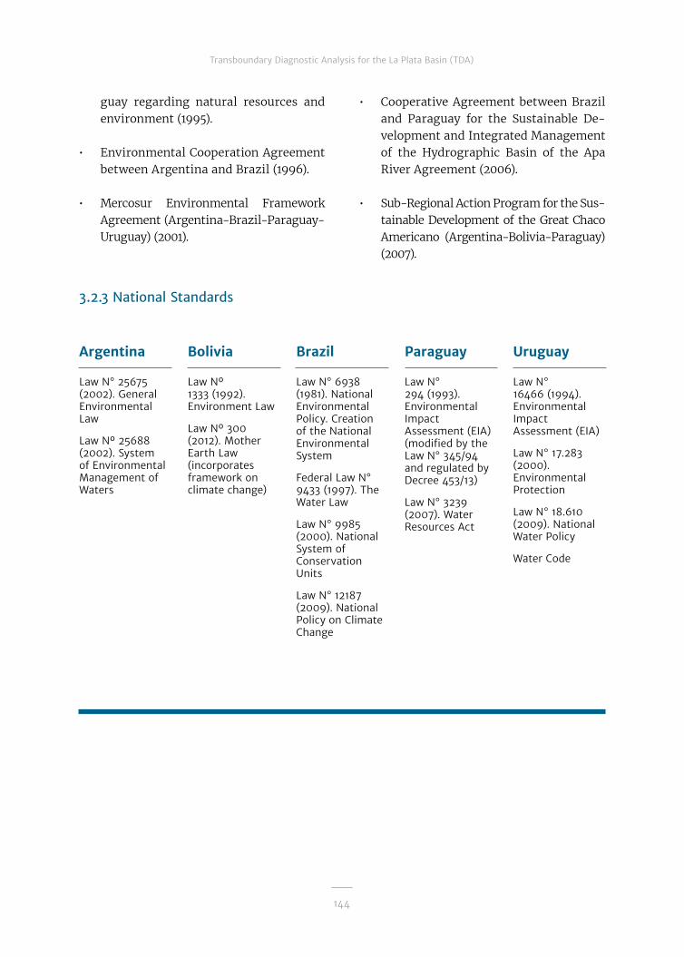
144
Transboundary Diagnostic Analysis for the La Plata Basin (TDA)
guay regarding natural resources and environment (1995).
• Environmental Cooperation Agreement between Argentina and Brazil (1996).
• Mercosur Environmental Framework Agreement (Argentina-Brazil-Paraguay- Uruguay) (2001).
Argentina
Law N° 25675 (2002). General Environmental Law
Law Nº 25688 (2002). System of Environmental Management of Waters
Bolivia
Law Nº 1333 (1992). Environment Law
Law Nº 300 (2012). Mother Earth Law (incorporates framework on climate change)
Brazil
Law N° 6938 (1981). National Environmental Policy. Creation of the National Environmental System
Federal Law N° 9433 (1997). The Water Law
Law N° 9985 (2000). National System of Conservation Units
Law N° 12187 (2009). National Policy on Climate Change
Paraguay
Law N° 294 (1993). Environmental Impact Assessment (EIA) (modified by the Law N° 345/94 and regulated by Decree 453/13)
Law N° 3239 (2007). Water Resources Act
Uruguay
Law N° 16466 (1994). Environmental Impact Assessment (EIA)
Law N° 17.283 (2000). Environmental Protection
Law N° 18.610 (2009). National Water Policy
Water Code
• Cooperative Agreement between Brazil and Paraguay for the Sustainable De-velopment and Integrated Management of the Hydrographic Basin of the Apa River Agreement (2006).
• Sub-Regional Action Program for the Sus-tainable Development of the Great Chaco Americano (Argentina-Bolivia-Paraguay) (2007).
3.2.3 National Standards

145
Transboundary Diagnostic Analysis for the La Plata Basin (TDA)
3.2.4 Regional Institutions
Table 3.2.4.1 details the multilateral organizations that act within the LPB.
Table 3.2.4.1
Multilateral organizations in the La Plata Basin
Year of Creation Name AR BO BR PY UY
1946 Joint Technical Commission of Salto Grande (CTM) X X
1967 Intergovernmental Coordinating Committee of the Countries of La Plata Basin (CIC) X X X X X
1971 Paraguayan-Argentinian Joint Commission of the Paraná River (COMIP) X X
1973 Binational Itaipú X X
1973 La Plata River Administrative Commission (CARP) X X
1973 Joint Technical Commission of the Maritime Front (CTMFM) X X
1973 Yacyretá Binational Entity (EBY) X X
1975 Administrative Commission of the Uruguay River (CARU) X X
1976 La Plata Basin Financial Development Fund (FONPLATA) X X X X X
1989 Intergovernmental Committee of the Paraguay-Parana Waterway (CIH) X X X X X
1991 Common Market of the South (MERCOSUR / MERCOSUR) X X X X
1991 Brazilian-Uruguayan Joint Commission for the Development of the Cuareim-Quaraí River Basin (CRC) X X
1993 Binational Commission of the Basin Lower Pilcomayo River X X
1995 Trinational Commission for the Development of the Pilcomayo River Basin X X X
1995 Binational Commission for the Development of the Upper Bermejo River Basin and the Río Grande de Tarija (COBINABE) X X
2006Brazilian-Paraguayan Joint Commission for the Sustainable Development and Integrated Management of the Apa River Basin (CRA)
X X

146
Transboundary Diagnostic Analysis for the La Plata Basin (TDA)
Argentina
Ministry of Environment and Sustainable Development (MAyDS)
Secretariat of Environmental Policy, Climate Change, and Sustainable Development (MAyDS)
Under-Secretariat of Water Resources (SSRH) (Ministry of Interior, Public Works, and Housing)
Federal Water Council (COHIFE)
Federal Environment Council (COFEMA)
National Water Institute (INA)
National Weather Service (SMN) (Ministry of Defense)
Naval Hydrography Service (SHN) (Ministry of Defense)
Brazil
Ministry of Environment (MMA)
Secretary of Urban Environment and Water Resources (SRHU) (MMA)
National Water Agency (ANA)
National Water Resources Council (CNRH)
National Environmental Council (CONAMA)
National Institute of Meteorology (INMET)
National Spacial Research Institute (INPE) (Ministry of Science, Technology, and Innovation)
Brazilian Institute of Environment and Renewable Natural Resources (IBAMA)
Bolivia
Ministry of Environment and Water (MMAyA)
Vice Ministry of Environment, Biodiversity, Climate Change, and Forestry Development Management (MMAyA)
National Meteorology and Hydrology Service (SENAMHI) (MMAyA)
National Naval Hydrography Service (SNHN) (Ministry of Defense)
Paraguay
Secretary of Environment (SEAM)
Direction of Meteorology and Hydrology (DMH) (National Directorate of Civil Aviation)
Uruguay
National Directorate of Water (DINAGUA) (Ministry of Housing, Land Use, and Environment MVOTMA)
National Environment Directorate (DINAMA) (MVOTMA)
Uruguayan Institute of Meteorology (INUMET) (Ministry of Housing, Use of the Land, and Environment- MVOTMA)
3.2.5 National and Interjurisdictional Institutions
Argentina
Federal National Plan for Water Resources (2007)
Bolivia
National Watershed Plan (2006)
Brazil
National Water Resources Plan
Paraguay
Master Environmental Management Plan for the Yacyretá Binational Entity (EBY)
Uruguay
National Water Plan
3.2.6 National Plans

147
Transboundary Diagnostic Analysis for the La Plata Basin (TDA)
3.3 Legal-institutional Framework: Specific Characteristics
3.3.1 Extreme Hydrological Events
Agreements
• Combat Desertification in Those Countries Experiencing Serious Drought (1994).
• Cooperation of the Upper Basin of the Paraguay River (Brazil-Bolivia). Objective: hydrolog-ical monitoring in the region (2001).
• Additional Protocol on Environmental Emergencies (2004) from the Mercosur Agreement on the Environment (Argentina-Brazil-Paraguay-Uruguay) (2001).
National Standards
Argentina
Law N° 25675 (2002). General Environmental Act. Art. 4. Mitigation of Transboundary Environmental Emergencies
Brazil
Federal Law N° 9433 (1997). Water Law (establishes a National Water Resources Plan, which contemplates “Preventing and defending against critical hydrological events”)
Law 12608 (2012). National Policy of Protection and Civil Defense (creates the disaster information and monitoring system)
National plans
Argentina
National Flood Insurance Program (relaunched in 2003)

148
Transboundary Diagnostic Analysis for the La Plata Basin (TDA)
Argentina
Decree 674 (1989), incorporates the polluter pays principle into the Mining Code
Bolivia
Law Nº 318 (2012), declares the improvement of water quality for human consumption by means of proper technology throughout the territory a national priority
Brazil
CONAMA 357 (2005). Classification of bodies of water and environmental guidelines for effluent discharge
Decree N° 440 (2005). Water quality control in water supply systems.
CONAMA 396 (2008). Framework for groundwater, areas of well protection, and control of potential sources of pollution
CNRH 140 (2012). Grants rights for effluent discharge
Uruguay
Decree 253 (2009) and its amendments. Protection of the Environment
3.3.2 Water Quality Degradation
Agreements
• Stockholm Convention on Persistent Organic Pollutants (1989), ratified by the five countries.
• Convention to Cooperate in Preventing Incidents of Water Pollution by Hydrocarbons and other Harmful Substances. (Argentina-Uruguay) (1987).
• Additional Protocol on environmental emergencies (2004) from the Mercosur Agreement on the Environment (Argentina-Brazil-Paraguay-Uruguay) (2001).
National Standards
Paraguay
Resolution SEAM Nº 222/05, establishes the water quality standard
Law Nº 1614 (2000). Regulatory and Tariff Framework for the Public Provision of Drinking Water Sewer Systems
National plans
Brazil
ANA. National Water Quality Evaluation Plan

149
Transboundary Diagnostic Analysis for the La Plata Basin (TDA)
3.3.3. Sedimentation of Water Bodies and Watercourses
National Standards
Argentina
Law N° 13273 (1995). The Forest Wealth Defense Act
Bolivia
Law N°1700 (1996). Forest Law
Brazil
Law N° 12651 (2012). Forest and Native Vegetation Protection Act (modified by Law ° 12727/12)
Paraguay
Law N° 4241 (2012). Restoration Act for Protected Forests of the Watercourses within the Eastern Region
Law 3239/07 Water Resources Act.
Uruguay
CWater Code
Law N° 15239 (1981) Soil and Water Conservation Laws
Forest Law (1987)
National plans
Brazil
National Agriculture-Livestock-Forestry Policy, The Brazilian Agricultural Research Corporation (EMBRAPA). Adoption of integration systems to recuperate degraded pastures
Argentina
National Observatory of Land Degradation and Desertification (ONDTyD) (MAyDS)
Bolivia
Vice Ministry of Lands (Ministry of Rural Development and Lands)
Brazil
Secretariat of Biodiversity and Forests of the Ministry of the Environment (MMA)
Brazilian Agricultural Research Corporation (EMBRAPA)
Paraguay
Secretariat of the Environment (SEAM)
National Forestry Institute (INFONA)
Uruguay
General Department of Renewable Natural Resources (Ministry of Livestock, Agriculture, and Fisheries)
DINAMA (MVOTMA)
DINAGUA (MVOTMA))
Institutions

150
Transboundary Diagnostic Analysis for the La Plata Basin (TDA)
3.3.4 Alteration and Loss of Biodiversity
Agreements
• Convention on International Trade of Endangered Species from Wild Flora and Fauna (1973), ratified by the five countries.
• Cartagena Protocol on Biosafety (2003), ratified by Argentina, Bolivia, Paraguay, and Uruguay.
• Rasmar Convention on Wetlands of International Importance (1971), ratified by the five countries.
National Standards
Brazil
National Biodiversity Policy
Law N° 6902 (1981). Creation of Ecological Stations and Environmental Protection Areas
Law N° 9985 (2000). National System of Environmental Conservation Units
CONAMA 303 (2002). Protected Areas
Uruguay
LLaw N° 16408. Biological Diversity
Law N° 19175. Hydrobiological Resources
Institutions
Argentina
MAyDS
COFEMA
Bolivia
Vice-Ministry of Environment, Biodiversity, Climate Change, and Forest Management, National Service of Protected Areas (SERNAP), decentralized entity of MMAyA
Brazil
Secretariat of Biodiversity and Forestry (MMA)
CONAMA
Chico Mendes Institute for Biodiversity Conservation (MMA)
Paraguay
SEAM
Uruguay
DINAMA (MVOTMA)
Paraguay
Law Nº 96. Wildlife
Law Nº 352. Protected Wildlife Areas

151
Transboundary Diagnostic Analysis for the La Plata Basin (TDA)
3.3.5 Unsustainable Use of Fishery Resources
Agreements
• Uruguay River Statute (Argentina-Uruguay) (1975).
• Convention on the Conservation and Development of Fish Resources in the Paraná and Paraguay Rivers (Argentina-Paraguay) (1996).
• Agreements between Brazil and Paraguay for the conservation of aquatic fauna in the bor-dering rivers (1994 y 1999).
National Standards
Plans
Institutions
National institutions
Uruguay
Law N° 19175 (2013). Hydrobiological Resources and Ecosystems
Brazil
Plan SAFRA on Fishing and Aquaculture
Paraguay
National Fishing Plan
Regional institutions
Paraguayan-Argentinian Mixed Commission of the Paraná River (COMIP)
Argentina
Undersecretary of Fisheries and Aquaculture (SPA) (Ministry of Agroindustry)
Bolivia
Decentralized Public Institute of Fisheries and Aquaculture (PACU) (Ministry of Rural and Land Development-MDRT)
Brazil
Ministry of Fisheries and Aquaculture
Paraguay
SEAM
Uruguay
National Directorate of Aquatic Resources (DINARA) (MGAP)
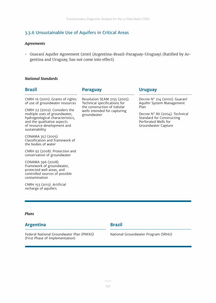
152
Transboundary Diagnostic Analysis for the La Plata Basin (TDA)
3.3.6 Unsustainable Use of Aquifers in Critical Areas
Agreements
• Guaraní Aquifer Agreement (2010) (Argentina-Brazil-Paraguay-Uruguay) (Ratified by Ar-gentina and Uruguay, has not come into effect).
National Standards
Plans
Brazil
CNRH 16 (2001). Grants of rights of use of groundwater resources
CNRH 22 (2002). Considers the multiple uses of groundwater, hydrogeological characteristics, and the qualitative aspects of resource development and sustainability
CONAMA 357 (2005). Classification and framework of the bodies of water
CNRH 92 (2008). Protection and conservation of groundwater
CONAMA 396 (2008). Framework of groundwater, protected well areas, and controlled sources of possible contamination
CNRH 153 (2013). Artificial recharge of aquifers
Paraguay
Resolution SEAM 2155 (2005). Technical specifications for the construction of tubular wells intended for capturing groundwater
Uruguay
Decree N° 214 (2000). Guaraní Aquifer System Management Plan
Decree N° 86 (2004). Technical Standard for Constructing Perforated Wells for Groundwater Capture
Argentina
Federal National Groundwater Plan (PNFAS) (First Phase of Implementation)
Brazil
National Groundwater Program (SRHU)

153
Transboundary Diagnostic Analysis for the La Plata Basin (TDA)
Argentina
SSRH
Bolivia
MMAyA
Geological and Mining Service (SERGEOMIN)
Brazil
MMA-SRHU
ANA
Brazilian Geological Service (CPRM)
Paraguay
SEAM
Uruguay
DINAGUA (MVOTMA)
Guaraní Aquifer System Commission
Institutions
3.3.7 Conflicts Over Water Use and the Environmental Impact of Irrigated Crops
National Standards
Argentina
Law N° 25688 (2002). Law on Minimum Standards for the Environmental Management of Water
Bolivia
Law Nº 1333 (1992). Environmental Law
Brazil
Federal Law N° 9433 (1997). Water Law
CNRH 16 (2001). Grant of rights for groundwater.
ANA 135 (2002). Grant of rights for use
ANA 425 (2004). Volume measurement of water captured in bodies of water
CNRH 65 (2006). Articulation of the rights and use of water resources with environmental licensing procedures
Law N° 12787 (2013). National Irrigation Policy
Paraguay
Resolution SEAM 170 (2006). Approval of the Regulation of the River Basin Water Council
Law N° 3239 (2007). Water Resources Law
Law Nº 294/93 Evaluation of Environmental Impact
Uruguay
Decree-Law N° 14859 (1978). Water Code
Law N° 15239 (1981). Conservation of Soil and Water
Ley N° 16466 (1994). Regulation of the Evaluation of Environmental Impact
Ley N° 18610 (2009). National Water Policy
Water Code

154
Transboundary Diagnostic Analysis for the La Plata Basin (TDA)
Argentina
Federal National Water Resources Plan (2007)
Bolivia
National Watershed Plan (PNC) (2006)
National Irrigation Plan to Live Well (PNDR) (2007)
Brazil
National Policy for recuperation of degraded pastures with the adoption of agriculture-livestock-forestry integration.
Uruguay
National Water Plan
Plans
Institutions
Argentina
SSRH
COHIFE
National Institute of Agricultural Technology (INTA)
Bolivia
Vice Ministry of Watersheds and Water Resources (MMAyA)
Vice Ministry of Water Resources and Irrigation (MMAyA)
Ministry of Rural and Land Development (MDRT), Vice Ministry of Land (VT)
National Irrigation Service (SENARI) (decentralized organization of MMAyA)
Brazil
MMA-SRHU
ANA
CNRH
Water Basin Committees
Brazilian Agricultural Research Corporation (EMBRAPA)
Paraguay
SEAM
Water Council for Basins
Uruguay
DINAGUA (MVOTMA)
MGAP- General Direction of Renewable Natural Resources (DGRNR)
Signing the Agreement on the Guaraní Aquifer. Meeting of the Mercosur Ministers of Foreign Affairs and Asso-ciated States, San Juan, Argentina, August 2, 2010.

155
Transboundary Diagnostic Analysis for the La Plata Basin (TDA)
3.3.8 Lack of Disaster Contingency Plans
National Standards
Argentina
Law N° 25675 (2002). General Environmental Law. Art. 4: Mitigation of Transboundary Impacts from Environmental Emergencies
Laws N° 23879 and N° 24539. Environmental Impact Assessment of Hydroelectric Dams
Bolivia
Law Nº 13338 (1992). Environmental Law
Law N° 2140 (2000). Risk Reduction and Disaster and Emergency Assistance
Law N° 2335 (2002). Creation of the Trust Fund for Risk Reduction and Disaster Assistance (FORADE)
Brazil
Federal Law N° 9433 (1997). Water Law
Law N° 12608 (2012). National Policy of Civil Defense and Protection (PNPDEC) and the Disaster Information and Monitoring System
Law N° 12334 (2010). National Policy on Dam Safety and creation of National Dam Safety System
Resolution CNRH 143 (2012). Classification of Dams
Resolution CNRH 144 (2012). Establishes guidelines for the implementation of the National Policy on Dam Safety
Paraguay
Law Nº 2615, Creation of the Secretary of National Emergencies (SEN)
Decree Nº 11632 regulates SEN
Uruguay
Decree-Law N° 14.859 (1978) Water Code
Law N° 18621. National Emergency System (SINAE)
Institutions
Argentina
SSRH
COHIFE
Dam Security Regulatory Agency (ORSEP) (SSRH)
Bolivia
MMAyA
Brazil
MMA-SRHU
ANA
Ministry of Integration
Paraguay
Secretary of National Emergencies (SEN)
Uruguay
SINAE
DINAGUA (MVOTMA)

156
Transboundary Diagnostic Analysis for the La Plata Basin (TDA)
3.3.9 Water Quality Degradation and Deterioration of Environmental Health
Agreements
• Convention on the Prior Informed Consent Procedure for Certain Hazardous Chemicals and Pesticides in International Trade (2004), ratified by the five countries.
• Stockholm Convention on Persistent Organic Pollutants (2004), ratified by the five countries.
National Standards
Argentina
Law N° 25675 (2002). General Environment Law
Law N° 25.688 (2002). Environmental Management of Water Law
Penal Code
Bolivia
Law Nº 1333 (1992). Environmental Law
Law Nº 300 (2012). Mother Earth Law
Law Nº 318 (2012). Improvement of drinking water quality for human consumption
Brazil
Law N° 6938 (1981). Creation of National Environmental System
Federal Law N° 9433 (1997). Water Law
Decree N° 440 (2005). Quality control of water supply systems
CONAMA 357 (2005). Classification of the bodies of water
CNRH 140 (2012). Granting of the rights of effluent discharge
Paraguay
Law N° 3239 (2007). Water Resources Law
Law N° 294 (1993). Evaluation of Environmental Impact Law (EIA) (modified by Law N° 345/94 and regulated by Decree 453/13)
Penal Code
Resolution N° 222. Secretariat for the Environment
Law Nº 2459/04, creation of the National Service for Plant and Seed Quality and Health (SENAVE)
Law Nº 3742, Agricultural Pesticide Control
Uruguay
Decree 253 (1979). Control of Water Contamination
Law N° 18610 (2009). National Water Policy
EIA: Law N° 16466 (1994). Environmental Impact Assessment
Law N° 17283 (2000). Environmental Protection
Water Code
Penal Code
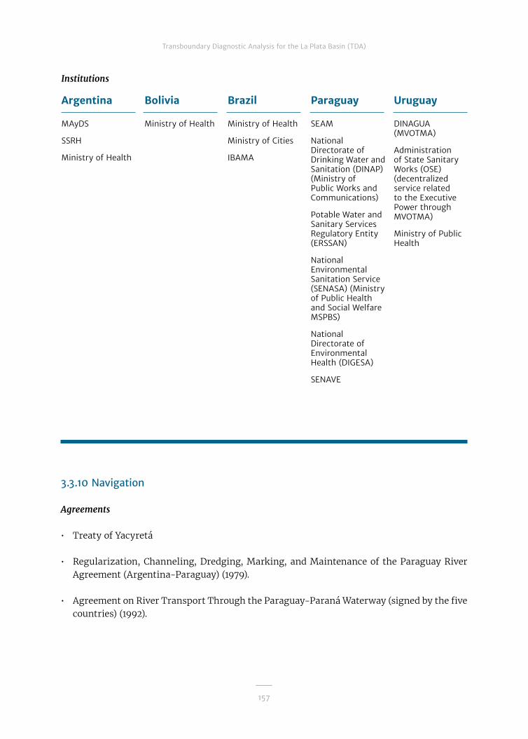
157
Transboundary Diagnostic Analysis for the La Plata Basin (TDA)
3.3.10 Navigation
Agreements
• Treaty of Yacyretá
• Regularization, Channeling, Dredging, Marking, and Maintenance of the Paraguay River Agreement (Argentina-Paraguay) (1979).
• Agreement on River Transport Through the Paraguay-Paraná Waterway (signed by the five countries) (1992).
Institutions
Argentina
MAyDS
SSRH
Ministry of Health
Bolivia
Ministry of Health
Brazil
Ministry of Health
Ministry of Cities
IBAMA
Paraguay
SEAM
National Directorate of Drinking Water and Sanitation (DINAP) (Ministry of Public Works and Communications)
Potable Water and Sanitary Services Regulatory Entity (ERSSAN)
National Environmental Sanitation Service (SENASA) (Ministry of Public Health and Social Welfare MSPBS)
National Directorate of Environmental Health (DIGESA)
SENAVE
Uruguay
DINAGUA (MVOTMA)
Administration of State Sanitary Works (OSE) (decentralized service related to the Executive Power through MVOTMA)
Ministry of Public Health

158
Transboundary Diagnostic Analysis for the La Plata Basin (TDA)
National Standards
Argentina
Civil Code
Law N° 20094 (1973). Navigation Law
Bolivia
Decree (17.01.1853). (Bolivian rivers can be navigated freely by ships of all flags)
Brazil
Law N° 9432 (1997). River Transport
Law N° 9537 (1997). River Transport Security
Law N° 9611 (1998). Multimodal Cargo Transport
Paraguay
Civil Code
Law N° 475 (1957). Sanction of the River and Maritime Code
Uruguay
Law Nº 12.091 (1954). Law on Navigation and Coastal Trade
Decree-Law N° 14859 (1978). Water Code
Regional Institutions
Intergovernmental Committee of the Paraguay-Paraná Waterway (CIH)
Argentina
Ministry of Transport
Bolivia
Ministry of Defense
Brazil
Ministry of Defense-Naval Command
Ministry of Transportation
Paraguay
National Administration of Navigation and Ports (ANNP)
Ministry of Foreign Affairs, Secretary of Environment, Naval Prefecture of the Paraguayan Navy, Paraguayan Ship Owners’ Association, National Water Commission
Uruguay
onal Hydrographic Directorate (Ministry of Transportation and Public Works-MTOP)
National Transport Directorate (MTOP)
Institutions
National Institutions

159
Transboundary Diagnostic Analysis for the La Plata Basin (TDA)
3.3.11 Hydroelectricity
Agreements
• Convention on the Utilization of the Uruguay River Rapids in the Salto Grande Area (Ar-gentina-Uruguay) (1946).
• Convention to Study the Use of the Paraná River’s Resources (Argentina-Paraguay) (1971).
• Itaipú Treaty for the Hydroelectric Utilization of the Water Resources of the Paraná River (Brazil-Paraguay) (1973).
• Treaty of Yacyretá (Argentina-Paraguay) (1973).
• Treaty for the Utilization of Shared Water Resources of the Boundary Stretches of the Uru-guay and Pepirí-Guazú Rivers (Argentina-Brazil) (1980).
• Tri-national Commission for the Development of the Pilcomayo River Basin (Argenti-na-Bolivia-Paraguay) (1995).
• Binational Commission for the Development of the upper Bermejo River and Grande de Tarija River Basins (Argentina-Bolivia) (1995).

160
Transboundary Diagnostic Analysis for the La Plata Basin (TDA)
Argentina
Law N° 24065 (1991). Regulatory Framework on Electricity
Bolivia
Law N° 1604 (1994). Electricity Law
Brazil
Law N° 3890 (1961). Constitution of the Brazilian Electric Compa-ny formed Centrais Elétricas Brazilei-ras S.A. (ELETRO-BRAS)
Law N° 7990 (1989). Financial compensation for the use of wa-ter resources to generate electric energy and oth-er aspects for the federal, state, and municipal govern-mental organiza-tions.
Law N° 9427 (1996). Brazilian Electricity Reg-ulatory Agency (ANEEL) and reg-ulation of the sys-tem of concession for the public en-ergy sector
ANEEL (2013). Electric Sector Regulation
Paraguay
Law N° 3009 (2006). Independent Production and Transport of Electric Power Law
Uruguay
Law N°16832 (1997). Updating the National Electric System and the framework of the Energy Regulation Unit
National Standards

161
Transboundary Diagnostic Analysis for the La Plata Basin (TDA)
Institutions
Regional Institutions
Mixed Technical Commission of Salto Grande (CTM)
Paraguayan-Argentinian Mixed Commission of the Paraná River (COMIP)
Itaipú Binational Entity
Yacyretá Binational Entity (EBY)
Argentina
Ministry of Mines and Energy
SSRH (Ministry of the Interior, Public Works, and Housing)
Bolivia
Ministry of Hydrocarbons and Energy
Brazil
Ministry of Mines and Energy
Brazilian Electricity Regulatory Agency (ANEEL)
Paraguay
National Electricity Administration (ANDE)
Uruguay
Ministry of Energy, Industry, and Mining
National Institutions


163
Chapter 4: Critical Transboundary Issues
4.1 Introduction
The Macro- Transboundary Diagnostic Analysis (Macro TDA), developed over a pe-riod of two years from 2003 to 2005, iden-tified, on a scientific and social basis, the critical transboundary issues (CTI) present and emerging in the LPB and their caus-al chains.5 The process of drawing up the Macro TDA (as a preliminary version) was carried out through national and regional workshops.
The critical issues identified were as follows:
• Extreme hydrological events linked to climate variability and change, partic-ularly more prolonged, recurrent, and intense floods and widespread drought periods that cyclically affect parts of the Basin, with catastrophic social, econom-ic, and environmental effects. Gaps in
information and climate knowledge were identified, with the consequent inability to more efficiently prevent the effects of climate variability and change.
• Water quality degradation, a problem caused by organic and chemical pol-lutants from specific sources with-out adequate treatment, such as min-ing and industrial activity; wastewater and solid waste from urban centers; diffuse pollution sources, mainly ag-ricultural crops with intensive use of agrochemicals. The lack of common standards and instruments for mutu-ally determining the quality parame-ters and constraints of the five coun-tries’ control and monitoring network was identified, making it impossible to carry out a coherent and encompassing diagnostic on the quality of the waters of the rivers in the Basin.
5 EThe causal analysis was carried out through national and regional workshops, with the participation of specialists designated by each country for the different topics. The CTI causes were classified as follows: i) Technical causes: causes that refer to poor management of scarce natural resources, such as water and land, to the use of inadequate technologies, lack of monitoring systems or the improper operation thereof; ii) Economic-managerial causes: causes that derive from the inadequate econom-ic projections or inadequacy of managerial approaches; iii) Political-institutional causes: causes derived from the institutional environment, that is, from the legal and organizational framework of a region or country; and iv) Socio-cultural causes: those based on the foundations on which society is formed, such as its behavioral norms, ethics, customs, traditions, religion, etc.

164
Transboundary Diagnostic Analysis for the La Plata Basin (TDA)
• The sedimentation of bodies of water and watercourses in the Basin, which lim-its the capacity of waterways and ports, with important maintenance costs, and which fills the dam reservoirs and mod-ifies the quality of their waters; these processes are caused by greater erosion and land degradation that has been in-creasing because of changes in land use and loss of vegetation.
Other critical issues of interest were also highlighted:
• The alteration and loss of biodiversity, in particular of river and coastal ecosys-tems—including wetlands—problems mainly caused by the loss and fragmen-tation of habitats.
• Unsustainable use of fishery resourc-es, whether due to overfishing or lack of protective capture methods, which alters the structure and functioning of aquatic communities.
• The unsustainable use of aquifers in crit-ical areas, the conservation of which
makes it necessary to manage them in an integrated way, together with surface re-sources and the climate, taking sustain-able development needs into account.
• Water use conflicts and the environ-mental impact of irrigated crops, with-out an overall vision and capacity to generate participatory processes for the stakeholders involved to reach a fair resolution.
• The lack of disaster contingency plans, including dam safety and problems as-sociated with the prevention of acci-dents and catastrophes mainly related to navigation and transport of hazard-ous and polluting materials.
• Poor water health and the deteriora-tion of environmental health and its ef-fects on human health, resulting from contamination and changes in wa-ter quality. The incidence of urban de-velopment with insufficient sanitation services and the advance of cyanobac-teria, among other things, was high-lighted, recognizing that it is a prob-lem that requires significant primarily national investment, but which also in-volves cross-border aspects.
It should be noted that in Stage 1, which be-gan in March 2011, it was decided that lim-itations on navigation and hydropower be incorporated as CTIs, as they are two so-cio-economic sectors that are fundamental to regional integration.
As part of the initial activities of that stage, a Regional Workshop on Working Groups was held (June 2011), where the project doc-ument was revised and updated, taking into account the time elapsed since the formu-lation of the proposal (2005). As a result of the review process, not only were the Mac-A bird of the Pantanal, Jaburu Tuiuiu.

165
Transboundary Diagnostic Analysis for the La Plata Basin (TDA)
ro TDA and the causal chains of each prob-lem updated, but also the baseline and work elements (objectives, outputs, results, and activities) of the components and subcom-ponents of the project.
During the period from 2011 to 2016, the project's execution included the imple-mentation of activities aimed at deepening the knowledge base of the different top-ics, which allowed for the consolidation and updating of the diagnostic. The pro-cess was carried out with the involvement of the Working Groups (WG), through the participation of representatives with com-petence in each of the topics from govern-mental and academic institutions from the five Basin countries (water quality, hydrau-lic balance, groundwater, land degradation, hydrometeorology, ecosystems, etc.).
The work of the WGs was complement-ed with specific studies aimed at obtaining knowledge on critical and priority issues for the Basin, not included in the project com-ponents. This includes studies on naviga-tional limitations and measures to over-come them; the analysis of the hydroelectric potential and the possible use of alternative sources of energy; and the problems asso-ciated with the environmental sanitation of the Basin, the impact on human health, and the transboundary effects.
Demonstrative Pilot Projects and priority projects related to critical problems of the Basin were also developed in selected areas and sub-basins, and carried out by local ac-tors and by the principal governmental and non-governmental organizations. The proj-ects were implemented with the objective of providing information for the preparation of this TDA and providing local management experiences for replication as part of the Strategic Actions Program (SAP), catalyzing existing initiatives in the countries involved.
The Demonstrative Pilot Projects are:
Regulated conservation of biodiversity in the Paraná River
Countries involved: Argentina, Brazil, and Paraguay
Its purpose is to contribute to improving the management capacity of aquatic re-sources in the Paraná River stretch between the confluence of the Paraná and Paraguay rivers and Guayrá falls, an area where two of the most important transboundary res-ervoirs of the Basin are located: Itaipú and Yacyretá. An updated baseline was gener-ated and guidelines were formulated that could contribute to the development of a management plan for the conservation of aquatic resources, and a set of recommen-dations was prepared to harmonize legisla-tion and to train local actors. It contributes to the knowledge base of the CTIs regarding alteration and loss of biodiversity and un-sustainable use of fishery resources.
Hydro-environmental alert system. Floods and droughts in the confluence zone of the Paraguay and Paraná rivers
Countries involved: Argentina and Paraguay
Its purpose is to develop a hydro-environ-mental monitoring and warning system for risk management (prevention, contingency, and rehabilitation) in the metropolitan axis of Resistance-Corrientes (Argentina) and Pilar (Paraguay), also contemplating ad-aptations or actions to to address the hy-drological effects of climate variability and change, to prevent flood and drought disas-ters, and to implement mitigation measures in collaboration with civil defense authori-ties. The alert system includes notification of extreme hydrological phenomena and contaminant spills and the preparation of

166
Transboundary Diagnostic Analysis for the La Plata Basin (TDA)
contingency plans. It contributes to knowl-edge base on the CTIs related to extreme hydrological events, lack of disaster contin-gency plans, and water quality degradation.
Resolution of water use conflicts - Cuareim / Quaraí river basin
Countries involved: Brazil and Uruguay
Its purpose is to execute a localized proj-ect that contributes to improving the inte-grated management capacity of the water resources of the Basin, seeking their har-monious use among national users and in the transboundary area. It promotes the involvement of local actors and the exist-ing Binational Commission for the devel-
opment of the Basin and the conservation or improvement of environmental quality, guiding decision-making processes toward a rational use of water, with an aim to re-solve current conflicts, including the issue of irrigated crops, particularly rice. It con-tributes to the knowledge base of CTIs on "water use conflicts and the environmental impact of irrigated crops."
Pollution and erosion control in the Pilcomayo River Basin
Countries involved: Argentina, Bolivia, and Paraguay
Its purpose is to generate a local manage-ment experience, contributing to the re-
Parque Nacional El Palmar - Argentina.

167
Transboundary Diagnostic Analysis for the La Plata Basin (TDA)
duction of both the risk of environmental liabilities and mining pollution, such as soil erosion, sedimentation, and silting in the Pilcomayo River watercourses. It includes a set of actions at the local level (Cotagai-ta basin in Bolivia). The aim is to preserve the integrity of the water resource system of the Pilcomayo sub-basin by improving water quality and erosion control through non-structural measures in order to create the possibility of replicating actions to con-trol and mitigate pollution and erosion. The project contributes to the knowledge base of the CTI on water quality degradation and sedimentation of bodies of water and wa-tercourses, considering the transboundary effect on Argentina and Paraguay.
There are also two priority projects dedi-cated to the Selva Misionera Paranáense (SMP) and to the Yrendá-Toba-Tarijeño Aquifer System (YTTAS) (see Chapters 1.3.11 and 1.4.1.3, respectively). A third project is based on the experience of the Cultivat-ing Good Water (CGW) program, initiat-ed in 2003 by Binational Itaipú to mitigate environmental liabilities and work toward a new culture, one of socio-environmen-tal sustainability, including the implemen-tation of appropriate technologies and best practices with the participation of the dif-ferent social actors that influence quality of life and the environment: companies, gov-ernments, schools and universities, civil society organizations, and the media.
The CIC expanded the CGW Program in the La Plata Basin, initially in the zones of influence of the other two bination-al hydroelectric power stations in the re-gion, operated by the Yacyretá Bination-al Entity (EBY) and the Mixed Technical
Commission of Salto Grande (CTM-SG). The Bolivian FP delegation (with no bina-tional hydroelectric power stations in its territory) was invited to send represen-tatives from the agencies or institutions that they considered appropriate to learn the methodology of the work in order to potentially replicate it.
The results of the various works and stud-ies, summarized in the previous chapters and in this chapter, form the basis of this analysis.
The following section presents a summary of the results for each CTI, in order to bet-ter understand the problems presented and their social and economic impacts. Spe-cial consideration will be given to the like-ly effects of climate variability and change, based on the results outlined in Chapter 2.
The summary is presented considering the entire basin and, depending on available information, the sub-basins mentioned in Chapter 1.3. It should be noted that the iden-tification of a problem in a sub-basin is not necessarily indicative of its occurrence in all of its extension, and it may be in fact be treated as a local problem that occurs in a certain area of that sub-basin, a point which will be clarified in each case.
The analysis includes some considerations on legal and institutional aspects and the identification of the main causes (techni-cal, economic-managerial, political-insti-tutional, and socio-cultural) that were de-tected for each CTI in the preparation of the Macro TDA. Based on these elements, rec-ommendations are made for the prepara-tion of the Strategic Actions Program (SAP).
168
Transboundary Diagnostic Analysis for the La Plata Basin (TDA)
4.2 Extreme Hydrological Events
4.2.1 Flooding
4.2.1.1 Presentation of the Topic
Floods are the greatest natural threat in the LPB. They are caused by three main factors: the natural increase of river flows in rainy seasons, disorganized urban sprawl that occupies flood plains, and the increase in groundwater levels.
Most of the rivers in the Basin have large floodplains that have been occupied by both the population and agricultural activities. The Paraguay River has large plains with a slow-flowing runoff when flooding occurs on its banks. On the banks of the Paraná River and its tributaries, such as the Ig-uazú River, there are important cities that are flooded with great frequency. This is the case with the cities of Resistencia, Cor-rientes, Rosario, and Santa Fe, which suffer major impacts. The Uruguay River also has significant flooding, mainly in São Borja, Itaquí, and Uruguaiana. In the lower part of the Basin shared by Argentina and Uruguay, flooding downstream of the Salto Grande dam was observed at the end of 2015, co-inciding, in turn, with the historical flood of Artigas and Quaraí, cities included in the pilot project carried out in the Cuareim/Quaraí river basin.
Since 1970, floods have been occurring more frequently, on average every four years. The greater frequency is associated with the El Niño phenomenon and the impact of land use on the upper basins.
On the other hand, in recent years there has been an increase in the groundwater level in the Pampa region of Argentina, associat-ed with natural and anthropogenic causes. In urban and suburban areas, the increase
in the water table causes damage to the un-derground infrastructure and increases the possibility of groundwater contamination. In rural areas, the reduced depth and up-welling of water cause flooding in large ar-eas intended for agricultural use.
Although this problem is associated, above all, with natural causes (mainly the in-crease in rainfall since 1970), there are anthropogenic causes such as inadequate territorial planning and the construc-tion of infrastructure works, such as roads which obstruct surface runoff and increase infiltration as a consequence of increased irrigated area.
4.2.1.2 Environmental, Social, and Economic Impacts
No systematic studies have been im-plemented in the Basin to assess loss-es or damages due to flooding. According to specific studies (FP, 2016b), during the El Niño event of 1982 to 83, the estimated losses in the La Plata Basin were more than a billion dollars.
In Argentina, the direct and intangible damages of the floods between 1987 and 1998 were estimated at 2,640 million dol-lars, with more than 235,000 people evacu-ated. In the period from 1991 to 1992, flood-ing created a loss of 513 million dollars, more than 3 million hectares flooded, and 122,000 people evacuated.
Recent studies undertaken in Paraguay within the framework of the Strategic Plan-ning and Institutional Development of the Pluvial Drainage Sector Support Program estimated that the baseline cost of a flood in an intermediate city is in the neighbor-hood of 5 million dollars, a value that arose from considering, among other variables, losses in GDP due to hours of work stop-

169
Transboundary Diagnostic Analysis for the La Plata Basin (TDA)
Montevideo Port, Uruguay.

170
Transboundary Diagnostic Analysis for the La Plata Basin (TDA)
page, loss of workers' income per hour of work stoppage, temporary shelters, provi-sion of emergency facilities, reconstruction of average housing, reconstruction of social housing, rehabilitation of waterways and waterworks, and operations to return vic-tims to their homes (FP, 2016b).
4.2.1.3 Activities Developed
In 2005, gaps were identified in informa-tion and knowledge of present and future climate, which required improving the ca-pacity to model the phenomena of climate variability and change to identify hazards and vulnerabilities, as well as to plan ad-aptation measures for the new climatic and hydrological scenarios.
In response, a detailed diagnosis of the hydrometeorological monitoring systems (meteorological and hydrological obser-vations as well as meteorological satellites and radar) and of the existing warning systems at the national and regional levels was advanced.
For example, in Argentina, the SINARAME project was implemented in two stages. In the first, the first two radars (the MR A0 prototype and the MR A1 operation) were developed and manufactured, and then the project proceeded to the design and the pre-liminary implementation of the LPB Oper-ations Center and the integration of exist-ing radar with transmission into the LPB. In 2015, the MR A0 was put into operation at the San Carlos de Bariloche airport, while the MR A1 was installed at the Nation-al University of Cordoba (UNC). During the period from 2015 to 2016, the second stage of the project will be carried out, with the installation of 10 meteorological radar units at different sites, five regional processing centers, and 55 automatic meteorological stations. In this second stage, the Argentine
sector of the LPB would have five new me-teorological radars: Las Lomitas (Formosa), Resistencia (Chaco), Bernardo de Irigoyen (Misiones), Chajarí (Entre Ríos), and Ezeiza (Buenos Aires).
On the other hand, activities related to hy-droclimatic modeling and adaptation al-low hydroclimatic scenarios generated by a model selected by the countries (ETA-INPE) and a hydrological model (MGB-IPH) in-stalled in the five countries to analyze the current situation and the future scenarios.
In order to visualize the effects of flood-ing, maps of flooding vulnerability, occur-rence, and impact were carried out at the sub-basin scale, including a regional anal-ysis of the results. Subsequently, for each of the sub-basins analyzed, urban and rural critical areas were identified. This provides a vulnerability map for flooding (Figure 4.2.1.3.1), as well as vulnerability assess-ments for different socio-economic sectors.
This issue is emphasized in the Demon-strative Pilot Project Hydro-environmental alert system. Floods and droughts in the con-fluence zone of the Paraguay and Paraná rivers, mentioned in Chapter 4.1.
4.2.1.4 Knowledge Expansion and Updating
Among the main results of the work on floods are the following:
Vulnerability to river flooding
Based on the GIS mapping of the La Plata Basin and applying the methodology pro-posed by the ANA (2011), the main water-courses were studied and those with high, medium, and low vulnerability to flood-ing were identified. Only 7.2 percent (67,820 km) of the watercourses of the Basin were

171
Transboundary Diagnostic Analysis for the La Plata Basin (TDA)
Figure 4.2.1.3.1
La Plata Basin. Flood Vulnerability
P P
P
P
P
Ü
BRAZIL
PARAGUAY
BuenosAires La Plata
River
Paran
á Rive
r
Paraná River
Uruguay River
BOLIVIA
URUGUAY
Montevideo
Asunción
Brasilia
Sucre
ARGENTINA
La Plata Riverown sub-basin
Vulnerability tofloods
Lower UruguaySub-basin
Upper UruguaySub-basin
Upper ParanáSub-basin
Upper ParaguaySub-basin
Lower ParaguaySub-basin
A T L A N T I CO C E A N
Lower ParanáSub-basin
Paragu
ayRiv
er
High (significant damage)Medium (reasonable damage)
Low (localized damage)
Vulnerability to floods
High (significant damage)
Medium (rassonable damage)
Low (localized damage)

172
Transboundary Diagnostic Analysis for the La Plata Basin (TDA)
analyzed. It should be noted that although the same methodology was used for the whole Basin, when applied in different countries by different experts, the results could present some differences between countries and sub-basins, so they should be taken as merely a first approximation to the problem. Based on the applied methodolo-gy, the following results were obtained: of the watercourses analyzed in the whole Ba-sin, 41 percent (27,806 km) presented high vulnerability to flooding, 35 percent (23,737 km) medium vulnerability, and 24 percent (16,276 km) low vulnerability. The detail by sub-basin is presented in Table 4.2.1.4.1.
Urban floods
Background studies indicate that one of the main problems in the La Plata Basin is ur-ban flooding. This was analyzed in particu-lar by first identifying the preliminary pop-ulations with potential flood problems. For this purpose, populations with more than
50,000 inhabitants were identified, as well and those with between 10,000 and 50,000 inhabitants, all with a nearby watercourse with high vulnerability to riparian flood-ing. The results that are presented should be considered a first approximation to the problem. When considering the entire Ba-sin, 92 cities were identified with more than 50,000 inhabitants and 226 populations be-tween 10,000 and 50,000 inhabitants with a high likelihood of having problems with river flooding. The sub-basin details are presented in Table 4.2.1.4.2.
Flood occurrence maps and flood im-pact maps were generated for both the Ba-sin (Figures 4.2.1.4.1 and 4.2.1.4.2) and the sub-basins.
The vulnerability analysis also identified 87 cities of more than 50,000 inhabitants and 226 with between 10,000 and 50,000 inhab-itants with a high vulnerability to flood-ing. In the rural areas of each sub-basin,
Table 4.2.1.4.1
Vulnerability to riparian floods in major sub-basins
Flood Vulnerability
Sub-basin Extension analyzed (km) High (%) Medium (%) Low (%)
Upper Paraguay 4,579 65 25 10
Lower Paraguay 17,417 38 41 21
Upper Paraná 11,939 23 40 37
Lower Paraná 12,946 73 24 3
Upper Uruguay 4,454 55 19 26
Lower Uruguay 13,334 27 39 34
La Plata River (*) 3,150 6 45 49
(*) The La Plata River sub-basin was only partially studied.

173
Transboundary Diagnostic Analysis for the La Plata Basin (TDA)
Table 4.2.1.4.2
Number of populations per sub-basin likely to have problems due to riparian flooding
Nº Populations
Sub-basin> 50.000
inhabitants
10.000 - 50.000
inhabitants
Upper Paraguay 3 15
Lower Paraguay 9 17
Upper Paraná 39 66
Lower Paraná 22 77
Upper Uruguay 4 18
Lower Uruguay 7 18
La Plata River (*) 8 15
(*) The La Plata River sub-basin was only partial-ly studied.
land use associated with high vulnerability (with a return period of less than five years) to flooding was identified (Table 4.2.1.4.3).
4.2.1.5 Influence of Climate Variability and Change
In general terms, there is an increase in rainfall mainly in the south and south-western areas of the LPB (although there is a decrease in the northern area), an in-crease in the frequency of intense rains, an increase in river flows, and an increase in dry periods. All these factors indicate a current trend towards an increase in ripar-ian flooding in the LPB.
In terms of the analysis of possible future scenarios, according to the available pre-cipitation studies (FP, 2016c), the following conclusions can be drawn:
• For the period 2011 to 2040, there is an increase of up to 1 mm/day in the south-
Table 4.2.1.4.3
Number of cities with high and medium vulnerability to floods
High Medium
Sub-basin> 50.000
inhabitants10.000-50.000
inhabitants> 50.000
inhabitants10.000-50.000
inhabitants
Upper Paraguay 3 15 3 19
Lower Paraguay 34 66 42 98
Upper Paraná 4 18 1 8
Lower Paraná 9 17 12 31
Upper Uruguay 22 77 8 21
Lower Uruguay 7 18 5 9
La Plata River 8 15 13 10
Total 87 226 84 196

174
Transboundary Diagnostic Analysis for the La Plata Basin (TDA)
P P
P
P
P
Ü
Occurrenceof floodsLow: return periods greater than 10 yearsMedium: return periods between 5 and 10 yearsHigh: return periods of less than 5 years
BRAZIL
PARAGUAY
BuenosAires La Plata
River
Paran
á Rive
r
Paraná River
Uruguay River
BOLIVIA
URUGUAY
Montevideo
Asunción
Brasilia
Sucre
ARGENTINA
La Plata Riverown sub-basin
Lower UruguaySub-basin
Upper UruguaySub-basin
Upper ParanáSub-basin
Upper ParaguaySub-basin
Lower ParaguaySub-basin
A T L A N T I CO C E A N
Lower ParanáSub-basin
Paragu
ayRiv
er
Figure 4.2.1.4.1
La Plata Basin. Flood occurrence
Occurrence of floods
Low: return periods greater a 10 years
Medium: return periods between 5 and 10 years
High: return periods of less than 5 years

175
Transboundary Diagnostic Analysis for the La Plata Basin (TDA)
Figure 4.2.1.4.2
La Plata Basin. Flood impacts
P P
P
P
P
Ü
Impact of floodsLowMedium
High
Average impact: reasonable damage to essential services,public and residential infrastructure and facilities
BRAZIL
PARAGUAY
BuenosAires La Plata
River
Paran
á Rive
r
Paraná River
Uruguay River
BOLIVIA
URUGUAY
Montevideo
Asunción
Brasilia
Sucre
ARGENTINA
La Plata Riverown sub-basin
Lower UruguaySub-basin
Upper UruguaySub-basin
Upper ParanáSub-basin
Upper Paraguay Sub-basin
Lower ParaguaySub-basin
A T L A N T I CO C E A N
Lower ParanáSub-basin
Paragu
ayRiv
er
High impact: high risk of damage to human lives,significant damage to essential services, facilities andpublic infrastructure and residential areas
Low impact: localized damage
High impact: high risk of damage to human lives, signifi-cant damage to essential services, facilities and public in-frastructure and residential areas.
Average impact: reasonable damage to essential services, public and residential infrastructure and facilities.
Low impact: localized damage.
Impact of floods
Low
Medium
High

176
Transboundary Diagnostic Analysis for the La Plata Basin (TDA)
ern area and a decrease of up to 3 mm/day in the northern part of the Basin.
• For the period 2041 to 2070, there is an increase of up to 1 mm/day in the south, southwest, and western zones, while in the north and northeast there is a de-crease of up to 1 mm/day.
• In the period 2071 to 2099, the increase continues for the southern, western, and northern areas and there is a decrease in the eastern zone for the December-Janu-ary-February quarter. Subsequently, this signals a moderate or neutral increase for the rest of the months of the year.
If the current trend continues, the south-ern and southwestern part of the Basin could have greater river flooding problems, while in the northwest zone, even with less precipitation, this problem will depend on whether the seasonal distribution is homo-
geneous or if, on the contrary, the current trend continues, where the rains accumu-late in fewer days.
4.2.2 Droughts
4.2.2.1 Presentation of the Topic
Drought is a hydrological extreme with low precipitation and flow for a long enough pe-riod to affect populations and environments. Unlike flooding, it has a slow and progres-sive nature. Available data on droughts and, in particular, their effects on the environ-ment and the economy are often scarce.
When discussing droughts, it is possible to distinguish the case in which the lack or reduction in precipitation affects areas with different magnitude—by reducing the availability of water, in quantity and quali-ty, to satisfy the demands for domestic and agricultural uses, among others—from the
SINARAME radar, Argentina.

177
Transboundary Diagnostic Analysis for the La Plata Basin (TDA)
case where such lack or reduction is re-flected in the reduction of flows and river levels—what is sometimes known as "low water"—affecting in particular hydroelec-tric generation and navigation.
In much of its territory, the Basin does not present significant water deficiencies for current uses. In some of the largest urban centers, low levels of water are commonly found in sources used for human consump-tion. This is because some of these cities are located in the headwaters of the tributaries of the main rivers, which limits the avail-ability of sources. San Pablo and Curitiba are two good examples of this situation.
Argentina devotes a large part of its terri-tory to agricultural, livestock, and forestry activities, generating strong pressure on its natural resources, particularly on the soil. In the province of Buenos Aires, the most severe droughts occurred in the early 1970s, with a reduction in extreme events after 1972. This trend towards a reduction in the risk of severe droughts and an increase in precipitation, particularly in the western part of the Pampa plain, has led to a shift from agriculture and ranching to a primar-ily agricultural system.
In the Gran Chaco region (shared by Ar-gentina, Bolivia, Brazil, and Paraguay) the semi-arid zone is subject to erosive pro-cesses and loss of fertility resulting from over-ranching and unsustainable agricul-ture. This situation is aggravated towards the west, where the arid Chaco region pres-ents the most extreme conditions of aridity, observing a process of desertification.
4.2.2.2 Environmental, Social, and Economic Impacts
There is a general consensus on the ex-istence of significant adverse econom-
ic consequences due to the occurrence of droughts, and these consequences are re-flected on a national scale, as they affect important sectors of the economies of LPB countries, such as agriculture and livestock production, agribusiness, hydropower gen-eration, and navigation, among others. However, it is a complex task to quantify the effects of drought economically, taking into account all its direct and indirect im-plications. In the framework of the Project’s activities, the incidence of drought was an-alyzed by relating the occurrence of a dry year to the variation in the GDP growth of the sub-basin affected by drought.
Although the GDP growth value in each of the sub-basins depends on the economies of the countries that make them up, as well as on many other factors that are indepen-dent of the drought situation, it is also a constant in most regions that the econom-ic sectors related to the availability of water resource have a large influence on the GDP. On average, the dry years identified have meant an average GDP decrease of 5 per-cent (between 3 and 7 percent).
4.2.2.3 Activities Developed
A study was carried out on vulnerability to drought; a temporal space characteriza-tion of the periods with water deficit at the sub-basin level and with an annual time scale was performed.
In addition, a characterization of the wa-ter deficit periods in the sub-basins was performed, based on the SPEI (Standard-ized Precipitation-Evapotranspiration In-dex), with a monthly step for different time scales (one, three, six, and 12 months) and an analysis of evapotranspiration potential (ETP) and precipitation (P) variables for the current and future scenarios. The current scenario (1961 to 2005) and future scenarios

178
Transboundary Diagnostic Analysis for the La Plata Basin (TDA)
(2007 to 2040, 2041 to 2070, 2071 to 2099) were analyzed.
4.2.2.4 Knowledge Expansion and Updating
For the study of vulnerability to drought events, monthly rainfall series from 46 pluviometric stations were used. Dry years were identified in the series with com-plete data (a period from 1861 to 2014 in some stations) and the average recurrence of those periods. The average time between dry years for the entirety of the LPB was six years, varying between five and nine years depending on the sub-basin analyzed.
In order to evaluate a possible change in current climate trends with respect to the complete historical series, the dry periods for the period of 1961 to 2014 were iden-tified. The mean time between dry years for the entirety of the LPB was nine years, varying between six and 16 years depend-ing on the sub-basin analyzed.
It was observed that in those areas where the mean time of recurrence of dry years is high, variation is minimal in the two peri-ods analyzed, whereas in areas where the mean dry-season recurrence time is low, in the reduced series, the time between droughts increases considerably.
Subsequently, an initial assessment of the spatial-temporal distribution of droughts was carried out. It was observed that for pe-riods with a good spatial representation of the pluviometric network in operation, the surface area with water deficit varies be-tween five and 20 percent of the total area of the Basin annually, with some unique years, such as 1962 with 55 percent, the years 1968 and 1988 with 33 percent, and the year 2008 with 48 percent. When an-alyzing the situation by sub-basins, it was
noticed that there is an important variabil-ity between them, reaching values of 70 to 80 percent surface area in a dry year, al-though in those same years the situation differs in the other sub-basins.
4.2.2.5 Influence of Climate Variability and Change
Among the main results of the charac-terization of water deficit periods in the sub-basins, based on the calculation of the SPEI index for each of them, the following stand out:
Upper Paraguay and upper Paraná: There is an increase in dry periods, both in their duration and in their magnitude and av-erage intensity. The same applies to the spatial coverage of dry periods. In the pe-riod from 2007 to 2040, the worst situa-tion occurred, gradually improving but not reaching the levels of the control period (1961 to 2005).
Lower Paraguay: Dry periods increase con-siderably in duration, magnitude, and spa-tial coverage for the period from 2007 to 2040, but without reaching the levels of the upper Paraguay and upper Paraná basins. From the period from 2041 to 2070 the sit-uation improves, although the situation of the control period is not reached. The spa-tial coverage of drought also begins to de-cline, although it remains above the levels of the control period.
Lower Paraná: In the control scenario, the basin presents a normal to slightly hu-mid climate, with brief dry periods of low intensity. In future scenarios, the climate gradually becomes more humid over time, decreasing the dry periods and their magni-tude, intensity, and spatial coverage. There-fore, future scenarios would present greater water resources than the control scenario.

179
Transboundary Diagnostic Analysis for the La Plata Basin (TDA)
Upper Uruguay: The climate in the period from 1961 to 2005 alternates between dry and wet periods. In the period from 2007 to 2040, there are fewer dry periods, al-though with longer duration and intensi-ty. In the 2041 to 2070 scenario, the hu-mid climate predominates, decreasing the number of dry periods, their duration, in-tensity, and coverage.
Lower Uruguay: The signal clearly indicates an increase in water resources as the most distant scenarios are analyzed over time. Dry periods decrease in quantity, duration, intensity, and spatial coverage.
La Plata River: The period from 1961 to 2005 was characterized by the alternation of dry and wet periods. In the future scenario from 2007 to 2040, there is a strong decrease in dry periods, their duration, and magnitude, as well as their spatial coverage. In the rest of the scenarios, although with a predom-inance of normal to humid climates, short dry periods are observed. In all cases, dry periods are fewer than those observed in the control scenario.
4.2.3 Legal and Institutional Considerations
While the issue is poorly developed at the country level, there is a broad national and regional umbrella consisting of several trea-ties—that include all or some of the five countries—that support the adoption of a harmonized framework that regulates this CTI. In Paraguay, there is a national policy on disaster prevention and risk management and reduction, carried out by the Secretari-at of National Emergencies and the National Commission, composed of several institu-tions. The treaty of San Ramón de la Nue-va Oran (1995) between Argentina and Bo-livia establishes a system of hydrological alert that could be taken as a model. There is an WMO-CIC Agreement (2000) that could relate to the WIGOS project at the develop-ment stage. Harmonization of regulations is required; the countries could start from a common base and adjust their legislation to the additional protocol of the Mercosur Framework Agreement on Environment in the area of cooperation and assistance in the event of environmental emergency.
Drought in the western region of the Chaco.

180
Transboundary Diagnostic Analysis for the La Plata Basin (TDA)
4.2.4 Primary Detected Causes
When elaborating the Macro TDA, the following causes were detected for this CTI:
Technical Causes
• Deforestation and loss of vegetation
cover.
• Inadequate hydro-meteorological
monitoring and prediction systems, and
insufficient studies on extreme events.
• Lack of defined risk areas.
• Lack of urban and territorial planning.
• Changes in land use.
Political-Institutional Causes
• Lack of coordination between countries
for the implementation of common
management.
• Lack of enforcement mechanisms for
existing regulations.
• Lack of legal framework for managing
transboundary water resources.
• Lack of regional disaster prevention
policies.
• Insufficient technical institutional
capacity in local areas.
Social and Cultural Causes
• Lack of education and awareness
processes.
• Historical trend of occupation of flooded
areas.
• Lack of environmental awareness.
• Lack of culture for seeking collective
solutions.
Economic-Managerial Causes
• Poor coordination of information on
extreme events.
• Insufficient economic resources.
• Lack of operational capacity for the
management and dissemination of
territorial planning plans associated with
extreme events.
• Lack of regional economic criteria for the
management of extreme events.
• Lack of sustainable management of the
basin.

181
Transboundary Diagnostic Analysis for the La Plata Basin (TDA)
4.2.5 Recommendations
In the search for answers for the CTI an-alyzed, based on the results of the studies carried out during Phase 1 of the Frame-work Program (FP, 2016b and 2016c) and taking into account the different caus-es of the various problems that the topic entails and the actions proposed to solve them, the following recommendations are proposed, as a contribution to the prepa-ration of the SAP:
• Consolidate, expand, and improve coor-dination between the various systems of monitoring, information, climate pre-diction, and early warning.
• Develop support systems for deci-sion-making at basin and sub-basin levels.
• Improve the urban and territorial plan-ning to increase resilience and reduce vulnerability to extreme events.
• Promote agro-ecological zoning to re-duce the impact of extreme events.
• Promote the development of region-al policies and the strengthening of the legal framework for the prevention and management of extreme events.
• Implement territorial planning and in-tegrated water resource management policies.
• Harmonize legal frameworks for the management of transboundary water resources.
• Promote institutional cooperation and
coordination at the basin level, including the consolidation of the CIC as the coor-dinating and institutional implementa-tion body.
• Establish and manage water manage-ment plans in conjunction with the me-teorological and geological services of the Basin countries.
• Promote joint monitoring of shared wa-ter resources.
• Seek sources of funding for joint ac-tivities.
• Exchange experiences on adaptation measures to extreme events.
• Promote the integration of surface and groundwater.
• Develop and apply at the sub-basin and sectoral levels methodologies for the quantification of economic losses caused by the extreme events.
• Strengthen national agencies for the management of extreme events.
• Exchange risk management experiences among national, bilateral, and multilat-eral agencies.
• Develop regional contingency plans for urban and rural areas for floods and droughts.
• Develop and exchange experiences on research, awareness-building, and en-vironmental education programs related to extreme events.

182
Transboundary Diagnostic Analysis for the La Plata Basin (TDA)
4.3 Water Quality Degradation
4.3.1 Presentation of the Topic
In relation to the loss of or threat to the wa-ter quality of the water bodies in the LPB, a common problem is observed, mainly due to point source and diffuse pollution of ter-restrial origin, in addition to the pollution sources originating from aquatic activities linked to navigation.
4.3.2 Activities Developed
The five countries prepared a preliminary methodological guide on water quality and quantity. Between 2011 and 2015, they pro-duced national water quality reports as a guide for monitoring, and two water qual-ity and water monitoring campaigns were carried out in the five countries of the Basin using that guide. An inventory of pollution sources (point-source and diffuse) was pre-pared with estimates of the main pollutant loads in the LPB. Special emphasis is placed on this topic in the Demonstrative Pilot Projects Hydro-environmental alert system. Floods and droughts in the confluence zone of the Paraguay and Paraná rivers and Pollution and erosion control in the Pilcomayo River Ba-sin, mentioned in Chapter 4.1.
4.3.3 Knowledge Expansion and Updating
The main threats to water quality are point-source pollution—a consequence of sewage and industrial effluent discharge and, in some specific areas, mining and oil production—and diffuse pollution, re-sulting from agricultural and livestock activity, in addition to the municipal solid waste that is discharged by drainage net-works to the main river courses. It should be noted that water pollution by urban solid waste is a topic that, in many inter-
national water bodies, is considered criti-cal and transboundary.
On the other hand, sewage effluents con-tribute a great deal of what have been called emerging pollutants, such as antibi-otics, tranquilizers, and other pharmaceu-tical drugs that are ingested daily by the population and whose metabolites in the end are discharged to surface water bodies by sanitation networks, posing a threat to aquatic ecosystems.
Regarding pollution as result of aquatic ac-tivities, one of the main problems is biolog-ical contamination by invasive species (for example, the golden mussel).
Throughout the LPB as a whole, it can be observed in general terms that diffuse or-ganic contamination—mainly as a conse-quence of agricultural/livestock activities—predominates over that of point sources. However, they have parity in the case of the Paraná sub-basin, and the predominance is inverted in the La Plata River sub-basin. This can be explained by the presence in these sub-basins of a large metropolis, like São Paulo and Buenos Aires, respectively.
The impact generated by organic matter is more relevant in the case of point sources in low flow courses, typical of the headwa-ters of the basin, in contrast with the large rivers, which are characterized by their high capacity of self-purification.
However, the appearance of harmful cya-nobacteria algae blooms—for example, in the waters of the Uruguay River, the Uru-guayan banks of the La Plata River, and the Santa Lucía River sub-basin (Uruguay)—as a consequence of nutrient inputs from ag-ricultural/livestock activities is increasing-ly recurrent. The tambos, pig and chicken farmers, also represent another important

183
Transboundary Diagnostic Analysis for the La Plata Basin (TDA)
source of organic matter inputs, their im-pacts depending on the sub-basin or area under consideration.
In terms of heavy metals, the contributions are mainly a consequence of industrial and mining activity. For example, contamina-tion due to the presence of heavy metals in the Pilcomayo and Bermejo rivers has as its origin in the strong mining activity in the headwaters of their respective basins in Bolivian territory. It is an emblematic case considering that it is an activity that has been taking place since pre-colonial times.
Beyond the above, given the large land area of the LPB and the various anthro-pogenic activities and their degree of de-velopment, each sub-basin presents its own particularities in terms of loss or threat to water quality.
Paraná River
The Paraná River is characterized by its great power of dilution and capacity for self-purification. However, degradation or water quality degradation is observed in the riparian areas of urban-industrial conglom-erates and in the rivers and streams of the sub-basin, such as in the areas of São Pau-lo, Brasilia, and Curitiba, with great demand for water and the corresponding increase in the load of contaminant discharges.
It is also observed that industrial efflu-ents from industries linked to agricultur-al/ranching activities, such as livestock, sugar cane, and pig and chicken farms represent important organic matter con-tamination contributions, with the con-sequent decrease of dissolved oxygen lev-els in water bodies.
In the lower Paraná basin, pollution prob-lems are observed, mainly in large urban
conglomerates, such as the cities of Rosa-rio and Santa Fe, and areas with industrial development, such as the city of Esperan-za, which is characterized by the presence of tanneries that pour their effluents into the northern part of the Salado river basin, a tributary of the Paraná.
Paraguay River
Particular attention should be given to mining activity in the upper basin of the Paraguay River in Bolivia and Brazil. There are tin deposits in the form of cassiterite and acid drainage, a consequence of min-ing activity and its environmental liabili-ties. Discharges of water used in extraction and processing, as well as the erosion and dissolution of mining waste, contaminate rivers and groundwater. The information on aquifer impact is still preliminary and the information relating to surface water pollution as a result of acid drainage from open-pit mining is not entirely accurate. Hence, the importance of actions to prevent and control post-closure pollution from a mining enterprise.
On the other hand, in the Brazilian sector of this high basin, water resources are also contaminated as a result of mining activi-ties, mainly in the state of Mato Grosso, and also from pesticides used in annual crops in the Planalto region.
Downstream, in Paraguay, the highest con-taminant load comes from agricultural ac-tivity (crops and pastures) and, mainly, from domestic and industrial effluent discharges in areas close to large urban centers, such as Concepción, Asunción, and Pillar.
A high concentration of phenols was ob-served—indicating probable contamination from industries, including timber—in the course of the Paraguay River in Humaitá and

184
Transboundary Diagnostic Analysis for the La Plata Basin (TDA)
one of its tributaries, the Apa River. Phenols are compounds highly toxic to aquatic spe-cies that cannot be degraded biologically.
In one of the main tributaries of the Par-aguay River, the Bermejo River, there is a certain degree of pollution caused by oil discharge, originating in the oil wells that discharge the water used in oil exploita-tion—which has high salinity, high tem-perature, and traces of hydrocarbons—into different tributaries of the basin.
In the Pilcomayo River, which has a pre-dominance of detritus fish species, high levels of heavy metals have been detected. At Mision La Paz (province of Salta), high concentrations of lead, arsenic, copper, mercury, zinc, and silver were found.
Uruguay River
In the upper basin of the Uruguay River, the largest sources of industrial pollution are found in the tributaries, the Peixe and Canoas rivers, which receive high pollu-tion loads of point source and diffuse origin due to the industrial activity in the state of Santa Catarina.
Effluents from the paper, tannery, and food industries from the cities of Caca-dor and Videira (the Peixe River basin) and Lages (the Canoas River basin) rep-resent an important source of contam-ination by heavy metals and other sub-stances, as well as organic matter. These loads have increased due to the growth in production, the outsourcing of industrial production, and the difficulty in treating small loads, which leads to the production of diffuse loads for the basin.
Most urban-industrial effluents are dis-charged into river systems with little or no prior treatment, which generates inade-
quate environmental conditions in most of the urban rivers that drain from these cities.
In this sub-basin there is an increase in the occurrence of noxious algae blooms (cya-nobacteria) resulting from eutrophication processes associated with increases in nu-trient spillage. In some cases these blooms may pose a threat to drinking water sourc-es, since conventional treatments do not re-move cyanotoxins. These events of harmful algal blooms also move to the Uruguayan banks of the La Plata River.
La Plata River
More than 97 percent of the freshwater in-flow to the La Plata River comes from the Paraná and Uruguay rivers, with the rest corresponding to numerous rivers and streams that dump their waters into the coastal strip.
Three sources of pollution have been iden-tified as responsible for the pollution in the La Plata River coastal strip: sewage ef-fluent discharge, the dumping of indus-trial effluents, and urban solid waste dis-charge. The first two are declining due to the extension of the sewage network and to greater control of industrial effluents. The presence of solid urban waste in vari-ous urban and suburban streams is a grow-ing problem, mainly due to an increase in waste generation and a low acceptance rate into the waste collection system, in addi-tion to the use of watercourses as a con-tainer for waste not recycled and discarded by the collectors, which are dragged, espe-cially when it rains, through the drainage network to the surface watercourses that discharge their waters in the coastal zone of the La Plata River.
The asymmetry in urban and industri-al development between the two coastal

185
Transboundary Diagnostic Analysis for the La Plata Basin (TDA)
zones (Uruguay and Argentina) is reflect-ed in the quality of water and the sedi-ments. As an example, while on the west-ern banks of the La Plata River there are more than 15,000 industries, on the east-ern banks there are about 200. Thus, the greatest contamination of urban-indus-trial origin comes from the city of Buenos Aires and its suburban area, and from La Plata and Gran La Plata. The river basins of Matanza-Riachuelo and Reconquista, as well as numerous streams and chan-nels, stand out due to their high degree of contamination.
In the case of Uruguay, the most affect-ed are urban watercourses, the Carrasco, Miguelete, Pantanoso, Colorado, and Las Piedras streams, and many of their tribu-taries, as well as the Montevideo Bay and the Santa Lucia River sub-basin, which is the source of potable water for the city of Montevideo.
In both countries, the rivers and streams mentioned have nearly permanent low lev-els of oxygen (levels of hypoxia or anoxia). These low levels of oxygen generate situa-tions of anaerobiosis, with the consequent emanation of unpleasant odors and envi-ronmentally degraded areas.
As in other transition systems, there is a turbid or "maximum turbidity" zone of water where there is interaction be-tween the freshwater of the La Plata River and the salt water of the Atlantic Ocean, where sediments accumulate (many of them contaminated, for example, with heavy metals and persistent organic compounds) and solid waste from coastal sources in the metropolitan area of Bue-nos Aires and the La Plata Basin. This is caused by two simultaneous processes: (i) some natural substances (organic and in-organic) carried by the freshwater of the
La Plata River (either dissolved or ad-sorbed by the suspended material) that condense and precipitate when salini-ty suddenly increases, and (ii) salt water from the sea enters deeply because of its greater density and weight and acts as a wedge, forcing the light material seated in the bottom to enter again in suspension, increasing the bioavailability of contami-nants "trapped" in the sediments.
Since the "maximum turbidity" zone is an area of high biological activity, there is a danger that, if the observed levels continue to increase, the accumulated contaminants may enter the food chain with harmful consequences. In this area, several species of demersal and pelagic fish group togeth-er to feed, spawn, and develop in their first stages of life.
Finally, it is important to consider that the problems of coastal pollution, except at the height of the maximum turbidity zone, are not reflected in the main body of the La Plata River. Therefore, the impact of ur-banized coastal areas on the water quali-ty and sedimentation is generally restrict-ed to a transverse section not exceeding two km from the coast. This is explained by the type of circulation in the La Plata River, wherein three longitudinal corridors con-verge in the main axis of the river (main-ly in the interior and middle of the La Plata River), which prevents, on average, mixture and transverse diffusion.
Estimate of Contaminant Loads
The main source considered when estimat-ing point source pollutant loads was that of domestic or cloacal origin. It was assumed that effluents discharged into the sewage system receive at least one primary treat-ment. The existence of plants with second-ary treatment was not considered since, if

186
Transboundary Diagnostic Analysis for the La Plata Basin (TDA)
they existed, these plants would treat a very small portion of the effluents, so that in the LPB, their impacts would be insignificant.
On the other hand, it was considered that inputs from industrial activity were not relevant for the determination of pollut-ant loads since, in principle, industries should comply with the regulations estab-lished by each of the five countries. How-ever, the detection of substances, such as the phenols mentioned above, should not be overlooked. With regard to mining ac-tivity, no information was available to es-timate the point source contaminants re-sulting from this activity.
Furthermore, the importance of includ-ing agricultural/ranching enterprises such as pig farms, livestock breeding, etc., was highlighted, and were treated as contribu-tors to the nutrients of animal origin based on the number of cattle.
The applied methodology presents con-straints, and it is a first approximation with respect to the quantification of point source and diffuse contaminant contribu-tions. In addition, it was applied consider-ing the available information, so the results have an important degree of uncertainty.
Estimation of point source and diffuse pollutant loads (nutrients)
Quantitatively, in relation to estimated dif-fuse discharges in the sub-basins of the Paraná and Paraguay rivers, the type of soil cultivation is significant for Nitrogen (N) and Phosphorus (P) parameters, with the highest levels for these sub-basins in Bra-zil and Argentina and, to a lesser extent, Paraguay (at a scale of 700,000 tons/year for Brazil, 200,000/year for Argentina, and 20,000/year for Paraguay in terms of nitro-gen in the Paraná river basin.
The applied methodology considers the contributions made by animals from urine and manure. As a reference, the informa-tion corresponding to the national agricul-tural censuses was considered, indicating the number of heads of cattle by depart-ment/municipality. The contributions of three parameters (Biological Oxygen De-mand—5 days of reaction—BOD5, Nitro-gen, and Phosphorus) are considered for the different types of livestock.
In the case of cattle, their contribution is significant in the sub-basins of the Paraná and Uruguay rivers and, to a lesser extent, in the La Plata River, with ranges between 670 and 1,175 tons/day contributing to the BOD5. With regard to sheep, the sub-ba-sins that receive the greatest organic load contributions are the Uruguay River and the Pilcomayo River. Regarding goats, the Pilcomayo sub-basin received the greatest contribution, followed by the Bermejo River basin. Finally, in the case of pigs, the larg-est significant contributions are found in the sub-basin of the Pilcomayo River, fol-lowed by the Paraná River and, to a lesser extent, the Uruguay River.
In relation to domestic inputs, the contri-butions to the Paraná sub-basin in rela-tion to the other sub- basins is significant for the three parameters (BOD5, P, and N), with three different orders in the contribu-tion scale for the BOD5, and two orders for the remaining parameters. Domestic con-tributions continue to be important in the sub-basin of the La Plata River.
4.3.4 Legal and Institutional Considerations
This issue is addressed in all of the nation-al legislations with varying degrees of in-tensity, so that there is a broad national and regional umbrella constituted by sever-

187
Transboundary Diagnostic Analysis for the La Plata Basin (TDA)
al treaties—some that include all five coun-tries and others with just some of them—that support the adoption of a harmonized framework to regulate this CTI.
There is a methodology guide approved in 1991 by the five countries and a further up-date is in process. Argentina and Uruguay have carried out joint monitoring in the common area of the La Plata River with-in the framework of the FREPLATA proj-ect; some qualitative objectives were agreed
upon for that area. In addition, Argentina, Bolivia, and Paraguay carry out joint mon-itoring in the Pilcomayo river basin, having defined reference values for metals between the three countries, given the priority of this problem for the sub-basin.
There is no coordination between central and local governments, nor municipalities that have jurisdiction within their territory. Institutions are weak and there are insuffi-cient human resources.
The contamination of the Basin’s waters constitutes a potential risk to human health and biodiversity.
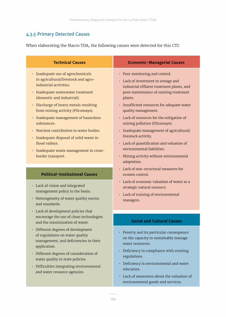
188
Transboundary Diagnostic Analysis for the La Plata Basin (TDA)
4.3.5 Primary Detected Causes
When elaborating the Macro TDA, the following causes were detected for this CTI:
Technical Causes
• Inadequate use of agrochemicals
in agricultural/livestock and agro-
industrial activities.
• Inadequate wastewater treatment
(domestic and industrial).
• Discharge of heavy metals resulting
from mining activity (Pilcomayo).
• Inadequate management of hazardous
substances.
• Nutrient contribution to water bodies.
• Inadequate disposal of solid waste in
flood valleys.
• Inadequate waste management in cross-
border transport.
Social and Cultural Causes
• Poverty and its particular consequence
on the capacity to sustainably manage
water resources.
• Deficiency in compliance with existing
regulations.
• Deficiency in environmental and water
education.
• Lack of awareness about the valuation of
environmental goods and services.
Economic-Managerial Causes
• Poor monitoring and control.
• Lack of investment in sewage and
industrial effluent treatment plants, and
poor maintenance of existing treatment
plants.
• Insufficient resources for adequate water
quality management.
• Lack of resources for the mitigation of
mining pollution (Pilcomayo).
• Inadequate management of agricultural/
livestock activity.
• Lack of quantification and valuation of
environmental liabilities.
• Mining activity without environmental
adaptation.
• Lack of non-structural measures for
erosion control.
• Lack of economic valuation of water as a
strategic natural resource.
• Lack of training of environmental
managers.
Political-Institutional Causes
• Lack of vision and integrated
management policy in the basin.
• Heterogeneity of water quality norms
and standards.
• Lack of development policies that
encourage the use of clean technologies
and the minimization of waste.
• Different degrees of development
of regulations on water quality
management, and deficiencies in their
application.
• Different degrees of consideration of
water quality in state policies.
• Difficulties integrating environmental
and water resource agencies.

189
Transboundary Diagnostic Analysis for the La Plata Basin (TDA)
4.3.6 Recommendations
In the search for answers for the CTI an-alyzed, based on the results of the studies carried out during Phase 1 of the Frame-work Program (FP, 2016b and 2016c) and taking into account the different caus-es of the various problems that the topic entails and the actions proposed to solve them, the following recommendations are proposed, as a contribution to the prepa-ration of the SAP:
• Harmonize regulations and develop con-sensual criteria for water quality assess-ment and monitoring.
• Seek sources of funding for the con-struction and operation of domestic and industrial wastewater treatment plants.
• Seek financing sources for the imple-mentation of best practices for the mon-itoring and management of environ-mental quality in mining enterprises.
• Promote the implementation of sustain-
able agricultural practices and the ratio-nal use of agrochemicals.
• Exchange experiences on disposal and recycling of solid urban waste.
• Exchange experiences on waste disposal in cross-border transport.
• Strengthen agencies responsible for wa-ter quality management.
• Develop joint programs for monitoring water quality and quantity among coun-tries.
• Develop training programs for environ-mental managers.
• Develop environmental education and training programs.
• Promote citizen participation in the pre-vention of domestic and urban pollution.
• Develop plans for valuation and imple-mentation of environmental services.

190
Transboundary Diagnostic Analysis for the La Plata Basin (TDA)
4.4 Sedimentation of Water Bodies and Courses
4.4.1 Presentation of the Topic
The sedimentation process alters and com-promises the structure and functioning of ecosystems, and thus of the environmen-tal goods and functions they provide. In the La Plata Basin, as a result of the large-scale development of agriculture and agro in-dustries, about half of the natural vegeta-tion has been changed to fields. Deforesta-tion caused by agriculture has reduced the ability of the land to capture and store car-bon and water and to anchor the soils, lead-ing to increases in erosion rates in some sites and sedimentation in others, causing changes in water availability.
Large-scale farming practices, due to the intensification of soybean production since the early 1990s and the development of one of the world's largest cattle breed-ing industries, have also led to compaction of the soil, reduction in water infiltration, increased surface runoff, and sedimenta-tion problems.
The high production of fine sediments in the upper basin is the characteristic feature of the Bermejo River, which contributes ap-proximately 100 million tons of sediment per year to the Paraguay-Paraná Delta and La Plata River systems. The fine sediments are transported to and deposited in ar-eas with very calm waters, from the Lower Paraná to the La Plata River.
The sediment production in the upper basin of the Pilcomayo River is somewhat larger than that of the Bermejo River. With mean annual flow rates of 210 m�/s and an an-nual contribution of sediments of the same magnitude as the Bermejo, it does not have enough energy to transport its solid car-
go to the Paraguay River, so it deposits the sediments in the wetlands of the Gran Cha-co plain in the vicinity of the border be-tween Argentina and Paraguay. This sol-id contribution of 110 million tons annually causes morphological changes in the chan-nels, in the bodies of water, and in the an-nual altimetry of the floodplain.
4.4.2 Environmental, Social, and Economic Impacts
The increase in the predicted sediment yield implies an increased risk of morpho-logical changes in the lower Bermejo river-bed, an increase in water clarification costs in potable water plants throughout the river way to the La Plata River, and an increase in dredging volumes in transverse channels of the Paraná River, channels of the La Plata River, and in ports and port accesses.
4.4.3 Activities Developed
As inputs for updating the diagnostic, there are national reports on existing in-formation on land use and degradation, projects, cartography, and publications; an integrated document with identification of critical degraded areas; maps of current land use and soil types, as well as an es-timate map of sediment production; a di-agnostic on land degradation in the Selva Misionera Paranaense; and an inventory of best practices and technologies for the use and sustainable management of soils. This topic is given special emphasis in the De-monstrative Pilot Project Pollution and ero-sion control in the Pilcomayo River Basin, mentioned in Chapter 3.1.
4.4.4 Knowledge Expansion and Updating
Among the main results of the completed work, the following stand out:

191
Transboundary Diagnostic Analysis for the La Plata Basin (TDA)
• The highest specific production of sedi-ment is verified in the Andean sector of the Basin. The most notable sources of sediment are the high basins of the Ber-mejo and Pilcomayo rivers. In the rest of the Basin, erosion and sedimentation problems resulting from agricultural/livestock activities also deserve special consideration because they cause pro-ductivity losses and deterioration of the porous structure and space.
• The Bermejo River discharges an av-erage annual flow of 446 m�/s, repre-senting 2.5 percent of the section of the Paraná River in Corrientes. In con-trast, the contribution of solid flow to
the Paraguay-Paraná Delta system of the Paraná-La Plata River is very im-portant, since the 100 million tons/year of suspended sediment constitutes about 75 percent of the total present in the Paraná River. In recent decades this percentage was increasing due to the construction of dams in Brazil in the upper basin of the Paraná River, which retain the sediments.
• The Pilcomayo River has an average annual flow of 203 m�/s and an annu-al sediment contribution of the same magnitude as the Bermejo, but it lacks sufficient energy to transport its solid cargo to the Paraguay River.
The Iruya River basin generates a large proportion of sediments which are then deposited into the Paraná and La Plata River.
192
Transboundary Diagnostic Analysis for the La Plata Basin (TDA)
• The average annual concentration of sediments in the LPB (150 mg/l) is mod-erate for a river in a basin in a tropi-cal zone, but it is a decisive parame-ter for the potabilization of river water and in the sedimentation of navigation channels with very low speeds (below 30 cm/s).
• The average annual concentration of 500 mg/l has been recorded in the Paraguay River tributaries in the Pantanal region, corresponding to an average erosion rate of 146 t/km�/year in watersheds with an average area of 17,000 km�.
• In southwestern Brazil near the border with Argentina, which covers the mid-dle and lower reaches of the left bank tributaries of the Paraná River from the Paranápanema River downstream and a substantial part of the Uruguay river ba-sin, the average annual concentration is around 100 mg/l and the specific produc-tion of sediments is around 95 t/km�/year.
Sub-basin analysis
Based on an analysis carried out on the seven sub-basins to identify the principal critical issues related to sediment pro-duction and transport, it was conclud-ed that the following sub-basins require more attention:
Upper Paraguay:
The Parapetí River begins in the east-ern range of the sub-Andean Sierras and forms an alluvial fan of several doz-ens of square kilometers in Bolivia and Paraguay. Its current permanent chan-nel empties into the Izozog swamps, but during the rainy season there is an im-portant transfer which forms the Timané River, which runs eastward and flows into
the Paraguay River. In exceptionally wet years, the swamps overflow and feed the springs of the San Julián River, which, downstream, is transformed into the São Paulo River to finally end up in the Iténez River on the border with Brazil. Under the current dynamics, in the Parapí river-bed one can observe fluvial sedimentation processes, which occur due to the change in slope of the river course. In the rainy season the river carries sedimentary ma-terial by dragging and suspension. The coarser materials are deposited near the exit of the sub-Andean mountain range and the thinner materials are deposited as they travel along the plain, until arriv-ing in the Izozog swamps, where very fine material accumulates.
Lower Paraguay:
The sediment production of the upper Pil-comayo River Basin is somewhat greater than that of the Bermejo River, but this load is deposited in the swamps of its alluvial cone in the Chaco plain and consequently does not reach the Paraguay-Paraná River. Conflicting transboundary river processes linked to water resources have been iden-tified: (i) use of water in an area with wa-ter deficit, (ii) the changing morphology of the channel due to erosion and sediment transport, (iii) fishery and fish fauna, par-ticularly the migration of shad from the lower basin to the upper basin, and (iv) the risk of contamination due to mining in the upper basin, from environmental liabilities and current activities. The total sedimen-tation of the channel to levels higher than the floodplain is a morphological problem that affects the management of the basin. Consequently, the river flows over the pla-teau forming new swamps annually.
The contribution of silt and clay from the Bermejo River constitutes 90 percent of the

193
Transboundary Diagnostic Analysis for the La Plata Basin (TDA)
fine sediment transported by the Paraná River, which is deposited predominantly in the La Plata River.
The area with the greatest fluviomorpho-logical activity is the upper La Plata Riv-er, adjacent to the Delta, where the an-nual amount of silt and clays dredged in the navigation channels is equivalent to 23 percent of the total contribution of the Bermejo River. Management measures in the upper Bermejo basin that substantial-ly affect the amount of sediment gener-ated for the entire basin have been iden-tified. The areas that produce the most sediment in the upper Bermejo basin are not significantly affected by current an-thropogenic actions, but specific sedi-ment production problems in the basin could be resolved through structural and nonstructural measures.
4.4.5 Influence of Climate Variability and Change
Changes in temperature and precipita-tion will manifest in variations in sedi-ment production and transport rates in the Bermejo and Pilcomayo river basins. There is a tendency to maintain current rates for the next 30 years, and a decrease for the period from 2041 to 2070 in both basins, which is of greater importance in the Pilcomayo River basin.
On the other hand, erosion and sedimen-tation problems resulting from agricultural and livestock activity cause an increase in runoff or flooding—in addition to produc-tivity loss—depending on the slope of the land and whether or not the soil transport-ed and transformed into sediment reach-es the surface waters, producing contam-ination with organic matter, nutrients, and agrochemicals.
4.4.6 Legal and Institutional Considerations
There is little regard for the joint manage-ment of land and water use. However, there are already accepted international regu-lations, such as the Conventions on Biodi-versity, Desertification, and Climate Change ratified by all countries at the 1992 Rio Earth Summit. The Environmental Hand-book for the Gran Chaco Americano, consid-ering soil resources, biodiversity, and wa-ter, among other aspects, was also validated through various workshops. This environ-mental framework could be applicable to other areas of the Basin. Internal legislation has been created in some countries, which should be taken as a model for harmoniza-tion among them; and land and water man-agement plans, such as those in Uruguay, have been implemented, which could be taken as a guide for their application in the remaining countries of the Basin.

194
Transboundary Diagnostic Analysis for the La Plata Basin (TDA)
4.4.7 Primary Detected Causes
When elaborating the Macro TDA, the following causes were detected for this CTI:
Technical Causes
• Improper use and management of soils
(expanding agricultural activity, use
of marginal soils, removal of natural
pastures, overgrazing).
• Excessive expansion of the agricultural
frontier.
• Soil compaction.
• Deforestation of coastal and native
forests (Uruguay River).
• Inadequate construction and
maintenance of infrastructure.
• Erosion generated by mining activity
(Pilcomayo and Bermejo rivers).
• Coastal erosion by fluctuation marked
by the operation of large dams.
Political-Institutional Causes
• Technical-economic weaknesses of state
agencies.
• Insufficient institutional coordination:
poor application and inadequate regional
harmonization of standards for the
protection and use of natural resources.
• Institutional decisions based on short-
term profitability and not on sustainable
land use.
• Bureaucracy and centralism.
Social and Cultural Causes
• Limited political and citizen awareness.
• "Chaqueos" or fires.
• Excessive profit for landowners
(producers). Short-term vision in leases.
• Perception that natural resources are
inexhaustible.
Economic-Managerial Causes
• Weakness in management and
administration.
• Inadequate implementation and
insufficient economic resources for
monitoring, control, and mitigation.
• Lack of application and supplementation
of territorial planning, especially at the
basin level.
• Extensive livestock activity and
monoculture agriculture, mainly
soybeans
• Lack of incentives and widespread
training to apply sustainable farming
techniques.
• Institutional weaknesses to ensure
compliance with environmental
legislation.

195
Transboundary Diagnostic Analysis for the La Plata Basin (TDA)
4.4.8 Recommendations
In the search for answers for the CTI an-alyzed, based on the results of the studies carried out during Phase 1 of the Frame-work Program (FP, 2016b and 2016c) and taking into account the different caus-es of the various problems that the topic entails and the actions proposed to solve them, the following recommendations are proposed, as a contribution to the prepa-ration of the SAP:
• Promote the development and harmo-nization of standards for the protection and use of natural resources.
• Develop plans for territorial planning and agro-ecological zoning.
• Strengthen institutional capacities for land use management.
• Strengthen institutional coordination at national and regional levels.
• Develop programs for monitoring, re-search, and applied studies on erosion and sediment generation and transport.
• Implement soil recovery and erosion control programs in priority areas.
• Develop comprehensive management plans for priority basins.
• Develop programs for the preservation and restoration of forests and riparian vegetation.
• Develop sustainable agriculture programs.
• Develop training and extension pro-grams in soil management and conser-vation techniques.
The turbid waters of the La Plata River. On the left, the Paraná Delta.

196
Transboundary Diagnostic Analysis for the La Plata Basin (TDA)
4.5 Alteration and Loss of Biodiversity
4.5.1 Presentation of the Topic
The LPB is a region of extraordinary eco-logical value. Its wide climatic and geo-logical variety, coupled with the great availability of water in much of its terri-tory has allowed for a great diversity of ecosystems and species. However, there is great concern about the threat to ecosys-tem integrity as a result of the advance-ment of human activities.
4.5.2 Activities Developed
Contributing to the deepening of knowl-edge about this subject, the joint work of the five countries provides: an invento-ry of protected areas and wetlands of the
Basin—by country and all together—fol-lowing a common methodology; an eval-uation of natural habitat loss, including the reduction of the Selva Misionera Pa-ranaense (SMP); an identification of the impacts and control measures on exotic species living in the countries; an integra-tion document containing guidelines for a biodiversity conservation strategy, a pro-posal for ecological corridors and wetland conservation and management, and rep-licas of the Cultivating Good Water pro-gram currently being implemented in mi-cro-watersheds near the influence areas of dams with binational hydroelectric centers (Itaipú, Yacyretá, and Salto Grande). This topic is given special emphasis in the De-monstrative Pilot Project Regulated conserva-tion of biodiversity in the Paraná River men-tioned in Chapter 4.1.
Tea cultivation in the Selva Misionera Paranaense region.

197
Transboundary Diagnostic Analysis for the La Plata Basin (TDA)
4.5.3 Knowledge Expansion and Updating
The work carried out has allowed for the identification of the following problems:
• Habitat loss/alteration, fragmentation, and loss of connectivity, which may be aggravated by the effects of climate change on critical or more vulnerable ar-eas by rising water levels.
• Loss of integrity (goods and services) due to environmental risk, with impacts on biodiversity throughout the LPB, es-pecially in the Pantanal and in the SMP.
• The low percentage of protected ar-eas, including those with some type of protection, endangers the environ-mental goods and services that eco-systems provide.
• Dams have affected some floodplains and interrupted migratory corridors.
• The bivalve molluscs of the genus Cor-bicula and the golden mussel Limnoper-na fortunei are some of the species that demand the most attention for their re-markable distribution throughout the Basin and their proven impacts on the native fauna, the ecosystem, infrastruc-ture works (such as water intakes), and other human activities.
Selva Misionera Paranaense (SMP)
The topography of the SMP comprises rel-atively flat areas with deep soils near the Paraná and other main rivers, with alti-tudes between 150 and 250 masl, to a rel-atively flat plateau with altitudes between 550 and 800 masl. The areas that are be-tween the main rivers and plateau, with altitudes between 300 and 600 masl, have
relatively steep slopes and are very exposed to soil erosion when forest cover is removed.
Their soils are relatively rich in nutrients. The red soils, which are deep near the riv-ers, become less deep and rockier at high-er altitudes. There is a great difference in soil types, which vary in texture, chemical composition, and acidity.
The ecoregion has a subtropical climate (with an average temperature of 16-22°C). In the southern part, frost is common (June-August), especially in the high-lands. Precipitation in the region rang-es from 1,000 to 2,200 mm per year, gen-erally with less precipitation in the north than in the south.
Rainfall is not uniformly distributed throughout the year, and some areas have up to five dry months. Increased rainfall during El Niño events produces large inter-annual variations. Precipitation and high seasonali-ty of temperature and light determine a sea-sonal pattern of primary forest productivity and an associated seasonality in the avail-ability of food for folivore, frugivore, and in-sectivore animal species.
More than 3,000 species of vascular plants, numerous mammals, a rich diversity of am-phibians, reptiles, invertebrates, and mar-supials have been registered in the SMP, as well as more than
550 species of birds, with a large concentra-tion of endemic species. The predominant vegetation is the semi-deciduous subtrop-ical forest. Variations in the local environ-ment and soil type allow for the existence of different plant communities, gallery for-ests, bamboo forests, palmetto forests (Eu-terpe edulis), and Paraná pine forests (Arau-caria angustifolia). Most of the forests have been exploited to obtain wood; some sec-

198
Transboundary Diagnostic Analysis for the La Plata Basin (TDA)
ondary forests are recovering from defor-estation. Thus, forest fragments are com-posed of primary and secondary forests at different stages of succession.
The main issues associated with land deg-radation also affect the populations of the three countries that share this ecosys-tem: loss of soils as a result of deforesta-tion and conversion to agricultural or live-stock land, alteration of biodiversity, water quality loss, and the socio-economic con-flicts associated with these processes. Add to this climate variability and change and the consequent alteration of the rainfall system, which can increase water erosion, resulting in a greater impoverishment of the soils, an increase in sedimentation in the river beds (with the water quality deg-radation), and desertification.
These processes of land degradation in the SMP have been addressed by differ-ent countries through different action and response strategies. Conservation mea-sures for SMP sections focus mainly on the implementation of a network of con-servation areas.
Analysis by sub-basin
Upper Paraguay:
The Pantanal is located in this sub-ba-sin, one of the most transcendent wetlands for the Basin's aquatic biodiversity. This sub-basin has suffered a considerable loss of terrestrial ecosystems (40 percent) and presents an environmental risk of loss of integrity. Sixty-one protected areas cover-ing 12.6 percent of its area have been creat-ed. There are six Ramsar sites (46,500 km�), two MAB Biosphere Reserves (326,492 km�), and 19 important bird areas (IBA). It is the least populated sub-basin, with 2.4 million people.
Lower Paraguay:
This sub-basin has suffered a 15 percent loss of terrestrial ecosystems. Three im-portant water reservoirs have been planned in the sources of the Bermejo River. It is one of the least-populated sub-basins (2.8 mil-lion inhabitants). Sixty-six protected areas have been set up covering 7.4 percent of its area, representing a low level of protection since it does not meet the 10 percent tar-get set by the CBD by 2010. The designation of nine Ramsar sites (11,384 km�), six Bio-sphere Reserves (21,097 km�), and 94 im-portant bird areas (IBA) is a clear indication of the high international priority received by this sub-basin.
Upper Paraná:
This sub-basin has suffered a very high loss of terrestrial ecosystems (75 per-cent). There are no Ramsar sites, which indicates the absence of major wet-lands of international relevance. The up-per Paraná and its tributaries have un-dergone major modifications to control flooding and hydroelectric power gener-ation (43 large reservoirs), which affect the respective floodplains. It is the most populated sub-basin, with 61.8 million inhabitants, with a high population den-sity (6.9 inhabitants/km�) and six im-portant cities, including the capital of Brazil, Brasilia. There are many protect-ed areas (313), but they cover only 7.7 per-cent of the sub-basin area. The Biosphere Reserve (MAB-Unesco), Mbaracayú For-est (2,800 km�), is partly included with-in this sub-basin. There are 32 IBA with-in its limits.
Lower Paraná:
There are several important wetlands, such as the Ramsar Lagoons and Iberá

199
Transboundary Diagnostic Analysis for the La Plata Basin (TDA)
Wetlands, the Chaco Wetlands, Jaaukan-igás, Otamendi Reserve, and the lower Paraná floodplain, Paraná Delta (Argen-tina) in this sub-basin. It has suffered a considerable loss of terrestrial ecosystems (40 percent) and presents environmental risk due to loss of integrity.
Three reservoirs associated with dams have been built, one in the Juramento River (Cabra Corral, Salta, Argentina) and two in Paraná: the Yacyretá and Itaipú dams. Other works that impact the eco-system are the Rosario-Victoria road con-nection, the real estate expansion over wetlands, and their loss to the construc-tion of hills for the use of agriculture and cattle breeding. The population amounts to 9.5 million (1.6 inhabitants/km�), with seven major cities. Eighty-two protected areas covering only 5.6 percent of the area have been created, a level of protection well below the CBD's 10 percent target for 2010. The designation of five Ramsar sites (10,950 km�), two Biosphere reserves (10,619 km�), and 78 IBAs show that it is a high international priority.
Upper Uruguay:
There are no noteworthy wetlands. This sub-basin has suffered a considerable loss of terrestrial ecosystems (60 per-cent). Three large reservoirs associat-ed with dams with hydroelectric pow-er plants have been built on the Uruguay River (Machadinho, Itá, and Passo Fundo) and there are plans for the construction of three new ones, which will increase the respective alteration of the fluvial envi-ronments. It is a sub-basin with a rela-tively small population, with 1.7 million inhabitants and without any large cities. Twenty-nine protected areas have been created covering only 4.4 percent of the sub-basin area, a low level of protection
with regard to the 10 percent target im-posed by the CBD. While there are import-ant wetlands, such as the Moconá Falls, there are no Ramsar sites. There is a Bio-sphere Reserve, Yabotí (2,366 km�), and 12 IBAs have been identified.
Lower Uruguay:
The most important wetlands are: Uru-guay River plains and islands, Farrapos Estuary Ramsar site, Villa Soriano, and Palmar de Yatay Ramsar Site. The sub-ba-sin has suffered a significant loss of ter-restrial ecosystems (60 percent). There are four large reservoirs associated with dams with hydroelectric power stations, one on the Uruguay River (Salto Grande) and three on the Negro River (Palmar, Rincón del Bonete, and Baygorria), with their respective alterations of river envi-ronments. It is a sub-basin with an inter-mediate population level, with 3.8 million inhabitants and a population density of 1.6 hab/km�), with three important cities. Thirty-nine protected areas covering only 1.8 percent of its area have been creat-ed, well below the CBD’s 10 percent target for 2010. Three Ramsar sites (849 km�), a Biosphere Reserve (997 km�), and 20 IBAs have been identified.
La Plata River:
The important wetlands are Samborom-bón Bay and the Santa Lucía swamps. This sub-basin has suffered a consid-erable loss of terrestrial ecosystems (35 percent), concentrated in the coastal strip of the La Plata River, mainly in the met-ropolitan areas associated with the cities of Buenos Aires and Montevideo. It is the second most populated sub-basin, with 24.9 million inhabitants, five major cities, including the capitals of Argentina and Uruguay—Buenos Aires and Montevideo,

200
Transboundary Diagnostic Analysis for the La Plata Basin (TDA)
respectively. Eleven protected areas cov-ering only 0.8 percent of the sub-basin area have been created, the lowest of the entire LPB and well below the CBD's 10 percent target for 2010 and even further away from the 2011 to 2020 Aichi target of 17 percent. Two Ramsar sites (Costane-ra Ecological Reserve and Samborombón Bay, 4,883 km�) and two MAB Biosphere Reserves (1,289 km�) have been designat-ed on the Argentine banks, and nine IBAs have been identified.
4.5.4 Influence of Climate Variability and Change
Loss or alteration of habitats and fragmen-tation and loss of connectivity may be ag-gravated by the effects of climate change in critical areas or those more vulnerable to rising water levels.
4.5.5 Legal and Institutional Considerations
Biodiversity issues still have little presence on the political agenda. The LPB countries have signed the Convention on Biological Diversity, which would make it easier to leg-islate or implement lines of action by hav-ing a common standard. This legislative text should be the basis for regional regulation. Although there has been progress in recent decades, the systematic implementation of international commitments is very hetero-geneous or disjointed. The problem should be dealt with in an integrated manner at the regional level, which would allow them to strengthen measures, give them solidity and territorial support, and promote their sus-tainability over time, so as not to encourage the development of specific, isolated mea-sures without continuity.
The Moconá Falls in the Uruguay River, Argentine-Brazilian border.

201
Transboundary Diagnostic Analysis for the La Plata Basin (TDA)
4.5.6 Primary Detected Causes
When elaborating the Macro TDA, the following causes were detected for this CTI:
Technical Causes
• Entry of invasive species (golden
mussel, among others) and
displacement of native species.
• Loss of ecological flows for wetland
maintenance.
• Loss of physicochemical water quality.
• Alteration of peak flows.
• Interruption of the migratory flow
of fish.
• Replacement of natural ecosystems by
productive activities.
• Alteration of water dynamics by
infrastructure works.
• Illegal hunting, fishing, and extraction
of flora.
• Illegal trafficking of animals and plants
(smuggling).
Political-Institutional Causes
• Auditing deficiencies and lack of
coordinated institutional decisions.
• Technical-economic weakness of state
agencies.
• Lack of protocols for the control of
invasive species.
• Lack of training, awareness-raising, and
human resources training programs.
• Little presence of biodiversity on the
political agenda.
• Deficiencies and heterogeneity of
country regulations.
Social and Cultural Causes
• Lack of social awareness about the value
of water resources and biodiversity.
• Irrational exploitation of the fishing
resource.
• Lack of willingness in civil society to
seek collective solutions.
Economic-Managerial Causes
• Lack of financial and material resources
for studies and monitoring.
• Lack of strategic planning for
biodiversity conservation.
• Lack of integration of the concept of
biodiversity protection into integrated
watershed management.
• Coordination deficiencies in research
programs.
• Lack of incentives for the care and
conservation of natural systems.
• Absence of regional environmental
assessments.

202
Transboundary Diagnostic Analysis for the La Plata Basin (TDA)
4.5.7 Recommendations
In the search for answers for the CTI an-alyzed, based on the results of the studies carried out during Phase 1 of the Framework Program (FP, 2016b and 2016c) and tak-ing into account the different causes of the various problems that the topic entails and the actions proposed to solve them, the fol-lowing recommendations are proposed, as a contribution to the preparation of the SAP:
Special Recommendation
Proposal for ecological/fluvial corridors: Landscapes along riverbeds act as naturally interconnected ecological units. The three main rivers of the LPB (Paraná, Paraguay, and Uruguay) establish a continuous strip of landscape organization with a vertical axis (north-south), cross-cutting different biogeographic patterns (biodiversity, cli-mate, temperature, precipitation, etc.) de-pending on the latitude.
Thus, the valley of these large rivers in the north-south direction, associated with trib-utaries on the horizontal (east-west) axis, can serve as a linear element connecting landscape fragments and natural areas with some kind of protection (parks, protected areas, biosphere reserves, Ramsar sites).
This type of strategy would serve to gener-ate large-scale spatial connectors, with the valleys of the Paraná, Paraguay, and Uru-guay rivers playing a central role in a pri-ority conservation network, which would include lateral extensions formed by tribu-taries to be selected and other areas in cur-rent protection status, etc.
Even if it is not possible to construct a con-tinuous corridor in the river valley because of the difficulty of reconciling with areas al-ready occupied by humans, a conservation
network formed by the restoration of land-scapes can be provided, and currently spa-tially fragmented species have a greater probability of displacement between con-served matrices. Figure 4.5.7.1 presents an outline of connection corridors through the large rivers and tributaries of the LPB asso-ciated with the protected areas close to them.
Recommendations generales
• Strengthen and harmonize the region-al legal framework for the protection of aquatic biodiversity.
• Develop and apply protocols for the con-trol and management of invasive species.
• Establish mechanisms for cooperation among countries in the field of biodiver-sity conservation.
• Develop joint bioprospecting programs.
• Develop river and coastal ecological cor-ridors and other forms of participatory conservation.
• Promote the development of trans-boundary protected areas.
• Exchange experiences on methodologies for the determination of ecological flows.
• Integrate information, research, and monitoring systems at the basin level.
• Conduct regional environmental impact assessments (EIAs).
• Promote the adoption of regional min-imum budgets for biodiversity conser-vation.
• Develop awareness and training programs on water resources and biodiversity.

203
Transboundary Diagnostic Analysis for the La Plata Basin (TDA)
Figure 4.5.7.1
Ecological corridor strategy on a large spatial scale in La Plata Basin
P P
P
P
P
Ü
BRAZIL
ARGENTINA
PARAGUAY
BuenosAires La Plata
River
Paran
á Rive
r
Paraná River
BOLIVIA
URUGUAY
Montevideo
Asunción
Brasilia
Sucre
Parag
uay
A T L A N T I CO C E A N
Ecological corridorsstrategy
River
Uruguay River
Great rivers(main corridor)Affluents(secondary corridors)Protected areas
Ecological corridors strategy
Great rivers (main corridor)
Affluents (secondary corridors)
Protected areas

204
Transboundary Diagnostic Analysis for the La Plata Basin (TDA)
4.6 Unsustainable Use of Fishery Resources
4.6.1 Presentation of the Topic
The unsustainable use of fishery resourc-es alters the structure and functioning of aquatic communities, and can compro-mise them.
4.6.2 Activities Developed
Contributing to the deepening of knowl-edge about this subject, the joint work of the five countries provides: an inventory of fish, habitats, and protected areas, es-pecially those that include aquatic ecosys-tems; a description of some of the major fisheries (species, gear, number of fishers, catch volumes), including commercial and subsistence fisheries and sport-recreation-al fisheries as the foundation for tourism. However, there are many information gaps that need to be filled in. This topic is giv-en special emphasis in the Demonstrative Pilot Project Regulated conservation of bio-diversity in the Paraná River mentioned in Chapter 4.1.
4.6.3 Knowledge Expansion and Updating
The main results of the work carried out in-dicate:
• As noted in Chapter 1.3.7, 40 percent (367) of fish species have socio-economic rel-evance as a resource for commercial, ar-tisanal, subsistence, recreational, and aquaculture fisheries. The number of rel-evant species presents an east-west gra-dient, suggesting that the use and valu-ation of the native fauna is more relevant in the sub-basins of the Paraguay River (upper and lower) and the lower Paraná, which also have a high fishing pressure.
• The predominant native fauna, belong-ing to the orders Characiformes and Silu-riformes, present adaptations that opti-mize reproductive success through the use of separate areas for the spawning, breeding, and feeding, among which they move by active migration (adults) and by drifting in the current (eggs and larvae), giving them, consequently, a transboundary character. Most of the whitefish species of the fisheries belong to these two orders.
• About 53 percent (480) of fish species are considered to be endemic in any of the seven sub-basins, indicating that the conservation of fish biodiversity requires differentiated efforts. Ende-mism is highest in the upper Paraná, it is intermediate in the sub-basins on the western edges of the Basin, and lowest in the lower Uruguay and the La Plata River.
• Thirteen species of exotic fish were registered in the La Plata Basin, sev-eral of them with invasive capaci-ty. The most widespread exotic spe-cies are: Asian carp (Cyprinus carpio) (present in five sub-basins), herbiv-orous carp (Ctenopharyngodon idella), and bighead carp (Hypophthalmichthys nobilis), registered in four of the seven sub-basins. Also important are tilapia (Tilapia rendalli), Nile tilapia (Oreochro-mis niloticus), rainbow trout (Oncorhyn-chus mykiss), and African catfish (Clar-ias gariepinus). The greatest diversity of exotic species was recorded in the sub-basins of the Paraná River (eight species in the upper Paraná, seven species in the lower) and La Plata Riv-er (eight species). In the upper Uruguay there is no record of exotic species, while there are intermediate levels in the remaining sub-basins.

205
Transboundary Diagnostic Analysis for the La Plata Basin (TDA)
• In Argentina, about 90 percent of in-land fisheries are in the LPB, where they work with 367 fish species of commer-cial and/or sport value, the most import-ant of which are tarpon (Prochilodus linea-tus), dorado (Salminus brasiliensis), surubí (Pseudoplatystoma), gilded catfish (Zun-garo zungaro), pacú (Piaractus mesopotam-icus), patí (Luciopimelodus pati), and boga (Leporinus obtuidens). Commercial artis-anal fisheries employ more than 10,000 people, while subsistence fisheries are important for the food security of vul-nerable sectors of the local population. The most important commercial species are tarpon, of which some 14,000 tons per year are exported. Recreation-sport fish-eries are also important throughout the Basin, with more than 70,000 annual li-censes, and bait fishing is carried out by the inhabitants of the riverbanks. Fish farming is an incipient activity, but it is increasing, especially in Formosa, Mis-iones, and Corrientes, with a native spe-cies, the pacú. The closed seasons in the border areas between Paraguay and Ar-gentina are fixed through an agreement signed between both countries.
• In Bolivia, subsistence fishing is a tra-ditional activity and constitutes an im-portant source of protein for riparian populations –mainly indigenous peo-ples– along the Bolivian section of the Pilcomayo River, where tarpon fishing predominates. This is a fundamental ac-tivity in this river, and it is one of the most important activities in Villa Mon-tes between May and September. Tar-pon, dorado, surubí, and pacú are the main fish exploited. In the lower basin there is recreational fishing of dorado, surubí, and catfish (Pimelodus).
• In all of Brazil, continental fisheries ac-count for about 24.8 percent of the coun-
try's fish production. Subsistence fishing is traditional in the Pantanal and con-stitutes an important source of protein for riparian populations. Recreational fishing, with more than 57,000 licens-es, represents 75 percent of all fish offi-cially shipped in the State of Mato Gros-so do Sul. The capture and marketing of live bait is an important related activi-ty. Aquaculture fish production is 73,200 tons per year, with the state of Paraná the largest producer.
• In Paraguay, the number of artisanal fishers is 7,877 (2015). The fisheries are very similar to those in Argentina and are mainly located in the Paraguay Riv-er. In the Chaco Paraguayo, the aborig-inal communities carry out subsistence fishing, mainly capturing tarpon in the middle basin of the Pilcomayo River. The most coveted commercial white species is the surubí, which is followed by gild-ed catfish, dorado, and pacú. During the annual closed season, which is shared with Argentina in the border sections of the Paraguay and Paraná rivers (from the beginning of November until ap-proximately December 20), the fisher-men receive a subsidy from their respec-tive governments.
• In Uruguay, artisanal fishing is car-ried out mainly in the Uruguay, Negro, and La Plata rivers. In the Uruguay Riv-er there are 250 to 300 boats with around 500 fishermen. Captures are estimated at 4,500 tons annually, bringing in mainly tarpon, patí, boga, dorado, various spe-cies of catfish (Pimelodus albicans, Pi-melodus maculatus), manduvá (Ageneiosus brevifilis), armado (Pectoras granulosus), manduví (Ageneiosus valenciennesi), tiger barb (Gnidens barbus), pejerrey (Odontes-thes bonariensis), tiger fish (Hoplias mal-abaricus), and suckermouth catfish (Hy-

206
Transboundary Diagnostic Analysis for the La Plata Basin (TDA)
postomus). Tarpon accounts for more than 70 percent of catches, and is also the main freshwater species exported, reaching around 4,300 tons in 2008.
• In some areas, fish stocks have been re-tracted because of high fishing pressure.
• There is a high risk of an increase in in-vasive alien species (IAS), by escape from their farming centers.
• The low level of protection and the loss of terrestrial habitats impact fish biodi-versity.
Analysis Diagnostic by sub-basin
Las subcuencas que requieren mayor atención son:
Upper Paraguay:
Exotic fish farming is underdeveloped.
Upper Paraná:
Nine species of threatened fish inhabit this sub-basin, and there is a high degree of in-vasion of exotic species. The cultivation of exotic fish is highly developed.
Lower Paraná:
In this sub-basin there are 13 native threatened species and a high degree of invasion, with seven species of invasive exotic fish; the herbivorous carp, Asian carp, rainbow trout, and tilapia present the greatest risk. The cultivation of exotic
fish is highly developed.
Upper Uruguay:
No significant exotic fish have been recorded.
Lower Uruguay:
Six species of threatened fish and five spe-cies of exotic fish have been recorded.
La Plata River:
This sub-basin presents a rich population of native fish, with five threatened species. The degree of invasion detected was classi-fied as high, with eight species of invasive exotic fish, the herbivorous carp and Asian carp presenting the greatest risk.
4.6.4 Influence of Climate Variability and Change
High vulnerability to climate change is an-ticipated for riparian habitats in the major fishing communities.
4.6.5 Legal and Institutional Considerations
There are inconsistencies in some regula-tions related to fishing in different coun-tries regarding the same rivers (closed season dates, prohibited species for fish-ing, different criteria for net use, among other things). There is a lack of harmoni-zation in the regulations (for example, the closed season on the Paraguay is differ-ent in Brazil and Argentina with respect to the same river).

207
Transboundary Diagnostic Analysis for the La Plata Basin (TDA)
4.6.6 Primary Detected Causes
When elaborating the Macro TDA, the following causes were detected for this CTI:
Technical Causes
• Overexploitation of target species.
• Interruption of target species
migrations from fisheries by civil works
in general.
• Disruption and loss of habitats due to
alterations in the hydraulic system.
• Contamination.
• Improper handling of aquaculture tanks
(nets and excavated).
Political-Institutional Causes
• Lack of harmonized and integrated
policies for the protection of aquatic life
at the Basin level.
• Asymmetry of norms and criteria for
natural resource use.
• Lack of economic management tools.
• Failure to comply with current
legislation and poor controls.
• Lack of participatory management.
Social and Cultural Causes
• Unsustainable techniques and
difficulties in accepting new
technologies.
• Increased poverty that increases fishing
pressure.
• Little awareness of the importance of
abiding by fisheries regulations and
ensuring compliance.
Economic-Managerial Causes
• Lack of technical and political coherence
in the design and implementation of
fishery policies.
• Lack of fisheries statistics and
environmental and biological
monitoring.
• Low incentive for technology of native
species production.
• Increased fishing pressure from fixed
prices set by the external market and
overexploitation.
• Inadequate design or absence of systems
to mitigate the impact of works.
• Increased fishing pressure because of
the loss of economic profitability for
fishermen.

208
Transboundary Diagnostic Analysis for the La Plata Basin (TDA)
4.6.7 Recommendations
In the search for answers for the CTI an-alyzed, based on the results of the studies carried out during Phase 1 of the Framework Program (FP, 2016b and 2016c) and tak-ing into account the different causes of the various problems that the topic entails and the actions proposed to solve them, the fol-lowing recommendations are proposed, as a contribution to the preparation of the SAP:
• Promote integrated policies, standards, and compatible criteria for the protec-tion and sustainable use of fishery re-sources at the Basin level.
• Harmonize fisheries legislation and reg-ulations.
• Consolidate sport fishing standards at the sub-basin level.
• Implement a code of conduct for respon-sible fishing.
• Strengthen tools and mechanisms for management and control.
• Implement environmental monitoring networks.
• Develop preventive programs for the control of fisheries and aquaculture.
• Develop actions to prevent and reverse the reduction of fish stocks.
• Implement mechanisms to reduce the impact of hydraulic works on migrations of target species.
• Monitor and control exotic species.
• Promote natural tourism by incorporat-ing plans for the regulation of fishing activity.
• Carry out vulnerability studies of priori-ty riverine habitats.
• Development of conservation programs for supporting species. Implementation of training and capacitation programs in sustainable production techniques.
Artisanal fishing, an important activity for the subsistence of many communities in the Basin.

209
Transboundary Diagnostic Analysis for the La Plata Basin (TDA)
4.7 Unsustainable Use of Aquifers in Critical Areas
4.7.1 Presentation of the Topic
At the regional level, there has been an increase in the use of groundwater re-sources due to urban and rural popula-tion development and the sharp increase in agricultural and industrial activities in the LPB region.
Several causes have led to an unsustain-able use of groundwater: There is a lack of knowledge about the vulnerability of re-charge areas, and there are deficiencies in well inventories, as well as their monitor-ing and exploitation. As an exception, it should be noted that Brazil has some mon-itoring networks, mainly in the state of São Paulo, and Paraguay monitors the Pa-tiño aquifer, which is of great importance at the local level.
4.7.2 Activities Developed
Through the joint work of the countries, progress has been made in the character-ization of select transboundary aquifers at the Basin level (Serra Geral, Baurú-Cai-uá-Acaray, Pantanal, and Agua Dulce), as well as in the elaboration of a hydrogeo-logical synthesis map of the Basin at a scale of 1: 2,500,000, presented in Chapter 1. In addition to the hydrogeological map, thematic maps were elaborated as a diag-nostic for groundwater and its exploita-tion in the Basin.
At the local level, progress has been made in the knowledge of the Yrendá-To-ba-Tarijeño Aquifer System (YTTAS) in the territories of Argentina, Bolivia, and Paraguay. Available information has been revealed, and field work with well moni-
toring and sampling for physical-chemi-cal and isotopic analysis has been carried out. A geological report has been prepared delineating the aquifer zone, and a geo-logical map has been elaborated in each country, to later be integrated. Similarly, hydrogeological maps have been created in each country, to later be integrated by all three countries.
4.7.3 Knowledge Expansion and Updating
Figure 4.7.3.1 shows the distribution of sa-linity in groundwater, and Figure 4.7.3.2 shows the density of information on drill-ing available from the FP, based on infor-mation from official agencies of each coun-try, per sub-basin.
In the lower Paraná sub-basin, the low-est well density of the Basin is observed, with only 1.5 wells/ 10 km�, corresponding to the Mesopotamian area of Argentina, an area with low demographic density and an abundance of surface water. At the same time, the La Plata River sub-basin, after the confluence of the Paraná and Uruguay riv-ers, and also with low population density and good surface water availability, has a density of 1.8 wells/10 km�.
The area with the highest level of ground-water exploitation today is the upper Uru-guay sub-basin, where a density of 70 wells/10 km� is observed.
With regard to vulnerability (Figure 4.7.3.3), low to medium natural vulnerability is ob-served for the area comprising the Paraná sedimentary basin, and high vulnerability for the YTTAS. For the Gran Chaco area, high vulnerabilities predominate, while those in the Pantanal are low. On the other hand, the Andes display a low vulnerability index.

210
Transboundary Diagnostic Analysis for the La Plata Basin (TDA)
Figure 4.7.3.1
La Plata Basin. Distribution of groundwater salinity
P P
P
P
P
Ü
BRAZIL
PARAGUAY
BuenosAires La Plata
River
BOLIVIA
URUGUAY
Montevideo
Asunción
Brasilia
Sucre
ARGENTINA
A T L A N T I CO C E A N
0 to 100100 to 500500 to 1,0001,000 to 3,000> 3,000
Electric conductivity (μS/cm)
0 to 100
100 to 500
500 to 1,000
1.000 to 3,000
> 3,000

211
Transboundary Diagnostic Analysis for the La Plata Basin (TDA)
P P
P
P
P
Ü
BRAZIL
PARAGUAY
BuenosAires La Plata
River
BOLIVIA
URUGUAY
Montevideo
Asunción
Brasilia
Sucre
ARGENTINA
Nº of Wells/10 km2 (per sub-basin)
A T L A N T I CO C E A N
Information on the number of wells available in the FP,supported by the official organisms of each country. Upper Paraguay - 4.5Upper Paraná - 3.7Lower Paraguay - 2.4Lower Paraná - 1.5Upper Uruguay - 70Lower Uruguay - 18La Plata River itself - 1.8
Figure 4.7.3.2
Drilling density for groundwater extraction by sub-basin
Nº of wells/10 km² (per sub-basin)
Upper Paraguay - 4.5
Upper Paraná - 3.7
Lower Paraguay - 2.4
Lower Paraná - 1.5
Upper Uruguay - 70
Lower Uruguay - 18
La Plata River itself - 1.8
Information on the number of wells available in the FP, supported by the official organisms of each country.

212
Transboundary Diagnostic Analysis for the La Plata Basin (TDA)
Figure 4.7.3.3
La Plata Basin. Natural vulnerability of groundwater to pollution
P P
P
P
P
Ü
BRAZIL
PARAGUAY
BuenosAires La Plata
River
BOLIVIA
URUGUAY
Montevideo
Asunción
Brasilia
Sucre
ARGENTINA
Vulnerability
A T L A N T I CO C E A N
NegligibleLow MediumHighExtreme
Vulnerability
Negligible
Low
Medium
High
Extreme

213
Transboundary Diagnostic Analysis for the La Plata Basin (TDA)
Yrendá-Toba-Tarijeño Aquifer System (YTTAS)
YTTAS is an aquifer system of great re-gional importance due to the expectations that exist in a region with water scarcity, a semi-arid climate, and other brackish or saltwater aquifers not suitable for human consumption or agricultural production. It represents one of the most important trans-boundary freshwater and groundwater res-ervoirs in this region, and one of the most significant in the South American continent.
It has been studied in greater detail than other aquifers due to lack of existing in-formation on drilling and the quality and quantity of water in addition to a lack of maps and the delimitation of the area. In this context, a geological map of YTTAS was elaborated and studies were carried out to create national hydrogeological maps.
In the YTTAS, the geology is manifested throughout the geological provinces of the Sub-Andean Sierras of Bolivia and Argenti-na and the Cretaceous basins of the North-west (Argentina), the Bolivian Chaco, West-ern Paraguay, and the Paranaense Chaco (Argentina). It is also delineated by the geo-logical provinces of the Central and East-ern Cordillera (Bolivia), Eastern Paraguay and the Brazilian Shield and the Paraná Ba-sin (Brazil), where the main aquifers were formed: GAS, Serra Geral, Baurú and Caiuá, among others.
From a geological point of view, the GAS consists of a sequence of predominant-ly sandy rocks, whose sedimentation oc-curred in fluvio-lacustrine and windy en-
vironments in the Triassic and Jurassic periods. These rocks saturated with wa-ter were later covered extensively by basal-tic laminar flows of the Upper Cretaceous, coverage that can exceed 1,000 m. In the uppermost part of this sequence, under a desert climate system, eolic-fluvial sands have been deposited, giving rise to layers of thick, porous, and permeable sandstones with a wide geographic distribution.
4.7.4 Influence of Climate Variability and Change
The climatic variations modeled for a pe-riod of almost 80 years would be insignif-icant from the point of view of groundwa-ter, since geological time periods are very broad. However, in some locations where recharge is affected by precipitation (more restricted aquifers such as Raigon), varia-tion may affect this recharge.
4.7.5 Legal and Institutional Considerations
The countries have a distinct level of le-gal progress on the subject, and also in its implementation and compliance. On both the constitutional and legal levels, the five countries have established the ini-tial steps toward sustainable groundwater management, but the subject is still not well developed in terms of regulation in some countries. It is therefore important that guidelines for groundwater use and protection in the LPB respect the singu-larities of the institutional and regulatory framework of each country, so it is neces-sary to define guidelines as recommenda-tions for local management.

214
Transboundary Diagnostic Analysis for the La Plata Basin (TDA)
4.7.6 Primary Detected Causes
When elaborating the Macro TDA, the following causes were detected for this CTI:
Technical Causes
• Lack of knowledge on the vulnerability
of the system (risk areas, recharge
areas).
• Identification of contaminating focal
points from agricultural uses and
domestic and industrial discharges.
• Lack of monitoring of the state of
exploitation of the aquifer, supply, and
demand.
• Lack of complete and effective
monitoring systems.
• Deficiencies in aquifer inventories,
studies, and research.
• Improper construction of drilling holes,
with risk of contamination.
Political-Institutional Causes
• Lack of regulatory framework for the
construction and use of drilling.
• Lack of integration of soil, water, and
environmental legislation in each
country and between countries.
• Lack of cross-border institutional
coordination for shared control and
management.
• Lack of exchange of information.
Social and Cultural Causes
• Poor culture, social awareness, and
training on the use of groundwater.
• Lack of economic-environmental
valuation by society.
• Lack of integrated vision of the water
resource.
• Poor social participation.
Economic-Managerial Causes
• Lack of management of groundwater use.
• Ineffectiveness of environmental
management instruments.

215
Transboundary Diagnostic Analysis for the La Plata Basin (TDA)
4.7.7 Recommendations
In the search for answers for the CTI an-alyzed, based on the results of the studies carried out during Phase 1 of the Frame-work Program (FP, 2016b and 2016c) and taking into account the different caus-es of the various problems that the topic entails and the actions proposed to solve them, the following recommendations are proposed, as a contribution to the prepa-ration of the SAP:
• Establish a normative and regulato-ry framework for the sustainable use of aquifers.
• Harmonize legislation on soil, water, and environmental resources in each coun-try and between countries.
• Develop a normative framework for the construction and use of drilling.
• Strengthen management capacity and institutional coordination.
• Strengthen and articulate institu-tions and services with competence in groundwater management.
• Develop integrated and participatory management tools.
• Develop a program for the sustainable management of YTTAS.
• Implement the actions resulting from the Environmental Protection and Sus-tainable Development of the Guarani Aquifer System project.
• Promote research and information ex-change.
• Conduct vulnerability studies for the identification of risk areas at the region-al and local levels.
• Develop inventories and regional data banks.
• Implement education and awareness programs.
• Strengthen information dissemination systems.
• Promote greater social participation.

216
Transboundary Diagnostic Analysis for the La Plata Basin (TDA)
4.8 Conflicts Over Water Use and the Environmental Impact of Irrigated Crops
4.8.1 Presentation of the Topic
The main reason for the conflict lies in the permanent and sustained growth of ir-rigated areas in the LPB. As a reference, there are currently about 4 million hect-ares of irrigated land in the LPB, while in the 1960s there were only 1.85 million in the total territory of Argentina, Brazil, Paraguay, and Uruguay.
The growth of the irrigated area has ac-celerated in the last three decades by in-creasingly technically advanced commer-cial production and due to the persistent occurrence of droughts and the proba-ble effects of climate change, as well as the need to ensure economic performance and survival of agricultural enterprises and producers.
This expansion of irrigation has creat-ed a growing conflict and shows the lack of overall vision and capacity to generate participatory processes amongst the actors involved for a balanced resolution; that is, there is a great need to implement Integrat-ed Water Resources Management (IWRM).
4.8.2 Activities Developed
The five countries of the Basin have ad-vanced in the deepening of knowledge re-garding water availability, including the preparation of a Surface Water Balance Cal-culation Manual for the LPB; the imple-mentation of surface water balance in each country; advances in Integrated Water Bal-ance (IWB) in pilot basins; and an evalu-ation of water use and demand at the na-tional level in each of the five countries, to be integrated later.
An opportunity has been identified for transferring knowledge on best practic-es in irrigated rice cultivation to support production and significantly reduce wa-ter consumption for irrigation through cross-border cooperation from the more developed to the more incipient regions. Special emphasis is placed on this topic in the Demonstrative Pilot Project Resolu-tion of water use conflicts - Cuareim/Quar-aí river basin.
4.8.3 Knowledge Expansion and Updating
The estimation of water demands corre-sponding to the various uses was carried out as follows:
Population demand includes domestic use, provision of public services, and water ser-vices for shops and industries located in the municipal area that are connected to the supply network. In general, there is no dis-crimination between each service for most municipalities and provinces. As much as possible, urban demand was estimated from real data obtained through measure-ments and censuses. But in the case of not having data, the starting data for the esti-mation of total urban demand was the pop-ulation and the per capita endowment. Es-timated consumption included urban and rural potable water, as well as water ex-tracted for potable water production that was not consumed.
Agricultural demand includes agriculture, forestry, and livestock demand. With re-spect to agriculture, only production un-der irrigation was estimated. No correla-tion was calculated for forest use. The number of crops considered for the area exceeded twenty and there was no dis-crimination between annually irrigated crops and perennials.

217
Transboundary Diagnostic Analysis for the La Plata Basin (TDA)
The concepts that characterize agricultural demand under irrigation are: 1) The net de-mand for irrigated crops (water consumed by crops); gross demand was not taken into account (total derived water, taking into account transport efficiency, distribution, and application); 2) The surface under irri-gation, and 3) The difference between gross and net demand, corresponding to the re-turn or losses. No information is available on the relationship at the country level.
The estimation of agricultural demand was obtained by means of indirect methods (es-timated net demands), as the sum of water consumption by the crops under irrigation plus the extracted water not consumed.
The estimation of livestock demand is gen-erally done in terms of the daily consump-
tion of water from the heads of cattle in a certain place or region. It was quantified by setting differentially applied consumption modules in the production chain. In this way, the volume of water used in all stag-es of growth, termination, and slaughter was taken into account, considering cat-tle, goats, equines, pigs, sheep, poultry, and others part of the livestock population.
As far as industrial demand is concerned, the data available generally refers to the large industry, which has its own supply sources. Small and medium-sized industries, how-ever, are often included in the urban supply sector, which in general leads to an under-estimation of industrial demand. Water used in industrial or processing activities is in-cluded as a further input for the interme-diate consumption associated with the ex-
Rice cultivation by flooding, a major use of water in the Basin

218
Transboundary Diagnostic Analysis for the La Plata Basin (TDA)
traction, retention, or processing of raw or mineral materials, product finishing, con-struction, and heat transfer processes.
The industrial uses of establishments sup-plied by potable water networks and dis-charged into the sewage system are not discriminated against, nor are a large num-ber of establishments which are supplied directly from underground sources and are not accounted for by the municipalities.
In relation to mining demand, the water consumed in this activity has many uses, especially during the process of separa-tion of minerals. It is also used for cooling, cleaning, lubrication of drillings, and as a cutting tool (drills, bits, and diamond drills). Surface mining requires water to avoid dust in the quarry paths, especially when there is heavy traffic of drilling, loading, and trans-port machinery. Groundwater mining needs it to cool environments and machines, to clean rock dust off of tools, and to avoid ex-cess dust, watering the soil to protect op-erators and machines. When groundwater work generates the emergence of natural water, it is necessary to anticipate its catch-ment, canalization, and pumping to avoid flooding. Water is also used for transpor-tation of minerals, for leaks, and processes for the restoration of land and revegetation of areas. There is little information on this use, and only estimates from Argentina and Uruguay are included.
Among the main results of the work carried out, there is an important concentration of water use for rice irrigation in the area near the Cuareim/Quaraí and Ibucuy rivers
on the Brazilian and Uruguayan banks, re-spectively, and in the contributing basin to the Uruguay River on the Argentine side.
Considering that irrigation will consolidate its dominant position as the main water consumer in all the countries of the Basin in the future, transforming growth into de-velopment should increase and regulate the water supply and increase its efficiency by optimizing the relation of kg of product per m� of irrigation water consumed.
4.8.4 Influence of Climate Variability and Change
Rice flooding uses a high volume of water, which can create conflicts with the water supply and the environmental maintenance of the channels. In the event of a drought, this problem would be very serious if pri-vate reservoirs built by the rural owners accumulated all available water.
4.8.5 Legal and Institutional Considerations
At the national level, all the countries es-tablish in their laws the main guidelines for the sustainable use of water resources and the granting of rights of use. While all coun-tries contain provisions for water use, the reach and extent of implementation var-ies. In some countries no permits are grant-ed, although they are foreseen, but the ap-plication is registered. There are also rights granted on a temporary basis but without a deadline. With regard to water charges, al-though almost all legislation provides for the possibility, in few cases is it applied.

219
Transboundary Diagnostic Analysis for the La Plata Basin (TDA)
4.8.6 Primary Detected Causes
When elaborating the Macro TDA, the following causes were detected for this CTI:
Technical Causes
• Little or no available information on
shared water resources (inventory of
uses and availability).
• Lack of knowledge of water demands for
different uses.
• Lack of hydrological studies of the basin.
• Asymmetries in the granting of rights
of use.
• Construction of hydraulic works
for exploitation without the proper
authorization.
• Unsustainable agricultural practices
placing demands on the resource.
Political-Institutional Causes
• Asymmetries in the control and
administration of the use of the
resource.
• Asymmetries in public policies.
• Asymmetries in legal-institutional
structures for integrated shared
resource management.
Social and Cultural Causes
• Poor culture, social awareness, and
training on water use.
• Lack of knowledge of social actors about
the value of resources and their limited
availability.
• Lack of knowledge of users about
regulations for the exercise of water use.
• Lack of a culture to seek collective
solutions and shared management.
Economic-Managerial Causes
• Lack of integration and asymmetric
application of water, land, and
environmental legislation.
• Lack of joint management bodies for
shared water resources.
• Little research on the topic of water
resource use optimization.

220
Transboundary Diagnostic Analysis for the La Plata Basin (TDA)
4.8.7 Recommendations
In the search for answers for the CTI an-alyzed, based on the results of the studies carried out during Phase 1 of the Framework Program (FP, 2016b and 2016c) and tak-ing into account the different causes of the various problems that the topic entails and the actions proposed to solve them, the fol-lowing recommendations are proposed, as a contribution to the preparation of the SAP:
• Promote agreements and the develop-ment of common legal frameworks for the management of water uses.
• Develop measures to increase the uptake and storage of water and improve the ef-ficiency of irrigation.
• Develop and exchange experiences on technologies to increase the availability
and efficient use of irrigation water.
• Joint use of surface and groundwater in areas under water stress.
• Strengthen the management and insti-tutional coordination capacities of com-petent bodies in the five countries.
• Consolidate and expand the Cuare-im-Quarai pilot project.
• Generate information and facilitate pub-lic access to data of interest for the man-agement of supply and demand.
• Conduct water demand studies in select-ed basins.
• Establish communication, dissemina-tion, and awareness of public opinion on management strategies.

221
Transboundary Diagnostic Analysis for the La Plata Basin (TDA)
4.9 Lack of Disaster Contingency Plans
4.9.1. Presentation of the Topic
The rivers of the Basin and their riparian areas are subject to the risk of disasters due to extreme natural events and human error that can cause accidents of various kinds, such as toxic spills and the break-down of infrastructure works. Hence, the need for preparation to prevent or con-front such events.
4.9.2 Activities Developed
Progress was made on a detailed diagnos-tic of hydro-meteorological monitoring and alert systems nationally (in each of the five countries of the Basin) and regionally, as the basis for strengthening contingen-cy plans in the event of disaster. Progress is being made in coordinating the five coun-tries in the hydro-meteorological network. Special emphasis is placed on this topic in the Demonstrative Pilot Projects Hydro-en-vironmental alert system. Floods and droughts in the confluence zone of the Paraguay and Paraná rivers and Resolution of water use con-flicts - Cuareim/Quaraí river basin.
4.9.3 Knowledge Expansion and Updating
From the analysis carried out, it follows that:
There are hydrological and hydraulic stud-ies associated with the hypothetical break-ages of the principal dams of the Uruguay and Paraná rivers in Argentina, since the
Dams Safety Regulatory Agency (ORSEP) exists in that country since the 90s, which inspects dam safety studies and, more spe-cifically, the development of so-called Emergency Action Plans (EAPs).
Brazil enacted Law 12334/2010 establishing the National Policy on Dam Safety and cre-ating the National Dam Safety System.
There is still a need to establish common agreements to facilitate the exchange of data and information and the establishment of homogeneous criteria (defining maxi-mum probable rises, probable breakage sce-narios, etc.) to allow for more detailed safe-ty studies (fundamentally for the analysis of domino effects in waterfall dams).
Contingency plans for riverine and rain-fall floods are currently being developed globally throughout the Matanza-Riachue-lo river basin (2,470 km�), Buenos Aires, Argentina. This activity can be taken as a frame of reference, along with similar ones that have been executed in the province of Santa Fe, Argentina.
4.9.4 Legal and Institutional Considerations
The accidents and disasters recorded in the Basin have highlighted the lack of pre-vention plans and, above all, contingen-cy plans for accidents. The Basin countries confront them with isolated measures, of-ten extemporaneous and insufficient and subject to a plurality of jurisdictions. On a national scale, in general, specific regula-tions are scarce.

222
Transboundary Diagnostic Analysis for the La Plata Basin (TDA)
4.9.5 Primary Detected Causes
When elaborating the Macro TDA, the following causes were detected for this CTI:
Technical Causes
• Risk of dam breakage due to operating
errors.
Political-Institutional Causes
• Lack of transnational contingency plans.
• Lack of national and transnational
regulations for dam safety.
• Lack of communication and
coordination between countries to
provide information on dams existing
upstream of possibly affected countries.
Social and Cultural Causes
• Lack of awareness of the risks of
populations located downstream of
the dams and the operating companies
themselves.
Economic-Managerial Causes
• Lack of contingency plans for the section
of the river potentially affected.
• Lack of common standards for
emergency operation and dam safety.
• Failure to review dam safety criteria,
considering the impacts of climate
change.

223
Transboundary Diagnostic Analysis for the La Plata Basin (TDA)
4.9.6 Recommendations
In the search for answers for the CTI an-alyzed, based on the results of the studies carried out during Phase 1 of the Framework Program (FP, 2016b and 2016c) and tak-ing into account the different causes of the various problems that the topic entails and the actions proposed to solve them, the fol-lowing recommendations are proposed, as a contribution to the preparation of the SAP:
• Establish common safety standards and criteria, considering the incidence of cli-mate variability and change.
• Elaboration and adoption of national and transnational safety and operation-al standards in the event of emergency.
• Promote the exchange of information and experiences on safety of works and operation of reservoirs.
• Institutionally articulate the organiza-tions that operate binational hydroelec-tric power plants.
• Develop or update contingency plans and programs in the event of dam breakage.
• Develop contingency plans for accidents and disasters.
• Develop citizen awareness measures on prevention and risk reduction.
• Develop citizen awareness programs for vulnerable areas.

224
Transboundary Diagnostic Analysis for the La Plata Basin (TDA)
4.10 Unhealthy Water and Deterioration of Environmental Health
4.10.1 Presentation of the Topic
This is a critical issue for all the countries of the Basin, which mainly involves all ur-ban areas -typical sources of domestic and industrial pollution- and agricultural and mining activities. There is a serious situation in the urban and rural settlements of the Ba-sin caused by biological contamination due to the lack of sanitation facilities and ade-quate wastewater treatment services.
4.10.2 Activities Developed
As outlined in Chapter 4.3.3, the work car-ried out provides an inventory of both dif-fuse and point sources of pollution, with an estimation of the main pollutant loads in the LPB. Progress was also made with re-gard to human health, with a report con-taining universal information for the Basin as a whole and by region of each country. This analysis was conducted jointly with the sanitation studies.
4.10.3 Knowledge Expansion and Updating
Episodes of waterborne diseases, such as diarrhea, cholera, malaria, and dengue, are common in certain regions, particular-ly where there are households without ac-cess to safe drinking water or sanitation. Diarrhea is by far the largest water-related epidemic disease that mainly affects chil-dren, and in particular those from house-holds without access to improved sources of drinking water or sanitation. Other dis-eases of lesser occurrence are leptospirosis, leishmaniasis, and yellow fever.
With regard to potential health risks in drinking water sources, in recent years
a number of blue-green algae blooms or toxigenic cyanobacteria have been record-ed in different river systems. These be-long to the oldest organisms on the planet and have characteristics that are common to other bacteria and eukaryotic algae, which gives them unique qualities in terms of their physiology, tolerance to extreme conditions, and adaptive flexibility. These blooms, which generally occur in low-depth bodies of water with low water circulation, are also associated with high temperatures, pH changes, prolonged water retention times, and low turbulence, have success-fully colonized aquatic ecosystems and are currently dispersed in inland water bodies (rivers, lakes, reservoirs) and marine envi-ronments, either as single-cell or multi-cell organisms (colonial or filamentous).
Its natural development has been mod-ified by human action, mainly by the ex-cessive contribution of nutrients, especial-ly nitrogen and phosphates, from sewage discharges and the increasing use of fertil-izers. This phenomenon can also be aggra-vated by climate variability and change, as the increase in the temperatures of water bodies favors the development of cyano-bacteria masses—called algae blooms—as a competitively successful group in com-parison with other phytoplankton.
As they grow disproportionately, depending on the genus and species concerned, these organisms produce cyanotoxins, which, when present in ambient water, can affect the health of the population, of domestic and wild animals, and of livestock.
As for schistosomiasis, a parasitic disease originating in Africa, it was discovered in South America at the beginning of the 20th century in Brazil, which is now an endem-ic country. It has spread mainly in the pop-ulations along the Atlantic coast of that

225
Transboundary Diagnostic Analysis for the La Plata Basin (TDA)
country, reaching the state of Rio Grande do Sul in the 1990s. The most efficient preven-tive measure is the control of people who come from endemic areas for different rea-sons (work, tourism, etc.).
Another serious problem is the presence of arsenic. Water is contaminated by contact with the layers of rocks with a high con-tent of this carcinogenic mineral. Arsenic is also used in some industrial processes and can be filtered into water bodies if not treated with care.
4.10.4 Legal and Institutional Considerations
In some areas there are no conditions for effective control of contamination. There is a lack of coordination between central and local governments. The topic is men-tioned in all national legislations with varying degrees of intensity, so there is a good foundation for adopting a harmo-nized framework to regulate this CTI in its various aspects.

226
Transboundary Diagnostic Analysis for the La Plata Basin (TDA)
4.10.5 Primary Detected Causes
When elaborating the Macro TDA, the following causes were detected for this CTI:
Technical Causes
• Inadequate disposal of solid waste.
• Untreated wastewater.
• Inadequate disposal of agrochemical
packaging.
• Lack of treatment of water supply.
• Inadequate urban drainage.
• Lack of information on waterborne
diseases.
Political-Institutional Causes
• Lack of harmonized and integrated
policies for surveying public health
problems related to water.
• Lack of coordination between
governments (local and central) and
social, technical, and economic actors
on water pollution.
• Asymmetry of legal and technical
criteria for the management of water
resources and public health.
Social and Cultural Causes
• Resistance to changing habits.
Economic-Managerial Causes
• IInefficiency in the control of industrial
dumps and agrochemicals.
• Lack of an integrated information system
on water resources.
• Lack of capacity of local sanitation and
health managers.
• Lack of local health data banks.

227
Transboundary Diagnostic Analysis for the La Plata Basin (TDA)
4.10.6 Recommendations
In the search for answers for the CTI an-alyzed, based on the results of the studies carried out during Phase 1 of the Frame-work Program (FP, 2016b and 2016c) and taking into account the different caus-es of the various problems that the topic entails and the actions proposed to solve them, the following recommendations are proposed, as a contribution to the prepa-ration of the SAP:
• Strengthen research and the generation and dissemination of data on waterborne diseases.
• Promote health plans associated with the treatment of waterborne morbidity.
• Promote policies and programs for the treatment of solid waste, industrial waste, and agrochemical management.
• Strengthen the capacity of local man-agers and the institutional coordina-tion of organizations and institutions in the water and sanitation sectors of the countries.
• Promote education and citizen aware-ness programs on environmental hy-giene and health.

228
Transboundary Diagnostic Analysis for the La Plata Basin (TDA)
4.11 Limitations on Navegation
4.11.1 Presentation of the Topic
Navigation is one of the key socioeconom-ic sectors in the integration of the LPB, be-cause it provides the connection between production centers, storage, and ports from which the main products are exported to the world. Currently, transport between the re-gions is primarily of agricultural products.
Navigation is the most economical means of transport, although it depends on con-nections with other modalities, the devel-opment of ports, investments in the main-tenance of roads and ports, and agreements between countries. The integrated assess-ment of all elements within the institu-tional framework of countries, particular-ly associated with economic potential, is the great challenge for the expansion and modernization of navigation in the Basin.
4.11.2 Activities Developed
Based on the work of national special-ists from the Basin countries, the state of knowledge of river navigation on the main waterways was updated.
4.11.3 Knowledge Expansion and Updating
The Paraguay River presents characteristics of a plain river, subject to erosion and sed-imentation, so that morphological chang-es occur in the bed that in the course of time modify the navigation channel. Vari-able water levels on the river, subject to the precipitation system in its basin, determine the coming hydraulic cycle on the Para-guay: low waters (from November to Feb-ruary), high waters (from May to August), and medium waters (from March to April and September to October).
In the low-water periods, there are gen-eralized difficulties in navigation and, more specifically, the appearance of criti-cal steps. The Paraguay River does not have artificial regulation of its flow, so the dy-namic process of the river necessitates per-manent monitoring of the effective depths of the navigation channel in order to deter-mine the critical steps and, through dredg-ing, to facilitate the navigation of boats of up to 10 feet throughout the year.
The section that presents the greatest dif-ficulties for navigation is that which lies between the mouths of the Apa and Pilco-mayo rivers, due to the existence of a rock bed. Poor drainage, poor channel signaling, and lack of satellite navigation charts make navigation difficult.
The main risk for navigation in the Para-guay River is associated with the inter-an-nual conditions presented by its water lev-els and flows. For example, during the years 1960 to 1973, the levels of the Par-aguay River were much lower than in the previous and subsequent periods. With low flows such as those recorded during this period, the stretch between Puerto Cace-res and Asunción offers very low drain-age, compromising navigation. This prob-lem triples the cost of navigation because of the need for a larger number of barg-es to carry the same cargo. Therefore, the greatest risk to navigation in the Basin is due to the probable consequences of cli-mate variability and change.
The Paraná River is a plain river that changes its course. This mobile bed fea-ture, which is very susceptible to tides, re-sults in obvious changes in the position of the navigation channel and in the set-ting of critical steps. It is a river that re-ceives sediments, especially from the Ber-mejo River, which causes silting in some

229
Transboundary Diagnostic Analysis for the La Plata Basin (TDA)
areas. At the same time, however, the river flows generating a process of self-dredg-ing, which means dredging is not required in those places. The stretch from Santa Fe over the Paraná River, to Asuncion, over the Paraguay River is one of the most ben-eficial since, for the most part, it is nav-igable throughout the year at eleven feet of draft. The Apipé rapids used to ex-ist in the Posadas-Corrientes section, but they disappeared with the construction of the Yacyretá dam, whose sluice and res-ervoir now allow navigation without any draft problems until the confluence of the Paraná River with the Iguazú.
The Uruguay River, which is commercially navigable only in a stretch of approximate-ly 200 km from its outflow, has historical-ly offered navigational conditions inferi-or to those prevailing in the Paraná River. In addition, it has not been systematical-ly maintained. The Uruguay River Admin-istrative Commission (CARU), a binational organization responsible for the planning and control of activities carried out in the section of shared jurisdiction between Ar-gentina and Uruguay, has carried out a study that resulted in the drainage project necessary to make it possible to sail with drafts up to 7.0m to the Argentine port of Concepción del Uruguay (km 187) and up to 5.17m to the Uruguayan port of Paysandú (km 207). The governments of both coun-tries have committed the necessary finan-cial contributions for the execution of the projected works, and have begun to take pre-dredging (bathymetry) and effective dredging actions in some parts of the low-er section of the river.
The Tieté River currently has an inland transportation waterway in Brazil and, due to the lack of a lock in the Itaipú dam, as mentioned above, it does not have a transport flow in the Paraná River down-
stream. In 2014, this hydroelectric pow-er plant suffered an interruption due to a long period of drought, which also led to conflicts with other water uses, such as urban water supply, irrigation, and hy-droelectricity.
The principal results associated with the main navigation sections were:
The navigation network of the Basin has been favored with regional agreements that allow its commercial exploitation. The Paraguay-Paraná Waterway alone reached the mark of 13 million tons of goods trans-ported in 2004, a value that is growing rapidly each year.
Paraguay-Paraná Waterway. This water-way is 3,442 km long from Nueva Palmi-ra, on the left bank of the Uruguay Riv-er in Uruguay, to Puerto Cáceres, at the north end on the Paraguay River. The bus-iest segment of traffic is between Puerto Caceres and Corumbá. The Paraguay Riv-er between Puerto Caceres and its con-fluence with the Cuiabá River presents a sinuous, wide, and shallow bed, which makes it difficult to navigate ships that require a certain draft. In order to ex-pand the transport capacity of the water-way, works have been planned to increase the draft of the channel; despite this, the project may have an important environ-mental impact that has been questioned by environmental groups and requires careful technical evaluation.
Table 4.11.3.1 presents the main physical characteristics of the Paraguay-Paraná Wa-terway, considering its different sections.
Tietê-Paraná Waterway. The Tietê River runs through a highly industrialized region of Brazil, which accounts for 35 percent of Brazil's GDP. There are multiple uses of en-

230
Transboundary Diagnostic Analysis for the La Plata Basin (TDA)
ergy and navigation in this system. There are currently eight locks and nine dams with hydroelectric power plants. This wa-terway runs from the Tietê (which cross-es the city of São Paulo) to the Itaipú dam, which does not yet have a lock.
Uruguay Waterway. The Uruguay River is navigable in its lower section, shared by Uruguay and Argentina, downstream from the Salto Grande dam. Upstream from Salto Grande, the river is navigable from Salto to São Borja, although traffic is scarce. In 2002, the Administrative Commission of the Uruguay River (CARU) promoted the
completion of full studies on the navigation of this river.
Some 11 million tons are moved through the Port of Nueva Palmira (Uruguay), of which only 5 million correspond to the Uruguayan cargo of cereals and pulp. The rest is estimated to come mainly from Paraguay, by way of the Paraguay-Paraná Waterway.
The access canal to the port of Montevideo has a length of 42 km, dredged to 11m. To maintain these depths, it is necessary to dredge between 10 and 12 million m�/year.
Table 4.11.3.1
Paraguay-Paraná Waterway
Section Length (km) Draft (m) Barge train (m)
Paraguay River
Cáceres – Corumbá 672 2.10 24 x 80
Corumbá – Porto Murtinho 538 2.10 50 x 290
Porto Murtinho – Asunción 602 2.10 60 x 319
Asunción – Confluencia 390 3.65 60 x 319
Paraná
Encarnación – Itaipú 360
Yacyretá – Incarnation 115
Confluencia – Yacyretá 225
Confluencia – Santa Fe 616 3.65 released
Santa Fe – Rosario 170 7.65 released
Rosario – New Palmira 420 10.36

231
Transboundary Diagnostic Analysis for the La Plata Basin (TDA)
4.11.4 Influence of Climate Variability and Change
Recalling the period of very low flows in the upper basin of the Paraguay River be-tween 1960 and 1973 and its effect on the shipping costs and on increased environ-mental impacts, it is important to veri-fy the potential effects in the future, tak-ing climate change into consideration. The reduction in levels, as in the peri-od mentioned, would increase navigation costs by about 300 percent due to the need to increase the number of vessels for the same tonnage.
4.11.5 Legal and Institutional Considerations
The Waterway Agreement is a law in all the countries and requires a polit-ical commitment to enforce it, as there are protocols and regulations that are not met. There is agreement between the countries to improve the waterways, but resources are needed to reach effec-tive navigability. There is little coordina-tion between the CIC and the CIH. At the national level, specific regulations exist but have not been harmonized between countries.
The lock on the Yacyretá binational dam permits navigation in the section of the Paraná River shared by Argen-tina and Paraguay.

232
Transboundary Diagnostic Analysis for the La Plata Basin (TDA)
4.11.6 Primary Detected Causes
When elaborating the Macro TDA, the following causes were detected for this CTI:
Technical Causes
• Lack or insufficiency of infrastructure
to overcome natural critical points.
• Lack of maintenance of the waterway.
• Lack of navigation locks.
• Insufficient infrastructure for access
to ports and for the operation of
navigation.
Political-Institutional Causes
• Asymmetries and weaknesses in country
regulations.
• Lack of transport policy.
• Lack of instrumentation of international
treaties and conventions.
Social and Cultural Causes
• Lack of planning culture.
• Preference for ground transportation.
Economic-Managerial Causes
• Inadequate joint institutional
management.
• Lack of agreement for the joint
financing of works.
• Lack of resources to maintain
navigability.
• Lack of multimodal transport planning.
• Lack of information on the socio-
environmental impacts of navigation on
civil society

233
Transboundary Diagnostic Analysis for the La Plata Basin (TDA)
4.11.7 Recommendations
In the search for answers for the CTI an-alyzed, based on the results of the studies carried out during Phase 1 of the Framework Program (FP, 2016b and 2016c) and tak-ing into account the different causes of the various problems that the topic entails and the actions proposed to solve them, the fol-lowing recommendations are proposed, as a contribution to the preparation of the SAP:
• Harmonize regional policies for river transport.
• Adapt the legal and institutional frame-work for river navigation.
• Promote structural, maintenance, and operations improvements in ports.
• Promote actions to reduce the vulnera-bility of river transport.
• Agree on safety standards in the transport and handling of dangerous cargoes.
• Strengthen institutional capacities for joint planning and management.
• Develop cross-border plans for mainte-nance and dredging of inland waterways.
• Strengthen information systems for navigation.
• Promote an integrated transportation system.

234
Transboundary Diagnostic Analysis for the La Plata Basin (TDA)
4.12 Development of Hydroelectric Potential
4.12.1 Presentation of the Topic
Hydropower is one of the core activities for the socio-economic integration of the LPB, where much of the hydroelectricity generated in the countries is concentrated. In the energy matrix, hydroelectric pow-er is the main generator in at least three countries of the Basin: Brazil, Paraguay, and Uruguay, and it is also important for Argentina. An important part of the power associated with this energy is found in the transboundary sections of the Basin. Hy-droelectric production offers opportuni-ties for synergy between countries in pro-duction and also in the transmission and distribution of electricity.
4.12.2 Activities Developed
Based on the work of national specialists from the Basin countries, the state of knowl-edge on hydropower was updated, with a broad vision focused on deepening the in-tegration of existing systems and those pre-dicted in the future.
4.12.3 Knowledge Expansion and Updating
The countries of the Basin have a large po-tential for renewable energy sources, par-ticularly in regards hydropower, which is estimated at around 93,000 MW, of which 66 percent is already being exploited. More than 150 hydroelectric power plants have been installed, of which 72 are operating at levels above 10 MW.
Twenty percent of the hydroelectric ener-gy in the Basin countries is generated in the transboundary stretches. A significant part of the hydroelectric potential is con-
centrated in the Paraná and Uruguay riv-ers, due to their geological and hydrologi-cal characteristics. The number of planned power plants is important, both internally and across transboundary courses.
Argentina has the highest untapped poten-tial (2,650 MW), equivalent to 66 percent of its total potential in the Basin (4,000 MW). Bolivia has planned, together with Argenti-na, works in the Bermejo River basin. Bra-zil has the largest hydroelectric potential, with around 74,000 MW (80 percent of the Basin's potential), of which about 67 per-cent is being exploited. Paraguay accounts for approximately 14 percent of the hydro-electric potential of the Basin, of which 67 percent (around 9,000 MW) is already be-ing exploited. Uruguay has almost all its hydroelectric potential in operation, which constitutes approximately 1.5 percent of the Basin total (1,515 MW).
Interaction through electrical interconnec-tions is associated with the use of transmis-sion lines connecting the electrical systems of two or more nations. The great advan-tage of electrical interconnection is the possibility of transmitting electrical ener-gy from one country to another, taking ad-vantage of the differences and complemen-tarities of electrical systems, consumption habits, seasonality, and temperature vari-ations. In addition, the possibility of being compensated for structural problems in a particular country also exists. The integra-tion of the hydroelectric sector is currently carried out through binational hydroelec-tric plants, among which Itaipú stands out.
Depending on the distance to the load cen-ters and the size of the inventoried poten-tial, the construction of new hydroelectric plants may not be economically viable if the market is much smaller than the pow-er of the plant. However, electrical integra-

235
Transboundary Diagnostic Analysis for the La Plata Basin (TDA)
tion allows large-scale companies located in countries with more protected internal markets to be economically viable by meet-ing the demand for integrated electrical en-ergy from several countries in a much more reliable way, compensating for any electric disparities or shortcomings with surplus energy from other countries.
In this sense, the electrical integration be-tween the countries creates greater reli-ability of the energy systems to cope with adverse meteorological conditions, tech-nical problems, and consumption peaks. On the other hand, since electrical systems must be designed not only to meet the av-erage demand, but above all to be able to face consumption peaks, the possibility of compensating and complementing the fa-cilities of several regions is a better use of the investments made.
4.12.4 Influence of Climate Variability and Change
The LPB has a privileged position with re-spect to the availability of water resourc-es in much of its territory. However, cli-mate variability and change can affect the production of hydroelectric power. The operation of the power plants depends on the annual or multi-annual rainfall cycle and, consequently, on the associated river flow. Phenomena such as El Niño and La Niña—mentioned in Chapter 2—and vari-ations in water surface temperature in the Tropical and Southern Atlantic can lead to climatic anomalies.
It will be necessary to continue the stud-ies in order to have a clear vision of the im-pacts of climate change on the water re-sources of the Basin and, consequently, to reduce the uncertainty, which constitutes an obstacle to operational planning and the management of hydroelectric plants.
4.12.5 Legal and Institutional Considerations
Given the degree of hydroelectric develop-ment in the countries of the LPB, there is a great deal of legal experience, which pro-vides a special basis for harmonization at the level of the Basin, facilitating energy integration.
It should be noted, however, that the inte-gration process of the hydroelectric sec-tor must address a complex context, con-ditioned by multiple variables, such as the political and institutional diversity of the countries, differences of interests, legal se-curity, the regulatory system, the energy trading system, and the integrated opera-tion of electrical systems.
4.12.6 Primary Detected Causes
As this CTI was incorporated after the preparation of the Macro TDA, the respec-tive analysis of its causes is not available.
4.12.7 Recommendations
In the search for answers for the CTI an-alyzed, based on the results of the studies carried out during Phase 1 of the Frame-work Program (FP, 2016b and 2016c) and taking into account the different caus-es of the various problems that the topic entails and the actions proposed to solve them, the following recommendations are proposed, as a contribution to the prepa-ration of the SAP:
• Make agreements for energy integration among the countries of the Basin.
• Promote inter-institutional transbound-ary meetings between technical teams from the main dams in the Basin, favor-ing the multiple use of shared dams.

236
Transboundary Diagnostic Analysis for the La Plata Basin (TDA)
• Strengthen relations between the bina-tional hydroelectric power plants (Itaipú, Yacyretá, and Salto Grande) in various work areas, particularly in the transfer of experiences and lessons learned by their operators.
• Encourage agreements with the naviga-tion sector to manage variable flows.
• Incorporate information from hy-dro-meteorological monitoring systems
and studies on climate projections into energy planning.
• Integrate hydro-meteorological moni-toring networks for hydraulic exploita-tion into other information systems.
Carry out actions to take advantage of the communications of the interconnect-ed regional system in order to improve the transmission of information for early warning hydrological systems.
Piracema Canal in the Itaipú dam.

237
Transboundary Diagnostic Analysis for the La Plata Basin (TDA)
4.13 Main Problems Detected by Sub-basin
This section summarizes the main prob-lems identified in each sub-basin for most of the Critical Transboundary Issues cov-
ered in the chapters above, with the pur-pose of highlighting and providing a foun-dation on which to relate them. Some of these main problems are featured in Fig-ure 4.13.1, while the description of each presents their respective figures.
Figure 4.13.1
Characteristic problems of each sub-basin
P P
P
P
P
Ü
BRAZIL
ARGENTINA
PARAGUAY
BuenosAires La Plata
River
Paran
á Rive
r
Paraná R iver
Uruguay R iver
BOLIVIA
URUGUAY
Montevideo
Asunción
Brasilia
Sucre
La Plata River Sub-basin- Urban and industrial pollution- Appearance of algae blooms- Sedimentation from upstream inputs- Loss of terrestrial ecosystems
Lower Uruguay- Conflicts between water uses- Appearance of algae blooms- Loss of terrestrial ecosystems- Impact of hydraulic works
A T L A N T I C
O C E A N
Upper Uruguay- Loss of terrestrial ecosystems- Impact of hydraulic works- Industrial contamination- Flood vulnerability
Upper Paraná- Impact of waterworks- Urban and industrial pollution- Loss of terrestrial ecosystems- Flood vulnerability
Lower Paraguay- Erosion and fluvial morphological changes- Contamination from mining- Urban and industrial pollution- Flood vulnerability
Parag
uay R
iver
Upper Paraguay- Loss of terrestrial ecosystems- Conflict between navigation and environment - Sedimentation- Contamination from mining
Lower Paraná- Loss of terrestrial ecosystems- Impact of road and hydraulic works- Flood vulnerability- Urban and industrial pollution

238
Transboundary Diagnostic Analysis for the La Plata Basin (TDA)
Upper Paraguay (to its confluence with the Apa river)
The Pantanal is located in this sub-ba-sin, one of the most transcendent wet-lands for the Basin's aquatic biodiversity. This sub-basin has suffered a consider-able loss of terrestrial ecosystems (40 per-cent) and presents an environmental risk of loss of integrity. Sixty-one protected areas covering 12.6 percent of its area have been created. There are six Ramsar sites (46,500 km�), two MAB Biosphere Reserves (326,492 km�), and 19 important bird areas (IBA). It is the least populated sub-basin, with 2.4 million people.
In terms of navigation, it boasts the tract of the Paraguay-Paraná Waterway with the greatest difficulty of traffic, between Puer-to Caceres and Corumbá. Between Puerto Caceres and the confluence with the Cuiabá River, the bed is sinuous, wide, and shal-low, which makes it difficult to navigate boats that require a certain draft. In order to expand the waterway's transport capac-ity, works have been planned to increase it, a project that may involve a significant en-vironmental impact requiring careful tech-nical evaluation.
With respect to sediment production and transport, the Parapetí River requires more attention, as sedimentation process-es can be observed in its channels that oc-cur due to the change of slope of the river course. In the rainy season, the river car-
ries sedimentation by drag and suspen-sion. The coarser materials are deposited near the exit of the sub-Andean mountain range and the thinner materials are de-posited as they travel along the plain, until arriving in the Izozog swamps, where very fine material accumulates.
Based on the analysis of 4,579 km of the upper section of Paraguay River, it was es-timated that 65 percent of the course has a high vulnerability to floods, 25 percent a medium vulnerability, and 10 percent low vulnerability. As for the number of popu-lations likely to have problems with river-ine floods, three were identified with more than 50,000 inhabitants and 15 between 10,000 and 50,000 inhabitants.
In terms of droughts, the characterization of future periods of water deficit shows an increase in dry periods, in terms of dura-tion, magnitude, and average intensity, as well as spatial coverage.
In relation to pollution, the mining activ-ity in Bolivia and Brazil stands out. There are tin deposits in the form of cassiter-ite and acid drainage as a result of this activity and its environmental liabilities. On the other hand, in the Brazilian sec-tor, water resources are contaminated by pesticides used in annual crops in the Planalto region.

239
Transboundary Diagnostic Analysis for the La Plata Basin (TDA)
")
Ü
BRAZIL
PARAGUAY
Apa River
ARGENTINA 0 100 200km
Fuerte Olimpo
Cuiabá
BOLIVIA
El Carmen
Rondonópolis
Pto. Cáceres
RíoBranco
Porto Murtinho
Cotoca
Coxim
Guaraní Nandeva
Pto. Diana
Roboré
Negr o River
Cuiabá River
I t iquir a River
Mayor Lagerenza
Pto. Suárez
Nova OlimpiaRosario Oeste
Anastacio
Noiaque
Miranda
Miranda R iver
Corumbá
Parag
uay R
iver
IzozogSwamps
Pantanal
Parap et í R iv er
Pl an alt o
Ta q uar í R iver
FloodvulnerabilityConservation SedimentsWetlands
Low
HighMedium
HydroelectricityPopulation
State, departmentor province capitalP Country capital
Main city
Protectedareas
Mainwetlands
Principalsedimentationareas
Hydroelectricpower stationsgreater than100 MW
Estimated Population 2.4 million people The second least populated
Protected areas 61 (12,6% of the area)
Loss of terrestrial ecosystems 40% of area Considerable
Figure 4.13.2 Upper Paraguay sub-basin

240
Transboundary Diagnostic Analysis for the La Plata Basin (TDA)
Lower Paraguay (to its confluence with the Paraná River)
This sub-basin is characterized by sediment production, which is somewhat greater in the upper basin of the Pilcomayo River than in the Bermejo River basin. However, the load on the Pilcomayo River is deposited in the swamps of its alluvial cone in the Cha-co plain, and it consequently does not reach the Paraguay River. The total sedimenta-tion of the channel to levels higher than the floodplain is a morphological problem that affects watershed management. As a conse-quence, the Pilcomayo River floods overflow over the plain, forming new swamps annu-ally. For its part, it should be noted that the contribution of silt and clays from the Ber-mejo River constitutes 90 percent of the fine sediment transported by the Paraná River.
As far as pollutant loads are concerned, the major ones come from agricultural activi-ty (crops and pastures) and, mainly, dis-charges of domestic and industrial effluents in areas close to large urban centers such as Concepción, Asunción—the capital of Par-aguay—and Pilar. Likewise, there is a high concentration of phenols—indicating prob-able contamination from industries, includ-ing timber—in the course of the Paraguay River and one of its tributaries, the Apa Riv-er. There is also a heavy metal presence in the Pilcomayo and Bermejo rivers, originat-ing from the mining activity in the head-
waters of their respective basins on Boliv-ian territory.
It is one of the least populated sub-basins, with 2.8 million inhabitants, also including the constitutional capital of Bolivia, Sucre. It has suffered a 15 percent loss of terres-trial ecosystems. Three important reser-voirs have been planned in the sources of the Bermejo River, and 66 protected areas have been created covering 7.4 percent of its area. There are nine Ramsar sites (11,384 km�), six Biosphere reserves (21,097 km�) and 94 IBA.
On the other hand, based on the analy-sis of 17,417 km of the lower section of the Paraguay River, it was estimated that 38 percent of the course has a high vul-nerability to flooding, 41 percent an av-erage vulnerability, and 21 percent low vulnerability. As for the number of pop-ulations likely to have problems with riv-er floods, nine were identified with more than 50,000 inhabitants and 17 between 10,000 and 50,000 inhabitants.
In terms of droughts, the characterization of future periods of water deficit shows an increase in dry periods—both in duration, magnitude, and spatial coverage—but with-out reaching the levels of the upper Para-guay and upper Paraná sub-basins.

241
Transboundary Diagnostic Analysis for the La Plata Basin (TDA)
P
PÜ
BOLIVIA
ARGENTINA
0 100 200km
Paraguay River
AsunciónSalta
BRAZIL
PARAGUAY
Tarija
S. S. de Jujuy
Potosí
Sucre
Bermejo R iver
Orán
Tartagal
Yacuiba
Formosa
Pedro Caballero
Te bicuary Rive r
Filadelfia
Pilar San Juan Bautistade las Misiones
Cazaapá
Villarica
Cnel. Oviedo
Paraguarí
Caacupé
Va. Hayes
Aregua
Concepción
San Pedro deYcuamandiyú
Villamontes
Villazón
Ing. Juárez
Las Lomitas
Clorinda
Pirané
Pto.Las Palmas
HumahuacaEmbarcación
Tupiza
Pilcomayo R iver
Apa River
Paraná River
FloodvulnerabilityConservation SedimentsWetlands
Low
HighMedium
HydroelectricityPopulation
State, departmentor province capitalP Country capital
Main city
Protectedareas
Mainwetlands
Principalsedimentationareas
Hydroelectricpower stationsgreater than100 MW
Figure 4.13.3 Lower Paraguay sub-basin
Estimated Population 2.8 million inhabitants One of the least populated
Protected areas 66 (7,4% of the area)
Loss of terrestrial ecosystems 15% of the area The least affected

242
Transboundary Diagnostic Analysis for the La Plata Basin (TDA)
Upper Paraná (to its confluence with the Iguazú Rive)
This is the most populated sub-basin, with 61.8 million inhabitants and six major cit-ies, including Brasilia, the capital of Brazil. Upper Paraná and its tributaries have un-dergone major modifications for flood con-trol and hydropower generation (43 large reservoirs and eight dams with locks). The Tietê-Paraná Waterway encompasses the Tietê River, which runs through a high-ly-industrialized region of Brazil, and the Paraná River to the Itaipu dam, which still does not have a sluice.
In terms of contamination, degradation or water quality degradation is observed in ri-parian areas of the urban-industrial con-glomerates and in the rivers and streams of the sub-basin, for example, in the areas of São Paulo, Brasilia, and Curitiba, with great demand for water and a correspond-ing increase in the load of contaminants discharged. It is also observed that the in-dustrial effluents of industries linked to agricultural activities represent important contributions of contamination by organic matter, with a consequent decrease in dis-solved oxygen levels in water bodies.
This sub-basin has suffered a very high
loss of terrestrial ecosystems (75 percent). There are no Ramsar sites, which indicates the absence of large wetlands of interna-tional relevance. There are many protect-ed areas (313), although they cover only 7.7 percent of its area. The Mbaracayú Forest Biosphere Reserve (2,800 km�) is part of this sub-basin. There are 32 IBAs within its limits. Nine species of threatened fish in-habit this sub-basin, and there is a high de-gree of invasion of exotic species. The cul-tivation of exotic fish is highly developed.
In terms of floods, 11,939 km of the high Paraná River stretch were analyzed, with 23 percent of the course considered to have high vulnerability to floods, 40 percent av-erage vulnerability, and 37 percent low vul-nerability. With regard to the number of populations likely to have problems with river floods, 39 were identified with more than 50,000 inhabitants and 66 between 10,000 and 50,000 inhabitants.
In terms of droughts, the characterization of future periods of water deficit shows an increase in dry periods, in terms of dura-tion, magnitude, and average intensity, as well as spatial coverage.

243
Transboundary Diagnostic Analysis for the La Plata Basin (TDA)
")
")
") ")
")
")
")
")")
")")
") ")
")
")")
")
")")
")
")
")
")
")")
")
")
")
")") ")")
") ")")
PÜ
BRAZIL
Paraná River
ATLANTIC OCEAN
Brasilia
ARGENTINA
Iguazú River
0 100 200km
Tietê R iverPar an apan ema R iver
Par an aiba River
Gr an d e Riv er
Iv aí R iver
Campo Grande
São Paulo
Curitiba
Goiânia
Riberão Preto
Campinas
Uberlândia
Londrina
BauruPedro J. Caballero
Ciudaddel Este
Foz do Iguaçu
ItaipúPARAGUAY
Anápolis
Patos deMinas
Barbacena
Ituiutaba
Poços de Caldas
Pouso AlegreItajubá
São Bentodo Sul
F. Beltrão
MbaracayúForest
FloodvulnerabilityConservation SedimentsWetlands
Low
HighMedium
HydroelectricityPopulation
State, departmentor province capitalP Country capital
Main city
Protectedareas
Mainwetlands
Principalsedimentationareas
Hydroelectricpower stationsgreater than100 MW
Figure 4.13.4 Upper Paraná sub-basin
Estimated Population 61.8 million people The most populated
Protected areas 313 (7,7% of the area)
Loss of terrestrial ecosystems 75% of the area Very high

244
Transboundary Diagnostic Analysis for the La Plata Basin (TDA)
Lower Paraná (to its mouth in the La Plata River)
There are several important wetlands, such as the Ramsar Lagoons and Iberá Wetlands, the Chaco Wetlands, Jaaukanigás, Otamen-di Reserve, and the lower Paraná floodplain, Paraná Delta (Argentina) in this sub-basin. It has suffered a considerable loss of terres-trial ecosystems (40 percent) and presents environmental risk due to loss of integrity. There are 82 protected areas covering only 5.6 percent of the total area. There are five Ramsar sites (10,950 km�), two Biosphere Reserves (10,619 km�), and 78 IBAs. Thir-teen species of threatened fish inhabit this sub-basin, and there is a high degree of in-vasion with seven species of exotic fish. The cultivation of exotic fish is highly developed.
The population amounts to 9.5 million in-habitants, with seven major cities. Three dam reservoirs have been built with power plants producing more than 100 MW, one in the Juramento River and two in the Paraná. Other works that impact the ecosystem are the Rosario-Victoria road connection, the real estate expansion over wetlands, and their loss to the construction of hills for the use of agriculture and cattle breeding.
In terms of floods, from the analysis of 12,946 km of the lower section of the Paraná River, it emerged that 73 percent of the course presents a high vulnerabil-ity to floods, 24 percent an average vul-nerability, and 3 percent low vulnerabili-ty. As to the number of populations likely to have problems with riverine flooding, 22 were identified with more than 50,000 inhabitants and 77 between 10,000 and 50,000 inhabitants.
Regarding droughts, the characterization of future periods of water deficit shows that the climate becomes gradually more humid for the most distant scenarios in time, de-creasing dry periods and their magnitude, average intensity, and spatial coverage.
In terms of pollution, problems are ob-served mainly in large urban conglom-erates such as the cities of Rosario and Santa Fe and areas with industrial de-velopment, such as the city of Esperan-za, with tanneries that pour their efflu-ents into the Salado River, an affluent of the Paraná.

245
Transboundary Diagnostic Analysis for the La Plata Basin (TDA)
")")
")")
")
")
P P
P
Ü
ARGENTINA
0 100 200Km
Paran
á Rive
r BRAZIL
URUGUAY
Yacyretá
Santa Fe
Salta
Rosario
BuenosAires
PARAGUAY
Paraná
ResistenciaCorrientes
Encarnación
Car carañá RiverTercero R iv er
Sal t o Ri ver
Guale
guay
River
Co rr ientes River
Salado River
Cu arto River
Va. María
Escobar
SanFrancisco
San Nicolás
Pergamino
Rafaela
Reconquista Goya
Pres. RoqueSáenz Peña
Oberá
Caaguazú
Mercedes
Vera
Joaquín V.González
Añatuya
Nogoyá
Esquina
La Paz
Ituzaingó
San Ignacio
Cap ibar í Ri ver
Posadas
Pto. Iguazú
Asunción
La P l ata Ri ver
IberáWetlands
ChacoWetlands
Jaaukanigás
ParanáDelta
Juramento RiverUrugua-í River
Victoria
Esperanza
ZárateOtamendiReserve Montevideo
FloodvulnerabilityConservation SedimentsWetlands
Low
HighMedium
HydroelectricityPopulation
State, departmentor province capitalP Country capital
Main city
Protectedareas
Mainwetlands
Principalsedimentationareas
Hydroelectricpower stationsgreater than100 MW
Figure 4.13.5 Lower Paraná sub-basin
Estimated Population 9.5 million people Intermediate level
Protected areas 82 (5,6% of the area)
Loss of terrestrial ecosystems 40% of the area Considerable

246
Transboundary Diagnostic Analysis for the La Plata Basin (TDA)
Upper Uruguay (To the section planned for the Garabí dam)
This is the least populated sub-basin, with 1.7 million inhabitants, with no large cities. It has suffered a significant loss of terrestrial ecosystems (60 percent). Three large reservoirs associated with dams with hydroelectric power plants have been built on the Uruguay River, and there are plans for the construction of three new ones. Twenty-nine protected areas have been created, covering only 4.4 percent of its area. Although there are important wetlands, such as the Moconá Falls, there are no Ramsar sites. There is a Biosphere Reserve, Yabotí (2,366 km�), and 12 IBAs have been identified.
As for industrial pollution, the largest sources are found in the tributaries, the Peixe and Canoas rivers, which receive high pollution loads of both point source and diffuse origin, coming from the paper and
food industries and tanneries of, respec-tively, the cities of Cacador and Videira.
Regarding flooding, 4,454 km of the upper stretch of the Uruguay River were analyzed, estimating that 55 percent of the course has a high vulnerability to floods, 19 per-cent has average vulnerability, and 26 per-cent low vulnerability. As for the number of populations likely to have problems with river floods, four were identified with more than 50,000 inhabitants and 18 between 10,000 and 50,000 inhabitants.
In terms of droughts, the characteriza-tion of future periods of water deficit shows fewer dry periods, although with longer du-ration and intensity. Later, the humid cli-mate predominates, decreasing the num-ber of dry periods, their duration, intensity, and coverage.

247
Transboundary Diagnostic Analysis for the La Plata Basin (TDA)
") ")
Ü
BRAZIL
PARAGUAY
ARGENTINA
0 50 100kmURUGUAY
Apóstoles
Urug ua y R iver
São LuisGonzaga
Santa Rosa
Oberá
Campo Grande
Chapecó
Erechim
Lages
Ijuí
Pelotas R iver
Passo Fundo
Caçador
I ju í R iver
Chapecó River
de Várzea RiverSanto Angelo
Cruz Alta
Videira
do Peixe River
MoconáFalls
El Soberbio
futureGarabídam"
YabotíReserve
Uruguay River C a n oas Riv er
FloodvulnerabilityConservation SedimentsWetlands
Low
HighMedium
HydroelectricityPopulation
State, departmentor province capitalP Country capital
Main city
Protectedareas
Mainwetlands
Principalsedimentationareas
Hydroelectricpower stationsgreater than100 MW
Figure 4.13.6 Upper Uruguay sub-basin
Estimated Population 1.7 million people The least populated
Protected areas 29 (4,4% of the area)
Loss of terrestrial ecosystems 60% of the area Important

248
Transboundary Diagnostic Analysis for the La Plata Basin (TDA)
Upper Uruguay (to its mouth in the La Plata River)
It is a sub-basin with an intermediate pop-ulation level, with 3.8 million inhabitants and three important cities. It presents some conflicts over the alternative use of water between rice irrigation, the supply of cities, and the conservation of ecological flows in rivers. In terms of contamination, there is a reoccurrence of harmful cyanobacteria al-gae blooms as a consequence of nutrient in-puts from agricultural activity.
The Planicie wetlands and islands of the Uruguay River, the Farrapos Estuary Ram-sar Site, Villa Soriano, and the Palmar de Ya-tay Ramsar Site stand out. The sub-basin has suffered a significant loss of terrestri-al ecosystems (60 percent). There are four large reservoirs associated with dams with hydroelectric power stations, one on the Uruguay River and three on the Negro Riv-er. Thirty-nine protected areas have been created, covering only 1.8 percent of its area. There are three Ramsar sites (849 km�) and a Biosphere Reserve (997 km�), and 20 IBAs. Six species of threatened fish and five spe-cies of exotic fish have been recorded.
In terms of floods, the analysis of 13,334 km of the lower section of the Uruguay River shows that 27 percent of the course has a high vulnerability to floods, 39 percent an average vulnerability, and
34 percent a low vulnerability. For its part, seven populations were identified with more than 50,000 inhabitants, and 18 be-tween 10.000 and 50.000 inhabitants, which have the probability of facing problems with riverine floods.
In terms of droughts, the characterization of future periods of water deficit shows an increase in water resources in the more dis-tant future scenarios. Dry periods decrease in quantity, duration, and intensity, as well as in spatial coverage.
The Uruguay River is navigable in its low-er section, shared by Uruguay and Argen-tina, downstream of the Salto Grande dam. Upstream from Salto Grande, it is naviga-ble from Salto to São Borja, although traf-fic is scarce.

249
Transboundary Diagnostic Analysis for the La Plata Basin (TDA)
")")
")
")
Ü
ARGENTINA
0 50 100km
Uruguay RiverBRAZIL
URUGUAY
Salto
FarraposWetland
Artigas
Rivera
Tacuarembó
Paysandú
FrayBentos
Mercedes
Trinidad
Durazno
Carmelo
Colón
Paso delos Toros
Concordia
MonteCaseros
Uruguaiana
SantoTomé
CuruzúCuatiá
Santana doLivramento
São Borja
Alegrete
Dolores
Concepcióndel Uruguay
Gualeguaychú
Miriñ
ay R i
ver Agua
pey Ri
ve rIb icu i R iverIrabipuitá River
Negr o R iverYi R iver
Tacua
rembó
River
DomPedrito
Itaquí
Cacequí
SãoMarcos
BellaUnión
Cardona
Paso deLos Libres
São Pedrodo Sul
São Franciscode Assis
Chajarí
SaltoGrande
Palmarde Yatay
Villa SorianoWetland
Arapey Gd e. River
Cuareim/Q uaraí Riv e r
FloodvulnerabilityConservation SedimentsWetlands
Low
HighMedium
HydroelectricityPopulation
State, departmentor province capitalP Country capital
Main city
Protectedareas
Mainwetlands
Principalsedimentationareas
Hydroelectricpower stationsgreater than100 MW
Figure 4.13.7 Lower Uruguay sub-basin
Estimated Population 3.8 million people Intermediate level
Protected areas 39 (1,8% of the area)
Loss of terrestrial ecosystems 60% of the area Important

250
Transboundary Diagnostic Analysis for the La Plata Basin (TDA)
La Plata River Sub-basin
It is the second most populated sub-basin, with 24.9 million inhabitants, and five ma-jor cities, including Buenos Aires and Mon-tevideo, the capitals of Argentina and Uru-guay, respectively.
The largest pollution of urban-industri-al origin in Argentina comes from the cities of Buenos Aires and its suburban area, and from La Plata and Gran La Pla-ta, the sub-basins of the Matanza-Ria-chuelo and Reconquista rivers, as well as numerous streams and channels. In the case of Uruguay, the urban courses are the most affected, the Carrasco, Migue-lete, Pantanoso, Colorado and Las Pie-dras streams and many of their tributar-ies, as well as the Bay of Montevideo and the Santa Lucía River sub-basin. Like-wise, there is a recurrent occurrence of harmful cyanobacteria algae blooms on the Uruguayan banks of the La Plata Riv-er and in its sub-basin, as a result of nu-trient inputs from agricultural/livestock activities.
The fine sediments of the Bermejo River, transported by the Paraná River, settle pre-dominantly in the upper section of the La Plata River, contiguous to the Paraná Delta, the area with the greatest fluviomorpho-logical activity.
Based on the analysis of 3,150 km in the La Plata River sub-basin, it was estimated that 6 percent of the courses have a high vulner-ability to floods, 45 percent an average vul-nerability, and 49 percent low vulnerabili-ty. As for the number of populations likely to have problems with riverine floods, eight were identified with more than 50,000 in-habitants and 15 between 10,000 and 50,000 inhabitants.
In the case of droughts, the characteriza-tion of future periods of water deficit shows a strong decrease of the dry periods, their duration and magnitude, as well as their spatial coverage.
In this sub-basin, the Samborombón Bay and Santa Lucía swamps stand out as im-portant wetlands. The sub-basin has suf-fered a considerable loss of terrestrial eco-systems (35 percent), concentrated in the coastal strip of the La Plata River. Eleven protected areas have been created, covering only 0.8 percent of its tota area. There are two Ramsar sites (4,883 km�) and two Bio-sphere Reserves (1,289 km�) in the Argen-tine section, and nine IBAs have been iden-tified. There is a considerable wealth of fish fauna, registering five threatened species. The degree of invasion is high, with eight recorded species of exotic fish.

251
Transboundary Diagnostic Analysis for the La Plata Basin (TDA)
P P
Ü
URUGUAY
ARGENTINA
0 100 200km
BuenosAires Montevideo
Salado River
A T L A N T I CO C E A N
San José River
S ta . Lu cí a R iv er
Samborombón River
Las Flores St ream
Vall imanca Stream
La Plata
Tandil
Junín
VenadoTuerto
Chivilcoy
Langeyú St reamAzul
Maldonado
CanelonesMinas
FloridaSan Joséde Mayo
Olavarría
Chascomús
Dolores
Las Flores Pila
SamborombónBay
Sta. LucíaSwampsColonia delSacramento
Matanza
Riachu
elo R.
Punta Rasa
Punta delEsteLa Plata River
FloodvulnerabilityConservation SedimentsWetlands
Low
HighMedium
HydroelectricityPopulation
State, departmentor province capitalP Country capital
Main city
Protectedareas
Mainwetlands
Principalsedimentationareas
Hydroelectricpower stationsgreater than100 MW
Figure 4.13.8 La Plata River sub-basin
Estimated Population 24.9 million people The second most populated
Protected areas 11 (0,8% of the area)
Loss of terrestrial ecosystems 35% of the area Considerable


253
Chapter 5: TDA Conclusions as Contributions to the SAP
The implementation of the Framework Program during the period from 2011 to 2016 deepened the information available on the Critical Transboundary Issues (CTI) of the La Plata Basin, particularly in rela-tion to the characteristics of each problem and related impacts. The work developed by the national institutions of each country, through the Thematic Groups, was con-solidated through technical consultations, seeking to provide an overview of the dif-ferent problems and their importance in the Basin, considering the environmental, so-cial, and economic aspects associated with them. In some cases, specialized techni-cal consultations were carried out, dealing with issues unrelated to a particular com-ponent. In this respect, health, navigation, and energy issues were addressed, among others. A particularly important aspect of this phase of the project was the generation and incorporation of data and information on climate variability and climate provid-ed by Component III on Hydroclimatology, which allowed for a qualitative visualiza-tion of the predicted impacts on the iden-tified problems and the economic sectors of interest to the Basin.
The development of each of the CTIs shown in Chapter 4—supported by Chapters 1 through 3—makes it possible to under-stand the hydrological behavior of the La Plata Basin, both historically and as pro-jected for the future.
From such analysis it emerges that more knowledge of the anthropic activities that affect hydrological behavior must be add-ed to the current understanding of natural phenomena, particularly regarding change in land use, especially driven by the de-velopment of agriculture and livestock and growing urbanization. Such hydrological behavior, modified by the actions of man, is the direct or relatively less indirect basis for the analysis of each CTI.
Based on the analysis of the main caus-es identified for the CTIs and the recom-mendations arising from the execution of this phase of the project, the following are the general recommendations to be con-sidered for the Strategic Action Program (SAP), grouped into technical, econom-ic-managerial, political-institutional, and socio-cultural points:

254
Transboundary Diagnostic Analysis for the La Plata Basin (TDA)
Technical Recommendations
• Promote joint monitoring of shared
water resources in quantity and quality.
• Encourage coordination between
observation and warning systems in
the face of extreme events (floods and
droughts) in the Basin countries.
• Promote agro-ecological zoning to
reduce the impact of extreme events.
• Improve urban and territorial planning
to increase resilience and reduce
vulnerability to extreme events.
• Exchange experiences on risk
management among national, bilateral,
and multilateral agencies.
• Develop regional contingency plans
for urban and rural areas in the face of
floods and droughts.
• Promote the exchange of best practices
for drought management.
• Develop and apply, at both the sectoral
and sub-basin levels, methodologies for
the quantification of economic damages
caused by extreme events.
• Promote the implementation of
sustainable agricultural practices and
the rational use of agrochemicals.
• Exchange experiences on cleaner
industrial production.
• Exchange experiences on waste
disposal in cross-border river
transport.
• Implement mechanisms to reduce
the impacts of hydraulic works on
migrations of different fish species.
• Develop or update contingency plans
and programs in case of broken dams
and other accidents.
• Promote structural, maintenance, and
operations improvements in ports.
• Promote actions to reduce the
vulnerability of river transport.
• Develop cross-border plans for
the maintenance and dredging of
waterways

255
Transboundary Diagnostic Analysis for the La Plata Basin (TDA)
Economic and Managerial Recommendations
• Develop agreed-upon criteria and
harmonize regulations for the
monitoring and evaluation of water
quality.
• Seek funding sources for the
construction and operation of domestic
and industrial wastewater treatment
plants.
• Seek funding sources for the
implementation of best practices for
the monitoring and management
of environmental quality in mining
enterprises.
• Develop river and coastal ecological
corridors and other forms of
participatory conservation.
• Establish cooperation mechanisms on
biodiversity conservation among the
countries.
• Consolidate standards for sport fishing
at the sub-basin level.
• Implement a code of conduct for
responsible fishing.
• Establish common safety standards and
criteria, considering the incidence of
climate variability and change.
• Promote the exchange of information
and experiences on reservoir operation
and safety of works.

256
Transboundary Diagnostic Analysis for the La Plata Basin (TDA)
Political and Institutional Recommendations
• Promote institutional cooperation
and coordination at the Basin level,
including the consolidation of the CIC
as the institutional coordinating and
planning body at the Basin level.
• Harmonize legal frameworks for
managing transboundary water
resources.
• Harmonize environmental legislation
on water resources and soil.
• Promote the development of regional
policies and the strengthening of legal
frameworks for the prevention and
management of extreme events.
• Promote the adoption of regional
minimum budgets for biodiversity
conservation.
• Strengthen and harmonize the regional
legal framework for the protection of
aquatic biodiversity.
• Develop and apply protocols for the
control and management of invasive
species.
• Harmonize legislation and regulations
for fisheries.
• Establish a regulatory framework for
the sustainable use of aquifers.
• Elaborate and adopt national and
transnational safety standards in case
of broken dams and other emergencies.
• Harmonize regional policies and adjust
the legal and institutional frameworks
for river navigation.
• Harmonize regional policies for
hydroelectricity development.
• Promote regional policies for the
development of ecotourism projects.

257
Transboundary Diagnostic Analysis for the La Plata Basin (TDA)
Socio-cultural Recommendations
• Promote greater social participation
in actions aimed at solving the Basin’s
problems.
• Develop and exchange experiences
on research, education, and public
awareness programs on water
resources and respective environmental
considerations.
• Promote education and public
awareness programs about specific
environmental problems in the Basin.
• Promote a culture of cooperation to
address collective action

259
Appendix: Complementary Information


261
Transboundary Diagnostic Analysis for the La Plata Basin (TDA)
Table A.1
Population of the states/provinces/departments that are part of La Plata Basin
Country (*) State/Province/Department Population (inhab)
ArgentinaBuenos Aires, Catamarca, Ciudad de Buenos Aires, Chaco, Córdoba, Corrientes, Entre Ríos, Formosa, Jujuy, Misiones, Salta, Santa Fe, Santiago del Estero, Tucumán.
29.030,719
26.1%
Bolivia Chuquisaca, Oruro, Potosí, Santa Cruz, Tarija.
2.,064,348
1.8%
BrazilBrazilia (Distrito Federal), Goiás, Minas Gerais, Mato Grosso, Mato Grosso do Sul, Paraná, Río Grande do Sul, Santa Catarina, San Pablo.
70,527,416
63.3%
Paraguay The whole country.
6,672,631
6.0%
UruguayArtigas, Canelones, Colonia, Durazno, Flores, Florida, Montevideo, Paysandú, Río Negro, Rivera, Salto, San José, Sorlano, Tacuarembó.
3,105,368
2.8%
Total111,400,482
100%
The calculation of the population of the La Plata Basin was made from the sum of the population of the sec-ond and third level units whose territory is within the basin. Provinces and departments in Argentina were con-sidered; states and municipalities in Brazil; departments and provinces in Bolivia; and departments and census tracts in Uruguay. In the case of Paraguay, the total data per country was considered, since it is included in its entirety the Basin. In all cases, any administrative territorial unit with 5 percent or more of its area included in the Basin was considered representative.
(*) The data correspond to the years 2010 in Argentina and Brazil, 2011 in Uruguay, and 2012 in Bolivia and Par-aguay. In the latter case the census was conducted but the results are not yet available on the website; the data corresponds to a projection calculation made by the General Directorate of Statistics, Surveys and Censuses of Paraguay.
Sources: National Institute of Statistics and Censuses (INDEC, Argentina); National Institute of Statistics (INE, Bolivia); Brazilian Institute of Geography and Statistics (IBGE, Brazil); General Directorate of Statistics, Surveys and Censuses (DGEEC, Paraguay) and National Institute of Statistics (INE, Uruguay).

262
Transboundary Diagnostic Analysis for the La Plata Basin (TDA)
Table A.2
Sectoral participation in % of GDP
Sectors Argentina 1 Bolivia 2 Brazil 3 Paraguay 4 Uruguay 5
Agriculture 9.0 12.3 5.3 18.1 10.1
Mining 3.8 18.4 4.3 0.2 0.3
Industry 19.5 12.8 13.0 12.2 22.6
Energy / Water 1.0 2.4 3.1 10.2 4.8
Construction 5.9 3.3 5.7 7.8 4.1
Servicies 15.7 11.1 12.7 16.8 13.4
Transportation and communications 7.9 10.0 8.3 6.5 9.1
Financial sector 16.0 10.8 15.4 8.9 18.5
Social services and government 21.2 18.9 32.3 19.4 17.1
Base year: 1 1993; 2 1990; 3 2000; 4 1994; 5 1983.The data in the table refer to the countries of the Basin as a whole, not only to the portion corresponding to the La Plata Basin.
Source: Statistical Yearbook of Latin America and the Caribbean. ECLAC, 2013.

263
Transboundary Diagnostic Analysis for the La Plata Basin (TDA)
Table A.3
Human Development Index (HDI) by country and by state, province, or department in La Plata Basin
Country HDI
country State/Province/Department
Argentina (2011) 0.848
Buenos Aires 0.838, Catamarca 0.836, City of Buenos Aires 0.889, Chaco 0.807, Córdoba 0.862, Corrientes 0.828, Entre Ríos 0.839, Formosa 0.806, Jujuy 0.829, Misiones 0.817, Salta 0.832, Santa Fe 0.846, Santiago del Estero 0.807, Tucuman 0.843.
Bolivia (2001) 0.641 Chuquisaca 0.563, Oruro 0.618, Potosí 0.514, Santa Cruz 0.689,
Tarija 0.641.
Brazil (2010) 0.727
Brasilia (Federal District) 0.824, Goiás 0.735, Minas Gerais 0.731, Mato Grosso 0.725, Mato Grosso do Sul 0.729, Paraná 0.749, Rio Grande do Sul 0.746, Santa Catarina 0.774, Sao Paulo 0.783.
Paraguay (2011) 0.659 The entire territory of Paraguay is included in the La Plata Basin.
Uruguay (2010) 0.790
Artigas 0.738, Canelones 0.706, Colonia 0.775, Durazno 0.762, Flores 0.772, Florida 0.769, Lavalleja 0.750, Maldonado 0.767, Montevideo 0.841, Paysandú 0.748, Rio Negro 0.753, Rivera 0.710, Salto 0.742, San Jose 0.732, Soriano 0.748, Tacuarembó 0.745.
Sources:
UNDP (2013): National report on human development 2013. Argentina in an uncertain world. Ensure human develop-ment in the 21st century. Buenos Aires, UNDP. Available at: http://hdr.undp.org/sites/default/files/pnudindh2013. pdf (accessed January 2016).
UNDP (2004): Index of human development in the municipalities of Bolivia. National Human Development Report Boliv-ia 2004. La Paz, UNDP. Available at: http://www.bivica.org/upload/idh-municipios.pdf (accessed January 2016).
UNDP, Joao Pinheiro Foundation and IPEA (2016): Atlas of human development in Brazil. Available at: http: // www.atlasbrasil.org.br/2013/en/ (accessed January 2016)
UNDP (2012): Evaluation of human development in Paraguay in the decade 2001-2011. Asuncion, UNDP. Available at: http://www.undp.org/content/dam/paraguay/docs/Evaluaci%C3%B3n%20del%20Desarrollo%20Human% 20in% 20Paraguay.pdf (accessed January 2016)
UNDP and the Presidency of Uruguay (2011): Human development index in Uruguay. Montevideo, UNDP. Available at: https://www.presidencia.gub.uy/_web/noticias/2005/06/2005061503.htm (accessed January 2016).

264
Transboundary Diagnostic Analysis for the La Plata Basin (TDA)
Table A.4
Percentage of illiteracy by country and by state, province, or department
Country % Country State/Province/Department
Argentina (2010) 7.5
Buenos Aires 6.2. Catamarca 7.4. Ciudad de Buenos Aires 3.6. Chaco 11.0. Córdoba 6.0. Corrientes 9.5. Entre Ríos 7.1. Formosa 9.7. Jujuy 8.3. Misiones 10.3. Salta 9.0. Santa Fe 6.1. Santiago del Estero 9.9. Tucumán 7.9.
Bolivia (2012) 12.6 Chuquisaca 11.8. Oruro 6.2. Potosí 11.9. Santa Cruz 1.6. Tarija 7.8.
Brazil (2010) 9.2
Brazilia (Distrito Federal) 4.7. Goiás 8.0. Minas Gerais 8.3. Mato Grosso 8.5. Mato Grosso do Sul 7.7. Paraná 6.3. Rio Grande do Sul 4.5. Santa Catarina 4.1. San Pablo 4.3.
Paraguay (2012) 4.7 The entire territory of Paraguay is included in the La Plata Basin.
Uruguay (2010) 1.3
Artigas 2.8. Canelones 1.4. Colonia 1.3. Durazno 2.1. Flores 1.8. Florida 1.9. Lavalleja 1.9. Maldonado 1.1. Montevideo 0.9. Paysandú 1.7. Río Negro 2.2. Rivera 3.5. Salto 2.1. San José 1.6. Soriano 2.1. Tacuarembó 2.7.
Note: The data correspond to all departments, states, and provinces; In the case of the countries the partial to-tals were added, and the percentage of the total population of each was calculated.
Sources:
INDEC (2013): National Population, Housing and Household Census 2010. Buenos Aires, National Institute of Statistics and Censuses. Available at: http://www.indec.gov.ar/bases-de-datos.asp?solapa=5;
INE (2012): Census of Population and Housing 2012. La Paz, National Institute of Statistics. Available at: http: //cen-sosbolivia.ine.gob.bo/
IBGE (2010): Population census 2010. Characteristics of population and households: results of the universe. Rio de Janei-ro, Brazilian Institute of Geography and Statistics. Available at: http://www.ibge.gov.br/home/ statistic / popula-tion / census2010/characteristics_of_population / characteristics_of_population_tab_uf_zip _ xls.shtm
INE (2011): Census of Population, Households and Housing 2011. Montevideo, National Institute of Statistics. Available at: http://www.redatam.org/binury/RpWebEngine.exe/Portal?BASE=CPV2011&lang=en

265
Transboundary Diagnostic Analysis for the La Plata Basin (TDA)
Table A.5
Life expectancy at birth by country and by state, province, or department
Country
Life expectancy country (in years) State / Province / Department
Argentina (2008 - 2010)
75.3
Buenos Aires 75.2. Catamarca 76.0. Ciudad de Buenos Aires 77.2. Chaco 72.8. Córdoba 75.7. Corrientes 74.4. Entre Ríos 75.0. Formosa 73.9. Jujuy 74.8. Misiones 74.2. Salta 74.9. Santa Fe 75.1. Santiago del Estero 70.9. Tucumán 75.1.
Bolivia (2005-2010)
67.1 Chuquisaca 66.3. Oruro 64.4. Potosí 62. Santa Cruz 69.4. Tarija 69.5.
Brazil (2011) 74.2
Brazilia (Distrito Federal) 76.2. Goiás 74.4. Minas Gerais 75.6. Mato Grosso 74.2. Mato Grosso do Sul 74.8. Paraná 75.2. Rio Grande do Sul 76.0. Santa Catarina 76.2. San Pablo 75.3.
Paraguay (2010-2015)
72.5 The entire territory of Paraguay is included in the La Plata Basin.
Uruguay (2006-2010)
75.9
Artigas 75.8. Canelones 76.0. Colonia 77.2. Durazno 76.5. Flores 76.8. Florida 77.0. Lavalleja 75.9. Maldonado 76.7. Montevideo 75.9. Paysandú 76.2. Río Negro 76.5. Rivera 75.3. Salto 75.2. San José 75.1. Soriano 75.9. Tacuarembó 75.5.
Sources:
INDEC (2005): Population projections by sex and age groups 2001-2015. Demographic Analysis Series Nº 31. Buenos Aires, National Institute of Statistics and Censuses.
INE (2004): Projection of life expectancy at birth by sex and periods, by region and department 2000-2030. Available at: http://www.ine.gob.bo/indice/visualizador.aspx?ah=PC20131.HTM
IBGE (2010): Major Regions and Units of the Federation: Life expectancy at birth according to population pro-jection: 1980, 1991-2030. Available at: http://www.ibge.gov.br/home/presidencia/noticias/imprensa/ ppts / 0000000243.pdf
UNDP Paraguay (2012): Evolution of human development in Paraguay. Asunción, United Nations Development Program. Available at: http://www.undp.org/content/dam/paraguay/docs/ Evaluation% 20Del% 20Develop-ment% 20Humano% 20en% 20Paraguay.pdf
INE (2013): Estimates and projections of the population of Uruguay: methodology and results. Montevideo, Na-tional Institute of Statistics. Available at: http://www.ine.gub.uy/web/guest/estimaciones-y- projections

266
Transboundary Diagnostic Analysis for the La Plata Basin (TDA)
Table A.6
Infant mortality rates by country and by state, province, or department
Country
Infant mortality by country
(en %) State/Province/Department
Argentina (2013) 10.8
Buenos Aires 11.0. Catamarca 9.7. Ciudad de Buenos Aires 8.9. Chaco 11.6. Córdoba 9.6. Corrientes 14.9. Entre Ríos 9.2. Formosa 14.2. Jujuy 11.8. Misiones 10.4. Salta 14.1. Santa Fe 9.8. Santiago del Estero 11.5. Tucumán 13.1.
Bolivia (2005-2011)
61.1 Chuquisaca 48.3. Oruro 55.1. Potosí 65.5. Santa Cruz 37.8. Tarija 37.2.
Brazil (2014) 14.4
Brazilia (Distrito Federal) 11.0. Goiás 15.8. Minas Gerais 12.0. Mato Grosso 17.7. Mato Grosso do Sul 14.9. Paraná 10.1. Rio Grande do Sul 10.2. Santa Catarina 9.8. San Pablo 10.5.
Paraguay (2011) 15.2 La totalidad del territorio de Paraguay se encuentra comprendido
en la La Plata Basin.
Uruguay (2013) 8.9
Artigas 9.4. Canelones 10.0. Colonia 7.5. Durazno 6.0. Flores 5.8. Florida 5.4. Lavalleja 11.4. Maldonado 5.4. Montevideo 7.5. Paysandú 8.9. Río Negro 11.1. Rivera 10.2. Salto 10.4 San José 9.8. Soriano 9.7. Tacuarembó 7.1.
The data correspond to the totality of each department, state, or province and to the entirety of each country.
Sources:
Directorate of Health Statistics and Information (2013): Vital statistics. Basic information. Year 2012. Buenos Aires, Ministry of Health of the Nation. Available at: http://www.deis.gov.ar/publicaciones/archivos/ Serie5Nro56.pdf
Directorate of Statistics and Health Information (2014): Vital statistics. Basic information. Year 2013. Buenos Aires, Ministry of Health of the Nation. Available at: http://www.deis.msal.gov.ar/Publicaciones/Archivos/ Serie5Nro57.pdf
INE (2008): Social statistics. Health. La Paz, National Institute of Statistics. Available at: http: //www.ine. gob.bo/indice/EstadisticaSocial.aspx?codigo=30101
INE (2012): Summary of indicators. Bolivia. Demographic indicators. La Paz, National Institute of Statistics. Available at: http://www.ine.gob.bo/indice/indicadores.aspx
IBGE (2014): Synthesis of social indicators. An analysis of the living conditions of the Brazilian population 2013. Rio de Janeiro, Brazilian Institute of Geography and Statistics. Available at: http://www.ibge.gov.br/home/estatistica/ population / condicaodevida / indicadorminimos / sintesisindicsociais2013 / default.shtm
IBGE (2015): Synthesis of social indicators. An analysis of the living conditions of the Brazilian population 2014. Rio de Janeiro, Brazilian Institute of Geography and Statistics. Available at: http://www.ibge.gov.br/home/estatistica/ population / condicaodevida / indicadorminimos / sinteseindicsociais2015 / default.shtm
Directorate General of Strategic Health Information (2012). Basic health indicators. Paraguay 2012. Asunción,

267
Transboundary Diagnostic Analysis for the La Plata Basin (TDA)
Ministry of Public Health and Social Welfare. Available at: http://www.paho.org/par/index. Php? Option = com_docman & task = doc_download & gid = 406 & Itemid = 253
Directorate General of Strategic Health Information (2013). Basic health indicators. Paraguay 2013. Asunción, Ministry of Public Health and Social Welfare. Available at: http://www.paho.org/par/index. Php? Option = com_docman & task = doc_download & gid = 452 & Itemid = 253
INE (2015): Evolution of infant mortality rate and its components. Montevideo, National Institute of Statistics. Avail-able at: http://www.ine.gub.uy/estadisticas-vitales
El País (2014): Infant mortality declined except in three departments. Montevideo. Available at: http: //www.elpais. com.uy/information/mortality-infantil-salvo-tres-departamentos.html
Table A.7
National parks in the territory of La Plata Basin
Argentina 13 Bolivia 3 Brazil 8 Paraguay 13 Uruguay 1
Campos del Tuyú National Park
Predelta National Park
Santa Fe Islands National Park
El Palmar National Park
Chaco National Park
Copo National Park
Mburucuyá National Park
Pilcomayo River National Park
Iguazu National Park
National Park
National Park
National Park
The Impenetrable National Park
National Park and Natural Area of Integrated Management Area Kaa-lya of Gran Chaco
National Park and Natural Area of Integrated Management Otuquis
National Park and Natural Area of Integrated Management Serrania del Aguaragüe
Chapada dos Guimarães National Park
Das Emas National Park
Brasilia National Park
Ilha Grande National Park
Pantanal Matogrossense National Park
Iguaçu National Park
Araucarias National Park
Campos Gerais National Park
Cerro Corá National Park
Ñacunday National Park
Ybycui National Park
Caazapa National Park
Paso Bravo National Park
Serrania de San Luis National Park
Defensores del Chaco National Park
Tinfunqué National Park
Teniente Agripino Enciso National Park
Medanos del Chaco National Park
Rio Negro National Park
Lake Ypoá National Park
Chovoreca National Park
Farrapos Estuary and Islands of the Uruguay River National Park


ActivityPractice or set of practices taking place in a defined area during a given period.
Adaptation Adjustment in human or natural systems with regard to new or changing environments.
BiodiversityQuantity and relative abundance of different families (genetic diversity), species, and eco-systems (communities) in a given area.
Biogeographic CorridorStructural component of an ecosystem whose characteristics—breadth, connectivity, nar-rowing, cuts, nodes, etc.—constitute an im-portant regulating function of the flow of species, genes, nutrients, energy, and water.
BiomeSet of related ecosystems that show similari-ties both in their appearance and in their in-ternal structure because they are influenced by the same climate, soil, and type of relief. Biomes are characterized mainly by their dominant plant and animal species.
Change in Land UseChange in the use or management of land by hu-mans, which may lead to a change in soil cover.
ClimateAverage weather state over a period of at least 30 years in a specific region. In a broader sense, it can also be said that climate refers not only to the atmosphere, but to the de-scription of climate systems as a whole, which comprises the atmosphere, ocean, earth, cryosphere (snow and ice), and biosphere. It is generally said that weather is what you have and the climate is what you expect.
Glossary
269
Climate ChangeChange in the state of the climate that can be identified –for example, with statistical evi-dence– by changes in the average climate or the variability of its properties and which per-sists for an extended period of time, usually for decades or longer periods. Climate change may be due to internal natural or external forceful processes, such as solar cycle modu-lations or volcanic eruptions, or to persistent anthropogenic changes in the composition of the atmosphere or in land use (special report on Managing the Risks of Extreme Events and Di-sasters to Advance Climate Change Adaptation, IPCC, 2012).
Change of climate attributed directly or indi-rectly to human activity that changes the com-position of the global atmosphere and which adds to the natural variability of the climate observed during certain periods. A distinction is made between "climate change," attribut-ed to human activities that alter atmospheric composition, and "climate variability," at-tributed to natural causes (United Nations Framework Convention on Climate Change - UNFCCC) (See Climatic variability).
Climate Model (in spectrum or hierarchy)Numerical representation of the climate sys-tem, based on the physical, chemical, and bi-ological properties of its components, their interactions, and their feedback processes, and which collects all or some of their known properties. The climate system can be repre-sented by models of varying degrees of com-plexity; in other words, for each component or set of components it is possible to identify a spectrum or hierarchy of models that dif-fer in such aspects as the number of spatial dimensions, the degree to which they explic-itly represent physical, chemical, or biological

270
Transboundary Diagnostic Analysis for the La Plata Basin (TDA)
processes, or the degree of use of empirical parameterizations. The coupled atmospheric and oceanic general circulation models (AOG-CM) provide the most complete representa-tion of the climate system currently available. There is movement towards more complex models incorporating interactive chemistry and biology. Climate models are used as a re-search tool to study, and simulate the climate and for operational purposes, in particular monthly, seasonal, and inter-annual climatic predictions (IPCC, 2013).
Climate PredictionA climatic prediction or climatic prognosis is the result of an attempt to obtain—from a particular state of the climate system—an estimate of actual future climate changes, for example, on seasonal, inter-annual, or regional time scales. As the future evolution of the climate system can be very sensitive to the initial conditions, these predictions are usually probabilistic.
Climate ProjectionSimulated response of the climate system to various emissions scenarios or to concentrations of greenhouse gases and aerosols, often based on simulations using climate models. Climate projections differ from climate predictions be-cause of their dependence on the emissions/con-centration/radiative forcing scenarios, based on relative assumptions, for example, on a socio-economic and technological development that may or may not materialize (IPCC, 2013).
Climate ScenarioA plausible and sometimes simplified repre-sentation of the future climate, based on an internally coherent set of climatological re-lationships, explicitly defined to investigate the possible consequences of anthropogen-ic climate change, and which can be intro-duced as incoming data in impact models. Climate projections are often used as a starting point for defining climatic scenari-
os, although these usually require addition-al information, for example on the current observed climate. A climate change scenario is the difference between a climate scenario and the current climate.
Climate VariabilityVariations in the mean state and other cli-mate data and statistics—such as standard deviations, occurrence of extreme phenom-ena, etc.—at all temporal and spatial scales, beyond specific meteorological phenomena. The variability may be due to natural inter-nal processes within the climate system (in-ternal variability), or to variations in external anthropogenic forces (external variability) (IPCC, 2007). (See also Climate Change).
CommunityAll populations of individuals who inhabit and interact in a common environment.
ConservationProtection, maintenance, management, sus-tainable use, restoration, and strengthening of the natural environment.
DeforestationAction to permanently eliminate the forest for non-forest use, with a reduction of crown cover to less than 10 percent.
DegradationThe process in which a system moves from a certain degree of organization and composi-tion to a simpler one with fewer components.
DesertificationDegradation of soils in arid, semi-arid, and dry sub-humid areas that are the result of several factors, including climatic variations and human activities.
DiversityGeneral term for designating the variabili-ty of living organisms of any kind, including

271
Transboundary Diagnostic Analysis for the La Plata Basin (TDA)
terrestrial and marine ecosystems and other aquatic ecosystems, and the ecological com-plexes of which they form part.
EcosystemDynamic complex where communities of plants, animals, fungi, and microorganisms and their physical environment interact as a single unit.
Emission ScenarioFuture greenhouse gas emissions are the product of very complex, dynamic systems, determined by forces such as population growth, socioeconomic development, or technological change. Its future evolution is very uncertain. Scenarios are alternative im-ages of what might happen in the future and are an appropriate instrument for analyzing how determining forces will influence future emissions, and for assessing the margin of error in that analysis. Emission scenarios are useful for climate change analysis, and for climate modeling in particular, for impact assessment, and for adaptation and mitiga-tion initiatives.
Endangered SpeciesSpecies whose survival is unlikely if causal factors continue to operate. In this category are species whose numbers have been reduced to a critical level or whose habitats have been dramatically reduced.
EndemicIn biology, referring to a species or taxon re-stricted to a specific region or location.
Environmental EducationPermanent learning process that targets the community as a whole with a global and nterdisciplinary approach to the environ-mental reality.
Environmental/Ecosystem ServicesFunctions (processes) provided by forests,
other natural ecosystems, and forest planta-tions which have a direct impact on the pro-tection and improvement of the environment and quality of life.
ExtinctionThe total disappearance of whole species.
FragmentationDivision of an area, landscape or habitat into separate and defined parts, often as a conse-quence of change in land use.
Functions of EcosystemsThe ability of ecosystems to provide services that satisfy society.
Global WarmingGradual increase in the temperature of the Earth's atmosphere and oceans that has been detected in the present, in addition to its con-tinued projected increase in the future.
Greenhouse EffectInfrared radiative effect of all the components of the atmosphere that absorb the infrared radiation. Greenhouse gases and clouds and, to a lesser extent, aerosols, absorb the radi-ation emitted by the Earth’s surface and by any point in the atmosphere. These substanc-es emit infrared radiation in all directions but, under equal conditions, the net amount of energy emitted into space is generally less than would have been emitted in the absence of such absorbers due to the decrease in tem-perature with altitude in the troposphere and the consequent weakening of the emission. A higher concentration of greenhouse gases in-creases the magnitude of this effect, and the difference is generally referred to as an in-tensified greenhouse effect. Modification of the concentration of greenhouse gases due to human emissions contributes to an increase in the surface temperature and in the tropo-sphere induced by an instantaneous radiative imposition in response to that forcing, which

272
Transboundary Diagnostic Analysis for the La Plata Basin (TDA)
gradually restores the radiative balance in the upper part of the atmosphere.
Greenhouse GasGaseous component of the atmosphere, natural or anthropogenic, which absorbs radiation at certain wavelengths on the ter-restrial radiation spectrum emitted by the surface of the Earth, by the atmosphere it-self, and by the clouds. This property causes the greenhouse effect. Water vapor (H�O), carbon dioxide (CO�), nitrous oxide (N�O), methane (CH�), and ozone (O�) are the pri-mary greenhouse gases of the Earth's atmo-sphere. In addition, the atmosphere contains a certain number of entirely anthropogenic greenhouse gases, such as halocarbons or other chlorine- and bromine- containing substances, which are covered by the Mon-treal Protocol. In addition to CO�, N�O, and CH�, the Kyoto Protocol covers additional greenhouse gases like sulfur hexafluoride (SF6), hydrofluorocarbons (HFCs), and per-fluorocarbons (PFCs).
HabitatThe particular environment or place where an organism or species lives; a part of the total environment but circumscribed more locally.
Intertropical Convergence Zone (ITCZ) Equatorial zonal strip of low pressure, strong convection, and large quantities of rainfall near the equator, where the trade winds of the northeast meet those of the southeast. This strip moves seasonally.
Land DegradationUnderstood as the reduction or loss of bi-ological or economic productivity and the complexity of rain fed agricultural land, irrigated arable land, pasture lands, for-ests, and woodlands, caused in arid zones, semi-arid and dry sub-humid areas, by land use systems or by a process or a com-bination of processes, including those re-
sulting from human activities and patterns of settlement.
MitigationAll activities tending to reduce the effects as a result of an impact.
Native ForestForest that has evolved and has been natu-rally renewed from organisms that were al-ready in a particular biogeographic region.
PopulationA group of individuals of the same species in an arbitrarily defined space/time and which are much more likely to come to-gether with one other than with individuals from another group.
Protected Natural AreasTerritory comprised within certain well-defined limits, of natural or semi-nat-ural characteristics, which is subject to the management of its resources to achieve es-tablished conservation objectives. Normal-ly, the territory belongs to a nation or to one of the nation’s public sector organisms, but it can also be private property, managed according to norms set by national or sub-national authorities.
ResourcesAny biotic or abiotic element that can be exploited, whether mercantile or not.
ScenarioPlausible description of a realistic future, based on a consistent and coherent set of assumptions about driving forces (for ex-ample, the rate of technological evolution and prices) and the most important rela-tionships. Note that scenarios are neither predictions nor prognoses, but they are useful, as they provide an overview of the consequences of the evolution of certain situations and measures.

273
Transboundary Diagnostic Analysis for the La Plata Basin (TDA)
Soil DegradationAny process of partial or total loss of land productivity.
Territorial PlanningProcess of planning the distribution and spatial location of the components of the territorial structure, as a means of imple-menting the strategies of a regional devel-opment proposal, with special emphasis on economic aspects, population distribution, and environmental management.
United Nations Framework Convention on Cli-mate Change (UNFCCC) Adopted in New York on May 9, 1992, and ratified the same year at the Earth Summit held in Rio de Janeiro by more than 150 countries plus the European Community. Its ultimate goal is to "sta-bilize greenhouse gas concentrations in the atmosphere at a level that will pre-vent dangerous human interference with
the climate system." It contains clauses that involve all Parties. Under the Con-vention, Parties included in Annex I (all OECD countries and countries in tran-sition) proposed to return, by the year 2000, greenhouse gas emission levels not controlled by the Montreal Protocol to the levels that existed in 1990. The Convention took effect in March 1994. In 1997 the UNFCCC incorporated the Kyo-to Protocol. In December 2015, the Paris Agreement was signed.
WeatherDescription of the state of the atmosphere at a given time (for example, at noon). It is defined by variables such as temperature, atmospheric pressure, wind direction and strength, quantity of clouds, and humidi-ty, among other things. It can be said that weather is instantaneous, changing, and somewhat unrepeatable. It is not the same at noon as at six in the afternoon.


275
Transboundary Diagnostic Analysis for the La Plata Basin (TDA)
References
Economic Commission for Latin America and the Caribbean (ECLAC), 2013. Statistical Yearbook for Latin America and the Caribbean.
Economic Commission for Latin America and the Caribbean (ECLAC), 2014. Statistical Yearbook for Latin America and the Caribbean.
IPCC, 2013. Summary for Policymakers. In: Climate Change 2013: The Physical Science Basis. Con-tribution of Working Group I to the Fifth Assessment Report of the Intergovernmental Panel on Climate Change [Stocker, T.F., D. Qin, G.-K. Plattner, M. Tignor, S.K. Allen, J. Boschung, A. Nauels, Y. Xia, V. Bex and P.M. Midgley (eds.)]. Cambridge University Press, Cambridge, United Kingdom and New York, NY, USA. Available at https://www.ipcc.ch/pdf/assessment-eport/ar5/wg1/WG1AR5_SummaryVolume_FINAL.pdf
Framework Program for the Sustainable Management of Water Resources in the La Plata Basin, in Relation to the Effects of Climate Variability and Change (FP), 2004. Watershed View of the La Plata Basin, Carlos EM Tucci, Consultant.
FP, 2016m. Opportunities for Development in the La Plata Basin, Ecotourism (in preparation).
FP, 2016b. Hydroclimatology (in preparation).
FP, 2016c. Hydroclimatic Scenarios in the La Plata Basin (in preparation).
FP, 2016d. Water Quality in the La Plata Basin (in preparation).
FP, 2016e. Opportunities for Development in the La Plata Basin, Best Practices. Crops (in preparation).
FP, 2016f. Opportunities for Development in the La Plata Basin, Clean Technologies (in preparation).
FP, 2016g. Aquatic Ecosystems of the La Plata Basin, Wetlands Inventory of the La Plata Basin (in preparation).
FP, 2016h. Land Degradation in the La Plata Basin, Land Degradation (in preparation).
FP, 2016i. Land Degradation in the La Plata Basin, Best practices (in preparation).
FP, 2016f. Hydraulic Balance in the La Plata Basin (in preparation).
FP, 2016g. Groundwater in the La Plata Basin (in preparation).
FP, 2016k. Opportunities for Development in the La Plata Basin, Hydroelectricity (in preparation).
PM, 2016l. Opportunities for Development in the La Plata Basin, Navigation (in preparation).
United Nations Environment Program (UNEP), 2014. Sustainable Management of Water Resources in the La Plata Basin, in Relation to the Effects of Climate Variability and Change, Final Report of the Midterm Evaluation, A. Merla, Evaluator.


277
Transboundary Diagnostic Analysis for the La Plata Basin (TDA)
List of Figures
Chapter 1Figure 1.1.1 General map of the La Plata Basin
Figure 1.3.1.1 Map of sub-basins
Figure 1.3.1.2 Geographic characteristics of the sub-basins
Figure 1.3.3.1 Geomorphologic structure of La Plata Basin
Figure 1.3.4.1 Soils of La Plata Basin
Figure 1.3.5.1 Principal wetlands of the La Plata Basin
Figure 1.3.7.1 Number of fisheries in the sub-basins
Figure 1.3.9.1 Protected areas of the La Plata Basin
Figure 1.3.10.1 Areas with higher criticality associated with land degradatio
Figure 1.3.10.2 Tentative isoerodent map for the La Plata Basin
Figure 1.3.11.1 Atlantic forest ecoregion of the Upper Paraná
Figure 1.4.1.2.1 Surface water balance of the La Plata Basin. Characteristic sites
Figure 1.4.1.2.2 Paraná, Paraguay, and Iguazú rivers. Annual flows
Figure 1.4.1.2.3 Paraguay River in Pilcomayo Port. Annual flows
Figure 1.4.1.2.4 Paraná River in Corrientes. Annual flows
Figure 1.4.1.2.5 Uruguay River. Annual flows
Figure 1.4.1.2.6 Uruguay River in Paso de los Libres. Annual flows
Figure 1.4.1.2.7 Paraná, Paraguay, and Iguazú rivers. Average monthly flows
Figure 1.4.1.2.8 Uruguay River. Average monthly flows
Figure 1.4.1.2.9 Relationship between the simulated monthly average flows corresponding to three future scenarios and the present situation
Figure 1.4.1.3.1 Transboundary aquifers of the La Plata Basin
Figure 1.4.1.3.2 Hydrogeological map of the La Plata Basin
Figure 1.4.1.3.3 Annual Volume of exploited groundwater
Figure 1.4.2.5.1 Hydroelectric power plants with more than 100 MW of power
Figure 1.4.2.6.1 La Plata Basin waterways
Figure 1.5.1.4.1 Meteorological radar of the La Plata Basin
Chapter 2Figure 2.1.1.1 Climatological precipitation in La Plata Basin (1973 to 2013)
Figure 2.1.1.2 Conceptual model of Lower-level Jet east of the Andes
Figure 2.1.1.3 Annual average water levels for the Uruguay and Paraná rivers
Figure 2.1.1.4 Hovmüller diagram for an area in the northern part of the Basin

278
Transboundary Diagnostic Analysis for the La Plata Basin (TDA)
Figure 2.1.1.5 Average climatological temperature of La Plata Basin and its sub-basins (1961 to 1990)
Figure 2.1.2.1.1 RCP Scenarios (Representative Concentration Pathways)
Figure 2.1.2.1.2 Projections of the average annual precipitation anomaly (%) and the mean annual temperature anomaly (°C)
Figure 2.1.2.1.3 Evolution of precipitation anomaly (mm/d) for La Plata Basin according to several models
Figure 2.1.2.1.4 Evolution of the temperature anomaly (ºC) for La Plata Basin according to several models
Figure 2.1.3.1 Total annual precipitation anomaly
Figure 2.3.1 National contributions by the countries of La Plata Basin
Chapter 4Figure 4.2.1.3.1 La Plata Basin. Flooding vulnerability
Figure 4.2.1.4.1 La Plata Basin. Flood occurrence
Figure 4.2.1.4.2 La Plata Basin. Flooding impact
Figure 4.5.7.1 Ecological corridor strategy on a large spatial scale in La Plata Basin
Figure 4.7.3.1 La Plata Basin. Distribution of groundwater salinity
Figure 4.7.3.2 Drilling density for groundwater extraction by sub-basin
Figure 4.7.3.3 La Plata Basin. Natural vulnerability of groundwater to pollution
Figure 4.13.1 Characteristic problems of each sub-basin
Figure 4.13.2 Upper Paraguay sub-basin
Figure 4.13.3 Lower Paraguay sub-basin
Figure 4.13.4 Upper Paraná sub-basin
Figure 4.13.5 Lower Paraná sub-basin
Figure 4.13.6 Upper Uruguay sub-basin
Figure 4.13.7 Lower Uruguay sub-basin
Figure 4.13.8 La Plata River sub-basin

279
Transboundary Diagnostic Analysis for the La Plata Basin (TDA)
List of Tables
Chapter 1Table 1.1.1 Distribution of the area of La Plata Basin by country and by water systems
Table 1.2.1.1 Area, population, and urban population by country
Table 1.2.2.1 Gross Domestic Product by country
Table 1.2.2.2 Total employed population, by sector
Table 1.2.3.1 Access to improved sources of potable water and sanitation
Table 1.4.1.1.1 Average monthly precipitation (P), average monthly evapotranspiration potential (PET), and the difference
Table 1.4.1.2.1 Summary of annual average flows (1971 to 2010)
Table 1.4.1.2.2 Values of specific flows (qme) and Q95 in relation to the mean flow (Qme)
Table 1.4.2.5.1 Main hydroelectric plants in the national stretches of the rivers of La Plata Basin
Table 1.4.2.5.2 Hydroelectric plants in the transboundary sections of La Plata Basin
Table 1.4.2.5.3 Main hydroelectric plants planned in the cross-border sections of La Plata Basin
Table 1.4.2.8.1 Ecotourism ventures by country
Table 1.4.3.1.1 Demand for water in the La Plata Basin
Table 1.4.4.1.1 General qualitative assessment of water use
Table 1.4.4.1.2 Areas of La Plata Basin with existing or potential conflicts between availability and demand, or with limitations on consumptive uses of water
Table 1.5.2.2.1 Regional Climate Center for Southern South America (CRC-SAS)
Chapter 2Table 2.1.2.1.1 Results of the ETA regional climate model 10 km
Chapter 3Table 3.2.4.1 Multilateral organizations in the La Plata Basin
Chapter 4Table 4.2.1.4.1 Vulnerability to riparian floods in major sub-basins
Table 4.2.1.4.2 Number of populations per sub-basin likely to have problems due to riparian flooding
Table 4.2.1.4.3 Number of cities with high and medium vulnerability to floods
Table 4.11.3.1 Paraguay-Paraná Waterway

280
Transboundary Diagnostic Analysis for the La Plata Basin (TDA)
Appendix ITable A.1 Population of the states/provinces/departments that are part of La Plata Basin
Table A.2 Sectoral participation in % of GDP
Table A.3 Human Development Index (HDI) by country and by state, province, or department in La Plata Basin
Table A.4 Percentage of illiteracy by country and by state, province, or department
Table A.5 Life expectancy at birth by country and by state, province, or department
Table A.6 Infant mortality rates by country and by state, province, or department
Table A.7 National parks in the territory of La Plata Basin


283
Transboundary Diagnostic Analysis for the La Plata Basin (TDA)
List of Acronyms
AMC Annual Mean Concentration (Concentración Media Anual, CMA)
ANA National Water Agency (Agência Nacional de Águas / Agencia Nacional de Aguas de Brasil)
ANAC National Civil Aviation Administration (Administración Nacional de Aviación Civil de Argentina)
ANDE National Electricity Administration (Administración Nacional de Electricidad de Paraguay)
ANEEL Brazilian Electricity Regulatory Agency (Agência Nacional de Energia Elétrica / Agencia Nacional de Energía Eléctrica de Brasil)
ANNP National Administration of Navigation and Ports (Administración Nacional de Navegación y Puertos de Paraguay)
AOGCM Atmosphere-Ocean General Circulation Model / Modelos Globales Acoplados Océano-Atmósfera
CARP La Plata River Administrative Commission (Comisión Administradora para el Río de la Plata)
CARU Administrative Commission of the Uruguay River (Comisión Administradora del Río Uruguay)
CBD Convention on Biological Diversity (Convenio sobre Diversidad Biológica, CDB)
CC Climate Change (Cambio Climático)
CEDLAS Socioeconomic Database for Latin America and the Caribbean (Base de Datos Socio-Económica para Latinoamérica y el Caribe)
CEMADEN National Center for Natural Disaster Monitoring and Alert (Centro Nacional de Monitoramento e Alertas de Desastres Naturais / Centro Nacional de Monitoreo y Alerta de Desastres Naturales de Brasil)
CGW Cultivating Good Water (Cultivando Agua Boa / Cultivando Agua Buena, CAB)
CIC Intergovernmental Coordinating Committee of the Countries of La Plata Basin (Comité Intergubernamental Coordinador de los Países de la Cuenca del Plata)
CIH Intergovernmental Committee of the Paraguay-Parana Waterway (Comité Intergubernamental de la Hidrovía Paraguay-Paraná)
CIMA Center for Marine and Atmospheric Research (Centro de Investigaciones del Mar y la Atmósfera, Argentina)
CNRH National Water Resources Council (Conselho Nacional de Recursos Hídricos / Consejo Nacional de Recursos Hídricos de Brasil)
COBINABE Binational Commission for the Developemtn of the Upper Basin of the Bermejo River and Rio Grande de Tarija (Comisión Binacional para el Desarrollo de la Alta Cuenca del Río Bermejo y el Río Grande de Tarija, Argentina-Bolivia)
COFEMA Federal Environment Council (Consejo Federal de Medio Ambiente, de Argentina)
COHIFE Federal Water Council (Consejo Hídrico Federal, de Argentina)

284
Transboundary Diagnostic Analysis for the La Plata Basin (TDA)
COMIP Paraguayan-Argentinian Joint Commission of the Paraná River (Comisión Mixta Argentino-Paraguaya del Río Paraná)
CONAMA National Environmental Council (Conselho Nacional do Meio Ambiente / Consejo Nacional de Medio Ambiente de Brasil)
CONAMA National Environmental Council (Consejo Nacional de Medio Ambiente de Uruguay)
CONICET National Scientific and Technical Research Council (Consejo Nacional de Investigaciones Científicas y Técnicas de Argentina)
COP Conference of the Parties (Conferencia de las Partes)
CPC Climate Prediction Center
CPRM Brazilian Geological Service (Serviço Geológico do Brasil / Servicio Geológico de Brasil)
CPTEC Center for Weather Forecasting and Climate Studies (Centro de Previsão de Tempo e Estudos Climáticos / Centro de Predicción del Tiempo y Estudios Climáticos de Brasil)
CRA Brazilian-Paraguayan Joint Commission for the Sustainable Development and Integrated Management of the Apa River Basin (Comisión Mixta Brasileño-Paraguaya para el Desarrollo Sustentable y la Gestión Integrada de la Cuenca del Río Apa)
CRC Brazilian-Uruguayan Joint Commission for the Development of the Cuarein- Quaraí Basin (Comisión Mixta Brasileño-Uruguaya para el Desarrollo de la Cuenca del Río Cuareim-Quaraí)
CRC-SAS Regional Climate Center for Southern South America (Centro Regional de Clima para el Sur de América del Sur)
CRU Climatic Research Unit / Unidad de Investigación del Clima, Universidad de East Anglia, Reino Unido
CTI Critical Transboundary Issue
CTM Joint Technical Commission of Salto Grande (Comisión Técnica Mixta de Salto Grande, Argentina-Uruguay)
CTMFM Joint Technical Commission for the Maritime Front (Comisión Técnica Mixta del Frente Marítimo, Argentina-Uruguay)
DAAE São Paulo Department of Water and Electricity (Departamento de Águas e Energia Elétrica do Estado de São Paulo / Departamento de Aguas y Energía Eléctrica del Estado de São Paulo)
DACC Department of Agriculture and Climate Contingencies of Mendoza (Dirección de Agricultura y Contingencias Climáticas de Mendoza, Argentina)
DDP Demonstrative Pilot Projects (Proyectos Piloto Demostrativos, PPD)
DECEA Brazilia Department of Air Space Control (Departamento de Contro le do Espaço Aéreo / Departamento de Control del Espacio Aéreo de Brasil)
DGEEC General Directorate of Statistics, Surveys, and Censuses (Dirección General de Estadísticas, Encuestas y Censos de Paraguay)
DGRNR General Directorate of Renewable Natural Resources (Dirección General de Recursos Naturales Renovables de Uruguay)
DIGESA National Directorate of Environmental Health (Dirección General de Salud Ambiental de Paraguay)
DINAC National Directorate of Civil Aeronautics (Dirección Nacional de Aeronáutica Civil de Paraguay)

285
Transboundary Diagnostic Analysis for the La Plata Basin (TDA)
DINAGUA National Directorate of Water (Dirección Nacional de Aguas de Uruguay)
DINAMA National Environment Directorate (Dirección Nacional de Medio Ambiente de Uruguay)
DINAP National Directorate of Drinking Water and Sanitation (Dirección de Agua Potable y Saneamiento de Paraguay)
DINARA National Directorate of Aquatic Resources of Uruguay (Dirección Nacional de Recursos Acuáticos de Uruguay)
DMH Direction of Meteorology and Hydrology (Dirección de Meteorología e Hidrología de Paraguay)
DNVN National Directorate of Waterways (Dirección Nacional de Vías Navegables de Argentina)
DSS Decision-making Support System (Sistema Soporte para la Toma de Decisiones, SSTD)
EAP Emergency Action Plan (Plan de Acción Durante Emergencias, PADE)
EBY Yacyretá Binational Entity (Entidad Binacional Yacyretá, Argentina-Paraguay)
ECLAC Economic Commission for Latin America and the Caribbean (Comisión Económica para América Latina y el Caribe, CEPAL)
EIA Environmental Impact Assessment (Evaluación de Impacto Ambiental)
EMBRAPA The Brazilian Agricultural Research Corporation (Empresa Brasileira de Pesquisa Agropecuária / Empresa Brasileña de Investigación Agropecuaria)
ENSO El Niño Southern Oscillation (El Niño-Oscilación del Sur- ENOS)
ERSSAN Potable Water and Sanitary Services Regulatory Entity (Ente Regulador de Servicios de Agua Potable y Saneamiento de Paraguay)
ETP Evapotranspiration potential (Evapotranspiración Potencial)
FAO Food and Agriculture Organization of the United Nations (Organización de las Naciones Unidas para la Alimentación y la Agricultura)
FONPLATA La Plata Basin Financial Development Fund (Fondo Financiero para el Desarrollo de la Cuenca del Plata)
FORADE Trust Fund for Risk Reduction and Disaster Assistance (Fondo de Fideicomiso para la reducción de riesgos y atención de desastres de Bolivia)
FP Framework Program for the Sustainable Management of La Plata Basin’s Water Resources, with respect to the effects of climate variability and change (Programa Marco para la Gestión Sostenible de los Recursos Hídricos en la Cuenca del Plata, en relación con los efectos de la variabilidad y el cambio climático, PM)
FPPP Fund for Promoting Public Participation (Fondo para la Participación Pública, FPP)
FREPLATA Environmental Protection of the La Plata River and its Maritime Front (Proyecto de Protección Ambiental del Río de la Plata y su Frente Marítimo, Argentina-Uruguay)
GAS Guaraní Aquifer System (Sistema Acuífero Guaraní)
GCM General Circulation Model / Modelo General de Circulación
GDP Gross Domestic Product (Producto Bruto Interno, PBI)
GEF Global Environment Facility (Fondo para el Medio Ambiente Mundial, FMAM)
GHG Greenhouse gases (Gases de Efecto Invernadero, GEI)
GFCS Global Framework for Climate Services (Marco Mundial para los Servicios Climáticos- MMSC)

286
Transboundary Diagnostic Analysis for the La Plata Basin (TDA)
HDI Human Development Index
IAS Invasive alien species (Especies exóticas invasoras, EEI)
IB Binational Itaipú (Itaipú Binacional, Brasil-Paraguay)
IBA Important Bird and Biodiversity Area / Área Importante para la Conservación de las Aves
IBAMA Brazilian Institute of Environment and Renewable Natural Resources (Instituto Brasileiro do Meio Ambiente e dos Recursos Naturais Renováveis/Instituto Brasileño de Medio Ambiente y Recursos Naturales Renovables)
IBD International Development Bank (Banco Interamericano de Desarrollo, BID)
IBGE Brazilian Institute of Geography and Statistics (Instituto Brasileiro de Geografia e Estatística / Instituto Brasileño de Geografía y Estadística de Brasil)
IGAM Mineiro Institute for Water Management (Instituto Mineiro de Gestão das Águas / Instituto Mineiro de Gestión de Aguas del Estado de Minas Gerais, Brasil)
INA National Water Institute (Instituto Nacional de Aguas, Argentina)
INDC Intended Nationally Determined Contributions / Contribuciones Determinadas a Nivel Nacional
INDEC National Institute of Statistics and Censuses (Instituto Nacional de Estadística y Censos de Argentina)
INE National Institute of Statistics (Instituto Nacional de Estadística de Bolivia)
INE National Institute of Statistics (Instituto Nacional de Estadística de Uruguay)
INIA National Institute of Agricultural Research (Instituto Nacional de Investigación Agropecuaria de Uruguay)
INMET National Institute of Meteorology (Instituto Nacional de Meteorologia / Instituto Nacional de Meteorología de Brasil)
INPE National Spacial Research Institute (Instituto Nacional de Pesquisas Espaciais / Instituto Nacional de Investigaciones Espaciales de Brasil)
INTA Institute of Agricultural Technology (Instituto Nacional de Tecnología Agropecuaria de Argentina)
INUMET Uruguayan Institute of Meteorology (Instituto Uruguayo de Meteorología)
IPCC Intergovernmental Panel on Climate Change / Panel Intergubernamental de Cambio Climático
IPTA Paraguayan Institute of Agrarian Technology (Instituto Paraguayo de Tecnología Agraria)
ITCZ Intertropical Convergence Zone (Zona de convergencia intertropical, ZCIT)
IWB Integrated Water Balance (Balance Hídrico Integrado, BIH)
IWRM Integrated Water Resource Management (Gestión Integrada de los Recursos Hídricos, GIRH)
JAXA Japan Aerospace Exploration Agency
LDN Land Degradation Neutrality / Neutralidad de la Degradación de la Tierra
LEAS Leading Environmental Analysis and Display System
LPB La Plata Basin (Cuenca de la Plata- CdP)

287
Transboundary Diagnostic Analysis for the La Plata Basin (TDA)
MAB Man and the Biosphere Programme / Programa El Hombre y la Biósfera - Reservas de la Biósfera de Unesco
MAyDS Ministry of Environment and Sustainable Development (Ministerio de Ambiente y Desarrollo Sustentable de Argentina)
MCS Mesoscale Convective Systems (Sistemas Convectivos de Mesoescala, SCM)
MCTI Ministry of Science, Technology, and Innovation (Ministério da Ciência, Tecnologia e Inovação do Brasil / Ministerio de Ciencia, Tecnología e Innovación de Brasil)
MDRT Ministry of Rural and Land Development (Ministerio de Desarrollo Rural y Tierras de Bolivia)
Mercosur Mercado Común del Sur
MMA Ministry of Environment (Ministério do Meio Ambiente do Brasil / Ministerio de Medio Ambiente de Brasil)
MMAyA Ministry of Environment and Water (Ministerio de Medio Ambiente y Agua de Bolivia)
MPA Ministry of Fisheries and Aquaculture (Ministério da Pesca e Aquicultura do Brasil / Ministerio de Pesca y Acuicultura de Brasil)
MR Meteorological radar (Radares meteorológicos, RM)
MTOP Ministry of Transportation and Public Works (Ministerio de Transporte y Obras Públicas de Uruguay)
MVOTMA Ministry of Housing, Land Use, and Environment (Ministerio de Vivienda, Ordenamiento Territorial y Medio Ambiente de Uruguay)
NASA National Aeronautics and Space Administration / Administración Aeronáutica y del Espacio de Estados Unidos
NOAA National Oceanic and Atmospheric Administration
NWI National Water Institute (Instituto Nacional del Agua de Argentina- INA)
OAS Organization of American States (Organización de los Estados Americanos, OEA)
ONDTyD National Observatory of Land Degradation and Desertification (Observatorio Nacional de Degradación de Tierras y Desertificación de Argentina)
ORSEP Dam Safety Regulatory Agency (Organismo Regulador de Seguridad de Presas de Argentina)
OSE Administration of State Sanitary Works (Administración de las Obras Sanitarias del Estado de Uruguay)
PACU Decentralized Public Institute of Fisheries and Aquaculture (Institución Pública Desconcentrada de Pesca y Acuicultura de Bolivia)
PCU Project Coordination Unit (Unidad de Coordinación de Proyecto)
PMAE Framework Program for Strategic Actions for the Sustainable Development of Water Resources in the La Plata Basin (Programa Marco de Acciones Estratégicas para la Gestión Sostenible de los Recursos Hídricos de la Cuenca del Plata)
PNAS National Groundwater Program (Programa Nacional de Águas Subterrâneas / Programa Nacional de Aguas Subterráneas de Brasil)
PNDR National Irrigation Plan to Live Well (Plan Nacional de Riego para Vivir Bien de Bolivia)
PNFAS Federal National Groundwater Plan (Plan Nacional Federal de Aguas Subterráneas de Argentina)

288
Transboundary Diagnostic Analysis for the La Plata Basin (TDA)
PNFRH National Water Resources Plan (Plan Nacional Federal de Recursos Hídricos de Argentina)
PNPDEC National Policy of Civil Defense and Protection (Política Nacional de Proteção e Defesa Civil /Política Nacional de Protección y Defensa Civil de Brasil)
PNUMA United Nations Environment Program (Programa de las Naciones Unidas para el Medio Ambiente)
RCM Regional Climatic Models / Modelos Climáticos Regionales
RCP Representative Concentration Pathways / Trayectorias de Concentración Representativas
RMA Argentine Meteorological Radar (Radares Meteorológicos Argentinos)
SACZ South Atlantic Convergence Zone (Zona de Convergencia del Atlántico Sur, ZCAS)
SALLJ South American Low-Level Jet / Jet de Bajo Nivel de Sudamérica
SAP Strategic Action Program (Programa de Acciones Estratégicas, PAE)
SAT Early Flood Warning System (Sistema de Alerta Temprana de Inundación, Durazno, Uruguay)
SEAM Secretary of the Environment (Secretaría del Ambiente de Paraguay)
SEGEMAR Argentine Geological Mining Service (Servicio Geológico Minero Argentino)
SEN Secretary of National Emergencies (Secretaria de Emergencia Nacional de Paraguay)
SENAMHI National Meteorology and Hydrology Service (Servicio Nacional de Meteorología e Hidrología de Bolivia)
SENARI National Irrigation Service (Servicio Nacional de Riego de Bolivia)
SENASA National Environmental Sanitation Service (Servicio Nacional de Saneamiento Ambiental de Paraguay)
SERGEOMIN Geological and Mining Service (Servicio Nacional Geológico de Minas de Bolivia)
SHN Naval Hydrography Service (Servicio de Hidrografía Naval de Argentina)
SIMEPAR Paraná Meteorological System (Sistema Meteorológico do Paraná / Sistema Meteorológico del Estado de Paraná, Brasil)
SINAE National Emergency System (Sistema Nacional de Emergencias de Uruguay)
SINARAME National System of Meteorological Radar (Sistema Nacional de Radares Meteorológicos de Argentina)
SIyAH Hydrological Information and Alert System of the La Plata Basin (Sistema de Información y Alerta Hidrológico de la Cuenca del Plata, Instituto Nacional del Agua, Argentina)
SMHN National Weather and Hydrologival Service (Servicio Meteorológico e Hidrológico Nacional de Bolivia)
SMN National Weather Service (Argentina) (Servicio Meteorologico Nacional- SMN)(cited in the text with the Spanish acronym)
SMP Selva Misionera Paranaense
SNATD National Disaster Early Warning System (Sistema Nacional de Alerta Temprana de Desas tres de Bolivia)
SNHN National Naval Hydrography Service (Servicio Nacional de Hidrografía Naval de Bolivia)

289
Transboundary Diagnostic Analysis for the La Plata Basin (TDA)
SNIRH National System of Information on Hydraulic Resources (Sistema Nacional de Informações sobre Recursos Hídricos/Sistema Nacional de Informaciones sobre los Recursos Hídricos de Brasil)
SPA Undersecretary of Fisheries and Aquaculture (Subsecretaría de Pesca y Acuicultura de Argentina)
SPEI Standardized Precipitation-Evapotranspiration Index (Índice estandarizado de precipitación-evapotranspiración)
SRHU Secretary of Urban Environment and Water Resources (Secretaria de Recursos Hídricos e Ambiente Urbano / Secretaría de Recursos Hídricos y Ambiente Urbano de Brasil)
SSRH Under-secretariat of Water Resources (Subsecretaria de Recursos Hídricos de la Nación de Argentina)
TCP La Plata Basin Treaty (Tratado de la Cuenca del Plata)
TDA Transboundary Diagnostic Analysis
TRMM Tropical Rainfall Measuring Mission
UBA University of Buenos Aires (Universidad de Buenos Aires, Argentina)
UDELAR University of the Republic (Universidad de la República)
UFAL Federal University of Alagoas, Brazil (Universidade Federal de Alagoas / Universidad Federal de Alagoas, Brasil)
UN United Nations (Organización de las Naciones Unidas, ONU)
UNC National University of Córdoba (Universidad Nacional de Córdoba, Argentina)
UNEP United Nations Environment Programme / Programa de las Naciones Unidas para el Medio Ambiente – PNUMA (cited in the text with the Spanish acronym)
Unesco United Nations Educational, Scientific and Cultural Organization (Organización de las Naciones Unidas para la Educación, la Ciencia y la Cultura)
UNESP Paulista State University (Universidade Estadual Paulista “Júlio de Mesquita Filho”/ Universidad Estatal Paulista “Julio de Mesquita Filho”)
UNFCCC United Nations Framework Convention on Climate Change (Convención Marco de las Naciones Unidas sobre el Cambio Climático, CMNUCC)
UTE National Power Plant and Electric Transmission Administration (Administración Nacional de Usinas y Transmisiones Eléctricas de Uruguay)
WIGOS WMO Integrated Global Observing System / Sistema Integrado de Observación Global de la Organización Meteorológica Mundial
VIDECI Vice Ministry of Civil Defense (Vice Ministerio de Defensa Civil de Bolivia)
WMO World Meteorological Organization (Organización Meteorológica Mundial – OMM)
WTO World Tourism Organization (Organización Mundial de Turismo, OMT)
YTTAS Yrendá-Toba-Tarijeño Aquifer System (Sistema Acuífero Yrendá Toba Tarijeño- SAYTTT)


291
Transboundary Diagnostic Analysis for the La Plata Basin (TDA)
Photography CreditsPg. 37 Iguazú waterfalls S. Mogliati
Pg. 40 São Paulo and Buenos Aires
Pg. 42 Cattle ranching S. Mogliati
Pg. 43 Water system Aguas de Formosa
Pg. 47 Pantanal Ecotrópica
Pg. 50 Sandstone Ana Clerici
Pg. 52 Iberá S. Mogliati
Pg. 56 Fish in Itaipú S. Mogliati
Pg. 69 Uruguay River S. Mogliati
Pg. 79 Borehole Proyecto Guaraní
Pg. 81 Network installation Aguas de Formosa
Pg. 83 Rice cultivation
Pg. 84 Industrial parks
Pg. 86 Itaipú P. Nardone
Pg. 88 Mining in Bolivia
Pg. 89 Yacyretá sluices Yacyretá Binational Entity
Pg. 91 Jesuit missions S. Mogliati
Pg. 93 Management meeting PM-CIC
Pg. 94 Water treatment plant
Pg. 101 Flooding in Paraguay Ecotrópica
Pg. 106 Flooding in Bolivia
Pg. 111 CIC meeting PM-CIC
Pg. 129 SAP Meeting PM-CIC
Pg. 133 Flooding in Santa Fe Diario El Litoral
Pg. 137 Paris Summit UN
Pg. 142 TDA Meeting PM-CIC
Pg. 154 GAS Agreement Ministry of Foreign Relations of Chile
Pg. 164 Jaburu Tuiuiu Ecotrópica
Pg. 166 El Palmar National Park Secretary of Tourism, Argentina
Pg. 169 Port of Montevideo National Ports Administration of Uruguay
Pg. 176 Radar Sinarame
Pg. 179 Drought
Pg. 187 Pollution Salvador Batalla, concurso FREPLATA
Pg. 191 Iruya River Silvia Rafaelli
Pg. 195 La Plata River
Pg. 196 Tea farming S. Mogliati
Pg. 200 Moconá Falls S. Mogliati
Pg. 208 Artisan fishing Julieta Peteán
Pg. 217 Rice fields
Pg. 231 Yacyretá sluice P. Nardone
Pg. 236 Piracema Canal Binational Itaipú


293
Transboundary Diagnostic Analysis for the La Plata Basin (TDA)
Political Representative Technical Representative Second Technical Representative
Argentina
Principals
Ambassador Natalio Marcelo Jamer (2016)
Ambassador Mónica Rosa Troadello (2011-2015)
Pablo Bereciartua (2016)
Edgardo Bortolozzi (2012-2015)
Fabián López (2011)
Osvaldo Fernandez (2016)
Roberto Adaro (2015, 2013 and 2012)
Julio Nasser (2014)
Miguel Gomez (2011)
Alternates
Minister Eugenio Garcia Santos (2012-2016)
Marcelo Gaviño Novillo (2016)
Andrés Rodríguez (2011-2015)
Miguel Gomez (2014)
Bolivia
Principals
Ambassador Juan Carlos Alurralde (2013-2016)
Ambassador Pablo Guzman Lougier (2011-2013)
Carlos Ortuño (2014-2016)
Luis Marka Saravia (2012-2013)
Oscar Cespedes Montaño (2014-2016)
Alternates
Juan Carlos Segurola Tapia (2014-2016)
Mayra Montero Castillo (2011-2016)
Clarems Endara Vera (2011)
Oscar Céspedes (2014-2016)
Brazil
Principals
Ambassador Eugenia Barthelmess (2015-2016)
Ambassador João Luiz Pereira Pinto (2011-2013)
Julio Thadeu Silva Kettelhut (2011-2016)
Institutional References Representatives of the countries in the Directing Council of the Framework Program

294
Transboundary Diagnostic Analysis for the La Plata Basin (TDA)
Political Representative Technical Representative Second Technical Representative
Brazil
Alternates
Minister-Counselor Gisela Padovan (2013-2016)
First Secretariat Rodrigo de Macedo Pinto (2016)
Second Secretariat Joaquim Araújo (2016)
Secretariat Filipe Lopes (2014-2015)
Secretariat Felipe Antunes (2014-2015)
Minister Philip Fox-Drummond Gough (2013)
Second Secretariat Patricia Soares (2011)
Paraguay
Principals
Ambassador Didier Olmedo (2014-2016)
Ambassador Luis Fernando Avalos (2012-2014)
Ambassador Gabriel Enciso Lopez (2011)
David Fariña (2014-2016)
Sofía Vera (2013-2014)
Daniel González (2013)
Silvia Spinzi (2012)
Daniel Garcia (2011-2012)
Alternates
First Secretariat Blas Felip (2013-2016)
Minister Miguel Lopez Arzamendia (2012)
Counselor Alfredo Nuñez (2011-2012)
First Secretariat Eliana Abigail Vergara (2011-2013)
Rafael Gonzalez (2011)
Uruguay
Principals
Martín Vidal (2016)
Minister Juan Remedi (2011-2015)
Daniel Greif (2015-2016)
Daniel Gonzalez (2012-2013)
José Luis Genta (2011)
Alejandro Nario (2015-2016)
Jorge Rucks (2011-2015)
Alternates
Javier Vidal (2016)
Silvana Alcoz (2015-2016)
295
Transboundary Diagnostic Analysis for the La Plata Basin (TDA)
National Coordinators
Argentina Bolivia Brazil Paraguay Uruguay
Principals
Miguel A. Giraut (2011-2016)
Mayra Montero Castillo (2011-2016)
Julio Thadeu Silva Kettelhut (2011-1016)
David Fariña (2014-2016)
Sofia Vera (2013-2014)
Daniel Gonzalez (2013)
Silvia Spinzi (2012)
Daniel Garcia (2011-2012)
Silvana Alcoz (2011-2016)
National Coordinator Assistants
Argentina Bolivia Brazil Paraguay Uruguay
Susana Minatti (2011-2016)
Aureliano Cesar (2011-2016)
Julieta Gauto (2011-2016)
Ana Laura Martino (2011-2016)
National Units of the Framework Program
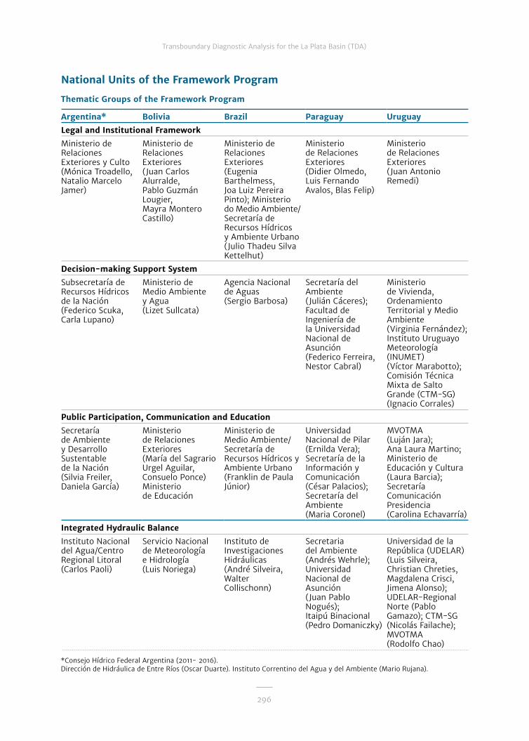
296
Transboundary Diagnostic Analysis for the La Plata Basin (TDA)
Argentina* Bolivia Brazil Paraguay Uruguay
Legal and Institutional Framework
Ministerio de Relaciones Exteriores y Culto (Mónica Troadello, Natalio Marcelo Jamer)
Ministerio de Relaciones Exteriores (Juan Carlos Alurralde, Pablo Guzmán Lougier, Mayra Montero Castillo)
Ministerio de Relaciones Exteriores (Eugenia Barthelmess, Joa Luiz Pereira Pinto); Ministerio do Medio Ambiente/Secretaría de Recursos Hídricos y Ambiente Urbano (Julio Thadeu Silva Kettelhut)
Ministerio de Relaciones Exteriores (Didier Olmedo, Luis Fernando Avalos, Blas Felip)
Ministerio de Relaciones Exteriores (Juan Antonio Remedi)
Decision-making Support System
Subsecretaría de Recursos Hídricos de la Nación (Federico Scuka, Carla Lupano)
Ministerio de Medio Ambiente y Agua (Lizet Sullcata)
Agencia Nacional de Aguas (Sergio Barbosa)
Secretaría del Ambiente (Julián Cáceres); Facultad de Ingeniería de la Universidad Nacional de Asunción (Federico Ferreira, Nestor Cabral)
Ministerio de Vivienda, Ordenamiento Territorial y Medio Ambiente (Virginia Fernández); Instituto Uruguayo Meteorología (INUMET) (Víctor Marabotto); Comisión Técnica Mixta de Salto Grande (CTM-SG) (Ignacio Corrales)
Public Participation, Communication and Education
Secretaría de Ambiente y Desarrollo Sustentable de la Nación (Silvia Freiler, Daniela García)
Ministerio de Relaciones Exteriores (María del Sagrario Urgel Aguilar, Consuelo Ponce) Ministerio de Educación
Ministerio de Medio Ambiente/Secretaría de Recursos Hídricos y Ambiente Urbano (Franklin de Paula Júnior)
Universidad Nacional de Pilar (Ernilda Vera); Secretaría de la Información y Comunicación (César Palacios); Secretaría del Ambiente (Maria Coronel)
MVOTMA (Luján Jara); Ana Laura Martino; Ministerio de Educación y Cultura (Laura Barcia); Secretaría Comunicación Presidencia (Carolina Echavarría)
Integrated Hydraulic Balance
Instituto Nacional del Agua/Centro Regional Litoral (Carlos Paoli)
Servicio Nacional de Meteorología e Hidrología (Luis Noriega)
Instituto de Investigaciones Hidráulicas (André Silveira, Walter Collischonn)
Secretaria del Ambiente (Andrés Wehrle); Universidad Nacional de Asunción (Juan Pablo Nogués); Itaipú Binacional (Pedro Domaniczky)
Universidad de la República (UDELAR) (Luis Silveira, Christian Chreties, Magdalena Crisci, Jimena Alonso); UDELAR-Regional Norte (Pablo Gamazo); CTM-SG (Nicolás Failache); MVOTMA (Rodolfo Chao)
National Units of the Framework Program
Thematic Groups of the Framework Program
*Consejo Hídrico Federal Argentina (2011- 2016). Dirección de Hidráulica de Entre Ríos (Oscar Duarte). Instituto Correntino del Agua y del Ambiente (Mario Rujana).

297
Transboundary Diagnostic Analysis for the La Plata Basin (TDA)
Water Quality
Subsecretaría de Recursos Hídricos de la Nación (Marina Jakomin)
Ministerio de Medio Ambiente y Agua (Geovana Rocabado)
Agencia Nacional de Aguas (Maurrem Ramon Vieira)
Universidad Nacional de Asunción (Inocencia Peralta); Secretaria del Ambiente (Sofía Vera, Aida Olavarrieta)
MVOTMA (Luis Reolón)
Groundwater
Subsecretaría de Recursos Hídricos de la Nación (Jorge Santa Cruz, Lida Borello)
Servicio Geológico Minero (Jorge Bellot)
Departamento de Aguas y Energía Eléctrica (Gerôncio Rocha); Servicio Geológico de Brasil (João Alberto Diniz, Fernando Feitosa, Roberto Kircheim)
Facultad de Ingeniería de la Universidad Nacional de Asunción (Andrés Wehrle); Secretaria del Ambiente (Daniel García Segredo)
MVOTMA (Lourdes Batista, Ximena Lacués); CEREGAS (Alberto Manganelli) Ministerio de Industria, Energía y Minería (MIEM) (Enrique Massa, Javier Techera); Obras Sanitarias del Estado (OSE) (Pablo Decoud, Andrés Pérez)
Aquatic Ecosystems
Secretaría de Ambiente y Desarrollo Sustentable de la Nación (Sara Sverlij); Subsecretaría de Recursos Hídricos de la Nación (Laura Pertusi)
Dirección General de Biodiversidad y Áreas Protegidas (Sharbel Gutierrez)
Universidad Estadual Paulista (Marcos Nogueira, Danilo Naliato)
Secretaría del Ambiente (Mirta Medina, Nora Neris, Reinilda Duré)
MVOTMA (Guillermo Scarlato); Ana Laura Martino; Ministerio de Agricultura, Ganadería y Pesca (Alfredo Pereira); UDELAR (Alejandro Brazeiro)
Environmental Degradation
Secretaría de Ambiente y Desarrollo Sustentable de la Nación (José Cuevas; Pablo Viegas Aurelio)
Ministerio de Desarrollo Rural y Tierra
Empresa Brasileña de Investigación Agropecuaria (Celso Vainer Manzatto)
Secretaria del Ambiente (David Fariña, José Silvero)
Ministerio de Ganadería, Agricultura y Pesca MGAP (Carlos Clerici); Facultad de Agronomía de la Universidad de la República - UDELAR (Mario Pérez Bidegain, Fernando García Prechac)
Development Opportunities
Secretaría de Ambiente y Desarrollo Sustentable de la Nación (Martín Reymúndez)
Ministerio de Relaciones Exteriores
Ministerio de Transportes (Luiz Eduardo García)
Secretaría Nacional de Turismo (Antonio Van Humbeeck)
Ministerio de Turismo (Marcelo Canteiro)
Thematic Groups of the Framework Program
Argentina Bolivia Brazil Paraguay Uruguay

298
Transboundary Diagnostic Analysis for the La Plata Basin (TDA)
PPD Biodiversity
Subsecretaría de Recursos Hídricos de la Nación (Laura Pertusi); Secretaría de Ambiente y Desarrollo Sustentable de la Nación (Sara Sverlij)
Ministerio de Medio Ambiente y Agua
Universidad Estadual Paulista (Marcos Nogueira); Itaipú Binacional (Carla Canzi)
Secretaria del Ambiente (Darío Mandelburger)
PPD Confluence
Administración Provincial del Agua del Chaco (Patricia Parini)
Itaipú Binacional (Jair Kotz, Carla Canzi)
Entidad Binacional Yacyretá (Lucas Chamorro)
PPD Cuareim
Comité de las Aguas Estaduales de la cuenca del río Quaraí (Ivo Lima Wagner); Secretaria do Ambiente e Desenvolvimento Sustentável do Rio Grande do Sul; Departamento de Recursos Hídricos (Fernando Meirelles)
Referente Local (Laura Marcelino); Comisión Cuenca Río Cuareim; MVOTMA (Silvana Alcoz); Ana Laura Martino
PPD Pilcomayo
Unidad Provincial Coordinadora del Agua de Formosa (Horacio Zambón); Secretaría de Recursos Hídricos de Salta (Alfredo Fuertes)
Ministerio de Relaciones Exteriores (Juan Carlos Segurola, Mayra Montero Castillo); Ministerio de Medio Ambiente y Agua (Oscar Cespedes)
Secretaria del Ambiente (Rosa Morel, Daniel García)
Hydroclimatic Scenarios
Instituto Nacional del Agua (Dora Goniadzki)
Servicio Nacional de Meteorología e Hidrología (Gualberto Carrasco)
Instituto Nacional de Investigaciones Espaciales (Gilvan Sampaio de Oliveira)
Dirección de Meteorología e Hidrología (Julián Baez); Facultad Politécnica de la Universidad Nacional de Asunción (Benjamín Grassi)
UDELAR (Rafael Terra, Gabriel Cazes, Marcelo Barriero); INUMET (Mario Bidegain)
National Units of the Framework Program
Thematic Groups of the Framework Program (continuation)
Argentina Bolivia Brazil Paraguay Uruguay

299
Transboundary Diagnostic Analysis for the La Plata Basin (TDA)
Monitoring and Early Warning
Instituto Nacional del Agua (Juan Borús)
Servicio Nacional de Hidrografía Naval (Luis Miguel Carrasco)
Agencia Nacional de Aguas (Valdemar S. Guimarães, Augusto Bragança)
Entidad Binacional Yacyretá (Lucas Chamorro); Universidad Católica Nuestra Señora de la Asunción (Cristián Escobar)
UDELAR (Luis Silveira, Jimena Alonso); MVOTMA (Luis Reolón, Gabriel Yorda, Javier Martínez, Juan Carlos Giacri, Adriana Piperno) CECOED Artigas (Juan José Eguillor)
Radar
Subsecretaría de Recursos Hídricos de la Nación (Juan Carlos Bertoni, Carlos Lacunza)
Servicio Nacional de Meteorología e Hidrología (Gualberto Carrasco)
Centro Nacional de Monitoreo y Alertas de Desastres Naturales (Carlos Frederico de Angelis)
Dirección de Meteorología e Hidrología (Julián Baez)
UDELAR (Gabriel Cazes); INUMET (Daniel Bonora, Néstor Santayana); CTM-SG (Juan Badagian)
Great Basin Models
Instituto Nacional del Agua (Juan Borús)
Servicio Nacional de Hidrografía Naval (Luis Miguel Carrasco)
Instituto de Investigaciones Hidráulicas (Walter Collischonn)
Universidad Católica Nuestra Señora de la Asunción (Cristián Escobar, Pedro Takahashi)
UDELAR (Christian Chreties)
Thematic Groups of the Framework Program
Argentina Bolivia Brazil Paraguay Uruguay

Framework Program
GEF - FMAM
Christian SeverinSenior Environment Specialist
UN ENVIRONMENT
Isabelle Van Der BeckProgram Manager
OAS - OEA
Cletus SpringerDirector of the Department of Sustainable Development (DDS)
Maximiliano CamposSenior Chief, Integrated Water Resources Management Division
Enrique BelloAdjunct Chief of the Technical and Administrative Unit GS/OAS Argentina
PROJECT DIRECTOR
Miguel Ángel López Arzamendia (2010-2011)José Luis Genta (2011-2015)Alejandro Peyrou (2015-2016)
INTERNATIONAL TECHNICAL COORDINATOR
Silvia Rafaelli (2011-2016)
ADJUNCT TECHNICAL COORDINATOR
Elena Benitez Alonso (2011-2013)Ana Maria Castillo Clerici (2013-2016)
TECHNICAL ASSISTANTS
Ignacio Masson (2011-2014)Julia Lacal Bereslawski (2011-2016)Eduardo Roude (2011-2016)Valeria Rodríguez Brondo (2011-2014)Fabián Riveros (2011-2012)Romina Morbelli (2013-2016) Marta Ayala (2014-2016)Martín Ribeiros (2014)Roberto Montes (2015) SECRETARIES
Aliene Zardo Ferreira (2011)Danielle Carvalho (2011-2012)Lourdes Martins (2012-2015)María Paula Giorgieri (2015-2016)
ORGANIZATION OF AMERICAN STATES - OAS
The OAS has maintained a historical relation-ship of technical cooperation with the La Plata Basin and the CIC on issues related to sustain-able development, natural resources and man-agement of water resources. For the prepara-tion of the Framework Program for the La Plata Basin, it was the regional organization selected both by UN Environment and by the CIC, as the executing agency with technical and adminis-trative responsibility for GEF funds. Member of the Project Board.
UN Environment directs and encourages par-ticipation in caring for the environment by in-spiring, informing and giving nations and peo-ples the means of improving their quality of life without endangering future generations. In the organizational structure of the Framework Pro-gram, it has been the GEF implementing agency, and its goal has been to ensure that the project is implemented for the benefit of the global envi-ronment. Member of the Project Board.
UNITED NATIONS ENVIRONMENT PROGRAMME - UN ENVIRONMENT
The GEF promotes international cooperation and fosters actions to protect the environment of our planet. Since its inception, it has become a catalyst and source of funding to consider global environmental issues in the development pro-cess in an integrated way, which is crucial to achieving a sustainable balance between man and nature. It provided the grants which funded the Framework Program.
GLOBAL ENVIROMENT FACILITY - GEF


Publications of the Framework Programme Main DocumentsVersions in Spanish, Portuguese and English
Sistema soporte para la toma de decisiones de la Cuenca del Plata
Marco institucional y legal para la gestión integrada de los recursos hídricos en la Cuenca del Plata
Transboundary Diagnostic Analysis for the La Plata Basin TDA
Strategic Action Program for the La Plata Basin SAP
Balance hídrico en la Cuenca del PlataDisponibilidad y usos, considerando escenarios futuros
Modelos de gestión
Participación pública, comunicación y educación Proyectos del Fondo de Participación Pública
Réplica del Programa Cultivando Agua Buena
Hidroclimatología de la Cuenca del Plata
Transboundary Diagnostic Analysis (TDA) and Strategic Action Program (SAP) for the La Plata Basin
Executive Summary
Framework Program for the La Plata Basin
Implementation Process and Primary Outcomes
Thematic Documents

Inventario de Regiones de Humedales de la Cuenca del Plata
Degradación de tierras en la Cuenca del Plata
Buenas prácticas en el uso del suelo en la Cuenca del Plata
Calidad del agua en la Cuenca del Plata
Selva Misionera Paranaense
Hidroelectricidad y navegación en la Cuenca del Plata
Boas práticas para o cultivo do arroz na Bacia do Prata
Proyecto Piloto Demostrativo
Conservación de la biodiversidad íctica en una zona regulada del río Paraná
Aguas subterráneas en la Cuenca del Plata
Ecosistemas acuáticos en la Cuenca del Plata
Proyecto Piloto Demostrativo
Sistema de alerta hidroambiental en la confluencia de los ríos Paraguay y Paraná
Proyecto Piloto Demostrativo
Control de contaminación y erosión en el río Pilcomayo
Proyecto Piloto Demostrativo
Resolución de conflictos por el uso del agua en la cuenca del río Cuareim/Quaraí
Tecnologías limpias y ecoturismo en la Cuenca del Plata