TOWN OF WINDHAM ZONING ORDINANCES AND LAND ...
150
TOWN OF WINDHAM ZONING ORDINANCES AND LAND USE REGULATIONS Adopted March 9, 1954 Amended March 8, 1955 Amended March 12, 1957 Amended March 10, 1959 Amended Sept. 18, 1959 Amended March 9, 1960 Amended March 14, 1962 Amended March 13, 1963 Amended March 10, 1964 Adopted May 23, 1967 Amended March 12, 1969 Amended March 11, 1970 Amended March 12, 1971 Amended January 9, 1973 Amended June 27, 1974 Amended March 2, 1976 Amended March 14, 1978 Amended March 16, 1979 Amended March 11, 1980 Amended March 14, 1981 Amended March 12, 1982 Amended March 8, 1983 Amended March 13, 1984 Amended March 12, 1985 Amended March 11, 1986 Amended March 13, 1987 Amended March 8, 1988 Amended March 14, 1989 Amended March 13, 1990 Amended March 10, 1992 Amended March 9, 1993 Amended March 8, 1994 Amended March 14, 1995 Amended March 11, 1996 Amended March 11, 1997 Amended March 10, 1998 Amended March 9, 1999 Amended March 14, 2000 Amended March 13, 2001 Amended March 12, 2002 Amended March 11, 2003 Amended March 9, 2004 Amended March 8, 2005 Amended March 14, 2006 Amended March 13, 2007 Amended March 11, 2008 Amended October 15, 2008 Amended March 10, 2009 Amended March 9, 2010 Amended March 8, 2011 Amended March 13, 2012 Amended March 12, 2013 Amended March 11, 2014 Amended March 10, 2015 Amended March 8, 2016 Amended March 18, 2017 Amended March 13, 2018 Amended March 12, 2019 Amended March 10, 2020 Amended March 9, 2021 Amended January 26, 2022 Amended March 8, 2022 Signed by the Planning Board Chair: ______________________________ Date: _____________
-
Upload
khangminh22 -
Category
Documents
-
view
4 -
download
0
Transcript of TOWN OF WINDHAM ZONING ORDINANCES AND LAND ...
TOWN OF WINDHAM
ZONING ORDINANCES AND LAND USE REGULATIONS
Adopted March 9, 1954 Amended March 8, 1955
Amended March 12, 1957 Amended March 10, 1959 Amended Sept. 18, 1959 Amended March 9, 1960
Amended March 14, 1962 Amended March 13, 1963 Amended March 10, 1964
Adopted May 23, 1967 Amended March 12, 1969 Amended March 11, 1970 Amended March 12, 1971 Amended January 9, 1973 Amended June 27, 1974 Amended March 2, 1976
Amended March 14, 1978 Amended March 16, 1979 Amended March 11, 1980 Amended March 14, 1981 Amended March 12, 1982 Amended March 8, 1983
Amended March 13, 1984 Amended March 12, 1985 Amended March 11, 1986 Amended March 13, 1987 Amended March 8, 1988
Amended March 14, 1989 Amended March 13, 1990 Amended March 10, 1992 Amended March 9, 1993 Amended March 8, 1994
Amended March 14, 1995 Amended March 11, 1996 Amended March 11, 1997 Amended March 10, 1998
Amended March 9, 1999 Amended March 14, 2000 Amended March 13, 2001 Amended March 12, 2002 Amended March 11, 2003 Amended March 9, 2004 Amended March 8, 2005
Amended March 14, 2006 Amended March 13, 2007 Amended March 11, 2008
Amended October 15, 2008 Amended March 10, 2009 Amended March 9, 2010 Amended March 8, 2011
Amended March 13, 2012 Amended March 12, 2013 Amended March 11, 2014 Amended March 10, 2015 Amended March 8, 2016
Amended March 18, 2017 Amended March 13, 2018 Amended March 12, 2019 Amended March 10, 2020 Amended March 9, 2021
Amended January 26, 2022 Amended March 8, 2022
Signed by the Planning Board Chair: ______________________________ Date: _____________

2022 ZONING REGULATIONS Page 2 of 150
Table of Contents SECTION 100 PURPOSE ................................................................................................................................. 4
SECTION 200 DEFINITIONS ............................................................................................................................ 5
SECTION 300 DISTRICTS .............................................................................................................................. 13
301 Establishment of Districts: ........................................................................................................... 13
302 Location of Districts: .................................................................................................................... 13
303 Location of Boundaries of Districts: ............................................................................................. 13
SECTION 400 CONTINUANCE OF EXISTING USES AND STRUCTURES .......................................................... 15
SECTION 500 NEW CONSTRUCTION AND NEW USES ................................................................................. 17
SECTION 600 USE REGULATION .................................................................................................................. 18
601 Wetland and Watershed Protection District (WWPD): ............................................................... 18
602 Rural District: ............................................................................................................................... 24
603 Residence Districts A, B, and C: .................................................................................................... 29
604 Neighborhood Business District: .................................................................................................. 31
605 Business Commercial District A:................................................................................................... 32
606 Limited Industrial District: ............................................................................................................ 36
607 Flood Plain District: ...................................................................................................................... 39
608 Historic District: ............................................................................................................................ 47
609 Aquifer Protection District: .......................................................................................................... 50
610 Housing for Older Persons: .......................................................................................................... 54
611 Open Space Residential Overlay District: ..................................................................................... 61
612 Village Center District (VCD): ....................................................................................................... 64
613 Public Utility Structures: .............................................................................................................. 70
614 Professional Business and Technology District: ........................................................................... 70
615 Route 28 Access Management Overlay District: .......................................................................... 72
616 Windham surface Water Watershed Protection Overlay District (WPOD) ................................. 75
617 Business Commercial District B: ................................................................................................... 85
618 Gateway Commercial District: ..................................................................................................... 86
619 Workforce Housing Overlay District: ........................................................................................... 88
620 Market Square Overlay District: ................................................................................................... 95
SECTION 700 DEVELOPMENT OF SITES AND LOCATION OF BUILDINGS AND STRUCTURES..................... 100
701 Height Regulations: .................................................................................................................... 100
702 Area, Frontage, Yard and Floor Area Requirements: ................................................................. 101
703 Accessory Buildings and Swimming Pools: ................................................................................ 102
704 Off-Street Parking and Loading Areas: ....................................................................................... 102
705 Open Space and Landscaping Requirements: ............................................................................ 104

2022 ZONING REGULATIONS Page 3 of 150
706 Sign Regulations: ........................................................................................................................ 105
707 Excavation of Earth Materials: ................................................................................................... 114
708 Junk Yards: ................................................................................................................................. 114
709 Unused Section .......................................................................................................................... 119
710 Fences: ....................................................................................................................................... 119
711 Roadside Farm Stands: ............................................................................................................... 120
712 Governmental Installations: ....................................................................................................... 121
713 Dwellings: ................................................................................................................................... 121
714 Noise: ......................................................................................................................................... 121
715 Impact Fees: ............................................................................................................................... 122
716 Vernal Pool Habitat Protection: ................................................................................................ 127
717 Cemetery Setback Requirements: ............................................................................................. 129
718 Small Wind Energy Systems: ...................................................................................................... 130
719 Historic Building/Structure Demolition/Substantial Modification Delay Ordinance: ................ 134
720 Kennels: ...................................................................................................................................... 137
SECTION 800 ADMINISTRATION ............................................................................................................... 141
SECTION 900 BOARD OF ADJUSTMENT .................................................................................................... 141
SECTION 1000 AMENDMENT .................................................................................................................... 142
SECTION 1100 VALIDITY ............................................................................................................................ 142
SECTION 1200 STRUCTURE CONVERSION ................................................................................................. 142
SECTION 1300 VIOLATIONS ....................................................................................................................... 144
SECTION 1400 SEPARABILITY .................................................................................................................... 144
SECTION 1500 ENFORCEMENT ................................................................................................................. 144
SECTION 1600 EFFECTIVE DATE ................................................................................................................ 144
APPENDIX A-1: .......................................................................................................................................... 145
TABLE OF REQUIREMENTS (9, 12) ............................................................................................................. 145
301 NOTES FOR TABLE: ......................................................................................................................... 146
MIMIMUM LOT AREA BY SOIL TYPE ...................................................................................................... 148

2022 ZONING REGULATIONS Page 4 of 150
On File with the Windham Town Clerk and the NH Office of Strategic Initiatives.
SECTION 100 PURPOSE
The purposes of this Zoning Ordinance are to lessen congestion in the streets, to secure safety from fires, panic and other dangers; to promote health and general welfare; to provide adequate light and air; to prevent the overcrowding of land; to avoid undue concentration of population; to facilitate the adequate provision of transportation, water, sewage, schools, parks, and proper use of natural resources in accord with other public requirements; to conserve the value of buildings and to encourage the most appropriate use of land in accord with Title LXIV, New Hampshire Revised Statutes Annotated, 1955, and any amendments thereto.
2022 ZONING REGULATIONS Page 5 of 150
SECTION 200 DEFINITIONS
For the purpose of this Ordinance, certain terms and words are herein defined as follows: Words used in the present tense include the future; words in the singular number include the plural number, and words in the plural number include the singular number; the word "shall" is mandatory and not directory; the word "building" includes the word "structure," the word "lot" includes the word "plot," and the word "land" includes the words "marsh" and "water." Unless defined otherwise, for the purposes of this Ordinance, the definition of the Building Code of the Town of Windham governs.
Abandoned/Abandonment:
When the owner/operator of a non-conforming use (a) intends to abandon or relinquish the use, and (b) takes some overt act, or fails to act, in some way that implies that the owner neither claims nor retains any interest in that use. Whenever a non-conforming use has not been exercised for a period of twelve (12) consecutive months or for a combined twenty-four (24) months during any thirty-six (36) month period, such non-conforming use shall not thereafter be exercised and the future use of the property shall be in conformance with the provisions of this Ordinance.
Accessory Building or Use:
A use, or detached building which is subordinate to the main use or building and located on the same lot with the main building or use, the use of which is customarily incidental to that of the main building or to the use of the land. Where a substantial part of a wall of an accessory building is a part of the wall of a main building or where an accessory building is attached to the main building, such accessory building shall be counted as a part of the main building. An accessory building shall include any structure designed to stand more or less permanently or indefinitely, covering a space of land, usually covered by a roof and more or less completely enclosed by walls and used as a storehouse or shelter for persons, animals, vehicles or personal property. It includes canvas, vinyl or similar carports, storage tents (as opposed to personal recreational tents) and shelters. It does not include storage containers/storage trailers.
Agriculture:
See NH RSA 21:34-a Farm, Agriculture, Farming.
Assembly Halls (Places of Assembly/Function Hall):
A building or structure used for social/entertainment, education, or commercial gatherings of individuals in group settings. It includes subordinate kitchen facilities to serve meals to attendees, which may be operated by a third party vendor, but it is specifically not operated as a restaurant (i.e., food services as primary use). It may include facilities for Religious Use (Churches) provided that it shall not include any residential uses associated with Churches.
Awning:
An awning is an architectural projection that provides weather protection, identity or decoration and is wholly supported by the building to which it is attached. An awning is comprised of a lightweight, rigid skeleton structure over which a covering is attached.
Bed & Breakfast:
An establishment providing transient accommodations to the public, including meals, within an owner-occupied dwelling containing up to twelve guest rooms.

2022 ZONING REGULATIONS Page 6 of 150
Boarding or Rooming House:
A building or premises, other than a hotel, inn, motel, or Bed and Breakfast, where rooms are let which are used primarily for sleeping and toiletry, and where meals may be regularly served by pre-arrangement in a common dining area for compensation; for not more than four (4) persons (not including the property owner and their immediate family) provided that the house is also occupied as an owner-occupied private residence; not open to transient guests; in contradistinction to hotels and restaurants, which are open to transients.
Broadcast Antenna Structure:
An antenna, or combination of antenna and associate tower, used for the purposes of transmission, re-transmission or reception of radio, television, electromagnetic or microwave signals for the purposes of over-the-air broadcasting for business or commercial purposes, but not including PWSFs.
Building:
As defined by the Building Code, Town of Windham.
Building Inspector:
The Building Inspector shall mean the Inspector of buildings or other designated authority or his duly authorized representative and charged with the enforcement of the building code.
Building Lot:
A measured parcel of land having fixed boundaries, with the required frontage on a town approved road and conforming to Town Zoning and/or Subdivision Control Regulations.
Call Center:
A centralized office used for the purpose of receiving and transmitting a large volume of telephone calls.
Canopy:
A canopy is an architectural projection that provides weather protection, identity or decoration and is supported by the building to which it is attached at the outer end by not less than two stanchions. A canopy can also be a detached structure and is comprised of a rigid structure over which a rigid covering is attached.
Change in Use of Structure:
An extension, enlargement, and/or alteration of pattern of utilization of the structure or change in purpose for which the structure is used and which increases the total intensity use of the structure which results in one (1) of the following (i) a change in the nature and purpose of the prior use, (ii) constitutes a use different in character, nature or kind, (iii) results in a substantially different effect on the surrounding neighborhood.
Church (also Churches; Religious Use(s)):
A church, synagogue, mosque, temple or other use or structure which is used for the practice of religion or religious worship as established in interpretations of state and federal constitutional protections of religion. It includes customary associated subordinate uses to practice religion, including single family residential uses, but specifically does not include business uses such as “retail” uses (e.g., thrift shop or gift shop) or commercial food service uses (e.g., restaurants) unless similar non-religious uses are allowed in the same zoning district.
College(s) (University):
Buildings or facilities adapted for and used for education and instruction of persons in post-secondary education which is intended to lead to a degree as authorized under regulations of the State Board of Education. Includes such ancillary facilities as dormitories, dining commons, medical facilities and security services, unless otherwise specifically prohibited.

2022 ZONING REGULATIONS Page 7 of 150
Commercial Service Establishment:
A business in which the primary concern is rendering services to persons and/or businesses rather than the sale of products, including but not limited to electricians, plumbers, repair services, installation services, general contractors, cleaning services without bulk storage of chemical cleaning materials, and businesses providing similar commercial services. Commercial services may include, as an accessory use only, retail sales of items related to the services being provided. Commercial Service Establishment does not include Personal Service Establishments, motor vehicle related services, tattoo shops, Offices, or psychics or similar types of services.
Completed Application:
One that contains sufficient information to allow the Board to proceed with consideration and to make an informed decision.
Conversion:
A structural change to adopt or alter a seasonal residence for year-round residential use; or a change in use, such as a change from seasonal occupancy to year-round occupancy.
Customary Home Occupation:
An occupation for gain or support conducted primarily on the premises. It is clearly a secondary use of the property, which does not adversely affect the residential character of the neighborhood. It is in compliance with the criteria established for a Customary Home Occupation.
Dwelling: Duplex:
A residential structure that contains 2 attached dwelling units. The dwelling units must share a common wall or common floor/ceiling, have a separate access to each dwelling. This type of dwelling is not considered an Accessory Dwelling Unit, as regulated in Section 602.1.9.
Dwelling: Multi Family:
A residential structure containing three or more attached dwelling units occupied exclusively for residential purposes, which requires Site Plan Review Approval. Multi-family dwellings do not include commercial accommodations for transient occupancy.
Dwelling: Single Family:
A building or manufactured housing as defined in RSA 674:31, occupied exclusively for residence purposes only and having one dwelling unit, but not including Business Commercial Accommodation for transient occupancy.
Dwelling Unit:
Rooms arranged for the use of one or more individuals living together as a single housekeeping unit with cooking, living, sleeping, and sanitary facilities.
Earth:
Pursuant to NH RSA 155-E:1, I, sand, gravel, rock, soil or construction aggregate produced by quarrying, crushing or any other mining activity or such other naturally-occurring unconsolidated materials that normally mask the bedrock.
Excavation:
Pursuant to NH RSA 155-E:1, II, land area which is used, or has been used, for the commercial taking of earth, including all slopes.
Floor Area:
The interior floor area of a dwelling unit exclusive of basements, stairwells, attics, and attached accessory buildings.

2022 ZONING REGULATIONS Page 8 of 150
Front Lot Line:
Any lot line that abuts a private or public vehicular right-of-way. For properties that do not abut a private or public vehicular right-of-way, the front lot line shall be that lot line that is located closest to the nearest private or public vehicular right-of-way.
Garage, Private: Covered spaces for the housing of motor vehicles, but not for the commercial repair, storage, or rental of motor vehicles.
Grade Plane:
A reference plane representing the average of finished ground level adjoining the building at all exterior walls. When the finished ground level slopes away from the exterior walls, the reference plane shall be established by the lowest points within the area between the building and the lot line or, when the lot line is more than 6 feet from the building, between the building and a point 6 feet from the building.
Health and Fitness Club:
A specific type of “Membership Club” whose primary purpose is to provide facilities for personal fitness and recreation.
Height, Building:
The vertical distance from grade plane to the height of eight (8) feet above the highest occupiable floor surface.
Hotel/Inn:
A building or section of a building in which the primary use is transient lodging accommodations for the public offered on a daily rate and where ingress and egress to sleeping rooms is made primarily through an inside lobby or office, supervised by a person in charge at all hours. Such facility may include such accessory uses as restaurants, bars, taverns, function rooms, and guest services such as pool, spa, workout room, and similar guest facilities.
Impervious Surface:
Any modified surface that cannot effectively absorb or infiltrate water. Examples of impervious surfaces include, but are not limited to, roofs, and unless designed to effectively absorb or infiltrate water, decks, patios, and paved, gravel, or crushed stone driveways, parking areas, and walkways.
Kennel, Coop, or Pen:
Accessory building or enclosure for keeping domestic pets, animals, or birds for use of or pleasure of residents, limited to litters and three or less such pets or animals three months or older in age, and to two dozen birds.
Kindergarten and Nursery School:
Buildings or facilities adapted for and used for education and instruction of children under the age of students who would be eligible to attend first grade instruction in accordance with regulations adopted by the State Board of Education. Education of children includes both secular and religious education.
Loading Space, Off Street:
An off street space or berth, on the same lot with a building, for the temporary parking of vehicles while loading or unloading merchandise or material, and which has access to a street, alley, or other appropriate means of ingress and egress.
Lot:
A measured parcel of land having fixed boundaries.

2022 ZONING REGULATIONS Page 9 of 150
Lot, Corner:
A lot abutting on two or more streets at their intersections.
Manufactured Housing:
Means any structure, transportable in one or more sections, which, in the traveling mode, is 8 body feet or more in width and 40 body feet or more in length, or when erected on site, is 320 square feet or more, and which is built on a permanent chassis and designed to be used as a dwelling with or without a permanent foundation when connected to required utilities, which include plumbing, heating, and electrical heating systems contained therein. Manufactured housing as defined in this section shall not include presite built housing as defined herein.
Membership Club:
A building or location used by a private organization to provide services, including recreation or entertainment to persons who have elected to join or become members of the organization which operates the facility, normally by payment of a fee. The number of members is limited or controlled through the organization’s eligibility rules and as part of the site plan approval process. Differentiated from Assembly Halls and Churches by virtue of the limited number of memberships or eligibility requirements and the obligation to pay or provide compensation to enjoy the facilities, or services of a Membership Club.
Motel:
An establishment providing transient accommodations to the public, containing 5 or more guest rooms, a majority of which have direct access to the outside without passing through a main registration lobby of the establishment, which is supervised by staff at all hours.
Non-conforming Structure:
A structure that is currently existing, which does not conform to the regulations for the district where it is located, and did exist at the time of publication of notice of the hearing before the Planning Board respecting the regulation to which it does not conform.
Non-conforming Use:
An existing use of land or building which does not conform to the regulations for the district in which such use of land or building exists and which existed at the time of publication of notice of the hearing before the Planning Board respecting the regulation to which it does not conform.
Occupiable Space:
A room or enclosed space designed for human occupancy in which individuals congregate for amusement, educational or similar purposes, or in which occupants are engaged at labor; and which is equipped with means of egress and light and ventilation facilities meeting the requirements of this code.
Open Space:
See Section 611.3.
Offices:
A business conducted by an individual or group practice characterized by a level of training or proficiency in a particular pursuit, science, or study, including but not limited to medical, dentistry, law, professional recruiters, engineering, land use planning, architecture, real estate, financial services, accounting, teaching, information and communications technology, and similar types of professions. Office does not include psychics or similar types of services, tattoo shops, Commercial Service Establishments, or Personal Services Establishments.

2022 ZONING REGULATIONS Page 10 of 150
Overnight Parking:
The parking or placement of a motor vehicle, except in an emergency situation, between the hours of 10:00 P.M. to 6:00 A.M., or otherwise for six (6) or more consecutive hours during that period.
Permit:
Written warrant or license granted by one having authority.
Personal Service Establishment:
A business, the primary concern of which is the rendering of services to persons rather the sale of products, including but not limited to barber, hairdresser, health spa, beauty salon, shoe repair, laundry, Laundromat, dry cleaner drop-off and pick-up service (for off-site dry-cleaning only), tailoring, dressmaking, photographic studio, catering, express mail/courier and businesses providing similar personal services. Personal services may include, as an accessory use only, retail sales of items related to services being provided. Personal Service Establishment does not include motor vehicle related services, tattoo shops, Offices, or Commercial Service Establishments.
Personal Wire Service Facility (PWSF):
A PWSF includes the set of equipment and network components, exclusive of the underlying tower or mount, including, but not limited to, antennas, accessory equipment, transmitters, receivers, base stations, power supplies, cabling, and associated equipment necessary to provide personal wireless services, per NH RSA 12-K:2(XXII).
Presite Built Housing:
Means any structure designed primarily for residential occupancy which is wholly or in substantial part made, fabricated, formed or assembled in off-site manufacturing facilities in conformance with the United States Department of Housing and Development minimum property standards and local building codes, for installation, or assembled and installation, on the building site. For the purposes of this definition, presite built housing shall not include manufactured housing, as defined herein.
Private Schools:
Buildings or facilities adapted for and used for education and instruction of children of an age eligible for kindergarten or higher in accordance with regulations adopted by the State Board of Education. Education of children includes both secular and religious education; also includes buildings or facilities intended for instructional training of persons in career skills or personal enhancement (e.g., dance/music schools).
Private Way:
Discontinued road or road not accepted by the Town.
Public Utility:
A corporation, company, association, joint stock association, partnership or person, including governmental agencies, which are regulated by the Public Utilities Commission, or franchised by the state or local government, and owning, operation, or managing any plant, or equipment involved in the supplying of services through erection, construction, alteration, or maintenance of gas, electrical service, water, or waste water transmission, distribution or collection systems; the conveyance of communication, telephone, telegraphic or television messages or services including cable TV.
PWSF Mounts:
The structure or surface upon which antennas are mounted and includes roof-mounted, side-mounted, ground-mounted, and structure-mounted antennas on an existing building, as well as an electrical transmission tower and water tower, and excluding utility poles, NH RSA 12-K:2(XX).
PWSF Towers: Freestanding or guyed structure, such as a monopole, monopine, or lattice tower, designed to support PWSFs, per NH RSA 12-K:2 (XXIV).

2022 ZONING REGULATIONS Page 11 of 150
Recreational Vehicle/Recreational Camper:
Means a vehicle which is: 1) built on a single chassis; 2) 400 square feet or less when measured at the largest horizontal projection; 3) designed to be self-propelled or permanently towable; and 4) designed primarily not for use as a permanent dwelling, but as temporary living quarters for recreational, camping, travel, or seasonal use.
Retail Sales:
The sale or rental of goods or merchandise directly to the public, including services incidental to the sale of such goods and merchandise. Wholesale sales from a retail showroom is included, without bulk storage of materials on site. This shall exclude any gasoline service, motor vehicle repair service, new / used motor vehicle sales / rentals, and trailer, boat, RV, manufactured home sales and service. Retail also does not include Commercial Service Establishments, Personal Service Establishments or Sexually Oriented Businesses.
Seasonal Residence:
A home, apartment, tenement, dwelling unit or other premises which were originally or are currently, ( i ) designed, ( ii ) situated or ( iii ) constructed, to be occupied primarily in the summer months; or such premises which were not or are not intended to be used by the inhabitants as a primary or permanent residence. For the purposes of this definition, as well as Section 1200., any dwelling unit used and occupied as a year-round residence on March 8, 1988 and not abandoned thereafter shall be considered a year-round residence.
Sexually Oriented Business:
As defined in Section 605.1.11.2. For the purposes of this Ordinance it shall not be considered a “retail” sales use, but shall be permitted only where specifically allowed.
Sign: Any words, lettering, parts of letters, figures, numerals, phrases, sentences, emblems, devices, designs, trade names, or trademarks by which anything is made known, such as are used to designate an individual, a firm, an association, a corporation, a profession, a business, or a commodity or product, which are visible from a public street or right of way and used to attract attention.’
Storage Containers/Storage Trailer:
An enclosed container (generally steel or metal) having a floor, walls, ceiling and access doors which it transportable by trailer truck or similar vehicle and used for storage of goods, materials and inventory (but not for occupancy) which is placed on the ground for use/access. When used on a temporary basis during renovation, reconstruction or relocation of occupants, its presence can be deemed an accessory use to residential use. Long term or indefinite use of such storage containers shall be deemed commercial use and subject to site plan approval by Planning Board.
Street:
A public way shown on a plan approved in accordance with the subdivision control law or otherwise qualifying a lot for frontage on a street under the subdivision control law.
Street Line:
The dividing line between a street and a lot and, in the case of a public way, the street line established by the public authority laying out the way upon which the lot abuts.
Structure:
As defined by the Town of Windham adopted building code.
Structure, Antenna:

2022 ZONING REGULATIONS Page 12 of 150
The rigid portion of the assembly which receives or transmits radio energy, and the mast or tower upon which said assembly is mounted, excluding non-rigid items such as wire, cable, transmission lines, guy wires or guy wire anchors.
Tattoo Shops:
A businesses whose primary service is the providing of tattoos.
Town:
The Town of Windham, New Hampshire.
Tourist Camp or Camp Sites:
Land used or intended to be used, let or rented for occupancy by campers traveling by automobile or otherwise; or for occupancy by house trailers, tents, or movable or temporary dwellings, rooms or sleeping quarters of any kind.
Wetland and Watershed Protection District (WWPD):
See Section 601.2.2.
Wetlands:
An area that is inundated or saturated by surface water or groundwater at a frequency and duration to support, and that under normal conditions does support, a prevalence of vegetation typically adapted for life in saturated soil conditions. Wetlands are to be delineated in accordance with the criteria and methods outlined in the Army Corp of Engineers, January 1987 Wetlands Delineation Manual. The Hydric Soils component of delineations shall be determined in accordance with the Manual “Field Indicators for Identifying Hydric Soils in New England.” (Version 2, July 1998, Published by the New England Interstate Water Pollution Control Commission).
Wholesale Sales:
A business whose primary use is the sale of goods and materials in bulk.
Yard:
An open space, other than an enclosed court, on the same lot with a building or group of buildings, which open space lies between the building or group of buildings and a lot line, and is unoccupied and unobstructed from the ground upward.
Yard, Front:
An area unoccupied by structures, except as set forth in Sections 702.1 and 702.8, extending across the full width of the lot and lying between the front lot line of the lot and the nearest line of the building. The depth of the front yard shall be the minimum distance between the building and front lot line.
Yard, Rear:
An area unoccupied by structures, except as set forth in Sections 702.1 and 702.8, extending across the full width of the lot and lying between the rear lot line of the lot and the nearest line of the building. The depth of a rear yard shall be the minimum distance between the building and rear lot line.
Yard, Side:
An area unoccupied by structures, except as set forth in Sections 702.1 and 702.8, located between the side lot line of the lot and the nearest line of the building and extending from the front yard to the rear yard or, in the absence of either of such yards, to the front or rear lot lines, as may be. The width of a side yard shall be the minimum distance between the building and the side lot line.

2022 ZONING REGULATIONS Page 13 of 150
SECTION 300 DISTRICTS
301 Establishment of Districts:
For the purposes of this Ordinance, the Town of Windham is divided into the following types of districts:
301.1 Wetland and Watershed Protection District
301.2 Rural District
301.3 Residence District A, B, and C
301.4 Neighborhood Business District
301.5 Business Commercial District A and B
301.6 Gateway Commercial District
301.7 Limited Industrial District
301.8 Historic District
301.9 Flood Plain District
301.10 Aquifer Protection District
301.11 Village Center District
301.12 Open Space Residential Overlay District
301.13 Professional, Business & Technology District
301.14 Housing for Older Persons Overlay District
301.15 Route 28 Access Management Overlay District
301.16 Windham Surface Water Watershed Protection Overlay District
301.17 Workforce Housing Overlay District
301.18 Market Square Overlay District
302 Location of Districts:
Said Districts are hereby established as shown, located, defined and bounded on the latest approved map entitled, "Zoning District Map of the Town of Windham, New Hampshire" signed by the Planning Board and filed with the office of the Town Clerk; with the exception of the Wetland and Watershed Protection District, the Flood Plain District, the Aquifer Protection District, the Housing for Older Persons District, the Open Space Residential Overlay District, the Route 28 Access Management Overlay District, the Windham Surface Water Watershed Protection Overlay District, the Market Square Overlay District, and the Workforce Housing Overlay District which are not defined by boundary lines on said map, but are districts determined by criteria set up under Sections 601, 607, 609, 610, 611, 615, 616, 619 and 620 respectively; which map, together with all explanatory matter thereon, is hereby incorporated in and made part of this Ordinance.
303 Location of Boundaries of Districts:
303.1
Where the boundary lines are shown upon said map within the street lines of public and private ways or utility transmission lines, the center lines of such ways or lines shall be the boundary lines, unless otherwise indicated.

2022 ZONING REGULATIONS Page 14 of 150
303.2
Boundary lines located outside of such street lines or transmission lines and shown approximately parallel thereto, shall be regarded as parallel to such lines, and dimensions shown in figures placed upon said map between such boundary lines and such transmission lines are the distances in feet of such boundary lines from the center line of such lines, such distances being measured at right angles to such lines unless otherwise indicated.
303.3
Where the boundary lines are shown approximately on the location of property or lot lines and the exact location of property, lot or boundary lines is not indicated by means of dimensions shown in figures, then the property or lot lines shall be the boundary lines.
303.4
Contour lines used as boundary lines are the elevation above the datum mean sea level as indicated by the U.S. Geological Survey.
303.5
Soil Association lines used as boundary lines are the Soil Association boundary lines as shown on the Soil Association Map, prepared by the U.S. Soil Conservation Service, dated 1966, and on file with the Planning Board.
303.6
In all cases which are not covered by other provisions of this Section, the location of boundary lines shall be determined by the distance in feet, if given, from other lines upon said map, by the use of identifications as shown on the map or by the scale of said map.
303.7
For lots located in more than one district, uses and structures shall conform to the requirements of the district in which they are located. If the use or structure spans the boundary between districts, the provision which imposes the greater restriction or higher standard shall apply.

2022 ZONING REGULATIONS Page 15 of 150
SECTION 400 CONTINUANCE OF EXISTING USES AND STRUCTURES
A non-conforming use or structure may continue provided that:
401
No increase in the extent of the non-conforming use or structure shall be made except as allowed in Section 406.
402
If said non-conforming use or structure has been changed to be less non-conforming, it shall not again be changed to a more non-conforming use or structure, and any future use or structure shall be in conformance with this ordinance.
403
If the non-conforming use is abandoned, it shall not be reestablished.
404
A non-conforming structure destroyed or damaged by fire, explosion or other catastrophe may be rebuilt or restored at the same location and again used as previously, provided that said owner shall apply for a building permit and start operations for restoring or rebuilding on said premises within twelve (12) months after such catastrophe and reconstruction is completed and a certificate of occupancy/approved final inspection issued within two (2) years of start of restoration, and further provided that the non-conforming structure, as restored, shall be constructed in accord with the Building Code of the Town of Windham and shall be only as great in volume and area as the original non-conforming structure.
405
Replacement of a pre-existing non-conforming structure shall be permitted under the following conditions:
405.1
The septic system must have State and Town approval.
405.2
There will be no increase in the area and/or volume of the structure.
405.3
There will be no increase in the non-conformity of the structure.
405.4
The new structure shall conform to the requirements of the Building Code.
405.5
A replacement of a non-conforming structure shall whenever possible be made to conform to the required setback requirements.
406
A non-conforming structure, which is non-conforming based on the fact that the lot size or lot frontage does not conform to the current requirements, may be expanded, subject to the following requirements:
406.1
The required septic system for such expanded use shall have State and Town approval without waivers from Env.WS 1004.16 of the NHDES Sewage Disposal System Design Rules.

2022 ZONING REGULATIONS Page 16 of 150
406.2
An increase in the volume or footprint of the structure can only occur on the portion of the structure that is currently in conformance and the addition will not result in further non-conformance with the ordinance.
406.3
The new structure shall conform to the requirements of the adopted building code.
2022 ZONING REGULATIONS Page 17 of 150
SECTION 500 NEW CONSTRUCTION AND NEW USES
501
For the purposes of this Ordinance, any lawful building or structure or use of a building, structure or land or part thereof, may be constructed, altered, enlarged, repaired or moved, occupied and used for any purpose which does not violate any section of this Ordinance or any of the provisions of the ordinances of the Town of Windham.
502
Any construction or use for which a building permit was legally issued prior to the publication of notice of the Planning Board hearing respecting this Ordinance or any amendment thereto shall be permitted, notwithstanding non-compliance with the requirements of this Ordinance or amendments thereto, provided such construction of use was commenced within six (6) months after the issuance of the permit and in the case of construction, completed within two (2) years thereafter.
503
A change of use or expansion of any non-residential or multi-family building, land or structure shall require Site Plan approval.

2022 ZONING REGULATIONS Page 18 of 150
SECTION 600 USE REGULATION
601 Wetland and Watershed Protection District (WWPD):
601.1
Purpose: In the interest of preserving water resources of the Town for the benefit of public health, safety, welfare and convenience, the regulations of the Wetland and Watershed Protection District are intended to guide the use of wetlands, lands draining into wetlands, as well as brooks, ponds, and water supply areas in order to:
601.1.1
Prevent the development of structures, or other land uses within the WWPD that would contribute to surface and groundwater contamination or reduce surface and groundwater supplies;
601.1.2
Preserve wetland areas which provide flood protection, nutrient absorption and augmentation of stream flow during dry periods;
601.1.3
Prevent unnecessary or excessive expense to the Town in providing and maintaining essential services and utilities, such as sewage collection and treatment and public water supply, which may arise because of the inappropriate use of land within the WWPD;
601.1.4
Encourage those uses that can be appropriately and safely located within the WWPD.
601.1.5
To enhance and protect surface and ground water quality.
601.2
Definitions:
Wetlands:
An area that is inundated or saturated by surface water or groundwater at a frequency and duration to support, and that under normal conditions does support, a prevalence of vegetation typically adapted for life in saturated soil conditions. Wetlands are to be delineated in accordance with the criteria and methods outlined in the Army Corp of Engineers, January 1987 Wetlands Delineation Manual. The Hydric Soils component of delineations shall be determined in accordance with the Manual “Field Indicators for Identifying Hydric Soils in New England.” (Version 2, July 1998, Published by the New England Interstate Water Pollution Control Commission).
Wetland and Watershed Protection District (WWPD):
Land areas designated as a WWPD shall include all areas in Section 601.4 and include wetlands one (1) acre in size or larger, as well as brooks, streams and ponds. For wetlands less than one (1) acre in size, see Section 601.4.3 and Section 601.4.7.
Normal High-Water Mark:
Normal High-Water Mark means the line on the shore, running parallel to a brook, stream or pond, established by fluctuations of water and indicated by physical characteristics such as a clear, natural line impressed on the immediate bank, shelving, changes in the character of soil, destruction of terrestrial vegetation, the presence of litter and debris, or other appropriate means that consider

2022 ZONING REGULATIONS Page 19 of 150
the characteristics of the surrounding areas. Where the normal high water mark is not easily discernible, the normal high water mark may be determined by the Department of Environmental Services.
Brook or Stream:
A brook or stream is a scoured natural or artificial channel indicating periods of concentrated water flow that has a contributory drainage area of 10 acres or more containing a wetland as defined in Section 601.2 -Wetlands of this ordinance. Roads, drainage culverts, or other man-made features do not constitute an interruption in the delineation of a brook or stream. Methodology for determining the upper limits of the WWPD around a brook or stream as defined in Section 601.2 Brook or Stream. - The Town of Windham Zoning Ordinance and Land Use Regulations: editor’s note: (See Figure 1).
Figure 1 Method:
Trace the channel upstream to the point where the contributory drainage area to the channel equals 10 acres. If there are no wetlands or ponds in these ten acres, the WWPD ends here. If there are wetlands or ponds in these ten acres, but they are less than one acre in size, the WWPD ends here. If the wetlands or ponds are greater than one acre in size, the WWPD extends along the channel and includes the wetlands and ponds.
Pond:
Any year-round standing body of water one (1) acre or more in area.
Hydric Soils:
Soils that are saturated or flooded during a sufficient portion of the growing season to develop anaerobic conditions in the upper soil layers.
Watershed:
A geographical area in which all water drains to a given stream, lake, wetland, estuary or pond. Within every watershed, water runs to the lowest point on that landscape – a stream, lake, wetland, estuary or pond. (NH DES).
601.3
Uses Permitted: Any of the following uses that do not result in the erection of any permanent building or conflict with the intents and purposes in Section 601.1 may be permitted in this district subject to Section 601.4.8
601.3.1
Intentionally omitted.

2022 ZONING REGULATIONS Page 20 of 150
601.3.2
Agriculture, done in accordance with best management practices adopted by the Commissioner of agriculture, markets, and food, Rockingham County Conservation District, and UNH Cooperative Extension;
601.3.3
Water impoundment’s and well supplies;
601.3.4
Drainage ways, streams, creeks or other paths of normal run off water;
601.3.5
Wildlife refuge;
601.3.6
Open space as may be permitted by Subdivision Regulations and other sections of this Ordinance;
601.3.7
Recreation, pedestrian trails, parks (but not an amusement park), fishing, boat landings, picnic areas, and any noncommercial open air recreational use, provided that there are adequate provisions for disposal of waste products and for parking outside the WWPD;
601.3.8
Driveway, streets and roads (hereinafter access ways) subject to the following:
1. The only buildable uplands available on the lot have no reasonable alternative means
of access from any road, whether publicly or privately owned; and 2. The access way crossing is designed to minimize to the greatest extent possible any
disruption of the WWPD; and 3. The length and design of the access way is the minimum length and width necessary to
provide access to the proposed use through the WWPD.
601.3.9
Utility systems, including water, gas, sewer, electricity, telephone, cable and communication lines.
601.4
Regulations:
601.4.1
Wetlands and Watershed Protection Districts shall include all lands within one hundred and fifty feet (150’) of the normal high water mark of Beaver Brook, Golden Brook and Flat Rock Brook. The WWPD for any other brook, stream or pond shall include all land within one hundred feet (100’) of the normal high water mark of said Brook or stream and one hundred feet (100’) from the normal high water of said pond.
601.4.2
The WWPD shall include that land area within one hundred feet (100’) of any wetland one (1) acre in size or larger.
601.4.3
Wetlands of less than one (1) acre in size, but larger than one-half acre shall be considered to have a WWPD of land within Twenty Five (25) feet, and Wetlands of less than one-half acre shall not be

2022 ZONING REGULATIONS Page 21 of 150
considered to have a WWPD except, in either case, those which are contiguous to a stream, brook or pond, in which case the provisions of Section 601.4.1 shall apply.
601.4.4
Notwithstanding the other provision herein, the following bodies of water shall not have a WWPD extending from their normal high water mark, nor shall they be considered a “pond” to adjacent wetlands: Cobbetts Pond, Canobie Lake, Shadow Lake, Rock Pond and Moeckel Pond. The WWPD associated with a stream or brook entering any of the exempt water bodies shall continue up to the normal high water mark of these water bodies.
601.4.5
The WWPD shall be increased by 100 feet under the following conditions: When those 100 feet has an upward slope of 12% or more and a minimum width of 100 feet.
601.4.6 None of the following shall be located closer than One Hundred Feet (100’) to any wetland contiguous to a WWPD or within a WWPD:
• Any waste disposal system
• Swimming pool/hot tub discharge or backwash
• Drinking water, reverse osmosis filtration rejects, backwash, or discharge
• Animal waste, compost, or fertilizer storage
• Snow storage, salt, or chlorine storage
• Untreated storm water discharge
601.4.7
Streams and brooks shall be considered to be part of any wetland through which said stream or brook flows. Any wetland contiguous to the stream or brook shall be protected by a WWPD.
601.4.8
The following uses, which require excavation, filling, drainage, stump removal, or otherwise altering the surface configuration of the land that is necessary for any construction shall require a special permit from the Planning Board:
1. Uses permitted in the WWPD; 2. Uses granted by variance; 3. If essential for the allowed use of land adjacent to the WWPD;
Such approval may be granted after the submission of plans describing the activities and after proper public notice and public hearing. Such plans shall also be submitted to the Conservation Commission and Code Enforcement Administrator (CEA) for their review and comment at the public hearing. The Planning Board’s action on proposals shall be based on whether the proposed action is consistent with the intents and purposes of Section 601 of this ordinance and documented accordingly.
601.4.8.1
Plans approved under this section shall contain the following notation on the plan: “NOTE: No structure may be erected nor shall any alteration of the surface configuration of the land be permitted in the Wetland and Watershed Protection District, except as authorized by this approval.”
601.4.8.2
Where any activity requiring Planning Board approval is proposed within the WWPD, the plan shall also indicate: the location and limits of the proposed activity; the construction techniques and sequence to be used in constructing the proposed improvements; and the

2022 ZONING REGULATIONS Page 22 of 150
protective measures to be employed to minimize the disturbance and/or degradation of the WWPD.
601.4.8.3
Where any activity requiring Planning Board approval is proposed within the WWPD, the applicant shall also submit evidence that: the WWPD disturbance is the minimum necessary to affect the proposed improvements; the proposed activity will not contribute to the degradation of surface or groundwater quality; the proposed activity is appropriate and safe to locate in the WWPD; and, the proposal is consistent with the intent and purpose of Section 601 of the Windham Zoning Ordinance. At a minimum, the Applicant shall submit:
1. Plans showing profiles, cross-sections, and elevations at 50-foot maximum intervals, for any proposed street, drives, access ways, or other disturbance of the WWPD;
2. Two (2) sets of color photographs (of minimum 4” x 6” size) taken in both directions along the centerline of any proposed street or access way at intervals corresponding with the intervals delineated on the plans submitted in accordance with 601.4.8.3.a.
3. Applicant may be required to submit current wildlife impact studies for Aquatic, Amphibious, protected, endangered, special interest species, Vernal pool, and nesting habitats, shown to be performed within proper season and within 1 year of application.
601.4.8.4
Where any application receiving Planning Board Approval contains property within the Wetland and Watershed Protection District (WWPD), the WWPD boundaries on such portions of the property as the Planning Board shall determine as reasonably necessary to prevent encroachment shall be marked. In determining whether such marking is reasonably necessary, the Planning Board shall consider the following factors:
1. Whether the application requires actual work within the WWPD area. 2. Whether the application results in new development in close proximity to the WWPD
area. 3. Whether the application results in new lot lines in close proximity to the WWPD. 4. Any other circumstance where the Planning Board sees just cause for such marking.
601.4.8.4.1
WWPD boundary markers should be placed at fifty-foot +/- (50 foot +/-) intervals along the total WWPD boundary following its general contour, provided further that at least one such marker must be within the line of sight from the location of the primary structure or proposed primary structure, if an unobstructed line of sight exists or will exist.
601.4.8.4.2
Care shall be taken to ensure that WWPD boundary markers are placed with the appropriate spacing at points closest to any proposed or existing structure located on the property.
601.4.8.4.3
Markers shall be affixed to trees if possible. Where no tree of reasonable girth present, markers shall be permanently affixed to hardscape, structure or non-biodegradable stakes that are driven a minimum of 24” into the ground.
601.4.8.4.4
The cost of the purchase of the WWPD boundary markers from the Community Development Department and the placement of them by a certified wetland scientist,
2022 ZONING REGULATIONS Page 23 of 150
surveyor, or other qualified professional, as determined by staff, shall be borne by the applicant/developer or their successors in interest.
601.4.8.5
Conditional Approvals:
601.4.8.5.1
If/when the Planning Board approves a WWPD special permit with conditions precedent to its final issuance, such conditions shall be satisfied within 120 days of the Board action.
601.4.8.5.2
The applicant may request an extension of time required to satisfy conditions precedent to final approval of a WWPD special permit by written request (including the reasons therefore) with the Board no later than 14 days prior to the expiration of the 120 day period provided. The Planning Board shall vote on whether an extension is appropriate under the circumstances.
601.4.8.6
Expiration of Approvals:
601.4.8.6.1
WWPD Special Permits expire one (1) year after the date of issuance if not exercised by the recipient. In the event a special permit expires, Applicant may be required to produce new and updated environmental studies to include wildlife corridors, aquatic species, protected, endangered, and special interest species, vernal pool, and nesting studies.
601.4.8.6.2
The recipient may request an extension of time to complete work under the issued permit by a written request (including the reasons therefore) with the Board no later than 14 days prior to the expiration of the one year period provided. The Planning Board shall vote on whether an extension is appropriate under the circumstances.
601.4.9
Non-accessory building and structures closer than fifty (50) feet to the WWPD shall require review by planning staff. Planning Board review shall only be required at the applicant’s request. The purpose of this section is to allocate room for swimming pools, decks, sheds, and lawn areas to be constructed outside of the WWPD.
601.5
Test Procedures: Plant and soil surveys needed to determine the extent and location of a WWPD shall be subject to the review and approval of the Planning Board in consultation with the Conservation Commission. Such surveys as are required shall be conducted by a soil scientist, botanist, or other person qualified to determine soil conditions and identify wetland plant species and shall be completed at the expense of landowner/developer. A complete report of the survey(s) shall be filed with the Planning Board.

2022 ZONING REGULATIONS Page 24 of 150
602 Rural District:
The Rural District is intended as a district for rural, residential, and noncommercial uses.
602.1
Uses Permitted:
602.1.1
Uses permitted in the Wetland and Watershed Protection District, Section 601.3:
602.1.1.1
Intentionally omitted.
602.1.1.2
Agriculture, done in accordance with best management practices adopted by the commissioner of agriculture, markets, and food, Rockingham County Conservation District, and UNH Cooperative Extension. All Farm Animal “Housing Boundary Setbacks”, as outlined in the best management practices, are to be measured from the property lines.
602.1.1.3
Water impoundments and well supplies;
602.1.1.4
Drainage ways, streams, creeks or other paths of normal run-off water;
602.1.1.5
Wildlife refuge;
602.1.1.6
Open space as may be permitted by Subdivision Regulations and other sections of this Ordinance;
602.1.1.7
Overnight parking as permitted in Section 603.1.5.
602.1.2
One (1) single-family detached dwelling per lot.
602.1.3
This section intentionally omitted.
602.1.4
Agriculture, as accessory use to a residential use when done in accordance with best management practices adopted by the commissioner of agriculture, markets, and food, Rockingham County Conservation District, and UNH Cooperative Extension. All Farm Animal “Housing Boundary Setbacks”, as outlined in the best management practices, are to be measured from the property lines.
602.1.5
Kennels for pets and animals for use of the residents of the premises.
602.1.6
Customary Home Occupation.
602.1.6.1
The purpose of the Customary Home Occupation ordinance is to allow diversity in employment available to Town residents, to support the variety of uses characteristic of

2022 ZONING REGULATIONS Page 25 of 150
small towns, and to allow reasonable growth. At the same time, the Ordinance intends to protect the character of the Town's residential neighborhoods and keep neighborhood residents free from nuisance.
602.1.6.2
A Customary Home Occupation shall be permitted by Conditional Use Permit by the Planning Board, per NH RSA 674:21. Site Plan Review by the Planning Board is not required.
602.1.6.3
The use of a room in a dwelling as a home office by a resident/occupant is an allowed use and does not require a Conditional Use Permit, provided that the use does not generate any traffic such as (i) deliveries or pickup of supplies or materials in excess of normal residential use, or (ii) clients coming to the property.
602.1.6.4
A Customary Home Occupation shall be carried out primarily on the premises, by those residing on the property and shall not change the residential character thereof. Upon request, the Planning Board is authorized to permit the employment of one additional employee.
602.1.6.5
No exterior renovations or construction, nor the public display of goods or wares or the exterior storage of material will be permitted.
602.1.6.6
The Customary Home Occupation shall be clearly incidental and secondary to the residential use and shall not change the residential character of the neighborhood.
602.1.6.7
The Customary Home Occupation shall not occupy more than 25% of the normal living area of the dwelling.
602.1.6.8
A Customary Home Occupation will not adversely affect neighboring properties, by reason of any unusual signage, lighting, noise, odors, or traffic.
602.1.6.9
The Planning Board shall consider the recommendations of the Building Inspector as to the adequacy of the water supply and sewage disposal system, and the Highway Agent as to the adequacy at the driveway entrances.
602.1.6.10
No additional parking areas in excess of those necessary for normal residential purposes will be allowed. On-street parking for Customary Home Occupations is not allowed.
602.1.6.11
No equipment or process shall be used which creates visual or audible electrical interference in any radio or television receiver off the premises or causes fluctuations in line voltage off the premises.
602.1.6.12
The Planning Board may impose such conditions and restrictions as it deems necessary to protect the residential character of the neighborhood.

2022 ZONING REGULATIONS Page 26 of 150
602.1.6.13
In all cases where a Conditional Use Permit for a Customary Home Occupation is applied for, the person applying must complete and sign an application form that sets forth the nature of the Customary Home Occupation and provides the details of the business and scope of operations. The applicant shall comply with the conditions set forth in the granting of the Conditional Use Permit and the failure to comply will result in the revocation of the Conditional Use Permit.
602.1.7
Accessory buildings and use.
602.1.8
Intentionally omitted.
602.1.9
Accessory Dwelling Units:
602.1.9.1
Purpose: To increase housing alternatives while maintaining neighborhood aesthetics and quality.
602.1.9.2
Definitions:
Accessory Dwelling Unit
Means a residential living unit that is within or attached to a single-family dwelling, and that provides independent living facilities for one or more persons, including provisions for sleeping, eating, cooking, and sanitation on the same parcel of land as the principal dwelling unit it accompanies.
Property Owner:
For purposes of this subsection, a property owner is one or more natural persons who have current possessory fee ownership in the land and buildings situated thereon which constitutes the lot and the principal and accessory dwelling units.
602.1.9.3 Rules & Regulations:
602.1.9.3.1 Maximum of one (1) accessory dwelling unit shall be allowed per single family dwelling. Accessory dwelling units associated with multiple single-family dwellings attached to each other such as townhouses, and with manufactured housing as defined in RSA 674:3 are prohibited.
602.1.9.3.2 The property owner must occupy either the principal or the accessory dwelling as their principal place of residence.
602.1.9.3.3 The property and use must conform to all of the Town of Windham Zoning Ordinance and Land Use Regulations, other applicable land use regulations and building, life safety and health codes.
602.1.9.3.3.1 The property owner may periodically be required to demonstrate their compliance to the Town, based on reasonable advanced notice.
2022 ZONING REGULATIONS Page 27 of 150
602.1.9.3.4 Any exterior entrances of the principal and accessory dwelling units shall be designed such that they have the characteristics and appearances of a single family residence.
602.9.3.4.1 An interior door shall be provided between the principal and accessory dwelling units, which may be locked.
602.1.9.3.5 The accessory dwelling unit may not exceed 950 square feet of occupied floor space with a maximum of two (2) bedrooms.
602.1.9.3.6 The principal and accessory dwelling units shall share a single driveway.
602.1.9.3.7 The septic and water systems shall meet NH DES and Town requirements for either the combined use of one system for both the principal and accessory dwelling units or the addition of systems for the accessory dwelling unit.
602.1.9.3.8 Space shall be provided to accommodate off-street parking for one additional motor vehicle.
602.1.9.3.9 The structure and lot shall not be converted to a condominium or any other form of legal ownership distinct from the ownership of the existing single family dwelling. In order to ensure compliance with this requirement, the property owners at the time the accessory dwelling unit is established shall be required to execute a restrictive covenant, easement or development restriction deed running in favor of the Town, which shall be recorded in the Rockingham County Registry of Deeds and a copy provided to the Community Development Department and the Assessor prior to the issuance of a certificate of Occupancy.
602.1.10 Home-Based Day Care: Home-Based Day Care, which includes a Family Group Day Care Home or a Family Day Care Home (both as defined below) is permitted in the same fashion as a Customary Home Occupation, and shall be permitted by the obtaining of a Conditional Use Permit issued by the Planning Board, applying the purpose and criteria found in Section 602.1.6.1 and having the same conditions as are found in Sections 602.1.6.4, 602.1.6.6, 602.1.6.7, 602.1.6.8, 602.1.6.10, 602.1.6.12 and 602.1.6.13.
602.1.10.1
Family Group Day Care Home: An occupied residence in which child day care is provided for less than 24 hours per day, except in emergencies, for 7 to 12 children from one or more unrelated families. The 12 children shall include all children related to the caregiver and any foster children residing in the home, except children who are 10 years of age or older. In addition to the 12 children, up to 5 children attending a full day school program may also be cared for up to 5 hours per day on school days and all day during school holidays.
602.1.10.2
Family Day Care Home: An occupied residence in which child day care is provided for less than 24 hours per day, except in emergencies, for up to 6 children from one or more unrelated families. The 6 children shall include any foster children residing in the home and all children who are related to the caregiver except children who are 10 years of age or older. In addition to

2022 ZONING REGULATIONS Page 28 of 150
the 6 children, up to 3 children attending a full day school program may also be cared for up to 5 hours per day on school days and all day during school holidays.
602.2
Uses Permitted Upon Site Plan Application and Review as Provided in Windham Site Plan Regulations: Where at the time of development the site is abutting a residentially developed area, no structure or parking lot which requires a site plan review shall be permitted within 100 feet of the side and/or rear property line that abuts the residentially developed area. This area shall be used as a buffer zone and shall provide adequate screening to the adjoining lots.
602.2.1
Public and parochial schools, museums, playgrounds, churches, or parish houses.
602.2.2
Private schools, including schools of dance and music, nursery schools and colleges with or without dormitory facilities, provided adequate off street parking areas in accord with Windham Site Plan Regulations are provided and there is no external change of appearance of any dwelling converted for such use but not including outdoor, overnight storage of commercial vehicles or the outdoor storage or more than one unregistered vehicle.
602.2.3
Cemeteries, Nursing homes and Charitable institutions.
602.2.4
Golf courses of at least 9 holes, not including miniature golf, are allowed. The golf course must have sufficient off-street parking areas in conformance with Section 704 off Street Parking and Loading Areas, Section 705 Open Space and Landscaping Requirements, and the site plan regulations. Clubhouse, pro shop, locker room, snack bar, parking and maintenance facilities associated with the golf course are considered part of the golf course. No structure or parking lot is permitted within 100 feet of the side or rear property lines of the golf course. Ancillary facilities may be developed in conjunction with a golf course but are limited to a restaurant, a function hall, racquet and/or outdoor tennis courts, putting greens, driving range, and a fitness center. The ancillary facilities shall not exceed twenty percent (20%) of the area of the golf course and shall be contiguous. Such facilities shall be permitted to continue operation only as long as the golf course is operating and maintained in good condition.
602.2.5
Pitch and Putt and Par3 golf courses of at least 9 holes, not including miniature golf or driving ranges, are allowed. Permitted facilities to support the golf course include clubhouse, pro shop, locker room, snack bar, parking, and maintenance facilities. Facilities operated out of existing structures or facilities utilizing areas of 1,000 square feet or less connected to an existing structure, are exempt from the setback requirements but can be no closer than existing building setbacks. Otherwise, no structure or parking lot is permitted within 100 feet of the side or rear property lines of the golf course. The ancillary facilities shall not exceed twenty percent (20%) of the area of the golf course and shall be contiguous. Such facilities shall be permitted to continue operation only as long as the golf course is operating and maintained in good condition.
602.2.6
Farm, Agriculture, Farming if this is the primary use of the property.

2022 ZONING REGULATIONS Page 29 of 150
603 Residence Districts A, B, and C:
The Residence Districts are intended as an area district for residences, with limited ancillary uses thereby avoiding conflicts with the use and enjoyment of residential properties. The Residence A District is primarily located in previously developed areas with smaller lot sizes, and often surrounding environmentally sensitive areas. The Residence B and C areas afford a wider range of housing alternatives to be developed making a diversity of housing options available to residents.:
603.1
Uses Permitted in the Residence Districts A, B, & C:
603.1.1
One single-family detached dwelling per lot.
603.1.2
Agriculture, as accessory use to a residential use when done in accordance with best management practices adopted by the commissioner of agriculture, markets, and food, Rockingham Country Conservation District, and UNH Cooperative Extension. All Farm Animal “Housing Boundary Setbacks”, as outlined in the best management practices, are to be measured from the property lines.
603.1.3
Accessory buildings and uses.
603.1.4
Intentionally omitted.
603.1.5
There may be outdoor, overnight parking of one commercial vehicle having less than 6,000 G.V.W. and two or less axles. The outdoor, overnight parking of one unregistered motor vehicle is permitted. (For Recreational Vehicles, see Section 704.2)
603.1.6
Dwelling unit as permitted in Section 602.1.9.
603.1.7
Home Occupations as permitted in Section 602.1.6.
603.1.8
Home-Based Day Care, as permitted in Section 602.1.10, is allowed in the Residence A District.
603.2
Additional Uses in the Residence District C:
603.2.1
Manufactured housing parks, provided that there is conformance with the Town of Windham, NH design and construction standards and in the Subdivision and Site Plan Regulations:
603.2.1.1
That all utility wires must be underground.
603.2.1.2
Approval by the Windham Board of Health.
603.2.1.3
Subject to Site Plan review by the Planning Board. The number of residential units in a Manufactured Home Park shall be calculated as follows:

2022 ZONING REGULATIONS Page 30 of 150
603.2.1.4
Remove the following non-buildable areas: regulatory floodway, wetlands, and the Wetland and Watershed Protection Districts;
603.2.1.5
Remove the parcel’s front, side and rear yards as non-buildable areas;
603.2.1.6
Add up the remaining buildable area in acres and multiply by three (3) or 1.5 in the Aquifer Protection District to determine the maximum amount of residential units;
603.2.1.7
Set aside a minimum of one (1) acre of contiguous buildable area or WWPD for common open space per ten (10) residential units.
603.2.1.8
Each manufactured home shall have at least 7,500 square feet of lease lot area. This area shall be at least seventy-five feet (75’) wide;
603.2.1.8.1
Each manufactured home shall be set back from another manufactured home by at least twenty feet (20’);
603.2.1.8.2
Every manufactured home shall have two off-street parking spaces on each lease lot. For every five (5) manufactured homes there shall be one (1) recreational vehicle parking space in a community parking lot.
603.2.2
Residential C must meet all requirements of Residential A, table of requirements, except manufactured housing shall be allowed with the following requirements:
603.2.2.1
Manufactured housing must be built in conformance with all acceptable building codes of the Town of Windham.
603.2.2.2
All requirements listed in Table of Requirements must be met with the exception of the living area per unit which shall be 600 square feet minimum.
603.3
In Residence “B” and “C” Districts, one (1) or more multifamily dwellings are permitted on a lot. There shall be a maximum of six (6) attached dwelling units per multifamily structure. A structure containing three or more attached dwelling units shall be subject to Site Plan Review.
603.4
In Residence “B” and “C” Districts, one (1) or more duplex dwellings are permitted on a lot provided that the units must be similar in size (square footage) with no more than ten percent (10%) difference. If more than one duplex dwelling structure is located on a lot, site plan review is required.

2022 ZONING REGULATIONS Page 31 of 150
604 Neighborhood Business District:
The Neighborhood Business District is intended for businesses that complement the neighborhood in character and scale, have minimal impact on the existing municipal infrastructure, and do not detract from the cultural, historic, or natural resources within the area.
604.1
Uses permitted, subject to Site Plan Approval as provided in Windham Site Plan Regulations.
604.1.1
Retail sales, which are contained within a building and are primarily for the shopping needs of the residents of the area. Store sign lights must be off after 10:00 p.m. and store must close at 11:00 p.m.
604.1.2
Offices.
604.1.3
Restaurants. No food or drink shall be served after 10 p.m.
604.1.4
Commercial Service Establishment.
604.1.5
Accessory building and uses.
604.1.6
Signs as provided in Windham Sign Ordinance.
604.1.7
Assembly halls, kindergartens and nursery schools.
604.1.8
A single dwelling unit allowed as an accessory use to a commercial enterprise provided it is contained within the same structure.
604.1.9
Overnight parking as permitted in Section 603.1.5.
604.1.10
Farm, Agriculture, Farming if this is the primary use of the property.
604.1.11
Boarding houses or rooming houses for not more than four (4) persons, provided that the house is also occupied as an owner-occupied private residence.
604.1.12
Banks and ATMs.
603.1.13
Personal Service Establishment.
604.1.14
Bed & Breakfast.
604.2
Unless associated with banking or pharmacy operations, no drive-thrus are allowed in the District.

2022 ZONING REGULATIONS Page 32 of 150
604.3
Conditions of Approval of permitted uses in the Neighborhood Business District shall be as provided in Section 606.2.
605 Business Commercial District A:
The Business Commercial District A is intended primarily for business which provides goods and services to the motoring and transient public.
605.1
Uses permitted subject to Site Plan approval as provided in Windham Site Plan Regulations.
605.1.1
Retail Sales:
605.1.2
Hotel/Inn and motels.
605.1.3
Restaurants.
605.1.4
Gasoline service stations, garages and repair shops provided that:
605.1.4.1
Repairs shall be limited to minor repairs and adjustments unless conducted in a building.
605.1.4.2
There shall be no storage of motor vehicles, appliances and equipment on the premises other than those in process of repair or awaiting delivery or in an enclosed structure or required in the operation of the service stations, garages or repair shops.
605.1.4.3
Gasoline service stations with fuel storage tanks serving: 1) the general public, or 2) members of a retail membership club, shall not be located within 1,000 feet of a water body used for domestic water supply as measured from the normal high water mark or within 1,000 feet of an Aquifer Protection District.
605.1.5
Salesroom and all outside sales areas require Site Plan approval by the Planning Board.
605.1.6
Funeral homes, mortuaries or crematories.
605.1.7
Passenger depots, terminals and utility structures.
605.1.8
Membership clubs.
605.1.9
Theaters, Assembly Halls, bowling alleys, skating rinks, clubs, other places of amusement or assembly and museums, providing all business is conducted within the building.

2022 ZONING REGULATIONS Page 33 of 150
605.1.10
Telephone exchange buildings, radio stations, television stations, PWSF towers, PWSF mounts and Broadcast Antenna Structures, and other utility structures subject to the provisions of Section 701.3.
605.1.11
Adult Entertainment Ordinance:
605.1.11.1
Purpose and Intent: It is the purpose of this article to establish reasonable and uniform regulations to prevent the concentration of sexually oriented businesses within the Town of Windham; and, it is the intent to promote the health, safety and general welfare of the citizens of the Town of Windham; and, it is the intent of this article that the regulations be utilized to prevent problems of blight and deterioration which accompany and are brought about by the concentration of sexually oriented businesses; and, the provisions of this amendment have neither the purpose nor the effect of imposing limitation or restriction on the content of any communicative materials, including sexually oriented materials; and, it is not the intent nor effect of this article to restrict or deny access by adults to sexually oriented materials protected by the First Amendment, or to deny access by the distributors and exhibitors of sexually oriented entertainment to their intended market; and, neither is it the intent nor effect of this article to condone or legitimize the distribution of obscene material.
605.1.11.2
Definitions of Sexually Oriented Businesses: A sexually oriented business is any place of business at which any of the following activities is conducted:
Adult Bookstore or Adult Video Store:
A business that devotes more than 15% of the total display, shelf, rack, table, stand or floor area, utilized for the display and sale of the following:
1. Books, magazines, periodicals, or other printed matter, or photographs, films, motion pictures, video cassettes, slides, tapes, records, CD-ROMS or other forms of visual or audio representations which meet the definition of “harmful to minors” and/or “sexual conduct” as set forth in RSA 571-B:1; or,
2. Instruments, devices or paraphernalia which are designed for use in connection with “sexual conduct” as defined in RSA 571-B:1, other than birth control devices.
An adult bookstore or adult video store does not include an establishment that sells books or periodicals as an incidental or accessory part of its principal stock and trade and does not devote more than 15% of the total floor area of the establishment to the sale of books and periodicals.
Adult Motion Picture Theater:
An establishment with a capacity of five or more persons, where for any form of consideration, films, motion pictures, video cassettes, slides or similar photographic reproductions are shown, and in which a substantial portion of the total presentation time is devoted to the showing of material which meets the definition of “harmful to minors” and/or “sexual conduct” as set forth in RSA 571-B:1, for observation by patron. For the purposes of this Section and subsections C, D, E, F, and G, a substantial portion of the total presentation time shall mean the presentation of films or shows described above for viewing on more than seven (7) days within any fifty-six (56) consecutive day period. Editorial Note: The reference to subsections C, D, E, F, and G is the next five

2022 ZONING REGULATIONS Page 34 of 150
definitions - Adult motion picture arcade, Adult drive in theater, Adult cabaret, Adult motel, and Adult Theater. Adult Motion Picture Arcade: Any place to which the public is permitted or invited wherein coin or slug-operated or electronically, electrically or mechanically controlled still or motion picture machines, projectors, or other image-producing devices are maintained to show images to four (4) or fewer persons per machines at any one time, in which a substantial portion of the total presentation time of the images so displayed is devoted to the showing of material which means the definition of “harmful to minors” and/or “sexual conduct” as set forth in RSA 571-B:1.
Adult Drive-In Theater:
An open lot or part thereof, with appurtenant facilities, devoted primarily to the presentation of motion picture, films, theatrical productions and other forms of visual productions, for any form of consideration to persons in motor vehicles or on outdoor seats, in which a substantial portion of the total presentation time being presented for observation by patrons is devoted to the showing of material which meets the definition of “harmful to minors” and/or “sexual conduct” as set forth in RSA 571-B:1
Adult Cabaret:
A nightclub, bar, restaurant, or similar establishment which during a substantial portion of the total presentation time feature live performances which meet the definition of “harmful to minors” and/or “sexual conduct” as set forth in RSA 571-B:1, and/or feature films, motion pictures, video cassettes, slides or other photographic reproductions, a substantial portion of the total presentation time of which is devoted to showing of material which meets the definition of “harmful to minors” and/or “Sexual conduct” as set forth in RSA 571-B:1
Adult Motel:
A motel or similar establishment offering public accommodations for any form of consideration which provides patrons with closed circuit television transmissions, films, motion pictures, video cassettes, slides or other photographic reproductions, a substantial portion of the total presentation time of which are distinguished or characterized by an emphasis upon the depiction or description of materials which meet the definition of “harmful to minors” and/or “sexual conduct” as set forth in RSA 571-B:1.
Adult Theater:
A theater, concert hall, auditorium or similar establishment either indoor or outdoor in nature, which, for any form of consideration, regularly features live performances, a substantial portion of the total presentation time of which are distinguished or characterized by emphasis on activities which meet the definition of “harmful to minors” and/or “sexual conduct” as set forth in RSA 571-B:1.
Nude Model Studio:
A place where a person who appears in a state of nudity or displays male genitals in a state of sexual arousal and/or the vulva or more intimate parts of the female genitals and is observed, sketched, drawn, painted, sculptured, photographed, or similarly depicted by other persons who pay money or any form of consideration or such display is characterized by an emphasis on activities which meets the definition of “harmful to minors” and/or “sexual conduct” as set forth in RSA 571-B:1.
Sexual Encounter Center:
A business or commercial enterprise that as one of its primary business purposes, offers for any form of consideration: (a) physical contact in the form of wrestling or tumbling

2022 ZONING REGULATIONS Page 35 of 150
between persons of the opposite sex; or (b) activities between male and female persons and/or persons of the same sex when one or more persons is in the state of nudity; or where the activities in (a) or (b) is characterized by an emphasis on activities which meets the definition of “harmful to minors” and/or “sexual conduct” as set forth in RSA 571-B:1.
605.1.11.3
Allowed locations and Location Restrictions of Sexually Oriented Businesses SEXUALLY ORIENTED BUSINESSES, as defined above shall be permitted only within the following designated area of the Business Commercial District A: That part of the Business Commercial District A bounded on the south by the Windham/Salem Town line, on the west by the former B&M Railroad right of way, on the north by the southerly side of Roulston Road, and crossing Route 28 on the southerly side of former Witch Hazel Road, and easterly by line drawn 500 feet easterly of and perpendicular to center line of Route 28; provided that all other regulations, requirements and restrictions in the Business Commercial A zone are met; and no sexually oriented business shall be permitted within 1,000 feet of another existing sexually oriented business, and no other sexually oriented business shall be permitted within a building, premise, structure or other facility that contains a sexually oriented business as defined in paragraphs A through I above.
605.1.11.4
Measure of Distance: The distance between any two sexually oriented businesses shall be measured in a straight line, without regard to intervening structures, from the closest exterior structural wall or temporary or permanent physical divider between each business.
605.1.11.5
Additional Reasonable Regulations: The Planning Board is empowered hereunder to review and approve permit applications for sexually oriented businesses and impose reasonable restrictions for buffering, outdoor lighting, parking, adequate ingress and egress from the site off of and onto public roads, pedestrian movement, and to provide for appropriate landscaping and building aesthetics in the “Site Plan Review Regulations of the Town of Windham, New Hampshire,” and to avoid site development layout which may result in negative environmental impacts.
605.1.11.6
Severability: The invalidity of any section or provisions of this article shall not invalidate any other section of provision thereof.
605.1.12
Retail and Wholesale motor vehicle, trailer, boat, RV, and manufactured housing sales utilizing outdoor display areas
605.1.13
Call Centers
605.1.14
Tattoo Shops
605.1.15
Accessory building and uses
605.1.16
Office
2022 ZONING REGULATIONS Page 36 of 150
605.1.17
Personal Service Establishment
605.1.18
Commercial Service Establishment
605.1.19
Banks and ATMs
605.2
Conditions of Approval: Conditions of approval of permitted uses in the Business Commercial Districts A shall be as provided in Section 606.2.
605.3
Drive-thrus are permitted in connection with any permitted use in Section 605.1.
606 Limited Industrial District:
The Limited Industrial District is intended for uses, such as research laboratories, office buildings and light manufacturing industries where such uses are compatible and transitional with neighboring uses.
606.1
Uses permitted: Subject to Site Plan approval as provided in Windham Site Plan Regulations:
606.1.1
Research laboratories
606.1.2
Manufacturing enterprises, provided that such activities will not be offensive, injurious or noxious because of sewerage and refuse, vibration, smoke or gas, fumes, dust or dirt, odors, danger of combustion or unsightliness.
606.1.3
Building materials warehouses with an accessory sales room of less than 500 square feet, utility structures, contractor’s yards, storage warehouses and buildings and wholesale distribution plants, provided that all loading and unloading is done at the rear of the building in covered berths and provided all materials and equipment stored outside are screened from view from public ways or abutting properties in a residence district except that items on display for retail sales need be screened only from properties in a residential district.
606.1.4
Printing or publishing establishments, photographic studios, medical or dental laboratories, subject to the restrictions in Sections 606.1.2 and 606.1.3.
606.1.5
Cafeterias for employees and other normal accessory uses, when contained in the same structure as a permitted use.
606.1.6
An apartment in a principle structure for occupancy by a watchman or caretaker.
606.1.7
Gasoline service stations, garages and repair shops provided that:

2022 ZONING REGULATIONS Page 37 of 150
606.1.7.1
Repairs shall be limited to minor repairs and adjustments unless conducted in a building.
606.1.7.2
There shall be no storage of motor vehicles, appliances and equipment on the premises other than those in process of repair or awaiting delivery or in an enclosed structure or required in the operation of the service stations, garages or repair shops.
606.1.7.3
Gasoline service stations with fuel storage tanks serving: The general public, or Members of a retail membership club shall not be located within 1,000 feet of a water body used for domestic water supply as measured from the normal high water mark or within 1,000 feet of an Aquifer Protection District.
606.1.8
Passenger depots, terminals and utility structures.
606.1.9
Telephone exchange buildings, radio stations, PWSF towers, PWSF mounts, Broadcast Antenna Structures subject to the provisions of Section 701.3 and other utility structures.
606.1.10
Restaurants.
606.1.11
Contractor yards and storage yards.
606.1.12
Firearms shooting ranges, whether indoor or outdoor, shall be allowed only in the Limited Industrial District. No firearms shooting range shall be allowed within 300 feet of any occupied building. Nothing in this section shall prohibit an otherwise allowed building from being constructed within this setback from a pre-existing firearms shooting range.
606.1.13
Health and Fitness Clubs.
606.1.14
Call Center.
606.1.15
Funeral homes, mortuaries or crematories.
606.1.16
Office.
606.1.17
Personal Service Establishment.
606.1.18
Banks and ATMs.
606.1.19
Commercial Service Establishment.

2022 ZONING REGULATIONS Page 38 of 150
606.2
Conditions for Approval:
606.2.1
Building Construction: All buildings shall be of construction prescribed in the Building Code of the Town of Windham.
606.2.2
Odor, Dust and Smoke: No such emissions shall be discernible beyond the property line or in the case of an industrial park development or of multiple use of the property, beyond one hundred feet (100’) of the building generating the emission, except that in no case shall the discharge from any source exceed the following limits:
606.2.2.1
Smoke measured at the point of discharge into the air shall not exceed a density of No. 1 on the Ringlemen Smoke Chart as published by the U.S. Bureau of Mines, except that a smoke of a density not darker than No. 2 on the Ringleman Chart may be emitted for not more than three (3) minutes in any one (1) hour.
606.2.2.2
Lime dust, as CaO, measured at the property line of any lot on which the activity creates such dust shall not exceed ten (10) micrograms per cubic meter of air.
606.2.2.3
Total particulate matter measured at all stacks or other points of emission to the air shall not exceed thirty (30) grams per hour per acre of land included in the lot.
606.2.2.4
All measurements of air pollution shall be by the procedures and with equipment approved by the Building Inspector, which procedures and equipment shall be of the latest generally recognized development and design readily available.
606.2.2.5
No open burning is permitted.
606.2.3
Intentionally Omitted.
606.2.4
Heat, Glare, Vibration and Radiation: No heat, glare or vibration shall be discernible without instruments from the outside of any structure and no nuclear radiation shall be discernible from the outside of the structure with or without instruments.
606.2.5
Exterior Lighting: No exterior lighting, other than street lighting approved by the Selectmen, shall shine on adjacent properties or towards any street.
606.2.6
Storage: All materials, supplies and equipment shall be stored in accord with Occupancy Standards and Process Hazards of the National Fire Protection Association National Fire Codes Volume 9 as amended, and shall be screened from view from public ways or abutting properties.

2022 ZONING REGULATIONS Page 39 of 150
606.2.7
Waste Disposal and Water Supply: Regulations of the Town Board of Health shall be met and shall be as indicated on the approved Site Plan. Hazardous waste materials shall not be disposed of on site, or stored on-site for more than thirty (30) days. “Hazardous Waste” shall be as defined by state and federal regulations. (See appropriate RSA #, or as amended.)
606.2.8
Screening, Surfacing, Parking and Signs: As provided in Section 700. of this Ordinance.
606.2.9
Neighborhood Impacts: Any potential neighborhood impacts from traffic, noise from construction, and hours of operation shall be identified by the Applicant and a mitigation plan submitted to the Planning Board for review and approval.
606.3
Drive-thrus are permitted in connection with any permitted use in Section 606.1
607 Flood Plain District:
This ordinance, adopted pursuant to the authority of RSA 674:16, shall be known as the Town of Windham Floodplain Development Ordinance. The regulations in this ordinance shall overlay and supplement the regulations in the Town of Windham Zoning Ordinance, and shall be considered part of the Zoning Ordinance for purposes of administration and appeals under state law. If any provision of this ordinance differs or appears to conflict with any provision of the Zoning Ordinance or other ordinance or regulations, the provision imposing the greater restriction or more stringent standard shall be controlling. The following regulations in this ordinance shall apply to all lands designated as special flood hazard areas by the Federal Emergency Management Agency (FEMA) in its “Flood Insurance Study for Rockingham County, New Hampshire” dated May 17, 2005 or as amended, together with the associated Flood Insurance Rate Map Panels numbered 528, 529, 531, 532, 533, 534, 536, 537, 538, 539, 541, 543, 545, 551, 553, and 561 dated May 17, 2005 or as amended, which are declared to be part of this ordinance and are hereby incorporated.
607.1 Definition of Terms:
The following definitions shall apply only to this Floodplain development Ordinance, and shall not be affected by, the provisions of any other ordinance of the Town of Windham.
Area of Special Flood Hazard:
Is the land in the floodplain within the Town of Windham subject to a one-percent or greater possibility of flooding in any given year. The area is designated on the FIRM as Zones A and AE.
Base Flood:
Means the flood having a one-percent possibility of being equaled or exceeded in any given year.
Basement:
Means any area of a building having a floor subgrade on all sides.
Building:
See “Structure.”

2022 ZONING REGULATIONS Page 40 of 150
Development:
Means any man-made change to improved or unimproved real estate, including but not limited to buildings or other structures, mining, dredging, filling, grading, paving, excavation, drilling operation, or storage of equipment or materials.
FEMA:
Means the Federal Emergency Management Agency.
Flood or Flooding:
Means a general and temporary condition of partial or complete inundation of normally dry land areas from:
1. The overflow of inland or tidal waters. 2. The unusual and rapid accumulation or runoff of waters from any source.
Flood Elevation Study:
Means an examination, evaluation, and determination of flood hazards and if appropriate, corresponding water surface elevations, or an examination and determination of mudslide or flood - related erosion hazards.
Flood Insurance Rate Map (FIRM):
Means an official map incorporated with this ordinance, on which FEMA has delineated both the special flood hazard areas and the risk premium zones applicable to the Town of Windham.
Flood Insurance Study:
See “Flood Elevation Study.”
Floodplain or Flood-prone Area:
Means any land area susceptible to being inundated by water from any source (see definition of “flooding”).
Flood Proofing:
Means any combination of structural and non-structural additions, changes, or adjustments to structures which reduce or eliminate flood damage to real estate or improved real property, water and sanitation facilities, structures and their contents.
Floodway:
See “Regulatory Floodway.”
Functionally Dependent Use:
Means a use which cannot perform its intended purpose unless it is located or carried out in close proximity to water. The term includes only docking and port facilities that are necessary for the loading/unloading of cargo or passengers, and ship building/repair facilities but does not include long-term storage or related manufacturing facilities.
Highest Adjacent Grade:
Means the highest natural elevation of the ground surface prior to construction next to the proposed walls of a structure.
Historic Structure:
Means any structure that is:
1. Listed individually in the National Register of Historic Places (a listing maintained by the Dept. of Interior) or preliminarily determined by the Secretary of the Interior as meeting the requirements for individual listing on the National Register;

2022 ZONING REGULATIONS Page 41 of 150
2. Certified or preliminarily determined by the Secretary of the Interior as contributing to the historical significance of a registered historic district or a district preliminarily determined by the Secretary to qualify as a registered historic district;
3. Individually listed on a state inventory of historic places in states with historic preservation programs which have been approved by the Secretary of the Interior; or
4. Individually listed on a local inventory of historic places in communities with historic preservation programs that have been certified either:
a. By an approved state program as determined by the Secretary of the Interior, or
b. Directly by the Secretary of the Interior in states without approved programs.
Lowest Floor:
Means the lowest floor of the lowest enclosed area (including basement). an unfinished or flood resistant enclosure, usable solely for parking of vehicles, building access or storage in an area other than a basement area is not considered a building’s lowest floor; provided, that such an enclosure is not built so as to render the structure in violation of the applicable non-elevation design requirements of this ordinance.
Manufactured Home:
Means a structure, transportable in one or more sections, which is built on a permanent chassis and is designed for use with or without a permanent foundation when connected to the required utilities. For floodplain management purposes the term “manufactured home” includes park trailers, travel trailers, and other similar vehicles placed on site for greater than 180 days. This includes manufactured homes located in a manufactured home park or subdivision. Manufactured Home Park or Subdivision: Means a parcel (or contiguous parcels) of land divided into two or more manufactured home lots for rent or sale.
Mean Sea Level:
Means the National Geodetic Vertical Datum (NGVD) of 1929 or other datum, to which base flood elevations shown on communities Flood Insurance Rate Map are referenced.
New Construction: Means, for the purposes of determining insurance rates, structures for which the start of construction” commenced on or after the effective date of an initial FIRM or after December 31, 1974, whichever is later, and includes any subsequent improvements to such structures. For floodplain management purposes, new construction means structures for which the start of construction commenced on or after the effective date of a floodplain management regulation adopted by a community and includes any subsequent improvements to such structures.
100-year Flood:
See “Base Flood:”
Recreational Vehicle: Means a vehicle which is:
(1) built on a single chassis; (2) 400 square feet or less when measured at the largest horizontal projection; (3) designed to be self-propelled or permanently towable by a light duty truck; and (4) designed primarily not for use as a permanent dwelling but as temporary living
a. Quarters for recreational, camping, travel or seasonal use.

2022 ZONING REGULATIONS Page 42 of 150
Regulatory Floodway:
Means the channel of a river or other watercourse and the adjacent land areas that must be reserved in order to discharge the base flood without cumulatively increasing the water surface elevation more than a designated height.
Special Flood Hazard Area:
See “Area of Special Flood Hazard”.
Structure:
Means for floodplain management purposes, a walled and roofed building, including a gas or liquid storage tank, that is principally above ground, as well as a manufactured home.
Start of Construction:
Includes substantial improvements, and means the date the building permit was issued, provided the actual start of construction, repair, reconstruction, placement, or other improvement was within 180 days of the permit date. The actual start means either the first placement of permanent construction of a structure on site, such as the pouring of slab or footings, the installation of piles, the construction of columns or any work beyond the stage of excavation; or the placement of manufactured home on a foundation. Permanent construction does not include land preparation, such as clearing, grading and filling; nor does it include the installation of streets and/or walkways; nor does it include excavation for a basement, footings, piers, or foundations or the erection of temporary forms; nor does it include the installation on the property of accessory buildings, such as garages or sheds not occupied as dwelling units or part of the main structure.
Substantial Damage:
Means damage of any origin sustained by a structure whereby the cost of restoring the structure to its before damaged condition would equal or exceed 50 percent of the market value of the structure before the damage occurred.
Substantial Improvement:
Means any combination of repairs, reconstruction, alteration, or improvements to a structure in which the cumulative cost equals or exceeds fifty percent of the market value of the structure. The market value of the structure should equal: (1) the appraised value prior to the start of the initial repair or improvement, or (2) in the case of damage, the value of the structure prior to the damage occurring. For the purposes of this definition, “substantial improvement” is considered to occur when the first alteration of any wall, ceiling, floor, or other structural part of the building commences, whether or not that alteration affects the external dimensions of the structure. This term includes structures which have incurred substantial damage, regardless of actual repair work performed. The term does not, however, include any project for improvement of a structure required to comply with existing health, sanitary, or safety code specifications which are solely necessary to assure safe living conditions or any alteration of a “historic structure”, provided that the alteration will not preclude the structure’s continued designation as a “historic structure”.
Violation:
Means the failure of a structure or other development to be fully compliant with the community’s flood plain management regulations. A structure or other development without the elevation certificate, other certifications, or other evidence of compliance required in 44CFR 60.3(b)(5), (c)(4), (c)(10), (d)(3), (e)(2), (e)(4), or (e)(5) is presumed to be in violation until such time as that documentation is provided.
2022 ZONING REGULATIONS Page 43 of 150
Water Surface Elevation:
Means the height, in relation to the National Geodetic Vertical Datum (NGVD) of 1929, (or other datum, where specified) of floods of various magnitudes and frequencies in the floodplains.
607.2
The Code Enforcement Administrator and/or Building Inspector shall review all building permit applications for new construction or substantial improvements to determine whether proposed building sites will be reasonably safe from flooding. If a proposed building site is located in a special flood hazard area, all new construction or substantial improvements shall:
607.2.1
Be designed (or modified) and adequately anchored to prevent floatation, collapse, or lateral movement of the structure resulting from hydrodynamic and hydrostatic loads, including the effects of buoyancy,
607.2.2
Be constructed with materials resistant to flood damage,
607.2.3
Be constructed by methods and practices that minimize flood damages,
607.2.4
Be constructed with electrical, heating, ventilation, plumbing and air conditioning equipment and other service facilities that are designed and/or located so as to prevent water from entering or accumulating within the components during conditions of flooding.
607.3
Where new or replacement water and sewer systems (including on-site systems) are proposed in a special flood hazard area the applicant shall provide the Code Enforcement Administrator and/or Building Inspector with assurance that these systems will be designed to minimize or eliminate infiltration of flood waters into the systems and discharges from the systems into flood water, and on-site waste disposal systems will be located to avoid impairment to them or contamination from them during periods of flooding.
607.4
For all new or substantially improved structures located in Zones A and AE, the applicant shall furnish the following information to the Code Enforcement Administrator and/or Building Inspector:
607.4.1
The as-built elevation (in relation to NGVD) of the lowest floor (including basement) and include whether or not such structures contain a basement.
607.4.2
If the structure has been floodproofed, the as-built elevation (in relation to NGVD) to which the structure was floodproofed.
607.4.3
Any certification of floodproofing. The Code Enforcement Administrator and/or Building Inspector shall maintain for public inspection, and shall furnish such information upon request.
607.5
The Code Enforcement Administrator and/or Building Inspector shall not grant a building permit until the applicant certifies that all necessary permits have been received from those governmental agencies from which approval is required by federal or state law, including Section 404 of the Federal Water Pollution Control Act Amendments of 1972, 33 U.S.C. 1334.

2022 ZONING REGULATIONS Page 44 of 150
607.6
Plans and Specifications:
607.6.1
In riverine situations, prior to the alteration or relocation of a watercourse the applicant for such authorization shall notify the Wetlands Bureau of the New Hampshire Department of Environmental Services and submit copies of such notification to the Code Enforcement Administrator and/or Building Inspector, in addition to the copies required by RSA 483-A: 1-b. Further, the applicant shall be required to submit copies of said notification to those adjacent communities as determined by the Code Enforcement Administrator and/or Building Inspector, including notice of all scheduled hearings before the Wetlands Bureau, the Windham Conservation Commission, and the Windham Planning & Zoning Board.
607.6.2
The applicant shall submit to the Code Enforcement Administrator and/or Building Inspector certification provided by a registered professional engineer, assuring that the flood carrying capacity of an altered or relocated watercourse can and will be maintained.
607.6.3
Along watercourses with a designated Regulatory Floodway no encroachments, including fill new construction, substantial improvements, and other development are allowed within the floodway unless it has been demonstrated through hydrologic and hydraulic analyses performed in accordance with standard engineering practices that the proposed encroachment would not result in any increase in flood levels within the community during the base flood discharge.
607.6.4
Until a Regulatory Floodway is designated along watercourses, no new construction, substantial improvements, or other development (including fill) shall be permitted within Zone AE on the FIRM, unless it is demonstrated by the applicant that the cumulative effect of the proposed development, when combined with all existing and anticipated development, will not increase the water surface elevation of the base flood more than one foot at any point within the community.
607.6.5
The Code Enforcement Administrator and/or Building Inspector shall obtain, review, and reasonably utilize any floodway data available from Federal, State, or other sources as criteria for requiring that all development located in Zone A meet the following floodway requirement:
607.6.5.1
No encroachments, including fill, new construction, substantial improvements, and other development are allowed within the floodway that would result in any increase in flood levels within the community during the base flood discharge.
607.7
Flood Plain Determination:
607.7.1
In special flood hazard areas the Code Enforcement Administrator and/or Building Inspector shall determine the 100 year flood elevation in the following order of precedence according to the data available:
607.7.1.1
In Zone AE, refer to the elevation data provided in the community’s Flood Insurance Study and accompanying FIRM or FHBM.

2022 ZONING REGULATIONS Page 45 of 150
607.7.1.2
In Zone A the Code Enforcement Administrator and/or Building Inspector shall obtain, review, and reasonably utilize any 100 year flood elevation data available from any federal, state or other source including data submitted for development proposals submitted to the community (i.e., subdivisions, site approvals).
607.7.2
The Code Enforcement Administrator and/or Building Inspector’s 100 year flood elevation determination will be used as criteria for requiring in Zones A and AE that:
607.7.2.1
All new construction or substantial improvement of residential structures have the lowest floor (including basement) elevated to or above the 100 year flood elevation;
607.7.2.2
That all new construction or substantial improvements of non-residential structures have the lowest floor (including basement) elevated to or above the 100 year flood level; or together with attendant utility and sanitary facilities, shall:
607.7.2.2.1
Be flood-proofed so that below the 100 year flood elevation the structure is watertight with walls substantially impermeable to the passage of water;
607.7.2.2.2
Have structural components capable of resisting hydrostatic and hydrodynamic loads and the effects of buoyancy; and
607.7.2.2.3
Be certified by a registered professional engineer or architect that the design and methods of construction are in accordance with accepted standards of practice for meeting the provisions of this section.
607.7.2.3
All manufactured homes to be placed or substantially improved within special flood hazard areas shall be elevated on a permanent foundation such that the lowest floor of the manufactured home is at or above the base flood level; and be securely anchored to resist floatation, collapse, or lateral movement. Methods of anchoring may include, but are not limited to, use of over-the-top frame ties to ground anchors. This requirement is in addition to applicable state and local anchoring requirements for resisting wind forces.
607.7.2.4
For all new construction and substantial improvements, fully enclosed areas below the lowest floor that are subject to flooding are permitted provided they meet the following requirements:
607.7.2.4.1
The enclosed area is unfinished or flood resistant usable solely for the parking of vehicles, building access or storage;
607.7.2.4.2
The area is not a basement;
607.7.2.4.3
Shall be designed to automatically equalize hydrostatic flood forces on exterior walls by allowing for the entry and exit of floodwater. Designs for meeting this requirement must

2022 ZONING REGULATIONS Page 46 of 150
either be certified by a registered professional engineer or architect or must meet or exceed the following minimum criteria: A minimum of two openings having a total net area of not less than one square inch for every square foot of enclosed area subject to flooding shall be provided. The bottom of all openings shall be no higher that one foot above grade. Openings may be equipped with screens, louvers, or other coverings or devices provided that they permit the automatic entry and exit of floodwater.
607.7.2.4.4
Recreational vehicles placed on sites within Zones A and AE shall either (i) be on the site for fewer than 180 consecutive days, (ii) be fully licensed and ready for highway use, or (iii) meet all standards for Section 60.3 (b) (1) of the National Flood Insurance Program Regulations and the elevation and anchoring requirements for “manufactured homes” in Paragraph (c) (6) of Section 60.3.
607.8
Variances & Appeals:
607.8.1
Any order, requirement, decision or determination of the Code Enforcement Administrator and/or Building Inspector made under this ordinance may be appealed to the Zoning Board of Adjustment as set forth in RSA 676:5.
607.8.2
If the applicant, upon appeal, requests a variance as authorized by RSA 674:33, I(b), the applicant shall have the burden of showing in addition to the usual variance standards under state law:
607.8.2.1
That the variance will not result in increased flood heights, additional threats to public safety, or extraordinary public expense.
607.8.2.2
That if the requested variance is for activity within a designated regulatory floodway, no increase in flood levels during the base flood discharge will result.
607.8.2.3
That the variance is necessary, considering the flood hazard, to afford relief.
607.8.3
The Zoning Board of Adjustment shall notify the applicant in writing:
607.8.3.1
The issuance of a variance to construct below the base flood level will result in increased premium rates for flood insurance up to amounts as high as $25 for $100 of insurance coverage and
607.8.3.2
Such construction below the base flood level increases risks to life and property. Such notification shall be maintained with a record of all variance actions.
607.8.4
The community shall:
607.8.4.1
Maintain a record of all variance actions, including their justification for their issuance, and

2022 ZONING REGULATIONS Page 47 of 150
607.8.4.2
Report such variances issued in its annual or biennial report submitted to FEMA’S Federal Insurance Administrator
608 Historic District:
An ordinance relating to the establishment of a Historic District in the Town of Windham.
Section I - Authority and Purpose: This ordinance is established under the authority granted in RSA 674:45 and 674:46. The purpose of this Ordinance is to promote the educational, cultural, economic, and general welfare of the public for the protection, enhancement, perpetuation, and preservation of the historic district. It is hereby declared that it is a public purpose that the heritage of Windham will be safeguarded by:
A. Preserving districts in Windham which reflect elements of a cultural, social, economic, political and architectural history;
B. Serving property value in such districts; C. Fostering civic beauty; D. Strengthening the local economy; E. Promoting the use of an historic district for the education, pleasure, and welfare of the
citizens of Windham.
Section II – Definitions:
Historic District: The area of Windham as specifically delineated on the zoning map (on a map which is on file in the Town clerk’s Office of the Town of Windham) and which:
a. Has special character or special historic or aesthetic interest of value, or b. Represents one or more areas of the history of Windham.
Exterior Architectural Feature:
The architectural style and general arrangement of such portions of the exterior of the structure as is designed to be open to view from the public way, including color, kind and texture of the building material, type of wall, windows, dormers, lighting fixtures, walks, terraces, exterior walls, fencing and other fixtures appurtenant to such portion.
Commission or Historic Commission:
As used in this ordinance shall mean the Windham Historic District Commission.
Section III - Powers and Duties: A. Membership: Qualifications; Term; Vacancies. The Commission shall consist of five (5) members
and up to three (3) alternate members, all of whom shall be appointed by the Board of Selectmen. The members of the Commission shall be appointed for three (3) year terms, except the initial appointments, which shall be staggered so no more than two Selectmen’s appointments are made annually, except when required to fill vacancies. In addition, the selectmen may appoint three (3) persons to serve as alternate members of the Commission. Alternate members shall be appointed for three (3) year terms, one (1) each year, except initial appointments, which shall be staggered such that only one term expires each year. Members (and alternates) of the Commission shall serve without compensation. In the event of a vacancy on the Commission, interim appointments may be made by the Board of Selectmen to complete the unexpired terms of such position.

2022 ZONING REGULATIONS Page 48 of 150
B. Specific Powers and Duties 1. It shall be the duty of the Historic Commission to develop regulations for the
accomplishment of the purposes of this Ordinance within said Historic District and within the provisions of the Ordinances and to relate said regulations to the Master Plan for Windham.
2. The Commission shall have the power to accept and use gifts, grants, as contributions for the exercise of its functions.
3. The Commission shall have the power to review and act upon all building permits for applications situated within the boundaries of any Historic District established, such power of review and approval, approval with conditions, or disapproval shall be limited to those considerations which affect the relationship of the applicant’s proposal to its surroundings, to the locations and arrangement of structures, to the treatment of exterior architectural features and finish of structures, and the compatibility of the land use within the district as may be deemed to affect the character and integrity of said district to achieve the purpose of this Ordinance.
4. It shall be the duty of the Historic Commission to provide reports and recommendations regarding development proposals to the Planning Board, Zoning Board of Adjustment, and other officials who may require information pertinent to the application.
5. It shall be the duty of the Commission to seek advice from such professional, educational, cultural, and other groups of persons that may be deemed necessary in the determination of a decision. The Commission shall have the power to engage such technical assistance and consultants as may be deemed necessary to appropriately review an application to assure its compatibility with the terms and purposes of this Ordinance. The costs of any such reviews shall be paid by the applicant.
6. It shall be the duty of the Commission to file with the Building Inspector or other duly delegated authority either a certificate of approval, certificate of approval with conditions, or notice of disapproval following the review and determination of any application. Said certificate shall be filed with the Building Inspector, or other duly delegated authority within 45 days after filing of the application of said certificates unless the applicant shall agree to a longer period of time for review. Failure to file such certificate within the specified period of time shall be deemed to constitute approval by said Commission.
7. No building permit shall be issued until a certificate of approval or certificate of approval with conditions has been filed with the building inspector.
8. In the case of a certificate of disapproval, such notice shall be binding upon the Building Inspector or other duly delegated authority and no permit shall be issued. In case of disapproval, the Historic Commission shall state the reasons for such disapproval in a written statement to the applicant and placed on file with the Building Inspector within 5 days of such decision being made.
9. The Historic Commission may refuse to issue a certificate of approval or certificate of appropriateness for the erection, reconstruction, alteration, demolition, partial demolition or removal of any structure within the Historic District, which in the opinion of the Historic Commission would be detrimental to the interest of the Historic District against the public interest of the Town.
10. In addition to the aforementioned powers the Historic Commission may conduct surveys if buildings for the purposes of determining those of historic and/or architectural significance and pertinent facts about them; formulate recommendations concerning the preparation of maps, brochures, and historic markers for selected historic and/or architectural sites and buildings; cooperate with and advise the governing body, and the Planning Board and other municipal agencies involving historic and/or architectural sites and buildings.”

2022 ZONING REGULATIONS Page 49 of 150
Section IV – Interpretation: Nothing in this Ordinance shall be construed to prevent ordinary maintenance or repair of any structure or place within any historic district.
Section V – Criteria Used When Reviewing Applications: The Historic Commission shall not consider interior arrangement features not subject to any public view. The Historic Commission shall consider the following criteria when reviewing applications: General design and arrangement. (Density, scale, unity in composition.)
1. Exterior architectural features and the extent to which they harmonize with existing features and the extent to which they harmonize with existing features found within the Historic District.
2. All signs, which are subject to, view from a public street, way or place. 3. The type or types of materials to be used on the structure. (Board and batten, clapboard,
brick, fieldstone, granite, wood shakes, roofing material, etc.) 4. The types of roof, within the area there are several types of roof, depending on the area of
construction, gable salt box, hip, and gambrel. 5. Architectural Detail: The relationship of detail may include cornices, lintels, arches,
balustrades, railing, entrance, doors, window dormers, chimney, etc. 6. The type or types of material used to construct or install paving, walks, walls, steps etc.
(Asphalt, stone dust, cobbles, granite, bluestone, fieldstone, etc.) 7. The type or types of material used to construct fencing or screening. 8. The placement of and type of lighting fixtures, lights, poles and trash receptacles. 9. Color: The predominant color should reflect historical accuracy and may be a natural
material or may be painted. This allows considerable latitude for variation within a single color spectral grouping.
10. Height shall not be more than 2 ½ stories or a maximum of 35 feet.
Section VI – Procedure A. Certificate of Approval. Notwithstanding any inconsistent ordinance, local law, code, rule or regulation concerning the issuing of building permits, no change in any architectural feature, in the district shall be commenced without a certificate of approval or certificate of approval with conditions from the Historic Commission nor shall any building permit for such change be granted without such a certificate of approval having first been issued. The certificate of approval required by this section shall be in addition to and not in lieu of any building permit that may be required by any ordinance, local law, code, rule or regulation of the Town of Windham. B. Pre-Application Review Procedure. Prior to the formal submission for consideration, preliminary scale drawings and outline specifications, including color samples for outside work, may be submitted for review and informal discussion with the Historic Commission. The purpose of this review shall be to acquaint the applicant with standards of appropriateness of design that are required for the proposed development. In case of very minor projects involving repair or alterations to existing buildings and other data are sufficiently clear and explicit, may grant preliminary and final approval at one session. Should said data indicate alterations, remodeling, or repairs not changing the exterior appearance, the Historic Commission may exempt the application from the provisions of Section VI and approve permit.
C. Data to be submitted with Formal Application: Application for a certificate of approval shall be made upon forms prescribed by the Historic Commission and shall contain the following information:

2022 ZONING REGULATIONS Page 50 of 150
1. Name, address, telephone number of applicant. 2. Location of building, structure, or land, the exterior architectural features of which
are proposed to be changed. 3. Drawings for the proposed alterations, additions, or changes and for new
construction of building or property use. As used herein, drawings shall mean plans and exterior elevations drawn to scale with sufficient detail to show the architectural design of the building. Plans and drawing do not need to be drawn by an architect.
4. Samples of materials, texture, and color. 5. Site Plan including all improvements affecting appearances such as walls, walks,
steps, terraces, lighting, fencing, accessory buildings, sign and other elements. 6. Sign: Any proposed sign or existing sign to be changed either in size, color, or
lettering, shall be shown on a detailed scale drawing showing the type of lettering, all dimensions and colors, a description of materials to be used and methods of illumination, if any, and a plan showing the location on building or property.
7. All of the above mentioned data shall be filed with the Historic Commission through the Community Development Department.
Section VII - Violations: Failure to comply with any of the provisions of this ordinance shall be deemed a violation and subject to Section 1300 of the Zoning Ordinance.
Section VIII Allowed Uses: The following land uses are allowed in the Historic District:
1. Municipal Uses except solid waste facilities and stand-alone antenna towers 2. Offices for professional occupations as defined in the Windham Zoning Ordinances Section
200 3. Churches 4. Assembly Halls 5. Single family residences
609 Aquifer Protection District
609.1 Authority and Purpose: Pursuant to RSA 674:16 (II) and RSA 674:21, the Town of Windham adopts an Aquifer Protection District and accompanying regulations in order to protect, preserve, and maintain potential groundwater supplies and related groundwater recharge areas within known aquifers identified by the Town. The objectives of the aquifer protection district are:
a. To protect the public health and general welfare of the citizens of Windham. b. To prevent development and land use practices that would contami¬nate or reduce the
recharge to the identified aquifers. c. To assure the availability of public and private water supplies for future growth of the
Town in accordance with the Master Plan. d. To encourage uses that can appropriately and safely be located in the aquifer recharge
areas. e. To minimize pollution and potential contaminates from reaching public water supply
systems and drinking water wells.

2022 ZONING REGULATIONS Page 51 of 150
609.2 Definitions:
Animal Feedlot:
An agricultural establishment consisting of confined feeding areas and related structures used for the raising of livestock. An animal feedlot shall be considered one on which more than five (5) livestock are raised simultaneously.
Aquifer:
For the purpose of this Section, aquifer means an unconsolidated geologic formation, group of formations, or part of a formation that is capable of yielding quantities of groundwater usable for municipal or private water supplies.
Groundwater:
All the water below the land surface in the zone of saturation or in rock fractures capable of yielding water to a well.
Groundwater Recharge:
The infiltration of precipitation through surface soil materials into groundwater. Recharge may also occur from surface waters, including lakes, streams, and wetlands.
Leachable Wastes:
Waste materials, including solid wastes, sludge and agricultural wastes that are capable of releasing contaminants to the surrounding environment, including wastes from subsurface disposal systems.
Mining of Land:
The removal of geologic materials such as topsoil, sand and gravel, metallic ores, or bedrock to be crushed or used as building stone.
Non Conforming Use:
Any lawful use of buildings, structures, premises, land or parts thereof existing as of the effective date of this Section, or amendment thereto, and not in conformance with the provisions of this Section, shall be considered to be a non conforming use.
Recharge Area:
The land surface area from which groundwater recharge occurs.
Solid Waste:
As defined in NH RSA 149-M:4,XXII
Hazardous Waste:
As defined in NH RSA 147-A:2,VII
609.3
Aquifer Protection District Boundaries:
609.3.1
The extent of the Aquifer Protection District shall be shown on the Stratified Drift Aquifers Map developed by the Rockingham Planning Commission and dated 12/15/09. The map is developed from the 1992 Water-Resources Investigations Report 91-4025 “Geohydrology and Water Quality of Stratified-Drift Aquifers in the Lower Merrimack and Coastal River Basins, Southeastern New Hampshire.” This map is to be used in conjunction with the tax map and/or other maps of the Town as an overlay district.

2022 ZONING REGULATIONS Page 52 of 150
609.3.2
Recharge Areas: A land area where rain or surface water can infiltrate into an aquifer through permeable soils. The infiltration replenishes the aquifer. When development is proposed within the Aquifer Protection District and any Recharge Area, the Planning Board may hire, at the developer’s expense, a qualified hydro geologist/hydrologist to assess the potential impact on groundwater quality and recharge rates of the aquifer from such development.
609.3.3
Appeals: Where the bounds of the identified aquifer or recharge area, as delineated, are in doubt or in dispute, any landowner aggrieved by such delineation may appeal the boundary location to the Planning Board. Upon receipt of such appeal, the Planning Board shall engage, at the landowner’s expense and request, a qualified hydro geologist/hydrologist to conduct an investigation and prepare a report determining the proper location and extent of the aquifer and recharge area relative to the property in question. This report shall include but not be limited to:
609.3.3.1
A detailed topographic layout of the subdivision and/or area to be developed, prepared by a registered land surveyor.
609.3.3.2
A revised soils map of the subdivision and/or area prepared by a soils scientist qualified in hydrologic studies including a written report of his onsite field inspection and test boring data.
609.3.3.3
The aquifer boundary as shown on the Stratified Drift Aquifers Map dated 12/15/09 shall be overlaid on the plat and the newly proposed boundary location shall be indicated on the same plat by a broken line.
609.3.3.4
Any additional mapping, hydro geologic reports or information which becomes available as a result of recent or on going scientific investigation of the location and extent of aquifers, performed by the U.S. Geological Survey, NH State agencies or boards, or the Town of Windham or the agents of any of the above. The Planning Board may, based upon the findings of Section 609.3.3.1 through Section 609.3.3.4 above, adjust the boundary or area designation of the Aquifer Protection District or reduce or expand the area so designated so as to more correctly define the location and extent of the aquifer on a site specific, case by case basis. The Planning Board shall reserve the right to withhold action on such plat pending the results of an onsite and/or other investigation by that Board or its appointed.
609.4
Use Regulations: The Aquifer Protection District is a zoning overlay district which imposes additional requirements and restrictions to those of the underlying, base district zoning. In all cases, the more restrictive requirement(s) and permitted uses shall apply.
609.4.1
Prohibited Uses: The following uses are prohibited in the Aquifer Protection District:
609.4.1.1
Disposal of solid waste, as defined in NH RSA 149-M:4, XXII
609.4.1.2
Storage, processing, recycling, and disposal of hazardous waste, as defined in NH RSA 147-A: 2, VII.
2022 ZONING REGULATIONS Page 53 of 150
609.4.1.3
Disposal or storage of leachable wastes.
609.4.1.4
Subsurface storage of petroleum and refined petroleum products and chemicals.
609.4.1.5
Industrial uses which discharge contact type process waters on site. Non-contact cooling water discharge is permitted.
609.4.1.6
Outdoor, open, and/or uncovered storage of road salt, salt/sand mixtures, and other chemical deicing materials.
609.4.1.7
Dumping of snow brought from outside the district containing de-icing chemicals.
609.4.1.8
Animal feedlots.
609.4.1.9
Automotive service and repair shops, junk and salvage yards.
609.4.1.10
Waste injection wells.
609.4.1.11
Excavating and mining of land except where incidental to a permitted use. Note that RSA 155 E expressly provides that sand and gravel excavations should be prohibited where such activities would substantially damage a known aquifer.
609.4.1.12
Gasoline stations
609.4.1.13
Outdoor, open and/or uncovered storage of commercial fertilizers
609.4.2
Recharge Requirements: Impervious surfaces within the Aquifer Protection District shall be no more than 30% of the total parcel area within the District.
609.4.2.1
A waiver may be granted in such cases where, in the opinion of the Planning Board, strict conformity would pose an unnecessary hardship to the Applicant, and the waiver would not be contrary to the spirit and intent of the Ordinance.
609.5
Design and Operations Guidelines: The following design and operation guidelines shall be observed within the Aquifer Protection District:
609.5.1
Safeguards: Provisions shall be made to protect against toxic or hazardous materials discharge or loss resulting from corrosion, accidental damage, spillage, or vandalism through measures such as: spill control provisions in the vicinity of chemical or fuel delivery points, secured storage areas for toxic or hazardous materials, and indoor storage provisions for corrodible or dissolvable materials. For operations which allow the evaporation of toxic or hazardous materials into the

2022 ZONING REGULATIONS Page 54 of 150
interiors of any structures, a closed vapor recovery system shall be provided for each such structure to prevent discharge of contaminated condensate into the groundwater.
609.5.2
Drainage: All runoff from impervious surfaces, excluding “high load areas” as defined under NHDES Alteration of Terrain Regulations (see Env-Wq 1502(26)), shall be recharged on the site and diverted toward areas covered with vegetation for surface infiltration to the extent possible.
609.5.3
In the case of any sand or gravel excavation permitted in accordance with RSA 155-E, or with respect to any earth removal allowed as being incidental to any permitted use, such excavation or removal shall not be carried out within 8 vertical feet of the seasonal high water table.
609.5.4
Location: Where portions of the parcel are outside of the Aquifer Protection District, potential pollution sources must be located outside the District.
609.5.5
Use of salt on parking areas, storage of road salt or other deicing chemicals, use of salt on roads in this District shall be minimized.
609.5.6
Animal manures, fertilizers and compost must be stored in accordance with Manual of Best Management Practices for Agriculture in NH, NH Department of Agriculture, Markets, and Food, July 2008, and any subsequent revisions.
609.5.7
Groundwater Discharge: No discharge of a regulated contaminant as defined under Env-Or 600 (see Env-Or 602.23) above Ambient Groundwater Quality Standard (AGQS) is allowed to the ground or groundwater. Dry wells may not be used when receiving a regulated contaminant. Discharge to a dry well of a regulated substance (as defined under Env-Wq 401 (see Env-Wq 401.03 (h)) is permitted only when treated to meet the AGQS specified under Env-Or 603.03. All applicants proposing groundwater discharge of commercial wastewater shall submit copies of approved NH DES Groundwater Discharge Permits and Registrations, as required under applicable state regulations.
609.6
Non-Conforming Uses: Any non-conforming use may continue and may be maintained or repaired, unless such use is determined to be a hazard to public health and safety and a detriment to water quality by the Code Enforcement Officer and Health Officer.
610 Housing for Older Persons:
610.1
Authority and Purpose: It is declared to be in the public interest and for the general welfare of the Town to permit the development of housing facilities specifically suited to address the special housing needs of the older persons. The provisions of this Section are adopted pursuant to the authority of RSA
674:16 and RSA 674:21, and shall overlay and supplement the other regulations of the Ordinance for the purpose of establishing provisions under which housing for older persons developments may be permitted by the Planning Board within certain zoning districts, and within certain areas of Windham.

2022 ZONING REGULATIONS Page 55 of 150
610.2
Definitions: As used in this Section, the following terms shall have the meanings indicated.
610.2.1
Older Persons: fifty-five (55) years of age or older.
610.2.2
Housing for Older Persons: Any of a variety of housing types or housing units intended exclusively for use and occupancy by persons aged fifty-five (55) years and older (with qualified exceptions per Section 610.4) and subject to applicable Federal and State Laws.
610.2.3
Housing for Older Persons Project: One (1) or more buildings situated on contiguous parcel(s) of land and containing housing for older persons dwelling units.
610.2.4
Handicapped Accessible: Meeting the design requirements of the Federal ADA Standards for Accessible Design and/or “Barrier-Free Design Code for the State of New Hampshire”.
610.2.5
Net Tract Area:
Contiguous useable land excluding wetlands, land within the Wetlands and Watershed Protection District (WWPD), flood plains, surface waters, hydric soils, vernal pools, right of ways, easements except slope easements, and land with slopes greater than 25%. In case of mixed-use sites, building footprints and paved areas for parking and circulation, which are not also used by Housing for Older Persons, shall be deducted.
610.2.6
Adaptable: An adaptable dwelling unit means a dwelling unit designed and constructed to facilitate future modification to provide access for persons with disabilities, or otherwise meet the criteria as “Handicapped Accessible”. See, 610.2.4. It means that some features necessary to be “Handicapped Accessible” may be omitted and/or concealed until needed, but that such features or accommodations can be added or installed without involving structural or material changes.
610.2.7
Open Space is defined for the purposes of this Section (610) to be portion (or portions) of the parcel(s) for residential tract development which is to be maintained in an open, non-built condition, and shall be protected by covenants recorded with the plans and deed restrictions. Common facilities are permitted. Open space land shall be owned as appurtenant to lot ownership, either as an undivided fractional interest as tenants in common or owned by an association whose membership consists of lot owners. If an Applicant elects to proceed under 611.6.7.3, this land may be subsequently conveyed to the Conservation Commission. In furtherance of objectives stated in Section 611.2.1, Open Space calculations for development shall be exclusive of wetlands (see section 200), surface waters, hydric soils (see section 601.2), vernal pools (see section 716.3), flood plain (see section 607.1), altered/unaltered slopes of greater than 25%, and portions of the parcel(s) not currently developed that is within twenty-five (25’) feet of a structure, road or driveway and that is less than one-half acre in size.
610.3
Location: Housing for older persons as defined herein may be permitted by the Planning Board.
2022 ZONING REGULATIONS Page 56 of 150
610.3.1
In the Rural District, Residence District A, Residence District B, and Residence District C Zoning Districts.
610.4
Occupancy: Occupancy of each unit shall be restricted to persons fifty-five (55) years and older, with the following exceptions:
1. An adult over the age of twenty one (21), if their presence is required to provide medical care to a resident aged fifty-five (55) or older;
2. Employees of the housing for older persons project (and family members living in the same unit) who are under fifty (55) years of age, provided the employees perform substantial duties related to the management or maintenance of the project’s facilities.
610.5
Minimum Lot Requirements: Parcel(s) for which Housing for Older Persons is proposed shall conform to the following minimum requirements, in addition to the other provisions of the Section.
610.5.1
Parcel(s) shall have a contiguous Net Tract Area of no less than four (4) acres;
610.5.2
There shall be fifty (50) feet of frontage on an existing or proposed Class V, or better, road.
610.6 Density: The total number of bedrooms that may be permitted on the subject site is intended to be equal to the equivalent Base Density achieved by applying soil type lot size requirements for the Town of Windham standard 4-bedroom subdivisions, plus additional density considerations if certain performance features and components are included in the design. The Base Density shall be calculated in accordance with the procedure outlined below:
610.6.1
Determine the number of standard equivalent 4-bedroom lots allowed by soil type using the minimum lot area requirements per Appendix A-1 of the Town of Windham Zoning Ordinance. Multiply this number by four (4) to establish the equivalent Base Density of bedrooms possible on the subject parcel.
610.7
Awarding of Density: The Planning Board may grant additional density considerations in accordance with the Development Standards and Development Incentives specified herein, upon the Board’s determination that the applicant’s proposal meets or exceeds the requirements relating to the specific density award under consideration.
610.7.1
Development Standards: Notwithstanding the other provisions of this Section, proposals meeting the following minimum development standards shall qualify for an additional density consideration of up to 30% total of the base density in accordance with Section 610.7.2.
610.7.1.1
Intentionally Omitted.
610.7.1.2
Allowable building types may include but are not limited to single detached, duplex, townhouse, or two (2) story garden style units. Each dwelling unit shall have a minimum of 400 square feet of living space. Two-bedroom units shall have a minimum of 600 square feet of living space.

2022 ZONING REGULATIONS Page 57 of 150
610.7.1.3
No building shall contain more than six (6) dwelling units, except that the Planning Board may permit more than ten (10) units per building when, in the Board’s sole discretion, such increase provides specific, substantial benefits consistent with the purpose and intent of this Ordinance;
610.7.1.4
Where there will be more than one (1) building on a lot, buildings shall have a minimum horizontal separation of thirty feet (30’), subject to applicable NFPA requirements. The Planning Board may require a greater separation where topography, or other unique characteristics of the site or the development will affect the use of emergency equipment between buildings;
610.7.1.5
Buildings or pavement, excepting access drives, shall be set back a minimum of fifty (50) feet from the nearest lot line;
610.7.1.5.1
The building setback shall include a minimum 25-foot wide vegetated buffer. For structures containing more than four (4) residential units, the building setback shall be 100 feet and include a vegetative buffer with a minimum width of 50 feet.
610.7.1.5.2
In consideration of the existence of residential neighborhoods, the Planning Board may require an increase in the width of the vegetative buffer, located within the overall setback.
610.7.1.5.3
The buffering shall provide a year-round dense visual screen in order to minimize adverse impacts. It may consist of evergreen trees and existing vegetation or, upon approval from the Planning Board, may include fencing, berms, boulders, mounds, deciduous vegetation, or combinations thereof to achieve the same objectives. If requested by the Planning Board, the buffer design shall be prepared, stamped, and signed by a licensed landscape architect.
610.7.1.6
A minimum of sixty-five (65%) of the total area within the development shall be set aside for permanent Open Space and passive recreation and shall be protected by covenants and deed restrictions, and shall be recorded with the plans.
610.7.1.7
All units within a building shall have at-grade or elevator access;
610.7.1.8
The project shall average no more than two (2) bedrooms per unit;
610.7.1.9
Units may occupy two (2) floors, provided that at least one bedroom and one full bathroom must be situated on the floor containing the principal access and main living area for the unit;
610.7.1.10
All units shall be constructed to be “Adaptable” for accessibility in accordance with Sections 610.2.4 and 610.2.6, above;

2022 ZONING REGULATIONS Page 58 of 150
610.7.1.11
A minimum of one (1) parking space shall be provided for each bedroom within the proposed development. Said parking shall be provided in close proximity to the units being served;
610.7.1.12
Additional parking for visitors and guests shall be provided as required by the Planning Board, but in no event at a ratio of less than one (1) space for every two (2) dwelling units;
610.7.1.13
All other appropriate provisions of this Ordinance and the Site Plan Regulations regarding on-site parking and loading requirements shall apply.
610.7.2
Development Incentives for additional density considerations: In addition to meeting the minimum Development Standards delineated above, an Applicant may propose and the Planning Board in its sole discretion may approve additional density awards (expressed as bedrooms) to the equivalent Base Density in accordance with the following Development Incentives:
610.7.2.1
Intentionally Omitted.
610.7.2.2
Intentionally Omitted.
610.7.2.3
Intentionally Omitted.
610.7.2.4
Provision of Salvage of Historic Resource: The Planning Board may award a density bonus not to exceed ten percent (10%) of the equivalent Base Density to an Applicant proposing to incorporate a structure from the Historic Resource List or cultural Resource List into the plan. The total square footage of the additional bonus units may not exceed five (5) times the square footage of the historic structure being incorporated. The Resource must be restored, preserved, or otherwise incorporated into the new development for the applicant to receive this bonus. When determining the amount of density bonus, the board should consider the importance of the historic resource, the expense required to salvage it, and the size of the proposed development.
610.7.2.5
In addition to and/or in satisfaction of, the requirements of Section 610.9.1, an Applicant shall include a minimum of a community gathering space or similar common recreation facility for all residents to all developments containing 20 units or grater. As a guideline, this community gathering space should be one-hundred square feet (100 sq. ft.) per dwelling unit and be both an on-site and all-weather year-round facility.
610.7.2.6
The Planning Board may award a density bonus not to exceed twenty percent (20%) of the equivalent Base Density to an applicant proposing to construct units with an average square footage of seven hundred fifty (750) sq. ft. per bedroom.
610.7.3
Nothing herein is intended to require the Planning Board to approve the maximum density award for a minimum proposal by an Applicant. Rather, the Board is encouraged to approve density
2022 ZONING REGULATIONS Page 59 of 150
awards in relation to a proposal’s qualitative and/or quantitative performance in achieving the intent of each Development Incentive.
610.7.4
In no event shall the total of all density awards approved for a given site or project exceed 30% of the equivalent Base Density as calculated under Section 610.6.1, above.
610.8
Design Standards: Any project proposed under this Housing for Older Persons Ordinance shall be required to conform to the requirements of the Town of Windham Site Plan Regulations.
610.9
Additional Criteria for Approval:
610.9.1
The Applicant shall be required to demonstrate the provision of significant facilities and services specifically designed to meet the physical and social needs of older persons, OR if the provision of such facilities and services is not practicable, that the proposed housing for older persons is necessary to provide important housing opportunities for older persons. Consideration of “significant services and facilities” shall include, but shall not be limited to:
1. Programs designed to provide a social life for residents; 2. Continuing education programs of interest to residents; 3. Information and counseling services; 4. Recreational programs; 5. Homemaker services;
a. Services designed to assist residents with the maintenance and upkeep of the building(s)and grounds;
6. An accessible physical environment; 7. Emergency and preventative health care programs; 8. Congregate dining facilities; 9. Transportation to facilitate access to social services; 10. Referral Services; and 11. Services to encourage/assist residents to use the services and facilities available to
them.
In demonstrating that significant services and facilities are provided, it is not required that all of the services listed above are being provided. It is intended under this Section that the Applicant comply with applicable state/federal law which imposes similar requirements. To the extent that a state/federal regulatory agency concludes that the Applicant has not fully complied with this Section, the Applicant must comply with such state and federal requirements as provided in Section 610.10.2.
610.9.2
Any site on which a housing for older person’s project is proposed shall be reviewed with respect to the availability of retail, business, medical, and transportation services, and that the proposed construction and design of the housing for older person’s project shall contain the usual amenities and living aids found in housing designed for use by older persons.
610.9.3
That the public interest will be served by the proposal to establish housing for older persons on the site, and the establishment of housing for older persons on the site will not cause a diminution in the property values of surrounding parcels.

2022 ZONING REGULATIONS Page 60 of 150
610.9.4
That the topography and other characteristics of the site are suitable for the type of development being proposed, and conflicts with the character of adjacent neighborhoods will be minimal.
610.9.5
The design and layout of the development shall emphasize the rural character of the Town, maximize the privacy of the dwelling units, preserve the natural character of land, and consider such factors as orientation, energy usage, views, etc.
610.10
Other Provisions:
610.10.1
Limitation on Number of Housing for Older Persons Units: The Planning Board shall not accept for consideration any proposal which, if approved, would increase the total number of all housing for older persons units, existing and proposed, above the number representing 8.75% of the total number of dwelling units within the Town as determined by the Tax Assessor.
610.10.2
Interpretation: To the extent that the specific requirements of this Housing for Older Persons Ordinance are inconsistent or at variance with any other requirements contained in the Zoning Ordinance, the requirements imposed herein shall govern and control a Housing for Older Persons proposal. To the extent that specific requirements imposed herein are inconsistent with or at variance with the requirements of the State of New Hampshire or the requirements of the Federal Government with respect to the operation or construction of a housing for older person’s project, such State or Federal requirements shall supersede the requirements of this Ordinance.
610.10.3
Legal Documents Required: The Planning Board shall require such covenants or legal restrictions that it deems necessary to insure the intent of this ordinance. The Planning Board may, as appropriate, require review and approval of any such documents by legal counsel to insure that the form and substance of such documents is sufficient to achieve and preserve the requirements of this Ordinance. The provision and review of any documents required hereunder shall be at the Applicant’s expense.
610.10.3.1
Assurances of Senior Residency: The Applicant shall provide deed restrictions, use limitations, covenants, or some other legally enforceable instrument, which shall permanently restrict occupancy of the housing facilities to persons who meet all applicable restrictions regarding age. The language of the restrictions and/or limitations must be specific and must correlate with current federal and state requirements for housing for older persons under the Federal Fair Housing Act. Said assurances shall include provisions for:
1. The publication of, and adherence to, policies and procedures which demonstrate an intent by the owner(s) or manager(s) to provide housing for persons fifty-five (55) years of age or older; and
2. Annual verification of compliance with the age restrictions by reliable surveys and affidavits. Notice of the results of the annual verification process is to be provided to the Code Enforcement Administrator.

2022 ZONING REGULATIONS Page 61 of 150
610.10.3.2
Assurances against Exportation of Water: Deed restrictions, covenants, or other reasonable assurances shall be required to insure that water extracted from any site(s) shall remain on-site.
610.10.4
Performance Guarantees Required: The Planning Board may require that a performance bond and/or such other legal assurances be submitted as are required to insure the completion of streets, buffers, amenities, or common area improvements, in accordance with the approved plans and the Subdivision and Site Plan Regulations of the Town of Windham.
611 Open Space Residential Overlay District:
Developments under this ordinance would be allowed in the Residence District A, Residence District B, Residence District C, and Rural District zones.
611.1
Authority and Purpose: This section is enacted in accordance with the provisions of RSA 674:21. The purpose of the Open Space Overlay District is to encourage flexibility in the design and development of land in order to provide for the conservation of open space, to plan for a more efficient use of Town services, and to promote the development of balanced residential communities in harmony with natural land features.
611.2
Objectives: The objectives of this Section are to:
611.2.1
Preserve open space, forests, farms, orchards and wetlands; especially intending to increase the amount of permanently usable undeveloped land (without steep slopes and wetlands) and to decrease the infringement upon the Wetland and Watershed Protection District.
611.2.2 Maintain or decrease existing residential densities allowing the same or fewer homes per development as would be permitted in a conventional subdivision (complying with zoning provisions such as, but not limited to, those governing lot design, wetland setbacks, road length, and all other applicable regulations);
611.2.3 Promote the more efficient use of land by requiring shorter networks of streets and utilities thus saving the town the expense of additional infrastructure;
611.2.4 Provide an organized procedure which can allow appropriate, high quality design and site planning.
611.2.5 Encourage developments with a variety of housing designs
611.2.6 Encourage a smaller scale neighborhood with a more clustered development pattern than is typical in a conventional subdivision.

2022 ZONING REGULATIONS Page 62 of 150
611.3 Definitions:
The following definitions specifically apply to this Section of the Zoning Ordinance:
Common Facilities:
Land or built facilities serving the Open Space Residential Development; includes wells and water and waste water treatment systems. Common facilities may be proposed, but are not required. Common facilities may also be owned or operated by regulated utility companies.
Conventional Subdivision:
A subdivision of land, other than a condominium subdivision, intended for single-family residential construction on fee simple lots, laid out in conformance with applicable dimensional requirements of the Windham Zoning Ordinance and Land Use Regulations as well as Design Standards for residential streets and lots specified in Sections 602 and 605 respectively of the Windham Subdivision Regulations.
Open Space:
Land that is not currently developed for residential tract development which is to be maintained in an open, non-built condition, and shall be protected by covenants recorded with the plans and deed restrictions. Common facilities are permitted. Open space land shall be owned as appurtenant to lot ownership, either as an undivided fractional interest as tenants in common or owned by an association whose membership consists of lot owners. If an Applicant elects to proceed under 611.6.7.3 This land may be subsequently conveyed to the Conservation Commission. In furtherance of objectives stated in Section 611.2.1, Open Space calculations for development shall be exclusive of wetlands (see section 200), surface waters, hydric soils (see section 601.2), vernal pools (see section 716.3), flood plain (see section 607.1), altered/unaltered slopes of greater than 25%, and portions of the parcel(s) not currently developed that is within twenty-five (25’) feet of a structure, road or driveway and that is less than one-half acre in size.
Open Space Residential Development:
A minimum ten (10) acre tract of single or consolidated ownership, where a number of single family structures may be grouped together with minimum lot area, frontage and yard requirements as specified in this section of the ordinance. The density of the tract as a whole shall be equal to that density achieved by using soil type lot size requirements as described in the Windham Zoning Ordinance. The remaining area in the tract, not built upon, is reserved as either open space or may be dedicated as Conservation Land, by following the procedure outlined in Section 611.6.7.3.
Tract:
One (1) or more adjacent lots. For the purpose of this definition, lots shall be considered adjacent, notwithstanding the fact they are separated by a brook, stream, or river; a public road or right of way (except the Interstate Highway); a railroad right of way; or by a private access way. The lots shall be merged into a single lot as a condition of approval under the Open Space Residential Overlay District.
Yield Plan:
A layout that demonstrates the number of potential single-family lots that would be obtained in a conventional subdivision employing only such waivers or variances which would likely meet the specific criteria for such waivers or variances.
611.4
Intentionally Omitted.

2022 ZONING REGULATIONS Page 63 of 150
611.5
Intentionally Omitted.
611.6
Development Standards: Development standards shall be as prescribed in the Windham subdivision control, except as noted below:
611.6.1
Permitted Uses: All uses allowed in the underlying district.
611.6.2
Road Standards as detailed in the Subdivision Regulations shall apply to Open Space Developments. Road widths shall be at or as close to the minimum paved road widths as possible, but no less than the minimum.
611.6.3
Building Lot Size: The minimum lot size shall be 20,000 sq. ft. with a minimum buildable area of 8,000 sq. ft. The maximum lot size shall be 30,000 sq. ft. with a minimum buildable area of 8,000 sq. ft.
611.6.4
Frontage and Yard Regulations: Structures may be located in any manner on the site which meet this district’s objectives, and provided that the following dimensional standards are met:
611.6.4.1
Intentionally Omitted
611.6.4.2
At Adjacent Properties: Building lots within the project that back up to other properties shall have rear yard and side yard, but not frontage, front yard or area, requirements as required for the underlying district.
611.6.4.3
Internal Dimensional Requirements: The following minimal dimensions shall apply for the layout of the structures within the parcel:
611.6.4.3.1
Front yard setback – minimum of twenty feet (20’) and a maximum of fifty feet (50’) from the edge of the right of way.
611.6.4.3.2
Frontage – minimum frontage of sixty feet (60’) and a maximum frontage of 100 feet (100’) at the minimum required front yard setback.
611.6.4.3.3
Structures shall be set back at least fifteen feet (15’) from side and rear lot lines.
611.6.5
Intentionally Omitted.
611.6.6
Water and Waste Treatment Systems: The development may be served by common water and waste water systems. Wells and waste water systems may be located within the open space and shall have a protective radius as required by the New Hampshire Water Supply and Pollution Control Commission or the Town of Windham. Such radius shall be wholly contained within the

2022 ZONING REGULATIONS Page 64 of 150
Open Space Subdivision. Any waste water treatment system or backup system shall have appropriate state approval.
611.6.7
Open Space:
611.6.7.1
Permanent Open Space: A minimum of sixty-five percent (65%) of the total area of the development shall be set aside as permanent Open Space.
611.6.7.2
Use of Open Space: Such land shall be restricted to open space recreational uses such as nature trails, residential agricultural use, passive recreation, conservation lands, existing agricultural uses and water and wastewater systems as allowed under Section 611.6.6. If the land is subsequently conveyed to the Town in accordance with 611.6.7.3 such space may be used by the general public for the same open space uses or as may be otherwise restricted by the Town.
611.6.7.3
As part of the application process, an applicant for approval of an Open Space Residential Development may elect to deed the designated open space to the Town, acting through its Conservation Commission in accordance with RSA 36-A:4. If an applicant elects to complete such conveyance, it will deed such land to the Town by warranty deed conveying title free and clear of encumbrances except any open space covenants required hereunder which will be recorded immediately prior to the conveyance and contemporaneously with the recording of the Open Space Subdivision plan.
611.6.7.4
All open space and conservation parcels, must be marked by placards and placed in clear view, designating the boundary of the open space or conservation land. Placard locations must be demarcated on the Final Open Space Subdivision Plan. The Planning Board may work with the Applicants and/or the Conservation Commission to determine the number, spacing, and location of placards.
612 Village Center District (VCD):
The purpose of this District is to create a walkable, mixed-use center that has residential, commercial,
historic and open landscaped pedestrian areas that enhance the quality of life in the Town. The Village
Center District generally supports denser, mixed-use development including retail, office, and residential
uses in conjunction with community gathering spaces accessible by the general public.
612.1
Uses Permitted in the VCD District:
612.1.1
Uses permitted in the Rural District, including those permitted with site plan approval, which shall be required.
612.2
Uses Permitted in the VCD District Subject to Site Plan approval as provided in the Windham Site Plan Regulations:

2022 ZONING REGULATIONS Page 65 of 150
612.2.1
Multi-Unit housing structures for ownership or lease. Multi-unit structures may have up to twelve (12) units and generally no more than two (2) bedrooms per unit and 1800 sq. ft. of living space. However, in structures having six (6) or more units, up to one third of those units may be three-bedroom units of up to 2,200 sq. ft. provided that one single one-bedroom unit no larger than 1,200 sq. ft. of living space is included in the structure for every two three-bedroom units. This option shall also be available for larger multi-unit structures proposed under Section 612.4.
612.2.2
Intentionally omitted.
612.2.3
Retail uses limited in size to no greater than 10,000 sq. ft. in gross floor area per business use.
612.2.4
Eating and drinking establishments including bakeries. Drive-thrus are not permitted.
612.2.5
Personal services.
612.2.6
Offices.
612.2.7
Banks and pharmacies with attendant drive-thru facilities.
612.2.8
Medical Clinics.
612.2.9
Schools, playgrounds, and fitness centers.
612.2.10
Child day care and learning centers.
612.2.11
Assembly Halls.
612.2.12
Funeral Homes.
612.2.13
Inns, bed and breakfasts of up to twelve (12) rooms that provide overnight accommodations and meals provided to transient individuals for compensation.
612.2.14
Assisted living facilities and adult day care facilities.
612.2.15
Mixed use facilities are encouraged; particularly incorporating residential with non-residential use.
612.2.16
Parking, biking, and pedestrian facilities.

2022 ZONING REGULATIONS Page 66 of 150
612.2.17
Utilities including septic systems both individual and community and water supply both individual and small community systems as defined by NH Department of Environmental Services.
612.3
Uses Prohibited in the VCD District:
Uses which are not listed as permitted are generally prohibited in the District. In addition the following provisions apply:
612.3.1
No drive-thru facilities are allowed in the Village Center District unless otherwise noted.
612.3.2
No new gas stations or automotive repair facilities or garages are permitted in the district.
612.3.3
No tattoo or body piercing services are permitted in the district.
612.3.4
No automobile washing establishments are permitted in the district.
612.3.5
No bulk storage or self-storage facilities are allowed in the district.
612.3.6
No animal kennels are permitted in the district.
612.3.7
No Gaming and Gambling facilities are permitted in the district.
612.4
Conditional Use Permits:
This Section is adopted as an Innovative Land Use Control Provision, pursuant to RSA 674:21. The Planning Board is vested with sole authority to administer and to grant Conditional Use Permits under this Section. An applicant is not entitled to a Conditional Use Permit, and the Planning Board may, in its discretion, decline to grant it if the Board determines such permit is not justified or warranted. A Conditional Use Permit may be granted to modify the requirements as specified, provided the Board finds with a written determination that each of the applicable Conditional Use criteria are met.
612.4.1
A Conditional Use Permit may be granted to modify the 10,000 sq. ft. gross floor area size limitation for a retail business or use, in accordance with the following criteria:
612.4.1.1
The modification complies with the Purpose of the Village District as noted in Section 612;
612.4.1.2
The applicant’s particular situation justifies a modification to the requirements and the site is suitable for the proposed modification;
612.4.1.3
There will be no adverse impact on adjacent properties, traffic, or pedestrian safety, and adjacent site interconnection opportunities are provided via easement for pedestrians and vehicular circulation;
2022 ZONING REGULATIONS Page 67 of 150
612.4.1.4
The aesthetic character of the site and the surrounding Village District area will not be adversely affected;
612.4.1.5
The modification will be consistent with the spirit and intent of the Zoning Ordinance and the Master Plan.
612.4.2
If above criteria in 612. 4.1 are met; the increase shall be regulated as follows:
612.4.2.1
The total gross floor area shall not exceed 15,000 gross square footage;
612.4.2.2
The amount of increase is offset by a minimum onsite or offsite equivalent area specifically designated and designed as open landscaped pedestrian park or plaza area to be enjoyed by pedestrians or users; in addition to any other Community Space requirements.
612.4.2.3
This offset can alternatively be met by providing excess water supply or septic capacity that can be made available to other developments, in the equivalent amount off-flow differential per NHDES regulations for the increased space and use. Capacity may be provided by actual production, or easement for location of facilities or setbacks.
612.4.2.4
This offset can alternatively be met if the proposed use is deemed by the Planning Board to provide a unique and special resource both to the Village Center District and the Town of Windham at large.
612.4.3
A Conditional Use Permit may be granted to allow up to 24 units in a multi-unit housing structure, in accordance with the following criteria:
612.4.3.1
The modification complies with the Purpose of the Village District as noted in Section 612;
612.4.3.2
The applicant’s particular situation justifies a modification to the requirements, and the site is suitable for the proposed modification;
612.4.3.3
There will be no adverse impact on adjacent properties, traffic, natural resources, or pedestrian safety, and adjacent site interconnection opportunities are provided via easement for pedestrian and vehicular circulation;
612.4.3.4
The aesthetic character of the site and the surrounding Village District area will not be adversely affected;
612.4.3.5
The modification will be consistent with the spirit and intent of the Zoning Ordinance and the Master Plan.

2022 ZONING REGULATIONS Page 68 of 150
612.4.3.6
The proposed use is deemed by the Planning Board to provide a mixture of residential and non-residential uses that will enhance the village nature of the district. The non-residential use must occupy not less than twenty (20) percent of the total square footage of the structure.
612.4.4
Intentionally Omitted.
612.4.4.1
The multi-family development will be designed to incorporate a functionally significant open landscaped community park or plaza area to be enjoyed by unit residents and visitors to the Village Center District, and/or;
612.4.4.2
The proposed use is deemed by the Planning Board to provide a mixture of residential and non-residential uses that will enhance the village nature of the district. The non-residential use must occupy not less than twenty (20) percent of the total square footage of the structure.
612.4.5
A Conditional Use Permit may be granted to allow no front, side or rear setback when the development of a walkable streetscape of contiguous storefronts, sidewalks and shared parking with adjacent VCD properties. Only setbacks preventing contiguous development with adjacent properties may be reduced. All other setbacks must be followed.
612.4.6
A Conditional Use Permit may be granted to allow multiple VCD properties to aggregate the 15% open landscaped pedestrian park or plaza area requirement. The required area from one property may be combined with that of another property if the Planning Board deems that it produces a result that is of benefit to the citizens of the town.
612.5
Development Standards:
Development standards shall be prescribed in the Site Plan Regulations. Additional development standards are as follows:
612.5.1
Village Center District - there shall be a minimum fifty feet (50’) natural buffer of vegetation supplemented by evergreen trees and landscaped berms from the abutting residential zoning district.
612.5.2
A front setback of fifty (50) feet shall be required from Route 111 and Thirty (30) feet from all other roads. Side and rear setbacks shall be twenty (20) feet.
612.5.3
Shared parking facilities and driveways shall be provided and the parking space requirements reduced where shared parking is designed to maximize complimentary uses and it has been demonstrated to the Planning Board that sufficient parking will be available when it is needed;
612.5.4
The road frontage requirements shall be fifty (50) feet at the front lot line. Notwithstanding the provisions of Note 2 of the Table of Requirements, this measurement shall be at the front

2022 ZONING REGULATIONS Page 69 of 150
property line. In addition, the Planning Board may grant a Conditional Use Permit to allow a lot with no frontage on a Class V (or Planning Board approved) road, under the following conditions:
612.5.4.1
The Lot shall have deeded access to a Class V or better road.
612.5.4.2
The Planning Board is satisfied that suitable arrangements are in place (by covenant documents or otherwise) to assure adequate public and public safety access at all times of the year.
612.5.4.3
That granting of the approval is consistent with the Purpose of the Village District as noted in Section 612.
612.5.4.4
That granting of the request will be consistent with the spirit and intent of the zoning ordinance and the Master Plan.
612.5.4.5
The applicant acknowledges that no building permit can be issued for such lot(s) until permission is secured under RSA 674:41.
612.5.5
Town roads in this district would be designed for low speed travel and therefore would be encouraged to be built narrower than the normal town standards;
612.5.6
Existing buildings, with historical significance, as designated in the Cultural Resource List and Historic Resource List, should be preserved and reused for allowed uses with shared parking and driveways. Shared parking would be located to minimize its visual impact in order to preserve the village character;
612.5.7
Public space or open-square for outdoor activities, including pedestrian walkways shall be provided; 15% of the land, not including wetlands and slopes greater than 25%, shall be developed as open landscaped pedestrian park or plaza area to be enjoyed by pedestrians or users. The area must be an easily accessible, prominent area with close proximity to public parking. Multiple VCD properties may aggregate this requirement on one property by obtaining a conditional use permit.
612.5.8 There shall be no minimum lot size;
612.5.9 Site interconnection opportunities via easement for pedestrians and vehicular circulation with adjacent VCD properties must be provided.
612.5.10 Sidewalks must be constructed to provide interconnectivity with adjacent properties.

2022 ZONING REGULATIONS Page 70 of 150
613 Public Utility Structures:
Public utility structures and buildings, not exceeding 500 square feet and 20 feet in height in size shall be allowed in any district, subject to site plan review and approval by the Windham Planning Board. This would not include PWSF towers, PWSF mounts and Broadcast Antenna Structures regulated elsewhere in section 701.3.
614 Professional Business and Technology District:
614.1 Purpose:
This district is intended to function as an employment center for Windham and surrounding communities featuring businesses and professional offices, research and development facilities, light industry and complementary educational uses. The District is intended to be compatible and transitional with the neighboring uses.
614.2
Uses Permitted: Subject to Site Plan Approval as provided in the Windham Site Plan Regulations.
614.2.1
Offices.
614.2.2
Medical or dental laboratories.
614.2.3
Private schools or colleges without dormitory facilities.
614.2.4
Health and fitness clubs.
614.2.5
Research laboratories and office buildings.
614.2.6
Printing or publishing shops.
614.2.7
Passenger depots, terminals and utility structures.
614.2.8
Telephone exchange buildings, radio stations, television stations, PWSF towers, PWSF mounts, Broadcast Antenna Structures and other utility structures subject to the provisions of Section 701.3.
614.2.9
Manufacturing.
614.2.10
Retail sales of merchandise, provided that:
614.2.10.1
The area dedicated to retail sales is limited to no more than 10% of Professional, Business and Technology District project’s total occupiable square footage;

2022 ZONING REGULATIONS Page 71 of 150
614.2.10.2
No single retail tenant space can be larger than 7,000sqft; and
614.2.10.3
No more than 50% of the retail tenant space can be located in that portion of the building which faces the lot frontage on the adjoining Class V or better street.
614.2.11
Wholesale distribution centers with less than 66% warehousing.
614.2.12
Banks and ATMs.
614.2.13
Newsstands, barbershops, dining rooms, luncheonettes, cafeterias, delicatessens, mechanical and/or electronic amusement devices, child care facilities and similar accessory services primarily for occupants or users thereof within an office or industrial building.
614.2.14
Off-street parking subject to the provisions of Section 704.
614.2.15
Signs as provided in Section 706.
614.2.16
Accessory buildings and uses.
614.2.17
Restaurant.
614.2.18
Call Center.
614.3 Development Standards:
Development Standards shall be prescribed in the Table of Requirements, the Site Plan Regulations and the following additional requirements.
614.3.1
If a non-residential use (building, parking area, or driveway) is proposed closer than 100’ from a residential zoning district, a vegetative buffer or earthen berm 50’ wide must be provided, which will provide screening for the residential use.
614.3.2 Shared parking facilities and driveways shall be provided and the parking space requirements reduced where shared parking is designed to maximize complimentary uses and it has been demonstrated to the Planning Board that sufficient parking will be available when it is needed;
614.3.3
Public space or Open space for outdoor activities, including pedestrian walkways shall be provided;
614.3.4
“The Conditions of Approvals” for buildings in the Limited/Industrial District contained in Section 606.2 shall apply in all appropriate circumstances.

2022 ZONING REGULATIONS Page 72 of 150
614.3.5
Applications for the Professional, Business and Technology District will integrate all retail and restaurant uses throughout the plan in a manner that retains the look and feel of a professional, business and technology plan.
614.4
Unless associated with banking operations, no drive-thrus are allowed the District.
615 Route 28 Access Management Overlay District:
615.1 Authority and Purpose:
This Ordinance, adopted pursuant to the authority of RSA 674:16 and RSA 674:21 shall be known as the Route 28 Access Management Overlay District Ordinance. The regulations in this ordinance shall overlay and supplement the regulations in the Town of Windham Zoning Ordinance and Land Use Regulations, and shall be part of the Zoning Ordinance for purposes of administration and appeals under state law. If any provision of this ordinance differs or appears to conflict with any provision of the Zoning Ordinance or other ordinance or regulation, the provision imposing the greater restriction or more stringent standard shall apply. The purpose of this ordinance is to:
1. Provide safe access to land development while conserving Route 28, Rockingham Road’s ability to move traffic safely and efficiently;
2. Provide reductions in accident costs; 3. Maintain the efficient movement of people and goods; 4. Preserve the public investment in the transportation infrastructure; 5. Reduce the need to build new roadways and driveways; 6. Protect the value of private investments; 7. Enhance the environmental and economic vitality of Route 28.
615.2 Objectives:
Limit the number of conflict points. The more conflict points that occur at an intersection the higher the potential for vehicular accidents. When left turns and cross street through movements are restricted, the number of conflict points is significantly reduced.
Separate conflict areas. Intersections created by public streets and driveways represent basic conflict areas. Adequate spacing between intersections allows drivers to react to one intersection at a time, and reduces the potential for conflicts.
Reduce the interference of through traffic. Through traffic often needs to slow down for vehicles exiting, entering, or turning across the roadway. Providing turning lanes, designing driveways with large turning radii, and restricting turning movements in and out of driveways allows turning traffic to get out of the way of the following through traffic.
Provide sufficient spacing for at-grade signalized intersections. Good spacing of intersections reduces conflict areas and increases the potential for smooth traffic progression.
Minimize signalized intersections.
Minimize visual driver distractions by maintaining natural and planted landscaped buffers along the Route 28 corridor.
Provide adequate on-site circulation and storage. The design of good internal vehicle circulation in parking areas and on local streets reduces the number of driveways that businesses need for access to the major roadway.

2022 ZONING REGULATIONS Page 73 of 150
615.3 Definitions:
Service Road:
A road located off the arterial, which provides access to properties that front on this road, instead of directly accessing the arterial.
615.4 Location:
The overlay area shall be located as follows: Starting at the Derry town line south along the east and west sides of Route 28, one thousand feet from the centerline of Route 28 to Jones Road. South of Jones Road, the overlay district shall follow the Manchester and Lawrence Railroad bed to the Salem town line on the west and Harris Road to the Salem town line on the east.
615.5
Allowed Uses All uses allowed in the underlying districts are allowed in the overlay district. For new construction, reconstruction, and new uses, see Section 500.
615.6
Development Standards: Development standards shall be as prescribed in the Subdivision Control and Site Plan Regulations, except as noted below:
615.6.1
The minimum frontage requirements for lots with frontage only on Route 28 shall be two hundred and fifty (250 Feet)
615.6.2
Front Yard Setback, Natural Buffer Area: The minimum front yard building setback for lots with frontage only on Route 28 shall be fifty (50) feet, which shall be left wooded and in its natural state. Where such area is not naturally wooded, it shall be suitably landscaped with a sufficient number of trees of a type common in Windham to constitute a visual barrier between the proposed development and the roadway. Under no circumstances will parking, retention ponds, or any other development involving clearance of natural vegetation be permitted within said area, except for permitted signs and allowed access driveways. Nothing herein is intended to prohibit appropriate tree surgery or similar maintenance of vegetation in this buffer area. Lots with frontage on both Route 28 and an adjacent or intersecting road shall also be required to provide the fifty (50) foot natural buffer along Route 28. The fifty-foot natural buffer shall not apply to lots zoned Neighborhood Business or Business Commercial A.

2022 ZONING REGULATIONS Page 74 of 150
615.6.3
Minimum Distance Between Driveways: The minimum distance between driveways on the same and opposing sides of Route 28, including all road intersections shall be measured from the centerline of the driveways at the right-of-way line and shall be a function of the posted speed in accordance with the following table:
MINIMUM DISTANCE BETWEEN DRIVEWAYS Posted Speed (mph) Minimum Spacing
35 150’ 40 185’ 45 230’ 50 275’
Where opposing sides of a road have different speed limits, the higher speed limit shall prevail. The centerlines of all new service roads and driveways should be aligned with driveways, and road intersections on the opposing side of the highway, if they exist. If such an alignment is not feasible, the driveways shall be offset in accordance with the above table.
615.6.4
Driveway Width: Non-residential driveways shall not exceed twenty-four (24) feet in width for two lanes or thirty-six (36) feet in width for three lanes, measured perpendicular to the driveway at its narrowest point. The driveway shall be flared at the property line with minimum radii of twenty-five (25) feet.
615.6.5
Maximum Number of Driveways Per Lot: Lots, which only have frontage on Route 28, shall be allowed a single driveway, unless demonstrated to the Planning Board that additional driveways are required for safety and/or traffic flow. Two, one-way driveways may be substituted for a single driveway, provided that the minimum required distance between driveways can be met, Section 615.6.3.
615.6.6
Driveway (Throat) Length: The minimum length of a driveway shall be of adequate length to accommodate the safe queuing of vehicles. The design of the driveway shall, to the maximum extent possible, cause no vehicles waiting to enter the site, to remain on the highway and to allow for safe ingress and egress to the property. The loading or unloading of delivery vehicles along the Route 28 right-of-way shall not be allowed.
615.6.7
Shared Parking Facilities and Driveways: Shared parking facilities and driveways shall be provided where feasible and the parking space requirements reduced where shared parking is designed to maximize complimentary use and it has been demonstrated to the Planning Board that sufficient parking will be available when it is needed.
615.6.8
Interconnecting Driveways: All projects subject to site plan review shall provide interconnecting driveways or easements for future construction of driveways that will provide and promote vehicular and pedestrian access between adjacent lots, without accessing the highway to all property lines, and shall be designed to provide safe and controlled access to adjacent developments where they exist.
615.6.9
Access to Lots with Multiple Frontages: Lots with frontage on both Route 28 and a service or intersecting road shall not be permitted to access Route 28, except where it can be demonstrated

2022 ZONING REGULATIONS Page 75 of 150
to the Planning Board that other potential access points would cause greater environmental, safety, or traffic impacts.
615.6.10
Service Roads: Service roads shall be utilized, whenever possible, for direct access to permitted uses on properties. New driveways and roads shall be located to maximize access to surrounding properties.
615.7
Administration: The Route 28 Access Management Overlay District shall be administered by the Planning Board through its Subdivision Control and Site Plan Regulations.
616 Windham surface Water Watershed Protection Overlay District (WPOD)
616.1
Authority and Statement of Intent
616.1.1
Pursuant to RSA 674: 21, the Town of Windham adopts a WPOD and accompanying regulations to ensure the protection and preservation of significant surface water bodies within the Town of Windham and their watersheds from the effects of point and non-point source pollution or sedimentation. The establishment of the WPOD and the adoption of these regulations are intended:
616.1.1.1
To protect public health,
616.1.1.2
To protect aquifers, which serve as existing or potential water supplies, and the aquifer recharge system,
616.1.1.3
To protect surface waters and wetlands contiguous to surface waters,
616.1.1.4
To protect the natural areas and wildlife habitats within the Watershed Protection Overlay Zone by maintaining ecological balances,
616.1.1.5
To prevent the degradation of water quality through the regulation of land uses and development within the WPOD, and
616.1.1.6
To assure proper use of natural resources and other public requirements.
616.1.2
In the event of a conflict between the requirements of this section and other requirements of the Windham Zoning Ordinance or state law, the more stringent requirements shall govern.
616.2
Applicability

2022 ZONING REGULATIONS Page 76 of 150
616.2.1
The special provisions established in this Watershed Protection Ordinance shall apply to all development proposals and to potential contaminating activities within the WPOD. The boundaries of the WPOD have been delineated by the NH DES using current location data for the following waterbodies:
616.2.1.1
Canobie Lake Watershed Overlay District Parcel Map dated 11/15/2011
616.2.1.2
Cobbetts Pond Watershed Overlay District Parcel Map dated 1/27/2010
616.2.1.3
Rock Pond Watershed Overlay District Parcel Map dated 11/24/2020
616.2.1.4
Moeckel Pond Watershed Overlay District Parcel Map dated 11/24/2020, but only as to Sub-district #4.
616.2.2
The boundaries of the WPOD are identified through drainage, groundwater and soils analyses and are considered to be essential to the protection of the watershed from the effects of point and non-point source pollution or sedimentation.
616.2.3
All development proposals occurring wholly or partly in an area within the WPOD shall be subject to the requirements of this Ordinance.
616.3
Administration
616.3.1
General: The Windham Planning Board shall have authority to create processes and procedures to administer the provisions of the Watershed Protection Ordinance.
616.3.2
Enforcement: The Code Enforcement Officer shall be responsible for enforcing the provisions and conditions of this Watershed Protection Ordinance, pursuant to the provisions of Section 1500 of Windham’s Zoning Ordinance.
616.3.3
Conditional Approvals:
616.3.3.1
If/when the Planning Board approves a Major Watershed permit not associated with a Site Plan or Subdivision with conditions precedent to its final issuance, such conditions shall be satisfied within 120 days of the Board action.
616.3.3.2
The applicant may request an extension of time required to satisfy conditions precedent to final approval of such Major Watershed permit by written request (including the reasons therefore) with the Board no later than 14 days prior to the expiration of the 120-day period provided. The Planning Board shall vote on whether an extension is appropriate under the circumstances.

2022 ZONING REGULATIONS Page 77 of 150
616.3.4
Expiration of Approvals: All Major and Minor Watershed Permits, not associated with a site plan or subdivision, expire one (1) year after the date of issuance if not exercised by the recipient.
616.4 Definitions
Artificial Pervious Surface:
Any modified surface which can effectively absorb or allow for the infiltration of water into the underling soil mass. Examples of Artificial Pervious Surfaces include: durable permeable pavements constructed of pervious concrete, porous asphalt, permeable pavers and a wide range of synthetic geotextile and geogrid type products which allow surfaces suitable for vehicular travel while allowing for unrestricted vertical passage of water to the underlying soil mass.
Automobile Service or Repair Station:
A retail establishment at which motor vehicles are refueled, serviced, and sometimes repaired.
Best Management Practices:
As defined in the New Hampshire Stormwater Manual, Volume 1, Volume II, and Volume III, prepared by NH DES as amended.
Buffer Zone:
The undisturbed natural area sufficient in size to mitigate runoff effects harmful to water quality.
Business Commercial Agricultural Activities:
The production of crops for sale, crops intended for widespread distribution to wholesalers or retail outlets. Business Commercial Agriculture includes livestock production and livestock grazing. Business Commercial Agriculture does not include crops grown for household consumption (e.g. backyard garden or from a vegetable garden or a few fruit trees).
Contamination:
Sedimentation, point and non-point source pollution, septage, or the discharge of hazardous materials.
Development:
Any activity resulting in a change in the physical character of any parcel of land, such as may be caused by, but not limited to: subdivisions, change in use, the construction or expansion of a building, deck, or shed; installation of a well or septic tank; land disturbing activity such as Business Commercial Agriculture or commercial forestry; paving of a previously permeable area; grading, and road building. Lot line adjustments are exempt.
Hazardous Materials:
As defined in Superfund Amendment and Reauthorization Act of 1986 and Identification and Listing of Hazardous Wastes, 40 C.F.R. §261 (1987).
Hydrology: The study of the earth’s waters, their distribution and the cycle involving precipitation, infiltration into the soil and evaporation.
Impervious Surface:
Shall have the meaning as set forth in Section 200, provided, that for the purposes of calculations required under this Section (e.g. Section 616.6.1.2), a maximum of one hundred fifty square feet (150 SF) of retaining wall may be excluded from the calculation of impervious area, provided the wall has a footprint of 12 inches or less in width.
Infiltration Rate:
The volume of surface water that filters into the soil per unit of time.
2022 ZONING REGULATIONS Page 78 of 150
Low-Impact Development (LID):
An approach to site development and design that provides increased opportunities for storm water infiltration and increased hydrologic function within a watershed as defined in NH DES Fact Sheet WD-WMB-17, “Low-Impact Development and Stormwater Management,” 2010 or any updated versions thereof.
Non-point Source Pollution:
Non-point source pollution generally results from land runoff, precipitation, atmospheric deposition, drainage, seepage or hydrological modification. Non-point source (NPS) pollution, unlike pollution from industrial and sewage treatment plants, comes from many diffuse sources. NPS pollution is caused by rainfall or snow melt moving over and through the ground. As the runoff moves, it picks up and carries away natural and human-made pollutants, finally depositing them into lakes, rivers, wetlands, coastal waters and ground waters; Contaminants including, but not limited to pesticides, fertilizers, animal wastes, sediments, nutrients and heavy metals that are deposited on the ground surface and flow into and pollute nearby surface waters.
Point Source Pollution:
Point pollution comes from a single source such as the discharge from a drainage pipe.
Potential Contaminating Activity:
Activities that have the potential to create a new discharge of contaminants or to increase the discharge of contaminants to surface or ground-waters.
Public Water Body: All water bodies with a surface area of 10 acres or more.
Runoff Volume: The volume of surface water that runs off during a storm event.
Sedimentation: The deposition of sand, silt, soil or other matter into a watercourse or wetland, including that resulting from post-development surface runoff.
Storm Event:
A period of sustained rainfall with a minimum total accumulation of 0.25 inches of precipitation over a 24 hour period.
Storm Water:
Surface water run-off from a non point source caused by a storm event.
Tributary Stream:
Any perennial or intermittent or ephemeral stream, flowing either directly or indirectly into a public water body. This shall include any tributary stream section contained within a pipe system.
Watershed:
The area lying within the drainage basins of public water bodies.
616.5 Use Regulations
616.5.1 Allowed uses established by the underlying zoning district shall apply, except as modified below:
616.5.2 The following uses shall be specifically prohibited within the WPOD:
616.5.2.1
Storage or production of hazardous materials as defined in either or both of the following:
616.5.2.1.1
Superfund Amendment and Reauthorization Act of 1986.

2022 ZONING REGULATIONS Page 79 of 150
616.5.2.1.2
Identification and Listing of Hazardous Wastes, 40 C.F.R. §261 (1987)
616.5.2.2
Disposal of hazardous materials or solid wastes.
616.5.2.3
Treatment of hazardous material, except rehabilitation programs authorized by a government agency to treat hazardous material present at a site prior to the adoption of this ordinance.
616.5.2.4
Any business that stores, uses or disposes of hazardous material, unless all facilities and equipment are designed and operated to prevent the release or discharge of hazardous materials and have undergone an inspection by the Town of Windham Building Inspector and Fire Inspector to certify they are in compliance with hazardous material regulations.
616.5.2.5
Disposal of septage or septic sludge, as defined by New Hampshire Solid Waste Rules Env-Wm101-300 & 2100 - 3700.
616.5.2.6
Automobile service and repair stations.
616.5.2.7
Junkyards and Salvage Yards as defined by RSA 236:112.
616.6
Review Requirements for Development in the WPOD
616.6.1
Development within the WPOD requires the submittal and approval of one of the following applications: Site Plan/Subdivision Watershed Application, Major Watershed Application, or Minor Watershed Application.
616.6.1.1
Applications for Subdivisions and Site Plans shall be accompanied by a Site Plan/Subdivision Watershed Application inclusive of a hydrologic study as outlined in Section 616.7. The Hydrological study must document, in a manner acceptable to the Planning Board, that the proposed land development would provide the same or greater degree of water quality protection as existed on the site(s) at the time the application was made. Change of Use Applications that do not propose any new construction, paving, alterations to grading, or other alteration to the terrain are exempt from the requirements of the hydrological study.
616.6.1.2
For any development that will result in post development impervious surface constituting more than 20% of the entire lot (or that portion of a lot to which the Ordinance applies under Sections 616.2.3) a storm water management and erosion control plan, consistent with the New Hampshire Stormwater Manual (latest edition) prepared by NH DES, shall be prepared and submitted for review and approval as part of a Major Watershed application unless previous approval has been granted through the Site Plan/Subdivision Watershed Application process. Major Watershed applications are reviewed and approved by the Planning Board.
2022 ZONING REGULATIONS Page 80 of 150
616.6.1.3
For any development that increases impervious surface, and that does not meet the requirements under Section 616.6.1.2, a Minor Watershed Application shall be submitted for review and approval. Minor Watershed Applications are reviewed and approved by the Code Enforcement Administrator and Building Inspector. Notice of Approval of such applications shall be given in the same fashion as issued Building Permits.
616.6.2
Residential Building Permit Applications for new home construction, additions and reconstruction of existing homes must include an erosion and sedimentation control plan developed with Best Management Practices. The erosion and sedimentation control plan shall be prepared by an engineer licensed in the State of New Hampshire or a qualified professional who is familiar with erosion control measures and procedures and acceptable to the Town Engineer. The erosion and sedimentation control plan shall be submitted as part of the Major or Minor Watershed Application.
616.6.3
Development shall not begin until all required application, submittal and permit approvals have been obtained unless an emergency determination has been made in accordance with Section 616.12. No building permit for development within the Watershed will be issued without an approved Watershed Application on file.
616.6.3.1
Appeals of Watershed Permits issued by the Planning Board shall be governed by the provisions of RSA 677:15.
616.6.3.2
Appeals of Watershed Permits issued by the Code Enforcement Administrator and Building Inspector shall be filed within thirty (30) days and governed by RSA 676:5(I).
616.6.4
All development within the WPOD shall be evaluated to ensure that:
616.6.4.1
No new impervious driveways are allowed within 75 feet of any surface water or wetland area. Accessory structures are allowed when permitted by the NH DES.
616.6.4.2
The impervious surface of any lot is limited to 30%. For lots that currently exceed 30% impervious surface, development must decrease the percent of impervious surface. Replacement in-kind of existing development does not require this reduction of impervious surface.
616.6.4.3
Non-point source pollution is prevented to the maximum extent possible, taking into account site conditions such as slope, soil type and erosivity and vegetative cover.
616.6.4.4
Best Management Practices (BMPs) are in place and are sufficient to remove or neutralize those pollutants that present a potential impact to the water body. The use or creation of detention ponds is not allowed for runoff control, except in those cases where an extended detention pond may be necessary to develop a site.

2022 ZONING REGULATIONS Page 81 of 150
616.6.4.5
Grading and removal of vegetation at a development site is minimized and erosion and sedimentation control measures are in place and properly installed.
616.6.4.6
If two or more dwelling units share a common sewage treatment system a perpetual maintenance agreement from the building’s owner is required.
616.6.4.7
Uses that may potentially cause contamination within the WPOD, must submit a spill prevention control and countermeasures plan for approval. This plan shall include the following elements:
616.6.4.7.1
Disclosure statements describing the types, quantities, and storage locations of all contaminants that will be part of the proposed project.
616.6.4.7.2
Contaminant handling and spill prevention techniques.
616.6.4.7.3
Spill reporting procedures, including a list of affected agencies to be contacted in the event of a spill.
616.6.4.7.4
Spill recovery plans, including a list of available equipment.
616.6.4.7.5
Spill cleanup and disposal plans.
616.7
Hydrologic Study and Plan
616.7.1
A hydrologic study shall be done by a professional engineer or hydrologist licensed in the State of New Hampshire and shall include the following information:
616.7.1.1
Description of the proposed project including location and extent of impervious surfaces; on-site processes or storage of materials; the anticipated use of the land and buildings; description of the site including topographic, hydrologic and vegetative features.
616.7.1.2
Characteristics of natural runoff on the site and projected runoff with the proposed project, including its rate and chemical and/or biological characteristics deemed necessary to make an adequate assessment of water quality.
616.7.1.3
Measures proposed to be employed to reduce the rate of runoff and pollutant loading of runoff from the project area, both during construction and after.
616.7.1.4
Proposed runoff control and watershed protection measures for the site. These measures shall be designed with the goal of ensuring that the rate of surface water runoff from the site does not exceed pre-development conditions and that the quality of such runoff will not be

2022 ZONING REGULATIONS Page 82 of 150
less than pre-development conditions. Special emphasis shall be placed on the impacts of proposed encroachments into the required buffer.
616.7.1.5
Where the developer of property subject to the terms of this Watershed Protection Ordinance seeks to utilize existing or planned off-site storm-water quality management facilities, the developer shall provide a written certification that the owner of the off-site facilities will accept the runoff and be responsible for its adequate treatment and that the arrangement will run with the land in a manner that will be acceptable to the Planning Board.
616.7.2
The study shall make use of existing water quality historical data of the protected water body to the maximum extent possible. If new data is to be relied upon, the Town reserves the right to have the data reviewed by an independent expert at the expense of the developer, before the study is deemed complete and ready for review.
616.7.3
The study shall be submitted to the Planning Board for review and approval concurrently with the submission of applications for review as required by this Ordinance.
616.8
Buffer Requirements
616.8.1
A 100-foot wide buffer zone shall be maintained along the edge of any tributary stream discharging into the protected water body along the edge of any wetlands associated with those tributary streams. The required setback distance shall be measured from the centerline of such tributary stream and from the delineated edge of a wetland. Streams shall be delineated from their mean high water mark. The buffer zone shall be maintained in its natural state to the maximum extent possible.
616.8.2
Any reduction in the required buffer zone width may be granted by the Planning Board upon presentation of a hydrologic or other study that provides documentation and justification, acceptable to the Planning Board, that even with the reduction, the same or a greater degree of water quality protection would be afforded as would be with the full-width buffer zone. In granting such a reduction, the Planning Board may require certain conditions of approval which may include, but are not limited to, restrictions on use, type of construction, and erosion, runoff or sedimentation control measures as deemed necessary to protect water quality.
616.8.3
All development shall be located outside of the required buffer zone.
616.8.4
The following uses shall not be permitted within the buffer zone:
616.8.4.1
Septic tanks and drain-fields
616.8.4.2
Feed lots or other livestock impoundments

2022 ZONING REGULATIONS Page 83 of 150
616.8.4.3
Trash containers and dumpsters which are not under roof or which are located so that leachate from the receptacle could escape unfiltered and untreated
616.8.4.4
Fuel storage in excess of fifty (50) gallons [200L]
616.8.4.5
Sanitary landfills
616.8.4.6
Activities involving the manufacture, bulk storage or any type of distribution of materials hazardous to the protected water body as defined in the Hazardous Materials Spills Emergency Handbook, American Waterworks Association, 1975, as revised, including specifically the following general classes of materials;
616.8.4.6.1
Oil and oil products
616.8.4.6.2
Radioactive materials
616.8.4.6.3
Any material transported in large commercial quantities that is a very soluble acid or base, highly biodegradable, or can create a severe oxygen demand
616.8.4.6.4
Biologically accumulative poisons
616.8.4.6.5
The active ingredients of poisons that are or were ever registered in accordance with the provisions of the Federal Insecticide, Fungicide, and Rodenticide Act, as amended (7 USC 135 et seq.)
616.8.4.6.6
Substances lethal to mammalian or aquatic life
616.8.4.6.7
Road salt or any other chlorides.
616.8.4.6.8
Lawn fertilizers
616.8.4.7
Bulk Storage of plowed snow except for onsite storage of plowed snow from pre-existing driveways and parking areas.
616.9 Septic Systems
616.9.1
For any new construction, an Effluent Disposal System (EDS) shall be installed in accordance to NH DES regulations requiring a 75 foot setback from Hydric-A soils and a 50 foot setback from Hydric-B soils from any surface water or wetland area.
2022 ZONING REGULATIONS Page 84 of 150
616.9.2
For any expansion of an existing structure, or the seasonal conversion of an existing structure, the owner shall conform to RSA 485-A: 38 and the associated Code of Administrative Rules for Subdivision and ISDS Design Rules, as amended.
616.9.3
For a new subdivision development for which EDS’s are proposed, if the lots are less than 5 acres, then all plans and permit application shall conform to all relevant NH DES rules and regulations. For lots that are greater than 5 acres, all plans and permit applications shall show an area of 4000 sq. ft., within which the EDS may be located, with test pit and percolation test data to verify the site’s suitability for a septic system.
616.9.4
If any septic assessment or an on-site inspection indicates that the existing system is in failure, a plan for a replacement system shall be submitted to NH DES within 30 days from the date of the onsite inspection.
616.10
Commercial Agriculture Activities
616.10.1
Livestock are not allowed direct access to the protected water body or their tributaries.
616.10.2
Application of fertilizers or pesticides is not allowed within 200 feet from the protected water body or their tributaries or wetlands.
616.10.3
All livestock grazing and feeding areas shall be a minimum of 200 feet away from the protected water body or their tributaries.
616.10.4
All runoff from livestock feeding areas shall be directed away from the protected water body or their tributaries or wetland area.
616.10.5
The storage and use of all animal manure for fertilization purposes must be conducted in accordance with the Best Management Practices for the Handling of Compost, Fertilizer, and Manure in New Hampshire, NH Department of Agriculture, Markets and Food.
616.10.6
Unless stricter setbacks or operational requirements are outlined above, all agricultural operations shall be conducted in accordance with the Manual of Best Management Practices for Agriculture in New Hampshire, NH Dept. of Agriculture, June 1993, as amended, and in accordance with all appropriate sections of the Comprehensive Shore land Protection Act, NH RSA 483-B.
616.11
Commercial Forestry Activities
616.11.1
A minimum 75-foot undisturbed natural vegetated buffer shall be maintained adjacent to all surface waters or wetland areas.

2022 ZONING REGULATIONS Page 85 of 150
616.11.2
Unless stricter setbacks or operational requirements are outlined above, all forestry operations shall be conducted in accordance with the Best Management Practices for Erosion Controls on Timber Harvesting Operations in New Hampshire, NH Division of Forests and Lands, February 2004, as amended, and in accordance with all appropriate sections of the Comprehensive Shore land Protection Act, as detailed in RSA 485-A: 17.
616.12
Emergency Exceptions
616.12.1
Emergency situations relating to public health, safety, and welfare will be temporarily relieved of the provisions of this ordinance in order to correct the emergency and restore the property to its previous condition as soon as possible.
616.12.2
The determination as to whether or not a situation is classified as an emergency shall be made by the Code Enforcement Officer and Building Inspector.
616.12.3
Within ten (10) business days of the determination being made, an application must be submitted as required by the provisions of this ordinance.
617 Business Commercial District B:
617.1
The Business Commercial District B is Intended Primarily for Business Which Provides Services to the Public:
617.1.1
Uses Permitted: Subject to Site Plan Approval as provided in Windham Site Plan Regulations:
617.1.2
Hotels, motels
617.1.3
Restaurants. Drive-thrus are not permitted.
617.1.4
Membership clubs, Assembly Halls
617.1.5
Accessory buildings and uses
617.1.6
Business or professional offices or banks
617.2
Conditions of Approval: Conditions of approval of permitted uses in the Business Commercial District B shall be as provided in Section 606.2.

2022 ZONING REGULATIONS Page 86 of 150
618 Gateway Commercial District:
618.1
Authority and Purpose: This Section is adopted pursuant to the authority of RSA 674:16 and RSA 674:21 and shall be known as the Gateway Commercial District. If any provisions of this Section differ or appear to conflict with any provisions or the Zoning Ordinance or other ordinance or regulation, the more strict of the provisions shall govern.
The purpose of the Gateway Commercial District is to:
1. Provide for an area of commercial development, including mixed use of retail, service, and professional offices, all of which are designed to reflect its proximity to the I-93 interchange,
2. Ensure that the entrance of the Town reflects and/or complements the architectural style of New England, maintains the historical character of Windham, and will be of architectural merit, and
3. Minimize sprawl, promote pedestrian-friendly design and maintain efficient traffic circulation and safety.
618.2
Uses Permitted: Subject to Site Plan approval as provided in Windham Site Plan Regulations:
618.2.1
Retail and wholesales establishments (excluding wholesale warehouse distribution centers) or
logistics centers.
618.2.2
Bed & Breakfast
618.2.3
Offices
618.2.4
Banks and ATMs
618.2.5
Intentionally Omitted
618.2.6
Schools; day care facilities
618.2.7
Personal Service Establishment
618.2.8
Accessory buildings and uses, customarily associated with and incidental to the above referenced permitted uses, shall be allowed subject to Site Plan review and approval.
618.2.9
Restaurant
618.2.10
Call Center
618.2.11
Hotel/Inn

2022 ZONING REGULATIONS Page 87 of 150
618.3
Performance Standards: Development proposals shall conform to the development standards prescribed in the Town of Windham Site Plan Review Regulations. Additionally, the following Performance Standards shall apply to all developments within the Gateway Commercial District:
618.3.1
A minimum twenty-foot (20’) landscaped buffer shall be required on any lot line where the abutting parcel is not situated within the Gateway Commercial District. If a non-residential use (building, parking area or non-access driveway) is proposed closer than 100’ from a residential zoning district, a vegetative buffer or earthen berm 50’ wide must be provided, which will provide screening for the residential use. The Planning Board may waive planting requirements where it deems visual or safety issues exist. Existing improvements that are situated within the landscaped buffer, and which are to be retained and reused as part of any Plan, may be permitted to remain within the buffer area.
618.3.2
Shared parking facilities and driveways shall be encouraged and provided where feasible. Parking spaces requirements may be reduced where shared parking is designed to maximize complimentary uses provided the Applicant can demonstrate, pursuant to Section 704 of this Zoning Ordinance, that sufficient parking will be available when it is needed. The use of parking decks is not required, but consideration of their possible use is encouraged where feasible to reduce the footprint of the area of required parking;
618.3.3
There shall be fifty-feet (50’) of lot frontage required on a Class V or better road. For the purposes of this subsection, frontage along Interstate 93 shall not be counted;
618.3.4
There shall be no front, side or rear lot line setback requirements except that there shall be a 20-foot setback from the Route 111 right-of-way, and the Route 111A right-of-way. The Planning Board shall consult with the Windham Fire Department and the Windham Police Department in determining the proper location, citing and separation of proposed structures so as to insure that proper emergency access is incorporated into the design of the site;
618.3.5
Public and private roads and driveways within this district should be designed to include traffic calming techniques (e.g. speed reduction measures);
618.3.6
Existing buildings, with historical significance, as recommended by the Heritage Commission, should be preserved and reused for allowed uses with shared parking and driveways. Such shared parking should be located and designed to minimize its visual impact;
618.3.7
The mixed use of buildings is encouraged – for example retail uses on the first floor, and office uses on the second floor – provided the nature and operation of the uses are sufficiently complimentary so as not to conflict.
618.3.8
Open squares or plazas, and pedestrian walkways, shall be provided. The Planning Board shall require pedestrian and bicycle access and circulation as an integral element of the design of any site. Where deemed appropriate, the Planning Board may require the Applicant to provide for the extension of pedestrian/bicycle access ways to the property lines, and the interconnection of

2022 ZONING REGULATIONS Page 88 of 150
access ways with those on adjacent parcels. All open squares, plazas, pedestrian walkways and bicycle paths may be used to satisfy minimum open space requirements;
618.3.9
All utilities shall be located underground, except where specifically exempted by the Planning Board.
618.3.10
No single structure located within the Gateway District will have a building footprint of more than 40,000 square feet.
618.4
There shall be no minimum lot size. However the Applicant must demonstrate, to the satisfaction of the Planning Board, that there are adequate utilities, parking, water supply, and sewage disposal capacity – either on-site or available to the site – to safely support the use(s) proposed for the subject site. Where an applicant is proposing or contemplating the use of cooperative agreements, easements, covenants, or other such legal contracts, copies of all such documents shall be submitted to the Planning Board for its review and approval. Any such documents shall also be reviewed by Town Counsel to ensure legal form, ownership, and enforceability;
618.5
The Planning Board will review each proposal for compliance with the stated purpose of the district to promote a mixture of complimentary land uses.
618.6
Conditions for Approval: Conditions of Approval for permitted uses in the Gateway Commercial District shall be as provided in Section 606.2.
618.7
Unless associated with banking operations or pharmacy operations, no drive-thrus are allowed in the District.
619 Workforce Housing Overlay District:
619.1 Purpose
In accordance with NH State Law, RSA 674:59, the purpose of this ordinance is to provide “reasonable and realistic opportunities for the development of workforce housing” within the Town of Windham. The intent is to encourage a balance of housing types for people of a wide range of incomes to help foster community development, a self-reliant workforce, and support community engagement.
619.2
Authority - This Ordinance is created in accordance with the provisions of RSA 674:58-674:61 and consistent with RSA 672:1 (III-e). In addition, this innovative land use Ordinance is adopted under the authority of NH RSA 674:21 and is intended as an “Inclusionary Zoning” provision, as defined in NH RSA 674:21 (I)(k) and 674:21 (IV)(a).
619.3
Applicability
619.3.1
Developments under this ordinance are allowed in the Residential District B, Residential C District, Rural District, and Village Center District.

2022 ZONING REGULATIONS Page 89 of 150
619.3.2
Dwelling types allowed in the Residential B District, Residential C District, and Village Center District are single family (attached or detached), duplex, and multi-family units.
619.3.3
Dwelling types allowed in the Rural District are limited to one single family (detached) or one duplex per lot unless otherwise permitted by Conditional Use Permit.
619.4 Definition of Terms: For the purposes of this Workforce Housing Overlay Zoning Ordinance, the following definitions apply:
Affordable:
As defined in RSA 674:58, “housing with combined rental and utility costs or combined mortgage loan debt services, property taxes, and required insurance that do not exceed 30 percent of a household's gross annual income.”
Collector Roads:
As defined in Section 300 of the Subdivision Control Regulations
Conditional Use Permit (CUP):
A Conditional Use Permit (CUP) is administered by the Planning Board and may authorize development which would otherwise not be allowed on a particular site as required under the Zoning Ordinance, Subdivision Regulations, or Site Plan Review regulations.
A CUP may not be granted by the Planning Board to relieve the applicant from the provisions of the Wetlands and Watershed Protection District (WWPD)(Section 601), Flood Plain District (Section 607), the Aquifer Protection District (Section 609), Cobbett’s Pond Watershed Protection Ordinance (Section 616), or Historic Demolition Delay Ordinance (Section 719).
Duplex Dwelling Units:
A building containing two independent dwelling units of nearly equal size and composition.
Multi-Family Dwelling Unit:
“A building or structure containing 5 or more dwelling units, each designed for occupancy by an individual household”, as defined in NH RSA 674:58(II).
Residential – 1 Roads:
As defined in Section 300 of the Subdivision Control Regulations
Residential – 2 Roads:
As defined in Section 300 of the Subdivision Control Regulations
Single Family (Attached) Dwelling Unit:
Single-family dwelling that is attached to at least one but no more than three other single-family dwelling. These are typically called townhouses or row houses.
Single Family (Detached) Dwelling Unit:
A free-standing residential building for occupancy by one household.
Net Tract Area:
Contiguous useable land excluding wetlands, land within the Wetlands and Watershed Protection District (WWPD), flood plains, surface waters, hydric soils, vernal pools, rights of way, easements except slope easements, and land with slopes greater than 25%. In the case of mixed-use sites, building footprints and paved areas for parking and circulation, which are not also used by the workforce housing development, shall be deducted.

2022 ZONING REGULATIONS Page 90 of 150
Workforce Housing:
As defined in RSA 674:58(IV), “housing which is intended for sale and which is affordable to a household with an income of no more than 100 percent of the median income for a 4-person household for the metropolitan area or county in which the housing is located as published annually by the United States Department of Housing and Urban Development. Workforce housing also means rental housing which is affordable to a household with an income of no more than 60 percent of the median income for a 3-person household for the same area as defined above. “Housing development that exclude minor children from more than 20% of the units, or in which more than 50% of the dwelling units have fewer than 2 bedrooms, shall not constitute workforce housing” for the purposes of NH RSA 674:58 or this Ordinance.
619.5 Procedure
619.5.1
Conceptual Consultation
All Workforce Housing project applications must come before the Planning Board for a Conceptual Consultation, as outlined in NH RSA676:4 (II) (a) & (c). An applicant applying for a development that is intended to qualify as Workforce Housing under this ordinance shall file a written statement of such intent as part of their initial application, as outlined in NH RSA 674:60(I).
619.5.2
Design Review
619.5.2.1
Subsequent to the Conceptual Consultation, all Workforce Housing project applications shall include a Design Review submission and consultation with the Planning Board, as outlined under NH RSA 676:4 (II) (b) & (c).
619.5.2.2
An application for a development that is intended to qualify as Workforce Housing under this ordinance shall file a written statement of such intent as part of their initial application per NH RSA 674:60(I).
619.5.2.3
Proposed preliminary architectural designs, site, and access layouts must be submitted as part of this review.
619.5.2.4
The application must include the rationale and approach to meeting Workforce Housing per NH RSA and these Ordinance requirements.
619.5.2.5
The application must include a list of potentially known Conditional Use Permits (CUP), waivers, and variances needed, including justification of their necessity and effectiveness for the project and contributing to affordability as it applies to the Statute and Ordinance.
619.5.3
Final Application
619.5.3.1
The application shall include the statutory intent statement filing per NH RSA 674:60(I).
619.5.3.2
Conditional Use Permits (CUP)

2022 ZONING REGULATIONS Page 91 of 150
619.5.3.2.1
The applicant must submit a list of requested conditional use permits (CUP) needed, including justification of their necessity and effectiveness in contributing to affordability.
619.5.3.2.2
A CUP may not be granted by the Planning Board to relieve the applicant from the provisions of the Wetlands and Watershed Protection District (WWPD)(Section 601), Flood Plain District (Section 607), the Aquifer Protection District (Section 609), the Cobbett’s Pond Watershed Protection Ordinance (Section 616), or Historic Demolition Delay Ordinance (Section 719).
619.5.3.2.3
Conditional Use Permits may be granted by the Planning Board if all of the following criteria are met:
1. The Conditional Use Permit is necessary in ensuring that the Workforce Housing proposal is affordable;
2. The granting of the Conditional Use Permit will not cause negative public health or safety impacts;
3. The granting of the Conditional Use Permit will not harm the natural resources of the area;
4. Realistic and reasonable measures to prevent the loss of those historic resources defined in 719.2.3;
5. The granting of the Conditional Use Permit will not substantially limit the reasonable use of adjacent property; or adversely affect the adjacent property values, and
6. The Development Standards outlined in Section 619.7 are met.
619.5.3.3
Any variances required must be obtained prior to final application.
619.5.3.4
If Variances from Section 601, 607, 609, 616, or 719 of the Zoning Ordinance are required, the applicant can request and be granted a joint hearing of the Planning Board and Zoning Board of Adjustment.
619.5.3.5
If review and approval from Section 719 of the Zoning Ordinance is required, the applicant can request and be granted a joint hearing of the Planning Board and the Historic District Commission, per NH RSA 676:2.
619.5.3.6
The application must include the rationale and approach to meeting the definition of Workforce Housing per the State requirements and this Ordinance.
619.5.3.7
The Planning Board may request, at the expense of the applicant, review of project materials by development professionals that are selected and contracted by the Planning Board. These reviews may include (but not be limited to) subjects of traffic, drainage, density calculations, septic and water systems, fiscal analysis, legal, landscaping, architecture, as well as others.

2022 ZONING REGULATIONS Page 92 of 150
619.5.3.8
Assurance of continued affordability shall be provided for at least 30 years from the date of Planning Board final approval, or in accordance with State law, whichever is more restrictive. Assurances may include but are not limited to deed restrictions, restrictive covenants, and association documents. Drafts of all documents will be required for review at the time of final application.
619.5.3.9
The responsibility for monitoring the compliance with the resale and rental restrictions on workforce housing units shall be the responsibility of a third party, as referenced in the NH Housing Finance Authority publication (June 2010 or as may be amended) “Meeting the Workforce Housing Challenge: A Guidebook for NH Municipalities”.
619.6
Conditions of Approval
619.6.1
Deed restrictions, restrictive covenants, association documents, and other required legal work related to dwelling units established under this ordinance shall be reviewed by Town Counsel to ensure legal form, ownership and enforceability.
619.6.2
Deed restrictions, restrictive covenants, association documents, and other legal work related to dwelling units established under this ordinance shall be properly referenced on all plans filed with the Windham Planning Board and the Registry of Deeds.
619.6.3
Workforce Housing Units developed under this ordinance are to remain affordable for a time period no less than 30 years from the date of final Planning Board approval, or in accordance with State law, whichever is more restrictive.
619.6.4
In a Workforce Housing Development where there are both market-rate and workforce housing units, the dwellings qualifying as Workforce Housing shall be made available for occupancy on approximately the same schedule as a project’s market-rate units. A schedule setting forth the phasing of the total number of units shall be established prior to final approval by the Planning Board. Said schedule shall be filed at the Registry of Deeds, and be properly updated with the Town and Registry as a condition of release of building permits.
619.6.5
Other reasonable conditions or restrictions may be placed on the application as determined by the Planning Board. All conditions and restrictions of approval will be provided in compliance with NH RSA 674:60(II).
619.6.6
In accordance with NH RSA 674:60 (III), the Planning Board, at the time of approval, shall determine the period of time in which an applicant may submit evidence on the cost of complying with conditions and restrictions contained within the Board’s approval, provided that it is not less than thirty (30) days.
619.6.7
All other procedures and criteria outlined in NH RSA 674:60(III) regarding conditions and restrictions of the approval will be followed.

2022 ZONING REGULATIONS Page 93 of 150
619.7
Development Standards: Unless otherwise outlined herein, developments shall meet the requirements of the Town of Windham Subdivision and Site Plan Regulations, as applicable.
619.7.1
Density
619.7.1.1
Density shall be determined in accordance with the requirements of Appendix A-1 of the Windham Zoning Ordinance using only the Net Tract Area of the property.
619.7.2
Minimum Acreage and size limitations
619.7.2.1
A minimum of 5 acres is required for a Workforce Housing project.
619.7.2.2
Workforce Housing units shall contain no more than 3 bedrooms.
619.7.3
Dwelling units
619.7.3.1
The architecture should be complimentary and harmonious with abutting developments.
619.7.3.2
In a Workforce Housing Development, the dwellings qualifying as Workforce Housing shall be compatible in architectural style and appearance with the market rate dwellings within the proposed development.
619.7.3.3
In a Workforce Housing Development where there are both market-rate and workforce housing units, a minimum of 50% of the dwellings must qualify as workforce housing. The Workforce Housing units should be interspersed throughout the overall development. If this percentage creates a financial burden and makes the development not financially viable, a waiver can be sought from the Planning Board to reduce this percentage. The request for a waiver must be accompanied by financial documentation justifying such waiver request
619.7.4
Frontage, Setbacks and Yard Regulations:
619.7.4.1
Structures may be located in any manner on the site that meet this Ordinance’s requirements and objectives, and provided that the following dimensional standards are met:
619.7.4.1.1
Proposed dwelling units that have their frontage on existing public & private roads shall have frontages and front yard setbacks as required in the underlying zoning district.
619.7.4.1.2
Proposed dwelling units shall have the required building setbacks for the underlying zoning district along the abutting property lines.

2022 ZONING REGULATIONS Page 94 of 150
619.7.4.2
There shall be a minimal horizontal separation between all structures: single family (detached) 20 feet, single family (attached) 35 feet, duplex 20 feet, and multi-family 35 feet.
619.7.5
Layout
619.7.5.1
The proposed plans shall show the location of all buildings, amenities, and common facilities on the property, as well as those other development abutting the property.
619.7.5.2
Representative floor plans, elevations, and driveway locations (etc.) must be submitted for the entire project as part of the application.
619.7.5.3 The plans shall indicate the natural features such as open fields, water features, woodlands, wetlands, trails, stonewalls, and known historic features.
619.7.5.4 All utilities and municipal/private infrastructure (existing and proposed) shall be shown.
619.7.6 Roads
619.7.6.1 All proposed Town roads within a Workforce Housing development shall be constructed to Town standards. Alternatively, development accesses can be provided by private roads and/or drives and shall meet all applicable standards for development and be privately owned and maintained.
619.7.6.2 Collector roads shall have a minimum right-of-way and road width in accordance with current subdivision regulations. However, collector road widths should not exceed the width of the existing road if it is a continuation of that road.
619.7.6.3
Residential-1 and Residential-2 roads may be ended in a turnaround or turning stub, with maximum road length in accordance with current subdivision regulations. The minimal geometry allowed for the end configuration shall meet minimum emergency access vehicle criteria. The minimum paved width for a secondary road shall be twenty-two feet (22 ft).
619.7.6.4
All Roads and access ways shall be designed to meet current AASHTO (American Association of State Highway and Transportation Officials) standards.
619.7.7
Water and Waste Treatment Systems
619.7.7.1
The development may be served by common water and waste water systems and/or individual systems, either off site or onsite, and include applicable easements and service intents as required by State Permitting.

2022 ZONING REGULATIONS Page 95 of 150
619.7.7.2
Wells and waste water systems shall have a protective radii and nitrate setbacks as required by the State of New Hampshire and the Town of Windham NH and/or evidence of approvable waivers as may be required by jurisdictional authorities.
619.7.7.3
Any wastewater treatment system or backup system shall have appropriate state approval.
619.8
Appeals: An applicant who has filed a Workforce Housing proposal that is denied or is approved with conditions or restrictions which have a substantial adverse effect on the viability of the proposed development may appeal the action to the Superior Court as outlined in NH RSA 674:61
620 Market Square Overlay District:
620.1
Purpose and Location: The Town of Windham has adopted the Market Square Overlay District to generate a walkable, mixed-use center that has retail, offices, restaurants, limited residential and public space uses that enhance the quality of community life in the Town.
620.1.1
Purpose
620.1.1.1
Promote the walkable, mixed use, downtown-like center that contains retail, office, restaurants, limited residential and public space components that enhance the quality of community life in Town.
620.1.1.2
To ensure high quality site planning, architecture and landscape design that enhances the distinct visual character and identity of Windham.
620.1.1.3
Minimize sprawl, promote pedestrian-friendly design and maintain efficient traffic circulation and safety.
620.1.2
Location
The Market Square Overlay District shall be an “overlay” district applicable to a qualifying parcel (or parcels) located within an area shown on the “Market Square Overlay District” map, dated October 2, 2015, and shall supersede the underlying zoning use and dimensional requirements. However, the provisions outlined in the Cobbett’s Pond and Canobie Lake Watershed Protection Overlay District and the Wetlands and Watershed Protection District apply.
All development applications which elect to utilize the Market Square Overlay District shall require a minimum of fifty (50) contiguous acres located within the area designated as eligible for utilization of the Overlay District provisions.

2022 ZONING REGULATIONS Page 96 of 150
620.2
Uses Permitted: Subject to Site Plan approval as provided by the Windham Site Plan Regulations and Design Review Regulations.
620.2.1
Retail Sales
620.2.2
Hotels & Inns
620.2.3
Restaurants, including outside dining areas
620.2.4
Offices
620.2.5
Personal Service Establishments
620.2.6
Theaters, bowling alleys, skating rinks, clubs, and museums
620.2.7
Telephone exchange buildings, radio stations, television stations, PWSF towers, PWSF mounts and Broadcast Antenna Structures, and other utility structures subject to the provisions of Section 701.3.
620.2.8
Banks and ATMs
620.2.9
Multi-unit housing structures for ownership or lease. Structures shall have at least three (3) and not more than twelve (12) residential units. All such units shall have not more than two (2) bedrooms. The total square footage dedicated to multi-family housing shall not exceed ten (10%) percent of the total occupiable square feet of the development application.
620.2.10
Assisted living facilities and adult day care facilities
620.2.11
Child day care and learning centers
620.2.12
Medical Clinics and offices
620.2.13
Health and fitness clubs
620.2.14
Outside activities and entertainment, such as farmers markets, concerts, festivals, etc. that are temporary in nature and is in accordance with Section 302.4 of the Site Plan Regulations.
620.2.15 Accessory buildings and uses
620.3
Mixed Use Requirements

2022 ZONING REGULATIONS Page 97 of 150
All applications for a development within the Market Square Overlay District will dedicate, as a minimum, the following percentage of the total, occupiable square footage to the following uses:
• Retail 15%
• Restaurant 15%
• Office 7.5%
• Residential 5%
620.4
Design Criteria
620.4.1
There shall be seventy-five (75’) of lot frontage required on a Class V or better road. For the purposes of this subsection, frontage along Interstate 93 shall not be counted.
620.4.2
There shall be no front, side or rear lot line setback requirements except that there shall be a 50-foot setback from the boundary of the overlay district project. The Planning Board shall consult with the Windham Fire Department and the Windham Police Department in determining the proper location, citing and separation of proposed structures so as to ensure that proper emergency access is incorporated into the design of the site.
620.4.3
The Applicant must demonstrate, to the satisfaction of the Planning Board, that there are adequate utilities, parking, water supply, and sewage disposal capacity – either on-site or available to the site – to safely support the use(s) proposed for the subject site.
620.4.3.1
Where an applicant is proposing or contemplating the use of cooperative agreements, easements, covenants, or other such legal contracts, copies of all such documents shall be submitted to the Planning Board for its review and approval. Any such documents shall also be reviewed by Town Counsel to ensure legal form, ownership, and enforceability.
620.4.3.2
All utilities shall be located underground, except where specifically exempted by the Planning Board.
620.4.4
Shared parking facilities and driveways shall be provided and the parking space requirements outlined in the Site Plan Regulations may be reduced where shared parking is designed to maximize complementary uses and it has been demonstrated to the Planning Board that sufficient parking will be available when it is needed.
620.4.5
Public and private roads and driveways within this district should be designed to include traffic calming techniques (e.g. speed reduction measures).
620.4.6
The mixed use of buildings is encouraged – for example retail uses on the first floor, and office uses on the second floor – provided the nature and operation of the uses are sufficiently complementary so as not to conflict.
2022 ZONING REGULATIONS Page 98 of 150
620.4.7
Open squares or plazas, and pedestrian walkways, shall be provided for each central development area. An open common area for public use shall be a minimum of 10,000 contiguous square feet. The Planning Board shall require pedestrian and bicycle access and circulation as an integral element of the design of any site. Where deemed appropriate, the Planning Board may require the Applicant to provide for the extension of pedestrian/bicycle access ways to the property lines, and the interconnection of access ways with those on adjacent parcels.
620.4.8
No drive-thru facilities are allowed in the Market Square District.
620.4.9
Low impact development design will be utilized.
620.4.10
Signage for the development, including the height and location of wall signs, freestanding signs, and directional signs, shall be reviewed and approved by the Planning Board in accordance with the requirements outlined in the Design Regulations.
620.4.10.1
The provisions of Sections 706.3.2, 706.5, and 706.7 of the Sign Ordinance applies to the Market Square Overlay District.
620.4.11
Single Permitted Use Requirements. An application for a development within the Market Square Overlay District will adhere to the following limitations as they relate to single structure footprint and maximum tenant space occupiable square footage.
620.4.11.1
Limitations on Single Structure Footprint. No single structure located within the Market Square Overlay District will have a building footprint of more than 60,000 square feet.
620.4.11.2
Individual Tenant Space Maximum Occupiable Square Footage. All tenant space construction within the Market Square Overlay District will adhere to the following limitations on total occupiable square footage.
620.4.11.2.1
At least 75% of the development’s total occupiable square footage will consist of tenant spaces that are each 10,000 occupiable square feet or less.
620.4.11.2.2
No more than 25% of the development’s total occupiable square footage will consist of tenant spaces that are each between 10,001 and 20,000 occupiable square feet.
620.4.11.2.3
Under no circumstances may a single individual tenant space be greater than 20,000 occupiable square feet, other than the exceptions listed in 620.4.11.3.
620.4.11.3
Anchor Tenant Maximum Occupiable Square Footage. An application for a development within the Market Square Overlay District may contain single individual tenant spaces that are greater than 20,000 occupiable square feet under the following conditions:
2022 ZONING REGULATIONS Page 99 of 150
620.4.11.3.1
An application containing greater than 200,000 square feet of total occupiable square feet of space may have one (1) single individual tenant space that is greater than 20,000 occupiable square feet, but in no event more than 40,000 occupiable square feet.
620.4.11.3.2
An application containing greater than 350,000 square feet of total occupiable square feet of space may have two (2) single individual tenant spaces that are greater than 20,000 occupiable square feet each, but in no event more than 40,000 occupiable square feet each.
620.4.11.3.3
Under no circumstances will any single individual tenant space within the Market Square Overlay District be greater than 40,000 occupiable square feet.
620.4.11.4
As used in the preceding subsections, the words “tenant space(s)” shall denote an area of a single occupant or single business entity and shall include space which is “owner occupied.”

2022 ZONING REGULATIONS Page 100 of 150
SECTION 700 DEVELOPMENT OF SITES AND LOCATION OF BUILDINGS AND STRUCTURES
701 Height Regulations:
701.1
The height of any occupiable space in any building shall not exceed thirty-five (35) feet except that in no case shall the height in an airport approach zone established by the New Hampshire Aeronautics Commission exceed the height limit established by said commission.
701.2
Limitations of height shall not apply to spires, domes, steeples, chimneys, bulkheads, cooling towers, ventilators, and other appurtenances usually carried above the roof, or to farm buildings or to municipal buildings provided that if the use requires a permit, one has been granted.
701.3
PWSF Towers, as defined in RSA 12-K:2(XXIV), PWSF Mounts, as defined in RSA 12-K:2(XX), and Broadcast Antenna Structures, as defined in Section 200 are permitted in the Business Commercial A, Limited Industrial, Market Square Overlay District and Professional, Business, and Technology Zoning Districts subject to the following:
701.3.1
PWSF towers, PWSF mounts and Broadcast Antenna Structures shall not exceed in height the distance to the nearest lot line or 150 feet, whichever is the lesser.
701.3.2
Intentionally omitted.
701.3.3
Guy wires shall not extend into the required building setback areas.
701.3.4
PWSF towers, PWSF mounts and Broadcast Antenna Structures attached, bracketed or mounted on buildings shall not extend more than twenty-five (25) feet above the established roof line.
701.3.5
Only one (1) PWSF towers, PWSF mounts and Broadcast Antenna Structures shall be erected on a lot. PWSF towers, PWSF mounts and Broadcast Antenna Structures shall be located at least four thousand (4,000) feet apart, measured in a straight line from the base of each PWSF tower, PWSF mounts or Broadcast Antenna Structures.
701.3.6
PWSF towers, PWSF mounts and Broadcast Antenna Structures shall be designed and placed to allow co-location of facilities and uses on each structure.
701.3.7
Intentionally Omitted
701.3.8
A site alternative analysis, including existing PWSF towers, PWSF mounts and Broadcast Antenna Structures, shall be conducted.
701.3.9
A bond shall be submitted to and held by the Town of Windham for the removal of the Broadcast Antenna structure when the structure is no longer operational.

2022 ZONING REGULATIONS Page 101 of 150
702 Area, Frontage, Yard and Floor Area Requirements:
No building or structure shall be erected unless in conformity with the requirements on the Table of Requirements (See Table of Requirements in Appendix A-1), except that:
702.1
Awnings, eaves, sills, steps, cornices, belt cornices, fences or walls, light poles, mailboxes, driveways, stonewalls, retaining walls, walkways, essential utilities, septic systems, cisterns for emergency water supply and similar features may project into or be permitted within the required yards provided in the ordinance.
702.2
On a corner lot, in order to provide visibility unobstructed at intersections, no sign, fence, wall, tree, hedge or other vegetation, and no building or other structure more than three (3) feet above the established street grades measured from a plane through the curb grades on the height of the crown of the street shall be erected, placed or maintained within the area formed by the intersecting street lines and a straight line joining said street lines at points which are twenty five (25) feet distant from the point of intersection, measured along said street line.
702.3
Further, no yard, lot area or other open space required for a building or structure by this Ordinance shall, during the existence of such building or structure, be occupied by or counted as open space for another such building or structure. No lot area shall be so reduced or diminished so that the yards or other open space shall be smaller than prescribed by this Ordinance.
702.4
Allowing waivers for pre-existing setback violations: Notwithstanding any other provision contained herein, for any single family or duplex dwelling, originally constructed by a lawfully issued building permit issued prior to January 1, 1980, the Code Enforcement Administrator, or his/her designated agent, may issue an administrative waiver of any setback violations, provided that the waiver may not be issued for any encroachment exceeding ten percent (10%) of the required setback distance. In determining whether to issue such a waiver, the Code Enforcement Administrator shall consider the following factors:
702.4.1
The potential causes for the original non-compliance;
702.4.2
The effect on public health, safety and welfare created by the encroachment;
702.4.3
The effect on non-enforcement of the required provisions on surrounding complying properties;
702.4.4
No approvals may be given for setback encroachments on both of the opposite sides of any structure. If the Code Enforcement Administrator should deny such waiver request, the property owner may file an administrative appeal or such a decision with the Zoning Board of Adjustment, or may alternatively seek a variance from the terms of the underlying setback requirement.
702.5
If a non-residential use (building, parking area, or driveway) is proposed closer than 100’ from a residential zoning district, a vegetative buffer or earthen berm 50’ wide must be provided, which will provide screening for the residential use.

2022 ZONING REGULATIONS Page 102 of 150
702.6
Canopies, whether attached to the principal structure or detached, shall be set back thirty (30) feet from the front property line, twenty (20) feet from the side property line, and thirty (30) feet from the rear property line measured from the edge of the canopy roof.
702.7
Energy or Communications Systems. Wind, solar, hydro and communication structures shall meet the required setbacks for the zoning district at their location.
702.8
For waterfront lots, docks and boat houses are permitted within the minimum required rear yard (or side yard if a corner lot) provided that the dock and/or boat house complies with all applicable NH DES regulations and obtains all necessary NH DES permits.
703 Accessory Buildings and Swimming Pools:
A detached accessory building or a swimming pool may be erected in the rear or side yard area in conformance with the yard requirements of the district in which it is located. An accessory building attached to its principle building shall be considered an integral part thereof and as such shall be subject to the front, side, and rear yard requirements applicable to the principle building.
703.1
A maximum of two (2) storage sheds no more than 100 sq. ft. in size each no more than 12 ft. in height (excluding rooftop adornments such as a cupola or weathervane) may be placed no closer than 10 ft. from the lot line in the side and/or rear yard
704 Off-Street Parking and Loading Areas:
704.1
Off street parking and loading spaces shall be required as follows:
704.1.1
Dwellings: One (1) parking space for each dwelling unit therein and sufficient off street parking for visitors.
704.1.2
For all required off-street parking spaces, open or enclosed, each three hundred (300) square feet of net standing and maneuvering area shall be considered one (1) space. However, if such spaces are located in a completely enclosed building, each two hundred and fifty (250) square feet of net standing and maneuvering area shall be considered one (1) space. All required parking spaces shall be provided with unobstructed access to and from a street and shall be properly maintained in such a manner as to permit them to be used at all times. All required parking spaces shall be located on the same lot as the use with which such spaces are connected or in the case of unenclosed spaces, within two hundred feet (200') of the lot.
704.2
Limitations on Parking:

2022 ZONING REGULATIONS Page 103 of 150
704.2.1
Outdoor parking of more than one (1) unregistered and uninspected motor vehicle or recreational vehicles/recreational campers on any lot shall be prohibited in all districts. There shall be no parking of unregistered or uninspected vehicles or recreational vehicles/recreational campers in the required side yard, front or rear setbacks.
704.2.2
Parking of any unregistered and uninspected motor vehicles or recreational vehicles/recreational campers on vacant lots, or on Town property, easements or rights-of-way shall be prohibited in all districts.
704.2.3
Prohibitions on parking unregistered and uninspected motor vehicles or recreational vehicles/recreational campers shall not apply to vehicles in a condition for and offered for sale from retail sales lots approved by the Planning Board, or in existence prior to site plan jurisdiction having been granted to the Planning Board, or to junk yards holding licenses issued by the State of New Hampshire, and likewise approved by the Planning Board or pre-existing.
704.2.4
Parking spaces at gasoline dispensers may be counted as required parking when there is only a convenience store on site.
704.2.5
In any district, no persons shall use or occupy a recreational vehicle or recreational camper for more than 30 days in a 365-day period. Residential use of a recreational vehicle or recreational camper for a period in excess of thirty days in a 365 day period shall require approval from the Board of Health, which may be granted in circumstances in which the primary residence has been destroyed or has become uninhabitable and it can be shown that adequate water and septic system are in place for the proposed duration and use.
704.2.6
A single recreational vehicle/recreational camper owned by a resident may be kept on the premises of said resident provided that:
704.2.6.1
It remains mobile and road-ready.
704.2.6.2
It may not occupy the front yard except as follows:
704.2.6.2.1
For corner lots, the recreational vehicle/recreational camper may occupy the front yard that abuts the street or private way having the least amount of traffic provided that the improvements on the property and/or conditions of the lot preclude parking in the side yard, as determined and approved by the Code Enforcement Administrator.
704.2.6.2.2
For properties subject to the shore land setback (see Appendix A-1, Note 12) the recreational vehicle/recreational camper may occupy the front yard provided that the improvements on the property and/or conditions of the lot preclude parking in the side yards, as determined and approved by the Code Enforcement Administrator.
704.2.6.3
It may be located within fifteen (15) feet of either side lot line or rear lot line.

2022 ZONING REGULATIONS Page 104 of 150
704.2.6.4
It creates no nuisance or risk of damage to health and/or property.
705 Open Space and Landscaping Requirements
705.1 The provisions of this Section will govern the development of all lots in all Districts with the exception of:
a) Lots in Rural and Residential Districts which are developed and/or used for one (1) or two (2) family dwelling;
b) Lots developed where open space or landscaping requirements, in either this ordinance or site plan regulations, may be more restrictive or impose greater requirements.
705.1.1
Open Space: A minimum of thirty (30%) percent of any total lot area shall be maintained as open space.
705.1.1.1
Open space as used in this Section (705) shall be considered the area not occupied by buildings, structures, paved or gravel surfaces whether used for parking, access, storage or otherwise. Areas which are landscaped qualify as open space as do natural and undeveloped areas.
705.1.1.2
Notwithstanding the foregoing, hardscape areas that are part of a landscaping plan can be counted as part of the required open space.
705.1.2
Any disturbed natural area shall be properly landscaped with grass, trees, shrubs, ground cover, mulch or a combination of any of these elements. In no case will mulch alone be acceptable.
705.1.3
No landscaped area shall be less than five (5) feet wide, except at a building perimeter, in which case three (3) feet is acceptable.
705.1.4
A properly landscaped area must be provided within twenty-five (25) feet of any building perimeter (except at loading areas, and along service access drives in the rear of any building not facing a public way).
705.1.5
A landscape plan must be submitted along with the site development for approval to the Planning Board. This plan shall identify all landscaped areas and define the intent of the proposed landscaping by identifying the general types and locations of plantings.
705.1.6
Landscaping shall comply with the following general specifications:
705.1.6.1
Deciduous trees shall not be less than two and one half (2 1/2) inches caliper.
705.1.6.2
Evergreen trees shall not be less than four (4) feet tall

2022 ZONING REGULATIONS Page 105 of 150
705.1.6.3
Shrubs shall not be less than eighteen (18) inches high.
705.1.6.4
All proposed plantings shall be appropriate for the soils and weather conditions of the specific site.
705.2 Definition:
705.2.1
Usable Floor Area: The sum of the area (s) of one or several floors of a building as measured by the exterior walls, excluding:
705.2.1.1
Stair halls, toilet rooms, enclosed hallways, enclosed lobbies, and other areas specifically defined as common use areas and physically identified by partitions or walls
705.2.1.2
Accessory garage areas, accessory to the operation of the building itself
705.2.1.3
Areas devoted to the operation of the building, housing heat, ventilation and air conditioning equipment.
706 Sign Regulations
706.1 Intent:
This article is adopted for the regulation of signs within the Town of Windham in order to enhance the visual environment of the Town; provide for the safety, convenience and welfare of its residents; and support the local business community. Permitted signs are those that give information and directions; build the image of business and industry; and complement the character of the zoning district land use.
706.2 Definitions:
A-Frame/Sandwich Board Sign:
A self-supporting freestanding sign, sized a maximum of 4’ in height and 2’ in width, shaped like and “A” that is easily movable and temporary in nature.
See diagram:
Awning Sign: Any visual message (letters, words, logos) incorporated into an awning attached to a building. If the awning only contains a street address and no other letters or words it is not considered a sign.
Changeable Copy Sign: A sign on which the visual message may be manually changed. (Example: Reader boards).
2022 ZONING REGULATIONS Page 106 of 150
Clear Sight Triangle: The area defined in Section 702.2.
Complex: Either commercial or industrial structure(s) with two or more tenant spaces or divisions.
Directional Sign:
A sign limited to providing directional or guide information on the most direct or simple route for on-site public safety and convenience. Directional signs may be located adjacent to driveways. Examples: “IN”, “OUT”, “ENTRANCE”, “EXIT”, and “PARKING”. Directional signs may not contain business names, slogans, or logos, unless the business is not directly visible from the public way.
Electronic Reader Board:
A sign, or portion thereof, with characters, letters, or illustrations that can be electronically changed or rearranged without altering the face or the surface of the sign.
Freestanding Sign:
Any sign supported by structures or supports that are placed on, or anchored in, the ground and that are independent from any building or other structure.
Historic Plaque:
A marker, erected by federal, state, or local authority identifying a historic place, name or date.
Illuminated Sign:
Any sign illuminated from the interior or exterior of the sign.
Projecting Sign:
Any sign affixed to a building or wall in such a manner that its leading edge extends more than twelve inches beyond the surface of such building or wall.
Roof line:
Shall be the lower border of a roof that overhangs the wall (the projecting edge of the roof).
Roof Sign:
Any sign that extends above the roofline of the building to which it is attached.
Seasonal Agricultural Sign:
Sign displayed during the harvest season of the item advertised
Sign:
Any words, lettering, parts of letters, figures, numerals, phrases, sentences, emblems, devices, designs, trade names, or trademarks by which anything is made known, such as are used to designate an individual, a firm, an association, a corporation, a profession, a business, or a commodity or product, which are visible from a public street or right-of-way and used to attract attention.
Sign Area:
Shall be that contiguous image area of the sign that could be used to communicate visually the advertised message; support structures and embellishments used to enhance the visual look of the sign shall not be counted in the sign area calculations so long as they are no more than 15% of the total sign area.
Unit:
Shall consist of only one primary structure per lot with one and only one tenant space.

2022 ZONING REGULATIONS Page 107 of 150
Wall Sign:
Any sign attached parallel to, but within twelve inches of a wall, painted on the wall surface, or erected and confined within the limits of an outside wall of any building or structure, which is supported by such wall or building, and which displays only one sign.
Window Sign:
Illuminated and non-illuminated signs placed in the windows of a structure and viewed or intended to be viewed from outside the structure.
706.3 Construction-All Districts:
706.3.1 All signs, except pre-existing non-conforming signs governed by Section 706.3.1.1 below, must conform to these regulations and the most recently adopted Building Code.
706.3.1.1 Any changes or modifications to a pre-existing non-conforming sign, except allowable maintenance activity under Section 706.7.1, shall require that the resulting sign meet these regulations, provided however, that changes in text, copy or style of the sign display area may be made if all the following criteria are met: 1) The associated use at the property has not changed as would require major site plan approval; and 2) The changes do not modify the character, nature or kind of sign; and 706.5.2 Illumination shall be installed 3) The changes do not result in a substantially different effect on abutting uses or the neighborhood; and 4) In the case of change to a sign previously approved by the Planning Board as part of site plan approval that included design guidelines, that the Planning Board or its designee has approved the proposed changes as consistent with the original site plan approval.
706.3.2
Sign Permits
706.3.2.1
It shall be unlawful for any person to erect, construct, enlarge, move or convert any sign in the Town of Windham, or cause the same to be done, without first obtaining a sign permit except as specified in 706.7.
706.3.2.2
For those signs that have already received approval from the Planning Board through Site Plan Review, the permitting agency will be the Code Enforcement Administrator.
706.3.2.3
The Planning Board reviews sign permits for: (1) All new or relocated free-standing signs (2) All non-residential awning signs.
706.4
Zones: Sign Usage Allowed:
Refer to Section 706.8 “Sign Specifications by District” table for maximum allowable number and dimensions of signs permitted in any zoning district. Other requirements, as applicable, are noted herein.

2022 ZONING REGULATIONS Page 108 of 150
706.4.1
Residence "A", “B”, “C” District & Rural District: A permanent sign shall be allowed to identify the name and address of the residential occupant; such sign shall not be internally illuminated and no Planning Board review or Town permits are required. Home Occupations may have one (1) wall or one (1) freestanding sign, neither being internally illuminated.
706.4.2
Business Commercial A and B Districts, Gateway Commercial District, Limited Industrial District, Neighborhood Business District, & Professional, Business and Technology District:
706.4.2.1
One (1) freestanding sign identifying the commercial complex or unit shall be allowed. A freestanding sign for a complex may identify the individual occupants of the complex in addition to the name of the complex. If a common back plate is used for support, it shall not exceed one and one half times the area of said occupants’ sign.
706.4.2.2
One (1) wall sign for each side of a building facing a public or private right-of-way is permitted. For complexes, one (1) wall sign is permitted per occupant on the building façade of each tenant space, except that where the occupant space has more than one (1) façade facing a public or private right-of-way. In the later case, one (1) wall sign per each occupant space façade facing a public or private right-of-way is permitted, up to a maximum of two (2) wall signs. Buildings fronting more than one right-of-way may not combine the permissible sign square footage for the purpose of placing one sign on one frontage.
706.4.3
Historic District and Village Center District: The intent of this section is to ensure the appropriateness of the placement, design, size, color, and execution of signs within the Historic and Village Center District so that they are visually compatible with the structures and environs.
706.4.3.1
Historic District: Any proposed sign, sign structure, or change to an existing sign (but not contents of normally changeable copy) is subject to approval by the Historic District Commission prior to the approval of the Sign by the Planning Board, where required through Site Plan Review, and the issuance of a sign permit by the Code Enforcement Administrator.
706.4.3.2
Historic District & Village Center District Signage Details: Dark backgrounds with light colored lettering are encouraged. Fluorescent or glowing colors are prohibited. Signs shall not obscure important architectural details or features such as windows, transom panels, sills, moldings, cornices, and the like. Signs on adjacent storefronts within the same development shall be coordinated in design, height, and proportion.
706.4.3.3
Historic District & Village Center District Illumination: In addition to lighting restrictions detailed elsewhere in the ordinance, no internally lit signs are permitted.
706.4.4
Intentionally Omitted
706.4.5
The intent of this section is to make special provisions for freestanding signs which are adjacent to the edge of the right-of-way for State Route 111 in the Village Center District:

2022 ZONING REGULATIONS Page 109 of 150
706.4.5.1
• Maximum Height - structure 8 ft., for complex 10 ft.
• Maximum Sign area – structure 20 sq. ft.; complex 40 sq. ft.
• Maximum Tenant Panels – 6
706.4.5.2
Image copy will be uniform in color, size, image and background
706.4.5.3
Notwithstanding the language in Section 706.4.3.3, internal illumination is permitted when the image copy is in reverse.
706.5
General Sign Regulations - All Districts:
706.5.1
Prohibited Signs: The following signs shall be prohibited within all zoning districts of the Town.
706.5.1.1
Beacon or flashing signs. Signs which feature flashing or rotating lights, strobes, strands of lights, animation, scrolling, or moving parts.
706.5.1.2
Electronic reader boards.
706.5.1.3
Hazardous signs. Signs that interfere with pedestrian or vehicular traffic, distract or confuse motorists, are in a state of disrepair, or are otherwise potentially hazardous to the public.
706.5.1.4
Inflatable signs. Any sign of flexible material that maintains its shape by means of inflation is not permitted.
706.5.1.5
Offsite signs. Signs or billboards advertising or identifying businesses not located on the same parcel or lot as the sign except where allowed by other sections of this ordinance.
706.5.1.6
Signs on vehicles/trailers. No sign affixed to a transportation vehicle either independently propelled or towable which is parked on a location for the purpose of advertising shall be allowed except where allowed by other sections of this ordinance.
706.5.1.7
No sign shall extend above the roof line of the building to which it is attached. Roof signs are not allowed in a manner so as not to create an unsafe condition for vehicular traffic or become a nuisance to abutting property owners. No flashing, moving, scrolling, or animated signs shall be allowed. Signs may be illuminated until 10pm or the close of business, whichever is later.
706.5.3
The limitation as to the number of signs does not apply to traffic or directional signals or signs which are necessary for safety and direction, with approval from the Planning Board through Site Plan Review or Code Enforcement Administrator where Site Plan Review is not required.
2022 ZONING REGULATIONS Page 110 of 150
706.5.4
Eight Inch (8”) high street numbers shall be included on all freestanding signs for identification purposes and will not count towards the sign size.
706.5.5
No permanent sign shall be affixed to any object within the Town right-of-way except as provided in Section 706.7.2.
706.5.6
All signs shall not interfere with the Clear Sight Triangle; shall not be positioned so as to obstruct or be a hazard to traffic on a road or to traffic entering or leaving the premises; and shall not create dangerous conditions with respect to pedestrians or vehicular traffic. No signs shall be erected so as to obstruct any doors, windows, or fire escapes of a building.
706.5.7
Or all externally illuminated signs, down-lit illumination is encouraged unless good cause can be shown.
706.5.8
Up to eight inch (8”) high street numbers may be included on building wall signs for identification purposes and will not count towards the wall sign size and/or as a wall sign if placed separately on the wall of a building.
706.6
Temporary Signs:
706.6.1
Temporary signs tacked, nailed, posted, or otherwise attached to trees, stakes, fences, or other objects advertising matter not applicable to the premises where located shall not be permitted unless as specifically allowed herein.
706.6.2
In Business Commercial A and B, Gateway Commercial, Limited Industrial, Neighborhood Business, Professional Business and Technology, and Village Center District; one unlighted on-premise temporary sign shall be allowed at a time for a business, provided:
706.6.2.1
Each temporary sign shall require a temporary sign permit, issued by the Code Enforcement Administrator. The exception to this is a temporary A-frame sandwich board sign as detailed in Section 706.6.2.6.
706.6.2.2
The temporary sign shall be a maximum of 24 sq. ft in area. And shall comply with the height and setback requirements for the district in which it is located;
706.6.2.3
The temporary sign shall be securely anchored at a stationary location; shall be non-motorized and non-moving; and shall not be lit or illuminated in any way
706.6.2.4
Such signs shall not be displayed for more than 30 days per permit, valid for one (1) year of issuance. There must be a period of fourteen (14) days between the end date of one temporary sign permit and the start date of another. The exceptions to this are seasonal

2022 ZONING REGULATIONS Page 111 of 150
agricultural signs which may be displayed for the duration of the season of the item advertised.
706.6.2.5
The nature of allowed temporary signs shall be event related or product related.
706.6.2.6
One (1) temporary A-frame sandwich board sign, maximum 4’ in height and 2’ in width, is permitted per business and does not require a temporary sign permit. The sign must be placed on the sidewalk or area directly in front of the business at a distance no greater than 2’ from the building, and must not impede pedestrian or handicapped access to the business or adjacent businesses. The sandwich board sign shall be removed when the business is not in operation, or when weather conditions, such as wind, create potentially hazardous situations,
706.6.2.7
Intentionally Omitted.
706.6.2.8
Per state law no temporary sign may be placed on State-owned property or within the State right-of-way, as referenced by NH RSA 236:69-89 and enforcement shall be through the NH Department of Transportation
706.6.3
Any civic organization, non-profit group, religious, educational or other similar entity may apply for a Temporary Sign Permit that automatically renews on an annual basis, subject to the following conditions: 1) the advertised event, with the exception of the event’s date and location, remains the same; 2) the sign dimensions remain the same; and 3) the design of the sign with the exception of the event’s date and location, remains the same. Any sign permitted under this section shall be a maximum of 24 sq. ft. in area and be displayed for not more than 30 days per event. These signs may be placed on Town owned property or within the Town right-of-way. Any Temporary Sign Permit approved pursuant to this section shall lapse and become void once more than 18 months have passed since the latest date on which the sign was last displayed as approved; or if any written violation notice has been issued and the violation has not been corrected.
706.6.4
Any Civic Organization, non-profit group, religious, educational, or other similar entity, may apply for a Temporary Sign Permit, advertising an event or meeting, including the date of the event, for that group. Any sign permitted under this section shall be a maximum of 24 sq. ft. in area and be displayed for not more than 30 days per event. These signs may be placed on Town-owned property or within the Town right-of-way.
706.7
Signs that do not require a Permit from the Town:
706.7.1
Repainting, cleaning and other normal maintenance or repair of a sign or sign structure, as long as the sign copy or structure is not modified in any way.
706.7.2
Any traffic or directional sign, or historic plaque owned or installed by a governmental agency.

2022 ZONING REGULATIONS Page 112 of 150
706.7.3
In any district, one unlighted temporary sign (12 sq.ft. for residential and 32 sq.ft. for 706.6.4 commercial) offering premises for sale or lease for each property, tenant space or unit in one ownership or association shall be permitted, as well as allowing one unlighted 10 sq. ft. sign identifying an architect, engineer or contractor while work is performed on the site. These signs shall be located on the subject property and must be removed when the work is completed and/or the property is sold/leased. Signs advertising an open house may only be displayed during the Open House event and 72 hours prior for a non-residential Open House event.
706.7.4
Signs placed in windows are allowed without a sign permit provided that they comply with the provisions outlined in Section 706.5.1.1, 706.5.1.2, 706.5.1.3, and 706.5.1.5
706.7.5
“Open” flags measuring 15 sq. ft. in size and attached to the building or a permanent base shall be allowed in all districts. Only one flag is allowed per business. National, State, and US military flags are exempt.
706.7.6
A-frame/Sandwich Board Signs as regulated by 706.6.2 .6.
706.7.7
Political signs. These are subject to NH RSA 664:14-664:18, as may be amended and enforcement shall be through the office of the NH Attorney General.
706.7.8
One Unlighted temporary sign (24 sq. ft. in size) advertising “Coming Soon”, “Grand Re-Opening” or similar event may be displayed while a business is under construction and until its opening. The “Coming Soon”, “Grand Re-Opening” or similar sign must meet the setback requirements of the zoning district in which it is located.
706.7.9
One (1) unlighted temporary sign advertising an event, including the date of the event, for any civic Organization, non-profit group, religious, educational or similar entity may be placed on a parcel or tenant space, whichever is least restrictive. The sign shall be no larger than 3 square feet on any residential property and no larger than 24 square feet on any property used in a non-residential fashion. The sign may be erected no earlier than fourteen (14) days prior to the event, and shall be removed within seven (7) days of the conclusion of the event. Notwithstanding the provisions of 706.6.1, the sign may be affixed to a tree, stakes or a fence, provided that it does not constitute a hazard to traffic or pedestrians.
706.7.10
“Farm Signs” as defined in RSA 236:70 (XIX) which promote the sale of agricultural products grown or produced on properties within Windham may be erected as off-premises signs without a permit from the Community Development Department. Such signage shall be “temporary” as described in Section 706.6.2.4, and no larger than 18” X 24”.

2022 ZONING REGULATIONS Page 113 of 150
706.8
Sign Specifications by District:
Res. Res. Res. Rural Comm. GCD Lim. PBT NB VCD
A B C Ind. HIST
Minimum Setbacks (ft)
front lot line 10 10 10 10 10 5 10 10 10 5
side lot line 30 30 30 50 50 10 50 50 50 5
Maximum Heights (ft)
From Grade (Artificial grading of the landscape is not allowed for the purpose of enhancing the sign’s height)
Freestanding sign 6 6 6 6 12 8 12 12 10 5 F
Maximum Sign Area (ft2)
freestanding sign (structure) 3 3 3 3 60 20 20 20 20 8 F
freestanding sign (complex) 20 B 20 B 20 B 20 B 60 60 60 60 20 16 F
wall sign 3 3 3 3 100 C 75 C 75 C 75 C 50C 16
home occupation 3 3 3 3 NP NP NP NP NP NP
Changeable Copy (ft2) NP NP NP NP 20D NP NP NP 16 E
Legend: NP = Not permitted
Footnotes: A: Intentionally omitted B: Maximum per entry location; may be split between one sign on each side of the street with a 50% increase in the total for this situation. C: Up to that amount allowed in 706.8, or 10% of the total sq. footage of the building or tenant façade, whichever is less. D: Not to exceed 33% of the total sign area; applicable only to a freestanding sign, in addition to the maximum sign area. E: Not to exceed 50% of the total sign area; applicable only to a freestanding sign. F: See Section 706.4.5 for additional requirements for freestanding signs in the Village Center District. Zoning District Abbreviations: Res.A = Residence A Lim.Ind.= Limited Industrial Res.B = Residence B PBT = Professional, Business and Technology Res.C = Residence C NB = Neighborhood Business Rural = Rural VCD = Village Center District Comm. = Business Commercial A and B, HIST = Historic District GCD = Gateway

2022 ZONING REGULATIONS Page 114 of 150
707 Excavation of Earth Materials
Unless otherwise exempted by the provisions of RSA 155-E:2 and RSA 155-E:2a, no property owner shall permit the Excavation of Earth on his/her premises without first obtaining an Excavation Permit from the Windham Planning Board pursuant to the requirements of the Town of Windham’s Excavation Regulations.
708 Junk Yards
708.1 Purpose:
To provide for the licensing and regulation of junk yards under the authority granted by NH RSA 236:115 to municipalities.
708.2 Intent:
To conserve and safeguard the public safety, health, and welfare of citizens, and the environment, and to further the economic growth and stability of the Town. A clean and attractive environment is declared to be of importance to the health and safety of the inhabitants and the safeguarding of their material rights against unwarrantable invasion.
To recognize that the maintenance of junk yards is a useful and necessary business and ought to be encouraged when not in conflict with the express purposes of the Land Use and Zoning Ordinance.
To give the Town the ability to regulate the yard in accordance with best management practices that protect public health, safety, and the environment through the licensing requirements.
708.3 Definitions:
Junk:
Any old or discarded material, which may include:
1. Old or scrap brass, copper, rope, rags, batteries, paper, trash, rubber debris and waste; or
2. Junked, dismantled or wrecked motor vehicles or parts thereof; or
3. Iron, steel or other old or scrap ferrous or nonferrous material.
Junk Motor Vehicle Dealer: Any person or firm who has an established place of business engaging in the buying of secondhand motor vehicles for the purpose of taking the same apart, or buying, and selling parts of secondhand motor vehicles, or tires, for the assembling of secondhand motor vehicle parts (as defined in NH RSA 236:112).
Junk Yard:
A place used for storing and keeping, or storing and selling, trading, or otherwise transferring junk. As used in this ordinance, the term includes, but is not limited to, the following types of junk yards:
Automotive recycling yards:
A motor vehicle junk yard, the primary purpose of which is to salvage multiple motor vehicle parts and materials for recycling or reuse (as defined in NH RSA 236:112).

2022 ZONING REGULATIONS Page 115 of 150
Machinery Junk Yards:
Any yard or field used as a place of storage in which there is displayed to the public view, junk machinery or scrap metal that occupies an area of at least 500 square feet (as defined in NH RSA 236:112).
Motor Vehicle Junk Yards:
Any place, not including the principal place of business of any motor vehicle dealer registered with the director of motor vehicles under NH RSA 261:104 and controlled under NH RSA 236:126, where the following are stored or deposited in a quantity equal in bulk to 2 or more motor vehicles:
1. Motor vehicles which are no longer intended or in condition for legal use according to their original purpose including motor vehicles purchased for the purpose of dismantling the vehicles for parts or for use of the metal for scrap; and/or
2. Used parts of motor vehicles or old iron, metal, glass, paper, cordage, or other waste or discarded or secondhand material which has been a part, or intended to be a part, of any motor vehicle (as defined in NH RSA 236:112).
Non-commercial Junk Yard:
A property used for the storage of junk not intended for resale or other commercial use in a quantity equal in bulk to 2 or more motor vehicles.
708.4
Location
708.4.1
All junk yards, as defined by Section 708.3 of this ordinance, are permitted in the Limited Industrial District.
708.4.2
A junk yard shall not create a public nuisance or affect the public health by reason of offensive or unhealthy odors or smoke, or by other causes.
708.4.3
A junk yard shall be located at least 660 feet from the right of way lines of Class I, II, III, and III-a state highways and at least 300 feet from the right of way lines of Class IV, V, and VI municipal highways; and
708.4.4
In no case may a license be granted for a new junk yard located less than 1,000 feet from the right-of-way lines of an interstate highway (per NH RSA 236:118 II).
708.4.5
No junk yard may be located within the Wetlands and Watershed Protection District (WWPD) or within 100’ of a vernal pool.
708.5
Fencing/Screening Requirements:
708.5.1
A junk yard shall be completely surrounded with a solidly constructed fence at least six (6) feet in height, that substantially screens the area and with a suitable gate, which shall be closed and locked, except during the working hours of the junk yard or when the applicant or his agent is within, as imposed by NH RSA 236:123.

2022 ZONING REGULATIONS Page 116 of 150
708.5.2
All motor vehicles and parts stored or deposited by the applicant shall be kept within the enclosure of the junk yard except as removal is necessary for its transportation in the reasonable course of the business.
708.5.3
All work on such motor vehicles and parts and shall be done within the enclosure.
708.5.4
Where the topography, natural growth of timber, a natural barrier, or other considerations accomplish the purposes of this subdivision in whole or in part, the fencing requirements may be reduced by the local governing body, upon granting the license.
708.6
Licensing Property owners with a junk yard use on their property, including non-commercial junk yards, must obtain:
1. A Certificate of Approval for the location of the junk yard granted by the Zoning Board of Adjustment;
2. Site Plan Approval from the Planning Board; and 3. A municipal License granted by the Board of Selectman
708.6.1
Application for Certificate of Approval: An applicant must apply for a Certificate of Approval from the Board of Adjustment, verifying that the proposed junk yard location meets the requirements of Section 708.4 and other restrictions within the zoning ordinance.
708.6.2
Requirements of Applicants seeking a Certificate of Approval:
708.6.2.1
A Certificate of Approval may not be granted to an applicant who has had any convictions for any type of larceny or for receiving stolen goods.
708.6.2.2
A Certificate of Approval personal to the applicant and cannot be assigned or assumed by a different person or entity. If the property or business is transferred to a new person or entity, the new owner/operator must apply for and obtain a new approval, which will be effective only to the next April 1st.
708.6.3
An applicant seeking a Certificate of Approval of a proposed junk yard location must submit:
708.6.3.1
A completed Certificate of Approval Application form
708.6.3.2
A description of the land to be included within the junk yard, by reference to permanent boundary markers.
708.6.3.3
Certification of compliance with best management practices, as detailed in Motor Vehicle Salvage Yard Environmental Compliance Manual and Self-Audit Checklist, NH Department of Environmental Services, May 2009, as amended, for applications to establish automotive recycling yards and motor vehicle junk yards.
2022 ZONING REGULATIONS Page 117 of 150
708.6.3.4
Site Plan showing the areas of property where items are to be stored and showing location of proposed fencing and fencing specifications.
708.6.4
Once a completed application is submitted, a public hearing will be held with the Zoning Board of Adjustment not less than 2 or more than 4 weeks from the date of the receipt of the application. A Certificate of Approval must be granted prior to an application being scheduled for Site Plan Review by the Planning Board.
708.6.5
Site Plan Review - An applicant seeking to establish new or expand an existing junk yard must receive Site Plan Review approval from the Planning Board and must follow the Site Plan Review criteria as outlined in the Site Plan Regulations. Specific attention is to be paid to the material stored on the site and its locations, as well as any potential environmental impacts for this stored material.
708.6.6
Application for License
708.6.6.1
Requirements of Applicants seeking a License:
708.6.6.1.1
A License may not be granted to an applicant who has had any convictions for any type of larceny or for receiving stolen goods.
708.6.6.1.2
A License is personal to the applicant and cannot be assigned or assumed by a different person or entity. If the property or business is transferred to a new person or entity, the new owner/operator must apply for and obtain a new approval, which will be effective only to the next April 1st.
708.6.6.2
An applicant seeking a junk yard license from the Board of Selectmen must submit:
708.6.6.2.1
A completed Junk Yard License Application Form
708.6.6.2.2
A description of the land where the junk yard is to be located, by reference to permanent boundary markers
708.6.6.2.3
Hours of operation
708.6.6.2.4
A Certificate of Approval from the Zoning Board of Adjustment stating that the proposed location is not contrary to the prohibitions of the zoning ordinance.
708.6.6.2.5
Verification that Site Plan approval was granted by the Planning Board.
708.6.6.3
Once a completed application is submitted, a public hearing will be held with the Board of Selectman not less than 2 or more than 4 weeks from the receipt of the application.

2022 ZONING REGULATIONS Page 118 of 150
708.7
License Renewal
708.7.1
A Junk Yard License is valid for a maximum of one year and must be renewed every April 1 by the Board of Selectman.
708.7.2
Applicant may renew his or her license without a hearing upon payment of the annual license fee provided:
708.7.2.1
All the provisions of the junk yard statute have been complied with during the previous license period;
708.7.2.2
The junk yard has not become a public nuisance under common law or NH RSA 236:119;
708.7.2.3
The applicant has not been convicted of any type of larceny or receiving stolen property; and
708.7.2.4
The applicant is able to certify compliance with best management practices as established by the NH Department of Environmental Services.
708.7.3
If the renewal application or other records of code enforcement show that any of these conditions have not been satisfied, the license may not be renewed without having a public hearing with the Board of Selectmen. Based upon the findings of the Board of Selectmen, the license may not be able to be renewed at all, or conditions may be placed upon the renewal. The occurrence of any of these events during the licensing period is also cause to evaluate whether the Town will take other enforcement action.
708.8
Appeals
708.8.1
If the Zoning Board of Adjustment denies an Application for a Certificate of Approval, the applicant may file a request for rehearing within thirty (30) days of the application denial; as outlined under NH RSA 677:2.
708.8.2
If the Planning Board denies a Site Plan Application, the applicant has right to follow the appeal procedure outlined in the Site Plan Regulations.
708.8.3
Applications for re-hearing before the Board of Selectman for a License or Renewal of a License must be filed within thirty (30) days of the date of decision beginning the next working day the Administration Department is open to the public following the day the decision is rendered. The request for re-hearing will be presented to the Board of Selectmen for consideration at the next scheduled meeting.
708.8.4
Appeals and Re-hearings shall follow the same procedure as the original hearing for all notifications and fees.

2022 ZONING REGULATIONS Page 119 of 150
708.9
Pre-existing Use: If a junk yard was established prior to July 8, 1965, which is the effective date of the NH State Statute creating the municipal licensing requirement, it may be considered “grandfathered” for the purpose of the municipal license.
708.9.1
Since a license is not transferable to another owner or operator, the grandfathered status of the license exists only as long as the original applicant is the owner or operator.
708.9.2
If the land or the operation is sold to a new person, the Zoning Board of Adjustment and Board of Selectmen must hold new hearings for a Certificate of Approval and for a License to examine the qualifications of the new buyer to operate the facility.
708.10
Antique Motor Vehicle Use: The provisions of the Junk Yard Ordinance shall not apply to any non Business Commercial Antique motor restoration activities involving antique motor vehicles over 25 years old, where the owner or lessee demonstrates that the requirements NH RSA 236:111-a are met.
709 Unused Section
710 Fences
710.1
Fence Permit: No fence shall be constructed, erected or enlarged prior to obtaining a permit from the Community Development Department.
710.2
Definition Fence: A manmade barrier that prohibits through passage.
710.3
Height of Fences
710.3.1
No fence in the Residence District A, Residence District B, Residence District C, Rural, Village Center District, and Historic Districts shall be constructed over four feet (4') in height for fences located within the minimum required front yard. Fences located within the minimum required side and rear yards may be a maximum of six feet (6’) in height.
710.3.2
Fences, hedges, and trees in all districts shall not be installed and/or planted so as to obstruct the view at the intersection of a driveway and/or public way.
710.3.3
Unless otherwise approved through Site Plan Review by the Planning Board, the height of fences in the Business Commercial A, Business Commercial B, Gateway, Neighborhood Business, Market Square Overlay District, Professional Business and Technology, Limited Industrial Districts, and any other location where a commercial use legally exists as the primary use, shall be a maximum of
2022 ZONING REGULATIONS Page 120 of 150
eight feet (8’) in height, unless the property is a residential use. In the case that the property is used as a residence, the fence must abide by the requirements of 710.3.1.
710.3.4
The exception to the height requirements in 710.3.1 and 710.3.2 are fences enclosing tennis courts, basketball courts, and other sport courts. These fences may be a maximum of twenty feet (20’) in height and require Planning Board approval.
710.4
General Fence Regulations
710.4.1
Fences shall meet the clear sight triangle requirements of Section 702.2. The finished side of the fence must face the abutting property. The side of a fence containing the posts or poles and other bracing appurtenances shall face inward to the property being fenced in or on which the fence is located.
710.4.2
No fence shall be erected between a fire hydrant or cistern and an adjacent street, nor within six feet (6’) of any fire hydrant or cistern. Nor shall it obstruct access to the Fire Department’s connections for the water supply.
710.4.3
No fence shall be erected within five feet (5’) of any public or private road.
710.4.4
Fences shall not be erected within the public right-of-way.
710.4.5
Fences may not be constructed of sheet metal, plywood, rolled plastic, razor wire, junk, or debris.
710.4.6
Barbed wire, chicken wire and electrically-charged fencing along property lines are prohibited, except on properties with an agricultural use and on commercial properties with Site Plan Approval from the Planning Board. Barbed wire on commercial properties shall be placed a minimum of eight feet (8’) from grade.
710.5
Swimming Pool Fencing: Any person who receives approval to construct an in-ground or above-ground swimming pool shall erect and maintain an adequate enclosure either surrounding the property or pool area, sufficient to make the pool inaccessible to small children. The pool fence must comply with both the requirements set forth in this Section and the requirements applicable to pool fences set forth in the NH State adopted Building Code.
711 Roadside Farm Stands
The selling of local homegrown produce and local homegrown farm products is permitted in the Rural, Residence A, Residence B, & Residence C Districts and not considered a commercial use, provided that it is an accessory use to a residential use on the same lot, is seasonal and temporary in nature, there are no permanent buildings or structures constructed for the Roadside Farm Stand, and that all the products are grown or produced on site or on a site of the farm stand owner.

2022 ZONING REGULATIONS Page 121 of 150
712 Governmental Installations
Government Installations shall be a permitted use in all districts and shall be subject to a public hearing by the Planning Board in accordance with RSA 674:54.
713 Dwellings
No dwelling shall be built so that any portion of said dwelling shall be below the seasonal high-water table as determined by tests at the location, unless it can be shown that adequate drainage will be provided. Footings and other construction that are solely for the support of said dwelling are exempt from the above regulations.
714 Noise
All noise shall be muffled so as not to be objectionable due to intermittence, beat frequency or shrillness, and as measured at any property line of the lot shall not exceed the following intensity in relation to sound frequency:
Maximum Sound Level, above Zero
Frequency, cycles Decibels Permitted*
0 to 74 74
75 to 149 59
150 to 299 52
300 to 599 46
600 to 1199 42
1200 to 2399 39
2400 to 4799 36
4800 to ---- 33
*According to the following formula: Sound Pressure Level in Decibels equals 10 log P1/P2 where P2 equals 0.0002 dynes/cm
714.1
Such sound levels shall be measured with a sound level meter and octave band analyzer calibrated by a commercial calibration laboratory whose working standard is from the National Institute of Standards and Technology
714.2
Noise making devices which are maintained and are utilized strictly to serve as warning devices are excluded from these regulations.
714.3
These noise standards will apply to the Industrial and Business Districts.

2022 ZONING REGULATIONS Page 122 of 150
715 Impact Fees
715.1
Authority: These regulations are authorized by New Hampshire RSA 674:21, V, and other pertinent state law, as an innovative land use control. Under this authority, new development in the Town of Windham may be assessed impact fees in proportion to its demand on the public capital facilities of the Town and the School District.
715.2
Purpose: The following regulations shall govern the assessment of impact fees for public capital facilities to accommodate the demands of new development on these facilities. These provisions are intended to:
715.2.1
Assist in the implementation of the Master Plan and Capital Improvements Program;
715.2.2
Ensure that adequate public capital facilities are available to serve the needs of new development;
715.2.3
Assess an equitable share of the cost of public capital facilities to new development in proportion to its demand on those facilities.
715.3
Definitions:
715.3.1
Assessed Property means any land or buildings comprising new development that is subject to an impact fee under this Article.
715.3.2
Assessment with respect to an impact fee means a notification issued to an assessed property by the Town of Windham, by its Planning Board at the time of subdivision or site plan approval, or its building Inspector at the time of issuance of a building permit if no Planning Board approval is needed. Such notice shall state the amount of an impact fee due and the conditions or schedule for its collection.
715.3.3
Collection with respect to an impact fee means the actual delivery of payment of the fee to the Town of Windham on behalf of an assessed property.
715.3.4
Impact fee means a fee or assessment imposed upon development, including subdivision, building construction or other land use change, in order to help meet the needs occasioned by the development for the construction or improvement of capital facilities owned or operated by the municipality, including and limited to water treatment and distribution facilities; wastewater treatment and disposal facilities; sanitary sewers; storm water, drainage and flood control facilities; public road systems and rights-of-way; municipal office facilities; public school facilities; the municipality’s proportional share of capital facilities of a cooperative or regional school district of which the municipality is a member; public safety facilities; solid waste collection, transfer, recycling, processing and disposal facilities; public libraries; and public recreation facilities, not including public open space.

2022 ZONING REGULATIONS Page 123 of 150
715.3.5
New Development means an activity that results in:
715.3.5.1
The creation of a new dwelling unit or units; or
715.3.5.2
The conversion of an existing use, or additions thereto, which would result in a net increase in the number of dwelling units; or
715.3.5.3
Construction resulting in a new non-residential building or a net increase in the floor area of any non-residential building; or
715.3.5.4
The conversion of an existing use to another use if such change would result in a net increase in the demand on public capital facilities that are the subject of impact fee assessment; or
715.3.5.5
The conversion of a seasonal dwelling unit to a year-round dwelling unit for the purposes of assessing school impact fees.
715.3.5.6
New development shall not include the replacement of an existing manufactured housing unit or the reconstruction of a structure that has been destroyed by fire or natural disaster where there is no change in size, density, or type of use that would increase the demand on capital facilities for which impact fees are assessed.
715.3.6
Off-site Improvements mean those improvements that are necessitated by a development but which are located outside the boundaries of the property that is subject to a subdivision plat or site plan approval by the Planning Board. Such off-site improvements shall be limited to any necessary highway, drainage, and sewer and water upgrades pertinent to that development.
715.3.7
Public Open Space means a parcel of land essentially unimproved and available to the public only for passive recreational use or natural resource conservation. Town parks which do not include “public recreation facilities” constitute public open space within the meaning of this Article.
715.3.8
Public Recreation Facilities means the land and facilities owned or operated by the Town of Windham, other than public open space, which are designed for the conduct of recreational sports, or other active leisure uses that include use of equipment, structures, or other improvements to the land to provide active indoor or outdoor public recreation programs or activities. Public recreation facilities may include improvements that occur within public open space parcels to provide active recreation components such as walking, hiking, or skiing trails.
715.3.9
School District means the Windham School District.
715.4
Authority to Assess Impact Fees:
The Planning Board is hereby authorized to assess impact fees to new development in a manner consistent with the standards herein set forth. The Planning Board shall have the authority to adopt

2022 ZONING REGULATIONS Page 124 of 150
and amend regulations to implement the provisions of this ordinance and to delegate the administrative functions of impact fee assessment, collection and disbursement.
715.5
Standards and Basis of Assessment:
715.5.1
The amount of any impact fee shall be a proportional share of public facility improvement costs which are reasonably related to the capital needs created by the development, and to the benefits accruing to the development from the capital improvements financed by the fee.
715.5.2
The Planning Board may prepare, adopt, or amend studies, reports, or cost allocation procedures that are consistent with the above standards, and which define a basis for impact fee assessment for public capital facilities, and the impact fee assessment schedules therefore. Updates to the fee may be based on factors including, but not limited to revisions in the Windham Capital Improvement Program, capital facility cost estimates, data from the U.S. Census, local school enrollment data, estimates of the number of housing units and non-residential building area in Windham, property tax assessment data, interest and discount rates, construction cost adjustment factors and other information pertaining to proportional demand for public services and related capital facilities.
715.5.3
No methodology, cost allocation procedure, or other basis of assessment, nor related impact fee schedules, or changes in the basis of assessment or the fee schedules, shall become effective until it shall have been the subject of a public hearing before the Planning Board.
715.5.4
In the case of new development to be created by conversion or modification of an existing use, the impact fee shall be based upon the net positive increase in the impact fee assessed for the new use as compared to the highest impact fee that was or would have been assessed to the existing use.
715.5.5
Upgrading of existing facilities and infrastructures, the need for which is not created by new development, shall not be paid for by impact fees.
715.6
Changes in Assessment Schedule:
715.6.1
The impact fee assessment schedules shall be reviewed annually by the Board of Selectmen, School Board and the Planning Board, along with the foundation documents that provide the basis for the assessment schedules. Such review may result in recommended adjustments in one or more of the fees based on the most recent data as they affect the variables in the fee calculations. Changes in the impact fee assessment schedules shall be effective only where the change in the basis of assessment or the fee schedule is adopted following a public hearing by the Planning Board on the proposed change.
715.6.2
Once impact fees have been adopted, or adjusted, and beginning the year after the most recent adoption or adjustment, the Windham Planning Board may conduct a public hearing to discuss an increase in said impact fees to account for inflation. Should the public hearing result in a vote in
2022 ZONING REGULATIONS Page 125 of 150
the affirmative, the Planning Board will be empowered to increase the current impact fees by an
amount equal to or lesser than the previous year’s annual CPI.
715.7
Assessment and Collection of Impact Fees:
715.7.1
Where subdivision or site plan approval is required for new development, impact fee assessment shall take place at the time of Planning Board approval of a subdivision plat or site plan.
715.7.2
When no Planning Board approval is required, or has been made prior to the adoption or amendment of the impact fee ordinance, impact fees shall be assessed prior to the issuance of a building permit.
715.7.3
No building permit for new development requiring payment of an impact fee shall be issued until the amount of the impact fee assessment has been determined by the Building Inspector.
715.7.4
Collection of the Impact fee shall be at the time a certificate of occupancy is issued. If no certificate of occupancy is required, impact fees shall be collected at the time when the development is ready for its intended use.
715.7.5
The Planning Board and the assessed party may establish an alternate, mutually acceptable schedule of payment of impact fees applicable to an assessed property. If an alternate schedule of payment is established, the Planning Board may require the applicant to post security, in the form of a cash bond, letter of credit, or performance bond so as to guaranty future payment of assessed impact fees. Such agreement will be recorded at the Rockingham County Registry of Deeds.
715.8
Waivers: The Planning Board may grant full or partial waivers of impact fees to an assessed property, subject to its finding that the proposed development meets one or more of the applicable conditions set forth below:
715.8.1
A full or partial waiver of public school impact fees may be granted for those residential units that are lawfully restricted to exclusive occupancy by persons age 55 or older within a development that is maintained in compliance with the provisions of RSA 354-A: 15, Housing For Older Persons. The Planning Board may waive school impact fee assessments on such age-restricted units where it finds that the property will be bound by lawful deeded restrictions on occupancy for a period of at least 20 years. The Planning Board may grant such a waiver upon receipt of satisfactory evidence that the proposed development will not generate public school enrollment while encumbered by appropriate age restrictive covenants.
715.8.2
The Planning Board may agree to waive all or part of an impact fee assessment and accept in lieu of a cash payment, a proposed contribution of real property or facility improvements of equivalent value and utility to the public. Prior to acting on a request for a waiver of impact fees under this provision that involves a contribution of real property or the construction of capital facilities, the Planning Board shall submit a copy of the waiver request to the Board of Selectmen for its review and consent prior to its acceptance of the proposed contribution. The value of
2022 ZONING REGULATIONS Page 126 of 150
contributions or improvements shall be credited only toward facilities of like kind, and may not be credited to other categories of impact fee assessment. Full or partial waivers may not be based on the value of exactions for on-site or off-site improvements required by the Planning Board as a result of subdivision or site plan review, and which would be required of the developer regardless of the impact fee assessments authorized by this Ordinance.
715.9
Appeals Under This Article:
715.9.1
A party aggrieved by a decision made by the Building Inspector relating to administrative decisions in the assessment or collection of impact fees authorized by this Section may appeal such decision to the Planning Board.
715.9.2
A party aggrieved by a decision of the Planning Board under this Article may appeal such decision to the Rockingham County Superior Court as provided by RSA 677:15, as amended.
715.10
Administration of Impact Fees:
715.10.1
All funds collected shall be properly identified by purpose and promptly transferred for deposit in a Capital Facilities Impact Fee Account. This account shall be considered as a special revenue fund account. Under no circumstances will impact fee revenues or interest accrue to the General Fund.
715.10.2
The Town Treasurer shall have custody of all fee accounts, and shall pay out the same only upon written orders of the Board of Selectmen. Funds withdrawn from the Capital Impact Fee Account shall be used solely for the purposes for which they were collected.
715.10.3
Funds withdrawn from each Capital Facilities Impact Fee Account shall be used solely for the purpose of funding, planning, designing, constructing, expanding, or equipping the public capital facilities in the facility category for which the impact fee was assessed under this ordinance.
715.10.4
Impact fees may be used to pay debt service on bonds or similar debt instruments where such expenditures were related to developing capacity for education of Windham public school students or for Town public capital facilities that are the subject of an impact fee assessment.
715.10.5
The Board of Selectmen shall order the release of school impact fee funds to the School District, upon its request, upon demonstration by the district of encumbered expenditures eligible for reimbursement by impacts fee. School impact fees may be used to reimburse the School District for the value of public school capacity already constructed in anticipation of growth, or school capacity to be developed in the future
715.10.6
The Town Treasurer shall record all fees paid by date of payment and the person making payment, the tax map and lot reference number of each assessed property under this Article for a period of at least six (6) years. At the end of each fiscal year, the Town Treasurer shall make a report to the Board of Selectmen, the Planning Board, and the School District giving a detailed account of all capital facilities impact fee transactions during the year.

2022 ZONING REGULATIONS Page 127 of 150
715.11
Refund of Fees Paid:
715.11.1
The owner of property for which an impact fee has been paid may apply to the Board of Selectmen for a refund of that fee, plus accrued interest, six (6) years from the date of the collection of that fee.
715.11.2
A refund to the property owner will be due only if the Windham School District or the Town of Windham has failed to encumber the governmental share of the capital improvement costs required to provide related facility capacity improvements to be funded in part by impact fees.
715.11.3
The Board of Selectmen shall provide each assessed property that is due a refund of an impact fee a written notice of the amount due, including any accrued interest, within 60 days of the six year anniversary date of when such fee was collected.
715.12
Other Authority Retained: This ordinance shall not be deemed to affect other authority of the Windham Planning Board over subdivisions or site plans, or rules and regulations pertaining to the Town’s public capital facilities, but not limited to:
715.12.1
The authority of the Planning Board to declare a development to be premature or scattered in accordance with the regulations of the Board and in accordance with RSA 674:36, II(a); or
715.12.2
The authority of the Planning Board to require the payment of exactions for off-site improvements for highway, drainage, sewer and water upgrades necessitated by the development, in accordance with the provisions of RSA 674:21, V (j); or
715.12.3
Other authority of the Town of Windham to assess other capital investment fees or system development charges under the authority of other statutes, Town ordinances, or through the Site Plan Review and Subdivision Regulations of the Windham Planning Board
716 Vernal Pool Habitat Protection:
716.1
General: Vernal pools, and their adjacent uplands, provide valuable habitat for many species of wildlife in New Hampshire, while offering essential breeding areas for certain amphibians and invertebrates. Upland connections between pools that offer both migration and over-wintering habitat must be protected in order to sustain local amphibian populations.
716.2
Purpose: The purpose of this ordinance is to protect vernal pools and associated upland habitat areas, both of which comprise essential vernal pool habitat. An additional purpose is to provide adequate protection of related wetland functions, including water quality, flood storage, groundwater recharge, and habitat for other, facultative species of wildlife.

2022 ZONING REGULATIONS Page 128 of 150
716.3
Definitions
Vernal Pool:
A vernal pool is a naturally occurring or intentionally created landscape depression of at least 500 square feet lacking a permanent above ground outlet. These depressions fill with water with the rising water table of fall and winter or with the meltwater and runoff of winter and spring snow and rain. Many vernal pools are covered with ice in the winter months but contain open water for a period of at least 60 days in the spring and early summer. By late summer, a vernal pool is generally (but not always) dry. Because of its periodic drying, vernal pools do not support breeding populations of fish. These conditions favor “obligate” vernal pool species, which in New Hampshire includes fairy shrimp, the mole salamanders, and the wood frog. Vernal pools also support a number of “secondary” species such as certain types of caddisflies (Trichoptera), dragonflies and damselflies (Odonata), beetles (Coleoptera), flies (Diptera), clam shrimp (Laevicaudata & Spinicaudata), pill clams (Sphaeridae), spire-shaped snails (Physidae & Lymnaeidae), and flat-spired snails (Planorbidae).
Vernal Pool Habitat:
Vernal pool habitat shall include the vernal pool depression as described above, as well as the adjacent forested area within 100 feet of the mean annual high water level of the vernal pool OR the edge of the associated wetland, whichever is furthest. Note that the high water level may include isolated pockets of water adjacent to and hydrologically connected to the main breeding pool during times of average maximum inundation.
716.4
Vernal pools shall have a minimum protective buffer of 40 feet from the edge of the pool. There shall be no cutting of vegetation or surface alteration within this area or within the vernal pool itself.
716.5
Vernal Pool Determination: Vernal pools must contain the minimum physical criteria described in 716.3 and at least one obligate vernal pool amphibian species, or a minimum of three secondary vernal pool species. These characteristics must be documented by a Certified Wetland Scientist, a wildlife biologist, or other suitably trained professional. Further, Vernal Pool Habitat must be identified and mapped by a Certified Wetland Scientist in order to determine the beginning edge of the Primary Protective Buffer (see 716.6)
716.6
Vernal Pool Buffer Area Marking Requirements
716.6.1
Vernal Pool Buffer Area Marking Requirements. Where any application receiving Planning Board approval contains property within a vernal pool/vernal pool buffer area, the vernal pool/vernal pool buffer boundaries on the affected portions of the property shall be marked. In determining whether such marking is reasonably necessary, the Planning Board shall consider the following factors:
1. Whether the application requires actual work within the vernal pool buffer area. 2. Whether the application results in new development in close proximity to the vernal
pool buffer area. 3. Whether the application results in new lot lines in close proximity to the vernal pool
buffer area. 4. Any other circumstance where the Planning Board sees just cause for such marking.

2022 ZONING REGULATIONS Page 129 of 150
716.6.2
Vernal pool/vernal buffer boundary markers should be placed at fifty-foot +/- intervals along the vernal pool buffer boundary following its general contour, provided further that each marker is easily visible when approaching the vernal pool buffer.
716.6.3
Care shall be taken to insure that vernal pool buffer boundary markers are placed with the appropriate spacing at points closest to any proposed or existing structure located on the property.
716.6.4
The cost of the purchase of the vernal pool/vernal buffer boundary markers from the Community Development Department and the placement by a certified wetland scientist, surveyor, or other qualified professional, as determined by staff, shall be borne by the applicant/developer or their successors in interest.
717 Cemetery Setback Requirements:
717.1
Purpose: Under RSA 289:3 (III) the State of New Hampshire has established certain statutory setbacks from burial sites, burial grounds and cemeteries in the absence of local zoning regulations. This section is intended to serve as said local regulations.
717.2
Definitions: The terms “cemetery”, “burial site”, and “burial ground” shall all have the definitions, which are provided in RSA 289:1.
717.3
Structure Setback: No building or structure shall be constructed within 25 feet of a known burial site or within 25 feet of the boundaries of an established burial ground or cemetery. Underlying zoning may require a greater setback for structures, in which case the greater setback will apply.
717.4
Access Way and Utilities: No Driveways and utility services (either above ground or buried) may be placed within 25 feet of a known burial site or 25 feet of the boundaries of an established burial ground or cemetery.
717.5
Special Exception: Where the foregoing restrictions present practical difficulties to the use and enjoyment of adjoining properties, the Zoning Board of Adjustment may grant special exceptions from these provisions provided that:
1. The proposed use must have approval of both the Board of Selectmen and Cemetery Trustees. 2. Such proposal does not impair the integrity of the cemetery walls, facilities, drainage, or other
physical attributes. 3. The proposed use does not diminish the general solemnity and solitude of the cemetery setting.
In this regard, the Board may require appropriate buffering or screening from such proposed use.
4. The proposed use does not pose a public safety hazard to the cemetery or patrons thereof. 5. There are no practical alternatives to the proposed use.

2022 ZONING REGULATIONS Page 130 of 150
718 Small Wind Energy Systems:
718.1
Purpose: This small wind energy systems ordinance is enacted in accordance with RSA 674:62-66, and the purposes outlined in RSA 672:1-III-a. The purpose of this ordinance is to accommodate small wind energy systems in appropriate residential and non-residential locations, while protecting the public’s health, safety and welfare. In addition, this ordinance provides a permitting process for small wind energy systems to ensure compliance with the provisions of the requirements and standards established herein.
718.2
Definitions:
Meteorological Tower (met tower): Includes the tower, related structural systems, and testing equipment, used to study wind resource information at a given location. For the purpose of this ordinance, met towers shall refer only to those whose purpose is to study the feasibility of installing a small wind energy system.
Modification:
Any change to the small wind energy system that materially alters the size, type or location of the small wind energy system. Like-kind replacements shall not be construed to be a modification.
Shadow Flicker:
The visible flicker effect when rotating blades of the wind generator cast shadows on the ground and nearby structures causing a repeating pattern of light and shadow.
Small Wind Energy System (tower):
A wind energy conversion system consisting of a wind generator, a tower, and associated control or conversion electronics, which has a rated capacity of 100 kilowatts or less and will be used primarily for onsite consumption by the residential or non-residential primary use of the site.
System Height:
The vertical distance from ground level to the tip of the wind generator blade when it is at its highest point.
Tower:
The monopole, guyed monopole or lattice structure that supports a wind generator.
Tower Height:
The height above grade of the fixed portion of the tower, excluding the wind generator.
Wind Generator:
The blades and associated mechanical and electrical conversion components mounted on top of the tower whose purpose is to convert kinetic energy of the wind into rotational energy used to generate electricity.
718.3
Procedure for Review:
718.3.1
Non-Residential Use

2022 ZONING REGULATIONS Page 131 of 150
718.3.1.1
Small wind energy systems and met towers are an accessory use permitted in all zoning districts where structures of any sort are allowed. A Minor Site Plan application is required.
718.3.1.2
Abutter and Regional Notification: In accordance with RSA 674:66, the Community Planner shall notify all abutters and the local governing body by certified mail upon application for a minor site plan to construct a small wind energy system. The
Community Planner shall review the application for regional impacts per RSA 36:55. If the proposal is determined to have potential regional impacts, the procedures set forth in RSA 36:57, IV shall be followed.
718.3.1.3
No small wind energy system shall be erected, constructed, or installed without first receiving a building permit from the building inspector. A building permit shall be required for any physical modification to an existing small wind energy system. Met towers that receive a building permit shall be permitted on a temporary basis not to exceed 2 years from the date the building permit was issued.
718.3.2
Residential Use
718.3.2.1
Building Permit: Small wind energy systems and met towers are an accessory use permitted in all zoning districts where structures of any sort are allowed. No small wind energy system shall be erected, constructed, or installed without first receiving a building permit from the building inspector. A building permit shall be required for any physical modification to an existing small wind energy system. Met towers that receive a building permit shall be permitted on a temporary basis not to exceed 2 years from the date the building permit was issued.
718.3.2.2
Abutter and Regional Notification: In accordance with RSA 674:66, the building inspector shall notify all abutters and the local governing body by certified mail upon application for a building permit to construct a small wind energy system. The public will be afforded 30 days to submit comments to the building inspector prior to the issuance of the building permit. The building inspector shall review the application for regional impacts per RSA 36:55. If the proposal is determined to have potential regional impacts, the building inspector shall follow the procedures set forth in RSA 36:57, IV.
718.4
Standards:
718.4.1
Setbacks: The setback shall be measured from the center of the tower base to property line, public roads, or nearest point on the foundation of an occupied building.
718.4.2
Setbacks for a small wind generating system (tower) is:
718.4.2.1
No setback from occupied buildings on participating landowner property

2022 ZONING REGULATIONS Page 132 of 150
718.4.2.2
1.5 times the tower height from occupied buildings on abutting properties
718.4.2.3
1.1 times the tower height from property lines of abutting property and utility lines
718.4.2.4
1.5 times the tower height from public ROW
718.4.2.5
Small wind energy systems must meet all setbacks for principal structures for the zoning district in which the system is located.
718.4.2.6
Guy wires used to support the tower are exempt from the small wind energy system setback requirements.
718.4.3
The maximum small wind energy system height shall not exceed (tower) 150 feet as measured from the base of the structure on which it is mounted.
718.4.4
Sound Level: The small wind energy system shall not exceed 60 decibels using the A scale (dBA), as measured at the site property line, except during short-term events such as severe wind storms and utility outages.
718.4.5
Shadow Flicker: Small wind energy systems shall be sited in a manner that does not result in significant shadow flicker impacts. Significant shadow flicker is defined as more than 30 hours per year on abutting occupied buildings. The applicant has the burden of proving that the shadow flicker will not have significant adverse impact on neighboring or adjacent uses. Potential shadow flicker must be addressed either through siting or mitigation measures.
718.4.6
Signs: All signs are prohibited on the small wind energy system, except for manufacturer identification or appropriate warning signs.
718.4.7
Only 1 small wind energy system (tower) is permitted per lot.
718.4.8
Code Compliance: The small wind energy system shall comply with all applicable sections of the New Hampshire State Building Code.
718.4.9
Aviation: The small wind energy system shall be built to comply with all applicable Federal Aviation Administration regulations and the New Hampshire Aviation regulations.
718.4.10
Visual Impacts: It is inherent that small wind energy systems may pose some visual impacts due to the tower height needed to access wind resources.
718.4.10.1
The applicant shall demonstrate through project site planning and proposed mitigation that the small wind energy system’s visual impacts will be minimized for surrounding neighbors and the community. All electrical conduits shall be underground.

2022 ZONING REGULATIONS Page 133 of 150
718.4.10.2 The color of the small wind energy system shall be a non-reflective, unobtrusive color that blends in with the surrounding environment.
718.4.10.3
A small wind energy system shall not be artificially lit unless such lighting is required by the Federal Aviation Administration.
718.5
Abandonment:
718.5.1
At such time that a small wind energy system is scheduled to be abandoned or discontinued, the applicant will notify the building inspector by certified U.S. mail of the proposed date of abandonment or discontinuation of operations.
718.5.2
Upon abandonment or discontinuation of use, the owner shall physically remove the small wind energy system within 90 days from the date of abandonment or discontinuation of use. This period may be extended at the request of the owner and at the discretion of the building inspector. “Physically remove” shall include, but not be limited to:
718.5.2.1
Removal of the wind generator and tower and related above-grade structures.
718.5.2.2
Restoration of the location of the small wind energy system to its natural condition, except that any landscaping, grading or below-grade foundation may remain in its same condition at initiation of abandonment.
718.5.3
In the event that an applicant fails to give such notice, the system shall be considered abandoned or discontinued if the system is out-of-service for a continuous 12-month period.After the 12 months of inoperability, the building inspector may issue a Notice of Abandonment to the owner of the small wind energy system. The owner shall have the right to respond to the Notice of Abandonment within 30 days from Notice receipt date. After review of the information provided by the owner, the building inspector shall determine if the small wind energy system has been abandoned. If it is determined that the small wind energy system has not been abandoned, the building inspector shall withdraw the Notice of Abandonment and notify the owner of the withdrawal.
718.5.4
If the owner fails to respond to the Notice of Abandonment or if, after review by the building inspector, it is determined that the small wind energy system has been abandoned or discontinued, the owner of the small wind energy system shall remove the wind generator and tower at the owner’s sole expense within 3 months of receipt of the Notice of Abandonment. If the owner fails to physically remove the small wind energy system after the Notice of Abandonment procedure, the building inspector may pursue legal action to have the small wind energy system removed at the owner’s expense.

2022 ZONING REGULATIONS Page 134 of 150
718.6
Violation: It is unlawful for any person to construct, install, or operate a small wind energy system that is not in compliance with this ordinance. Small wind energy systems installed prior to the adoption of this ordinance are exempt from this ordinance except when modifications are proposed to the small wind energy system.
718.7
Penalties: Any person who fails to comply with any provision of this ordinance or a building permit issued pursuant to this ordinance shall be subject to enforcement and penalties as allowed by NH Revised Statutes Annotated Chapter 676:17.
719 Historic Building/Structure Demolition/Substantial Modification Delay Ordinance
719.1 Purpose and Authority
719.1.1 The purpose of this article is to:
1. Establish a process for preserving and protecting significant buildings or other structures within the Town of Windham (the “Town”) which constitute or reflect distinctive features of the cultural, political, architectural or social history of the Town;
2. To encourage owners of such buildings or other structures to seek out persons or groups of people who might be willing to purchase, preserve, rehabilitate or restore such buildings or other structures rather than demolishing or substantially renovating them; or, barring that,
3. To create a record, including a photo/video history of such buildings or other structures; and
4. To provide a reasonable time period for public notice, public hearing and discussion by interested groups and individuals of means by which to preserve such buildings or other structures.
719.1.2 This Ordinance shall be adopted as an Innovative Land Use Control under the provisions of RSA 674:21
719.2 Definitions
Except as otherwise provided herein, the following definitions shall apply:
Building or other structure:
any combination of materials forming a shelter for persons, animals or property.
Community Development Department (CDD):
Includes any staff members working for or on behalf of the Department, including but not limited to the Building Inspector, Code Enforcement Officer, Community Planner, and Community Development Director.
2022 ZONING REGULATIONS Page 135 of 150
Demolition:
The act of pulling down, destroying, removing or razing any buildings or other structure or commencing the work of total or substantial destruction with the intent of completing the same.
Demolition Permit:
A written application for the demolition of a building or structure and/or the approval of such, applied for and obtained through the CDD in accordance with the NH State Building Code.
Historic District Commission: (HDC):
The duly established and appointed Commission in the Town of Windham, which is authorized to assume the duties of a Heritage Commission, while continuing its responsibility to act as a HDC, in accordance with the 1998 Town Meeting vote.
Historic Building/Structure Sign:
A Sign stored at the Community Development Department, which is to be posted on properties that are subject to the permitting provisions of Sections 719.4 and 719.6 of this Ordinance.
Historic Cultural Resource List:
A list prepared by the HDC dated 2015, as may be updated, pursuant to RSA 674:44-b (I) (a), of the Historic Sites and Structures in the Town of Windham, and is available on the Town Web Site or at the CDD.
Review Committee:
A standing committee of the HDC comprised of five (5) members of the Commission and two (2) alternates appointed by the chair of the commission.
Substantially Renovate:
To do work, to renovate, rehabilitate or modify a building or other structure such that its exterior appearance or architectural features are substantially replaced and would require a building permit or Planning Board approval.
719.3
Criteria: This Ordinance applies to:
1. Any building, which is or was a habitable residential or commercial structure, OR 2. A detached outbuilding, barn, garage or ancillary structure, AND 3. That was constructed prior to 1940, 4. Appears on the Historic Cultural Resource List dated 2015, as may be updated
719.4
Procedure – Building Permits
Except as provided in Section 719.7, when an application for a demolition permit or a building permit involving substantial renovations is submitted for a property meeting the criteria outlined in Section 719.3, the following procedure is to be followed:
719.4.1
Within 10 business days of receipt of an application, the CDD will provide in person with signed receipt or by certified mail, a copy of this Ordinance to the applicant and notification that a “Historic Building/Structure” Sign may be required to be posted on the property.
2022 ZONING REGULATIONS Page 136 of 150
719.4.2
Within 10 business day of receipt of an application, the CDD will provide a copy of the application to the HDC Chair, as well as email and phone notice to the HDC Chair that such application has been applied for.
719.4.3
Within 30 calendar days of the HDC Chair being made aware of the application, the HDC must (1) determine if a public hearing is to be held and specify the date, time and location, or (2) if this Section of the Ordinance is to be waived. HDC Chair will provide notification of such decision to the CDD in writing and to the applicant by certified mail.
719.4.4
If a public hearing is to be conducted by the Review Committee on the submitted application, it must take place within 20 calendar days of notification as listed in Section 719.4.3.
719.4.5
Within 5 business days of the CDD and applicant’s receipt of the HDC’s decision to hold a public hearing, as outlined in Section 719.4.3, the applicant must erect the “Historic Building/Structure” Sign on the subject property; the sign shall remain on the site in a location at the front of the structure, that is unobstructed and clearly visible to the transient public until a permit is issued by the CDD or the application is withdrawn by the applicant.
719.4.6
Notice of the public hearing will be posted by the HDC as outlined in NH RSA 675:7.
719.4.7
The applicant, or a representative of the applicant, proposing the demolition or substantial renovations, shall be invited to attend the public hearing to hear the concerns and/or alternatives that are proposed by the members of the public.
719.4.8
The Review Committee and the applicant or the applicant’s representative may agree to hold a meeting within 10 business days after the public hearing to discuss alternatives to demolition / substantial renovation if the Review Committee determines that the proposal is potentially detrimental to the community.
719.5
Demolition/Substantial Renovations
719.5.1
If no alternatives to demolition/substantial renovations have been identified and agreed to by the applicant, after the public hearing provided for in Section 719.4.7 and/or the meeting provided for in Section 719.4.8, the CDD may proceed to issue the permit.
719.5.2
After the permit has been issued and prior to demolition/substantial renovations, the applicant is encouraged to provide the HDC the opportunity to photographically document the building or structure. The HDC shall also encourage the applicant to salvage significant architectural features.

2022 ZONING REGULATIONS Page 137 of 150
719.6
Procedure – Planning Board Applications
When an application for a Site Plan or Subdivision involving demolition, substantial renovations, or development of the property is submitted for a property meeting the criteria outlined in Section 719.3, or the site is included on the Historic Cultural Resource List, the following procedure it to be followed:
719.6.1
The application will be provided to the HDC for review and comment by the CDD as part of its internal application review process.
719.6.2
As part of the CDD staff review of the application for TRC, a copy of this Ordinance will be provided to the applicant.
719.6.3
Ten calendar days prior to when the application has been scheduled for a Planning Board public hearing, notification will be provided to the HC requesting comments for the Planning Board to consider.
719.6.4
Ten calendar days prior to the scheduled Planning Board public hearing on the application, the applicant must erect the “Historic Building/Structure” Sign, which is to be provided by Community Development Department staff, on the subject property in a location visible to the transient public. The sign shall remain on the site until a notice of decision is issued by the Community Development Department on behalf of the Planning Board or the application is withdrawn by the applicant.
719.7
Exceptions
719.7.1
Nothing in this Ordinance shall be construed to prevent immediate demolition where public safety is at stake and the building has been determined by the Building Inspector and/or Fire Inspector to be a public hazard and demolition is the only viable recourse.
719.7.2
The provisions of this Ordinance do not apply if an applicant previously received a permit under Section 719.5.1 or Planning Board approval under Section 719.6 and the applicant is seeking to renew or extend said permit or approval or to re-apply after the expiration of said permit or approval, provided the application is for the identical work previously permitted or approved.
719.7.3
The provisions of Section 719.4 do not apply if a permit is being requested for a building or structure that was part of an application under 719.6.
720 Kennels
720.1 Purpose:
This Ordinance is intended to provide regulations for protecting public health, safety, and welfare as well as the welfare of dogs and other animals. In addition, it is for the purpose of prohibiting nuisance, animal neglect, and containing the spread of diseases.

2022 ZONING REGULATIONS Page 138 of 150
720.2
Title and Applicability: This ordinance shall be known and referred to as the Town of Windham Kennel Ordinance. It governs both Commercial Kennels as well as those subject to regulation as Home Occupations. This ordinance does not apply to facilities operated by veterinarians licensed by the State of New Hampshire which engage in the practice of veterinary medicine under RSA 332-B.
720.3 Definitions:
Kennel:
A facility (use or structure) intended and used to keep or care, breed, groom, handle, train, sell, or board on a short or long term basis, dogs or other household pets belonging to customers, patrons, or others, or lost or strayed animals, for compensation or as a humanitarian gesture.
Commercial Kennel:
A facility (use or structure) intended and used to keep or care, breed, groom, handle, train, sell, or board on a short or long term basis, five (5) or more dogs or other household pets belonging to customers, patrons, or others , or lost or strayed animals, for compensation or as a humanitarian gesture.
NOTE: For the purposes of this Ordinance, a breeder with more than one adult unspayed female will be considered either a commercial kennel or require a Customary Home Occupation/Conditional Use Permit.
720.4
Location: Commercial kennels are permitted only in the Business Commercial A or Limited Industrial Districts.
720.5
Approvals:
720.5.1
Commercial Kennels shall be required to obtain Site Plan approval from, the Planning Board in accordance with the Site Plan regulations.
720.5.2
A Kennel Operation with four (4) or fewer dogs or other household pets as a commercial enterprise may be considered a Customary Home Occupation and requires the securing of a Customary Home Occupation/Conditional Use Permit; however, it does not require Site Plan Review.
720.5.3
The Animal Control Officer shall be given any submitted application at least ten (10) business days prior to a scheduled Planning Board hearing for review and comment.
720.6
Regulations for Commercial Kennels:
The following sections contain provisions governing Commercial Kennels:
720.6.1
Setbacks: The minimum distance between any animal enclosures, buildings, structures or fenced area in which animals are housed or exercised must be at least:
720.6.1.1

2022 ZONING REGULATIONS Page 139 of 150
One hundred (100) feet from the property line;
720.6.1.2
Three hundred (300) feet from any preexisting occupied structure, except property occupied by the owner/operator of the kennel;
720.6.1.3
One thousand (1000) feet from any preexisting educational institution located on another lot. This setback shall be measured from the fenced area and building structures of the commercial kennel to the nearest property line of the educational institution.
720.6.2
Facility Size:
720.6.2.1
The number of animals boarded entirely outside or partially outside the facility shall be based on the size and style of the kennel and shall be determined by the following:
720.6.2.2
If the kennel uses crates or dog suites in conjunction with a doggie daycare then a minimum of 60 square feet of space per dog is required.
720.6.2.3
If the kennel consists of a private indoor and outdoor run, then it shall consist of at least 4’X4’ indoor space and 4’ x 12’ outside space with a permanent roof for protection from the elements. This type of private kennel shall be used by one adult dog or one female with her litter.
720.6.2.4
The exception to the above unit sizing is this: Multiple dogs from the same owner may be housed together in a shared kennel space if the Animal Control Officer deems the space adequate.
720.6.2.5
The size of the kennel space for cats and other small pets are not regulated by this ordinance.
720.6.3
Reduction in Setback. A reduction in setback requirement, as listed in Section 720.6.1, is only permitted for kennels having a total holding capacity of ten (10) or fewer animals outside or partially outside of the building. The setback requirement may be reduced to fifty (50) feet from the property line for all kennel areas that are surrounded by an effective noise screen. Where a noise screen is provided, it must consist of one of the following combinations:
720.6.3.1
An earth berm covered by a combination of dense evergreen shrubs and evergreen trees. The minimum height of the entire noise screen must be eight (8) feet, but the earth berm itself must be no more than five (5) feet. The minimum width of the entire noise screen must be twenty-five (25) feet.
720.6.3.2
A masonry, stone, or block wall, augmented on one side by a combination of dense evergreen shrubs and evergreen trees. The minimum height of the entire noise screen must

2022 ZONING REGULATIONS Page 140 of 150
be eight (8) feet, and the minimum width of the span of vegetation plantings must be twenty-five (25) feet.
720.7
Regulations for all Kennels (Commercial Kennels and Home Occupation Kennels):
720.7.1
All off-leash dogs and other animals must be housed within a completely enclosed building between the hours of 10:00pm and 6:00am.
720.7.2
Dog barking at night shall be regulated according to NH RSA 466:31(b) and are subject to penalties as detailed in NH RSA 466:31-a. Additionally, the noise standards set by Section 714 of the Windham Zoning Ordinance shall also apply to all commercial kennels and customary home occupation kennels.
720.7.3
Kennel structures or yard areas where dogs and other household pets are exercised may not be located within the Wetland and Watershed Protection District or within 100 ft. of any other wetland, stream, or natural surface feature.
720.7.4
Animal wastes shall not be stored closer than one hundred (100) feet from any property line or surface waters. All animal wastes shall be removed from the grounds and other areas where the dogs are housed daily. Stored waste shall be removed from premises on a weekly basis, in a manner that is acceptable to the Planning Board.
720.7.5
All dogs boarded must be current in vaccinations (appropriate for their age) of rabies, distemper/parvo, and bordatella.
720.7.6
All cats boarded must be current in vaccinations (as appropriate for their age) of rabies, feline leukemia, and distemper.
720.7.7
All outdoor lights must be shielded to direct light and glare onto the facility’s premises and may be of sufficient intensity to ensure security. Lighting and glare must be deflected, shaded and focused away from any adjoining property.
720.7.8
Fencing. Where animals are not entirely enclosed within a building, they must be surrounded by a six (6) foot high security fence. All fences must have a height of six (6) or more feet, and all screens, as listed in Section 720.6, must have a height of six (6) or more feet within four (4) growing seasons.
720.7.8.1
Adequate measures to deter dogs from digging under the fence, in a manner that is acceptable to the Planning Board, must be provided for all security fences.

2022 ZONING REGULATIONS Page 141 of 150
SECTION 800 ADMINISTRATION
The provisions of this ordinance and any amendments thereto shall be administered and enforced by the Code Enforcement Administrator who shall be appointed by the Selectmen.
SECTION 900 BOARD OF ADJUSTMENT
901
Establishment: A Board of Adjustment shall be established in accordance with chapter 673 of the Revised Statutes Annotated, and shall exercise all duties and functions granted to it and the Building Code Board of Appeals under the provisions of Title LXIV of the Revised Statutes Annotated. The following administrative provisions shall govern the Board of Adjustment:
901.1
The Board shall adopt Rules of Procedure in accordance with RSA 676:1, which shall not be inconsistent with the laws of the State of New Hampshire or any other provision contained therein.
901.2
The Rules of Procedure of the Board shall provide for the election of a Chairman, Vice Chairman, and Secretary at the Board's first meeting following the annual election of members.
901.3
The Secretary of the Board of Adjustment shall keep minutes of the Board's proceedings, showing the vote of each member upon every question, or if absent or failing to vote, indicating that fact. The Secretary shall keep records of the Board's examinations and official actions, all of which shall be public record.
902
Meetings: Meetings of the Board shall be held as provided in the Rules of Procedure, in conformance with the time requirements of State law.
903
Decision: The concurring vote of three (3) members of the Board of Adjustment shall be necessary to reverse any order, requirement, decision, or determination of the administrative officer, or to decide in favor of the applicant on any matter upon which it is required to pass, in accordance with the provisions of this Ordinance.
904
Appeals: Appeals may be taken by any person aggrieved, or by an officer, department board or bureau of the municipality affected by any decision of the administrative officer. Such appeals shall be governed by the following deadlines:
904.1
Appeals of a decision by the Planning Board, as outlined in RSA 676:5 III, shall be made within 30 days of the issuance of the decision per RSA 676:3.
904.2

2022 ZONING REGULATIONS Page 142 of 150
Appeals of any decision to issue a building permit shall be made within seven days of the issuance of same being posted at the Community Development Department and in a local newspaper.
904.3
Appeals to the Board of Adjustment on actions taken by the Administrative Officer, as defined in RSA 676:5II (a) shall be made within 30 days of the decision being issued.
905
Hearing of Appeals: Upon receipt of an Appeal, the Board of Adjustment shall schedule a public hearing, giving the notice, and within the time as required under RSA 676:7. The Board's Rules of Procedure shall address the conduct of the public hearing.
906
Duration of Approvals: Any variance or special exception granted by the Board of Adjustment shall terminate two (2) years from its issuance by the Board of Adjustment unless the variance or special exception granted has been exercised by the recipient. Additionally, no such variance or special exception shall expire within 12 months after the resolution of a Planning Board Application filed in reliance upon the variance or special exception. A 1-year renewal may be granted by the Code Enforcement Administrator, if requested in writing prior to the expiration of the periods set forth above if it can be shown that substantial progress (sic) has been made towards exercising the approval.
SECTION 1000 AMENDMENT
This Ordinance may from time to time be changed by amendment, addition or repeal by a town meeting in the manner provided by Chapter 31:63a of the New Hampshire Revised Statutes Annotated, 1955, and any amendments thereto.
SECTION 1100 VALIDITY
Where this Ordinance imposes a greater restriction upon the use, height and the area of structures or the use of premises than is imposed by other ordinances, the provisions of this Ordinance shall control. The invalidity of any section or provision of this Ordinance shall not invalidate any other section or provision thereof.
SECTION 1200 STRUCTURE CONVERSION
1200.1
Any change from seasonal to full time year-round shall be a permitted use provided that:
1200.1.1
Minimum standards of the Windham Building Code are met.
1200.1.2
Minimum standards of the Windham Health Regulations are met.
1200.1.3
The lots otherwise conform to dimensional and other requirements in Section 700.
1200.1.4
The provisions of the following subsections 1200.2., 1200.3 and 1200.4 are complied with.
2022 ZONING REGULATIONS Page 143 of 150
1200.2 Definitions:
Sewage Disposal System:
Means any private sewage disposal or treatment system, other than a municipally owned and operated system.
Developed Waterfront Property:
Means any parcel of land as defined in RSA 4:40-a and upon which stands a structure suitable for either seasonal or year-round human occupancy.
1200.3
Sewage Disposal:
System Prior to occupying any existing structure on a full-time basis, which would increase the load on a sewage disposal system, the owner of such structure shall submit an application for approval of the sewage disposal system to the Building Department. Application for approval shall include one of the following:
1200.3.1
Evidence that the existing sewage disposal system meet the requirements of the W.S.P.C.D. for the intended usage or the Town's minimum standard for use or occupancy, whichever is more stringent.
1200.4
For the Purpose of Conversions of Seasonal Use to Year Round Use: The following site assessment study shall be required:
1200.4.1
Shall include the name, address, and telephone number of the owner's agent and the location and a brief description of the property, including the tax map reference and lot number.
1200.4.2
Shall include the lot size, slope, loading (based on the number of existing or proposed bedrooms in the structure), water source, soil type, and estimated seasonal high water table information to be determined by on site investigation (Test Pits). The licensed designer shall write his assessment of the site for the current use and proposed use of the system, based upon the criteria and information in this subparagraph.
1200.4.3
Shall include information about this present sewage disposal system, if available. If the installed system was approved by the Town a copy of the approval form, approval number and
plan shall be attached to the site assessment study. An assessment study indicating that the site fails to meet any of the criteria established under this section shall prohibit the conversion of the property.
1200.4.4
The site assessment form submitted to the State of N.H.W.S.P.C.D. shall be attached to the Town site assessment report and shall also indicate the State approval or disapproval.
2022 ZONING REGULATIONS Page 144 of 150
SECTION 1300 VIOLATIONS
Any person who violates or fails to comply with any of the provisions of this ordinance shall be liable for the fines and penalties as provided for in RSA 676:17. Additionally, the Town may pursue the injunctive relief as provided for in RSA 676:15 together with reimbursement of costs and attorney's fees all as provided for under law. References to statutes above are assumed to include successor enactments by the legislature on the same subjects.
SECTION 1400 SEPARABILITY
If any section, subsection, phrase, sentence or portion of this Ordinance is for any reason held invalid or unconstitutional by any court of competent jurisdiction, such portion shall be deemed a separate district and independent provision and such holding shall not affect the validity of the remaining portions thereof.
SECTION 1500 ENFORCEMENT
Pursuant to Section 800, the Code Enforcement Administrator, as designated by the Selectmen (and/or an employee of his/her department designated by him/her) shall be responsible for enforcement of this ordinance and shall hold authority granted under state law to institute and prosecute proceedings, to enforce, enjoin or bring proceedings as a result of violation of any provisions hereunder.
SECTION 1600 EFFECTIVE DATE
This Ordinance shall take effect upon adoption.
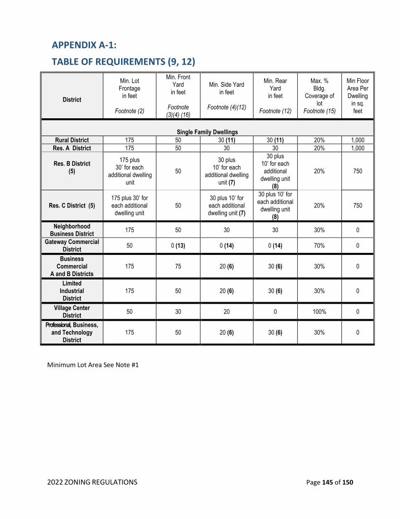
2022 ZONING REGULATIONS Page 145 of 150
APPENDIX A-1:
TABLE OF REQUIREMENTS (9, 12)
District
Min. Lot Frontage
in feet
Footnote (2)
Min. Front Yard
in feet
Footnote (3)(4) (16)
Min. Side Yard in feet
Footnote (4)(12)
Min. Rear Yard
in feet
Footnote (12)
Max. % Bldg.
Coverage of lot
Footnote (15)
Min Floor Area Per Dwelling
in sq. feet
Single Family Dwellings
Rural District 175 50 30 (11) 30 (11) 20% 1,000
Res. A District 175 50 30 30 20% 1,000
Res. B District (5)
175 plus 30’ for each
additional dwelling unit
50
30 plus 10’ for each
additional dwelling unit (7)
30 plus 10’ for each additional
dwelling unit (8)
20% 750
Res. C District (5) 175 plus 30’ for each additional
dwelling unit 50
30 plus 10’ for each additional dwelling unit (7)
30 plus 10’ for each additional
dwelling unit (8)
20% 750
Neighborhood Business District
175 50 30 30 30% 0
Gateway Commercial District
50 0 (13) 0 (14) 0 (14) 70% 0
Business Commercial
A and B Districts 175 75 20 (6) 30 (6) 30% 0
Limited Industrial District
175 50 20 (6) 30 (6) 30% 0
Village Center District
50 30 20 0 100% 0
Professional, Business, and Technology
District 175 50 20 (6) 30 (6) 30% 0
Minimum Lot Area See Note #1
2022 ZONING REGULATIONS Page 146 of 150
301 NOTES FOR TABLE:
1. Wetlands of a lot shall not be computed as part of the lot area. Minimum land area requirements for all districts shall be computed based on soil types as required in Table of Requirements Minimum Lot Area by soil type. Whenever a lot contains soils having two or more types of soil which pose different degrees of problems for on-site waste disposal systems, the minimum land area shall be computed by reference to the percentage of the total usable lot taken up by each soil type.
Whenever a lot contains multiple soils with two or three different degrees of limitation for on-site waste disposal systems, the leach field shall, whenever possible, be located on the soils which pose the least degree of limitation for the system. When computing minimum land areas under this Section, wetlands, flood plains, exposed ledge, easements except slope easements, and slopes greater than 25% shall not be counted.
When it has been determined that a lot has two or more slope types, the same method shall be used to determine the lot area as is used when the lot has two or more soil types. On lots with slope types C or greater, driveway profiles of the first 100 feet shall be provided. (See Windham Subdivision Regulations as amended.)
2. Said measurement shall be taken at a point fifty (50) feet from the nearest front lot line.
2.1. Private roads may be allowed to satisfy frontage requirements in Residence B District. Minimum standards for such private roads shall be Town Specifications, except that the width may vary according to traffic needs.
3. Providing that any residential front yard need only be the average of the depths of the front
yards of the abutting lots; the front yards of the abutting vacant lots shall be considered to have the minimum permitted.
4. In the case of a corner lot, all front lot lines shall be subject to the minimum front yard
requirements, and the remaining lot lines shall be considered side lot lines subject to the minimum side yard requirements.
4.1 In Residence B and Residence C Districts, when there is more than one (1) structure containing dwelling units on a lot, there shall be forty (40) feet minimum distance between such structures.
5. The following modifications to the “base” lot size (See Note #1) shall be made when dealing with
multifamily or duplex dwellings:
5.1 For each multifamily dwelling, 5,000 square feet of land area shall be added to the lot area for each bedroom in excess of two (2). For example: Each multifamily dwelling containing six two-bedroom dwelling units would be required to have a minimum of 100,000 square feet (i.e., 50,000 square feet plus 5,000 square feet for each bedroom in excess of two (2), or 50,000 square feet for a total minimum land area of 100,000 square feet. This example is based on soils which pose slight problems for on-site waste disposal systems.

2022 ZONING REGULATIONS Page 147 of 150
5.2 For a multifamily dwelling containing less than five (5) dwelling units, the area of land required per bedroom in excess of two (2) may be reduced as follows: For multifamily dwellings containing four (4) dwelling units, 4,000 square feet per bedroom; for multifamily dwellings containing three (3) dwelling units, 3,000 square feet per bedroom. A multifamily dwelling containing in excess of three (3) bedrooms per dwelling unit shall require 5,000 square feet per bedroom in excess of two (2).
5.3 For duplex dwellings, 2,000 square feet of land area shall be added for each bedroom in excess of two (2), provided further that if any unit in a duplex contains in excess of three (3) bedrooms, such unit shall require an additional 5,000 square feet per bedroom over three (3).
6. Fifty (50) feet where abuts Residential District.
7. The minimum side yard for each duplex or multifamily dwellings shall be thirty (30) feet plus ten
(10) feet for each additional dwelling unit in excess of one (1). (See Table of Requirements Minimum Side Yard.)
8. The minimum rear yard for each duplex or multifamily dwellings shall be thirty (30) feet plus ten
(10) feet for each additional dwelling unit in excess of one (1).
9. If a non-residential use (building, parking area, or driveway) is proposed closer than 100’ from a residential zoning district, a vegetative buffer or earthen berm 50’ wide must be provided, which will provide screening for the residential use.”
10. Intentionally omitted
11. For uses other than residential in the Rural District, there shall be one-hundred (100) feet where
abuts a residentially developed area.
12. Except that the minimum shoreland setback in non-WWPD areas for non-accessory buildings shall be fifty (50) feet from the reference line (Reference Line: For natural fresh water bodies = natural mean high water level; For artificially impounded fresh water bodies = water line at full pond).
13. A minimum setback from Range Road and Route 111 and Route 111A shall be fifty feet (50’).
14. A minimum fifty-foot (50’) landscaped buffer shall be required on any lot line where the
abutting parcel is not situated within the Gateway Commercial District.
15. Building coverage of lot shall only measure those buildings that have a roof and any attached and detached accessory buildings.
16. A front setback of 50 ft. shall be required from Route 111

2022 ZONING REGULATIONS Page 148 of 150
MIMIMUM LOT AREA BY SOIL TYPE NOTE: The following may not be a complete list of soil types in Windham. Contact the Soil Conservation Service or the Rockingham County Conservation District for assistance. The minimum lot area shall be 50,000 square feet and shall contain 30,000 square feet of contiguous area, except as defined in the Village Center District and the Open Space Residential Overlay District. The 30,000 square feet of contiguous area shall not include wetlands, the Wetland Watershed Protection District, or drainage easements. The area within the 30,000 square feet shall accommodate a minimum rectangular area of 10,000 square feet with a minimum dimension of 100 feet. The Planning Board may approve areas meeting the required area even though they do not meet the rectangular requirement. The principal structure shall be located entirely in the 10,000 square foot area. The Planning Board can allow the 10,000 square foot area to be located outside the 30,000 square foot area when the Board determines that the purpose of this ordinance would be better served with the required area in another location.
SOIL TYPE LOT SIZE SOIL TYPE LOT SIZE SOIL TYPE LOT SIZE
111BH 5OOOO 111CH 55OOO 111DH 75OOO
111EH NA 112BH 95OOO 112CH 100OOO
112DH 12OOOO 112EH NA 114* NA
11XBH 1OOOOO 11XCH 125000 11XDH 16OOOO
11XEH NA 121BH 5OOOO 121CH 55OOO
121DH 75OOO 121EH NA 122BH 95OOO
112CH 1OOOOO 122DH 12OOOO 122EH NA
124*H NA 12XBH 1OOOOO 12XCH 125OOO
12XDH 16OOOO 12XEH NA 161BH 6OOOO
161CH 7OOOO 161DH 9OOOO 161EH NA
164*H NA 166*H NA 16XBH 11OOOO
16XCH 14OOOO 16XDH 16OOOO 16XEH NA
211BH 5OOOO 211CH 55OOO 211DH 75OOO
211EH NA 21XCH 125OOO 212BH 95OOO
212CH 1OOOOO 212DH 12OOOO 212EH NA
213BH 6OOOO 213CH 95OOO 213DH 125OOO
213EH NA 214*H NA 21XBH 1OOOOO
21XDH 16OOOO 21XEH NA 221BH 5OOOO
221CH 55OOO 221DH 75OOO 221EH NA
222BH 95OOO 222CH 1OOOOO 222DH 12OOOO
222EH NA 223BH 6OOOO 223CH 95OOO
223DH 125OOO 223EH NA 224*H NA
22XBH 1OOOOO 22XCH 125OOO 22XDH 16OOOO
22XEH NA 231BH 5OOOO 231CH 55OOO
231DH 75OOO 231EH NA 233BH 6OOOO
233CH 95OOO 233DH 125OOO 233EH NA
234*H NA 23XBH 1OOOOO 23XCH 125000
23DXH 16OOOO 23XEH NA 241BH 6OOOO
241CH 95OOO 241DH 125OOO 241EH NA
243BH 6OOOO 243CH 95OOO 243DH 125OOO
244*H NA 24XBH 11OOOO 24XCH 16OOOO
24XDH 18OOOO 24XEH NA 251BH 11OOOO
251CH 16OOOO 251DH 16OOOO 251EH NA
253BH 11OOOO 253CH 16OOOO 253DH 16OOOO

2022 ZONING REGULATIONS Page 149 of 150
SOIL TYPE LOT SIZE SOIL TYPE LOT SIZE SOIL TYPE LOT SIZE
253EH NA 254*H NA 25XBH 16OOOO
25XCH 19OOOO 25XDH 24OOOO 25XEH NA
261BH 6OOOO 261CH 7OOOO 261DH 9OOOO
261EH NA 263BH 75OOO 263CH 1O5OOO
263DH 14OOOO 263EH NA 264*H NA
266*H NA 26XBH 11OOOO 26XCH 14OOOO
26XDH 16OOOO 26XEH NA 275*H NA
311BH 75OOO 311CH 11OOOO 311DH 15OOOO
311EH NA 312BH 12OOOO 312CH 155OOO
312DH 16OOOO 312EH NA 313BH 75OOO
313CH 11OOOO 313DH 15OOOO 313EH NA
314*H NA 31XBH 125OOO 31XCH 15OOOO
31XDH 16OOOO 31XEH NA 321BH 6OOOO
321CH 95OOO 321DH 125OOO 321EH NA
322BH 1O5OOO 322CH 125OOO 322DH 16OOOO
322EH NA 323BH 75OOO 323CH 11OOOO
323DH 15OOOO 323EH NA 324*H NA
32XBH 125OOO 32XCH 15OOOO 32XDH 16OOOO
32XEH NA 331BH 95OOO 331CH 125OOO
331DH 155OOO 331EH NA 333BH 95OOO
333CH 125OOO 333DH 155OOO 333EH NA
33XBH 145OOO 33XCH 16OOOO 33XDH 2O5OOO
33XEH NA 334*H NA 341BH 95OOO
341CH 125OOO 341DH 155OOO 341EH NA
343BH 95OOO 343CH 125OOO 343DH 155OOO
343EH NA 344*H NA 34XBH 145OOO
34XCH 16OOOO 34XDH 2O5OOO 34XEH NA
351BH 11OOOO 351CH 16OOOO 351DH 16OOOO
351EH NA 353BH 11OOOO 353CH 16OOOO
353DH 16OOOO 353EH NA 354*H NA
35XBH 16OOOO 35XCH 19OOOO 35XDH 24OOOO
35XEH NA 361BH 9OOOO 361CH 125OOO
361DH 16OOOO 361EH NA 363BH 9OOOO
363CH 125OOO 363DH 16OOOO 363EH NA
364*H NA 366*H NA 36XBH 14OOOO
36XCH 16OOOO 36XDH 17OOOO 36XEH NA
375*H NA 411BH 11OOOO 411CH 16OOOO
412BH 16OOOO 412CH 19OOOO 413BH 11OOOO
413CH 16OOOO 414*H NA 41XBH 16OOOO
41XCH 18OOOO 421BH 95OOO 421CH 145OOO
422BH 16OOOO 422CH 165OOO 423BH 11OOOO
423CH 16OOOO 424*H NA 42XBH 16OOOO
42XCH 18OOOO 431BH 145OOO 431CH 16OOOO
433BH 145OOO 433CH 16OOOO 434*H NA
43XBH 175OOO 43XCH 235OOO 441BH 145OOO
441CH 16OOOO 443BH 145OOO 443CH 16OOOO
444*H NA 44XBH 175OOO 44XCH 235OOO
451BH 160OOO 251CH 2O5OOO 453BH 16OOOO
453CH 2O5OOO 454*H NA 45XBH 195OOO
45XCH 285OOO 461BH 13OOOO 461CH 16OOO
463BH 13OOOO 463CH 16OOOO 464*H NA
466*H NA 46XBH 165OOO 46XCH 195OOO

2022 ZONING REGULATIONS Page 150 of 150
APPENDIX TO SECTION 601.2.1
1. Bogs are underlain by peat or muck deposits of significant depths and are characterized by a
distinct group of trees and plants which are adapted to the bog's highly acidic conditions.
The water in a bog is practically devoid of oxygen and nutrients. Bogs usually develop in
undrained glacial depressions.
1.1. Typical of the bog are: Sphagnum Moss (Sphagnum); Cotton grass Eriophorumspp.); Bog
rosemary (Andromeda Glaucophylla Leather leaf (Chamaedaphne Calyculata); Bog laurel
(Kalmia polifolia); Pitcher plant (Sarracenia purpurea); Sundews (Drosera spp);
Cranberries (Vaccinium oxycoccos and V. macrocarpon); Sweet Gale (Myrica gale); Bogbean
or Buckbean (Menyanthes trifoli¬ata); Bladderworts (urticularia spp.); Black Spruce (Pica
mariana); Larch or Tamarack (Larix laricina).
2. Marshes are treeless wetlands dominated by soft stemmed herbaceous plants. The surface of
the marsh is covered with water though seasonal fluctuations in water depth are expected.
Marshes range from the wet meadows variety to deep marshes which can be covered with
several feet of water.
2.1. Typical plants of the marsh are: Bur reeds (Sparganiaceae); Sedges, including bulrushes,
cotton grasses and wool grasses (Cyperaceae); Rushes (Junca¬ceae); Cat tails (Typhaceae);
Arums (Araceae); Smar weeds (Polygonum spp); Hydrophylous grasses (Gramineae); Frog's
bits (Hydrocharitaceae); Pickerel¬weeds (Pontederia spp.); Water lilies (nymphaeaceae);
Duckweeds (Lemnaceae).
3. Swamps are dominated by trees and shrubs. The water table is at or near the ground surface
for a significant part of the year.
3.1. Typical plants of swamps are: Red maple (Acer rubrum); Black ash (Fraxinus nigra); Willows
(Salix spp.); Alders (Alnus spp.); Black Gum (nyssa sylvatica); Common Elder (Sambucus
canadensis); Winterberry (Ilex vertidillata); Marsh rose (Rosa palustris); Arrow wood
(Viburnum recognitum); Wood reedgrasses (Cinna spp.); Skunk cabbage (Symplocarpus
foetidus); Marsh marigold (Caltha palustris); Button bush (Cephalenthus occidentalis);
White hellebore (Veratrum viride).