
town of eliot maine
242
-
Upload
khangminh22 -
Category
Documents
-
view
5 -
download
0
Transcript of town of eliot maine


TOWN OF ELIOT MAINE PLANNING OFFICE
1333 State Road Eliot ME, 03903
PUBLIC HEARING NOTICE
AUTHORITY: Eliot, Maine Planning Board PLACE: Remote Zoom Meeting DATE OF HEARING: Tuesday, February 16, 2021 TIME: 7:00 PM Notice is hereby given that the Planning Board of the Town of Eliot, Maine will hold a public hearing on Tuesday, February 16th, 2021 at 7:00 PM for the following application(s):
a) 7 Maclellan Lane (Map 37/Lot 19), PID # 037-019-000, PB20-05: Application for an 8,000 +/- sq. ft.
expansion to an existing 2,000 sq. ft. structure and Change of Use to add retail sales to existing approved uses (also includes a Shoreland Zoning Application for a portion of the site)
o Applicant: Blake Dubin o Owner: Blake Dubin
b) 62 Wildbrook Lane (Map 89/Lot 16), PID # 089-016-000, PB20-11: Application for an amendment to an approved Subdivision Plan to establish a private right-of-way on one lot
o Applicant: Nicole M. Elwell and Andrew J. Elwell o Owner: Arthur McCarthy
c) 290 Harold L Dow Highway (Map 37/Lot 20), PID # 037-020-000, PB20-28: Application for a Change of Use and Site Plan Amendment to expand the buildings on-site to include a 14,560 sq. ft. Agricultural Facility (Marijuana Establishment: Adult Use Marijuana Cultivation) and a 3,925 sq. ft. Adult Use Retail Building. Revised Plan also depicts a proposed 1,440 sq. ft. Temporary Adult Use Retail Trailer.
o Owner: DJR Real Estate, LLC o Applicant: DJR Real Estate LLC
d) 21 Foxbrush Drive (Map 50/Lot 19), PID # 050-019-000, PB20-27: New Shoreland Zoning Permit Application and Site Plan Amendment Application related to a previously approved Shoreland Zoning Permit/Site Plan Application for a residential building (single-family dwelling unit). The new application proposes to reduce the residential building’s footprint and shift its location on the property.
o Owner: Charles and Cheryl Tewell o Applicant: Charles and Cheryl Tewell
Interested persons may be heard and written communication received regarding this application at this hearing. The application is on file and available for review in the Planning Office at Eliot Town Hall, 1333 State Road, Eliot, ME 03903. The meeting agenda and information on how join the remote Zoom meeting will be posted on the web page at eliotmaine.org/planning-board.

A6 Saturday, February 6, 2021 | Portsmouth Herald | www.seacoastonline.com
OBITUARIES&NEWS
Philip Scarponi Jr.
PORTSMOUTH — Philip Scarponi Jr., 74, passed away suddenly on Monday, February 1, 2021. Born in Portsmouth on September 11, 1946 he was the son of the late Philip and Irene (Bartlett) Scarponi Sr.
He was a graduate of Portsmouth High School and the New Hampshire Technical Institute.
Philip was employed at Watts Fluidair in Kittery, retiring in 2011 after 42 years.
He was a loving husband, father and grandfather who enjoyed spending time with his family.
He was an avid gardener who took much pride in growing the best tomatoes and other vegetables. He also loved nature, delight-ing in everything from a big thunderstorm to the sight of a fox in the backyard.
Philip was looking forward to the start of the NASCAR season.
There was nothing he couldn’t fix – whenever anyone asked him for help, he’d always solve the prob-lem. He will be sadly missed.
Survivors include his wife of 53 years Shirley ( W o o d e s o n ) S c a r p o n i ,
children Philip Scarponi III and wife Tammy, Diane Scarponi and husband David Sulkis, Deidra Boucher and husband Jason, grandchil-dren Dominic Scarponi, Samantha Scarponi, and many cousins.
SERVICES: Services will be held at the convenience of the family. Arrangements are by the Farrell Funeral H o m e , 6 8 4 S t a t e S t . , Portsmouth.
In lieu of flowers, please consider a donation to the American Diabetes Association, P.O. Box 7023, Merrifield, VA 22116-7023.
Twenty staff members at the Edgewood Centre have tested positive for COVID-19.
According to state health officials, the Edgewood Centre is one of 26 insti-tutions across the state designated as having an active coronavirus outbreak.
T h e f a c i l i t y f i r s t announced their outbreak on Jan. 21, just over two weeks since their first vaccina-tion clinic held on Jan. 4 in
partnership with Walgreens pharmacy.
Cummings previously told Seacoastonline all residents consented to receiving the vaccine and nearly 90% had got their first shot at the Jan. 4 clinic.
"Our residents and their families remain our top pri-ority for they are the true victims of this insidious virus," a statement from the facility announcing the out-break read.
Pre-planning had occurred for months to prepare for the possibility of an outbreak at the Centre, Cummings had added.
New Hampshire health
officials, as of Thursday, had reported 1,085 coronavi-rus deaths, with 795 coming in long-term care facili-ties (73.3% of all deaths). According to the Kaiser Family Foundation, this percentage is highest in the nation by several percent-age points. New Hampshire is one of 13 states where between 50-75% of COVID-19 fatalities are taking place in long-term care facilities, which also reflects a lower death rate in the state of non-nursing home residents.
The Jan. 21 press release from the Edgewood Centre also spoke to the numer-ous challenges its residents
had seen in their lifetimes, including multiple wars and social and racial injustice.
“They are resilient, and they are most certainly survivors. On behalf of the entire staff, now more than ever, we commit ourselves to providing unparalleled care and comfort during this most difficult time. We thank our government public health partners for their help and guidance,” the statement continued.
With an additional 433 cases added Thursday, the state currently has 4,099 registered active cases of COVID-19 and is seeing a 3.1% test positivity rate.
Barbieri received her first COVID-19 vaccine right
before Christmas and fol-lowed that up with a second shot mid-January.
“Everyone that met the criteria and everyone that entered the raffle received a ticket to the Super Bowl,”
s a i d B a r b i e r i , a 2 0 1 6 Winnacunnet graduate.
About 3,000 employees of the hospital were able to receive a ticket. Barbieri found out Jan. 27 that she would be attending the game.
Barbieri initially thought she hadn’t been selected since she didn’t receive an email in the morning like some of her co-workers did. “I was like, ‘Oh I didn’t win, whatever,’” said Barbieri.
“I’m happy for them.”Later that day, while
Barbieri was attending her nursing clinicals in the labor-delivery unit, someone suggested that all employees should check their emails. “Oh, let me just check with some down time,” Barbieri said. “It was like, ‘Congratulations, you’re a winner of a Super Bowl ticket.’ Everyone was pumped.”
Barbieri is one of 11 people she knows who will be attending the game. “One of my best friends who’s a nurse at another local hospital, she also won a ticket,” she said.
Wounded Warrior commercial, too
The good news for the Barbieri family doesn’t
stop there. The Wounded Warrior Project invited the family to participate in a commercial that would air during the Super Bowl.
B a r b i e r i ’ s m o t h e r , Christine, who is a veteran of the Air Force, has a ser-vice dog to help her with her Type 2 Diabetes.
The family was recently in Tampa eating at one of the venues when they were approached with the invite. Barbieri’s parents still live in New Hampshire, but peri-odically travel to Tampa to visit with their daughter. “It just happened to be that they were down this time,” said Barbieri.
“They were invited to get featured for the Wounded Warrior segment they were doing with CBS Sports with their service dogs,” said
Barbieri.The Wounded Warrior
Project is a charity and vet-eran service organization that provides numerous programs and services for veterans.
Barbieri said she is not sure if her mother will be able to attend or not, but the invite was still exciting.
A s f o r t h o u g h t s o n attending her first Super Bowl, Barbieri said, “It’s just unbelievable. I’m just ecstatic.”
BARBIERIFrom Page A1
Caitlyn Barbieri, a 2016
graduate from Winnacunnet
High School and a nurse at
Tampa General Hospital, will
be in attendance at Sunday’s
Super Bowl LV at Raymond
James Stadium. [COURTESY]
OUTBREAKFrom Page A1
The Edgewood Centre in Portsmouth. [COURTESY]
I N B R I E F
WASHINGTON
Pentagon will deploy troops to assist vaccine drive
The Pentagon will deploy troops to assist getting A m e r i c a n s v a c c i n a t e d against COVID-19, the White House said Friday.
C o r o n a v i r u s s e n i o r a d v i s e r A n d y S l a v i t t announced that Defense Secretary Lloyd Austin has approved a request for assistance from the Federal Emergency Management Agency. It means about 1,000 active duty military personnel will deploy to help state vaccination centers.
President Joe Biden has called for setting up 100 mass vaccination centers around the country within a month. Two are opening in California, and Slavitt said military personnel will arrive at those centers in a little over a week.
The Pentagon has sched-uled a news briefing later
Friday to provide more information about the mili-tary role.
BERLIN
Tiny chameleon a contender for title of smallest reptile
It fits on a human fin-gertip, but this chameleon could make a big splash.
S c i e n t i s t s f r o m Madagascar and Germany say a newly discovered species of chameleon is a contender for the title of world’s smallest reptile.
Frank Glaw, who was part of the international team of researchers that classified the new species and named it Brookesia nana said the
body of the male specimen appeared to be just 13.5-mil-limeters-long (a little more than a 1 /2-inch.)
That’s at least 1.5 mil-limeters smaller than the previous record holder, another member of the Brookesia family.
The Associated Press
By Alan Fram and Brian SlodyskoThe Associated Press
WASHINGTON — Rep. Marjorie Taylor Greene l a s h e d o u t Friday at “morons” in both parties who voted to kick her off her com-mittees, a day after the House meted out the unprecedented punishment that Democrats said she’d earned by spread-ing hateful and violent conspiracy theories.
Underscoring the politi-cal vise her inflammatory commentary has clamped her party into, all but 11 Republicans voted against the Democratic move on Thursday but none rose to defend her lengthy history of outrageous social media posts.
In the most riveting moment of that day’s debate, the freshman Republican from a deep-red corner of Georgia took to the House floor on her own behalf. She offered a mixture of backped-aling and finger-pointing as she wore a dark mask embla-zoned with the words “FREE SPEECH.”
The chamber’s near party-line 230-199 vote was the latest instance of conspiracy
theories becoming pitched political battlefields, an increasingly familiar occur-rence during Donald Trump’s presidency. He faces a Senate trial next week for his House impeachment for inciting insurrection after a mob he fueled with his false narrative of a stolen election attacked the Capitol.
Thursday’s fight also underscored the uproar and political complexities that Greene — a master of provok-ing Democrats, promoting herself and raising campaign money — has prompted since becoming a House candidate last year.
Greene showed no signs of repentance Friday.
“I woke up early this morning literally laughing thinking about what a bunch of morons the Democrats (+11) are for giving some one like me free time,” she tweeted.
At a news conference later outside the Capitol, Greene accused news organizations of “addicting our nation to hate.” She deflected a ques-tion about her past online suggestion that House Speaker Nancy Pelosi could be executed for treason, and warned that Republicans
opposing her should remem-ber that Trump — with whom she is closely allied — controls the GOP.
“The party is his,” she said. “It doesn’t belong to anybody else.”
A day earlier on the House floor, Greene tried to dissoci-ate herself from her “words of the past.” Contradicting past social media posts, she said she believes the 9/11 attacks and mass school shoot-ings were real and no longer believes QAnon conspiracy theories, which include lies about Democratic-run pedo-phile rings.
But she didn’t explicitly apologize for supportive online remarks she’s made on other subjects, as when she mulled Pelosi, D-Calif., being assassinated or the possibility of Jewish-controlled space rays causing wildfires. And she portrayed herself as the victim of unscrupulous “big media companies.”
News organizations “can take teeny, tiny pieces of words that I’ve said, that you have said, any of us, and can portray us as someone that we’re not,” she said. She added that “we’re in a real big problem” if the House punished her but tolerated
“members that condone riots that have hurt American people” — a clear reference to last summer’s social jus-tice protests that in some instances became violent.
G r e e n e w a s o n t h e E d u c a t i o n a n d L a b o r Committee and the Budget Committee. Democrats were especially aghast about her assignment to the edu-cation panel, considering the past doubt she cast on school shootings in Florida and Connecticut.
The political imperative for Democrats was clear: Greene’s support for violence and fictions was dangerous and merited punishment. Democrats and researchers said there was no apparent precedent for the full House removing a lawmaker from a committee, a step usually taken by their party leaders.
The calculation was more complicated for Republicans.
Though Trump left the White House two weeks ago, his devoted followers are numerous among the party’s voters, and he and Greene are allies. Minority Leader Kevin McCarthy, R-Calif., hopes GOP victories in the 2022 elections will make him speaker.
Greene: ‘Morons’ voted to boot her from committees
PUBLIC HEARING NOTICE
AUTHORITY: Eliot, Maine Planning BoardPLACE: Remote Zoom MeetingDATE OF HEARING: Tuesday, February 16, 2021TIME: 7:00 PM
Notice is hereby given that the Planning Board of the Town of Eliot, Maine will hold a public hearing on Tuesday, February 16th,2021 at 7:00 PM for the following application(s):
a) 7 Maclellan Lane (Map 37/Lot 19), PID # 037-019-000, PB20-05: Application for an 8,000 +/- sq. ft. expansion to anexisting 2,000 sq. ft. structure and Change of Use to add retail sales to existing approved uses (also includes a ShorelandZoning Application for a portion of the site)
o Applicant: Blake Dubino Owner: Blake Dubin
b) 62 Wildbrook Lane (Map 89/Lot 16), PID # 089-016-000, PB20-11: Application for an amendment to an approvedSubdivision Plan to establish a private right-of-way on one lot
o Applicant: Nicole M. Elwell and Andrew J. Elwello Owner: Arthur McCarthy
c) 290 Harold L Dow Highway (Map 37/Lot 20), PID # 037-020-000, PB20-28: Application for a Change of Use and Site PlanAmendment to expand the buildings on-site to include a 14,560 sq. ft. Agricultural Facility (Marijuana Establishment: AdultUse Marijuana Cultivation) and a 3,925 sq. ft. Adult Use Retail Building. Revised Plan also depicts a proposed 1,440 sq. ft.Temporary Adult Use Retail Trailer.
o Owner: DJR Real Estate, LLCo Applicant: DJR Real Estate LLC
d) 21 Foxbrush Drive (Map 50/Lot 19), PID # 050-019-000, PB20-27: New Shoreland Zoning Permit Application and Site PlanAmendment Application related to a previously approved Shoreland Zoning Permit/Site Plan Application for a residentialbuilding (single-family dwelling unit). The new application proposes to reduce the residential building’s footprint and shift itslocation on the property.
o Owner: Charles and Cheryl Tewello Applicant: Charles and Cheryl Tewell
Interested persons may be heard and written communication received regarding this application at this hearing. The applicationis on file and available for review in the Planning Office at Eliot Town Hall, 1333 State Road, Eliot, ME 03903. The meeting agendaand information on how join the remote Zoom meeting will be posted on the web page at eliotmaine.org/planning-board.
LEGAL NOTICEPLANNING BOARD
PORTSMOUTH, NEW HAMPSHIRE
NOTICE IS HEREBY GIVEN that the Planning Board will hold a public hearing on the following applications on Thursday,February 18, 2021 starting at 7:00 p.m. via Zoom Conference Call (details below).
A separate meeting will be held on Thursday, February 25, 2021 to hear additional petitions, for which a separate Legal Notice will bepublished.
The application of Clipper Traders, LLC, Portsmouth Hardware and Lumber, LLC, Owners and Iron Horse Properties, LLC,Owner and Applicant, for properties located at 105 Bartlett Street and Bartlett Street requesting Site Plan Review approval for thedemolition and relocation of existing structures and the construction of 152 dwelling units in 3 buildings, and associated communityspace, paving, lighting, utilities, landscaping and other site improvements. Said properties are shown on Assessor Map 157 Lot 1 andLot 2 and Assessor Map 164 Lot 1 and 4-2 and lie within the Character District 4-W (CD4-W) and Character District 4-L1 (CD4-L1)Districts.
The application of Clipper Traders, LLC, Portsmouth Hardware and Lumber, LLC, Owners and Iron Horse Properties, LLC,Owner and Applicant, for properties located at 105 Bartlett Street and Bartlett Street requesting Wetland Conditional Use PermitApproval in accordance with Section 10.1017 of the Zoning Ordinance for work within the 25-foot, 50-foot, and 100-foot wetlandbuffers to North Mill Pond which includes the removal of existing impervious surfaces and buildings, construction of 3 stormwateroutlets, repaving of an existing access drive and parking lot, construction of a linear waterfront trail and community space, andconstruction of three new buildings which will result in a net overall reduction in impervious surfaces of 28,792 square feet. Saidproperties are shown on Assessor Map 157 Lot 1 and Lot 2 and Assessor Map 164 Lot 1 and 4-2 and lie within the Character District4-W (CD4-W) and Character District 4-L1 (CD4-L1) Districts.
The application ofMichael Petrin, Owner, for property located at 239 Northwest Street requesting Wetland Conditional UsePermit approval in accordance with Section 10.1017 of the Zoning Ordinance to renovate an existing home with portions of thenew construction in the wetland buffer. Said property is shown on Assessor Map 122 Lot 3 and lies within the General Residence A(GRA) District.
The application ofMichael J. O’Connor, Owner, for property located at 163 Sparhawk Street requesting Wetland Conditional UsePermit approval in accordance with Section 10.1017 of the Zoning Ordinance for in-kind replacement of garage steps and a landingand installation of stormwater infiltration. Said property is shown on Assessor Map 159 Lot 7 and lies within the General ResidenceA (GRA) District.
The application of Robert Gigliotti, Owner, for property located at 292 Lang Road requesting Wetland Conditional Use Permitapproval in accordance with Section 10.1017 of the Zoning Ordinance to construct an addition of an entryway to the front of thehouse and a deck behind the house, along with a replacement tank and associated piping within the wetland buffer zone. Saidproperty is shown on Assessor Map 287 Lot 4 and lies within the Single Residence B (SRB) District.
Application of JJCM Realty, LLC and Topnotch Properties, LLC, Owners, for property located at 232 South Street requestingWetland Conditional Use Permit approval in accordance with Section 10.1017 of the Zoning Ordinance to construct a new deckand staircase onto the existing residential structure, relocate an existing storage shed and install native plantings in the buffer. Saidproperty is shown on Assessor Map 111 Lot 2 and lies within the Single Residence B (SRB) District.
Juliet T.H. Walker, AICPPlanning Director
You are required to register to join the meeting over Zoom, a unique meeting ID and password will be provided once you register.Registration information will be provided on the meeting agenda when it is posted to the web page. For technical assistance, pleasecontact the Planning Department by email ([email protected]) or by phone 610-7216.
Note: The Agenda for the Planning Board meeting will differ from the Legal Notice. For information on the Agenda call the PlanningDepartment at 610-7216 or check the City’s website at www.cityofportsmouth.com/planportsmouth/planning-board.
Need to place a legal noticein the Portsmouth Herald, Exeter News-Letter, HamptonUnion, Foster’s Daily Democrat or Seacoast Sunday?
Email your request to: [email protected] include: notice text, publication name and
date to publish along with your contact info

PB20-5: 7 MacLellan Ln. (Map 37/Lot 19): Site Plan Review for an 8,000 +/- sq. ft. expansion to an existing 2,000 sq. ft. structure and Change of Use to add retail sales to existing approved uses – Public Hearing
1
To: Planning Board From: Jeff Brubaker, AICP, Town Planner Cc: John Chagnon, PE, LLS, Ambit Engineering, Applicant’s Representative
Blake Dubin, Applicant Shelly Bishop, Code Enforcement Officer
Kearsten Metz, Land Use Administrative Assistant Date: February 10, 2021 (report date) February 16, 2021 (meeting date) Re: PB20-5: 7 MacLellan Ln. (Map 37/Lot 19), PID # 037-019-000: Site Plan Review
for an 8,000 +/- sq. ft. expansion to an existing 2,000 sq. ft. structure and Change of Use to add retail sales to existing approved uses (also includes a Shoreland Zoning Application for a portion of the site) – Public Hearing
Updated from the December 15, 2020, and January 19, 2021, meeting staff reports
Application Details/Checklist Documentation Address: 7 MacLellan Lane Map/Lot: 37/19 PB Case#: 20-5 Zoning District: Commercial/Industrial (C/I) Shoreland Zoning
District(s): Resource Protection, Limited Commercial
Property Owner Name: Blake Dubin Applicant Name: Blake Dubin Proposed Project: Site Plan Review
• Site Plan Amendment for an 8,000 +/- sq. ft. building expansion
• Change of Use to add retail sales to existing approved uses
• 1-19-21 update: application revised to eliminate any expansion of the manufacturing use and devote the building expansion entirely to retail use
Shoreland Zoning Application (portion of property)

PB20-5: 7 MacLellan Ln. (Map 37/Lot 19): Site Plan Review for an 8,000 +/- sq. ft. expansion to an existing 2,000 sq. ft. structure and Change of Use to add retail sales to existing approved uses – Public Hearing
2
Overview Applicant Blake Dubin (agent: Ambit Engineering) is seeking site plan review and approval of a Site Plan Amendment and Change of Use at 7 MacLellan Ln. (Map 37, Lot 19). The 3.1-acre property is located on the corner of MacLellan Ln. and Harold L. Dow Hwy. According to the application cover letter:
The project consists of the addition of an 8,000 SF building (attached to the existing building) at the site with the associated site improvements. The proposal
Sketch Plan Application Received by
Staff: January 21, 2020 (initial submittal withdrawn) February 3, 2020 (new submittal) January 7, 2021 (updated submittal)
Application Fee Paid and Date:
$300 January 21, 2020
Application Sent to Staff Reviewers:
February 6, 2020
Sketch Plan Heard by PB May 12, 2020 Site Plan Review Application Application Received by
Staff: December 1, 2020
Application Fee Paid and Date:
$400 (SP Amend. – $100; Chg. of Use – $25; SLZ App. – $100; P.H. – $175) December 1, 2020
Application Sent to Staff Reviewers:
December 1, 2020
Application Heard by PB Found Complete by PB
December 15, 2020; January 19, 2021; February 16, 2021 (scheduled) January 19, 2021
Site Walk None Public Hearing February 16, 2021 (scheduled) Public Hearing Publication Feb. 1, 2021 (posted); Feb. 6, 2021 (newspaper) Deliberation TBD Notice of Decision TBD Reason for PB Review: Site Plan Review/Amendment (building addition);
Change of Use; Shoreland Zoning

PB20-5: 7 MacLellan Ln. (Map 37/Lot 19): Site Plan Review for an 8,000 +/- sq. ft. expansion to an existing 2,000 sq. ft. structure and Change of Use to add retail sales to existing approved uses – Public Hearing
3
will expand the existing manufacturing use and add an unspecified retail component. January 19, 2021, update: The applicant has revised their application so that no manufacturing expansion is proposed. The proposed building expansion would be devoted entirely to retail use (unspecified).
The Site Plan Review application package includes a cover letter; Site Plan Review application; abutter’s list; warranty deed; wetland delineation report; approved subsurface wastewater disposal system application (HHE-200); email regarding septic being inspected and in working order; drawings/elevations for the proposed building expansion; January 2019 NOD; drainage analysis; stormwater inspection and maintenance plan; and site plan set. The site plan set includes a 1”=500’ location map; standard boundary and topo survey; existing conditions and demolition plan; site layout plan; drainage and grading plan; utility plan; and detail sheets. A Shoreland Zoning Application was also submitted to show the extent of the shoreland zoning districts and the site improvements in those districts.
January 19, 2021, update: Additional documents submitted for this meeting include a new cover letter, a waiver request related to required loading zones, a trip generation calculation memo, lighting specifications, a septic suitability memo, and updated building elevations. February 16 update: A new cover letter and site plan set has been submitted reflecting revisions based on the January 19 Planning Board review.
Zoning The property is located in the Commercial/Industrial (C/I) District. It also includes Resource Protection (RP) and Limited Commercial (LC) shoreland zoning districts. Uses The applicant is requesting approval to add unspecified retail sales at the site. The current approved use is manufacturing for the extraction of industrial hemp and/or other botanical oils (see January 2019 NOD). Before that, the site was used as a car wash. “Retail stores, local, other” are an SPR use in the C/I District in the 45-290 land use table. The Section 1-2 definition is: “Retail stores, local, other, means a store that specializes in the sale of a limited quantity and variety of items.”

PB20-5: 7 MacLellan Ln. (Map 37/Lot 19): Site Plan Review for an 8,000 +/- sq. ft. expansion to an existing 2,000 sq. ft. structure and Change of Use to add retail sales to existing approved uses – Public Hearing
4
Since it was previously discussed, it should be noted that the applicant is not applying for approval to add a marijuana use with this application.
January 19, 2021, update: As stated above, the proposed building expansion would be used fully for retail and not for expanded manufacturing.
Type of review needed (February 16 update) Sketch plan review occurred on May 12, 2020, and a first round of full site plan review occurred on December 15, 2020. The January 19, 2021, meeting included continued review of the application, including the new information submitted by the applicant. The Board voted at this meeting to find the application complete and ready for public hearing. Requested information waivers
• 33-127(12) – High Intensity Soils Report Shoreland zoning The application package includes a shoreland zoning application for the portion of the site improvements in the shoreland zone (about 12,000 sq. ft.). The application states that the project “proposes to decrease the impervious area in the portion of the zone on the property”. Lot coverage Maximum lot coverage in the C/I District is 50%. Per site layout plan (sheet C2), the proposed expansion will increase the lot coverage from 21% to 32.5%. The total disturbed area would be 51,755 sq. ft. (Note 4).
January 19, 2021, update: With the updated submittal, there is a slight increase in the project disturbed area by 100 sq. ft., to 51,855 sq. ft. February 16 update: The new site plan’s disturbed area continues to be reported as 51,855 sq. ft. (sheet C2).
Setbacks Setbacks are listed in Note 6 of the boundary survey and drawn on the plan sheets. Existing features such as the sign along Route 236 and a utility panel are in the front setback. The improvements appear to meet all required lot line setbacks. Since this is a corner lot, there are 2 front lot lines – for Route 236 and MacLellan Ln.

PB20-5: 7 MacLellan Ln. (Map 37/Lot 19): Site Plan Review for an 8,000 +/- sq. ft. expansion to an existing 2,000 sq. ft. structure and Change of Use to add retail sales to existing approved uses – Public Hearing
5
Wetlands Wetlands exist on and near the site, which is close to the confluence of Little Brook and Great Brook into Sturgeon Creek. A 75-ft. wetland buffer is shown on the plan. Some of the developed portion of the existing site is within the buffer, including part of the driveway and parking area, accessory buildings, and about half of the leach field. The Wetland Notes on sheet C1 describe how the wetlands were delineated and flagged. A wetland delineation report, dated 1/17/20, is included in the application package. The site layout plan (sheet C2) shows the majority of proposed improvements outside of the wetland buffer, including the ~8,000 sq. ft. building addition. Utilities (summary) The cover letter provides a summary of the existing utility services:
The site is served by the following utilities: • Water service: Existing well • Sewer Service: Existing Septic System • Electrical Service: Existing service and pad mounted transformer • Gas Service: Existing Propane Tank • Trash Removal: Existing Dumpster
Water service The site plan sheets show the existing well in the southern corner of the property, south of the parking area. The water line to the existing building would be modified to terminate at the expanded building. Septic system The septic system and leach field are located in the eastern corner of the site. An approved subsurface wastewater disposal system application (HHE-200) from 2005, for the previous car wash use, is included in the application package. The system includes a 1,000-gallon tank, a carbon filtration system, a pump chamber, a 10,400 sq. ft. leach field, and a design flow of 1,950 gpd. The applicant plans to use the existing septic system for the expanded building. An email from the applicant included in the package states the septic system “was inspected and was in working order” in April 2019. The HHE-200 form shows how the leach field is just outside the protective well radius. The Planning Board may wish to confirm with the applicant how the wastewater demand of the expanded building will be met with the existing septic system, although the wastewater-intensive car wash use has gone away.

PB20-5: 7 MacLellan Ln. (Map 37/Lot 19): Site Plan Review for an 8,000 +/- sq. ft. expansion to an existing 2,000 sq. ft. structure and Change of Use to add retail sales to existing approved uses – Public Hearing
6
January 19, 2021, update: A septic suitability memo was submitted on December 15 and is now included in the packet. While this reflects the previous iteration of uses (expanded manufacturing), the memo shows a proposed flow (demand) of 601 gpd, compared with the existing septic system’s design flow of 1,950 gpd, leaving a significant surplus capacity. However, this may be something the Planning Board would want to discuss further with the applicant since the proposed retail use would now be filling out all of the proposed building expansion. February 16 update: The applicant addressed wastewater demand at the January 19 meeting, further describing the surplus capacity with a 1,950 gpd system.
Trash removal The waste container is located in the rear of the site, behind the building. Enclosure or screening of waste containers is required by 45-422(a)(2), if they would be otherwise visible from a public way or located within 50 feet of a residential structure. The waste container seems mostly to be screened from Route 236 by the existing building and vegetation and would be further screened by the building expansion and additional vegetative screening (discussed further below), and no residential structures are within 50 ft. However, the Planning Board may wish to confirm with the applicant whether the existing waste container is of sufficient size and capacity for the proposed expanded manufacturing and new retail uses (45-422(c)).
January 19, 2021, update: The dumpster would be relocated from its present location, in the rear of the property, closer to the existing shed and further away from the wetland area. The dumpster enclosure detail is now shown on Sheet D4.
TIF District The property is an original TIF parcel. The Route 236 Sewer & Water Extension project will install water and sewer (gravity/forcemain) lines along Route 236 by the site. Parking Parking calculations are included in Note 3 on the site layout plan (sheet C2). Rates used include:
• Manufacturing: 1 space/employee (15 employees, 15 spaces) • Retail: 1 space/150 sq. ft. (4,000 sq. ft., 27 spaces)
The applicant has met the minimum parking requirements (45-495): 42 spaces are required, and 53 are provided. While applicants can exceed the minimum, if the

PB20-5: 7 MacLellan Ln. (Map 37/Lot 19): Site Plan Review for an 8,000 +/- sq. ft. expansion to an existing 2,000 sq. ft. structure and Change of Use to add retail sales to existing approved uses – Public Hearing
7
Planning Board believes other site plan elements are needed to address other performance standards, the Board may wish to discuss with the applicant adding these in place of some number of the “surplus” 11 spaces. Such elements could include, but are not limited to, additional front vegetative screening or foundation planting, additional rear planting in the wetland buffer, or designated loading space. The applicant proposes 40 regular non-employee spaces, 3 ADA-accessible spaces, and 10 designated employee spaces. Parking space and aisle dimensions are shown on the plan. The minimum 180 sq. ft. parking space size requirement appears to have been met. The ADA spaces have adjacent access aisles. For the 2 ADA spaces on the south side of the building, the access aisle is flush with the sidewalk. For the 1 ADA space on the north side of the building, it is unclear what accessible entrance is accessed from the access aisle. This should be clarified by the applicant. ADA space details are on sheet D2.
January 19, 2021, update: With the updated amount of retail space (8,000 sq. ft.), the parking calculations have been updated (see sheet C2). 60 spaces are now required, and the site plan continues to show 53 spaces, leaving a deficit of 7 spaces. The Planning Board should discuss this further with the applicant. February 16 update: The updated site layout plan (sheet C2) now shows 60 total spaces provided (4 ADA spaces, 56 regular) to meet the required number. Additional parking as been added on the east side of the site, near the septic field.
Loading The site layout plan (sheet C2) shows one loading area next to 4 parking spaces on the northeast side of the existing building. 45-494 requires 1 loading bay or berth for retail, wholesale, warehouse and industrial operations between 2,000 and 5,000 sq. ft. 4,000 sq. ft. of retail space would require 1 loading bay and 6,000 sq. ft. of manufacturing would require 2 bays. It is recommended that the applicant address loading needs and the number of required bays, and relocate the loading area shown on the plan so that it doesn’t obstruct parking spaces.
January 19, 2021, update: The updated submittal includes a waiver request letter to provide 1 loading bay instead of the required 2 (for 5,001-40,000 sq. ft. of retail space). The Board should discuss this with the applicant. February 16 update: The updated site layout plan (sheet C2) now shows 2 loading zones to address 45-194. The waiver request has been withdrawn.
Sidewalk The site layout plan (sheet C2) proposes a 5-6-ft. sidewalk along about half of the perimeter of the expanded building.

PB20-5: 7 MacLellan Ln. (Map 37/Lot 19): Site Plan Review for an 8,000 +/- sq. ft. expansion to an existing 2,000 sq. ft. structure and Change of Use to add retail sales to existing approved uses – Public Hearing
8
Screening Section 33-175(b):
Front yards, especially those along Rte. 236, shall have an extensive vegetative cover, including large shade trees. Areas along Rte. 236 shall be 50 feet in width, beginning at the 50-foot setback line and extending to the rear of the front yard so as to screen the proposed use. Similarly, half of the front yard for commercial or industrial uses on other streets shall be landscaped.
Fronting Route 236, the site currently has some trees, but it is relatively visually open to the highway. The site layout plan (sheet C2) shows new shade trees and shrubs within the Route 236 and MacLellan Ln. front setbacks, including a planting schedule. Oaks are spaced along both roads. The proposed planting does not appear to meet the depth called for in 33-175(b). It is recommended that the depth of planting be increased, although some of the Route 236 setback area is devoted to stormwater management structures. 33-175(c) also requires a partial foundation planting. While some planting is close to the existing building and the building addition, primarily in the form of planted islands next to parking spaces, the Planning Board may wish to discuss with the applicant whether additional foundation planting is desired. Some existing tree buffering exists between this property and adjacent properties.
January 19, 2021, update: Sheet C2 now shows a wider Route 236 vegetative screening by laterally staggering the proposed tree and shrub plantings. There is now additional foundation planting along the MacLellan Ln. side of the building.
Ch. 25 - Floodplain Management Ordinance According to Note 3 on the boundary survey and supported by online GIS, the site is not located in a flood hazard zone. Stormwater As noted above, the proposal would result in 51,755 sq. ft. of disturbed area. The table on the site layout plan (sheet C2) shows how the project would increase the total impervious area from 28,313 to 43,781 sq. ft. – just over 1 acre. The main contributors to the impervious area increase are the building addition and additional pavement for parking. The project is subject to Maine DEP Chapter 500 Stormwater Management Rules and Section 45-411 and Chapter 35 of the Town Code. The project is not within the MS4 urbanized area.

PB20-5: 7 MacLellan Ln. (Map 37/Lot 19): Site Plan Review for an 8,000 +/- sq. ft. expansion to an existing 2,000 sq. ft. structure and Change of Use to add retail sales to existing approved uses – Public Hearing
9
The drainage and grading plan (sheet C3) shows the location of stormwater management structures, including a detention pond, swale (sized for a 100-year storm), concrete weir, and rip rap in the Route 236 setback and behind the building. The roof gutter on the building addition would drain into an existing catch basin. Note 3 also commits to installation of erosion control measures consistent with Maine DEP guidance. Stormwater management structure details are on detail sheets D3 and D4 of the site plan set. The application packet includes a drainage plan/analysis that proposes “multiple strategies toward reducing the burden of stormwater runoff on the property and surrounding area”. The drainage plan notes that the site currently “does not have any modern Stormwater Treatment BMP’s in place. The majority of existing runoff flows off-site untreated.” Stormwater flowing into the detention pond would drain via either the “swale leading to a drainage ditch [or] an outlet control structure leading to wetlands surrounding the property”. Other parts of the site would drain into the existing catch basin and then to the wetlands. The post-development drainage analysis concludes (p. 4):
The additional flows to the site were considered were able to be mitigated with the use of a detention pond west of the parking lot. The wetland outflow experienced a negligible rise in the 2-year event, but otherwise the system experienced significant reductions or maintained the peak flow in all other areas. The 100-year storm was also designed so that the site would not experience flooding during certain more extreme storm events.
The analysis further concludes that the “likely impact on the surrounding [town] infrastructure will be minimal”. The overall conclusion of the drainage analysis is (p. 5):
This analysis has calculated the runoff for the existing site and for the proposed developed site for [the site] on Route 236 in Eliot, ME. The proposed development will not significantly impact either the town infrastructure or the surrounding wetlands. Erosion and sediment control practices will be implemented for both the temporary condition during construction and for final stabilization after construction. There are no negative impacts to downstream receptors or adjacent properties anticipated as a result of this project.
The application package also includes a stormwater inspection and maintenance plan.
January 19, 2021, update: Sheet C3 now includes a note: “Maine DEP stormwater PBR application required”. The revised plan slightly increases the post-construction impervious square footage to 43,891, from 43,781 in the previous iteration. The roof drain discharge has been added to Sheet C4.

PB20-5: 7 MacLellan Ln. (Map 37/Lot 19): Site Plan Review for an 8,000 +/- sq. ft. expansion to an existing 2,000 sq. ft. structure and Change of Use to add retail sales to existing approved uses – Public Hearing
10
February 16 update: As of 2/10, DEP correspondence had not yet been received. Any subsequent correspondence will be reported at the PB meeting.
Erosion and sedimentation control The drainage plan (p. 4) and detail sheet (D1) describe erosion control measures required during construction. Signage The applicant proposes to reuse the existing Route 236 sign. This sign looks to be within 8 ft. of the ROW boundary, in which case it would need to be moved back (45-532).
January 19, 2021, update: The sign will need to be moved back at least 8 ft. from the Route 236 right-of-way, or a variance will be needed. See the December 23, 2020, email from the Town Attorney included in the package. February 16 update: The applicant has committed to moving the sign back 8 ft. from the ROW/lot line.
Building elevations The application package includes front, back, and side elevations to show the look and design of the proposed building addition.
January 19, 2021, update: New architectural plan elevations, submitted December 15, 2020, are now in the packet.
Previous Planner staff report considerations Considerations from David Galbraith’s report, from May 5, 2020, are listed below, including a note on whether and how they have been addressed by the applicant. Requiring a Landscape Plan to be submitted. The site layout plan (sheet C2) now includes planting locations and a planting schedule. Sidewalks illustrated do not include handicapped access “tip-downs”. Most of the sidewalk can be accessed from the ADA-accessible parking spaces on the south side of the building because it is flush with the access aisle. There are, however, steps that make a portion of the sidewalk inaccessible.

PB20-5: 7 MacLellan Ln. (Map 37/Lot 19): Site Plan Review for an 8,000 +/- sq. ft. expansion to an existing 2,000 sq. ft. structure and Change of Use to add retail sales to existing approved uses – Public Hearing
11
Existing curb opening is ranges from 52 feet wide to 75 feet wide. The opening could be significantly reduced in size while still providing safe access. The driveway opening on MacLellan Ln. is now shown as 40 ft. wide. Building Elevation Plans (all sides) should be submitted with proposed sign locations As discussed above, a building elevation sheet is now included. A detailed signage plan should be submitted illustrating any ground sign locations and general design of said sign including dimensions. See detail sheet D2. A Grading / Drainage Plan should be submitted. Now included.
Other updates for January 19, 2021 Trip generation According to the January 6, 2021, trip generation memo, the projected net increase in weekday PM peak hour trips is 40. The memo states: “The increase in trips as a percentage of 2019 existing traffic is 3.9%. The anticipated increase in traffic is negligible and does not substantially alter the traffic conditions. The corridor is designed for uses such as the proposed project.” MaineDOT According to the letter from MaineDOT, included in the packet, “the proposed modifications to the site do not require the submittal and approval of a new MaineDOT Entrance Permit application”. Lighting A site lighting plan is in Sheet L1. The plan shows the illuminance levels throughout the site. The illuminance values (mostly 0.0) at property boundaries accord with Note 5: “All lighting shall be shielded to minimize light trespass and direct glare beyond the property boundary.” This addresses 45-410 – Glare. Note 6 states further: “All lights shall be dark sky compliant and directed downward.” The applicant has also submitted LED luminaire specifications, which are included in the packet.

PB20-5: 7 MacLellan Ln. (Map 37/Lot 19): Site Plan Review for an 8,000 +/- sq. ft. expansion to an existing 2,000 sq. ft. structure and Change of Use to add retail sales to existing approved uses – Public Hearing
12
Some additional considerations for the Planning Board (updated January 19, 2021)
• Odor: The proposed expansion would now include all retail and not be split between manufacturing and retail. The existing building is still approved for manufacturing of hemp and botanical oils.
• Existing gas storage tank, correction from previous staff report: this is an existing underground storage tank not covered by 45-418.
Motion templates (February 16 update) Approval with conditions Motion to approve PB20-5 (7 Maclellan Ln.): Site Plan Review for an 8,000-sq.-ft. expansion to an existing 2,000-sq.-ft. structure and Change of Use to add “Retail stores, local, other” to existing approved uses, subject to the following conditions:
1. [standard conditions] 2. Approval of “Retail stores, local, other” use shall not constitute approval of other
specific retail uses listed in the table of permitted and prohibited uses (Section 45-290 of the Town Code).
3. __________________[any other conditions] Disapproval Motion to disapprove PB20-5 for the following reasons:
1. ___________________ 2. ___________________ 3. ___________________
Continuance Motion to continue PB20-5 to the March 2, 2021 meeting. Respectfully submitted, Jeff Brubaker, AICP Town Planner

Parcel Number: CAMA Number: Property Address:
036-008-000036-008-000 348 HAROLD L DOW HWY
Mailing Address: FINLEY, GARY D FINLEY, MAUREEN10 WYMAN AVE KITTERY, ME 03904
Parcel Number: CAMA Number: Property Address:
036-009-003036-009-003 40 JULIE LN
Mailing Address: LORON LLC 44 RIVERVIEW DR ELIOT, ME 03903
Parcel Number: CAMA Number: Property Address:
036-010-000036-010-000 335 HAROLD L DOW HWY
Mailing Address: THOMPSON, STEPHEN R 335 HAROLD L DOW HWY ELIOT, ME 03903-1418
Parcel Number: CAMA Number: Property Address:
036-011-000036-011-000 HAROLD L DOW HWY
Mailing Address: PERHAM, CALVIN L 145 PINE GROVE AVE LYNN, MA 01904-2859
Parcel Number: CAMA Number: Property Address:
036-013-000036-013-000 HAROLD L DOW HWY
Mailing Address: TOWN OF ELIOT 1333 STATE ROAD ELIOT, ME 03903
Parcel Number: CAMA Number: Property Address:
036-014-000036-014-000 37 BRADSTREET LN
Mailing Address: HUNDLEY, THOMAS R HUNDLEY, L APRIL37 BRADSTREET LANE ELIOT, ME 03903
Parcel Number: CAMA Number: Property Address:
037-003-000037-003-000 6 JULIE LN
Mailing Address: CRESTA, RALPH J CRESTA, KATHERINE A295 WEST RD PORTSMOUTH, NH 03801
Parcel Number: CAMA Number: Property Address:
037-004-000037-004-000 14 MACLELLAN LN
Mailing Address: HERITAGE OPERATING LP AMERIGAS PROPANE LPC/O THE ALBANO GROUP PO BOX 1240MANCHESTER, NH 03105
Parcel Number: CAMA Number: Property Address:
037-005-000037-005-000 26 MACLELLAN LN
Mailing Address: BROWN DOG PROPERTIES MAINE LLC 396 BEECH RD ELIOT, ME 03903
Parcel Number: CAMA Number: Property Address:
037-021-000037-021-000 300 HAROLD L DOW HWY
Mailing Address: SLATE HILL RECYCLING LLC 171 YORK WOODS RD SOUTH BERWICK, ME 03908
Abutters:
Parcel Number: CAMA Number: Property Address:
037-019-000037-019-0007 MACLELLAN
Mailing Address: DUBIN, BLAKE 336 MILLER AVE PORTSMOUTH, NH 01760
Subject Property:
Abutters List Report - Eliot, ME
2/11/2021
www.cai-tech.comData shown on this report is provided for planning and informational purposes only. The municipality and CAI Technologies
are not responsible for any use for other purposes or misuse or misrepresentation of this report. Page 1 of 2
500 foot Abutters List ReportEliot, MEFebruary 11, 2021

Parcel Number: CAMA Number: Property Address:
045-001-000045-001-000 9 BRADSTREET LN
Mailing Address: BEDARD, PATRICK S BEDARD, ABBY COHENPO BOX 366 ELIOT, ME 03903
Parcel Number: CAMA Number: Property Address:
045-015-000045-015-000 HAROLD L DOW HWY
Mailing Address: TOWN OF ELIOT 1333 STATE RD ELIOT, ME 03903
Parcel Number: CAMA Number: Property Address:
045-018-000045-018-000 384 HAROLD L DOW HWY
Mailing Address: HENRIE REALTY TRUST MARIE & MATTHEW GAGONON TRUSTEESPO BOX 431 TOPSFIELD, MA 01983
Parcel Number: CAMA Number: Property Address:
046-007-000046-007-000 50 MACLELLAN LN
Mailing Address: HISSONG READY-MIX AGGREGATES LLC 48 YORK ST SUITE 2 KENNEBUNK, ME 04043
Parcel Number: CAMA Number: Property Address:
046-010-000046-010-000 MACLELLAN LN
Mailing Address: BROWN DOG PROPERTIES MAINE LLC 396 BEECJ RD ELIOT, ME 03903
Abutters List Report - Eliot, ME
2/11/2021
www.cai-tech.comData shown on this report is provided for planning and informational purposes only. The municipality and CAI Technologies
are not responsible for any use for other purposes or misuse or misrepresentation of this report. Page 2 of 2
500 foot Abutters List ReportEliot, MEFebruary 11, 2021


Page 1 of 2
To: Planning Board From: Adapted from July 7, 2020 report by David C.M. Galbraith – SMPDC Updates – Jeff Brubaker, AICP, Town Planner Cc: Arthur McCarthy (property owner) Thomas W. Harmon P.E. – Civil Consultants Land Use Administrative Assistant Date: February 11, 2021 (report date)
February 16, 2021 (meeting date) Re: Wildbrook Lane Subdivision Amendment – 62 Wildbrook Lane (Property ID# 089-016-
000) Thirty (30) foot wide access easement – Public Hearing
Project Overview: This application is for an amendment to the Wildbrook Lane (Wildridge) Subdivision. The proposed amendment would create a thirty (30) foot wide (2/16/21 update: variable width) access easement over 62 Wildbrook Lane. Wildbrook Lane is a privately owned street and
Application Details/Checklist Documentation Address: 62 Wildbrook Lane Map/Lot: Property ID# 089-016-000 PB Case#: PB20-11 Zoning District: Rural District Shoreland Zoning: N/A Owner Name: Arthur McCarthy Applicant Name: Nicole and Andrew Elwell Proposed Project: Wildright Subdivision Amendment for a private right-of-way over
62 Wildbrook Lane Application Received
by Staff: June 29, 2020; December 9, 2020 (updated submittal) Application Fee Paid
and Date: June 29, 2020
Application Sent to Staff Reviewers:
June 29, 2020
Application Heard by PB
Found Complete by PB
July 7, 2020; January 19, 2021 January 19, 2021
Site Walk None Public Hearing February 16, 2021 (scheduled) Public Hearing
Publication Feb. 1, 2021 (posted); Feb. 6, 2021 (newspaper)
Deliberation N/A Notice of Decision N/A Reason for PB
Review: Wildridge Subdivision Amendment for a thirty (30) foot wide access easement over 62 Wildbrook Lane.

Wildbrook Lane Subdivision Amendment – 62 Wildbrook Lane (Property ID# 089-016-000) Thirty (30) foot wide access easement.
Page 2 of 2
maintained by the Wildbrook Lane Homeowners Association (HOA). As proposed the easement would extend from Wildbrook Lane over the 62 Wildbrook Lane property to the rear property line. The last amendment granted for the Wildbrook Lane Subdivision was lot line adjustments for Lots “A”, “B” and “C”. 62 Wildbrook Lane is Lot “C” on the submitted revised subdivision plans which were approved by the Eliot Planning Board on May 16, 2000 and were recorded at the York County Registry of Deeds on May 17, 2000. The amended plan also illustrates an access agreement from Lot “A” to an abutting lot which is located outside of the Wildwood Subdivision (63 Wildbrook Lane - PID# 081-001-000). The easement granted access to Wildwood Lane and the lot participates in the plowing and roadway maintenance. The proposal before the Planning Board is similar the easement created for 63 Wildbrook Lane and it is Mr. McCarthy’s desire is to create an easement that would grant access to land, owned by Mr. McCarthy which was outside of the original approved subdivision plan. Mr. McCarthy’s abutting properties were combined by the Town’s Assessor. The lot Mr. McCarthy is granting access is currently too small to be considered a “buildable lot” as it lacks the necessary lot size. Mr. McCarthy has an agreement with an abutting property owner to purchase the required land area making the lot conforming. The proposed lot would be created and developed under the Town’s back lot provisions. See Sheet “S1” illustrating the proposed easement and Sheet “P” illustrating the “remainder lot” of McCarthy and the land “proposed acquisition between the Tessier and Mackenzie”. This plan also illustrates the Frost Cemetery which straddles the subject properties and grants a twenty (20) foot access easement from Wildbrook Lane to the Cemetery and continues to Johnson Road.
2/16/21 update: Sheet S1 has been updated to show the cemetery access easement continuing to Wildbrook Lane within the plan inset, which was not clear on the previous plan.
Sketch Plan Items Identified by Staff for Review and Additional Discussion: The proposed easement and purchase of the Tessier lot (57 Johnson Lane – PID# 089-004-000) will create a lot outside of the Wildbrook Lane Subdivision but will require access to Wildbrook Lane. Due to this roadway being privately owned and maintained by the existing Homeowner’s Association the lot being created will be required to be a paying member of the Association. Therefore, the Homeowner’s Association will need to grant access to Wildbrook Lane. Mr. McCarthy has been informed of this requirement and prior to being scheduled for a public hearing the application shall include an association vote granting said access.
2/16/21 update: The September 4, 2020, letter from the Wildbrook Lane Road Association is included in the packet. On January 19, the Planning Board approved the sketch plan, found the application complete, and moved to public hearing.

Parcel Number: CAMA Number: Property Address:
081-001-000081-001-000 63 WILDBROOK LN
Mailing Address: LAMPRELL, WILLIAM O'DONOGHUE, JESSICA H63 WILDBROOK LN ELIOT, ME 03903
Parcel Number: CAMA Number: Property Address:
081-002-003081-002-003 52 WILDBROOK LN
Mailing Address: CUNNINGHAM, CHRISTINA L LAWRENCE, MARK W52 WILDBROOK LN ELIOT, ME 03903
Parcel Number: CAMA Number: Property Address:
081-002-004081-002-004 37 WILDBROOK LN
Mailing Address: SIMMS, CHRISTOPHER D SIMMS, CHERLYN37 WILDBROOK LN ELIOT, ME 03903
Parcel Number: CAMA Number: Property Address:
081-004-000081-004-000 139 BRIXHAM RD
Mailing Address: PLOCHARCZYK, MICHAEL J LEWIS, SARAH E139 BRIXHAM RD ELIOT, ME 03903
Parcel Number: CAMA Number: Property Address:
088-007-000088-007-000 GOODWIN RD
Mailing Address: GREAT WORKS REGIONAL LAND TRUST PO BOX 151 SOUTH BERWICK, ME 03908
Parcel Number: CAMA Number: Property Address:
089-001-000089-001-000 147 BRIXHAM RD
Mailing Address: RANKIE, CHARLES L JR 147 BRIXHAM RD ELIOT, ME 03903
Parcel Number: CAMA Number: Property Address:
089-002-000089-002-000 21 JOHNSON LN
Mailing Address: CANNON, DURWOOD J CANNON, DONNA21 JOHNSON LN ELIOT, ME 03903
Parcel Number: CAMA Number: Property Address:
089-002-001089-002-001 22 WILDLIFE DR
Mailing Address: CURRY, JAYLON CURRY, SARA22 WILDLIFE DR ELIOT, ME 03903
Parcel Number: CAMA Number: Property Address:
089-002-002089-002-002 21 WILDLIFE DR
Mailing Address: BROOKS, ALAN D 21 WILDLIFE DR ELIOT, ME 03903
Parcel Number: CAMA Number: Property Address:
089-003-000089-003-000 33 JOHNSON LN
Mailing Address: LARRABEE, WILLIAM LARRABEE, MELANIE33 JOHNSON LN ELIOT, ME 03903
Abutters:
Parcel Number: CAMA Number: Property Address:
089-016-000089-016-00062 WILDBROOK LN
Mailing Address: MCCARTHY, ARTHUR 62 WILDBROOK LN ELIOT, ME 03903
Subject Property:
Abutters List Report - Eliot, ME
2/11/2021
www.cai-tech.comData shown on this report is provided for planning and informational purposes only. The municipality and CAI Technologies
are not responsible for any use for other purposes or misuse or misrepresentation of this report. Page 1 of 2
500 foot Abutters List ReportEliot, MEFebruary 11, 2021

Parcel Number: CAMA Number: Property Address:
089-004-000089-004-000 57 JOHNSON LN
Mailing Address: TESSIER, JAMES J TESSIER, CATHY E57 JOHNSON LN ELIOT, ME 03903
Parcel Number: CAMA Number: Property Address:
089-006-000089-006-000
Mailing Address: TOWN OF ELIOT 1333 STATE RD ELIOT, ME 03903
Parcel Number: CAMA Number: Property Address:
089-009-000089-009-000 52 JOHNSON LN
Mailing Address: EMERY, DAVID A HRS OR DEVS 52 JOHNSON LN ELIOT, ME 03903
Parcel Number: CAMA Number: Property Address:
089-010-000089-010-000 46 JOHNSON LN
Mailing Address: ASHENDEN, VICKI L ASHENDEN, ANTHONY K46 JOHNSON LN ELIOT, ME 03903
Parcel Number: CAMA Number: Property Address:
089-011-000089-011-000 38 JOHNSON LN
Mailing Address: LUNNIE, DOUGLAS F 140 SOUTH ST BIDDEFORD, ME 04005
Parcel Number: CAMA Number: Property Address:
089-012-000089-012-000 151 BRIXHAM RD
Mailing Address: MAIN, ARRON MAIN, DARLENE R151 BRIXHAM RD ELIOT, ME 03903
Parcel Number: CAMA Number: Property Address:
089-017-000089-017-000 65 WILDBROOK LN
Mailing Address: LAPOINTE, RENALD A & HANNAH M LAPOINTE, JOCELYNN S47 GREENBRIAR DR ELIOT, ME 03903
Parcel Number: CAMA Number: Property Address:
089-018-000089-018-000 45 JOHNSON LN
Mailing Address: BD DUBRAVSKY FAMILY REVOCABLE TRUST DANNY J & BRIDGET E DUBRAVSKY TRUSTEES45 JOHNSON LN ELIOT, ME 03903
Parcel Number: CAMA Number: Property Address:
089-019-000089-019-000 66 WILDBROOK LN
Mailing Address: TURNER, GARY A TURNER, PEGGY A66 WILDBROOK LN ELIOT, ME 03903
Abutters List Report - Eliot, ME
2/11/2021
www.cai-tech.comData shown on this report is provided for planning and informational purposes only. The municipality and CAI Technologies
are not responsible for any use for other purposes or misuse or misrepresentation of this report. Page 2 of 2
500 foot Abutters List ReportEliot, MEFebruary 11, 2021


PB20-28: 290 Harold L. Dow Hwy. (Map 37, Lot 20): Site plan amendment and change of use to expand the buildings on-site to include marijuana cultivation, an adult use marijuana retail building, and a temporary adult use retail trailer – Public Hearing
1
To: Planning Board From: Jeff Brubaker, AICP, Town Planner Cc: Michael J. Sudak, EIT, Attar Engineering, Applicant’s Representative Brian Nielsen, EIT, Attar Engineering, Applicant’s Representative
Kenneth Wood, PE, Attar Engineering, Applicant’s Representative Shelly Bishop, Code Enforcement Officer Kearsten Metz, Land Use Administrative Assistant
Date: February 11, 2021 (report date) February 16, 2021 (meeting date)
Re: PB20-28: 290 Harold L. Dow Hwy. (Map 37, Lot 20): Site plan amendment and change of use to expand the buildings on-site to include marijuana cultivation, an adult use marijuana retail building, and a temporary adult use retail trailer – Public Hearing
Updated from report for January 19 meeting
Application Details/Checklist Documentation Address: 290 Harold Dow Highway Map/Lot: 37/20 PB Case#: PB20-28 Zoning: Commercial/Industrial (C/I) Shoreland Zoning: N/A Property Owner(s): DJR Real Estate, LLC (purchased from AMP Realty
Holdings, LLC on 10-30-20) Applicant(s): DJR Real Estate, LLC Proposed Project: Site Plan Amendment Review:
• Change of use • Building expansion
Application Received by Staff: December 22, 2020
Application Fee Paid and Date:
$125 ($100 – Site Plan Amendment; $25 – Change of Use); Paid – 12/23/20
Application Sent to Staff Reviewers:
December 23, 2020
Application Heard by PB
Found Complete by PB
January 19, 2021 January 19, 2021
Site Walk None Public Hearing February 16, 2021 (scheduled)

PB20-28: 290 Harold L. Dow Hwy. (Map 37, Lot 20): Site plan amendment and change of use to expand the buildings on-site to include marijuana cultivation, an adult use marijuana retail building, and a temporary adult use retail trailer – Public Hearing
2
Overview
DJR Real Estate, LLC (agent: Attar Engineering) is applying for a site plan amendment at 290 Harold L. Dow Highway (Map 37, Lot 20) to expand the previously-approved buildings to include a 14,560 sq. ft. agricultural facility and a 3,925 sq. ft. adult use marijuana retail building. Also proposed is a 1,440 sq. ft. temporary adult use marijuana retail trailer, which would operate during construction of the permanent buildings.
Because the previous Planning Board approval on October 6, 2020 was for a “Marijuana Establishment (retail)”, per the Notice of Decision, the proposed agricultural facility constitutes a request for a change of use. Although it isn’t explicit in the application, the applicant’s representative has conveyed that this facility is intended for adult use marijuana cultivation. This is supported by the applicant’s inclusion of a state cultivation conditional license and references to cannabis in the waste disposal plan. The adult use marijuana retail building and temporary adult use marijuana retail trailer were also components of the October 2020 site plan.
February 16 update: The applicant has submitted a new cover letter, updated water demand and septic impact information, updated schematic floor plans for the cultivation facility, an updated conditional license, and an updated site plan set, which are included in this meeting’s agenda packet. The cover letter was received by the Town on February 9, so in this report the new documents will be collectively referred to as the “February 9 submittal”. The updated site plan (Sheet 1) now has an explicit reference in Note 1 to an adult use marijuana cultivation facility as an additional use being sought for approval. Note that the adult use retail building size has decreased from 3,925 sq. ft. in the previous submittal to 3,456 sq. ft. in the current submittal.
The cover letter states: “Sales shall be limited to Adult Use Marijuana products only, with no intent of retail for Medical Marijuana products.”
Zoning
The site is in the Commercial/Industrial (C/I) district.
Type of review needed
While Section 33-140(b) states, in part:
…if the planning board determines that the proposed revisions are minor and do not result in any substantial changes to the approved development or further impact abutters, the planning board may approve the amended site plan. If the planning board determines that the changes are substantial, then the planning
Public Hearing Publication
Feb. 1, 2021 (posted); Feb. 6, 2021 (newspaper)
Deliberation TBD Notice of Decision TBD Reason for PB Review: Site Plan Amendment Review / Change of Use

PB20-28: 290 Harold L. Dow Hwy. (Map 37, Lot 20): Site plan amendment and change of use to expand the buildings on-site to include marijuana cultivation, an adult use marijuana retail building, and a temporary adult use retail trailer – Public Hearing
3
board shall process the application for the amended site plan in the same fashion as an application for review of a site plan under division 4 of this article III.
Since the proposal is for a new type of marijuana establishment (an SPR use in the C/I District), all marijuana establishments require site plan review and approval from the Planning Board (33-190), additional information and revisions of the submitted information are recommended, and the proposed agricultural facility would represent a new structure that is about four times the size of the currently-approved marijuana store, I recommend that full site plan review be conducted for this application.
Previous uses and Planning Board actions
The property is 3.01 acres in area. Prior to 2010, it was forested. In or around 2010, the interior of the site was cleared for use as a roundwood and lumber storage yard, and the driveway was built. By 2015, the site was used for firewood processing, storage, and sales. In November 2017, the Planning Board approved a 12,000 sq. ft. commercial development, which would have included 8 commercial/retail units, but it was never built. The October 2020 approval included a change of use to adult use marijuana establishment (retail), and a site plan amendment showing an adult use marijuana retail building and temporary trailer, the latter of which has now been located on the site.
State conditional license
Before an application can be found complete, a conditional license from the state Office of Marijuana Policy (OMP) for the proposed marijuana use must be provided. The application package includes the following OMP conditional licenses:
• ECC Lebanon, LLC, ACC555, Adult Use Marijuana Cultivation Facility, Tier 3 (expires 10/29/21)
o Owner: Arcanna, LLC (100%) • Arcanna Retail, LLC, AMS276, Adult Use Marijuana Store (expires 6/25/21)
o Owners: James Folan (31.75%), Dana Brearley (31.75%), Ryan Ward (20%), Shell Road, LLC (15%), Congress Street Capital (1.5%)
o Same as included in previous application (October 2020 approval)
February 16 update: The February 9 submittal includes a new conditional license at the higher Tier 4:
• ECC Lebanon, LLC, ACD555, Adult Use Marijuana Cultivation Facility, Tier 4 (expires 10/29/21)
o Owner: Arcanna, LLC (100%)
Cultivation tier
A Tier 3 license allows a plant canopy of not more than 7,000 square feet of mature plants. The applicant has included a cultivation facility floor plan; it is recommended that this clearly show the total area of mature plant canopy in accordance with the cultivation tier limit.

PB20-28: 290 Harold L. Dow Hwy. (Map 37, Lot 20): Site plan amendment and change of use to expand the buildings on-site to include marijuana cultivation, an adult use marijuana retail building, and a temporary adult use retail trailer – Public Hearing
4
February 16 update: The February 9 submittal includes more information about the cultivation tier and layout. See the pages right after the cover letter. With the state updating the applicant’s conditional license from Tier 3 to Tier 4, the allowable mature plant canopy increases from 7,000 sq. ft. to 20,000 sq. ft. The applicant estimates the plant canopy “will likely fall between 7,000 and 10,000 square feet”.
Section 33-190 – Performance standards for marijuana establishments
The application is subject to the marijuana establishment performance standards in Section 33-190.
Screening
Marijuana establishments must be screened from view according to Section 33-175. Subsection (b) states:
Front yards, especially those along Rte. 236, shall have an extensive vegetative cover, including large shade trees. Areas along Rte. 236 shall be 50 feet in width, beginning at the 50-foot setback line and extending to the rear of the front yard so as to screen the proposed use. Similarly, half of the front yard for commercial or industrial uses on other streets shall be landscaped.
The October 2020 site plan included new deciduous tree and shrub plantings in the Route 236 setback north of the driveway and tree cover south of the driveway. The parking area, DEP-approved bioretention filters, and a snow storage area are just behind the setback line. The currently-proposed site plan’s vegetative screening looks similar, and it presents an opportunity to discuss with the applicant the requirement for additional vegetative cover extended back from the 50-ft. setback line, consistent with 33-175(b), but without changing the DEP-approved bioretention filters.
February 16 update: There is a new note 13 on the site plan stating: “The vegetative screening within the frontyard setback is accomplished with the current botanical schedule and planting locations depicted here on Sheet 1, and remains unchanged from the previously-approved October 2020 plan set.”
While the proposed planting will accomplish some vegetative screening, it is not at the depth articulated in 33-175(b). It is recommended that the Planning Board consider a potential condition that additional planting take the place of some number of the 11 proposed parking spaces behind the planting. The site plan already shows a surplus of parking spaces compared to what is required (32 required, 47 provided). Additional planting would allow for closer adherence to 33-175(b), potentially supplement the stormwater management benefits of the bioretention filter, and help address the stormwater runoff performance standard in 45-411, while the site plan would continue to provide more than the required parking spaces. See recommended condition in the “Motion templates” section.

PB20-28: 290 Harold L. Dow Hwy. (Map 37, Lot 20): Site plan amendment and change of use to expand the buildings on-site to include marijuana cultivation, an adult use marijuana retail building, and a temporary adult use retail trailer – Public Hearing
5
Parking and loading: permanent buildings
The site plan includes parking calculations in general note 8. The calculations use the 1 space per 150 sq. ft. standard for retail and the 1 space per 200 sq. ft. standard for a small amount of office space, resulting in a requirement of 37 spaces. A total of 47 spaces are provided. It is not clear how the new agricultural facility would affect parking demand. Similar to the previous application, the current cover letter references 5-8 employees; the number of employees for the agricultural facility should be confirmed.
For comparison, the October 2020 site plan included 70 spaces with 29 required. However, the applicant stated at the time: “At a later date the applicant would like the option to expand to the level shown on the approved 2017 site plan, at which time they would present to the planning board again”. The current site plan has removed some spaces that were on the south and east sides of the lot, which now have just the drive aisle looping around the agricultural facility.
The site plan should show how the proposed parking area meets Section 502 of the 2010 ADA Standards for Accessible Design. ADA parking space access aisles need to adjoin an accessible route and connect to accessible entrances. The accessible route from the access aisle should not pass behind parked vehicles. Landing clear width at the tops of curb ramps should be consistent with Section 406 of the ADA standards: at least 3 ft. long and as wide as the curb ramp. At least 3 changes to the site plan are recommended to be discussed with the applicant: (1) for the curb ramp to the adult use retail building, a planter box that may hinder wheelchair access should be moved; (2) an ADA-compliant landing area should be shown at the top of the curb ramp to the agricultural facility; (3) accessible routes to building doors should be clear.
Parking space and circulation aisle dimensions are shown on the site plan. The 9’x20’ space dimensions meet the minimum size requirement of 180 sq. ft. (45-488). Similar to the October 2020 site plan, a delivery and loading area is shown on the north side of the retail building. The cover letter states that there will be 1 delivery per day, which is the same as the October 2020 application. The Planning Board may wish to confirm this with the applicant since this application adds the agricultural facility. Additional loading facilities may also be required (45-494).
February 16 update: The February 9 submittal updates the parking calculations (site plan note 8). A total of 8 spaces (1 per employee) are shown for the cultivation facility, in addition to the other uses. 32 spaces are required and 47 are provided. The site plan appears to have a small discrepancy between the adult use retail building drawing area (3,456 sq. ft., about 500 ft. smaller than the previous submittal) and the area used in the parking calculation (3,256 sq. ft.); if the former is used, it would likely result in 1 additional required parking space. Also, these calculations reflect that the temporary adult use retail trailer would not be operational at the same time as the permanent adult use retail building – the previous submittal had added both together – so the required parking calculation has decreased from the previous submittal even as the 8 spaces for the cultivation facility have been added.

PB20-28: 290 Harold L. Dow Hwy. (Map 37, Lot 20): Site plan amendment and change of use to expand the buildings on-site to include marijuana cultivation, an adult use marijuana retail building, and a temporary adult use retail trailer – Public Hearing
6
ADA accessibility has been updated to show a landing area at the top of the curb ramp to the adult use retail building. The landing area at the top of the curb ramp next to the cultivation facility is not clear. A planter box has been relocated to better promote wheelchair accessibility next to the adult use retail building. The locations of building doors in relation to curb ramps have been labeled.
Parking: temporary trailer
A site plan (L1) is included in the application package showing the temporary adult use marijuana retail trailer along with associated parking spaces and drive aisle. 11 parking spaces are shown, though ADA accessibility from the parking to the wheelchair ramp should be clarified.
February 16 update: ADA-accessible parking and access consistent with Section 502 of the ADA standards for the trailer should be clarified (trailer site plan set, sheet L1). A designated ADA space should be shown along with a marked access aisle and accessible route to the trailer ramp.
Signage
The site plan includes a note stating: “New sign conforming to Article XI of Chapter 45 of the Eliot Town Code. Per Section 33-190(3) the sign shall not use the word ‘marijuana’ or ‘cannabis’ or any other word, phrase or symbol commonly understood to refer to marijuana.”
Area of marijuana-related activities
Section 33-190(4) requires all marijuana activities to be conducted indoors. This commitment is reflected in Note 11 on the site plan.
Odor management
The cover letter states: “The same Odor Control practices that are currently in-place across the street at 291 Harold Dow for their cultivation practices shall be exercised for this site development.” For a refresher on 291 Harold L. Dow Highway’s odor management, this is from my October 6, 2020, report for that site:
The Planner review (June 10, 2019) of the April 2019 application stated that the “applicant is proposing to control exterior odors with an internal circulating air handling system including a CO2 air exchange system with carbon filter scrubbers. The Board may wish to discuss this further with the applicant to ensure that the dispensary is not producing offensive or harmful odors perceptible beyond the lot lines per Section 45-409”. As part of review of this application, an odor mitigation plan was provided that indicated that the cultivation space would be in a sealed environment with 4 recirculating/scrubbing filters per flowering space yielding 10 air changes per hour.
The Planning Board may wish to ask that this odor management system be more explicitly documented in the current 290 HL Dow application package, especially with the addition of the marijuana cultivation facility.

PB20-28: 290 Harold L. Dow Hwy. (Map 37, Lot 20): Site plan amendment and change of use to expand the buildings on-site to include marijuana cultivation, an adult use marijuana retail building, and a temporary adult use retail trailer – Public Hearing
7
Marijuana product disposal
Section 33-190 requires “an operational plan for proper disposal of marijuana and related byproducts in a safe, sanitary and secure manner and in accordance with all applicable federal, state and local laws and regulations”. The state program rule also requires, for cultivation conditional licenses: “Plans for wastewater and waste disposal for the cultivation facility, in compliance with all state and federal laws.” The application package includes a plan for disposal of plant material, including rendering unusable via milling and mixing 1:1 with non-marijuana wastes. A dumpster pad with screening fence, carried over from the October 2020 site plan, is shown on the northwest side of the site.
Security measures
Site plan notes 9 and 10 have security information, and a security plan is also included in the application package.
Separation from sensitive uses
Regarding the Section 33-190(5) 500 ft. buffer/setback requirement, the cover letter states that the “facility is not within 500’ of the property line of an existing public or private school, residential property, childcare facility, place of worship or a public facility (graphic map attached).” The map is not apparent in the current submittal package but was included in last year’s application package.
Hours of operation
The proposed hours of operation for the retail facility are the same as from the October 2020 approval (10am to 8pm). At the October 6, 2020, meeting, the applicant clarified that it would be operational 7 days/week. The applicant should clarify the proposed days and hours of operation for the agricultural facility as well, which is something required by the state program rule for cultivation conditional licenses.
February 16 update: At the January 19 meeting, the applicant stated that the cultivation would be 7 days a week.
Sale of edible products
During review of the previous application, the applicant stated they would be selling edible products at the retail facility. The Board may wish to confirm that this is still the case and that any edible products will be stored in a secure area (33-190(8)).
Drive-through and home delivery
In accordance with 33-190(9), site plan note 11 states, in part: “No drive-through or home delivery services are proposed.”
Packaging and labeling
Section 33-190(10) covers allowable pesticide use and requires compliance with state packaging and labeling rules. The state Adult Use Marijuana Program Rule has extensive packaging and labeling requirements for marijuana establishments.

PB20-28: 290 Harold L. Dow Hwy. (Map 37, Lot 20): Site plan amendment and change of use to expand the buildings on-site to include marijuana cultivation, an adult use marijuana retail building, and a temporary adult use retail trailer – Public Hearing
8
Inspection
Section 33-190 requires Code Enforcement Officer and Fire Chief (or designee) inspections prior to Certificate of Occupancy.
Wastewater
The cover letter conveys that there have been no changes to the Wastewater Disposal System/HHE-200 Form. The previous application stated that the wastewater disposal system is designed to provide treatment for up to 32 employees, and it included a copy of the 2017 HHE-200 form. The leach field and septic tank are shown on the northeast side of the site on the grading and utility plan. Both the temporary trailer and permanent buildings will need to tie into this wastewater system. The application package includes a waste and water plan for the temporary trailer; it should clarify the trailer bathroom tie-in to the system.
The Planning Board may wish to ask how the proposed agricultural facility will affect demand on the system.
February 16 update: The February 9 submittal includes additional information (notes 6-8 on the Grading and Utility Plan, sheet 2) addressing utility service connections for the temporary trailer, water use, and wastewater. Water recycling and reuse details are on the page after the cover letter – “Water Demand and Septic Impact”.
Water supply
The cover letter conveys that there have been no changes to proposed domestic water service or the on-site well location. The proposed well is shown between the driveway and the front parking spaces in the grading and utility plan.
The Planning Board may wish to inquire about how the proposed agricultural facility impacts the site’s water demand.
February 16 update: Water demand is estimated at 175 gpd.
Traffic and driveway
As in October 2020, the cover letter estimates the proposed retail trip generation to be about 55 trips during the peak hour, with 1 delivery per day. The Planning Board may wish to ask the applicant about the potential impact of additional trips related to the agricultural facility. The Board may recall that the applicant updated their driveway permit with MDOT for the October 2020 approval.
February 16 update: Note 12 on the site plan (sheet 1) states, in part: “Traffic generated by site includes 8 employees per shift, 2 deliveries per day and 55.01 trips by retail facility. No additional trips are expected for the cultivation facility outside of the increase in deliveries from 1 to 2.” The cover letter states: “The Change of Use associated with this Site Plan Amendment does not create any changes to the expected trip generation values accessing the development, as described above in General Note #12.”

PB20-28: 290 Harold L. Dow Hwy. (Map 37, Lot 20): Site plan amendment and change of use to expand the buildings on-site to include marijuana cultivation, an adult use marijuana retail building, and a temporary adult use retail trailer – Public Hearing
9
Stormwater
The cover letter states: “The proposed changes to building sizes result in no increases to existing impervious area, as all footprint increases occur in areas previously dedicated to gravel or asphalt travelways. There will be no additional impacts on stormwater management, and all approved Bioretention Filters shall remain in their current place at their current size.”
The previous application included Maine DEP’s conditional approval of this stormwater management system, which was signed on December 4, 2017, and has a 4-year lapsing clause. The site is not in the MS4 urbanized area.
A soil erosion and sedimentation control plan is included in the site plan package.
Fire safety
No new comments have been received from the Fire Chief. There is the potential for further review given the addition of the agricultural facility. Note that a fire code compliance plan is required for a state cultivation facility conditional license.
Regarding the October 2020 site plan (adult use marijuana retail facility and temporary trailer), the Fire Chief provided a review letter, which stated:
• The building is greater than 3000 square feet and requires a Maine Fire Marshal review as well as associated state required permits.
• The occupancy is required to follow the 2018 Edition of NFPA 1, Chapter 38 and its referenced codes, standards and documents.
• Knox Box access to the facility. • Full Fire Alarm system with monitoring off premise 24/7. • All copies of permits and requirements from the Maine Fire Marshals office to the
Eliot Fire Chief. • Complete set of construction plans to include access and egress roads submitted to
the Eliot Fire Chief prior to construction. • Any proposed fire hydrant locations approved by the Eliot Fire Chief. • If structure is to be sprinkled for fire protection contact the Eliot Fire Chief for
location and type of fire department street connection.
Lighting plan
A lighting plan is included in the application package. However, this plan uses the 2017 site plan building footprint/outline. The applicant did submit an updated lighting plan, after the Planning Board’s October 6, 2020, approval, to Planning staff. The current application package should include an updated lighting plan reflecting the new permanent building orientation and luminaire locations, including the agricultural facility, to better inform a review of glare and security impacts.
Note that a lighting and power plan for the temporary trailer is included.

PB20-28: 290 Harold L. Dow Hwy. (Map 37, Lot 20): Site plan amendment and change of use to expand the buildings on-site to include marijuana cultivation, an adult use marijuana retail building, and a temporary adult use retail trailer – Public Hearing
10
February 16 update: The February 9 submittal includes an updated lighting plan (sheet 3) that reflects the current building layout proposal. The plan shows luminaire locations and mostly zero illuminance at property boundaries.
Motion templates (February 16 update)
Approval with conditions Motion to approve PB20-28 (290 Harold L. Dow Hwy.): Site plan amendment and change of use to expand the buildings on-site to include marijuana cultivation, an adult use marijuana retail building, and a temporary adult use retail trailer, subject to the following conditions:
1. [standard conditions] 2. [additional conditions recommended]
a. For the purposes of adherence to 33-175(b), supplementing the stormwater management benefits of the bioretention filter, and helping address the stormwater runoff performance standard in 45-411, additional vegetative screening shall be provided between the buildings and Route 236. Screening shall be accomplished, prior to a certificate of occupancy being granted for the adult use retail building or cultivation facility, in place of a minimum of 4 of the 11 front parking spaces shown on the site plan closest to Route 236 without negatively impacting the proposed bioretention filters or vehicle circulation, except that the applicant may implement an alternative means of accomplishing a substantially similar screening effect if approved by the Code Enforcement Officer.
b. An ADA-compliant landing area at the top of the curb ramp to the cultivation facility shall be installed.
c. Prior to a certificate of occupancy being granted for the temporary adult use trailer, an ADA-compliant parking space and access aisle leading to the building ramp shall be in place.
3. __________________[any other conditions] Disapproval Motion to disapprove PB20-28 for the following reasons:
1. ___________________ 2. ___________________ 3. ___________________
Continuance Motion to continue PB20-28 to the March 2, 2021 meeting. Respectfully submitted, Jeff Brubaker, AICP, Town Planner

Parcel Number: CAMA Number: Property Address:
037-001-000037-001-000 265 HAROLD L DOW HWY
Mailing Address: CHURCHILL, EVAN A/ROSALIE B REVOCABLE TR EVAN A AND ROSALIE B CHURCHILL TRUSTEES1288 STATE RD ELIOT, ME 03903
Parcel Number: CAMA Number: Property Address:
037-002-001037-002-001 291 HAROLD L DOW HWY
Mailing Address: PAOLUCCI REALTY TRUST PETER J & CARMEN S PAUL TRUSTEES291 HAROLD L DOW HWY ELIOT, ME 03903
Parcel Number: CAMA Number: Property Address:
037-002-002037-002-002 4 BROOK DR
Mailing Address: MORIARTY, MARIE 23 LANDING DR METHUEN, MA 01844-5825
Parcel Number: CAMA Number: Property Address:
037-002-004037-002-004 BROOK DR
Mailing Address: GORANSSON, PAUL GORANSSON, HLEN255 DEPOT RD ELIOT, ME 03903
Parcel Number: CAMA Number: Property Address:
037-003-000037-003-000 6 JULIE LN
Mailing Address: CRESTA, RALPH J CRESTA, KATHERINE A295 WEST RD PORTSMOUTH, NH 03801
Parcel Number: CAMA Number: Property Address:
037-003-001037-003-001 299 HAROLD L DOW HWY
Mailing Address: NATURAL ROCKS SPRING WATER ICE CO INC 299 HAROLD L DOW HWY ELIOT, ME 03903
Parcel Number: CAMA Number: Property Address:
037-004-000037-004-000 14 MACLELLAN LN
Mailing Address: HERITAGE OPERATING LP AMERIGAS PROPANE LPC/O THE ALBANO GROUP PO BOX 1240MANCHESTER, NH 03105
Parcel Number: CAMA Number: Property Address:
037-005-000037-005-000 26 MACLELLAN LN
Mailing Address: BROWN DOG PROPERTIES MAINE LLC 396 BEECH RD ELIOT, ME 03903
Parcel Number: CAMA Number: Property Address:
037-009-000037-009-000 276 HAROLD L DOW HWY
Mailing Address: BLACK HAWK HOLDINGS LLC 36 WILSON ST WILTON, NH 03086
Parcel Number: CAMA Number: Property Address:
037-021-000037-021-000 300 HAROLD L DOW HWY
Mailing Address: SLATE HILL RECYCLING LLC 171 YORK WOODS RD SOUTH BERWICK, ME 03908
Abutters:
Parcel Number: CAMA Number: Property Address:
037-020-000037-020-000290 HAROLD L DOW HWY
Mailing Address: DJR REAL ESTATE LLC 61 BRADSTREET LN ELIOT, ME 03903
Subject Property:
Abutters List Report - Eliot, ME
2/11/2021
www.cai-tech.comData shown on this report is provided for planning and informational purposes only. The municipality and CAI Technologies
are not responsible for any use for other purposes or misuse or misrepresentation of this report. Page 1 of 1
500 foot Abutters List ReportEliot, MEFebruary 11, 2021

Mr. Jeffrey Brubaker, AICP, Town Planner February 5th, 2021 Town of Eliot, Maine Project No. C072-21 1333 State Road Eliot, Maine 03903 RE: Site Plan Amendment & Change of Use – Review Letter
PB20-28: 290 H.L. Dow Highway (Tax Map 37, Lot 20) Eliot, Maine
Dear Mr. Brubaker: On behalf of DJR Real Estate, LLC. I am providing a revised Plan Set and the following supporting narrative/attachments to address comments presented in a February 4th, 2021 Review Letter from the Town Planner. Response items are presented in the order that they were received in the referenced letter.
General Note #1 on Sheet 1 has been revised to confirm the Change of Use for this development, from exclusively Adult Use Marijuana Retail to both Adult Use Marijuana Retail and Adult Use Marijuana Cultivation.
Canopy dimensions will likely fall between 7,000 and 10,000 square feet. Please find attached language and Tier 4 Conditional License.
General Note #13 on Sheet 1 has been added, which states that vegetative screening in the front yard setback will be accomplished by the currently-depicted Botanical Schedule on Sheet 1, which remains unchanged from the previously-approved October 2020 Plan Set.
General Notes #8 and #12 on Sheet 1 have been revised to correctly display the expected number of employees, the expected hours of operation for both portions of the development, as well as updated parking calculations and trip generation values.
Sheet 1 (Site Plan) has been updated to depict the area of the cultivation building where the loading bay shall be located.
The entire Plan Set has been updated to provide clarity on the ADA accessibility and egress into both portions of the proposed development, including the slight relocation of proposed planting boxes, and provision of entrances into the facility.
Sheet 2 (Grading and Utility Plan) has had its Notes section updated to include #6, #7, and #8, all of which address the proposed Temporary Trailer and utility service connections to the permanent on-site well and subsurface wastewater disposal system. The Reference Notes on Sheet 1 have also been updated to include the Temporary Trailer Plan Set as Reference #4, which details the location of where these service connections enter the modular building.
Water demand is approximately 175 gallons per day. Attached language describes the

water re-use system and potential impact to the wastewater system.
Correspondence between Attar Engineering and the Maine DOT is attached in support of the current MDOT Entrance Permit for this development, which is also attached. The Change of Use associated with this Site Plan Amendment does not create any changes to the expected trip generation values accessing the development, as described above in General Note #12.
Sheet 3 (Photometric Plan) has been updated to reflect the updated facility and Cultivation building.
We look forward to discussing this project at the February 16th Planning Board meeting and Public Hearing. If any additional information is required, please contact me. Thank you for your assistance. Sincerely; Michael J. Sudak, E.I.T. Staff Engineer cc: DJR Real Estate, LLC C072-21 Cover Rev 05Feb2021

Cultivation Layout – See Figure 1 As we dove deeper into laying out what cultivation would look like, we found that it most likely would exceed the 7,000sq ft of Flower space and our tier 3 license. Therefore we had the state update our conditional license to tier 4 in order to leave room for an overage. The drawing below is not to scale, but has the flower space at a total of ~10,000sq ft broken into 7 rooms. Each landing around 1,400 scare feet.
Water Demand and Septic Impact A cultivation facility of this size will require and average of 175 gallons of water per day. We will also be using the ARC’s System by Hydrologic to recycle and reuse as much of the condensate (water the plants respirate collected by dehumidifiers) as possible. That being said, if we elect to move away from the ARC’s system, we would be offsetting about 150 gallons a day of clean condensate water which is well under the septic capacity.

Figure 1

Flower 1 Flower 2 Flower 3 Flower 4 Flower 5 Flower 6 Flower 7 Mother
Vegetative
Cure 1
Cure 2
Processing
Packaging/Storage
ReceivingEntry
Elec
tric
alUtility
Bat
h 1
Bat
h 2

DEPARTMENT OF ADMINISTRATIVE AND FINANCIAL SERVICES
OFFICE OF MARIJUANA POLICY
MAINE ADULT USE MARIJUANA PROGRAM
This certifies that
ECC LEBANON, LLC License Number ACD555
has been issued a CONDITIONAL license as an
ADULT USE MARIJUANA CULTIVATION FACILITY, TIER 4
under 28-B MRS. This does NOT permit the licensee to engage in any activity.
NOTE: THIS IS NOT AN ACTIVE LICENSE
To make a complaint about this licensed Adult Use Marijuana Establishment:
Email: [email protected]
Issued on:
October 30, 2020
Expires on:
October 29, 2021
Erik Gundersen,Director
OFFICE OF MARIJUANA POLICY
MAINE ADULT USE MARIJUANA
PROGRAM
Page 1 of 2 for ACD555

The Conditional License for ACD555 has been issued based on the
following organizational structure:
Principals:MELISSA JEAN MARR-WARREN, MANAGER
JAMES JOSEPH FOLAN, III, MANAGER
DANA HOWARD BREARLEY, MANAGER
Owners:100.00% - ARCANNA, LLC
NOTICE: This conditional license was issued based upon the information indicated above
and submitted on application forms provided by the conditional licensee. The conditional
licensee acknowledged and affirmed that the foregoing information was truthful and
complete in the presence of a notary. Any changes to the information indicated above must
be timely reported to the Office of Marijuana Policy and may affect the conditional
licensee’s licensure status. A conditional licensee will be required, at a minimum, to obtain
a new local authorization based upon any changes to the entity ownership structure listed
above.
Page 2 of 2 for ACD555

ROUTE 236
HAROLD L. DOW HIGHWAY
ATTAR ENGINEERING, INC.
AutoCAD SHX Text
(PAVED SURFACE)
AutoCAD SHX Text
GRANITE
AutoCAD SHX Text
HIGHWAY BOUND
AutoCAD SHX Text
(EXISTING)
AutoCAD SHX Text
IRON PIPE
AutoCAD SHX Text
(EXISTING)
AutoCAD SHX Text
N/F
AutoCAD SHX Text
ELIOT WOOD SERVICES, LLC
AutoCAD SHX Text
Y.C.R.D. 16725/832
AutoCAD SHX Text
TAX MAP 37, LOT 9
AutoCAD SHX Text
PORTION OF
AutoCAD SHX Text
N/F
AutoCAD SHX Text
SLATE HILL RECYCLING, LLC
AutoCAD SHX Text
Y.C.R.D. 16670/358
AutoCAD SHX Text
TAX MAP 37, LOT 21
AutoCAD SHX Text
PORTION OF
AutoCAD SHX Text
TOWER EASEMENT
AutoCAD SHX Text
3.01 ACRES %%P
AutoCAD SHX Text
131,250 SQUARE FEET
AutoCAD SHX Text
TAX MAP 37, LOT 20
AutoCAD SHX Text
Y.C.R.D. 15795/88
AutoCAD SHX Text
AMP REALTY HOLDINGS, LLC
AutoCAD SHX Text
SUBJECT PROPERTY:
AutoCAD SHX Text
11
AutoCAD SHX Text
%%UBENCHMARK 1:
AutoCAD SHX Text
NAIL W/BRASS
AutoCAD SHX Text
FLASHER IN 13" OAK
AutoCAD SHX Text
ELEVATION=47.35'
AutoCAD SHX Text
%%UBENCHMARK 2:
AutoCAD SHX Text
NAIL W/BRASS FLASHER
AutoCAD SHX Text
IN ROOT OF 20" BEECH
AutoCAD SHX Text
ELEVATION=45.76'
AutoCAD SHX Text
8
AutoCAD SHX Text
5
AutoCAD SHX Text
11
AutoCAD SHX Text
KNOX BOX LOCATION
AutoCAD SHX Text
NEW SIGN CONFORMING TO ARTICLE XI OF CHAPTER 45 OF THE ELIOT TOWN CODE. PER SECTION 33-190(3) THE SIGN SHALL NOT USE THE WORD "MARIJUANA" OR "CANNABIS" OR ANY OTHER WORD, PHRASE OR SYMBOL COMMONLY UNDERSTOOD TO REFER TO MARIJUANA.
AutoCAD SHX Text
N/F
AutoCAD SHX Text
SLATE HILL RECYCLING, LLC
AutoCAD SHX Text
Y.C.R.D. 16670/358
AutoCAD SHX Text
TAX MAP 37, LOT 21
AutoCAD SHX Text
PORTION OF
AutoCAD SHX Text
ABUTTING PROPERTY:
AutoCAD SHX Text
DUMPSTER PAD W/SCREENING FENCE
AutoCAD SHX Text
SNOW STORAGE AREA
AutoCAD SHX Text
SNOW STORAGE AREA
AutoCAD SHX Text
SNOW STORAGE AREA
AutoCAD SHX Text
DELIVERY AND LOADING AREA
AutoCAD SHX Text
8
AutoCAD SHX Text
4
AutoCAD SHX Text
PRP. NEW BUILDING (65' X 224') MARIJUANA ESTABLISHMENT (14,560 SQ. FT.) FFE = 48.00'
AutoCAD SHX Text
ADULT USE RETAIL BLDG. 3,456 SQ. FT. FFE = 47.00'
AutoCAD SHX Text
TEMPORARY ADULT USE RETAIL TRAILER
AutoCAD SHX Text
GRID NORTH NAD83 MSPCS WEST ZONE
AutoCAD SHX Text
LEGEND
AutoCAD SHX Text
PROPERTY LINE
AutoCAD SHX Text
EXT. ABUTTER LINE
AutoCAD SHX Text
UPLAND
AutoCAD SHX Text
WETLAND
AutoCAD SHX Text
EXT. WETLAND BNDY
AutoCAD SHX Text
EXT. WETLAND AREA
AutoCAD SHX Text
FOUND PIPE OR IRON ROD
AutoCAD SHX Text
FOUND STONE OR CONCRETE MONUMENT
AutoCAD SHX Text
PRP. RIGHT-OF-WAY
AutoCAD SHX Text
SETBACK
AutoCAD SHX Text
EXT. PAVEMENT
AutoCAD SHX Text
PRP. PAVEMENT
AutoCAD SHX Text
PRP. BUILDING
AutoCAD SHX Text
GRAPHIC SCALE
AutoCAD SHX Text
(FEET)
AutoCAD SHX Text
30
AutoCAD SHX Text
60
AutoCAD SHX Text
90
AutoCAD SHX Text
120
AutoCAD SHX Text
0
AutoCAD SHX Text
NO.
AutoCAD SHX Text
DATE
AutoCAD SHX Text
DESCRIPTION
AutoCAD SHX Text
REVISIONS
AutoCAD SHX Text
TAX MAP 37, LOT 20
AutoCAD SHX Text
APPROVED BY:
AutoCAD SHX Text
FILE: BREARLEY_BASE.DWG
AutoCAD SHX Text
REVISION DATE:
AutoCAD SHX Text
DRAWN BY:
AutoCAD SHX Text
JOB NO: C072-20
AutoCAD SHX Text
DATE:
AutoCAD SHX Text
SCALE:
AutoCAD SHX Text
CIVIL STRUCTURAL MARINE SURVEYING
AutoCAD SHX Text
1284 STATE ROAD - ELIOT, MAINE 03903
AutoCAD SHX Text
PHONE: (207)439-6023 FAX: (207)439-2128
AutoCAD SHX Text
FOR:
AutoCAD SHX Text
02/05/21
AutoCAD SHX Text
PRELIMINARY APPROVAL REVISIONS
AutoCAD SHX Text
D
AutoCAD SHX Text
12/22/20
AutoCAD SHX Text
BUILDING FOOTPRINT REDESIGN
AutoCAD SHX Text
C
AutoCAD SHX Text
10/13/20
AutoCAD SHX Text
PLANNING REVIEW
AutoCAD SHX Text
B
AutoCAD SHX Text
09/24/20
AutoCAD SHX Text
PLANNING REVIEW
AutoCAD SHX Text
A
AutoCAD SHX Text
SITE PLAN
AutoCAD SHX Text
AMP COMMERCIAL DEVELOPMENT
AutoCAD SHX Text
290 HAROLD L. DOW HIGHWAY, ELIOT, MAINE
AutoCAD SHX Text
DJR REAL ESTATE, LLC
AutoCAD SHX Text
61 BRADSTREET LANE
AutoCAD SHX Text
ELIOT, ME 03903
AutoCAD SHX Text
1" = 30'
AutoCAD SHX Text
08/17/20
AutoCAD SHX Text
AGC
AutoCAD SHX Text
D : 02/05/21
AutoCAD SHX Text
SHEET: 1 OF 4
AutoCAD SHX Text
SITE LOCATION MAP
AutoCAD SHX Text
APPROXIMATE SCALE 1" = 2000'
AutoCAD SHX Text
ATTEST%%U %%UREGISTER
AutoCAD SHX Text
PLAN BOOK%%U %%U, PAGE%%U %%U
AutoCAD SHX Text
AT%%U %%Uh,%%U %%Um,%%U %%UM, AND RECORDED IN
AutoCAD SHX Text
RECEIVED%%U %%U, 20%%U %%U
AutoCAD SHX Text
YORK COUNTY ss. REGISTRY OF DEEDS
AutoCAD SHX Text
STATE OF MAINE
AutoCAD SHX Text
PLANNING BOARD
AutoCAD SHX Text
TOWN OF ELIOT
AutoCAD SHX Text
DATE
AutoCAD SHX Text
CHAIR
AutoCAD SHX Text
GENERAL NOTES 1. THE PLAN PROVIDES A PROPOSED SITE PLAN AMENDMENT TO THE PROPERTY LOCATED AT 290 HAROLD DOW HIGHWAY (ROUTE 236) IN ELIOT. THE PROPOSED AMENDMENT DEPICTS AN INCREASE IN THE OVERALL SIZE OF THE PROPOSED BUILDING TO INCLUDE A MARIJUANA ESTABLISHMENT (AGRICULTURAL FACILITY FOR ADULT-USE MARIJUANA CULTIVATION AND RETAIL SPACE FOR ADULT USE MARIJUANA SALES). THE PROPOSED CHANGES DO NOT RESULT IN ANY INCREASE IN DEVELOPED IMPERVIOUS COVER. 2. BOUNDARY LINES, EXISTING CONDITIONS, TOPOGRAPHY AND INITIAL DESIGN BASIS BASED UPON REFERENCE 3. 3. ASSESSOR'S INFORMATION: TOWN OF ELIOT TOWN OF ELIOT PORTION OF ASSESSOR'S MAP 37 LOT 20 4. RECORD OWNER: AMP REALTY HOLDINGS AMP REALTY HOLDINGS AMP REALTY HOLDINGS C/O NORTHERN POOL & SPA 291 HAROLD L. DOW HIGHWAY ELIOT, MAINE 03903 5. DEED REFERENCE: Y.R.C.D. 15795/088 Y.R.C.D. 15795/088 6. ZONING INFORMATION: COMMERCIAL/INDUSTRIAL (C/I) DISTRICT COMMERCIAL/INDUSTRIAL (C/I) DISTRICT LOT SIZE: 3 ACRES 3 ACRES MINIMUM LOT SIZE: 3 ACRES 3 ACRES FRONT SETBACK: 50' 50' SIDE SETBACK: 20' 20' REAR SETBACK: 20' 20' MAXIMUM BUILDING HEIGHT: 55' 55' MAXIMUM LOT COVERAGE: 50% 50% 7. LOCUS PARCEL CONTAINS 3 ACRES MORE OR LESS 8. PARKING REQUIREMENTS - AS PER §45-495; §45-495; 45-495; §45-495(7): RETAIL SALES = 1 SPACE/150 SQ. FT. 45-495(7): RETAIL SALES = 1 SPACE/150 SQ. FT. RETAIL SALES = 1 SPACE/150 SQ. FT. = 1 SPACE/150 SQ. FT. 3,256 SQ. FT. => [3,256/150] => 21.7 SPACES => [3,256/150] => 21.7 SPACES §45-495(9): OFFICE SPACE = 1 SPACE/200 SQ. FT. 45-495(9): OFFICE SPACE = 1 SPACE/200 SQ. FT. OFFICE SPACE = 1 SPACE/200 SQ. FT. = 1 SPACE/200 SQ. FT. 400 SQ. FT. (200 IN RETAIL AREA, 200 IN CULTIVATION AREA) => 2 SPACES §45-495(11): COMMERCIAL/INDUSTRIAL USE = 1 SPACE/ANTICIPATED EMPLOYEE 45-495(11): COMMERCIAL/INDUSTRIAL USE = 1 SPACE/ANTICIPATED EMPLOYEE COMMERCIAL/INDUSTRIAL USE = 1 SPACE/ANTICIPATED EMPLOYEE = 1 SPACE/ANTICIPATED EMPLOYEE 8 EMPLOYEES MAX => 8 SPACES => 8 SPACES TOTAL REQUIRED: = 31.7 => 32 SPACES = 31.7 => 32 SPACES TOTAL PROVIDED: => 47 SPACES => 47 SPACES 9. SECURITY CAMERAS MUST BE PERMANENTLY FIXED AT THE FOLLOWING LOCATIONS IN THE SECURITY CAMERAS MUST BE PERMANENTLY FIXED AT THE FOLLOWING LOCATIONS IN THE ESTABLISHMENT: 1. ALL EXIT/ENTRY POINTS (SUFFICIENT TO IDENTIFY INDIVIDUALS ENTERING AND EXITING THE PREMISES AND LIMITED ACCESS AREAS). 2. EACH POINT OF SALE A SUFFICIENT NUMBER OF CAMERAS MUST BE PERMANENTLY FIXED TO ALLOW VIEWING OF THE FOLLOWING: 1. ANY AREA WHERE MARIJUANA, MARIJUANA PLANTS, IMMATURE MARIJUANA PLANTS, SEEDLINGS, SEEDS, MARIJUANA CONCENTRATE OR MARIJUANA PRODUCTS ARE CULTIVATED, PROCESSED, MANUFACTURED, STORED, AND/OR PREPARED FOR TRANSFER OR SALE (THE AREA MUST BE VIEWED IN ITS ENTIRETY). 3. THE SURVEILLANCE SYSTEM STORAGE DEVICE MUST BE SECURED ON THE PREMISES IN A LOCKBOX, CABINET OR CLOSET, OR MUST BE ON A THIRD-PARTY SERVER OR SECURED IN ANOTHER MANNER TO PROTECT FROM EMPLOYEE TAMPERING OR CRIMINAL THEFT. 4. ALL SURVEILLANCE RECORDINGS MUST BE KEPT FOR A MINIMUM OF 45 DAYS ON THE LICENSEE'S RECORDING DEVICE. 10. ALL EXTERIOR DOORS TO BE LOCKED WITH CARD ACCESS FOR EMPLOYEES. KEY CARD AND KEYS WILL BE PROVIDED FOR EMERGENCY PERSONNEL IN KNOX-BOX AT FRONT OF BUILDING. 11. ALL MARIJUANA ACTIVITIES SHALL BE CONDUCTED INDOORS. NO DRIVE-THROUGH OR HOME DELIVERY ALL MARIJUANA ACTIVITIES SHALL BE CONDUCTED INDOORS. NO DRIVE-THROUGH OR HOME DELIVERY SERVICES ARE PROPOSED. 12. TRAFFIC GENERATED BY SITE INCLUDES 8 EMPLOYEES PER SHIFT, 2 DELIVERIES PER DAY AND 55.01 TRAFFIC GENERATED BY SITE INCLUDES 8 EMPLOYEES PER SHIFT, 2 DELIVERIES PER DAY AND 55.01 TRIPS BY RETAIL FACILITY. NO ADDITIONAL TRIPS ARE EXPECTED FOR THE CULTIVATION FACILITY OUTSIDE OF THE INCREASE IN DELIVERIES FROM 1 TO 2. NUMBERS COME FROM THE MOST RECENT EDITION OF THE INSTITUTE OF TRANSPORTATION ENGINEERS TRAFFIC ENGINEERING HANDBOOK (ITE 10TH EDITION). 13. THE VEGETATIVE SCREENING WITHIN THE FRONTYARD SETBACK IS ACCOMPLISHED WITH THE CURRENT THE VEGETATIVE SCREENING WITHIN THE FRONTYARD SETBACK IS ACCOMPLISHED WITH THE CURRENT BOTANICAL SCHEDULE AND PLANTING LOCATIONS DEPICTED HERE ON SHEET 1, AND REMAINS UNCHANGED FROM THE PREVIOUSLY-APPROVED OCTOBER 2020 PLAN SET.
AutoCAD SHX Text
REFERENCES 1. "UPDATED EXISTING CONDITIONS PLAN OF LAND OF AMP REALTY HOLDINGS, LLC., 290 HAROLD "UPDATED EXISTING CONDITIONS PLAN OF LAND OF AMP REALTY HOLDINGS, LLC., 290 HAROLD L. DOW HIGHWAY (ROUTE 236), TAX MAP 37, LOT 20, ELIOT, YORK COUNTY, MAINE." DATED MAY 17, 2017. PREPARED BY CIVIL CONSULTANTS. 2. REFER TO MAINE DOT ENTRANCE PERMIT #9781 DATED JANUARY 1, 2010 FOR 42' WIDE REFER TO MAINE DOT ENTRANCE PERMIT #9781 DATED JANUARY 1, 2010 FOR 42' WIDE ENTRANCE TO COMMERCIAL/INDUSTRIAL USE WITH THE DIMENSIONS SHOWN HEREON. 3. "SITE PLAN, AMP COMMERCIAL DEVELOPMENT, 290 HAROLD L. DOW HIGHWAY (ROUTE 236), "SITE PLAN, AMP COMMERCIAL DEVELOPMENT, 290 HAROLD L. DOW HIGHWAY (ROUTE 236), TAX MAP 37, LOT 20, ELIOT, YORK COUNTY, MAINE." DATED SEPTEMBER 28, 2017. PREPARED BY CIVIL CONSULTANTS. 4. "RELOCATION OF MODULAR BUILDING FOR DJR REAL ESTATE, 290 HAROLD L. DOW HIGHWAY, ELIOT, MAINE". DATED DECEMBER 22, 2020. PREPARED BY JENKINS CONSULTING ENGINEERS, PA.
AutoCAD SHX Text
BIORETENTION FILTER
AutoCAD SHX Text
BIORETENTION FILTER
AutoCAD SHX Text
BIORETENTION FILTER
AutoCAD SHX Text
BIORETENTION FILTER
AutoCAD SHX Text
SYM.
AutoCAD SHX Text
AR
AutoCAD SHX Text
AM
AutoCAD SHX Text
BOTANICAL NAME
AutoCAD SHX Text
ACER RUBRUM 'OCTOBER GLORY'
AutoCAD SHX Text
AMERLANCHIER ABORIA "AUTUMN BRILLIANCE"
AutoCAD SHX Text
COMMON NAME
AutoCAD SHX Text
RED MAPLE OCTOBER GLORY
AutoCAD SHX Text
SHADBUSH
AutoCAD SHX Text
QUAN.
AutoCAD SHX Text
4
AutoCAD SHX Text
5
AutoCAD SHX Text
SIZE/UNIT
AutoCAD SHX Text
2-2.5"C
AutoCAD SHX Text
5'-6"
AutoCAD SHX Text
SYM.
AutoCAD SHX Text
BD
AutoCAD SHX Text
CA
AutoCAD SHX Text
BOTANICAL NAME
AutoCAD SHX Text
BUDDLEIA DAVIADII
AutoCAD SHX Text
CLETHRA ALNIFOLIA
AutoCAD SHX Text
COMMON NAME
AutoCAD SHX Text
BUTTERFLY BUSH
AutoCAD SHX Text
SUMMERSWEET
AutoCAD SHX Text
QUAN.
AutoCAD SHX Text
15
AutoCAD SHX Text
60
AutoCAD SHX Text
SIZE/UNIT
AutoCAD SHX Text
2'-3' HT
AutoCAD SHX Text
SS
AutoCAD SHX Text
SCHIZACHYRIUM SCOPARIUM
AutoCAD SHX Text
LITTLE BLUESTEM
AutoCAD SHX Text
11
AutoCAD SHX Text
AE
AutoCAD SHX Text
ARONIA MELANOCARPA
AutoCAD SHX Text
BLACK CHOKEBERRY
AutoCAD SHX Text
37
AutoCAD SHX Text
1'-3' HT
AutoCAD SHX Text
1'-3' HT
AutoCAD SHX Text
2'-4' HT
AutoCAD SHX Text
OHD BAY (SECURED)
AutoCAD SHX Text
PED DOOR
AutoCAD SHX Text
PED DOOR

ROUTE 236
HAROLD L. DOW HIGHWAY
ATTAR ENGINEERING, INC.
AutoCAD SHX Text
44
AutoCAD SHX Text
43
AutoCAD SHX Text
42
AutoCAD SHX Text
41
AutoCAD SHX Text
40
AutoCAD SHX Text
39
AutoCAD SHX Text
39
AutoCAD SHX Text
40
AutoCAD SHX Text
41
AutoCAD SHX Text
41
AutoCAD SHX Text
41
AutoCAD SHX Text
41
AutoCAD SHX Text
42
AutoCAD SHX Text
42
AutoCAD SHX Text
42
AutoCAD SHX Text
43
AutoCAD SHX Text
43
AutoCAD SHX Text
43
AutoCAD SHX Text
42
AutoCAD SHX Text
41
AutoCAD SHX Text
41
AutoCAD SHX Text
41
AutoCAD SHX Text
41
AutoCAD SHX Text
42
AutoCAD SHX Text
43
AutoCAD SHX Text
42
AutoCAD SHX Text
43
AutoCAD SHX Text
44
AutoCAD SHX Text
45
AutoCAD SHX Text
42
AutoCAD SHX Text
42
AutoCAD SHX Text
43
AutoCAD SHX Text
44
AutoCAD SHX Text
45
AutoCAD SHX Text
46
AutoCAD SHX Text
47
AutoCAD SHX Text
48
AutoCAD SHX Text
40
AutoCAD SHX Text
41
AutoCAD SHX Text
42
AutoCAD SHX Text
43
AutoCAD SHX Text
44
AutoCAD SHX Text
45
AutoCAD SHX Text
46
AutoCAD SHX Text
39
AutoCAD SHX Text
38
AutoCAD SHX Text
38
AutoCAD SHX Text
39
AutoCAD SHX Text
40
AutoCAD SHX Text
41
AutoCAD SHX Text
42
AutoCAD SHX Text
43
AutoCAD SHX Text
44
AutoCAD SHX Text
45
AutoCAD SHX Text
46
AutoCAD SHX Text
47
AutoCAD SHX Text
49
AutoCAD SHX Text
48
AutoCAD SHX Text
47
AutoCAD SHX Text
46
AutoCAD SHX Text
45
AutoCAD SHX Text
46
AutoCAD SHX Text
47
AutoCAD SHX Text
48
AutoCAD SHX Text
49
AutoCAD SHX Text
49
AutoCAD SHX Text
48
AutoCAD SHX Text
47
AutoCAD SHX Text
46
AutoCAD SHX Text
45
AutoCAD SHX Text
44
AutoCAD SHX Text
43
AutoCAD SHX Text
39
AutoCAD SHX Text
40
AutoCAD SHX Text
41
AutoCAD SHX Text
42
AutoCAD SHX Text
43
AutoCAD SHX Text
44
AutoCAD SHX Text
42
AutoCAD SHX Text
40
AutoCAD SHX Text
41
AutoCAD SHX Text
40
AutoCAD SHX Text
41
AutoCAD SHX Text
42
AutoCAD SHX Text
43
AutoCAD SHX Text
44
AutoCAD SHX Text
45
AutoCAD SHX Text
44
AutoCAD SHX Text
43
AutoCAD SHX Text
45
AutoCAD SHX Text
46
AutoCAD SHX Text
47
AutoCAD SHX Text
48
AutoCAD SHX Text
49
AutoCAD SHX Text
50
AutoCAD SHX Text
50
AutoCAD SHX Text
47
AutoCAD SHX Text
48
AutoCAD SHX Text
49
AutoCAD SHX Text
50
AutoCAD SHX Text
51
AutoCAD SHX Text
52
AutoCAD SHX Text
45
AutoCAD SHX Text
46
AutoCAD SHX Text
47
AutoCAD SHX Text
48
AutoCAD SHX Text
49
AutoCAD SHX Text
50
AutoCAD SHX Text
45
AutoCAD SHX Text
46
AutoCAD SHX Text
45
AutoCAD SHX Text
43
AutoCAD SHX Text
43
AutoCAD SHX Text
44
AutoCAD SHX Text
44
AutoCAD SHX Text
42
AutoCAD SHX Text
41
AutoCAD SHX Text
43
AutoCAD SHX Text
44
AutoCAD SHX Text
45
AutoCAD SHX Text
44
AutoCAD SHX Text
43
AutoCAD SHX Text
41
AutoCAD SHX Text
42
AutoCAD SHX Text
42
AutoCAD SHX Text
41
AutoCAD SHX Text
40
AutoCAD SHX Text
40
AutoCAD SHX Text
41
AutoCAD SHX Text
41
AutoCAD SHX Text
40
AutoCAD SHX Text
40
AutoCAD SHX Text
41
AutoCAD SHX Text
42
AutoCAD SHX Text
42
AutoCAD SHX Text
43
AutoCAD SHX Text
44
AutoCAD SHX Text
45
AutoCAD SHX Text
46
AutoCAD SHX Text
47
AutoCAD SHX Text
48
AutoCAD SHX Text
49
AutoCAD SHX Text
48
AutoCAD SHX Text
46
AutoCAD SHX Text
47
AutoCAD SHX Text
44
AutoCAD SHX Text
45
AutoCAD SHX Text
51
AutoCAD SHX Text
50
AutoCAD SHX Text
46
AutoCAD SHX Text
47
AutoCAD SHX Text
48
AutoCAD SHX Text
45
AutoCAD SHX Text
46
AutoCAD SHX Text
47
AutoCAD SHX Text
48
AutoCAD SHX Text
49
AutoCAD SHX Text
46
AutoCAD SHX Text
46
AutoCAD SHX Text
45
AutoCAD SHX Text
45
AutoCAD SHX Text
44
AutoCAD SHX Text
46
AutoCAD SHX Text
45
AutoCAD SHX Text
46
AutoCAD SHX Text
47
AutoCAD SHX Text
47
AutoCAD SHX Text
46
AutoCAD SHX Text
45
AutoCAD SHX Text
40
AutoCAD SHX Text
41
AutoCAD SHX Text
42
AutoCAD SHX Text
44
AutoCAD SHX Text
43
AutoCAD SHX Text
41
AutoCAD SHX Text
40
AutoCAD SHX Text
39
AutoCAD SHX Text
39
AutoCAD SHX Text
40
AutoCAD SHX Text
41
AutoCAD SHX Text
42
AutoCAD SHX Text
43
AutoCAD SHX Text
44
AutoCAD SHX Text
45
AutoCAD SHX Text
46
AutoCAD SHX Text
47
AutoCAD SHX Text
48
AutoCAD SHX Text
49
AutoCAD SHX Text
44
AutoCAD SHX Text
43
AutoCAD SHX Text
42
AutoCAD SHX Text
45
AutoCAD SHX Text
43
AutoCAD SHX Text
45
AutoCAD SHX Text
44
AutoCAD SHX Text
46
AutoCAD SHX Text
46
AutoCAD SHX Text
46
AutoCAD SHX Text
46
AutoCAD SHX Text
45
AutoCAD SHX Text
44
AutoCAD SHX Text
45
AutoCAD SHX Text
45
AutoCAD SHX Text
45
AutoCAD SHX Text
46
AutoCAD SHX Text
45
AutoCAD SHX Text
46
AutoCAD SHX Text
47
AutoCAD SHX Text
50
AutoCAD SHX Text
49
AutoCAD SHX Text
48
AutoCAD SHX Text
47
AutoCAD SHX Text
50
AutoCAD SHX Text
49
AutoCAD SHX Text
48
AutoCAD SHX Text
47
AutoCAD SHX Text
46
AutoCAD SHX Text
45
AutoCAD SHX Text
44
AutoCAD SHX Text
50
AutoCAD SHX Text
51
AutoCAD SHX Text
51
AutoCAD SHX Text
51
AutoCAD SHX Text
CMP
AutoCAD SHX Text
29-1/2
AutoCAD SHX Text
8-1/2 NYNEX
AutoCAD SHX Text
CMP
AutoCAD SHX Text
30
AutoCAD SHX Text
9
AutoCAD SHX Text
NET&T
AutoCAD SHX Text
CMP
AutoCAD SHX Text
31
AutoCAD SHX Text
19.2
AutoCAD SHX Text
10
AutoCAD SHX Text
NET&T
AutoCAD SHX Text
CMP
AutoCAD SHX Text
31-1/2
AutoCAD SHX Text
1942
AutoCAD SHX Text
NYNEX
AutoCAD SHX Text
10-1/2
AutoCAD SHX Text
CMP
AutoCAD SHX Text
31-1/2S
AutoCAD SHX Text
(PAVED SURFACE)
AutoCAD SHX Text
TWIN
AutoCAD SHX Text
15" OAK
AutoCAD SHX Text
18"
AutoCAD SHX Text
OAK
AutoCAD SHX Text
GRANITE
AutoCAD SHX Text
HIGHWAY BOUND
AutoCAD SHX Text
(EXISTING)
AutoCAD SHX Text
IRON PIPE
AutoCAD SHX Text
(EXISTING)
AutoCAD SHX Text
18" HDPE
AutoCAD SHX Text
15" CMP
AutoCAD SHX Text
INV.=39.5'
AutoCAD SHX Text
INV.=
AutoCAD SHX Text
39.2'
AutoCAD SHX Text
INV.=
AutoCAD SHX Text
39.3'
AutoCAD SHX Text
INV.=
AutoCAD SHX Text
39.1'
AutoCAD SHX Text
N/F
AutoCAD SHX Text
ELIOT WOOD SERVICES, LLC
AutoCAD SHX Text
Y.C.R.D. 16725/832
AutoCAD SHX Text
TAX MAP 37, LOT 9
AutoCAD SHX Text
PORTION OF
AutoCAD SHX Text
N/F
AutoCAD SHX Text
SLATE HILL RECYCLING, LLC
AutoCAD SHX Text
Y.C.R.D. 16670/358
AutoCAD SHX Text
TAX MAP 37, LOT 21
AutoCAD SHX Text
PORTION OF
AutoCAD SHX Text
TOWER EASEMENT
AutoCAD SHX Text
3.01 ACRES %%P
AutoCAD SHX Text
131,250 SQUARE FEET
AutoCAD SHX Text
TAX MAP 37, LOT 20
AutoCAD SHX Text
Y.C.R.D. 15795/88
AutoCAD SHX Text
AMP REALTY HOLDINGS, LLC
AutoCAD SHX Text
SUBJECT PROPERTY:
AutoCAD SHX Text
11
AutoCAD SHX Text
43
AutoCAD SHX Text
42
AutoCAD SHX Text
44
AutoCAD SHX Text
43
AutoCAD SHX Text
46
AutoCAD SHX Text
%%UBENCHMARK 1:
AutoCAD SHX Text
NAIL W/BRASS
AutoCAD SHX Text
FLASHER IN 13" OAK
AutoCAD SHX Text
ELEVATION=47.35'
AutoCAD SHX Text
%%UBENCHMARK 2:
AutoCAD SHX Text
NAIL W/BRASS FLASHER
AutoCAD SHX Text
IN ROOT OF 20" BEECH
AutoCAD SHX Text
ELEVATION=45.76'
AutoCAD SHX Text
8
AutoCAD SHX Text
5
AutoCAD SHX Text
11
AutoCAD SHX Text
44
AutoCAD SHX Text
45
AutoCAD SHX Text
46
AutoCAD SHX Text
46
AutoCAD SHX Text
46
AutoCAD SHX Text
46
AutoCAD SHX Text
44
AutoCAD SHX Text
45
AutoCAD SHX Text
44
AutoCAD SHX Text
TP SW2
AutoCAD SHX Text
TP NE1
AutoCAD SHX Text
TP NE2
AutoCAD SHX Text
TP NW1
AutoCAD SHX Text
TP SW1
AutoCAD SHX Text
44
AutoCAD SHX Text
KNOX BOX LOCATION
AutoCAD SHX Text
W
AutoCAD SHX Text
NEW SIGN CONFORMING TO ARTICLE XI OF CHAPTER 45 OF THE ELIOT TOWN CODE. PER SECTION 33-190(3) THE SIGN SHALL NOT USE THE WORD "MARIJUANA" OR "CANNABIS" OR ANY OTHER WORD, PHRASE OR SYMBOL COMMONLY UNDERSTOOD TO REFER TO MARIJUANA.
AutoCAD SHX Text
N/F
AutoCAD SHX Text
SLATE HILL RECYCLING, LLC
AutoCAD SHX Text
Y.C.R.D. 16670/358
AutoCAD SHX Text
TAX MAP 37, LOT 21
AutoCAD SHX Text
PORTION OF
AutoCAD SHX Text
ABUTTING PROPERTY:
AutoCAD SHX Text
DUMPSTER PAD W/SCREENING FENCE
AutoCAD SHX Text
SNOW STORAGE AREA
AutoCAD SHX Text
SNOW STORAGE AREA
AutoCAD SHX Text
P1
AutoCAD SHX Text
CB3 RIM 43.85 INV IN 40.60 INV OUT 40.50
AutoCAD SHX Text
12" CPP
AutoCAD SHX Text
CB1 RIM 42.00 INV IN 38.30 INV OUT 38.30
AutoCAD SHX Text
12" CPP
AutoCAD SHX Text
CB3
AutoCAD SHX Text
CB4 RIM 44.0 INV IN 40.80 INV OUT 40.75
AutoCAD SHX Text
18" CPP
AutoCAD SHX Text
CB4
AutoCAD SHX Text
CB2 RIM 45.50 INV IN 42.40 INV OUT 42.40
AutoCAD SHX Text
CB2
AutoCAD SHX Text
SNOW STORAGE AREA
AutoCAD SHX Text
CB1
AutoCAD SHX Text
DELIVERY AND LOADING AREA
AutoCAD SHX Text
8
AutoCAD SHX Text
4
AutoCAD SHX Text
46.75' X
AutoCAD SHX Text
46.15' X
AutoCAD SHX Text
46.15' X
AutoCAD SHX Text
PRP. NEW BUILDING (65' X 224') MARIJUANA ESTABLISHMENT (14,560 SQ. FT.) FFE = 48.00'
AutoCAD SHX Text
ADULT USE RETAIL BLDG. 3,456 SQ. FT. FFE = 47.00'
AutoCAD SHX Text
TEMPORARY ADULT USE RETAIL TRAILER
AutoCAD SHX Text
48.00' X
AutoCAD SHX Text
46.50' X
AutoCAD SHX Text
46.25' X
AutoCAD SHX Text
45.85' X
AutoCAD SHX Text
44.35' X
AutoCAD SHX Text
47.00' X
AutoCAD SHX Text
46.30' X
AutoCAD SHX Text
46.55' X
AutoCAD SHX Text
44.50' X
AutoCAD SHX Text
44.50' X
AutoCAD SHX Text
43.50' X
AutoCAD SHX Text
43.35' X
AutoCAD SHX Text
47.00' X
AutoCAD SHX Text
46.50' X
AutoCAD SHX Text
46.40' X
AutoCAD SHX Text
51.66' X
AutoCAD SHX Text
45.70' X
AutoCAD SHX Text
45.00' X
AutoCAD SHX Text
41.00' X
AutoCAD SHX Text
GRID NORTH NAD83 MSPCS WEST ZONE
AutoCAD SHX Text
LEGEND
AutoCAD SHX Text
PROPERTY LINE
AutoCAD SHX Text
EXT. ABUTTER LINE
AutoCAD SHX Text
UPLAND
AutoCAD SHX Text
WETLAND
AutoCAD SHX Text
EXT. WETLAND BNDY
AutoCAD SHX Text
PRP. SILTATION FENCE
AutoCAD SHX Text
FOUND PIPE OR IRON ROD
AutoCAD SHX Text
FOUND STONE OR CONCRETE MONUMENT
AutoCAD SHX Text
SETBACK
AutoCAD SHX Text
PRP. BUILDING
AutoCAD SHX Text
PRP. PARKING
AutoCAD SHX Text
EXT. TEST PIT
AutoCAD SHX Text
EXT. STONEWALL
AutoCAD SHX Text
PRP. SIGN
AutoCAD SHX Text
EXT. TREELINE
AutoCAD SHX Text
PRP. TREELINE
AutoCAD SHX Text
EXT. MAJOR CONTOUR
AutoCAD SHX Text
XXX
AutoCAD SHX Text
EXT. MINOR CONTOUR
AutoCAD SHX Text
XXX
AutoCAD SHX Text
XXX
AutoCAD SHX Text
PRP. MAJOR CONTOUR
AutoCAD SHX Text
PRP. MINOR CONTOUR
AutoCAD SHX Text
XXX
AutoCAD SHX Text
PRP. SPOT GRADE
AutoCAD SHX Text
46X50
AutoCAD SHX Text
PRP. CATCH BASIN
AutoCAD SHX Text
EXT. POWER POLE
AutoCAD SHX Text
EXT. MONITORING WELL
AutoCAD SHX Text
W
AutoCAD SHX Text
PRP. STORM LINE
AutoCAD SHX Text
PRP. SEWER LINE
AutoCAD SHX Text
PRP. WATER LINE
AutoCAD SHX Text
EXT. OVERHEAD ELEC
AutoCAD SHX Text
PRP. STOCKADE FENCE
AutoCAD SHX Text
EXT. PAVEMENT
AutoCAD SHX Text
PRP. PAVEMENT
AutoCAD SHX Text
PRP. GRAVEL
AutoCAD SHX Text
GRAPHIC SCALE
AutoCAD SHX Text
(FEET)
AutoCAD SHX Text
30
AutoCAD SHX Text
60
AutoCAD SHX Text
90
AutoCAD SHX Text
120
AutoCAD SHX Text
0
AutoCAD SHX Text
NO.
AutoCAD SHX Text
DATE
AutoCAD SHX Text
DESCRIPTION
AutoCAD SHX Text
REVISIONS
AutoCAD SHX Text
TAX MAP 37, LOT 20
AutoCAD SHX Text
APPROVED BY:
AutoCAD SHX Text
FILE: BREARLEY_BASE.DWG
AutoCAD SHX Text
REVISION DATE:
AutoCAD SHX Text
DRAWN BY:
AutoCAD SHX Text
JOB NO: C072-20
AutoCAD SHX Text
DATE:
AutoCAD SHX Text
SCALE:
AutoCAD SHX Text
CIVIL STRUCTURAL MARINE SURVEYING
AutoCAD SHX Text
1284 STATE ROAD - ELIOT, MAINE 03903
AutoCAD SHX Text
PHONE: (207)439-6023 FAX: (207)439-2128
AutoCAD SHX Text
FOR:
AutoCAD SHX Text
02/05/21
AutoCAD SHX Text
PRELIMINARY APPROVAL REVISIONS
AutoCAD SHX Text
D
AutoCAD SHX Text
12/22/20
AutoCAD SHX Text
BUILDING FOOTPRINT REDESIGN
AutoCAD SHX Text
C
AutoCAD SHX Text
10/13/20
AutoCAD SHX Text
PLANNING REVIEW
AutoCAD SHX Text
B
AutoCAD SHX Text
09/24/20
AutoCAD SHX Text
PLANNING REVIEW
AutoCAD SHX Text
A
AutoCAD SHX Text
GRADING AND UTILITY PLAN
AutoCAD SHX Text
AMP COMMERCIAL DEVELOPMENT
AutoCAD SHX Text
290 HAROLD L. DOW HIGHWAY, ELIOT, MAINE
AutoCAD SHX Text
DJR REAL ESTATE, LLC
AutoCAD SHX Text
61 BRADSTREET LANE
AutoCAD SHX Text
ELIOT, ME 03903
AutoCAD SHX Text
1" = 30'
AutoCAD SHX Text
08/17/20
AutoCAD SHX Text
AGC
AutoCAD SHX Text
D : 02/05/21
AutoCAD SHX Text
SHEET: 2 OF 4
AutoCAD SHX Text
SITE LOCATION MAP
AutoCAD SHX Text
APPROXIMATE SCALE 1" = 2000'
AutoCAD SHX Text
ATTEST%%U %%UREGISTER
AutoCAD SHX Text
PLAN BOOK%%U %%U, PAGE%%U %%U
AutoCAD SHX Text
AT%%U %%Uh,%%U %%Um,%%U %%UM, AND RECORDED IN
AutoCAD SHX Text
RECEIVED%%U %%U, 20%%U %%U
AutoCAD SHX Text
YORK COUNTY ss. REGISTRY OF DEEDS
AutoCAD SHX Text
STATE OF MAINE
AutoCAD SHX Text
PLANNING BOARD
AutoCAD SHX Text
TOWN OF ELIOT
AutoCAD SHX Text
DATE
AutoCAD SHX Text
CHAIR
AutoCAD SHX Text
GRADING & UTILITY NOTES
AutoCAD SHX Text
1. ALL PIPES, VALVES, FITTINGS, AND CONNECTIONS SHALL MEET CURRENT ELIOT ALL PIPES, VALVES, FITTINGS, AND CONNECTIONS SHALL MEET CURRENT ELIOT WATER DISTRICT STANDARDS. 2. ALL STORM DRAINS TO BE ADS N-12 (PE) OR APPROVED EQUAL. ALL STORM DRAINS TO BE ADS N-12 (PE) OR APPROVED EQUAL. 3. A MINIMUM OF 5.0' OF COVER SHALL BE MAINTAINED OVER ALL WATER LINES. A MINIMUM OF 5.0' OF COVER SHALL BE MAINTAINED OVER ALL WATER LINES. 4. CENTRAL MAINE POWER COMPANY WILL PREPARE THE ELECTRICAL PLAN FOR CENTRAL MAINE POWER COMPANY WILL PREPARE THE ELECTRICAL PLAN FOR CONSTRUCTION. 5. NEW WATER AND SEWER LINES SHALL BE TESTED IN ACCORDANCE WITH NEW WATER AND SEWER LINES SHALL BE TESTED IN ACCORDANCE WITH RESPECTIVE DISTRICT REQUIREMENTS. 6. THE PROPOSED MODULAR TRAILER SHALL SERVE AS A TEMPORARY THE PROPOSED MODULAR TRAILER SHALL SERVE AS A TEMPORARY ADULT-USE RETAIL FACILITY DURING THE CONSTRUCTION OF THE PERMANENT BUILDINGS OF THIS DEVELOPMENT. THE TEMPORARY ADULT-USE RETAIL FACILITY WILL NOT OPERATE CONCURRENTLY WITH ANY PERMANENT USE OF THIS DEVELOPMENT. 7. THE TEMPORARY TRAILER WILL BE SERVICED BY THE PRIVATE, ON-SITE THE TEMPORARY TRAILER WILL BE SERVICED BY THE PRIVATE, ON-SITE DRILLED WELL, WITH " HOT WATER AND " COLD WATER SERVICE LINES. SEE 12" HOT WATER AND " COLD WATER SERVICE LINES. SEE 12" COLD WATER SERVICE LINES. SEE REFERENCE #4 ON SHEET 1 FOR THE TEMPORARY TRAILER PLAN SET. 8. THE TEMPORARY TRAILER WILL BE SERVICED BY THE SUBSURFACE THE TEMPORARY TRAILER WILL BE SERVICED BY THE SUBSURFACE WASTEWATER DISPOSAL SYSTEM APPROVED FOR THIS DEVELOPMENT, WITH A 3" SDR-35 PVC GRAVITY SERVICE LINE. SEE REFERENCE #4 ON SHEET 1 FOR THE TEMPORARY TRAILER PLAN SET.
AutoCAD SHX Text
SYM.
AutoCAD SHX Text
AR
AutoCAD SHX Text
AM
AutoCAD SHX Text
BOTANICAL NAME
AutoCAD SHX Text
ACER RUBRUM 'OCTOBER GLORY'
AutoCAD SHX Text
AMERLANCHIER ABORIA "AUTUMN BRILLIANCE"
AutoCAD SHX Text
COMMON NAME
AutoCAD SHX Text
RED MAPLE OCTOBER GLORY
AutoCAD SHX Text
SHADBUSH
AutoCAD SHX Text
QUAN.
AutoCAD SHX Text
4
AutoCAD SHX Text
5
AutoCAD SHX Text
SIZE/UNIT
AutoCAD SHX Text
2-2.5"C
AutoCAD SHX Text
5'-6"
AutoCAD SHX Text
SYM.
AutoCAD SHX Text
BD
AutoCAD SHX Text
CA
AutoCAD SHX Text
BOTANICAL NAME
AutoCAD SHX Text
BUDDLEIA DAVIADII
AutoCAD SHX Text
CLETHRA ALNIFOLIA
AutoCAD SHX Text
COMMON NAME
AutoCAD SHX Text
BUTTERFLY BUSH
AutoCAD SHX Text
SUMMERSWEET
AutoCAD SHX Text
QUAN.
AutoCAD SHX Text
15
AutoCAD SHX Text
60
AutoCAD SHX Text
SIZE/UNIT
AutoCAD SHX Text
2'-3' HT
AutoCAD SHX Text
SS
AutoCAD SHX Text
SCHIZACHYRIUM SCOPARIUM
AutoCAD SHX Text
LITTLE BLUESTEM
AutoCAD SHX Text
11
AutoCAD SHX Text
AE
AutoCAD SHX Text
ARONIA MELANOCARPA
AutoCAD SHX Text
BLACK CHOKEBERRY
AutoCAD SHX Text
37
AutoCAD SHX Text
1'-3' HT
AutoCAD SHX Text
1'-3' HT
AutoCAD SHX Text
2'-4' HT
AutoCAD SHX Text
OHD BAY (SECURED)
AutoCAD SHX Text
PED DOOR
AutoCAD SHX Text
PED DOOR

224'
FFE = 48.00'
ESTABLISHMENT (14,560 SQ. FT.)
(65' X 224') MARIJUANA
PRP. NEW BUILDING
11
GRANITE
HIGHWAY BOUND
(EXISTING)
IRON PIPE
(EXISTING)
BENCHMARK 1:
NAIL W/BRASS
FLASHER IN 13" OAK
ELEVATION=47.35'
TP SW2
TP NE1
TP NE2
TP NW1
P1
INV OUT 40.50
INV IN 40.60
RIM 43.85
CB3
1
2
"
Ø
C
P
P
INV OUT 38.30
INV IN 38.30
RIM 42.00
CB1 12"Ø CPP
CB1
CB3
INV OUT 40.75
INV IN 40.80
RIM 44.0
CB4
1
8
"
Ø
C
P
P
CB4
INV OUT 42.40
INV IN 42.40
RIM 45.50
CB2
CB2
18" HDPE
15" CMP
INV.=39.5'
INV.=
39.2'
INV.=
39.3'
INV.=
39.1'
W
40
4
5
4
0
45
4
0
45
45
4
5
4
0
40
40
4
5
50
4
5
40
40
40
40
50
45
4
5
4
5
40
40
40
45
44
4
3
42
41
40
3
9
39
41
41
41
41
4
2
42
42
43
43
43
42
41
41
41
4
1
4
2
4
3
4
2
43
4
2
4
2
4
3
4
4
4
6
47
4
8
4
1
4
2
43
44
46
3
9
3
8
3
8
3
9
4
1
4
2
4
3
4
4
46
47
4
9
4
8
4
7
4
6
4
6
4
7
48
49
4
9
4
8
4
7
4
6
4
4
4
3
3
9
4
14
2
4
3
44
4
2
4
1
4
1
4
2
4
3
4
4
4
3
47
48
4
6
4
4
42
4
1
4
3
4
4
44
4
1
4
2
4141
41
42
4
6
4
7
4
8
4
9
4
6
4
7
51
4
6
4
7
48
4
6
4
7
4
8
4
9
46
4
4
46
45
46
47
47
4
6
4
1
42
44
4
3
41
39
39
41
42
43
44
46
47
48
49
4
3
42
44
43
44
46
4
5
50
49
48
50
49
48
47
46
45
44
50
51
51
51
CMP
29-1/2
8-1/2 NYNEX
CMP
30
9
NET&T
CMP
31
19.2
10
NET&T
CMP
31-1/2
1942
NYNEX
10-1/2
CMP
31-1/2S
X
48.00'
X
43.50'
X
43.35'
X
51.66'
X
41.00'
ROUTE 236
HAROLD L. DOW HIGHWAY
(PAVED SURFACE)
N/F
ELIOT WOOD SERVICES, LLC
Y.C.R.D. 16725/832
TAX MAP 37, LOT 9
PORTION OF
N/F
SLATE HILL RECYCLING, LLC
Y.C.R.D. 16670/358
TAX MAP 37, LOT 21
PORTION OF
TOWER EASEMENT
3.01 ACRES ±
131,250 SQUARE FEET
TAX MAP 37, LOT 20
Y.C.R.D. 15795/88
AMP REALTY HOLDINGS, LLC
SUBJECT PROPERTY:
8'
12'12'12'
20'
9'
24'
30'
30'
24'
5'
8'
6'
N/F
SLATE HILL RECYCLING, LLC
Y.C.R.D. 16670/358
TAX MAP 37, LOT 21
PORTION OF
ABUTTING PROPERTY:
60'
24'
92'
101'
102'
20'
50'
20'
20'
101'
147'
72'
48'
48'
20'
20'
65'
SNOW STORAGE AREA
SNOW STORAGE AREA
SNOW STORAGE AREA
S
5
-
2
S
5
-
2
S
3
S
4
S
4
S
3
W
3
W
3
W
3
W
3
W
3
W
3
W
3
W
3
W
3
W
3
W
3
W
3
0
.
0
0
.
0
0
.
0
0
.
0
0
.
0
0
.
0
0
.
0
0
.
0
0
.
0
0
.
0
0
.
0
0
.
0
0
.
0
0
.
0
0
.
0
0
.
0
0
.
0
0
.
0
0
.
0
0
.
0
0
.
0
0
.
0
0
.
0
0
.
0
0
.
0
0
.
0
0
.
0
0
.
0
0
.
0
0
.
0
0
.
0
0
.
0
0
.
0
0
.
0
0
.
0
0
.
0
0
.
0
0
.
0
0
.
0
0
.
0
0
.
0
0
.
0
0
.
0
0
.
0
0
.
0
0
.
0
0
.
0
0
.
0
0
.
0
0
.
0
0
.
0
0
.
0
0
.
0
0
.
0
0
.
0
0
.
0
0
.
0
0
.
0
0
.
0
0
.
0
0
.
0
0
.
0
0
.
0
0
.
0
0
.
0
0
.
0
0
.
0
0
.
0
0
.
0
0
.
0
0
.
0
0
.
0
0
.
0
0
.
0
0
.
0
0
.
0
0
.
0
0
.
0
0
.
0
0
.
0
0
.
0
0
.
0
0
.
0
0
.
0
0
.
0
0
.
0
0
.
0
0
.
0
0
.
0
0
.
0
0
.
0
0
.
0
0
.
0
0
.
0
0
.
0
0
.
0
0
.
0
0
.
0
0
.
0
0
.
0
0
.
0
0
.
0
0
.
0
0
.
0
0
.
0
0
.
0
0
.
0
0
.
0
0
.
0
0
.
0
0
.
0
0
.
0
0
.
0
0
.
0
0
.
0
0
.
0
0
.
0
0
.
0
0
.
0
0
.
0
0
.
0
0
.
0
0
.
0
0
.
0
0
.
0
0
.
0
0
.
0
0
.
0
0
.
0
0
.
0
0
.
0
0
.
0
0
.
0
0
.
0
0
.
0
0
.
0
0
.
0
0
.
0
0
.
0
0
.
0
0
.
0
0
.
0
0
.
0
0
.
0
0
.
0
0
.
0
0
.
0
0
.
0
0
.
0
0
.
0
0
.
0
0
.
0
0
.
0
0
.
0
0
.
0
0
.
0
0
.
0
0
.
0
0
.
0
0
.
0
0
.
0
0
.
0
0
.
0
0
.
0
0
.
0
0
.
0
0
.
1
0
.
1
0
.
1
0
.
1
0
.
0
0
.
0
0
.
0
0
.
0
0
.
0
0
.
0
0
.
0
0
.
0
0
.
0
0
.
0
0
.
0
0
.
0
0
.
0
0
.
0
0
.
0
0
.
0
0
.
0
0
.
0
0
.
0
0
.
0
0
.
0
0
.
1
0
.
1
0
.
1
0
.
1
0
.
1
0
.
1
0
.
1
0
.
1
0
.
0
0
.
0
0
.
0
0
.
0
0
.
0
0
.
0
0
.
0
0
.
0
0
.
0
0
.
0
0
.
0
0
.
0
0
.
0
0
.
0
0
.
0
0
.
0
0
.
0
0
.
0
0
.
0
0
.
0
0
.
1
0
.
1
0
.
1
0
.
2
0
.
2
0
.
2
0
.
2
0
.
1
0
.
1
0
.
1
0
.
0
0
.
0
0
.
0
0
.
0
0
.
0
0
.
0
0
.
0
0
.
0
0
.
1
0
.
1
0
.
2
0
.
1
0
.
0
0
.
0
0
.
0
0
.
0
0
.
0
0
.
0
0
.
0
0
.
0
0
.
1
0
.
1
0
.
1
0
.
2
0
.
3
0
.
3
0
.
3
0
.
3
0
.
2
0
.
2
0
.
1
0
.
1
0
.
0
0
.
0
0
.
0
0
.
0
0
.
0
0
.
0
0
.
0
0
.
0
0
.
1
0
.
2
0
.
3
0
.
4
0
.
6
0
.
4
0
.
0
0
.
0
0
.
0
0
.
0
0
.
0
0
.
0
0
.
1
0
.
1
0
.
2
0
.
2
0
.
3
0
.
4
0
.
6
0
.
5
0
.
4
0
.
3
0
.
2
0
.
1
0
.
1
0
.
1
0
.
0
0
.
0
0
.
0
0
.
0
0
.
0
0
.
0
0
.
0
0
.
1
0
.
2
0
.
3
0
.
5
0
.
8
1
.
2
1
.
5
0
.
7
0
.
1
0
.
0
0
.
0
0
.
1
0
.
1
0
.
1
0
.
2
0
.
3
0
.
4
0
.
6
0
.
7
0
.
9
0
.
9
0
.
8
0
.
6
0
.
4
0
.
3
0
.
2
0
.
1
0
.
1
0
.
1
0
.
0
0
.
0
0
.
0
0
.
0
0
.
0
0
.
0
0
.
0
0
.
0
0
.
1
0
.
2
0
.
4
0
.
8
1
.
3
1
.
5
2
.
1
2
.
8
0
.
9
0
.
2
0
.
1
0
.
1
0
.
1
0
.
2
0
.
3
0
.
4
0
.
7
0
.
9
1
.
1
1
.
3
1
.
3
1
.
1
0
.
9
0
.
7
0
.
5
0
.
3
0
.
2
0
.
2
0
.
1
0
.
1
0
.
0
0
.
0
0
.
0
0
.
0
0
.
0
0
.
0
0
.
0
0
.
0
0
.
0
0
.
0
0
.
1
0
.
1
0
.
3
0
.
6
1
.
2
1
.
8
2
.
3
2
.
7
4
.
1
4
.
2
0
.
3
0
.
2
0
.
2
0
.
3
0
.
5
0
.
7
1
.
0
1
.
3
1
.
5
1
.
9
1
.
9
1
.
6
1
.
3
1
.
0
0
.
7
0
.
5
0
.
4
0
.
3
0
.
2
0
.
1
0
.
0
0
.
0
0
.
0
0
.
0
0
.
0
0
.
0
0
.
0
0
.
0
0
.
0
0
.
0
0
.
0
0
.
0
0
.
0
0
.
0
0
.
1
0
.
2
0
.
6
1
.
3
2
.
0
3
.
1
3
.
8
4
.
4
2
.
6
0
.
3
0
.
3
0
.
5
0
.
7
1
.
0
1
.
4
1
.
7
2
.
1
2
.
5
2
.
5
2
.
1
1
.
7
1
.
4
1
.
0
0
.
8
0
.
8
0
.
5
0
.
2
0
.
1
0
.
1
0
.
0
0
.
0
0
.
0
0
.
0
0
.
0
0
.
0
0
.
0
0
.
0
0
.
0
0
.
0
0
.
0
0
.
0
0
.
0
0
.
0
0
.
0
0
.
1
0
.
1
0
.
2
0
.
6
1
.
4
2
.
7
3
.
7
3
.
3
3
.
2
2
.
3
0
.
8
0
.
7
1
.
0
1
.
3
1
.
7
2
.
2
2
.
9
3
.
4
3
.
4
2
.
9
2
.
2
1
.
7
1
.
3
1
.
3
1
.
3
0
.
8
0
.
4
0
.
1
0
.
1
0
.
1
0
.
0
0
.
0
0
.
0
0
.
0
0
.
0
0
.
0
0
.
0
0
.
0
0
.
0
0
.
0
0
.
0
0
.
0
0
.
0
0
.
0
0
.
0
0
.
0
0
.
1
0
.
1
0
.
1
0
.
5
1
.
4
2
.
2
2
.
5
2
.
5
2
.
3
1
.
9
1
.
2
1
.
4
1
.
7
2
.
1
2
.
8
3
.
5
3
.
8
4
.
0
3
.
5
2
.
8
2
.
1
1
.
9
2
.
2
1
.
9
1
.
5
0
.
4
0
.
2
0
.
1
0
.
1
0
.
0
0
.
0
0
.
0
0
.
0
0
.
0
0
.
0
0
.
0
0
.
0
0
.
0
0
.
0
0
.
0
0
.
0
0
.
0
0
.
0
0
.
0
0
.
0
0
.
0
0
.
0
0
.
0
0
.
1
0
.
1
0
.
2
0
.
5
1
.
2
1
.
9
2
.
2
2
.
0
1
.
9
1
.
8
1
.
8
2
.
1
2
.
5
3
.
1
3
.
7
4
.
3
4
.
3
3
.
7
3
.
0
2
.
5
2
.
8
3
.
1
3
.
0
1
.
2
1
.
0
0
.
4
0
.
2
0
.
1
0
.
1
0
.
0
0
.
0
0
.
0
0
.
0
0
.
0
0
.
0
0
.
0
0
.
0
0
.
0
0
.
0
0
.
0
0
.
0
0
.
0
0
.
0
0
.
0
0
.
0
0
.
0
0
.
0
0
.
0
0
.
0
0
.
0
0
.
1
0
.
1
0
.
1
0
.
2
0
.
5
1
.
1
1
.
9
2
.
1
1
.
9
1
.
9
2
.
1
2
.
3
2
.
5
2
.
9
3
.
6
3
.
9
3
.
8
3
.
5
2
.
9
2
.
9
3
.
4
4
.
6
1
.
4
1
.
6
1
.
2
0
.
5
0
.
1
0
.
1
0
.
0
0
.
0
0
.
0
0
.
0
0
.
0
0
.
0
0
.
0
0
.
0
0
.
0
0
.
0
0
.
0
0
.
0
0
.
0
0
.
0
0
.
0
0
.
0
0
.
0
0
.
0
0
.
0
0
.
0
0
.
0
0
.
0
0
.
0
0
.
1
0
.
1
0
.
2
0
.
3
0
.
5
0
.
8
1
.
4
1
.
9
2
.
0
2
.
1
2
.
4
2
.
5
2
.
6
2
.
8
3
.
1
3
.
4
3
.
4
3
.
1
3
.
0
2
.
9
3
.
4
2
.
6
2
.
1
1
.
2
0
.
5
0
.
1
0
.
1
0
.
1
0
.
0
0
.
0
0
.
0
0
.
0
0
.
0
0
.
0
0
.
0
0
.
0
0
.
0
0
.
0
0
.
0
0
.
0
0
.
0
0
.
0
0
.
0
0
.
0
0
.
0
0
.
0
0
.
0
0
.
0
0
.
0
0
.
0
0
.
0
0
.
1
0
.
1
0
.
4
0
.
6
0
.
7
0
.
9
1
.
3
1
.
9
2
.
2
2
.
5
2
.
8
2
.
7
2
.
7
2
.
7
2
.
7
2
.
9
2
.
9
3
.
0
2
.
7
2
.
4
3
.
4
1
.
8
1
.
1
0
.
5
0
.
4
0
.
2
0
.
1
0
.
1
0
.
0
0
.
0
0
.
0
0
.
0
0
.
0
0
.
0
0
.
0
0
.
0
0
.
0
0
.
0
0
.
0
0
.
0
0
.
0
0
.
0
0
.
0
0
.
0
0
.
0
0
.
0
0
.
0
0
.
0
0
.
0
0
.
0
0
.
1
0
.
1
0
.
6
1
.
2
1
.
1
1
.
1
1
.
3
1
.
6
2
.
0
2
.
5
3
.
1
3
.
3
3
.
2
2
.
9
2
.
7
2
.
6
2
.
6
2
.
9
2
.
9
2
.
4
1
.
7
1
.
4
0
.
8
1
.
3
0
.
8
0
.
4
0
.
2
0
.
1
0
.
0
0
.
0
0
.
0
0
.
0
0
.
0
0
.
0
0
.
0
0
.
0
0
.
0
0
.
0
0
.
0
0
.
0
0
.
0
0
.
0
0
.
0
0
.
0
0
.
0
0
.
0
0
.
0
0
.
0
0
.
0
0
.
0
0
.
0
0
.
0
0
.
1
0
.
1
0
.
4
1
.
8
1
.
7
1
.
7
1
.
7
1
.
7
1
.
9
2
.
3
3
.
2
3
.
7
3
.
9
3
.
8
3
.
2
2
.
8
2
.
6
2
.
8
3
.
2
3
.
2
2
.
2
2
.
4
1
.
5
1
.
1
0
.
5
0
.
1
0
.
1
0
.
0
0
.
0
0
.
0
0
.
0
0
.
0
0
.
0
0
.
0
0
.
0
0
.
0
0
.
0
0
.
0
0
.
0
0
.
0
0
.
0
0
.
0
0
.
0
0
.
0
0
.
0
0
.
0
0
.
0
0
.
0
0
.
0
0
.
0
0
.
0
0
.
1
0
.
1
0
.
3
2
.
6
2
.
8
2
.
2
2
.
4
2
.
2
2
.
0
2
.
2
2
.
6
3
.
4
3
.
9
4
.
5
4
.
0
3
.
5
2
.
9
2
.
8
3
.
3
4
.
1
4
.
8
2
.
7
1
.
5
0
.
7
0
.
2
0
.
1
0
.
0
0
.
0
0
.
0
0
.
0
0
.
0
0
.
0
0
.
0
0
.
0
0
.
0
0
.
0
0
.
0
0
.
0
0
.
0
0
.
0
0
.
0
0
.
0
0
.
0
0
.
0
0
.
0
0
.
0
0
.
0
0
.
0
0
.
0
0
.
0
0
.
0
0
.
0
0
.
0
0
.
1
0
.
4
3
.
3
2
.
9
2
.
6
2
.
7
2
.
0
1
.
9
2
.
2
2
.
6
3
.
3
3
.
9
4
.
2
3
.
8
3
.
4
3
.
0
3
.
1
3
.
3
4
.
7
2
.
6
1
.
8
0
.
9
0
.
2
0
.
1
0
.
0
0
.
0
0
.
0
0
.
0
0
.
0
0
.
0
0
.
0
0
.
0
0
.
0
0
.
0
0
.
0
0
.
0
0
.
0
0
.
0
0
.
0
0
.
0
0
.
0
0
.
0
0
.
0
0
.
0
0
.
0
0
.
0
0
.
0
0
.
0
0
.
0
0
.
0
0
.
0
0
.
1
0
.
2
3
.
1
4
.
5
3
.
8
3
.
2
2
.
9
2
.
3
1
.
8
1
.
6
2
.
3
2
.
6
2
.
8
3
.
5
3
.
6
3
.
5
3
.
1
2
.
9
2
.
6
2
.
6
1
.
3
1
.
0
0
.
3
0
.
1
0
.
0
0
.
0
0
.
0
0
.
0
0
.
0
0
.
0
0
.
0
0
.
0
0
.
0
0
.
0
0
.
0
0
.
0
0
.
0
0
.
0
0
.
0
0
.
0
0
.
0
0
.
0
0
.
0
0
.
0
0
.
0
0
.
0
0
.
0
0
.
0
0
.
0
0
.
0
0
.
0
0
.
0
0
.
1
1
.
4
3
.
4
3
.
4
4
.
0
3
.
5
2
.
9
2
.
5
1
.
5
2
.
3
2
.
8
2
.
7
2
.
7
2
.
9
2
.
7
2
.
9
2
.
6
2
.
1
1
.
0
0
.
4
0
.
1
0
.
1
0
.
0
0
.
0
0
.
0
0
.
0
0
.
0
0
.
0
0
.
0
0
.
0
0
.
0
0
.
0
0
.
0
0
.
0
0
.
0
0
.
0
0
.
0
0
.
0
0
.
0
0
.
0
0
.
0
0
.
0
0
.
0
0
.
0
0
.
0
0
.
0
0
.
0
0
.
0
0
.
0
0
.
1
0
.
9
2
.
2
2
.
5
2
.
7
3
.
0
2
.
9
3
.
5
2
.
8
3
.
5
3
.
1
2
.
6
2
.
4
2
.
7
3
.
0
2
.
5
1
.
9
1
.
2
0
.
6
0
.
2
0
.
1
0
.
0
0
.
0
0
.
0
0
.
0
0
.
0
0
.
0
0
.
0
0
.
0
0
.
0
0
.
0
0
.
0
0
.
0
0
.
0
0
.
0
0
.
0
0
.
0
0
.
0
0
.
0
0
.
0
0
.
0
0
.
0
0
.
0
0
.
0
0
.
0
0
.
0
0
.
0
0
.
0
0
.
0
0
.
1
0
.
4
1
.
3
1
.
7
2
.
2
2
.
6
2
.
5
2
.
4
3
.
7
6
.
6
3
.
8
2
.
8
2
.
9
3
.
1
3
.
6
4
.
9
2
.
1
1
.
2
0
.
5
0
.
2
0
.
1
0
.
0
0
.
0
0
.
0
0
.
0
0
.
0
0
.
0
0
.
0
0
.
0
0
.
0
0
.
0
0
.
0
0
.
0
0
.
0
0
.
0
0
.
0
0
.
0
0
.
0
0
.
0
0
.
0
0
.
0
0
.
0
0
.
0
0
.
0
0
.
0
0
.
0
0
.
0
0
.
0
0
.
1
0
.
4
1
.
0
1
.
7
2
.
4
2
.
1
1
.
7
1
.
6
3
.
2
2
.
8
3
.
2
3
.
9
7
.
6
2
.
5
2
.
6
1
.
5
0
.
6
0
.
2
0
.
1
0
.
0
0
.
0
0
.
0
0
.
0
0
.
0
0
.
0
0
.
0
0
.
0
0
.
0
0
.
0
0
.
0
0
.
0
0
.
0
0
.
0
0
.
0
0
.
0
0
.
0
0
.
0
0
.
0
0
.
0
0
.
0
0
.
0
0
.
0
0
.
0
0
.
0
0
.
0
0
.
1
0
.
4
0
.
9
1
.
7
2
.
0
1
.
6
1
.
5
1
.
2
2
.
3
3
.
0
1
.
0
1
.
5
1
.
4
0
.
8
0
.
2
0
.
1
0
.
0
0
.
0
0
.
0
0
.
0
0
.
0
0
.
0
0
.
0
0
.
0
0
.
0
0
.
0
0
.
0
0
.
0
0
.
0
0
.
0
0
.
0
0
.
0
0
.
0
0
.
0
0
.
0
0
.
0
0
.
0
0
.
0
0
.
0
0
.
0
0
.
0
0
.
1
0
.
5
1
.
2
1
.
7
1
.
9
1
.
6
1
.
7
1
.
7
2
.
4
1
.
0
1
.
2
0
.
9
0
.
2
0
.
1
0
.
1
0
.
0
0
.
0
0
.
0
0
.
0
0
.
0
0
.
0
0
.
0
0
.
0
0
.
0
0
.
0
0
.
0
0
.
0
0
.
0
0
.
0
0
.
0
0
.
0
0
.
0
0
.
0
0
.
0
0
.
0
0
.
0
0
.
0
0
.
0
0
.
1
0
.
6
1
.
6
2
.
1
2
.
2
1
.
7
1
.
6
1
.
9
2
.
6
4
.
0
1
.
4
1
.
1
1
.
0
0
.
3
0
.
1
0
.
1
0
.
0
0
.
0
0
.
0
0
.
0
0
.
0
0
.
0
0
.
0
0
.
0
0
.
0
0
.
0
0
.
0
0
.
0
0
.
0
0
.
0
0
.
0
0
.
0
0
.
0
0
.
0
0
.
0
0
.
0
0
.
0
0
.
0
0
.
1
0
.
5
2
.
0
3
.
0
2
.
6
2
.
3
1
.
9
1
.
6
2
.
2
2
.
7
2
.
7
1
.
5
2
.
8
0
.
4
0
.
1
0
.
1
0
.
0
0
.
0
0
.
0
0
.
0
0
.
0
0
.
0
0
.
0
0
.
0
0
.
0
0
.
0
0
.
0
0
.
0
0
.
0
0
.
0
0
.
0
0
.
0
0
.
0
0
.
0
0
.
0
0
.
0
0
.
0
0
.
1
1
.
0
3
.
3
3
.
0
3
.
4
2
.
5
1
.
9
1
.
9
2
.
2
2
.
1
1
.
5
0
.
9
3
.
1
2
.
1
0
.
3
0
.
1
0
.
1
0
.
0
0
.
0
0
.
0
0
.
0
0
.
0
0
.
0
0
.
0
0
.
0
0
.
0
0
.
0
0
.
0
0
.
0
0
.
0
0
.
0
0
.
0
0
.
0
0
.
0
0
.
0
0
.
0
0
.
0
0
.
0
0
.
1
0
.
6
3
.
8
3
.
5
2
.
9
2
.
6
2
.
2
1
.
9
1
.
9
1
.
5
1
.
1
1
.
0
1
.
4
1
.
8
0
.
5
0
.
1
0
.
1
0
.
0
0
.
0
0
.
0
0
.
0
0
.
0
0
.
0
0
.
0
0
.
0
0
.
0
0
.
0
0
.
0
0
.
0
0
.
0
0
.
0
0
.
0
0
.
0
0
.
0
0
.
0
0
.
0
0
.
0
0
.
1
0
.
2
0
.
3
3
.
0
3
.
5
3
.
1
2
.
6
2
.
1
1
.
6
1
.
5
1
.
5
1
.
5
2
.
4
0
.
9
1
.
1
0
.
5
0
.
2
0
.
1
0
.
0
0
.
0
0
.
0
0
.
0
0
.
0
0
.
0
0
.
0
0
.
0
0
.
0
0
.
0
0
.
0
0
.
0
0
.
0
0
.
0
0
.
0
0
.
0
0
.
0
0
.
0
0
.
0
0
.
0
0
.
0
0
.
1
0
.
1
0
.
2
2
.
5
3
.
1
2
.
7
2
.
2
1
.
5
1
.
3
1
.
3
1
.
7
2
.
5
4
.
2
1
.
5
1
.
1
0
.
8
0
.
2
0
.
1
0
.
0
0
.
0
0
.
0
0
.
0
0
.
0
0
.
0
0
.
0
0
.
0
0
.
0
0
.
0
0
.
0
0
.
0
0
.
0
0
.
0
0
.
0
0
.
0
0
.
0
0
.
0
0
.
0
0
.
0
0
.
0
0
.
1
0
.
9
2
.
4
2
.
8
2
.
4
1
.
9
1
.
6
1
.
2
1
.
3
1
.
8
2
.
4
2
.
4
4
.
4
2
.
2
1
.
3
0
.
8
0
.
2
0
.
1
0
.
0
0
.
0
0
.
0
0
.
0
0
.
0
0
.
0
0
.
0
0
.
0
0
.
0
0
.
0
0
.
0
0
.
0
0
.
0
0
.
0
0
.
0
0
.
0
0
.
0
0
.
0
0
.
0
0
.
0
0
.
0
0
.
3
2
.
2
3
.
3
2
.
9
3
.
0
2
.
2
1
.
6
1
.
3
1
.
3
1
.
5
1
.
4
0
.
9
3
.
2
1
.
8
0
.
9
0
.
2
0
.
1
0
.
1
0
.
0
0
.
0
0
.
0
0
.
0
0
.
0
0
.
0
0
.
0
0
.
0
0
.
0
0
.
0
0
.
0
0
.
0
0
.
0
0
.
0
0
.
0
0
.
0
0
.
0
0
.
0
0
.
0
0
.
0
0
.
1
2
.
6
3
.
6
3
.
5
2
.
6
2
.
1
1
.
5
1
.
1
0
.
8
1
.
0
0
.
6
2
.
0
1
.
8
1
.
1
0
.
3
0
.
1
0
.
1
0
.
0
0
.
0
0
.
0
0
.
0
0
.
0
0
.
0
0
.
0
0
.
0
0
.
0
0
.
0
0
.
0
0
.
0
0
.
0
0
.
0
0
.
0
0
.
0
0
.
0
0
.
0
0
.
0
0
.
1
0
.
2
2
.
1
3
.
1
3
.
0
2
.
3
1
.
5
0
.
9
0
.
5
1
.
0
1
.
1
1
.
0
0
.
3
0
.
1
0
.
1
0
.
0
0
.
0
0
.
0
0
.
0
0
.
0
0
.
0
0
.
0
0
.
0
0
.
0
0
.
0
0
.
0
0
.
0
0
.
0
0
.
0
0
.
0
0
.
0
0
.
0
0
.
0
0
.
0
0
.
1
0
.
2
0
.
6
2
.
7
2
.
1
1
.
2
0
.
6
0
.
3
0
.
3
0
.
5
0
.
7
0
.
4
0
.
1
0
.
1
0
.
0
0
.
0
0
.
0
0
.
0
0
.
0
0
.
0
0
.
0
0
.
0
0
.
0
0
.
0
0
.
0
0
.
0
0
.
0
0
.
0
0
.
0
0
.
0
0
.
0
0
.
0
0
.
0
0
.
0
0
.
3
0
.
8
0
.
5
0
.
2
0
.
1
0
.
1
0
.
2
0
.
3
0
.
1
0
.
0
0
.
0
0
.
0
0
.
0
0
.
0
0
.
0
0
.
0
0
.
0
0
.
0
0
.
0
0
.
0
0
.
0
0
.
0
0
.
0
0
.
0
0
.
0
0
.
0
0
.
0
0
.
0
0
.
0
0
.
0
0
.
1
0
.
1
0
.
0
0
.
0
0
.
1
0
.
1
0
.
1
0
.
1
0
.
0
0
.
0
0
.
0
0
.
0
0
.
0
0
.
0
0
.
0
0
.
0
0
.
0
0
.
0
0
.
0
0
.
0
0
.
0
0
.
0
0
.
0
0
.
0
0
.
0
0
.
0
0
.
0
0
.
0
0
.
0
0
.
0
0
.
0
0
.
0
0
.
1
0
.
1
0
.
0
0
.
0
0
.
0
0
.
0
0
.
0
0
.
0
0
.
0
0
.
0
0
.
0
0
.
0
0
.
0
0
.
0
0
.
0
0
.
0
0
.
0
0
.
0
0
.
0
0
.
0
0
.
0
0
.
0
0
.
0
0
.
0
0
.
0
0
.
0
0
.
0
0
.
0
0
.
0
0
.
0
0
.
0
0
.
0
0
.
0
0
.
0
0
.
0
0
.
0
0
.
0
0
.
0
0
.
0
0
.
0
0
.
0
0
.
0
0
.
0
0
.
0
0
.
0
0
.
0
0
.
0
0
.
0
0
.
0
0
.
0
0
.
0
0
.
0
0
.
0
0
.
0
0
.
0
0
.
0
0
.
0
0
.
0
0
.
0
0
.
0
0
.
0
0
.
0
0
.
0
0
.
0
0
.
0
0
.
0
0
.
0
0
.
0
0
.
0
0
.
0
0
.
0
0
.
0
0
.
0
0
.
0
0
.
0
0
.
0
0
.
0
0
.
0
0
.
0
0
.
0
0
.
0
0
.
0
0
.
0
0
.
0
0
.
0
0
.
0
0
.
0
0
.
0
0
.
0
0
.
0
0
.
0
0
.
0
0
.
0
0
.
0
0
.
0
0
.
0
0
.
0
0
.
0
0
.
0
0
.
0
0
.
0
0
.
0
0
.
0
0
.
0
0
.
0
0
.
0
0
.
0
0
.
0
0
.
0
0
.
0
0
.
0
0
.
0
0
.
0
0
.
0
0
.
0
0
.
0
0
.
0
0
.
0
0
.
0
0
.
0
0
.
0
0
.
0
0
.
0
0
.
0
0
.
0
0
.
0
0
.
0
0
.
0
0
.
0
0
.
0
0
.
0
0
.
0
0
.
0
0
.
0
0
.
0
0
.
0
0
.
0
0
.
0
0
.
0
0
.
0
0
.
0
0
.
0
0
.
0
0
.
0
0
.
0
0
.
0
0
.
0
0
.
0
0
.
0
0
.
0
0
.
0
0
.
0
0
.
0
0
.
0
0
.
0
0
.
0
0
.
0
0
.
0
0
.
0
0
.
0
0
.
0
0
.
0
0
.
0
0
.
0
0
.
0
0
.
0
0
.
0
0
.
0
0
.
0
ATTAR ENGINEERING, INC.
Luminaire Schedule
Symbol Qty Label ArrangementDescription
2 S3 SINGLEGLEON-AF-02-LED-E1-SL3-HSS/ SSS4A20SFN1 (20' AFG)
2 S4 SINGLEGLEON-AF-02-LED-E1-SL4-HSS/ SSS4A20SFN1 (20' AFG)
2 S5-2 BACK-BACKGLEON-AF-02-LED-E1-5WQ/ SSS4A20SFN2 (20' AFG)
12 W3 SINGLEISS-SA1B-740-U-SL3 / WALL MTD 12' AFG
AutoCAD SHX Text
GRID NORTH NAD83 MSPCS WEST ZONE
AutoCAD SHX Text
GRAPHIC SCALE
AutoCAD SHX Text
(FEET)
AutoCAD SHX Text
30
AutoCAD SHX Text
60
AutoCAD SHX Text
90
AutoCAD SHX Text
120
AutoCAD SHX Text
0
AutoCAD SHX Text
NO.
AutoCAD SHX Text
DATE
AutoCAD SHX Text
DESCRIPTION
AutoCAD SHX Text
REVISIONS
AutoCAD SHX Text
TAX MAP 37, LOT 20
AutoCAD SHX Text
APPROVED BY:
AutoCAD SHX Text
FILE: BREARLEY_BASE.DWG
AutoCAD SHX Text
REVISION DATE:
AutoCAD SHX Text
DRAWN BY:
AutoCAD SHX Text
JOB NO: C072-20
AutoCAD SHX Text
DATE:
AutoCAD SHX Text
SCALE:
AutoCAD SHX Text
CIVIL STRUCTURAL MARINE SURVEYING
AutoCAD SHX Text
1284 STATE ROAD - ELIOT, MAINE 03903
AutoCAD SHX Text
PHONE: (207)439-6023 FAX: (207)439-2128
AutoCAD SHX Text
FOR:
AutoCAD SHX Text
02/05/21
AutoCAD SHX Text
PRELIMINARY APPROVAL REVISIONS
AutoCAD SHX Text
C
AutoCAD SHX Text
10/13/20
AutoCAD SHX Text
PLANNING REVIEW
AutoCAD SHX Text
B
AutoCAD SHX Text
09/24/20
AutoCAD SHX Text
PLANNING REVIEW
AutoCAD SHX Text
A
AutoCAD SHX Text
LIGHTING PLAN
AutoCAD SHX Text
AMP COMMERCIAL DEVELOPMENT
AutoCAD SHX Text
290 HAROLD L. DOW HIGHWAY, ELIOT, MAINE
AutoCAD SHX Text
DJR REAL ESTATE, LLC
AutoCAD SHX Text
61 BRADSTREET LANE
AutoCAD SHX Text
ELIOT, ME 03903
AutoCAD SHX Text
1" = 30'
AutoCAD SHX Text
08/17/20
AutoCAD SHX Text
AGC
AutoCAD SHX Text
C : 02/05/21
AutoCAD SHX Text
SHEET: 3 OF 4
AutoCAD SHX Text
ATTEST%%U %%UREGISTER
AutoCAD SHX Text
PLAN BOOK%%U %%U, PAGE%%U %%U
AutoCAD SHX Text
AT%%U %%Uh,%%U %%Um,%%U %%UM, AND RECORDED IN
AutoCAD SHX Text
RECEIVED%%U %%U, 20%%U %%U
AutoCAD SHX Text
YORK COUNTY ss. REGISTRY OF DEEDS
AutoCAD SHX Text
STATE OF MAINE
AutoCAD SHX Text
PLANNING BOARD
AutoCAD SHX Text
TOWN OF ELIOT
AutoCAD SHX Text
DATE
AutoCAD SHX Text
CHAIR

ATTAR ENGINEERING, INC.
’’
’
’
’
’
AutoCAD SHX Text
2
AutoCAD SHX Text
PLACE AND STAKE BALE,
AutoCAD SHX Text
USE TWO STAKES PER
AutoCAD SHX Text
BALE.
AutoCAD SHX Text
TRENCH
AutoCAD SHX Text
1
AutoCAD SHX Text
EXCAVATE A TRENCH 4"
AutoCAD SHX Text
DEEP AND THE WIDTH OF
AutoCAD SHX Text
A BALE.
AutoCAD SHX Text
WIDTH OF BALE
AutoCAD SHX Text
4" MIN
AutoCAD SHX Text
PLAN VIEW
AutoCAD SHX Text
WEDGE LOOSE STRAW
AutoCAD SHX Text
BETWEEN BALES TO
AutoCAD SHX Text
CREATE A CONTINUOUS
AutoCAD SHX Text
BARRIER.
AutoCAD SHX Text
3
AutoCAD SHX Text
4
AutoCAD SHX Text
RUNOFF WITH
AutoCAD SHX Text
SEDIMENT
AutoCAD SHX Text
FILTERED
AutoCAD SHX Text
WATER
AutoCAD SHX Text
BACKFILL AND COMPACT
AutoCAD SHX Text
THE EXCAVATED SOIL AS
AutoCAD SHX Text
SHOWN ON THE UPHILL SIDE
AutoCAD SHX Text
OF THE BARRIER TO PREVENT
AutoCAD SHX Text
PIPING.
AutoCAD SHX Text
NOTES:
AutoCAD SHX Text
1. PLACE BALES IN A SINGLE ROW, LENGTHWISE ON THE CONTOUR.
AutoCAD SHX Text
2. PLACE BALES 10' AWAY FROM THE TOE OF SLOPE.
AutoCAD SHX Text
3. IN SLOPING AREAS WHERE SURFACE FLOW FOLLOWS THE BALE LINE, INSTALL PERPENDICULAR
AutoCAD SHX Text
BALE CHECKS AT APPROPRIATE INTERVALS (100' MAX.)
AutoCAD SHX Text
BINDING WIRE
AutoCAD SHX Text
OR TWINE
AutoCAD SHX Text
(NTS)
AutoCAD SHX Text
HAY BALE BARRIER
AutoCAD SHX Text
PACKED STRAW
AutoCAD SHX Text
BALE
AutoCAD SHX Text
STAKE
AutoCAD SHX Text
COMPACTED BACKFILL
AutoCAD SHX Text
MDOT FRENCH DRAIN
AutoCAD SHX Text
STONE
AutoCAD SHX Text
2 : 1
AutoCAD SHX Text
12" (MIN)
AutoCAD SHX Text
L
AutoCAD SHX Text
SLOPE
AutoCAD SHX Text
(FT./FT.)
AutoCAD SHX Text
0.02
AutoCAD SHX Text
0.03
AutoCAD SHX Text
0.04
AutoCAD SHX Text
0.05
AutoCAD SHX Text
0.08
AutoCAD SHX Text
0.10
AutoCAD SHX Text
0.12
AutoCAD SHX Text
0.15
AutoCAD SHX Text
LENGTH
AutoCAD SHX Text
(FT.)
AutoCAD SHX Text
100
AutoCAD SHX Text
66
AutoCAD SHX Text
50
AutoCAD SHX Text
40
AutoCAD SHX Text
25
AutoCAD SHX Text
20
AutoCAD SHX Text
17
AutoCAD SHX Text
13
AutoCAD SHX Text
L = THE DISTANCE SUCH THAT POINTS A AND B
AutoCAD SHX Text
ARE OF EQUAL ELEVATION.
AutoCAD SHX Text
A
AutoCAD SHX Text
B
AutoCAD SHX Text
STONE CHECK DAM
AutoCAD SHX Text
STONES SHALL CONSIST OF HARD DURABLE ROCK
AutoCAD SHX Text
AND CONFORM TO THE FOLLOWING TABLE:
AutoCAD SHX Text
SIEVE
AutoCAD SHX Text
DESIGNATION
AutoCAD SHX Text
6 INCH
AutoCAD SHX Text
1 1/2 INCH
AutoCAD SHX Text
NO. 4
AutoCAD SHX Text
% PASS. BY WEIGHT
AutoCAD SHX Text
(SQUARE MESH SIEVES)
AutoCAD SHX Text
90 - 100
AutoCAD SHX Text
0 - 40
AutoCAD SHX Text
0 - 5
AutoCAD SHX Text
SPACING BETWEEN CHECK DAMS
AutoCAD SHX Text
6"
AutoCAD SHX Text
(NTS)
AutoCAD SHX Text
EROSION CONTROL MIX BERM
AutoCAD SHX Text
EROSION CONTROL MIX COMPOSITION STANDARDS:
AutoCAD SHX Text
(NTS)
AutoCAD SHX Text
12" (MIN)
AutoCAD SHX Text
FILTERED
AutoCAD SHX Text
WATER
AutoCAD SHX Text
RUNOFF WITH
AutoCAD SHX Text
SEDIMENT
AutoCAD SHX Text
5%%% (MAX)
AutoCAD SHX Text
- THE ORGANIC MATTER CONTENT SHALL BE
AutoCAD SHX Text
- PARTICLE SIZE BY WEIGHT SHALL BE 100%%%
AutoCAD SHX Text
BETWEEN 80 AND 100%%%, DRY WEIGHT BASIS.
AutoCAD SHX Text
- THE ORGANIC PORTION NEEDS TO BE FIBROUS
AutoCAD SHX Text
PASSING A 6" SCREEN AND A MINIMUM OF 70%%%,
AutoCAD SHX Text
MAXIMUM OF 85%%% PASSING A 0.75" SCREEN.
AutoCAD SHX Text
- LARGE PORTIONS OF SILTS, CLAYS OR FINE
AutoCAD SHX Text
- SOLUBLE SALTS CONTENT SHALL BE
AutoCAD SHX Text
AND ELONGATED
AutoCAD SHX Text
SANDS ARE NOT ACCEPTABLE IN THE MIX
AutoCAD SHX Text
<4.0 mmhos/cm
AutoCAD SHX Text
- THE pH SHOULD FALL BETWEEN 5.0 AND 8.0
AutoCAD SHX Text
EROSION CONTROL MIX
AutoCAD SHX Text
24" (MIN)
AutoCAD SHX Text
12" (MIN)
AutoCAD SHX Text
FILTERED
AutoCAD SHX Text
WATER
AutoCAD SHX Text
RUNOFF WITH
AutoCAD SHX Text
SEDIMENT
AutoCAD SHX Text
EROSION CONTROL MIX
AutoCAD SHX Text
24" (MIN)
AutoCAD SHX Text
3
AutoCAD SHX Text
1 (MAX)
AutoCAD SHX Text
20' (MAX)
AutoCAD SHX Text
TOP OF SLOPE
AutoCAD SHX Text
CATCH BASIN GRATE
AutoCAD SHX Text
(NTS)
AutoCAD SHX Text
COMPACTED SOIL
AutoCAD SHX Text
HAY BALE FILTER FOR CATCH BASIN
AutoCAD SHX Text
RUNOFF
AutoCAD SHX Text
GRADE STAKE (2) PER BALE
AutoCAD SHX Text
SECTION
AutoCAD SHX Text
FILTERED RUNOFF
AutoCAD SHX Text
HAY BALE
AutoCAD SHX Text
NO.
AutoCAD SHX Text
DATE
AutoCAD SHX Text
DESCRIPTION
AutoCAD SHX Text
REVISIONS
AutoCAD SHX Text
TAX MAP 37, LOT 20
AutoCAD SHX Text
APPROVED BY:
AutoCAD SHX Text
FILE: BREARLEY_BASE.DWG
AutoCAD SHX Text
REVISION DATE:
AutoCAD SHX Text
DRAWN BY:
AutoCAD SHX Text
JOB NO: C072-20
AutoCAD SHX Text
DATE:
AutoCAD SHX Text
SCALE:
AutoCAD SHX Text
CIVIL STRUCTURAL MARINE SURVEYING
AutoCAD SHX Text
1284 STATE ROAD - ELIOT, MAINE 03903
AutoCAD SHX Text
PHONE: (207)439-6023 FAX: (207)439-2128
AutoCAD SHX Text
FOR:
AutoCAD SHX Text
10/13/2020
AutoCAD SHX Text
PLANNING REVIEW
AutoCAD SHX Text
B
AutoCAD SHX Text
9/24/2020
AutoCAD SHX Text
PLANNING REVIEW
AutoCAD SHX Text
A
AutoCAD SHX Text
EROSION AND SEDIMENTATION CONTROL PLAN
AutoCAD SHX Text
AMP COMMERCIAL DEVELOPMENT
AutoCAD SHX Text
290 HAROLD L. DOW HIGHWAY, ELIOT, MAINE
AutoCAD SHX Text
DJR REAL ESTATE, LLC
AutoCAD SHX Text
61 BRADSTREET LANE
AutoCAD SHX Text
ELIOT, ME 03903
AutoCAD SHX Text
1" = 30'
AutoCAD SHX Text
08/17/20
AutoCAD SHX Text
AGC
AutoCAD SHX Text
B : 10/13/2020
AutoCAD SHX Text
SHEET:4 OF 4
AutoCAD SHX Text
ATTEST%%U %%UREGISTER
AutoCAD SHX Text
PLAN BOOK%%U %%U, PAGE%%U %%U
AutoCAD SHX Text
AT%%U %%Uh,%%U %%Um,%%U %%UM, AND RECORDED IN
AutoCAD SHX Text
RECEIVED%%U %%U, 20%%U %%U
AutoCAD SHX Text
YORK COUNTY ss. REGISTRY OF DEEDS
AutoCAD SHX Text
STATE OF MAINE
AutoCAD SHX Text
PLANNING BOARD
AutoCAD SHX Text
TOWN OF ELIOT
AutoCAD SHX Text
DATE
AutoCAD SHX Text
CHAIR
AutoCAD SHX Text
EROSION & SEDIMENTATION CONTROL NOTES 1. SILTATION FENCE OR HAY BALE BARRIERS WILL BE INSTALLED DOWNSLOPE OF ALL SILTATION FENCE OR HAY BALE BARRIERS WILL BE INSTALLED DOWNSLOPE OF ALL STRIPPING OR CONSTRUCTION OPERATIONS. A DOUBLE SILT FENCE BARRIER SHALL BE INSTALLED DOWNSLOPE OF ANY SOIL MATERIAL STOCKPILES. SILT FENCES SHALL BE INSPECTED AFTER EACH RAIN EVENT AND DAILY DURING PROLONGED RAIN. SILT AND SOIL PARTICLES ACCUMULATING BEHIND THE FENCE SHALL BE REMOVED AFTER EACH SIGNIFICANT RAIN EVENT AND IN NO INSTANCE SHOULD ACCUMULATION EXCEED 1/2 THE HEIGHT OF THE FENCE. TORN OR DAMAGED AREAS SHALL BE REPAIRED. 2. TEMPORARY AND PERMANENT VEGETATION AND MULCHING IS AN INTEGRAL COMPONENT TEMPORARY AND PERMANENT VEGETATION AND MULCHING IS AN INTEGRAL COMPONENT OF THE EROSION AND SEDIMENTATION CONTROL PLAN. ALL AREAS SHALL BE INSPECTED AND MAINTAINED UNTIL THE DESIRED VEGETATIVE COVER IS ESTABLISHED. THESE CONTROL MEASURES ARE ESSENTIAL TO EROSION PREVENTION AND ALSO REDUCE COSTLY REWORK OF GRADED AND SHAPED AREAS. 3. SEEDING, FERTILIZER AND LIME RATES AND TIME OF APPLICATION WILL BE DEPENDENT SEEDING, FERTILIZER AND LIME RATES AND TIME OF APPLICATION WILL BE DEPENDENT ON SOIL REQUIREMENTS. TEMPORARY VEGETATION SHALL BE MAINTAINED IN THESE AREAS UNTIL PERMANENT SEEDING IS APPLIED. ADDITIONALLY, EROSION AND SEDIMENTATION MEASURES SHALL BE MAINTAINED UNTIL PERMANENT VEGETATION IS ESTABLISHED. 4. ALL LAWN AREA, OUTER POND SIDE SLOPES AND SWALES SHALL BE PERMANENTLY ALL LAWN AREA, OUTER POND SIDE SLOPES AND SWALES SHALL BE PERMANENTLY SEEDED WITH THE FOLLOWING MIXTURE: 20 LB/ACRE CREEPING RED FESCUE, 2 LB/ACRE REDTOP AND 20 LB/ACRE TALL FESCUE FOR A TOTAL OF 42 LB/ACRE. FERTILIZER AND LIME RATES SHALL BE DEPENDENT ON SOIL TESTING. IN THE ABSENCE OF SOIL TESTS, FERTILIZE WITH 10-20-20 (N-P205-K201) AT 800 LB/ACRE AND LIME AT 3 TONS/ACRE. MULCH WITH HAY AT 70-90 LB/1000 S.F. 4" OF LOAM SHALL BE APPLIED PRIOR TO SEEDING. 5. POND BOTTOMS AND INNER POND SIDESLOPES SHALL BE PERMANENTLY SEEDED WITH POND BOTTOMS AND INNER POND SIDESLOPES SHALL BE PERMANENTLY SEEDED WITH THE FOLLOWING MIXTURE: 20 LB/ACRE CREEPING RED FESCUE, 8 LB/ACRE BIRDSFOOT TREFOIL AND 20 LB/ACRE TALL FESCUE FOR A TOTAL OF 48 LB/ACRE. SEE THE ABOVE NOTE FOR FERTILIZER, LIME AND MULCHING RATES. 6. TEMPORARY VEGETATION OF ALL DISTURBED AREAS, MATERIAL STOCKPILES AND OTHER TEMPORARY VEGETATION OF ALL DISTURBED AREAS, MATERIAL STOCKPILES AND OTHER SUCH AREAS SHALL BE ESTABLISHED BY SEEDING WITH EITHER WINTER RYE AT A RATE OF 112 LB/ACRE OR ANNUAL RYEGRASS AT A RATE OF 40 LB/ACRE. WINTER RYE SHALL BE USED FOR FALL SEEDING AND ANNUAL RYEGRASS FOR SHORT DURATION SEEDING. SEEDING SHALL BE ACCOMPLISHED BEFORE OCTOBER 1. 7. TEMPORARY SEEDING OF DISTURBED AREAS SHALL BE ACCOMPLISHED BEFORE OCTOBER TEMPORARY SEEDING OF DISTURBED AREAS SHALL BE ACCOMPLISHED BEFORE OCTOBER 1. PERMANENT SEEDING SHALL BE ACCOMPLISHED BEFORE SEPTEMBER 15. 8. ALL SEEDED AREAS SHALL BE MULCHED WITH HAY AT A RATE OF 2 BALES (70-90 ALL SEEDED AREAS SHALL BE MULCHED WITH HAY AT A RATE OF 2 BALES (70-90 LB) PER 1000 S.F. OF SEEDED AREA. 9. SLOPES 2:1 OR STEEPER SHALL BE TREATED WITH POLYJUTE OPEN WEAVE GEOTEXTILE SLOPES 2:1 OR STEEPER SHALL BE TREATED WITH POLYJUTE OPEN WEAVE GEOTEXTILE (OR EQUIVALENT) AFTER SEEDING. JUTE MATS SHALL BE ANCHORED PER MANUFACTURER'S SPECIFICATIONS. 10. EXCESSIVE DUST CAUSED BY CONSTRUCTION OPERATIONS SHALL BE CONTROLLED BY EXCESSIVE DUST CAUSED BY CONSTRUCTION OPERATIONS SHALL BE CONTROLLED BY APPLICATION OF WATER OR CALCIUM CHLORIDE. 11. THE CONTRACTOR MAY OPT TO USE EROSION CONTROL MIX BERM AS A SEDIMENT THE CONTRACTOR MAY OPT TO USE EROSION CONTROL MIX BERM AS A SEDIMENT BARRIER IN LIEU OF SILTATION FENCE OR HAY BALE BARRIERS WITH APPROVAL FROM THE INSPECTING ENGINEER. 12. MINIMIZE DISTURBED AREAS AND PROTECT NATURAL DOWNGRADIENT BUFFER AREAS TO MINIMIZE DISTURBED AREAS AND PROTECT NATURAL DOWNGRADIENT BUFFER AREAS TO THE EXTENT PRACTICABLE. CONTROL STORMWATER VOLUME AND VELOCITY WITHIN THE SITE TO MINIMIZE SOIL EROSION. MINIMIZE THE DISTURBANCE OF STEEP SLOPES. CONTROL STORMWATER DISCHARGES, INCLUDING BOTH PEAK FLOW RATES AND VOLUME, TO MINIMIZE EROSION AT OUTLETS. THE DISCHARGE MAY NOT RESULT IN EROSION OF ANY OPEN DRAINAGE CHANNELS, SWALES, STREAM CHANNELS OR STREAM BANKS, UPLAND, OR COASTAL OR FRESHWATER WETLANDS OFF THE PROJECT SITE. 13. DITCHES, SWALES, AND OTHER OPEN STORMWATER CHANNELS MUST BE DESIGNED, DITCHES, SWALES, AND OTHER OPEN STORMWATER CHANNELS MUST BE DESIGNED, CONSTRUCTED, AND STABILIZED USING MEASURES THAT ACHIEVE LONG-TERM EROSION CONTROL. DITCHES, SWALES AND OTHER OPEN STORMWATER CHANNELS MUST BE SIZED TO HANDLE, AT A MINIMUM, THE EXPECTED VOLUME RUNOFF. EACH CHANNEL SHOULD BE CONSTRUCTED IN SECTIONS SO THAT THE SECTION’S GRADING, SHAPING, AND INSTALLATION S GRADING, SHAPING, AND INSTALLATION OF THE PERMANENT LINING CAN BE COMPLETED THE SAME DAY. IF A CHANNEL’S FINAL S FINAL GRADING OR LINING INSTALLATION MUST BE DELAYED, THEN DIVERSION BERMS MUST BE USED TO DIVERT STORMWATER AWAY FROM THE CHANNEL, PROPERLY-SPACED CHECK DAMS MUST BE INSTALLED IN THE CHANNEL TO SLOW THE WATER VELOCITY AND A TEMPORARY LINING IN THE CHANNEL TO SLOW THE WATER VELOCITY AND A TEMPORARY LINING INSTALLED ALONG THE CHANNEL TO PREVENT SCOURING. . 14. THE CHANNEL SHOULD RECEIVE ADEQUATE ROUTINE MAINTENANCE TO MAINTAIN CAPACITY AND THE CHANNEL SHOULD RECEIVE ADEQUATE ROUTINE MAINTENANCE TO MAINTAIN CAPACITY AND PREVENT OR CORRECT ANY EROSION OF THE CHANNEL'S BOTTOM OR SIDE SLOPES. 15. WHEN THE WATERSHED DRAINING TO A DITCH OR SWALE IS LESS THAN 1 ACRE OF TOTAL WHEN THE WATERSHED DRAINING TO A DITCH OR SWALE IS LESS THAN 1 ACRE OF TOTAL DRAINAGE AND LESS THAN 1/4 ACRE OF IMPERVIOUS AREA, DIVERSION OF RUNOFF TO ADJACENT WOODED OR OTHERWISE VEGETATED BUFFER AREAS IS ENCOURAGED WHERE THE OPPORTUNITY EXISTS. 16. SEDIMENT BASINS MUST BE DESIGNED TO PROVIDE STORAGE FOR EITHER THE CALCULATED SEDIMENT BASINS MUST BE DESIGNED TO PROVIDE STORAGE FOR EITHER THE CALCULATED RUNOFF FROM A 2-YEAR, 24-HOUR STORM OR PROVIDE FOR 3,600 CUBIC FEET OF CAPACITY PER ACRE DRAINING TO THE BASIN. OUTLET STRUCTURES MUST DISCHARGE WATER FROM THE SURFACE OF THE BASIN WHENEVER POSSIBLE. EROSION CONTROLS AND VELOCITY DISSIPATION DEVICES MUST BE USED IF THE DISCHARGING WATERS ARE LIKELY TO CREATE EROSION. ACCUMULATED SEDIMENT MUST BE REMOVED AS NEEDED FROM THE BASIN TO MAINTAIN AT LEAST OF THE DESIGN CAPACITY OF THE BASIN. THE USE OF CATIONIC TREATMENT CHEMICALS, SUCH AS POLYMERS, FLOCCULANTS, OR OTHER CHEMICALS THAT CONTAIN AN OVERALL POSITIVE CHARGE DESIGNED TO REDUCE TURBIDITY IN STORMWATER MUST RECEIVE PRIOR APPROVAL FROM THE DEPARTMENT. WHEN REQUESTING APPROVAL TO USE CATIONIC TREATMENT CHEMICALS, YOU MUST DESCRIBE APPROPRIATE CONTROLS AND IMPLEMENTATION PROCEDURES TO ENSURE THE USE WILL NOT LEAD TO A VIOLATION OF WATER QUALITY STANDARDS. IN ADDITION, YOU MUST SPECIFY THE TYPE(S) OF SOIL LIKELY TO BE TREATED ON THE SITE, CHEMICALS TO BE USED AND HOW THEY ARE TO BE APPLIED AND IN WHAT QUANTITY, ANY MANUFACTURER’S RECOMMENDATIONS, AND ANY TRAINING HAD S RECOMMENDATIONS, AND ANY TRAINING HAD BY PERSONNEL WHO WILL HANDLE AND APPLY THE CHEMICALS. 17. GRAVEL AND PAVED ROADS MUST BE DESIGNED AND CONSTRUCTED WITH CROWNS OR OTHER GRAVEL AND PAVED ROADS MUST BE DESIGNED AND CONSTRUCTED WITH CROWNS OR OTHER MEASURES,SUCH AS WATER BARS, TO ENSURE THAT STORMWATER IS DELIVERED IMMEDIATELY TO ADJACENT STABLE DITCHES, VEGETATED BUFFER AREAS, CATCH BASIN INLETS, OR STREET GUTTERS. 18. CULVERTS MUST BE SIZED TO AVOID UNINTENDED FLOODING OF UPSTREAM AREAS OR CULVERTS MUST BE SIZED TO AVOID UNINTENDED FLOODING OF UPSTREAM AREAS OR FREQUENT OVERTOPPING OF ROADWAYS. CULVERT INLETS MUST BE PROTECTED WITH APPROPRIATE MATERIALS FOR THE EXPECTED ENTRANCE VELOCITY, AND PROTECTION MUST EXTEND AT LEAST AS HIGH AS THE EXPECTED MAXIMUM ELEVATION OF STORAGE BEHIND THE CULVERT. CULVERT OUTLET DESIGN MUST INCORPORATE MEASURES, SUCH AS APRONS, TO PREVENT SCOUR OF THE STREAM CHANNEL. OUTLET PROTECTION MEASURES MUST BE DESIGNED TO STAY WITHIN THE CHANNEL LIMITS. THE DESIGN MUST TAKE ACCOUNT OF TAILWATER DEPTH. 19. PARKING AREAS MUST BE CONSTRUCTED TO ENSURE RUNOFF IS DELIVERED TO ADJACENT PARKING AREAS MUST BE CONSTRUCTED TO ENSURE RUNOFF IS DELIVERED TO ADJACENT SWALES, CATCH BASINS, CURB GUTTERS, OR BUFFER AREAS WITHOUT ERODING AREAS DOWNSLOPE. THE PARKING AREA’S SUBBASE COMPACTION AND GRADING MUST BE DONE TO S SUBBASE COMPACTION AND GRADING MUST BE DONE TO ENSURE RUNOFF IS EVENLY DISTRIBUTED TO ADJACENT BUFFERS OR SIDE SLOPES. CATCH BASINS MUST BE LOCATED AND SET TO PROVIDE ENOUGH STORAGE DEPTH AT THE INLET TO ALLOW INFLOW OF PEAK RUNOFF RATES WITHOUT BY-PASS OF RUNOFF TO OTHER AREAS.
AutoCAD SHX Text
EROSION & SED. CONTROL NOTES (CONT.) 20. WHENEVER PRACTICABLE, NO DISTURBANCE ACTIVITIES SHOULD TAKE PLACE WITHIN 50 FEET OF ANY PROTECTED WHENEVER PRACTICABLE, NO DISTURBANCE ACTIVITIES SHOULD TAKE PLACE WITHIN 50 FEET OF ANY PROTECTED NATURAL RESOURCE. IF DISTURBANCE ACTIVITIES TAKE PLACE BETWEEN 30 FEET AND 50 FEET OF ANY PROTECTED NATURAL RESOURCE, AND STORMWATER DISCHARGES THROUGH THE DISTURBED AREAS TOWARD THE PROTECTED NATURAL RESOURCE, PERIMETER EROSION CONTROLS MUST BE DOUBLED. IF DISTURBANCE ACTIVITIES TAKE DISTURBANCE ACTIVITIES TAKE PLACE LESS THAN 30 FEET FROM ANY PROTECTED NATURAL RESOURCE, AND STORMWATER DISCHARGES THROUGH THE DISTURBED AREAS TOWARD THE PROTECTED NATURAL RESOURCE, PERIMETER EROSION CONTROLS MUST BE DOUBLED AND DISTURBED AREAS MUST BE TEMPORARILY OR PERMANENTLY STABILIZED WITHIN 7 DAYS. 21. PRIOR TO CONSTRUCTION, PROPERLY INSTALL SEDIMENT BARRIERS AT THE DOWNGRADIENT EDGE OF ANY AREA TO BE DISTURBED AND ADJACENT TO ANY DRAINAGE CHANNELS WITHIN THE DISTURBED AREA. SEDIMENT BARRIERS SHOULD BE INSTALLED DOWNGRADIENT OF SOIL OR SEDIMENT STOCKPILES AND STORMWATER PREVENTED FROM RUNNING ONTO THE STOCKPILE. MAINTAIN THE SEDIMENT BARRIERS BY REMOVING ACCUMULATED SEDIMENT, OR REMOVING AND REPLACING THE BARRIER, UNTIL THE DISTURBED AREA IS PERMANENTLY STABILIZED. WHERE A DISCHARGE TO A STORM DRAIN INLET OCCURS, IF THE STORM DRAIN CARRIES WATER DIRECTLY TO A SURFACE WATER AND YOU HAVE AUTHORITY TO ACCESS THE STORM DRAIN INLET, YOU MUST INSTALL AND MAINTAIN PROTECTION MEASURES THAT REMOVE SEDIMENT FROM THE DISCHARGE. 22. PRIOR TO CONSTRUCTION, PROPERLY INSTALL A STABILIZED CONSTRUCTION ENTRANCE (SCE) AT ALL POINTS OF EGRESS FROM THE SITE. THE SCE IS A STABILIZED PAD OF AGGREGATE, UNDERLAIN BY A GEOTEXTILE FILTER FABRIC, USED TO PREVENT TRAFFIC FROM TRACKING MATERIAL AWAY FROM THE SITE ONTO PUBLIC ROW'S. MAINTAIN THE SCE UNTIL ALL DISTURBED AREAS ARE STABILIZED. 23. WITHIN 7 DAYS OF THE CESSATION OF CONSTRUCTION ACTIVITIES IN AN AREA THAT WILL NOT BE WORKED FOR MORE THAN 7 DAYS, STABILIZE ANY EXPOSED SOIL WITH MULCH, OR OTHER NON-ERODIBLE COVER. STABILIZE AREAS WITHIN 75 FEET OF A WETLAND OR WATERBODY WITHIN 48 HOURS OF THE INITIAL DISTURBANCE OF THE SOIL OR PRIOR TO ANY STORM EVENT, WHICHEVER COMES FIRST. 24. REMOVE ANY TEMPORARY CONTROL MEASURES, SUCH AS SILTATION FENCE, WITHIN 30 DAYS AFTER PERMANENT STABILIZATION IS ATTAINED. REMOVE ANY ACCUMULATED SEDIMENTS AND STABILIZE. 25. IF THE AREA WILL NOT BE WORKED FOR MORE THAN ONE YEAR OR HAS BEEN BROUGHT TO FINAL GRADE, THEN PERMANENTLY STABILIZE THE AREA WITHIN 7 DAYS BY PLANTING VEGETATION, SEEDING, SOD, OR THROUGH THE USE OF PERMANENT MULCH, OR RIPRAP, OR ROAD SUB-BASE. IF USING VEGETATION FOR STABILIZATION, SELECT THE PROPER VEGETATION FOR THE LIGHT, MOISTURE, AND SOIL CONDITIONS; AMEND AREAS OF DISTURBED SUBSOILS WITH TOPSOIL, COMPOST, OR FERTILIZERS; PROTECT SEEDED AREAS WITH MULCH OR, IF NECESSARY, EROSION CONTROL BLANKETS; AND SCHEDULE SODDING, PLANTING, AND SEEDING SO TO AVOID DIE-OFF FROM SUMMER DROUGHT AND FALL FROSTS. NEWLY SEEDED OR SODDED AREAS MUST BE PROTECTED FROM VEHICLE TRAFFIC, EXCESSIVE PEDESTRIAN TRAFFIC, AND CONCENTRATED RUNOFF UNTIL THE VEGETATION IS WELL-ESTABLISHED WITH 90% COVER BY HEALTHY VEGETATION. IF NECESSARY, AREAS MUST BE REWORKED AND RESTABILIZED IF GERMINATION IS SPARSE, PLANT COVERAGE IS SPOTTY, OR TOPSOIL EROSION IS EVIDENT. ONE OR MORE OF THE FOLLOWING MAY APPLY TO A PARTICULAR SITE. 26. FOR SEEDED AREAS, PERMANENT STABILIZATION MEANS A 90% COVER OF THE DISTURBED AREA WITH MATURE, HEALTHY PLANTS WITH NO EVIDENCE OF WASHING OR RILLING OF THE TOPSOIL. 27. FOR SODDED AREAS, PERMANENT STABILIZATION MEANS THE COMPLETE BINDING OF THE SOD ROOTS INTO THE UNDERLYING SOIL WITH NO SLUMPING OF THE SOD OR DIE-OFF. 28. FOR MULCHED AREAS, PERMANENT MULCHING MEANS TOTAL COVERAGE OF THE EXPOSED AREA WITH AN APPROVED FOR MULCHED AREAS, PERMANENT MULCHING MEANS TOTAL COVERAGE OF THE EXPOSED AREA WITH AN APPROVED MULCH MATERIAL. EROSION CONTROL MIX MAY BE USED AS MULCH FOR PERMANENT STABILIZATION ACCORDING TO THE APPROVED APPLICATION RATES AND LIMITATIONS. 29. FOR AREAS STABILIZED WITH RIPRAP, PERMANENT STABILIZATION MEANS THAT SLOPES STABILIZED WITH RIPRAP FOR AREAS STABILIZED WITH RIPRAP, PERMANENT STABILIZATION MEANS THAT SLOPES STABILIZED WITH RIPRAP HAVE AN APPROPRIATE BACKING OF A WELL-GRADED GRAVEL OR APPROVED GEOTEXTILE TO PREVENT SOIL MOVEMENT FROM BEHIND THE RIPRAP. STONE MUST BE SIZED APPROPRIATELY. IT IS RECOMMENDED THAT ANGULAR STONE BE USED. 30. FOR CONSTRUCTION PROJECTS ON LAND USED FOR AGRICULTURAL PURPOSES (E.G., PIPELINES ACROSS CROP FOR CONSTRUCTION PROJECTS ON LAND USED FOR AGRICULTURAL PURPOSES (E.G., PIPELINES ACROSS CROP PIPELINES ACROSS CROP LAND), PERMANENT STABILIZATION MAY BE ACCOMPLISHED BY RETURNING THE DISTURBED LAND TO AGRICULTURAL BY RETURNING THE DISTURBED LAND TO AGRICULTURAL USE. 31. FOR PAVED AREAS, PERMANENT STABILIZATION MEANS THE PLACEMENT OF THE COMPACTED FOR PAVED AREAS, PERMANENT STABILIZATION MEANS THE PLACEMENT OF THE COMPACTED GRAVEL SUBBASE IS COMPLETED, PROVIDED IT IS FREE OF FINE MATERIALS THAT MAY RUNOFF WITH A RAIN EVENT. WITH A RAIN EVENT. . 32. FOR OPEN CHANNELS, PERMANENT STABILIZATION MEANS THE CHANNEL IS STABILIZED WITH A 90% COVER OF HEALTHY FOR OPEN CHANNELS, PERMANENT STABILIZATION MEANS THE CHANNEL IS STABILIZED WITH A 90% COVER OF HEALTHY 90% COVER OF HEALTHY VEGETATION, WITH A WELL-GRADED RIPRAP LINING, TURF REINFORCEMENT MAT, OR WITH ANOTHER NON-EROSIVE LINING SUCH AS CONCRETE OR ASPHALT PAVEMENT. THERE MUST BE NO EVIDENCE OF SLUMPING OF THE CHANNEL LINING, UNDERCUTTING OF THE CHANNEL BANKS, OR DOWN-CUTTING OF THE CHANNEL. 33. THE CONTRACTOR SHALL BE RESPONSIBLE FOR ADEQUATE HOUSEKEEPING PRACTICES DURING THE CONSTRUCTION OF THE CONTRACTOR SHALL BE RESPONSIBLE FOR ADEQUATE HOUSEKEEPING PRACTICES DURING THE CONSTRUCTION OF THE PROJECT. THESE STANDARDS CAN BE FOUND IN THE FOLLOWING DOCUMENT: MDEP CHAPTER 500 (STORMWATER MANAGEMENT), APPENDIX C. HOUSEKEEPING. HOUSEKEEPING PRACTICES INCLUDE, BUT ARE NOT LIMITED TO, SPILL PREVENTION, GROUNDWATER PROTECTION, FUGITIVE SEDIMENT AND DUST, DEBRIS AND OTHER MATERIALS, EXCAVATION DEWATERING, AUTHORIZED NON-STORMWATER DISCHARGES AND UNAUTHORIZED NON-STORMWATER DISCHARGES(DETAILED BELOW). 33.1. AUTHORIZED NON-STORMWATER DISCHARGES. IDENTIFY AND PREVENT CONTAMINATION BY NONSTORMWATER AUTHORIZED NON-STORMWATER DISCHARGES. IDENTIFY AND PREVENT CONTAMINATION BY NONSTORMWATER DISCHARGES. WHERE ALLOWED NON-STORMWATER DISCHARGES EXIST, THEY MUST BE IDENTIFIED AND STEPS SHOULD BE TAKEN TO ENSURE THE IMPLEMENTATION OF APPROPRIATE POLLUTION PREVENTION MEASURES FOR POLLUTION PREVENTION MEASURES FOR THE NON-STORMWATER COMPONENT(S) OF THE DISCHARGE. AUTHORIZED NONSTORMWATER DISCHARGES ARE: (A) DISCHARGES FROM FIREFIGHTING ACTIVITY; (B) FIRE HYDRANT FLUSHINGS; (C) VEHICLE WASHWATER IF DETERGENTS ARE NOT USED AND WASHING IS LIMITED TO THE EXTERIOR OF VEHICLES (ENGINE, UNDERCARRIAGE AND TRANSMISSION WASHING IS PROHIBITED); (D) DUST CONTROL RUNOFF IN ACCORDANCE WITH PERMIT CONDITIONS AND APPENDIX (C)(3); (E) ROUTINE EXTERNAL BUILDING WASHDOWN, NOT INCLUDING SURFACE PAINT REMOVAL, THAT DOES NOT INVOLVE DETERGENTS; (F) PAVEMENT WASHWATER (WHERE SPILLS/LEAKS OF TOXIC OR HAZARDOUS MATERIALS HAVE NOT OCCURRED, UNLESS ALL SPILLED MATERIAL HAD BEEN REMOVED) IF DETERGENTS ARE NOT USED; (G) UNCONTAMINATED AIR CONDITIONING OR COMPRESSOR CONDENSATE; (H) UNCONTAMINATED GROUNDWATER OR SPRING WATER; (I) FOUNDATION OR FOOTER DRAIN-WATER WHERE FLOWS ARE NOT CONTAMINATED; (J) UNCONTAMINATED EXCAVATION DEWATERING (SEE REQUIREMENTS IN APPENDIX C(5)) (K) PORTABLE WATER SOURCES INCLUDING WATERLINE FLUSHINGS (L) LANDSCAPE IRRIGATION 33.2. UNAUTHORIZED NON-STORMWATER DISCHARGES. THE DEPARTMENT’S APPROVAL UNDER THIS UNAUTHORIZED NON-STORMWATER DISCHARGES. THE DEPARTMENT’S APPROVAL UNDER THIS S APPROVAL UNDER THIS CHAPTER DOES NOT AUTHORIZE A DISCHARGE THAT IS MIXED WITH A SOURCE OF NONSTORMWATER, OTHER THAN THOSE DISCHARGES IN COMPLIANCE WITH APPENDIX C (6). SPECIFICALLY, THE DEPARTMENT’S S APPROVAL DOES NOT AUTHORIZE DISCHARGES OF THE FOLLOWING: (A) WASTEWATER FROM THE WASHOUT OR CLEANOUT OF CONCRETE, STUCCO, PAINT, FORM RELEASE OILS, CURING COMPOUNDS OR OTHER CONSTRUCTION MATERIALS; (B) FUELS, OILS OR OTHER POLLUTANTS USED IN VEHICLE AND EQUIPMENT OPERATION AND MAINTENANCE; (C) SOAPS, SOLVENTS, OR DETERGENTS USED IN VEHICLE AND EQUIPMENT WASHING; AND (D) TOXIC OR HAZARDOUS SUBSTANCES FROM A SPILL OR OTHER RELEASE
AutoCAD SHX Text
E&S INSPECTION/MAINTENANCE DURING CONSTRUCTION A. INSPECTION AND CORRECTIVE ACTION. INSPECT DISTURBED AND IMPERVIOUS AREAS, EROSION INSPECTION AND CORRECTIVE ACTION. INSPECT DISTURBED AND IMPERVIOUS AREAS, EROSION . INSPECT DISTURBED AND IMPERVIOUS AREAS, EROSION CONTROL MEASURES, MATERIALS STORAGE AREAS THAT ARE EXPOSED TO PRECIPITATION, AND LOCATIONS WHERE VEHICLES ENTER OR EXIT THE SITE. INSPECT THESE AREAS AT LEAST ONCE A WEEK AS WELL AS BEFORE AND WITHIN 24 HOURS AFTER A STORM EVENT ( " RAINFALL), 12" RAINFALL), AND PRIOR TO COMPLETING PERMANENT STABILIZATION MEASURES. A PERSON WITH KNOWLEDGE OF EROSION AND STORMWATER CONTROL, INCLUDING THE STANDARDS AND CONDITIONS IN THE PERMIT, SHALL CONDUCT THE INSPECTIONS. B. MAINTENANCE. IF BEST MANAGEMENT PRACTICES (BMPS) NEED TO BE REPAIRED, THE REPAIR MAINTENANCE. IF BEST MANAGEMENT PRACTICES (BMPS) NEED TO BE REPAIRED, THE REPAIR . IF BEST MANAGEMENT PRACTICES (BMPS) NEED TO BE REPAIRED, THE REPAIR WORK SHOULD BE INITIATED UPON DISCOVERY OF THE PROBLEM BUT NO LATER THAN THE END OF THE NEXT WORKDAY. IF ADDITIONAL BMPS OR SIGNIFICANT REPAIR OF BMPS ARE NECESSARY, IMPLEMENTATION MUST BE COMPLETED WITHIN 7 CALENDAR DAYS AND PRIOR TO ANY STORM EVENT (RAINFALL). ALL MEASURES MUST BE MAINTAINED IN EFFECTIVE OPERATING CONDITION UNTIL AREAS ARE PERMANENTLY STABILIZED. C. DOCUMENTATION. KEEP A LOG (REPORT) SUMMARIZING THE INSPECTIONS AND ANY CORRECTIVE DOCUMENTATION. KEEP A LOG (REPORT) SUMMARIZING THE INSPECTIONS AND ANY CORRECTIVE . KEEP A LOG (REPORT) SUMMARIZING THE INSPECTIONS AND ANY CORRECTIVE ACTION TAKEN. THE LOG MUST INCLUDE THE NAME(S) AND QUALIFICATIONS OF THE PERSON MAKING THE INSPECTIONS, THE DATE(S) OF THE INSPECTIONS, AND MAJOR OBSERVATIONS ABOUT THE OPERATION AND MAINTENANCE OF EROSION AND SEDIMENTATION CONTROLS, MATERIALS STORAGE AREAS, AND VEHICLES ACCESS POINTS TO THE PARCEL. MAJOR OBSERVATIONS MUST INCLUDE BMPS THAT NEED MAINTENANCE, BMPS THAT FAILED TO OPERATE AS DESIGNED OR PROVED INADEQUATE FOR A PARTICULAR LOCATION, AND LOCATION(S) WHERE ADDITIONAL BMPS ARE NEEDED. FOR EACH BMP REQUIRING MAINTENANCE, BMP NEEDING REPLACEMENT, AND LOCATION NEEDING ADDITIONAL BMPS, NOTE IN THE LOG THE CORRECTIVE ACTION TAKEN AND WHEN IT WAS TAKEN. THE LOG MUST BE MADE ACCESSIBLE TO DEPARTMENT STAFF AND A COPY MUST BE PROVIDED UPON REQUEST. THE PERMITTEE SHALL RETAIN A COPY OF THE LOG FOR A PERIOD OF AT LEAST THREE YEARS FROM THE COMPLETION OF PERMANENT STABILIZATION.
AutoCAD SHX Text
%%UWINTER CONSTRUCTION NOTES
AutoCAD SHX Text
NOVEMBER 1 - APRIL 15
AutoCAD SHX Text
1. AN AREA SHALL BE CONSIDERED STABILIZED WHEN EXPOSED SURFACES HAVE BEEN EITHER MULCHED WITH HAY AT A RATE OF 100 LB/1000 S.F. OR DORMANT SEEDED, MULCHED AND ADEQUATELY ANCHORED BY AN APPROVED ANCHORING TECHNIQUE. IN ALL CASES, MULCH SHALL BE APPLIED SO THAT THE SOIL SURFACE IS NOT VISIBLE THROUGH THE MULCH. 2. FROM OCTOBER 15 TO APRIL 1, LOAM AND SEED WILL NOT BE REQUIRED. DURING PERIODS OF TEMPERATURES ABOVE FREEZING, DISTURBED AREAS SHALL BE FINE GRADED AND PROTECTED WITH MULCH OR TEMPORARILY SEEDED AND MULCHED UNTIL PERMANENT SEEDING CAN BE APPLIED. AFTER NOVEMBER 1, DISTURBED AREAS MAY BE LOAMED, FINE GRADED AND DORMANT SEEDED AT A RATE 200-300% HIGHER THAN THE SPECIFIED PERMANENT SEEDING RATE. IF CONSTRUCTION CONTINUES DURING FREEZING WEATHER, DISTURBED AREAS SHALL BE GRADED BEFORE FREEZING AND TEMPORARILY STABILIZED WITH MULCH. DISTURBED AREAS SHALL NOT BE LEFT OVER THE WINTER OR FOR ANY OTHER EXTENDED PERIOD OF TIME UNLESS STABILIZED WITH MULCH. 3. FROM NOVEMBER 1 TO APRIL 15 ALL MULCH SHALL BE ANCHORED BY EITHER PEG LINE, MULCH NETTING, ASPHALT EMULSION CHEMICAL, TRACK OR WOOD CELLULOSE FIBER. MULCH NETTING SHALL BE USED TO ANCHOR MULCH IN ALL DRAINAGE WAYS WITH SLOPES GREATER THAN 3%, SLOPES EXPOSED TO DIRECT WINDS AND FOR SLOPES GREATER THAN 8%. MULCH NETTING SHALL BE USED TO ANCHOR MULCH IN ALL AREAS WITH SLOPES GREATER THAN 15%. AFTER OCTOBER 1, THE SAME APPLIES TO ALL SLOPES GREATER THAN 8%. 4. SNOW SHALL BE REMOVED FROM AREAS OF SEEDING AND MULCHING PRIOR TO PLACEMENT. 5. FOR WINTER STABILIZATION, HAY MULCH SHALL BE APPLIED AT TWICE THE STANDARD TEMPORARY STABILIZATION RATE. AT THE END OF EACH CONSTRUCTION DAY, AREAS THAT HAVE BEEN BROUGHT TO FINAL GRADE SHALL BE STABILIZED. MULCH SHALL NOT BE SPREAD ON TOP OF SNOW. 6. ALL AREAS WITHIN 75 FEET OF A PROTECTED NATURAL RESOURCE SHALL BE PROTECTED WITH A DOUBLE ROW OF SEDIMENT BARRIERS. 7. ALL VEGETATED DITCH LINES THAT HAVE NOT BEEN STABILIZED BY NOVEMBER 1, OR WILL BE WORKED DURING THE WINTER CONSTRUCTION PERIOD, SHALL BE STABILIZED WITH AN APPROPRIATE STONE LINING BACKED BY AN APPROPRIATE GRAVEL BED OR GEOTEXTILE UNLESS SPECIFICALLY RELEASED FROM THIS STANDARD BY THE MDEP. 8. MULCH NETTING SHALL BE USED TO ANCHOR MULCH ON ALL SLOPES GREATER THAN 8% UNLESS EROSION CONTROL BLANKETS OR EROSION CONTROL MIX IS BEING USED ON SUCH SLOPES.
mdion
Stamp
mdion
Stamp

PB20-27: 21 Foxbrush Dr. (Map 50, Lot 19): Amendment of a previously-approved shoreland zoning/site plan application to modify the design of a proposed residential structure – Public Hearing
1
To: Planning Board From: Jeff Brubaker, AICP, Town Planner Cc: Ryan McCarthy, PE, PLS, Tidewater Engineering & Surveying, Applicant’s Agent
Shelly Bishop, Code Enforcement Officer Kearsten Metz, Land Use Administrative Assistant
Date: February 10, 2021 (report date) February 16, 2021 (meeting date) (previous report: Jan. 19 mtg)
Re: PB20-27: 21 Foxbrush Dr. (Map 50, Lot 19): Amendment of a previously-approved shoreland zoning/site plan application to modify the design of a proposed residential structure – Public Hearing
Application Details/Checklist Documentation Address: 21 Foxbrush Dr. Map/Lot: 50/19 PB Case#: PB20-27 (previous case: PB20-8) Zoning District: Suburban Shoreland Zoning: Resource Protection, Limited Residential Owner Name: Charles and Cheryl Tewell Applicant Name: Charles and Cheryl Tewell Proposed Project: Shoreland Zoning/Site Plan Application
Amendment – Residential use Application Received by Staff: December 22, 2020 Application Fee Paid and Date: $175 ($100 – Revision to final site plan after
Planning Board approval; $75 – non-conforming structures, uses, and lots) – 12/23/2020
Application Sent to Staff Reviewers:
December 23, 2020
Application Heard by PB Found Complete by PB
January 19, 2021 January 19, 2021
Site Walk None Site Walk Notice Publication N/A Public Hearing February 16, 2021 (scheduled) Public Hearing Publication Feb. 1, 2021 (posted); Feb. 6, 2021 (newspaper) Deliberation TBD Notice of Decision TBD Reason for PB Review: Shoreland Zoning/Site Plan Application
Amendment

PB20-27: 21 Foxbrush Dr. (Map 50, Lot 19): Amendment of a previously-approved shoreland zoning/site plan application to modify the design of a proposed residential structure – Public Hearing
2
Overview Applicants Charles and Cheryl Tewell have submitted a Request for Planning Board Action, Shoreland Zoning Permit Application, amended site plan, and supporting information for 21 Foxbrush Drive (Map 50, Lot 19) related to an amendment of a previously-approved Shoreland Zoning Permit Application and Site Plan for a residential structure. As stated in the application cover letter, “The applicant is requesting approval to modify the design of the proposed replacement structure that was approved by the Board on July 21, 2020 under Case #PB20-8. Said modifications are limited to a reduction [in] the proposed building’s footprint and a shift in the proposed building’s location on the property.” In addition to a cover letter, the application includes the following documents:
1. Request for Planning Board Action Form 2. Shoreland Zoning Permit Application 3. Site Plan Review Submission Checklist 4. Abutter Listing 5. Project Narrative 6. Architectural Plans 7. Location Map 8. Current Deed 9. FEMA Flood Zone Overlay 10. Replacement Subsurface Wastewater Disposal Design 11. Maine DEP Permit-By-Rule Approval 12. Previously approved Site Plan dated May 18, 2020 13. PB 20-8 Notice of Decision dated 7-21-2020 14. Proposed Site Plan Amendment & Erosion & Sediment Control Plan
The cover letter states: “As the proposed modifications are minor, you will find that most of the enclosed supporting documents are the same that were submitted under PB20-8”. Zoning 21 Foxbrush Dr. is located within the Limited Residential (LR) and Resource Protection (RP) shoreland zoning districts. The base zone is Suburban. Type of review needed by Planning Board Revisions to previously-approved site plans and expansions of nonconforming structures in the shoreland zone require Planning Board approval (33-140; 44-32).
February 16 update: The Planning Board found the application complete at its January 19 meeting and recommended the item for a public hearing.

PB20-27: 21 Foxbrush Dr. (Map 50, Lot 19): Amendment of a previously-approved shoreland zoning/site plan application to modify the design of a proposed residential structure – Public Hearing
3
Previous Planning Board actions The Planning Board approved the aforementioned previous application for this property under PB20-8 on July 21, 2020. Note that this decision was appealed to the Board of Appeals in September 2020. The Board of Appeals denied the appeal. The property is currently the subject of an active case (complaint) before York County Superior Court. Nonconformance Section 44-32(c)(1)(c)(1):
c. All other legally existing nonconforming principal and accessory structures that do not meet the water body, tributary stream, or wetland setback requirements may be expanded or altered as follows, as long as other applicable municipal land use standards are met and the expansion is not prohibited by subsection 44-32(c)(1) or subsection 44-32(c)(1)(a), above.
1. For structures located less than 75 feet from the normal high-water line of a water body, tributary stream, or upland edge of a wetland, the maximum combined total footprint for all structures may not be expanded to a size greater than 1,000 square feet or 30 percent larger than the footprint that existed on January 1, 1989, whichever is greater. The maximum height of any structure may not be made greater than 20 feet or the height of the existing structure, whichever is greater.
The project narrative states:
As part of this amendment application, the replacement building’s footprint is proposed to be reduced from 1,058 square feet to 999 square feet. The location of the replacement building is also proposed to be shifted westerly approximately eight (8) feet so that it is at least 30 feet from the easterly property line. This will provide more space for vehicle parking and maneuvering. All calculations to demonstrate compliance with the applicable sections of Chapter 44 Shoreland Zoning are depicted on the enclosed site plan for your review.
It should be noted that the allowable expansion calculations approved by the Board under Case # PB20-8 excluded the area of existing deck but included the existing timber steps/brick patio (reference is made to Findings of Fact notes 18 & 19). For this Amendment, the applicant has chosen a more conservative approach of excluding both the existing deck and the existing timber steps/brick patio from the allowable expansion calculations.

PB20-27: 21 Foxbrush Dr. (Map 50, Lot 19): Amendment of a previously-approved shoreland zoning/site plan application to modify the design of a proposed residential structure – Public Hearing
4
To aid in your review, we have enclosed a copy of the previously approved site plan, the Notice of Decision dated 07-21-2020 and offer the following brief summary of previous approval:
Under Case # PB20-8, the applicant was granted approval to demolish the existing non-conforming residential structure located on Tax Map 50 Lot 19 and construct a new residential structure. The existing structure is located entirely within the 75-foot setback from the Piscataqua River; therefore, the application was subject to compliance with Section 44-32 of the Eliot Code of Ordinances.
Under Section 44-32, the replacement structure was permitted to expand by up to 30% of the footprint that existed on January 1, 1989. The location of the replacement structure was also proposed to be shifted farther away from the Piscataqua River, thereby improving the shoreland setback non-conformity. Due to the lot size and configuration, it was not feasible to meet a 75-foot shoreland setback as it overlaps with the other property line setbacks. Additionally, the proposed replacement subsurface wastewater disposal system required a 20-foot setback which further restricted the available building envelope. All applicable sections of the shoreland zoning ordinance (Chapter 44) were determined to be met, such as (but not limited to) lot coverage, building coverage, and structure height. As stated within the Notice of Decision, the Board determined that the application met the requirements of Section 44-32 to the greatest extent practicable. [end quote from project narrative]
The revised building footprint is shown on the amended site plan. See also the building schematic and the foundation plan included in the application package.
Proposed lot coverage With the proposed revision to reduce the size of the previously-approved residential structure, the proposed lot coverage has changed. The application proposes 999 sq. ft. of building coverage, or 9.4% of the lot area, less than the maximum (15%) prescribed for the Suburban zone by the dimensional standards table in Section 45-405. The application proposes 2,113 sq. ft. of impervious area, or 19.9% of the lot area. This is less than the existing impervious coverage of 23.6% and the maximum (20%) prescribed for the total footprint area of all structures, driveways, parking areas and other nonvegetated surfaces within the shoreland zone (44-35(b)(4)). Calculations are shown on the amended site plan. Setbacks As cited above, the application proposes to shift the location of the residential structure “westerly approximately eight (8) feet so that it is at least 30 feet from the easterly property

PB20-27: 21 Foxbrush Dr. (Map 50, Lot 19): Amendment of a previously-approved shoreland zoning/site plan application to modify the design of a proposed residential structure – Public Hearing
5
line”. The distance to the river/highest annual tide line continues to be greater than 25 ft. The setbacks are shown on the amended site plan. Building height As cited above, Section 44-32(c)(1)(c)(1) states, in part: “The maximum height of any structure may not be made greater than 20 feet or the height of the existing structure, whichever is greater.” Per the Section 1-2 definition: “Height of a structure (within chapter 44, Shoreland Zoning) means the vertical distance between the mean original (prior to construction) grade at the downhill side of the structure and the highest point of the structure, excluding chimneys, steeples, antennas, and similar appurtenances which have no floor area.” The shoreland zoning structure height calculations are in the site plan. The existing building height is calculated at 20.65 ft. and the replacement structure height is calculated to be 20.5 ft. Septic system The narrative states, “No changes to the proposed replacement subsurface wastewater disposal system are proposed as part of this amendment application”, and cites the information from the previous application. Erosion and sedimentation control Sheet C2, after the amended site plan, has an erosion and sediment control plan. Stormwater management The narrative states: “The modifications as part of this amendment application have minimal effect on the stormwater characteristics of the site”, and cites the information from the previous application. DEP Permit-by-Rule (PBR) Form A DEP Permit-By-Rule (PBR) form is included in the application package. The agenda item also includes recent correspondence from DEP regarding whether an updated PBR is needed. The DEP representative states: “A new PBR will not be required for the proposed changes to PBR #70309 for the minor modifications to the site plan regarding minimizing the proposed size of the house by 59 square feet and proposing the house to be located 30 feet from the easterly property line, as opposed to the accepted 20-foot property line setback.” Requested information waivers
• High Intensity Soil Survey – 33-127(12)

PB20-27: 21 Foxbrush Dr. (Map 50, Lot 19): Amendment of a previously-approved shoreland zoning/site plan application to modify the design of a proposed residential structure – Public Hearing
6
February 16 update: The Planning Board approved the High Intensity Soil Survey waiver at the January 19 meeting.
Motion templates (February 16 update) Related to approval, findings that should be voted on (does not include all findings of fact to be included in the NOD)
1. All applicable sections of the Shoreland Zoning Ordinance (Chapter 44) and Shoreland Zoning Permit Application have or will be met.
2. Applicant has met §44-32 – Nonconformance. 3. Based on the information presented by the applicant and in accordance with Sec.
44-44, the Planning Board finds that the proposed use: a. Will maintain safe and healthful conditions; b. Will not result in water pollution, erosion, or sedimentation to surface
waters; c. Will adequately provide for the disposal of all wastewater; d. Will not have an adverse impact on spawning grounds, fish, aquatic life,
bird, or other wildlife habitat; e. Will conserve shore cover and visual, as well as actual, points of access to
inland and coastal waters; f. Will protect archaeological and historic resources as designated in the
comprehensive plan; g. Will avoid problems associated with floodplain development and use; h. Is in conformance with the provisions of section 44-35, land use standards.
Approval (with conditions) That the Planning Board approves the shoreland zoning permit application for PB20-27, with the following conditions of approval:
1. [Standard conditions] 2. ___________________ [any additional conditions]
Denial That the Planning Board denies the shoreland zoning permit application for PB20-27, with the following reasons for denial:
1. ______________ 2. ______________ 3. ______________
Respectfully submitted, Jeff Brubaker, AICP, Town Planner

Parcel Number: CAMA Number: Property Address:
050-013-000050-013-000 651 RIVER RD
Mailing Address: LONGSTAFF, JAMES E 651 RIVER RD ELIOT, ME 03903
Parcel Number: CAMA Number: Property Address:
050-014-000050-014-000 655 RIVER RD
Mailing Address: ENDICOTT FAMILY TRUST IRREVOCABLE TRUST CHRISTOPHER C BLAIN TRUSTEE655 RIVER RD ELIOT, ME 03903
Parcel Number: CAMA Number: Property Address:
050-015-000050-015-000 657 RIVER RD
Mailing Address: LYNCH, JEFFREY W LYNCH, ALICE M657 RIVER RD ELIOT, ME 03903
Parcel Number: CAMA Number: Property Address:
050-016-000050-016-000 663 RIVER RD
Mailing Address: VALUTKEVICH, PAUL V VALUTKEVICH, ANNA B663 RIVER RD ELIOT, ME 03903
Parcel Number: CAMA Number: Property Address:
050-017-000050-017-000 667 RIVER RD
Mailing Address: BERMAN, MARK A 667 RIVER RD ELIOT, ME 03903
Parcel Number: CAMA Number: Property Address:
050-018-000050-018-000 669 RIVER RD
Mailing Address: UNDERHILL, JANICE K 669 RIVER RD ELIOT, ME 039603
Parcel Number: CAMA Number: Property Address:
050-020-000050-020-000 26 FOXBRUSH DR
Mailing Address: HARMAN, TERRIE REVOCABLE LIVING TRUST TERRIE HARMAN TRUSTEE6 OAK STREET EXETER, NH 03833
Parcel Number: CAMA Number: Property Address:
050-021-000050-021-000 673 RIVER RD
Mailing Address: SMITH, DANIEL 673 RIVER RD ELIOT, ME 03903
Parcel Number: CAMA Number: Property Address:
050-023-000050-023-000 RIVER RD
Mailing Address: SMITH, DANIEL 673 RIVER RD ELIOT, ME 03903
Parcel Number: CAMA Number: Property Address:
060-001-000060-001-000 677 RIVER RD
Mailing Address: SMITH, MARY A 673 RIVER RD ELIOT, ME 03903
Abutters:
Parcel Number: CAMA Number: Property Address:
050-019-000050-019-00021 FOXBRUSH DR
Mailing Address: TEWELL, CHARLES F TEWELL, CHRYL A21 FOXBRUSH DR ELIOT, ME 03903
Subject Property:
Abutters List Report - Eliot, ME
2/11/2021
www.cai-tech.comData shown on this report is provided for planning and informational purposes only. The municipality and CAI Technologies
are not responsible for any use for other purposes or misuse or misrepresentation of this report. Page 1 of 2
500 foot Abutters List ReportEliot, MEFebruary 11, 2021

Parcel Number: CAMA Number: Property Address:
060-002-000060-002-000 21 RIVERVIEW DR
Mailing Address: TROIANO, MARK TROIANO, JUDITH21 RIVERVIEW DR ELIOT, ME 03903
Abutters List Report - Eliot, ME
2/11/2021
www.cai-tech.comData shown on this report is provided for planning and informational purposes only. The municipality and CAI Technologies
are not responsible for any use for other purposes or misuse or misrepresentation of this report. Page 2 of 2
500 foot Abutters List ReportEliot, MEFebruary 11, 2021


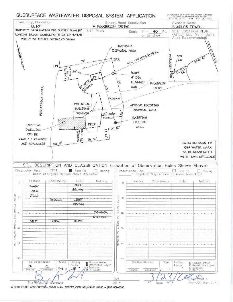


Correspondence Submitted by Terrie Harman


To: Planning Board From: Jeff Brubaker, AICP, Town Planner Cc: Patricia King, Applicant Date: February 10, 2021 (report date)
February 16, 2021 (meeting date) Re: PB20-24: 1004 Goodwin Rd. (Map 94, Lot 13) – Pool and Deck Rental Home Business – Sketch Plan
Review (continued)
Overview: This application is for a pool and deck rental home business located at 1004 Goodwin Rd., Map 94, Lot 13, within the Rural zoning district. The 5-acre lot contains an existing single-family residential dwelling unit, a garage, a shed, and an approximately 28’ round above-ground pool with deck. It also contains an existing home business, Mikayla J’s Salon, located in the garage structure. The applicants, James and Patricia King, propose to rent the pool and deck for recreational use, by reservation only, through a pool rental website. They do not propose to have any non-occupants employed with the home business. While the application does not state when the pool and deck would be available to be rented, in a phone call, the applicant informed me that it would be between Memorial Day and Labor Day, and between 10am and 7pm on a given day. (2/16 update: These hours were verbally confirmed at the January 19 meeting.) No merchandise or products will be sold as part of the proposed home business. The pool and deck are over 200 ft. from Goodwin Rd. but are visible from the road, according to Google Street View (Sept. 2019). However, the application conveys that neighboring homes are not visible through the woods. No business sign or business vehicle
Application Details/Checklist Documentation Address: 1004 Goodwin Rd. Map/Lot: 94/13 PB Case#: PB20-24 Zoning District: Rural Shoreland Zoning: N/A Owner Name: James and Patricia King Applicant Name: James and Patricia King Proposed Project: Site Plan Review for the following:
• Home Business Application Application Received by
Staff: 12/7/20 (Home Business) (updated from previous site plan review application received 10/27/20)
Application Fee Paid and Date:
$200 ($25 home business; $175 public hearing) 10/27/20
Application Sent to Staff Reviewers:
N/A
Application Heard by PB Found Complete by PB
Date: 1/19/21, 2/16/21 (scheduled) Date: TBD
Site Walk Date: TBD Public Hearing Date: TBD Public Hearing Publication Date: TBD Deliberation Date: TBD Notice of Decision Date: TBD Reason for PB Review: Home Business Application

Memo: 1004 Goodwin Rd. (PB20-24) – Pool and Deck Rental Home Business
2
is proposed. For the question on how fluids, solids, and gases unique to the business are going to be used and stored, the application states that required pool chemicals will be stored in a locked shed. The application proposes to “designate three (3) parking spots, clearly marked, 20 feet off Sugar Hill Drive” on the property. The applicants co-own the property (warranty deed included), and it is their primary residence. The combined area of the pool and deck is about 1,500 sq. ft. The application states that the “deck is the primary structure for the business/venue and that is 800 square feet”. Included with the application are a warranty deed, narrative, sketch plan, and aerial photos. Town staff have also included in the agenda item Planning Board minutes from October 17, 2006, which document approval of the home business application for the salon/professional office. Type of Review Needed (2/16 update): This meeting is for continued review of this application, including new information provided by the applicant. The Planning Board may wish to ask questions of the applicant, request additional information, if needed, or make a motion on application completeness and setting of a public hearing. Town Planner’s Review Notes: I believe the relevant issues for the Planning Board to consider and discuss include, but are not limited to, the following:
Zoning: The proposed use, which would rent out an already-existing residential pool and deck, is “Recreational use not requiring structures”, which is an SPR use in the Rural zoning district (45-290). In addition to other applicable sections of the Town Code, the proposed home business must conform to the requirements of Section 45-456.1. Several of the requirements of 45-456.1 are addressed in the application and “Overview” section above. Two home businesses: 45-456.1(b) states: “A home business is not permitted in conjunction with a home occupation on the same lot. However, more than one home business may be located on the same lot as long as in the aggregate and cumulatively the home businesses on the lot comply with the requirements of this section.” This brings up a few topics for discussion.
Salon approval: The Planning Board approved the salon as a home business on October 17, 2006. See attached minutes. Multiple home businesses needing to comply in the aggregate with 45-456.1: One important issue to be discussed is the aggregate and cumulative size of the two home businesses. The 1,500 sq. ft. maximum (subsection (c)) applies cumulatively. Since the pool and deck are about 1,500 sq. ft., adding that space to the salon would exceed the maximum area. However, the Planning Board may wish to consider this provision in the context of the time limitations on the proposed pool/deck rental. In other words, most of the year, only one home business would be operational, and the use of more than 1,500 sq. ft. of home business space would only occur when the salon is open and the pool and deck are being rented.
2/16 update: At the January 19 meeting, the applicant estimated the salon area at about 700 sq. ft. Assuming a 28 ft. diameter, the pool area would be another ~615 sq. ft. Using GIS, I estimate the deck at about 850 sq. ft.
Another important “aggregate and cumulative” issue, parking, is discussed below. Home business as accessory use to ADU or principal dwelling unit: Section 45-459(c)(6) states: “A home occupation or home business may be conducted, subject to existing regulations, as an accessory use to either the ADU or the principal dwelling unit, but not both.” While the warranty deed references an accessory apartment, the minutes from the Planning Board’s first review of the salon home business in 2006 show that the ADU was being converted into the salon. The applicant

Memo: 1004 Goodwin Rd. (PB20-24) – Pool and Deck Rental Home Business
3
also conveyed that there is no current ADU, so this “accessory to both” provision of the Town Code appears to be not applicable to the current application.
Parking: The maximum customer/non-resident employee parking spaces allowed by 45-456.1(i) is four (4). Existing marked parking spaces for the salon are shown on the sketch plan and visible in aerial imagery. The 3 additional proposed parking spaces along Sugar Hill Drive would exceed the maximum. The salon and pool rental would need to share a total of 4 spaces.
2/16 update: Discussion of parking between the Planning Board, applicant, and myself has focused on use of the existing parking area next to the garage/salon for the 4 customer/non-resident employee spaces shared between the 2 home businesses, and not creating new parking spaces along Sugar Hill Drive as initially proposed. The applicant and I have also discussed, and the applicant is open to, a condition to maintain a reservation system that would manage demand between the 2 home businesses to keep customer/non-resident employee parking to 4 as much as possible. Most days of the year, the pool would not be reserved.
Visibility of the home business: The Planning Board should discuss how to interpret and apply 45-456.1(k), which states, in part: “Storage of material associated with the home business use and any other external evidence of the business, must be located or screened such that it is not visible from the street or neighboring residences.” While the pool and deck are visible from Goodwin Rd., the fact that it is a rental business may not be evident. It would be “reservation only”; no sign or business vehicle are proposed. Operation of the pool rental: The Planning Board may wish to ask more about how the pool rental would operate in terms of number of people able to use it at one time, managing parking, etc. Potential conditions, 2/16 update: Reflecting the January 19 meeting and subsequent discussion with the applicant, I recommend the following limitations on the pool rental operation be considered to help ensure compliance with the Town Code any mitigate any potential adverse effects. Should the Planning Board entertain a motion to approve at a future meeting, the Board may wish to make these conditions of approval.
• Reservations open Memorial Day to Labor Day • Reservation hours between 10:00 am and 7:00 pm • Maximum of 12 people per reservation: consistent with the 12-15 range discussed on January 19 • Reservation system that keeps customer/non-resident employee parking demand to 4 as much as
possible (total between the 2 businesses), consistent with the Town’s home business regulations, with use of the existing parking area near the salon/garage (no new parking spaces)
• Maintaining insurance – the applicant has stated that she already has the insurance and had a pool inspection done for the insurance
• A state health inspection may or may not be required (I am checking with our CEO on this) • Provide/maintain access to a stationary bathroom – this was also discussed on January 19
Planner’s Recommendation for the 2/16/21 meeting: The Planning Board should review the application and sketch plan, discuss the above (and any other relevant) issues, and determine what, if any, further information is needed from the applicant. Otherwise, the Planning Board may wish to make a motion on application completeness and setting of a public hearing. Respectfully submitted, Jeff Brubaker, AICP Town Planner


PB21-01: 445 River Rd. (Map 33/Lot 4) Shoreland Zoning Application to remove an existing deck and add a sunroom and new deck
1
To: Planning Board From: Jeff Brubaker, AICP, Town Planner Cc: Kenneth and Carolyn McGee, Applicant Michelle Shields, Applicant’s Representative
Shelly Bishop, Code Enforcement Officer Kearsten Metz, Land Use Administrative Assistant
Date: February 10, 2021 (report date) February 16, 2021 (meeting date)
Re: PB21-01: 445 River Rd. (Map 33/Lot 4): Shoreland Zoning Application to remove an existing deck and add a sunroom and new deck
Overview Applicants Kenneth and Carolyn McGee have submitted a Shoreland Zoning Permit Application for their residential property at 445 River Rd. (Map 33, Lot 4) to replace a
Application Details/Checklist Documentation Address: 445 River Rd. Map/Lot: 33/4 PB Case#: PB21-01 Zoning District: Suburban Shoreland Zoning: Resource Protection, Limited Residential Owner Name: McGee Family Revocable Trust Applicant Name: Kenneth and Carolyn McGee Proposed Project: Shoreland Zoning Application – Residential use Application Received by Staff: January 19, 2021
Application Fee Paid and Date: Application Fee Paid and Date:
$175 ($100 shoreland zoning application; $75 for nonconforming structure)
Application Sent to Staff Reviewers:
February 10, 2021
Application Heard by PB Found Complete by PB
February 16, 2021 (scheduled)
Site Walk TBD Site Walk Notice Publication TBD Public Hearing TBD Public Hearing Publication TBD Deliberation TBD Notice of Decision TBD
Reason for PB Review: Shoreland Zoning Application / Site Plan Review

PB21-01: 445 River Rd. (Map 33/Lot 4) Shoreland Zoning Application to remove an existing deck and add a sunroom and new deck
2
16’x16’ deck with a 14’x16’ sunroom (13 ft. in height), remove old deck stairs, and add a new 7’x8’ deck and stairs to exit off the sunroom. No new clearing would take place, and the existing septic system would remain. A paved rear patio within 25 ft. of the Piscataqua River would be demolished and replaced with vegetative cover. The application includes a Shoreland Zoning Permit Application, existing conditions plan, site plan, and elevations for the proposed sunroom. The agenda packet also has a location map with zoning. Zoning 445 River Rd. is located entirely within the Resource Protection (RP) and Limited Residential (LR) Shoreland Zoning districts. The underlying base zoning is Suburban. Type of review needed by Planning Board Planning Board review is needed for “greatest practical extent” review and because the sunroom would replace a deck partially in the RP district (SPR use). In this initial review, the Planning Board should ask questions of the applicant, seek additional information if needed, and consider a motion on application completeness and setting a public hearing. Existing conditions The lot sits between the river and River Rd. at the western end of Governor Hill Rd. There is an existing 1334 sq. ft. residence built in 1950, along with the previously-mentioned back deck and stairs (to be removed) and a brick walkway and patio near the shoreline surrounded by gardens. The existing residence is fully within the LR district. Part of the existing deck, and the deck stairs, are within the RP district. Part of the proposed sunroom and new deck stairs would be within the RP district. Nonconformance The lot (about 0.14 ac., 55 ft. of River Rd. frontage, 77 ft. of shoreline frontage) is a nonconforming lot of record in the Suburban district, and the existing structures are nonconforming. According to past deeds, the lot was created prior to 1950. The existing house, deck, and stairs – and proposed sunroom, new deck, and stairs – are within the 75 ft. river normal high-water line setback prescribed Section 44-35(b)(1). Section 44-32 – Nonconformance applies. The existing deck and stairs to be removed are 310 sq. ft. total. The stairs are 27 ft. from the normal high-water line. The new sunroom, deck, and stairs would be 307 sq. ft. total, and the new sunroom and stairs would be 36 ft. from the normal high-water line. Therefore, the total footprint of the new structures would be 3 sq. ft. less than the existing structures and further back from the river.

PB21-01: 445 River Rd. (Map 33/Lot 4) Shoreland Zoning Application to remove an existing deck and add a sunroom and new deck
3
Reconstruction or replacement of a nonconforming structure in the shoreland zone is allowed subject to Section 44-32(c)(4). In summary, this section requires that “such reconstruction or replacement is in compliance with the water body, tributary stream or wetland setback requirement to the greatest practical extent as determined by the planning board in accordance with” Chapter 44. The nonconformity shall not be increased, the reconstructed or replacement structure shall not be larger than the original structure (except as allowed by the 44-32(c)(1) expansion rule, but see lot coverage and impervious surface considerations below), and the new structure needs to meet the setback requirement (75 ft.) if it can. In this application, the new sunroom, deck, and stairs are further from the water than the existing stairs. The new sunroom would be no closer to the water than the existing deck and would be 2 ft. narrower, and it appears that it would not be possible to locate the new sunroom, deck, and stairs anywhere else on the lot without encroaching on a lot line setback. As discussed below, the net change would be to reduce both lot coverage and impervious surface. However, this is a preliminary assessment and should be discussed further as needed by the Planning Board. Proposed lot coverage Maximum lot coverage for the base zoning district, Suburban, is 15%. This application involves a reduction in lot coverage (by 3 sq. ft.) for a nonconforming lot of record and nonconforming structure, so the lot coverage nonconformity is being reduced. Impervious surface Section 44-35(b)(4) includes a 20% limit for the total footprint area of all structures, driveways, parking areas and other nonvegetated surfaces, within the shoreland zone. This application involves a reduction in the footprint area for this nonconforming lot of record and nonconforming structure, achieved mostly by the removal of the 176-sq.-ft. brick patio near the river and replacement with vegetated, pervious surface (grass/gardens). The impervious coverage is reduced from 59.3% to 56.4%. Additional information needed
• Warranty deed • DEP correspondence as needed • Potential additional information for floodplain standards – the proposed sunroom
and deck appear to be near or slightly in flood zone AE but would be elevated on posts
Respectfully submitted, Jeff Brubaker, AICP Town Planner

PB21-01: 445 River Rd. (Map 33/Lot 4) Shoreland Zoning Application to remove an existing deck and add a sunroom and new deck
4
Additional information Full text of Section 44-32(c)(4):
Reconstruction or replacement. Any nonconforming structure which is located less than the required setback from a water body, tributary stream, or upland edge of a wetland and which is removed, or damaged or destroyed, regardless of the cause, by more than 50 percent of the market value of the structure before such damage, destruction or removal, may be reconstructed or replaced provided that a permit is obtained within 18 months of the date of said damage, destruction, or removal, and provided that such reconstruction or replacement is in compliance with the water body, tributary stream or wetland setback requirement to the greatest practical extent as determined by the planning board in accordance with the purposes of this chapter. In no case shall a structure be reconstructed or replaced so as to increase its nonconformity. If the reconstructed or replacement structure is less than the required setback it shall not be any larger than the original structure, except as allowed pursuant to subsection 44-32(c)(1) above, as determined by the nonconforming footprint of the reconstructed or replaced structure at its new location. If the total footprint of the original structure can be relocated or reconstructed beyond the required setback area, no portion of the relocated or reconstructed structure shall be replaced or constructed at less than the setback requirement for a new structure. When it is necessary to remove vegetation in order to replace or reconstruct a structure, vegetation shall be replanted in accordance with subsection 44-32(c)(3) above. Any nonconforming structure which is located less than the required setback from a water body, tributary stream, or wetland and which is removed by 50 percent or less of the market value, or damaged or destroyed by 50 percent or less of the market value of the structure, excluding normal maintenance and repair, may be reconstructed in place if a permit is obtained from the code enforcement officer within one year of such damage, destruction, or removal. In determining whether the building reconstruction or replacement meets the water setback to the greatest practical extent the planning board shall consider, in addition to the criteria in paragraph (c)(3) above, the physical condition and type of foundation present, if any.


445 River Rd. Location Map (prepared by Town staff)Eliot, ME
February 10, 2021³ 0 500 1000 1500
Data shown on this map is provided for planning and informational purposes only. The municipality and CAI Technologies are not responsible for any use for other purposesor misuse or misrepresentation of this map.
1 inch = 500 Feet

1333 State Road Eliot, ME 03903 - Phone (207) 439-1817 - Fax (207) 439-1415
Planning Board Submission Deadlines (DRAFT) Please find below the recently updated submission deadlines. Any materials submitted for Planning Board review are due in the Planning Office at least two weeks before the Planning Board’s meeting, following the schedule shown below. The Planning Board’s meeting agendas will be available approximately a week before the meeting. (The Planning Board meets on the first and third Tuesdays of the month, and generally reserves the first meeting of each month for administrative duties). Applications and other public records submitted to the Planning Board may be viewed by any member of the public, by visiting the Planning Office during normal business hours. You may also visit our website at www.eliotmaine.org for meeting information and applicable forms. Questions about a Planning Board application? We are here to help answer questions about the Planning Board process and ordinance requirements. Kearsten Metz – Land Use Administrative Assistant – [email protected]
* March 16: Latest regular meeting for public hearing and recommendation on June 2021 election ordinance amendments and growth permits question
Meeting Date Last Day to Submit Materials Agenda Packet Date Type of Meeting February 16, 2021 January 19, 2021 February 9, 2021 Application Review
March 2, 2021 February 2, 2021 February 23, 2021 Application Review
Ordinance PH March 16, 2021 February 16, 2021 March 9, 2021 Ordinance PH*
April 6, 2021 March 9, 2021 March 30, 2021 Administrative April 20, 2021 March 23, 2021 April 13, 2021 Application Review May 4, 2021 April 6, 2021 April 27, 2021 Administrative
May 18, 2021 April 20, 2021 May 11, 2021 Application Review June 1, 2021 May 4, 2021 May 25, 2021 Administrative
June 15, 2021 May 18, 2021 June 8, 2021 Application Review June 29, 2021 June 1, 2021 June 22, 2021 Application Review July 6, 2021 No meeting
July 20, 2021 June 22, 2021 July 13, 2021 Application Review August 3, 2021 July 6, 2021 July 27, 2021 Administrative
August 17, 2021 July 20, 2021 August 10, 2021 Application Review