Sistema de Comunicaciones Tierra-Tierra mediante Anillo de ...
Upload
khangminh22Category
view
0download
0
Tierra Robles Wildland Fuel/Vegetation Management Plan
Prepared by:
Wildland Resource Managers
P.O. Box 102 Round Mountain, California 96084
July 2015

Tierra Robles Wildland Fuel/Vegetation Management Plan
Introduction and Background:
This Wildland Fuel/Vegetation Management Plan has been prepared to meet the California Department of Forestry and Fire Protection/Shasta County Fire Department (CAL FIRE/SCFD) requirement as detailed in their November 16, 2010 letter to the Director of the Department of Resource Management, Shasta County, California and to meet these requirements in a manner that retains and enhances the oak woodlands and related wildlife species present on the project area. The CAL FIRE/SCFD letter noted that: “The plan shall provide for the reduction of flammable vegetation from around designated building envelopes and roadways and driveways, special attention shall be given to reducing the flammable vegetation on hillsides below designated building envelopes. The plan shall take into account fire hazards, tree preservation, aesthetics, erosion control and reforestation.”
Several State and Federal laws apply to the management of the wildlife resource present on a project site including, but not limited to: Federal and State Endangered Species Acts, the Migratory Bird Act, the Environmental Protection Act and the Clean Water Act. These acts prescribe how habitats will be managed to avoid a “taking” of a listed species while conducting an otherwise lawful activity. The term “take” means to harass, harm, pursue, hunt, shoot, wound, kill, trap, capture, or collect, or to attempt to engage in any such conduct” (Endangered Species Act 1973).
The wildlife habitat resource on-site is governed by the presence of an annual grassland understory with an overstory of blue oak in association with interior live oak and, less commonly, grey pine. Common wildlife species utilizing the site include Columbian black-tailed deer, mourning dove, turkey, California valley quail, acorn woodpecker, Lewis’ woodpecker, red-tail hawk, Botta pocket gopher, ground squirrel, turkey vultures and numerous species of insects and birds.
Dissecting the oak woodlands is a network of intermittent and ephemeral stream courses with associated wetland vegetation and limited riparian habitat which has aquatic and wetland associated species (ACOE verified Wetlands Delineation. 2011).
This plan is written to provide management direction for the reduction of flammable vegetation from around building envelopes, roadways and driveways in accordance with the county’s 2010 letter while at the same time retaining and enhancing the oak woodlands and associated wildlife habitats within the general area for those species associated with the oak woodlands.
1

Tierra Robles is owned by Shasta Red, LLC, an investment corporation headquartered in Beverly Hills, California. The property consists of 715.4 acres located in central Shasta County, California, just southwest of the unincorporated community of Bella Vista. The property area is located in portions of Sections 19 and 30 of Township 32 North, Range 3 West, and portions of Sections 24 and 25 of Township 32 North, Range 4 West, MDBM (Figure 1).
Tierra Robles was historically known as the Chatham Ranch, a family owned “cow/calf” livestock operation. The present owners currently lease the property for winter/spring cattle grazing and for honey bee yards. There are no improvements on the property except for unimproved access roads, a set of corrals, and line and limited cross fences.
Both small lot and large properties surround the property on the east, south and west sides. The Stillwater Gun Club is the adjacent property on the north side.
With approval from the county, the intent of the applicant owners is to subdivide the property into 166 small acreage lots ranging in size from 1.3 to 7.5 acres suitable for custom home-sites and associated infrastructure.
General Environmental Setting:
The combination of soils, topography, vegetation, and climate contribute to the vegetative fuel loading and habitat values of the site.
Soils: Soils within the project area are diverse and are considered part of the Newton-Red Bluff association. These soils are on nearly level to steep, well-drained and moderately well-drained clays and clay loams formed in old alluvium on high terraces (Shasta County soil survey, 1974). On-site soils include:
Ad: Anderson gravelly sandy loam Ae: Anderson gravelly sandy loam, moderately deep CgB: Clough gravelly loam: well-drained soils with a hardpan, runoff slow. IeD: Inks-Pentz complex: well-drained with moderate permeability. IeE: Inks-Pentz complex: 30 to 50 percent slopes, very stony loam. NeC: Newton gravelly loam, 8 to 15 percent slopes, slow permeability. RcA: Red Bluff gravelly loam, moderately deep, moderately well-drained. RcB: Red Bluff gravelly loam, moderately deep, 3 to 8 percent slopes, moderately well-drained RdA: Redding gravelly loam, 0-3 percent slopes, with hardpan at 10-30 inches.
2

£¤44
£¤299
BOYLE
OLD A
LTUR
AS
OLD HWY 44
OLD OREGONDE
SCHU
TES
LOGA
N
WINE
GAR
OLD 44
RAESARA
STILL
WATE
R
SONO
RA
COLOMA
ROBLEDO
FORD
ADAR
BERY
L
STATE HWY 44
ORIO
LE
VIKINGLE
SLYE
CHES
HIRE
EASYED
EN
HARTNELL
OAK MEADOW
FRAZ
IER
FREN
CH C
REEK
SALM
ON C
REEK
ARAP
AHO
YUKI
YAMA
CHOLET
NORTHGATE
STATE HWY 44 EB
HARLEY LEIGHTON
STATE HWY 44 WB
STATE HWY 299
ABER
NATH
Y
GREE
N OA
KS
RANCHO
SWEDE CREEK
JOANNA
MADD
ELEI
N
OSAGE
COW CREEK
HIDDEN
OAK TREE
JILL
HELE
NA
HACKETT
LANCELOT
CEDRO
OAK KNOLL
APRI
LSANDPOINT
NEVA
DAMAE
INNS
BRUC
K
VINE
GRAYSTONE
INK
PRIVATE
CHUKAR
BLUF
F
LASSEN VIEW
SEVEN LAKES
TARMAC
PORT
A DEG
OCA
NDY C
ANE
ARGYLE
TIA MIA
FALLING OAKS
HILLVIEW
OCTO
BER
SURR
EY
ROCK
Y
LONITA
TOMKENS
PETU
NIA
HIDDEN BERYL
SUMAR
ROBBIE
WINCHESTER
ROAD
RUN
NER
PALO DURO
FALLING LEAF
WHIS
TLEB
ERRY
STRAWN
STATE HWY 299 EB
BLOOMINGDALE
HUMM
INGB
IRD
WE-TOOSTONE MEADOW
STATE HWY 299 WB
THORN
DAYS
TAR
UNIVERSITYHO
MEST
EAD
MARTY'S
BRANDY
ROCK
ING
HORS
E
WATERLINE
CALOKALA
ROBIN
LOS ROBLES
CROS
SROA
DS
SUND
ANCE
ARRIBA
DYNASTY
CONESTOGA
SUGG
IE
GOSPEL
SUNNY OAKSSP
ARRO
W
KILBE
Y
NORA
WINDSONG
CARSON
THUR
SDAY
KIWI
LILLA
STEPHENO
SETAC
KARP
DAYSHA
HIDD
EN AC
RES
PEBB
LE C
REEK
RYAN
HILL
VIA LINDA
NORT
H ST
AR
SAN JUAN
WESLEY
BLACKFOOT
EARLY CREEK
RUSTIC OAK
HOTSPUR
DIR KINDERHOBBIE ACRES
ELISA
GAUC
HOBE
LLA C
EDRO
CATTLE
LEON
LONE
GOO
SE
SHADY OAK
NUBBIN
PEACEFUL
OAHU
GASP
ERS
NEVIL
LE
DUKE
STARWOOD
JUANITABO
BBY
SMOK
E TRE
E
VIA SERENA
JACK
SON
HOLE
ENDV
IEW
ORIOLE
SUNNY OAKS
ORIO
LE
ABER
NATH
Y
FREN
CH C
REEK
DESC
HUTE
S
GIS and Cartography rkBARON GEOvisualsCopyright 2005 - 2015
Projection: California State Plane, ZONE 1, NAD 83
Field Work and Project Managementby Wildland Resource ManagersSteven J. KernsPrincipal and Certified Wildlife Biologist
May 15, 2015 Tierra Robles Vicinity Map
PondSources:Wildland Resource ManagersNAIP Program for Imagerywww.atlas.ca.govNAIP DOQQ/CIR July 2009I meter spatial resolution
!(
!(
!(
!(
!(!(!(
!(
!(!(
!(
!(
!(
!(
!(
!.
!.
!.
!.
!.
Redding
Dunsmuir
Anderson
Red Bluff
Viola
Burney
Shasta
Oak Run
McArthur
Lakehead
Palo Cedro
Old StationWhiskeytownBella Vista
Shingletown
French GulchMountain Gate
Round Mountain
Montgomery Creek
£¤44
£¤299
£¤36
£¤89
£¤3
£¤273
£¤151
£¤32
£¤36
£¤299
£¤299
£¤44
§̈¦5
REDDING
Tierra Robles Property
Tierra Robles Property
Shasta County
:0 1,100 2,200 3,300 4,400550
Feet
0 0.2 0.4 0.6 0.8 1 1.20.1Miles
1 inch = 2,583 feet
CALIFORNIA
Figure 1Figure 1

The Ae soils are found along the Clough Creek flood plain while the Ad soils are found along the flood plain of the unnamed gulch in the northeast corner of the project area. The RcA soil forms the tableland areas in the central portion of the property and it is within these areas that the vernal complexes seem to be present. Overstory oaks and pines are absent on portions of this soil type and it is probable that a hardpan layer is relatively close to the surface in this area. The NeC series forms the dissected side slopes of the Clough Creek drainage and supports a fairly dense oak overstory with a brush and grass understory. This combination forms suitable forage and escape habitat for deer. The Ie series consists of well-drained and somewhat excessively drained soils that are underlain by cemented tuffaceous sediment. These soils are on upland portions of the property. The Cg series consists of moderately well-drained soils that have a hardpan and are found on high terrace areas. (See Soil Survey of Shasta County Area, California, USDA Soil Conservation Service for detail description of soils resource). Figure 2, below, is taken from the NRCS web page and displays the location of the soils resource on the project area.
Figure 2. Tierra Robles Soils (Source: NRCS Web Soils Survey for Shasta County 2015)
3

Topography: Tierra Robles is situated on a high terrace of shallow soils southwest of the town of Bella Vista. This high terrace is dissected by two major drainage systems with several smaller supporting tributaries. Clough Creek is the most significant drainage being an intermittent stream that flows from north to south across the western portion of the property. The main channel is fairly wide (10-15 feet) and is comprised of a gravel bottom with pools and shallow runs. There is no significant riparian habitat associated with this stream course however, there are clumps of isolated willows and cottonwoods scattered along the stream at various locations.
Running from north to south along the eastern side of the property, through a shallow valley, is another intermittent stream that drains the properties to the north of Tierra Robles. This stream is not as prominent as Clough Creek with widths varying between eight and twelve feet. For the sake of identification, we have labeled this stream “East Creek.” The stream bed is gravelly with a shallow gradient. There is no established riparian corridor along this stream. Rather, as with Clough Creek, there are scattered willow bushes and occasional cottonwoods.
Between East Creek and Clough Creek are three other small ephemeral drainages that originate on the subject property and drain its central portion. These streams flow from north to south and are generally of shallow gradient. Upland vegetation comes to the stream channel edges without any riparian vegetation being present in any of these drainages.
There is little evidence of severe erosion in any of the drainages on the project site and all stream courses appear stable.
Vegetation: In the upland areas the vegetative composition is uniformly blue oak/grey pine (Quercus douglasii, Pinus sabiniana) with the blue oaks being most abundant. Tree canopy cover within this area ranges from 0 to nearly 100%, with a wide range of size classes. Annual grasses and forbs comprise the understory with patches of manzanita (Arctostaphylos spp), coffee berry (Rhamnus californica), and poison oak (Rhus diversiloba) being the predominant shrubs. Within the steeper draws of the drainage in the northeast corner of the property the vegetation is dominated by interior live oak (Quercus wislizenii) with a scattered mid-story of poison oak, coffee berry, and manzanita. In places, the overstory canopy closure within in these steeper gulches is nearly 90%, resulting in a nearly non-existent understory. On the high terrace areas there are open annual grasslands on very shallow soils. Vegetation on these areas is comprised of annual grasses and forbs with few trees being present. A detailed vegetation
4

May 15, 2015Tierra Robles Vegetation Map
Figure 3
Projection: California State Plane, ZONE 1, NAD 83
GIS and Cartography rkBARON GEOvisualsCopyright 2005-2015
Field Work and Project Managementby Wildland Resource ManagersSteven J. KernsPrincipal and Certified Wildlife Biologist
Figure 3
:0 380 760 1,140 1,520190
Feet
0 0.1 0.2 0.3 0.40.05Miles
1 inch = 833 feet
StreamProject Boundary
LEGEND
Contours
Annual Grassland (88.10 Acres)
Blue Oak Interior Live Oak (138.77 Acres)Blue Oak Woodland (474.30 Acres)
Interior Live Oak (20.01 Acres)Sources:Wildland Resource ManagersLehmann & Assoc. ConsultingS2-J2 Engineering

description may be found in the Tierra Robles Biological Review prepared in 2015 by Wildland Resource Managers. Figure 3 illustrates the general location of the vegetative features of the property.
Climate and weather patterns: The greater Redding area has a Mediterranean climate consisting of cool wet winters and hot dry summers. Figures 4, 5 and 6 indicate temperature, rainfall and wind speed patterns for the area.
Figure 4. Average Temperatures
The daily average low (blue) and high (red) temperature with percentile bands (inner band from 25th to 75th percentile, outer band from 10th to 90th percentile) are displayed.
5
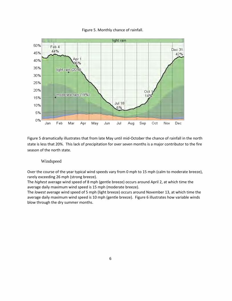
Figure 5. Monthly chance of rainfall.
Figure 5 dramatically illustrates that from late May until mid-October the chance of rainfall in the north state is less that 20%. This lack of precipitation for over seven months is a major contributor to the fire season of the north state.
Windspeed
Over the course of the year typical wind speeds vary from 0 mph to 15 mph (calm to moderate breeze), rarely exceeding 26 mph (strong breeze). The highest average wind speed of 8 mph (gentle breeze) occurs around April 2, at which time the average daily maximum wind speed is 15 mph (moderate breeze). The lowest average wind speed of 5 mph (light breeze) occurs around November 13, at which time the average daily maximum wind speed is 10 mph (gentle breeze). Figure 6 illustrates how variable winds blow through the dry summer months. 6

Figure 6
The average daily wind speed minimum (red), maximum (green), and average (black) wind speed with percentile bands (inner band from 25th to 75th percentile, outer band from 10th to 90th percentile).
The combination of hot dry summers coupled with lack of rainfall and wind during the summer months contribute to the severity of the “fire season” in the north state. It is because of these weather conditions and the vegetative associations on-site that there is a very real danger of fires on the project area.
Wildfire Hazards:
Existing fuels: There are four principal vegetative communities on the property: annual grassland, blue oak woodlands, blue oak/interior live oak/grey pine and interior live oak/shrub. To understand the threat of fire in various vegetative communities, the USDA developed fire models for different situations. On the project area, there are four appropriate USDA fire behavior fuel models that can be used in the mathematical modeling of fire behavior and fire
7

danger ratings for each vegetative type (Anderson 1982). These communities are shown on Figure 7 and described as follows:
1. Annual grasslands ~ Fire Behavior Fuel Model 1: “Fire spread is governed by the fine, very porous, and continuous herbaceous fuels that have cured or are nearly cured. Fires are surface fires that move rapidly through the cured grass and associated material. Very little shrub or timber is present, generally less than one third of the area.” Total fuel load, <3-inch dead and live, tons/acre = 0.74 Dead fuel load, ¼ inch tons/acre = .74 Live fuel load, foliage tons/acre = 0 Fuel bed depth, feet= 1.0
2. Blue oak woodlands ~ Fire Behavior Fuel Model 2: Within the blue oak woodland areas the understory is predominately grasses with only a minor shrub component. This being the case; Fuel Model 2 is most appropriate: “Fire spread is primarily through the fine herbaceous fuels, either curing or dead. These are surface fires where the herbaceous material, in addition to litter and dead-down stemwood from the open shrub or timber overstory, contribute to the fire intensity. Open shrub lands and oak/pine stands that cover one-third to two-thirds of the area may generally fit this model. Such stands may include clumps of fuels that generate higher intensities and that may produce firebrands.” Total fuel load, <3-inch dead and live, tons/acre = 4.0 Dead fuel load, ¼ inch tons/acre = 2.0 Live fuel load, foliage tons/acre = 0.5 Fuel bed depth, feet= 1.0
3. Blue oak/interior live oak/grey pine ~ Fire Behavior Fuel Model 5: As the shrub component is more frequent in this type, Fuel Model 5 is most appropriate: “Fire is generally carried in the surface fuels that are made up of litter cast by the shrubs and the grasses or forbs in the understory. The fires are generally not very intense because surface fuels loads are light, the shrubs are young with little dead material, and the foliage contains little volatile material.” 8

May 15, 2015Tierra Robles Fire Behavior Fuel Model Areas
Figure 7
Projection: California State Plane, ZONE 1, NAD 83
GIS and Cartography rkBARON GEOvisualsCopyright 2005-2015
Field Work and Project Managementby Wildland Resource ManagersSteven J. KernsPrincipal and Certified Wildlife Biologist
Figure 7:0 380 760 1,140 1,520190
Feet
0 0.1 0.2 0.3 0.40.05Miles
1 inch = 833 feetStreamProject Boundary
LEGEND
Contours
Fuel Model 1 Area (88.10 Acres)Fuel Model 2 Area (474.30 Acres)Fuel Model 5 Area (138.77 Acres)Fuel Model 6 Area (20.01 Acres)
FM 1
FM 1 FM 1FM 2 FM 6
FM 5
FM 2FM 6
FM 6
Sources:Wildland Resource ManagersLehmann & Assoc. ConsultingS2-J2 Engineering
FM 2
FM 5

Total fuel load, <3-inch dead and live, tons/acre = 3.5 Dead fuel load, ¼ inch tons/acre = 1.0 Live fuel load, foliage tons/acre = 2.0 Fuel bed depth, feet= 2.0
4. Interior live oak ~ Fire Behavior Fuel Model 6: Due to the mature shrub component in this type, Fuel Model 6 is appropriate: “Fires carry through the shrub layer where the foliage is more flammable than fuel model 5, but this requires moderate winds, greater than 8 mi/h at mid-flame height. Fire will drop to the ground at low wind speeds or at openings in the stand. The shrubs are older but not as tall as shrub types of model 4, nor do they contain as much fuel as model 4.” Total fuel load, <3-inch dead and live, tons/acre = 6.0 Dead fuel load, ¼ inch tons/acre = 1.5 Live fuel load, foliage tons/acre = 0 Fuel bed depth, feet= 2.5
Rates of Spread and fire intensities: The shrub group of fuel models has a wide range of fire intensities and rates of spread. With winds of 5 mi/hr fuel moisture content of 8% and a live fuel moisture content of 100%, the models have the following values:*
Fuel Model # Rate of spread Flame length* (Chains/hour) ( Feet) 4 75 19 5 18 4 6 32 6 7 20 5 *(Anderson, 1982)
9

Risks and potential hazards: Late spring through mid-fall are known as the “fire season” in the north state due to the lack of moisture and dry fuel conditions. These factors coupled with the vegetative type found on the property contribute to a high risk of fire on the landscape. Wildfire is simply a part of the ecosystem wherein the project is located. Any development within this area must address the natural occurrence of fire.
Wildlife Resource:
“The blue oak / grassland habitats provides breeding habitats for a large variety of wildlife species, although no species is totally dependent on them for breeding, feeding or cover” (Verner 1988). Common to the area and of interest to the local citizens are deer, turkey, valley quail, mourning dove, several passerine species and woodpeckers. These species utilize the area due to the presence of succulent annual and perennial grasses in the spring, annual mast crop of acorns and lichen, along with canopy nesting opportunities, cavities and snag grainery trees. The juxtaposition of cover, both thermal and escape, in association with foraging area makes the area attractive to deer, of which there is a small resident herd. The overstory canopy cover is ideal nesting, foraging and escape cover for numerous passerine birds including American robin, scrub jay, western blue bird, Oregon junco, rufus-sided towhee, gold-finch, song sparrow, nuthatch, and a number of finches, to name a few. The mid and understory vegetative composition plays host to valley quail and turkeys. Ground squirrels and pocket gophers have so excavated the sub-surface soils that there is little place one can walk without running the risk of falling into a hole.
In short, the wildlife associated with the project area are typical of those species found within the north state blue oak-grassland areas.
Resource Management Prescriptions for Reduction of Fuels and Habitat Enhancement:
To address the need to reduce fuel loading and associated fire hazards along with retaining and enhancing the wildlife habitats, the stand structure and species composition of the vegetative communities across the landscape needed to be identified. Since the vegetative communities are different, one vegetative management prescription is not suitable for the entire property to meet management objectives. To address this issue, the project area was divided into distinct Resource Management Areas (RMA’s) based on common vegetative and topographical features. The boundaries of the RMA’s were drawn along proposed lot lines so that the
10

management prescription for each RMA could be applied uniformly to the lots within that RMA. Below is a description of each RMA along with the specific vegetative management prescription for each RMA. Figure 8 identifies the locations of the RMA’s on the project map. Please see photo section of this report for a visual sample of each RMA. General management prescriptions that apply to all RMA’s follow the specific prescriptions. These management prescriptions are designed to reduce the fire fuel loading capacity while at the same time protecting and enhancing the oak resource and associated wildlife habitats. These prescriptions are written for implementation by the individual lot landowner on their property or by the Tierra Robles Homeowner's Association (TRHOA) for the open space areas.
These recommendations address vegetation in the over, mid and understory. Oaks of various sizes can comprise parts or all these strata. Often small oaks are found in “clusters.” For the purpose of this management plan, a “cluster” is defined as: a group of small trees, less than 3” dbh, with canopies touching.
A. Specific Management Prescriptions for RMA’s
RMA 1: Annual Grassland Habitat: Primarily located on the high terrace area of the central portion of the project area, RMA 1 is characterized by annual grasses with scattered larger blue oaks with well-developed crowns (see “Oak Resource of Tierra Robles” report (ORTR)). Fuel Model 1 is applicable to this area.
Vegetative management prescription for RMA 1:
1. Annual grass height will be maintained at or below 6” 2. Limb any oaks present up 8’, but taking no more than 50% of the live crown 3. Piled grass cuttings and slash from pruning of trees may be burned on-site on burn days
with approval of the Fire Marshall
RMA 2: Clough Creek Blue Oak Annual Grassland: This vegetative type is common in the Clough Creek drainage area and is characterized by blue oak woodlands with scattered grey pine over an annual grassland understory with a limited mid-story brush component. It has the most complex oak woodland stand structure on the property (ORTR, 2015). Within this RMA, tree stem sizes vary from less than 1” to nearly 30” dbh and the average basal area is the highest of any RMA, being 5,441.77sq ft. (ORTR, 2015). There are more standing snags and
11

RMA 5-2
RMA 3
RMA 4
RMA 2
RMA 5-1
RMA 2
RMA 2
RMA 3
RMA 2
RMA 5-2
RMA 4
RMA 1
RMA 1
RMA 5-2
GIS and Cartography rkBARON GEOvisualsCopyright 2015
Projection: California State Plane, ZONE 1, NAD 83
Field Work and Project Managementby Wildland Resource ManagersSteven J. KernsPrincipal and Certified Wildlife Biologist
Sources:Wildland Resource ManagersLehmann & Assoc. ConsultingS2-J2 Engineering
Figure 8
Figure 8Tierra Robles Resource Management Areas With Lot Lines
May 15, 2015
:0 370 740 1,110 1,480185
Feet
0 0.075 0.15 0.225 0.30.0375Miles
1 inch = 833 feet
Lot LineStream
Project BoundaryLEGEND
RMA 1 (71.87 Acres)RMA 2 (318.97 Acres)RMA 3 (93.92 Acres)RMA 4 (43.89 Acres)RMA 5 (192.49 Acres)
Contours

declining large trees within this RMA than the others and the overstory canopy is the greatest, being nearly 100% in some areas (ORTR, 2015). Fuel model 2 is applicable for this RMA.
Vegetative management prescription for RMA 2:
1. Retain standing and declining trees unless they pose a hazard to land users 2. Thin out smaller trees to a spacing of from 6 to 8 feet between trees. In doing this:
a. Priority 1: Select for trees 5” dbh or greater to retain b. Priority 2: Select for trees 1-5” dbh to retain c. Priority 3: A cluster of 1-3” dbh trees (see definition) may be retained. Size of
cluster should not exceed 12’ from outside tree to outside tree. Space the cluster of trees a minimum of 8’ from another cluster or a retained tree. Manzanita may serve as a tree cluster.
3. Limb all oaks up 8’, but taking no more than 50% of the live crown 4. Annual grasses shall be maintained at or below 6”. 5. Piled grass cuttings, slash and prunings from trees may be burned on-site on burn days
with approval of the Fire Marshall 6. On flat to mild slopes (0-20%) planted shrubs should be spaced at a distance 2 times the
height of the shrub (For example, two 2’ high shrubs should be planted 4’ apart)
(Tree Cluster definition: For the purpose of this report a tree cluster is defined as: “a group of trees of dbh between 1” and 3” in immediate proximity to one another with touching or overlapping crowns.”)
RMA 3: Blue Oak, Interior live oak, brush; slope < 20%: In this area, blue oaks and to a lesser extent, interior live oaks are the dominant overstory species with scattered grey pine. A mid-story component of poison oak, manzanita, wedge leaf ceanothus, and redbud is present. The understory is comprised of annual grasses and forbs. This vegetative type is found in the west central and northeast central portions of the project area. Fuel model 5 applies to this area.
12

Vegetative management prescription:
1. Retain standing and declining trees unless they pose a hazard to land users 2. Thin out trees to a spacing of from 6 to 8 feet between trees. In doing this:
a. Priority 1: Select for trees 5” dbh or greater to retain b. Priority 2: Select for trees 1-5” dbh to retain c. Priority 3: A cluster of 1-3” dbh trees (see definition) may be retained. Size of
cluster should not exceed 12’ from outside tree to outside tree. Space a cluster of trees a minimum of 8’ from another cluster or retained tree. Manzanita or wedgeleaf ceanothus may serve as a cluster.
4 Annual grass height will be maintained at or below 6” 5 Limb oaks up 8’, but taking no more than 50% of the live crown 6 Remove mid-story brush species to a spacing of twice the distance of the height of the
brush. 7 Remove dead and down brush and limbs 8 Piled grass cuttings, slash and prunings from trees may be burned on-site on burn days
with approval of the Fire Marshall 9 On flat to mild slopes (0-20%) planted shrubs should be spaced at a distance 2 times the
height of the shrubs (For example, two 2’ high shrubs should be planted 4’ apart) 10 Retain live oak “clumps” (multi-stem bowls). Limb these stems up 8’.
RMA 4: Blue Oak, Interior live oak, brush; slope > 20%: In this area, found on the steeper side slopes of the East Creek drainage, there is a continuous fuel ladder from the understory grasses through the mid-story brush and saplings to the overstory canopy of blue and interior live oak with scattered grey pine. Fuel model 6 applies to this area.
Vegetative management prescription
1 Retain standing and declining trees unless they pose a hazard to land users 2. Thin out trees to a spacing of from 6 to 8 feet between trees. In doing this:
a. Priority 1: Select for trees 5” dbh or greater to retain b. Priority 2: Select for trees 1-5” dbh to retain c. Priority 3: A cluster of 1-3” dbh trees (see definition) may be retained. Size of
cluster should not exceed 12’ from outside tree to outside tree. Space a cluster of trees a minimum of 8’ from another cluster or retained tree. Manzanita or wedgeleaf ceanothus may be used as a cluster.
13

3. Limb all oaks up 8’, but taking no more than 50% of the live crown 4. Annual grass height will be maintained at or below 6” 5. Remove mid-story brush species to a spacing of twice the distance of the height of the
brush. 6. Remove dead and down brush and limbs 7. Piled grass cuttings, slash and prunings from trees may be burned on-site on burn days
with approval of the Fire Marshall 8. On flat to mild slopes (0-20%) planted shrubs should be spaced at a distance 2 times the
height of the shrubs (For example, two 2’ high shrubs should be planted 4’ apart) 9. Retain live oak “clumps” (multi-stem bowls). Limb these stems up 8’. 10. On mild to moderate slopes (20-40%) shrubs should be spaced four times the height of
the shrub (For example, two 2’ high shrubs should be spaced 8’apart). 11. On steeper slopes (>40%) on east side of lots, for 200’ down-slope from the crest, or to
lot boundary: a. Remove all brush and mid-story vegetation b. Remove dead and down brush and limbs c. Annual grass height shall be maintained at or below 4”. d. Limb oaks up 8’, but taking no more than 50% of the live crown
RMA 5-1: East Creek Open Space Management Area: This area is a combination of RMA’s 3, 4 and 5 (on the steeper side slopes of the drainage) but will be managed as a unit by the Tierra Robles Homeowner's Association (TRHOA).
Vegetative management prescription:
1. To reduce fuel height of annual grasses and create natural trail fuel breaks, graze livestock within this RMA in the spring of each year to reduce annual grass height, on the average, to between two and six inches. Actual grazing dates and herd numbers will be determined annually based on annual rainfall amounts. Generally, grazing period should be from January 15th to May 30th.
2. Maintain wildlife friendly fence at, or generally near, the property lot lines located west of the East Creek drainage.
Note: Livestock have been grazed in this area for over 100 years with negligible impacts to the vegetative or aquatic resource while at the same time being able to greatly reduce the fuel loading of the under and mid-story vegetative component of the area.
14

RMA 5-2: Clough Creek Drainage Open Space Management Areas: This area is a combination of RMA’s 2 and 3 but will be managed as one unit by the TRHOA.
Vegetative management prescription:
1. Retain as many oaks as possible 2. Annual grass height will be maintained at or below 6” by mowing after the growing
season but prior to complete “dry out” of grasses. Grasses will be mowed but mowed areas are restricted to outside the riparian habitat areas
3. Limb oaks up 8’, but taking no more than 50% of the live crown 4. Mid-story brush species may be retained in clump if the clumps are spaced 2 times the
distance of the height of the brush. Brush clumps may be no larger than 12’ in diameter.
5. Remove dead and down brush and limbs 6. Retain riparian vegetation along Clough Creek.
B. General Management Requirements for all RMA’S:
1. Structures A. 30 feet out from every structure:*
1. Remove all dead plants, grass, and weeds. ` 2. Remove dead or dry leaves and pine needles from yard, roof and rain gutters 3. Keep tree branches 10 feet away from chimney and other trees
B. 30-100 feet from every structure:*
1. Cut or mow annual grass down to a maximum height of 4 inches 2. Create horizontal spacing between shrubs and trees 3. Create vertical spacing between grass, shrubs and trees.
*(Complies with California Public Resources Code, Section 4291-4299)
2. Vegetation A. On flat to mild slopes (0-20%) planted shrubs should be spaced apart 2 times the height of the shrub (two 2’ high shrubs should be planted 4’ apart).
B. Retain all elderberry bushes where found.
15

Effects of project:
The design of the Tierra Robles development will address additional resource management issues. These include:
Fuel breaks: The proposed road network consists of 34,545 linear feet (53.73 acres) of paved roadways that vary in widths of 50’, 60’ and 84’ in width. These roads will comprise the major fuel break system for the project. In addition, the cleared areas 30 feet around each structure will provide additional fuel breaks. See “Tierra Robles Design Features Map” for location of the road network.
Access: Access will be provided by the proposed road network which meets the Shasta
County Fire Marshal’s conditions as outlined in Shasta County’s Fire Department’s memo of November 16, 2010 and comply with Section 6.11 of the Fire Safety Standards. Please see memo in Appendix.
Water supply: Water to the project area will be supplied by Bella Vista Water district as
proposed in the project description and in compliance with the Shasta County’s Fire Department memo of November 16, 2010. Fire hydrants will be placed as specified by California’s State Fire Code.
Open Space Areas: There are six open space areas designed into the project, most
notable is the East Creek drainage area comprised of 150.4 acres. The other areas are 14.58 acres, 8.40 acres, 6.85 acres, 3.04 acres and 2.62 acres. See Figure 8 for the locations of the open space areas. The open space will function as wildlife travel corridors and provide foraging, denning, and nesting habitat. In addition, their more natural condition will provide thermal and escape cover for a multiplicity of wildlife species. Maintenance of these areas will be performed by the Tierra Robles Homeowner's Association (TRHOA) in conjunction with a land management agency. Little funding will be required as the Open Space areas will not provide for passive activities like picnic areas or other areas where infrastructure is maintained for a specific use, such as playgrounds, bird watching and other such passive or informal activities. See “Tierra Robles Design Features Map” for location of the open space areas.
16

Erosion control: The vegetative management prescriptions for the RMA’s in this plan are designed to retain sufficient ground cover in all RMA’s to eliminate all but natural erosion. At no time, except in the case of fire, should the annual grasses be less than 4” in height with sufficient root structure to maintain soils in place during storm events. There will be some natural erosion along stream courses, but the buffer area around these areas will retain natural vegetation that will stabilize soils. Overstory tree canopy will reduce rain impact erosion and the larger tree deep rooting systems will further hold sub-soils during wind and rain storm events. Roadways and constructed buildings will be designed to county standards.
Forest Resource: In the stands where the tree density is restricting growth, the thinning as proposed for RMA 2 will allow the crowns of the remaining trees to develop and cause enhanced tree growth and better developed crowns. Larger crowns will allow for greater acorn production. This acorn crop will not only be utilized by wildlife but will also drop more seed acorns to the forest floor that will have to opportunity to germinate and grow. Thinning of the suppressed oaks not only reduces the fuel loading of the area but also promotes better growth of the more robust trees which in turn will produce more mast crop.
In the stands where the trees are more widely spaced, the trees have well-developed crowns and are producing acorns. Within this type of stand, reforestation should occur normally. Keeping fire out of this ecosystem will allow for seedling development on a regular basis.
Aquatic Resources: The road systems and other infrastructure have been designed for 100% avoidance of all aquatic features on the property. By this design there will be no impact to any stream or wetland area thereby preserving the unique character and habitat associations of these areas. In addition, vegetative buffer zones of 30 feet on either side of the stream channel have been established around all streams to further protect their courses. With the exception of necessary fuel reduction activities, these features will be protected from man related actions. See “Tierra Robles Design Features Map” for location of the aquatic resource protection areas.
17

Report Preparation:
This report was prepared by: Steven J. Kerns. Principal and Certified Wildlife Biologist Wildland Resource Managers Round Mountain, California In association with: Dr. Phil McDonald. PH.D Forest Science Registered Forest Ecologist USDA Forest Service, Pacific South West Research Station Dr. Jerry Walters. PH.D Agronomy and Soil Science Research Forester USDA Forest Service, Pacific South West Research Station We gratefully acknowledge their expertise and assistance in the preparation of these management recommendations.
For questions regarding this report, please contact:
Wildland Resource Managers P.O. Box 102 Round Mountain, California 96084 (530) 472-3437 Email: [email protected]
18

Photo Section: Typical Vegetative Composition of the RMA’s
Photo 1. RMA 1 Annual grassland
Photo 2. RMA 1 Annual grassland

Photo 3. RMA 2 Blue oak woodlands, Clough Creek draingae
Photo 4 RMA 2 Blue oak woodlands, Clough Creek drainage
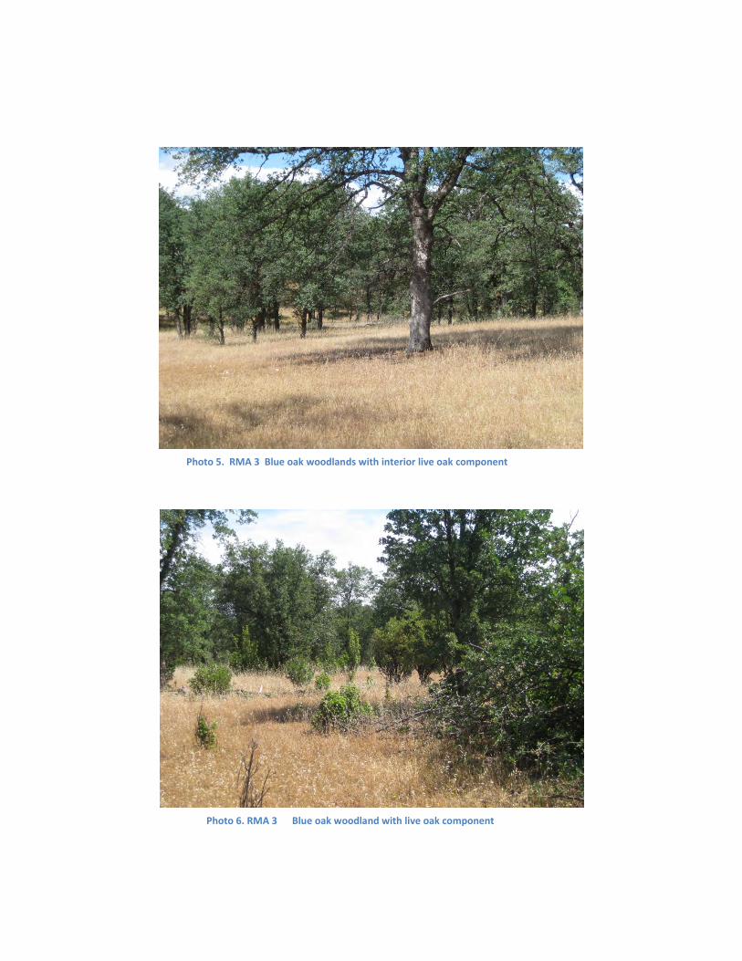
Photo 5. RMA 3 Blue oak woodlands with interior live oak component
Photo 6. RMA 3 Blue oak woodland with live oak component
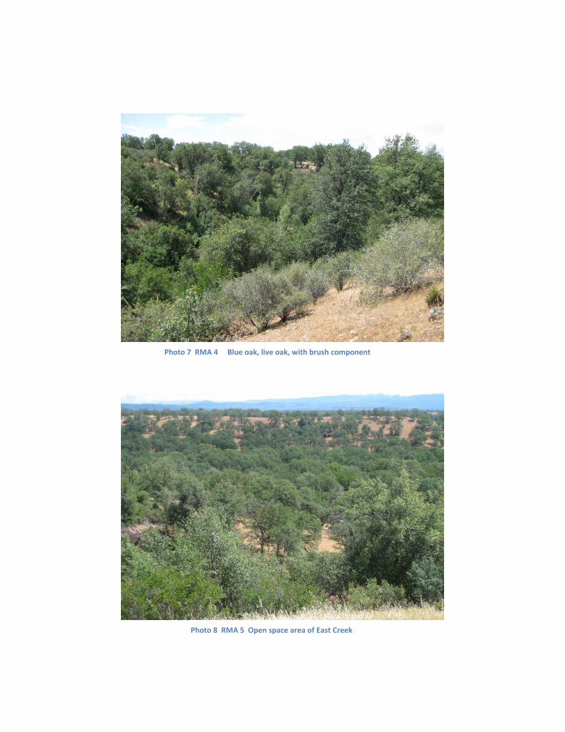
Photo 7 RMA 4 Blue oak, live oak, with brush component
Photo 8 RMA 5 Open space area of East Creek

References
Anderson, Hal E. 1982. Aids to determining fuel models for estimating fire behavior. USDA Forest Service Gen. Tech. Rep. INT-122, 22p. Intermt. For. and Range. Exp Stn. Ogdon, Utah 84401
California Public Resources Code, Sections 4291-4299. www.leginfo.ca.gov/cgi-bin/displaycode?section=prc&group=04001-0500&file=42
Chatham Ranch Wetlands Delineation. 2011. Prepared by: Wildland Resource Managers. Verified by ACOE October 24, 2011.
Endangered Species Act: section on definitions from ESA web page.
Verner, Jared. Blue Oak – Digger Pine Vegetative Association. In: Mayer, Kenneth E. and William F. Laudenslayer, Jr. editors. 1988. A Guide to Wildlife Habitats of California. Published by: USDA Forest Service Pacific Southwest Forest and Range Experiment Station; California Department of Fish and Wildlife; Pacific Gas and Electric company; USDA Forest Service Region 5.
Wenham, Doug. Novermber 16, 2010. Letter from Shasta County fire warden to Russ Mull, Director, Shasta County Department of Resource Management. Subject, Fire prevention, Fire safety and land use planning for Tract Map 1996 / Tierra Robles.
www.weatherspark.com
23

Appendix
Wildfire prevention
1. Government Requirements: The California Public Resources Code, Section 4291-4299 states that for persons owning, leasing, or maintains a building or structure, they shall do the following: “Maintain defensible space of 100 feet from each side and from the front and rear of the structure, but no beyond the property line. The amount of fuel modification necessary shall take into account the flammability of the structures as affected by building material, building standards, location and type of vegetation. Fuels shall be maintained in a condition so that a wildfire burning under average weather conditions would be unlikely to ignite the structure.” The California Department of Forestry and Fire Protection (Cal-Fire) makes the following recommendations for Zones around structures in order to meet the requirements of the Ca Public Resources Code: Zone 1, out 30 feet from structure:
1. Remove all dead plants, grass and weeds. 2. Remove dead or dry leaves and pine needles from yard, roof and rain gutters 3. Keep tree branches 10 feet away from chimney and other trees
Zone 2, 30-100 feet from structure: 1. Cut or mow annual grass down to a maximum height of 4 inches 2. Create horizontal spacing between shrubs and trees 3. Create vertical spacing between grass, shrubs and trees.
24

Copyright © 2022 FDOKUMEN