Minutes of 964 Meeting of the Town Planning Board held on ...
Upload
khangminh22Category
view
0download
0
NOTICE This meeting will be held using Zoom. The meeting access information is below.
Meeting Access Details
Join via computer: https://us02web.zoom.us/j/87451749334?pwd=eVdWSXpNbjd4K21uVnZzNjRvbWROUT09
Join via phone: 1-253-215-8782
Meeting ID#: 874-517-49334 Meeting Password: 384762
If you have any comments on Agenda items for this meeting and do not want to attend, please email comments to [email protected].
Page 1 of 433

This facility is ADA accessible. If you need special accommodations, please contact City Hall at 503.852.7575 at least 24 hours prior to this meeting.
CITY COUNCIL REGULAR SESSION AGENDA TUESDAY, AUGUST 4, 2020 VIA ZOOM, 191 E. MAIN STREET, CARLTON
7:00 PM CITY COUNCIL REGULAR MEETING Pages 1. CALL TO ORDER2. ROLL CALL3. PLEDGE OF ALLEGIANCE4. CHANGES OR ADDITIONS TO THE AGENDA 2 5. CEREMONIES/APPOINTMENTS/ANNOUNCEMENTS
A. Appointment of Guilherme Brandao to Planning Commission – Confirm Mayor Appointment 3 B. Appointment of Paul Junker to OR-47 Ad-Hoc Committee- Confirm Mayor Appointment 5 C. Citizen committee for City Manager hiring process x
6. CITIZEN COMMENTSThis section of the agenda allows members of the public to address the City Council on any item not otherwise on theagenda. Members of the public, when invited by the Mayor, shall come forward, state their name and street address, anddirect all comments to the Mayor. Comments are typically limited to three (3) minutes unless additional time is allowedby the Mayor.
7. CONSENT AGENDAA. Meeting Minutes – Approve
1. City Council – June 23, 2020 and July 7, 2020 7 B. Accounts Payable Report – Information Only 14 C. Auditor Contract Renewal 17
8. ORDINANCES/RESOLUTIONS/DISCUSSION/ACTION ITEMSA. Public Hearing: Comprehensive Plan/Zone Change 2020-01- Ordinance No. 2020-727 30B. Parks Plan Amendment Public Hearing- Ordinance No. 2020-728 232 C. NHMP Addendum - Approve 298 D. Police vehicle surplus declaration 351 E. Police vehicle and radio purchase 361 F. COPS Grant Acceptance 380 G. Buy Local Program Conclusion 413 H. COVID-19 Emergency Business Assistance Applications 414 I. League of Oregon Cities Legislative priorities 420
9. COUNCIL LIASION REPORTSA. TourismB. Carlton Business AssociationC. Other
10. ADJOURNMENT
Page 2 of 433

Last Update: 12/13/2019
Application for Boards/Commission Contact Information Name:
Street Address: Mailing Address: City/State/Zip Code: Cell Phone: Work Phone: E-Mail Address:
Background
Years of Residence in Carlton:
Place of Employment: Occupation: Educational Background:
Prior Civic Activities:
Boards/Commissions of Interest Please check which Boards/Commission your requesting to serve on:
□ City Council □ Visit Carlton Tourism Committee
□ Budget Committee □ Ad-hoc Advisory Committee
□ Planning Commission _________________________
Guilherme Brandao
441 N 2nd St
Same
Carlton, OR, 97111
971-237-4965
Same
4 years
Self Employed
Online store owner
Idaho State University - Master of AccountancyBrigham Young University Idaho - Bachelor of Science in AccountancyETE Getulio Vargas - Mechatronics Technician
Staff Accountant - Jones & Roth CPAs and Business AdvisorsHuman Resources Compensation Assistant - Brigham Young University Idaho
Also interested in City Council and Budget Committee if there are openings in the future.
Page 3 of 433

Last Update: 12/13/2019
Special Skills or Qualifications Summarize any special training, skills or experience you may have pertinent to the Board/Commission to which you are applying.
Motivation Discuss your motivation for serving on this Board/Commission.
Special Notice Please be advised that members of the City Council and Planning Commission are required to file an annual Statement of Economic Interest with the State of Oregon. A sample reporting form is available from Carlton City Hall indicating the type of information you will be required to disclose if you are appointed.
Agreement and Signature By submitting this application, I affirm that the facts set forth in it are true and complete. I understand that if I am accepted as a volunteer, any false statements, omissions, or other misrepresentations made by me on this application may result in my immediate dismissal.
Name (printed)
Signature
Date
Our Policy It is the policy of the City of Carlton to provide equal opportunities without regard to race, color, religion, national origin, gender, sexual preference, age, or disability. The City of Carlton accepts applications from potential board/commission members throughout the year and will hold applications until vacancies exist on specific boards/commissions. Thank you for completing this application form and for your interest in volunteering with us.
I have been living in Carlton for a little while and I would like to contribute to improve this town. I have recently become a citizen of the United States and now feel it is my duty to get involved in politics, help others more, and participate in the community.
My educational background and career have given me a good idea how to interpret data / numbers which would would aid in making decisions as a planning commissioner. I come from a diverse background, having been born in Sao Paulo, Brazil and lived in Asia, which could bring a different perspective. I am also used to making important decisions as I have been successfully running my business for 5 years.
Guilherme Brandao
07/06/2020
Page 4 of 433

$rrr
Application for Boards,/Commission
Gontact lnformation
A GRI,AT LII''I'LE TO'$/N
Visit Carlton Tourism Comrnittee
Ad-hoc Advisory Gommittee
k\ 1 -(b
Name:
Street Address:
Mailing Address:
ciry/state/zip code
Home Phone:
Work Phone:
E-MailAddress:
Background
Years of Residence in Carlton
Place of Employment:
Occupation:
Educational Background :
fl city Council
E audget Committee
E Planning Commisslon
?qu"U Jt,.crk<q*Buo €-- QAq\-\d' s\lsta> a. Gccr$.q-\\ 9\
Cgat"S" oc- q-1 l\t"1?s-Acta-acsgq.
n\^-CAj vtj t1g@hs{on^,\. eoo^
rl?,e{,L.&Re!,.tid \urpten+ ccrrchctn,c,
[rtqh $h"aU
S{ hoo q5qnniddlee- q*, *ls\stefur$.tnrr/S*osr^-N,iuru
Prior Civic Activities
Boards/Commissions of lnterest
Please check which Boards/Commission your requesting to serve on
E
Last Update: 2/1312017
Page 5 of 433

i.
Sp*e!al SSsilts s:r Q*alifie*ti*nsSummarize any special training, skills or experience you may have pertinent to the Board/Commissionto which you are applying.
M*tivaticx'r
Discuss your motivation for serving on this Board/Commission.
\,Jo,tlo). 0i\ e\JgNSba., tO eUU,g $\,seh,SL b^^ tu<- Zcr ro - fuc Zcrfl-\s-u uh, dr,crAiaA .l{r^.}L t\&[,lf,qh.Ar eu$*su[ +q"r--, s]..
5p**6a! ftlotic*Please be advised that members of the City Council and Planning Commission are required to file anannual Statement of Economie lnterest with the State of Oregon. A sample reporting form isavailable from Carlton City Hall indicating the type of information you will be required to disclose if youare appointed.
Agreerment an*l SEgmxture
By submitting this application, I affirm that the facts set forth in it are true and complete. I understandthat if I am accepted as a volunteer, any false statements, omissions, or other misrepresentationsmade by me on this application may result in my immediate dismissal.
,JL u fqrL"Name (printed)
Signature
Date $KRqu**& hr&
W,Ar&'^a AI
*rur FoFicy
It is the policy of the City of Carlton to provide equal opportunities without regard to race. color,religion, national origin, gender, sexual preference, age, or disability. The City of Carlton acceptsapplications from potential board/commission members throughout the year and will hold applicationsuntil vacancies exist on specific boards/commissions.
Thank you for completing this application form and for your interest in volunteering with us.
Last Update: 2ll3l20l7
Page 6 of 433

City of Carlton – City Council Minutes – January 7, 2020 Page 1 of 2
City Council Special Meeting Minutes June 23, 2020
City Hall, 191 E Main Street Carlton, Oregon REGULAR MEETING 6:30 PM
1. CALL TO ORDER-Roll Call Mayor Brian Rake called the regular meeting to order at 6:31 PM. Members Present: Mayor Brian Rake, Councilors Shirley Ward-Mullen, Scott Carl, Kathy Maher, Carey Rhoads, Linda Watkins, and Amy Wilder Members Absent: Staff Present: City Manager Dennis Durham, Office Specialist Kayla Baker, Utility Clerk Morgan Shelton, Community and Economic Coordinator Aimee Amerson, Director of Administrative Services Christy Martinez. Others Present: Grant Erickson, Kevin Valk, Starla Pointer, Susan Turrell, Bryan Bahr, Nici Stauffer, Phil Turrell, Jeff McInnis, Mackenzie Rosie, Patty Williams, Mark Schmidt, Bonnie Ingram, Debra Zimmerman, Dean Joni Anderson, Casey Livingston, Melissa Skipper, Lynette Shaw, Renee Ryan, Kevin Skipper, Roselyn Mostafa, Gabe Morales, Ginny Rake, Emily Chadwick, Erin Crawford, Lisa Christensen, Chad Taylor, Marissa Douglas, Christine Andrus, Carrie Lawson, Lisa Patterson, David and Heidi Blanchard, Carol, G. Frugia, Shelly, Janine, Michelle, Jami, Tera, Ginger, Gary, Misty, Andy, and Jessica P. 2. PLEDGE OF ALLEGIANCE 6:32 PM
The Pledge of Allegiance was performed. 3. CITIZEN COMMENTS 6:32 PM Susan Turrell- Expressed concerns with JR Meadows subdivision phase two rezoning and feels it goes against the city comprehensive plan in persevering wetland and mature timber. Also feels the plan does not provide adequate park green space. Pam Robbins-Feels City Hall staff and mayor moved forward with Holst on City Hall project without the input of the city council. Believes the cost of this project is to high with the current COVID-19 pandemic. Brian Kershaw-Believes that the scope of the work doesn’t match the size of the city and feels like the plan Holst presented to the city council was different from the concept plan that was created by George Fox students. 4. ACTION ITEM
6:48 PM A. City Hall Project Mark Schmidt with Holst Architecture presented the City Hall plan, explaining why the plan is different from the student concept. City Manager Dennis Durham answered questions submitted by councilor Shirley Ward-Mullen regarding seismic testing on current City Hall building, timeline of the design changes and payments made to Holst.
Page 7 of 433

City of Carlton – City Council Minutes – January 7, 2020 Page 2 of 2
MOTION: Rhoads/Watkins to table project and discontinue Holst services. Motion carried (6 Yes/0 No/0 Absent/1 Abstain [Wilder]). B. Business Oregon COVID-19 Emergency Business Assistance Grant Acceptance Dennis Durham explained the Business Assistance Grant. Councilor Kathy Maher asked questions on who would be eligible to receive the funds. MOTION: Ward-Mullen/Wilder to accept the OBDD grant of $12,500 and authorize the City Manager to execute the COVID-19 Emergency Business Assistance Program Loan Agreement. Motion carried (6 Yes/1 No/0 Absent/0 Abstain). 5. ADJOURNMENT The regular meeting adjourned at 7:46 PM.
APPROVED by the City of Carlton City Council on August 4, 2020. ATTEST: ____________________________________ ___________________________________ Kayla Baker, Office Specialist Brian Rake, Mayor
Page 8 of 433

City of Carlton – City Council Minutes –July 7, 2020 Page 1 of 5
City Council Minutes July 7, 2020
Via Zoom, Carlton, Oregon WORK SESSION 6:00 PM 1. CALL TO ORDER/AGENDA REVIEW Mayor Brian Rake called the meeting to order at 6:01 PM. No changes were made to the work session agenda. 2. ROLL CALL Members Present: Mayor Brian Rake, Councilors Shirley Ward-Mullen, Scott Carl, Amy Wilder, Kathy Maher and Linda Watkins Members Absent: Carey Rhoads Staff Present: City Manager Dennis Durham, Director of Administrative Services Christy Martinez, Utility Clerk Morgan Shelton, Community and Economic Development Coordinator Aimee Amerson, Office Specialist Kayla Baker and City Attorney Walt Gowell Others Present: Jeff McInnis, Starla Pointer, Susan Turrell, Bonnie Ingham, Patty Williams, Gabe Morales, Jeff Weiss, Nichole Pilakowski, Mackenzie Rose, Kathy Behring, Annette Madrid, Dean Joni Anderson, Bekki Jansen, Christine Andrus, Erin Crawford, Louis Nymagoux, Kayla Gonzalez, Casey Livingston, Marcia Baker, Emily Chadwick, Lynette Shaw, Patty Johns, Janet Zuelke, Shali Ruk, Kristen Wessel, Rebecca Moore, Ginny, Gary, Ki Phone, Jami, Grant, Carol, Makenna, Douglas, Shelly, G. Frugia, Meg S., Jeri, Amy, John, Cole, Katrina, Theresa, Kevin. 3. ANNOUNCEMENTS/REPORTS/PRESENTATIONS 6:02 PM A. Parks Plan Update Lisa Brosnan of the Council of Government (COG) discussed the areas where park land is needed according to state and federal standards. Councilors considered options and locations for future parks to meet the future needs of the City. B. Council Rules and Procedures Update Councilors reviewed the Council Rules and Procedures provided from the Mayor. (See final meeting packet). Councilor Watkins recommended that the council compare the updates to the current council rules and procedures. Councilor Ward-Mullen asked City Attorney Walt Gowell if the municipal code can be updated with the new council rules and procedures. Gowell stated it would be a re-write of section 2.05 of the municipal code. 4. ADJOURN TO REGULAR MEETING The work session adjourned at 6:50 PM. ________________________________________________________________________________ REGULAR MEETING 7:00 PM
1. CALL TO ORDER Mayor Brian Rake called the regular meeting to order at 7:01 PM.
Page 9 of 433

City of Carlton – City Council Minutes –July 7, 2020 Page 2 of 5
2. ROLL CALL Members Present: Mayor Brian Rake, Councilors Shirley Ward-Mullen, Scott Carl, Amy Wilder, Kathy Maher and Linda Watkins Members Absent: Carey Rhoads Staff Present: City Manager Dennis Durham, City Attorney Walt Gowell, Utility Clerk Morgan Shelton, Community and Economic Development Coordinator Aimee Amerson, Office Specialist Kayla Baker and Director of Administrative Services Christy Martinez Others Present: Jeff McInnis, Starla Pointer, Susan Turrell, Bonnie Ingham, Patty Williams, Gabe Morales, Jeff Weiss, Nichole Pilakowski, Mackenzie Rose, Kathy Behring, Annette Madrid, Dean Joni Anderson, Bekki Jansen, Christine Andrus, Erin Crawford, Louis Roumagoux, Kayla Gonzalez, Casey Livingston, Marcia Baker, Emily Chadwick, Lynette Shaw, Patty Johns, Janet Zuelke, Shali Ruk, Kristen Wessel, Rebecca Moore, Ginny, Gary, Ki Phone, Jami, Grant, Carol, Makenna, Douglas, Shelly, G. Frugia, Meg S., Jeri, Amy, John, Cole, Katrina, Theresa, Kevin. 3. PLEDGE OF ALLEGIANCE 7:02 PM The Pledge of Allegiance was performed. 4. CHANGES OR ADDITIONS TO THE AGENDA 7:02 PM Councilor Watkins added a discussion on the ODOT Hwy 47 Ad-Hoc Committee and a discussion on scheduling meeting/mediation on the JR Meadows rezoning. Councilor Wilder added a discussion on the City Hall remodel and next steps for this project. 5. CEREMONIES/APPOINTMENTS/ANNOUNCEMENTS 7:07 PM A. Appointment of Anthony Stuart to Planning Commission Mayor Rake introduced new Planning Commissioner Anthony Stuart. Anthony Stuart shared his excitement in getting started as a planning commissioner. MOTION: Ward-Mullen/Wilder to approve Anthony Stuart and appoint him to the Planning Commission. Motion carried (6 Yes/0 No/1 Absent {Rhoads} /0 Abstain). B. OR-47 Ad-Hoc Committee Appointments City Manager Dennis Durham discussed the applications received for the ODOT Hwy 47 Ad-Hoc committee. MOTION: Watkins/Carl to approve all the applications for the OR-47 Ad-Hoc Committee. Motion carried (6 Yes/0 No/1 Absent {Rhoads}/0 Abstain). 6. CITIZEN COMMENTS 7:13 PM Casey Livingston letter- Feels that the citizens of Carlton are not being listened to by the Council. Also believes there should be a review of City Manager Dennis Durham. Pam Robbins letter-Stated that citizens are concerned with the actions of the City Manager and Mayor regarding the City Hall Project.
Page 10 of 433

City of Carlton – City Council Minutes –July 7, 2020 Page 3 of 5
Jeff McInnis letter- Believes that the personal goals and opinions of councilors have prevented the city council from making progress on topics. Susan Turrell letter- Stated there is insufficient water supply to support future growth of Carlton. Feels the zone change should not be approved due to the strain it would put on the current infrastructures. Andy Rabung letter- Feels the growth of Carlton is critical to Main Street business and expressed his support of the new JR Meadows housing development. Jeffrey Wiess letter- Expressed concerns with the Mayor refusing to read letters into the record at a recent city council meeting. Feels that if council member can’t fully devote their attention and time to the city council that they recuse themselves. Neva Caldwell letter- Expressed her thanks to City Manager, Mayor and Chief of Police for their great work taking care of the city. Patty Williams- Requested that Dennis Durham be shown on screen during city council meetings. 7. CONSENT AGENDA 7:38 PM
A. Meeting Minutes – Approve 1. City Council Work Session Minutes – June 2, 2020
B. Accounts Payable Report – Information Only
MOTION: Wilder/Ward-Mullen to approve the consent agenda including corrected City Council meeting minutes from June 2, 2020 and the accounts payable report. Motion carried (6 Yes/0 No/1 Absent {Rhoads}/0 Abstain). 8. ORDINANCES/RESOLUTIONS/DISCUSSION/ACTION ITEMS 7:40 PM
A. Public Hearing: Comprehensive Plan/Zone Change 2020-01-Ordinance No. 2020-727-REMOVED Mayor Rake stated this item has been removed at the request of the developer and will be on the Agenda for the August 4, 2020 City Council meeting.
B. Resolution No. 300-Transporation and Growth Management Grant-Approve 7:41 PM Community and Economic Development Coordinator Aimee Amerson explained the Transportation and Growth Management Grant and stated if awarded, the monies would be used to update the transportation plan. MOTION: Wilder/Ward-Mullen to approve and authorize the Mayor to sign the attached resolution authorizing an application to the Transportation and Growth Management Program. Motion carried (6 Yes/0 No/1 Absent {Rhoads}/0 Abstain).
C. Quinby purchase of 156 East Monroe Street Property 7:43 PM
Dennis Durham presented the proposed purchase agreement of 156 East Monroe Street by Quinby Construction. MOTION: Maher/Watkins to not approve the sale of rental property located at 156 E Monroe. Motion failed (2 Yes/4 No {Rake, Carl, Ward-Mullen and Wilder}/1 Absent {Rhoads}/0 Abstain). MOTION: Carl/Wilder to authorize the sale of rental property located at 156 E Monroe. Motion carried
Page 11 of 433
City of Carlton – City Council Minutes –July 7, 2020 Page 4 of 5
(4 Yes/2 No {Watkins and Maher}/1 Absent {Rhoads}/0 Abstain).
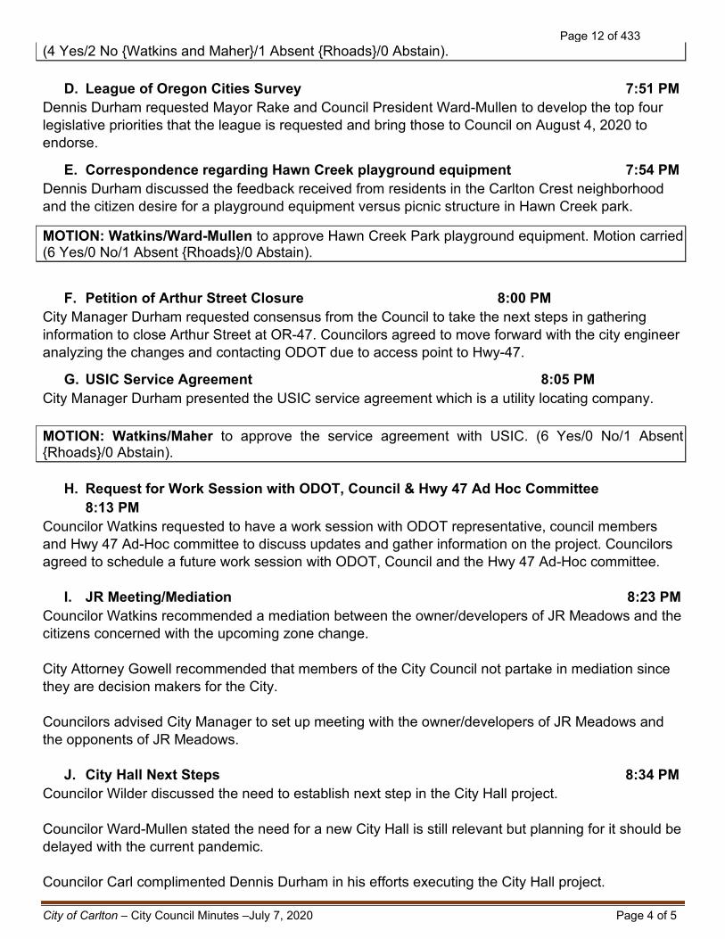
D. League of Oregon Cities Survey 7:51 PM Dennis Durham requested Mayor Rake and Council President Ward-Mullen to develop the top four legislative priorities that the league is requested and bring those to Council on August 4, 2020 to endorse.
E. Correspondence regarding Hawn Creek playground equipment 7:54 PM Dennis Durham discussed the feedback received from residents in the Carlton Crest neighborhood and the citizen desire for a playground equipment versus picnic structure in Hawn Creek park.
MOTION: Watkins/Ward-Mullen to approve Hawn Creek Park playground equipment. Motion carried (6 Yes/0 No/1 Absent {Rhoads}/0 Abstain).
F. Petition of Arthur Street Closure 8:00 PM City Manager Durham requested consensus from the Council to take the next steps in gathering information to close Arthur Street at OR-47. Councilors agreed to move forward with the city engineer analyzing the changes and contacting ODOT due to access point to Hwy-47.
G. USIC Service Agreement 8:05 PM City Manager Durham presented the USIC service agreement which is a utility locating company. MOTION: Watkins/Maher to approve the service agreement with USIC. (6 Yes/0 No/1 Absent {Rhoads}/0 Abstain).
H. Request for Work Session with ODOT, Council & Hwy 47 Ad Hoc Committee 8:13 PM
Councilor Watkins requested to have a work session with ODOT representative, council members and Hwy 47 Ad-Hoc committee to discuss updates and gather information on the project. Councilors agreed to schedule a future work session with ODOT, Council and the Hwy 47 Ad-Hoc committee.
I. JR Meeting/Mediation 8:23 PM Councilor Watkins recommended a mediation between the owner/developers of JR Meadows and the citizens concerned with the upcoming zone change. City Attorney Gowell recommended that members of the City Council not partake in mediation since they are decision makers for the City. Councilors advised City Manager to set up meeting with the owner/developers of JR Meadows and the opponents of JR Meadows.
J. City Hall Next Steps 8:34 PM Councilor Wilder discussed the need to establish next step in the City Hall project. Councilor Ward-Mullen stated the need for a new City Hall is still relevant but planning for it should be delayed with the current pandemic. Councilor Carl complimented Dennis Durham in his efforts executing the City Hall project.
Page 12 of 433

City of Carlton – City Council Minutes –July 7, 2020 Page 5 of 5
City Manager Durham proposed a monthly update on the Covid-19 pandemic during the monthly City Council meeting. Councilors agreed on these monthly updates. 7. ADJOURNMENT The regular meeting adjourned at 8:52 PM.
APPROVED by the City of Carlton City Council on August 4, 2020. ATTEST: ____________________________________ ___________________________________ Kayla Baker, Office Specialist Brian Rake, Mayor
Page 13 of 433

Accounts Payable
User:
Printed:
aamerson
7/24/2020 9:19 AM
Checks by Date - Summary by Check Date
Check No Check DateVendor NameVendor No Check Amount
AmeMai American Maid LLC 06/24/2020 1,010.0056585
CanSol Canon Financial Services, Inc. 06/24/2020 590.4656586
CarTru Carlton Truck Shop 06/24/2020 110.0056587
Comcas Comcast 06/24/2020 165.2656588
CorMai Core & Main LP 06/24/2020 42.0056589
EdgAna Edge Analytical Inc 06/24/2020 49.7056590
Holst Holst 06/24/2020 40,766.7556591
LanFor Landmark Ford 06/24/2020 24,019.4056592
LGPI LCOG 06/24/2020 615.0056593
MotSol Motorola Solutions 06/24/2020 1,359.1556594
NewReg News-Register 06/24/2020 279.7756595
PorGen Portland General Electric 06/24/2020 802.4456596
Rodda Rodda 06/24/2020 102.8456597
VerWir Verizon Wireless 06/24/2020 80.0256598
WirWor Wire Works LLC 06/24/2020 1,656.0956599
YamCom Yamhill Communications Agency 06/24/2020 2,798.7556600
74,447.63Total for 6/24/2020:
CDLand C and D Landscapes Co 06/30/2020 787.5056607
CerFol Certified Folder Display Service Inc 06/30/2020 2,020.3256608
Comcas Comcast 06/30/2020 634.7156609
DepCon Dept. Consumer & Business Serv 06/30/2020 89.6056610
EdgAna Edge Analytical Inc 06/30/2020 358.2056611
FarEle Farnham Electric Co. 06/30/2020 4,670.0056612
FasCom Fastenal Company 06/30/2020 10.2656613
FirFedCC First Federal Card Services 06/30/2020 5,169.6156614
GenTec Genuine Technology Group, Inc. 06/30/2020 4,202.0056615
HauRue Haugeberg, Rueter, Gowell 06/30/2020 1,350.0056616
ICCMA ICMA 06/30/2020 851.0056617
LanCor Corey Lane 06/30/2020 35.3756618
LeaCit League Of Oregon Cities 06/30/2020 1,999.8756619
OnliNW McMinnville Access Co. DBA Online Northwest06/30/2020 476.0056620
UB*00471 Kathleen Moss 06/30/2020 85.4656621
OreSta Oregon Stationers 06/30/2020 120.0056622
OvsKub OVS 06/30/2020 81.2156623
PriUti Private Utility Locating, LLC. 06/30/2020 1,200.0056624
TetTec Tetra Tech, Inc 06/30/2020 18,887.5456625
43,028.65Total for 6/30/2020:
Aflac AFLAC 07/05/2020 37.0056601
9985 CIS 07/05/2020 24,809.4956602
9981 EFTPS 07/05/2020 8,620.5856603
OreRev Oregon Dept. of Revenue 07/05/2020 2,412.5856604
9100 PERS 07/05/2020 6,197.5256605
10004 VOYA- State of Oregon Plan 07/05/2020 450.0056606
Page 1AP Checks by Date - Summary by Check Date (7/24/2020 9:19 AM)
Page 14 of 433

Check No Check DateVendor NameVendor No Check Amount
42,527.17Total for 7/5/2020:
BarPro Barco Products Co 07/08/2020 2,361.2156626
CasInc Caselle, Inc. 07/08/2020 136.0056627
CenLin CenturyLink 07/08/2020 505.0656628
CItBan Citizens Bank 07/08/2020 2,588.5556629
Comcas Comcast 07/08/2020 153.6356630
Con Car Carole Connell 07/08/2020 3,920.0056631
DatPro Dataprose 07/08/2020 595.2556632
DavAut Davison Auto Parts 07/08/2020 15.3756633
LawCom Lawrence Company 07/08/2020 50.0056634
Leaf Leaf 07/08/2020 188.0056635
LowHom LOWE'S Home Improvement 07/08/2020 29.7756636
McmPum McMinnville Pumping LLC 07/08/2020 1,550.0056637
OneCal One Call Concepts, Inc. 07/08/2020 45.6056638
OreRevCT Oregon Department Of Revenue 07/08/2020 350.0056639
RecWes Recology Western Oregon 07/08/2020 277.8456640
AutGro The Automation Group, Inc 07/08/2020 442.5056641
Univar Univar Solutions 07/08/2020 3,704.5756642
Ward J Jill M Ward 07/08/2020 233.7556643
YamShe Yamhill County Sheriff's Office 07/08/2020 96.0056644
17,243.10Total for 7/8/2020:
AirNor Airgas USA, LLC 07/15/2020 232.4056645
ProBui Builders FirstSource 07/15/2020 124.0256646
CarCor Carlton Corner Service 07/15/2020 581.9956647
Comcas Comcast 07/15/2020 402.9956648
EdgAna Edge Analytical Inc 07/15/2020 326.9056649
PapMac Pape Machinery 07/15/2020 485.8356650
PorGen Portland General Electric 07/15/2020 4,252.4056651
PriUti Private Utility Locating, LLC. 07/15/2020 337.5056652
UB*00472 Stone Griffon Vineyard 07/15/2020 36.5556653
UsaBlu USABlueBook 07/15/2020 19.6556654
WeeMan Weed Man 07/15/2020 478.0056655
WilFar Wilco Farmers 07/15/2020 320.5156656
7,598.74Total for 7/15/2020:
9981 EFTPS 07/20/2020 8,959.4356657
OreRev Oregon Dept. of Revenue 07/20/2020 2,498.2356658
9100 PERS 07/20/2020 6,450.3356659
10004 VOYA- State of Oregon Plan 07/20/2020 450.0056660
18,357.99Total for 7/20/2020:
AirNor Airgas USA, LLC 07/22/2020 3,747.655661
AmeMai American Maid LLC 07/22/2020 760.005662
APA American Planning Association 07/22/2020 140.005663
AssetP Asset Protection Partnership, LTD 07/22/2020 119.555664
Axon Axon Enterprise, Inc. 07/22/2020 1,820.755665
BotEqu Botten's Equipment Rental 07/22/2020 255.005666
RonBus Ron Bush 07/22/2020 2,160.005667
CDLand C and D Landscapes Co 07/22/2020 532.505668
CanSol Canon Financial Services, Inc. 07/22/2020 536.465669
Page 2AP Checks by Date - Summary by Check Date (7/24/2020 9:19 AM)
Page 15 of 433

Check No Check DateVendor NameVendor No Check Amount
CitCou CIS 07/22/2020 71,936.035670
Comcas Comcast 07/22/2020 167.865671
ConSup Consolidated Supply 07/22/2020 649.235672
CouGov Council Of Governments 07/22/2020 1,373.005673
CraRoc Crabtree Rock Company, Inc. 07/22/2020 491.135674
BusCra Craig Bush 07/22/2020 50.005675
DogDept Dog Waste Depot 07/22/2020 434.485676
FarEle Farnham Electric Co. 07/22/2020 1,355.385677
FirFedCC First Federal Card Services 07/22/2020 99.405678
GenTec Genuine Technology Group, Inc. 07/22/2020 4,202.005679
HauRue Haugeberg, Rueter, Gowell 07/22/2020 2,759.005680
Holst Holst 07/22/2020 45,445.135681
Leaf Leaf 07/22/2020 54.005682
LexPol Lexipol LLC 07/22/2020 1,950.005683
OreMan OCCMA 07/22/2020 105.355684
OreAcc Oregon Accreditation Alliance 07/22/2020 605.005685
OreSta Oregon Stationers 07/22/2020 18.005686
PorGen Portland General Electric 07/22/2020 1,207.965687
Quill Quill 07/22/2020 34.205688
SieSpr Sierra Springs 07/22/2020 33.965689
TetTec Tetra Tech, Inc 07/22/2020 42,355.005690
UsaBlu USABlueBook 07/22/2020 122.675691
VerWir Verizon Wireless 07/22/2020 280.075692
VinBou VinBound Marketing 07/22/2020 700.005693
WeeMan Weed Man 07/22/2020 1,093.505694
YamCom Yamhill Communications Agency 07/22/2020 2,798.755695
190,393.01Total for 7/22/2020:
Report Total (111 checks): 393,596.29
Page 3AP Checks by Date - Summary by Check Date (7/24/2020 9:19 AM)
Page 16 of 433

Page 1 of 1
191 E. Main St. Phone (503) 852-7575 Carlton, OR 97111
Memorandum
To: The Mayor and Members of the City Council From: Christy Martinez-Director of Administrative Services Subject: Audit Services Date: July 15, 2020
Recommended Motion It is MOVED that the City Council accept the quote from Pauly Rogers and Company PC and authorize the City Manager to sign the personal service agreement for auditing services for $23,250 FY21
Background
The City contracts for independent auditing services yearly as required by the State of Oregon ORS 297.465 and Chapter 183.
The City reached out to auditing firms that work with municipalities in this area. Two of the firms declined to bid as they did not have time this year to perform the services.
Pauly Rogers and Company PC $23,250
Boldt Carlisle & Smith $29,000
TKW Declined to bid
Grove and Swank CPA Declined to bid
Fiscal Impact
The Council allocated $36,000 in the FY21 budget for this item.
Attachments
Bids for Service
Page 17 of 433

PAULY, ROGERS AND CO., P.C. Certified Public Accountants The Leaders in Oregon Municipal Auditing
Auditing Services Proposal for: City of Carlton and Carlton Urban Renewal Agency July 10, 2020 Pauly, Rogers and Co., P.C. Roy Rogers, CPA 12700 SW 72nd Avenue Tigard, OR 97223 (503) 620‐2632 (503) 684‐7523 FAX [email protected]
Page 18 of 433

PAULY, ROGERS AND CO., P.C. Certified Public Accountants The Leaders in Oregon Municipal Auditing
TABLE OF CONTENTS
Transmittal Letter 1
Why Select Us 3
Approach to the Engagement 4
Audit Fee 8
Page 19 of 433

PAULY, ROGERS AND CO., PC 1
July 10, 2020
Christy Martinez, Director of Administrative Services City of Cartlton 191 East Main Street Carlton, OR 97111 Thank you for the opportunity to present our qualifications in order to serve as auditors for the City of Carlton and Carlton Urban Renewal Agency for the year ending June 30, 2020. We believe this proposal provides all the information you will find necessary about our firm and its services. We also hope this proposal shows our enthusiasm and eagerness to be your auditors. Pauly, Rogers and Co., P.C. has been proud to provide auditing services to governmental and non‐profit clients in many industries since 1947. Our experience and longevity in auditing has put us in the forefront of the audit industry in our state. We audit more than 200 entities annually, making us one of the largest auditing firms in the state. We believe an audit should not be a rote exercise. On the contrary, it should help our client develop and enhance the capabilities of their staff and help meet the challenges of the future. We believe the audit process can be a powerful tool in helping the City of Carlton and Carlton Urban Renewal Agency increase the effectiveness and efficiency of internal controls, reduce unnecessary and costly procedures, provide clear and compliant financial reports and develop best practices for financial oversight. We will not just write up audit findings and let your staff decide how to best fix the issue; instead we will work with staff to provide options on how to resolve complex audit issues in an efficient manner. In order to best serve you, our audit provides:
A complete understanding of the work to be performed. We communicate often throughout the year and are available to answer questions, even on April 15th (our auditors are 100% dedicated to auditing and do not provide tax services). We will ensure that you are apprised of requirements, standards, and rulings that impact financial accounting and reporting, and related compliance. We will communicate during all phases of fieldwork including a discussion of all audit findings. We are committed to clear communication and do not surprise our clients with audit findings that were not fully discussed with Management on multiple occasions.
A large audit staff to handle all of your needs. Our highly experienced staff will include a lead auditor on your job. We have over 25 auditors dedicated to auditing in the State of Oregon.
PAULY, ROGERS, AND CO., P.C. 12700 SW 72nd Ave. ♦ Tigard, OR 97223 (503) 620-2632 ♦ (503) 684-7523 FAX www.paulyrogersandcocpas.com
Page 20 of 433

PAULY, ROGERS AND CO., PC 2
A commitment to servicing governments in the State of Oregon. Pauly, Rogers and Co., P.C. has a deep commitment to servicing governments in the State of Oregon. Our commitment to servicing our state and understanding the complexities of Oregon keeps us in the forefront of auditing in the state. We audited 28 Cities last year.
Delivery of audit reports in a timely fashion. We will meet your deadlines. We understand the investment you make in the audit relationship in terms of dollars and time, and we are committed to providing value with every interaction. In order to meet your deadlines we perform interim work before your books are closed, and we have a large enough staff to perform our final fieldwork at any time. Our proposed timeline is �lexible and will meet your needs!
• Free assistance with questions. Our willingness to provide minor technical assistance throughout the year without billing for additional services has been one of the trademarks of Pauly, Rogers and Co., P.C. A great deal of discussion is expected to occur during the year, all of which helps the auditors, as well as the City properly deal with issues as they arise.
We are confident you will find our firm has the experience and ability to provide the excellent auditing and advisory services you require. You need a firm that understands how City’s operate. We are on the leading edge of auditing in the state of Oregon. We want to be The City of Carlton and Carlton Urban Renewal Agency’s auditors! Roy R. Rogers, CPA, as signer of this letter, is authorized to make representations and to execute a personal services contract on behalf of the firm. We consider the terms of this proposal negotiable, and will enter into negotiations with the City of Carlton and Carlton Urban Renewal Agency, if there are minor items that should be worked out. This proposal is a firm and irrevocable offer for ninety (90) days from the date of submission on July 10, 2020. We may be reached at the address and the telephone number listed on page one (1) of this letter should you have any questions.
Very truly yours,
Roy R. Rogers, Managing Partner PAULY, ROGERS AND CO., P.C.
Page 21 of 433

CITY OF CARLTON AND CARLTON URA WHY SELECT US
PAULY, ROGERS AND CO., PC 3
Why Select Us
Differences
We are familiar with Springbrook.
We exercise diligence and do not take shortcuts with the audit
process.
Our clients stay with us so we do not spend unnecessary time
advertising, marketing or beating the street for new business.
We are known experts in the state.
Fee arrangements and expenditures are agreed to in advance.
We provide client assistance packages.
We respect your staff time so we provide information portals.
We encourage open and ongoing communication and do not bill
for routine calls and discussions.
We attract talented and bright staff.
Our staff receive complete and comprehensive training.
We are using technology to innovate audit processes.
We always give our clients responsive and timely advice on their
questions.
Your Bene�its
This means your staff will not have excessive time to familiarize
us with your operating system.
You get a thorough audit.
We can spend more time on your audit!
We can provide you proactive advice on new accounting
pronouncements.
There are no surprises to you .
You know what to expect from our visits.
This allows your staff to provide us information on their time
schedule.
For most clients, this amounts to a savings in unbilled fees.
They provide you value and a positive working relationship.
This ensures you an effective and ef�icient audit.
This drives our internal cultures and gives you a thorough and
comprehensive audit.
As the world continues moving at a more rapid pace, we can help
guide you though the changes.
Page 22 of 433

CITY OF CARLTON AND CARLTON URA APPROACH TO THE ENGAGEMENT
PAULY, ROGERS AND CO., PC 4
Approach to the Engagement Planning Annually, our firm develops and updates audit programs for all of our audit clients, specifically tailored for the organization. This process involves the firm's Partners, Managers and Senior Associates, and is designed to develop programs that meet all professional standards of the American Institute of Certified Public Accountants and the Minimum Standards for Audits of Oregon Municipal Corporations. During this time, the assigned Senior Associate would contact the City’s personnel to discuss areas of emphasis, timing of fieldwork and reporting or other ways our firm can better meet the needs of the organization. To help provide timely audit reports, we normally perform interim work during a mutually agreeable time. We will send an “Audit Itinerary” early in the fiscal year which includes your audit team contact information as well as interim and final audit preparation lists. Understanding The City and Urban Renewal Agency’s Internal Controls During interim work, we perform a review of the accounting records in use and conduct an evaluation of internal control as required by generally accepted auditing standards. Our process of gaining an understanding of internal control entails interviewing various accounting staff to develop written walkthrough documents that highlight key controls and control weakness, filling out control checklists, as well as discussions with supervisory staff on areas where controls may be lacking. Any deficiencies encountered in the accounting records or internal control, together with our recommendations, will be discussed with Management at that time. This procedure may permit implementation of corrective action prior to issuance of the audit report and management letter. The work to be performed would include documentation of our understanding of the City’s system of internal accounting controls, initial testing of the accounts payable controls and payroll controls, and initial testing of management's reconciliation procedures for higher risk balance sheet accounts such as cash and investments. Our audit procedures will be developed to target risks identified during our risk assessment of all account balances and transaction classes. Analytical Procedures and Substantive Audit Tests In conjunction with the City’s personnel, we will schedule a period of time to complete the final work. The audit team would usually consist of two accountants. During this time, we will complete our testing of the internal control system and begin substantive testing of the City’s accounts. Once we get a copy of the final general ledger we will perform an initial analytic review that will highlight areas where there may be significant changes from prior years. We will then determine if these changes are reasonable and this will dictate the level of risk and testing to be applied to each area of the audit. The substantive testing will include independent confirmations where practical and needed, or examination of subsequent activity, when efficient. Our procedures will include testing the reconciliation of the City’s property tax receipts with those of the County Treasurer, confirmation of revenues received from the State of Oregon and confirmation of any other significant grants or revenues. Tests of expenditures will include sampling of both accounts payable and payroll cycles to ensure adequate coverage. On certain accounts we will perform detailed analytic work that would entail predicting the ending account balance and comparing that with the actual balances, and then determining if the difference is reasonable. If not, we would perform
Page 23 of 433

CITY OF CARLTON AND CARLTON URA APPROACH TO THE ENGAGEMENT
PAULY, ROGERS AND CO., PC 5
additional tests on that account. We will also perform detailed substantive tests on all other significant balance sheet and income statement accounts. If there are any audit adjustments we will discuss this with management and give you our reasoning before we proceed with the adjustment. We won’t surprise you with journal entries that are not discussed! We would complete the grant compliance review during this phase, if necessary. Our program guides will be completed and conclusions documented relating to the assertions implicit in grant compliance and financial reporting. Financial Reporting Review and Analysis The reporting phase of the engagement will be initiated in the field and completed in our office after completion of on‐site fieldwork. The reporting phase would be handled by the assigned Senior Associate. This phase of the audit will include completion of our audit files, analysis and comparisons, as well as a detailed review of the financial statements. The review component of the audit includes a review of all workpapers, documents and the financial reports by the team involved in the audit, as well as the compliance manager and manager on the job. At a minimum your audit file and financial statements have three different reviews. The Concurring Partner also performs a technical review of the financial statements and reviews the workpapers for completeness and reviews any important accounting issues, the communication of internal control matters and communication with the governing body, if applicable, and the attorney letter. Use of The City and Urban Renewal Agency’s Personnel This proposal is based on the anticipated cooperation of the City’s personnel and the assumption that the City’s books will be balanced, reconciled and all accruals made. It is also understood that the City will prepare all mutually agreed‐upon internal financial schedules, and upload all requested files to our secure Sharefile portal. The schedules we request the City to prepare are no more than those which would be required to prepare a hard, well‐documented close of the books at year‐end. We request the City prepare all confirmation letters, retrieve documents, answer questions and, of course, prepare the financial statements as early in the audit process as possible so that we can audit the financials. We do not foresee any anticipated issues with the audit of the City. However, it is possible that issues will arise during the course of the audit. We will keep you up to date of any major audit issues as we become aware of them. Ability and Willingness to Provide Constructive Suggestions Due to our extensive experience with auditing, we are able to focus on the critical areas and perform the audit in the most efficient manner possible. We can offer valuable suggestions to the organization, as well as compare your procedures with other similar entities. These advantages have kept us in the forefront of auditing in Oregon. As we audit and advise clients, major issues are addressed and solved. We then rely on conversations with client management to address minor issues, and advise upper management and Governing Bodies of our clients when major issues arise. We are not shy in discussing sensitive topics with any level of management. We never blind‐side our clients with un‐reviewed management letter comments, and are agreeable to modifying language that does not dilute the message but enhances readers’ understanding of the issues.
Page 24 of 433

CITY OF CARLTON AND CARLTON URA APPROACH TO THE ENGAGEMENT
PAULY, ROGERS AND CO., PC 6
Board of Directors Annually in the planning phase we will send a letter to the City Council requesting information on potential audit areas of interest that we should delve into further. We find that this questionnaire is essential in designing our audit tests. For each issue identified in the questionnaire we will gain a better understanding of the issue and address it as part of our audit process. Upon completion of the audited financial report we will send the Council a letter detailing the findings of our audit as well as a description of key audit areas and future accounting and auditing pronouncements.
Page 25 of 433

CITY OF CARLTON AND CARLTON URA APPROACH TO THE ENGAGEMENT
PAULY, ROGERS AND CO., PC 7
Timeline for Completing the Engagements Note: These hours are an estimate based upon our experience auditing nonprofits. Since we do not bill by the hour, other than for special projects, we will spend whatever amount of time is necessary to meet professional standards and perform the audit in accordance with the proposal. Below is the timeline for the audit.
Written Work Plan and Planning
Interim Work
Audit Fieldwork
Draft and Review Reports
Delivery
The audit program will be written by assigned Senior Associate & Roy including any special procedures developed after meeting with the organization. The engagement letter and planning will also be executed during this time.
Internal control, audit risk and materiality would be evaluated. Initial compliance work will begin.
Audit �ieldwork will be conducted at an agreed‐upon time when the books are closed. The exit conference would occur immediately upon completion of the �ieldwork, and would include a discussion of our study of the internal control system and the observations and conclusions from it. Also, we would communicate any potential �indings and recommendations.
Preparation of the audit �ile and �inancial reports, including technical and second Partner review.
The �inal reports will be printed and delivered by the agreed‐upon date.
July/Aug 16 hours
July/Aug 96 hours
Aug/Sept 104 Hours
Oct/Nov 26 Hours
Nov 7 Hours
Total Hours 249
For City and Urban Renewal Agency
Page 26 of 433

CITY OF CARLTON AND CARLTON URA AUDIT SERVICES FEES
PAULY, ROGERS AND CO., PC 8
Audit Fees Our not‐to‐exceed fee for the year ending June 30, 2020 for City of Carlton and Carlton Urban Renewal Agency is listed below. The fee is based on the anticipated cooperation of the City’s staff, and on the assumption that the books will be closed, balanced and all appropriate accounts reconciled to the detail and the trial balance will have been prepared and made available to us before we begin our final fieldwork. The fees also assume that the City will use our Sharefile Portal to upload all requested audit documents. The portal allows us to keep audit fees low and perform a great deal of the audit work remotely. We anticipate that about 20‐30% of our work will be done on site. It also includes the auditing standards in effect for this year, but not changes in standards or potential scope of work changes that might occur in future years for standards not yet issued. These fees are inclusive of all staff time, all services outlined below and all of our out‐of‐pocket expenses for travel and supplies. Telephone calls and emails from the organization seeking advice or assistance are welcomed anytime during the year, and such calls are anticipated as part of the total proposed fee. Our willingness to provide minor technical assistance throughout the year without billing for additional services has been one of the trademarks of Pauly, Rogers and Co., P.C. A great deal of discussion is expected to occur during the year, all of which helps the auditors, as well as the organization properly deal with issues as they arise.
City of Carlton Carlton Urban Renewal Agency
Services For Year Ending June 30, 2020
For Year Ending June 30, 2020
Annual Audit 19,500 2,900
Financial Statements 3,950 800
Total 23,450 3,700 Fees for future years will increase for inflation and new accounting standards. This is normally 4‐6% per year. Rates for Additional Professional Services Pauly, Rogers and Co., P.C. can provide the organization with a variety of services in addition to the annual audit. Special reports, projects or other work undertaken at the client’s request is billed at the following hourly rates for 2020: Managing Partner $190, Partner $170, Manager $130, Senior Associate $120, Associate and Staff Accountant $110 and Support Staff $55. At the time of the request, we would estimate the fee to be charged and seek written approval of that fee. Special projects could be unit‐priced or receive a reduced fee if they were scheduled at times when we are less busy with audit work.
Page 27 of 433

July 16, 2020
City of Carlton 191 E. Main St Carlton, OR 97111
Boldt Carlisle + Smith is pleased to provide you with our quote for professional auditing services for the year ended June 30, 2020. Having over 50 years of experience auditing local governments in Oregon, our firm is qualified to perform the audit of City of Carlton and the Carlton Urban Renewal Agency and capable of providing quality auditing services at a competitive price in a timely, efficient manner for as follows:
Scope of Work
Audit performed in accordance with: Generally Accepted Auditing Standards Minimum Standards for Audits of Oregon Municipal Corporations
Report requirements: Independent auditor’s report Independent auditor’s report required by Oregon State Regulations
Additional communications: Provision of year-end journal entries Summary of revenues and expenditures Required communications under AU-C 260 to those charged with governance Letter to those charged with governance under AU-C 265 to report findings and recommendations,
if applicable
Qualifications and Experience
We have over 50 years of experience auditing Oregon Municipal Corporations, including cities similar to the City of Carlton. Performing over 60 audits a year allows us to bring a breadth of experience to all our audits including familiarity with unique issues in local government such as PERS reporting, bond issuances, Oregon budget law, and federal and state grant compliance.
As the assurance partner at Boldt Carlisle + Smith, Brad Bingenheimer oversees all of the firm’s audits. He has over 30 years as a CPA performing hundreds of governmental audits, and was recently Chair of the Governmental Accounting & Auditing Strategic Committee at the Oregon Society of CPAs. Brad has been invited to speak on several occasions at the Oregon Government Finance Officers Association conference and also presented at the OSCPA Governmental Accounting and Auditing conference this year.
Boldt Carlisle + Smith and all assigned key professional staff are properly registered and licensed by the Oregon State Board of Accountancy to practice public accounting in Oregon and are registered by the same licensing body to perform audits of Oregon municipal corporations. Our staff includes 25 CPAs, including 8 on the Oregon Municipal roster.
Page 28 of 433

Pre-Audit Municipal Seminar
Annually, we provide a four to six hour seminar as a no-charge service to our local government audit clients. The seminar is designed for individuals who hold positions of fiscal and administrative responsibility and can cover topics such as internal controls, cybersecurity, or other suggestions for improving procedures. Attendants have told us that this seminar is useful because it provides information on issues of current interest and a forum to exchange ideas with others who are actively involved in fiscal operations.
Proposed Fees
Our all-inclusive fees for the audits of the financial statements for June 30, 2020 are based on the expected time required to complete the engagements and the level of experience required as follows:
Entity Fee
City of Carlton $ 29,200 Carlton Urban Renewal Agency $ 3,250
References
Please feel free to contact any of the following organizations regarding our professional services:
City of Forest Grove Paul Downey [email protected] City of Brownsville Scott McDowell [email protected] City of Newberg Matt Zook [email protected] Yamhill County Mike Barnhart [email protected]
Brad Bingenheimer, Member, is entitled to represent the firm, empowered to submit this quote and authorized to sign a contract with the District on behalf of Boldt Carlisle + Smith.
If you have any questions after you have had an opportunity to review our proposal, we would be pleased to answer them. Please contact Brad Bingenheimer at (503) 585-7751.
Very truly yours,
BOLDT CARLISLE + SMITH
Bradley G. Bingenheimer, CPA Telephone: 503-585-7751 Fax: 503-370-3781 Email: [email protected]
Page 29 of 433

10215 NE Old McMinnville HighwayZone Change Application
City Council MeetingAugust 4, 2020
City of Carlton File No.: CPA/ZC 2020-01
Page 30 of 433

Project Team» TJA, LLC
» Owner/Applicant
» Steve Reimann and Jake Lucey
» AKS Engineering & Forestry, LLC» Land Use Planning, Civil Engineering, Surveying, Landscape
Architecture, Arborist, and Natural Resources Consultant
» Monty Hurley and Chris Goodell
» Lancaster Mobley» Transportation Engineering Consultant
2
Page 31 of 433

Site Overview» South of E Main Street
» West of NE Old McMinnville Highway
» South of JR Meadows Subdivision
» ±13.94 Acres
» Agricultural Holding (AH) (Current)
» Site has been within City UGB since 1981 when Carlton UGB was established
3
Page 32 of 433

Comprehensive Plan» Housing [Goal-10]
» The City’s 2007 Housing Needs Analysis estimated that 233 additional dwelling units will be needed in Carlton by 2027.
» This included an estimated need for 176 new single-family and 57 multifamily units.
» “The City shall encourage a mix of housing types including duplex development within new subdivisions and residential planned unit developments until City’s housing mix more closely resembles preferred ratio of 75% single-family to 25% multifamily.”
» As noted in the Findings prepared by City staff, based on 2019 data, the current ratio of housing mix in Carlton is 97% single-family to 3% multifamily.
4
Residential (R)
Recently Rezoned from AH to R
Page 33 of 433

Planned Zone Change» Provides Variety of Housing Types» Brings City Closer to Preferred Ratio of
Housing Types» Residential-Medium Density (R-2)
» ±11.97 Acres
» Planned to Accommodate 55 Lots for Future Single-Family Detached Homes
» Residential-Medium High Density (R-3)» ±1.97 Acres
» Planned to Accommodate 22 Future Multifamily Dwellings
» Mix of housing types is 71% single-family to 29% multifamily, which closely matches City’s desired mix
5
Page 34 of 433

Zone Change Review Criteria • Planned Zones are appropriate for properties with a Comprehensive Plan Designation (AH)
• Allowed uses within R-2 and R-3 can be accommodated on the site
• Allowed uses in R-2 and R-3 can be established in compliance with development requirements
• Adequate public facilities are in place to accommodate property
• All of the criteria listed in purpose statement of proposed zones (R-2 and R-3) are met
6
Page 35 of 433

7
A.
Zone Change 17.180.050 - Criteria for approval.
The proposed zone is appropriate for the comprehensive plan land use designation on the property and is consistent with the description and policies for the applicable comprehensive plan land use classification.
The Residential Plan Designation implemented through the R-2 and R-3 Zoning Designations is consistent with the Agricultural Holdings (AH) Comprehensive Plan Policies.
• City of Carlton Comprehensive Plan
• Agricultural Lands (Goal 3)
Policy 1. Agricultural land conversion to urban uses shall be done only when adequate public facilities and services are available to the area(s) proposed for development.
1. Public facilities are adequate and available to provide services to the site.
2. As detailed in the City Staff Report “The City finds public streets, water, sanitary sewer and private utilities will be available to the parcel after utilities are installed in the adjoining JR Meadows.”
Policy 2. The City shall retain established agricultural holding zones until agricultural lands are needed for urban uses.
1. The City’s Comprehensive Plan estimated a need for 176 new single-family and 57 multifamily units by the year 2027.
Page 36 of 433

The uses permitted in the proposed zone can be accommodated on the proposed site without exceeding its physical capacity.
Zone Change 17.180.050 - Criteria for approval.
Residential homes with associated infrastructure and amenities can be accommodated on the site.
B.
StreetsUnderground UtilitiesSidewalksOpen SpaceTrails
8
Page 37 of 433

Allowed uses in the proposed zone can be established in compliance with the development requirements of this title.
Zone Change 17.180.050 - Criteria for approval.
Preliminary Site Plan
Lot Sizes - 6,000 to 7,450 square feetMinimum Lot Size in R-2 District is 6,000 square feet22 Future Multifamily DwellingsPermitted Density in R-3 District is 8 to 32 units per acre
C.
9
Page 38 of 433

Adequate public facilities, services, and transportation networks are in place or are planned to be provided concurrently with the development of the property.
10
Zone Change 17.180.050 - Criteria for approval.
The City Engineer has reviewed the application and finds that adequate public facilities will be available after the improvements for JR Meadows Subdivision to the north are installed.
Water“There is sufficient water system distribution infrastructure to serve the proposed zone change.”
Sanitary Sewer“The Wastewater Facility Plan identified upgrades and the City has added them to the CIP and intends to improve the treatment plant in the near future. With the improvements there will be sufficient capacity in the treatment system.”
Hawn Creek Pump Station to provide adequate capacity Hawn Creek Pump Station upgrade funded by this project With Hawn Creek Pump Station upgrade, sufficient sanitary sewer system to support zone change
“Based on proposed improvements to the collection system that the City is undertaking, there would be capacity for the proposed zone change.”
Streets and Transportation“A traffic analysis was prepared by a professional traffic engineer for 77 units,…the operations of the major intersections (7th Street at E Main Street and S Pine Street at E Polk Street will be impacted, but the level of service is considered acceptable with no improvements to the intersections.”All streets are planned to comply with Transportation System Plan (TSP) and provide long-term community connectivity.
Schools“…the Yamhill-Carlton School District does have the capacity to serve and support the number of students that would likely be projected in the development described.” – Bill Rhoades, Superintendent of Yamhill Carlton School District
D.
Page 39 of 433

For residential zone changes, the criteria listed in the purpose statement for the proposed zone shall be met.
Zone Change 17.180.050 - Criteria for approval.
The purpose statement for the R-2 Zoning District states, “The Residential-Medium Density (R-2) District is to provide for single-family and duplex housing at an average density of ten (10) dwelling units per acre or less. The R-2 District is consistent with the new Residential Medium-Density Comprehensive Plan designation.”
Density Requirements
Minimum Lot Size
Dimensional Standards
Details Confirmed with Subdivision Review
E.
11
Page 40 of 433

For residential zone changes, the criteria listed in the purpose statement for the proposed zone shall be met.
Zone Change 17.180.050 - Criteria for approval.
The purpose statement for the R-3 Zoning District states “The Residential-Medium High Density (R-3) district provides opportunities for higher density housing in close proximity to substantial commercial and public development where full urban services are available. The R-3 district, which generally accommodates residential development of eight (8) to thirty-two (32) units per acre, is consistent with the residential comprehensive plan designation.”
Density Requirements
Minimum Lot Size
Dimensional Standards
Details Confirmed with Site Design Review
E.
12
Page 41 of 433

City of Carlton Transportation System Plan (TSP) Future Street Plan
13
E Wilson Street
E Taylor Street
E Cleveland Street
S 3r
dSt
reet
E Washington Street
E Taft Street
S 7t
h St
reet
S 8t
h St
reet
E Wilson Street
Page 42 of 433

Conceptual Neighborhood Circulation Plan
14
J R Meadows Park
E Cleveland Street
E Taylor Street
S 8t
h St
reet
S 7t
h St
reet
Page 43 of 433

City of Carlton Future Street Plan and Conceptual Neighborhood Circulation Plan
15
Page 44 of 433

Preliminary Site Plan» Subdivision
» 55 Lots for Future Single-Family Detached Homes
» 1 Lot for Future Multifamily Dwellings
» Open Space Areas » ±1.93 Acres (14% of Total Site)
» Planned Tree Preservation» ± 30% of on-site trees are planned to be retained
» Interconnected Street System» Provides roadways shown on the Transportation
System Plan (TSP)
» Street stubs (planned for future street connectivity)
» Interconnected Pedestrian Circulation System» Connects open space/park area adjacent to
multifamily lot to Carlton Elementary School via sidewalks and trails
16
Page 45 of 433

17
Public Streets, Utilities, and Infrastructure» Streets and Transportation
» Professional traffic study submitted and reviewed by City Engineer
» Intersections function at acceptable levels before and after development
» Plan provides the roadways/transportation infrastructure shown on the City’s TSP
» Sufficient transportation system to support zone change per City Engineer
» Stormwater Improvements» Preliminary Stormwater Report will be submitted and
reviewed by City Engineer with subdivision application
» Final Stormwater Report will be reviewed and approved by City Engineer prior to permits
» Sufficient stormwater system to support zone change per City Engineer
» Water» Fire flow analysis and calculations reviewed and approved by
City Engineer
» Sufficient water system to support zone change per City Engineer’s review
» Sanitary Sewer » Hawn Creek Pump Station upgrade to provide adequate
capacity
» Hawn Creek Pump Station upgrade funded by this project
» With Hawn Creek Pump Station upgrade, sufficient sanitary sewer system to support zone change per City Engineer
» Wetlands» Wetland delineation and mapping work already completed
» Wetlands are planned to be preserved
» No work will be done within wetlands without required permits
» Floodplain» Floodplain planned to be preserved
» Work will not take place within floodplain without required permits
» Schools» “…the Yamhill-Carlton School District does have the capacity
to serve and support the number of students that would likely be projected in the development described.” – Bill Rhoades, Superintendent of Yamhill Carlton School District
Page 46 of 433

» Site is adjacent to Carlton Elementary School, identified on the City Parks and Recreation Facilities plan within the draft Carlton Parks Development Plan dated December 2019
» City currently has 23.18 acres of parkland
» City to add ±9.5 additional acres of parkland over next 20 years
» Future City of Carlton parkland acquisition to focus on additional lands in areas not currently within one quarter to one half mile of an existing park and recreation facility
Subject Site
18
C arlton Elementary
JR Meadows
Planned Open Space/Parks
City of Carlton Open Space/Parks
Page 47 of 433

Financial BenefitsEstimated SDC Fees
19
JR Meadows Phase 1 Single Family Units Multi Family Units Total
37 11 48
Per Unit
Park $1,948.00 $72,076.00 $21,428.00 $93,504.00
Sewer $8,033.00 $297,221.00 $88,363.00 $385,584.00
Stormwater $2,087.00 $77,219.00 $22,957.00 $100,176.00
Transportation $3,829.00 $141,673.00 $42,119.00 $183,792.00
Water $7,950.00 $294,150.00 $87,450.00 $381,600.00
Subtotal $23,847.00 $882,339.00 $262,317.00 $1,144,656.00
JR Meadows Phase 2Single Family Units Multi Family Units Total
55 22 77
Per Unit
Park $1,948.00 $107,140.00 $42,856.00 $149,996.00
Sewer $8,033.00 $441,815.00 $176,726.00 $618,541.00
Stormwater $2,087.00 $114,785.00 $45,914.00 $160,699.00
Transportation $3,829.00 $210,595.00 $84,238.00 $294,833.00
Water $7,950.00 $437,250.00 $174,900.00 $612,150.00
Subtotal $23,847.00 $1,311,585.00 $524,634.00 $1,836,219.00
Total (Phases 1 and 2) $2,193,924.00 $786,951.00 $2,980,875.00
Page 48 of 433

Financial BenefitsEstimated Utility Connection Fees*
20
JR Meadows Phase 1 Single Family Units Multi Family Units Total
37 11 48
Per Unit
Sewer $200.00 $7,400.00 $2,200.00 $9,600.00
Water $650.00 $24,050.00 $7,150.00 $31,200.00
Subtotal $850.00 $31,450.00 $9,350.00 $40,800.00
JR Meadows Phase 2Single Family Units Multi Family Units Total
55 22 77
Per Unit
Sewer $200.00 $11,000.00 $4,400.00 $15,400.00
Water $650.00 $35,750.00 $14,300.00 $50,050.00
Subtotal $850.00 $46,750.00 $18,700.00 $65,450.00
Total (Phases 1 and 2) $78,200.00 $28,050.00 $106,250.00
*Utility Connection Fees are in Addition to SDC Fees
Page 49 of 433

Financial BenefitsEstimated Construction Excise Tax
21
JR Meadows Phase 1 Single Family Units Multi Family Units Total
37 11 48
Yamhill Carlton School District* $74,000.00 $11,000 $85,000.00
Subtotal $74,000.00 $11,000 $85,000.00
JR Meadows Phase 2Single Family Units Multi Family Units Total
55 22 77
Yamhill Carlton School District* $110,000.00 $22,000 $132,000.00
Subtotal $110,000.00 $22,000 $132,000.00
Total (Phases 1 and 2) $184,000.00 $33,000 $217,000.00
* $1.00 Per Square Foot. This assumes Single Family Homes average 2,000 Square Feet, and Multi-Family Units Average 1,000 Square Feet
Page 50 of 433

Financial BenefitsEstimated Property Taxes
22
JR Meadows Phase 1 Single Family Units Multi Family Units Total All Units in Phase 1
37 11 48
Real Market Value** $400,000.00 $175,000.00
Assumed Assessed Value Percentage 63.00% 75.00%
Assessed Value $252,000.00 $131,250.00
Property Tax Rate 0.0175375 0.0175375
Annual Tax Estimate $4,419.45 $2,301.80
Subtotal $163,519.65 $25,319.77 $188,839.42
JR Meadows Phase 2Single Family Units Multi Family Units Total All Units in Phase 2
55 22 77
Real Market Value** $400,000.00 $175,000.00
Assumed Assessed Value Percentage 63.00% 75.00%
Assessed Value $252,000.00 $131,250.00
Property Tax Rate 0.0175375 0.0175375
Annual Tax Estimate $4,419.45 $2,301.80
Subtotal $243,069.75 $50,639.53 $293,709.28
Total (Phases 1 and 2) $406,589.40 $75,959.30 $482,548.70** These are assumed values
Page 51 of 433

Financial Benefits Estimated State School District Funding
23
JR Meadows Phase 1 Single Family Units Multi Family Units Total All Units in Phase 1
37 11 48
Percentage 75.00% 75.00%
Children per Household 1.24 1.24
ADM Allotment per Child (State) $8,988.00 $8,988.00
Subtotal $309,277.08 $91,947.24 $401,224.32
JR Meadows Phase 2Single Family Units Multi Family Units Total All Units in Phase 2
55 22 77
Percentage 75.00% 75.00%
Children per Household 1.24 1.24
ADM Allotment per Child (State) $8,988.00 $8,988.00
Subtotal $459,736.20 $183,894.48 $643,630.68
Total (Phases 1 and 2) $769,013.28 $275,841.72 $1,044,855.00
Page 52 of 433

Financial BenefitsEstimated Utility User Fees
24
JR Meadows Phase 1 Single Family Units Multi Family Units Total
37 11 48
Average Utility Bill $151.18 $151.18 $151.18
Months 12 12 12
Subtotal $67,123.92 $19,955.76 $87,079.68
JR Meadows Phase 2Single Family Units Multi Family Units Total
55 22 77
Average Utility Bill $151.18 $151.18 $151.18
Months 12 12 12
Subtotal $99,778.80 $39,911.52 $139,690.32
Total (Phases 1 and 2) $166,902.72 $59,867.28 $226,770.00
Page 53 of 433

25
Public Support for the Zone Change Application
“The brand-new home in a small town was what brought us out to this area. And we have only continued to grow and support the community since calling YC home. We believe that bringing another new development to Carlton can truly help grow our community. lt means more locals supporting the local businesses and supporting the youth of our area as well.
We were blessed to get the opportunity to call YC home because of a new subdivision that had been built and we would like to see others get the same opportunity.
We are in favor of City File #CPA/ZC 20L9-O2 TJA, LLC .” – Mike and Carrie Lawson
Page 54 of 433

26
Public Support for the Zone Change Application
To Whom it May Concern,
I am writing in favor of City File #CPA/ZC20L9-02 TJ A. As a small business owner on Main Street in Carlton, well planned community growth is vital to the continued growth and success of small business.
Main Street businesses are the heart of Carlton and often what draws families to move to our Great Little Town. Currently over 65% of the patrons of Barrel 47 are local residents. Being able to provide a quality dining experience for our local residents is the cornerstone of our business.
As always with growth comes growing pains. That is why I support this measure as it addresses critical infrastructure needs that will ensure successful growth of our fair town.
RespectfullyAndy RabungOwner Barrel 47
“That is why I support this measure as it addresses critical infrastructure needs that will ensure successful growth of our fair town.” – Andy Rabung, Owner of Barrel 47
Page 55 of 433

27
Public Support for the Zone Change Application
“We would like to commend the Planning Commission and staff for its excellent Goal 10 findings contained within the Staff report for CPA.ZC 2020-01. The findings provide detailed context regarding the progress the City is making towards satisfying its housing needs and describes the affects the changes will have on the housing supply within the City. The document will serve the City well over the next 20 years to help meet its Goal 10 requirements.” –Louise Dix, Fair Housing Council of Oregon
Page 56 of 433

“I would like to express my support for the proposed zone change from Agricultural Holding to Residential-Medium Density of R-2 (11.97 acres) and Residential-Medium High Density or R-3 (1.97), for the purpose of building new residential buildings. I think that the proposed zone change, and the subsequent development of associated land for residential use, will benefit both the Carlton community at large and the businesses established in Carlton .” – Tim Corrigan, Carlton Resident and Business Owner
28
Public Support for the Zone Change Application Page 57 of 433

Chris GoodellAKS Engineering & Forestry12965 SW Herman Road, Suite 100Tualatin, OR [email protected](503) 563-6151
Questions?
29
Page 58 of 433

1
RECOMMENDATION FROM THE CITY OF CARLTON PLANNING COMMISSION
CITY STAFF REPORT DATE: July 27, 2020 FILE: Comprehensive Plan Map Amendment and Zone Change City File #CPA.ZC 2020-01 FROM: Carole Connell, Carlton City Planner HEARING DATE: Carlton City Council on August 4, 2020 APPLICANT: TJA, LLC 9110 NW Clay Pit Road Yamhill, OR 97148 OWNER: Larry and Cheryl Park 10215 NE Old McMinnville Highway Carlton, OR 97111 REQUEST: A Comprehensive Plan & Zone Map Amendment for 13.94 acres
from Agricultural Holding AH to Residential – Medium Density R-2 (11.97 acres), and to Residential - Medium-High Density R-3 (1.97 acres)
SUBJECT LOCATION: 10215 NE Old McMinnville Highway. An 18.96-acre parcel, Tax
Lot 1300 Section 22 T3S R4W; with access to Old McMinnville Highway to the east and adjoining the south boundary of JR Meadow subdivision on E. Main Street
PLAN DESIGNATION: Comprehensive Plan Map: Agricultural Holding Zoning: Agricultural Holding AH CRITERIA: Carlton Development Code (CDC) Chapters 17.48 AH and 17.22
R-2 & 17.28 R-3 Zones; 17.180 Zone Change; 17.196 - 200 Public Hearings Before the Planning Commission and City Council; 17.212 Type IV Actions; Carlton Comprehensive Plan; TSP Future Street Plan; Carlton Parks and Recreation Plan
ENCLOSURES: Applicant’s Zone Change application materials, plans PO-01 to PO-06, Traffic Impact Analysis by Lancaster Mobley, March 2020; Applicant’s 27 day Waiver of 120-day rule, applicant’s financial data letter, Carlton TSP map, Ag parcels in use map, and 1981 Carlton UGB map.
Page 59 of 433

2
I. REQUEST On May 18, 2020, the Planning Commission approved a Preliminary Land Partition to divide the subject parcel into two parcels to separate the land inside the Carlton city limits/UGB from the portion outside the city. When the final partition plat is recorded the 18.96-acre parcel is proposed to be divided on the City/County jurisdictional boundary line as follows:
• Parcel 1: 13.94 acres (City) • Parcel 2: 5.02 acres (County)
On May 18, 2020 subject to the final partition approval and recording, the Planning Commission also recommended approval of a Comprehensive Plan and Zone Map change for Parcel 1 from Agricultural Holding to Residential Medium-Density R-2 on an estimated 11.97 acres, and Residential Medium-High Density R-3 on an estimated 1.97 acre portion of the city parcel. The request does not include a development plan approval. However, a 77- 182-unit development could be built inside the city if the zone change is approved by City Council. The applicant’s Exhibit A Sheet PO-06 indicates a tentative conceptual plan for 56 single family dwellings and 22 or more multi-family dwellings. The applicant has provided the plan so that neighbors, city residents and city officials are aware of the owner’s intent and preliminary impacts. If the zone change is approved by City Council, the applicant must file a detailed subdivision and development plan for Planning Commission consideration. If a preliminary subdivision plan is approved the applicant shall design engineered construction plans in accordance with city public facility requirements for City Public Works and Engineering review and approval. Site: The subject property is inside the City limits and the Carlton Urban Growth Boundary (UGB) and is planned for urban development. It is currently zoned Agricultural Holding and is vacant. The parcel is adjoined by Carlton elementary school, residential housing and vacant land zoned R-1 and R-2 to the north and west, and Agricultural Holding zoning to the south. The parcel outside the city/UGB is farmland zoned by Yamhill County EFU 80-acre minimum. There are no permanent structures on the site Sheet PO-02 Existing Conditions indicates varied topography with elevations ranging from 145’ to 175’. The FEMA FIRM flood hazard area crosses the parcel in the upper right-hand corner denoting the Hawn Creek 100-year floodplain. Sheet PO-02 identifies dozens of trees over 6” dbH as well as four (4) wetlands and drainage streams in the northeast, southwest and northwest corners of the site. Wetlands: The Division of State Lands (DSL) responded to the city’s notice with several comments about the site regarding wetlands and land use. In summary, the DSL staff recommends the applicant submit their informal wetland delineation boundaries to DSL for formal review and approval per OAR 141-090-0035. Prior to this it is advised that the applicant and local planning departments view the wetland boundaries currently shown as preliminary, subject to change. At the time of subdivision development, state and federal permits may be
Page 60 of 433

3
required if wetland impacts are proposed. The subdivision platting shown but not yet submitted for formal review appears that it will create lots that pose future development problems due to wetland presence. If the applicant has any questions about wetland permitting and how to best demonstrate avoidance and minimization of wetland impacts, please contact Mike DeBlasi of DSL at 503-986-5226.” As part of any development application on this property, a state-approved wetland delineation and mitigation plan will be required. It will be submitted to the City for review. Site access is currently from Old McMinnville Hwy. The partition creates a landlocked Parcel 1 unless or until JR Meadows subdivision streets are built to provide access from 7th Street. The Partition approval is subject to a condition that requires a recorded emergency access to the site from Old McMinnville Hwy. Future Streets: The 2009 Carlton Transportation System Plan (TSP) designates future street extensions to serve urban development on vacant land inside the UGB. The TSP identifies the extension of Cleveland and Wilson Streets from the west through the site, as well as two north/south street extensions including 7th Street and a new unnamed east of 7th Street. See Applicant’s Exhibit A PO-04 Conceptual Neighborhood Circulation Plan. II. PROCEDURE & AUTHORITY A Plan/Zone Change is processed as a Type IV public hearing procedure in which an initial public hearing is held by the Planning Commission who makes a recommendation for approval or denial to City Council based on substantial findings in response to the plan and zone map amendment approval criteria of CDC 17.180. The Council may decide to approve or deny the plan/ zone map amendment. Approval is adopted by ordinance. The Council’s final decision may be appealed to the state Land Use Board of Appeals.
• Citizen Involvement It is the goal of the city to ensure the opportunity for citizens to be involved in all phases of the planning process. The Carlton Comprehensive Plan and its updates was developed by the citizenry to plan for Carlton’s future. The city ensures property owners and the citizenry at large are notified of new land use requests, application reviews and decisions. The city maintains a land use planning process and policy framework as a basis for all decisions and actions related to the use of land and to assure an adequate factual basis for such decision. The Carlton Plan and Development Code meet the requirements of state land use laws.
The application was deemed complete on April 7, 2020. Public notices were mailed and posted for the initial Planning Commission hearing on May 18,2020. The Commission’s approval recommendation was forwarded to City Council. Council’s decision shall be finalized within 120 days of completeness, or by August 5, 2020 in accordance with state law. The applicant may waive the 120-day rule to extend the deadline. The applicant requested a continuance of the originally scheduled July 7 City Council hearing. The applicant also provided a 27-day waiver of the 120-day rule to September 2, 2020. The Council’s decision shall be completed by that date unless another waiver is provided by the applicant.
Page 61 of 433

4
III. AGENCY & CITIZEN COMMENTS
• The Department of Land Conservation and Development DLCD was notified of the zone change on 4-9-20, more than the required 35 days before the initial Planning Commission hearing on 5-14-20. No comments received.
• The Division of State Lands – Response received 5-6-20 • City Engineer Gordon Munro public facility comments, dated 5-11-20 • The Fair Housing Council of Oregon letter received 5-15-20 • Susan Turrell, resident letters dated 5-18-20, 5-19-20, 5-28-20, 6-29-20 (2) • Felix Madrid letter 5-18-20 & 6-18-20 • Mike & Carrie Lawson resident letter dated 6-22-20 • Tim Corrigan letter 6-30-20 • Yamhill Carlton School District letter from Bill Rhoades Superintendent dated 7-17-20
Page 62 of 433

5
IV. ZONE CHANGE REQUEST A. SITE ZONING Section 17.48 AH Zone: The property is currently zoned AH. The purpose of the Agricultural Holding zone is to allow for agricultural uses to continue until such time the land is needed for urban uses and when public facilities and services are available. The AH zone permits agricultural or horticultural uses and wineries. The AH zone also permits a single-family dwelling outright for owners, operators or help required to carry out the agricultural use. Agricultural uses include the raising of crops, the feeding, breeding and management of livestock for dairy or other agricultural uses. FINDINGS: The vacant land is in active agricultural or horticultural use. The applicant is purchasing the portion of the land inside the city, designated for urban use by the Carlton Comprehensive Plan. The applicant proposes to develop a residential neighborhood. The zone change request from AH to Residential is to designate the city parcel Residential R-2 and R-3. The applicant has an approved residential subdivision adjoining the northwest corner of the site named JR Meadow and intends to extend the residential neighborhood into the subject city parcel.
Page 63 of 433

6
B. CDC 17.22.010 R-2 ZONE PURPOSE The applicant requests changing the city parcel from Agricultural to Residential. The total parcel is 13.94 acres. The request changes 11.97 acres to R-2 and 1.97 acres to R-3.
R-2 Permitted uses: Residential uses permitted in the Residential-Medium Density district include single family, duplex, or an attached single-family dwelling with a maximum of two dwelling units. Lot size minimums in the zone range from 5000 square feet (attached), 6000 SF (single family) to 8000 SF (duplex). The zone permits an average density of 10 dwelling units per acre or less.
FINDINGS: The applicant’s conceptual subdivision plan illustrates 56 single dwellings on the R-2 portion. The R-2 portion allows a project density based on 10 dwelling units per gross acre. The applicant’s concept plan (Sheet PO-05) proposes 11.97 acres of R-2 which allows potentially 120 dwelling units. The concept plan illustrates 56 single and duplex lots that range from 6,000 to 7,450 square feet, nearly half the number of units permitted. The plan is not being considered for approval unless the zone is changed, and a subdivision is approved by the Planning Commission
C. CDC 17.28.10 R-3 ZONE PURPOSE
The Residential Medium High (R-3) district provides opportunities for higher density housing in proximity to substantial commercial and public development where full urban services are available. The R-3 district accommodates residential development of eight (8) to thirty-two (32) units per acre.
R-3 Permitted uses: Residential uses permitted in the Residential Medium-High Density district include single-family, duplex, multi-family and manufactured home parks. The multi-family density permits three or more units on 9500 SF plus 1,500 SF per additional unit.
FINDINGS: The applicant conceptually proposes a single R-3 parcel that is 39,158 + 46,806 = 85,984 /1.97 acres in size, noted on Exhibit A sheet PO-05. The R-3 portion permits a density of 8 – 32 dwellings per acre. The estimated two-acre area could accommodate a maximum of about 64 multi-family dwellings. The applicant’s concept plan estimates 22 multi-family units will be built on the R-3 portion that is constrained by numerous natural features that will be incorporated as open space. The plan is not being considered for approval. If the zone change is approved the applicant is required to apply for Major Site Development permit approval by the Planning Commission.
D. CDC 17.56 Floodplain Management (FP) Overlay Zone
The purpose of the Floodplain management overlay zone is to:
1. Restrict or prohibit uses what are dangerous to health, safety, and property due to water or erosion hazards or which result in damaging increases in flood heights or velocities.
2. Require that uses vulnerable to floods, including facilities that serve such uses, be protected against flood damage at the time of initial construction.
3. Control the alteration of natural floodplains, stream channels and natural protective barriers, which help accommodate or channel flood waters.
Page 64 of 433

7
4. Control filling, grading, dredging and other development that may be subject to or increase flood damage.
5. Prevent or regulate the construction of flood barriers which will unnaturally divert flood waters, or which may increase flood hazards in other areas.
This chapter shall apply to all areas of special flood hazards within the jurisdiction of Carlton. A flood plain development permit must be obtained before construction or development begins within any area of special flood hazard, in compliance with the standards of 17.56.050 to 17.056.070. The basis for establishing areas of special flood hazard are identified by the Federal Insurance Administration in a scientific report entitles “The Flood Hazard Study for Yamhill County, Oregon and Incorporated Areas”, dated March 2, 2010. The development permit is a Type I procedure approved by the City Administrator.
FINDINGS: The City finds on applicant’s sheet Exhibit A PO-02 Preliminary Existing Conditions map there are extensive slopes, trees, wetlands and some floodplain on the site per FEMA FIRM map dated March 2, 2010. A more definitive analysis will be required by the Division of State Lands (DSL) described in their response to this application. Detailed development review will be considered by DSL, City staff and the Planning Commission if the zone change is approved by City Council and a subdivision development is submitted for Planning Commission approval in the future.
VII. ZONE CHANGE APPROVAL CRITERIA AND FINDINGS A Plan/Zone Map Change is subject to the provisions of CDC Section 17.180 Zone Change. 17.180.020 - Zone change defined.
A "zone change" is a reclassification of any area from one zone or district to another. After the proposed change has been reviewed at a public hearing by the Planning Commission, their recommendation is forwarded to City Council. The City Council will also hold a public hearing and deliberate to either approve or deny the zone change. If approved the zone change shall be adopted by ordinance. 17.180.030 – The Zone Change Procedure:
A. That there is a lack of other comparatively zoned property to satisfy the proposed use; FINDINGS: In determining whether to apply an R-2 and R-3 zone to the AH parcel this criterion requires a finding there is a lack of such zoning in the Carlton UGB. This is determined by the current inventory and availability of residentially zoned property in the UGB and the housing needs projected by the Carlton Comprehensive Plan. The City finds a vast majority of the land in the city is zoned Low Density R-1 and developed with single family homes. Existing R-2 and R-3 zones primarily adjoin the central downtown district and those lands are developed or underdeveloped. In 2019 a rezone to R-3 and a development plan was approved at 1st and Roosevelt to allow 3 detached and 3 attached dwellings for 12 moderate income homes. The City finds additional R-2 and R-3 land is still needed to reach Comprehensive Plan housing goals.
Page 65 of 433

8
Based on city housing data in this report, in 2019 an estimated 97% of the homes in Carlton were single family and 3% of the housing was multi-family. Since then, seven (7) new single-family permits were issued while no duplex or multi-family units were issued. The City finds there is a lack of R-2 and R-3 zoned land available in the Carlton UGB with direct access to city streets and all public services. In 2019 the JR Meadows Phase 1 zone-change and subdivision plan were approved to add a greater variety of home styles for an estimated 61 dwellings. The JR Meadows R-3 parcel will provide an estimated potential for 12 multi-family dwellings. On their R-2 parcel there are 12 lots large enough for a duplex, adding 24 more affordable dwellings there, for a total of 49 single and duplex units. The two projects approved in 2019 are not built but will add an estimated 40 attached dwellings and 51 detached dwellings, which will increase the percentage of multi-family dwellings in the city’s housing inventory. Other parcels within the Carlton UGB zoned AH may be designated for future residential use. But a zone change requires that public streets and services be available before a zone change can be approved, and many sites in agricultural use do not have direct access to city streets, sewer or water services. The subject site will have direct access to city streets and all public services. The City finds there is a lack of serviceable R-2 and R-3 land available
B. That the change of zone is in conformance with comprehensive plan, the Carlton development code, and any applicable street and highway plans;
FINDINGS: The City finds the request is not affected by all elements of the Carlton Community Development Code until a development is proposed. A development proposal is required to comply with planned street extensions and connections, pedestrian and bicycle routes defined in the Carlton Transportation System Plan (TSP). The TSP Future Street Plan indicates 7th and Wilson Streets are planned collector street extensions, and Cleveland is a planned local street extension through the site. The applicant illustrates on Exhibit A sheet PO-04 Conceptual Neighborhood Circulation Plan three street extensions including 7th Street, Cleveland and Wilson Streets. There are many Comprehensive Plan policies applicable to the proposed zone change which are discussed in detail in Section 17.180.050 Zone Change approval criteria below.
C. That the proposed property is adequate in size and shape to facilitate those uses allowed in the proposed zone;
FINDINGS: The 11.97-acre portion is being considered for a R-2 designation. The applicant has illustrated how single-family dwellings fit on the parcel to meet minimum R- 2 zone standards. A future could include lots large enough for duplexes as well. The proposed 1.97-acre parcel to be zoned R-3 are of a size and shape to facilitate residential use.
D. That the proposed property related to streets and highways is adequate to serve the type of traffic that will be generated by uses in the proposed zone; and
FINDINGS: The applicant illustrates on Exhibit A sheet PO-04 Conceptual Neighborhood Circulation Plan three street extensions including 7th Street, Cleveland And Wilson Streets. The City finds the proposed property will connect to a pending 7th Street extension from Main Street through JR Meadow subdivision. The applicant’s concept development plan also
Page 66 of 433

9
illustrates Wilson Street (a collector) and Cleveland Street (a local street) that will eventually align with an extension of those streets from the west in accordance with the Transportation System Plan (TSP). A transportation impact analysis is provided by the applicant’s transportation engineer. The report indicates the existing street system is adequate to serve the additional traffic generated by future residential development. See full report in applicant’s Exhibit D.
E. That the proposed change of zone will have no substantial impact on the abutting property or the uses thereof.
FINDINGS: The City finds abutting property on the west side of the site is Carlton Elementary School and an agricultural parcel. To the north is the JR Meadow subdivision and to the east is farmland. Future R-2 and R-3 development on the site will change the character of the area and impact the adjoining agricultural lands. The subject site has been planned for future residential use since 1981 when the Carlton Urban Growth Boundary was established.
17.180.040 - Application and fee
An application for a zone change shall be filed with the city recorder and accompanied by the appropriate fee. It shall be the applicant's responsibility to submit a complete application that addresses the review criteria of this chapter. The City finds the applicant filed a complete application and paid the fee.
17.180.050 - Criteria for approval of a Zone Change
Zone change proposals shall be approved if the applicant provides evidence substantiating the following criteria:
A. The proposed zone is appropriate for the comprehensive plan land use designation on the property and is consistent with the description and policies for the applicable comprehensive plan land use classification.
FINDINGS: The City finds the Comprehensive Plan currently designates the site for an Agricultural Holding designation intended for development because the property is inside the Carlton Urban Growth Boundary (UGB). The UGB was projected to accommodate housing growth until 2027. The Comprehensive Plan map does not specify a designated urban zone for the site. The City Planning Commission and City Council shall determine whether the subject site should be designated for residential use and zoned accordingly. The City finds a residential zone is appropriate because adjoining land is occupied by housing and the elementary school.
Criterion: Does the proposed zone change comply with Comprehensive Plan Policies? The proposed zone change complies with the following italicized Comprehensive Plan policies: Agricultural plan policies:
• Agricultural conversion to urban uses shall be done only when adequate public facilities and services are available to the area proposed for development.
FINDINGS: The following is a detailed description of service availability to the property.
Page 67 of 433

10
Public Facilities: The City finds public streets, water, sanitary sewer and private utilities will be available to the parcel after utilities are installed in the adjoining JR Meadows. From a public works standpoint, the City Engineer’s memo of 5-11-20 indicates that the criteria for a zone change as defined in code section 17.180.050 D (adequate public facilities) has been met, and provides the following comments:
The land is proposed to have 11.97 acres of R-2 zoning and 1.97 acres of R-3 zoning.
• Per code the R-2 land can have single family homes or duplexes and has and average density of 10 units/ac. That equates to as much as 119 units. The applicant has indicated that the subsequent development application may be for 56 single family units.
• Per code the R-3 land can have single family homes or duplexes and has an average density of 8 to 32 units/ac. That equates to as much as 62 units. The applicant has indicated that the subsequent development application would be approximately 22 multi-family units.
• The draft development layout has been provided which shows 78 units. The total possible units are 182 should the development plans be modified.
1. Streets – Secondary Access: The proposed layout in conjunction with the JR Meadows subdivision would provide approximately 95 lots with only one street access. A permanent secondary access is needed. As more land is developed, there would be a secondary access. The location proposed as the “emergency access” is located outside the UGB, so would need to meet Yamhill County standards and go through the County Planning process. This would occur in conjunction with an application for a development.
2. Streets – Traffic Impact: A traffic study using standard traffic evaluation methods was performed for 77 units, which is essentially the proposed number of units of the future development. As required, this was performed by a traffic engineer. The operations of the major intersections (7th St. at E Main St. and Pine St. at Polk St.) will be impacted, but the level of service is considered acceptable with no improvements to the intersections.
a. The proposed zone change allows for a significantly higher number of units to be constructed.
b. Traffic conditions may change at the time that any development application is submitted.
c. At the time that a development application is submitted the traffic study will need to be updated to meet current conditions and the specifics of the application.
d. At the time of the application the City will have a traffic engineer review the study and recommendations.
3. Streets – Connectivity: Initially, the property would be connected to the City transportation system from 7th St. which is being constructed as part of the JR Meadows subdivision. A conceptual layout of future streets on adjacent developable land indicates how the property could be further connected to the transportation system as future land develops. This could possibly supply multiple connects.
Page 68 of 433

11
4. Water Service – Fire Flow: An 8” water line is being constructed to the property boundary as part of the JR Meadows subdivision. As part of the JR Meadows subdivision a water model was developed that indicated that an 8” water line extended through the property would be sufficient to provide fire flow. This will be improved in the future as land to the west develops and a second connection to the water distribution system is constructed.
5. Water Service – Capacity: There is sufficient water capacity. The Water Master Plan indicates that there is sufficient water source and treatment. In addition, during the summer of 2019 the City constructed an intertie with McMinnville Water & Light (MW&L) providing the City the ability to purchase water if required. This intertie is now operable. The City is also in the midst of two system improvements which will reduce water loss and increase raw water storage capacity. This includes dredging the raw water reservoir and replacement of the transmission pipe from the treatment plant to the treated water reservoir on Meadow Lake Road.
6. Water Distribution – There is sufficient water system distribution infrastructure to serve the proposed zone change. Through a series of projects, the City upgraded the water distribution system replacing old and undersized pipes. Fire flow tests and hydraulic modeling has shown that there is more than sufficient capacity in the distribution system to serve this site.
7. Sanitary Sewer - Treatment Capacity: The current wastewater treatment plant is at capacity with regard to load and flow during certain times of the year. However, the is proceeding through the required steps to address the concerns. A Wastewater Facility Plan has been completed and accepted by the DEQ which identified upgrades, and the City has added them to the CIP and intends to improve the treatment plant in the near future. With the improvements there will be sufficient capacity in the treatment system.
8. Sanitary Sewer – Collection: The collection system consists of three parts that would serve the project location: gravity pipe from the site to the Hawn Creek Pump Station; Hawn Creek Pump Station and Force Mains; gravity pipe from the end of the force main to the treatment plant. Based upon proposed improvements to the collection system that the City is currently undertaking, there would be capacity for the proposed zone change.
a. Initial Gravity Main – There is an 8” gravity main being constructed as part of the JR Meadows development that will end at the project location. This is sufficient to serve the property.
b. Hawn Creek Sanitary Sewer Pump Station: The Hawn Creek pump station does not currently have the capacity to serve the zoning proposed. However, the City is in process of designing an upgrade to the pump station capacity. With the upgrade there will be sufficient capacity to meet the requirements of the proposed zone change.
c. Final Gravity Main: As part of the Hawn Creek Pump Station upgrade two locations in the downstream gravity system will be upgraded to address capacity. With these upgrades the collection system will have sufficient capacity.
Page 69 of 433

12
9. School Capacity – On 7-17-20 an email letter from Bill Rhoades, Superintendent of Yamhill- Carlton School District was received upon request by city staff. The letter says: “Dear Carol, thank you for your email and the information provided (zone change application). Thank you too for the opportunity to consider the impact of this development on capacity in the Yamhill-Carlton School District. While COVID-19 has certainly altered our sense of “capacity” we believe that under general conditions the Yamhill-Carlton School District does have capacity to serve and support the number of students that would likely be projected in the development described. Thank you again for considering the impact on our schools in your deliberations.”
Agricultural Comprehensive Plan policies continued
• The City shall retain established agricultural zoned until agricultural lands are needed for urban uses.
• Development shall be encouraged to utilize vacant parcels of bypassed land in order to achieve a more compact community. FINDINGS: The City finds the original and updates of the 1981 Carlton Comprehensive Plan identified the land as needed for urban use by the year 2027. We are approaching the end of the planning period and today’s market indicates there is a need for more housing in Carlton. The Plan states development is encouraged to utilize vacant parcels that achieve a more compact community. The City finds the parcel adjoins a planned residential neighborhood and supports a logical extension of three city streets identified in the long-range transportation plan. The request does not bypass vacant land but rather provides an orderly extension of public services to new residential development within walking distance to Carlton Elementary School.
• ORS 215.263 Land Divisions in exclusive farm use zones (2) (a) The governing body of a county or its designee may approve a proposed division of land to create parcels for farm use as defined in ORS 215.203 if it finds that: (C) A portion of a lot or parcel has been included within an urban growth boundary and redesignated for urban uses under the applicable acknowledged comprehensive plan and the portion of the lot or parcel that remains outside the urban growth boundary and zoned for exclusive farm use is smaller than the minimum lot or parcel size established under ORS 215.780 (Minimum lot or parcel sizes). FINDINGS: The City finds the zone change meets the subject statute because a portion of the subject property has been located inside the urban growth boundary of the City and another portion outside the City since state acknowledgement of the Carlton Comprehensive Plan in 1981. The application involves partitioning the property along the Carlton UGB. The portion of the property located outside the boundary does not have an existing dwelling and is subject to subsection (b).
Page 70 of 433

13
The City finds Ken Friday, Yamhill County Planning Director was notified of the application on 12-10-19 and indicated support to divide the parcel provided they divide it along the city/county line.
Natural Resource and Open Space Policies The City finds no forest lands or fish and wildlife resources were identified in the Comprehensive Plan whereby the Planning Commission and Citizens Advisory Committee decided not to develop goals and policies for those elements. The Plan is based on the preponderance of agricultural lands surrounding Carlton. The Plan describes there are areas desirable to preserve as open spaces but, “as a rural community, Carlton is surrounded by scenic farmland and open space that lend an overall pastoral setting to the City.”
• The City shall ensure that as development occurs, adequate land will be retained in permanent open space. FINDINGS: “The Carlton Parks Development Plan”, December 2019 is preparing for an increase in residential development and the need to plan for future development of parks and recreation facilities. The plan was developed under the guidance of the Carlton Parks Committee who assisted in identifying facilities and determining and refining necessary improvements. The Planning Commission and City Council then prioritized system improvements for inclusion in the Carlton Capital Improvement Program. According to Park Plan Goal 3 Policy #3, “The City recognizes the importance of Hawn Creek drainage as a significant natural resource within the community. The City encourages retention of land in and around the Hawn Creek floodplain as open space and for future use as a pedestrian and bicycle trail.” The City finds the subject parcel being considered for a zone change is adjoined by and partially within the Hawn Creek floodplain and drainages. The above policy encourages retention of land in and around Hawn Creek for open space and future use as a pedestrian and bicycle trail. The City finds at the time of a development proposal and area to be retained for open space and trails shall be identified and preserved in the preliminary subdivision plan. The City finds the Carlton Parks Development Plan Parks and Recreational Facilities map on page 13 identifies Carlton Elementary School as an existing park and recreation facility. If the subject land is rezoned to residential a preliminary subdivision proposal shall include connecting homes to the school by a combination of sidewalk and trail facilities. The plan shall be reviewed and approved by the Carlton Planning Commission. Purchase of any public open space must be considered by the City Parks Committee and City Council.
• Efforts shall be made to preserve creeks and floodplain areas as open space. These areas shall be maintained to provide a natural storm water and drainage system. Bicycle and pedestrian pathways should be examined for possible inclusion in these areas. FINDINGS: The City finds at the time of a development proposal on the subject site the applicant shall identify the specific boundaries of Hawn Creek floodplain and associated drainages. The applicant and Planning Commission will consider including bicycle and
Page 71 of 433

14
pedestrian pathways that connect the natural open space to adjoining homes and the Carlton Elementary School.
Recreation Plan Policies
• To provide adequate park land and recreational facilities for the citizens of the community. • Development of bicycle and pedestrian pathways should be examined as a potential
recreational resource for the citizens of Carlton. FINDINGS: The City finds agricultural lands in the southeast quadrant of the city and inside the UGB being considered for residential uses, particularly adjoining the east side of Carlton Elementary School. Two zone changes by the applicant in 2019 and this 2020 request could add an additional minimum of 127 dwellings to the area in the near future. The Hawn Creek floodplain, wetlands and associated drainage areas are within the potential development site. The City finds the City Council is considering adoption of a draft City Park Plan update. A described purpose in the plan is “to identify current and future parks and recreation needs”, and to develop proposed parks and recreation facilities to meet future needs.” The Plan directs the City “to identify general areas where parks could be developed”. Further, it is city policy to “recognize the importance of Hawn Creek drainage area as a significant natural resource within the community, whereby the City encourages land in and around Hawn Creek floodplain as open space or future use as a pedestrian and bicycle trail”. The City finds the Carlton Park Plan goals and policies affect the zone change request because the subject site includes floodplain, wetlands and dozens of mature trees within and adjoining the Hawn Creek drainage. If the zone change is approved, future development of the property will consider preserving the Hawn Creek natural resource area for a passive park and recreation area with a pedestrian/bicycle trail to access adjoining neighborhoods and provide a trail connection to the elementary school.
Natural Hazards Policies Any use of flood hazard area should be carefully evaluated before development is allowed.
• The City shall enforce its Flood Hazard Zone as a way to guide development within the flood plain and encourage expansion into areas not affected by the flood plain hazards. FINDINGS: The FEMA floodplain map shows that a portion of the property is in the 100-year floodplain. The basis for establishing areas of special flood hazard are identified by the Federal Insurance Administration in a scientific report entitles “The Flood Hazard Study for Yamhill County, Oregon and Incorporated Areas”, dated March 2, 2010.Therefore, when a development application is submitted the floodplain ordinance shall be applied. This includes the requirement of “no rise” of the 100-year floodplain elevation along with other requirements in code section17.56. The City finds the site will be subject to special flood hazard development standards at the time of a preliminary subdivision proposal. A flood plain development permit must be obtained before construction or development begins within any area of special flood hazard, in compliance with the standards of 17.56.050 to 17.056.070. The development permit is a Type I procedure approved by the City Administrator.
Page 72 of 433

15
• The City shall control runoff from newly developed areas that increases flood hazard and or erosion. FINDINGS: When a development application is submitted the City storm water, floodplain and erosion control requirements will be addressed by the City Engineer and the Planning Commission. This will include an assessment of the storm water with regards to both erosion control and floodplain. Full storm design plans, and erosion control plans (and 1200-C erosion control permit through DEQ) will be developed for review. Any use of flood hazard area will be carefully evaluated before a development plan is approved.
Economic Development Plan Policies
• Carlton shall encourage business development that retains, strengthens and expands the business bases in Carlton FINDINGS: The City finds Carlton has served chiefly as retail and service center supplying goods and services for those living and working in the surrounding area. New housing in the city will provide economic support to existing and new businesses by residents that purchase homes in a future residential development. Those new residents will pay city taxes to help support city public utility and services improvements. New residents will offer their volunteer time to community services and events. New residents will add permanent population to counterbalance the growing conversion of existing dwellings to vacation rentals. The City finds new residential development will retain, strengthen and expand the business base in Carlton. On July 27, 2020 the applicant submitted a revised financial impact analysis to show the projected economic impact on the City, County and YCSD revenue deriving from JR Meadows Phase 1 and the conceptual plan for JR Meadows Phase II for 55 SF detached homes and 22 multi-family dwellings. JR Meadows Phases 1 & 2 projected development costs and public agency revenues: 1. Property tax annual revenue: $482,548.70 2. YC School District Average Daily Membership Allotment: $1,044,855 3. City System Development Charge per building permit (SDC’s): $2,980,875 4. City Utility annual User Fees: $226,770.00 5. Construction Excise Taxes: $217,000
Housing Plan Policies
• To permit new developments only when all urban services become available including public water, sanitary sewers, storm drainage, solid waste collection, streets, parks and recreation and adequate police and fire protection.
• The City shall encourage a mix of housing types…until the City’s housing more closely resembles the preferred ratio of 75% single family to 25% multifamily.
• Varying lot sizes and configurations shall be encouraged in order to provide for a variety of housing types, densities and designs.
Page 73 of 433

16
• Developable areas which are most easily served by public facilities and services shall be identified and promoted as priority development areas. FINDINGS: The City finds city and state housing policies plan for the housing needs of Carlton citizens. Buildable lands refer to lands in urban and urbanizable areas that are suitable, available and necessary for residential use. Needed housing units is defined as housing types of all types and tenures determined to serve residents within an urban growth boundary. The Oregon Fair Housing Council provided a letter in support of the proposed zone change and referred to the housing policies in this report as “gold star findings.” The City finds the subject site is buildable and urbanizable as anticipated by the Carlton Comprehensive Plan within the UGB. The cost of housing has risen dramatically in the last 10 years. The availability of varied and affordable housing options has decreased since then, in conflict with city housing goals. The zone change will provide an opportunity for new duplex and multi-family housing types planned for but not being built in Carlton. The City has not reached its goal to achieve a housing mix ratio of 75% single family (97.2% in 2019) to 25% multi-family (2.8% in 2019), or the goal to provide for varying lot sizes and configurations to encourage a variety of housing types, densities and designs. The City Housing Needs Analysis update in the Comprehensive Plan (2007) projected a population of 2,379 by 2027, and a need for 233 additional dwellings units, or a total of 906 dwelling units. The City’s 2019 population is 2,239 and today there are a total of 932 dwellings but only 27 apartments. The existing inventory exceeds the projected need for single family homes seven years before the projected need to the year 2027, while continually decreasing the percentage of lower cost housing units available. The 2007 Comprehensive Plan update found the housing mix was 88% single family and 12% multi-family housing. Today it is an estimated 97.2% SF and 2.8% MF. The increase in new homes built in the last decade clearly indicates the city has trended further away from the goal to achieve 25% multi-family housing. The proposed R-2 and R-3 zones will allow opportunity to increase the variety of housing type, density and design. The applicant is offering a plan to build new single family on the R-2 portion and setting aside about 2 acres for R-3 development to increase affordability in that portion. The City finds the zone change is consistent with the description and policies of the R-2 and R-3 zones whereby the zones permits smaller lot sizes than the R-1 zone category to help lower the cost of homes. All urban services are planned to be available by the developer from his adjoining site to the north. The zone change will provide opportunity for new housing types unavailable in the predominantly zoned low-density R-1 neighborhoods in Carlton. In a letter from the Fair Housing Council of Oregon in response to this request, they said “We would like to commend the Planning Commission and staff for its excellent Goal 10 findings within the Staff report for CPA.ZC 2020-01. The findings provide detailed context regarding the progress the City is making towards satisfying its housing needs and describes the affects the changes will have on the housing supply within the City. The document will serve the City well over the next 20 years to help meet its Goal 10
Page 74 of 433

17
requirements.” Their attached email correspondence from the Fair Housing Council indicated the subject of the letter is “Gold Standard Findings”.
Public Facility and Services Plan Policies
• To permit new developments only when all urban services become available including public water, sanitary sewers, storm drainage, solid waste collection, streets, parks and recreation and adequate police and fire protection. FINDINGS: The City finds that new development will only be permitted if all urban services and streets will be made available. The applicant is in the process of developing JR Meadow Phase 1 to the north which will bring water, sanitary sewer, storm drainage and transportation improvements to the site boundary. The City is in the process of CIP improvements to the sanitary system including the Hawn Creek Pump Station and treatment plant. Any development application would be dependent upon completion of the JR Meadows Phase 1 subdivision, and the City sanitary sewer CIP work being completed. (See section 17.180.050 A. Agricultural Plan Policies for specific information on public infrastructure.) If the zone change is approved a preliminary subdivision plan can be filed illustrating public and private service specifications. The preliminary plans will be reviewed by the City Planning Commission, the Fire Chief, the City Engineer, City Planner and the Public Works Department. Following approval of a preliminary subdivision plan the applicant must prepare detailed engineered construction plans for city staff approval. During preliminary subdivision review an open space parcel will be considered in order to preserve wetlands, trees and floodplain on the site and accommodate park or recreation use in the neighborhood. If not, each new home on the parcel will be required to pay a parks system development fee to the City’s parks budget for use in future public park improvements.
• The City shall protect the function of existing or planned roadways and roadway corridors through the appropriate land use regulations.
• The local street plan in the Transportation System Plan shall be implemented by local developments. The local street plan identifies general alignments of future local streets and maintains a grid system whenever possible. Developers shall be required to follow the local street plan. Flexibility is allowed only as the proposed modifications still meet the integrity of the overall street plan and circulation objectives.
• That the proposed property related to streets and highways is adequate to serve the type of traffic that will be generated by uses in proposed zone; and FINDINGS: A traffic study is required because more than 250 trips per day, or 25 peak hour trips are projected by residential development as per CDC Section 17.100.070B. The City finds the applicant has provided the study as required for the zone change request. The study is prepared by a transportation engineer, Lancaster Mobley Engineering. The City Engineer accepts the applicant’s conclusions and finds there is adequate capacity at key intersections at peak traffic times to accommodate the additional traffic generated by a future development on the site. He said in 2019 the city did a traffic study on 7th Street
Page 75 of 433

18
that serves all of the Carlton Crest and Carlton Acres subdivisions, in total approximately 160 single-family lots (JR Meadow Phase 1 and 2 would be about 115 dwellings). At that time the County put out speed wires for 3 days, and the police put out speed signs for 22 days. Over the 22-day period the average traffic volume was 479 vehicles per day (one way). Over the 3-day period the average was 889 (two way). These are consistent with each other. On average that is one vehicle every 1.5 minutes (two way) and one vehicle every 3 minutes (one way) At the peak traffic hour there was approximately one vehicle every 0.5 minutes two way, and every 1.5 minutes one way. Traffic under 2,000 vehicles per day is considered low volume by AASHTO. The City finds this example is a comparable comparison and therefore traffic impact is considered low as supported by the applicant’s traffic study. The State Transportation Planning Rule (TPR) is in place to ensure that the transportation system is capable of supporting possible increases in traffic intensity that could result from changes to the Carlton Comprehensive Plan. Per the required OAR 660-012-0060 analysis, the City finds the traffic impact report indicates the zone amendment will not change any street standards or existing or planned transportation facilities or functional street classifications. Further, the two intersections studied by the report (E. Main & 7th and S. Pine and Polk) indicate those two intersections are anticipated to operate acceptably even under the reasonable worst-case development scenario for the property when rezoned. According to the engineer, the proposed zone change will not degrade the performance of any existing or planned transportation facilities below acceptable levels and therefore the TPR is satisfied. Future Street Plans: The subject site is affected by three planned street extensions including 7th, Cleveland, and Wilson streets. The 1999 and updated 2009 Carlton TSP’s illustrate extending 7th Street, a planned collector street for vehicle and pedestrian access to the area. The applicant proposes to dedicate and build the street right-of-way and provide access to vacant land to the south. Street details will be determined during a future subdivision development review of the site. The TSP Future Street Plan also illustrates Cleveland (local) and Wilson (collector) street extensions both east and west. The applicant’s conceptual plan incorporates those streets to comply with the TSP. These adopted roadway plans will be reviewed in detail if the zone change is approved and a subdivision development is subsequently proposed.
Urbanization Plan policies
• The City shall encourage the availability of sufficient land for various uses to ensure choices in the market- place.
FINDINGS: The applicant finds there is a demand for residential development in the Carlton UGB. The City finds the available parcel is within close proximity to urban services and requests it be zoned to accommodate a variety of housing types and tenures to meet the demand for new housing in Carlton. The City finds there is a lack of sufficient land zoned R-2 and R-3 to meet city housing policies as described in this report.
Page 76 of 433

19
• The size of the parcels of urbanizable land that are converted or developed shall be of adequate dimension to maximize the utility of land resources and to enable the logical extension of services to the parcel.
FINDINGS: The City finds the 13.94-acre parcel is of an adequate size and dimension to develop for residential use. It adjoins existing and planned residential development to the west whereby public services and streets can be logically extended in accordance with city service and street master plans.
• The City shall require new development to pay all costs of capitol development to that development.
FINDINGS: The City finds the developer of a residential development in the future will be required to pay all capital costs associated with a development that shall first be approved by the Carlton Planning Commission. In addition, each home will be required to pay a City Systems Development Charge (SDC) for sanitary sewer, water, streets and park services.
• Encourage the location of housing to minimize the consumption of prime agricultural land and other areas of natural resource that contribute to the community’s rural character.
FINDINGS: The subject parcel is used for agricultural production illustrated by a 2019 city inventory of AH zoned parcels currently in agricultural use. The City finds development of the subject parcel will ensure existing agriculturally used parcels in the adjoining area can continue while also directly extending existing urban services from the applicant’s approved residential subdivision abutting the subject site.
• Development shall avoid locating in areas which are subject to, and/or generate adverse environmental impacts.
FINDINGS: The City finds the site is encumbered by wetlands and topographic constraints. An in-depth wetland analysis of the site is required when the applicant proceeds with a subdivision plan. Wetlands, variable topography and old growth tree groves should be avoided. Addressing these issues will be a requirement of a proposed subdivision application.
• Development shall be encouraged to utilize vacant parcels of bypassed land in order to achieve a more compact community.
FINDINGS: The City finds development of the subject site can be assured if JR Meadow Phase 1 subdivision is built because it will provide a logical and compact extension of services from to the subject site.
B. The uses permitted in the proposed zone can be accommodated on the proposed site without exceeding its physical capacity;
FINDINGS: The City finds development of the site will be constrained by wetlands, drainageways, large trees and variable topography. A future subdivision plan will be evaluated to assure residential development does not exceed the physical capacity of the land. The City Engineer finds the proposed residential land use can be supplied with city services from JR Meadow Phase 1 development. It shall be determined that residential use of the land will not exceed the service capacity of the subject parcel, at the time of a site-specific development proposal.
Page 77 of 433

20
C. Allowed uses in the proposed zone can be established in compliance with the development requirements in this title.
FINDINGS: The applicant has conceptually illustrated how the site can accommodate a minimum of 55 single family residential dwellings in accordance with the R-2 standards. The City Engineer describes service requirements necessary to do so. The zone change does not include a concept plan for the R-3 site. Subdivision and site development plan details for both zones will be considered by the Planning Commission with public notice and a public hearing in the future.
D. Adequate public facilities, services, and transportation networks are in place or are planned to be provided concurrently with the development of the property.
FINDINGS: See section 17.180.050 A. Agricultural Plan Policies of this staff report for comments on the public facilities. The City Engineer’s comments indicate that adequate public facilities to serve residential use are in place or are planned to be provided concurrent with any development.
E. For residential zone changes, the criteria listed in the purpose statement for the proposed zone shall be met.
FINDINGS: The City finds the purpose of the R-2 zone is to provide for single family and duplex housing at an average density of 10 dwelling units per acre. The applicant has illustrated a tentative subdivision plan for 55 units on an 11.97-acre site, well below the roughly 120 units allowed by the R-2 zone. The purpose of “the Residential-Medium High Density (R-3) district is to provide for higher density housing which is in close-proximity of substantial commercial and public development where full urban services are available. The R-3 district, which generally accommodates residential development of 8 to 32 units per acre, is consistent with the residential comprehensive plan designation.” The applicant has not illustrated the site can be developed within the parameters of the R-3 zone. But the 2-acre parcel is permitted to accommodate 16 - 64 multi-family dwellings if zoned R-3.
F. The following additional criteria shall be used to review all nonresidential changes: 1. The supply of vacant land in the proposed zone is inadequate to accommodate the
projected rate of development of uses allowed in the zone during the next five years, or the location of the appropriately zoned land is not physically suited to the particular uses proposed for the subject property, or lack site specific amenities required by the proposed use;
FINDINGS: The City finds the request changes a nonresidential agricultural holding zone to a residential zone. The City finds previously herein that there is an inadequate supply of vacant, serviceable R-2 and R-3 zoned sites to meet projected population growth and housing needs. The City finds the site is planned for urban development, is physically suited for residential use adjoining the elementary school and can be provided with specific amenities such as streets, urban services and access to open space or parks.
Page 78 of 433

21
2. The proposed zone, if it allows uses more intensive than other zones appropriate for the land use designation, will not allow uses that would destabilize the land use pattern of the area or significantly adversely affect adjacent properties.
FINDINGS: The R-2 and R-3 zone allows more intensive uses than the R-1 and AH zones, but less intensive uses than commercial or industrial zoning. The City finds a zone change from existing agricultural category to an urban residential use will change the existing land use pattern of the adjoining area. But the parcel is planned to be urbanized and the timing of that urbanization is within the Carlton Comprehensive Plan population and housing growth projections8888 to the year 2027. The proposed development pattern will not destabilize or significantly adversely affect adjacent properties because the residential rezone request is consistent with the residential character of existing neighborhoods in the vicinity of Carlton Elementary School. Development of the site will be required to preserve wetlands and natural features in the area and will be consistent with the transportation plan, improving connections to several streets in all directions. Development beyond the urban growth boundary to the east will not be permitted unless the Carlton Comprehensive Plan and the Yamhill County Comprehensive Plan are amended in the future.
VIII. SUMMARY CONCLUSION 1. The City finds the zone change request is a supportable planning decision to provide new
residential neighborhoods with varied housing types in this undeveloped quadrant of the city because it can be serviced with public streets, adequate fire protection and utilities. The area has been planned for urban development since 1981. a) There is floodplain on the property as identified in the FEMA floodplain map. At the time
of a development application the requirements of the City code section 17.56 “Floodplain Management (FP) Overlay Zone” will be applied.
b) There is a preliminary wetlands identification on the property. At the time of a development application State requirements through the Division of State Lands (DSL) for wetlands will be applied.
c) Public improvements are either available or planned to be provided concurrent with the development of the property.
The details of how to efficiently and effectively design the development to meet market demand and housing affordability will follow, based on thorough site engineering that includes the protection of natural features in accordance with carrying capacity of the land. Development of the site will be constrained by floodplain, wetlands, drainageways, large trees and variable topography. It should be designed to preserve the continuity of the site’s natural features by creating a natural, passive open space feature adjoining the Hawn Creek floodplain that is accessible to public streets, the elementary school and routes into town. The applicant said the R-3 site is located near the Hawn Creek floodplain to provide a surrounding open space environment adjoining the multi-family housing units.
2. The applicant’s concept plan illustrates an extension of 7th Street, Cleveland Street and Wilson
Street in accordance with the TSP’s neighborhood circulation plan for the southeast quadrant
Page 79 of 433

22
of the city. Street connectivity will then be made available to other adjoining urbanizable parcels.
3. The proposal complies with Carlton Comprehensive Plan goals and policies related to open
space and natural resource protection, housing, public facilities, transportation, and urbanization goals. The zone change criteria listed in CDC Section 17.180.050 have been met by the applicant.
IX. RECOMMENDATION
At their May 18, 2020 the Carlton Planning Commission recommended approval of the Comprehensive Plan and Zone Change request. Staff recommends that the City Council adopt the ordinance supporting the zone change based upon the findings in this report.
Page 80 of 433

12965 SW Herman Road, Suite 100
Tualatin, OR 97062 (503) 563-6151
Zone Change and Partition Application for 10215 NE Old McMinnville Highway
Date: March 2020 Submitted to: City of Carlton
Planning Department 191 E Main Street Carlton, OR 97111
Applicant: TJA, LLC
9110 NW Clay Pit Road Yamhill, OR 97148
Page 81 of 433

Contents I. Executive Summary .................................................................................................................2 II. Site Description/Setting ..........................................................................................................2 III. Applicable Review Criteria ......................................................................................................2
CARLTON DEVELOPMENT CODE ............................................................................................................... 2 Division II. - ZONING AND DEVELOPMENT PROVISIONS ....................................................................... 2
Chapter 17.22 - RESIDENTIAL-MEDIUM DENSITY (R-2) DISTRICT ..................................................... 2 Chapter 17.28 - RESIDENTIAL-MEDIUM HIGH DENSITY (R-3) DISTRICT ............................................ 3 Chapter 17.56 - FLOODPLAIN MANAGEMENT (FP) OVERLAY ZONE ................................................. 3
Division III. - GENERAL DEVELOPMENT STANDARDS ............................................................................ 4 Chapter 17.60 - GENERAL PROVISIONS ............................................................................................ 4 Chapter 17.64 - STREET STANDARDS ................................................................................................ 5 Chapter 17.72 - STORM DRAINAGE .................................................................................................. 7 Chapter 17.88 - DEVELOPMENT STANDARDS FOR LAND DIVISIONS ................................................ 8
Division VI. - APPLICATION REQUIREMENTS AND REVIEW CRITERIA ................................................. 11 Chapter 17.172 - PARTITIONS ......................................................................................................... 11 Chapter 17.180 - ZONE CHANGE ..................................................................................................... 13
IV. Conclusion ............................................................................................................................ 19
Exhibits Exhibit A: Preliminary Plans Exhibit B: City Application Form and Checklist Exhibit C: Yamhill County Assessor’s Map Exhibit D: Transportation Impact Analysis Exhibit E: List of Surrounding Property Owners Exhibit F: Legal Description Exhibit G: Ownership Information
Page 82 of 433

10215 NE Old McMinnville Highway – City of Carlton Partition and Zone Change Application
March 2020 Page 1
Zone Change and Partition Application for 10215 NE Old McMinnville Highway
Submitted to: City of Carlton Planning Department 191 E Main Street Carlton, OR 97111
Applicant: TJA, LLC
9110 NW Clay Pit Road Yamhill, OR 97148
Owner:
Larry and Cheryl Park 10215 NE Old McMinnville Highway Carlton, OR 97111
Applicant’s Consultant: AKS Engineering & Forestry, LLC
12965 SW Herman Road, Suite 100 Tualatin, OR 97062
Contact: Chris Goodell, AICP, LEEDAP Email: [email protected] Phone: (503) 563-6151 Site Location: 10215 NE Old McMinnville Highway Yamhill County Assessor’s
Map: 3 4 22 Tax Lot 1300
Site Size: ±18.96 acres Current Zoning District: City of Carlton - Agricultural Holding (AH)
Yamhill County – Exclusive Farm Use (EF-80) Planned Zoning Districts: City of Carlton - Residential-Medium Density (R-2)
City of Carlton - Residential-Medium High Density (R-3) Yamhill County – Exclusive Farm Use (EF-80)
Page 83 of 433

10215 NE Old McMinnville Highway – City of Carlton Partition and Zone Change Application
March 2020 Page 2
I. Executive Summary TJA, LLC is submitting this application for a partition and zone change for the subject property. The subject property is bisected by the City’s Urban Growth Boundary (UGB) and as a result a portion of the property is within Yamhill County. The partition follows the City’s UGB Boundary line and will create two parcels; one that will be inside the City’s boundary, and one that will remain outside the UGB in unincorporated Yamhill County. The portion of the property that is within the City’s boundary (Parcel 1) is currently designated Agricultural Holding (AH), a holding district that allows agricultural uses to continue until such time that the agricultural lands are needed for urban uses and public facilities and services are available. The planned zone change would apply the Residential-Medium Density (R-2) zoning designation to approximately ±11.97 acres and the Residential Medium High Density (R-3) zoning designation to approximately ±1.97 acres of this Parcel. The zoning for the area outside the City’s UGB (Parcel B) would continue to be Yamhill County EF-80. The Applicant also intends to submit a residential subdivision application for Parcel 1, which would be permitted by a zone change to the R-2 and R-3 Zoning Districts and provides for a variety of needed housing in the City of Carlton (City).
The zone change is consistent with relevant goals and policies within the City of Carlton’s Comprehensive Plan and satisfies the applicable approval criteria for zone changes from the Carlton Development Code.
This application includes the City application forms, written materials and Preliminary Plans necessary for City staff to review and determine compliance with the applicable approval criteria. The evidence is substantial and supports the City’s approval of the application.
II. Site Description/Setting The subject site is ±18.96 acres and is located in the southeast edge of the City of Carlton (Yamhill County Assessor’s Map 3 4 22 Tax Lot 1300). The site is directly south of the approved JR Meadows Subdivision. The subject site is surrounded by properties zoned Residential-Low Density (R-2) and Agricultural Holding (AH) to the north, Public Facility (PF) and Agricultural Holding (AH) to the west, Yamhill County AF-80 to the east.
III. Applicable Review Criteria
CARLTON DEVELOPMENT CODE
Division II. - ZONING AND DEVELOPMENT PROVISIONS
Chapter 17.22 - RESIDENTIAL-MEDIUM DENSITY (R-2) DISTRICT
17.22.010 - Purpose.
The Residential-Medium Density (R-2) district provides for single-family and duplex housing at an average density of ten (10) dwelling units per acre or less. The R-2 district is consistent with the new Residential Medium-Density comprehensive plan designation.
Response: The planned zone change would implement the Residential-Medium Density (R-2) zoning designation on approximately ±11.97 acres of the subject site. Based on Section 17.22.020(A), single-family and duplex dwellings are permitted uses in the Residential-Medium District. The Applicant intends to submit a separate residential subdivision application with the intent to provide single-family (detached) housing in the future,
Page 84 of 433

10215 NE Old McMinnville Highway – City of Carlton Partition and Zone Change Application
March 2020 Page 3
consistent with the development standards in the R-2 Zoning District. The Conceptual Future Subdivision Plan and Aerial Zoning Plans included in Exhibit A illustrate how the planned zone change and future single-family residential subdivision are consistent with the R-2 District and Residential (Medium Density) Comprehensive Plan designations and can provide for a variety of needed housing.
Chapter 17.28 - RESIDENTIAL-MEDIUM HIGH DENSITY (R-3) DISTRICT
17.28.010 - Purpose.
The Residential-Medium High Density (R-3) district provides opportunities for higher density housing in close proximity to substantial commercial and public development where full urban services are available. The R-3 district, which generally accommodates residential development of eight (8) to thirty-two (32) units per acre, is consistent with the residential comprehensive plan designation.
Response: The planned zone change would also implement the Residential-Medium High Density (R-3) zoning designation on a portion of the site. Based on Section 17.28.020(A), multi-family dwellings are a permitted use in the Residential-Medium High (R-3) District. As shown on the Conceptual Future Subdivision Plan, there is a ±39,156 square foot lot (Lot 72) that is sized to accommodate a multi-family building(s). Based on the minimum lot area in the R-3 Zoning District, a lot of this size could accommodate up to 22 future multi-family dwelling units.
As previously stated, the Applicant intends to submit a separate residential subdivision application with the intent to provide multi-family dwellings in the future that would be consistent with the development standards in the R-3 Zoning District. The R-3 Zoning Designation on this portion of Parcel 1 would create a complementary housing type to the remainder of the Parcel with R-2 Zoning and would help create a variety of housing types.
Chapter 17.56 - FLOODPLAIN MANAGEMENT (FP) OVERLAY ZONE
17.56.020 - Applicability.
A. Lands To Which This Chapter Applies. This chapter shall apply to all areas of special flood hazards within the jurisdiction of the City of Carlton, Yamhill County, Oregon.
B. Basis for Establishing the Areas of Special Flood Hazard. The areas of special flood hazard identified by the Federal Insurance Administration in a scientific and engineering report entitled "The Flood Insurance Study for Yamhill County, Oregon and Incorporated Areas, dated March 2, 2010," with accompanying flood insurance map (FIRM) is hereby adopted by reference and declared to be part of this chapter. The flood insurance study and the FIRM are on file at the City Hall. The best available information for flood hazard area identification as outlined in Subsection 17.56.070 A. shall be the basis for regulation until a new FIRM is issued which incorporates the data utilized under Subsection 17.56.070 A.
Response: As shown on the Preliminary Plans, there are existing mapped flood areas on the site, and as shown, is primarily outside of the existing City’s UGB. This application does not include improvements that would disturb these areas, and as shown on the Conceptual Future
Page 85 of 433

10215 NE Old McMinnville Highway – City of Carlton Partition and Zone Change Application
March 2020 Page 4
Subdivision Plan (Exhibit A), this area can be avoided with a future subdivision of the site. This will be further addressed in a future Subdivision Application for this site.
Division III. - GENERAL DEVELOPMENT STANDARDS
Chapter 17.60 - GENERAL PROVISIONS
17.60.020 - Application of standards.
A. The standards set forth in this chapter shall apply to partitions; subdivisions; planned unit developments; commercial and industrial projects; single-family dwellings, duplexes, and multi-family structures. Developments outside the city which will tie into or take access from city streets, or increase the flow or change the point of discharge to the city storm drainage system shall be subject to the improvement standards set forth in this title to the extent necessary to mitigate the impacts to these systems.
Response: This application involves a zone change and a partition. Therefore, the standards of this chapter apply.
B. The application of these standards to a particular development shall be modified as follows:
1. Development standards that are unique to a particular use, or special use, shall be set forth within the district;
2. Those development standards which are unique to a particular district shall be set forth in the section governing that district.
Response: To the extent applicable, the application of these standards can be modified as outlined in the provisions above.
C. No public works construction shall be undertaken until an agreement is executed between the developer and the city specifying the period within which required improvements and repairs shall be completed, as well as referencing the terms and conditions under which the city has approved the development. The agreement shall be in the form acceptable to the city attorney.
Response: This requirement is understood.
17.60.030 - Application of public facility standards.
Standards for the provision and utilization of public facilities or services available within the City of Carlton shall apply to all land developments in accordance with the following table of reference. No development permit shall be approved unless the following improvements are provided for prior to occupancy or operation, or unless future provision is assured in accordance with Chapter 17.216.
Page 86 of 433

10215 NE Old McMinnville Highway – City of Carlton Partition and Zone Change Application
March 2020 Page 5
Public Facilities Improvement Requirements Table Fire
Hydrant Streets Water
Hookup Sewer Hookup
Storm Drain
Street Lights
Partition, Subdivisions, PUD, or Manufactured Home Park
C-1 Yes Yes Yes Yes Yes
Legend: No = Not required Yes = Required C = Conditional, as noted: C-1 Fire Hydrants for Commercial, Industrial Expansions, or Residential Uses: One or more fire hydrants are required as per the Uniform Building Code and Uniform Fire Code or if adequate fire flows are not available to the site. If the existing water lines are insufficient to provide adequate fire flows, water lines shall be upgraded to provide sufficient capacity at the developer's expense.
Response: This application involves a zone change and partition. Parcel 1 will be provided with adequate transportation services, public water, and public sewer with the improvements of the JR Meadows Subdivision to the north. Stormwater for Parcel 1 will continue to drain to an existing drainageway on the site. As Parcel 2 is located outside the City’s UGB, the City’s Public Facilities Requirements noted above are not applicable to this parcel. To the extent applicable, this criterion is satisfied.
17.60.040 - Design standards.
The design of all improvements within existing and proposed rights-of-way and easements, all improvements to be maintained by the city, and all improvements for which city approval is required, shall comply with the requirements of the most recently adopted Standard Specifications for Public Works Construction in the City of Carlton.
Response: This application does not include improvements within existing or new rights-of-way. An emergency access easement is planned on Parcel 2 that will meet applicable Fire District requirements when applicable in the future. This criterion is satisfied.
Chapter 17.64 - STREET STANDARDS
17.64.020 - Scope.
The provisions of this chapter shall be applicable to:
A. The creation, dedication, or construction of all new public or private streets, pedestrian facilities, and bikeways in all subdivisions, partitions, or other developments in the city.
B. The extension or widening of existing public or private street rights-of-way, easements, or street improvements including those which may be proposed by an individual or the city, or which may be required by the city in association with other development approvals.
C. The construction or modification of any utilities, bikeways, or sidewalks in public rights-of-way or private street easements.
D. The planting of street trees or other landscape materials in public rights-of-way (landscape strip).
Page 87 of 433

10215 NE Old McMinnville Highway – City of Carlton Partition and Zone Change Application
March 2020 Page 6
Response: This application does not include new public streets. Therefore, the provisions of this chapter are not applicable.
(…)
17.64.060 - Private streets.
A. Streets and other rights-of-way serving a planned unit development that are not dedicated for public use shall comply with the following:
1. Private streets shall only be allowed where the applicable criteria of Section 17.88.030(C) are satisfied. Private streets shall have a minimum easement width of twenty (20) feet and a minimum paved or curbed width of eighteen (18) feet.
2. Unless otherwise specified in the Standard Specifications for Public Works Construction in the City of Carlton, all private streets serving more than two dwelling units shall be constructed to the same pavement section specifications required for public streets. Provision for the maintenance of the street shall be provided in the form of a maintenance agreement, homeowners association, or other instrument acceptable to the city attorney.
3. A turn-around shall be required for any private street which has only one outlet and which is in excess of two hundred (200) feet long or which serves more than two residences. Turn-arounds for private streets shall be either a circular turn-around with a minimum paved radius of thirty-five (35) feet, or a "tee" or "hammerhead" turn-around with a minimum paved dimension across the "tee" of seventy (70) feet and a twenty (20) foot width with appropriate radius at the corners.
B. Any grant of a private street or land functioning as an easement shall not be accepted by the city and dedicated for public use except upon approval of the council and upon meeting the specifications of Sections 17.64.020 and 17.64.040.
Response: This application does not include the construction of private streets. Therefore, the provisions above are not applicable.
17.64.070 - Access easements.
A private access easement created as the result of an approved partitioning shall conform to the following:
A. Partition access easements shall only be allowed where the applicable criteria of Section 17.88.030(D) are satisfied. The easement shall comply with the following standards:
1. Minimum width: twenty (20) feet;
2. Minimum paved or curb to curb width: twenty (20) feet;
3. Maximum length: two hundred fifty (250) feet;
4. No more than three dwelling units shall have sole access to the easement.
Response: The partition follows the City’s UGB Boundary line and will create two parcels; one that will be inside the City’s boundary, and one that will remain outside the UGB in unincorporated Yamhill County. An emergency access easement is planned for Parcel 2
Page 88 of 433

10215 NE Old McMinnville Highway – City of Carlton Partition and Zone Change Application
March 2020 Page 7
which is outside of the City’s UGB. This easement will meet the criteria of the applicable reviewing authorities. To the extent applicable, these criteria are satisfied.
B. Unless otherwise specified in the Standard Specifications for Public Works Construction in the City of Carlton, all private streets serving more than two dwelling units shall be constructed to the same pavement section specifications required for public streets. Provision for the maintenance of the street shall be provided in the form of a maintenance agreement, homeowners association, or other instrument acceptable to the city attorney.
C. A turn-around shall be required for any access easement which has only one outlet and which is in excess of two hundred (200) feet long or which serves more than two residences. Turn-arounds shall be either a circular turn-around with a minimum paved radius of thirty-five (35) feet, or a "tee" or "hammerhead" turn-around with a minimum paved dimension across the "tee" of seventy (70) feet and a twenty (20) foot width with appropriate radius at the corners.
D. All private access easements serving more than two residences shall be designated as fire lanes and signed for no parking.
Response: The partition follows the City’s UGB Boundary line and will create two parcels; one that will be inside the City’s boundary, and one that will remain outside the UGB in unincorporated Yamhill County. An emergency access easement is planned for Parcel 2 which is outside of the City’s UGB. This easement will meet the criteria of the applicable reviewing authorities. To the extent applicable, these criteria are satisfied.
Chapter 17.72 - STORM DRAINAGE
17.72.020 - Scope.
A. The provisions of this chapter shall apply to all new residential land partitions and subdivisions, planned unit developments, multi-family developments, commercial developments, and industrial development; and to the reconstruction or expansion of such developments.
Response: The planned partition included in this application is subject to the provisions of this chapter.
B. The provisions of this chapter shall apply to all drainage facilities that impact any public storm drain system, public right-of-way or easement dedicated to or located within all off-street parking and loading areas.
Response: This provision is understood.
C. All storm water runoff shall be conveyed to a public storm sewer or natural drainage channel having adequate capacity to carry the flow without overflowing or otherwise causing damage to public and/or private property. In the case of private development, the developer shall pay all costs associated with designing and constructing the facilities necessary to meet this requirement.
Response: This application involves a zone change and partition. It does not include improvements that would modify storm water runoff for the site.
17.72.030 - Plan for storm drainage and erosion control.
No construction of any facilities in a development included in Section 17.72.020 shall be permitted until a storm drainage and erosion control plan
Page 89 of 433

10215 NE Old McMinnville Highway – City of Carlton Partition and Zone Change Application
March 2020 Page 8
for the project is prepared by an engineer registered in the State of Oregon and approved by the city. This plan shall contain at a minimum:
A. The methods to be used to minimize the amount of runoff, siltation, and pollution created from the development both during and after construction.
B. Plans for the construction of storm sewers, open drainage channels, and other facilities that depict line sizes, profiles, construction specifications, and other such information as is necessary for the city to review the adequacy of the storm drainage plans.
C. Design calculations shall be submitted for all drainage facilities. These drainage calculations shall be included on the site plan drawings and shall be stamped by a licensed professional engineer in the State of Oregon. Peak design discharges shall be computed using the rational formula and based upon the design criteria outlined in the Standard Specifications for Public Works Construction in the City of Carlton and the most current adopted storm drainage master plan.
Response: This application involves a zone change and partition. It does not include improvements that would necessitate storm drainage/erosion control measures. These criteria are not applicable.
17.72.040 - General standards.
A. All development shall be planned, designed, constructed and maintained to:
1. Protect and preserve existing natural drainage channels to the maximum practicable extent;
2. Protect development from flood hazards;
3. Provide a system by which water within the development will be controlled without causing damage or harm to the natural environment, or to property or persons within the drainage basin;
4. Assure that waters drained from the development are substantially free of pollutants, through such construction and drainage techniques as sedimentation ponds, reseeding, phasing or grading;
5. Assure that waters are drained from the development in such a manner that will not cause erosion to any greater extent than would occur in the absence of development;
6. Provide dry wells; French drains, or similar methods, as necessary to supplement storm drainage systems;
7. Avoid placement of surface detention or retention facilities in road rights-of-way.
Response: This application does not include physical changes to the site. A subdivision application that addresses the standards of 17.72.040 is planned to be submitted separately from this zone change and partition application.
(…)
Chapter 17.88 - DEVELOPMENT STANDARDS FOR LAND DIVISIONS
17.88.020 - Scope.
The provisions of this chapter shall apply to all subdivisions, planned unit developments and partitions within the City of Carlton.
Page 90 of 433

10215 NE Old McMinnville Highway – City of Carlton Partition and Zone Change Application
March 2020 Page 9
Response: This application includes a partition. Therefore, the provisions of this chapter are applicable.
17.88.030 - Standards for lots or parcels.
A. Minimum Lot Area. Minimum lot area shall conform to the requirements of the zoning district in which the parcel is located.
Response: This application involves a zone change and partition plat. The zone change would implement the R-2 and R-3 zoning standards on Parcel 1. Parcel 2 is comprised of property outside of the City of Carlton’s UGB within Yamhill County and has an EF-80 zoning designation. As shown on the Preliminary Plans, Parcel 1 is ±13.94 acres, and after the zone change ±11.97 acres will be zoned R-2, and ±1.97 acres will be zoned R-3, both of which exceed the minimum lot area requirements for their respective zoning districts. This standard is satisfied.
B. Maximum Lot Area. When single-family residential use is proposed for a lot with an area double or greater than the minimum density of the underlying zone the Planning Commission may take into consideration the potential for further division of the lot at a future date.
Response: A Conceptual Future Subdivision Plan is included in this application that shows how Parcel 1 can be further divided in the future. This criterion is satisfied.
C. Lot Width and Depth. The depth of a lot or parcel shall not be more than three times the width of the parcel, with the exception that parcels created for public utility uses or in zones where there is no minimum lot area requirement shall be exempt from width to depth ratio provisions.
Response: The Preliminary Plans show the lot width and depth for each of the Parcels, and, as shown, the depth of each Parcel is less than three times the width of the Parcel. This criterion is met.
D. Access. All lots and parcels created after the effective date of the ordinance codified in this title shall provide a minimum frontage, on an existing or proposed public street, equal to twenty (20) feet. An exception shall apply when residential lots or parcels and planned unit developments, may be accessed via a private street or easement developed in accordance with the provisions of Chapter 17.64 or when the city finds that public street access is:
1. Infeasible due to parcel shape, terrain, or location of existing structures; and
2. Not necessary to provide for the future development of adjoining property.
Response: As previously discussed, access for Parcel 1 is planned to be provided with the installation of improvements associated with the JR Meadows subdivision to the north. This road extension will provide access to Parcel 1 as shown on the Preliminary Plans (Exhibit A). As further shown on the Preliminary Plans, each Parcel meets the frontage requirements discussed above. This criterion is met.
E. Flag Lots. If a flag-lot is permitted, the following standards shall be met:
Response: As illustrated on the Preliminary Plans, the planned partition does not include a flag lot. Therefore, this standard is not applicable.
Page 91 of 433

10215 NE Old McMinnville Highway – City of Carlton Partition and Zone Change Application
March 2020 Page 10
F. Through Lots. Through lots shall be avoided except where essential to provide separation of residential development from major traffic arteries, adjacent nonresidential activities, or to overcome specific disadvantages of topography and orientation. A ten (10) foot wide screening or buffering easement, pursuant to the provision of Chapter 17.84, may be required by the city during the review of the land division request.
Response: As illustrated on the Preliminary Plans, the planned partition does not include a through lot. Therefore, this standard is not applicable.
G. Lot Side Lines. The side lines of lots, as far as practicable, shall run at right angles to the right-of-way line of the street upon which the lots face.
Response: As illustrated on the Preliminary Plans, the side lot lines, as far as are practicable, run at right angles to the right-of-way line of the street upon which the lots face. Therefore, this standard is satisfied.
H. Lot Grading. The minimum elevation at which a structure may be erected, taking into consideration the topography of the lot, the surrounding area, drainage patterns and other pertinent data, shall be established by the building inspector.
Response: This application does not include grading. Therefore, this standard is not applicable.
I. Utility Easements. Utility easements shall be provided on lot areas where necessary to accommodate public utilities. Such easements shall have a minimum total width as specified in Section 17.76.020.
Response: Utility easements are not included with this application. This standard does not apply.
17.88.040 - Standards for blocks.
A. General. The length, width, and shape of blocks shall be designed with regard to providing adequate building sites for the use contemplated; consideration of needs for convenient access, circulation, control, and safety of street traffic; and recognition of limitations and opportunities of topography.
B. Sizes.
1. Block Length. Except as provided in Section 17.100.030 for the Main Street Special Transportation Area (STA), blocks in residential and commercial districts shall be a minimum of one hundred (100) feet long and shall not exceed six hundred (600) feet in length between street right-of-way lines, unless the previous adjacent development pattern or topographical conditions justify a variation. Blocks that exceed six hundred (600) feet in length shall provide additional pedestrian and bicycle accessways.
2. Block Perimeter. Block perimeters in residential and commercial districts shall not exceed one thousand four hundred (1,400) feet.
C. Alleys. Alleys may be provided in all districts, however, alleys shall be provided in commercial and industrial areas, unless other permanent provisions for access to off-street parking and loading facilities are provided.
Response: This application does not include blocks. These criteria are not applicable.
17.88.050 - Improvement requirements.
All improvements required by this title or as conditions of approval of any subdivision or partition shall be completed prior to the issuance of any building permits for any structures within the subject development. If the
Page 92 of 433

10215 NE Old McMinnville Highway – City of Carlton Partition and Zone Change Application
March 2020 Page 11
developer requests approval to record the final plat before all required improvements have been constructed and all conditions of approval have been met by the developer and accepted by the city, the developer shall provide a security guarantee satisfactory to the city that all improvements will be constructed in conformance with all city standards and ordinances and all conditions of approval will be satisfied. If the total street frontage of the development is less than or equal to two hundred fifty (250) feet, the applicant may request to sign and the city may grant an improvement deferral agreement or non-remonstrance agreement.
Response: This application involves a zone change and partition. Improvements are not included with this application. The Applicant intends to submit a separate residential subdivision application that will address the applicable provisions of Section 17.88.050.
(…)
17.88.060 - Improvement procedures.
In addition to other requirements, improvements installed by a developer for any land division, either as a requirement of these regulations or at his or her own option, shall conform to the requirements of this title and improvement standards and specifications adopted by the city, and shall be installed in accordance with the following procedure:
Response: This application involves a zone change and partition. Improvements are not included with this application. The Applicant intends to submit a separate residential subdivision application that will address the applicable provisions of Section 17.88.050.
(…)
Division VI. - APPLICATION REQUIREMENTS AND REVIEW CRITERIA
Chapter 17.172 - PARTITIONS
17.172.010 - Applicability.
A partition is required for any land division that creates two or three parcels in a calendar year. The parcels shall meet the Development Standards for Land Division of Chapter 17.88, other applicable development standards and the following additional requirements:
A. Each parcel shall satisfy the dimensional standards of the applicable zoning district, unless a variance from these standards is approved.
Response: This application involves a partition and a zone change. The partition follows the City’s UGB Boundary line and will create two parcels; one that will be inside the City’s boundary, and one that will remain outside the UGB in unincorporated Yamhill County. As addressed in Section 17.22.010 and 17.22.020, the planned zone change would implement the Residential-Medium Density (R-2) and the Residential-Medium High Density (R-3) zoning designations on the portion of the property within the City of Carlton (Parcel 1). The Conceptual Future Subdivision Plan included in Exhibit A shows how a future subdivision would be consistent with the development standards in the R-2 and R-3 zoning districts.
Parcel 2 is located outside the City’s UGB within Yamhill County and has an Exclusive Farm Use (EF-80) zoning designation. The County has indicated that because the planned partition follows the existing City’s UGB they support this partition, and because the
Page 93 of 433

10215 NE Old McMinnville Highway – City of Carlton Partition and Zone Change Application
March 2020 Page 12
majority of the property is within the City’s boundary the City of Yamhill should process the partition application.
B. Adequate public facilities shall be available to serve the existing and newly created parcels.
Response: As shown on the Preliminary Plans, transportation and utilities services for Parcel 1 will be available from the improvements installed with the JR Meadows subdivision to the north. Parcel 2 has access to NE Old McMinnville Highway from an existing driveway, and as is typical of properties in Yamhill County, sanitary sewer and water services can be provided by way of septic system and a well. This criterion is satisfied.
17.172.030 - Process.
Preliminary plats for partitions shall be reviewed in accordance with the Type II review procedures.
Response: The partition application is intended to be reviewed concurrently with the zone change application, both of which are processed as Type III applications.
A. Applications for partitions shall be submitted on forms provided by the city to the city recorder and accompanied by the appropriate fee. It shall be the applicant's responsibility to submit a complete application that addresses the review criteria of this chapter.
Response: The required application form and fee are included in this submittal. This application requirement is satisfied.
B. The applicant shall submit ten (10) clear and legible copies of the preliminary plan on sheets not less than eleven (11) inches by seventeen (17) inches and no more than twenty-four (24) inches by thirty-six (36) inches in size. Preliminary plans shall be drawn to a scale of one-inch equals fifty (50) feet or larger.
Response: Preliminary Plans are included in the application materials, consistent with the provision above. This submittal requirement is satisfied.
1. General Information. The following general information shall be shown on the tentative plan:
a. Vicinity map extending eight hundred (800) feet in each direction showing all streets, property lines, streams, and other pertinent data to locate the proposal;
b. North arrow, scale of drawing and date of preparation;
c. Tax map and tax lot number or tax account of the subject property;
d. Dimensions and size in square feet or acres of the subject property;
e. The names and addresses of the property owner, partitioner and engineer, surveyor, or other individual responsible for laying out the partition.
Response: The Preliminary Plans included in the application materials show the information required above. Therefore, this submittal requirement is met.
2. Existing Conditions.
Page 94 of 433

10215 NE Old McMinnville Highway – City of Carlton Partition and Zone Change Application
March 2020 Page 13
a. Location of all existing easements within the property;
b. Location of city utilities (water, sanitary sewer, storm drainage) within or adjacent to the property proposed for use to serve the development;
c. The location and direction of watercourses or drainage swales. The location and disposition of any wells, wetlands identified on the State Wetland Inventory, septic tanks, and drain fields in the partition;
d. Existing uses of the property, including location of existing structures on the property. It should be noted whether the existing structures are to be removed or to remain on the property.
Response: The Preliminary Plans included in the application materials show the information required above, as applicable. This submittal requirement is satisfied.
3. Proposed Plan. A detailed plan of the propose partition clearly showing the following:
a. Locations, approximate dimensions and area in square feet of all proposed parcels. All parcels shall be numbered consecutively;
b. Location, width and purpose of any proposed easements.
Response: The Preliminary Plans included in the application materials show the information required above, as applicable. Therefore, this submittal requirement is met.
4. Supplemental Information. Proposed deed restrictions, if any, in outline form.
Response: This application does not include deed restrictions. This submittal requirement doesn’t apply.
Chapter 17.180 - ZONE CHANGE
17.180.010 - Process.
Rezoning or zone changes shall be reviewed in accordance with the Type III review procedures.
Response: This application includes a zone change and partition. Based on the City of Carlton Development Code, it is understood that this combined application is to be processed through a Type III review procedure.
17.180.030 - Zone change procedure.
A. That there is a lack of other comparatively zoned property to satisfy the proposed use;
Response: The vast majority of land in the City is zoned R-1 and is improved with single-family homes. The R-2 and R-3 Zones primarily adjoin the central downtown district but are fully improved. The R-2 Zoning District is a relatively new zoning district in the City, and with the exception of the recently approved JR Meadows project to the north, the only land designated R-2 is fully developed with a manufactured home park and a fully developed single-family subdivision on N 1st Street. The Agricultural Holding District was a result of the findings included in the Comprehensive Plan which demonstrated the need to set
Page 95 of 433

10215 NE Old McMinnville Highway – City of Carlton Partition and Zone Change Application
March 2020 Page 14
aside buildable land to be rezoned to a residential designation and increase density as needed. There are other parcels that are zoned AH; however, most of the other parcels don’t have direct access to public transportation and utilities. This site will have direct access to transportation and all public utilities with the construction of the JR Meadows Subdivision to the north. Rezoning the subject site from AH to R-2 and R-3 would provide ±13.94 acres of land to accommodate a planned future residential subdivision, which would create lots of varying sizes suitable for the potential construction of single-family homes and multi-family dwellings. The zone change is necessary to provide needed housing. Therefore, this provision is met.
B. That the change of zone is in conformance with comprehensive plan, the Carlton development code, and any applicable street and highway plans;
Response: This application is in conformance with the Comprehensive Plan, the Carlton Development Code, and transportation goals, as detailed below in Section 17.180.050.
C. That the proposed property is adequate in size and shape to facilitate those uses allowed in the proposed zone;
Response: As shown on the Preliminary Plans, Parcel I is ±13.94 acres in size and is generally rectangular in shape, which is suitable in size and shape to accommodate a future residential subdivision for the future construction of single-family homes and multi-family dwellings, as illustrated in the Conceptual Future Subdivision Plan. Therefore, this provision is satisfied.
D. That the proposed property related to streets and highways is adequate to serve the type of traffic that will be generated by uses in proposed zone; and
Response: The Transportation Impact Analysis (included in Exhibit D) demonstrates that the subject property in relation to streets and highways is adequate to serve the residential traffic expected to be generated by permitted uses in the R-2 and R-3 Zoning Districts. Therefore, this provision is satisfied.
E. That the proposed change of zone will have no substantial impact on the abutting property or the uses thereof.
Response: The R-2 and R-3 Zoning District Designations are intended for single-family and multi-family homes. As shown on the Aerial Zoning Map, the uses of the abutting properties include Residential (R-2), Agricultural Holding (AH), and Public Facility (PF). Both planned uses (R-2 and R-3) are compatible with the abutting uses shown on the Aerial Zoning Plan (Exhibit A). The site has been planned for future residential when the Carlton Urban Growth Boundary was established in 1981. A future subdivision of this site will provide new streets and other public infrastructure that are useful and advantageous for abutting underdeveloped properties/facilities, potential development, etc., in areas where needed housing can be provided. Therefore, this provision is satisfied.
17.180.040 - Application and fee.
An application for a zone change shall be filed with the city recorder and accompanied by the appropriate fee. It shall be the applicant's responsibility to submit a complete application that addresses the review criteria of this chapter.
Page 96 of 433

10215 NE Old McMinnville Highway – City of Carlton Partition and Zone Change Application
March 2020 Page 15
Response: The required City application fee is included in the application materials. It is understood that this application is to be filed with the City Recorder. Additionally, the review criteria are addressed directly below in Section 17.180.050. Therefore, the written materials together with the supplemental application materials included in the application materials provide a complete application. This submittal requirement is satisfied.
17.180.050 - Criteria for approval.
Zone change proposals shall be approved if the applicant provides evidence substantiating the following:
A. The proposed zone is appropriate for the comprehensive plan land use designation on the property and is consistent with the description and policies for the applicable comprehensive plan land use classification.
Response: The R-2 and R-3 Zoning Districts are appropriate for the Comprehensive Plan land use designations Residential (Medium Density) and Residential (Medium-High Density) and are consistent with the description and applicable policies of the City of Carlton Comprehensive Plan (2009), as follows:
Agricultural Lands (Goal-3)
• Policy 1. Agricultural land conversion to urban uses shall be done only when adequate public facilities and services are available to the area(s) proposed for development.
• Policy 2. The City shall retain established agricultural holding zones until agricultural lands are needed for urban uses.
Housing (Goal-10)
• Policy 1. To permit new developments only when all urban services become available. These services shall include: public water, sanitary sewers, storm drainage, solid waste collection, streets, parks and recreation facilities, and adequate police, and fire protection.
• b. The City shall encourage a mix of housing types including duplex development within new subdivisions and residential planned unit developments until the City's housing mix more closely resembles the preferred ratio of 75 percent single-family to 25 percent multifamily. Policy Residential Land Use 6.c. Varying lot sizes and configurations shall be encouraged in order to provide for a variety of housing types, densities and designs.
Public Facilities and Services (Goal-11)
• Policy 5. Developable areas which are most easily served by public facilities and services shall be identified and promoted as priority development areas.
Response: The Agricultural Holding Plan designation is implemented through the Agricultural Holding (AH) Zone and includes areas with the Carlton UGB intended for future growth and allows an orderly phasing of urban development of land. Property designated Agricultural Holding is to be rezoned to a residential zoning designation when a need
Page 97 of 433

10215 NE Old McMinnville Highway – City of Carlton Partition and Zone Change Application
March 2020 Page 16
arises for increased density within the UGB. The AH Zone is a holding district that allows agricultural uses to continue until such time that the agricultural lands are needed for urban uses and public facilities and services are available.
Conversion of this site from agricultural to residential land is consistent with these goals. Services for this site will be available with the improvements of the JR Meadows Subdivision to the north. This parcel does not bypass vacant land and provides an extension of residential land to the north.
The City Housing Needs Analysis in the Comprehensive Plan (2007) projected a population of 2,379 by the year 2027 and a need for additional dwelling units. The 2018 population of 2,235 is approaching the 2027 projection, with 8 years remaining. The lands designated AH have been determined to be necessary for the future urbanization of the City beyond the year 2017 per the Comprehensive Plan (2009). Based on the housing needs model developed by the Oregon Housing and Community Services Department there will be an estimated need for 176 new single-family units each year. The Conceptual Future Subdivision Plan demonstrates the site is suitable to accommodate a residential land use, implemented through a zone change from Agricultural Holding (AH) to Residential-Medium Density (R-2) and Residential Medium-High Density (R-3). Lots in the R-2 and R-3 zoning designations can accommodate single-family detached homes and multi-family homes, which fulfills the City’s need to provide additional housing within City limits and is consistent with the above-noted policies. As discussed in Section 17.180.050(D), adequate public facilities and services are planned to be extended through the site to accommodate the planned future residential subdivision.
Open Spaces and Scenic Sites (Goal-5a)
• Policy 1. The City shall ensure that as development occurs, adequate land will be retained in permanent open space.
• Policy 2. Efforts shall be made to preserve creeks and floodplain areas as open space. These areas shall be maintained to provide a natural storm water and drainage system. Bicycle and pedestrian pathways should be examined for possible inclusion in these areas.
Response: The City’s responsibilities for the creation/preservation of open space and natural areas take place in a variety of ways. In the case of land development, that occurs from conversion of urban holding land to residential land. The City of Carlton Development Code includes standards and requirements that implement these policies. Future applications for subdivisions will be reviewed by the City for compliance with applicable standards, etc. The Conceptual Future Subdivision Plan illustrates how open space/natural resource preservation can be provided for this property, consistent with the requirements of the Carlton Development Code.
Transportation (Goal-12) / TSP Goal 2
• Policy B.1. The City shall protect the function of existing and planned roadways as identified in the Transportation System Plan.
Page 98 of 433

10215 NE Old McMinnville Highway – City of Carlton Partition and Zone Change Application
March 2020 Page 17
• Policy B.3. The City shall protect the function of existing or planned roadways and roadway corridors through the application of appropriate land use regulations.
• Policy C. The local street plan in the Transportation System Plan shall be implemented by local developments. The local street plan identifies general alignments of future local streets and maintains a grid system whenever possible. Developers shall be required to follow the local street plan. Flexibility is allowed only as the proposed modifications still meet the integrity of the overall local street plan and circulation objectives.
Response: The City achieves the applicable transportation policies in a variety of ways. As previously noted, in the case of land development, that occurs from conversion of urban holding land to residential land. The City of Carlton Development Code includes standards and requirements that implement these policies. Future applications for subdivisions will be reviewed by the City for compliance with applicable standards, etc. The Conceptual Future Subdivision Plan illustrates how the function of existing and planned roadways (as identified in the Transportation System Plan), the integrity of the local street plan, and circulation objectives can be achieved in compliance with the requirements of the Carlton Development Code, on this property.
Therefore, the zone change from AH to R-2 and R-3 is appropriate and consistent with the description and policies for the R-2 and R-3 land use classifications in the Comprehensive Plan. This approval criterion is satisfied.
B. The uses permitted in the proposed zone can be accommodated on the proposed site without exceeding its physical capacity.
Response: The R-2 and R-3 Zoning District standards and other applicable portions of the Carlton Development Code and other applicable requirements ensure that the potential future land uses do not exceed the capacity of the land itself. Each of these Zoning District Standards include requirements regulating uses, densities, lot sizes and dimensions, building heights, setbacks, etc. Other sections of the code regulate parking, street design, landscaping, etc. In this case, the R-2 and R-3 Zoning designations are appropriate for the subject site because it is rectilinear, level, has frontage on existing city streets, and is relatively unencumbered by existing development, natural resource or other challenges. Therefore, this approval criterion is satisfied.
C. Allowed uses in the proposed zone can be established in compliance with the development requirements in this title.
Response: As previously mentioned, the Applicant intends to submit a residential subdivision application with the intent to build homes on lots in accordance with the R-2 and R-3 Zoning Districts. The Conceptual Future Subdivision Plan (Exhibit A) includes lots for single-family detached homes which is a permitted and appropriate use in the R-2 Zoning District, and further shows one lot that is ±39,158 square feet in size that can accommodate a multi-family building, which is a permitted and appropriate use in the R-3 Zoning District. The Conceptual Future Subdivision Plan illustrates a conceptual subdivision layout for the site that can be compliant with the R-2 and R-3 Zoning Districts
Page 99 of 433

10215 NE Old McMinnville Highway – City of Carlton Partition and Zone Change Application
March 2020 Page 18
development standards, that are to be reviewed later under a future Subdivision application. Therefore, this approval criterion is satisfied.
D. Adequate public facilities, services, and transportation networks are in place or are planned to be provided concurrently with the development of the property.
Response: With the installation of infrastructure improvements associated with the JR Meadows Subdivision to the north, this site will have adequate public facilities, services, and transportation networks to serve a residential land use on the site, consistent with the requirements of this title as follows:
• Water: The site can be served by an 8-inch water line that is planned to be extended to the site’s northern property line in S 7th Street at the time the public improvements associated with the JR Meadows Subdivision are installed.
• Sanitary Sewer: The site can be served by an 8-inch sanitary sewer line that is planned to be extended to the site’s northern property line in S 7th Street at the time the public improvements associated with the JR Meadows Subdivision are installed.
• Stormwater: The site currently drains northeast into an existing drainage way and will continue to do so after the Partition and Zone Change. This application does not include improvements that will modify impervious area. As shown on the Conceptual Future Subdivision Plan (Exhibit A) the configuration of Parcel 1 will allow for future stormwater facilities to be located on the property to manage stormwater before releasing into the existing stormwater drainage ways.
• Transportation Network: S 7th Street is planned to be extended to the site’s northern property boundary when the public improvements associated with the JR Meadows Subdivision are installed. An easement across Parcel 2 will provide a secondary emergency access to NE Old McMinnville Highway.
The public facilities, services, and transportation networks can be improved/ constructed/extended on site as generally shown on the Conceptual Future Subdivision Plan to serve a residential land use. Therefore, this approval criterion is satisfied.
E. For residential zone changes, the criteria listed in the purpose statement for the proposed zone shall be met.
Response: This application involves a zone change from the AH Zoning District to the R-2 and R-3 Zoning Districts. The purpose statement for the R-2 Zoning District states, “The Residential-Medium Density (R-2) District is to provide for single-family and duplex housing at an average density of ten (10) dwelling units per acre or less. The R-2 District is consistent with the new Residential Medium-Density Comprehensive Plan designation.” Based on the size, location, and other attributes of subject property and as illustrated on the Conceptual Future Subdivision Plan, the portion of the property that is planned to be rezoned to R-2 can be utilized for single-family housing at ten dwelling units per acre or less, consistent with the R-2 Zoning District and applicable standards.
Page 100 of 433

10215 NE Old McMinnville Highway – City of Carlton Partition and Zone Change Application
March 2020 Page 19
The purpose statement for the R-3 Zoning District states “The Residential-Medium High Density (R-3) district provides opportunities for higher density housing in close proximity to substantial commercial and public development where full urban services are available. The R-3 district, which generally accommodates residential development of eight (8) to thirty-two (32) units per acre, is consistent with the residential comprehensive plan designation.” As illustrated on the Conceptual Future Subdivision Plan, the portion of the property that is planned to be rezoned to R-3 can be utilized for multi-family homes at eight to thirty-two units per acre, consistent with the R-3 Zoning District.
F. The following additional criteria shall be used to review all nonresidential changes:
(…)
Response: This application does not include a non-residential zone change. Therefore, these criteria do not apply.
IV. Conclusion The required findings have been made, and this written narrative and accompanying documentation demonstrate that the application is consistent with the applicable provisions of the City of Carlton Comprehensive Plan and City of Carlton Development Code. The evidence in the record is substantial and the City rely upon this information in its approval of the application.
Page 101 of 433

Exhibit A: Preliminary Plans
Exhibit A: Preliminary Plans
Page 102 of 433

PROJECTSITE
CARLTON CITYLIMITS / U.G.B.
CARLTON CITYLIMITS / U.G.B.
JR MEADOWS SUBDIVISION(APPROVED BUT NOT RECORDED)
NE
OL
D M
cMIN
NV
ILL
E H
IGH
WA
Y
S 7
TH
ST
RE
ET
CIT
Y L
IMIT
S/ U
.G.B
.
JR MEADOWS SUBDIVISION(APPROVED BUT NOT RECORDED)
FOR
ESTR
YSU
RVE
YIN
GEN
GIN
EER
ING
NA
TUR
AL
RES
OU
RC
ESLA
ND
SCA
PE A
RC
HIT
ECTU
RE
PLA
NN
ING
1021
5 N
E O
LD
McM
INN
VIL
LE
HIG
HW
AY
TA
X L
OT
130
0 Y
AM
HIL
L C
OU
NT
Y T
AX
MA
P 3
4 2
2C
AR
LT
ON
, OR
EG
ON
PRELIMINARY
PO-01
CO
VE
R S
HE
ET
WIT
H V
ICIN
ITY
AN
D S
ITE
MA
PS
VICINITY MAP
SITE MAP
10215 NE OLD MCMINNVILLE HIGHWAYZONE CHANGE AND PRELIMINARY PARTITION PLANS
APPLICANT:
PLANNING /ENGINEERING /SURVEYING TEAM:
PROJECTLOCATION:
PROPERTYDESCRIPTION:
EXISTING LAND USE:
PROJECT PURPOSE:
VERTICAL DATUM:
SHEET INDEX
Page 103 of 433

NE
OL
D M
CM
INN
VIL
LE
HIG
HW
AY
FOR
ESTR
YSU
RVE
YIN
GEN
GIN
EER
ING
NA
TUR
AL
RES
OU
RC
ESLA
ND
SCA
PE A
RC
HIT
ECTU
RE
PLA
NN
ING
1021
5 N
E O
LD
McM
INN
VIL
LE
HIG
HW
AY
TA
X L
OT
130
0 Y
AM
HIL
L C
OU
NT
Y T
AX
MA
P 3
4 2
2C
AR
LT
ON
, OR
EG
ON
PRELIMINARY
PR
EL
IMIN
AR
Y E
XIS
TIN
G C
ON
DIT
ION
S P
LA
N
PO-02
Page 104 of 433

C I
T Y
L I
M I
T S
/ U
. G. B
.
E TAFT STREET
NE
OL
D M
cMIN
NV
ILL
E H
IGH
WA
Y
S 7
TH
ST
RE
ET
JR MEADOWSSUBDIVISION
(APPROVED BUT NOT RECORDED)
PR
EL
IMIN
AR
Y P
AR
TIT
ION
PL
AT
PO-03
FOR
ESTR
YSU
RVE
YIN
GEN
GIN
EER
ING
NA
TUR
AL
RES
OU
RC
ESLA
ND
SCA
PE A
RC
HIT
ECTU
RE
PLA
NN
ING
1021
5 N
E O
LD
McM
INN
VIL
LE
HIG
HW
AY
TA
X L
OT
130
0 Y
AM
HIL
L C
OU
NT
Y T
AX
MA
P 3
4 2
2C
AR
LT
ON
, OR
EG
ON
PRELIMINARY
Page 105 of 433

C I T Y L I M I T S / U. G. B.
E WASHINGTON STREET
E MAIN STREET
E HARRISON STREET
S 5
TH
ST
RE
ET
E MAIN STREET
S L
INK
E A
VE
S 3
RD
ST
RE
ET
S 6
TH
ST
RE
ET
S 2
ND
ST
RE
ET
E TAFT STREET
E POLK STREET
S 1
ST
ST
RE
ET
S P
INE
ST
RE
ET
OREG
ON HW
Y 47
OR
EG
ON
HW
Y 47
W CLEVELAND STREET
E WASHINGTON STREET
W WILSON STREET
W ADAMS STREET
W TAYLOR STREET
NE
OL
D M
cMIN
NV
ILL
E H
IGH
WA
Y
S 7
TH
ST
RE
ET
S 7
TH
ST
RE
ET
E TAFT STREET
E WASHINGTON STREET
C I
T Y
L I
M I
T S
/ U
. G. B
.
LEGEND
FOR
ESTR
YSU
RVE
YIN
GEN
GIN
EER
ING
NA
TUR
AL
RES
OU
RC
ESLA
ND
SCA
PE A
RC
HIT
ECTU
RE
PLA
NN
ING
1021
5 N
E O
LD
McM
INN
VIL
LE
HIG
HW
AY
TA
X L
OT
130
0 Y
AM
HIL
L C
OU
NT
Y T
AX
MA
P 3
4 2
2C
AR
LT
ON
, OR
EG
ON
PRELIMINARY
CO
NC
EP
TU
AL
NE
IGH
BO
RH
OO
D C
IRC
UL
AT
ION
PL
AN
PO-04
Page 106 of 433

E MAIN ST
E WASHINGTON ST
E HARRISON ST
S L
INK
E A
VE
S 3
RD
ST
S 2
ND
ST
S 1
ST
ST
W WASHINGTON ST
S 5
TH
ST
S 6
TH
ST
N 4
TH
ST
N 5
TH
ST
S 7
TH
ST
N 7
TH
ST
N 3
RD
ST
N 2
ND
ST
N 1
ST
ST
E MUNROE ST
W TAFT ST
W GRANT ST
W MADISON ST
E MADISON ST
S P
INE
ST
S P
AR
K S
T
S K
UT
CH
ST
W CLEVELAND ST
E POLK ST
E TAFT ST
N K
UT
CH
ST
N Y
AM
HIL
L S
T
N S
CO
TT
ST
W MAIN ST
W MONROE ST
N G
ILW
OO
D S
T
N 6
TH
ST
N 8TH PI
S A
RT
HU
R S
T
W WILSON ST
TUALATIN VALLEY HWY
E TAFT ST
CIT
Y L
IMIT
S
CITY LIMITS
CITY LIMITS
PROJECT SITE
OR
EG
ON
HW
Y 47
NE
OL
D M
cMIN
NV
ILL
E H
IGH
WA
Y CITY ZONING DESIGNATIONS
FOR
ESTR
YSU
RVE
YIN
GEN
GIN
EER
ING
NA
TUR
AL
RES
OU
RC
ESLA
ND
SCA
PE A
RC
HIT
ECTU
RE
PLA
NN
ING
1021
5 N
E O
LD
McM
INN
VIL
LE
HIG
HW
AY
TA
X L
OT
130
0 Y
AM
HIL
L C
OU
NT
Y T
AX
MA
P 3
4 2
2C
AR
LT
ON
, OR
EG
ON
PRELIMINARY
ZO
NIN
G M
AP
WIT
H A
ER
IAL
PH
OT
OG
RA
PH
PO-05
Page 107 of 433

E TAFT STREET
NE
OL
D M
cMIN
NV
ILL
E H
WY
E TAFT STREET
NE
OL
D M
cMIN
NV
ILL
E H
IGH
WA
Y
S 7
TH
ST
RE
ET
C I
T Y
L I
M I
T S
/ U
. G. B
.
CO
NC
EP
TU
AL
FU
TU
RE
SU
BD
IVIS
ION
PL
AN
PO-06
FOR
ESTR
YSU
RVE
YIN
GEN
GIN
EER
ING
NA
TUR
AL
RES
OU
RC
ESLA
ND
SCA
PE A
RC
HIT
ECTU
RE
PLA
NN
ING
1021
5 N
E O
LD
McM
INN
VIL
LE
HIG
HW
AY
TA
X L
OT
130
0 Y
AM
HIL
L C
OU
NT
Y T
AX
MA
P 3
4 2
2C
AR
LT
ON
, OR
EG
ON
PRELIMINARY
Page 108 of 433

E TAFT STREET
NE
OL
D M
cMIN
NV
ILL
E H
WY
E TAFT STREET
NE
OL
D M
cMIN
NV
ILL
E H
IGH
WA
Y
S 7
TH
ST
RE
ET
C I
T Y
L I
M I
T S
/ U
. G. B
.
E TAFT STREET
JR MEADOWSSUBDIVISION
(APPROVED BUT NOT RECORDED)
PR
EL
IMIN
AR
Y U
TIL
ITY
PL
AN
PO-07
FOR
ESTR
YSU
RVE
YIN
GEN
GIN
EER
ING
NA
TUR
AL
RES
OU
RC
ESLA
ND
SCA
PE A
RC
HIT
ECTU
RE
PLA
NN
ING
1021
5 N
E O
LD
McM
INN
VIL
LE
HIG
HW
AY
TA
X L
OT
130
0 Y
AM
HIL
L C
OU
NT
Y T
AX
MA
P 3
4 2
2C
AR
LT
ON
, OR
EG
ON
PRELIMINARY
Page 109 of 433

Exhibit B: City Application Form and Checklist
Exhibit B: City Application Form and Checklist
Page 110 of 433

City of Carlton 191 E. Main St. Carlton, OR 97111 Phone: 503-852-7575 Fax: 503-852-7761 www.ci.carlton.or.us
Comprehensive Plan Amendment/Zone Change
Within the City of Carlton, land is classified by general land use categories on the Comprehensive Plan Map. The Comprehensive Plan Map includes six (6) general planning designations: Residential, Manufactured Home, Commercial, Industrial, Public and Agricultural Holding. The Comprehensive Plan Map designation describes the existing or intended future use of the property over the 20-year planning horizon. A Comprehensive Plan Map amendment is the reclassification of any area from one Comprehensive Plan map designation to another. Each Comprehensive Plan Map designation is implemented by a specific zone district within the city limits. There are eleven (11) zone districts within the city limits: Agricultural Holding (AH); Downtown District (D); Commercial Business (C); Commercial Industrial (CI); General Industrial (GI); Residential Medium Density (R-2); Residential Medium-High Density (R-3); Manufactured Home District (MH); Mixed Density Residential (MX); Residential Low Density (R-1); and Public Facility (PF). The Carlton Zoning Map identifies the zoning of every property within the City of Carlton. The Carlton Zoning Map is available at City Hall and on the City of Carlton's website. A “zone change” is a reclassification of any area from one zone or district to another and may or may not involve a Comprehensive Plan Map amendment. Carlton Development Code (CDC) Chapter 17.180* identifies the process to request a zone change within the City of Carlton. Application Process Comprehensive Plan map amendments and zone changes are reviewed in accordance with the Type III review procedures found in CDC Section 17.188.020. The Planning Commission conducts an initial public hearing to review the request and make a recommendation to the City Council. The City Council then holds a public hearing to issue a final decision on the request. Application Requirements To request a Comprehensive Plan amendment and/or zone change, there shall be submitted to the City Recorder: ____ One (1) paper copy and one (1) electronic copy (PDF format preferred) of the application form and the application attachments. Copies must be clear and legible. ____ Application filing fee * The Carlton Development Code is available online at: www.ci.carlton.or.us/municode
Last updated on 01/27/2012. Page 1 of 5
Page 111 of 433

Comprehensive Plan Amendment/Zone Change Application City of Carlton
Docket No.: Date: Fee: Receipt No.: Applicant: Name ______________________________________________ Mailing Address ______________________________________ ______________________________________ Phone ______________________________ Title Holder: Name ______________________________________________ Mailing Address ______________________________________ ______________________________________ Location: Street Address ______________________________________
Tax Lot Number ___________________Map _______________ Description: Current Comprehensive Plan Designation ________________________
Current Zoning _______________________
Proposed Zoning: Proposed Comprehensive Plan Designation (if applicable): Prerequisites: In accordance with Carlton Development Code Section 17.180.010, Comprehensive Plan Amendment/Zone Change applications are conducted as a Type III procedure. The Planning Commission will conduct a public hearing to consider the request and will make a recommendation to the City Council. The City Council will conduct a second public hearing and make the final local decision on the request. To request a hearing and approval of a Zone Change/Comprehensive Plan Amendment, by the City Planning Commission and City Council, there shall be submitted to the City Recorder in addition to this application and filing fee: _____ A Site Plan 8½ x 11 inches or multiples thereof in size illustrating the following information is attached:
1. The date, north point, scale and sufficient description to define the location and boundaries of the parcel(s) on which the Zone Change/Comprehensive Plan Amendment is proposed.
Last updated on 01/27/2012. Page 2 of 5
Applicant's Consultant:AKS Engineering & Forestry, LLCContact: Chris Goodell12965 SW Herman Road, Suite 100Tualatin, OR 97062(503) 563-6151 - Email: [email protected]
Agricultural Holding (AH)
Residential-Medium Density (R-2) and Residential-Medium High Density (R-3)
Page 112 of 433

2. Name and address of the recorded owner or owners and of the person who prepared the Site Plan.
3. For land adjacent to and for the site of the conditional use show locations, names and existing widths of all streets and easements of way; location, width and purpose of all other access or utility easements; drainage ways; and other significant site features.
4. Outline and location of existing and proposed buildings. Plan shall indicate existing setback distance from building to the property lines.
5. Indicate areas of flooding, soil hazard or areas of steep slopes. _____ The names and addresses of all property owners within 100 feet of the property boundaries, as shown on the last preceding tax roll of the Yamhill County Assessor. Note: A list of property owner names and addresses within 100 feet of the property may be obtained from a title company or the Yamhill County Assessor Department located at: 535 NE 5th Street, Room 42, McMinnville, OR, phone: (503) 434-7521. _____ A legal description of the property subject to the zone change/Comprehensive Plan amendment. _____ A detailed description of the proposed Zone Change/Comprehensive Plan amendment and specifically how it addresses each and every Criteria for Approval from Development Code Section 17.180.050. It is the sole responsibility of the applicant to provide adequate evidence upon which the Planning Commission and City Council can base a decision. 17.180.050 Criteria for Approval
Zone change proposals may be approved if the applicant provides evidence substantiating the following: A. The proposed zone is appropriate for the Comprehensive Plan land use
designation on the property and is consistent with the description and policies for the applicable Comprehensive Plan land use classification.
B. The uses permitted in the proposed zone can be accommodated on the proposed site without exceeding its physical capacity.
C. Allowed uses in the proposed zone can be established in compliance with the development requirements in this Ordinance.
D. Adequate public facilities, services, and transportation networks are in place or are planned to be provided concurrently with the development of the property.
E. For residential zone changes, the criteria listed in the purpose statement for the proposed zone shall be met.
F. The following additional criteria shall be used to review all zone changes: 1. The supply of vacant land in the proposed zone is inadequate to
accommodate the projected rate of development of uses allowed in the zone during the next 5 years, or the location of the appropriately zoned land is not physically suited to the particular uses proposed for the subject property, or lack site specific amenities required by the proposed use.
Last updated on 01/27/2012. Page 3 of 5
Page 113 of 433

2. The proposed zone, if it allows uses more intensive than other zones appropriate for the land use designation, will not allow uses that would destabilize the land use pattern of the area or significantly adversely affect adjacent properties.
_____ One (1) paper copy and one (1) electronic copy (PDF format preferred) of this application and all of the application attachments. Copies must be clear and legible. Conditions of Approval:
As specified by Development Code Section 17.188.020(I), approval of a Type II or Type III action may be granted subject to conditions. The following limitations shall be applicable to conditional approvals: 1. Conditions shall be designed to protect public health, safety and general welfare
from potential adverse impacts caused by a proposed land use described in an application. Conditions shall be related to the following: a. Protection of the public from the potentially deleterious effects of the
proposed use; or b. Fulfillment of the need for public service demands created by the proposed
use. 2. Changes or alterations of conditions shall be processed as a new administrative
action. 3. All conditions of approval required by the City for a Type II or Type III approval
shall be completed prior to the issuance of building permits, except that the Planning Commission may stipulate that some conditions be completed prior to issuance of building occupancy permits when the former is impractical. When an applicant provides information demonstrating to the satisfaction of the Planning Commission that it is not practical to fulfill all conditions prior to issuance of a building permit, the applicant must complete a performance guarantee for required improvements pursuant to CDC Chapter 17.216.
Last updated on 01/27/2012. Page 4 of 5
Page 114 of 433

I HEREBY CERTIFY THAT ALL STATEMENTS CONTAINED HEREIN, ALONG WITH THE EVIDENCE SUBMITTED, ARE IN ALL RESPECTS TRUE AND CORRECT TO THE BEST OF MY KNOWLEDGE AND BELIEF. ________________________________________ Applicant’s Signature ________________________________________ Date ________________________________________
Applicant’s Signature ________________________________________ Date ________________________________________
Title Holder’s Signature ________________________________________ Date ________________________________________
Title Holder’s Signature ________________________________________ Date
NOTE: ALL OWNERS MUST SIGN THIS APPLICATION OR SUBMIT LETTERS OF CONSENT. INCOMPLETE OR MISSING INFORMATION MAY DELAY THE APPROVAL PROCESS.
Last updated on 01/27/2012. Page 5 of 5
Signed Application FormsPreviously Submitted to City
directly by Applicant
Page 115 of 433

Last updated on 01/19/2012. Page 1 of 5
City of Carlton 191 E. Main St. Carlton, OR 97111 Phone: 503-852-7575 Fax: 503-852-7761 www.ci.carlton.or.us
Partition
A partition means to divide an area or tract of land into two (2) or three (3) parcels in a calendar year. Parcels created through the partition process shall meet the Development Standards for Land Divisions found in Carlton Development Code (CDC)* Chapter 17.88, and other applicable development standards found in the Carlton Development Code and Public Works Design Standards (PWDS). Each parcel shall satisfy the dimensional standards of the applicable zoning district, unless a variance from these standards is approved. In addition, adequate public facilities shall be available to serve the existing and newly created parcels (CDC 17.172.010). No parcel within an approved partition may be redivided within the same calendar year in which it was recorded, except through the subdivision process. A master plan is required for any partition application that leaves a portion of the subject property capable of replatting (CDC 17.172.040). Application Process Partitions are reviewed through a two-step process. Preliminary plats for partitions are first reviewed in accordance with the Type II land use review procedures found in CDC Section 17.188.020. The Planning Commission conducts a public hearing to review the request and makes a final decision on whether or not to grant preliminary partition approval. The Planning Commission’s decision may be appealed to the City Council by filing an appeal application within 12 days following the final written notice of the Commission’s decision. Upon receiving preliminary partition approval, the applicant has eighteen (18) months to complete the required conditions of approval and record the final survey plat. Final plats are reviewed in accordance with the provisions found in CDC 17.176.040 - 17.176.050. No final plat shall be approved by the city unless:
1. The plat is in substantial conformance with the Carlton Development Code and the provisions of the preliminary plan as approved, including any conditions imposed in connection therewith;
2. The plat contains free and clear of all liens and encumbrances a donation to the public of all common improvements, including but not limited to streets, roads, sewage disposal and water supply systems, the donation of which is required by
Page 116 of 433

Last updated on 01/19/2012. Page 2 of 5
the Carlton Development Code or was made a condition of the approval of the preliminary plat;
3. Explanations of all common improvements required as conditions of approval of the preliminary plan have been recorded and referenced on the plat;
4. All reserve blocks shown on the preliminary plan or required as conditions of approval have been deeded in fee simple to the city;
5. The city has received adequate assurances that the applicant has agreed to make all public improvements that are required as conditions of approval of the preliminary plan. The following constitute acceptable adequate assurances: a. Certification by the City Engineer that all required public improvements are
completed and approved by the city; or b. The City Engineer certifies that seventy-five (75) percent of the improvements
are completed and a performance guarantee as provided by CDC Section 17.216.010.
Application Requirements To request a partition, there shall be submitted to the City Recorder: ___ One (1) paper copy and one (1) electronic copy (PDF format preferred) of the application form and the application attachments. Copies must be clear and legible. ___ Application filing fee Expiration of Approval If the final survey plat is not recorded within eighteen (18) months, the preliminary approval shall lapse. The City Manager shall upon written request by the applicant and payment of the required fee; grant an extension not to exceed six (6) months provided that:
1. No changes are made to the approved preliminary plat; 2. There have been no changes in existing conditions, facts, or applicable
policies or ordinance provisions on which the original approval was based (CDC 17.172.050).
*The Carlton Development Code is available online at: www.ci.carlton.or.us/municode
Page 117 of 433

Last updated on 01/19/2012. Page 3 of 5
Partition Application City of Carlton Docket No.:
Date: Fee: Receipt No.: Applicant: Name __________________________________________________ Mailing Address __________________________________________ __________________________________________ Phone ___________________ Email _________________________ Title Holder: Name __________________________________________________ Mailing Address __________________________________________ __________________________________________ Surveyor and/or Engineer (if applicable):
Name __________________________________________________ Phone _ ______________________________
Location: Street Address __________________________________________
Tax Lot Number ___________________ Map _________________ Description: Comprehensive Plan Designation: _________________________
Current Zoning: ________________________ Prerequisites: To request a hearing and approval of a partition, there shall be submitted to the City Recorder with this application and filing fee, the following information: ____ A preliminary partition plan on sheets that are not less than 11 inches by 17 inches and no more than 24 inches by 36 inches in size. Preliminary plans shall be drawn to a scale of one-inch equals 50 feet or larger. 1. The following general information shall be shown on the preliminary plan:
Applicant's Consultant:AKS Engineering & Forestry, LLCContact: Chris Goodell12965 SW Herman Road, Suite 100Tualatin, OR 97062(503) 563-6151 - Email: [email protected]
TJA, LLC
9110 Clay Pit Road
Yamhill, OR 97148Please ContactApplicant's Consultant
Please ContactApplicant's Consultant
Larry and Cheryl Park
10215 NE Old McMinnville Highway
Carlton, OR 97111
AKS Engineering & Forestry, LLC
503-563-6151
10215 NE Old McMinnville Highway
1300 3 4 22City of Carlton: AgriculturalYamhill County: Agricultural
City of Carlton: Agricultural Holding (AH)Yamhill County: Exclusive Farm Use (EF-80)
Page 118 of 433

Last updated on 01/19/2012. Page 4 of 5
a. Vicinity map extending 800 feet in each direction showing all streets, property lines,
streams, and other pertinent data to locate the proposal. b. North arrow, scale of drawing and date of preparation. c. Tax map and tax lot number or tax account of the subject property. d. Dimensions and size in square feet or acres of the subject property. e. The names and addresses of the property owner, partitioner and engineer, surveyor, or
other individual responsible for laying out the partition. 2. Existing Conditions:
a. Location of all existing easements within the property. b. Location of City utilities (water, sanitary sewer, storm drainage) within or adjacent to the
property proposed for use to serve the development. c. The location and direction of watercourses or drainage swales. The location and
disposition of any wells, wetlands identified on the State Wetland Inventory, septic tanks and drain fields in the partition.
d. Existing uses of the property, including location of existing structures on the property. It
should be noted whether the existing structures are to be removed or to remain on the property.
2. The preliminary plan shall clearly show to scale the following:
a. Locations, approximate dimensions and area in square feet of all proposed parcels. All parcels shall be numbered consecutively.
b. Location, width and purpose of any proposed easements.
3. Supplemental Information.
a. Proposed deed restrictions, if any, in outline form. b. A master plan for development is required for any application that leaves a portion of the
subject property capable of replatting. ____ The names and addresses of all property owners within 100 feet of the partition site boundaries, as shown on the last preceding tax roll of the Yamhill County Assessor. Note: A list of property owner names and addresses within 100 feet of the property may be obtained from a title company or the Yamhill County Assessor Department located at: 535 NE 5th Street, Room 42, McMinnville, OR, phone: (503) 434-7521. ____ One (1) paper copy and one (1) electronic copy (PDF format preferred) of this application and all of the application attachments. Copies must be clear and legible.
N/A
Page 119 of 433

Last updated on 01/19/2012. Page 5 of 5
Review Standards: All partitions shall conform to all applicable Zoning District standards, development standards, and other provisions of the Carlton Development Code. Variance Application: When necessary, the Planning Commission may authorize variances to the requirements of the Carlton Development Code in conjunction with a partition request. Application for a variance shall be made by petition of the subdivider, stating fully the grounds for the application. The Planning Commission shall review the Variance in accordance with CDC Section 17.148. An Application for a Variance ____Does ____Does not accompany this partition application. I HEREBY CERTIFY THAT ALL STATEMENTS CONTAINED HEREIN, ALONG WITH THE EVIDENCE SUBMITTED, ARE IN ALL RESPECTS TRUE AND CORRECT TO THE BEST OF MY KNOWLEDGE AND BELIEF. ________________________________________ Applicant’s Signature ________________________________________ Date ________________________________________
Applicant’s Signature ________________________________________ Date ________________________________________
Title Holder’s Signature ________________________________________ Date ________________________________________
Title Holder’s Signature ________________________________________ Date
NOTE: ALL OWNERS MUST SIGN THIS APPLICATION OR SUBMIT LETTERS OF CONSENT.
INCOMPLETE OR MISSING INFORMATION MAY DELAY THE APPROVAL PROCESS.
Signed Application FormsPreviously Submitted to City
directly by Applicant
Page 120 of 433

Exhibit C: Yamhill County Assessor's M
ap
Exhibit C: Yamhill County Assessor’s Map
Page 121 of 433

Page 122 of 433

Exhibit D: Transportation Im
pact Analysis
Exhibit D: Transportation Impact Analysis
Page 123 of 433

lancaster mobley
JR Meadows Phase 2
Transportation Impact Analysis
Carlton, OR
Date:
March 19, 2020
Prepared for:
Steve Reiman,
TJA, LLC
Prepared by:
T errington Smith, EIT
Daniel Stumpf, PE
Page 124 of 433

JR Meadows Phase 2 2/28/2020 Transportation Impact Analysis Page 2 of 23
Table of Figures 3
Table of Tables 3
Executive Summary 4
Project Description 5 Introduction 5 Location Description 5
Vicinity Roadways 5 Study Intersections 6
Site Trips 8 Trip Generation 8
Existing AH Zone 8 Proposed R-2 & R-3 Zone 8 Proposed Development 8
Trip Distribution 9
Traffic Volumes 10 Existing Conditions 10 Growth Rates 10 Year 2035 Planning Horizon 10 Year 2022 Background Conditions 10 Year 2022 Buildout Conditions 11
Safety Analysis 18 Crash History Review 18 Warrant Analysis 18
Preliminary Traffic Signal Warrants 18 Left-Turn Lane Warrants 18
Operational Analysis 19
Transportation Planning Rule 20
Conclusions 22
Appendix 23
Page 125 of 433

JR Meadows Phase 2 2/28/2020 Transportation Impact Analysis Page 3 of 23
Table of Figures
Figure 1: Vicinity Map 7
Figure 2: Existing AH Zone AM Peak Hour 12
Figure 3: Existing AH Zone PM Peak Hour 13
Figure 4: Proposed R-2 & R-3 Zone AM Peak Hour 14
Figure 5: Proposed R-2 & R-3 Zone PM Peak Hour 15
Figure 6: Proposed Development AM Peak Hour 16
Figure 7: Proposed Development PM Peak Hour 17
Table of Tables
Table 1: Vicinity Roadway Descriptions 6
Table 2: Vicinity Intersection Descriptions 6
Table 3: Trip Generation Summary 9
Table 4: Intersection Capacity Analysis 20
Page 126 of 433

JR Meadows Phase 2 2/28/2020 Transportation Impact Analysis Page 4 of 23
Executive Summary 1. A zone change and the subsequent development of a subdivision is proposed for approximately 13.94
acres located at/near 10215 NE Old McMinnville Highway in Carlton, Oregon.
2. The proposed JR Meadows Phase 2 subdivision is estimated to generate 51 trips during the morning peak hour, 66 trips during the evening peak hour, and 682 trips each weekday.
3. No crashes were found to have been reported at either of the study intersections and no safety concerns were identified.
4. Preliminary traffic signal warrants are not projected to be met at either of the study intersections under any analysis scenario.
5. Left-turn lane warrants are projected to be met at the intersection of E Main Street at N 7th Street for both the eastbound and westbound directions under existing year and year 2035 conditions, regardless of the zoning designation of the property. In addition, warrants are met for the southbound approach at the intersection of S Pine Street at E Polk Street. Although warrants are met, the site is expected to nominally impact the left-turning movements of the eastbound approach of E Main Street at N 7th Street and the southbound approach of S Pine Street at E Polk Street. Additionally, neither intersection had reported crashes during a five-year analysis period that could have been mitigated with the inclusion of a left-turn lane. Accordingly, no new turn lanes are recommended at these intersections.
6. All study intersections are projected to operate acceptably under all analysis scenarios.
7. The proposed zone change of the property will not degrade the performance of any existing or planned transportation facility beyond acceptable jurisdictional operational standards. Accordingly, Oregon’s Transportation Planning Rule is satisfied.
Page 127 of 433

JR Meadows Phase 2 2/28/2020 Transportation Impact Analysis Page 5 of 23
Project Description
Introduction A subdivision is proposed on a portion of the property located at/near 10215 NE Old McMinnville Highway (Tax Lot 1300) in Carlton, Oregon following a zone change of the property from Agricultural Holding (AH) to Residential – Medium Density (R-2) and Residential – Medium High Density (R-3). The proposed subdivision will consist of 55 single family homes and up to 22 multifamily dwelling units and have internal roadway connections to S 7th Street.
Taffic impacts related to the zone change and proposed subdivision were analyzed at the following intersections:
1. E Main Street at 7th Street
2. S Pine Street at W Polk Street
The study will review the projected traffic impacts at the planning horizon based on the trip generation potentials of the site under both the existing and proposed zoning designations and will address the Transportation Planning Rule (TPR) to ensure that the transportation system is capable of supporting the resulting changes in traffic intensity. Analysis of the expected year of occupancy with and without the development will also be conducted to evaluate the projected traffic impacts of the proposed subdivision. Detailed information on traffic counts, trip generation calculations, safety analyses, and level of service calculations is included in the appendix to this report.
Location Description The subject site is located south of E Main Street, east of S Arthur Street, and west of NE Old McMinnville Highway in Carlton, Oregon. The site includes a portion of tax lot #1300 which encompasses an approximate total of 13.94 acres. The site will be provided future access to the north by way of the in-process JR Meadows Subdivision and will provide seven future connections to adjacent properties via four additional streets which end as stubs along the northern, southern, eastern, and western edges of the site.
Vicinity Roadways
The proposed development is expected to impact four vicinity roadways. Table 1 on page 6 provides a description of each vicinity roadway.
Page 128 of 433

JR Meadows Phase 2 2/28/2020 Transportation Impact Analysis Page 6 of 23
Table 1: Vicinity Roadway Descriptions
S Pine Street (OR Hwy 47) ODOT Rural Minor Arterial 30 mph Posted Not Permitted None Yes
E Main Street City of Carlton Arterial 25 mph Posted Permitted Partial Yes
E Polk Street City of Carlton School Zone Collector
25 mph Statutory
Partially Permitted Partial Partial
N 7th Street Yamhill County Collector 25 mph
Statutory Permitted Partial Partial
On-street Parking Curbs SidewalksRoadway Jurisdiction Functional
Classification Speed
S Pine Street is under the jurisdiction of the Oregon Department of Transportation (ODOT) and is also identified as Tualatin Valley Highway or Oregon Highway 47. It is classified as a Rural Minor Arterial in the 2012 ODOT Highway Design Manual and as a Regional Highway in the 1999 Oregon Highway Plan.
Study Intersections
The proposed subdivision is expected to impact two vicinity intersections of significance. Table 2 below provides a summarized description of each study intersection.
Table 2: Vicinity Intersection Descriptions
1 E Main Street at N 7th Street Three-Legged Stop Controlled Stop-Controlled Southbound Approach
2 S Pine Street at E Polk Street Four-Legged Stop Controlled Stop-Controlled Eastbound and Westbound Approaches
Number Name Geometry Traffic Control Phasing/Stopped Approaches
A vicinity map displaying the project site, vicinity streets, and the study intersections with their associated lane configurations and control types is shown in Figure 1 on page 7.
Page 129 of 433

Page 130 of 433

JR Meadows Phase 2 2/28/2020 Transportation Impact Analysis Page 8 of 23
Site Trips
Trip Generation The subject site is currently zoned as Agricultural Housing (AH) and is proposed for a change in zoning to Residential – Medium Density (R-2) and Residential – Medium High Density (R-3). To determine the impacts of the proposed change in zoning, reasonable worst-case development scenarios for the existing and proposed zones were determined utilizing data for the most traffic intensive uses permitted within each zone. The trip generation of the subsequent development was also calculated.
Existing AH Zone To determine a reasonable worst-case development scenario under the existing zoning, City of Carlton Code Section 17.48 was referenced and compared to land uses provided within the Trip Generation Manual1. Based on an assessment of permitted uses under the AH zone, data from land use code 970, Winery, was used based on square footage of the building that houses the tasting room. The average size of the tasting rooms used to collect data for the Trip Generation Manual were between 2,000 and 4,000 square feet. A tasting room with an area of 4,000 square feet was used for worst-case analysis.
Proposed R-2 & R-3 Zone To determine a reasonable worst-case development scenario under the proposed zoning, City of Carlton Code Sections 17.22 and 17.28 were referenced and compared to land uses within the Trip Generation Manual. The R-2 district allows for single-family detached housing with a minimum lot area of 6,000 square feet. The R-3 district accommodates development of multifamily housing at 9,500 square feet for the first three units and 1,500 square feet per each additional unit.
The subject property is proposed to consist of approximately 11.97 acres of R-2 zoning and approximately 0.90 acres of R-3 zoning. Assuming a 20 percent reduction in site area associated with roads and other infrastructure, a maximum development potential of the R-2 zone of 69 units of single-family homes was calculated. The proposed 0.90 acres of R-3 zoning has a maximum development potential of 22 multi-family dwelling units. Data from land use codes 210, Single-Family Detached Housing, was used to estimate the maximum trip generation of the R-2 zone based on the number of dwelling units, and land use code 220, Multifamily Housing (Low Rise), was used to estimate the maximum trip generation of the R-3 zone based on the number of units.
Proposed Development To estimate the number of trips generated by the proposed development, data from land use codes 210, Single-Family Detached Housing, and 220, Multifamily Housing (Low-Rise), were used based on the number of dwelling units.
The trip generation estimates are summarized in Table 3 on page 9. Detailed trip generation calculations are included in the technical appendix to this report.
1 Institute of Transportation Engineers (ITE), Trip Generation Manual, 10th Edition, 2017.
Page 131 of 433

JR Meadows Phase 2 2/28/2020 Transportation Impact Analysis Page 9 of 23
Table 3: Trip Generation Summary
Enter Exit Total Enter Exit Total
Winery 790 4,000 SF 6 2 8 15 14 29 184
Single Family Home 210 69 Units 13 38 51 43 25 68 652
Multifamily Housing 220 22 Units 2 8 10 8 4 12 162
Total 15 46 61 51 29 80 814
9 44 53 36 15 51 630
Proposed Development
Single Family Home 210 55 Units 10 31 41 34 20 54 520
Multifamily Housing 220 22 Units 2 8 10 8 4 12 162
12 39 51 42 24 66 682
Existing Agricultural Housing Zone
Proposed Medium Density Residential Zone
Net Difference
Total
Weekday Total
ITE Code Size
Morning Peak Hour Evening Peak Hour
Trip Distribution The directional distribution of site trips to/from the project site was estimated based on locations of likely trip destinations, locations of major transportation facilities in the site vicinity, and existing travel patterns at the study intersections. The following trip distribution was estimated and used for analysis:
• Approximately 30 percent of site trips will travel to/from the west along E Main Street;
• Approximately 25 percent of site trips will travel to/from the east along E Main Street;
• Approximately 20 percent of site trips will travel to/from the north on N Yamhill Street;
• Approximately 15 percent of site trips will travel to/from the south on S Pine Street; and
• Approximately 10 percent of site trips will travel to/from the north on S 3rd Street.
Page 132 of 433

JR Meadows Phase 2 2/28/2020 Transportation Impact Analysis Page 10 of 23
Traffic Volumes
Existing Conditions Year 2019 traffic volumes were referenced from the traffic study conducted for the adjacent JR Meadows Subdivision (dated August 2nd, 2019). To reflect existing year 2020 conditions, the volumes were increased by applying a compounded growth rate of two percent per year over a one year period at each of the study intersections.
Growth Rates In order to calculate the future traffic volumes on local streets, a compounded growth rate of two percent per year was used for analysis. Growth rates for traffic volumes on Oregon Highway 47 were derived using ODOT’s 2038 Future Volume Tables in accordance with the Analysis Procedures Manual (APM). Using data corresponding to milepost 38.18, a linear growth rate of 0.53 percent was calculated and applied to through volumes on the highway.
Year 2035 Planning Horizon To reflect traffic conditions by the 2035 planning horizon without the proposed zone change and without future development of the site, traffic volumes from the JR Meadows Subdivision were referenced; specifically, the traffic volumes assuming the JR Meadows Subdivision zone change was implemented. Peak hour trips calculated to be generated under the reasonable worst-case development scenarios, as described within the Site Trips section, were added to the 2035 planning horizon volumes in order to analyze the impacts of the existing AH zone and the proposed R-2/R-3 zones. The traffic volumes used to analyze the existing AH zone are shown in Figure 2 on page 12 and Figure 3 on page 13. The traffic volumes used to analyze the proposed R-2/R-3 zones are shown in Figure 4 on page 14 and Figure 5 on page 15.
Year 2022 Background Conditions Two years of growth were applied to existing volumes in order to obtain the year 2022 background conditions for a “no-build” scenario. In addition, background volumes were adjusted to account for trips associated with the adjacent JR Meadows Subdivision. The JR Meadows Subdivision Transportation Impact Analysis (TIA) was used to obtain trip generation and trip assignment data to quantify the total number of site trips travelling through the study intersections related to this report. These in-process trips were included in the year 2022 background volumes for each study intersection.
Page 133 of 433

JR Meadows Phase 2 2/28/2020 Transportation Impact Analysis Page 11 of 23
Year 2022 Buildout Conditions Peak hour trips calculated to be generated by the proposed development, as described earlier within the Site Trips section, were added to the projected year 2022 background traffic volumes to obtain the expected year 2022 buildout volumes. The traffic volumes used to analyze the proposed development scenario are shown in Figure 6 on page 16 and Figure 7 on page 17.
Page 134 of 433

Page 135 of 433

Page 136 of 433

Page 137 of 433

Page 138 of 433

Page 139 of 433

Page 140 of 433

JR Meadows Phase 2 2/28/2020 Transportation Impact Analysis Page 18 of 23
Safety Analysis
Crash History Review Using data obtained from the ODOT’s Crash Analysis and Reporting Unit, a review of the most recent available five years of crash history (January 2013 to December 2017) at the study intersection was performed. The crash data was evaluated based on the number of crashes, the type of collisions, the severity of the collisions, and the resulting crash rate for the intersection.
Based on a review of the crash data, no reported crashes were found at the intersections of E Main Street at 7th Street and S Pine Street at E Polk Street during the analysis period. Accordingly, no safety concerns were identified at the study intersections.
Warrant Analysis Preliminary Traffic Signal Warrants Preliminary traffic signal warrants were examined for the unsignalized study intersections to determine whether the installation of a new traffic signal will be warranted at the intersections upon completion of the proposed development.
Low volumes were observed for the minor street approaches at each unsignalized study intersection. By examination, traffic signal warrants are not projected to be met under any of the analysis scenarios. No new installations of traffic signals are recommended.
Left-Turn Lane Warrants Left-turn lane warrants were examined for both study intersections. A left-turn refuge is primarily a safety consideration for the major-street approach, removing left-turning vehicles from the through traffic stream.
Warrants for an eastbound or westbound left-turn lane at the intersection of E Main Street at 7th Street were based on the methodology outlined in the National Cooperative Highway Research Program (NCHRP) Report Number 4572 while warrants for a southbound or northbound left-turn lane at the intersection of S Pine Street at E Polk Street were based on design curves developed by the Texas Transportation Institute as adopted by ODOT. Both methodologies evaluate the need for a left-turn lane based on the number of left-turning vehicles, the number of travel lanes, the number of advancing and opposing vehicles, and the roadway travel speed.
An eastbound left-turn lane is projected to be warranted at the intersection of E Main Street at 7th Street during the year 2022 background conditions. It should be noted that the proposed development is not anticipated to contribute site trips to the eastbound left-turn approach. A westbound left-turn lane is projected to be warranted in year 2035 under the reasonable worst-case development scenario with the proposed zone change implemented. However, based on the crash data analysis, there were no crashes reported that could be mitigated by the installation of a turn lane, whereby no turn lanes are recommended at this intersection.
2 Bonneson, James A. and Michael D. Fontaine, NCHRP Report 457: An Engineering Study Guide for Evaluating Intersection Improvements, Transportation Research Board, 2001.
Page 141 of 433

JR Meadows Phase 2 2/28/2020 Transportation Impact Analysis Page 19 of 23
Left-turn lane warrants are met for the southbound approach at the intersection of S Pine Street at E Polk Street under existing conditions. The proposed development is not expected to contribute site trips to the southbound left-turn approach nor were any rear-end collisions reported at the intersection. Since the proposed development is expected to contribute a nominal number of vehicle trips to this movement and the crash data does not indicate any significant safety issue that could be remedied by a dedicated left-turn lane, no new turn lane is recommended at this intersection.
Detailed warrant analyses for each study intersection are included in the technical appendix to this report.
Operational Analysis A capacity and delay analysis was conducted for the study intersections per the unsignalized intersection analysis methodologies in the Highway Capacity Manual 3 (HCM). Study intersections were evaluated during the morning and evening peak hours under the following conditions:
Year 2020 existing traffic conditions; Year 2035 planning horizon traffic conditions, assuming the site is fully developed under existing AH
zoning; Year 2035 planning horizon traffic conditions, assuming the site is fully developed under the proposed
R-2 zoning; Year 2022 background traffic conditions, assuming no additional development on site; and Year 2022 buildout traffic conditions, assuming the proposed development is completed and occupied;
Intersections are generally evaluated based on the average control delay experienced by vehicles and are assigned a grade according to their operation. The level of service (LOS) of an intersection can range from LOS A, which indicates very little or no delay experienced by vehicles, to LOS F, which indicates a high degree of congestion and delay. The volume-to-capacity (v/c) ratio is a measure that compares the traffic volumes (demand) against the available capacity of an intersection.
The City of Carlton does not have an adopted performance standard for intersection operation. Generally, unsignalized intersections operating at LOS E are considered to be operating acceptably.
The intersection of S Pine Street at E Polk Street is under the jurisdiction of ODOT. The applicable minimum operational standards for ODOT facilities are established under the Oregon Highway Plan4 and are based on the classification of the roadway and its v/c ratio. Regional Highways with speed limits less than 35 mph that are inside the Urban Growth Boundary but aren’t within a Metropolitan Planning Organization are required to operate with a v/c ratio of 0.90 or better.
The v/c, delay, and LOS results of the capacity analysis are shown in Table 6 on page 20 for the morning and evening peak hours. Detailed calculations as well as tables showing the relationship between delay and LOS are included in the appendix to this report.
3 Transportation Research Board, Highway Capacity Manual, 6th Edition, 2016. 4 Oregon Department of Transportation, 1999 Oregon Highway Plan, Including Amendments November 1999 through May 2015, 1999.
Page 142 of 433

JR Meadows Phase 2 2/28/2020 Transportation Impact Analysis Page 20 of 23
Table 4: Intersection Capacity Analysis
LOS Delay (s) v/c LOS Delay (s) v/c
1 E Main Street at 7th Street
2020 Existing Conditions B 12 0.11 B 14 0.06
2022 Background Conditions B 14 0.13 C 18 0.07
2022 Buildout Conditions C 15 0.14 C 21 0.14
2035 Planning Horizon C 18 0.21 D 29 0.14
2035 Existing AH Zone C 19 0.21 D 32 0.21
2035 Proposed R-2 and R-3 Zone C 22 0.26 E 39 0.32
2 S P ine Street at E Polk Street
2020 Existing Conditions C 17 0.13 C 17 0.12
2022 Background Conditions C 17 0.16 C 18 0.14
2022 Buildout Conditions C 17 0.18 C 19 0.15
2035 Planning Horizon C 22 0.28 D 27 0.26
2035 Existing AH Zone C 22 0.28 D 27 0.28
2035 Proposed R-2 and R-3 Zone C 23 0.32 D 28 0.29
BOLDED results indicate operation above acceptable jurisdictional standards.
Morning Peak Hour Evening Peak Hour
Based on the above results, all study intersections are currently operating acceptably per their respective jurisdictional standards and are projected to continue operating acceptably all analysis scenarios, regardless of the proposed development or proposed zone change.
Transportation Planning Rule The Transportation Planning Rule (TPR) is in place to ensure that the transportation system is capable of supporting possible increases in traffic intensity that could result from the changes to adopted plans and land use regulations. The applicable elements of the TPR are quoted in italics below, with responses following.
660-012-0060
(1) If an amendment to a functional plan, an acknowledged comprehensive plan, or a land use regulation (including a zoning map) would significantly affect an existing or planned transportation facility, then the local government must put in place measures as provided in section (2) of this rule, unless the amendment is allowed under section (3), (9) or (10) of this rule. A plan or land use regulation amendment significantly affects a transportation facility if it would:
(a) Change the functional classification of an existing or planned transportation facility (exclusive of correction of map errors in an adopted plan);
Page 143 of 433

JR Meadows Phase 2 2/28/2020 Transportation Impact Analysis Page 21 of 23
(b) Change standards implementing a functional classification system; or
(c) Result in any of the effects listed in paragraphs (A) through (C) of this subsection based on projected conditions measured at the end of the planning period identified in the adopted TSP. As part of evaluating projected conditions, the amount of traffic projected to be generated within the area of the amendment may be reduced if the amendment includes an enforceable, ongoing requirement that would demonstrably limit traffic generation, including, but not limited to, transportation demand management. This reduction may diminish or completely eliminate the significant effect of the amendment.
(A) Types or levels of travel or access that are inconsistent with the functional classification of an existing or planned transportation facility;
(B) Degrade the performance of an existing or planned transportation facility such that it would not meet the performance standards identified in the TSP or comprehensive plan; or
(C) Degrade the performance of an existing or planned transportation facility that is otherwise projected to not meet the performance standards identified in the TSP or comprehensive plan.
The proposed change in zoning will not change any standards to the functional classification of existing or planned transportation facilities. Accordingly, section (a) is not triggered.
No changes are proposed to any standards implementing the functional classification system. Accordingly, section (b) is also not triggered.
Section (c) is also not triggered since both study intersections are projected to meet their respective jurisdiction’s performance standards through the planning horizon year of 2035. The study intersections near the subject site are anticipated to operate acceptably even under the reasonable worst-case development scenario for the property when zoned R-2 and R-3.
Based on the detailed analysis, the proposed zone change from AH to R-2 and R-3 will not degrade the performance of any existing or planned transportation facility. Accordingly, the Transportation Planning Rule is satisfied.
Page 144 of 433

JR Meadows Phase 2 2/28/2020 Transportation Impact Analysis Page 22 of 23
Conclusions No crashes were found to have been reported at either of the study intersections and no safety concerns were identified.
Preliminary traffic signal warrants are not projected to be met at either of the study intersections under any analysis scenario.
Left-turn lane warrants are projected to be met at the intersection of E Main Street at N 7th Street for both the eastbound and westbound directions under existing year and year 2035 conditions, regardless of the zoning designation of the property. In addition, warrants are met for the southbound approach at the intersection of S Pine Street at E Polk Street. Although warrants are met, the site is expected to nominally impact the left-turning movements of the eastbound approach of E Main Street at N 7th Street and the southbound approach of S Pine Street at E Polk Street. Additionally, neither intersection had reported crashes during a five-year analysis period that could have been mitigated with the inclusion of a left-turn lane. Accordingly, no new turn lanes are recommended at these intersections.
All study intersections are projected to operate acceptably under all analysis scenarios.
The proposed zone change of the property will not degrade the performance of any existing or planned transportation facility beyond acceptable jurisdictional operational standards. Accordingly, Oregon’s Transportation Planning Rule is satisfied.
Page 145 of 433

JR Meadows Phase 2 2/28/2020 Transportation Impact Analysis Page 23 of 23
Appendix
Page 146 of 433

Page 147 of 433

Land Use: WineryLand Use Code: 970Setting/Location Rural
Variable: 1,000 Sq. Ft. GFAVariable Value: 4
Trip Rate: 2.07 Trip Rate: 7.31
Enter Exit Total Enter Exit TotalDirectional DirectionalDistribution Distribution
Trip Ends 6 2 8 Trip Ends 15 14 29
Trip Rate: 45.96
Enter Exit Total
Directional
DistributionTrip Ends 92 92 184
Source: TRIP GENERATION, Tenth Edition
50%
Note: Weekday rate assumed to be ten times the PM peak hour.
TRIP GENERATION CALCULATIONS
PM PEAK HOUR
WEEKDAY
70% 30%
50% 50%
PM PEAK HOUR
50%
Page 148 of 433

Land Use: Single-Family Detached HousingLand Use Code: 210Setting/Location General Urban/Suburban
Variable: Dwelling UnitsVariable Value: 69
Trip Rate: 0.74 Trip Rate: 0.99
Enter Exit Total Enter Exit TotalDirectional DirectionalDistribution DistributionTrip Ends 13 38 51 Trip Ends 43 25 68
Trip Rate: 9.44 Trip Rate: 9.54
Enter Exit Total Enter Exit TotalDirectional DirectionalDistribution DistributionTrip Ends 326 326 652 Trip Ends 329 329 658
Source: Trip Generation Manual, Tenth Edition
TRIP GENERATION CALCULATIONS
AM PEAK HOUR PM PEAK HOUR
WEEKDAY SATURDAY
25% 75% 63% 37%
Proposed Conditions
50% 50%50%50%
Page 149 of 433

Land Use: Multifamily Housing (Low-Rise)Land Use Code: 220Setting/Location General Urban/Suburban
Variable: Dwelling UnitsVariable Value: 22
Trip Rate: 0.46 Trip Rate: 0.56
Enter Exit Total Enter Exit TotalDirectional DirectionalDistribution DistributionTrip Ends 2 8 10 Trip Ends 8 4 12
Trip Rate: 7.32 Trip Rate: 8.14
Enter Exit Total Enter Exit TotalDirectional DirectionalDistribution DistributionTrip Ends 81 81 162 Trip Ends 90 90 180
Source: TRIP GENERATION, Tenth Edition
77% 63% 37%
50% 50%50%50%
TRIP GENERATION CALCULATIONS
AM PEAK HOUR PM PEAK HOUR
WEEKDAY SATURDAY
23%
Page 150 of 433

Land Use: Single-Family Detached HousingLand Use Code: 210Setting/Location General Urban/Suburban
Variable: Dwelling UnitsVariable Value: 55
Trip Rate: 0.74 Trip Rate: 0.99
Enter Exit Total Enter Exit TotalDirectional DirectionalDistribution DistributionTrip Ends 10 31 41 Trip Ends 34 20 54
Trip Rate: 9.44 Trip Rate: 9.54
Enter Exit Total Enter Exit TotalDirectional DirectionalDistribution DistributionTrip Ends 260 260 520 Trip Ends 262 262 524
Source: Trip Generation Manual, Tenth Edition
50% 50%50%50%
TRIP GENERATION CALCULATIONS
AM PEAK HOUR PM PEAK HOUR
WEEKDAY SATURDAY
25% 75% 63% 37%
Proposed Conditions
Page 151 of 433

Total Vehicle Summary
N 7th St & E Main St
7:00 AM to 9:00 AM
5-Minute Interval Summary7:00 AM to 9:00 AM
Interval Northbound Southbound Eastbound Westbound PedestriansStart N 7th St N 7th St E Main St E Main St Interval CrosswalkTime Bikes L R Bikes L T Bikes T R Bikes Total North South East West
7:00 AM 0 3 4 0 0 29 0 10 0 0 46 1 0 0 07:05 AM 0 3 5 0 0 28 0 10 0 0 46 0 0 0 07:10 AM 0 7 2 0 0 23 0 10 0 0 42 0 0 0 07:15 AM 0 2 4 0 1 29 0 13 0 0 49 0 0 0 07:20 AM 0 1 1 0 1 22 0 14 0 0 39 0 0 0 07:25 AM 0 1 4 0 0 23 0 17 1 0 46 0 0 0 07:30 AM 0 2 4 0 0 30 0 21 1 0 58 0 0 0 07:35 AM 0 0 1 0 0 28 0 25 0 1 54 0 0 0 07:40 AM 0 0 4 0 3 31 0 16 0 0 54 0 0 0 07:45 AM 0 2 3 0 0 27 0 24 0 0 56 0 0 0 07:50 AM 0 1 2 0 1 21 0 25 0 0 50 0 0 0 07:55 AM 0 2 1 0 3 33 0 17 0 0 56 0 0 0 08:00 AM 0 0 3 0 1 23 0 16 0 0 43 0 0 0 08:05 AM 0 0 2 0 2 23 0 8 0 0 35 1 0 0 08:10 AM 0 1 2 0 0 20 0 9 1 0 33 1 0 0 08:15 AM 0 1 1 0 2 28 0 5 0 0 37 0 0 0 08:20 AM 0 2 2 0 0 23 0 14 0 0 41 0 0 0 08:25 AM 0 1 4 0 0 23 0 16 0 0 44 0 0 0 08:30 AM 0 1 2 0 0 18 0 16 1 0 38 0 0 0 08:35 AM 0 1 1 0 2 30 0 9 0 0 43 1 0 0 08:40 AM 0 1 1 0 1 24 0 9 1 0 37 0 0 0 08:45 AM 0 0 2 0 2 15 0 8 0 0 27 0 0 0 08:50 AM 0 2 1 0 2 13 0 9 0 0 27 0 0 0 08:55 AM 0 2 2 0 0 18 0 13 1 0 36 0 0 0 0
Total Survey
0 36 58 0 21 582 0 334 6 1 1,037 4 0 0 0
Tuesday, May 14, 2019
Clay Carney(503) 833-2740
9
324
2
202
2435
1
0
0 0
00InOut
1159OutIn
333In
237Out
Out348
In204
0.00
PH
F
0.0%
HV
0.77PHF 3.4%HV
0.90PHF 3.3%HV
0.61
PH
F
1.7%
HV
Peak Hour Summary7:00 AM to 8:00 AM
15-Minute Interval Summary7:00 AM to 9:00 AM
Interval Northbound Southbound Eastbound Westbound PedestriansStart N 7th St N 7th St E Main St E Main St Interval CrosswalkTime Bikes L R Bikes L T Bikes T R Bikes Total North South East West
7:00 AM 0 13 11 0 0 80 0 30 0 0 134 1 0 0 07:15 AM 0 4 9 0 2 74 0 44 1 0 134 0 0 0 07:30 AM 0 2 9 0 3 89 0 62 1 1 166 0 0 0 07:45 AM 0 5 6 0 4 81 0 66 0 0 162 0 0 0 08:00 AM 0 1 7 0 3 66 0 33 1 0 111 2 0 0 08:15 AM 0 4 7 0 2 74 0 35 0 0 122 0 0 0 08:30 AM 0 3 4 0 3 72 0 34 2 0 118 1 0 0 08:45 AM 0 4 5 0 4 46 0 30 1 0 90 0 0 0 0
Total Survey
0 36 58 0 21 582 0 334 6 1 1,037 4 0 0 0
Peak Hour Summary7:00 AM to 8:00 AM
Northbound Southbound Eastbound Westbound PedestriansN 7th St N 7th St E Main St E Main St Total Crosswalk
In Out Total Bikes In Out Total Bikes In Out Total Bikes In Out Total Bikes North South East WestVolume 0 0 0 0 59 11 70 0 333 237 570 0 204 348 552 1 596 1 0 0 0
%HV 0.0% 1.7% 3.3% 3.4% 3.2%PHF 0.00 0.61 0.90 0.77 0.90
Northbound Southbound Eastbound WestboundN 7th St N 7th St E Main St E Main St Total
L R L T T RVolume 24 35 9 324 202 2 596
%HV NA NA NA 0.0% NA 2.9% 0.0% 3.4% NA NA 3.0% 50.0% 3.2%PHF 0.46 0.80 0.56 0.91 0.77 0.25 0.90
Rolling Hour Summary7:00 AM to 9:00 AM
Interval Northbound Southbound Eastbound Westbound PedestriansStart N 7th St N 7th St E Main St E Main St Interval CrosswalkTime Bikes L R Bikes L T Bikes T R Bikes Total North South East West
7:00 AM 0 24 35 0 9 324 0 202 2 1 596 1 0 0 07:15 AM 0 12 31 0 12 310 0 205 3 1 573 2 0 0 07:30 AM 0 12 29 0 12 310 0 196 2 1 561 2 0 0 07:45 AM 0 13 24 0 12 293 0 168 3 0 513 3 0 0 08:00 AM 0 12 23 0 12 258 0 132 4 0 441 3 0 0 0
1.7%0.0%
By Movement
By Approach
Total TotalTotalTotal0
0.00 0.77
204
0.90
333
0.61
593.4%3.3%
Page 152 of 433

Heavy Vehicle Summary
N 7th St & E Main St
7:00 AM to 9:00 AM
Heavy Vehicle 5-Minute Interval Summary7:00 AM to 9:00 AM
Interval Northbound Southbound Eastbound WestboundStart N 7th St N 7th St E Main St E Main St IntervalTime Total L R Total L T Total T R Total Total
7:00 AM 0 0 0 0 0 0 0 1 0 1 17:05 AM 0 0 0 0 0 2 2 0 0 0 27:10 AM 0 0 0 0 0 2 2 1 0 1 37:15 AM 0 0 0 0 0 0 0 0 0 0 07:20 AM 0 0 0 0 0 0 0 0 0 0 07:25 AM 0 0 0 0 0 0 0 0 0 0 07:30 AM 0 0 0 0 0 0 0 0 1 1 17:35 AM 0 0 0 0 0 2 2 1 0 1 37:40 AM 0 0 1 1 0 0 0 1 0 1 27:45 AM 0 0 0 0 0 1 1 2 0 2 37:50 AM 0 0 0 0 0 1 1 0 0 0 17:55 AM 0 0 0 0 0 3 3 0 0 0 38:00 AM 0 0 0 0 0 0 0 0 0 0 08:05 AM 0 0 0 0 0 1 1 0 0 0 18:10 AM 0 0 0 0 0 0 0 1 0 1 18:15 AM 0 0 0 0 0 2 2 1 0 1 38:20 AM 0 0 0 0 0 1 1 0 0 0 18:25 AM 0 0 0 0 0 1 1 0 0 0 18:30 AM 0 0 0 0 0 0 0 0 0 0 08:35 AM 0 0 1 1 0 2 2 1 0 1 48:40 AM 0 0 0 0 0 0 0 0 0 0 08:45 AM 0 0 0 0 1 0 1 2 0 2 38:50 AM 0 0 0 0 0 1 1 2 0 2 38:55 AM 0 0 0 0 0 3 3 1 0 1 4
Total Survey
0 0 2 2 1 22 23 14 1 15 40
Tuesday, May 14, 2019
0
11
1
6
01
00InOut
11OutIn
11In
7Out
Peak Hour Summary7:00 AM to 8:00 AM
Clay Carney(503) 833-2740
Heavy Vehicle 15-Minute Interval Summary7:00 AM to 9:00 AM
Interval Northbound Southbound Eastbound WestboundStart N 7th St N 7th St E Main St E Main St IntervalTime Total L R Total L T Total T R Total Total
7:00 AM 0 0 0 0 0 4 4 2 0 2 67:15 AM 0 0 0 0 0 0 0 0 0 0 07:30 AM 0 0 1 1 0 2 2 2 1 3 67:45 AM 0 0 0 0 0 5 5 2 0 2 78:00 AM 0 0 0 0 0 1 1 1 0 1 28:15 AM 0 0 0 0 0 4 4 1 0 1 58:30 AM 0 0 1 1 0 2 2 1 0 1 48:45 AM 0 0 0 0 1 4 5 5 0 5 10
Total Survey
0 0 2 2 1 22 23 14 1 15 40
Heavy Vehicle Peak Hour Summary7:00 AM to 8:00 AM
Northbound Southbound Eastbound WestboundN 7th St N 7th St E Main St E Main St
In Out Total In Out Total In Out Total In Out TotalVolume 0 0 0 1 1 2 11 7 18 7 11 18 19
PHF 0.00 0.25 0.55 0.44 0.59
Northbound Southbound Eastbound WestboundN 7th St N 7th St E Main St E Main St
Total L R Total L T Total T R TotalVolume 0 0 1 1 0 11 11 6 1 7 19
PHF 0.00 0.00 0.25 0.25 0.00 0.55 0.55 0.38 0.25 0.44 0.59
Heavy Vehicle Rolling Hour Summary7:00 AM to 9:00 AM
IntervalStart IntervalTime Total L R Total L T Total T R Total Total
7:00 AM 0 0 1 1 0 11 11 6 1 7 197:15 AM 0 0 1 1 0 8 8 5 1 6 157:30 AM 0 0 1 1 0 12 12 6 1 7 207:45 AM 0 0 1 1 0 12 12 5 0 5 188:00 AM 0 0 1 1 1 11 12 8 0 8 21
E Main StWestbound
By Approach
N 7th St N 7th St E Main StNorthbound Southbound Eastbound
Total
By Movement
Total
Page 153 of 433

Peak Hour Summary
7:00 AM to 8:00 AMTuesday, May 14, 2019
59 11
35 24
� �
� 2
0 237 � 202 204 0
9 �
0 333 324 � 348 0
0 0
N 7th St & E Main St
N 7
th S
t
E Main St
1Bikes
0Bikes
1Peds
Ped
s0
Clay Carney(503) 833-2740
Ped
s0
0 333 324 � 348 0
Count Period: 7:00 AM to 9:00 AM
333
204WB 0.77 3.4%
EB 0.90 3.3%
0
NB 0.00 0.0% 0
SB 0.61 1.7%
Intersection 0.90 3.2%
59
596
E Main St
Approach HV%PHF Volume
0
1Bikes
0Bikes
1Peds
Ped
s0
Clay Carney(503) 833-2740
0
Bikes
0Peds
Ped
s0
0Bikes
Page 154 of 433

Total Vehicle Summary
N 7th St & E Main St
4:00 PM to 6:00 PM
5-Minute Interval Summary4:00 PM to 6:00 PM
Interval Northbound Southbound Eastbound Westbound PedestriansStart N 7th St N 7th St E Main St E Main St Interval CrosswalkTime Bikes L R Bikes L T Bikes T R Bikes Total North South East West
4:00 PM 0 0 2 0 2 17 0 21 1 0 43 0 0 0 04:05 PM 0 2 2 0 3 23 0 26 3 0 59 0 0 0 04:10 PM 0 1 2 0 1 18 0 34 3 0 59 0 0 0 04:15 PM 0 1 1 0 1 28 0 31 3 0 65 0 0 0 04:20 PM 0 0 1 0 1 19 0 41 2 0 64 0 0 0 04:25 PM 0 0 0 0 1 25 0 49 1 0 76 0 0 0 04:30 PM 0 0 2 0 3 25 0 20 0 0 50 0 0 0 04:35 PM 0 1 2 0 4 21 0 30 3 0 61 0 0 0 04:40 PM 0 1 1 0 3 25 0 30 2 0 62 0 0 0 04:45 PM 0 0 2 0 0 28 0 27 2 0 59 0 0 0 04:50 PM 0 0 0 0 2 24 0 32 1 0 59 0 0 0 04:55 PM 0 0 0 0 4 29 0 41 3 0 77 0 0 0 05:00 PM 0 1 3 0 4 24 0 36 4 0 72 0 0 0 05:05 PM 0 1 2 0 3 14 0 32 1 0 53 0 0 0 05:10 PM 0 1 1 0 3 25 0 37 0 0 67 0 0 0 05:15 PM 0 1 2 0 4 25 0 36 0 0 68 0 0 0 05:20 PM 0 0 1 0 8 17 0 42 2 0 70 0 0 0 05:25 PM 0 0 4 0 1 27 0 29 2 0 63 0 0 0 05:30 PM 0 0 1 0 5 27 0 37 2 0 72 0 0 0 05:35 PM 0 1 1 0 4 35 0 34 2 0 77 0 0 1 05:40 PM 0 1 0 0 2 21 1 40 4 0 68 0 0 0 05:45 PM 0 2 3 0 2 19 0 33 5 0 64 0 0 0 05:50 PM 0 0 3 0 2 33 0 16 4 0 58 0 0 0 05:55 PM 0 1 2 0 0 20 0 22 2 0 47 0 0 0 0
Total Survey
0 15 38 0 63 569 1 776 52 0 1,513 0 0 1 0
Tuesday, May 14, 2019
Clay Carney(503) 833-2740
42
287
26
429
818
0
0
0 1
00InOut
6826OutIn
329In
447Out
Out295
In455
0.00
PH
F
0.0%
HV
0.96PHF 1.8%HV
0.83PHF 3.6%HV
0.72
PH
F
0.0%
HV
Peak Hour Summary4:50 PM to 5:50 PM
15-Minute Interval Summary4:00 PM to 6:00 PM
Interval Northbound Southbound Eastbound Westbound PedestriansStart N 7th St N 7th St E Main St E Main St Interval CrosswalkTime Bikes L R Bikes L T Bikes T R Bikes Total North South East West
4:00 PM 0 3 6 0 6 58 0 81 7 0 161 0 0 0 04:15 PM 0 1 2 0 3 72 0 121 6 0 205 0 0 0 04:30 PM 0 2 5 0 10 71 0 80 5 0 173 0 0 0 04:45 PM 0 0 2 0 6 81 0 100 6 0 195 0 0 0 05:00 PM 0 3 6 0 10 63 0 105 5 0 192 0 0 0 05:15 PM 0 1 7 0 13 69 0 107 4 0 201 0 0 0 05:30 PM 0 2 2 0 11 83 1 111 8 0 217 0 0 1 05:45 PM 0 3 8 0 4 72 0 71 11 0 169 0 0 0 0
Total Survey
0 15 38 0 63 569 1 776 52 0 1,513 0 0 1 0
Peak Hour Summary4:50 PM to 5:50 PM
Northbound Southbound Eastbound Westbound PedestriansN 7th St N 7th St E Main St E Main St Total Crosswalk
In Out Total Bikes In Out Total Bikes In Out Total Bikes In Out Total Bikes North South East WestVolume 0 0 0 0 26 68 94 0 329 447 776 1 455 295 750 0 810 0 0 1 0
%HV 0.0% 0.0% 3.6% 1.8% 2.5%PHF 0.00 0.72 0.83 0.96 0.93
Northbound Southbound Eastbound WestboundN 7th St N 7th St E Main St E Main St Total
L R L T T RVolume 8 18 42 287 429 26 810
%HV NA NA NA 0.0% NA 0.0% 0.0% 4.2% NA NA 1.6% 3.8% 2.5%PHF 0.50 0.64 0.70 0.81 0.93 0.59 0.93
Rolling Hour Summary4:00 PM to 6:00 PM
Interval Northbound Southbound Eastbound Westbound PedestriansStart N 7th St N 7th St E Main St E Main St Interval CrosswalkTime Bikes L R Bikes L T Bikes T R Bikes Total North South East West
4:00 PM 0 6 15 0 25 282 0 382 24 0 734 0 0 0 04:15 PM 0 6 15 0 29 287 0 406 22 0 765 0 0 0 04:30 PM 0 6 20 0 39 284 0 392 20 0 761 0 0 0 04:45 PM 0 6 17 0 40 296 1 423 23 0 805 0 0 1 05:00 PM 0 9 23 0 38 287 1 394 28 0 779 0 0 1 0
0.0%0.0%
By Movement
By Approach
Total TotalTotalTotal0
0.00 0.96
455
0.83
329
0.72
261.8%3.6%
Page 155 of 433

Heavy Vehicle Summary
N 7th St & E Main St
4:00 PM to 6:00 PM
Heavy Vehicle 5-Minute Interval Summary4:00 PM to 6:00 PM
Interval Northbound Southbound Eastbound WestboundStart N 7th St N 7th St E Main St E Main St IntervalTime Total L R Total L T Total T R Total Total
4:00 PM 0 0 0 0 0 0 0 0 0 0 04:05 PM 0 0 0 0 0 0 0 1 0 1 14:10 PM 0 0 0 0 0 0 0 3 0 3 34:15 PM 0 0 0 0 0 0 0 4 0 4 44:20 PM 0 0 0 0 0 0 0 2 0 2 24:25 PM 0 0 0 0 0 0 0 1 0 1 14:30 PM 0 0 0 0 0 2 2 1 0 1 34:35 PM 0 1 0 1 0 0 0 3 0 3 44:40 PM 0 0 0 0 0 0 0 1 0 1 14:45 PM 0 0 0 0 0 1 1 0 0 0 14:50 PM 0 0 0 0 0 0 0 1 0 1 14:55 PM 0 0 0 0 0 1 1 0 0 0 15:00 PM 0 0 0 0 0 2 2 2 0 2 45:05 PM 0 0 0 0 0 1 1 1 0 1 25:10 PM 0 0 0 0 0 2 2 0 0 0 25:15 PM 0 0 0 0 0 0 0 0 0 0 05:20 PM 0 0 0 0 0 1 1 1 0 1 25:25 PM 0 0 0 0 0 2 2 0 0 0 25:30 PM 0 0 0 0 0 1 1 1 0 1 25:35 PM 0 0 0 0 0 0 0 0 0 0 05:40 PM 0 0 0 0 0 2 2 0 0 0 25:45 PM 0 0 0 0 0 0 0 1 1 2 25:50 PM 0 0 0 0 0 0 0 1 0 1 15:55 PM 0 0 0 0 0 1 1 0 0 0 1
Total Survey
0 1 0 1 0 16 16 24 1 25 42
Tuesday, May 14, 2019
0
12
1
7
00
00InOut
10OutIn
12In
7Out
Peak Hour Summary4:50 PM to 5:50 PM
Clay Carney(503) 833-2740
Heavy Vehicle 15-Minute Interval Summary4:00 PM to 6:00 PM
Interval Northbound Southbound Eastbound WestboundStart N 7th St N 7th St E Main St E Main St IntervalTime Total L R Total L T Total T R Total Total
4:00 PM 0 0 0 0 0 0 0 4 0 4 44:15 PM 0 0 0 0 0 0 0 7 0 7 74:30 PM 0 1 0 1 0 2 2 5 0 5 84:45 PM 0 0 0 0 0 2 2 1 0 1 35:00 PM 0 0 0 0 0 5 5 3 0 3 85:15 PM 0 0 0 0 0 3 3 1 0 1 45:30 PM 0 0 0 0 0 3 3 1 0 1 45:45 PM 0 0 0 0 0 1 1 2 1 3 4
Total Survey
0 1 0 1 0 16 16 24 1 25 42
Heavy Vehicle Peak Hour Summary4:50 PM to 5:50 PM
Northbound Southbound Eastbound WestboundN 7th St N 7th St E Main St E Main St
In Out Total In Out Total In Out Total In Out TotalVolume 0 0 0 0 1 1 12 7 19 8 12 20 20
PHF 0.00 0.00 0.60 0.67 0.63
Northbound Southbound Eastbound WestboundN 7th St N 7th St E Main St E Main St
Total L R Total L T Total T R TotalVolume 0 0 0 0 0 12 12 7 1 8 20
PHF 0.00 0.00 0.00 0.00 0.00 0.60 0.60 0.58 0.25 0.67 0.63
Heavy Vehicle Rolling Hour Summary4:00 PM to 6:00 PM
IntervalStart IntervalTime Total L R Total L T Total T R Total Total
4:00 PM 0 1 0 1 0 4 4 17 0 17 224:15 PM 0 1 0 1 0 9 9 16 0 16 264:30 PM 0 1 0 1 0 12 12 10 0 10 234:45 PM 0 0 0 0 0 13 13 6 0 6 195:00 PM 0 0 0 0 0 12 12 7 1 8 20
E Main StWestbound
By Approach
N 7th St N 7th St E Main StNorthbound Southbound Eastbound
Total
By Movement
Total
Page 156 of 433

Peak Hour Summary
4:50 PM to 5:50 PMTuesday, May 14, 2019
26 68
18 8
� �
� 26
0 447 � 429 455 0
42 �
0 329 287 � 295 0
0 0
N 7th St & E Main St
N 7
th S
t
E Main St
0Bikes
0Bikes
0Peds
Ped
s0
Clay Carney(503) 833-2740
Ped
s1
0 329 287 � 295 0
Count Period: 4:00 PM to 6:00 PM
329
455WB 0.96 1.8%
EB 0.83 3.6%
0
NB 0.00 0.0% 0
SB 0.72 0.0%
Intersection 0.93 2.5%
26
810
E Main St
Approach HV%PHF Volume
0
0Bikes
0Bikes
0Peds
Ped
s0
Clay Carney(503) 833-2740
0
Bikes
0Peds
Ped
s1
1Bikes
Page 157 of 433

Total Vehicle Summary
S Pine St & W Polk St
7:00 AM to 9:00 AM
5-Minute Interval Summary7:00 AM to 9:00 AM
Interval Northbound Southbound Eastbound Westbound PedestriansStart S Pine St S Pine St W Polk St W Polk St Interval CrosswalkTime L T R Bikes L T R Bikes L T R Bikes L T R Bikes Total North South East West
7:00 AM 0 21 1 0 0 11 0 0 0 0 0 0 0 0 1 0 34 1 0 0 17:05 AM 0 12 0 0 0 14 0 0 0 2 0 0 0 0 1 0 29 0 0 0 07:10 AM 0 16 0 0 0 9 0 0 0 0 0 0 0 0 0 0 25 0 0 0 07:15 AM 0 15 0 0 2 18 0 0 0 0 0 0 2 0 1 0 38 1 0 0 07:20 AM 0 18 0 0 3 22 0 0 0 0 0 0 2 0 1 0 46 2 0 0 27:25 AM 0 14 1 0 1 16 0 0 0 0 0 0 0 0 0 0 32 2 0 0 17:30 AM 0 28 0 0 5 18 0 0 0 0 0 0 3 0 2 0 56 0 0 0 07:35 AM 0 14 1 0 5 31 0 0 0 0 0 0 2 0 0 0 53 0 0 0 07:40 AM 0 23 0 0 7 22 0 0 0 0 0 0 1 0 2 0 55 0 0 0 07:45 AM 0 25 1 0 7 24 0 0 0 1 0 0 3 0 1 0 62 1 0 0 07:50 AM 0 9 2 0 6 23 0 0 0 1 0 0 2 0 3 0 46 0 0 0 07:55 AM 0 24 1 0 4 18 0 0 0 0 0 0 3 0 0 0 50 0 0 0 08:00 AM 0 11 0 0 13 13 0 0 1 0 0 0 2 0 5 0 45 0 0 0 08:05 AM 0 17 0 0 10 23 0 0 0 0 0 0 0 0 4 0 54 0 0 0 08:10 AM 0 12 1 0 8 20 0 0 0 0 0 0 6 0 3 0 50 0 0 0 08:15 AM 0 26 0 0 4 18 0 0 0 0 0 0 3 0 2 0 53 0 0 0 08:20 AM 0 16 0 0 0 11 0 0 0 0 0 0 0 0 0 0 27 0 0 0 08:25 AM 0 14 0 0 0 19 0 0 0 0 0 0 0 0 1 0 34 0 0 0 08:30 AM 0 21 0 0 0 8 0 0 0 0 0 0 1 0 0 0 30 0 0 0 08:35 AM 0 21 0 0 0 25 0 0 0 0 0 0 2 0 0 0 48 0 0 0 08:40 AM 0 17 0 0 1 16 0 0 0 0 0 0 0 0 0 0 34 0 0 0 08:45 AM 0 13 0 0 1 20 0 0 0 0 0 0 1 0 1 0 36 0 0 0 08:50 AM 0 13 0 0 0 19 0 0 0 0 0 0 0 0 0 0 32 0 0 0 08:55 AM 0 24 0 0 0 18 0 0 0 0 0 0 0 0 0 0 42 0 0 0 0
Total Survey
0 424 8 0 77 436 0 0 1 4 0 0 33 0 28 0 1,011 7 0 0 4
Tuesday, May 14, 2019
Clay Carney(503) 833-2740
1
2
0
23
0
27
70
248 730
5
0
3 0
221
228275InOut
245321OutIn
3In
0Out
Out82
In50
0.86
PH
F
8.8%
HV
0.63PHF 2.0%HV
0.38PHF 0.0%HV
0.84
PH
F
5.0%
HV
Peak Hour Summary7:20 AM to 8:20 AM
15-Minute Interval Summary7:00 AM to 9:00 AM
Interval Northbound Southbound Eastbound Westbound PedestriansStart S Pine St S Pine St W Polk St W Polk St Interval CrosswalkTime L T R Bikes L T R Bikes L T R Bikes L T R Bikes Total North South East West
7:00 AM 0 49 1 0 0 34 0 0 0 2 0 0 0 0 2 0 88 1 0 0 17:15 AM 0 47 1 0 6 56 0 0 0 0 0 0 4 0 2 0 116 5 0 0 37:30 AM 0 65 1 0 17 71 0 0 0 0 0 0 6 0 4 0 164 0 0 0 07:45 AM 0 58 4 0 17 65 0 0 0 2 0 0 8 0 4 0 158 1 0 0 08:00 AM 0 40 1 0 31 56 0 0 1 0 0 0 8 0 12 0 149 0 0 0 08:15 AM 0 56 0 0 4 48 0 0 0 0 0 0 3 0 3 0 114 0 0 0 08:30 AM 0 59 0 0 1 49 0 0 0 0 0 0 3 0 0 0 112 0 0 0 08:45 AM 0 50 0 0 1 57 0 0 0 0 0 0 1 0 1 0 110 0 0 0 0
Total Survey
0 424 8 0 77 436 0 0 1 4 0 0 33 0 28 0 1,011 7 0 0 4
Peak Hour Summary7:20 AM to 8:20 AM
Northbound Southbound Eastbound Westbound PedestriansS Pine St S Pine St W Polk St W Polk St Total Crosswalk
In Out Total Bikes In Out Total Bikes In Out Total Bikes In Out Total Bikes North South East WestVolume 228 275 503 0 321 245 566 0 3 0 3 0 50 82 132 0 602 5 0 0 3
%HV 8.8% 5.0% 0.0% 2.0% 6.1%PHF 0.86 0.84 0.38 0.63 0.89
Northbound Southbound Eastbound WestboundS Pine St S Pine St W Polk St W Polk St Total
L T R L T R L T R L T RVolume 0 221 7 73 248 0 1 2 0 27 0 23 602
%HV 0.0% 8.1% 28.6% 11.0% 3.2% 0.0% 0.0% 0.0% 0.0% 3.7% 0.0% 0.0% 6.1%PHF 0.00 0.85 0.44 0.59 0.81 0.00 0.25 0.25 0.00 0.75 0.00 0.48 0.89
Rolling Hour Summary7:00 AM to 9:00 AM
Interval Northbound Southbound Eastbound Westbound PedestriansStart S Pine St S Pine St W Polk St W Polk St Interval CrosswalkTime L T R Bikes L T R Bikes L T R Bikes L T R Bikes Total North South East West
7:00 AM 0 219 7 0 40 226 0 0 0 4 0 0 18 0 12 0 526 7 0 0 47:15 AM 0 210 7 0 71 248 0 0 1 2 0 0 26 0 22 0 587 6 0 0 37:30 AM 0 219 6 0 69 240 0 0 1 2 0 0 25 0 23 0 585 1 0 0 07:45 AM 0 213 5 0 53 218 0 0 1 2 0 0 22 0 19 0 533 1 0 0 08:00 AM 0 205 1 0 37 210 0 0 1 0 0 0 15 0 16 0 485 0 0 0 0
5.0%8.8%
By Movement
By Approach
Total TotalTotalTotal228
0.86 0.63
50
0.38
3
0.84
3212.0%0.0%
Page 158 of 433

Heavy Vehicle Summary
S Pine St & W Polk St
7:00 AM to 9:00 AM
Heavy Vehicle 5-Minute Interval Summary7:00 AM to 9:00 AM
Interval Northbound Southbound Eastbound WestboundStart S Pine St S Pine St W Polk St W Polk St IntervalTime L T R Total L T R Total L T R Total L T R Total Total
7:00 AM 0 3 0 3 0 1 0 1 0 0 0 0 0 0 0 0 47:05 AM 0 2 0 2 0 0 0 0 0 1 0 1 0 0 0 0 37:10 AM 0 3 0 3 0 0 0 0 0 0 0 0 0 0 0 0 37:15 AM 0 3 0 3 0 2 0 2 0 0 0 0 0 0 0 0 57:20 AM 0 1 0 1 0 0 0 0 0 0 0 0 0 0 0 0 17:25 AM 0 1 1 2 0 1 0 1 0 0 0 0 0 0 0 0 37:30 AM 0 0 0 0 1 0 0 1 0 0 0 0 0 0 0 0 17:35 AM 0 2 0 2 1 0 0 1 0 0 0 0 0 0 0 0 37:40 AM 0 3 0 3 1 1 0 2 0 0 0 0 0 0 0 0 57:45 AM 0 1 0 1 1 0 0 1 0 0 0 0 0 0 0 0 27:50 AM 0 0 1 1 0 1 0 1 0 0 0 0 0 0 0 0 27:55 AM 0 1 0 1 1 1 0 2 0 0 0 0 0 0 0 0 38:00 AM 0 2 0 2 2 0 0 2 0 0 0 0 0 0 0 0 48:05 AM 0 1 0 1 1 1 0 2 0 0 0 0 0 0 0 0 38:10 AM 0 1 0 1 0 2 0 2 0 0 0 0 1 0 0 1 48:15 AM 0 5 0 5 0 1 0 1 0 0 0 0 0 0 0 0 68:20 AM 0 2 0 2 0 0 0 0 0 0 0 0 0 0 0 0 28:25 AM 0 2 0 2 0 0 0 0 0 0 0 0 0 0 1 1 38:30 AM 0 2 0 2 0 0 0 0 0 0 0 0 0 0 0 0 28:35 AM 0 2 0 2 0 2 0 2 0 0 0 0 0 0 0 0 48:40 AM 0 2 0 2 0 0 0 0 0 0 0 0 0 0 0 0 28:45 AM 0 2 0 2 0 6 0 6 0 0 0 0 0 0 0 0 88:50 AM 0 0 0 0 0 2 0 2 0 0 0 0 0 0 0 0 28:55 AM 0 6 0 6 0 1 0 1 0 0 0 0 0 0 0 0 7
Total Survey
0 47 2 49 8 22 0 30 0 1 0 1 1 0 1 2 82
Tuesday, May 14, 2019
0
0
0
0
0
1
20
8 80
18
209InOut
1816OutIn
0In
0Out
Peak Hour Summary7:20 AM to 8:20 AM
Clay Carney(503) 833-2740
Heavy Vehicle 15-Minute Interval Summary7:00 AM to 9:00 AM
Interval Northbound Southbound Eastbound WestboundStart S Pine St S Pine St W Polk St W Polk St IntervalTime L T R Total L T R Total L T R Total L T R Total Total
7:00 AM 0 8 0 8 0 1 0 1 0 1 0 1 0 0 0 0 107:15 AM 0 5 1 6 0 3 0 3 0 0 0 0 0 0 0 0 97:30 AM 0 5 0 5 3 1 0 4 0 0 0 0 0 0 0 0 97:45 AM 0 2 1 3 2 2 0 4 0 0 0 0 0 0 0 0 78:00 AM 0 4 0 4 3 3 0 6 0 0 0 0 1 0 0 1 118:15 AM 0 9 0 9 0 1 0 1 0 0 0 0 0 0 1 1 118:30 AM 0 6 0 6 0 2 0 2 0 0 0 0 0 0 0 0 88:45 AM 0 8 0 8 0 9 0 9 0 0 0 0 0 0 0 0 17
Total Survey
0 47 2 49 8 22 0 30 0 1 0 1 1 0 1 2 82
Heavy Vehicle Peak Hour Summary7:20 AM to 8:20 AM
Northbound Southbound Eastbound WestboundS Pine St S Pine St W Polk St W Polk St
In Out Total In Out Total In Out Total In Out TotalVolume 20 9 29 16 18 34 0 0 0 1 10 11 37
PHF 0.71 0.67 0.00 0.25 0.71
Northbound Southbound Eastbound WestboundS Pine St S Pine St W Polk St W Polk St
L T R Total L T R Total L T R Total L T R TotalVolume 0 18 2 20 8 8 0 16 0 0 0 0 1 0 0 1 37
PHF 0.00 0.64 0.50 0.71 0.50 0.50 0.00 0.67 0.00 0.00 0.00 0.00 0.25 0.00 0.00 0.25 0.71
Heavy Vehicle Rolling Hour Summary7:00 AM to 9:00 AM
IntervalStart IntervalTime L T R Total L T R Total L T R Total L T R Total Total
7:00 AM 0 20 2 22 5 7 0 12 0 1 0 1 0 0 0 0 357:15 AM 0 16 2 18 8 9 0 17 0 0 0 0 1 0 0 1 367:30 AM 0 20 1 21 8 7 0 15 0 0 0 0 1 0 1 2 387:45 AM 0 21 1 22 5 8 0 13 0 0 0 0 1 0 1 2 378:00 AM 0 27 0 27 3 15 0 18 0 0 0 0 1 0 1 2 47
W Polk StWestbound
By Approach
S Pine St S Pine St W Polk StNorthbound Southbound Eastbound
Total
By Movement
Total
Page 159 of 433

Peak Hour Summary
7:20 AM to 8:20 AMTuesday, May 14, 2019
321 245
0 248 73
� � �
� 23
0 0 0 50 0
� 27
1 �
0 3 2 � 82 0
0 0
S Pine St & W Polk St
S P
ine
St
W Polk St
0Bikes
0Bikes
5Peds
Ped
s3
Clay Carney(503) 833-2740
Ped
s0
0 3 2 � 82 0
0 �
� � �
0 221 7
275 228
Count Period: 7:00 AM to 9:00 AM
3
50WB 0.63 2.0%
EB 0.38 0.0%
0 S P
ine
St
NB 0.86 8.8% 228
SB 0.84 5.0%
Intersection 0.89 6.1%
321
602
W Polk St
Approach HV%PHF Volume
0
0Bikes
0Bikes
5Peds
Ped
s3
Clay Carney(503) 833-2740
0
Bikes
0Peds
Ped
s0
0Bikes
Page 160 of 433

Total Vehicle Summary
S Pine St & W Polk St
4:00 PM to 6:00 PM
5-Minute Interval Summary4:00 PM to 6:00 PM
Interval Northbound Southbound Eastbound Westbound PedestriansStart S Pine St S Pine St W Polk St W Polk St Interval CrosswalkTime L T R Bikes L T R Bikes L T R Bikes L T R Bikes Total North South East West
4:00 PM 0 23 1 0 0 22 0 0 0 0 0 0 1 0 1 0 48 0 0 0 04:05 PM 0 16 0 0 1 16 0 0 0 0 0 0 0 1 2 0 36 0 0 0 04:10 PM 0 20 0 0 0 32 0 0 0 1 0 0 1 0 2 0 56 0 0 0 04:15 PM 0 24 0 0 1 23 0 0 0 0 0 0 0 0 1 0 49 0 0 0 04:20 PM 0 35 0 0 0 22 0 0 0 0 0 0 1 0 1 0 59 0 0 0 04:25 PM 0 26 0 0 0 24 0 0 0 0 0 0 0 0 0 0 50 0 0 0 04:30 PM 0 31 0 0 4 30 0 0 0 0 0 0 3 0 1 0 69 0 0 0 04:35 PM 0 25 0 0 1 22 2 0 1 0 0 0 1 0 0 0 52 0 0 0 04:40 PM 0 30 0 0 0 32 0 0 0 0 0 0 2 0 1 0 65 0 0 0 04:45 PM 0 23 0 0 0 28 0 0 0 0 0 0 0 0 0 0 51 0 0 0 04:50 PM 0 20 0 0 2 26 0 0 0 0 0 0 2 0 0 0 50 0 0 0 04:55 PM 0 33 0 0 0 29 0 0 0 0 0 0 4 0 1 0 67 0 0 0 05:00 PM 0 18 0 0 1 40 2 0 0 1 0 0 1 0 0 0 63 0 0 0 05:05 PM 0 26 3 0 0 16 0 0 0 0 0 0 3 0 1 0 49 0 0 0 05:10 PM 0 31 1 0 4 20 0 0 0 0 0 0 1 0 1 0 58 0 0 0 05:15 PM 0 22 0 0 1 17 0 0 0 0 0 0 3 0 0 0 43 0 0 0 05:20 PM 0 30 0 0 1 26 0 0 0 0 0 0 1 0 1 0 59 0 0 0 05:25 PM 0 34 0 0 0 36 0 0 0 0 0 0 3 0 1 0 74 0 0 0 05:30 PM 0 37 0 0 3 36 1 0 1 0 0 0 2 0 2 0 82 0 0 0 05:35 PM 0 38 0 0 1 19 0 0 0 0 0 0 2 0 1 0 61 0 0 0 05:40 PM 0 25 0 0 1 34 0 0 0 0 0 0 1 0 0 0 61 0 0 0 05:45 PM 0 24 0 0 2 18 0 0 0 0 0 0 1 0 1 0 46 0 0 0 05:50 PM 0 26 0 0 2 22 0 0 0 0 0 0 1 1 0 0 52 0 0 0 05:55 PM 1 28 0 0 1 14 0 0 0 0 0 0 2 0 1 0 47 0 0 0 0
Total Survey
1 645 5 0 26 604 5 0 2 2 0 0 36 2 19 0 1,347 0 0 0 0
Tuesday, May 14, 2019
Clay Carney(503) 833-2740
1
1
0
9
0
24
40
325 133
0
0
0 0
342
346349InOut
352341OutIn
2In
3Out
Out18
In33
0.79
PH
F
3.5%
HV
0.75PHF 0.0%HV
0.50PHF 0.0%HV
0.83
PH
F
1.2%
HV
Peak Hour Summary4:40 PM to 5:40 PM
15-Minute Interval Summary4:00 PM to 6:00 PM
Interval Northbound Southbound Eastbound Westbound PedestriansStart S Pine St S Pine St W Polk St W Polk St Interval CrosswalkTime L T R Bikes L T R Bikes L T R Bikes L T R Bikes Total North South East West
4:00 PM 0 59 1 0 1 70 0 0 0 1 0 0 2 1 5 0 140 0 0 0 04:15 PM 0 85 0 0 1 69 0 0 0 0 0 0 1 0 2 0 158 0 0 0 04:30 PM 0 86 0 0 5 84 2 0 1 0 0 0 6 0 2 0 186 0 0 0 04:45 PM 0 76 0 0 2 83 0 0 0 0 0 0 6 0 1 0 168 0 0 0 05:00 PM 0 75 4 0 5 76 2 0 0 1 0 0 5 0 2 0 170 0 0 0 05:15 PM 0 86 0 0 2 79 0 0 0 0 0 0 7 0 2 0 176 0 0 0 05:30 PM 0 100 0 0 5 89 1 0 1 0 0 0 5 0 3 0 204 0 0 0 05:45 PM 1 78 0 0 5 54 0 0 0 0 0 0 4 1 2 0 145 0 0 0 0
Total Survey
1 645 5 0 26 604 5 0 2 2 0 0 36 2 19 0 1,347 0 0 0 0
Peak Hour Summary4:40 PM to 5:40 PM
Northbound Southbound Eastbound Westbound PedestriansS Pine St S Pine St W Polk St W Polk St Total Crosswalk
In Out Total Bikes In Out Total Bikes In Out Total Bikes In Out Total Bikes North South East WestVolume 346 349 695 0 341 352 693 0 2 3 5 0 33 18 51 0 722 0 0 0 0
%HV 3.5% 1.2% 0.0% 0.0% 2.2%PHF 0.79 0.83 0.50 0.75 0.83
Northbound Southbound Eastbound WestboundS Pine St S Pine St W Polk St W Polk St Total
L T R L T R L T R L T RVolume 0 342 4 13 325 3 1 1 0 24 0 9 722
%HV 0.0% 3.2% 25.0% 0.0% 1.2% 0.0% 0.0% 0.0% 0.0% 0.0% 0.0% 0.0% 2.2%PHF 0.00 0.78 0.25 0.54 0.83 0.38 0.25 0.25 0.00 0.75 0.00 0.56 0.83
Rolling Hour Summary4:00 PM to 6:00 PM
Interval Northbound Southbound Eastbound Westbound PedestriansStart S Pine St S Pine St W Polk St W Polk St Interval CrosswalkTime L T R Bikes L T R Bikes L T R Bikes L T R Bikes Total North South East West
4:00 PM 0 306 1 0 9 306 2 0 1 1 0 0 15 1 10 0 652 0 0 0 04:15 PM 0 322 4 0 13 312 4 0 1 1 0 0 18 0 7 0 682 0 0 0 04:30 PM 0 323 4 0 14 322 4 0 1 1 0 0 24 0 7 0 700 0 0 0 04:45 PM 0 337 4 0 14 327 3 0 1 1 0 0 23 0 8 0 718 0 0 0 05:00 PM 1 339 4 0 17 298 3 0 1 1 0 0 21 1 9 0 695 0 0 0 0
1.2%3.5%
By Movement
By Approach
Total TotalTotalTotal346
0.79 0.75
33
0.50
2
0.83
3410.0%0.0%
Page 161 of 433

Heavy Vehicle Summary
S Pine St & W Polk St
4:00 PM to 6:00 PM
Heavy Vehicle 5-Minute Interval Summary4:00 PM to 6:00 PM
Interval Northbound Southbound Eastbound WestboundStart S Pine St S Pine St W Polk St W Polk St IntervalTime L T R Total L T R Total L T R Total L T R Total Total
4:00 PM 0 1 0 1 0 2 0 2 0 0 0 0 0 0 0 0 34:05 PM 0 0 0 0 1 1 0 2 0 0 0 0 0 0 0 0 24:10 PM 0 0 0 0 0 2 0 2 0 0 0 0 0 0 0 0 24:15 PM 0 1 0 1 0 1 0 1 0 0 0 0 0 0 0 0 24:20 PM 0 0 0 0 0 2 0 2 0 0 0 0 0 0 0 0 24:25 PM 0 0 0 0 0 0 0 0 0 0 0 0 0 0 0 0 04:30 PM 0 2 0 2 0 3 0 3 0 0 0 0 0 0 0 0 54:35 PM 0 0 0 0 0 1 0 1 0 0 0 0 0 0 0 0 14:40 PM 0 2 0 2 0 2 0 2 0 0 0 0 0 0 0 0 44:45 PM 0 0 0 0 0 0 0 0 0 0 0 0 0 0 0 0 04:50 PM 0 1 0 1 0 1 0 1 0 0 0 0 0 0 0 0 24:55 PM 0 1 0 1 0 0 0 0 0 0 0 0 0 0 0 0 15:00 PM 0 1 0 1 0 0 0 0 0 0 0 0 0 0 0 0 15:05 PM 0 1 1 2 0 0 0 0 0 0 0 0 0 0 0 0 25:10 PM 0 0 0 0 0 1 0 1 0 0 0 0 0 0 0 0 15:15 PM 0 1 0 1 0 0 0 0 0 0 0 0 0 0 0 0 15:20 PM 0 1 0 1 0 0 0 0 0 0 0 0 0 0 0 0 15:25 PM 0 1 0 1 0 0 0 0 0 0 0 0 0 0 0 0 15:30 PM 0 0 0 0 0 0 0 0 0 0 0 0 0 0 0 0 05:35 PM 0 2 0 2 0 0 0 0 0 0 0 0 0 0 0 0 25:40 PM 0 0 0 0 0 1 0 1 0 0 0 0 0 0 0 0 15:45 PM 0 0 0 0 0 1 0 1 0 0 0 0 0 0 0 0 15:50 PM 0 0 0 0 0 0 0 0 0 0 0 0 0 0 0 0 05:55 PM 0 0 0 0 0 2 0 2 0 0 0 0 0 0 0 0 2
Total Survey
0 15 1 16 1 20 0 21 0 0 0 0 0 0 0 0 37
Tuesday, May 14, 2019
0
0
0
0
0
0
10
4 00
11
124InOut
114OutIn
0In
0Out
Peak Hour Summary4:40 PM to 5:40 PM
Clay Carney(503) 833-2740
Heavy Vehicle 15-Minute Interval Summary4:00 PM to 6:00 PM
Interval Northbound Southbound Eastbound WestboundStart S Pine St S Pine St W Polk St W Polk St IntervalTime L T R Total L T R Total L T R Total L T R Total Total
4:00 PM 0 1 0 1 1 5 0 6 0 0 0 0 0 0 0 0 74:15 PM 0 1 0 1 0 3 0 3 0 0 0 0 0 0 0 0 44:30 PM 0 4 0 4 0 6 0 6 0 0 0 0 0 0 0 0 104:45 PM 0 2 0 2 0 1 0 1 0 0 0 0 0 0 0 0 35:00 PM 0 2 1 3 0 1 0 1 0 0 0 0 0 0 0 0 45:15 PM 0 3 0 3 0 0 0 0 0 0 0 0 0 0 0 0 35:30 PM 0 2 0 2 0 1 0 1 0 0 0 0 0 0 0 0 35:45 PM 0 0 0 0 0 3 0 3 0 0 0 0 0 0 0 0 3
Total Survey
0 15 1 16 1 20 0 21 0 0 0 0 0 0 0 0 37
Heavy Vehicle Peak Hour Summary4:40 PM to 5:40 PM
Northbound Southbound Eastbound WestboundS Pine St S Pine St W Polk St W Polk St
In Out Total In Out Total In Out Total In Out TotalVolume 12 4 16 4 11 15 0 0 0 0 1 1 16
PHF 0.75 0.33 0.00 0.00 0.67
Northbound Southbound Eastbound WestboundS Pine St S Pine St W Polk St W Polk St
L T R Total L T R Total L T R Total L T R TotalVolume 0 11 1 12 0 4 0 4 0 0 0 0 0 0 0 0 16
PHF 0.00 0.92 0.25 0.75 0.00 0.33 0.00 0.33 0.00 0.00 0.00 0.00 0.00 0.00 0.00 0.00 0.67
Heavy Vehicle Rolling Hour Summary4:00 PM to 6:00 PM
IntervalStart IntervalTime L T R Total L T R Total L T R Total L T R Total Total
4:00 PM 0 8 0 8 1 15 0 16 0 0 0 0 0 0 0 0 244:15 PM 0 9 1 10 0 11 0 11 0 0 0 0 0 0 0 0 214:30 PM 0 11 1 12 0 8 0 8 0 0 0 0 0 0 0 0 204:45 PM 0 9 1 10 0 3 0 3 0 0 0 0 0 0 0 0 135:00 PM 0 7 1 8 0 5 0 5 0 0 0 0 0 0 0 0 13
W Polk StWestbound
By Approach
S Pine St S Pine St W Polk StNorthbound Southbound Eastbound
Total
By Movement
Total
Page 162 of 433

Peak Hour Summary
4:40 PM to 5:40 PMTuesday, May 14, 2019
341 352
3 325 13
� � �
� 9
0 3 0 33 0
� 24
1 �
0 2 1 � 18 0
0 0
S Pine St & W Polk St
S P
ine
St
W Polk St
0Bikes
0Bikes
0Peds
Ped
s0
Clay Carney(503) 833-2740
Ped
s0
0 2 1 � 18 0
0 �
� � �
0 342 4
349 346
Count Period: 4:00 PM to 6:00 PM
2
33WB 0.75 0.0%
EB 0.50 0.0%
0 S P
ine
St
NB 0.79 3.5% 346
SB 0.83 1.2%
Intersection 0.83 2.2%
341
722
W Polk St
Approach HV%PHF Volume
0
0Bikes
0Bikes
0Peds
Ped
s0
Clay Carney(503) 833-2740
0
Bikes
0Peds
Ped
s0
0Bikes
Page 163 of 433

Traffic Signal Warrant AnalysisProject: JR Meadows Phase 2Date: 3/18/2020Scenario: Year 2035 Planning Horizon + Proposed Zone
E Main Street 7th Street1 1
1155 43
Warrant Used:100 percent of standard warrants used
X 70 percent of standard warrants used due to 85th percentile speed in excessof 40 mph or isolated community with population less than 10,000.
Number of Lanes for Moving ADT on Major St. ADT on Minor St.Traffic on Each Approach: (total of both approaches) (higher-volume approach)
WARRANT 1, CONDITION A 100% 70% 100% 70%Major St. Minor St. Warrants Warrants Warrants Warrants
1 1 8,850 6,200 2,650 1,8502 or more 1 10,600 7,400 2,650 1,8502 or more 2 or more 10,600 7,400 3,550 2,5001 2 or more 8,850 6,200 3,550 2,500
WARRANT 1, CONDITION B1 1 13,300 9,300 1,350 9502 or more 1 15,900 11,100 1,350 9502 or more 2 or more 15,900 11,100 1,750 1,2501 2 or more 13,300 9,300 1,750 1,250
Note: ADT volumes assume 8th highest hour is 5.6% of the daily volume
Approach Volumes
Minimum Volumes
Is Signal Warrant Met?
Warrant 1Condition A: Minimum Vehicular Volume
Major Street 11,550 6,200Minor Street* 430 1,850 No
Condition B: Interruption of Continuous TrafficMajor Street 11,550 9,300Minor Street* 430 950 No
Combination WarrantMajor Street 11,550 7,440Minor Street* 430 1,480 No
* Minor street right-turning traffic volumes reduced by 25%
Major Street: Minor Street: Number of Lanes: Number of Lanes:
PM Peak Hour Volumes:
PM Peak Hour Volumes:
Page 164 of 433

Traffic Signal Warrant AnalysisProject: JR Meadows Phase 2Date: 3/18/2020Scenario: Year 2035 Planning Horizon + Proposed Zone
S Pine Street E Polk Street1 1
901 50
Warrant Used:100 percent of standard warrants used
X 70 percent of standard warrants used due to 85th percentile speed in excessof 40 mph or isolated community with population less than 10,000.
Number of Lanes for Moving ADT on Major St. ADT on Minor St.Traffic on Each Approach: (total of both approaches) (higher-volume approach)
WARRANT 1, CONDITION A 100% 70% 100% 70%Major St. Minor St. Warrants Warrants Warrants Warrants
1 1 8,850 6,200 2,650 1,8502 or more 1 10,600 7,400 2,650 1,8502 or more 2 or more 10,600 7,400 3,550 2,5001 2 or more 8,850 6,200 3,550 2,500
WARRANT 1, CONDITION B1 1 13,300 9,300 1,350 9502 or more 1 15,900 11,100 1,350 9502 or more 2 or more 15,900 11,100 1,750 1,2501 2 or more 13,300 9,300 1,750 1,250
Note: ADT volumes assume 8th highest hour is 5.6% of the daily volume
Approach Volumes
Minimum Volumes
Is Signal Warrant Met?
Warrant 1Condition A: Minimum Vehicular Volume
Major Street 9,010 6,200Minor Street* 500 1,850 No
Condition B: Interruption of Continuous TrafficMajor Street 9,010 9,300Minor Street* 500 950 No
Combination WarrantMajor Street 9,010 7,440Minor Street* 500 1,480 No
* Minor street right-turning traffic volumes reduced by 25%
Number of Lanes:
Minor Street: Number of Lanes:
PM Peak Hour Volumes:
Major Street:
PM Peak Hour Volumes:
Page 165 of 433

Project: 20012 - Carlton Tax Lot 1300 Intersection: E Polk Street at S Pine Street Date: 2/24/2020Scenario: 2020 Existing Conditions
Speed: 30 mph
74 13
340 3431 1
244 3481 1
584 691
Yes No
O+A DHV O+A DHV
Lane Needed? Lane Needed?
# of Advancing Through Lanes # of Advancing Through Lanes
Opposing DHV Opposing DHV# of Opposing Through Lanes # of Opposing Through Lanes
AM Peak Hour PM Peak HourLeft-Turn Volume Left-Turn Volume
Approaching DHV Approaching DHV
Page 166 of 433

Left-Turn Lane Warrant Analysis
Project: 20012 - Carlton Tax Lot 1300Intersection: E Main Street at N 7th Street - EastboundDate: 2/24/2020Scenario: Year 2022 Background Conditions PM
2-lane roadway (English)INPUT
Value25
12%363484
OUTPUTValue360
CALIBRATION CONSTANTSValue
3.05.01.9Average time for left-turn vehicle to clear the advancing lane, s:
Limiting advancing volume (VA), veh/h:Guidance for determining the need for a major-road left-turn bay:
Left-turn treatment warranted.
VariableAverage time for making left-turn, s:Critical headway, s:
Variable
Variable85th percentile speed, mph:Percent of left-turns in advancing volume (VA), %:Advancing volume (VA), veh/h:Opposing volume (VO), veh/h:
0
100
200
300
400
500
600
700
800
0 100 200 300 400 500 600 700Opp
osin
g Vo
lum
e (V
O),
veh/
h
Advancing Volume (VA), veh/h
Left-turn treatment warranted.
Left-turn treatment not warranted.
Page 167 of 433

Left-Turn Lane Warrant Analysis
Project: 19152 - Cinder Butte VillageIntersection: E Main Street at N 7th Street - WestboundDate: 3/18/2020Scenario: Year 2035 Proposed Zoning PM
2-lane roadway (English)INPUT
Value254%650447
OUTPUTValue640
CALIBRATION CONSTANTSValue
3.05.01.9Average time for left-turn vehicle to clear the advancing lane, s:
Limiting advancing volume (VA), veh/h:Guidance for determining the need for a major-road left-turn bay:
Left-turn treatment warranted.
VariableAverage time for making left-turn, s:Critical headway, s:
Variable85th percentile speed, mph:Percent of left-turns in advancing volume (VA), %:Advancing volume (VA), veh/h:Opposing volume (VO), veh/h:
Variable
0
100
200
300
400
500
600
700
800
0 100 200 300 400 500 600 700Opp
osin
g Vo
lum
e (V
O),
veh/
h
Advancing Volume (VA), veh/h
Left-turn treatment warranted.
Left-turn treatment not warranted.
Page 168 of 433
LEVEL OF SERVICE
Level of service is used to describe the quality of traffic flow. Levels of service A
to C are considered good, and rural roads are usually designed for level of service C.
Urban streets and signalized intersections are typically designed for level of service D.
Level of service E is considered to be the limit of acceptable delay. For unsignalized
intersections, level of service E is generally considered acceptable. Here is a more
complete description of levels of service:
Level of service A: Very low delay at intersections, with all traffic signal cycles
clearing and no vehicles waiting through more than one signal cycle. On highways, low
volume and high speeds, with speeds not restricted by other vehicles.
Level of service B: Operating speeds beginning to be affected by other traffic;
short traffic delays at intersections. Higher average intersection delay than for level of
service A resulting from more vehicles stopping.
Level of service C: Operating speeds and maneuverability closely controlled by
other traffic; higher delays at intersections than for level of service B due to a significant
number of vehicles stopping. Not all signal cycles clear the waiting vehicles. This is the
recommended design standard for rural highways.
Level of service D: Tolerable operating speeds; long traffic delays occur at in-
tersections. The influence of congestion is noticeable. At traffic signals many vehicles
stop, and the proportion of vehicles not stopping declines. The number of signal cycle
failures, for which vehicles must wait through more than one signal cycle, are noticeable.
This is typically the design level for urban signalized intersections.
Level of service E: Restricted speeds, very long traffic delays at traffic signals, and
traffic volumes near capacity. Flow is unstable so that any interruption, no matter how
minor, will cause queues to form and service to deteriorate to level of service F. Traffic
signal cycle failures are frequent occurrences. For unsignalized intersections, level of
service E or better is generally considered acceptable.
Level of service F: Extreme delays, resulting in long queues which may interfere
with other traffic movements. There may be stoppages of long duration, and speeds may
drop to zero. There may be frequent signal cycle failures. Level of service F will typically
result when vehicle arrival rates are greater than capacity. It is considered unacceptable by
most drivers.
Page 169 of 433

LEVEL OF SERVICE CRITERIA
FOR SIGNALIZED INTERSECTIONS
LEVEL CONTROL DELAY
OF PER VEHICLE
SERVICE (Seconds)
A <10
B 10-20
C 20-35
D 35-55
E 55-80
F >80
LEVEL OF SERVICE CRITERIA
FOR UNSIGNALIZED INTERSECTIONS
LEVEL CONTROL DELAY
OF PER VEHICLE
SERVICE (Seconds)
A <10
B 10-15
C 15-25
D 25-35
E 35-50
F >50
Page 170 of 433

HCM 6th TWSC1: E Main Street & N 7th Street 02/24/2020
Carlton Tax Lot 1300 02/18/2020 2020 Existing Conditions AM Synchro 9 ReportPage 1
IntersectionInt Delay, s/veh 1.3
Movement EBL EBT WBT WBR SBL SBRLane ConfigurationsTraffic Vol, veh/h 9 330 206 2 24 36Future Vol, veh/h 9 330 206 2 24 36Conflicting Peds, #/hr 0 0 0 0 0 0Sign Control Free Free Free Free Stop StopRT Channelized - None - None - NoneStorage Length - - - - 0 -Veh in Median Storage, # - 0 0 - 0 -Grade, % - 0 0 - 0 -Peak Hour Factor 90 90 90 90 90 90Heavy Vehicles, % 3 3 3 3 2 2Mvmt Flow 10 367 229 2 27 40
Major/Minor Major1 Major2 Minor2Conflicting Flow All 231 0 - 0 617 230 Stage 1 - - - - 230 - Stage 2 - - - - 387 -Critical Hdwy 4.13 - - - 6.42 6.22Critical Hdwy Stg 1 - - - - 5.42 -Critical Hdwy Stg 2 - - - - 5.42 -Follow-up Hdwy 2.227 - - - 3.518 3.318Pot Cap-1 Maneuver 1331 - - - 453 809 Stage 1 - - - - 808 - Stage 2 - - - - 686 -Platoon blocked, % - - -Mov Cap-1 Maneuver 1331 - - - 449 809Mov Cap-2 Maneuver - - - - 449 - Stage 1 - - - - 801 - Stage 2 - - - - 686 -
Approach EB WB SBHCM Control Delay, s 0.2 0 11.6HCM LOS B
Minor Lane/Major Mvmt EBL EBT WBT WBR SBLn1Capacity (veh/h) 1331 - - - 613HCM Lane V/C Ratio 0.008 - - - 0.109HCM Control Delay (s) 7.7 0 - - 11.6HCM Lane LOS A A - - BHCM 95th %tile Q(veh) 0 - - - 0.4
Page 171 of 433
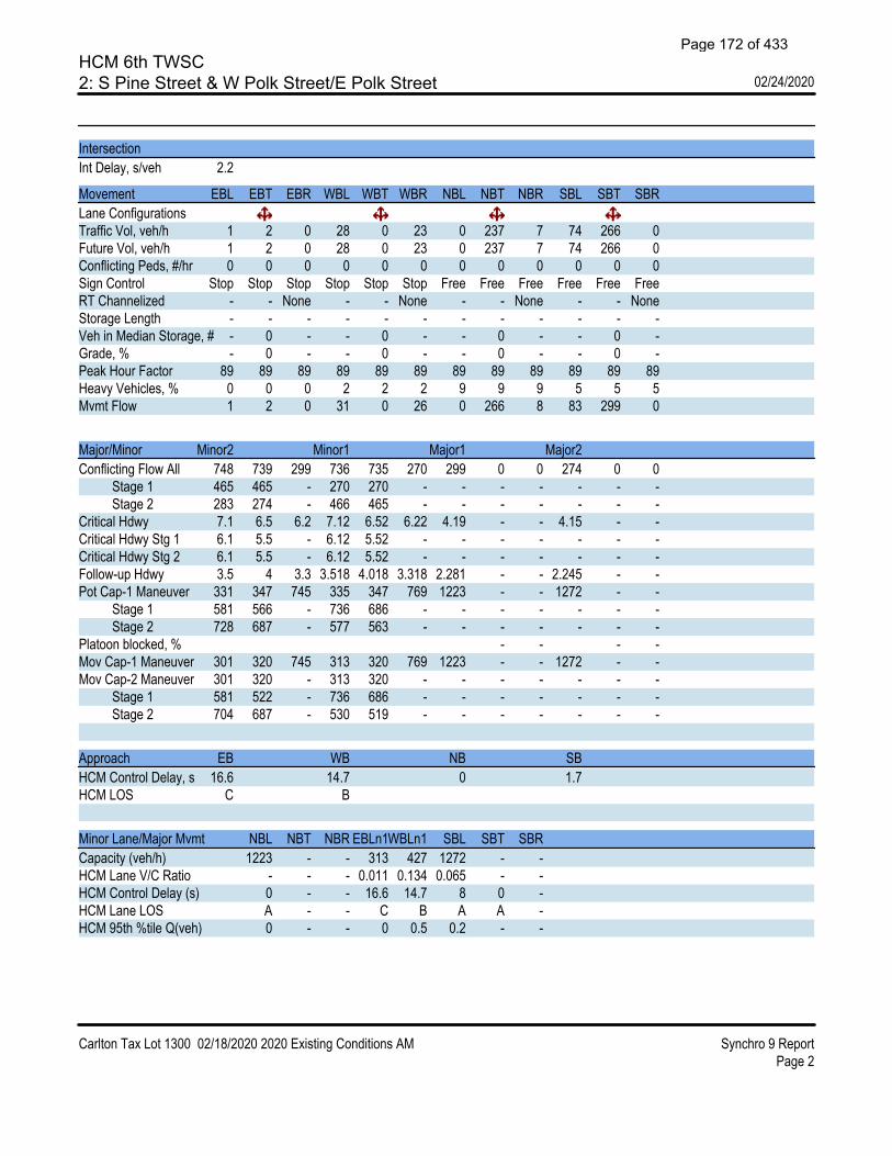
HCM 6th TWSC2: S Pine Street & W Polk Street/E Polk Street 02/24/2020
Carlton Tax Lot 1300 02/18/2020 2020 Existing Conditions AM Synchro 9 ReportPage 2
IntersectionInt Delay, s/veh 2.2
Movement EBL EBT EBR WBL WBT WBR NBL NBT NBR SBL SBT SBRLane ConfigurationsTraffic Vol, veh/h 1 2 0 28 0 23 0 237 7 74 266 0Future Vol, veh/h 1 2 0 28 0 23 0 237 7 74 266 0Conflicting Peds, #/hr 0 0 0 0 0 0 0 0 0 0 0 0Sign Control Stop Stop Stop Stop Stop Stop Free Free Free Free Free FreeRT Channelized - - None - - None - - None - - NoneStorage Length - - - - - - - - - - - -Veh in Median Storage, # - 0 - - 0 - - 0 - - 0 -Grade, % - 0 - - 0 - - 0 - - 0 -Peak Hour Factor 89 89 89 89 89 89 89 89 89 89 89 89Heavy Vehicles, % 0 0 0 2 2 2 9 9 9 5 5 5Mvmt Flow 1 2 0 31 0 26 0 266 8 83 299 0
Major/Minor Minor2 Minor1 Major1 Major2Conflicting Flow All 748 739 299 736 735 270 299 0 0 274 0 0 Stage 1 465 465 - 270 270 - - - - - - - Stage 2 283 274 - 466 465 - - - - - - -Critical Hdwy 7.1 6.5 6.2 7.12 6.52 6.22 4.19 - - 4.15 - -Critical Hdwy Stg 1 6.1 5.5 - 6.12 5.52 - - - - - - -Critical Hdwy Stg 2 6.1 5.5 - 6.12 5.52 - - - - - - -Follow-up Hdwy 3.5 4 3.3 3.518 4.018 3.318 2.281 - - 2.245 - -Pot Cap-1 Maneuver 331 347 745 335 347 769 1223 - - 1272 - - Stage 1 581 566 - 736 686 - - - - - - - Stage 2 728 687 - 577 563 - - - - - - -Platoon blocked, % - - - -Mov Cap-1 Maneuver 301 320 745 313 320 769 1223 - - 1272 - -Mov Cap-2 Maneuver 301 320 - 313 320 - - - - - - - Stage 1 581 522 - 736 686 - - - - - - - Stage 2 704 687 - 530 519 - - - - - - -
Approach EB WB NB SBHCM Control Delay, s 16.6 14.7 0 1.7HCM LOS C B
Minor Lane/Major Mvmt NBL NBT NBR EBLn1WBLn1 SBL SBT SBRCapacity (veh/h) 1223 - - 313 427 1272 - -HCM Lane V/C Ratio - - - 0.011 0.134 0.065 - -HCM Control Delay (s) 0 - - 16.6 14.7 8 0 -HCM Lane LOS A - - C B A A -HCM 95th %tile Q(veh) 0 - - 0 0.5 0.2 - -
Page 172 of 433

HCM 6th TWSC1: E Main Street & N 7th Street 02/24/2020
Carlton Tax Lot 1300 02/18/2020 2020 Existing Conditions PM Synchro 9 ReportPage 1
IntersectionInt Delay, s/veh 0.9
Movement EBL EBT WBT WBR SBL SBRLane ConfigurationsTraffic Vol, veh/h 43 293 438 27 8 18Future Vol, veh/h 43 293 438 27 8 18Conflicting Peds, #/hr 0 0 0 0 0 0Sign Control Free Free Free Free Stop StopRT Channelized - None - None - NoneStorage Length - - - - 0 -Veh in Median Storage, # - 0 0 - 0 -Grade, % - 0 0 - 0 -Peak Hour Factor 93 93 93 93 93 93Heavy Vehicles, % 4 4 2 2 0 0Mvmt Flow 46 315 471 29 9 19
Major/Minor Major1 Major2 Minor2Conflicting Flow All 500 0 - 0 893 486 Stage 1 - - - - 486 - Stage 2 - - - - 407 -Critical Hdwy 4.14 - - - 6.4 6.2Critical Hdwy Stg 1 - - - - 5.4 -Critical Hdwy Stg 2 - - - - 5.4 -Follow-up Hdwy 2.236 - - - 3.5 3.3Pot Cap-1 Maneuver 1054 - - - 315 585 Stage 1 - - - - 623 - Stage 2 - - - - 676 -Platoon blocked, % - - -Mov Cap-1 Maneuver 1054 - - - 298 585Mov Cap-2 Maneuver - - - - 298 - Stage 1 - - - - 590 - Stage 2 - - - - 676 -
Approach EB WB SBHCM Control Delay, s 1.1 0 13.5HCM LOS B
Minor Lane/Major Mvmt EBL EBT WBT WBR SBLn1Capacity (veh/h) 1054 - - - 451HCM Lane V/C Ratio 0.044 - - - 0.062HCM Control Delay (s) 8.6 0 - - 13.5HCM Lane LOS A A - - BHCM 95th %tile Q(veh) 0.1 - - - 0.2
Page 173 of 433

HCM 6th TWSC2: S Pine Street & W Polk Street/E Polk Street 02/24/2020
Carlton Tax Lot 1300 02/18/2020 2020 Existing Conditions PM Synchro 9 ReportPage 2
IntersectionInt Delay, s/veh 1
Movement EBL EBT EBR WBL WBT WBR NBL NBT NBR SBL SBT SBRLane ConfigurationsTraffic Vol, veh/h 1 1 0 24 0 9 0 344 4 13 327 3Future Vol, veh/h 1 1 0 24 0 9 0 344 4 13 327 3Conflicting Peds, #/hr 0 0 0 0 0 0 0 0 0 0 0 0Sign Control Stop Stop Stop Stop Stop Stop Free Free Free Free Free FreeRT Channelized - - None - - None - - None - - NoneStorage Length - - - - - - - - - - - -Veh in Median Storage, # - 0 - - 0 - - 0 - - 0 -Grade, % - 0 - - 0 - - 0 - - 0 -Peak Hour Factor 83 83 83 83 83 83 83 83 83 83 83 83Heavy Vehicles, % 0 0 0 0 0 0 4 4 4 1 1 1Mvmt Flow 1 1 0 29 0 11 0 414 5 16 394 4
Major/Minor Minor2 Minor1 Major1 Major2Conflicting Flow All 850 847 396 846 847 417 398 0 0 419 0 0 Stage 1 428 428 - 417 417 - - - - - - - Stage 2 422 419 - 429 430 - - - - - - -Critical Hdwy 7.1 6.5 6.2 7.1 6.5 6.2 4.14 - - 4.11 - -Critical Hdwy Stg 1 6.1 5.5 - 6.1 5.5 - - - - - - -Critical Hdwy Stg 2 6.1 5.5 - 6.1 5.5 - - - - - - -Follow-up Hdwy 3.5 4 3.3 3.5 4 3.3 2.236 - - 2.209 - -Pot Cap-1 Maneuver 283 301 658 284 301 640 1150 - - 1145 - - Stage 1 609 588 - 617 595 - - - - - - - Stage 2 613 593 - 608 587 - - - - - - -Platoon blocked, % - - - -Mov Cap-1 Maneuver 275 296 658 279 296 640 1150 - - 1145 - -Mov Cap-2 Maneuver 275 296 - 279 296 - - - - - - - Stage 1 609 577 - 617 595 - - - - - - - Stage 2 603 593 - 596 576 - - - - - - -
Approach EB WB NB SBHCM Control Delay, s 17.7 17.4 0 0.3HCM LOS C C
Minor Lane/Major Mvmt NBL NBT NBR EBLn1WBLn1 SBL SBT SBRCapacity (veh/h) 1150 - - 285 330 1145 - -HCM Lane V/C Ratio - - - 0.008 0.12 0.014 - -HCM Control Delay (s) 0 - - 17.7 17.4 8.2 0 -HCM Lane LOS A - - C C A A -HCM 95th %tile Q(veh) 0 - - 0 0.4 0 - -
Page 174 of 433

HCM 6th TWSC1: N 7th Street & E Main Street 02/24/2020
Carlton Tax Lot 1300 02/18/2020 2022 Background Conditions AM Synchro 9 ReportPage 1
IntersectionInt Delay, s/veh 1.7
Movement EBL EBT EBR WBL WBT WBR NBL NBT NBR SBL SBT SBRLane ConfigurationsTraffic Vol, veh/h 9 343 4 2 214 2 12 0 6 25 0 37Future Vol, veh/h 9 343 4 2 214 2 12 0 6 25 0 37Conflicting Peds, #/hr 0 0 0 0 0 0 0 0 0 0 0 0Sign Control Free Free Free Free Free Free Stop Stop Stop Stop Stop StopRT Channelized - - None - - None - - None - - NoneStorage Length - - - - - - - - - - - -Veh in Median Storage, # - 0 - - 0 - - 0 - - 0 -Grade, % - 0 - - 0 - - 0 - - 0 -Peak Hour Factor 90 90 92 92 90 90 92 92 92 90 92 90Heavy Vehicles, % 3 3 2 2 3 3 2 2 2 2 2 2Mvmt Flow 10 381 4 2 238 2 13 0 7 28 0 41
Major/Minor Major1 Major2 Minor1 Minor2Conflicting Flow All 240 0 0 385 0 0 667 647 383 650 648 239 Stage 1 - - - - - - 403 403 - 243 243 - Stage 2 - - - - - - 264 244 - 407 405 -Critical Hdwy 4.13 - - 4.12 - - 7.12 6.52 6.22 7.12 6.52 6.22Critical Hdwy Stg 1 - - - - - - 6.12 5.52 - 6.12 5.52 -Critical Hdwy Stg 2 - - - - - - 6.12 5.52 - 6.12 5.52 -Follow-up Hdwy 2.227 - - 2.218 - - 3.518 4.018 3.318 3.518 4.018 3.318Pot Cap-1 Maneuver 1321 - - 1173 - - 372 390 664 382 389 800 Stage 1 - - - - - - 624 600 - 761 705 - Stage 2 - - - - - - 741 704 - 621 598 -Platoon blocked, % - - - -Mov Cap-1 Maneuver 1321 - - 1173 - - 350 385 664 375 384 800Mov Cap-2 Maneuver - - - - - - 350 385 - 375 384 - Stage 1 - - - - - - 618 594 - 753 704 - Stage 2 - - - - - - 702 703 - 609 592 -
Approach EB WB NB SBHCM Control Delay, s 0.2 0.1 14.1 12.5HCM LOS B B
Minor Lane/Major Mvmt NBLn1 EBL EBT EBR WBL WBT WBR SBLn1Capacity (veh/h) 415 1321 - - 1173 - - 549HCM Lane V/C Ratio 0.047 0.008 - - 0.002 - - 0.125HCM Control Delay (s) 14.1 7.7 0 - 8.1 0 - 12.5HCM Lane LOS B A A - A A - BHCM 95th %tile Q(veh) 0.1 0 - - 0 - - 0.4
Page 175 of 433

HCM 6th TWSC2: S Pine Street & W Polk Street/E Polk Street 02/24/2020
Carlton Tax Lot 1300 02/18/2020 2022 Background Conditions AM Synchro 9 ReportPage 2
IntersectionInt Delay, s/veh 2.4
Movement EBL EBT EBR WBL WBT WBR NBL NBT NBR SBL SBT SBRLane ConfigurationsTraffic Vol, veh/h 1 2 0 33 0 24 0 240 8 77 269 0Future Vol, veh/h 1 2 0 33 0 24 0 240 8 77 269 0Conflicting Peds, #/hr 0 0 0 0 0 0 0 0 0 0 0 0Sign Control Stop Stop Stop Stop Stop Stop Free Free Free Free Free FreeRT Channelized - - None - - None - - None - - NoneStorage Length - - - - - - - - - - - -Veh in Median Storage, # - 0 - - 0 - - 0 - - 0 -Grade, % - 0 - - 0 - - 0 - - 0 -Peak Hour Factor 89 89 89 89 89 89 89 89 89 89 89 89Heavy Vehicles, % 0 0 0 2 2 2 9 9 9 5 5 5Mvmt Flow 1 2 0 37 0 27 0 270 9 87 302 0
Major/Minor Minor2 Minor1 Major1 Major2Conflicting Flow All 764 755 302 752 751 275 302 0 0 279 0 0 Stage 1 476 476 - 275 275 - - - - - - - Stage 2 288 279 - 477 476 - - - - - - -Critical Hdwy 7.1 6.5 6.2 7.12 6.52 6.22 4.19 - - 4.15 - -Critical Hdwy Stg 1 6.1 5.5 - 6.12 5.52 - - - - - - -Critical Hdwy Stg 2 6.1 5.5 - 6.12 5.52 - - - - - - -Follow-up Hdwy 3.5 4 3.3 3.518 4.018 3.318 2.281 - - 2.245 - -Pot Cap-1 Maneuver 323 340 742 327 340 764 1220 - - 1267 - - Stage 1 574 560 - 731 683 - - - - - - - Stage 2 724 683 - 569 557 - - - - - - -Platoon blocked, % - - - -Mov Cap-1 Maneuver 292 312 742 304 312 764 1220 - - 1267 - -Mov Cap-2 Maneuver 292 312 - 304 312 - - - - - - - Stage 1 574 514 - 731 683 - - - - - - - Stage 2 698 683 - 519 511 - - - - - - -
Approach EB WB NB SBHCM Control Delay, s 16.9 15.5 0 1.8HCM LOS C C
Minor Lane/Major Mvmt NBL NBT NBR EBLn1WBLn1 SBL SBT SBRCapacity (veh/h) 1220 - - 305 407 1267 - -HCM Lane V/C Ratio - - - 0.011 0.157 0.068 - -HCM Control Delay (s) 0 - - 16.9 15.5 8 0 -HCM Lane LOS A - - C C A A -HCM 95th %tile Q(veh) 0 - - 0 0.6 0.2 - -
Page 176 of 433

HCM 6th TWSC1: N 7th Street & E Main Street 02/24/2020
Carlton Tax Lot 1300 02/18/2020 2022 Background Conditions PM Synchro 9 ReportPage 1
IntersectionInt Delay, s/veh 1.2
Movement EBL EBT EBR WBL WBT WBR NBL NBT NBR SBL SBT SBRLane ConfigurationsTraffic Vol, veh/h 45 305 13 6 456 28 8 0 4 8 0 19Future Vol, veh/h 45 305 13 6 456 28 8 0 4 8 0 19Conflicting Peds, #/hr 0 0 0 0 0 0 0 0 0 0 0 0Sign Control Free Free Free Free Free Free Stop Stop Stop Stop Stop StopRT Channelized - - None - - None - - None - - NoneStorage Length - - - - - - - - - - - -Veh in Median Storage, # - 0 - - 0 - - 0 - - 0 -Grade, % - 0 - - 0 - - 0 - - 0 -Peak Hour Factor 93 93 92 92 93 93 92 92 92 93 92 93Heavy Vehicles, % 4 4 2 2 2 2 2 2 2 0 2 0Mvmt Flow 48 328 14 7 490 30 9 0 4 9 0 20
Major/Minor Major1 Major2 Minor1 Minor2Conflicting Flow All 520 0 0 342 0 0 960 965 335 952 957 505 Stage 1 - - - - - - 431 431 - 519 519 - Stage 2 - - - - - - 529 534 - 433 438 -Critical Hdwy 4.14 - - 4.12 - - 7.12 6.52 6.22 7.1 6.52 6.2Critical Hdwy Stg 1 - - - - - - 6.12 5.52 - 6.1 5.52 -Critical Hdwy Stg 2 - - - - - - 6.12 5.52 - 6.1 5.52 -Follow-up Hdwy 2.236 - - 2.218 - - 3.518 4.018 3.318 3.5 4.018 3.3Pot Cap-1 Maneuver 1036 - - 1217 - - 236 255 707 241 258 571 Stage 1 - - - - - - 603 583 - 544 533 - Stage 2 - - - - - - 533 524 - 605 579 -Platoon blocked, % - - - -Mov Cap-1 Maneuver 1036 - - 1217 - - 216 238 707 228 241 571Mov Cap-2 Maneuver - - - - - - 216 238 - 228 241 - Stage 1 - - - - - - 569 550 - 513 529 - Stage 2 - - - - - - 510 520 - 567 546 -
Approach EB WB NB SBHCM Control Delay, s 1.1 0.1 18.4 14.8HCM LOS C B
Minor Lane/Major Mvmt NBLn1 EBL EBT EBR WBL WBT WBR SBLn1Capacity (veh/h) 281 1036 - - 1217 - - 395HCM Lane V/C Ratio 0.046 0.047 - - 0.005 - - 0.073HCM Control Delay (s) 18.4 8.6 0 - 8 0 - 14.8HCM Lane LOS C A A - A A - BHCM 95th %tile Q(veh) 0.1 0.1 - - 0 - - 0.2
Page 177 of 433

HCM 6th TWSC2: S Pine Street & W Polk Street/E Polk Street 02/24/2020
Carlton Tax Lot 1300 02/18/2020 2022 Background Conditions PM Synchro 9 ReportPage 2
IntersectionInt Delay, s/veh 1.1
Movement EBL EBT EBR WBL WBT WBR NBL NBT NBR SBL SBT SBRLane ConfigurationsTraffic Vol, veh/h 1 1 0 27 0 9 0 348 8 14 330 3Future Vol, veh/h 1 1 0 27 0 9 0 348 8 14 330 3Conflicting Peds, #/hr 0 0 0 0 0 0 0 0 0 0 0 0Sign Control Stop Stop Stop Stop Stop Stop Free Free Free Free Free FreeRT Channelized - - None - - None - - None - - NoneStorage Length - - - - - - - - - - - -Veh in Median Storage, # - 0 - - 0 - - 0 - - 0 -Grade, % - 0 - - 0 - - 0 - - 0 -Peak Hour Factor 83 83 83 83 83 83 83 83 83 83 83 83Heavy Vehicles, % 0 0 0 0 0 0 4 4 4 1 1 1Mvmt Flow 1 1 0 33 0 11 0 419 10 17 398 4
Major/Minor Minor2 Minor1 Major1 Major2Conflicting Flow All 864 863 400 859 860 424 402 0 0 429 0 0 Stage 1 434 434 - 424 424 - - - - - - - Stage 2 430 429 - 435 436 - - - - - - -Critical Hdwy 7.1 6.5 6.2 7.1 6.5 6.2 4.14 - - 4.11 - -Critical Hdwy Stg 1 6.1 5.5 - 6.1 5.5 - - - - - - -Critical Hdwy Stg 2 6.1 5.5 - 6.1 5.5 - - - - - - -Follow-up Hdwy 3.5 4 3.3 3.5 4 3.3 2.236 - - 2.209 - -Pot Cap-1 Maneuver 277 295 654 279 296 634 1146 - - 1136 - - Stage 1 604 585 - 612 590 - - - - - - - Stage 2 607 587 - 604 583 - - - - - - -Platoon blocked, % - - - -Mov Cap-1 Maneuver 268 289 654 274 290 634 1146 - - 1136 - -Mov Cap-2 Maneuver 268 289 - 274 290 - - - - - - - Stage 1 604 574 - 612 590 - - - - - - - Stage 2 597 587 - 591 572 - - - - - - -
Approach EB WB NB SBHCM Control Delay, s 18.1 18.1 0 0.3HCM LOS C C
Minor Lane/Major Mvmt NBL NBT NBR EBLn1WBLn1 SBL SBT SBRCapacity (veh/h) 1146 - - 278 319 1136 - -HCM Lane V/C Ratio - - - 0.009 0.136 0.015 - -HCM Control Delay (s) 0 - - 18.1 18.1 8.2 0 -HCM Lane LOS A - - C C A A -HCM 95th %tile Q(veh) 0 - - 0 0.5 0 - -
Page 178 of 433

HCM 6th TWSC1: N 7th Street & E Main Street 03/18/2020
Carlton Tax Lot 1300 02/18/2020 2022 Buildout Conditions AM Synchro 9 ReportPage 1
IntersectionInt Delay, s/veh 2.4
Movement EBL EBT EBR WBL WBT WBR NBL NBT NBR SBL SBT SBRLane ConfigurationsTraffic Vol, veh/h 9 343 12 5 214 2 36 0 16 25 0 37Future Vol, veh/h 9 343 12 5 214 2 36 0 16 25 0 37Conflicting Peds, #/hr 0 0 0 0 0 0 0 0 0 0 0 0Sign Control Free Free Free Free Free Free Stop Stop Stop Stop Stop StopRT Channelized - - None - - None - - None - - NoneStorage Length - - - - - - - - - - - -Veh in Median Storage, # - 0 - - 0 - - 0 - - 0 -Grade, % - 0 - - 0 - - 0 - - 0 -Peak Hour Factor 90 90 92 92 90 90 92 92 92 90 92 90Heavy Vehicles, % 3 3 2 2 3 3 2 2 2 2 2 2Mvmt Flow 10 381 13 5 238 2 39 0 17 28 0 41
Major/Minor Major1 Major2 Minor1 Minor2Conflicting Flow All 240 0 0 394 0 0 678 658 388 665 663 239 Stage 1 - - - - - - 408 408 - 249 249 - Stage 2 - - - - - - 270 250 - 416 414 -Critical Hdwy 4.13 - - 4.12 - - 7.12 6.52 6.22 7.12 6.52 6.22Critical Hdwy Stg 1 - - - - - - 6.12 5.52 - 6.12 5.52 -Critical Hdwy Stg 2 - - - - - - 6.12 5.52 - 6.12 5.52 -Follow-up Hdwy 2.227 - - 2.218 - - 3.518 4.018 3.318 3.518 4.018 3.318Pot Cap-1 Maneuver 1321 - - 1165 - - 366 384 660 374 382 800 Stage 1 - - - - - - 620 597 - 755 701 - Stage 2 - - - - - - 736 700 - 614 593 -Platoon blocked, % - - - -Mov Cap-1 Maneuver 1321 - - 1165 - - 343 378 660 360 376 800Mov Cap-2 Maneuver - - - - - - 343 378 - 360 376 - Stage 1 - - - - - - 614 591 - 747 697 - Stage 2 - - - - - - 695 697 - 592 587 -
Approach EB WB NB SBHCM Control Delay, s 0.2 0.2 15.4 12.7HCM LOS C B
Minor Lane/Major Mvmt NBLn1 EBL EBT EBR WBL WBT WBR SBLn1Capacity (veh/h) 402 1321 - - 1165 - - 536HCM Lane V/C Ratio 0.141 0.008 - - 0.005 - - 0.129HCM Control Delay (s) 15.4 7.7 0 - 8.1 0 - 12.7HCM Lane LOS C A A - A A - BHCM 95th %tile Q(veh) 0.5 0 - - 0 - - 0.4
Page 179 of 433

HCM 6th TWSC2: S Pine Street & W Polk Street/E Polk Street 03/18/2020
Carlton Tax Lot 1300 02/18/2020 2022 Buildout Conditions AM Synchro 9 ReportPage 2
IntersectionInt Delay, s/veh 2.5
Movement EBL EBT EBR WBL WBT WBR NBL NBT NBR SBL SBT SBRLane ConfigurationsTraffic Vol, veh/h 1 2 0 38 0 24 0 240 9 77 269 0Future Vol, veh/h 1 2 0 38 0 24 0 240 9 77 269 0Conflicting Peds, #/hr 0 0 0 0 0 0 0 0 0 0 0 0Sign Control Stop Stop Stop Stop Stop Stop Free Free Free Free Free FreeRT Channelized - - None - - None - - None - - NoneStorage Length - - - - - - - - - - - -Veh in Median Storage, # - 0 - - 0 - - 0 - - 0 -Grade, % - 0 - - 0 - - 0 - - 0 -Peak Hour Factor 89 89 89 89 89 89 89 89 89 89 89 89Heavy Vehicles, % 0 0 0 2 2 2 9 9 9 5 5 5Mvmt Flow 1 2 0 43 0 27 0 270 10 87 302 0
Major/Minor Minor2 Minor1 Major1 Major2Conflicting Flow All 765 756 302 752 751 275 302 0 0 280 0 0 Stage 1 476 476 - 275 275 - - - - - - - Stage 2 289 280 - 477 476 - - - - - - -Critical Hdwy 7.1 6.5 6.2 7.12 6.52 6.22 4.19 - - 4.15 - -Critical Hdwy Stg 1 6.1 5.5 - 6.12 5.52 - - - - - - -Critical Hdwy Stg 2 6.1 5.5 - 6.12 5.52 - - - - - - -Follow-up Hdwy 3.5 4 3.3 3.518 4.018 3.318 2.281 - - 2.245 - -Pot Cap-1 Maneuver 323 340 742 327 340 764 1220 - - 1266 - - Stage 1 574 560 - 731 683 - - - - - - - Stage 2 723 683 - 569 557 - - - - - - -Platoon blocked, % - - - -Mov Cap-1 Maneuver 292 312 742 304 312 764 1220 - - 1266 - -Mov Cap-2 Maneuver 292 312 - 304 312 - - - - - - - Stage 1 574 514 - 731 683 - - - - - - - Stage 2 697 683 - 519 511 - - - - - - -
Approach EB WB NB SBHCM Control Delay, s 16.9 16 0 1.8HCM LOS C C
Minor Lane/Major Mvmt NBL NBT NBR EBLn1WBLn1 SBL SBT SBRCapacity (veh/h) 1220 - - 305 396 1266 - -HCM Lane V/C Ratio - - - 0.011 0.176 0.068 - -HCM Control Delay (s) 0 - - 16.9 16 8.1 0 -HCM Lane LOS A - - C C A A -HCM 95th %tile Q(veh) 0 - - 0 0.6 0.2 - -
Page 180 of 433

HCM 6th TWSC1: N 7th Street & E Main Street 03/18/2020
Carlton Tax Lot 1300 02/18/2020 2022 Buildout Conditions PM Synchro 9 ReportPage 1
IntersectionInt Delay, s/veh 1.7
Movement EBL EBT EBR WBL WBT WBR NBL NBT NBR SBL SBT SBRLane ConfigurationsTraffic Vol, veh/h 45 305 39 17 456 28 23 0 10 8 0 19Future Vol, veh/h 45 305 39 17 456 28 23 0 10 8 0 19Conflicting Peds, #/hr 0 0 0 0 0 0 0 0 0 0 0 0Sign Control Free Free Free Free Free Free Stop Stop Stop Stop Stop StopRT Channelized - - None - - None - - None - - NoneStorage Length - - - - - - - - - - - -Veh in Median Storage, # - 0 - - 0 - - 0 - - 0 -Grade, % - 0 - - 0 - - 0 - - 0 -Peak Hour Factor 93 93 92 92 93 93 92 92 92 93 92 93Heavy Vehicles, % 4 4 2 2 2 2 2 2 2 0 2 0Mvmt Flow 48 328 42 18 490 30 25 0 11 9 0 20
Major/Minor Major1 Major2 Minor1 Minor2Conflicting Flow All 520 0 0 370 0 0 996 1001 349 992 1007 505 Stage 1 - - - - - - 445 445 - 541 541 - Stage 2 - - - - - - 551 556 - 451 466 -Critical Hdwy 4.14 - - 4.12 - - 7.12 6.52 6.22 7.1 6.52 6.2Critical Hdwy Stg 1 - - - - - - 6.12 5.52 - 6.1 5.52 -Critical Hdwy Stg 2 - - - - - - 6.12 5.52 - 6.1 5.52 -Follow-up Hdwy 2.236 - - 2.218 - - 3.518 4.018 3.318 3.5 4.018 3.3Pot Cap-1 Maneuver 1036 - - 1189 - - 223 243 694 227 241 571 Stage 1 - - - - - - 592 575 - 529 521 - Stage 2 - - - - - - 519 513 - 592 562 -Platoon blocked, % - - - -Mov Cap-1 Maneuver 1036 - - 1189 - - 202 224 694 210 222 571Mov Cap-2 Maneuver - - - - - - 202 224 - 210 222 - Stage 1 - - - - - - 557 541 - 498 510 - Stage 2 - - - - - - 490 502 - 548 529 -
Approach EB WB NB SBHCM Control Delay, s 1 0.3 21.3 15.3HCM LOS C C
Minor Lane/Major Mvmt NBLn1 EBL EBT EBR WBL WBT WBR SBLn1Capacity (veh/h) 257 1036 - - 1189 - - 378HCM Lane V/C Ratio 0.14 0.047 - - 0.016 - - 0.077HCM Control Delay (s) 21.3 8.6 0 - 8.1 0 - 15.3HCM Lane LOS C A A - A A - CHCM 95th %tile Q(veh) 0.5 0.1 - - 0 - - 0.2
Page 181 of 433

HCM 6th TWSC2: S Pine Street & W Polk Street/E Polk Street 03/18/2020
Carlton Tax Lot 1300 02/18/2020 2022 Buildout Conditions PM Synchro 9 ReportPage 2
IntersectionInt Delay, s/veh 1.2
Movement EBL EBT EBR WBL WBT WBR NBL NBT NBR SBL SBT SBRLane ConfigurationsTraffic Vol, veh/h 1 1 0 30 0 9 0 348 13 14 330 3Future Vol, veh/h 1 1 0 30 0 9 0 348 13 14 330 3Conflicting Peds, #/hr 0 0 0 0 0 0 0 0 0 0 0 0Sign Control Stop Stop Stop Stop Stop Stop Free Free Free Free Free FreeRT Channelized - - None - - None - - None - - NoneStorage Length - - - - - - - - - - - -Veh in Median Storage, # - 0 - - 0 - - 0 - - 0 -Grade, % - 0 - - 0 - - 0 - - 0 -Peak Hour Factor 83 83 83 83 83 83 83 83 83 83 83 83Heavy Vehicles, % 0 0 0 0 0 0 4 4 4 1 1 1Mvmt Flow 1 1 0 36 0 11 0 419 16 17 398 4
Major/Minor Minor2 Minor1 Major1 Major2Conflicting Flow All 867 869 400 862 863 427 402 0 0 435 0 0 Stage 1 434 434 - 427 427 - - - - - - - Stage 2 433 435 - 435 436 - - - - - - -Critical Hdwy 7.1 6.5 6.2 7.1 6.5 6.2 4.14 - - 4.11 - -Critical Hdwy Stg 1 6.1 5.5 - 6.1 5.5 - - - - - - -Critical Hdwy Stg 2 6.1 5.5 - 6.1 5.5 - - - - - - -Follow-up Hdwy 3.5 4 3.3 3.5 4 3.3 2.236 - - 2.209 - -Pot Cap-1 Maneuver 275 292 654 277 295 632 1146 - - 1130 - - Stage 1 604 585 - 610 589 - - - - - - - Stage 2 605 584 - 604 583 - - - - - - -Platoon blocked, % - - - -Mov Cap-1 Maneuver 266 286 654 272 289 632 1146 - - 1130 - -Mov Cap-2 Maneuver 266 286 - 272 289 - - - - - - - Stage 1 604 574 - 610 589 - - - - - - - Stage 2 595 584 - 591 572 - - - - - - -
Approach EB WB NB SBHCM Control Delay, s 18.2 18.5 0 0.3HCM LOS C C
Minor Lane/Major Mvmt NBL NBT NBR EBLn1WBLn1 SBL SBT SBRCapacity (veh/h) 1146 - - 276 313 1130 - -HCM Lane V/C Ratio - - - 0.009 0.15 0.015 - -HCM Control Delay (s) 0 - - 18.2 18.5 8.2 0 -HCM Lane LOS A - - C C A A -HCM 95th %tile Q(veh) 0 - - 0 0.5 0 - -
Page 182 of 433

HCM 6th TWSC1: N 7th Street & E Main Street 02/24/2020
Carlton Tax Lot 1300 02/18/2020 2035 Planning Horizon AM Synchro 10 ReportPage 1
IntersectionInt Delay, s/veh 2.3
Movement EBL EBT EBR WBL WBT WBR NBL NBT NBR SBL SBT SBRLane ConfigurationsTraffic Vol, veh/h 12 445 7 3 277 3 22 0 10 33 0 48Future Vol, veh/h 12 445 7 3 277 3 22 0 10 33 0 48Conflicting Peds, #/hr 0 0 0 0 0 0 0 0 0 0 0 0Sign Control Free Free Free Free Free Free Stop Stop Stop Stop Stop StopRT Channelized - - None - - None - - None - - NoneStorage Length - - - - - - - - - - - -Veh in Median Storage, # - 0 - - 0 - - 0 - - 0 -Grade, % - 0 - - 0 - - 0 - - 0 -Peak Hour Factor 90 90 92 92 90 90 92 92 92 90 92 90Heavy Vehicles, % 3 3 2 2 3 3 2 2 2 2 2 2Mvmt Flow 13 494 8 3 308 3 24 0 11 37 0 53
Major/Minor Major1 Major2 Minor1 Minor2Conflicting Flow All 311 0 0 502 0 0 866 841 498 846 844 310 Stage 1 - - - - - - 524 524 - 316 316 - Stage 2 - - - - - - 342 317 - 530 528 -Critical Hdwy 4.13 - - 4.12 - - 7.12 6.52 6.22 7.12 6.52 6.22Critical Hdwy Stg 1 - - - - - - 6.12 5.52 - 6.12 5.52 -Critical Hdwy Stg 2 - - - - - - 6.12 5.52 - 6.12 5.52 -Follow-up Hdwy 2.227 - - 2.218 - - 3.518 4.018 3.318 3.518 4.018 3.318Pot Cap-1 Maneuver 1244 - - 1062 - - 274 301 572 282 300 730 Stage 1 - - - - - - 537 530 - 695 655 - Stage 2 - - - - - - 673 654 - 533 528 -Platoon blocked, % - - - -Mov Cap-1 Maneuver 1244 - - 1062 - - 250 296 572 273 295 730Mov Cap-2 Maneuver - - - - - - 250 296 - 273 295 - Stage 1 - - - - - - 529 522 - 685 653 - Stage 2 - - - - - - 622 652 - 515 520 -
Approach EB WB NB SBHCM Control Delay, s 0.2 0.1 18.4 15.5HCM LOS C C
Minor Lane/Major Mvmt NBLn1 EBL EBT EBR WBL WBT WBR SBLn1Capacity (veh/h) 303 1244 - - 1062 - - 434HCM Lane V/C Ratio 0.115 0.011 - - 0.003 - - 0.207HCM Control Delay (s) 18.4 7.9 0 - 8.4 0 - 15.5HCM Lane LOS C A A - A A - CHCM 95th %tile Q(veh) 0.4 0 - - 0 - - 0.8
Page 183 of 433

HCM 6th TWSC2: S Pine Street & W Polk Street/E Polk Street 02/24/2020
Carlton Tax Lot 1300 02/18/2020 2035 Planning Horizon AM Synchro 10 ReportPage 2
IntersectionInt Delay, s/veh 3
Movement EBL EBT EBR WBL WBT WBR NBL NBT NBR SBL SBT SBRLane ConfigurationsTraffic Vol, veh/h 1 3 0 43 0 32 0 304 12 100 341 0Future Vol, veh/h 1 3 0 43 0 32 0 304 12 100 341 0Conflicting Peds, #/hr 0 0 0 0 0 0 0 0 0 0 0 0Sign Control Stop Stop Stop Stop Stop Stop Free Free Free Free Free FreeRT Channelized - - None - - None - - None - - NoneStorage Length - - - - - - - - - - - -Veh in Median Storage, # - 0 - - 0 - - 0 - - 0 -Grade, % - 0 - - 0 - - 0 - - 0 -Peak Hour Factor 89 89 89 89 89 89 89 89 89 89 89 89Heavy Vehicles, % 0 0 0 2 2 2 9 9 9 5 5 5Mvmt Flow 1 3 0 48 0 36 0 342 13 112 383 0
Major/Minor Minor2 Minor1 Major1 Major2Conflicting Flow All 974 962 383 958 956 349 383 0 0 355 0 0 Stage 1 607 607 - 349 349 - - - - - - - Stage 2 367 355 - 609 607 - - - - - - -Critical Hdwy 7.1 6.5 6.2 7.12 6.52 6.22 4.19 - - 4.15 - -Critical Hdwy Stg 1 6.1 5.5 - 6.12 5.52 - - - - - - -Critical Hdwy Stg 2 6.1 5.5 - 6.12 5.52 - - - - - - -Follow-up Hdwy 3.5 4 3.3 3.518 4.018 3.318 2.281 - - 2.245 - -Pot Cap-1 Maneuver 233 258 669 237 258 694 1138 - - 1187 - - Stage 1 487 489 - 667 633 - - - - - - - Stage 2 657 633 - 482 486 - - - - - - -Platoon blocked, % - - - -Mov Cap-1 Maneuver 201 227 669 213 227 694 1138 - - 1187 - -Mov Cap-2 Maneuver 201 227 - 213 227 - - - - - - - Stage 1 487 430 - 667 633 - - - - - - - Stage 2 623 633 - 421 428 - - - - - - -
Approach EB WB NB SBHCM Control Delay, s 21.7 21.5 0 1.9HCM LOS C C
Minor Lane/Major Mvmt NBL NBT NBR EBLn1WBLn1 SBL SBT SBRCapacity (veh/h) 1138 - - 220 302 1187 - -HCM Lane V/C Ratio - - - 0.02 0.279 0.095 - -HCM Control Delay (s) 0 - - 21.7 21.5 8.3 0 -HCM Lane LOS A - - C C A A -HCM 95th %tile Q(veh) 0 - - 0.1 1.1 0.3 - -
Page 184 of 433

HCM 6th TWSC1: N 7th Street & E Main Street 02/24/2020
Carlton Tax Lot 1300 02/18/2020 2035 Planning Horizon PM Synchro 9 ReportPage 1
IntersectionInt Delay, s/veh 1.7
Movement EBL EBT EBR WBL WBT WBR NBL NBT NBR SBL SBT SBRLane ConfigurationsTraffic Vol, veh/h 58 394 23 12 589 36 14 0 7 11 0 25Future Vol, veh/h 58 394 23 12 589 36 14 0 7 11 0 25Conflicting Peds, #/hr 0 0 0 0 0 0 0 0 0 0 0 0Sign Control Free Free Free Free Free Free Stop Stop Stop Stop Stop StopRT Channelized - - None - - None - - None - - NoneStorage Length - - - - - - - - - - - -Veh in Median Storage, # - 0 - - 0 - - 0 - - 0 -Grade, % - 0 - - 0 - - 0 - - 0 -Peak Hour Factor 93 93 92 92 93 93 92 92 92 93 92 93Heavy Vehicles, % 4 4 2 2 2 2 2 2 2 0 2 0Mvmt Flow 62 424 25 13 633 39 15 0 8 12 0 27
Major/Minor Major1 Major2 Minor1 Minor2Conflicting Flow All 672 0 0 449 0 0 1253 1259 437 1244 1252 653 Stage 1 - - - - - - 561 561 - 679 679 - Stage 2 - - - - - - 692 698 - 565 573 -Critical Hdwy 4.14 - - 4.12 - - 7.12 6.52 6.22 7.1 6.52 6.2Critical Hdwy Stg 1 - - - - - - 6.12 5.52 - 6.1 5.52 -Critical Hdwy Stg 2 - - - - - - 6.12 5.52 - 6.1 5.52 -Follow-up Hdwy 2.236 - - 2.218 - - 3.518 4.018 3.318 3.5 4.018 3.3Pot Cap-1 Maneuver 909 - - 1111 - - 149 171 620 152 172 471 Stage 1 - - - - - - 512 510 - 445 451 - Stage 2 - - - - - - 434 442 - 513 504 -Platoon blocked, % - - - -Mov Cap-1 Maneuver 909 - - 1111 - - 129 153 620 138 153 471Mov Cap-2 Maneuver - - - - - - 129 153 - 138 153 - Stage 1 - - - - - - 465 464 - 405 442 - Stage 2 - - - - - - 401 434 - 461 458 -
Approach EB WB NB SBHCM Control Delay, s 1.1 0.2 28.6 20.5HCM LOS D C
Minor Lane/Major Mvmt NBLn1 EBL EBT EBR WBL WBT WBR SBLn1Capacity (veh/h) 175 909 - - 1111 - - 271HCM Lane V/C Ratio 0.13 0.069 - - 0.012 - - 0.143HCM Control Delay (s) 28.6 9.3 0 - 8.3 0 - 20.5HCM Lane LOS D A A - A A - CHCM 95th %tile Q(veh) 0.4 0.2 - - 0 - - 0.5
Page 185 of 433

HCM 6th TWSC2: S Pine Street & W Polk Street/E Polk Street 02/24/2020
Carlton Tax Lot 1300 02/18/2020 2035 Planning Horizon PM Synchro 9 ReportPage 2
IntersectionInt Delay, s/veh 1.6
Movement EBL EBT EBR WBL WBT WBR NBL NBT NBR SBL SBT SBRLane ConfigurationsTraffic Vol, veh/h 1 1 0 37 0 12 0 440 12 18 419 4Future Vol, veh/h 1 1 0 37 0 12 0 440 12 18 419 4Conflicting Peds, #/hr 0 0 0 0 0 0 0 0 0 0 0 0Sign Control Stop Stop Stop Stop Stop Stop Free Free Free Free Free FreeRT Channelized - - None - - None - - None - - NoneStorage Length - - - - - - - - - - - -Veh in Median Storage, # - 0 - - 0 - - 0 - - 0 -Grade, % - 0 - - 0 - - 0 - - 0 -Peak Hour Factor 83 83 83 83 83 83 83 83 83 83 83 83Heavy Vehicles, % 0 0 0 0 0 0 4 4 4 1 1 1Mvmt Flow 1 1 0 45 0 14 0 530 14 22 505 5
Major/Minor Minor2 Minor1 Major1 Major2Conflicting Flow All 1096 1096 508 1089 1091 537 510 0 0 544 0 0 Stage 1 552 552 - 537 537 - - - - - - - Stage 2 544 544 - 552 554 - - - - - - -Critical Hdwy 7.1 6.5 6.2 7.1 6.5 6.2 4.14 - - 4.11 - -Critical Hdwy Stg 1 6.1 5.5 - 6.1 5.5 - - - - - - -Critical Hdwy Stg 2 6.1 5.5 - 6.1 5.5 - - - - - - -Follow-up Hdwy 3.5 4 3.3 3.5 4 3.3 2.236 - - 2.209 - -Pot Cap-1 Maneuver 193 215 569 195 217 548 1045 - - 1030 - - Stage 1 522 518 - 532 526 - - - - - - - Stage 2 527 522 - 522 517 - - - - - - -Platoon blocked, % - - - -Mov Cap-1 Maneuver 184 209 569 190 210 548 1045 - - 1030 - -Mov Cap-2 Maneuver 184 209 - 190 210 - - - - - - - Stage 1 522 502 - 532 526 - - - - - - - Stage 2 513 522 - 505 501 - - - - - - -
Approach EB WB NB SBHCM Control Delay, s 23.6 26.5 0 0.3HCM LOS C D
Minor Lane/Major Mvmt NBL NBT NBR EBLn1WBLn1 SBL SBT SBRCapacity (veh/h) 1045 - - 196 226 1030 - -HCM Lane V/C Ratio - - - 0.012 0.261 0.021 - -HCM Control Delay (s) 0 - - 23.6 26.5 8.6 0 -HCM Lane LOS A - - C D A A -HCM 95th %tile Q(veh) 0 - - 0 1 0.1 - -
Page 186 of 433

HCM 6th TWSC1: N 7th Street & E Main Street 02/24/2020
Carlton Tax Lot 1300 02/18/2020 2035 Existing AH Zone AM Synchro 10 ReportPage 1
IntersectionInt Delay, s/veh 2.3
Movement EBL EBT EBR WBL WBT WBR NBL NBT NBR SBL SBT SBRLane ConfigurationsTraffic Vol, veh/h 12 445 10 5 277 3 23 0 11 33 0 48Future Vol, veh/h 12 445 10 5 277 3 23 0 11 33 0 48Conflicting Peds, #/hr 0 0 0 0 0 0 0 0 0 0 0 0Sign Control Free Free Free Free Free Free Stop Stop Stop Stop Stop StopRT Channelized - - None - - None - - None - - NoneStorage Length - - - - - - - - - - - -Veh in Median Storage, # - 0 - - 0 - - 0 - - 0 -Grade, % - 0 - - 0 - - 0 - - 0 -Peak Hour Factor 90 90 92 92 90 90 92 92 92 90 92 90Heavy Vehicles, % 3 3 2 2 3 3 2 2 2 2 2 2Mvmt Flow 13 494 11 5 308 3 25 0 12 37 0 53
Major/Minor Major1 Major2 Minor1 Minor2Conflicting Flow All 311 0 0 505 0 0 872 847 500 852 851 310 Stage 1 - - - - - - 526 526 - 320 320 - Stage 2 - - - - - - 346 321 - 532 531 -Critical Hdwy 4.13 - - 4.12 - - 7.12 6.52 6.22 7.12 6.52 6.22Critical Hdwy Stg 1 - - - - - - 6.12 5.52 - 6.12 5.52 -Critical Hdwy Stg 2 - - - - - - 6.12 5.52 - 6.12 5.52 -Follow-up Hdwy 2.227 - - 2.218 - - 3.518 4.018 3.318 3.518 4.018 3.318Pot Cap-1 Maneuver 1244 - - 1060 - - 271 299 571 280 297 730 Stage 1 - - - - - - 535 529 - 692 652 - Stage 2 - - - - - - 670 652 - 531 526 -Platoon blocked, % - - - -Mov Cap-1 Maneuver 1244 - - 1060 - - 247 293 571 270 291 730Mov Cap-2 Maneuver - - - - - - 247 293 - 270 291 - Stage 1 - - - - - - 527 521 - 682 648 - Stage 2 - - - - - - 617 648 - 512 518 -
Approach EB WB NB SBHCM Control Delay, s 0.2 0.1 18.5 15.5HCM LOS C C
Minor Lane/Major Mvmt NBLn1 EBL EBT EBR WBL WBT WBR SBLn1Capacity (veh/h) 303 1244 - - 1060 - - 431HCM Lane V/C Ratio 0.122 0.011 - - 0.005 - - 0.209HCM Control Delay (s) 18.5 7.9 0 - 8.4 0 - 15.5HCM Lane LOS C A A - A A - CHCM 95th %tile Q(veh) 0.4 0 - - 0 - - 0.8
Page 187 of 433

HCM 6th TWSC2: S Pine Street & W Polk Street/E Polk Street 02/24/2020
Carlton Tax Lot 1300 02/18/2020 2035 Existing AH Zone AM Synchro 10 ReportPage 2
IntersectionInt Delay, s/veh 3
Movement EBL EBT EBR WBL WBT WBR NBL NBT NBR SBL SBT SBRLane ConfigurationsTraffic Vol, veh/h 1 3 0 43 0 32 0 304 13 100 341 0Future Vol, veh/h 1 3 0 43 0 32 0 304 13 100 341 0Conflicting Peds, #/hr 0 0 0 0 0 0 0 0 0 0 0 0Sign Control Stop Stop Stop Stop Stop Stop Free Free Free Free Free FreeRT Channelized - - None - - None - - None - - NoneStorage Length - - - - - - - - - - - -Veh in Median Storage, # - 0 - - 0 - - 0 - - 0 -Grade, % - 0 - - 0 - - 0 - - 0 -Peak Hour Factor 89 89 89 89 89 89 89 89 89 89 89 89Heavy Vehicles, % 0 0 0 2 2 2 9 9 9 5 5 5Mvmt Flow 1 3 0 48 0 36 0 342 15 112 383 0
Major/Minor Minor2 Minor1 Major1 Major2Conflicting Flow All 975 964 383 959 957 350 383 0 0 357 0 0 Stage 1 607 607 - 350 350 - - - - - - - Stage 2 368 357 - 609 607 - - - - - - -Critical Hdwy 7.1 6.5 6.2 7.12 6.52 6.22 4.19 - - 4.15 - -Critical Hdwy Stg 1 6.1 5.5 - 6.12 5.52 - - - - - - -Critical Hdwy Stg 2 6.1 5.5 - 6.12 5.52 - - - - - - -Follow-up Hdwy 3.5 4 3.3 3.518 4.018 3.318 2.281 - - 2.245 - -Pot Cap-1 Maneuver 233 257 669 237 258 693 1138 - - 1185 - - Stage 1 487 489 - 666 633 - - - - - - - Stage 2 656 632 - 482 486 - - - - - - -Platoon blocked, % - - - -Mov Cap-1 Maneuver 201 226 669 213 227 693 1138 - - 1185 - -Mov Cap-2 Maneuver 201 226 - 213 227 - - - - - - - Stage 1 487 430 - 666 633 - - - - - - - Stage 2 622 632 - 421 428 - - - - - - -
Approach EB WB NB SBHCM Control Delay, s 21.8 21.5 0 1.9HCM LOS C C
Minor Lane/Major Mvmt NBL NBT NBR EBLn1WBLn1 SBL SBT SBRCapacity (veh/h) 1138 - - 219 302 1185 - -HCM Lane V/C Ratio - - - 0.021 0.279 0.095 - -HCM Control Delay (s) 0 - - 21.8 21.5 8.4 0 -HCM Lane LOS A - - C C A A -HCM 95th %tile Q(veh) 0 - - 0.1 1.1 0.3 - -
Page 188 of 433

HCM 6th TWSC1: N 7th Street & E Main Street 02/27/2020
Carlton Tax Lot 1300 02/18/2020 2035 Existing AH Zone PM Synchro 9 ReportPage 1
IntersectionInt Delay, s/veh 2
Movement EBL EBT EBR WBL WBT WBR NBL NBT NBR SBL SBT SBRLane ConfigurationsTraffic Vol, veh/h 58 394 32 16 589 36 22 0 10 11 0 25Future Vol, veh/h 58 394 32 16 589 36 22 0 10 11 0 25Conflicting Peds, #/hr 0 0 0 0 0 0 0 0 0 0 0 0Sign Control Free Free Free Free Free Free Stop Stop Stop Stop Stop StopRT Channelized - - None - - None - - None - - NoneStorage Length - - - - - - - - - - - -Veh in Median Storage, # - 0 - - 0 - - 0 - - 0 -Grade, % - 0 - - 0 - - 0 - - 0 -Peak Hour Factor 93 93 92 92 93 93 92 92 92 93 92 93Heavy Vehicles, % 4 4 2 2 2 2 2 2 2 0 2 0Mvmt Flow 62 424 35 17 633 39 24 0 11 12 0 27
Major/Minor Major1 Major2 Minor1 Minor2Conflicting Flow All 672 0 0 459 0 0 1266 1272 442 1258 1270 653 Stage 1 - - - - - - 566 566 - 687 687 - Stage 2 - - - - - - 700 706 - 571 583 -Critical Hdwy 4.14 - - 4.12 - - 7.12 6.52 6.22 7.1 6.52 6.2Critical Hdwy Stg 1 - - - - - - 6.12 5.52 - 6.1 5.52 -Critical Hdwy Stg 2 - - - - - - 6.12 5.52 - 6.1 5.52 -Follow-up Hdwy 2.236 - - 2.218 - - 3.518 4.018 3.318 3.5 4.018 3.3Pot Cap-1 Maneuver 909 - - 1102 - - 146 168 615 149 168 471 Stage 1 - - - - - - 509 507 - 440 447 - Stage 2 - - - - - - 430 439 - 509 499 -Platoon blocked, % - - - -Mov Cap-1 Maneuver 909 - - 1102 - - 126 149 615 134 149 471Mov Cap-2 Maneuver - - - - - - 126 149 - 134 149 - Stage 1 - - - - - - 462 460 - 400 436 - Stage 2 - - - - - - 395 428 - 454 453 -
Approach EB WB NB SBHCM Control Delay, s 1.1 0.2 31.9 20.8HCM LOS D C
Minor Lane/Major Mvmt NBLn1 EBL EBT EBR WBL WBT WBR SBLn1Capacity (veh/h) 168 909 - - 1102 - - 266HCM Lane V/C Ratio 0.207 0.069 - - 0.016 - - 0.146HCM Control Delay (s) 31.9 9.3 0 - 8.3 0 - 20.8HCM Lane LOS D A A - A A - CHCM 95th %tile Q(veh) 0.8 0.2 - - 0 - - 0.5
Page 189 of 433

HCM 6th TWSC2: S Pine Street & W Polk Street/E Polk Street 02/27/2020
Carlton Tax Lot 1300 02/18/2020 2035 Existing AH Zone PM Synchro 9 ReportPage 2
IntersectionInt Delay, s/veh 1.7
Movement EBL EBT EBR WBL WBT WBR NBL NBT NBR SBL SBT SBRLane ConfigurationsTraffic Vol, veh/h 1 1 0 40 0 12 0 440 14 18 419 4Future Vol, veh/h 1 1 0 40 0 12 0 440 14 18 419 4Conflicting Peds, #/hr 0 0 0 0 0 0 0 0 0 0 0 0Sign Control Stop Stop Stop Stop Stop Stop Free Free Free Free Free FreeRT Channelized - - None - - None - - None - - NoneStorage Length - - - - - - - - - - - -Veh in Median Storage, # - 0 - - 0 - - 0 - - 0 -Grade, % - 0 - - 0 - - 0 - - 0 -Peak Hour Factor 83 83 83 83 83 83 83 83 83 83 83 83Heavy Vehicles, % 0 0 0 0 0 0 4 4 4 1 1 1Mvmt Flow 1 1 0 48 0 14 0 530 17 22 505 5
Major/Minor Minor2 Minor1 Major1 Major2Conflicting Flow All 1098 1099 508 1091 1093 539 510 0 0 547 0 0 Stage 1 552 552 - 539 539 - - - - - - - Stage 2 546 547 - 552 554 - - - - - - -Critical Hdwy 7.1 6.5 6.2 7.1 6.5 6.2 4.14 - - 4.11 - -Critical Hdwy Stg 1 6.1 5.5 - 6.1 5.5 - - - - - - -Critical Hdwy Stg 2 6.1 5.5 - 6.1 5.5 - - - - - - -Follow-up Hdwy 3.5 4 3.3 3.5 4 3.3 2.236 - - 2.209 - -Pot Cap-1 Maneuver 192 214 569 194 216 546 1045 - - 1027 - - Stage 1 522 518 - 530 525 - - - - - - - Stage 2 526 521 - 522 517 - - - - - - -Platoon blocked, % - - - -Mov Cap-1 Maneuver 183 208 569 189 210 546 1045 - - 1027 - -Mov Cap-2 Maneuver 183 208 - 189 210 - - - - - - - Stage 1 522 502 - 530 525 - - - - - - - Stage 2 512 521 - 505 501 - - - - - - -
Approach EB WB NB SBHCM Control Delay, s 23.7 27.3 0 0.4HCM LOS C D
Minor Lane/Major Mvmt NBL NBT NBR EBLn1WBLn1 SBL SBT SBRCapacity (veh/h) 1045 - - 195 223 1027 - -HCM Lane V/C Ratio - - - 0.012 0.281 0.021 - -HCM Control Delay (s) 0 - - 23.7 27.3 8.6 0 -HCM Lane LOS A - - C D A A -HCM 95th %tile Q(veh) 0 - - 0 1.1 0.1 - -
Page 190 of 433

HCM 6th TWSC1: N 7th Street & E Main Street 03/18/2020
Carlton Tax Lot 1300 02/18/2020 2035 Proposed R2 & R3 Zone AM Synchro 10 ReportPage 1
IntersectionInt Delay, s/veh 3.2
Movement EBL EBT EBR WBL WBT WBR NBL NBT NBR SBL SBT SBRLane ConfigurationsTraffic Vol, veh/h 12 445 16 7 277 3 49 0 21 33 0 48Future Vol, veh/h 12 445 16 7 277 3 49 0 21 33 0 48Conflicting Peds, #/hr 0 0 0 0 0 0 0 0 0 0 0 0Sign Control Free Free Free Free Free Free Stop Stop Stop Stop Stop StopRT Channelized - - None - - None - - None - - NoneStorage Length - - - - - - - - - - - -Veh in Median Storage, # - 0 - - 0 - - 0 - - 0 -Grade, % - 0 - - 0 - - 0 - - 0 -Peak Hour Factor 90 90 92 92 90 90 92 92 92 90 92 90Heavy Vehicles, % 3 3 2 2 3 3 2 2 2 2 2 2Mvmt Flow 13 494 17 8 308 3 53 0 23 37 0 53
Major/Minor Major1 Major2 Minor1 Minor2Conflicting Flow All 311 0 0 511 0 0 881 856 503 866 863 310 Stage 1 - - - - - - 529 529 - 326 326 - Stage 2 - - - - - - 352 327 - 540 537 -Critical Hdwy 4.13 - - 4.12 - - 7.12 6.52 6.22 7.12 6.52 6.22Critical Hdwy Stg 1 - - - - - - 6.12 5.52 - 6.12 5.52 -Critical Hdwy Stg 2 - - - - - - 6.12 5.52 - 6.12 5.52 -Follow-up Hdwy 2.227 - - 2.218 - - 3.518 4.018 3.318 3.518 4.018 3.318Pot Cap-1 Maneuver 1244 - - 1054 - - 267 295 569 274 292 730 Stage 1 - - - - - - 533 527 - 687 648 - Stage 2 - - - - - - 665 648 - 526 523 -Platoon blocked, % - - - -Mov Cap-1 Maneuver 1244 - - 1054 - - 243 288 569 258 285 730Mov Cap-2 Maneuver - - - - - - 243 288 - 258 285 - Stage 1 - - - - - - 525 519 - 677 642 - Stage 2 - - - - - - 611 642 - 497 515 -
Approach EB WB NB SBHCM Control Delay, s 0.2 0.2 21.5 16HCM LOS C C
Minor Lane/Major Mvmt NBLn1 EBL EBT EBR WBL WBT WBR SBLn1Capacity (veh/h) 293 1244 - - 1054 - - 418HCM Lane V/C Ratio 0.26 0.011 - - 0.007 - - 0.215HCM Control Delay (s) 21.5 7.9 0 - 8.4 0 - 16HCM Lane LOS C A A - A A - CHCM 95th %tile Q(veh) 1 0 - - 0 - - 0.8
Page 191 of 433

HCM 6th TWSC2: S Pine Street & W Polk Street/E Polk Street 03/18/2020
Carlton Tax Lot 1300 02/18/2020 2035 Proposed R2 & R3 Zone AM Synchro 10 ReportPage 2
IntersectionInt Delay, s/veh 3.4
Movement EBL EBT EBR WBL WBT WBR NBL NBT NBR SBL SBT SBRLane ConfigurationsTraffic Vol, veh/h 1 3 0 51 0 32 0 304 14 100 341 0Future Vol, veh/h 1 3 0 51 0 32 0 304 14 100 341 0Conflicting Peds, #/hr 0 0 0 0 0 0 0 0 0 0 0 0Sign Control Stop Stop Stop Stop Stop Stop Free Free Free Free Free FreeRT Channelized - - None - - None - - None - - NoneStorage Length - - - - - - - - - - - -Veh in Median Storage, # - 0 - - 0 - - 0 - - 0 -Grade, % - 0 - - 0 - - 0 - - 0 -Peak Hour Factor 89 89 89 89 89 89 89 89 89 89 89 89Heavy Vehicles, % 0 0 0 2 2 2 9 9 9 5 5 5Mvmt Flow 1 3 0 57 0 36 0 342 16 112 383 0
Major/Minor Minor2 Minor1 Major1 Major2Conflicting Flow All 975 965 383 959 957 350 383 0 0 358 0 0 Stage 1 607 607 - 350 350 - - - - - - - Stage 2 368 358 - 609 607 - - - - - - -Critical Hdwy 7.1 6.5 6.2 7.12 6.52 6.22 4.19 - - 4.15 - -Critical Hdwy Stg 1 6.1 5.5 - 6.12 5.52 - - - - - - -Critical Hdwy Stg 2 6.1 5.5 - 6.12 5.52 - - - - - - -Follow-up Hdwy 3.5 4 3.3 3.518 4.018 3.318 2.281 - - 2.245 - -Pot Cap-1 Maneuver 233 257 669 237 258 693 1138 - - 1184 - - Stage 1 487 489 - 666 633 - - - - - - - Stage 2 656 631 - 482 486 - - - - - - -Platoon blocked, % - - - -Mov Cap-1 Maneuver 201 226 669 213 227 693 1138 - - 1184 - -Mov Cap-2 Maneuver 201 226 - 213 227 - - - - - - - Stage 1 487 430 - 666 633 - - - - - - - Stage 2 622 631 - 421 428 - - - - - - -
Approach EB WB NB SBHCM Control Delay, s 21.8 23.1 0 1.9HCM LOS C C
Minor Lane/Major Mvmt NBL NBT NBR EBLn1WBLn1 SBL SBT SBRCapacity (veh/h) 1138 - - 219 291 1184 - -HCM Lane V/C Ratio - - - 0.021 0.32 0.095 - -HCM Control Delay (s) 0 - - 21.8 23.1 8.4 0 -HCM Lane LOS A - - C C A A -HCM 95th %tile Q(veh) 0 - - 0.1 1.3 0.3 - -
Page 192 of 433

HCM 6th TWSC1: N 7th Street & E Main Street 03/18/2020
Carlton Tax Lot 1300 02/18/2020 2035 Proposed R2 & R3 Zone PM Synchro 9 ReportPage 1
IntersectionInt Delay, s/veh 2.7
Movement EBL EBT EBR WBL WBT WBR NBL NBT NBR SBL SBT SBRLane ConfigurationsTraffic Vol, veh/h 58 394 53 25 589 36 32 0 14 11 0 25Future Vol, veh/h 58 394 53 25 589 36 32 0 14 11 0 25Conflicting Peds, #/hr 0 0 0 0 0 0 0 0 0 0 0 0Sign Control Free Free Free Free Free Free Stop Stop Stop Stop Stop StopRT Channelized - - None - - None - - None - - NoneStorage Length - - - - - - - - - - - -Veh in Median Storage, # - 0 - - 0 - - 0 - - 0 -Grade, % - 0 - - 0 - - 0 - - 0 -Peak Hour Factor 93 93 92 92 93 93 92 92 92 93 92 93Heavy Vehicles, % 4 4 2 2 2 2 2 2 2 0 2 0Mvmt Flow 62 424 58 27 633 39 35 0 15 12 0 27
Major/Minor Major1 Major2 Minor1 Minor2Conflicting Flow All 672 0 0 482 0 0 1297 1303 453 1292 1313 653 Stage 1 - - - - - - 577 577 - 707 707 - Stage 2 - - - - - - 720 726 - 585 606 -Critical Hdwy 4.14 - - 4.12 - - 7.12 6.52 6.22 7.1 6.52 6.2Critical Hdwy Stg 1 - - - - - - 6.12 5.52 - 6.1 5.52 -Critical Hdwy Stg 2 - - - - - - 6.12 5.52 - 6.1 5.52 -Follow-up Hdwy 2.236 - - 2.218 - - 3.518 4.018 3.318 3.5 4.018 3.3Pot Cap-1 Maneuver 909 - - 1081 - - 139 161 607 141 158 471 Stage 1 - - - - - - 502 502 - 429 438 - Stage 2 - - - - - - 419 430 - 501 487 -Platoon blocked, % - - - -Mov Cap-1 Maneuver 909 - - 1081 - - 118 140 607 124 137 471Mov Cap-2 Maneuver - - - - - - 118 140 - 124 137 - Stage 1 - - - - - - 455 455 - 389 420 - Stage 2 - - - - - - 379 413 - 443 441 -
Approach EB WB NB SBHCM Control Delay, s 1.1 0.3 38.6 21.7HCM LOS E C
Minor Lane/Major Mvmt NBLn1 EBL EBT EBR WBL WBT WBR SBLn1Capacity (veh/h) 156 909 - - 1081 - - 254HCM Lane V/C Ratio 0.321 0.069 - - 0.025 - - 0.152HCM Control Delay (s) 38.6 9.3 0 - 8.4 0 - 21.7HCM Lane LOS E A A - A A - CHCM 95th %tile Q(veh) 1.3 0.2 - - 0.1 - - 0.5
Page 193 of 433

HCM 6th TWSC2: S Pine Street & W Polk Street/E Polk Street 03/18/2020
Carlton Tax Lot 1300 02/18/2020 2035 Proposed R2 & R3 Zone PM Synchro 9 ReportPage 2
IntersectionInt Delay, s/veh 1.8
Movement EBL EBT EBR WBL WBT WBR NBL NBT NBR SBL SBT SBRLane ConfigurationsTraffic Vol, veh/h 1 1 0 41 0 12 0 440 20 18 419 4Future Vol, veh/h 1 1 0 41 0 12 0 440 20 18 419 4Conflicting Peds, #/hr 0 0 0 0 0 0 0 0 0 0 0 0Sign Control Stop Stop Stop Stop Stop Stop Free Free Free Free Free FreeRT Channelized - - None - - None - - None - - NoneStorage Length - - - - - - - - - - - -Veh in Median Storage, # - 0 - - 0 - - 0 - - 0 -Grade, % - 0 - - 0 - - 0 - - 0 -Peak Hour Factor 83 83 83 83 83 83 83 83 83 83 83 83Heavy Vehicles, % 0 0 0 0 0 0 4 4 4 1 1 1Mvmt Flow 1 1 0 49 0 14 0 530 24 22 505 5
Major/Minor Minor2 Minor1 Major1 Major2Conflicting Flow All 1101 1106 508 1094 1096 542 510 0 0 554 0 0 Stage 1 552 552 - 542 542 - - - - - - - Stage 2 549 554 - 552 554 - - - - - - -Critical Hdwy 7.1 6.5 6.2 7.1 6.5 6.2 4.14 - - 4.11 - -Critical Hdwy Stg 1 6.1 5.5 - 6.1 5.5 - - - - - - -Critical Hdwy Stg 2 6.1 5.5 - 6.1 5.5 - - - - - - -Follow-up Hdwy 3.5 4 3.3 3.5 4 3.3 2.236 - - 2.209 - -Pot Cap-1 Maneuver 191 212 569 193 215 544 1045 - - 1021 - - Stage 1 522 518 - 528 523 - - - - - - - Stage 2 524 517 - 522 517 - - - - - - -Platoon blocked, % - - - -Mov Cap-1 Maneuver 182 206 569 188 209 544 1045 - - 1021 - -Mov Cap-2 Maneuver 182 206 - 188 209 - - - - - - - Stage 1 522 502 - 528 523 - - - - - - - Stage 2 510 517 - 505 501 - - - - - - -
Approach EB WB NB SBHCM Control Delay, s 23.9 27.8 0 0.4HCM LOS C D
Minor Lane/Major Mvmt NBL NBT NBR EBLn1WBLn1 SBL SBT SBRCapacity (veh/h) 1045 - - 193 221 1021 - -HCM Lane V/C Ratio - - - 0.012 0.289 0.021 - -HCM Control Delay (s) 0 - - 23.9 27.8 8.6 0 -HCM Lane LOS A - - C D A A -HCM 95th %tile Q(veh) 0 - - 0 1.2 0.1 - -
Page 194 of 433

Exhibit E: List of Surrounding Property Owners
Exhibit E: List of Surrounding Property Owners
Page 195 of 433

R3422 01100 Catherine Liedtke 16300 Sw Hart Rd Beaverton, OR 97007
R3422CC 01200 Jeffrey Degrauw 9680 Ne Old McMinnville Hwy Carlton, OR 97111
R3422 01300 Larry & Cheryl Park PO Box 698 Carlton, OR 97111
R3422 01900 Ronald & Kathy Sticka PO Box 579 Carlton, OR 97111
R3422 01800 Ronald & Linda Tribbett PO Box 549 Carlton, OR 97111
R3422CC 00100 School District No 11 535 Ne 5th St McMinnville, OR 97128
R3422CB 03300 School District No 11 535 Ne 5th St McMinnville, OR 97128
R3422 01200 Stephen Hoff Ii & Amy Hoff 10051 Ne Old McMinnville Hwy Carlton, OR 97111
R3422 01400 Steve Reimann 9110 Nw Clay Pit Rd Yamhill, OR 97148
Page 196 of 433

Exhibit F: Legal Description
Exhibit F: Legal Description
Page 197 of 433

AKS Job #7395‐01
EXHIBIT A Zone Change Description
A portion of the James Johnson Donation Land Claim (D.L.C.) No. 67, located in the Southwest One-Quarter of Section 22, Township 3 South, Range 4 West, Willamette Meridian, Yamhill County, Oregon, and being more particularly described as follows: Commencing at the southwest corner of said D.L.C. No. 67; thence along the west line of said D.L.C. No. 67, North 02º36’29” East 336.34 feet to the southeast corner of Instrument Number 200808231, Records of Yamhill County; thence continuing along said west line, North 02º59’52” East 274.17 feet to the southwest corner of Film Volume 306, Page 604, Records of Yamhill County, and the Point of Beginning; thence continuing along said west line, North 02º59’52” East 610.48 feet to the northwest corner of said deed; thence along the north line of said deed, South 87º26’12” East 993.35 feet to the City of Yamhill city limits line; thence along said city limits line, South 02º59’09” West 612.01 feet to the south line of said deed; thence leaving said city limits line along said south line; North 87º20’56” West 993.47 feet to the Point of Beginning. The above described tract of land contains 13.94 acres, more or less. The Basis of Bearings for this description is State Plane Grid bearing, Oregon State Plane, North Zone 3601, NAD83(2011) Epoch: 2010.0000. Distances shown are ground values.
3/9/2020
Page 198 of 433

OL
D M
cMIN
NV
ILL
E H
IGH
WA
Y
ZONE CHANGE MAP B
Page 199 of 433

Exhibit G: Ownership Inform
ation
Exhibit G: Ownership Information
Page 200 of 433

Page 201 of 433

Page 202 of 433

PROJECTSITE
CARLTON CITYLIMITS / U.G.B.
CARLTON CITYLIMITS / U.G.B.
JR MEADOWS SUBDIVISION(APPROVED BUT NOT RECORDED)
NE
OL
D M
cMIN
NV
ILL
E H
IGH
WA
Y
S 7
TH
ST
RE
ET
CIT
Y L
IMIT
S/ U
.G.B
.
JR MEADOWS SUBDIVISION(APPROVED BUT NOT RECORDED)
FOR
ESTR
YSU
RVE
YIN
GEN
GIN
EER
ING
NA
TUR
AL
RES
OU
RC
ESLA
ND
SCA
PE A
RC
HIT
ECTU
RE
PLA
NN
ING
1021
5 N
E O
LD
McM
INN
VIL
LE
HIG
HW
AY
TA
X L
OT
130
0 Y
AM
HIL
L C
OU
NT
Y T
AX
MA
P 3
4 2
2C
AR
LT
ON
, OR
EG
ON
PRELIMINARY
PO-01
CO
VE
R S
HE
ET
WIT
H V
ICIN
ITY
AN
D S
ITE
MA
PS
VICINITY MAP
SITE MAP
10215 NE OLD MCMINNVILLE HIGHWAYZONE CHANGE AND PRELIMINARY PARTITION PLANS
APPLICANT:
PLANNING /ENGINEERING /SURVEYING TEAM:
PROJECTLOCATION:
PROPERTYDESCRIPTION:
EXISTING LAND USE:
PROJECT PURPOSE:
VERTICAL DATUM:
SHEET INDEX
Page 203 of 433
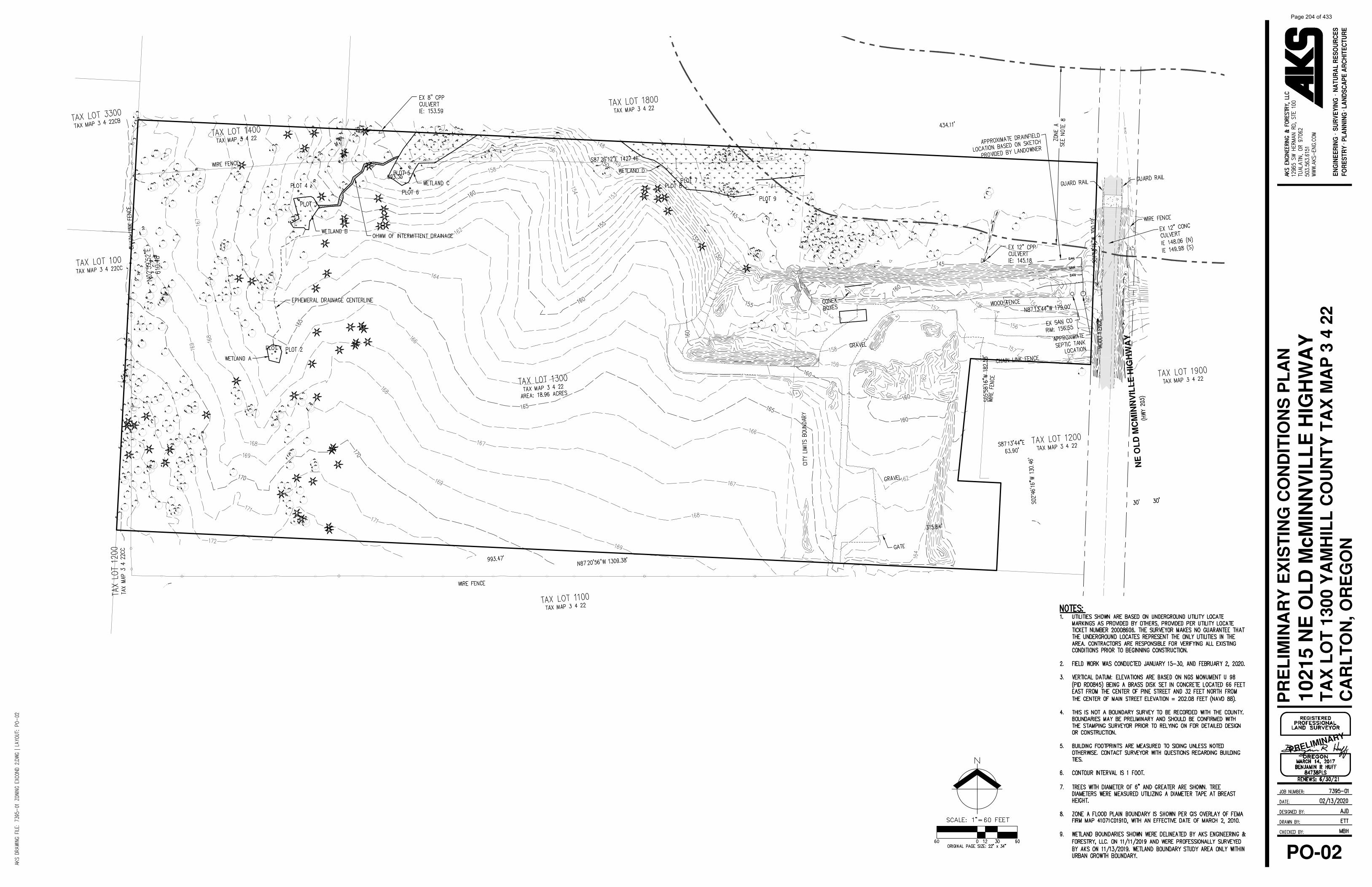
NE
OL
D M
CM
INN
VIL
LE
HIG
HW
AY
FOR
ESTR
YSU
RVE
YIN
GEN
GIN
EER
ING
NA
TUR
AL
RES
OU
RC
ESLA
ND
SCA
PE A
RC
HIT
ECTU
RE
PLA
NN
ING
1021
5 N
E O
LD
McM
INN
VIL
LE
HIG
HW
AY
TA
X L
OT
130
0 Y
AM
HIL
L C
OU
NT
Y T
AX
MA
P 3
4 2
2C
AR
LT
ON
, OR
EG
ON
PRELIMINARY
PR
EL
IMIN
AR
Y E
XIS
TIN
G C
ON
DIT
ION
S P
LA
N
PO-02
Page 204 of 433

C I
T Y
L I
M I
T S
/ U
. G. B
.
E TAFT STREET
NE
OL
D M
cMIN
NV
ILL
E H
IGH
WA
Y
S 7
TH
ST
RE
ET
JR MEADOWSSUBDIVISION
(APPROVED BUT NOT RECORDED)
PR
EL
IMIN
AR
Y P
AR
TIT
ION
PL
AT
PO-03
FOR
ESTR
YSU
RVE
YIN
GEN
GIN
EER
ING
NA
TUR
AL
RES
OU
RC
ESLA
ND
SCA
PE A
RC
HIT
ECTU
RE
PLA
NN
ING
1021
5 N
E O
LD
McM
INN
VIL
LE
HIG
HW
AY
TA
X L
OT
130
0 Y
AM
HIL
L C
OU
NT
Y T
AX
MA
P 3
4 2
2C
AR
LT
ON
, OR
EG
ON
PRELIMINARY
Page 205 of 433

C I T Y L I M I T S / U. G. B.
E WASHINGTON STREET
E MAIN STREET
E HARRISON STREET
S 5
TH
ST
RE
ET
E MAIN STREET
S L
INK
E A
VE
S 3
RD
ST
RE
ET
S 6
TH
ST
RE
ET
S 2
ND
ST
RE
ET
E TAFT STREET
E POLK STREET
S 1
ST
ST
RE
ET
S P
INE
ST
RE
ET
OREG
ON HW
Y 47
OR
EG
ON
HW
Y 47
W CLEVELAND STREET
E WASHINGTON STREET
W WILSON STREET
W ADAMS STREET
W TAYLOR STREET
NE
OL
D M
cMIN
NV
ILL
E H
IGH
WA
Y
S 7
TH
ST
RE
ET
S 7
TH
ST
RE
ET
E TAFT STREET
E WASHINGTON STREET
C I
T Y
L I
M I
T S
/ U
. G. B
.
LEGEND
FOR
ESTR
YSU
RVE
YIN
GEN
GIN
EER
ING
NA
TUR
AL
RES
OU
RC
ESLA
ND
SCA
PE A
RC
HIT
ECTU
RE
PLA
NN
ING
1021
5 N
E O
LD
McM
INN
VIL
LE
HIG
HW
AY
TA
X L
OT
130
0 Y
AM
HIL
L C
OU
NT
Y T
AX
MA
P 3
4 2
2C
AR
LT
ON
, OR
EG
ON
PRELIMINARY
CO
NC
EP
TU
AL
NE
IGH
BO
RH
OO
D C
IRC
UL
AT
ION
PL
AN
PO-04
Page 206 of 433

E MAIN ST
E WASHINGTON ST
E HARRISON ST
S L
INK
E A
VE
S 3
RD
ST
S 2
ND
ST
S 1
ST
ST
W WASHINGTON ST
S 5
TH
ST
S 6
TH
ST
N 4
TH
ST
N 5
TH
ST
S 7
TH
ST
N 7
TH
ST
N 3
RD
ST
N 2
ND
ST
N 1
ST
ST
E MUNROE ST
W TAFT ST
W GRANT ST
W MADISON ST
E MADISON ST
S P
INE
ST
S P
AR
K S
T
S K
UT
CH
ST
W CLEVELAND ST
E POLK ST
E TAFT ST
N K
UT
CH
ST
N Y
AM
HIL
L S
T
N S
CO
TT
ST
W MAIN ST
W MONROE ST
N G
ILW
OO
D S
T
N 6
TH
ST
N 8TH PI
S A
RT
HU
R S
T
W WILSON ST
TUALATIN VALLEY HWY
E TAFT ST
CIT
Y L
IMIT
S
CITY LIMITS
CITY LIMITS
PROJECT SITE
OR
EG
ON
HW
Y 47
NE
OL
D M
cMIN
NV
ILL
E H
IGH
WA
Y CITY ZONING DESIGNATIONS
FOR
ESTR
YSU
RVE
YIN
GEN
GIN
EER
ING
NA
TUR
AL
RES
OU
RC
ESLA
ND
SCA
PE A
RC
HIT
ECTU
RE
PLA
NN
ING
1021
5 N
E O
LD
McM
INN
VIL
LE
HIG
HW
AY
TA
X L
OT
130
0 Y
AM
HIL
L C
OU
NT
Y T
AX
MA
P 3
4 2
2C
AR
LT
ON
, OR
EG
ON
PRELIMINARY
ZO
NIN
G M
AP
WIT
H A
ER
IAL
PH
OT
OG
RA
PH
PO-05
Page 207 of 433

E TAFT STREET
NE
OL
D M
cMIN
NV
ILL
E H
WY
E TAFT STREET
NE
OL
D M
cMIN
NV
ILL
E H
IGH
WA
Y
S 7
TH
ST
RE
ET
C I
T Y
L I
M I
T S
/ U
. G. B
.
CO
NC
EP
TU
AL
FU
TU
RE
SU
BD
IVIS
ION
PL
AN
PO-06
FOR
ESTR
YSU
RVE
YIN
GEN
GIN
EER
ING
NA
TUR
AL
RES
OU
RC
ESLA
ND
SCA
PE A
RC
HIT
ECTU
RE
PLA
NN
ING
1021
5 N
E O
LD
McM
INN
VIL
LE
HIG
HW
AY
TA
X L
OT
130
0 Y
AM
HIL
L C
OU
NT
Y T
AX
MA
P 3
4 2
2C
AR
LT
ON
, OR
EG
ON
PRELIMINARY
Page 208 of 433

E TAFT STREET
NE
OL
D M
cMIN
NV
ILL
E H
WY
E TAFT STREET
NE
OL
D M
cMIN
NV
ILL
E H
IGH
WA
Y
S 7
TH
ST
RE
ET
C I
T Y
L I
M I
T S
/ U
. G. B
.
E TAFT STREET
JR MEADOWSSUBDIVISION
(APPROVED BUT NOT RECORDED)
PR
EL
IMIN
AR
Y U
TIL
ITY
PL
AN
PO-07
FOR
ESTR
YSU
RVE
YIN
GEN
GIN
EER
ING
NA
TUR
AL
RES
OU
RC
ESLA
ND
SCA
PE A
RC
HIT
ECTU
RE
PLA
NN
ING
1021
5 N
E O
LD
McM
INN
VIL
LE
HIG
HW
AY
TA
X L
OT
130
0 Y
AM
HIL
L C
OU
NT
Y T
AX
MA
P 3
4 2
2C
AR
LT
ON
, OR
EG
ON
PRELIMINARY
Page 209 of 433

celon Ttuqonapf, glsm Plan Apntxng
: st$mill*,-
-Ad{ial-
ColF.tor
--.+- Railrod Raglt4f-Wr:l
-
Prooo$dcollEtsPmpo€d Locd strBd
Proped Local (Appmxird.e)
M Starc@F UG8
sI
HNRRISON ST
MARKE'T
MAotrsoN
HUJ
B2iI
CAR OREGONFUTUFE STREET FLAN
13
I
I
II
I
,lnft,-,
:: -,:r\
Page 210 of 433

In Regard to the Matter of:(fill in application type and name)
Comprehensive Plan & Zoning Map Amendment lor10215 NE Old McMinnville Highway
,,4ffi-?fr.
1VAIVER OF I2O-DAY RULE
A (;RI.J\'I' Lll-rt.t; l'O\)tN
BEFORE THE CITY COUNCIL OF THE CITY OF CARLTON
COUNTY OF YAMHILL, STATE OF OREGON
Case File 1i16. CPA.ZC 2020-01
STATE OF OREGON
County of Yamhill
L Steve Reimann hereby gtant a 27 day(applicant)
extension to the 120-day rule due to unforeseen circumstances. In the event the situation lasts
longer than anticipated the extension will need to be renewed on September 2,2020(date)
to determine the need for an additional extension.
Dated this 3 day of (iu lu 2020J
ss
)))
(Signature)
Page 211 of 433

/
tii:l
ffiffiffimt
CARLTON
N
W@ E
s
o aoo aoo t2 00
Scola i n F.rl
June 1981
COMPREHENS IVE PLAN MAP,
2",.f.'-T.-;Tx
q Residential
@ Mobile Home Residential
@ Commercial
Industrial
Public Facility
Agricultural Holding/Future Residential
ffi
Page 212 of 433

ij
:i
UGB &
UGB & AH GIPT ...1
CITY LIMITSI
I_i_t:t: l
-_-_.JR1
J
iIiI
i
.1.
-,,1-
AH L
I
ir I l'i;
ir'-r " l
]N
"'.,1, . 1". i'lli.llil)':" I -"."i ..-:r
ji; I
!t
\R1
tr'li'.,rJ'; l.;li.i;,ll..i
ii-rlUGB & MX L l
C TY LIN/ITS R1
III-l
I)
rt"1.,1
/tt/ ;"."/ "ril. i., iir*l'-3r.r_Fl -
CB.l
€I
l*-t
-ti lIJ
ll r*iIri
I ;;i- .; l-,r-lt lri :il:l r i.s-t l'lt.r:-.rt'
i; I '
-_1[- 4,:
'' .1il'1.-'i';,'"'-'i,1. ' : ,y ^,i. 1," .,,, .r.1,. "
PFl-,L-* i
ltli|;-.=ri j R1
';,". "ir
t: : )
i lL. I l
iiirii il cll
l
t- !
i.:-.1.r
PF ! ' -r I
-,-l
-ol ;;- i -;lUGB & -4,, i; r-.I -r4l.,i.t^ lCITY LIMITS
UGB &ir: ! ,.,-:LECENO CITY LI]VITS
"i:i r..1I -i, -: -l
.CITY LIMITS LINE
"PF.U.G.B. LINEUGB.ZONE BOUNDARY LINE t
CITY LII\,,II Illl. .,{r
- :t'jTOWI\SHIP 3 SOUIH. RANGE 4 WEST. IV.M.
CITY ZONE DESIGNATIONS l;. " -.
ii ''lI
TY
R1 RESIDENTIAL LOW DENSITY \: ' \
'\: 1,, -\R3
FLOOD PLAIN INFORMATION R2 RESIDENTIAL MEDIUM DENSITY
PANEL DENSITY
DATE _--_
DD_MS (MAIN STREEI SUBDISIRICT) MX l
suBDtsTRtcT)CB COMMERCIAL BUSINESS
CI COMMERCIAL INDUSIRIAL UGB &GI GENERAL INDUSTRIAL
PF PUBLIC FACILITY
AH AGRICULruRAL H
MX MIXED DENSITYUGBFP FLOOD PLAIN MAN{GEMENT
*."41 -..*'*""^.'..\oqAc- o^F6 s .rBt@.
TY TIIVIITS
CITY LIMITSCITY L]M1TS
2i9,1E.
zi,i
s
4
uoo;d
a4zoN
I
E E
il;
-tn
t:
;l:
Page 213 of 433

Page 214 of 433

Page 215 of 433

ORDINANCE NO. 2020-727 AN ORDINANCE RE-ZONING CERTAIN PROPERTY LOCATED WITHIN THE
CITY LIMITS OF THE CITY OF CARLTON WHEREAS, TJA, LLC, an Oregon limited liability company, (“Applicant”) is the potential owner under contract to purchase the tract of land consisting of property described on Exhibit A attached hereto; and WHEREAS, Carlton Municipal Code Sections Chapters 17.48 AH, 17.24 R-2 Zone, 17.28 R-3 Zone; 17.180 Zone Change; and 17.196 - 200 Public Hearings authorize the City to undertake and complete zoning proceedings to amend city zoning designations for a parcel or parcels; and WHEREAS, the Applicant has applied for a Comprehensive Plan and Zone Map change from Agricultural Holding for 11.97 acres to Medium Density Residential, R-2 and for 1.97 acres to Medium High Density Residential, R-3 to allow for future housing on a Tax Lot R3422-1300 located on the south side of Main Street; and
WHEREAS, the City Recorder of the City of Carlton, Oregon, caused notice of a public hearing on such zoning request to be published as required by city ordinance. In addition, written notice of the requested zoning request was mailed to effected owners of property as required by city ordinance, and posted within the City of Carlton. Proof of publication and written notice is on file at City Hall; and
WHEREAS, said public hearing was held on the 18th day of May, 2020, before the Carlton Planning Commission in the City Council Chambers of the City of Carlton, Oregon, at which time all interested persons thus appearing were invited to be heard on the question of such zoning request; and
WHEREAS, the Planning Commission, being fully informed about said request, found by a majority vote that said change did conform with the review criteria listed in the municipal code based on the material submitted by the applicant and findings of fact and the conclusionary findings for approval contained in the staff report, all of which are on file in City Hall and that the zoning request was consistent with the Comprehensive Plan; and
WHEREAS, the Planning Commission recommended that the Council approve the proposed Comp Plan Amendment from Agricultural Holding AH to Residential, and applying a zone designation of Residential Medium-Density R-2 (for 11.97) acres and Residential Medium-High R-3 (for 1.97 acres) for Applicant’s property; and
WHEREAS, subsequently, the City Council scheduled a public hearing and such public hearing was held on August 4, 2020, in the Carlton Fire Hall in the City of Carlton. Notice of said hearing was given by written notice to affected property owners and to the general public by legal notice in the News Register, a newspaper of general circulation in the City of Carlton, published as required by city ordinance prior to the day of the hearing all as appears from the proof of publication on file in the Recorder’s office, and the Recorder caused the notice to be posted in public places in the City; and
Page 216 of 433

WHEREAS, the Carlton City Council conducted the scheduled hearing at the time
and date specified above in accordance with the standards adopted in the Carlton Municipal Code. The testimony of the proponents and opponents was received and, in addition, the record generated by the Carlton Planning Commission were duly incorporated into the record and was considered by the Council; and
WHEREAS, the Carlton City Council adopts the findings and conclusions set forth
on Exhibit A attached hereto.
NOW THEREFORE THE CITY OF CARLTON ORDAINS AS FOLLOWS: SECTION 1. That inasmuch as the owner of the area and territory described and designated herein has requested a Comprehensive Plan Map and zoning designation change from Agricultural Holding to Residential Medium Density R-2 for 11.97 acres and Residential Medium-High Density R-3 for 1.97 acres be applied to the area and territory described on Exhibit A, and based on the findings set forth in the city staff report on Exhibit A attached hereto, the Comprehensive Plan Map and the zoning designation for the Applicant’s property are hereby amended to and established as Residential Medium Density, R-2 District as to 11.97 acres and to Residential Medium-High Density, R-3 District as to 1.97 acres as described and delineated on Exhibit A attached hereto.
ADOPTED by the City Council of the City of Carlton, Oregon, on ____________, 2020 by the following votes:
AYES: NAYS: ABSENT: ABSTAIN:
APPROVED and signed by the Mayor on _____________________, 2020.
________________________________ Brian Rake, Mayor
ATTEST: ____________________________________ City Recorder
Page 217 of 433

C I
T Y
L I
M I
T S
/ U
. G. B
.
E TAFT STREET
NE
OL
D M
cMIN
NV
ILL
E H
IGH
WA
Y
S 7
TH
ST
RE
ET
JR MEADOWSSUBDIVISION
(APPROVED BUT NOT RECORDED)
ZO
NIN
G E
XH
IBIT
PO-03
FOR
ESTR
YSU
RVE
YIN
GEN
GIN
EER
ING
NA
TUR
AL
RES
OU
RC
ESLA
ND
SCA
PE A
RC
HIT
ECTU
RE
PLA
NN
ING
1021
5 N
E O
LD
McM
INN
VIL
LE
HIG
HW
AY
TA
X L
OT
130
0 Y
AM
HIL
L C
OU
NT
Y T
AX
MA
P 3
4 2
2C
AR
LT
ON
, OR
EG
ON
PRELIMINARY
Exhibit A
Page 218 of 433

June 18, 2020
Felix Madrid 1000 E. Main Street Carlton, Oregon 97111
Re: From the City of Carlton Planning Commission Staff Report; Comprehensive Plan Map and Zone Change Amendment City File #CPA.ZC 2020-01 and, Land Partition City File #PAR2020-02 (referred to as “The Application”). NOTE: Even though neither of these files are petitions for development, a provisional plan, provided, I’m sure, in an effort to comply with the City’s requirement to submit a development plan when applying for a zoning change, is explicit about the nature and scope of development on the City lot created by the partition.
What follows is commentary on The Application, detailing how it does not support or conform to the City’s Comprehensive Plan, as well as other concerns to substantiate and justify a recommendation to deny the Zone Change.
The applicant (TJA, LLC) first requests a land division to separate the land inside Carlton city limits from the portion of the lot that is in the county, and then requests Comprehensive Plan and Zone change for the 13.94 acre parcel that is within the City limits, from Ag. Holding to R-2 (medium density residential) on c. 11.97 acres of this lot, and R-3 (medium high density residential). The applicant has proposed a tentative conceptual plan for development of 56 single family dwellings and 22 or more multi-family dwellings.
The Document claims that a maximum 77-182 unit development could be built if the zone change is approved.
Page 219 of 433

1. PROBLEMS WITH FLOODING From the Comprehensive Plan (and included in the Application): “Development shall avoid locating in areas which are subject to, and/or generate adverse environmental impacts.” The FEMA FIRM flood hazard area crosses the parcel in the upper right-hand corner denoting the Hawn Creek 100-year floodplain. There are four wetlands and drainage streams in the northeast, southwest and northwest corners of the site. Hawn Creek, the Hawn Creek Floodplain and these wetland areas pose significant problems for development in this area. This development, if implemented would increase flooding at the site and upstream along Hawn Creek, adversely affecting these properties and creating potential for liabilities resulting from this development which have not been explored or detailed in the Application.
Clearly, although development plans for the two lots that would be created by the land division have not been submitted, the intent is to build homes on the lot(s). Large amounts of fill will need to be brought into the site to ensure minimum elevations for site development. This will significantly affect the capacity of the wetlands to accept storm waters and to buffer floods, and will increase the height of flood waters from Hawn Creek at and upstream of the development site.
Given the widely understood consensus in the scientific community that, due to climate change, severity of storm events has increased and will continue to increase, it is reasonable to assume that the area given to the FEMA 100 year Floodplain is likely to be an underestimate. This is consistent with (from the Application) Division of State Lands (DSL) advice to the applicant and local planning departments, to view the wetland boundaries currently shown as preliminary, subject to change.
2. PROBLEMS WITH SATISFACTION OF HOUSING GOALS The Application’s Conclusion Summary states that: The conceptual development plan provides a MOSTLY single-family housing option (emphasis mine). But, (from the Application) the applicant is offering a plan to build ONLY new single family dwellings on this 11.97 acre R-2 portion
Page 220 of 433

(emphasis mine). This runs counter to the City’s housing target goal of assuring that 25% of dwellings are multi family units. The City should mandate a plan that moves in this direction, towards the satisfaction of its housing goals. From the Application, as of 2019, over 97% of the homes in Carlton are single family.
(From the Application) “The City Housing Needs Analysis in the Comprehensive Plan (2007) projected a population of 2,379 by 2027, and a need for 233 additional dwellings units, or a total of 906 dwelling units. Now, the City’s 2019 population is 2,239 and there are a total of 932 dwellings including 27 apartments, exceeding the projected need for single family homes seven years before the 2027 projected need, while also decreasing the percentage of lower cost housing units.” Taking into account the c. 55 new single family homes that are to be built in JR Meadows it is clear that Carlton is well ahead of the projected needs for single family homes.
(From the Application) “The City finds the proposed zone change on the 11.97-acre parcel will result in only single family homes on the R-2 portion.”
Why is the City greenlighting development that will provide more single family homes, which the City has projected it does not need?
The portion of the development that is slated for R3 is situated in the Hawn Creek flood plain, which means that it is likely to have problems and may well be sacrificed, so the applicant can look good while denying the City the promised multifamily housing. If the City is interested in moving towards satisfaction of its Housing Goals, assuring that 25% of dwellings are multifamily units, it will need to deny this application, as it will only result in more single family homes.
There is no analysis in the Application to reflect the impact on housing needs in Carlton that may have changed or will change as a result of the economic impact of Covid-19 and the recession and/or depression resulting from this. Given the economic impacts we are experiencing, with unemployment levels
Page 221 of 433

not seen since the 1920’s it may be worth to consider these impacts on housing needs.
3. PROBLEMS WITH SATISFACTION OF RECREATION & NATURAL RESOURCE POLICIES According to the Application, the City Council is considering adoption of a draft City Park Plan update. A described purpose in the plan is “to identify current and future parks and recreation needs”, and to develop proposed parks and recreation facilities to meet future needs.” The Plan directs the City “to identify general areas where parks could be developed”. Further, it is city policy to “recognize the importance of Hawn Creek drainage area as a significant natural resource within the community, whereby the City encourages land in and around Hawn Creek floodplain as open space or future use as a pedestrian and bicycle trail”.
Although the conceptual development plan submitted indicates 56 single family units, the possibility for up to 182 units indicates a predisposition to develop the lots as densely as possible. This is in conflict with the stated City policy (from Application): To provide adequate park land and recreational facilities for the citizens of the community. The development of bicycle and pedestrian pathways should be examined as a potential recreational resource for the citizens of Carlton.
The City cannot satisfactorily resolve these contradictory design objectives, i.e., to densely fill in and develop a picturesque area of great natural beauty will not allow the same area to function as a significant natural resource within the community. In the Application, it is city policy to “recognize the importance of Hawn Creek drainage area function as a significant natural resource within the community.
4. PROBLEMS WITH SATISFACTION OF PUBLIC FACILITY AND SERVICES PLAN POLICIES
Page 222 of 433

The Application states as City policy: To permit new developments only when all urban services become available including public water, sanitary sewers, storm drainage, solid waste collection, streets, parks and recreation and adequate police and fire protection. The City shall require new development to pay all costs of capitol development to that development.
The Application identifies current problems with Water Availability,* Sanitary Sewer Treatment Capacity, Sanitary Sewer Collection, and with the Hawn Creek Pump Station as being unable to handle more than their current capacity. Upgrades are planned but costs are not available in the Document nor is it clear that “new development” will pay for these upgrades (see 5. below)
From the Application it is clear that the CITY DOES NOT AT THE PRESENT TIME HAVE THE WATER CAPACITY, SEWAGE TREATMENT CAPACITY OR PUMPING CAPACITY TO SERVE THE ZONING PROPOSED. Because of this, the proposed zone change does not comply with Comprehensive Plan Policies.
Additionally, the traffic study (performed for 77 units) is not available for view/study. The statement in the Application that “the operations of the
major intersections (7th St. at E Main St. and Pine St. at Polk St.) will be impacted, but the level of service is considered acceptable with no improvements to the intersections” indicates that there would be an impact to intersections that are already feeling the burden of additional traffic through Carlton and in the area. This “increased impact” is a burden that Carlton residents are expected to bear, but the cost of this burden is not detailed in the report. Also, and unfortunately, the transportation engineer was hired by the applicant which is (obviously) not a good idea. The City should independently hire an engineer to perform this study, not the applicant. The applicant hiring the engineer to perform the traffic study invalidates the traffic study.
Page 223 of 433

* Notes on Water Capacity, Water Transport, Sewer and associated infrastructure, and costs of development.
In The Application there is a claim made as to Water Service - Capacity:
“The Water Master Plan indicates that there is sufficient water source and treatment”.
Unfortunately, a plan to have water is not the same as having water available, which is a requirement of the Carlton Comprehensive Plan for development.
Any Carlton resident knows we have water rationing in late summer, along with problems of turbidity. Let’s add to this the effect that the 55 or more additional units in the JR Meadows subdivision will have on our water rationing issues. The truth is that we don’t presently have the Water Capacity for this new development. The claimed availability of water is only seen in an engineers report that provides a model of water availability based on dredging the reservoir which provides Carlton with water, and, with the replacement of the pipeline from the reservoir to Carlton, along which path water loss is occurring. These projects will cost many millions (tens of millions, more?) of dollars. Do we have an actual price for this? Has a bid been accepted, by the City of Carlton for this work? Does the City of Carlton already have funds for this work in their bank account? Supposedly, there are federal or state monies that will come to our aid for this. But is this certain? Given the economic turmoil and the recession we’re in, the Government may say that despite previous assurances they don’t have the funds to help Carlton. What about McMinnville? McMinnville’s water source may be part of the Master Water Plan. Apparently McMinnville has water to sell and is now in the process of contracting with the City of Lafayette to provide them with water for their new subdivision’s water needs. But firstly, this water will have a price. What price? We don’t know yet…and what if McMinnville finds out that, due to climate change or their own development, or for other reasons, that they don’t have enough water to sell to Carlton?
Page 224 of 433

Given all of these uncertainties wrt Future Water Capacity, and the fact that the City is at the limit of what it can offer its residents wrt present Water Capacity, is it reasonable to fast track a development that will significantly increase the demand on present Water Capacity?
In The Application, wrt Sewage Treatment Capacity: “The current wastewater treatment plant is at capacity with regard to load and flow during certain times of the year.” However, the Wastewater Facility Plan identified upgrades and the City has added them to the CIP and intends to improve the treatment plant in the near future. “With the improvements there will be sufficient capacity in the treatment system.” What are the costs of these improvements and who will pay for them? Will they cause increases in Carlton water and sewer charges? What about the increases in Water and Sewer charges that Carlton residents have endured, and accomodated in recent years. Are these monies being put towards the funding of these planned Water Projects? If not, why not?
The Application states that “the Hawn Creek Pump Station does not have the capacity to serve the zoning proposed” but also makes the claim that the City is in process of designing an upgrade to the pump station and that with the upgrade there will be sufficient capacity to meet the requirements of the proposed zone change. What will be the cost of this and who will pay for it?
5. PROBLEMS ASSOCIATED WITH EDUCATIONAL NEEDS IMPOSED BY THE NEW DEVELOPMENT
There is no mention in the application of the effect the development will have on the school system and its ability to handle the projected increase in students in the various schools resulting from the new development. New students as part of the new development will increase class size, not a welcome proposition, and one that does not favor educational goals that recognize that smaller class size leads to better educational outcomes. The developer should be required to pay for the improvements that will be necessary to maintain educational standards. Otherwise the City and its residents will have to suffer with decreased quality of education for our children or pay for the necessary upgrades via a school bond.
Page 225 of 433

6. PROBLEMS WITH LIABILITIES IN THE NEW DEVELOPMENT
City Planner claimed at the May 18th Planning Commission meeting that this new development is pretty much the same as the JR Meadows, which is not the case. The JR Meadows development site, though it does have significant water moving across it in at least two locations, water flow which is now causing issues with infrastructure engineering and construction on that site, does not have anything like the same wetlands and floodplain that this new development has. These “site constraints” as they are identified in the application, will cause issues with development because of the significant water flow across large areas of the site for prolonged periods during the year. The issues will be inflooding and water seepage, like that experienced by some other Carlton residents in developments near Hawn Creek, but will probably be worse, because the site of the new development is lower lying still than on the north side of Main Street.
CONCLUSION
Let’s call it what it is…if there’s any doubt in your mind about this you can hear City Planner Carole Connell herself reveal the truth as she conflates “subdivision” with “zone change” during the Planning Commission meeting of May 18, at 0:14:50. They are one and the same thing. As the proposed development does not meet the requirements of the Comprehensive Plan, this application should be denied.
ADDENDUM
A thorough reading of the application CPA.ZC 2020-01 reveals that City Findings are deficient. City Planner should have observed, and stated in the Findings that the site in question offers resources and opportunities for the City that have not been considered in the application. These resources have only been identified as site constraints, which diminish these resources to the level of an obstruction to the application, and to the development which would ensue should the application be approved, which development would permanently destroy these resources for the residents of Carlton. I urge you
Page 226 of 433

now to take this opportunity and manifest your interest in the greater good for Carlton, and consider the full range of possibilities for this unique parcel of land. There are many in Carlton that would be grateful for your action.
Sincerely,
Felix Madrid
Page 227 of 433

Page 228 of 433

06/22/2020
Statementon behalf of the Lawson Family
Regarding City File #CPA/ZC20L9-02 TJA, LLC
Lawson Family11599 NE Finn Hill Loop
Carlton, OR 97111
We moved to Yamhill in 2007 into a brand-new subdivision. We moved out this way so that we
could bring up and raise our family in a small town. After living in Yamhill for several years we
purchased a small farm in Carlton in 2015. When we started living in the Yamhill/Carlton area we had no
.. idea how much we would be blessed to call it home. The sense of community here is something like we
have never seen.
We have watched our children grow and thrive and we truly believe it is because we chose tomove them to a small town with big character. Over the years we have watched community members
support the youth in the area in abundance, When we started our own business in 2017 it was one ofour main goals to conilibute to the youth of our area as well. As a local business owner and family, we
believe in buying local and supporting local first. I think the same is true for many families in the area.
The brand-new home in a small town was what brought us out to this area. And we have only
continued to grow and support the community since calling YC home. We believe that bringing another
new development to Carlton can truly help grow our community. lt means more locals supporting thelocal businesses and supporting the youth of our area as well.
We were blessed to get the opportunity to call YC home because of a new subdivision that had
been built and we would like to see others get the same opportunity.
We are in favor of City File #CPA/ZC 20L9-O2 TJA, LLC .
Thank you,
Mike and Carrie Lawson
Page 229 of 433

Page 230 of 433

1221 SW Yamhill Street, Portland, Oregon 97205
May 15, 2020
Planning Commission City of Carlton 191 E. Main Street Carlton, OR 97111 RE: File No. CPA.ZC 2020-01 A Comprehensive Plan & Zone Map Amendment for 13.94 acres (Parcel 1) from Agricultural Holding AH to Residential – Medium Density R-2 (11.97 acres), and to Residential - Medium-High Density R-3 (1.97 acres)
To the Carleton Planning Commission
This letter is submitted jointly by Housing Land Advocates (HLA) and the Fair Housing Council of Oregon (FHCO). Both HLA and FHCO are non-profit organizations that advocate for land use policies and practices that ensure an adequate and appropriate supply of affordable housing for all Oregonians. FHCO’s interest relate to a jurisdiction’s obligation to affirmatively further fair housing.
We would like to commend the Planning Commission and staff for its excellent Goal 10 findings contained within the Staff report for CPA.ZC 2020-01. The findings provide detailed context regarding the progress the City is making towards satisfying its housing needs, and describes the affects the changes will have on the housing supply within the City. The document will serve the City well over the next 20 years to help meet its Goal 10 requirements.
Thank you for your consideration of our comments.
Sincerely,
Louise Dix AFFH Specialist Fair Housing Council of Oregon
Cc: Gordon Howard, DLCD
Page 231 of 433

Carlton, LA 2019-01, Comprehensive Plan Amendment – Parks Plan 1
CITY OF CARLTON COMPREHENSIVE PLAN AMENDMENT 2019-01
City Council Hearing – STAFF REPORT
I. BACKGROUND REPORT DATE: July 24, 2020 APPLICANT: City of Carlton LOCATION: Citywide REQUEST: Comprehensive Plan amendment to update the Carlton Parks Development
Plan. Included are updates to population projections and demographics, parks inventory, improvements, and comparisons to OPRD and NPRA standards.
CRITERIA: Oregon Statewide Planning Goals and Guidelines City of Carlton Comprehensive Plan, 2000 (Amended 2007 and 2009) EXHIBITS:
A. Draft Carlton Parks Development Plan, 2019 B. Oregon Statewide Planning Goals and Guidelines, Goal 8 C. Revised Carlton Parks Map with ¼ mile buffers
II. OVERVIEW This proposed update to the Comprehensive Plan is based on an identified need for analysis of park inventory and needed improvements, based on updated population projections and in comparison, with national and state standards. Analysis of the City’s current inventory of existing parkland and forecasted population growth has identified a need for new parkland, as well as improvement to existing parkland in order to meet standards and to provide a range of recreational opportunities for Carlton residents through the year 2040. Based on the latest population projections, the City’s park system is expected to serve a population of 3,204 residents by the year 2040. According to National Recreation and Park Association (NRPA) guidelines, the typical amount of parkland is 10.1 acres per 1000 residents. The City of Carlton currently has 23.16 acres of parkland. By 2040, the City will need a total of 32.68 acres to meet the NRPA standard. The State of Oregon also has a recommended level of service for parks that is broken down into the acreage recommended for various types of parks. The City of Carlton currently meets the state standards by category, but will need to plan for an increased population in 2040, when the City should have 3.20 to 6.41 acres of neighborhood parks and 6.41 to 19.22 acres of community parks to meet the state standards.
Page 232 of 433

Carlton, LA 2019-01, Comprehensive Plan Amendment – Parks Plan 2
Local governments may prepare and adopt local parks master plans pursuant to Statewide Planning Goal 8: Recreational Needs and OAR 660-034-0040. These plans may be integrated with local comprehensive land use plans. Parks master plans help to give a community direction in developing future parks and making improvements to existing parks to meet residents’ needs. III. PROCEDURE A text amendment to the City of Carlton Comprehensive Plan is a Type IV action. A type IV action is a legislative review in which the City considers and enacts or amends laws and policies. Type IV actions are initiated by the City of Carlton; other parties may request the City Council consider a proposal requiring Type IV review. Public notice and hearings are provided in a Type IV process. Appeal is to the Land Use Board of Appeals (LUBA). Direction to amend the Carlton Comprehensive Plan was given by the City Council at a regular meeting held on May 7, 2019. A public hearing shall be held by the Planning Commission on all proposed amendments and revisions of the Comprehensive Plan. Following Planning Commission action, the City Council shall hold a public hearing to consider the Planning Commission’s recommendation on proposed amendments. Notice shall be as specified in Chapter 17.192. Per Chapter 17.192.030, public notice for both the Planning Commission and City Council hearings was provided to the Department of Land Conservation and Development on October 17, 2019. Notice of the Planning Commission and City Council hearings was published in the News-Register on November 15, 2019. Notice to the public was posted at City Hall, Ladd Park, and the Post Office. Notice was posted and updated on the City’s website. On February 24, 2020, the Carlton Planning Commission held a properly noticed public hearing to review the proposal and to make a recommendation to City Council. After review of the staff report and the draft plan, the Planning Commission voted to recommend approval with the following changes to the draft plan:
1. Add a map showing ½ and ¼ mile radius around the existing parks 2. Add a ½ basketball court to the list of future needs for Hawn Creek Park 3. Remove RV parking from the list of future needs for Wennerberg Park
City Council held a hearing on May 5, 2020. At that time they requested a work session be scheduled for the 7/7/2020 meeting. At that time, Council directed staff to amend the buffer map to include boundary showing future parks land. The goal of this is to show where the City should have more parks in the future. The Carlton Development Code does not specifically identify criteria for the approval of text amendments to the Comprehensive Plan. Because amendments to the Comprehensive Plan apply
Page 233 of 433

Carlton, LA 2019-01, Comprehensive Plan Amendment – Parks Plan 3
to the entire city, they are reviewed and approved on the basis of whether or not they are consistent with the Statewide Planning Goals and Guidelines and the best interests of the public. Findings related to these criteria are outlined below:
IV. CRITERIA/FINDINGS
STATEWIDE PLANNING GOALS Findings: Goal 1: Citizen Involvement. The public will be given the opportunity to give input and voice their concerns at the public hearings before the Planning Commission and the City Council and will be notified of decisions made on the application. Goal 2: Land Use Planning. Establishes a land use planning process and policy framework as a basis for all decision and actions related to use of land and to assure an adequate factual base for such decisions and actions. The review of this application is being conducted according to the procedures set forth in the Carlton Development Code, Chapter 17.212.020: Procedure for Type IV Actions. The legislative amendment is being considered for conformance with the Oregon Statewide Planning Goals and Guidelines. Goals 3: Agricultural Lands. This goal is not applicable. The proposal will not affect agricultural lands. Goal 4: Forest Lands. This goal is not applicable. The proposal will not affect forest lands. Goal 5: Natural Resources, Scenic and Historic Areas, and Open Areas. This goal aims to protect natural resources and conserve scenic and historic areas and open spaces. The proposal is intended to preserve areas of open space within the City of Carlton, as well as set aside new areas for recreation and open space while improving upon existing park areas. Goal 6: Air, Water and Land Resources. This goal endeavors to maintain and improve the quality of the air, water and land resources of the State. The proposal intends to improve air, water, and land resources quality by preserving and maintaining open space. Goal 7: Areas Subject to Natural Disasters and Hazards. Staff finds this goal is not applicable. Goal 8: Recreation Needs. To satisfy the recreational needs of the citizens of the state and visitors and, where appropriate, to provide for the siting of necessary recreational facilities, including destination resorts. The proposal is consistent with Goal 8 in that it will assist the City in meeting federal and state standards for the provision of parkland, based on current and projected populations, and will provide guidance for the siting of recreational facilities within the City over the next twenty years.
Page 234 of 433

Carlton, LA 2019-01, Comprehensive Plan Amendment – Parks Plan 4
Because amendments to the Comprehensive Plan apply to the entire city, they are reviewed and approved on the basis of whether or not they are consistent with the best interests of the public. The adopted 2000 Comprehensive Plan, currently in effect, and this proposed amendment to the Comprehensive Plan to include update the Parks element both identify the need to monitor parks inventories in relation to increasing population projections, in order to meet federal and state standards. Based on the latest population projections, the City’s park system is expected to serve a population of 3,204 residents by the year 2040. According to National Recreation and Park Association (NRPA) guidelines, the typical amount of parkland is 10.1 acres per 1000 residents. The City of Carlton currently has 23.16 acres of parkland. By 2040, the City will need a total of 32.68 acres to meet the NRPA standard. The State of Oregon also has a recommended level of service for parks that is broken down into the acreage recommended for various types of parks. The City of Carlton currently meets the state standards by category, but will need to plan for an increased population in 2040, when the City should have 3.20 to 6.41 acres of neighborhood parks and 6.41 to 19.22 acres of community parks to meet the state standards. Goal 9: Economy of the State. Staff finds this goal is not applicable. Goal 10: Housing. Staff finds this goal is not applicable. Goal 11: Public Facilities and Services. Goal 11 requires a timely, orderly and efficient arrangement of public facilities and services to serve as a framework for urban and rural development. The proposal intends to increase the amount and variety of recreational facilities available to the residents of Carlton through long-term planning for parks and park facilities. Goal 12: Transportation. Staff finds this goal is not applicable. Goal 13: Energy Conservation. Staff finds this goal is not applicable. Goal 14: Urbanization. Goal 14 provides the guideline: Comprehensive plans and implementing measures for land inside urban growth boundaries should encourage the efficient use of land and the development of livable communities. This proposal intends to enhance livability factors within the City of Carlton by planning for an increase in population and relating that to the amount of land available for parks. Also, by providing a basis for the long-term planning for park facilities to meet the needs of current and future residents of Carlton. Goals 15-19. These goals apply to specific geographic locations, none of which are impacted here. Staff finds these goals do not apply.
Page 235 of 433

Carlton, LA 2019-01, Comprehensive Plan Amendment – Parks Plan 5
City of Carlton Comprehensive Plan, 2000 (Amended 2007 and 2009) Recreation Goals and Policies:
Goal: To provide adequate park land and recreational facilities for the citizens of the community.
Policies
1. Recreational facilities and services shall be expanded as the need arises.
2. To the extent possible, the acquisition of park sites in advance of actual need shall be made to assure the availability of adequate, properly located sites. The City shall investigate and enact appropriate funding alternatives and other suitable techniques for the acquisition and development of park and recreational facilities.
3. Continued availability and use of school-owned recreational
facilities by the general public shall be encouraged in the future. In addition, schools and parks shall be located on adjacent sites whenever possible.
4. Development of bicycle and pedestrian pathways should be
examined as a potential recreational resource for the citizens of Carlton.
5. The City shall support Yamhill County in meeting its anticipated
demand for future parkland for recreational uses.
6. The city shall seek funding for a park and recreational study sufficient to identify and program future park and recreational facility and property needs.
Findings: The proposed update to the parks master plan conforms to the stated goals of the City’s Comprehensive plan in that it provides an analysis the City can use to determine the types and amount of parkland needed by the City over the next twenty years. The proposal allows the City to make informed decisions concerning parkland needs and identifies funding opportunities for the future acquisition and development of parks and recreation facilities.
Page 236 of 433

Carlton, LA 2019-01, Comprehensive Plan Amendment – Parks Plan 6
V. CONCLUSIONS Staff recommends approval of Comprehensive Plan Amendment 2019-01, based on the criteria and findings outlined above. Possible actions by the City Council are listed below. The City Council may take one of the following actions: A. Make a motion to adopt the staff report and approve Legislative Amendment, LA 2019-01. B. Make a motion to adopt the staff report and approve Legislative Amendment, LA 2019-01, as
modified to reflect the changes made by the City Council.
Note: The Council Member making the motion needs to state the modifications and the reasons for the modifications.
C. Make a motion to continue the public hearing to a date and time certain and state the
additional information that is needed to allow for a future decision. D. Make a motion to deny Legislative Amendment, LA 2019-01.
Note: The Council Member making the motion needs to state the reasons for the recommendation of denial.
Page 237 of 433

Page 238 of 433

Page 239 of 433

Page 240 of 433

Page 241 of 433

Page 242 of 433
Page 243 of 433

Page 244 of 433

Page 245 of 433

Carlton Parks Development Plan
December 2019 Adopted by Ordinance No.
Prepared for: The City of Carlton, Oregon Prepared by: Mid‐Willamette Valley Council of Governments
Page 246 of 433

Prepared for:
City of Carlton, Oregon
Brian Rake, Mayor
Prepared by:
Mid‐Willamette Valley Council of Governments Salem, Oregon
2014 Carlton Parks Committee
Kathie Oriet Carey Rhoads Ginger Williams Val Anctil Nancy Carl Joe Della Valle Andy Eldien Carol Fredrick Danielle Findley Mark Herwig Jeff Lorton Annette Madrid Joe Moore Steve Reimann Lynne Salewski Linda Watkins
2019 Carlton City Council Brian Rake, Mayor Shirley Ward‐Mullen Kathy Rich Carey Rhoads Scott Carl Linda Watkins Amy Wilder 2019 Planning Commission Kevin Herwick, Chair Adam Brennan Gwen Jernstedt Bob Graham Dust Bailey Kathleen Moss Jessica Sampson
Staff Dennis Durham, City Manager
Page 247 of 433

Carlton Parks Development Plan, December 2019 Page 1-2
TABLE OF CONTENTS
Chapter 1 Introduction Parks Planning Process Purpose of this Plan Methods Organization of this Plan
1‐3 1‐3 1‐3 1‐4 1‐4
Chapter 2 Community Profile Demographic Characteristics Housing Trends Economy Summary
2‐1 2‐1 2‐4 2‐5 2‐6
Chapter 3 Goals and Policies 3‐1
Chapter 4 Park Facilities Inventory and Classification Park Facilities in the Carlton Area Park Classification
4‐1 4‐1 4‐6
Chapter 5 Proposed Park Improvements Proposed Improvement Projects by Park
5‐1 5‐1
Chapter 6 Capital Improvement Program 6‐1
Chapter 7 Parkland Acquisition Plan Current and Future Park Services Approximate Cost to Maintain Standard
7‐1 7‐1 7‐2
Page 248 of 433

Carlton Parks Development Plan, December 2019 Page 1-3
Appendix A Funding Information A‐1
Appendix B Ladd Park Concept Plan B‐1
Appendix C Hawn Creek Park Development Plan C‐1
Chapter 1 Introduction
Carlton is preparing for population growth and an increase in residential development. The city has experienced only moderate growth in recent years, but several large residential subdivision projects planned for the community will result in a steady increase in population in coming years. The City created and adopted a parks development plan in 2014 that included a Capital Improvements Program (CIP) for park facilities.
With the increase in residential development in the city, it is important to plan for future development of parks and recreation facilities as well. Such facilities contribute greatly to the quality of life in small communities. In addition, the development of a parks development plan and CIP serve as the basis for calculating Systems Development Charges (SDCs) for parks. SDC funds are an important mechanism for funding development of new recreational facilities to meet the needs of a growing population.
This plan was developed under guidance from the Carlton Parks Committee. The Parks Committee assisted in identifying facilities and determining and refining necessary system improvements. The Planning Commission and City Council then prioritize system improvements for inclusion in the CIP.
The Parks Planning Process
Park facilities can help meet the demand for recreational activities and enhance a community’s quality of life. Providing adequate park facilities can be a challenge for many growing communities.
Lack of resources—both staff and money—limits many communities’ ability to develop and maintain adequate parks systems. Identifying system priorities and matching them with available resources requires careful planning. Many communities develop and adopt park system master plans to guide development of their parks system.
Parks provide a variety of resources and opportunities for communities. These include passive and active recreation opportunities, preservation of open space and wildlife habitat that may include environmentally sensitive land such as wetlands or coastlines, and preservation of historic, cultural, and natural resources. In addition, parks may serve as informal meeting places in a community—drawing residents together and creating a sense of cohesiveness and community.
Local governments may prepare and adopt local parks master plans pursuant to Statewide Planning Goal 8: Recreational Needs and OAR 660‐034‐0040. These plans may be integrated with local comprehensive land use plans. Parks master plans help to give a community direction in developing future parks and making improvements to existing parks to meet residents’ needs.
Purpose of this Plan
The purpose of this Parks Development Plan is to identify park and recreation amenities that will meet the needs of the community. The Plan will serve as a guide for future development of parks within the community. More specifically, the purpose of this plan is to:
Page 249 of 433

Carlton Parks Development Plan, December 2019 Page 1-4
• Identify current and future park and recreation needs. • Identify park and recreation goals and policies. • Develop a list of proposed parks and recreation facility improvements designed to meet future needs. • Identify general areas where new parks facilities could be developed. • Develop costs estimates for proposed parks and recreation facilities improvements. • Identify reimbursement and improvement SDC requirements.
Page 250 of 433

Carlton Parks Development Plan, December 2019 Page 1-5
• Identify funding strategies and sources for proposed parks and recreation facilities improvements.
Methods
A variety of methods were used to create this plan. Mid‐Willamette Valley Council of Governments (MWVCOG) staff used the following approach:
1. Background research on the demographics and park resources of Carlton. 2. Inventory of the condition and amenities of each of Carlton’s existing parks. 3. Research on p a r k s tand ard s and c l a s s i f i c at io n s to be a basis for developing standards
and classifications specific to Carlton. 4. Meeting with the Carlton Parks Committee to identify a list of needed improvements and amenities. 5. Research on costs for capital improvement projects. 6. Research on possible funding options for the capital improvement plan.
Organization of this Plan
This plan is organized into seven chapters:
• Chapter 1: Introduction
• Chapter 2: Community Profile examines trends in population, housing, age composition, school enrollment, racial composition, income levels, poverty rates, and employment, as they relate to parks planning.
• Chapter 3: Goals and Policies outlines the City’s parks and recreation policy framework. • Chapter 4: Park Inventory provides an inventory of parks available in Carlton, including information
on the condition, amenities, and classification of each facility. • Chapter 5: Proposed Parks Improvements provides a description of proposed improvements within
the existing park system. • Chapter 6: Capital Improvement Program presents a 5‐year capital improvement program (CIP). The
CIP focuses on specific park improvements with cost estimates and a short‐ or long‐term ranking for each project.
• Chapter 7: Parkland Acquisition Plan calculates the amount of parkland needed through 2040 to keep pace with growth in Carlton. This chapter also includes a preliminary cost estimate to acquire needed parkland and discusses acquisition strategies.
Appendices:
• Appendix A: Funding Options Contacts, names, phone numbers, and websites for various funding options.
• Appendix B: Ladd Park Concept Plan Provides a conceptual site plan outlining proposed changes to Ladd Park.
• Appendix C: Hawn Creek Park Development Plan Provides a site plan for the development of Hawn Creek Park.
• Appendix D: Wennerberg Park Plan?
Page 251 of 433

Page 2-1 Carlton Parks Development Plan, December 2019
Chapter 2 Community Profile
Carlton’s location and demographic characteristics present opportunities and constraints for the community’s park system. This chapter describes socioeconomic data for Carlton. Demographic trends provide an understanding of present and future park need. Development trends provide information on the rate, type, and location of growth. All of these factors should be considered when siting future park facilities and in prioritizing capital improvements. The community profile information can also be used in grant proposals to fund specific parks and recreation improvements.
Demographic Characteristics
Population
Table 2‐1 shows population trends between 1970 and 2018 for Carlton, Yamhill County, and the State of Oregon while Figure 2‐1 provides a population forecast to 2040 for the City of Carlton. Carlton grew at an average annual growth rate (AAGR) of 1.6 percent between 2010 and 2018. This growth rate was higher than both the 1.0 percent AAGR of Yamhill County and Oregon’s annual growth rate of 1.1 percent for the same time period.
Table 2‐1. Population Trends in Carlton and Yamhill County (1970‐2018) and Oregon 1970‐2018
Year Carlton AAGR Yamhill County AAGR Oregon AAGR
1970 1,126 40,213 2,091,385
1980 1,302 1.5% 55,332 5.2% 2,633,105 2.6%
1990 1,289 ‐0.1% 65,551 2.6% 2,842,321 0.8%
2000 1,514 1.6% 84,992 2.9% 3,421,399 2.0%
2010 2,007 2.9% 99,193 1.6% 3,831,074 1.1%
2018* 2,270 1.6% 107,415 1.0% 4,195,300 1.1%
* Source: U.S. Census Bureau, Census 2000 and 2010, Portland State University Center for Population Research, and MWVCOG
State law requires P o r t l a n d S t a t e U n i v e r s i t y ( P S U ) , i n c o o r d i n a t i o n w i t h l o c a l g o v e r n m e n t s , t o i s s u e 5 0 ‐ y e a r p o p u l a t i o n f o r e c a s t s t o b e a p p l i e d b y l o c a l g o v e r n m e n t s w h e n c h a n g i n g t h e c o m p r e h e n s i v e p l a n o r a l a n d u s e r e g u l a t i o n o f t h e g o v e r n m e n t (ORS 195.033). PSU, in coordination with Yamhill County and the City of Carlton, have developed a coordinated forecast for the city’s population through 2067. I n a d d i t i o n , O r e g o n A d m i n i s t r a t i v e R u l e s ( O R S ) 6 6 0 ‐ 0 1 5 r e q u i r e s l o c a l g o v e r n m e n t s t o a p p l y 2 0 ‐ y e a r p o p u l a t i o n f o r e c a s t s t o d e m o n s t r a t e n e e d f o r p a r k s a n d o p e n s p a c e w h e n i m p l e m e n t i n g c o m p r e h e n s i v e p l a n c h a n g e s o r l a n d u s e r e g u l a t i o n s . The coordinated 2040 population forecast for Carlton is 3,204 persons. This coordinated population forecast is used in this plan to estimate future parkland needs for Carlton.
Page 252 of 433

Page 2-1 Carlton Parks Development Plan, December 2019
Future population growth will create increased demand for infrastructure—including parks—for Carlton. By 2040, the existing parks system will be servicing a larger population. The City will need to acquire new parkland if it desires to maintain the current level of service. The projected future need for additional parkland is presented later in Chapter 7: Parkland Acquisition Plan also uses this projection.
Figure 2‐1 Population Forecast for Carlton 2018 – 2040
Source: Portland State University Population Research Center
Age Characteristics
Age is an important factor in parks planning. Each age group has different needs and desires. Current and future age distribution of a community should influence the facilities and amenities offered in parks.
The US Census shows that in 2010, the median age in Carlton was 34.3 years. This is similar to the median age for Yamhill County, 34.1 years, and younger than the Oregon median age, 36.8 years. The age composition of Carlton, Yamhill County, and Oregon is shown in Figure 2‐1.
0
500
1,000
1,500
2,000
2,500
3,000
3,500
2018 2019 2020 2025 2030 2035 2040
Population Forecast 2018 ‐ 2040
Page 253 of 433

Page 2-8 Carlton Parks Development Plan, December 2019
Figure 2‐2. Age Distribution: Oregon, Yamhill County, City of Carlton, 2017
Age: ACS Demographic and Housing Estimates, 2013‐2017 American Community Survey 5‐year Estimates
Oregon State Yamhill County City of Carlton
Estimate Percent Estimate Percent Estimate Percent <5 231,854 5.80% 5,913 5.80% 69 3.60% 5‐9 242,780 6.00% 6,510 6.40% 158 8.20%
10‐14 242,234 6.00% 7,062 6.90% 218 11.30% 15‐19 245,601 6.10% 7,380 7.20% 160 8.30% 20‐24 264,705 6.60% 7,272 7.10% 91 4.70% 25‐34 558,821 13.90% 12,623 12.30% 197 10.20% 35‐44 527,675 13.10% 12,873 12.60% 355 18.30% 45‐54 514,194 12.80% 13,166 12.90% 254 13.10% 55‐59 268,331 6.70% 7,059 6.90% 117 6.00% 60‐64 273,843 6.80% 6,274 6.10% 106 5.50% 65‐74 392,682 9.80% 9,407 9.20% 152 7.80% 75‐84 179,433 4.50% 4,818 4.70% 42 2.20% >85 82,974 2.10% 2,009 2.00% 18 0.90%
Median age (years) 39.2 38.2 36.9
Source: American Community Survey
0%
5%
10%
15%
20%
<5 5‐9 10‐14 15‐19 20‐24 25‐34 35‐44 45‐54 55‐59 60‐64 65‐74 75‐84 >85
Age Range in Years
Age Distribution: 2017
Oregon Yamhill Carlton
Page 254 of 433

Page 2-9 Carlton Parks Development Plan, December 2019
Race and Ethnicity
Carlton’s population is gradually becoming more diverse in ethnic and racial composition. Table 2‐2 summarizes these trends between 2010 and 2017. The city’s population is still predominantly white, and is less diverse than Yamhill County or Oregon.
Table 2‐2. Race and Ethnic Composition in Carlton, Yamhill County, and Oregon, 2010‐2017
Source: U.S. Census Bureau, 2010, American Community Survey 5‐Year Estimates, 2013‐2017; 1 Percentages may add to more than 100 percent because individuals may report more than one race.
School Enrollment
The US Census shows that the median age in Carlton is less than the Yamhill County median age and less than Oregon's median age. According to the 2017 American Community Survey, 31.4percent of the population in Carlton was 19 years of age or younger. In Yamhill County, 26.3 percent of the population was 19 years of age or younger in 2017. For Oregon in 2017, this figure was 23.9 percent.
The 2017 Census shows that over half of the Carlton residents enrolled in school were children attending elementary school.
Table 2‐3. School Enrollment in Oregon, Yamhill County, and Carlton, 2017
School Enrollment Oregon Yamhill Carlton Total Percent Total Percent Total Percent Population 3 years and over enrolled in school 953,282 (X) 25,587 (X) 652 (X) Nursery school, preschool 55,980 5.90% 1,190 4.70% 22 3.40% Kindergarten to 12th grade 626,100 65.70% 17,517 68.50% 508 77.90% Kindergarten 46,420 4.90% 1,291 5.00% 14 2.10% Elementary: grade 1 to grade 4 192,658 20.20% 5,237 20.50% 153 23.50% Elementary: grade 5 to grade 8 190,294 20.00% 5,656 22.10% 177 27.10% High school: grade 9 to grade 12 196,728 20.60% 5,333 20.80% 164 25.20% College, undergraduate 224,653 23.60% 6,244 24.40% 109 16.70% Graduate, professional school 46,549 4.90% 636 2.50% 13 2.00%
Source: U.S. Census Bureau, American Community Survey (ACS), 2017
R ac e/E thnic ity 2010 2017 2010 2017 2010 2017White (alone) 83.6% 84.9% 89.9% 88.2% 91.8% 90.0%B lack or African American (alone) 1.6% 1.9% 0.8% 1.0% 0.1% 0.0%American Indian and Alas ka Native 1.3% 1.1% 1.5% 1.2% 1.6% 0.3%As ian 3.0% 4.1% 1.1% 1.4% 0.3% 0.6%Native Hawaiian and O ther P ac ific Is lander 0.2% 0.4% 0.1% 0.2% 0.1% 0.0%S ome other race 4.2% 3.0% 5.1% 3.9% 3.2% 2.5%Two or more races 3.1% 4.6% 2.4% 4.0% 2.9% 6.6%His panic or L atino O rigin (of any race) 8.0% 12.7% 8.0% 15.7% 4.6% 9.0%
O reg on Y amhill C arlton
Page 255 of 433

Page 2-
Carlton Parks Development Plan, December 2019
Housing Trends Tenure
Housing characteristics provide information that can be useful for parks planning. The rate, type, and location of housing development are important variables that provide information on where future parks should be located. Moreover, this data is useful for parks planning because it gives insight into the potential funding base (e.g. property taxes and systems development fees).
According to the 2017 US Census, 76.9 percent of the occupied housing units in Carlton are owner occupied. This figure is higher than for either Yamhill County or Oregon, as indicated in Table 2‐4.
Table 2‐4. Housing Tenure and Average Household Size by Housing Tenure in Oregon, Yamhill County, and Carlton, 2017
Housing Tenure/Household Size Oregon Yamhill Carlton Estimate Percent Estimate Percent Estimate Percent Total: 1,571,631 X 35,952 X 636 X Owner occupied 969,453 61.7% 24,428 67.9% 489 76.9% Renter occupied 602,178 38.3% 11,524 32.0% 147 23.1%
Average household size of owner‐occupied units 2.57 2.71 2.93 Average household size of renter‐occupied units 2.4 2.67 3.44
Source: U.S. Census Bureau, American Community Survey, 2017
Building Permits
Carlton experienced relatively slow to moderate residential growth in recent years. The PSU Forecasts for Yamhill County, its Cities and Unincorporated Areas (2017‐2067) indicates that between 2000 and 2010, 191 new housing units were constructed in Carlton, representing an average annual growth rate of 2.9%. The PSU Coordinated Population Forecast (2017‐2067) a n t i c i p a t e s t h e a v e r a g e a n n u a l g r o w t h r a t e b e t w e e n t h e y e a r s 2 0 1 7 a n d 2 0 3 5 t o b e 1 . 7 % w i t h i t s s h a r e o f c o u n t y w i d e p o p u l a t i o n g r o w t h e x p e c t e d t o b e 2 . 7 p e r c e n t f o r t h o s e y e a r s . T h e s p e c i f i c a s s u m p t i o n s f o r t h e C i t y o f C a r l t o n i n c l u d e : “ T h e 5 ‐ y e a r a v e r a g e a n n u a l h o u s i n g u n i t g r o w t h r a t e i s a s s u m e d t o r a p i d l y i n c r e a s e t o 2 . 0 2 p e r c e n t d u r i n g t h e f i r s t 1 0 y e a r s a n d t h e n d e c l i n e t h e r e a f t e r . T h e o c c u p a n c y r a t e i s a s s u m e d t o b e s t e a d y a t 9 2 . 4 p e r c e n t t h r o u g h o u t t h e 5 0 ‐ y e a r h o r i z o n . P P H ( P e r s o n s P e r H o u s e h o l d ) i s a s s u m e d t o b e s t a b l e a t 2 . 8 3 o v e r t h e f o r e c a s t p e r i o d . ”
Economy
The economy of Yamhill County is shifting from a dependence on the forest products industry to an economy with expanding technology, service, and tourism sectors. Agriculture still plays a dominant
Page 256 of 433

Page 2-
Carlton Parks Development Plan, December 2019
role in the local economy and the expanding local winery industry brings together the agricultural and tourism sectors. With its small‐town character and convenient location to both McMinnville and Newberg, Carlton serves as a “bedroom community” and provides quality of life attributes that are important for families. The City’s park system can serve an important role in maintaining the quality of life that Carlton residents enjoy.
Page 257 of 433

Page 2-
Carlton Parks Development Plan, December 2019
Income and Poverty
Carlton’s residents earned a median household income (averaged for the years of 2012‐2016) higher than in Oregon and Yamhill County as shown in Table 2.5.
Table 2‐5. Median Household Income in Carlton, Yamhill County, and Oregon, (2012‐2016 ‐ 5‐y e a r estimates)
Location
Carlton $59,417
Yamhill County $54,951
Oregon $53,270
Source: U.S. Census Bureau, American Community Survey (2012‐2016) 1In 2016 inflation‐adjusted dollars
Table 2‐6 shows the percentage of persons below the poverty level in Carlton, according to the American Community Survey, averaged for the years of 2012‐2016. The percentage is lower than estimated for both Yamhill County and Oregon during the same time period.
Table 2‐6. Percentage of Persons below Poverty Line in Carlton, Yamhill County, and Oregon, (2012‐2016 ‐ 5‐year estimates)
Location
Carlton 5.7% Yamhill County 15.7%
Oregon 15.7%
Source: U.S. Census Bureau, American Community Survey (2012‐2016)
Summary • By 2040, the park system in Carlton is projected to be serving a population of 3,204 residents. • Compared to Yamhill County and the State of Oregon, Carlton has a younger population that needs
to be considered in the planning process. • Carlton has a relatively high rate of home ownership, which can be indicative of a willingness to
commit public resources to park and recreation improvements. • Median income has been increasing in Carlton while poverty rates have remained relatively lower
than that of Yamhill County and the State of Oregon. Poverty and income trends need to be considered in the any parks planning process, as they can affect the public’s willingness to pay for new facilities.
• Demographic trends should be periodically reviewed to ensure parks planning keeps pace with community needs.
Page 258 of 433

Carlton Parks Development Plan, December 2019 Page 3-1
Chapter 3 Goals and Policies
As part of the Parks Development Plan, the City adopts the following goals and policies:
Goal 1: To provide Carlton residents with increased and improved recreational facilities and opportunities.
Policies:
1. Provide park and recreation facilities that adequately serve all residential areas of the town.
2. Provide a full range of recreational activities to serve Carlton residents on a year‐round basis.
3. Improve existing park and recreational facilities to meet the community’s needs.
4. Develop new recreational facilities consistent with the City’s Park Development Plan.
5. Adequately maintain City parks, open space and recreational facilities.
Goal 2: To provide a variety of parks and recreation facilities and services to benefit the broadest range of age, social, economic and special group interests and abilities.
Policies:
1. Provide adequate and accessible recreation facilities for all age groups. Design both active and passive recreational facilities that can be used by elderly and handicapped citizens.
2. Encourage the development of bicycle and pedestrian pathways as potential recreational resources for members of the community.
3. When possible, require land divisions and planned unit developments to provide for pedestrian access to parks and potential park sites.
Goal 3: To encourage the continued provision of park and recreational facilities throughout the community. Reasonable efforts should be made to acquire park and open space areas to meet current and future long‐range recreational needs.
Policies:
1. Parkland, open space and easements shall be acquired through parkland dedication, purchase, eminent domain, or donation in developing areas and new subdivisions.
2. The City will actively pursue financial assistance for park development, including: Land and Water Conservation Fund, Local Government Grant Program, Recreational Trails Program (RTP), and other related funding sources.
3. The City recognizes the importance of the Hawn Creek drainage as a significant natural resource within the community. The City encourages retention of land in and around the Hawn Creek floodplain as open space and for future use as a pedestrian and bicycle trail.
4. The City recognizes the importance of preserving the Union Pacific abandoned railroad corridor and developing the right‐of‐way as a multi‐use recreational trail in the future.
Page 259 of 433

Page 4-1 Carlton Parks Development Plan, December 2019
Chapter 4
Park Facility Inventory and ClassificationAn important element of planning for the future of a city’s park system is to conduct an inventory and condition assessment of existing facilities and amenities. This chapter provides information on parks and recreation facilities within Carlton. There is also a condition assessment, including a list of key deficiencies, provided for the city‐owned facilities.
Standards for park space and facilities were first established nationally based on "standard demand" and have been modified at state and local levels to reflect specific demand. These standards were first established by committees of recreation professionals based on practical experience in the field. In 1983, the National Recreation and Park Association (NRPA) published a report titled, "Recreation, Park and Open Space Standards and Guidelines," which set a national standard for the provision of parkland based on population. Until recently, that standard was 9.6 acres of parkland per 1000 residents. The NRPA no longer makes a recommendation, but, rather, states what is typical each year. Currently the typical amount of parkland is 10.1 acres per 1000 residents. This figure can be used as a benchmark or goal for the City to measure against when evaluating its current level of service. The City of Carlton currently has 23.16 acres of parkland, which represents 10.2 acres of parkland per 1000 residents. In the year 2040, based on a population forecast of 3,204 residents, the City should have 32.68 acres of parkland to stay in line with the National average. This would require an addition of 9.5 acres by 2040. Additionally, the State of Oregon has a recommended level of service standard for parks, which was developed by the Oregon State Parks Department in 2013. The State standard recommends a range between 6.25 to 12.5 acres of parkland per 1000 residents. The total recommended acreage is broken down into the number of acres recommended for various types of parks, including: pocket parks, neighborhood parks, community parks, etc., as outlined in the 2013 publication, "A Guide to Community Park and Recreation Planning." The Oregon State Parks Department recommends 1.0 to 2.0 acres per 1000 residents for neighborhood parks and 2.0 to 6.0 acres per 1000 residents for community parks. By this standard, the City of Carlton should currently have between 2.27 and 4.54 acres of neighborhood parks and between 4.54 and 13.62 acres of community parks. The City currently meets and exceeds these standards with 4.34 acres of neighborhood parks and 18.86 acres of community parks. In the year 2040, the City should have 3.20 to 6.41 acres of neighborhood parks and 6.41 to 19.22 acres of community parks to meet the State standards.
Activity Classifications: Recreational facilities are frequently classified as resource‐based or activity‐based. Resource‐based facilities are centered around particular natural resources, which may provide opportunities for picnicking, hiking, hunting, water sports, fishing, or simply enjoying nature. Activity‐based facilities are developed for the enjoyment of particular activities, such as basketball, baseball, or football, or recreational programs, such as aerobics, painting, and senior citizen activities. The distinction between these two types is not clear‐cut because many resource‐based sites often contain activity‐based facilities.
The most effective park system is one composed of a variety of different types of parks, open
Page 260 of 433

Page 4-2 Carlton Parks Development Plan, December 2019
space areas, and recreational venues, each designed to provide a specific type of recreational activity or opportunity. A park system that is classified and used properly is easier to maintain, encounters less conflicts between user groups, and minimizes negative impacts on adjoining neighbors. A good park classification system also helps assess what facilities are available for current use and what types of parks will be needed to serve the community in the future.
Park Inventory – The City of Carlton owns and maintains approximately 23.16 acres of parkland. These parklands are classified as neighborhood parks and community parks. City parks offer a range of opportunities and provide amenities for a variety of user groups. Important to the character of the city, these parks contribute to the overall sense of place for residents.
Figure 4‐1 shows the location of existing city parks in Carlton.
Figure 4‐1 Map of Carlton Parks and Recreational Facilities
Page 261 of 433

Page 4-3 Carlton Parks Development Plan, December 2019
Neighborhood Parks Ladd Park
The city park located downtown is approximately 1.46 acres in size and contains picnic facilities, playground equipment, a sports court, the city pool (1935) and site of the 1921 Ladd Fountain. The pool is open daily during the summer months with classes and special swims. The park is well situated in regard to the downtown commercial core.
Features:
• Picnic facilities • Ladd Fountain • City pool • Basketball Court
Future Needs:
• Multipurpose Sport Court • Sports court cover for year‐round use • Gazebo/Stage • Ladd Fountain Upgrade • Veteran Memorial Upgrade
Hawn Creek Park
Hawn Creek Park is located in the northeast section of the city, adjacent to Hawn Creek. The park is approximately 2.88 acres in size and currently undeveloped. This park was dedicated as part of the Carlton Crest Subdivision, a 155‐unit subdivision that was granted preliminary approval in June 2005.
Page 262 of 433

Page 4-4 Carlton Parks Development Plan, December 2019
The parkland includes approximately 1.45 acres within the 100‐year floodplain of Hawn Creek and an additional 1.35 acres on either side of Hawn Creek that can be developed as a Neighborhood Park.
Features:
• Adjacent to Hawn Creek
Future Needs:
• Pedestrian access (Sidewalk/trail) • Playground equipment, benches • Picnic shelter • Landscaping • Half basketball court
Community Parks
Wennerberg Park
Wennerberg Park, located at the western edge of the city limits and adjacent to the South Yamhill River, is approximately 18.86 acres in size. The park provides for a mixture of recreation activities, with three baseball fields, two picnic pavilions, barbecue sites, and access to the North Yamhill River. A new large multi‐use picnicking and day use facility has been completed. The new facility include a shelter with a fixed overhead roof, barbecues, potable water, electricity, and ADA compliant parking and access to the shelter.
Features:
• Three baseball diamonds • Three picnic pavilions • River access and natural areas
Future Needs:
• Access road paving • Restrooms update and expansion • Concession stand for softball and baseball facilities • Additional pavilion • Update to softball and baseball facilities • Dedicated dog park
Page 263 of 433

Page 4-5 Carlton Parks Development Plan, December 2019
• Sidewalks along Grant Street • Update to current parking and additional parking • New Playground Equipment
Page 264 of 433

Table 4‐1. Summary of the Oregon Parkland Classification System and Suggested LOS Standards
Type of Facility
Definition
Benefits & Function
Size Criteria Service Area
Design Criteria
Existing Parks of This Type Name Acreage
Mini-Parks Mini-parks offer open space within neighborhoods, providing passive or limited active recreational opportunities. Mini-parks may simply be open lots within neighborhoods or may be more developed with a limited number of amenities. These should be accessible by sidewalks, trails, or low-traffic residential streets.
Mini-parks provide a balance between open space and residential development. They offer opportunities for passive recreation and/or limited active recreation for neighboring residents. Mini-parks add activity and character to neighborhoods and may be an appropriate space for neighborhood gatherings.
0 - .75 acres ¼ mile or less
Mini-parks may offer low-intensity facilities such as benches, picnic tables, multi-purpose paved trails, landscaping, and public art. If the mini-park also offers active recreation, it may include children’s play areas, community gardens, and a limited number of sports courts.
None 0.00
Neighborhood Parks
Developed neighborhood parks offer accessible recreation and social opportunities to nearby residents. These should be accessible by sidewalks, trails, or low-traffic residential streets. Neighborhood parks accommodate the needs of a wide variety of age and user groups.
Neighborhood parks provide access to basic recreation activities for nearby residents of all ages; contributes to neighborhood identity and a sense of place.
.75 – 5 acres ¼ - ½ mile Neighborhood parks should also include passive recreation opportunities, such as children’s play areas, sports courts and fields, picnic facilities, public art, open turf areas, swimming pools, sitting areas, landscaping, community gardens, restrooms, and pathways. Security lighting and off-street parking may be provided if necessary.
Ladd Park and Hawn Creek Park
1.46 + 2.88 Total: 4.34
Community Parks
Community Parks provide a variety of active and passive recreational opportunities for all age groups. These parks are larger in size and serve a wider base of residents than neighborhood parks. Community parks often include facilities for organized group activities as well as facilities for individual and family activities. Community
Community parks provide a variety of accessible recreation opportunities for all age groups. They also provide educational opportunities, serve recreational needs of families, preserve open spaces and landscapes, and provide opportunities for community social activities and events. These can serve as a community focal point.
5 - 50 acres ½ - 5 miles In addition to amenities offered at neighborhood parks, community parks may also offer sports facilities for large groups, amphitheaters, group picnic areas, botanical gardens, event space, interpretive facilities, and community centers. Higher quality children's play areas may be provided to create a family play destination.
Wennerberg Park
18.86
Page 265 of 433

parks also preserve open spaces and unique landscapes.
School Parks School Parks may be established through a relationship with the school district which allows neighboring residents to use school grounds during non- school hours. These can serve many of the same functions as Neighborhood Parks.
School Parks offer an opportunity to expand recreational, social, and educational opportunities in an efficient and cost-effective manner.
Varies Determined by location of school district property
School Parks offer varying amenities such as children's play areas, open turf, sport courts and fields, running tracks, benches, picnic tables, landscaping, and multi-purpose trails.
Carlton Elementary School
2.0 acres (approx.)
Beach or River Parks
Beach and/or River Parks offer residents of the whole community access to these natural resource areas. These parks may or may not be located in close proximity to residential areas. These parks should be accessible by sidewalks, trails, and streets.
Beach and/or River Parks offer unique opportunities to connect residents to the natural features of the area. These contribute to community character and create a sense of place.
Varies Determined by location of natural areas
Beach and/or River Parks should offer passive recreation opportunities such as sitting areas, picnic tables, wildlife viewing, trails, and landscaping if appropriate. These parks should also offer access to the beach and/or river's edge to provide opportunities for activities such as fishing, swimming, and boating.
None (although Wennerberg Park offers some of these amenities)
N/A
Trails and Connectors
A public access route for commuting and trail-oriented recreational activities, includes sidewalks, bikeways, multi-use trails and paths. These emphasize safe travel for pedestrians to and from parks and around the community.
Provides opportunities for connections between park facilities and neighborhoods, trail-oriented activities, and reduces auto-dependency
Width of trail and right-of-way depends on intended use and location
Determined by location of trails and park facilities
A variety of pathway types are needed to accommodate activities such as walking, running, biking, dog walking, rollerblading, skateboarding, and horseback riding. Trails may be located within parks or be designed as part of the citywide transportation system. Each type of trail should be designed to safely accommodate users, and meet recognized design standards.
None N/A
Page 266 of 433

Page 4-8 Carlton Parks Development Plan, December 2019
Page 267 of 433

Carlton Parks Development Plan, December 2019 Page 5-1
Page 268 of 433

Carlton Parks Development Plan, December 2019 Page 5-2
School District Facilities
School facilities offer the potential for partnerships between local school districts and municipalities to share recreation amenities. This is an efficient and cost‐effective way to expand recreational opportunities for residents, as they may serve many of the same functions as neighborhood parks.
The Carlton Elementary School, located at the intersection of E. Polk Street and S. 3rd Street, is approximately 3.0 acres in size. Recreation amenities include several acres of recreation fields.
Chapter 5 Proposed Parks Improvements
This chapter describes proposed improvements to existing city park system. The improvements were identified by the Carlton Parks Committee, City staff and the City Council to meet community needs. The Parks Committee expressed a need to provide amenities that appealed to a variety of user groups and helped provide a greater sense of community within Carlton. The improvements are listed here by park facility. Several additional improvements were identified by the project team. The proposed improvements provide the framework for the Capital Improvement Program described in Chapter 6.
Proposed Improvement Projects by Park: Ladd Park
The Parks Committee identified a number of improvements for the City pool facility located within this park. These include demolition and reconstruction of the pool building, the addition of a water slide and wading pool, and construction of a splash fountain that would appeal to younger children.
Other significant improvements to this park include adding a picnic pavilion and restrooms, constructing a cover for the existing basketball court, and additional landscaping. The project team identified signage and additional trash receptacles as other minor improvements.
In 2009, the Lakota Group, as part of the Oregon Main Street Program completed a conceptual site plan for the Ladd Park (see Appendix B). Improvements identified in the conceptual site plan, including the demolition and installation of new landscaping, walkways, and utilities, refurbishing Ladd Fountain, and installing a new information kiosk, have been incorporated into the City’s Parks Capital Improvement Program found in Chapter 6.
In 2011, a concept design study for the pool house building was completed by Robertson Sherwood Architects to replace the existing structure with a new 3,350 square foot facility. The project also addresses the desire to collocate flush toilets in the downtown business district that would be accessible to the public outside of the fenced pool area.
Page 269 of 433

Carlton Parks Development Plan, December 2019 Page 5-3
Wennerberg Park
The Parks Committee identified a number of improvements to Wennerberg Park. Improving both the access road through the park and parking areas and providing additional access to the Yamhill River were identified as needed projects. Improving river access includes removing noxious vegetation and improving the riparian area through the park.
Other significant improvements include adding a concession facility and additional restrooms and construction of two additional picnic pavilions. The City also wishes to convert one of the existing picnic pavilion areas to a band shelter with the hopes of developing a local music program.
Page 270 of 433

Carlton Parks Development Plan, December 2019 Page 5-4
Page 271 of 433

Carlton Parks Development Plan, December 2019 Page 5-5
Hawn Creek Park
In 2013, the Parks Committee worked with Nevue Ngan Associates to develop a concept plan and magnitude of cost report for Hawn Creek Park. After working with Nevue Ngan on park features and design options the Parks Committee identified a preferred plan (see Appendix C). Improvements identified in the preferred plan for Hawn Creek Park include installing a walking path, children’s play structure, park benches and furnishings, landscaping improvements, shelter area, and a basketball court.
The City also wishes to retain the area in and around the Hawn Creek floodplain as an open space area. These areas shall be maintained to provide a natural storm water and drainage system. The City will consider construction of bicycle and pedestrian pathways in these areas.
Page 272 of 433

Carlton Parks Development Plan, December 2019 Page 6-1
Chapter 6 Capital Improvement Program
An important component of a parks master plan is the capital improvement program (CIP). The CIP gives specific details and costs of projects that should be implemented to work towards the goals and actions developed through the planning process. This chapter provides a detailed framework for implementing suggested improvements and additions to the park system for a specified time frame—usually five years. A capital improvement program details what specific park improvements will cost and prioritizes projects. The intent is to provide the City with a capital‐budgeting tool that clearly identifies costs, potential funding sources, and priorities.
The CIP reflects community priorities and resources. The Carlton Parks Committee developed the list of potential projects and improvements to existing parks. The Planning Commission and City Council Committee then refined the list of potential improvements and identified them as short‐term or long‐term projects. Table 6‐2 includes the projects identified with cost estimates and whether they were identified for short‐ or long‐term implementation. Short‐term projects should be addressed in five years or less, and long‐term projects should be addressed in five to ten years.
Capital Improvement Projects by Park
Table 6‐1 displays the proposed capital improvement projects for each City‐owned park in Carlton. The projects are intended to meet community needs. Each project is ranked as short‐term or long‐term, and a cost estimate is given with the source of the estimate.
To create the capital improvement program, MWVCOG staff determined prices for the improvement suggestions from the list of proposed improvements presented in Chapter 5. Sources for the prices came from City of Carlton staff, project costs from other cities, construction cost estimates, parks and recreation products suppliers, RS Means Site Work and Landscape Cost Data (2003), and generalized estimates by MWVCOG staff. City budget information was used to calculate the hourly cost of Carlton’s parks employees.
Total costs for each park in Tables 6‐1 and 6‐2 represent an estimated range of costs for the capital improvement projects for the next five years. Because there is a great deal of variation in prices and prices were unavailable for some projects, it is recommended that the City of Carlton consult with local contractors before beginning these projects. In some cases, price ranges are listed for these projects to give the City a general estimate when deciding what capital improvement projects to undertake.
Table 6‐1. Five‐Year Cost Estimates for Capital Improvement Projects
for Parks and Recreation Facilities in Carlton
Park Estimated Improvements Cost Ladd Park $332,600 Wennerberg Park $291,000 Hawn Creek Park $186,950 Skate Park $442,510 ‐ 538,410 Total for all parks $ 1,253,060 – 1,348,960
Source: MWVCOG, 2014
Page 273 of 433

Carlton Parks Development Plan, December 2019 Page 6-2
Table 6‐2. Capital Improvement Projects. Costs, Priorities, and Funding Options by Park Short Term = (1‐5 years), Long Term (5‐10 years)‐
Park Capital Improvement Projects Schedule Cost Estimate Source of Cost Estimate Funding Options
1. Ladd Park
b) Splash fountain Long $50,000 Waterworks International & City of Hubbard
Parks budget, Partnerships, Grants, Donations
e) Small picnic pavilion Short $30,000 Nevue Ngan Associates Parks budget, Partnerships, Grants, Donations
f) Refurbish Ladd Fountain Short $15,600 Parks budget, Partnerships, Grants, Donations
g) Additional pool lanes Long $175,000 Parks budget, Partnerships, Grants, Donations
h) Landscaping improvements Short $10,000 RS Means Site Work & Landscaping Cost Data (2003)
Parks budget, Partnerships, Grants, Donations
i) Trash Receptacles (4) Long $2,000 RS Means Site Work & Landscaping Cost Data
Parks budget
j) Downtown Park Renovation Improvements (site demo, new walks/curbs, utilities, fencing, etc.)
Short $50,000 Parks budget, Partnerships, Grants, Donations
Total Cost Estimate for Ladd Park $ 332,600
2. Wennerberg Park
a) Restroom at south end of park (pit type) Short $50,000 Romtec, Inc Parks budget, Grants
b) Picnic tables (16) Long $16,000 Nevue Ngan Associates Parks budget, Donations
Page 274 of 433

Carlton Parks Development Plan, December 2019 Page 6-3
Park Capital Improvement Projects Priority Cost Estimate Source of Cost Estimate Funding Options
c) Playground equipment Short $75,000 Various suppliers Parks budget, Partnerships, Grants, Donations
d) Large day use facility Short $150,000 City of Myrtle Creek, Town of Lancaster, NY, City of Golden
Parks budget, Partnerships, Grants, Donations
Total Cost Estimate for Wennerberg Park $291,000
3. Hawn Creek Park
a) Play structure Short $30,000 Nevue Ngan Associates Parks budget, Partnerships, Donations
b) General construction, demolition/erosion control (sidewalks)
Short $26,540 Nevue Ngan Associates Parks budget, Donations
d) Planting/landscaping Short $29,000 Nevue Ngan Associates Parks budget, Donations e) Furnishings (garbage cans, 4 benches, 4
picnic tables) Short $8,700 Nevue Ngan Associates Parks budget, Donations
f) Basketball Court Long $10,500 Nevue Ngan Associates Parks budget, Partnerships, Donations
g) Shelter area Short $32,800 Nevue Ngan Associates Parks budget, Partnerships, Donations
Total Cost Estimate for Hawn Creek Park
$186,950
Total cost estimate includes 20% contingency, mobilization, OH&P.
4. Skate Park
a) 8,000‐10,000 sq.ft. facility Short $280,000 – 350,000
Dreamland Skatepark Design Parks budget, Partnerships, Grants, Donations
b) Picnic tables (2) Short $2,000 Nevue Ngan Associates Parks budget, Grants, Donations
c) Trash receptacles (2) Short $1,000 Nevue Ngan Associates Parks budget, Donations
d) Landscaping Short $15,000 Parks budget, Donations
e) General construction (sidewalks, paving, clearing)
Short $25,000 Parks budget, Partnerships, Grants, Donations
Total Cost Estimate for the Proposed Skate Park $442,510 – 538,410
Total cost estimate includes 20% contingency, mobilization, OH&P.
COST ESTIMATE FOR ALL PARK IMPROVEMENTS $2,710,560 –
2,806,400
Source: City of Carlton, MWVCOG, 2019.
Page 275 of 433

Carlton Parks Development Plan, December 2019 Page 7-1
Chapter 7 Future Parkland Acquisition Plan
The City of Carlton is currently well served by parks. In reviewing the current park system, Parks Committee members expressed satisfaction with the current amount of parkland available, while identifying a number of needed improvements to existing facilities. The Parks Committee did recognize the need to provide additional parkland in developing areas of the City to maintain the existing level of service as the city grows.
This chapter describes parkland needs for Carlton based on the city’s coordinated population projection for 2040. It then discusses land costs estimates and strategies for both short‐term and long‐term land acquisition.
Current and Future Park Service
The 2040 population estimate for Carlton is 3,204 persons1. In 2018, there were 23.16 acres of parkland within the city or 10.2 acres per 1,000 residents. In order to maintain this level of service over the next 20 years, Carlton will need to acquire 9 . 5 a c r e s o f new parkland. Table 7‐1 shows the Oregon State Parks Department’s suggestions for parkland by park type and current and future levels of service. The table shows how much parkland would be needed by type if the City desires to maintain the 2018 level of service by park type. Land for both neighborhood and community parks will be needed to maintain this standard.
If the Carlton population reaches the 2040 projection of 3,204 persons, it would need a total of 32.68 acres of parkland to maintain its current level of service standard. The total new land needed to satisfy the standard level of service is approximately 9.5 acres. The table shows how much parkland would be needed by park type for the city to maintain the 2018 level of service.
Table 7‐1. Comparison of Recommended Park Standards and Level of Service in 2018 and 2040
Park Classification ORPA
Recommended Standard – Per 1,000 residents
2018 Acreage
2018 LOS/1,000
Residents in acres
2040 Total
Acreage Needed
2040 Acres
Needed to Acquire
Neighborhood Park 1.0 – 2.0 acres 4.34 2.27 7.27 2.95 Community Park 2.0 – 6.0 acres 18.86 8.30 7.93 2.87
Total LOS/Acreage 6.25—12.5 acres
23.18 10.20 32.68 9.5
Source: OPRD SCORP 2013‐2017, PSU Population Research Center, MWVCOG
Future parkland acquisition will focus on the need to purchase additional land to develop additional Neighborhood and Community parkland in areas not currently within one‐quarter to one half mile of an existing park facility. Possible future park locations include land located along Hawn Creek, east of Roosevelt Ave, and exploring the possibility of expanding ball field park facilities and developing an RV park facility near Wennerberg Park.
Page 276 of 433

Carlton Parks Development Plan, December 2019 Page 7-2
Approximate Cost to Maintain Standard
This section presents an estimate of how much it will cost to acquire 9.5 additional acres of parkland. The estimate is based on sales records of vacant residential parcels, larger than one (1) acre, in Carlton between 2004 and 2013 and real market land values for vacant residential parcels within the existing city limits. These land values are derived from the Yamhill County Assessment database. The recent sales date showed that land values in excess of $6,000 per acre are anticipated.
Using this data, the estimated cost to acquire the necessary parkland to maintain the 2018 level of service is $64,000 per acre (in 2018 dollars). The overall estimated acquisition cost for 9.5 acres is $224,000. This figure is included in the City’s Capital Improvements Program for Parks and Recreation Facilities. This figure represents a significant investment for the city and the implication of this estimate is that the City should think long‐range and strategically about acquisition.
Currently, Carlton does not require the dedication of parkland in lieu of their systems development charge (SDC). In the short‐term, Carlton can acquire land through purchase, partnerships, and donations.
This section provides guidance on how to determine the suitability of potential parkland, when using both short and long‐term strategies. The City shall assess the following criteria when they decide to accept land:
• The topography, geology, access, parcel size, and location of land in the development available for dedication;
• Potential adverse/beneficial effects on environmentally sensitive areas; • Compatibility with the Parks Development Plan in effect at the time of dedication; • Vehicular and pedestrian access to the site; • Availability of previously acquired property; and • Parkland need based on maintaining the 2018 level of service standard per 1,000 residents by park
type.
Other land may become part of the Carlton park system through donation. The following criteria will be considered to determine land suitable for parks, recreation, or open space. The questions are used to rate potential parkland sites for environmental attributes and compatibility with the goals of the Parks Development Plan. Parcels that receive a yes to “meets criteria” on three or more of these criteria should be further considered for acquisition.
• Is the property located within an area identified as strategic or a priority – such as the northeast portion of the community north of Main Street?
• Are the topography, geology, access, parcel size, and location of land in the development good for parks?
• Is the action compatible with the Parks Development Plan, Public Facilities element of the Comprehensive Plan, and the City of Carlton Parks Acquisition Plan in effect at the time of dedication?
• Is the site is accessible by multiple transportation modes or can be accessed by multiple transportation modes?
• Are there potential adverse/beneficial effects on environmentally sensitive areas? • Does it protect natural and historical features, scenic vistas, watersheds, timber and wildlife for parks
Page 277 of 433

Carlton Parks Development Plan, December 2019 Page 7-3
Page 278 of 433

Carlton Parks Development Plan, December 2019 Page A-1
Appendix A Funding Information
The following list provides brief descriptions and contacts for possible funding sources for parks and recreation facilities and improvements.
Partnerships
Federal
Bureau of Land Management
Contact: Salem District Office Bureau of Land Management 1717 Fabry Rd SE Salem, OR 97306 Phone: (503) 375‐5646 Website: http://www.blm.gov/or/index.php
U.S. Fish and Wildlife Service
Contact: Pacific Region 911 NE 11th Ave Portland, OR 97232 Phone: (503) 231‐6120 Website: http://www.fws.gov/pacific
State
Department of State Lands, Wetland Mitigation Banking
Contact: Department of State Lands 775 Summer Street NE Salem, Oregon 97301‐1279 Phone: (503) 986‐5200 Website: http://www.oregon.gov/dsl/pages/index.aspx
Oregon Department of Fish and Wildlife
Contact: Oregon Department of Fish and Wildlife 4034 Fairview Industrial Drive SE Salem, Oregon 97302 Phone: (503) 947‐6000 Website: http://www.dfw.state.or.us/
Page 279 of 433

Carlton Parks Development Plan, December 2019 Page A-2
Not‐for‐Profit Organizations
American Farmland Trust (For agricultural lands only)
Contact: American Farmland Trust 1200 18th Street NW, Suite 800 Washington, DC 20036 Phone: (202) 331‐7300 Fax: (202) 659‐8339 Website: http://www.farmland.org/
Greater Yamhill Watershed Council
Contact: 237 NE Ford Street, Suite 9 P.O. Box 1517 McMinnville, OR 97128 Phone: (503) 474‐1047 Website: http://www.yamhillwatershedcouncil.org
Rail to Trails Conservancy
Contact: The Duke Ellington Building 2121 Ward Ct., NW 5th Floor Washington, DC 20037 Phone: (202) 331‐9696 Website: www.railstotrails.org/index.html
Resource Assistance for Rural Environments (RARE) Program
Contact: University of Oregon Phone: (541) 346‐3881 Website: http://www.rare.uoregon.edu
The Nature Conservancy
Contact: The Nature Conservancy of Oregon 821 S.E. 14th Avenue Portland, Oregon 97214 Phone: (503) 230‐1221 Website: http://nature.org/
Yamhill Soil and Water Conservation District Contact: 2200 SW 2nd Street #C McMinnville, OR 97128 Website: http://www.yamhillswcd.org
Page 280 of 433

Carlton Parks Development Plan, December 2019 Page A-3
Grants
Private Grant‐Making Organizations
National Grants
Kodak American Greenways Awards
This program is a partnership between Eastman Kodak, The Conservation Fund, and the National Geographic Society. The Conservation Fund forges partnerships to protect America's legacy of land and water resources. Through land acquisition, community initiatives, and leadership training, the Fund and its partners demonstrate sustainable conservation solutions emphasizing the integration of economic and environmental goals.
Contact:
The Conservation Fund 1655 N. Fort Myer Drive, Suite 1300 Arlington, Virginia 22209 Phone: (703) 525‐6300 Website: http://www.conservationfund.org/
State Grants
Oregon Community Foundation Grants
Proposals to the Oregon Community Foundation (OCF) are prioritized for funding based on their fit with a set of basic guiding principles and four specific funding objectives.
• To nurture children, strengthen families and foster the self‐sufficiency of • Oregonians (40‐50% of OCF Grants); • To enhance the educational experience of Oregonians (15‐20% of OCF • grants); • To increase cultural opportunities for Oregonians (15‐20% of OCF grants); • To preserve and improve Oregon's livability through citizen involvement (10‐15% of OCF grants);
Only about 5 percent of Community Grants are above $50,000. Larger grants tend to be made only for projects that are an exceptionally good fit with OCF priorities, have a broad scope of impact, and address an area to which OCF’s board has decided to give special attention.
Contact:
Oregon Community Foundation 1221 SW Yamhill #100 Portland, Oregon 97205 Phone: (503) 227‐6846 Website: http://www.ocf1.org/
The Collins Foundation
The Collins Foundation’s purpose is to improve, enrich, and give greater expression to the religious, educational, cultural, and scientific endeavors in the State of Oregon and to assist in improving the quality of life in the state. In its procedures, the Foundation has not been an "Operating Foundation" in the sense of taking the initiative in creating and directing programs designed to carry out its purpose. Rather, the trustees have
Page 281 of 433

Carlton Parks Development Plan, December 2019 Page A-4
chosen to work through existing agencies and have supported proposals submitted by colleges and universities, organized religious groups, arts, cultural and civic organizations, and agencies devoted to health, welfare, and youth. Contact:
The Collins Foundation 1618 SW First Avenue, Suite 505 Portland, Oregon 97201 Phone: (503) 227‐7171 Website: http://www.collinsfoundation.org/
Regional Grants
Paul G. Allen Forest Protection Fund
The Paul G. Allen Foundation focuses its grant making on the acquisition of old growth and other critical forestlands. Priority is given to projects that protect forestlands with a strategic biological value that extend or preserve wildlife habitat, and, where possible, offer opportunities for public recreation and education. The foundation is particularly interested in landscape‐scale projects that provide optimal potential for protection of ecological integrity, functional and intact ecosystems, connectivity, and biodiversity conservation.
Contact:
Grants Specialist PGA Foundations 505 5th Ave. S, Suite 900 Seattle, Washington 98104 Phone: (206) 342‐2030 Email: [email protected] Website: http://www.pgafoundations.com
Ben B. Cheney Foundation
Washington and Oregon institutions are eligible for Cheney Foundation grants. Letters of inquiry outlining the proposed project are required. Full applications are accepted only from those whose inquiry letters are of interest to the foundation. There are no deadlines.
Contact:
Ben B. Cheney Foundation 3110 Ruston Way, Suite A Tacoma, Washington 98402 Phone: (253) 572‐2442 Email: [email protected] Website: www.benbcheneyfoundation.org
Page 282 of 433

Carlton Parks Development Plan, December 2019 Page A-5
Public Grantmaking Organizations
Federal
National Park Service
Land and Water Conservation Fund
The Land and Water Conservation Fund (LWCF) program uses federal dollars from the National Park Service that are passed down to the states for acquisition, development, and rehabilitation of park and recreation areas and facilities.
To be eligible for LWCF grants, the proposed project must be consistent with the outdoor recreation goals and objectives contained in the Statewide Comprehensive Outdoor Recreation Plan (SCORP) and elements of a jurisdiction’s local comprehensive land use plan and parks master plans.
Contacts:
Oregon Parks and Recreation Department 725 Summer Street NE, Suite C Salem, Oregon 97301 Website: http://www.oregon.gov/oprd/GRANTS/pages/lwcf.aspx
U.S. Department of Transportation
The "Moving Ahead for Progress in the 21st Century Act" known as MAP‐21 was signed into law on July 6, 2012, and became effective October 1, 2012. MAP‐21 creates a streamlined, performance‐based, and multi‐modal program to address the many challenges facing U.S. transportation system, including safety, maintaining, infrastructure condition, reducing traffic congestion, improving efficiency of the system and freight movement, protecting the environment, and reducing costs in project delivery. MAP‐21 builds on and refines many of the highway, transit, bike, and pedestrian programs and policies established in 1991.The Department works closely with stakeholders to ensure that local communities are able to build multimodal, sustainable projects ranging from passenger rail and transit to bicycle and pedestrian paths.
Contact:
U.S. Department of Transportation 1200 New Jersey Avenue SE Washington, D.C. 20590 Website: http://www.fhwa.dot.gov/map21/ Oregon Division Federal Highway Administration 530 Center Street NE, Suite 420 Salem, OR 97301 Phone: (503) 399‐5749
Page 283 of 433

Carlton Parks Development Plan, December 2019 Page A-6
State of Oregon
Oregon Department of Transportation (ODOT) State Pedestrian and Bicycle Grants
In 2012, the Bicycle & Pedestrian Program Grants ended and became part of the "Enhance" program. See below.
Transportation Enhancement Program
Funds are available from ODOT for projects that enhance the cultural, aesthetic and environmental value of the state's transportation system. Eligible activities include bicycle/pedestrian projects, historic preservation, landscaping and scenic beautification, mitigation of pollution due to highway runoff, and preservation of abandoned railway corridors. A minimum of 10.27% match is required. There is $3 million of annual funding available for the fiscal years of 2002 through 2005. The application cycle is every two years.
Contact:
Transportation Enhancement Program Manager Phone: (503) 986‐3528 www.oregon.gov/ODOT/HWY/LGS/enhancement.aspx and www.oregon.gov/ODOT/TD/TP/STIP/InstructionsforEnhancement092112.pdf
Transportation Safety Grants
Contact:
Transportation Safety Division ODOT ‐ TLC Building, MS 3
4040 Fairview SE Industrial Drive Salem, OR 97302‐ 1142 http://www.oregon.gov/ODOT/TS/Pages/about_us.aspx
More ODOT funding information can be found on Oregon’s Regional Solutions Team website: http://www.regionalsolutions.oregon/gov. Regional Solutions is an innovative, collaborative approach to community and economic development in Oregon. The State partners with Oregon colleges and universities. Through the use of Regional Solutions Centers, state agency work and fund at the local level to identify priorities, solves problems, and seizes opportunities to complete projects in the most economical and streamlined process possible.
Business Oregon‐Infrastructure Finance Authority
From pioneering recycling programs to thoughtful land use laws to bike friendly cities, the commitment
The Transportation Safety Division provides information, direct services, grants and contracts to the public and to partner agencies and organizations. More than half the funding comes from federal fundsearmarked for safety programs. The division administers more than 550 grants and contracts each yearto deliver safety programs to Oregon citizens.
Page 284 of 433

Carlton Parks Development Plan, December 2019 Page A-7
of the Oregon Tourism Commission is everywhere. The Oregon Travel Philanthropy Fund helps pay for stewardship projects around the state.
Contact: Oregon Tourism Commission/Travel Oregon 250 Church Street SE Suite 100 Salem, OR 97301 Web site: www.traveloregon.com
Business Oregon Contact: 775 Summer St NE, Suite 200 Salem, OR 97301‐1280 866‐467‐3466 http://www.oregon4biz.com/ (See: Resource and tools including Oregon Cultural Trust listed below.)
Oregon Cultural Trust
The mission of the Oregon Cultural Trust (made up of five partner agencies (Oregon Arts Commission, Oregon Humanities, Oregon Heritage Commission, State Historic Preservation Office, Oregon Historical Society) is to lead building an environment in which cultural organizations are sustained and valued as a core part of Oregon's vibrant communities an economy. Three categories of grants are offered: development, participation, and partner. The Cultural Trust provides extensive support to rural areas with the help of coalition volunteers. www.culturaltrust.org/what‐we‐support
Oregon Department of Environmental Quality
Water Quality Nonpoint Source Grants (319 Grants)
Approximately $1.5 million is available each year in grants from the Oregon Department of Environmental Quality for nonpoint source water quality and watershed enhancement projects that address the priorities in the Oregon Water Quality Nonpoint Source Management Plan. Applications are generally due around June 15th each year. Contact the program for specific deadlines. Funds are awarded February of the following year.
Contact:
DEQ 811 SW 6th Ave. Portland, Oregon 97204‐1390 Phone: (503) 229‐5696
Western Region 700 Front St NE Salem, OR 97301‐1039 Phone: (503) 378‐7944
Specific Oregon Department of Environmental Quality funds can be found at the http://www.deq.state.or.us/wq/grants/grants.htm
Page 285 of 433

Carlton Parks Development Plan, December 2019 Page A-8
Also see DEQ's Regional Solutions Team’s website:
Page 286 of 433

Carlton Parks Development Plan, December 2019 Page A-9
Oregon Department of State Lands
Easements
The Oregon Department of State Lands grants easements for the use of state‐ The Department of State Land grants easement for use of state‐ owned land managed by the agency. An easement allows the user to have the right to use state‐ owned land for a specific purpose and length of time, and this does not convey any proprietary or other rights of use other than those specifically granted in the easement authorization. Uses of state‐owned land subject to an easement include, but are not limited to gas, electric and communication lines (including fiber optic cables); water supply pipelines for other than domestic or irrigation purposes, ditches, canal, and flumes; sewer, storm and cooling water lines; bridges, skylines and logging lines; roads and trails; and railroad and light rail track. Terms of the easement depend on the type of use and location of the easement, among other factors. (Note: Many easements also need a removal‐fill permit from DSL.
Contact:
Department of State Lands 775 Summer St. NE Salem, OR 97301‐1279 Phone: 503‐986‐5200 http://www.oregon.gov/dsl/lw/Pages/easements.aspx
Wetlands Program
The Oregon Department of State Lands’ Wetlands Program staff implement the wetland program elements contained in the 1989 Wetlands Conservation Act. They also help implement the Removal‐Fill Law. The program has close ties with local wetland planning conducted by cities, providing both technical and planning assistance.
Contact:
Department of State Lands 775 Summer Street NE, Suite 100 Salem, Oregon 97301‐1279 Phone: (503) 986‐5200 Website: http://www.oregon.gov/dsl/pages/index.aspx
Oregon Parks and Recreation Department
The Oregon Parks and Recreation Department administers several grant programs including the Federal Land and Water Conservation Fund (described under “Federal Grant‐Making Organizations” in this section), Local Government, and Recreation Trails grants.
Contact:
Oregon Parks and Recreation Department 725 Summer Street NE Salem, Oregon 97301 Phone: (503) 986‐0705 Website: http://www.oregon.gov/oprd/GRANTS/pages/index.aspx
Page 287 of 433

Carlton Parks Development Plan, December 2019 Page A-10
Local Government Grants
Local government grants are provided for the acquisition, development and rehabilitation of park and recreation areas and facilities. Eligible agencies include city and county park and recreation departments, park and recreation districts, and port districts. The Local Government Grant program provides up to 50 percent funding assistance.
Recreation Trail Grants
Every year, the Oregon Parks and Recreation Department accepts applications for Recreational Trail Program (RTP) grants.
Types of projects funded include: • Maintenance and restoration of existing trails • Development and rehabilitation of trailhead facilities • Construction of new recreation trails • Acquisition of easements and fee simple titles to property
Grant recipients are required to provide a minimum 20% match. Projects must be completed, and costs billed within two years of project authorization.
Oregon Watershed Enhancement Board
The Oregon Watershed Enhancement Board (OWEB) is a state agency that provides grants to help Oregonians take care of local streams, rivers, wetlands and natural areas. Community members and landowners use scientific criteria to decide jointly what needs to be done to conserve and improve rivers and natural habitat in the places where they live. OWEB grants are funded from the Oregon Lottery, federal dollars, and salmon license plate revenue. The agency is led by a 17‐member citizen board drawn from the public at large, tribes, and federal and state natural resource agency boards and commissions.
Contact:
Oregon Watershed Enhancement Board 775 Summer Street NE, Suite 360 Salem, Oregon 97301‐1290 Phone: (503) 986‐ 0178 Website (grants): http://www. oregon.gov/OWEB/GRANTS/Pages/index.aspx
Oregon State Marine Board
Facility Grant Program
The Oregon State Marine Board provides facility grants to cities, counties, park and recreation districts, port districts, and state agencies. Grant funds may be used for master planning, design and engineering, land acquisition, new construction, or expansion and rehabilitation of public recreational boat access and vessel waste collection facilities.
Contact:
435 Commercial St NE #400 Salem, OR 97309‐5065 Phone: 503‐378‐8587 Web: www.oregon.gov.OSMB/Pages/contact_us.aspx
Page 288 of 433

Carlton Parks Development Plan, December 2019 Page A-11
Oregon Department of Fish and Wildlife
Sport Fish and Restoration Program Funds Cities, counties, park and recreation districts, port districts, and state agencies may receive funding from the Oregon Department of Fish and Wildlife. Funds are awarded at the start of each federal fiscal year to priority projects. This is a matching fund program of 75% federal and 25% by the State Marine Board. Eligible projects include acquisition and construction of public recreational motorized boating facilities, such as: boat ramps, boarding floats, restrooms, access roads, parking areas, transient tie‐up docks, dredging and signs.
Contact:
Realty Manager Oregon Department of Fish and Wildlife P.O. Box 59 Portland, Oregon 97207 Phone: (503) 872‐5310 Ext. 5385
Park and Recreation District
Special districts, such as a park and recreation district, are financed through property taxes or fees for services, or some combination thereof. A governing body elected by the voters directs all districts. A good source for information is the Special District Association of Oregon (SDAO). SDAO was formed in 1979 to give special districts a stronger and united voice at the Oregon Legislature. SDAO has outlined to the process of forming a special district.
Contact:
Special Districts Association of Oregon PO Box 12613 Salem, Oregon 97309‐0613 Phone: (503) 371‐8667; Toll‐free: 1‐800‐285‐5461 E‐mail: [email protected] Website: www.sdao.com
Land Trusts
There are local and national land trusts that may be interested in helping to protect land in the Carlton area.
The Wetlands Conservancy
The Wetlands Conservancy (TWC) is a non‐profit organization. It was founded in 1981 and working to conserve, protect, and restore Oregon's wetlands. In its protection efforts, it is dedicated to promoting community and private partnerships.
Contact:
4640 SW Macadam #50 Portland, OR 97239 Phone: (503) 227‐0778 Website: www.oregonwetlands.net
Page 289 of 433

Carlton Parks Development Plan, December 2019 Page A-12
Land Trust Alliance The Land Trust Alliance is a national conservation program that increases the pace of conversation, enhances the quality of conservation, and works to create laws and resources to protect the land.
Contact:
Land Trust Alliance Northwest Program 1353 Officers Row Vancouver, WA 98661 Phone: (971) 202‐1483
Coalition of Oregon Land Trusts 322 NW 5th, Suite 301D Portland, OR 97209 Phone: 503‐719‐4732 Email: [email protected] Website: www.lta.org
Trust for Public Land
The Trust for Public Land was founded to create parks and protect land for people to enjoy and includes efforts toward providing easy access to safe, green space to play. The Trust for Public Land helps raise funds for conservation, works to protect and restore natural spaces; collaborates with communities to plan, design, and build parks, playgrounds, gardens, and trails; our providing leadership and expertise to local challenges.
Contact: Trust for Public Land 806 SW Broadway, Suite 570 Portland, Oregon 97204 Phone: (503) 228‐6620 Email: [email protected] Website: www.tpl.org
Northwest Land Conservation Trust Northwest Land Conservation Trust is a nonprofit and is governed by a Board of Directors experienced in agricultural, forestry, and environmental matters. The Trust serves private land owners who wish to protect and preserve the environmental features of their land through the use of conservation easements.
Contact:
Northwest Land Conservation Trust P O Box 613 Turner, Oregon 97305‐0613 Phone: (503) 873‐8777 Email: [email protected] Website: http://www. nwlct.org
Page 290 of 433

Carlton Parks Development Plan, December 2019 Page B-1
Appendix B Ladd Park Concept Plan
In 2009, the City of Carlton in partnership with the Carlton Business Association (CBA), received design assistance through the Oregon Main Street Program to develop a plan to renovate Ladd Park. The project consultant provided three (3) design options that the community voted on in June 2009. Based upon feedback received from the community, the project consultant prepared a final design to renovate Upper Park (see Upper Park Conceptual Site Plan below). In addition, the project consultant prepared a five (5)‐phase plan for completing the design and a list of sources to help fund the project.
On March 2, 2010, the Carlton City Council held a work session to review the proposed conceptual plan for Upper Park. The Council agreed to adopt the plan for Upper Park as a conceptual plan subject to further refinements needed to address city concerns and contingent upon the availability of funding resources. Preliminary concerns with the Upper Park Conceptual Site Plan expressed at the Council work session held on March 2, 2010 include the following:
• The need for vehicle access to the park for maintenance staff and emergency vehicles; • Modification of the proposed kiosk placement to a location outside of the public right‐of‐way
(sidewalk) area; • The provision of larger open space/play areas that are uninterrupted by walkways; and • Modifications to the playground area (consider moving closer to the basketball court area).
Page 291 of 433

Carlton Parks Development Plan, December 2019 Page B-2
Upper Park Carlton, Oregon LAKOTA --C--o-n-c-c-p-r-u-a-l-S-i-te--P-l-a-n------------------------------,..,!"'.!".-"_!' .............ll.l.m..l!•!.::\. :c "---15' J(r
S
Page 292 of 433

Carlton Parks Development Plan, December 2019 Page B-3
Junc 30, 2009
Page 293 of 433

Carlton Parks Development Plan, December 2019 Page C-1
Appendix C Hawn Creek Park Development Plan
Page 294 of 433

Wennerberg Park
CarltonElementary
LaddPark
HawnCreekPark
Sources: Esri, HERE, Garmin, USGS, Intermap, INCREMENT P, NRCan, Esri Japan, METI, Esri China (HongKong), Esri Korea, Esri (Thailand), NGCC, (c) OpenStreetMap contributors, and the GIS User Community
Legend
City Limits
Railway Trail
1/4-Mile Parks Buffer
Future Park Areas
City of CarltonParks and Recreational Facilities
Parks Buffers and Future Park Areas
r:/city/Carlton/CarltonParksMap2019.mxd lh 7/21/201,100 0 1,100550 Feet
.
Page 295 of 433

ORDINANCE NO. 2020-728
AN ORDINANCE OF THE CITY COUNCIL OF THE CITY OF CARLTON AMENDING THE CARLTON PARKS DEVELOPMENT PLAN.
RECITALS: WHEREAS, by Ordinance 641, on November 3, 2005, the City Council of the City of Carlton adopted the Carlton Parks Development Plan, which described existing park facilities, included parks and recreation policies, identified future park needs and proposed parks and recreation facilities improvements; and WHEREAS, the City of Carlton subsequently acquired new park land, known as Hawn Creek Park, through the development of Carlton Crest Subdivision (Local File #S 04-03) to serve residential development located in the northeast area of the city; and WHEREAS, ORS 223.304 requires that credit be allowed for construction of a qualified public improvement provided it is identified in the city’s capital improvement plan; and WHEREAS, the City Council of the City of Carlton held a public hearing on November 14, 2011, to consider amending the Carlton Parks Development Plan to include the Hawn Creek Park improvements in the Parks Capital Improvement Plan; and WHEREAS, upon conducting a public hearing the City Council of the City of Carlton found it was in the public’s interest to amend the Parks Development Plan to include the Hawn Creek Park improvements in the Parks Capital Improvement Plan, and adopted City Resolution No 2010-127 amending the Parks Capital Improvement Plan as set forth therein; and WHEREAS, the City Council has requested and received an updated Parks Development Plan prepared by the Willamette Council of Governments; and WHEREAS, a public hearing on the proposed Parks Development Plan was held on August 4, 2020, to consider amending the plan in its entirety. NOW THEREFOR BE IT ORDAINED BY THE CITY COUNCIL OF THE CITY OF CARLTON AS FOLLOWS: Section 1. Title 3, Article 2, Section 3.12.320 hereby amended to delete the Carlton Parks Development Plan, dated November 3, 2005, as previously amended, from Exhibit A thereto, and to include on Exhibit A thereto, the Parks Development Plan dated December, 2019, set forth on Exhibit A attached hereto and made a part hereof.
Page 296 of 433

ADOPTED by the City Council of the City of Carlton, Oregon, on ____________, 2020 by the following votes:
AYES: ________________________________________
NAYS: ________________________________________
ABSENT: _____________________________________
ABSTAIN:_____________________________________
APPROVED and signed by the Mayor on _____________________, 2020.
________________________________ Brian Rake, Mayor
ATTEST: ____________________________________ City Recorder
Page 297 of 433

This facility is ADA accessible. If you need special accommodation, please contact City Hall at 503.852.7575 at least 24 hours prior to this meeting.
Memorandum To: The Mayor and Members of the City Council From: Aimee Amerson, Community and Economic Development Coordinator Subject: Yamhill County Multi-Jurisdictional Natural Hazard Mitigation Plan (NHMP) Date: July 21, 2020
Recommendation It is MOVED that the City Council accept the draft Yamhill County Multi-Jurisdictional Natural Hazard Mitigation Plan (NHMP) and authorize the City Manager to sign documents related to this action.
Background
The Yamhill County Emergency Management department is updating the Yamhill County Multi-Jurisdictional Hazard Mitigation Plan.
This draft (upon acceptance) updates the last Mitigation Plan from 2000. This plan is needed in order for jurisdictions to receive federal funds for mitigation projects and hazards.
Fiscal Impact Undetermined.
Attachments
Yamhill County Multi-Jurisdictional Natural Hazard Mitigation Plan (NHMP) draft
Page 298 of 433

City of Carlton Addendum to the
Yamhill County Multi-Jurisdictional
Hazard Mitigation Plan
June 2020 Volume II: Carlton Addendum
Prepared for:
City of Carlton
Prepared by:
University of Oregon Institute for Policy Research and Engagement
Oregon Partnership for Disaster Resilience
Photo Credit Washington Post
REVIEW DRAFT
Page 299 of 433

Planning grant funding provided by:
Federal Emergency Management Agency (FEMA) Pre-Disaster Mitigation Program
Grant: HMGP-DR4328-5-P-OR Disaster Award Number: 97.039
and
Additional Support Provided by:
This material is a result of tax-supported research and, as such, is not copyrightable. It may be freely reprinted with the customary crediting of the source.
REVIEW DRAFT
Page 300 of 433

TABLE OF CONTENTS
Purpose, Mission, and Goals ............................................................................................ 1
Process and Participation ................................................................................................. 3
Implementation and Maintenance ................................................................................... 4
Mitigation Strategy .......................................................................................................... 7
Risk Assessment
Hazard Analysis .......................................................................................................... 15
Community Characteristics ......................................................................................... 17
Community Assets ...................................................................................................... 19
Hazard Characteristics ................................................................................................ 23
Drought ............................................................................................................................ 23
Earthquake (Cascadia Subduction Zone) ......................................................................... 24
Earthquake (Crustal) ........................................................................................................ 26
Flood ................................................................................................................................ 29
Landslide .......................................................................................................................... 31
Severe Weather ............................................................................................................... 33
Volcanic Event ................................................................................................................. 35
Wildfire ............................................................................................................................ 35
Appendix A: Action Item Forms ...................................................................................... 39
Appendix B: Public Involvement Summary ..................................................................... 47
REVIEW DRAFT
Page 301 of 433

List of Tables
Table CA-1 Carlton Action Items ............................................................................................... 9 Table CA-2 Hazard Analysis Matrix ......................................................................................... 16 Table CA-3 Probability and Vulnerability Comparison ........................................................... 16 Table CA-4 Community Characteristics .................................................................................. 18 Table CA-5 Critical and Essential Facilities .............................................................................. 20 Table CA-6 Rapid Visual Survey Scores ................................................................................... 28 Table CA-7 Flood Insurance Detail .......................................................................................... 31
List of Figures
Figure CA-1 Understanding Risk ............................................................................................. 15 Figure CA-2 Oregon Transportation Map: City of Carlton ...................................................... 19 Figure CA-3 Oregon Bridges and Structurally Deficient Bridges ............................................. 22 Figure CA-3 Cascadia Subduction Zone Expected Shaking ..................................................... 25 Figure CA-4 Active Crustal Faults, Epicenters (1971-2008), and Soft Soils ............................. 27 Figure CA-5 Special Flood Hazard Area ................................................................................... 29 Figure CA-6 Landslide Susceptibility Exposure ....................................................................... 32 Figure CA-7 Overall Wildfire Risk ............................................................................................ 36
REVIEW DRAFT
Page 302 of 433

Yamhill County NHMP June 2020 Page CA-1
Purpose
This is an update of the Carlton addendum to the Yamhill County Multi-Jurisdictional Natural Hazard Mitigation Plan (NHMP). This addendum supplements information contained in Volume I (Basic Plan) which serves as the NHMP foundation, and Volume III (Appendices) which provide additional information. This addendum meets the following requirements:
• Multi-Jurisdictional Plan Adoption §201.6(c)(5),
• Multi-Jurisdictional Participation §201.6(a)(3),
• Multi-Jurisdictional Mitigation Strategy §201.6(c)(3)(iv), and
• Multi-Jurisdictional Risk Assessment §201.6(c)(2)(iii).
Updates to Carlton’s addendum are further discussed throughout the NHMP, and within Volume III, Appendix B, which provides an overview of alterations to the document that took place during the update process.
Carlton adopted their addendum to the Yamhill County Multi-jurisdictional NHMP on [Date, 2020]. FEMA Region X approved the Yamhill County NHMP on [Date, 2020] and the City’s addendum on [Date, 2020]. With approval of this NHMP the City is now eligible to apply for the Robert T. Stafford Disaster Relief and Emergency Assistance Act’s hazard mitigation project grants through [Date, 2025].
Mitigation Plan Mission
The NHMP mission states the purpose and defines the primary functions of the NHMP. It is intended to be adaptable to any future changes made to the NHMP and need not change unless the community’s environment or priorities change.
The City concurs with the mission statement developed during the Yamhill County planning process (Volume I, Section 3):
To promote public policy and mitigation activities which will enhance the safety to life
and property from natural hazards.
This can be achieved by increasing public awareness, documenting the resources for risk reduction and loss-prevention, and identifying activities to guide the county towards building a safer, more sustainable community.
Mitigation Plan Goals
Mitigation plan goals are more specific statements of direction that Yamhill County citizens, and public, and private partners can take while working to reduce the City’s risk from natural hazards. These statements of direction form a bridge between the broad mission statement, and serve as checkpoints, as agencies, and organizations begin implementing mitigation action items.
The City concurs with the goals developed during the Yamhill County planning process (Volume I, Section 3). All NHMP goals are important and are listed below in no order of priority. Establishing community priorities within action items neither negates nor eliminates any goals, but it establishes which action items to consider implementing first, should funding become available.
REVIEW DRAFT
Page 303 of 433

Page CA-2 June 2020 Carlton Addendum
Below is a list of the NHMP goals:
GOAL 1: EMERGENCY OPERATIONS
• Coordinate natural hazard mitigation activities, where appropriate, with emergency operations plans and procedures and with other agencies.
GOAL 2: EDUCATION AND OUTREACH
• Develop and implement education and outreach programs to increase public awareness of the risks associated with natural hazards.
GOAL 3: PARTNERSHIPS
• Develop effective partnerships with public and private sector organizations and significant agencies and businesses for future natural hazard mitigation efforts.
• Coordinate natural hazard mitigation actions between the County and local jurisdictions to create more cohesive and effective hazard mitigation efforts.
GOAL 4: PREVENTIVE
• Develop and implement activities to protect human life, commerce, and property from natural hazards.
• Reduce losses and repetitive damage for chronic hazard events while promoting insurance coverage for catastrophic hazards.
GOAL 5: NATURAL RESOURCES UTILIZATION
• Link natural resources management, land use planning, and watershed planning with natural hazard mitigation activities to protect natural systems and allow them to serve natural hazard mitigation functions.
GOAL 6: IMPLEMENTATION
• Implement strategies to mitigate the effects of natural hazards and increase the quality of life and resilience of economies in Yamhill County.
GOAL 7: DEVELOPMENT
• Communities appropriately apply development standards that consider the potential impacts of natural hazards.
GOAL 8: DOCUMENTATION
• Document and evaluate progress in achieving hazard mitigation strategies and action items.
REVIEW DRAFT
Page 304 of 433

Yamhill County NHMP June 2020 Page CA-3
Process and Participation
This section of the NHMP addendum addresses 44 CFR 201.6(a)(3), Participation.
In addition to establishing a comprehensive community-level mitigation strategy, the Disaster Mitigation Act of 2000 (DMA2K), and the regulations contained in 44 CFR 201, require that jurisdictions maintain an approved NHMP to receive federal funds for mitigation projects. Local adoption, and federal approval of this NHMP ensures that the city will remain eligible for pre-, and post-disaster mitigation project grants.
The Oregon Partnership for Disaster Resilience (OPDR) at the University of Oregon’s Institute for Policy Research and Engagement (IPRE) collaborated with the Oregon Office of Emergency Management (OEM), Yamhill County, and Carlton to update their NHMP. This project is funded through the Federal Emergency Management Agency’s (FEMA) Hazard Mitigation Grant Program for DR-4328 (HMGP-DR-4328-OR-5-P). Members of the Carlton NHMP Steering committee also participated in the County NHMP update process (Volume III, Appendix B).
The Yamhill County NHMP, and Carlton addendum, are the result of a collaborative effort between citizens, public agencies, non-profit organizations, the private sector, and regional organizations. The Carlton NHMP Steering Committee guided the process of developing the NHMP.
Convener and Committee
The Carlton City Administrator serves as the NHMP addendum convener. The convener of the NHMP will take the lead in implementing, maintaining, and updating the addendum to the Yamhill County NHMP in collaboration with the designated convener of the Yamhill County NHMP (Yamhill County Emergency Manager).
Representatives from the City of Carlton Steering Committee met formally, and informally, to discuss updates to their addendum (Volume III, Appendix B). The steering committee reviewed, and revised the City’s addendum, with focus on the NHMP’s risk assessment, and mitigation strategy (action items).
This addendum reflects decisions made at the designated meetings, and during subsequent work, and communication with Yamhill County Emergency Manager, and OPDR. The changes are highlighted with more detail throughout this document, and within Volume III, Appendix B. Other documented changes include a revision of the City’s risk assessment, and hazard identification sections, action items, and community profile.
The Carlton steering committee was comprised of the following representatives:
• Convener, Aimee Amerson, Community and Economic Development Coordinator
• Kevin Martinez, Police Chief
• Dennis Durham, City Manager
• Bryan Burnham, Public Works Director
• Christy Martinez, Director of Administrative Services
REVIEW DRAFT
Page 305 of 433
Page CA-4 June 2020 Carlton Addendum
Public Participation
Public participation was achieved by posting the NHMP publicly and providing community members the opportunity to make comments and suggestions during the review process. Community members were also provided an opportunity for comment via a survey administered by IPRE (Volume III, Appendix F). During the City public review period (Attachment B) there were no comments provided.
Implementation and Maintenance
The City Council will be responsible for adopting the Carlton addendum to the Yamhill County NHMP. This addendum designates the steering committee, and a convener to oversee the development, and implementation of action items. Because the City addendum is part of the County’s multi-jurisdictional NHMP, the City will look for opportunities to partner with the County. The City’s steering committee will convene after re-adoption of the Carlton NHMP addendum on an annual schedule. The County is meeting on a semi-annual basis and will provide opportunities for the cities to report on NHMP implementation, and maintenance during their meetings. The City Administrator will serve as the convener and will be responsible for assembling the steering committee. The steering committee will be responsible for:
• Reviewing existing action items to determine suitability of funding;
• Reviewing existing, and new risk assessment data to identify issues that may not have been identified at NHMP creation;
• Educating, and training new steering committee members on the NHMP, and mitigation actions in general;
• Assisting in the development of funding proposals for priority action items;
• Discussing methods for continued public involvement; and
• Documenting successes, and lessons learned during the year.
The convener will also remain active in the County’s implementation, and maintenance process (Volume I, Section 4).
The City will utilize the same action item prioritization process as the County (Volume I, Section 4).
Implementation through Existing Programs
This NHMP is strategic and non-regulatory in nature, meaning that it does not necessarily set forth any new policy. It does, however, provide: (1) a foundation for coordination and collaboration among agencies and the public in the city; (2) identification and prioritization of future mitigation activities; and (3) aid in meeting federal planning requirements and qualifying for assistance programs. The mitigation plan works in conjunction with other city plans and programs including the Comprehensive Land Use Plan, Capital Improvements Plan, and Building Codes, as well as the Yamhill County NHMP, and the State of Oregon NHMP.
The mitigation actions described herein (and priority actions in Attachment A) are intended to be implemented through existing plans and programs within the city. Plans and policies already in existence have support from residents, businesses and policy makers. Where possible, Carlton will implement the NHMP’s recommended actions through existing plans
REVIEW DRAFT
Page 306 of 433

Yamhill County NHMP June 2020 Page CA-5
and policies. Many land-use, comprehensive and strategic plans get updated regularly, allowing them to adapt to changing conditions and needs. Implementing the NHMP’s action items through such plans and policies increases their likelihood of being supported and implemented. Implementation opportunities are further defined in action items when applicable.
Future development without proper planning may result in worsening problems associated with natural hazards. Carlton’s acknowledged comprehensive plan is the City of Carlton Comprehensive Plan. The City implements the plan through the Community Development Code.
Carlton currently has the following plans that relate to natural hazard mitigation. For a complete list visit the City’s website:
• Comprehensive Plan, Plan Map (2000, amended 2009)
• Carlton Municipal Code and Development Code ▪ Title 7: Emergency Organization and Functions ▪ Title 8: Health and Safety
▪ Chapter 8.08 Fire Limits and Fire Prevention ▪ Chapter 8.24 Burning of Grass, Weeds, Refuse or Other Material
▪ Title 17: Development Code ▪ Chapter 17.56 Floodplain Management Overlay Zone
• Building Code, 2017 Oregon State Building Code based on 2015 International Residential Code (IRC), and 2012 International Building Code (to be updated to the 2020 Oregon State Building Code, anticipated October 2020)
• Public Works Design Standards
• Transportation System Plan (2009), Appendices
• Water Management and Conservation Plan (2014)
• Water System Emergency Response Plan (2004)
• Water Vulnerability Assessment (2002, 2007)
• BLM Landslide Study Carlton Reservoir/Panther Creek (1999)
• Sewer Master Plan
• Stormwater Master Plan
• Parks Master Plan
Other plans:
• Yamhill County Community Wildfire Protection Plan (2009, revised Nov. 2015)
Government Structure
The Carlton City Charter establishes a Council/Manager form of government, which vests policy authority in a volunteer City Council, and administrative authority for day-to-day operations in an appointed, professional City Manager. The Carlton City Council consists of a Mayor, who is elected at-large to serve a two-year term, and six Councilors who serve four-year terms. At least three Council positions are up for election every two years. Councilors are elected at-large. The three candidates who receive the highest number of votes are elected to the vacant seats. The Council meets at least once per month at City Hall. The agenda of each meeting includes time for citizen comment.
REVIEW DRAFT
Page 307 of 433

Page CA-6 June 2020 Carlton Addendum
The City of Carlton currently has the following departments which have a role in natural hazard mitigation:
Administration services are provided by the City Manager and include strategic planning, budget and finance, and development of public policy recommendations to the City Council.
Public Works provides many of the basic urban services to the citizens of Carlton, including water, wastewater, street, and park systems, and their maintenance and repair.
Building services are provided through a contract with Yamhill County and include plan review and inspections on commercial, industrial and residential developments.
Planning services include all long range and current planning for new development, as well as the City’s flood plain management zone. Planning is also responsible for implementation of the Comprehensive Plan.
Police services include law enforcement activities, emergency management (emergency preparedness, mitigation, response and recovery efforts for Carlton during emergencies, disasters, or disruptions).
Fire protection services are provided through a contract with Carlton Fire District. The fire station is in Carlton. Services include fire suppression, hazardous materials incidents, and disaster response. Non-emergency services include fire prevention and inspection services, code enforcement, public safety education services/CPR training, and fire extinguisher use.
Continued Public Participation
An open public involvement process is essential to the development of an effective NHMP. To develop a comprehensive approach to reducing the effects of natural disasters, the planning process shall include opportunities for the public, neighboring communities, local, and regional agencies, as well as, private, and non-profit entities to comment on the NHMP during review.1 Keeping the public informed of efforts to reduce its risk to future natural hazard events is important for successful NHMP implementation, and maintenance. As such, the City is committed to involving the public in the NHMP review and update process (Volume I, Section 4). The City posted the plan update for public comment before FEMA approval, and after approval will maintain the plan on the City’s website: https://www.ci.carlton.or.us/
NHMP Maintenance
The Yamhill County NHMP, and City addendum will be updated every five years in accordance with the update schedule outlined in the Disaster Mitigation Act of 2000. During the County NHMP update process, the City will also review, and update its addendum (Volume I, Section 4). The convener will be responsible for convening the steering committee to address the questions outlined below.
• Are there new partners that should be brought to the table?
• Are there new local, regional, state or federal policies influencing natural hazards that should be addressed?
1 Code of Federal Regulations, Chapter 44. Section 201.6, subsection (b). 2015
REVIEW DRAFT
Page 308 of 433

Yamhill County NHMP June 2020 Page CA-7
• Has the community successfully implemented any mitigation activities since the NHMP was last updated?
• Have new issues or problems related to hazards been identified in the community?
• Are the actions still appropriate given current resources?
• Have there been any changes in development patterns that could influence the effects of hazards?
• Have there been any significant changes in the community’s demographics that could influence the effects of hazards?
• Are there new studies or data available that would enhance the risk assessment?
• Has the community been affected by any disasters? Did the NHMP accurately address the impacts of this event?
These questions will help the steering committee determine what components of the mitigation plan need updating. The steering committee will be responsible for updating any deficiencies found in the NHMP.
Mitigation Strategy
This section of the NHMP addendum addresses 44 CFR 201.6(c)(3(iv), Mitigation Strategy.
The City’s mitigation strategy (action items) were first developed during the 2009 NHMP planning process and revised during subsequent NHMP updates. During these processes, the steering committee assessed the City’s risk, identified potential issues, and developed a mitigation strategy (action items).
During the 2019-2020 update process the City re-evaluated their mitigation strategy (action items). During this process action items were updated, noting what accomplishments had been made, and whether the actions were still relevant; any new action items were identified at this time (see Volume III, Appendix B for more information on changes to action items).
Priority Action Items
Table CA-1 presents a list of mitigation actions. The steering committee decided to modify the prioritization of action items in this update to reflect current conditions (risk assessment), needs, and capacity. High priority actions are shown in bold text with grey highlight. The City will focus their attention, and resource availability, upon these achievable, high leverage, activities over the next five-years. Although this methodology provides a guide for the steering committee in terms of implementation, the steering committee has the option to implement any of the action items at any time. This option to consider all action items for implementation allows the committee to consider mitigation strategies as new opportunities arise, such as capitalizing on funding sources that could pertain to an action item that is not currently listed as the highest priority. Refer to Attachment A for detailed information for each high priority action. Full text of the plan goals referenced in Table CA-1 is located on page CA-2. REVIEW D
RAFT
Page 309 of 433

Page CA-8 June 2020 Carlton Addendum
This page intentionally left blank.
REVIEW DRAFT
Page 310 of 433

Yamhill County NHMP June 2020 Page CA-9
Table CA-1 Carlton Action Items
Natural Hazard
Action ID Action Item
Coordinating Organization
(Lead) Partners
Potential Funding C
ost
Timing
Plan Goals Addressed
Go
al 1
Go
al 2
Go
al 3
Go
al 4
Go
al 5
Go
al 6
Go
al 7
Go
al 8
Multi-Hazard Actions
Multi-Hazard
#1
Develop, enhance, and implement public education and information materials concerning mitigation, preparedness and safety procedures for identified natural hazards.
Planning
Public Works, Fire District,
Police, School District,
Administration
General fund, grants
L Ongoing ✓ ✓ ✓ ✓ ✓
Multi-Hazard
#2
Cross reference and incorporate mitigation planning provisions into all community planning processes such as comprehensive, capital improvement, land use, transportation plans, etc to demonstrate multi-benefit considerations and facilitate using multiple funding source consideration.
Planning Public Works,
Administration
General fund, utility
rates M Medium ✓ ✓ ✓ ✓ ✓ ✓
Multi-Hazard
#3
Identify critical facilities, especially fire and police departments, without emergency power and encourage these facilities to secure emergency power to mitigate power outage events due to natural hazard events. Consider solar battery options due to PGE policy changes during fire risk. Consider outreach to private property owners.
Public Works
Planning, Fire, Administration, School District,
PGE/BPA
General fund, utility
rates H Medium ✓ ✓ ✓ ✓ ✓
REVIEW DRAFT
Page 311 of 433

Page CA-10 June 2020 Carlton Addendum
Natural Hazard
Action ID Action Item
Coordinating Organization
(Lead) Partners
Potential Funding C
ost
Timing
Plan Goals Addressed
Go
al 1
Go
al 2
Go
al 3
Go
al 4
Go
al 5
Go
al 6
Go
al 7
Go
al 8
Multi-Hazard
#4
Develop public and private sector partnerships to foster hazard mitigation activities.
Administration
Planning, Public Works, Fire, Police, CBA
General fund, grants
L Short ✓ ✓ ✓ ✓ ✓ ✓
Multi-Hazard
#5
Perform hydrologic and hydraulic engineering, and drainage studies and analyses. Use information obtained for feasibility determination and project design. This information should be a key component, directly related to a proposed project.
Administration
Planning, Public Works, Tetra
Tech
General fund, grants, Utility rates
H Short ✓ ✓ ✓ ✓ ✓ ✓
Multi-Hazard
#6
Promote resilience, response, mitigation, and recovery planning for local businesses to continue operating after a disaster.
Administration
Planning, Public Works, Police,
Fire, CBA
General funds, grants, private
investment
L Ongoing ✓ ✓ ✓ ✓ ✓ ✓ ✓
Drought Actions
No actions Identified at this time Earthquake Actions
Earthquake #1
Conduct seismic strength evaluations of critical facilities and infrastructure to identify vulnerabilities and seismically retrofit (structural and nonstructural) identified critical facilities and infrastructure to meet life safety standards in order to continue operations post-earthquake.
Public Works School District,
Fire District, Planning
General funds, utility fees, grants
H Medium ✓ ✓ ✓ ✓ ✓ ✓
REVIEW DRAFT
Page 312 of 433

Yamhill County NHMP June 2020 Page CA-11
Natural Hazard
Action ID Action Item
Coordinating Organization
(Lead) Partners
Potential Funding C
ost
Timing
Plan Goals Addressed
Go
al 1
Go
al 2
Go
al 3
Go
al 4
Go
al 5
Go
al 6
Go
al 7
Go
al 8
Earthquake #2
Seismically retrofit (structural and nonstructural) identified high risk critical facilities and infrastructure to meet life safety standards in order to continue operations post-earthquake.
Administration
Public Works, School District,
Fire District, Planning, City
Engineer
General fund, utility fees, grants
H Long ✓ ✓ ✓ ✓ ✓ ✓
Earthquake #3
Encourage utility companies to evaluate and harden vulnerable infrastructure elements for sustainability.
Public Works Utilities, Planning,
Administration
General fund, permit
fees L Ongoing ✓ ✓ ✓ ✓ ✓ ✓
Earthquake #4
Educate property owners about structural and non-structural retrofitting of vulnerable buildings and encourage retrofit.
Planning FEMA, DLCD,
OEM
General fund, permit
fees L Ongoing ✓ ✓ ✓
Earthquake #5
Develop an outreach program to educate and encourage homeowners and tenants to secure furnishings, storage cabinets, and utilities to prevent injuries and damage.
Planning FEMA, DLCD,
OEM
General fund, permit
fees L Ongoing ✓ ✓ ✓
Flood Actions
Flood #1
Ensure continued compliance in the National Flood Insurance Program (NFIP) through enforcement of local floodplain management ordinances.
Planning Administration,
Public Works General
fund L Ongoing ✓ ✓ ✓ ✓ ✓ ✓ ✓ ✓
Flood #2
Work with FEMA to update FIRMs. Request DOGAMI debris flow and lidar data be included in FIRM updates. Use the updated FIRMS for land use and mitigation planning.
Planning Public Works,
FEMA, DOGAMI, DLCD
General fund, HMA
M Mid-Term
✓ ✓ ✓ ✓ ✓ REVIEW DRAFT
Page 313 of 433

Page CA-12 June 2020 Carlton Addendum
Natural Hazard
Action ID Action Item
Coordinating Organization
(Lead) Partners
Potential Funding C
ost
Timing
Plan Goals Addressed
Go
al 1
Go
al 2
Go
al 3
Go
al 4
Go
al 5
Go
al 6
Go
al 7
Go
al 8
Flood #3
Provide flood protection to mitigate damage and contamination of wastewater treatment systems.
Public Works Planning General
fund, utility fees
H Long ✓ ✓ ✓ ✓ ✓
Flood #4
Install new streamflow and rainfall measuring gauges to better inform community and emergency responders of flood risk.
Public Works Planning,
Administration Stormwater utility fees
L Short Term
✓ ✓ ✓ ✓ ✓
Flood #5
Implement mitigation measures identified by critical facilities' owners, and other facility owners, to protect facilities located within the 100-year floodplain.
Administration
Planning, Public Works, Fire
District, Police, School District
General fund, HMA
H Long Term
✓ ✓ ✓ ✓
Landslide Actions
Landslide #1
Utilize technology, geologic resources and other available data (such as DOGAMI LIDAR data) to identify and map potential areas for landslides - high, moderate and low.
Planning DOGAMI,
Engineering, MW&L
General fund, utility fees, grants
M Short ✓ ✓ ✓ ✓ ✓
Severe Weather Actions (Windstorm and Winter Storms – Snow/Ice)
Severe Weather
#1
Develop and implement programs to coordinate maintenance and mitigation activities to reduce risk to public infrastructure from severe winter storms.
Public Works Planning,
Administration
General fund, Utility
fees M Ongoing ✓ ✓ ✓ ✓ ✓
Severe Weather
#2
Purchase NOAA weather radios and develop a web portal linking residents to various weather information sites. (NWS, FEMA, The Weather Channel).
Public Works Planning, Fire
District, Police, School District
General funds, utility fees, grants
L Short ✓ ✓ ✓ ✓ REVIEW DRAFT
Page 314 of 433

Yamhill County NHMP June 2020 Page CA-13
Natural Hazard
Action ID Action Item
Coordinating Organization
(Lead) Partners
Potential Funding C
ost
Timing
Plan Goals Addressed
Go
al 1
Go
al 2
Go
al 3
Go
al 4
Go
al 5
Go
al 6
Go
al 7
Go
al 8
Severe Weather
#3
Identify and prioritize critical facilities' overhead utilities that could be placed underground to reduce power disruption from windstorm / tree blow down damage.
Public Works
Planning, Utilities, property owners
General funds, utility fees, grants
H Medium ✓ ✓ ✓ ✓ ✓
Severe Weather
#4
Implement tree clearing mitigation programs to keep trees from threatening lives, property, and public infrastructure from severe weather events.
Public Works
Planning, Utilities, property owners
General funds, utility fees, grants
M Ongoing ✓ ✓ ✓ ✓ ✓ ✓
Volcanic Event Actions
Volcanic Event
#1
Evaluate ash impact on stormwater drainage system, utility infrastructure, transportation network, public facilities, and develop mitigation actions.
Engineering Public works,
Police, Fire District
General funds, utility fees, grants
L Medium ✓ ✓ ✓ ✓
Wildfire Actions
Wildfire #1
Coordinate wildfire mitigation action items through the Yamhill County Community Wildfire Protection Plan.
Fire District Planning General
fund, ODF, grants
M Ongoing ✓ ✓ ✓ ✓ ✓ ✓ ✓ ✓
Wildfire #2
Provide wildland fire information in an easily distributed format for all residents.
Fire District Planning General
fund, utility fees
L Ongoing ✓ ✓ ✓ ✓ ✓
Wildfire #3
Develop, implement, and enforce vegetation management codes/plans to reduce wildfire risk.
Planning, Fire Public Works General
fund, grants L Short ✓ ✓ ✓ ✓ ✓ ✓ ✓
REVIEW DRAFT
Page 315 of 433

Page CA-14 June 2020 Carlton Addendum
Natural Hazard
Action ID Action Item
Coordinating Organization
(Lead) Partners
Potential Funding C
ost
Timing
Plan Goals Addressed
Go
al 1
Go
al 2
Go
al 3
Go
al 4
Go
al 5
Go
al 6
Go
al 7
Go
al 8
Wildfire #4
Conduct residential audits for wildland and building fire hazard identification then develop an outreach program to disseminate the findings.
Fire Planning, Public
Works General
fund, grants L Short ✓ ✓ ✓ ✓ ✓ ✓ ✓
Source: City of Carlton steering committee, 2020. Note: Full text of the plan goals referenced in this table is located on page CA-2.
REVIEW DRAFT
Page 316 of 433

Yamhill County NHMP June 2020 Page CA-15
Risk Assessment
This section of the NHMP addendum addresses 44 CFR 201.6(b)(2) - Risk Assessment. In addition, this chapter can serve as the factual basis for addressing Oregon Statewide Planning Goal 7 – Areas Subject to Natural Hazards. Assessing natural hazard risk has three phases:
• Phase 1: Identify hazards that can impact the jurisdiction. This includes an evaluation of potential hazard impacts – type, location, extent, etc.
• Phase 2: Identify important community assets, and system vulnerabilities. Example vulnerabilities include people, businesses, homes, roads, historic places, and drinking water sources.
• Phase 3: Evaluate the extent to which the identified hazards overlap with or have an impact on, the important assets identified by the community.
The local level rationale for the identified mitigation strategies (action items) is presented herein, and within Volume I, Section 2, and Volume III, Appendix C. The risk assessment process is graphically depicted in Figure CA-1. Ultimately, the goal of hazard mitigation is to reduce the area of risk, where hazards overlap vulnerable systems.
Figure CA-1 Understanding Risk
Hazard Analysis
The Carlton steering committee developed their hazard vulnerability assessment (HVA), using their previous HVA, and the County’s HVA as a reference. Changes from their previous HVA and the County’s HVA were made where appropriate to reflect distinctions in vulnerability, and risk from natural hazards unique to Carlton, which are discussed throughout this addendum.
REVIEW DRAFT
Page 317 of 433

Page CA-16 June 2020 Carlton Addendum
Table CA-2 shows the HVA matrix for Carlton listing each hazard in order of rank from high to low. For local governments, conducting the hazard analysis is a useful step in planning for hazard mitigation, response, and recovery. The method provides the jurisdiction with sense of hazard priorities but does not predict the occurrence of a hazard.
One catastrophic hazard (Cascadia Subduction Zone earthquake) and three chronic hazards (winter storm, windstorm, and flood) rank as the top hazard threats to the City (Top Tier). The wildfire, drought, and crustal earthquake hazards comprise the next highest ranked hazards (Middle Tier), while the landslide and volcanic event hazards comprise the lowest ranked hazards (Bottom Tier).
Table CA-2 Hazard Analysis Matrix
Source: Carlton steering committee, 2019-2020.
Table CA-3 categorizes the probability, and vulnerability scores from the hazard analysis for the City and compares the results to the assessment completed by the Yamhill County steering committee. Variations between the City, and County are noted in bold text within the city ratings.
Table CA-3 Probability and Vulnerability Comparison
Source: Carlton and Yamhill County steering committee, 2019-2020.
Hazard History Vulnerability
Maximum
Threat Probability
Total Threat
Score
Hazard
Rank
Hazard
Tiers
Winter Storm 16 40 80 56 192 #1
Earthquake - Cascadia 6 45 100 35 186 #2
Windstorm 16 25 70 56 167 #3
Flood 18 20 60 63 161 #4
Wildfire 4 20 80 28 132 #5
Drought 10 15 50 56 131 #6
Earthquake - Crustal 6 20 60 21 107 #7
Landslide 6 15 30 21 72 #8
Volcanic Event 4 10 30 7 51 #9
Top
Tier
Middle
Tier
Bottom
Tier
Hazard Probability Vulnerability Probability Vulnerability
Drought High Low High Moderate
Earthquake - Cascadia Moderate High Moderate High
Earthquake - Crustal Low Moderate Low Moderate
Flood High Moderate High High
Landslide Low Low High Low
Volcanic Event Low Low Low Low
Wildfire Moderate Moderate Low Low
Windstorm High Moderate High Moderate
Winter Storm High High High High
Carlton Yamhill County
REVIEW DRAFT
Page 318 of 433

Yamhill County NHMP June 2020 Page CA-17
Community Characteristics
Table CA-4 and the following section provides information on City specific demographics, and assets. Many of these community characteristics can affect how natural hazards impact communities, and how communities choose to plan for natural hazard mitigation. Considering the city specific assets during the planning process can assist in identifying appropriate measures for natural hazard mitigation. Between 2012 and 2019 the City grew by 660 people (41%).2 According to the State’s official coordinated population forecast, between 2019 and 2040 the City’s population is forecast to grow by 41% to 3,204.3 Note: the State is currently updating the official forecast and the proposed 2040 population is 3,152 which represents a 39% increase from 2019 population.4 Median household income increased by 8% between 2012 and 2017.5
New development has complied with the standards of the Oregon Building Code, and the city’s development code including their floodplain ordinance.
Economy
The City of Carlton is in the north-central portion of Yamhill County along Highway 47. The economy of Carlton is largely related to agriculture and supporting services. Carlton’s commercial areas developed along primary routes, and residential development followed nearby (see Figure CA-2).
Most workers residing in the city (97%, 824 people) travel outside of the city for work primarily to McMinnville, Portland Metro area, Newberg, and Salem.6 Most of the city’s workforce travels to the city (93% of the workforce, 355 people) primarily from McMinnville, Newbery, and the City of Yamhill.
Carlton residents are employed in a variety of occupations including: construction, extraction, and maintenance (17%), professional (16%), office and administrative support (11%), management, business, and financial operations (9%), and sales (8%) occupations.7
The largest employer in the city is the Yamhill Carlton School District.
2 Portland State University, Population Research Center, "Annual Population Estimates", 2019. 3 Portland State University, Population Research Center, "Oregon Population Forecast Program Cycle 1 (2014-2017)". 2017. 4 Portland State University, Population Research Center, "Oregon Population Forecast Program Cycle 2 (2018-2020)". 2020 (proposed). 5 Social Explorer, Table T57, U.S. Census Bureau, 2013-2017 and 2008-2012 American Community Survey Estimates. 6 U.S. Census Bureau. LEHD Origin-Destination Employment Statistics (2002-2017). Longitudinal-Employer Household Dynamics Program, accessed on April 25, 2020 at https://onthemap.ces.census.gov. 7 Social Explorer, Table A17008, U.S. Census Bureau, 2013-2017 American Community Survey Estimates.
REVIEW DRAFT
Page 319 of 433

Page CA-18 June 2020 Carlton Addendum
Table CA-4 Community Characteristics
Source: U.S. Census Bureau, 2013-2017 American Community Survey; Portland State University, Population Research Center, "Annual Population Estimates", 2019. Portland State University, Population Research Center, "Oregon Population Forecast Program Cycle 1 (2014-2017)". 2017. and "Oregon Population Forecast Program Cycle 2 (2018-2020)". 2020 (proposed).
Carlton is in the north-central portion of Yamhill County. The North Yamhill River and Hawn Creek are the two drainage basins within the city.
Carlton is generally flat with hills located wo the west of the city and in the area of the city’s water treatment plant and reservoir. Soils in Carlton are moderately well-drained silt loam of the Woodburn series and the poorly drained Wapato silt loam series. The area is largely agricultural with uncultivated vegetation consisting of scattered Oak and Douglas Fir.
Carlton’s temperatures range from a monthly average low of 34-38°F in the winter months to average highs of 75-83°F in the summer months. The coolest month is December and the warmest months are July and August. The average annual precipitation is about 42 inches and approximately 74% falls between November and March.
The City has an educated population with 88% of residents 25 years, and older holding a high school degree and 15% have a bachelor’s degree or higher.
Carlton includes industrial and commercial development but is zoned primarily residential.
Population Characteristics
2012 Population 1,610
2019 Population 2,270
2040 Forecasted Pop. [Proposed]* 3,204 [3,152]
White 85%
Black/ African American 0%
American Indian and Alaska Native < 1%
Asian 1%
0%
Some Other Race < 1%
Two or More Races 5%
Hispanic or Latino 9%
Limited or No English Spoken 19 1%
Vulnerable Age Groups
Less than 15 Years 445 23%
65 Years and Over 212 11%
Disability Status
Total Population 257 13%
Children 29 5%
Seniors 48 23%
Income Characteristics
Households by Income CategoryLess than $15,000 40 6%$15,000-$29,999 70 11%$30,000-$44,999 69 11%$45,000-$59,999 95 15%$60,000-$74,999 104 16%$75,000-$99,999 108 17%$100,000-$199,999 150 24%$200,000 or more - -
Median Household Income $63,875
Poverty Rates
Total Population 122 6%
Children 44 8%
Seniors 13 6%
Housing Cost Burden
Owners with Mortgage 120 25%
Renters 62 42%
Race (non-hispanic) and Ethnicity (Hispanic)
Native Hawaiian and Other Pacific Islander
Housing Characteristics
Housing Units
Single-Family 644 93%
Multi-Family 23 3%
Mobile Homes 29 4%
Year Structure Built
Pre-1970 300 43%
1970-1989 112 16%
1990-2009 263 38%
2010 or later 21 3%
Housing Tenure and Vacancy
Owner-occupied 489 70%
Renter-occupied 147 21%
Seasonal 9 1%
Vacant 51 7%
REVIEW DRAFT
Page 320 of 433

Yamhill County NHMP June 2020 Page CA-19
Figure CA-2 Oregon Transportation Map: City of Carlton
Source: Oregon Department of Transportation REVIEW D
RAFT
Page 321 of 433

Page CA-20 June 2020 Carlton Addendum
Community Assets
This section outlines the resources, facilities, and infrastructure that, if damaged, could significantly impact the public safety, economic conditions, and environmental integrity of Carlton.
Critical facilities and infrastructure are those that support government and first responders’ ability to act in an emergency. They are a top priority in any comprehensive hazard mitigation plan. These include locally designated shelters and other essential assets, such as fire stations, and water and wastewater treatment facilities (see Table CA-5). Essential facilities and infrastructure are those that support the continued delivery of key government services, and/or that may significantly impact the public’s ability to recover from the emergency. These facilities may include: City buildings and other public facilities such as schools.
It is important to note that the facilities identified as “critical” and “essential” are characterized differently than the structural code that identifies buildings as “essential” and “non-essential.” The structural code uses different language and criteria and therefore have completely different meanings than the buildings identified in this addendum.
Table CA-5 Critical and Essential Facilities
Facility Name Address
Government
See Table CA-6 for information on seismic vulnerability.
City Hall/EOC 191 E Main St Critical
Water Treatment Plant 21511 NW Panther Creek Rd Critical
Carlton Reservoir (not in City) 8-miles west (Panther Creek) Critical
Public Works 945 W Grant Critical
Sewage Lagoons (not in City) 1-mile west of city limits Critical
US Post Office 438 W Main St Essential
Emergency Response
Fire District Station 343 W Roosevelt St Critical
Police (City Hall) 191 E Main St Critical
Educational (Public)
Elementary School 300 Rice Ln Essential
Community Assets
Carlton Swimming Pool 225 W Grant St
Transportation/Infrastructure
Mobility plays an important role in Carlton, and the daily experience of its residents, and businesses. Motor vehicles represent the dominant mode of travel through, and within Carlton. Carlton is served by Yamhill County Transit (route 33 connects Carlton to Forest Grove to the north and McMinnville to the south).
Infrastructure that provides critical and essential services include:
REVIEW DRAFT
Page 322 of 433

Yamhill County NHMP June 2020 Page CA-21
Railroads
There is no freight or passenger rail service in the city.
Airports
The city has no commercial service airports, however Portland International Airport (PDX), the largest and busiest airport in the state, is in nearby Multnomah County. The closest municipal airport is in McMinnville.
Roads/Seismic lifelines
The Tualatin Valley Highway (OR 47) is the major north-south transportation route through the city. Main St/Meadow Lake Rd/Hendricks Rd is the major east-west transit route in the city (see Figure CA-2).
Seismic lifeline routes help maintain transportation facilities for public safety and resilience in the case of natural disasters. Following a major earthquake, it is important for response and recovery agencies to know which roadways are most prepared for a major seismic event. The Oregon Department of Transportation has identified lifeline routes to provide a secure lifeline network of streets, highways, and bridges to facilitate emergency services response after a disaster.8
System connectivity and key geographical features were used to identify a three-tiered seismic lifeline system. Routes identified as Tier 1 are considered the most significant and necessary to ensure a functioning statewide transportation network. The Tier 2 system provides additional connectivity to the Tier 1 system, it allows for direct access to more locations and increased traffic volume capacity. The Tier 3 lifeline routes provide additional connectivity to the systems provided by Tiers 1 and 2.
The Lifeline Routes in Carlton:
• Tier I: None
• Tier II: None
• Tier III: None
Bridges
Because of earthquake risk, the seismic vulnerability of the county’s bridges is an important issue. Non-functional bridges can disrupt emergency operations, sever lifelines, and disrupt local and freight traffic. These disruptions may exacerbate local economic losses if industries are unable to transport goods. Bridges within the city that are critical or essential include:
• North Yamhill River, Meadow Lake Rd (ODOT 20066)
• Hawn Creek, Hendricks Rd (ODOT 11594A)
8 Oregon Department of Transportation. Oregon Seismic Lifeline Evaluation Vulnerability Synthesis Identification, Oregon Seismic Lifeline Routes, May 15 2012. Page 6-4 figure 6-1. Accessed September 12, 2019.
REVIEW DRAFT
Page 323 of 433

Page CA-22 June 2020 Carlton Addendum
Figure CA-3 Oregon Bridges and Structurally Deficient Bridges
Source: Oregon Department of Transportation, ODOT TransGIS, accessed April 29, 2020
Utility Lifelines
Utility lifelines are the resources that the public relies on daily such as, electricity, fuel and communication lines. If these lines fail or are disrupted, the essential functions of the community can become severely impaired. Utility lifelines are closely related to physical infrastructures, like dams and power plants, as they transmit the power generated from these facilities.
Generally, the network of electricity transmission lines running throughout the city is operated by Portland General Electric.9 The Williams Gas Pipeline provides natural gas that is delivered to customers in the city by Northwest Natural Gas. These lines may be vulnerable as infrequent natural hazards, like earthquakes, could disrupt service to natural gas consumers across the region.
The city water and wastewater systems include the following:
• Panther Creek Reservoir (8 miles west of the city on Panther Creek)
• Water treatment plant (21511 NW Panther Creek Road)
• Two water storage tanks (1.38 MG, 1 mile west of the city)
• Lift station 1 (Howe) and Lift station 2 (Hahn)
• Approx. 47,000 feet transmission pipes
• Approx. 63,000 feet of distribution pipes
• 3 Sewer treatment lagoons (1 mile west of the city)
• Pump stations
9 Allan, Stuart et. al., Atlas of Oregon. Pg. 102.
REVIEW DRAFT
Page 324 of 433

Yamhill County NHMP June 2020 Page CA-23
Environmental Assets/Parks:
Environmental assets are those parks, green spaces, wetlands, and rivers that provide an aesthetic, and functional ecosystem services for the community include: Ladd Park, Wennerberg Park (Disc Golf), and Hawn Creek Park.
Vulnerable Populations:
Vulnerable populations, including seniors, disabled citizens, women, and children, as well those people living in poverty, often experience the impacts of natural hazards and disasters more acutely. Populations that have special needs or require special consideration include:
Child Care Facilities
Yamhill Carlton Together Cares Learning for Life Preschool
Yamhill Carlton Child Development Center
Adult Care Facilities
None
Cultural and Historic Assets
The cultural and historic heritage of a community is more than just tourist charm. For families that have lived in the city for generations and new resident alike, it is the unique places, stories, and annual events that make Carlton an appealing place to live. The cultural and historic assets are both intangible benefits and obvious quality-of-life- enhancing amenities. Because of their role in defining and supporting the community, protecting these resources from the impact of disasters is important. The following historic resources can be found in the City of Carlton:
Carlton State Bank and Savings Building (NW corner of Main and Pine) Westerlook Farm (Charles Ladd Estate) Wennerberg Wooden Barn (SW corner of Park and Taft)
Brooks Hotel and theater building (116 W Main Street)
Carlton Elementary school (229 E Monroe Street)
Southern Pacific Railroad Depot (120 N Pine Street)
Carlton Grain Elevator (168 S Pine Street)
Hazard Characteristics
Drought
The steering committee determined that the City’s probability for drought is high, and that their vulnerability to drought is low.
Volume I, Section 2 describes the characteristics of drought hazards, history, as well as the location, extent, and probability of a potential event. Due to the climate of Yamhill County, past, and present weather conditions have shown an increasing potential for drought.
The City’s primary water source is from Panther Creek Reservoir and Panther Creek. The City also has a water right permit for a potential source on Fall Creek and from the Willamette
REVIEW DRAFT
Page 325 of 433
Page CA-24 June 2020 Carlton Addendum
River via the Yamhill Regional Water Authority (although infrastructure is not yet developed to access this source).
The city has one water reservoir (Panther Creek Reservoir) that holds 66-acre feet. The city’s water treatment plant (ca. 2002) has the capacity of to treat 1.2 million gallons per day (MGD). The city has two storage tanks that hold a combined 1.38 million gallons (MG) that are located one mile west of the city. The city has approximately 63,000 feet of distribution pipes and 47,000 feet of transmission pipes. The City has adequate capacity for existing needs.
Vulnerability Assessment
Due to insufficient data and resources, Carlton is currently unable to perform a quantitative risk assessment, or exposure analysis, for this hazard. State-wide droughts have historically occurred in Oregon, and as it is a region-wide phenomenon, all residents are equally at risk. Structural damage from drought is not expected; rather the risks apply to humans and resources. Industries important to the City of Carlton’s local economy such as agriculture, and timber have historically been affected, and any future droughts would have tangible economic and potentially human impacts.
Mitigation Activities
The City engages in water conservation measures including water line leak detection and repair, replacement of deteriorating pipe (including major transmission and distribution line improvements in 2015), and replacement/repair of older and under-registering water meters and reducing dead end lines in order to increase water circulation throughout the system.
Carlton Codes Pertaining to Droughts
The following Carlton codes, plans, and policies pertain to droughts:
1. Carlton Comprehensive Plan, “Water Resources” and “Natural Hazards”.
2. Carlton provides water conservation tips to residents that include voluntary measures individuals and households can take to increase conservation of water during times of low water availability.
3. The City has a Water Management and Conservation Plan.
Please review Volume I, Section 2 for additional information on this hazard.
Earthquake (Cascadia Subduction Zone)
The steering committee determined that the City’s probability for a Cascadia Subduction Zone (CSZ) earthquake is moderate and that their vulnerability to a CSZ earthquake is high.
Volume I, Section 2 describes the characteristics of earthquake hazards, history, as well as the location, extent, and probability of a potential event. Generally, an event that affects the County is likely to affect Carlton as well. The causes, and characteristics of an earthquake event are appropriately described within the Volume I, Section 2 as well as the location, and extent of potential hazards. Previous occurrences are well documented within Volume I, Section 2, and the community impacts described by the County would generally be the same for Carlton as well.
REVIEW DRAFT
Page 326 of 433

Yamhill County NHMP June 2020 Page CA-25
Within the Northern Willamette Valley are that includes Yamhill County, two potential faults and/or zones can generate high-magnitude earthquakes. These include the Cascadia Subduction Zone and the Gales Creek-Newberg-Mt. Angel Structural Zone (including the Newberg Fault).
Cascadia Subduction Zone
The Cascadia Subduction Zone is a 680-mile-long zone of active tectonic convergence where oceanic crust of the Juan de Fuca Plate is subducting beneath the North American continent at a rate of 4 cm per year. Scientists have found evidence that 11 large, tsunami-producing earthquakes have occurred off the Pacific Northwest coast in the past 6,000 years. These earthquakes took place roughly between 300 and 5,400 years ago with an average occurrence interval of about 510 years. The most recent of these large earthquakes took place in approximately 1700 A.D.10
Figure CA-4 displays relative shaking hazards from a Cascadia Subduction Zone earthquake event. As shown in the figure, the City is expected to experience very strong (orange) shaking in a CSZ event.
Figure CA-4 Cascadia Subduction Zone Expected Shaking
Source: Oregon HazVu: Statewide Geohazards Viewer (DOGAMI) Note: To view detail click the link above to access Oregon HazVu.
10 The Cascadia Region Earthquake Workgroup, 2005. Cascadia Subduction Zone Earthquakes: A magnitude 9.0 earthquake scenario. http://www.crew.org/PDFs/CREWSubductionZoneSmall.pdf
REVIEW DRAFT
Page 327 of 433

Page CA-26 June 2020 Carlton Addendum
The city’s proximity to the Cascadia Subduction Zone, potential slope instability, and the prevalence of certain soils subject to liquefaction, and amplification combine to give the City a high-risk profile. Due to the expected pattern of damage resulting from a CSZ event, the Oregon Resilience Plan divides the State into four distinct zones, and places Carlton within the “Valley Zone” (Valley Zone, from the summit of the Coast Range to the summit of the Cascades). Within the Northwest Oregon region, damage, and shaking is expected to be strong, and widespread - an event will be disruptive to daily life, and commerce, and the main priority is expected to be restoring services to business, and residents.
Earthquake (Crustal)
The steering committee determined that the City’s probability for a crustal earthquake is low and that their vulnerability to crustal earthquake is moderate.
Volume I, Section 2 describes the characteristics of earthquake hazards, history (see below), as well as the location, extent, and probability of a potential event. Generally, an event that affects the County is likely to affect Carlton as well. The causes, and characteristics of an earthquake event are appropriately described within Volume I, Section 2 as well as the location, and extent of potential hazards. Previous occurrences are well-documented within Volume I, Section 2, and the community impacts described by the County would generally be the same for Carlton as well.
Error! Reference source not found. shows a generalized geologic map of the Carlton area that includes the areas for potential regional active faults, earthquake history (1971-2008), and soft soils (liquefaction) hazard. The figure shows the areas of greatest concern within the City limits as red (High liquefaction hazard). The inset map shows the county including the Newberg Fault and hazard history.
Vulnerability Assessment (subduction zone and crustal)
Due to insufficient data and resources, Carlton is currently unable to perform a quantitative risk assessment for this hazard. The western portion of Yamhill County is likely to experience higher levels of shaking than the eastern portion, as a result of its proximity to the Cascadia Subduction Zone.
The City of Carlton is in the north-central portion of Yamhill County, in a region likely to experience strong shaking should a subduction zone or significant crustal earthquake occur. This rating represents the peak acceleration of the ground caused by the earthquake, and for a strong designation corresponds to 9-20 percent of the acceleration of gravity. The City is also in an area prone to liquefaction (soft soils) during either a subductions zone or crustal earthquake event. Carlton is located more distant from crustal earthquake faults (the closest is the Newberg fault approximately 10 miles to the east) and has not experienced a damaging earthquake.
Ground movement is likely to cause damage to weak, unreinforced masonry buildings, and to induce small landslides along unstable slopes. As well as landslide, earthquakes can trigger other hazards such as dam failure and disruption of transportation and utility systems.
Panther Creek Reservoir and the city’s water mains are vulnerable to seismic activity. The drainage basin above the dam is 3.19 square miles. There has been some erosion caused by tree removal activities by local landowners during the rainy season. There is a main 4.5
REVIEW DRAFT
Page 328 of 433

Yamhill County NHMP June 2020 Page CA-27
mile, 10-inch diameter transmission line to the city, and includes a 6-inch emergency connection to the McMinnville Water and Light main transmission line.
Figure CA-5 Active Crustal Faults, Epicenters (1971-2008), and Soft Soils
Source: Oregon HazVu: Statewide Geohazards Viewer (DOGAMI) Note: To view detail click the link above to access Oregon HazVu.
Utility systems will be significantly damaged, including damaged buildings, and damage to utility infrastructure, including water treatment plants, and equipment at high voltage substations (especially 230 kV or higher which are more vulnerable than lower voltage substations). Buried pipe systems will suffer extensive damage with approximately one break per mile in soft soil areas. There would be a much lower rate of pipe breaks in other areas. Restoration of utility services will require substantial mutual aid from utilities outside of the affected area. Transportation systems (bridges, pipelines) are also likely to experience significant damage. There is a low probability that a major earthquake will result in failure of upstream dams.
Building codes were implemented in Oregon in the 1970s, however, stricter standards did not take effect until 1991 and early 2000s. As noted in the community characteristics section (Table CA-4), approximately 59% of residential buildings were built prior to 1990, which increases the City’s vulnerability to the earthquake hazard. Information on specific
REVIEW DRAFT
Page 329 of 433

Page CA-28 June 2020 Carlton Addendum
public buildings’ (schools and public safety) estimated seismic resistance, determined by DOGAMI in 2007, is shown in Table CA-6; each “X” represents one building within that ranking category. Of the facilities evaluated by DOGAMI using their Rapid Visual Survey (RVS), none have a very high (100% chance) collapse potential, three buildings, two at Carlton Elementary School and the Carlton Fire Station, have a high (greater than 10% chance) collapse potential.
Table CA-6 Rapid Visual Survey Scores
Facility Site ID*
Level of Collapse Potential
Low (<1%)
Moderate (>1%)
High (>10%)
Very High
(100%)
Schools
Carlton Elementary (420 S 3rd)
Yamh_sch02 X X,X
Public Safety
Carlton Fire (209 N Kutch St)
Yamh_fir04 X
Carlton Police/City Hall/EOC (191 E Main St)
Yamh_pol09 X
Source: DOGAMI 2007. Open File Report 0-07-02. Statewide Seismic Needs Assessment Using Rapid Visual Assessment. “*” – Site ID is referenced on the RVS Yamhill County Map
Mitigation Activities
Earthquake mitigation activities listed here include current mitigation programs and activities that are being implemented by Carlton agencies or organizations.
A primary mitigation objective is to construct or upgrade critical and essential facilities and infrastructure to withstand future earthquake events. Seismic retrofit grant awards per the Seismic Rehabilitation Grant Program11 are available via the Oregon Infrastructure Finance Authority.
Carlton Codes Pertaining to Earthquakes
The following Carlton codes, plans, and policies pertain to earthquakes:
1. Carlton Comprehensive Plan, “Natural Hazards”.
2. The City of Carlton enforces the Oregon Building Code which includes provisions for earthquakes.
Please review Volume I, Section 2 for additional information on this hazard.
11 The Seismic Rehabilitation Grant Program (SRGP) is a state of Oregon competitive grant program that provides funding for the seismic rehabilitation of critical public buildings, particularly public schools and emergency services facilities.
REVIEW DRAFT
Page 330 of 433

Yamhill County NHMP June 2020 Page CA-29
Flood
The steering committee determined that the City’s probability for flood is high and that their vulnerability to flood is moderate.
Volume I, Section 2 describes the characteristics of flood hazards, history, as well as the location, extent, and probability of a potential event. Portions of Carlton have areas of floodplains (special flood hazard areas, SFHA). These include areas include the North Yamhill River along the city’s west boundary and the Hawn Creek in the northeast section of the city (Figure CA-6).
Figure CA-6 Special Flood Hazard Area
Source: Oregon HazVu: Statewide Geohazards Viewer (DOGAMI) Note: To view detail click the link above to access Oregon HazVu.
For mitigation planning purposes, it is important to recognize that flood risk for a community is not limited only to areas of mapped floodplains. Other portions of Carlton outside of the mapped floodplains may also be at relatively high risk from over bank flooding from streams too small to be mapped by FEMA or from local storm water drainage.
Floods can have a devastating impact on almost every aspect of the community, including private property damage, public infrastructure damage, and economic loss from business interruption. It is important for the City to be aware of flooding impacts and assess its level of risk. The City has been proactive in mitigating flood hazards by purchasing floodplain property.
REVIEW DRAFT
Page 331 of 433

Page CA-30 June 2020 Carlton Addendum
The economic losses due to business closures often total more than the initial property losses that result from flood events. Business owners, and their employees are significantly impacted by flood events. Direct damages from flooding are the most common impacts, but indirect damages, such as diminished clientele, can be just as debilitating to a business.
Vulnerability Assessment
Due to insufficient data and resources, Carlton is currently unable to perform a quantitative risk assessment for this hazard. FEMA FIRMs were used to outline the 100-year and 500-year floodplains for the City of Carlton. The 100-year floodplain delineates an area of high risk, while the 500-year floodplain delineates an area of moderate risk. Most special flood hazard areas are within agricultural or open space use. Commercial development is generally located in the center of Carlton and is outside the special flood hazard area. The city’s sewage lagoons are in an area susceptible to flooding from the North Yamhill River. A few residential properties to the east are susceptible to flooding of under one-foot flooding from Hawn Creek. Additionally, the city’s water supply at Panther Creek Reservoir is within a special flood hazard area.
National Flood Insurance Program (NFIP)
FEMA’s Flood Insurance Study (FIS), and Flood Insurance Rate Maps (FIRMs) are effective as of March 2, 2010. Table CA-7 shows that as of August 2019, Carlton has one (1) National Flood Insurance Program (NFIP) policies in force for a single-family residential property built after the initial FIRMs. The city has never had a Community Assistance Visit (CAV) and does not participate in the Community Rating System (CRS). There have been no paid flood insurance claims. The City complies with the NFIP through enforcement of their flood damage prevention ordinance and their floodplain management program.
The Community Repetitive Loss record for Carlton identifies no Repetitive Loss Properties12 or Severe Repetitive Loss Properties13.
Mitigation Activities
Flood mitigation activities listed here include current mitigation programs and activities that are being implemented by Carlton agencies or organizations.
Carlton Codes Pertaining to Flooding
The following Carlton codes, plans, and policies pertain to flooding:
1. Carlton Comprehensive Plan, “Natural Hazards”.
12 A Repetitive Loss (RL) property is any insurable building for which two or more claims of more than $1,000 were paid by the National Flood Insurance Program (NFIP) within any rolling ten-year period, since 1978. A RL property may or may not be currently insured by the NFIP. 13 A Severe Repetitive Loss (SRL) property is a single family property (consisting of 1 to 4 residences) that is covered under flood insurance by the NFIP, and has incurred flood-related damage for which 4 or more separate claims payments have been paid under flood insurance coverage, with the amount of each claim payment exceeding $5,000, and with cumulative amount of such claims payments exceeding $20,000; or for which at least 2 separate claims payments have been made with the cumulative amount of such claims exceeding the reported value of the property.
REVIEW DRAFT
Page 332 of 433

Yamhill County NHMP June 2020 Page CA-31
2. Carlton Development Code Chapter 17.56 Floodplain Management Overlay Zone. This portion of the Community Development Code implements the Goal 7 policies of the Comprehensive Plan and regulates development within the floodplain.
Table CA-7 Flood Insurance Detail
Source: Information compiled by Department of Land Conservation, and Development, August 2019. NP = Not Participating, NA = Not Applicable
Please review Volume I, Section 2 for additional information on this hazard.
Landslide
The steering committee determined that the City’s probability for landslide is low and that their vulnerability to landslide is low.
Volume I, Section 2 describes the characteristics of landslide hazards, history, as well as the location, extent, and probability of a potential event within the region.
Landslide susceptibility exposure for Carlton is shown in Figure CA-7. Approximately 5% of Carlton has very high or high, and approximately 33% moderate, landslide susceptibility exposure.14 Within the City areas of higher landslide risk tend to be located adjacent to the North Yamhill River and Hawn Creek and indicate erosion potential. In general, the areas of greater risk are located outside of the city to the west. Note that even if a jurisdiction has a
14 DOGAMI. Open-File Report, O-16-02, Landslide Susceptibility Overview Map of Oregon (2016)
Yamhill County Carlton
Effective FIRM and FIS 3/2/2010 3/2/2010
Initial FIRM Date - 6/30/1976
Total Policies 446 1
Pre-FIRM Policies 153 0
Single Family 401 1
2 to 4 Family 14 0
Other Residential 10 0
Non-Residential 21 0
Minus Rated A Zone 72 0
Insurance in Force $100,617,300 $350,000
Total Paid Claims 81 0
Pre-FIRM Claims Paid 68 0
Substantial Damage Claims 3 0
Total Paid Amount $1,166,076 $0
Repetitive Loss Structures 4 0
Severe Repetitive Loss Properties 0 0
CRS Class Rating - NP
Last Community Assistance Visit - NA
Policies by Building Type
REVIEW DRAFT
Page 333 of 433

Page CA-32 June 2020 Carlton Addendum
high percentage of area in a high or very high landslide exposure susceptibility zone, this does not mean there is a high risk, because risk is the intersection of hazard, and assets.
Figure CA-7 Landslide Susceptibility Exposure
Source: Oregon HazVu: Statewide Geohazards Viewer (DOGAMI) Note: To view detail click the link above to access Oregon HazVu
Potential landslide-related impacts are adequately described within Volume I, Section 2, and include infrastructure damages, economic impacts (due to isolation, and/or arterial road closures), property damages, and obstruction to evacuation routes. Rain-induced landslides, and debris flows can potentially occur during any winter, and thoroughfares beyond City limits are susceptible to obstruction as well.
REVIEW DRAFT
Page 334 of 433

Yamhill County NHMP June 2020 Page CA-33
The most common type of landslides are slides caused by erosion. Slides move in contact with the underlying surface, are generally slow moving, and can be deep. Rainfall-initiated landslides tend to be smaller; while earthquake induced landslides may be quite large. All soil types can be affected by natural landslide triggering conditions.
Vulnerability Assessment
Due to insufficient data and resources, Carlton is currently unable to perform a quantitative risk assessment for this hazard. DOGAMI completed a statewide landslide susceptibility assessment in 2016 (O-16-02), general findings from that report are provided above and within Figure CA-7. Response and recovery efforts will likely vary from minor cleanup to more extensive utility system rebuilding. Utility disruptions are usually local and terrain dependent. Damages may require reestablishing electrical, communication, and gas pipeline connections occurring from specific breakage points. Initial debris clearing from emergency routes and high traffic areas may be required. Water and wastewater utilities may need treatment to quickly improve water quality by reducing excessive water turbidity and reestablishing waste disposal capability.
Mitigation Activities
Landslide mitigation activities listed here include current mitigation programs and activities that are being implemented by the City of Carlton agencies or organizations.
City of Carlton Codes Pertaining to Landslides
The following Carlton codes, plans, and policies pertain to landslides:
1. Carlton Comprehensive Plan, “Natural Hazards”.
2. The City of Carlton enforces the Oregon Building Code which includes provisions that address the potential of geologic hazards including landslides.
Please review Volume I, Section 2 for additional information on this hazard.
Severe Weather
Severe weather can account for a variety of intense, and potentially damaging hazard events. These events include windstorms and winter storms. The following section describes the unique probability, and vulnerability of each identified weather hazard.
Windstorm
The steering committee determined that the City’s probability for windstorm is high and that their vulnerability to windstorm is moderate.
Volume I, Section 2 describes the characteristics of windstorm hazards, history, as well as the location, extent, and probability of a potential event within the region. Because windstorms typically occur during winter months, they are sometimes accompanied by flooding and winter storms (ice, freezing rain, and very rarely, snow). Other severe weather events that may accompany windstorms, including thunderstorms, hail, lightning strikes, and tornadoes are generally negligible for Carlton.
Volume I, Section 2 describes the impacts caused by windstorms, including power outages, downed trees, heavy precipitation, building damages, and storm-related debris. Additionally, transportation, and economic disruptions result as well.
REVIEW DRAFT
Page 335 of 433

Page CA-34 June 2020 Carlton Addendum
Damage from high winds generally has resulted in downed utility lines, and trees usually limited to several localized areas. Electrical power can be out anywhere from a few hours to several days. Outdoor signs have also suffered damage. If the high winds are accompanied by rain (which they often are), blowing leaves, and debris clog drainage-ways, which in turn may cause localized urban flooding.
Please review Volume I, Section 2 for additional information on this hazard.
Winter Storm (Snow/Ice)
The steering committee determined that the City’s probability for winter storm is high and that their vulnerability to winter storm is high.
Volume I, Section 2 describes the characteristics of winter storm hazards, history, as well as the location, extent, and probability of a potential event within the region. Severe winter storms can consist of rain, freezing rain, ice, snow, cold temperatures, and wind. They originate from troughs of low pressure offshore that ride along the jet stream during fall, winter, and early spring months. Severe winter storms affecting the City typically originate in the Gulf of Alaska or in the central Pacific Ocean. These storms are most common from November through March.
Vulnerability Assessment
Due to insufficient data and resources, Carlton is currently unable to perform a quantitative risk assessment, or exposure analysis, for the windstorm and winter storm hazards. All areas within the City of Carlton are equally at risk of a windstorm or winter storm event.
Mitigation Activities
The City works to mitigate problems regarding windstorm and winter storm issues when they arise. Mitigation activities listed here include current mitigation programs and activities that are being implemented by Carlton agencies or organizations.
• ODOT is responsible for sanding and de-icing state managed roads including: OR 47 within city limits.
• The City requires that all new utility lines, cables or wires, on new development be placed underground.
• The City via Yamhill County provides education on winter weather preparedness
• The City encourages property owners to trim hazard trees, and to maintain trees within public rights-of-way. Utility companies maintain trees along their utility easements.
City of Carlton Codes Pertaining to Windstorms and Winter Storms
The following Carlton codes, plans, and policies pertain to windstorms and winter storms:
1. The City of Carlton Development Code provides standards for public infrastructure and utilities, including design.
2. The City of Carlton enforces the Oregon Building Code which regulates building material requirements and includes provisions for windstorms and winter storms.
Please review Volume I, Section 2 for additional information on this hazard.
REVIEW DRAFT
Page 336 of 433

Yamhill County NHMP June 2020 Page CA-35
Volcanic Event
The steering committee determined that the City’s probability for a volcanic event is low and that their vulnerability to a volcanic event is low.
Volume I, Section 2 describes the characteristics of volcanic hazards, history, as well as the location, extent, and probability of a potential event within the region. Generally, an event that affects the Eastern portion of the County is likely to affect Carlton as well. Several volcanoes are located near Carlton, the closest of which are Mount Hood, Mount Adams, Mount Saint Helens, Mount Rainier, and the Three Sisters.
Due to Carlton’s relative distance from volcanoes, the city is unlikely to experience the immediate effects that eruptions have on surrounding areas (i.e., mud and debris flows, or lahars). Although the City of Carlton is unlikely to experience lahars or lava flows, tephra (sand- sized or finer particles of volcanic rock that is ejected rapidly into the air from volcanic vents) drifts downwind from the explosions and can form a blanket-like deposit of ash. The eruption of Mount St. Helens in 1980, for example, coated the Willamette Valley with a fine layer of ash. If Mount Hood erupts, however, the city could experience a heavier coating of ash. Tephra is a public health threat, and can damage agriculture and transportation systems (i.e., aircraft and on- the-ground vehicles). Tephra can also clog drainage systems and create major debris management problems. Within Carlton, public health would be a primary concern, and keeping transportation routes open/accessible would be important as well.
Vulnerability Assessment
Due to insufficient data and resources, Carlton is currently unable to perform a quantitative risk assessment, or exposure analysis, for this hazard.
Mitigation Activities
The existing volcanic event hazard mitigation activities are conducted at the county, regional, state, and federal levels and are described in the Yamhill County NHMP.
City of Carlton Codes Pertaining to Volcanic Events
The City does not have specific codes, plans, or policies that pertain to volcanic events:
Please review Volume I, Section 2 for additional information on this hazard.
Wildfire
The steering committee determined that the City’s probability for wildfire is low and that their vulnerability to wildfire is low.
The Yamhill County Community Wildfire Protection Plan (CWPP) was completed in August 2009 and revised in 2015. The CWPP is hereby incorporated into this NHMP addendum by reference, and it will serve as the wildfire section for this addendum.
Volume I, Section 2 describes the characteristics of wildland fire hazards, history, as well as the location, extent, and probability of a potential event within the region. The location, and extent of a wildland fire vary depending on fuel, topography, and weather conditions. Weather, and urbanization conditions are primarily at cause for the hazard level. Carlton has not experienced a wildfire within City limits. The city is surrounded by irrigated agricultural
REVIEW DRAFT
Page 337 of 433

Page CA-36 June 2020 Carlton Addendum
land. However, some wooded areas are a concern in the case of a wildfire event. Figure CA-8 shows overall wildfire risk in Carlton.
Figure CA-8 Overall Wildfire Risk
Source: Oregon Wildfire Risk Explorer, date accessed April 29, 2020.
There have been no wildfires in the City, however, several small wildfires have occurred west of the city in the regions near the city’s water treatment plant and Panther Creek Reservoir. Wildland fires can be a problem in late summer to early fall and are usually caused by human activity (illegal brush burning, etc.).
The forested areas within, and surrounding Carlton are interface areas. These areas (outside of the city) are characterized by varying housing structures (often large houses on small lots, some with shake roofs), natural, and ornamental vegetation, and topography that may increase the risk for wildfire spreading (particularly to the north and northeast).
Most of the city has less severe (low to none) wildfire burn probability that includes expected flame lengths less than four feet under normal weather conditions.15 However, conditions vary widely and with local topography, fuels, and local weather (including wind)
15 Oregon Wildfire Risk Explorer,
REVIEW DRAFT
Page 338 of 433

Yamhill County NHMP June 2020 Page CA-37
conditions. Under warm, dry, windy, and drought conditions expect higher likelihood of fire starts, higher intensity, more ember activity, and a more difficult to control wildfire that will include more fire effects and impacts.
Carlton’s fire response is provided by Carlton Fire District. The CWPP assesses wildfire risk, maps wildland urban interface areas, and includes actions to mitigate wildfire risk (all identified actions are outside the city limits). However, several identified projects are located near the city or within the city’s watershed including moderate priority defensible space projects at the BPA and PGE substations located to the west of the city, and a high priority survey/defensible space project for the Panther Creek Area near the city’s water reservoir. The City will update the City’s wildfire risk assessment if the CWPP presents better data during future updates (an action item is included to participate in future updates to the CWPP).
Vulnerability Assessment
Due to insufficient data and resources, Carlton is currently unable to perform a quantitative risk assessment for this hazard.
The potential community impacts, and vulnerabilities described in Volume I, Section 2 are generally accurate for the City as well.
Property can be damaged or destroyed with one fire as structures, vegetation, and other flammables easily merge to become unpredictable, and hard to manage. Other factors that affect ability to effectively respond to a wildfire include access to the location, and to water, response time from the fire station, availability of personnel, and equipment, and weather (e.g., heat, low humidity, high winds, and drought).
Exposed infrastructure including wastewater main lines, major water lines, natural gas pipeline and fiber optic lines are buried, decreasing their vulnerability to damage from wildfire hazards. However, wildfire conditions could potentially limit or delay access for the purposes of operation or repair.
Mitigation Activities
The Carlton Fire District works to mitigate problems regarding wildfire issues when they arise. Wildfire mitigation activities listed here include current mitigation programs and activities that are being implemented by Carlton agencies or organizations.
City of Carlton Codes Pertaining to Wildfires
The following Carlton codes, plans, and policies pertain to wildfires:
1. The City of Carlton Development Code provides standards for public infrastructure and utilities, including design.
2. The City of Carlton enforces the Oregon Building Code which regulates building material requirements and includes provisions for fire.
Please review the Yamhill County Community Wildfire Protection Plan (CWPP) and Volume I, Section 2 for additional information on this hazard.
REVIEW DRAFT
Page 339 of 433

Page CA-38 June 2020 Carlton Addendum
This page intentionally left blank.
REVIEW DRAFT
Page 340 of 433

Yamhill County NHMP June 2020 Page CA-39
ATTACHMENT A:
ACTION ITEM FORMS
Each action item has a corresponding action item worksheet describing the activity, identifying the rationale for the project, identifying potential ideas for implementation, and assigning coordinating and partner organizations. The action item worksheets can assist the community in pre-packaging potential projects for grant funding. The worksheet components are described below.
ALIGNMENT WITH EXISTING PLANS/POLICIES
The City NHMP includes a range of action items that, when implemented, will reduce loss from hazard events in the City. Within the plan, FEMA requires the identification of existing programs that might be used to implement these action items. The City addresses statewide planning goals and legislative requirements through its comprehensive land use plan, capital improvements plan, mandated standards and building codes. To the extent possible, the City will work to incorporate the recommended mitigation action items into existing programs and procedures. Each action item identifies related existing plans and policies.
STATUS/RATIONALE FOR PROPOSED ACTION ITEM
Action items should be fact-based and tied directly to issues or needs identified throughout the planning process. Action items can be developed at any time during the planning process and can come from several sources, including participants in the planning process, noted deficiencies in local capability, or issues identified through the risk assessment. The rationale for proposed action items is based on the information documented in this addendum and within Volume I, Section 2. The worksheet provides information on the activities that have occurred since the previous plan for each action item.
IDEAS FOR IMPLEMENTATION
The ideas for implementation offer a transition from theory to practice and serve as a starting point for this plan. This component of the action item is dynamic, since some ideas may prove to not be feasible, and new ideas may be added during the plan maintenance process. Ideas for implementation include such things as collaboration with relevant organizations, grant programs, tax incentives, human resources, education and outreach, research, and physical manipulation of buildings and infrastructure.
COORDINATING (LEAD) ORGANIZATION:
The coordinating organization is the public agency with the regulatory responsibility to address natural hazards, or that is willing and able to organize resources, find appropriate funding, or oversee activity implementation, monitoring and evaluation.
INTERNAL AND EXTERNAL PARTNERS:
The internal and external partner organizations listed in the Action Item Worksheets are potential partners recommended by the project steering committee but not necessarily
REVIEW DRAFT
Page 341 of 433

Page CA-40 June 2020 Carlton Addendum
contacted during the development of the plan. The coordinating organization should contact the identified partner organizations to see if they are capable of and interested in participation. This initial contact is also to gain a commitment of time and/or resources toward completion of the action items.
Internal partner organizations are departments within the City or other participating jurisdiction that may be able to assist in the implementation of action items by providing relevant resources to the coordinating organization.
External partner organizations can assist the coordinating organization in implementing the action items in various functions and may include local, regional, state, or federal agencies, as well as local and regional public and private sector organizations.
PLAN GOALS ADDRESSED:
The plan goals addressed by each action item are identified as a means for monitoring and evaluating how well the mitigation plan is achieving its goals, following implementation.
TIMELINE:
All broad scale action items have been determined to be ongoing, as opposed to short (0 to 2 years), medium (2-5 years), or long (6 or more years). This is because the action items are broad ideas, and although actions may be implemented to address the broad ideas, the efforts should be ongoing.
POTENTIAL FUNDING SOURCE
Where possible potential funding sources have been identified. Example funding sources may include: Federal Hazard Mitigation Assistance programs, state funding sources such as the Oregon Seismic Rehabilitation Grant Program, or local funding sources such as capital improvement or general funds. An action item may include several potential funding sources.
ESTIMATED COST
A rough estimate of the cost for implementing each action item is included. Costs are shown in general categories showing low, medium, or high cost. The estimated cost for each category is outlined below:
Low - Less than $50,000
Medium - $50,000 – $100,000
High - More than $100,000
REVIEW DRAFT
Page 342 of 433

Yamhill County NHMP June 2020 Page CA-41
Multi-Hazard #1
Proposed Action Item: Alignment with Plan Goals:
Develop, enhance, and implement public education and information materials concerning mitigation, preparedness and safety procedures for identified natural hazards.
Gopal 1, Goal 2, Goal 3, Goal 6, Goal 8
Alignment with Existing Plans/Policies:
Emergency Operations Plan, Community Wildfire Protection Plan
2020 Status/Rationale for Proposed Action Item:
The natural hazard sections of the City’s addendum (Volume II) to the Yamhill Co. NHMP and Yamhill County’s risk assessment (Volume I, Section 2 and Volume III, Appendix C) identify vulnerable populations and property within the various identified hazard areas. Increasing public outreach to educate residents about their risk to natural hazards affecting their community as well as what to do in the event of a natural hazard will help decrease their vulnerability to natural hazards.
The Disaster Mitigation Act of 2000 requires communities to identify how the community will continue to involve the public in the plan maintenance process [201.6(c)(4)(iii)]. Educating landowners on how to mitigate the effects of natural hazards helps keep the public informed of what is being done with the plan, how the City is working to mitigate its risk to natural hazards, and allows for feedback and suggestions from the public for improving, updating, and maintaining the plan.
Ideas for Implementation:
Distribution of natural hazard information describing dangers and evacuation routes for visitors to Carlton and continued educational outreach for residents and business owners.
Update brochures with new information provided as part of reports provided by DOGAMI, ODF, DLCD, and FEMA (among others).
Identify and use existing mechanisms for public outreach (e.g., SWCD, NRCS, watershed councils, OSU Extension, etc.).
Coordinating Organization: Planning
Internal Partners: External Partners:
Public Works, Fire District, Police, School District, Administration
DOGAMI, DLCD, FEMA, ODF
Potential Funding Sources: Estimated cost: Timeline:
General fund, grants Low
Short (0-2 years)
Medium (2-5 years)
Long (6+ years)
X Ongoing
Form Submitted by: 2019-20 NHMP Steering Committee
Priority: High
REVIEW DRAFT
Page 343 of 433

Page CA-42 June 2020 Carlton Addendum
Multi-Hazard #2
Proposed Action Item: Alignment with Plan Goals:
Cross reference and incorporate mitigation planning provisions into all community planning processes such as comprehensive, capital improvement, land use, transportation plans, etc to demonstrate multi-benefit considerations and facilitate using multiple funding source consideration.
Goal 1, Goal 4, Goal 5, Goal 6, Goal 7, Goal 8
Alignment with Existing Plans/Policies:
Comprehensive Plan, Development Code, Building Code
2020 Status/Rationale for Proposed Action Item:
Comprehensive plans provide the framework for the physical design of a community. They shape overall growth and development while addressing economic, environmental and social issues. Oregon’s statewide goals are accomplished through local comprehensive plans. State Law requires local governments to adopt a comprehensive plan and the zoning and land-division ordinances needed to put the plan into action.
Integration of NHMPs into comprehensive plans and other plans will help to reduce a community’s vulnerability to natural hazards, support in mitigation activities, help to increase the speed in which action items are implemented and therefore the speed in which communities recover from natural disasters.
Integration of NHMPs into local plans gives the action items identified in the NHMP legal status for guiding local decision-making regarding land use and/ or capital expenditures. .
Ideas for Implementation:
Conduct a policy crosswalk of the NHMP, the comprehensive plan, and other planning documents, to identify areas of possible integration.
Integrate natural hazards information and policies into the comprehensive plan and other plans.
Engage in collaborative planning and integration.
Coordinate future NHMP and comprehensive plan reviews and updates.
Coordinating Organization: Planning
Internal Partners: External Partners:
Public Works, Administration DLCD
Potential Funding Sources: Estimated cost: Timeline:
General fund, utility rates Medium
Short (0-2 years)
X Medium (2-5 years)
Long (6+ years)
Ongoing
Form Submitted by: 2019-20 NHMP Steering Committee
Priority: High
REVIEW DRAFT
Page 344 of 433

Yamhill County NHMP June 2020 Page CA-43
Earthquake #1
Proposed Action Item: Alignment with Plan Goals:
Seismically retrofit (structural and nonstructural) identified high risk critical facilities and infrastructure to meet life safety standards in order to continue operations post-earthquake.
Goal 2, Goal 3, Goal 4, Goal 6, Goal 7, Goal 8
Alignment with Existing Plans/Policies:
2020 Status/Rationale for Proposed Action Item:
Currently, all new facilities must comply with and meet seismic standards. If someone moves into an old building, they must upgrade to current standards.
DOGAMI did a windshield survey of schools, fire stations, police, and city halls (2007 RVS). The focus was on action of existing buildings and information was shared with participants.
Ideas for Implementation:
Provide information to government building and school facility managers and teachers on nonstructural mitigation techniques including: securing bookcases, filing cabinets, light fixtures, and other objects that can cause injuries and block exits;
Encourage facility managers, business owners, and teachers to refer to FEMA’s practical guidebook: Reducing the Risks of Nonstructural Earthquake Damage;
Encourage homeowners and renters to use Is Your Home Protected from Earthquake Disaster? A Homeowner's Guide to Earthquake Retrofit (IBHS) for economic and efficient mitigation techniques;
Use the FEMA 154 seismic evaluations generated by DOGAMI to prioritize critical and essential buildings for upgrades;
Explore partnerships to provide retrofitting classes for homeowners, renters, building professionals, and contractors; and
Target development located in potential fault zones or in unstable soils for intensive education and retrofitting resources.
Coordinating Organization: Administration
Internal Partners: External Partners:
Public Works, Planning, City Engineer DOGAMI, School District, Fire District
Potential Funding Sources: Estimated cost: Timeline:
General funds, utility fees, grants (SRGP, HMA) High
Short (0-2 years)
Medium (2-5 years)
X Long (6+ years)
Ongoing
Form Submitted by: 2019-20 NHMP Steering Committee
Priority: High
REVIEW DRAFT
Page 345 of 433

Page CA-44 June 2020 Carlton Addendum
Flood #3
Proposed Action Item: Alignment with Plan Goals:
Provide flood protection to mitigate damage and contamination of wastewater treatment systems.
Goal 1, Goal 3, Goal 4, Goal 6, Goal 8
Alignment with Existing Plans/Policies:
Sewer Master Plan
2020 Status/Rationale for Proposed Action Item:
The Disaster Mitigation Act of 2000 requires communities to identify actions and projects that reduce the effects of hazards on the community [201.6(c)(3)(ii)]. Mitigating flood impacts to the wastewater treatment system will allow for continuous operation during a flood event and decrease interruptions during and after a hazard event.
Ideas for Implementation:
Implement improvements identified in the Sewer Master Plan.
Coordinating Organization: Public Works
Internal Partners: External Partners:
Planning
Potential Funding Sources: Estimated cost: Timeline:
General funds, HMA, utility fees High
Short (0-2 years)
Medium (2-5 years)
X Long (6+ years)
Ongoing
Form Submitted by: 2019-20 NHMP Steering Committee
Priority: High
REVIEW DRAFT
Page 346 of 433

Yamhill County NHMP June 2020 Page CA-45
Severe Weather #1
Proposed Action Item: Alignment with Plan Goals:
Develop and implement programs to coordinate maintenance and mitigation activities to reduce risk to public infrastructure from severe winter storms.
Goal 2, Goal 3, Goal 4, Goal 6, Goal 8
Alignment with Existing Plans/Policies:
2020 Status/Rationale for Proposed Action Item:
Currently, all new facilities and infrastructure must comply with development standards including undergrounding.
The Disaster Mitigation Act of 2000 requires communities to identify actions and projects that reduce the effects of hazards on the community [201.6(c)(3)(ii)]. Reducing risk to public infrastructure will decrease service interruptions during and after a hazard event.
Ideas for Implementation:
Develop, implement, and maintain partnership with electric utilities to underground existing utilities where and when possible.
Mitigate impacts to public infrastructure snow, ice, wind, and rain events.
Consider possible incentives.
Develop a tree clearing program to mitigate related threats to infrastructure, people, and property.
Coordinating Organization: Public Works
Internal Partners: External Partners:
Planning, Administration Oregon Energy Trust, Pacific Power, ODOT
Potential Funding Sources: Estimated cost: Timeline:
General funds, utility fees Medium
Short (0-2 years)
Medium (2-5 years)
Long (6+ years)
X Ongoing
Form Submitted by: 2019-20 NHMP Steering Committee
Priority: High
REVIEW DRAFT
Page 347 of 433

Page CA-46 June 2020 Carlton Addendum
Wildfire #1
Proposed Action Item: Alignment with Plan Goals:
Coordinate wildfire mitigation action items through the Yamhill County Community Wildfire Protection Plan.
Goal 1, Goal 2, Goal 3, Goal 4, Goal 5, Goal 6, Goal 7, Goal 8
Alignment with Existing Plans/Policies:
Yamhill County Community Wildfire Protection Plan
2020 Status/Rationale for Proposed Action Item:
The wildfire mitigation action items provide direction on specific activities that organizations and residents in Carlton can take to reduce wildfire hazards.
Ideas for Implementation:
Implement high and medium priority projects including defensible space and fuels reduction projects identified in the CWPP.
Coordinating Organization: Carlton Fire District
Internal Partners: External Partners:
Planning ODF
Potential Funding Sources: Estimated cost: Timeline:
General fund, ODF grants Medium
Short (0-2 years)
Medium (2-5 years)
Long (6+ years)
X Ongoing
Form Submitted by: 2019-20 NHMP Steering Committee
Priority: High
REVIEW DRAFT
Page 348 of 433

Yamhill County NHMP June 2020 Page CA-47
ATTACHMENT B:
PUBLIC INVOLVEMENT SUMMARY
Members of the steering committee provided edits and updates to the NHMP prior to the public review period as reflected in the final document.
To provide the public information regarding the draft NHMP addendum, and provide an opportunity for comment, an announcement (see text below) was announced on the city’s website and an email contact was provided for public comment.
During the public review period there were no comments provided.
To be updated after review.
REVIEW DRAFT
Page 349 of 433

Page CA-48 June 2020 Carlton Addendum
This page intentionally left blank.
REVIEW DRAFT
Page 350 of 433

The City of Carlton is an Equal Opportunity Provider
191 E. Main St. Phone (503) 852-7575 Carlton, OR 97111 FAX (503) 852-7761
Memorandum
To: The Mayor and Members of the City Council From: Chief of Police, Kevin Martinez Subject: Vehicle Declaration as Surplus Property Date: July 15, 2020 Recommended Motion It is MOVED that the City Council accept and authorize the Mayor to sign the attached surplus IGA with the Oregon Surplus Department for the sale of surplus equipment and declare the Police 2006 and 2007 vehicles as surplus. Background This IGA is and has been, an ongoing IGA between the City of Carlton and the Oregon State Surplus Department. Police Vehicles to be Surplused 1. 2006 Ford Crown Victoria (VIN #2FAFP71W96X124043, License plate # E235587 2. 2007 Ford Crown Victoria (VIN #2FAFP71W77x111681, License # E237402.
Both vehicles are unfit as a functional patrol vehicle due to their overall condition and age and it is recommended that they are declared as surplus property. The current condition of these vehicles does not allow for the safe use of these vehicles.
It is further recommended that the aforementioned vehicles be turned over to the Oregon State Surplus Department after the Carlton City Council declares these vehicles as surplus property to be sold, with a portion of the proceeds, as designated by the Oregon State Surplus Department’s agreement, to be forwarded to the City of Carlton’s vehicle replacement fund.
Fiscal Impact
The proceeds from the sale will be used towards the first year’s lease payment
Attachments IGA Oregon State Surplus Agreement
Page 351 of 433

Page 352 of 433

Page 353 of 433

Page 354 of 433

Page 355 of 433

Page 356 of 433

Page 357 of 433

Page 358 of 433

Page 359 of 433

Page 360 of 433

Page 361 of 433

Page 362 of 433

Page 363 of 433

Page 364 of 433

Page 365 of 433

Page 366 of 433

Page 367 of 433

Page 368 of 433

Page 369 of 433

Page 370 of 433

Page 371 of 433

Page 372 of 433

Page 373 of 433

Page 374 of 433

Page 375 of 433

Page 376 of 433

Page 377 of 433

Page 378 of 433

Page 379 of 433

Page 1 of 6
191 E. Main St. Phone (503) 852-7575 Carlton, OR 97111
Memorandum
To: The Mayor and Members of the City Council From: Kevin Martinez, Chief of Police Subject: Acceptance of the 2020 Office of Community Oriented Policing Services (COPS)
Hiring Program Grant Date: July 15, 2020
Recommended Motion It is MOVED that the City Council accept the awarded COPS grant to hire one new full-time police officer. Background
In February 2020 the Carlton Police Department applied for COPS Hiring Program funds for the addition of one police officer position. The following is a timeline related to the evolvement of the Carlton Police Department from 1990 to the current date.
• In 1990 the population was approximately 1,289.
• In 1995, the Carlton Police Department had 2 sworn officers serving a population of approximately 1,353. At that time the City Council approved the hiring of a 3rd officer with the assistance of a COPS grant.
• 25 years later Carlton’s population more than doubled, and the city has seen a significant increase in housing, businesses, tourism, traffic, and crime-related issues.
• In 2000, the population was approximately 1,514 and there were approximately 540 households. As of 2017, there were approximately 709 households. Currently, several housing developments are projecting an increase of approximately 102 single-family homes in addition to approximately 22 apartments.
• There are 125 active business licenses with 45 of them being licensed for conducting alcohol beverage related business (Wine tasting rooms, restaurants/bars, stores, and wine production).
• The total service calls, (Officer obligated time investigating crimes and city ordinances,
Page 380 of 433

Page 2 of 6
conducting follow-up, conducting extra patrols, or providing cover for other agencies) in Carlton for the year 2019, was approximately 2,300. The number of service calls reported for the year of 1996 was 310 service calls and 341 municipal court citations, an increase of 64%.
• Adding the new officer will increase allow for better coverage between the hours of 8 a.m. thru 3 a.m. 7 days a week. Officers' schedules are adjusted in cases where an officer takes time off to ensure the best coverage of the city.
• The police department currently provides coverage during the highest call load times which are generally between the hours of 8 a.m. thru 11 p.m.
• The Yamhill County Sheriff’s Office currently responds to Carlton when officers are off duty when there is an emergency call in progress. The Chief of Police is notified by phone and/or email when a citizen calls YCOM to talk to an officer about a non-emergency call. The Chief of Police responds to citizens promptly to determine how to best proceed with the citizen’s concern or problematic situation. Response time by the Sheriff’s Office or another agency to emergency calls is dependent on where that personnel is in the County and what urgent calls they may be dealing with at the time. Carlton officers will respond when off duty in cases of emergencies and critical incidents.
• The investigations that require a large amount of Officer designated time are related to child welfare/abuse, domestic violence, mental health, theft, city ordinance complaints, and neighborhood disputes, as these cases generally require a substantial amount of follow up investigation time to ensure the overall safety of the victims and community at large.
Page 381 of 433

Page 3 of 6
The following statistics demonstrate the total service calls from January 1, 2010, thru July 14, 2020.
All service calls within Carlton City Limits All data is based on the manual gathering of statistics and is subject to the possibility of minor miscalculations
Year
2010 2015 2016 2017 2018 2019 1/1/2020 thru 7/14/2020
TOTAL CAD CALLS
1,094 2,202 2,008 1,648 2,289 2,357 1,073
Domestic 26 23 27 27 58 31 18 Mental Health / Welfare Check
20 17 15 14 23 28 16
Theft 21 21 24 23 57 56 10 Burglary 13 11 6 4 10 7 3 Assault 1 2 4 1 2 7 3 Sex Crime 3 8 3 5 5 3 1 Traffic Accident 6 4 5 5 12 11 2 DHS Child Welfare / Juvenile Abuse
14 11 14 34 34 62 18
Restraining Order Violation
3 3 8 5 7 10 4
All Other calls 782 1,564 1,495 1,193 1,566 1,784 906 ADULT ARRESTS
54 26 59 37 46 49 18
JUVENILE ARRESTS
6 18 16 6 56 10 1
TOTAL ARREST
60 44 75 43 102 59 19
Page 382 of 433

Page 4 of 6
Monthly service calls for January 1, 2020, thru July 14, 2020, within Carlton City Limits All data is based on the manual gathering of statistics and is subject to the possibility of minor miscalculations
January February March April May June 1/1/20 thru 7/14/2020)
TOTAL CAD CALLS
181 131 136 121 200 199 105
Domestic 2 0 8 3 4 1 0 Mental Health / Welfare Check
1 4 2 2 2 3 2
Theft 4 1 1 1 3 0 0 Burglary 0 1 1 0 0 0 1 Assault 0 1 0 0 1 1 0 Sex Crime 0 1 0 0 0 0 0 Traffic Accident 0 0 0 1 1 0 0
Traffic Stops 29 9 5 9 21 30 5
DHS Child Welfare / Juvenile Abuse
3 0 3 5 4 2 1
Restraining Order Violation
0 1 1 0 0 0 2
All Other calls 142 113 115 100 164 162 94
Page 383 of 433

Page 5 of 6
Total Municipal Court Related Citations – (This includes Traffic and City Ordinance)
All data is based on the manual gathering of statistics and is subject to the possibility of minor miscalculations Year 2010 2015 2017 2018 2019 2020
1/1/2020 thru 7/14/2020
Total 244 140
108
327 309 108
The Carlton Police Department is recognized throughout Yamhill County and the State of Oregon as a proactive, accredited, and community policing oriented law enforcement agency. The department provides numerous proactive and educational programs, presentations, and community notifications to reduce crime and provide citizens with information that can help them stay safer as well as be able to capture information that can aid the police department in its efforts to keep the community safe. Due to the highly visible, professional, accreditation, and ethical community policing style of the police department, it has received numerous compliments and support from local as well as countrywide and statewide.
The COPS Hiring Grant is a competitive award program intended to reduce crime and advance public safety through community policing by providing direct funding for the hiring of career law enforcement officers. The grant will pay approximately 81% of the officer’s salary for three years and the City would be responsible for the remainder of the salary and benefits.
The following are some of the benefits that hiring the new officer:
Increase the amount of time Carlton has an officer on duty. Improve prevention, education, and investigations related to Child Abuse and Domestic
Violence issues. Meet staffing needs related to the increases in population, housing, tourism, vehicle,
and pedestrian traffic over the last 25 years. Enhance community policing efforts through pro-active, education, and enforcement. Enhance response to city ordinance issues. Enhance efforts to prevent and/or reduce thefts, controlled substance crimes, firearms
crimes, criminal mischief through community presentations, traffic safety issues, and neighborhood watch.
Page 384 of 433

Page 6 of 6
On June 25, 2020, the city received notice from the COPS Office that the City had been awarded a COPS Grant for $125,000.
Carlton Police Department is 1 of 12 agencies in the State of Oregon, and the only one in Yamhill County to receive a 2020 COPS grant through the Department of Justice to aid in the hiring of one new police officer. 2020 COPS hiring grant funds were awarded to 596 law enforcement agencies across the nation.
The City has received support letters expressing support to hire a new police officer. The letters are from business owners, law enforcement agencies to include the McMinnville Police Department and Yamhill County Sheriff’s Office, organizational partners to including Juliette’s House and Yamhill County Juvenile Department, local businesses as well as citizens and residents that live in the surrounding Carlton area and Carlton Business Association. FACTS & FINDINGS
1. On June 25, 2020, the Carlton Police Department was notified that it had been awarded a $125,000 grant.
2. The grant award provides entry-level funding for one officer position for three years. As a condition of the grant, the city must retain this position for a fourth year.
3. The department budget in FY21 has appropriated funds for 1 additional sworn officer. The one new position will bring the total sworn officer staff to 4.
Fiscal Impact
The FY21 adopted budget has appropriated funds to receive the grant of $42,000 for the first year to offset the cost of the beginning Officer’s salary of $52,000. The FY21 adopted budget has appropriated funds for the personnel costs. The City is responsible for the Officer’s benefits which can range from 25 to 40 percent of the Officer’s salary.
Attachments
Grant award letter
Page 385 of 433

Page 386 of 433

Page 387 of 433

“Excellence in Service”
Yamhill County Sheriff’s Office
Sheriff Tim Svenson 535 NE 5th Street, Room 143, McMinnville, Oregon 97128-4595
Business Office: (503) 434-7506 Fax: (503) 472-5330 Jail: (503) 434-7507 Jail Fax: (503) 434-7534
Email: [email protected]
May 19, 2020 Mayor Brian Rake and City Council Carlton City Hall 191 East Main Street Carlton, OR 97111 Mayor Rake and Carlton City Councilors:
Please accept this letter in support of the addition of 1.0 FTE position in the Carlton Police Department in the position of
certified Police Officer.
As you are aware, the City of Carlton has shown a projected population growth of more than 13% since the last census in
2010 and the County shows a projected growth of 9% during that same period. Increases of this size for the city and county
bring increased traffic congestion, more neighbors and disagreements, as well as more opportunities for community activities
that support a police presence.
In addition, the explosion of the wine, viticulture, and food industries has brought additional tourism to the city. With that
tourism comes additional strain on existing infrastructure, including law enforcement services. With the largest number of
tasting rooms per capita and over 50 member wineries in the Yamhill-Carlton AVA alone, Carlton has become a destination
location. For law enforcement, this means that there is an increased eye towards balancing the needs of the residents of
Carlton, business owners, and visitors. Partnerships between tourism and law enforcement are essential to providing quality
tourism services and an experience that benefits both residents and visitors alike. Community policing approaches are
expanding to include supporting the tourism industry, event and tourism risk management, and assisting with economic
development for the community.
Given the continued growth of both the resident population and the transitory tourist population, an increase in police
personnel is a prudent investment for the city. Nationwide, the FBI’s Uniform Crime Reporting (UCR) Program shows that the
rate of full-time sworn law enforcement employees per 1,000 in habitants is 2.4. With a projected population of almost 2,300,
increasing the staff of Carlton PD from 3.0 FTE sworn officers to 4.0 FTE sworn officers is within the normative average and
would allow the police department to provide additional services and support to the residents, business owners, and visitors
of the city.
As partners for law enforcement services in the County, I believe that increasing Carlton PD’s full-time certified staff will bring
benefits beyond simply the addition of an individual. It will support the enhancement of the sense of community and safety
that draws people to Carlton to live and work, expand the safe and welcoming atmosphere for visitors both locally and
regionally, and enrich their contributions to the county-wide mutual aid agreement between all law enforcement agencies in
the County. I encourage you to support Chief Martinez’s request.
Tim Svenson, Sheriff
Page 388 of 433

“Excellence in Service”
Yamhill County Sheriff’s Office
Sheriff Tim Svenson 535 NE 5th Street, Room 143, McMinnville, Oregon 97128-4595
Business Office: (503) 434-7506 Fax: (503) 472-5330 Jail: (503) 434-7507 Jail Fax: (503) 434-7534
Email: [email protected]
July 15, 2020 Mayor Brian Rake, City Manager Dennis Durham, and Carlton City Council Carlton City Hall 191 East Main Street Carlton, OR 97111 Mayor Rake, City Manager Durham, and Carlton City Councilors:
Please accept this letter in support of the addition of 1.0 FTE position in the Carlton Police Department in the position of
certified Police Officer.
As you are aware, in 1995, the City was awarded a COPS grant, which allowed the Police Department to hire a third full-time
certified Police Officer. At the time, the population of Carlton was 1,353. As of July 1, 2019, the Certified Population
Estimates published by Portland State University show the population as 2,270. During the 24 years since the last full-time
certified position has been added, the City has more than doubled in size, growing by almost 68%. While this is good news
for the City, it also means that there are more issues that necessitate a law enforcement response, including drugs, child
abuse, domestic violence, houselessness, property crimes, and neighborhood disputes.
Carlton Police Department is a community-policing focused agency. Even as the city’s resident population has exploded, to
say nothing of the increase in restaurants, tasting rooms, and other retail establishments, Carlton PD has remained
committed to the three guiding principles of community policing – community partnerships, organizational transformation, and
problem solving. And while the three full-time certified Police Officers, which includes Chief Martinez, are doing a
commendable job, there is much more that could be done by adding another officer to share the workload. Engaging with the
community and solving problems at the lowest level possible requires staffing sufficient to allow officers the time to establish
and maintain relationships. It also requires a level of staffing that permits long-term investigations, such as those typical with
investigations into drugs and child abuse, along with residential and commercial burglaries, to not negatively impact the day-
to-day requirements of policing a city the size of Carlton.
Carlton Police Department is an accredited law enforcement agency through the Oregon Accreditation Alliance. They have
earned and maintained this accreditation, which is no small feat, by keeping current with the procedural and policy changes
in law enforcement that evolve over time. They have achieved a level of professionalism that is rare for agencies of their size.
They have much to be proud of, as do all of you who have supported the work that they do, but they could do so much more.
I encourage you to support the Carlton Police Department’s request to add an additional full-time certified Police Officer and I
look forward to working with the new officer in collaboration and partnership to address the safety of the community.
Brandon Bowdle, Captain
Enforcement Division
Page 389 of 433

Page 390 of 433

Page 391 of 433

Mark Evenstad
Applied lnsights338 West Main St
Carlton, OR 971-11
Dear Mayor, City Council and City Manager,
I write today, as a business owner, property owner, proud, tax paying and investing member of theCarlton community. I wish to communicate my support of our very capable and qualified Chief of policeand our Police Officers. I understand that the City Council is considering a request for additional policemember/s, which of course, will require appropriate allocation of City funds.
It does not escape me that we are in a bizarre time in our nation. The City I was born and raised in,Minneapolis, Minnesota has burned, rioted and then the City Council voted to defund the police
department. I am unable to comprehend how defunding the police department is going to protect mybusiness interests, property interests, employees and their families in that City. More importantly- howwill the de-funding of the City police force protect my minor children that still spend most of their schoolyear there?
We are fortunate in Carlton to have Community policing standards that are much higher than the city ofMinneapolis. Had it not been for the violent act of one officer, perhaps Minneapolis could have avoidedthe destruction that followed. ln Carlton, we have had vibrant wine/other business growth, revenuegrowth, financial investment growth, general population growth and growth in housing. We are a
standout, small community, in the County, Valley and, in my estimatioR, greater oregon.
We also have growth related problems like opioid related issues, child abuse issues, domestic violencecrimes, property crimes and (larger)neighborhood disputes. ln my view, our City policy of communitypolicing and community building is the only way to successfully address these growth-related issues.This means investing in preventing crime from growing as well as effectively managing it as it is.
Taking a longer view, when it comes to financial investing is, in my view, always worth it. Same forinvesting in a better (1.e. safer, more livable, more diverse, more attractive to future residents,businesses and investors) community tomorrow, by spending fractionally more, today. A connectedcommunity- where City Government, City Businesses and the best interests of all of our residents isaligned- will achieve our goals. I am proud of our policing standards and ethics and offer my support ofincreasing funding to this critical component of our future
Thank you, in advance, for your consideration of my views.
Kind regards,
0111000001100001o1110100011010000o100000011101000110111APP11ED0010OOOOOINSlGHTSlO0001011101110110010101110011011011110110110101100101,,*il^ttrffi-
338 W. Main Street, Carlton, OR 97111
Page 392 of 433

Page 393 of 433

Page 394 of 433

24 July 2020
Dear Mayor Rake and Members of the City Council of Carlton,
As the current volunteer Board President of YCTC, I am writing to you in support of Chief Martinez’s proposal to create a 4th full-time officer position which will be primarily funded for the next 3 years through the Department of Justice’s COPS program.
As you know, our nonprofit organization’s mission is to strengthen our community by supporting youth and families. Chief Martinez’s current policing plan dovetails well with our work in that it focuses on community policing through efforts to reduce child-abuse, domestic disputes, and creating more healthy conditions within the community for families as a way of addressing the roots of crime in Carlton. At a time when citizens of metro areas are calling for defunding the police, it’s crucial to hold up Chief Martinez’s work in community policing that focuses on maintaining a high level of communication and interaction with our citizens as stewards of the community. His leadership and the work of our police to protect and serve our citizens is a model for other rural communities. Our police department has a long history of being an integral part of Carlton by participating in local events both formally, by providing security, but also in his and his officers’ providing entertainment and interactions with families through National Night Out and concerts held in the City Parks. Our officers have a long-standing practice of talking with and listening to community members, including children, while on patrol. Their friendly interactions with citizens on a daily basis is a key indicator of the success of Chief Martinez’s strategies. It is due to current policing practices that members of our community hold our Police in high regard. In addition to our own organization, Yamhill County offers a number of partners like Juliette’s House and A Family Place that help with our Police Department’s current strategies. By addressing the source of crime through creating better conditions for families, crime rates in Carlton have been substantially reduced in recent years..
However, it’s worth noting that Carlton has grown substantially since the last expansion of the department from 2 to 3 full-time officers in 1995. It is essential to Chief Martinez’s plan to keep our community safe that the department expand to 4 full-time officers. I am glad that the City’s budget committee has approved the hiring of the new officer with the award of the aforementioned grant. It is crucial that the Council respect and uphold this important step in making sure our community policing moves to a sustainable level staffing for the future. Along with the new City Hall, it will allow for the Police and City Government to better serve the citizens of Carlton.
Page 395 of 433

I hope that you will take the opportunity to maintain our community’s tradition of strong community policing by approving the new office position.
Sincerely,
Hans Erik Nordstrom, Ph.D.
YCTC Board President
Associate Professor of Mathematics, University of Portland,
Proud Carlton resident since 2006.
Page 396 of 433

Page 397 of 433

Page 398 of 433

Page 399 of 433

Page 400 of 433

Page 401 of 433

Page 402 of 433

Page 403 of 433

Page 404 of 433

Page 405 of 433

Page 406 of 433

Page 407 of 433

Page 408 of 433

I am Christine McDonald, a resident of Carlton. Recently I had an incident inmy home which eventually involved tJle local police. They helped with theproblem, were very courteous and went beyond what I would have expected tohelp resolve the situation. All three oflicers were eventually involved, and keptin contact with me, and were with follow-ups.
The officers also helped with information about contacting otJrer agencies that Ineeded at the time. I am so appreciative of their help and the fact I was able tocontact them at any time during the incident. Chief Martinez often called tosee if I was okay!
Needless to say, after this experience, I am in full support of our police officers.Again, I would like to thank all three officers for their help and support.
-d,
Page 409 of 433

Carlton Business AssociationPOBox224Carllon OR 9711L
Mayor Brian Rake, MaYor
City of Carlton191 E. Main Street
Carlton,0R 97111
July 1,4,2020
Carlton City Council,
I am writing in support of the City's effort to hire an additional police officer and effort to provide
better law enforcement patrol coverage for the community. And considering the City has been
awarded a grant of $125,000 to help pay for the position over the next three years, this is a win-win
for the entire community.
The Carlton Business Association has always been a strong supporter of the Carlton Police
Department and appreciative of the selices we receive. We strongly encourage the Council to
accept the coPS Grant and move forward with hiring a new officer.
Thank you,
ju ie RabungCarlton Business Association, President
Page 410 of 433

455 W Monroe Street
Carlton, OR 971-11
July 74,2020
City of Carlton
ATTN: Mayor Rake, City Manager & City Council
191 E Main StreetCarlton, OR 97111
Dear Mayor Rake, City Manager & City Council,
As a resident of Carlton, Oregon and a previous Board Member of the Carlton Business Association, I have investeda substantial amount of time and effort in our community and I truly believe Carlton is a great little town. I wouldlike to submit a letter of support for Officer Martinez's request for an additional full time Carlton Police Officer.
I began working in Carlton in 2006, moving here in 2009 when the sidewalks were unmanageable and many of thebuildings were rundown and vacant. Since then I have seen tremendous growth, a substantial traffic increase andthe development and success of many businesses. During this time, I have also experienced many residents andbusiness owners invest their hearts and souls into Carlton, creating such an indelible city.
After seeing many incarnations of the Carlton Police Department, I feel that Chief Martinez's command and hisOfficers comprise the most organized and effective department with the best presence and commitment I haveexperienced. They continue to strive and succeed in creating a sense of community and personal connection withthe residents of Carlton. They make for a safer, more stable and healthier environment.
Twice I have needed the assistance of the Carlton Police Department. ln 2015 I had the awful experience of seeingone of my dogs hit by a speeding driver directly in front of my house, one of the many trying to avoid the intersectionof 99W and Main Street. I have also been the victim of a terrible incident in 20!7 that greatly compromised mysafety. Chief Martinez, Officer Blair and OfficerJordan displayed extreme professionalism and compassion; havinga consistent and strong presence on West Monroe Street, slowing traffic, assisting with legal action and making mefeel understood and safe. They continue to patrol my neighborhood regularly since then, stopping to check in whenthey see me. I feel extremely fortunate and am greatly indebted to them.
With all that is currently happening with both physical and mental health, increasing tourism and traffic andpopulation growth, I think it is imperative to have consistent, trustworthy and skilled Police support for ourcommunity. Having an additional Officer will help increase safety and enjoyment for all residents as well as visitors.
Thank you for your time.
Warmest Regards,
Christie Shertzer
cc: Chief Kevin Martinez
Page 411 of 433

Carlton City Council
July 20, 2020
I am writing this in support of hiring an additional officer to the city police force.
I have lived in Carlton full time for the last 10 years and been connected in the community through family and friends who reside here since I was a teenager, 40 years ago. Over the last few years, I have seen a positive change in the way our police interact with the community and I applaud the emphasis on community policing led by Chief Martinez. Our Carlton police force works hard to keep this community safe and at the same time, they go beyond just “catching” bad guys by working in partnership with the schools and community organizations to support families who are at risk, getting to the root of the issues. They are proactive, vs reactive and, I believe, stand as a model of what true community policing should be.
One area of concern that must be considered as it impacts our community is mental health. Mental health issues are on the rise and being exacerbated by the Covid 19 lockdowns. To be blunt, expanding the number of crisis-response trained officers is critical, officers under the leadership and modeling of someone, like Chief Martinez, who are compassionate and are trained in de-escalation and humane crisis response. Officers who see people not perps; as community members not just “calls”.
The council has approved money in the budget for an additional officer, and now with the DOJ grant I firmly believe the timing is right to expand our police force. Carlton is growing and already the staffing for our public safety is stretched thin. This is an excellent opportunity to grow our “force” to keep pace with the community it serves. I urge the council to authorize the hiring of an additional officer without delay.
Thank you
Virginia Rake
203 W Main St
Carlton, OR
Page 412 of 433

This facility is ADA accessible. If you need special accommodation please contact the City Recorder at 503.852.7575 at least 24 hours prior to this meeting.
Memorandum To: The Mayor and Members of the City Council From: Morgan Shelton, Utility Billing, Records, and Court Clerk Subject: Buy Carlton Relief Program Conclusion Date: July 21, 2020
Recommendation It is MOVED that the City Council conclude the Buy Carlton Relief Program with a final date to submit receipts for credit of August 7th, 2020. Along with the end of the program, the City will resume normal city utility billing procedures.
Background
The Buy Carlton Relief Program was modeled after Dayton, Oregon’s “2020 URBAN Program” with the intent of stimulating the local economy by promoting patronage to businesses experiencing reduced income during the COVID-19 restrictions and closures.
The City of Dayton ended its program on June 30th, 2020, stating businesses are now open and no longer operating under such severe restrictions.
The City has the option to reinstate the program should new restrictions be imposed in the future and additional hardships result.
Fiscal Impact Residents have submitted 1,095 receipts totaling $36,010.62. With the submitted receipts, the City has issued $15,675 in utility account credits making for an average of $34.46 spent per $15 credit issued.
Page 413 of 433

Page 414 of 433

Page 415 of 433

Page 416 of 433

Page 417 of 433

Page 418 of 433

Page 419 of 433

City of:
Legislation
A. Beer and Cider Tax IncreaseB. Broadband Infrastructure and Technical Assistance FundingC. Building (Reach) Codc - Energy Efficiency Local OptionD. COVID-l9 Economic Recovery InvestmentsE. Digital Equity and InclusionF. Expedited Siting for Shelter and Affordable HousingG. Green Energy/Renewables - Expanded Local OptionH. Housing and Services InvestmentI. lncreased Budgetary Flexibilitl During Budgetarl, EmergencyJ. lnfrastructure Financing and ResilienceK. Local Climate Action Planning ResourcesL. Local Energy Generation Project SupportM. Local Speed Setting AuthorityN. Long Term Transportation Infrastructure FundingO. Low-Income Energy Efficiency and Affordability ProgramsP. Marijuana Tax Local Rate Limitation IncreaseQ. Mental Health Service DeliveryR. Municipal Broadband and Municipal Pole ProtectionS. Nerv Mobilig,'ServicesT. Photo Enforcement Safety CamerasU. Property Tax Reformv. Reducing wastewater Impacts from wipes and other "Non-Flushables'oW. Right-of-way/Franchise Fees Authority PreservationX. State Highway Funds FormulaY. Tort Liability ReformZ. Water Utility Rate and Fund Assistance
In addition to your ranking of the priorities shown above, please use this space to provideus with any comments (supportive or critical) you may have on these issues, or thoughts onissues or potential legislative initiatives that have been overlooked during the committeeprocess.):
Please rnark 4 boxes with an X or check rnark that reflects
the top 4 issues that yor-rr city recommends be added to the
priorities for the LOC's 2021 legislative agenda.
X
x
xx
Page 420 of 433

V,,"..,..n..nrrio,r'irro ilr^ hqr.<l c1!!!r,!!l llrn lrn!lrrl 'l'!rero 4r{.ht'!!(.d'litrl(c, iIr dlr*. llioll*! f{}n1 {ifi[tI (rrr .rr Yr rrrh rrrs rr..r \r 5vl,J " .-- * _-/ t. _ -- ' * ts
,,..-.,,..',..,:,1 !i.-.-.!i-i..^riiiiil it{i^.r.nr::firiii a,/.i:i..+:r fin(! flrc rlioif;rl v{',"'s;{}Ht ".",'ifh !r','tlel'!ictl{srrr.rJ lrr v v r\rl rrr\rr --'h- ---_
bv going to this web adtlress: httns://www.orcities.oreidownioad fiieii038i0. it is irest opcnetE
in Googlc Chromc.
A. Beer and Cider Tax Increase
Legislation:The League proposes incleasing the state taxes on beer and cider to assist with rising public safety costs,
improve public health, reduce alcohol cousurnption by rninors, arrd provide alcohol tax equity with wine
and liquor.
Background:Oregon's tax has not been increased since 1978 and is curretrtly $2.60 per barrel whiclt eqttates to about 8
cents or.l a gallon of beer. The tax is by voliune arid uot on the sales price, tueaning the tax is less tlran 5
cents on a six-pack. Oregon has the lowest beer tax itt the country, and to get to the rn iddle of the states
Oregon would need to raise tlie tax to $30.00 per barrel or 54 cents per six pack (a more than 10-fold
increase). Given recent challenges to the craft brewing industry tied to bar and restaurant closttres it rnay
be appropriate to delay or phase-in the increase. Cities are preempted fi'orn imposing alcohol taxes. In
exchange, cities receive approximaLely 34Yo of the state alcohol revetlrles, but the state takes 50% of beer
and wine taxes off the top prior to this distribution. Cities have significant pLrblic safbty costs related to
alcohol consumption, and the beertax cloes not cotne close to covering its fair share of these costs.
Presenled by the Finetnce and Taxation Commiltee
B. Broadband Infrastructure and Tcchnical Assistance Funding
Legislation:Seek additional state support and funding fol increased broadband infi'astructure deployment and technical
assistance.
Background:The deployrnent of broadband and telecommunications networks and services (public and/or private) throtrghottt
Oregon is criticalto economic development, education, lrealth and safety and the ability of residents to be linked.^ at-^:- -^-,^-.-.--^.-+^ D^^^^..^1. -L^.,,- ^.^.. ^f +h^ ctofa ailhar rrni can,crl
^" r,r.rlerqcrtied hrr nntnnefifirrel,u tlltilr BUvlJllllrlvllLJ' l\usu4lvll JlluvYJ (lrv(tr \rr
broadband technology. A significant barrier to the deploytlettt of broadband infi'astrLrcture is funditrg. Cities neecl
additionol funding and support frotn various sources, including the state and federal govel'nment, allocated fhr'
ilcreased or new, reliable, low latency broadband infi'astructure that reaches speeds of at least 25 Mbps download
ald 3 Mbps upload or any updated speed standarcls as adopted by the FCC. Many fedelal graut prograt.ns require
localities to have a broadband strategic plan in place before they are eligible for funds. Therefore, there is a need
for funding sources fo help cities with technical assistance as well as infi'astrttcture.
Presented by the Telecont, Broadband & Cable Committee
C. Building @each) Code * Energy Efficiency Local Option
Legislation:The LOC will pursue/support legislation to allow communities to adopt the Reach Code as the mattdatory
residential ot'commercial building code within the city's jurisdictional boundaries. The Reach Code would
represent a buiiding energy cocie that would be at ieast i 0 percent rnore efl-icietrt than the siatewide
building cocle. Uncler this proposal, cities would be able to adopt the more eff icient Reach Code or wotrld
continue to use the standard statewide building code as the base code.
Page 421 of 433

Background:Under cltrretrt state law, cities are preempted frorn adopting local building codes. Instead, development issLrbject to statewide codes, including for new residential and comrnercial developrnent. In 2009, legislationwas passed to itnplernent a llew, optional code (Reach Code) that would allow developers to exceedstatewide codes artd strearnline the coustruction of higher-perfonnance buildings through efficienciesgained in the building exterior envelope as well as heating, ventilation, air conditioning, piping insulationand lighting. The Reach Code is optionalfol br.rilders to use, but a local governlrent can't rnandate a
builder to use it. This legislative recornmendation rvould allow a city to adopt the Reach Code within theirjtrrisdiction in order to prornote additional erlergy efficiency for new residential and commercial structures.lf a city does Itot wish to adopt the Reach Code, the statewide code would rernain in place. The LOCEnergy & Ettvironnrent Committee discussed whether this recornmendation would irnpact housing costsand believes that long-tenll cost savings may be gained throLrgh increased energy efficiency in newly builtunits. Ultirnately, the decision on whether to utilize the standard code or the enhanced (Reach) code wouldbe at the discretion of the ciw.
Presented b,the Energy and Envirortntent Contmittee
D. COVID-l0 Economic Recovery Investments
Legislation:The League will advocate for continued econolnic recovery strategies and investments for srnall businessand wolkforce assistance in response to the econon.ric irnpacts of the COVID-19 pandemic.
Background:The COVID- l9 pandenric has had a devastating impact orr Olegon's small businesses and workforce.While the federal government and the state have made recent investments to slrpporl small business, theseresources have yet to meet current needs and r.nore resources will be needed to suppoft long term economicrecovely for Oregon's cornrnurrities. The League will work in coordination with economic developmentpartners to advocate for colttitrued investrnents to support long-terrn recovery and economic development.
Presented b1t the Contmunily Developmenl Contmittee
E. Digital Bquitv and Inclusion
Legislation:Sr"rpporl legislation and policies that are inclusive and equitable to all, individuals and courmunities, so that theyItave tlte information technology capacity ueeded for full parlicipation in our society, democracy and economy.
Background:Connectivity is crucial to modern life. It is being relied on rnore for how people do business, learn, and receiveirnpoftant services like healthcare. As technology has evolved, the digital divide has become more complex andnuatrced. It is no longer about the existence of technology in certain places. Now, the discussion of the digitaldivide is fi'amed in tenns of whetlier a population has access to hardware, to the Internet, to viable connectionspeeds and to the skills and training they need to effectively use it. The LOC will partner with schools, healthcare,and othel stakeholders to ensure technologies are relevant, available, affordable, and accessible to the diversepopulous and communities of Oregon. Additionally, the LOC will advocate for digital literacy programs to helplearn these new technologies.
Presented hy the Telecom, Broctdbund & Cable Committee
Page 422 of 433

F. Expedited Siting for Shelter and Affordable Housing
Legislation:Thc League vrill pursue legislation to expedite the siting of etnergenc5, shelter and other affordable ltousing
that follows the intent of the 2020 shelter siting bill (HB 4001) but retains tnore local decision making in
the process. The League will pLrrsue this priority in coordirtation with affordable hoLtsittg paftners and
other land use stakeholders.
Background:The League worked closely with city and county partuers during the2020 session to gain it-nproveureuts to
HB 4001, which sought to preempt all local siting and zoning regulatiorts and the land use appeals process,
for approvirig the siting of emergency shelters for a one-year period. HB 4001 received strong legislative
support in2020. Draft omnibus legislation for a potential future special session has included the text of HB
400l and the League expects to see HB 4001 reintroduced inthe202l sessiott.
This priority will ernpower cities and counties to proactively introduce altentative legislation, sirnilar to
existing statute in California, which requires jurisdictions to identify places where sltelters can locate
instead of mandating that jurisdictions allow shelters to be sited anywhere. The California model requires
cities and counties to accommodate their need for elnergency slrelters on sites where the use is allowed
without a conditional use perrnit and reqLrires cities and counties to treat transitional and sr-rppoftive
housing projects as a residential use ofproperty.
Presented by the Community Developmenl Conntillee
G. Green Energy/Renewables - Expanded Local Option
Legislation:The LOC will pursue/support policies that increase local control opporlunities for cities that want toestablish a community-scale green energy program. This progratn would be optional for cities that cltoose
to pursue it. Cities who choose to, would be allor,ved to adopt resolutiotts that would opt-in residential,
commercial, and industrial customers to a voluntary renewable energy option if it is provided by an
investor owned utility that serves tlre city and its electric custotners. Under this proposed prograrn, a citywould be able to pursue a more aggressive green energy porlfolio and would beller position cities to meet
local clirnate action goals.
Background:Under current law, customers of investor-owned utilities can opt-itt to voluntary renewable ellergy optionsfortheir customers. These options allow custorners to iuvest in additional green energy gerteration. In
2019,the state of Utah passed legislation (SB 4ll) that allows cities arrd counties to opt-in to programs on
a cornrnunity-scale basis, while still allowing individLral custoruers to opt-out. Under this proposal, any citywithin the territory of an investor-owned utility, would be able to pursue this option for cortrtlttnity-scalerenewable energy (net- 100% renewable).
Presented by lhe Energy cmd Environment Commillee
H. Housing and Services Investment
Legislation:The League will sr"rpport increased investrnents for affordable housing, homeless assistance, and related
services inciuding funciing for: shelter, horneiess services, case managetnent, rent assistance, tire
development and preservation of affbrdable housittg, atrd pertnatrent suppottive housing.
Page 423 of 433

Background:Cities large and snrall were facing escalating hor.nelessness rates before the COVID-19 pandernic and thecttrrellt ecotrotnic downtut'n will only increase the nurnber of Oregonians facing eviction or experiencingItotnelessltess. State gertelal fuud prograrns like the Ernergency Housing Assistance (EHA) and StateHolreless Assistance Prograrn (SHAP) have seen record iuvestrnents in previous legislative sessions. Thelegislative elnergency board also voted receutly to dedicate $l2M in generalfunds to support rentassistance and safe shelter in response to COVID- I 9.
Oregon's lack of available housing, higlr rerrts and high horle prices are causing housing instability andItotnelessltess to itrcrease. The Legislatule has rnade record investrnents in recent years to fund the LIFTafTordable ltousing prograllr and preserve Oregon's existing afTordable housing infi'astmcture. Theseprogralns are furrded through general obligation bonds and lottery backed bonds.
Pertnatreut SLrpportive Housing is a key strategy for ending chlonic hornelessness that reduces downstrearncosts to public systems like pLrblic safety, ernergency health care and corrections. The 2019 Legislatureinvested over $50M to stand up a three-pronged perrnanent supportive housing program that includes 1 )developtnent costs to build, 2) rerrt assistance to keep units deeply affordable, and 3) wrap around servicesthat are key to errsuring residents' Ioug-tenn stability. The state should continue investing in this rnodel tobring Inore Permanent Suppoftive l-lousing across the state and ensure that the housing developed with theoriginal $50M continues receive tlre necessaly ongoing funding for rent assistance and supporlive services.
Presentecl by the Cornmunillt Developrnett/ Committee
I. Increased Budsetary Flexibilitv Durins Emergency
Legislation:The League proposes lelaxing budgetary constraints in state law so that cities may better be able towithstand revenlle losses related to natural disasters and public health enrergencies. These losses willinevitably force rnany cities to cut services and lay off staff, the legislatLrre can reduce the effect of lossesby increasittg flexibility for use of fr.rnds dLrring and after a declared elnergency.
Background:Cities anticipate a tremendous loss in revenue due to the COVID-19 pandemic. Reduced revenues alreadyirtclude losses to lodgirrg taxes, gas taxes, llark fees, development fees, parking fees, utility charges, and soon. Fuftltel out, there is widespread concern that there will be impacts to the real estate market going into2021 , and by extension a redr,rctior"r in 2021-22 property tax revenues. Cities want rnaxirnurn flexibility inusing funds that are subject to statutory lirnitations but will negotiate terrns on individual funding sourcesinclLrding payback requirernents if necessary. This flexibility shoLrld apply during and after declaredemergencies, including both the currerrt panclenric and future natural disasters.
Presenled by the Fincrnce ancl Taxalion Committee
J. Infrastructure Financing and Resilience
Legislation:The League will advocate for an increase in the state's investment in key infi'astructure funding sources,irrcluding, but not lirnited to, the Special PLrblic Works Fund (SPWF), Brownfield Redevelopment Fund,and Regionally Significant Industrial Site loan program. The advocacy will include seeking an investmentand set aside throLrgh the SPWF for seisn'ric resilience planning arrd related infrastructure improvernents tomake Oregon water and wastewater systems more resilient.
Page 424 of 433

Background:Cities contitrue to face the challenge of holv to fund infi'astt'ucture improvements (both to tnaintaitt cl.lrl'ellt
and to build new). Increasing state resources iu programs that provide access to lower rate loans attd
or.nnfs.-*-,il! nc.sist ciries in irrrreslirrs irr vital infi'aslrLrctLrre. Infi'a-s1-r'Ltctttre clevelol)ttteltl itttpacfs ecoltotnic
developrnent, housing, and livability. The levelof fiurdingforthese progralns has been inadequate
cornpared to the needs over the last few biennia and tlre futtds are depleting and uusustainable without
significant program rnodifications and reinvestnrents. This priority will foctrs ou tnaximizing both the
arnount of funding and the flexibility of the f Lrnds to rxeet tlte tteeds of lnore cities across tlte state to
ensure long-term infrastructttre investment.
Presented by the Commtrnily Developntent Conntitlee
K. Local Climate Action Planning Resources
Legislation:The LOC will seek grant funding and technical assistance resolrrces fol cities to pursue, adopt or expand
local climate action plans. In addition, the LOC will pursue opportLmities to work with the Oregott Clirnate
Change Research Institute (through Oregon State University) to provide cities and counties withlocal/regional datathat can bettel infbrnr the adoption and impletnetrtatiott of climate adaptation and
rnitigation at the local level.
Background:According to the Oregon Department of Energy's 201 8 Biennial Energy Repolt (BER), since tlre early
1990s, rnajor intemationaland U.S. scientific assessn-lents have concluded that both climate change
rnitigation and adaptation efforts are necessal'y in response to clirnate change. The BER goes on to explainrlror odqntqrinn ic nfierr thnrrolrl nlas acliorrs ''lo nrenale For atrd adirrsl to rtew corrdiliorrs- tlrelebv redttcittp-" r- -r-_'- - ' J
harm or taking advantage of new opportLrnities or simply to reduce sociefy's vulnerability to climate
change impacts." Local clirnate action plans, adopted by cities or coutrties, catr help cotnnruttities better
understand how climate change will impact their commuttities, and calt provide localized soltttions to help
rnitigate againstthe inipacts of clirnate change. The LOC is arvare o1'f,ottrteen cities that have adopted local
clirnate action plans. There are other cities that are interested in cloing the same but that do ttot have the
financial and/or staffing resources that ale ltecessary.
Presenled by the Energy and Ent,ironnrent Contnrillee
L. Local Energy Generation Project Support
Legislation:The LOC will supporl/pursue funding, technical assistance attd other tools that tnake local energy
geneiation morc fcasible {br cities to pttistte.
Background:Local energy generation projects can better positiorr cities to pursue and achieve local climate action goals,
address capacity constraints of existing electric traustnissiou lirtes, and catr lrelp cities respond to
individual businesses that rnay be seeking green ellergy options. The types of local energy generation
projects discussed by the committee include, but are not lirnited to, small-scale hydropower, in-conduit
hydropower, rnethane capture, biomass and solar. Sucli projects are not intended to conflict with existing
low-carbon power purchase agreements but carr position cities to pllrsue local climate actiott goals atrd
supplernent energy needs through renewable generation. Uuder tltis recomntendatiou, the LOC will workto identifo barriers and potential solutions to local energy generation and will pursue ftrnding assistance fot'
feasibility studies and project implementation.
Presented by the Energ,, cmd Ent,ironmenl Conrntillee
Page 425 of 433

M. Local Speed Settins Authoritv
Legislation:Support legislation that plovides legislative ar-rthority for ODOT to delegate local speed setting authority toOregon cities that tneet state criteria. I Improve safety and speed lirnit consistency in Oregon cities byestablishing a clear delegation process that is consistent with recently adopted statewide speecl zone rules.(OAR 734-020-0014,734-020-0015, artd 134-020-0016). This will be permissive legislation allowingcities to opt-in and thus will not be a mandate.
Background:The state of Olegon and cities across the state are all comrnitted to improving safety on our streets.National and international research has shown that setting appropriate speed limits on city streets is acritical tool for improving safety and saving lives. Durin gthrc 2020legislative session, HB 4103 gainedwidespread sttpport for setting up a collaborative process with ODOT and cities that opt into a process forgaining local speed setting authority. Despite strong support, HB 4103 did not pass due to the legislativeclockrunnittgout. Goingforward,LOCwillworkwithsafbtyadvocatesandcitiesanduseHB4l03frornthe 2020 session as a ternplate for legislation in 2021 . Delegated authority should be rnade available to allcities that meet ODOT's criteria; participation by cities is perrnissive (not reqnired). Cities should be ableto determitte speeds that are adequate and safe for their cornmunities, working within the OAR speed zonefi'amework. This will irnprove safety and make speed setting lnore consistent across local governmentjurisdictions.
Presenled by the Transportalion Commiltee
N. Long Term Transportation fnfrastructure Funding
Legislation:Support expattsiott and consideration of revenLre-generating options to fund rnultirnodal transportationinfrastructt"tt'e, whiclt includes state and local facilities. SLrpport state and local projects that are part of theStatewide Transportation hnprovement Program.
Background:Oregon has tnade two significaltt state-wide trauspoftatiorr irrvestments in the last 15 years. In 2009 theJobs and Transportation Act (JTA). This was a successful effort fi'orn local governments and the businesscornmunity to invest in maintenance and capacity building projects state-wide. In 201 7 , HB 2011established Oregon's first ever compleherrsive, nrultinrodal, transpoltation investment with what is knownas "Keep Oregon Moving," which was a $5.3 billion package. Although HB 2017 will not have its fullfirrrding tuttil2024 LOC and other transportation advocates will need to constantly explore other sources ofrevenue including a possible fitture t'eplacerrent of Olegon's gas tax i,vith a road user charge system.Oregou has beett pioneering a vehicle rniles traveled (VMT) tax within the MyOReGo pilot program. Thepl'ograln is volttrttary attd can provide several berrefits to users. Ultirnately the long-term structure fortransportation investment ntay well take on a sirnilar strltcture.
Presenled hy lhe Transportation Commitlee, endorsed by the Conntunity Development Committee
O. Low-Income Enerqy Effi ciency and Afforda bilitv Proqrams
Legislation:The LOC will provide support for programs that seek to expand upon low-income energy and heatingassistance programs, including prograrns targeted to make energy more affordable for rental properties. Irraddition, the LOC will wolk to sltpport programs that provide for energy bill payrnent assistance andexpatrd opportunities for low-ittcome Oregonians to access resoLrrces for home weatherization.
Page 426 of 433

Background:Accorcling to Oregon Housiug & Cornmunity Set'vices, approxinrately 396,1 82, or about 25 percent of all
households, are considered energy-bLrrdened because of their energy-r'elated expenditttres (as of 20 I 8). A
lrolseholel rs eonsidered energy burdened if six percertt or tnore of its gloss iltcotne is consttmed by
energy-related expenses. In recent years, legislatiott has beett introdttced in Oregon that woLrld have
provided additional assistance to low-iucome horneowners and renters that struggle with energy
affordability. Unfortunately, legislation did not pass. The need for such assistance has increased as a resttlt
of the economic lrardships resLrlting fi'orn COVID-19. In addition to billpayment assistance, theLe is a need
for programs that will support low-income ltotne weatlterization in order to make ellergy bills rnole
affordable in the lortg-telrn.
n-..--.---l^ J l--, tl-- D-..--.-, .-.-) D,-.,:...,.-'..,,'^r /1^,'.'.";trn.>1- I gJe I I leu U),/ I I le Lt I t e I E)/ Ut tU Lt t v a I \t t t t t tY r t t v u t, t,, t t t r e c
P. Marijuana Tax Local Rate Limitation Increase
Legislation:The League proposes increasing the current 3Yo cap ott local marijttatta taxes. T'his would give local voters
greater choice in choosing a rate that lef'lects tlteir Ireeds or their cotnmttnity.
Background:Retailers licensed by the Oregon Liquor Contlol Comrnissiotr (OLCC) are required to cltarge a state-
imposed retail sales tax of l7 percent for all recreational marijuana sold. Cities atrd cotttrties
(urrincorporated areas only) may also inrpose a local retail sales tax of up to3oh, subject to voter approval.
Tax rates for recreational marijuana vary widely across the states, but the total Oregon tax burden at a
rnaximum of 20%o is the lowest of West Coast states. Washington imposes a 37%o state excise tax, but with
a state sales tax of 6.5a/u and local rstcs of up to I .99/othe total rate can reach over 459/o. Califbrnia has a
retail tax of only 15o/o, buI with a state sales tax of' 7 .5%o and local taxes up to I 5.'25'A the total rate catr
reach up to37.15Yo. Oregon consistently ranks aurortg tlte lowest of the states for marijuatia prices. Cities
are sensitive to the desire to not push consuulers to the black market arrd will work with the legislature on
an increased cap that balances that concet'n with local revenue needs'
Presented the Finance and Tax Commillee
a. Mental Health Service Delivery
Legislation:Support the delivery of rnental health selvices iu order to reduce negative police interactions and eusttre
that those in need receive the help they reqtrire
Background:I I : - l,^,.^ --,^: ^-^:.:.-^) rl^^ l^li-,^..., ^f .--^.-r^l l.^^lrl- -^...,:^^- ,-^..:^l:^^ll', ^.,.".lngLomlnlfteeang tne L\JL lilgillugtSillpllavgprluril.lzgu urgLlsilvsl] ul lilslil.dl llLdll"ilssrvlL\) PLrlu\lrlqrrJ Uvrr
the last 5 years. Items contained in this pliority have inclLrded crisis intervention training fbr police otticer,
mobile police and social worker teams to proactively work with people in datrger of going into crisis, jaildiversion, mental health courts and greater access to care. Itt the imtnediate past shoft session, the LOC worked
with its coalition paftners to obtain $9 rnillion in additional funding for aid-and-assist, commttnity cale and jaildiversion but was unsuccessful due to a lack of qttorum.
While the rneasurerlents are subjective and uot in general agreernetrt, most surveys of behavioral health and
alcoholanddrugadclictionserviceavailabilityplaceOregonnearoratthebottotnofstaterartkings. Asaresttlt,Oregon ra-nks thtrd in the nalion for alcohol related deatlts, and above the national average in suicides.
Anecdotally, most police chiefs that have participated in LOC convel'sations on this topic report a growing
nurnber of calls for service stemming fi'om people in mental health clisis. The COVID-19 pandernic has
exacerbated some of these issues with Portland Police Bureau reporting a41o/o ittcrease in stricide related calls
(including atternpts and threats) over this time last year. This priority would itrclude but not be limited to:
Page 427 of 433

Investment: The stark truth is that Oregon has never financially supported mental health services at a levelcotrlnellsurate with need. More beds and more capacity will allow for greater delivery. The spending plan rnaybe colnplicated bitt nrany advocates blistle at the idea of "mental health refonl" when it's never been funded as apliority. The League does rrot have a specific nurnber at this time but is in conversation with partners to developolte.
Decirnalization Mental Illness: People suffering from mental illness that interact with the criminaljusticesystem typically spend more time incarcerated and suffer a disruption in treatment. Jail diversion has beensomething the League has advocated for in previous sessions and but will require changes in law, training andinvestrnents.
Workgroups Otttcotnes: There are currently several workgroups developing behavioral health reform plans thathave yet to be conipleted, much of that work has been interrupted by COVID 19. LOC staff can update theCommittee on these their work continues but cannot rnake recomnrendations on them now.
AlcoholAvailability: Theprevalenceofcheapandpotentalcoholicbeveragesthatareproducedandsoldfortheexpress purpose ofachieving rapid intoxication has been a concern for Oregon Recovers, an advocacy group forthoserecoveringfi'ornaddiction. OLCCsellsseveralT50mlbottlesforunder$l0andsomeaslowas$5.Creating a tniniururn price per international unit of alcohol has had arr impact on consumption of cheap, potentbeverages in Scotland and is believed to have had an irnpact or1 coltsulnption there. Raising the price of low costbut high-volume products woLrld also increase city shared revenue and provide additional funding for behavioralhealtli services.
Mental Health Parit-v: Oregon and the federal government have enacted statutes to ensure that mental healthservices are treated as a health issues in a rnanner identical to physical health by health insurers. The legislativeintent behind these laws has not been rnet as evidence by reports of denied coverage. Ensuring effective paritywould increase treatment an access.
Presenled by the General Governmenl/Human Resour"ces Commiltee, endorsed by the ContmunilyDeveIopntenI Commiftee
R. Municipal Broadband and Pole Protection
Legislation:Oppose legislative efforts to restrict existing rnunicipal authority to provide broadband services, and own andoperate poles in the rights-of-way.
Background:As the public grows more dependent on the Internet for exparrding parts of their lives, community choices forgaining access at a reasonable price, for both consurrers and producers, are dwindling. Sorne municipalitieschoose to beconre service providers thernselves. Municipal broadband is sometimes the only way to bring highspeed internet to a community and it can serve as an access point to neighboring communities. Additionally,rnunicipal broadband adds competition to the market and can help lower prices for cornmunity members. As thereis a push for rnore connectivity and bridging the digital the divide, the LOC will protect localities rights to beinternet service providers for their own commurrities. Additionally, as lnore and more srnall cell and 5Gtechnology is deployed in the rights-of-way, the LOC will protect the right of municipalities to own, operate andregulate attachments that are allowed on their poles.
Presented by the Telecont, Broadband & Cable Comntittee
Page 428 of 433

S. New Mobility Services
Legislation:Srrnnn't fnr a rrnrietv nf rrer-r-r rnnhilit.r selr-,ices lhat rrrornote a safe- strstairtable- and eoLrilable tnttltitnodalusPPvr "..-. r. ""-' '-t''transportation system, while preserving local govenrment's ar.rthority to regulate services and ensure they
best serve the local context.
Background:Transportation mobility has been rapidly changiug overtlte last few years. The erttergence of ridesharing
services such as Transportation Network Cornpanies (TNCs) now provide the public with tnore options to
get frorn point "a" to point "b." New platfornrs continue to elnerge such as scooters, shared bikes, electric
cieiivery tricycies for package deiivery anci the possibiiity oi ir-ri-ure dr-iveriess clelivcr'y aiid veiiicle fleeis.
Cities must have the flexibility to address the impacts of emet'ging technologies ort their commuttities such
as increased congestion and air pollution while protectittg cottsumers and maiutaining a saf'e trausportation
network that recognizes the unique tteeds of individual communities.
Presented by the Transporlalion Commiltee
T. Photo Enforcement Safety Cameras
Legislation:Supporl continuation and expansion of fixed speed aud red-light cameras and mobile speed radar state-
wide to irnprove public safety in high-crash corridors. Explore changes that enable more streantlined
processing of citations. Allow for local goverrrtrents to fbrnr IGA's with otlier local governlnents to
facilitate the use of safety calneras and rnobile radar itt their commttnities.
Background:The Olegon Transportation Safety Action Plan sets a goalof no deatlts or lif'e-changing injurics on
Oregorr's tlatrsportation systern by 2035.1n 2015. the Oregon L,egislatr.tre granted the city of Portland the
antlrority to implement a fixed speed safety canrera prograr.lr (HB 2621). Portland's fixed speed camera
systerns have been operating on "ulban high clash corridors" fbr the past several years. Data collected at
these locations shows a distinct change in driver behavior that has redttced the risk of collisions (See
PBOT Report). Under existing statutes, photo radar is allowed in the cities of Albany, Beavetton, Bend,
Eugene, Gladstone, Medford, MilwaLrkie, Oregon City. Portland and Tigard. LOC's goal is to bring thisauthority state-wide providing all cities with the choice of operating speed radar in their cornmttnities to
improve safety and reduce the risk of high-speed crashes.
Presenled by lhe Transportalion Commillee
U. Property Tax Reform
Legislation:The League of Oregon Cities proposes that the Legislature t'efer a corrstitutional measltre and take stattttory
action to reform the property tax system as part of the2021sessiotr. With the passage of the Corporate
Activities Tax Oregon has taken a step towards lorrg term financial stability at the state altd school districtlevel, but local budgetary challenges persist and the legislature rnust take actiorr to allow cities and other
local governments to adequately fund the services that residents demand.
Background:The property tax system is broken and in need of repair due to Measut'es 5 and 50, which are both now over ?.0
years old. The cunent systern is inequitable to property owners and jurisdictions alike, is often inadequate to
allow jurisdictions to provide critical services, relroves all local choice, and is incomprehensible to the majorityof taxpayers. Local governments and schools rely heavily on properfy tax revetrttes to pay for services and capital
expenses. Therefore, the League will tal<e a leadership role iu forming coalitions to help draft and advocate for
Page 429 of 433

botlt comprehettsive and incremerrtal property tax reform option packages. The League will rernain flexible tosupport all legislatiott that irnproves the systeul, with a focus orr a property tax package that includes, but may notbe limited to these elernents:
r To restore local choice, a system that allows voters to adopt tax levies and establish tax rates outside ofcurreut limits and not sub.ject to courpression (requires constitutional referral).
o To achieve equity, a systern that lras taxpayers' relative share tied to the value of their property, ratherthan the conrplex and irtcreasingly arbitlary valuation system based on assessed value from MeasLrre 50(requires constitutional referral).
o To euhance fairness and adequacy, a system that makes various statutory changes, some of which wouldadjust the irnpact of the above changes. For example, as a part of comprehensive refonn the Leaguesupports a new reasonable homestead exemptiorr (percentage of RMV with a cap) but also supportslimiting or repealing various property tax exernptions that do not have a reasonable return on investment.
Presented b),the Finance and Tax Comnrillee, enefutrsed b,the Contmunity Detelopntent Committee
V. Reducing Wastewater Impacts from Wipes and Other "Non-Flushables"
Legislation:The LOC will work with other stakeholders, including the Oregon Association of Clearr Water Agenciesaddress challenges resulting from wipes and other non-flushable iterns. Legislation pursued will likelyfocus on requirernents for manufacturers to clearly label prodLrct packaging to indicate that the productshould not be flr.rshed, however, the LOC will additionally explore other viable opportunities to address thepublic healtli, environrnental and econornic cliallenges resulting from improper disposal of these products.
Background:In recent years, public wastewater systems have experienced significant increases in sewer line clogs,envirotu.netrtal impacts, infrastructlu'e impacts and costs associated with wipes being flushed down toiletsMost wipes dott't break dowrr rvherr fluslred. and even wipes that are labeled as "flushable" can clogpipelines and putlps and can cause sewage overflows in residences and tlre environment. The COVID-19pandemic has made tliis challenge even worse dLre to slrortages of toilet paper and increased use ofdisinf'ecting wipes. The EPA and other national organizations, as well as statewide and local wastewateragencies, are working to get the nlessage out to avoid costly as well as environmental impacts of wipes inour sewer and treatment systems. In March of 2020, the state of Washington passed legislation requiringtlanuf'acturers to label prodLrcts with a "do not fluslr" logo if the product does not nreet national"flushability" standards (i.e. breaking down in the ser,ver systern).
Pre s en t e d by l h e W ale r/l( crs tew ater C o m m i tt e e
W. Right-of-Way/Franchise Fees Authority Preservation
Legislation:Oppose legislation that, in auy way, preempts local authority to manage public rights-of-way and cities'ability to set tlie rate of compensation for the use of such rights-of-way.
Background:In its cornmitment to the protection of Home Rule and local control, the LOC consistently opposes restrictions onthe rights of cities to manage tlreir own affairs. From time to tirne, in the context of public rights-of-wayrnanagerneut authority discussions, legislative proposals to restrict this authority arise. Efforls to restrict localauthority often include proposals for a statewide right-of-way access policy and compensation system as well as
lirniting the ability of cities to charge fees of other goverrlrnent entities. This is contrary to local governmentrnanagement authority; the ability to enter into agreerrents with users of the right-of-way either byagreement/contract or ordinance; to set terrns of right-of-way use and to set the rate of compensation. In recent
Page 430 of 433

years the FCC has passed rLrlernaking through various orders like tlre Small Ceil Orders (FCC I B- I 3 3 and FCC
18-1 I I ) and the Cable Franchising Order (FCC 19-80) that erode cities' right-of-way artd fl'anchising authorityLocal governrrrents around the U.S. are fighting these orders iu court. There is a fear that the language of these
orders willbe eodifiee! in state legislatures. This woLrld mean if the orders are overturned in court at the federal
level, they will still irnpact cities in states that have passed laws codifying the orders.
Presented by lhe Telecom, Broodbancl & Cctble Contntiltee
X. State Highway Funds Forrnula
Lcgisiaiiori:Consider opening the state highway fund distributicln fonrula to allow for au additional percentage to
cities. Currentlythesplitis50-30-20withtheStatereceiving50o/o.Countiesreceiving30%andthebalarrce going to Cities 20oh.
Background:Oregon has had a distribution formula lbr the state highway fund for decades. This fund cotlbines the
reveltues generated from the state's gas tax, weight-mile tax otr lteavy trucks, liceuses, fees, and bond
proceeds. Approxirnately 77 percent of the total revenue collected by Oregon Department ofTranspoftation (ODOT) is from state sources, while orily 23 percent cornes fi'om federal sources. During
the 2017 session base levelfunding forthe least populated couttties was established along with a $5
million-dollar srnall city fund for cities under 5,000 in popLrlation with a maxiurulu award of $100,000 and
no match requirement. LOC will engage with other trattsportatiott interests to deterlnine if there is
adequate support to advance legislation that would revisit the current 50-30-20 distribrrtion.
Presentecl b), the 7-ransporlution (lomnriitee
Y. Tort Liabiliff Reform
Legislation:COVID-19 and existing federal court decisions have added risk exposure to cities in areas rvhere theirauthority has been limited or have not received adequate support. This pliority seeks to eltsure that cities
are not held liable in these areas.
Background:CIS has already had a COVID related claim flled against it for a COVID related exposure. While tltere
may be many legitirnate reasons for a person to seeli clatnages related to the oLrtbreak, local governlrelttshave been hampered by inadequate supplies of PPE, testing capability, direct financial suppoft, and
legislative relief.
Additionally, the Boise decision that preverrts cities fi'om enforciug no campitrg rules and ordinances
subject cities to additionaltort liability. The ruling holds that if a person has tro place else to go, a citymust allow them to sleep somewhere. While tltere is a logical basis for the core of the lLrling, if a cityallows a person to sleep in an area that is not designed for camping, such as a park, the person rnay seek
damages. Please note that recreational users of parks Ittay not seek damages due to Oregon's recreational
immunity statute that were corrected in 2011 .
Finally, in previons sessions, legislation has been introduced but rtot passed to reqttire cities to perlnit
shelters in areas where they may not be appropriate and "codily" the Boise decision in state iaw. Thislegislation did not include immunity fi'onr torl liability while removing city authority.
Presenled by lhe General Government/Hurttcm Resources Crtnntiltee
Page 431 of 433

Z. Water Utility Rate and Fund Assistance
Legislation:Tlre League will work during the 2021 legislative session to plovide water utility funding assistance forratepayers that are experiencing ongoing ol'recellt econornic hardships. In addition, the LOC will work toidentify oppottunities for additional investments in public infi'astructure, including water supply,wastewater treaturent, stormwater managerl-lent, green infrastructure oppoftunities and resilience for watersystems. Finally, the LOC Water & Wastewater Policy Cornmittee has identified a need for additional,targeted grant funding assistance that will benefit smaller communities. This includes additional funding toconduct rate studies, feasibility studies and funding to help comrnunities cornply with new regulatoryrequirernents, including the requirement to include a seisrnic risk assessment and mitigation plan withinregular water master plan updates.
Background:In response to economic impacts associated with tlie spread of COVID-19, many of Oregon's dlinkingwater and wastewater utility providers have offered additional assistance to ratepayers. The LOC is awarethat most water utility providers have temporarily ceased water service shut offs (disconnections) for non-payrnent or past due bill collection during this period of economic hardship. Impacts associated withresidential ratepayer l'evellue losses and decreased water consurnption fi'orn businesses that have eitherclosed or limited operations has resulted in revenue losses for rnany Oregon water utility providers. Somewater Lrtilities have outstanding debt frorn prior infi'astructure investrnents and have expressed concernsthat reductions in revenue may impact the ability to make the ongoing debt payrnents. In addition, theecotrolnic hardships that are being experienced by many Oregonians, especially in low-incolne andIninority commurrities, will be ongoing; highlighting the need for additional ratepayer assistanceinvestments that focuses on eqLrity and our most vulnerable popr"rlations.
The LOC will work to identifi funding for water utility ratepayer assistarrce and will work to establish aframework for the distribution of funds and will seek to ensure that this crisis does not exacerbate existinginequities, especially for Black, Indigenous, other Communities of Color and for rural Oregonians.
In addition, while COVID-19 has created unique revenue challenges for water utility providers, a key issuethat most cities continue to face is how to fund infrastructure improvemerrts (including maintaining,repairing and replacing existing infi'astructure and building new infrastructure to address capacity andregulatory requirements). Increasing resources in programs that provide access to lower-rate loans andinfi'astructut'e-specific grants will assist cities in investing in vital infrastructure improvements which willalso help bolster econornic recovery. Infrastructr-rre developnrent irnpacts economic development, housing,and livability. The levelof funding folthese programs has been inadequate comparedto the needs overthelast few bienrria and the funds are depleting and unsustainable without significant program modificationsand reinvestments.
The LOC will pursue additional funding thror"rgh the state's Special Public Works Fund, which providesfunding assistance througli Business Oregon fbr a variety of public infi'astructure needs and will explorestate bonding capacity opportunities for water-specific infrastructr-rre needs. In addition, LOC will pursuefunding for snrall communities that face regulatory and operational challenges. Examples of small-cornmunity fr"urding assistance opporturrities lray include expanded grant opportunities through existingfunding programs and additional funding assistance to help conrnrunities with regulatory compliance andengage in utility best practices, including rate studies.
Presenled by the Water/Waslewater Contmittee, endorseel by the Contmunity Developmenl Committee
Page 432 of 433

Aaknarylcdseuen!!
Thank you to all that participated in the policy commiltee process
Brian Latta, Dallas (Chair)Timothy Rippe, Folest Grove (l/ice-Chair)Tom Armstrong, PortlandMichael Boquist, La GrandeBarbara Bull, CorvallisSteve CIements, La GrandeKatv f)rrnsmrrir F.stacada
Len Coodwin, VenetaAllen I'lobson, WinstonKelly Madding, AshlandHilary Norton, HalseyHeather Richards, McMinnvilleScot Siegel, Lake OswegoMichael Sykes, ScappooseDerrick Tokos, NewportRyan Wells, CorneliusKenna West, WillaminaJohn Williams, West LinnSteve Wright, Seaside
Stacy Cowan, PortlandErik Kancler, BendEthan Nelson, EugeneE,ric Noll, State, PortlandAnne Davies, Lane Council ofGovernmentsSpencer Parsons, Beery, Elsner'&l-lammondAriel Nelson, LOC
Community DevelopmentCommittee
Energy & EnvironmentCommittee
Steve Uffelman, Prineville (ChailKathryn Hyzy, Milwaukie (Vice-Chair)Thomas Brownson, AstoriaSteve Dahl, DrainSteve Forrester, PrinevilleJelry Gillham, Sutherlin'lonya Graham, AshlandScott Hill, McMinnvilleTheresa Kohlhoff, Lake OswegoVinh Mason, PortlandSandra Spelliscy, TalcntBlffTraber, CorvallisStacy Cowan, PortlandJennifer Joly, OMEUTracy Rutten, LOC
Finance & Taxation Committee
Don Fludson, Tualatin (Chair)Paul Chalmers, Pendleton (Vice-C hair)Martha Bennett, Lake OswegoDavid Bodway, SherwoodNancy Brewer, CorvallisThomas Brownson, AstoriaCretchen Buehner, King CityBarbara Bull. CorvallisKaty Dunsmuir, Estacada
.lessica Eden. PoltlandJoseph Gall. SherwoodPeter l-lall, I IainesBessie Johnson, AlbanySuzanrrc Lineen. tlillsborolJeidi t,ueb, TigardAnthony Martin. I IillsboroBrian McDowell. UnionSeth l{eeser, Wood Village'l'im Rosener. Slrerrvoocl
Llyron Smith, IjermistonJim Snyder, PhoenixAndlcw Struthels. CorvallisTyler Wallace, I'}ortlandKenna West, WillaminaSteve Wright. Seaside
E,ric Chanrbers. GreshamEthan Nclson" E,ugenc
Eric Noll, PorllandCarol Samuels, Piper Sandler & CoMark Gliarst, LOC
General Government/HumanResources Committee
Jake Boone. Cottage Grove (Chair)Aaron Cubic. Crants Pass (L/ice-Chair)David Allen, NewportDavid Bodway. ShelrvoodJeny Cillham, SutherlinMalk Cissiner. EugeneJefT Groth, SherwoodCathy Henson, PoltlandAllen Ilobson. WinstonBessie Johnson, Albanyl leidi Lueb, Councilor,'l'igardStephanie Moran. Junction CityLisa Morgan. Prinevilletrrhan hlelcnn Frrcpne
Jim Snyder, I'hoenixSteve Uffelman" Prinevillc'l'ylel Wal lacc, lroltlandStacy Cowan. PortlandEric Noll, PortlandScott Winkels, LOC
Tclccour, Broadband and CableCommittee
Peter Truax, Forest Grove (ChailRyan Zink. Salen (l'ice-Chair)Pam Belrian, EugencSteve Cal laway, HillsboroLen Goodwin, VenetaAnne I-lill, I)ortlandRobert Kellogg,'IualatinMarilyn Mor-ton, lndependenceElisabeth Perez, PoftlandSeth Reeser. Wood VillageHeather Richards. McMinnvilleTirn l{osener. SherrvoodByron Srnith. I Ielmiston
Pam Vaughan. ColvallisNancy Wyse. CorvallisMaja LIaium. PortlandJennif'er Joly. OMEUEric Noll, PortlandReba Crocker. ROW Consultants t.,LCAnne Davies" Pricipal Attorney, Lane
Council of GovemmentsSpencer Parsons, Beery. Elsner &I IammondChris Tamarin. Iluisness Oregon.lenna Jones. LOC
Tra nsportation Com m ittee
Ken Woods. Dallas (Choir)Timm Slater'. North Bend (Vice-Cltair)Mike Bisset, McMinnvilleTom Boyatt, SplingfieldGretchen Buehner. King CitySteve Callaway, FI illsboroShoshana Cohen" PortlandJoseph Gall, SherwoodScott Hill. McMinnvilleILob Inerf'eld. EugeneRobert Kellogg,'IualatinThelesa Kohlofl, Lake OswegoJarnie Krarrz.'lroudaleIlrian Latta, DallasKeith Ma),s, SherwoodWalt Perry, Jefl'ersonMichael, Quilty, Central PointTimothy Rippe, Forest Grove'Iim Rosener. SherwoodMichael Sykes, ScappooseBifTTraber. CorvallisJulie Warncke, Salern
John Williams, West l,innSta"cy Cr:wan, l'ofl-landKayla I lootsmans, ODO'['Jinr McMauley. LOC
Water/Wastewater Com m ittee
Jason Pulley, Salem (C ha ir)Niki lverson. Flillsboro (Vice Chair),\licc BrorvlcS' Chesn'orth, PortlandSteve Dahl" Drain'lim Gloss. NewportJan Lee, SandyBrian McDowell. UnionSara Petrocine, PortlandPaul Rheault. BendDean Sawyer, NewportJulic Smitherman. AshlandEric Noll. PortlandSusie Smith. ACWA'lracy Rutten. LOC
Page 433 of 433
Copyright © 2022 FDOKUMEN