Theme 1 - The Marine Environment - NIE
19
Learning Outcomes By the end of this chapter you should be able to: • describe the structure of the Earth as core, mantle and crust. • outline plate tectonic theory. • understand the formation of tsunamis. • outline the geomorphology of the marine environment as continental shelf, continental slope, abyssal plain, submarine ridge, ocean trench, volcanic island, coral reef and atoll. • describe the features of a sandy shore, rocky and muddy shore, estuaries and mangrove. • outline the Darwin-Dana-Daly theory of atoll formation. • understand the chemical properties of seawater including inorganic solutes, salinity, dissolved oxygen, pH. • understand the physical properties of seawater including density, pressure, light penetration, temperature, tides and wave action, currents and upwellings. • describe the features of wet and dry monsoons. • outline the features of El Niño. • discuss the causes and effects of global warming. The Marine Environment Theme 1
-
Upload
khangminh22 -
Category
Documents
-
view
2 -
download
0
Transcript of Theme 1 - The Marine Environment - NIE

Learning OutcomesBy the end of this chapter you should be able to:
• describe the structure of the Earth as core, mantle and crust.• outline plate tectonic theory.• understand the formation of tsunamis.• outline the geomorphology of the marine environment as continental shelf, continental slope,
abyssal plain, submarine ridge, ocean trench, volcanic island, coral reef and atoll.• describe the features of a sandy shore, rocky and muddy shore, estuaries and mangrove.• outline the Darwin-Dana-Daly theory of atoll formation.• understand the chemical properties of seawater including inorganic solutes, salinity, dissolved
oxygen, pH.• understand the physical properties of seawater including density, pressure, light penetration,
temperature, tides and wave action, currents and upwellings.• describe the features of wet and dry monsoons.• outline the features of El Niño.• discuss the causes and effects of global warming.
The Marine EnvironmentTheme 1

1.1 Introduction to Marine Science Several technological advances made in the last century have helped us to expand our knowledge of marine science. Sophisticated equipment has enabled us to observe various phenomena and behaviour of organisms in the oceans across the world. To better understand the marine environment and to appreciate it, it is important to know some of the features of this environment.
Structure of the Earth The Earth is divided into three layers (Figure 1.1):• crust • mantle • core
The crust is a layer of solid rock about 60–100 km thick. This layer of rock on the surface of the Earth is hard but very brittle and breaks easily. The mantle is a thick layer of molten rock, which has a similar density as that of tar. At the center of the Earth is the core. The temperature at the core is so high that it crosses the melting point of the rocks, but the high pressure prevents the rocks from melting.
Extent and Depths of the OceansAbout 70% of the Earth’s surface is covered by ocean. Oceans are like large basins containing salt water (Figure 1.2).
Figure 1.2: Oceans and seas
Figure 1.1: Earth’s layersFigure 1.1: Earth’s layers
Movement of the mantle layerCrustMantle
Inner Core Outer Core
Greenland
North SeaCaspian Sea
Sea of Japan
Bering Sea
China SeaMediteranean
Sea
Aral Sea
Equator
Red Sea
Asia
Europe
AfricaIndian Ocean
Antarctic Ocean
Pacific Ocean
Pacific Ocean
Atlantic Ocean
Arctic Ocean
South America
North America
Australia
Maldives
Arabian Sea
2
Chapter 1: The Marine Environment

Pacific Ocean is the largest and covers about 30% of the Earth’s surface. Marian Trench in the Pacific Ocean has the deepest point. Ocean produces about 70% of the oxygen that we use for breathing. Very large lakes are sometimes referred to as seas. Example of such seas are Caspian Sea and Aral Sea. Small areas of water or part of the ocean may also be called seas. Examples are the Arabian Sea, Bering Sea, Mediterranean Sea, Red Sea and China Sea (Figure 1.2).
The five oceans are:
• Antarctic Ocean
• Arctic Ocean
• Atlantic Ocean
• Indian Ocean
• Pacific Ocean
Plate tectonicsIn 1912, Alfred Wegener put forward the theory of Continental Drift. He suggested that 225 million years ago, there was one single continent, which he called Pangaea (Figure 1.3a). Two hundred million years ago, it split up into separate pieces, which slowly drifted apart. These pieces of the Earth’s crust are called plates. They float on the molten rocks inside the Earth’s crust-like driftwood on a slow-moving current. The continents lie on different plates, which move due to tectonic activity. As the plates move, the continents also move. North and South America are still moving further away from Europe and Africa at the speed of 10 mm to 100 mm a year. If you look at a map of the world (Figure 1.3c), you can see that the Atlantic coasts of South America and Africa could fit together like pieces of jigsaw puzzle.
Figure 1.3: Movement of the Earth’s continents
Pangea
North America
North America
North America
South America
South AmericaSouth
America
Europe
EuropeEurope
Asia
AsiaAsia
Africa
AfricaAfrica
India
IndiaIndia
Australia
Australia
Australia
Antartica
Antartica Antartica
a
c
b
d
3

TsunamiTsunami is caused by the sudden displacement of a large volume of water often due to earthquakes or volcanic eruptions under a sea or an ocean. During earthquakes, the Earth’s plates move with a great force and, which causes sudden changes in the level of sea floor, resulting in a displacement of large volumes of water. Out in the deep ocean, tsunami waves are not very high, but as the waves approach shallow areas (near the coast), their height increases dramatically. In other words, in the deep ocean the tsunami waves have a long wavelength and small amplitude, but as they approach the shore, the amplitude increases as the waves slow down. Tsunami waves travel very fast (about the speed of an aeroplane) in the deep ocean. Tsunamis can cause lot of destruction and loss of life especially in coastal areas.
1.2 Geomorphology of Marine Environment Continental Shelf The continents are surrounded by shallow water, up to 200 m deep. The bed of this shallow water is called the continental shelf. In some areas, it is very narrow while in others it extends over great distances. The Indian continental shelf extends to the southern edge of Sri Lanka; the South American continental shelf extends past the Falkland Islands.
The continental shelf is affected by land erosion, the sinking of the continents and the changing sea level. Although the continental shelf covers only 8% of the total sea area, 80% of the world’s fish catch is caught above the continental shelf. It is also becoming increasingly important for the supply of oil and natural gas.
Did you know?
On 26 December 2004 around 9:20am, a tsunami stuck the Maldives. The earthquake was felt by many across the Maldives, but thought little of the tsunami. Several communities across the Maldives were severely affected and the death toll was at 82.
Figure 1.4: The Earth’s structures in the marine environment
Continent
Continental Shelf
Abyssal Plain
Ocean Trench
Ocean Volcanic Island
Ocean Ridge
4
Chapter 1: The Marine Environment

Continental Slope Past the continental shelf, the sea bed slopes down steeply forming a slope. The continental slope is between the continental shelf and the deep ocean floor called abyssal plain. The continental shelf and the continental slope forms the continental margin.
Abyssal Plain The abyssal plain is at the bottom of the continental slope. This flat unexplored area is covered with soft sludge formed from the bodies of dead organisms raining down the water column from above. Although the abyssal plain in very cold and is hostile to life, many organisms live down there, including a few that can move at an astonishingly fast rate.
Submarine Ridge The Earth’s crust is thin and weak at the point where the continental plates move away from each other. Molten material from below pushes up and forms underwater ridges between the two plates. Sometimes this ridge is so high that it pushes above the surface of the ocean forming islands (Figure 1.5).
Ocean Trench At places where two plates come together, one is pushed under the other forming ocean trenches. These trenches can be over 7000 m deep. The deepest place in the world is Challenger Deep in the Mariana Trench off the island Mariana, in the Pacific. A depth of 11,035 m has been recorded there.
Did you know?
The Hawaii Islands were formed by volcanic activity. When two plates come together they may rub causing it to weaken and compressing the Earth’s crust. These areas are often associated with the formation of earthquakes and volcanoes. A line of volcanic islands is often found behind an ocean trench.
MountainsContinents
Ocean RidgeTrench
Mantle
Ocean
Plate 1
Plate 2 Plate 3
Plate 4
Volcanic Island
Figure 1.5: Movement of plates on the Earth’s crust
5
Debleena
Sticky Note
Sir, please check this for continuity and coherence.

Coral Reef A coral reef is a ridge or a knoll made mainly from the build-up of coralline materials left from the bodies of coral animals. Most coral reefs are found in tropical areas of the world’s oceans between latitudes 30° N and 30° S. The main reef builders are the stony corals. The coralline sponges, coralline algae and bryozoans are also important. They secrete calcium carbonate, which acts like cement, binding together coral, sand and pieces of rubble to form a more solid structure.
Coral reefs first appeared some 500 million years ago. The shallow coastal waters around islands and continents in tropical seas were first colonised by coral polyps. These multiplied and grew faster and better along the seaward edge where the currents were the strongest. On the outer reef, the waves cause fragments of coral to break off and form a sloping wall below the reef front. This sloping wall of coral fragments provide a firm base on which more coral could grow, and slowly the reef extends outwards.
With the extension of the reef outwards, the environmental conditions behind the reef front would change. The currents would be reduced, silt build up and the temperature of the trapped water would increase. Such conditions are less favourable for coral growth and this may slow down or stop coral growth.
There are three types of coral reefs (Figure 1.7):
1. Fringing reef
2. Barrier reef
3. Atoll
Fringing reefs grow in shallow water from the shoreline to about half a kilometer offshore. Behind the reef front is a flat area called the reef flat. This flat extends to the shore. It is composed of coral rubble, sand and some living corals. Coral growth is reduced on this reef flat due to large-scale changes in salinity and temperature, and a lot of sedimentation. The water is very shallow and large parts of the reef flat may be exposed during the low tide. There are fringing reefs around Sri Lanka and the Bahamas.
A barrier reef is separated from the shore by a wide deep lagoon unlike a fringing reef. The lagoon may be up to 150 km wide and 100 m deep, which is deep enough for ships to pass through. A barrier reef also has a reef flat behind the reef front. The best known example is the 2000 km long Great Barrier Reef off the eastern coast of Australia.
Figure 1.6: A coral reef
Fringing reef
Barrier reef
Atoll
Figure 1.7: Three types of coral reefs.
Fringing reef
Barrier reef
Fringing Reef
Barrier Reef
Shallow Lagoon
Deep Water
Land
Land
Sea
Sea
6
Chapter 1: The Marine Environment

Atoll are reefs found in the middle of the ocean, usually far from any continental shore. The outer side of the reef is quite steep and slopes down to the bottom of the ocean; they do not have a continental shelf and the inside of the reef encloses a shallow lagoon up to 100 m in depth.
Coral growth is greatest in places where there is a strong current. Therefore, the most developed reef structures face the current, while the least developed face away from the current usually on the lee of an island or atoll.
The atoll reef is interrupted in some places by channels caused by currents of water moving in and out of the atoll. Within the lagoons (inside the atoll basin) of some large atolls, several shallow reefs can be seen. On the atoll reef and some of the inner reefs, islands are formed. Each have its own ‘house reef’ and inshore lagoon. Figure 1.8 shows an example of an atoll in the Maldives.
Did you know?
The word ‘atoll’ is derived from the Maldivian word ‘atholhu’.
MaldivesFigure 1.8: The atolls of the Maldives are among the largest in the world: Huvadhu atoll measures 82 km in length and 67 km in width.
7

1.3 The Seashore Sandy Shore Sandy shores are formed by particles of material washed ashore by waves and currents. In tropical regions, these beaches contain coral rubble broken to small pieces during storms and coral pieces passed through the guts of various fish, such as parrotfish. Coralline algae such as halimeda also contributes to the sand on these beaches. The sand is constantly moved by waves breaking on the shore. During low tide, sand on the upper part of the sandy shores dry out as water drains through the sand particles. This makes it more difficult for the organisms to survive in the sand due to possible chances of desiccation.
Rocky Shore Rocky shores are formed by different sizes of rocks washed ashore. On many tropical islands, this intertidal zone consists of varying sizes of coral providing suitable habitats for many different organisms. Organisms found in rocky shore areas constantly experience high energy waves and are frequently exposed to sun and air.
Muddy ShoreMuddy shores retain more water compared to sandy shore. Muddy shores formed from fine particles of clay and silt that settled in calm conditions. Muddy shores are common at estuaries where rivers meet the sea. Silt and clay particles (very fine particles) that form these mud flats retain water even during low tide. This helps many organisms to thrive in these special ecosystems.
8
Chapter 1: The Marine Environment

1.4 Coastal Features Estuary An estuary is formed when fresh water from land meets and mixes with saltwater from the sea. It is often enclosed and surrounded by wetlands. Estuaries can take different shapes and can be called bays, inlets, wetlands or swamps. Estuaries are unique ecosystems and often instable due to the ebb and flood of the tide. There are unique plants and animals that live in these brackish water ecosystems. It is a place that provides shelter to thousands of plants and animals from the open sea. Some are permanent residents while others visiting the estuaries use it for roosting, feeding, spawning and as nurseries. Often estuarine environments are extremely harsh due to the salinity and temperature gradients.
Mangrove Mangroves are sometimes called mangrove forests and are special ecosystems found in the intertidal zone along the coastline. Mangroves are rich in diversity and provide shelter to many species of plants and animals. The trees that grow in the mangrove forest are also called mangroves.
These trees are adapted to survive in salt water conditions. Some mangrove species can remove salt from saltwater with the help of their roots. Others have special glands on the leaves that can actively secrete salt.
Both mangrove flora and fauna have important ecosystem roles that help to sustain the mangrove habitat. The roots of the mangrove plants provide shelter to several species of fish and invertebrates found in the mangrove. Mangroves also provide shelter and food to birds and other larger organisms too.
Mangroves are important sources of food, fuel wood, timber, medicines and act as a great buffer for waves reducing erosion of islands. Mangroves contribute to the rich biodiversity of the surrounding ecosystems including coral reefs.
9

1.5 Atoll Formation The Darwin–Dana–Daly Theory of Atoll FormationAccording to this theory, fringing reefs formed around volcanic islands. Eventually, the volcanic islands sank. However, the process was slow enough for coral growth on the outside of the reefs to compensate for it and remain near sea level. On the inside of the reefs, a lagoon formed between the island and reef. As the subsidence continued, the island in the centre (volcanic island) disappeared leaving a ring-shaped reef surrounding a central lagoon – an atoll (Figure 1.9). Coral reefs grew in the shape of a circle around the lagoon.
Figure 1.9: A – Young volcanic island, B – The volcanic island sinking, C – Volcanic island submerged
A
B
C
10
Chapter 1: The Marine Environment
1.6 Chemical Properties of Seawater Inorganic Solutes The concentration of the elements in seawater changes with salinity. The major elements found in seawater with a salinity of 35 parts per thousand (35%) are shown in Table 1.1.
Salinity Seawater contains most of the known elements and many of them are in the form of salts in solution. The elements present in the highest concentration in seawater are sodium (30.6%) and chlorine (55.0%). When seawater is evaporated mostly sodium and chloride remain. This is how most common table salt – sodium chloride – is made.The total amount of dissolved salts in seawater is termed as salinity. On an average, there are about 35 parts of salt per 1000 parts of water. This is usually written as 35% or 35 ppt and read as 35 parts per thousand. Salinity is said to increase when the concentration of salts become greater. Salinity may be increased by evaporation. Salinity is said to decrease when the concentration of salts become less (Figure 1.10). Salinity decreases when fresh water is added into the seawater during precipitation (rainfall) or when fresh water runoff from land.
Dissolved Oxygen The concentration of dissolved oxygen in seawater varies between 0 and 8.5 cm3l-1 (cubic centimetres per litre). Higher values of dissolved oxygen occur at the surface of the sea where the dissolved oxygen is in equilibrium with the oxygen in the atmosphere. Oxygen is more soluble in cold water than in warm water. Mixing of surface waters during storms and wave action increases the amount of dissolved oxygen. In addition, plants and algae (in water) also give out oxygen during photosynthesis. Several micro-organisms such as microbes reduce the dissolved oxygen levels as they decompose organic matter.
pH The pH scale is used to measure the acidity or alkalinity of a substance. The scale has numbers from 0 to 14. On the pH scale, 7 indicates neutral. A pH below 7 is acidic and above 7 is alkaline. The average pH of the oceans is about 8.1 indicating that the seawater is alkaline. Oceans absorb large quantities of gas including carbon dioxide that enters the atmosphere. Since carbon dioxide is an acidic gas, when it dissolves in the seawater it affects the pH of the oceans making it more acidic. Changes in ocean pH affects marine ecosystems such as the coral reefs.
Table 1.1: Elements found in the seawater
Elements gkg-1
Chlorine (as chloride) 19.3Sodium 10.8Sulphur (as sulphate) 2.7Magnesium 1.3Calcium 0.4Potassium 0.4
Figure 1.10: Variation in salinity
North
South
80
60
40
20020 13.5 14.0 14.5 15.0 15.5 16.0
40
60
80
11

Diffusion and Osmosis All substances are made up of minute particles called molecules. In gases and liquids, the atoms move about at random colliding with one another. Due to this movement, the molecules tend to distribute themselves evenly throughout any space in which they are confined. This molecular movement that results in their uniform distribution is called diffusion (Figure 1.12).
Dissolved gases, like all solutes, move by diffusion from a region of high concentration to a region of low concentration. The differences in concentration resulting in diffusion is called a concentration gradient. The steeper or different the diffusion gradient, the more rapid is the resulting diffusion. In nature many solutions are separated by a semipermeable membrane. The passage of water molecules, by diffusion through the membrane is called osmosis.
Figure 1.11: pH scale
0 1 2 3 4 5 6 7 8 9 10 11 12 13 14
Increasing Acidity Neutral Increasing Alkalinity
Figure 1.12: Osmosis and diffusion
12
Chapter 1: The Marine Environment

1.7 Physical Properties of SeawaterDensityThe density of seawater changes with its temperature and salinity (Figure 1.13). Cold water is denser than warm water; salt water is denser than fresh water. The greater the mass of seawater per volume, the denser is the seawater. In the ocean, water tends to form thin layers of different densities, with the least dense at the top and the densest at the bottom.
If a layer of seawater is denser than the one below it, it will sink and spread sideways. This accounts for the large vertical changes in density, salinity and temperature in seawater.
Pressure The pressure of seawater increases with depth at approximately 100 kPa (kilopascals), or one atmosphere every 10 m. The pressure in the oceans increase almost linearly with depth. Marine organisms are adapted to different ranges of pressure.
Light Penetration Of the light that enters the seawater, 80% is absorbed in the top 10 m. Tropical seas have the greatest light penetration. However, in tropical seas only the top 100 m have enough light for plants to use, although light can usually be visually detected down to 200 m. The surface waters of the ocean, where organisms such as algae and phytoplankton (which carryout photosynthesis) mainly live, is called the euphotic zone. Sunlight penetrates less in the polar waters, hence the euphotic zone can be less than 10 m deep in the poles. Dissolved particles such as sediments can affect light penetration in seawater.
Temperature The Sun heats the Earth from a distance of about 150 million km. The sunlight hits the Earth straight on at the equator. The further away from the equator, the greater the angle at which the sunlight hits the Earth’s surface.
Most of the radiated heat is absorbed in the top 200 m of the seawater. This produces a layer of warm water at the top of the sea. The area of water dividing warm water from the cold water is called a thermocline (Figure 1.14). Radiated heat has two important physical effects on seawater.
1. The surface water is warmed.
2. Some of the water evaporates.
Figure: 1.14: Vertical distribution of water temperature and density in 35% salinity seawater
THERMOCINE
Temperature curve
Deep cold layer
Warm suface layer
Temperature °C
Dep
th, m 0
100
5 15 2010
200
300
400
500
Figure 1.13: Variation of water density in 35% salinity seawater with depth
The density of seawater changes with its temperature and salinity (Figure 1.13). Cold water is denser than warm water; salt water is denser than fresh water. The greater the mass of seawater per volume, the denser is the seawater. In the ocean, water tends to form thin layers of different densities, with the least dense at the top
If a layer of seawater is denser than the one below it, it will sink and spread sideways. This accounts for the large vertical changes in
The pressure of seawater increases with depth at approximately 100 kPa (kilopascals), or one atmosphere every 10 m. The pressure in the oceans increase almost linearly with depth. Marine organisms
Of the light that enters the seawater, 80% is absorbed in the top 10 m. Tropical seas have the greatest light penetration. However, in tropical seas only the top 100 m have enough light for plants to use,
Figure 1.13: Variation of water density in 35% salinity seawater with depth
THERMOCINE
Density curve
Deep cold layer
Warm surface layer0
100
1.025 1.027
200
300
400
500
Dep
th, m
Density, kg/m3
13

Cold and warm water mix only slowly to produce warm water unless they are stirred vigorously. Water tends to remain in small ‘parcels’, each maintaining its own temperature, salinity and microscopic plants and animals.
Tide and Wave Action The regular rise and fall of the seawater is known as tide. The water on the Earth’s surface is pulled by the gravitational forces of the Sun and the Moon. Since the Moon is closer to the Earth than the Sun, the gravitational force of the Moon is greater than that of the Sun.
There are two tidal extremes.
1. Spring tide
2. Neap tide
When the Sun and the Moon are pulling together, such as during a full or a new Moon, the forces add and the tides are high. These are called spring tides (Figure 1.15). When the Sun and the Moon are at 90° in relation to the Earth, such as during half Moon, the forces on the water are at its least and the tides are the lowest. These are called neap tides.
The movement of the Moon in relation to the Sun causes the tides to range from neap tides to spring tides. A complete cycle – from new Moon to the next new Moon – takes approximately 28 days, that is, one lunar month. There are two high tides and two low tides every day because the Earth rotates on its own axis every 24 hours. This is known as a daily or diurnal cycle.
Unlike the tides, most waves are caused by winds sweeping on the surface of the water. As wind blows over the surface of a sea, it causes some high and low pressures. Air tumbles forward into the low areas and finally develops a circular motion. The sea surface begins to take on the form of a wave. When a wave enters shallow waters, its amplitude increases and sometimes causes the top of the wave to fall forward. All waves are not caused by wind. The disturbances that lead to displacement of large quantities of water, such as earthquakes, result in a tsunami. Tides can also be referred as large waves.
Did you know?
The highest tides occur in Canada at Bay of Fundy. Here sometimes the difference between high and low tide can be more than 16 m.
Figure 1.15: Spring and neap tides
Full moon
Full moon
Moon
Earth
Earth
Earth
Sun
Sun
Sun
14
Chapter 1: The Marine Environment

Currents and Upwelling Sea currents are large-scale water movements that occur everywhere in a sea (Figure 1.16). The energy needed for this system comes from radiation from the Sun and acts indirectly in two ways.
The first is unequal heating of the air. Warm air rises and cold air moves in to replace it creating wind, which drives the surface water touching it. The second is the unequal heating of the sea water itself resulting in differences in densities in the surface water of the seas. If two parcels of waters with different densities meet, the parcel of water with the greater density will slide below the parcel of water with lower density. They do not mix with one another.
Figure 1.16: Ocean currents
Currents and wind help create upwelling in the ocean and along coastlines. Upwelling of seawater (Figure 1.17) occurs where deep water is forced up to the surface bringing with it nutrients that plankton can use. At the surface, with plenty of sunlight, the plant plankton multiply to create a rich source of food for other organisms, it is in these areas that the world’s richest fishing grounds are found.
15

Did you know?
Two of the world’s richest fisheries are the anchoveta fishery of Peru and pilchard fishery of SW Africa. Another rich fishery is found off Cape Hatteras on the east coast of the United States of America where the Labrador Current meets the Gulf Stream. Among others are the Faeroe Islands where the north Atlantic drift rises over a submarine ridge, and in the northwest Arabian Sea between Somalia and Oman.
1.8 Climatic FeaturesMonsoons Seasonal winds, like the ones occurring during the southwest monsoon and the northeast monsoon in the Indian Ocean are commonly known as monsoon. Monsoons blow for approximately six months in southern Asia and parts of Africa. Summer monsoons blow mostly from the west and produce rain, while winter monsoons blow mostly from the east and cause draught in the south Asian region.
An air current or wind is named according to its source, or direction it is coming from. Hence, a monsoon that blows from the southwest to the northeast is known as a southwest monsoon.
A water current, on the other hand, is named according to the direction it is flowing toward. Hence, a current that flows from west to east is called an easterly current.
Figure 1.17: Upwelling and downwelling
Wind
Downwelling Upwelling
Wind
Figure 1.18: Monsoon wind over the central Indian Ocean
Winter MonsoonOctober–March
Summer MonsoonApril–September
Arabia Arabia
AfricaAfrica
Indian OceanIndian Ocean
16
Chapter 1: The Marine Environment
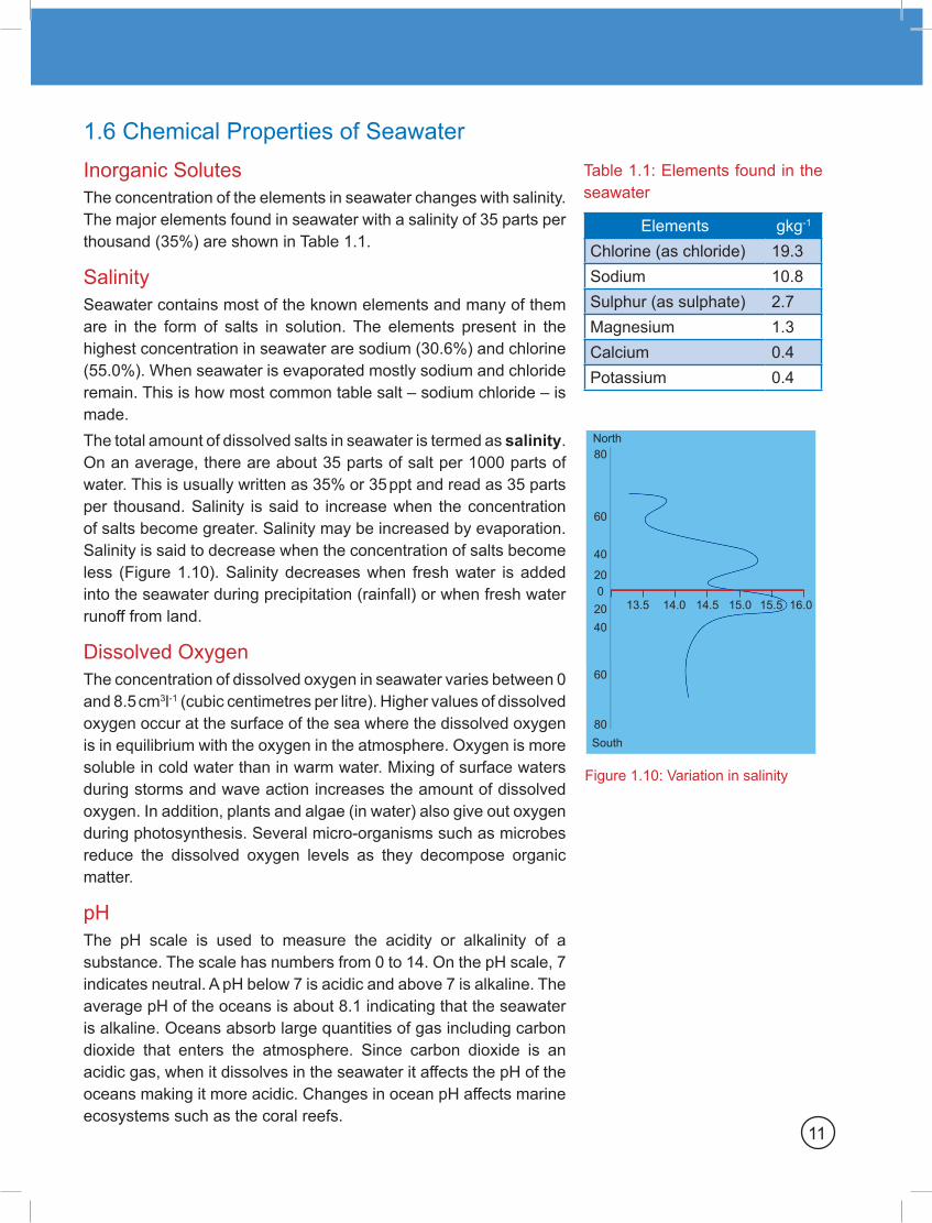
El Niño Every few years, the temperature of the normally cool surface water of the eastern equatorial Pacific increases. This happens when there is a reversal in the prevailing westerly Trade Winds across the Pacific Ocean. The winds build up in strength and then diminishes. Water that has been shifted westwards by the winds is pushed back towards the west coast of South America. In effect, this movement becomes a part of the El Niño event. In turn, the warmer waters increase rainfall and surface temperature along the western coast of South America. The increase in temperature reduces the amount of plankton, which are nourished by nutrients brought up by the colder upwelling water. The reduction in plankton disrupts the commercial anchovy fishing in the region because the anchovies do not get to feed on plankton sufficiently.
Did you know?
El Niño and La Nina are the opposite phases of the ENSO cycle.
In Spanish El Niño means little boy and La Nina means little girl.
Figure 1.19: ENSO – El Niño south oscillation
Winds
Winds
Such is the severity of the El Niño effect that it can create climatic changes in coastal areas all around the Pacific, not just around Peru. The normally warm water along the east coast of Australia is replaced by an upwelling of colder water; precipitation the western Pacific seems to decrease as a result.
17
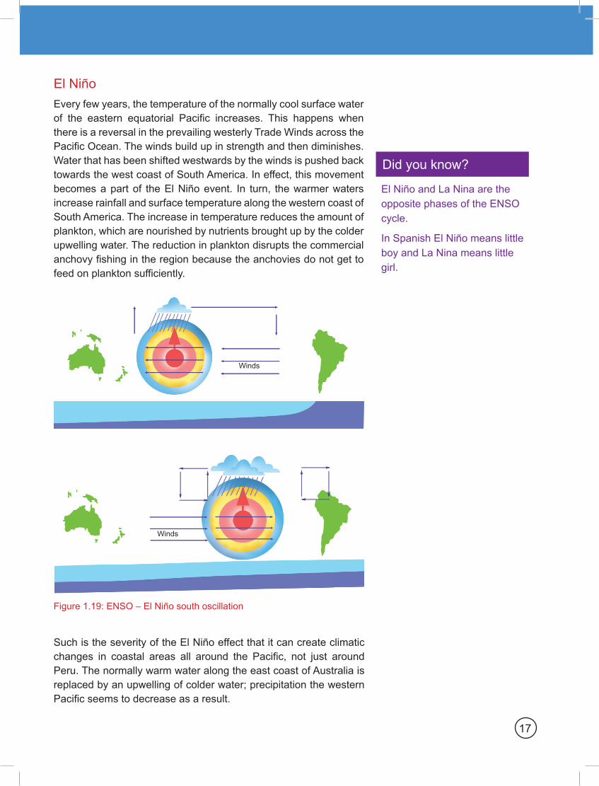
Figure 1.20: Layers of the atmosphere
Exosphere and thermosphere is the outermost layer
Mesosphere protects Earth’s surface from being hit by most meteoroids
Stratosphere contains ozone layer
Troposphere is where weather occurs
Thermosphere
Exosphere
Mesosphere
Stratosphere
Troposphere
In addition, changes in the atmospheric pressure occur off the shores of Australia, just as they do along the west coast of South America. Wind patterns deviate from the normal course in both cases. Severe draught in Australia and flooding caused by torrential rains and heat in South America occur concurrently with and are blamed on El Niño. This entire effect has been referred to as ENSO – for El Niño South Oscillation (Figure 1.19).
Global Warming The atmosphere is made up of layers that surround the Earth like rings (Figure 1.20). The troposphere extends from the ground to 15 km above the Earth’s surface. It is a mixture of oxygen, carbon dioxide and nitrogen. The stratosphere is located between 15 km and 35 km above the ground. It contains ozone (O3) layer, which acts as the Earth’s natural screen. About 99% of the atmosphere is found in these two layers. The remaining 1% of the atmosphere extends several hundred kilometers above the stratosphere. It includes the mesosphere and thermosphere.
Many think that the atmosphere is just the air we breathe. In reality, there is a lot more to it. • It is a natural greenhouse that holds the Sun’s heat near the
Earth’s surface, keeping the Earth at the right temperature to support life.
• It is a protective sunscreen that filters out most of the Sun’s harmful ultraviolet (UV) rays.
• It is a pipeline that moves dust, particles and contaminants around the globe.
• It is a storehouse for all the gases that we need to survive.
The natural greenhouse effect that helps keep the Earth warm is caused by the greenhouse gases in the atmosphere that traps the Sun’s heat, warming land, air and water. Without these gases, the Sun’s heat would escape into the space. Greenhouse gases found in the atmosphere include:• water vapour• carbon dioxide (CO2)• methane (CH4)• chlorofluorocarbons (CFCs)• nitrous oxide (N2O)
18
Chapter 1: The Marine Environment

The greenhouse gases in the atmosphere help to keep the Earth warm making it possible for living things to thrive. When these gases increase and trap too much of the Sun’s heat, it can cause global warming. Carbon dioxide is a greenhouse gas that has been around on the Earth for as long as there has been an atmosphere. The amount of carbon dioxide in the atmosphere has been moderated by plants and animals. Plants absorb carbon dioxide and give out oxygen during photosynthesis. Animals produce carbon dioxide from oxygen during respiration.
Up until the industrial revolution, the balance between oxygen and carbon dioxide was in favour of oxygen. A massive store of carbon was built up by plants as coal, oil and gas. These carbon stores are known as fossil fuels. Burning of fossil fuel causes carbon stored in it to combine with atmospheric oxygen forming carbon dioxide. The oxygen is depleted and the carbon dioxide increases.
Unfortunately, the plants that are alive today cannot keep up with this level of burning and indeed the number of plants needed to make oxygen from carbon dioxide is reducing primarily through deforestation.
Did you know?
The modern lifestyle and the growth in global population are contributing to global warming affecting the lives of people across the world. Global warming can cause changes in:
• Seasons
• Water supply
• Sea level
• Plant and animal life
Greenhouse EffectThe Sun provides nearly all the energy needed to sustain life on Earth. About one-third of all the solar radiation that reaches the Earth is reflected back into the space. The remaining radiation enters the atmosphere and reaches the Earth. The Earth being much cooler than the Sunre-radiates the thermal radiation at longer wavelengths. This thermal radiation with longer wavelength is absorbed by the gas particles in the atmosphere and sent back towards the Earth causing the warming of the Earth’s surface. The greenhouse effect caused by the gases in the atmosphere makes it possible for life forms to thrive on the planet. Without the natural greenhouse effect (Figure 1.21), the Earth’s surface would be below 0°C, freezing all water, which is essential for life.
Atmosphere
Earth’s surface
Infrared radiation is
emitted by the Earth’s surface
Some of the infrared radiation passes through the atmosphere. Some is absored by greenhouse
gases and re-emitted in all directions by the atmosphere.
This warms the Earth’s surface and the lower atmosphere.
Some solar radition is reflected by the Earth and the atmosphere
Some radiation is absorbed by the Earth’s surface and warms it.
Figure 1.21: Natural greenhouse effect
Figure 1.22: Greenhouse used for growing crops
19