
Their Impact on Maine and Androscoggin County - CiteSeerX
100
Hurricanes & Tropical Storm Hurricanes & Tropical Storms Their Impact on Maine and Androscoggin County By Wayne Cotterly © 1996
-
Upload
khangminh22 -
Category
Documents
-
view
1 -
download
0
Transcript of Their Impact on Maine and Androscoggin County - CiteSeerX

Hurricanes & Tropical StormHurricanes & Tropical Stormss
Their Impact on Maine and Androscoggin County
By
Wayne Cotterly
© 1996

2

3
TABLE OF CONTENTS TABLE OF CONTENTS................................................................................................................................................. 3
FOREWORD.................................................................................................................................................................... 6
ACKNOWLEDGMENTS................................................................................................................................................ 7
INTRODUCTION............................................................................................................................................................ 9
HURRICANES................................................................................................................................................................13
SEASON.........................................................................................................................................................................14 FORMATION.................................................................................................................................................................14 CLASSES OF STORMS...................................................................................................................................................15 STRUCTURE .................................................................................................................................................................15 MOVEMENT .................................................................................................................................................................17 FORECASTING..............................................................................................................................................................18 WATCHES AND WARNINGS.......................................................................................................................................19 AREAS AT RISK...........................................................................................................................................................20
COASTAL AREAS .................................................................................................................................................20 INLAND AREAS ....................................................................................................................................................20
HAZARDS......................................................................................................................................................................20 Wind ........................................................................................................................................................................20 Rain .........................................................................................................................................................................21 Storm Surge ...........................................................................................................................................................21 Storm Tide..............................................................................................................................................................21 Tornado’s...............................................................................................................................................................22 Other Hazards.......................................................................................................................................................22
DAMAGE POTENTIAL ................................................................................................................................................22 Saffir—Simpson Damage Potential Scale........................................................................................................22 How Damage Occurs............................................................................................................................................23
HURRICANE NAMES....................................................................................................................................................25
PREPAREDNESS..........................................................................................................................................................29
Long Before a Storm Arrives...............................................................................................................................29 Shortly Before a Storm Arrives...........................................................................................................................30 When a Hurricane Watch is Issued:...................................................................................................................31 Whan a Hurricane Warning is Issued:..............................................................................................................32
RESPONSE.....................................................................................................................................................................33
EVACUATION .......................................................................................................................................................33 STAYING AT HOME .............................................................................................................................................34
RECOVERY....................................................................................................................................................................35
MITIGATION.................................................................................................................................................................36
MAINE HURRICANE FACTS .....................................................................................................................................37
CHRONOLOGY............................................................................................................................................................39

4
MAINE HURRICANE HISTORY................................................................................................................................43
HURRICANE - SEPTEMBER GALE OF 1869 .........................................................................................................45
“SAXBY’S GALE”- OCTOBER 1869 ......................................................................................................................47
TROPICAL STORM - NO NAME (1888).................................................................................................................48
HURRICANE - NO NAME (1893)...............................................................................................................................49
HURRICANE - NO NAME (1894)...............................................................................................................................50
HURRICANE - NO NAME (1924)...............................................................................................................................51
HURRICANE - NO NAME (1927)...............................................................................................................................52
HURRICANE - NO NAME (1929)...............................................................................................................................53
TROPICAL STORM - NO NAME (1932).................................................................................................................54
HURRICANE-NO NAME (1933).................................................................................................................................55
NEW ENGLAND HURRICANE OF 1938..................................................................................................................56
GREAT ATLANTIC HURRICANE OF 1944............................................................................................................61
HURRICANE- NO NAME (1949)................................................................................................................................63
HURRICANE-ABLE (1952).........................................................................................................................................64
HURRICANE CAROL (1953) .....................................................................................................................................65
HURRICANE CAROL (1954) .....................................................................................................................................66
HURRICANE EDNA-(1954).........................................................................................................................................69
TROPICAL STORM BRENDA-(1960).....................................................................................................................71
HURRICANE DONNA-(1960).....................................................................................................................................72
HURRICANE ESTHER - (1961)..................................................................................................................................74
UNNAMED TROPICAL STORM-(1961)..................................................................................................................75
HURRICANE DAISY-(1962) .......................................................................................................................................76
HURRICANE GINNY-(1963).......................................................................................................................................77
TROPICAL STORM DORIA-(1971).........................................................................................................................79
TROPICAL STORM HEIDI-(1971) ...........................................................................................................................80
TROPICAL STORM CARRIE-(1972).......................................................................................................................81

5
HURRICANE BELLE-(1976).......................................................................................................................................82
HURRICANE DAVID-(1979).......................................................................................................................................83
HURRICANE GLORIA-(1985)....................................................................................................................................84
TROPICAL STORMS CHRIS & ALBERTO-(1988).............................................................................................86
HURRICANE BOB-(1991)...........................................................................................................................................87
HURRICANE BERTHA-(1996)...................................................................................................................................89
HURRICANE EDOUARD-(1996)................................................................................................................................91
SUMMARY.....................................................................................................................................................................93
REFERENCES ................................................................................................................................................................94
GLOSSARY....................................................................................................................................................................96
INDEX..............................................................................................................................................................................98

6
Foreword A question that has often been asked of me while doing research on this report is; “Why write a report on hurricanes in Maine, when we hardly ever see any?” My answer to this question is twofold; First, to remind people that hurricanes can and do happen in Maine, and that many of these storms have caused extensive damage and death. Second, to allow the people of Maine to see what damage has been done in the past, and to show how to prepare for these storms in the future.
A Selectman in our town recently commented; “The world is not going to end tomorrow… What do you think is going to happen anyway?”, unfortunately my response was cut off before I had the opportunity to fully answer the question, so I will hopefully try to answer it now.
No, the world is probably not going to end tomorrow. However, it is the responsibility of both the government and the individual to be prepared for disasters, and to plan for a worst case scenario. As to what’s going to happen, well that’s anybody’s guess, but the need to be prepared for all hazards should be a priority for every community, every family, and every individual.
Over the past few decades, the United States has been impacted by several disasters. Many of these were caused by hurricanes; including Andrew, Hugo, Bob, and most recently Opal and Fran. Because of these events, many people have come to rely upon the government to come running to their aid whenever a disaster strikes.
However, many become upset or angry when the government does not respond rapidly. Whenever a disaster occurs, it may take several days for our government to mobilize equipment and manpower, and until that point, we must remember that we are on our own, and are responsible for ourselves and our families.
As an emergency management official, it is my hope that this report will allow you to recognize and understand that the possibility exists that we may be faced with a major hurricane at some point in the future. It is also my intent that this report will encourage you to seek out additional preparedness information. Not only for hurricanes, but for all types of disasters. This information is readily available through your local office of emergency management or through the American Red Cross.

7
Acknowledgments The material for this report comes from several sources. Primarily from newspaper accounts, magazine articles, reports on the subject, and personal experiences. However, I would like to acknowledge the work of David Ludlum, for his extensive research on hurricane history. Without this research, much of the information on early hurricane history would not be available.
I would also like to express my sincere thanks to George Sambatero of PC Weather Products for all of his fine work in creating the Hurrtrak® software used for creating the hurricane tracking charts and past history data used in this report.

8

9
Introduction Over the years, the State of Maine has seen its share of severe weather extremes. From blizzards in the winter to severe thunderstorms in the summer. We have experienced tornadoes, floods, drought, and yes, Hurricanes! People who live in this part of northern New England have become quite acclimated to the weather, and have learned to tolerate it. New England weather was once described by Mark Twain who said:
“I reverently believe that the maker who made us all, makes everything in New England but the weather. I don’t know who makes that…The weather is always doing something there…I have counted one hundred and thirty six different kinds of weather inside of 24 hours.”
Though Maine is not considered a State known for its tropical storms and hurricanes, it has had more than its share. Over the years, Maine has endured some of the worst hurricanes to impact the east coast of the United States. In most cases, the storms had weakened prior to their arrival, yet they still caused extensive damage, injuries, and even deaths.
Hurricanes can be devastating, but the threat to any one location in Maine is quite small. Yet, it is the governments responsibility to be prepared for these events, and to respond to the damage they create. In addition, it is also the responsibility of government to aid in recovery, and to reduce the potential damage these storms create in the future.
As an Emergency Management Director, it is my responsibility to prepare our local community for all disasters and large scale emergencies. However, in order to prepare for these emergencies, it is necessary to look to the past to see what has occurred, and to use this information as guidance as to what could possibly happen again.
This report outlines the past history of hurricanes and tropical storms in Maine, and describes the impact these storms have had on the State, and more specifically Androscoggin County. As the nature of this report can become quite technical, I have attempted to keep the material “light” and hopefully informative.
This report contains information gathered from several sources, and has been made as accurate as possible. In the next chapter, I will provide some basic information on hurricanes and their effects in order to give you some background on this subject.
In subsequent chapters, I will provide descriptions of the many storms that have had a major impact on the area. This chronology dates back as early as 1635, and continues to the present. Every effort has been made to depict an accurate account of the events that occurred. However, I must note that accurate records were not kept until the late 1800’s. Prior to that, only brief overviews are provided.
Will Maine experience the same type of devastation that was produced by hurricanes such as Andrew, Hugo, or Camille? In my opinion, it is not very likely, but it is possible
Chapter
1

10
for this State to feel the effects of a major (Category 3 or higher) hurricane at some point in the future. Only time will tell.

11


13
Hurricanes “It blew down houses and barns, trees, corn and everything in its way. Such a hurricane as was never the like in these parts of the world”
— Rev. Thomas Smith Portland, Maine
August 12, 1752
The hurricane is known as the “Greatest Storm on Earth,” and rightly so as these storms can cause destruction over a wide area and can affect millions of lives during their brief life. The word Hurricane comes from the Spanish word Hurácan which was originally derived from colonial and Caribbean Indian tribal words for evil spirits. In many cultures, the word for hurricane means “Storm God”, “Devil”, or “God of Thunder and Lightning”. Whatever the name, the storm can strike fear into the bravest of souls, and those foolish enough to challenge the storms can lose everything, including their life.
Over the past 360 years, the average frequency of tropical systems in Maine is one every 8 years. During that time, Maine has been visited by at least 45 hurricanes or tropical storms. Several of these storms caused extensive damage, while others caused only minor problems. During this same time period, there were several years in which more than one storm hit the area. In other years, Maine was lucky not to have had even one. However, not included in this number are the many “close calls” where tropical systems have only produced lighter amounts of rain and wind.
Why does this happen? Hurricanes are affected by the earth’s climate, and tend come in cycles. As an example of this; from 1800 to 1900, only 7 storms had a noticeable affect on Maine. But from 1901 to the present, we have endured 30 notable storms, with 6 of them causing extensive damage. Will this trend continue? No one knows for sure, but some forecasters believe that we may experience an increase in stronger hurricanes due to global warming. Others believe that the explanation would be that we have experienced a vast improvement in the technology of detection and tracking of hurricanes.
The State of Maine is located outside the main hurricane belt, yet some of the most destructive storms of record have occurred there. Storms such as Carol, Edna, Donna, and Bob are memorable examples. Where do these storms form? They begin forming deep in the tropics as described in the next section.
It must be noted however, that not all tropical storms in Maine are considered bad. Some of these storms have actually helped the people in the state by bringing an abundance of rain to the area. This relieved droughts and invigorated an economy that relies on the rainfall and the rivers.
Chapter
2

14
Season The hurricane season officially runs from June 1st through November 30th. The peak season for Maine begins the last week in August and runs through the end of September. However, hurricanes do occur at other times of the year. Of the 45 storms to have affected Maine since 1635, 28 have occurred during the peak period described above. However, since 1973, there has been a shift in the peak period to include storms as early as July 13th. It is unclear if this is just a short term shift, or the beginning of a trend toward an earlier peak period for storms.
The earliest tropical storm to affect Maine during any season was on July 13, 1996, when Tropical Storm Bertha paid a visit to the state. The latest hurricane to affect Maine during any season was Ginny on October 31, 1963.
Formation Hurricanes form in different areas of the Atlantic at different times throughout the hurricane season. In the earliest part of the season, the storms tend to form in the Caribbean and in the Gulf of Mexico. As the Intertropical Convergence Zone (ITCZ) makes is seasonal migration to the north, the storms can begin forming farther to the east. By September, storms can form as far east as the Cape Verde Islands off the coast of Africa.
Hurricanes typically begin as a cluster of clouds and thunderstorms. These clusters of storms usually move from east to west driven by the trade winds. When an area of thunderstorms becomes stronger, it may be classified as either a Tropical Disturbance or a Tropical Wave.
As an area of disturbed weather drifts to higher latitudes, the effects of the earth’s rotation begin to change the storms characteristics. Coriolis Effect, as it is known, begins the rotating movement of the cluster which may eventually develop a closed circulation. When this happens, and the winds are less than 38 mph, it is classified as a Tropical Depression
As a depression passes over warmer waters in the western Atlantic, it may deepen or intensify. If the sustained winds increase to beyond 39 mph and up to 74 mph, it will then upgraded to a Tropical Storm and given its own name.
If a storm continues to develop and gather strength, the sustained winds may exceed 75 mph. At this point the storm is classified as a hurricane. With wind speeds greater than 75 mph, hurricanes are further subdivided into five categories using the Saffir-Simpson Scale of Potential Damage. This scale is used to classify the destruction potential of a hurricane. A description of this scale is given later in this report.
Hurricanes require warm water and moisture to maintain their strength. They also tend to change their characteristics as they move northward or over land. If a hurricane moves over land, the friction of the terrain and the lack of moisture will cause the storm to lose its intensity very rapidly. If a storm moves north over the water, it will lose strength, but at a slower rate. This is due primarily to colder sea surface temperatures introducing colder temperatures into the core of the storm. If a storm remains over

15
colder water, it may go through a metamorphosis and change into what is known as an extratropical storm. In other words, a normal mid-latitude low pressure area. This type of storm differs from a hurricane in that the center of the storm is normally colder than the surrounding air, and it has fronts associated with it. Hurricanes have a warm center with colder air surrounding it, and has no fronts at all.
Classes of Storms As described in the previous section, tropical systems have different stages of development. Descriptions of these stages are listed below:
Tropical Disturbance— A tropical disturbance is a moving area of thunderstorms or convection in the tropics that maintains its identity for 24 hours or more.
Tropical Wave— A trough of low pressure that moves along with the trade winds. Tropical waves can often become tropical depressions.
Tropical Depression— An organized system of clouds and thunderstorms with a defined circulation and maximum sustained winds of 38 mph (33 knots) or less.
Tropical Storm— An organized system of strong thunderstorms with a defined circulation and maximum sustained winds of 39 to 73 mph (34 to 63 Knots).
Hurricane— An intense tropical weather system with a well defined circulation and maximum sustained winds of 74 mph (64 knots) or higher.
Structure The structure of a hurricane is made up of spiral bands of thunderstorms and areas of heavy rain. These spiral bands flow inward toward the center of the storm. Surrounding the center is an area of very strong thunderstorms and a concentration of very high winds. This area is known as the eye-wall and is where the most destruction occurs.
At the center of the storm is an area of light winds, lowest pressure, and sometimes clear skies. This area is known as the eye. The eye can be dangerous as it can lull people into believing that the storm is over when in fact the winds will soon pick up again, only this time from the opposite direction.
Tropical cyclones rotate counter-clockwise in the Northern Hemisphere, and clockwise in the Southern Hemisphere. The word cyclone was coined by Henry Piddington in 1839 during his investigation of these storms in India. The word “cyclone” comes from the Greek word “Kyklos” which means “Coils of the snake” , describing the rotating movement of the storm.
Hurricanes are known as the “Greatest Storms on Earth”, as they are very large. The typical hurricane covers an average of 400 to 600 miles across, but these massive storms can easily span 1,000 miles across. Even though the storms are quite large in

16
size, the strongest winds typically extend outward from the storm’s center only 40 to 60 miles.

17
Movement The typical hurricane moves at an average speed of around 12 mph. Its movement is affected by several factors including the upper level winds called “steering currents”, and by other areas of high and low pressure. While in the lower latitudes, hurricanes tend to move from east to west. However, when a storm begins to drift further north, the westerly flow at the mid-latitudes tends to make the storm begin to curve toward the north and then to the east.
When it does this, the storm may accelerate its forward speed. This increase in forward speed is why some of the strongest hurricanes have reached New England. By increasing its forward speed, a storm does not have the opportunity to lose much of its strength before reaching this area. The Great New England Hurricane of 1938 is a perfect example of this, as it accelerated to nearly 70 mph from Cape Hatteras, NC to southern New England on September 21, 1938. The storm was the worst ever to affect New England, and is considered the benchmark hurricane for this area.
Hurricanes sometimes move erratically. If the steering currents are light, the storm may move very slowly or become stationary. The forward motion may become so slow that the track begins to wobble. Storms then tend to move in a looping pattern which causes great difficulty for emergency management officials and forecasters to make decisions. These storms can keep areas along the coast on edge for many days.
Hurricanes in New England are not as rare as some may think. However, there are several conditions that are required to have a major hurricane impact our state and the rest of New England. These are:
v There must be a steep pressure gradient from east to west at all levels of the atmosphere. In other words, a strong trough of low pressure to the west, and a strong high pressure ridge to the east.
v The terrain in front of the storm must have had an abundance of moist tropical air.
v The storm track will need to remain over the open sea until it reaches New England.
v The storm will need to move rapidly, and;
v The winds aloft need to be blowing almost directly North.
Unless favorable conditions are present north of Cape Hatteras that will cause the storm to accelerate to 35 mph, and preferably 40-45 mph or more, the likelihood of a “major” hurricane affecting New England is quite small.

18
Forecasting As mentioned before, hurricanes can be difficult to forecast. Even with our advanced technology and satellites, forecasters have difficulty predicting the path of a storm. The responsibility of predicting these tracks falls on the National Hurricane Center (NHC) in Coral Gables, Florida (near Miami). The NHC forecasters have many tools at their disposal, and receive data from many different sources. Some of the sources include station data, satellite information, aircraft reconnaissance reports, ship reports, and radar to name a few.
One of the most useful tools forecasters have at their disposal are the use of computers. Several computer programs have been created to simulate the atmospheric dynamics. The information that comes into the center is entered into these computers, and an atmospheric model projection is produced.
There are several computer models that are created. Some models are statistical while others are dynamic. Statistical models use the climatological data of past hurricane movement to predict movement of the current storm. Dynamic models use equations to simulate atmospheric conditions at different levels of the atmosphere to predict a storms future movement.
One model called CLIPER, which stands for Climatological and Persistence uses a combination of both statistical and dynamic modeling. This type of model has been quite accurate, and has been used extensively.
Though no model is 100% perfect, with so many models to choose from, choosing the correct one becomes a difficult task for forecasters. Together with raw data and experience, forecasters create a projected path for the storm, and if warranted, may issue a watch or warning.

19
Watches and Warnings As described in the previous section, the National Hurricane Center is responsible for issuing watches and warnings with regard to hurricanes. The National Weather Service is responsible for collecting data, creating forecasts, and disseminating warnings to the public. When a watch or a warning is issued, preparations should begin for the predicted weather event. Information on how to prepare for a hurricane is outlined later in this report. Below is a description of what some of these watches and warnings mean.
Severe Thunderstorm Watch— A severe thunderstorm watch is issued whenever there is the possibility of a severe thunderstorm within a specified area. A severe thunderstorm is defined as one with tornadoes and/or funnel clouds, hail of ¾ inch in diameter, and/or winds in excess of 58 mph.
Severe Thunderstorm Warning— A severe thunderstorm warning is issued when a severe thunderstorm has been spotted, and is moving into a specified area.
Tornado Watch— A tornado watch is issued whenever the conditions are favorable for tornado development.
Tornado Warning— A Tornado warning is issued when a tornado has been spotted and is issued for a specific area.
Flash Flood Watch— A Flash Flood Watch means that flash flood conditions are possible within the designated area. (i.e. be alert)
Flash Flood Warning— A Flash Flood Warning means that a flash flood has been reported or is imminent. (i.e. take immediate action)
Tropical Storm Watch— A Tropical Storm Watch is issued for coastal areas when there is the threat of tropical storm conditions within 36 hours.
Tropical Storm Warning—A Tropical Storm Warning is issued when tropical storm conditions, including sustained winds of 39 to 73 mph are expected within 24 hours or less.
Hurricane Watch— A Hurricane Watch is issued when hurricane conditions pose a threat to a specified coastal area within 36 hours.
Hurricane Warning— A Hurricane Warning is issued when sustained winds of 74 mph or higher are expected in a specified coastal area within 24 hours or less.
Of course, each of these watches and warnings is meaningless if the public does not perceive them to be a threat. The problem that people face in the State of Maine is that the majority of the population has never experienced a “major” hurricane. Though many have experienced weaker storm systems, the result is a false impression of a hurricane’s potential damage. This leads to complacency and delayed actions which could result in the loss of many lives.

20
Areas At Risk COASTAL AREAS
All coastal areas of Maine are subject to hurricanes or tropical storms. Although they do not occur that often, the coastal areas are subject to a higher risk than inland areas due to storm surge, storm tide, higher winds, and heavy rains. In addition, coastal areas have a greater need for evacuations than do inland areas.
INLAND AREAS
Inland areas of Maine are also at risk of hurricanes and tropical storms. The risk is higher for southern Maine than it is for northern parts. This is due to the fact that hurricane winds have usually been reduced substantially by the time the storm reaches northern Maine. However, the risk is still high for all inland areas for flooding. Especially for towns located along rivers and streams such as the Androscoggin and Little Androscoggin Rivers.
Hazards Wind
Wind is one of the most destructive forces in a hurricane. The wind is the result of pressure differential between the center of the storm, and the air pressure surrounding it. This is referred to as pressure gradient. The steeper the gradient, the stronger the winds will be. As a hurricane passes over land, the wind speed diminishes rapidly due to friction. However, even these reduced winds have the potential to cause destruction.
To be considered hurricane force, winds must be greater than 74 mph. Damage can come from the force of the wind on a structure or from flying debris. Small items left outside, signs, roofing material, siding, etc. can become missiles, some of which may cause damage.
Prior to Hurricane Andrew, meteorologists believed that strong wind gusts were responsible for the serious hurricane damage. However, T. Theodore Fujita, an expert on tornadoes and creator of the Fujita Scale of destruction for tornado’s, did extensive analysis of the damage caused by hurricane Andrew. He found that there were eddies or whirlwinds that spun off of the eye wall. These eddies, are referred to as Spin-up Vortices, and can produce winds in excess of 200 mph. These eddies become stronger because of they are stretched vertically by strong convection.
The maximum velocity of wind in a hurricane can be computed using the following formula:
V max =16 Pn-Po
Where Pn = Pressure outside of the hurricane (i.e. 1010 Mb in the tropics) and Po = The central pressure of the storm. As an example: If a hurricane had a central pressure of 980 Mb. The calculation would work out to be around 88 knots or around 101 mph.

21
Rain
When we think of hurricanes, we tend to think of strong winds. However, heavy rains also accompany these storms. This heavy rain can cause flooding in a relatively short period of time, and is considered the major threat to inland areas. It is not uncommon to find rainfall totals in excess of 6 inches within a span of 6 to 8 hours. This can cause rivers and streams to rise rapidly, and to overflow their banks. People caught unaware of this, may become victims of the flood waters. This rapid rise of water is known as flash flooding. Hundreds of people each year die as the result of flash flooding. Most of these events are associated with thunderstorms, however, they can and do occur as the result of hurricane rains.
Storm Surge
For coastal areas, the storm surge is the most destructive force of a hurricane and is responsible for 90% of the flooding deaths in a hurricane. What is the storm surge? The storm surge is a dome of water spanning 50 to 100 miles in diameter that moves in the same direction as the storm. It is caused by winds in the right forward quadrant of the storm, forcing water in the same direction as the storm’s motion.
The lower atmospheric pressure over the water near the storm center also contributes to the height of the storm surge. The lower the pressure in the storm’s center create a lesser atmospheric pressure on the surface, and so the water tends to be higher than in surrounding areas.
The storm surge is also affected by the depth of the water. In the open ocean, the storm surge isn’t noticeable. However, when the water becomes shallow near land, the effects of the storm surge are more clearly seen. The result is a wall of water that can inundate entire coastal cities that have elevations close to sea level.
The effect of a storm surge increases with several factors. These include:
v A Lower atmospheric pressure at the storm’s center
v An increase in the radius of maximum sustained winds, but not beyond 50 Km.
v An increase in forward speed of the storm, and
v The decreasing slope of the ocean bottom
Storm Tide
This occurs if the storm surge arrives at the same time as the normal high tide. The storm tide is the combination of the storm surge and the high tide. As an example, a 10 foot storm surge added to a 10 foot tide would create a storm tide of 20 feet. The storm tide and surge are accompanied by high waves that batter an area of coastline as much as 100 miles wide. This is what occurred in 1938 in Providence, Rhode Island that caused massive flooding of the entire city and killed hundreds of people. Another example includes the 1900 storm in Galveston Texas that killed over 6,000 people.

22
Tornado’s
As with thunderstorms, hurricanes often produce tornadoes. However, these tornadoes are not as destructive as their mid-west cousins. Tornado’s most often are embedded in the spiral rain bands of the storm, but they can also occur near the eye wall. Tornado’s develop in the forward semi-circle of the hurricane, usually in the right front quadrant.
Hurricane tornado’s are not a major problem. This is primarily due to the fact that the probability of the event affecting any given area is small. Also, the damage potential is less than that of the sustained winds and gusts.
Other Hazards
There are several other hazards that are associated with hurricanes. These include, live wires that have been blown down, ruptured gas lines from damaged buildings, roads that have been undermined by flowing water, looting, and injuries caused by traversing through damaged areas.
Damage Potential
Saffir—Simpson Damage Potential Scale
In 1972, Robert Simpson, former Director of the National Hurricane Center had difficulty describing to emergency management and disaster officials what to expect for damage from approaching hurricanes. The determination was made that a scale was needed to give disaster officials an idea of what to expect. Herbert Saffir, a consulting engineer who was known as the “father of the Miami building code” was enlisted to work with Simpson on this project. Together they created the Saffir-Simpson Damage Potential Scale that is used today. The scale is broken down into five categories based on wind speed. A one on the scale would indicate a minimal hurricane, while a five would indicate catastrophic damage. The scale was introduced in public advisories in 1975, and is described below:
Category 1 74-95 MPH MINIMAL > 28.94” Hg.
Damage is done primarily to shrubbery, trees, foliage, and unanchored mobile homes. No real damage to other structures, though there may be some damage to poorly constructed signs. A storm surge of 4 to 5 feet above normal is to be expected. Low-lying coastal roads will become inundated, and there would be minor pier damage. Some small craft might be torn from their moorings in exposed anchorage.
Category 2 96-110 MPH MODERATE 28.50” to 28.93” Hg.
Considerable damage to shrubbery, tree foliage, and vegetation can be expected, and some trees may be blown down. Major damage is possible to exposed mobile homes, and extensive damage to poorly constructed signs. There may also be some damage to the roofing materials, doors, and/or windows of buildings. A storm surge of 6 to 8 feet above normal can be expected. Low-lying escape routes to inland areas can be cut off by rising water from 2 to 4 hours in advance of the storm center. There can be considerable damage to piers, and marinas could be flooded. Small craft will be torn

23
from their moorings in exposed anchorage. Evacuation of some shoreline residences and low-lying island areas will be required.
Category 3 111-130 MPH EXTENSIVE 27.91” to 28.49” Hg.
Foliage will be torn from trees and some large trees will be blown down. Practically all poorly constructed signs will be blown down. There will be some damage to roofing, doors, and windows. There may also be structural small residences and utility buildings, with a minor amount of curtain-wall failures. Mobile homes can be destroyed. A storm surge of 9 to 12 feet above normal can be expected that would cause serious flooding along the coast. Many smaller structures along the coastline may be destroyed, and larger structures may be damaged by battering waves and floating debris. Low-lying escape routes to inland areas can be cut off by rising water from 3 to 5 hours in advance of the storm center. Flat terrain 5 feet or less above sea level will be flooded inland up to 8 miles or more. Evacuation of low-lying area residences within several blocks of the shoreline would possibly be required
Category 4 131-155 MPH EXTREME 27.17” to 27.90” Hg.
Shrubs, trees, and signs are blown down. There will be extensive damage to roofing materials, doors, and windows. Complete failure of roofs on many small residences, and complete destruction of mobile homes. A storm surge of 13 to 18 feet above normal can be expected. Flat terrain 10 feet or less above sea level will be flooded as far as 6 miles. Major damage will occur to lower floors of structures near the shoreline due to flooding and battering of waves and floating debris. Low-lying escape routes to inland areas can be cut off by rising water from 3 to 5 hours in advance of the storm center. Major erosion of beaches can be expected, and massive evacuation of all residences within 500 yards of the shoreline will possible be required. Evacuation of single story residences on low ground within 2 miles of shore will be required.
Category 5 155 MPH+ CATASTROPHIC < 27.17” Hg.
Shrubs, trees, and signs will be blown down. Considerable damage to roofs, and very severe damage to windows and doors can be expected. Complete failure of roofs on many small residences and industrial buildings. Extensive shattering of glass in windows and doors, as well as some complete building failures. Small buildings are overturned or blown away. Complete destruction of mobile homes. A storm surge in excess of 18 feet above normal can be expected. Major damage to the lower floors of all structures less than 15 feet above sea level and within 500 yards of shore. Low-lying escape routes to inland areas are cut off by rising water from 3 to 5 hours in advance of the storm center. Massive evacuation of residential areas on low ground within 5 to 10 miles of shore possibly required.
How Damage Occurs
The destructive power of a hurricane in one day is equivalent to the detonation of approximately 800 atomic bombs. To put it another way, the power produced by a hurricane in one day could supply the entire United States with electrical power for 6 months.
One of the ways this energy is dissipated is through wind. The pressure gradient or the difference in central pressure to surrounding areas is responsible for creating the winds inside a hurricane. When the wind blows over the surface of the water, the lack of

24
friction allows the storm to maintain its intensity. However, if structures, trees, or other objects are placed in its way, the wind will be dissipated but the energy is transferred into a force of destruction.
There are three main factors that affect damage to buildings. These are:
v Aerodynamic forces
v Atmospheric pressure differential between the interior and exterior, and
v The impact of airborne debris (missiles)
The most important factor affecting a structure is the aerodynamic forces placed upon it. When the air flows past a building, the shape of the roof creates an airfoil that in turn creates lift, much like the wing of an airplane. This lifting action pulls upward on the roof, and also pulls out on the sides of the structure As the wind speed increases, the force rises exponentially, and is the reason why some structures begin to fail at lower wind speeds.
Pressure differential also acts on a building, but to a lesser degree. The pressure differential is proportional to the air tightness of the building, or the rate at which changes to air pressure can be accommodated. In other words, the tighter the house, the greater potential for damage due to pressure differential. K.C. Meheta and his colleagues stated that in tornadoes “conventional buildings are not damaged by atmospheric pressure effects, but rather by forces due to aerodynamic effects of wind.” This gives credence to the idea that hurricane damage is primarily caused by the flow of air around a structure rather than the difference in pressure.
A more important factor concerning pressure is the effects of internal ram air pressure. When windows or doors fail, the air can enter a building and cause an increase in ram air pressure within the structure. Herbert Saffir estimated that the ram air pressures can provide interior forces of 1.5 times those of a fully enclosed building. These internal forces acting outwardly on all sides of the structure. So if a window were to break, or a door was to be opened, the force of air that comes into the house will increase the
A e r o d y n a m i c F o r c e s A c t i n g O n A B u i l d i n g

25
pressure outwardly on the walls, and enhance the aerodynamic pull of air surrounding the building. Hence, the greater likelihood of structural failure.
In addition to the ram air pressure differential, the force of the wind against an object also contributes to the destruction. As the wind speed increases, the force against the object is squared. As an example of this;
If the wind blows at 25 mph, it will cause 1.6 pounds per square foot of force. On a typical 4’x 8’ sheet of plywood, that translates into a force of around 50 pounds acting on the wood. If we increased the wind speed by a factor of three to 75 mph, the force acting on the plywood at that speed would be 450 pounds. If the wind were to increase to 125 mph, the force would increase to 1,250 pounds. As you can see, the amount of force acting on a structure can be tremendous, even at minimal hurricane strength.
Another, cause of damage to buildings is due to fluid acceleration. This relates to the natural frequency of oscillation of some structures. The hurricane eddies are unique in that they significantly contribute to the amplitude of oscillation. Most low rise buildings are not susceptible to this. However, wires are affected which might put additional stress on towers and poles. In addition, tall structures may be susceptible to this type of damage. In essence, the back and forth movement of taller structures in the wind tends to weaken them or cause them to over sway their limits, and cause them to collapse.
Hurricane Names The naming of hurricanes actually goes back several hundred years. In those days, the storms were named after that particular day’s “Saint”. As an example of this would be the “Santa Ana Hurricane” that hit Puerto Rico on July 26, 1825 or the “San Felipe Hurricane” on September 13, 1876.
In the early 1900’s, a forecaster in Australia named hurricanes after political figures he particularly disliked. He used this method so that he could describe the storms characteristics such as “causing great distress”, or “wandering aimlessly”, and compare them to their political counterparts
Hurricanes are also known by different names in various locations around the world. In other areas, they are known as Typhoons, Cyclones, and Willy-Willy’s (Australia). The last one was not very popular for obvious reasons. In Maine, the early storms were referred to as Gales, Equinoctial Storms, or Line Storms. The latter two names referring to the time of the year and the location from which these storms are born (referring to the equatorial line).
In 1950, the military began using the phonetic alphabet (ABLE, BAKER, CHARLIE, etc.) to name hurricanes. This method was not very popular, and caused a lot of confusion. This plan was abandoned in 1953 for a more popular plan, the use of women’s names.
The idea for the use of women’s names to identify hurricanes came from a novel written in 1941 called “Storm” by George R. Stewart. In this novel, a meteorologist referred to hurricanes by giving them lady’s names. During World War II, this became even more popular with military meteorologists. So in 1953, the first list of women’s names was developed and was placed in alphabetical order to identify hurricanes.

26
27
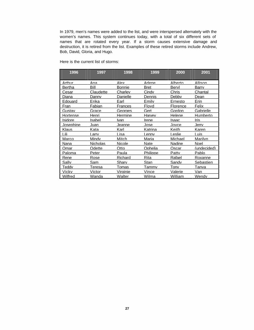
In 1979, men’s names were added to the list, and were interspersed alternately with the women’s names. This system continues today, with a total of six different sets of names that are rotated every year. If a storm causes extensive damage and destruction, it is retired from the list. Examples of these retired storms include Andrew, Bob, David, Gloria, and Hugo.
Here is the current list of storms:
1996 1997 1998 1999 2000 2001
Arthur Ana Alex Arlene Alberto Allison Bertha Bill Bonnie Bret Beryl Barry Cesar Claudette Charley Cindy Chris Chantal Diana Danny Danielle Dennis Debby Dean Edouard Erika Earl Emily Ernesto Erin Fran Fabian Frances Floyd Florence Felix Gustav Grace Georges Gert Gordon Gabrielle Hortense Henri Hermine Harvey Helene Humberto Isidore Isabel Ivan Irene Isaac Iris Josephine Juan Jeanne Jose Joyce Jerry Klaus Kata Karl Katrina Keith Karen Lili Larry Lisa Lenny Leslie Luis Marco Mindy Mitch Maria Michael Marilyn Nana Nicholas Nicole Nate Nadine Noel Omar Odette Otto Ophelia Oscar (undecided) Paloma Peter Paula Philippe Patty Pablo Rene Rose Richard Rita Rafael Roxanne Sally Sam Shary Stan Sandy Sebastien Teddy Teresa Tomas Tammy Tony Tanya Vicky Victor Virginie Vince Valerie Van Wilfred Wanda Walter Wilma William Wendy

28

29
Preparedness “If a major storm strikes a coastal metropolitan center this year, the risk of fatalities is high because the endangered population will face congested evacuation routes, insufficient escape time, and has too little experience in hurricane survival. It is imperative that coastal residents and visitors alike, take the threat seriously, acquaint themselves with hurricane safety rules, and evacuate immediately if advised to do so.”
—Dr. Robert C. Sheets Former Director, NHC
In Emergency Management, there are four important functions to be considered in managing any emergency. These areas are: Preparedness, Response, Recovery, and Mitigation. In this report, these functional areas have been used to describe what the general public can do to prepare for, respond to, recover from, and mitigate damages in future occurrences of hurricanes in Maine. Even though there is an abundance of information available on the subject, I felt it to be important to include some of the more important points within this report.
When should we prepare for a hurricane? Ideally, preparations should begin well before a hurricane even forms. These preparations should be performed by every family and by every community. Here is a list of things that should be done prior to the arrival of a hurricane:
LONG BEFORE A STORM ARRIVES
v Find out about the National Flood Insurance Program if you live in a flood plain. Remember, there is usually a 30-day waiting period for such insurance.
v Create a family disaster plan- information for creating a family disaster plan can be obtained through your local Emergency Management Office or the American Red Cross.
v Protect your windows, create plywood panels for each window and pre-drill holes every 18 inches. Make sure that you mark where each panel goes. When the storm approaches, it will be quicker and easier to install them, and you won’t have to be concerned about a supply shortage.
v Know the risks of hurricanes in your area
Chapter
3

30
SHORTLY BEFORE A STORM ARRIVES
v Get and use only official information
v Know the storm surge history and elevation of your area
v Learn the safe routes inland
v Learn the location of official emergency shelters
v Avoid low-lying areas
v Store everything that might blow away
v Review the needs and working condition of emergency equipment, such as flashlights, battery-powered radios, etc.
v Check your home for loose or clogged rain gutters and downspouts.
v Keep trees and shrubbery trimmed. Cut weak branches and trees that could fall or bump against the house. When trimming, try to create a channel through the foliage to the center of the tree to allow for air flow.
v Determine where to move your boat in an emergency
v Review your insurance policy to ensure it provides adequate coverage.
v Individuals with special needs should contact their local office of emergency management.

31
WHEN A HURRICANE WATCH IS ISSUED:
v Frequently monitor radio, TV, NOAA Weather Radio, or hurricane hotline telephone numbers for official bulletins of the storm’s progress
v Fuel and service family vehicles
v Inspect and secure mobile home tie downs
v Prepare to cover all window and door openings with shutters or other shielding materials.
v Remove awnings
v Check food, water, and medical supplies.
ð Have clean, air-tight containers on hand to store at least 2 weeks of drinking water (14 gallons per person).
ð Stock up on canned provisions
ð Get a camping stove with fuel
ð Keep a small cooler with frozen gel packs handy for packing refrigerated items.
ð Have a fully stocked first aid kit available
ð Have a non-electric can opener available
ð Check prescription medicines—obtain at least 10 days to 2 weeks supply
ð Stock up on extra batteries for radios, flashlights, and lanterns.
v Prepare to store and secure outdoor lawn furniture and other loose, lightweight objects, such as garbage cans, garden tools, potted plants, etc.
v Have on hand an extra supply of cash.
v Turn refrigerator to maximum cold and open only when necessary.
v Review evacuation plans.
v If you have a boat, moor it securely, or move it to a safe place. Use ropes or chains to secure the boat to the trailer. Use tie-downs to anchor the trailer to the ground or the house.
32
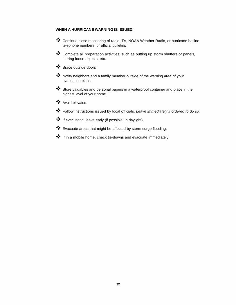
WHEN A HURRICANE WARNING IS ISSUED:
v Continue close monitoring of radio, TV, NOAA Weather Radio, or hurricane hotline telephone numbers for official bulletins
v Complete all preparation activities, such as putting up storm shutters or panels, storing loose objects, etc.
v Brace outside doors
v Notify neighbors and a family member outside of the warning area of your evacuation plans.
v Store valuables and personal papers in a waterproof container and place in the highest level of your home.
v Avoid elevators
v Follow instructions issued by local officials. Leave immediately if ordered to do so.
v If evacuating, leave early (if possible, in daylight).
v Evacuate areas that might be affected by storm surge flooding.
v If in a mobile home, check tie-downs and evacuate immediately.

33
Response EVACUATION
Plan to evacuate if you…
ð live in a mobile home. Do not stay in a mobile home under any circumstances. They are unsafe in high wind and/or hurricane conditions, no matter how well fastened to the ground.
ð live on the coastline or on an offshore island, or live near a river or in a flood plain.
ð live in a high rise. Hurricane winds are stronger at higher elevations. Glass doors and windows may be blown out of their casings and weaken the structure.
v Stay with friends or relatives or at a low-rise inland motel outside of the flood zones. Leave early to avoid heavy traffic, roads blocked by early flood waters, and bridges impassable due to high winds.
v Put food and water out for pets if you cannot take them with you. Public shelters do not allow pets nor do most motels/hotels. However, if at all possible, take your pets with you.
v Hurricane shelters will be available for people who have no other place to go. Shelters may be crowded and uncomfortable, with no privacy and no electricity. Do not leave you home for a shelter until government officials announce on radio and/or television that a particular shelter is open.
ð What to bring to a shelter: First-aid kit, medicine; baby food and diapers; cards, games; books; toiletries; battery-powered radio; flashlight (per person); extra batteries; blankets or sleeping bags; identification, valuable papers (insurance), and cash.
v Roads may be closed for your protection. If you come upon a barricade or a flooded road, turn around and go another way.
v Do not drive into flooded areas.
v Stay on firm ground. Moving water only 6 inches deep can sweep you off your feet.
v Tell someone outside of the storm area where you are going.
v Lock up when you leave.

34
STAYING AT HOME
Reminder: Only stay in a home if you have not been ordered to leave. If you ARE told to leave, do so immediately.
v Store water:
ð Fill sterilized jugs and bottles with water for a 2-week supply of drinking water. ð Fill bathtub and large containers with water for sanitary purposes.
v Turn off utilities if told to do so by authorities.
ð Check pilot lights-shut off the gas if they are out. ð Turn off propane tanks ð Unplug small appliances ð If the electricity is out, use a car radio or portable radio for updates and
information on the storm.
v Avoid open flames, such as candles or kerosene lamps as a source of light.
v If power is lost, turn off major appliances to reduce power “surges” when electricity is restored.
v Stay inside a well constructed building. In structures, such as a home, examine the building, and plan in advance what you will do if winds become strong. Strong winds can produce deadly missiles and structural failure. If winds become strong:
ð Stay away from windows and doors even if they are covered. Take refuge in small interior room, closet, or hallway. Take a battery-powered radio, a NOAA Weather Radio, and a flashlight with you to your place of refuge.
ð Close all interior doors. Secure and brace external doors, particularly double inward opening doors and garage doors
ð If you are in a two story house, go to an interior first-floor room or basement, such as a bathroom, closet, or under the stairs.
ð If you are in a multiple-story building and away from water, go to the first or second floors and take refuge in halls or other interior rooms away from windows. Interior stairwells and the areas around elevator shafts are generally the strongest part of a building.
ð Lie on the floor under tables or other sturdy objects. ð Be alert for tornadoes which are often spawned by hurricanes. ð Stay inside, and away from windows, skylights, and glass doors. You can be
injured by flying debris outside. If the winds are strong, you can lie on the floor under a table or another sturdy object.
If the eye of the hurricane should pass over your area, be aware that the improved weather conditions are temporary and that the storm conditions will return with winds coming from the opposite direction sometimes in a period of just a few minutes.

35
Recovery AFTER THE STORM
v Stay in your protected area until announcements are made on the radio or television that the dangerous winds have passed. Stay tuned to local radio for information.
v Stay away from disaster areas.
v If you have evacuated, do not return home until officials announce your area is ready. Remember, proof of residency may be required in order to re-enter evacuation areas.
v If your home or building has structural damage, do not enter until it is checked by officials.
v Check gas, water, and electrical lines and appliances for damage.
When checking for gas leaks—if you smell gas or hear it making a hissing sound, open a window and quickly leave the building. Turn off the gas at the outside main valve if you can and call the gas company from a neighbors home. If you turn off the gas for any reason, it must be turned back on by a professional.
Look for electrical system damage—If you see sparks, broken or frayed wires, or if you smell hot insulation, turn off the electricity at the main fuse box or circuit breaker. Do not do this if you must step in water to get to the fuse box.
Stay out of flooded basement due to the potential electrical shock hazard.
Check for sewage and water line damage—If you suspect sewage lines are damaged, avoid using the toilets.
v Open windows and doors to ventilate and dry your home if it has been water damaged.
v Take pictures of the damage, both to the house and its contents and keep accurate records of damage for taxes and insurance claims.
v Avoid using candles and other open flames indoors
v Beware of outdoor hazards: ð Avoid downed power lines and any water in which they may be lying ð Be alert for poisonous snakes, often driven from their dens by high water ð Beware of weakened bridges and washed out roads. ð Watch for weakened limbs on trees and/or damaged overhanging structures.
v Do not use the telephone unless absolutely necessary. The system usually is jammed with calls during and after a hurricane. Use the telephone to report life threatening emergencies only.
v Be alert for debris in the road, drive only if it is absolutely necessary.
v Guard against spoiled food. Use dry or canned food. Do not drink or prepare food with tap water until you are certain it is not contaminated. Also, check the refrigerator for any spoilage.
v Help injured or trapped persons

36
ð Give First Aid where appropriate
ð Do not move seriously injured persons unless they are in immediate danger of further injury. Call for help.
v When cutting up fallen trees, use caution, especially if you use a chain saw. Serious injuries can occur when these powerful machines snap back or when the chain breaks.
Mitigation Mitigation includes any activities that prevent an emergency, reduce the chances of an emergency happening, or lessen the damaging effects of unavoidable emergencies. Investing in preventative mitigation steps now such as strengthening non-reinforced masonry to withstand wind and flooding and installing shutters on every window will help reduce the impact of hurricanes in the future. For more information on mitigation, contact your local emergency management office.
37
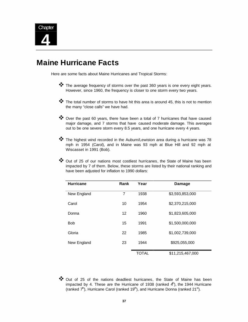
Maine Hurricane Facts Here are some facts about Maine Hurricanes and Tropical Storms:
v The average frequency of storms over the past 360 years is one every eight years. However, since 1960, the frequency is closer to one storm every two years.
v The total number of storms to have hit this area is around 45, this is not to mention the many “close calls” we have had.
v Over the past 60 years, there have been a total of 7 hurricanes that have caused major damage, and 7 storms that have caused moderate damage. This averages out to be one severe storm every 8.5 years, and one hurricane every 4 years.
v The highest wind recorded in the Auburn/Lewiston area during a hurricane was 78 mph in 1954 (Carol), and in Maine was 93 mph at Blue Hill and 92 mph at Wiscasset in 1991 (Bob).
v Out of 25 of our nations most costliest hurricanes, the State of Maine has been impacted by 7 of them. Below, these storms are listed by their national ranking and have been adjusted for inflation to 1990 dollars:
Hurricane Rank Year Damage
New England 7 1938 $3,593,853,000
Carol 10 1954 $2,370,215,000
Donna 12 1960 $1,823,605,000
Bob 15 1991 $1,500,000,000
Gloria 22 1985 $1,002,739,000
New England 23 1944 $925,055,000
TOTAL $11,215,467,000
v Out of 25 of the nations deadliest hurricanes, the State of Maine has been impacted by 4. These are the Hurricane of 1938 (ranked 4th), the 1944 Hurricane (ranked 7th), Hurricane Carol (ranked 19th), and Hurricane Donna (ranked 21st).
Chapter
4

38
v When do hurricanes occur in Maine? As you can see in the chart below, the peak weeks for hurricanes run from September 1st to September 15th.
v The deadliest Maine Hurricane occurred in 1869. Eleven people died in the wreck of the Helen Eliza in Portland Harbor.
v The heaviest rainfall recorded during a hurricane was 8.05” in Brunswick during Hurricane Edna in 1954.
v Hurricane Ginny in 1963, dropped 13 inches of snow on Aroostook County, with some snow accumulation as far south as Lewiston, Maine. This snow however, did not remain on the ground for long.
v Storms also occur out of season. On February 5, 1952, a strong storm originating in the tropics, hit Maine with strong winds, rain, and snow. It is still being debated as to whether this storm was in fact a hurricane/tropical storm.
JUN JUL 1-15 JUL 16-31 AUG 1-15 AUG 16-31 SEP 1-15 SEP 16-30 OCT 1-15 OCT 16-31 NOV
01 1
5
10
12
8
5
3
0
0
2
4
6
8
10
12
JUN JUL 1-15 JUL 16-31 AUG 1-15 AUG 16-31 SEP 1-15 SEP 16-30 OCT 1-15 OCT 16-31 NOV
Maine Hurricane Seasonal Breakdown 1635 to 1996

39
Chronology
Maine Tropical Storms and Hurricanes 1635 to 1996
TS = Tropical Storm DP = Tropical Depression
Chapter
5
Y e a r N a m e C a t
.
S t a r t
D a t e
E n d
D a t e
M a x
W i n d
( K t s )
B a r o .
P r e s s u r e
A f f e c t e d
M a i n e
M a i n e
P e a k
W i n d
1 6 3 5 N o N a m e N A 8 / 1 5
1 6 3 8 N o N a m e N A 9 / 2 4
1 6 7 5 N o N a m e N A 8 / 2 8
1 6 8 3 N o N a m e N A 8 / 1 3
1 7 6 1 N o N a m e N A 2 9 . 5 7 1 0 / 2 4
1 7 6 9 N o N a m e N A 2 9 . 5 7 9/8
1 7 7 0 N o N a m e N A 2 8 . 9 6 1 0 / 2 0
1 7 7 8 N o N a m e N A 8 / 1 3
1 7 8 8 N o N a m e N A 9/6
1 8 1 5 N o N a m e N A 9 / 2 3
1 8 5 8 N o N a m e T S 2 8 . 8 7 9 / 1 6
1 8 6 9 N o N a m e N A 2 9 . 0 0 9/8 5 4
1 8 6 9 N o N a m e N A 2 8 . 9 9 10/4 N A
1 8 8 8 N o N a m e T S 0 9 / 2 3 0 9 / 2 7 5 0 9 / 2 5 5 0
1 8 9 3 N o N a m e 3 0 8 / 1 3 0 8 / 2 5 1 0 5 8 / 2 2 1 0 0
1 8 9 4 N o N a m e 3 1 0 / 0 1 1 0 / 1 2 1 0 5 1 0 / 1 1 5 5
1 9 2 4 N o N a m e 4 0 8 / 1 6 0 8 / 2 8 1 1 5 8 / 2 7 8 5
1 9 2 7 N o N a m e 3 0 8 / 1 9 0 8 / 2 6 1 0 5 8 / 2 4 8 5
1 9 2 9 N o N a m e 4 0 9 / 2 2 1 0 / 0 4 1 2 0 9 3 6 10/3 2 4
1 9 3 2 N o N a m e T S 0 9 / 0 9 0 9 / 1 7 4 5 9 / 1 6 - 1 7 5 0
1 9 3 3 N o N a m e 3 0 9 / 0 8 0 9 / 2 1 1 0 5 9 5 7 9 / 1 7 - 1 8 6 5
1 9 3 8 N o N a m e 5 0 9 / 1 0 0 9 / 2 2 1 4 0 9 3 8 9 / 2 1
1 9 4 4 N o N a m e 4 0 9 / 0 9 0 9 / 1 6 1 2 0 9 4 3 9 / 1 5 5 0

40
Maine Tropical Storms and Hurricanes 1635 to 1996
TS = Tropical Storm DP = Tropical Depression
Y e a r N a m e C a t
.
S t a r t
D a t e
E n d
D a t e
M a x
W i n d
( K t s )
L o w e s t
P r e s s u r e
A f f e c t e d
M a i n e
M a i n e
P e a k
W i n d
1 9 4 9 N o N a m e 4 0 8 / 2 3 0 8 / 3 1 1 3 0 9 5 4 8 / 2 9 4 0
1 9 5 2 A B L E 2 0 8 / 1 8 0 9 / 0 2 9 0 9 9 8 9/2 2 5
1 9 5 3 C A R O L 4 0 8 / 2 8 0 9 / 0 9 1 3 0 9 2 9 9/7 6 5
1 9 5 4 C A R O L 2 0 8 / 2 5 0 9 / 0 1 8 5 9 7 6 8 / 3 1 7 8
1 9 5 4 E D N A 3 0 9 / 0 2 0 9 / 1 5 1 0 5 9 / 1 1 6 5
1 9 6 0 B R E N D A T S 0 7 / 2 8 0 8 / 0 1 5 0 7 / 3 0 4 0
1 9 6 0 D O N N A 5 0 8 / 2 9 0 9 / 1 4 1 4 0 9 3 2 9 / 1 2 6 2
1 9 6 1 E S T H E R 4 0 9 / 1 0 0 9 / 2 7 1 2 5 9 2 7 9 / 2 5 3 0
1 9 6 1 N o N a m e D P 0 9 / 1 2 0 9 / 1 5 3 5 9 / 1 5 3 5
1 9 6 1 F R A N C E S 3 0 9 / 3 0 1 0 / 1 0 1 1 0 9 4 8 1 0 / 5 - 7 5 0
1 9 6 2 D A I S Y 2 0 9 / 2 9 1 0 / 0 9 9 5 9 6 5 10/7 3 5
1 9 6 3 G I N N Y 2 1 0 / 1 6 1 0 / 3 0 9 5 9 5 8 1 0 / 2 9 - 3 0 1 0 0
1 9 7 1 D O R I A T S 0 8 / 2 0 0 8 / 2 9 5 5 9 8 9 8 / 2 8 - 2 9 4 0
1 9 7 1 H E I D I T S 0 9 / 1 1 0 9 / 1 5 5 5 9 9 6 9 / 1 3 - 1 4 4 0
1 9 7 2 C A R R I E T S 0 8 / 2 9 0 9 / 0 5 6 0 9 9 2 9 / 3 - 4 3 3
1 9 7 6 B E L L E 3 0 8 / 0 6 0 8 / 1 0 1 0 5 9 5 1 8 / 8 - 1 0 3 9
1 9 7 9 D A V I D 5 0 8 / 2 5 0 9 / 0 8 1 5 0 9 2 4 9/6 4 5
1 9 8 5 G L O R I A 4 0 9 / 1 6 1 0 / 0 2 1 2 5 9 2 0 9 / 2 6 - 2 7 5 1
1 9 8 8 A L B E R T O T S 0 8 / 0 5 0 8 / 0 8 3 5 1 0 0 2 8 / 7 - 8 3 5
1 9 8 8 C H R I S T S 0 8 / 2 1 0 8 / 3 0 4 5 1 0 0 5 8 / 2 8 - 2 9 2 0
1 9 9 1 B O B 3 0 8 / 1 6 0 8 / 2 9 1 0 0 9 5 0 8 / 1 9 - 2 1 6 1
1 9 9 6 B E R T H A 2 0 7 / 0 5 0 7 / 1 4 1 0 0 9 6 0 7 / 1 4 2 2

41
OTHER STORM DATA- L-Lewiston P-Portland E-Eastport #-Poland
Y e a r S t o r m N a m e D a t e M a i n e
R a i n f a l l
M a i n e
D a m a g e
T o t a l
D e a t h s
M a i n e
D e a t h s
M a i n e
I n j u r i e s
M a i n e
P r e s s u r e
1 8 6 9 N o N a m e 9/8 H e a v y S e v e r e 1 1 1 1
1 8 6 9 N o N a m e 10/4 6 . 0 0 ” + S e v e r e
1 8 8 8 N o N a m e 9/26 M i n i m a l
1 8 9 3 N o N a m e 8/22 M a r i n e
1 8 9 4 N o N a m e 1 0 / 1 0 H e a v y M o d e r a t e
1 9 2 4 N o N a m e 8/27 H e a v y M a r i n e
1 9 2 7 N o N a m e 8/24 2 . 0 9 ” - P
0 . 4 5 ” - L
M i n i m a l 2 9 . 3 4 ”
1 9 2 9 N o N a m e 10/3 1 . 8 8 ” - P
0 . 8 5 ” - L
M i n i m a l 2 9 . 3 2 ”
1 9 3 2 N o N a m e 9 / 1 6 -
9/17
5 . 4 8 ” - L S e v e r e 2
1 9 3 3 N o N a m e 9 / 1 8 -
9/19
3 . 6 3 ” - E
2 . 4 8 ” - L
M o d e r a t e 4 1 2 2 8 . 9 0 ”
1 9 3 8 N o N a m e 9/21 0 . 4 9 ” - L S e v e r e 6 0 0
1 9 4 4 N o N a m e 9/15 4 . 3 4 ” - L S e v e r e 3 9 0 2 2 9 . 0 8 ”
1 9 4 9 N o N a m e 8/29 0 . 4 8 ” - L M o d e r a t e
1 9 5 2 A B L E 9/2 2 . 3 7 ” - P
1 . 7 0 ” - L
1 9 5 3 C A R O L 9/7 1 . 0 2 ” - L M i n i m a l
1 9 5 4 C A R O L 8/31 2 . 1 5 ” - L S e v e r e 6 0 3
1 9 5 4 E D N A 9/11 7 . 4 9 ” - P
4 . 7 5 ” - L
S e v e r e 2 9 8
1 9 6 0 B R E N D A 7/31 1 . 3 8 ” - L M i n i m a l
1 9 6 0 D O N N A 9/13 2 . 9 9 ” - L S e v e r e 5 0
1 9 6 1 E S T H E R 9 / 2 5 -
9/26
2 . 2 6 ” - L
1 9 6 1 N o N a m e 9/15 1 . 3 8 ” - L M o d e r a t e
1 9 6 2 D A I S Y 1 0 / 5 -
10/7
4 . 5 8 ” - L M o d e r a t e 2 2
1 9 6 3 G I N N Y 1 0 / 2 9
-
1 0 / 3 0
2 . 0 7 ” - L M o d e r a t e
1 9 7 1 D O R I A 8 / 2 8 -
8/29
1 . 7 3 ” - L 2
1 9 7 1 H E I D I 9 / 1 3 -
9/14
1 . 6 5 ” - L
1 9 7 2 C A R R I E 9 / 3 -
9/4
2 . 6 4 ” - L M o d e r a t e 1 1
1 9 7 6 B E L L E 8 / 8 -
8/10
2 . 4 0 ” - L M o d e r a t e 3 3
1 9 7 9 D A V I D 9/6 1 . 2 6 ” - L M o d e r a t e 1 1 0 0
1 9 8 5 G L O R I A 9 / 2 6 -
9/27
1 . 3 4 ” - L S e v e r e 3
1 9 8 8 A L B E R T O 8 / 7 -
8/8
0 . 2 5 ” - L
1 9 8 8 C H R I S 8 / 2 8 -
8/29
1 . 2 3 ” - L M i n o r
1 9 9 1 B O B 8 / 1 9 -
8/21
6 . 4 2 ” - L S e v e r e 3 3 2
1 9 9 6 B E R T H A 7/14 # 4 . 1 1 ”
4 . 1 0 ” - L
2 9 . 7 1 ”

42

43
Maine Hurricane History
Early History Prior to 1886, accurate records on hurricanes became more difficult to find. However, thanks to David Ludlum, a weather historian and author of Early American Hurricanes 1492—1870, many hurricanes can be traced back to the early 1600’s. He accomplished this primarily through journals and diaries of people who lived through these events.
When working with early records, one needs to note that a change took place in the calendar. On September 2, 1752, we changed from the Julian Calendar to the Gregorian Calendar. This is the system that we currently use today. The change added 9 days to the Julian Calendar so that the next day became September 14th. I will use both the old date and the new date when specifying times prior to September 2, 1752. The new date will be indicated in parenthesis.
The earliest storm of record here in the United States occurred on August 15, 1635 (Aug 25th). This storm was the first of the early colonial hurricanes, and had a similar track to the Great Atlantic Hurricane of 1944 and Hurricane Edna of 1954. As described by Governor John Winthrop, of the Massachusetts Bay Colony, This storm caused great destruction and uprooted thousands of trees. This storm passed between Boston and Plymouth, Massachusetts, and was a fast mover. Though Maine did not become a state until 1820, the territory was part of Massachusetts until that time. Since the track was similar to two other destructive storms in Maine, I have included it because of its proximity to this area, and to show the potential of storms here in Maine.
On September 24, 1638 (Oct 4th) the first recorded storm in Maine (Mass) occurred. “September 24— Monday, about 4 o’clock in the afternoon, a fearful storm of wind began to rage, called a hurricane…The greatest mischief it did us, was the wracking of our shallops, and the blowing down of many trees, in some places a mile together.” This was taken from the writings of John Jocelyn of Scarborough, Maine. The shallops indicated in this passage are small boats that are used in shallow waters.
On August 28, 1675, (Sept 7th), forty years after the first colonial hurricane hit the area, another storm hit causing crop damage and trees to be blown down. On August 13, 1683 (Aug 23rd) another storm hit and took a track similar to the hurricane of 1938. This was an inland storm, and probably dropped heavy rain on Maine as it caused major flooding in Connecticut. It also had a storm surge that doubled the tide in Massachusetts. Dover, New Hampshire indicated it had an “exceedingly high tide and was stormy”
Seventy six years passed before the next storm was documented. This storm occurred on October 23-24, 1761 and caused gale force winds across Casco Bay and the Bay of Fundy. This storm tore up trees by the roots, however most damage was done to Boston and Providence, Rhode Island.
Chapter
6

44
On September 8, 1769 a strong northeast gale was described by Rev. Thomas Smith of Portland as “a dreadful storm”. This storm had a forward motion of around 40 mph and a low pressure of 29.57. Damage was primarily confined to Newport, Rhode Island, but Maine experienced heavy rain and wind, causing tree limbs to break. On October 20, 1770, Rev. Smith indicated “an exceedingly great storm” had passed through the area. This storm had a low pressure of 28.96” Hg. On September 6, 1788, a strong storm uprooted trees, unroofed barns, destroyed orchards, and killed many cattle. This storm was known as the “Western New England Hurricane”, but caused damage far to the east. It created a 75 mile wide path of destruction in less than 30 minutes. Several people were killed by falling trees.
“The Great September Gale of 1815” occurred on September 23rd of that year. This storm was the greatest to hit this area since the storm of 1635. It would not be for another 123 years when the next great storm occurred in 1938. This storm probably developed in the eastern Atlantic off the Cape Verde Islands, and made its first landfall in St. Barthelemy in the Caribbean. The storm passed the Turks and the Bahamas, and accelerated to 50 mph. This storm caused great destruction inland, and the most damage was to the east of the storm center. The storm split New England in half, and proceeded through upstate New Hampshire into Canada. Six people died in the storm which inundated Providence. In Maine there was probably much forest destruction. On September 4, 1821, another storm came through New England, but too far to the west to do much destruction in Maine. However, as an interesting note, this storm was studied by William C. Redfield, who, by observing the path of destruction and the way that trees fell, had determined that hurricanes were circular, and rotated around a center.
The next storm of note did not occur until 1858. On September 16th, strong gales from the southeast once again occurred. Bangor reported they had “one of the heaviest in years” This storm continued until midnight, and uprooted trees and blew down chimneys. Belfast, Maine reported that there was minor damage to shipping. Central and Eastern Maine felt the strongest winds as they were in the eastern side of the storm. The storm had a low pressure of 29.42 at Nantucket.

45
Hurricane - September Gale of 1869
Date: September 8, 1869
Category: N/A
Category in Maine : N/A
Maximum Winds: N/A
Maximum Maine Winds: 54 mph
Minimum Central Pressure: 28.60” Hg.
Rainfall In Maine: Heavy Rain
Maine Damage : $50,000+ (1869 $)
Maine Injuries: Unknown
Maine Deaths: 11
Description
On September 8, 1869, Maine was affected by a hurricane that struck both coastal and inland areas. This storm was the first since 1815 to affect inland areas, and allowed people in that area to experience the full fury of a tropical storm. This storm caused greater destruction than the hurricane of 1815.
The storm made landfall on eastern Long Island, New York, and proceeded rapidly to the north-northeast on a line of Milford, Framingham, Concord, Lawrence, Massachusetts. It then proceeded to Dover, New Hampshire, Lewiston and Gardiner, Maine before finally exiting to Canada. By 6:15 PM the storm was passing Lunenberg, Massachusetts as the barometer fell to 28.60” Hg. By 8:30 PM, the storm had reached its peak in Portland, and by 9:00 PM, reached its peak in Lisbon with 54 mph winds. The storm passed by Gardiner at 10:00 PM. Shortly thereafter, the winds lulled as the eye passed over. By 11:00 PM, the winds began to pick up from the Southwest. Pressure in Gardiner was 29.14” at 9:00 PM. with nearly hurricane force winds. The storm maintained its strength all the way into Canada, as it sunk two ships on the Gulf of St. Lawrence.
Washington County to the east had the worst of the storm between 10:00 PM and 1:00 AM. From that point, the storm moved off into Canada, leaving behind a 40 to 50 mile wide path of destruction in its wake. One interesting note about the damage was that all of it occurred on the east side of the storm center. Areas to the west were not affected, even as close as 10 miles.
The damage from this storm was tremendous. In Bath, large trees were uprooted, woodsheds and buildings were damaged, along with chimneys and fences. In Bath alone, damages were estimated between $25,000 to $50,000 (1869 dollars).

46
In Portland, the newspapers indicated that it was the severest storm ever known in that city. $6,000 dollars in damage occurred to the Catholic Cathedral when its steeple was blown down. In addition, chimneys, telegraph wires, and tree branches littered the streets. Train service was delayed for quite some time because of obstructions on the tracks. At the New England Fairgrounds, the damage was great as many of the tents were either blown down or away.
In the Auburn and Lewiston area, there was considerable crop damage, and some minor damage to awnings and trees. There was also some major damage, as the Baptist Church building was demolished, and a 100’x15’ stable shed was blown down at the trotting course. In Lisbon, many trees were blown down, and there was damage to signs and shutters, but no major damage to buildings. However, the Lisbon Falls bridge was damaged considerably.
In other areas, the gable end of a 700’x40’ bakery was blown down in Westbrook. In Falmouth, a house and an outbuilding lost their roofs. In Bangor, the damage was reported to be severe, and at least one house was leveled. Other houses were blown down in Pittsfield and Old Town, and several other houses lost their roofs. In addition a mill in Bradley burned to the ground causing $25,000 damage. In York County, a Tornado was spawned and caused general destruction at around 8 PM. One house was blown over by this event.
Statewide, the apple crop was damaged, and there was much damage to ships and other vessels. All along the Maine coast, there were 30 wrecked ships. In Casco Bay, the Helen Eliza, a schooner out of Rockport, Massachusetts, was wrecked off of Peaks Island with a loss of all but one of her crew of 12.

47
“Saxby’s Gale”- October 1869
Dates: October 4, 1869
Category: N/A
Category in Maine : N/A
Maximum Winds: N/A
Maximum Maine Winds: ±45 mph
Minimum Central Pressure: 28.99” Hg.
Rainfall In Maine: 6.00 inches +
Maine Damage : Severe-Eastern Portions
Maine Injuries: 0
Maine Deaths: 0
Description
On October 4, 1869, a second storm within two weeks hit the State of Maine. This storm, known as Saxby’s Gale brought more destruction to the coastline. The storms name came from a British Naval Lieutenant by the name of S.M. Saxby who predicted in November 1868 that a storm would occur with unusual violence and high tides on October 5, 1869. This prediction was made due to the proximity of the moon to the earth’s equator. Saxby had previous success with these predictions, and was taken somewhat seriously.
In Maine, Washington County took the brunt of the storm, but was felt all along the Maine coast. A strong storm surge affected many of the rivers and tributaries up to 55 miles inland. At Fredericton, NB, the tide was reported to have risen 3 feet. The storm surge was not the only story from this storm, it was also the rain. From the middle Atlantic through New England, heavy rains fell as the storm merged with a low pressure area to the west. Up to 6 inches of rain was reported from many areas. Here in Maine, Lisbon reported 2.70 inches and there were reports that the Androscoggin River rose to its highest stage since the famous floods of 1832. Wind damage was light in this area as winds blew around 45 mph. The barometric pressure from this storm fell to 28.99” Hg. at Gardiner around 7:00 PM.
As I mentioned above, the winds inland were not strong enough to cause much serious damage. However, as one man was driving from Eastport to Calais, he counted 90 houses blown down or seriously damaged. As another man put it “…there never was such a gale hereabouts as this since the country was settled…The tide rose beyond all precedent.”
Saxby's Gale

48
Tropical Storm - No Name (1888)
Dates: September 23rd to September 27th
Category: Tropical Storm
Category in Maine : Tropical Storm
Maximum Winds: 55 mph
Maximum Maine Winds: approx. 50 mph
Minimum Central Pressure: N/A
Rainfall In Maine: N/A
Maine Damage : Minimal
Maine Injuries: 0
Maine Deaths: 0
Description
The Tropical Storm of August 25, 1888, began off the coast of Florida as the sixth storm of the season, and began moving to the northeast at an average pace. However, As it passed Cape Hatteras, the storm increased its forward speed to 30 mph. As it did this, the storm track remained off the coast, and the storm did not have an opportunity to lose much strength.
When the storm reached Maine, it caused damage primarily to shipping in the area. In Portland, several schooners were dragged ashore. It is estimated that the winds were in excess of 50 mph.

49
Hurricane - No Name (1893)
Dates: August 13th to August 25th
Category: 3
Category in Maine : Tropical Storm
Maximum Winds: 121 mph
Maximum Maine Winds: mph
Minimum Central Pressure: Mb
Rainfall In Maine: inches
Maine Damage : Marine
Maine Injuries: 0
Maine Deaths: 0
Description
The Storm of 1893 formed in the middle Atlantic on August 15, 1893, and was the fourth storm of the season. Two days later it was classified a hurricane as it moved toward the west-northwest. As it did this, it reached its peak wind of 98 mph on August 18th. The next day, the storm began its curve to the North and held its intensity until just south of New England. The storm made landfall to the east of New York City and caused substantial damage in Southern New England.
The storm continued to track to the north and then northeast, passing across New Hampshire and the Northwestern border of Maine before heading into Canada. As it crossed over western Maine, some minimal damage was done. In Portland, one schooner was run aground. It is estimated that the winds were near hurricane strength as it traveled through the area.
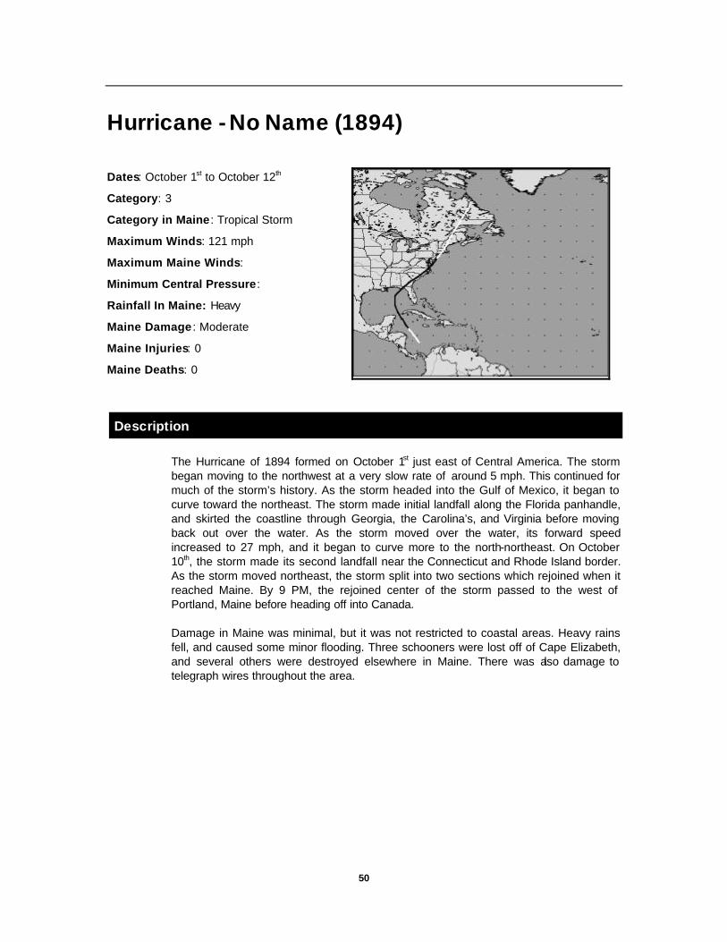
50
Hurricane - No Name (1894)
Dates: October 1st to October 12th
Category: 3
Category in Maine : Tropical Storm
Maximum Winds: 121 mph
Maximum Maine Winds:
Minimum Central Pressure:
Rainfall In Maine: Heavy
Maine Damage : Moderate
Maine Injuries: 0
Maine Deaths: 0
Description
The Hurricane of 1894 formed on October 1st just east of Central America. The storm began moving to the northwest at a very slow rate of around 5 mph. This continued for much of the storm’s history. As the storm headed into the Gulf of Mexico, it began to curve toward the northeast. The storm made initial landfall along the Florida panhandle, and skirted the coastline through Georgia, the Carolina’s, and Virginia before moving back out over the water. As the storm moved over the water, its forward speed increased to 27 mph, and it began to curve more to the north-northeast. On October 10th, the storm made its second landfall near the Connecticut and Rhode Island border. As the storm moved northeast, the storm split into two sections which rejoined when it reached Maine. By 9 PM, the rejoined center of the storm passed to the west of Portland, Maine before heading off into Canada.
Damage in Maine was minimal, but it was not restricted to coastal areas. Heavy rains fell, and caused some minor flooding. Three schooners were lost off of Cape Elizabeth, and several others were destroyed elsewhere in Maine. There was also damage to telegraph wires throughout the area.

51
Hurricane - No Name (1924)
Dates: August 16th to August 28th
Category: 4
Category in Maine : Tropical Storm
Maximum Winds: 132 mph
Maximum Maine Winds: Est. 65 mph
Minimum Central Pressure: N/A
Rainfall In Maine: Heavy
Maine Damage : Minimal
Maine Injuries: 0
Maine Deaths: 0
Description
On August 16, 1924, the seasons second storm formed off the coast of South America. As the storm moved to the northwest, it did not develop very quickly. In fact, it took five days before it became a hurricane on August 21st. At this point, the storm was located to the east of the Bahamas and Turks Islands. The storm intensified to a category 4 on the Saffir-Simpson scale on August 24th and it slowed down to only 3 mph.
As the storm continued northwest, it eventually stalled off the coast of Florida. Later on August 24th, the storm changed direction, and began moving to the northeast. As it moved to the northeast, the storm began to accelerate. Slowly at first, but by August 26th the storm was moving forward at a rate of 40 mph. The storm remained offshore, and quickly moved toward Nova Scotia.
As the storm passed to the southeast of Nantucket, Massachusetts, it caused extensive damage. It is estimated that the winds were close to 100 mph near the center of the storm. Boston received a total of 4.37” of rain in 14 hours. Even the Boston area received damage from this storm. Hundreds of yachts and several ocean liners were caught in the storm. Many of the yachts were dragged ashore by the high winds. In Maine, there were only minor reports of damage, and no injuries were reported. However, south of Maine, many people were killed in this storm. For the most part, this was a rain and wind storm for the State of Maine.

52
Hurricane - No Name (1927)
Dates: August 19th to August 26th
Category: 3
Category in Maine : Tropical Storm
Maximum Winds: 121 mph
Maximum Maine Winds: 61 mph
Minimum Central Pressure: 29.34” Hg.
Rainfall In Maine: 2.09 inches-Portland
0.45” in Lewiston
Maine Damage : Minimal
Maine Injuries: 0
Maine Deaths: 0
Description
The Hurricane of 1927 formed to the east of the Leeward Islands in the Caribbean on August 19, 1927. This storm rapidly intensified to hurricane strength on the same day. Because of the lack of reports on this storm prior to its discovery, it is most likely that the storm originally formed somewhere to the east of this point. This storm was the first of the 1927 hurricane season.
As the storm moved over warmer waters, it intensified to a Category 3 storm on August 22nd. It maintained that strength over the open waters of the Caribbean until late the next day. On August 23rd, the storm began to weaken slowly as it moved into higher latitudes and over colder water. The storm eventually curved northeast, and made landfall in Nova Scotia.
This storm produced heavy rain which in turn caused flooding in many parts of New England. The flooding was primarily concentrated in central Massachusetts, near Worcester. Portland, Maine had dense fog and the rain came down at more than 1 inch per hour causing minor street flooding.
Total rainfall for Portland was 2.09 inches, while further to the northwest, Lewiston received a little less than one half inch. The pressure in Eastport, Maine fell to as low as 29.34” Hg. as the storm passed. There were no reports of damage from this storm.

53
Hurricane - No Name (1929)
Dates: September 22nd to October 4th
Category: 4
Category in Maine : Tropical Storm
Maximum Winds: 138 mph
Maximum Maine Winds: 24 mph
Minimum Central Pressure: 936 Mb
Rainfall In Maine: 1.88 inches in Portland
Maine Damage : Minimal
Maine Injuries: 0
Maine Deaths: 0
Description
The Storm of 1929 formed to the north of Puerto Rico on September 22nd and moved at an average rate of around 11 mph curving initially to the northeast and then to the northwest. This storm was the second of only three during the 1929 hurricane season and was by far the strongest. However, this was not the case for Maine.
As the storm moved northwest, it began to strengthen and slow its forward speed. By September 24th, the storm was located to the northeast of Grand Bahama Island when it suddenly made a sharp turn to the southwest. The storm hit the Bahamian island head on at a strength of nearly Category 4 on the Saffir-Simpson scale. As the storm passed through the Bahamas, causing extensive damage, it began to re-curve to the northwest, heading for the Florida panhandle. The storm made its second landfall on September 30th near Apalachicola, Florida. However, the storm had diminished to only a Category 1 storm. As the storm moved inland, it continued to lose strength, so that by the time it reached Maine, the storm produce peak winds of only 24 mph at Portland.
The storm crossed through northern New England, passing Maine on the October 3rd & 4th. Prior to the storm’s arrival, the State of Maine was experiencing a dry spell. Heavy rains from this storm were very beneficial. In Portland, the rain began on October 3rd at 7:00 PM and ended around 8 AM on the 4th. A total of 1.88 inches of rain fell on the city, and flooded many cellars. The lowest barometer reading in Maine was 29.32”. No other damage was reported.

54
Tropical Storm - No Name (1932)
Dates: September 9th to September 17th
Category: Tropical Storm
Category in Maine : Tropical Storm
Maximum Winds: 52 mph
Maximum Maine Winds: 50 mph
Minimum Central Pressure: N/A
Rainfall In Maine: 6.56 inches in Rumford
5.50” in Lewiston, 5.42” in Waterville
Maine Damage : Severe
Maine Injuries: 2
Maine Deaths: 0
Description
The tropical storm of 1932 formed near the Yucatan Peninsula of Mexico on September 9th and maintained its strength throughout its life span. Initial strength of the winds were 40 mph that gradually increased to just over 50 mph within a few days. The storm was a very slow mover at first, but by September 14th, the storm began to move quite rapidly to the east then more toward the northeast as it crossed over Florida. The storm made its initial landfall on September 15th in northwest Florida. As the storm moved up along the eastern seaboard, it did not gain in strength. As it moved over colder waters, the storm began to lose strength, but had pockets of strong winds remaining by the time it reached Maine.
Rain was the big story in Maine on September 17th as flooding caused extensive damage in several areas. Rumford received 6.56 inches of rain. Because of the flooding, 4 bridges were washed out, causing at least $8,000 damage to one of them. Two motorists also drove into a stream and were injured because of the bridge failures. In addition, the Bangor and Aroostook railroad had several parts of the railway washed out in Rumford. Some gaps were as large as 125 feet long by 20-30 feet deep.
In Lewiston, the storm began at 8:35 AM on the 9th and ended at 4:45 AM the next morning. During that 20 hour time frame, 5.5 inches of rain fell, and was described as the “Heaviest short rain in history”. Because of the heavy rain, the Androscoggin River rose seven feet. Though the river did not flood the twin cities, it did overflow its banks in Bethel. The storm reached its peak at around 10:00 PM with heavy rains and winds taking their toll on communications and transportation. Telephone and telegraph service was disrupted, as was trolley service in the twin cities. Power was out throughout the area. Strong winds of 50 mph were reported along the coast, but some inland areas also experienced gusty conditions. Because of the strong winds, several boats on Lake Auburn and on Sabattus Lake were sunk and several trees were uprooted. The apple crop in Rockland was also severely damaged. Heavy rains also fell in Waterville, where they reported 5.42 inches in only 14 hours

55
Hurricane-No Name (1933)
Dates: September 8th to September 21st
Category: 3
Category in Maine : Tropical Storm
Maximum Winds: 121 mph
Maximum Maine Winds: est. 40 mph
Minimum Central Pressure: 957 Mb
Rainfall In Maine: 3.81 inches
Maine Damage : Minimal
Maine Injuries: 0
Maine Deaths: 0
Description
The 1933 hurricane season was a memorable one. A total of 21 hurricanes formed during that year, the most of any year to date. The Hurricane of 1933, was the 15th storm of the season and originated to the east of the Leeward Islands in the Caribbean on September 8th. As the storm drifted to the north, it gradually increased in intensity. The storm became a hurricane on September 12th, and continued strengthening as it moved to the northwest.
By September 16th, the storm was passing near Cape Hatteras, North Carolina. As it approached the coastline, the storm began to be affected by the prevailing winds, and began to curve north and then northeast. As it did this, the storm began to accelerate to 25 mph on the 17th. The storm passed along the coast of Maine on the 18th before continuing northeast toward Nova Scotia.
As the storm passed to the east, Maine was on the “wet” side of the storm. Heavy rains fell across the coastal areas, but did not quite reach interior New Hampshire as Berlin was dry. The storm caused two million dollars in damage to North Carolina, and killed 39 people. However, Maine was spared the winds, and was primarily affected by heavy rain.
In southern New England, Nantucket reported winds of 54 mph and a total rainfall of 9.92 inches. In Provincetown, at the tip of Cape Cod, a total of 13.27 inches of rain fell in only 24 hours. Here in Maine, the rainfalls were not as dramatic. In Eastport, the rainfall total was 3.63” and had a barometric pressure of only 28.90”. In Woodland, Maine, near Caribou, the rainfall total was 3.81”.
Damage in Maine was caused primarily from flooding. In Lewiston, several cellars were flooded In other areas, several rural roads were damaged from erosion. In Boothbay

56
Harbor, two youths were missing as they ventured out in a small skiff. There were no reports as to whether they were ever found.
New England Hurricane of 1938
Dates: September 10th to September 22nd
Category: 5
Category in Maine : 1
Maximum Winds: 161 mph
Maximum Maine Winds: 70 mph
Minimum Central Pressure: 938 Mb
Rainfall In Maine: N/A
Maine Damage : $135,000 (38’ dollars)
Maine Injuries: 5
Maine Deaths: 0
Description
Of all the hurricanes that have made their way to New England, the hurricane of 38’ will long be remembered as the most destructive and costliest of storms. In 1990 dollars, the Storm of 38’ caused $3,593,853,000 dollars in damage throughout New England. This ranks as the seventh costliest storm in U.S. History. However, the cost of the storm cannot only be measured in dollars, it can be measured in lives lost as well. This storm also has the dubious distinction of ranking fourth among the deadliest hurricanes in U.S. History. More than 600 people died in the storm, nearly 2000 people were seriously injured, and over 16,000 families were either displaced or left homeless.
The storm began as a strong tropical wave off the coast of Africa, near the Cape Verde Islands. As it moved westward across the Atlantic, it continued to gain strength. On September 15, 1938, the storm was upgraded to a hurricane well to the east of Puerto Rico. By September 18th at 8:30 A.M. the storm had moved to a position due north of Puerto Rico and due east of the Bahamas tracking west-northwest toward Florida. At that time, officials in Florida began making preparations for the possibility of the storm impacting that state. However, on September 20th, residents of Florida could breath a sigh of relief as the storm curved northward toward the Carolina’s. During the next 24 hours, the storm moved approximately 300 miles at a forward speed of around 12.5 mph. By 8:30 A.M. on September 21st, the storm had completed its curve northward, and was passing 75 miles east of Cape Hatteras, NC.
While the storm was moving up the coast, a deep trough of low pressure was moving out of the Great Lakes. This trough was strong enough to influence the storm as it moved closer to the coast. Further out in the Atlantic, a strong Bermuda high was in

57
place, blocking the storm from moving east. The result of these two pressure systems influencing the storm was that the hurricane would be squeezed and accelerated to the north, and not out to sea. The southerly flow that was created by the trough and the high pressure area, pushed the storm forward at an unprecedented rate of around 70 mph.
The Weather Bureau had watched this storm intently for several days, but the forecasters believed that the storm would travel out to sea, well south of New England. For this reason, no warnings were issued, except the usual warnings issued to small craft to stay in port. Could there have been more warning? One junior forecaster for the bureau had predicted the exact track of the storm. A warning could have been issued, but he was ignored by the senior forecasters.
By 10:00 AM on the 21st, a storm warning was posted from Atlantic City, NJ to Block Island, RI. At 12:30 PM this warning was upgraded to a whole gale (55-75 mph), and by 3:40 PM, Providence, RI was finally warned that the storm was going to cross Long Island, NY. At 5:00 PM, the strongest part of the storm hit Providence. Even though the storm center passed to the west of the city, it was believe that the eye was nearly 50 miles wide.
As the storm moved through Rhode Island, it inundated the City of Providence with a storm surge of 13 feet above normal high tide. The timing of the storm couldn’t be worse, as high tide was scheduled for 6:52 PM, at the height of the storm. The storm was all but over in Rhode Island by around 7:30 PM. In only 3 ½ hours, the storm left its mark in the form of destruction.
From central Connecticut, the storm traveled north through north through northwestern New England. Boston reported winds of 73 mph, and Blue Hill Observatory in Milton Massachusetts reported sustained winds of 121 mph and gusts to 183 mph. Mount Washington reported winds of 136 mph. However, the effects of the storm were beginning to be felt throughout the six state region. Maine began to feel the effects of this storm in the early evening of the 21st.
Four days prior to the storm, New England received substantial rain. The interior areas were already flooded as dams had broken, bridges and railroads were washed out, and eleven people were killed. This heavy rain also softened the ground so that when the strong winds of the hurricane arrived, it did not take much to overturn them.
“Worst wind storm in two cities history”
—Sept. 22, 1938; Lewiston Daily Sun
In Androscoggin County, Maine, the damage from the storm was incredible. Power was out nearly everywhere, and telephone service was disrupted. The Twin Cities went dark at around 10:30 PM, when two main power lines were severed. The emergency services were kept busy all night as the dispatchers received hundreds of calls. All available police and firemen were mobilized, and assistance was offered by other groups such as the Veterans of Foreign Wars, the Red Cross, and the Boy Scouts.

58
In Auburn and Lewiston, at different times throughout the evening, every road out of the Twin Cities were blocked by falling trees. Highway crews worked overtime to clear the roads of debris. This was the case throughout much of the area.
59
The first damage reported was to a sign in front of a music hall in Lewiston. The sign was blown into the street, where it fell onto a car from Massachusetts that was parked near the curb. Other reports of damage then flowed into the dispatch office of trees crashing down into the streets, into wires, and into houses. There were literally hundreds of trees downed around the area.
Several houses were damaged when trees fell onto them. Some of these included a house on Leavitt Avenue in Lewiston and a house on Maine Street in Auburn. The second house sustained the worst damage as a large tree crashed through the roof and brought down second floor ceilings. Several houses on Court Street were also damaged by falling trees.
The trees were not the only things to cause damage, the wind also took its toll on several homes. On Derosay avenue in Auburn, the roof of a home was blown off and the windows were blown out on one side. In Lewiston, a five foot square skylight cover was blown off the roof of a building near Main Street and Park Street, narrowly missing three people when it crashed to the ground.
At 9:45 PM, the tin roof on a home on Park Street was ripped off “and folded as though it were paper”. On Fifth Street, a barn roof was half torn off. In Auburn, a barn on Woodbury Hill Road was blown down and a window on a home on Gill Street was also torn from its casing during the night.
Other houses were damaged in surrounding towns including homes in Minot and Poland. The roof on one summer home in East Otisfield was blown into Thompson Lake. In Richmond, the roof of a barn was blown away, and throughout the area several chimneys were toppled by the winds. In East Otisfield, 2000 trees were uprooted near Thompson Lake, and several summer homes were damaged by falling trees. In nearby Oxford, several people escaped injury when a large tree missed their parked car by only a few feet.
Maine was lucky in the fact that there were no reported deaths due to the storm. Out of the six states, Maine was the only state to escape without any deaths from this storm. However, there were a few injuries. In Lewiston, a man was struck in the head by a falling tree limb, and a Lewiston High School freshman was badly injured as he slipped while clearing debris. In Waterville, another tree limb struck a man causing minor lacerations. In Farmington, a woman suffered a broken arm when the motorcycle she was riding ran into a downed tree. A Farmington High football player was also injured when a tree fell onto his car.
The winds in Portland were reported to be as high as 70 mph. Along the coast, there was very little rain, but the inland areas such as Auburn and Lewiston received occasional rain during the storm. Because of this fact, the Androscoggin River did not rise as high as expected. At Gulf Island Dam, the flow was only 25,000 cfs at 9:00 AM on the 22nd. However, in Bangor, the Penobscot river overflowed its banks and flooded cellars in low-lying areas of the city. Thankfully, there was only minor flooding throughout the state.

60
In fewer than 12 hours, the storm left a path of destruction covering 40,000 square miles of New York and New England. Records show that the storm killed 600 people, but in a study done by Joe McCarthy called “Hurricane” stated…”If an exact count of deaths resulting from the storm could be made, the total would be closer to 700 than 600. Another 1,754 people were injured, and an estimated 63,000 people, many of them homeless were forced to seek emergency help and shelter from the Red Cross and various local relief agencies.”
In New England, a total of 4,500 homes were destroyed, 15,139 buildings damaged, 26,000 automobiles were destroyed, 2,605 boats lost, and 3,369 were damaged. If it happened once, could it happen again?
In 1938, New Englanders were totally unprepared for the wrath of a full fledged hurricane. To the people of that era, hurricanes were storms that either occurred in the tropics, or they had no idea what a hurricane was. The last time a storm of this intensity had struck New England was in 1815, long before the oldest residents were born. This also contributed to the people being unprepared.
Today, with the advances in technology, it is highly unlikely that anyone in New England would not know of an approaching storm. However, even with all of the advanced warning capabilities, many people still ignore the possibility of a hurricane, but to a lesser degree than in 1938.

61
Great Atlantic Hurricane of 1944
Dates: September 9th to September 16th
Category: 4
Category in Maine : Tropical Storm
Maximum Winds: 138 mph
Maximum Maine Winds: 60 mph-Portland
Minimum Central Pressure: 943 Mb.
Rainfall In Maine: 4.34 inches
Maine Damage : Major
Maine Injuries: 0
Maine Deaths: 2
Description
The “Great Atlantic Hurricane of 1944” was first detected as a hurricane on September 9, 1944 and was the seventh storm of the season. On discovery, the storm position was to the northeast of the Leeward Islands in the Caribbean and was moving to the west-northwest at around 16 mph. The storm intensified to a Category 4 storm on the Saffir-Simpson scale on September 12th and remained at that strength until just before reaching Cape Hatteras. The storm continued on this track until September 13th, when it began curving to the north. The storm made initial landfall as a Category 3 storm, as it passed Cape Hatteras. From this point forward, the storm began to accelerate to the northeast to a speed in excess of 40 mph.
The hurricane made a second landfall on the eastern end of Long Island, NY. As the storm progressed northeastward, it passed to the north of Boston and then into the Gulf of Maine. The storm continued to accelerate rapidly to the east-northeast toward Nova Scotia on September 15th.
In Maine, the storm began as rain on the 14th at 4:00 PM. As the night progressed, the weather got gradually worse, and by 12:00 Midnight, torrential rains were falling. At 12:51 AM, Civil Defense authorities mobilized personnel and equipment to assist the emergency services. By 2:30 AM, the winds had reached 50 mph in the Auburn and Lewiston area. At 4:00 AM, the center of the storm passed only 50 miles from Portland and was headed northeast. By 4:33 AM, the all clear was sounded.
A total of 390 people died in the storm, 26 in New England, and 2 in Maine. In Bath, Maine, a 10 year old boy was electrocuted when he came into contact with downed wires and in Augusta, a 40 year old woman was run over by a bicyclist who was blinded by the heavy rains. Of the 390 people who died, 340 of them were lost on ships at sea. This storm ranks as the 7th deadliest hurricane in United States history..
62
The hurricane of 1944 also ranks as 23rd costliest of hurricanes to hit the United States with $925,055,000 in damages. These damages were adjusted to 1990 dollars. Maine received substantial damage throughout the state.
In Androscoggin County, 40% of the apple crop was destroyed by high winds. At Bates College, 4.34” of rain fell during the storm. The high winds and heavy rains caused several streets to become flooded, trees to be uprooted, limbs to be torn down, and widespread outages of electric and telephone service.
In Auburn, 2 barns were destroyed by the high winds. One located in West Auburn and the other located on North River Road. Seven cars were also damaged in the twin cities from falling trees and limbs. The sidewalks were damaged when the older trees that had substantial root systems fell over.
The winds in Portland reached 42 mph with gusts to 60 mph. The damage throughout the area was comparable to that done in Auburn and Lewiston. The heavy rains caused several rivers to rise, including the Little Androscoggin River in Mechanic Falls. This river rose 3 feet, but no flooding was reported.
The temperatures remained consistent throughout the storm as there was a high of 67 F and a low of 64 F, a range of only 3 degrees. At 6:30 AM, the barometric pressure indicated 29.08” Hg, but by that time the storm was almost over. The most intense part of the storm occurred between 2:30 AM and 4:30 AM.
This storm was different from the Hurricane of 38’ in that there was plenty of advance warning. The media followed the storm extensively prior to the storm, and the civil defense officials were well informed of the storm’s current position.

63
Hurricane- No Name (1949)
Dates: August 23rd to August 31st
Category: 4
Category in Maine : Tropical Storm
Maximum Winds: 150 mph
Maximum Maine Winds: 40 mph
Minimum Central Pressure: 954 Mb
Rainfall In Maine: 0.35 to 2 inches
Maine Damage : Moderate
Maine Injuries: 0
Maine Deaths: 0
Description
The storm on 1949 began on August 23rd near the northern Leeward Islands. This storm was the second of the season, and moved west-northwest at an average speed of 13 mph. On August 25th, the storm was upgraded to a hurricane, and rapidly intensified into a Category 4 storm. On August 27th, the storm made its landfall near Palm Beach, Florida packing sustained winds of 150 mph. As the storm made landfall, it began to weaken and begin its curve to the northeast. As the storm passed near Jacksonville later that day, it was downgraded to a tropical storm.
The storm continued on a northeast track, it began to accelerate to over 40 mph. The storm finally reached New England as a minimal tropical storm on August 29th. The storm had been pretty much been wrung dry as it moved over the Appalachian Mountains on its way northeast as rainfall amounts in Maine varied from one-third of an inch to two inches. Winds across Androscoggin County ranged from 15 to 40 mph and caused some damage.
Newspaper reports state that there were several trees that were uprooted and branches broken causing widespread power outages. Even as a tropical storm, it still had some punch left in it as in Winthrop, a barn was blown down.
Though the storm did cause some damage, it did have one redeeming quality, and that was that it broke a heat wave that was in place across the area. Temperatures were brought down to the 60’s and low 70’s throughout the storm.
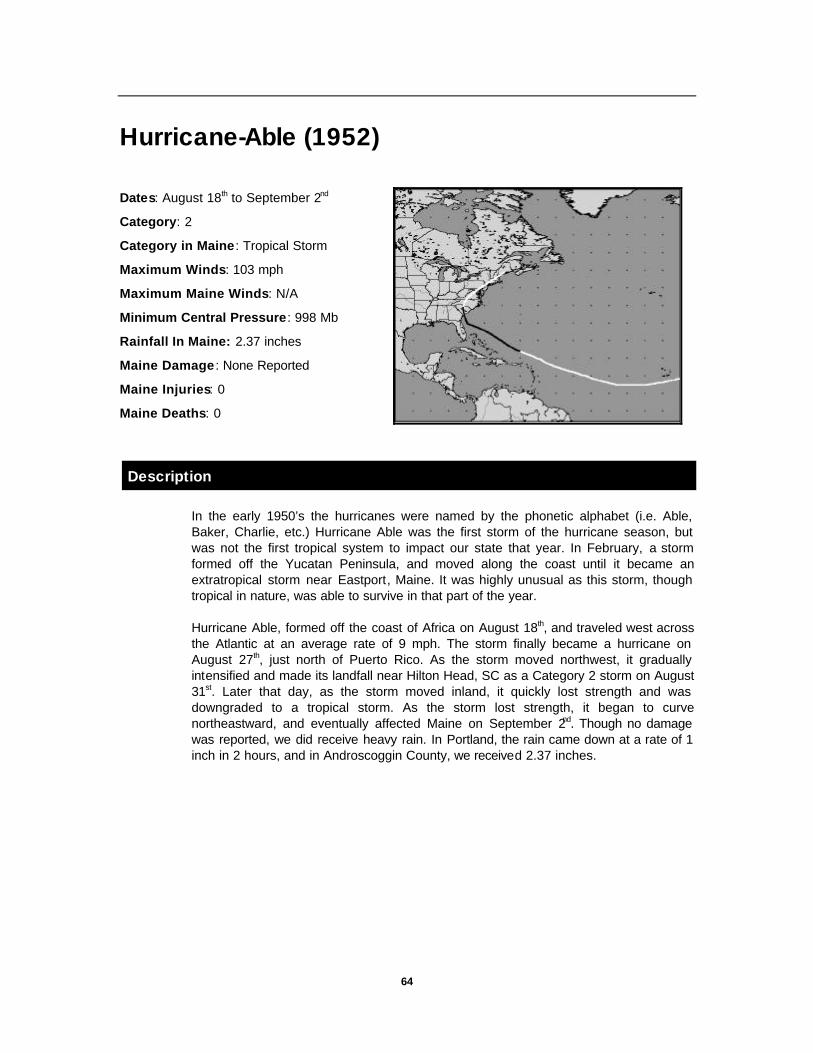
64
Hurricane-Able (1952)
Dates: August 18th to September 2nd
Category: 2
Category in Maine : Tropical Storm
Maximum Winds: 103 mph
Maximum Maine Winds: N/A
Minimum Central Pressure: 998 Mb
Rainfall In Maine: 2.37 inches
Maine Damage : None Reported
Maine Injuries: 0
Maine Deaths: 0
Description
In the early 1950’s the hurricanes were named by the phonetic alphabet (i.e. Able, Baker, Charlie, etc.) Hurricane Able was the first storm of the hurricane season, but was not the first tropical system to impact our state that year. In February, a storm formed off the Yucatan Peninsula, and moved along the coast until it became an extratropical storm near Eastport, Maine. It was highly unusual as this storm, though tropical in nature, was able to survive in that part of the year.
Hurricane Able, formed off the coast of Africa on August 18th, and traveled west across the Atlantic at an average rate of 9 mph. The storm finally became a hurricane on August 27th, just north of Puerto Rico. As the storm moved northwest, it gradually intensified and made its landfall near Hilton Head, SC as a Category 2 storm on August 31st. Later that day, as the storm moved inland, it quickly lost strength and was downgraded to a tropical storm. As the storm lost strength, it began to curve northeastward, and eventually affected Maine on September 2nd. Though no damage was reported, we did receive heavy rain. In Portland, the rain came down at a rate of 1 inch in 2 hours, and in Androscoggin County, we received 2.37 inches.
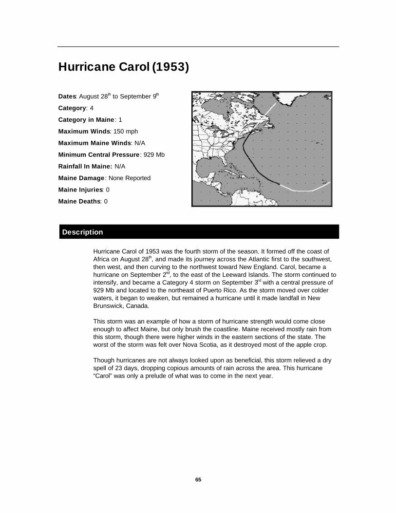
65
Hurricane Carol (1953)
Dates: August 28th to September 9th
Category: 4
Category in Maine : 1
Maximum Winds: 150 mph
Maximum Maine Winds: N/A
Minimum Central Pressure: 929 Mb
Rainfall In Maine: N/A
Maine Damage : None Reported
Maine Injuries: 0
Maine Deaths: 0
Description
Hurricane Carol of 1953 was the fourth storm of the season. It formed off the coast of Africa on August 28th, and made its journey across the Atlantic first to the southwest, then west, and then curving to the northwest toward New England. Carol, became a hurricane on September 2nd, to the east of the Leeward Islands. The storm continued to intensify, and became a Category 4 storm on September 3rd with a central pressure of 929 Mb and located to the northeast of Puerto Rico. As the storm moved over colder waters, it began to weaken, but remained a hurricane until it made landfall in New Brunswick, Canada.
This storm was an example of how a storm of hurricane strength would come close enough to affect Maine, but only brush the coastline. Maine received mostly rain from this storm, though there were higher winds in the eastern sections of the state. The worst of the storm was felt over Nova Scotia, as it destroyed most of the apple crop.
Though hurricanes are not always looked upon as beneficial, this storm relieved a dry spell of 23 days, dropping copious amounts of rain across the area. This hurricane “Carol” was only a prelude of what was to come in the next year.

66
Hurricane Carol (1954) Dates: August 25th to September 1st
Category: 2
Category in Maine : 1
Maximum Winds: 98 mph
Maximum Maine Winds: 78 mph
Minimum Central Pressure: 976Mb
Rainfall In Maine: 2.15” in Lewiston
Maine Damage : $10 Million
Maine Injuries: 7
Maine Deaths: 3
Description
Since the Great Atlantic Hurricane of 1944, the area was spared from destruction. However, in 1954, things got decidedly worse as the area was hit by two hurricanes only 10 days apart. The first of these hurricanes to hit New England was Carol.
Hurricane Carol formed as a tropical storm near the Bahamas on August 25th from a tropical depression centered there over the previous week. The storm began to move northwest at a rate of 12 mph, but upper level winds began to weaken, and the storm gradually slowed. As the storm moved over the warm waters of the Caribbean, it intensified until it became a hurricane two days later. The storm continued to intensify, and had slowed its forward speed to only 1-2 mph. When hurricanes slow like this, they tend to drift erratically.
Between August 27th and August 29th, the storm drifted to the northwest, curving more to the west, and then making a sharp turn to the north and northeast. On August 30th, the storm was located off the coast of South Carolina. But later that day, the storm began to be influenced by a deep trough moving toward the eastern seaboard.
By late on August 30tht, the storm had accelerated to a forward speed of 40 mph, and was moving toward New England. The Weather Bureau had predicted that the storm would affect Long Island, NY in the Afternoon of the 31st, but the east coast trough deepened, and the storm maintained its rapid movement to the northeast. At one point, while the storm was off the coast of New Jersey, the storm’s forward speed was calculated at 60 mph.

67
The storm made its landfall on Long Island, New York with winds approaching 120 mph. The tides were high, and the results were similar to the Hurricane of 1938. As the eastern, most dangerous semi-circle crossed southern New England, it caused extensive damage, and a storm surge of 10 to 15 feet. Some areas reported storm surges higher than in 1938.
The eye of the storm passed over Groton, Connecticut, at 10 AM on the 31st, and continued to cut a path through central New England. As many as 4000 cottages were destroyed from Westerly, Rhode Island eastward to Sakonnet Point. At 10:30 AM, the Boston Weather Bureau issued a Hurricane Warning for coastal New England, but it was already too late as coastal residents had only minutes to prepare for the storm.
Carol wreaked havoc across southern New England as it swept away cottages, restaurants, and boatyards. Though the storm was weaker than the Hurricane of 38’, it was the worst storm in the history of Cape Cod.
Even though the storm was moving inland, it was not yet through with its destruction. In Maine, winds were clocked at 80 mph at the Augusta airport, 75 mph at the State Capitol, and 70 mph in Portland. Wind was not the only factor in the storm, as a total of 2.15 inches of rain fell on the Twin Cities in less than 12 hours. The rain began at 5:05 PM on the 31st and ended at 4:55 PM on the 1st. This according to records at the Union Water Power Company in Lewiston. The peak of the storm was felt between 3:30 PM and 5:30 PM on August 31st.
Damage from the storm was estimated to be close to $10 million dollars. The highest ever to occur from a natural disaster. Ironically, that record would be broken only 10 days later by Hurricane Edna. Governor Burton Cross declared a state of emergency as the apple crop was all but ruined.
In Windham, a large lumber shed at L.C. Andrew Company was destroyed. In Farmington, a large elm fell onto a house causing extensive damage. In Norway and South Paris, the story was the same as the rest of the region, as several trees were knocked down, and some homes damaged by falling trees. Power was out between 2 PM on Tuesday the 31st and 4 AM the next day.
Here in Androscoggin County, the damage was tremendous. Photographs of the area showed whole trees uprooted, telephone poles knocked down, houses damaged, cars crushed, and damage to other structures. The storm caused widespread power outages and disrupted telephone service. Hospitals lost power, and emergency services were kept busy throughout the storm.
In North Livermore, several hundred acres of corn were flattened, and apple orchards were virtually stripped of their crop. Roads throughout the area were made impassable from tree branches and utility lines. Lisbon was also hit hard with the greatest number of wires downed in the area.
The storm took as many as 60 lives during its trip along the coast. This ranks the storm as the 19th deadliest in U.S. History. Three people in Maine were killed, and several others were injured. One incident In Columbia Falls, took the life of a 60 year old woman from New Brunswick, when two automobiles collided at the height of the storm. Four others were injured in the crash.

68
In Auburn, a 17 year old boy was injured when he was struck in the back by a large tree limb. In Lewiston, a firefighter had 2 fingers severely crushed while attempting to secure a Coca-Cola sign on Lisbon Street. In Gray, a 61 year old woman re-fractured a broken leg while she was fleeing a fire that had broken out in her home. The fire started when a tree fell onto the house.
In the Twin Cities, hundreds of trees were reported uprooted, and many sidewalks were damaged from their root systems. Electrical and telephone service was disrupted as tree branches fell like match sticks. Water mains were also broken by the roots of fallen trees.
Houses were damaged by trees in several locations as were many cars. A Fire Truck in Lewiston was damaged by a falling tree limb while responding to a home that had been struck by a large tree on Main Street. In Lewiston, the City Park and Bates College Campus were littered with fallen trees and branches.
Firemen in Auburn were kept busy throughout the storm responding to several small electrical fires and sparking wires. No serious fires were reported. Off duty policemen were also called into work as well as the Civil Defense auxiliary police and the American Legion police unit. Civil Defense personnel had been alerted by the State CD headquarters in the morning, and were well prepared.
Six counties were declared a disaster area by the Small Business Administration in Washington. These counties were York, Cumberland, Sagadahoc, Lincoln, Knox, and Waldo counties. A preliminary estimate by the Agriculture Department placed the damage of the apple crop close to $1.7 Million dollars.
In 1990 dollars, the total storm damage from Carol was $2,370,215,000 dollars, the 10th most costliest hurricane in U.S. history. As residents were cleaning up from Carol, Hurricane Dolly was moving closer to New England. Thankfully, the storm moved out to sea south of New England. However, mother nature was not through yet. Edna, a much less noticed storm was brewing in the Atlantic, and would strike the area only 10 days later.

69
Hurricane Edna-(1954)
Dates: September 2nd to September 15th
Category: 3
Category in Maine : 1
Maximum Winds: 121 mph
Maximum Maine Winds: 74 mph
Minimum Central Pressure: 940 Mb
Rainfall In Maine: 8.05 inches-Brunswick
Maine Damage : $15 Million
Maine Injuries: 0
Maine Deaths: 8
Description
While residents of Maine and New England were cleaning up from Hurricane Carol, Edna was forming off the coast of South America. The storm formed on September 2nd and began to move at an average forward speed of 11 mph toward the north and northwest. Forecasters began to become concerned on September 7th when the storm intensified to hurricane strength southeast of the Bahamas. As the storm moved northwest, another deep trough, similar to the one that took Carol rapidly northeast was developing along the east coast. By September 8th, Edna had moved to within 300 miles of the Florida coast and began to turn northward. On September 9th, hurricane watches were issued along the coast from Georgia to Cape Hatteras as winds were now close to 125 mph, making Edna potentially more powerful than Carol.
As the storm moved northward, it began to accelerate, affected by the trough that had developed along the eastern seaboard. On September 10th, the storm was located off the Carolina coast, but turning more northeastward. Watches and warnings were issued as far north as the Merrimack River in Massachusetts. On September 11th, Edna passed by Cape Hatteras and headed northeast at a speed of 26 mph. The storm continued to accelerate to 48 mph later that day. Across New England, Rains began to fall, and totals ranged from 5 to 7 inches. For most of New England, Edna will be remembered as a wet storm.
The eye of the storm passed between Nantucket and Martha’s Vineyard, Massachusetts at 2:30 PM on September 11th. Thankfully, Edna arrived at low tide, and high storm tides did not form. As the storm continued northeast, winds began to wrap around the storm from the north. The storm was large, as gale force winds extended outward 400 miles from the center. Winds of 110 mph were reported at Block Island, RI, 90 mph at Providence, RI, and 87 mph at Boston with a brief gust of 101 mph from the northwest.

70
As the storm passed Nantucket and Martha’s Vineyard, something unusual happened. The eye of the storm split into two sections. One eye was said to be over Cape Cod near Brewster, while the other was said to be northeast of Provincetown. Record pressure readings at Truro (28.29”) and Nantucket (28.18”) supported the presence of the two eyes as they are over 60 miles apart.
The worst damage from Edna occurred primarily in Maine. Along the coast, the amount of marine damage was huge. Heavy rains soaked the area in excess of 7 to 8 inches. The Kennebec and other rivers went wild, and washed out roads and bridges throughout central and southern Maine. Winds at Portland were 60 mph with gusts to 74 mph. Portland also reported a total of 7.49 inches of rain, 5.84 inches in only 6 hours. The lowest pressure recorded in Maine was 940 Mb or 27.77” Hg.
Damages in Maine totaled more than $15 Million dollars, $5 Million more that Carol only 10 days earlier. Damages in Androscoggin County were estimated at around $300,000 dollars, and the damage total for New England was $40.5 Million dollars. A State of emergency was declared in 20 counties.
In the Auburn and Lewiston area, the heavy rains began at 5:22 AM on Saturday, September 11th, and continued until 9:45 PM that night. There was only one break in the rainfall and that occurred between 7:40 PM and 8:45 PM. The Androscoggin River rose rapidly as the rains fell. By 11 AM, the flow was 43,000 cfs at Gulf Island Dam, and the Libby Mill’s first floor was flooded. Strong winds also buffeted the area. Winds at the airport gusted as high as 65 mph. Due to the strong winds, there were numerous power outages across the area. In addition, numerous trees were knocked down.
Eight people died due to drowning in Maine. In Unity, a family of 10 was trapped on top of their car, cut off by raging flood waters. A human chain of rescuers managed to save 9 of them. One 8 year old girl was swept away as her father lost his grip on the child when a house smashed into the guard rail. A 47 year old man was also swept away as he was trying to rescue the family. In all, a total of 29 people died in the storm, 12 people in New England, and 8 of those were in Maine,

71
Tropical Storm Brenda-(1960)
Dates: July 28th to August 1st
Category: Tropical Storm
Category in Maine : Tropical Storm
Maximum Winds: 58 mph
Maximum Maine Winds: est. 45 mph
Minimum Central Pressure: N/A
Rainfall In Maine: 1.4”-Farmington
1.32”-Portland, 1.38”- Lewiston
Maine Damage : Minor
Maine Injuries: 0
Maine Deaths: 0
Description
Tropical Storm Brenda formed as a tropical depression on July 28th in the Gulf of Mexico, and began moving rapidly northeast at speed of 30 mph. This storm was a fast mover, and because of that fact, never had the opportunity to gather much strength. The storm quickly made landfall in Florida, near Cedar Key with winds of only 35 mph. The storm traveled across Florida and hugged the eastern seaboard. As the storm passed Wilmington, NC, it reached its peak winds of 58 mph. The storm had slowed a bit as its forward speed was down to 22 mph. However, as the storm passed Cape Hatteras, it began to accelerate again to well over 35 mph. The storm eventually crossed over New York City, across central New England, and then into Canada.
Damage from this storm was minor. A large tree fell in Auburn and a large limb fell onto a house in Lewiston. Three people also had to be rescued from the surf in Old Orchard Beach. Total rainfall in Lewiston was 1.38 inches.

72
Hurricane Donna-(1960)
Dates: August 29th to September 14th
Category: 5
Category in Maine : 1
Maximum Winds: 161 mph
Maximum Maine Winds: 77 mph-Portland
Minimum Central Pressure: 932 Mb
Rainfall In Maine: 3.18 inches-Portland
Maine Damage : Severe
Maine Injuries: 0
Maine Deaths: 0
Description
Hurricane Donna began as a tropical depression off the coast of Africa on August 29th, and began moving to the west at a speed of 27 mph. By August 30th, the storm had slowed to only 14 mph, but had intensified to tropical storm strength, thereby becoming the fourth named storm of the season. The storm continued to intensify as it moved west-northwest. On September 1st, the storm had become a hurricane and was now located well to the east of the Leeward Islands in the Caribbean. As the storm moved toward warmer waters, it intensified to a Category 5 hurricane, the highest level on the Saffir-Simpson Scale. It remained this intensity, hitting the northern Leeward Islands of Barbuda and Antigua head on.
Donna had then lost some of its intensity, gradually decreasing to a Category 3 just north of Puerto Rico. As the storm approached Puerto Rico, it began to move more toward the northwest and then back again to the west, making a beeline for the northern Cuban coast. By September 9th, the storm had regained some of its strength and was now a Category 4 storm as it brushed along the coast of Cuba. Later that day, the storm began to curve more toward Florida, and hit the Key’s head on packing 138 mph winds.
As the storm passed Marathon, Florida, it began to curve to the north, and then the northeast, passing directly over Naples, Florida. As the storm moved back across Florida, it had lost most of its strength, but was still a Category 2 hurricane. From this point on, the storm took a direct track northeast, headed for New England.
By the time the storm reached New England, the winds were still at a Category 2 level. The storm made landfall in eastern Long Island, New York. When it did this, the eye was reported to be 50 miles wide, with a central pressure of 28.55” and winds of 95 mph at Block Island, Rhode Island. The storm crossed Long Island Sound, and proceeded to cross western Rhode Island, central Massachusetts near Worcester, and

73
then into Maine. Through Maine, the track passed between Poland and Norway, then finally into Canada.
A total of 133 people were killed, 18 in the U.S., and 3 in Massachusetts, making this the 21st deadliest hurricane in U.S. History. Damage from this storm was extensive, and in 1990 dollars was estimated at $1,823,605,000 Dollars, the 12th costliest hurricane in U.S. History.
In Maine, the storm brought winds and heavy rain. A total of 3.18 inches of rain fell in Portland, 1 inch in only 35 minutes. In Lewiston, a total of 2.99 inches fell, flooding many streets. At the Auburn-Lewiston Airport, winds were clocked at 30 mph with gusts to 55 mph. Winds in Portland gusted to 77 mph, while in Boston they were only 51 mph. However. at the Blue Hill Observatory in Milton, Massachusetts the winds gusted to 140 mph with a barometric pressure of 28.52” Hg.
Along the coast, 15 to 20 boats in Falmouth harbor were damaged. Total boat damage was estimated at $250,000 dollars. Due to a potentially high storm surge, coastal residents in low-lying beach areas of Cumberland and York Counties were evacuated. Several counties lost power during the storm; These include Androscoggin, Cumberland, and York Counties. In Southwest Harbor, Maine, lightning struck the Dirigo Hotel, causing a fire at the peak of the storm. The fire caused $100,000 in damages.
Moderate damage occurred in the Auburn and Lewiston area. Trees and tree branches were knocked down, some into power lines. This caused widespread outages of both electricity and telephone service. In addition, television antenna’s were damaged, as were several signs including a Sears sign in Lewiston. 25% to 40% of the apple crop was destroyed.
In Lewiston, a large tree had fallen on Horton Street and narrowly missed a police cruiser. Other damage included a trap door being blown from the roof of an apartment building. This trap door ended up falling onto Lisbon Street. Luckily, no injuries occurred. Another tree had fallen onto a house on Ash Street, and the Lewiston Fire Department responded to assist with salvage operations.
Heavy rains fell, causing the Androscoggin river to rise by 5 times the normal flow. Gulf Island Dam reported up to 20,000 cfs were flowing at the peak of the storm. The abundant amount of rain did relieve dry conditions that had increased the fire danger.

74
Hurricane Esther - (1961)
Dates: September 10th to September 27th
Category: 4
Category in Maine : Tropical Storm
Maximum Winds: 144 mph
Maximum Maine Winds: N/A
Minimum Central Pressure: 927 Mb
Rainfall In Maine: 2 inches-Lewiston
Maine Damage : None Reported
Maine Injuries: 0
Maine Deaths: 0
Description
Hurricane Esther formed from a tropical depression far out in the eastern Atlantic. The storm’s initial motion was to the west-northwest at 19 mph, rather fast for this type of storm. On September 12th, Esther was upgraded to a hurricane, still headed to the west-northwest. The next day, the storm began to curve to a more westerly heading. It maintained this track for several days, and continued to intensify. By September 18th, the storm was classified as a Category 4 hurricane. As it strengthened, it began to slow its forward speed. By September 22nd, the storm had slowed to only 5 mph. Light upper level winds allowed the storm to drift over colder waters, and the hurricane quickly lost strength. Esther was downgraded to a tropical storm that same day.
Here are some interesting things regarding this storm. First, the storm track made a looping pattern, this is typical of hurricanes that have no steering winds aloft. Second, the storm threatened New England 23 years to the day of the 1938 hurricane. In addition, the storm affected Maine as both a tropical and an extratropical system. Total rainfall in Portland from the storm was 3.56 inches. In southern New England, winds gusted to over 80 mph along with heavy rain.
The storm finally made landfall in Maine as an extratropical system on September 26th. Landfall occurred near Brunswick, Maine. By this time, the winds had diminished to only 30 to 35 mph. No damage was reported from winds and the storm dropped two inches of rain in Lewiston.

75
Unnamed Tropical Storm-(1961)
Dates: September 12th to September 15th
Category: Tropical Storm
Category in Maine : Tropical Storm
Maximum Winds: 40 mph+
Maximum Maine Winds: 70 mph
Minimum Central Pressure: N/A
Rainfall In Maine: N/A
Maine Damage : Minor
Maine Injuries: 0
Maine Deaths: 0
Description
On September 12th, 1961, a tropical depression formed over the Bahamas. This storm moved directly north at a speed of only 2 mph. During the next two days, the storm increased in intensity to tropical storm force. The storm continued northbound until in made initial landfall in North Carolina, near Cape Fear. Over land, the storm did not lose much of its strength but began heading to the northeast. Hugging the coast, the storm maintained its intensity until it reached the Maine coast.
Newspaper reports indicate that this storm was much stronger than anticipated. Reports of 100 mph winds at 800 feet were reported in Machias at 10:30 AM. This came from the Cutler Antenna Farm and Radio Station. Damage on the ground was reported as several trees were uprooted and the winds moved buildings off their foundations. Several Tuna boats were ripped from their moorings as well. Power outages were wide spread. Winds of 63 mph were reported in Jonesport. There were no unusual reports of wind or rain in Androscoggin County. The storm was downgraded and reclassified as an extratropical system as it passed through New Brunswick, Canada.

76
Hurricane Daisy-(1962) Dates: September 29th to October 9th
Category: 2
Category in Maine : 1
Maximum Winds: 109 mph
Maximum Maine Winds: 60 mph
Minimum Central Pressure: 965 Mb
Rainfall In Maine: 7.71 inches-Portland
Maine Damage : Moderate
Maine Injuries: 0
Maine Deaths: 2
Description
Hurricane Daisy formed as a tropical depression several hundred miles to the east of the Leeward Islands. The storm’s initial motion was to the west-northwest at 16 mph. The storm kept up its speed for the next several days. The storm was upgraded to a tropical storm on October 2nd when the storm was located only a few hundred miles north of the northern Leeward Islands. As the storm intensified, it began to curve more toward the west. Two days later, the storm was upgraded to hurricane status. The storm gradually increased in intensity to achieve Category 2 strength by October 5th, when the storm was several hundred miles east of Florida. The storm also began to curve northward and eventually north-northeast that day. The hurricane continued a straight track to the north-northeast until October 7th, when it was well southeast of Cape Cod. At this time, the storm made a sharp turn to the north-northwest toward Maine. However, as the storm approached the coastline, it again mad a sharp turn. This time it turned 90 degrees to the right into Nova Scotia and then out to sea.
The storm never made landfall in Maine, but because of its size, the effects were felt throughout the state. Along the coast, wind, heavy swells and surf caused marine losses. In Portland, the sustained winds were 34 mph with gusts to 41 mph. In Lewiston, the newspapers reported wind gusts to 50 mph. Though the winds were fairly strong, the storm will be remembered more as a wet storm. A total of 7.71 inches of rain fell in Portland within 24 hours, 3.13 inches of it in only 6 hours. This set a 24 hour record for rainfall in Portland that wasn’t broken until Bob in 1991. Excessive rain fell in southern New England. Wakefield, Massachusetts reported 14.25 inches of rain. Prior to the storm’s arrival, New England experienced a Nor’easter. This storm dropped substantial rain on the region. The combined rainfall from both systems caused significant flooding damage as it rained for over 60 hours. Damage was in the millions throughout New England.
In Auburn and Lewiston, a total of 4.58 inches of rain fell. Flooding was a problem in Auburn as the Androscoggin River flooded the North River Road. River flow on the Androscoggin rose to 36,000 cfs. The storm left a total of 24 people dead, two of them from Maine. High winds toppled Television Antennas and uprooted trees. Widespread power outages also occurred.

77
Hurricane Ginny-(1963)
Dates: October 16th to October 30th
Category: 2
Category in Maine : Tropical Storm
Maximum Winds: 109 mph
Maximum Maine Winds: 100 mph-Rockland
Minimum Central Pressure: 958 Mb
Rainfall In Maine: 2.75”-Eastport
Maine Damage : $300,000 +
Maine Injuries: 0
Maine Deaths: 0
Description
Hurricane Ginny formed as a tropical depression on October 16th, near north of the island of Hispaniola. This storm was the 7th of the season, and the only one to come close to New England. This storm is also known as the famous snow hurricane.
The tropical depression moved slowly to the north over the next several days and did not gain much strength. Peak winds were only 20 to 30 knots between October 16th and October 19th. Late in the day on the 19th, the storm began to rapidly intensify, and became a hurricane the next day.
From that point on, the storm began to move erratically. First moving to the west, then looping to the southeast, and then re-curving to the north and east. As the storm was looping off of the southeast coast of the U.S., it went through several changes in strength. On October 23rd, the storm was downgraded to a tropical storm off the coast of Florida. By Later that day, the storm regained its strength. The hurricane reached its peak intensity of 109 mph on October 29th. By this point, the storm was heading north-northeast at a fairly rapid pace. Its position was well off shore, and south of New England. The storm moved well off the coast of Maine on October 29th, near Yarmouth, Nova Scotia. Even though the storm was well off the coast, it was still large enough to affect the state.

78
Southern Maine received a total of 1.5 inches of rain from the storm. Lewiston received a total of 1.73 inches of rain, and a dusting of snow while Eastport received the most rain at 2.75 inches. This storm was unusual in many ways. First, the storm was affected by many different steering currents. It took several days to finally settle on a track to the northeast. Most hurricanes maintain a fairly straight track, but when the steering currents become erratic, so do the hurricane tracks. The second unusual event occurred in Maine, as it snowed heavily in some areas. Cold air from Canada was brought down into Maine from the counter-clockwise circulation of the storm. The cold air combined with the moisture from the storm caused the unusual snow event.
Aroostook County received a total of 13 inches of snow from this storm and on Mount Kathadin, the total snowfall was 4 feet. Though snow fell in Lewiston, the warmer temperatures melted it quickly. Some wind damage occurred, as the Auburn and Lewiston area experienced widespread power outages. Television antennas were knocked down and $10,000 in damages occurred to a storage shed in Portland.
The winds were strongest along the coast as 100 mph winds were recorded in Rockland and 75 mph winds in Eastport. The total amount of damage in Maine was over $300,000 dollars.

79
Tropical Storm Doria-(1971)
Dates: August 20th to August 29th
Category: Tropical Storm
Category in Maine : Tropical Storm
Maximum Winds: 63 mph
Maximum Maine Winds: 61 mph
Minimum Central Pressure: 989 Mb
Rainfall In Maine: 1.75 inches
Maine Damage : Moderate
Maine Injuries: 0
Maine Deaths: 0
Description
Many people believe that a storm has to be a hurricane to cause destruction. Tropical Storm Doria proved those people wrong. Doria formed as a tropical depression, well to the east of the Leeward Islands on August 20th. The depression maintained its strength for several days as it moved across the Caribbean. By August 26th, the storm was only a few hundred miles off the coast of Florida. The storm began to curve to the north, and as it did, it intensified to tropical storm strength. Doria continued moving to the north, and eventually made landfall near Cape Lookout, North Carolina on August 27th. As the storm moved over land, it began to weaken. Doria’s track took it through the mid-Atlantic states, southern New England, and eventually into western Maine. The storm exited the state to the northeast, and into northern New Brunswick, Canada.
As the storm passed through Maine, strong winds were felt across the area as the average winds were near 30 mph. In Lewiston, a gust of 61 mph was recorded. The winds also toppled trees and caused widespread power outages. Telephone service was also disrupted. In Sabattus, a mobile home was damaged by the strong winds as was a 10’ x10’ steel shed in Lewiston. Thousands of dollars in damages occurred in the Twin Cities. Rain was heavy, but no flooding problems were reported. Lewiston received a total of 1.75 inches of rain.
Two people died in this storm. An 18 year old was swept out to sea as he was watching the surf in Marblehead, Massachusetts and a rescuer who was trying to save the youth.
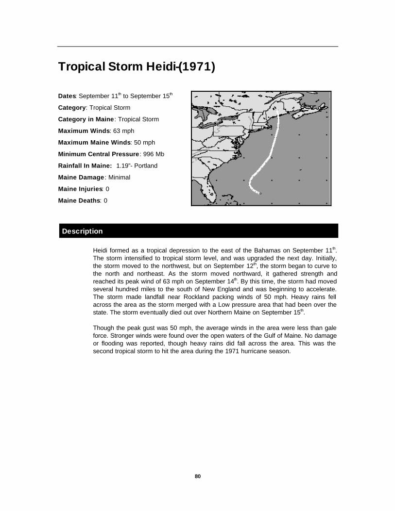
80
Tropical Storm Heidi-(1971)
Dates: September 11th to September 15th
Category: Tropical Storm
Category in Maine : Tropical Storm
Maximum Winds: 63 mph
Maximum Maine Winds: 50 mph
Minimum Central Pressure: 996 Mb
Rainfall In Maine: 1.19”- Portland
Maine Damage : Minimal
Maine Injuries: 0
Maine Deaths: 0
Description
Heidi formed as a tropical depression to the east of the Bahamas on September 11th. The storm intensified to tropical storm level, and was upgraded the next day. Initially, the storm moved to the northwest, but on September 12th, the storm began to curve to the north and northeast. As the storm moved northward, it gathered strength and reached its peak wind of 63 mph on September 14th. By this time, the storm had moved several hundred miles to the south of New England and was beginning to accelerate. The storm made landfall near Rockland packing winds of 50 mph. Heavy rains fell across the area as the storm merged with a Low pressure area that had been over the state. The storm eventually died out over Northern Maine on September 15th.
Though the peak gust was 50 mph, the average winds in the area were less than gale force. Stronger winds were found over the open waters of the Gulf of Maine. No damage or flooding was reported, though heavy rains did fall across the area. This was the second tropical storm to hit the area during the 1971 hurricane season.

81
Tropical Storm Carrie-(1972)
Dates: August 29th to September 5th
Category: Tropical Storm
Category in Maine : Tropical Storm
Maximum Winds: 69 mph
Maximum Maine Winds: mph
Minimum Central Pressure: 992 Mb
Rainfall In Maine: 7.23 inches
Maine Damage : Minimal
Maine Injuries: 0
Maine Deaths: 1
Description
Carrie formed as a depression off the coast of Florida on August 29th, and quickly began moving to the northeast. Over the next couple of days, the storm gathered strength and was upgraded to a tropical storm on August 31st. The storm reached a peak intensity of 58 mph on September 1st, and was located well to the east of Cape Hatteras. Under normal circumstances, most storms would continue to move to the northeast. However, on September 1st, the storm made a sudden turn to the northwest, but began losing its strength over the colder waters. As the upper level shearing diminished, and the storm moved back over the Gulf Stream, it re-intensified again to just under hurricane strength at 69 mph. The storm continued on a track toward Long Island, NY, but on September 3rd, it began to change direction again. This time it was tracking to the northeast. The storm eventually made landfall near Eastport, Maine on September 4th, and moved off into the Canadian Maritime Provinces.
The storm hit Maine on Labor Day weekend, typically the end of summer celebration in New England. The storm brought heavy rains to eastern sections. On the Island of Martha’s Vineyard, 10 inches of rain fell, while at Chatham on Cape Cod received a total of 6 inches. Strong winds also battered the cape as well with winds gusting to 100 mph.
In Maine, Portland reported winds of 40 mph and Augusta reported winds of only 35 mph. Some tree damage occurred across the Auburn and Lewiston area, and some coastal flooding was reported. Though southern and central Maine were left relatively unscathed, Eastern Maine was hit relatively hard. Damage occurred to many small boats that had broken from their moorings and power outages were reported in many locations including Biddeford, Brunswick, Sebago, and Rockland. Heavy rains also fell across the state, with Eastport receiving as much as 7.23 inches. Though the winds did not cause any injuries on land, one person was killed during the storm while scuba diving off Acadia National Park.

82
Hurricane Belle-(1976)
Dates: August 6th to August 10th
Category: 3
Category in Maine : N/A
Maximum Winds: 121 mph
Maximum Maine Winds: 61 mph
Minimum Central Pressure: 957 Mb
Rainfall In Maine: 2.58” - Portland
5 to 9 inches in St. John Valley
Maine Damage : Minimal
Maine Injuries: 3
Maine Deaths: 3
Description
During what was one of the wettest summers in years, Hurricane Belle paid a visit to New England for the country’s bicentennial celebration. During that summer, 47% of the days were raining. In June a total of 3.99 inches of rain fell, and another 6.20 inches in July. Prior to the storm in August, a total of 2.31 inches more had fallen.
Belle was the first hurricane of the season, and it formed as a tropical depression on August 6th, just to the east of the Bahamas. Initial movement of the storm was variable, and the storm moved very little during the first 24 hours. After that, the storm began to increase in intensity until it reached hurricane strength on August 7th. The storm began moving more to the north as time went by, and began to accelerate. The storm reached Category 3 on August 9th as it was off the coast of the Carolina’s. The storm continued to accelerate, but as it moved over colder waters, it began to lose strength. By the time it made landfall on Long Island, NY, the storm was only Category 1. As it passed over Long Island, the storm was downgraded to a tropical storm, then eventually a depression over southern New England. The remnants of the storm affected Northern New England on the August 10th, crossing west of Sebago, Maine.
Winds were fairly strong in Maine as they gusted to 52 mph at the Auburn-Lewiston airport. In Portland, winds were reported at 26 mph with gusts to 39 mph. Rainfall there totaled 2.58” with 2.05” occurring within 6 hours. Across the area, several tree limbs fell, knocking out power in many locations. A few trees were completely knocked down in the Auburn and Lewiston area. Heavy losses also occurred to the potato and grain crops in Aroostook County. A total of 2.35 inches fell in Lewiston, and flooding was widespread over northern Maine. Three people were killed in Maine during the storm due to traffic related injuries.

83
Hurricane David-(1979) Dates: August 25th to September 8th
Category: 5
Category in Maine : Tropical Storm
Maximum Winds: 173 mph
Maximum Maine Winds: 69 mph-Lewiston
58 mph-Portland
Minimum Central Pressure: 924 Mb
Rainfall In Maine: 1.26”- Lewiston
Maine Damage:
Maine Injuries: 0
Maine Deaths: 0
Description
Twenty five years had passed since Carol and Edna had struck in 1954. As described by the newspapers “David was a pussycat…” , when comparing them with the storms of 1954. However, a week earlier, David was far from being a “pussycat” as this storm roared through the Caribbean as a Category 5 storm. The death toll from that area was close to 1,100 people.
David formed as a tropical depression southwest in the Eastern Atlantic on August 25th. The storm’s initial motion was to the west at the rather brisk pace of 21 mph. As the storm moved westward, it gradually became more organized and eventually was upgraded to a hurricane on August 27th. The storm continued moving west, and impacted the Leeward Islands on 30th packing sustained winds of 143 mph. Though the storm passed over the islands, it continued to intensify until it reached Category 5 on the Saffir-Simpson scale. As a Category 5 storm, it caused extensive damage from the U.S. Virgin Islands through the Island of Hispaniola. Sustained winds in this area were close to 175 mph with gusts to over 200 mph. These high winds flattened everything, and as I mentioned before, over 1,100 people were killed.
The storm began to curve to the northwest, and headed for Florida. By September 3rd, the storm was just offshore of Miami. However, the destruction was kept to a minimum as the sustained winds were only 97 mph. The storm continued tracking to the northwest, but began to move inland over Georgia. As the storm moved further inland, it weakened considerably, but began to accelerate and curve to the northeast. David finally reached Maine on September 7th, causing moderate damage. The worst of the storm hit between 3:30 PM and 6:00 PM. There were no deaths reported in Maine, however there was one death reported in Massachusetts.
In the Auburn and Lewiston area, many trees were toppled by the storm, and some damaged houses when they fell. Power lines were down everywhere, as 2,000,000 people were affected by power outages. Some were without power for nearly a full day. Heavy rain also fell on the area causing minor street flooding. The rain began in Lewiston at 8:30 AM and continued until 8:50 PM. A total of 1.26” of rain fell during that period with a gust to 69 mph at the airport at 3:00 PM.

84
Hurricane Gloria-(1985) Dates: September 16th to October 2nd
Category: 4
Category in Maine : 1
Maximum Winds: 125 mph
Maximum Maine Winds: 86 mph at
Goat Island, 80 mph-Old Orchard Beach
Minimum Central Pressure: 920 Mb
Rainfall In Maine: 1.30 inches-Lewiston
2.00 inches-Rumford
Maine Damage : Severe
Maine Injuries: 3
Maine Deaths: 0
Description
Gloria was the 7th storm of the season, and was by far the strongest in the Atlantic. This was the first major storm to hit New England since Donna in 1960.
The storm began as a tropical depression far in the Eastern Atlantic, just south of the Cape Verde Islands. The storm formed on September 16th, and began moving to the west-northwest. Over the next several days, the storm would become better organized and would gain in strength. By September 21st, the storm reached hurricane strength and was located several hundred miles to the east of the Leeward Islands. As the storm approached these islands, it suddenly made a sharp turn to the northwest, and passed to the north of all islands in the Caribbean.
The storm continued to gain in strength until it reached its peak on September 25th as a Category 4 storm. Sustained winds were now at 143 mph with higher gusts and the storm was now located several hundred miles to the east of Florida. As the storm approached the east coast, it began to curve northward, passing over the Outer Banks of North Carolina on September 27th. By this point, Gloria had decreased in strength to a Category 2 storm, but still had some punch left as total storm damages were $1 Billion Dollars.
The storm tracked right along the east coast, but still over the water which allowed it to maintain its strength. Typical of hurricanes along the east coast, Gloria began to accelerate as it passed North Carolina. The storm made landfall on Long Island, New York around 2 PM on the 27th. As the storm continued north, it passed through central Massachusetts, central New Hampshire, and western Maine and accelerated to 40 mph. As the storm was now over land, its intensity diminished rapidly. The storm eventually moved off into Canada and then out to sea, but not before leaving the area with heavy rain and wind damage.
85
Wind and Rain were the story here in Maine as winds in Portland reached sustained winds of 39 mph with gusts to 70 mph and Augusta reported gusts to 73 mph. At Goat Island, 86 mph was the peak gust reported.
A total of 1.3 inches of rain fell in Lewiston, 2 inches fell in Rumford, but only .41 inches fell in Portland. There was only a 2 foot storm surge associated with this storm in Maine as the storm hit at low tide
The high winds knocked out power for several days and left 250,000 people in the dark, some for up to two weeks. Androscoggin County had the worst of the power outages. Central Maine Power reported that it was the worst damage since Carol and Edna in 1954. By the second day after the storm, 30,000 people were still without power. Most were in the towns of Poland, Minot, and Mechanic Falls.
In Ogunquit, a 95 unit motor inn lost its roof and in Augusta, two people were temporarily trapped in their mobile home when a tree split it in two. Windows at the State House were blown out as well. In North Turner, another mobile home lost its roof, but no injuries were reported.
Hundreds of trees in the Auburn and Lewiston area were either uprooted or had their limbs torn off. In New Gloucester, a woman was seriously injured when part of the roof of her mobile home blew off and pinned her to a car in her driveway. A Windsor man was also seriously injured when a tree limb fell onto him. Also, in Auburn, the high winds also took off the roof of a home on Manley Street. Several other tree limbs on that street fell and crushed several cars.
Twenty people spent the night at an emergency shelter set up at the Lewiston Multi-purpose center, and a few stayed at the Auburn Armory. The storm kept most people indoors, as crime was kept to a minimum. As one police officer stated, “even criminals stayed at home”. Lewiston and Auburn Restaurants and food businesses did a booming business throughout the period. With the power out for an extended period of time, several area businesses helped keep their neighbors frozen foods cold by offering them space in their freezers. Neighbor helping neighbor is something that rarely happens, but during times like these, people put aside their differences for the common good.

86
Tropical Storms Chris & Alberto-(1988)
Dates: August 21st to August 30th
Category: N/A
Category in Maine : Tropical Depression
Maximum Winds: 52 mph
Maximum Maine Winds: est. 20 mph
Minimum Central Pressure: 1005 Mb
Rainfall In Maine: N/A
Maine Damage : Minimal
Maine Injuries: 0
Maine Deaths: 0
Description
Tropical Storm Chris began in the middle Atlantic on August 21, 1988 and began traveling west. Chris was the third named storm of the season and the second to visit the Maine during 1988. Alberto was the first storm and had set off scattered thunderstorms, showers, and heavy downpours.
The effects in Maine were very limited. Central Maine Power reported that 10,000 people lost power during the storm due to strong winds. Four houses and several automobiles near Crystal Lake were damaged in the Town of Gray.

87
Hurricane Bob-(1991) Dates: August 16th to August 29th
Category: 3
Category in Maine : Tropical Storm
Maximum Winds: 115 mph
Maximum Maine Winds: 61 mph
Minimum Central Pressure: 950 Mb
Rainfall In Maine: 7.83 inches-Portland
Maine Damage : $26 Million
Maine Injuries: 2
Maine Deaths: 3
Description
On August 16th, a tropical depression formed 200 miles to the east of the Bahamas. This storm moved slowly to the northwest and intensified. By the end of the next day, the storm had become a hurricane and was named Bob as it was the second storm of the season.
As Bob became a hurricane, it began to move to the northeast and accelerated. By August 19th, the storm was located 30 to 35 miles to the east of Cape Hatteras, and was at its peak intensity of 115 mph. As the storm moved quickly northeast, it began to weaken over the colder waters. The storm made landfall near New Bedford, Massachusetts packing 98 mph winds. The storm cut a path across southeastern Massachusetts, and then into the Gulf of Maine. As it did this, it continued to weaken and began to lose its tropical characteristics. By 10 PM that evening, the storm made a second landfall in Rockland, Maine at which time it was downgraded to a tropical storm. The storm proceeded across eastern Maine, New Brunswick, and then out to sea on August 29th.
Six tornadoes were associated with hurricane Bob. Four in North Carolina and two on Long Island, New York. These were confirmed, and there were 16 unconfirmed tornadoes reported including nine on Hatteras Island, NC, 2 in Rhode Island, and 2 in Massachusetts. There was also one possible tornado reported in St. Albans.
Massachusetts took the brunt of the storm surge as it was in the eastern half of the storm. The storm surge was estimated at 7 to 9 feet in Buzzards Bay. A twelve foot storm surge was recorded in Rhode Island.
On Cape Cod, the damage was severe. Trees and Wires were down everywhere, and power was out for a week in many areas. Several houses were destroyed along the coast line due to either the winds or the storm surge.

88
Heavy rain was also associated with this storm. Rainfall amounts ranged from 5 to 8 inches along the path of the storm. At Cape Hatteras, a total of 5.30 inches fell, 7.04 inches at Bridgehampton, Long Island, 7.00 inches in Groton, Connecticut, and 7.83 inches at Portland, Maine. A total of 5.59 inches of that fell in only 6 hours.
Strong winds battered the area. In Portland, the sustained wind was 40 mph with gusts to 61 mph. At Blue Hill, peak wind was 93 mph, it was 92 mph at Wiscasset, 69 mph a Mt. Desert Island, and 69 mph at Matinicus Rock.
An estimated 2.1 million businesses and homes lost power at some point during the storm. From personal experience, the Town of Poland had power out on the primary lines for 4 days, with some parts of town out for over a week. This caused many people to scramble to find ways of keeping their frozen foods cold.
In Maine, the damage was a bit lighter, but widespread power outages prevailed. Many trees and wires were knocked down. Most of the damage occurred along the coastal areas, but power outages spread as far as western Maine.
In York County, 8600 people were evacuated from the coast and placed into emergency shelters. The Governor ordered evacuations of residents within ¼ mile of the shore as Coastal flooding took its toll on the area. Two Million dollars in damage occurred in York and Cumberland Counties. In Gorham, 5 bridges were washed out by rising waters of local rivers and streams.
In Topsham, a power surge caused by the hurricane caused the former Mikes Ice Cream store to catch fire. The building was destroyed by the fire. All across the area, corn fields were flattened and the apple crop was damaged. Debris clearance took up to a week in most areas.
In Androscoggin County, a total of 6.3 inches of rain fell in Lewiston. Flooding damaged many areas including roads in Lisbon and Durham. The Androscoggin River also rose by 4 feet to 8’ 4” from 4’ 6”. Flooding destroyed small bridges, and washed out several roads throughout the county.
High winds in Androscoggin County caused extensive damage as the storm peaked around 7:30 PM. In Durham, winds of 68 mph were reported. In Poland, the highway, fire, and sheriffs departments were kept busy into the night. Several calls for branches on wires and trees downed on roads came into the dispatch center. In Minot, the highway department had to clear in excess of 30 trees from the roads. Lisbon and Mechanic Falls had the worst damage totaling $332,000 of personal property damage and $44,000 of public damage. Total damage in Androscoggin County was estimated at $1 Million Dollars.
Damages from Bob were estimated at $1.5 Billion Dollars, making Bob the 15th most costliest hurricane in U.S. History. Total damages in Maine stood at $212 Million. A total of 18 people died in the storm. Six in Connecticut, 3 in both New York and Maine, 2 in both Nova Scotia and New Hampshire, and 1 in both North and South Carolina.
Three people in Maine died due to the storm. In Cumberland, a 60 year old man was swept away by flood waters while evacuating his disabled truck. Another 34 year old man from South Portland was electrocuted while plugging in a water pump in a flooded basement. Out to sea, another man was found dead on a life raft. Two people were injured when their car went into a brook in Durham. Though there were a lot of close calls, no other injuries were reported.

89
Hurricane Bertha-(1996)
Dates: July 5th to July 14t h
Category: 2
Category in Maine : Tropical Storm
Maximum Winds: 115 mph
Maximum Maine Winds:
Maximum Winds in Poland: 22 mph
Minimum Central Pressure: 960 Mb
Minimum Pressure in Poland: 29.71” Hg
Rainfall In Maine: 4.11 inches (Poland)
6.10 inches (S. Berwick)
Maine Damage : Minimal
Maine Injuries: 0
Maine Deaths: 0
Description
Bertha was the second storm of the 1996 hurricane season, and began as a strong tropical wave that came off of the African coast in the eastern Atlantic. Normally in July, tropical systems form in the Gulf of Mexico or in the western Caribbean. However, Bertha was an unusual storm in that it formed far to the east of these areas. The storm began as a tropical depression on July 4th and quickly became the seasons second tropical storm on July 5th.
As Bertha headed westward, the storm was expected to develop slowly. However, the storm kept the NHC on its toes by developing more rapidly than anticipated. The storm reached hurricane strength just east of the Lesser Antilles. The storm track then took it across the northern islands of Barbuda, St. Thomas, and eventually moved westward just north of San Juan, Puerto Rico. Two deaths were recorded in Puerto Rico as a couple of surfers were overwhelmed by the waves.
The computer models had expected the hurricane to develop slowly, but on July 9th, the hurricane intensified dramatically overnight with pressures dropping to 960 Mb and maximum sustained winds increasing to 115 mph. The storm went from a minimal category 1 hurricane to a major category 3 hurricane in just a few hours. This woke up a few people in the United States, as the hurricane was still headed to the west.

90
On July 10th, as preparations for the storm were being made from Florida to North Carolina, the storm began to turn more to the north-west. This spared Florida, but placed the states of Georgia, South Carolina, and North Carolina under the Gun. Hurricane Warnings were in place from Brunswick, Georgia to the North Carolina and Virginia border.
Myrtle Beach, SC and Wilmington NC were highest on the strike probability list, and the storm finally made landfall on July 12th as a Category 2 storm just to the east of Wilmington. The storm rapidly lost strength and by 5 AM on July 13th the hurricane was downgraded to a tropical storm. As the storm crossed North Carolina and Virginia, it caused moderate damage.
As the storm headed more to the north-northeast, it became more of a strong rain storm, and was showing signs of becoming extratropical. The storm traveled along the coast and crossed Long Island, NY by 5 PM on July 13th. The storm was accelerating and continued to cross over southern New England just south of the Boston area. As it crossed the area, there was very little wind inland, and some gusty winds offshore.
Because of the heavy rain expected, the National Weather Service issued a flood watch prior to the arrival of the storm. The effects in Maine were minor. Poland, Maine received a total of 4.11 inches of rain, and some areas received in excess of 6 inches. Damage was minimal, with some ditch erosion, flooding of low lying areas and streets, and basement flooding. Power Outages were reported in a small section of Lewiston and there were also some outages in surrounding towns. In Oxford County, Route 219 was made impassable by flooding in several locations. Dispatchers in all counties were kept extremely busy with telephone reports of minor problems.
The storm continued to the northeast, and the last advisory placed the storm in the Bay of Fundy. The storm had lost most of its tropical characteristics, and had for the most part transformed into an extratropical low pressure area headed out to sea.

91
Hurricane Edouard-(1996)
Dates: August 21st to September 3rd
Category: 4
Category in Maine : Tropical Storm
Maximum Winds: 140 mph
Maximum Maine Winds: mph
Maximum Winds in Poland: 28 mph
Minimum Central Pressure: 935 Mb
Minimum Pressure in Poland: 29.82” Hg
Rainfall In Maine: .32 inches (Poland)
Maine Damage : Minimal
Maine Injuries: 0
Maine Deaths: 0
Description
Edouard began as a tropical wave that came off the coast of Africa. A tropical depression formed southwest of the Cape Verde Islands on August 21st. As the storm moved west, it gradually increased in strength. By the next day, the storm was upgraded to a tropical storm and given the name Edouard. The storm continued on its west-northwesterly track and gradually became better organized. On August 23rd, the storm became the second hurricane of the season.
As the storm continued on a west-northwest track, it continued to gain strength. It went through several cycles of intensification and weakening, but became a Category 4 storm on August 25th. This intensity did not last long, as the storm suffered from southwesterly wind shear aloft. However, the storm would increase in intensity and decrease over time bouncing from Category 4 to Category 3 and back again.
By August 27th, the storm was threatening the Leeward Islands in the Caribbean. However, the storm continued on its west-northwesterly track and missed all of the Caribbean Islands. The only effects from the storm felt on the islands were heavy surf.
On August 29th, the storm was north of the Island of Hispaniola, and began to turn to the north. This turn was caused by a trough lifting out and creating a weakness to the north of the storm. However, the trough did not pull the storm very far, but changed its direction to almost due north.
Forecasters had difficulty predicting the path of the storm. The several computer models used by the National Hurricane Center were showing several different track possibilities. The forecasters took the best blend of models and predicted for the storm

92
to begin moving toward the northwest. The reason for this change of direction was a high pressure area to the north of the storm was expected to move to the east, forcing the storm back toward the east coast.
While on its track northward, the storm would wobble, and become more disorganized. It continued to go through intensification cycles, but as it approached the cooler waters, it began to lose strength. Edouard was not a typical New England hurricane as it was moving much too slow at only 10 mph. Most other storms tend to accelerate when they pass Cape Hatteras, but this storm was being held back by the high pressure area to the north.
Labor day is typically one of the most traveled days of the year, and this is especially true on Cape Cod. As the storm approached southern New England, many summer residents and tourists all tried to leave the Cape in advance of the storm. Traffic was backed up for 18 miles or half the length of Cape Cod. This gave emergency management officials a taste of what it would be like to attempt an evacuation of Cape Cod.
As the storm approached, winds began to pick up along the southern coast. Nantucket reported a peak gust of 90 mph from the storm, while the mainland received slightly lesser amounts of wind. Trees were knocked over, branches took out power lines, and 35,000 to 40,000 people lost power. Three to five inches of rain fell across the cape, adding to an already soaked ground.
The storm came within only 80 miles off shore before it began to turn out to sea. In Maine, the effects were much less dramatic. Because of the media hype, residents in Maine were quite prepared for the worst. Boaters spent the day before, removing their boats from the water in preparation for the arrival of the storm. Heavy surf closed many beaches along the southern Maine coast. With the potential for coastal flooding, the American Red Cross opened several emergency shelters, but they were never used.
Winds were highest along the coast, with winds gusting to near 30 mph inland. A peak gust of 28 mph was reported in Poland. Rainfall amounts varied from 1 inch along the coast to only 2 to 4 tenths of an inch in inland areas.
Damage from the storm was very minor. In Portland, the winds knocked out power to 1900 residents, though Central Maine Power reported sporadic outages elsewhere. In Mechanic Falls, a large tree limb was weakened and came crashing down the day after the storm. When this limb fell, it tore down power lines as well. The local fire department responded to stand by. No other damage was reported.
In all, an estimated total of $3.5 million dollars in damages occurred on Cape Cod from this storm. Though the storm never directly hit New England, it made residents think about the possibility of a hurricane impacting the area. Forewarning of the storm could not have been better. As Edouard was another “close call” hurricane, it is hoped that residents do not believe that preparation was for naught. As in the story about the boy who cried “wolf”, the more close calls New Englanders have with regard to hurricanes, the more complacent they will become, until the big one hits. By then, unfortunately, it will be too late.

93
Summary Over the past 360 years, Maine has been impacted by a large number of hurricanes and tropical storms. Some of these storms have caused extensive damage while others had only a minimal effect. There have also been a large number of hurricanes and tropical storms that have come close to the area, but have been driven out to sea by strong westerly winds. I feel it’s important to remind people that these storms, though they have not had a direct impact on the area, have come close enough to warrant our attention. In essence, over the years the people of Maine have been lucky.
Throughout this report, I have attempted to explain how hurricanes form, what the dangers are, and how to prepare and respond to them. I have also included details on what the effects of storms in the past have been. For the most part, the threat to Maine remains moderate. Though most damage in the past has been minor, there have been several storms that have caused extensive damage. Though these storms do not happen very often, they can and do happen here in Maine. Just imagine what the impact of a hurricane such as Andrew or Hugo making a direct landfall in Maine would be like? If we could, we might be better prepared.
It needs to be pointed out that those who live in inland sections are not immune to the effects of a hurricane. Damage from several storms in the past have caused more damage to inland sections than to coastal areas. It also needs to be pointed out that wind is not the only source of destruction from a hurricane. Torrential rains that have caused flooding have accounted for the majority of hurricane deaths in Maine. No one is immune from the dangers of a hurricane. A little preparedness and knowledge can go a long way toward reducing the chances of becoming a statistic.
It is my hope that this report has provided you with the knowledge that will help you prepare for these storms, and to have answered any questions you may have had about hurricanes and their impact in Maine.
It is also my intention to inspire you to seek out additional information on the topic of hurricanes. Your office of emergency management is a good place to start. Ask yourself these questions: Do I have a plan to respond to a hurricane? Does my town have a plan? Are we really prepared for a major hurricane? If the answer is no to any of these questions, then ask yourself or those responsible in your community: Why not?

94
References
Dunn, Gordon E., and Banner I. Miller. Atlantic Hurricanes. Baton Rouge: Louisiana State University Press, 1960.
Simpson, Robert, and Herbert Riehl The Hurricane and its Impact. Baton Rouge: Louisiana State University Press, 1981
U.S. Department of Commerce, National Oceanic and Atmospheric Administration, National Weather Service, Hurricane-A Familiarization Booklet. NOAA PA 91001. Revised April 1993.
U.S. Department of Commerce, National Oceanic and Atmospheric Administration, National Weather Service, Hurricanes…The Greatest Storms on Earth-a preparedness guide. March 1994
Williams, Jack. USA Today’s: The Weather Book-an easy to understand guide to USA’s weather. New York: Vintage Books-A Division Of Random House, Inc. April 1992
Morin, Joseph M. and Michael D. Morgan. Meteorology: The Atmosphere and the Science of Weather. Macmillan College Publishing Company. 1991 (Fourth Edition)
Hughes, Patrick. “Hurricanes Haunt Our History”. Weatherwise (June, 1987), pp. 134-140
Cobb, Hugh. “The Siege of New England”. Weatherwise (October, 1989), pp. 262-266
Avila, Lixion A. and Richard J Pasch. “Atlantic Hurricanes-Bob hogs the headlines”. Weatherwise (February/March, 1992), pp. 34-41
Wagner, James A. “The Impossible Hurricane…Could it happen again?”. Weatherwise (October, 1988) pp. 279-283
Ludlum, David M. “The Great Hurricane of 1938”. Weatherwise (August, 1988) pp. 214-216
Whipple, A.B.C.. “The Great Hurricane of 1938” . Readers Digest (September 1988) pp. 104-109
DA,. “Hurricanes-Storms of the Centuries”. Weatherwise (June/July, 1995) pp. 13-14
“The Great Hurricane and Tidal Wave-Rhode Island”. Providence: Providence Journal Company: September 1938
Mailhot, Marc P. 1994: “A New England Tropical Cyclone Climatology 1938-1994 Direct Hits and Near Misses II”
_____________. 1994: “The 1954 Hurricane Season…Remembered”

95
Hurricane Tracks by Hurrtrak EM/Pro V1. PC WX Products, Marietta GA
“20th century hurricanes: The Costliest” USA Today WWW Page (http://www.usatoday.com/weather/whcost.htm) November 8, 1995
“20th century hurricanes: The deadliest” USA Today WWW Page (http://www.usatoday.com/weather/whfatal.htm) November 8, 1995
The Weather Channel: “Everything Weather- the essential guide to the Why’s & Wonders of Weather” CD-ROM. BVE Products: Atlanta NCDC Weather Data for Lewiston Cooperative Observer Station # 17-4566-2 Weather Data from Poland, Maine-Cooperative Observer Station #17-6856-2 also, personal weather records from the author. Reports, Warnings, Watches and Advisories from the National Weather Service, National Oceanic and Atmospheric Administration, and the National Hurricane Center Lewiston Daily Sun- Sept. 9, 1869 Lewiston Daily Sun- Oct. 5, 1869 Lewiston Daily Sun-Sept. 26, 1888 Lewiston Daily Sun-Aug. 23-24, 1893 Lewiston Daily Sun-Oct. 11, 1894 Lewiston Daily Sun-Aug. 27, 1924 Lewiston Daily Sun-Aug. 25, 1927 Lewiston Daily Sun-Oct. 3, 1929 Lewiston Daily Sun-Sept. 17, 1932 Lewiston Daily Sun-Sept. 18, 1933 Lewiston Daily Sun-Sept. 22-24, 1938 Lewiston Daily Sun-Sept. 15, 1944 Lewiston Daily Sun-Sept. 1-2, 1954 Lewiston Daily Sun-Sept. 11, 1954 Lewiston Daily Sun-July 31, 1960 Lewiston Daily Sun-Sept. 12, 1960 Lewiston Daily Sun-Sept. 27, 1961 Lewiston Daily Sun-Sept. 15, 1961 Lewiston Daily Sun-Oct. 29, 1963 Lewiston Daily Sun-Aug. 28, 1971 Lewiston Daily Sun-Sept. 13-14, 1971 Lewiston Daily Sun-Sept. 4, 1972 Lewiston Daily Sun-Sept. 7, 1979 Lewiston Daily Sun-Sept. 28, 1985
Lewiston Evening Journal-Sept. 21, 1938 Lewiston Evening Journal-Sept. 15-19, 1944 Lewiston Evening Journal-Aug. 29-30, 1949 Lewiston Evening Journal-Feb. 4, 1952 Lewiston Evening Journal-Sept. 2, 1952 Lewiston Evening Journal-Sept. 8, 1953 Lewiston Evening Journal-Sept. 1, 1954 Lewiston Evening Journal-Sept. 12, 1960 Lewiston Evening Journal-Oct. 8, 1962 Lewiston Evening Journal-Sept. 14, 1971 Lewiston Evening Journal-Sept. 5, 1972 Lewiston Evening Journal-Aug. 11, 1976 Lewiston Evening Journal-Sept. 7, 1979 Lewiston Evening Journal-Aug. 8, 1988 Lewiston Evening Journal-Aug. 31, 1988 Lewiston Sun-Journal-Sept. 28, 1991 Lewiston Sun-Journal-July 14, 1996 Lewiston Sun-Journal-Aug. 8, 1996 Lewiston Sun-Journal-Aug. 11, 1996

96
Glossary Convection-The transfer of heat by the movement of the heated material. In meteorology, the up and down movement of air caused by heat.
Coriolis Effect-The apparent curving motion of anything such as wind caused by the earth’s rotation. First described in 1835 by French scientist Gustave-Gaspard Coriolis.
Cyclone-An area of low pressure around which the winds blow counter-clockwise in the Northern Hemisphere.
Eye-The area in the center of a tropical cyclone. It is characterized by light winds and little or no cloudiness or precipitation.
Flash Flood Warning— A Flash Flood Warning means that a flash flood has been reported or is imminent. (i.e. take immediate action)
Flash Flood Watch— A Flash Flood Watch means that flash flood conditions are possible within the designated area. (i.e. be alert)
Flash Flood-Flooding with a rapid rise in water
Gradient-The rate of change in the value of any element with distance in any given direction.
Hurricane Warning— A Hurricane Warning is issued when sustained winds of 74 mph or higher are expected in a specified coastal area within 24 hours or less.
Hurricane Watch— A Hurricane Watch is issued when hurricane conditions pose a threat to a specified coastal area within 36 hours.
Hurricane-A tropical cyclone in which the maximum sustained winds at the surface is greater than 74 mph.
Intertropical Convergence Zone-The area near the equator along which the opposite trade winds of the two hemispheres meet. It is located in the same general region of the world known as the “doldrums”, but the Intertropical Convergence Zone (ITC or ITCZ) does not imply light and variable winds.
Knot-A unit of measure used for speed. (i.e. 1 knot equals the speed of 1 nautical mile per hour)
Millibar-A unit of pressure equal to 1000 dynes per square centimeter. An inch of mercury is equal to 33.86 millibars.
National Hurricane Center-National Weather Service office in Coral Gables, Florida, that tracks and forecasts hurricanes and other weather in the Atlantic, Gulf of Mexico, Caribbean Sea, and parts of the Pacific.
Nautical Mile-One nautical mile equals 6,000 feet
Saffir-Simpson Damage Potential Scale-A 1-5 scale developed by Robert Simpson and Herbert Saffir that measures hurricane intensity.

97
Severe Thunderstorm Warning— A severe thunderstorm warning is issued when a severe thunderstorm has been spotted, and is moving into a specified area.
Severe Thunderstorm Watch— A severe thunderstorm watch is issued whenever there is the possibility of a severe thunderstorm within a specified area. A severe thunderstorm is defined as one with tornadoes and/or funnel clouds, hail of ¾ inch in diameter, and/or winds in excess of 58 mph.
Spiral Band-A long and narrow spiraling band embedded within the wind circulation around a hurricane. It is along the spiral bands that convergence and rainfall reach a maximum, these bands are visible by radar.
Statute Mile-One statute mile equals 5,280 feet
Storm Surge-An abnormal rise of the sea along a shore as the result, primarily, of the winds of a storm.
Tornado Warning— A Tornado warning is issued when a tornado has been spotted and is issued for a specific area.
Tornado Watch— A tornado watch is issued whenever the conditions are favorable for tornado development.
Tropical Depression-A tropical cyclone in which the maximum sustained winds at the surface are 38 mph or less.
Tropical Disturbance- A moving area of thunderstorms in the tropics that maintains its identity for 24 hours or more.
Tropical Storm Warning—A Tropical Storm Warning is issued when tropical storm conditions, including sustained winds of 39 to 73 mph are expected within 24 hours or less.
Tropical Storm Watch— A Tropical Storm Watch is issued for coastal areas when there is the threat of tropical storm conditions within 36 hours.
Tropical Storm-A tropical cyclone in which the maximum sustained winds at the surface are between 39 mph and 74 mph.
Tropical Wave-A trough of low pressure in the easterly trade-winds
Trough-An elongated area of low atmospheric pressure, running generally north-south, either at the surface or aloft.

98
INDEX
A
Able · 59 Androscoggin County · 1, 9, 53, 57, 58, 59, 62, 65, 70,
80, 83 Aroostook County · 34, 73, 77 Auburn · 33, 42, 50, 53, 54, 56, 57, 63, 65, 66, 68, 71,
73, 76, 77, 78, 80 Augusta · 56, 62, 76, 80
B
Bangor · 40, 42, 50, 54 Bath · 41, 56 Belfast · 40 Belle · 77 Bertha · 12, 23, 84 Bob · 6, 11, 23, 33, 71, 82, 83, 89 Bradley · 42 Brenda · 66 Brunswick · 34, 60, 62, 64, 69, 74, 76, 82, 85
C
Calais · 43 Carol · 11, 33, 34, 46, 51, 52, 60, 61, 62, 63, 64, 65,
70, 74, 77, 78, 79, 80, 82 Carrie · 76 computer models · 15 Coriolis Effect · 12, 91 costliest hurricanes · 33 Cumberland · 63, 68, 83 cyclone · 13
D
Daisy · 71 Damage Potential · 19 David · 7, 23, 78, 89 David Ludlum · 7, 39 deadliest hurricanes · 34 deadliest Maine Hurricane · 34 Donna · 11, 33, 34, 67, 79 Doria · 74 Dr. Robert C. Sheets · 25
Durham · 83
E
Eastport · 43, 48, 51, 59, 72, 73, 76 Edna · 11, 34, 39, 62, 63, 64, 65, 78, 80 Edouard · 86 Equinoctial Storms · See Gales Esther · 69 EVACUATION · 29 extratropical storm · 12 eye · 13 eye-wall · 13
F
Falmouth · 42, 68 Flash Flood Warning · 16 Flash Flood Watch · 16 fluid acceleration · 21 Formation
Hurricane Formation · 12 frequency · 33 Fujita Scale · 17
G
Gales · 22 Gardiner · 41, 43 George R. Stewart · 22 Ginny · 12, 34, 72 Gloria · 23, 33, 79 Gray · 63, 81 Gregorian Calendar · 39
H
Hazards · 17 heaviest rainfall · 34 Heidi · 75 Henry Piddington · 13 Herbert Saffir · 19, 21, 91 Hurácan · 11 Hurricane of 1938 · 52 Hurricane of 1944 · 56 Hurricane Warning · 16

99
Hurricane Watch · 16 Hurricanes · 11
I
Intertropical Convergence Zone · 12, 91
J
John Jocelyn · 39 Jonesport · 70 Julian Calendar · 39
K
K.C. Meheta · 21 Kyklos · 13
L
Lewiston · 33, 34, 41, 42, 48, 50, 51, 53, 54, 56, 57, 61, 62, 63, 65, 66, 68, 69, 71, 73, 74, 76, 77, 78, 79, 80, 83, 85
Line Storms · See Gales Lisbon · 41, 42, 43, 62, 63, 68, 83
M
Machias · 70 Mark Twain
on New England Weather · 9 Mechanic Falls · 57, 80, 83 Minot · 54, 80, 83 Mitigation · 32
N
National Hurricane Center · 15, 16, 19, 86, 90, 91 National Weather Service · 16 New Gloucester · 80 NHC · See National Hurricane Center North Livermore · 62
O
Old Orchard Beach · 66, 79 Old Town · 42
Oxford County · 85
P
Pittsfield · 42 Poland · 54, 67, 80, 83, 84, 85, 86 Portland · 11, 34, 40, 41, 42, 44, 45, 46, 48, 49, 54, 56,
57, 59, 62, 65, 66, 67, 68, 69, 71, 73, 75, 76, 77, 78, 80, 82, 83
Preparedness · 25 pressure gradient · 20
R
Rain · 17 ram air pressure · 21 Recovery · 31 Response · 29 Rev. Thomas Smith · 11, 40 Robert Simpson · 19, 91 Rockland · 50, 72, 73, 75, 76, 82
S
S.M. Saxby · 43 Sabattus · 50, 74 Saffir-Simpson Damage Potential Scale · See Saffir-
Simpson Scale Saffir-Simpson Scale · 12, 67 Season
Hurricane Season · 12 Sebago · 76, 77 Severe Thunderstorm Warning · 16 Severe Thunderstorm Watch · 16 Southwest Harbor · 68 spiral bands · 13 steering currents · 14 Storm Surge · 18 Storm Tide · 18
T
T. Theodore Fujita · 17 Tornado · 16, 18, 42, 92 Tornado Warning · 16 Tornado Watch · 16 Tornado’s · 18 Tropical Depression · 12, 13, 35, 36, 92 Tropical Disturbance · 12, 13, 92 Tropical Storm · 1, 12, 13, 16, 33, 35, 36, 92

100
Tropical Storm-1961 · 70 Tropical Wave · 12, 13, 92 Turner · 80 Twin Cities · See Auburn or Lewiston
W
Washington County · 41, 43 Westbrook · 42
William C. Redfield · 40 Willy-Willy’s · 22 Wind · 17 Windsor · 80
Y
York County · 42, 83