The global distribution of human population and recent volcanism
Upload
independentCategory
view
8download
0
ELSEVIER Palaeogeography, Palaeoclimatology, Palaeoecology 150 (1999) 135–177
The Ziway–Shala lake basin system, Main Ethiopian Rift: Influence ofvolcanism, tectonics, and climatic forcing on basin
formation and sedimentation
Caroline Le Turdu a,1, Jean-Jacques Tiercelin a, Elisabeth Gibert b,Ł, Yves Travi c,Kiram-Eddine Lezzar a, Jean-Paul Richert d, Marc Massault b, Francoise Gasse e,Raymonde Bonnefille e, Michel Decobert e, Bernard Gensous f, Vincent Jeudy a,
Endale Tamrat e, Mohammed Umer Mohammed g, Koen Martens h, Balemwal Atnafu i,Tesfaye Chernet c, David Williamson e, Maurice Taieb e
a UMR CNRS 6538 ‘Domaines Oceaniques’, Institut Universitaire Europeen de la Mer, Universite de Bretagne Occidentale, PlaceNicolas Copernic, 29280 Plouzane, France
b EP 1748 CNRS, Equipe Hydrologie, Paleohydrologie et Paleoenvironnement, Universite Paris-Sud, Batiment 504,91405 Orsay Cedex, France
c Laboratoire d’Hydrogeologie, Universite d’Avignon et des Pays du Vaucluse, 33 rue Louis Pasteur, 84000 Avignon Cedex, Franced 3 Rue des Ajoncs, 64160 Morlaas, France
e CEREGE, B.P. 80, 13545 Aix-en-Provence Cedex 04, Francef Laboratoire ‘Environnements sedimentaires et Stratigraphie’, Universite de Perpignan, 52 Avenue de Villeneuve,
66860 Perpignan, Franceg Department of Geology and Geophysics, Addis Ababa University, P.O. Box 1176, Addis Ababa, Ethiopia
h Royal Belgian Institute of Natural Sciences, Freshwater Biology, Vautierstraat 29, B-1000 Brussels, Belgiumi Department of Earth Sciences, Via Universita 4, 41100 Modena, Italy
Received 28 July 1998; accepted 20 November 1998
Abstract
In the central sector of the Main Ethiopian Rift, the Ziway–Shala lake basin system includes four present-day residuallakes, from north to south, lakes Ziway, Langano, Abijata, and Shala. This region of East Africa is under the influence ofthe Intertropical Convergence Zone seasonal migration. Thus it has been designated as a potential core site by the ERICAProject (‘Environmental Research for Intertropical Climate in Africa’). The four lakes have been subjected to strongchanges in water level and water salinity at least during the Late Pleistocene. The purpose of this study is to produce amodel of basin formation and sediment accumulation for this system of lakes, in order to separate the effects of climaticchange from environmental variations induced by local or regional factors such as volcano-tectonic forcings. In addition toan exhaustive synthesis of available data, various investigations have been used to develop this model: 3D remote sensing,high-resolution seismics, coring, and structural, sedimentological, and hydrological field studies. New AMS radiocarbondating helped to refine the pre-existing stratigraphic framework for this region, and basin age estimations were calculatedusing mean sediment accumulation rates. The history of the Ziway–Shala lake basin system has been reconstructed from
Ł Corresponding author. Fax: C33-298498749; E-mail: [email protected] Present address: Elf Petroleum Norge AS, Research and Development Department, Dusavik, P.O. Box 168N, 4001 Stavanger, Norway.
0031-0182/99/$ – see front matter 1999 Elsevier Science B.V. All rights reserved.PII: S 0 0 3 1 - 0 1 8 2 ( 9 8 ) 0 0 2 2 0 - X
136 C. Le Turdu et al. / Palaeogeography, Palaeoclimatology, Palaeoecology 150 (1999) 135–177
the Late Pliocene–Early Pleistocene period (106 yr), mainly characterized by catastrophic explosive volcanic eruptions.The early-middle Pleistocene–Late Pleistocene period (104–106 yr) was marked by a regional volcano-tectonic paroxysm,resulting in major changes in the morphology of the area, with the formation of the Abijata, Ziway and Shala lakebasins. From ¾0.20 Ma, the Ziway–Shala basin history is marked by the eastward migration of volcano-tectonic activity,resulting in the development of the youngest basin of the Ziway–Shala system, the Langano Basin. The joint historyof sedimentation in the Ziway, Langano, Abijata, and Shala lake basins started during the early-Late Pleistocene period(101–104 yr) and is characterized from this period up to the present-day by a series of climatically controlled rises and fallsof lake level. 1999 Elsevier Science B.V. All rights reserved.
Keywords: Ethiopia; volcanism; rift tectonics; lake level; palaeoclimate; sedimentation
1. Introduction
The small and large lakes of the East African Riftsystem (EARs) have been shown to contain high-res-olution volcano-tectonics and palaeoclimate proxyrecords that extend back into the Oligo–Miocene(Talbot and Livingstone, 1989; Morley et al., 1992;Johnson et al., 1996; Johnson and Odada, 1996;Lezzar et al., 1996; Cohen et al., 1997). In thecentral segment of the Main Ethiopian Rift (MER),the Ziway–Shala lake basin system includes fourresidual lakes which have been subjected to strongchanges in lacustrine conditions, at least during theLate Pleistocene (Street and Grove, 1979) (Fig. 1). Ithas been designated as a core project of ERICA, the‘Environmental Research for Intertropical Climatein Africa’ Project, to obtain a complete record ofthe monsoon in intertropical Africa through the lastglacial–interglacial cycle.
The purpose of this study is to reconstruct at dif-ferent architectural scales (106 yr, 104–106 yr, and101–104 yr) (Leeder, 1993) the mechanisms of basinformation and sediment accumulation for the Ziway–Shala lake system related to volcano-tectonic and cli-matic forcings during the Pleistocene–Holocene pe-riod. To attain this end, and in addition to an ex-haustive synthesis of available data, various inves-tigations were conducted in the Ziway–Shala lakebasin during three successive seasons of field work,
Fig. 1. (A) Location of the Main Ethiopian Rift (MER) within the East African Rift system. (B) Summary geological map and mainphysiographic features of the central sector of the MER between 7º and 8º300N. 1 D Pleistocene fluvio-lacustrine sediments; 2 D recentbasaltic flows, cinder cones and hyaloclastites; 3 D late Quaternary volcanism (pumice deposits and obsidian lavas); 4 D Pleistocenerift floor ignimbrites and pumice deposits; 5 D Pliocene trachytic shield volcanoes; 6 D Oligocene to Miocene plateau basalts andignimbrites; 7 D main plateau boundary (simplified from Di Paola, 1972; Street, 1979). Inset: Fig. 2.
1994, 1995, and 1997. This paper presents the resultof: (1) remote sensing structural interpretation usingaerial photographs and 2D–3D SPOT satellite im-agery; (2) structural and sedimentological field stud-ies; (3) a high-resolution reflection seismic survey ofLake Langano using a SIG MiniSparker (50 J); (4)coring of lacustrine sequences in lakes Langano andAbijata using the Equarift stationary piston corer anda Livingstone corer; and (5) a hydrological and hy-drogeochemical study of the lake system.
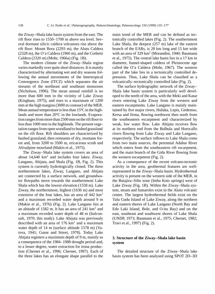
2. General setting, climate, hydrology, andvegetation
The Ziway–Shala lake basin system (7–8º300Nlat.; 38º070–39º300E long.) is part of the NNE-trend-ing MER that forms, together with the Afar Depres-sion, the northernmost segment of the East AfricanRift system. Northward this segment diverges tooceanic spreading regimes with the Red Sea and theGulf of Aden rift systems (Fig. 1A).
In the study area, the MER is bounded by steepborder fault escarpments 70–80 km apart, limiting theEthiopian Plateau to the west, and the SoutheasternPlateau to the east. The latter exceeds 2500 m in el-evation over wide areas. The large Pliocene trachyticshield volcanoes of Mount Chilalo (4006 m), MountBadda (4170 m), Mount Kubsa (3760 m) overlook

C. Le Turdu et al. / Palaeogeography, Palaeoclimatology, Palaeoecology 150 (1999) 135–177 137
138 C. Le Turdu et al. / Palaeogeography, Palaeoclimatology, Palaeoecology 150 (1999) 135–177
the Ziway–Shala lake basin system from the east. Therift floor rises to 1550–1700 m above sea level. Sev-eral dormant silicic caldera volcanoes rise above therift floor: Mount Bora (2293 m), the Alutu Caldera(2328 m), the O’a Caldera (1960 m), and the CorbettiCaldera (2320 m) (Mohr, 1966a) (Fig. 1B).
The modern climate of the Ziway–Shala regionvaries markedly over quite short distances. It is mainlycharacterized by alternating wet and dry seasons fol-lowing the annual movements of the IntertropicalConvergence Zone (ITCZ) which separates the airstreams of the northeast and southeast monsoons(Nicholson, 1996). The mean annual rainfall is nomore than 600 mm in the vicinity of Lake Ziway(Kingham, 1975), and rises to a maximum of 1200mm at the high margins (3000 m contour) of the MER.Mean annual temperature is less than 15ºC in the high-lands and more than 20ºC in the lowlands. Evapora-tion ranges from more than 2500 mm on the rift floor toless than 1000 mm in the highlands. The present vege-tation ranges from open woodland to bushed grasslandon the rift floor. Rift shoulders are characterized bybushed grassland, then remnants of dry, montane for-est and, from 3200 to 3500 m, ericaceous scrub andAfroalpine moorland (Makin et al., 1975).
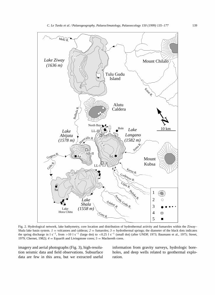
The Ziway–Shala lake system covers an area ofabout 14,640 km2 and includes four lakes: Ziway,Langano, Abijata, and Shala (Fig. 1B, Fig. 2). Thissystem is currently hydrologically closed. The threenorthernmost lakes, Ziway, Langano, and Abijataare connected by a surface network, and groundwa-ter flowpaths move towards the southernmost LakeShala which has the lowest elevation (1558 m). LakeZiway, the northernmost, highest (1636 m) and mostextensive of the four lakes, has an area of 442 km2
and a maximum recorded water depth around 9 m(Makin et al., 1976) (Fig. 2). Lake Langano lies atan altitude of 1582 m. It has an area of 241 km2 anda maximum recorded water depth of 48 m (Italcon-sult, 1970; this study). Lake Abijata was previouslydescribed with an area of 176 km2 and a maximumwater depth of 14 m (surface altitude 1578 m) (Va-tova, 1941; Gasse and Street, 1978). Today LakeAbijata registers a maximum depth of 9 m, mainly asa consequence of the 1984–1988 drought period and,to a lesser degree, water extraction for trona produc-tion (Chernet et al., 1996; Chernet, 1997). Each ofthe three lakes has an elongate shape parallel to the
main trend of the MER and can be defined as tec-tonically controlled lakes (Fig. 2). The southernmostLake Shala, the deepest (257 m) lake of the easternbranch of the EARs, is 28 km long and 15 km widewith an area of 329 km2 (Morandini, 1940; Baumannet al., 1975). The central lake basin lies in a 17 km indiameter, funnel-shaped caldera of Pleistocene agecalled the O’a Caldera (Mohr, 1967). The westernpart of the lake lies in a tectonically controlled de-pression. Thus, Lake Shala can be classified as avolcanically–tectonically controlled lake (Fig. 2).
The surface hydrographic network of the Ziway–Shala lake basin system is particularly well devel-oped to the north of the area, with the Meki and Katarrivers entering Lake Ziway from the western andeastern escarpments. Lake Langano is mainly main-tained by five major rivers, Huluka, Lepis, Gedemso,Kersa and Jirma, flowing northwest then north fromthe southeastern escarpment and characterized byweak, low water flow. Lake Abijata receives flowat its northern end from the Bulbula and Horocallorivers flowing from Lake Ziway and Lake Langano,respectively. The surface inflows to Lake Shala comefrom two main sources, the perennial Adabar Riverwhich enters from the southeastern rift escarpment,and the main branch of the Gidu River flowing fromthe western escarpment (Fig. 2).
As a consequence of the recent volcano-tectonicactivity in the area, geothermal features are well-represented in the Ziway–Shala basin. Hydrothermalactivity is present on the western side of the MER, inthe Butajira–Silte zone (Imba Koto springs) west ofLake Ziway (Fig. 1B). Within the Ziway–Shala sys-tem, steam and fumaroles exist in the Alutu volcaniccentre. The largest hydrothermal fields exist on theTulu Gudu Island of Lake Ziway, along the northernand eastern shores of Lake Langano (North Bay andEdo Laki Island, Bole, and O-itu Bay) and on theeast, southeast and southwest shores of Lake Shala(UNDP, 1973; Baumann et al., 1975; Chernet, 1982;Travi et al., 1997) (Fig. 2).
3. Structure of the Ziway–Shala lake basinsystem
The detailed structure of the Ziway–Shala lakebasin system has been analysed using SPOT 2D–3D
C. Le Turdu et al. / Palaeogeography, Palaeoclimatology, Palaeoecology 150 (1999) 135–177 139
Meki R.B
ulbu
la R
.
Katar R.
Alutu Caldera
Mount Chilalo
MountKubsa
Lake Hora Chitu
Jirm
a R.
Kersa R.
Lepis R.
Huluka R.
Guta R.
Gid
u R.
Meki R.
Gogesa R.
50
100150
250
200
3240
2416
8
LL-III
LL-I
North BayBole
5
7
9
11
911
1315
48
7
53
1
2
3
Lake Langano(1582 m)
LakeShala
(1558 m)
LakeAbijata
(1578 m)
Lake Ziway(1636 m)
Tulu GuduIsland
Lc
Sa
45
Awade Godu R.
A dabarR.
G edemso R.
AB-IIAa
Horoca
llo R.
N10 km
Fig. 2. Hydrological network, lake bathymetry, core location and distribution of hydrothermal activity and fumaroles within the Ziway–Shala lake basin system. 1 D volcanoes and calderas; 2 D fumaroles; 3 D hydrothermal springs; the diameter of the black dots indicatesthe spring discharge in l s�1, from >10 l s�1 (large dot) to <0.25 l s�1 (small dot) (after UNDP, 1973; Baumann et al., 1975; Street,1979; Chernet, 1982); 4 D Equarift and Livingstone cores; 5 D Mackereth cores.
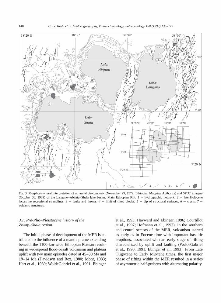
imagery and aerial photographs (Fig. 3), high-resolu-tion seismic data and field observations. Subsurfacedata are few in this area, but we extracted useful
information from gravity surveys, hydrologic bore-holes, and deep wells related to geothermal explo-ration.
140 C. Le Turdu et al. / Palaeogeography, Palaeoclimatology, Palaeoecology 150 (1999) 135–177
Fig. 3. Morphostructural interpretation of an aerial photomosaic (November 29, 1972; Ethiopian Mapping Authority) and SPOT imagery(October 30, 1989) of the Langano–Abijata–Shala lake basins, Main Ethiopian Rift. 1 D hydrographic network; 2 D late Holocenelacustrine recessional strandlines; 3 D faults and throws; 4 D limit of tilted blocks; 5 D dip of structural surfaces; 6 D crests; 7 Dvolcanic structures.
3.1. Pre-Plio–Pleistocene history of theZiway–Shala region
The initial phase of development of the MER is at-tributed to the influence of a mantle plume extendingbeneath the 1100-km-wide Ethiopian Plateau result-ing in widespread flood-basalt volcanism and plateauuplift with two main episodes dated at 45–30 Ma and18–14 Ma (Davidson and Rex, 1980; Mohr, 1983;Hart et al., 1989; WoldeGabriel et al., 1991; Ebinger
et al., 1993; Hayward and Ebinger, 1996; Courtillotet al., 1997; Hofmann et al., 1997). In the southernand central sectors of the MER, volcanism startedas early as in Eocene time with important basalticeruptions, associated with an early stage of riftingcharacterized by uplift and faulting (WoldeGabrielet al., 1990, 1991; Ebinger et al., 1993). From LateOligocene to Early Miocene times, the first majorphase of rifting within the MER resulted in a seriesof asymmetric half-grabens with alternating polarity.
C. Le Turdu et al. / Palaeogeography, Palaeoclimatology, Palaeoecology 150 (1999) 135–177 141
By mid-Late Miocene time, the eastern and westernfaulted margins of the MER had formed (Davidsonand Rex, 1980; WoldeGabriel et al., 1990). Then, inLate Miocene–Early Pliocene time, evolution fromalternating half-grabens to a full, symmetrical grabenoccurred.
The present symmetrical rift was fully definedby 3.5 Ma when a paroxysm of ignimbrite (¾2000km3) of the Munesa crystal tuff erupted from alarge, now buried caldera located on the rift floor(WoldeGabriel, 1987). Since this period, vertical dis-placement of up to 2 km has occurred in the centralsector of the MER (WoldeGabriel et al., 1990, 1992).Since ¾1.6 Ma, volcanic activity and structural de-formation of the MER has been confined to a NNE-trending structure formed by a line of hundreds ofyoung faults and volcanic centres along the rift floorclose to the eastern escarpment, and arranged in enechelon fashion (Meyer et al., 1975; Morton et al.,1979; WoldeGabriel et al., 1990). This volcano-tec-tonic axis, named the Wonji Fault Belt (WFB) byMohr (1960), is considered to be the current axis ofcrustal extension (Fig. 1B, Fig. 4).
38˚20' E
7˚40' NA
AlutuCaldera
Z
CorbettiCaldera
L
O'a Caldera
AWShala-Corbetti
segment
Gadamsa-East Ziwaysegment
50 km
Ziway-Shalasegment
S
Duguna-Abayasegment
ETHIOPIANPLATEAU
SOUTHEASTERNPLATEAU
7˚20' N
38˚40' E
Fig. 4. Structural sketch map of the Wonji Fault Belt showing thefour en echelon NNE-trending segments within the Ziway–Shalalake basin system. Three shield (caldera) volcanoes are presentat each WFB offset. From north to south these are the AlutuCaldera, the O’a Caldera, and the Corbetti Caldera (after Mohr,1960; Mohr et al., 1980). AW D Lake Awasa; S D Lake Shala; AD Lake Abijata; L D Lake Langano; Z D Lake Ziway.
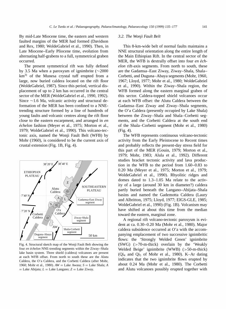
3.2. The Wonji Fault Belt
This 8-km-wide belt of normal faults maintains aNNE structural orientation along the entire length ofthe Main Ethiopian Rift. In the central sector of theMER, the WFB is dextrally offset into four en ech-elon rift-axis segments. From north to south, theseare the Gadamsa–East Ziway, Ziway–Shala, Shala–Corbetti, and Duguna–Abaya segments (Mohr, 1960,1967; Lloyd, 1977; Mohr et al., 1980; WoldeGabrielet al., 1990). Within the Ziway–Shala region, theWFB formed along the eastern marginal graben ofthis sector. Caldera-topped shield volcanoes occurat each WFB offset: the Alutu Caldera between theGadamsa–East Ziway and Ziway–Shala segments,the O’a Caldera (presently occupied by Lake Shala)between the Ziway–Shala and Shala–Corbetti seg-ments, and the Corbetti Caldera at the south endof the Shala–Corbetti segment (Mohr et al., 1980)(Fig. 4).
The WFB represents continuous volcano-tectonicactivity from the Early Pleistocene to Recent timesand probably reflects the present-day stress field forthis part of the MER (Gouin, 1979; Morton et al.,1979; Mohr, 1983; Alula et al., 1992). Differentstudies bracket tectonic activity and lava produc-tion in the WFB to the period from 1.60–0.83 to0.20 Ma (Meyer et al., 1975; Morton et al., 1979;WoldeGabriel et al., 1990). Rhyolitic ridges anddomes dated to 1.3–1.05 Ma relate to the activ-ity of a large (around 30 km in diameter?) calderapartly buried beneath the Langano–Abijata–Shalabasins and named the Gademotta Caldera (Lauryand Albritton, 1975; Lloyd, 1977; EIGS-GLE, 1985;WoldeGabriel et al., 1990) (Fig. 1B). Volcanism mayhave shifted at about this time from the mediantoward the eastern, marginal zone.
A regional rift volcano-tectonic paroxysm is evi-dent at ca. 0.30–0.20 Ma (Mohr et al., 1980). Majorcaldera subsidence occurred at O’a with the accom-panying emplacement of two successive ignimbriticflows: the ‘Strongly Welded Green’ ignimbrite(SWG) (>70-m-thick) overlain by the ‘WeaklyWelded Beige’ ignimbrite (WWB) (>50-m-thick)(Qi4 and Qi5 of Mohr et al., 1980). K–Ar datingindicates that the two ignimbrite flows erupted byabout 0.24 Ma (Mohr et al., 1980). The Corbettiand Alutu volcanoes possibly erupted together with
142 C. Le Turdu et al. / Palaeogeography, Palaeoclimatology, Palaeoecology 150 (1999) 135–177
O’a, also evolving to a caldera-forming shield vol-cano type (Di Paola, 1972; Lloyd, 1977; Mohr et al.,1980; WoldeGabriel et al., 1990).
Post-0.20-Ma fissural basaltic eruptions and su-perimposed scoria cones have been confined tothe WFB, mostly in the Gadamsa–East Ziway andShala–Corbetti segments (Lloyd, 1977), and in theZiway–Shala segment with the Tulu Billa basalticeruption at 0.18 Ma (Mohr et al., 1980) (Fig. 2). Sili-cic fissural volcanism is described at 0.15 Ma in theAlutu volcanic centre (Electroconsult, ELC, 1986;Gianelli and Teklemariam, 1993), and has continuedup into Holocene times from the Corbetti (Urji andChabbi volcanoes) and Alutu calderas (Dakin andGibson, 1971; Di Paola, 1972) (Fig. 1B) as shown bynumbers of ash layers within the Late Pleistocene–Holocene deposits north and east of Lake Abijata(Street, 1979), and in the lakes Langano and Abijatasediment cores. Intermittent late Holocene activity ofAlutu is demonstrated by obsidian flows and pumicebreccias dated at about 2 ka (Gianelli and Tekle-mariam, 1993) and ash layers west of the volcano,which were deposited shortly before 1.54 ka andshortly after 0.23 ka (Haynes and Haas, 1974).
3.3. The Lake Ziway Basin
Lake Ziway lies in a east-dipping downfaultedbasin bounded to the west by the 20-km-long, NNE-trending West Ziway Fault (WZF) of Holoceneage (Geze, 1974) or possibly older (Street, 1979)(Fig. 1B, Fig. 2). Swarms of parallel, vertical fissuresand linear collapse depressions have been reportedalong the WZF. Such features relate to the regionalfault patterns and may be attributed to subsoil (un-consolidated pumice or alluvium) piping and col-lapse into fractures developed in the underlying hardsubstratum during recent phases of tectonic activity(Albritton, 1974; Street, 1979). The southern limit ofthe Ziway Basin corresponds to the Alutu volcaniccomplex, marked by a number of hyaloclastite andscoria cones which form a lava threshold culminatingat the altitude of 1635 m.
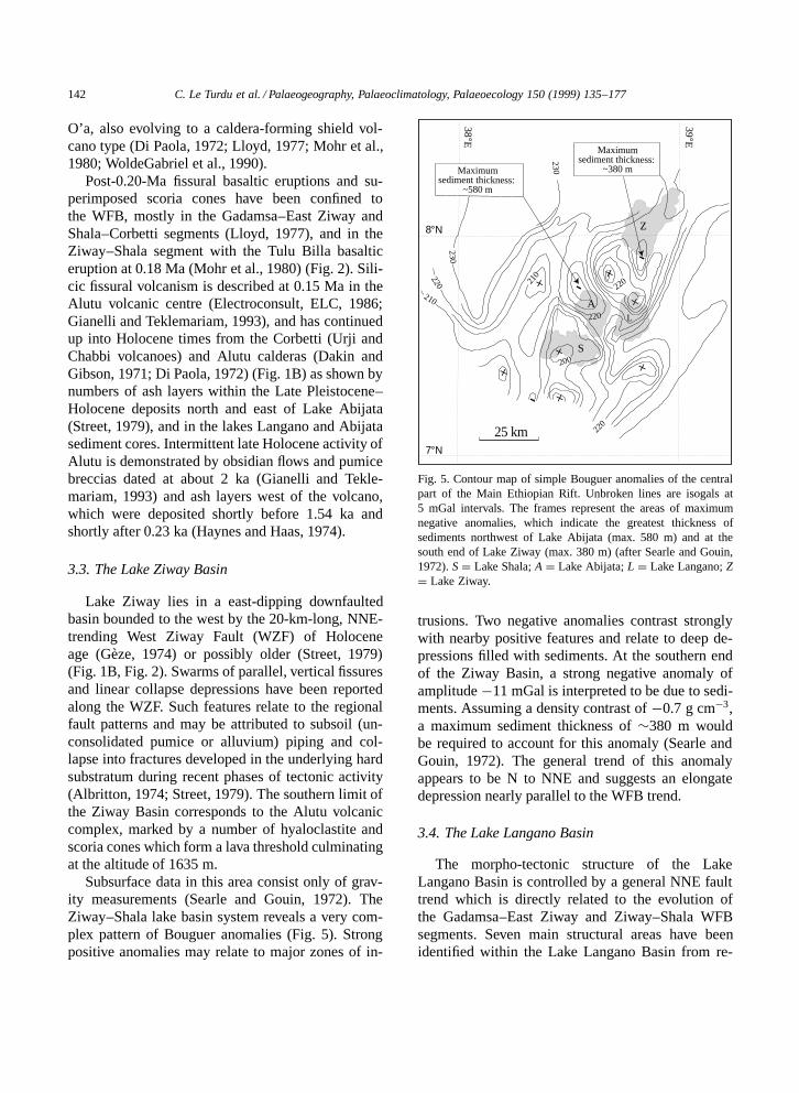
Subsurface data in this area consist only of grav-ity measurements (Searle and Gouin, 1972). TheZiway–Shala lake basin system reveals a very com-plex pattern of Bouguer anomalies (Fig. 5). Strongpositive anomalies may relate to major zones of in-
L.
230
220
+
+-
-
8°Ν
7°Ν
38°E
39°E
Z
+
++
-+
+
L
A
S
210
200
220
220
Maximumsediment thickness:
~580 m
230
220
210
25 km
Maximumsediment thickness:
~380 m
Fig. 5. Contour map of simple Bouguer anomalies of the centralpart of the Main Ethiopian Rift. Unbroken lines are isogals at5 mGal intervals. The frames represent the areas of maximumnegative anomalies, which indicate the greatest thickness ofsediments northwest of Lake Abijata (max. 580 m) and at thesouth end of Lake Ziway (max. 380 m) (after Searle and Gouin,1972). S D Lake Shala; A D Lake Abijata; L D Lake Langano; ZD Lake Ziway.
trusions. Two negative anomalies contrast stronglywith nearby positive features and relate to deep de-pressions filled with sediments. At the southern endof the Ziway Basin, a strong negative anomaly ofamplitude �11 mGal is interpreted to be due to sedi-ments. Assuming a density contrast of �0.7 g cm�3,a maximum sediment thickness of ¾380 m wouldbe required to account for this anomaly (Searle andGouin, 1972). The general trend of this anomalyappears to be N to NNE and suggests an elongatedepression nearly parallel to the WFB trend.
3.4. The Lake Langano Basin
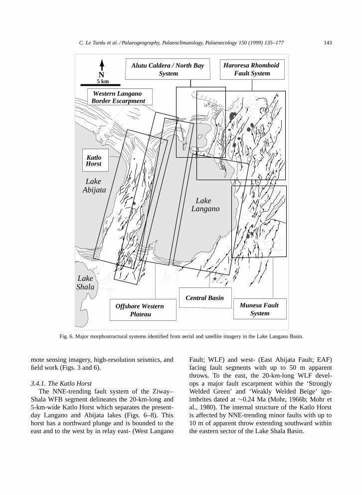
The morpho-tectonic structure of the LakeLangano Basin is controlled by a general NNE faulttrend which is directly related to the evolution ofthe Gadamsa–East Ziway and Ziway–Shala WFBsegments. Seven main structural areas have beenidentified within the Lake Langano Basin from re-
C. Le Turdu et al. / Palaeogeography, Palaeoclimatology, Palaeoecology 150 (1999) 135–177 143
Lake Langano
Lake Abijata
LakeShala
KatloHorst
Western Langano Border Escarpment
Haroresa Rhomboid Fault System
Central BasinOffshore Western
PlateauMunesa Fault
System
Alutu Caldera / North Bay System
5 kmN
Fig. 6. Major morphostructural systems identified from aerial and satellite imagery in the Lake Langano Basin.
mote sensing imagery, high-resolution seismics, andfield work (Figs. 3 and 6).
3.4.1. The Katlo HorstThe NNE-trending fault system of the Ziway–
Shala WFB segment delineates the 20-km-long and5-km-wide Katlo Horst which separates the present-day Langano and Abijata lakes (Figs. 6–8). Thishorst has a northward plunge and is bounded to theeast and to the west by in relay east- (West Langano
Fault; WLF) and west- (East Abijata Fault; EAF)facing fault segments with up to 50 m apparentthrows. To the east, the 20-km-long WLF devel-ops a major fault escarpment within the ‘StronglyWelded Green’ and ‘Weakly Welded Beige’ ign-imbrites dated at ¾0.24 Ma (Mohr, 1966b; Mohr etal., 1980). The internal structure of the Katlo Horstis affected by NNE-trending minor faults with up to10 m of apparent throw extending southward withinthe eastern sector of the Lake Shala Basin.
144 C. Le Turdu et al. / Palaeogeography, Palaeoclimatology, Palaeoecology 150 (1999) 135–177
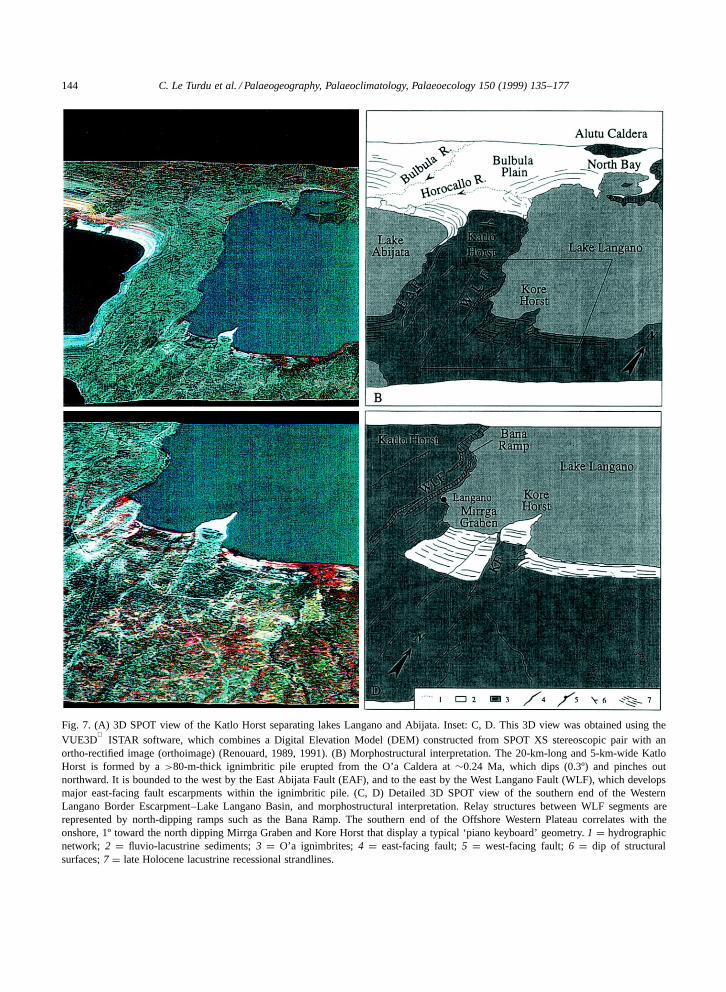
Fig. 7. (A) 3D SPOT view of the Katlo Horst separating lakes Langano and Abijata. Inset: C, D. This 3D view was obtained using theVUE3D
ISTAR software, which combines a Digital Elevation Model (DEM) constructed from SPOT XS stereoscopic pair with an
ortho-rectified image (orthoimage) (Renouard, 1989, 1991). (B) Morphostructural interpretation. The 20-km-long and 5-km-wide KatloHorst is formed by a >80-m-thick ignimbritic pile erupted from the O’a Caldera at ¾0.24 Ma, which dips (0.3º) and pinches outnorthward. It is bounded to the west by the East Abijata Fault (EAF), and to the east by the West Langano Fault (WLF), which developsmajor east-facing fault escarpments within the ignimbritic pile. (C, D) Detailed 3D SPOT view of the southern end of the WesternLangano Border Escarpment–Lake Langano Basin, and morphostructural interpretation. Relay structures between WLF segments arerepresented by north-dipping ramps such as the Bana Ramp. The southern end of the Offshore Western Plateau correlates with theonshore, 1º toward the north dipping Mirrga Graben and Kore Horst that display a typical ‘piano keyboard’ geometry. 1 D hydrographicnetwork; 2 D fluvio-lacustrine sediments; 3 D O’a ignimbrites; 4 D east-facing fault; 5 D west-facing fault; 6 D dip of structuralsurfaces; 7 D late Holocene lacustrine recessional strandlines.
C. Le Turdu et al. / Palaeogeography, Palaeoclimatology, Palaeoecology 150 (1999) 135–177 145
3.4.2. The Western Langano Border FaultEscarpment
It corresponds to the major NNE-trending WestLangano Fault (WLF) which is formed by severalin relay east-facing fault segments. Maximum ap-parent throw of >50 m occurs at the southwestend of Lake Langano and decreases rapidly to zerotoward the south, and more progressively towardthe north, ending 3 km south of the Horocallo outlet(Figs. 6–8). Relay structures between WLF segmentsare mainly represented by north-dipping ramps (e.g.,Bana Ramp; Fig. 7C,D, Fig. 8C). Small undatedtrachytic domes less than 50 m in diameter are reg-ularly scattered along the WLF escarpment. Theypossibly erupted along late tensional fissures accom-modating the West Langano Fault during the WFBdevelopment, and are of similar age as the silicic ex-trusions at Alutu volcanic centre, thought to be LatePleistocene (UNDP, 1973) or porphyritic comenditicobsidian domes lying upon the WFB and havingPleistocene–Holocene ages (Di Paola, 1977; Mohret al., 1980). The WLF escarpment has undergonestrong erosion that has locally created wide, deeplyincised valleys through the footwall of the fault.Some of these valleys are linked to a lower baselevel than the present-day.
3.4.3. The Offshore Western PlateauHigh-resolution reflection seismic data acquired
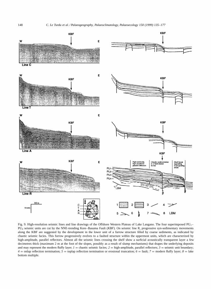
during the 1994 field season of the ERICA Projectwithin the lake basin indicate the existence eastof WLF of a second NNE-trending, 14-km-longfault named the Kore–Basuma Fault (KBF) (Jeudy,1995) (Figs. 8 and 9). This fault affects the wholesedimentary pile imaged on seismic lines (PU1 toPU4 seismic units), and locally shows indicationsof syn-sedimentary movements (Fig. 9, line R). Themaximum apparent throw of about 7 m is reached tothe north and south ends of the basin and reduces to3.5 m in the area of Bana, possibly relating to a rampgeometry coinciding at this latitude with the BanaRamp (Fig. 7C,D, Fig. 8C). To the north, the Kore–Basuma Fault is not clearly defined and may corre-spond to a relay from the main NNE-trending faultforming the eastern flank of the O-Itu Basuma Penin-sula (Jeudy, 1995) (Fig. 8C). To the south, the KBFseems to end in an en echelon fault system formedby minor NE–SW-trending, east-facing faults with a
few metres throw, delineating the eastern side of theKore Horst (Fig. 7C,D, Fig. 8C).
Together the West Langano and Kore–Basumafaults delineate a NNE-trending, 3-km-wide and20-km-long sublacustrine plateau named the Off-shore Western Plateau (maximum water depth 34 m)which dips at about 0.03% toward the basin cen-tre (Fig. 8B,C, Fig. 9). Seismic data indicate thatthis plateau is cut by several NNE-trending, east- orwest-facing fault segments which are only expressedby flexure-type deformation within seismic reflectors(Fig. 8C, Fig. 9). Spacing between seismic lines doesnot allow good correlation between fault segments,but interpretation of such a fault geometry can besupported by analogy with the grid-fault pattern de-scribed from the Axial Graben of the Central KenyaRift (Tiercelin et al., 1980; Grimaud et al., 1994; LeTurdu et al., 1995, 1999). This suggests these faultsto be a few tens of metres to a few kilometres longand characterized by a sinuous trace (Fig. 8C).
At the southern end of the plateau, east- andwest-facing faults seem to correlate with the on-shore 2-km-wide, 1º north-dipping Mirrga Graben,bounded to the west by the WLF and to the east bythe Kore Fault (KF). Immediately west, the 2-km-long, 1-km-wide and ¾20-m-high Kore Horst isdelineated to the west by the Kore Fault and to theeast by a NE–SW-trending en echelon fault system(Fig. 7C,D, Fig. 8C), creating a characteristic ‘pianokeyboard’ geometry. Open fissures at the south endof the Mirrga Graben, along the same trend as theWest Langano Fault, indicate recent tectonic activityin this area (Street, 1979).
3.4.4. The Central BasinThis 14-km-long and 9-km-wide semicircular de-
pression lies east of the Kore–Basuma Fault. Theaxis of greatest water depth (48 m) is shifted towardthe western part of the basin close to the KBF, sug-gesting a west-dipping half-graben geometry (Figs. 8and 9, line A). Fault distribution remains importantalong the KBF, with east- and west-facing fault seg-ments producing narrow (50- to 500-m-wide) horstsand grabens. Such faults present minor surface ex-pression but are clearly identified by the offset andflexure of the sedimentary series.
Fault density seems to decrease progressively to-ward the eastern shore of the Central Basin (Fig. 8C).

146 C. Le Turdu et al. / Palaeogeography, Palaeoclimatology, Palaeoecology 150 (1999) 135–177
C. Le Turdu et al. / Palaeogeography, Palaeoclimatology, Palaeoecology 150 (1999) 135–177 147
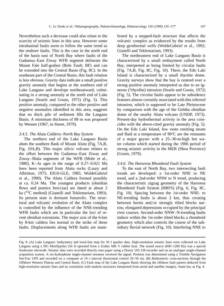
Nevertheless such a decrease could also relate to thescarcity of seismic lines in this area. However someintrabasinal faults seem to follow the same trend asthe onshore faults. This is the case in the north endof the basin east of North Bay where faults of theGadamsa–East Ziway WFB segment delineate theMount Fale half-graben (Bole Fault; BF) and canbe extended into the Central Basin (Fig. 8C). In thesoutheast part of the Central Basin, this fault relationis less obvious. Gravity data indicate a small positivegravity anomaly that begins at the southern end ofLake Langano and develops northeastward, culmi-nating in a strong anomaly at the north end of LakeLangano (Searle and Gouin, 1972) (Fig. 5). Thispositive anomaly, compared to the other positive andnegative anomalies identified in this area, suggeststhat no thick pile of sediment fills the LanganoBasin. A minimum thickness of 88 m was proposedby Wenner (1967, in Street, 1979).
3.4.5. The Alutu Caldera–North Bay SystemThe northern end of the Lake Langano Basin
abuts the southern flank of Mount Alutu (Fig. 7A,B,Fig. 10A,B). This major silicic volcano relates tothe offset between the Gadamsa–East Ziway andZiway–Shala segments of the WFB (Mohr et al.,1980). K–Ar ages in the range of 0.27–0.021 Mahave been reported from Alutu rocks (Laury andAlbritton, 1975; EIGS-GLE, 1985; WoldeGabrielet al., 1990). The Alutu Caldera formed possiblyat ca. 0.24 Ma. The youngest products (obsidianflows and pumice breccias) are dated at about 2ka (14C method) (Gianelli and Teklemariam, 1993).Its present state is dormant fumarolic. The struc-tural and volcanic evolution of the Alutu complexis controlled by the influence of the NNE-trendingWFB faults which are in particular the loci of re-cent obsidian extrusions. The major axis of the 6-kmby 8-km caldera lies normal to the strike of thesefaults. Displacements along WFB faults are mani-
Fig. 8. (A) Lake Langano: bathymetry and track-line map for 50 J sparker data. High-resolution seismic lines were collected on LakeLangano using a SIG MiniSparker (50 J) operated from a Zodiac MK V rubber boat. The sound source (600–1200 Hz) was a specialfreshwater electrode. Seismic data were recorded directly onto paper using a Dowty 195-138 recorder and on an analogue single-channelacquisition system. A six-hydrophone single-channel streamer received the signal. Position was determined using a Trimble NavigationNavTrac GPS and recorded on a computer at 10 s interval (horizontal control 20–50 m). (B) Bathymetric cross-sections through theOffshore Western Plateau and Central Basin. (C) Fault map of the Lake Langano Basin showing the offshore fault pattern deduced fromhigh-resolution seismic lines and its correlation with onshore structures interpreted from aerial and satellite imagery. Same key as Fig. 4.
fested by a stepped-fault structure that affects thevolcanic complex as evidenced by the results fromdeep geothermal wells (WoldeGabriel et al., 1992;Gianelli and Teklemariam, 1993).
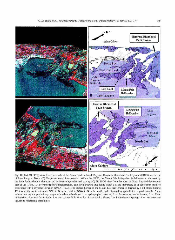
The northeastern end of Lake Langano Basin ischaracterized by a small embayment called NorthBay, interpreted as being limited by circular faults(Fig. 7A,B, Fig. 8C, Fig. 10). There, the Edo LakiIsland is characterized by a small rhyolite dome.Gravity surveys show that the bay is centred over astrong positive anomaly interpreted as due to an ig-neous (?rhyolite) intrusion (Searle and Gouin, 1972)(Fig. 5). The circular faults appear to be subsidencefeatures almost certainly associated with this inferredintrusion, which is supposed to be Late Pleistoceneby comparison with the age of the Gebiba obsidiandome of the nearby Alutu volcano (UNDP, 1973).Present-day hydrothermal activity in the area coin-cides with the above-cited gravity anomaly (Fig. 5).On the Edo Laki Island, few vents emitting steamand fluid at a temperature of 96ºC are the remnantsof a major geyser with a 25–30-m-high hot wa-ter column which started during the 1906 period ofstrong seismic activity in the MER (Shoa Province)(Gouin, 1979).
3.4.6. The Haroresa Rhomboid Fault SystemTo the east of North Bay, two intersecting fault
trends are developed: a 1st-order NNE to NEtrend, and a 2nd-order NNW to N trend, producingthe characteristic zigzag geometry of the HaroresaRhomboid Fault System (HRFS) (Fig. 6, Fig. 8C,Fig. 10). Spacing between the 1st-order NNE- toNE-trending faults is about 2 km, thus creatingbetween horsts and=or strongly tilted blocks nar-row, elongated depressions occupied by the principalriver courses. Second-order NNW–N-trending faultsinduce within the 1st-order tilted blocks a rhomboidgeometry which also controls the course of the sub-sidiary fluvial network (Fig. 10). Interfering NNE to
148 C. Le Turdu et al. / Palaeogeography, Palaeoclimatology, Palaeoecology 150 (1999) 135–177
Fig. 9. High-resolution seismic lines and line drawings of the Offshore Western Plateau of Lake Langano. The four superimposed PU1–PU4 seismic units are cut by the NNE-trending Kore–Basuma Fault (KBF). On seismic line R, progressive syn-sedimentary movementsalong the KBF are suggested by the development in the lower unit of a furrow structure filled by coarse sediments, as indicated bychaotic seismic facies. This furrow progressively evolves to a faulted structure within the uppermost units, which are characterized byhigh-amplitude, parallel reflectors. Almost all the seismic lines crossing the shelf show a surficial acoustically transparent layer a fewdecimetres thick (maximum 2 m at the foot of the slopes, possibly as a result of slump mechanisms) that drapes the underlying depositsand may represent the modern fluffy layer. 1 D chaotic seismic facies; 2 D high-amplitude, parallel reflectors; 3 D seismic unit boundary;4 D onlap reflection termination; 5 D toplap reflection termination or erosional truncation; 6 D fault; 7 D modern fluffy layer; 8 D lakebottom multiple.
C. Le Turdu et al. / Palaeogeography, Palaeoclimatology, Palaeoecology 150 (1999) 135–177 149
Fig. 10. (A) 3D SPOT view from the south of the Alutu Caldera–North Bay and Haroresa Rhomboid Fault System (HRFS), north endof Lake Langano Basin. (B) Morphostructural interpretation. Within the HRFS, the Mount Fale half-graben is delineated to the west bythe Bole Fault, which is characterized by intense hydrothermal activity. (C) 3D SPOT view from the north of North Bay and the westernpart of the HRFS. (D) Morphostructural interpretation. The circular faults that bound North Bay are interpreted to be subsidence featuresassociated with a rhyolitic intrusion (UNDP, 1973). The eastern border of the Mount Fale half-graben is formed by a tilt block dipping15º toward the west that trends NNE to N in the north to NNW to N in the south, and is formed by ignimbrites erupted from the Alutuvolcano during the preliminary stages of caldera subsidence. 1 D hydrographic network; 2 D fluvio-lacustrine sediments; 3 D Alutuignimbrites; 4 D east-facing fault; 5 D west-facing fault; 6 D dip of structural surfaces; 7 D hydrothermal springs; 8 D late Holocenelacustrine recessional strandlines.
150 C. Le Turdu et al. / Palaeogeography, Palaeoclimatology, Palaeoecology 150 (1999) 135–177
NE and NNW to N trends result in a complex S- orZ-shaped pattern particularly well-developed wherethe Gadamsa–East Ziway segment of the WFB abutsthe eastern margin of the MER (Boccaletti et al.,1992; Bonini et al., 1997; Korme et al., 1997). The1st-order NNE- to NE-trending east-facing faultswith 50–100 m apparent throws delineate severalmajor, west-tilted (5 to 15º) blocks forming a seriesof 0.5- to 3-km-wide half-grabens that are filled bysediments as in the Mount Fale half-graben, or occu-pied by small water bodies like the Haro Bu-a Lake(Fig. 8C, Fig. 10).
3.4.7. The Munesa Fault SystemSouth of 8º380N lat., an abrupt change of fault
style is related to the presence of a major ESE-trend-ing transverse fault named the Munesa TransverseFault (MTF) (Mohr, 1987) (Fig. 8C). Throws alongthe 1st-order NNE to NE faults decrease to zerowhen approaching the MTF. South of this fault, thefew young faults extend south as demonstrated bythe west-facing Korte Ridge Fault (KRF) and LenchaFault (LF) (Fig. 8C). Offshore, at the southeasternend of the Central Basin, a few NNE-trending faultshave been identified on seismic lines, mainly result-ing in disturbance of seismic reflectors. These faultsrepresent the northern extension of the west-facingKercheche and Kime faults (KEF and KIF) (Jeudy,1995) (Fig. 8C). The Munesa Fault System corre-sponds to the southern end of the Gadamsa–EastZiway segment of the WFB. Beyond this point, awestward offset of the WFB structure is observed,relaying the Gadamsa–East Ziway segment to theZiway–Shala segment (Fig. 5).
3.5. The Lake Abijata Basin
Lake Abijata currently lies within a very flat de-pression bounded to the east by a gently faultedmargin: the eastern flank of the NNE-trending KatloHorst, which separates Lake Abijata from LakeLangano (Figs. 3 and 7A,B). The southern and west-ern margins of the basin are essentially controlledby volcanic relief partly belonging to the Shala vol-canics. To the north, a flat alluvial plain opens towardthe Bulbula Plain and the Lake Ziway Basin. Threemain structural regions have been identified withinthis basin: the East Abijata Border Escarpment, the
Southwestern Danga Volcanic Boundary, and theAbijata Main Basin (Fig. 11).
3.5.1. The East Abijata Border EscarpmentIt corresponds to a 15-km-long, west-facing in
relay fault system named the East Abijata Fault(EAF) which forms the eastern boundary of theKatlo Horst, and progressively disappears toward thenorth, below the Bulbula alluvial plain (Fig. 11).With up to 20 m apparent throw, this fault is partof the Ziway–Shala WFB segment and affects the¾0.24 Ma old ‘Weakly Welded Beige’ ignimbrite(WWB) which blankets the rift floor in this area.Compared to the well-expressed West Langano Faultwhich forms the western boundary of the KatloHorst, the East Abijata Fault is characterized by asmoothed morphology that possibly relates to a shiftof tectonic activity from the central area of the MERtoward the eastern marginal zone.
3.5.2. The Southwestern Danga Volcanic BoundaryThis area consists of a large volcanic complex
that forms a 70-m-high isthmus between Abijata andShala lakes (Fig. 11). The oldest outcropping vol-canics within this area are pumice-flow beds datedat about 0.60 Ma and locally the WWB ignimbritedated at ¾0.24 Ma (Mohr et al., 1980). More recentvolcanics are represented by the fresh-looking TuluBilla basaltic cinder cone dated at 0.18 Ma (Mohret al., 1980). Scoriaceous basaltic flows of the TuluBilla have been partially buried beneath lacustrinesediments thought by Street (1979) to be Holocenein age. Subaqueous volcanics described as ‘lacus-trine guyots’ by Lloyd (1977) form the Lencha Gudoand Lencha Tiko cones on the southwest shore ofLake Abijata (Fig. 11).
3.5.3. The Abijata Main BasinThe very flat Abijata Main Basin depression is
bounded to the east by the smooth East AbijataBorder Escarpment, which disappears progressivelytoward the north, where the Abijata Main Basin joinsthe Bulbula alluvial plain (Fig. 3). Just north of LakeAbijata, gravity surveys indicate an abrupt changebetween a positive anomaly related to intrusion andrecent volcanism in the Alutu Caldera, and a strongnegative anomaly (Searle and Gouin, 1972) (Fig. 5).High gradients indicate a shallow origin for this
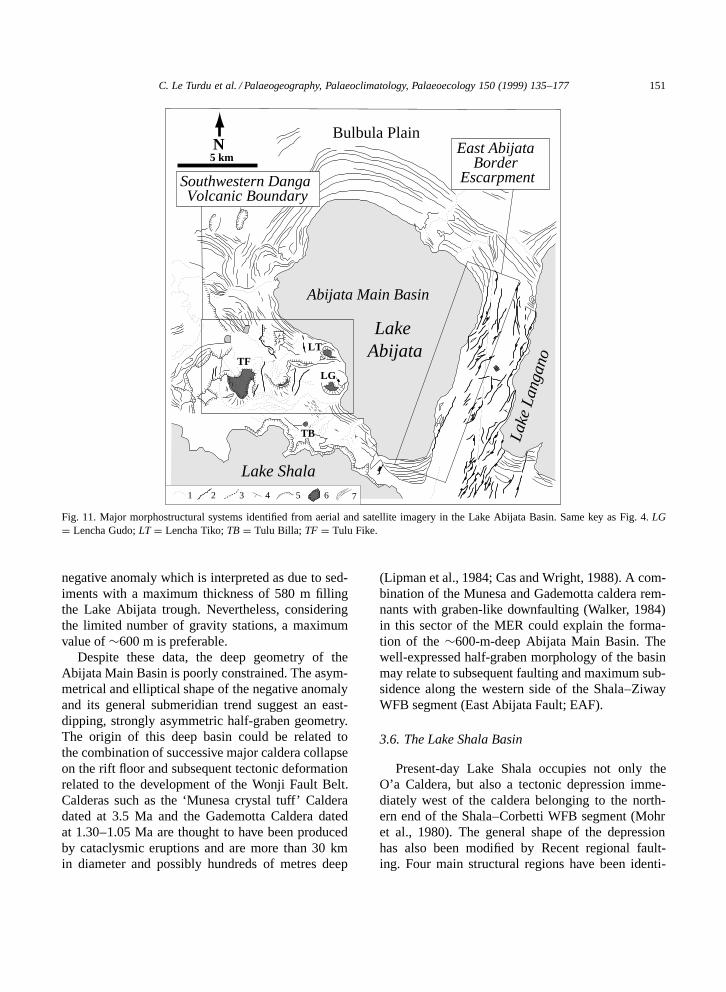
C. Le Turdu et al. / Palaeogeography, Palaeoclimatology, Palaeoecology 150 (1999) 135–177 151
Lake Abijata
Abijata Main Basin
Southwestern Danga Volcanic Boundary
East Abijata Border
Escarpment
Bulbula Plain
1 2 3 4 5 6 7
Lake Shala
Lake
Lan
gano
TB
TFLT
LG
5 kmN
Fig. 11. Major morphostructural systems identified from aerial and satellite imagery in the Lake Abijata Basin. Same key as Fig. 4. LGD Lencha Gudo; LT D Lencha Tiko; TB D Tulu Billa; TF D Tulu Fike.
negative anomaly which is interpreted as due to sed-iments with a maximum thickness of 580 m fillingthe Lake Abijata trough. Nevertheless, consideringthe limited number of gravity stations, a maximumvalue of ¾600 m is preferable.
Despite these data, the deep geometry of theAbijata Main Basin is poorly constrained. The asym-metrical and elliptical shape of the negative anomalyand its general submeridian trend suggest an east-dipping, strongly asymmetric half-graben geometry.The origin of this deep basin could be related tothe combination of successive major caldera collapseon the rift floor and subsequent tectonic deformationrelated to the development of the Wonji Fault Belt.Calderas such as the ‘Munesa crystal tuff’ Calderadated at 3.5 Ma and the Gademotta Caldera datedat 1.30–1.05 Ma are thought to have been producedby cataclysmic eruptions and are more than 30 kmin diameter and possibly hundreds of metres deep
(Lipman et al., 1984; Cas and Wright, 1988). A com-bination of the Munesa and Gademotta caldera rem-nants with graben-like downfaulting (Walker, 1984)in this sector of the MER could explain the forma-tion of the ¾600-m-deep Abijata Main Basin. Thewell-expressed half-graben morphology of the basinmay relate to subsequent faulting and maximum sub-sidence along the western side of the Shala–ZiwayWFB segment (East Abijata Fault; EAF).
3.6. The Lake Shala Basin
Present-day Lake Shala occupies not only theO’a Caldera, but also a tectonic depression imme-diately west of the caldera belonging to the north-ern end of the Shala–Corbetti WFB segment (Mohret al., 1980). The general shape of the depressionhas also been modified by Recent regional fault-ing. Four main structural regions have been identi-
152 C. Le Turdu et al. / Palaeogeography, Palaeoclimatology, Palaeoecology 150 (1999) 135–177
Lake
Shala
Southern ShalaFault System
Eastern ShalaFault System
Central Basin
Northwest Shala Volcanic Boundary
1 2 3 4 5 6 7 8
*
Lake Shala
Eastern Shala Fault System
Gale Horst
DokatuRebo
Scalloped rim ofthe O'a Calderawall
?
***
N
RR
F
A
B
1 3 42 5
5 km
N
RogeRafu Fault
C. Le Turdu et al. / Palaeogeography, Palaeoclimatology, Palaeoecology 150 (1999) 135–177 153
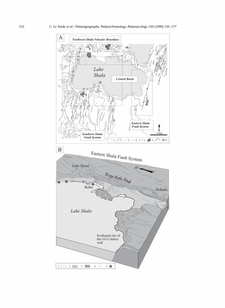
fied: the Eastern Shala Fault System; the NorthwestShala Volcanic Boundary; the Central Basin; and theSouthern Shala Fault System (Fig. 12A).
3.6.1. The Eastern Shala Fault SystemThis NNE-trending fault system belongs to the
southern end of the Ziway–Shala WFB segment(Figs. 4 and 12). It is connected to its north with theKatlo Horst through the Gale Horst. To the north-northeast, the Eastern Shala Fault System links withthe Mirrga Graben, extending the Offshore West-ern Plateau of Lake Langano southward (Fig. 7C,D,Fig. 8C). Within this fault system, the major 15-km-long, west-facing Roge Rafu Fault (RRF) with anapparent throw of 50 m corresponds to the tectoni-cally rejuvenated wall of the O’a Caldera (Fig. 12B).Open cracks a few metres wide, 20–30 m deep and20–2000 m long are visible in this area (Mohr et al.,1980). A major 3-km-long hydrothermal field occurson the eastern shoreline of Lake Shala near Rebo(Figs. 2 and 12).
3.6.2. The Northwest Shala Volcanic BoundaryThis area partly corresponds to the Southwestern
Danga Volcanic Boundary of Lake Abijata Basin.It is formed by rhyolitic air-fall pumice 5- to 40-mthick, related to the Tulu Fike cone, but also result-ing from subaquatic eruptions. Tulu Fike is the onlypost-caldera parasitic centre identified at Shala. ESE-trending faults between Tulu Fike and Tulu Billasuggest fault control on the late volcanic activity inthis area (Mohr et al., 1980) (Figs. 11 and 12A).
3.6.3. The Central BasinIt corresponds to the 17 km long-axis diameter
O’a Caldera (Mohr et al., 1980) whose sides plungesteeply to depths exceeding 250 m, particularly alongits southern shore (Baumann et al., 1975) (Fig. 12).This structure was produced by a volcano-tectoniccollapse of regional extent (estimated collapse vol-ume of 120 km3) at a date centred on ¾0.24 Ma
Fig. 12. (A) Major morphostructural systems identified from aerial and satellite imagery in the Lake Shala Basin. Same key as Fig. 4. (B)Morphostructural interpretation of the 3D SPOT view of the Eastern Shala Fault System. The major west-facing Roge Rafu Fault (RRF)corresponds to a rejuvenation of part of the O’a Caldera wall, and shows minor tectonic features such as the 2-km-long and 1-km-wideDokatu collapse block that may act as a NW-dipping ramp between two segments of the RRF. 1 D recent lacustrine sediments; 2 Dundating lacustrine sediments; 3 D ignimbrites and pumices; 4 D dip of structural surface; 5 D hydrothermal springs.
(Mohr et al., 1980). Sparse ESE-trending transversefaults with upthrows of 5–30 m affect the easternand western walls of the caldera. The deep structureof Lake Shala–O’a Caldera is unknown.
3.6.4. The Southern Shala Fault SystemThe southern shore of Lake Shala is marked by
precipitous cliffs more than 300 m high, correspond-ing to the caldera walls. This morphology is inter-sected to the west by the 12-km-wide, submeridianfault system of the Shala–Corbetti segment of theWFB, forming a NNE-trending elongated tectonicdepression with a relatively flat and shallow floorand a maximum water depth of 50 m (Baumann etal., 1975). Recent volcanic activity in this area ismarked by basaltic flows, spatter cones, hyaloclastiterings at Hora Chitu and Mechefera (Di Paola, 1972),and by several hydrothermal vents (Figs. 2 and 12A).
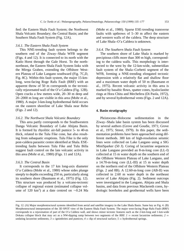
4. Basin stratigraphy
Pleistocene–Holocene sedimentation in theZiway–Shala lake basin system has been discussedby several authors (Grove and Goudie, 1971; Groveet al., 1975; Street, 1979). In this paper, the sedi-mentation problems have been approached using dif-ferent methods. 300 km of high-resolution seismiclines were collected on Lake Langano using a SIGMiniSparker (50 J). Coring of lacustrine sequencesin Lake Langano provided an 8-m-long core (LL-I)collected at 15 m water depth on the southern end ofthe Offshore Western Plateau of Lake Langano, anda 14.70-m-long core (LL-III) at 15 m water depthon the northern end of the Offshore Western Plateau(Figs. 2 and 8B). A 12.60-m-long core (AB-II) wascollected in 2.60 m water depth in the northeastsector of Lake Abijata (Fig. 2). Sediment outcropswere investigated in the Langano, Abijata and Shalabasins, and data from previous Mackereth cores, hy-drologic boreholes and geothermal wells have been
154C
.Le
Turduet
al./Palaeogeography,Palaeoclim
atology,Palaeoecology150
(1999)135–177
L. Langano
L. Shala
L. Abijata
MOUNT FALE
10
5
0 m
Tuffaceous siltstone
Massive clayswith calcrete and rhizocretionsConglomerate and sandstone with small scale Gilbert-type foresets
Massive clayswith floating grainsand interbedded conglomerate
Alutu ignimbrites
DAKA ILALA
Massive or laminated clays
Massive clays with floating pebbles of pumice
Conglomerate
S1S2
S3
S4
S5
S6
S7
15
10
5
0 m
Massive diatomiteDiatomitic marlConglomerate and massive silt
Massive diatomite with convolute bedding
Conglomerate and massive diatomite
Massive diatomiteConglomerate and massive silt with pumice debris
Massive or laminated silt with dispersed pumice pebblesand diatomite clasts
AJEWA
Silt, sand and diatomite
Paleosoil
AJEWA IV
Gritty loam with calcrete layers
Diatomaceous mudstone
Gritty silt and sand
'Paper Diatomite'
Air-fall pumice lapilli
AJEWA III
AJEWA IIB
AJEWA IIA
AJEWA I
Paleosoil
Diatomaceous mudstone
(from Street, 1979)
Cross-bedded sand
Fluvial gravels and silt
AJEWA V
AJEWA VISand and silt with cross-bedding
Gravelly sand
Sand and silt
Gritty silt with pumice pebbles
10
0 m
5
15
20
25
30
DEKA WEDE
5790 ± 115 (#)
8520 ± 200 (#)
12 200 ± 200 (#)
10 450 ± 180 (#) 11 870 ± 300 (#)
22 050 ± 650 (#)
24 000 ± 750 (#)
Abernosa Pumice Member
10
15
20
25
30
34
Silty sand
Marls
Silty sandPebbly sand
Clayed silt
Paleosoil
MarlFluvial sand
Pumice lapilli
Gravelly sandCalcareous siltClayey silt
Gravels
Pumice
5
0 m
27 050 ± 1540 (#)
Paleosoils
Paleosoil
(from Street, 1979)
Fractured diatomite
LENCHA GIDU
Ignimbrite
Laminated diatomite
Massive diatomite
Convoluted diatomite
Diatomiteinterbedded with pyroclastic layers
Massive diatomite
0 m
5
10
28 300 ± 400 (*)
Conglomerate
Conglomerate and pyroclastic layers
Conglomerate and sand
O-ITU WOSHE
0 m
5
10
15
O-itu Wosheobsidian flow
5700 ± 110 (*)
Conglomerateand gravelly sand
Conglomerate and gravelly sand with large oblique stratification
Conglomerate
Gravels and sands with Gilbert-type foresets
AJEWA
LENCHA GIDU
DEKA WEDE O-ITU WOSHE
MOUNT FALE
DAKA ILALA
A
?
(<0.1 Ma)
(>27-30 ka)
Fig. 13. The middle-Late Pleistocene fluvio-lacustrine series of the Ziway–Shala lake basin system. (A) Onshore sections. (B) Offshore and onshore cores. Radiocarbon dates inyr BP: (#) from Street (1979); (C) from Bonnefille et al. (1986); (M) from Mohammed and Bonnefille (1991) and Mohammed (1992). New AMS radiocarbon dates: (*) measured;(**) calibrated. 1 D shells and shell debris; 2 D Melanoides shells; 3 D fish debris; 4 D ostracods; 5 D sponge spicules; 6 D root marks; 7 D plant debris; 8 D bone fragments; 9D glass shards; 10 D obsidian artefacts.
C.L
eTurdu
etal./Palaeogeography,
Palaeoclimatology,Palaeoecology
150(1999)
135–177155
1600 ± 150 Mud
������ Clay and silt
Massive andlaminated silt
0
1
2
3
4
5
1540 ± 200
1720 ± 80
CORE Aa
0
5
10
15
20
25
7970 ± 150
9810 ± 170
9950 ± 170
10 370 ± 180
Lake beds
Coarse sand with rhyolite pebbles
Alternating diatomite and coarse pumice sand
Fine sand, silty diatomiteand pure diatomite
Medium to coarse pumice sand
Sand with root fragments and phytoliths (paleosol)
Diatomaceaous clay or silty clay with silt or sand
Pumice silt and sand
Lithofa
cies
Depth (m
)
������������������
�����������������������������������������
(#)
ABIJATA Borehole
(from Street,1979)
�������������
�������������������
����������
������
����������������
����@@@@����ÀÀÀÀ����@@@@����ÀÀÀÀ����@@@@����ÀÀÀÀ����@@@@����ÀÀÀÀ����@@@@����ÀÀÀÀ����@@@@����ÀÀÀÀ����@@@@����ÀÀÀÀ����@@@@����ÀÀÀÀ����@@@@����ÀÀÀÀ����@@@@����ÀÀÀÀ����@@@@����ÀÀÀÀ����@@@@����ÀÀÀÀ����@@@@����ÀÀÀÀ����@@@@����ÀÀÀÀ����@@@@����ÀÀÀÀ����@@@@����ÀÀÀÀ����@@@@����ÀÀÀÀ����@@@@����ÀÀÀÀ����@@@@����ÀÀÀÀ����@@@@����ÀÀÀÀ����@@@@����ÀÀÀÀ����@@@@����ÀÀÀÀ����@@@@����ÀÀÀÀ����@@@@����ÀÀÀÀ����@@@@����ÀÀÀÀ����@@@@����ÀÀÀÀ����@@@@����ÀÀÀÀ����@@@@����ÀÀÀÀ����@@@@����ÀÀÀÀ����@@@@����ÀÀÀÀ����@@@@����ÀÀÀÀ����@@@@����ÀÀÀÀ����yyyy����
����������
����������
�������������������������������@@@@@@@@��������ÀÀÀÀÀÀÀÀ��������@@@@@@@@��������ÀÀÀÀÀÀÀÀ��������@@@@@@@@��������ÀÀÀÀÀÀÀÀ��������@@@@@@@@��������ÀÀÀÀÀÀÀÀ��������@@@@@@@@��������ÀÀÀÀÀÀÀÀ��������@@@@@@@@��������ÀÀÀÀÀÀÀÀ��������@@@@@@@@��������ÀÀÀÀÀÀÀÀ��������@@@@@@@@��������ÀÀÀÀÀÀÀÀ��������@@@@@@@@��������ÀÀÀÀÀÀÀÀ��������@@@@@@@@��������ÀÀÀÀÀÀÀÀ��@@��ÀÀ��@@��ÀÀ��@@��ÀÀ��@@��ÀÀ��@@��ÀÀ��@@��ÀÀ��@@��ÀÀ��@@��ÀÀ��@@��ÀÀ��@@��ÀÀ��@@��ÀÀ��@@��ÀÀ��@@��ÀÀ��@@��ÀÀ��@@��ÀÀ��@@��ÀÀ��@@��ÀÀ��@@��ÀÀ��@@��ÀÀ��@@��ÀÀ��@@��ÀÀ��@@��ÀÀ��@@��ÀÀ��@@��ÀÀ��@@��ÀÀ��@@��ÀÀ��@@��ÀÀ��@@��ÀÀ��@@��ÀÀ��@@��ÀÀ��@@��ÀÀ��@@��ÀÀ��yy��������@@��ÀÀ��@@��ÀÀ��@@��ÀÀ��@@��ÀÀ��@@��ÀÀ��@@��ÀÀ��@@��ÀÀ��@@��ÀÀ��@@��ÀÀ��@@��ÀÀ��@@��ÀÀ��@@��ÀÀ��@@��ÀÀ��@@��ÀÀ��@@��ÀÀ��@@��ÀÀ��@@��ÀÀ��@@��ÀÀ��@@��ÀÀ��@@��ÀÀ��@@��ÀÀ��@@��ÀÀ��@@��ÀÀ��@@��ÀÀ��@@��ÀÀ��@@��ÀÀ��@@��ÀÀ��@@��ÀÀ��@@��ÀÀ��@@��ÀÀ��@@��ÀÀ��@@��ÀÀ��yy�������@@��ÀÀ��@@��ÀÀ��@@��ÀÀ��@@��ÀÀ��@@��ÀÀ��@@��ÀÀ��@@��ÀÀ��@@��ÀÀ��@@��ÀÀ��@@��ÀÀ��@@��ÀÀ��@@��ÀÀ��@@��ÀÀ��@@��ÀÀ��@@��ÀÀ��@@��ÀÀ��@@��ÀÀ��@@��ÀÀ��@@��ÀÀ��@@��ÀÀ��@@��ÀÀ��@@��ÀÀ��@@��ÀÀ��@@��ÀÀ��@@��ÀÀ��@@��ÀÀ��@@��ÀÀ��@@��ÀÀ��@@��ÀÀ��@@��ÀÀ��@@��ÀÀ��@@��ÀÀ��yy���������������@@��ÀÀ��@@��ÀÀ��@@��ÀÀ��@@��ÀÀ��@@��ÀÀ��@@��ÀÀ��@@��ÀÀ��@@��ÀÀ��@@��ÀÀ��@@��ÀÀ��@@��ÀÀ��@@��ÀÀ��@@��ÀÀ��@@��ÀÀ��@@��ÀÀ��@@��ÀÀ��@@��ÀÀ��@@��ÀÀ��@@��ÀÀ��@@��ÀÀ��@@��ÀÀ��@@��ÀÀ��@@��ÀÀ��@@��ÀÀ��@@��ÀÀ��@@��ÀÀ��@@��ÀÀ��@@��ÀÀ��@@��ÀÀ��@@��ÀÀ��@@��ÀÀ��@@��ÀÀ��yy�������@@��ÀÀ��@@��ÀÀ��@@��ÀÀ��@@��ÀÀ��@@��ÀÀ��@@��ÀÀ��@@��ÀÀ��@@��ÀÀ��@@��ÀÀ��@@��ÀÀ��@@��ÀÀ��@@��ÀÀ��@@��ÀÀ��@@��ÀÀ��@@��ÀÀ��@@��ÀÀ��@@��ÀÀ��@@��ÀÀ��@@��ÀÀ��@@��ÀÀ��@@��ÀÀ��@@��ÀÀ��@@��ÀÀ��@@��ÀÀ��@@��ÀÀ��@@��ÀÀ��@@��ÀÀ��@@��ÀÀ��@@��ÀÀ��@@��ÀÀ��@@��ÀÀ��@@��ÀÀ��yy
��������������������������������������
�����������������������
���
��@@��ÀÀ��@@��ÀÀ��@@��ÀÀ��@@��ÀÀ��@@��ÀÀ��@@��ÀÀ��@@��ÀÀ��@@��ÀÀ��@@��ÀÀ��@@��ÀÀ��@@��ÀÀ��@@��ÀÀ��@@��ÀÀ��@@��ÀÀ��@@��ÀÀ��@@��ÀÀ��@@��ÀÀ��@@��ÀÀ��@@��ÀÀ��@@��ÀÀ��@@��ÀÀ��@@��ÀÀ��@@��ÀÀ��@@��ÀÀ��@@��ÀÀ��@@��ÀÀ��@@��ÀÀ��@@��ÀÀ��@@��ÀÀ��@@��ÀÀ��@@��ÀÀ��@@��ÀÀ��yy������
������������������
�������������������������
Coarse sand
0
12
17 Paleosoil
25
38
51
64
77
90
103
116
129
142
155
162
Fine sand and silt
Clay
Clay and silt
Not sampled
Coarse sand
Fine sand and silt
����������
������
�������������
ClaySilt
0
1
2
3
4
5
2170 ± 220
2700 ± 230
CORE Sa
Laminated clay
������865 ± 60
10 050 ± 100
1790 ± 70
6200 ± 60
230
11 610
1380
6830
0
1
2
3
4
5
6
7
8
9
10
11
12
12.6
��������������������������������������������
Lithofa
cies
Depth (m
)
Homogeneous clayey marl
Homogeneous or laminated marl
Fine to coarse sand, and pyroclastite
Pyroclastite
Fine sand and pyroclastite
Homogeneous clayey marl
Homogeneous clayey marl
Homogeneous and laminated marl
Coarse sand
Coarse to fine sandand pyroclastic layers
CORE AB-II
(*) (**)
Paleosoil
Alternating clayand silt
(**)
4920 ± 70 5260
5980 ± 80 6560
7280 ± 80 7670
9 590 ± 10010 500
1
2
3
4
5
6
7
8
9
10
11
12
13
0
14
14,7
Coarse sand and gravels
Fine homogeneous mud
������
��������
���������
����
��������
Clay with gravels and gas bubbles
Fine homogeneous mud
Coarse to fine pyroclastite
Sand
and gravels
Fine pyroclastic layers
Interbedded mud, sand and pyroclastites
Clay with gravels and gas bubblesFine homogeneous mud
Fine to coarse sand
��
Lithofa
cies
Depth (m
)
(*)
CORE LL-III
��� Mud
��
Clay
Silt
0
1
2
3
4
5
1060 ± 200
1850 ± 220
CORE Lc
Laminated clay
6
2100 ± 220
2370 ± 220
L. Langano
L. Shala
L. Abijata
Sa
Aa
LL-III
AB-II
ABIJATABorehole
Lc
B
Paleosoil17
?
?
?∼ 69 ka 56
(from Mohammed,1992) (from Mohammed and Bonnefille,1991)
(from Mohammed,1992)
(+) (∆)(∆)
Lithofa
cies
Depth (m
)
?
1 2 3
4 5 6
7 8 9
10
Fig. 13 (continued).
156 C. Le Turdu et al. / Palaeogeography, Palaeoclimatology, Palaeoecology 150 (1999) 135–177
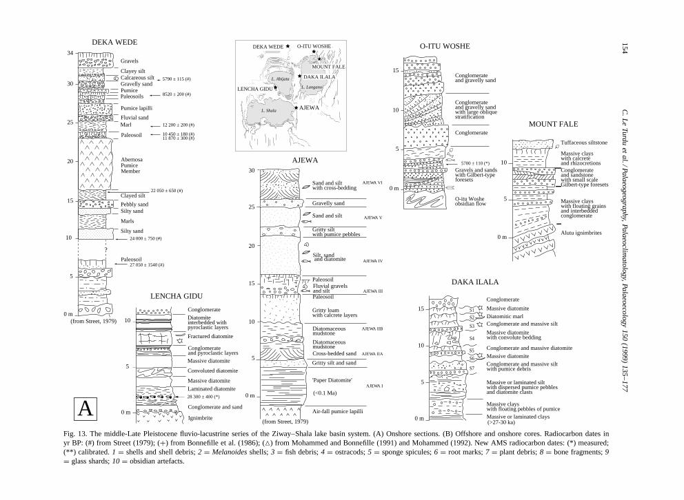
considered to locate depocentres and their relation-ships to the major volcano-tectonic elements. Severalnew AMS radiocarbon dates presented in this paperhelp to refine the pre-existing stratigraphic frame-work for the Late Pleistocene–Holocene period.
4.1. The Lake Langano Basin
New detailed stratigraphic studies have beenconducted on sediments of fluvial–lacustrine ori-gin along the western faulted margin (WLF) ofthe Langano Basin and at its northern end, in theHaroresa Rhomboid Fault System and on the south-ern flank of the Alutu volcano. The lake basin itselfhas been investigated using high-resolution seismicsand coring.
4.1.1. The Western Langano Border Escarpmentsediments
The environment of the Western Langano FaultEscarpment shows a relatively complex evolution.This escarpment underwent periods of vigorous ero-sion, leading to the formation of incised valleys andthe development of coarse detrital bodies on theWLF footwall block. Fine-grained lacustrine sed-iments and pyroclastic-rich volcaniclastics locallyoutcrop along the WLF hangingwall block and arecommonly interbedded within the coarse detritalbodies. They are locally faulted and show a 10 to15º tilt toward the west. Decimetric- to decametric-scale deformation features such as convolute beddingand folds, clastic dykes, slump breccias, turbiditesequences and various types of diapiric intrusionscan be observed within these formations. At about7º360N lat., close to the Daka Ilala area (Fig. 8C),a >18-m-thick sediment pile dipping 15º toward thewest and cut by NNE-trending faults is exposed in adeeply incised west–east-trending gully.
The lower one-third of this section comprises,from base to top (Fig. 13A), a >3-m-thick suc-cession of green, massive or laminated clays withfloating pumice granules and cobbles, overlain bya 3-m-thick unit of massive and laminated grey orbeige–green silts with randomly dispersed pumicepebbles and diatomite clasts. This unit can be in-terpreted as a fine-grained turbidite facies, possiblyrelated to a deep lake or active fault scarp environ-ment.
The upper two-thirds of the section are formed byseven normally graded or ungraded sequences witherosional bases (S7 to S1 from base to top). Nor-mally graded sequences consist at base of 0.50- to1-m-thick conglomeratic beds overlain by white orgrey massive silts or diatomites. Ungraded sequencesare mainly formed by >1.5-m-thick beds of mas-sive beige to light green diatomites or beige–greenmassive or laminated clayey silts. Each ungradedsequence is characterized at the top by columnarjointing that could result from desiccation. Sequence4 shows convolute bedding and reworked clasts ofwhite diatomite and is affected by N- to NNE-ori-ented open cracks.
The diatom flora of the upper two-thirds of theDaka Ilala section is dominated by one of the follow-ing freshwater planktonic species: Cyclostephanosdubius (S2), Aulacoseira granulata var. valida, A.agassizii (S1), or Stephanodiscus minutulus and S.minutus (S6). The large predominance of freshwa-ter planktonic forms indicates a lacustrine phasewith a high water level and low salinity (S4 toS2). Sequence 6 strongly differs from the othersequences in the abundance of Stephanodiscus (S.minutus, S. minutulus) that indicate lacustrine con-ditions comparable to the early and mid-Holocenehighstands identified in the area (Gasse and Street,1978; Street, 1979). Sequence 1 is characterizedby freshwater planktonic forms such as Fragilariatenera, Stephanodiscus minutulus and S. medius, inaddition to Aulacoseira granulata var. valida and A.agassizii. This association may indicate silica-richwaters, and a well-marked short-term stability of thewater body. A small number of freshwater littoralspecies, epiphytic (e.g., Amphora ovalis, A. pedi-culus, Epithemia adnata, Fragilaria pinnata, Cocco-neis diminuta, Fragilaria capucina var. vaucheriae),or benthic (e.g., Cymatopleura elliptica, Naviculagastrum), suggests that they have been transportedfrom the littoral zone, possibly by turbidity currents.Sequence 4 contains reworked clasts of diatomitecharacterized by Cyclostephanos dubius, possiblyoriginating from underlying sequences.
A major characteristic of the Daka Ilala sectionis the presence of Cyclostephanos dubius, some-times dominant. This species was only found in the43–26 m section of the Abijata borehole (Figs. 2and 13B), characterizing a lacustrine episode be-
C. Le Turdu et al. / Palaeogeography, Palaeoclimatology, Palaeoecology 150 (1999) 135–177 157
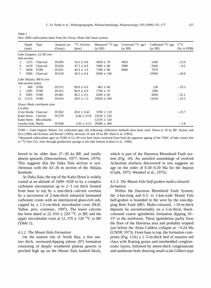
Table 1New AMS radiocarbon dates from the Ziway–Shala lake basin system
Depth Type Analysis no. 14C Activity Measured 14C age Corrected 14C age a Calibrated 14C age δ13C(mm) (Orsay) (pmc) (yr BP) (yr BP) (yr BP) (‰ vs PDB)
Lake Langano, LL-III coreSub-section:2 1215 Charcoal H1495 54.2 š 0.8 4920 š 70 4920 5260 �15.94 4129 Charcoal H1420 47.5 š 0.9 5980 š 80 5980 6560 �8.27 6456 TOM H1421 40.4 š 1.0 7280 š 80 6800 7670? 9580 Charcoal H1220 30.3 š 0.4 9590 š 100 10500 �20.9
Lake Abijata, AB-II coreSub-section (mm):1 460 TOM H1372 89.8 š 0.6 865 š 60 230 �19.33 2285 TOM H1415 80.0 š 0.9 1790 š 70 13809 8385 TOM H1481 46.2 š 0.3 6200 š 60 6830 �25.1
12 11155 TOM H1416 28.6 š 1.3 10050 š 100 11610 �23.2
Ziway–Shala catchment areaLocality:O-itu Woshe Charcoal H1362 49.0 š 0.42 5700 š 110 �25.7Katlo Horst Calcrete H1579 6.46 š 0.18 22010 š 220Katlo Horst Microbialite 12370 š 120Lencha Gidu Shells H1568 2.95 š 0.15 28300 š 400 �1.8
TOM D Total Organic Matter. For calibrated ages, the following calibration methods have been used. Down to 10 ka BP: Stuiver andKra (1986) and Kromer and Becker (1993); between 10 and 18 ka BP: Bard et al. (1993).a Measured radiocarbon ages on TOM of LL-III core have been corrected from both the apparent ageing of the TDIC of lake waters dueto 14C-free CO2 rises through geothermal springs at the lake bottom (Gibert et al., 1999).
lieved to be older than 27–30 ka BP, and totallyabsent upwards (Descourtieux, 1977; Street, 1979).This suggests that the Daka Ilala section is syn-chronous with the 43–26 m section of the Abijataborehole.
At Daka Ilala, the top of the Katlo Horst is widelycoated at an altitude of 1600–1620 m by a complexcarbonate encrustation up to 2–3 cm thick formedfrom base to top by a mm-thick calcrete overlainby a succession of 2-mm-thick subaerial laminatedcarbonate crusts with an interlayered glass-rich ash,capped by a 1.5-cm-thick microbialite crust (M.R.Talbot, pers. commun., 1997). The lower calcretehas been dated at 22; 010 š 220 14C yr BP, and theupper microbialite crust at 12; 370 š 120 14C yr BP(Table 1).
4.1.2. The Mount Ilala FormationOn the eastern rim of North Bay, a few me-
tres thick, westward-dipping (about 20º) formationconsisting of deeply weathered plateau gravels isperched high up on the Mount Ilala faulted block,
which is part of the Haroresa Rhomboid Fault sys-tem (Fig. 10). An unrolled assemblage of evolvedAcheulian artefacts discovered in situ suggests anage on the order of 0.30–0.20 Ma for the deposit(Clark, 1975; Wendorf et al., 1975).
4.1.3. The Mount Fale half-graben multi-colouredformation
Within the Haroresa Rhomboid Fault System,the 2-km-long and 0.5- to 1-km-wide Mount Falehalf-graben is bounded to the west by the east-dip-ping Bole Fault (BF). Multi-coloured, >10-m-thickdeposits lie unconformably on a 5-m-thick, black-coloured coarse ignimbritic formation dipping 10–15º to the northwest. These ignimbrites partly formthe floor of the Haroresa area and probably eruptedjust before the Alutu Caldera collapse at ¾0.24 Ma(UNDP, 1973). From base to top, the formation com-prises (Fig. 13A) a 1–5-m-thick bed of massive redclays with floating grains and interbedded conglom-eratic layers, followed by metre-thick conglomerateand sandstone beds showing small-scale Gilbert-type
158 C. Le Turdu et al. / Palaeogeography, Palaeoclimatology, Palaeoecology 150 (1999) 135–177
foresets, and grey, beige and red clays with numer-ous levels of rhizocretions and calcrete. A 1-m-thickhorizontal bed made of grey tuffaceous siltstone andsandstone with abundant silicified fossil wood capsthe formation. Fossil hydrothermal vents are locallymarked by siliceous sinter deposits.
These beds are locally affected by a progressivediscordance, thus indicating a syn-sedimentary basinfloor deformation (Fig. 13A). Foreset beds from dif-ferent parts of the outcrop show progradation in moreor less opposite directions, parallel to the NNE to NEgraben axis. As a result of the rotation of the gen-eral dip from west to southwest of the Mount Falehalf-graben floor, an offshore extent toward the westand southwest of the multi-coloured formation canbe inferred, thus forming part of the Lake LanganoBasin sediment infill (Fig. 8C, Fig. 10). No preciseage indication is presently available for the MountFale Formation. Nevertheless, contrasting facies withthe Upper Pleistocene–Holocene formations withinthe Ziway–Shala lake basin suggests an age betweenlate-middle Pleistocene (age of the underlying ign-imbrites) and early-Late Pleistocene.
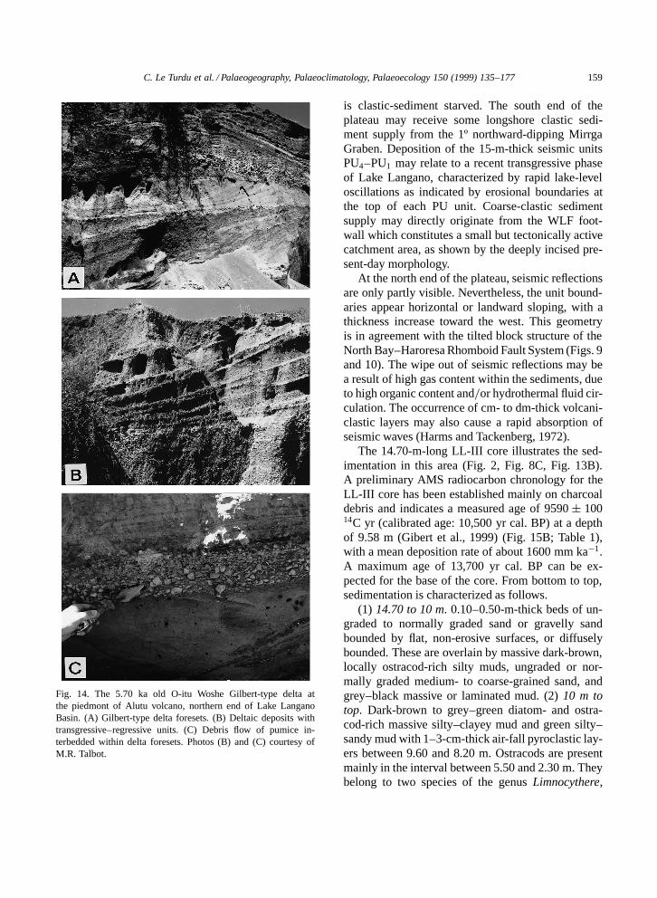
4.1.4. The O-itu Woshe deltaThe Alutu volcano is the source of much of
the volcaniclastics deposited in the Lake LanganoBasin. The present-day Lake Langano shorelinetransgresses across a wide low-angle fan formed byspreads of alluvium and slope-wash. At O-itu Woshe,on the southern flank of Alutu, a >15-m-thick se-quence of interbedded channel and interchannel de-posits overlies a >2-m-thick obsidian flow. The mainfacies association consists of alternating medium(<1 m) to thick (>1 m) massive, laminated orlarge-scale obliquely bedded siltstone beds and thick(>1 m) gravelstone or conglomerate beds, somewith cross-bedding, ripple cross-laminations and ero-sional boundaries (Fig. 13A). The lithics are mostlycomposed of granule- to cobble-sized pumice andobsidian. Fish debris, worn fragments of vertebratefossils and obsidian artefacts have been found in thesiltstone or gravelstone beds. These different unitsrepresent a Gilbert-type delta, with well-developedforesets, locally interbedded with pumice debrisflows, and units relative to transgressive–regressivelacustrine phases (Fig. 14). An AMS radiocarbonage of 5700 š 110 14C yr BP has been obtained
on charcoal debris collected within an unstratifiedsandy–gravelly bed near the base of the formation(Fig. 13A; Table 1). The whole formation lies overthe piedmont of the Alutu Caldera and shows a gen-eral 5º to 20º dip to the south toward the North Bayof Lake Langano, spreading over several kilometreson the littoral plain. The eastern boundary of theformation corresponds to the western faulted flank ofthe Mount Ilala tilted block.
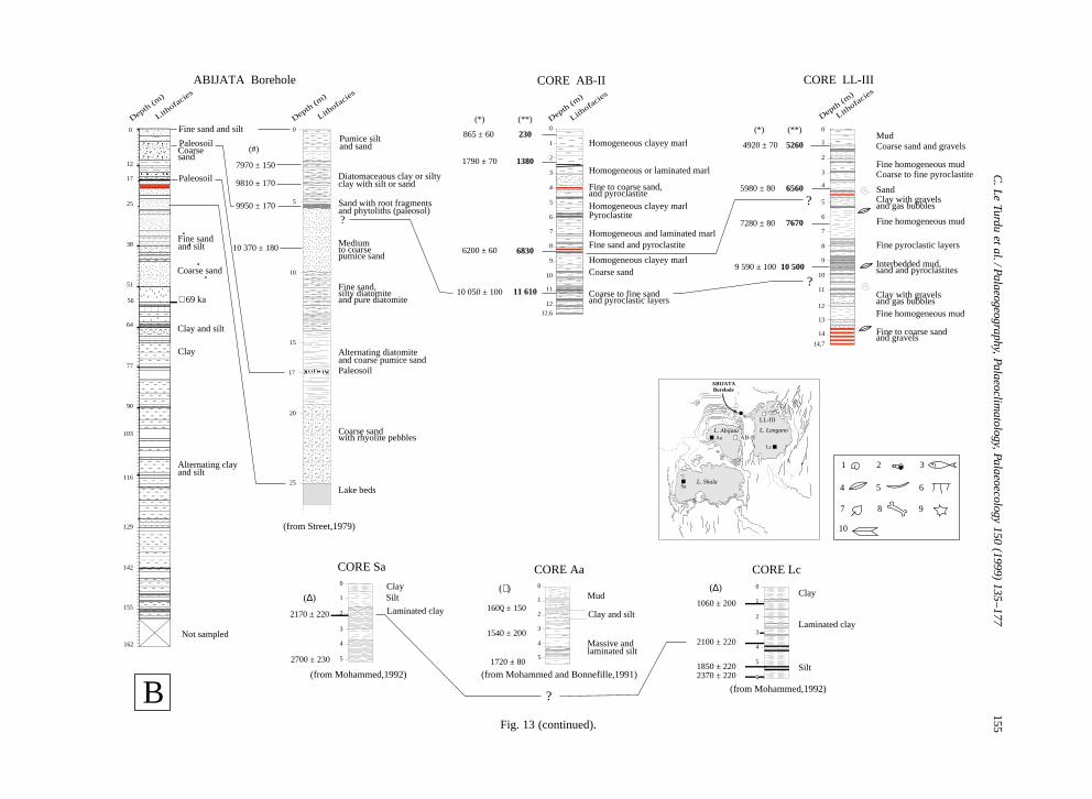
4.1.5. The Offshore Western PlateauThis narrow, NNE–SSW-oriented shelf extends
between the West Langano Fault (landward) and theKore Basuma Fault (basinward). This peculiar off-shore physiographic area displays a specific seismicstratigraphic pattern. The shelf deposits appear tobe organized into stacked subhorizontal units cutby numerous normal faults with 2–3 m maximumthrow, particularly well marked at the north end ofthe basin (Fig. 9). In the southern part of the plateau,four superimposed seismic units (PU4 to PU1 frombase to top) can be identified. In dip direction, theunit boundaries slope slightly basinward so that thethickness of the units remains nearly constant, 3m for each of the three uppermost units (PU1 toPU3), and 6 m for the lower unit (PU4) (calcu-lated using an average wave velocity of 1500 m s�1,generally agreed for recent sediments) (Andersonand Hampton, 1974). Unit boundaries are erosional,as shown by toplap reflection terminations (Fig. 9,line R). Internal facies display parallel reflectorsor subtle low-angle clinoforms dipping basinward.The progradation direction of the clinoforms indi-cates an eastward transport of the sediment (Fig. 9,line R). An 8-m-long core (LL-I) recovered in thesouthern part of the shelf on the trace of seismicline R (Fig. 8C, Fig. 9) sampled at its base thick,coarse-grained layers, in good agreement with theseismic facies identified on line R. Toward the north,the successive units stack vertically and show anaggradational geometry (Fig. 9, lines A and T).
The aggrading stacking pattern of the OffshoreWestern Plateau seismic units implies sufficient sed-iment input, combined with vertical tectonic move-ments and climatically induced lake-level variationswhich provided accommodation space. In the presentphysiographic setting, the central part of the plateau,bounded to the west by the West Langano Fault,
C. Le Turdu et al. / Palaeogeography, Palaeoclimatology, Palaeoecology 150 (1999) 135–177 159
Fig. 14. The 5.70 ka old O-itu Woshe Gilbert-type delta atthe piedmont of Alutu volcano, northern end of Lake LanganoBasin. (A) Gilbert-type delta foresets. (B) Deltaic deposits withtransgressive–regressive units. (C) Debris flow of pumice in-terbedded within delta foresets. Photos (B) and (C) courtesy ofM.R. Talbot.
is clastic-sediment starved. The south end of theplateau may receive some longshore clastic sedi-ment supply from the 1º northward-dipping MirrgaGraben. Deposition of the 15-m-thick seismic unitsPU4–PU1 may relate to a recent transgressive phaseof Lake Langano, characterized by rapid lake-leveloscillations as indicated by erosional boundaries atthe top of each PU unit. Coarse-clastic sedimentsupply may directly originate from the WLF foot-wall which constitutes a small but tectonically activecatchment area, as shown by the deeply incised pre-sent-day morphology.
At the north end of the plateau, seismic reflectionsare only partly visible. Nevertheless, the unit bound-aries appear horizontal or landward sloping, with athickness increase toward the west. This geometryis in agreement with the tilted block structure of theNorth Bay–Haroresa Rhomboid Fault System (Figs. 9and 10). The wipe out of seismic reflections may bea result of high gas content within the sediments, dueto high organic content and=or hydrothermal fluid cir-culation. The occurrence of cm- to dm-thick volcani-clastic layers may also cause a rapid absorption ofseismic waves (Harms and Tackenberg, 1972).
The 14.70-m-long LL-III core illustrates the sed-imentation in this area (Fig. 2, Fig. 8C, Fig. 13B).A preliminary AMS radiocarbon chronology for theLL-III core has been established mainly on charcoaldebris and indicates a measured age of 9590 š 10014C yr (calibrated age: 10,500 yr cal. BP) at a depthof 9.58 m (Gibert et al., 1999) (Fig. 15B; Table 1),with a mean deposition rate of about 1600 mm ka�1.A maximum age of 13,700 yr cal. BP can be ex-pected for the base of the core. From bottom to top,sedimentation is characterized as follows.
(1) 14.70 to 10 m. 0.10–0.50-m-thick beds of un-graded to normally graded sand or gravelly sandbounded by flat, non-erosive surfaces, or diffuselybounded. These are overlain by massive dark-brown,locally ostracod-rich silty muds, ungraded or nor-mally graded medium- to coarse-grained sand, andgrey–black massive or laminated mud. (2) 10 m totop. Dark-brown to grey–green diatom- and ostra-cod-rich massive silty–clayey mud and green silty–sandy mud with 1–3-cm-thick air-fall pyroclastic lay-ers between 9.60 and 8.20 m. Ostracods are presentmainly in the interval between 5.50 and 2.30 m. Theybelong to two species of the genus Limnocythere,
160 C. Le Turdu et al. / Palaeogeography, Palaeoclimatology, Palaeoecology 150 (1999) 135–177
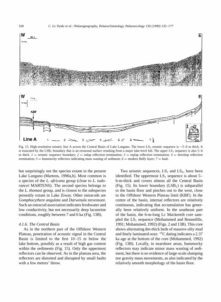
Fig. 15. High-resolution seismic line A across the Central Basin of Lake Langano. The lower LS2 seismic sequence is ¾5–6 m thick. Itis truncated by the LSB1 boundary that is an erosional surface resulting from a major lake-level fall. The upper LS1 sequence is also 5–6m thick. 1 D seismic sequence boundary; 2 D onlap reflection termination; 3 D toplap reflection termination; 4 D downlap reflectiontermination; 5 D hummocky reflectors indicating mass wasting of sediment; 6 D modern fluffy layer; 7 D fault.
but surprisingly not the species extant in the presentLake Langano (Martens, 1990a,b). Most common isa species of the L. africana group (close to L. tudo-rancei MARTENS). The second species belongs tothe L. thomasi group, and is closest to the subspeciespresently extant in Lake Ziway. Other ostracods areGomphocythere angulata and Darwinula stevensoni.Such an ostracod association indicates freshwater andlow conductivity, but not necessarily deep lacustrineconditions, roughly between 7 and 6 ka (Fig. 13B).
4.1.6. The Central BasinAs in the northern part of the Offshore Western
Plateau, penetration of acoustic signal in the CentralBasin is limited to the first 10–15 m below thelake bottom, possibly as a result of high gas contentwithin the sediments (Fig. 15). Only the uppermostreflectors can be observed. As in the plateau area, thereflectors are distorted and disrupted by small faultswith a few metres’ throw.
Two seismic sequences, LS1 and LS2, have beenidentified. The uppermost LS1 sequence is about 5–6-m-thick and covers almost all the Central Basin(Fig. 15). Its lower boundary (LSB1) is subparallelto the basin floor and pinches out to the west, closeto the Offshore Western Plateau limit (KBF). In thecentre of the basin, internal reflectors are relativelycontinuous, indicating that accumulation has gener-ally been relatively uniform. In the southeast partof the basin, the 6-m-long Lc Mackereth core sam-pled the LS1 sequence (Mohammed and Bonnefille,1991; Mohammed, 1992) (Figs. 2 and 13B). This coreshows alternating dm-thick beds of massive silty mudand finely laminated ooze. 14C dating indicates a 2.37ka age at the bottom of the core (Mohammed, 1992)(Fig. 13B). Locally, in nearshore areas, hummockyreflectors may indicate minor mass wasting of sedi-ment, but there is no evidence of large-scale slumpingnor gravity mass movements, as also indicated by therelatively smooth morphology of the basin floor.
C. Le Turdu et al. / Palaeogeography, Palaeoclimatology, Palaeoecology 150 (1999) 135–177 161
The underlying LS2 sequence is of lesser extent.It is lens-shaped and pinches out up to 3 km fromthe eastern shore and close to the Kore Basuma Fault(KBF). The axis of maximum thickness (½5–6 m) islocated in the western half of the basin. Reflectorsare concave upward and are truncated by the LSB1
boundary (Fig. 15). This erosional truncation of LS2
may result from a drastic lake-level fall, possiblyassociated with recent subsidence of the CentralBasin that also controls the present bathymetry.
4.2. The Lake Abijata Basin
North of Lake Abijata, a great thickness of lateQuaternary lacustrine and fluvial sediments is ex-posed by the Bulbula River and its tributaries. Thesesediments have been referred to as the Bulbula For-mation by Street (1979). Several boreholes havepenetrated these sediments, including a 162-m-deepborehole located on the northern edge of Lake Abi-jata (Street, 1979). To the west of the lake, on theAbijata–Shala isthmus, only a few deposits havebeen identified. Sedimentation in the Abijata MainBasin has been documented by two cores collectedin the southwest and northeast sectors.
4.2.1. The Southwestern Danga Volcanic BoundaryBasaltic flows issued from the Tulu Bila volcano
are partly buried beneath 10 m of lake sediments,including a thick freshwater diatomite (Street, 1979).South of the Lencha Gidu volcano, a>10-m-thick la-custrine sequence overlapping a >2-m-thick weath-ered ignimbritic flow is exposed in a gully flowingtoward Lake Abijata. A general dip of 10–15º towardthe west affects the whole sediment pile as well as itsvolcanic basement. From base to top, this formationcomprises (Figs. 11 and 13A):
(1) a 0.50-m-thick bed of conglomerate and grav-elly sand with clasts of the overlying ignimbrite,overlapped by a 0.50-m-thick dark-grey pyroclasticbed;
(2) a metre-thick diatomitic series with at baseabundant gastropod shells (Melanoides) that accu-mulated parallel to the stratification plane; X-raydiffraction analysis indicates that the Melanoidesshells are still pure aragonite — they provided anAMS age of 28; 300 š 400 yr BP (Gibert et al.,1999) (Fig. 13A; Table 1);
(3) a 3-m-thick bed of alternating laminated,massive and convoluted diatomites, overlain by a2.50-m-thick bed of dark-beige silt, yellow–greypyroclastic layers and unstratified gravelly sandstone;
(4) a 2-m-thick bed of beige, platy diatomite cutby numerous cm- to dm-thick clastic dykes orientedN10º to N45º; small, conjugate N75º and N155ºtrending normal faults cut this diatomitic bed, andsmall-scale antithetic faults delineate micrograbenfeatures;
(5) at the top, a 2-m-thick bed of massive, beigediatomite with interbedded dm-thick, dark-grey py-roclastic layers.
In this section, the diatom assemblages are domi-nated by the freshwater, facultative planktonic formsFragilaria brevistriata, F. construens and its varietyventer, and F. africana. Cyclotella ocellata also oc-curs in all samples with relatively high percentages.Planktonic species are the freshwater form Aula-coseira granulata and its var. valida which requireshigh silica content and tolerates turbid water, A. goet-zeana, Nitzschia lancettula and N. lacuum. The largemajority of encountered diatom species are littoralfreshwater forms, with Navicula seminuloides, Syne-dra ulna, Amphora ovalis, A. libyca, Cymbella spp.,Rhopalodia gibba, Epithemia adnata, Synedra ulna,Cocconeis diminuta, C. disculus. The flora clearlyreflects dilute conditions, although a few speciesare most commonly found in oligosaline water, e.g.,Nitzschia amphibia, Epithemia sorex. By compari-son with the Abijata borehole (Descourtieux, 1977;Street, 1979), absence of Stephanodiscus and Cy-clostephanos dubius together with the relative abun-dance of Cyclotella ocellata suggest for this sectionneither an Holocene age nor >30 ka BP. This shouldreflect the last Pleistocene highstand at ¾25 ka.
4.2.2. The Abijata Main BasinSeveral tens of metres of deposits belonging to the
¾600-m-thick sequence that fills the Abijata MainBasin are exposed in the Bulbula River Gorge andits tributaries (Fig. 2). Several sections up to 30 mthick at various sites along the Bulbula Gorge (DekaWede gully and Kurkura area) have been describedin detail (Street, 1979). Four principal lacustrinemembers have been defined. Each represents a majorlacustrine phase, numbered Bulbula I–IV from baseto top (Gasse and Street, 1978) (Figs. 11 and 13A).
162 C. Le Turdu et al. / Palaeogeography, Palaeoclimatology, Palaeoecology 150 (1999) 135–177
At the Deka Wede type site, the Deka Wede 1 and2 Members are separated from Members 3 and 4by the 13-m-thick Abernosa Pumice Member that isinterpreted as primary ejecta which has undergoneweathering and possible reworking by surface washor mud flow, and is dated at about 21 ka at its base(Street, 1979). Each Deka Wede Member is 2- to4-m thick, formed by massive or laminated marl,silt and fine sand containing diatoms, gastropodsand ostracods, and separated from each other by aslight, erosive disconformity. 14C dating on carbon-ates, charcoal and soil humus places the Bulbula I–IV phases between <27 ka and 5.8 ka BP (Street,1979) (Fig. 13A).
On the northern shore of the present-day Lake Abi-jata, slightly west of the Bulbula River, 162 m oflacustrine and fluvial sediments were penetrated bya borehole (Street, 1979) (Figs. 2 and 13B). Fine-grained sediments deposited in a lacustrine or low-energy fluvial environment predominate from thebase of the core (158 m) up to 56 m (Fig. 13B). From56 m up to the top of the core, coarse sediments (sandto gravel deposited in fluvial or shallow-water lacus-trine environment) dominate. However, fine-grainedlake beds have been described between 43 and 38m, and the upper 25 m of the borehole provided evi-dence for three Holocene lake-level maxima, namedAbijata II–IV, represented by diatomites and diatoma-ceous silts or clays. 14C dating places the beginningof the Abijata II phase at around 10,370š 180 yr BP,Abijata III between 9950 š 170 and 9810 š 170 yrBP, and Abijata IV lasting shortly after 7970š150 yrBP (Street, 1979; Lezine and Bonnefille, 1982). Twopalaeosols have been described, at about 16.80 m (R.Bonnefille, pers. observation) and at 5.58–5.35 m, re-spectively. The upper palaeosol is dated 9950 š 170yr BP (Street, 1979) (Fig. 13B).
Sedimentation in the southern part of the AbijataMain Basin is documented by two cores collectedin the southwest and northeast sectors. Core Aa wascollected in 1981 using a Mackereth corer at 10.80m water depth (Bonnefille et al., 1986) (Figs. 2and 13B). It is 5.46 m long and has been dated at1.7 ka close to its base. A high rate of sedimentation(3030 mm ka�1) characterizes the southwest sectorof the lake for the last 2 ka, with dominantly silts andclayey silts in the lower half of the core, overlain bylaminated to homogeneous muds. These sediments
are organic-rich (up to 9% TOC) with an abundantdiatom microflora and ostracods.
Core AB-II is 12.60 m long and was collected inDecember 1995 at 2.60 m water depth in the north-east sector close to the northern end of the East Abi-jata Fault escarpment (Figs. 2 and 13B). Four AMSradiocarbon ages have been obtained on bulk organicmatter and indicate a measured age of 10,050 š 10014C yr (calibrated age 11,610 yr) close to the baseof the core (Gibert et al., 1999) (Fig. 13B; Table 1).During this period, sedimentation in this area wascharacterized by the accumulation of homogeneousor laminated muds with some mm-thick pyroclasticlayers and cm-thick beds of fine to coarse sands at thebase of the core. Mean accumulation rate is slowerthan in the southwest sector, about 1090 mm ka�1.
In the absence of dated core material from LakeAbijata that is more than 30 ka old, an age estimatefor the Abijata Main Basin development can only bedetermined through the combination of short-termsediment accumulation rates derived from radiocar-bon-dated cores with a depth-to-basement estimatedfrom published geophysical data (see RSRM methodof Cohen et al., 1993 and Lezzar et al., 1996). Themost representative sediment facies data to be used forthis age estimation come from the 162-m-deep Abi-jata borehole. From the analysis of sedimentary se-quence frequency of this core, a general 3 : 2 propor-tion between fine-grained ‘lacustrine or low-energyfluviatile’ facies, and coarse-grained, mainly ‘fluvi-atile-volcaniclastic’ facies can be inferred (Fig. 13B).Short-term sediment accumulation rates are derivedfrom radiocarbon dates obtained on the upper 25 m ofunconsolidated Holocene sediments from the Abijataborehole (Street, 1979) and from the 12.60-m-longAB-II core (Fig. 13B). Calculated sediment accumu-lation rates and their relations with core lithologyare presented in Table 2. The general 3 : 2 propor-tion between fine-grained ‘lacustrine’ shale facies andcoarse-grained ‘fluviatile-volcaniclastic’ silt facies isinferred to be constant at the borehole site which liesin a ‘proximal’ position in relation to the East AbijataFault, that is supposed to have always been the mainborder fault of the Abijata Main Basin.
Using calculated mean sediment accumulationrates (Table 2), an estimated minimum age of ¾0.33Ma can be inferred for the base of a ¾600 m max-imum thickness sedimentary pile accumulated in a
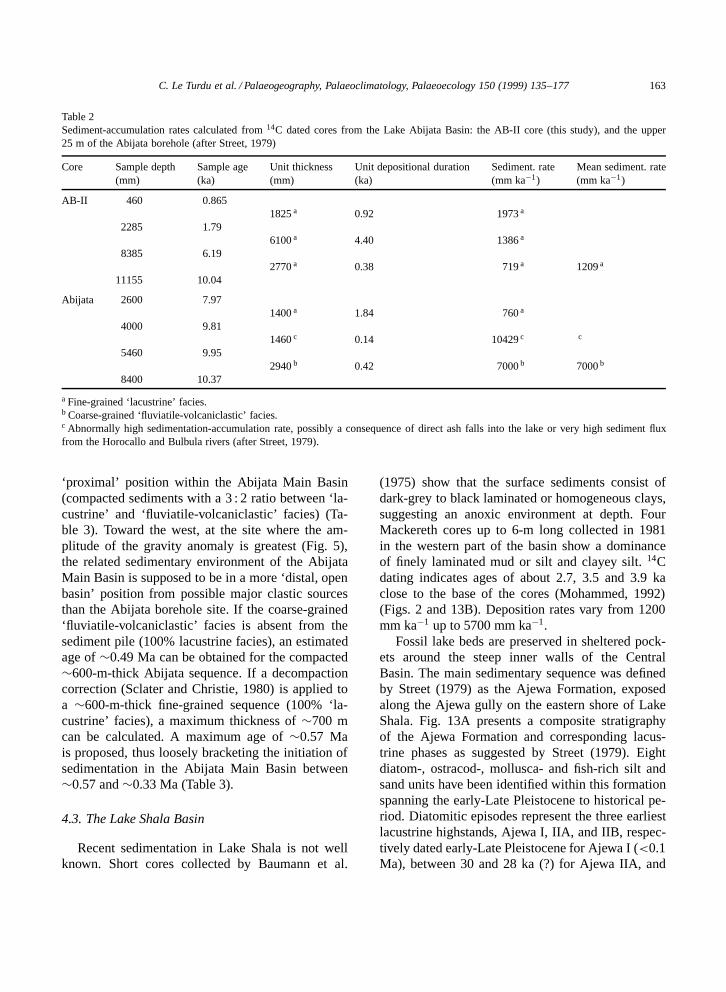
C. Le Turdu et al. / Palaeogeography, Palaeoclimatology, Palaeoecology 150 (1999) 135–177 163
Table 2Sediment-accumulation rates calculated from 14C dated cores from the Lake Abijata Basin: the AB-II core (this study), and the upper25 m of the Abijata borehole (after Street, 1979)
Core Sample depth Sample age Unit thickness Unit depositional duration Sediment. rate Mean sediment. rate(mm) (ka) (mm) (ka) (mm ka�1) (mm ka�1)
AB-II 460 0.8651825 a 0.92 1973 a
2285 1.796100 a 4.40 1386 a
8385 6.192770 a 0.38 719 a 1209 a
11155 10.04
Abijata 2600 7.971400 a 1.84 760 a
4000 9.811460 c 0.14 10429 c c
5460 9.952940 b 0.42 7000 b 7000 b
8400 10.37
a Fine-grained ‘lacustrine’ facies.b Coarse-grained ‘fluviatile-volcaniclastic’ facies.c Abnormally high sedimentation-accumulation rate, possibly a consequence of direct ash falls into the lake or very high sediment fluxfrom the Horocallo and Bulbula rivers (after Street, 1979).
‘proximal’ position within the Abijata Main Basin(compacted sediments with a 3 : 2 ratio between ‘la-custrine’ and ‘fluviatile-volcaniclastic’ facies) (Ta-ble 3). Toward the west, at the site where the am-plitude of the gravity anomaly is greatest (Fig. 5),the related sedimentary environment of the AbijataMain Basin is supposed to be in a more ‘distal, openbasin’ position from possible major clastic sourcesthan the Abijata borehole site. If the coarse-grained‘fluviatile-volcaniclastic’ facies is absent from thesediment pile (100% lacustrine facies), an estimatedage of ¾0.49 Ma can be obtained for the compacted¾600-m-thick Abijata sequence. If a decompactioncorrection (Sclater and Christie, 1980) is applied toa ¾600-m-thick fine-grained sequence (100% ‘la-custrine’ facies), a maximum thickness of ¾700 mcan be calculated. A maximum age of ¾0.57 Mais proposed, thus loosely bracketing the initiation ofsedimentation in the Abijata Main Basin between¾0.57 and ¾0.33 Ma (Table 3).
4.3. The Lake Shala Basin
Recent sedimentation in Lake Shala is not wellknown. Short cores collected by Baumann et al.
(1975) show that the surface sediments consist ofdark-grey to black laminated or homogeneous clays,suggesting an anoxic environment at depth. FourMackereth cores up to 6-m long collected in 1981in the western part of the basin show a dominanceof finely laminated mud or silt and clayey silt. 14Cdating indicates ages of about 2.7, 3.5 and 3.9 kaclose to the base of the cores (Mohammed, 1992)(Figs. 2 and 13B). Deposition rates vary from 1200mm ka�1 up to 5700 mm ka�1.
Fossil lake beds are preserved in sheltered pock-ets around the steep inner walls of the CentralBasin. The main sedimentary sequence was definedby Street (1979) as the Ajewa Formation, exposedalong the Ajewa gully on the eastern shore of LakeShala. Fig. 13A presents a composite stratigraphyof the Ajewa Formation and corresponding lacus-trine phases as suggested by Street (1979). Eightdiatom-, ostracod-, mollusca- and fish-rich silt andsand units have been identified within this formationspanning the early-Late Pleistocene to historical pe-riod. Diatomitic episodes represent the three earliestlacustrine highstands, Ajewa I, IIA, and IIB, respec-tively dated early-Late Pleistocene for Ajewa I (<0.1Ma), between 30 and 28 ka (?) for Ajewa IIA, and
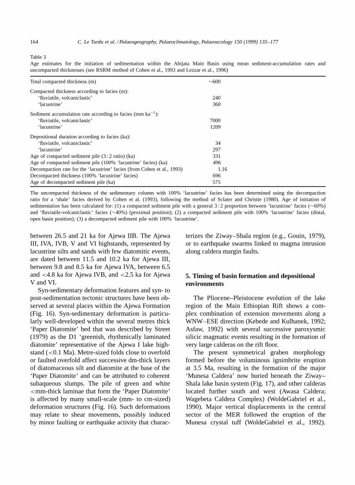
164 C. Le Turdu et al. / Palaeogeography, Palaeoclimatology, Palaeoecology 150 (1999) 135–177
Table 3Age estimates for the initiation of sedimentation within the Abijata Main Basin using mean sediment-accumulation rates anduncompacted thicknesses (see RSRM method of Cohen et al., 1993 and Lezzar et al., 1996)
Total compacted thickness (m) ¾600
Compacted thickness according to facies (m):‘fluviatile, volcaniclastic’ 240‘lacustrine’ 360
Sediment accumulation rate according to facies (mm ka�1):‘fluviatile, volcaniclastic’ 7000‘lacustrine’ 1209
Depositional duration according to facies (ka):‘fluviatile, volcaniclastic’ 34‘lacustrine’ 297
Age of compacted sediment pile (3 : 2 ratio) (ka) 331Age of compacted sediment pile (100% ‘lacustrine’ facies) (ka) 496Decompaction rate for the ‘lacustrine’ facies (from Cohen et al., 1993) 1.16Decompacted thickness (100% ‘lacustrine’ facies) 696Age of decompacted sediment pile (ka) 575
The uncompacted thickness of the sedimentary column with 100% ‘lacustrine’ facies has been determined using the decompactionratio for a ‘shale’ facies derived by Cohen et al. (1993), following the method of Sclater and Christie (1980). Age of initiation ofsedimentation has been calculated for: (1) a compacted sediment pile with a general 3 : 2 proportion between ‘lacustrine’ facies (¾60%)and ‘fluviatile-volcaniclastic’ facies (¾40%) (proximal position); (2) a compacted sediment pile with 100% ‘lacustrine’ facies (distal,open basin position); (3) a decompacted sediment pile with 100% ‘lacustrine’.
between 26.5 and 21 ka for Ajewa IIB. The AjewaIII, IVA, IVB, V and VI highstands, represented bylacustrine silts and sands with few diatomitic events,are dated between 11.5 and 10.2 ka for Ajewa III,between 9.8 and 8.5 ka for Ajewa IVA, between 6.5and <4.8 ka for Ajewa IVB, and <2.5 ka for AjewaV and VI.
Syn-sedimentary deformation features and syn- topost-sedimentation tectonic structures have been ob-served at several places within the Ajewa Formation(Fig. 16). Syn-sedimentary deformation is particu-larly well-developed within the several metres thick‘Paper Diatomite’ bed that was described by Street(1979) as the D1 ‘greenish, rhythmically laminateddiatomite’ representative of the Ajewa I lake high-stand (<0.1 Ma). Metre-sized folds close to overfoldor faulted overfold affect successive dm-thick layersof diatomaceous silt and diatomite at the base of the‘Paper Diatomite’ and can be attributed to coherentsubaqueous slumps. The pile of green and white<mm-thick laminae that form the ‘Paper Diatomite’is affected by many small-scale (mm- to cm-sized)deformation structures (Fig. 16). Such deformationsmay relate to shear movements, possibly inducedby minor faulting or earthquake activity that charac-
terizes the Ziway–Shala region (e.g., Gouin, 1979),or to earthquake swarms linked to magma intrusionalong caldera margin faults.
5. Timing of basin formation and depositionalenvironments
The Pliocene–Pleistocene evolution of the lakeregion of the Main Ethiopian Rift shows a com-plex combination of extension movements along aWNW–ESE direction (Kebede and Kulhanek, 1992;Asfaw, 1992) with several successive paroxysmicsilicic magmatic events resulting in the formation ofvery large calderas on the rift floor.
The present symmetrical graben morphologyformed before the voluminous ignimbrite eruptionat 3.5 Ma, resulting in the formation of the major‘Munesa Caldera’ now buried beneath the Ziway–Shala lake basin system (Fig. 17), and other calderaslocated further south and west (Awasa Caldera;Wagebeta Caldera Complex) (WoldeGabriel et al.,1990). Major vertical displacements in the centralsector of the MER followed the eruption of theMunesa crystal tuff (WoldeGabriel et al., 1992).
C. Le Turdu et al. / Palaeogeography, Palaeoclimatology, Palaeoecology 150 (1999) 135–177 165
Fig. 16. Deformation features identified at the base of the Ajewa Formation, Lake Shala Basin. (A) Millimetre-thick laminae in the‘Paper Diatomite’ (dated <0.1 Ma) are affected by structures that result from the stretching of mm- to >1 mm-thick and more brittlelaminae, with development of jointing perpendicular to the bedding, and in some cases with complete separation and rotation of thesegments. This type of deformation is related to boudinage (Wilson, 1961) and may result from shear movements that are induced byregional earthquake activity (up to 6 in magnitude; see Gouin, 1979) or to earthquake swarms located on the caldera-wall boundaryfaults. To the right, knife blade is 1 cm wide. (B) Centimetre- to decimetre-thick diatomaceous beds at the base of the ‘Paper Diatomite’show metre-sized folds that may result from slumping, some possibly tectonically induced. (C) At the base of the section, a successionof decimetre- to metre-thick beds of grey clay, silt and conglomerate dip 40º westward and is affected by numerous small normal faults.This tilted formation is onlapped by a several metres thick, horizontal diatomaceous unit that represents a lateral facies of the ‘PaperDiatomite’. This indicates a strong phase of tectonic deformation characterized by tilting of strata combined with minor faulting duringthe middle Pleistocene or early-Late Pleistocene.
During the middle Pliocene to Early Pleistocene pe-riod (3.5–1.6 Ma), crustal extension gave rise on theSoutheastern Plateau to the trachytic shield volca-noes Chilalo and Badda (Mohr and Potter, 1976) andother centres of the eastern and western shoulders ofthe MER (Fig. 1B).
5.1. Initiation of the Wonji Fault Belt and AbijataMain Basin
By ¾1.6 Ma, tectonic activity and lava productionshifted from the central area of the MER towardthe eastern, marginal zone, resulting in the develop-ment of the Wonji Fault Belt volcano-tectonic axisthat extends along the entire MER (Kazmin, 1979).

166 C. Le Turdu et al. / Palaeogeography, Palaeoclimatology, Palaeoecology 150 (1999) 135–177
��
����
������
������
������
������
������
������
������
������
������
������
������
������
�����
���
yy
yyyy
yyyyyy
yyyyyy
yyyyyy
yyyyyy
yyyyyy
yyyyyy
yyyyyy
yyyyyy
yyyyyy
yyyyyy
yyyyyy
yyyyyy
yyyyy
yyy
����
�����
�������
�������
�������
�������
�������
�������
�������
�������
�������
�������
�������
�������
�������
�������
�������
�������
�������
�������
�������
�������
�������
�������
�������
�������
�������
�������
�������
�������
������
����
��
yyyy
yyyyy
yyyyyyy
yyyyyyy
yyyyyyy
yyyyyyy
yyyyyyy
yyyyyyy
yyyyyyy
yyyyyyy
yyyyyyy
yyyyyyy
yyyyyyy
yyyyyyy
yyyyyyy
yyyyyyy
yyyyyyy
yyyyyyy
yyyyyyy
yyyyyyy
yyyyyyy
yyyyyyy
yyyyyyy
yyyyyyy
yyyyyyy
yyyyyyy
yyyyyyy
yyyyyyy
yyyyyyy
yyyyyyy
yyyyyy
yyyy
yy
��
����
������
�������
�������
�������
�������
�������
�������
�������
�������
�������
�������
�������
�������
�������
�������
�������
�������
�������
�������
�������
�������
�������
�����
����
yy
yyyy
yyyyyy
yyyyyyy
yyyyyyy
yyyyyyy
yyyyyyy
yyyyyyy
yyyyyyy
yyyyyyy
yyyyyyy
yyyyyyy
yyyyyyy
yyyyyyy
yyyyyyy
yyyyyyy
yyyyyyy
yyyyyyy
yyyyyyy
yyyyyyy
yyyyyyy
yyyyyyy
yyyyyyy
yyyyyyy
yyyyy
yyyy
���
�����
�������
�������
�������
�������
�������
�������
�������
�������
�������
�������
�������
������
�����
����
yyy
yyyyy
yyyyyyy
yyyyyyy
yyyyyyy
yyyyyyy
yyyyyyy
yyyyyyy
yyyyyyy
yyyyyyy
yyyyyyy
yyyyyyy
yyyyyyy
yyyyyy
yyyyy
yyyy
��
����
�����
�����
�����
�����
�����
�����
�����
�����
�����
�����
�����
�����
����
��
yy
yyyy
yyyyy
yyyyy
yyyyy
yyyyy
yyyyy
yyyyy
yyyyy
yyyyy
yyyyy
yyyyy
yyyyy
yyyyy
yyyy
yy
��
����
�����
������
������
������
������
������
������
������
������
������
������
������
�����
���
yy
yyyy
yyyyy
yyyyyy
yyyyyy
yyyyyy
yyyyyy
yyyyyy
yyyyyy
yyyyyy
yyyyyy
yyyyyy
yyyyyy
yyyyyy
yyyyy
yyy
���
�����
�������
��������
��������
��������
��������
��������
��������
��������
��������
��������
��������
��������
��������
��������
��������
��������
�������
�����
���
yyy
yyyyy
yyyyyyy
yyyyyyyy
yyyyyyyy
yyyyyyyy
yyyyyyyy
yyyyyyyy
yyyyyyyy
yyyyyyyy
yyyyyyyy
yyyyyyyy
yyyyyyyy
yyyyyyyy
yyyyyyyy
yyyyyyyy
yyyyyyyy
yyyyyyyy
yyyyyyy
yyyyy
yyy
��
����
������
��������
��������
��������
��������
��������
��������
��������
��������
��������
��������
��������
��������
��������
��������
��������
��������
��������
������
����
��
yy
yyyy
yyyyyy
yyyyyyyy
yyyyyyyy
yyyyyyyy
yyyyyyyy
yyyyyyyy
yyyyyyyy
yyyyyyyy
yyyyyyyy
yyyyyyyy
yyyyyyyy
yyyyyyyy
yyyyyyyy
yyyyyyyy
yyyyyyyy
yyyyyyyy
yyyyyyyy
yyyyyyyy
yyyyyy
yyyy
yy
��
����
������
�������
�������
�������
�������
�������
�������
�������
�������
�������
�������
�������
�������
�������
�������
�������
�������
�������
�����
����
yy
yyyy
yyyyyy
yyyyyyy
yyyyyyy
yyyyyyy
yyyyyyy
yyyyyyy
yyyyyyy
yyyyyyy
yyyyyyy
yyyyyyy
yyyyyyy
yyyyyyy
yyyyyyy
yyyyyyy
yyyyyyy
yyyyyyy
yyyyyyy
yyyyyyy
yyyyy
yyyy
������������
���������
������������������������
������������������������
������
Munesa Caldera
Gademotta Caldera
O'a CalderaCorbetti Caldera
���������
����������������
Lake AwasaAwasa Caldera
Corbetti Caldera O'a CalderaLake Shala
Lake Abijata Lake Langano Alutu CalderaGademotta Caldera
Corbetti parasiticsilicic activity
Tulu Billabasaltic eruption
Alutu Caldera
Alutu parasitic silicic activity
Particularly explosive post-caldera phase(Abernosa pumice)
Obsidian flows(Gebiba, O-itu Woshe)
Initiation of sedimentation in the Abijata Main Basin
Lake Ziway
Timescale
Location
3.5 (Ma)
~1.60
1.30
1.05
0.57
0.30
~0.24
0.20
0.180.15
30 (ka)
21
2
Initiation of the Wonji Fault Belt along the entire MER
S N
����
yyyy
���
yyy
0.33
"Munesa Crystal Tuff"
"O'a ignimbrites"(SWG and WWB)
���
�����
�������
��������
��������
��������
��������
��������
��������
��������
��������
��������
��������
��������
��������
��������
��������
��������
��������
�������
�����
���
yyy
yyyyy
yyyyyyy
yyyyyyyy
yyyyyyyy
yyyyyyyy
yyyyyyyy
yyyyyyyy
yyyyyyyy
yyyyyyyy
yyyyyyyy
yyyyyyyy
yyyyyyyy
yyyyyyyy
yyyyyyyy
yyyyyyyy
yyyyyyyy
yyyyyyyy
yyyyyyyy
yyyyyyy
yyyyy
yyy
����
�����
�������
���������
�����������
������������
�������������
�������������
�������������
�������������
�������������
�������������
�����������
���������
�������
�����
����
yyyy
yyyyy
yyyyyyy
yyyyyyyyy
yyyyyyyyyyy
yyyyyyyyyyyy
yyyyyyyyyyyyy
yyyyyyyyyyyyy
yyyyyyyyyyyyy
yyyyyyyyyyyyy
yyyyyyyyyyyyy
yyyyyyyyyyyyy
yyyyyyyyyyy
yyyyyyyyy
yyyyyyy
yyyyy
yyyy
Period of quiescence
���
�����
�������
��������
��������
��������
��������
��������
��������
��������
��������
��������
��������
��������
��������
��������
��������
�������
������
����
��
yyy
yyyyy
yyyyyyy
yyyyyyyy
yyyyyyyy
yyyyyyyy
yyyyyyyy
yyyyyyyy
yyyyyyyy
yyyyyyyy
yyyyyyyy
yyyyyyyy
yyyyyyyy
yyyyyyyy
yyyyyyyy
yyyyyyyy
yyyyyyyy
yyyyyyy
yyyyyy
yyyy
yy
Dormant fumarolic
Hydrothermal activity
Lake Shala
Present-day
5.6
Explosive phasesat 1.54 and 0.23 ka
Fig. 17. Time chart of volcanism in the Ziway–Shala region from middle Pliocene to present-day.
At 1.30–1.05 Ma, strong silicic magmatic eventsresulted in the formation of the ¾30-km-wide Gade-motta Caldera (Laury and Albritton, 1975; Lloyd,1977), and extrusion of basalts and massive rift mar-gin faulting occurred on the northeast side of therift at the same period (Mohr et al., 1980) (Fig. 17,Fig. 18A, Fig. 19A).
The minimum age estimated for the initiation ofsedimentation in the Abijata Main Basin of ¾0.57–0.33 Ma suggests the beginning of basin subsidenceand fault development on the west side of the Ziway–
Shala segment, possibly involving a pre-existing de-pression formed by the superimposed remnants ofthe Munesa and Gademotta calderas. This area wasalready a zone of structural weakness, and nor-mal faulting resulted in the formation of the EastAbijata Fault (EAF) that possibly extended furthernorth below the present-day Bulbula Plain (Fig. 18A,Fig. 19B). This tectono-volcanic depression floodedprobably very rapidly as did the previous GademottaCaldera (Laury and Albritton, 1975). The main axesof sediment flux are difficult to identify, with possi-
C. Le Turdu et al. / Palaeogeography, Palaeoclimatology, Palaeoecology 150 (1999) 135–177 167
bly a small lateral footwall flux related to a nascentfault scarp (EAF). Axial flux was probably greater,mainly controlled by the progressive NNE-trendingfault segmentation of the Ziway–Shala zone of theWonji Fault Belt, and the longitudinal tilt generatedby the development of the EAF (e.g., Leeder, 1993),resulting in the development of a larger drainagebasin than the present-day basin. The axis of majorsubsidence of the Abijata Main Basin was proba-bly the active rift axis for this period (Fig. 18B,Fig. 19A,B).
5.2. Paroxysmic silicic volcanism in theZiway–Shala region
At around 0.30–0.20 Ma, a regional paroxysm ofcrustal extension and related silicic and basaltic vol-canism characterized the whole Main Ethiopian Rift(Morton et al., 1979). A major episode of rift marginfaulting initiated new fault scarps along the easternflank of the MER, creating the Gadamsa–East Ziwaysegment of the WFB, and resulted in the initiation ofthe Ziway Basin immediately east of the West ZiwayFault (WZF) (Fig. 17, Fig. 18A, Fig. 19C,D). Age es-timation using the parameters defined for the AbijataMain Basin provides a bracket of¾0.31–0.20 Ma forinitiation of sedimentation in the Ziway Basin, whichcan relate to the faulting episode affecting the east-ern margin of the MER and the beginning of east-ward migration of tectonic activity within the WonjiFault Belt. Erosion of new, tectonically formed es-carpments along the eastern margin resulted in thegrowth of the footwall-sourced Mount Ilala plateaugravel formation (Fig. 18B, Fig. 19C,D).
In the Corbetti–Shala, Ziway–Shala and Gadam-sa–East Ziway segments of the WFB, this volcanicepisode was marked within possibly a few tens ofyears (Marsh, 1984) by several moderate-volumeignimbritic eruptions (Fig. 17, Fig. 18A, Fig. 19D). Atca. 0.24 Ma, the O’a volcano erupted a large calderacollapse (estimated collapse volume of 120 km3) ac-companied by the emplacement of the¾120-m-thick‘Strongly Welded Green’ and ‘Weakly Welded Beige’ignimbrites that blanket the rift floor up to the northend of the Langano and Abijata basins. The col-lapse of the O’a Caldera led to the instantaneousformation of a natural deep-water reservoir (Mohr etal., 1980). Along the Corbetti–Shala and Gadamsa–
East Ziway segments of the WFB, the Corbetti andAlutu volcanoes possibly erupted synchronously withO’a. Coarse ignimbrites partly forming the floor ofthe Haroresa Rhomboid Fault System southeast ofAlutu probably erupted just before the caldera col-lapse (UNDP, 1973) (Fig. 19D).
5.3. Eastward migration of volcano-tectonic activityand basin formation along the Ziway–Shala andGadamsa–East Ziway segments of the WFB
Volcanic activity ceased after 0.20 Ma on theZiway–Shala WFB segment, as shown by the lack ofpost-caldera silicic volcanism at O’a, excepting theTulu Fike pumice parasitic cone, and the formationat 0.18 Ma of the Tulu Billa basaltic cone, which islocated well off the WFB in the Southwestern DangaVolcanic Boundary (Figs. 11, 17 and 19E). On thecontrary, the Shala–Corbetti and Gadamsa–East Zi-way segments are characterized by numerous fissuralbasaltic eruptions. The Alutu and Corbetti volcanoesare marked by parasitic silicic activity, starting at0.15 Ma at Alutu and continuing to Holocene time(Fig. 17, Fig. 18A, Fig. 19E).
Fault movement continued along the Ziway–Shala WFB segment where the East Abijata Faultaffected the O’a ignimbrites deposited at ¾0.24 Ma.Active basin subsidence along the East Abijata Faultinitiated the east-dipping half-graben structure ofthe Abijata Main Basin. Sediment flux in the basinstrongly increased by this time, particularly as a con-sequence of the growing of the new Alutu and O’avolcanic reliefs, resulting in axial fluxes of coarse- tofine-grained volcaniclastics from north-northeast andsouth. Footwall flux also increased along the axisof maximum subsidence, but mainly provided withinthe Abijata Main Basin fine-grained sediments ac-cording to the fault scarp lithology, consisting ofthe ‘Weakly Welded Beige’ ignimbritic formation(Fig. 18B).
From<0.1 Ma, ‘lacustrine-type’ fine-grained sed-imentation prevailed within the Abijata Main Basin,as shown by sediment facies from the Abijata bore-hole, and axial-fluvial, deltaic and possible shallow-lacustrine facies accumulated in the grid-fault systemforming the nascent Langano Basin. Sedimentationin the O’a Caldera was represented by the ‘PaperDiatomite’ indicating a deep-water lacustrine envi-
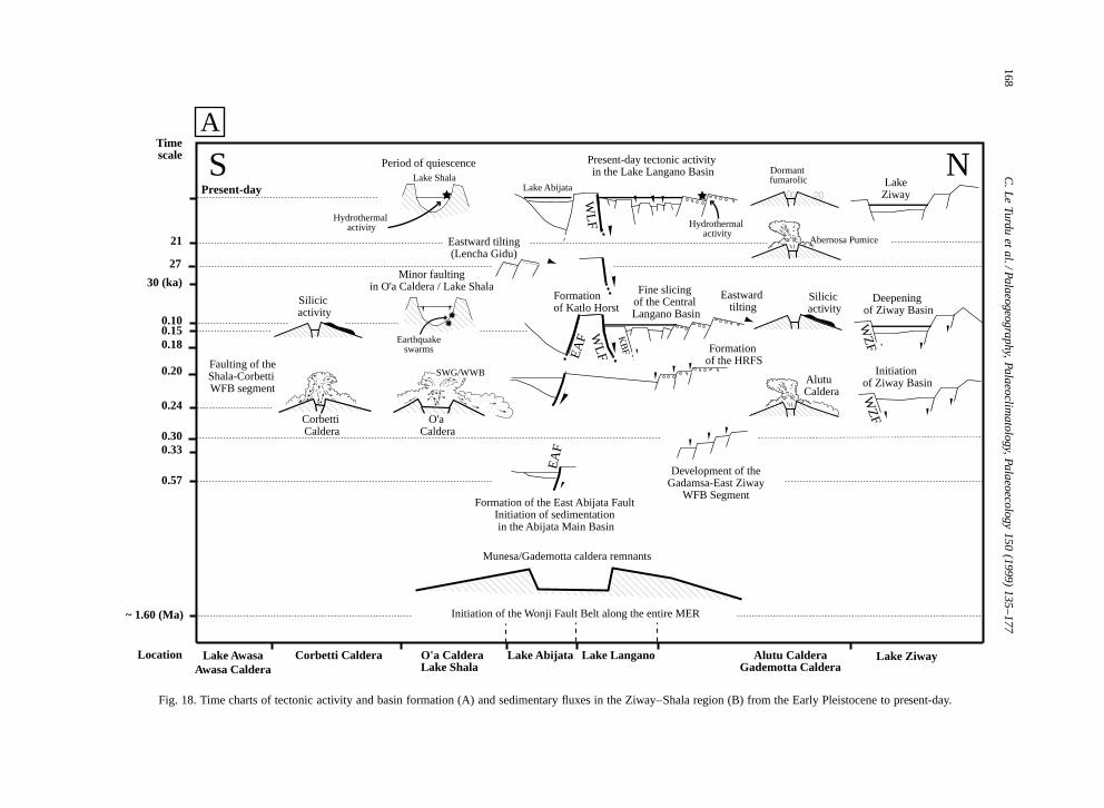
168C
.Le
Turduet
al./Palaeogeography,Palaeoclim
atology,Palaeoecology150
(1999)135–177
��
����
������
��������
����������
������������
�������������
�������������
�������������
�������������
�������������
�������������
������������
����������
��������
������
����
��
yy
yyyy
yyyyyy
yyyyyyyy
yyyyyyyyyy
yyyyyyyyyyyy
yyyyyyyyyyyyy
yyyyyyyyyyyyy
yyyyyyyyyyyyy
yyyyyyyyyyyyy
yyyyyyyyyyyyy
yyyyyyyyyyyyy
yyyyyyyyyyyy
yyyyyyyyyy
yyyyyyyy
yyyyyy
yyyy
yy
����
�����
�������
���������
�����������
�������������
�������������
�������������
�������������
�������������
�������������
������������
�����������
���������
�������
�����
���
yyyy
yyyyy
yyyyyyy
yyyyyyyyy
yyyyyyyyyyy
yyyyyyyyyyyyy
yyyyyyyyyyyyy
yyyyyyyyyyyyy
yyyyyyyyyyyyy
yyyyyyyyyyyyy
yyyyyyyyyyyyy
yyyyyyyyyyyy
yyyyyyyyyyy
yyyyyyyyy
yyyyyyy
yyyyy
yyy
~ 1.60 (Ma)
0.57
0.30
0.24
0.20
0.180.15
30 (ka)
21
Timescale
Location
Formation of the East Abijata Fault Initiation of sedimentation in the Abijata Main Basin
Faulting of theShala-Corbetti WFB segment
Minor faultingin O'a Caldera / Lake Shala
Period of quiescence Present-day tectonic activity in the Lake Langano Basin
Fine slicing of the Central Langano Basin
Formation of Katlo Horst
Formation of the HRFS
Eastward tilting
Development of theGadamsa-East Ziway
WFB Segment
EA
F
Initiation of Ziway Basin
WZ
F
S N
Lake AwasaAwasa Caldera
Corbetti Caldera O'a CalderaLake Shala
Lake Abijata Lake Langano Alutu CalderaGademotta Caldera
Lake Ziway
Initiation of the Wonji Fault Belt along the entire MER
0.33
Hydrothermal activity
Earthquakeswarms
0.10
EA
F WLF
KB
F
Corbetti Caldera
O'a Caldera
Alutu Caldera
Deepening of Ziway Basin
WZ
F
��
����
�����
������
������
������
������
������
������
������
������
������
������
�����
����
��
yy
yyyy
yyyyy
yyyyyy
yyyyyy
yyyyyy
yyyyyy
yyyyyy
yyyyyy
yyyyyy
yyyyyy
yyyyyy
yyyyyy
yyyyy
yyyy
yy
������������
���
�����
�������
�������
�������
�������
�������
�������
�������
�������
�������
�������
�������
������
����
��
yyy
yyyyy
yyyyyyy
yyyyyyy
yyyyyyy
yyyyyyy
yyyyyyy
yyyyyyy
yyyyyyy
yyyyyyy
yyyyyyy
yyyyyyy
yyyyyyy
yyyyyy
yyyy
yy
������������
��
����
������
�������
��������
��������
��������
��������
��������
��������
��������
��������
��������
��������
��������
��������
��������
�������
������
����
��
yy
yyyy
yyyyyy
yyyyyyy
yyyyyyyy
yyyyyyyy
yyyyyyyy
yyyyyyyy
yyyyyyyy
yyyyyyyy
yyyyyyyy
yyyyyyyy
yyyyyyyy
yyyyyyyy
yyyyyyyy
yyyyyyyy
yyyyyyyy
yyyyyyy
yyyyyy
yyyy
yy
������������
����
�����
�������
���������
����������
����������
����������
����������
����������
����������
����������
����������
����������
����������
����������
����������
����������
����������
����������
����������
����������
����������
����������
����������
����������
����������
����������
����������
����������
����������
����������
����������
����������
����������
����������
����������
����������
����������
����������
����������
����������
����������
����������
����������
����������
����������
����������
���������
��������
������
����
��
yyyy
yyyyy
yyyyyyy
yyyyyyyyy
yyyyyyyyyy
yyyyyyyyyy
yyyyyyyyyy
yyyyyyyyyy
yyyyyyyyyy
yyyyyyyyyy
yyyyyyyyyy
yyyyyyyyyy
yyyyyyyyyy
yyyyyyyyyy
yyyyyyyyyy
yyyyyyyyyy
yyyyyyyyyy
yyyyyyyyyy
yyyyyyyyyy
yyyyyyyyyy
yyyyyyyyyy
yyyyyyyyyy
yyyyyyyyyy
yyyyyyyyyy
yyyyyyyyyy
yyyyyyyyyy
yyyyyyyyyy
yyyyyyyyyy
yyyyyyyyyy
yyyyyyyyyy
yyyyyyyyyy
yyyyyyyyyy
yyyyyyyyyy
yyyyyyyyyy
yyyyyyyyyy
yyyyyyyyyy
yyyyyyyyyy
yyyyyyyyyy
yyyyyyyyyy
yyyyyyyyyy
yyyyyyyyyy
yyyyyyyyyy
yyyyyyyyyy
yyyyyyyyyy
yyyyyyyyyy
yyyyyyyyyy
yyyyyyyyyy
yyyyyyyyy
yyyyyyyy
yyyyyy
yyyy
yy
Munesa/Gademotta caldera remnants
���
�����
�������
��������
��������
��������
��������
��������
��������
��������
��������
��������
��������
��������
��������
��������
��������
�������
�����
���
yyy
yyyyy
yyyyyyy
yyyyyyyy
yyyyyyyy
yyyyyyyy
yyyyyyyy
yyyyyyyy
yyyyyyyy
yyyyyyyy
yyyyyyyy
yyyyyyyy
yyyyyyyy
yyyyyyyy
yyyyyyyy
yyyyyyyy
yyyyyyyy
yyyyyyy
yyyyy
yyy
Dormant fumarolic Lake
Ziway
A
Hydrothermal activity
Lake ShalaLake Abijata
WLF
Present-day
Abernosa Pumice
��
����
������
�������
��������
��������
��������
��������
��������
��������
��������
��������
��������
��������
��������
��������
��������
��������
������
����
��
yy
yyyy
yyyyyy
yyyyyyy
yyyyyyyy
yyyyyyyy
yyyyyyyy
yyyyyyyy
yyyyyyyy
yyyyyyyy
yyyyyyyy
yyyyyyyy
yyyyyyyy
yyyyyyyy
yyyyyyyy
yyyyyyyy
yyyyyyyy
yyyyyyyy
yyyyyy
yyyy
yy
����������������
27
Eastward tilting(Lencha Gidu)
SWG/WWB
��
����
������
�������
�������
�������
�������
�������
�������
�������
�������
�������
�������
�������
�������
�������
�������
�������
�����
����
yy
yyyy
yyyyyy
yyyyyyy
yyyyyyy
yyyyyyy
yyyyyyy
yyyyyyy
yyyyyyy
yyyyyyy
yyyyyyy
yyyyyyy
yyyyyyy
yyyyyyy
yyyyyyy
yyyyyyy
yyyyyyy
yyyyyyy
yyyyy
yyyy
Silicic activity
���
�����
������
�������
�������
�������
�������
�������
�������
�������
�������
�������
�������
�������
�������
�������
�������
�������
�����
���
yyy
yyyyy
yyyyyy
yyyyyyy
yyyyyyy
yyyyyyy
yyyyyyy
yyyyyyy
yyyyyyy
yyyyyyy
yyyyyyy
yyyyyyy
yyyyyyy
yyyyyyy
yyyyyyy
yyyyyyy
yyyyyyy
yyyyyyy
yyyyy
yyy
Silicic activity
Fig. 18. Time charts of tectonic activity and basin formation (A) and sedimentary fluxes in the Ziway–Shala region (B) from the Early Pleistocene to present-day.
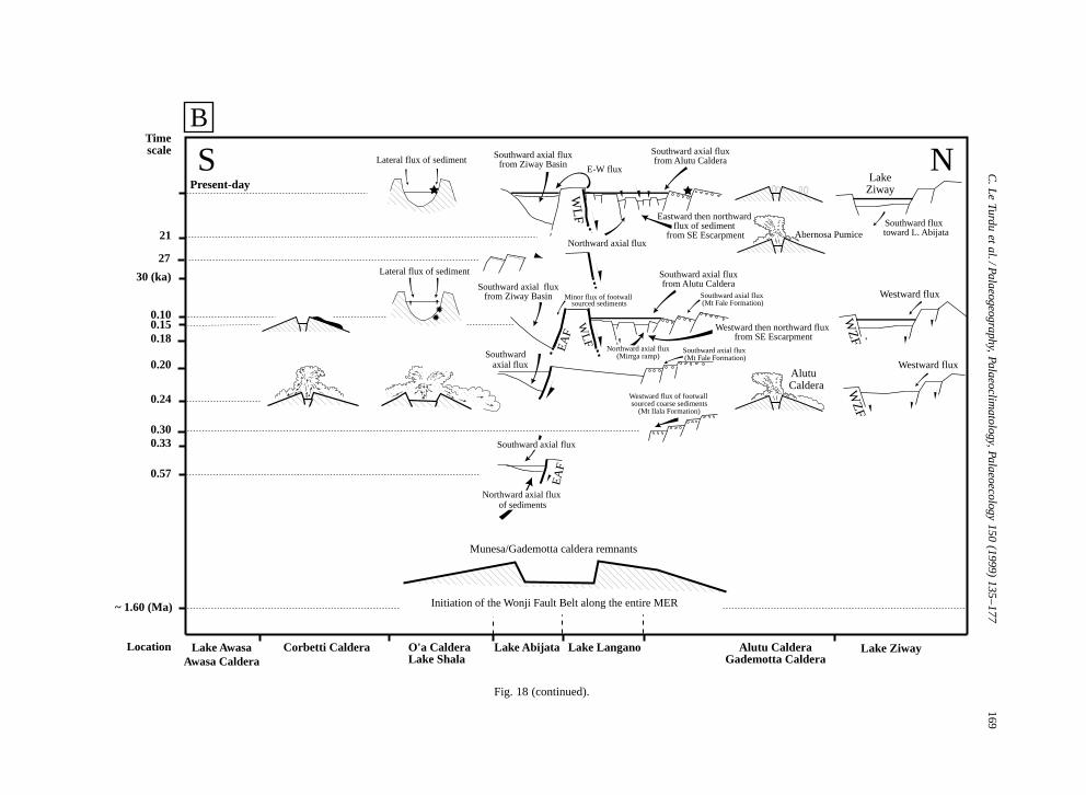
C.L
eTurdu
etal./Palaeogeography,
Palaeoclimatology,Palaeoecology
150(1999)
135–177169
��
����
������
��������
����������
������������
�������������
�������������
�������������
�������������
�������������
�������������
������������
����������
��������
������
����
��
yy
yyyy
yyyyyy
yyyyyyyy
yyyyyyyyyy
yyyyyyyyyyyy
yyyyyyyyyyyyy
yyyyyyyyyyyyy
yyyyyyyyyyyyy
yyyyyyyyyyyyy
yyyyyyyyyyyyy
yyyyyyyyyyyyy
yyyyyyyyyyyy
yyyyyyyyyy
yyyyyyyy
yyyyyy
yyyy
yy
���
�����
�������
���������
�����������
�������������
�������������
�������������
�������������
�������������
�������������
������������
�����������
���������
�������
�����
����
yyy
yyyyy
yyyyyyy
yyyyyyyyy
yyyyyyyyyyy
yyyyyyyyyyyyy
yyyyyyyyyyyyy
yyyyyyyyyyyyy
yyyyyyyyyyyyy
yyyyyyyyyyyyy
yyyyyyyyyyyyy
yyyyyyyyyyyy
yyyyyyyyyyy
yyyyyyyyy
yyyyyyy
yyyyy
yyyy
~ 1.60 (Ma)
0.57
0.30
0.24
0.20
0.180.15
30 (ka)
21
Timescale
Location
EA
F
WZ
F
S N
Lake AwasaAwasa Caldera
Corbetti Caldera O'a CalderaLake Shala
Lake Abijata Lake Langano Alutu CalderaGademotta Caldera
Lake Ziway
Initiation of the Wonji Fault Belt along the entire MER
0.33
0.10
EA
F
WLF
Alutu Caldera
WZ
F
��
����
�����
������
������
������
������
������
������
������
������
������
������
�����
����
��
yy
yyyy
yyyyy
yyyyyy
yyyyyy
yyyyyy
yyyyyy
yyyyyy
yyyyyy
yyyyyy
yyyyyy
yyyyyy
yyyyyy
yyyyy
yyyy
yy
������������
���
�����
�������
�������
�������
�������
�������
�������
�������
�������
�������
�������
�������
������
����
��
yyy
yyyyy
yyyyyyy
yyyyyyy
yyyyyyy
yyyyyyy
yyyyyyy
yyyyyyy
yyyyyyy
yyyyyyy
yyyyyyy
yyyyyyy
yyyyyyy
yyyyyy
yyyy
yy
������������
��
����
������
�������
�������
�������
�������
�������
�������
�������
�������
�������
�������
�������
�������
�������
�������
�������
�����
����
yy
yyyy
yyyyyy
yyyyyyy
yyyyyyy
yyyyyyy
yyyyyyy
yyyyyyy
yyyyyyy
yyyyyyy
yyyyyyy
yyyyyyy
yyyyyyy
yyyyyyy
yyyyyyy
yyyyyyy
yyyyyyy
yyyyyyy
yyyyy
yyyy
������������
����
�����
�������
���������
����������
����������
����������
����������
����������
����������
����������
����������
����������
����������
����������
����������
����������
����������
����������
����������
����������
����������
����������
����������
����������
����������
����������
����������
����������
����������
����������
����������
����������
����������
����������
����������
����������
����������
����������
����������
����������
����������
����������
����������
����������
����������
����������
���������
��������
������
����
��
yyyy
yyyyy
yyyyyyy
yyyyyyyyy
yyyyyyyyyy
yyyyyyyyyy
yyyyyyyyyy
yyyyyyyyyy
yyyyyyyyyy
yyyyyyyyyy
yyyyyyyyyy
yyyyyyyyyy
yyyyyyyyyy
yyyyyyyyyy
yyyyyyyyyy
yyyyyyyyyy
yyyyyyyyyy
yyyyyyyyyy
yyyyyyyyyy
yyyyyyyyyy
yyyyyyyyyy
yyyyyyyyyy
yyyyyyyyyy
yyyyyyyyyy
yyyyyyyyyy
yyyyyyyyyy
yyyyyyyyyy
yyyyyyyyyy
yyyyyyyyyy
yyyyyyyyyy
yyyyyyyyyy
yyyyyyyyyy
yyyyyyyyyy
yyyyyyyyyy
yyyyyyyyyy
yyyyyyyyyy
yyyyyyyyyy
yyyyyyyyyy
yyyyyyyyyy
yyyyyyyyyy
yyyyyyyyyy
yyyyyyyyyy
yyyyyyyyyy
yyyyyyyyyy
yyyyyyyyyy
yyyyyyyyyy
yyyyyyyyyy
yyyyyyyyy
yyyyyyyy
yyyyyy
yyyy
yy
Munesa/Gademotta caldera remnants
����
�����
�������
�������
�������
�������
�������
�������
�������
�������
�������
�������
�������
�������
�������
�������
�������
������
����
��
yyyy
yyyyy
yyyyyyy
yyyyyyy
yyyyyyy
yyyyyyy
yyyyyyy
yyyyyyy
yyyyyyy
yyyyyyy
yyyyyyy
yyyyyyy
yyyyyyy
yyyyyyy
yyyyyyy
yyyyyyy
yyyyyyy
yyyyyy
yyyy
yy
LakeZiway
B
WLF
Present-day
Abernosa Pumice
��
����
������
�������
�������
�������
�������
�������
�������
�������
�������
�������
�������
�������
�������
�������
�������
�������
�����
����
yy
yyyy
yyyyyy
yyyyyyy
yyyyyyy
yyyyyyy
yyyyyyy
yyyyyyy
yyyyyyy
yyyyyyy
yyyyyyy
yyyyyyy
yyyyyyy
yyyyyyy
yyyyyyy
yyyyyyy
yyyyyyy
yyyyyyy
yyyyy
yyyy
����������������
27
��
����
������
�������
��������
��������
��������
��������
��������
��������
��������
��������
��������
��������
��������
��������
��������
��������
������
����
��
yy
yyyy
yyyyyy
yyyyyyy
yyyyyyyy
yyyyyyyy
yyyyyyyy
yyyyyyyy
yyyyyyyy
yyyyyyyy
yyyyyyyy
yyyyyyyy
yyyyyyyy
yyyyyyyy
yyyyyyyy
yyyyyyyy
yyyyyyyy
yyyyyyyy
yyyyyy
yyyy
yy
Westward flux of footwall sourced coarse sediments
(Mt Ilala Formation)
Southward axial flux from Ziway Basin
Southward axial fluxfrom Alutu Caldera
Northward axial flux
Eastward then northward flux of sediment
from SE Escarpment
E-W flux
Southward axial fluxfrom Alutu Caldera
Southward axial flux (Mt Fale Formation)
Northward axial flux(Mirrga ramp)
Westward then northward flux from SE Escarpment
Southward axial flux (Mt Fale Formation)
Lateral flux of sediment
Southward axial flux from Ziway Basin
Lateral flux of sediment
Minor flux of footwall sourced sediments
Southward axial flux
Westward flux
Southward fluxtoward L. Abijata
Westward flux
Southward axial flux
Northward axial flux of sediments
Fig. 18 (continued).
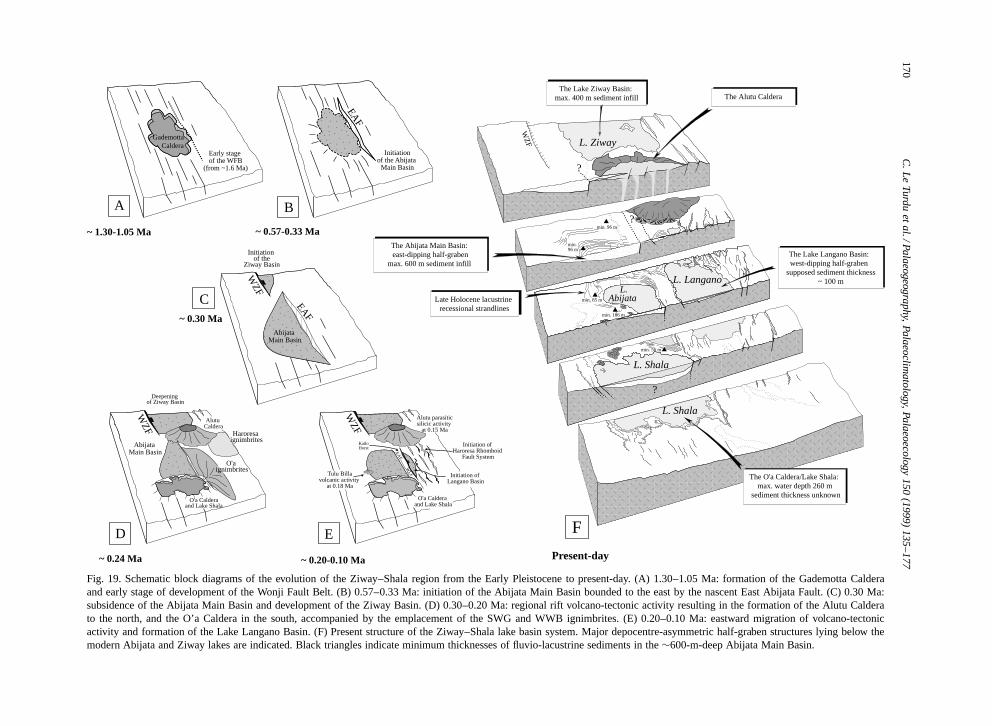
170C
.Le
Turduet
al./Palaeogeography,Palaeoclim
atology,Palaeoecology150
(1999)135–177
������������������������������������������������������������������������������������������������������������������������������������������������
Gademotta Caldera
Early stage of the WFB
(from ~1.6 Ma)
~ 1.30-1.05 Ma
������
Initiationof the Abijata Main Basin
���������������������������������������������������������������������������������������������������������������������������������������
��yy��yy
~ 0.57-0.33 Ma
��
�������������������������������������������������������
����������
��������������������
������������������������������������������
������������������������������������������������������������������������������������
WZF
������������������������������
����������������������������������������������������������������������
����������������������������������������
����������������������������������������
��������������������������������������������������
�����������������������������������
~ 0.20-0.10 Ma Present-day
KatloHorst
Initiation of Haroresa Rhomboid
Fault System
�������������������������������������������������������������������������������������������������������������������������������������������������������������������������������������������
��������������
Initiation of the
Ziway Basin
~ 0.30 MaAbijata
Main Basin
EAF
��������������������������������������������������������������������������������������������������������
������������
Abijata Main Basin
WZF
O'a Calderaand Lake Shala
~ 0.24 Ma
������������������������������������������������������������������������������
��������������������
������������������������������������������
C
A B
D E
�������������������
���������
���������������������������������������������������������������������������������������������������������������������������������������������������������������������������������������������������������������������������������������������������������������������������������������������������������
@@@@@@@@@@@@@@@@@@@@@@@@@@@@@@@@@@@@@@@@@@@@@@@@@@@@@@@@@@@@@@@@@@@@@@@@@@@@@@@@@@@@@@@@@@@@@@@@@@@@@@@@@@@@@@@@@@@@@@@@@@@@@@@@@@@@@@@@@@@@@@@@@@@@@@@@@@@@@@@@@@@@@@@@@@@@@@@@@@@@@@@@@@@@@@@@@@@@@@@@@@@@@@@@@@@@@@@@@@@@@@@@@@@@@@@@@@@@@@@@@@@@@@@@@@@@@@@@@@@@@@@@@@@@@@@@@@@@@@@@@@@@@@@@@@@@@@@@@
���������������������������������������������������������������������������������������������������������������������������������������������������������������������������������������������������������������������������������������������������������������������������������������������������������
ÀÀÀÀÀÀÀÀÀÀÀÀÀÀÀÀÀÀÀÀÀÀÀÀÀÀÀÀÀÀÀÀÀÀÀÀÀÀÀÀÀÀÀÀÀÀÀÀÀÀÀÀÀÀÀÀÀÀÀÀÀÀÀÀÀÀÀÀÀÀÀÀÀÀÀÀÀÀÀÀÀÀÀÀÀÀÀÀÀÀÀÀÀÀÀÀÀÀÀÀÀÀÀÀÀÀÀÀÀÀÀÀÀÀÀÀÀÀÀÀÀÀÀÀÀÀÀÀÀÀÀÀÀÀÀÀÀÀÀÀÀÀÀÀÀÀÀÀÀÀÀÀÀÀÀÀÀÀÀÀÀÀÀÀÀÀÀÀÀÀÀÀÀÀÀÀÀÀÀÀÀÀÀÀÀÀÀÀÀÀÀÀÀÀÀÀÀÀÀÀÀÀÀÀÀÀÀÀÀÀÀÀÀÀÀÀÀÀÀÀÀÀÀÀÀÀÀÀÀÀÀÀÀÀÀÀÀÀÀÀÀÀÀÀÀÀÀÀÀÀÀÀÀÀÀÀÀÀÀÀÀÀÀÀÀÀÀÀÀÀÀÀÀÀÀÀÀÀÀÀÀÀÀÀÀÀÀÀÀÀÀÀÀÀÀÀÀ
���������������������������������������������������������������������������������������������������������������������������������������������������������������������������������������������������������������������������������������������������������������������������������������������������������
������������������������������������������������������������������������������������������������������������������������������������������������������������������������������������������������������������������������������������������
@@@@@@@@@@@@@@@@@@@@@@@@@@@@@@@@@@@@@@@@@@@@@@@@@@@@@@@@@@@@@@@@@@@@@@@@@@@@@@@@@@@@@@@@@@@@@@@@@@@@@@@@@@@@@@@@@@@@@@@@@@@@@@@@@@@@@@@@@@@@@@@@@@@@@@@@@@@@@@@@@@@@@@@@@@@@@@@@@@@@@@@@@@@@@@@@@@@@@@@@@@@@@@@@@@@@@@@@@@@@@@@@@@@@@@@@@@
������������������������������������������������������������������������������������������������������������������������������������������������������������������������������������������������������������������������������������������
ÀÀÀÀÀÀÀÀÀÀÀÀÀÀÀÀÀÀÀÀÀÀÀÀÀÀÀÀÀÀÀÀÀÀÀÀÀÀÀÀÀÀÀÀÀÀÀÀÀÀÀÀÀÀÀÀÀÀÀÀÀÀÀÀÀÀÀÀÀÀÀÀÀÀÀÀÀÀÀÀÀÀÀÀÀÀÀÀÀÀÀÀÀÀÀÀÀÀÀÀÀÀÀÀÀÀÀÀÀÀÀÀÀÀÀÀÀÀÀÀÀÀÀÀÀÀÀÀÀÀÀÀÀÀÀÀÀÀÀÀÀÀÀÀÀÀÀÀÀÀÀÀÀÀÀÀÀÀÀÀÀÀÀÀÀÀÀÀÀÀÀÀÀÀÀÀÀÀÀÀÀÀÀÀÀÀÀÀÀÀÀÀÀÀÀÀÀÀÀÀÀÀÀÀÀÀÀÀÀÀÀÀÀÀÀÀÀÀÀÀÀÀÀÀÀÀÀÀÀÀÀÀÀÀ
�����������������������������������������������������������������������������������������������������������������������������������������������������������������������������������������������������������������������������������������������������������������������
������������������������������������������������������������������������������������������������������������������������������������������������������������������������������������������������������������������������������������������������������������������������������������������������������������������������������������������������������������
@@@@@@@@@@@@@@@@@@@@@@@@@@@@@@@@@@@@@@@@@@@@@@@@@@@@@@@@@@@@@@@@@@@@@@@@@@@@@@@@@@@@@@@@@@@@@@@@@@@@@@@@@@@@@@@@@@@@@@@@@@@@@@@@@@@@@@@@@@@@@@@@@@@@@@@@@@@@@@@@@@@@@@@@@@@@@@@@@@@@@@@@@@@@@@@@@@@@@@@@@@@@@@@@@@@@@@@@@@@@@@@@@@@@@@@@@@@@@@@@@@@@@@@@@@@@@@@@@@@@@@@@@@@@@@@@@@@@@@@@@@@@@@@@@@@@@@@@@@@@@@@@@@@@@@@@@@@@@@@@@@@@@@@@@@@@@@@@@@@@@@@@@@@@@@@@@@@@@@@@@@@@@@@@@@@@@@@@@
�����������������������������������������������������������������������������������������������������������������������������������������������������������������������������������������������������������������������������������������������������������������������������������������������������������������������������������������������������������������������������������������
ÀÀÀÀÀÀÀÀÀÀÀÀÀÀÀÀÀÀÀÀÀÀÀÀÀÀÀÀÀÀÀÀÀÀÀÀÀÀÀÀÀÀÀÀÀÀÀÀÀÀÀÀÀÀÀÀÀÀÀÀÀÀÀÀÀÀÀÀÀÀÀÀÀÀÀÀÀÀÀÀÀÀÀÀÀÀÀÀÀÀÀÀÀÀÀÀÀÀÀÀÀÀÀÀÀÀÀÀÀÀÀÀÀÀÀÀÀÀÀÀÀÀÀÀÀÀÀÀÀÀÀÀÀÀÀÀÀÀÀÀÀÀÀÀÀÀÀÀÀÀÀÀÀÀÀÀÀÀÀÀÀÀÀÀÀÀÀÀÀÀÀÀÀÀÀÀÀÀÀÀÀÀÀÀÀÀÀÀÀÀÀÀÀÀÀÀÀÀÀÀÀÀÀÀÀÀÀÀÀÀÀÀÀÀÀÀÀÀÀÀÀÀÀÀÀÀÀÀÀÀÀÀÀÀÀÀÀÀÀÀÀÀÀÀÀÀÀÀÀÀÀÀÀÀÀÀÀÀÀÀÀÀÀÀÀÀÀÀÀÀÀÀÀÀÀÀÀÀÀÀÀÀÀÀÀÀÀÀÀÀÀÀÀÀÀÀÀÀÀÀÀÀÀÀÀÀÀÀÀÀÀÀÀÀÀÀÀÀÀÀÀÀÀÀÀÀÀÀÀÀÀÀÀÀÀÀÀÀÀÀÀÀÀÀÀÀÀÀÀÀÀÀÀÀÀÀÀÀÀÀÀÀÀÀÀÀÀÀÀÀÀÀÀÀÀÀÀ
�����������������������������������������������������������������������������������������������������������������������������������������������������������������������������������������������������������������������������������������������������������������������������������������������������������������������������������������������������������������������������������������
L. Shala
��������������������������������������������������������
@@@@@@@@@@@@@@@@@@@@@@@@@@@@@@@@@@@@@@@@@@@@@@@@@@@@@@@@
��������������������������������������������������������
ÀÀÀÀÀÀÀÀÀÀÀÀÀÀÀÀÀÀÀÀÀÀÀÀÀÀÀÀÀÀÀÀÀÀÀÀÀÀÀÀÀÀÀÀÀÀÀÀÀÀÀÀÀÀÀÀ
��������������������������������������������������������
���������������������������������������������������������������������������������������������������������������������������������������������������������������������������������������������������������������������������������������������������������������������������������������������������������������������������������������������������������������������������������������������������������������������������������������������������������������������������������������������������������������
@@@@@@@@@@@@@@@@@@@@@@@@@@@@@@@@@@@@@@@@@@@@@@@@@@@@@@@@@@@@@@@@@@@@@@@@@@@@@@@@@@@@@@@@@@@@@@@@@@@@@@@@@@@@@@@@@@@@@@@@@@@@@@@@@@@@@@@@@@@@@@@@@@@@@@@@@@@@@@@@@@@@@@@@@@@@@@@@@@@@@@@@@@@@@@@@@@@@@@@@@@@@@@@@@@@@@@@@@@@@@@@@@@@@@@@@@@@@@@@@@@@@@@@@@@@@@@@@@@@@@@@@@@@@@@@@@@@@@@@@@@@@@@@@@@@@@@@@@@@@@@@@@@@@@@@@@@@@@@@@@@@@@@@@@@@@@@@@@@@@@@@@@@@@@@@@@@@@@@@@@@@@@@@@@@@@@@@@@@@@@@@@@@@@@@@@@@@@@@@@@@@@@@@@@@@@@@@@@@@@@@@@@@@@@@@@@@@@@@@@@@@@@@@@@@@@@@@@@@@@@@@@@@@@@@@@@@@@@@@@@@@@@@@@@@@@@@@
���������������������������������������������������������������������������������������������������������������������������������������������������������������������������������������������������������������������������������������������������������������������������������������������������������������������������������������������������������������������������������������������������������������������������������������������������������������������������������������������������������������
ÀÀÀÀÀÀÀÀÀÀÀÀÀÀÀÀÀÀÀÀÀÀÀÀÀÀÀÀÀÀÀÀÀÀÀÀÀÀÀÀÀÀÀÀÀÀÀÀÀÀÀÀÀÀÀÀÀÀÀÀÀÀÀÀÀÀÀÀÀÀÀÀÀÀÀÀÀÀÀÀÀÀÀÀÀÀÀÀÀÀÀÀÀÀÀÀÀÀÀÀÀÀÀÀÀÀÀÀÀÀÀÀÀÀÀÀÀÀÀÀÀÀÀÀÀÀÀÀÀÀÀÀÀÀÀÀÀÀÀÀÀÀÀÀÀÀÀÀÀÀÀÀÀÀÀÀÀÀÀÀÀÀÀÀÀÀÀÀÀÀÀÀÀÀÀÀÀÀÀÀÀÀÀÀÀÀÀÀÀÀÀÀÀÀÀÀÀÀÀÀÀÀÀÀÀÀÀÀÀÀÀÀÀÀÀÀÀÀÀÀÀÀÀÀÀÀÀÀÀÀÀÀÀÀÀÀÀÀÀÀÀÀÀÀÀÀÀÀÀÀÀÀÀÀÀÀÀÀÀÀÀÀÀÀÀÀÀÀÀÀÀÀÀÀÀÀÀÀÀÀÀÀÀÀÀÀÀÀÀÀÀÀÀÀÀÀÀÀÀÀÀÀÀÀÀÀÀÀÀÀÀÀÀÀÀÀÀÀÀÀÀÀÀÀÀÀÀÀÀÀÀÀÀÀÀÀÀÀÀÀÀÀÀÀÀÀÀÀÀÀÀÀÀÀÀÀÀÀÀÀÀÀÀÀÀÀÀÀÀÀÀÀÀÀÀÀÀÀÀÀÀÀÀÀÀÀÀÀÀÀÀÀÀÀÀÀÀÀÀÀÀÀÀÀÀÀÀÀÀÀÀÀÀÀÀÀÀÀÀÀÀÀÀÀÀÀÀÀÀÀÀÀÀÀÀÀÀÀÀÀÀÀÀÀÀÀÀÀÀÀÀÀÀÀÀÀÀÀÀÀÀÀÀÀÀÀÀÀÀÀÀÀÀÀÀÀÀÀÀÀÀÀÀÀÀÀÀÀÀÀÀÀÀÀÀ
���������������������������������������������������������������������������������������������������������������������������������������������������������������������������������������������������������������������������������������������������������������������������������������������������������������������������������������������������������������������������������������������������������������������������������������������������������������������������������������������������������������
��
L. Shala
������������������
@@@@@@@@@@@@@@@@@@
������������������
ÀÀÀÀÀÀÀÀÀÀÀÀÀÀÀÀÀÀ
������������������ ��
���������������
�����������������������������������������������������������������������������������������������������������������������������������������������������������������������������������������������������������������������������������������������������������������������������������������������������������������������������������������������������������������������������������������
@@@@@@@@@@@@@@@@@@@@@@@@@@@@@@@@@@@@@@@@@@@@@@@@@@@@@@@@@@@@@@@@@@@@@@@@@@@@@@@@@@@@@@@@@@@@@@@@@@@@@@@@@@@@@@@@@@@@@@@@@@@@@@@@@@@@@@@@@@@@@@@@@@@@@@@@@@@@@@@@@@@@@@@@@@@@@@@@@@@@@@@@@@@@@@@@@@@@@@@@@@@@@@@@@@@@@@@@@@@@@@@@@@@@@@@@@@@@@@@@@@@@@@@@@@@@@@@@@@@@@@@@@@@@@@@@@@@@@@@@@@@@@@@@@@@@@@@@@@@@@@@@@@@@@@@@@@@@@@@@@@@@@@@@@@@@@@@@@@@@@@@@@@@@@@@@@@@@@@@@@@@@@@@@@@@@@@@@@
�����������������������������������������������������������������������������������������������������������������������������������������������������������������������������������������������������������������������������������������������������������������������������������������������������������������������������������������������������������������������������������������
ÀÀÀÀÀÀÀÀÀÀÀÀÀÀÀÀÀÀÀÀÀÀÀÀÀÀÀÀÀÀÀÀÀÀÀÀÀÀÀÀÀÀÀÀÀÀÀÀÀÀÀÀÀÀÀÀÀÀÀÀÀÀÀÀÀÀÀÀÀÀÀÀÀÀÀÀÀÀÀÀÀÀÀÀÀÀÀÀÀÀÀÀÀÀÀÀÀÀÀÀÀÀÀÀÀÀÀÀÀÀÀÀÀÀÀÀÀÀÀÀÀÀÀÀÀÀÀÀÀÀÀÀÀÀÀÀÀÀÀÀÀÀÀÀÀÀÀÀÀÀÀÀÀÀÀÀÀÀÀÀÀÀÀÀÀÀÀÀÀÀÀÀÀÀÀÀÀÀÀÀÀÀÀÀÀÀÀÀÀÀÀÀÀÀÀÀÀÀÀÀÀÀÀÀÀÀÀÀÀÀÀÀÀÀÀÀÀÀÀÀÀÀÀÀÀÀÀÀÀÀÀÀÀÀÀÀÀÀÀÀÀÀÀÀÀÀÀÀÀÀÀÀÀÀÀÀÀÀÀÀÀÀÀÀÀÀÀÀÀÀÀÀÀÀÀÀÀÀÀÀÀÀÀÀÀÀÀÀÀÀÀÀÀÀÀÀÀÀÀÀÀÀÀÀÀÀÀÀÀÀÀÀÀÀÀÀÀÀÀÀÀÀÀÀÀÀÀÀÀÀÀÀÀÀÀÀÀÀÀÀÀÀÀÀÀÀÀÀÀÀÀÀÀÀÀÀÀÀÀÀÀÀÀÀÀÀÀÀÀÀÀÀÀÀÀÀÀ
�����������������������������������������������������������������������������������������������������������������������������������������������������������������������������������������������������������������������������������������������������������������������������������������������������������������������������������������������������������������������������������������
��
L. Abijata
L. Langano
������
������������������������������
@@@@@@@@@@@@@@@@@@@@@@@@@@@@@@
������������������������������
ÀÀÀÀÀÀÀÀÀÀÀÀÀÀÀÀÀÀÀÀÀÀÀÀÀÀÀÀÀÀ
��������������������������������
��������������
@@@@@@@@@@@@@@@@
����������������
ÀÀÀÀÀÀÀÀÀÀÀÀÀÀÀÀ
����������������
?
������������������
Late Holocene lacustrine recessional strandlines
L. Ziway
?
The Lake Ziway Basin: max. 400 m sediment infill
The Abijata Main Basin: east-dipping half-graben
max. 600 m sediment infill
The O'a Caldera/Lake Shala: max. water depth 260 m
sediment thickness unknown
?
The Lake Langano Basin: west-dipping half-graben
supposed sediment thickness ~ 100 m
F
Alutu Caldera
O'a ignimbrites
O'a Caldera and Lake Shala
Initiation of Langano Basin
WZF
EAF
Deepening of Ziway Basin
EAF
WLF�Tulu Billa
volcanic activity at 0.18 Ma
The Alutu Caldera
WZ
F
▲min. 96 m
▲min. 96 m
▲min. 85 m
▲min. 186 m
�������������
▲min. 56 m
Haroresa ignimbrites
Alutu parasiticsilicic activity
at 0.15 Ma
Fig. 19. Schematic block diagrams of the evolution of the Ziway–Shala region from the Early Pleistocene to present-day. (A) 1.30–1.05 Ma: formation of the Gademotta Calderaand early stage of development of the Wonji Fault Belt. (B) 0.57–0.33 Ma: initiation of the Abijata Main Basin bounded to the east by the nascent East Abijata Fault. (C) 0.30 Ma:subsidence of the Abijata Main Basin and development of the Ziway Basin. (D) 0.30–0.20 Ma: regional rift volcano-tectonic activity resulting in the formation of the Alutu Calderato the north, and the O’a Caldera in the south, accompanied by the emplacement of the SWG and WWB ignimbrites. (E) 0.20–0.10 Ma: eastward migration of volcano-tectonicactivity and formation of the Lake Langano Basin. (F) Present structure of the Ziway–Shala lake basin system. Major depocentre-asymmetric half-graben structures lying below themodern Abijata and Ziway lakes are indicated. Black triangles indicate minimum thicknesses of fluvio-lacustrine sediments in the ¾600-m-deep Abijata Main Basin.
C. Le Turdu et al. / Palaeogeography, Palaeoclimatology, Palaeoecology 150 (1999) 135–177 171
ronment with anoxic conditions on the lake bottom.Erosion features affecting the top of the ‘Paper Di-atomite’ in the Shala Basin relate to a regressivephase, also marked by fluvial sands and diatoma-ceous shallow-water deposits in the Abijata borehole(Street, 1979). The sharp change in lithology fromfine-grained ‘lacustrine’ facies to a coarser ‘fluvio-lacustrine’ facies at 56 m in the Abijata boreholemay relate to this regressive event and indicates amajor change in the sediment source. Age estima-tion of this regressive phase, using sedimentationrates defined in Table 2, suggests a time of ¾69ka (Fig. 13B). Syn-sedimentary deformation featuresobserved in the <0.1 Ma old beds of the O’a Caldera(Fig. 16) can be interpreted as the result of shearmovements induced by local faulting or earthquakeactivity, the O’a Caldera representing a geological–morphological environment particularly favourableto seismic activity along caldera margin faults andsensitive to slope instability.
Lateral migration of tectonic activity, typical ofvarious intracontinental rift systems (Tiercelin, 1990;Morley, 1993; Le Turdu et al., 1995; Lezzar et al.,1996), characterizes the post-0.20 Ma period, result-ing possibly in the breakdown of movement alongthe East Abijata Fault (EAF), and to the east inthe fine slicing of the Gadamsa–East Ziway WFBsegment associated with the deepening of the ZiwayBasin (Fig. 18A, Fig. 19E). On the eastern side ofthe Ziway–Shala WFB segment, the development ofthe West Langano and Kore–Basuma Faults associ-ated with numerous antithetic minor faults inducedthe formation of the Katlo Horst, the Offshore West-ern Plateau, and the Central Basin of Lake Langano(Fig. 18A). The development of the Kore–BasumaFault and minor structures internal to the LanganoBasin can also be interpreted as synthetic adjust-ments along the major West Langano Fault, actingduring the deepening of the Langano Basin.
Interference between the NNE to NE and ESE tec-tonic trends of the Wonji Fault Belt and the MunesaFault System, respectively, resulted in the structura-tion of the Haroresa Rhomboid Fault System andthe north end of the Langano Basin. Simultaneouswestward block tilting of the Haroresa RhomboidFault System is illustrated by the 20º angle of theMount Ilala plateau gravel formation and by the fanshape of the Mount Fale half-graben deposits, thus
suggesting for this phase of deformation an age be-tween 0.20 Ma and early-Late Pleistocene. Such ex-tensive movements along the Gadamsa–East Ziwayand Ziway–Shala segments of the WFB probablyinduced hydrothermal fluid circulation in the NorthBay–Haroresa systems and along the West LanganoFault (Fig. 18A, Fig. 19E).
The combination of the O’a and Alutu volcanicfeatures with tectonic segmentation of the area re-sulted in the development of a new hydrographicnetwork, where tributaries derived from the South-eastern rift escarpment are rapidly deflected to axialdrainage by the NNE-trending, S- or Z-shaped grid-fault and ramp structures of the Wonji Fault Belt(Haroresa and Munesa structures). The Mount Falehalf-graben formation represents a small axial-flu-vial and deltaic system flowing south toward thenascent Lake Langano Basin or sometimes north,possibly as the result of tectonic tilting or delta-lobeswitching, during the early-Late Pleistocene. Sedi-ment flux also originated from the southeastern endof the Langano Basin, as a result of the control bythe transverse Munesa Fault System of the drainagebasin formed by the Southeastern rift escarpment.Water and sediment fluxes were strictly directed to-ward the Langano Basin using the north-dippingMirrga Ramp (Fig. 18B).
5.4. Late Pleistocene–Holocene Ziway–Shala basinevolution: volcano-tectonics versus climate forcing
The probable joint history of sedimentation withinthe Ziway, Langano, Abijata and Shala lake basinsstarted in the early-Late Pleistocene time intervaland continued all along Holocene times up to thepresent-day, reacting to a series of humid phasescharacterizing Africa from 140 ka up to 2 ka (Gasseand Street, 1978; Lezine and Casanova, 1991; Stur-chio et al., 1993; Cohen et al., 1997).
The Late Pleistocene–Holocene time interval ap-pears to be characterized by minor tectonic defor-mation compared with previous periods. Maximumtectonic activity seems to be concentrated along theGadamsa–East Ziway WFB segment. The slight tilt-ing (10–15º west) observed in the ¾28 ka oldLencha Gidu series on the west side of the Abi-jata Basin indicates that tectonic deformation alsoaffected the non-faulted side of the Ziway–Shala
172 C. Le Turdu et al. / Palaeogeography, Palaeoclimatology, Palaeoecology 150 (1999) 135–177
system (Fig. 18A). Small NNE-trending faults af-fecting the Daka Ilala sediments and other deforma-tion features (convolute bedding and folds, clasticdykes, slump breccias, turbidite sequences) indicategentle post-27 ka tectonic movements along the WestLangano Fault escarpment and may relate to the up-lift of the Katlo Horst during the time of sedimentdeposition or slightly later.
These movements may also relate to the numerousvolcanic events that characterize the Alutu volcaniccentre, and associated seismic activity attributed tomagma intrusion along caldera margin faults. Alutuentered a particularly explosive post-caldera phaseshortly before 21 ka (Fig. 17), continuing to eruptintermittently through Holocene and Recent times asshown by the numerous pyroclastics layers found inthe lake cores. Deformation features may have alsoresulted from volcanic doming of the active southernflank of Alutu during the Late Pleistocene (Gebibaobsidian dome and Edo Laki rhyolite) and Holocene(O-itu Woshe obsidian flows) eruptions (Fig. 17) asshown by the up to 20º dip toward the south of the5.6 ka old O-itu Woshe deltaic beds (M. Benvenutti,pers. commun., 1997).
Diatom flora from the sediment sequence iden-tified at Daka Ilala along the West Langano Faultindicates that generally high water level and low-salinity conditions predominated in this area at a datepossibly older than 30–27 ka. The succession of mi-nor disconformities suggests a series of short-periodlake-level fluctuations with a stability of the waterbody at the top of the sediment sequence. Slump andturbidite features may relate to a deep lake environ-ment close to an active fault scarp (WLF). The DakaIlala section can be stratigraphically correlated withthe 43–26 m section of the Abijata core (Fig. 13B),and similarities in diatom flora may indicate theexistence of a large water body possibly floodinga proto-Katlo Horst between Abijata and Langano.This high lake-level period may be older than theZiway–Shala II transgressive phase defined in theDeka Wede section of the Bulbula Plain (dated ataround 30 ka) and in the Shala Basin (Ajewa II Aphase dated at 30–28 ka?) (Gasse and Street, 1978;Street, 1979).
On the west side of the Abijata Basin, the LenchaGidu section indicates littoral lacustrine conditionsat 28.3 ka. This event can be correlated with the
low lake level identified between 28.2 and 27 ka inthe Bulbula Plain (the Ziway–Shala II–III regressionof Street, 1979). In the upper part of the section,the diatom flora indicates a very calm lacustrineenvironment which may correspond to the Ziway–Shala III transgressive phase identified at about 27ka in the Bulbula Plain by Street (1979).
The formation of pedogenetic carbonate crustsat 22 ka on the Katlo Horst indicates subaerialconditions within a semi-arid setting, and possiblymarks the Ziway–Shala III–IV lake-level fall (Street,1979). During this period, it has been proposed thatLake Ziway dried out completely (Lloyd, 1977). Atthe Abijata borehole site, the palaeosol at the depthof 16.80 m with an estimated age of ¾20.75 kapossibly marks this phase (Fig. 13B). The air-fallash interlayered within the carbonate crusts mayrelate to Alutu volcano explosive phases as it hasbeen described for this period by Geze (1974) andStreet (1979) (Abernosa Pumice Member and othereruptive events) (Fig. 17). Such explosive volcaniceruptions would have to cause transient local orregional climate changes.
The Late Pleistocene–Holocene time intervalwas marked by a series of rise and falls of lakelevel affecting the Ziway–Shala lake basin system,well-identified in the Bulbula River sections and inthe upper part of the Abijata borehole (Gasse andStreet, 1978; Street, 1979). In the Deka Wede sec-tion, a date of 11.50 ka was suggested by Street(1979) for the Ziway–Shala IV transgression. TheKatlo microbialite dated at 12.37 ka, possibly formedover a water depth range of 0–30 m (Casanova,1991) on top of the Katlo Horst, suggests an olderdate for the initiation of the Ziway–Shala IV lakemaximum. Nevertheless, uplift movements can besuspected for the Late Pleistocene–Holocene timeinterval along the West Langano and Kore–Basumafaults as shown on seismic lines. Present altitudeof the Katlo Horst cannot be used to constrain thecorresponding lake level.
At the base of core LL-III in Lake Langano (Fig.13B), fine to coarse sands and gravels possibly relateto the Ziway–Shala III–IV regression dated between21 and 11.5 ka (Street, 1979). In the Lake AbijataBasin, cm-thick beds of fine to coarse sands at about10 ka (calibrated age 11.6 ka) at the base of the corealso suggest a shallow-lacustrine environment that
C. Le Turdu et al. / Palaeogeography, Palaeoclimatology, Palaeoecology 150 (1999) 135–177 173
can be correlated with the Ziway–Shala IV–V regres-sion. The progressive installation of deeper, freshwa-ter lacustrine conditions with evidence of high organicproductivity and anoxic conditions on the lake flooris suggested between ca. 9.50 and 7.50 ka, between7 and 6 ka and between 5.85 and 5.20 ka by mag-netic methods on LL-III core (Tamrat, 1997; Tamratand Williamson, 1997), in phase with the transgres-sive phases identified by Street (1979) between 9.95ka and 8.50 ka (Ziway–Shala V), and between 6.50and 4.80 ka (Ziway–Shala VI). The period between9.60 and 9.40 ka is marked in the LL-III core by nu-merous air-fall pyroclastic layers suggesting series ofexplosive eruptions from the Alutu volcano.
Dark-brown muds between 8 and 6 m in theLL-III core may indicate the permanence in theLangano Basin of a water body almost comparableto the present-day lake during the regressive phaseZS V–VI identified at 8.5 ka by Street (1979). Con-tinuation of fine-grained sedimentation with a richostracod fauna suggests freshwater conditions possi-bly corresponding to the Ziway–Shala VI high lakelevel starting at 6.50 ka (Street, 1979). This periodcan be correlated with the development at 5.70 kaof the O’itu Woshe Gilbert-type deltaic environmentat the north end of Lake Langano. Transgressive–regressive features within the delta beds are indica-tive of short-lived lake-level fluctuations during thehighstand period.
In the Central Basin of Lake Langano, the LS1–LS2 seismic sequences indicate uniform sedimentaccumulation and are interpreted as the two lasthigh lake-level periods. The erosional truncation rep-resented by the LSB1 boundary can be related tothe Ziway–Shala VI–VII regressive phase startingat about 4.8 ka. Initiation of deposition of the LS1
sequence and the aggradation of the PU1–PU4 seis-mic units on the Offshore Western Plateau (Figs. 9and 15) may correspond to the Ziway–Shala VIItransgressive phase starting shortly after 2.5 ka(Street, 1979; Gillespie et al., 1983) as indicatedby the dating at the base of core Lc (Mohammed andBonnefille, 1991; Mohammed, 1992). Minor masswasting observed within the LS1 sequence possiblyrelates to the first steps of this transgressive phaseor to low-amplitude tectonic movements along theKore Basuma Fault. Synchronous changes in bio-genic production at the two core sites indicate strong
water mixing by the time the two lakes were united(Ziway–Shala V, VI and VII high lake stands) (Tam-rat and Williamson, 1997; Tamrat et al., 1997).
The mid-late Holocene time interval was markedfor the three southern lakes, Langano, Abijata andShala by a rapid and almost uninterrupted retreat,as indicated by the recessional strandlines whichare clearly visible on aerial and satellite imagery(Fig. 3). A short lacustrine phase is evidenced atca. 1.50 ka in the Abijata core Aa (Bonnefille etal., 1986). The present-day Ziway–Shala lake basinsystem is a closed and complex hydrological system,not only controlled by climate, but also by active tec-tonics and volcanism in the form of thermal springsand groundwater circulation (Fig. 18A, Fig. 19F).High-resolution seismic evidence and numerous hy-drothermal features indicate that the West Langanoand Kore–Basuma faults in the Lake Langano Basinclearly mark the present-day active rift axis.
6. Conclusions
This study of the Ziway–Shala lake basin systemof the MER provides an evolutionary model thatcan be applied to other intracontinental rift systemswhere initial rift floor segmentation is dominated bymajor explosive volcanism, in contrast with tecton-ics-dominated rift basins.
At the macro-architectural scale (106 yr), theLate Pliocene–Early Pleistocene morphology of theZiway–Shala region directly relates to catastrophicexplosive volcanic eruptions correlated with majorcaldera collapse (Munesa and Gademotta calderas).The history of the lake basin system started as aresult of a combination of large (30 km diameter?)pre-existing caldera depressions.
At the meso-architectural scale (104–106 yr), faultdeformation and migration linked to the tectonicstructuration of the WFB results in controlling the ar-chitectural pattern of the basin and drainage system.Successive depressions caused by the subsidenceof crustal blocks combined with reliefs formed bymagma effusion during a new paroxysmic explo-sive volcanic phase, the whole being associated withgraben-like downfaulting related to the developmentof the Wonji Fault Belt, resulted in less than 105
yr in a new complex rift floor morphology: to the
174 C. Le Turdu et al. / Palaeogeography, Palaeoclimatology, Palaeoecology 150 (1999) 135–177
west, development of the Abijata Main Basin su-perimposed to the pre-existing Munesa–Gademottacalderas; to the north-northeast, development of theZiway Basin. Lateral migration of volcano-tectonicactivity resulted later in the diachronous formationof two opposite half-grabens, the Abijata Main Basinto the west, and the Langano Basin to the east,separated by the Katlo Horst.
Finally, at a micro-architectural scale (101–104
yr), the climate signal appeared to be more pro-nounced as tectonic effects have waned. Climaticfluctuations at regional or global scale, linked tothe monsoon effects, and possibly influenced at amillennial scale by the regional explosive volcan-ism, caused river regime change and major base-level changes controlling drainage basin area andshape, resulting in quick-alternating high- and low-lake morphologies. Minor tectonic movements ap-peared to be concentrated in the youngest LanganoBasin, possibly correlated with volcanic activity ofAlutu, thus defining the present-day Ethiopian Riftactive axis.
Acknowledgements
This work is part of the ERICA Project conductedby Raymonde Bonnefille and funded since 1994by the ‘Programme National d’Etude du Climat’(PNEDC), the ‘Dynamique de la Terre et du Cli-mat’ (DYTEC) and ‘Variabilite de l’Environnementde la Terre’ (VARIENTE) programs developed byINSU (Institut National des Sciences de l’Univers,CNRS, France), and the French–Ethiopian Coopera-tive Program in Earth Sciences conducted by INSU,the Ministry of Foreign Affairs, France, and the De-partment of Geology and Geophysics, Addis AbabaUniversity, Ethiopia. In addition, C.L.T. and J.-J.T.would like to acknowledge Elf Petroleum Norge ASfor providing funding for SPOT imagery and DEMacquisition (3D-3G research contract No. 2231-01ELF to J.-J.T.). Facilities and field assistance wereprovided by the Department of Geology and Geo-physics, Addis Ababa University and by the Culturaland Scientific Service of the French Embassy inEthiopia. The authors express their thanks to Pro-fessor Solomon Tadesse, to Jean-Pierre Debaere,Jacky Piguet and Asfaw Salehu. Support for remote
sensing studies was provided by the remote sens-ing laboratory of Elf Exploration Production in Pau(France), and by the Ethiopian Mapping Authority inAddis Ababa. Funding by SUCRI 2E, University ofWestern Britanny contributed to the 1995 and 1997field trips. Thanks to Martia Maia for helpful com-ments on gravity data, to Mario Sagri and MarcoBenvenutti for fruitful discussions in the field, toMichael Talbot, Cynthia Ebinger and Robin Renautfor their help in various phases of the work, and toBernadette Coleno for assistance with illustrations.Special acknowledgements are due to Ray Cas andGiday WoldeGabriel for their constructive reviews,and to Elf Petroleum Norge AS for having autho-rized this publication. This is publication No. 71of the International Decade of East African lakes(IDEAL) programme.
References
Albritton, C.C. Jr., 1974. Geological setting. In: Wendorf, F.,Schild, R. (Eds.), A Middle Stone Age Sequence from theCentral Rift Valley, Ethiopia. Polish Academy of Sciences(Ossolineum), Warsaw, pp. 15–27.
Alula, D., Boccaletti, M., Getaneh, A., Mazzuoli, R., Tortorici,L., Trua, T., 1992. Geological map of the Nazret–Dera region(Main Ethiopian Rift). 1:50,000 scale, Ministero degli Esteri,Consiglio Nazionale delle Ricerche, S.EL.CA, Firenze.
Anderson, A.L., Hampton, L.D., 1974. In-situ measurements ofsediment acoustic properties during coring. In: Inderbitzen,A.L. (Ed.), Deep-Sea Sediments. Physical and MechanicalProperties 2, Plenum Press, New York, 497 pp.
Asfaw, L.M., 1992. Constraining the African pole of rotation. In:Ebinger, C., Gupta, H., Nyambok, I. (Eds.), Seismology andRelated Sciences in Africa. Tectonophysics 209, 55–63.
Bard, E., Arnold, M., Fairbanks, R.G., Hamelin, B., 1993.230Th=234U and 14C ages obtained by mass spectrometry oncorals. Radiocarbon 35, 191–199.
Baumann, A., Forstner, U., Rhode, R., 1975. Lake Shala: waterchemistry, mineralogy and geochemistry of sediments in anEthiopian rift lake. Geol. Rundsch. 64, 593–609.
Boccaletti, M., Getaneh, A., Tortorici, L., 1992. The MainEthiopian Rift: an example of oblique rifting. Ann. Tecton-icae 6, 20–25.
Bonini, M., Souriot, T., Boccaletti, M., Brun, J.-P., 1997. Succes-sive orthogonal and oblique extension episodes in a rift zone:laboratory experiments with application to the Ethiopian Rift.Tectonics 16, 347–362.
Bonnefille, R., Robert, C., Delibrias, G., Elenga, C., Herbin, J.-P.,Lezine, A.M., Perinet, G., Tiercelin, J.-J., 1986. Palaeoen-vironment of Lake Abijata, Ethiopia, during the past 2000years. In: Frostick, L.E., Reid, I., Renaut, R.W., Tiercelin, J.-J.
C. Le Turdu et al. / Palaeogeography, Palaeoclimatology, Palaeoecology 150 (1999) 135–177 175
(Eds.), Sedimentation in African Rifts. Geol. Soc. London,Spec. Publ. 25, 253–265.
Cas, R.A.F., Wright, J.V., 1988. Volcanic Successions. Modernand Ancient. Chapman and Hall, London, 528 pp.
Casanova, J., 1991. Biosedimentology of Quaternary stromato-lites in intertropical Africa. J. Afr. Earth Sci. 12, 409–415.
Chernet, T., 1982. Hydrogeology of the Lakes Region, Ethiopia.Ministry of Mines and Energy, Ethiopian Institute of Geologi-cal Surveys, Mem. 7, 97 pp.
Chernet, T., 1997. Etude des mecanismes de mineralisation enfluorure et elements associes de la Region des lacs du RiftEthiopien. These Doctorat de l’Universite d’Avignon et desPays du Vaucluse, 210 pp.
Chernet, T., Gibert, E., Travi, Y., 1996. Hydrologie isotopique dela region des lacs du Rift Ethiopien. Colloque International surl’utilisation des techniques isotopiques dans le domaine desressources en eau et en sol, Madhia, Tunisie, 13–15 juin 1996.Extended abstract.
Clark, J.K., 1975. A comparison of the Late Acheulian industriesof Africa and the Middle East. In: Butzer, K.W., Isaac, G.L.(Eds.), After the Australopithecines. Mouton, The Hague, pp.605–659.
Cohen, A.S., Soreghan, M.J., Scholz, C.A., 1993. Estimating theage of formation of lakes: an example from Lake Tanganyika,East African Rift system. Geology 21, 511–514.
Cohen, A.S., Lezzar, K.-E., Tiercelin, J.-J., Soreghan, M., 1997.New palaeogeographic and lake level reconstructions of LakeTanganyika: implications for tectonic, climatic and biologicevolution in a rift lake. Basin Res. 9, 107–132.
Courtillot, V., Hofmann, C., Manighetti, I., Tesfaye Kidane,Tapponnier, P., 1997. Relations between plume birth and con-tinental breakup: the case of the Ethiopian Traps and AfarDepression. International Symposium Flood Basalts, Rifting,and Paleoclimates in the Ethiopian Rift and Afar Depression.Addis Ababa, February 3–14, abstr. 23.
Dakin, F.M., Gibson, I.L., 1971. Boseti Bariccia: a QuaternaryPantelleritic volcano in the Main Ethiopian Rift. Bull. Geo-phys. Observ., Addis Ababa University 13, pp. 106–109.
Davidson, A., Rex, D., 1980. Age of volcanism and rifting insouthwestern Ethiopia. Nature 283, 657–658.
Descourtieux, C., 1977. L’evolution Holocene du lac Abiy-ata (Ethiopie): reconstitution paleoecologique et paleoclima-tique a partir de l’etude des Diatomees. Memoire de D.E.A.d’Algologie (unpubl. dissertation), Universite de Paris VI, 11pp.
Di Paola, G.M., 1972. The Ethiopian Rift Valley (between 7º000and 8º400 lat. North). Bull. Volcanol. 36, 517–560.
Di Paola, G.M., 1977. Geological Map of the Tullu Moje Vol-canic Area. Consiglio Naz. Ricerche, Firenze (Map only, scale1:75,000).
Ebinger, C., Yemane, T., WoldeGabriel, G., Aronson, J.L., Wal-ter, R.C., 1993. Late Eocene–Recent volcanism and faulting inthe southern main Ethiopian rift. J. Geol. Soc., London 150,99–108.
EIGS (Ethiopian Institute of Geological Surveys)-GLE, 1985.Geothermal Exploration Project, Ethiopian Lakes District rift.GLE-D-6239, pp. 1.1–7.1.
Electroconsult, ELC, 1986. Exploitation of Langano–Alutogeothermal resources. Feasibility report. Milan.
Gasse, F., Street, F.A., 1978. Late Quaternary lake-level fluctu-ations and environments of the northern Rift Valley and Afarregion (Ethiopia and Djibouti). Palaeogeogr., Palaeoclimatol.,Palaeoecol. 24, 279–325.
Geze, F., 1974. La region centrale du rift ethiopien. These de3eme cycle (unpublished dissertation), Universite Paris-Sor-bonne, 218 pp.
Gianelli, G., Teklemariam, M., 1993. Water–rock interactionprocesses in the Aluto–Langano geothermal field (Ethiopia). J.Volcanol. Geotherm. Res. 56, 429–445.
Gibert, E., Travi, Y., Massault, M., 1999. AMS-14C chronologyof two lacustrine cores from the Ethiopian Rift (Langanoand Abijata). Validity and comparison. Geophys. Res. Lett.(submitted).
Gillespie, R., Street-Perrot, F.A., Switsur, R., 1983. Post-glacialarid episodes in Ethiopia have implications for climate predic-tion. Nature 306, 680–683.
Gouin, P., 1979. Earthquake History of Ethiopia and the Horn ofAfrica. IDRC, Ottawa, 259 pp.
Grimaud, P., Richert, J.-P., Rolet, J., Tiercelin, J.-J., Xavier,J.-P., Morley, C.K., Coussement, C., Karanja, S.W., Renaut,R.W., Guerin, G., Le Turdu, C., Michel-Noel, G., 1994. Faultgeometry and extension mechanisms in the Central KenyaRift, East Africa. A 3D remote sensing approach. Bull. Cent.Rech. Explor.-Prod. Elf-Aquitaine 18 (1), 59–92.
Grove, A.T., Goudie, A.S., 1971. Late Quaternary lake levels inthe Rift Valley of Southern Ethiopia and elsewhere in tropicalAfrica. Nature 234, 403–405.
Grove, A.T., Street, A.F., Goudie, A.S., 1975. Former lake levelsand climatic change in the rift valley of southern Ethiopia.Geogr. J. 141, 177–202.
Harms, J.C., Tackenberg, P., 1972. Seismic signature of sedimen-tation models. Geophysics 37, 45–48.
Hart, W.K., WoldeGabriel, G., Walter, R.C., Mertzman, S.A.,1989. Basaltic volcanism in Ethiopia: constraints on continen-tal rifting and mantle interaction. J. Geophys. Res. 94 (B6),7731–7748.
Haynes, V., Haas, H., 1974. Southern Methodist University ra-diocarbon date list I. Radiocarbon 16, 368–380.
Hayward, N.J., Ebinger, C., 1996. Variations in the along-axissegmentation of the Afar Rift system. Tectonics 15 (2), 244–257.
Hofmann, C., Courtillot, V., Feraud, G., Rochette, P., Yirgu,G., Ketefo, E., Pik, R., 1997. Timing of the Ethiopian floodbasalts event and implications for plume birth and globalchange. Nature 389, 838–841.
Italconsult, 1970. Meki River Diversion Scheme. Produced forthe Imperial Ethiopian Government, Addis Ababa. Rome, 5Vols.
Jeudy, V., 1995. Approche morphostructurale et sedimentaire dubassin du lac Langano, Rift Ethiopien, pour le Pleistocenesuperieur. Projet ERICA. DEA Universite de Bretagne Occi-dentale.
Johnson, T.C., Odada, E.O., 1996. The Limnology, Climatology,
176 C. Le Turdu et al. / Palaeogeography, Palaeoclimatology, Palaeoecology 150 (1999) 135–177
and Paleoclimatology of the East African Lakes. Gordon andBreach, London, 456 pp.
Johnson, T.C., Scholz, C.A., Talbot, M.R., Kelts, R., Ricketts,R.D., Ngobi, G., Beuning, K., Ssemmanda, I., McGill, J.,1996. Late Pleistocene desiccation of Lake Victoria and rapidevolution of cichlid fishes. Science 273, 1091–1093.
Kazmin, V., 1979. Stratigraphy and correlation of volcanic rocksin Ethiopia. Ethiopian Institute of Geological Surveys Note106, pp. 1–26.
Kebede, F., Kulhanek, O., 1992. Recent seismicity of the EastAfrican rift system and its implications. In: Ebinger, C., Gupta,H., Nyrmbok, I. (Eds.), Seismology and Related Sciences inAfrica. Tectonophysics 209, 51–54.
Kingham, T.J., 1975. Rainfall records for the southern Rift Valleyof Ethiopia. Land Resources Div., U.K. Min. Overseas Devel.,Tolworth, Supplementary Report 18, 50 pp.
Korme, T., Chorowicz, J., Collet, B., Bonavia, F.F., 1997. Vol-canic vents rooted on extension fractures and their geodynamicimplications in the Ethiopian Rift. J. Volcanol. Geotherm. Res.79, 205–222.
Kromer, B., Becker, B., 1993. German oak and pine 14C calibra-tion, 7200–9439 BC. Radiocarbon 35, 125–135.
Laury, R.L., Albritton Jr., C.C., 1975. Geology of Middle StoneAge archaeological sites in the Main Ethiopian Rift Valley.Bull. Geol. Soc. Am. 86, 999–1011.
Leeder, M., 1993. Tectonic controls upon drainage basin de-velopment, river channel migration and alluvial architecture:implications for hydrocarbon reservoir development and char-acterization. In: North, C.P., Prosser, D.J. (Eds.), Characteri-zation of Fluvial and Aeolian Reservoirs. Geol. Soc. London,Spec. Publ. 73, 7–22.
Le Turdu, C., Coussement, C., Tiercelin, J.-J., Renaut, R.W.,Rolet, J., Richert, J.-P., Coquelet, D., 1995. Rift basin struc-ture and depositional patterns interpreted using a 3D remotesensing approach: the Baringo and Bogoria Basins, CentralKenya Rift, East Africa. Bull. Cent. Rech. Explor.-Prod. Elf-Aquitaine 19 (1), 1–37.
Le Turdu, C., Tiercelin, J.-J., Richert, J.-P., Rolet, J., Renaut,R.W., Lezzar, K.E., Coussement, C., Xavier, J.-P., 1999. Influ-ence of pre-existing oblique discontinuities on the geometryand evolution of extensional fault patterns: evidence from theKenya Rift using SPOT imagery. In: Morley, C. (Ed.), Con-tinental Rifting in East Africa, Processes and Evolution: asRevealed by Hydrocarbon Exploration. Am. Assoc. Pet. Geol.Spec. Publ. (in press).
Lezine, A.M., Bonnefille, R., 1982. Diagramme polliniqueholocene d’un sondage du lac Abiyata (Ethiopie, 7º420 Nord).Pollen Spores XXIV, 3–4, 463–480.
Lezine, A.M., Casanova, J., 1991. Correlated oceanic and con-tinental records demonstrate past climate and hydrology ofNorth Africa (0–140 ka). Geology 19, 307–310.
Lezzar, K.-E., Tiercelin, J.-J., De Batist, M., Cohen, A.S., Ban-dora, T., Van Rensbergen, P., Le Turdu, C., Mifundu, W.,Klerkx, J., 1996. New seismic stratigraphy and Late Tertiaryhistory of the North Tanganyiky Basin, East African Rift Sys-tem, deduced from multichannel and high-resolution reflectionseismic data and piston core evidence. Basin Res. 8, 1–28.
Lipman, P.W., Self, S., Heiken, G. (Eds.), 1984. Calderas andAssociated Igneous Rocks. J. Geophys. Res. 89 (B10), 8219–8342.
Lloyd, E.F., 1977. Geological factors influencing geothermalexploration in the Langano Region, Ethiopia. N.Z. Geol. Surv.,Unpubl. Rep. U.N. geothermal project in Ethiopia, 73 pp.
Makin, M.J., Kingham, T.J., Waddams, A.E., Birchall, C.J.,Teferra, T., 1975. Development prospects in the Southern RiftValley, Ethiopia. Land Resources Div., U.K. Min. OverseasDevel., Tolworth, Land Resources Study 21, 270 pp.
Makin, M.J., Kingham, T.J., Waddams, A.E., Birchall, C.J.,Eavis, B.W., 1976. Prospects for irrigation developmentaround Lake Zwai, Ethiopia. Land Resources Div., U.K. Min.Overseas Devel., Tolworth, Land Resources Study 26, 407 pp.
Marsh, B.D., 1984. On the mechanics of caldera resurgence. J.Geophys. Res. 89 (B10), 8245–8251.
Martens, K., 1990a. Revision of African Limnocythere s.s.BRADY, 1867 (Crustacea, Ostracoda) with special referenceto the Eastern Rift Valley Lakes: morphology, taxonomy, evo-lution and (palaeo)ecology. Archiv. Hydrobiol. Suppl. 83 (4),453–524.
Martens, K., 1990b. Speciation and evolution of the genus Lim-nocythere BRADY, 1867 s.s. in the East African Galla andAwassa basins. Courier Forschungsinst. Senckenberg 123, 87–95.
Meyer, W., Pilger, A., Rosler, A., Stets, J., 1975. Tectonic evolu-tion of the northern part of the Main Ethiopian Rift in southernEthiopia. In: Pilger, A., Rosler, A. (Eds.), Afar Depression ofEthiopia. Inter-Union Commission on Geodynamics, Stuttgart.Sci. Rep. 14, pp. 352–362.
Mohammed, M.U., 1992. Paleoenvironnement et paleoclimatolo-gie des derniers millenaires en Ethiopie. Contribution paly-nologique. These de Doctorat, Universite d’Aix-Marseille III,219 pp.
Mohammed, M.U., Bonnefille, R., 1991. The recent historyof vegetation and climate around Lake Langano (Ethiopia).Palaeoecol. Afr. 22, 275–285.
Mohr, P.A., 1960. Report on a geological excursion throughSouthern Ethiopia. Bull. Geophys. Observ., Addis Ababa Uni-versity 2, pp. 9–19.
Mohr, P.A., 1966a. Chabbi Volcano (Ethiopia). Bull. Volcanol.29, 797–816.
Mohr, P.A., 1966b. Geological report on the Lake Langano andadjacent plateau regions. Bull. Geophys. Observ., Addis AbabaUniversity 9, pp. 59–75.
Mohr, P.A., 1967. The Ethiopian Rift System. Bull. Geophys.Observ., Addis Ababa University 11, pp. 1–65.
Mohr, P.A., 1983. Ethiopian flood basalt province. Nature 303,577–584.
Mohr, P.A., 1987. Patterns of faulting in the Ethiopian rift valley.Tectonophysics 143, 169–179.
Mohr, P.A., Potter, E.C., 1976. The Sagatu ridge dike swarm,Ethiopian rift margin. J. Volcanol. Geotherm. Res. 1, 55–71.
Mohr, P.A., Mitchell, J.G., Raynolds, R.G.H., 1980. Quaternaryvolcanism and faulting at O’a Caldera, Central Ethiopian Rift.Bull. Volcanol. 43, 173–189.
C. Le Turdu et al. / Palaeogeography, Palaeoclimatology, Palaeoecology 150 (1999) 135–177 177
Morandini, G., 1940. Le caratteristiche di alcuni laghi dell’AfricaOrientale Italiana. Riv. Geogr. Ital. 47, 67–76.
Morley, C., 1993. Interaction of deep and shallow processes inthe evolution of the Kenya Rift. Tectonophysics 236, 81–91.
Morley, C.K., Wescott, W.A., Stone, D.M., Harper, R.M., Wig-ger, S.T., Karanja, F.M., 1992. Tectonic evolution of the north-ern Kenyan Rift. J. Geol. Soc. London 149, 333–348.
Morton, W.H., Rex, D.C., Mitchell, J.G., Mohr, P., 1979. Rift-ward younging of volcanic units in the Addis Ababa region,Ethiopian Rift Valley. Nature 280, 284–288.
Nicholson, S.E., 1996. A review of climate dynamics and climatevariability in eastern Africa. In: Johnson, T.C., Odada, E.O.(Eds.), The Limnology, Climatology and Paleoclimatology ofthe East African Lakes. Gordon and Breach, Amsterdam, pp.25–56.
Renouard, L., 1989. Creation automatique de MNT a partir decouples d’images SPOT. In: SPOT 1, utilisation des images,bilans, resultats. Cepadues Ed., Toulouse, pp. 1347–1356.
Renouard, L., 1991. Restitution automatique du relief a partirde couples stereoscopiques d’images du satellite SPOT. TheseDoctorat de l’Ecole Polytechnique, Paris, 144 pp.
Sclater, J.G., Christie, P.A.F., 1980. Continental stretching: anexplanation of the post mid-Cretaceous subsidence of thecentral North Sea basin. J. Geophys. Res. 85, 3711–3739.
Searle, R., Gouin, P., 1972. A gravity survey of the central partof the Ethiopian rift valley. Tectonophysics 15, 41–52.
Street, F.A., 1979. Late Quaternary lakes in the Ziway–ShalaBasin, Southern Ethiopia. Unpublished Ph.D. thesis, Univer-sity of Cambridge, 475 pp.
Street, F.A., Grove, A.T., 1979. Global maps of lake level fluctu-ations since 30,000 years BP. Quat. Res. 12, 83–118.
Stuiver, M., Kra, R.S., 1986. Calibration issue. In: Stuiver, M.,Kra, R.S. (Eds.), Proceedings of the 12th International 14CConference. Radiocarbon 28, 805–1030.
Sturchio, N.C., Dunkley, P.N., Smith, M., 1993. Climate-drivenvariations in geothermal activity in the northern Kenya riftvalley. Nature 362, 233–234.
Talbot, M.R., Livingstone, D.A., 1989. Hydrogen index andcarbon isotopes of lacustrine organic matter as lake levelindicators. Palaeogeogr., Palaeoclimatol., Palaeoecol. 70, 121–137.
Tamrat, E., 1997. Magnetostratigraphie et magnetisme desequences lacustres plio-pleistocenes et holocenes d’AfriqueOrientale. These de Doctorat, Universite d’Aix-Marseille III,302 pp.
Tamrat, E., Williamson, D., 1997. High resolution rock and pale-omagnetic records from Lake Langano and its environmentalimplication. International Symposium Flood basalts, Riftingand Paleoclimates in the Ethiopian Rift and Afar Depression,Addis Ababa, February 3–14, abstr. 40.
Tamrat, E., Williamson, D., Taieb, M., 1997. Rock magnetic andgeochemical attempts to correlate records of two Holocenecores and its environmental implication. European Geophysi-cal Society, Solid Earth Geophysics Symposium, Vienna, April21–25. Ann. Geophys. Suppl. 1, 15, C106.
Tiercelin, J.-J., 1990. Rift-basin sedimentation: responses to cli-mate and tectonism. The East African Rift example. In: Kogbe,C.A., Lang, J. (Eds.), Memoire sur les sediments continentauxphanerozoıques d’Afrique. J. Afr. Earth Sci. 10, 283–305.
Tiercelin, J.-J., Le Fournier, J., Herbin, J.-P., Richert, J.-P., 1980.Continental rifts: modern sedimentation, tectonic and volcaniccontrol. Example from the Bogoria–Baringo graben, GregoryRift, Kenya. In: Geodynamic Evolution of the Afro-ArabicRift System. Accad. Naz. Lincei, Atti Convegni Lincei 47, pp.143–164.
Travi, Y., Chernet, T., Gibert, E., 1997. Study of the hydrologi-cal behaviour of the lakes region in the Ethiopian Rift usinghydrological, hydrochemical and isotopic data: palaeohydro-logical implications. International Symposium Flood basalts,Rifting and Paleoclimates in the Ethiopian Rift and Afar De-pression. Addis Ababa, February 3–14, abstr. 43.
UNDP, 1973. Investigation of Geothermal Resources for PowerDevelopment: Geology, Geochemistry and Hydrogeology ofHot Springs of the East African Rift System within Ethiopia.Rec. Rep. DDSF=ON=116, United Nations, New York, 275pp.
Vatova, A., 1941. Relazione sui risultati idrografici relativi ailaghi dell’Africa Orientale Italiana esplorati dalla MissioneIttiologica. In: Brunelli, G. et al. (Eds.), Esplorazione dei laghidelle Fossa Galla. Ministero dell’Africa Italiana, Rome, pp.67–127.
Walker, G.P.L., 1984. Downsag calderas, ring faults, calderasizes, and incremental caldera growth. J. Geophys. Res. 89(B10), 8407–8416.
Wendorf, F., Laury, R.L., Albritton, C.C.J., Schild, R., Haynes,C.V., Damon, P.E., Shafiqullah, M., Scarborough, R., 1975.Dates for the Middle Stone Age of East Africa. Science 187,740–742.
Wenner, C.-G., 1967. Reconnoitering Survey of the Water Re-sources in the Chilalo Awraja, Ethiopia, November 1966–February 1967. C.A.D.U. Project prep. Per. Publ. 4, ChilaloAgricultural Development Unit, Asella, 39 pp.
Wilson, G., 1961. The tectonic significance of small scale struc-tures, and their importance to the geologist in the field. Ann.Soc. Geol. Belg. 84, 424–548.
WoldeGabriel, G., 1987. Volcanotectonic History of the Cen-tral Sector of the Main Ethiopian Rift: a Geochronological,Geochemical, and Petrological Approach. Ph.D. Thesis, CaseWestern Reserve University, Cleveland, OH, 410 pp.
WoldeGabriel, G., Aronson, J.L., Walter, R.C., 1990. Geology,geochronology, and rift basin development in the central sectorof the Main Ethiopia Rift. Bull. Geol. Soc. Am. 102, 439–458.
WoldeGabriel, G., Yemane, T., Suwa, G., White, T., Asfaw, B.,1991. Age of volcanism and rifting in the Burji–Soyoma area,southern Main Ethiopian Rift: geo- and biochronologic data. J.Afr. Earth Sci. 13, 437–447.
WoldeGabriel, G., Walter, R.C., Aronson, J.L., Hart, W.K., 1992.Geochronology and distribution of silicic volcanic rocks ofPlio–Pleistocene age from the central sector of the MainEthiopian Rift. Quat. Int. 13=14, 69–76.
Copyright © 2022 FDOKUMEN