The Western Altmark versus Flintbek - a palaeoecological research on two megalithic regions
14
The Western Altmark versus Flintbek e palaeoecological research on two megalithic regions Sarah Diers a, b, * , Doris Jansen b, c , Almuth Alsleben d,1 , Walter Dörfler a, b , Johannes Müller a, b , Doris Mischka a, 2 a Institute of Pre- and Protohistoric Archaeology, Kiel University, 24098 Kiel, Germany b Graduate School “Human Development in Landscapes”, Kiel University, 24098 Kiel, Germany c Institute for Ecosystem Research, Kiel University, 24098 Kiel, Germany d Academy of Sciences and Literature, Mainz, “Project Bronze Age settlements in Northern Europe”, Germany article info Article history: Received 30 January 2012 Received in revised form 2 July 2013 Accepted 19 July 2013 Keywords: Neolithic Funnel Beaker Culture Megalithic tombs Pollen Charcoal Landscape Human impact abstract This investigation focuses on the human-induced transformation of landscapes by comparing two small- scale megalithic regions on the North German Plain. For this study two test areas were defined, each measuring 36 km 2 . Archaeological information and palaeoecological proxies were implemented to investigate changes of the environment related to human activities of the Neolithic Funnel Beaker Culture (FBC) during the period from ca. 3800e2800 cal BC. The chronological framework was constructed with the help of Bayesian and aoristic modelling of AMS-dates, combining archaeological and radiometric infor- mation. Charcoal from the megalithic tombs provided on-site data that show human impact induced by the construction and further use of the graves. Off-site data originated from two pollen profiles of nearby bogs. They supply additional information on local and regional landscape development. The ratio of light- demanding to shade-tolerant woody species represents the degree of woodland openness. It is a value which can be determined for both anthracological as well as palynological data. A comparison of both proxies led to divergent results for the two chosen areas. The proxies can be associated quite well for the Haidberg area with regard to openness, whereas missing accordance of both palaeoecological data sets in the Flintbek region provides a strong argument for human impact on local levels. A settlement phase indicated by various non-arboreal pollen taxa was not confirmed for the Altmark Haidberg area before 3050 cal BC, but in the nearby area of Beetzendorf (7 km distance) at least since ca. 3200 cal BC. In the Flintbek region, two settlement phases of the FBC are visible, separated by a phase of forest regeneration, which was attributed to changes of settlement behaviour within the local Neolithic societies. Ó 2013 Elsevier Ltd. All rights reserved. 1. Introduction In different publications, divergent land use management pro- cesses were postulated and detected for the Funnel Beaker Culture (FBC) groups in Northwest Germany, Northern Germany, the Netherlands, Sweden and Denmark (among others: Andersen,1989, 1992a; Bakker, 2003; Behre and Ku can, 1994; Dörfler et al., 2012; Dreibrodt et al., 2012; Feeser et al., 2012; Göransson, 1988; Iversen, 1941; Kalis and Meurers-Balke, 1998; Müller, 2011; Müller et al., 2013; Schier, 2009; Sjögren, 2006; Troels-Smith,1960; Wiet- hold, 1998). These analyses revealed common practices but also the heterogeneity of management solutions in the investigated areas. Palaeoecological questions of woodland management and the openness of landscapes in the course of the FBC have mainly been investigated with a focus on the phenomenon of Neolithisation and, at times, the question of mobility of people versus acculturation, which is still under debate (Fischer and Kristiansen, 2002; Hoika, 1993; Sjögren, 2006). Other studies (Vera, 2000) question the pre- vailing woodland hypothesis before the onset of Neolithisation. The present study aims to evaluate the character and extent of landscape openings of local scale around megalithic tombs from ca. 3800e2800 cal BC in two key regions in Northern Germany. For this purpose, it was indispensable to arrive at a high precision Abbreviations: FBC, Funnel Beaker Culture; LPAZ, Local Pollen Assemblage Zone; MOF, mixed-oak forest. * Corresponding author. Institute of Pre- and Protohistoric Archaeology, Kiel University, 24098 Kiel, Germany. Tel.: þ49 431 880 2335; fax: þ49 431 880 7300. E-mail addresses: [email protected] (S. Diers), [email protected] kiel.de (D. Jansen), [email protected] (A. Alsleben), wdoerfl[email protected] kiel.de (W. Dörfler), [email protected] (J. Müller), doris.mischka@ fau.de (D. Mischka). 1 Work affiliation: Haddebyer Chaussee 14, 24866 Busdorf/Schleswig, Germany. 2 Present address: Institute of Pre- and Protohistory, Friedrich-Alexander- University Erlangen-Nürnberg, 91054 Erlangen, Germany. Contents lists available at ScienceDirect Journal of Archaeological Science journal homepage: http://www.elsevier.com/locate/jas 0305-4403/$ e see front matter Ó 2013 Elsevier Ltd. All rights reserved. http://dx.doi.org/10.1016/j.jas.2013.07.036 Journal of Archaeological Science 41 (2014) 185e198
Transcript of The Western Altmark versus Flintbek - a palaeoecological research on two megalithic regions

lable at ScienceDirect
Journal of Archaeological Science 41 (2014) 185e198
Contents lists avai
Journal of Archaeological Science
journal homepage: http : / /www.elsevier .com/locate/ jas
The Western Altmark versus Flintbek e palaeoecological research ontwo megalithic regions
Sarah Diers a,b,*, Doris Jansen b,c, Almuth Alsleben d,1, Walter Dörfler a,b,Johannes Müller a,b, Doris Mischka a,2
a Institute of Pre- and Protohistoric Archaeology, Kiel University, 24098 Kiel, GermanybGraduate School “Human Development in Landscapes”, Kiel University, 24098 Kiel, Germanyc Institute for Ecosystem Research, Kiel University, 24098 Kiel, GermanydAcademy of Sciences and Literature, Mainz, “Project Bronze Age settlements in Northern Europe”, Germany
a r t i c l e i n f o
Article history:Received 30 January 2012Received in revised form2 July 2013Accepted 19 July 2013
Keywords:NeolithicFunnel Beaker CultureMegalithic tombsPollenCharcoalLandscapeHuman impact
Abbreviations: FBC, Funnel Beaker Culture; LPAZ, LMOF, mixed-oak forest.* Corresponding author. Institute of Pre- and Pro
University, 24098 Kiel, Germany. Tel.: þ49 431 880 2E-mail addresses: [email protected] (S.
kiel.de (D. Jansen), [email protected] (A. Akiel.de (W. Dörfler), [email protected] (D. Mischka).
1 Work affiliation: Haddebyer Chaussee 14, 248662 Present address: Institute of Pre- and Protoh
University Erlangen-Nürnberg, 91054 Erlangen, Germ
0305-4403/$ e see front matter � 2013 Elsevier Ltd.http://dx.doi.org/10.1016/j.jas.2013.07.036
a b s t r a c t
This investigation focuses on the human-induced transformation of landscapes by comparing two small-scale megalithic regions on the North German Plain. For this study two test areas were defined, eachmeasuring 36 km2. Archaeological information and palaeoecological proxies were implemented toinvestigate changes of the environment related to human activities of the Neolithic Funnel Beaker Culture(FBC) during the period fromca. 3800e2800 cal BC. The chronological frameworkwas constructedwith thehelp of Bayesian and aoristic modelling of AMS-dates, combining archaeological and radiometric infor-mation. Charcoal from themegalithic tombs provided on-site data that showhuman impact induced by theconstruction and further use of the graves. Off-site data originated from two pollen profiles of nearby bogs.They supply additional information on local and regional landscape development. The ratio of light-demanding to shade-tolerant woody species represents the degree of woodland openness. It is a valuewhich can be determined for both anthracological as well as palynological data. A comparison of bothproxies led to divergent results for the two chosen areas. The proxies can be associated quite well for theHaidberg area with regard to openness, whereas missing accordance of both palaeoecological data sets inthe Flintbek region provides a strong argument for human impact on local levels. A settlement phaseindicated by various non-arboreal pollen taxa was not confirmed for the Altmark Haidberg area before3050 cal BC, but in the nearby area of Beetzendorf (7 km distance) at least since ca. 3200 cal BC. In theFlintbek region, two settlement phases of the FBC are visible, separated by a phase of forest regeneration,which was attributed to changes of settlement behaviour within the local Neolithic societies.
� 2013 Elsevier Ltd. All rights reserved.
1. Introduction
In different publications, divergent land use management pro-cesses were postulated and detected for the Funnel Beaker Culture(FBC) groups in Northwest Germany, Northern Germany, theNetherlands, Sweden andDenmark (among others: Andersen,1989,
ocal Pollen Assemblage Zone;
tohistoric Archaeology, Kiel335; fax: þ49 431 880 7300.Diers), [email protected]), [email protected] (J. Müller), doris.mischka@
Busdorf/Schleswig, Germany.istory, Friedrich-Alexander-any.
All rights reserved.
1992a; Bakker, 2003; Behre and Ku�can, 1994; Dörfler et al., 2012;Dreibrodt et al., 2012; Feeser et al., 2012; Göransson, 1988;Iversen, 1941; Kalis and Meurers-Balke, 1998; Müller, 2011; Mülleret al., 2013; Schier, 2009; Sjögren, 2006; Troels-Smith, 1960; Wiet-hold, 1998). These analyses revealed common practices but also theheterogeneity of management solutions in the investigated areas.Palaeoecological questions of woodland management and theopenness of landscapes in the course of the FBC have mainly beeninvestigatedwith a focus on the phenomenon of Neolithisation and,at times, the question of mobility of people versus acculturation,which is still under debate (Fischer and Kristiansen, 2002; Hoika,1993; Sjögren, 2006). Other studies (Vera, 2000) question the pre-vailing woodland hypothesis before the onset of Neolithisation.
The present study aims to evaluate the character and extent oflandscape openings of local scale around megalithic tombs from ca.3800e2800 cal BC in two key regions in Northern Germany. For thispurpose, it was indispensable to arrive at a high precision
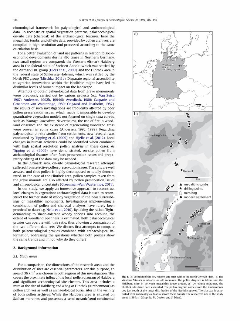
Fig. 1. (a) Location of the key regions and sites within the North German Plain. (b) TheWestern Altmark is situated on old moraines. The pollen diagram is taken from theHaidberg mire in between megalithic grave groups. (c) On young moraines, theFlintbek sites have been excavated. The pollen diagram comes from the Kirchenmoorbog just south of the linear distribution of the Neolithic graves. The charcoal is asso-ciated with archaeological features from these burials. The respective size of the studyareas is 36 km2 (Graphic: M. Oetken and S. Diers).
S. Diers et al. / Journal of Archaeological Science 41 (2014) 185e198186
chronological framework for palynological and anthracologicaldata. To reconstruct spatial vegetation patterns, palaeoecologicalon-site data (charcoal) of the archaeological features, here themegalithic tombs, and off-site data, provided by pollen archives, arecompiled in high resolution and processed according to the samecalculation basis.
For a better evaluation of land use patterns in relation to socio-economic developments during FBC times in Northern Germany,two small regions are compared: the Western Altmark Haidbergarea in the federal state of Sachsen-Anhalt, which was settled bythe Altmark FBC group (Diers et al., 2009), and the Flintbek area inthe federal state of Schleswig-Holstein, which was settled by theNorth FBC group (Mischka, 2011a). Disparate regional accessibilityto agrarian innovations within the Neolithic might have led todissimilar levels of human impact on the landscape.
Attempts to obtain palynological data from grave monumentswere previously carried out by various projects (e.g. Van Zeist,1967; Andersen, 1992b, 1994/5; Averdieck, 1980; Casparie andGroenman-van Waateringe, 1980; Odgaard and Rostholm, 1987).The results of such investigations are frequently affected by poorpollen preservation issues, which made it impossible to developquantitative vegetation models not focused on single taxa curves,such as Plantago lanceolata. Nevertheless, the use of fire in wood-land clearance and the existence of regenerating woodland areaswere proven in some cases (Andersen, 1993, 1998). Regardingpalynological on-site studies from settlements, new research wasconducted by Tipping et al. (2009) and Hjelle et al. (2012). Localchanges in human activities could be identified when combinedwith high spatial resolution pollen analysis in these cases. AsTipping et al. (2009) have demonstrated, on-site pollen fromarchaeological features often faces preservation issues and prepa-ratory editing of the data may be needed.
In the Altmark area, on-site palynological research attemptssuffered from selective pollen preservation issues. The soils are wellaerated und thus pollen is highly decomposed or totally deterio-rated. In the case of the Flintbek area, pollen samples taken fromthe grave mounds are also affected by pollen preservation issuesand chronological uncertainty (Groenman-Van Waateringe, 2011).
In our study, we apply an innovative approach to reconstructlocal changes in vegetation: anthracological data is used to recon-struct the former state of woody vegetation in the near surround-ings of megalithic monuments. Investigations implementing acombination of pollen and charcoal analyses have rarely beenpracticed to date (e.g. Nelle et al., 2010). By taking the ratio of light-demanding to shade-tolerant woody species into account, theextent of woodland openness is estimated. Both palaeoecologicalproxies can operate with this ratio, thus allowing a comparison ofthe two different data sets. We discuss first attempts to compareboth palaeoecological proxies combined with archaeological in-formation, addressing the questions whether both proxies showthe same trends and, if not, why do they differ?
2. Background information
2.1. Study areas
For a comparison, the dimensions of the research areas and thedistribution of sites are essential parameters. For this purpose, anarea of 36 km2was chosen in both regions of this investigation. Thiscovers the proximate influx of the local pollen diagram of Haidbergand significant archaeological site clusters. This area includes amire at the site of Haidberg and a bog at Flintbek (Kirchenmoor) aspollen archives as well as archaeological burial sites in the vicinityof both pollen archives. While the Haidberg area is situated onSaalian moraines and possesses a semi-oceanic/semi-continental

S. Diers et al. / Journal of Archaeological Science 41 (2014) 185e198 187
climate, the Flintbek area is located on Weichselian morainegrounds formed in conjunction with an oceanic climate near theBaltic Sea (Fig. 1a).
The megalithic tomb sites in the Western Altmark region aredistributed in a dispersed manner, often in small groups on theslopes of the hilly relief in the study region. The sites are noterected on the highest points of the relief, but on different heightsof the slopes (Demnick, 2009; Demnick et al., 2008a, 2008b; Diersand Demnick, 2012; Fritsch, 2006). The Haidberg mire is locatedin the centre of the local investigation area, measuring 0.17 ha insize. It primarily features local pollen influx. Three groups ofmegalithic tombs are located to the north and south of the mire inthe vicinity at a distance of 0.8 kme3 km (Fig. 1b). Althoughlocated at some distance from the tombs, this investigationnevertheless attempts to detect the Neolithic burial constructionactivity in the pollen diagram. A settlement area is confirmed at adistance of 7 km in the Beetzendorf Valley, a kind of flat riverinebasin (Fig. 2). Here, a pollen analysis indicates an open landscapenear domestic sites from ca. 3200 cal BC onwards (Demnick et al.,2008a, 2008b).
Fig. 2. Extended research area of 12 � 15 km in the Western Altmark, including the Haidoecological sites mentioned in the text are labelled. Charcoal samples belong to the long b
In contrast, the Neolithic sites of the Flintbek region were con-structed along a ridge spread over about 3.3 km (Fig. 1c). A possiblesettlement area of about 8 km2 was limited by the valley of theEider River in the northwest and in eastern and southern directionsby three mires. To the southeast, the landscape features an endmoraine with small hills and kettle-hole mires. The Funnel Beakertombs were constructed slightly below the highest parts of theridge towards the Eider River Valley. The complete Neolithicsequence of the Subboreal was only preserved in the southernmostKirchenmoor bog. With an expanse of approximately 35 ha, the bogconstituted a trap for regional pollen. The nearest megalithic burialsite was located about 1.85 km to the northeast of the bog. Theresults gained from this bog can be recognized as good local toregional background information.
2.2. Archaeology and chronology
For Flintbek, more than 150 AMS dates have been used toanalyse the development of 26 archaeological sites. Among thelatter, some delivered finds and features indicating Early Funnel
berg area. Known Funnel Beaker Culture sites are mapped. Archaeological and palae-arrow Lüdelsen 6 (Graphic: H. Dieterich).

S. Diers et al. / Journal of Archaeological Science 41 (2014) 185e198188
Beaker settlement activities. At nearly all of the sites different kindsof tombs were found. Especially the long barrows have severaldevelopment phases (Mischka, 2011a, 2011b). The dates generallyrange within a timeframe from ca. 3630 cal BC until ca. 1800 cal BC.For the Western Altmark region (Fig. 2), two megalithic tombs arecurrently dated by 17 AMS dates (Demnick et al., 2008a, 2008b;Diers and Demnick, 2012). These provide the first absolute chro-nological evidence for FBCmegalithic tombs dated to 3550 cal BC inthe mentioned region. The youngest Neolithic dates are associatedwith secondary burials of the Single Grave culture within theexisting megalithic tombs and date to ca. 2400 cal BC.
In both regions, human activity is already indicated before3600 cal BC by archaeological features such as settlement pits(Flintbek area) and first depositions (Lüdelsen 3), intentional sanddeposits (Lüdelsen 6), flint scatters and settlement features (Tan-geln). Contemporaneously, the first megalithic tombs of differentdolmen constructions appeared in Flintbek (Mischka, 2011a). Forthe Western Altmark, dolmens with a round enclosure, such asLüdelsen 3, were constructed not later than around 3550 cal BC. Thedolmens were usually covered by mounds. These mounds wereeither constructed in round versions including a crepis (a line of bigstone blocks that marks the outer limit of the barrows) or, as atLüdelsen 3 (Bock et al., 2006; Demnick et al., 2008a, 2008b; Fritschand Müller, 2012), with a round kerb of small boulders.Rectangular-shaped mounds with side kerbstones are a furthertypical FBC burial feature and were also observed. The lattermounds were parts of sequentially enlarged monuments that wereinitiated with either a megalithic dolmen tomb or a so-called non-megalithic mortuary structure during initial phases in Flintbek andthe Western Altmark (Lüdelsen 6). The entire monuments arereferred to as long barrows (“Langbetten”). In the case of Flintbek,the earliest long barrow with an initial non-megalithic tomb wasdated exactly to 3500 cal BC. It was constructed as a complicated,timber-built mortuary house, limited by pebble stones and coveredwith an oval-shaped earthen mound. In Lüdelsen 6, the non-megalithic structure dates to ca. 3700 cal BC. Simple non-megalithic single graves were also common in Flintbek, but arenot yet known for the Altmark region. In Flintbek, these were un-spectacular long oval shaped pits for inhumations, often dug intothe centre or periphery of an older tumulus. In the Altmark, a non-megalithic long mound at Lüdelsen 6 was enlarged with a passagegrave, a raised trapezoidal mound and kerbstones in differentphases. AMS dates indicate the beginning of the non-megalithicstructures before the megalithic structures contemporary withthe dolmen Lüdelsen 3. At about 3350 cal BC, passage graves werethe dominant mode of construction in Flintbek and in the Altmark.In both regions, the end of the construction phase for new passagegraves is difficult to date because of a plateau in the calibrationcurve of about 300e400 years, lasting until the beginning of theEarly Single Grave Culture, with single burials in small moundsaround 2900/2800 cal BC. Most of the megalithic tombs had beenused several times for secondary burials. In the Altmark, ceramicdepositions on top of the Lüdelsen 3 dolmen mound refer to ac-tivities between Late FBC and the observed secondary Single Graveburial. Also, Globular Amphorae activities could be identified atgrave mounds in both regions. On the whole, tombs for collectiveburials were redesigned into single grave mounds.
The development of the subsistence economy and ritual econ-omies is important for reconstructing the meaning of monumentsin landscapes. In Flintbek, it was possible to recognize ard marksunderneath four long barrows. This verifies the use of this agri-cultural/technical innovation which made it possible to farm largerplots of land. As a result, strong impacts on the vegetation arethereby likely to be reflected in archaeobotanical proxies. The ab-solute dates of the features above the ardmarks deliver termini ante
quem for the emergence of the ard. For Flintbek, these activitiesstarted before 3560 cal BC (Mischka, 2011a). The ard marks inFlintbek support the assumption that graves were built on formerfields, even if some ard marks are discussed to be of a ritual nature(Pätzold, 1960; Rowley-Conwy, 1987).
In contrast, brown forest soil beneath the Lüdelsen 3 burialmound indicates an intentional clearing of woodland for the con-struction of the megalithic tomb (Demnick et al., 2008a, 2008b).Pits for earth extraction, detected within 25 m distance from thegrave mound, strongly suggest that soil was taken from these pitsfor construction purposes. This also implies that human impact inthis context must have been closely confined. The lack of sods in themound most likely indicates that an open landscape was not theprevailing vegetation type in the nearby surroundings.
3. Material and methods
3.1. Pollen
The two pollen data sets were processed identically to allow adetailed and reliable comparison of the studied local areas (Figs. 3and 4). Theywere both gained frommires reflecting local (Haidbergmire) and regional (Kirchenmoor bog) vegetation. A pollen recordfrom the Beetzendorf Valley (Demnick et al., 2008a, 2008b) wasused to estimate further aspects of regional vegetation de-velopments in the Western Altmark Haidberg area.
The reference sum of the taxa curves is composed of land plants,excluding Calluna and Cyperaceae, which are considered here to beplants growing on the bog surface and therefore tend to be over-represented. Identification of the taxa and pollen types followsBeug (2004) and Moore et al. (1991). Additionally, the referencecollection of pollen at the Institute of Pre- and ProtohistoricArchaeology, Kiel, was consulted.
The diagramswere generated with the programme CountPol 3.3by I. Feeser. The selected taxa or types are chosen identically inorder to illustrate the differences between light-demanding andshade-tolerant species as well as the onset of human impact withinthe key regions. Indicator taxa for shade-tolerance are those of thedeciduous mixed-oak forest, including Pinus, which is a commontree in the Altmark. In Flintbek, this taxon amounts to less than 5%,reflecting long-distance transport rather than a presence of thistaxon in the surroundings. Betula and Corylus are regarded as light-demanding taxa. An open landscape as the result of arable farmingand livestock breeding is indicated by the sum curves of pastoraland arable taxa as well as by single curves of Poaceae, P. lanceolataand cereal-type. The summed anthropogenic indicators are listedalphabetically in Table 1. In both key regions, their low values donot deliver further information for our research design. In bothcases, the preservation of pollen is good and does not affect theinterpretation of the results.
Calluna and Cyperaceae were included in the diagrams to reflectthe very local open landscape. To detect possible forest-grazing orforest fires, Pteridium and the counted charcoal particles above10 mm are shown.
Both diagrams are plotted against a time scale ranging from ca.3800e2800 cal BC. They rely on the AMS dates of the two profiles(Table 2) taken from bulk samples of raised bog peat (Kirch-enmoor), fen peat and macroscopic plant remains (Haidberg). Thetime scale was provided by the age-depth-models of the two datasets, as processed in OxCal4.1.7 (Bronk Ramsey, 2008). Both age-depth-models were produced using a P-sequence with k-factor 1.The basis of calculation for the Flintbek-model is the pollen strat-igraphic feature of the elm decline which differs chronologically inboth regions. According to a new calibration of the profile of LakeBelau in Schleswig-Holstein (Dörfler et al., 2012), the end of the elm

Fig. 3. Pollen diagram Haidberg mire (HAI) plotted against the time scale for the time span 3800e2800 cal BC with LPAZ (Local Pollen Assemblage Zones). Reference sum: terrestrial plant pollen counts. Selected taxa.
S.Diers
etal./
Journalof
Archaeological
Science41
(2014)185
e198
189

Fig. 4. Pollen diagram Kirchenmoor bog (FKM) plotted against the time scale for the time span 3800e2800 cal BC with LPAZ (Local Pollen Assemblage Zones). Reference sum: terrestrial plant pollen counts. Selected taxa.
S.Diers
etal./
Journalof
Archaeological
Science41
(2014)185
e198
190
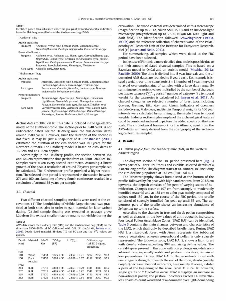
Table 1Identified pollen taxa subsumed under the groups of pastoral and arable indicatorsfrom the Haidberg mire (HAI) and the Kirchenmoor bog (FKM).
“Haidberg” mire
Arable indicatorsFrequent Artemisia, Avena-type, Cerealia indet., Chenopodiaceae,
Cannabis/Humulus, Plantago major/media, Rumex acetosa-typePastoral indicatorsFrequent Anthemis-type, Apiaceae p.p, Bidens-type, Caryophyllaceae p.p.,
Filipendula, Galium-type, Gentiana pneumonanthe-type, Jasione,Liguliflorae, Plantago lanceolata, Poaceae, Ranunculus acris-type,Rosaceae, Scrophulariaceae, Silene-type, Thalictrum.
Rare types Anagallis-type, Aster-type.
“Kirchenmoor” bog
Arable indicatorsfrequent Artemisia, Cerastium-type, Cerealia indet., Chenopodiaceae,
Hordeum-type, Rumex acetosa-type, Triticum-type.Rare types Brassicaceae, Cannabis/Humulus, Lamium-type, Plantago
major/media, Polygonum avicularePastoral indicatorsFrequent Anthemis-type, Apiaceae p.p., Bidens-type, Filipendula,
Liguliflorae, Mercurialis perennis, Plantago lanceolata,Poaceae, Ranunculus acris-type, Rosaceae, Trifolium-type
Rare types Caryophyllaceae p.p., Centaurea jacea-type, Galium-type,Jasione, Phyteuma-type, Potentilla-type, Rhinanthus-type,Silene-type, Succisa, Thalictrum, Urtica, Vicia-type.
S. Diers et al. / Journal of Archaeological Science 41 (2014) 185e198 191
decline dates to 3840 cal BC. This date is included in the age-depth-model of the Flintbek-profile. The section prior to 3840 cal BC is notradiocarbon dated. For the Haidberg mire, the elm decline datesaround 3580 cal BC. However, since the duration of the decline isnot fixed, it may be just a snap-shot of it. Christiansen (2008)estimated the duration of the elm decline was 180 years for theNorthern Altmark. The Haidberg model is based on AMS dates at160 cm and at 110 cm depths.
Accordingly, in the Haidberg profile, the section between 154and 126 cm represents the time period from ca. 3800e2800 cal BC.Samples were taken every second centimetre. Assuming a lineargrowth of the peat, a resolution of around 70 years per sample canbe calculated. The Kirchenmoor profile provided a higher resolu-tion. The selected time period is represented in the section between274 and 160 cm. Sampling of every fourth centimetre resulted in aresolution of around 35 years per sample.
3.2. Charcoal
Two different charcoal sampling methods were used at the ex-cavations. (1) The handpicking of visible, large charcoal was prac-ticed at both sites, also in order to gain material for later carbondating. (2) Soil sample floating was executed at passage graveLüdelsen 6 to extract smaller macro remains not visible during the
Table 2AMS-dates from the Haidberg mire (HAI) and the Kirchenmoor bog (FKM) for thetime span 3800e2800 cal BC. Calibrated with Calib 5.1 (IntCal 04, Reimer et al.,2004). Depth, dated material, BP-date,
P2 cal BC-date and the d13C values are
quoted.
Depth(cm)
Material Lab-Nr.KIA
14C-Age(BP)
d13C(&) Calibrated age(cal BC, 2-sigma,probability)
HAI110 Wood 35134 3775 � 30 �23.57 � 0.21 2292 2058 95.4160 Plant
remains35135 5280 � 30 �26.69 � 0.07 4182 3995 95.4
FKM213 Bulk 37518 4480 � 35 �28.63 � 0.29 3341 3085 88.7232 Bulk 37519 4465 � 35 �23.81 � 0.22 3341 3021 95.4258 Bulk 37520 4865 � 35 �29.09 � 0.20 3710 3631 88.7282 Bulk 37521 5030 � 30 �23.90 � 0.14 3945 3760 90.6
excavation. The wood charcoal was determined with a stereoscope(magnification up to �112, Nikon SMZ 1500) and an incident-lightmicroscope (magnification up to �500, Nikon ME 600, light anddark field). The identification followed Schweingruber (1990a,1990b) and the reference collection of charred wood of the Palae-oecological Research Unit of the Institute for Ecosystem Research,Kiel (cf. Jansen and Nelle, 2013).
For summarizing, all samples which were dated to the FBCperiod have been selected.
In the caseof Flintbek, amore detailed time scale is possible due tothe high amount of dated charcoal samples. This is based on aBayesian model in OxCal and an aoristic model (Mischka, 2011a;Ratcliffe, 2000). The time is divided into 5 year intervals and the a-posteriori AMS dates are rounded to 5 years each. Each sample is is-sued aweight-per-time-span (aorist i¼ 1/number of 5 year intervals)to avoid over-emphasizing of samples with a large date range. Bysumminguptheaoristic valuesmultipliedby thenumberof charcoalsper taxaor category (
Pni¼1 aorist i*number of category i), a temporal
weight for the categories is calculated (cf. Jansen et al., 2013). Ascharcoal categories we selected a number of forest taxa, includingQuercus, Fraxinus, Tilia, Acer, and Ulmus. Indicators of opennessincludeCorylus,Maloideae, and Betula. Temporalweights for 100 yearintervals were calculated by summing up the single 5 year temporalweights. In doing so, the single samples of the archaeological featurescould be combined and used to picture the added spectra on the timescale. The chronological framework for the Altmark, apart from theAMS-dates, is mainly derived from the stratigraphy of the archaeo-logical features sampled.
4. Results
4.1. Pollen profile from the Haidberg mire (HAI) in the WesternAltmark region
The diagram section of the FBC period presented here (Fig. 3)forms part of S. Diers’ PhD thesis and exhibits selected details of a230 cm long profile. The diagram starts at ca. 3800 cal BC, includingthe elm decline pinpointed at 148 cm (3581 cal BC).
The lithostratigraphy shows humic sand at the bottom of theprofile, followed by fen peat with high sand content. From 203.5 cmupwards, the deposit consists of fen peat of varying states of hu-mification. Changes occur at 197 cm from strongly to moderatelyhumified material and at 188 cm to a fen peat mainly composed ofsedges until 159 cm. In the course of the FBC period, the profileconsisted of strongly humified fen peat up until 55 cm. The up-permost part of the profile shows an increasing abundance ofSphagnum up to the surface.
According to the changes in tree and shrub pollen compositionas well as changes in the low values of anthropogenic indicators,four Local Pollen Assemblage Zones (LPAZ HAI) can be identified.Table 3 contains the main changes between and characteristics ofthe LPAZ, which shall only be described briefly here. During LPAZHAI 1, a mixed-oak forest with Pinus represents the Subborealwoody vegetation, whereas non-arboreal pollen is only sparselyrepresented. The following zone, LPAZ HAI 2, shows a light forestwith Corylus values exceeding 30% and rising Betula values. Thecereal-type is present in this zonewith one pollen grain, while non-arboreal taxa, especially arable and pastoral indicators, remain atlow percentages. During LPAZ HAI 3, the mixed-oak forest withPinus regains strength. Towards the end of the zone, shrubs (mainlyCorylus) decrease. Pastoral indicators, here mainly Poaceae, exhibita peak at the beginning of the zone. From 3100 cal BC onwards,single grains of P. lanceolata occur. LPAZ 4 displays an increase innon-arboreal pollen; the pastoral indicators exceed 1%. Neverthe-less, shade-tolerant woodland taxa dominate over light-demanding
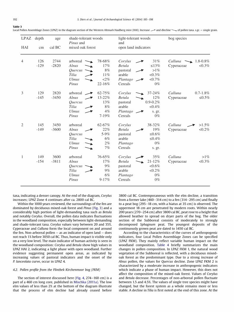
Table 3Local Pollen Assemblage Zones (LPAZ) in the diagram section of the Western Altmark Haidberg mire (HAI). Increase and dlecline of pollen taxa. s.gr. ¼ single grain.
LPAZ depth age shade-tolerant woods light-tolerant woods bog speciesPinus and and
HAI cm cal BC mixed oak forest open land indicators
4 126 2744 arboreal 78-68% Corylus 31% Calluna 1.8-0.8%-129 -2820 Alnus 17% Betula Cyperaceae <0.3%
Quercus 8% pastoral >1%Tilia 11% arable <0.3%Ulmus <2% Plantago <0.7%Pinus 22-16% Cereals 0%
3 129 2820 arboreal 62-75% Corylus 37-24% Calluna 0.7-1.8%-145 -3450 Alnus 13-22% Betula 12% Cyperaceae
Quercus 13% pastoral 0.9-0.2%Tilia 8% arable <0.4%Ulmus 4% Plantago s. gr.Pinus 7-19% Cereals 0%
2 145 3450 arboreal 62-67% Corylus 38-32% Calluna >1.5%-149 -3600 Alnus 22% Betula 19% Cyperaceae <0.2%
Quercus 5-9% pastoralTilia 6% arableUlmus 2% Plantago 0%Pinus 7% Cereals s. gr.
1 149 3600 arboreal 76-65% Corylus 35% Calluna >1%-154 -3811 Alnus 17% Betula 21-12% Cyperaceae <0.3%
Quercus 9% pastoral <0.6%Tilia 9% arable <0.2%Ulmus 6% Plantago 0%Pinus 9-17% Cereals 0%
S. Diers et al. / Journal of Archaeological Science 41 (2014) 185e198192
taxa, indicating a denser canopy. At the end of the diagram, Corylusincreases; LPAZ Zone 4 continues after ca. 2800 cal BC.
Within the 1000 years reviewed, the surroundings of the fen aredominated by deciduous mixed-oak forest and Pinus (Fig. 3) and aconsiderably high portion of light-demanding taxa such as Betulaand notably Corylus. Overall, the pollen data indicates fluctuationsin the woodland composition, especially between light-demandingand shade-tolerant taxa. Corylus values vary between 20 and 35%.Cyperaceae and Calluna form the local component on and aroundthe fen. Non-arboreal pollen e as an indicator of open land e doesnot reach 1% before 3050 cal BC. Thus, human impact is visible onlyon a very low level. The main indicator of human activity is seen inthe woodland composition: Corylus and Betula show high values inLPAZ HAI 2, indicating a light phase with open woodland. Furtherevidence suggesting permanent open areas, as indicated byincreasing values of pastoral indicators and the onset of theP. lanceolata curve, occur in LPAZ 4.
4.2. Pollen profile from the Flintbek Kirchenmoor bog (FKM)
The section of interest discussed here (Fig. 4, 274e160 cm) is apart of a 460 cm long core, published in Mischka (2011a). The lowelm values of less than 2% at the bottom of the diagram illustratethat the process of elm decline had already ceased before
3800 cal BC. Contemporaneous with the elm decline, a transitionfrom a former lake (460e314 cm) to a fen (314e295 cm) and finallyto a peat bog (295e18 cm, with a hiatus at 35 cm) is observed. Theuppermost 18 cm are penetrated by modern roots. Within nearly200 years (270e254 cm) after 3800 cal BC, peat rose to a height thatallowed heather to spread on dryer parts of the bog. The oldersection of the Subboreal consists of moderately to stronglydecomposed Sphagnum peat. The youngest deposits of thecontinuously grown peat are dated to 1450 cal BC.
According to the characteristics of the curves of anthropogenicindicators, four Local Pollen Assemblage Zones can be specified(LPAZ FKM). They mainly reflect variable human impact on thewoodland composition. Table 4 briefly summarizes the mainchanges in pollen composition. In LPAZ FKM 1, the natural woodvegetation of the Subboreal is reflected, with a deciduous mixed-oak forest as the predominant type. Due to a strong increase ofAlnus pollen, the values for Quercus decline. Zone LPAZ FKM 2 ischaracterized by a moderate increase in anthropogenic indicatorswhich indicate a phase of human impact. However, this does notaffect the composition of the mixed-oak forest. Values of Corylusand Betula decrease. Percentages of non-arboreal pollen fluctuatebetween 1.5 and 4.5%. The values of single tree species might havechanged, but the forest system as a whole remains more or lessstable. A decline in Tilia is first noted at the end of this zone. At the
Table 4Local Pollen Assemblage Zones (LPAZ) in the diagram section of the Flintbek Kirchenmoor bog (FKM). Increase and decline of pollen taxa, s.gr. ¼ single grains.
S. Diers et al. / Journal of Archaeological Science 41 (2014) 185e198 193
same time, Corylus-values recover from a small depression. In LPAZFKM 3, especially the subdominant trees Tilia, Fraxinus and Ulmusregain moderate values of around 5%. Corylus approaches the 50%point, with a simultaneous decrease of Alnus at the end of LPAZFKM 3. In the following pollen zone, LPAZ FKM 4, higher values ofnon-arboreal pollen indicate a phase of human impact. This set-tlement phase continues for another 100 years until 2700 cal BC(not displayed). Corylus reaches maximum values of 53%, whilethose of Betula and taxa of the deciduous mixed-oak forestdecrease. This corresponds with slightly higher values of Pteridiumand micro-charcoal. Altogether, these processes indicate an open-ing of the landscape.
During the 1000 years between 3800 and 2800 cal BC, the land-scape near Flintbek was dominated by deciduous mixed-oak forestwith Quercus, reaching pollen proportions of the terrestrial pollensum between 10 and 20%. The partially open canopy of these forests,at least inpart, promoted thedistributionof light-demanding shrubs,such as Corylus, whose values fluctuate between 30 and 40%. Pinusremains at a low level, around 2e3%, and is regarded as a result oflong distance transport. The prevailing loamy soils excluded standsof Pinus in the region. The local component is characterized by Alnus,distributed in carrs and floodplains, and by Calluna and Cyperaceae,mainlygrowingon thebog itself. Non-arboreal pollen, an indicatorofan open landscape, was sparse and remained below 5%. Cereal-type
pollen appears as single grains. Their curve is still intermittent, butvalues are apparently increasing (LPAZ FKM 4: 0.3%).
4.3. Charcoal results
474 charcoal pieces from 44 samples belonging to FBC contextsin the Altmark have been analysed. The main taxa include Quercus,Pinus, Corylus and Betula. From Flintbek, a larger number of samples(79) and pieces (1316) are available (Jansen et al., 2013).
Comparable to the Altmark site Lüdelsen 6, Quercus and Corylusare the main taxa represented at the Flintbek evidence. Further-more, wetland taxa, such as Alnus and Fraxinus, and the Maloideaegroup, are considerably more frequent in the Flintbek data than atLüdelsen 6. Based on the number of charcoal pieces, the pro-portions of taxa indicating openness, including Corylus, Maloideaeand Betula, amount to ca. 40% for the Flintbek megalithic landscapeand ca.18% for theWestern Altmarkmegalithic landscape (Fig. 5). Incontrast, the values of woodland taxa, including Quercus, Pinus,Fraxinus, Tilia, Acer and Ulmus, are higher at the Altmark site than atFlintbek. The complete data set of both sites and problems ofinterpretation due to the different sampling strategies are dis-cussed in Jansen and Nelle (2013).
Due to the lower number of samples and particularly datedsamples, a more detailed time separation of the Altmark material is

Fig. 5. Charcoal from the passage grave Lüdelsen 6 (n ¼ 474) in the Western Altmark and the Flintbek burial mounds (n ¼ 1316). The assemblages are displayed in percentages of thetotal fragment number. Further woodland taxa: Ulmus, Tilia and Acer; wetland taxa: Alnus and Fraxinus (Analyses: D. Jansen).
S. Diers et al. / Journal of Archaeological Science 41 (2014) 185e198194
not indicated here. Dates range between ca. 3600 and 2800 cal BC,the FBC usage phases of the grave Lüdelsen 6.
In the case of Flintbek, a comparison of 100 year intervals waspossible. The changes in openness of the local environment areexpressed as a ratio between light-demanding and shade-tolerantwood taxa (Fig. 6). While the value of openness remains low until3700 cal BC (ratio: <0.5), it subsequently rises to a much higherlevel up to a ratio of 1.5. After the time interval 3700e3600 cal BC,the proportion of light-tolerant taxa decreases slowly until itreached its former ratio between 2900 and 2800 cal BC.
5. Discussion
5.1. Discussion of approaches
The identical processing of the two pollen diagrams enabledexcellent comparability of the results. Observed differences be-tween the diagrams are discussed with regard to matters of influxareas, their position in relation to the settlements and the buriallandscape areas, and within their natural environments, includingfactors such as soils and climate. The Haidberg mire, being a smallpollen trap (0.17 ha), was assumed to have mirrored local vege-tation responses, i.e., human impact activities in the near sur-roundings. It is situated between 3 grave groups, at a distance of0.8e3 km within a forested landscape, which might have affectedthe absence of distinct anthropogenic markers. In contrast, theKirchenmoor bog is rather large (35 ha) and reflects regionaldevelopments of the landscape. With relation to the gravemounds, the latter bog is located in a peripheral position, at thenearest 1.85 km away from the southernmost monuments.Anthropogenic indicators in this diagram were expected to berather weak. But, if anthropogenic indicators were neverthelessrecorded, human influence on the environment must have beenmuch greater than in comparable records from a small mire nearsites.
Soil and climate factors appear to have also caused differences inthe occurrence of species. This is the case for Pinus, which had notbeen a common tree in Holstein but in the Altmark since the Borealdue to the sandy Saalian moraine soils and the semi-continentalclimate in the latter region.
Due to insect pollination, the Maloideae group is not repre-sented in the pollen records; it occurs only in the anthracological
material of Flintbek. The Maloideae group represents light-demanding trees and shrubs such as those of the genera Malus,Pyrus and Crataegus.
For the approach to discuss the openness of the landscape bymeans of the ratio between the two indicated habitats, both taxa,Pinus, belonging to the group of shade-tolerant tree species, andMaloideae, belonging to the group of light-demanding taxa, areincluded in the calculation.
As previously mentioned (see Section 4.3), the anthracologicalinvestigation had to overcome a methodological obstacle: thematerial basis relying on different sampling strategies (cf. Jansenand Nelle, 2013). In both study areas, the identified charcoal orig-inates from material of the grave mounds and provides local in-formation on the surroundings of the monuments. Thus, the pollenand charcoal results allow a direct comparison of the local woodvegetation in the Haidberg region (Western Altmark), whereasthese data sets complement one another on local (charcoal) andregional (pollen) scales in the Flintbek region.
Additionally, the chronological frameworks differ. In the Alt-mark, the correlation of pollen and charcoal data depended on thedating of the archaeological stratigraphy.
The aoristic method used for dating the charcoal from Flintbekenables theplottingof the results fromanthracologyandpalynologyagainst the same time scale and allowsa broader interpretation. Thisis an improvement compared to the method of discussing singlearchaeological features, single dates and single spectra of thesefeatures with their different time ranges and limited samples sizes(Fig. 6). The positive application of Bayesian statistics and aoristicmodelling to analyse charcoal data deliver a newquality of research.
5.2. Discussion of Western Altmark results
For the Western Altmark Haidberg area, pollen and charcoalresults correlate well with each other with respect to their overallwoodland composition throughout the time span analysed. Due toa continuous record and a fixed chronology, the pollen data enablea more detailed reconstruction of the woodland developmentduring the FBC period. The charcoal assemblages from tombLüdelsen 6 can be defined as belonging to the FBC between 3600and 2800 cal BC. They show the dominance of shade-tolerantwoodland taxa (Fig. 5). The number of tree taxa in the Haidbergpollen diagram exceeds that of the charcoal assemblages. The latter
L3: grave mound
mound
FBC depositions
burialse
d
L6: passage grave
Plantago lanceolata
Plantago lanceolata
s
s
Time(cal BC)
Time(cal BC)
Archaeology
Archaeology
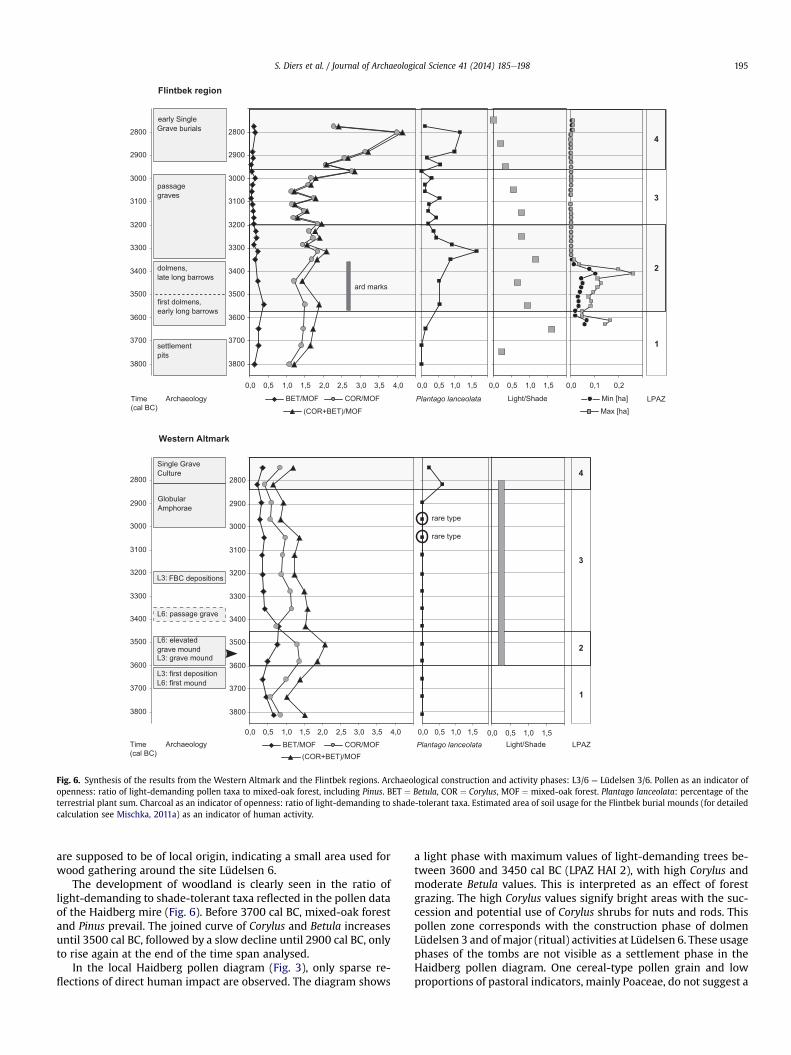
Fig. 6. Synthesis of the results from the Western Altmark and the Flintbek regions. Archaeological construction and activity phases: L3/6 ¼ Lüdelsen 3/6. Pollen as an indicator ofopenness: ratio of light-demanding pollen taxa to mixed-oak forest, including Pinus. BET ¼ Betula, COR ¼ Corylus, MOF ¼ mixed-oak forest. Plantago lanceolata: percentage of theterrestrial plant sum. Charcoal as an indicator of openness: ratio of light-demanding to shade-tolerant taxa. Estimated area of soil usage for the Flintbek burial mounds (for detailedcalculation see Mischka, 2011a) as an indicator of human activity.
S. Diers et al. / Journal of Archaeological Science 41 (2014) 185e198 195
are supposed to be of local origin, indicating a small area used forwood gathering around the site Lüdelsen 6.
The development of woodland is clearly seen in the ratio oflight-demanding to shade-tolerant taxa reflected in the pollen dataof the Haidberg mire (Fig. 6). Before 3700 cal BC, mixed-oak forestand Pinus prevail. The joined curve of Corylus and Betula increasesuntil 3500 cal BC, followed by a slow decline until 2900 cal BC, onlyto rise again at the end of the time span analysed.
In the local Haidberg pollen diagram (Fig. 3), only sparse re-flections of direct human impact are observed. The diagram shows
a light phase with maximum values of light-demanding trees be-tween 3600 and 3450 cal BC (LPAZ HAI 2), with high Corylus andmoderate Betula values. This is interpreted as an effect of forestgrazing. The high Corylus values signify bright areas with the suc-cession and potential use of Corylus shrubs for nuts and rods. Thispollen zone corresponds with the construction phase of dolmenLüdelsen 3 and ofmajor (ritual) activities at Lüdelsen 6. These usagephases of the tombs are not visible as a settlement phase in theHaidberg pollen diagram. One cereal-type pollen grain and lowproportions of pastoral indicators, mainly Poaceae, do not suggest a
S. Diers et al. / Journal of Archaeological Science 41 (2014) 185e198196
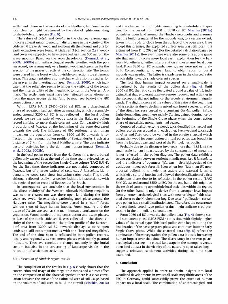
settlement phase in the vicinity of the Haidberg fen. Small-scalelocal clearing might be stressed by the ratio of light-demandingto shade-tolerant species (Fig. 6).
The values of Betula and Corylus in the charcoal assemblagesindicate at least minor to medium disturbance in the vicinity of theLüdelsen 6 grave. As woodland soil beneath the mound and pits forearth extraction were found at Lüdelsen 3 (cf. Section 2.2), wood-land cover was expected to have prevailed less than 100m from thegrave mounds. Based on the geoarchaeological (Demnick et al.,2008a, 2008b) and anthracological results together with the pol-len record, we assume only very limited woodland openings for theerection of the graves directly at the construction site. The tombswere placed in the forest without visible connections to settlementareas. This argumentation also matches with visibility studies forthe graves in the investigation area (Demnick, 2009), which indi-cate that the relief also seems to hinder the visibility of the tombsand the intervisibility of the megalithic tombs in the Western Alt-mark. The settlements must have been situated some kilometresfrom the grave groups during (and beyond, see below) the FBCconstruction phases.
Within LPAZ HAI 3 (3450e2820 cal BC), an archaeologicalphase of repeated ritual activities at megaliths, which presumablyended around 3200 cal BC, is not reflected in the local pollenrecord; we see the ratio of woody taxa in the Haidberg pollenrecord shifting to more shade-tolerant taxa. Comparatively highproportions of Poaceae at the beginning of the zone decreasedtowards the end. The influence of FBC settlements as humanimpact on the vegetation from ca. 3200 cal BC onwards is re-flected in the regional pollen profile of Beetzendorfer Bruch at adistance of 7 km from the local Haidberg mire. The data indicatepastoral activities being the dominant human impact (Demnicket al., 2008a, 2008b).
In the local pollen record from the Haidberg mire, non-arborealpollen only exceed 1% at the end of the time span reviewed, i.e., atthe beginning of the succeeding Single Grave culture (LPAZ HAI 4).For the first time, these indicators are not mainly composed ofPoaceae, but of a larger variety of taxa, e.g., P. lanceolata. Light-demanding wood taxa show increasing ratios again. This trend,although reflected locally in aweaker fashion, is in accordance withthe regional pollen record of Beetzendorfer Bruch.
In consequence, we conclude that the local environment inthe direct vicinity of the Western Altmark Haidberg megalithswas neither cleared nor was there open land during the 1000years reviewed. No extensive gardening took place around theHaidberg mire. The megaliths were placed in a “calm” forestwithout signs of huge human impact. Forest grazing and theusage of Corylus are seen as the main human disturbances on thevegetation. Wood needed during construction and usage phases,at least of the tomb Lüdelsen 6, was collected in the direct vi-cinity of the sites. In contrast, the pollen profile of the Beetzen-dorf area from 3200 cal BC onwards displays a more openlandscape still contemporaneous with the “forested megaliths”.The end of the time span is reflected in both pollen records,locally and regionally, as settlement phases with mainly pastoralindicators. Thus, we conclude a change not only in the burialcustom but also in the structuring of landscape visible in therelocation of settlement activities.
5.3. Discussion of Flintbek region results
The compilation of the results in Fig. 6 clearly shows that theconstruction and usage of the megalithic tombs had a direct effecton the composition of the charcoal species: there is a clear corre-lation between the curve of the estimated area of soil usage, basedon the volumes of soil used to build the tumuli (Mischka, 2011a)
and the charcoal ratio of light-demanding to shade-tolerant spe-cies. For the period from 3700 to 3370 cal BC, Mischka (2011a)postulates open land around the Flintbek necropolis and assumesthat the building material for the mounds was, to a certain extent,taken in thin sods or clods from the surface of the open area. If weaccept this premise, the exploited surface area was still local: it isestimated from 11 to 2620 m2 (for the detailed calculation basis seeMischka, 2011a). However, there were also some pits at one gravesite that might indicate more local earth exploitation for the bar-rows. Nonetheless, neither interpretation argues against local openland. From 3350 cal BC onwards, new graves were not or rarelybuilt. Consequentially, no open land to obtain sods for burialmounds was needed. The latter is clearly seen in the charcoal ratiowhich shifts towards shade-tolerant species.
The fact that human impact occurred on a small-scale isunderlined by the results of the pollen data (Fig. 4). Until3000 cal BC, the ratio curve fluctuated around a value of 1.5, indi-cating that shade-tolerant taxaweremore frequent and activities inthe necropolis did not influence the woody environment signifi-cantly. The slight increase of the values of this ratio at the beginningof this section is due to decliningmixed-oak forest species, an effectof the Alnus increase coeval to a constant Corylus pollen influx.Light-demanding trees, here mainly Corylus, gained dominance bythe beginning of the Single Grave phase when the constructionphase of megalithic monuments had ceased.
Comparedqualitatively, thewoody taxa identified in charcoal andpollen records correspond with each other. Evenwetland taxa, suchas Alnus and Salix, could be verified in the on-site charcoal whichmeant that wood for construction or ritual purposes was brought infrom the lowlands east and west of the Flintbek necropolis.
Probably due to the distances involved (more than 1.85 km), thesmall-scale human impact caused by the construction of megalithsis not reflected in the pollen diagram. The pollen data exhibit astrong correlation between settlement indicators, i.e., P. lanceolata,and the indicator of openness ([Corylus þ Betula]/[species of thedeciduous mixed-oak forest]). Even when low (less than 5% non-arboreal pollen), it is likely that arable and pastoral farming,which left a cultural imprint and allowed the identification of a firstsettlement phase due to its reflection in the pollen record (LPAZFKM 2), started around 3550 cal BC. On the one hand, this might bethe result of summing upmultiple local activities within the region.On the other hand, it might derive from a stronger local impactfrom unknown archaeological sites with new or bigger fields situ-ated closer to the Kirchenmoor bog. Due to self-pollination, cereal-type pollen has a small distribution area. Therefore, the occurrenceof even single cereal-type pollen grains might indicate crop pro-cessing in the immediate surroundings.
From 2960 cal BC onwards, the pollen data (Fig. 4) show a sec-ond settlement phase (LPAZ FKM 4), this time with slightly highervalues of the cereal-type. This local pollen zone begins during thelast decades of the passage grave phase and continues into the EarlySingle Grave phase. While the charcoal data (Fig. 5) reflect thedominance of forest vegetation, the pollen data indicate increasinghuman impact over that time. The discrepancy in the two palae-oecological data sets e a closed landscape in the necropolis versusopen land at least in the vicinity of the naturally open raised bog e
suggests relocated settlement activities during the time spanexamined.
6. Conclusion
The approach applied in order to obtain insights into localwoodland developments in two small-scale megalithic areas of theFBC in Germany could successfully prove the extent of humanimpact on a local scale. The combination of anthracological and
S. Diers et al. / Journal of Archaeological Science 41 (2014) 185e198 197
palynological data with archaeological background informationenabled the detection of local woodland developments and theorganization of space between 3800 and 2800 cal BC.
For the Western Altmark area around the local pollen record ofHaidberg, the following conclusion, integrating on-site charcoalsand the regional pollen data from the Beetzendorfer Bruch, can bedrawn: hardly reflected indicators of farming near the megalithicconstruction sites indicate a distinct organization of economic andsocial space. The local environment in the direct vicinity of theWestern Altmark Haidberg megaliths was neither cleared nor didopen land exist during their construction and usage period from3600 cal BC onwards. No extensive gardening is reflected. Theburial landscape was characterized by forest grazing and the use ofCorylus, resulting in a light canopy with light-demanding taxa. Thisimpact changed the woodland composition without supportinglarge scale openings. Nevertheless, shade-tolerant trees, as seen inthe anthracological record of tomb Lüdelsen 6, remained stable.
The regional pollen profile of the Beetzendorf area (Demnicket al., 2008a, 2008b) in the Western Altmark displays a moreopen landscape from 3200 cal BC onwards, contemporaneous withthe “forested megaliths” after their construction phase. In conse-quence, a local forest around the megalithic clusters separated theritual area from the domestic area at least since that time.
With the onset of the succeeding Single Grave phase around2800 cal BC, local and regional pollen data reflect a rise in pastoralindicators, which must be due to changes in the organization ofeconomic and social space and thus reflect a change in the meaningof the megaliths in the Haidberg area in the Western Altmark.
In the Flintbek area, however, stronger indicators of humanimpact in both palaeoecological data sets indicate a differentorganization of economic and social space. The local space sur-rounding the megalithic tombs was characterized by open landfrom 3700 cal BC onwards, which is well reflected by the on-sitecharcoal data of the megalithic tombs in Flintbek. Ard marks assigns of agricultural activities are linked to the burial remainsand dated by AMS dates not later than 3650 cal BC. The agri-cultural economy of the FBC in the Flintbek area is quite well-documented in the pollen record of the Kirchenmoor bog from3570 to 3200 cal BC. After nearly 200 years of successive forestregeneration, which we interpret to be due to changes of thesettlement behaviour within the local Neolithic societies and ofchanges in land use patterns, a second phase of human impact onthe vegetation is reflected in the pollen data. The latter is con-nected to the end of the local Passage Grave construction phase,respectively to the beginning of the Early Single Grave phase. Butuntil 2800 cal BC, the local area of Flintbek became morewooded, as seen in the anthracological data. This stresses achange in activities immediately around the tombs which wesuggest to be associated with pastoral farming and a relocation ofsettlement activities.
In comparison, regarding supra-regional developments, CentralEuropean cultural trends normally appear later in the more northernregions. In this regard, neolithisation processes took place earlier inthe Elbe Valley, including the Eastern Altmark area, than in theWestern Baltic region, including Flintbek. Nevertheless, the indicationof similar pollen trends in theWestern Altmark area and the Flintbekarea in Holstein indicate a secondary much later neolithisation pro-cessof themoraine areas startingwith slashandburn cultivation from4100 cal BConwards and ard cultivation not later than 3650 cal BC. (cf.also LakeBelau inSchleswig-Holstein:Dörfler et al., 2012; Feeser et al.,2012). The introduction of innovative techniques (both ard or wheeland wagon, cf. the evidence of preserved tracks at Flintbek, cf.Mischka, 2011b), might have triggered these developments.
In both regions, the palaeoecological proxies underline that theopenness of the landscape due to the construction of megalithic
monuments is restricted to local scale developments. In compari-son, indicators of arable and pastoral farming in the pollen data,evenweak in the case of the Haidberg mire, lead to the assumptionthat the settlements were located in the wider vicinity of the mires.This is stressed by the first appearance of cereal-type pollen(Kirchenmoor bog: 3570 cal BC; Haidberg mire: 3500 cal BC).Cereal-type pollen from the Kirchenmoor bog prior to 3570 cal BCmay have been non-cereal Poaceae.
The chronological and the chorological patterns in both regionsrepresent small-scale human activities and relocated settlementsand/or arable fields during the FBC and with the onset of the SingleGrave phase. This matches the results from other regions, forexample, Flögeln (Bakker, 2003; Behre and Ku�can, 1994).
Although the general development is quite similar, at a distanceof more than 350 km the local organization of economic and socialspace is different: In the Western Altmark Haidberg area the forestwas cleared on a small-scale for the construction of tombs, whereasin the Flintbek area the tombs were built on former settled orfarmed land. With the Single grave phase, the relocation of settle-ment activities in both areas also differed. In the Haidberg area,activities approached the tombs, whereas woodland becamedominant around the tombs in Flintbek.
Acknowledgements
We would like to express our gratitude to the German ResearchFoundation (DFG) and the Academy of Science and Literature, Mainzfor funding our research. The reviewed regions are or were recentlyinvestigated in connection with the DFG-project “Megalithic Land-scape Altmark/Megalithlandschaft Altmark e MittelneolithischeSiedlungsmuster einer Kleinregionmit Grobsteinanlagen “, the DFG-supported PostDoc project “Flintbek”, the DFG PhD project “Pre-historic wooded environment and wood economy of NorthernCentral Europe, investigated by archaeo- and geoanthracologicalmethods“, granted by the Graduate School “Human Development inLandscapes” (all Kiel), and the Bronze Age project from the Academyof Science and Literature, Mainz (Schleswig). Denis Demnick washelpful in establishing the Western Altmark chronology and map-ping data. Matthias Oetken and Holger Dieterich providedmaps in apleasing graphical style. Svetlana Ibens carried out the pollentreatment in the lab. We are very grateful to them and especially toEileen Kücükkaraca and Nicole Taylor for English proof-reading. Lastbut not least, we would like to thank two anonymous reviewers fortheir helpful comments on an earlier draft of the manuscript andguest-editor Nicki J. Whitehouse for her patience.
References
Andersen, S.T., 1989. Natural and cultural landscapes since the Ice Age. Shown bypollen analyses from small hollows in a forested area in Denmark. Journal ofDanish Archaeology 8, 188e199.
Andersen, S.T., 1992a. Pollen proxy data for human impact on vegetation, based onmethodological experiences. In: Frenzel, B. (Ed.), Evaluation of Land SurfacesCleared from Forests by Prehistoric Man in Early Neolithic Times and the Timeof Migrating German Tribes, Special Issue: ESF Project, European Palaeoclimateand Man 3, pp. 1e11. Stuttgart.
Andersen, S.T., 1992b. Early- and Middle-Neolithic agriculture in Denmark: pollenspectra from soils in burial mounds of the Funnel Beaker Culture. Journal ofEuropean Archaeology 1, 153e180.
Andersen, S.T., 1994/5. Pollen analytical investigations of barrows from the FunnelBeaker and Single Grave Cultures in the Vroue area, West Jutland, Denmark.Journal of Danish Archaeology 12, 107e132.
Averdieck, F.-R., 1980. Zum Stand der palynologischen Untersuchungen an Erd-bauten in Schleswig-Holstein. Offa 37, 384e393.
Bakker, R., 2003. The emergence of agriculture on the Drenthe Plateau. A palae-obotanical study supported by high-resolution 14C dating. ArchäologischeBerichte 16. Habelt, Bonn.
Behre, K.-E., Ku�can, D., 1994. Die Geschichte der Kulturlandschaft und des Acker-baus in der Siedlungskammer Flögeln, Niedersachsen, seit der Jungsteinzeit.

S. Diers et al. / Journal of Archaeological Science 41 (2014) 185e198198
Niedersächsisches Institut für Historische Küstenforschung. Probleme derKüstenforschung im südlichen Nordseegebiet 21. Isensee, Oldenburg.
Beug, H.-J., 2004. Leitfaden der Pollenbestimmung für Mitteleuropa und angren-zender Gebiete. Pfeil, München.
Bock, H., Fritsch, B., Mittag, L. (Eds.), 2006. Die Großsteingräber der Altmark. Theiss,Halle.
Bronk Ramsey, C., 2008. Deposition models for chronological records. QuaternaryScience Review 27, 42e60.
Casparie, W.A., Groenman-van Waateringe, W., 1980. Palynological analysis ofDutch Barrows. Palaeohistoria 22, 7e65.
Christiansen, J., 2008. Vegetationsgeschichtliche Untersuchungen in der westlichenPrignitz, dem östlichen Hannoverschen Wendland und der nördlichen Altmark.Dissertation, Göttingen. URL: http://webdoc.sub.gwdg.de/diss/2008/christiansen/christiansen.pdf.
Demnick, D., Diers, S., Bork, H.-R., Fritsch, B., Müller, J., 2008a. Der GroßdolmenLüdelsen 3 in der westlichen Altmark (Sachsen-Anhalt) e Baugeschichte, Rit-uale und Landschaftsrekonstruktion. www.jungsteinSITE.de, 15th December.
Demnick, D., Diers, S., Bork, H.-R., Fritsch, B., Müller, J., 2008b. Das GroßsteingrabLüdelsen 3 in der westlichen Altmark (Sachsen-Anhalt) e Vorbericht zur Aus-grabung 2007 und zum Pollenprofil vom Beetzendorfer Bruch. Jahresschrift fürmitteldeutsche Vorgeschichte 92 (2011), 231e308.
Demnick, D., 2009. Sichtanalysen am Beispiel Altmärkischer Megalithgräber. In:Beier, H.-J., Claßen, E., Doppler, T., Ramminger, B. (Eds.), Neolithische Mon-umente und neolithische Gesellschaften. Beiträge der Sitzung der Arbeitsge-meinschaft Neolithikum während der Jahrestagung des NordwestdeutschenVerbandes für Altertumsforschung e. V. in Schleswig, 9e10. Oktober 2007, VariaNeolithica VI. Beiträge zur Ur- und Frühgeschichte Mitteleuropas 56. Beier-Beran, Langenweißbach, pp. 141e152.
Diers, S., Demnick, D., Fritsch, B., Müller, J., 2009. Megalithlandschaft Altmark e einneues Projekt zu Großsteingräbern und Siedlungsmustern in der Altmark. In:Beier, H.-J., Claßen, E., Doppler, T., Ramminger, B. (Eds.), Neolithische Mon-umente und neolithische Gesellschaften. Beiträge der Sitzung der Arbeitsge-meinschaft Neolithikum während der Jahrestagung des NordwestdeutschenVerbandes für Altertumsforschung e. V. in Schleswig, 9e10. Oktober 2007, VariaNeolithica VI. Beiträge zur Ur- und Frühgeschichte Mitteleuropas 56. Beier-Beran, Langenweißbach, pp. 65e71.
Diers, S., Demnick, D., 2012. Megalithlandschaft in der westlichen Altmark: Mit-telneolithische Siedlungsmuster einer Kleinregion mit Großsteinanlagen. In:Meller, H. (Ed.), Zusammengegraben e Kooperationsprojekte in Sachsen-Anhalt. Tagung vom 17. bis 20. Mai 2009 im Landesmuseum für Vorge-schichte Halle (Saale), Archäologie in Sachsen-Anhalt Sonderband 16. Land-esamt für Denkmalpflege und Archäologie Sachsen Anhalt und Landesmuseumfür Vorgeschichte, Halle (Saale), pp. 49e56.
Dörfler, W., Feeser, I., van den Bogaard, C., Dreibrodt, S., Erlenkeuser, H.,Kleinmann, A., Merkt, J., Wiethold, J., 2012. A high-quality annually laminatedsequence from Lake Belau, Northern Germany: revised chronology and itsimplications for palynological and tephrochronological studies. The Holocene22 (12), 1413e1426.
Dreibrodt, S., Zahrer, J., Bork, H.-R., Brauer, A., 2012.Witterungs- undUmweltgeschichtewährend der norddeutschen Trichterbecherkultur e rekonstruiert auf Basis mik-rofazieller Untersuchungen an jahresgeschichteten Seesedimenten. In: Hinz, M.,Müller, J. (Eds.), Siedlung, Grabenwerk, Grosssteingrab. Studien zu Gesellschaft,Wirtschaft und Umwelt der Trichterbechergruppen im nördlichen Mitteleuropa,Frühe Monumentalität und soziale Differenzierung 2. Habelt, Bonn, pp. 145e158.
Feeser, I., Dörfler, W., Averdieck, F.-R., Wiethold, J., 2012. New insight into regionaland local land-use and vegetation patterns in eastern Schleswig-Holstein dur-ing the Neolithic. In: Hinz, M., Müller, J. (Eds.), Siedlung, Grabenwerk, Gross-steingrab. Studien zu Gesellschaft, Wirtschaft und Umwelt derTrichterbechergruppen im nördlichen Mitteleuropa, Frühe Monumentalität undsoziale Differenzierung 2. Habelt, Bonn, pp. 159e191.
Fischer, A., Kristiansen, K. (Eds.), 2002. The Neolithisation of Denmark. 150 Years ofDebate. J. R. Collis Publications, Sheffield.
Fritsch, B., 2006. Die Großsteingräber der Altmark. In: Bock, H., Fritsch, B., Mittag, L.(Eds.), Die Großsteingräber der Altmark. Theiss, Halle, pp. 30e170.
Fritsch, B., Müller, J., 2012. Großsteingräber in Sachsen Anhalt. In: Beier, H.-J.,Küßner, M., Schäfer, D., Schimpff, V., Wagner, K., Zimmermann, A. (Eds.), Findenund Verstehen. Festschrift für Thomas Weber zum sechzigsten Geburtstag,Beiträge zur Ur- und Frühgeschichte Mitteleuropas 66. Beier und Beran, Lan-genweißbach, pp. 64e80.
Göransson, H., 1988. Neolithic Man and the forest environment around Alvastra PileDwelling. In: Institute of North European Archaeology at the University ofStockholm (Ed.), Theses and Papers in North European Archaeology 20. Lund.
Groenman-Van Waateringe, W., 2011. Flintbek: palynological investigations ofMegaliths and Bronze Age Barrows. In: Mischka, D. (Ed.), Das Neolithikum inFlintbek, Kr. Rendsburg-Eckernförde, Schleswig-Holstein e Eine feinch-ronologische Studie zur Besiedlungsgeschichte einer Siedlungskammer anhandvon Gräbern. Habilitationsschrift, Kiel, pp. 289e293.
Hjelle, K.L., Solem, T., Halvorsen, L.S., Åstveit, L.I., 2012. Human impact and land-scape utilization from Mesolithic to medieval time traced by high spatial
resolution pollen analysis and numerical methods. Journal of ArchaeologicalScience 39, 1368e1379.
Hoika, J., 1993. Grenzfragen oder: James Watt und die Neolithisierung. Arch-äologische Informationen 16, 6e19.
Iversen, J., 1941. Landnam i Danmarks Stenalder. En pollenanalytisk Undersøgelseover det første Landbrugs Indvirkning paa Vegetationsudviklingen (Landoccupation in Denmark’s Stone Age. A pollen-analytical study of the influenceof farmer culture on the vegetational development). Danmarks GeologiskeUndersøgelse. II., Række 66. Reitzel [in Komm.], København.
Jansen, D., Mischka, D., Nelle, O., 2013. Wood usage and its influence on the envi-ronment from the Neolithic until the Iron Age: a case study of the graves atFlintbek (Schleswig-Holstein, Northern Germany). Vegetation History andArchaeobotany 22 (4), 335e349.
in this issue) Jansen, D., Nelle, O., 2013. The Neolithic woodland e archae-oanthracology of six Funnel Beaker sites in the lowlands of Germany. Journal ofArchaeological Science. Special Issue “The World Reshaped” (.
Kalis, A., Meurers-Balke, J., 1998. Die “Landnam”-Modelle von Iversen und Troels-Smith zur Neolithisierung des westlichen Ostseegebietes e ein Versuch derAktualisierung. Prähistorische Zeitschrift 73, 1e24.
Mischka, D., 2011a. Das Neolithikum in Flintbek, Kr. Rendsburg-Eckernförde,Schleswig-Holstein e Eine feinchronologische Studie zur Besiedlungsge-schichte einer Siedlungskammer anhand von Gräbern. Habilitationsschrift, Kiel.
Mischka, D., 2011b. Early evidence of a wheeled wagon in Northern Europe and astatistical model of the building sequence of the Neolithic Long Barrow atFlintbek LA 3, northern Germany. Antiquity 85 (329), 742e758.
Moore, P.D., Webb, J.A., Collinson, M.E., 1991. Pollen Analysis, second ed. BlackwellScientific Publications, Oxford.
Müller, J., 2011. Megaliths and Funnel Beakers: Societies in Change 4100-2700 BC.In: Kroon-Vordaacht 13. Amsterdams Archaeologisch Centrum van der Uni-versiteit, Amsterdam.
Müller, J., Bork, H.-R., Brozio, J.P., Demnick, D., Diers, S., Dibbern, H., Dörfler, W.,Feeser, I., Fritsch, B., Furholt, M., Hage, F., Hinz, M., Kirleis, W., Klooß, S.,Kroll, H.J., Lorenz, M.L.L., Mischka, D., Rinne, C., 2013. Landscapes as socialspaces and ritual meaning: some new results on TRB in northern Germany.In: Bakker, J.A., Bloo, S.B.C., Dütting, M.K. (Eds.), From Funeral Monumentsto Household Pottery. Current Advances in Funnel Beaker Culture (TRB/TBK) Research (Proceedings of the Borger Meetings 2009, The Netherlands),British Archaeological Reports International Series 2474. Oxbow, Oxford,pp. 51e80.
Nelle, O., Dreibrodt, S., Dannath, Y., 2010. Combining pollen and charcoal: evalu-ating Holocene vegetation composition and dynamics. Journal of ArchaeologicalScience 37, 2126e2135.
Odgaard, B.V., Rostholm, H., 1987. A single grave barrow at Harreskov, Jutland. Exca-vation andpollen analysis of a fossil soil. Journal of Danish Archaeology 6, 87e100.
Pätzold, J., 1960. Rituelles Pflügen beim vorgeschichtlichen Totenkult. PrähistorischeZeitschrift 38 (3e4), 189e239.
Ratcliffe, J.H., 2000. Aoristic analysis: the spatial interpretation of unspecific tem-poral events. International Journal of Geographical Information Science 14,669e679.
Reimer, P.J., et al., 2004. IntCal04: calibration issue. Radiocarbon 46 (3), 1029e1058.Rowley-Conwy, P., 1987. The interpretation of ard marks. Antiquity 61, 263e266.Schier, W., 2009. Extensiver Brandfeldbau und die Ausbreitung der neolithischen
Wirtschaftsweise in Mitteleuropa und Südskandinavien am Ende des 5. Jahr-tausends v. Chr. Prähistorische Zeitschrift 84, 15e43.
Schweingruber, F.H., 1990a. In: Eidgenössische Forschungsanstalt für Wald Schneeund Landschaft, Birmensdorf (Ed.), Anatomie europäischer Hölzer: Ein Atlas zurBestimmung europäischer Baum-, Strauch- und Zwergstrauchhölzer¼ Anatomyof European woods. Mit einem Beitrag von Pieter Baas. Haupt, Bern, Stuttgart.
Schweingruber, F.H., 1990b. In: Eidgenössische Forschungsanstalt für Wald, Schneeund Landschaft (Ed.), Mikroskopische Holzanatomie: Formenspektren mitte-leuropäischer Stamm- und Zweighölzer zur Bestimmung von rezentem undsubfossilem Material ¼ Anatomie microscopique du bois ¼ Microscopic woodanatomy, third ed. Flück-Wirth [in Komm.], Teufen.
Sjögren, K.-G. (Ed.), 2006. Ecology and Economy in Stone Age and Bronze AgeScania, National Heritage Board. Archaeological Excavations Department, Lund.
Tipping, R., Bunting, M.J., Davies, A.L., Murray, H., Fraser, Shannon, McCulloch, R.,2009. Modelling land use around an early Neolithic timber ‘hall’ in north eastScotland from high spatial resolution pollen analyses. Journal of ArchaeologicalScience 36, 140e149.
Troels-Smith, J., 1960. Ivy, Mistletoe and Elm: Climate Indicators e Fodder Plants: aContribution to the Interpretation of the Pollen Zone Border 7e8. DanmarksGeologiske Undersøgelse Raekke 4, Forelobige meddelelser og mindreafhandlinger 4,4. Reitzel, København.
Van Zeist, W., 1967. Archaeology and Palynology in the Netherlands. Review ofPalaeobotany and Palynology 4, 45e65.
Vera, F.W.M., 2000. Grazing Ecology and Forest History. CABI, Wallingford.Wiethold, J., 1998. Studien zur jüngeren postglazialen Vegetations- und Sied-
lungsgeschichte im östlichen Schleswig-Holstein. Universitätsforschungen zurPrähistorischen Archäologie 45. Habelt, Bonn.