The vegetation of the Subantarctic islands Marion and Prince ...
165
The vegetation of the Subantarctic islands Marion and Prince Edward
-
Upload
khangminh22 -
Category
Documents
-
view
0 -
download
0
Transcript of The vegetation of the Subantarctic islands Marion and Prince ...

The vegetation of the Subantarctic islands Marion and Prince Edward

The vegetation of the Subantarctic islands Marion and Prince Edward
Proefschrift ter verkrijging van de graad van doctor in de wiskunde en
natuurwetenschappen aan de Katholieke Universiteit te Nijmegen, op gezag van de Rector Magnificus Prof. Dr. P. G. A. B. Wijdeveld,
volgens besluit van het College van Decanen in het openbaar te verdedigen op donderdag 3 december 1981 des namiddags te 2.00 uur precies
door
NICOLAAS JOHANNES MARIE GREMMEN
geboren te Schijndel
DR W. JUNK PUBLISHERS THE HAGUE - BOSTON - LONDON 1981


Preface
The first scientific exploration of Marion and Prince Edward Islands took place in 1873, one century after their discovery, when the Challenger-expedition landed a party on Marion Island. The next visit of scientists to the islands was in 1939, when members of the Bougainville-expedition landed on Marion Island. In the years after the establishment of the meteorological station on Marion Island in 1948 some biological and geological observations were made (see e.g. Rand 1954,1955a, b, 1956; Truss well 1965; La Grange 1962), but systematic study of the islands only started with a biological and geological expedition in 1965-66 (Zinderen Bakker et al. 1971 ). Since then a number of biological expeditions to Marion and Prince Edward Islands have been made.
The present study forms part of the Marion Island Bioenergetics and Mineral Cycling Programme, initiated and directed by Prof. Dr. E. M. van Zinderen Bakker. The author spent two summers on Marion Island as a member of the 4th and 5th biological expeditions to the island (November 1973 - June 1974 and November 1974 - June 1975). Prince Edward Island was explored during a visit of one week in May 1974.
Acknowledgements
Many people have contributed in one way or another to the realisation of this study, and only a few are mentioned below. The fact that the names of the numerous others who have contributed to this work are not mentioned does not make my gratitude to them less sincere.
Prof. Dr. E. M. van Zinderen Bakker, former director of the Institute for Environmental Sciences, University of the Orange Free State, Bloemfontein, South Africa, was the initiator of this study. I want to express my sincere gratitude to him for giving me the opportunity to undertake this study, for his stimulating guidance and encouragement in the early stages of the work, and for his continuing interest and comments thereafter.
Valdon R. Smith, of the same institute, gave me his unrelenting support, both during our stay on Marion Island in 1973-74, and in later stages of our work. His lasting, active interest in the progress of this work has been very stimulating.
I am grateful to all members of the4th and 5th expeditions to Marion Island and to the members of the 30th and 31th relief teams to the Marion Island weatherstation for their companionship and their interest in my work.
The South African Department of Transport sponsors the biological research programme on the islands, and provides transport to and from the islands, as well as accommodation, food and clothing to the members of the expeditions. N. J. M. Gremmen
VII


Contents
Preface and Acknowledgements VII
1. Introduction 1
2. Description of the environment 2
2.1. Geographical and océanographie position 2 2.2. Geology 3 2.3. Topography and hydrology 10 2.4. Climate 12 2.5. Soils 17 2.6. Phytogeography 21 2.7. History 28 2.8. Human influence on the islands' ecosystems 29
3. Methods 35 3.1. Phytosociological methods 35
- Sampling procedure 35 - Tabulation of the data 37 - Syntaxonomy 37 -Vegetation mapping 38
3.2. Soil analyses and groundwater measurements 38
4. The plant communities 41 4.1. Communities of areas strongly influenced by salt-spray: the Crassula moschata complex 43
Ass. 1.1. Cotulo plumosae-Crassuletum moschatae 45 Ass. 1.2. Crassule moschatae-Clasmatocoleetum vermicularis 46 Ass. 1.3. Crassulo moschatae-Azorelletum selaginis 47
4.2. Communities of areas strongly influenced by animals: the Callitriche antarctica-Poa cookii complex 51
Ass. 2.1. Montio fontanae-Callitrichetum antarcticae 53 Ass. 2.2. Callitricho antarcticae-Poetum annuae 54 Ass. 2.3. Poo cookii-Cotuletum plumosae 55 Ass. 2.4. Montio fontanae-Clasmatocoleetum vermicularis 57 Ass. 2.5. Leptodontio proliferi-Poetum cookii 57
IX

4.3. Communities of springs and drainage lines: the Acaena magellanica-Brachythecium complex 61 Ass. 3.1. Brachythecietum subphcati 62 Ass. 3.2. Acaeno magellanicae-Drepanocladetum uncinati 63 Ass. 3.3. Acaeno magellanicae-Brachythecietum rutabuli 64 Ass. 3.4. Acaeno magellanicae-Agrostietum stoloniferae 66
4.4. Communities of oligotrophic mires: the Juncus scheuchzerioides-Blepharidophyllum densifolium complex 69
Ass. 4.1. Community of Juncus scheuchzerioides 71 Ass. 4.2. Junco scheuchzerioidis-Drepanocladetum uncinati 71 Ass. 4.3. Distichophylletum fasciculati 77 Ass. 4.4. Blepharidophyllo densifolii-Clasmatocoleetum humilis 77 Ass. 4.5. Uncinio compactae-Ptychomnietum ringiani 83 Ass. 4.6. Lycopodio magellanici-Jamesonielletum coloratae 83 Ass. 4.7. Jamesonielletum grandiflorae 85 Ass. 4.8. Bryo laevigati-Breutelietum integrifoliae 86
4.5. Communities of well-drained lowland slopes: the Blechnum penna-marina complex 90 Ass. 5.1. Isopterygio pulchelli-Blechnetum penna-marinae 90
4.6. Fjaeldmark vegetation: The Andreaea-Racomitrium crispulum complex 94 Ass. 6.1. Jungermannio coniflorae-Racomitrietum crispuli 96 Ass. 6.2. Andreaeo acutifoliae-Racomitrietum crispuli 97
4.7. Other communities 102 Comm. 7.1. Sociation of Limosella australis 102 Comm. 7.2. Sociation of Potamogetón spec 102 Comm. 7.3. Sociation of Azorella selago 104 Comm. 7.4. Community of Azorella selago and Acaena magellanica 104
4.8. Alien vascular plants in the vegetation of Marion and Prince Edward Islands 105
5. Ecological outline and concluding remarks 115
Summary 121
Appendices 125
References 129
Subject index 137
Syntaxonomic index 141
Systematic index 143
Samenvatting 147
Curriculum vitae 149
X

CHAPTER ONE
Introduction
Marion and Prince Edward Islands are remote specs of land in the vast ocean surrounding the Antarctic continent (Fig. 1). They are extremely oceanic, in a geological, geographical, climatológica! as well as a biological sense. The islands are of volcanic origin, about 500 000 years old (Verwoerd 1971). Their climate is characterized by cool temperatures (about 5 0C) which show little variation, by very high precipitation and by strong winds (Schulze 1971). The islands' flora and fauna are characterized by a low number of species. To colonize the islands these species have been selected on their ability to cross wide expanses of ocean and to establish themselves successfully on the islands. Consequently the biota is very impoverished in comparison with continental areas, since many groups of organisms which are very successful in the surrounding continental areas are lacking on the islands (cf. e.g. Holdgate 1967c; Holdgate & Wace 1961; Wace 1960, 1966; Bram well 1979).
The present work is the first comprehensive account of the vegetation of a Subantarctic area using the floristic-sociological approach to vegetation study of the Braun-Blanquet School (cf.
Westhoff & Maarel 1973, 1978; Westhoff 1979). Several authors (e.g. Wace & Holdgate 1958; Huntley 1971; cf. Westhoff & Maarel 1973,. 1978) have remarked upon the difficulty or even impossibility of using species-fidelity in characterizing plant communities of cold-temperate or Subantarctic islands, due to the species-poverty of the flora and the wide ecological amplitude of many species. Studies in azonal species-poor communities, such as salt marshes (Beeftink 1965, 1966, 1968) and communities of higher water plants (Hartog & Segal 1964; Segal 1965), have shown that, although difficulties are encountered, e.g. in the determination of the relationships between communities that show very little floristic similarities, the application of the Braun-Blanquet approach results in a very useful classification. At the outset of this study it was believed that an investigation into the vegetation of Marion and Prince Edward Islands using the methods of the Braun-Blanquet approach would yield a detailed inventory of plant communities as well as information on their ecology, which could serve as a basis for further scientific research on the islands.
1

CHAPTER TWO
Description of the environment
2.1 Geographical and océanographie position
The islands Marion (46° 54' S, 37045' E) and Prince Edward (46° 38' S, 37° 57' E) are small specs of land in the vast Southern Ocean (Fig. 1). The remoteness of these islands - which measure 290 and 44 km2
respectively and lie 22 km apart - is illustrated by the distance to the nearest land, the Crozet Islands, which are situated 945 km to the east, while the nearest continent, Africa, lies 1800 km NNW of the islands. The distance to the Antarctic continent is 2300 km.
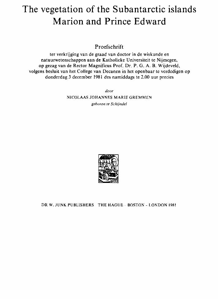
The surrounding ocean has a strong influence upon the ecosystems of the islands. Not only is the climate of the southern oceanic regions strongly influenced by the distribution of watermasses with different temperatures, but océanographie boundaries also have biogeographic significance (cf. Deacon 1964; Winterbottom 1971). A diagrammatic representation of the main meridional currents and the distribution of water masses in the Southern Ocean is given in Fig. 2. Cold Antarctic surface-water flows northward from the boundary region of east and west wind drifts at about 65° S. Cold water with a comparatively high salinity forms the Antarctic Bottom Current, moving northward from the continental shelf. This northward-flowing water is replenished by a southward current of warmer water at a depth of 2000-3000 m (Deacon 1959, 1960, 1964).
The temperature of the Antarctic surface-water gradually increases in a northerly direction. At about 50° S a sharp rise in surface temperature occurs within a short distance. Here Antarctic
surface-watej, with temperatures ranging from 1-2 ° С in winter to 4-5 °C in summer, meets Subantarctic surface-water, which is с 2 0 C warmer. These watermasses do not mix. The Antarctic surface-water sinks below the Subantarctic water. The Antarctic Convergence seems to occur where the warm, deep southward current rises most steeply over the colder Antarctic Bottom Current. The position of the Antarctic Convergence is remarkably stable: it is always found within about 100 km from its mean position (Deacon 1959,1960, 1964). The temperature gradient at the surface shows another sharp increase at about 40° S. Here the Subantarctic surface-water, with a temperature ofc. 10°С in winter and 14 0 C in summer, meets the water of the subtropical seas, which is some 4 0 C warmer (Fig. 2). This boundary region is called the Subtropical Convergence. It has a much less stable position than the Antarctic Convergence (Deacon 1964).
At present the Antarctic Convergence is situated about 250 km south of Marion and Prince Edward Islands. During recent geological times the position of this océanographie boundary has shifted considerably. Some 18 000 years ago the convergence apparently was lying to the north of the islands, leaving them surrounded by cold Antarctic surface-water (Zinderen Bakker 1969, 1971b, 1973b, 1978; Hays et al. 1976). This went together with a lowering of the air temperature, resulting in an extensive glaciation of Marion Island (Zinderen Bakker 1969, 1970, 1971b, 1973b, 1976, 1978; Hall 1978a, b; see also par. 2.2).
2

β trjstan da cunha
•gough
e o ' w . south georgia
~"v prince ed ward
• bouvet „ manon
\ · îles с rozet
,60° E
î les ikerguelen
~ st. paul onald«, » · ' heard new
amsterdaml
-«macquane campbell ¡••.auckland islands
ant ipodes. · ^ η ^ ά δ ( > ·
•
180°
Fig. I. Geographical map of the Southern Ocean.
2.2 Geology
Marion and Prince Edward Islands are situated near the centre of the West Indian Ocean Ridge, which is a continuation of the Mid-Atlantic Ridge and connects the latter with the Indian Ocean Ridge system (Girod & Nougier 1972). Most of the islands associated with these ridges have recently shown
volcanic activity, e.g. Bouvet (Baker & Tomblin 1964) and Tristan da Cunha (Gass 1963; Dickson 1965a, b). For several thousands of years Marion and Prince Edward Islands apparently have not shown volcanic activity, but in 1980 an eruption took place at Kaalkoppie on Marion (V. R. Smith, personal communication).
During the short visits of the Challenger (1873)
3
W e s t e r l y w i n d b e l t
ANTARCTIC
CONVERGENCE
Easterly wind belt
ANTARCTIC
DIVERGENCE SUBANTARCTIC
SURFACE WATER
ANTARCTIC
SURFACE WATER PACK ICE ICE SHELF
4000 m -
W A R M ο ε
ιι ι ι ι izQ»
SO" S
WESTWARD CURRENT
EASTWARD CURRENT
I | l l ^ " - ^ . COMPARATIVELY HIGH SALINITY
es's
Fig. 2. The meridional circulation of water in the Southern Ocean (after Deacon 1964 and Zinderen Bakker Sr. 1967).
and the Bougainville (1939) expeditions some information on the geology of the island was collected (Renard 1889; Moseley 1892; LaCroix 1923, 1940). A comprehensive geological survey was undertaken during the South African Biological and Geological Expedition to Marion and Prince Edward Islands in 1965/1966. The results have been published by Verwoerd (1967, 1971), Kable, Erlank & Cherry (1971), McDougall (1971) and Snape & Retief (1971). The following is largely based on accounts by Verwoerd (1967, 1971).
Marion and Prince Edward Islands are the summits of coalescing shield volcanoes of late Quaternary origin. Their age is estimated at 0.5 million years. Two distinct series of lavas can be discerned (Fig. 4), associated with two periods of volcanic activity.
Fine grained, compact basalts with a grey colour
resulted from the first volcanic stage. Potassium-argon dates show ages for lava flows of this type of between с 276 000 and 100 000 years. Stratified tuff and pyroclastic deposits associated with this first volcanic stage are present but not prominent. Eruptive and effusive activity during this period took place at a number of sites on the islands.
The greater part of the islands is covered with deposits which originated from a more recent period of volcanic activity (Figs. 5 and 6). The lavas of this second volcanic stage are generally black in colour and strongly vesicular. In chemical composition they do not differ markedly from the old grey lavas. Potassium-argon dates show that black lava was erupted с 15 000 years ago. Different methods of consolidation of the lava resulted in variation in structure ofthe lava flows. Flows consisting of solid lava covered with clincker fragments (aa flows) are
4

///^^/ relative lowlands
ί " 'MA scarps
prince edward
prominent scoria cones / / / / /
isobaths
3β°οοΈ
Fig. 3. Physiography of Marion and Prince Edward Islands and bathymetry of the surrounding ocean (after Verwoerd 1971).
5

^ттіь...
' • ^ » ^ й *
• ï t * _ _ » Г". -г
.-ж
fig. ^. Black lava flow (left) and a grey lava area near Kildalkey Bay, Marion Island
the most common type. The loose lava fragments are piled into heaps often up to 20 m high. Block lava covers a large part of the islands. These flows are built of loose, ragged lava blocks up to 1 m in diameter, generally arranged into steeply sloping, parallel ridges. Pahoehoe lava, characterized by its even surface, is not very common. Lava tunnels, caves and other structures caused by large gas bubbles are frequently encountered in flows of this type.
The numerous cones of red and black pyroclastic material occurring on the islands (Figs. 6,7,8) have been the main centres of activity during the second volcanic stage. Tuffaceous deposits associated with this stage are very rare.
Marion Island shows a conspicuous radial pattern of grey lava ridges and plateaus, with the valleys and plains covered by black lava. This is the result of radial faulting which has occurred between the two stages of volcanic activity. No such faulting is apparent on Prince Edward (Fig. 3).
Glaciations of Marion Island
At present, permanent snow and ice covers are restricted to the central highland of Marion Island, above с 1000 m a.s.l. The occurrence of striated platforms, smoothly rounded grey lava outcrops and the general topography of the grey lava areas (Fig. 5) strongly suggest an extensive glaciation of the island in the past. No black lava seems to have been subjected to ice-covering. This dates the glaciationof Marion Island between с 100 000 and 15 000 years ago. A study of glacial landforms and deposits showed that the island was subjected to three periods of glaciation, all of the Wiirm and Riss age, each with stades and interstades (Hall 1978a, b). Palynological research revealed the last stages of the last ice age (Schalke & Zinderen Bakker 1967, 1971; Zinderen Bakker 1967b, 1969, 1970,1971a,b, 1973b). Hall(I978)concludesthata minimal temperature decrease of 3.5 0 С during the glaciations was reached. This is in agreement with
6

ш
-¿^-Щ^ш^--
ШХУШ Ша*
Fig. 5. Grey lava area near Kerguelen Rise, Marion. Note the cushions of Azorella selago. The vegetation is the Andreaeo acutifoliae -Racomitrietum crispuli hymenophylletosum peltati. Fig. 6. View from Skua Ridge over part of the north-eastern coastal plain of Marion Island towards Junior's Kop, one of the с 130 scoria cones on the islands.
7

'- _j snow and ice (as on 1 3 . 4 . 6 t )
J •*> « [ permanent i c ·
I I superficial wind-blown volcanic ash
scoria cones
[ t ] grey bedded ash cones
j [ Π younger black basaltic lava flows
L — J o l d e r , g r e y lavas
Fig. 7. Geological map of Marion Island (after Verwoerd І97І).

+ 1-+ + * •f ι · * »·• ч- *•* *• +
rad and black acoria соя·«
superficial w i n d - b l o w n volcanic aah
gray baddad aah conas
young black basaltic lavaa
old gray basaltic l a v a s
O cr','r
у^-Г^ aacarpmant
VO Fig. 8- Geological map of Prince Edward Island (after Verwoerd 1971).

values suggested by Zinderen Bakker (1973b) and Hays et al. (1976). A temperature decrease of this magnitude implies a shift of the Antarctic Convergence to the north of the islands (Zinderen Bakker 1973b; Hall 1978a, b).
The glaciers do not appear to have covered Marion Island completely. In the ice-free areas cold-resistant species probably survived during the ice ages (cf. Zinderen Bakker 1970). A similar situation apparently existed on Kerguelen (cf. Bellair 1965; Young & Schofield 1973).
2.3 Topography and hydrology
Marion Island consists of a central highland, sloping down in all directions towards the sea. This central highland has the form of a plateau, at с 1000 m above sea level and with a number of higher volcanic cones. The highest of these reaches 1230 m. The surface of the highland is formed by unconsolidated scoriae and volcanic ash, with few rocky outcrops. Most of the central highland is permanently covered by ice and snow.
From the central highland the land slopes down more or less steeply towards the sea. This 'island slope' forms the greater portion of the island. It is divided into valleys and plains separated by plateaus and ridges in a radial pattern which is especially conspicuous on the northern and eastern sides of the island. The ridges and plateaus almost always consist of grey lava. Black lava generally covers the less elevated areas. Ridgetops and valleys are often separated by steep cliffs of over 100 m high. This pattern seems to have resulted from radial faulting (Verwoerd 1971).
On the northern and eastern sides of Marion Island the island slope descends more or less gradually towards the sea. On the western, and part of the southern sides, the island slope abruptly ends in an escarpment of 200-300 m high, which in turn descends steeply to a low coastal plain. This escarpment runs parallel to the coast. It seems to be the result of marine erosion and apparently formed the coastline of the island before the second period of volcanic activity. The surface substrate of the escarpment now largely consists of black lava. The coastal plain is 1-2 km wide and also consists entirely of black lava. It is elevated up to about 50 m above sea level.
Approximately 130 scoriae cones mark the centres of eruption of the second volcanic stage. Many of these are well preserved, often showing circular craters and sometimes containing a crater-lake.
The coastline is generally formed by cliffs. Where the old, grey lava meets the ocean, marine erosion produced high cliffs, at some places reaching several hundreds of metres above sea level. Beaches are common along grey lava coasts. Except for a narrow sandy beach at Ship's Cove (Fig. 9), all beaches consist of boulders. Grey lava areas produced a smooth coastline, often with large, curved bays. Black lava coasts are very irregular, with numerous capes, inlets, caves and off-shore rocks. The coastal cliffs of black lava areas generally do not reach a height of more than 20 m and beaches occur at only a few places along these coasts.
The highest part of Prince Edward Island is formed by the central block, with a summit of 672 m. To the east the central block slowly slopes down towards a coastal plain. On the western side it terminates abruptly in nearly vertical cliffs of c. 400 m high. At the foot of this escarpment lies a coastal plain. To the north and south the central block ends in precipitous cliffs, up to 500 m high, descending into the sea.
Marion Island possesses a poorly-developed radial drainage system. (Verwoerd 1971). Underground drainage occurs to a considerable extent and is greatly facilitated by the porous structures of black lava and pyroclastic deposits. Grey lava flows are more impermeable. Consequently, the above-ground drainage system in these grey lava areas is more developed. Only a few of the с 35 streams on Marion Island are perennial, notably the Van den Boogaard River and the Diving Petrel Stream. After four days without rain, the Van den Boogaard River was observed to flow strongly 1.5 km inland, but not much water reached the sea through its course at that time. Considerable drainage of water from the rivercourse into the ground appeared to take place. On Prince Edward Island only a few small streams are found, none of which carries water permanently.
Lakes and ponds are not important in the islands drainage system. Large lakes (1000-30 000 m2) are generally confined to the impermeable grey lava areas. Their depth ranges from 0.5-2.5 m
10

cape davis »boot rock
0 crater
perennial stream
'ν-' intermittent stream
^~ attitude tines at 150 m intervals pri'nsloo
triegaardt bay #nA ¿ships cove
skua \ ridge ^ д
mixed pickle cove
f urseal bay
swartkop point '
transvaal cove
trypot beach
macaroni bay
е..
0 - - J ^ - - -
rooks bay
green О J kildalkey bay hill
1 0 1 2 3 4 5 km 'r ' : ! I I , I I
3 7 3 5 Ε 3β SS' 39 4 0 41 43 4 3 4S 46 47 48 50 51 52 53
Fig. 9. Topographical map of Marion Island (after Langenegger & Verwoerd 1971).

(Grobbelaar 1974). In mire areas bog ponds are common. They are mostly small in size.
Water movement through the soil is locally concentrated in drainage lines. In some places at the bottom of grey lava slopes water emerges to form small springs. Generally the catchment area providing the water for these springs is large enough to assure a continuous water supply. Below the springs water tracks are often found, which in most cases do not possess a free water channel. These watertracks generally run out into a stream, but in some cases the water disappears again below the surface.
2.4 Climate
The islands possess a cool, extremely oceanic
climate, characterized by an average annual temperature of с 5 0 C with little diurnal and seasonal variation, by a very high precipitation and humidity, and by strong winds, blowing predominantly from westerly directions. Weather conditions on the islands are strongly influenced by the numerous depressions that travel from north-west to south-east through the area. The passing fronts cause high cloudiness and precipitation (Vowinckel 1954).
The Meteorological Station at Marion Island, established in 1948, is maintained by the South African Weather Bureau. It is situated on the northeastern side of the island at Transvaal Cove, 23 m above sea level, с 100 m away from the coast (Fig. 9). Its geographical position is Lat. 46052'34"S, Long. 37ο5Γ40' E (Langenegger & Verwoerd 1971). Annual reports on meteorological
Ι ι • 3 7'53'E 54'
46'36'S
0 5 5 ' 56' 57' 5 8 ' 59 3 8 0 0 Ol
37'
kant crater
3 8 '
albatrjof« vatTei
о
-.Ъ'
^ ) О golden gate
cave bay
300
39'
О crater
" V stream penguin beach
altitude line«
intervals
at 1 5 0 m
4 0 ' О south cape
2 km
12
Fig. 10. Topographical map of Prince Edward Island (after Langenegger & Verwoerd 1971).

data are published by the Weather Bureau. Summarized data have been provided by Fabncius (1957) and Schulze (1971). For the computation of the climatic statistics given in this chapter, summarized data from Schulze ( 1971 ) were used as well as detailed data for the years 1963-1973, excluding 1971 (Weather Bureau 1967a, b, 1968,1970, 1971a, b, 1972, 1973, 1975a, b).
Sunshine
In Table 1, 23 years of data on sunshine duration are summarized. Days with full sunshine are very rare. During winter, Marion Island receives a smaller part of the astronomically possible sunshine than in summer, but no corresponding differences in cloudiness are observed (Table 2). Part of this variation is due to the methods of computation of the possible sunshine duration, which assumes an unobstructed horizon (Weather Bureau 1973).
At the weather station the central mountain area of the island obstructs the horizon in south-westerly, westerly and north-westerly directions, reaching up to с 5° above the horizon.
Cloudiness
The sky over Marion Island is generally overcast or nearly so. During a 15-year period 70% of the observations showed a cloud cover of 6-8 oktas (Schulze 1971 ). Cloud observations are summarized in Table 2. The evenings are somewhat less cloudy than the mornings and afternoons, especially during winter.
Part of the amount of clouds observed is of orographic origin. Because of orographic effects the average cloud cover on the western side of Marion Island is probably higher than at the weather station (Schulze 1971). No meteorological observations are available from this part of the
Table I Sunshine duration at the Marion Island Weather Station (24 years 1948-1973, excluding 1967 and 1971)
J F M A M J J A S О Ν D
Y
Sunshine duration
Hrs
50 4 9 38 28 24 1 8 2 0 25 3.1 4 5 5 1 52
36
day % of possible
32 35 31 26 25 21 22 25 27 33 35 33
30
Frequency of days with
0 1-10 of possible
4 4 6 8 9
10 10 8 7 4 3 4
76 54
11-49 sunshine
15 12 12 II II 10 II 12 13 13 15 15
149
50-89
8 8 8 7 7 4 5 6 6 9 8 8
84
90 100%
0 0 0 0 0 0 0 0 0 0 0 0
2
Table 2 Mean monthly cloud cover at the Marion Island weather station in oktas at 0800, 1400 and 2000 h S A S Τ (1959-1973, excluding 1971)
0800 h 1400 h 2000 h
J
64 63 62
F
65 64 62
M
63 62 58
A
64 64 58
M
62 62 54
J
63 63 56
J
64 65 58
A
62 64 58
S
63 65 59
О
62 63 58
Ν
64 63 61
D
64 63 6 I
Y
63 63 59
13

island, but the presumption is supported by the experiences of field parties in this area.
Temperature
Due to their small landmass, the relatively low-incidence of sunshine and the nearly permanent winds, the temperature regime of the islands is closely related to that of the surrounding ocean (cf. Kessler 1978). The islands are situated с 200 km north of the Antarctic Convergence, where the Antarctic surface water sinks below the Subant-arctic surface water which is с 2 0 C warmer (Deacon 1964).
The average sea surface temperature at Transvaal Cove ranges from 4.0 0 С in August and September to 6.1 0 С in February and March. The extremes observed during a 15-year period were 2.1 0 C and 8.0 0 C . The mean monthly air temperature follows closely the temperature of the sea water, being с 1.5 ° С higher in summer and с 1 0 С lower in winter (Schulze 1971).
The seasonal and diurnal variation in air temperature on Marion Island is very small, as is shown by the thermoisopleth-diagram (Fig. 11). This diagram shows lower summer temperatures than those given by Zinderen Bakker (1978). This is due to the fact that three of the four years of which the latter author used the temperature data in the compilation of his diagram had warmer summers than the average. Very similar patterns are shown by thermoisopleth-diagrams for Macquarie (Troll 1955) and Kerguelen (Trol 1944). The warmest period on Marion occurs nearly two months after the sunshine maximum; this clearly indicates the strong influence of the surrounding ocean on the temperature regime of the islands. The absolute extremes measured at the weather station are -6.8 0 C and 22.3 0 C . Generally the temperature range on one day does not exceed 6 ° C. An average of 55 days with frost occur annually at sea level. Although frost may occur in any month of the year at the weather station, generally a frost-free period of 2-4 months occurs during summer. The number
J A S O N D J F M A M J J
Fig. 11. Thermoisopleth-diagram for the weather station on Marion Island (46053'S; 37052'E). h = 23 m. 1963 1973, excl. 1971.
14

of days with frost increases with altitude Zinderen Bakker (1978) estimates that at 250 m above sea level frost occurs on about 50% of the nights On only 90 days/year the temperature rises above 10 0 С (Table 3)
From 0-2000 m above sea level the average temperature lapse rate in the free atmosphere is с 4.5 °C/1000 m m summer. In winter a temperature decrease of 4 0 oC/1000 m is found The 0°-isotherm fluctuates between с 600 m above sea level in winter to с 1900 m in summer (Schulze 1971).
Relative humidity
The average relative humidity on Marion Island is
somewhat higher than 80% Diurnal and seasonal variation is small. Only on rare occasions does the humidity fall below 50% and then generally only for a few hours. Values of less than 40% are exceptional (Schulze 1971; Weather Bureau 1967a,b, 1968, 1970, 1971a,b, 1972, 1973, 1975a,b) It should be noted that these are screen humidity values and, especially during wjndy conditions, the actual humidity at plant canopy level may be lower
Precipitation
Some data on precipitation for a period of 22 years are summarized in Table 4. There is a distinct seasonal variation in precipitation April and May are the wettest months with a precipitation of more
Table 3 The number of days on which the maximum temperature at the Marion Island weather station is less than l0 0°Cand the minimum temperature less than 0 0 "С (1961 1973, excluding 1971)
M M J N D
Days with max temp sglOO "C 16 1 12 8 15 6 20 9 26 2 26 9 29 5 29 6 28 2 24 8 23 0 215 274 5
Days with min temp «ΞΟ 0 o C 01 0 2 01 14 4 8 5 3 8 3 119 111 71 39 0 6 55 1
Table 4 Summary of some precipitation observations at Marion Island (1951-1973, excluding 1971)
J F M A M
J J A S О Ν D
Y
Precipitation in mm
Average
231 212 226 238 247 219 224 191 190 175 197
225
2575
Adj a v ·
226 227 222 242 243 222 220 187 193 172 200 221
2575
Mm
137 103 149 142 100 104 148 87
113 108 88
166
2109
Max
350 333 397
327 428 461 319 250 359 288 316 300
2992
Frequency of days with precip
itation
>0 1 mm
26 23 24 27 28 28 28 28 27 25 25 26
313
>1 0
20 19 19 21 23 23 23 22 20 19 20 22
251
mm Snow
29 1 8 2 6 4 5 8 4 9 6
116 130 134 9 6 77 6 4
90 7
Fog
38 4 3 56 4 1 4 2 39 4 8 34 2 4 2 6 24 32
447
* Average precipitation adjusted for months of equal length
15

than 240 mm each, whereas October on average receives 172 mm. Although the amount of precipitation for each individual month may differ considerably from the average, the yearly extremes lie within 20% of the average. About 50 days/year have less than 0.2 mm of precipitation. Dry spells of more than a few days are rare.
Snow may occur during any month of the year, but is most frequent during winter, when one out of every three days receives snow. The lowland areas are covered with snow only for short periods in winter, but the highest part of Marion is permanently covered with snow. In summer the snow-line is found at about 1000 m above sea level, in winter at about 600 m (Zinderen Bakker 1971a).
Hail is observed on 15 days/year and fog occurs on an average of 45 days.
Wind
Marion and Prince Edward are situated within the belt of West winds between 40 and 60° S. These westerlies are interrupted by numerous depressions passing from north-west to south-east. During about 60% of the time the wind blows from directions between west and NNW (Fig. 12).
The average wind speed at the weather station is 6.7 m. sec.1 . Winds blowing from the westerly
Fig. 12. Wind direction frequency at the Marion Island meteorological station (data from Weather Bureau 1967a,1971a, 1973, 1975a, b).
16
quarter are on the average stronger than those from otherdirections (Schulze 1971). The meteorological station is sheltered considerably from winds from directions between south-west and north-west (Taljaard 1957). Thus the average wind speed at exposed sites may be much higher than at the station. According to Huntley (1970), at high elevations winds are considerably stronger than at sea level.
There is a small seasonal variation in wind speed, with on average somewhat higher velocities in winter than in summer. The frequency of calm conditions shows a maximum during summer, while gales are most frequent in winter (Table 5).
Schulze (1971) has pointed out a clear diurnal rhythm in wind speed at Marion Island during summer. The average wind velocity is highest at noon (c. 7.7 m. sec.- ') and is only 6.5 m. sec.-1
during the night. This pattern, caused by heating of the island during the day and cooling at night, is much less clear in winter.
Climate classification
The cool, extremely oceanic climate of Marion Island does not fit well into the climate classification made by Walter & Lieth (1967). Walter et al. (1975) mention a Subantarctic climate zone when describing the cold temperate or boreal climate type, but from their description it is apparent that this type differs considerably from the Marion climate. Walter (1970) classifies the climate of the Subantarctic regions as Arctic. Fig. 13 shows the climate diagram (cf. Walter 1955; Walter & Lieth 1967; Walter 1970; Walteretal. 1975) of the Marion Island weather station. Comparison of this diagram with those given in Walter & Lierh's world atlas reveals only few stations with similar climates, e.g. Staaten Island and Evangelistas on the southern tip of South America, the Subantarctic islands Kerguelen and Macquarie, and some mountain stations in New Zealand, such as Chateau Tongariro. In Walter & Lieth's system the climate of Marion Island can be classified as VIII-IX (oceanic), i.e. an extremely oceanic climate with colder summers than the cold temperate climate (VIII) and lacking the cold winters of the latter. At the same time, however, the climate is much warmer than the Arctic climate type (IX), especially in winter.

Table S. Frequency of wind speed classes at the Marion Island weather station in 0/00 (1963-1973, excluding 1966 and 1971).
J F
M A M
J J A
S
О Ν D
Y
Wind speed
0.0 -1.0
11 15 16 15 12 12 9 8 8 12 9 12
141
1.1 -1.5
3 2 3 2 3 3 3 3 3 3 3 4
34
in m. sec
1.6 -3.3
10 8 9 10 10 8 8 10 9 9 9 11
108
I
3.4 -5.4
14 12 14 13 14 11 13 14 15 13 17 16
162
5.5 -7.9
17 16 15 16 17 13 16 16 19 16 17 16
193
8.0 -10.7
13 10 12 11 14 15 14 13 12 14 12 13
152
10.8
-13.8
9 8 8 9 9 13 12 11 10 11 10 9
120
13.9
-17.1
5 4 3 4 4 5 5 5 5 5 5 3
54
17.2
-20.7
2 2 2 1 2 2 2 3 2 2 2 2
23
20.8
-24.4
0 0 1 0 0 1 1 1 0 0 0 0
5
24.5
-32.7
0 0 0 0 0 0 0 0 0 0 0 0
2
A second climate classification made especially with regard to biological phenomena is given in the map of seasonal climates of the earth by Troll & Paffen (1966, see also Troll 1966). Marion Island lies within zone 14, the zone of highly oceanic, sub-polar climates with moderately cold winters (coldest month -8 0 to +2 0C), poor in snow, and with cool summers (warmest month +5 0 to +12 0 C; annual fluctuation less than 13°, often less than
MtllllN ISUNi 12S «1 112 - г г ι
•с
I ·
!,1 -I.I *//*/ ¿ /)*>*)/>/>/ >s/ /->-r
1%
Fig. 13. Climate diagram of the weather station at Marion Island.
10 0C). This climate type occurs in a belt between с 50 and 60° S. In the northern hemisphere it is restricted to a few areas, notably the Aleutan Islands and southern Iceland (Troll & Paffen 1966).
2.5 Soils
Classification of the soils of the islands according to international systems is difficult, due to the immaturity of the soils, the negligible effect of parent material on soil development and the strong influence of small variations in topography (Smith 1976c).
The cool, extremely oceanic climate strongly favours the formation of peat. On large parts of the lowland areas, especially where drainage is impeded, peat deposits occur ranging in thickness from a few cm to more than 4 m. The peat may be resting directly on parent rock, but usually a layer of loamy clay separates the two (Fig. 14, Table 6).
At well-drained sites which are not markedly exposed (e.g. most lowland slopes) the soil generally consists of 5-30 cm of plant litter and humus overlying a layer of loamy clay (Fig. 15, Table 7). The depth of these slope soils generally lies between 50 and 130 cm.
At strongly exposed sites, especially at high
17

Parent rock
Fig. 14. Soil profile of a peat deposit on Marion Island (after Smith 1976c).
'lifter
Bs or soft plinthic
Parent rock
Fig. 15. Profile of the soil of a lowland slope (after Smith 1976c).
Table 6. Chemical data of the profile of peat soil illustrated in Fig. 14 (after Smith 1976c).
Depth (cm)
0-5 5-20
20-40 50-70 90-100
pH
4.2 4.4 5.0 4.9 4.6
Loss at 105 "C
(%)
1931 1403 365 218 477
Table 7. Chemical data on
Depth (cm)
0- 5 5-13
20-40 40-50 75-85
pH
4.2 4.2 4.3 4.5 5.3
Loss at 105 0 C
(%)
655 590 475 344 426
Org. С
(%)
45.9 46.4 30.3 24.6 10.4
Tot. N
(%)
2.30 n.d. 0.76 0.27 0.67
Tot. Ρ
(%)
0.66 n.d. 0.52 0.60 0.54
C.E.C. exch. Ca2 +
exch. Mg 2 +
(milli-equivalents · 100 g
42.7 n.d.
28.4 15.9 13.0
2.4 n.d. 1.7 2.2 3.3
the soil profile of a lowland slope illustrated in
Org. С
(%)
37.2 33.8 20.4
n.d. n.d.
Tot. N
(%)
2.40 2.23 1.45 0.77 n.d
Tot. Ρ
(%)
0.65 1.09 1.01 0.82 n.d.
C.E.C. exch. Ca 2 +
6.3 n.d. 0.8 0.9 1.3
exch. Na +
-')
2.2 n.d. 0.7 0.9 0.8
exch. K+
1.6 n.d. 0.1 0.2 0.2
Fig. l5(afterSmith 1976c).
exch. Mg2 +
(milli-equivalents · IOC
41.8 25.3 27.1 23.1 26.5
6.1 n.d. 1.4 0.9 0.6
13.4 n.d. 0 6 0.6 0.4
exch. Na+
Г')
2.0 n.d. 0.6 0.4 0.3
exch. K+
4.0 n.d. 0.3 0.1 tr

г// гНищаю' asitvbacrtÌMAizxx.,
m
Pringlea antiscorbutica

elevations, accumulation of organic matter is small. The soils of these areas are skeletal, gravelly loams which are generally very shallow (Fig. 16, Table 8). The surface of these soils is often covered with a pavement of rocks and gravel. Principal factors involved in the formation of the pavement seem to be wind and water which carry away the fine soil particles. At high elevations frost action may effect some sorting of stones (Zinderen Bakker 1978; cf. Troll 1944). In formerly glaciated areas pavements of grey lava blocks may, in fact, be the remains of ablation moraines.
In some areas (e.g. young black lava flows and scoria deposits) no appreciable soil formation has taken place.
The chemical status of Marion Island soils is described by Smith (1976a,b,c,d, 1978a,b, 1979). Some data are presented in Tables 6 to 9. Similar to
\0Ш (г*&\Ш? д.. itter
Bh
Parent rock
Fig. 16. Profile of a fjaeldmark soil (after Smith 1976c).
those of many polar and subpolar regions, the soils of the island are low in nitrogen and phosphorous (Smith 1976a; Lindeboom 1979). Physical and chemical weathering seem to play a minor role as mechanisms which supply nutrients to the soil (Smith 1977a). Due to the high precipitation leaching of minerals from the soil is rapid. The major source of mineral nutrients is the ocean, directly via salt-spray (e.g. Na, Mg, and K), or indirectly, via the excretion of sea-going animals (N and P; Smith 1978a). Smith (1977a) states that although the lowland coastal areas are most affected, virtually no part of the islands is free of chemical influcence by salt-spray.
Animal excreta are the most important source of nitrogen on the islands. Lindeboom (1979) calculated an annual input of 30-40 metric tons of nitrogen into the vegetated areas of Marion Island from bird excreta directly deposited on the vegetation. Another 40-50 tons of nitrogen originates fronj ammonia which evaporates from penguin rookeries and is subsequently deposited in other areas. Elephant seals are responsible for the direct deposition of 7-10 tons of nitrogen in vegetated areas and an additional 2-5 tons of nitrogen in the form of ammonia evaporated from their wallows. Nitrogen-fixation by cyanobacteria (notably Nostoc commune Vaucher) accounts for the addition of 100-200 kg of nitrogen into the vegetated areas of Marion Island (Lindeboom 1979; cf. Croóme 1973). This quantity is small compared to other sources of nitrogen, but may be of significance in areas not influenced by animals (Lindeboom 1979; cf. Smith 1976a,c). The input of nitrogen from the weathering of rocks, which Lindeboom (1979) estimates at less than 6 kg annually on Marion Island, is negligible.
Additional data on the islands' soils are given in the descriptions of the habitats of the plant communities.
Table 8. Chemical data on the fjaeldmark soil illustrated in Fig. 16 (after Smith 1976c).
Depth (cm)
3-15 15-33 33-60 60-?
рн
5.0 5.2 5.5 5.6
Loss at 105 "C
(%)
198 229
77 58
Org. С
(%)
11.9 6.7 2.7 1.9
Tot. N
(%)
0.73 0.51 0.20 0.13
Tot. Ρ
(%)
n.d. 0.47 0.66 0.65
C.E.C. exch. Ca2 +
exch. Mg2 +
(milli-equivalents · 100
20.6 21.2 19.0 13.7
0.6 0.4 0.1 0.1
1.3 0.1 0.1 0.1
exch. Na+
g"')
1.0 0.8 0.4 0.8
exch. K +
0.5 0.3 0.1 0.2
19

о
Table 9 Chemical status of the honzons containing living roots in the soils under Manon Island plant communities (after Smith 1976a, 1977d)
Soil type and vegetation N Depth pH Water Ca Mg Na К Total Org С Total N Total Ρ NH4-N NOj-N
(em) (%) ( % s a t u r a t i o n o f C E C ) (%) (%) (%) (mg· 100 g ' soil)
Peat soils Agrostis magellanica mire (0 0-20 4 2 1667 ± 1 9 9 5 ± I 5 1 3 ± 0 5 5 ± 0 7 3 ± 1 0 26 ± 1 5 48 ± 5 2 3 ± 0 4 0 6 ± 0 5 2 4-6 5 0 0-0 7 Slope soils Blechnum penna-manna fernbrake 8 0-18 4 3 7 I 5 ± 67 21 ± 5 2 4 0 ± 2 2 4 ± 0 8 7 ± 2 1 72 ± 5 4 44 ± 1 2 2 ± 0 2 0 7 ± 0 2 tr-l 6 00-tr
Acaena magellanica drainage line 6 0-45 4 2-4 7 1002 ± 2 7 5 26 ± 1 1 32 ± 9 0 4 ± I 9 2 ± I 0 65 ± 1 0 8 43 ± 1 1 2 5 ± 0 4 0 7 ± 0 2 tr-2 9 0 0-tr
Ρoa cooku tussock grassland 8 0-50 4 0-4 1 360 ± 2 3 1 4 ± 1 2 1 3 ± 3 0 5 ± 2 2 1 ± 0 5 34 ± 4 1 25 ± 5 1 7 ± 0 3 1 6 ± 0 5 0 9-8 4 0 0-10 Fjaeldmark soils Azorella selago Г)яМтатк 4 0-10 5 2 · 217 ± 168 3 ± 2 I 9 ± 3 4 3 ± 1 9 2 ± 3 3 17 ± 5 9 6 0* 0 7· 0 4* 0 0-0 5 0 0-tr
N = number of determinations, • = single determination, tr = trace (<0 5 mg 100 g ' soil) Values expressed as ranges or as means ± standard deviations

2.6 Phytogeography
Knowledge of the phytogeography of the Subant-arctic zone is incomplete. This is mainly due to the fragmentary nature of data available on the crypto-gamic floras of many southern regions and also because no consistent taxonomie assessment of these floras has been made.
Marion and Prince Edward Islands form part of the Antarctic Kingdom (Engler 1964). Good (1974) also places them within the Antarctic Kingdom. This author, however, includes larger parts of South America and New Zealand and leaves out the Antarctic continent and some outlying island groups.
A division of the southern circumpolar regions based on floristic considerations was proposed by Skottsberg (1905) and later revised by himself (Skottsberg 1960). This division is shown in Fig. 17. Skottsberg defined the Subantarctic Zone as the area between 48 and 60° latitude, including Marion and Prince Edward Islands and Crozet, but excluding Bouvet and the South Sandwich Islands. Within the Subantarctic Zone Skottsberg (I960) discerned three phytogeographic provinces: ( I ) The Kerguelen Province consists of Marion and Prince Edward Islands, Crozet, Kerguelen, Heard and MacDonald. (2) The Magellanian Province comprises South Georgia, Falkland Islands and Subantarctic South America. (3) Macquarie, Auckland, Campbell, Antipodes and Snares Islands together form the Province of the Subantarctic Islands of New Zealand.
A more restricted definition of the Subantarctic Zone is given by Wace (I960, 1965, 1969). His division of southern circumpolar regions into four zones (High Antarctic, Maritime Antarctic, Subantarctic and Cool Temperate; Fig. 18) is based on physiognomic and ecological characteristics of the vegetation of these areas. Wace (loc. cit.) defines the Subantarctic Zone as the region south of the southern limit of growth of trees and woody shrubs, and north of the limit of closed phanerogamic communities. This zonation coincides with a zona-tion based on the range of mean monthly temperatures (Holdgate 1964; Gressit 1970). The temperature regime of the Subantarctic Zone is characterized by the absence of months warmer than 8.5 ° С which means, according to Holdgate (1964), that it is too cold to permit tree growth. The
temperature of the coldest month ranges from +3 0
to -3 °C. The Subantarctic Zone comprises six islands and island groups, all situated within a few degrees latitude of the Antarctic Convergence: Marion and Prince Edward Islands, Crozet, Kerguelen, Macquarie, Heard and MacDonald, and South Georgia. The terrestrial vegetation of these islands is characterized by the presence of mire in which the important peat-forming plants are bryophytes (other than Sphagnum spp.), closed communities of tussock-forming grasses, cushion-forming flowering plants, and herbfield communities with large-leaved perennial species (Wace 1960, 1965, 1969).
Twenty-two species of vascular plants are indigenous to Marion and Prince Edward Islands. These species and their distribution are listed in Table 10. Data on the distribution of these plants were compiled by Rothuizen (1977). Seven species are restricted to the Kerguelen Province. One of these (Elaphoglossum randii) is endemic to Marion and Prince Edward Islands (Alston & Schelpe 1957; Huntley 1971). Seven species are restricted to islands of the Kerguelen Province, e.g. Polystichum marionense (Fig. 19), Ranunculus moseleyi, Poa cookii (Fig. 35) and Pringlea antiscorbutica (Fig. 20), but most of the islands' vascular species show a widespread distribution throughout the temperate regions of the southern hemisphere. Wace (1965) suggests that many of these species, which occur in remote islands as well as on the continents, may have been driven out of Tertiary Antarctica and have achieved circumpolar ranges today by transoceanic dispersal during the Quaternary.
The status of two species on Marion and Prince Edward Islands, Juncus cf. effusus L. and Potamogetón spec, is not conclusively ascertained. Huntley ( 1971 ) considers these species, which show a very limited distribution on the islands, as recent additions to the indigenous flora. Only vegetative material of Potamogetón was found. Juncus cf. effusus, however, is known to flower on Marion Island (V. R. Smith, personal communication).
Two subspecies of Montia fontana have been found on the islands. Material collected on Marion in 1873 by Moseley during the Challenger expedition is identified by Moore (1963) as subspecies chondrosperma (Fenzl.) Walters. This subspecies is considered as almost certainly introduced by man into the Southern Hemisphere (Moore 1963; cf.
21

Greene & Greene 1963; Greene & Walton 1975). Specimens collected by Huntley on Marion (coll. nr. 999) and Prince Edward Island (coll. nr. 647) belong to the subspecies/о/і/диа. The latter may have migrated to the Southern Hemisphere via the mountains of either the Old or New Worlds or it may be there as a result of its introduction by man (Moore 1963). The presence of Μοηπα-pollen grains in peat deposits on Marion of at least 10 000
years old (Schalke & Zinderen Bakker 1967, 1971) shows the native status of Montia fontana on this island, but does not exclude the possibility that one of the subspecies was introduced by man.
A list of moss species known from Marion and Prince Edward Islands and data on their distributions are given in Table 11, compiled from Clifford 1953, Fineran 1971, Greene 1968a,b, Hébard 1970a, Sainsbury & Allison 1962, Zanten 1971,
Fig. 17. Phytogeographical division of southern circumpolar regions after Skottsberg (1905, 1960). A = Magellanian Province; В = Kerguelen Province; С = Province of the Subantarctic islands of New Zealand.
22

Seppelt 1977 and my own data. One third of the 72 species of Musei known from the islands are widely spread throughout southern cold and temperate regions. Five species show a bipolar distribution, eight are cosmopolitan. No mosses are endemic to Marion and Prince Edward, but ten species are restricted to two or more islands or island groups of the Kerguelen province. Five species are found in the Kerguelen Province and in South America or its
outlying islands, 13 in the Kerguelen Province and in the Australia-New Zealand sector of the Southern Hemisphere.
A high incidence of endemism is shown by the hepatics of Marion and Prince Edward islands (Grolle 1971a). Twenty percent (seven species) of the liverworts are endemic, and a further 20% are restricted to the Kerguelen Province. Five of the 36 species are found in islands of the Kerguelen
Fig. 18. Phytogeographical division of southern circumpolar regions after Wace (1960, 1965, 1969).
23

Table IO The indigenous vascular plants of Marion and Prince Edward Islands and their distribution
JS S
с ω
о 3 U tí
тз —
Έ •§
« -S -S [Л
li = = я S ζ
3 -S я- Ο" S·
*• з i (Λ U < (Λ
и ел ™
< ζ
ι« cd u) ^ Тл Тл 3 д з С о О
< H О ел
E <
во i t> 3
,э 0
+
+ + + +
+ +
А саепа magellanica (Lam)Vahl + + + + +
Agrostts magellanica Lam + + + +
Azorella selago Hook f + + + + + + Blechnum penna-manna
(Poir)Kuhn + + + + + + + + + Callitnche antárctica
Engelm + + + + + + + + + + + Colobanthus kerguelensis
Hook f + + + + Coluta plumosa Hook f + + + + + + + + Crassula moschata
Forst f + + + + + + + + + + Elaphoglossum randa
Alston & Schelpe + + Grammitis kerguelensis
Tard + + + + + + + + Hymenophyllum peltatum
(Poir)Desv + + + + + Juncus scheuchzenoides
Gaud + + + + + + Limosella australis R Br + + + + + Lycopodium
+ + + + + magellamcum Sw Lycopodium saururus
Lam Monna fontana L Poa cookn Hook f Polystichum manonense
Alston & Schelpe Prmglea antiscorbutica
R Br Ranunculus biternatus
Sm Ranunculus moseleyi
Hook Г
+ + + + + + + + + + + + + +
+ + +
+ + + + +
+ + + +
+
+ + + +
+ + + + +
+ + + + + + + + + +
+ + + + + +
+ + + Chatham Island
+ + + + + + + + + + Ascension Island
+ + + + + N-W Europe
+ + + + + + + + + + + + N temperate regions S Africa
+ + + + + + + + + + Chatham Island, Juan Fernandez
+ + *
+ + + + + + + + + » ·
+ + + +
+ + + Uncinia compacta R Br + + + + + + + + + + + +
•Reunion Madagascar, Mauritius Rodrigues St Helena S Africa ••Northern Hemisphere, New Guinea, E Afr mnts
Province and the South American sector Four species show a similar distribution pattern, but include islands of the Tristan da Cunha group The relationship between the hverworth-floras of the islands and the Australia - New Zealand region is
much less pronounced than in the mosses A list of species and their distributions is given in Table 12, compiled from Arnell (1953, 1963), Grolle (1964, 1971a,b, 1972), Hodgson (1962), Kuwahara (1966), Seppelt (1977) and my own data
24

Fig. 19. Polysíuhum marioneme.
Fifty species of lichens are known from Marion and Prince Edward Islands (Lindsay 1976 and my own data, Table 13). Two of these appear to be endemics. Eleven species are restricted to islands of the Kerguelen Province. Remarkable is the high proportion (40%) of species with bipolar distributions.
Distribution patterns of the plant species of the islands indicate a strong relationship between the floras of Marion and Prince Edward and the other islands of the Kerguelen Province. Similar relationships were found in several faunal groups, e.g. Entomostraca (Smith & Sayers 1971), Araneida (Lawrence 1971) and Insecta (Dreux 1971).
Most of the plant species of the islands are widely distributed in southern cold and temperate regions, indicating the ability of these species to cross wide expanses of ocean. Several of the flowering plants
Fig. 20. Pringlea antiscorbutica.
have fruits adapted to transport by animals, e.g. Acaena magellanica and Uncinia compacta. The barbed fruits of these species were often observed attached to the feathers of birds (cf. Kok 1975; Fig. 21). On South Georgia Walton (1977) made similar observations on the fruits of Acaena. The ability of oceanic birds in subantarctic regions to cover large distances within a short time is well documented (e.g. Falla 1960; Berutti et al. 1975). The most spectacular example cited by Falla ( 1960) is of a giant petrel {Macronectes giganteus) which was picked up in Western Australia five weeks after its probable date of departure from Signy Island, South Orkney Islands, 11 000 km away. Driftwood of Nothofaguspumilis found on Marion (Zinderen Bakker 1971a) indicates the possibility of transport by sea currents from South America to the islands. Similar observations were made on Tasmania and
25

Kt
"" 3
S
&C
iÖ
ÖO
OÖ
Gb
Ö
^ 5
Э
¡2
о
О
Я
Pi
S
чГ
Г-
—
^
bt
!-»
Ol
•S
·?
5
3
I *
с
5.
? 5
^ 'S
'S
<
Ч
-i
з-
з-
а-
а- *
•
а-
а-
3
3 3
3
ft
К"
φ
ξ.
с" с
"
о с
·*> ,
* S
· ΐ
!
il
ё з
зэ=
.
a a
о
о
2 S
!Э·
о-
а о
S
. 5
о
а а
·*
! !?
? О
О
C
i О
Г
і Г
) а
η
о
о
о
II
II
II
S.3
і.
5
. 5
. 5
. i.
Ζ
. і.
3 i
ρ
^
о
о
о
о
5"
3 3
3
to
to
to
to
to
to
te
Ä
Sí
.*
* .α
ϊ S
•5
й •
?
a S
> 1
g.
S .
S-
г·
Г?·
U
- ."
-a
tf •
-)
<
<
(η
ГЪ
- ^
-
:'=) S
а
β- Ч
з I
Гя
η
Г)
Β.
2
ml χ
a. s
o.
íw
^
α.
: "0
*
Si
'•If
C
L ~
t
э 's
s
§ f.
5
з 3
. ч
» с
о
" а
ε -
-
s-
°5 £
а
β 5_
s
I 3
S
3 %
s
55 г
"*
2п
с к
3
3
а-
»ъ
о а
δ г
3 X
s
χ S
. η
ft
<
№
о-
* Д
Í
^
Й
-s ^
. er
"
со
5
іэ
IH
"
a-
a-·*
li
с с
3
3
&.S
? 5
SP
a-s-
5 г
a·
a g
5
5 g
'S
β
' =
«
£1
3
E
5.
S"
S
- f
is
3 </>
s
3 i.
i.
χ
ν
a
a
a
a
5 §
. о
. ^
. ^
*ft
•%
**
5-
ö Q
ö
S *b
**
«%
5
й
в a
•i
2_
of
α
ш«
а
α.
о
Ici
"s
* о g-
ч
1 S-
2·
Іэ
S. 3
—
о- -
о
ffc
2е
5 3
2
=
—
CL
О
ш
->
i W
5
2 5
* С
++++++++++++++
+++++++++++++++++++++++++
++
++
++
++
+ +
+ + + + +
+ +
+ + +
+ + +
+
+
+
+ + +
+ + + +
-ι- + + +
+ + +
+
+
+ +
+ +
+
+ + +
+
+ + + + +
+
+
+++++
+
++
+
+
+
+ +
+
+
+
+
+
+ + +
+ +
+
+ +
+
+
+ +
+
+
+ +
+
+
+
+ +
+
+
+ +
+
+
+ +
+
+
+ +
+
+
+
+ +
+
+ + + +
+++
+++++
++
++++++
+ + +
+
+
+ +
+ +
+
+
+
+
+
+ + +
+ +
+
+
+
+
+
+ + +
+
+
+
+ +
+ +
+ + + +
о о-
? 5
г*
s- т
§ S
+
+
+
+
+
+
+ +
+
+ + +
+
+
+
+
+++++++
+ + + + +
ζ о
+
+
+
+ +
+ +
+ + +
+ + +
+ +
+ +
+
+
+ + +
+
+
+ + + + +
+
+
+ + +
zi Χ
Ma
no
n
Isla
nd
Pri
nc
e E
dw
ard
b
lan
d
lie
s C
roz
el
lie
s K
erg
ue
len
He
ard
an
d
Ma
cd
on
ald
Is
lan
ds
Ma
cq
ua
ne
Ca
mp
be
ll
Isla
nd
Au
ck
lan
d
Isla
nd
s
Ne
w
Ze
ala
nd
Ta
sma
nia
Au
stra
lia
Tri
sta
n d
e C
un
ha
+
Co
ug
h
Isla
nd
Bo
uv
el
So
uth
G
eo
rgia
Fa
lkla
nd
Is
lan
ds
Fu
eg
ia
So
uth
A
me
ric
a
An
tarc
tic
zo
ne
So
uth
ern
A
fric
a
4
P
3 о 3 "0
•
η
э α

Table II (Continued)
•ο ΐ (9
2
i 8 υ * = л E <« «я я
I £ S ë χ
+
С = Ό 'S 2 я « Κ Ξ S E -= g. І. ä й s a a ε "3 * s s
5 я 3 u 3 3 2 υ < Ζ h- <
во Λ с X. с:
ο 'S Ι S Η > 'S 3 e* ΐ я -з э ÍS с э s 3
о о я э о Ç о Ш (Л bu Ц. (Л < ΪΛ
+ + +
Hygroamblystegiumfìlum(C Mudi ) Reim + + + Нурпит cupressiforme Hedw + + + + Isopierygium pulchellum ( Hedw ) Jaeg
var aniarclicum (Mitt ) Zant + + + Leplodonimm prohferum Herz + + Muhchofena campylocarpa (Hook & Arnott) Mitt + + +
var auslralis (H&mp ) Zant + Onhodoniium Untare Schwacgr + Orthoincum crassifohum Hook f & Wils + + + Philonoiis cf augusti/olia Kaal + + Philonotis scabri/olia (Hook f & Wils ) Broth + + + Philonoiis tenuis (Tayl ) Jaeg + + Plagioihecium plaiyphyllum Moenk + + Pohlia albicans (Wahlenb ) Lindb + + Pohha nutans (Hedw ) Lindb + Polymchum jumpermum Hedw + + + + Polytnchum pili/erum Hedw + Psilopilum cf tnsiamense Dix + Ptychommon rmgianum Broth & Kaal + + Äflcomirnumcmpu/um(Hook f & Wils ) Hook f 4 Wils + + + + + + + Racomurium lanugmosum (Hedw ) Bnd + + + + + Schisttdium falcatum (Hook f & Wils) Zant + + Schistidium stylostegium (C Muell ) Zant + + + Tartufo cf geheebiaeopsis (C Muell ) Broth + + + Tortula cf rubra Mitt + Trematodonßextpes Mitt + Willia autro-leucophaea (Besch ) Broth + + Verructdens mtcrocarpus (Mitt ) Zant + +
+ + + + + + +
+ +
+ + +
+ + + +
+ +
+ + + + +
+ + + +
+ +
+ + + + cosmopolitan
+ + + + +
+ + + + + + +
+ + + +
+ introduced m Europe
Northern Hemisphere cosmopolitan
+ cosmopolitan + + + cosmopolitan + + + + + + Northern Hemisphere
+ +
+ + + + + cosmopolitan
+ + +
+ +
Macquane Island (Barber et al. 1959;Costin 1965). It is not known, however, whether or not any of the islands' terrestrial plant species possesses propágales which may survive prolonged immersion in sea water.
Aerial long distance transport is probably the most important mechanism by which cryptogamic species reached the islands (cf. Grolle 1969; Zanten 1976,1978). Zanten (loc. cit.) has shown that spores of a number of widely distributed moss species are able to survive desiccation and freezing which may occur during aerial transport. The presence of pollen grains from South American sources in peat cores from the islands further demonstrates the
possibility of aerial long distance transport. From the occurrence of these polen grains Schalke & Zinderen Bakker (1971) conclude that the wind system around Antarctica has not changed during the last 16 000 years. Western Subantarctic (Kerguelen Province and South American sector) and circumsubantarctic distribution patterns may be readily explained by wind dispersal. For Eastern Subantarctic distribution patterns (Kerguelen Province and Australia - New Zealand sector) aerial transport is not such an obvious explanation.
Some striking differences between the various plant groups appear from the distribution data, e.g. the large proportion of endemics in the Hepaticae
27

Table 12 The hepatics of Marion and Prince Edward Islands and their distribution
О
+
J2 * δ "β -S -S -3 "θ
_ "и с 2 ^ — с о к. -ч id с
bí ΐ α- 2 н -»> я я a ε г
υ ?.д ε s э 2 a : = = î S < u < 7 b <
E <
ел LL U. ел
< E
i h я
Acrobolbus ochroph\!lus (H f & Τ ) Schust Anastroph\llum aunium (Lehm ) Steph Andre*sianthus (armatus Grolle AndreKsiamhus lanusnpus Grolle Andrevisianihus manonensis (S Arn ) Grolle BlephandophiHum densifohum (Hook ) Angstr Cephalozia randn S Arn Clasmalocolea humilis ( H f Sí Τ ) Grolle Clasmalocolea vermiculans (Lehm ) Grolle Calura cahptrifoha (Hook ) Dum Diplophxllum manonense S Arn Fossombronia australis Mitt fferzogobrium atrocapiltum (H f & Τ ) Grolle Herzogobrvum teres (Carnngt & Pears ) Grolle Herzogobrxum vermtculare (Schiffn ) Grolle H\grolembidium ventrosum (Mitt ) Grolle Jamesomella colorata (I ehm ) Schiffn Jamewmella grandiflora (\ indenb Si Goltsche) Steph Jensema pisicolor (H f SL Τ ) Grolle Jungermanma coniflora Schiffn Lepidozia laevi/olia ( Η Γ & Τ ) Gotische et al Leptosc\phu5 expansus (Lehm ) Grolle Lethocolea radicosa (L & L ) Grolle Lophocolea randn S Arn Lophozia alindriformis (Mitt ) Steph
Marchantía heneroana L & L Meizgena decipiens (Mass ) Schiffn SÌ Gotische Metzgena grollei Kuwah Metzgena manonensis S Arn Pach\gloîsa fissa (Mitt ) Herz SL Grolle Plagiochila crozetensis Kaal Plagtoihila beterodonta (H f & Τ ) Gotische et al Schistochila carnosa (Miti ) Steph Symphiogìna manonensis S Arn Temnona quadripartitum (Hook ) Mitt Tyhmanthus vindii Mitt
+ + +
+ + + + + + + + + + + + + + + + + + + + + + + + + +
+ + +
+ +
+ +
+ + + +
+ + + + + +
+ + + + + + + +
+ + + +
+
+ + + + +
+ + + + + + + + + + + + + + + + + +
+ + +
+ +
+
+ +
+ +
+ + +
+
+ + +
+
+
-f
+
+
+
+
+ +
+
+
+
+ +
+ + +
+
+ + +
+ +
+ +
+ +
+
S-W Europe
+ + + + + + + + + + + + +
+ + + Java, Japan, Hawaii
+ +
+ + + +
+ + +
compared to mosses and lichens, and the strong bipolar element in the lichens. It seems premature to draw any phytogeographic conclusions from this. These patterns may well be caused by the paucity of the data (cf. Zanten 1971,1978) or be d ue to the different taxonomie concepts of the specialists working on each group.
2.7 History
The islands were discovered on 13 and 14 January 1772 by the French sailor Marion Dufresne, who, thinking that he had found the outposts of the not yet discovered southern continent, called the larger one 'Terre de l'Espérance'. The other one he named
28

'Ile de la Caverne', after the large cave he sighted near the coast of this island (Marsh 1948, Zinderen Bakker 1971a, Brossard 1972). A few years later in 1776, the islands were sighted by Captain Cook, who gave them the name 'Prince Edward Islands'. After hearing about the discovery by Marion Dufresne, he renamed the larger one Marion Island. The smaller one kept the name Prince Edward Island (Hydrographie Department 1948, Marsh 1948, Zinderen Bakker 1971a).
Possibly Marion Dufresne was not the first one to sight these islands. In 1663 Bareni Barentsz. Ham, captain of the Dutch East India Company vessel 'Maerseveen' discovered two islands, which he named 'Dina' (on some maps called 'Denia') and 'Maerseveen' (Leupe 1868). Zinderen Bakker (1971a) suggests that, although the positions given by first mate Michiel Gerritsz Boos in the logbook are very different from those of Marion and Prince Edward, these are the same islands.
Sealers were probably the first people to land on the islands. By 1802 several sealers' camps were established both on Marion and Prince Edward (Tizard et al. 1885). These camps were not permanently inhabited. Parties of sealers were put ashore on the islands at the end of the winter when the seals started to arrive on the islands. At the end of the season they were picked up with their capture. During most of the 19th and early 20th century sealers had settlements on the islands and visits by sealing expeditions from South Africa, England, Norway and the United States are recorded (Marsh 1948, Rand 1956, Roberts 1958). The last sealing expedition to the islands took place in 1930, when the Cape Town-based sealer Kildalkey landed a party on Marion Island. Unfavourable weather curtailed this expedition and forced the Kildalkey to return. No further attempt to resume sealing on the islands has been made (Marsh 1948, Rand 1955b, 1956).
Three shipwrecks are known to have taken place on Prince Edward Island. On 19 June 1849 the British emigrant ship Richard Dart, on passage from England to New Zealand, was wrecked on this island. Eleven survivors out of a complement of 63 were rescued on 2 September. The South African sealing vessel Maria was wrecked on 17 May 1857. The survivors spent the winter on the island and were rescued on the 6th of December. On 22 October 1912 the Cape Town-based sealer Sea Bird
was wrecked on Prince Edward Island. All but two of the crew survived a stay of nearly six months on the island and were rescued on the 14th of April of the following year. The Norwegian sealing vessel Solglimt was wrecked at Ship's. Cove on Marion Island on 16 October 1908. The crew was rescued a month later (Marsh 1948; Roberts 1958).
Marion and Prince Edward Islands were annexed by South Africa on 29 December 1947 and 4 January 1948 respectively. A meteorological station was established at Transvaal Cove on Marion Island in January 1948 and has been occupied continuously since then (Marsh 1948; La Grange 1954; Schulze 1971).
Before the establishment of the weather station, the only scientific exploration of the islands took place during the short visits of two expeditions: the Challenger-expedition in 1873 (cf. Tizard et al. 1885; Moseley 1874, 1877a,b, 1892) and the Bougainville-expedition in 1939 (Jeannel 1940). Between 1948 and 1965 some biological and geological observations were made (e.g. Rand 1954, 1955a,b, 1956; Trusswell, 1965; La Grange 1962), but it was not until 1965-66 that a systematic exploration of the islands took place by a team of biologists and geologists (cf. Zinderen Bakker 1967; Zinderen Bakker et al. 1967, 1971). Since then several biological expeditions to the islands have been made.
2.8 Human influences on the islands' ecosystems
As early as 1802, thirty years after their discovery by the French sailor Marion Dufresne, sealers established several camps on both Marion and Prince Edward Islands. Sealing expeditions from South Africa, England, Norway and the United States are known to have visited the islands during the 19th and early 20th century (Tizard et al. 1885; Marsh 1948; Roberts 1958). Rand (1956) found evidence of the occupation of a sealers' camp at Mixed Pickle Cove during 1909-1911 and 1920-1921. The last sealing expedition to the islands took place in 1930 by the Cape Town-based sealer Kildalkey. Over 1000 Elephant Seals were killed before bad weather forced the ship to return prematurely to Cape Town (Marsh 1948; Rand 1955b).
The impact of sealing activities on the population
29

3 a
s δ
1
§
Ξ σ
£
co S
J Ä
S 3
S ¡
2
г о
з
•5
β
о с
.
5
*«
"в
SS
В"
δ"
С
Γ
ι ^
0.-Й
-а
ζ
а
^
г- δ
" 0
з г
2 в
с ft
. 3 I
ö
S
i >
В о
<т
я
· ^ з
s σ
ü s
3 s.
г
I?-
ν:
ш
<-~
a
. <
в-
г-
w
и
о
5 ?
5"
г (
¡5
оч
5 5
5
4
"5
£
'iti
^ ζ
?
Ci
α
"ι
-ι
3
3
s ε.
5 н
с
β
S
-£. S"
S З
" ь
о &
2
3 3
ä
з э
•ъ
о о
в
5
S
s. *
-
О «
s Х
~~
5·
S
^§
Ì 2
=
5 о
с о
Í
^
3 S
о
3
о
^
о
о о
г-
оч
з -
о з
ft.
ft.
ft.
ft.
ft.
ft.
,_
^ •
%
*%
*ъ
*%
*%
S
. о
о
о
о
e
ft
с с
- g
-O
3-5
-а
- 3
г ш
χ
—
2
о
5 3
Й
- 3
—
C
l
§ Z
>
3 а з
Ci
3
β
Я"
χ
Η
S
χ >
в
_
ο
3_
0^
DM
г
3 3?
η
3
w
й»
"•
^^ в
ЭС
Ζ
- .
•<
w
К
" π
?
о 2
. 3
or
η
•ι
-ч
О 3
χ П
о 3 IT
^ ^
Jí
з- о
з-
* =
1
ю
ζ-,
а г
г —
> -
*
— а
о
3
w
^ О
" ^
ч
^ о
—
σ· ^
^
3 Ν
s
· S
-
Π
Г)
π
В" В
" В"
S-
S-
S-о
с о
3
3
3
5 5
В
О
з •
*
•= *
S
Й
-
S.?
S
в.
5-~
о-
5 "
β
a e
з-
с —
о
ς ι-
S
η
π
δ"
Β"
S- 5
-3
3
Β
Ξ
с <
j
^ δ
ft
S
a
s
ñ О
0
δ
Ν ,Ζ
,
Q
0
Ο
Β" -
^ι
3 3
ϊ
Β Β
°
3 2
= s «
в il lì ft
ft
OD
? ft
ft
с
в ft
с
ft
. 2
^
i. к
.
S-s
2
3
ο
Ζ
M
< •
О =
! Ξ
1
- п э
М
-3
=У
Ό В
"
Г
ζ^
. ft
о э"
^
3?
г —
ь
2 Д
^
с
. <
η
Г=
В
X
а.-в
D
с 3
W
в
-^
^ Ν
Ξ
Η
^-'
в
σ"
з*
Ν г
^
_ τ
ас
if
+ +
+ +
+
+ +
+ +
+
+ +
+ +
+ +
+ +
+ +
+ -(
--(--
(- +
+ +
+
+ +
+
^ +
+
++
++
+
++
+
+
+
+
++
+
+
++
++
+
+
+ +
+
+
+
D
о CL
tre
+ +
+ +
+ +
+ +
+
+
+ +
+
+
+ +
+
+ +
+
+
+ +
+ +
+
+ +
+
+
+ -
I- +
+ +
+
+ +
+
+ +
+
+ +
+
+
+ +
+ +
+ +
+ +
+
+
•5
-S
'a
"5 T
j "β
3
'S "
ö 'S
о
оо
£
.0
0Э
2.
£.
2.
рГ
вв
вв
во
вв
в
g·
•5
о
о
о 3
о
Ό О^
В
3 ^
m
<г
S ·α
о
2.
Ti
ei
ζ >
э
Q
О В
о Ό О,
В
3 ь
σ*
•5
о
ю
•5
ГП
о.
ΐ
Mar
ion
Isl
and
Pri
nce
Edw
ard
Isl
and
Iles
Cro
zet
Iles
Ker
guel
en
Hea
rd a
nd M
acdo
nal
d I
slan
ds
Cam
pbel
l Is
land
Au
ckla
nd
Isl
ands
Ne
w Z
eal
and
Au
stra
lia
Tri
stan
da
Cun
ha +
Go
ugh
Isl
and
Sou
th G
eorg
ia
Fal
klan
d I
slan
ds
Fue
gia
Sou
th A
mer
ica
Mar
itim
e A
nta
rcti
c a.
о ΐ s a.

а н
^ ^
^ ^
^ ^
a j
2 I
а
а.
δ" 3
~ »
s Г
§
(5
Ч
•η
&
«ъ
5~
S
δ"
Χ
•-<
2 s
С
5
fa
3- n"
3 a XI > Ξ
S
э с IS
Ξ
α
3
ST
ο
χ > Ι г 2 r- рв
3
з-
g. 3
δ
0
3 0
g г
: >
з
3
о- η
о
3
+ +
+
+ +
+
+
+
+
+ +
+
+ +
+ +
+
+
+
+
+
Mar
ion
Isl
and
Pri
nce
Edw
ard
Isla
nd
Iles
Cro
zet
Iles
Ker
guel
en
Hea
rd a
nd
Mac
do
nal
d Is
lan
ds
Cam
pbe
ll I
slan
d
Au
ckla
nd
Isla
nd
s
New
Zea
lan
d
Au
stra
lia
Tri
stan
da
Cu
nh
a +
Co
ugh
Isl
and
So
uth
Ceo
rgia
Fal
klan
d Is
lan
ds
Fue
gia
So
uth
Am
eric
a
Mar
itim
e A
nta
rcti
c

sizes of Elephant Seal (Mirounga leonina L.) and Fur Seal {Arctocephalus tropicalis Gray) must have been devastating. The latter species had nearly disappeared from the islands: in 1952 the Fur Seal population on Marion Island counted only a few hundred individuals (Rand 1956), but the population has increased considerably during the last few decades. In 1975 there were about 7000 Fur Seals on Marion and 2000 on Prince Edward Island (Condy 1978). Penguins were also taken by sealers (Moseley 1892), but probably no large part of the population was killed. Sealing influenced the oceanic ecosystem in the vicinity of the islands more than the terrestrial ecosystem, though to some extent the nutrient flow from the ocean to the terrestrial environment must have been affected. Furthermore the size of breeding and moulting populations of seals also influences the distribution of certain plant communities. No data are available to judge the quantitative effects of these changes.
Three species of vertebrates have been introduced on Marion Island. Mice {Mus musculus L.) reached the island probably with sealers' ships during the 19th century. They are now very abundant all over the island and seem to be the predominant herbivores (Smith 1977a). They are also very important carnivores: in their stomach contents large amounts of insect larvae have been found. (V. R. Smith, personal communication). Domestic cats (Felis catus L.) were introduced at the weather station in the early 1950's (Anderson & Condy 1974). The cats, too, (Fig. 22) are important carnivores in the Marion Island terrestrial ecosystem (Smith 1977a). In 1975 the feral population of cats on Marion exceeded 2000. It extensively exploits the population of small petrels (Procellariidae), possibly killing as many as 600 000 birds/year (Van Aarde 1977). A campaign aimed at controlling the cat population is in progress (Williams et al. 1979).
Fig. 22. Feral cat on Manon Island.
32

In the 1960's trout were introduced in the Van den Boogaard River, one of the very few perennial streams on Marion Island (Grobbelaar 1974). The population is small and is not flourishing.
After the annexation of the islands by South Africa in 1948 and the building of the weather station at Transvaal Cove, Marion Island, a supply of sheep and domestic chickens was imported annually from 1950 to 1969 to provide food for the occupants of the station. No feral populations of these animals established themselves. The sheep, numbering from 10 to 60, mainly lived on Poa cookii. This selective grazing and the accompanying trampling resulted in the destruction of tussock grassland in some areas (Huntley 1971), but since the disappearance of these animals the grassland seems to have recovered from the damage.
In 1950 and 1951 trees were planted near the meteorological station, some of them in soil imported from South Africa. Of these Pinus
pinaster, Chaemaecyparis lawsoniana and Pitto-sporum crassifolium survived for some time (La Grange 1954), but none longer than a few years. Soil was also imported for a small greenhouse. Soil invertebrates and other organisms certainly have been introduced in this way.
Invertebrates which apparently have been introduced by man are the spider Myro kerguelensis Cambr. (Lawrence 1971) and the flies Fannia canicularis (L.) and Limnophyes pusillus Eaton (Dreux 1971; Séguy 1971).
No alien animals are known from Prince Edward Island.
Fourteen species of alien vascular plants have been recorded from Marion Island and one from Prince Edward (Huntley 1971; Gremmen 1975; Gremmen & Smith 1980). Four of these. Avena sativa L., Holcus lanatus L., Hypochoeris radicata L., and Plantago lanceolata L., are transient aliens, recorded from the vicinity of the meteorological
Fig. 23. Ρυα annua (centre) growing between the remains of a sealers' camp at Ship's Cove, Marion Island.
33

station, and presumably introduced with livestock, fodder or soil from South Africa. By 1974 these species had disappeared from the island (Gremmen 1975). Rumex acetosella L. has been recorded from two localities. This species apparently is unable to' spread into the surrounding vegetation and is classed as a persistent alien. Nine species are naturalized aliens. Of these Alopecurus australis Nees., Agropyron repens (L.) P. Beauv., Poa pratensis L. and Festuca rubra L. show a restricted distribution. The distribution-patterns of these species indicate an introduction at one or more sealers' camps (cf. Fig. 23). Agrostis stolonifera L., Cerastium fontanum Baumg., Poa annua L., Sagina apetala Ard. and Stellaria media (L.) Vili. have a widespread distribution. These species are
able to spread by seed and, with the exception of Agrostis stolonifera, may rapidly colonise sites on the island where the plant cover is completely or partially destroyed, e.g. by trampling animals or humans. Sagina apetala was presumably introduced at the meteorological station. Comparison of data on the distribution of this species in 1966 and 1975 shows a considerable extension of the area in which it occurs (Gremmen 1975). The population of Sagina has increased even more since 1975 (V. R. Smith, personal communication).
Marion and Prince Edward Islands were declared nature reserves by the South African government in 1948. For a number of years now authorities have been trying to avoid further introductions of alien organisms.
34

CHAPTER THREE
Methods
3.1 Phytosociological methods
In the present survey the methods of the Braun-Blanquet School have been applied. Concepts and methods of this floristic-sociological approach have been treated in detail by e.g. Braun-Blanquet ( 1928, 1932,1951,1964), Ellenberg (1956), Becking (1957), Shimwell(1971), Werger(1973, 1974), Westhoff & Maarel (1973, 1978) and Mueller-Dombois & Ellenberg ( 1974), and only a very brief outline of the methods will be given here.
Westhoff & Maarel (1973,1978) state the essence of the Braun-Blanquet approach to classification and interpretation of communities in the following three ideas: 1. Plant communities are conceived as types of
vegetation, recognised by their floristic composition. The full species compositions of communities better express their relationships to one another and their environments than any other characteristic.
2. Amongst the species that make up the floristic composition of a community, some are more sensitive expressions of a given relationship than others. For practical classification (and indication of the environment) the approach seeks to use those species whose ecological relationships makes them most effective indicators; these are diagnostic species (character-species, differential species and constant companions).
3. Diagnostic species are used to organise communities into a hierarchical classification of which the association is the basic unit. The vast information with which phytosociologists deal
must, of necessity, be thus organised; and the hierarchy is not merely necessary but invaluable for the understanding and communication of comfmunity relationships that it makes possible.
Sampling procedure
A total of 510 relevés were made, 472 on Marion Island and 38 on Prince Edward Island. For logistic reasons a large proportion of the field-work was carried out within a few kilometres from the meteorological station, but during a number of field trips most other parts of Marion Island were visited and sampled. On Prince Edward Island field work was restricted to the eastern coastal plain and the eastern slopes of the highland.
To determine a suitable quadrat-size species/ area curves were made for the most important vegetation types (Braun-Blanquet 1964). Although the minimal area concept is much critisized (cf. Werger 1972, 1973; Westhoff & Maarel 1973, 1978), it is commonly used to determine a suitable size for sample plots. In the extremely species-poor communities dominated by Crassula moschata, Co tula plumosa, Montia fontana or Callitriche antárctica a minimal area of less than 1 m2 was found satisfactory. In Poa cookii tussock grassland 4-10 m2 appeared to be representative, depending on the structure of the vegetation, especially on the density of Poa tussocks. In communities dominated by Acaena magellanica 4 m2 was sufficient, while in most mire communities a sample of 2 m2 was represen-
35

tative In some communities dominated by bryophytes 1/102 proved to be a representative sample of the stand In Bìechnum penna-manna vegetation 4 m2 was sufficient and in fjaeldmark vegetation 4-102 was found as minimal area These sizes are of the same order as empirical values for minimal plot sizes found in temperate vegetation-types of similar structure (cf Westhoff & Maarel 1973, 1978, Mueller-Dombois & Ellenberg 1974) When the uniformity of site and vegetation allowed for it, the quadrat-size was usually taken larger than the minimal values given here
For each sample plot the following habitat characteristics were noted
a) location of the quadrat as determined on the topographical map by Langenegger & Verwoerd (1971),
b) elevation above sea level as estimated using the same map,
c) slope angle as measured and slope aspect as determined using the topographical map,
d) notes on the exposure of the site to the wind, e) exposure to salt-spray, rated on a 6-point scale
ranging from 0 (no or very little influence) to 5 (very strong exposure to salt-spray) In estimating the exposure to salt-spray the exposure to the wind, direction and distance to the sea and altitude was taken into account,
f) influence of animals Trampling and influence of excreta was estimated on a 6-point scale similar to the one used for salt-spray Notes were made on other activities of animals, e g destruction of bryophyte carpets by fouraging birds or the deposition of crop pellets,
g) general notes on the geology and topography of the quadrat area,
h) a general description of the soil Soil depth was measured down to a depth of 40 cm A sample of the upper 5-10 cm of the soil was taken for subsequent analysis of water content, loss-on-igmtion, pH and electric conductivity, and
i) depth of the groundwater level To measure the groundwater level а с 40 cm deep hole was made (5 cm diameter), in which after about one hour the depth of the water level was measured Depths of over 40 cm were not noted
Before analysing the vegetation of the sample plot the size and form of the stand was noted and a general description of the surrounding vegetation
and its habitats was made The structure of the vegetation was described, noting height and cover percentage of each stratum as well as cover percentage of bare soil Subsequently a list of all species of vascular plants, mosses and hepatics in the quadrat was made Of the lichens the crustose species were not listed separately All secies of bryophytes and non-crustose lichens were collected from each sample plot for subsequent checking of the field-identifications In many of the collections of the genus Cladonia the material did not allow for identification at the species level In the tables all Cladomas are therefore listed collectively
At each plot each species was rated on the cover-abundance scale of Braun-Blanquet (1928, 1951) with a subdivision of scale unit 2, following proposals by Barkman et al (1964) The cover-abundance scale is given in Table 14 The cover values in this study represent external cover In most cases the difference between external and internal cover is small With some flowering plants (e g Acaena magellanica and Agrostis magellanica), however, the difference may be appreciable The use of external cover minimizes to a large extent the effects of seasonal differences due to leaf-development of the plants
The sociability of each species was noted, using the 5-point scale of Braun-Blanquet (1928, 1932, 1951, 1964, Table 15), as well as vitality and phenology, but little use is made of these data in this study
From a number of communities structure diagrams were drawn in the field
Table 14 The cover-abundance scale of Braun-Blanquet ( 1928, 1951), with a subdivision of scale unit 2 following proposals by Barkman et al (1964)
r One or few individuals, covering less than 5% of total plot area
+ Occasional and covering less than 5% of total plot area I Abundant and covering less than 5% of total plot area 2m Very abundant, covering less than 5% of total plot area 2a Covering5 12 5% of total plot area, irrespective of number
of individuals 2b Covering 12 5-25% of total plot area, irrespective of
number of individuals 3 Covering 25-50% of total plot area, irrespective of number
of individuals 4 Covering 50-75% of total plot area, irrespective of number
of individuals 5 Covering 75 100% of total plot area, irrespective of
number of individuals
36

Table 15. The sociability scale (Braun-Blanquet 1928, 1932, 1951, 1964).
1 Growing singly 2 Growing in small groups of a few individuals or forming
small tussocks 3 Growing in small patches, cushions or large tussocks 4 Growing in extensive patches, in carpets or broken mats 5 Growing in great crowds or extensive mats completely
covering the whole plot area
Tabulation of the data
The relevés were arranged into phytosociological tables. Tabulation procedures are described in detail by e.g. Ellenberg (1956), Shimwell (1971), Westhoff & Maarel (1973, 1978) and Mueller-Dombois & Ellenberg (1974). Tabulation was for a large part executed manually, but also classification and ordination procedures with computer-programs were used, notably the programs TABORD (Maarel et al. 1978) and ORDINA (Roskam 1971 ). Also ordination using the reciprical averaging procedure described by Hill (1977) was used.
In the heads of the tables a large number of environmental data are given, as well as data on the structure of the vegetation (e.g. height and cover of the different layers). The bottom part of the tables gives the floristic data of the sample plots.
In principle all relevés were entered into the tables. In a number of cases, however, the identifications of the bryophytes could not be checked, as the samples had been consumed for a large part by beetles (most probably Ectemnorrhinus similis Waterhouse; cf. Smith 1977c) inadvertently included with the collections. These relevés were excluded from the tables. Transitions between communities not influenced by animals and biotically heavily influenced communities, have, in general, not been included in the tables. Such transitions were numerous, and inclusion of them in the tables would greatly confuse the table pattern. For these various reasons, about 15% of the relevés were not reproduced in the tables given in the following chapters.
A summary of the floristic composition of the communities is given in a synoptic table (Table 32). In this table the presence of each species is given, using a 5-point scale (Braun-Blanquet 1928, 1932, 1951, 1964; Table 16), together with the mean
Table 16. Presence scale (Braun-Blanquet 1928, 1932, 1951, 1964).
I Species present in I- 20% of the relevés of a community II Species present in 21 40% of the relevés of a community III S pecies present in 41 - 60% of the relevés of a community IV Species present in 61- 80% of the relevés of a community V Species present in 81-100% of the relevés of a community
cover-abundance value of each species in each community. The latter value allows a better comparison of the different communities than the range of cover-abundance values, which is usually given in synoptic tables, since in a number of the communities described here this range is rather large. In the compilation of the synoptic table, fragments, transitions and a-typical facies or variants were excluded. Computations were made using the computerprogram SYNOP(0. van Tongeren 1980, unpublished).
Syntaxonomy
Based on the phytosociological tables a classification of the plant communities was devised. The fundamental unit in the syntaxonomic hierarchy is the association, defined by its characteristic species combination, including character and differential species as well as companions with high presence values (cf. e.g. Westhoff & Maarel 1973,1978). As a general rule in this study, the rank of association is assigned to phytocoena possessing at least one character-species (cf. Dierschke 1971; Westhoff & Maarel 1973,1978); but some exceptions have been made. Communities showing a characteristic species combination, including at least one differential species, and which are clearly differentiated structurally and or ecologically from related phytocoena with the rank of association, were also given association-rank (cf. Beeftink 1965). Some phytocoena which each possess character-species, were united into a single association and ranked as subassociations because of their close floristic, structural and ecological similarity (e.g. Lycopodio magellanici - Jamesonielletum coloratae ranun-culetosum biternati and catagonietosum politi). This is in accordance with the ideas of Braun-Blanquet (e.g. 1928).
Communities lacking character and differential species are described as sociations when a clear
37

dominant was present, or as 'communities' without receiving any definite phytosociological rank when such a dominant species was lacking (cf. Westhoff & Maarel 1973, 1978). In the naming and typification of associations and subassociations the code of phytosociological nomenclature as proposed by Barkman et al. (1976) is followed. All communities discussed in this study are described here for the first time.
Marion and Prince Edward Islands represent only a small part of the distribution area of many of the species met with (cf. Tables 10 to 13). Although not much detailed phytosociological data are available from the other Subantarctic islands, it seems very probable that Marion and Prince Edward Islands represent only part of the range of a number of the communities described here. It seems premature, therefore, to design a formal hierarchical classification system for units with a rank above the association, based solely on the data presented in this study. Some way of arranging the plant communities of Marion and Prince Edward Islands into groups seems, however, useful and logical. The communities are therefore grouped into community-complexes. Each complex comprises a number of floristically related phytocoena, and may be differentiated from other complexes by one or more characteristic taxa. The name of the complex is derived from one or more of these taxa. The complexes are ecologically significant in that they comprise communities of related environmental situations.
Vegetation mapping
During the second season of field work a detailed vegetation mapping of three areas was executed on a field-scale of 1:50. The legend for these maps was made by tabulation of the relevant relevés available at that time and suplemented with a number of relevés made within the mapping areas. After the final classification of the islands' plant communities was made, the legend units were revised when necessary and renamed to fit the syntaxonomic system. Detailed topographical maps of the mapping areas were made using a dumpy level following ordinary levelling procedures as described by White (1969). A map showing the depth of the groundwater level was made of each area. These maps are based on measurements at the cross-over
points of a grid with lines 2 m apart, which was laid out over the mapping area. In each area the depth of the groundwater level was measured under comparable circumstances: on the second day of a dry spell, after a period with no exceptionally high precipitation. At the same points soil samples were taken for the determination of the soil water content. These samples were also taken under similar conditions. Only the maps of the mapping area in Nellie Humps, near the meteorological station, are published here. Those of the other study areas are available at the Institute for Environmental Sciences, University of the Orange Free State, Bloemfontein, South Africa, at the Department of Geobotany, Katholieke Universiteit, Nijmegen, the Netherlands, and with the author.
3.2 Soil analyses and groundwater measurements
In each quadrat a sample was taken of the upper 5-10 cm of soil, after removal of the plant litter. In some cases, notably from areas at great distance from the meteorological station, the effort in carrying all samples back to the laboratory proved to be prohibitive.
In the laboratory, after crumbling and thouroughly mixing of the soil a subsample was taken for measurement of the soil water content. This was done by drying fresh samples at 105 0C to constant weight and determining the water loss by weighing (Gardner 1965) and is expressed as percentages of the oven-dry weight. The remainder of the soil sample was allowed to dry in a heated room at a temperature of 20-25 °C. All other analyses were performed on these dried samples, after they were crushed and sieved through a 2 mm-mesh sieve.
Soil pH was measured in a suspension of one part air-dry soil and five parts distilled water, since in many of the highly organic soils the usual soil: water ratio of 1:2 (Peech 1965) did not result in a sufficiently wet soil paste. The suspension was stirred several times during 30 min and then allowed to stand for one hour, ρ H was measured using a glass electrode and reference calomel electrode.
Organic matter content of the soil was determined by the loss-on-ignition method (Ball 1964). Loss-on-ignition is expressed as a percentage of the oven-dry weight.
38

Electric conductivity was measured in a 1:5 soil:distilled water suspension, using a Philips PW 9501 electric conductivity meter. The results of these measurements are not given in detail.
Weather conditions show an appreciable influence on some of the factors measured here. Electrical conductivity of soils near the sea is influenced strongly by the occurrence of storms bringing much salt-spray to the land, and by leaching by heavy
rains (cf. Huntley 1971). Soil water content and depth of the groundwater level is affected by the amount of rainfall. Repeated measurements of groundwater levels at a number of points in the Nellie Humps mapping area showed an appreciable variation of the depth of the water level within a short period of time, which was correlated to the amount of rainfall in the period immediately preceeding the measurements (Fig. 24).
η Ì
•о с э о
о
О.
21 23 25 27
date in March 1975
Fig. 24. Variation in the depth of the groundwater level at a number of sites in mire and slope vegetation, and the daily precipitation during three weeks. The measuring points were situated in the following communities: A and B: Blephandophyllo densifolu -Clasmatocoleetum humihs ranunculetosum biternati; C: Blephandophyllo - Clasmatocoleetum blechnetosum penna-mannae; D and E: Lycopodio magellanici - Jamesonielletum coloratae catagonietosum politi; F: Isopterygio pulchelli Blechnetum penna-mannae typicum.
39


CHAPTER FOUR
The plant
The absence of trees, shrubs or other tall-growing plants gives the islands Marion and Prince Edward a rather bleak appearance and from some distance the islands' plant cover looks very monotonous. In the lowland areas two different types of vegetation can be discerned from a distance: most areas have a light brown-green colour, caused by the graminoid species dominating the plant cover here: Agrostis magellanica and Uncinia compacta. Within these light-brownish areas dark green regions are seen, where the fern Blechnum penna-marina is dominant. In the higher-elevated areas, as well as in those parts of the lowlands which are strongly exposed to the wind, the colour of the lava predominates, being grey or black, often with a greenish hue caused by the cushions of Azorella selago which dominate the vegetation of these areas. Near places where animals gather, bright green is the predominant colour in the vegetation, the colour of Poa cookii, Callitriche antárctica and Cottila plumosa, while along the coast locally reddish patches occur where Crassula moschata dominates.
On a closer inspection the vegetation does not appear to be as uniform as it looks at first sight. After tabulation of the data collected in this study, 41 plant communities were distinguished (Table 17) which are described in the following chapters. The synoptic table (Table 32) gives a summary of the floristic composition of these communities. Based mainly on their species-composition, although in a few cases also considering structural and ecological factors, the communities were grouped into six community-complexes:
communities
The first group, the Crassula moschata complex, is characterized by the presence of Crassula moschata, a species which is restricted to areas strongly influenced by salt-spray. The communities of this complex form the plant cover of coastal areas where the influx of minerals via sea water and salt-spray is strong.
The communities of the second group, the Callitriche antárctica-Poa cookii complex, are characterized by the importance of Callitriche antárctica, Montia fontana and Poa cookii in the vegetation. They form the plant cover of areas strongly influenced by trampling and manuring by animals.
The first two community-complexes together are differentiated from all other communities on the islands by Cotula plumosa (Table 32).
The dominance of Acaena magellanica characterizes the communities of the Acaena magellanica-Brachythecium complex (except for one subassociation). The characteristic species in the bryophyte stratum are Brachythecium subplicatum or Brachythecium rutabulum. The communities of this group occur on sites with a more or less strong lateral water movement through the soil or at the soil surface, like in springs, flushes and drainage lines.
The fourth group of plant communities, the Juncus scheuchzerioides-Blepharidophyllum den-sifolium complex, is characterized by a large number of species, amongst others Blepharidophyl-lum densifolium, Clasmatocolea humilis, Disticho-phyllum fasciculatum, Campylopus arboricola, Andrewsianthuslancistipusand Uncinia compacta.
41

Table 17. List of the plant communities of Marion and Prince Edward Islands.
1. Craaeula moechata complex
1.1. Cotulo ріитовав - Craasuletum moeohatae
1.1. a. Crassula - variant
b. intermediate variant
c. Cotula - variant
1.2. Crassulo moschatae - Claematocoleetum veimicularie
1.3. Crassulo mosahatae - Azorelletum selaginis
{Crassula - Raaomitrium crispulum mosaic)
2. Callitriche antárctica - Poa соокгі complex
2.1. Montio fontanae - Callitrichetum antarctioae
2.1.1. agrostietosum magellanicae
2.1.2. typicum
2.1.2.a. Montia fontana variant
b. intermediate variant
c. Callitriche antárctica variant
2.2. Callitriche antarctioae - Poetum annuae
2.3. Poo cookii - Cotuletum plwnosae
2.k. Montio fontanae - Clasmatocoleetum venniaularis
2.5. Leptodontio proliferi - Poetum cookii
2.5.1. inops
2.5.2. brachythecietosían rutabuli
(Poa cookii - Callitriche antárctica mosaic)
3. Acaena magellanica - Brachythecium complex
3.1. Brachythecietum subplicati
3.1.1. philonotidetosum
3.1.2. inops
3.1.3. breutelietosum integrifoliae
3.2. Acaeno magellanicae - Drepanocladetum uncinati
3.2.1. breutelietosum integrifoliae
3.2.2. brachythecietosum rutabuli
3.3. Acaeno magellanicae - Brachythecietum rutabuli
3.i|. Acaeno magellanicae - Agrostietum stoloniferae
i*. Juncus scheuchzerioides - Blepharidophyllum densifolium complex
Ί . Ι . Cormunity of Juncus scheuchzerioides
^m]t a . Campylopus clavatus variant
b. Ranunculus bitematue vartant
Junco echeuahzerioidio - Drepanocladetum uncinati
1. juncetosum scheuchzerioidis
2. montietosum fontanae
3*. clasmatocoleetosum humilie
iHstichophylletum fasciculati
BlepharidophylLo densifolii - Clasmatocoleetum humilia
1. ranunculetosum biternati
2. clasmatocoleetosum humiiis
3. blechnetosum penna-marinae
Uncinio compactae - Ptychomnietum ringiani
Lycopodio magellanici - Jamesonielletum coloratae
1. ranunculetosum biternati
2. caiajuniabosum politi
(degradation stages of Lycopodio - JamesouieLlctum
and other mire communities)
Jamesonielletum grandiflorae
Bryo laevigati - Breutelietum integrifoliae
1. uncinietosum compactae
l.a. Bi^eutelta - variant
b. Riccardia - variant
2. acaenetouiAm magellantaae
BLechnum penna-martna complex
Isopterygio pulchelli - Blechnetum penna-marinae
1. uncinietosum compactae
2. brachythecietosum rutabuli
3. typicum
Andreaea - Racomitrium onspulum complex
Jungeiwnannio conifiorae - Racorni tri e turn crisp и li
Andreaeo acutifoliae - Racomitrietum crispuli
Ì. hymenophylletosum peltati
2. hypnetosum cupressiformis
o t h e r commun 11 íes
sociation of Limosella australis
sociation of Potamogetón spec.
sociation of Azorella selago
cormunity of Azorella selago and Acaena mageLlanira

Most of these species are also found in communities of the Blechnum penna-marina complex, but usually only occur there in minor quantities. The communities of the Juncus scheuchzerioides-Blepharidophyllum densifolium complex form the vegetation of the islands' mires.
Characteristic for the communities of the Blechnum penna-marina complex is the dominance of Blechnum penna-marina. A number of bryo-phytes are more or less restricted to these communities, e.g. Isopterygiumpulchellum, cf. Ambly-stegium, Campylopuspoly trichoides, and the lichen Peltigera canina. These communities form the vegetation of most of the islands well-drained lowland slopes.
The sixth group contains the communities of areas strongly exposed to the wind. The most conspicuous species in these communities is Azorella selago which forms hard cushions in these areas. A large number of species are characteristic for the communities of this group, called the Andreaea-Racomitrium crispulum complex, e.g. Andreaeaspp.,Ditrichumstrictum, Herzogobryum vermiculare, Grammitis kerguelensis (Table 32).
Finally four communities remain, which could not be fitted into any of the groups mentioned sofar. Two of these are waterplant-communities, each containing only one species. These species were not found in any other community on the islands, and consequently these communities do not have any floristic relation at all to any of the other communities. The other two are communities dominated by Azorella selago; this species does not form small, separate cushions here, but comparatively loose mats (Fig. 63). These communities also could not satisfactorily be assigned to any of the aforementioned complexes, but they are not sufficiently differentiated from e.g. the Blechnum penna-marina complex or the Andreaea-Racomitrium crispulum complex to warrant the formation of a separate group. Therefore they are put into this rest-group.
4.1 Communities of areas strongly influenced by salt-spray: the Crassula moschata complex
The importance of salt-spray as a source of plant nutrients in Subantarctic and Antarctic areas has been recognised by many authors (e.g. Allen &
Northover 1967; Ashton 1965; Grobbelaar 1974; Holdgate 1967b; Holdgate et al. 1967; Johnson 1975; Laing 1909; Smith 1976c, 1977a). Influx of minerals from the ocean via air-borne spray is probably important for plant growth in all parts of Marion and Prince Edward Islands (Grobbelaar 1974; Smith 1976c), but seems to have a noticeable effect on the floristic composition of the vegetation only in a narrow belt along the coast.
Comparison of data on salt-deposition on Marion Island (Huntley 1971) with data from other areas shows that the amount of minerals entering the islands' terrestrial ecosystems through salt-spray is comparatively high (Table 18). The values given for Marion Island are from a transect on the eastern side of the island. Along the western coast, which is exposed to the predominant winds, salt deposition probably is still higher. Analysis of the mineral content of rainwater in transects perpendicular to the coast by Grobbelaar (1974) showed that the influence of the ocean reached much further inland along the westcoast than on the north-eastern side of Marion (Table 19).
Kelp and shells deposited on top of coastal cliffs witness the direct impact of high waves. Wave action may exert a mechanical, erosive influence upon soil and vegetation of areas adjacent to the shore. The impact of the waves seems to be of considerable age, since smoothed pebbles are found at depths of 20-60 cm in coastal soils (Fig. 25),
Table 18. Deposition of Na in coastal areas of Marion Island, United Kingdom and Japan. Marion: Archway Bay (after Huntley 1971); U.K.: Lizard Peninsula, Cornwall (from Malloch 1972); Hokkaido, Japan (Fujiwara & Umejima 1962).
Distance from Na deposition in kg ha day' the sea (m)
с I
с 20
с. 50
с. 100
200 225 435 500 645 850
Marion
35 30 18
10 4
4
U.K.
4.0 6.7 4.9 1.2
0.5
43

suggesting that some of the soil material was deposited by the sea (Smith 1976c). Some chemical data on the soil profile given in Fig. 25 are reproduced in Table 20.
The most prominent species in the vegetation of the areas strongly influenced by salt-spray are Crassula moschata and Cotula piumosa. Crassula
moschata, a small chamaephyte with succulent leaves, is restricted to more or less saline habitats. Cotula plumosa is abundant in areas influenced by salt-spray as well as on sites strongly influenced by animal excreta. In saline environments Cotula plants generally are only a few cm high, forming small-leaved rosettes, densely covered with long,
Table 19. The mineral content of rainwater in transects perpendicular to the coast (after Grobbelaar 1974).
Transect 'Northwest': SE of Cape Davis; 4/1-6/3 1973
Distance from
the sea (m)
25 50
100 200
400 600 800
1000
Mineral content of rainwater in
N a +
144.4 40.8 22.5 13.2
11.1 7.5
7.1 7.2
K +
5.0
1.6 0.9 0.5 0.4 0.7
0.3 0.2
C a 2 +
1.8
1.0 0.6
0.6 0.3 0.4 0.4 0.4
Mg 2 +
16.9 4.6 2.6 1.6 1.4
0.8 0.9 0.9
mgl" 1
CI
227.0 71.6 39.5
22.7 18.0 14.0 11.4
11.2
S 0 4 ^
34.0
9.0 4,8
3.9 2.2
2.5 2.4
1.9
Transect 'East': Gentoo Lake to Junior's Kop; 4/1-7/3 1973
Distance Mineral content of rainwater in mg Γ1
trom the sea (m)
25
50 100 200 400
600 800
1000 1500
2000
Na +
230.0
20.1
10.1 7.8 7.0 5.0 5.4
5.3 4,6 4.7
K+
8.5 0.8
0.5 0.4
0.3 0.2
0,2 0.2 0.2 0.2
Ca 2 +
9.5 0.9 0.4
0.3 0.3 0.3 0.3
0.3 0.2
0.2
Mg 2 +
27.2
2.2 1.1 0.7 0.9
0.6 0.7
0.6 0,6
0.6
Cl
370.0 35.5 18.6 14.0 12.7
8.8 8.9 8.7 7,7
7,6
s o 4
2
54.0 4.2 2,4
1.8 1.8
0.6 1.1 1.1 1.1 1.8
0
5
10
2 0 -
40 -
60 -
8 0
^
о
о
100-i cm
fig·. 25. Profile of the soil of a coastal area strongly influenced by salt-spray (after Smith 1976c). a, b and c: light to dark brown fibrous peat; d: black - dark brown sticky clay; e: dark brown clay with many smoothed pebbles; f: dark brown sticky clay with only few pebbles.
Table 20
Depth (cm)
. Chemical data on
pH Loss at 105 °C (%)
the profile of г
Org.
(%) С Tot.
(%)
coastal soil illustratet
N Tot. Ρ
(%)
1 in Fig. 25 (after Smith 1976c).
MiUi-equivalent! C.E.C, exch.
C a 2 +
• 100 g-exch. Mg 2 +
1
exch.
N a +
exch. K+
0- 6 5.2 590 6-11 5.2 681
11-14 5.3 804 14-50 n.d. 807 50-80 4.1 533
44.1 39.8 38.4 31.8 21.5
2.17 2.43 2.36 2.48 1.39
0.54 0.48 0.49 0.76 0.95
83.8 73.9 69.9 n.d. 32.1
13.5 14.8 10.0 4.3 4.6
41.6 45.2 28.0 24.7 16.8
16.3 n.d. 20.7 17.4 11.3
1.8 1,3 I.I 0.8 0.6
44

white hairs. This is in strong contrast to the very lush Cotula plants which are up to 25 cm high and grow on nitrogenous soils. Similar differences in growth form of this species have been described from Kerguelen by Werth (1906) and Chastain (1958), and from Macquarie by Gilham (1961).
The belt of salt-spray vegetation is widest along the westcoast of the islands, locally over 200 m wide. In other coastal areas only small stands of this vegetation occur, except on sites strongly exposed to the influence of waves and salt-spray, such as East Cape, Duiker's Point and Storm Petrel Bay.
Three associations are distinguished in the vegetation of areas strongly influenced by salt-spray. Characteristic for all three is the presence of Crassula moschata, a species which only very rarely occurs in any other type of vegetation on the islands.
Association 1.1 Cotulo plumosae-Crassuletum moschatae (type relevé 42)
Wherever soil material has accumulated in crevices and depressions between the coastal rocks above the tidal zone. Crassula moschata may establish itself. On sites less strongly exposed to the erosive action of the waves larger patches of Cotulo plumosae-Crassuletum are found (Fig. 26). This low-growing vegetation, often only 2-4 cm high, is very poor in species and besides Crassula moschata and Cotula plumosa only Ranunculus biternatus reaches appreciable cover (Table 21, Figs. 27, 28). The association does not possess any character-species. Differential species is Cotula plumosa.
Stands of this community are found on generally shallow soils (5-40 cm deep) consisting of fibrous
Fig. 26. Black lava coastal rocks with Cotulo plumosae Crassuletum moschatae (Mixed Pickle Cove, Marion).
45

' 1І{Ым)АіШ№^}№5и№!^!#« КАииш
Ііз^-ffi
Crassula moschata
Cotula piumose
Azorella selago
Ranunculu« b l t e r n a t u e
ijfaff C o l o b a n t h u s kergualensis
ss. • s m a t o c o l e a .1
v e r m i c u l a r i s Y Agrosl ls
т а в а і і а п і с а
Fig 27 Struclure-diagram of the communities of the Crassula точскаіа complex, a = Cotulo plumosae - Crassuletum moschatae; b = Crassulo moschatae - Clasmatocoleetum vermiculans, с = Crassule moschatae - Azorelletum selaginis.
peat and clay. The soils are wet but well-drained and the high electric conductivity of the soil extracts indicates saline conditions.
Three variants of the Cotulo plumosae-Crassuletum moschatae are discerned, differentiated by the relative abundances of Cotula and Crassula (Table 21). On sites within reach of large waves the Oassu/a-variant is found. Cotula is present here only in very small numbers. On sites less affected by waves and salt-spray, on very well-drained soils, often at a somewhat greater distance from the shore, Cotula plumosa becomes dominant and Crassula occurs only in small numbers. On intermediate sites a variant is found in which both Crassula and Cotula reach high cover values.
Stands of Cotulo plumosae-Crassuletum moschatae form a nearly continuous belt along the westcoasts of the islands. Along the other coasts extensive stands only occur in areas strongly
exposed to the influence of the sea, e.g. East Cape, Duiker's Point, Paddy Rocks, Storm Petrel Bay and Whale Bird Point.
Association 1.2 Crassulo coleetum vermicularis (type relevé 273)
moschatae-Clasmato-
On sites within the salt-spray zone where impeded drainage has resulted in the presence of a groundwater level near the soil surface, stands of this association occur (Fig. 29). The structure of the vegetation is more intricate than in the first association of this complex: a well-developed bryophyte stratum as well as a herb layer is present, the latter usually not more than 5 cm high (Fig. 27).
Character-species of the Crassulo moschatae-Clasmatocoleetum vermicularis is the moss Eriopus
46

^ S r
••c-^
ИР .
"' ... ft " *
Fig. 28. Cotulo plumosae - Crassuletum moschatae, intermediate variant.
apicuìatus. Differential species are Clasmatocolea vermicularis, the dominant bryophyte, Callitriche antárctica and Hygroamblystegium filum (Table 21). This community is found on soils consisting of fibrous peat, mainly formed by Crassula moschata, overlying clay deposits. Stands of this association were met with at only a few localities along the north and westcoast of Marion Island.
Association 1.3 Crassulo moschatae-Azorelletum selaginis (type relevé 279)
This community, dominated by Azorella selago, is found on sites within the salt-spray zone which are strongly exposed to the wind. The prominence of cushion-plants {Azorella selago and Colobanthus kerguelensis. both differential species of this association) and the large proportion of bare soil (Figs
27 and 30) reflect the extreme environmental conditions. Stands of Crassulo moschatae-Azorelletum selaginis are found on soils with a much lower content of organic matter than those on which the other two associations of the Crassula complex occur. Related to this is a comparatively low water content of the soil (Table 21).
Stands of this association are found all around the islands in areas strongly influenced by salt-spray, but are most extensive along the west-coast, which is directly exposed to the predominant, westerly winds.
Extensive parts of black lava flows along the coast are covered by /lzore//a-dominated vegetation on a substratum of lava rocks interspersed with shallow deposits of clay and fibrous peat (Figs. 29 and 31). This vegetation is a mosaic of two communities: the rocks are occupied by a fragmentarily developed fjaeldmark community (cf. Par. 4.6, the Andreaea-Racomitrium crispulum complex).
47

Table 21 The Crassula moschata complex
C O T U L O P L U M O S A E - C R A S S U L E T U I 4 M O S C H A T A E
CRASSULO MOSCHATAE
Crassula - var iant Intermediate var iant Cotula - var iant
CUSMATOCOinTUH
VERMICULAR IS
CRASSULO MOSCHATAE -
AZORELŒTUN SELASINIS
CUSSULA -
мсожшим
m o s · i e
Ar\ VJV NI№4EI Í I J C A T I T M
S O J [ l l i - f ) 4 L A T I T U ' E ( " inO) Д І Ч . S b C .
tA '3TE>V LONCITUPE ( 3 7 0 ) H I N . S F C .
c ' b V A F I O N [M A . S . L . ) I JCt [ЧАТІОГ ( β )
ASHbCT Г Ц f l - r - n ( C - t l
UF-PTH Ul· í f í ( U N ^ A T f - " ï I FV fc l ( С м ) S O I ' лАГі-Ч СГNTЬNT ( Χ Ι Ο Г) S O I L ι Ή •"Oll 1 f S·" О І Г Ч І Т І 1 Ч С ) I N h l l i b N C h OF SAlTSHRAY 1 JF^LENCt- I F ~ 4 A J i I I U I . I IF ' JtNCfc I h l A N U P I N G
l i e I f ' I T СГ Ι ΕΙίΟ Ι * Υ = Π (CM) C 0 V F 7 OF I'НТВ L*YfclT í * ) H H í M T OF ΙΪΥΟΗ ΙΥΤΙ Ι Α Υ Ε Τ ( ( . 4 ) С 0 Г 9 Of ^HYOPHYTt LAYHT ί ϊ ) COVER OF AI ГАЕ I " ) О Ы OF I ARe S O U ( 3 ) COVhR OF I '1C<S ( X ) ОилППАТ S I ^ E ( W ? l ГОГАІ JU4RÍ-B CF Ч І Ь С І Ь Я
ЬЬ 21? 337 S4 ö l S07 S? S3 6? 63 71 ?1*
w :n nn j n
π in F Pn
s? ІЧ S I 4S
in
i n
•>? 4ñ S I «s
H
?n
s? 14 I H 10
m
s? 4S S I 4S 1?
Э SS F
3S
s? 4S S I 4S 1?
J SSÉ
4S
s? 4S S I 4S
m
pn
5 ? 4S S I 4S 1?
J ENE
? 7
S? 4S S I 4S
I I )
30
4 » PS 4 ?
m ?o
s? 4S S I 4S Ι Γ
1 В F 5 0
41 AS 70 ήΠ 43 ВО ИЗ 94 ЯП 73 87 4.9 4.Я S,3 Ч,? 5,? 91 on О АЯ 79
an
4 0
9
ВО
2 0
?
ion
!
99 80 9S 97 BS г ?
97 100
41 43 SI 4 2 45 4H 56 46 50
S? 52 52 S? 52 52 52 5? 5? 4S 45 45 45 45 4S 45 4S 45 51 51 51 51 51 51 51 51 51 45 45 45 45 45 4S 45 4S 45 io io 13 io io m m ю ι?
3 3 S 3 ?n
SSE NE ESE NE SSt 20 SO 45 25 35 25 25 30 20
A2 0 3 ΛΟ ή 7 7 2 rt3 5 2 4 9 4 . 5 4 , 9 4 . a 4 , 9 4 , 7 5 , 1 5 , 1
8 9 H5 91 9 4 S 3 9 2 91 SO SO 5 5 5 5 5 5 5 5 5
9 0 Θ5 0 5 7 0 7 5 9 5 7 5 9 9 9 0 1 0 0 I l I I
< l 3 I < l
2 0 15 15 3 0 2 5 5 2 5 I IO
I 4 1 | | 1 I 1 1 I 4 7 4 4 3 4 3 4 A 3
47 57 33β 5H 49 70 59 ftO ή9 ή7
52 52 45 45
З 52 52 52 52 52 35 45 45 43 4S 45
Il IO IO 12 IO 12
SE SU ENE ENE Ν 20 IO
50 Λ7 54 -СП
SJ 55 59 ПО 75 4.Í 5.5 5,7 5,5 4,7 93 Ч| 91 (M 90
52 « <5 5?
51 5 I
45 45 12 I? 15
74 69 5,0 5,4 94 93
97 I00 « I00 97 I00 I00 97 97 99 9
0
275 273 271 270 276
49 49 50 50 49
25 25 05 05 25
42 42 40 40 42
IO IO 05 05 ІП
25 20 20 20 ЗП
- 9 -12 -12 - В 99 139 90 104 161
4,5 90 Θ2 92
95 90 40 15 25
I I I I I
60 70 95 100 90
277 Sn5 570 S06 600 261 262
52 52 53 52 14 39
49 52 5: 25 14 I ' 42 30 s; IO IO К 30 25 К
7 Ь 25 I I
— -35 — 2Θ 3'
5,2 46
IO 67 30 30
52 52 00 OS IS i s
S7fi 290 279
52 53 52 S/ 25 25 S? 42 42 05 in in 2П 25 25
44 S7 5.1 4 , 6
43 52 60
33 2 2 34 S . 6 5 . 5 5 , 5
51 4 1 SS
2 0 I S 2 0 IO 2 5 2 0 30 30 7 0 9 0 9 5 SS 6 5
217 15 4 S 3 5
2 5 100 25 1 0 0 3rt 2 5 16 4 9 6 θ 9 12 14
<1
70 IS 2e)
1
IS
<l
AS \6 1?
? 1 1
<l
i n 70
1?
CHAWACn-R-SPfcí JES CF r I F COMPI EX
CIIASSU К MOSCMATA
J l A C N O S l i r TAXA OF ASSOCI A T I JN^ АЧІ) rnrtfcP U N I T 1 ;
COIULA PLUOSA ΗΓΪΙΓΡυ^ APICUIATHS L' ASMATOCOI ЬА VbRU ICH! ARIS CABLITI CI'E ANTAftCTK A 4YCIT0AMPI YSTbrilJH Ы ' и ч A/OPI LLA ^CLAX COI OPANTMU·" KFHCUtlE4SIS САШ YLOPUS CAVIFOI PIS rfACÍ ЧІГПІІ И CfiISPUt 114 ΙΕΓΖΟΙ O ÍÍYUM ( . " I L .
HIACnCHllA HtTfcRODOfíTA CHJ^TOSt 1 IClItt«:
COVPAMO'J SPECIES
KANUNCUI И*1 riTESNATUS 4ΓΝΤΙΑ hOfn ANA AGfJOSTIS »ACbU ANICA POA СПОК I I JUNCIIS rCHLUCM7FRI0IDfcS FOSSO^BBONIA AUSTHAlIS LOI IIOCOI cA RANPI I
S 4 S S 5 S S 5 S S S S ?H ?B 2A ?k ?k
2A 2A 2Я 2Ъ 2R
• ?A ?A 2A ?fl ?A I I 2A I 2A

¿ ν
rs,
.--;^· и£~Ъ*
^ш^^^ь** - i " '
• . ^ ^ * . · ·
Fig. 29. Black lava coastal area along the westcoast of Marion Island. The vegetation in the depression is Crassule moschatae
Clasmatocoleetum vermicularis, in the other areas Crassulo moschatae - Azorelletum selaginis and Crassula - Racomitrium
crispulum mosaic.
Fig. 30. Crassulo moschatae - Azorelletum selaginis (Fur Seal Bay, Marion).
49

о black lava fibrous peat ^ т ^ Azorella " " selago
Crassula moschata
m Racomitrium crispulum and Orthotrichum crassifollum
fig. 31. Structure-diagram of Crassula - Racomitrium crispulum mosaic.
The second component of the mosaic is formed by fragments of Crassulo moschatae - Azorelletum selaginis or Cotulo plumosae-Crassuletum moschatae on the clay and peat deposits (cf. Table 21).
Synchorological remarks
Communities similar to the Cotulo plumosae-Crassuletum moschatae are widely spread in Sub-antarctic and southern temperate regions. A community of Crassula moschata and Cotula plumosa, associated with Ranunculus pseudotrullifolius Skottsb., forms extensive stands in the coastal zone of lies Kerguelen (Chastain 1958; Cour 1959; Aubert de la Rue 1964) and lies Crozet (Werth 1906). Ranunculus pseudotrullifolius is endemic to these island groups. A detailed floristic description of this vegetation is not available, but it seems very similar to the Cotulo-Crassuletum and is probably a vicariant community.
Crassula moschata is the dominant species in communities found within the salt-spray zone of most of the islands south of Ne w Zealand: Auckland Islands, Antipodes Islands (Cockayne 1909), Campbell Island (Laing 1909, Oliver & Sorensen
1951) and Macquarie Island (Taylor 1955a). The descriptions in the literature are not sufficient for any detailed comparison, but these communities seem to be similar in structure and ecology to the Cotulo-Crassuletum of Marion and Prince Edward Islands.
The Omw/a-association described by Skotts-berg (1913) from the Falkland Islands, in which the most prominent species are Crassula moschata, Colobanthus subulatus and Plantago barbata, differs appreciably in floristic composition, but seems to resemble the Cotulo-Crassuletum in ecology.
No communities comparable to the Crassulo moschatae-Clasmatocoleetum vermicularis or the Crassulo moschatae-Azorelletum selaginis have been reported from other Subantarctic regions. Very recently Cleef (1981) described a number of very wet Tillaea.(= О т ш / а ) communities from the Colombian Andes and summarized these in the order Tillaeetalia. It is possible that the Cotulo-Crassuletum described here belongs to that order.
50
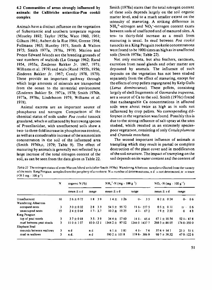
4.2 Communities of areas strongly influenced by animals: the Callitriche antarctica-Poa cookii complex
Animals have a distinct influence on the vegetation of Subantarctic and southern temperate regions (Moseley 1892; Taylor 1955a; Wace I960, 1961; Gilham 1961; Aubert de la Rue 1964; Greene 1964; Follmann 1965; Huntley 1971; Smith & Walton 1975; Smith 1977a, 1978a, 1979). Marion and Prince Edward Islands are the breeding grounds of vast numbers of seabirds (La Grange 1962; Rand 1954, 1955a; Zinderen Bakker Jr. 1967, 1971; Williams et al. 1979) and seals (Rand 1955b, 1956; Zinderen Bakker Jr. 1967; Condy 1978, 1979). These provide an important pathway through which large amounts of minerals are transported from the ocean to the terrestrial environment (Zinderen Bakker Sr. 1971a, 1978; Smith 1976b, 1977a, 1978a; Lindeboom 1979; Williams et al. 1978).
Animal excreta are an important source of phosphorus and nitrogen Comparison of the chemical status of soils under Poa cookii tussock grassland, which is influenced by burrowing species of Procellariidae, with uninfluenced soils show a two- to three-fold increase in phosphorous content, as well as a considerable increase of the ammonium concentration in the soil of the influenced area (Smith 1976b,c, 1979; Table 9). The effect of manuring by animals is generally not reflected by a large increase of the total nitrogen content of the soil, as can be seen from the data given in Table 22.
Smith (1978a) states that the total nitrogen content of these soils depends largely on the soil organic matter level, and to a much smaller extent on the intensity of manuring. A striking difference in NH4+-nitrogen and NC^'-nitrogen content exists between soils of unaffected and of manured sites. A ten- to thirty-fold increase as a result from manuring is usual. In mud between Poa cookii tussocks in a King Penguin rookerie concentrations were found to be 1000 times as high as in unaffected soils (Smith 1978a; Table 22).
Not only excreta, but also feathers, carcasses, excretion from nasal glands and other matter are deposited by animals. The influence of such deposits on the vegetation has not been studied separately from the effect of manuring, except for the effects of crop pellets regurgitated by Kelp Gulls (Larus domimcanus). These pellets, consisting largely of shell fragements of Gaimardia trapesina, are a source of Ca to the soil. Smith (1976c) found that exchangeable Ca concentrations in affected soils were about twice as high as in soils not influenced by crop pellets. No corresponding dif-ferçnce in the vegetation was found. Possibly this is due to the strong influence of salt-spray at the sites studied, which resulted in an extremely species-poor vegetation, consisting of only Cotulaplumosa and Crassula moschata.
The second important influence of animals is trampling which may result in partial or complete destruction of the plant cover and in modification of the soil structure. The impact of trampling on the soil depends on its water content and the content of
Table22 The nitrogen status of some Marion Island soils (after Smith 1978a) Wandering Albatross samples collected from the vicinity of the nests King Penguin samples from the periphery of a rookerie N = number of determinations, η d = not determined, tr = trace (<0 5 mg · 100 g"1)
Uninfluenced Wandering Albatross
occupied nests unoccupied nests
King Penguin top of peat stools mud between peat stools
Elephant Seal mounds between wallows mud in wallows
N
10
15
organic N (%)
mean ± s d
2 6 ± 0 72
3 0 ± 0 32 2 4 І 0 6 4
3 7 ± 0 1 8 11 0 ± I 07
nd nd.
range
18 39
28 33 I 7- 3.7
3 5 - 3 9 10 0-12 1
nd nd
NH 4
+ -N(mg. 100
mean ± s
1 4 ±
54 5 ± 10 2 ±
34 4 ± 1344 2 ±
6 1 ±
d
126
55 72 15 25
1760 97 02
1 81 1902± 101 8
g ' )
range
0-
11 6-4 1-
14 1-1244 0
4 1-119 8-
35
1175 67 2
45.4 1437 7
7 6 306 0
NO, -N (mg ·
mean ± s d
0 2 ± 0 24
0 5 ± 0 11 1 9 ± 2 55
67 1 ± 18 54 260 3 ± 88 05
37 6 ± 14 1 90 7 ± 38.52
100 g ' )
range
0-
tr-0
52 1-174 0-
23 3 47 9-
0 6
0 6 48
87 8 350 0
515 122 6
51

organic matter. In relatively dry, mineral soils trampling generally results in soil compaction. Wet, peaty soil, however, is easily churned up by trampling animals. The effect of trampling on the plant cover not only depends on the strength and growth form of the plants, but also on the soil properties mentioned above. In soils which are easily churned up trampling may lead to considerable damage to the root system of the plants. In mineral soils such damage is less likely to occur. In large penguin rookeries the soil is eroded away locally to a depth of several metres as a result of intensive trampling. Erosion gullies of over 3 m deep were encountered at the edge of the rookerie at Kildalkey Bay, the largest rookerie on the islands. Water is the main erosive agent, as wind plays only a minor role (cf. Gilham 1961).
No large herbivores are present on Marion and Prince Edward Islands. Consequently, grazing is no important factor affecting the vegetation.
The impact of seals and birds on soils and vegetation varies considerably with the size and
habits of the animals concerned. Herds of Elephant Seals moving inland from their landing beaches during the moulting season (November-April) have a devastating effect on the plant cover of wet, peaty areas. The seals churn up the soil over large areas and heavily damage the vegetation. As a result of this generally yearly recurring disturbance the vegetation of these areas has a pioneer-character, consisting largely of therophytes, notably Callitriche antárctica and Montia fontana. The latter species is generally classified as hemi-cryptophyte, but behaves here as a therophyte. By depressing the peat locally in their moulting areas Elephant Seals form wallows: hollows of a few square metres in area, up to 1 m deep, filled with strongly nitrogenous mud. The mud of unoccupied wallows is often colonized by Callitriche antárctica and Montia fontana.
Yearly recurring destruction of the plant cover and disturbance of the soil also takes place in the breeding colonies of King and Macaroni penguins (Fig. 32). Within the rookeries heavy trampling and
Fig. 32. King Penguin colony at Kildalkey Bay. Marion.
52

manuring is prohibitive for plant growth and the soil remains bare. Most penguins are confined to the coast, but large groups of non-breeding King Penguins may wander up to 2 km inland during the moulting season, locally exerting a strong influence upon soil and vegetation. Rockhopper Penguins breed nearly everywhere along the coasts of the islands. They do not concentrate into large rookeries. Consequently the impact of these more dispersed animals is comparatively small.
Large concentrations of burrowing species of small prions and petrels (Procellariidae) are found on coastal and some inland slopes. By trampling and manuring these birds strongly modify the soil and the vegetation of these slopes (cf. Smith 1976b). Because of their small size and weight these animals do not have such a destructive impact as the larger species of penguins and seals. Groups of breeding Sooty, Grey-headed and Yellow-nosed Albatrosses, which are found on inland and coastal slopes, have a similar influence.
The influence of solitary breeding birds is restricted to the small areas around the nest sites. Croóme (1972) found that one seasons' occupation of a nest by Wandering Albatrosses or Giant Petrels resulted in a significant modification of the chemical status of the soils. According to this author a five-fold increase in the organic nitrogen content is not uncommon, and he suggests that the influence of the birds on the nitrogen content of the soil may last for 5-6 years after the nest is abandoned.
Trampling and manuring are generally connected on the islands. In some cases, however, minerals from animal excreta are carried by water or wind to areas not occupied by animals. A striking example of this was seen at Kaalkoppie, a tuffaceous hill on the west coast of Marion Island. Part of its top and seaward slope is occupied by a penguin rookerie. On the landward side the top of the hill supports a luxuriant growth of Poa cookii. Guano, washed down from the rookerie, apparently allows plant growth on this otherwise bare hillside.
The plant cover of areas influenced by animals differs strongly from all other vegetation on the islands. Characteristic species for all communities of this complex are Poa cookii, Callitriche antárctica, and Montia fontana (Tables 23 and 32). Bryophytes, which are important in many other types of vegetation on the islands, play only a minor role here. In this respect the vegetation of areas
influenced by animals resembles the communities of saline habitats. Five associations together form the Callitriche antárctica-Poa cookii complex (Table 23). They range from low-growing pioneer communities to tussock grassland of some 40 cm height with a comparatively complex structure (Fig. 33).
Association 2.1 Montio fontanae-Callitrichetum antarcticae (type relevé 139)
Areas where the original plant cover has been destroyed by trampling, and which are strongly influenced by manuring, are rapidly colonized by Callitriche antárctica and Montia fontana. These species form the character-combination of this association, which is the pioneer vegetation on wet, peaty and more or less heavily manured soils. The community is very poor in species and has a very simple structure (Fig. 33). Montia and Callitriche frequently occur in all other communities of the Callitriche antárctica-Poa coofc/'/'complex, but have their optimum in the present association (Table 23). Two subassociations were found.
Subassociation 2.1.1 agrostietosum magellanici (type relevé 186)
After destruction of the bryophyte layer in Agrostis magellanica-dom'mated mire vegetation (cf. Par. 4.4) by trampling or foraging birds (notably Lesser Sheatbill, Chionis minor, and Kelp Gull, Larus dominicanus) Montia fontana invades the vegetation. The influence of animals is comparatively light, because of the small numbers and small size of the birds concerned. Thus, enrichment of the soil by excreta is slight, but seems imperative for the development of this community. In the absence of prolonged animal activity the vegetation reverts to one of the mire communities, probably within a few years. Differential species of this subassociation is Agrostis magellanica.
Subassociation 2.1.2 typicum (type relevé 139)
This subassociation, which does not possess any differential taxa, develops when intensive trampling
53

Table 23 The ÇaHuruhe antarcma - Poa took η complex.
n O N T I O F O N T A N A E - C A L L I T R I C H E T U H A N T A f t C T I C A E
ogrostletosun
magellanlcae
t y D I с и m
Ptontla - variant Intemtealate vorlont Cal l l tr lche - variant
CALUTRJCHO ANTARCTICAE
POETW ANNUAE
I 70 1 4 ^ I*.
n/'fcr - т Г ' П
- 3 S - 3 ^ •
4 . 3 л,9 ·
4 S3 S?
14 I ? 9 I ПО
I IS Ι-*ΙΊ З-ІР ^ЛЗ ЪУ?
Al SO 40
j b S l * b i - Ï J I J « l i l Ί Ϊ 6 | 4 |
ПЛ DJ nn
* 4 40 0Л
n o ю п i n i n n 11(1 09
і ь 4П г1- H d 40
M l 1^5 7S 76 80 •". Î 4,Ρ 4 , 4 4 , 4 4,Ь <
99 96 9S 97 PI
m n M O 110 IPO
.б« 349 I H ι ьбв 3 t 7 з г « i o n
M 37 51 53 5? Э ЬП
17 70 in IO in 30 75
S? ·)9 47 SI SI ПО 47
П7 70 ЗП ,)7 ?iJ 7П 4^
70 l?n 4S ?5 10 15 20
07 119 107 en 76
.4 4,И 4./ 5.2 4,7 3,4
100 i n n 95 99 ή5 IPO m n
57 51 57 57 57
584 I 4 J ЗЧЛ 543 5β2 57A І 7 Л з г о
53 5П э л ' IO 40 J ] 51 5? 4ñ po 37 ПЗ IO 2Ъ 75 m 4П ι β
У5 т о т о т о 09 ю п
I VTh ' AYt"1 ( Ч
f i f Τ " ι f ) ТА и C*LI ГГЫ ' i * " І А і ' С Т І С *
ОГ'-Ь*1 I I A ^ - T Î T K TAXAI
Ι Ό * »ч ιι t
С П ! ! ' A P d " f i s i Γ' A*"! A ' 4 ' Сд VI-"(UIC ' ДП]'-I Λ r i l A N T l A 1 Ц П Ч Г A M I I H ' , ι Ρ' 'Κ ΡΑΝ, ί ' Ι Ι - ι ' , ' l O M U Ч , R i | ' h Ë t l ' i Η'ϊΑΓΗ/Γ" ' ] ι ЯНТАЧИ ПИ д г о г - , ι Г*. Ч Г и ^ ' . Г с с і л IO» ι Π/ΙΑ СУ І - П Р І Р І й ^ І Ч I l ï t r 1 * J Ц ι Ч I s I · " ІЧАГЪЧ Д »l-'U t ^ r l · " i '.|( ƒ «Г« ι Ι _ Ι Ί ) - t r Ά Γ Λ υ μ γ - ^ ί д^г A Ai „ ( C M Ι1· αΑΓ(-!| AMC*
4 5 S S 4 4 3 ?R 7P ?B 4 5 S 5 Ί 5 5
I · • • Ρ ?A 5 5 5 5 S 5 5
5 ^ 5 5 6 5 5 5
•Jfv peci'-s
J ГЧ( I f ••( ι Ll'CI / r ' M J U t S I T^SO^ 'J M A AU^ l i f L " = A-OHL' 'A -.1 ' A iC
1 I ?B
has resulted in the complete destruction of the original plant cover of wet, peaty soils, rich in nitrogen. Three variants are discerned, according to the relative abundances of Monna fontana and Cailitriche antárctica. One variant is dominated by Montia, another by Cailitriche, while still another is intermediate for these species. On sites where manuring has been extremely heavy Cailitriche seems to reach dominance more often than Montia, but no clear environmental gradient fits the pattern of changing dominance of these two species. It is believed that the availability of propagules at the time when the bare soil is available for colonization plays an important role in determining which species reaches dominance.
Stands of this subassociation are found in all areas on the islands which are influenced by animals. Extensive stands occur near large penguin rookeries and colonies of Elephant Seals. Very small stands were met with near nests of Wandering
Albatrosses (Diomedea exulans) and large species of petrels.
Both Cailitriche antárctica and Montia fontana are able to partake in a perennial vegetation, and without further disturbance other species, e.g. Cotulaplumosa and Poa cookii, invade the vegetation. In most cases, however, succession is prevented by annually recurring destruction of the plant cover.
Association 2.2 Callitricho antarcticae-Poetum annuae (type relevé 583)
Poa annua, which species together with Cailitriche antárctica forms the character-combination of this association, is a naturalized alien on Marion and Prince Edward Islands (Gremmen 1975). As a general rule in this study, alien species have not
54

POO
260 ιο<
S3 so fì5 ?S SI / 7 S5 *S го 25
s го srt н
-зп -IO? 114
98 97
3 3 4 4 J PS
100 І п 0
Л 4
4 4
•i 2А 2А
η
5 5
+ •
C O O K I I
2S·,
ьз пъ ы ss ?ь
J SE
- 3 0 e i
4 , 0 96
4 A
ь юг
4
й
5
s
?57
ЪЗ оъ SI е,5 ?П 20 5
_ Й? л,2
OS
3
1? I0f>
4
3
I
5
W 3
se ?s л7 4S ?5 15
- 4 0 flu
97
Э 4
12 i re
4
4
I η
s
R
-
2 Ы
S3 Г5 Si SS 20 4 ^
SSb
_ 74 4 . 0
PS
3 4
20 100
4
л
1
s
*
C O T U L C T U H
b l r t
ss гп ib S7 40
_
3 4
?ь ΙΟΙ"
гз 3
*
ς
5 I S
SS гп 3S se 40
_
3
2S no
25
*
5
+
?so
S3 OS M ss 15 40 SF
57 4 , 4
R i
4
2S 100
4
3
R
S
Л37
52 35 34 00 35 30 Чгі
_ 93
л «1
30 ЮТ
2S ?
5
P I U H O S A E
154
SI IS 5 / 40 70
3 S h
- 4 5
4 9
9 4
4
4
IO ino
7 3
?A
S
5ή7
S3 10 s?
25 IS
r>H
_ 93
93
40 99
?5
1 ?A
S
*
5Λ2
S7 Π S2 02 30
_ 1 I 1 4 . 3
9A
3 3
20 110
г 3
?s 4
3
s
•
S71
S3 1«,
5? i r Í S
_ ι \e-
9S ?
3^ 0 0
i l
1
21 S
+ 3
5
transition
143
5 / 5b 51 ПО 4 0
m
fc -30 n i
4, 1 96
3 3
25 I T
0
ч
I 24
5 3
?R
MiS
S7 S5 51 no 45 10 SE
- J " 72
з,е
4
?s
1 7
4)
1 "
1
, 2P
S ?A
1
5 M
S7 M 57 02 35
t
-7S H ft 4 , ?
о*;
7 г
?* i n n
2 /•5
?s 7
1
3
ь
-
NONTIQ FONTAMAE -
CLASHATOCOLfETÜH VERMICULARIS
147 ? ι η M ^ 9 1 5 Л 0
^ 7 52 " " SI 55 10 4 , : ' η ^ SI SI M c l 5П
m 1^ 45 12 " 3^ 30 15 58 25 10 & ^ h SSE t
- 2 0 - 2 5 -74 -20 -gç g 7 92 121 I M
4 . 7 4 . 2 ^ . 3 4 , 0 4 .1 h 96 К 9 ? 9 3
3 2 ' ? 3 ? ?
ir io 1 г п ^ ^ - 45 90 I M 3"
, ? 2 I 2 95 ІПО 9 ^ ' 0 1 «
3
Q 4 I 3 Ift μ g Π I I 13
3 7EI 7A 5 •
+ + 1 1 ?B
= , 4 5 5 5
? в I •
3 + 1 * 1
s гв ι
197
50 ah 44 IO 40
ь,
m
- I F I I ?
4.г C i
1 3
20 90
I 90
4
H
I 3
s 7A
'
FPIAMENTS
175 ЮЛ
4П 5П Sr 4 Г
49 45
•s m 35 3(
7 Sfc
-?? -?π I 4 m s
4 . 2 4 , 0 CO 47
4 ? * 3
30 эо 70 30
99 100
4 4 M 4
•
4 3
5 5 1 3
2A
R
l O Q
t-n
4 1
0
- 1 7
1 И 4 , 0
*-> 7 2
?c
100
4
'
+
4
IS?
SI I E
5T 4 P
7 Π
<S
«Ч
-pt-
7J 4 . 3
49
5
ЭГ
«1
9
,:
5 + S
R
129
S |
15 57 •1П ГР
J ^ S f c
- 2 2 1 IS
•»,? O í
3 4
25 99
3 ЧП
4
*
•
5
Π
*
LEPTODONTIO PROLIFERI
η
зго
3' ?0 S í Id
I ? "
- I S 13J 4 . Τ
9 7
5
55 9S
3
ъ
) *
1
s
0 D
J 7 J
11 ?s Ί Ο
2S
2 " 1 V
-1 4
4 . 2
4
i l l
1
?s л
+ s
*
S
3 / Í
57 i " '•(l 2 "
•S ' F
1?
i^ l
4 1
3 Ί
3 ' i o n
1
9 1
1
» s
:
32?
J!" ?s nn 71" ? i
г-1
'" -••9
4 . f 73
4 S
ЗП
3
?s
^
5
1
R
4 1 J
=,-> SI 3
73 я
4 ι
J J
7
3 3e
m
л I 1
+
"
I +
;
,"*-t f
3Î ' Ч 13 ЗГ 4 0
' - l -
ЗЛ 4 . η
3
З1-о?
7 4 P
3 ? t
I 1
1 3
7 *
- pŒTim COOKII
brachythecletosun rutabull
th r
SO 17 4 "
33 30 t -
2S
5 S
4 . 5 «7
4
S
3^
1 3'
s 2^ 13
1 5
7P 'A
? "
1
*
477 43Л
•-З Ь І
=,2 í ' ¡
ss 3/ 3S зь Г-, Л С І
'J ".t
-7 A| 4 . ' 4 . ?
К ч?
7 Э 1 *
З ь 3Г; ос ос?
з -> 1 f 1
1С '(* 13 7
+ 1 5 'S
? 1 I
¿ I - » / T |
• - I S j ( R 4 Л
t n c ?
17 S 4
J " )-c r 4 P
» h
_ Í ? u t
4 . τ 4 . 4 74 7'
1 3 1 β
J-> J5
? J
η 7
J 'л 15 ι*- M
I *
7/ I
0
«22
' 3 4 ì i c 7
r 4 "
" 75
• " >
, 3S
5
1 * η
7»
4 ? -
S -
5C
7' 1 /
70
*.-/ J
Ì
1 '
1 l1-
1 " 1
*
7 Д
71
.*. 57 21 ΐ -
7
Γ," -TO
1Г.
£
3'
·'
1
'
1
•
been used to characterize syntaxa. Poa annua, however, has spread to many sites on the islands where it definitely was not introduced and is doing very well there. Dense swards of this grass, which is sometimes the only species present (relevé 320), are found on relatively dry, mineral, strongly compacted soils, generally heavily manured by animals. In this vegetation most plants of Poa annua, elsewhere usually a therophyte, are perennial. Similar behaviour of this species has been noted on Kerguelen (Chastain 1958) and South Georgia (Walton & Smith 1973).
Stands of this association were found near some large King Penguin rookeries and Elephant Seal moulting grounds, e.g. Kildalkey Bay, King Penguin Bay, Trypot Beach and Cave Bay (Prince Edward) and in the immediate vicinity of the meteorological station.
Association 2.3 Poo cookii-Cotuletum plumosae (type relevé 193)
This association does not possess any character-species. Differential species is Cotulaplumosa, the dominant of this species-poor vegetation. This community occurs on well-drained, organic soils, which are strongly influenced by manuring, on sites where trampling is not so heavy as to do very much damage to the plant cover.
Stands of Poo cookii-Cotuletum plumosae are restricted to the coastal lowlands. Cotula plumosa is not found above с 100 m above sea level, which may be a consequence of the alleged dependence of this species on minerals deposited by salt-spray (Huntley 1971).
Cotula plumosa has its optimum in two associations, the present one and the Cotulo plumosae-Crassuletum moschatae, which occurs in saline habitats. Cotula differentiates these two communi-
55

Fig. SS. Structure-diagrams of communities of the Callitriche antárctica Poa cookii complex, a = Montio fontanae - Callitrichetum antarcticae agrostietosum magellanicae; b = Montio fontanae - Callitrichetum antarcticae typicum; с = Callitricho antarcticae -Poetum annuae; d = Poo cookii Cotuletum plumosae, e = Montio fontanae Clasmatocoleetum vermicularis; f = Leptodontio proliferi - Poetum cookii inops; g = Leptodontio proliferi - Poetum cookii brachythecietosum rutabuli.

ties from all other ones on Marion and Prince Edward Islands. Floristically the Cotulo-Crassule-tum and the Poo-Cotuletum are differentiated from each other respectively by Crassula moschata and by Poa cookii and Monlia fontana (Table 32). There is a conspicuous difference in growth form between Cotula plants of these two communities: in Poo cookii-Cotuletum plumosae stands the Cotula plants are usually 10-25 cm high, with long, ascending leaves, which contrast strongly with the small rosettes, densely covered with long, white hairs formed by Cotula in the salt-spray zone (Fig. 28, cf. Gilham 1961; Chastain 1958).
Stands of Poo cookii-Cotuletum plumosae cover large parts of the coastal regions in areas influenced by animals.
Association 2.4 Montio fontanae-Clasmatocolee-tum vermicularis (type relevé 76)
This is the only community within the Callitriche antárctica-Poa cookii complex in which a bryo-phyte stratum completely covers the soil. Dominant is the liverwort Clasmatocolea vermicularis, the differential species of this association against all other communities of this complex. Its phytoso-ciological position is comparable to that of Cotula plumosa, but it does not show morphological differences between the populations of different habitats. Clasmatocolea vermicularis is dominant in the association described here and in the Crassule moschatae-Clasmatocoleetum vermicularis, which occurs on very wet soils within the salt-spray zone (cf. Par. 4.1). It differentiates these two communities from all other ones on Marion and Prince Edward Islands.
The Montio fontanae-Clasmatocoleetum vermicularis has a more complex structure than the communities of this complex described sofar, possessing a well-developed bryophyte stratum as well as a herb layer (Fig. 33e). The small proportion of therophytes in the vegetation and the comparatively large number of species (on average 9 species/ relevé) indicate a more mature character of the vegetation compared with the communities of areas influenced by animals described sofar.
Stands of this association are found on wet, organic soils with a groundwater level at about
20 cm below the surface. Trampling is usually light and the influence of manuring moderate, and enrichment through the groundwater from surrounding areas is in some cases more important than direct deposition of excreta by animals. An intermediate vegetation between Montio-Clasma-tocoleetum and Poo-Cotuletum was found on slightly drier soils (relevés 143, 146 and 563). Other stands develop towards the Leptodontio proliferi-Poetum cookii (e.g. relevés 560, 197 and 175). Poorly developed, fragmentary stands of this association also occur (e.g. relevés 196 and 199).
Association 2.5 Leptodontio proliferi-Poetum cookii (type relevé 422)
This association comprises the Poa cookii tussock grasslands of the islands. Character-species of the Leptodontio proliferi-Poetum cookii are Poa cookii, Leptodontium proliferum and Marchantía berteroana. Tussock grassland is found on well-drained soils, generally on slopes, with a moderate to strong influence of animals. The impact of animals is not evenly distributed in this type of vegetation. Trampling is in most cases much stronger in between the tussocks of Poa cookii than on the places occupied by individuals of this species, and consequently deposition of excreta also is not homogeneous over all parts of the site (cf. Table 22). In his description of the vegetation of Kerguelen, Chastain (1958) gives the impression that Poa cookii tussock grassland there is restricted to areas influenced by saltspray. On Marion and Prince Edward Islands this is not the case, as stands of this association were found at sites more than 4 km inland, at elevations of up to 300 m above sea level (cf. Huntley 1971).
Subassociation 2.5.1 inops (type relevé 323)
In areas strongly influenced by seals and penguins tussock grassland is generally poor in species and the bryophyte stratum is usually very poorly developed. Disturbance of the soil and vegetation is stronger here than in the other subassociation, and the animals influencing the vegetation here are generally much larger in size. Only when small
57

species of burrowing prions and petrels are present in very high densities, such as is the case on some slopes near Cave Bay (Prince Edward), the sub-association inops is found. When their density is smaller the other subassociation occurs.
Extensive stands of this community occur in all areas strongly influenced by animals, notably by seals and penguins.
Subassociation 2.5.2 brachythecietosum rutabuli (type relevé 422)
This subassociation is found on well-drained, often steep slopes, where the disturbance of soil and plant cover is less strong than on sites occupied by the subassociation inops, which in most cases is due to the much smaller size of the animals concerned (usually burrowing species of Procellariidae). The influence of these animals is therefore less destructive in this case than in most other communities of this complex. This is reflected in the comparatively high number of species in the vegetation (on average 13 species/ relevé, compared to 6 or 7 in the subassociation inops) and in the occurrence of a number of species which have their optimum in communities of areas not influenced by animals. Character-species of this subassociation is Mielich-hoferia campylocarpa. Differential species are Brachythecium rutabulum, Acaena magellanica, Agros t is stolonifera, Drepanocladus uncina tus and Lophozia cylindriformis (Table 23). The structure of this community, which is more complex than that of most associations of this complex, is illustrated in Fig. 33g.
Extensive stands of this vegetation cover coastal and inland slopes (Fig. 34) influenced by species of Procellariidae or by albatross species, in some cases also by penguins.
Poa cookii-Callitriche antárctica mosaic
Soil erosion associated with trampling by penguins may cause the formation of 30-100 cm high peat stools, crowned by Poa cookii tussocks and surrounded by hollows with Callitriche antárctica. Usually a large proportion of the soil remains bare (Table 24, Fig. 35). The vegetation of such sites is a mosaic of fragments of the Leptodontio proliferi-Poetum cookii on the hummocks and of Montio fontanae-Callitrichetum antarcticae occupying the
hollows, and represents a degradation stage of the Leptodontio-Poetum. Large areas at the periphery of some penguin rookeries are covered with this mosaic.
The distribution of the plant communities of the Callitriche antárctica-Poa cookii complex in relation to environmental conditions is represented diagrammatically in Fig. 36. The vertical axis represents a gradient of increasing influence by animals, while on the horizontal axis the communities are arranged in a series from wet to dry. The latter gradient coincides largely with a gradient from organic to mineral soils. Soil compaction is a function of both the intensity of the influence of animals and soil characteristics. In the diagram soil compaction is strongest in the top right-hand corner, which represents sites with a dry mineral soil and a very strong influence by animals. At the bottom of the diagram only a few of the most common vegetation types of areas unaffected by animals are shown.
Synchorological remarks
Most of the species dominating the communities of the Callitriche antárctica-Poa cookii complex are widely distributed on the islands in the Southern Ocean (cf. Tables 10, 11, 12). A few species have a more restricted distribution, e.g. Poa cookii, which only occurs on the islands of the Kerguelen Province. However, other species of Poa, more of less similar in habit and in ecology, form tussock grasslands in many other Subantarctic and southern temperate regions (cf. Wace 1965).
Although no detailed floristic data are available, it seems likely that the Montio fontanae-Callitrichetum antarcticae, or closely related communities, are present on most Subantarctic islands. On Macquarie and on Campbell Island the pioneer vegetation in abandoned Elephant Seal wallows is dominated by Callitriche antárctica, while in a later stage Montiafontana and still later Cotulaplumosa play an important role in the vegetation of these sites (Taylor 1955a; Gilham 1961 ; Oliver & Sorensen 1951). A similar luxuriant growth of Callitriche antárctica, Montiafontana and Cotula plumosa is reported from wet, sheltered coastal cliffs on Auckland Island (Cockayne 1909), but it is not clear whether or not this vegetation has a similar ecology as the Montio-Callitrichetum. In his
58

Fig, 34. Coastal slopes, covered with Poo cookii - Cotuletum plumosae and Leptodontio proliferi - Poetum cookii.
description of the vegetation of Kerguelen Chastain (1958) does not mention a community resembling the Montio-Callitrichetum, but Cour (1959) reports lush mats of Callitriche antárctica and lists this species as one of the dominants in the vegetation of inland seal wallows on these islands. No related communities are reported from Crozet, but in view of the resemblance of flora and environment of this archipelago to those of Kerguelen and Marion and Prince Edward Islands, it seems likely that such communities do occur there. On South Georgia extensive swards of Callitriche antárctica are found around abandoned albatross nests (Greene 1964).
Poa annua has been introduced to all Subant-arctic islands (Walton 1975) and communities related to the Callitricho antarcticae-Poetum annuae seem to occur on most of them. Because of its adaptation to heavy grazing pressure this species has been very successful on islands with introduced herbivores (Walton 1975). Thus, on South Georgia extensive 'replacement swards' dominated by Poa annua are found in areas where the original vegetation has been destroyed by the introduced reindeer (Walton & Smith 1973; Walton 1975; Kightley & Smith 1976).
59

Table 24 Poa cooku Calhtnche antárctica mosaic
Relevé number Location
Southern Latitude (46°) mm sec
Eastern Longitude (37°) mm sec
Elevation ( m a s i ) Inclination (c) Aspect Soil depth (cm) Depth of groundwater level (cm) Soil water content (X 10%) SoilpH Soil loss on ignition (%) Influence of saltspray Influence of trampling Influence of manuring Height of herb layer (%) Cover of herb layer (%) Cover of bare soil (%) Cover of rocks (%) Quadrat size (m2) Total number of species
Poa cookn Calhtnche antárctica Montia fontana Poa annua Cotula plumosa Ranunculus biternatus Agrostis magellanica Marchantía berteroana
192
50 25 47 45 25
-35 35 93
38 97
5 5
25 100
9 2
43 54
149
57 55 51 00 35 10
E -
60 42
95
5 5
15 97
3
9 4
33 4 4
2a 3
r2
388
57 47 50 42
100
-67 47
5 5
30 90 10
9 4
4 3 2a 3
1 3 13
127
51 15 57 40 70 7
SSE 25
-25 70 33
92
5 5
30 65 35
25 4
33 34 1 2
+ 2
151
51 15 57 45 30 20
W -
46 45
96
5 5
30 65 35
9 3
33 2b 3
1 2
321
38 25 00 25 15
-121
5 5
30 65 35
100 6
33 33 r 1
+ 3 + 3 + 2
187
51 00 47 30 45
--
43 37
81
5 5
25 60
9 3
4 3 1 3
2a 3
195
50 25 47 45 20 35
NNW -
30 3 1
80
5 5
30 30 70
25 2
43 1 3
126
57 40 51 15 70 7
SSE 25 25 41
43 87
5 5
30 20 80
25 2
2b 3 1 3
150
57 55 51 00 35 10
E
-46
39 88
5 5
30 30 70
16 6
2b 3 2a 3 + 2
+ 3 + 2
r2
Cotula plumosa occurs on all islands of the Kerguelen Province and on the islands south of New Zealand (Table 10), but communities dominated by this species are only reported from Kerguelen, where a Cotulaplumosa-'pTame' occurs on deep, organic soils outside the littoral zone (Chastain 1958) This author does not mention the influence of animals with respect to this community. Moseley (1877a), however, observed that on Kerguelen Cotula plumosa 'thrives and luxuriates where the soil is enriched by animal dung' The available information on this community is insufficient to judge the resemblance of it to the Poo cookn-Cotuletum plumosae
Clasmatocolea vermiculans, dominant and character-species of the Montio fontanae-Clasma-tocoleetum vermiculans, is reported from only one other Subantarctic island, South Georgia (cf
Table 12), and no communities resembling this association have been described
Poa cooku tussock grassland is found on Kerguelen (Aubert de la Rue 1932, 1964, Chastain 1958, Cour 1959), Crozet (Dreux 1964), Heard and Macdonald Island (Hemsley 1885, Vanhoffen 1903), but flonstic and ecological data are insufficient to judge the relationship of those tussock grasslands to the Leptodontio prolifen-Poetum cookn Some of the Poafoliosa and Poa flabellata communities reported from Macquane (Taylor 1955a), South Georgia (Skottsberg 1912, Greene 1964), Gough and Tristan da Cunha (Wace & Holdgate 1958, Wace 1961, Wace & Dickson 1965) appear to be similar in structure and ecology to the Leptodontio prolifen-Poetum cooku
60
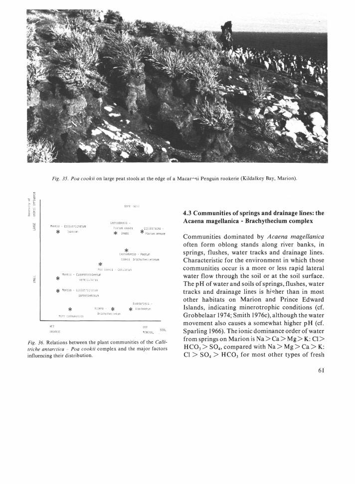
ш* • t¿
m ш-: Fig. 35. Poa íookii on large peat stools at the edge of a Macaroni Penguin rookerie (Kildalkey Bay, Marion).
nom io
*
* *
-
bare soil
Leptodontio -tomficnetu. poetu. moni coilitncho
І Г О , С Ш 1 * moos * Poetm omuoe
* Leotoflontlo - Poetum cooku crochytnecietosun
* Poo cooku - cotuletum
чопчо • Ciosnatocoleetum
vermiculans
Portio - Collltricfletuni
agrostietosurri
IsoDtengio -
^- Дсоепо ^с φ Blechneti»
Bracn,· гр comunities
Fig. 36. Relations between the plant communities of the Cullimi he antárctica Poa cookii complex and the major factors influencing their distribution.
4.3 Communities of springs and drainage lines: the Acaena magellanica - Brachythecium complex
Communities dominated by Acaena magellanica often form oblong stands along river banks, in springs, flushes, water tracks and drainage lines. Characteristic for the environment in which those communities occur is a more or less rapid lateral water flow through the soil or at the soil surface. The pH of water and soils of springs, flushes, water tracks and drainage lines is higher than in most other habitats on Marion and Prince Edward Islands, indicating minerotrophic conditions (cf. Grobbelaar 1974; Smith 1976c), although the water movement also causes a somewhat higher pH (cf. Sparling 1966). The ionic dominance order of water from springs on Marion is Na > Ca > Mg Ж : Cl > HCOj > S0 4, compared with Na > Mg > Ca > К: Cl > S 0 4 > HCOj for most other types of fresh
61

water on the island. According to Grobbelaar (1974) this indicates a marked geochemical modification of the mineral content of the drainage water. Smith (1976a, 1977d) found comparatively high concentrations of Ca and Mg in soils of drainage lines (cf. Table 9).
Not only the concentrations of minerals in the soil and drainage water influences the mineral nutrition of the plants, but also the water movement is alleged to have an important effect, resulting in a greater availability of nutrients (Chapman 1965; Ingram 1967). Thus water tracks and springs are sites with an appreciably greater nutrient supply to the vegetation than their surrounding areas.
Associated with drainage lines, water tracks, flushes and springs is a group of plant communities characterized by the abundance of Acaena magellanica in the herb layer and of Brachythecium subplicatum or Brachythecium rutabulum in the bryophyte stratum (Table 25, 32). These communities form a series, ranging in habitat preference from rapidly flowing, shallow, open water, via fast-flowing springs and flushes, generally without open water channel, and water tracks (places with a less abundant water supply than flushes), to drainage lines on slopes, where the groundwater level is usually more than 40 cm below the surface.
Association 3.1 Brachythecietum subplicati (type relevé 465)
Brachythecium subplicatum, the character-species of this association, dominates the bryophyte stratum of the vegetation of springs and flushes and other places with rapidly flowing, shallow water. Usually Acaena magellanica dominates the herb layer. Although the water flow, which is related to the amount of rainfall, may vary considerably, the bryophyte layer of the vegetation always remains about saturated with water. Three subassociations are discerned.
Subassociation 3.1.1 philonotidetosum (type relevé 309)
Philonotis cf. angusti/olia and Bryum spec. (no. 9 in Zanten 1971) are the character-species of this subassociation. Only one extensive stand of this community was found, covering an area perma
nently inundated by Van Den Boogaard River near Tafelberg on Marion Island. A dense mat of bryophytes grows here in 3-10 cm deep running water. The soil consists of 1-3 cm organic matter overlying a bed of pebbles and sandy material (Fig. 37). At the edges of the stand the bryophyte layer is locally poorly developed and the vegetation is dominated by Montia fontana (relevé 312). A possible reason for this change in dominance is the stronger impact of fluctuations in the water level along the edges of the inundated area.
Fragmentary stands of this community were found along the borders of some rivers, on sandy deposits within reach of the water. These stands are most common along the upper course of Van Den Boogaard River. The river probably provides an easy dispersal route for Philonotis and Bryum, which were both found on Marion in vegetative form only. The permanent nature of the river is probably important, assuring a permanent water supply, even during spells without precipitation.
Subassociation 3.1.2 inops (type relevé 459)
In springs and water tracks with a strong rate of flow dense carpets of Brachythecium subplicatum occur. Acaena magellanica dominates the herb layer, but in some cases this species is absent and the herb layer is poorly developed (Figs. 37, 38). This subassociation contains only few species, and is characterized by the absence of the differential and character-species of both other subassociations. The vegetation often has the character of a quaking bog. There seems to be a tendency for the cover of Acaena in this community to decrease towards the middle of the spring or flush. No explanation for this phenomenon was found.
Subassociation 3.1.3 breutelietosum integrifoliae (type relevé 465)
This community (Fig. 37) occurs on more solid ground in water tracks, on more mineral soils than the subassociation inops. It is comparatively rich in species (Table 25). Differential species are Breutelia integrifolia and Drepanocladus uncinatus. Character-species is cf. Cratoneuron filicinum (Zanten 1971). The water flow through stands of this community seems to be appreciably less than
62

5
..¡'¡¡••¡•¡•ι ;:;;.'.•.'! ι
15-
%%m&
Acaena magellanica m
Brachythecium subplicatum
Phllonotls
cl angustifolia
Ranunculus biternatus
B r y u m spec.
Breutel ia integrifol la
Mont la fontana
cf. Cratoneuron
Drepanocladus uncinatus
Ag rostís magellanica
rock
sand
p e a t
Fig 37 Structure diagrams of communities of the Acaena magellanica - Brachythecium complex, a = Brachythecietum subplicati philonoudetosum; b = Brachythecietum subplicati inops; с = Brachythecietum subplicati breutehetosum integnfohae; d = Acaeno magellanicae - Drepanocladetum uncinati breutehetosum integnfohae
through the flushes covered with stands Brachythecietum subplicati inops.
of
Only one extensive stand of the Brachythecietum subplicati philonotidetosum was found, along Van Den Boogaard River (Marion). Both other sub-associations are common on Marion Island. No stands of this association were found on Prince Edward Island, where also none of the characteristic bryophytes of this community, e.g. Brachythecium subplicatum, Philonotis cf. angustifolia, Bryum spec, Breutelia integrifolia and cf. Cratoneuron filicinum, have been found. None of these species is known to produce spores on Marion Island, which makes distribution of these species from this island to Prince Edward Island very difficult.
Association 3.2 Acaeno magellanicae-Drepanocla-detum uncinati (type relevé 206)
In drainage lines with a less strong water flow and with a water level at least somewhat below the soil surface, Drepanocladus uncinatus is the dominant bryophyte. Together with Acaena magellanica, the dominant in the herb layer, this species forms the character-combination of this association. Two subassociations are distinguished.
Subassociation 3.2.1 breutehetosum integrifoliae (type relevé 206)
This subassociation (Fig. 37) is found in drainage lines with a water level close to the surface ( 1 -13 cm deep). Differential species are Breutelia integrifolia and Agrostis magellanica.
63

Table 25 The Acaena magellanica - Braíh\ theiium complex
REÍ EVt NUKDEH ІПСЛТІОМ
«ΟΙΙΓΗΕΡΝ U T I T J I l f c ("HO) H I N . srr.
EASTERN I O N U I T U " t ( J70) M I N . ShC.
hLEVATITN ( 't А . Я . Е . ) Ι Ν Π INATtON (O) ASPECT SOIL 'ІЬГ'ГС ССЧ) DEPTH OE mOUNRWATFR I EVEI ( C i ) S O I ' ΛΑΤΕΙΪ CONTENT ( Х І П Í ) S T I L Λ' S( Γ , o t ; S ON IGf ' IT ION С ) INHUENCE OH SAI Γ^ΡΊΑΥ INFLUENCE OF ТРАЧІ I I h i l Г1И JLNCE OE H ' A ' U r l m , M Z I t l ' l "C IF.ÌH I AYtP ICM) COVER OE 'ΙΕΡΗ I ДУЕР (У) Έ Ι Π Π OF Ι ΙίΥΟΡ'ΎΊΕ I AYLH (Cl')
COVET OE ERYIPHYTL LAYER (%) COVER OF AI OAE (%) COVE i Ol· BARE SOU (·;) COVER ΟΓ 10CKS (Ж) OJA >RAT SI7E (M2) TOTAL MMDb» OE Si-cCItS
CIIARACTCR-SPECIE·, OF Tl'E COMPItX
ACAENA MAGELLAN ICA
UIACNOSlIC TAXA OF ASSOCIATIONS АМІ ІОИЬП UNITS
P"ILONOTIS CF. ANGUSTIFOLIA BRYUM S P r C . nPAC'YTI'ECH'M SimPI ІСАТІЧ CRATOtcURON U L I C I N U M LRElircI ΙΛ INTEGRIEO' IA OREPANOCIADUS UNCINATUS SIAri'YTl'cCIUVl RUTAPULUM HI ECHNUC PEN'.A-МАЫЧА A G R r s n s STOLON IFLRA PRINGUA AKTISCORBUTICA AGPOSTI"; MAGELLANICA CE. AMBIYSrfcOIUM Ы Е Ч А Р І А * L ) I A CER/STIPH HOLOSTEOIDES
COVPANIO> SPECIES
MONI ΙΑ FONTANA RANI" CUI US BITERNATIJS POA COOK Π LOPhOCOLEA R A N I 4 I POA ANNUA A70RLLLA SEUGO HYGROAMBLYSTECIUM E I L I U
lEPTOIWNTIUH PROI IEERUM
B R A C H Y T H E C I E T U M S U B P L I C A T I
Dhllono-
tldetosum
31?
53 П5 4Π ЛП
? з п
• 5
S 40
s 3
?(1 4 g
1 I +
I
s I
•
+
309
S3 ns m /ІП
? з п
• 7
s 10
5 100
л 0
3 1 s
I
1 1 1
1
э і о
53 05 4B 40
?30
+ 4
5 3 5
99
4 10
3 1 s •
+
1 1 R
1
¡SO
57 П5 31 15 75
- 7 117 j . f t (19
1? 7 4
100
4
'S
5
+
+ 1
1 η 0
47Θ ЛЪ6
50 5П 43 4S 4B 4Я OS 05
ПО 90
• ? - 3 304 5 , 3
В7
10 15 3 3 5 5
100 100
4 ?5 4 Л
1 1
5 5
1
1 1 1 •
*
Ρ s
459
50 4В 4P 05
ПО 4
N
- 3 ?04 5 . 4
15 40
5 100
15 Л
3
5
+
+
1
453
50 4В 4Н 05
100 4
N
- 4 ?09 5,В
70
15 00
5 100
1? б
4
5
2А + + +
35?
57 05 31 15 75
- 9 й | 4
6 , 0 яв
30 99
7 100
9 4
5
5
+ +
breutelletosim
4 / 9
50 ЛН 4В 05
1 10
0
10 70
5 100
4 ч
4
5 ?И
+ +
+
1 1
Integrlfollae
767 465 2 6 э
51 50 51 00 48 0 0
4П 4В „ „ ПО 05 о а
140 МО 120 1 5
SU NE 4 у
0 • 2 • 3 132 71
5 , 3 64 26
15 ?0 і ь 60 40 60
5 6 s 100 1 00 100
4 15 3 IO 10 β
4 3 4
+
5 5 5 I I 2A 1 • 1 • • 1
I ?A •
+ + + • 1 1 R 1
+
707
51 00 4B 00
1 10
- ? 97
5 . 4 40
15 95
6 100
3 7
5
5 ?A
+ +
?B
1
?64
51 on 48 00
IPO 40
NNH 7
- 2 150
15 60
5 100
3 6
A
5 2B 7B
+
1
ACAENO MAGELLAN I CAE -
DREPANOCLADETim UNCINATI
breutelletosim
20Э
51 00 48 no
130
- 3 0 50
6 , 0 3fl
20 50
6 100
3 5
3
+ 5
3
*
Integrlfollae
205 540 46? ?06
51 52 50 51 00 21 49 00 40 49 46 4fl CO 55 05 00
130 130 110 130 10 N
- 3 - 3 - 1 0 - 1 57 63 156 ВЭ
braíiyttECletoain Ι
rutdull
431 557
53 52 45 ? l 5? 49 30 55 50 135
35 SSE
- 2 5 -96 76
5 . 4 5 . 5 5 .В 5.5 И.S 5 . 0 33 98 92 34
?0 25 15 ?5 70 70 60 90
5 5 6 5 100 100 100 100
3 0 9 3 9 7 8 7
3 3 4 4
+ 1
1 • 1 ?A 5 5 5 5
1 1 R •
3 3 1 ?B
• • ?A + +
+
1 lì
76 75
?5 30 100 B5
3 15 99 100
3 20 5 10
5 5
5 5 1
?B
+
+ + + +
1 1
?A
189 134
51 57 00 45 47 51 30 00 45 50
75 E 15
- 3 5 94 83
4 ,1 4 .1 91 РЗ
I 30 ?0 95 99
4 15 90 ЮН
5 16 6 5
5 5
4 5 ?A ?Ч
?A
•
1 1
?в
Subassociation 3.2.2 brachythecietosum rutabuli (type relevé 189)
In drainage lines with a groundwater level more than about 25 cm below the surface Breutelia and Agrost is magellanica disappear and Brachythecium rutabulum becomes more frequent (Table 25). This subassociation does not possess any differential species. On average tne water content of soils under stands of this community is much higher than in those on which the next association, the Acaeno magellanicae-Brachythecietum rutabuli, occurs.
On somewhat drier soils transitional stages between these communities are found (relevés 249, 474 and 425).
Association 3.3 Acaeno magellanicae-Brachythecietum rutabuli (type relevé 425)
In drainage lines and along the banks of streams, on sites with a groundwater level usually more than 40 cm below the surface, and with comparatively dry
64

1 transition
?49
51
50
51
05
ta 5
5E
-32 4,9
I
35 100
5
95
4
1 1
5
4
3
1
+
*
2Λ
1 3
•
I
474
52
30
50
55 (50
35
лип
6? 4.9
Э
31 99
6 Й0
25 9
5
?B
3
1
+
+
+
3
425
53
45
5?
45 50
30 NNfc
-47 4,4
53
30
ion 4
95
16
7
5
3 4
1
+
+
1
227
51
50 50
45 65
- 7
90 4,9
74
25 100
5
no
4
6
5
2A
5
2B
+
R
ACAENO
222
52 10
50
50 АО
-59 4,6
70
20 100
5 97
4
4
5
2A
5
I
• 2A
*
371
5B
00 51
00 70
10 Nt 17
-— 64 4.3
89
2 4 0
98
10 80
9 7
5
1
5
+
+ 2B
MAGELLANICAE -
473
52 15
50 48 55
45 ENE
15
5Θ 5,4
75
35 95
15 100
36
6
5
1
5 1
•
R
II 1
57
30
50
20 10
50 -20
200
4,В
66
15 100
1 60
2 7
5
+
4
•
1
5
1
375
57
50
50 42
150 3
ND 50
76
"л7
h
25
90 IO
100
9 4
5
5
R
4
387
52 IO
51 15
100
21
4,9 35
1 25
99 7
100
9
6
5
5
I
+
•
BRACHYTHECIETUM
216
51 50
50 45
35 5
E
-35 89
•<.5 93
40
100 IO
100
16 4
4
4
I
2A
226
57
50
50 55
70 45
S
30
70
4.7 77
1
2
35
100 5
95
4
7
4
1 5
2A
4
•
•
370
52 21 49 55
75 7
56 15
39
4,6 76
1 30
99 IO
50
9 9
5
3
1
R
+ * 1
546
57
45 51
55
135 30
5E
-57 5.1 64
30
ino 7
9П
16 7
5
5
2A
•
+
2A
RUTABULI
136
52 52
37 ГО
70 25
S5H 15
52 4,4 87
25
ino IO
90
9 5
5
5
2A
R
1
509
57 15
51 51
30
30
100 IO
100
25 10
5
1 4
2D
4
167
52 21 49
IO
50 5Г
NE
22
5.3 45
40
100 7
100
25 6
5
5
2B
+
2A
S43
52 21
49 55
un 35
Sh
-66 4,6 65
35 ΙΟΓ
5
99
20 q
5
+
5
3
R
•
2B
+
504
52 56
38 Г0
65
-
30
99 1
<l
1
18 12
5
1
•
R
•
R
252
53 05
51 55
20 50
S
-74 4.2 91
3 4
30
100 1
1
4
13
4
1
+
1
1
1
2A 4
•
§
(Л
ε
424 221
53 52 45 1"
52 51 45 or
30 45 45
NE
-20
55 42
4.3 4,7 55 45
I
эо зо ιοο m o
3 3
60 60
16 4 9 9
5 5
1 * 4 4
1
3 2B
•
1
+
+
ACAENO MAGELLANICAE -
225
52 10
50 50
60
-23 5.7 33
35
mo 1
<l
4
в
4
+
1
5
Ρ
I
+
R
R
AGROSTIETUM
241 240 426
52 52 53 00 05 45
51 51 52 1Γ 10 4b
45 45 30 45
fcNh 4П
-20
2 3 27 115
5,4 5,3 5,6 36 37 60
1 30 30 30
100 100 100 2 2 3
1 3 7
4 4 16 8 9 8
4 4 2A
• I 2A 1 • *
5 5 5
Ρ Ρ •
η •>
+
+
R •
+
STOLONIFERAE
219
5? IO
51
15
35
-22 9 . 1
34
4 fi
mo 2
I
4
e
3
+
1
5
η
+
+
fraqments
220 223
52 52
10 IO
51 50
00 50
45 «0
-и io 5.6 5.6
12 ?3
30 40 95 100
5
4 4
2 6
3 J
4 4
R
+
+
•
430
53 45
52
10 51
-15
94 5,4
65
25
ino 1
< 1
16
5
1
5
9
1
42J
53
4C 52
15 30 4 π
2Γ
71
4 . 7
63
1
31 1Γ
η
3 <1
16
5
+
+
5
+
+
fragments
319
3Ü 30 ПО
21 30
15 tME
-η Ь,5
M
35 IOC
5
15
25
?
5
2B
324 514
ЗТ 56
32 40 ΓΙ 35
19 40 35 50
IO
l.t
-13 -20
feo 4 . /
70
I
2
JO 21'
i n 100
2 го
25 25
/ 4
5 5
J +
2 В I
3
+
soils, a community occurs dominated by Acaena magellanica in the herb layer and with a bryophyte stratum dominated by Brachythecium rutabulum. Together these two species form the character-combination of this association. The soil here consists of a 20 40 cm thick humus-rich layer overlying a brownish clay of varying depth. Beneath this layer often a soft or hard plinthic layer occurs, usually containing many black Mn nodules (Smith 1976c; Fig. 39). On wet, organic soils Drepanocladus uncinatus may reach relatively high cover values (e.g. relevés 227 and 222), while
Blechnum penna-marina generally indicates somewhat drier conditions (relevés 167 and 543). On comparatively mineral, dry soils Agrostis stolonifera invades the vegetation, resulting in transitional stands between the Acaeno magellanicae-Brachy-thecietum rutabuli and Acaeno magellanicae-Agrostietum stoloniferae (relevés 424 and 221). Some stands occur in which Brachythecium rutabulum has a very low cover, and in which a comparatively large number of species are present (relevés 508 and 252). Their syntaxonomic and ecological position is not clear.
65

Fig. 38. Spring with Brachythecietum subplicati (near Diving Petrel Stream, Marion).
The Acaeno magellanicae-Brachythecietum ru-tabuli is widely distributed on Marion Island but was not found on Prince Edward Island, where Brachythecium rutabulum is lacking. On Marion Island Brachythecium rutabulum was found only vegetatively, which accounts for it not spreading from this island to Prince Edward. The Acaena vegetation of drainage lines on Prince Edward has a very poorly developed bryophyte stratum, since the
mosses dominating the vegetation of comparable habitats on Marion are lacking here, and apparently no other species take over this prominent position (cf. relevés 319 and 324).
Association 3.4 Acaeno magellanicae-Agrostietum stoloniferae (type relevé 240)
66

сш
о
10
20
40
60
80
100
120
im
Alltter
ύ α Γ * · brown
Ад dork orown
dark brown
light brown
light brown
Mn nodules
Indurated layer
Hard
pi Inthic
strongly gleyed
^т^ semi - gleyed
Heavily Indurated layer
Indurated layer
Scoriae and gravel
Hdrd ollnthlc
Fig. 39. Profile of the soil in a stand of Acaeno magellanicae -Brachythecietum rutabuli (after Smith 1976c).
Agrostis stolonifera has been introduced inadvertently by man on Marion Island. It is widely spread along stream-sides and on coastal slopes in the north-eastern part of the island (Gremmen & Smith 1980), where it forms extensive stands on relatively dry, mineral soils on sites with lateral groundwater movement, notably in drainage lines on grey lava slopes and on deposits of gravel and sandy material along rivers (Fig. 41). Agrostis stoloni/era and Acaena magellanica form the character-combination of this association. Differential species is Pringlea antiscorbutica.
Stands of Acaeno magellanicae-Agrostietum stoloniferae were only met with in the north-eastern part of Marion Island, where this community seems to replace the Acaeno magellanicae-Brachythecie-
tum rutabuli in part of its habitat-range, notably on comparatively dry, mineral soils.
Agrostis stolonifera has not been found on Prince Edward Island.
Synchorological remarks
Communities dominated by Acaena magellanica are recorded from most Subantarctic islands, but little data on their floristic composition and ecology are available. On Kerguelen and Crozet Acaena magellanica dominates the vegetation of large parts of the lowlands (Schenck 1905; Werth 1906; Chastain 1958; Cour 1959; Aubert de la Rue 1964; Dreux 1964, Hébrard 1970), occurring on dry, mineral soils as well as on wet peat. On South Georgia Acaena magellanica is one of the pioneers on bare scree or morainic slopes, where it forms extensive stands together with the turf-forming moss Tortula robusta Hook. & Grev. (Skottsberg 1912; Greene 1964; Smith & Walton 1975). The .4caem/-dominated communities on these islands seerp to cover a wider range of habitats than the communities of the Acaena magellanica-Brachy-thecium complex on Marion, and their distribution apparently is not related to a lateral water flow through the soil. Insufficient data, however, are available to assess the relationships between the /Ісаела-communities of those islands.
In his description of the vegetation of Macquarie Taylor (1955a) reports dense mats of Acaena magellanica growing locally on the gravels of creek fans. No floristic data are available but the habitat description suggests a correspondence to the Acaeno magellanicae-Brachythecietum rutabuli. It should be noted that most of the characteristic species of the communities of the Acaena-Brachy-thecium complex described in this study do not occur on Macquarie (cf. Table 11).
An apparently vicariant community of the Brachythecietum subplicati philonotidetosum is found on South Georgia, where along streamsides and in flushes a vegetation of Philonotis acicularis (C. Muell.) Kindb., Philonotis vagans (Hook. f. & Wils.) Mitt., Hygroamblystegium austro-fluviatile (С. Muell.) and Monda fontana occurs (Skottsberg 1912), which resembles this subassociation strongly in structure and ecology. Lindsay (1971) has described a community of a species of Brachythe-cium, which occurs in the South Shetland Islands
67

Acaena magella nica
Ranunculus bíternatus
^ А Л Л Brachythecium rutabutum f Agrostis magellanica
Poa cooki i
l i t t e r
humus - rich clay
clay
Fig. 40. Structure-diagram of Acaeno magellanicae - Brachythecietum rutabuli.
fig. 41. Acaeno magellanicae - Agrostietum stoloniferae (the light band of grassy vegetation) along Van Den Boogaard River.
6X

(Maritime Antarctic), on wet slopes and on flat areas where melt water accumulates during summer. This author states that the more rapid the water flows, the more luxuriant the moss in this crypto-gamic community grows. This Brachythecium sociation seems to correspond in site ecology to the Brachythecietum subplicati on Marion Island.
4.4 Communities of oligotrophic mires: the Juncus scheuchzerioides - Blepharidophyllum densifolium complex
The cool and extremely oceanic climate of Marion and Prince Edward Islands greatly favours peat formation and wherever drainage is impeded peat deposits have accumulated, ranging in depth from a few centimetres to more than 4 m. In the lowland areas of the islands numerous small and large mires,
often interconnected by peat deposits on slopes, cover a large part of the surface (Fig. 42). These mires are not ombrotrophic in a strict sense, as most of them receive water which has been in contact with the mineral soil of the surrounding areas. This apparently does not result in a marked influx of minerals into the mires, and about all minerals here are derived from the precipitation (cf. Grobbelaar 1974). As a consequence of the high and nearly continuous rainfall, in most areas movement of plant nutrients in the upper part of the peat deposits may well occur in a downward direction only, thus preventing any influence of geogenous water on the vegetation. Lateral drainage of water through the mire across the surface of the parent rock is indicated by the oxygen content of the soil solution, which first decreases rapidly with depth, but increases again in the lower part of the peat deposit (Smith 1976c). The rate of water flow is very small
Fig. 42. Goney Plain, Marion Island, showing an intricate pattern of mires (light coloured areas) in the depressions of the lava flows and Isopterygio pulchelli - Blechnetum penna-marinae on well-drained slopes (dark areas).
69

compared to the flow of water in the springs and flushes described in the previous chapter. Only in water tracks through the mire expanse does a relatively high water flow occur. Water transport here mostly takes place through the peat soil, and usually no open water channel is found. The vegetation of these water tracks differs strongly from that of other parts of the mire areas, which probably is related to the different plant nutrient regime in the water tracks (cf. Chapman 1965; Sparling 1966; Ingram 1967; see association 4.8). Peat deposits are best developed on grey lava and on black lava flows of the aa type. On block lava and on pahoehoe lava flows of the second volcanic series the very porous nature of the surface does not permit the stagnation of water, thus preventing the formation of peat. The deepest peat deposits occur in the basins in the lava flows. Peat is also found on somewhat sloping ground, but is absent on steep slopes. Between peat and lava usually a 15-70 cm thick layer of loamy clay occurs, originating from the weathering of the lava before the beginning of peat accumulation, or in black lava areas possibly also blown in by the wind from the nearby grey lava areas, which for a large part are covered with thick layers of glacial clay.
The surface of the valley bogs is generally flat or slightly concave. On slopes the surface of the peat deposits follows more closely the topography of the underlying lava flows. Physiognomically the islands' mires show a resemblance to the blanket bogs of western Ireland. The mires have a very even surface, a pattern of hollows and hummocks as in the bogs of the European continent being completely absent. Also no surface structures comparable to the shallow terraces found by Wace (1961) on the surface of the bogs on the Cough Island plateau are present on Marion and Prince Edward Islands.
The most important peat-forming plants in the mires on the islands are bryophytes, notably Drepanocladus uncinatus, Blepharidophyllum demifolium, Jamesoniella colorata, Racomitrium lanuginosum and Breuteliaintegrifolia. Graminoid species also play an important role, notably Agrostis magellanica and Uncinia compacta, and, to a much smaller extent, Juncus scheuchzerioides. In relatively dry parts of the mires Blechnum penna-marina contributes considerably to the peat formation. As has already been noted in an earlier
chapter, Sphagnum spp., which are very important in bog vegetation of large parts of the world, do not occur on Marion and Prince Edward Islands, and also do not play a role of any import in the mire vegetation of the other Subantarctic islands.
A large number of species is restricted to communities of the Juncus scheuchzerioides-Blepharidophyllum densifolium complex or has its optimum here, e.g. Juncus scheuchzerioides, Distichophyl-lum fasciculatum, Peltigera polydactyla, Blepharidophyllum densifolium, Clasmatocolea humilis, Lepidozia laevifolia, Leptoscyphus expansus, Schistochila carnosa, Acrobolbus ochrophyllus, Ptychomnion ringianum, Jamesoniella grandiflora, Jamesoniella colorata, Fossombronia australis, Uncinia compacta, Andrewsianthus lancistipus, Riccardia cf. pinguis, Riccardia cf. multiflda, Jensenia pisicolor, Lycopodium magellanicum, Breutelia integrifolia, Bryum laevigatum and Sym-phyogyna marionensis (Tables 26a,b, 32).
Thecommunitiesofthiscomplex can be arranged into a series along a gradient from wet to dry. The position of the communities along this gradient, based on more than 1000 measurements of the soil water content in stands of mire vegetation, is shown in Table 33. At the wet end of the gradient inundation or extremely wet soil conditions apparently prevent the occurrence of many species (cf. Table 26a,b). On drier soils not so much the average situation as well as the extreme conditions seem important. During periods of several consecutive days without precipitation, with strong winds and with sunny weather, the water supply to the bryophyte stratum of the vegetation is sometimes insufficient, locally resulting in severe drought-damage. After a period of four days with such weather conditions (a very rare occurrence on Marion and Prince Edward Islands) severe damage was observed to the vegetation along the wetter part of the gradient, notably the Junco scheuchzerioidis-Drepanocladetum uncinati and the Blepharido-phyllo densifolii-Clasmatocoleetum humilis. Bryophytes with a mat-forming habit, e.g. Clasmatocolea humilis, Blepharidophyllum densifolium and Drepanocladus uncinatus, are more susceptible to drought than species which form turves or carpets. These dense types of colony, and turves even more so than carpets, are more resistant to water loss to a desiccating atmosphere than mats of wefts. Furthermore, the densely packed, predominantly
70

vertical structural elements in turves do facilitate the water supply to the upper parts of the plants by providing numerous capillary spaces for water transport(cf. Gimingham&Birsel957;Gimingham & Smith 1971; Mägdefrau 1935; Gimingham 1967).
The pattern of the plant communities in the mire in a small black lava valley in Nellie Humps, near the meteorological station, is shown in a vegetation map (Fig. 43). This pattern shows a conspicuous correlation with the pattern of the groundwater level (Fig. 45), soil water content (Fig. 46) and elevation (Fig. 44). From the community patterns in this and two other areas of which detailed vegetation maps have been made, which are not reproduced here, conclusions are drawn about the relative position of the mire communities along a wet-dry gradient. These patterns also provide indications on the direction in which the communities develop in a successional series.
Community 4.1 Community of Juncus scheuchze-rioides (type relevé 586)
In this community two types of pioneer vegetation, mostly dominated by Juncus scheuchzerioides, are united: one which occurs on bare, wet peat soil, the other is found in 20-80 cm deep water in bog ponds. This community is floristically very poorly characterized: it does not possess any character- or differential species. Conspicuous is the very open character of the vegetation, which is very poor in species, and the relative importance of Juncus scheuchzerioides. Bryophytes play a very minor role in the vegetation. Two variants are discerned:
a. Campylopus clavatus variant
This is a degradation stage of the Blepharidophyllo densifolii-Clasmatocoleetum humilis or related communities. It is found on wet, oligotrophic peat soils, in areas where the original plant cover has been more or less completely destroyed, often after initial disturbance of the vegetation by fouraging birds (notably Lesser Sheatbill and Kelp Gull) and subsequent erosion by water and wind. Juncus scheuchzerioides then colonises the bare peat. Some relics of the original vegetation generally are present, notably tufts of Agrostis magellanica and Uncinia
compacta, and in some cases most of the species present are remains of the community previously occupying the site (e.g. relevé 467).
The Campylopus clavatus variant is floristically not well differentiated from the other one, but is clearly different in habitat.
Juncus scheuchzerioides shows markedly different growth forms in the two variants of the Juncus community. In the Campylopus variant Juncus plants often are not more than a few centimetres high and have a reddish-brown colour, while plants of this species in the Ranunculus biternatus variant grow up to 30 cm high, and are often bright green in colour.
b. Ranunculus biternatus variant
Juncus scheuchzerioides, Agrostis magellanica and Ranunculus biternatus are the most prominent and often the only species in this pioneer community which occurs in 20-80 cm deep water. This community, which occurs in many bog pools on the islands (Fig. 47), is floristically differentiated from the Campylopus clavatus variant by Ranunculus biternatus, and by the absence of e.g. Uncinia compacta and Campylopus clavatus, species which are found, although infrequently, in stands of the latter variant. The difference between the growth forms of Juncus scheuchzerioides in the two variants of this community has already been remarked upon.
In some stands Juncus scheuchzerioides plays only a minor role, and Agrostis magellanica or Ranunculus biternatus attain dominance. This change in dominance could not be correlated with any difference in environmental conditions.
Association 4.2 Junco scheuchzerioidis-Drepano-cladetum uncinati (type relevé 488)
The dominant bryophyte in this community is Drepanocladus uncinatus, which together with Juncus scheuchzerioides forms the character-combination of this association. It is found towards the drier side of the Juncus scheuchzerioides community, along the edges of bog pools and on extremely wet peat soils in depressions in the mire expanse. Three subassociations are discerned.
71

.',',·,', ·:·;·:<· ll'l'l ν V ν
2.1.2 а
2.5.2
5.1 + h 2.
f r 2 + f r 4
'I ' ! ' :
4.6.1
4.1 Ь Juncus
4.1b Ag г. ma.
4.2.3
- • ^ - ; Π
ііжіШ
Î ι
О 2 4 β β io m
Fig. 43. Vegetation map of an area in Nellie Humps, Marion Island (see Table 17 (p. 42) for explanation of the numbers of the legend).

9 ^ 4 6 ? » я
Fig. 44. Map of the elevation (m above see level) in the Nellie Humps mapping area (cf. Fig. 43).

2
Fig. 45. Map showing the groundwater level (cm below the surface) in the Nellie Humps mapping area (cf. Fig. 43).

О 2 4 β β W t
Fig. 46. Map showing the soil water content (% of dry weight) in the Nellie Humps mapping area (cf. Fig. 43).

^ " « » 1 .
Шил.'
ι
Лч* Ш
Щ •
^
- ν ·
^ Й Т Ч ^ ^ ^ y á t ^
fe ^ Л ^
i^ä >i,:\\
г% \\v\
^ítóíl
Л
•*f j t
V
{% %..' i
fv r * „ . -
f Í^. 47. Ranunculus bilernaius variant of the Community of Juncus scheuchzerioides in a small bog pond. The dominant species are Juncus scheuchzerioicies and Ranunculus bilernaius.
Subassociation 4.2.1 juncetosum scheuchzerioidis (type relevé 587)
Subassociation 4.2.3 clasmatocoleetosum humilis (type relevé 488)
This community, which is differentiated by Juncus scheuchzerioides, is found in bog pools in 25-70 cm deep water. The bryophyte layer is submerged, not attached to the soil, but floating near or at the surface of the water. The herb layer of the vegetation emerges above the water surface.
Subassociation 4.2.2 montietosum fontanae (type relevé 429)
Stands of this subassociation, which does not possess any differential species (Table 26), are found on extremely wet peat soils, e.g. along the edge of bog ponds where the water level is nearly at the soil surface.
On less extremely wet peat soils, with the groundwater level somewhat further below the surface than at the sites where the subassociation montietosum occurs, the subassociation clasmatocoleetosum humilis is found. This community contains appreciably more species than the other two subassociations (about 11 species/relevé, compared to с 6 species/relevé in the other subassociations). Differential species are Distichophyllum fascicula-tum, Blepharidophyllum densifolium, Clasmato-colea humilis, Lepidozia laevifolia, Leptoscyphus expansus and Peltigera polydactyla (Table 26). Towards the drier end of the range of habitats occupied by this community Uncinia compacta locally reaches dominance, sometimes accompanied
76

by Blechnumpenna-marina (e.g. relevé 217 and 90). The three subassociations of the Junco scheuch-zerioidis-Drepanocladetum uncinati can be found forming successive zones in the order in which they have been described here along a gradient from с 50 cm deep water to the shore of bog ponds. In the same order this can be interpreted as a successional series in the terrestrialisation of such pools.
Association 4.3 Distichophylletum fasciculati (type relevé 20)
On slightly drier peat soils than those on which the Junco-Drepanocladetum occurs, the moss Disti-chophyllum fasciculatum reaches dominance, forming the Distichophylletum fasciculati, of which it is the character-species. In a series from wet to dry this community follows towards the drier side of the Junco scheuchzerioidis-Drepanocladetum uncinati clasmatocoleetosum humilis, but only in situations where the wet-dry gradient is very gradual well-developed stands were found. When this gradient is steepler stands of Blepharidophyllo densifolii-Clasmatocoleetum humilis follow immediately towards the dry side of the Junco scheuchzerioidis-Drepanocladetum uncinati zone.
Association 4.4 Blepharidophyllo densifolii-Clas-matocoleetum humilis (type relevé 24)
Following the Distichophylletum fasciculati in the series from wet to dry is the Blepharidophyllo densifolii-Clasmatocoleetum humilis, in which the bryophyte layer is dominated by the hepatics Blepharidophyllum densifolium and Clasmatoco-lea humilis, both character-species of this association. Campylopus arboricola, Lepidozia laevifolia and Peltigera polydactyla differentiate this community from the ones described sofar in this complex. Three subassociations are distinguished:
Subassociation 4.4.1 ranunculetosum biternati (type relevé 24)
Blepharidophyllum densifolium, which species achieves dominance throughout this community, differentiates it and the subassociation blechne-
tosum penna-marinae against the subassociation clasmatocoleetosum humilis. Stands of this sub-association are found on very wet peat soils, with a groundwater level usually between 5 and 10 cm below the surface.
Subassociation 4.4.2 clasmatocoleetosum humilis (type relevé 411)
This subassociation is differentiated against the other two by Clasmatocolea humilis, the dominant bryophyte. Otherwise the floristic composition of the vegetation is very similar to that of the sub-association ranunculetosum biternati. This community occurs on somewhat less wet soils than the subassociation ranunculetosum. Along a gradient from wet to dry a belt of this community is often found between zones of the subassocitions ranunculetosum and blechnetosum, but in other, apparently similar situations this subassociation is not present. No explanation for this phenomenon was found.
Subassociation 4.4.3 blechnetosum penna-marinae (type relevé 404)
At the drier end of the range of habitats occupied by the Blepharidophyllo-Clasmatocoleetum, on peat soils with a groundwater level at about 10-20 cm below the surface, Blechnum penna-marina invades the vegetation, often reaching dominance (Figs. 48, 49). In addition to Blechnum, Fossombronia australis, Jamesoniella colorata, Jenseniapisicolor, Lophozia cylindriformis, Plagiochila heterodonta, Racomitrium lanuginosum and Uncinia compacta differentiate this subassociation and indicate somewhate drier soil conditions.
In a series from wet to dry this subassociation follows towards the dry side of the subassociations ranunculetosum and clasmatocoleetosum. Ina successional series the subassociation blechnetosum can be interpreted as the stage following after the subassociation ranunculetosum. The position of the subassociation clasmatocoleetosum humilis in the succession of the mire vegetation is not clear.
77

-J 00
Table 26a The Juncus scheuchzenoides - Blephandophy Hum densifohum complex (first part).
CoHjnlty of Juncus scheucruerloldes
СОФУ lows clevotus variant Rmjnculus bltematus variant
JIUCO SCHEUOfZERIOIDIS - DKPANOCUUETW UKIMTI
juncetoufl
scheuchzerioidi»
•ontletoufl fontaue claantocoleetosu· Г и і Ш і
DiSTicHonmiiTW
. t ' І- Ь М Л Р Н U í T ' ü t Sn j l'Flìl· Ι * Ί Γ Τ υ [ > 1460) I
b A S ' l ^ J I p'ir ' T ^ n t η / β ) I
" Ι Γ I l l tV i (Οι
" P [ ι F ' TU' «A-tf l ' l - ^ - l 5 1 .Al CU"! ' π ( » И ' )
'. I t I ¡SS C*l К 'Г I IS C i ] l·'! HCl- ' Г SM Ρ·^OY T i l l l - ' t l ')Γ Τ' *«Ι ^ І
IK! и I I ' ' 1 ILV
. i/t Η οι- ' n i i j ι »Yt ; (*-) v-( r ι- F- ' ^v^i c i t ' m ' с· vf-г - Ί r i " i f ' v r f - : AYtr ι
Ι <Ί I ( I * ' А Г-] С '«!_ ' Ob ГА"Ь SOIT f ) L ι rf II Í» "T f (Λ)
I - * ' ι IR TJJ Si»- I ·-'
114 H i 4ft6 1 IS 4J4 SJfl 339 J
S3 І З 5? S3 53 Ί ? за
sn I? SS ?0 JO Vt 2П ІЗП 3" JS
ÍS [ I 77 95 fiS ÇS ρ·,
Sn 90 9S 9S
119 43S SPA SS« 446 S64
5 Ì 5? 57 5? 53 S?
SI SI SI 51 ?7 2Я 30 25 7fl ЗП 50 20
* Я Р »лп »ип - г *ОП J?9
5.3 5.3 S.(I 5.? 4 . 9 S,?
'PO 589 SUT 590 105 109
5 3 Ъ? S? 52 5? 5?
•во »зп »гп
5 , 9 5.?
7П 00 99
ÓD ЗП 20
• JO **s ·25 ·25 ι
?S ТО 50 10 90 40 3 5 5 If l 10 Ч
00 70 9* ЮР ' I " 1 'ИП
74 θ) 80 7? 429 I 1 230 '71
52 52 52 52 53 52 52 52 45 45 4S 45 43 37 00 15 52 52 52 52 1? 51 50 51 45 45 45 45 30 ЗП 40 ПЗ
31 71 117 ?P4 220 31β 2IS .Τ S.I 4,0 4,7 95 70 Θ7 89 97 9П Я5 В4
5 ІП 7 IO 15 IO 30 7 95 70 90 3 I I 4 5 2 2 7 4
100 100 100 100 35 100 00 100
407 390 13 12 48β 606 472 ?J7 90
52 52 52 52 49 5? 52 5? 52 40 40 37 ЗТ 35 30 15 IO 35
51 51 42 51 10 1 6
0 0 4
9 1
1 5
5
0 0
V I 2 0
- 7 75Г 4 , 5
9 7
2 5
S 5
1 0 0
W 2 5
- I l
1 ?
7
1 0 0
1 0
Ά
- I ?
1 5
I
mu
0 5
4 0
• 1
1 5
I O
5
ino
w 2 0
- I O
2 5
4 П 1 0
TOO
m 5 0
І 9 Я
4 Ρ 9 4
2 5
in
1 0 0
I S
и
- J 3 12*
4 , 4
Θ9
? 0
Ύ 1 0 0
2 8
2 7
- 7
¿?
? η
?Γ
0 0
ιΟΤ β 9 ЛЖ 7 20
52 52 52 52 52 52 40 28 40 40 40 40 51 51 51 51 51 51 31 30 31 30 31 3) 20 25 25 I ft 25 22
- 5 - 6 - 6 - 4 - 7 - 5 22 t 4,4
9f, 94 94 95
100 100 100 100 100 100
ІЛ t l 12
1 1 А ^ ( lAi . >• •
! Г JS Ч І . " И _ І F = I И Ч-Ч l ' I . Ч <- - 1 Γ ι * ) ' Α Ί < It- »• A l Ч ' 'ID IKT is ' - С ' I v j i , ,ц( icuLATU*
AKI Ю,і у м nt-'MKJ« lU« ' Τ ι ΠΙ ι » 1 l ' I Ie:
ι ТО*".' Ь Х . <" )І 1*
1 f r JCls
Γ η
l ' l · 4 '
!*· Τ
Π Γ
s И
• Ί Κ
A M
( Τ ι
«-Η
Ι ΓΓ l i j
1
A
*
Ι*" Λ " H T M ι
A A I H ' Ι*
' Ι іЧТ)-' Ρ 14
»ι rF' om· τ» ι Τ (AMI"
Д 1 КЫ\ IF-Ur-A * CO'J «τ»
1 ^ 4 1 ' i '" '* · '"
Luí n-IG [CAT J f . , 1 ICI! [S ЧТЧОТІ-ОІ Tí
( IS I l ! - 7 / ( IT i r , V. Ι ι
" ^ f , H
1' ИТ К ^
1 ' Г' I Î . D
Ci' I i A (."lìlO^t ^ fcC'l)4 ι 1 I YP ' V l [ „ •>'\ ' F . ' , 1 44
'I .V IT 1 M' v s T r ( U l i F I ' , f f r · ΒΑ Jf M
' Af 1 LI " 'CA
ЧІГ^І
"Ι- r --ili чтим·-οι i n г m Amiti;ι
I , OM AVA ' * '"НАГ
I'M 't ИЬЛЬРГАЧА
rA V' R* 1С 1 ΑΙ)!«:
?В • Ι 2А 3 5 ?А 5 5 5 2А • 2 *
I 7А I
I • I 2А 2А ?А

Table 26a (continued).
/ Ы Ь Ь M l I F H ' ( A T I O *
4>-C.
»5r pJ ІГМІТІГЬ итв) «ικ. S P C .
t l l V í T n J г»· * . « • . ' . } I - C 1 * 1 1 0 . і ( β 1
A ^ l r C J «-f > - i r . Τ' ( C O
Tir>T1l »IF r , i r t , I ' " » T b » 1 H i t 1 I C H г. 1 ' . * l t C Ü h T l I T С И П -.) Ч - Ч 1 r» · . I I K I S S O'l M - I S T I IK С * ! 1 I M l U C e 'If- S * ' ] « 4 > l > * l f Г І П Ь Ч . 1 OF T C ^ M i L l ' M
ι N H j t - J P H ( I F 4 » · υ ι · ι , ' I - I ' 1 I f I t f t « l * r H Ï CCIí) . » V i « Dl· > t R i l 1 * T t C I н ь . г ' г η г г> п> і т Т е ' m ι ( d l
C U V ! η 0 ' Π * W-" Τ Τ l * Y t P С . Ι
C ' I V L T Χ- ' A - i b S O M С ! ) С ^ ' В I I I W H « ·. ( 4 1
T t A t » r M / t 1 ί ? 1
m » ! c i ' Ef' οι S^FCT'-'
» . S ' A S M i C U n O M i ·
JL' Γ Ί Ί SCI ' UC ' F ^ n i Ч.Ч l A ' l - M S І Г 1 П ' Л Г І С
Rt * I L I A И <· ' I C I U f i S Л 1 - - ' " ( M H' v i l l i | л ч Г ' С Ш A l U i
l ' r r І А М ) О п и у м е - r i F 4 < t | F i l H I « ^ L A r * ' T O l i * 1 " r f l l ' S
. T O S C Y H •II«: H K - A ' S I " ! | e , ' I * - M ' » I v I F i l t |«
( ( i T I ' i i - (•= AM U I C » f
1 И Т І І . г · ' * l " 1 L r r > » C l П A « • H e S A M J ' ' A C I S T l f l S j v c I M A ' • Ο ι ? * ' Г А
r l S S l l ' i r L I A Al T I ^ · r J . I ^ M A f l s K 0 * 0 1 1 ι v i / ( A Γ Ϊ Ι j · ipr i-nr« i<; С ' А Г І - и И A l'I Г Р ' ' 0 П Э ' Т А
ι Γ ϊ ί " ΐ ι » : 4 Ι ' Λ ι І І Г . І А М И
j A x i · ; ^ i h L L A ( Р А Ч Г І ^ Г ^ І
J A » f c S > 4 ] H 1 * C t " j r t T » l A C r j I l P J U J 1 A N I I M * < - 4 I »
1 VCOi· I 1 I U 1 Ι Α Γ ; ' ! Α' ι . μ « l l « 4 ' ~ i | - " r i L I - 1 I H ^ p i L A T J -Ι Κ ^ ' Ί , Α C f . - - I ' . f i l M S " t L f 1 I » І Ч - Т . ( 0 | Ц і [ I A
I I I Yl Ч 1 Аі- І Г А Т І І · ! Р І Г С А 7 І І І А c f . „ i n i F I D A 1 i-C M > 1 F ' 4 i - H A r 1 4 * Al Al · · A 1 A i t l L A M C A
5 L I S r - C I ' M A C A B I T ' A
. 1 A f 1 " Ь С І І Ч t ' I ΑΤΥΡ ' Y L U ·
1-17 * ^ I A f w l i ' l , ^ S ^ A T » Γ 1 ,' Г О ' r i »
Y(.I I Í U ^ Í Y 4 T C ' 1 ' J F i l l ' " n f ' S J C I ' г А RA m u Α-,ΓΟ^Ι '•. А Г г И " l ' C A
са^**\гк*і
» i r ï f l r d · · ^ l i l i l í
1С A Ί Ι Τ Α Г 111 A i n i e R ) C A · > r i r u ' r i A V A T I ς
.1 - ι " ΙΑ f Ж - A N A (17') - Ί ί * - Η ΑΟΟ
- ^ Й С І Ч - П ΙΑ " m F t O A ' . A Α( І Ю І Х І І Ч is 1С1 i l i l ' l Y ' l ' j s
С ' А г A i f X . 1 ) cA V C B i I C I Ι Α Π ! * ; S Y ' P ' ï C r Y A H A M O I t N S I S С Г А І О И А ГГЦ. r f K f A Γ A f W I P A H l I T A μΠΑ Г П 0 К H
, FASCI COATI
1 9
5 2 4 0
S I 3 1
2 ?
- 1
15 1 0
4
I D O
ч
#
s
2 И
2 A
__
I O
Ъ2 4 0
5 1 3 1
к
- Ί
I O 1
ч I D O
I 9
"" + 5
З Р
I
« 1
3 P 2
5 2 4 0
5 1 3 0
2 0
_ 4 эо? 4 . 5
9 7
1 4 J 3
1 0 0
9
" —
ф 4
3
•
If
1
4 1 3
5 2 4 0
5 1 j n
2 2
- « 1 7 7
«.* ¿5
2 П S 7
I ftO
9
1
5
?A
BUPNARIOOPHYUD DENSIFOUI - OASWTOCOlffTIJñ HWILIS
rmjnculetotie bitenwti
4 0 1
ы 4 0
5 1 3 0
2 3
- I I 1 9 *
4 , 1 « 5
2 ^
2 0 S
I D O
4
5
f,
•
гв
1 7 3 9 3 3Prt
5 2 5 2 5 2 4 П 4 0 4 П
5 1 i t 5 1 3 1 3 0 ЗП
» 2 f l 2 0
- I O - 1 2 - β 1 5 2 1 4 4
4 , 2 4 , 4 fe Φ5
15 15 2 D ? 0 3 5
5 4 л
ion ion ino
I 4 4 5 rt A
Ρ В
S 5 5 2 * • •
№
?A I ? *
• R
4 0 3 1 7 0
5 2 І 0 4 0 5 0
5 1 4R
31 no ip an
j
ε
- 7 - 1 0
I M 2 3 7
4 . Í & 7 «
2 0 15 7 « I 3 4
ino mo
4 1 f, Λ
η
2Α * 5 * I
R 2 *
2 * ·
1 4 9 2 9 7 4 0 0 4 8 4 | 4
5 0 5 1 5 2 « 5 ? 4 0 4 0 4 0 4 5 4 0
AH 5 0 5 1 5 ' 5 I
0 0 5 0 3 0 3 0 3 1
SO АО 2 0 5 0 2 5
- 1 0 - 5 - m - л - , n
2 П І 1 8 3 1 3 7
4 . 1 4 . 4 9 7 9 5 9 4
9 1 5 2 0 1 5 15 . 1 I 7 ' ' В
4 3 3 1 5 1 0 0 1 0 0 m o » 0 0 1 0 0
1 4 4 * 1 7 7 ? Τ 7
• •
• I • 2 A •
• 5 5 5 5 5 1 2 « 1 2 B 2A
?A
R *
• « 2 » • 2A
• R
1 5 Ι Λ
4 2 5 ? 4 0 4 0 5 1 5 1
3 1 3 1 2 5 2 5
- I S - A
9 4
1 5 1 5 2 0 i n
5 5 1 0 0 1 0 0
1 1
7 7
2 A 3
5 4 2 M 3 ? * 1
ff
гв 2A
1
2 3 2 4 4 7 7
5 ? 4 ? 4 ?
4 0 4 6 4 7 5 1 5 1 5 1
3 1 31 2 0
2 2 2 2 5 1
- 1 3 - 1 A - 4 i a i 4 , 4
9 5 9 5
1 5 14 2 5 7 4 0 7
2 3 3 1 0 0 1 0 0 1 0 0
1 1 1 6 4 β fl
Э 2 B *
5 5 5 2A 2A 1
R
R
2 A 3 ?A
• R ·
R
2 1
*г 4 0 5 1
3 1
2 ?
- 1 3
14 2 П
3 1 0 0
4
2 *
4 1
2 «
№
гв
R
3 9 7
5 ?
4 0 5 1
M 2 P
- fl І 4
9*
I S
A 1 1 0
fl
В
5
R
1
*
3 7
4 ?
4 0 5 1 3 0
1 5 3
S E
-m
1 0
un
ino
1
9
1
4 •
5
1
3 9 1
5 ? 4 0 5 1 3 0
2 1
- A
2 І Д 4 , 5
7 7
15 S
5 1 0 0
4
0
2A •
5
1
•
3 0 0
5 1
4 0 5 0
5 П 4 0
- R
1 7 4 4 , 4
9 4
2 5 3 0
3 1 0 0
4
4
- " ™
5
1 ?k
3
ЗА
5 ?
4 П 5 1
3 1 2 5
- I B
I O
3 i o n
fl •
5 7 A
2 A
R
•
4
3 9 4 1 7 2 3 0 4 1 8
5 1 5 0 5 3 5 2
4 0 5 0 0 0 4 0 4 1 Hfl S I 4 1
3 0 0 0 3 5 3 1 2 1 4 0 4 * 2 4
5
1 4 A 3 0 0 1 7 f t
4 , 1 7 7 9 1 9 0
2 0 1 5 1 0 1 5 Г 6 0 14 14
Л A 3 5 r o n 1 0 0 І П П n o
4 1 4 1
4 9 1 0 9
5 5 S «.
* * 2* >Ш
•* • · » I »
В *
• R
Ρ 2 * 4 2 R p u
* R R
*
2 7
_ о
9 4
1 5
3 3
mo
1 η
φ гн
s 7A
I
? «
*
Я 9
S 2
З * 5 1 ? п
2 7
- Ч
4 . 3
1 1 f i
3
т о
" ^-
в
гл
в
4
*
сlosMtocolettosi* huil 1 is
3 9 4 4 | Г
5 2 s ?
4 0 4 0 5 1 5 1 3 0 j n ? o I A
3 0 «,
- 4 3 - m
9 3 I J 7 •«.3 4 . 2
9 ή
I I S ? n
3 7
2 ?
mo ico
3 4
5 7
t
1 1 5 S
I ?A
•
4 1 7
5 2 4 0
5 1 Ϊ Π ??
- i
И З 4 , S
0 3
I S I
? П О
r
""
Ρ
|
5 7 9 3 9 3 4 5 4 3 ?
5 3 5 ? 3 7 4 1 0 Ί 4 | j n 4 Г
5 1 5 1 5 9 S ? S 5 3 0 2 0 1 * . ? S I S I A S 4 '
7 ? S b ft
_ | f t _ | 7 - 1 - 9
2 1 7 ? ? 5 4 . * . 4 , ?
9 A 9 ? OS
1
?5 m зп го s * S 1 I Ï 1 4 4 4
mr mo ino no
9 1 1 9
η 9 m m
• · г м
I •
2 4 I ? u 1 • 1
S S S S
I ?N *
7A 7A
I 4 ι 2A
I * *
I
41 Ъ Л 4 1 1 f i /
4 9 SU S? S ?
4 П 4 0 4 Г J ' . 4 2 4 1 S I S I SO 2 S J l JO 4 5 ^О 2 2 ? "
- 1 3 - 7 - I S - ?
9 3
? 1 I S ?o |? 7 4 Ί ) i n n
? ) ? 3
i n irn mo no
9 1 3 1
• 1 1? 14 1 '
.
s •> ь s
* I
?A
1 5 1 5
• · В
* * * •
1
J4A
i l
?*1 SO
rtS
- 3 9 2
4 , S
(S
no
""
J
А О
4 ]
?''
ftO
- 1 " I T *
4 . 5
1
'JO
| m
>A
2A
•
R
blechnetosun Dwru-aorlnoe
З о н
s ?
j n
- Э П
4 . 1
л
i s
i n
s
3
1
2 0
e·)
J l 2 5
- I l
ο ι
ι 1
s
I
г"1
2A
3
*
l i ) ?'ч
' 0 S I
f η o n
- І Я -
1 І О 1 7 4
'•» 74
I S 2 '
ί 3 t r o ч п
1 •• i s |b
• ?'
J 1
3 S
* * 2A
- 0 ,
. j
4 0
J " ? 1
1
- 1 2
AS
1
r*
m
s
? *
¿."O JO ΑΠΑ
t . ? t l
J i J l J r
7 "" 2 1
-Ί- _ J - _ | - · 74 •>,
->j 9 '
¿r Γ - r
,, |,n
J ' I ' f
S S •
? •>· 1
* 211 I
*

00
о Table 26b The Juncus scheuzenoides - Blephandophvllum densifohum complex (second part)
ЛЬ' tVr миььч LTCATIO·)
S f l i n F>4 LAlTT.Dt («M») t ' I M .
чье. t * 4 r t ( Í H ^O'rf lTUIh <J70( v i i .
ShC. еІЬ ЛТК J (M # . Ч . ' .> I 4CL INAMOK (О) Asfl· Г Ч Т І І ІЬИП' (С ) І і с И И ÜI- rfíOlJ'DhATrn І Ь с' ( С М
sui Attn cj TEMI m o χ) SniL , 1 ' SOI' TOSS V I f · IT ION t r i INf-'UfcNCb OF ЧДІТ-fBAT [Nf-іиЬЧСГ f Γ Г l íMkLI INF' Jr'( .b DI- »ANJblNC ' с І П І Т OF 1 ' 'iL I AYfcf' (CK) LbJ>-4 Ol- HfclïH ι ATL Í ÍS )
- Ι Γ IJ (F l ìYlH'IYrt " AYtB (CM) С 1VF> Of ПІ> ГРі Yfh UA*tP ( * ) CO ΥΪ OF АІГАЬ ( » ) COVtrí flF ^APt s o n m С « Π OF JrXAS ІХ) OLAÍ 4»T S I / t («?) ТлГА1 ЧИРЕР rF SF-'-CItS
l A r s n c n r TAXA OF AssnciATlor·; АЧ' S J4ASS0CIAI[Of Si
-IHCUS SCriFUC ZEPHHOES I'AMl ' HI US 1 ГЬ^ЧАТМ·"
Fl A J(K M HIS г VCl (AIMS ) I r l ΐαν ιμι YILU FA^crCLPI ATJi»
III t-PU l\ X-FI YM IJU I F N ^ I F O ' I U * - Ί Α ' J t ' f í l l i A Li I IS ' cfTOStYHI l l r tXr'AfSllS LFi -Ml l / lA LArV i ro i |A ^Ad^YLOl JS A M OPICOT * r-LI TI< t»A POI Υ )*(.ΓΥ A А'(П>1- S I A f l l J ^ [ АЧСІ^І IPIIS JH^IUIA COMPACTA 1-0 *CM IPC ΙΑ AUSTFALIS J - I ^ F M » 1 І«:)Г01 ΟΙ I U ' O ' I A CYI If 4lf OfJH[S PLACIOC I I A 1 F ΡΊ0ΊΠ4ΤΑ ^ΓΥ( » MON fíJHClAMH J i ^ F ^ ^ r S I L ' '•7ANIIFL0RA JA' hSr 1 Ifcl 1 A COI ORAFA ІАСГЧІТРЫМ LAN INO^IJ
r YCOPr | I a ИАГЬПА'ПСи»
rmi(|ipi>!'Yiui UITICATJM Н І С Г А П П І А L F . ι r «-ors
ki-UTFLIA lb TFf RIF Ol IA
IIRYUU 'At^ lCAfUM IC(.A' iIA CF. » u n IF IDA
I IECIULK РЬМА-ЧАПІЧА ACAF·A *АГ i l A If A
C M I S T ' J C MIA CAPUTA ι 1/OKTt еГІИЬ FIATYPtYLLUF. »ісТ/ГсРІЛ t L l i - l t N S C A T A ^ O I iu POI i m 4Y0IOA ('YSTt UW F I I I I M LOPI 0(.OIEA PANDII A.FOSrJ= РАГсТІ AUICA
СШРАЧІи J' «
LH FYLOHJS SUI'HHb'S 1 IC r^ fü I 1 A Ч І і і A l l I r W l (.AVf YI1P Г Π AVATbS U 1 1 * FONTA IA A^OUfLA S t l Af 0 ¿AFff ΙΑ'Π IA PbFílbPÍ ANA ACPOlUII 1 IS СН-ЧЙОИ! YI 1 IIS СІА^ЧАТіСОІЕА VEPWlCULAfflS SYWM'Y-KY'JA HARIUf MS IS CLAIOtJIA COLL. TcUHOM «JAtWIPABTITA PCA с x > r i I
491 4ЛЯ
49 SJ
ST ?s 4? 51 IS ?4 75 4П
i n
- ? - ? I M ?
4 . 9 Я 7
?n ?S 70 95
S 4 inn 9o
15 ?5 ч я
« +
•
*
5 S
1
•» R
?Р S
Ρ
•
(JNCINIO СОГРАСТАЕ
4 8 9
4 9
4 0
4 7
15
4 5
- 7
1 5
3(1 7
1 0 0
4
+
+
5
«
j
R
490 497
49 49 48 5П 47 4? 7·) 15 70 7'i
- 7 - 2
?n ?*< JO ЗП
7 ^ ІПП 100
9 1П
+
• •
) |
• +
5 5 •
«
1 ?A
R
2R 3
R
4 7 5
5 ?
3 5
5 0 4 9
5 0
- 7 7 7 1
4 , 3 Rfl
7 "
1 7
ч 1 0 0
M I I
•
•
1
•
•
*
5
•
«
7B
4 Й А
4 9
3 7
4 2 0 5
5 5
- ή
2 Π
3 0 5
mo
1 2
•
I
I
I
5
3
*
- PTYOKmiETW
4 β 3
4 9
4 ? 7 П
5 0
- 3
2 П
1 1
ion
9 1 7
# η
*
5
4
7А
R
4 9 4
4 9
sn л? I S
7 5
3 5
- 3
7 5
3 5 5
i n n
9
1 3
""
* I
* 5 +
3
+
SI 1
5 3 1 5
3 7
4 5
ЛП
_ |
2 5
1 5
5
9 «
9
1 3
|
1
*
5
•
1 •
В
? B
*
4 B 7
4 9
4 3 4 ? 2 0
6 0
- 1 7
7 0
3 0
5
i n n
9
"
R
1
» 1
R
1
5
1
2k
? f l
+
RIMIMI
7 3 4
5 0 4 P
5 7
no 1 1 5
- rt 1 3 1
Θ 9
1 5
ОП л
4 0
"
|
* ?A
* 5
«
•
4
3
I 0 J
5 2 3 5
5 1 2 0
7 5 3
sr
- 1 0 Ι ά Π
4, | 8 6
9 5 4
9 5
1 1 *
1
1
2 f
•
5
1 5
5
1
1
•
I K I I I A ILCCMMt «ari H I var
9 4
5 2 3 5
5 1 2 0
2 5
- 1 4
I M
4 . 5
ВО
7 0
9 5
7
1 0 0
1 1 6
•
1
7 M
5
В
•
2А 5
•
5
ЙВ
5 7 3 5
5 ) 2 0
2 5
5
к
- 1 5
J 4 0
4 . 3 9 0
7 0
9 П
Ь
1 0 0
1 5
1
1
7 5 1
1
5
7А
1
3
< Р Э
4 9 5 П
4 ? 1 5
7 5
- 1 9
7 5
6 0
А
1 0 0
9 0
+
| I
5
3
J
+
a n t
4 «
4 9
5 0
4 ? 1 5
7 5 3 5
S 4 0
- 2 Э
1 5
6 5 Ч
9 5
I B 1 7
j
5
«
4
*
*
•
* •
3 3 1
зэ 7 5
0 0
I O
то
E
- 5 3 4
4 . ° 8 0
9 0
3
inn
I O
I
5
•
*
5
«
9 1
5 2 3 5
5 1
7 0
2 7
- 7 1 7 7
7 4
I P
7 0
5
1 0 0
1 1 7
7 K
| 1
5
4
* R
3 1 4
5 3 1 0
4 8
4 5
2 7 0
-in 9 4
4 . 7
6 8
2 П
9 5 1
1 0 0
1 3
+ в
2 8
5
+
* •
5
•
•
rcruncu
« 7 335
5? 38 35 48 51 no 20 10 « 25
- 2 0 - 1 2 75 177
4 . 7
84 89
10 15 99 90
2 ? 1П0 99
1 4 16 \t
R
3 1 ?A •
* * | * I • • 1 « 1 R
« | 1 +
4 5
•
5 5
« •
LYCOPODIO I W 1 I M 1 C I
letosi* Ы t e m a t i
4 3 3
5 3 7 7
5 ? 0 3
4 0
7 H
- 2 0 Rfl
*.* 9 1
2 0
3 0 4
9 9
1 7
+
•
| 1
R
1
η
5
2 A
•
1
»
1
R
5 3 A
5 7
2 1 4 9
5 5
1 3 0
- 1 1
1 1 8
' . 9 7 7
7 5
9 5
3
9 5
9
2 0
|
7 A
2*
*
5
1
1
•
1
•
5
| •
3 0 2
5 ? 1 0
5 0 5 П
5 5 7
E S E
- 9 1 7 1
4 . 3
as
3 0
8 5
3
9 7
4
1 3
+
1
R R
•
5
•
i
*
R
R
4 7 0
5 2 1 5
Ы 0 0
5 0
- 3 5
8 8
4 . 3 9 7
? 0
4 0
1 0 0
1 6
1 3
•
?A
•
1
•
1
5
2 B
2 B
•
4 6 9
5 7 2 0
5 1 1 0
4 0
3
m
- 2 0
9 5
«.τ 7 5
I O
9 7 4
6 5
Ι Α
1 3
+
* I
R
2 A
*
4
•
ь
•
1
4 6 1
5 1 0 0
4 θ 0 0
1 1 0 4
_ 5 4
5 , i
7 0
6 5 А
9 9
9 1 4
В
t
•
I
+
5
*
4
•
2 A
4
3 0 3
5 ? t o
5 0 5 5
5 0 I O
N E
_ 1(19 л , 4
8 5
3 0
6 0
3
9 9
1 Г
R
I
2 4
R
5
4
•
• 2 A
R
•
J A I
5 7
2 0
5 ! I O
8 0 7
E
- 7 5
И З
*.т А 8
I O
9 0 4
9 5
5
1 9
1
1
1
I
5
R
I
R
2 B
R
5
I
1
- JAfCSOMIELifTin CCLOMTAE
4 4 7
5 3 0 5
5 1 7 5
6 0
- 2 0
1 7 П
4 , 8
A 7
1 5
9 5
7
9 9
9
1 5
1
4
•
7A
4
4 •
3
•
4
R
R
•
гпішШсп
M
5 2 3 5
5 1 2 0
2 0
7 0
- I B
6 2 4 1 7
49
1 0
6 0
3
9 0
I A
1
R
Э
R
2A +
5
2 A
* R
3
2 B
2 A
•
R
5 4 9
5 2 2 1 4 9
5 5
1 3 0
- 5 1 0 4
5 . 0 A 5
7 5
9 5 4
«
I A
•
2 *
+
5
3
*
*
•
5
2 A
•
5 3 4
5 2 2 1
4 9 5 5
1 J 0
- 3 0 5 4
5 , 3 5 5
2 0
4 0
5
9 7
I A 1 7
*
I
Τ
л
2 A
•
5
I
•
*
5 37
5 7 2 1
4 9 5 5
1 3 0
1 5 7
5 7 1 5
5 1 1 0
6 0
3 0
fcNE
- 1 3 7 Я
3 0
3 5
5 . 7 U . 3 4 4
2 5 8 0
5
8 0
1 6
7 1
1
1
•
л
3
•
* 4
* 4
J
•
A 9
1 5
9 9 1 5
9 9
9
11
~
1
R
2 M
•
5
5
* 1
•
*
1
catmonletoun p o l i t i
5 2 A
5 ?
2 1 4 9 5 5
1 3 0
- 1 7
5 5
ъ.* 4 3
7 5
5 0
I O
7 0
Ι Α 1 4
*
•
•
•
•
4
•
Э
+
* 2 Β
2 В
3 0 4
5 2 1 5
5 1 0 0
4 0 7
45 Я
- 2 5
9 0
'Ú
3 0
7 5 В
9 9
1 5
R
1
•
•
•
1
5
2 *
1
•
?А
R
+
5 3 4
5 2 7 J
4 9 5 5
1 3 0
- 1 8
4 ?
•».3
2 5
5 0 7
8 0
1 6 1 5
•
•
•
1
4
2 А
* 2 В
2 В
*
* 4 5
5 ? 2 1
4 9 5 5
1 3 0 3
S
- J A
6 5
5 . 5
5 1
1 5
9 5 5
7 5
1 6 1 7
+
7 В
•
5
? А
•
*
2 В
•
•
*
98 «15
52 5? 35 40 51 51 70 30 27 2«,
5 17 И ENE
- 3 5 - 1 8 139 PI л,Х З.И
»0 73
15 25 35 40
5 8 100 95
I 4 17 IS
« R
I 2H
* 1 •
•
• 2A 5 5
2A 3
*
1
* •
* 2 B
3 0 1
5 1
4 0
5 0
5 0 АО
I O S E
- 1 2
М О
8 7
2 5
5
7
1 0 0
4
1 4
•
I
I
1
5
fi
I
•
*
R
4 4 {
5 0
3 0
5 3
0 0 1 0 0
3 0 - 7 5
6 6 4 . 6
6 5
2 0
6 0
6
9 9
9
7 1
^ -
•
1
+
•
5
•
4
* 7 Д
•
*
•

Table 26b (continued).
Oeorodotion stages of
Lvcopodlo - JOBSonlelletLii or
other l i r e conunltlee
JtfESOniELlETVI GRATO I FLORAE BRYD UtVISATl - ВНЕІЛШЕТЦП INTE6RIF0LIAE
unclnletosun cavactoe R I C C A R B I *
ocoenetosun
пкхіеі i o n i c «
LJC/TICN •¡Γ TlIF Ì4 I A l l^Ul l fc Κ ή Ο ) ι 14.
чье t A C f t f l N LOftf [TUCfc ( 3 7 0 ) M M .
r i I •i-it^ >£НП fC^Í
.r1\ UY < RO IM )H*Ti-f) I bVct S i l t ATtD CJ ТЕГП (Д10 " I S M I И I S U * 'O-iS Of I f ІТІПЧ (Г> IKf-tUbrlCt OF SA' T'h'RAY INF-IUhVCr ΊΓ ι ШІ _ Ι · ' l'lt-' I c ' C t Hl·- »AN I H MG I І-ІП1Г Oh I • 41' lAYtr» IL*1) LGV -i OF- í t n t ! • ATM) m Η - Ι Γ " | Γί- RYTIJ'IYTt 'AV-R (' С І ЬГ' ')l· niiYOfJi-yrt LAvtP ( » CO VT ОУ АГГАЬ I*) C V h O fiF ^APt ЧОП ( ^ 1 С' V V Ή- ЮС»·- I T I X A I -ÍAT S I 7 t (»?1 r^TAt Ч1МПЕТ OF Sh-'-CIt'î
MAÍSO^T ' ( TAX* OF АЧЧОСІАТІОІ1: *4'1 S l - lASSíXTlATlr^Si
j j t t c u 1 ; s c p ' F u c z E P i o n * 1 ; І А М И ' U' US I I l f N A T l *; l'et AJOí I Al US ! ЧСГІАК S " : i ICI» И' Yl LU FA<-C tC ' t AfUH
14 t P 'A M )ГИ Y I чи МЬЧМН»! ιυ< Г[ *<• Д Г Г С Г І t A U I ' " · ' t l TOS(.*ei li·" H c A t S U ^ L f C l ΠΖΙΑ I AhYlFOLIA О А Ч І YLOi us AIM o n i c o i A
f - b I ' r I l '-OA POI * »CTfi A A' ir i ' i- ' • ' Α Π ί Τ АЧСІ^І IPIIS J4C IMA CO'PACTA
І-Т ^CW P í ) I IA AU^TPALIS W ^ h ' l í P I^ ICOl Oí
П Н O/lA CYl I M P I I O P J I S f - L A r i i c i H A ^-τFЧ0^^чTA ^ Γ Υ Π " CNI()4 FU MCI АНИД J * * FS")I IfcLLO rPANriFLOBA JAI tSOt I h M A COI ORATA •»ACroITPIUl» -ANlJi l ' O b l ì i I СОИОПІІШ M A r , t ' l А ГС. f' ΠΙ*-! Ι Γ Μ Ο μ ι ι γ ί υ I l l l I C A T U M f í l LCA fn iA . h . I i n o u ï s
HrLTELIA I ^ r F r B I I O I IA IJRYUM ι AbVK.AfUM fICCA J HA CF. » Ц П IFIDA
ПГЬСИШМ f'bW A-4APINA ACAI-'A » « G f ' W ICA SCI ІЧТОС I t i A САвНГЯД μ /GlCTH=CIIH PI AT*PI YLLUtf
ЛсГ/СсПІА Î l . l f ' I t N S САТАГОГ rU" POI ITU* 'lYSrOAi II y i T t r i U H FKI IM ^OPIOCÌI EA ПАЧОІІ A j t v u S r i S WAr.tlI A ЛСА
CCmPASIJIÍSl
CAlFYLOPl^ ЧОРШТЬ'Ч IlICFAf OH» A Ч І П Α Ρ · > Ι Ε » Ι CACI Υ ГР Г С^А АТЪЧ « ! ΙΤΙΑ F04TA ΙΑ A70Bfc'LA ЧЫ Α ( 0 tART IAHT ΙΑ P t B I E I l f AMA ACPO'IOt I 'IS НСЧППКГ Y' I US Cl А^ИАГГСОТЕА VEHMICULARIS SYUf »ЧПІ Г'РА » А Й К І І Ь М М Ч CLAIOMA COLL. FcUWOIA OIIXIHHARTITA ИСА C X K I I
7S9 754 β* 188 I J l
Μ Ι ι ο ί 9> e * ι ο ί
*il Λ·Λ ^ 8 . . «
i o n m o 100 К Л 97
73 340 97 ЯЧ ЮН IO? 117 213 218 503 107 SA ?04 ?)Ъ РіЗ f8«j ?\л JIJS
52 57 52 5? 5? 51 57 57 51 5? 57 5? 5? 38 5? 51 5? 57 53 35 45 40 35 20 35 35 ПО
?n 35 ?п 20 50 75 ?a 25 75 55
- Ι Ι - Ι · 3 - 7 - β І4П 234 777 Ι βη I 70
4 , 5 4 , 9 4 , 4 4 , 4 94 90 87 7θ
9П ЮЛ 85 55 95 100 1ПП JOO
40 ЮГ« 8 0 I f O
IO IO 45 35 3S ПО m IO ПО IO 35
І2І 550 i n j 527 531 4 4 ! 5 4 | ab? 575 ? 4 j ЭЭ* ¿çs M 7 7 J ? ?*?\b?3 735 574
6? 5? 57 57 57 Sn 57 57 57 5? 57 " ι 57 S?
51 51 Э ?
- 7 7
5 1
7 5
- 7 П Λ 4
4 , 6
0 7
51 48 70 ПП 20 130
5 S
-4П - 2 0 141 39 4 , 6 5 . 0
87 70
5 1 1 5
3 5
- Ч 7 1
4 7 Λ 3
5 1 1 5
3 5
- 7 9 4
4.А S H
4 7
зп 4 5
A 4
4 Λ 3 3
I S
3 5
Π
5 1
3 4
? P
7 5
S I
4 Ц 3 3
54 55 130 130
>ПЯ |4 >,? 4 , 7
79 5 3
7 0
?5 1
7 4 , я 5
7 1
71 35 71 71 15 71 1? ? І
55 55 05 55 Л SS IST * Ί 131 SO 75 70 110 5Γ
-5
?
τ-. i
- I
771 5 . ?
I S 9 4 , 4
- 7 3 117
5 . 0
I f t / I I S 7 i f l 74П
79 76 80 ή7 t l
7 5
3 5
Ь
7 0
7 0
Λ Π 4
1 0 0
7 П
Я П
3
i n o
1 5
8 5
9 5
4 15 9П 7n
3 3 100 ion
s in
I
9 0
1 5
1
9 3
? n
7
ion
II) i n i n 75 70 75 15 IS ÍS 70 60 IO 85 4П 30 ήΠ PS 7г ςι«ί
9 9 99 90 100 99 100 100 99 100 |оп Щ п 1РП m n
I l 17 12 13
7A Ι Ι Π ?A * 5 4 78 28
• 2A •
• R * • 4 Ρ Я
5 5 4 5 4 5 5 5 5 5 5
7A I
?P 1 1 I
I JO 1 IS 1 JO
701 71d ?(!? 7')3 7^5
4 Π 44 i(\
I 30 I JO 17'

&Ê^m£r.... , " _ _ * — j ^ " . . ~"*..... * e s T * g j g ^ ' " · " •:·-,.. . . , ; ^ , · -*-*ГГ»—« .-.«i ' ïî ІЗ-»*· »- -Аедв-
afir^ - ^ д ^ і Т І Р ^ ^ ^ -.-Г > .'.• -ЛІ^.. „аша»-: "*•-**' ••„.. ' i - i r * * -
• . - , L •
^ ^ й ^ ^ І •
,
f/g 4S. Blepharidophyllo densifolii Clasmatocoleetum humilis. At the centre of the photograph the subassociation ranunculetosum occurs, changing towards the subassociation blechnetosum towards the left and bottom of the picture.
mfttfítwhtíi Ж Ул fftfifffi ШФЩ ЪНІ fñwf
Шя ш ft
йЫкЕттішшиыжйжІ с
Ö m
ι y Υ A g r o s t i s magellanica
1 Uncin
1 Τ Blechnu
ia c o m p a c t a
m penna - marina
/ Blepharidophyllum densifollum f Ranunculus b i t e r n a t u s
'f Clasmatocolea humil ia |_ L e p t o s c y p h u s expansus
Pelt i géra pol yd act y la Ac r o bol bus o c h r o p h y l l u s
Fig. 49. Structure-diagram of the Blepharidophyllo densifolii - Clasmatocoleetum humilis. a = subassociation ranunculetosum biternati; b = subassociation blechnetosum penna-marinae.
82

Association 4.5 Uncinio compactae-Ptychomnie-tum ringiani (type relevé 475)
Character-species of this association is Ptychom-nion ringianum, the dominant in the bryophyte layer (Fig. 50). Jamesoniella colorata, Jamesoniella grandiflora and Uncinia compacta are the differential species of this association against all other mire communities described sofar. Stands of Uncinio compactae-Ptychomnietum ringiani occur on wet peat soils with a groundwater level at about 10 cm below the surface. The soils contain a higher proportion of mineral matter than those under most communities of this complex. On sites where the groundwater level is somewhat deeper below the surface a variant dominated by Uncinia compacta occurs (relevés 101,94 and 88; Table 26), while on still drier soils Blechnum penna-marina reaches dominance in this vegetation (e.g. relevés 493 and 495).
Association 4.6 Lycopodio magellanici-Jameso-nielletum coloratae (type relevé 545)
On drier soils than those on which he communities of the mire complex described so far occur, the hepatic Jamesoniella colorata and the moss Äflcowi'm'ww/ajjM^mosww reach dominance. These two bryophytes are transgredient character-species of this association: each is also the character-species of one of the subassociations of this community. A further character-species is Lycopodium magel-lanicum. Differential species of this association against all other communities of this complex are Catagonium politum, Metzgeria decipiens, Plagio-theciumplatyphyllumana Plagiochila heterodonta. Symphyogyna marionensis and Riccardia cf. pinguis differentiate the Lycopodio magellanici-Jamesonielletum coloratae and the Bryo laevigati-Breutelietum integrifoliae together against the other mire communities.
Fig. 50. Uncinio compactae - Ptychomnietum ringiani.
83

oo
5-^^оЗ" : л в : ^ м ** в ·
í<wa'-i" " П •
• - ^ ^ :
: , ^ ^ -• s . r ^ ? ^
ПТГ ^ ^ ^ . 5чГ >' Fig. 51. Part of the north-eastern coastal plain of Marion Island with Van Den Boogaard River. Most of the plain is covered by peat deposits. The predominant community here is the Lycopodio magellanici - Jamesonielletum coloratae (most of the light coloured areas).
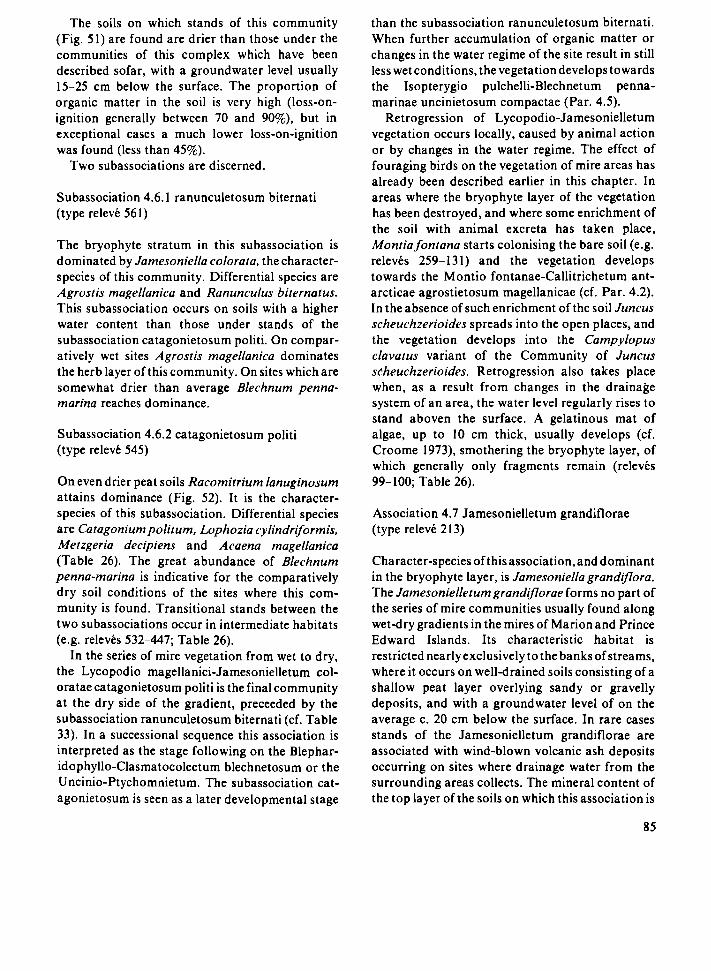
The soils on which stands of this community (Fig. 51) are found are drier than those under the communities of this complex which have been described sofar, with a groundwater level usually 15-25 cm below the surface. The proportion of organic matter in the soil is very high (loss-on-ignition generally between 70 and 90%), but in exceptional cases a much lower loss-on-ignition was found (less than 45%).
Two subassociations are discerned.
Subassociation 4.6.1 ranunculetosum biternati (type relevé 561)
The bryophyte stratum in this subassociation is dominated by Jamesoniella colorata, the character-species of this community. Differential species are Agrostis magellanica and Ranunculus biternatus. This subassociation occurs on soils with a higher water content than those under stands of the subassociation catagonietosum politi. On comparatively wet sites Agrostis magellanica dominates the herb layer of this community. On sites which are somewhat drier than average Blechnum penna-marina reaches dominance.
Subassociation 4.6.2 catagonietosum politi (type relevé 545)
On even drier peat soils Racomitrium lanuginosum attains dominance (Fig. 52). It is the character-species of this subassociation. Differential species are Catagonium politum, Lophozia cylindriformis, Metzgeria decipiens and Acaena magellanica (Table 26). The great abundance of Blechnum penna-marina is indicative for the comparatively dry soil conditions of the sites where this community is found. Transitional stands between the two subassociations occur in intermediate habitats (e.g. relevés 532-447; Table 26).
In the series of mire vegetation from wet to dry, the Lycopodio magellanici-Jamesonielletum col-oratae catagonietosum politi is the final community at the dry side of the gradient, preceeded by the subassociation ranunculetosum biternati (cf. Table 33). In a successional sequence this association is interpreted as the stage following on the Blephar-idophyllo-Clasmatocoleetum blechnetosum or the Uncinio-Ptychomnietum. The subassociation catagonietosum is seen as a later developmental stage
than the subassociation ranunculetosum biternati. When further accumulation of organic matter or changes in the water regime of the site result in still less wet conditions, the vegetation develops towards the Isopterygio pulchelli-Blechnetum penna-marinae uncinietosum compactae (Par. 4.5).
Retrogression of Lycopodio-Jamesonielletum vegetation occurs locally, caused by animal action or by changes in the water regime. The effect of fouraging birds on the vegetation of mire areas has already been described earlier in this chapter. In areas where the bryophyte layer of the vegetation has been destroyed, and where some enrichment of the soil with animal excreta has taken place, Montiafontana starts colonising the bare soil (e.g. relevés 259-131) and the vegetation develops towards the Montio fontanae-Callitrichetum ant-arcticae agrostietosum magellanicae (cf. Par. 4.2). In the absence of such enrichment of the soil Juncus scheuchzerioides spreads into the open places, and the vegetation develops into the Campylopus clavatus variant of the Community of Juncus scheuchzerioides. Retrogression also takes place when, as a result from changes in the drainage system of an area, the water level regularly rises to stand aboven the surface. A gelatinous mat of algae, up to 10 cm thick, usually develops (cf. Croóme 1973), smothering the bryophyte layer, of which generally only fragments remain (relevés 99-100; Table 26).
Association 4.7 Jamesonielletum grandiflorae (type relevé 213)
Character-species of this association, and dominant in the bryophyte layer, is Jamesoniella grandiflora. The Jamesonielletum grandiflorae forms no part of the series of mire communities usually found along wet-dry gradients in the mires of Marion and Prince Edward Islands. Its characteristic habitat is restricted nearly exclusively to the banks of streams, where it occurs on well-drained soils consisting of a shallow peat layer overlying sandy or gravelly deposits, and with a groundwater level of on the average с 20 cm below the surface. In rare cases stands of the Jamesonielletum grandiflorae are associated with wind-blown volcanic ash deposits occurring on sites where drainage water from the surrounding areas collects. The mineral content of the top layer of the soils on which this association is
85

•іЗк '"-
^$31
Í^A ..
• ^ • .
fig. 52. Racomitrium lanuginosum, Jamesoniella colorala. Blechnumpenna-marina and Agrostis magellanica in a stand of Lycopodio magellanici - Jamesonielletum coloratae.
found is higher than in the soils under the other communities of the mire complex (usually less than 70% loss-on-ignition). Agrostis magellanica generally dominates the herb layer. On comparatively wet sites, e.g. close to the edge of a stream, Ranunculus biternatus may attain dominance in this community (e.g. relevé 215 and 212), while on more mineral soils, e.g. on elevated embankments along streams, Acaena magellanica becomes dominant in the herb layer (relevés 185-108; Table 26).
Association 4.8 Bryo laevigati-Breutelietum inte-grifoliae (type relevé 384)
In water tracks in the mires, the vegetation differs strongly from that of the mire expanse. These water tracks are sites with a comparatively strong lateral water transport through the peat soil, but the water flow is not as strong as in springs and flushes (Par. 4.3). An open water channel is usually absent or very small, but after heavy rains the water may rise above the surface. On average the depth of the groundwater level is not more than 10 cm below the surface, but this depth is, as is the rate of water flow, closely correlated with the amount of rainfall. Fluctuations in the water flow are larger here than
K6

in springs and flushes overgrown by stands of Bracythecietum subplicati or related communities, as the catchment area feeding these water tracks generally is much smaller.
The plant-nutrient status of the water tracks differs from that of the mire expanse: the somewhat higher pH of the soil may indicate more minero-trophic conditions in the water tracks, but may also be the result from water movement (Sparling 1966), and the water flow through the soil enlarges the availability of nutrients to the plants (cf. Chapman 1965; Ingram 1967). The soils contain more mineral matter than those of the surrounding mire expanse, probably as a result of deposition of mineral particles brought in from surrounding areas by the water.
Characteristic for these water tracks is a vegetation with a bryophyte stratum dominated by Breutelia integrifolia, Bryum laevigatum and Riccardiaci. multifida, the character-species of this association (Fig. 53).
Subassociation 4.8.1 uncinietosum compactae (type relevé 384)
Differential species of this subassociation are Clasmatocolea humilis, Jemenia pisicolor, Riccar-dia cf. pinguis, Uncinia compacta, Jamesoniella colorata and Jamesoniella grandiflora. This community forms the characteristic vegetation of water tracks in mires. Usually Breutelia integrifolia dominates the bryophyte stratum, but at some sites a variant dominated by Riccardia cf. multifida was found, possibly related to a greater deposition of mineral particles by the water. One small stand dominated by Bryum laevigatum was met with in a narrow, deep drainage channel on a black lava slope where the water flow after heavy rains was very fast.
Subassociation 4.8.2 acaenetosum magellanicae (type relevé 202)
This subassociation, which is differentiated by Acaena magellanica and Hygroamblystegium fllum, shows a floristic resemblance to the Brachy-thecietum subplicati breutelietosum integrifoliae (Par. 4.3), and is found in similar habitats, viz. associated with small springs or drainage lines on grey lava slopes. The Brachythecietum subplicati,
however, occurs on sites with a more continuous water supply, where variation in the amount of rainfall results in only small fluctuations of the water level.
On the western coastal plain of Marion Island and on the escarpment going up from this plain to the central highland a type of vegetation occurs which consists of a mosaic of large Azorella selago cushions and of mats of bryophytes. These mats are fragments of associations of the Juncus scheuch-zerioides-Blepharidophyllum densifolium complex, notably the Blepharidophyllo densifolii-Clasmatocoleetum humilis (relevés 502, 504 and 498; Table 27) and the Lycopodio magellanici-Jamesonielletum coloratae (relevé 501). This vegetation occurs on loamy soils with a thin top layer of organic matter, and is found at elevations up to 500 m. No groundwater level occurs within 40 cm from the surface. By preventing a quick run-off of the rainwater, the Azorella cushions help to create a comparatively constant water regime at these sites. The abundance of such stands in the western part of Marion may be related to the probably more constantly wet moisture regime there.
Not all communities of the Juncus scheuchzeri-oides-Blepharidophyllum densifolium complex were found on both Marion and Prince Edward Island. No stands of Junco scheuchzerioidis-Drepanocladetum uncinati, Uncinio compactae-Ptychomnietum ringiani, Jamesonielletum grandi-florae and Bryo laevigati-Breutelietum integrifoliae were met with on the latter island. Insufficient data on the mire vegetation of Prince Edward Island are available to allow for a detailed comparison of the species compositions of all mire communities on Marion with those of their counterparts on Prince Edward. Conspicuous in the mires of the latter island is the high presence and abundance of Campylopus subnitens and Schistochila carnosa, and the absence of a number of species which play an important role in the vegetation of the mires on Marion Island, e.g. Ptychomnion ringianum, Racomitrium lanuginosum and Breutelia integrifolia.
87

Fig. 5S. Mire area near Skua's Ridge, Marion Island. Most of the light-colored areas are covered with Lycopodio magellanici -Jamesonielletum coloratae From the right-hand side, near the bottom of the picture, towards the left a pattern of communities can be seen along a water track through the mire (Bryo laevigati Breutelietum integnfoliae).
Synchorological remarks
Most Subantarctic islands seem to possess mire and bog communities similar in structure and ecology to those of Marion and Prince Edward Islands. Insufficient data, however, are available for any detailed comparison.
Hébrard (1970b) reports the presence of mire communities on Kerguelen and Crozet. Important species here include Anisothecium hookeri (C. Müll.) Broth., Makednothallus crassifrom Steph., Breutelia chrysura (C. Müll.) Broth., Breutelia pendula, Bryum laevigatum and Drep-anocladus uncinatus. Aubert de la Rue (1962), however, states that the main peat-forming plants
in the bogs of Kerguelen are phanerogams, notably Juncus scheuchzerioides, Acaena magellanica and Azorella selago.
The species composition of the bog communities dominated by bryophytes on Macquarie differs considerably from the one of the bogs of Marion and Prince Edward, but on a generic level the resemblance is conspicuous: the most abundant bryophytes in the bogs on Macquarie are Breutelia pendula, Bryum laevigatum, Drepanocladus aduncus and Ptychomnion aciculare (Taylor 1955a). In bog ponds on this island, and on extremely wet peat soils, communities corresponding to the Ranunculus biternatus variant of the Community of Juncus scheuchzerioides occur,
M

Table 27 Mosaic of Azorella selago and bryophytc mats.
Relevé number
Location-
Southern Latitude (46°) mm.
sec.
Eastern Longitude (37°) mm.
sec.
Elevation (m a.s 1 )
Herb layer: height (cm)
cover (%)
Bryophyte layer: height (cm)
cover (%)
Quadrat size (m2)
Number of species
Azorella selago
Blephandophyllum densifolium
Clasmatocolea humilis
Peltigera polydactyla
Ranunculus biternatus
Agrostis magellanica
Marchantía berteroana
Schistochila carnosa
Lepidozia laevifoha
Jamesoniella colorata
Montia fontana
Lophozia cylmdriformis
Lophocolea randn
Clasmatocolea vermiculans
Colobanthus kerguelensis
Campylopus polylnchoides
Distichophyllum fasciculatum
Racomitnum lanuginosum
Metzgena decipiens
Ditrichum stnetum
Leptoscyphus expansus
Campylopus arborícela
Uncima compacta
Blechnum penna-manna
Plagiothecium platyphyllum
Ptychomnion nngianum
Campylopus introflexus
506
52
35
38
10
60
20
70
3
30
9
12
4
3
1
+ 1
2A
+ +
+ + +
1
504
52
16
38
30
70
20
65
2
40
9
12
4
1
3
+ +
1
+ +
1
+
+ +
498
52
00
39
30
450
10
65
10
35
25
12
4
3
+ +
+ + +
+
+ + +
1
501
52
20
38
15
30
25
65
3
40
9
18
4
+ + + +
2B
+
+ 3
+
+
+ + +
1
+ R
+
Soc.
3-4
3-4
2-4
2
1
2-3
2
2
2
2-4
1-2
2
2
3
1 2
2
'3
2
2
2
2
2
1
2 3
2
2
2
e.g. the Juncus scheuchzerioides association, the Juncus scheuchzerioides-Scirpus aucklandicus association and the Ranunculus biternatus association (Taylor 1955a).
On South Georgia the rush Rostkovia magellanica is one of the most important mire species. Bryophytes play an important role in this vegetation, and on wet sites extensive pure stands of Drepanocladus uncinatus occur (Greene 1964), possibly resembling the Junco scheuchzerioidis-Drepanocladetum uncinati.
No mire communities have been reported from Heard and Macdonald Islands (Schenck 1905; Werth 1906; Law & Burstall 1953). These islands possess a very small flora, in which nearly all species which are important in the mires of Marion and Prince Edward Islands are lacking (cf. Tables 10, 11,12).
In the Maritime Antarctic extensive mats of bryophytes occur, forming peat deposits of up to several metres in thickness (see e.g. Wace 1965; Gimingham & Smith 1970; Lindsay 1971; Smith 1972; Allison & Smith 1973), but these are not comparable in species composition or in ecology to the communities of the Juncus scheuchzerioides-Blepharidophyllum densifolium complex. On the South Shetland Islands, however, spongy carpets of Drepanocladus uncinatus occur in areas where melt water accumulates during summer (Lindsay 1971); these seem to resemble somewhat the Junco scheuchzerioidis-Drepanocladetum uncinati. Similar carpets on Signy Island, South Orkney Islands, seem to occur in appreciably drier habitats (cf. Smith 1972).
In the southern cool temperate regions the most important peatforming plants in ombrogenous mires are cushion plants (e.g. Donatio, Gaimardia, Oreobolus and Phyllachne) and Sphagnum spp. (Wace 1965, Godley 1978), and no communities resembling any of the associations of the mire complex of Marion and Prince Edward Islands have been reported from these regions. Communities with Juncus scheuchzerioides do occur on several of the southern temperate islands, e.g. on the Falkland Islands, v/heiea'Juncusscheuchzerioides-association' grows on damp ground at the margins of streams and in dune slacks (Skottsberg 1909, 1913; Moore 1968), but these are floristically as well as ecologically different from the Juncus scheuchzerioides community described in this study.
89

There is some floristic affinity between the communities of this complex and a number of páramo mire communities described recently by Cleef (1981) under the name Calamagrostion ligulatae; this affinity is especially noteworthy in the Bryo-Breutelietum but cannot yet be evaluated properly with the available data.
4.5 Communities of well-drained lowland slopes: the Blechnutn penna-marina complex
The aspect of the vegetation of well-drained, relatively dry lowland slopes is determined by the dominance of Blechnum penna-marina (Fig. 54). This fern forms dense swards in which bryophytes usually do not reach a high cover (Fig. 55). The complex consists of only one association, which is divided into three subassociations (Table 28).
Association 5.1 Isopterygio pulchelli-Blechnetum penna-marinae (type relevé 539)
Stands of this community cover the largest part of the slopes in the lowlands of Marion and Prince Edward Islands. On these well-drained, relatively dry slopes no peat formation takes place. The soil consists of a 5-30 cm deep, dark brown layer of humus and plant litter, overlying deposits of loamy clay, which usually are more than 40 cm thick (Fig. 15; Table 7). No groundwater level is usually found within 40 cm from the surface, and on many sites it is not present at all.
Character-taxa of the Isopterygio pulchelli-Blechnetum penna-marinae are Isopterygium pul-chellum var. antarcticum, cf. Amblystegium (cf. Zanten 1971), Peltigera canina, Campylopus poly-trichoides, Metzgeria decipiens, Plagiothecium
• •
Fig. 54. Lowland slopes with Isopterygio pulchelli - Blechnetum penna-marinae (dark slopes). The more level areas are covered by stands of Lycopodio magellamcae - Jamesonielletum coloratae (near Junior's Kop, Manon).
90

A
M
Г
О
-ρ
Blechnum penna-marina veg,;fr.
cf. Amblystegium
Metzgeria decipiens
Cladonia
Leptoscyphua expansus
Plagiochlla heterodonta
litter
humus-rich clay
Fig. 55. Structure-diagram of Isopterygio pulchelli - Blechnetum penna-marinae typicum.
platyphyilum and Blechnum penna-marina. The latter species is commonly met with in many of the plant communities on the islands, but reaches very high presence and cover values only in this association (cf. Table 32). Three subassociations are distinguished:
Subassociation 5.1.1 uncinietosum compactae (type relevé 299)
Many of the species which occur in this subassociation have their optimum in communities of the mire complex, e.g. Uncinia compacta, Symphyogyna marionensis, Jensenia pisicolor and Fossombronia australis. Together with Distichophyllum imbri-catum, Jungermannia coniflora and Cladonia spp. these species differentiate the subassociation uncinietosum against the other two subassociations. The moss Distichophyllum imbricatum is rare on Marion Island, where it was found in two communities only: this one and the Lycopodio
magellanici-Jamesonielletum coloratae. It has not been found on Prince Edward Island. Jungermannia coniflora has its optimum in this subassociation and in the Jungermannio coniflorae-Racomitrietum crispuli, the fjaeldmark vegetation of lowland areas (Par. 4.6). Differential species of the subassociations uncinietosum compactae and brachythecietosum rutabuli together against the subassociation typicum are Lepidozia laevifolia, Clasmatocolea humilis, Acrobolbus ochrophyllus, Peltigera polydactyla and Blepharidophyllum densifolium. These species have their optimum in communities of the mire complex, and their presence here indicates comparatively moist conditions,
Stands of this subassociation are usually found on soils with a thick layer of plant litter and humus, and an appreciably higher water content than those on which stands of the other two subassociations occur. Generally this community is found on slopes, but in some cases it occurs on more or less level sites
91
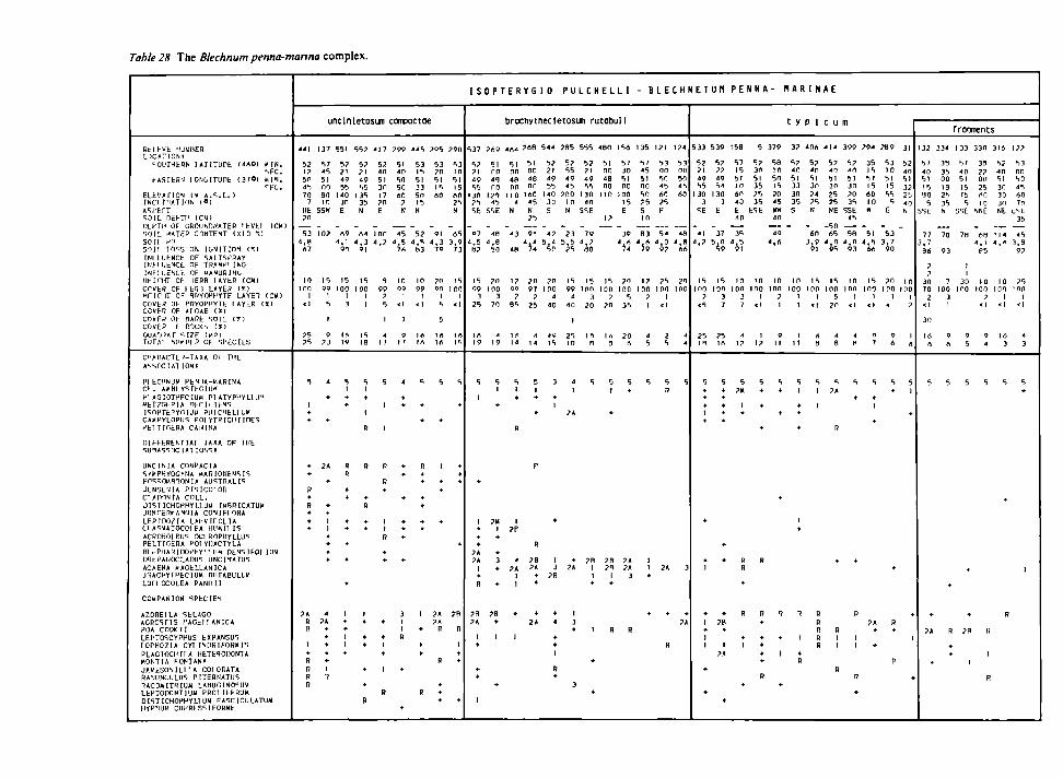
Table 28 The Blechnum penna-manna complex.
B f c L U ' b ' Ш К П Е Я D C í T I O M
^OUFHfc^N І А Т І Т и Г Ь ί Ί Α Ο ) W I N . S F C .
l - A S r t B I l O N O I T U n t ( 3 7 0 ) « 1 4 . ' ' F C .
E L b V > n O V t « A . ^ . L . ) INC1 I N A T I I N ( 0 )
A S P E C T S O I L DEf-TI ' ( C M )
ПЕРТН OF CROUh.D.UTEB < E V t l I C H ) S O I L ЧАТЕР С1Г1ТЕЧТ ( x i o ·;)
s o i l e n s o n l o s s ON І О Ч І Т Ю Ч CCI
[ N H U t N C b OF SALTSPrtAY I N H U t M C L OF T R A U p i I N C
I N F L I I E M C E OF H A N U B I N G Ч Е І П І Т OF 1ERB І А У Е В І С И )
С Г ЕВ OF 1 EIIS L A V E B ( * ) Ч Г І С І Т ОС RBYOPMYTF LAYET ( C M ) СО ЬН OF PRYOPMYTt t A Y E B ( X ) C C V F ' i OF A l ПАЕ ( * ) COVFR OF BADE S O I L ( Г ) COVEB F DOCKS ( I )
O U A T i A f S I 7 F ( M ? ) Г О Г А ' NUI/PU) OF S P E C I E S
C I ' A M C T E H - T A X A OF ГНЕ
A ' - s r C I A l I O N I
14 ECHNU» P E 4 I A - 1 1 A R I N A C F . Α » Β Ι Y S T F O I I J »
PI A C I O T F F C I U M P I A T Y P I ' Y H l l ' l M E T 7 G F R I A Π Ε Γ Ι ι I F N S
I S O P T f l Y C l U « P U I C I I b L l l . » CAMPYLOPUS P O I Y T H I C H I IDES P E I T I O E R A C A N I N A
D I F F t R t N T I A l TAXA OF THE S U H A S S O C I A T I O N S t
U N C I N I A COMPACTA
SYMP4Y0GYNA U A R I O N E N S I S F n s S 0 M R 7 0 N l A A U S T R A L I S
J E N S E 4 I A P I S I C O I O R
CI A D O N I A C O L L .
J I S T I C H O P P Y L L U M I M B B I C A T U H J l i n r E R l ' A N N I A C 0 N I F 1 0 R A
L E P I D O Í I A L A t V I F O L I A C l A S Ï A T 0 C 0 1 FA Ш ' И П I S
ACROHOIEUS O C I R O P H Y L L U S P E L T I O E B A POI YDACTYLA О І с Р Н А Ш О О Р Н У М і Ч D E 4 S I F 0 I I I I 4 D O t P A N O C L A r a i S U N C I 4 A T U S
ACAENA K A G E L L A N I C A J I A C H Y T M E C I U M R U T A B U L L V L O I I OCOLEA PANO 11
C O t l P A N I O N S P E C I E S
A Z 0 B E 1 L A SELAGO A G R C S r i S I ' A G E I I A N I C A POA COOK 11 LEPTOSCYPHUS EXPANSUS I 0 P H O Z I A CYI I N D R I F O B H I S
P L A G I O C H I I A HETEBOTONTA H O N T I A FONTANA
J A l í E S O N l E l l A COI ORATA BA-IUNCULUS P I T E R N A T I I S 7 А С 0 М І Т П І и М L A H U G I N 0 S U 4 L E P T O n O N T l U B PRC1 I F E R U M D I S T I C H O P H Y L H I M F A S C I C U L A T U M MYPMIJM CÜPRLSSIFOHWF
4 4 1
5 2 1? 5 Г 4S 7 0
7
HE
?n
5 3 4 , 9
A7
10
inn 1
< l
? 5 ?S
5
1 •
*
•
•
R •
R
+ + •
?A R R
1
+ R
В R
R
unclnletosun concactoe
1 3 7
5 7 4 5
5 1
m 3 0 i n
SSH
-1 0 ?
15 9 9
1
5
1
9 ? 3
4
•
+
2A
+
+ +
1 1 • •
* +
4 ?A
+
* + • 4-
1
?
5 5 1
5 ? J l 4 9 5 5
1 4 0 ЗП
E
-Л 9
4 . 1 9 t l
15
1 0 0 1
3
I A 19
5 1 + •
В
R
+ +
+ +
+
•
•
1 +
* 1 1
+
5 5 ?
5 ? ? l 4 9 5 5
1 3 5 3 5 N
_ rt4
4 , 3 9 1
15
1 0 0 1
1
I S I S
5 1
+
1
R
R
* η
+ +
1 +
• •
+
+
η
4 1 7
5 2 4 0
5 1 ЗП 17
?n E
_ inn < . ?
ч 9 9
? 5
I
4 17
5
I
1
n
в +
1 1
η
+ •
+
+ I •
1
в
2 9 9
5 1 4 0
5 0 5 0
en ? Ν
4 5
* . 5 7 6
IO 9 9
1
<1
ι
9 17
4
• +
•
+
+
• +
*
*
3 1 1
R
+
+
4 4 5
5 3 15
5 1 3 3 5 0 15
Ν
_ 5 2
4 , 5
аз
IO 9 9
I
< 1
1 6 Ι Α
5
+
+
R • •
•
+
+ +
I
•
•
•
В
? 9 5
5 3 ? 0 5 1 15
АО
_ 9 1
4 , 3 7 9
? 0 9 0
t
5
5
Ι Α Ι Α
5
•
I
•
+
+
2A ?A
В
В
• + +
? 9 П
5 3 i n
5 1 15
АО 2 5
Ν
-А 5
3 , 9 7 3
15
1 0 0
<ι
Ι Α I S
5
+
+ * *
*
? B
η
1 + •
•
I S O P T E R Y G I O
5 3 7
5 ? 7 1 4 9 5 5
1 3 0 ? 5
SE
_ 9 7
4 . 5 ft?
I S
9 9 3
2 5
1Λ 1 9
5
1
•
1 +
+
+ ?A ?A
1
+ В
? B ?A
1 •
+ +
1
1
? A 9
5 1
no 4 5
no 1 2 0
4 5
SS E
_ 4B
4 , 8 5 0
2 0
1 0 0 3
7 0
4 1 9
5
+
?M I
+
• 3
+
•
?в •
I
+
P U L C H E L L I
bracnytnecletosun rutabull
4 A 4
5 1
no «a no
1 1 0 4
N
-4 3
4 8
1? 9 9
? 9 5
I r t 14
5 1 •
Ρ
| ? P
4
?A 1
1
*
1
? « 8
5 1 0 0
4 8
on 1 6 0
4 5
N 2 5
9 1 4»i
?n 9 7
?
2 5
л 14
5
1 +
•
Ρ
R
? B ?А
+
*
•
2 А
5 4 4
5 ? 2 1 4 9 5 5
1 4 0 3 0
s
-4 ? 5*ί
? 0
mo л
4 0
4V I S
3
•
1
•
I 3
2 B
•
4
+ •
1
R •
2 8 5
5 ? 5 5 4 9 4 5
?no in N
-2 3
5 , 5 ? 5
15 9 9
4
4 0
1
2 5 10
4
1
2A
* 2A
1
3 +
3
5 5 5
5 2 2 1 4 9 5 5
1 3 0 4 0
SSE
-7 9
'a 15
1 0 0 3
2 0
i n η
5
? B 1
1 •
1
•
•
4 8 0 1 5 «
5 1 5 7 0 0 3 0
4 8 5 1 0 0 ОС
1 1 0 1 0 0 1 5
E I ?
3 9
'Ú
15 ? n
mo inn ? 5
? 0 3 5
1Л 2 0 3 A
5 5 1 +
*
2 8 ?A ? n ?A
1 3 •
R R
- B L E C H N E T U M
1 3 5
5 7 4 5 5 1 0 0 5 0
7 5
S 1 0
8 3
17
ino ?
I
4
5
5
I 1 •
*
1 2 1
5 3 0 0 5П 4 5
АО 7 5 F
5 4
4 , 0 9 ?
? 5
ino I
<1
2 5
5
R
2A
+
В
1 2 4
5 3
nn 5П 4 5
АО
4 8
',я AA
2 0 1 0 0
л 4
5
3
+
?А
5 3 3
5 2 21 4 9 5 5
1 3 0 3
SE
-4 1
" . ?
15
ino ?
< 5
2 5 H I
5 • •
+ 1
«
+
+
I
+ 1 +
I 1
+
•
5 3 9
5 ? ? ? 4 9 5 4
1 3 0 3
E
-3 7
5 , 0 5 9
15
ion 3 7
? 5 I A
5 4
+ •
* *
* •
+
7 8 +
I
?A
•
P E N N A
Ι 5 Θ
5 7 15
5 1 1 0
4 0 4 0
E 4 0
3 5
' . 5 9 1
10
ion 3 7
л 1?
5
?M
I +
R В
•
R
* I
•
5
5 ? 3 0
5 1 3 5 7 5 3 5
ESE
I O
ino I
< l
1 17
5 +
•
+
R
R +
* * * * R
-
3 7 9
5 8 10
5 0 15
9 0 4 5
НИ 4 0
4 9
4 , A
10 1 0 0
7 1
9 I I
5
+
+
+
В
4
1
+
N A R I N A E
t У
3 7
5 7 4 0
5 1 3 3
3 0 3 5
S
-
m 1 0 0
I 1
1 1 f
5
1
+ •
·»
1
+
R
1
+ В
с ι
4 ПА
5 ? 4 0 5 1 3 0 7 4 7 5 Ν
-6 П
3 . 9 91
15
inn I
«1
A Э
5 1
1
R
В R R R
c u m
4 | 4 3 9 9 2 9 4
5 ? 5 ? 3 5 4 П 4 0 15
5 1 5 1 5 7 3 0 3 0 15
2 5 7 0 6 0 2 5 3 5 1 0
NE SSE « 4 5
- 5 П 6 5 5 8 5 1
4 , Π 4 , 0 4 , 5 9 5 9 3 6 6
15 IO 15
1 0 0 1 0 0 1 0 0
5 I I
7 0 < l < l
4 4 О 8 8 7
5 5 5
7A + •
1
• R
+ •
R
?A R • 1 1 1 1 +
R
r?
•
7 8 9 31
5 3 5 2 1 0 4 0 5 1 5 1
' 5 3 2 5 5 2 b
5 4 0 E N
-5 3 3 . 7
9 0
7 0 I O
ι nn mo 1 1
< ?
9 1
4 A
5 5 * 1
+
+
•
R +
1
Ρ
+
1 3 2
5 7
4 0 5 1
15 4 0
5 SSE
7 7
3 , 7
Э6
? 7
3 0 7 0
2 < l
3 0
16 A
5
•
?A
+
frmments
3 3 4 1 3 3 3 3 0 3 1 6 1 7 ?
3 5 5 7 3 5 5 7 5 3
3 5 4 0 7 2 4 0 0 0 0 0 5 1 0 0 51 5 0
18 15 2 5 30 4 5 2 5 7 5 АП 3 0 АО
3 5 5 IO 3 0 7П N SSE NUE N t ESE
3 5
7 0 7 8 6 8 1 1 4 4 5 4 , 1 4 , 4 3 , 8
9 3 P 5 9 ?
I 1
7 3 0 I O I O 7 5
loo irò mo inn inn 3 7 1 1 I «1 < l < l
9 9 9 16 4
A 5 4 3 3
5 5 5 5 5
*
*
* 1
+
• R
R ?B В
+ • 1
1
R

Fig. 56. Strongly exposed fjaeldmark area at about 400 m above sea level, covered by Andreaeo acutifoliae - Racomitrietum cnspuli (Feldmark Plateau, Marion).
on well-drained peat soils. Here it can be considered as the stage in the succession of mire vegetation which follows after the Lycopodio magellanici-Jamesonielletum coloratae catagonietosum (cf. Par. 4.4).
Subassociation 5.1.2 brachythecietosum rutabuli (type relevé 537)
Conspicuous in this subassociation is the abundance of Acaena magellanica and the comparatively well-developed bryophyte stratum, in which Drepanocladus uncinatus plays an important role (Table 28). In addition to these two species Brachy-thecium rutabulum and Lophocolea randii are differential species of this subassociation against both other ones. The differential species of the subassociations brachythecietosum rutabuli and uncinietosum compactae together against the sub-
association typicum have already been listed above. The differential species of this subassociation
indicate some resemblance between this community and the Acaeno magellanicae-Brachythecietum rutabuli, a community found in comparatively dry drainage lines (Par. 4.3). On sites where stands of Isopterygio pulchelli-Blechnetum penna-marinae brachythecietosum rutabuli are found subsurface drainage of water through the soil seems to occur, although on a much smaller scale than in the drainage lines.
Stands of this community are more common on grey lava than on black lava, where the more porous nature of the substratum permits the drainage water to flow through holes and cracks in the lava (cf. Verwoerd 1971 ) at depths where it does not influence the vegetation. Sites where this community occur are usually somewhat sheltered from the wind.
93

The large variation in the number of species /releve in this subassociation (Table 28) could not be correlated with differences in habitat In some stands the bryophyte stratum is very fragmentanly developed (eg relevé 135, 121 and 124) Azorella selago forms large cushions in some stands of this community, locally even achieving dominance (e g releve 544)
Subassociation 5 1 3 typicum (type relevé 539)
This is the most common of the subassociations of the Isopterygio pulchelli-Blechnetum penna-mannae, and it covers an appreciable part of the lowlands of Marion and Prince Edward Islands It does not possess any character- or differential taxa The number of species/relevé is smaller on the average than in both other subassociations, and the total cover of the bryophytes is very low (cf Tables 28,32) The subassociation typicum occurs on drier soils than both other subassociations, and it is apparently more tolerant to exposure to strong winds than the subassociation brachythecietosum rutabuli
Fragmentanly developed stands, containing only very few species, were commonly met with (e g relevés 132-122) Except for Blechnum penna-manna no diagnostic species are present here In some cases the influence of animals seems to account for this (e g relevé 132, 133 and 330), in other cases the cause for this strongly mpovenshed development is not clear
The Isopterygio pulchelli-Blechnetum penna-mannae is a very common vegetation type on Marion and on Prince Edward Island, but on the latter island only the subassociation typicum was met with
Synchorological remarks
Although Blechnum penna-manna as well as many of the other species which make up the Isopterygio pulchelli-Blechnetum penna-marmae are widely spread in Subantarctic and southern temperate regions (cf Tables 10, 11, 12), communities similar to this association do not seem to play an important role in the vegetation of these areas Moseley (1877) and Schenck (1905) report the occurrence of pure stands of Blechnum penna-manna on Kerguelen,
without giving any further particulars about this type of vegetation, but in more recent descriptions of the vegetation of this island group (e g Aubert de la Rue 1932,1964, Chastain 1958, Cour 1958,1959) no communities dominated by Blechnum penna-manna, or any other vegetation type similar to the Isopterygio pulchelli-Blechnetum penna-mannae is mentioned Werth ( 1906) observed a community of Blechnum penna-manna, Lycopodium magellam-cum and mosses on Crozet, but as no further description of this vegetation is given, the resemblance with any of the communities found on Marion and Prince Edward Islands can not be judged
No communities resembling the Isopterygio pulchelli-Blechnetum penna-mannae seem to occur on Macquane (cf Taylor 1955a), Heard and Macdonald Islands (cf Schenck 1905, Law & Burstall 1953), or on South Georgia (cf Skottsberg 1912, Greene 1964, Smith & Walton 1975) A type of vegetation in which Blechnum penna-manna is abundant and which seems similar in ecology to the Isopterygio-Blechnetum has been reported from the Falkland Islands, viz the 'Empetrum rubrum-Blechnum penna-manna association', one of the dwarf-shrub heath communities occurring on these islands (Moore 1968, cf Skottsberg 1909,1913) On Tristan da Cunha stands of almost pure Blechnum penna-manna cover cliff slopes of between 45 and 60°, growing on dry, stable peat (Wace & Holdgate 1958), these stands seem to resemble the Blechnum vegetation of Marion and Prince Edward Islands, but the data are insufficient to judge the similarity of these communities No similar vegetation has been reported from Gough Island (cf Wace 1961)
4.6 Fjaeldmark vegetation: the Andreaea - Raco-mitrium crispulum complex
Fjaeldmark vegetation, ι e an open vegetation of isolated, stunted flowering plants, accompanied by mosses and lichens, which occurs where the climate is not sufficiently favourable to permit the development of a closed vegetation of any kind (Holttum 1922, cf Warming 1887, Huntley 1971), covers a large part of Marion and Prince Edward Islands Closed vegetation here is largely restricted to the lowlands, but even there, on sites fully exposed to the force of the winds, e g on grey lava ridges, an
94

open fjaeldmark vegetation is found. At elevations fjaeldmark areas of the Subantarctic islands by e.g. above с 250 m only sheltered sites usually bear a Schenck (1905) and Werth (1906). closed plant-cover. The severe climatological conditions are reflected
At higher altitudes climatic conditions are more in the vegetation by the dominance of species with a severe than at sea level. With each 1000 m increase cushion-forming habit (cf. Fig. 57, 58), which in altitude the temperature decreases about 4.5 0 С possess a relatively high resistance to water loss to a (Schulze 1971). Consequently the frequency of desiccating atmosphere (see e.g. Gimingham 1967; nights with frost increases strongly: Zinderen Gimingham & Smith 1971), have a higher heat Bakker (1978) estimates that at 250 m above sea retention capacity (cf. Zinderen Bakker 1978) and level the temperature just above the soil surface falls an increased resistance to wind abrasion. The most below 0 °C on about 50% of the nights, compared conspicuous plants in the fjaeldmark vegetation of to с 30% at sea level. To the severity of the climate the islands Marion and Prince Edward are Azorella strong winds are added; these are alleged to be more selago and several species of the genera Andreaea forceful at high elevations than at sea level (Taylor and Ditrichum (Fig. 58). 1955a; Schulze 1971), causing drought stress and Fjaeldmark vegetation usually occurs on loamy wind abrasion to the plants. The importance of this soils containing an often large amount of rock factor in the ecology ofthe fjaeldmark vegetation is debris (cf. Fig. 16). Rocks usually cover a large part stressed by the use ofthe word 'wind-desert' for the of the surface (40-100%; cf. Table 29, Fig. 59), as
95

4 0 c m -
2 0
О - -
E •*- -»• W
ъто-
Azorella selago
Agrostis magellanica
Blechnum penna-marina
^ β , * *
ш
— ι 2
Acaena magellanica
Ditrichum strictum
Andreaea sp.
- 2 0 c m
3 4 m Racomitrium crispulum
r — crustose lichens
( * } stones
Fig. 58. Structure-diagram of Jungermannio coniflorae - Racomitrietum crispuli, the lowland fjaeldmark community.
the finer particles at the surface have been blown away by the strong winds, or washed away by the rain. At high elevations cryoturbatic processes locally result in a sorting of the larger stones from the fine soil particles. Stone lines and at some sites soil polygons are formed by such processes (cf. Zinderen Bakker 1978).
Fjaeldmark soils contain little organic matter and in comparison with other soils on the islands the water content is low, ranging from 20-385% (Table 29). The concentration of plant nutrients in the soil is very low (Smith 1976a,c; Table 9). Smith (loc. cit.) explains this by saying that the rapid percolation of the incoming rainwater through these soils, which have a very low water retention capacity, causes a continuous leaching of minerals from the soil.
Despite the severe environmental conditions the number of species in stands of this type of vegetation is high: the number of species/relevé is on average 16, amongst the highest of any of the plant communities on the islands (cf. Table 32). To some
extent this is a result of the complex structure of the substratum, usually consisting of a mosaic of lava rocks and fine-particulate material, forming a mosaic of microhabitats differing in substrate and microclimate. This complexity is further enhanced by the cushion-habit of many of the species in these communities; as a consequence the cushions offer sheltered microhabitats on their leeward sides and in the cushions. Many of the species found in the fjaeldmark communities are more or less restricted to one type of microhabitat, and different micro-coenoses may be distinguished; these have not been studied separately.
Association 6.1 Jungermannio coniflorae-Racomi-trietum crispuli (type relevé 442)
This community forms the vegetation of most lowland fjaeldmark areas, where climatological conditions are less severe than at higher elevations.
96

Fig. 59. Andreaeo acutifoliae - Racomitrietum crispuli hymenophylletosum peltatr on a grey lava plateau at about 250 m above sea level (Talfelberg, Manon).
The soils contain more organic matter and more water than those under stands of the other association of this complex. The total cover of the vegetation here is appreciably higher than in the fjaeldmark communities of high elevations (on average about 45%, compared with 5-10% at high elevations). A further indication of the less severe environmental conditions of the sites where this association occurs is the high proportion of plants with other growth forms than cushions, e.g. Blechnum penna-marina and Acaena magellanica, in this vegetation (cf. Table 29). These species, as well as Uncinia compacta and Jungermannia coni-ßora, are the differential species of the Junger-mannio coniflorae-Racomitrietum crispuli against the Andreaeo acutifoliae-Racomitrietum crispuli, the other association of this complex.
Association 6.2 Andreaeo acutifoliae-Racomitrietum crispuli (type relevé 553)
Character-taxa of this association are Andreaea acutifolia, Ditrichum strictum, Grimmia kerguel-ensis, Philonotis scabrifolia, Psilopilum cf. tristan-iense, Hymenophyllumpeltatum, Bartramiapatens var. papillota, Verrucidens microcarpus and Holo-dontium pumilum. This community covers a large part of Marion and Prince Edward Islands between с 100 and 500 m above sea level. It occurs on mineral soils, which show the smallest loss-on-ignition (usually less than 20%) and water content (generally less than 70% of the dry weight) values of any of the islands soils.
The total plant cover in this community rarely exceeds 10% and species which do not form cushions form only a small proportion of the biomass. They are mostly restricted to sheltered microhabitats, such as on the leeward side of stones
97

Table 29 The Andreaea Racomitnum cnspulum complex
DE! Ь Ь NUMBfcR LOCATION
S0UT1IEHN LATITUDE C4ftO) M I N . SEC.
EASTERN LONGITUDE ( 3 7 0 ) M I N . S F C
ELEVATION (M A . S . I . ) I N C L I N A T I O N ( 0 )
ASPECT S O I ! ПЕРТ'' (CM) DEPTH OF GROUNDWATER LEVEL (CM) S O I L HATER CONTENT ( X I CI %) S O I L ИІІ S O I L LOSS ON I G N I I I O N ( Г ) INFLUENCE OF SALTSP4AY INFLUENCE OF TRAMPLING INFLUENCE OF MANURING HEIGHT OF HERP I AYER ( M ) COVER OF HbRB LAYER C.) HEIGHT OF BRYOPHYTE LAYER (CM) COVER OH flRYOPHYTt LAYER ( * ) COVER OF ALGAE (5!) COVER OF BARE S O I L ("!) COVFR OF ROCKS ( * ) QUADRAT S I Z E ( V ? ) TOTA! NUMBER OF SPECIES
CHARACTER-SPECIES OF THE COMPLEXJ
RACOMITRIUM CRISPULIIM ANDREAEA ACUMINATA HER?OGOBRYUM VERMICULARE ANDREAEA HEGUIARIS GRAMMITIS KERGUELENSIS LYCOPODIUM SAURURIS
DIAGNOSTIC TAXA OF ASSOCIATIONS AND SUBASSOCIATIONS
BI ECHNU4 PENNA-MARINA ACAENA MAGE!LAN ICA JUNGERMANNIA CONIFLOfiA U N C I N I A COMPACTA ANDREAEA A C U T I E O L I A DITRICMUM STRICTU» GRIMMIA KERGUELENSIS P H I I O N O T I S SCAHRIFOLIA P S I L O P I L U V T R I S T A M E N S E HYMENOPHYLLUM PtLTATUM BARTRAMIA PATENS VERRUCIDENS MICROCARPUS HOLODONTIUM PUMILUM CAMPYIOPUS CI AVATUS MET7GERIA D E C I P I E N S HYPN1IM CUPRESSIFORME COLOBANTHUS KCRGUfcLENSIS ACROBO! BUS OCHROPHYILUS Ü I I R I C H U M CONICUM PRINGLE/ ANTISCORBUTICA
COMPANIONS·
CRUSTOSE I ICHENS AZORELLA SELAGO AGROSTIS MAGELLANICA P I A G I O C H I I A HETEROIIONTA RACOMITRIUM LANUGINOSUM CLADONIA COLL. CATAGONIUW PO' ITUM MONTIA FONTANA POA COOK 11 IÎANUNCULUS 4ITCRNATUS JAMESON IELLA GRANDIFLORA I h P i n O Z I A I A E V I F O I І А CAMPYLOPUS C A V I F O L I U S J E N S E N ! * P I S I C O ' O R SYHPHYOCYNA MARIONENSIS J A 4 E S 0 N I E ! ! A (OiORATA S C H I S r O C H I I A CARNOSA
JUNGERMANNIO CON I F L O R A E -
RACOMITRIETUM C R I S P U L I
зол
5 ? s n
5 1 35 4П
.... 3 7 5 . 3
5 0
3 5 37
1 3
i n 5 5 I n 13
1 +
?M + R
2B 1
+
+ ?R
1
+
+
? 8 1
5 3 i n
51 15 5 5
. 33 b . ?
η J 5
1
<!
9П
4 9 M
+ + •
+
2B JA
+
+
+ 2A
η
I
+ + +
351
3 9 nn 5 0 4 3 40
— 37
5 . 1 54
15 70
3 1(1
5 i n 2 5 15
+
1 3 +
*
1 3 1
2A
R + +
4 4 3
5 3 2 0 5 1 0 5 7П
2 0
—. 2 9 5 . В
4 9
15 4 5
1 3
17 W 2 5 17
+ ?M
R
Ρ
2B 3 • •
+
• PA
1 + 1 R
+
29Ä
5 3 П7 5 1 3Π 5П 13 NW
-22 4 . У
9
20 Í O
1 < l
5 40
0 14
1 1
3 +
1
+
+ +
2П 1 1
*
+
163
5 7 2П 51 i n 70
7 ESE
... 19 5 , 3 4 3
15 5П
3 7
IO 4П
9 14
+
+
4 +
I
+
I 2A
1 I
2A
+
1 1
44?
5 3 12 51 05 7П
A
N1» 13
— ЗЯ 5 , 8 4|S
15 15
1 i n
B5 2 5 14
1 2A
R
+ + • 4
+
+ 2B ?A
•
+
+
5 2 9
5 2 12 5 0 55
130
-2B 5 , 9
2 5 7 3 1
sn 45 2 5 14
+
+
1
+
+
•
2A + +
R
+
•
ANDREAEO ACUT I FOLIAE -
nymenoDhvlletosum pel t a t i
166
5 7 15 51 i n
100
; E
—. 1 5 . 5
i n
2 5 5 2
< l
1 9 5 2 5 13
+
1 R
?M • + •
+
+
1 2A
1
1
+
165
57 15 51 i n 90
5
SS E
3 5 . 5
i n
2П 5 5 3
2 9 7
inn 15
+
1
2 4 ?u
1 +
+
+
1 2A
1 +
+
+
+
5 5 3
5 2 2 1 4 9 5 4
І 4 П
7
4 6 . 1
13
2П 5 3 5
9 0 2 5 19
1 2A
+
1 2M
1
+
• + +
R
1 2A
1 + + • +
+
+
2Θ1
5 3 0 0 4 0 4 5
2 8 0 25
SS E
—. 5 5 . 6
В
з п 15
3 < l
5 ВО 4 9 15
•f +
2А •
• +
1
+ 2 !
+ + +
+
•
3 1 5
5 3 2 0 4П 3 0
з п о
5
2 0 5 3
2 0
5 5 4 0 6 4 17
+
?Р 1
• + + •
+
1 2А
+ R
η + •
+
3 0 7
5 2 5 5 4 8 4 5
2 8 0
3
-—
15 3 I
7
9 9 6 4 16
R I
+ +
2 ί +
+ + •f
•
3 1 + +
+
+
4 5 1
5 2 4 2 5 0 27
100
I I 6 , 2
IB
15 7 1
7
6 0 35 2 5 2П
+
2A 1
+ + + +
2A 1 • + +
η
+
+ R +
RACOMITRIETUfl
h v o n e t o s u m
CRISPULI
c u p r e s s l f o r m l s
2B2
5 3 on 4 9 4 5
2 8 0 3 5 S
3
I S 5 , 2
2 9
2 0 ЗП
2 1
9 9 4 9 IB
+
+
+ +
+ +
1
+
+ 3
1 R
• + •
+ +
2 8 3
5 1 no 4 9 4 5
2 8 0 3 5 SH
2 Ш.
2Π 7 1
< l
9 7 4 9 2П
1 1
2M
| + + +
1 +
1 +
* 2A
R 1
R 2M
* +
+
3 1 3
5 3 i n 48 4П
2 8 0 35 η
25 5 1
1
0 9 inn
2 2
+ + + +
+
4
·*
* •
+
+ +
1
+ 1 • +
• *
+ + + +
3 7 2
58 П5 5 0 4A
160 4 5 SX
-._
15 3 2 3
97 2 5 14
1
R
•
1
1
+ 1 R + +
1 +
+ •f
f r a g m e n t s
2 8 6
5 2 5 5 4 9 4 5
2 0 0 i n N
— A 5 , 6
19
2 5 15
5
< l
70 15 4 0
4
+
R
+
+ 2M
1
2Π 2A
+
3 7 3 2B4
5 7 5 3 30 0 0 5 0 4 9 20 4 5
І6П 2 8 0 4 3 0
HNW N 3
—- — 6 3 4 . 9 5 . 3
18 2 2
25 2П 3 5 1 1
< l < l
9 7 9 7 2 5 4 9
Ч В
+ • 1
•
• 1 •
+
+
+ I 2A 1 R
4
•
98

or Azorella cushions, or grow in or on top of Azoreila cushions (cf. Fig. 58).
Two subassociations are discerned, the subassociation hypnetosum cupressiformis, which occurs on deposits of large scoriae, and the subassociation hymenophylletosum peltati, which is found on other types of substratum.
Subassociation 6.2.1 hymenophylletosum peltati (type relevé 553)
This is the most common of the two subassociations, and is usually found on sites with a loamy soil with much rock-debris. Rocks and gravel sometimes completely cover the finer soil material, but between the large stones usually some loamy soil is available for plant growth (cf. Fig. 59). Differential species of this subassociation is Campylopus clavatus.
Subassociation 6.2.2 hypnetosum cupressiformis (type relevé 283)
Stands of this community were only found on deposits of comparatively large scoriae, ranging in size from a few cm to over 30 cm in diameter. Only in some of the pockets between the scoriae have some fine soil particles been collected. The nature of the substratum is responsible for a very distinct type of vegetation: only a part of the plants in this community grow above the surface level of the scoriae deposits, i.e. many species of mosses and hepatics growing in the hollows between the scoriae where sufficient light reaches and where the temperature and humidity regime is more favourable than at the surface. Metzgeria decipiens, Hypnum cupressiformis, Herzogobryum vermiculare, Acro-bolbus ochrophyllus, all differential species of this subassociation, as well as Catagoniumpolitum and Lepidozia laevifolia, are abundant in the locally very lush bryophyte mats which are found in the spaces between the scoriae, to a depth of about 30 cm below the surface (Fig. 60). Further differential species of this community are Pringlea antiscorbutica. Ditrichum conicum and Colobanthus kerguelensis.
On sites which offer less sheltered microhabitats, due to the scarcity of rocks on the surface of the soil or to the small sizes of the rock fragments, poorly developed stands of the Andreaeo acutifoliae-
Racomitrietum crispuli occur (e.g. relevé 286). Fragmentary stands also occur on sites where cryoturbatic processes prevent the establishment of many species as a result of the movements of the soil particles and rock fragments. The formation of needle ice may also cause the elimination of small plants in these areas (cf. Billings & Mooney 1968). Except for Azorella selago and Agrostis magellanica, the latter mostly growing on the Azorella cushions, the vegetation nearly exclusively consists of epipetric species (e.g. relevé 373). Also on deposits of volcanic ash and of small scoriae, which are not more than a few cm in diameter, fragmen-tarily developed stands of this community occur (relevé 284).
An interesting phenomenon in the fjaeldmark vegetation of Marion and Prince Edward Islands is the occurrence of completely spherical colonies of mosses (Fig. 61). These moss balls, nearly always consisting of only one species, only in rare cases with a few stems of another species between them, are locally abundant in the fjaeldmark vegetation. Balls of Andreaea regularis and Ditrichum strictum were commonly met with. Also balls of Holodon-tium pumilum occur (Zanten 1971).
Moss balls have been reported from Arctic and Subarctic regions (Lid 1938; Eythorsson 1951; Benninghoff 1955; Shacklette 1966), Antarctic and Subantarctic areas (Schenck 1905; Aubert de la Rue 1964, 1968; Seppelt & Ashton 1978; Zanten 1971) and the East African mountains (Hedberg 1964). Different explanations for the formation of these globular moss-colonies have been offered. According to Shacklette (1966) and Lid (1938) the wind plays an important role in the formation of these balls, either by undercutting attached moss-colonies, or by overturning moss cushions growing on small stones. It is also an important force in moving these balls around (cf. also James 1876, cited by Schenck 1905; Seppelt & Ashton 1978). Hedberg (1964) and Benninghoff (1955) mention the instability of the substratum as a result of cryoturbatic processes as a force in the formation of moss balls. Hedberg (loc. cit.) suggests that on Mt. Kenia and other East African mountains moss balls originated from moss carpets which were broken up by needle ice formation. Needle ice formation as well as cryoturbatic movements of the substrate particles may cause regular changes in the position of the moss balls, resulting in almost perfectly
99

* * ' . · .
Ж ·
4 >
χ
^ * %
' ·*:.
• . , · : : ^ ·
^ ? χ
fìg. 60. Andreaeo acutifoliae - Racomitrietum crispuli hypnetosum cupressiformis on a deposit of scoriae. Only part of the vegetation can be seen at the surface, many bryophytes grow in the hollows between the scoria-fragments.
globular moss colonies in some cases (Hedberg 1964).
On Marion and Prince Edward Islands spherical colonies of Andreaea spp., notably of Andreaea regularis, occur in large numbers at some localities. These moss balls are found at elevations of more than 150 m above sea level. Here frost occurs on a large proportion of the nights (Zinderen Bakker 1978) and ice formation plays an important role in the process of turning these moss colonies around. At the sites where these moss balls were found periglacial phenomena did not seem to be important. Next to the strong winds, water is a force which causes movement amongst the moss balls on Marion and Prince Edward Islands. During heavy rains much water runs off along the surface of the soil in many fjaeldmark areas, locally forming strong currents. It was observed that colonies of Andreaea spec, growing on small rock fragments, were moved around by the water. The
formation of balls of Andreaea spp. seems to start with such overturning of moss cushions growing on small stones. In all balls formed by this species the centre is formed by a small rock fragment. In globular colonies of Ditrichum, however, only organic matter, and rarely some mineral soil material was found in the centre. The formation of balls of this species seems to start with the dislodging of attached cushions.
Seppelt & Ashton (1978) describe the development of sedentary colonies of Bryum algens and Grimmia lawiana from unattached moss balls on Mawson Rock on the Antarctic continent. Thus moss balls can assist the propagation of species to new sites (cf. also Shacklette 1966). Such a process has not been osberved on Marion and Prince Edward Islands.
Moss balls have also been reported from Europe and New Zealand (e.g. Dixon 1912; Martin 1952). Here trampling and scratching by birds and other
100

i . , •. Af-Ví
m**
•*L\.
Fig. 61. Ball of Ditnchum strtetum in fjaeldmark vegetation.
w^^ i "- "^Я
l ì /J*
M
s
w
' A
animais are important factors in the formation of these unattached colonies.
Synchorological remarks
Fjaeldmark vegetation dominated by cushion plants is widely distributed in southern cold and temperate regions (e.g. Schenck 1905; Werth 1906; Taylor 1955a,b; Wace 1960, 1965; Huntley 1971, 1972), as well as in the mountain regions of South America (cf. Rauh 1978; Cleef 1978, 1981), New Zealand (cf. Cockayne 1928; Troll 1948) and Australia (cf. Costin 1957).
All islands of the Kerguelen Province possess plant communities comparable to the Junger-mannio coniflorae-Racomitrietum crispuli and Andreaeo acutifoliae-Racomitrietum crispuli. On the islands of the Kerguelen archipelago communities dominated by Azorella selago occur on exposed sites (Schenck 1905; Werth 1906; Chastain 1958;
Cour 1958, 1959; Aubert de la Rue 1964). They are most common between 600 and 800 m above sea level (Chastain 1958). No detailed data are available, but this '/Izore/Za-formation' (Schenck 1905) seems similar in structure and ecology to the communities of the Andreaea-Racomitrium cris-pulum complex. The communities dominated by Lyallia kerguelensis and by Poa kerguelensis (Chastain 1958, Aubert de la Rue 1964) also seem similar in structure and in habitat to the fjaeldmark vegetation of Marion and Prince Edward Islands.
Large parts of the lies Crozet are covered by communities dominated by Azorella selago cushions, on top of which some grasses often occur (Dreux 1964). There this type of vegetation occurs up to about 300 m above sea level. At high altitudes Racomitrium spp. and Andreaea spp. dominate the vegetation on basaltic rocks (Hébrard 1970b).
On Heard Island Azorella selago grows up to 120 m above sea level (Schenck 1905), forming a
101

vegetation similar to that on Kerguelen (Werth 1906). On Macdonald Island Azorella selago covers much of the higher parts (Budd 1972). No furter information on this vegetation is available.
Taylor (1955a) and Ashton & Gill (1965) describe a 'Feldmark formation' on Macquarie. The communities of this formation, which covers most of the island above 200 m above sea level, up to the summits at с 450 m, resemble those of the fjaeld-mark of Marion and Prince Edward Islands. On Macquarie the pattern of distribution of species within a stand as well as of communities within a fjaeldmark area is apparently largely determined by soil movements associated with cryoturbatic processes (Taylor 1955b). In this respect the fjaeldmark of Macquarie differs from that of Marion and Prince Edward Islands.
Azorella selago does not occur on South Georgia (Greene 1964, Greene & Walton 1975) and no other cushion plant takes its place there. The cryptogamic communities of rock and scree which occur on this island, and in which Andreaea spp. and Racomi-trium crispulum are prominent (Skottsberg 1912; Greene 1964), seem to correspond in site-ecology to the fjaeldmark of Marion and Prince Edward.
Some cryptogamic communities from the Maritime Antarctic somewhat resemble the communities of the Andreaea-Racomitrium crispulum complex. Especially the Andreaea- Usnea association (Gimingham & Smith 1970), which occurs on e.g. the South Orkney Islands (Smith 1972) and South Shetland islands (Allison & Smith 1973; Lindsay 1971), resembles the Andreaeo acutifoliae-Racomi-trietum crispuli in species composition.
On the Falkland Islands communities in which cushion-forming plants dominate and cryptogams are a conspicuous element in the vegetation occur above 600 m (Skottsberg 1909, 1913, Moore 1968). Insufficient data are available for a comparison with the fjaeldmark communities described in this study, but it seems likely that a resemblance exsists.
Some of the 'montane rock communities' described by Wace (1961) from Gough Island are comparable to communities of the Andreaea-Racomitrium crispulum complex, but the 'feld-mark' described by this author is very different in structure and in species composition from the Marion Island fjaeldmark. Azorella selago does not occur on this island. On Tristan da Cunha, where Azorella selago is also lacking, alpine desert vegeta
tion occurs (Wace & Holdgate 1958) of which Andreaea spp. and Racomitrium crispulum are important constituents. These communities, as well as some forms of the 'Empetrum rubrum-Racomitrium ¡anuginosum heath', are comparable to the fjaeldmark associations from Marion and Prince Edward Islands. These communities occur on Tristan from 1500 m above sea level to the summit at 2060 m.
4.7 Other communities
In this last group some communities are described, which do not fit well into any of the six community-complexes described sofar.
Community 7.1 Sociation of Limosella australis (type relevé 592)
This community is dominated and characterized by Limosella australis. It occurs on the bottom of shallow lakes, usually growing on a thin layer of organic mud overlying mineral deposits (clay and rock fragments). Only one stand was analysed: relevé no. 592; in 20-30 cm deep water of a lake near Macarony Bay, Marion Island; 40 m a.s.l.; total cover of the herb layer: 5%; height of herb layer: 5 cm; algae: 95%; Limosella australis 2m.5. Cleef (1981) recently also described communities with a predominance of Limosella australis occurring in similar habitats in the Colombian Andes. He grouped these in his order Tillaeetalia.
Community 7.2 Sociation of Potamogetón spec. (type relevé 621)
Only one stand of this type was found, occurring in one of the Albatross lakes, in about 1 m deep water, growing on a soil consisting largely of rock debris and clay, with a thin layer of organic mud: relevé no. 621: in 1 m deep water of one of the Albatross Lakes, Marion Island; 45 m a.s.l.; total cover of the vegetation: 30%; height of herb layer: 100 cm; Potamogetón spec. 3.5.
The status of Potamogetón spec, on Marion Island has not been ascertained conclusively. Huntley ( 1971 ) suggests that it is a recent, naturally introduced species.
102

Table 30. Other communities.
REI EVE NUMBER
LOCATION SOUTHERN LATITUDE ( 4 6 0 ) M I N .
SEC. EASTERN LONGITUDE ( 3 7 0 ) M I N .
SEC. ELEVATION (M A . S . L . ) INCLINATION (O )
ASPECT SOIL DEPTH (CM) DEPTH OF GROUNDWATER LEVEI (CM) SOIL WATER CONTENT ( X I O %) S O I L PH SOIL LOSS ON I G N I T I O N (%) INFLUENCE OF SALTSPRAY INFIUENCE OF TRAMPLING INFLUENCE OF MANURING HEIGHT OF HERB LAYER (CM) COVER OF HERB LAYER 1%) HEIGHT OF RRYOPHYTE LAYER (СЧ) COVER OF PRYOPHYTb LAYER (%) COVER OF ALGAE (%) COVER OF BARE SO I I (%) COVER OF ROCKS ("S) QUADRAT S I Z E (M?) TOTAL NUMBER OF SPECIES
AZORELLA SELAGO POA COOK 11 MONTIA FONTANA PRINGI.fcA ANTISCORBUTICA COLOBANTHUS KfcRGUfcI.ENSIS CAMPYI.OPUS CLAVATUS ACAENA MAGELLANICA RACOMITRIUM CRISPULUM PLAGIOCHIIA HETERODONTA RANUNCUIUS HITERNATUS PELTIGERA POLYDACTYLA AGROSTIS MAGELLANICA LOPHOCOLEA RAND 11 LEPID07.IA LAEVIFOLIA CLASMATOCOI EA HUMII IS JAMESON IELLA COLORATA LEPTOSCYPHUS EXPANSUS DREPANOCLADUS UNCINA TUS MET7GERIA DECIPIËNS FUÑARÍA LAXA PHILONOTIS SCABRIFOMA BRACHYTHECIUM RUfABULUM AGROSTIS STOLONIFERA BI ECHNUM PENNA-MARINA JAMESONIELI.A GRANDIFLORA CK. AMBLYSTECIUM RACOMITRIUM LANUGINOSUM BBACHYTHECIUM PARADOXUM CERASTIUM MOLOSTËOIDES
Sociatlon of Azorella selago
500 499 512 513 355 514 519 344
51 51 54 54 з а 54 56 38 55 55 15 15 27 15 40 ?0 39 39 36 36 00 36 35 00 35 35 33 25 15 ?5 -13 20
400 4П0 50 30 50 30 6 5 40 5 3 15 50
E SW N S 2 5 30
1 ?0 25 25 15 30 15 30 30 99 99 100 99 45 99 99 1 ПО
5 1 1 < l < l <1
I I 1 15 1
100 100 25 25 25 25 25 25 1 3 4 4 4 5 6 7
5 5 5 5 5 5 5 5 1 + J ?A + + + • +
+ 1 + 1 1 I + + +
1 ?P 3 +
R 1 Ρ
+
COMMUNITY OF
AZORELLA SELAGO
AND ACAENA
MAGELLANICA
?44 224 224 548
51 50 52 5 2 50 45 10 21 51 51 5 0 4 9 05 5П 50 55 6 5 65 60 145
? E
5 0
30 57 45 35 5 , 6 4 , 8 5 , 3 5 , 3
43 6 7 39
ЗП 15 ?5 ?5 99 100 100 9 7
1 2 3 4 1 4 5 35
1
4 9 4 1? 12 13 12 15
5 5 5 4 +
+ 1 + + 1
3 4 5 л
+ + I + +
R R + ?B 1 1 + 1
+ + 1 I 1
• + 1 ?A 3 + + 1 + R
1 1 ! + ?A
+ 1 + +
R
103

Community 7.3 Sociation of Azorella selago (type relevé 513)
This community consists of a more or less continuous mat of Azorella selago, in which only few other species occur. It does not possess any diagnostic species, but its total species-combination (Table 30) and its structure (Fig. 62) distinguish it from all other communities on Marion and Prince Edward Islands. Stands of this community occur on well-drained soils, often on deposits of volcanic ash and scoriae, usually on somewhat sheltered sites. On the western part of Marion, on the coastal plain as well as at high elevations, extensive Azorella carpets occur. The abundance of this community in this part of the island may be related to the continuous supply of very humid air from the ocean and the probably higher precipitation on this side of the island. Small stands of this community occur between 200 and 500 m above sea level on
somewhat sheltered sites, often with a water supply by drainage from surrounding areas (cf. Fig. 62). This community is commonly met with on both Marion and Prince Edward Islands.
Community 7.4 Community of Azorella selago and Acaena magellanica (type relevé 228)
The dominant species in this community is Azorella selago, which forms usually large mats of plants which are appreciably less compact than those in fjaeldmark vegetation and in the /4zore//a-sociation described above. Separate plants are often recognizable by their cushion-form, as opposed to the mats of the /lzore//a-sociation, in which from the outside usually no separate plants are recognizable (cf. Figs. 62, 63). Acaena magellanica partly covers the Azorella, and a large number of bryophytes
Fig. 62. Sociation oí Azorella selago (foreground) in a depression of the lava (low in a fjaeldmark area at about 400 m above sea level (near Theo, Marion).
104

Fig. 63. Community of Azorella selago and Acaena magellanica on a scoriae deposit near Gordon's Hill, Marion.
grows on and in between the Azorella plants. Many of these bryophytes show their optimum in mire communities, and their presence here indicates comparatively favourable moisture conditions. Stands of this community occur on well-drained soils with a higher water content than fjaeldmark soils, but lower than that of slopes covered by Isopterygio pulchelli-Blechnetum penna-marinae. The proportion of organic matter in the soil is low. This community occurs on lowland slopes as well as on sheltered sites with a favourable water regime at high elevations.
4.8 Alien vascular plants in the vegetation of Marion and Prince Edward Islands
The alien vascular plants recorded from Marion and Prince Edward Islands can be grouped into four categories: transient species, persistent species, naturalized species with a restricted distribution
and widespread naturalized species (Gremmen 1975; Gremmen & Smith 1980; cf. Walton & Smith 1973; Meurk 1977). These species arrived on the islands by diaspores inadvertently introduced by man (xenophytes in the terminology of Holub & Jirásek, 1967; cf. Schroeder 1969), and are, with exception of the transient species, not restricted to sites influenced by man, but occur in, and sometimes replace, natural communities.
Two of the islands' plant communities are characterized and usually dominated by alien species, viz. the Callitricho antarcticae-Poetum annuae and the Acaeno magellanicae-Agrostietum stoloniferae. Communities dominated by Poa annua occur largely on sites which are not colonised by indigenous species, notably on strongly compacted soils (cf. Par. 4.2). Agrostis stolonifera, however, seems to replace Acaena magellanica and other species in the vegetation of comparatively dry drainage lines and embankments along streams, which originally probably were occupied by Acaeno magellanicae-
105

Brachythecietum rutabuli (cf. Par. 4.3.; Gremmen & Smith 1980).
Poa pratensis is found on well-drained soils, usually on slopes. Only a few stands dominated by this grass were found (Table 31) and this species has not spread much beyond its probable sites of introduction. Therefore no separate community was discerned for this type of vegetation. Festuca rubra, which was found on still fewer sites, occurs in similar habitats as does Poa pratensis. Also
Agropyron repens, which species is restricted to one locality on Marion, near Ship's Cove, grows on similar well-drained soils. In habitat the stands dominated by these alien grasses are more or less similar to that of the Acaeno magellanicae-Brachythecietum rutabuli (Par. 4.3).
Completely different sites are colonized by Sagina apetala. This species, which is restricted to the immediate vicinity of the weather station, but is spreading to other areas, occurs on sites where
Table 31 Stands with alien vascular species
Relevé number Elevation (m) S l o p e D Aspect Depth of groundwaler level (cm) Soil water content (XI0%) Soil ρ H Soil loss-on-ignition (%) Herb layer cover (%)
height (cm) Bryophyte layer cover (%)
height (cm) Cover of bare soil (%) Quadrat size (m2) Number of species
Agropyron repens Festuca rubra Poa pratensis Agrostis stolonifera Rumex acetosella Stellane media Poa annua Sagina apetala Cerastium holosteoides Acaena magellanica Brachythecium rutabulum Blechnum penna-manna Poa cookn Leptodontium prohferum Marchatia berteroana Callitnche antárctica Cotula plumosa Monna fontana Lophocolea randn Agrostis magellanica Pcltigera polydactyla Juncus scheuchzenoides Ranunculus biternatus Drepanocladus uncinatus
559 IS 25
N
35 56
52 100 60
25 3
5 1
+
535 130 30
ESE
83 55
68 100 50
1 5
16 5
5
1 1 1
1
574 10 70
NNE
79 52
77 100 35
15 4
4 4
+
+
558 40 55
ENE
64 4 4
85 100 40
1 3
50 5
5
+ + + +
575 15 60
E
71 4 6
89 100 40
I 2
20 6
5
+
+
+
577 20
96 4 6
83 100 30
1 2
9 10
5
1
г
+
+ 1 1 г
580 15 30
Ν 30
101 4 0
93 100 30 70
3
15 10
+ 5
+ 1
+
4 1
+ +
520 200
25 E
99 25
I 20
5
5 I
+
+
581 25 20
SE 15 80
47 76
100 7 I 1
16 12
4
1
+ 1 3
2a 1
+
1 1
585 25
5 E
20 67
4 5 92 99 20
1 2 1
25 9
5
+
2a 1 1
1 1
+
Additional taxa, recorded once Azorella selago 577 г Fossombronia australis 581 + Jamesoniella grandiflora 580 1 Leptoscyphus expansus 577 + cf Lethocolea radicosa 575 + Plagiochila heterodonta 575 + Pnnglea antiscorbutica 520 1
106

trampling has provided bare soil. It occurs most commonly in communities of the Callitriche antárctica-Poa cookii complex and in transitional stands between these and communities of the Juncus scheuchzerioides-Blepharidophyllum den-sifolium complex. Usually it does not reach high cover. Only at some sites near the weather station, where the original vegetation has been strongly disturbed by man, does Sagina reach dominance (e.g. relevés 581 and 585; Table 31 ). This vegetation shows affinity with communities of the Callitriche antárctica-Poa cookii complex, although also elements of mire vegetation are present.
Rumex acetosella, the only persistent alien vascular species on the islands, occurs in an area
near the meteorological station, surrounded by Poo cookii-Cotuletum plumosae and Leptodonito proliferi-Poetum cookii, but the species composition of this stand (Table 31 ) does not indicate a clear relation to any of the plant communities described in this study.
Stellaria media and Cerastium holosteoides are frequently found growing in groups on sheltered sites, e.g. at the leeward sides of boulders. Single individuals of both species are frequently found in stands of Acaeno magellanicae-Bracthythecietum rutabuli (cf. Table 25). In this vegetation usually some open soil is available for colonization, while the Acaena canopy provides shelter against strong winds.
107

Table 32 Synoptic table of the plant communities
I I ! i i ι s i J j
•a -a t s с i J J
i ì I I I
1 Ι ι
•ige number of ipeclc
7 7
9 7
the Сгаавиіа moeetota еочрівя
"raëêult шрв-гласа
inopia apícrulatíjí
Cotula plumea
CLaamatocoleí va r i n c u l a n e
СЬагас t e m t ic t * x · of conmuni t ic i of the Csí.Ltnrhe zntarctíca -Poa jooKii c tmp l tx
Montíu fantan-i
CatLiimto wtarctica
Рое зппиа
Marrhart^a be r i a r c a n a
Hieliakhofena еапру¡.осатфа
C f u r i c t i r 1 í t І с і*лл of cannun t l e i
of tbr A'iena •vigel'Oni-a -
Brarhythtciwn contplea
Д^зйг
Β η/um opee
P>\T.lonotre af angjetxfolia
f I·ιï ιιícΊt;•^ .uг>^ ru^ibjlio"
Ajroatie BÏOLCTnirera
Pr tn jZea mcxBcorbjtica
Steliana media
Cerne tun holoeteoidee
Drepanoriadje anennatua
^ ν»
/ l"
I I I *
ν4
I I I * I I I *
iv2"
v"1
ι ι Γ
Vs
I I *
„.' ,v'
l '
IV*1
l /
V2»
l» 1
V*
V*
„Α
ν H I IV
v- / /
ν5 ι1·
ν ν ν
ιι ιν in
s i s ν ν ν
108

о ЧО
f г г ï f Ϊ * Ϊ ? Ι Ϊ Л î î il -" f S i 5 S i ; з г j • " ΐ ÍJ К L fc Q "
s I * - s. S B· Í "
t> й с « S Г Э
ï 4 | i ? £ I f I r ä з s ε
1
Diattohophylletun fosciouUtti
Blephondaphyllo danaifolii - Clamatoeolmmtw* Ьлпііа гаттаиілtemici ¡ntuwmti
Blepfuuidaphyllo ätnaifolxi, - ChumUtooleetimi hum.Itш atnmnataooleetaaiMi Ншпііш
Blaphanàophyllo dtrisifolii - Claanatoaolaetmi hwnlt* ЫлаНтшЫжмі репгиг-ииптюа
Urunnio oawpactOM - Ptyahaimetian nnffiani
Lyoapodta magell&iiei - JtwrntrntellttuB colorata* гапіяіяиіаіош&п internati
Lyaopodbo mgetlanm ~ Jamaomelletim aaloralaa oatagcmetoeLn politi
dagradaticn stage of ічір* vegetattem (animi aatian and «matori)
dfgndatxon etage of wire vtgetatton (tnuridatton)
JcBaaaomei.l«tit* givruhfïovae
В rye laamgatl· - Brenta li^tian intigrifolio* uncinietoeiJn corpartae Breutelia-oan-ant
Bryo laeoigati - Вгаисаіівіші іпілдпfolta» unnnietoaum ασφαείαβ Hicoanha-voFt-ant
Bryo laevzgatí - Breutaltetwi integri foliaa оеаяпаіопея г ідеііатош
laopterygio pulchelli - Bteohtwtun раппа-лаппае umnnieteewi oonpoctaa
laoptary/giG puloftelli - Bleottnettm рвпка-лагиыв braatiythametoei*! rutabuli
Itoptarygto puLchollt - В La ahne tum ретвіа-гыппая typieaa
Jungemaiviio amifloniM - f1a"írm.triatm oneputi
Andeaaeò acuti fa tiae - Raaormtnatitn anapuli hynmnophylletoaui
Andremo oautì-folioe - Baaorntrretuit enapult hyprwtoai** cuppeaaiforrmê
eouiation oa ΑχοτνΙΙα aeloço
oomunity of Авогаііа aelogO and Aoaûna njgellaniea
eo-íattan of ипоаеХХа auatmlia
ejjiation of l'otcwnogeton epee
m о.
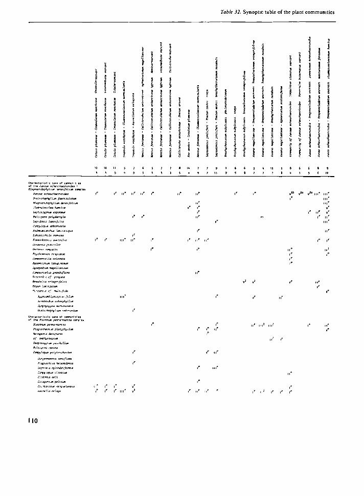
Table 32. Synoptic table of the plant communities
3 •J
ι 5 Л
9 4, i s л
! I i i
5 í s
! \ < s i
s
1 : s л г а ι
S
i ι л
; I
S I г
я
i
S І s t b » •5 с
,',
I
;
S Í r
я
1
! 1 ! 1 « 3 * с
я
4
s Í
5 ç
1 1
í i 3 ! I
ì Ì
S I
'i I 9 S
5 1
I I J
1 ΐ
\ i
^ г
i
i
'i I ' с
\ !
J \ ι ι
-
•ξ
f
i
jj | ι
•i
•1
1
Chiréctirl it I с tai« of corwwjmtl«! o ' the Junffut »cheu^hë«n.ozdee -Bltphandvphyllun loieifolittii coif
Jimcue ваНвисНыпоіайа
Pietichophylljtn faatnsulatum
ВІврНлгіоорНуІІл dzioifolii*!
СІавііііосаЫа h^nlia
Lfpzoacyphua ехряявия
Peitir/em polydaptyla
Lipitbtia laeviftlta
Ccmpjflnpjt arbori сю la
AidreiMisntHue Laurietipui
S^hie cachi Li immota
FoMtonbrtmia aas tralie
Jeteiria ptêiaclor
PtychcmnLoi i-inçianian
¿•твйопіаііа oc lora ta
Rae&ritrium lanug.notwi
LyMpvdiupi "vigellxnicrjri
JjnewMtltJ grandiflora
Rt??ardi3 ¿f ptrtçjta
Breuitlis xr-tegnfolbi
3 i v j ra .a j , ' luit-fbda
ArroboibuM achrophyllue
Synptyojyna тапопйпаіш
¡h.8tt¿hoph)jlí\eTi i*ibrbixitifi
ι' r ν». „J»
Вьвс пиш penna-nanna
Píajio£>)«mum platyphyilion
He i яд* ri з dtcipieie
с f AlvblyBzegiwn
lêopterygv^n pu^^hellum
Сотру Іорил poljt-riehiTidûê
JurgeTnantta oott.flora
РІодлэеНііа heteroJoita
Icpnaaii ajliiiín/orwin
Clìdtiìu aoll
Сзіадоплп poZitwi
Co. ibjnthua <ergJ*lentie
Ай пііа geloso
Il I I I III"
I' I I I
110

of Marion and Prince Edward Islands (continued)
5 Ì s I S 1 5 s
I ä ; з
ï ï I i
I I J
! !
's s I J
1 1 ! І
1 î
•Î ι
i i 3 9
f 9 ~> e s с
І & ? s s | л л *
ï I ! !
16 t l 15 lb
S 9
10 IB
β 1
16 19
• И IV II M
I I * V* III 1" н і г
IV* .V 2 0 V3
. · * .*· • • > •
I I '
/ v* / v» I I I * I I I * I I *
•ν* ι" m * m* n* M I ' v2
nr ι* , i r
iv г ii и
i r IV
iv m и* i\r
IV* IV*
^ tv1 . r v1 iv f IV* Élr / в i i i t a i n* ν 2 " ν 2 0 ν 2 0 vr1 ν 5
JwiatÊ eahiuahMrimdet cc * Î d i l l
MatK^ophytÍMn faBoioulatm с % J 4 ^ Ζ J
St^pAandöphyilwn den*i/oUtjoi с * V d H I J . d i i f c l
CloMimtacoUa » l i m i t · c t b . d t l l t d ^ Z . d W l
t^ptomayphu» «apunau· 4 4 1 )
P # l t t p * m polydactyUi d » I J
Ісріаошіа Immfolta d * 2 î
Сафуи>рим arbonooLa
Andiwi&ithu» Іаіилшігри*
Sekiêtoctnla оятсла
Ро*ш0яЬгопІ4 аил t r a i t · d t l ] ò 5 t 1
/«пл л і в рішіаоіо ύ Ч ** Ί d Ί ä 1 , d 5 ' 1
№t<nma жяраоьа d * 't Э , d * β I d S 1 1 d 6 1
Raaomtnt f4 Umuçtnoeim < * i ( t r ) . ς * t> 2 . d * ^ ï
Lj/eepodiiM magtllanicwt e * Ь
Jim*M7mtLta Qtnrvhftom С * Τ d Ί В 1
Я сгчтЛа <;ƒ ptnyui* d * Ь + ^ θ , d % В t
ffrttkt*íij xntsgnfolui e * β , d 3 1 3 d J І 1
Віул Іавпдаияі < Ί β
fficnirdta β/" mulfi-flda t * β
фвгоачЫу« ЫІГІМЯ fi lt£ñ d 1 I d * β Я
АстоЬо[Ьи* oahrtjphfflluM d 6 2 I
ΐ ν ψ ' ψ ο ^ ν η β ηαττβηβηιΐβ d 't 6 • ^ 6 , d 5 ' 1
ui#tteíiíJpft^Ili*i мчЬггоаЬЛ 4 S 1 I
Bl«etaii«n ρβτηα-ΐΉτιηα с 5 1 • d fr 1
PloffVothtmiM platYphylli*! с 5 1 d 4 fr
«etBj jena danpimm e 5 1 . d 4 6 ( d ^ f r l t ( l b 2 3
fff **îy»t#fftuii с S l
laopttryffiun pu loh* Hun с S 1
P # î t i i « r a irantna с S 1
Сгщуіори* polytnohaidma С 5 1
Jmgémonma ocmiflora d S 1 t , d fr 1
РІафіос*гіІа bittrodonta d fc * î , 4 Ί 4
Lúpfwíia i i y l indnfc i rm» d 2 S I . d * * ) d t f r l
Carçylaput olavatua d 6 2 1
Cladonia ooll d 5 1 t
CataganiuH p o l t n m d * 6 . d * fr 3
Coïabanthiâ» ktrgusUntiM 4 1 3 . d fr 3 2
Ажог ііа ëtlogo d 1 J
111

Table 32 Synoptic table of the plant communities
! - I ** . l i t i Mí i ¡ l ! 1
i S ! ! i î i 1 l 4 ι s f 1 ! Π ι i 1 ! 1 } π m u n i i π J ι π i Í 11 І І І І ! 1 1 ! І ! і і ! ! І і Ч і Н * І I l i з з s î ι ι i i i ι 1 I ! : : I І ! l I 1 ! Η Ч i ? ? 3 M 1 Ч i ! ! f î ? i i i i 1 1 1 i ! ! i I I M ! 4 ! î t ! 1 ? I І ä á i | | | |
•s a
1 î i i i 3 ι i I î I i I ¡ 1 1 ? 1 i ! 1 1 i | { f 1 i
C h i n e i t r r n ic tama of connunltle» of the AridrvasQ - Racam-triupi апариііл
aruMtate lichm» I
Aiidraata acwnr-.aUi
Atdr*3«a rvguíane
Onwyntf катфі4І*пп.а
L¡tooped%t4n tajrurut
Andrene a aauCifoHa
[>i tri chum β i n . - t u r n
Сгтчпга квтуивівпча
Philcmotië веаЬгъfolia
Pttlopi,jm af i r t i t o n i en «β
Hynênnphyllum pvltatitn
Bartratna p a t i n e I |
ΛΌ luden r u m рилпСип
Нурплч ruprmênfoi** I I * І г | г
other іаха
t t f l o e c t t o a u e t r a l t «
Лгп7»еів •mgeiíe«.« π Γ ιΓ м1* m * m * v4 и1* ι ι Γ i i i p ιι1* m * v1 i n* ιΓ ν 1 M I * ν 1 ν** ι ι Γ n* v1 ivJ v*· v3 v 2 0
Ranunculi* fritematue IV7 v ' V1 IV1 M l * IV7 IV1 M * I I I * IV1 i v ' I I * VJ V* IV* I I I * IV* I I I * \ r I l r VJ Ч1 V1 v '
topbocoUa гамЫ l ' I 1" l ' I * Г Г l " І Г I I * M l * І ] l ' | r I1" i l l 1 | l * I I * iv*
Ссргруіория aavifoliua I
Tcnncna quadi-ipaititun I
Braöhythacnißn pamdoxum I I
CephalOMia mnàii I
Plofieahi la a p o M í í n r t »
Саіфуіария tri poflrnxuM
С&фуіорим Biíbntttnt I
112

of Manon and Prince Edward Islands (continued)
¿ 1 1 !
§ ,
Г 5 5 ä
! I
1 1 ι ι 3 s
Í Ì
ê s
i
í ι ! f •?
I I ! 1
Ϊ i « s s
l i l i ï Л Л л *
ft а
ä i ϊ Ι Ι
ι ^
10 28 1J β 12 13 9 S β 6 IS ϊ 5 9 ΙΖ 1Î 7 β k 8 %
7 θ 10 16 11 IS lb 5 6 IJ •I " '° 'β " 1 D
'5 1 &
" k
^
V IV IV
l ' I I ' .'· ..ι· Grarrnn· Ъві^ім [«пега
Ц/оороачля Mururu»
Andrea*^ amiti/о Ita
Wtnofcwi etFietwi
Crvmta кврдилішпвьв
ftit tonati.· »cafcri/öliü
tattcptltn a/ tnetani#n·«
Portrawa patina
Vtrnieidtrta япет оагри*
Holodonttitn рілп.[і«і í^pnur гіфг«*»і/оті
V*- ν» /ί· /ь з з
I I I * IV1 I I I * I I ' I I I * I I I * Va" ν 6 / ν 4 / ν 4 ν 2 6 IV* IV* ιν1" ν 7 V1 IV*
Ι Γ II* VJ III* III* І І Г l ' II1" II* ι1" II1" ι*
η * . p . r i r i n * i r l*
1' г
limonila one troll· с 7 1
P0tanpp*tan ·ρ*(» с 7 2
Açroêti» падеІІапСоа d i l l d î î 1 d * 6 1 AmuttTbtuj tntmituâ Л 4 & l
Loptweolta mndii d S 1 2
С&руіорио comfo'xuM
Temono qi&dnpartttitn
Broati/thoiTtun paradoxen
CephaloMia ranchi
Plofíooht-la сгожвіепміё
Стфуіорим introfieai»
Сафуіориа mubrntenm
113


CHAPTER FIVE
Ecological outline and concluding remarks
Apart from the very pronounced influence of salt-spray and of trampling and manuring by birds and seals, the most prominent factor determining the distribution of the plant communities on Marion and Prince Edward Islands is the water-regime in the soil. Two aspects of this water-regime are most important: (1) the amount of water available.
Extreme situations probably affect the vegetation most, viz. inundation in the wetter part of the wet-dry gradient, and at the dry end of the gradient the unavailability of water in the driest periods, which on the islands means after a few days without precipitation.
(2) the occurrence of lateral water movement on the soil surface or through the soil. Such water flow is alleged to have a marked effect on the nutrient availability for the plants (Chapman 1965; Sparling 1966; Ingram 1967; cf. Par. 4.3 and 4.4).
More or less parallel with the wet-dry gradient often a change from organic to more mineral soils occurs, while frequently also a trend from somewhat sheltered towards strongly exposed conditions coincides with this gradient. Three major types of habitat are discerned along this complex gradient: a) poorly drained lowland areas, where peat depos
its have accumulated. The soils of these mire areas are highly organic and usually very wet, with a groundwater level usually within 40 cm from the soil surface;
b) well-drained lowland areas, not strongly exposed to the wind. These are mostly slopes, with a soil consisting of a layer of organic matter up to с
30 cm thick overlying deposits of clay; c) areas strongly exposed to the rigours of the
climate. These include nearly all parts of the islands higher than с 300 m above sea level, as well as those parts of the lowlands which are strongly exposed to the wind. The soils contain little organic matter and usually have a low water content.
Each of these three habitat-types has its own characteristic plant communities. Associated with the islands' mire areas are the communities of the Juncus scheuchzerioides-Blepharidophyllum den-sifolium complex, which are characterized by the prominence of bryophytes in the vegetation. Agrostis magellanica and Uncinia compacta usually dominate the herb layer (cf. Par. 4.4).
The well-drained slopes are mostly covered by communities of the Blechnum penna-marina complex, usually dominated by Blechnum penna-marina. The bryophyte stratum in these communities is usually not very prominent, which probably is a consequence of the drier habitat conditions here.
On exposed sites communities of the Andreaea -Racomitrium crispulum complex form the vegetation. Cushion plants (both vascular plant species (Azorella selago) and many bryophytes) are very prominent. The total cover of the vegetation is not high, commonly less than 10%, but the number of species is usually high (cf. Par. 4.6).
A fourth group of plant communities, the A caena magellanica-Brachythecium complex (cf. Par. 4.3), is not associated with one of the habitat types
115

mentioned above, but forms the plant cover of sites with a more or less strong lateral water flow, such as springs, flushes and drainage lines. These are usually associated with slopes, but are also locally found within the mire complex, e.g. along the edges of streams and in water tracks at the bottom of drainage lines.
Most of the plant communities making up the Juncus scheuchzerioides-Blepharidophyllum den-sifolium complex, the Blechnum penna-marina complex and the Andreaea-Racomitrium crispulum complex, as well as some communities from the restgroup (cf. Par. 4.7), can be arranged according to their habitat preferences into a single series from wet to dry (Table 33). At the wet end of the gradient the series starts with the Ranunculus biternatus variant of the community of Juncus scheuch-
zenoides, which occurs in bog ponds, in 20-80 cm deep water. Along the edges of the ponds and on the wettest sites on peat soils Drepanocladus uncinatus enters the vegetation, and the Junco scheuch-zerioidis-Drepanocladetum uncinati is the second community in the series. The three subassociations of the Junco-Drepanocladetum occur along the gradient from wet to dry in the following order: juncetosum scheuchzerioidis, montietosum fon-tanae and clasmatocoleetosum humilis. Next in the series is the Distichophylletum fasciculati, which towards the dry side is followed by the Blepharido-phyllo densifolii-Clasmatocoleetum humilis. The subassociation ranunculetosum biternati usually occupies wetter sites than the subassociation clasmatocoleetosum humilis, while the subassociation blechnetosum penna-marinae occurs on drier peat
Table 33 Manon and Prince Edward Island plant communities, arranged in series from wet to dry
Soil water Communities of sites with no content (%) pronounced lateral water flow
Communities of sites with a pronounced lateral water flow
Open water Comm. of Juncus scheuchzenoides (Ranunculus-variant)
Junco-Drepanocladetum juncetosum 3000 Junco-Drepanocladetum montietosum
Junco-Drepanocladetum clasmatocoleetosum
2000
1000
500
100
Distichophylletum fasciculati
Blephandophyllo-Clasmatocoleetum ranunculetosum
Blephandophyllo-Clasmatocoleetum clasmatocoleetosum
Blephandophyllo-Clasmatocoleetum blechnetosum
Lycopodio-Jamesonielletum ranunculetosum
Lycopodio-Jamesonielletum catagonietosum
Isopterygio-Blechnetum uncinietosum
Isopterygio Blechnetum brachythecietosum
Isopterygio-Blechnetum typicum
Community of Azorella and Acaena Sociation of Azorella selago Jungermannio- Racomitnetum
crispuh Andreaeo-Racomitnetum cnspuli
Brachythecietum subplicati philonotidetosum
Brachythecietum subplicati mops
Brachythecietum subplicati breutelietosum
Acaeno-Drepanocladetum breutelietosum
(Bryo Breutehetum uncinietosum) (Bryo-Breutelietum acaenetosum)
Acaeno-Drepanocladetum brachythecietosum
Acaeno-Brachythecietum rutabuli
Acaeno-Agrostietum stolomferae
116

soils than the two others. The Uncinio compactae-Ptychomnietum ringiani has about the same position as the Blepharidophyllo-Clasmatocoleetum along the wet-dry gradient, but occurs on soils containing more mineral matter than most mire soils. The next association in the series is the Lycopodio magellanici-Jamesonielletum coloratae, which occurs on relatively dry peat soils with a groundwater level usually between 15 and 25 cm below the surface. The subassociation ranuncule-tosum biternati occupies wetter sites than the subassociation catagonietosum politi. The James-onielletum grandiflorae occupies a similar position as the Lycopodio magellanici-Jamesonielletum coloratae in the series from wet to dry, but prefers more mineral soils, and is mostly found along the banks of little streams on deposits of sand or gravel or of scoriae, which are covered by a thin layer of peat. When leaving the Uncinio compactae-Pty-chomnietum ringiani and the Jamesonielletum grandiflorae out of consideration, the part of the wet-dry series described sofar can also be interpreted as a successional series of mire communities. The number of species/relevé tends to increase markedly along the gradient from wet to dry (and thus from pioneer communities to communities of a more mature developmental stage), from 3 species in the Juncus scheuchzerioides community to on average 16 species/ relevé in the Lycopodio magellanici-Jamesonielletum coloratae catagonietosum politi (cf. Table 32).
The series from wet to dry continues with the communities of the Blechnum penna-marina complex. This complex contains only one association, the Isopterygio pulchelli-Blechnetum penna-marinae. The subassociation uncinietosum, which contains a number of species which have their optimum in mire vegetation, occurs on comparatively moist slopes, but sometimes also on well-drained peat soils. On drier slopes, usually somewhat influenced by lateral groundwater movement, the subassociation brachythecietosum rutabuli is found, while on still drier slopes the subassociation typicum occurs. In this part of the series the number of species decreases again (cf. Table 32), probably as a consequence of the more unfavourable water regime on the dry slopes.
Towards the dry side of the Isopterygio pulchelli-Blechnetum penna-marinae follows the community of Azorella selago and Acaena magellanica
(Par. 4.7). Floristically this community does not fit well in the series, but according to its habitat preferences it must be placed here. It is followed by the sociation of Azorella selago. This community, which is very poor in species, also breaks the clear floristic gradient in this series (cf. Table 32), but again belongs here on the basis of its habitat requirements. It occurs in fjaeldmark areas, on sites where influx of water from surrounding areas and some shelter from the wind cause a somewhat more favourable water-regime.
The end of the series is formed by the fjaeldmark vegetation (Andreaea-Racomitrium crispulum complex; Par. 4.6). On exposed sites in the lowlands stands of the Jungermannio coniflorae-Racomitrietum crispuli occur. The vegetation of very strongly exposed lowland sites (e.g. on grey lava ridges) and of more elevated areas consists largely of Andreaeo acutifoliae-Racomitrietum crispuli hymenophylletosum peltati. The soils in these areas contain very little organic matter and commonly consist of a large proportion of rock fragments. Their water retention capacity is small. During the prolonged and frequent periods of rainy weather sufficient water seems to be available even in these areas, but during the occasional dry spells when evaporation is greatly enhanced by the strong winds water shortage becomes an important factor here too. As an adaption to these occasional periods of drought many of the species in the fjaeldmark vegetation possess acushion-like growth form, while several other species in these communities are largely restricted to strongly sheltered microhabitats such as the leeward sides of boulders and A zore //α-cushions, along or nearly under the edges of stones, or in cushions of Azorella or other species. A special type of such sheltered micro-habitats is found in scoriae deposits, where many species of bryophytes find shelter and a more favourable moisture regime in the hollows between the loosely heaped lava fragments. The vegetation of these areas, where an important portion of the plants grow beneath the surface, is formed by the Andreaeo acutifoliae-Racomitrietum crispuli hyp-netosum cupressiformis. In the final part of the wet-dry series the number of species/ relevé increases again, probably as a result of the large variety in microhabitats available in the fjaeldmark areas (cf. Par. 4.6).
The plant communities of sites with a lateral
117

water flow at the soil surface or through the soil (Acaena magellanica-Brachythecium complex; Par. 4.3) can also be arranged into a series from wet to dry (Table 33). The series starts with the Brachy-thecietum subplicati, a community occurring in springs and along the edges of streams. The sub-association philonotidetosum is found on mineral soils in shallow, comparatively fast flowing water. The subassociations inops and breutelietosum integrifoliae occur on peat deposits in springs and flushes, the former usually in faster running water than the latter. On somewhat less wet sites the Acaeno magellanicae-Drepanocladetum uncinati is met with, the subassociation breutelietosum integrifoliae on wet peat soils, the subassociation brachythecietosum rutabuli on drier soils. The next community in this series is the Acaeno magellanicae-Bracythecietum rutabuli, which is found on well-drained sites along streams and in drainage lines on slopes. The final community of the series, the Acaeno magellanicae-Agrostietum stoloniferae, is found in comparatively dry habitats, such as drainage lines on steep slopes and gravelly deposits along streams. Considering the species composition of the communities of this series (cf. Tables 25 and 32), a gradual change can be seen when going from wet to dry. In the same direction the initial preponderance of bryophytes in the vegetation changes to a dominance of vascular species in the dry habitats. A similar trend is present in the corresponding part of the wet-dry series of communities from habitats with no marked lateral water flow (cf. Tables 32 and 33). All communities of this series mentioned sofar belong to the Acaena magellanica-Brachythecium complex. One association of the Juncus scheuchzerioides-Blepharidophyllum den-sifolium complex, the Bryo laevigati-Breutelietum integrifoliae, is also found in habitats with a strong lateral water flow, notably in water tracks in mire areas, and should find a place in this series. Its position is about the same as that of the Acaeno magellanicae-Drepanocladetum uncinati breutelietosum integrifoliae. This community does not fit in the fioristic gradient in the series. Its characteristic habitat, being water tracks in mire areas, is also different from that of the other communities in this series which generally are associated with more minerotrophic conditions.
In saline habitats and in areas affected by trampling and manuring by birds and seals the
vegetation differs strongly from that of the other parts of the islands (cf. Table 32).
Only a small number of plant communities occur in areas influenced by seawater or salt-spray. The distribution of these communities, which are grouped together in the Crassula moschata complex (Par. 4.1), is largely determined by the intensity of the salt-spray deposition and by the water-regime of the soil. On those sites most strongly affected by seawater and salt-spray the vegetation is Cotulo plumosae-Crassuletum moschatae, notably the variant dominated by Crassula moschata. In somewhat less saline habitats soil moisture conditions determine the distribution of the communities to a large extent: on very wet, organic soils the Crassule moschatae-Clasmatocoleetum vermicu-laris occurs, on well-drained, organic soils the vegetation is Cotulo-Crassuletum, while on sites with dry, mineral soils, exposed to the winds, the Crassule moschatae-Azorelletum selaginis is met with. The prominence of cushion plants in the vegetation of these sites (cf. Fig. 27) reflects the severe environmental conditions.
The vegetation of areas strongly influenced by animals shows little relation to the other communities occurring on the islands. The most prominent species in the vegetation of these areas (Callitriche antárctica-Poa cookii complex; Par. 4.2) are M'ontiafontana, Callitriche antárctica, Poa cookii, Cotula plumosa and Poa annua. The nutrient status of the soils they grow on differs appreciably from that of soils of areas not influenced by animals (cf. Table 9), while frequent trampling in these areas has a considerable, sometimes devastating influence on soil and plant cover. The major factors influencing the distribution of plant communities of these areas strongly influenced by animals are the intensity of the influence of the animals and the water content and content of organic matter of the soil. The relation between habitat conditions and the distribution of the plant communities of this complex has already been described in Par. 4.2, and is represented diagrammatically in Fig. 36.
A final conclusion from the present study concerns the applicability of the Braun-Blanquet approach to vegetation classification in Subantarctic regions. The results of this study show that, despite the relatively small number of species and the wide
118

ecological amplitude of some of them, the differences in habitat-range between the species are pronounced enough to result in a large variation in the plant cover of the islands. This variation allows
the distinction of a large number of floristically clearly differentiated plant communities, the distribution of which in nearly all cases could be related to environmental factors.
119

Summary
This study gives an account of the plant communities of the Subantarctic Islands Marion and Prince Edward.
Marion and Prince Edward Islands (46° 54' S, 37° 45' E) are comparatively young, volcanic islands, associated with the West Indian Ocean Ridge. They form small specs of land in the vast Southern Ocean, far removed from any continent (Africa is 1800 km to the NNW, Antarctica 2300 km to the South). The nearest land is formed by the lies Crozet, 945 km east of the islands. Marion Island measures 290 km2, Prince Edward 44 km2. The islands lie 22 km apart. They are the summits of shield volcanoes and their age is estimated to be about 0.5 million years. Two periods of volcanic activity have resulted in two distinct series of lavas. Fine-grained, grey basaltic lava originated from eruptions between с 275 000 and 100 000 years BP. A period of volcanic activity about 15 000 years ago produced strongly vesicular, black lava. Recently ( 1980) a small eruption took place at Kaalkoppie on Marion Island. Between the two periods of volcanic activity glaciers have covered Marion Island nearly completely. The glaciations are of the same period as the Wurm- and Riss-glaciations in Europe. During these ice ages the Antarctic Convergence, the boundary between the cold Antarctic surface water and the с 2 0 C warmer Subantarctic surface water, which is now situated about 250 km to the south of Marion and Prince Edward Islands, had shifted to a position north of the islands.
Marion Island consists of a central mountain area, reaching up to 1230 m above sea level and sloping down in all directions towards the sea.
Along the west- and southcoasts this slope abruptly ends in a 200-300 m high escarpment, which steeply descends towards a coastal plain. A radial pattern of elevated grey lava ridges, probably the result of radial faulting and separating low-lying areas covered by black lava, is characteristic of the island. About 130 scoriae cones mark the centres of eruptions of the second volcanic stage. The highland of Prince Edward Island, the summit of which reaches 672 m, gently slopes down towards the East. On the western side it ends abruptly in a с 400 m high escarpment with descends towards a coastal plain. Towards the north and south the highland ends in high, precipitous cliffs, descending steeply towards the sea.
The climate of the islands is extremely oceanic, with an average annual temperature of 5 0 C which shows very little diurnal and seasonal variation, a very high precipitation (2575 mm annually) and humidity, and high wind speeds. Three soil-categories can be discerned: peat soils, soils of lowland slopes consisting of a layer of organic matter overlying a layer of clay, and fjaeldmark soils which consist of clay usually containing many rock fragments. The latter soils are sometimes very shallow. Weathering plays a minor role in supplying nutrients to the soils. The major source of mineral nutrients is the ocean, directly via salt-spray (e.g. Na, Mg and K) or indirectly via excreta and other depositions by sea-going animals (notably N and P).
Marion and Prince Edward Islands are situated within the Subantarctic Zone, i.e. south of the southern limit of tree growth and the occurrence of
121

woody shrubs and north of the southern limit of closed phanerogam communities. The flora of the islands shows a strong affinity to that of the other islands of the Kerguelen Province (Crozet, Kerguelen, Heard and Macdonald Islands). The total number of species is small: 22 indigenous species of vascular plants occur, and 72 mosses, 36 hepatics and 50 species of lichens have been identified. Of a further two species of vascular plants on the islands the status has not been ascertained conclusively. The influence of man on the islands' ecosystems is comparatively small. Although sealing must have had a devastating effect on the population-sizes of Elephant Seal and Fur Seal, these seem to have recovered again. Practically all further influence is indirect; it is a result of, in most cases inadvertent, introductions of plant and animal species to the islands. On Marion 14 species of vascular plants have been introduced, of which four have disappeared again. Three species of vertebrates were introduced: cats, mice and trout. Of these the cats form a pest, heavily influencing the populations of small birds. Some insects appear to have been introduced also. The only alien species recorded from Prince Edward Island is Poa annua.
The vegetation of Marion and Prince Edward Islands has been studied using the methods of the Braun-Blanquet School. Forty-one plant communities (on the level of subassociations) were distinguished, and their floristic composition, structure, habitat-characteristics and distribution on the islands has been described. All syntaxa in this study are newly described. As far as the data available in the literature allowed, remarks have been made on the distribution of these communities in other areas. The communities are grouped into six community-complexes which comprise floris-tically and ecologically related syntaxa.
The first group of communities, united into the Crassula moschata complex, forms the vegetation of areas strongly affected by salt-spray. Three associations are discerned: Cotulo plumosae-Crassuletum moschatae, Crassulo moschatae-Clasmatocoleetum vermicularis and Crassulo moschatae-Azorelletum selaginis. The distribution of these associations is largely determined by the intensity of salt-spray deposition and by the soil water regime.
The vegetation of areas strongly influenced by trampling and manuring by animals is formed by
the communities of the Callitriche antárctica-Poa cookii complex, viz. Montio fontanae-Callitriche-tum antarcticae, Callitricho antarcticae-Poetum annuae, Poo cookii-Cotuletum plumosae, Montio fontanae-Clasmatocoleetum vermicularis and Lep-todontio proliferi-Poetum cookii. The distribution of these communities is largely dependent on the intensity of the influences by animals and on the water content and the proportion of organic matter in the soil.
Communities dominated by Λcaena magellanica, united in the Acaena magellanica-Brachythecium complex, form the vegetation of springs, flushes, drainage lines and other sites with a pronounced lateral water-flow just above or below the soil surface. The associations which make up this complex form a series from extremely wet habitats (e.g. springs) to comparatively dry sites (e.g. drainage lines on steep slopes) in the following order: Brachythecietum subplicati, Acaeno magellanicae-Drepanocladetum uncinati, Acaeno magellanicae-Brachythecietum rutabuli and Acaeno magellanicae-Agrostietum stoloniferae.
The communities which occur in oligotrophic mires form the Juncus scheuchzerioides-Blephari-dophylium densifolium complex. Most of the communities of this complex can be arranged into a single series, ranging in habitat from very wet (bog ponds) to comparatively dry (peat deposits with a groundwater level below 25 cm) in the following order: Community of Juncus scheuchzerioides (Ranunculus biternatus variant). Junco scheuchze-rioidis-Drepanocladetum uncinati, Distichophylle-tum fasciculati, Blepharidophyllo densifolii-Clas-matocoleetum humilis, Uncinio compactae-Pty-chomnietum ringiani and Lycopodio magellanici-Jamesonielletum coloratae. This series can also be interpreted as a successional series. The vegetation on peat soils with a comparatively high proportion of mineral matter often is the Jamesonielletum grandiflorae. In water tracks through the mire expanse the Bryo laevigati-Breutelietum integrifo-liae occurs.
On well-drained slopes the vegetation is the Isopterygio pulchelli-Blechnetum penna-marinae, the only association of the Blechnum penna-marina complex.
The vegetation of fjaeldmark areas is formed by the communities of the Andreaea-Racomitrium crispulum complex: Jungermannio coniflorae-
122

Racomitrietum crispuli in the lowlands, and Andreaeo acutifoliae-Racomitrietum crispuli at strongly exposed sites in lowland areas and at higher elevations. These communities show a very complex structure and are comparatively rich in species. This is a consequence of the complex nature of the fjaeldmark substrate and the cushion-forming habit of many species in this type of vegetation. In one of the subassociations of the Andreaeo-Racomitrietum plants grow for the most part below the surface in the hollows between the rocks making up the scoriae deposits on which this community occurs. Moss balls, unattached globular colonies of mosses, are locally abundant in fjaeldmark areas.
An ecological outline of the vegetation of Marion and Prince Edward Islands is given in which the most important environmental gradients are described, and the communities are arranged in series along these gradients. The most prominent factor influencing the distribution of the plant communities on the islands is the soil moisture regime. Gradients from organic to mineral soils and
from somewhat sheltered to strongly exposed conditions run more or less parallel with the wet-dry gradient. Two series along wet - dry gradients can be formed, one comprising communities from habitats with no pronounced lateral water movement, the other consisting of communities from springs, water tracks and drainage lines, where lateral water-flow is pronounced. The first series contains most communities of the Juncus scheuchzerioides- Blepharidophyllum densifolium complex, the Blechnum penna-marina complex and the Andreaea-Racomitrium crispulum complex, while the second series consists of the communities of the Acaena magellanica-Bra-chythecium complex and one association of the Juncus-Blepharidophyllum complex. Only the communities of the Callitriche antárctica-Poa cookii complex and the Crassula moschata complex, i.e. the vegetation of areas strongly influenced by animals or by salt-spray, do not fit into these series. They differ, floristically, strongly from all other vegetation types on the islands.
123


Appendices
Appendix 1. Infrequent taxa occurring in the relevés of Table 21 (Crassula moschata complex)
Acaena magellanica Bryum dichotomum Campylopus polytrichoides Cladonia coll. Distichophyllum imbricatum Drepanocladus uncinatus
261: + 261: r 600: + 279: + 505: + 67: +
Appendix 2. Infrequent taxa occurring in
Andrewsianthus cf. carinatus Andrewsianthus lancistipus Bartramia patens Blechnum penna-marina Blepharidophyllum densifolium
Brachythecium paradoxum Brachythecium spec. Bryum amblyolepsis Bryum argenteum Bryum dichotomum Bryum spec. Campylopus polytrichoides
Campylopus subnitens Campylopus spec. Catagonium politum Cephalozia randii cf. Ceratodon purpureus Cerastium holosteoides
473: + 291: r 419: 1 554: 2a 210:2b 560: 2a 176: + 76: +
584: 2m 427: 1 457: +
76: + 458: 1 419: 1 419: + 377: + 291: + 377: + 76:2b
436: r
262: +
68: +
Peltigera polydactyla Philonotis scabrifolia Pringlea antiscorbutica Sagina apetala Schistochila carnosa Temnoma quadripartitum
the relevés of Table 23 ( Callitriche antárctica·
554: 1
291: 1
421: +
437: +
458: 1
437: r
Clasmatocolea humilis
Hygroamblystegium filum Hypnum cupressiforme
Jamesoniella grandiflora
Lepidozia laevifolia Leptoscyphus expansus Metzgeria decipiens Metzgeria cf. grollei Peltigera polydactyla Peltigera spec. Plagiothecium platyphyllum
Pohlia nutans Pringlea antiscorbutica Sagina apetala Stellaria media Uncinia compacta
262: + 279: г 262: +
45: г 505: + 273: +
•Poa cookii complex)
567: + 419: + 428: 1 427: 1 437: 1 560: + 199: 1 437: + 560: 1 322: + 427: г
75: + 560: + 291:2a 457: + 436: + 437: r 582: 1 427: + 291: 1
560: 1
428: 1
175: +
419: 1
437: + 210: r
129: 2m 554: +
554: +
125

Appendix 3. Infrequent taxa occurring in the relevés of Table 25 (Acaena magellanica-Brachythecium complex)
Brachythecium paradoxum Brachythecium spec. Breutelia pendula Bryum laevigatum Callitriche antárctica Clasmatocolea vermicularis Cotula plumosa Hypnum cupressiforme
387: 1 508: + 459: + 312: + 309: 1 252: + 252:3 167: 1 370: 1
370: 1
310: 1 324: 2a
426: +
Juncus scheuchzerioides 380: 2a Leptoscyphus expansus 508: + Marchantía berteroana 380: + Mielichhoferia campylocarpa 252: 1 Peltigera polydactyla 557: + Philonotis scabrifolia 508: r cf. Riccardia 324: I
540: + 324: 1 219: г
Appendix 4. Infrequent taxa occurring in the relevés of Table 26 (Juncus scheuchzerioides-Blepharido-phyllum densifolium complex)
Agrostis stolonifera cf. Amblystegium Andrewsianthus
marionensis Andrewsianthus spec.
Brachythecium paradoxum
Brachythecium rutabulum Brachythecium spec. Callitriche antárctica
Campylopus cavifolius Campylopus introflexus
214: + 204: +
162: + 217: 1 409: +
545: + 472: +
30: + 435: 1 254: 2a 413: + 298: +
545:
412:
202:
564: 606:
+
+
r
2a r
346:4
259:3
Campylopus 131: r polytrichoides 538: +
cf. Cephalozia randii 301: + Colobanthus kerguelensis 339: + Cotula plumosa 254: + Hymenophyllum peltatum 157: + Hypnum cupressiforme 171: + Isopterygium pulchellum 495: + Jungermannia coniflora 532: + Leptodontium proliferum 131: + cf. Lethocolea radicosa 162: + cf. Lophocolea 485: + Metzgeria marionensis 402: + Peltigera canina 415: + Plagiochila crozetensis 298: 1
495: + 687: r
243: +
495: + 545: 1 449: + 494: + 98: 1
409: + 404: +
30: + 461: +
Appendix 5. Infrequent taxa occurring in the relevés of Table 28 (Blechnum penna-marina complex)
Andreaea acuminata Brachythecium paradoxum Breutelia integrifolia Bryum laevigatum Campylopus arboricola Campylopus clavatus Campylopus introflexus Catagonium politum Cephalozia randii cf. Cephaloziella Clasmatocolea vermicularis Cotula plumosa Distichophyllum fasciculatum
441: + 269: + 441: + 268: г 290: 1 295: 1 199: 1 552: + 379: + 290: + 295: + 132: г 552: r 539: +
445: 464: 539:
158:
295:
+ r г
+
+
379:
379:
290:
+
+
+
Festuca rubra Jamesoniella grandiflora Juncus scheuchzerioides Lycopodium magellanicum Marchantía berteroana Philonotis scabrifolia Plagiochila crozetensis Pohlia nutans cf. Pohlia Pringlea antiscorbutica Ptychomnion ringianum Riccardia cf. multifida Riccardia cf. pinguis Tylimanthus viridis
533: (+) 269: I 137: 1 285: + 132: + 269: г 533: + 441: + 290: + 539: r 269: 1 334: 1 441: + 295: 1
464: 1
544: +
268: 1
126

Appendix 6. Infrequent taxa occurring in the relevés of Table 29 (Andreaea-Racomitrium crispulum complex)
Fuñaría laxa Lophocolea randa Lycopodium magellanicum Marchantía berteroana cf. Parmelia Stereocaulon cymosum Tylimanthus viridis Usnea cf. insularis Usnea spec. Willia austro-leucophaea
443: + 313: + 165: + 313: г 351: r 306: + 315: + 351: + 351: г 281: +
Andreaea gainii Andrewsianthus lancistipus Blindia magellanica Breutelia integrifolia Campylopus polytrichoides Ceratodon purpureus cf. Cheilotheca Clasmatocolea humilis Dicranoweisia brevipes Dicranoweisia breviseta Distichium capillaceum
315: 451: 442: 383: 163: 307: 529: 443: 372: 281: 373:
r
+ + + г
+ + + 1 1
+
127


References
Aarde, R J van , 1977 Voeding, habitatsvoorkeur en voortplanting van die wildehuiskat (Felis catus Linnaeus, 1758) op Manoneiland M Sc Thesis, Zoology dept Pretoria
Allen, S E ANorthover, M J , 1967 Soil types and nutrients on Signy Island Phil Trans Roy Soc London, Ser В, 252 179-185
Allison, J S & Smith, R I L , 1973 The vegetation of Elephant Island, South Shetland Islands Br Antarct Surv Bull 33-34 185-212
Alston, A H G & Schelpe, E А С L E, 1957 The Pteridophyta of Marion Island J S Afr Bot 23 105-109
Anderson.G D ÄCondy.P R , 1974 A note on the feral house cat and mouse on Marion Island S Afr J Antarct Res 4 58-61
Arnell, S , 1953 List of Hepaticae collected in Marion Island by Mr R W Rand Svensk Bot Tidskr 47 411-425
Arnell, S , 1963 Hepaticae of South Africa Stockholm Ashton, D Η , 1965 Regeneration pattern of Poafoliosa Hook
f on Macquane Island Proc Roy Soc Victoria 79 (1) 215-233
Ashton, D H & Gill, Α Μ , 1965 Pattern and process in a Macquane Islandfeldmark Proc Roy Soc Victoria 79(1) 235-245
Aubert de la Rue, Ε , 1932 La flore et la faune des Iles Kerguelen La Terre et la Vie 2 (I) 29-51
Aubert de la Rue, Ε, 1962 Quelques particularités des tourbières de l'Archipel de Kerguelen, leur répartition, leur structure et leur destruction Τ A A F 21 12-30
Aubert de la Rüe, Ε , 1964 Observations sur les charactères et la répartition de la végétation des Iles Kerguelen С N F R A -Biologie 1(1) 1-60
Aubert de la Rüe, Ε , 1968 Balles de mousse et mousses vagabondes, curiosités végétales des ¡les Kerguelen Τ A A F 45 3-9
Baker, Ρ E uTomblin, J F , 1964 A recent volcanic eruption on Bouveteya, South Atlantic Ocean Nature 203 1055-1056
Bail, D F , 1964 Loss-on-ignition as an estimate of organic
matter and organic carbon in non-calcareous soils J Soil Science 15 84-92
Barber, Η Ν , Dadswell, Η E & Ingle, H D , 1959 Transport of driftwood from South America to Tasmania and Macquane Island Nature 184 203-204
Barkman, J J , Doing, H & Segal, S , 1964 Kritische Bemerkungen und Vorschlage zur quantitativen Vegetationsanalyse Acta Bot Neerl 13 394-419
Barkman, J J , Moravec, J & Rauschert, S , 1976 Code of phytosociological nomenclature Vegetano 32 131-185
Becking, R W, 1957 The Zürich-Montpellier School of phylosociology Bot Rev 23 411-488
Beeftink, W G , 1965 De zoutvegetatie van ZW-Nederland beschouwd in Europees verband Thesis Wageningen, Meded Landbouwhogeschool 65 (1) 1-167
Beeftink, W G , 1966 Vegetation and habitat of the salt marshes and beachplains in the South-Western part of the Netherlands Wentia 15 83-108
Beeftink, W G, 1968 Die Systematik der europaischen Salzpflanzen-gesellschaften In R Tüxen (ed ), Pflanzensoziologische Systematik Ber Int Symp Stolzenau/ Weser 1964 239-263 Junk, The Hague
Bellair, Ρ , 1965 Un exemple de glaciation aberrante, les ¡les Kerguelen С N F R A 11 3-27
Bennmghoff, W W , 1955 Jokla mys J Glaciology2 514-515 Berutti, A , Burger, A Ε , Williams, A J & Siegfried, W R ,
1975 Bird ringing on Manon Island S Afr J Antarct Res 5 50-52
Billings, W D & Mooney, H A , 1968 The ecology of arctic and alpine plants Biol Rev 43 481 529
Bramwell, D (ed ) , 1979 Plants and islands Academic Press, London
Braun-Blanquet, J , 1928 Pflanzensoziologie I Aufl Springer, Wien
Braun-Blanquet, J , 1932 Plant sociology (transi G D Fuller 6 H S Conard) McGraw Hill, New York
Braun-Blanquet, J , 1951 Pflanzensoziologie 2 Aufl Springer, Wien
Braun-Blanquet, J , 1964 Pflanzensoziologie 3 Aufl Springer, Wien
129

Brossard, M de, 1972 II y a deux siècles, Manon-Dufresne Crozet, Kerguelen Τ A A F 58-59 3 26
Budd, G M , 1972 McDonald Island Reconnaissance, 1971 Polar Record 16 64-67
Chapman, S B, 1965 The ecology of Coom Rigg Moss, Northumberland III Some water relations of the bog system J Ecol 53 371-384
Chastain, A , 1958 La flore et la vegetation des Iles Kerguelen Mem Mus Nat Hist Nat, В, Botanique 11 (1) 1-136
Cleef. A M , 1978 Characteristics of neotropical páramo vegetation and ils subantarctic relations In С Troll & W Lauer (eds ), Geoecological relations between the southern temperate zone and the tropical mountains Erdwissensch Forschung XI, Steiner, Wiesbaden 365-390
Cleef, Α Μ , 1981 The vegetation of the páramos of the Colombian Cordillera Oriental Diss Bot No 61 Cramer, Vaduz
Clifford, Η Τ , 1953 The mosses of Macquane Island and Heard Island ANARESc Reports(Ser B) Bot 2(11) 1-12
Cockayne, L , 1909 The ecological botany of the subantarctic islands of New Zealand In С Chilton (ed ), The Subantarctic Islands of New Zealand Vol I Government Printer, Wellington 182 235
Cockayne, L , 1928 The vegetation of New Zealand 2nd ed Engelmann, Leipzig
Condy, Ρ R , 1978 Distribution, abundance, and annual cycle of fur seals (Arctocephalus spp ) on the Prince Edward Islands S Afr J Wildl Res 8 159-168
Condy, Ρ R , 1979 Annual cycle of the southern elephant seal Mirounga leonina (Linn ) at Marion Island S Afr J Zool 14 95-102
Costin, Α Β , 1957 The high mountain vegetation of Australia Austr J Bot 5 173-189
Costin, Α Β , 1965 Long distance seed dispersal to Macquane Island Nature 206 317
Cour, Ρ , 1958 A propos de la flore de l'Archipel de Kerguelen Τ A A F 4-5 10-32
Cour, Ρ , 1959 Flore et vegetation de l'Archipel de Kerguelen II Vegetation Τ A A F 8-9 3-40
Croóme, R L , 1972 Preliminary investigations on the nitrogen status of the Marion Island ecosystem Unpublished expedition report, Dept of Botany, U O F S Bloemfontein
Croóme, R L , 1973 Nitrogen fixation m the algal mats on Marion Island S Afr J Antarct Res 3 64 67
Deacon, G E R , 1959 The Antarctic Ocean Science Progress 47 647-660
Deacon, G E R , I960 The southern cold temperate zone Proc Roy Soc London (Ser В) 152 441-447
Deacon, G E R , 1964 The Southern Ocean In R Priestly, R J Adíe & G de Q Robin (eds ), Antarctic Research Butterworth, London
Dickson, J Η , 1965a The biological report of the Royal Society Expedition to Tristan da Cunha, 1962 Part 1 General introduction Phil Trans Roy Soc London (Ser В) 249 259-271
Dickson, J H , 1965b The effects of the eruption of 1961 on the
vegetation of Tristan da Cunha Phil Trans Roy Soc London (Ser В)249 403-424
Dierschke, Η , 1971 Stand und Aufgaben der pflanzensoziologischen Systematik in Europa Vegetatio22 255-264
Dixon, Η Ν , 1912 Note on mosses growing unattached Bryologist 15 31-32
Dreux, Ρ , 1964 Observations sur la flore et la végétation de l'Ile aux Cochons (Archipel Crozet) Bull Soc Bot France 111 (7-8) 382-386
Dreux, Ρ , 1971 Insecta In E M van Zinderen Bakker Sr, J Μ Winterbottom & R A Dyer(eds ), Manon and Pnnce Edward Islands Balkema, Cape Town 335-343
Ellenberg, H , 1956 Aufgaben und Methoden der Vegetationskunde In H Walter, Einführung in die Phytologie IV, 1 Ulmer, Stuttgart
Engler, A , 1964 Syllabus der Pflanzenfamilien Part II Borntraeger, Berlin
Eythórsson, J , 1951 Зокіа-пфі J Glaciology 1 (9) 503
Fabncius, A F, 1957 Climate of the Sub-Antarctic islands In Μ Ρ van Rooy (ed ), Meteorology of the Antarctic Weather Bureau, Dept of Transport, Pretoria 111-135
Falla, R A , 1960 Oceanic birds as dispersal agents Proc Roy Soc London Ser В 152 655 659
Fineran, Β Α , 1971 A catalogue of bryophytes, lichens and fungi collected in the Auckland Islands J Roy Soc Ν Ζ 1 (3-4) 215-229
Follmann, G , 1965 Una asociación nitròfila de liqúenes epi-pétricos de la Antartica Occidental con Ramalina terébrala Tayl el Hook como especie caracterizante Instituto Antartica Chileno Publicación No 4 1-8
Fujiwara, К & Umejima, S , 1962 On the distribution of wind-borne salt on the coastal terrace Res Bull Coll Exp Forests Hokkaido Univ 21 453-464
Gardner, W H, 1965 Water content In С A Black (ed ) Methods of soil analysis American Society of Agronomy, Madison, Wis 82-127
Gass, I G , 1963 The Royal Society's Expedition to Tristan da Cunha, 1962 Geogr J 129 281-289
Gilham, Μ Ε , 1961 Modification of subantarctic flora on Macquane Island by sea birds and sea elephants Proc Roy Soc Victoria 74 (I) 1-12
Gimingham, С Η , 1967 Quantitative community analysis and bryophyte ecology on Signy Island Phil Trans Roy Soc London, Ser В 252 251-259
Gimingham, С Η & Birse, Ε , 1957 Ecological studies on growth-form in bryophytes I Correlations between growth-form and habitat J Ecol 45 533-545
Gimingham, С Η & Smith, R I L , 1970 Bryophyte and lichen communities in the Maritime Antarctic In M W Holdgate (ed ), Antarctic Ecology Vol 2 Academic Press, London 752-785
Gimingham, С H & Smith, R I L , 1971 Growth form and water relations of mosses in the Maritime Antarctic Br Antarct Surv Bull 25 1-21
130

Girod, M & Neugier, J , 1972 Volcamsm of the Sub-Antarctic islands In R J Adíe (ed ), Antarctic geology and geophysics Int Union Geol Se Ser В 1 777-788
Godley, E J, 1978 Cushion bogs In С Troll & W Lauer (eds ), Geoecological relations between the southern temperate zone and the tropical mountains Erdwissensch Forschung XI, Steiner, Wiesbaden 141-158
Good, R , 1974 The geography of the flowering plants 4th ed Longman, London
Greene, S W , 1964 The vascular flora of South Georgia Br Amarci Surv Sci Rep 45
Greene, S W , 1968a Studies in Antarctic Bryology I A basic check list for mosses Rev Bryol Lichenol 36 (1-2) 132-138
Greene, S W, 1968b Studies in Antarctic Bryology II Andreaea, Neuroloma Rev Bryol Lichenol 36 (1-2) 139-146
Greene, S W & Greene, D Μ , 1963 Check list of the subantarctic and antarctic vascular flora Polar Record 11 (73) 411-418
Greene, S W & Walton, D W H , 1975 An annotated check list of the sub-antarctic and antarctic vascular flora Polar Record 17(110) 473-484
Gremmen, N J Μ , 1975 The distribution of alien vascular plants on Marion and Prince Edward Islands S Afr J Antarct Res 5 25-30
Gremmen.N J M & Smith, V R , 1980 Agrostis stolonifera L on Marion Island (Subantarctic) S Afr J Antarct Res 10 (in press)
Gressitt, J L , 1970 Subantarctic entomology and biogeo-graphy Pacific Insects Monograph 23 295-374
Grobbelaar, J U , 1974 A contribution to the limnology of the sub-antartic island Marion D Sc Thesis, Bloemfontein
Grolle, R ,1964 Miscellanea hepatologicae(l 1-20) J Jap Bot 39 173-178
Grolle, R , 1969 Grossdisjunktionen in Artarealen Lateinamerikanischer Lebermoose In E J Fittkau, J lilies, H Klinge, G H Schwabe & H Sioh (eds ), Biogeography and ecology in South America Vol II Junk, The Hague 562-582
Grolle, R, 1971a Hepaticopsida In E M van Zinderen Bakker Sr, J M Winterbottom & R A Dyer(eds ), Manon and Prince Edward Islands Balkema, Cape Town 228-236
Grolle, R , 1971b Die Lebermoose der Crozet-Inseln (Sub-antarktis) Lmdbergia 1 80-82
Grolle, R , 1972 The hepatics of the South Sandwich Islands and South Georgia Br Antarct Surv Bull 28 83-95
Hall, К J , 1977 Some observations on the former sea levels of Manon Island S Afr J Amarci Res 7 19-22
Hall, 1С J , 1978a Evidence for Quaternary glaciation of Marion Island (sub-Antarctic) and some implications In Ε M van Zinderen Bakker (ed ), Antarctic glacial history and world palaeoenvironments Balkema, Rotterdam 137-147
Hall, К J , 1978b Quaternary glacial geology of Marion Island D Phil Thesis, Bloemfontein
Hartog, С den & Segal, S , 1964 A new classification of the
water-plant communities Acta Bot Neerl 13 367-393 Hays, J D , Lozano, J A , Shackleton, N & Irving, G , 1976
Reconstruction of the Atlantic and Western Indian Ocean sectors of the 18 000 BP Antarctic Ocean Geol Soc Am Mem 145 337-372
Hebrard.J Ρ , 1970a Muscinèes récoltées aux Iles Kerguelen et Crozet pendant la campagne d'été des Terres Australes et Antarctiques Françaises (1969) Rev Bryol Lichenol 37 135-162
Hébrard, J Ρ , 1970b Contribution à l'étude de quelques groupements muscinaux des Iles Kerguelen et Crozet Rev Bryol Lichenol 37 315-343
Hedberg, О , 1964 Features of Afroalpine ecology Acta Phytogeogr Suecica 49 1-144
Hemsley, W Β , 1885 Report on the botany of the Bermudas and various other islands of the Atlantic and Southern Oceans Second Part In С W Thompson & J Murray (eds ), Report on the scientific results of the voyage of H M S Challenger during the years 1873-76 Botany, Vol I H M Stationery Office, London 1-299
Hill, Μ О , 1973 Reciprocal averaging an eigenvector method of ordination J Ecol 61 237 249
Hodgson, Ε A , 1962 Hepatics from the subantarctic islands of New Zealand, including the 'Cape Expedition' collections from the Auckland and Campbell Islands Ree Dom Mus Wellington, Ν Ζ 4(11) 101-132
Holdgate, M W , 1964 Terrestrial ecology in the Maritime Antarctic In R Carnck, M Holdgate & J Prévost (eds ), Biologie Antarctique Hermann, Pans 181-194
Holdgate, M W , 1967a Signy Island Phil Trans Roy Soc London, Ser В 252 173-177
Holdgate, M W, 1967b The Antarctic ecosystem Phil Trans Roy Soc London Ser В 252 363-383
Holdgate, M W , 1967c The influence of introduced species on the ecosystems of temperate oceanic islands Proceedings and Papers of the I U С N 10th technical meeting, I U С N Publications, New Series 9 151-176
Holdgate, M W , Allen, S E & Chambers, M J G , 1967 A preliminary investigation of the soils of Signy Island, South Orkney Islands Br Antarct Surv Bull 12 53-71
Holdgate, M W&Wace, Ν M , 1961 The influence of man on the floras and faunas of southern islands Polar Record 10 (68) 475 493
Holttum, R Ε , 1922 The vegetation of West Greenland J Ecol 10 87-108
Holub, J & Jirásek, V, 1967 Zur Vereinheitlichung der Terminologie in der Phytogeographie Folia Geobot Phyto-taxon 2 69-113
Huntley, В J , 1970 Altitudinal distribution and phenology of Marion Island vascular plants Tijdskr Natuurwet 10 (4) 255-262
Huntley, В J , 1971 Vegetation In Ε M van Zinderen Bakker Sr , J M Winterbottom & R A Dyer (eds ), Manon and Prince Edward Islands Balkema, Cape Town 98-160
Huntley, В J , 1972 Notes on the ecology of Azorella selago Hook f J S Afr Bot 38 103-113
Hydrographie Department 1948 The Antarctic Pilot 2nd ed The Admiralty, London
131

Ingram, H A P , 1967 Problems of hydrology and plant distribution in mires J Ecol 55 711-724
James, Τ Ρ, 1876 Musei Bull U S Nat Mus, Washingtons 25-27
Jeannel, R , 1940 Croisière du Bougainville aux Iles Australes Françaises I Partie génerale Mem Mus Nat Hist Nat , N S 14 1-46
Johnson, Ρ Ν , 1975 Vegetation and flora of the Solander Islands, Southern New Zealand Ν Ζ J Bot 13 189-213
Kable, E D , Erlank, A J & Cherry, R D , 1971 Geochemical features of lavas In E M van Zinderen Bakker Sr , J M Winterbottom & R A Dyer (eds ), Manon and Pnnce Edward Islands Balkema, Cape Town 78-88
Kessler, A , 1978 Studien zur Klimatologie der Strahlungsbilanz unter besonderer Berücksichtigung der tropischen Hochgebirge und der Kühltemperierten Zone der Südhalbkugel In С Troll & W Lauer (eds ), Geoecological relationships between the southern temperate zone and the tropical mountains Erdwissensch Forschung XI, Steiner, Wiesbaden 49-61
Kighlley, S Ρ J & Smith, R I L , 1976 The influence of reindeer on the vegetation of South Georgia I Long-term effects of unrestricted grazing and the establishment of exclosure experiments in various plant communities Br Antarct Surv Bull 44 57-76
Kok,Ο , 1975 Verspreid mg van veervasgehegte sade deur voéls Ostrich 46 261-263
Kuwahara, Y , 1966 The family Metzgeriaceae in North and South-East Asia Rev Bryol Lichenol 34 191-139
Lacroix, A , 1923 Minéralogie de Madagascar Vol 3 Pans Lacroix, A , 1940 Les laves des volcans inactifs des Iles Manon
et Crozet Mém Mus Hist Nat 14 47-62 La Grange, J J , 1954 The South African station on Manon
Island Polar Record 7 (48) 155-158 La Grange, J J , 1962 Notes on the birds and mammals on
Manon Island and Antarctica (SANAE) J S Afr Biol Sc 3 27-86
Laing, R Μ , 1909 The chief plant formations and associations of Campbell Island In С Chilton (ed ), The Subantarctic islands of New Zealand Vol 2 Government Printer, Wellington 482-492
Langenegger, О & Verwoerd, W J , 1971 Topographic survey In E M van Zinderen Bakker Sr , J M Winterbottom & R A Dyer (eds ), Manon and Prince Edward Islands Balkema, Cape Town 32-39
Law, Ρ G & Burstall, Τ , 1953 Heard Island Α Ν A R E Interim Reports 7 1-32
Lawrence, R F, 1971 Araneida In E M van Zinderen Bakker Sr , J M Winterbottom & R A Dyer (eds ), Manon and Prince Edward Islands Balkema, Cape Town 301-313
Leupe, Ρ A , 1868 De eilanden Dina en Maerseveen Verhandelingen en Bengten betrekkelijk het Zeewezen, de Zeevaartkunde, de Hydrographie, de Kolomen en de daar
mede in verband staande wetenschappen 3,2e afd 242 253 Lid, J , 1938 Mosbollar Nyt Mag Naturv 78 101-104 Lindeboom, H J , 1979 Chemical and microbiological aspects
of the nitrogen cycle on Manon Island (Sub-Antarctic) Thesis, Groningen
Lindsay, D С , 1971 Vegetation of the South Shetland Islands Br Antarct Surv Bull 25 59-83
Lindsay, D С , 1976 The lichens of Marion and Prince Edward Islands, Southern Indian Ocean Nova Hedwigia 28 667-689
Maarel, E van der, Janssen, J G M & Louppen, J M W , 1978 TABORD, a program for slructunng phytosociolog-ical tables Vegetano 38 143-156
Mägdefrau, К, 1969 Die Lebensformen der Laubmoose Vegetano 16 285-297
Malloch, A J С , 1972 Salt-spray deposition on the maritime cliffs of the Lizard Peninsula J Ecol 60 103-112
Marsh, J Η , 1948 No pathway here Timmins, Cape Town Martin, W , 1952 U nattached mosses in the New Zealand flora
Bryologist55 65-70 McDougall, I , 1971 Geochronology In Ε M van Zinderen
Bakker Sr, J M Winterbottom&R A Dyer (eds ), Manon and Prince Edward Islands Balkema, Cape Town 72-77
Meurk, С D , 1977 Alien plants in Campbell Island's changing vegetation Maun Ora 5 93-118
Moore, D Μ , 1963 The subspecies of Montia fontana L Botamska Notiser 116(1) 16-30
Moore, D M,I968 The vascular flora of the Falkland Islands Br Antarctic Surv Sc Rep 60
Moseley, Η Ν , 1874 On the botany of Manon Island, Kerguelen's Land and Young Island of the Heard Group J Linn Soc London, Botany 14 387-388
Moseley, Η Ν , 1877a Further notes on the plants of Kerguelen, with some remarks on the insects J Linn Soc London, Botany 15 53-54
Moseley, Η Ν , 1877b Notes on the flora of Marion Island J Linn Soc London, Botany 15 481-482
Moseley, Η Ν , 1892 Notes by a naturalist An account of observations made during the voyage of H M S 'Challenger' round the world in the years 1872-1876 Murray, London
Mueller-Dombois, D & Ellenberg, Η , 1974 Aimsand methods of vegetation science Wiley & Sons, New York
Oliver, R L & Sorensen, J Η , 1951 Botanical investigations on Campbell Island Part I The vegetation Cape Expedition Series Bull No 7 Dept Sc Ind Res, Wellington, Ν Ζ 5-24
Peech, Μ , 1965 Hydrogen-Ion activity In С A Black (ed ), Methods of soil analysis American Society of Agronomy Madison, Wis 914-926
Rand, R W,1954 Notes on the birds of Marion Island Ibis 96 173-206
Rand, R W,1955a The penguins of Marion Island Ostrich 24
132

57 69 Rand, R W , 1955b Manon Island Home of South Africa's
Elephant Seal Afr Wildl 9 7-9 Rand, R W,I956 Notes on the Marion Island Fur Seal Proc
Zool Soc London 129 65-82 Rauh, W , 1978 Die Wuchs- und Lebensformen der tropischen
Hochgebirgsregionen und der Subantarktis Em Vergleich In С Troll & W Lauer (eds ), Geoecological relations between the southern temperate zone and the tropical mountains Erdwissenschaftliche Forschung XI, Steiner, Wiesbaden 62-92
Renard, A F , 1889 Report on petrology of oceanic islands Rep Sc Res Voyage H S S Challenger 1873-1876 Physics and chemistry 2 (7) 104-107
Roberts, В В , 1958a Chronological list of Antarctic expeditions Polar Record 9 (59) 97-134
Roberts, В В , 1958b Chronological list of Antarctic expeditions Polar Record 9 (60) 191 239
Roskam, E, 1971 Programme ORDINA multidimensional ordination of observation vectors Programme Bulletin 16, Psychol Lab Nijmegen
Rothuizen, I W J M , 1977 De geografische verbreiding van de inheemse vaatplanten van de subantarctische flora-provincie Kerguelen Doctoraal-verslag, Afd Geobotame, 1С U Nijmegen (unpublished)
Sainsbury, G О К & Allison, К W , 1962 Mosses from the Auckland Islands and Campbell Island Ree Dom Mus Wellington 4 (12) 133 142
Schalke, H J W G & van Zinderen Bakker Sr, Ε Μ , 1967 A preliminary report on palynologial research on Marion Island (Sub-Antarctic) S Afr J Sci 63 254-259
Schalke, H J W G & van Zinderen Bakker Sr, E Μ , 1971 History of the vegetation In E M van Zinderen Bakker Sr, J M Wmterbottom&R A Dyer (eds ), Manon and Prince Edward Islands Balkema, Cape Town 89-97
Schenck, H , 1905 Vergleichende Darstellung der Pflanzengeographie der subantarktischen I nseln, insbesondere über Flora und Vegetation von Kerguelen Wiss Ergebn Deutsche Tiefsee-Exp Valdivia 1898-1899 2 (I) 1-178
Schroeder, F -G , 1969 Zur Klassifizierung der Anthro-pochoren Vegetatio 16 225-238
Schulze, В R,1971 The climate of Marion Island In Ε M van Zinderen Bakker Sr ,J M Winterbottom & R A Dyer (eds ), Manon and Prince Edward Islands Balkema, Cape Town 16-31
Segal, S , 1965 Een vegetatie-onderzoek van hogere waterplanten in Nederland Wetensch Meded Κ Ν В V 57
Séguy, E , 1971 Diptera In E M van Zinderen Bakker Sr , J M Winterbottom & R A Dyer (eds ), Manon and Prince Edward Islands Balkema, Cape Town 344-348
Seppelt, R D , 1977 Studies on the bryoflora of Macquane Island I Introduction and checklist of species Bryologist 80 167-170
Seppelt, R D &Ashton, D Η , 1978 Studies on the ecology of the vegetation at Mawson Station, Antarctica Austral J Ecol 3 373-388
Shacklette, Τ S , 1966 Unattached moss polsters on Amchitka
Island, Alaska Bryologist 69 346-352 Shimwell, D , 1971 Description and classification of vegetation
Sidgewick & Jackson, London Skottsberg, C, 1905 Some remarks upon the geographical
distibution of vegetation in the colder Southern hemisphere Ymer25(4) 402-427
Skottsberg, С, 1909 Studiin über das Pflanzenleben der Falklandinseln Wiss Ergebn Schwed SUdpolar-Exp 1901-1903,4(10) 1-58
Skottsberg, С , 1912 The vegetation of South Georgia Wiss Ergebn Schwed SUdpolar-Exp 1901-1903,4(12) 1-36
Skottsberg, С ,1913 A botanical survey of the Falkland Islands (Bot Ergebn Schwed Exp Patagonien U D Feuerlande, 1907 1909, 3) К Svensk Vet Akad Handl 50(3) 1-129
Skottsberg, С , 1960 Remarks on the plant geography of the southern cold temperate zone Proc Roy Soc London Ser В 152 447-457
Smith, R I L,1972 Vegetation of the South Orkney Islands, with particular reference to Signy Island Br Anlarct Surv Sc Rep 68
Smith, R I L & Walton, D W Η , 1975 South Georgia, Subantarctic In Τ Rosswall & О W Heal (eds ), Structure and function of tundra ecosystems Ecol Bull (Stockholm) 20 399-423
Smith, V R , 1976a Standing crop and nutnent status of Marion Island (Sub-Antarctic) vegetation J S Afr Bot 42 231-263
Smith, V R , 1976b The effect of burrowing species of Procellamdae on the nutrient status of inland tussock grasslands on Marion Island J S Afr Bot 42 265-272
Smith, V R , 1976c The nutrient statuses of Marion Island plants and soils M Sc Thesis, Bloemfontein
Smith, V R , 1977a A qualitative description of energy flow and nutrient cycling in the Marion Island terrestrial ecosystem Polar Record 18(115) 361-370
Smith, V R , 1977b Vegetation standing crop of the grey lava flows and of the eastern coastal plain on Manon Island J S Afr Bot 43 105-114
Smith, V R , 1977c Notes on the feeding of Ectemnorrhinus similis Waterhouse(Curculionidae)adults on Marion Island Oecologia(Berl)29 269-273
Smith, V R , I977d The chemical composition of Manon Islandsolls, plants and vegetation S Afr J Anta ret Res 7 28 39
Smith, V R , 1978a Animal-plant-soil relationships on Manon Island (Subantarctic) Oecologia (Beri ) 32 239-253
Smith, V R, 1978b Soil chemistry on Marion Island (Subantarctic) S Afr J Sci 74 174-175
Smith, V R , 1979 The influence of seabird manuring on the phosphorus status of Marion Island (Subantarctic) soils Oecologia (Beri) 41 123-126
Smith,W A ASayers,R L,I97I Entomostraca In Ε M van Zinderen Bakker Sr, J M Winterbotlom & R A Dyer (eds ), Marion and Prince Edward Islands Balkema, Cape Town 361-372
Snape, С & Relief, J A, 1971 Palaeomagnetic study of some recent lavas In E M van Zinderen Bakker Sr, J M Winterbottom & R A Dyer (eds ), Manon and Pnnce Edward Islands Balkema, Cape Town 63-71
133

Sparling, J Η , 1966 Studies on the relationship between water movement and water chemistry in mires Can J Bot 44 747-748
Taljaard, J J , 1957 Geographical and hydrological features of the Antarctic In Μ Ρ van Rooy (ed ), Meteorology of the Antarctic Weather Bureau, Pretoria I IS
Taylor, В W , 1955a The flora, vegetation and soils of Macquane Island A N A R E Rep Ser В, Vol 2, Botany
Taylor, В W , 1955b Terrace formation on Macquane Island J Ecol 43 133-137
Tizard, Τ Η , Moseley, Η Ν , Buchanan, J Y & Murray, J , 1885 Report of the scientific results of the voyage of Η M S 'Challenger'1873-76 Narrative Vol 1, first part
Troll, С , 1944 Strukturboden, Sohfluktion und Frostkhmate der Erde Geol Rundschau 34 545-694
Troll, С , 1948 Der asymmetrische Aufbau der Vegetationsstufen auf der Nord-und Südhalbkugel Jahresber Geobot Forschungs-institutes Rubel 1947, Zürich 46-83
Troll, С , 1955 Der jahreszeitliche Ablauf des Naturgeschehens in den verschiedenen Klimagürteln der Erde Studium Generales 713-733
Troll, С, 1966 Jahreszeitenklimate der Erde In Η E Landsberg, Η Lippmann, Κ Η Paffen & С Troll, World maps of climatology Springer, Berlin
Trusswell, J F , 1965 Manon Island, South Indian Ocean Nature 205 64 65
Vanhöffen, Ε , 1903 Biologischer Bericht Heard Insel Veröff Inst Meeresk Univ Berlin S 126
Verwoerd, W J , 1967 Geologiese evolusie van Marion en Prince Edward-eilande S Afr J Sci 63 219-225
Verwoerd, W J , 1971 Geology In Ε M van Zinderen Bakker Sr, J M Winterbottom & R A Dyer (eds ), Manon and Prince Edward Islands Balkema, Cape Town 40-62
Vowinckel, E , 1954 Synoptische Klimatologie vom Gebiet Manon Island NOTOS (Pretona) 3 (1) 12-21
Wace, Ν M , I960 The botany of the southern oceanic islands Proc Roy Soc London Ser В 152 475-490
Wace, Ν Μ , 1961 The vegetation of Gough Island Ecol Monogr 31 337-367
Wace, N M, 1965 Vascular plants In J van Mieghem 4 Ρ van Oye (eds ) Biogeography and ecology in Antarctica Junk, The Hague 201-266
Wace, Ν M , 1966 Last of the virgin islands Discovery 27 (2) Wace, Ν Μ , 1969 The terrestrial biogeography of Antarctica
In Ε M van Zinderen Bakker (ed ), Palaeoecology of Afnca and ofthe surrounding islands and Antarctica Vol 5 213-238 Balkema, Cape Town
Wace, Ν M & Dickson, J Η , 1965 The terrestrial botany of the Tristan da Cunha Islands Phil Trans Roy Soc London, Ser В 249 273-360
Wace, N M & Holdgate, M W , 1958 The vegetation of Tristan da Cunha J Ecol 46 593-620
Walter, Η , 1955 Die Klimagramme als Mittel zur Beurteilung
der Klimaverhältnisse für ökologische, vegetationskundliche und landwirtschaftliche Zwecke Ber Deutsch Bot Ges 68 331-344
Walter, Η , 1970 Vegetationszonen und Klima Ulmer, Stuttgart
Walter, Η , Harmckell, E & Mueller-Dombois, D , 1975 Klimadiagramm-Karten der einzelnen Kontinente und ökologische Klimagliederung der Erde Fischer, Stuttgart
Walter, Η & Lieth, Η , 1967 Klimadiagramm-Wellatlas Fischer, Jena
Walton, D W Η , 1975 European weeds and other alien species in the Sub-Antarctic Weed Research 15 271-282
Walton, D W Η , 1977 Studies on Acaena (Rosaceae) Seed germination, growth and establishment in A magellanica (Lam)VahlandA tenera Alboff Br AntarctSurv Bull 45 29 40
Walton, D W Η & Smith, R I L , 1973 Status of the alien vascular flora of South Georgia Br Antarct Surv Bull 36 79-97
Warming, E , 1887 Om Grönlands Vegetation Meddel om Grönland 12
Weather Bureau, 1967a Report on meteorological data of the year 1965 Government Printer, Pretoria
Weather Bureau 1967b Report on meteorological data of the year 1966 Government Printer, Pretoria
Weather Bureau 1968 Report on meteorological data of the year 1967 Government Printer, Pretoria
Weather Bureau, 1970 Report on meteorological data of the year 1968 Government Printer, Pretoria
Weather Bureau, 1971a Report on meteorological data ofthe year 1963 Government Printer, Pretoria
Weather Bureau, 1971 b Report on meteorological data of the year 1969 Government Printer, Pretoria
Weather Bureau, 1972 Report on meteorological data of the year 1970 Government Printer, Pretoria
Weather Bureau, 1973 Report on meteorological data of the year 1964 Government Printer, Pretoria
Weather Bureau, 1975a Report on meteorological data of the year 1972 Government Printer, Pretoria
Weather Bureau, 1975b Report on meteorological data ofthe year 1973 Government Printer, Pretoria
Werger, M J A , 1972 Species-area relationship and plot size with some examples from South African vegetation Bothalia 10 583 594
Werger, M J A , 1973 Phytosociology of the upper Orange River Valley A syntaxonomical and synecological study Thesis, Nijmegen, V & R, Pretoria
Werger, M J A , 1974 On concepts and techniques applied in the ZUrich-Montpellier method of vegetation survey Bothalia 11 309-323
Werth, E , 1906 Die Vegetation der subantarktischen Inseln Kerguelen, Possession- und Heard-Eiland 1 Deutsche SUdpol-Exp 1901-1903,8, Bot (I) 125-176
Westhoff, V , 1979 Phytosociology in the Netherlands history, present state, future In M J A Werger (ed ), The study of vegetation Junk, The Hague 81-121
Westhoff, V & van der Maarel, Ε , 1973 The Braun-Blanquet approach In R H Whittaker (ed ), Ordination and classification of communities Handbook of vegetation science 5
134

617 726 Junk, The Hague Westhoff, V & van der Maarel, E , 1978 The Braun-Blanquet
approach 2nd ed In R Η Whittaker (ed ), Classification of plant communities Junk, The Hague 287 399
White, W S , 1969 Basic metric surveying Newnes - Butter-worths, London
Williams, A J , Burger, A E & Berutti, A , 1978 Mineral and energy contributions of carcasses of selected species of sea birds to the Marion Island ecosystem S Afr J Antarct Res 8
Williams, A J , Siegfried, W R , Burger, A E A Berutti, A , 1979 The Prince Edward Islands a sanctuary for seabirds in the Southern Ocean Biol Conserv 15 59 71
Winterbottom, J Μ , 1971 The position of Manon Island in the Sub-Antarctic avifauna In Ε M van Zinderen Bakker Sr , J M Winterbottom & R A Dyer (eds ), Manon and Pnnce Edward Islands Balkema, Cape Town 241 248
Young, S В & Schofield, Ε К , 1973 Palynological evidence for the late-glacial occurrence of Pringlea and Lyallia on Kerguelen Islands Rhodora 75 239-247
Zanten, В О van, 1971 Musei In E M van Zinderen Bakker Sr , J M Winterbottom & R A Dyer (eds ), Manon and Prince Edward Islands Balkema, Cape Town 173 227
Zanten, В О van, 1976 Preliminary report on germination experiments designed to estimate the survival chances of moss spores during aerial trans-oceanic long range dispersal in the southern hemisphere, with particular reference to New Zealand Journ Hattori Bot Lab 41 133-140
Zanten, В О van 1978 Experimental studies on trans-oceanic long-range dispersal of moss spores in the southern hemisphere Journ Hatten Bol Lab 44 455-482
Zinderen Bakker Jr Ε M van, 1967 Observations on animal life on Manon and Prince Edward Islands S Afr J Sci 63 242-246
Zinderen Bakker Jr, Ε M van, 1971 Comparative avian ecology In E M van Zinderen Bakker Sr, J M
Wmterbottom & R A Dyer (eds ), Marion and Prince Edward Islands Balkema, Cape Town 161 172
Zinderen Bakker Sr, Ε Μ van, 1967 The South African biological-geological survey of the Marion and Pnnce Edward Islands and the meteorological expedition to Bouvet Island S Afr J Sci 63 217-218
Zinderen Bakker Sr, Ε M van, 1969 Quaternary pollen analytical studies in the Southern Hemisphere with special reference to the Sub-Antarctic In Ε M van Zinderen Bakker Sr (ed ), Palaeoecology of Afnca, the surrounding islands and Antarctica 5 175-212 Balkema, Cape Town
Zinderen Bakker Sr , Ε Μ van, 1970 Quaternary climates and Antarctic biogeography In M W Holdgate (ed ), Antarctic ecology Academic Press, London 31 40
Zinderen Bakker Sr , Ε M van, 1971a Introduction In Ε M van Zinderen Bakker Sr , J M Wmterbottom & R A Dyer (eds ), Marion and Pnnce Edward Islands Balkema, Cape Town 1-15
Zinderen Bakker Sr, Ε. M van 1971b The glaciation of Manon Island S Afr J Antarct Res I 35
Zinderen Bakker Sr, E M van, 1973 The glaciation(s) of Marion Island (sub-Antarctic) In Ε M van Zinderen Bakker Sr (ed ), Palaeoecology of Afnca, the surrounding islands and Antarctica 8 161-178 Balkema, Cape Town
Zinderen Bakker Sr , Ε Μ van, 1976 The evolution of late-quaternary palaeoclimates of southern Afnca In Ε M van Zinderen Bakker Sr (ed ), Palaeoecology of Africa, the surrounding islands and Antarctica 9 Balkema, Cape Town
Zinderen Bakker Sr, Ε Μ van, 1978 Geoecology of the Manon and Prince Edward Islands In С Troll &W Lauer (eds ) Geoecological relations between the southern temperate zone and the tropical mountains Erdwissensch Forschung XI Steiner, Wiesbaden 495-515
Zinderen Bakker Sr, Ε M van. Verwoerd, W J & Langenegger, Ο , 1967 Marion and Pnnce Edward Islands Nature 213 230-232
Zinderen Bakker Sr E M van, Wmterbottom, J M & Dyer, R A (eds), 1971 Marion and Prince Edward Islands Balkema, Cape Town
135


Subject index
Africa, 24, 28, 121 Southern, 26, 27, 33
African mountains, 24, 99 Albatrosses, 51,53, 54, 58, 59 Algae, 85 Alien species, see Introduced species Animals, influence on soil and vegetation, 94, 109
(see also Manuring, Trampling) Antarctic Continent, 21, 100, 121 Antarctic Convergence, 2, 3, 4, 10, 21, 121 Antarctic Kingdom, 21 Antarctic Zone, 26, 27 Antipodes Islands, 3, 21, 24, 28, 50 Association, 35, 37 Auckland Islands, 3, 21, 24, 26, 27, 28, 29, 30, 50, 58 Australia, 23, 24, 25, 26, 27, 28, 29, 30, 101
Beaches, 10 Blanket bog, 70 Bougainville expedition, 4, 29 Bouvet, 3,21,26,27 Braun-Blanquet approach, 1,35, 118, 122
Campbell Island, 3, 21, 24, 26, 27, 28, 29, 30, 50, 58 Cats, 32, 33, 122 Challenger expedition, 3, 21, 29 Classification, 35, 37, 38, 118 Clay, 17,46,70,90, 121 Climate, 12-17,95,96, 121 Climate classification, 16 Climate diagram, 16, 17 Cloudiness, 12, 13 Coastal cliffs, 10 Coastal plain, 10, 45 Community complex, 38, 41, 122 Cool temperate Zone, 21, 89 Cover - abundance scale, 36 Crozet Islands, 2, 3, 21, 23, 24, 26, 27, 28, 29, 30, 50, 59, 60,67,
88,94, 101, 121, 122 Cryoturbatic processes, 96, 99, 102
Cushion - plants, 21, 41, 43, 47, 87, 89, 94, 95, 96, 97, 99, 101, 102, 104, 115, 117, 118, 123
Cyanobactena, 19
Degradation stage, 83, 109, 111, 113 Dina, 30 Distribution,
of hepatics, 23, 27, 28 of lichens, 25, 28, 30-31 of mosses, 22, 26 27, 28, 63 of vascular plants, 21, 24
Drainage, 10,62,69,86, 104 Drainage lines, 12, 41, 61-64, 66, 67, 87, 93, 105, 116, 118, 122 Drought, 70, 95
Endemics, 21, 25 Evaporation, 117
Falkland Islands, 3, 21, 24, 26, 27, 28, 29, 30, 50, 89, 94, 102 Faulting, 6, 10 Fjaeldmark, 91,94-97, 99, 100 102, 104, 105, 117, 122, 123 Flush, 41,61,62, 63, 87, 116, 118, 122 Frost, 14, 15, 95, 100 Frost action, 19 Fuegia, 24, 26, 27, 28, 29, 30
Geology, 3-10 Geographical position of Marion and Prince Edward, 2 Giant Petrel, 25 Glaciation, 2, 6, 121 Cough Island, 24, 26, 27, 28, 29, 30, 59, 70, 94, 102 Gradient from wet to dry, 70, 71,77, 85, 115, 116-118, 123 Grazing, 33, 52, 59 Groundwater level, 39,46, 57,63,64,71,74,76,77.83,85,86,87,
90, 115, 117 Growth form,
of bryophytes, 70 of Cotula plumosa, 44, 45, 57 of Juncus scheuchzenoides, 71 of vascular plants, 97
137

Hail, 16 Heard Island, 3,21, 23,24,26,27,28,29,30,60,89,94, 101, 122 High Antarctic Zone, 21 History, 28 31 Human influence, 29-34, 105, 107, 122 Humidity, 15,99, 121
Ice, 10, 100 Introduced species,
of plants, 22, 33, 54, 59, 67, 105, 106, 122 of animals, 32, 33, 122
Kelp Gull, 51,53, 71 Kerguelen Islands, 3,10, 14,16,21,23,24,26,27,28,29,30,50,
55, 58, 59, 60, 67, 88, 94, 101, 102, 122 Kerguelen Province, 21, 25, 27, 57, 59, 101, 122
Lakes, 10, 102 Lava, 4
age of, 4, 121 black, 4, 6, 10, 19, 47, 49, 70, 71, 87, 93, 121 grey, 4, 6, 9, 10, 67, 70, 87, 93, 94, 97, 121 structure of flows, 4, 6
Lesser Sheathbill, 53, 71 Lowland slopes, 17, 18, 20,43, 90, 105, 115, 121
Macdonald Island, 3, 21, 23, 24, 26, 27, 29, 30, 60, 89, 94, 102, 122
Macquane Island, 3, 14, 16, 21, 23, 24, 26,27, 28,50,58,60,67, 90,94, 102
Maerseveen, 30 Magellanian Province, 21 Manuring, influence on soil and vegetation, 19,36,51,53,55,57,
58,71,85, 115, 118, 121, 122 Marion Dufresne, 28, 31 Maritime Antarctic, 21, 28, 29, 30, 68, 89, 102 Meteorological station, 12, 16, 29, 32, 55, 106, 107 Methods, 35-39
phytosociological, 35-38 of soil analysis, 38-39
Mice, 32, 122 Mineral matter, 83, 86, 97, 102, 117 Minerals, 19,43,51,54,62,69
(see also Nutrients) Minerotrophic conditions, 61, 87, 118 Minimal area, 35 Mire, 21,43,54,69,70,71,77,83,85,86,87,88,90,91,105,107,
115, 116, 117 Moss balls, 99-100, 101, 123
Naturalized aliens, 33, 54, 105 Needle - ice, 99 New Amsterdam, 24 New Zealand, 16, 20, 23, 24, 26, 27, 28, 30, 100, 101 Nitrogen, 19,51,53 Nitrogen - fixation, 19 Number of species, 76, 94, 96, 117, 123 Nutrients, 19,20,32,43,51,62,70,87,96, 115, 118, 121
138
Oceanography, 2 Ohgotrophic peat, 71, 122 Ombrotrophic mires, 69, 89, 90
Peat, 17, 18,20,22,47,69,70,71,76,77,83,88,90, 117,118,121 Penguins, 19, 32, 51, 52, 53, 54, 55, 59 Persistent aliens, 33, 105, 107 Phytogeography, 21-28 Pioneer communities, 52, 53, 58, 71, 117 Ponds. 10,71,76,77,88, 116, 122 Precipitation, 12, 15-16, 39, 62, 69, 70, 100, 104, 115, 121 Prions, see Procellarudae Province of the Subantarctic islands of New Zealand, 22, 60
Quadrat size, 35
Rainfall, see precipitation Reindeer, 59 Retrogression, 85 Rivers, 10,33,62,63
Salt-spray, 19,35,41,43,47,50,51,54,55,57, 115, 118, 121, 122, 123
Sampling procedure, 35-36 Scoriae. 10. 19,85,99, 100, 104, 117, 123 Scoriae cones, 6, 7, 10, 121 Seabirds, 51 Sealers, 29, 33, 34 Seals, 19,32,51,52,58, 115, 118
Elephant, 32, 52, 55 Fur, 32
Seal wallows, 52, 58 Sheep, 33 Shipwrecks, 29 Snares Islands, 3, 21, 24 Snow, 10, 16 Sociability, 36, 37 Soil, 17-20,69,90, 121
of coastal areas, 43, 44 of fjaeldmark areas, 19, 20, 95-96, 97, 121 of lowland slopes, 17, 18, 20
Soil compaction, 52, 55, 58, 105 Soil organic matter content, 38, 47, 52, 85, 96, 117, 122 SoilpH, 38, 61,87 Soil water content, 38, 47, 64, 70, 71, 75, 91, 96, 97, 105, 116 South America, 16, 21, 23, 24, 26, 27, 28, 29, 30, 101 South Georgia, 3,21,23,24,25,26,27,28,29,30,55,59,60,67,
89, 94, 102 South Orkney Islands, 3, 25, 89, 102 South Sandwich Islands, 3, 21 South Shetland Islands, 67, 89, 102 Southern Ocean, 2, 3, 121 Springs, 12,41,60,61,66,86,87, 116, 118, 122 St Paul, 24 Streams, see Rivers Subantarctic Zone, 21, 23, 121 Succession, 71,77, 85, 93, 117 Sunshine, 13, 14 Synchorology, 50, 58, 67, 88, 94, 101 Synoptic table, 37, 108-113

Tasmania, 24, 25, 26, 27, 28 Temperature,
of the air, 12, 14-15,21,95,99, 121 decrease during ice ages, 2, 6, IO of sea water, 2, 14
Thermoisopleth - diagram, 14 Trampling, influence on soil and vegetation, 36, 41, 51, 52, 53,
55, 57, 58, 71, 85, 100, 107, 115, 118, 122 Transient aliens, 33, 105 Transport of diaspores, 25
by animals, 25 by water, 25, 62 by air, 27
Tristan da Cunha, 3, 24, 26, 27, 28, 29, 30, 60, 94, 102
Trout, 33, 122 Tussock grass, 21, 35, 51, 53, 57, 58, 60
Vegetation map, 38, 71, 72 Volcanic activity, 3-6, 10, 121 Volcanic ash, see Scoriae
Wandering Albatross, 54 Water tracks, 12, 61, 62, 70, 86, 87, 116, 118 Weather station, see meteorological station West Indian Ocean Ridge, 3, 121 Wind, 12, 16, 17, 27, 70, 95, 99, 107, 117, 121
Xenophytes, 105
139


Syntaxonomic index
Acaena magellanica Brachylhecium complex, 41, 61-69, 108, 115, 118, 122, 123
Acaeno magellamcae-Agrostietum stoloniferae, 65, 67, 68, 105, 108, 110, 112, 116, 118, 122
Acaeno magellanicae-Brachythecietum rutabuli, 64-66, 67, 93, 106, 107, 108, 110, 112, 116, 118, 122
Acaeno magellamcae-Drepanocladetum uncinati, 63, 64, 108, ПО, 112, 118, 122 brachythecietosum rutabuli, 64, 68, 108, 110, 112, 116, 118 breutehetosum integnfoliae, 63, 64, 108, 110, 112, 116, 118
Andreaea - Racomitnum crispulum complex, 43, 47, 94 102, 110, 115, 116, 117, 122, 123
Andreaea -Usnea association, 102 Andreaeo acutifoliae - Racomitnetum cnspuli, 93, 96, 97, 98,
99, 101, 102, 109, 111, 116, 123 hymenophylletosum peltati, 7, 96, 98,99, 109, 111, 113, 117 hypnetosum cupressiformis, 98, 99, 100, 109, 111, 113, 117
Azorella formation, 101 Azorella selago, sociation of, 103, 104, 109, 111, 113, 116, 117 Azorella selago and Acaena magellanica, community of, 103,
104, 105, 109, 111, 113, 116, 117
Blechnum penna-manna complex, 43,90 94,110,115, 116, 117, 122, 123
Blephandophyllo densifoln-Clasmatocoleetum humilis, 70, 71, 77,82,85, 109, 111, 113, 116, 117, 122 blechnetosum penna-mannae, 77, 79, 82, 85, 109, III, 113, 116 clasmatocoleetosum humilis, 77, 79, 109, III, 113, 116 ranunculetosum biternati, 77, 79, 82, 109, III, 113, 116
Brachythecietumsubplicati,62,64,66,69,87,104,106, 111,114 breutelietosum integnfoliae, 62, 63, 64, 87, 108, 110, 112, 116, 118 mops, 62, 63, 64, 104, 106, 109, 111 philonotidetosum, 62, 63, 64, 67, 104, 106, 109, 111
Brachythecium sociation. 68, 69 Bryo laevigati-Breutelietum integnfoliae, 81, 83, 86, 87, 89,90,
109, 111, 113, 118, 122 acaenetosum magellamcae, 81, 87, 109, III, 113, 116 uncmietosum compactae, 81, 87, 109, Ml, M3, M6
Calamagrostion ligulatae, 90 Calhtriche antarctica-Poa cooku complex, 41, 51-60, 107, 108,
118, 122, 123 Callilncho antarcticae-Poetum annuae, 54, 56, 59, 61, 105, 108,
110, 112, 122 Cotulo plumosae-Crassuletum moschatae, 45-46,48,50,55,57, ' 108,110,112,118,122
Crassula-association, 50 Crassula moschata complex, 41, 43, 48, 108, 118, 122, 123 Crassula moschata-Racomitrium crispulum mosaic, 47, 48, 49,
50, 108, 110, 112 Crassule moschatae-Azorelletum selagmis, 46, 47, 48, 49, 50,
108, 110, 112, 118. 122 Crassule moschatae-Clasmatocoleetum vermiculans, 46 47,48,
49,50, 108, 110, 112, 118, 122
Dislichophylletum fasciculati, 77,78,79,109,111,113, 116,122
Empctrum rubrum - Blechnum penna-manna association, 94 Empetrum rubrum - Racomitnum lanuginosum heath, 102
Feldmark - formation, 102
Isopterygio pulchelli-Blechnetum penna-mannae, 90-94, 105, 109, 111, 113, 117, 122 brachythecietosum rutabuli, 91, 92, 93, 94, 109, 111, 113, 116, 117 typicum, 91,92, 93, 94, 109, 111, 113, 116, 117 uncmietosum compactae, 85, 91, 92, 93, 109, III, 113, 116, 117
Jamesomelletum grandiflorae, 81,85-86, 87, 109, 111, 113, 117, 122
Juncus scheuchzenoides association, 89 Juncus scheuchzenoides, community of, 71, 78, 89, 108, 110,
112, 117, 122 Campylopus clavalus variant, 71, 78, 85, 108, 110, 112 Ranunculusbiternatus variant, 71,78,88, 108.110,112,116, 122
Juncus scheuchzenoides - Blephandophyllum densifolium complex, 41, 43, 68-90, 107, 110, 115, 116, 118, 122, 123
141

Juncui scheuchzerioides - Scirpus aucklandicus association, 89 Junco scheuchzerioidis-Drepanocladetum uncinati, 70, 71, 78,
85,89, 108, 110, 112, 116, 122 clasmatocoleetosum humilis, 76, 78, 108, 110, 112, 116 juncetosum scheuchzerioidis, 76, 78, 108, 110, 112, 116 montictosum fontanae, 76, 78, 108, 110, 112, 116
Jungermannio coniflorae-Racomitnetum crispuli, 91, 97, 98, 101, 109, 111, 116, 117, 123
Leptodontio proliferi-Poetumcookii, 55,56,57,58,60, 107,108, 110, 112, 122 brachythecielosum rutabuli, 55, 56, 58, 61, 108, 110, 112 mops, 55, 56, 57, 58, 61, 108, 110, 112
Limosella auslralis, sociation of, 102, 109, 111, 113 Lycopodio magellanici-Jamesonielletum coloratae, 80, 83-85,
87,90,91, 109, 111, 113, 117, 122 catagonietosum politi, 80, 85, 93, 109, 111, 113, 116, 117 ranunculetosum biternati, 80, 85, 109, 111, 113, 116, 117
Montio fontanae-Callitrichetum antarcticae, 53 54, 56, 58, 59, 61, 108, 110, 112, 122 agrostielosum magellamcae, 53, 54, 56,61, 85, 108, 110, 112 typicum, 53, 54, 56, 61, 108, 110, 112
Montio fontanae-Clasmatocoleetum vermiculans, 55, 56, 57, 60,61, 108, 110, 112, 122
Poa cookii - Callitriche antárctica mosaic, 58, 60 Poo cookii-Cotuletum plumosae, 56, 57, 60, 61, 108, 110, 112,
122 Potamogetón spec, sociation of, 102, 109, 111, 113
Ranunculus biternatus association, 89
Tillaeetaha, 50, 102
Uncinio compactae-Ptychomnietum rmgiani, 80,83,85,87,109, III, 113, 117, 122
142

Systematic index
Acaena magellanica, 20, 24, 25, 35, 36, 41, 54, 58, 61, 62, 63, 64, 66, 67, 70, 78, 80, 85 86, 87, 88, 92, 93, 97, 98, 103, 104, 105, 107, 108, 109, 122, 125
Acrobolbus ochrophyllus, 28, 70, 78, 80, 91, 92,98, 99, 110, 111 Acrocladium aunculatum, 26 Agropyron repens, 34, 106 Agrostis magellanica, 20,24,36,41,48,53, 54,63,64,71,78,80,
85,86,89,98,99, 103, 110, 111, 115 Agrostis stolonifera, 34,54,58,64,65,67, 103,105, 118, 119, 126 Alopecurus australis, 34 cf Amblystcgium, 43, 90, 92, 103, 110, 111, 126 Anastrophyllum auritum, 28 Andreaea spp , 43, 95, 100, 101, 102 Andreaea acuminata, 26, 98, 112, 113, 126 Andreaea acutifoha, 26, 97, 98, 112, 113 Andreaea gainn, 26, 127 Andreaea regulans, 26, 98, 99, 100, 101 Andrewsianthus sp , 126 Andrewsianthus carmatus, 28, 125 Andrewsianthus lancistipub, 28,41,70,78,80, 110, 111, 125,127 Andrewsianthus manonensis, 28, 126 Amsothecium hooken, 88 Arctoccphalus tropicalis, see Hur Seal Arthroraphis citrinella, 30 Aspicihopsis macrophthalma, 30 Avena sativa, 33 A7orella selago, 7,20, 24,41,43,47,48,54,64,78,80,87,88,89,
92,94,95,98,99, 101, 102, 103, 104, 105, 110, 111, 115, 117
Bartramia patens, 26, 97, 98, 112, 113, 125 Blechnum penna-manna, 20,24,36,41,43,64,65,70, 78,80,83,
85,89,90,91,92,94,97,98, 103, 110, 111, 115, 125 Blephandophyllum densifohum, 28,41,70,76,77,78,80,89,91,
92, 110, 111, 125 Bhndia magellanica, 26, 127 Brachythecium sp , 67, 69, 125, 126 Brachythecium austro-salebrosum, 26 Brachythecium paradoxum, 26, 103, 112, 113, 125, 126 Brachythecium rutabulum, 26, 41, 54, 58, 62, 64, 65, 66, 92, 93,
103, 108, 109, 126
Brachythecium subplicatum, 26, 41, 62, 63, 64, 108, 109 Breutelia chrysura, 88 Breuteha integnfolia, 26,62,63,64,70,78,80,87, 110, 111, 126,
127 Breuteha pendula, 26, 88, 126 Bryumsp,62, 63, 64, 108, 109 Bryum algens, 100 Bryum amblyolepsis, 26, 125 Bryum argcnteum, 26, 125 Bryum dichotomum, 26, 125 Bryum eatonn, 26 Bryum kerguelense, 26 Bryum laevigalum, 26, 70, 78, 80, 87, 88, 110, 111, 126 Buellia coniops, 30
Callilnche antárctica, 24, 35, 41, 47, 48, 52, 53, 54, 58, 59, 108, 109, 118, 126
Caloplaca cirrochrooides, 30 Caloplaca depauperata, 30 Caloplaca vitellinella, 30 Campylopus sp , 125 Campy lopus arborícela, 26. 41,77, 78, 80, 89, 110, 111, 126 Campylopus cavifolius, 26, 48, 98, 112, 113, 126 Campylopus clavatus, 26, 71,78, 80, 98, 99, 103, 110, 111 Campylopus introflexus, 26, 89, 112, 113, 126 Campylopus polytnchoides, 26,43,89,90,92, ! 10, 111, 125,126,
127 Campylopus submtens, 26, 78, 80, 87, 110, 112, 125 Catagonium politum, 26,78,80,83,85,98,99,110,111, 125,126 Calillaría impohta, 30 cf Cephaloziella, 126 Cephalozia randn, 28, 112, 113, 125, 126 Ceratodon cf purpureus, 26, 125, 127 Cerastium fontanum, see Cerastium holosleoides Cerastium holosteoides, 34, 64, 103, 107, 108, 109, 125 Chamaecypans lawsoniana, 33 Cheilotheca chilensis, 26, 127 Chioms minor, see Lesser Sheathbill Cladonia coll , 36, 78, 80, 91, 92, 98, 110, 111, 125 Cladonia balfouru, 30
143

Cladonia cf coccifera, 30 Cladonia macilenta, 10 Cladonia phyllophora, 30 Cladonia pyxidata, 30 Cladonia cf scabnuscula, 30 Cladonia subsquamosa, 30 Cladonia cf vulcanica, 30 Clasmatocolea humilis, 28, 41, 70, 76, 77, 78, 80, 87, 89, 91, 92,
103, 110, 111, 125, 127 Clasmatocolea vermiculans, 28,47,48,54,57,60,78,80,89,108,
109, 126 Colobanthus kerguelensis, 24, 47, 48, 89, 98, 99, 103, 110, 111,
126 Colobanthus subulatus, 50 Colura calyptnfoha, 28 Cotula piumosa, 24, 35, 41, 44,45,48, 50, 51, 53, 54, 55, 57, 58,
59,60, 108, 109, 118, 126 Crassula moschata, 24,35,41,44,45,47,48,50,51, 57,108, 109,
118 cf Cratoneuron filicinum, 26, 62, 64, 108, 109
Dicranoloma biliardieri, 26, 78, 80 Dicranoweisia brevipes, 26, 127 Dicranoweisia breviseta, 26, 127 Diomedea exulans, see Wandering Albatross Diplophyllum marionense, 28 Distichium capillaceum, 26, 127 Distichophyllum fasciculatum, 26,4!, 69, 76, 77, 78, 80, 89,92,
110, Ut, 126 Distichophyllum imbncatum, 26, 78,80, 91,92, 110, 111, 125 Ditnchum, 95, 100 Ditnchum conicum, 26, 98, 99, 112, 113 Ditnchum immersum, 26 Ditnchum stnctum, 26, 43, 89, 97, 98, 99, 112, 113 Donatia, 89 Drepanocladus aduncus, 26, 88 Drepanocladus uncinatus, 26, 54, 58, 62, 63, 64, 65, 70, 71, 78,
80, 88, 89, 92, 93, 103, 108, 109, 116, 125
Ectemnorrhinus similis, 37 Elaphoglossum randa, 21, 24 Empetrum rubrum, 94, 102 Enopus apiculatus, 26, 46, 48, 108, 109 Eustichia longirostns, 26
Fannia aciculans, 33 Felis catus, see Cats Festuca rubra, 34, 106, 126 Fossombroma australis, 28,48,54,70,77,78,80,91,92,110,111 Fuñaría laxa, 26, 103, 127
Gaimardia, 89 Gaimardia trapesina, 51 Grammitis kerguelensis, 24, 43, 98, 112, 113 Gnmmia kerguelensis, 26, 97, 98, 112, 113 Gnmmia lawiana, 100
Haematomma erythromma, 29 Herzogobryum coli, 48
Hcr?ogobryum atrocapillum, 28 Herzogobryum teres, 28 Herzogobryum vermiculare, 28, 43, 98, 99, 112, 113 Holcus lanatus, 33 Holodontium pumilum, 26. 97, 98, 99, 112, 113 Hygroamblystegium austro-fluviatile, 67 Hygroamblystegium filum, 27, 47, 48, 64, 78, 80, 84, 110, 111,
125 Hygrolembidium ventrosum, 28 Hymenophyllum pcltatum, 24, 97, 98, 112, 113, 126 Hypnum cupressiforme, 27, 92, 98, 99, 112, 113, 125, 126 Hypochoens radicata, 33
Isopterygium pulchellum, 27, 43, 90, 92, 110, III, 126
Jamesomella colorata, 28,70,77,78,80,83,85,86,87,89,92,98, 103, HO, 111
Jamesomella grandiflora, 28, 70, 78, 80, 83, 85, 87, 98, 103, 110, 111, 125, 126
lensenia pisicolor, 28, 70, 77, 78, 80, 87, 91, 92, 98, 110, 111 Juncus cf effusus, 21 Juncus scheuchzerioides, 24,48,54,70,71,76,78,80,85,88,89,
110, 111, 126 lungermanma comflora, 28, 91,92, 97, 98, 101, 111, 126
La rus dominicanus, see Kelp Gull Lccanora polytrope, 29 Lecidea atraía, 29 Lecidea aubertii, 29 Lecidea homalotera, 29 Lccidea cf interrupta, 29 Lecidea lapicida, 29 Lecidea lygomma, 29 Lecidea urbanskyana, 29 Lepido/m laevifolia, 28, 70,76,77,78,80,89,91,92,98,99, 103,
110, 111, 125 Leptodontium proliferum, 27, 54, 57, 64, 92, 108, 109, 126 Leptoscyphusexpansus, 28,70, 76, 78,80,89,92, 103, 110, 111,
125, 126 I ethocolea radicosa, 28, 126 Limnophyes pusillus, 33 Limosella australis, 24, 102, 112, 113 Lophocolea randn, 28,48,54,64,78,80,89,92,93,103, 112, 113,
127 Lophozia cylindnformis, 28, 54, 58, 77, 78, 80, 85, 89, 92, I IO,
111 Lyalha kerguelensis, 101 Lycopodmm magellamcum, 24, 70, 78, 80, 83, 94, 110, 111, 126,
127 Lycopodium saururus, 24, 98, 112, 113
Macronectes giganteus, see Giant Petrel Makednothallus crassifrons, 88 Marchantía berteroana, 28, 54, 57, 78, 80, 89, 108, 109, 126, 127 Melzgcna decipiens, 28, 78, 80, 83, 85, 89, 90, 92, 98, 99, 103,
110, 111, 125 Metzgena grollei, 28, 125 Melzgena manoncnsis, 28, 126 Microglcna austrocinerascens, 30
144
Miehchhoferia campylocarpa, 27, 54, 58, 108, 109, 126 Mirounga leonina, see Elephant Seal Montia fontana, 21, 22, 24, 35, 41,48, 52, 53, 54, 57, 58, 62,64,
67, 78, 80, 85, 89, 92, 98, 103, 108, 109, 118 Mus musculus, see Mice Myro kerguelensis, 33
Nostoc commune, 19
Orceolina kerguelensis, 29 Oreobolus, 89 Orthodontium lineare, 27 Orthotrichum crassifohum, 27, 50
Pachyglossa fissa, 28 Pannarla dichroa, 29 Pannarla hookeri, 29 cf Parmelia, 127 Parmelia saxatilis, 30 Parmelia sulcata, 30 Parmotrema cntinum, 30 Peltigera sp , 125 Peltigera canina, 30, 43, 90, 92, 110, 111, 126 Peltigera polydactyla, 30, 70, 76, 77, 78, 80, 89, 91,92, 103, 110,
111, 125, 126 Philonotis aciculans, 67 Philonotis cf angustifoha, 27, 62, 63, 64, 108, 109 Philonotis scabnfolia, 27, 97, 98, 103, 110, 111, 125, 126 Philonotis tenuis, 27 Philonotis vagans, 67 Phyllachne, 89 Physcia cf phaea, 30 Pinus pinaster, 33 Pittosporum crassifohum, 33 Placopsis bicolor, 30 Placopsis cf cribellans, 30 Plagiochila cro7etensis, 28, 112, 113, 126 Plagiochila helerodonta, 28, 48,77, 78,80,83,92,98, 103, 110,
III Plagiothecium platyphyllum, 27, 78, 80, 83, 89, 90,92, 110, 111,
125 Plantago barbata, 50 Plantago lanceolata, 33 Pod annua, 33, 34, 54, 55, 59, 64, 105, 108, 109, 118, 122 Poacookn, 20,21,33,35,41,48,51,53,54,57,60,61,64,78,80,
92,98, 103, 108, 109, 118 Poa flabellata, 60 Poa foliosa, 60 Poa kerguelensis, 101 Poa pratensis, 34, 106 Pohlia albicans, 27 Pohlia nutans, 27 Polystichum manonense, 21, 24 Polytrichumjumperinum, 27 Polytnchum piliferum, 27 Potamogetón sp , 21, [02, 112, 113 Prmglea antiscorbutica, 21, 24,64,67.98,99, 103, 108, 109, 125,
126
Procellarndae, 32, 51,53, 58 Pseud ocyphellana crocata, 30 Psilopilum cf tnstamense, 27, 97, 98, 112, 113 Plychommon aciculare, 88 Ptychomnion rmgianum, 27, 70, 78, 80, 83, 87,90, 110, 111, 126
Racomitnum spp , 101 Racomitnum cnspulum, 27, 48, 98, 102, 103, 111, 112 Racomitnum lanugmosum, 27, 69, 77, 78', 80,83, 85, 87, 89,92,
98, 103, 110, 111 Ramalma cf subfarmacea, 30 Ranunculus biternatus, 24, 45, 48, 54,64, 71, 76, 78, 80, 85, 86,
89,90,92,98, 103, 112, 113 Ranunculus moseleyi, 21, 24 Ranunculus pseudotrulhfolius, 50 Rhizocarpon geographicum, 30 cf Riccardia, 126 Riccardiacf multifida, 70, 78, 80, 84, 110, 111, 126 Riccardia cf pmguis, 70, 78, 80, 83, 84, 110, III, 126 Rostkovia magellanica, 89 Rumex acetosella, 34, 107
Sagina apelala, 34, 106, 107, 125 Schistidium falcatum, 27 Schistidium stylostegium, 27 Schistochila carnosa, 28, 70, 78, 80, 85, 89, 98, 110, 111, 125 Scirpus aucklandicus, 89 Sphagnum spp , 23, 70, 89 Sporastatia cf testudínea, 30 Stellarla media, 14, 64, 107, 108, 109, 125 Stereocaulon cymosum, 30, 118 Symphyogyna manonensis, 28,70,78,80,83,91,92,98, 110, 111
Temnoma quadnpartitum, 28, 78, 80, 112, 113, 125 Tortula cf geheebiaeopsis, 27 Tortula robusta, 67 Tortula cf rubra, 27 Trematodon flexipes, 27 Tylimanthus viridis, 28, 126, 127
Uncmia compacta, 24,25,41,70,71,76,77,78,80,83,87,89,91, 92,97,98, 110, III, 115, 125
Usnea sp , 127 Usnea msulans, 30, 118
Verrucaria ceuthocarpa, 30 Verrucaria dunetzii, 31 Verrucaria maura, 31 Verrucaria mucosa, 31 Verrucaria tesselatula, 31 Verrucidens microcarpus, 27, 97, 98, 112, 113
Willia austro-leucophaea, 27, 127
Xanthoparmelia mougeotn, 31 Xanthona candelaria, 31 Xanthona elegans, 31
145


Samenvatting
Marion en Prince Edward zijn twee relatief jonge, vulkanische eilanden, gelegen in de Zuidelijke Oceaan, ver verwijderd van enig ander land. De Hes Crozet vormen het dichtstbijzijnde land, op 945 km ten oosten van Marion en Prince Edward. Het meest nabije continent is Afrika, 1800 km in noordnoordwestelijke richting gelegen, terwijl Antarctica 2300 km naar het zuiden ligt. Marion en Prince Edward meten respektievelijk 290 en 44 km2 en zijn 22 km van elkaar verwijderd.
Twee fasen van vulkanische aktiviteit zijn te onderscheiden in de ontwikkelingsgeschiedenis van de eilanden. Gedurende de oudste fase, с 275 000-100 000 jaar geleden, werd grijze lava gevormd, terwijl de lava van de jongste vulkanische fase zwart van kleur is. Nog tijdens een eruptie in 1980 op Marion werd zwarte lava gevormd. Tussen de twee perioden van vulkanische aktiviteit heeft er een ijstijd plaatsgevonden, gedurende welke het grootste deel van Marion door gletsjers was bedekt.
Het klimaat van de eilanden is extreem oceanisch en wordt gekenmerkt door een lage, zeer gelijkmatige temperatuur (jaargemiddelde 5 °C), door een hoge neerslag (2575 mm jaarlijks) en door sterke winden.
Marion en Prince Edward liggen in de subantarctische zone. Hun flora vertoont grote gelijkenis met die van de overige eilanden van de Kerguelen Provincie (Crozet, Kerguelen, Heard en Macdonald). Het aantal soorten is laag: 23 inheemse soorten vaatplanten, 72 soorten mossen, 36 levermossen en 50 lichenen. Daarnaast zijn 14 soorten vaatplanten door de mens ingevoerd, waarvan er inmiddels weer 4 zijn verdwenen.
De vegetatie van Marion en Prince Edward is onderzocht met behulp van de methodieken van de Braun-Blanquet school. Op het niveau van de subassociatie werden 41 plantengemeenschappen onderscheiden. Al deze gemeenschappen worden hier voor het eerst beschreven. Ze zijn verenigd in complexen, d.w.z. groepen van gemeenschappen met een duidelijke floristische en oecologische verwantschap.
De belangrijkste faktor die de verspreiding van de plantengemeenschappen op de eilanden bepaalt is het waterregime van de bodem. Twee series van plantengemeenschappen kunnen langs nat-droog gradiënten worden onderscheiden, een op standplaatsen met geen of nauwelijks zijwaartse waterbeweging door de bodem, een andere op plaatsen met een duidelijke zijwaartse beweging van water door de bodem of aan het oppervlak. De eerste serie bestaat uit de vegetatie van plasjes, venen, hellingen en tenslotte hooggelegen, sterk aan de wind blootgestelde plaatsen, terwijl de tweede serie wordt gevormd door plantengemeenschappen van stroompjes, bronnen, watergeulen in het veen, drainage geulen op hellingen en beekoevers. De vegetatie van gebieden met een sterke invloed van zout, of van dieren sluit niet bij deze series aan. Deze verschilt floristisch sterk van alle andere vegetatietypen op de eilanden.
147


Curriculum vitae
Nicolaas Johannes Marie Gremmen werd geboren te Schijndel op 13 juli 1948. Hij doorliep de lagere school te Schijndel en de middelbare school te 's Hertogenbosch, alwaar hij in 1966 het diploma gymnasium β behaalde. In ditzelfde jaar begon hij aan de studie biologie aan de Katholieke Universiteit te Nijmegen. Hij behaalde het kandidaatsdiploma in 1969. In 1971 behaalde hij de graad van doctorandus (cum laude), met als hoofdvak vegetatiekunde (onder begeleiding van Prof. Dr. V. Westhoffen Dr. H. Strijbosch) en als bijvakken dieroecologie (onder begeleiding van Dr. H. C. J. Oomen en Dr. J. J. van Gelder) en genetica (onder begeleiding van Prof. Dr. S. J. Geerts en Dr. C. Stumm). In 1971 was hij als vegetatiekundig onderzoeker in dienst van de Provinciale Planologische Dienst van Drente. Vervolgens was hij wetenschappelijk medewerker aan de afdeling Geobotanie van de Katholieke Universiteit te Nijmegen. Van eind 1973 tot 1977 was hij als vegetatiekundig onderzoeker verbonden aan de Universiteit van de Oranje Vrijstaat te Bloemfontein, Zuid Afrika. Gedurende deze periode nam hij deel aan twee expedities naar de subantarctische eilanden Marion en Prince Edward. Gedurende een deel van 1978 was hij werkzaam als vegetatiekundig onderzoeker bij de Provinciale Planologische Dienst van Overijssel. In 1979 werd hij aangesteld als wetenschappelijk medewerker aan de afdeling Geobotanie van de Katholieke Universiteit te Nijmegen, alwaar hij op dit moment werkzaam is.
149


Stellingen
1. Smartt's flexibel systematisch model voor het bepalen van
de plaats van proefvlakken voor vegetat¡eonderzoek, dat speciaal
is ontworpen met het oog op een efficiente bemonstering van het
onderzoeksterrein, houdt bij een tweedimensionaal patroon van
proefvlakken onvoldoende rekening met mogelijk in het vegetatie
patroon aanwezige eendimensionale variatie.
Smartt, P.F.M. 1978. Sampling for vegetation survey:
a flexible systematic model for sample location.
Journal of Biogeography 5, Ό - 56.
2. Oe mate van voorspelbaarheid van secundaire successie na een
verstoring is positief gecorreleerd met de intensiteit van de ver
storing. Derhalve ¡s het model dat door Noble 6 Slatyer is gefor
muleerd alleen geschikt voor het voorspellen van secundaire
successie na catastrofen.
Noble, I.R. Б Slatyer, R.O. I98O. The use of vital
attributes to predict successional changes in plant
communities subject to recurrent disturbances.
Vegetat ¡0 Ii3, 5 - 21 .
3. De conclusie van Glenn-Lewin dat de normale success¡emodellen
niet toeoasbaar zijn op de vegetatie van afvalhopen van dagbouw
mijnen is op grond van de door hem gepresenteerde gegevens niet
gerechtvaardigd.
Glenn-Lewin, D.C. I98O. The individualistic nature of
plant community development. Vegetatio Ό , I'd - l'tfi.
Ί. Het is verbazingwekkend dat sinds de publicatie van E. Hultén's
Ou'li'ic of Ihr hin tory of Arctic and bcraal biota during the
Qunri: г>:лгу period in 1937i waarin hij uit de huidige verspreidings
patronen van 2000 ongeselecteerde plantensoorten de verspreiding
van deze soorten gedurende de laatste ijstijden reconstrueert,
niemand erop gewezen heeft dat een dergelijke reconstructie op grond
van deze gegevens niet mogelijk is.


5. Higgs (1Э8І) wijst er terecht op dat het onjuist is om op
grond van de evenwichtstheorie van de eilandbiogeografie (Mac-
Arthur 6 Wilson I967) te pleiten ten gunste van een klein
aantal grote natuurreservaten en ten nadele van een groot
aantal kleine reservaten.
Higgs, A.J. 1981. Island biogeography theory and
nature reserve design. Journal of Biogeography
8, 117 - nk.
MacArthur, R.H. ε Wilson, E.O. 1967. The theory of
island biogeography. Princeton University Press.
6.Hoe groter en gevarieerder het gebied is waarover een syntaxon
verspreid is, des te moeilijker wordt het om binnen dit syntaxon
lagere eenheden van elkaar te onderscheiden.
7. Het natuurlijk karakter van Prince Edward Island wordt sterk
bedreigd door het bezoek aan dit eiland van wetenschappelijke
expedities. Indien geen stringente voorzorgsmaatregelen worden
genomen is ongewilde invoer van nieuwe soorten door deze
expedities niet te vermijden.
Stellingen behorende bij het proefschrift van N.J.M.G remmen,
The vegetation of the Subantarctic islands Marion and Prince Edward.
Nijmegen, 3 december I98I
Mocht de inhoud van dit proefschrift voor U
niet van belang zijn, dan zal de auteur het
ten zeerste op prijs stellen als U het aan hem
wilt terugzenden of op andere wijze terugbezorgen.
N.J.M.Gremmen
Afdeling Geobotanic
Faculteit der Wiskunde en Natuurwetenschappen
Toernooi veld
Nijmegen.