The use of damaged speleothems and in situ fault displacement monitoring to characterise active...
10
THE USE OF DAMAGED SPELEOTHEMS AND IN SITU FAULT DISPLACEMENT MONITORING TO CHARACTERISE ACTIVE TECTONIC STRUCTURES: AN EXAMPLE FROM ZÁPADNÍ CAVE, CZECH REPUBLIC UPORABA DEFORMIRANIH SIG TER IN SITU MERJENJE PREMIKOV PRELOMOV ZA DOLOČITEV AKTIVNIH TEKTONSKIH STRUKTUR: PRIMER IZ JAME ZÁPADNÍ CAVE, ČEŠKA REPUBLIKA Miloš BRIESTENSKÝ 1 *, Josef STEMBERK 1 , Matt D. ROWBERRY 1 Izvleček UDK 551.242:551.435.84(437.3) Miloš Briestenský, Josef Stemberk & Matt D. Rowberry: Upo- raba deformiranih sig ter in situ merjenje premikov prelomov za določitev aktivnih tektonskih struktur: primer iz jame Zá- padní Cave, Češka Republika EU-TecNet projektna mreža spremljanja premikov prelomov beleži tri dimenzionalne premike v izbranih tektonskih struk- turah kristalinske osnove osrednje Evrope. Članek predstavlja študijo recentne in aktivne tektonike v jami Západní Cave na severu Češke Republike. Gre za razširitev predhodnih geoloških raziskav z merjenjem deformacij sige ter za merjenje premikov dveh prelomnih struktur znotraj Lusatian narivne cone. Defor- macija sige kaže na zmične premike: prelom v smeri ZJZ-VSV je povezan z desnim horizontalnim zmikom, medtem ko je pre- lom v smeri SSZ-JJV povezan z levim horizontalnim zmikom. Premiki kažejo, da se kompresijska napetost σ1 nahaja v SZ ali JV kvadrantu, medtem ko je raztezna napetost σ3 usmerjena pravokotno na σ1, to je v SV ali JZ kvadrantu. In situ spreml- janje tektonskih premikov je potrdilo, da premiki ob ZJZ-VSV usmerjenih prelomih kažejo desne zmike, medtem ko premiki ob SSZ-JJV usmerjenih prelomih odražajo leve zmike. Hkrati pa so meritve SSZ-JJV usmerjenih prelomov pokazale relativ- en vertikalni dvig vzhodnega bloka, kar kaže, da ima prelom poševne premike. Spremljanje premikov ob prelomih je poka- zalo tudi izrazita obdobja povečane geodinamične aktivnosti, ki jih imenujemo napetostni pulzi v letih 2008, 2010–2011 in 2012. Značilnosti deformacije sige in rezultati o premikih preloma potrjujejo, da kompresijska napetost σ1na tej lokaciji ostaja v SZ ali JV kvadrantu. Rezultati predstavljajo pogled v obdobja napetostnih pulzov, kar kaže na potrebo po dolgot- rajnem monitoring, da bi lahko bolje razumeli geodinamične procese ter hkrati pokazali , da je možno določiti premike, ki nastajajo ob posameznih prelomih na način, ki ga ni mogoče določiti z geodetskimi meritvami s pomočjo GNSS. 1 Department of Engineering Geology, Institute of Rock Structure and Mechanics, Academy of Sciences of the Czech Republic, V Holešovičkách 41, 182 09 Prague 8, Czech Republic, e-mail: [email protected]; [email protected]; e-mail: [email protected] * Corresponding author Received/Prejeto: 14.08.2013 COBISS: 1.01 ACTA CARSOLOGICA 43/1, 129–138, POSTOJNA 2014 Abstract UDC 551.242:551.435.84(437.3) Miloš Briestenský, Josef Stemberk & Matt D. Rowberry: e use of damaged speleothems and in situ fault displacement monitoring to characterise active tectonic structures: an ex- ample from Západní Cave, Czech Republic e EU-TecNet fault displacement monitoring network re- cords three-dimensional displacements across specifically se- lected tectonic structures within the crystalline basement of central Europe. is paper presents a study of recent and active tectonics at Západní Cave in northern Bohemia (Czech Re- public). It extends previous geological research by measuring speleothem damage in the cave and monitoring displacements across two fault structures situated within the Lusatian rust Zone. e speleothem damage reflects strike-slip displacement trends: the WSW-ENE striking fault is associated with dextral strike-slip displacement while the NNW-SSE striking fault is associated with sinistral strike-slip displacement. ese mea- surements demonstrate that the compressive stress σ1 is lo- cated in the NW or SE quadrant while the tensile stress σ3 is oriented perpendicular to σ1, i.e. in the NE or SW quadrant. e in situ fault displacement monitoring has confirmed that movements along the WSW-ENE striking fault reflect dextral strike-slip while movements along the NNW-SSE striking fault reflect sinistral strike-slip. In addition, however, monitoring across the NNW-SSE striking fault has demonstrated relative vertical upliſt of the eastern block and, therefore, this fault is characterised by oblique movement trends. e fault displace- ment monitoring has also shown notable periods of increased geodynamic activity, referred to as pressure pulses, in 2008, 2010–2011, and 2012. e fact that the measured speleothem damage and the results of fault displacement monitoring cor- respond closely confirms the notion that, at this site, the com- pressive stress σ1 persists in the NW or SE quadrant. e pre- sented results offer an insight into the periodicity of pressure
-
Upload
independent -
Category
Documents
-
view
2 -
download
0
Transcript of The use of damaged speleothems and in situ fault displacement monitoring to characterise active...

THE USE OF DAMAGED SPELEOTHEMS AND IN SITU FAULT DISPLACEMENT MONITORING TO CHARACTERISE ACTIVE
TECTONIC STRUCTURES: AN EXAMPLE FROM ZÁPADNÍ CAVE, CZECH REPUBLIC
UPORABA DEFORMIRANIH SIG TER IN SITU MERJENJE PREMIKOV PRELOMOV ZA DOLOČITEV AKTIVNIH
TEKTONSKIH STRUKTUR: PRIMER IZ JAME ZÁPADNÍ CAVE, ČEŠKA REPUBLIKA
Miloš BRIESTENSKÝ1*, Josef STEMBERK1, Matt D. ROWBERRY1
Izvleček UDK 551.242:551.435.84(437.3)Miloš Briestenský, Josef Stemberk & Matt D. Rowberry: Upo-raba deformiranih sig ter in situ merjenje premikov prelomov za določitev aktivnih tektonskih struktur: primer iz jame Zá-padní Cave, Češka Republika EU-TecNet projektna mreža spremljanja premikov prelomov beleži tri dimenzionalne premike v izbranih tektonskih struk-turah kristalinske osnove osrednje Evrope. Članek predstavlja študijo recentne in aktivne tektonike v jami Západní Cave na severu Češke Republike. Gre za razširitev predhodnih geoloških raziskav z merjenjem deformacij sige ter za merjenje premikov dveh prelomnih struktur znotraj Lusatian narivne cone. Defor-macija sige kaže na zmične premike: prelom v smeri ZJZ-VSV je povezan z desnim horizontalnim zmikom, medtem ko je pre-lom v smeri SSZ-JJV povezan z levim horizontalnim zmikom. Premiki kažejo, da se kompresijska napetost σ1 nahaja v SZ ali JV kvadrantu, medtem ko je raztezna napetost σ3 usmerjena pravokotno na σ1, to je v SV ali JZ kvadrantu. In situ spreml-janje tektonskih premikov je potrdilo, da premiki ob ZJZ-VSV usmerjenih prelomih kažejo desne zmike, medtem ko premiki ob SSZ-JJV usmerjenih prelomih odražajo leve zmike. Hkrati pa so meritve SSZ-JJV usmerjenih prelomov pokazale relativ-en vertikalni dvig vzhodnega bloka, kar kaže, da ima prelom poševne premike. Spremljanje premikov ob prelomih je poka-zalo tudi izrazita obdobja povečane geodinamične aktivnosti, ki jih imenujemo napetostni pulzi v letih 2008, 2010–2011 in 2012. Značilnosti deformacije sige in rezultati o premikih preloma potrjujejo, da kompresijska napetost σ1na tej lokaciji ostaja v SZ ali JV kvadrantu. Rezultati predstavljajo pogled v obdobja napetostnih pulzov, kar kaže na potrebo po dolgot-rajnem monitoring, da bi lahko bolje razumeli geodinamične procese ter hkrati pokazali , da je možno določiti premike, ki nastajajo ob posameznih prelomih na način, ki ga ni mogoče določiti z geodetskimi meritvami s pomočjo GNSS.
1 Department of Engineering Geology, Institute of Rock Structure and Mechanics, Academy of Sciences of the Czech Republic, V Holešovičkách 41, 182 09 Prague 8, Czech Republic, e-mail: [email protected]; [email protected]; e-mail: [email protected]
* Corresponding author
Received/Prejeto: 14.08.2013
COBISS: 1.01
ACTA CARSOLOGICA 43/1, 129–138, POSTOJNA 2014
Abstract UDC 551.242:551.435.84(437.3)Miloš Briestenský, Josef Stemberk & Matt D. Rowberry: !e use of damaged speleothems and in situ fault displacement monitoring to characterise active tectonic structures: an ex-ample from Západní Cave, Czech Republic >e EU-TecNet fault displacement monitoring network re-cords three-dimensional displacements across speci?cally se-lected tectonic structures within the crystalline basement of central Europe. >is paper presents a study of recent and active tectonics at Západní Cave in northern Bohemia (Czech Re-public). It extends previous geological research by measuring speleothem damage in the cave and monitoring displacements across two fault structures situated within the Lusatian >rust Zone. >e speleothem damage reQects strike-slip displacement trends: the WSW-ENE striking fault is associated with dextral strike-slip displacement while the NNW-SSE striking fault is associated with sinistral strike-slip displacement. >ese mea-surements demonstrate that the compressive stress σ1 is lo-cated in the NW or SE quadrant while the tensile stress σ3 is oriented perpendicular to σ1, i.e. in the NE or SW quadrant. >e in situ fault displacement monitoring has con?rmed that movements along the WSW-ENE striking fault reQect dextral strike-slip while movements along the NNW-SSE striking fault reQect sinistral strike-slip. In addition, however, monitoring across the NNW-SSE striking fault has demonstrated relative vertical upli[ of the eastern block and, therefore, this fault is characterised by oblique movement trends. >e fault displace-ment monitoring has also shown notable periods of increased geodynamic activity, referred to as pressure pulses, in 2008, 2010–2011, and 2012. >e fact that the measured speleothem damage and the results of fault displacement monitoring cor-respond closely con?rms the notion that, at this site, the com-pressive stress σ1 persists in the NW or SE quadrant. >e pre-sented results o\er an insight into the periodicity of pressure

ACTA CARSOLOGICA 43/1 – 2014130
MILOŠ BRIESTENSKÝ, JOSEF STEMBERK & MATT D. ROWBERRY
Ključne besede: Aktivna tektonika, deformacija sige, premiki ob prelomu, napetostno polje, Lusatian narivna cona, jama Zá-padní Cave.
pulses, demonstrate the need for protracted monitoring peri-ods in order to better understanding geodynamic processes, and show that it is possible to characterise the displacements that occur across individual faults in a way that cannot be ac-complished from geodetic measurements obtained by Global Navigation Satellite Systems.Keywords: active tectonics, speleothem damage, fault displace-ment, stress ?eld, Lusatian >rust Zone, Západní Cave.
INTRODUCTION
>e EU-TecNet fault monitoring network has been re-cording three-dimensional displacements across speci?-cally selected tectonic structures within the shallow crust for more than a decade (Stemberk et al. 2003; Briestenský et al. 2007; Košťák et al. 2011). >e network was estab-lished to characterise the displacements that occur across individual faults as these cannot be resolved from geo-detic measurements obtained by Global Navigation Sat-ellite Systems (GNSS). It currently records displacements across more than one hundred tectonic structures within the crystalline basement of central Europe (EU-TecNet 2013). >is intracratonic region is particularly suitable for the study of microdisplacements because the highly fractured crystalline basement is not associated with sig-ni?cant seismic activity (Stemberk et al. 2010).
>e relative three-dimensional displacements are measured using specially designed optical-mechanical crack gauges (Košt’ák & Popp 1966; Košt’ák 1969). >ese are permanently installed in caves or other underground spaces because such settings are able to preserve a three-dimensional record of deformation una\ected by sub-sequent erosion and they are largely shielded from cli-matic e\ects such as diurnal or seasonal massif dilations
(Briestenský et al. 2010, 2011a, b). >e data are recorded across the monitoring network once a month due to the fact that the readings have to be taken manually (Klimeš et al. 2012). >e network has, nonetheless, demonstrated that underlying tectonic processes are initiated as a re-sult of the widespread redistribution of stress and strain within the crust (Košťák et al. 2007; Stemberk et al. 2010; Košťák et al. 2011, Briestenský et al. 2014).
>is paper presents a study of recent and active tec-tonics at Západní Cave in northern Bohemia (Czech Re-public). It extends previous geological research by mea-suring speleothem damage in the cave and monitoring displacements across two fault structures located within the Lusatian >rust Zone. >e overall objectives of the paper are to: (i) provide a geological and geomorpho-logical overview of Ještěd Ridge; (ii) provide a detailed geological description of Západní Cave; (iii) present the measurements of speleothem damage in the cave; and (iv) present the results of the displacement monitoring across two faults in the cave. >e measurements of spe-leothem damage and the results of fault displacement monitoring have been used to compute the recent re-gional stress ?eld.
METHODS
A number of previous studies have shown that damaged speleothems may be indicative of active tectonics (e.g. Kashima 1993; Gilli 2005; Becker et al. 2012; Camelbeeck et al. 2012). In certain situations within cave systems it is clear that damaged speleothems are associated with fault outcrops (Šebela 2008). At Západní Cave the idea that tectonic activity was responsible for the signi?cant number of fresh speleothem breaks was suggested by their association with the main faults although it was, of course, important to consider other possible mechanisms that may lead to such damage such as freezing, gravita-
tional movements, or sediment in?ll volume changes. >e most appropriate places in which to study the spe-leothems were selected, in so far as is possible, usually in the cave ceiling (Briestenský et al. 2011a). At each lo-cation the amount of displacement was recorded along with the displacement vector.
>e in situ fault displacements were recorded us-ing two permanently installed optical-mechanical crack gauges. >eir ability to record data in three-dimensions is critical as the movement between fault planes is fre-quently characterised by slip (Košt’ák 2006). >ese mea-

ACTA CARSOLOGICA 43/1 – 2014 131
THE USE OF DAMAGED SPELEOTHEMS AND IN SITU FAULT DISPLACEMENT MONITORING TO CHARACTERISE ACTIVE ...
THE GEOLOGY AND GEOMORPHOLOGY OF JEŠTĚD RIDGE
>e studied cave is situated within the broad geomor-phological unit of the Ještěd-Kozákov Ridge and, more speci?cally, within the subunit of Ještěd Ridge (Demek 1987). >e Ještěd-Kozákov Ridge has a length of almost 60 km and a width that does not exceed 15 km and com-prises part of the Western Sudetes. It runs from the north-western hills of Pískový vrch (547 m asl) and Ostrý vrch (514 m asl) to the southeastern hill of Kozákov (744 m asl). >e ridge is intersected by the deep valleys of the Mohelka and Jizera Rivers. >e highest, and best-known, point along the ridge is the summit of Ještěd (1012 m asl) which overlooks the city of Liberec and which hosts a spectacular hyperboloid television tower. >e Ještěd Ridge is a wedge-shaped horst trending NW-SE. It is composed of strongly folded, mainly during the Variscan Orogeny (Chlupáč 1964), slightly to epizonally metamor-phosed rocks dating from the late Proterozoic and Paleo-zoic, which were upli[ed during Saxonian movements (Kozdrój et al. 2001). >e northeastern part of the horst is separated from the Železný Brod Crystalline Complex, the Variscan granitoids of the Krkonoše Pluton, and the Cambrian-Ordovician Jizera orthogneiss by the NW-SE trending Machnín Fault. >e southwestern part of the horst borders the platform sediments of the Bohemian Cretaceous Basin and Mnichovo Hradiště Basin that forms part of South Krkonoše Piedmont Basin. >is con-tact is represented by a wider fault zone, called the Lusa-
tian >rust. >is thrust represents the most signi?cant fault zone in the northern part of the Bohemian Mas-sif while it also comprises part of an important feature that crosses much of central Europe (Malkovský 1979). It strikes from Dresden in Germany to Turnov in the Czech Republic with a length more than 110 km (Mal-kovský 1977). Its thrust plane dips to the NNE by 15–75° (Pošmourný 1967; Kurka & Bělohradský 1979; Coubal et al. 1999). >e present position of the crystalline block and platform sediments, which is divided by the Lusatian >rust (Fig. 1), has resulted from several generations of movement (Coubal 1989). >e most recent morphostruc-tural development of Ještěd Ridge began in the Pliocene, with intense activity in the Pleistocene, which is consid-ered to be ongoing (Kopecký 1970). It has been proposed that, since that time, the amplitude of vertical movement has ranged from around 500 m to 700 m (Vyskočil & Ko-pecký 1974) to perhaps more than 1000 m (Malkovský 1979). >e entire course of the fault is covered by Qua-ternary sediments and it does not have a morphological expression (Coubal et al. 1999). >ere are also a number of faults running parallel to the Lusatian >rust and these separate the Ještěd Crystalline Unit into partial blocks (Fig. 1). >e Ještěd Ridge karstic area has developed in WSW-ENE trending strips of metamorphosed Devonian limestones (Chlupáč 1998), most of which have tecton-ised limits (Kachlík 2002).
sure relative displacement and angular rotation using the moiré phenomenon of optical interference (Oster & Nishijima 1963). >e moiré patterns appear when two identical overlapping periodic structures undergo a small relative displacement causing the development of a series of characteristic macroscopic interference fringes whose arrangement and periodicity does not necessarily resemble that of the overlapping structures (Marti et al. 2013). Its con?guration, however, is deterministic and the observed patterns reQect the amount and direction of relative movement (Marti et al. 2013). >e gauge itself comprises two pairs of two identical overlapping glass plates referred to as the combined indicator (Košt’ák 1991). >e plates are each etched with one spiral grid and two rectangular grids, one horizontal and one verti-cal (Klimeš et al. 2012).
>e moiré interference of two regular Archimedes spirals is represented by a family of hyperbolas with a
common principal axis that follows the direction of the displacement. >e family comprises a variable num-ber of macroscopic fringes proportional to the amount of relative displacement. >erefore, if the orienta-tion of the principal axis and the number of fringes is known, through a simple trigonometric transformation the amount of relative displacement can be calculated (Košt’ák 1991). >e moiré interference of two identical overlapping sets of parallel lines is represented by a fam-ily of oblique parallel lines which slope according to the direction of the rotation. >e family comprises a variable number of macroscopic fringes whose period is pro-portional to the amount of relative rotation α (Košt’ák 1991). It is possible to record relative displacements in three co-ordinates (x, y, z) with a precision of better than ±0.007 mm and horizontal and vertical rotations (gxy and gxz) with a precision of better than ± 0.00016 rad.

ACTA CARSOLOGICA 43/1 – 2014132
Fig. 1: !e geological units and fault systems in the vicinity of Západní Cave (modi$ed a%er Chaloupský et al. 1989; Kozdrój et al. 2001). Krkonoše-Jizera Crystalline Unit – 1: Ještěd Crystalline Unit; 2: Železný Brod Crystalline Unit; 3: Krkonoše Granites; 4: Lusatian Granodiorite Massif; 5: Jizera Metamorphic Complex; 6: Bohemian Cretaceous Basin. South Krkonoše Piedmont Basin – 7: Mnicho-vo Hradiště Basin. 8: thrust; 9: main faults; 10: secondary faults (either certain, assumed, or concealed under a sedimentary cover); 11: state boundary. LT: Lusatian !rust; MF: Machnín Fault.
>e cave is located within a small body of crystal-line limestones in the Ještěd Crystalline Complex ap-proximately 15 km west of Liberec, close to the village of Jítrava, in northern Bohemia (Fig. 1). >is complex forms part of the western sector of the larger Krkonoše-Jizera Crystalline Unit (Chaloupský et al. 1989). It is the largest cave found within the karstic part of Ještěd Ridge and its entrance is situated in an old limestone quarry on western slope of Vápenný Hill (790 m asl). >e quarry represents one of the most important stratigraphic and paleontological localities in the Czech part of the West Sudetes due to its well documented Devonian fauna (Ko-liha 1929). >e beds here form an asymmetrical, almost isoclinal brachyanticline, which is reversed to the SE. >e core of the structure consists of black pyrite-bearing phyllitic shales of Lower Fammenian age, overlain by an
approximately 20 m-thick bed of crystalline limestones. >ese limestones were slightly metamorphosed during the Variscan Orogeny. >e superincumbent bed is rep-resented by a thick complex of green and grey schists, greywacke, and conglomerate from the Lower Carbonif-erous (Chlupáč 1964; Budil et al. 1999). >e cave has de-veloped along two faults: 80°→150° (dip→dip direction) and 70°→062° (Bosák & Horušický 1978). >e NNW-SSE striking fault has the same orientation as the nearby Lu-satian Fault (Fig. 1). In total the length of the cave pas-sages attains approximately 280 m while the denivelation is 25 m (Hromas et al. 2009). It is divided into two parts: Staré jeskyně Cave, discovered in 1958, and Nové jeskyně Cave, discovered in 1962. Staré jeskyně Cave consists of high, predominately narrow, passages that have devel-oped along fractures. Its main corridor has a length of
THE GEOLOGY AND GEOMORPHOLOGY OF ZÁPADNÍ CAVE
MILOŠ BRIESTENSKÝ, JOSEF STEMBERK & MATT D. ROWBERRY

ACTA CARSOLOGICA 43/1 – 2014 133
40 m and a width of between 0.5–1 m. Nové jeskyně Cave comprises a larger hall that narrows progressively away from the entrance and is occasionally Qooded. It hosts an unusual range of cave decorations such as transpar-
ent stalactites and excentriques while the cave walls are draped by Qowstone. >e clastic sedimentary ?lls consist of loams with gravels and cobbles (Bosák & Horušický 1978).
RESULTS
SPELEOTHEM DAMAGE MEASURED ALONG THE TWO MAIN FAULTS
During our research, which focused on mapping the structural and morphological features of the cave, it was noted that speleothems precipitated along fractures were commonly damaged by fresh cracks and breaks. >e damage is clearly associated with both of the afore-mentioned faults. In those places where the speleothems had not broken completely it could be seen that the dis-placements were characterised by strike-slip movements (Fig. 2). Moreover, in places where the speleothems were accessible, the displacements could be measured using a slide gauge (Fig. 3). >e measured speleothem damage, characterised by strike-slip movements, showed dex-
tral strike-slip displacements ranging from 1.24 mm to 3.40 mm along the WSW-ENE striking fault and sinistral strike-slip displacements ranging from 4.10 to 5.60 mm along the NNW-SSE striking fault. On the basis of the results of this survey, the recent local stress ?eld orienta-tion was determined (Jurková & Briestenský 2008). >e observed senses of displacement demonstrates that com-pressive stress σ
1 is located in the NW or SE quadrant
while the tensile stress σ3 is oriented perpendicular to σ
1,
i.e. in the NE or SW quadrant (Fig. 2).
IN SITU FAULT DISPLACEMENT MONITORINGIn 2007, due to the presence of the damaged speleothems and the location of the cave within the Lusatian >rust
Fig. 2: A sketch of Západní Cave showing the position of damaged speleothems and the location of the two permanently installed optical-mechanical crack gauges (modi$ed a%er Skřivánek & Hromas 1961). 1: signi$cant faults with recorded displacement directions indicated by arrows: 2: sites in which the fault displacements are recorded using optical-mechanical crack gauges; 3: sites in which the damaged speleothems have been measured using a slide gauge; 4: space pro$les; 5: computed stress directions according to speleothem deformation and fault displacements recorded in the cave. !e photograph on the right shows the location of gauge N1 across the WSW-ENE striking fault, taken from the NE (Photo: T. Nýdl).
THE USE OF DAMAGED SPELEOTHEMS AND IN SITU FAULT DISPLACEMENT MONITORING TO CHARACTERISE ACTIVE ...
ACTA CARSOLOGICA 43/1 – 2014134
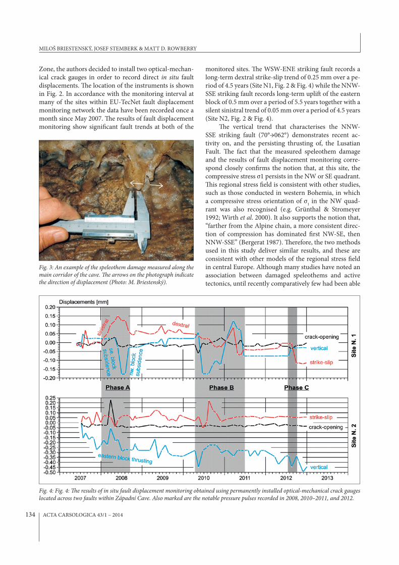
Zone, the authors decided to install two optical-mechan-ical crack gauges in order to record direct in situ fault displacements. >e location of the instruments is shown in Fig. 2. In accordance with the monitoring interval at many of the sites within EU-TecNet fault displacement monitoring network the data have been recorded once a month since May 2007. >e results of fault displacement monitoring show signi?cant fault trends at both of the
monitored sites. >e WSW-ENE striking fault records a long-term dextral strike-slip trend of 0.25 mm over a pe-riod of 4.5 years (Site N1, Fig. 2 & Fig. 4) while the NNW-SSE striking fault records long-term upli[ of the eastern block of 0.5 mm over a period of 5.5 years together with a silent sinistral trend of 0.05 mm over a period of 4.5 years (Site N2, Fig. 2 & Fig. 4).
>e vertical trend that characterises the NNW-SSE striking fault (70°→062°) demonstrates recent ac-tivity on, and the persisting thrusting of, the Lusatian Fault. >e fact that the measured speleothem damage and the results of fault displacement monitoring corre-spond closely con?rms the notion that, at this site, the compressive stress σ1 persists in the NW or SE quadrant. >is regional stress ?eld is consistent with other studies, such as those conducted in western Bohemia, in which a compressive stress orientation of σ
1 in the NW quad-
rant was also recognised (e.g. Grünthal & Stromeyer 1992; Wirth et al. 2000). It also supports the notion that, “farther from the Alpine chain, a more consistent direc-tion of compression has dominated ?rst NW-SE, then NNW-SSE” (Bergerat 1987). >erefore, the two methods used in this study deliver similar results, and these are consistent with other models of the regional stress ?eld in central Europe. Although many studies have noted an association between damaged speleothems and active tectonics, until recently comparatively few had been able
Fig. 3: An example of the speleothem damage measured along the main corridor of the cave. !e arrows on the photograph indicate the direction of displacement (Photo: M. Briestenský).
Fig. 4: Fig. 4: !e results of in situ fault displacement monitoring obtained using permanently installed optical-mechanical crack gauges located across two faults within Západní Cave. Also marked are the notable pressure pulses recorded in 2008, 2010–2011, and 2012.
MILOŠ BRIESTENSKÝ, JOSEF STEMBERK & MATT D. ROWBERRY
ACTA CARSOLOGICA 43/1 – 2014 135
to directly relate speleothem damage to direct measure-ments of fault displacement (Briestenský et al. 2011a; Camelbeeck et al. 2012).
>e fault displacement monitoring also shows nota-ble periods of increased geodynamic activity, referred to as pressure pulses, in 2008, 2010–2011, and 2012. >ese pressure pulses simultaneously interfere with the long-term displacement trends at both sites. >ree pulses have been registered since monitoring began in 2007 (Fig. 4 A, B, C). >e most susceptible instrument appears to be N1 as, at this locality, the pressure pulses seem to last for longer periods and induce larger displacement am-plitudes. >e long-term trend is one of progressive com-pression as shown by the eastward horizontal shi[ of the western block and upli[ of the eastern block (Fig. 4 &
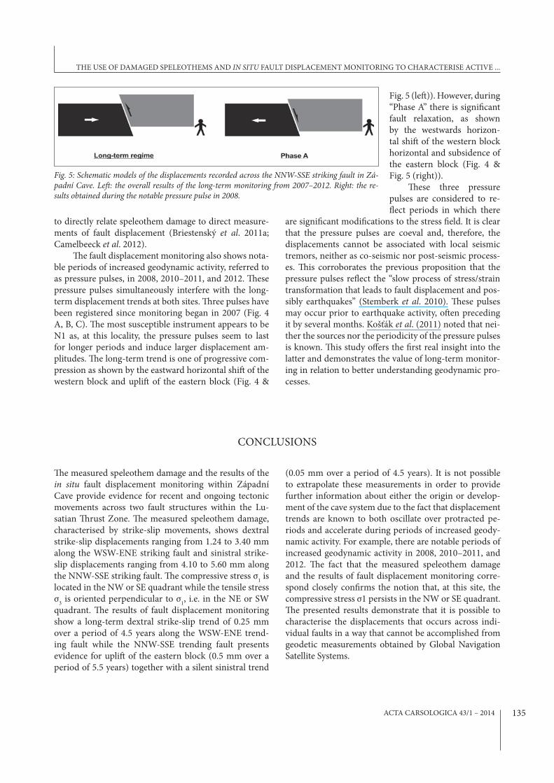
Fig. 5 (le[)). However, during “Phase A” there is signi?cant fault relaxation, as shown by the westwards horizon-tal shi[ of the western block horizontal and subsidence of the eastern block (Fig. 4 & Fig. 5 (right)).
>ese three pressure pulses are considered to re-Qect periods in which there
are signi?cant modi?cations to the stress ?eld. It is clear that the pressure pulses are coeval and, therefore, the displacements cannot be associated with local seismic tremors, neither as co-seismic nor post-seismic process-es. >is corroborates the previous proposition that the pressure pulses reQect the “slow process of stress/strain transformation that leads to fault displacement and pos-sibly earthquakes” (Stemberk et al. 2010). >ese pulses may occur prior to earthquake activity, o[en preceding it by several months. Košťák et al. (2011) noted that nei-ther the sources nor the periodicity of the pressure pulses is known. >is study o\ers the ?rst real insight into the latter and demonstrates the value of long-term monitor-ing in relation to better understanding geodynamic pro-cesses.
CONCLUSIONS
>e measured speleothem damage and the results of the in situ fault displacement monitoring within Západní Cave provide evidence for recent and ongoing tectonic movements across two fault structures within the Lu-satian >rust Zone. >e measured speleothem damage, characterised by strike-slip movements, shows dextral strike-slip displacements ranging from 1.24 to 3.40 mm along the WSW-ENE striking fault and sinistral strike-slip displacements ranging from 4.10 to 5.60 mm along the NNW-SSE striking fault. >e compressive stress σ
1 is
located in the NW or SE quadrant while the tensile stress σ
3 is oriented perpendicular to σ
1, i.e. in the NE or SW
quadrant. >e results of fault displacement monitoring show a long-term dextral strike-slip trend of 0.25 mm over a period of 4.5 years along the WSW-ENE trend-ing fault while the NNW-SSE trending fault presents evidence for upli[ of the eastern block (0.5 mm over a period of 5.5 years) together with a silent sinistral trend
(0.05 mm over a period of 4.5 years). It is not possible to extrapolate these measurements in order to provide further information about either the origin or develop-ment of the cave system due to the fact that displacement trends are known to both oscillate over protracted pe-riods and accelerate during periods of increased geody-namic activity. For example, there are notable periods of increased geodynamic activity in 2008, 2010–2011, and 2012. >e fact that the measured speleothem damage and the results of fault displacement monitoring corre-spond closely con?rms the notion that, at this site, the compressive stress σ1 persists in the NW or SE quadrant. >e presented results demonstrate that it is possible to characterise the displacements that occurs across indi-vidual faults in a way that cannot be accomplished from geodetic measurements obtained by Global Navigation Satellite Systems.
Fig. 5: Schematic models of the displacements recorded across the NNW-SSE striking fault in Zá-padní Cave. Le%: the overall results of the long-term monitoring from 2007–2012. Right: the re-sults obtained during the notable pressure pulse in 2008.
THE USE OF DAMAGED SPELEOTHEMS AND IN SITU FAULT DISPLACEMENT MONITORING TO CHARACTERISE ACTIVE ...

ACTA CARSOLOGICA 43/1 – 2014136
>e authors wish to acknowledge the ?nancial support provided by the Czech Ministry of Education, Youth, and Sports (COST OC 625.10), the Czech Science Foundation (GA205/05/2770, GA205/06/1828 & GA205/09/2024), and the Grant Agency of the Academy of Sciences of the
Czech Republic (IAA300120801). >e study was con-ducted within the framework of the research plan for the Institute of Rock Structure and Mechanics ASCR (A VOZ30460519) and CzechGeo/EPOS (Project No. LM2010008).
ACKNOWLEDGEMENTS
REFERENCES
Becker, A., Häuselmann, P., Eikenberg, J. & E. Gilli, 2012: Active tectonics and earthquake destructions in caves of northern and central Switzerland.- Interna-tional Journal of Speleology, 41, 1, 35–49.
Bergerat, F., 1987: Stress ?elds in the European platform at the time of Africa-Eurasia collision.- Tectonics, 6, 2, 99–132.
Bosák, P. & R. Horušický, 1978: Současný stav výzkumů krasových jevů Ještědského hřbetu [>e current state of research into karst phenomena along Ještěd Ridge].- Československý kras, 29, 47–52.
Briestenský, M., Košťák, B., Stemberk, J., Petro, L., Vozár, J. & L. Fojtíková, 2010: Active tectonic fault mi-crodisplacement analyses: a comparison of results from surface and underground monitoring in west-ern Slovakia.- Acta Geodynamica et Geomaterialia, 7, 4, 387–397.
Briestenský, M., Stemberk, J., Michalík, J., Bella, P. & M.D. Rowberry, 2011a: >e use of a karstic cave system in a study of active tectonics: fault move-ments recorded at Driny Cave, Malé Karpaty Mts (Slovakia).- Journal of Cave and Karst Studies, 73, 2, 114–123.
Briestenský, M., Stemberk, J. & Ľ. Petro, 2007: Displace-ments registered around the March 13th 2006 Vr-bové earthquake M = 3.2 (Western Carpathians).- Geologica Carpathica, 58, 5, 487–493.
Briestenský, M., >inová, L., Stemberk, J. & M.D. Row-berry, 2011b: >e use of caves as observatories for recent geodynamic activity and radon gas concen-trations in the Western Carpathians and Bohemian Massif.- Radiation Protection Dosimetry, 145, 2–3, 166–172.
Briestenský, M., >inová, L., Praksová, R., Stemberk, J., Rowberry, M.D. & Z. KnejQová, 2014: Radon, car-bon dioxide, and fault displacements in central Eu-rope related to the Tōhoku Earthquake.- Radiation Protection Dosimetry, doi: 10.1093/rpd/ncu090.
Budil, P., Štěpánek, P., Adamovič, J., Coubal, M., Chlupáč, I., Opletal, M. & J. Valečka, 1999: Examples of im-portant geological localities in the Sudetes (Czech Republic).- Polish Geological Institute Special Pa-pers, 2, 27–32.
Camelbeeck, T., Ruymbeke, M., Quinif, Y., Vandycke, S, Kerchove, E. & Z. Ping, 2012: Observation and in-terpretation of fault activity in the Rochefort cave (Belgium).- Tectonophysics, 581, 48–61.
Chaloupský, J. et al. 1989: Geologie Krkonoš a Jizerských hor [Geology of the Krkonoše and Jizerské Mts].- Academia, pp. 288, Prague.
Chlupáč, I., 1964: Nový nález fauny ve slabě metamor-fovaném paleozoiku Ještědského pohoří [New fau-nal ?nds in the low-grade metamorphic Paleozoic mountains of Ještěd].- Časopis pro mineralogii a geologii, 9, 1, 27–35.
Chlupáč, I., 1998: Poznámky k rozšíření devonu a stavbě metamorfovaného paleozoika v jižní a střední části Ještědského pohoří [Notes on the Devonian distri-bution and structure of metamorphosed Paleozoic rocks in southern and central parts of the Ještěd Mts].- Zprávy o geologických výzkumech v roce 1997, 19–22.
Coubal, M., 1989: Projevy saxonské tektogeneze v cen-trální části České křídové pánve [>e manifestation of Saxonian tectonics in the central part of the Bo-hemian Cretaceous Basin].- Manuscript, Archive of Czech Geological Institute, pp. 236, Prague.
Coubal, M., Čech, S., Málek, J. & V. Prouza, 1999: Lužický zlom.- Závěrečná zpráva grantového projektu GAČR č. 205/96/1754 [Lusatian Fault – ?nal report of grant project GAČR No. 205/96/1754].- Manuscript, Ar-chive of Czech Geological Institute, Prague.
Demek, J., 1987: Zeměpisný lexikon ČSR, hory a nížiny [Geographical lexicon of ČSR, mountains and low-lands].- Academia, pp. 584, Prague.
MILOŠ BRIESTENSKÝ, JOSEF STEMBERK & MATT D. ROWBERRY

ACTA CARSOLOGICA 43/1 – 2014 137
EU-TecNet, 2013: >e EU-TecNet monitoring network TM-71.- [Online] Available from: http://www.irsm.cas.cz/ext/tecnet/index.php [last accessed: 22 No-vember 2013].
Gilli, E., 2005: Review on the use of natural cave spele-othems as palaeoseismic or neotectonics indica-tors.- Comptes Rendus Geosciences, 337, 13, 1208–1215.
Grünthal, G. & D. Stromeyer, 1992: >e recent crustal stress ?eld in central Europe – trajectories and ?-nite-element modeling.- Journal of Geophysical Re-search, 97, B8, 11.805–11.820.
Hromas, J. et al. 2009: Jeskyně [Caves].- In: Mackovčin, P. & M., Sedláček (eds.): Chráněná území ČR [Pre-served areas of the Czech Republic].- Agentura ochrany přírody a krajiny ČR, pp. 608, Prague.
Jurková, N. & M. Briestenský, 2008: Recent movements along tectonic failures in Západní Cave (Ještěd Ridge, Northern Bohemia).- Slovenský kras, 46/25.
Kachlík, V., 2002: Geologická mapa 1:10 000, list 03–13–20 Kryštofovo údolí [Geological map 1:10 000, Sheet No 03–13–20 Kryštofovo údolí].- Manuscript, Ar-chive of Czech Geological Institute, Prague.
Kashima, N., 1993: Fracture of speleothems in Hoshino-no-ana Cave, Minami-Daito Island, Okinawa Pre-fecture, Southwest Japan.- Journal of the Speleolog-ical Society of Japan, 18, 33–41.
Klimeš, J., Rowberry, M.D., Blahůt, J., Briestenský, M., Hartvich, F., Košťák, B., Rybář, J., Stemberk, J. & P. Štěpančíková, 2012: >e monitoring of slow moving landslides and assessment of stabilisation measures using an optical-mechanical crack gauge.- Land-slides, 9, 3, 407–415.
Koliha, J., 1929: Svrchní devon v pohoří Ještědském [Up-per Devonian in Ještěd Mountains].- Věstník Stát-ního geologického Ústavu, 5, 268–292.
Kopecký, A., 1970: Neotektonický vývoj severních a severovýchodních Čech [Neotectonic development of northern and northeastern Bohemia].- Věstník Ústředního ústavu geologického, 45, 339–346.
Košťák, B., 1969: A new device for in situ movement de-tection and measurement.- Experimental Mechan-ics, 9, 8, 374–379.
Košťák, B., 1991: Combined indicator using moiré tech-nique.- In: Sorum G. (ed.) Field Measurements in Geomechanics, Proceedings of the 3rd International Symposium on Field Measurements in Geomechan-ics, 9th–11th September 1991, Oslo. Balkema, 53–60, Rotterdam.
Košťák, B., 2006: Deformation e\ects in rock massifs and their long-term monitoring.- Quarterly Jour-nal of Engineering Geology and Hydrogeology, 39, 249–258.
Košťák, B., Cacoń, S., Dobrev, N.D., Avramova-Tacheva, E., Fecker, E., Kopecký, J., Petro, Ľ., Schweizer, R. & A.A. Nikonov, 2007: Observations of tectonic mi-crodisplacements in Europe in relation to the Iran 1997 and Turkey 1999 earthquakes.- Izvestiya Phys-ics of the Solid Earth, 43, 6, 503–516.
Košťák, B., Mrlina, J., Stemberk, J. & B. Chán, 2011: Tec-tonic movements monitored in the Bohemian Mas-sif.- Journal of Geodynamics, 52, 1, 34–44.
Košťák, B. & K. Popp, 1966: Moiré strain gauges.- Strain, 2, 2, 1–12.
Kozdrój, W., Krentz, O. & M. Opletal, 2001: Comments on the geological map Lausitz-Jizera-Krkonoše (with-out Cenozoic sediments) 1: 100 000. Mit Geologische Karte und Legende.- Sächsisches Landesamt für Umwelt, Landwirtscha[ und Geologie, pp. 64, Frei-berg.
Kurka, J. & V. Bělohradský, 1979: Průběh a charakter lužického zlomu mezi obcemi Světlá pod Ještědem a Zdislava [>e course and character of the Lusati-an Fault between the villages of Světlá pod Ještědem and Zdislava].- Acta Musei Bohemiae Borealis, Sci-Acta Musei Bohemiae Borealis, Sci-entiae Naturales, 11, 185–196.
Malkovský, M., 1977: Důležité zlomy platformního pokry-vu severní části Českého masívu [Signi?cant faults in the platform cover of the northern Bohemian Mas-sif].- Výzkumné práce Ústředního Ústavu Geolog-ického, pp 30, Prague.
Malkovský, M., 1979: Tektogeneze platformního pokryvu Českého masívu [Tectonogenetic platform cover of the Bohemian Massif].- Ústřední ústav geologický, pp. 176, Prague.
Marti, X., Rowberry, M.D. & J. Blahůt, 2013: A MATLAB® code for counting the moiré interference fringes re-corded by the optical-mechanical crack gauge TM-71.- Computers & Geosciences, 52, 164–167.
Oster, G. & Y. Nishijima, 1963: Moiré patterns.- Scien-ti?c American, 208, 5, 54–63.
Pošmourný, K., 1967: Geologicko-petrogra?cké poměry krystalinika západní části Ještědského hřbetu [Geo-logical and petrographical situation of the crystal-line complex in the western part of Ještěd Ridge].- Acta Musei Bohemiae Borealis, Scientiae Naturales, 3, 15–25.
Šebela, S., 2008: Broken speleothems as indicators of tec-tonic movements.- Acta Carsologica, 37, 52–62.
Skřivánek, F. & J. Hromas, 1961: Plán Západní jeskyně [Map of Západní Cave].- Archiv Základní Orga-nizace České Speleologické Společnosti 4–01, Li-berec.
THE USE OF DAMAGED SPELEOTHEMS AND IN SITU FAULT DISPLACEMENT MONITORING TO CHARACTERISE ACTIVE ...

ACTA CARSOLOGICA 43/1 – 2014138
Stemberk, J., Košťák, B. & S. Cacoń, 2010: A tectonic pressure pulse and increased geodynamic activity recorded from the long-term monitoring of faults in Europe.- Tectonophysics, 487, 1–12.
Stemberk, J., Košťák, B. & V. Vilímek, 2003: 3D monitor-ing of active tectonic structures.- Journal of Geody-namics, 36, 1–2, 103–112.
Vyskočil, P. & A. Kopecký, 1974: Neotectonics and re-cent crustal movements in the Bohemian Mas-sif.- Výzkumný ústav geodetický, topogra?cký a kartogra?cký (VÚGTK), pp. 179, Prague.
Wirth, W., Plene?sch, T., Klinge, K., Stammler, K. & D. Seidl, 2000: Focal mechanisms and stress ?eld in the region Vogtland/Western Bohemia.- Studia Geophysica et Geodaetica, 44, 2, 126–141.
MILOŠ BRIESTENSKÝ, JOSEF STEMBERK & MATT D. ROWBERRY