The Ulten Valley In South Tyrol, Italy: Vegetation and Settlement History of the Area, and...
12
ISSN 1816-4374 Palyno-Bulletin Vol. 1 - NO. 1-2(2005) Special Issue: Late Glacial and Holocene Vegetation, Climate and Anthropogenic History of the Tyrol and Adjacent Areas (Austria, Switzerland, Italy) Institute of Botany - University of Innsbruck, Austria
-
Upload
independent -
Category
Documents
-
view
4 -
download
0
Transcript of The Ulten Valley In South Tyrol, Italy: Vegetation and Settlement History of the Area, and...

ISSN 1816-4374
Palyno-Bulletin
Vol. 1 - NO. 1-2(2005)
Special Issue: Late Glacial and Holocene Vegetation, Climate and Anthropogenic
History of the Tyrol and Adjacent Areas (Austria, Switzerland, Italy)
Institute of Botany - University of Innsbruck, Austria

Palyno-Bulletin Vol.1
The Ulten Valley in South Tyrol, Italy: Vegetation and Settlement History of the Area, and Macrofossil Record from
the Iron Age Cult Site of St. Walburg
Andreas G. Heiss, Werner Kofler, & Klaus Oeggl
Macrofossil analysis of an Iron Age burnt-offering place gave evidence on fully developed agriculture in an area once considered uninhabited prior to the Middle Ages. Further information was acquired on human impact on forest habitats, and on ritual praxis. Pollen, extrafossils, stomata and charcoal analyses from Totenmoos bog show the vegetation development and the human impact in the Ulten Valley since the Bølling.
Late Glacial - Holocene - Palynology - Archaeobotany - Iron Age - Burnt-offering-place - Forestry Management - Climate change - Human impact - Fire - Italy
Introduction General Information on the Area
The municipality of Ulten/Ultimo divides into the three districts of St. Walburg/S. Valpurga (1,190 m.a.s.l.), St. Nikolaus/S. Nicolo (1,271 m.a.sl.), and St. Gertraud/S. Gertrude/ (1,519 m.a.s.l.) and is situated in the Ultental/Val d'Ultimo, a tributary valley of the Etsch/Adige valley in northern Italy (Fig. 1).
Fig. 1: Location of Ulten/Ultimo in South Tyrol/Alto Adige, northern Italy).
From the east, beginning at Lana, it runs about 30 kilometres in a westward direction towards Ortler Mountain. The climate is of the humid temperate type, with humid and cold winters and cool summers
('Dfc' in Köppen classification). The climate diagram from the meteorological station at St. Walburg (Fliri 1975, see Fig. 2) contains only partial information, as no temperature data were available. Data from the closest site comparable to Ulten's climate is from Reschen (about 50 km to the northwest, linear distance). However, in St. Walburg the summer precipitation maximum typical for this part of the Alps is replaced by two precipitation peaks in June and October respectively.
The geology of the valley (Fig. 3) is highly dominated by the metamorphic crystalline rocks of the Ortler Range: the local bedrock is formed by quartz phyllites (the northern ridge mainly), gneiss (to the south), and granite (to the east). Though basically being a U-shaped valley shaped by glaciation, the section between St. Walburg and the mouth of the Ultental is formed by two deep gorges, cut into the rock by Pleistocene glacial melting water, as well as by the Falschauer brook during the Holocene. This made it very difficult to access the valley from Lana until the construction of an access road between 1904 and 1907 (Fischer 1985).
63
Ulten Ultimo
Bozen Bolzano
50 km

Palyno-Bulletin Vol. 1
Fig. 3: Geological overview of the region around the Ultental (Autonome Provinz Bozen 2001, modified).
Local actual vegetation is dominated by coniferous forests (Fig. 4), from the montane spruce forests at the lower valley-sides (with few places of pine as well as spruce-fir forests south of St. Walburg) up to the subalpine forests dominated by spruce, or by larch and Swiss stone pine. Hardwood vegetation is only of minor importance in the Ultental, and limited to riparian mixed forests of grey alder and birch (Peer 1995). Human impact is nowadays strongly reflected by the high abundance of cultivated fields and
hay meadows, and many mountain pastures. Due to the altitude and a thence rougher climate, orchards are of nearly no importance in the Ultental, very unlike the adjacent Vinschgau region. As documented for the 20th century (1928-1972; Fischer 1985), rye is today the predominantly cultivated cereal (as both a spring grain and winter grain), followed by wheat and to a smaller extent barley, oats, and root crops.
64
Reschenpass 1461 m
4.8 Grad C 604 mm
St. Walburg 1264 m 826 m m
D fc
Nie
ders
chla
g
[mm
]
Nie
ders
chla
g
[mm
] Monat
Monat
Tem
peratur [Grad C
]
Fig. 2: Climate diagrams of St. Walburg (data from Fliri 1975) and Reschen (Mühr 2000-2005). Only precipitation data for St. Walburg were available.
Geological overview
Mica-schist
Ortler quartz phyllite
Bozen quartz porphyry
Brixen quartz phyllite
Weisshorn dolomite
Ifing granite
Kreuzberg granite
Gneiss (paragneiss and granite-gneiss)
Mendelzug
Mölten permoskyth

Palyno-Bulletin Vol.1
Actual vegetation
Fig. 4: Actual vegetation of the region (Peer 1995, modified).
The Pollen Record from Totenmoos bog: Late glacial and Holocene Vegetation History
Site description, actual vegetation, Materials and Methods The bog-sediment core was sampled from Totenmoos (Gauss-Boaga X: 655449, Gauss-Boaga Y: 155585), a bog located at an altitude of 1718 m.a.s.l in the Ultental (South Tyrol, Italy, Fig. 1, 3 and 4). A core 800 cm in length was recovered from the deepest point of the bog, which covers a area of 0.46 ha. The bog vegetation is affected by cow-pasturing and is characterised by Sphagnum sp., Eriophorum vaginatum, Carex pauciflora, Drosera rotundifolia, Calluna vulgaris. Young Picea trees are also present. The surrounding forest is dominated by Picea and Larix (Larici-Piceetum).
Sediment samples, 1 cm each, were taken from contiguous 5 cm intervals of the core for pollen, charcoal, extrafossils and stomata analysis. Samples were gently washed with distilled water through a sieve of 150 urn and treated with acetolysis and HF procedures. A minimum of 1000 terrestrial pollen (spores excluded) were counted from most samples. Chronozones (see below) follow Welten (1982).
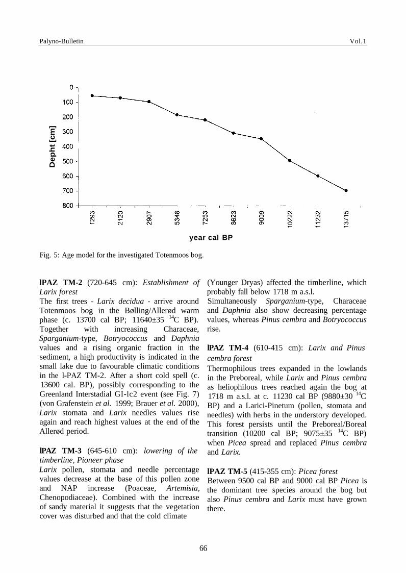
Results Chronology
An age model (linear interpolation between datum points) was developed from ten mass accelerator dates using calendar ages (Fig. 5) Based on OxCal 3.9 (Bronk Ramsey 2003) radiocarbon years were converted to calendar dates.
Vegetation development
The results of pollen, extrafossils, needles, stomata and charcoal analysis at Totenmoos show the vegetation development at 1718 m a.s.l. since approximately the Bølling (Fig. 6).
lPAZ TM-1 (790-720 cm): Development of pioneer vegetation After the ice retreat high erosional input is shown by silty sand, which show high pollen sums. A herbaceous pioneer vegetation (Poaceae, Artemisia, Chenopodiaceae, Helianthemum etc. was locally present in the first phase. The onset of the Juniperus-Hippophae shrub phase is probably indicated by small increases in Juniperus, Hippophae, Betula and Salix percentage values during the Bølling (740 cm).
65
Pioneer Vegetation on acidic substrata Alpine grass heaths on acidic substrata Dwarf shrub communities on acidic substrata Dwarf juniper heath Mugo pine heath Green alder brushwood and tall perennial herb communities Larch and Swiss stone pine forest Larch forest Larch meadow Subalpine spruce forest Montane spruce forest Spruce and fir forest Beech and fir forest Silicole beech forest Carbonate beech forest Silicole pine forest Carbonate pine forest Pine and milkvetch forest Downy oak and pine forest Dry meadow Extensively used meadows on acidic substrata Downy oak forest Hophornbeam and flowering ash forest Canyon forest Grey alder and birch wood Black alder forest Willow brushwood Fields and hay meadows Orchard Vineyard Lake Glacier
Palyno-Bulletin Vol.1
Fig. 5: Age model for the investigated Totenmoos bog.
lPAZ TM-2 (720-645 cm): Establishment of Larix forest The first trees - Larix decidua - arrive around Totenmoos bog in the Bølling/Allerød warm phase (c. 13700 cal BP; 11640±35 14C BP). Together with increasing Characeae, Sparganium-type, Botryococcus and Daphnia values and a rising organic fraction in the sediment, a high productivity is indicated in the small lake due to favourable climatic conditions in the l-PAZ TM-2. After a short cold spell (c. 13600 cal. BP), possibly corresponding to the Greenland Interstadial GI-lc2 event (see Fig. 7) (von Grafenstein et al. 1999; Brauer et al. 2000), Larix stomata and Larix needles values rise again and reach highest values at the end of the Allerød period.
lPAZ TM-3 (645-610 cm): lowering of the timberline, Pioneer phase Larix pollen, stomata and needle percentage values decrease at the base of this pollen zone and NAP increase (Poaceae, Artemisia, Chenopodiaceae). Combined with the increase of sandy material it suggests that the vegetation cover was disturbed and that the cold climate
(Younger Dryas) affected the timberline, which probably fall below 1718 m a.s.l. Simultaneously Sparganium-type, Characeae and Daphnia also show decreasing percentage values, whereas Pinus cembra and Botryococcus rise.
lPAZ TM-4 (610-415 cm): Larix and Pinus cembra forest Thermophilous trees expanded in the lowlands in the Preboreal, while Larix and Pinus cembra as heliophilous trees reached again the bog at 1718 m a.s.l. at c. 11230 cal BP (9880±30 14C BP) and a Larici-Pinetum (pollen, stomata and needles) with herbs in the understory developed. This forest persists until the Preboreal/Boreal transition (10200 cal BP; 9075±35 14C BP) when Picea spread and replaced Pinus cembra and Larix.
lPAZ TM-5 (415-355 cm): Picea forest Between 9500 cal BP and 9000 cal BP Picea is the dominant tree species around the bog but also Pinus cembra and Larix must have grown there.
66
year cal BP
De
ph
t [c
m]

Palyno-Bulletin Vol.1
Fig. 6: Totenmoos: pollen and extrafossil percentage values for major taxa are shown (BP = AD 1950). Pollen percentage values were calculated from the total terrestrial pollen sum (Cyperaceae and Rosaceae excluded).
67

Palyno-Bulletin Vol.1
Fig. 7: Climate proxies for cold phases in the Eastern Alps and alpine foreland. A+B+C) Larix pollen, Larix stomata, Larix needle and Pinus sp. percentage values from Totenmoos bog (this study). D) S180 from Ammersee (von Grafenstein et al., 1999).
68
9880 ± 30 14C BP 11232 ± 70 cal BP
11640 ± 35 14C BP 13306 ± 220 cal BP
Pollen
Stomata
Brauer et al. (2000) von Grafenstein et al. (1999)
year cal BP (before 1950)

Palyno-Bulletin Vol.1
lPAZ TM-6 (355-95 cm): Picea-Abies forest Beginning 9000 cal BP (8065±30 14C BP; Boreal/Atlantic transition) Abies alba shows a nearly continuous curve indicating that fir has increasing importance in the dense Picea forest around and below the bog. First pollen indicative for anthropogenic influence (Plantago lanceolata) occur in the Neolithic (c. 5350 cal BP; 4710±30 14C BP) and are probably part of the distance transport from the valleys. The local human influence on vegetation began c. 4000 year cal BP and is reflected by a continuous Plantago lanceolata curve, rising Larix percentage values (Larix meadows) and rising charcoal influx values (charcoal >50 µm and >100 µm). Cross-correlations (charcoal influx values/pollen percentage values; Tinner et al., 1999) indicate that Larix, Juniperus and Poaceae expansion was favoured by fire, whereas Abies alba and Picea where reduced by fire. The first Cerealia pollen grain was found in the Bronze Age (c. 3200 cal BP).
lPAZ TM-7 (95-1 cm): Forest opening and meadows The proportion of AP (Abies, Picea) decrease, whereas indicators for pasturing (Poaceae, Juniperus, Ericaceae, Rumex-type, Plantago lanceolata and Urticaceae) increase since the late Bronze Age (2900 cal BP; 2815±25 14C BP). Simultaneous heliophilous shrubs and trees (Larix, Alnus, Betula, Corylus) show increasing tendency. As shown by the AP/NAP ratios the strongest human influence in the forest around the Totenmoos bog could be detected during the Iron Age as well as for the Middle Ages and modern Times. A recovery of the forest, indicated by rising AP, is shown in the Roman Times. The occurrence of Olea during the Middle Ages is due to long-distance transport, whereas high percentage values of Secale cereale (first occurrence c. 1300 cal BP; 1385±35 14C BP) and the finding of Centaurea cyanus indicate that rye was cultivated near the bog at 1718 m a.s.l. Increasing pasturing in the Middle Ages is also indicated by the coprophilous fungi Podospora, Cercophora, Sordaria and Sporormiella.
Settlement History and the Burnt-Offering Place of St.Walburg Until the early twenties of the 20th century the Ultental was commonly considered an uninhabited area before the Middle Ages, mainly due to the difficult access situation mentioned above, and to a lack of archaeological finds from prehistoric times. But indeed the valley had always been accessible, not only from the east (Etschtal), but also from the south. Several mountain passes connect the Ultental with the settlement areas of the Nonstal/Val di Non and the Gardasee/Lago di Garda.
Shards from Iron Age pottery discovered in 1967 at the Kirchbichl (church hill) of St. Walburg were the first evidence for prehistoric settlement in the Ultental (Steiner 2003). Archaeological finds from even earlier epochs, namely silex artefacts, were discovered in 1985 at several mountain passes, documenting at least inspections of the valley as early as the Mesolithic.
69
Fig. 8: Aerial view of the Kirchbichl and the excavation site (photo: Karl Gruber).

Palyno-Bulletin Vol.1
Fig. 9: Partial reconstruction of the sacrificial site (photo: Hans Nothdurfter).
Also in the last century's eighties, an excavation campaign carried out at the Kirchbichl (Fig. 8) of St. Walburg revealed an early Iron Age settlement, which had been continuously inhabited from the Hallstatt period Ha A1/B1 (about 1,200-1,000 BC) until Ha D2/3 (about 500 BC), as documented by Nothdurfter (1989, 1992) and Steiner (2003).
Then, in 5th/6th century BC, the settlement had been abandoned, then levelled, and overbuilt with a ritual site for burnt offerings (Brandopferplatz, see Fig. 9). The huge sanctuary had been established atop an artificial terrace of about 70 x 15-25 m, fortified by supporting walls facing uphill and downhill respectively. Five altars in a row (some of them merged during later construction phases), two large stone circles, and a parallel row of eleven clay slabs with scorched surfaces were discovered, all embedded in immense layers of carbonised material with thicknesses up to 50 cm. Archaeological analyses as well as numerous radiocarbon data indicated maintenance of this sanctuary from ca. 500 BC to ca. 200 BC.
The structure of the site, unique to the Alpine area, points to Mediterranean, perhaps Etruscan archetypes (Nothdurfter 1992, Weiss 1997).
Macrofossil Results from the Burnt-Offering Place, and Implications on Vegetation History With the purpose of highlighting historico-cultural aspects as sacrificial rites, as well as adding new information on the history of cultivated plants, a supra-regional project is currently concentrating on the analysis of carbonised plant remains from several Iron Age burnt-offering places in the Alps. Due to its unique complexity, the sanctuary of Ulten is a pivotal part of that project.
Up to now, about 77 kg of soil material from Ulten have been analysed according to standard procedures (Jacomet and Kreuz 1999). Considering the very bad preservation conditions in a burnt-offering place (optimal oxygen supply, repeated burning of the material) a substantial amount of cultivated plants could be identified, though only in small quantities. Surprisingly enough, even evidence for oilseeds could be produced.
The major part of the plant offerings consisted of cereal gruel or bread (Fig. 10), whereof two components were identified: foxtail millet (Fig. 10.2) and einkorn or emmer (Fig. 10.3). The other food plants were available as single grains.
70

Palyno-Bulletin Vol.1
Fig. 10: Carbonised bread/gruel from the St. Walburg sanctuary. 1 fragment of the carbonised mass, scale bar = 1 mm, 2 detail: SEM image of a contained caryopsis of Setaria italica (foxtail millet), 3 detail: SEM image of transverse cells of the caryopsis of Triticum monococcum/T. dicoccum (einkorn/emmer).
Fig. 11: Carbonised cultivated plant remains from the pyre of St. Walburg. 1 Hordeum vulgare (hulled barley), 2 Panicum miliaceum (broomcorn millet), 3 Vicia faba (broad bean), 4 Linum usitatissimum (linseed, flax), 5 Papaver somniferum (opium poppy). Scale bars = 1 mm.
Fig. 12: Carbonised wild plant diaspores from the burnt-offering place. 1 Fallopia convolvulus (black bindweed), 2 Polygonum aviculare (prostrate knotweed), 3 Chenopodium hybridum (mapleleaf goosefoot), 4 Sherardia arvensis (blue fieldmadder), 5 Carex muricata agg. (prickly sedge group). Scale bar = 1 mm.
The list of all identified cultivated plants is as follows: Cereals Hordeum vulgare (hulled barley, Fig. 11.1) Panicum miliaceum (broomcorn millet, Fig. 11.2) Setaria italica (foxtail millet, Fig. 10.2) Triticum sp. (wheat) Triticum aestivum / T durum / T turgidum (naked wheat)
Triticum dicoccum (emmer) Triticum monococcum (einkorn) Pulses Vicia faba (broad bean), Fig. 11.3 Oilseeds Linum usitatissimum (linseed, flax, Fig. 11.4) Papaver somniferum (opium poppy, Fig. 11.5)
71

Palyno-Bulletin Vol.1
Besides the cultivated plants, carbonised remains of various wild species were identified, predominantly arable weeds (see Fig. 12). The presence of diaspores of both field crops and arable weeds in the offerings strongly indicates an immolation of cultivated plants coming directly from the fields, maybe in the form of sheaves. Another consequence of this conjoint occurrence is the strong suggestion that the offered food plants were cultivated locally during Iron Age (even warmth demanding cereals like Panicum and Setaria), and not imported.
Another instructive component of the identified macro remains was charcoal: the fuel wood from the pyres of Ulten has already been analysed in large part. The summary of the results is as following:
• Species compositions at Ulten and at Feldkirch-Altenstadt (another site investigated within the project) gave no evidence for any firewood selection as to species. In fact, the charcoal fragments reflected rather well the local vegetation to be expected in the respective area.
• The presence of pioneer woody species (as Betula in the Ulten record) indicated wood gathering from places influenced by human impact, where reforestation had still been going on (maybe the close surroundings of the settlement?).
• However, a very clear selection had been made in terms of wood quality: none of the observed charcoal fragments had originated from branches/trunks thicker than 20 cm, with 80% of the stems not exceeding 10 cm in diameter.
To conclude the current phase of research on the Ulten macrofossils, we now have reliable evidence that a wide spectrum of field crops were cultivated in the Ulten area during Iron Age (Hallstatt), including "thermophilic" millets.
Furthermore, it can be said with high probability that Iron Age local forest vegetation did not seriously differ from the current state, and also
that human interference on forest ecosystems (i.e. forestal measures) had already taken place.
Acknowledgements This work was supported by the Austrian Science Fund (FWF), which we greatly acknowledge.
References Autonome Provinz Bozen (ed.) 2001. EarthBrowser.
Website. http://www.provinz.bz.it/hochbau/1106/Earthbr owser/index_d.htm.
Brauer, A., Günter, C, Johnsen, S.J., and Negendank, J.F.W. 2000. Land-ice teleconnections of cold climatic periods during the last Glacial/Interglacial transition. Climate Dynamics 2/3: 229-239.
Bronk Ramsey, C. 1995. Radiocarbon calibration and analysis of stratigraphy: The OxCal program. Radiocarbon 37: 425-430.
Fischer, K. 1985. Das Ultental - Beitrag zur Geographie eines Südtiroler Hochtales. Der Schlern Heft 1:203-253.
Fliri, F. 1975. Das Klima der Alpen im Räume von Tirol. Monographien zur Landeskunde Tirols, Vol. 1. Universitätsverlag Wagner, Innsbruck-München: 454 pp.
Jacomet, S., Kreuz, A. 1999. Archäobotanik. Verlag Eugen Ulmer, Stuttgart: 368 pp.
Mühr, B. 2000-2005. Klimadiagramme. Website. http://www.klimadiagramme.de/Frame/indexeu. html.
Nothdurfter, H. 1985. Ulten, St. Walburg, Brandopferplatz. Denkmalpflege in Südtirol 1987/88. Landesdenkmalamt Bozen, Verlag Athesia: 53-59.
Nothdurfter, H. 1992. Die Fritzens-Sanzeno-Kultur und ihre Beziehungen zur etruskischen Kultur. In: Etrusker nördlich von Etrurien. Akten des Symposions Wien - Schloss Neuwaldegg. Österr. Akad. Wiss. Phil.-hist. Kl. Sitzungsberichte 589 (1992): 45-62.
Peer, T. 1995. Die natürliche Pflanzendecke Südtirols. Begleittext zur Karte der natürlichen Vegetation 1:200.000. Bozen. 32 pp + Karte.
Steiner, H. 2003. Spätbronze- bis ältereisenzeitliche Siedlung in St. Walburg in Ulten. Der Schlern Heft 8/9 (7): 4-33.
72

Palyno-Bulletin Vol.1
Tinner, W., Hubschmid, P., Wehrli, M., Ammann, B. & Conedera, M. 1999. Long-term forest fire ecology and dynamics in southern Switzerland. Journal of Ecology 87: 273-289.
von Grafenstein, U., Erlenkeuser, H., Brauer, A., Jouzel, J., Johnsen, S.J. 1999. Mid-European Decadal Isotope-Climate Record from 15,500 to 5000 Years B.P. Science Vol 284: 1654-1657.
Weiss, R.-M. 1997. Prähistorische Brandopferplätze in Bayern. Internationale Archäologie 35.
Welten, M. 1982. Vegetationsgeschichtliche Untersuchungen in den Schweizer Alpen: Bern-Wallis. Denkschriften der Schweizerischen Naturforschenden Gesellschaft 95: 1-104 u. Diagrammheft.
Andreas G. Heiss Werner Kofler Klaus Oeggl
University of Innsbruck Department of Botany Division of Palynology, Systematics and Geobotany Sternwartestraße 15 A-6020 Innsbruck Austria
[email protected] [email protected] [email protected]
73