The Ulaca Oppidum (Central Spain) as a Case Study - MDPI
22
Citation: Maté-González, M.Á.; Rodríguez-Hernández, J.; Sáez Blázquez, C.; Troitiño Torralba, L.; Sánchez-Aparicio, L.J.; Fernández Hernández, J.; Herrero Tejedor, T.R.; Fabián García, J.F.; Piras, M.; Díaz-Sánchez, C.; et al. Challenges and Possibilities of Archaeological Sites Virtual Tours: The Ulaca Oppidum (Central Spain) as a Case Study. Remote Sens. 2022, 14, 524. https://doi.org/10.3390/ rs14030524 Academic Editor: Mercedes Solla Received: 28 December 2021 Accepted: 20 January 2022 Published: 22 January 2022 Publisher’s Note: MDPI stays neutral with regard to jurisdictional claims in published maps and institutional affil- iations. Copyright: © 2022 by the authors. Licensee MDPI, Basel, Switzerland. This article is an open access article distributed under the terms and conditions of the Creative Commons Attribution (CC BY) license (https:// creativecommons.org/licenses/by/ 4.0/). remote sensing Article Challenges and Possibilities of Archaeological Sites Virtual Tours: The Ulaca Oppidum (Central Spain) as a Case Study Miguel Ángel Maté-González 1,2,3,4, * , Jesús Rodríguez-Hernández 5 , Cristina Sáez Blázquez 2,3,6 , Libertad Troitiño Torralba 3,7 , Luis Javier Sánchez-Aparicio 2,3,8 , Jesús Fernández Hernández 2 , Tomás Ramón Herrero Tejedor 9 , José Francisco Fabián García 10 , Marco Piras 4 , Carlos Díaz-Sánchez 5 , Diego González-Aguilera 2,3 , Gonzalo Ruiz Zapatero 5 and Jesús R. Álvarez-Sanchís 5 1 Department of Topographic and Cartography Engineering, Escuela Técnica Superior de Ingenieros en Topografía, Geodesia y Cartografía, Universidad Politécnica de Madrid, Mercator 2, 28031 Madrid, Spain 2 Department of Cartographic and Land Engineering, Higher Polytechnic School of Ávila, Universidad de Salamanca, Hornos Caleros 50, 05003 Ávila, Spain; [email protected] (C.S.B.); [email protected] (L.J.S.-A.); [email protected] (J.F.H.); [email protected] (D.G.-A.) 3 Gran Duque de Alba Institution, Diputación Provincial de Ávila, Paseo Dos de Mayo, 8, 05001 Ávila, Spain; [email protected] 4 Department of Environment, Land and Infrastructure Engineering, Politecnico di Torino, 10129 Torino, Italy; [email protected] 5 Department of Prehistory, Ancient History and Archaeology, Complutense University of Madrid, Prof. Aranguren s/n, 28040 Madrid, Spain; [email protected] (J.R.-H.); [email protected] (C.D.-S.); [email protected] (G.R.Z.); [email protected] (J.R.Á.-S.) 6 Department of Electric, System and Automatic Engineering, Universidad de León, Campus Vegazana, s/n, 24007 León, Spain 7 Department of Human Geography, Complutense University of Madrid, Prof. Aranguren s/n, 28040 Madrid, Spain 8 Department of Construction and Architectural Technology, Escuela Técnica Superior de Arquitectura de Madrid, Universidad Politécnica de Madrid, Avda. Juan de Herrera 4, 28040 Madrid, Spain 9 Department of Agroforestry Engineering, Escuela Técnica Superior de Ingeniería Agronómica, Alimentaria y de Biosistemas, Universidad Politécnica de Madrid, Campus Ciudad Universitaria, Av. Puerta de Hierro, nº 2–4, 28040 Madrid, Spain; [email protected] 10 Servicio Territorial de Cultura de Ávila, Junta de Castilla y León, Plaza Fuente el Sol, s/n, 05001 Ávila, Spain; [email protected] * Correspondence: [email protected] or [email protected]; Tel.: +34-920-35-35-00 Abstract: This research presents a virtual tour performed on the oppidum of Ulaca, one of the most relevant archaeological sites of the Iberian Peninsula during the Late Iron Age (ca. 400–50 BC). Beyond the clear benefits of the tool to the interpretation, dissemination, and knowledge of the mentioned archaeological site and its surroundings, the novelty of this research is the implemen- tation of the platform in alternative scenarios and purposes. In this way, the present work verifies how the access to multi-source and spatially geolocated information in the same tool (working as a geospatial database) allows the promotion of cross-sectional investigations in which different specialists intervene. This peculiarity is also considered useful to promote tourism with an interest beyond the purely historical/archaeological side. Likewise, the possibility of storing and managing a large amount of information in different formats facilitates the investigation in the contexts of excavations and archaeological or environmental works. In this sense, the use of this kind of tool for the study of cultural landscapes is especially novel. In order to better contextualize the potential of the virtual tour presented here, an analysis about the challenges and possibilities of implementing this tool in environments such as the Ulaca oppidum is performed. The selected site stands out for: (i) being in a unique geological, environmental and ecological context, allowing us to appreciate how human beings have modified the landscape over time; (ii) presenting numerous visible archaeological remains with certain conservation problems; and (iii) not having easy access for visitors. Keywords: oppidum; vettones; virtual tour; cultural heritage; cultural landscapes Remote Sens. 2022, 14, 524. https://doi.org/10.3390/rs14030524 https://www.mdpi.com/journal/remotesensing
-
Upload
khangminh22 -
Category
Documents
-
view
5 -
download
0
Transcript of The Ulaca Oppidum (Central Spain) as a Case Study - MDPI
�����������������
Citation: Maté-González, M.Á.;
Rodríguez-Hernández, J.;
Sáez Blázquez, C.; Troitiño Torralba, L.;
Sánchez-Aparicio, L.J.;
Fernández Hernández, J.;
Herrero Tejedor, T.R.; Fabián García, J.F.;
Piras, M.; Díaz-Sánchez, C.; et al.
Challenges and Possibilities of
Archaeological Sites Virtual Tours:
The Ulaca Oppidum (Central Spain) as
a Case Study. Remote Sens. 2022, 14,
524. https://doi.org/10.3390/
rs14030524
Academic Editor: Mercedes Solla
Received: 28 December 2021
Accepted: 20 January 2022
Published: 22 January 2022
Publisher’s Note: MDPI stays neutral
with regard to jurisdictional claims in
published maps and institutional affil-
iations.
Copyright: © 2022 by the authors.
Licensee MDPI, Basel, Switzerland.
This article is an open access article
distributed under the terms and
conditions of the Creative Commons
Attribution (CC BY) license (https://
creativecommons.org/licenses/by/
4.0/).
remote sensing
Article
Challenges and Possibilities of Archaeological Sites VirtualTours: The Ulaca Oppidum (Central Spain) as a Case StudyMiguel Ángel Maté-González 1,2,3,4,* , Jesús Rodríguez-Hernández 5 , Cristina Sáez Blázquez 2,3,6 ,Libertad Troitiño Torralba 3,7, Luis Javier Sánchez-Aparicio 2,3,8 , Jesús Fernández Hernández 2 ,Tomás Ramón Herrero Tejedor 9 , José Francisco Fabián García 10, Marco Piras 4 , Carlos Díaz-Sánchez 5 ,Diego González-Aguilera 2,3 , Gonzalo Ruiz Zapatero 5 and Jesús R. Álvarez-Sanchís 5
1 Department of Topographic and Cartography Engineering, Escuela Técnica Superior de Ingenieros enTopografía, Geodesia y Cartografía, Universidad Politécnica de Madrid, Mercator 2, 28031 Madrid, Spain
2 Department of Cartographic and Land Engineering, Higher Polytechnic School of Ávila, Universidad deSalamanca, Hornos Caleros 50, 05003 Ávila, Spain; [email protected] (C.S.B.); [email protected] (L.J.S.-A.);[email protected] (J.F.H.); [email protected] (D.G.-A.)
3 Gran Duque de Alba Institution, Diputación Provincial de Ávila, Paseo Dos de Mayo, 8, 05001 Ávila, Spain;[email protected]
4 Department of Environment, Land and Infrastructure Engineering, Politecnico di Torino, 10129 Torino, Italy;[email protected]
5 Department of Prehistory, Ancient History and Archaeology, Complutense University of Madrid, Prof.Aranguren s/n, 28040 Madrid, Spain; [email protected] (J.R.-H.); [email protected] (C.D.-S.);[email protected] (G.R.Z.); [email protected] (J.R.Á.-S.)
6 Department of Electric, System and Automatic Engineering, Universidad de León, Campus Vegazana, s/n,24007 León, Spain
7 Department of Human Geography, Complutense University of Madrid, Prof. Aranguren s/n,28040 Madrid, Spain
8 Department of Construction and Architectural Technology, Escuela Técnica Superior de Arquitectura deMadrid, Universidad Politécnica de Madrid, Avda. Juan de Herrera 4, 28040 Madrid, Spain
9 Department of Agroforestry Engineering, Escuela Técnica Superior de Ingeniería Agronómica, Alimentaria yde Biosistemas, Universidad Politécnica de Madrid, Campus Ciudad Universitaria, Av. Puerta de Hierro,nº 2–4, 28040 Madrid, Spain; [email protected]
10 Servicio Territorial de Cultura de Ávila, Junta de Castilla y León, Plaza Fuente el Sol, s/n, 05001 Ávila, Spain;[email protected]
* Correspondence: [email protected] or [email protected]; Tel.: +34-920-35-35-00
Abstract: This research presents a virtual tour performed on the oppidum of Ulaca, one of the mostrelevant archaeological sites of the Iberian Peninsula during the Late Iron Age (ca. 400–50 BC).Beyond the clear benefits of the tool to the interpretation, dissemination, and knowledge of thementioned archaeological site and its surroundings, the novelty of this research is the implemen-tation of the platform in alternative scenarios and purposes. In this way, the present work verifieshow the access to multi-source and spatially geolocated information in the same tool (workingas a geospatial database) allows the promotion of cross-sectional investigations in which differentspecialists intervene. This peculiarity is also considered useful to promote tourism with an interestbeyond the purely historical/archaeological side. Likewise, the possibility of storing and managinga large amount of information in different formats facilitates the investigation in the contexts ofexcavations and archaeological or environmental works. In this sense, the use of this kind of tool forthe study of cultural landscapes is especially novel. In order to better contextualize the potential ofthe virtual tour presented here, an analysis about the challenges and possibilities of implementingthis tool in environments such as the Ulaca oppidum is performed. The selected site stands out for: (i)being in a unique geological, environmental and ecological context, allowing us to appreciate howhuman beings have modified the landscape over time; (ii) presenting numerous visible archaeologicalremains with certain conservation problems; and (iii) not having easy access for visitors.
Keywords: oppidum; vettones; virtual tour; cultural heritage; cultural landscapes
Remote Sens. 2022, 14, 524. https://doi.org/10.3390/rs14030524 https://www.mdpi.com/journal/remotesensing
Remote Sens. 2022, 14, 524 2 of 22
1. Introduction
Territory has progressively assimilated its condition as heritage resource in recentdecades [1,2], leading to a rapprochement between territorial and heritage assessments andinterpretations. These conceptual changes have made it possible to broaden the simplifiedvision usually associated with heritage, moving from the monument to the territory [3] andvice versa. In other words, the concept of the territorial context as a heritage resource allowsdetermining, understanding, and valuing the unique pieces on which a place is structured.
Territorial heritage integrates environmental, cultural, social, and economic functions,in which tourism activity has gained special prominence in recent years, and especially, ininland or natural territories, as a consequence of the pandemic generated by COVID-19.The heritage valuation process that the territory is going through is contributing to over-come the idea of heritage as a burden and to be considered as a fundamental resource inthe most innovative territorial development strategies. An integrated heritage analysisimplies discovering that the territory is the depository of numerous resources, both ma-terial and intangible, natural and cultural, which represent not only the signs of its pastidentity but are also the key to base future development [4,5]. However, heritage cannot bemanaged apart from the processes of construction and social appreciation of the territoryas cultural capital [6]. That is why, within the framework of development approaches on ahuman scale [7], territory, culture, heritage, and economy must be managed under unitarycriteria [8]. Troitiño [9] pointed out that the organization and management of heritageterritories, considering the uniqueness of the territories in which they were located, must becapable of channeling new functionalities, such as tourism, leisure, cultural, landscape orenvironmental activities, as well as assigning them a clear and differentiated role in currenturban and territorial structures. It is time to face the potentialities, problems, effects, andconsequences related to the valorization of heritage, calling for a heritage planning andmanagement of the territory that offers a transversal, dynamic, and integrating vision [10],and that considers the social, cultural, economic, environmental, and functional dimen-sions [11]. It is therefore required to overcome a plan focused, in some cases, on the passiveprotection of heritage and, in others, on the promotion or design of “tourist territories” thatmask a real estate overproduction or speculative processes [12].
The preservation of heritage is one of the aspects that every advanced society mustface in an unavoidable way. Each community, taking into account its collective memoryand past, is responsible for the identification and management of its heritage [13]. Thelatest International Charter of Restoration (Charter of Krakow, 2000) [14] echoes the needto persist in plans and actions for the training and education of citizens that promotesthe dissemination and importance of heritage and its conservation. In this context, itis necessary for educational policies to integrate these actions into national educationsystems at different levels. This claim is included in most of the recommendations ofinternational organizations (UNESCO, ICOMOS, ICCROM, OMT...). However, makinga correct dissemination of heritage is not an easy task. There are currently numerousinitiatives that try to offer society means of transmitting knowledge about heritage, but thepossibility of not being as useful, attractive, or efficient as intended must be considered [15].As a rule, there are different difficulties when understanding and interpreting the historicalmeaning of heritage by society as a non-specialized public [15]. Apart from the generalinformation that can be obtained about a heritage asset, a tradition, or a cultural landscape,it is associated with a large amount of historical information that is not always easyto transmit [16].
In recent decades, work has been done to promote and value the heritage that sur-rounds us, with the aim of obtaining tools close to citizens. The goal is to facilitate greateraccess to culture for all sectors of the population and increase the educational levels ofsociety. Thus, as a result of the advances experienced by Geoinformation technologies,several initiatives try to use methods of visualization and virtualization of cultural heritagefor these purposes [17–21]. These applications are presented as an exceptional instrumentcapable of allowing users to interact with heritage through digital tools [22].
Remote Sens. 2022, 14, 524 3 of 22
This so-called Virtual Archaeology is openly considered as a scientific discipline,collected in the London Charter (2009) [23] and the Seville Principles (2011) [24], sincethese works are the result of the research and the development of systems and ways ofvirtualization for a better understanding of cultural heritage [24]. These tools are having agreat impact on the development and practice of tourism, not only in terms of supply, butalso demand. Digital resources and the generation of apps have multiplied considerablyin the last decade, especially since the beginning of the pandemic in the first quarter of2020 [25]. The restrictions applied to mobility have implied a reaction from the destinationsto keep their offer active, to bring the visitor closer to all the attractions from home,with the aim of generating expectations that promote the intention of moving towardsthese territories. In this way, users, who are increasingly accustomed to the use of newtechnologies, have the possibility of accessing information that is not easy to transmit(because they are not physically present, such as intangible cultural heritage or assets ortraditions that no longer exist, sites with difficult access or in a remote place, among othercircumstances), thus enriching the activity carried out [26–28].
Under the bases previously shown, the research project ULACA VIRTUAL TOUR wasproposed. The mentioned work is focused on the development of a novel web platformfor the valorization of the Ulaca oppidum (located in the Spanish province of Ávila), beingin line with the sustainable tourism promoted by the 2030 Agenda for Sustainable Devel-opment [29]. This platform focuses on the tourism of this archaeological site, but also onthe researchers who participate in the different studies on pre-Roman civilizations andthe students coming from different levels of education, especially disciplines related tocompulsory education and university careers in preservation and enhancement of culturalheritage. To this end, an efficient combination of 360 images, 3D models, and a geospatialdatabase using several web-programming languages (HTML-5, CSS-3, Php, JavaScript andXML) was used.
As can be observed, Section 2 describes the case under study, as well as the numberof visitors received by Ulaca and other oppida in the province of Ávila. Section 3 presentsthe methodology used to generate the virtual tour, while Section 4 presents the principalresults. Likewise, in Section 5, the discussion is developed and, finally, in Section 6 themain conclusions obtained in this work are presented.
2. Ulaca Oppidum and the Celtic Archaeotourism in the Region of Ávila
The province of Ávila, its history, culture, and society are reflected in its heritage, itshistorical and artistic legacy and traditions of past times and cultures [30,31]. Its landscapesare the reflection of the vicissitudes of life and traditions of its current and past inhabitants,whose traces are visible in important monuments and in traditions that are still preservedtoday [32]. It is an extensive territory with an area of 8049 km2 and a current populationof 171,265 inhabitants, unevenly distributed in 248 municipalities, which translates intoa population density of 21.28 inhabitants/km2, being the ninth province with the lowestratio inhab/km2 of Spain. There is a clear predominance in the region of small municipali-ties (less than 500 inhabitants), representing 82% of the province. This proportionality isinverted if the variable used is the population concentration, where Ávila capital shows itssupremacy, concentrating 34.40% of the population.
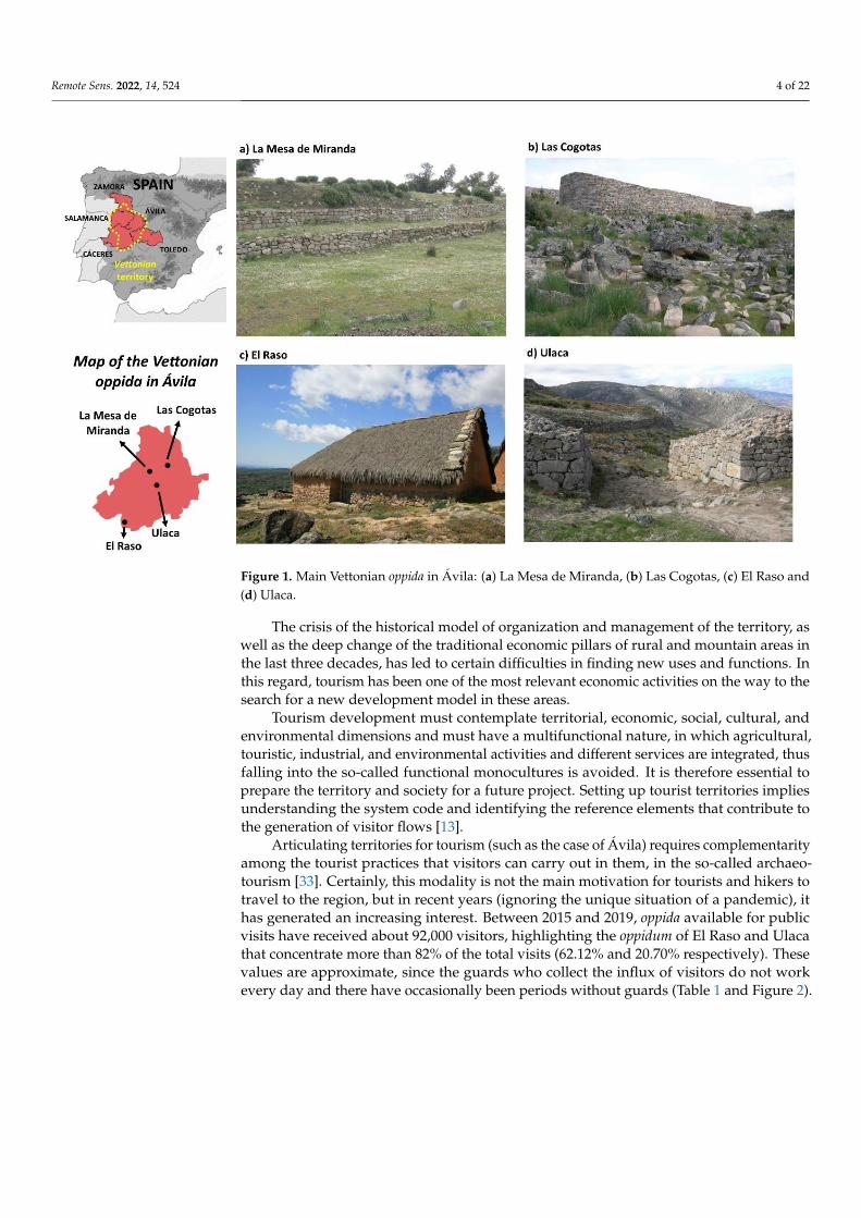
This previous inequality is an inherent condition not only in the territorial reality, butalso at the level of the existing tourist and cultural appreciation. Ávila has an unquestion-able heritage diversity, both from the cultural, natural, and immaterial point of view. At theinternational level, the province highlights for the UNESCO World Heritage declaration of“Old City of Ávila and Churches outside the walls” (1985). But beyond the existing valuesin the capital, the rest of the Ávila municipalities hide numerous heritage elements and arelevant cultural offer, such as the oppida of La Mesa de Miranda (Chamartín), Las Cogotas(Cardeñosa), El Raso (Candeleda), and Ulaca (Solosancho) (Figure 1). However, the realityof these resources shows that not all of them are adequate to function as “tourist products”.
Remote Sens. 2022, 14, 524 4 of 22
Remote Sens. 2022, 14, x FOR PEER REVIEW 4 of 23
Cogotas (Cardeñosa), El Raso (Candeleda), and Ulaca (Solosancho) (Figure 1). However,
the reality of these resources shows that not all of them are adequate to function as “tourist
products”.
Figure 1. Main Vettonian oppida in Á vila: (a) La Mesa de Miranda, (b) Las Cogotas, (c) El Raso and
d) Ulaca.
The crisis of the historical model of organization and management of the territory, as
well as the deep change of the traditional economic pillars of rural and mountain areas in
the last three decades, has led to certain difficulties in finding new uses and functions. In
this regard, tourism has been one of the most relevant economic activities on the way to
the search for a new development model in these areas.
Tourism development must contemplate territorial, economic, social, cultural, and
environmental dimensions and must have a multifunctional nature, in which agricultural,
touristic, industrial, and environmental activities and different services are integrated,
thus falling into the so-called functional monocultures is avoided. It is therefore essential
to prepare the territory and society for a future project. Setting up tourist territories im-
plies understanding the system code and identifying the reference elements that contrib-
ute to the generation of visitor flows [13].
Articulating territories for tourism (such as the case of Á vila) requires complementa-
rity among the tourist practices that visitors can carry out in them, in the so-called archae-
otourism [33]. Certainly, this modality is not the main motivation for tourists and hikers
to travel to the region, but in recent years (ignoring the unique situation of a pandemic),
it has generated an increasing interest. Between 2015 and 2019, oppida available for public
visits have received about 92,000 visitors, highlighting the oppidum of El Raso and Ulaca
that concentrate more than 82% of the total visits (62.12% and 20.70% respectively). These
values are approximate, since the guards who collect the influx of visitors do not work
every day and there have occasionally been periods without guards (Table 1 and Figure
2).
Figure 1. Main Vettonian oppida in Ávila: (a) La Mesa de Miranda, (b) Las Cogotas, (c) El Raso and(d) Ulaca.
The crisis of the historical model of organization and management of the territory, aswell as the deep change of the traditional economic pillars of rural and mountain areas inthe last three decades, has led to certain difficulties in finding new uses and functions. Inthis regard, tourism has been one of the most relevant economic activities on the way to thesearch for a new development model in these areas.
Tourism development must contemplate territorial, economic, social, cultural, andenvironmental dimensions and must have a multifunctional nature, in which agricultural,touristic, industrial, and environmental activities and different services are integrated, thusfalling into the so-called functional monocultures is avoided. It is therefore essential toprepare the territory and society for a future project. Setting up tourist territories impliesunderstanding the system code and identifying the reference elements that contribute tothe generation of visitor flows [13].
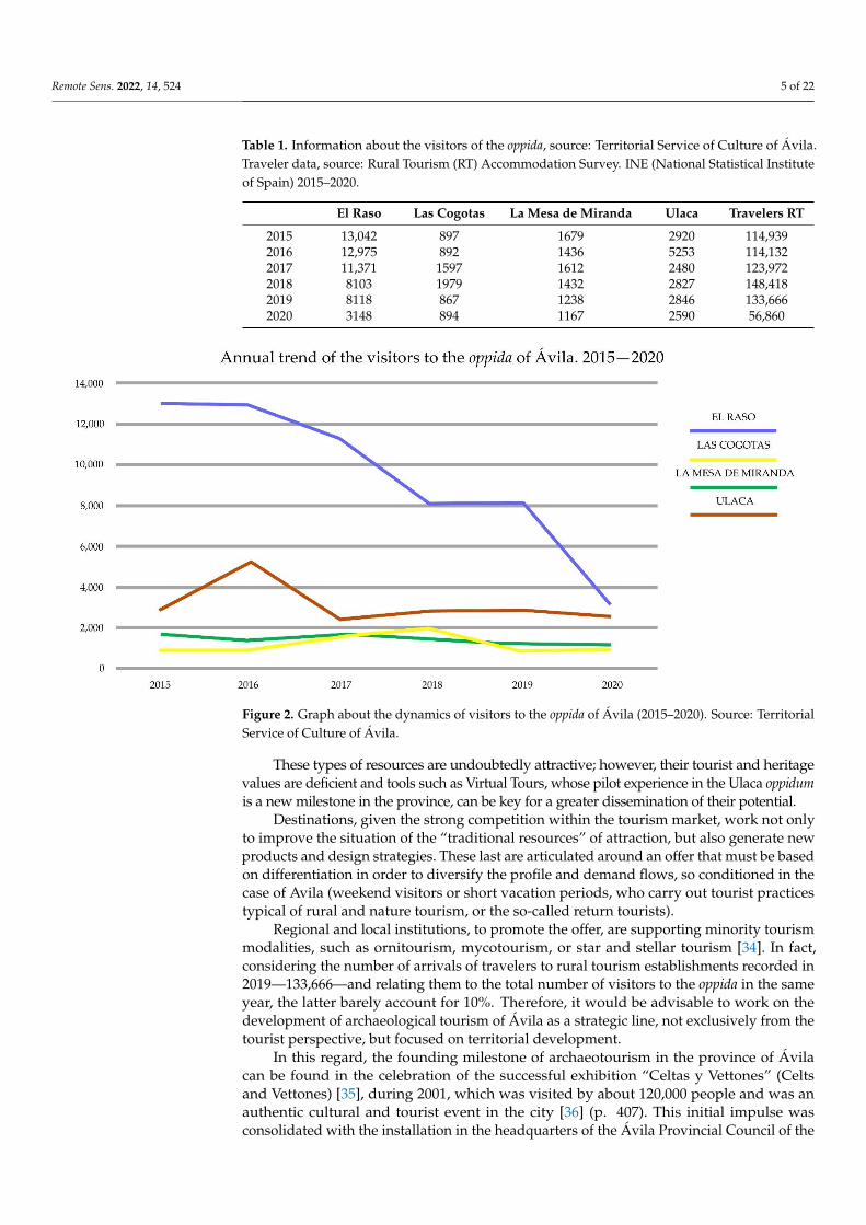
Articulating territories for tourism (such as the case of Ávila) requires complementarityamong the tourist practices that visitors can carry out in them, in the so-called archaeo-tourism [33]. Certainly, this modality is not the main motivation for tourists and hikers totravel to the region, but in recent years (ignoring the unique situation of a pandemic), ithas generated an increasing interest. Between 2015 and 2019, oppida available for publicvisits have received about 92,000 visitors, highlighting the oppidum of El Raso and Ulacathat concentrate more than 82% of the total visits (62.12% and 20.70% respectively). Thesevalues are approximate, since the guards who collect the influx of visitors do not workevery day and there have occasionally been periods without guards (Table 1 and Figure 2).
Remote Sens. 2022, 14, 524 5 of 22
Table 1. Information about the visitors of the oppida, source: Territorial Service of Culture of Ávila.Traveler data, source: Rural Tourism (RT) Accommodation Survey. INE (National Statistical Instituteof Spain) 2015–2020.
El Raso Las Cogotas La Mesa de Miranda Ulaca Travelers RT
2015 13,042 897 1679 2920 114,9392016 12,975 892 1436 5253 114,1322017 11,371 1597 1612 2480 123,9722018 8103 1979 1432 2827 148,4182019 8118 867 1238 2846 133,6662020 3148 894 1167 2590 56,860
Remote Sens. 2022, 14, x FOR PEER REVIEW 5 of 23
Table 1. Information about the visitors of the oppida, source: Territorial Service of Culture of Á vila.
Traveler data, source: Rural Tourism (RT) Accommodation Survey. INE (National Statistical Insti-
tute of Spain) 2015–2020.
El Raso Las Cogotas La Mesa de
Miranda Ulaca Travelers RT
2015 13,042 897 1679 2,920 114,939
2016 12,975 892 1436 5,253 114,132
2017 11,371 1,597 1612 2,480 123,972
2018 8,103 1,979 1432 2,827 148,418
2019 8,118 867 1238 2,846 133,666
2020 3,148 894 1167 2,590 56,860
Figure 2. Graph about the dynamics of visitors to the oppida of Á vila (2015–2020). Source: Territorial
Service of Culture of Á vila.
These types of resources are undoubtedly attractive; however, their tourist and her-
itage values are deficient and tools such as Virtual Tours, whose pilot experience in the
Ulaca oppidum is a new milestone in the province, can be key for a greater dissemination
of their potential.
Destinations, given the strong competition within the tourism market, work not only
to improve the situation of the "traditional resources" of attraction, but also generate new
products and design strategies. These last are articulated around an offer that must be
based on differentiation in order to diversify the profile and demand flows, so conditioned
in the case of Avila (weekend visitors or short vacation periods, who carry out tourist
practices typical of rural and nature tourism, or the so-called return tourists).
Regional and local institutions, to promote the offer, are supporting minority tourism
modalities, such as ornitourism, mycotourism, or star and stellar tourism [34]. In fact, con-
sidering the number of arrivals of travelers to rural tourism establishments recorded in
2019—133,666—and relating them to the total number of visitors to the oppida in the same
year, the latter barely account for 10%. Therefore, it would be advisable to work on the
development of archaeological tourism of Á vila as a strategic line, not exclusively from
the tourist perspective, but focused on territorial development.
Figure 2. Graph about the dynamics of visitors to the oppida of Ávila (2015–2020). Source: TerritorialService of Culture of Ávila.
These types of resources are undoubtedly attractive; however, their tourist and heritagevalues are deficient and tools such as Virtual Tours, whose pilot experience in the Ulaca oppidumis a new milestone in the province, can be key for a greater dissemination of their potential.
Destinations, given the strong competition within the tourism market, work not onlyto improve the situation of the “traditional resources” of attraction, but also generate newproducts and design strategies. These last are articulated around an offer that must be basedon differentiation in order to diversify the profile and demand flows, so conditioned in thecase of Avila (weekend visitors or short vacation periods, who carry out tourist practicestypical of rural and nature tourism, or the so-called return tourists).
Regional and local institutions, to promote the offer, are supporting minority tourismmodalities, such as ornitourism, mycotourism, or star and stellar tourism [34]. In fact,considering the number of arrivals of travelers to rural tourism establishments recorded in2019—133,666—and relating them to the total number of visitors to the oppida in the sameyear, the latter barely account for 10%. Therefore, it would be advisable to work on thedevelopment of archaeological tourism of Ávila as a strategic line, not exclusively from thetourist perspective, but focused on territorial development.
In this regard, the founding milestone of archaeotourism in the province of Ávilacan be found in the celebration of the successful exhibition “Celtas y Vettones” (Celtsand Vettones) [35], during 2001, which was visited by about 120,000 people and was anauthentic cultural and tourist event in the city [36] (p. 407). This initial impulse wasconsolidated with the installation in the headquarters of the Ávila Provincial Council of the
Remote Sens. 2022, 14, 524 6 of 22
permanent exhibition “Vettonia. Cultura y Naturaleza” (Vettonia. Culture and Nature) [37].Another key element in the dissemination of the heritage bequeathed by the protohistoriccommunities has been the restoration and adaptation for the visit of some of the main sitesof the Iron Age of Ávila and Salamanca within the framework of the European projectINTERREG III-A (2003–2005) [38]. Among these actions, the creation of archaeologicalvisitor centers, the signposting of the access route, the musealization of the surroundings,the cleaning and reconstruction of the defenses, especially around the gates (Figure 1),can be highlighted. In this way, a tourist route has been consolidated around these sitesand other important settlements in northern Portugal [39]. In addition, around the mainpre-Roman sites in Ávila, several festivals and “Celtic-Vetton” markets have arisen, such asthe Celtic Moon in Ulaca, with fifteen editions [40], Lugnasad in La Mesa de Miranda withfourteen editions [41], or the Celtic festival in El Raso with nine editions.
Ulaca Oppidum
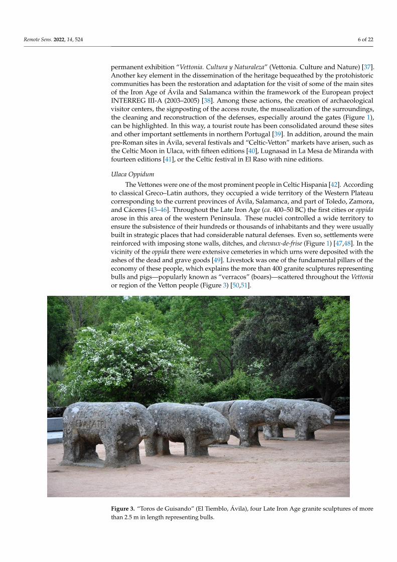
The Vettones were one of the most prominent people in Celtic Hispania [42]. Accordingto classical Greco–Latin authors, they occupied a wide territory of the Western Plateaucorresponding to the current provinces of Ávila, Salamanca, and part of Toledo, Zamora,and Cáceres [43–46]. Throughout the Late Iron Age (ca. 400–50 BC) the first cities or oppidaarose in this area of the western Peninsula. These nuclei controlled a wide territory toensure the subsistence of their hundreds or thousands of inhabitants and they were usuallybuilt in strategic places that had considerable natural defenses. Even so, settlements werereinforced with imposing stone walls, ditches, and chevaux-de-frise (Figure 1) [47,48]. In thevicinity of the oppida there were extensive cemeteries in which urns were deposited with theashes of the dead and grave goods [49]. Livestock was one of the fundamental pillars of theeconomy of these people, which explains the more than 400 granite sculptures representingbulls and pigs—popularly known as “verracos” (boars)—scattered throughout the Vettoniaor region of the Vetton people (Figure 3) [50,51].
Remote Sens. 2022, 14, x FOR PEER REVIEW 7 of 23
Figure 3. “Toros de Guisando” (El Tiemblo, Ávila), four Late Iron Age granite sculptures of more
than 2.5 m in length representing bulls.
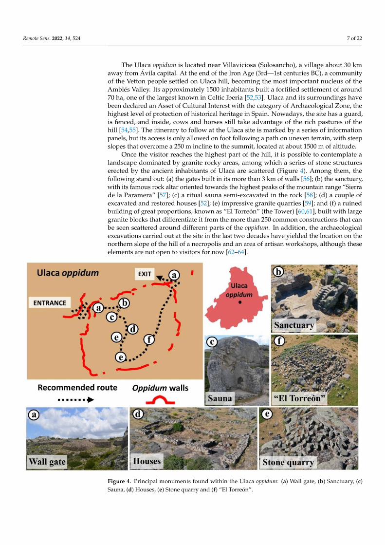
The Ulaca oppidum is located near Villaviciosa (Solosancho), a village about 30 km
away from Á vila capital. At the end of the Iron Age (3rd—1st centuries BC), a community
of the Vetton people settled on Ulaca hill, becoming the most important nucleus of the
Amblés Valley. Its approximately 1,500 inhabitants built a fortified settlement of around
70 ha, one of the largest known in Celtic Iberia [52,53]. Ulaca and its surroundings have
been declared an Asset of Cultural Interest with the category of Archaeological Zone, the
highest level of protection of historical heritage in Spain. Nowadays, the site has a guard,
is fenced, and inside, cows and horses still take advantage of the rich pastures of the hill
[54,55]. The itinerary to follow at the Ulaca site is marked by a series of information panels,
but its access is only allowed on foot following a path on uneven terrain, with steep slopes
that overcome a 250 m incline to the summit, located at about 1,500 m of altitude.
Once the visitor reaches the highest part of the hill, it is possible to contemplate a
landscape dominated by granite rocky areas, among which a series of stone structures
erected by the ancient inhabitants of Ulaca are scattered (Figure 4). Among them, the fol-
lowing stand out: (a) the gates built in its more than 3 km of walls [56]; (b) the sanctuary,
with its famous rock altar oriented towards the highest peaks of the mountain range “Si-
erra de la Paramera” [57]; (c) a ritual sauna semi-excavated in the rock [58]; (d) a couple
of excavated and restored houses [52]; (e) impressive granite quarries [59]; and (f) a ruined
building of great proportions, known as “El Torreón” (the Tower) [60,61], built with large
granite blocks that differentiate it from the more than 250 common constructions that can
be seen scattered around different parts of the oppidum. In addition, the archaeological
excavations carried out at the site in the last two decades have yielded the location on the
northern slope of the hill of a necropolis and an area of artisan workshops, although these
elements are not open to visitors for now [62–64].
Figure 3. “Toros de Guisando” (El Tiemblo, Ávila), four Late Iron Age granite sculptures of morethan 2.5 m in length representing bulls.
Remote Sens. 2022, 14, 524 7 of 22
The Ulaca oppidum is located near Villaviciosa (Solosancho), a village about 30 kmaway from Ávila capital. At the end of the Iron Age (3rd—1st centuries BC), a communityof the Vetton people settled on Ulaca hill, becoming the most important nucleus of theAmblés Valley. Its approximately 1500 inhabitants built a fortified settlement of around70 ha, one of the largest known in Celtic Iberia [52,53]. Ulaca and its surroundings havebeen declared an Asset of Cultural Interest with the category of Archaeological Zone, thehighest level of protection of historical heritage in Spain. Nowadays, the site has a guard,is fenced, and inside, cows and horses still take advantage of the rich pastures of thehill [54,55]. The itinerary to follow at the Ulaca site is marked by a series of informationpanels, but its access is only allowed on foot following a path on uneven terrain, with steepslopes that overcome a 250 m incline to the summit, located at about 1500 m of altitude.
Once the visitor reaches the highest part of the hill, it is possible to contemplate alandscape dominated by granite rocky areas, among which a series of stone structureserected by the ancient inhabitants of Ulaca are scattered (Figure 4). Among them, thefollowing stand out: (a) the gates built in its more than 3 km of walls [56]; (b) the sanctuary,with its famous rock altar oriented towards the highest peaks of the mountain range “Sierrade la Paramera” [57]; (c) a ritual sauna semi-excavated in the rock [58]; (d) a couple ofexcavated and restored houses [52]; (e) impressive granite quarries [59]; and (f) a ruinedbuilding of great proportions, known as “El Torreón” (the Tower) [60,61], built with largegranite blocks that differentiate it from the more than 250 common constructions that canbe seen scattered around different parts of the oppidum. In addition, the archaeologicalexcavations carried out at the site in the last two decades have yielded the location on thenorthern slope of the hill of a necropolis and an area of artisan workshops, although theseelements are not open to visitors for now [62–64].
Remote Sens. 2022, 14, x FOR PEER REVIEW 8 of 23
Figure 4. Principal monuments found within the Ulaca oppidum: (a) Wall gate, (b) Sanctuary, (c)
Sauna, (d) Houses, (e) Stone quarry and (f) “El Torreón”.
3. Materials and Methods
Virtual tours can be defined as immersive digital tools that allow visiting different
spaces or places in a certain environment. The simulation of this environment is based on
the interconnection of a series of 360° panoramic images, which allow the complete visu-
alization of the space, generated by means of specific software. As a general rule, this vir-
tual space is accessible from any computer or mobile device with internet access, provid-
ing a similar sensation to that of being on the site. In addition, information can be linked
to these virtual tools to facilitate the user's understanding of the environment shown.
Below, the process of developing the ULACA VIRTUAL TOUR is presented.
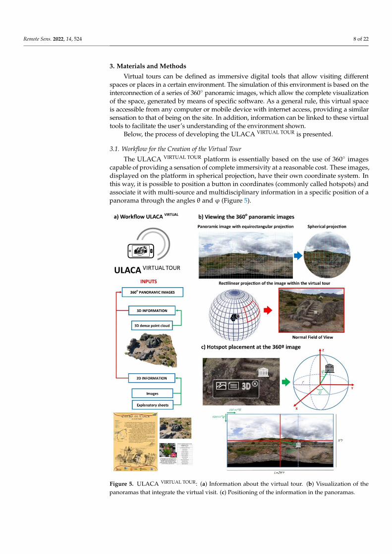
3.1. Workflow for the Creation of the Virtual Tour
The ULACA VIRTUAL TOUR platform is essentially based on the use of 360° images capa-
ble of providing a sensation of complete immersivity at a reasonable cost. These images,
displayed on the platform in spherical projection, have their own coordinate system. In
this way, it is possible to position a button in coordinates (commonly called hotspots) and
associate it with multi-source and multidisciplinary information in a specific position of a
panorama through the angles θ and φ (Figure 5).
Figure 4. Principal monuments found within the Ulaca oppidum: (a) Wall gate, (b) Sanctuary, (c)Sauna, (d) Houses, (e) Stone quarry and (f) “El Torreón”.
Remote Sens. 2022, 14, 524 8 of 22
3. Materials and Methods
Virtual tours can be defined as immersive digital tools that allow visiting differentspaces or places in a certain environment. The simulation of this environment is based on theinterconnection of a series of 360◦ panoramic images, which allow the complete visualizationof the space, generated by means of specific software. As a general rule, this virtual spaceis accessible from any computer or mobile device with internet access, providing a similarsensation to that of being on the site. In addition, information can be linked to these virtualtools to facilitate the user’s understanding of the environment shown.
Below, the process of developing the ULACA VIRTUAL TOUR is presented.
3.1. Workflow for the Creation of the Virtual Tour
The ULACA VIRTUAL TOUR platform is essentially based on the use of 360◦ imagescapable of providing a sensation of complete immersivity at a reasonable cost. These images,displayed on the platform in spherical projection, have their own coordinate system. Inthis way, it is possible to position a button in coordinates (commonly called hotspots) andassociate it with multi-source and multidisciplinary information in a specific position of apanorama through the angles θ and ϕ (Figure 5).
Remote Sens. 2022, 14, x FOR PEER REVIEW 9 of 23
Figure 5. ULACA VIRTUAL TOUR: (a) Information about the virtual tour. (b) Visualization of the pano-
ramas that integrate the virtual visit. (c) Positioning of the information in the panoramas.
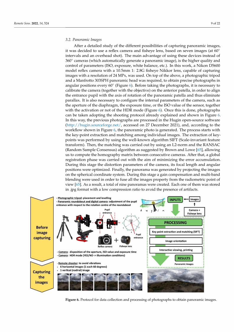
3.2. Panoramic Images
After a detailed study of the different possibilities of capturing panoramic images, it
was decided to use a reflex camera and fisheye lens, based on seven images (at 60° inter-
vals and an overhead shot). The main advantage of using these devices instead of 360°
cameras (which automatically generate a panoramic image), is the higher quality and con-
trol of parameters (ISO, exposure, white balance, etc.). In this work, a Nikon D5600 model
reflex camera with a 10.5mm 1: 2.8G fisheye Nikkor lens, capable of capturing images with
a resolution of 24 MPx, was used. On top of the above, a photographic tripod and a Man-
frotto 303SPH panoramic head was required, to obtain precise photographs in angular
positions every 60° (Figure 6). Before taking the photographs, it is necessary to calibrate
the camera (together with the objective) on the anterior patella, in order to align the en-
trance pupil with the axis of rotation of the panoramic patella and thus eliminate parallax.
It is also necessary to configure the internal parameters of the camera, such as the aperture
of the diaphragm, the exposure time, or the ISO value of the sensor, together with the
activation or not of the HDR mode (Figure 6). Once this is done, photographs can be taken
adopting the shooting protocol already explained and shown in Figure 6. In this way, the
previous photographs are processed in the Hugin open-source software
Figure 5. ULACA VIRTUAL TOUR: (a) Information about the virtual tour. (b) Visualization of thepanoramas that integrate the virtual visit. (c) Positioning of the information in the panoramas.
Remote Sens. 2022, 14, 524 9 of 22
3.2. Panoramic Images
After a detailed study of the different possibilities of capturing panoramic images,it was decided to use a reflex camera and fisheye lens, based on seven images (at 60◦
intervals and an overhead shot). The main advantage of using these devices instead of360◦ cameras (which automatically generate a panoramic image), is the higher quality andcontrol of parameters (ISO, exposure, white balance, etc.). In this work, a Nikon D5600model reflex camera with a 10.5mm 1: 2.8G fisheye Nikkor lens, capable of capturingimages with a resolution of 24 MPx, was used. On top of the above, a photographic tripodand a Manfrotto 303SPH panoramic head was required, to obtain precise photographs inangular positions every 60◦ (Figure 6). Before taking the photographs, it is necessary tocalibrate the camera (together with the objective) on the anterior patella, in order to alignthe entrance pupil with the axis of rotation of the panoramic patella and thus eliminateparallax. It is also necessary to configure the internal parameters of the camera, such asthe aperture of the diaphragm, the exposure time, or the ISO value of the sensor, togetherwith the activation or not of the HDR mode (Figure 6). Once this is done, photographscan be taken adopting the shooting protocol already explained and shown in Figure 6.In this way, the previous photographs are processed in the Hugin open-source software(http://hugin.sourceforge.net/, accessed on 27 December 2021), and, according to theworkflow shown in Figure 6, the panoramic photo is generated. The process starts withthe key-point extraction and matching among individual images. The extraction of key-points was performed by using the well-known algorithm SIFT (Scale-invariant featuretransform). Then, the matching was carried out by using an L2-norm and the RANSAC(Random Sample Consensus) algorithm as suggested by Brown and Lowe [65], allowingus to compute the homography matrix between consecutive cameras. After that, a globalregistration phase was carried out with the aim of minimizing the error accumulation.During this stage the distortion parameters of the camera, its focal length and angularpositions were optimized. Finally, the panorama was generated by projecting the imageson the spherical coordinate system. During this stage a gain compensation and multi-bandblending were used in order to fuse all the images property from the radiometric point ofview [65]. As a result, a total of nine panoramas were created. Each one of them was storedin .jpg format with a low compression ratio to avoid the presence of artifacts.
Remote Sens. 2022, 14, x FOR PEER REVIEW 10 of 23
(http://hugin.sourceforge.net/ - accessed on 21 January 2022 -), and, according to the work-
flow shown in Figure 6, the panoramic photo is generated. The process starts with the
key-point extraction and matching among individual images. The extraction of key-points
was performed by using the well-known algorithm SIFT (Scale-invariant feature trans-
form). Then, the matching was carried out by using an L2-norm and the RANSAC (Ran-
dom Sample Consensus) algorithm as suggested by Brown and Lowe [65], allowing us to
compute the homography matrix between consecutive cameras. After that, a global regis-
tration phase was carried out with the aim of minimizing the error accumulation. During
this stage the distortion parameters of the camera, its focal length and angular positions
were optimized. Finally, the panorama was generated by projecting the images on the
spherical coordinate system. During this stage a gain compensation and multi-band
blending were used in order to fuse all the images property from the radiometric point of
view [65]. As a result, a total of nine panoramas were created. Each one of them was stored
in .jpg format with a low compression ratio to avoid the presence of artifacts.
Figure 6. Protocol for data collection and processing of photographs to obtain panoramic images.
In addition, 56 high-resolution panoramic images (in .tif format) were totally gener-
ated: i) of the main monuments of the Ulaca oppidum (Figure 4); ii) of the locations in which
there are information panels; iii) of the most representative places of the archaeological
site due to its landscape interest; iv) of intermediate locations for the transition between
the previous scenarios; v) and finally, several panoramic images of the 2018 excavation
campaign carried out in "El Torreón", in which the work dynamics of the entire archaeo-
logical team is shown.
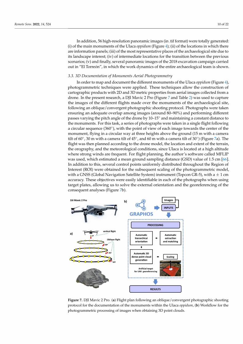
3.3. 3D documentation of Monuments. Aerial Photogrammetry
In order to map and document the different monuments of the Ulaca oppidum (Figure
4), photogrammetric techniques were applied. These techniques allow the construction of
cartographic products with 2D and 3D metric properties from aerial images collected from
a drone. In the present research, a DJI Mavic 2 Pro (Figure 7 and Table 2) was used to
capture the images of the different flights made over the monuments of the archaeological
Figure 6. Protocol for data collection and processing of photographs to obtain panoramic images.
Remote Sens. 2022, 14, 524 10 of 22
In addition, 56 high-resolution panoramic images (in .tif format) were totally generated:(i) of the main monuments of the Ulaca oppidum (Figure 4); (ii) of the locations in which thereare information panels; (iii) of the most representative places of the archaeological site due toits landscape interest; (iv) of intermediate locations for the transition between the previousscenarios; (v) and finally, several panoramic images of the 2018 excavation campaign carriedout in “El Torreón”, in which the work dynamics of the entire archaeological team is shown.
3.3. 3D Documentation of Monuments Aerial Photogrammetry
In order to map and document the different monuments of the Ulaca oppidum (Figure 4),photogrammetric techniques were applied. These techniques allow the construction ofcartographic products with 2D and 3D metric properties from aerial images collected from adrone. In the present research, a DJI Mavic 2 Pro (Figure 7 and Table 2) was used to capturethe images of the different flights made over the monuments of the archaeological site,following an oblique/convergent photographic shooting protocol. Photographs were takenensuring an adequate overlap among images (around 80–90%) and performing differentpasses varying the pitch angle of the drone by 10–15◦ and maintaining a constant distance tothe monuments. For this task, a series of photographs were taken in a single flight followinga circular sequence (360◦), with the point of view of each image towards the center of themonument, flying in a circular way at three heights above the ground (15 m with a cameratilt of 60◦, 30 m with a camera tilt of 45◦, and 60 m with a camera tilt of 30◦) (Figure 7a). Theflight was then planned according to the drone model, the location and extent of the terrain,the orography, and the meteorological conditions, since Ulaca is located at a high altitudewhere strong winds are frequent. For flight planning, the author’s software called MFLIPwas used, which estimated a mean ground sampling distance (GSD) value of 1.5 cm [66].In addition to this, several control points uniformly distributed throughout the Region ofInterest (ROI) were obtained for the subsequent scaling of the photogrammetric model,with a GNSS (Global Navigation Satellite System) instrument (Topcon GR-5), with a± 1 cmaccuracy. These objectives were easily identifiable in each of the photographs when usingtarget plates, allowing us to solve the external orientation and the georeferencing of theconsequent analyses (Figure 7b).
Remote Sens. 2022, 14, x FOR PEER REVIEW 11 of 23
site, following an oblique/convergent photographic shooting protocol. Photographs were
taken ensuring an adequate overlap among images (around 80%–90%) and performing
different passes varying the pitch angle of the drone by 10-15° and maintaining a constant
distance to the monuments. For this task, a series of photographs were taken in a single
flight following a circular sequence (360°), with the point of view of each image towards
the center of the monument, flying in a circular way at three heights above the ground (15
m with a camera tilt of 60°, 30 m with a camera tilt of 45°, and 60 m with a camera tilt of
30°) (Figure 7a). The flight was then planned according to the drone model, the location
and extent of the terrain, the orography, and the meteorological conditions, since Ulaca is
located at a high altitude where strong winds are frequent. For flight planning, the au-
thor’s software called MFLIP was used, which estimated a mean ground sampling dis-
tance (GSD) value of 1.5 cm [66]. In addition to this, several control points uniformly dis-
tributed throughout the Region of Interest (ROI) were obtained for the subsequent scaling
of the photogrammetric model, with a GNSS (Global Navigation Satellite System) instru-
ment (Topcon GR-5), with a ± 1 cm accuracy. These objectives were easily identifiable in
each of the photographs when using target plates, allowing us to solve the external orien-
tation and the georeferencing of the consequent analyses (Figure 7b).
Figure 7. DJI Mavic 2 Pro. (a) Flight plan following an oblique/convergent photographic shooting
protocol for the documentation of the monuments within the Ulaca oppidum, (b) Workflow for the
photogrammetric processing of images when obtaining 3D point clouds.
Table 2. UAV sensor’s specifications.
DJI Mavic 2 Pro
Autonomy 31 min
Total weight 907 gr
Maximum flight speed 72 km/h
Accuracy of the on-board GPS ±1.5 m (x,y) and ±0.5 m (z)
DJI Mavic 2 Pro Camera
Sensor 1" CMOS
Effective pixels: 20 million
Objective FOV: 77
Format equivalent to 35 mm: 28 mm
Figure 7. DJI Mavic 2 Pro. (a) Flight plan following an oblique/convergent photographic shootingprotocol for the documentation of the monuments within the Ulaca oppidum, (b) Workflow for thephotogrammetric processing of images when obtaining 3D point clouds.
Remote Sens. 2022, 14, 524 11 of 22
Table 2. UAV sensor’s specifications.
DJI Mavic 2 Pro
Autonomy 31 minTotal weight 907 gr
Maximum flight speed 72 km/hAccuracy of the on-board GPS ±1.5 m (x,y) and ±0.5 m (z)
DJI Mavic 2 Pro Camera
Sensor 1′′ CMOSEffective pixels: 20 million
Objective
FOV: 77Format equivalent to 35 mm: 28 mm
Opening: f/2.8–f/11Focus distance: 1 m to ∞
Once the different flights were made, images were processed with photogrammetricreconstruction software. After considering all the existing programs, the open-source toolGRAPHOS was selected [67].
Thanks to GRAPHOS, six dense point clouds of the monuments of the Ulaca oppidum(Figure 4) were generated (stored in .laz format). The metric control and final precision ofthe different point clouds obtained can be seen in Table 3. The Root Mean Square Error(RMSE) results from the residual errors at control points (considering in all cases, the use ofeight control points in the form of target plates and with GNSS coordinates with ±1 cmaccuracy. As explained previously, the target plates were uniformly distributed throughoutthe ROI, with the aim of a homogeneous distribution of errors).
Table 3. Metric control and final accuracy of the different point clouds.
Ground Sampling Distance (GSD) Root Mean Square Error (RMSE)
Wall gate 1.9 cm 1.5 cmHouses 1.4 cm 1.2 cm
Stone quarry 1.5 cm 1.1 cmSauna 1.5 cm 1.2 cm
Sanctuary 1.5 cm 1.3 cm“El Torreón” 1.5 cm 1.2 cm
3.4. Information Required for Understanding the Archaeological Site
An essential part of this kind of project is the correct compilation, homogenization, andstandardization of the information for the understanding of the site under study. However,in these contexts, the information: (a) tends to come from different sources; (b) is usuallyin numerous places (dispersed depending on its owner, importance, and historical signifi-cance...); (c) or has different typology and format (heterogeneous information). Therefore,the search and compilation of information is frequently a complicated task, which mustbe carried out in an exhaustive transversal way [68]. It must be also considered that it isnot always possible to find the required information and is convenient to establish searchcriteria and several preliminary objectives to estimate the resources to be invested in thedevelopment of this part of the research.
In the case of the Ulaca oppidum, the following information was compiled: (i) his-torical/archaeological; derived from the research team working at the site [52,62,63];(ii) geological; consulting the website of the “Geolodía” outreach initiative, which tookplace in 2018 at the Ulaca oppidum (https://geolodiaavila.com/geolodia-avila-2018/, ac-cessed on 27 December 2021) and promotes geological field excursions guided by special-ists; (iii) floristics and fauna; obtained from different investigations in the area [69,70]. Allthese data were complemented with photographic material of elements of interest locatedin the Ulaca oppidum and its surroundings. Subsequently, all the information was rigorously
Remote Sens. 2022, 14, 524 12 of 22
homogenized and standardized in different formats (texts and explanatory sheets). On topof the above, the Culture Territorial Service of the Junta de Castilla y León provided theproject with all the informative posters present at the site, which we included to increasethe interest and understanding of the visitors to the Ulaca oppidum.
In total, the following were generated: (i) five cards (in .png format) explaining andshowing the action of humans still present in the landscape of Ulaca, such as: the pivot holecarved into the rock in which the wooden door would fit to close the northern access to theoppidum; the wagon wheel tracks visible in the rock; several remains of pottery; wedge-holesin the stone quarries for the extraction of blocks for the construction of the monuments; orone of the bull sculptures found in the surroundings of the oppidum; (ii) 17 cards (in .pngformat) where the flora and fauna that can be found in the site are described (4 fauna cardsand 13 flora cards). It should be noted that the current inhabitants of the area continueto dedicate themselves to raising livestock, so it is very common today to find cows andhorses grazing within the archaeological site; (iii) five sheets (in .png format) explainingand showing: the different characteristics of the granitic landscape (such as erosion andweathering of the rock, the existence of joints and fracture zones or the for-mation of rockbasins); the presence of springs in the area; or information on the formation of the AmblésValley; (iv) 14 images of the different explanatory panels of the oppidum; and (v) sevendocuments (in .pdf format) and images (in .png format) showing and explaining the usesand function of the main monuments of the Ulaca oppidum (Figure 4).
3.5. Architecture of the Virtual Platform
The sources of information previously identified, as well as the 3D point clouds andpanoramic images, were integrated in a unique virtual environment. This virtual environ-ment uses the panoramic images as the main support to which is attached the different infor-mation sources. This environment was developed by using the low-cost software Pano2VR®
(https://ggnome.com/pano2vr/, accessed on 27 December 2021). Within this software thevirtual platform was programmed by considering different web-based languages, such asHTML (markup language), CSS (design language), and JavaScript (programming language).The HTML and CSS languages were used for designing the content of the platform aswell as its graphical user interface (GUI) (Figure 8). This GUI was made up by a HTMLheader and body. The header is de-voted to show information related with the entitiesinvolved. Meanwhile, the body is used for projecting the panoramas, the information,the map of the site, and a navigation menu. The information of the platform is shown bymeans of hotspots which are HTML entities that include a JavaScript function that allow animage file to be shown when the user clicks on it. The navigation menu includes severalJavaScript functions that allow the point of view to be changed by rotating the panorama.Additionally, this menu includes zoom functions, an icon for open/close the map as well asseveral icons for opening PDF files with general information such as a historical guide or ageological guide. These PDF files are rendered by using an iframe entity (HTML language).
It is worth mentioning that some of the hotspots include the possibility of renderingthe 3D point cloud. This rendering was performed by using the open-source library Potree®
(http://potree.org/, accessed on 27 December 2021). This platform is based on the WebGLtechnology and is capable of quickly rendering heavy point clouds, as well as incorporatingmetric operations, such as linear measurements, areas, or volumes, that may be of interestto professionals. The connection between this engine and the virtual tour was made upby using an HTML page on which is embedded the 3D point cloud. This viewer alsoincludes several JavaScript functions that allow the coordinates of points, the value of linearmeasures or the area of a specific place to be obtained.
Remote Sens. 2022, 14, 524 13 of 22Remote Sens. 2022, 14, x FOR PEER REVIEW 14 of 23
.
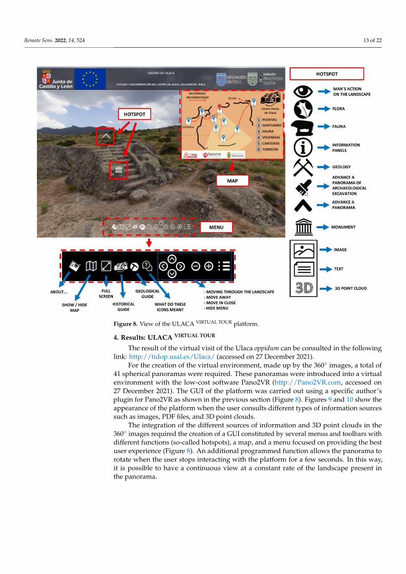
Figure 8. View of the ULACA VIRTUAL TOUR platform.
4. Results: ULACA VIRTUAL TOUR
The result of the virtual visit of the Ulaca oppidum can be consulted in the following
link:
http://tidop.usal.es/Ulaca/ (accessed on 21 January 2022)
For the creation of the virtual environment, made up by the 360° images, a total of 41
spherical panoramas were required. These panoramas were introduced into a virtual en-
vironment with the low-cost software Pano2VR (http://Pano2VR.com, accessed on 21 Jan-
uary 2022 -). The GUI of the platform was carried out using a specific author’s plugin for
Pano2VR as shown in the previous section (Figure 8). Figures 9 and 10 show the appear-
ance of the platform when the user consults different types of information sources such
as images, PDF files, and 3D point clouds.
The integration of the different sources of information and 3D point clouds in the
360° images required the creation of a GUI constituted by several menus and toolbars with
different functions (so-called hotspots), a map, and a menu focused on providing the best
user experience (Figure 8). An additional programmed function allows the panorama to
rotate when the user stops interacting with the platform for a few seconds. In this way, it
is possible to have a continuous view at a constant rate of the landscape present in the
panorama.
Figure 8. View of the ULACA VIRTUAL TOUR platform.
4. Results: ULACA VIRTUAL TOUR
The result of the virtual visit of the Ulaca oppidum can be consulted in the followinglink: http://tidop.usal.es/Ulaca/ (accessed on 27 December 2021).
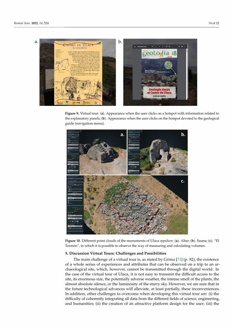
For the creation of the virtual environment, made up by the 360◦ images, a total of41 spherical panoramas were required. These panoramas were introduced into a virtualenvironment with the low-cost software Pano2VR (http://Pano2VR.com, accessed on27 December 2021). The GUI of the platform was carried out using a specific author’splugin for Pano2VR as shown in the previous section (Figure 8). Figures 9 and 10 show theappearance of the platform when the user consults different types of information sourcessuch as images, PDF files, and 3D point clouds.
The integration of the different sources of information and 3D point clouds in the360◦ images required the creation of a GUI constituted by several menus and toolbars withdifferent functions (so-called hotspots), a map, and a menu focused on providing the bestuser experience (Figure 8). An additional programmed function allows the panorama torotate when the user stops interacting with the platform for a few seconds. In this way,it is possible to have a continuous view at a constant rate of the landscape present inthe panorama.
Remote Sens. 2022, 14, 524 14 of 22Remote Sens. 2022, 14, x FOR PEER REVIEW 15 of 23
Figure 9. Virtual tour: (a). Appearance when the user clicks on a hotspot with information related
to the explanatory panels; (b). Appearance when the user clicks on the hotspot devoted to the geo-
logical guide (navigation menu).
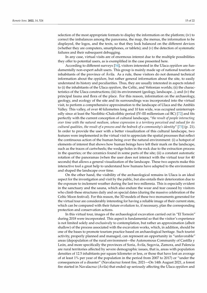
Figure 10. Different point clouds of the monuments of Ulaca oppidum: (a). Altar; (b). Sauna; (c). “El
Torreón”, in which it is possible to observe the way of measuring and calculating volumes.
5. Discussion. Virtual tours: challenges and possibilities
The main challenge of a virtual tour is, as stated by Grima [71] (page 82), the existence
of a whole series of experiences and attributes that can be observed on a trip to an archae-
ological site, which, however, cannot be transmitted through the digital world. In the case
of the virtual tour of Ulaca, it is not easy to transmit the difficult access to the site, its
enormous size, the potentially adverse weather, the intense smell of the plants, the almost
absolute silence, or the luminosity of the starry sky. However, we are sure that in the fu-
ture technological advances will alleviate, at least partially, these inconveniences. In ad-
dition, other challenges to overcome when developing this virtual tour are: i) the difficulty
of coherently integrating all data from the different fields of science, engineering, and hu-
manities; ii) the creation of an attractive platform design for the user; iii) the selection of
Figure 9. Virtual tour: (a). Appearance when the user clicks on a hotspot with information related tothe explanatory panels; (b). Appearance when the user clicks on the hotspot devoted to the geologicalguide (navigation menu).
Remote Sens. 2022, 14, x FOR PEER REVIEW 15 of 23
Figure 9. Virtual tour: (a). Appearance when the user clicks on a hotspot with information related
to the explanatory panels; (b). Appearance when the user clicks on the hotspot devoted to the geo-
logical guide (navigation menu).
Figure 10. Different point clouds of the monuments of Ulaca oppidum: (a). Altar; (b). Sauna; (c). “El
Torreón”, in which it is possible to observe the way of measuring and calculating volumes.
5. Discussion. Virtual tours: challenges and possibilities
The main challenge of a virtual tour is, as stated by Grima [71] (page 82), the existence
of a whole series of experiences and attributes that can be observed on a trip to an archae-
ological site, which, however, cannot be transmitted through the digital world. In the case
of the virtual tour of Ulaca, it is not easy to transmit the difficult access to the site, its
enormous size, the potentially adverse weather, the intense smell of the plants, the almost
absolute silence, or the luminosity of the starry sky. However, we are sure that in the fu-
ture technological advances will alleviate, at least partially, these inconveniences. In ad-
dition, other challenges to overcome when developing this virtual tour are: i) the difficulty
of coherently integrating all data from the different fields of science, engineering, and hu-
manities; ii) the creation of an attractive platform design for the user; iii) the selection of
Figure 10. Different point clouds of the monuments of Ulaca oppidum: (a). Altar; (b). Sauna; (c). “ElTorreón”, in which it is possible to observe the way of measuring and calculating volumes.
5. Discussion Virtual Tours: Challenges and Possibilities
The main challenge of a virtual tour is, as stated by Grima [71] (p. 82), the existenceof a whole series of experiences and attributes that can be observed on a trip to an ar-chaeological site, which, however, cannot be transmitted through the digital world. Inthe case of the virtual tour of Ulaca, it is not easy to transmit the difficult access to thesite, its enormous size, the potentially adverse weather, the intense smell of the plants, thealmost absolute silence, or the luminosity of the starry sky. However, we are sure that inthe future technological advances will alleviate, at least partially, these inconveniences.In addition, other challenges to overcome when developing this virtual tour are: (i) thedifficulty of coherently integrating all data from the different fields of science, engineering,and humanities; (ii) the creation of an attractive platform design for the user; (iii) the
Remote Sens. 2022, 14, 524 15 of 22
selection of the most appropriate formats to display the information on the platform; (iv) tocorrect the imbalances among the panorama, the map, the menus, the information to bedisplayed, the logos, and the texts, so that they look balanced on the different devices(whether they are computers, smartphones, or tablets); and (v) the detection of systematicfailures and their subsequent debugging.
In any case, virtual visits are of enormous interest due to the multiple possibilitiesthey offer to potential users, as is exemplified in the case presented here.
According to different surveys [54], visitors interested in the Ulaca oppidum are fun-damentally non-expert adult users. This group is mainly made up of national tourists orinhabitants of the province of Ávila. As a rule, these visitors do not demand technicalinformation about the oppidum, but rather general information about the site, to easilyunderstand its history and peculiarities. Thus, they are usually interested in aspects relatedto (i) the inhabitants of the Ulaca oppidum, the Celtic, and Vettonian worlds; (ii) the charac-teristics of the Ulaca constructions; (iii) its environment (geology, landscape...); and (iv) theprincipal fauna and flora of the place. For this reason, information on the archaeology,geology, and ecology of the site and its surroundings was incorporated into the virtualvisit, to perform a comprehensive approximation to the landscape of Ulaca and the AmblésValley. This valley, of over 40 kilometres long and 10 km wide, was occupied uninterrupt-edly since at least the Neolithic–Chalcolithic period (IV–III millennium cal BC) [72] and fitsperfectly with the current conception of cultural landscape, “the result of people interactingover time with the natural medium, whose expression is a territory perceived and valued for itscultural qualities, the result of a process and the bedrock of a community’s identity” [73] (p. 21).In order to provide the user with a better visualization of this cultural landscape, twofeatures were implemented in the virtual visit to appreciate the spatial processes that reflectthe continuous action of the human being over the natural environment: (i) a hotspot ofelements of interest that shows how human beings have left their mark on the landscape,such as the traces of cartwheels; the wedge-holes in the rock due to the extraction processin the quarries; or the ceramics found in some parts of the site; (ii) a constant automaticrotation of the panoramas (when the user does not interact with the virtual tour for 40seconds) that allows a general visualization of the landscape. These two aspects make thisinteractive tool a great help to understand how humans have adapted to the environmentand shaped the landscape over time.
On the other hand, the visibility of the archaeological remains in Ulaca is an idealaspect for the investigation and visit by the public, but also entails their deterioration due tothe exposure to inclement weather during the last two millennia. This is especially evidentin the sanctuary and the sauna, which also endure the wear and tear caused by visitorswho climb these structures daily and on special dates (during the massive celebration of theCeltic Moon festival). For this reason, the 3D models of these two monuments generated forthe virtual tour are considerably interesting for having a reliable image of their current state,which can be compared with their future evolution to, if necessary, plan the correspondingprotection and conservation actions.
In this virtual tour, images of the archaeological excavation carried out in “El Torreón”during 2018 were incorporated. This aspect is fundamental so that the visitor’s experienceis not limited solely and exclusively to contemplation, but rather an approximation (albeitshallow) of the process associated with the excavation works, which, in addition, should beone of the bases to promote tourism practice based on archaeological heritage. Such touristactivity, properly planned and managed, can represent an opportunity in “unfavorable”areas (depopulation of the rural environment—the Autonomous Community of Castilla yLeón, and more specifically the provinces of Soria, Ávila, Segovia, Zamora, and Palenciaare rural territories affected by severe demographic issues, that is, areas with populationdensities of 12.5 inhabitants per square kilometer or less, or those that have lost an averageof at least 1% per year of the population in the period from 2007 to 2017) or “under theconsequences of a disaster” (Navalacruz forest fire, 2021—On 14th August 2021, a forestfire started in Navalacruz (Ávila) that ended up seriously affecting the Ulaca oppidum and
Remote Sens. 2022, 14, 524 16 of 22
all its surrounding landscape. The fire devastated more than 22,000 hectares, becoming themost important forest fire in recent years in Spain), as is the case in Ulaca. In fact, there areexamples, such as the initiative promoted by Lorcatur after the 2011 earthquakes in Lorca(Murcia), whose program "Lorca, open for restoration" was a boost for the city and was anidea awarded by the World Travel Market (WTM) in the 2012 edition of the Global Awards.It is, therefore, a matter of turning a priori weakness into an opportunity and tools suchas the one presented in this work can be key in the generation of these types of dynamictourism products.
One of the most innovative uses of this platform is possibly to promote better infor-mation management to facilitate the investigation of the teams (multidisciplinary) in theexcavation and study processes of archaeological sites. The study of an archaeologicalsite is frequently associated with a large amount of documentation: bibliographic sources,specifically of the archaeological excavations, data analysis, administration, oral sources,graphic documents (plans, photographs...), among other sources of information that maybe interesting, related to geology, ecology, etc. The combination and management of allthis information sometimes becomes complex, making investigations difficult. The imple-mentation of this platform in an inclusive environment (thanks to the 360◦ visualizationof different locations in the Ulaca oppidum) and its possible use as a geospatial database(allowing information to be in a specific point of the panorama) facilitates the link and asso-ciation between graphic data (2D/3D visualization) and historical, geological, ecologicaldocumentation among other data of interest, allowing the development of investigationsin an agile way. Thus, the global environment of the area or element under study, withgeolocated information is available. In addition, it is worth highlighting the novelty ofincluding 3D information in tools with these characteristics. The 3D documentation of anelement or environment is digital metric information that allows for useful formal analysesto understand and study the reconstructed scene. Measurements in buildings, such as thoseobtained in “El Torreón” from this site, allow the construction of new hypotheses around itsuse and functionality [60,61]. This third dimension allows an improved understanding ofthe environment, as can be seen in the reconstruction of the northwest area of the oppidumwalls, where the three lines of defenses can be perfectly observed.
For some authors, the global life cycle of Cultural Heritage involves four phases:knowledge, use, communication, and management [74]. In the case of the present platform,which allows the storing and management of data in different formats and from differentsources, all the information is available to the stakeholders [75]. It should be also notedthat most heritage files and property records do not contain 3D information [76], an aspectthat could be partially covered with the workflow proposed here.
The role of this platform for didactic use in formal and informal contexts is also clear,since it can be a teaching/learning tool at various levels of higher education, such asCompulsory Secondary Education or university studies. Virtual tours have been used ineducation since the late 20th century. As an example, its application in pedagogy is reflectedin the investigations of Foley [77], which develops the possibilities of bringing studentscloser to different places and museums and being able to interact with them through imagesor videos. Procter [78] highlighted the possibility of using multi-user virtual environments(MUVE) that allow the interaction of students with the virtual space, viewing objects orsimulations generated for the didactics of a place.
In Compulsory Secondary Education and university studies, Ulaca Virtual Tour plat-form meets several of the competencies that students must acquire at these educationallevels, mainly through Information and Communication Technologies (ICT). In fact, ICTsare considered one the basic competences that students must possess at the end of compul-sory education in the Spanish educational system.
Regarding the university environment, this platform can be used in numerous uni-versity degrees as teaching support in subjects related to Archaeology, History, Heritage,Architecture, Geology, Biology . . . , allowing an eminently practical teaching system, com-pared to the traditional passive, theoretical, and repetitive learning. The experience of
Remote Sens. 2022, 14, 524 17 of 22
meaningful learning thus displaces the mere assimilation of knowledge in fixed compart-ments. It also enables the reinforcement of skills acquired in previous levels of training.Likewise, this tool can be especially useful in times of pandemic, as an alternative to fieldtrips, both for schoolchildren and for high school/university students. In addition, virtualtours are a resource that favors the integration of students with economic or mobilitydifficulties since it allows the enjoyment and benefits of the tour [79] without assumingthe economic cost of the trip or the poor accessibility of some sites. These tools are alsoa particularly useful resource for retired university students (University of Experienceor University for the Elderly), who are increasingly present in the university context [80](p. 244). In this way, it becomes a very useful tool in the implementation of educationalinnovation methodologies.
In addition, the use of this tool in the teaching/learning system perfectly fits with theSTEAM (Science, Technology, Engineering, Arts and Mathematics) concept that promotes anew integrated education initiative of Science, Mathematics and Technology (in general, notonly computer science) with two well differentiated characteristics: (i) teaching–learning ofSciences, Technology, Engineering, Arts and Mathematics in an integrated way, rather thanas compartmentalized areas of knowledge; (ii) with an Engineering approach regardingthe development of theoretical knowledge for its subsequent practical application, alwaysfocused on solving technological aspects. STEAM initiative thus improves the explicit as-similation of concepts from different disciplines or skills related to the use and developmentof technologies, among many other positive impacts on students.
Likewise, the possibility of using these digital tools in historical/archaeological mu-seums cannot be overlooked. The visualization of the virtual tour of an archaeologicalsite in 2D (through computers) or in 3D (through computers with the help of differentglasses and helmets—Virtual Reality) next to the collection showcases can provide thenecessary context to better know and understand the place where the different exhibitedobjects appeared. Similarly, and to enrich the use of these tools in the presentation ofthe archaeological sites, it may be interesting to incorporate into the virtual tour a 3Dreconstruction of the objects deposited in museum collections [81]. This aspect is especiallyinteresting, since sometimes the archaeological objects discovered in a site are distributedin different institutions. In this way, it would be possible to simulate a virtual museum ofall the objects belonging to that archaeological site, contextualized in a spatial and temporalway. It could be very attractive for visitors to exploit the use of Augmented Reality (AR)techniques, which allow virtual objects to be placed in the real world, and Mixed Reality(MR), which takes AR one step further and allows virtual and real objects to merge andinteract with each other. All this will allow a better exploration of the cultural and socialmeaning of these archaeological objects and the culture or historical period to which theybelong, as well as a better understanding of their past use or function, greatly improvingtheir visibility to a non-expert public. A complete technological innovation that, with thehelp of smartphones and tablets, promises to revolutionize visits to archaeological sitesand museums.
Finally, virtual tours can play a fundamental role in the inclusion of “non-publics” [82],that is, groups generally excluded from archaeology, such as, people with motor difficultieswho want to visit a site with difficult access [83], as is the case of Ulaca.
6. Conclusions
In this work a virtual tour made on the Ulaca oppidum, ULACA VIRTUAL TOUR, ispresented. There is no doubt that these types of heritage interpretation tool, for educationaluse in formal and informal contexts or for the dissemination of cultural heritage, arewidely implemented. However, the novelty of this research is the possibility of usingthis tool for other purposes, such as: (i) unifying information from the different fieldsof science, since not only purely archaeological/historical data are included, but alsoinformation of geological or ecological nature; or (ii) the storage and management ofinformation (by enabling its use as a geospatial database) in excavation contexts and
Remote Sens. 2022, 14, 524 18 of 22
archaeological or environmental studies, facilitating the investigation of experts by allowingthe pooling of information from different sources and formats (photographs, texts, 3Dmodels of geographic space...), being especially novel in this area its integration as a toolfor the study of cultural landscapes. In this way, the combination of 360◦ images withimmersive capacity together with Digital Terrain Models (DTM), Orthophotography, 3DGraphics Representations and other conveniently assembled cartographic products allowsthe observer to recreate the space with clarity while responding quickly to the demandof basic information about the place. This type of visual impact not only increases thevisit time on the web, but also encourages the virtual traveler to the realization of a realcultural and/or tourist trip. Thus, this virtual tour is considered as a basic guide to goodpractices, due to the information it contains and its precision, in relation to the time takenfor its development.
These types of applications constitute a tool to diversify and enrich the tourist offerof the region of Ávila. There is no doubt that the province is attractive as a destination forrural and nature tourism, ranking in this regard among the ten most relevant destinationsin Spain. However, requirements are increasingly demanding, in addition to the naturalvalues and quality of the infrastructures and tourist facilities. In this sense, it is necessaryto support non-massive practices, consistent with the fragility of the territories, suchas archaeotourism, the object of this work, ornitourism, or astrotourism. In Ulaca, lightpollution is minimal, so the visitor can enjoy the vision of an incredible starry sky. Inaddition, recent archaeoastronomical studies have revealed that the alignment of the altarwith the highest peaks of the mountain range “Sierra de la Paramera” is not accidental,since it would be related to the height of the sun, as it passes through the summit knownas the “Risco del Sol” (Crag of the Sun), during the winter solstice [57]. Apart from theactivities carried out annually to attract visitors to Ulaca and other oppida in the provinceof Ávila, such as the Celtic Moon or other “Celtic” markets, this tool can serve to claimand attract, motivate, and seduce an audience interested in other types of themes, beyondthe purely archaeological aspect. Consequently, this type of dynamic and open tools canprovide great added value by combining different innovative elements, presenting a greatjourney and future, with the common denominator of the use of new technologies.
It should be finally noted that the possibility of integrating multi-source informa-tion can benefit and facilitate training and education actions for citizens. STEAM teach-ing/learning in an integrated way, instead of as compartmentalized areas of knowledge,improves the explicit assimilation of concepts from different disciplines, skills related tothe use and development of technologies, among many other benefits that have a verypositive impact on students. If these tools use cultural heritage as a backdrop, they canbe beneficial by allowing the acquisition of knowledge and skills that help them exploreand understand the importance of heritage and its environment [84]. Individuals will beable to act consistently in an active, inclusive, resilient, responsible, critical, and supportiveway, in accordance with the identity values of the society (avoiding social detachment,depopulation, and other current challenges), which are so closely linked to cultural heritage.
Author Contributions: Conceptualization, M.Á.M.-G., J.R.-H., C.S.B., G.R.Z., and J.R.Á.-S.; method-ology, M.Á.M.-G., J.R.-H., C.S.B., and L.J.S.-A.; validation, M.Á.M.-G., J.R.-H., C.S.B., D.G.-A., M.P.,L.J.S.-A., G.R.Z., and J.R.Á.-S.; formal analysis, M.Á.M.-G., J.R.-H., C.S.B., D.G.-A., M.P., G.R.Z., andJ.R.Á.-S.; investigation, M.Á.M.-G., C.S.B., J.R.-H., D.G.-A., M.P., G.R.Z., and J.R.Á.-S.; resources,M.Á.M.-G., C.S.B., J.R.-H., J.F.H., L.T.T., J.F.F.G., T.R.H.T., L.J.S.-A., D.G.-A., C.D.-S., M.P., G.R.Z., andJ.R.Á.-S.; data curation, M.Á.M.-G., C.S.B., J.F.H., L.T.T., J.F.F.G., D.G.-A., and M.P.; writing—originaldraft preparation, M.Á.M.-G., C.S.B., J.R.-H., L.T.T., T.R.H.T., D.G.-A., M.P., C.D.-S., G.R.Z., andJ.R.Á.-S.; writing—review and editing, M.Á.M.-G., C.S.B., J.R.-H., L.T.T., T.R.H.T., D.G.-A., M.P.,G.R.Z., and J.R.Á.-S.; supervision, M.Á.M.-G., C.S.B., and J.R.-H.; project administration, M.Á.M.-G.,C.S.B., J.R.-H., D.G.-A., M.P., G.R.Z., and J.R.Á.-S.; funding acquisition, M.Á.M.-G., C.S.B., J.R.-H.,D.G.-A., M.P., J.F.F.G., G.R.Z., and J.R.Á.-S. All authors have read and agreed to the published versionof the manuscript.
Remote Sens. 2022, 14, 524 19 of 22
Funding: This work has been partially funded by: European Union—Marie Skłodowska-Curie Indi-vidual Fellowships, H2020-MSCA-IF-2019 (grant agreement ID: 894785; AVATAR project); Govern-ment of Spain (European Project PCIN-2015-022); Government of Spain (National Project HAR2015-65994-R); Comunidad de Madrid “Programa sobre paisaje y patrimonio, LABPA-CM (H2019/HUM-5692). Programa de Actividades de I+D en CCSS y Humanidades de la Comunidad de Madrid”;Diputación Provincial de Ávila; Institución Gran Duque de Alba (Ayudas a la investigación sobretemas abulenses, convocatoria 2019).
Data Availability Statement: Data sharing not applicable.
Acknowledgments: The authors would like to thank the TIDOP Research Group of the Departmentof Cartographic and Land Engineering of the Higher Polytechnic School of Ávila (University ofSalamanca) and the GESyP Group (Universidad Politécnica de Madrid) for allowing us to usetheir tools and facilities. In addition, we would like to thank the Junta de Castilla y León forproviding information regarding visitors to the oppida in the province of Ávila. This work has beencarried out within the framework of research projects funded by: the European Union through apostdoctoral fellowship to one of the authors within the actions of Marie Skłodowska-Curie IndividualFellowships, H2020-MSCA-IF-2019 (grant agreement ID: 894785; AVATAR project “Application ofVirtual Anastylosis Techniques for Architectural Research” (http://avatar.polito.it/, accessed on27 December 2021); to the Government of Spain through the European Project PCIN-2015-022,“Resituating Europe’s first towns: a case study in enhancing knowledge transfer and developingsustainable management of cultural landscapes” and to the National Project HAR2015-65994-R,“Vettones: urbanism and society through non-destructive techniques”; to the Community of Madrid,through the program on landscape and heritage, “LABPA-CM (H2019/HUM-5692). Programade Actividades de I+D en CCSS y Humanidades de la Comunidad de Madrid”; to the ProvincialCouncil of Ávila through funds for archaeological works and to the Gran Duque de Alba Institution(dependent on the Provincial Council of Ávila) through the “Ayudas a la investigación sobre temasabulenses, convocatoria 2019”.
Conflicts of Interest: The authors declare no conflict of interest.
References1. Ortega Valcárcel, J. El patrimonio territorial: El territorio como recurso cultural y económico. Ciudades 1998, 4, 31–48. [CrossRef]2. Manero Miguel, F.; García Cuesta, J.L.; Coords. Territorial Heritage & Spatial Planning. A Geographical Perspective; Thomson Reuters
Aranzadi: Pamplona, Spain, 2017.3. Ariño Villarroya, A. La expansión del patrimonio cultural. Rev. Occidente 2002, 250, 129–150.4. DELTA (Développement de Systèmes Culturels Territoriaux). Guide Méthodologique pour le Développement des Systèmes Culturels
Territoriaux; Istituto per il Mediterraneo (IMED): Roma, Italy, 2006.5. Troitiño Vinuesa, M.Á.; Troitiño Torralba, L. Sistemas patrimoniales territoriales en regiones urbanas y áreas metropolitanas.
Ciudad Y Territorio. Estud. Territ. 2015, 47, 197–202.6. Bourdieu, P. Capital Cultural, Escuela y Espacio Social; Siglo XXI: Mexico City, Mexico, 2005.7. Max-Neef, M. Desarrollo a escala humana: Una opción para el futuro. Oikos 1992, 7, 53–66.8. OSE. Patrimonio Natural, Cultural y Paisajístico. Claves para la Sostenibilidad Territorial; Observatorio de la Sostenibilidad en España,
Ministerio de Medio Ambiente Rural y Marino: Madrid, Spain, 2009.9. Troitiño Vinuesa, M.Á. El patrimonio cultural territorial y los retos de puesta en valor y uso turístico responsable. In 20 Retos Para
el Turismo en España; Aguiló, E., Antón, S., Coords, Eds.; Editorial Pirámide: Madrid, Spain, 2015; pp. 261–296.10. Troitiño Vinuesa, M.Á.; Troitiño Torralba, L. Visión territorial del patrimonio y sostenibilidad del turismo. Boletín De La Asoc. De
Geógrafos Españoles 2018, 78, 212–244. [CrossRef]11. Troitiño Vinuesa, M.Á.; Troitiño Torralba, L. Patrimonio y turismo: Reflexión teórico conceptual y una propuesta metodológica
integradora aplicada al municipio de Carmona (Sevilla, España). Scr. Nova 2016, 20, 543. [CrossRef]12. Requejo, J. ¿Por qué lo llaman turismo cuando quieren decir promoción inmobiliaria?. In Destinos turísticos y viejos problemas
¿Nuevas soluciones? Troitiño Vinuesa, M.Á., García, J., García, M., Coords, Eds.; Universidad de Castilla-La Mancha & Asociaciónde Geógrafos Españoles: Cuenca, Spain, 2008; pp. 653–662.
13. Troitiño, M.Á.; Troitiño, L. Patrimonio y turismo: Una complementariedad necesaria en un contexto de uso responsable delpatrimonio y cualificación de la visita. Rev. Patrim. Cult. De España 2010, 3, 89–108.
14. Charter of Krakow. Principles for Conservation and Restoration of Built Heritage. 2000. Available online: http://icomosubih.ba/pdf/medjunarodni_dokumenti/2000%20Krakovska%20povelja.pdf (accessed on 27 December 2021).
15. Carratalá Guijarro, M. Los yacimientos arqueológicos: Conocer la Historia a partir del Patrimonio in situ. Tejuelo Didáctica De LaLeng. Y La Literatura. Educ. 2014, 9, 351–360.
Remote Sens. 2022, 14, 524 20 of 22
16. Galán Saulnier, C.; Sánchez Meseguer, J.L. Tratamiento y gestión de la información arqueológica: ¿Un problema o un reto? Espac.Tiempo Y Forma. Ser. I Prehist. Y Arqueol. 2009, 2, 269–298. [CrossRef]
17. Gomez-Lahoz, J.; Gonzalez-Aguilera, D. Recovering traditions in the digital era: The use of blimps for modelling the archaeologicalcultural heritage. J. Archaeol. Sci. 2009, 36, 100–109. [CrossRef]
18. Gonzalez-Aguilera, D.; Muñoz-Nieto, A.; Rodriguez-Gonzalvez, P.; Menéndez, M. New tools for rock art modelling: Automatedsensor integration in Pindal Cave. J. Archaeol. Sci. 2011, 38, 120–128. [CrossRef]
19. Rodríguez-Gonzálvez, P.; Mancera-Taboada, J.; González-Aguilera, D.; Muñoz-Nieto, Á.; Armesto, J. A hybrid approach to createan archaeological visualization system for a Palaeolithic cave. Archaeometry 2012, 54, 565–580. [CrossRef]
20. Torres, J.A.; Hernandez-Lopez, D.; Gonzalez-Aguilera, D.; Hidalgo, M.A.M. A hybrid measurement approach for archaeologicalsite modelling and monitoring: The case study of Mas D’is, Penàguila. J. Archaeol. Sci. 2014, 50, 475–483. [CrossRef]
21. Fernández-Hernandez, J.; González-Aguilera, D.; Rodríguez-Gonzálvez, P.; Mancera-Taboada, J. Image-based modelling fromunmanned aerial vehicle (UAV) photogrammetry: An effective, low-cost tool for archaeological applications. Archaeometry 2015,57, 128–145. [CrossRef]
22. Xiao, W.; Mills, J.; Guidi, G.; Rodríguez-Gonzálvez, P.; Barsanti, S.G.; González-Aguilera, D. Geoinformatics for the conservationand promotion of cultural heritage in support of the UN Sustainable Development Goals. ISPRS J. Photogramm. Remote Sens. 2018,142, 389–406. [CrossRef]
23. London Charter. The London Charter for the Computer-Based Visualisation of Cultural Heritage. 2009. Available online:http://www.londoncharter.org (accessed on 27 December 2021).
24. ICOMOS. The Seville Principles. International Principles of Virtual Archaeology. 2017. Available online: https://icomos.es/wp-content/uploads/2020/06/Seville-Principles-IN-ES-FR.pdf (accessed on 27 December 2021).
25. Vayanou, M.; Katifori, A.; Chrysanthi, A.; Antoniou, A. Cultural Heritage and Social Experiences in the Times of COVID 19. In2020 AVI2CH Workshop on Advanced Visual Interfaces and Interactions in Cultural Heritage; AVI2CH: Salerno, Italy, 2020.
26. Bruno, F.; Lagudi, A.; Ritacco, G.; Agrafiotis, P.; Skarlatos, D.; Cejka, J.; Kouril, P.; Liarokapis, F.; Philpin-Briscoe, O.; Poullis, C.; et al.Development and integration of digital technologies addressed to raise awareness and access to European underwater culturalheritage. An overview of the H2020 i-MARECULTURE project. In Proceedings of the OCEANS 2017—Aberdeen, Aberdeen, UK,19–22 June 2017; pp. 1–10.
27. Kersten, T.P.; Tschirschwitz, F.; Deggim, S. Development of a virtual museum including a 4D presentation of building history invirtual reality. ISPRS—Int. Arch. Photogramm. Remote. Sens. Spat. Inf. Sci. 2017, XLII-2/W3, 361–367. [CrossRef]
28. Fernández-Palacios, B.J.; Morabito, D.; Remondino, F. Access to complex reality-based 3D models using virtual reality solutions.J. Cult. Herit. 2017, 23, 40–48. [CrossRef]
29. Available online: https://worldtop20.org/global-movement?gclid=Cj0KCQiAweaNBhDEARIsAJ5hwbclmAfLY49MJFUVlFELuoArxMQ77txX8-3Ey-HMKorOcDcxNrgNIo0aAm_lEALw_wcB (accessed on 27 December 2021).
30. Mariné, M. El primer Museo Provincial de Ávila. In Homenaje a Sonsoles Paradinas; Mariné, M., Terés, E., Coords, Eds.; Asociaciónde Amigos del Museo de Ávila: Ávila, Spain, 1998; pp. 309–323.
31. Luis López, C. Formación del Territorio y Sociedad en Ávila (siglos XII-XV); Institución Gran Duque de Alba: Ávila, Spain, 2010.32. Troitiño, M.A. Estrategia de Desarrollo Territorial Sostenible del Valle del Tiétar; Institución Gran Duque de Alba: Ávila, Spain, 2008.
Available online: https://tietarentransicion.org/gallery/estrategia%20de%20desarrollo%20territorial%20sostenible%20del%20valle%20del%20tie%CC%81tar.pdf (accessed on 27 December 2021).
33. Blanco-Romero, A.; Blázquez-Salom, M.; De la Calle, M.; Fernández-Tabales, A.; García, M.; Lois, R.C.; Mínguez, M.C.; Navalón-García, R.; Navarro, E.; Trotiño, L. Diccionario de Turismo; Cátedra: Madrid, Spain, 2021.
34. Available online: https://www.fundacionstarlight.org (accessed on 27 December 2021).35. Almagro-Gorbea, M.; Mariné, M.; Álvarez-Sanchís, J.R. (Eds.) Celtas y Vettones, 4th ed.; Institución Gran Duque de Alba-Real
Academia de la Historia: Ávila, Spain, 2004.36. Álvarez-Sanchís, J.R.; Rodríguez-Hernández, J. Engagement strategies for Late Iron Age oppida in North-Central Spain. Complutum
2016, 27, 401–415.37. Álvarez-Sanchís, J.R.; González-Tablas, F.J. Vettonia. Cultura y Naturaleza; Institución Gran Duque de Alba: Ávila, Spain, 2005.38. Fabián García, J.F. La arqueología y el público en los yacimientos vettones de Ávila y Salamanca. In Arqueología Vettona. La Meseta
Occidental en la Edad del Hierro; Álvarez-Sanchís, J.R., Ed.; Museo Arqueológico Regional: Alcalá de Henares, Spain, 2008; pp. 424–439.39. Ser Quijano, G. (Ed.) Ruta de Castros y Verracos de Ávila, Salamanca, Miranda do Douro, Mogadouro y Penafiel; Institución Gran Duque
de Alba: Ávila, Spain, 2006.40. Rodríguez-Hernández, J.; González-Álvarez, D. Luna Celta historical re-enactment, central Spain: Iron Age alive! Int. J. Herit.
Stud. 2021, 27, 134–150. [CrossRef]41. Ruiz Zapatero, G.; Salas Lopes, N. Los vettones hoy: Arqueología, identidad moderna y divulgación. In Arqueología Vettona. La Meseta
Occidental en la Edad del Hierro; Álvarez-Sanchís, J.R., Ed.; Museo Arqueológico Regional: Alcalá de Henares, Spain, 2008; pp. 408–423.42. Lorrio, A.J.; Ruiz Zapatero, G. The Celts in Iberia: An Overview. E-Keltoi 2005, 6, 167–254.43. Álvarez-Sanchís, J.R. Los Vettones, 2nd ed.; Real Academia de la Historia: Madrid, Spain, 2003.44. Álvarez-Sanchís, J.R. Los señores del ganado. Arqueología de los pueblos prerromanos en el occidente de Iberia; Akal: Madrid, Spain, 2003.45. Salinas De Frías, M. Los vettones: Indigenismo y romanización en el occidente de la Meseta; Ediciones Universidad de Salamanca:
Salamanca, Spain, 2001.
Remote Sens. 2022, 14, 524 21 of 22
46. Sánchez Moreno, E. Vetones: Historia y arqueología de un pueblo prerromano; Ediciones de la Universidad Autónoma de Madrid:Madrid, Spain, 2000.
47. Álvarez-Sanchís, J.R. Oppida and Celtic society in western Spain. E-Keltoi 2005, 6, 255–285.48. Esparza Arroyo, A. Castros con piedras hincadas del oeste de la Meseta y sus aledaños. In Chevaux-de Frise i Fortificació en la Primera Edat
del Ferro Europea; Alonso, N., Junyent, E., Lafuente, A., López, J.B., Eds.; Universitat de Lleida: Lleida, Spain, 2003; pp. 155–178.49. Ruiz Zapatero, G.; Álvarez-Sanchís, J.R. Las Cogotas: Oppida and the Roots of Urbanism in the Spanish Meseta. In Social
Complexity and the Development of Towns in Iberia: From the Copper Age to the Second Century AD; Cunliffe, B.W., Keay, S.J., Eds.;British Academy: London, UK, 1995; pp. 209–235.
50. Álvarez-Sanchís, J.R. Zoomorphic Iron Age Sculpture in Western Iberia: Symbols of Social and Cultural Identity? Proc. Prehist.Soc. 1994, 60, 403–416. [CrossRef]
51. Ruiz Zapatero, G.; Álvarez-Sanchís, J.R. Los verracos y los vettones. In Arqueología Vettona. La Meseta Occidental en la Edad delHierro; Álvarez-Sanchís, J.R., Ed.; Museo Arqueológico Regional: Alcalá de Henares, Spain, 2008; pp. 214–231.
52. Ruiz Zapatero, G. Castro de Ulaca. Solosancho, Ávila; Institución Gran Duque de Alba: Ávila, Spain, 2005.53. Ruiz Zapatero, G.; Álvarez-Sanchís, J.R.; Rodríguez-Hernández, J. Urbanism in Iron Age Iberia: Two Worlds in Contact. J. Urban
Archaeol. 2020, 1, 123–150. [CrossRef]54. Tully, G.; Piai, C.; Rodríguez-Hernández, J.; Delhommeau, E. Understanding perceptions of cultural landscapes in Europe: A
comparative analysis using ‘oppida’ landscapes. Hist. Environ. Policy Pract. 2019, 10, 198–223. [CrossRef]55. Moore, T.; Guichard, V.; Álvarez-Sanchís, J.R. The place of archaeology in integrated cultural landscape management: A case
study comparing landscapes with Iron Age oppida in England, France and Spain. J. Eur. Landsc. 2020, 1, 9–28. [CrossRef]56. Collis, J. The vettones in a european context. In Arqueología Vettona. La Meseta Occidental en la Edad del Hierro; Álvarez-Sanchís, J.R., Ed.;
Museo Arqueológico Regional: Alcalá de Henares, Spain, 2008; pp. 62–77.57. Pérez Gutiérrez, M. Astronomía en los castros celtas de la provincia de Ávila; Institución Gran Duque de Alba: Ávila, Spain, 2010.58. Almagro-Gorbea, M.; Álvarez-Sanchís, J.R. La “Sauna” de Ulaca: Saunas y baños iniciáticos en el mundo céltico. Cuad. De Arqueol.
De La Univ. De Navar. 1993, 1, 177–253.59. Rodríguez-Hernández, J. Los procesos técnicos de la cantería durante la Segunda Edad del Hierro en el occidente de la Meseta.
Zephyrus 2012, LXX, 113–130.60. Maté-González, M.Á.; Sáez Blázquez, C.; Carrasco García, P.; Rodríguez-Hernández, J.; Fernández Hernández, J.; Vallés Iriso, J.;
Torres, Y.; Troitiño Torralba, L.; Courtenay, L.A.; González-Aguilera, D.; et al. Towards a Combined Use of Geophysics and RemoteSensing Techniques for the Characterization of a Singular Building: “El Torreón” (the Tower) at Ulaca Oppidum (Solosancho,Ávila, Spain). Sensors 2021, 21, 2934. [CrossRef]
61. Rodríguez-Hernández, J.; Álvarez-Sanchís, J.R.; Aparicio-Resco, P.; Maté-González, M.Á.; Ruiz-Zapatero, G. Reconstrucciónvirtual en 3D del “Torreón” del oppidum de Ulaca (Solosancho, Ávila): Mucho más que una imagen. Arqueol. De La Arquit. 2021,18, e123. [CrossRef]
62. Álvarez-Sanchís, J.R.; Marín, C.; Falquina, A.; Ruiz Zapatero, G. El oppidum vettón de Ulaca (Solosancho, Ávila) y su necrópolis.In Arqueología Vettona. La Meseta Occidental en la Edad del Hierro; Álvarez-Sanchís, J.R., Ed.; Museo Arqueológico Regional: Alcaláde Henares, Spain, 2008; pp. 338–361.
63. Rodríguez-Hernández, J. Poder y Sociedad: El oeste de la Meseta en la Edad del Hierro; Institución Gran Duque de Alba: Ávila, Spain, 2019.64. Álvarez-Sanchís, J.R.; Rodríguez-Hernández, J.; Ruiz Zapatero, G. El askos de Ulaca (Solosancho, Ávila) y el simbolismo del toro
entre los vettones. Trab. De Prehist. 2021, 78, 356–365. [CrossRef]65. Brown, M.; Lowe, D.G. Automatic panoramic image stitching using invariant features. Int. J. Comput. Vis. 2007, 74, 59–73.
[CrossRef]66. Fernández-Hernandez, J.; González-Aguilera, D.; Rodríguez-Gonzálvez, P.; Mancera-Taboada, J. A new trend for reverse
engineering: Robotized aerial system for spatial information management. In Applied Mechanics and Materials; Trans TechPublications Ltd.: Stafa-Zurich, Switzerland, 2012; Volume 152, pp. 1785–1790.
67. Gonzalez-Aguilera, D.; López-Fernández, L.; Rodriguez-Gonzalvez, P.; Hernandez-Lopez, D.; Guerrero, D.; Remondino, F.;Menna, F.; Nocerino, E.; Toschi, I.; Ballabeni, A.; et al. GRAPHOS–open-source software for photogrammetric applications.Photogramm. Rec. 2018, 33, 11–29. [CrossRef]
68. Rodríguez-Gonzálvez, P.; Muñoz-Nieto, A.L.; del Pozo, S.; Sanchez-Aparicio, L.J.; Gonzalez-Aguilera, D.; Mills, J.; Barsanti, S.G.4D Reconstruction of Cultural Heritage Sites. In Latest Developments in Reality-Based 3D Surveying and Modelling; Remondino, F.,Georgopoulos, A., González-Aguilera, D., Agrafiotis, P., Eds.; MDPI: Basel, Switzerland, 2018; pp. 119–140.
69. Fuertes Lasala, E. Aportaciones a la flora abulense: El valle de Amblés I (Equisetaceae-Violaceae). Bot. Complut. 1989, 14, 123–148.70. Abad Soria, J.; García Quiroga, F. El Valle Amblés y las sierras de Ávila, la Paramera y La Serrota; Patrimonio Natural Abulense;
Institución Gran Duque de Alba: Ávila, Spain, 2011.71. Grima, R. Presenting archaeological sites to the public. In Key Concepts in Public Archaeology; Moshenska, G., Ed.; UCL Press:
London, UK, 2017; pp. 73–92.72. Fabián García, J.F. El IV y III Milenio AC en el Valle Amblés (Ávila); Junta de Castilla y León: Salamanca, Spain, 2006.73. IPCE. National Plan for Cultural Landscape; Instituto del Patrimonio Cultural de España: Madrid, Spain, 2012.74. Apollonio, F.I.; Gaiani, M.; Sun, Z. A reality integrated BIM for architectural heritage conservation. In Handbook of Research on
Emerging Technologies for Architectural and Archaeological Heritage; IGI Global: Hershey, PA, USA, 2017; pp. 31–65.
Remote Sens. 2022, 14, 524 22 of 22
75. Nocerino, E.; Menna, F.; Farella, E.; Remondino, F. 3D virtualization of an underground semi-submerged cave system. Int. Arch.Photogramm. Remote Sens. Spat. Inf. Sci. 2019, XLII-2/W15, 857–864. [CrossRef]
76. Herrero-Tejedor, T.; Pérez-Martín, E.; Conejo-Martín, M.Á.; De Herrera, J.L.; Ezquerra-Canalejo, E.; Velasco-Gómez, J. Assessmentof underground wine cellars using geographic information technologies. Surv. Rev. 2015, 47, 202–210. [CrossRef]
77. Foley, K. The Big Pocket Guide to Using & Creating Virtual Field Trips, 3rd ed.; Tramline: Seattle, WA, USA, 2003.78. Procter, L. What is it about Field Trips? Praxis, Pedagogy and Presence in Virtual Environments. Procedia—Soc. Behav. Sci. 2012,
55, 980–989. [CrossRef]79. Greene, J.P.; Kisida, B.; Bowen, D.H. The Educational Value of Field Trips. Educ. Next 2014, 14, 78–86.80. Álvarez-Sanchís, J.R. ¿Qué Arqueología para mañana? Complutum 2009, 20, 242–245.81. Esclapés, J.; Tejerina Antón, D.; Bolufer, J.; Esquembre, M.A. Augmented Reality System for the musealization of archaeological
sites. Virtual Archaeol. Rev. 2013, 4, 42–47. [CrossRef]82. Ruiz Zapatero, G. Presencia social de la arqueología y percepción pública del pasado. In Construcciones y usos del Pasado: Patrimonio
Arqueológico, Territorio y Museo, Ferrer García, C.; Vives-Ferrándiz Sánchez, J., Ed.; Museu de Prehistòria de València-Diputación deValencia: Valencia, Spain, 2012; pp. 31–73.
83. Kyrlitsias, C.; Christofi, M.; Michael-Grigoriou, D.; Banakou, D.; Ioannou, A. A Virtual Tour of a Hardly Accessible ArchaeologicalSite: The Effect of Immersive Virtual Reality on User Experience, Learning and Attitude Change. Front. Comput. Sci. 2020, 2, 23.[CrossRef]
84. ICOMOS. The Nara Document on Authenticity. 1994. Available online: https://www.icomos.org/charters/nara-e.pdf (accessed on27 December 2021).