
The TERT gene harbors multiple variants associated with pancreatic cancer susceptibility

din i ng in the sanctuary of deme ter and kore 1
Volume 8020 1 1
Copyright © The American School of Classical Studies at Athens, originally published in Hesperia 80 (2011), pp. 559–634. This offprint is supplied for personal, non-commercial use only. The definitive electronic version of the article can be found at <http://www.jstor.org/stable/10.2972/hesperia.80.4.0559>.
Hesperia The Journal of the Amer ic an School
of Cl assic al S tudies at Athens

hesperiaTracey Cullen, Editor
Editorial Advisory Board
Carla M. Antonaccio, Duke UniversityAngelos Chaniotis, Institute for Advanced Study, PrincetonJack L. Davis, American School of Classical Studies at Athens
A. A. Donohue, Bryn Mawr CollegeJan Driessen, Université Catholique de Louvain
Marian H. Feldman, University of California, BerkeleyGloria Ferrari Pinney, Harvard University
Sherry C. Fox, American School of Classical Studies at AthensThomas W. Gallant, University of California, San DiegoSharon E. J. Gerstel, University of California, Los Angeles
Guy M. Hedreen, Williams CollegeCarol C. Mattusch, George Mason University
Alexander Mazarakis Ainian, University of Thessaly at VolosLisa C. Nevett, University of Michigan
Josiah Ober, Stanford UniversityJohn K. Papadopoulos, University of California, Los Angeles
Jeremy B. Rutter, Dartmouth CollegeA. J. S. Spawforth, Newcastle University
Monika Trümper, University of North Carolina at Chapel Hill
Hesperia is published quarterly by the American School of Classical Studies at Athens. Founded in 1932 to publish the work of the American School, the jour-nal now welcomes submissions from all scholars working in the fields of Greek archaeology, art, epigraphy, history, materials science, ethnography, and literature, from earliest prehistoric times onward. Hesperia is a refereed journal, indexed in Abstracts in Anthropology, L’Année philologique, Art Index, Arts and Humanities Citation Index, Avery Index to Architectural Periodicals, Current Contents, IBZ: Internationale Bibliographie der geistes- und sozialwissenschaftlichen Zeitschriften- literatur, Numismatic Literature, Periodicals Contents Index, Russian Academy of Sciences Bibliographies, and TOCS-IN. The journal is also a member of CrossRef.
The American School of Classical Studies at Athens is a research and teaching institution dedicated to the advanced study of the archaeology, art, history, philosophy, language, and literature of Greece and the Greek world. Established in 1881 by a consortium of nine American universities, the School now serves graduate students and scholars from more than 180 affiliated colleges and uni-versities, acting as a base for research and study in Greece. As part of its mission, the School directs on going excavations in the Athenian Agora and at Corinth and sponsors all other American-led excavations and surveys on Greek soil. It is the official link between American archaeologists and classicists and the Ar-chaeological Service of the Greek Ministry of Culture and, as such, is dedicated to the wise management of cultural resources and to the dissemination of knowl-edge of the classical world. Inquiries about programs or membership in the School should be sent to the American School of Classical Studies at Athens, 6–8 Charlton Street, Princeton, New Jersey 08540-5232.

© The Amer i c an Sc hoo l o f C l a s s i c a l S tud i e s a t Athens
hesperia 80 (201 1)Pages 5 59–634
The Saronic Harbors Archaeological Research Project (SHARP)Investigations at Mycenaean Kal amianos, 2007–2009
ABSTRACT
This article describes the initial phase of investigations at Kalamianos, a recent-ly discovered Mycenaean coastal settlement on the Saronic Gulf in the south-eastern Corinthia. To date 50 buildings and 120 rooms of Late Helladic IIIB date have been identified at the site, which is unique for the excellent preserva- tion of aboveground architectural remains. Beyond the site is another large Mycenaean architectural complex, as well as small fortified enclosures and ter-race walls also dating to the Bronze Age. The evidence indicates that Kalamianos was a significant center of Mycenaean activity in the 13th century b.c., and possibly served as Mycenae’s principal harbor on the Saronic Gulf.
INTRODUCT ION
In 2001, members of the Eastern Korinthia Archaeological Survey (EKAS) discovered a large Mycenaean architectural complex at Kalamianos near the village of Korphos, on the rugged Saronic coast of the southeastern Corinthia (Fig. 1).1 We immediately realized the site’s significance: walls and foundations of buildings of Mycenaean type, some of them monu-mental, are exposed on the surface of the gentle seaside slope above the cape known as Akrotirio Trelli, covering 7.2 ha on land and an unknown further extent now underwater (Fig. 2). In 2006, the Saronic Harbors
1. Rothaus et al. 2003; Tartaron, Rothaus, and Pullen 2003. An exhaus-tive search of the scholarly literature failed to locate any previous mention of the site. Although many local residents were aware of old walls at Kalamianos, there was no specific knowledge of their date or significance. For their kind assistance during our subsequent research at Kalamianos, we wish to thank Konstantinos Kissas and
Panayiota Kasimis of the 37th Epho- reia of Prehistoric and Classical An- tiquities and Demetrios Athanasoulis of the 25th Ephoreia of Byzantine Antiquities. We gratefully acknowl- edge financial support from the Insti-tute for Aegean Prehistory, the U.S. National Science Foundation (grant BCS-0810096), the Stavros S. Niarchos Foundation, the Loeb Classical Library Foundation, the Arete Foundation, the
Florida State University, the Univer- sity of Pennsylvania, and Norwich University. Finally, we thank Tracey Cullen and the editorial staff of Hes- peria, as well as two anonymous reviewers, for their thoughtful com-ments, most of which have been in- corporated into the published version. Unless otherwise indicated, all photo-graphs and illustrations are by the authors.

thomas f. tartar on e t al .560
Archaeological Research Project (SHARP), codirected by Daniel J. Pullen and Thomas F. Tartaron, was constituted for the purpose of initiating in-vestigations at the site and in the surrounding area. A permit was obtained through the American School of Classical Studies at Athens for three seasons of preliminary research in 2007–2009.
The research design of SHARP’s initial phase included architectural mapping and documentation, surface survey at the site and in the surround-ing region, geomorphological analysis, and anthropological research. These studies aimed to provide detailed documentation of the surface remains at Kalamianos and to contextualize the settlement within its region and the greater Mycenaean world. At the time of writing, the process of purchasing land at Kalamianos for future excavations is under way. The initial phase of research thus comprises a range of environmental and surface studies that stand on their own, but also provide a rich context for eventual sub-surface investigation.
In this report we focus on the Late Helladic (LH) period at Kalamianos and in its hinterland. Evidence for other phases of use, particularly dur-ing the Early Helladic (EH) period, is also noted. Activity after the end of the Bronze Age was more limited, and the site and its region attained real prominence only during the heyday of the Mycenaean palaces in the 13th century b.c.
Figure 1. Map of the northeastern Peloponnese and Saronic Gulf region, with important Bronze Age archaeological sites identified

inv e st ig at ions at mycenaean kal amiano s 561
THE SI TE IN I TS REGIONAL SET T ING
Kalamianos is located on a narrow coastal lowland approximately 2.5 km southeast of the modern village of Korphos (Fig. 2). The narrow strip of low hills and basins that defines the modern Korphos region measures no more than 2 km2; beyond this it is hemmed in on all sides by the rugged high hills and mountains of the southeastern Corinthia. This topographic configuration—steep, often inaccessible sea-cliff shorelines punctuated by small coastal plains and tiny anchorages that may have difficult access inland—is characteristic of much of the Saronic Gulf. The basins, filled with colluvium from surrounding slopes, are stony, but many have been cleared for agricultural use in recent centuries, mainly for olive and wheat pro-duction, but also for grazing between harvest and planting. The hills have been used for grazing and for harvesting resin from pine trees. In general, all of these pursuits are now diminishing with changing economic times. The cultivation of olives, a marketable commodity as oil or fruit, remains strong, along with expanding local economies of tourism and fish farming.
There are no perennial streams in the Korphos region. After a rainfall, water is available for a short time in the steep valleys that drain the northern uplands, especially the deep valley below (west and south of ) Stiri. A larger stream system is located west of the modern village of Korphos, and this has built a delta into Korphos Bay. But unless there has been some human
Figure 2. Satellite image of the Korphos region. Image © 2010 DigitalGlobe

thomas f. tartar on e t al .562
intervention in the flow of water (and none is apparent to us), even this large system does not represent a year-round supply of fresh water. Today the stream is dry in the summer, but bars of large boulders attest to periodic high flow, most likely limited to winter torrents. Thus, the Bronze Age communities at Kalamianos and in the surrounding region had to rely on alternative freshwater sources. Rainwater could be captured, but ground-water, in the form of springs and wells, was likely the primary water supply. The hydrology of the site and its effect on the Mycenaean settlement is discussed further below.
The few surviving coastal wetlands at Kalamianos and west of Korphos are relics of a once extensive system. The name Kalamianos itself means “reedy,” and seems to allude to a time when such wetlands were a prominent feature of the landscape. Remnants of wetlands include a small isthmus joining Akrotirio Trelli to the rest of the site, an area behind the gravel beach on the south side of the site, and a small basin immediately north of Kalamianos (Fig. 3). These are fed by four sources: fresh groundwater flowing from the north through fractures; saline water moving through fractures during times or in areas of low fresh groundwater supply; salt water from beach overwash events during storms; and rainfall. Vegetation in the small basin north of Kalamianos consists of grasses and small trees that require fresh water, and the surface of this area is dry during the summer. Coring here revealed that soil moisture in the clay-rich sediment
Figure 3. Geological and topographic map of Kalamianos. Contour inter-val is 4 m, with 2 m intervals shown as dashed lines.
inv e st ig at ions at mycenaean kal amiano s 563
2. Horden and Purcell 2000, pp. 186–190; Rothaus et al. 2003.
3. Ford and Williams 1989, pp. 374–396, table 9.1.
is moderate below a depth of ca. 25 cm; this water is probably retained rainwater and possibly seeping groundwater. The small isthmus contains brackish water, and salt-marsh grass and Salicornia, a short succulent plant that lives in brackish environments, dominate the vegetation. The water here is generally not potable, whereas the water in the northern basin probably is, at least during the rainy season. Wetlands are an underappreci-ated resource that could have supplied food (fish, amphibians, fowl, and edible plants), building material (clay and mud, reeds), grazing for live- stock, water in dry seasons, and salt.2
THE GEOLO GICAL SET T ING
Bedroc k
The Mesozoic-age bedrock in the Kalamianos-Stiri area consists of alter-nating beds of gray, bivalve-bearing, crystalline limestone and thin-bedded, granular-weathering limestone (Fig. 4). Today, most limestone texture is obscured by weathering, expressed by a thin surface coat of reprecipitated calcium carbonate. The rock appears gray and featureless, but, when first cut, it would have been dark gray with striking fossil forms.
The site at Kalamianos sits on the south-facing slope of a small ridge. Because of the northward dip of bedding in the bedrock and the natural fracture pattern, the north-facing slope of the ridge is smooth, while the south slope is characterized by a natural stair-step topography. This to-pography, coupled with the fact that the rock contains abundant fractures, presented ideal conditions for the quarrying of rectangular blocks on site.
Karst Geol og y
The Korphos region is a karst landscape. Chemical weathering and erosion (solution of calcium carbonate by fresh water) of the limestone surfaces has produced rock with solution features known as karren.3 Karren can form when the rock has a soil cover, as slightly acidic water moves over the stone. (Rainwater is slightly acidic and plant decomposition adds organic acids.) They can also form or be accentuated on rock lacking soil cover. Such features include pits on the upper horizontal surfaces of rock, as well as rillenkar-ren, vertical solution channels formed by water running down the sides of stones (Fig. 5).
The origin and development of karren features in the study area are not completely clear, but at least some formation seems to have occurred with no soil cover. Other areas have extensive irregular shafts and hollow areas in the rock that are probably a result of organic-acid activity associated with roots, indicating soil cover. In some places, fractures in the rock have been sites of water movement, which has resulted in focused dissolution of the limestone and often the extensive expansion of the original fracture width. This process has created features known as clints (the remaining stone) and grikes (the solution-enlarged fractures). Chemical erosion of limestone, at all scales, creates the landforms and features that are col-lectively known as karst.

thomas f. tartar on e t al .564
Modern karst features, in addition to the microkarstic pits and rillen-karren, include mesoscale sinkholes and filled sinkholes known as dolines; examples of dolines include a shallow basin immediately north of the Kalamianos site and two elongated basins at Stiri (Figs. 4, 6). Mesoscale karst also includes the solution enlargement of fractures, which occur in a three-dimensional orthogonal system (discussed below), creating clints and grikes and giving the bedrock surface a great deal of local relief. The widening of fractures would have facilitated the quarrying of blocks, and we believe that parts of the south-facing slope of Kalamianos have been extensively quarried. Macroscale karst features include valleys known as poljes, which are created by solution along major fracture or fault zones. The large valley trending east–west north of Kalamianos is a polje. Other dolines and poljes are found in the uplands north of Kalamianos and Korphos (Fig. 4); in fact, nearly all of the agricultural basins in the uplands appear to be fault- or fracture-controlled solution basins. These dolines and poljes almost certainly existed in the Bronze Age and may have been exploited for their agricultural potential, as they continue to be today.
Figure 4. Geological and geomor- phological map of the Korphos region. Contour interval is 20 m, with elevations in the uplands reaching over 400 m. The high point at Kalamianos, marked with an X, is 18 m.

inv e st ig at ions at mycenaean kal amiano s 565
Figure 5. Example of well-developed rillenkarren on blocks in an ancient terrace wall on the Pharonisi peninsula
Figure 6. View of the eastern doline at Stiri, looking south. A Mycenaean architectural complex sits on the low ridge at the left (eastern) edge of the doline, and an Early Bronze Age set-tlement occupies the south-facing slope beyond the ridgetop.

thomas f. tartar on e t al .566
Fractures and Gr oundwater
The bedrock contains two generations of joint sets.4 Joints are fractures, and sets are defined as fractures that occur in a repeating and parallel pat-tern. The older generation consists of north–south and east–west inter-secting sets that, while in the subsurface, were significantly altered when groundwater dissolved the joint walls and opened the joints widely—up to 2–3 m wide in places. Intersections of joints were often loci of dissolu-tion where large caves formed. These solution-enlarged joints and caves then filled with crystalline calcite and solution breccia (limestone clasts from wall and ceiling collapse contained in a red silt matrix). Later, these paleokarst features were exposed at the surface, and they can now be found throughout the region.
The younger generation of joints comprises three orthogonal, well-developed joint sets that create natural, rectangular blocks, which would have facilitated the quarrying of architectural stone. These younger joints have reopened the older generation of joints, especially the set trending east–west, and the new fractures are conduits for groundwater that moves from the high topography in the north through the fracture system to-ward the sea (Fig. 7). Groundwater, under this large hydraulic gradient, rises to the surface as offshore freshwater springs and in east–west joints at Kalamianos. The water that rises to within 2–3 m of the surface at the site today is probably on the order of decades to centuries old, although it could be younger if the subterranean flow path is exceptionally permeable due to solution enlargement of the joints. We sampled water in two joints, including one within 30 m of the sea, and chemical analyses demonstrated that the water meets all standards for drinking water in the United States. The joints on site have been artificially opened to create more ready access to the water (Fig. 8). Joints throughout the region typically contain water, but they are generally closed (openings of a few millimeters to centime-ters); they exhibit surface openings on the order of 1–3 m wide only when found near archaeological remains (Kalamianos, Stiri, and other sites in the hinterland), implying deliberate modification. These natural artesian or nearly artesian springs were the main source of fresh water for the Bronze Age occupants.
Faults and Tectonic History
Geologically recent tectonic evolution of the region includes crustal exten-sion, which has created normal faults and down-to-the-south dropping of fault blocks. The normal faulting appears to have been accompanied by some oblique motion. Faulting is part of a large right-lateral shear system related to the evolution of the Aegean subduction zone.5 The hills north of Kalamianos, including Stiri, constitute a large fault block that is separated by one or more major faults from a down-dropped block to the south, which consists of several small blocks, each having dropped to the south and rotated back to the north (Fig. 4).
Faults in the Kalamianos-Korphos area trend at a high angle to the coast, creating a series of fault blocks that have individual histories of
4. Miller and Dunn 2009.5. Armijo et al. 1996, p. 47, fig. 25.

inv e st ig at ions at mycenaean kal amiano s 567
Figure 7. Schematic cross-section of regional groundwater flow from the mountains to the sea at Kalamianos
Figure 8. An artificially widened joint at Kalamianos that contained potable water in June 2008

thomas f. tartar on e t al .568
fault-related motion, some of it recent in age. For example, since the Bronze Age the block upon which Kalamianos sits has dropped several meters relative to the block to the northeast. The evidence for this includes architecture and beachrock horizons in the shallow waters off Kalamianos, and a well-developed fault scarp between the two fault blocks.
The Kalamianos block has experienced some tilting to the west rela-tive to surrounding blocks, but unless architecture on the site proves to be tilted, the western tilt of the block must predate the Bronze Age. Recent subsidence of the Kalamianos block therefore appears to have been strictly vertical, with the block dropping relative to the block to the northeast. The fault between these two blocks is marked by a well-exposed fault scarp (up to the east), and slicken lines on the fault surface indicate a recent slip of 85°–90°, southeast to nearly vertical, for the Kalamianos block. The significance of this is that any paleocoastal reconstruction need not take into account differential subsidence, or tilt, for the Kalamianos shoreline.
Erosion and Dep osition
Careful examination of sediment cover at Kalamianos has revealed a com- plicated history of sediment transport. It seems that the site was never a locus of deposition for externally derived sediment, principally because it is located on a small hill. Some wind-derived silt has almost certainly been deposited on the site, and along the shore large storms can deposit marine sediments, but no significant external sediment supply is available. The two primary sediment sources have been decomposed mudbrick and clays from the dissolution of limestone (clay being an “impurity” in the limestone that remains as the limestone is dissolved into and carried away by water). These two sources have supplied silt and clay that could have built up with time, partially or completely burying architecture.
A detailed mapping of part of the site reveals a complex history of ero-sion and deposition that is largely a function of slope and the orientation of architectural remains. With each rain, water flowing across the surface is concentrated in zones that lack walls set perpendicular to the slope, and these areas become sites of sediment erosion and transport. Sediment is deposited where walls impede water flow, or where a sharp decrease in gradient occurs. Thus, the thickness of sediment cover is highly variable across the site, from none to many decimeters. Some of the thickest de-posits are on the upslope sides of walls and within buildings. With respect to buried archaeological horizons, the highest preservation potential for sealed deposits is within buildings and on the upslope side of larger walls. In contrast, areas within structures where the downslope wall is missing or is largely destroyed have a low preservation potential.
Today the site has what seems to be, in general, a very thin sediment cover, and we have used several kinds of evidence to reconstruct a general erosion and deposition history, including (1) soil trapped in interstices of walls, above the modern surface; (2) exposure of the lowest course of wall stones; (3) chemical solution hollows related to roots and organic decay (implying a soil cover); and (4) a study of rillenkarren on wall stones.6 It 6. Collins and Dunn 2008.

inv e st ig at ions at mycenaean kal amiano s 569
seems likely that the site was once covered in more sediment, perhaps up to 50 cm in thickness. Erosion, apparently relatively recently, has removed this cover in many areas. The amount of erosion (30–50 cm) corresponds to that seen elsewhere in the Korphos-Kalamianos-Stiri area, as evidenced by the exposure of the upper root bases of olive trees. The apex of the hill upon which the Mycenaean site is situated consists of exposed clints and grikes with relief of up to 1 m; the corresponding deposition downslope of this area, behind modern terrace walls, suggests relatively recent erosion at the site. Thus, sediment movement and deposition may be related to agricultural practices in the last 200–300 years, including terracing or the abandonment of terrace agriculture.
THE MODERN AND ANCIENT SHORELINES
The modern coastline in the Korphos region is rugged and dominated by a rocky shoreline that plunges to water depths of 3 m or more; the main ex- ceptions are the southeastern shoreline at Kalamianos and the well-sheltered Korphos Bay. The narrow land shelf at Kalamianos slopes gently into the shallow offshore waters, with depths of only several meters within 125 m of the shoreline, after which the sea floor drops abruptly to 50 m. Within 500 m from the shore, the depth reaches more than 100 m. This feature, known to local fisherman as the “chasm,” is exploited as a particularly fer- tile fishing ground that has sustained the fishing trade for generations.
In the shallow waters off Kalamianos, a submerged promontory con-nects Akrotirio Trelli to a tiny rock islet to the east (Fig. 3). This submerged promontory partially protects the Kalamianos shoreline, diminishing wave energy. The small isthmus connecting Akrotirio Trelli to the main site con- sists of a bedrock surface at or below sea level, with a sand and mud veneer on which a low-lying wetland has formed. In the lee of Akrotirio Trelli, the shoreline along the isthmus is sandy. To the east, where wave energy at the shoreline is greater, the beach consists of one or two beach ridges of coarse gravel. This gravelly beach extends about halfway along the southeastern Kalamianos shoreline. The rest of the shoreline, farther northeast and beyond the protection of the submerged promontory, is rocky and steep.
Despite its rugged structure, the Saronic coast offers an abundance of scattered, sheltered embayments. The ancient coastline likely afforded similar protected anchorage sites, but the position and configuration of the shoreline has changed dramatically since the Bronze Age due to tectonic displacements. In the Corinthia, tectonic movements have occurred along several major regional extensional fault systems with a complex history of differential fault motions. In general, where steep coastal relief pre- vails, neither global sea-level change nor local crustal (tectonic) adjustment (causing changes in relative sea level) have produced substantial change in coastline configuration during the Holocene, but in low-lying, shallow water contexts like Kalamianos, these forces can bring about signifi- cant changes in coastal configuration with even small changes in relative sea level. Consequently, some areas of the coast have undergone no relative
thomas f. tartar on e t al .570
subsidence or uplift, whereas other areas have subsided dramatically by many meters.7
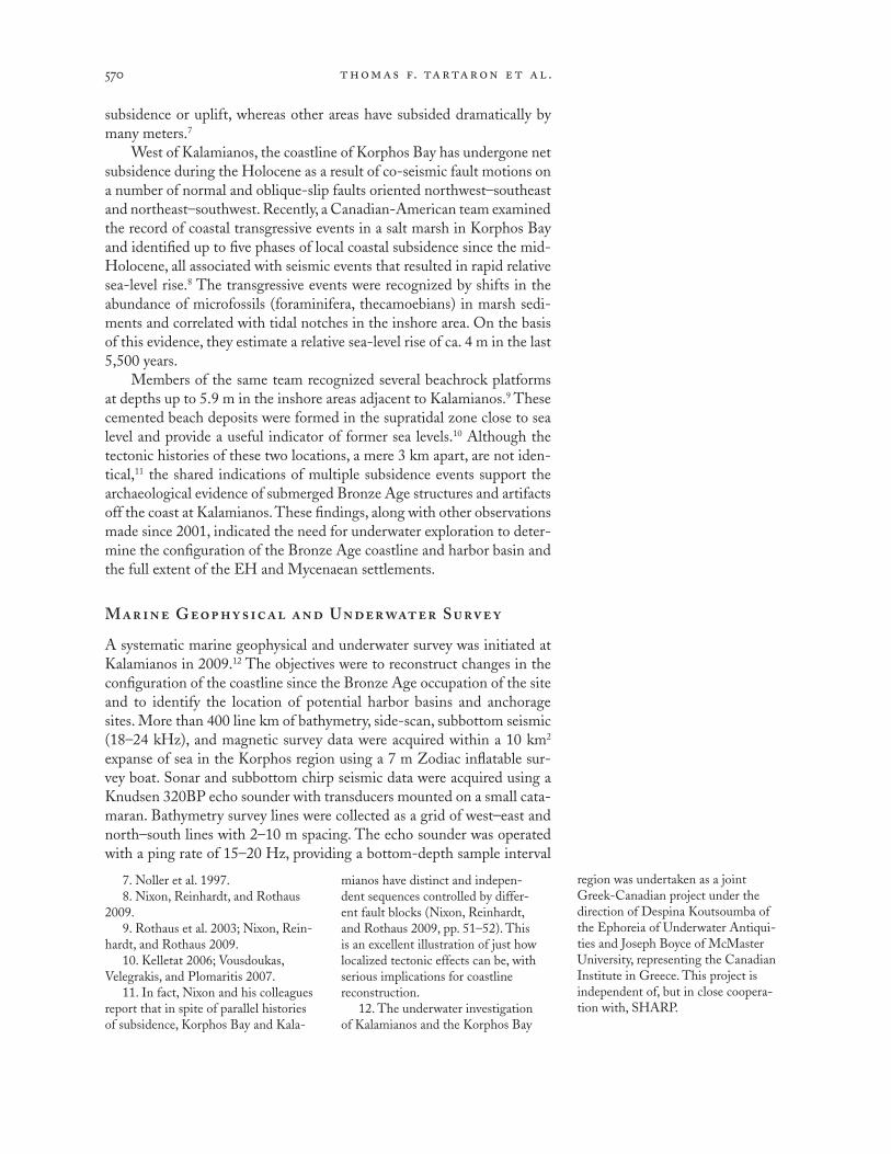
West of Kalamianos, the coastline of Korphos Bay has undergone net subsidence during the Holocene as a result of co-seismic fault motions on a number of normal and oblique-slip faults oriented northwest–southeast and northeast–southwest. Recently, a Canadian-American team examined the record of coastal transgressive events in a salt marsh in Korphos Bay and identified up to five phases of local coastal subsidence since the mid-Holocene, all associated with seismic events that resulted in rapid relative sea-level rise.8 The transgressive events were recognized by shifts in the abundance of microfossils (foraminifera, thecamoebians) in marsh sedi-ments and correlated with tidal notches in the inshore area. On the basis of this evidence, they estimate a relative sea-level rise of ca. 4 m in the last 5,500 years.
Members of the same team recognized several beachrock platforms at depths up to 5.9 m in the inshore areas adjacent to Kalamianos.9 These cemented beach deposits were formed in the supratidal zone close to sea level and provide a useful indicator of former sea levels.10 Although the tectonic histories of these two locations, a mere 3 km apart, are not iden-tical,11 the shared indications of multiple subsidence events support the archaeological evidence of submerged Bronze Age structures and artifacts off the coast at Kalamianos. These findings, along with other observations made since 2001, indicated the need for underwater exploration to deter-mine the configuration of the Bronze Age coastline and harbor basin and the full extent of the EH and Mycenaean settlements.
Mar ine Geophy sic al and Under water Surve y
A systematic marine geophysical and underwater survey was initiated at Kalamianos in 2009.12 The objectives were to reconstruct changes in the configuration of the coastline since the Bronze Age occupation of the site and to identify the location of potential harbor basins and anchorage sites. More than 400 line km of bathymetry, side-scan, subbottom seismic (18–24 kHz), and magnetic survey data were acquired within a 10 km2 expanse of sea in the Korphos region using a 7 m Zodiac inflatable sur-vey boat. Sonar and subbottom chirp seismic data were acquired using a Knudsen 320BP echo sounder with transducers mounted on a small cata-maran. Bathymetry survey lines were collected as a grid of west–east and north–south lines with 2–10 m spacing. The echo sounder was operated with a ping rate of 15–20 Hz, providing a bottom-depth sample interval
7. Noller et al. 1997.8. Nixon, Reinhardt, and Rothaus
2009.9. Rothaus et al. 2003; Nixon, Rein-
hardt, and Rothaus 2009.10. Kelletat 2006; Vousdoukas,
Velegrakis, and Plomaritis 2007.11. In fact, Nixon and his colleagues
report that in spite of parallel histories of subsidence, Korphos Bay and Kala-
mianos have distinct and indepen- dent sequences controlled by differ- ent fault blocks (Nixon, Reinhardt, and Rothaus 2009, pp. 51–52). This is an excellent illustration of just how localized tectonic effects can be, with serious implications for coastline reconstruction.
12. The underwater investigation of Kalamianos and the Korphos Bay
region was undertaken as a joint Greek-Canadian project under the direction of Despina Koutsoumba of the Ephoreia of Underwater Antiqui-ties and Joseph Boyce of McMaster University, representing the Canadian Institute in Greece. This project is independent of, but in close coopera-tion with, SHARP.

inv e st ig at ions at mycenaean kal amiano s 571
of ca. 5–10 cm. The bathymetry postprocessing included corrections for changes in sea surface due to waves and tides, and tie-line leveling to correct for cross-line errors. The line data were then gridded and interpolated to produce a digital bathymetric model (DBM) using a minimum curvature algorithm.
Magnetic survey data were acquired simultaneously with sonar data us-ing a Marine Magnetics SeaQuest multisensor marine gradiometer system. Survey navigation was provided by a Trimble Ag132 onboard differential global positioning system (DGPS) with submeter positioning accuracy. The bathymetric survey aimed to produce a detailed map of the relief of the seabed around the site and to determine the location and configuration of beachrock ridges identified by previous work.13 The subbottom seismic and magnetic survey data provided additional information on sediment thickness, bedrock structure, and the location of buried ballast and pottery within the harbor basin. The results of the seismic and magnetic work are being published separately;14 here we focus on a small subset of bathymetry data (0.25 km2) from the inshore area around Kalamianos.
Surveys were conducted by underwater divers using scuba equipment to investigate the submerged beachrock platforms and other targets identified by the geophysical survey. The areal extent of the beachrock outcrops was mapped using a surface-towed DGPS antenna, and the top and bottom depths were measured relative to the sea surface. Beachrock platforms were documented with underwater video, and samples were obtained at several locations for laboratory analysis (grain size, micropalaeontology, pottery studies) and radiocarbon dating of shells by accelerator mass spectrometry. The analysis and dating of samples are currently under way at McMaster University and the results will be published separately.
Results
The bathymetry map is presented as a color-shaded image in Figure 9. The water depth is less than 5 m across much of the inshore area and increases rapidly seaward, reaching a depth of more than 70 m within 300 m of the coast. The seabed relief is smooth with nearly continuous sediment cover, except in shallow water where the limestone bedrock and beachrock crops out in localized shoals. The bathymetry shows a submerged bedrock promon-tory east of Akrotirio Trelli, together with a drowned isthmus that formerly connected the small islet with the coast of the mainland. The submerged isthmus divides the inshore area into two separate lagoonal basins (the “western” and “eastern” basins) (Fig. 9:a).
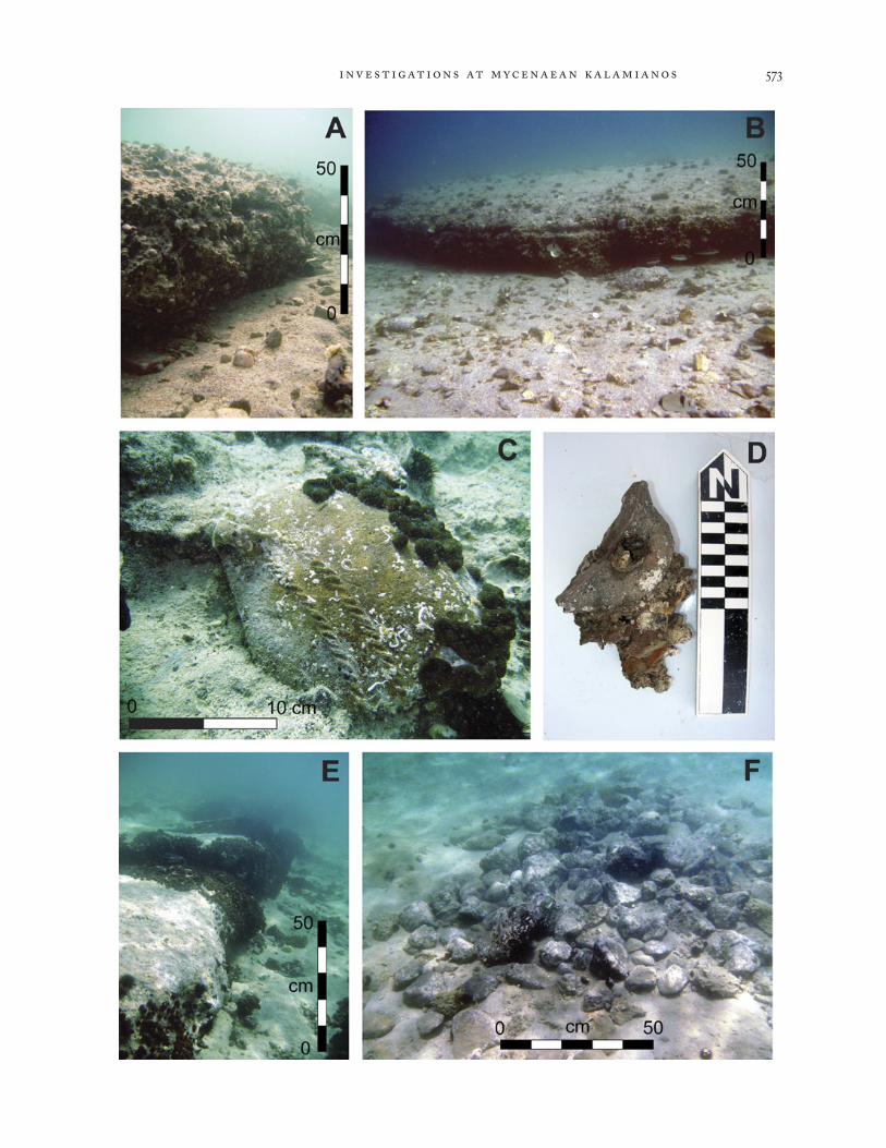
Two distinct beachrock ridges (BR-1, BR-2) were identified in the bathymetric mapping and confirmed by diver survey (Fig. 9:a). The up-permost ridge (BR-1) consists of two moundlike beachrock outcrops lo- cated on the submerged isthmus, ca. 100 m from shore. The mounds are up to 1–1.2 m in height, 30–40 m in length, and ca. 20 m in width. Both outcrops at BR-1 are elongated roughly parallel with the modern shoreline and have a basal water depth of 3.2–3.6 m. The BR-1 ridge consists of a vuggy, well-cemented calcarenite containing abundant Mycenaean pottery fragments (Fig. 10:a, b). Ceramic material constitutes about 30%–50% of
13. Rothaus et al. 2003; Tartaron, Rothaus, and Pullen 2003, pp. 34–35.
14. For preliminary results, see Dao 2011.

thomas f. tartar on e t al .572
Figure 9 (left). Aerial photograph and color-shaded bathymetric map of the inshore area at Kalamianos: (a) modern shoreline, with sub-merged beachrock ridges BR-1 and BR-2 indicated; (b) reconstructed shoreline during the LH period, with dashed line indicating the extension of the shoreline further landward beneath younger basin sediments; (c) reconstructed shoreline during the EH period.
Figure 10 (opposite). Images from the underwater investigation: (a) beach- rock ridge BR-1; (b) beachrock mound on west side of BR-1, with abundant pottery fragments in fore-ground; (c) well-preserved EH vessel fragment cemented in beachrock ridge BR-2; (d) Mycenaean jug han-dle from BR-1; (e) beachrock ridge BR-2 in water depth of 5.4–5.8 m; (f ) partially exposed ballast mound identified by magnetic survey in the western basin.
inv e st ig at ions at mycenaean kal amiano s 573

thomas f. tartar on e t al .574
the beachrock volume and consists mainly of angular sherds with little evidence of bioencrustation or surface boring (Fig. 10:b–d). On the whole, the fragments show little sign of postdepositional reworking or biological alteration, which is consistent with rapid burial in a supratidal, low-energy beach environment. The lower beachrock ridge (BR-2) occurs at a depth of 5.4–5.8 m on the western margin of the submerged promontory (Fig. 9:a). The beachrock is ca. 0.4–0.6 m in height (Fig. 10:e) and has a much lower abundance of ceramic material (10%–20%). The pottery includes well-preserved fragments of EH coarse ware (Fig. 10:c), which provide a terminus post quem for the formation of the ridge.15 Many of the fragments preserve decorative surface features and lack significant bioencrustation or surface boring, a condition consistent with rapid burial. The presence of EH pottery at BR-2 provides supporting evidence for a pre-Mycenaean occupation phase that has also been recognized in the archaeological land survey at Kalamianos.
Coastal Reconstructions
The configuration of the Bronze Age coastline has been reconstructed using the bathymetry model and beachrock elevations as a guide to the positions of the paleoshorelines (Fig. 9:b, c). The chronology of beachrock formation has yet to be established through absolute dating, but on the basis of the available ceramic evidence the BR-1 shoreline has been tentatively associated with the LH phase of site occupation (ca. 1400–1200 b.c.) and the BR-2 shoreline with the EH phase (ca. 2700–2200 b.c.). It should also be noted that the reconstructed shoreline positions are approxima-tions based on the modern bathymetric contours and do not take into account the effects of sediment accumulation and compaction following the submergence of the beachrock ridges. Nevertheless, the maps provide a useful starting point for understanding the configuration of the coastline in the Bronze Age.
The coastal reconstructions show that during the LH (Mycenaean) period (Fig. 9:b), the islet was much more extensive than it is at present (ca. 500 m2), but separate from the mainland. The bedrock promontory on the eastern side of Akrotirio Trelli was emergent during this phase, provid- ing a sheltered anchorage site, the western basin, with a deep-water approach. The extent of the western harbor basin shown in Figure 9:b is approximate, as the thickness of the post-Mycenaean sediment fill has yet to be estab-lished from seismic and core data. During the Mycenaean phase, ships may have anchored in the western basin and loaded or unloaded goods directly or via smaller, lighter craft. The abundant concentrations of pottery in the beachrock ridges at BR-1 seem to point to the use of the sandy coastal promontory here as a “shipping terminus.” The western basin would have provided a sheltered anchorage during periods when the dominant winds were blowing from the west and southwest. During periods when the winds were blowing from the east and southeast, the shallow embayment on the west side of Akroterio Trelli could have provided an alternative mooring site. Larger ships might also have been moored at the offshore island.
15. The fragment illustrated in Figure 10:c is probably from a type 3 jar with impressed bands between horizontal handles, generally dated to EH IIA (Lerna III phases A–B; see Lerna IV, pp. 559–569).

inv e st ig at ions at mycenaean kal amiano s 575
During the EH phase of settlement, when the local sea level was ca. 5.4 m lower than at present, the island was connected to the mainland by an isthmus that stood 1.0–1.5 m above sea level (Fig. 9:c). Together, the island and isthmus formed a natural recurved breakwater, ca. 250 m in length and 40–50 m in width, enclosing a well-protected natural harbor in the eastern basin. Cycladic longboats, the largest known seagoing craft of the period, were likely ca. 15–20 m in length with a shallow draft,16 and it is possible that such vessels may have docked on the natural quay afforded by the steep limestone outcrop that forms the northern shore of the island. This remains the most likely location for an anchorage and trading center during this period, although a dense concentration of obsidian marking a probable EH workshop (described below) was found onshore very near the western basin.
Other important clues to the location of anchorage sites can be ob-tained from the distribution of ships’ ballast, which can be detected even when buried at some depth by a magnetic gradiometer survey.17 Magnetic surveys in the eastern and western harbor basins at Kalamianos identified a number of magnetic “hot spots,” which were found to be associated with accumulations of volcanic ballast stones and ceramic material. The volcanic boulders and pottery have a significant induced and remnant magnetization when compared to the local limestone bedrock and seafloor sediments. Diver reconnaissance surveys of the western basin identified a number of small ballast-stone piles and a large, partially exposed mound of ballast consisting mainly of andesitic boulders and limestone cobbles (Fig. 10:f ). The exposed portion of the mound was 4–5 m in diameter and included scattered Mycenaean pottery fragments. Work is currently under way to map the distribution of magnetic anomalies as a means of pinpointing the location of anchorage sites.
The data obtained from the marine geophysical and underwater survey are currently being studied. The findings will generate new questions and hypotheses that will guide future work in the waters off Kalamianos.
THE ARCH I TECT URE OF MYCENAEAN KALAMIANOS
One of the main objectives of SHARP has been to document and study the Late Bronze Age site of Kalamianos. As a consequence of a set of unique formation processes, discussed above but not yet entirely understood, the architecture of the site is extremely well preserved, allowing us to examine an entire town, from individual buildings to overall organization, without excavation. Over the course of three field seasons in 2007–2009 we docu-mented more than 50 individual structures and architectural complexes, hundreds of walls, and other built features (Fig. 11). The following account includes a general introduction; a description of the methods used to docu-ment the architecture; preliminary remarks on the form and construction techniques of the buildings, the circuit walls, and other structures; and a discussion of the planning and organization of the site. We have only begun
16. Broodbank 2000, pp. 97–101.17. For an example of the magnetic
detection of ballast mounds, see Boyce, Reinhardt, and Goodman 2009.
thomas f. tartar on e t al .576
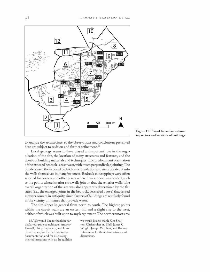
to analyze the architecture, so the observations and conclusions presented here are subject to revision and further refinement.18
Local geology seems to have played an important role in the orga-nization of the site, the location of many structures and features, and the choice of building materials and techniques. The predominant orientation of the exposed bedrock is east–west, with much perpendicular jointing. The builders used the exposed bedrock as a foundation and incorporated it into the walls themselves in many instances. Bedrock outcroppings were often selected for corners and other places where firm support was needed, such as the points where interior crosswalls join or abut the exterior walls. The overall organization of the site was also apparently determined by the fis-sures (i.e., the enlarged joints in the bedrock, described above) that served as water sources in antiquity, since clusters of buildings are regularly found in the vicinity of fissures that provide water.
The site slopes in general from north to south. The highest points within the circuit walls are an eastern hill and a slight rise to the west, neither of which was built upon to any large extent. The northernmost area
Figure 11. Plan of Kalamianos show-ing sectors and locations of buildings
18. We would like to thank in par-ticular our project architects, Andrew Howell, Philip Sapirstein, and Giu- liana Bianco, for their efforts in the documentation and for discussing their observations with us. In addition
we would like to thank Kim Shel- ton, Christopher A. Pfaff, James C. Wright, Joseph W. Shaw, and Rodney Fitzsimons for their observations and discussions.

inv e st ig at ions at mycenaean kal amiano s 577
of architecture lies between these two hills, centered on Building 7-I, with the remainder of the buildings on the slopes to the south. In some places the slope is very gentle, with nearly flat and level areas; in others the slopes are steeper. The architecture was built to take the topography into account.
The exposure and preservation of so much stone architecture at Kala- mianos can be explained by a combination of factors. The walls of the buildings are constructed of stone to a considerable height, and the need for mudbrick to complete them may have been minimal. If this were the case, there would be little dissolved and eroded mudbrick to bury the structures. The situation of the site is such that there is a shallow depression between the foothills to the north and the slope on which the buildings stand. This depression would prevent gravity-entrained colluvial deposits from reaching the structures, although there is localized erosional and colluvial activity confined to the site itself. Finally, post-Bronze Age occupation of the site seems to have been minimal. There is evidence for Late Roman reuse of a building in sector 9, and a few small, simple structures in sec-tor 5 may date to the same period. Stones were robbed from buildings to feed a modern lime kiln at the shore in sector 9, and villagers report that much lime plaster and whitewash were made in the past at Kalamianos and exported to Aigina. The planting of olive trees in the recent past has also disturbed some structures. For the most part, however, the site seems to have been relatively undisturbed by later use.
As noted above, the stone foundations of many structures, or portions of structures, are bedded on exposed bedrock. The walls are preserved to a height of 1 m or more in places, establishing clear wall lines for both exterior and interior walls; the highest preserved wall, at the southeast corner of Building 7-I, stands to 1.75 m (Fig. 12). In other structures the
Figure 12. Southeastern corner of Building 7-I

thomas f. tartar on e t al .578
walls are buried in the soil, or soil has accumulated around their bases. The depth of these soil deposits is not clear without excavation, but in many places it seems that they should be substantial enough to merit excava-tion. In room 1 of Building 7-I the collapsed stone covering the surface was removed, revealing a layer of topsoil with small pebbles and red earth. Geologist Richard Dunn was able to push an auger into this to a depth of 0.25 m before striking stone; a small piece of unburned clay (daub?) was retrieved from the auger core, suggesting collapse of structural members once sealed by clay, such as part of a ceiling. Likewise, traces of soil in the interstices between the stones at the southeast corner of Building 7-I led Dunn to suggest that there had been erosion of more than 0.50 m of soil from the exterior of the building. Some structures built on sloping ground have taller south (downslope) walls that retain soil on their uphill sides, while the northern ends of the structures are apparently buried.
Whatever the explanations for the exceptional preservation of the site, the circumstances have presented us with a nearly complete plan of a walled Mycenaean town, including individual buildings, streets, and other features. Part of the site has been lost to the sea, but at least 3.5 ha of structures are preserved (Fig. 13). What we lack, of course, is stratigraphy, and thus the buildings represent a palimpsest of structures with imprecisely known chronological relationships. Nevertheless, detailed architectural observa-tions provide some evidence for construction sequences and the modifica-tion of structures over time, and the retrieval of datable ceramics from the buildings through spatially controlled surface collection provides chrono-logical evidence for the buildings.
Figure 13. Aerial photograph of Kalamianos, looking south-southeast.Balloon photo K. Xenikakis and S. Gesafides

inv e st ig at ions at mycenaean kal amiano s 579
Apart from modern terrace walls and a few poorly preserved structures in sectors 5 and 9 that date to the Late Roman period (or later), all of the architecture at Kalamianos appears to be of Mycenaean date. The buildings as they are now understood date to the LH IIIB period, although some were perhaps initially constructed as early as LH IIIA; the lack of identifiable LH IIIC material establishes a terminus ante quem for the site. Thus the total length of time represented by the buildings is ca. 120 years, or up to 200 years at most.19 This span, four to eight generations in length, afforded ample opportunity for the buildings to undergo modification or expansion. We need not assume that all the structures were built at the same time or occupied throughout the entire LH IIIB period.
Architectural Documentation
The unique state of preservation and sheer quantity of the architecture at Kalamianos presented major challenges. A number of methods were used to document the remains, from initial location and inventory using handheld GPS units to stone-by-stone drawings at 1:20 or 1:50 scale. Not all of the architecture was subjected to each method of documentation; instead, an attempt was made to obtain a sample based on criteria that included the size of the structure, the location within the site, and the state of preservation.
In 2007 we conducted a systematic surface survey of the site. Instead of recovering artifacts, however, we initially concentrated on identifying walls. The site was divided into nine arbitrarily defined sectors for ease of identification (Fig. 11).20 Field teams of five to eight individuals, usually spaced 10 m apart, walked transects looking for architecture.
Four major impediments to the identification of architecture were immediately apparent: the vegetation, the extensive use of local bedrock as a foundation and construction material, the extensive collapse of ancient stone walls, and the presence of modern terrace walls in parts of the site. The area is densely overgrown with wild olive, as well as maquis and phry- gana; the relatively young domesticated olives have not been tended in years, and much wild vegetation has grown up around them. The plant-ing of the olives seems to have disturbed many buildings, where stones were moved to create space for the young trees. Elsewhere, the roots of wild plants have broken apart the relatively brittle bedrock and pushed stones out of alignment, while the growth above ground has obscured them. The local bedrock, as discussed above, generally fractures into cu- bic or rectangular shapes, which are then utilized in construction, but it is often difficult to distinguish bedrock that has spalled off in blocky forms from actual worked blocks. In many instances it seems that the walls were mostly or substantially constructed of stone, and their collapse
19. Shelmerdine 2001, p. 332, table 1; 2008, pp. 3–7. Shelmerdine’s “modified chronology,” which takes into account the dendrochronological data from the Uluburun shipwreck, suggests a date of ca. 1310/1300 b.c.
for the transition from LH IIIA2 to LH IIIB and a date of ca. 1190/1180 for the transition from LH IIIB to LH IIIC. LH IIIB thus lasts approxi-mately 120 years. If we extend the date of the buildings at Kalamianos back
into LH IIIA2 (ca. 1370–1310/1300), the span is lengthened to 190 years.
20. Areas beyond the circuit walls were also given sector numbers, includ-ing sector 13 for Stiri.

thomas f. tartar on e t al .580
has often filled the buildings with debris. Usually, however, rooms were identifiable by the presence of depressions in the fallen debris, if not by the lines of the walls themselves. A characteristic feature of construction at Kalamianos is the use of large shaped blocks as cornerstones or at the midpoints of walls in order to support the roof or an interior wall, whether abutting or joining. Once one of these blocks was recognized, it was often possible to rapidly trace portions of the exterior walls of the structure to which it belonged.
When a wall was recognized, a field team recorded the length, orien-tation, presence of faces and courses, and location on standardized forms for entry into a database and geographic information system (GIS). The locations of the endpoints were established by the use of handheld GPS units. While this method is suitable for a landscape with sparse surface remains, in the densely built landscape of Kalamianos the margin of error inherent in measurements made by handheld GPS units (± ca. 4 m) made the subsequent use of the locational data difficult. Mapping the endpoints in this way often resulted in erroneous lengths, locations, or orientations, and made the association of related walls difficult.21 The locational data obtained at this stage were never meant for mapping purposes, but rather for inventorying in advance of subsequent, more detailed study. This initial dis-covery survey resulted in the identification of nearly 1,000 walls (Fig. 14). Additional walls were subsequently identified through systematic archaeo-logical survey and during documentation and other fieldwork.
Differential GPS provides much more accurate locational information, with margins of error in the 2–4 cm range. Over the course of the first three years of the project, many of the walls and structures previously mapped with handheld GPS units were also mapped with DGPS, although often only in outline form.22 The resulting plan (Fig. 15) provides a more accu-rate representation of the distribution, form, and size of the architectural features on the site. We were especially concerned to map structures that might not be subjected to additional methods of architectural documenta-tion. DGPS was also utilized throughout the larger survey region to map structures where use of other techniques, such as survey by electronic total station, proved impractical.
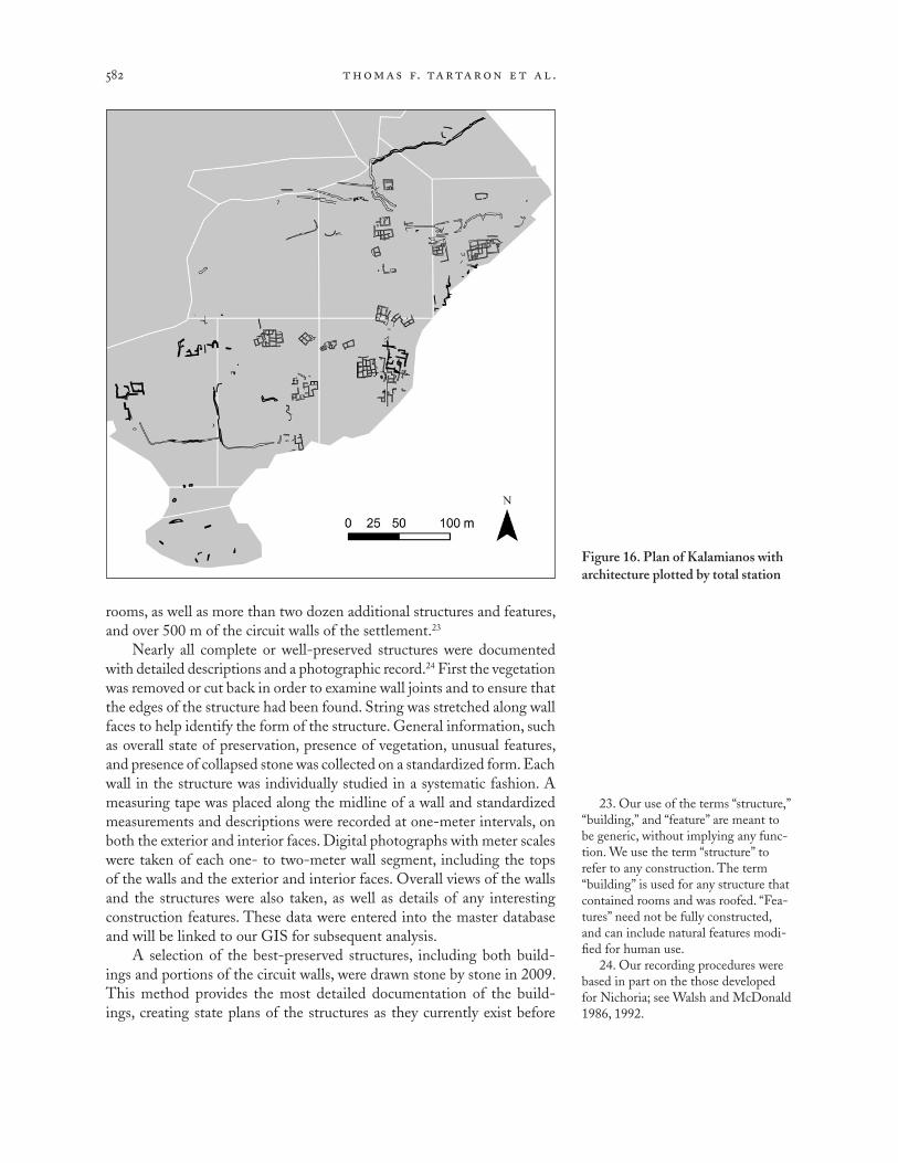
All structures that were subjected to additional architectural documen-tation, such as wall descriptions and photography, were eventually mapped using an electronic total station (Fig. 16). Wherever possible, the interior and exterior faces, doorways, and other features were mapped, providing a more detailed plan of the buildings. As progressively refined documentation of the architecture took place, new interpretations of the buildings, walls, and features led to new mapping by the total station team. By the end of the 2009 season we had mapped ca. 50 buildings with 120 measurable
21. As an experiment we plotted much of the initial locational data using the GPS coordinates of the mid-point of the wall and measuring the length and orientation directly, rather than connecting the two endpoints. The resulting plans more closely
reflected the actual structures.22. Owing to the high cost of
DGPS equipment and the need for multiple teams to record basic loca-tional data simultaneously in real time, it was deemed impractical to use DGPS as the initial discovery method.

inv e st ig at ions at mycenaean kal amiano s 581
Figure 14. Plan of Kalamianos after initial discovery and plotting of architecture with handheld GPS units
Figure 15. Plan of Kalamianos with architecture plotted by DGPS
thomas f. tartar on e t al .582
rooms, as well as more than two dozen additional structures and features, and over 500 m of the circuit walls of the settlement.23
Nearly all complete or well-preserved structures were documented with detailed descriptions and a photographic record.24 First the vegetation was removed or cut back in order to examine wall joints and to ensure that the edges of the structure had been found. String was stretched along wall faces to help identify the form of the structure. General information, such as overall state of preservation, presence of vegetation, unusual features, and presence of collapsed stone was collected on a standardized form. Each wall in the structure was individually studied in a systematic fashion. A measuring tape was placed along the midline of a wall and standardized measurements and descriptions were recorded at one-meter intervals, on both the exterior and interior faces. Digital photographs with meter scales were taken of each one- to two-meter wall segment, including the tops of the walls and the exterior and interior faces. Overall views of the walls and the structures were also taken, as well as details of any interesting construction features. These data were entered into the master database and will be linked to our GIS for subsequent analysis.
A selection of the best-preserved structures, including both build-ings and portions of the circuit walls, were drawn stone by stone in 2009. This method provides the most detailed documentation of the build- ings, creating state plans of the structures as they currently exist before
23. Our use of the terms “structure,” “building,” and “feature” are meant to be generic, without implying any func-tion. We use the term “structure” to refer to any construction. The term “building” is used for any structure that contained rooms and was roofed. “Fea-tures” need not be fully constructed, and can include natural features modi-fied for human use.
24. Our recording procedures were based in part on the those developed for Nichoria; see Walsh and McDonald 1986, 1992.
Figure 16. Plan of Kalamianos with architecture plotted by total station

inv e st ig at ions at mycenaean kal amiano s 583
excavation. In some instances the observations of the architects led to dif-ferent interpretations of the remains from those inferred from mapping by other means. These structures were remapped with a total station in order to bring the data into conformity with the interpretations of the architects.
Two sessions of aerial photography were conducted during the 2009 season. In the first, a digital camera set to take photographs every five seconds was suspended from a kite pulled behind a boat.25 The second session, conducted by Kostas Xenikakis and Symeon Gesafides, used a teth- ered balloon from which was suspended a digital camera operated by remote control. The resulting photographs (including Fig. 13, as well as Figs. 22 and 25, below), when georeferenced and rectified, will provide a valuable set of overviews and detailed images of the site.
Mater ials and Construction Techniq ues
The principal material used in construction at Kalamianos was the local limestone. Because we have examined only surface remains, we have no evidence at the present time for the use of organic materials. There is some evidence for the use of clay in construction, but whether for mudbrick or for roofing is not clear.
As noted above, the limestone at Kalamianos fractures readily into roughly rectangular shapes of various sizes. Occasionally these large stones were set directly into the walls, but in other cases they were shaped before use, especially if the stone was to be used at a corner or as another structural feature. After the site was abandoned the stones were subjected to further weathering, including spalling and fracturing most likely caused by thermal expansion and contraction, with the result that architectural stones may now be smaller than their original size. In places, this process has led to wall collapse or the dislocation of smaller pieces of stone from the wall face.
Exposed bedrock is found throughout the site, often in close proximity to structures. There is little direct evidence for quarrying, in part because the rock has apparently been continuously exposed for centuries, and weather-ing has erased most of the evidence. The pervasive fracturing, spalling, and removal of stone surfaces through chemical solution has altered the exterior faces of blocks and obscured any trace of tool marks or quarry marks. At the same time, karren features reveal the orientation of the blocks over the period of exposure to weathering processes.26 The occurrence of pitting on the upper horizontal surfaces and rillenkarren ridges and channels on the vertical face implies that a stone has remained in its present orientation during a long period of exposure, and thus may provide corroborative evi-dence for in-situ blocks. When karren features exist on a stone but are out
25. We would like to thank Despina Koutsoumba of the Ephoreia of Under-water Antiquities for arranging the use of the boat for this project. The kite photography was conducted by Ben Gourley and Michael Charno of the University of York.
26. See Tartaron, Pullen, and Noller 2006, pp. 154–156, for further discus-sion of the way in which such weather-ing features can assist in establishing broad chronological frameworks for architecture in karstic regions.

thomas f. tartar on e t al .584
of their original orientation, it is assumed that the block has been moved from the position it occupied in the past.27
There is some indication that certain varieties of the limestone were selected for aesthetic reasons. Where fissures occur, the fill of the bedrock joints includes banded crystalline calcite that weathers white in contrast to the usual gray. In sector 7, near fissure 7-14, large blocks of the white, banded limestone were used along exterior walls and at corners, perhaps for architectural emphasis. In other areas of the site, corner blocks sometimes appear to be a different color from the majority of the stone used in the rest of the building. None of the stone used in structures at Kalamianos, however, need have come from more than a short distance away (under 100 m in most cases). The use of local limestone kept the costs of both quarrying and transportation low.
We have only begun to study the construction techniques employed at Kalamianos. The most common technique is a form of double-faced, rubble-filled construction (Fig. 17). Two rows of stones, many of which are roughly triangular and set with their apexes inward, form the faces of the wall. Smaller rubble fill, frequently containing sherds and shells, is placed between them to form a solid structure. The doubled-faced, rubble-filled walls were reinforced with large square blocks at the corners of structures, at the midpoints of walls, and sometimes at the points where interior walls meet exterior walls. Large rectangular blocks laid as headers across the full width of the wall are found occasionally, serving as anta blocks at the ends of walls or doorways, strengthening walls at points where other walls join, and elsewhere. The walls at Kalamianos average ca. 0.85 m in width, which is considerably larger than the average width of 0.50 m at Nichoria, the only other site for which comparable data have been published.28 A recent study of Mycenaean architecture by Pascal Darcque provides maximum widths for the walls of 162 buildings: these range from 0.40 to 2.80 m, with an average of 0.80 m.29
The stones used in wall construction at Kalamianos vary greatly in size, but even in relatively small structures many of the stones are remark-ably large. Blocks 1 m or more in length are not at all uncommon, and this gives many walls a “cyclopean” appearance (Fig. 18). While the ready availability of large stones at the site might account for their liberal use, care was apparently taken to set them in conspicuous positions, whether they are worked (at corners or near doorways) or unworked (especially on the eastern facades of buildings). This careful placement of large blocks, along with the use of the lighter-colored, banded limestone blocks in similar positions, recalls the use of conglomerate blocks in the palaces at Mycenae and Tiryns, where James Wright has argued for their deliberate employ-ment as a display of palatial power.30
Although there are numerous examples of stones worked into square or rectangular blocks, there are no “ashlar” walls of coursed masonry. Worked blocks seem to have been placed primarily at corners and other points of articulation, not along the entire foundation course of a building. We have not observed any cuttings or fittings for clamps, dowels, or mortises and tenons. Instead, the stones appear to have been fitted together in a drywall technique, perhaps with mud mortar. One cutting in the form of a slot, on
27. Collins and Dunn (2008) deter-mined that in-situ architectural stone had poorly developed (younger) rillen-karren relative to bedrock, and calcu-lated a rate of rillenkarren formation based on the known age of the standing Mycenaean walls. The rillenkarren sur-faces of architectural stones that had fallen from walls were found to be still more poorly formed, many having fallen out of their in-situ orientation ca. 1300–2100 years ago, according to the calculated rate of rillenkarren for-mation. Finally, when one compares in-situ, exposed stones to stones from interior walls that would not have been exposed, the latter generally lack rillenkarren. These observations may provide insight into the formation of the archaeological site, implying grad-ual collapse of the buildings and burial of many lower wall surfaces, particularly the interior wall faces of structures where sediment was trapped.
28. Walsh and McDonald 1992, p. 457.
29. Darcque 2005, pp. 139–143, fig. 33. If one separates the buildings at “palatial” sites (i.e., Gla, Midea, Myce-nae, Pylos, Thebes, and Tiryns) from those at “nonpalatial” sites, the resulting ranges and averages are strikingly dif-ferent. At palatial sites, the range of maximum wall widths is 0.40–2.80 m, with an average of 0.94 m; at nonpala-tial sites, the range is 0.45–1.60 m, with an average of 0.66 m.
30. Wright 2006, pp. 58–60.

inv e st ig at ions at mycenaean kal amiano s 585
Figure 17. Example of wall construc-tion: Building 7-X, wall 270, from north
Figure 18. Cyclopean masonry: Building 7-X, east wall

thomas f. tartar on e t al .586
the upper surface of the leveled bedrock in the northwest part of room 10 in Building 7-I, is of a size to hold a beam or a post (0.30 x 0.12 m). The bedrock in this area has been trimmed to a series of flat steps or terraces; the surface with the slot is at the same level as the top of pier 283 in the middle of room 10.
In Building 7-I we see the use of what might be called orthostates: blocks with a length and height much greater than their depth, set into the face of the wall.31 They are found at the northwest and southwest corners of the structure, as well as in the south wall adjacent to the entrance (Fig. 19). Their use at Kalamianos is surprising, since true orthostates are rare, even at palatial centers.32 As none of the examples at Kalamianos preserves the mortises that Michael Nelson identifies as a feature of true orthostates, it is perhaps best to label these “pseudo-orthostates,” pending further study.
The question of the use of mud mortar in the stone walls is still un-resolved. Most of the walls as preserved are above ground and exposed to the elements, and thus they have little soil in them. Whether this was true when the walls were built is uncertain. Some of the better-constructed corners seem to fit together in such a way that mortar would have been unnecessary, but the double-faced walls may well have required mud mortar for their rubble interiors. The recovery of Mycenaean ceramics (discussed below) from the interiors of the walls suggests that mud or earth mortar containing sherds and shells was employed in their construction.
Some of the most useful data on construction techniques is provided by Building 13-II, a small structure at Stiri that was cut by the construction of a modern road from the coastal lowland up to the church of the Panayia Stiri. The building seems to have been a rectangular tower attached to a larger enclosure. From above, the appearance of the tower, with its corner-stones, double-faced and rubble-filled walls, and collapsed stone debris, resembles that of the buildings at Kalamianos and at the large Mycenaean complex at Stiri just to the east of 13-II. The section of the building cut by
31. See Nelson 2001, p. 111, for the definition used here.
32. Nelson (2001, pp. 112, 113, 117–125) notes the rarity of orthostates in Mycenaean construction. Many examples are not well dated; those at Pylos have been dated to early LH IIIB at the latest, but are more likely not later than LH IIIA (pp. 202–203).
Figure 19. Southwest corner of Building 7-I, showing “pseudo-orthostate” block

inv e st ig at ions at mycenaean kal amiano s 587
the road, however, clearly reveals that the stones of the exterior face of the wall are set on bedrock, well below the floor level, while the stones of the interior face are bedded on large stones (Fig. 20). It is not clear in the sec-tion whether the rubble packing beneath the floor was used solely to build up the downslope portion of the building, in a manner similar to terraces at other Mycenaean sites,33 or whether it belongs to the wall of an earlier structure. Smaller stones were used to form the packing for the floor, and a layer of pebbles, also perhaps part of the floor, is visible at some points in the exposed section. Above the floor, sherds, as well as fragmented but nearly complete Mycenaean vessels, were found mixed with more small rounded pebbles in a red clayey soil matrix. The fact that these vessels are not resting directly on the floor suggests that they may have fallen from shelves at the time of the room’s collapse. The red clay matrix with sherds and small rounded pebbles most likely derives from collapsed structural elements, either mudbrick or roofing clay or both. Together with the red soil and pebbles revealed in room 1 of Building 7-I (p. 578, above), the evidence from Building 13-II at Stiri suggests that deposits of soil worth excavating may be preserved within many of the rooms at Kalamianos.
The B uildings at Kal amianos
The structures at Kalamianos have a wide range of sizes and plans, but two main types are repeated throughout the site: smaller buildings, often with four rooms, which are set at a distance from other structures; and larger multiroomed complexes, which may contain more than one functional unit (Fig. 11). Some of the larger complexes apparently consist of a core four-room unit to which several more rooms and spaces have been added; in Building 5-XV, for example, a second four-room unit was built south of
33. For Mycenaean terrace construc-tion, see Wright 1980.
Figure 20. Building 13-II at Stiri: view of road-cut section showing construction

thomas f. tartar on e t al .588
the first, utilizing the earlier unit’s south wall (wall 5-1043) as the north wall of the addition. We have not been able to identify a single example of the so-called megaron form (i.e., a unit with a porch, large main room, and either an intervening vestibule or a rear chamber, all on a single axis), although the features of Building 7-I approximate this architectural form, which has often been considered typically Mycenaean.34
The freestanding four-room unit does not seem to occur at other My- cenaean sites, yet it appears several times at Kalamianos. Sapirstein has noted that the interior crosswalls often do not bond with the exterior walls, at least as preserved. In other words, an undivided structure measuring ca. 10 x 10 m was constructed first, into which interior crosswalls were inserted at a later time. A structure built in this way may have been faster to complete, or have required less labor, than a structure with interior walls that bonded with the exterior walls.
Of the structures that have so far been thoroughly documented, we have plans for at least 13 complete buildings and for large portions of another seven, from which we can calculate overall building size and average room size (Table 1). A comparison with data collected by Darcque shows that the distribution of building sizes at Kalamianos is comparable to that at other sites (Table 2).35 Although overall size can be computed for only 19 build-ings at Kalamianos, compared to 141 in Darcque’s study, the most common size range at Kalamianos, 50–100 m2 (47.4%), is also the most common at other Mycenaean sites (33.3%). Discounting very large buildings (those over 310 m2), the second most common size range at Kalamianos is 120–200 m2
(26.3%); at other Mycenaean sites it is 20–50 m2 (18.4%), followed by 120–200 m2 (13.5%).
At Kalamianos, many of the four-room units seem to have ca. 45–55 m2 of usable interior space, although there is considerable variation. Of particu-lar interest is the amount of usable space expressed as a percentage of the total footprint of the building (Table 1). In spite of substantial differences in building size (50–440 m2) and number of rooms (1–16), the amount of usable space within a building consistently falls within a narrow range from 48% to 70% of the total footprint of the building. This statistic will be useful in attempting to assess the size of poorly preserved structures when only the exterior outline is preserved.
A number of the documented buildings are incomplete, in the sense that we are unable to determine their full extent with certainty. Often, however, we have been able to identify and document individual rooms even in the incomplete structures; as a consequence we now have measure- ments for 120 rooms. A comparison of the room sizes with the data com-piled by Darcque shows that the distribution of room sizes at Kalamia- nos conforms well to those at other Mycenaean sites (Table 3, Fig. 21).36 Kalamianos lacks very large rooms (those over 75 m2), but Darcque lists only 32 such large rooms, or ca. 5.1% of his total of 626 rooms.37 The most common room size in Darcque’s compilation is in the 5–10 m2 range (159, or 25.4% of all rooms), followed by rooms in the 10–15 m2 range (139, or 22.2% of all rooms). The most common room size at Kalamianos is in the 10–15 m2 range (36, or 30.0%), followed by rooms in the 5–10 m2 range (29, or 24.2%). The pattern at Kalamianos nevertheless conforms well to
34. Darcque (1990; 2005, pp. 318–319) argues against the use of the term “megaron” as too ambiguous and too problematic.
35. Darcque 2005, pp. 149–161, 323–326, fig. 100.
36. Darcque 2005, pp. 149–161, esp. p. 159, fig. 38. We have not included two extremely large rooms in the 225–235 m2 range (Gla, Building B, rooms 3 and 5) in the chart in Figure 21.
37. Gla accounts for nearly half (14) of the 32 rooms on Darcque’s list with an area greater than 75 m2.

inv e st ig at ions at mycenaean kal amiano s 589
TABLE 1. BUILDING SIZES, INTERIOR SPACE, AND SH ERD COUNTS
BuildingLength (N–S)
Width (E–W)
Total ExteriorFootprint (m2)
No. of Rooms
Combined Room Area (m2)
Average Room Area (m2)
Room Area as % of
Total FootprintTotal
Sherds
3-III (incomplete) 8.37 11.49 88.97 2 55.12 27.56 61.9% 0
4-III 9.98 9.34 87.15 4 49.55 12.39 56.9% 112
4-VI 20.56 12.42 195.58 7 116.67 16.67 59.7% 63
4-IX (incomplete) 21.42 6.81 130.57 3+ 76.45 <25.48 58.6% 77
4-XIV (incomplete) 15.04 7.45 87.95 3+ 58.60 <19.53 66.6% 28
4-XVI (incomplete) 16.32 26.31 229.78 12+ 136.86 <11.41 59.6% 7
5-II 26.50 19.34 440.00 16 281.61 17.60 64.0% 95
5-III (incomplete?) 10.89 6.86 64.93 2 36.25 18.13 55.8% 5
5-VIII (A–D only)1 17.37 18.50 293.90 14 202.49 (52.57 + 46.22 + 46.54 +57.16)
14.46 (17.52, 15.41, 11.64, 14.29)
68.9% 123
5-XIII 7.42 7.65 50.82 4 24.57 6.14 48.3% 11
5-XIV 6.30 12.00 61.25 2 38.21 19.11 62.4% 11
5-XV 15.19 9.98 162.66 3 + 4 47.89 + 44.91 15.96, 11.23 55.2% 6
7-I 17.22 21.50 276.00 10 181.57 18.16 65.8% 37
7-II 10.38 9.44 92.93 4 51.30 12.83 55.2% 9
7-III 9.33 17.78 165.00 7 102.53 14.65 62.1% 15
7-V 8.88 5.91 50.42 2 29.27 14.64 58.1% 1
7-X 9.36 11.89 110.00 3 63.64 21.21 57.9% 12
9-IV 9.38 20.80 181.14 7+ 112.76 <14.11 62.3% 135
9-VIII 6.29 12.12 65.67 1 45.78 45.78 69.7% 6
9-XI (incomplete) 10.35 13.89 – 5 44.35 8.87 – 9
Average room area = 15.05 m2
Average total exterior footprint = 123.25 m2 (Building 5-VIII counts as four units, Building 5-XV as two units)
Average combined room area as percentage of total footprint = 61.9%1 The poorly preserved units E and F are omitted from this table. With units E and F the E–W width of Building 5-VIII is 27. 5 m and the total exterior footprint is 418.5 m.
TABLE 2. BUILDING SIZES AT KALAMIANOS COMPARED TO THOSE AT OTHER MYCENAEAN SI TES
Building Size (m2)
Kalamianos (19 examples)
Other Mycenaean Sites (141 examples)
No. % No. %
20–50 0 0 26 18.4
50–100 9 47.4 47 33.3
100–120 1 5.3 13 9.2
120–200 5 26.3 19 13.5
200–310 3 15.8 12 8.5
>310 1 5.3 24 17.0
Source of comparative data: Darcque 2005, pp. 320–326, figs. 100–104

thomas f. tartar on e t al .590
TABLE 3. RO OM SIZES AT KALAMIANOS COMPARED TO THOSE AT OTHER MYCENAEAN SI TES
Room Size (m2)
Kalamianos (120 examples)
Other Mycenaean Sites (626 examples)
No. % No. %
0–5 8 6.7 46 7.3
5–10 29 24.2 159 25.4
10–15 36 30.0 139 22.2
15–20 16 13.3 68 10.9
20–25 16 13.3 59 9.4
25–30 10 8.3 32 5.1
30–35 3 2.5 26 4.2
35–40 0 – 16 2.6
40–45 1 0.8 17 2.7
45–50 0 – 10 1.6
50–55 0 – 7 1.1
55–60 0 – 7 1.1
60–65 0 – 3 0.5
65–70 0 – 3 0.5
70–75 1 0.8 2 0.3
75–80 0 – 7 1.1
80–85 0 – 3 0.5
85–90 0 – 1 0.2
90–95 0 – 1 0.2
95–100 0 – 2 0.3
100–105 0 – 2 0.3
105–110 0 – 7 1.1
110–115 0 – 1 0.2
115–120 0 – 1 0.2
120–125 0 – 1 0.2
125–130 0 – 0 –
130–135 0 – 0 –
135–140 0 – 0 –
140–145 0 – 1 0.2
145–150 0 – 2 0.3
150–155 0 – 0 –
155–160 0 – 0 –
160–165 0 – 0 –
165–170 0 – 1 0.2
225–230 0 – 1 0.2
230–235 0 – 1 0.2
Source of comparative data: Darcque 2005, p. 159, fig. 38

inv e st ig at ions at mycenaean kal amiano s 591
the overall pattern of rooms in Mycenaean buildings at other sites, with the exception of the very large rooms.
While we were able to collect ceramics from the interiors of many of the rooms, it has not been possible to determine with certainty their func-tions, partly because of the small quantity of pottery recovered from any one unit, and partly because the material has so far received only limited study. Based on the preliminary identification of the pottery, we assume a domestic function for most of the buildings, although the assemblages vary in their makeup from building to building (see below).
Four buildings that have been extensively documented—Buildings 4-III, 4-VI, 5-VIII, and 7-I—will be discussed here to illustrate the range in building sizes and types at Kalamianos.
Building 4-III (Fig. 22) is a good example of a four-room structure set apart from other neighboring structures by several meters. It measures ca. 9.98 x 9.34 m, and is unusual in that it does not share the cardinal orientation of the majority of structures at Kalamianos; instead, its north wall (wall 4-130) runs from 45° to 225°, parallel to the modern contour of the gentle slope from northwest to southeast on which the building is constructed. The southeast (downslope) wall is not as well preserved as the others; a gap in the eastern portion of the wall may mark the position of a former entrance to the structure.
Building 4-III is located just to the south of a large group of terrace walls that occupy the northwestern part of the settlement, and it may be that rubble from the structure provided readily available material for the construction of terrace walls in the modern era. Large rectangular blocks were used for the four cornerstones, as well at the points on the exterior
Figure 21. Distribution of room sizes at Kalamianos (black bars) compared to other Mycenaean sites (white bars). Source of comparative data: Darcque 2005, p. 159, fig. 38

thomas f. tartar on e t al .592
38. There may have been a road or other passage running east–west to the north of Building 4-III, as the build-ings to the west and east of 4-III seem to be aligned along a natural (modern) path. In the case of other structures at Kalamianos (e.g., Buildings 7-I and 7-X), the builders took the view or ave-nue of approach into consideration and emphasized parts of the structure with larger stones.
walls where interior walls joined, at least on the northwest, southwest, and southeast. The blocks on the northwest and southeast were set as headers. The northwest exterior wall seems to be constructed of larger stones than the others, perhaps because it was felt that the upslope wall needed to be more substantial for stability, drainage, and erosion control, or even for appearance.38
The interior of Building 4-III is divided into four rooms by two inter-secting crosswalls. The crosswall connecting the northwest and southeast walls is fairly straight, perpendicular to the exterior walls, and set slightly to the southwest of the central axis of the structure. The other crosswall is not as well defined, but it seems to be set at an oblique angle to the exte-rior walls, thus forming irregularly shaped rooms. Room 1 is the smallest, rooms 3 and 4 the largest.
Building 4-VI (Fig. 23) is one of several multiroomed complexes at Kalamianos. It is one of the largest buildings, measuring 20.56 m north–south x 12.42 m east–west, with a total footprint of 195.58 m2. The building is located at the southern edge of the built area in this sector, on a gentle slope from northeast to southwest, with a steeper slope at the southern
Figure 22. Plan of Building 4-III over aerial photograph. Composite P. Sapirstein; balloon photo K. Xenikakis and S. Gesafides

inv e st ig at ions at mycenaean kal amiano s 593
end. It is irregular in outline: a large rectangular unit (rooms 2–5) forms the core, to which were added two large rooms (6, 7) on the south and a small, poorly preserved rectangular room (1) on the north. Unlike the majority of buildings at Kalamianos, Building 4-VI does not use large square or rectan-gular blocks at each of the corners; such blocks appear only at the corners of the south wall of the southern addition. The walls of 4-VI appear to be more carefully constructed than the walls of many other structures, with carefully selected flat triangular or trapezoidal stones laid in overlapping courses. Many of these stones are so large that they overlap stones from the opposite face, thus reducing the amount of rubble fill needed for the interior of the walls.39
While many of the walls of Building 4-VI are very well constructed and preserved, the extent of the collapsed rubble in the interior makes it difficult to fully understand the internal arrangement.40 There are at least six interior spaces, and perhaps as many as eight, as the larger rooms 2 and 5
Figure 23. Plan of Building 4-VI.P. Sapirstein
39. It is hoped that a detailed analy-sis of the data may reveal chronological or functional distinctions among the various methods of wall construction at Kalamianos, similar to those found by Walsh and McDonald (1986, 1992) at Nichoria.
40. Several olive trees were found in the structure, and the movement of stones to provide adequate space for their planting has caused additional disturbance.

thomas f. tartar on e t al .594
were perhaps subdivided into smaller spaces.41 Room 6, in the southwest of the building, is of special interest for its apparent great depth of rubble (Fig. 24). The west exterior wall rises to a height of 1.18 m above the bedrock and ground level, but the floor inside seems to be at a lower level, suggesting that it was partly cut into the bedrock. The level of the floor is certainly lower than the current ground level of the rooms to the north and east. Perhaps this room had two levels, one below, for storage, and one above.
Despite the apparent regularity of Building 5-VIII (Fig. 25), the struc-ture is difficult to understand because of an overlying rectangular structure of a later period (Building 5-IX); a modern path leading down to the sea has further disturbed a number of the walls in the eastern portion of the structure. It is one of the largest structures at the site, measuring 27.5 m east–west x 17.4 m north–south and covering 418.5 m2.42 The slope is fairly gentle, except at the southwest where there is noticeable drop in the ground surface, but an outcropping of bedrock forms the foundation of this corner. To the east is a well-defined street (the “Avenue”), and on the other three sides open spaces may be pathways or roads.
The building is one of the more regular in plan, with at least four units (A–D) of three or four rooms each. The units run from north to south, and the north–south party walls often extend continuously from the north exterior wall to the south exterior wall of the building. The east–west crosswalls are sometimes continuous across units, but in other instances they are not quite in alignment with the crosswalls of adjacent units. Between the four well-defined units to the west and the Avenue to the east there is much rubble and disturbance, but there are enough wall segments to indicate that the structure most likely had two more units (E, F) in the east, making six units in total. The south wall of the eastern section is not aligned with the south wall of the remaining portion of the building, but is set back to the north because of the walled-off area around a cistern
Figure 24. Building 4-VI, room 6: overview showing collapsed rubble
41. A figure of seven rooms is used for the calculations in Table 1.
42. Because of the poor preserva- tion of the eastern portion of Building 5-VIII, the calculations in Table 1 use measurements for units A–D only.

inv e st ig at ions at mycenaean kal amiano s 595
just to the south of the building. If our identification of Building 5-VIII as a series of contiguous independent units contained within a common set of exterior walls is correct, then we have what could be called an “insula,” similar to constructions known from elsewhere in the Aegean, but not in mainland Greece in the Late Bronze Age.43
Building 7-I is perhaps the most interesting structure at Kalamianos for its location, its plan, and its construction features (Fig. 26). It has more architectural embellishments associated with elite Mycenaean architecture than any other structure at Kalamianos, including the use of orthostate building blocks, column bases, and piers. Building 7-I is situated above all other structures, near the north gate of the main enclosure wall; the north-ern part of the building is built on a gentle slope, but the ground drops off rapidly to the south and especially the southeast. We have not completely deciphered its history of construction, but it appears that the northern wall reused or replaced part of the circuit wall around the eastern hill.
There are three parts to the structure: a rectangular section to the west with well-built walls meeting at right angles (rooms 1, 2); a large central sec- tion (rooms 3–10), which, while somewhat irregular, contains what seems to be a very large room whose floor was supported by a series of piers and bedrock outcroppings (room 10); and an eastern extension that incorporates more segments of the circuit wall (areas 11 and 12, probably unroofed).44 The central and eastern portions of the building make extensive use of bedrock outcroppings for the bedding of walls, supports for piers, and even
Figure 25. Plan of Building 5-VIII. Composite P. Sapirstein; balloon photo K. Xenikakis and S. Gesafides
43. Buildings of “insula” form include Early Bronze Age examples from Kolonna Stadt V (Alt-Ägina III.1, pp. 28–42) and Thermi (Lamb 1936). Perhaps related to the seeming regu- larity of Building 5-VIII are construc-tions at Mycenae such as Building Delta within the eastern portion of the citadel or Building N near the Lion Gate (Darcque 2005, pp. 323–326, nos. 56, 62).
44. Areas 11 and 12 are not included in Table 1, which takes account of roofed spaces only.
A3
A2
A1
B3
B2
B1
C3
C4
C2
C1D1
D2
D3
D4
E/F
“Avenue”
5-IX
Crossroad
0 5 10 m
Building 5-VIII – Kalamianos – 2009Philip Sapirstein

thomas f. tartar on e t al .596
for floors. Pseudo-orthostates are found throughout the exterior walls at the northern and southern entrances (areas 6 and 7) and at the corners of the building (Fig. 19).
An ancient path leads up from the southeast past the southeast corner of the building, with its large squared blocks, to the southern entrance, a porch with one column base (area 7). Flanking the porch to the east are several orthostates. A gentle ramp (8) leads up to the north into the building, where one could turn to the left (west) into a series of interconnected rooms with well-built walls and clear doorways (rooms 1–4). It was in room 1 of Build- ing 7-I that we cleared the rubble down to the ground surface, revealing the carefully built walls of the building (p. 578, above). There are clear doorways here in the western section, although the thresholds are not currently visible. Based on our study of the road-cut Building 13-II at Stiri (pp. 586–587, above), we believe that the ground surface revealed by removing the rubble is above the level of the floor and thresholds in this area.
Figure 26. Plan of Building 7-I. G. Bianco

inv e st ig at ions at mycenaean kal amiano s 597
North of this suite of rooms is what appears to be another entrance area (5, 6), with extensive leveling of the bedrock to form floors. The ramp from the southern entrance (8) led into a large pillared area (room 10). The bedrock inside room 10 slopes in a series of steps, some of which seem to be artificially modified, from north to south; the southern end of this space is much lower than the northern end, and the floor below the rubble in the southeast corner is at least another 0.80 m below the top of the rubble. One well-preserved pillar (283 on Fig. 26) comprises three large square blocks set on bedrock (Fig. 27). The top of the pillar is at the same elevation as the uppermost cut step in the bedrock to the north, suggesting that this is close to the level of the floor constructed over the sloping basement. As noted above, one worked bedrock surface preserves a cutting as if for a beam or post. Some slabs along the western edge of room 10 may be stone treads for a staircase in this area. From the present state of the remains, we cannot tell whether the space over the basement would have been one large room or subdivided into several smaller rooms. If it were one room, it would be the largest one at Kalamianos, measuring ca. 74 m2.
East of the main central section is a smaller set of spaces (11, 12) that seems to be connected with Building 7-I. Although there was no direct access from the main central section of Building 7-I, the alignment of the
Figure 27. Building 7-I: pillar 283

thomas f. tartar on e t al .598
45. Darcque 2005, pp. 339–340, 357–366.
46. Darcque (2005, p. 340) lists 25 Intermediate Buildings: eleven at Mycenae, one each at Tiryns and The-bes, two each at Sparta and Pylos, and eight at Gla. Pantou (2010, pp. 382–383, 387–388) includes Megaron A at Dimini in the nonpalatial Intermediate Building category, chiefly on the basis of its size (390 m2), although it lacks a number of the more sophisticated fea-tures Darcque attributes to this class of building.
47. Another entrance may have been located on the west side, near the entrance to the later circuit wall.
south wall of the eastern section (walls 270 and 276) with the south wall of the main central section (wall 405) and the column base of the entrance porch (287) indicates that the eastern section should be considered part of Building 7-I.
To the south of Building 7-I lies Building 7-III, measuring ca. 18 m east–west by at least 9 m north–south and separated from 7-I by an open space ca. 4 m in width. The western end of this open space was closed off, forming a courtyard between the two buildings. Several of the interior walls of 7-III align with those of 7-I, suggesting a relationship between the two. If Building 7-III can be considered another wing of Building 7-I, the resulting complex covers over 520 m2, which would make it by far the largest build- ing at Kalamianos. The size of 7-I/III and its architectural features would place it within Darcque’s “Intermediate” category of Mycenaean build-ings—neither a “house” nor a “palace.”45 In his discussion of Intermediate Buildings, Darcque notes that most are found at palatial sites (which he defines as sites with administrative documents in Linear B); only two sites without palaces, Sparta (the Menelaion) and Gla, have buildings that fall into this category.46 If our characterization of Building 7-I/III as an Intermediate Building holds, then it represents one of the few such struc-tures outside a palatial center and signals the importance of Kalamianos.
The Circuit Wal ls
We have been able to trace two circuit walls that enclosed the settlement at Kalamianos for several hundred meters (Figs. 28, 29). Nowhere are the walls as massive as the fortifications of Mycenae, Tiryns, and other sites; often they are barely 1.10 m in width. Unlike the buildings at Kalamianos, with their great quantities of collapsed rubble, little rubble is found adjacent to the preserved stretches of the circuit walls. This raises the question of whether the walls were ever completed, and what the upper portions were made of, if not of stone. As the walls are preserved now, they do not present an insurmountable obstacle to a person climbing over them. The stones used in the circuit walls are often rough and seemingly unworked, although there are a number of large blocks that are set upright in orthostate fashion, perhaps to increase the impression of size and imitate cyclopean masonry.
From our preliminary study of the circuit walls, we believe that a wall enclosing the eastern hill was the first to be constructed. This wall, which we have been able to trace for nearly its entire length of over 320 m, runs from the sea on the north side of the eastern hill west–southwest to the area of the modern entrance to the site, where it makes a large bend and returns to the east on the south side of the hill. Because the southern and eastern portions of the site lie below sea level, it is unclear whether the wall also extended parallel to the shore on the northeast side in the area now underwater, connecting the two ends and forming a closed circuit, or whether the two ends terminated at the Bronze Age shoreline. The only possible entrance we have found is on the south side, about 60 m west of where the wall ends near the sea.47 In our current understanding of the eastern circuit wall, it seems that Building 7-I disrupted the line of the wall, perhaps even incorporating some of the circuit wall into its north and east walls when the original circuit was no longer needed.
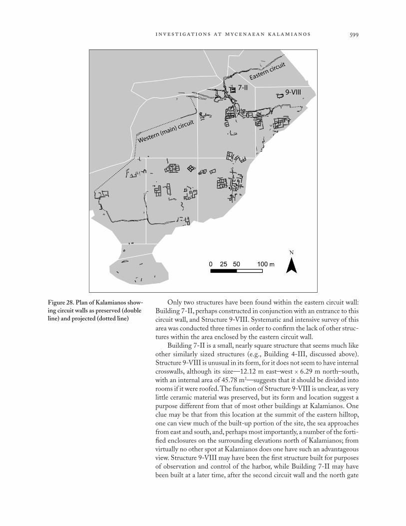
inv e st ig at ions at mycenaean kal amiano s 599
Only two structures have been found within the eastern circuit wall: Building 7-II, perhaps constructed in conjunction with an entrance to this circuit wall, and Structure 9-VIII. Systematic and intensive survey of this area was conducted three times in order to confirm the lack of other struc-tures within the area enclosed by the eastern circuit wall.
Building 7-II is a small, nearly square structure that seems much like other similarly sized structures (e.g., Building 4-III, discussed above). Structure 9-VIII is unusual in its form, for it does not seem to have internal crosswalls, although its size—12.12 m east–west x 6.29 m north–south, with an internal area of 45.78 m2—suggests that it should be divided into rooms if it were roofed. The function of Structure 9-VIII is unclear, as very little ceramic material was preserved, but its form and location suggest a purpose different from that of most other buildings at Kalamianos. One clue may be that from this location at the summit of the eastern hilltop, one can view much of the built-up portion of the site, the sea approaches from east and south, and, perhaps most importantly, a number of the forti-fied enclosures on the surrounding elevations north of Kalamianos; from virtually no other spot at Kalamianos does one have such an advantageous view. Structure 9-VIII may have been the first structure built for purposes of observation and control of the harbor, while Building 7-II may have been built at a later time, after the second circuit wall and the north gate
Figure 28. Plan of Kalamianos show-ing circuit walls as preserved (double line) and projected (dotted line)

thomas f. tartar on e t al .600
were constructed. Thus, given the nature of Structure 9-VIII, the relative lack of other structures, and the disturbance of the southwestern portion of the circuit by the construction of Building 7-I, we believe that the eastern circuit wall was the first to be constructed at the site.
A second circuit wall, which joins the eastern circuit north of Building 7-I, enclosed the remainder of the site. The area where the main circuit wall joins the eastern wall is difficult to understand, because it was here that the principal (and perhaps only) landward gate complex was found, and the area appears to have undergone several changes (Fig. 30). This is also the modern entrance to the site, and several footpaths pass through the area. The main gate complex seems to have led one toward a tower of regular, well-cut stones before making a sharp turn to the east into a large square courtyard surrounded by circuit walls. Farther on, an inner gate provided access to the settlement.
The main circuit wall continues west of the gate for some 70 m before it apparently turns to the south (Fig. 28). From this point until we again find continuous segments in sector 3, ca. 235 m to the southwest, only short sections are preserved. Some of the disturbance is undoubtedly due to the construction of the stone boundary wall surrounding a modern house to the west; the boundary wall is built of the local stone, which was surely in part robbed from ancient walls. Further disturbance may be attributed to the terracing of this area.
In sector 3 to the southwest, the course of the circuit wall is picked up again, running from north to south before making a sharp bend to the east.
Figure 29 (left). A segment of the northern portion of the eastern circuit wall
Figure 30 (opposite). Plan of the entrance area of the second circuit wall, north of Building 7-I. G. Bianco

inv e st ig at ions at mycenaean kal amiano s 601
0 1 2 3 4 5 m
giuliana bianco 2009 - november 25
Korphos: Kalamianos - 2009
Circuit Wall
SHARP
visible wallpossible earlier wallpossible later wallanta and baseorthostatebedrock used as wall or as structural support flattened bedrock possible threshold or floorbedrockwall numberroom numbervegetationpossible reused column basemodern path
legend
280
10
gri
d n
ort
h
291
293
292292
6080
410
2941 2
5
6
fence
step up building
not surveyed
wall not surveyed
wall not surveyed
1266
1266
1266
1266
1266
12651265
1265
1263 12631272
12621262
1272

thomas f. tartar on e t al .602
Near this change in orientation were discovered what may be a tower and gate. A continuous 200 m stretch of the wall runs from sector 3 east to Build- ing 4-XIV on the modern coast. East of Building 4-XIV we have no evi-dence of the circuit wall; most likely it turned to the south and has been lost to the sea.
Ur ban Kal amianos
The excellent preservation of so many structures at Kalamianos allows us to examine the urban planning of the settlement, a topic not often possible to address in the Bronze Age Aegean because of the limited exposure of most settlements through excavation. Even after more than a century of work at sites such as Mycenae or Tiryns, the layout of the towns surrounding the citadels in the palatial period is poorly understood.48 If our hypothesis that Kalamianos was a planned architectural settlement is correct, then we also are presented with the opportunity here to examine the principles of Mycenaean urban planning. Given the need to construct a new settle-ment (or greatly expand a small, preexisting one), what factors would have guided its layout?
The plan of the Mycenaean settlement at Kalamianos seems to be deter- mined by both natural and cultural factors. The principal natural factors are the orientation and exposure of the bedrock and the presence of water-bearing fissures. Because of the roughly east–west orientation of the bedrock, and the incorporation of the bedrock into many of the buildings, the majority of the structures are oriented approximately north–south and east–west.49 The settlement does not conform exactly to an orthodox grid pattern such as that found in later Greek towns (e.g., Halieis), but the lack of such a pattern does not indicate a lesser degree of planning.50 The construction of many buildings without regard for the contours of the land supports the notion of an overall orientation for the built environment. There is also a strong association of water-bearing fissures with architecture at the site, suggesting a deliberate attempt to situate buildings near convenient sources of water, although many buildings and complexes cannot currently be associated with exposed water-bearing features.
Throughout the settlement there are numerous pathways and passages among the structures. In sector 5 we have one of our best-defined built streets, the Avenue (5-1223), which runs north–south for at least 60 m (Fig. 31). About midway along its length is one of the largest worked blocks at the site, measuring 1.5 m in length; south of this block the Avenue is very straight, but north of it the road curves slightly around cistern 5-32 to continue north between Buildings 5-VIII to the west and 5-II to the east. The Avenue retains a fairly consistent width of ca. 1.5 m wherever we can measure it. The borders of the Avenue are, for the most part, the walls of buildings flanking the passage. Across the Avenue from the large block is the blocked opening into a circular walled area (5-X) enclosing cistern 5-32.
Some of our best evidence for planning comes from sector 5, where several structures seem to be aligned with one another (Fig. 31). The large worked block on the eastern side of the Avenue seems to have functioned as a guide for the layout of features in this area, as well as for the alignment
48. Recent work at both Mycenae and Tiryns has specifically addressed the question of the “lower towns.” At Tiryns a large town of postpalatial (LH IIIC) date has been found outside the citadel to the north, but little sur-vives from the palatial period, in part because of periodic flooding prior to the construction of the Kofini Dam at the end of LH IIIB (Maran 2002–2003, 2004). For recent work in the lower town at Mycenae, under the direction of C. Maggidis, see Maggidis and Stamos 2006 and, more recently, http://mycenae-excavations.org/ lower_town.html. See also French et al. 2003.
49. Building 4-III, discussed above, is a notable exception. There is no exposed bedrock apparent in the area immediately surrounding the structure that would have encouraged the adop-tion of the standard orientation.
50. For the grid pattern at Halieis, see Boyd and Rudolph 1978. For a dis-cussion of planning in ancient societies, see Smith 2007.

inv e st ig at ions at mycenaean kal amiano s 603
of the Avenue itself. Cistern 5-32 and (at least) Building 5-II to the north of the block were probably constructed before the block was set in place, while Building 5-VIII and the structures to the south of the block, flanking the straight segment of the Avenue, were probably constructed afterward in rough alignment with the block. The walled area around the cistern was built before Building 5-VIII, as the southern end of units E and F is set back to the north from the southern end of units A–D.
A peculiar feature of Kalamianos is that within the circuit walls there is much land that has no evidence of built structures (Fig. 11). The walls enclose approximately 7.2 ha (72,000 m2), yet structures occupy only ap-proximately 3.5 ha, or less than half of the enclosed space.51 Much of the northwest, west, and southwest areas enclosed by the wall feature rugged relief, with bedrock often exposed on or above the surface. By contrast, the extensive gentle slopes covered by terraces and terrace walls in the middle of the settlement may once have been occupied by structures, but we find no evidence for them, and coring reveals that bedrock here is nowhere deeper than 30 cm. There may be cultural reasons for the absence of buildings in these areas. One indication of this is that wall 7-1 separates a possible quarry area west of Building 7-I from the built area around Building 7-I.
Figure 31. Plan of the Avenue and adjacent structures in sector 5. The large worked block that may have guided the layout of this area is marked with an X.
51. The boundaries of the settle-ment used for this calculation are the northern segment of the eastern circuit wall, the main circuit wall, and the coastline in between. We have counted as “occupied” land that lies within 20 m of structures or land between structures separated by no more than 30 m; we include areas of debris without defined walls as “structural.” This measurement of occupied vs. unoccupied land is, of course, subject to modification as addi-tional structures or portions of struc-tures are identified; nevertheless, it does illustrate the point that a significant portion of the site was not occupied by structures.

thomas f. tartar on e t al .604
At Kalamianos we have both densely built-up urban areas with streets separating structures, and areas where buildings are separated from one another by several meters of apparently open space.52 In areas of both types we see a mixture of building sizes, from small four-room units to larger complexes of seven or more rooms. The eastern portion of the site, sectors 5 and 7, seems to have been more densely built up than areas to the west, such as sectors 3 and 4; one wonders whether this increasing density from west to east indicates that some part of the core of the site lies to the east of sector 5 in low-lying areas now underwater. One might expect less dense construction farther from the center of the settlement, as we see in sectors 3 and 4.
ARCHAEOLO GICAL SURFACE SURVEY
From 2007 to 2009, SHARP carried out surface survey within a survey area of 7.35 km2, partitioned into five zones (Fig. 32). The first of these zones is the Kalamianos site itself, as delimited by the modern property fence that closely approximates the limits of the Mycenaean settlement. Beyond the site, survey proceeded in four off-site zones: zone 2, a land-scape of coasts, low hills, and basins adjacent to the site in the localities Kalamianos,53 Pharonisi, Aramada, and Sarakina; zones 3 and 4, a series of highland peaks and basins to the north at Stiri, Kaloyirikon, Malia Toudre, Malia Stiri, Malia Pitsis, Lakka Gliata, Spati, and Prosili Toyia; and zone 5, portions of the coast and lower slopes surrounding the modern village of Korphos.54 In many off-site locations, evidence of Mycenaean activity, especially architectural, was found. Sites of other periods, including Final Neolithic (FN), Early Bronze Age, Classical/Hellenistic, Late Roman, Medieval, and Early Modern, were also identified and studied.
In all forms of survey combined, our coverage was ca. 4.26 km2, a 58% sample, although the intensity of the different survey units used to cover this area varied. Most of the remaining area was left unsurveyed due to steep slope, impenetrable vegetation with no ground visibility, or mod-ern development, including houses and hotels, businesses, and fenced properties.
Me thods
We employed three distinct modes of survey, each with a specific spatial scale and purpose: the Discovery Unit, the Extensive Discovery Unit, and the Architectural Discovery Unit. The Discovery Unit (DU) was the stan-dard mode of intensive survey, in which surveyors walked in parallel lines 10 m apart, counting all artifacts on tally counters, and collecting small numbers of samples for use as chronological indicators and comparative
52. Some of this seemingly open area could well have been occupied by courts and yards, with less substantial walls than those used in the buildings.
53. Whereas we refer to the Myce-naean harbor site as Kalamianos, the
modern toponym covers a slightly larger area that also includes low-lying land north of the Mycenaean settle-ment.
54. In our original permit applica-tion, we counted four zones, with the
Kalamianos site as an unnumbered zone. Here and in future publications we give Kalamianos a zone number, raising the number of zones to five. There is no difference whatsoever in the survey area.
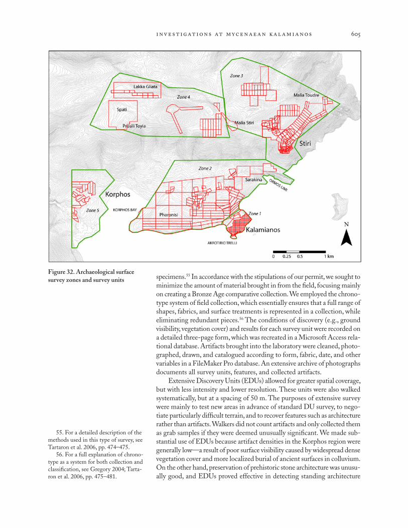
inv e st ig at ions at mycenaean kal amiano s 605
specimens.55 In accordance with the stipulations of our permit, we sought to minimize the amount of material brought in from the field, focusing mainly on creating a Bronze Age comparative collection. We employed the chrono-type system of field collection, which essentially ensures that a full range of shapes, fabrics, and surface treatments is represented in a collection, while eliminating redundant pieces.56 The conditions of discovery (e.g., ground visibility, vegetation cover) and results for each survey unit were recorded on a detailed three-page form, which was recreated in a Microsoft Access rela-tional database. Artifacts brought into the laboratory were cleaned, photo- graphed, drawn, and catalogued according to form, fabric, date, and other variables in a FileMaker Pro database. An extensive archive of photographs documents all survey units, features, and collected artifacts.
Extensive Discovery Units (EDUs) allowed for greater spatial coverage, but with less intensity and lower resolution. These units were also walked systematically, but at a spacing of 50 m. The purposes of extensive survey were mainly to test new areas in advance of standard DU survey, to nego- tiate particularly difficult terrain, and to recover features such as architecture rather than artifacts. Walkers did not count artifacts and only collected them as grab samples if they were deemed unusually significant. We made sub- stantial use of EDUs because artifact densities in the Korphos region were generally low—a result of poor surface visibility caused by widespread dense vegetation cover and more localized burial of ancient surfaces in colluvium. On the other hand, preservation of prehistoric stone architecture was unusu- ally good, and EDUs proved effective in detecting standing architecture
Figure 32. Archaeological surface survey zones and survey units
55. For a detailed description of the methods used in this type of survey, see Tartaron et al. 2006, pp. 474–475.
56. For a full explanation of chrono- type as a system for both collection and classification, see Gregory 2004; Tarta- ron et al. 2006, pp. 475–481.
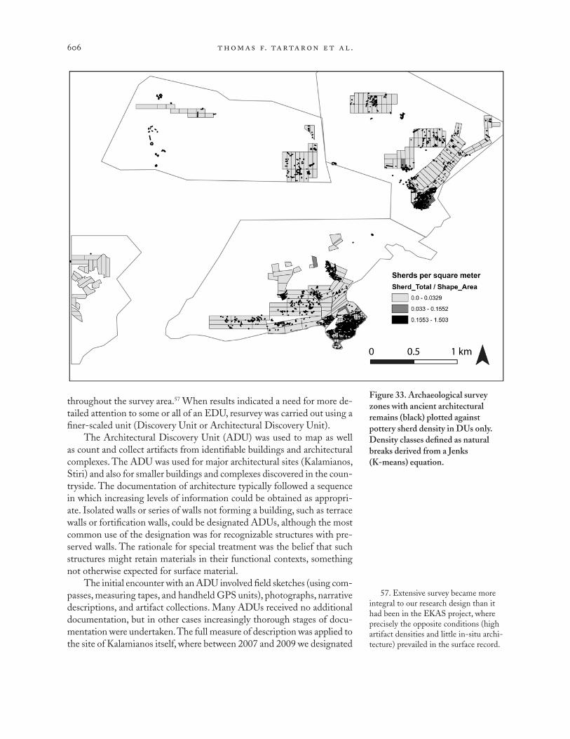
thomas f. tartar on e t al .606
throughout the survey area.57 When results indicated a need for more de- tailed attention to some or all of an EDU, resurvey was carried out using a finer-scaled unit (Discovery Unit or Architectural Discovery Unit).
The Architectural Discovery Unit (ADU) was used to map as well as count and collect artifacts from identifiable buildings and architectural complexes. The ADU was used for major architectural sites (Kalamianos, Stiri) and also for smaller buildings and complexes discovered in the coun-tryside. The documentation of architecture typically followed a sequence in which increasing levels of information could be obtained as appropri-ate. Isolated walls or series of walls not forming a building, such as terrace walls or fortification walls, could be designated ADUs, although the most common use of the designation was for recognizable structures with pre-served walls. The rationale for special treatment was the belief that such structures might retain materials in their functional contexts, something not otherwise expected for surface material.
The initial encounter with an ADU involved field sketches (using com- passes, measuring tapes, and handheld GPS units), photographs, narrative descriptions, and artifact collections. Many ADUs received no additional documentation, but in other cases increasingly thorough stages of docu-mentation were undertaken. The full measure of description was applied to the site of Kalamianos itself, where between 2007 and 2009 we designated
57. Extensive survey became more integral to our research design than it had been in the EKAS project, where precisely the opposite conditions (high artifact densities and little in-situ archi-tecture) prevailed in the surface record.
Figure 33. Archaeological survey zones with ancient architectural remains (black) plotted against pottery sherd density in DUs only. Density classes defined as natural breaks derived from a Jenks (K-means) equation.

inv e st ig at ions at mycenaean kal amiano s 607
dozens of ADUs and generated a progressively more detailed reconstruction of the site’s architecture using DGPS and electronic total station survey, stone-by-stone drawings, and balloon photography. Within each ADU we counted and collected artifacts from two types of contexts where possible: the interior of the walls and the interior of individual rooms. Survey by ADU allowed us to map architectural features in some detail and to recover artifactual evidence for their date and function.
On the basis of results from all forms of survey, we designated sev-eral locations as “sites” or, in the terminology adopted earlier by EKAS, Localized Cultural Anomalies (LOCAs).58 In contrast to other parts of the northeastern Corinthia, however, here we encountered few dense artifact scatters not associated with architectural remains; thus, defining LOCAs as artifact density peaks against a flatter background scatter did not play a significant role. Instead, our LOCAs are typically architectural complexes of two broad periods—Bronze Age and Early Modern/Modern—and their associated artifacts. Even some of these produced few artifacts, and else-where artifact densities were generally low (Fig. 33).
Intensive Surve y at Kal amianos (Zone 1 )
Intensive archaeological survey at the Kalamianos site was accomplished in stages from 2007 to 2009. We first superimposed over the entire site a grid of survey units, composed of cells measuring 25 x 25 m (although because of the irregular shoreline and other features of the site, many of the actual units are of different sizes) (Fig. 34). We walked each grid square as a Discovery Unit, so that one level of resolution for our counts and collections is the size of the grid square. These DUs were walked not with the standard 10 m walker spacing, but with a spacing of 5 m to increase the intensity and reso- lution of data recovery, effectively creating an “urban survey.”59
Mycenaean buildings, often with clearly recognizable rooms, existed within many of the grid cells. Whenever we encountered buildings in which rooms with four walls were preserved, we counted and collected within those features as ADUs first, before the DU was walked (Fig. 34). In accordance with our practice in ADUs, we counted and collected from two contexts: the interior of the walls and the interior of the rooms. The walls, as noted above, generally consist of two stone faces and a rubble core, and we found that broken pottery was often part of the fill between the faces. This gave us a valuable way to establish a terminus post quem for the construction of a building. Collection from the interior of the rooms themselves might provide further information about the date and use of specific rooms within a building. Thus, ADU survey within the buildings gave us a second, finer level of resolution. Furthermore, many of the ADUs originally walked in 2007 and 2008 were resurveyed in 2009 after extensive clearing of vegetation had revealed new rooms and additional artifacts.
The surface survey at Kalamianos yielded close to 3,000 artifacts in DUs and ADUs, dating from FN/EH I to the Modern period. The over-whelming majority of the artifacts to which we could assign a secure date, however, belong to the Mycenaean period, with EH, Roman, and Early
58. Tartaron et al. 2006, pp. 485–492.
59. Bintliff and Snodgrass 1988; Alcock 1991.

thomas f. tartar on e t al .608
Modern/Modern artifacts present in small but detectable amounts. We can say with some certainty that there was no major or even very significant occupation of Kalamianos after the Late Bronze Age, and that nearly all of the premodern architectural remains are Mycenaean, with the exception of minor rebuilding in sectors 5 and 9. In sector 9 during the Late Roman period a ceramic kiln was installed in the corner of a Mycenaean building (Building 9-IV with kiln 9-961) that was apparently still exposed almost two millennia after it was first built.
A brief comparison of the percentage of LH artifacts from Kalamianos with those from Stiri or the SHARP survey area as a whole serves to em- phasize the prominence of the Late Bronze Age in the history of the coastal settlement, as do the general artifact patterns at Kalamianos it-self. Mycenaean objects form 27.2% of the entire collection of diagnostic SHARP ceramics; of these a full 20% were found at Kalamianos, only 3.1% at Stiri, and the remaining 4.1% in all other survey areas. Mycenaean pottery forms 62.4% of the diagnostic material from Kalamianos itself, but at Stiri it represents only 11.1% (Fig. 35). Furthermore, while nearly 60% of the total ceramics collected from Stiri are diagnostic, slightly less than 50% of those from Kalamianos have been identified with certainty. This discrepancy results from two factors specific to the coastal settlement: an abundance of beach pottery worn down to rounded cores of clay, often with no trace of the original surface or form; and greater numbers of buildings producing a higher volume of undiagnostic medium-coarse and coarse body sherds. Some of the latter may be reclassified as we learn more about local
Figure 34. Urban survey grid at Kalamianos with overlay of ADUs designated during survey

inv e st ig at ions at mycenaean kal amiano s 609
domestic plain wares, but such work will require results from excavation as well as archaeometric comparison with other regional coarse wares. As they are often found in conjunction with diagnostic Mycenaean (and only Mycenaean) objects, however, they likely belong to that period.
Of the diagnostic material from Kalamianos, 24.8% consists of abraded mica- or amphibole-rich body sherds that currently can be classed only as “prehistoric.” The fabric types are common to cooking wares ranging from the FN to the LH throughout the survey area, but without the evidence of characteristic surface finishes and/or shapes, they cannot be attributed to ei-ther the EH or LH periods without further chemical or petrographic analysis. The FN–EH presence at Kalamianos is meager and tends to cluster on the beaches of the modern coastline, a distributional pattern that suggests that the earlier site(s) may be located underwater. Preliminary underwater survey by the Greek-Canadian team has confirmed the abundance of EH material now submerged in nearshore waters (pp. 574–575, above). Occasionally, finds from these earlier periods of prehistory are found in the wall cores or rubble-filled interiors of the Mycenaean buildings, but such objects account for less than 4% of all pottery associated with the buildings. Although few in number, the EH II finds do include items indicative of high social status, including a polished pedestaled sauceboat and two volcanic mortars with spool handles. Such mortars are characterized by fine-grained southern Aegean or Aiginetan volcanic stone, and are known elsewhere only from Ayios Kosmas in Attica, Lithares in Boiotia, and the southern Argolid.60
Most notable at Kalamianos is the complete absence of historical Greek material—the gap between the LH and Roman periods is clear, and Roman ceramics account for a mere 3.8% of all diagnostic pottery. Addi- tionally, most of the Roman material is either concentrated in and around
Figure 35. Percentage of diagnostic pottery sherds by chronological period for Kalamianos, Stiri, and the entire survey area
60. Runnels 1988.

thomas f. tartar on e t al .610
Building 9-IV, in which the Late Roman kiln was installed, or consists of large amphora sherds found in areas of Early Modern use. Evidence from Stiri indicates that artifacts such as tiles and amphoras were collected and reused in Early Modern structures. The same may be true at Kalamianos, although information from archival sources and oral histories, as well as the low occurrence of Early Modern pottery (3%), suggest that the now rocky and inhospitable coast has not been recently used for habitation. Overall, very little later disturbance of the Mycenaean remains is evident.
The diagnostic Mycenaean pottery at Kalamianos is, generally, of LH III date (Fig. 36). Vessels of the period common to the site are tripod cooking pots, stemmed kraters, deep bowls, and kylikes of various forms. A single painted disk from a large stirrup jar was also found (Fig. 36:a). Excavation alone can provide a full sequence of material to establish whether occupation during this broad period was continuous or punctuated by gaps, but preliminary analysis of the pottery indicates that while the peak of activity certainly occurred during the LH IIIB period, LH IIIA pot-tery does exist in small amounts. This earlier assemblage consists mainly of cooking pots with button bases or short rim profiles, but fine pottery banded in the LH IIIA style also appears, along with both Lustrous and Matt Painted Aiginetan wares. A few other sherds of fine painted pottery still in the preliminary stages of analysis have thus far found their best matches in vessels of the LH IIIA period at other sites in Attica, Aigina, the Argolid, and the Corinthia; but until a thorough comparison is com-pleted, they cannot be added with certainty to the body of Kalamianos material earlier than LH IIIB, much less provide more precise dates within LH IIIA. Altogether, the securely dated LH IIIA material falls just short of 10% of the LH assemblage at Kalamianos. Perhaps significantly, the findspots of this material form a cluster in sectors 4 and 5. In addition to other material found directly on the beach or in the walls and interiors of partially submerged buildings, these finds perhaps indicate the area of an earlier, smaller settlement, now partly underwater, which in LH IIIB either expanded or was built over after a period of disuse.
Late Helladic IIIB material is ubiquitous at Kalamianos. Pottery that is specifically LH IIIB in date, as opposed to simply LH III or generically Mycenaean, is found in both the walls and interiors of nearly 40% of the structures that produced Mycenaean artifacts. The pottery is scattered throughout the surface DUs over the entire site and comprises approxi-mately half of the Mycenaean material recovered at the settlement. Typical diagnostic vessels include the monochrome stemmed bowl, the Group B deep bowl, and the kylix FS 258 with a tall, narrow stem (Fig. 36:c, d). A handful of heavily abraded sherds appear to belong to handmade mini- ature vessels, which were most popular during LH IIIB1. Fine and medium- coarse painted body sherds commonly exhibit paneled decoration as well, a decorative syntax that was popular during the LH IIIB period, and a single example was found of the LH IIIB vertical whorl shell.61 Monochrome pot-tery is common. Several other decorated fragments are still being studied, but whereas a few painted sherds find their best parallels in LH IIIA, most have multiple comparanda during LH IIIB. The abundance of material
Figure 36 (opposite). Examples of LH III ceramics from Kalamianos (unless otherwise specified): (a) deco-rated stirrup-jar disk; (b) cooking-pot handle with potmark; (c) decorated deep-bowl rim and handle; (d) deco-rated kylix stem; (e) decorated dipper rim and handle; (f ) plain(?) kylix stem with calcium carbonate deposit; (g) tripod cooking-pot leg (from Stiri); (h) cooking-pot button base (from Stiri); (i) decorated krater ped-estal. Scale 2:3. Photos D. Trusty
61. Here and below, descriptions of decorative motifs follow the terminol-ogy of Furumark [1941] 1972.

inv e st ig at ions at mycenaean kal amiano s 611
that can be certainly dated to the LH IIIB period indicates thriving occu- pation in both phases 1 and 2.
The LH IIIA–IIIB pottery establishes a chronological outline for Kala- mianos, but the examples described above do not illustrate the full range of vessels and decoration thus far catalogued from the site. Although many sherds still require cleaning, particularly the dissolution of the often thick crust of calcium carbonate that coats many of those found in and around the limestone architecture, several other Furumark motifs have been iden- tified. These include antithetic spirals with central triglyphs, zigzags, wavy lines, adder marks, multiple hooked stems, net patterns, and splashed rims and handles. Generically Mycenaean banded or plain wares include
a
b cd
e
f
g h i

thomas f. tartar on e t al .612
amphoras, hydrias, spouted basins, shallow cups or dippers, and jugs of several kinds. Storage jars, pithoi, cooking kettles with horizontal handles, possible pot stands in cooking fabric, and a single burnished askos round out the functional assemblage. In these collected artifacts are represented all the domestic categories expected of a modest urban settlement—equip-ment for storage, cooking, eating, and drinking—and possibly even a ritual component, indicated by the askos. As “biographies” of individual buildings are constructed, the finds from each will be integrated into more refined contexts and may reveal areas designated for particular activities; at the moment, however, evidence for specific industries is not apparent in the ceramic record.
The stone finds are not so mute on this topic. Although the volcanic stone artifacts of both Early and Late Bronze Age Kalamianos require closer study, a few general observations can be made. Fully 70% of the volcanic stone catalogued in the field and not readily identifiable as EH consists not of querns or other types of grinding equipment, but of unworked or small, broken fragments, frequently built into the walls of Mycenaean build-ings. It therefore seems likely that the processing of dietary agricultural materials was performed on a scale sufficient only to meet the needs of the local population, a supposition that supports the picture of a modest urban settlement.
Other stone finds, however, indicate maritime trade, and demonstrate that the community used its coastal location to great advantage. A stone spout from a type of Mycenaean mortar generally used for grinding spices was collected from the interior of a building, indicating that specialized goods reached the site in at least small quantities. Considered in conjunction with the disk of the large stirrup jar found in another building (Fig. 36:a), this find is of interest for another reason: Curtis Runnels notes that in the LH period spouted stone mortars were used for grinding spices in order to perfume olive oils.62 Perhaps then, specialized goods also left the site in small quantities. Large numbers of ballast stones have been noted in the Mycenaean areas of the settlement, suggesting they were unloaded from ships in exchange for some other cargo.
Flaked stone, particularly Melian obsidian, is also present at Kalamianos and normally would constitute another indicator of maritime trade, but the assemblage is not verifiably Mycenaean. It is admittedly difficult to differentiate between Neolithic and Bronze Age assemblages without specific artifact types diagnostic of either period, particularly in a region such as that covered by SHARP, where successive Neolithic, Early Bronze Age, and Late Bronze Age occupations are common. The assemblage from Kalamianos lacks such chronologically specific types. Moreover, it is 97% obsidian, which is typical of other southern Aegean survey assemblages dominated by Neolithic and/or Bronze Age materials and located on coasts within 150 km from Melos. The find context from which the flaked stone was recovered at Kalamianos may signify pre-Mycenaean acquisition, however. The key part of the assemblage—that is, the part that demon-strates raw nodule import, initial reduction, and blade production—was found almost exclusively in DU 72100 at the modern coastline, where the 62. Runnels 1988, pp. 269–270.

inv e st ig at ions at mycenaean kal amiano s 613
material is overwhelmingly of FN and EH date. Evidence does exist, how- ever, for secondary use of the imported material. Just as local beach ce-ramics have been worn down to smooth pebblelike sherds by the abrasive action of the waves, so too the blanks and retouched tools have been rolled and hydrated. Some of the blanks exhibit retouch that is less rolled and hydrated, implying retouch and discard younger than the initial reduction sequences. Perhaps this occurred during the Mycenaean reoccupation of the site as an expedient means of obtaining flaked tools, despite the frequency of maritime activity suggested by the other special finds. If that is the case, questions arise concerning the tools—mainly blades—found throughout inland regions where evidence for reduction or intensive production is lacking. Were the inland blades supplied by the coastal settlement, and, if so, during what period or periods? Would the Mycenaeans have continued to import obsidian and chert in any amount, either in raw or finished form, despite its ready availability?
The common and copious occurrence of shells of various types in the wall cores of the buildings is more difficult to interpret. A preliminary analysis of this material indicates that the shells were not collected as liv-ing specimens;63 more likely, they were scooped up, along with fragments of pottery and ground stone, from shoreline gravels used as filling in the walls. At present it remains uncertain whether the local population dined regularly on shellfish or other food from the sea.
A final set of objects, still partly enigmatic, also casts light on the mari- time movement of goods and the involvement of Kalamianos in such trade. Three Aiginetan potmarks have been recovered at the site, all on the well-made, micaceous or amphibole-tempered cooking pottery characteristic of the harbor town. Two of the marks appear in Lindblom’s catalogue: an applied clay pellet (I29), here below a vertical handle, and a V-shaped incision (G35), here at the base of a cooking-pot handle (Fig. 36:b).64 A third mark is incompletely preserved at a break; two parallel vertical notches below a vertical handle may represent just that (I11), or an incised trapeze (I19), or an incised H mark (I20), or even a form as yet unattested. The two identifiable marks, G35 and I29, are known from Kolonna, Asine, Lerna, Midea, and Tsoungiza on Aiginetan painted and burnished ware, plain ware, and kitchenware, a few with contextual dates of Middle Helladic (MH) I–II to LH IIA.65 That no LH III dates are attested for G35, the form preserved at Kalamianos on the LH III cooking-pot handle, is not surprising, given that much of the pottery in Lindblom’s catalogue lacks a stratified context, and production of Aiginetan marked pottery did not cease until LH IIIC Early. The example of I29 found at Kalamianos, however, is in fact applied to a well-preserved rim, handle, and body profile of a small LH I cooking pot, which is the only known LH I object from the entire SHARP survey area. It was not recovered from any of the Mycenaean buildings, but rather from the easternmost beach, where FN–EH II pottery is more common than LH. No MH pot- tery has been identified at Kalamianos or elsewhere in the survey area. The presence of this LH I object at an otherwise solidly LH III town is puzzling.
63. Tatiana Theodoropoulou (pers. comm.). Her analysis will be published separately.
64. Lindblom 2001, pp. 48–51.65. Lindblom 2001, pp. 79, 88–89.

thomas f. tartar on e t al .614
Off-Site Surve y : O vervie w of Zones 2–5
North and west of Kalamianos, survey zone 2 comprises a narrow, elongated basin (polje) nestled between a series of low coastal ridges to the south and the lowest slopes of the interior mountains to the north (Fig. 32). This basin, less than 0.4 km2 in area, is the only level, arable land in the lowland zone around Kalamianos.
Architectural remains in this zone were found exclusively on the coastal ridges and slopes, while in the basin itself artifact densities ranged from moderate to high. This artifact patterning is interesting both historically and geomorphologically. Over time, the basin has filled with stony col-luvial deposits, particularly from the steeper slopes to the north, with the result that ancient material is buried under colluvium up to several meters in depth. Plowing in recent decades, however, has brought to the surface a mix of fragmented, abraded artifacts of many periods. In addition to Bronze Age material, we find evidence of activity in the basin in periods otherwise poorly represented in the survey area, particularly Classical–Hellenistic and Roman. Farmers in those periods may have exploited the basin from permanent settlements around Korphos village, but they certainly were not living at Kalamianos. Exploitation of the lower slopes for agricultural purposes is indicated by the strong evidence for Bronze Age terrace walls in zones 1–4 (see below). The higher slopes and ridges above the basin would have been ideal for grazing sheep and, especially, goats. The distribution of Bronze Age sites and features in zone 2 also suggests a preference for commanding views and intervisibility among sites in elevated places.
Zones 3 and 4 comprise the southernmost peaks of the rugged, moun- tainous interior of the southeastern Corinthia. Nestled between the peaks is a series of fault-controlled upland basins—the product of solution en-largement in fault zones—oriented roughly northwest–southeast. These small basins collect sediment from the surrounding slopes, and form the centers of relatively fertile microecological niches composed of arable basin land, freshwater springs along fault lines, and grazing land on sur-rounding slopes and ridges. In most of them, architectural and artifactual traces of a hamlet, farmstead, or pastoral complex indicate repeated exploi-tation in the past. Until very recently, wheat was grown extensively in these basins, and olive groves continue to be cultivated on slopes throughout the area. Terrace walls, collapsed farm buildings, and threshing floors provide evidence of intensive agricultural exploitation in recent times. Shepherds continue to make extensive use of the slopes and ridges, as they must always have done.
The linear topographic break of the fault line connecting the basins (Fig. 4) served as a principal route of movement linking the Korphos area with the interior regions of the Corinthia and the Argolid; this route was used from antiquity until an extension of the Corinth–Epidauros road was blasted through to Korphos in the later 20th century. Use of this upland route in the Bronze Age is indicated by a series of fortified enclosures with commanding views of the route and the Saronic Gulf (described below). These archaeological remains may be considered in light of ethnographic descriptions of overland passage to Mycenae via the basins and mountain passes of Sophiko, Angelokastro, Limnes, and Berbati, to suggest that the

inv e st ig at ions at mycenaean kal amiano s 615
Korphos area was the eastern terminus of a land route connecting Mycenae and the Saronic Gulf.
Zone 5 consists of gently sloping natural terraces above and to the west of Korphos village, as well as steeper contours forming a transition to the mountains of the interior. This landscape is watered by the single major stream in the survey area, which empties into Korphos Bay at the southwestern edge of the village. The stream is seasonal, however, flowing during winter torrents but dry for most of the year. The dry streambed and the narrow terraces of stream gravel surrounding it offer an alternative overland route out of Korphos, joining the upland route after a vigorous walk of 4 km. A mixture of wheat and olive dominated the terraces in recent times, although today agricultural use has shifted almost exclusively to olive. Much of the area, however, has now been claimed by modern development as the village expands: a large part of zone 5 is no longer available for survey because of the presence of new homes, condominiums, and fenced properties. Nevertheless, surface visibility was generally good in the olive groves, most of which had been plowed in recent years. We did not recognize architectural remains of any period except Modern, but the survey yielded moderate quantities of artifacts with a sufficient con-centration in the Late Roman period to suggest the existence of a small community or villa overlooking Korphos Bay. Only a few FN–EH I sherds hint at a prehistoric presence here. This pattern may reflect a general shift of settlement away from Kalamianos toward Korphos in historical times, perhaps because tectonic activity had rendered the former useless and the latter viable as a harbor.
Bronz e Age Architectural Remains in Zones 2–4
Beyond Kalamianos in zones 2–4, architectural features were abun-dant, while the distribution of artifacts was patchy and mainly associated with architecture. Only in zone 5, above Korphos village, did significant densities of ancient artifacts occur without associated architectural remains. Both modern (1830s to the present) and premodern architectural features were recorded in zones 2–4. Modern structural remains comprise mainly farm outbuildings, mandria and other kinds of pastoral structures, terrace walls, and stone clearance piles. Several agro-pastoral complexes with these features are being studied by Lita Tzortzopoulou-Gregory and Timothy Gregory as part of a program of historical-period research and oral history focused on traditional lifeways in the Korphos-Sophiko region.66 The an-cient architectural remains are of five main types, discussed in turn below: two Bronze Age settlement complexes at Stiri, one Early Bronze Age and one Mycenaean; fortified stone enclosures; terrace walls; cairns; and other isolated walls and buildings.
The Bronz e Age Se t tlements at S tir i
During our exploration of the countryside, we quickly identified a second major Mycenaean settlement overlooking an upland, double-lobed basin (doline) at Stiri (Fig. 6). As at Kalamianos, several distinct complexes of well-constructed buildings are preserved on the surface, allowing us to
66. This program of research is inte-gral to our efforts to understand Bronze Age lifeways. The results of the study will be reported in full elsewhere.

thomas f. tartar on e t al .616
map and study the settlement in its apparent entirety (Fig. 37). Here, too, a nearly pristine Mycenaean settlement has weathered the centuries without serious later disturbance. Small quantities of material from the historical period were recovered at Stiri (Fig. 35), but from the Mycenaean buildings themselves no Roman material and only a few Early Modern sherds were retrieved, indicating that the buildings remained virtually untouched. The masonry technique is essentially the same as that employed at Kalamianos, and the artifacts recovered within the rooms and wall cores, as well as those scattered outside the buildings, confirm a chronological overlap in LH IIIB (though apparently not in LH IIIA), with a similar absence of evidence for activity in LH IIIC. Perched on a high sea cliff with an unimpeded view of Kalamianos, the community living at Stiri was undoubtedly in constant communication with the harbor settlement below in the 13th century b.c.
There are significant differences between the two sites, however. With a maximum extent of ca. 1.4 ha, Mycenaean Stiri was less than one-fifth the size of Kalamianos. The construction of walls and buildings is also different in important respects. First, Stiri lacks the monumentality seen in Buildings 7-I, 7-X, or 4-VI at Kalamianos. Second, while the stones used in walls are significantly smaller, they are flatter and by and large more carefully fitted together. It is possible that the limestone at hand had specific properties that favored this size and shape, but differences in conception and design, the preferences and skills of masons and workmen, and the social and political conditions under which the construction was under-taken are also plausible explanations. Moreover, although the settlement exhibits a variety of building plans, including large, squarish complexes of multiple rooms (13-III) and long, narrow groupings conforming to natural terraces (13-I and 13-VI), they do not correspond closely to the building plans found at Kalamianos, which are themselves variable. Thus, the same questions about the meaning of this architectural variability across the site apply equally to Stiri.
Comparison of the Mycenaean pottery assemblages underscores con- trasts between the sites in chronological and functional terms as well. Compared to the wide range of vessel types and decoration found at the large coastal settlement of Kalamianos, the ceramic finds from the handful of buildings at Stiri are quite restricted in typological scope. Cooking pots and large medium-coarse to coarse storage jars, amphoras, and hydrias are
Figure 37. DGPS plan of Mycenaean architectural remains at Stiri

inv e st ig at ions at mycenaean kal amiano s 617
common, but fine wares are restricted to a few kylikes, cups or dippers, a single conical krater, stemmed bowls, and Group B deep bowls. Decoration is limited to monochrome or banding, with one possible example of panel-ing; most fine wares are simply plain polished vessels. On the basis of this evidence, Mycenaean Kalamianos clearly had access to and a desire for a wider variety of fine decorated feasting and drinking equipment, while the structures at Stiri housed simpler, more practical equipment. The ceramic assemblage at Stiri appears limited in chronological scope as well: all pre- cisely datable pottery falls within the LH IIIB period, without a single sherd of earlier Mycenaean material.
The ground stone supplements this picture of the upland settlement as a primarily agro-pastoral outpost. Whereas nearly 70% of the volcanic stone at Kalamianos is unworked, approximately 50% of the sample re-covered in and around the Mycenaean buildings of Stiri consists of querns and various types of handstones. In addition, shells account for only 1.5% of the total Stiri assemblage, underscoring the emphasis on land- rather than sea-based resources.
Location must have been an important factor in the role Stiri played in the Mycenaean coastal world of the 13th century b.c. From observation points on the hilltops overlooking the site, a sweeping view extending from Athens and Salamis in the northeast to Aigina and Methana in the east and southeast makes this an ideal location from which to monitor seaborne traffic on the Saronic Gulf and relay signals to Kalamianos and perhaps to other communities as well, including Kolonna on Aigina’s northwestern coast (Fig. 1).
A second advantage is the basin west of the site, which is well watered by springs and winter rains, making agriculture and pastoralism possible on a relatively large scale (Fig. 6). Intensive cultivation of wheat and olive has been practiced here in recent times, along with grazing of sheep and goats on wheat stubble and in the wooded hills all around. This productive landscape, along with the other basins and slopes in survey zones 3 and 4, may have been systematically developed in the Mycenaean palatial period to provide staple crops, animals and their secondary products, and trade goods to the harbor community at Kalamianos.
Just how these goods were transported down the precipitous slope to Kalamianos is uncertain, and some have concluded that there could be no direct overland route between the two sites.67 We learned from local infor- mants, however, of a switchback path leading directly up a defile from Sara- kina to Stiri, which was used to reach the Panayia church on foot before a road was bulldozed up the mountainside more than 25 years ago. Exam- ination of the path revealed that at one time it was a well-built road partially cut into bedrock, with occasional bridges, possibly capable of ac-commodating wheeled traffic. The chronological range of the road’s use is unknown.
Stiri was also the site of a major Early Bronze Age occupation, which was concentrated mainly on the steep slope facing south toward Kalamianos, and thus south of the Mycenaean settlement. This EH site is, after Kala- mianos and the Mycenaean settlement at Stiri, the most substantial settle-ment in our survey area. Architectural remains, including intact walls and
67. Dixon 2000, p. 87. If this were true, travelers would have been faced with a long and indirect journey to join up with the paths through the upland basins well north and west of Korphos village.

thomas f. tartar on e t al .618
fields of collapsed debris where buildings must once have stood, and pos-sibly also terrace walls, are spread over an area of more than 2 ha (Fig. 38). These architectural features were accompanied by very high artifact counts, dominated by EH pottery.
Because of the unusual density of architecture and artifacts, we estab-lished another grid of 25 x 25 m DU cells over the site, as we had done at Kalamianos (Fig. 38). The results of the investigation underscore the initial impression of a very significant EH habitation site. The number of artifacts far outstrips that of any other site in the survey area, including Kalamianos itself: a total of more than 4,000 pottery sherds and 146 lithics, consisting of roughly equal amounts of obsidian flaked stone and andesitic ground stone. The vast majority of the identifiable sherds belong to the Early Bronze Age, with a clear apogee of activity in the EH II period.
Artifacts dating from FN to EH II account for just over 44% of all diagnostic material from the Stiri region, and even comprise more than 16% of the pottery found in the Mycenaean complexes there, indicating that FN and EH activity was more extensive than that in the Late Bronze Age (Fig. 35). Whereas the LH finds are fewer in number and limited in both chronological and typological scope, the FN and EH pottery includes a wide range of types and decorative styles, indicating a thriving domestic settlement with far-flung trade contacts. Final Neolithic objects include bowls, askoi, and braziers of various sizes; the bowls and askoi may exhibit burnishing, red slipping and burnishing, piercing, punctates, and parallel or herringbone incision. From the EH period come fruitstands, dippers, sauceboats, askoi, bowls with incurving or thickened rims and sometimes knobbed, lug, or spool handles, knobbed pithoi, hydrias, jars with T-rims, thickened or flaring rims, sloping shoulders, raised, flat or mat-impressed bases, and sometimes twisted handles, possible hearth fragments, a frying pan, and a loom weight (Fig. 39). Decoration includes urfirnis in black,
Figure 38. Survey walkers among the remains of collapsed EH structures at Stiri

inv e st ig at ions at mycenaean kal amiano s 619
brown, and red, slip painting, blue slipping and polishing, incision, taenia bands of various types, rolled impressed zigzags, stamp impressions, bur-nishing, and red slipping and burnishing. A few more EH II mortars with spool handles were also found, in addition to many groundstone saddle querns, elliptical querns, and handstones of several kinds.
Two intriguing questions are how and why an Early Bronze Age com- munity would build a settlement on such a steep slope. The question of how may be answered by a series of retaining walls, which support build-ing platforms associated with broad fields of fallen stone, undoubtedly the remains of collapsed buildings, in which wall fragments are often preserved, and which are generally rich in EH artifacts. It is thus possible to trace the rough outlines of a terraced settlement. A later set of very large ter-race walls extending from the top to the bottom of the hill appears to be Mycenaean in date. Some of these walls are built over or in front of earlier EH structures or retaining walls. The function of the Mycenaean terrace walls was surely agricultural: no trace of contemporaneous buildings was found, and Mycenaean artifacts were rare among the survey collections.
The question of why the inhabitants chose to build on this steep slope is equally interesting. In the Aegean during the EH II period, a coastal/maritime orientation would be unsurprising, and the main viewshed of the Stiri slope is south to Kalamianos and the Saronic Gulf beyond.68 At
b
c
d
f g
a 1:3
e 1:2
68. For viewshed analysis and its archaeological applications, see Wheat-ley 1995; Jones 2006.
Figure 39. Examples of EH ceramics: (a) urfirnis decorated T-rim jar with taenia bands (Stiri); (b) tubular han-dle (Kalamianos); (c) frying pan (Stiri); (d) burnished pedestal (Kala- mianos); (e) pithos with incised rim (Kalamianos); (f ) pithos with knob handle (Stiri); (g) juglet (ADU 95001). Scale 2:3, except where indicated. Photos D. Trusty

thomas f. tartar on e t al .620
Kalamianos, a contemporary EH settlement is evidenced by a scatter of artifacts near the modern shoreline and on the seabed offshore, where the Early Bronze Age shoreline is now being identified (pp. 574–575, above). The concentration of obsidian near the water’s edge probably represents the importation and initial processing of Melian obsidian during the same period. Apart from its relationship with Kalamianos, which may have in-volved monitoring the Saronic Gulf from the peak above the settlement, the EH occupation of Stiri should be understood as an agro-pastoral com- munity. Both obsidian and EH pottery are found on the south-facing slope, in the basins surrounding the ridge occupied by the church of the Panayia, and in the area of the later Mycenaean settlement. It is therefore possible to envision an extensive Early Bronze Age settlement occupying the heights at Stiri and spreading down onto the south-facing slope and into the saddle later occupied in LH III. If so, the settled area in EH II may have approached 4 ha or so, making it a remarkably large settlement for its period.
S tone Enc l osures
A striking cultural feature of elevated locations beyond Kalamianos is a series of small, fortified enclosures, apparently situated to allow expansive and strategic views of land and sea routes. These curious enclosures share a number of common features, although some are found in only a few examples and no two enclosures are exactly alike. At present, ca. 20 enclo-sures have been identified, and more surely await discovery in the region (Figs. 40, 41). Common attributes include: (1) elliptical or ovoid shape, with dimensions ranging from 15 x 10 m to 30 x 25 m; (2) double-faced limestone walls with a rubble core, varying in thickness from 0.8 to 1.8 m, often along the line of a single wall; (3) location on a high point overlooking agricultural land and/or routes of movement by land and/or sea; and (4) few or no associated artifacts. Some of the enclosures have a single platform of roughly rectangular shape on the inner side of the wall, which may once have supported a tower. A few contain poorly preserved crosswalls.
We infer from these formal similarities that the enclosures are broadly contemporary, but establishing a chronological framework has been a chal-lenge, since most lack artifacts that can be securely associated with their original construction or use. It is easy enough to ascertain that they are ancient structures, readily distinguished from Early Modern and Modern pastoral enclosures. Thick-walled, large-rubble constructions with inner and outer faces of uncut, unhammered stones and cores of small-stone rubble and earth are neither required nor used in recent rural architecture. The advanced weathering of the limestone to a dark gray color, with frequent karren features such as rillenkarren and pits, further indicates exposure in situ for a period on the order of thousands of years.69
Some of these enclosures were examined by Michael Dixon and dis-cussed in his doctoral dissertation as Classical/Hellenistic towers associated with Corinthian-Epidaurian border disputes.70 On the basis of several obser- vations, we propose instead that they are almost surely of Bronze Age date. The large-rubble construction is unlike that of other Classical and
69. Tartaron, Pullen, and Noller 2006, pp. 154–156.
70. Dixon 2000, pp. 82–85.

inv e st ig at ions at mycenaean kal amiano s 621
Hellenistic fortified sites in the area, but it is characteristic of structures and terrace walls in the Bronze Age settlements at Kalamianos and Stiri. Dixon seeks to explain this by suggesting that the enclosures were built hurriedly in a time of danger, but this seems a rather forced argument. Furthermore, there is a virtual absence of historical-period artifacts at these sites. Elsewhere, Classical and Hellenistic fortified sites, large and small, are littered with pottery and especially broken roof tiles, but we found no such artifacts.71
Figure 40. Satellite image of the Korphos region with the locations of small elliptical stone enclosures indicated by open white ovals, and two larger Mycenaean enclosures indicated by filled ovals. Also marked is the historically attested path con-necting the Korphos region with the Argolid and the Corinthia (dashed line). Image © 2009 DigitalGlobe
Figure 41. Elliptical stone enclosure at the summit of Prosili Toyia (ADU 85100)
71. The Classical/Hellenistic forti-fied enclosure at Are Bartze, west of the SHARP survey zone (Dixon 2000, pp. 73–78), provides a good example of the stark contrast in form and artifact content between such enclosures and those under discussion here.

thomas f. tartar on e t al .622
The few sherds that we did manage to extract from the cores of some of the walls belong to coarse ware of Bronze Age type. Based on the iden-tification of a small number of these artifacts, construction dates in the Early Bronze Age appear likely, but we do not know if the enclosures were used over a long period of time, or put up for a specific, narrow purpose and subsequently destroyed or abandoned. The remaining uncertainties about the chronology must be resolved by further study of the architecture and associated artifacts.
The function of the enclosures can be inferred in part from their loca-tions at elevated spots throughout the survey area (Fig. 40). They seem to have been carefully placed with specific viewsheds in mind, particularly overlooking agricultural resources and maritime and/or overland routes. Preliminary viewshed analyses suggest that strategic views and intervis-ibility could be combined to create a complex system of communication and control. Many enclosures could have had more than one visual function. For example, ADUs 85060, 85075, 85076, 95062, and 95064 are ideally situated to control both fertile basins and the principal overland route in the upland zone. Closer to the sea at Sarakina, ADU 95066 had limited views of agricultural land to the north, but commanded the presumed path by which humans and animals could climb from the lowlands to Stiri. This enclosure was visually linked with ADU 85071, which guarded the upper end of that path at a possible entrance to the Mycenaean settlement at Stiri. Two other enclosures, ADUs 85091 and 85100, were set on mountain peaks and oriented to the south with expansive views of sea and land ap-proaches to Kalamianos, which also lay in plain view. The intervisibility the enclosures with several others provided opportunities to relay warnings and other vital signals from one to another.72 They are spacious enough to have housed a small garrison.
Other functions are also possible. Because many of the enclosures ap-pear to be oriented both toward fertile basins and toward overland routes, they may have played an economic role as collection and storage facilities for agro-pastoral products awaiting shipment.73 A fortified residence or refuge for an extended family or kin group could have served multiple purposes, as a territorial marker, a lookout post for monitoring and defense, a shelter for people and animals, and a center for the collection and processing of agro-pastoral products. Historical and ethnographic examples of a contested landscape that resulted in comparably distributed (though not formally similar) structures can be found in the Mani in southern Greece and in Albania’s Shala Valley.74 Whatever their range of functions, the enclosures hint at a well-developed internal organization of the political economy on a regional scale, aimed at security and the exploitation of resources.
A different kind of fortified enclosure, considerably larger and of secure Mycenaean date, also occurs in the survey area. We have identified two
72. It must be kept in mind when analyzing viewsheds that clearance of the vegetation around sites is often cru-cial for assessing their intervisibility. We currently have no specific informa-tion about the vegetation in our area in the Bronze Age, so the viewshed
analyses now in preparation do not yet take these variables into account.
73. Similar lines of reasoning have been applied to characterize the Mi- noan Protopalatial “watchtowers” of East Crete as combining elements of military and economic control: Tzedakis
et al. 1989; Müller 1991. At present, the enclosures around Korphos consti-tute a local phenomenon, but one that seems certain to be recognized farther afield in the future.
74. Galaty, forthcoming.

inv e st ig at ions at mycenaean kal amiano s 623
examples: ADUs 85071 and 85083/85084/85085 (Fig. 40). ADU 85071 measures approximately 50 x 25 m; as noted above, it may have monitored access to the Mycenaean site at Stiri. ADUs 85083/85084/85085 form a vast, if only partially preserved, fortified enclosure situated in a saddle between two low hills just north of the site of Kalamianos (Fig. 42). The fortification wall is preserved only on the western and southern sides, but ca. 200 m of its length are extant. The fully preserved enclosure may have been al-most a hectare in size. In places the wall, constructed with two faces and a rubble core, is up to 2 m thick. Mycenaean pottery was recovered from at least two segments of the wall. Extending down the northwest-facing slope are the remains of large-stone terrace walls, at least one of which produced a Mycenaean sherd. A small, well-preserved elliptical enclosure (ADU 85081) measuring ca. 15 x 11 m is incorporated entirely within the larger enclosure near the curve of its southern wall. Because no diagnostic artifacts were recovered, its date is uncertain, but formally it belongs to the group of small elliptical enclosures discussed above. Thus, it may be an Early Bronze Age structure that was later incorporated into the Mycenaean enclosure—a plausible scenario given the pattern of Mycenaean reoccupa-tion of Early Bronze Age sites in the survey area. The enclosure in the saddle has a limited viewshed, but unimpeded views of the Kalamianos harbor and the low basin on its northern edge.
Figure 42. DGPS plan of the large stone enclosure of Mycenaean date (ADUs 85083/85084/85085) north of Kalamianos. The smaller elliptical enclosure (ADU 85081) may date to the Early Bronze Age.

thomas f. tartar on e t al .624
Terrace Wal ls
Reports of terrace walls and terrace systems dating to the Bronze Age have appeared in greater numbers in recent years,75 but in the absence of clear stratigraphic data from excavations it has often been difficult to provide incontrovertible evidence of these claims. So it is in the SHARP survey area as well, although here the circumstantial evidence is fairly strong. We believe we can demonstrate that many terrace walls are of great antiquity by documentation of their general morphological characteristics and com-parison with buildings of known Mycenaean date.76 Several distinct phases of terrace building can be identified in the survey area, and because later terrace walls were often built directly upon earlier foundations, it has been possible to arrange them in relative chronological order and to study their distinguishing characteristics.
The most recent examples, found throughout the survey area, are of Early Modern to Modern date and reflect a great expansion of agricultural activity in the last two centuries or more. In some places, they are built on the remains of much earlier terrace walls; elsewhere, they are new con-structions, which sometimes use blocks robbed from more ancient walls and structures. Often there are multiple subphases of wall construction within Early Modern–Modern times, reflecting the accretional aspect of continuous development in the agricultural landscape. The construction of terrace walls in modern times has taken place within the memory of the older inhabitants of Korphos.
The Early Modern–Modern terrace walls possess certain telltale char-acteristics. They are often built as pocket terraces, curving around an olive tree or a small group of trees, rather than as long, continuous stretches of wall following the contours of a hillside. The coursing of the stones tends to be poorly developed and the distribution of stone sizes irregular from top to bottom. There is no attempt to place the flat sides of stones on the exterior faces, or their pointed edges toward the interior to help bond the wall to the fill behind it. The overall impression is one of little planning or organization; instead, small groups (probably families and kin) built terrace walls as needed, using materials at hand rather than those brought in or specially quarried. They reused preexisting terrace walls where possible and made expedient use of stone from collapsed buildings and terraces. Stone taken from older structures can frequently be recognized by weathering features, such as rillenkarren, that are no longer oriented as they were dur-ing the period of their formation (see pp. 583–584, above).
Oral information obtained from local farmers and shepherds confirms that little effort was expended in the creation of workable agricultural land, and that the terraced fields, especially in the Stiri area, already existed at the time of the arrival of the current settlers in the area. These settlers came
75. Hope Simpson, Goldberg, and Clark 2005; Frederick and Krahtopou-lou 2008.
76. A study of the prehistoric ter-race walls is being undertaken by Lynne Kvapil as part of her doctoral disserta-
tion at the University of Cincinnati. Some of the information that follows comes from her preliminary study of terrace walls in the SHARP survey area in 2009 (Kvapil 2009).

inv e st ig at ions at mycenaean kal amiano s 625
from the upland village of Sophiko after 1914 to occupy lands recently relinquished by the monastery of the Panayia Stiri.77 In the premodern period, the fields, cisterns, and threshing floors were owned and exploited by the monastery, which dates to the 11th century or earlier. The new ar-rivals were originally herdsmen of goats and sheep, with little experience in agricultural production. They continued to use the existing fields and features, planting new trees, building pocket terraces, and maintaining the existing terrace walls with minor repairs as needed, using whatever stones they had at their disposal.
In a few places there seems to have been a middle phase of terrace construction between the Bronze Age and Early Modern period. These terrace walls, built on the foundations of the earliest phase, were poorly constructed, and as a consequence are only rarely preserved. It is unlikely that this activity was widespread in the survey area.
The products of the lowest, and thus earliest, phase of terrace wall construction tend to be well preserved and spatially associated with exten-sive Bronze Age architectural remains at Kalamianos, Stiri, the Pharonisi peninsula, and the saddle north of Kalamianos (Fig. 5). The construction techniques used in these walls contrast sharply with those of the Early Modern–Modern period, but they share features with the circuit wall and buildings of Mycenaean Kalamianos. The terrace walls were set on bedrock or on the ground surface with a proper foundation course, which often was reused in the construction of later terraces and survives today. Where pre-served to a greater height, the walls are roughly to regularly coursed, with larger stones and a more regular distribution of sizes than in more recent terrace walls. Care was taken to fashion the terrace risers with flat exterior faces and long trailing edges that bonded the stones to the inner fill. This bonding technique replicates that found in the building walls at Mycenaean Kalamianos and Stiri. Smaller stones provide interstitial chinking, a feature also characteristic of the Mycenaean buildings. Although these terrace walls tend to survive in sections rather than as long, continuous walls, their traces are sufficient to confirm that the slopes were extensively terraced along the natural contours at regular elevation intervals. The purpose of the terraces was surely to augment the usable agricultural space in a semiarid landscape with relatively little level, arable land.
The accumulated evidence—the relative position of the earliest terraces, in-situ weathering features such as rillenkarren, construction techniques, close spatial association with major Bronze Age architectural sites, and in some cases the recovery of artifacts—points to a Bronze Age date for the orig-inal construction of the earliest series of terrace walls. This hypothesis con-forms well to the general pattern of human activity in the survey area, which exhibits a hiatus in significant settlement in zones 1–4 from ca. 1200 b.c. to Early Modern times.78 If the early terrace walls were built mainly in the Mycenaean period, the contrast with the more recent walls lies not only in their formal characteristics, but implicitly also in the political and economic organization required to construct them. If the recent terrace walls are the product of families working on privately held land, the more monumental, uniform, and carefully constructed first-phase terraces may have been the work of a community- or regional-level authority.
77. Nikolaos Konstas (pers. comm.).78. An important exception is the
Byzantine presence at the monastery of Panayia Stiri and other local churches.

thomas f. tartar on e t al .626
Cairns
Large, amorphous piles of stone are common throughout the survey area. Most often, these can be identified as modern clearance cairns, composed of large stones moved aside to clear spaces for agricultural use. Some of these features, however, can be recognized as having different formal and chronological characteristics (Fig. 43). Dixon examined several large cairns on the Pharonisi peninsula, and identified them as markers of the border between the Corinthia and the Epidauria in the Hellenistic period.79 It is our opinion, based on the form of these cairns and the finds we extracted from them, that they were constructed in the Early Bronze Age, and that they can be associated with similar features at Vayia in the eastern Corinthia and Vassa in the northeastern Argolid.80 We have interpreted these cairns and the long, lower rubble piles connecting them as the collapsed walls and towers of fortified settlements or enclosures.
Although the features on the Pharonisi peninsula are smaller in scale, they match these formal criteria well, and the pottery extracted from their interiors indicates a similar chronology.81 Two cairns (ADUs 85079 and 85087) yielded seven sherds each. ADU 85079 produced four diagnos-tic pieces of FN–EH I pottery and three small, abraded sherds of the micaceous or amphibole-tempered fabrics common to prehistoric wares in the survey region. ADU 85087 produced three EH II jar and hydria fragments, a single FN–EH I sherd, and three abraded examples of the micaceous prehistoric fabric. No finds from later periods were recovered. A much larger cairn discovered in the upland basin between Malia Stiri and Malia Pitsis is particularly similar in form and scale to the Vayia and Vassa cairns, and it also yielded EH coarse-ware sherds. We do not know the full range of functions that these cairns served, but the latest discoveries help to fill in a developing picture of a regional, and previously unknown, architectural phenomenon.
79. Dixon 2000, pp. 87–89.80. Tartaron, Pullen, and Noller
2006.81. Because these cairns were poten-
tially highly visible features in the land-scape, redating their construction does not preclude their reuse for purposes such as marking boundaries in later times.
Figure 43. Large stone cairn on the Pharonisi peninsula

inv e st ig at ions at mycenaean kal amiano s 627
Isol ated S tructures
A small number of off-site structural remains probably mark the locations of farmsteads or pastoral installations dating to the Bronze Age. These are of two types: isolated buildings, and long walls that are not terrace walls and may instead delineate field boundaries.
The first type is exemplified by ADU 95007, situated on the south-facing slope of the Pharonisi peninsula, overlooking the Saronic Gulf. This is an isolated, roughly rectangular building measuring 12 x 9 m, with an attached wall of double-faced, rubble-core construction identical to that used in the Mycenaean buildings at Kalamianos. Characteristic of such buildings is a dearth of definitive artifactual evidence, so that it is primarily on the basis of formal characteristics and weathering patterns that Bronze Age dates can be proposed. In this case, the Mycenaean structure was ap-parently reused in historical times, as shown by the recovery of a Roman weight and an Early Modern amphora from within the building.
The second type comprises isolated walls that do not function as ter-races because of their orientation and construction. Most of these are identi-fied on the basis of double-faced, rubble-core construction. Characteristic examples are the scattered walls at Spati, on the slope overlooking Lakka Gliata in the northwestern corner of the survey area. These walls might represent field boundary markers or segments of enclosure walls which, because of selective preservation, could not be recognized as such.
The list of isolated architectural features of Bronze Age date is short. We expect to identify significantly more in future study seasons, and to gain a better sense of their function and magnitude on the landscape.
The Missing Funerary Landsc ap e
Despite our many discoveries in the Korphos region, we have no idea where the Bronze Age communities buried their dead. In the first phase of SHARP we detected only a few equivocal and essentially undatable traces of cist-type graves at Kalamianos. Under typical circumstances we would expect to find a cemetery of chamber tombs outside the settlement, perhaps some distance away, cut into marl or soft limestone. The Korphos region lacks marls, however, and the local limestone is very hard, leaving us without obvious locations to begin searching. It is possible that the residents of Kalamianos adapted to the geological setting by preserving old burial traditions, such as the cist grave, or by adopting atypical forms of burial. The karst terrain is full of caves and deep solution shafts, especially in the uplands, which could have served as burial chambers. Cave burials are com-mon in Crete from the Neolithic to the Early Minoan period, and in places persisted there until Middle Minoan IIB,82 but the practice is not known on the Mycenaean mainland. If these features were subsequently filled in and buried, it would be difficult to detect them today. Our failure to locate the cemeteries that must have existed to serve the mortuary needs of the community at Kalamianos is a reminder of the limits of our knowledge and an indication of the work that lies ahead.
82. Haggis 1993; Betancourt et al. 2008.

thomas f. tartar on e t al .628
TH E BRONZE AGE IN THE KORP HOS REGION
The full significance of Mycenaean Kalamianos can be appreciated in both archaeological and historical terms. The unusually well-preserved architec-ture at Kalamianos, Stiri, and other sites in the Korphos region offers an un-precedented insight into the organization, both urban and rural, of life in a Mycenaean provincial center. As a small anchorage that was developed into an urban port town, Kalamianos supplies concrete evidence of Mycenae’s economic, and perhaps political, interest in gaining access to the Saronic Gulf. As an urban harbor, it became an important node in the Mycenaean maritime economy and occupied a key position as a second-order center in the hierarchy of Mycenaean settlements. The striking monumentality of many of its buildings sets it apart from other provincial centers in the Saronic region, such as Kanakia on Salamis,83 Ayios Konstantinos on the Methana peninsula,84 Galatas on the mainland across from Poros,85 Kiapha Thiti in Attica,86 and many others. We therefore believe that Kalamianos may have been Mycenae’s principal Saronic harbor.
The archaeological surface survey succeeded in contextualizing Myce- naean Kalamianos as part of a well-integrated human landscape of settle-ments and activity areas in the coasts, basins, and uplands of the Korphos region. The architectural remains, and the artifacts that are often associated with them, are tantalizing fossils of a once-vibrant world of the 13th cen- tury b.c., a time when the interests of the harbor settlement—itself connected to an expanding Mycenaean world—grew to incorporate the productive ca- pacity of the hinterland. The sites and landscapes of the Late Bronze Age served crucial functions for this regional center, including production of agro-pastoral products, communication and security, and access to the inte- rior regions of the Corinthia and Argolid via the upland route leading west- ward toward Mycenae.
With the data from SHARP’s initial phase in hand, we may begin to construct a long-term narrative for the Korphos region in the Bronze Age. The ample evidence for Early Bronze Age activity at Kalamianos, Stiri, Pharonisi, and elsewhere demonstrates an early cultural florescence a full millennium before the Mycenaean urban centers were built. The apparent acme of this activity in EH II accords well with the emergence of social complexity at that time throughout the Aegean area.87 Interregional interac-tion increased among the coasts and islands, as indicated by the circulation of exotic items of presumably high social value, while competition and conflict intensified, as implied by the appearance of fortifications at many coastal sites. The period witnessed a striking expansion of settlement, especially large coastal settlements well situated for maritime activity.88
In the EH II period, Kalamianos was a modest but significant harbor tied into a nascent Saronic “small world” centered on the growing settle-ment at Kolonna on Aigina (Fig. 1). During EH II (Kolonna phases II–III; ca. 2700–2200 b.c.) and EH III (Kolonna phases IV–VI Early; ca. 2200–2000 b.c.), Kolonna grew from a modest settlement of mudbrick houses to one of the most significant urban centers of the Aegean: a densely populated, heavily fortified town with monumental stone structures and sophisticated urban planning, its buildings arranged in insulae separated by gravel roads.
83. Lolos 2003, 2007.84. Konsolaki-Yiannopoulou 2002.85. Konsolaki-Yiannopoulou 2003.86. Maran 1992.87. Renfrew 1972, pp. 451–455;
Pullen 1985; Broodbank 2000; Rutter 2001.
88. Konsola 1986; Broodbank 2000, pp. 279–287; Pullen 2003.

inv e st ig at ions at mycenaean kal amiano s 629
Beginning in EH III, pottery was imported from the Peloponnese, central Greece, and the Cycladic islands; and by the beginning of the Middle Bronze Age, these same areas had begun to import Aiginetan table ware, storage vessels, and cooking pots.89 Evidence of economic specialization extends beyond pottery to the production of textiles in the Färberhaus (phase III), storage of agricultural surplus in the House of the Pithoi (phase III), and smelting of copper (phase IV). The Weisses Haus of phase III (along with its predecessor, the Haus am Felsrand of phase II) is a monumental “corridor house,” similar to those found at several mainland sites in EH II, which perhaps played a central administrative role in the community.90 In its layout and construction the Weisses Haus exhibits particularly close parallels to the House of the Tiles at Lerna, a resemblance that suggests early and meaningful relations between the two sites.91
The active EH II period in the Korphos region developed from an inconspicuous presence in FN–EH I, detectable as a background scatter of coarse-ware pottery throughout the survey area. As elsewhere in the Aegean, EH II is marked by a nucleation of population in large settle-ments with a strong maritime orientation in coastal areas. The evidence for external connections consists of obsidian from the island of Melos, im- ported as raw nodules and processed at Kalamianos most likely in the Early Bronze Age, and andesite of Aiginetan origin, found both as raw nodules and finished ground-stone implements at Kalamianos, Stiri, and elsewhere. Much of the coarse-ware pottery of FN and EH date contains micaceous and igneous inclusions, possibly a temper of crushed volcanic stone from Aigina or Methana. Close connections with Aigina already in the Early Bronze Age are not surprising, since Kolonna and Kalamianos are intervis-ible sites; indeed, on a clear afternoon it is possible to make out the archae- ological site of Kolonna from Kalamianos.
From EH III to the early Mycenaean period, Kalamianos becomes almost invisible archaeologically, like so many other small settlements of the northeastern Peloponnese in what is widely known as the “Middle Helladic hiatus.” The scant evidence of human presence at Kalamianos includes a few sherds with standard Aiginetan potmarks that have a prob-able chronological range between MH I and LH II. In those centuries, roughly 2000–1500 b.c., the Korphos region must have been sparsely settled by a dispersed population engaged mainly in agro-pastoral pursuits, with limited external contacts. By contrast, Kolonna, almost uniquely in the mainland region, grew in prosperity and complexity through the MH period, establishing relations beyond the Saronic with central and northern Greece,92 the Cycladic islands,93 the inland Argolid,94 and Minoan Crete,95 and perhaps serving as intermediary between the Cretan palaces and the
89. Lindblom 2001, pp. 40–42, 131–132.
90. Ongoing excavations at Kolonna are revealing a number of large build-ings in phase III, however, so the for-mer impression of the Weisses Haus as singular in its size and complexity may be giving way to a picture of “an accu-
mulation of more or less homogeneous, self-sufficient unities” (Felten 2007, p. 13).
91. Lerna IV, pp. 298–303; Shaw 2007.
92. Central Greece: Sarri 2007. Northern Greece: Maran 2007.
93. Crego 2007; Nikolakopoulou
2007; Overbeck 2007.94. Argos: Philippa-Touchais 2007.
Lerna: Zerner 1978, pp. 156–158; 1993, pp. 48–50. Southern Argolid: Nordquist 1995, pp. 44, 50–51.
95. Gauss and Smetana 2007, pp. 61–65.

thomas f. tartar on e t al .630
emerging center at Mycenae in the Shaft Grave period. It has been claimed that Kolonna became the first Aegean “state” outside of Crete at this time.96
The ceramic evidence suggests that the Aiginetans maintained this outward focus on more distant trading partners until developments in the Shaft Grave period, most importantly the rise of Mycenae, revived intensive interaction with the Saronic Gulf and the northeastern Peloponnese start-ing in MH III and peaking in LH I–II. This was the era of the greatest cohesion of the Kolonna-centered Saronic world, and for most sites in the region, the time of the greatest abundance of Aiginetan imports.97 There are also signs that it was a time of emerging competition between Kolonna and Mycenae. The rarity of lustrous painted pottery of early Mycenaean (LH I) style at Kolonna and in the circum-Saronic region, despite easy contact between the Saronic and Argolic Gulfs, may indicate a deliberate exclusionary strategy on the part of the Aiginetans and a more general en-vironment of competition between an established and an emergent power.98
The small world of the Saronic Gulf began to change in the 15th cen- tury when Mycenaean (LH II) pottery spread for the first time into the re-gion.99 Still, Kolonna’s pottery export industry declined only after 1400 b.c. (LH IIIA1), coinciding with the construction of the first certain palace at Mycenae itself.100 By this time, it appears, Mycenae had begun to expand politically as well as economically, and had begun the process of superseding Kolonna as the center of power in the Saronic Gulf. A flood of Mycenaean ceramics swept over the region, and the number of sites almost doubled during the palatial period.101 These new Saronic foundations took on many characteristics of settlements in the Mycenaean heartland, including archi-tectural styles and burial forms and practices. We may count Kalamianos among them, because although there had been a low level of activity at the site for almost two millennia, only around 1300 b.c. was the port town built in a single, planned effort that reflected a particular need for such a maritime installation.
Figure 44. View over the Saronic Gulf to the east and southeast from Kalamianos, showing Aigina (with Kolonna at its northwestern corner), Angistri, and the Methana peninsula
96. Niemeier 1995, p. 73.97. Lindblom 2001, pp. 41–42.98. Mountjoy 1999, pp. 20, 492;
Tartaron 2010. The scarcity of LH I pottery of Mycenaean style relative to Aiginetan pottery at Tsoungiza, near Mycenae itself in the interior south-western Corinthia, suggests limits on Mycenae’s influence at that time; see Rutter 1989, p. 12; Lindblom 2001, p. 41.
99. Maran 1992, pp. 204–211; Rut-ter 1993.
100. Lindblom 2001, p. 41.101. Siennicka 2002.

inv e st ig at ions at mycenaean kal amiano s 631
REFERENCES
Alcock, S. E. 1991. “Urban Survey and the Polis of Phlius,” Hesperia 60, pp. 421–463.
Alt-Ägina III.1 = H. Walter and F. Felten, Die vorgeschichtliche Stadt: Befestigungen, Häuser, Funde (Alt-Ägina III.1), Mainz 1981.
Armijo, R., B. Meyer, G. C. P. King, A. Rigo, and D. Papanastassiou. 1996. “Quaternary Evolution of the Corinth Rift and Its Implications for the Late Cenozoic Evolution of the Aegean,” Geophysical Journal International 126, pp. 11–53.
Betancourt, P. P., C. Davaras, H. M. C. Dierckx, S. C. Fer- rence, J. Hickman, P. Karkanas, P. J. P. McGeorge, J. D. Muhly, D. S. Reese, E. Stavropodi, and L. Langford-Verstegen. 2008. “Excavations in the Hagios Charalambos Cave: A Preliminary Report,” Hesperia 77, pp. 539–605.
Bintliff, J., and A. Snodgrass. 1988. “Mediterranean Survey and the City,” Antiquity 62, pp. 57–71.
Boyce, J. I., E. G. Reinhardt, and B. N. Goodman. 2009. “Magnetic Detection of Ship Ballast Mounds and Anchorages at Caesarea Mari- tima, Israel,” JAS 36, pp. 1516–1526.
Boyd, T. D., and W. W. Rudolph. 1978. “Excavations at Porto Cheli and Vicinity. Preliminary Report IV: The Lower Town of Halieis, 1970–1977,” Hesperia 47, pp. 333–355.
Broodbank, C. 2000. An Island Archaeology of the Early Cyclades, Cambridge.
Collins, D., and R. K. Dunn. 2008. “Using Late Bronze Age Walls at Kalamianos, Greece, to Determine a Minimum Rate of Rillenkarren Formation,” Geological Society of America Abstracts with Programs 40, p. 66.
Crego, D. M. 2007. “Exchange in Period IV at Ayia Irini on Kea,” in Felten, Gauss, and Smetana 2007, pp. 333–338.
Dao, P., 2011. “Marine Geophysi- cal and Geomorphic Survey of
In the crucial early Mycenaean period, Kalamianos was part of a con-tested periphery—the setting for a competitive process in which Mycenae extended its sphere of influence into the Saronic Gulf at the expense of Kolonna. The eventual founding of a port town in clear view of Kolonna’s ramparts is a substantiation of Mycenae’s success (Fig. 44). The monu-mentality of Kalamianos’s architecture might be interpreted as a pointed statement of a changing of the guard. In effecting this transformation, Mycenae broke apart the old Saronic world and incorporated the region into a larger world of land and sea connections.
During the course of the Late Bronze Age, Kalamianos was trans-formed from hamlet to contested periphery to monumentalized harbor and outpost of Mycenae. The town was not long-lived, however, and around 1200 b.c. it was abandoned along with many other Mycenaean sites upon the destruction of the palaces. In the future, by continuing coastal geomor-phological studies and beginning excavations, we hope to learn whether Kalamianos was destroyed—by humans or by a seismic catastrophe that caused the entire coastline to subside, submerging part of the settlement and rendering the site unusable as a harbor—or was simply abandoned as no longer of any use once Mycenaean maritime networks had mostly ceased to exist. The foundation, brief life, and demise of this Mycenaean provincial center offers an extraordinary case study in the expansion of an ancient state, and should reveal much new information about the political economy of the Mycenaean heartland.

thomas f. tartar on e t al .632
Submerged Bronze Age Shore- lines and Anchorage Sites at Kalamianos (Korphos, Greece)” (M.Sc. thesis, McMaster Univ.; http://digitalcommons.mcmaster.ca/opendissertations/6310).
Darcque, P. 1990. “Pour l’abandon du terme ‘mégaron’,” in L’habitat égéen préhistorique. Actes de la Table Ronde internationale organisée par le Centre National de la Recherche Scientifique, l ’Université de Paris I et l ’École française d’Athènes (Athènes, 23–25 juin 1987) (BCH Suppl. 19), ed. P. Darcque and R. Treuil, Athens, pp. 21–31.
———. 2005. L’habitat mycénien: Formes et fonctions de l’espace bâti en Grèce continentale à la fin du IIe mil-lénaire avant J.-C. (BÉFAR 319), Athens.
Dixon, M. D. 2000. “Disputed Terri- tories: Interstate Arbitrations in the Northeast Peloponnese, ca. 250– 150 b.c.” (diss. Ohio State Univ.).
Felten, F. 2007. “Aegina-Kolonna: The History of a Greek Acropolis,” in Felten, Gauss, and Smetana 2007, pp. 11–34.
Felten, F., W. Gauss, and R. Smetana. 2007. Middle Helladic Pottery and Synchronisms. Proceedings of the Inter- national Workshop Held at Salzburg, October 31st–November 2nd, 2004 (Ägina-Kolonna: Forschungen und Ergebnisse 1), Vienna.
Ford, D. C., and P. Williams. 1989. Karst Geomorphology and Hydrology, London.
Frederick, C. D., and A. Krahtopoulou. 2008. “The Stratigraphic Implica- tions of Long-Term Terrace Agri- culture in Dynamic Landscapes: Polycyclic Terracing from Kythera Island, Greece,” Geoarchaeology 23, pp. 550–585.
French, E. B., S. E. Iakovidis, C. Ioan- nides, A. Jansen, J. Lavery, and K. Shelton. 2003. Archaeological Atlas of Mycenae (
229), Athens.Furumark, A. [1941] 1972. Mycenaean
Pottery 1: Analysis and Classification (SkrAth 4º, 20), repr. Stockholm.
Galaty, M. Forthcoming. “ ‘An Offense to Honor is Never Forgiven . . . ’: Violence and Landscape Archaeol-
ogy in Highland Northern Albania,” in The Archaeology of Violence: An Integrated Approach to the Study of Violence and Conflict, ed. S. Ralph, Buffalo.
Gauss, W., and R. Smetana. 2007. “Aegina Kolonna, the Ceramic Sequence of the SCIEM 2000 Project,” in Felten, Gauss, and Smetana 2007, pp. 57–80.
Gregory, T. E. 2004. “Less is More: The Quality of Ceramic Evidence from Archaeological Survey,” in Mediterranean Archaeological Land- scapes: Current Issues, ed. E. F. Atha- nassopoulos and L. Wandsnider, Philadelphia, pp. 15–36.
Haggis, D. 1993. “The Early Minoan Burial Cave at Ayios Antonios and Some Problems in Early Bronze Age Chronology,” SMEA 31, pp. 7–34.
Hope Simpson, R., P. Goldberg, and J. A. Clark. 2005. “The Two Agricultural Terraces Chosen for Excavation,” in Pseira IX: The Archaeological Survey of Pseira Island, Part 2: The Intensive Surface Survey (Prehistory Monographs 12), ed. P. P. Betancourt, C. Davaras, and R. Hope Simpson, Philadelphia, pp. 251–256.
Horden, P., and N. Purcell. 2000. The Corrupting Sea: A Study of Mediter- ranean History, Oxford.
Jones, E. E. 2006. “Using Viewshed Analysis to Explore Settlement Choice: A Case Study of the Onondega Iroquois,” AmerAnt 71, pp. 523–538.
Kelletat, D. 2006. “Beachrock as Sea-Level Indicator? Remarks from a Geomorphological Point of View,” Journal of Coastal Research 22, pp. 1558–1564.
Konsola, D. 1986. “Stages in Urban Transformation in the Early Helladic Period,” in Early Helladic Architecture and Urbanization. Proceedings of a Seminar Held at the Swedish Institute in Athens, June 8, 1985 (SIMA 76), ed. R Hägg and D. Konsola, Göteborg, pp. 9–19.
Konsolaki-Yiannopoulou, E. 2002. “A Mycenaean Sanctuary on Me- thana,” in Peloponnesian Sanctuaries and Cults. Proceedings of the Ninth International Symposium at the Swedish Institute at Athens, 11–13
June 1994 (SkrAth 4º, 48), ed. R. Hägg, Stockholm, pp. 25–36.
———. 2003. “
,” in
, 26–29 1998, ed. E. Konsolaki-Yiannopoulou, Athens, pp. 159–228.
Kvapil, L. 2009. “The Terraces of Kalamianos: Preliminary Report” (unpublished manuscript, SHARP archive).
Lamb, W. 1936. Excavations at Thermi in Lesbos, Cambridge.
Lerna IV = M. H. Wiencke, The Archi- tecture, Stratification, and Pottery of Lerna III (Lerna IV), Princeton 2000.
Lindblom, M. 2001. Marks and Makers: Appearance, Distribution, and Function of Middle and Late Helladic Manufacturers’ Marks on Aeginetan Pottery (SIMA 128), Jonsered.
Lolos, Y. 2003. “Cypro-Mycenaean Relations ca. 1200 b.c.: Point Iria in the Gulf of Argos and Old Salamis in the Saronic Gulf,” in . Sea Routes: Interconnections in the Medi- terranean, 16th–6th c. B.C. Proceedings of the International Symposium Held at Rethymnon, Crete, September 29th–October 2nd, 2002, ed. N. C. Stampo- lidis and V. Karageorghis, Athens, pp. 101–116.
———. 2007. “,” in :
. , , 7–9
2002, ed. E. Konsolaki-Yiannopou- lou, Athens, pp. 221–252.
Maggidis, C., and A. Stamos. 2006. “Detecting Mycenae: Systematic Remote-Sensing Survey in the ‘Lower City’: Toward the Discovery of the Mycenaean Settlement out-side the Citadel,” in From Space to Place. Second International Conference on Remote Sensing in Archaeology, CNR, Rome, Italy, December 4–7, 2006, ed. S. Campana and M. Forte, Oxford, pp. 157–166.
Maran, J. 1992. Kiapha Thiti: Ergebnisse der Ausgrabungen II.2: 2. Jt. v. Chr.: Keramik und Kleinfunde (MarbWPr 1990), Marburg.

inv e st ig at ions at mycenaean kal amiano s 633
———. 2002–2003. “The Town of Tiryns after the Fall of the Palace: Some New Insights,” BICS 46, pp. 223–224.
———. 2004. “Architektonische Innovation im spätmykenischen Tiryns: Lokale Bauprogramme und fremde Kultureinflüsse,” in Althelle- nische Technologie und Technik: Von der prähistorischen bis zur hellenist-ischen Zeit mit Schwerpunkt auf der prähistorischen Epoche, Weilheim, pp. 261–286.
———. 2007. “Emulation of Aeginetan Pottery in the Middle Bronze Age of Coastal Thessaly: Regional Context and Social Meaning,” in Felten, Gauss, and Smetana 2007, pp. 167–182.
Miller, G., and R. K. Dunn. 2009. “Brittle Fracture Analysis and Identification of Bronze Age Water Resources at Kalamianos, Eastern Peloponnese, Greece,” Geological Society of America Abstracts with Programs 41, p. 96.
Mountjoy, P. A. 1999. Regional Mycenaean Decorated Pottery, Rahden.
Müller, S. 1991. “Prospection de la plaine de Malia,” BCH 115, pp. 741–749.
Nelson, M. C. 2001. “The Architecture of Epano Englianos, Greece” (diss. Univ. of Toronto).
Niemeier, W.-D. 1995. “Aegina: First Aegean ‘State’ Outside of Crete?” in Politeia: Society and State in the Aegean Bronze Age. Proceedings of the 5th International Aegean Conference, University of Heidelberg, Archäologi- sches Institut, 10–13 April, 1994 (Aegaeum 12), ed. R. Laffineur and W.-D. Niemeier, Liège, pp. 73–80.
Nikolakopoulou, I. 2007. “Aspects of Interaction between the Cyclades and the Mainland in the Middle Bronze Age,” in Felten, Gauss, and Smetana 2007, pp. 347–359.
Nixon, F. C., E. G. Reinhardt, and R. Rothaus. 2009. “Foraminifera and Tidal Notches: Dating Neotec- tonic Events at Korphos, Greece,” Marine Geology 257, pp. 41–53.
Noller, J. W., L. E. Wells, E. G. Rein- hardt, and R. M. Rothaus. 1997. “Subsidence of the Harbor at Kenchreai, Saronic Gulf, Greece,
during the Earthquakes of a.d. 400 and a.d. 1928,” Eos 78, p. 636.
Nordquist, G. C. 1995. “The Pottery of the Early Helladic III and Mid- dle Helladic Periods,” in Artifact and Assemblage: The Finds from a Regional Survey of the Southern Argolid, Greece 1: The Prehistoric and Early Iron Age Pottery and the Lithic Artifacts, ed. C. N. Runnels, D. J. Pullen, and S. Langdon, Stanford, pp. 43–51.
Overbeck, J. 2007. “The Middle Bronze Age Sequences of Kea and Aegina,” in Felten, Gauss, and Smetana 2007, pp. 339–346.
Pantou, P. 2010. “Mycenaean Dimini in Context: Investigating Regional Variability and Socioeconomic Complexities in Late Bronze Age Greece,” AJA 114, pp. 381–401.
Philippa-Touchais, A. 2007. “Aeginetan Matt Painted Pottery at Middle Helladic Aspis, Argos,” in Felten, Gauss, and Smetana 2007, pp. 97– 113.
Pullen, D. 1985. “Social Organization in Early Bronze Age Greece: A Multi-Dimensional Approach” (diss. Indiana Univ.).
———. 2003. “By Land or by Sea: Chalcolithic and Early Bronze Age Settlements in Southern Greece and the Aegean Sea,” in Chalcolithic and Early Bronze Age Hydrostrategies. Actes du XIV e Congrès UISPP, Université de Liège, Belgique, 2–8 septembre 2001 (BAR-IS 1123), ed. D. Gheorghiu, Oxford, pp. 25–29.
Renfrew, A. C. 1972. The Emergence of Civilisation: The Cyclades and the Aegean in the Third Millennium B.C., London.
Rothaus, R., E. Reinhardt, T. Tartaron, and J. Noller. 2003. “A Geoarchaeo- logical Approach for Understanding Prehistoric Usage of the Coastline of the Eastern Korinthia,” in Metron: Measuring the Aegean Bronze Age. Proceedings of the 9th International Aegean Conference (Aegaeum 24), ed. K. P. Foster and R. Laffineur, Liège, pp. 37–47.
Runnels, C. N. 1988. “Early Bronze Age Stone Mortars from the Southern Argolid,” Hesperia 57, pp. 257–272.
Rutter, J. B. 1989. “A Ceramic Definition of Late Helladic I from Tsoungiza,” Hydra 6, pp. 1–19.
———. 1993. “A Group of LH IIA Pottery from Tsoungiza,” Hesperia 62, pp. 53–93.
———. 2001. “The Prepalatial Bronze Age of the Southern and Central Greek Mainland,” in Aegean Pre- history: A Review (AJA Suppl. 1), ed. T. Cullen, Boston, pp. 95–155.
Sarri, K. 2007. “Aeginetan Matt-Painted Pottery in Boeotia,” in Felten, Gauss, and Smetana 2007, pp. 151–165.
Shaw, J. 2007. “Sequencing the EH II ‘Corridor Houses,’ ” BSA 102, pp. 137–151.
Shelmerdine, C. W. 2001. “The Pala- tial Bronze Age of the Southern and Central Greek Mainland,” in Aegean Prehistory: A Review (AJA Suppl. 1), ed. T. Cullen, Boston, pp. 329–381.
———. 2008. “Background, Sources, Methods,” in The Cambridge Companion to the Aegean Bronze Age, ed. C. W. Shelmerdine, Cambridge, pp. 1–18.
Siennicka, M. 2002. “Mycenaean Settlement Patterns in the Saronic Gulf,” !wiatowit 4, pp. 179–193.
Smith, M. E. 2007. “Form and Meaning in the Earliest Cities: A New Approach to Ancient Urban Planning,” Journal of Planning History 6, pp. 3–47.
Tartaron, T. F. 2010. “Between and Beyond: Political Economy in Non-Palatial Mycenaean Worlds,” in Political Economies of the Aegean Bronze Age. Papers from the Langford Conference, Florida State University, Tallahassee, 22–24 February 2007, ed. D. J. Pullen, Oxford, pp. 161–183.
Tartaron, T. F., T. E. Gregory, D. J. Pullen, J. S. Noller, R. M. Rothaus, J. L. Rife, L. Tzortzo- poulou-Gregory, R. Schon, W. R. Caraher, D. K. Pettegrew, and D. Nakassis. 2006. “The Eastern Korinthia Archaeological Survey: Integrated Methods for a Dynamic Landscape,” Hesperia 75, pp. 453–523.
Tartaron, T. F., D. J. Pullen, and J. S. Noller. 2006. “Rillenkaren at

thomas f. tartar on e t al .634
Vayia: Geomorphology and a New Class of Early Bronze Age Fortified Settlement in Southern Greece,” Antiquity 80, pp. 145–160.
Tartaron, T. F., R. M. Rothaus, and D. J. Pullen. 2003. “Searching for Prehistoric Aegean Harbors with GIS, Geomorphology, and Archae- ology,” Athena Review 3, pp. 27–36.
Tzedakis, Y., S. Chryssoulaki, S. Vou- tsaki, and Y. Venieri. 1989. “Les routes minoennes: Rapport prélimi-naire. Défense de la circulation ou circulation de la défense?” BCH 113, pp. 43–75.
Vousdoukas, M. I., A. F. Velegrakis, and T. A. Plomaritis. 2007. “Beach- rock Occurrence, Characteristics, Formation Mechanisms and Im- pacts,” Earth-Science Reviews 85, pp. 23–46.
Walsh, V. A., and W. A. McDonald. 1986. “Greek Late Bronze Age Domestic Architecture: Toward a Typology of Stone Masonry,” JFA 13, pp. 493–499.
———. 1992. “House Construction and Town Layout,” in Excavations at Nichoria in Southwest Greece II: The Bronze Age Occupation, ed. W. A. McDonald and N. C. Wilkie, Minneapolis, pp. 455–466.
Wheatley, D. 1995. “Cumulative View- shed Analysis: A GIS-Based Method for Investigating Intervisibility, and Its Archaeological Application,” in Archaeology and Geographic Informa- tion Systems: A European Perspective, ed. G. R. Lock and Z. Stan!i!, Lon- don, pp. 171–186.
Wright, J. C. 1980. “Mycenaean Pala- tial Terraces,” MdI 95, pp. 59–86.
———. 2006. “The Social Production of Space and the Architectural Reproduction of Society in the Bronze Age Aegean during the 2nd Millennium b.c.e.,” in Constructing Power: Architecture, Ideology, and So- cial Practice, ed. J. Maran, C. Juwig, H. Schwengel, and U. Thaler, Ham- burg, pp. 49–73.
Zerner, C. 1978. “The Beginning of the Middle Helladic Period at Lerna” (diss. Univ. of Cincinnati).
———. 1993. “New Perspectives on Trade in the Middle and Early Helladic Periods on the Mainland,” in Wace and Blegen: Pottery as Evi- dence for Trade in the Aegean Bronze Age, 1939–1989, ed. C. Zerner, P. Zerner, and J. Winder, Amster-dam, pp. 39–56.
Thomas F. Tartaron
Universit y of Pennsy lvaniadepartment of classical studiescohen hall 201philadelphia, pennsylvania 19104
tar taron@sas .upenn.edu
Daniel J. Pullen
The Fl or ida S tate Universit ydepartment of classics205 dodd halltallahassee, florida 32306
dpul [email protected]
Richard K. Dunn
Nor wich Universit ydepartment of geolog y and environmental sciencenorthfield, vermont 05663
rdunn@nor wich.edu
Lita Tzortzopoulou-Gregory
Ohio S tate Universit ydepartment of history230 west 17th avenuecolumbus, ohio 43210
gregor [email protected]
Amy Dill
The Fl or ida S tate Universit ydepartment of classics205 dodd halltallahassee, florida 32306
adi l [email protected]
Joseph I. Boyce
McMaster Universit yschool of geography and earth scienceshamilton, ontariocanada l8s 4k1
Copyright © 2022 FDOKUMEN