The Roman shipwreck from the 1st Century AD at Grebeni by the island of Silba (preliminary result)
20
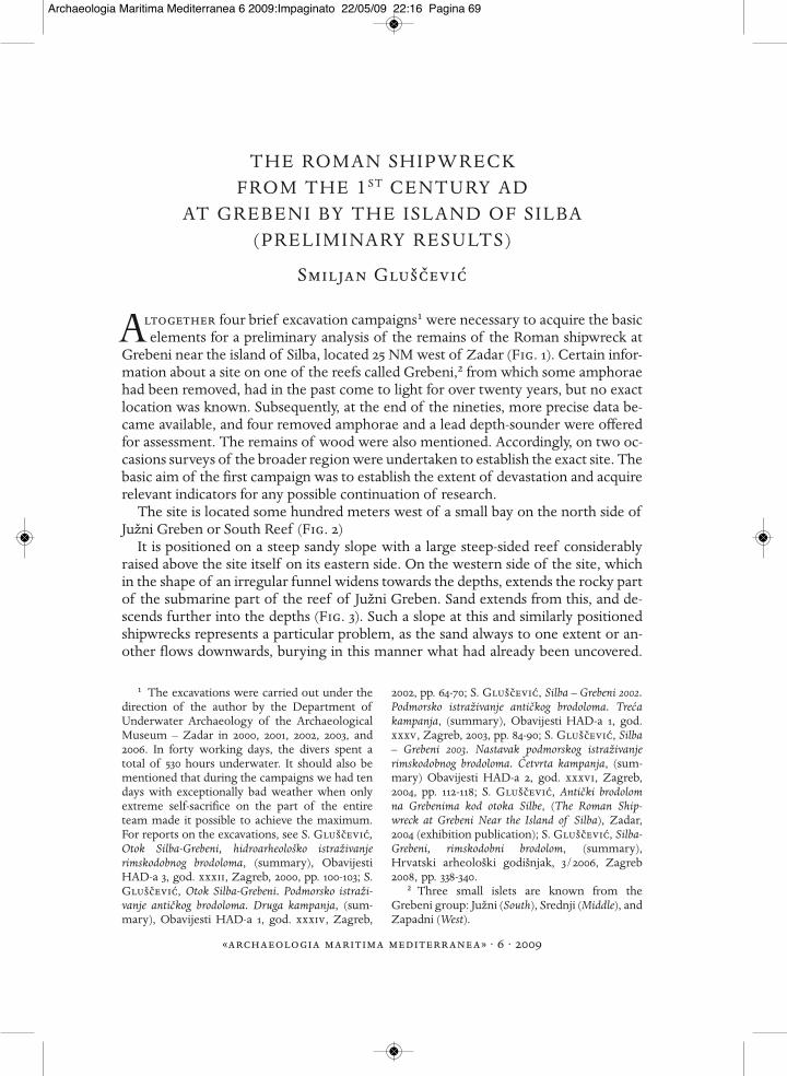
THE ROMAN SHIPWRECK FROM THE 1 ST CENTURY AD AT GREBENI BY THE ISLAND OF SILBA (PRELIMINARY RESULTS) Smiljan Glušc ˇevic´ ltogether four brief excavation campaigns1 were necessary to acquire the basic elements for a preliminary analysis of the remains of the Roman shipwreck at Grebeni near the island of Silba, located 25 NM west of Zadar (Fig. 1). Certain infor- mation about a site on one of the reefs called Grebeni,2 from which some amphorae had been removed, had in the past come to light for over twenty years, but no exact location was known. Subsequently, at the end of the nineties, more precise data be- came available, and four removed amphorae and a lead depth-sounder were offered for assessment. The remains of wood were also mentioned. Accordingly, on two oc- casions surveys of the broader region were undertaken to establish the exact site. The basic aim of the first campaign was to establish the extent of devastation and acquire relevant indicators for any possible continuation of research. The site is located some hundred meters west of a small bay on the north side of Južni Greben or South Reef (Fig. 2) It is positioned on a steep sandy slope with a large steep-sided reef considerably raised above the site itself on its eastern side. On the western side of the site, which in the shape of an irregular funnel widens towards the depths, extends the rocky part of the submarine part of the reef of Južni Greben. Sand extends from this, and de- scends further into the depths (Fig. 3). Such a slope at this and similarly positioned shipwrecks represents a particular problem, as the sand always to one extent or an- other flows downwards, burying in this manner what had already been uncovered. 1 The excavations were carried out under the direction of the author by the Department of Underwater Archaeology of the Archaeological Museum – Zadar in 2000, 2001, 2002, 2003, and 2006. In forty working days, the divers spent a total of 530 hours underwater. It should also be mentioned that during the campaigns we had ten days with exceptionally bad weather when only extreme self-sacrifice on the part of the entire team made it possible to achieve the maximum. For reports on the excavations, see S. Glušc ˇevic ´ , Otok Silba-Grebeni, hidroarheološko istraživanje rimskodobnog brodoloma, (summary), Obavijesti HAD-a 3, god. xxxii, Zagreb, 2000, pp. 100-103; S. Glušc ˇevic ´, Otok Silba-Grebeni. Podmorsko istraži- vanje antic ˇkog brodoloma. Druga kampanja, (sum- mary), Obavijesti HAD-a 1, god. xxxiv, Zagreb, 2002, pp. 64-70; S. Glušc ˇevic ´, Silba – Grebeni 2002. Podmorsko istraživanje antic ˇkog brodoloma. Trec ´a kampanja, (summary), Obavijesti HAD-a 1, god. xxxv, Zagreb, 2003, pp. 84-90; S. Glušc ˇevic ´, Silba – Grebeni 2003. Nastavak podmorskog istraživanje rimskodobnog brodoloma. C ˇ etvrta kampanja, (sum- mary) Obavijesti HAD-a 2, god. xxxvi, Zagreb, 2004, pp. 112-118; S. Glušc ˇevic ´, Antic ˇki brodolom na Grebenima kod otoka Silbe, (The Roman Ship- wreck at Grebeni Near the Island of Silba), Zadar, 2004 (exhibition publication); S. Glušc ˇevic ´, Silba- Grebeni, rimskodobni brodolom, (summary), Hrvatski arheološki godišnjak, 3/2006, Zagreb 2008, pp. 338-340. 2 Three small islets are known from the Grebeni group: Južni (South), Srednji (Middle), and Zapadni (West). «archaeologia maritima mediterranea»· 6 · 2009 A Archaeologia Maritima Mediterranea 6 2009:Impaginato 22/05/09 22:16 Pagina 69
Transcript of The Roman shipwreck from the 1st Century AD at Grebeni by the island of Silba (preliminary result)
THE ROMAN SHIPWRECKFROM THE 1ST CENTURY AD
AT GREBENI BY THE ISLAND OF SILBA(PRELIMINARY RESULTS)
Smiljan Glušcevic
ltogether four brief excavation campaigns1 were necessary to acquire the basicelements for a preliminary analysis of the remains of the Roman shipwreck at
Grebeni near the island of Silba, located 25 NM west of Zadar (Fig. 1). Certain infor-mation about a site on one of the reefs called Grebeni,2 from which some amphoraehad been removed, had in the past come to light for over twenty years, but no exactlocation was known. Subsequently, at the end of the nineties, more precise data be-came available, and four removed amphorae and a lead depth-sounder were offeredfor assessment. The remains of wood were also mentioned. Accordingly, on two oc-casions surveys of the broader region were undertaken to establish the exact site. Thebasic aim of the first campaign was to establish the extent of devastation and acquirerelevant indicators for any possible continuation of research.
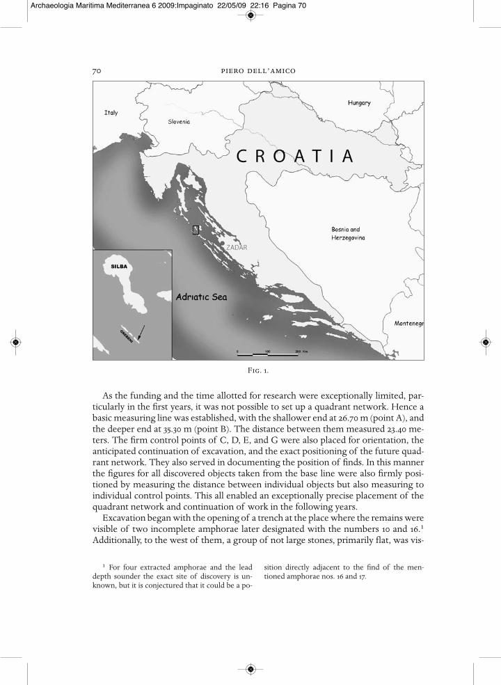
The site is located some hundred meters west of a small bay on the north side ofJužni Greben or South Reef (Fig. 2)
It is positioned on a steep sandy slope with a large steep-sided reef considerablyraised above the site itself on its eastern side. On the western side of the site, whichin the shape of an irregular funnel widens towards the depths, extends the rocky partof the submarine part of the reef of Južni Greben. Sand extends from this, and de-scends further into the depths (Fig. 3). Such a slope at this and similarly positionedshipwrecks represents a particular problem, as the sand always to one extent or an-other flows downwards, burying in this manner what had already been uncovered.
1 The excavations were carried out under thedirection of the author by the Department ofUnderwater Archaeology of the ArchaeologicalMuseum – Zadar in 2000, 2001, 2002, 2003, and2006. In forty working days, the divers spent a total of 530 hours underwater. It should also bementioned that during the campaigns we had tendays with exceptionally bad weather when onlyextreme self-sacrifice on the part of the entireteam made it possible to achieve the maximum.For reports on the excavations, see S. Glušcevic,Otok Silba-Grebeni, hidroarheološko istraživanje rimskodobnog brodoloma, (summary), ObavijestiHAD-a 3, god. xxxii, Zagreb, 2000, pp. 100-103; S.Glušcevic, Otok Silba-Grebeni. Podmorsko istraži-vanje antickog brodoloma. Druga kampanja, (sum-mary), Obavijesti HAD-a 1, god. xxxiv, Zagreb,
2002, pp. 64-70; S. Glušcevic, Silba – Grebeni 2002.Podmorsko istraživanje antickog brodoloma. Trecakampanja, (summary), Obavijesti HAD-a 1, god.xxxv, Zagreb, 2003, pp. 84-90; S. Glušcevic, Silba– Grebeni 2003. Nastavak podmorskog istraživanjerimskodobnog brodoloma. Cetvrta kampanja, (sum-mary) Obavijesti HAD-a 2, god. xxxvi, Zagreb,2004, pp. 112-118; S. Glušcevic, Anticki brodolomna Grebenima kod otoka Silbe, (The Roman Ship-wreck at Grebeni Near the Island of Silba), Zadar,2004 (exhibition publication); S. Glušcevic, Silba-Grebeni, rimskodobni brodolom, (summary),Hrvatski arheološki godišnjak, 3/2006, Zagreb2008, pp. 338-340.
2 Three small islets are known from theGrebeni group: Južni (South), Srednji (Middle), andZapadni (West).
«archaeologia maritima mediterranea» · 6 · 2009
A
Archaeologia Maritima Mediterranea 6 2009:Impaginato 22/05/09 22:16 Pagina 69
70 piero dell’amico
As the funding and the time allotted for research were exceptionally limited, par-ticularly in the first years, it was not possible to set up a quadrant network. Hence abasic measuring line was established, with the shallower end at 26.70 m (point A), andthe deeper end at 35.30 m (point B). The distance between them measured 23.40 me-ters. The firm control points of C, D, E, and G were also placed for orientation, theanticipated continuation of excavation, and the exact positioning of the future quad-rant network. They also served in documenting the position of finds. In this mannerthe figures for all discovered objects taken from the base line were also firmly posi-tioned by measuring the distance between individual objects but also measuring toindividual control points. This all enabled an exceptionally precise placement of thequadrant network and continuation of work in the following years.
Excavation began with the opening of a trench at the place where the remains werevisible of two incomplete amphorae later designated with the numbers 10 and 16.1Additionally, to the west of them, a group of not large stones, primarily flat, was vis-
1 For four extracted amphorae and the leaddepth sounder the exact site of discovery is un-known, but it is conjectured that it could be a po-
sition directly adjacent to the find of the men-tioned amphorae nos. 16 and 17.
Fig. 1.
Archaeologia Maritima Mediterranea 6 2009:Impaginato 22/05/09 22:16 Pagina 70
the roman shipwreck at grebeni by the island of silba 71ible, and on the basis of the visual surveythey were evidently of a different originthan the surrounding rocks.
The very first excavations showed thatthis was a relatively deep deposit of sand,which was somewhat more compact on-ly in the lower layers. The same situationoccurred in the following years. It was es-tablished that the main cargo of the shipwas composed of amphorae, and furtherdiscoveries included wooden remains ofthe ship structure, bronze nails, bronzeclamps, and several pieces of pottery thatmost probably belonged to the ship’skitchen.
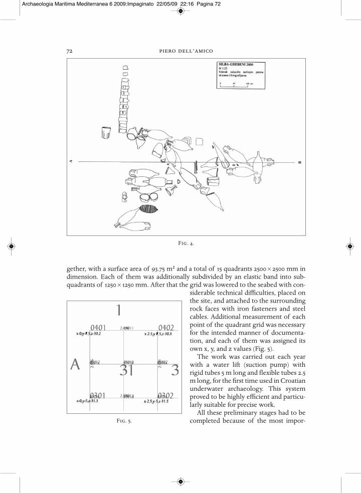
After the first year, it was possible tomake a plan of the excavated section, andto draw the plan as a whole along withthe disposition of the discovered remains(Fig. 4).
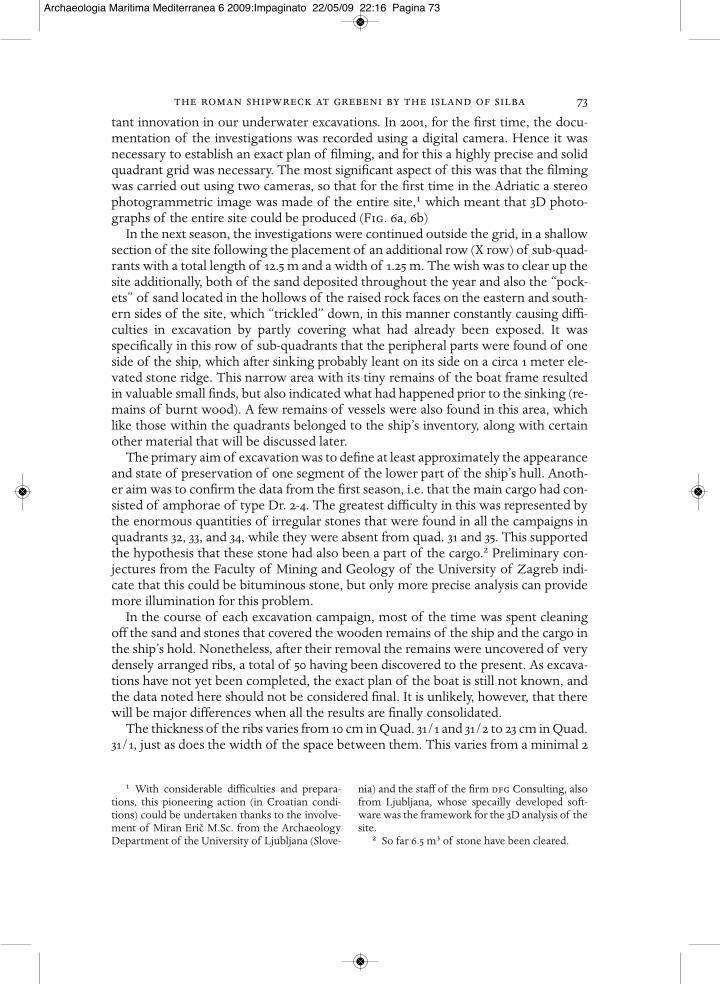
In the next year, a solid metal gridmeasuring 12.5 × 7.5 meters was put to- Fig. 2.
Fig. 3.
Archaeologia Maritima Mediterranea 6 2009:Impaginato 22/05/09 22:16 Pagina 71
72 piero dell’amico
gether, with a surface area of 93.75 m2 and a total of 15 quadrants 2500 × 2500 mm indimension. Each of them was additionally subdivided by an elastic band into sub-quadrants of 1250 × 1250 mm. After that the grid was lowered to the seabed with con-
siderable technical difficulties, placed onthe site, and attached to the surroundingrock faces with iron fasteners and steelcables. Additional measurement of eachpoint of the quadrant grid was necessaryfor the intended manner of documenta-tion, and each of them was assigned itsown x, y, and z values (Fig. 5).
The work was carried out each yearwith a water lift (suction pump) withrigid tubes 5 m long and flexible tubes 2.5m long, for the first time used in Croatianunderwater archaeology. This systemproved to be highly efficient and particu-larly suitable for precise work.
All these preliminary stages had to becompleted because of the most impor-
Fig. 4.
Fig. 5.
Archaeologia Maritima Mediterranea 6 2009:Impaginato 22/05/09 22:16 Pagina 72
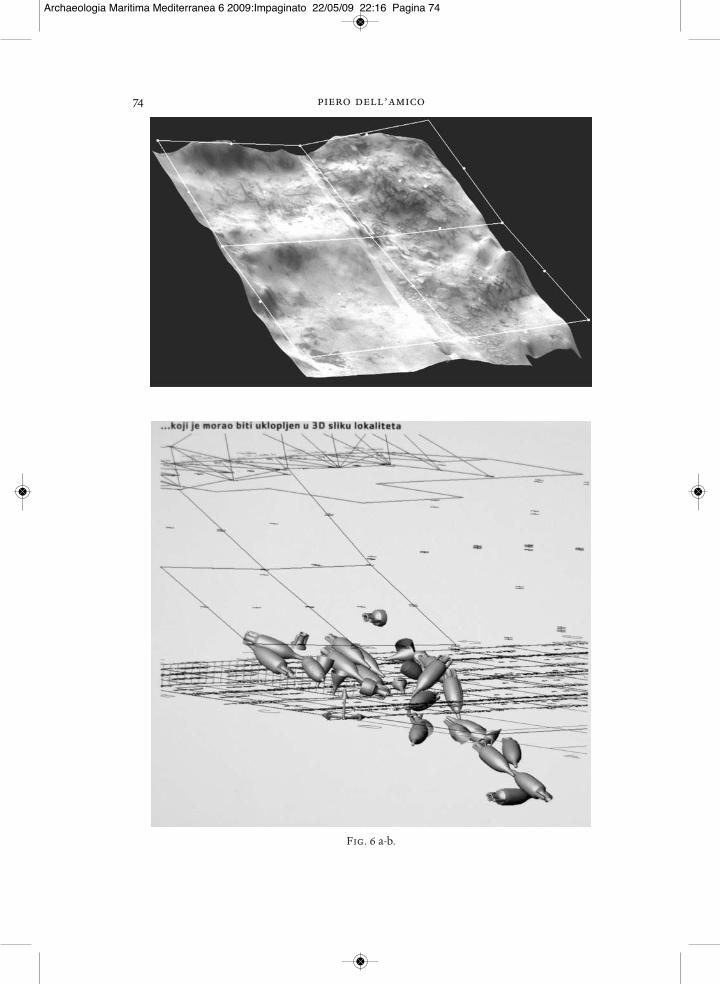
the roman shipwreck at grebeni by the island of silba 73tant innovation in our underwater excavations. In 2001, for the first time, the docu-mentation of the investigations was recorded using a digital camera. Hence it wasnecessary to establish an exact plan of filming, and for this a highly precise and solidquadrant grid was necessary. The most significant aspect of this was that the filmingwas carried out using two cameras, so that for the first time in the Adriatic a stereophotogrammetric image was made of the entire site,1 which meant that 3D photo-graphs of the entire site could be produced (Fig. 6a, 6b)
In the next season, the investigations were continued outside the grid, in a shallowsection of the site following the placement of an additional row (X row) of sub-quad-rants with a total length of 12.5 m and a width of 1.25 m. The wish was to clear up thesite additionally, both of the sand deposited throughout the year and also the “pock-ets” of sand located in the hollows of the raised rock faces on the eastern and south-ern sides of the site, which “trickled” down, in this manner constantly causing diffi-culties in excavation by partly covering what had already been exposed. It wasspecifically in this row of sub-quadrants that the peripheral parts were found of oneside of the ship, which after sinking probably leant on its side on a circa 1 meter ele-vated stone ridge. This narrow area with its tiny remains of the boat frame resultedin valuable small finds, but also indicated what had happened prior to the sinking (re-mains of burnt wood). A few remains of vessels were also found in this area, whichlike those within the quadrants belonged to the ship’s inventory, along with certainother material that will be discussed later.
The primary aim of excavation was to define at least approximately the appearanceand state of preservation of one segment of the lower part of the ship’s hull. Anoth-er aim was to confirm the data from the first season, i.e. that the main cargo had con-sisted of amphorae of type Dr. 2-4. The greatest difficulty in this was represented bythe enormous quantities of irregular stones that were found in all the campaigns inquadrants 32, 33, and 34, while they were absent from quad. 31 and 35. This supportedthe hypothesis that these stone had also been a part of the cargo.2 Preliminary con-jectures from the Faculty of Mining and Geology of the University of Zagreb indi-cate that this could be bituminous stone, but only more precise analysis can providemore illumination for this problem.
In the course of each excavation campaign, most of the time was spent cleaningoff the sand and stones that covered the wooden remains of the ship and the cargo inthe ship’s hold. Nonetheless, after their removal the remains were uncovered of verydensely arranged ribs, a total of 50 having been discovered to the present. As excava-tions have not yet been completed, the exact plan of the boat is still not known, andthe data noted here should not be considered final. It is unlikely, however, that therewill be major differences when all the results are finally consolidated.
The thickness of the ribs varies from 10 cm in Quad. 31/1 and 31/2 to 23 cm in Quad.31/1, just as does the width of the space between them. This varies from a minimal 2
1 With considerable difficulties and prepara-tions, this pioneering action (in Croatian condi-tions) could be undertaken thanks to the involve-ment of Miran Eric M.Sc. from the ArchaeologyDepartment of the University of Ljubljana (Slove-
nia) and the staff of the firm dfg Consulting, alsofrom Ljubljana, whose specailly developed soft-ware was the framework for the 3D analysis of thesite.
2 So far 6.5 m3 of stone have been cleared.
Archaeologia Maritima Mediterranea 6 2009:Impaginato 22/05/09 22:16 Pagina 73
74 piero dell’amico
Fig. 6 a-b.
Archaeologia Maritima Mediterranea 6 2009:Impaginato 22/05/09 22:16 Pagina 74
the roman shipwreck at grebeni by the island of silba 75
cm in Quad. 31/2 to a maximal 16 cm in Quad. 31/1.1 The average space measures 8.7cm, while the average rib width measures 13.5 cm.
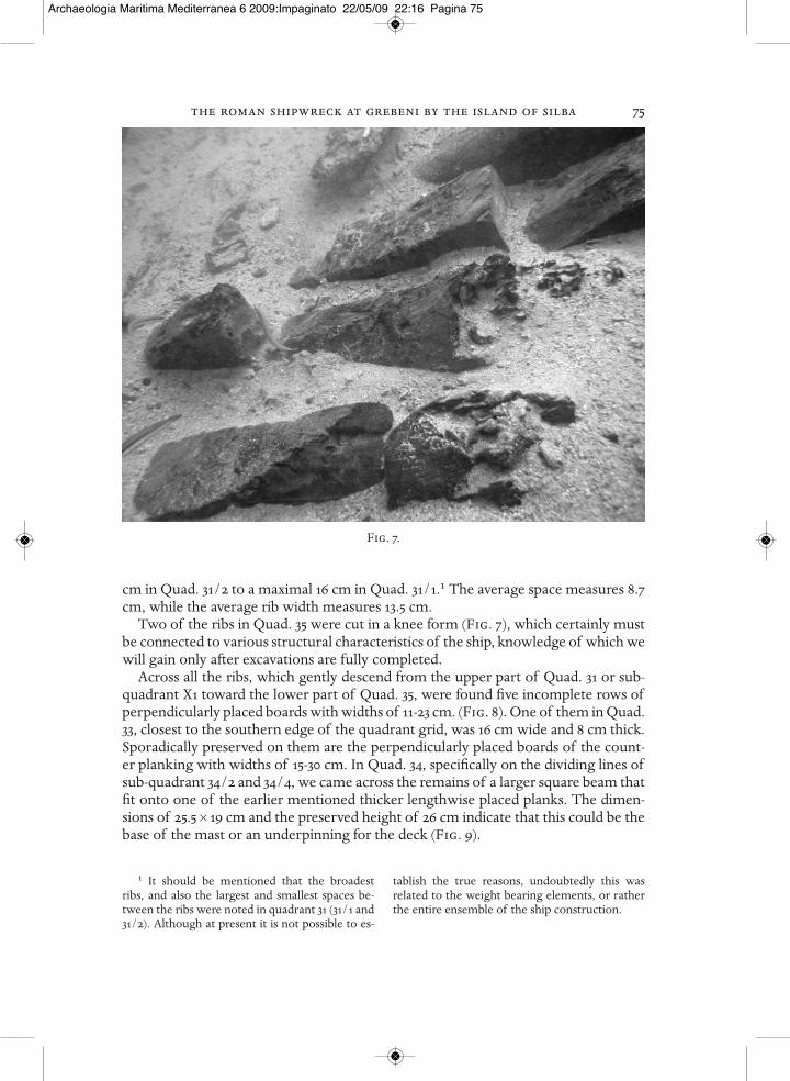
Two of the ribs in Quad. 35 were cut in a knee form (Fig. 7), which certainly mustbe connected to various structural characteristics of the ship, knowledge of which wewill gain only after excavations are fully completed.
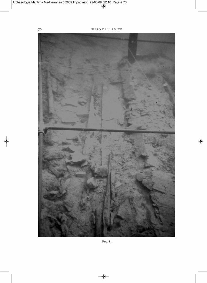
Across all the ribs, which gently descend from the upper part of Quad. 31 or sub-quadrant X1 toward the lower part of Quad. 35, were found five incomplete rows ofperpendicularly placed boards with widths of 11-23 cm. (Fig. 8). One of them in Quad.33, closest to the southern edge of the quadrant grid, was 16 cm wide and 8 cm thick.Sporadically preserved on them are the perpendicularly placed boards of the count-er planking with widths of 15-30 cm. In Quad. 34, specifically on the dividing lines ofsub-quadrant 34/2 and 34/4, we came across the remains of a larger square beam thatfit onto one of the earlier mentioned thicker lengthwise placed planks. The dimen-sions of 25.5 × 19 cm and the preserved height of 26 cm indicate that this could be thebase of the mast or an underpinning for the deck (Fig. 9).
1 It should be mentioned that the broadestribs, and also the largest and smallest spaces be-tween the ribs were noted in quadrant 31 (31/1 and31/2). Although at present it is not possible to es-
tablish the true reasons, undoubtedly this was related to the weight bearing elements, or ratherthe entire ensemble of the ship construction.
Fig. 7.
Archaeologia Maritima Mediterranea 6 2009:Impaginato 22/05/09 22:16 Pagina 75
76 piero dell’amico
Fig. 8.
Archaeologia Maritima Mediterranea 6 2009:Impaginato 22/05/09 22:16 Pagina 76

the roman shipwreck at grebeni by the island of silba 77
Part of the exterior planking of the boat discovered in Quad. 35/2 was 4 cm thick.This, along with the size of the bronze nails and particularly the clamps found to thepresent (Fig. 10), might preliminarily suggest a ship length of around 20 meters.
Samples of the wood were analyzed by the Institute of Wood Industry Researchof the Forestry Faculty of the University of Zagreb. Three analyses in total were per-formed, from the keel, the planking, and the ribs of the vessel. The wood from thekeel and the planking belongs to the Pine genus (Pinus L.), subgenus yellow pines(diploxylon Koehne), most probably the Scotch pine (Pinus sylvestris L.), Arnold sen-tinel black pine (Pinus nigra Arnold), or mountain pine (Pinus mungo Turra). Thewood from the rib sample most probably belonged to a stone pine (Pinus pinea L.)
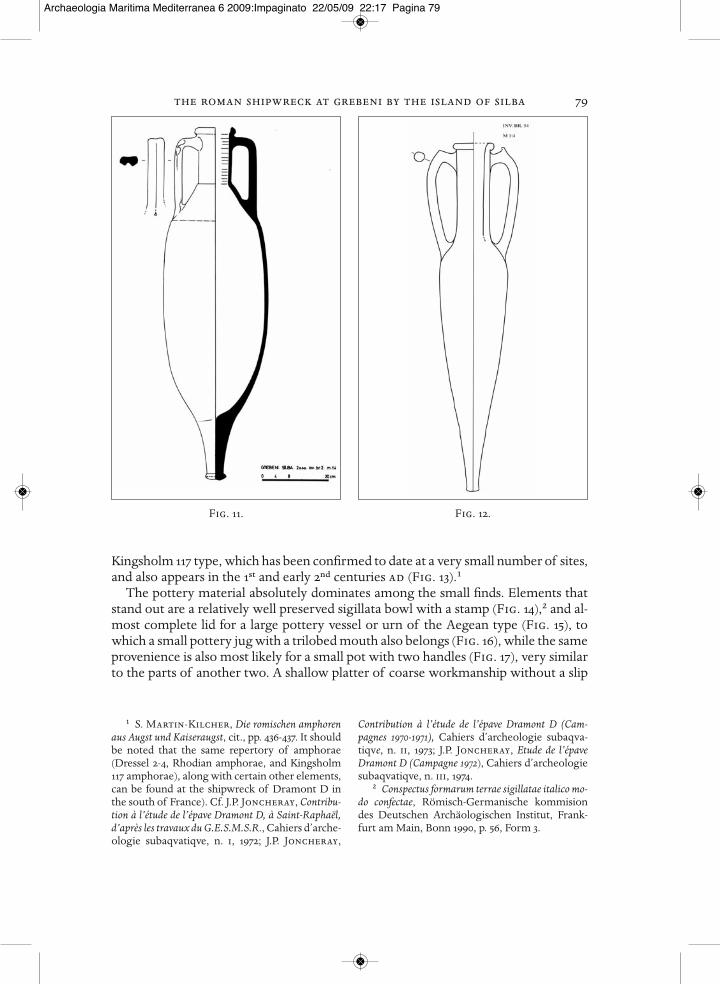
As was already noted, most of the cargo was composed of elongated amphorae forwine with sharply cut double handles of the type Dressel 2-4, certainly the most wide-ly distributed type of wine amphora in the western Mediterranean during the earlyImperial period (Fig. 11).1 They appear up to the middle of the 2nd century ad. Dif-
1 D.P.S. Peacock, D.F.Williams, Amphoraeand the Roman Economy, Longman ArchaeologySeries, 1986, p. 106. These amphorae were also dis-cussed in several works by T. Bezeczky, RomanAmphorae from the Amber Route in Western Pannonia,
bar International Series 386, 1987, 4; S. Martin-Kilcher, Die römischen amphoren aus Augst undKaiseraugst, Forschung in Augst, Band 7, Augst 1994,pp. 337-346.
Fig. 9.
Archaeologia Maritima Mediterranea 6 2009:Impaginato 22/05/09 22:17 Pagina 77

78 piero dell’amico
ferences have been noted in the workmanship and to some extent in size, which leadsto doubt about a common provenience. At the very least, it indicates different work-shops, as is confirmed by the visually different internal structure of some of them.This type of amphora can be found at twenty some Adriatic sites, in variants rangingfrom Hispanic through Italic to Greek.1
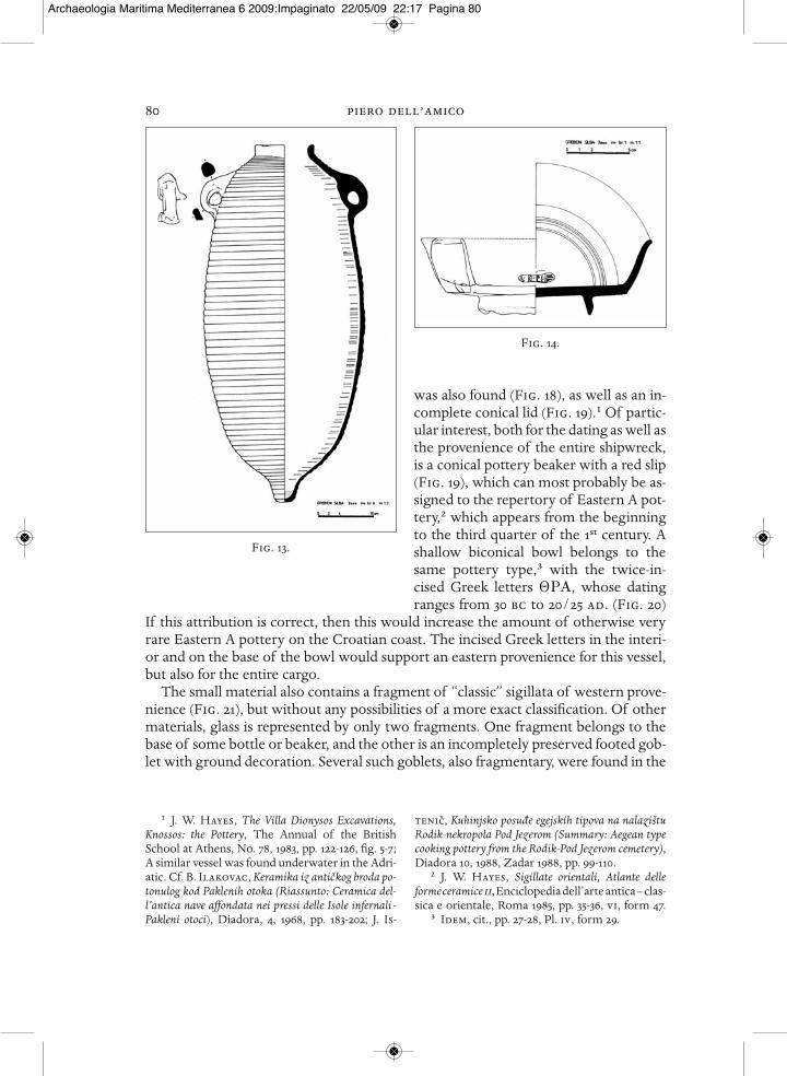
Along with this predominant amphora type, another two were discovered, one belonging to the Rhodian type, which developed from a late Hellenistic prototype ofthe late 1st century bc but continued into the early 2nd century ad (Fig. 12).2 They arenot particularly common at Adriatic underwater sites,3 and they exhibit considerabledifferences in size, color, structure, hardness, and thickness of the walls. An as yet almost isolated example of an amphora quite specific to Croatian sites4 belongs to the
1 M. Jurišic, Ancient Shipwrecks of the Adriatic,Maritime transport during the first and second cen-turies ad, BAR International Series 928, 2000, pp.12-14, map 22; Other than the shipwreck at Silba,the only other one where the main cargo was am-phorae Dr. 2-4 is by the island of Zlarin nearŠibenik. Cf. Z. Brusic, Rt Plavac, Zlarin kod Šibeni-ka – ostaci antickog brodoloma, cit., pp. 103-104.
2 D.P.S. Peacock, D.F Williams, Amphoraeand the Roman Economy, cit., pp. 102-104.
3 M. Jurišic, Ancient Shipwrecks of the Adriatic,Maritime transport during first and second centuriesad, cit., p. 14, where he notes all the sites, whethershipwrecks or harbors in whose strata they arefound.
4 Another example discovered in the entranceto the harbor of Vis (ancient Issa) is located in thehydro-archaeological collection in Vis on the is-land of the same name.
Fig. 10.
Archaeologia Maritima Mediterranea 6 2009:Impaginato 22/05/09 22:17 Pagina 78
the roman shipwreck at grebeni by the island of silba 79
Kingsholm 117 type, which has been confirmed to date at a very small number of sites,and also appears in the 1st and early 2nd centuries ad (Fig. 13).1
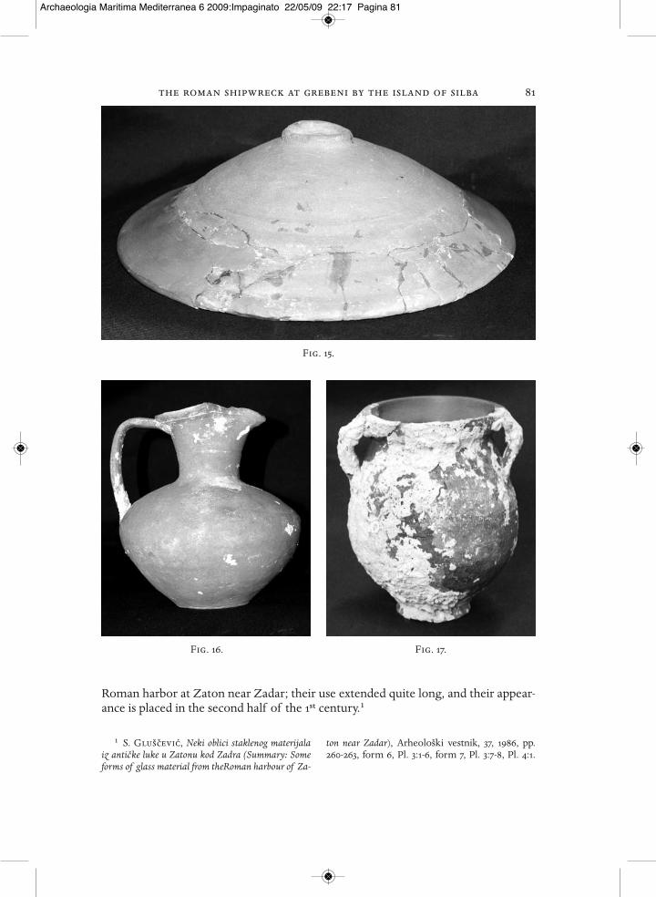
The pottery material absolutely dominates among the small finds. Elements thatstand out are a relatively well preserved sigillata bowl with a stamp (Fig. 14),2 and al-most complete lid for a large pottery vessel or urn of the Aegean type (Fig. 15), towhich a small pottery jug with a trilobed mouth also belongs (Fig. 16), while the sameprovenience is also most likely for a small pot with two handles (Fig. 17), very similarto the parts of another two. A shallow platter of coarse workmanship without a slip
1 S. Martin-Kilcher, Die romischen amphorenaus Augst und Kaiseraugst, cit., pp. 436-437. It shouldbe noted that the same repertory of amphorae(Dressel 2-4, Rhodian amphorae, and Kingsholm117 amphorae), along with certain other elements,can be found at the shipwreck of Dramont D inthe south of France). Cf. J.P. Joncheray, Contribu-tion à l’étude de l’épave Dramont D, à Saint-Raphaël,d’après les travaux du G.E.S.M.S.R., Cahiers d’arche-ologie subaqvatiqve, n. i, 1972; J.P. Joncheray,
Contribution à l’étude de l’épave Dramont D (Cam-pagnes 1970-1971), Cahiers d’archeologie subaqva-tiqve, n. ii, 1973; J.P. Joncheray, Etude de l’épaveDramont D (Campagne 1972), Cahiers d’archeologiesubaqvatiqve, n. iii, 1974.
2 Conspectus formarum terrae sigillatae italico mo-do confectae, Römisch-Germanische kommisiondes Deutschen Archäologischen Institut, Frank-furt am Main, Bonn 1990, p. 56, Form 3.
Fig. 11. Fig. 12.
Archaeologia Maritima Mediterranea 6 2009:Impaginato 22/05/09 22:17 Pagina 79
80 piero dell’amico
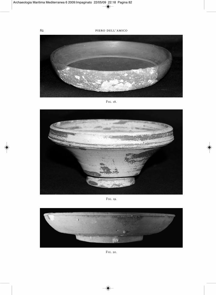
was also found (Fig. 18), as well as an in-complete conical lid (Fig. 19).1 Of partic-ular interest, both for the dating as well asthe provenience of the entire shipwreck,is a conical pottery beaker with a red slip(Fig. 19), which can most probably be as-signed to the repertory of Eastern A pot-tery,2 which appears from the beginningto the third quarter of the 1st century. Ashallow biconical bowl belongs to thesame pottery type,3 with the twice-in-cised Greek letters £PA, whose datingranges from 30 bc to 20/25 ad. (Fig. 20)
If this attribution is correct, then this would increase the amount of otherwise veryrare Eastern A pottery on the Croatian coast. The incised Greek letters in the interi-or and on the base of the bowl would support an eastern provenience for this vessel,but also for the entire cargo.
The small material also contains a fragment of “classic” sigillata of western prove-nience (Fig. 21), but without any possibilities of a more exact classification. Of othermaterials, glass is represented by only two fragments. One fragment belongs to thebase of some bottle or beaker, and the other is an incompletely preserved footed gob-let with ground decoration. Several such goblets, also fragmentary, were found in the
1 J. W. Hayes, The Villa Dionysos Excavations,Knossos: the Pottery, The Annual of the BritishSchool at Athens, No. 78, 1983, pp. 122-126, fig. 5-7;A similar vessel was found underwater in the Adri-atic. Cf. B. Ilakovac, Keramika iz antickog broda po-tonulog kod Paklenih otoka (Riassunto: Ceramica del-l’antica nave affondata nei pressi delle Isole infernali -Pakleni otoci), Diadora, 4, 1968, pp. 183-202; J. Is-
tenic, Kuhinjsko posude egejskih tipova na nalazištuRodik-nekropola Pod Jezerom (Summary: Aegean typecooking pottery from the Rodik-Pod Jezerom cemetery),Diadora 10, 1988, Zadar 1988, pp. 99-110.
2 J. W. Hayes, Sigillate orientali, Atlante delleforme ceramice ii, Enciclopedia dell’arte antica – clas-sica e orientale, Roma 1985, pp. 35-36, vi, form 47.
3 Idem, cit., pp. 27-28, Pl. iv, form 29.
Fig. 13.
Fig. 14.
Archaeologia Maritima Mediterranea 6 2009:Impaginato 22/05/09 22:17 Pagina 80
the roman shipwreck at grebeni by the island of silba 81
Roman harbor at Zaton near Zadar; their use extended quite long, and their appear-ance is placed in the second half of the 1st century.1
1 S. Glušcevic, Neki oblici staklenog materijalaiz anticke luke u Zatonu kod Zadra (Summary: Someforms of glass material from theRoman harbour of Za-
ton near Zadar), Arheološki vestnik, 37, 1986, pp.260-263, form 6, Pl. 3:1-6, form 7, Pl. 3:7-8, Pl. 4:1.
Fig. 15.
Fig. 16. Fig. 17.
Archaeologia Maritima Mediterranea 6 2009:Impaginato 22/05/09 22:17 Pagina 81
82 piero dell’amico
Fig. 18.
Fig. 20.
Fig. 19.
Archaeologia Maritima Mediterranea 6 2009:Impaginato 22/05/09 22:18 Pagina 82
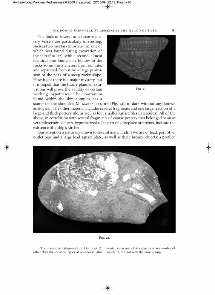
the roman shipwreck at grebeni by the island of silba 83The finds of several other coarse pot-
tery vessels are particularly interesting,such as two mortars (mortarium), one ofwhich was found during excavation ofthe ship (Fig. 22), with a second, almostidentical one found in a hollow in therocks some thirty meters from our site,and separated from it by a large protru-sion or the peak of a steep rocky slope.How it got there is a major mystery, butit is hoped that the future planned exca-vations will prove the validity of certainworking hypotheses. The mortariumfound within the ship complex has astamp on the shoulder: M. mar/secvndin (Fig. 23), to date without any knownanalogies.1 The other material includes several fragments and one larger section of alarge and thick pottery tile, as well as four smaller square tiles (laterculus). All of theabove, in correlation with several fragments of coarse pottery that belonged to an asyet undetermined form, hypothesized to be part of a fireplace or firebox, indicate theexistence of a ship’s kitchen.
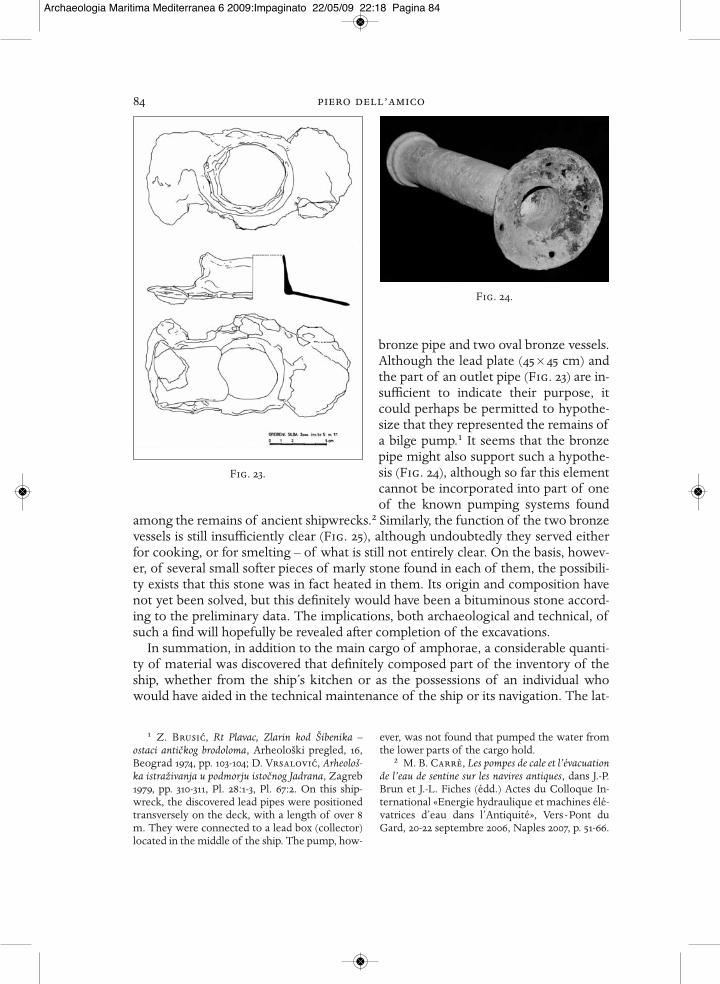
Our attention is naturally drawn to several metal finds. Two are of lead: part of anoutlet pipe and a large lead square plate, as well as three bronze objects: a profiled
1 The mentioned shipwreck of Dramont D,other than the identical types of amphorae, also
contained as part of its cargo a certain number ofmortaria, but not with the same stamp.
Fig. 22.
Fig. 21.
Archaeologia Maritima Mediterranea 6 2009:Impaginato 22/05/09 22:18 Pagina 83
84 piero dell’amico
bronze pipe and two oval bronze vessels.Although the lead plate (45 × 45 cm) andthe part of an outlet pipe (Fig. 23) are in-sufficient to indicate their purpose, itcould perhaps be permitted to hypothe-size that they represented the remains ofa bilge pump.1 It seems that the bronzepipe might also support such a hypothe-sis (Fig. 24), although so far this elementcannot be incorporated into part of oneof the known pumping systems found
among the remains of ancient shipwrecks.2 Similarly, the function of the two bronzevessels is still insufficiently clear (Fig. 25), although undoubtedly they served eitherfor cooking, or for smelting – of what is still not entirely clear. On the basis, howev-er, of several small softer pieces of marly stone found in each of them, the possibili-ty exists that this stone was in fact heated in them. Its origin and composition havenot yet been solved, but this definitely would have been a bituminous stone accord-ing to the preliminary data. The implications, both archaeological and technical, ofsuch a find will hopefully be revealed after completion of the excavations.
In summation, in addition to the main cargo of amphorae, a considerable quanti-ty of material was discovered that definitely composed part of the inventory of theship, whether from the ship’s kitchen or as the possessions of an individual whowould have aided in the technical maintenance of the ship or its navigation. The lat-
1 Z. Brusic, Rt Plavac, Zlarin kod Šibenika –ostaci antickog brodoloma, Arheološki pregled, 16,Beograd 1974, pp. 103-104; D. Vrsalovic, Arheološ-ka istraživanja u podmorju istocnog Jadrana, Zagreb1979, pp. 310-311, Pl. 28:1-3, Pl. 67:2. On this ship-wreck, the discovered lead pipes were positionedtransversely on the deck, with a length of over 8m. They were connected to a lead box (collector)located in the middle of the ship. The pump, how-
ever, was not found that pumped the water fromthe lower parts of the cargo hold.
2 M. B. Carrè, Les pompes de cale et l’évacuationde l’eau de sentine sur les navires antiques, dans J.-P.Brun et J.-L. Fiches (édd.) Actes du Colloque In-ternational «Energie hydraulique et machines élé-vatrices d’eau dans l’Antiquité», Vers - Pont duGard, 20-22 septembre 2006, Naples 2007, p. 51-66.
Fig. 23.
Fig. 24.
Archaeologia Maritima Mediterranea 6 2009:Impaginato 22/05/09 22:18 Pagina 84
the roman shipwreck at grebeni by the island of silba 85
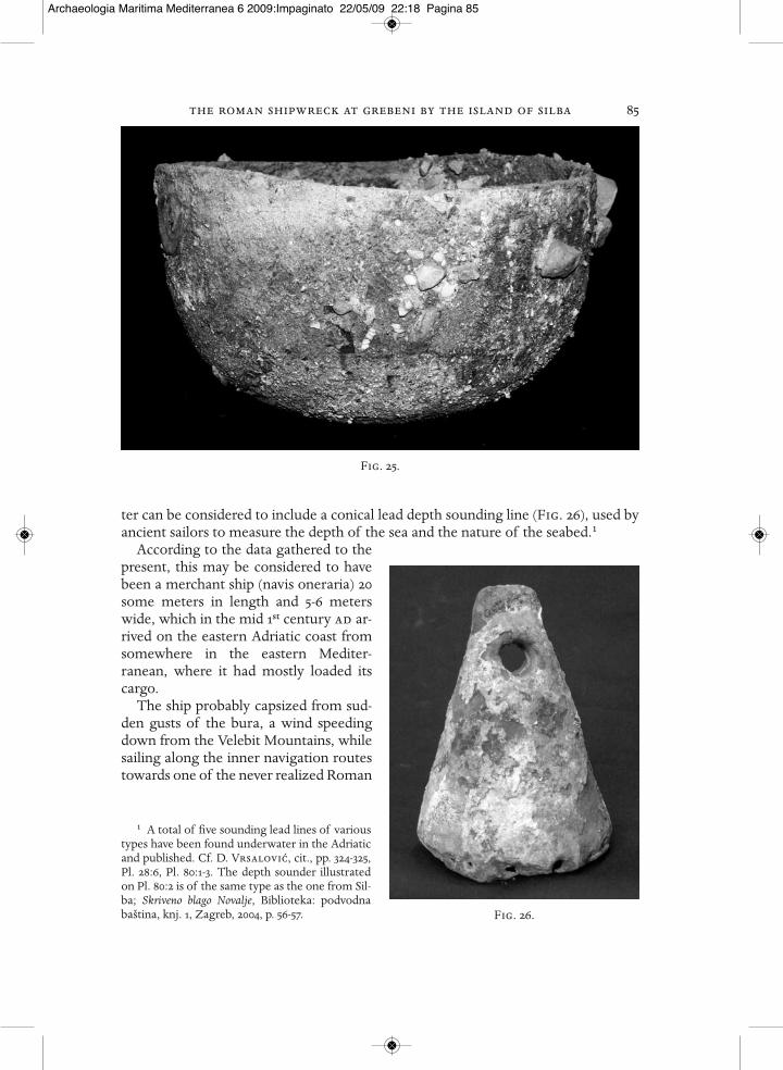
ter can be considered to include a conical lead depth sounding line (Fig. 26), used byancient sailors to measure the depth of the sea and the nature of the seabed.1
According to the data gathered to thepresent, this may be considered to havebeen a merchant ship (navis oneraria) 20some meters in length and 5-6 meterswide, which in the mid 1st century ad ar-rived on the eastern Adriatic coast fromsomewhere in the eastern Mediter-ranean, where it had mostly loaded itscargo.
The ship probably capsized from sud-den gusts of the bura, a wind speedingdown from the Velebit Mountains, whilesailing along the inner navigation routestowards one of the never realized Roman
1 A total of five sounding lead lines of varioustypes have been found underwater in the Adriaticand published. Cf. D. Vrsalovic, cit., pp. 324-325,Pl. 28:6, Pl. 80:1-3. The depth sounder illustratedon Pl. 80:2 is of the same type as the one from Sil-ba; Skriveno blago Novalje, Biblioteka: podvodnabaština, knj. 1, Zagreb, 2004, p. 56-57.
Fig. 25.
Fig. 26.
Archaeologia Maritima Mediterranea 6 2009:Impaginato 22/05/09 22:18 Pagina 85
86 piero dell’amicoports of the northern Adriatic.1 Judging from the remains of burnt wood, it can behypothesized that during the storm part of the ship caught fire, and it then sunk.
The further planned excavations will certainly solve the questions of the exactlength and tonnage of the ship, and aid in more precisely defining certain still unclearconstruction details, and it may also be possible to determine a more exact prove-nience of both the ship and the cargo.
Bibliography
Skriveno blago Novalje, Biblioteka: podvodna baština, knj. 1, Zagreb, 2004.Bezeczky T. 1987, Roman Amphorae from the Amber Route in Western Pannonia, «bar» Interna-
tional Series 386.Carrè M. B., Les pompes de cale et l’évacuation de l’eau de sentine sur les navires antiques, dans
J.-P. Brun et J.-L. Fiches (éd) Actes du Colloque International «Energie hydraulique et machinesélévatrices d’eau dans l’Antiquité», Vers - Pont du Gard, 20-22 septembre 2006, Naples 2007,p. 51-66.
Brusic Z. 1974, Rt Plavac, Zlarin kod Šibenika – ostaci antickog brodoloma, «Arheološki pregled.»,16, pp. 103-104.
Brusic Z. 1980, Neki problemi plovidbe Kvarnericem, Pomorstvo Lošinja i Cresa, «Otocki ljetopisCres-Lošinj» 3, Mali Lošinj, pp. 157-171.
Casson L. 1971, Ships and Seamanship in the Ancient World, Princeton.Glušcevic S. 1986, Neki oblici staklenog materijala iz anticke luke u Zatonu kraj Zadra, «Arhe-
ološki vestnik», 37, pp. 255-277.Glušcevic S. 1994, Brodolomi i brodarenje na istocnoj obali Jadrana od prapovijesti do 19. stoljeca,
«Kaštelanski zbornik», 4, pp. 25-60.Glušcevic S. 2000, Otok Silba-Grebeni, hidroarheološko istraživanje rimskodobnog brodoloma,
Obavijesti HAD-a 3, god. xxxii, pp. 100-103.Glušcevic S. 2002, Otok Silba-Grebeni. Podmorsko istraživanje antickog brodoloma. Druga kam-
panja, Obavijesti HAD-a 1, god.xxxiv, pp. 64-70.Glušcevic S. 2003, Silba-Grebeni 2002. Podmorsko istraživanje antickog brodoloma. Treca kampan-
ja, Obavijesti HAD-a 1, god. xxxv, pp. 84-90.Glušcevic S. 2004a, Silba-Grebeni 2003. Nastavak podmorskog istraživanje rimskodobnog brodolo-
ma. Cetvrta kampanja, Obavijesti HAD-a 2, god. xxxvi, pp. 112-118.Glušcevic S. 2004b, Anticki brodolom na Grebenima kod otoka Silbe, (The Roman Shipwreck at
Grebeni Near Isand of Silba), (publikacija uz izložbu)Grace V. R. 1961, Amphoras and the Ancient Wine Trade, American School of Classical Studies at
Athens, Princeton-New Jersey.Hayes J. W. 1983, The Villa Dionysos Excavations, Knossos: the Pottery, «The Annual of the British
School at Athens», 78, pp. 97-168.Hayes J. W. 1985, Sigillate orientali, Atlante delle forme ceramiche ii, Enciclopedia dell’arte anti-
ca - classica e orientale, Roma.Ilakovac B. 1968, Keramika iz antickog broda potonulog kod Paklenih otoka (Riassunto: Ceram-
ica dell’antica nave affondata nei pressi delle Isole infernali - Pakleni otoci), «Diadora», 4, pp.183-202.
Isings C. 1957, Roman Glass From Dated Finds, Gröningen/Djakarta.
1 Z. Brusic, Neki problemi plovidbe Kvarne ricem,Otocki ljetopis Cres – Lošinj, Pomorstvo Lošinja iCresa, 3, Mali Lošinj 1980, pp. 157-171; S. Glušce-
vic, Brodolomi i brodarenje na istocnoj obali Jadranaod prapovijesti do 19. stoljeca, Kaštelanski zbornik, 4,Kaštela 1994, 25-60.
Archaeologia Maritima Mediterranea 6 2009:Impaginato 22/05/09 22:18 Pagina 86

the roman shipwreck at grebeni by the island of silba 87Istenic J. 1988, Kuhinjsko posude egejskih tipova na nalazištu Rodik-nekropola Pod Jezerom (Sum-
mary: Aegean type cooking pottery from the Rodik-Pod Jezerom cemetery), «Diadora» 10,Zadar, pp. 99-110.
Istenic J., Schneider G. 2000, Aegean cooking ware in the eastern Adriatic, «Rei cretarie ro-mane favtorum acta» 36.
Joncheray J. P. 1972, Contribution à l’étude de l’épave Dramont D, à Saint-Raphaël, d’après lestravaux du G.E.S.M.S.R., «Cahiers d’archeologie subaqvatiqve», n. i.
Joncheray J. P. 1973, Contribution à l’étude de l’épave Dramont D (Campagnes 1970-1971), «Cahiersd’archeologie subaqvatiqve», n. ii.
Joncheray J. P. 1974, Etude de l’épave Dramont D (campagne 1972), «Cahiers d’archeologie sub-aqvatiqve», n. iii.
Jurišic M. 2000, Ancient Shipwrecks of the Adriatic, Maritime transport during the first and second century ad, «bar» International Series 828, Oxford.
Martin-Kilcher S. 1997, Die römische Amphoren aus Augst und Kaiseraugst, Forschungenin Augst 7/2, Augst.
Parker A. J. 1992, Ancient Shipwrecks of the Mediterranean and the Roman Provinces, «bar» In-ternational series 580.
Peacock D. P. S., Williams D. F. 1986, Amphorae and the Roman Economy, London-New York.Vrsalovic D. 1979, Arheološka istraživanja u podmorju istocnog Jadrana, Zagreb.
Archaeologia Maritima Mediterranea 6 2009:Impaginato 22/05/09 22:18 Pagina 87

Archaeologia Maritima Mediterranea 6 2009:Impaginato 22/05/09 22:18 Pagina 88