THE PREHISTORIC BURIAL MOUNDS AND RELATED MONUMENTS OF COUNTY WESTMEATH Part II
68
THE PREHISTORIC BURIAL MOUNDS AND RELATED MONUMENTS OF COUNTY WESTMEATH II. MONUMENTS IN CENTRAL WESTMEATH (BARONY OF RATHCONRATH AND PARTS OF BARONIES OF MOYGOISH, MOYCASHEL, AND MOYASHEL & MAGHERADERNON) "#$%" &'()%**+,, -.%, /012+'- 3#, 4)*"+" 56 3+,-&+#-. '1)*-6 '1)*'%7 #*" )*"+0-#8+* %* #,,1'%#-%1* 3%-. 3+,-&+#-. #0'.#+171(%'#7 #*" .%,-10%'#7 ,1'%+-6 9:;< = ">?@A &B(C@DDEFF
-
Upload
independent -
Category
Documents
-
view
4 -
download
0
Transcript of THE PREHISTORIC BURIAL MOUNDS AND RELATED MONUMENTS OF COUNTY WESTMEATH Part II
!
!
THE PREHISTORIC BURIAL MOUNDS AND
RELATED MONUMENTS OF COUNTY
WESTMEATH
!
II. MONUMENTS IN CENTRAL WESTMEATH (BARONY OF RATHCONRATH
AND PARTS OF BARONIES OF MOYGOISH, MOYCASHEL, AND MOYASHEL
& MAGHERADERNON)
!!
!!!
"#$%"!&'()%**+,,!!!
!!
-.%,!/012+'-!3#,!4)*"+"!56!3+,-&+#-.!'1)*-6!'1)*'%7!#*"!)*"+0-#8+*!%*!#,,1'%#-%1*!3%-.!3+,-&+#-.!#0'.#+171(%'#7!#*"!.%,-10%'#7!,1'%+-6!
!9:;<!
!=!">?@A!&B(C@DDEFF!

! "!
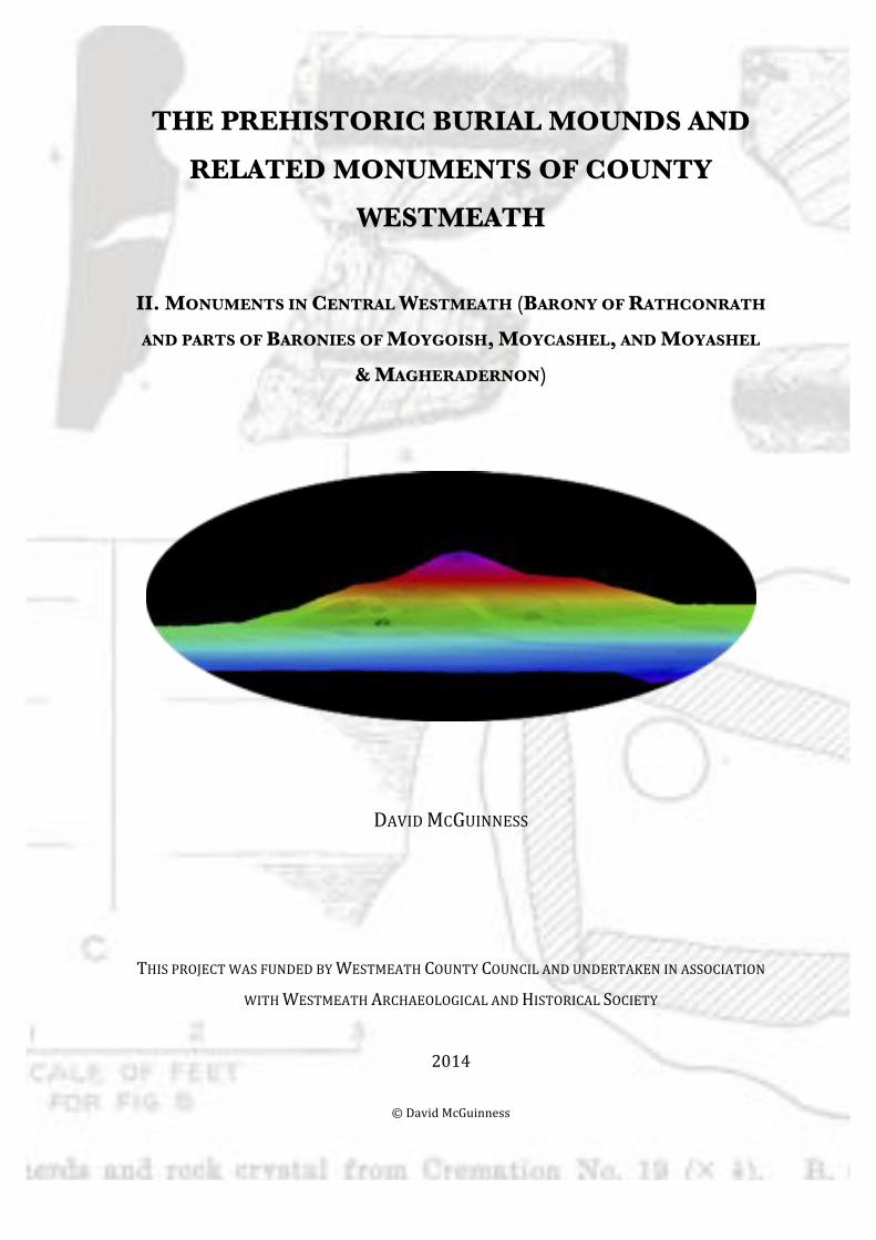
Cover Illustration: LIDAR profile of stepped-barrow at Cumminstown (No. 18), vertically exaggerated (© OSI)
CONTENTS
3. Acknowledgments 4. Introduction 6. Morphology, Classification & Comparanda 16. Ransacked & Excavated Sites 17. Siting & Topography 21. Barrows, Megaliths & Rock Art 24. Barrows & Early Medieval Church sites 26. Medieval Literature & Folk Tradition 28. Catalogue of Monuments 67. References List of Figures in Main Text:
Fig. I: Map of 2013 season study area Fig. II: ASI classification of barrows based on surface features Fig. III: Barrows shaped from natural hillocks at Rathcroghan and near Carrowmore Fig. IV: Profiles of Stepped-Barrow and Ring-Barrow shaped from glacial landforms at Balgarrett (Nos 2, 4) Fig. V: Generic Pond-Barrow Fig. VI: Profiles of Stepped-Barrows at Rathmoon, Co. Wicklow, and Balgarrett (No. 3) Fig. VII: LIDAR profile of Stepped-Barrow at Cumminstown (No. 18) Fig. VIII: Examples of miniature ringfort-shaped barrows from Carrowmore area of Sligo Fig. IX: Generic Disc-Barrow Fig. X: Extent of view from Hill of Ushnagh Fig. XI: Earthwork dramatically sculpted from Captain’s Hill on shore of Lough Owel Fig. XII: Rock art reused in ringfort beside tumulus at Togherstown (No. 44) Fig. XIII: Rock art found in Ballinlug townland Fig. XIV: Shaw’s map of Westmeath locations associated with the Táin Bó Cúailnge
List of Figures in Catalogue:
Fig. 1: Mound-Barrow at Ardan (No. 1) from the east Fig. 2: Profiles of Ring or Stepped-Barrow at Balgarrett (No. 2) Fig. 3: Profiles of Ring or Stepped-Barrow at Balgarrett (No. 3) Fig. 4: Profiles of Ring-Barrow at Balgarrett (No. 4) Fig. 5: Profiles of Mound-Barrow at Balgarrett (No. 5) Fig. 6: Plan and sections of excavated cemetery cairn at Coolatoor (Knockast) (No. 13) Fig. 7: Selection of finds from Coolatoor (Knockast) cemetery cairn (No. 13) Fig. 8: LIDAR plan and profile of Cumminstown Mound-Barrow (No. 17) Fig. 9: LIDAR oblique overhead view of Cumminstown Mound-Barrow (No. 17) Fig. 10: LIDAR profile of Cumminstown Stepped-Barrow (No. 18) Fig. 11: LIDAR vertical and oblique overhead views and profile of Cumminstown Stepped-Barrow (No. 18) Fig. 12: LIDAR vertical overhead views and profiles of Cumminstown Stepped-Barrow (No. 18) Fig. 13: LIDAR vertical overhead views and profiles of Garryduff Ring or Stepped-Barrow (No. 21) Fig. 14: LIDAR oblique overhead view of Garryduff Ring or Stepped-Barrow (No. 21) and adjacent knoll Fig. 15: LIDAR vertical overhead view and profile of Garryduff Ring-Barrow (No. 22) Fig. 16: LIDAR oblique overhead view of Garryduff Ring-Barrow (No. 22) Fig. 17: Interior of Ring-Barrow at Garryduff (No. 23), showing central mound, ditch and surrounding bank Fig. 18: LIDAR oblique overhead view of Garryduff Ring-Barrow (No. 23) Fig. 19: LIDAR vertical overhead view and profile of Garryduff Ring-Barrow (No. 23) Fig. 20: Profiles of Ring-Barrow at Habsborough (No. 24) Fig. 21: The ‘Catstone’ at Kellybrook (Hill of Ushnagh), with aerial view of stone inside Pond-Barrow (No. 25) Fig. 22: Stepped-Barrow and associated megaliths at Kilcumreragh (No. 26) Fig. 23: Bowl-Barrow at Rahugh (No. 37) Fig. 24: Landscape around Bowl-Barrow on Knockbo Hill (No. 37) and site of monastery of Rahugh Fig. 25: Possible Ditch-Barrow at Templepatrick (No. 43) with site of early medieval monastery Fig. 26: Striking landform delimited by ditch and scarp at Tuitestown, containing barrows (Nos 45-7) Fig. 27: Plan and profile of Ring-Barrow at Ushnagh Hill (No. 48)
! #!
ACKNOWLEDGMENTS
I wish to thank the Heritage Forum of Westmeath County Council, chaired by Bernadette Solon, for funding
this project. Additional resources and surveying equipment, including a Leica DISTO D510, were made
available by Professor Michael Herity, MRIA, who also provided advice, support and encouragement.
This survey was instigated by Westmeath Archaeological & Historical Society, and would not have
been possible without the constant, voluntary help of its members in liaising with local landowners, supplying
much local information, providing meals and transport and enthusiastically participating in survey-work at all
sites. In particular, Peter Wallace and Seamus O’Brien, both members of the Society and of the Heritage
Forum, provided solid assistance in the field, as did fellow member Tommy Cassidy of Slane More (Slemain
Mide). Geographer Seamus O’Brien, MA, also gave essential advice on the natural setting of the monuments.
Patrick Munnelly provided invaluable assistance in recording barrow-profiles and in technical
troubleshooting. Tara Clarke from near Frewin Hill, currently completing an MA degree in Archaeology at
UCD, gave of her free time in providing further assistance in the field. Claire McGuinness provided access to
computer hardware and helped to track down online publications.
The National Monuments Service Archive Unit, in particular Rachel Barrett and Edward Bourke,
were extremely helpful in facilitating my examination of SMR files from the valuable ASI archive in the
Custom House, Dublin. The writer gratefully acknowledges the NMSAU and individual ASI fieldworkers for
information from these files included in the catalogue. Staff at the Ordnance Survey of Ireland specially
prepared the LIDAR images included here and generously gave of their time in explaining the process to
myself and Professor Herity.
Local landowners were amenable to the project and extremely helpful in locating sites and ensuring
the efficient running of the project. Thomas Tynan of Tuitestown and his son, historian Dr Edward Tynan,
Patrick Wallace of Balgarrett, and Mr McCormack of Moyvoughly, were particularly enthusiastic about the
project and provided much information about sites on their land.

! $!
INTRODUCTION
‘The perpetual difficulty of Irish archaeology is the vagueness of its nomenclature…. Tumulus, or feudal mote, disc
barrow, or house-ring cannot be distinguished by external features alone….’
T.J. Westropp, ‘The Ancient Sanctuaries of Knockainey and Clogher, County
Limerick, and their Goddesses’, PRIA 34 (1917-19), pp. 47-67 at 57
The aim of the Prehistoric Burial Mounds project, as outlined in the 2012 season report
(McGuinness 2012), is to examine the barrows and related monuments of Co. Westmeath
with a view to understanding their morphology and classification, distribution, siting and
archaeological context—the vital statistics of the monuments, as it were, as these can be
understood through non-invasive survey-work and observation. The current document is
an interim report for the second season (2013) of what is an ongoing project. As such, while
it contains very full catalogue descriptions, it includes no more than a brief commentary on
what was encountered, drawing attention to some of the more interesting observations
made. With limited time and resources available, the main focus this season was on
examining barrow morphology, and, as such, the greater part of the discursive text is
devoted to describing the sheer variety of monuments in the study area and problems in
their classification.
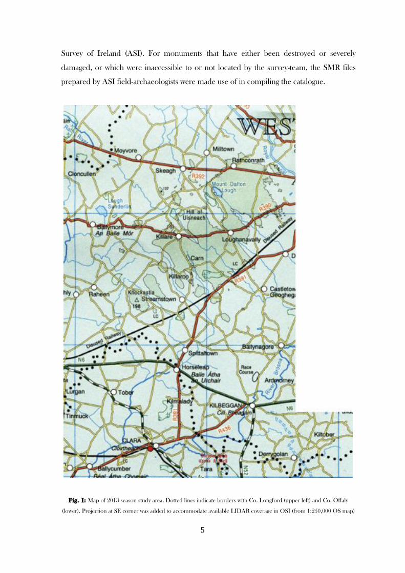
The 2013 season study area (Fig. I) covers a large, irregularly shaped block of
terrain in the centre of the county to west and south-west of the 2012-season study area,
taking in forty-eight barrows in the barony of Rathconrath and parts of the baronies of
Moygoish, Moycashel, and Moyashel & Magheradernon. Its northern limit is marked by an
east-west line on the National Grid (Northing 258000) running east from the Co. Longford
border as far as Easting 237000, which marked the western limit of the 2012 season study
area. At the south end of this line (i.e. Easting 237000), an eastern extension to the study
area was made to avail of OSI LIDAR coverage of a group of barrows in the Tyrrellspass
area. This extension runs from NGR 237000, 235000 as far east as NGR 241000, 235000
and then south to the Co. Offaly border. The western limit of the study area is marked by
Easting 219000, running south from the Longford border as far as the Offaly border, and
the southern limit is formed by the Offaly border.
The monuments listed in the RMP (Record of Monuments and Places) for Co.
Westmeath (1996), along with additional monuments listed on the National Monuments
Service website, formed the basis for this season’s work. Both of these sources are derived
from the SMR (Sites and Monuments Record) archive of the state-funded Archaeological
! %!
Survey of Ireland (ASI). For monuments that have either been destroyed or severely
damaged, or which were inaccessible to or not located by the survey-team, the SMR files
prepared by ASI field-archaeologists were made use of in compiling the catalogue.
Fig. I : Map of 2013 season study area. Dotted lines indicate borders with Co. Longford (upper left) and Co. Offaly
(lower). Projection at SE corner was added to accommodate available LIDAR coverage in OSI (from 1:250,000 OS map)
! &!
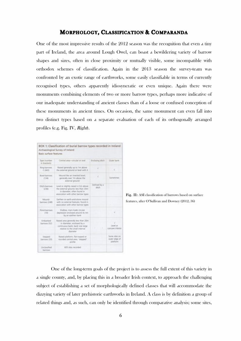
MORPHOLOGY, CLASSIFICATION & COMPARANDA
One of the most impressive results of the 2012 season was the recognition that even a tiny
part of Ireland, the area around Lough Owel, can boast a bewildering variety of barrow
shapes and sizes, often in close proximity or mutually visible, some incompatible with
orthodox schemes of classification. Again in the 2013 season the survey-team was
confronted by an exotic range of earthworks, some easily classifiable in terms of currently
recognised types, others apparently idiosyncratic or even unique. Again there were
monuments combining elements of two or more barrow types, perhaps more indicative of
our inadequate understanding of ancient classes than of a loose or confused conception of
these monuments in ancient times. On occasion, the same monument can even fall into
two distinct types based on a separate evaluation of each of its orthogonally arranged
profiles (e.g. Fig. IV, Right).
One of the long-term goals of the project is to assess the full extent of this variety in
a single county, and, by placing this in a broader Irish context, to approach the challenging
subject of establishing a set of morphologically defined classes that will accommodate the
dizzying variety of later prehistoric earthworks in Ireland. A class is by definition a group of
related things and, as such, can only be identified through comparative analysis; some sites,
! '!
however, may turn out to be unique or at least extremely rare. In particular we shall see that
the conventional classification risks breaking down in the case of those monuments
sculpted from glacial landforms.
The monuments in the 2013 season catalogue have where possible been
provisionally classified according to the current Archaeological Survey of Ireland (ASI)
schema (Fig. II), but, as we shall see in the type-by-type discussion here, the fit is by no
means perfect.
RING-BARROWS
Thirteen or possibly seventeen monuments1 appear to be best classified as ring-barrows or
embanked ring-ditches in that they are defined by a low circular mound or ground-level
platform, centrally positioned, surrounded by a ditch and external bank. Loughan (No. 29)
and Simonstown (No. 41) are textbook examples of this most numerous type of barrow
(1843 known) documented by the ASI (O’Sullivan and Downey 2012).
As with last season (McGuinness 2012, 8-9), several of these ring-barrows are on
sloping ground (e.g. Nos 4, 9). In the case of Ballyglass (No. 9), the summit of a hill
appears to have been ignored in favour of a position a short distance south west of this.
Others (Nos 2, 3, 14, 21, 22, 24) are shaped from the top of a knoll, so that the central
mound appears to be formed from the summit of the knoll rather than a constructed
mound (e.g. Fig. 13, Lower), this ‘mound’ is higher than the bank, and the ditch is higher
than external ground level. The mound is not always the usual low platform characteristic
of ring-barrows, but can be more like bowl-barrows, though not constructed like these.
These kinds of monument do not fit the ASI classification (Fig. II), whether of ring-barrows
or other types, but have been noted in Sligo and were repeatedly observed by Herity in the
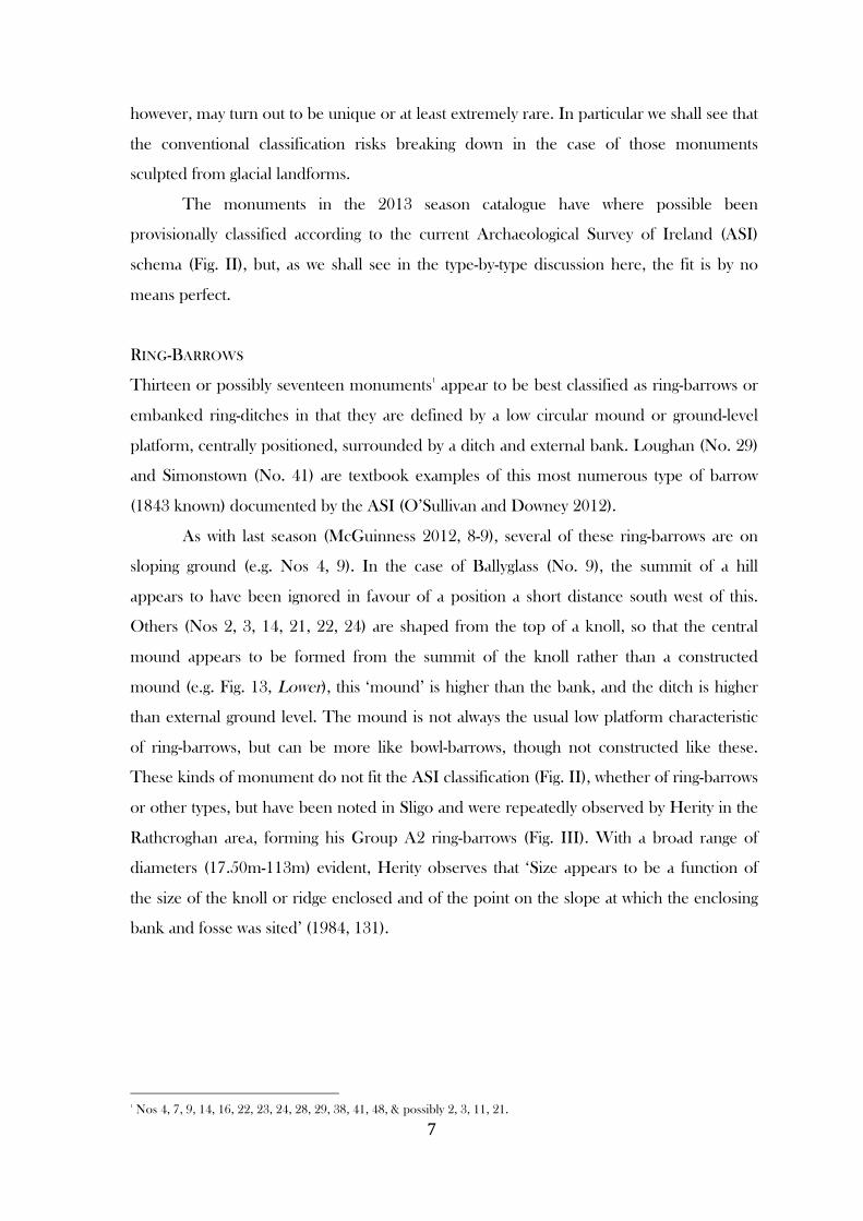
Rathcroghan area, forming his Group A2 ring-barrows (Fig. III). With a broad range of
diameters (17.50m-113m) evident, Herity observes that ‘Size appears to be a function of
the size of the knoll or ridge enclosed and of the point on the slope at which the enclosing
bank and fosse was sited’ (1984, 131).
!!!!!!!!!!!!!!!!!!!!!!!!!!!!!!!!!!!!!!!!!!!!!!!!!!!!!!!!1 Nos 4, 7, 9, 14, 16, 22, 23, 24, 28, 29, 38, 41, 48, & possibly 2, 3, 11, 21.
! (!
F ig. III : Barrows shaped from natural hillocks at Rathcroghan, Co. Roscommon (Upper), and near Carrowmore, Co.
Sligo (Lower), after Herity (1984, Fig. 48) and Timoney (1984, Fig. 223)
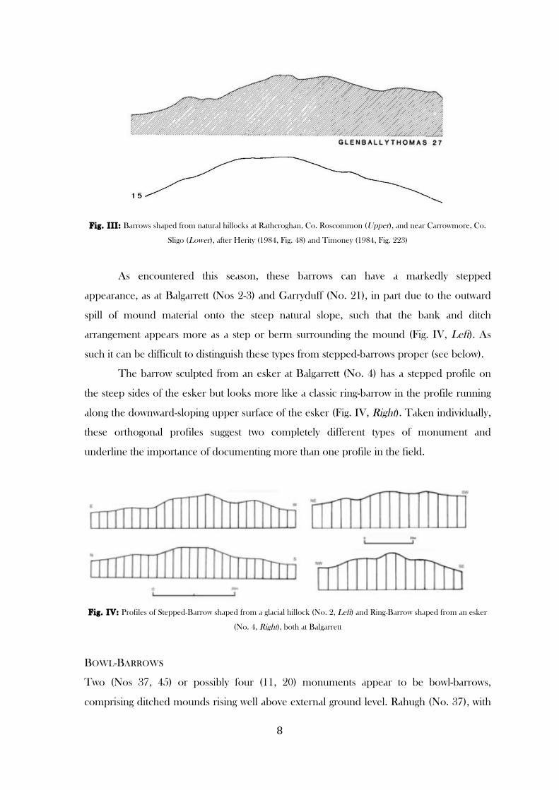
As encountered this season, these barrows can have a markedly stepped
appearance, as at Balgarrett (Nos 2-3) and Garryduff (No. 21), in part due to the outward
spill of mound material onto the steep natural slope, such that the bank and ditch
arrangement appears more as a step or berm surrounding the mound (Fig. IV, Left). As
such it can be difficult to distinguish these types from stepped-barrows proper (see below).
The barrow sculpted from an esker at Balgarrett (No. 4) has a stepped profile on
the steep sides of the esker but looks more like a classic ring-barrow in the profile running
along the downward-sloping upper surface of the esker (Fig. IV, Right). Taken individually,
these orthogonal profiles suggest two completely different types of monument and
underline the importance of documenting more than one profile in the field.
Fig. IV: Profiles of Stepped-Barrow shaped from a glacial hillock (No. 2, Left) and Ring-Barrow shaped from an esker
(No. 4, Right), both at Balgarrett
BOWL-BARROWS
Two (Nos 37, 45) or possibly four (11, 20) monuments appear to be bowl-barrows,
comprising ditched mounds rising well above external ground level. Rahugh (No. 37), with
! )!
its domed mound nearly 2m high and surrounding ditch, comes closest to the orthodox
ASI understanding of a bowl-barrow (Fig. II), although some ASI fieldworkers specify
alternative mound shapes, defining the type as ‘steep-sided conical or flat-topped earthen
mounds which can be enclosed by a fosse with or without an outer bank’ (Farrelly and
O’Brien 2002, 25). Tuitestown (No. 45) does not have the classic domed or hemispherical
profile: like the three hilltop Slane More barrows surveyed last season (McGuinness 2012,
39-40), it is a flat-topped conical tumulus surrounded by a ditch. The two sites at Bredagh
(No. 11) and Gaddrystown (No. 20) have been destroyed, but from ASI accounts of the
1970s and 1980s appear to have been respectively a bowl-barrow or ring-barrow, and a
bowl-barrow or mound-barrow.
DITCH-BARROW?
In size and morphology the monument at Templepatrick (No. 43) seems closest to the
fairly numerous (236) ditch-barrow class, as understood by the ASI (Fig. II), but as its
markedly concave or dished central area is a feature associated more with the ASI’s
ditchless embanked-barrow type rather than with ditch-barrows (Fig. II), it cannot with
certainty be placed in any of the currently recognised classes.
Two similar monuments were encountered last season at Leny and Slane More.
These had both been classified as ringforts in the ASI-based Record of Monuments and
Places (1996), but were provisionally named platform-barrows by the writer (McGuinness
2012, 29, 37-8). These two, at 38m and 43m in maximum diameter respectively, are on a
much larger scale than the Templepatrick monument, each being in fact nearly twice the
specified upper limit of 20m for the diameter of embanked and ditch-barrows (Fig. II); and
they were identified as barrows in part through close proximity to other types of barrow.
MOUND-BARROWS
At least thirteen and as many as sixteen monuments2 come closest in appearance to the
broad mound-barrow class, comprising earthen and stone mounds with no external features
(Fig. II). As was noticed last season (McGuinness 2012), it was again apparent in the 2013
season that these ditchless tumuli in reality possess a variety of external features of potential
value in isolating sub-types, such as platform-shaped, truncated conical or dome-shaped
!!!!!!!!!!!!!!!!!!!!!!!!!!!!!!!!!!!!!!!!!!!!!!!!!!!!!!!!2 Nos 1, 5, 6, 12, 13, 17, 27, 33, 34, 36, 39, 42, 44, and possibly 15, 20, 40.
! *+!
mounds, flattened summits with marked slope, circumferential ledges part way up the
mound, possible kerbs, deliberately incorporated natural boulders and rock outcrop, etc.
The size range is enormous, from the tiny flattish tumulus at Ardan (No. 1), 3.10m
across and no more than 0.30m high, to the immense upturned bowl at Cumminstown,
33.5m across and up to 5.8m high, which appears to have been sculpted from a natural
hillock. Boulders protrude from the upper surface of mounds at Ardan (No. 1), Balgarrett
(Nos 5-6) and Mweelra (No. 34), and from the edge of mounds at Mweelra (No. 34) and
Nicholastown (No. 34), possibly forming a kerb.
A step or ledge up to 1.20m wide appears to run around the circumference of the
Nicholastown barrow less than 1m above the base, bearing close comparison with the three
hilltop barrows at Slane More examined last season, in particular No. 32, for which
comparanda are cited in last season’s report (McGuinness 2012, 12-13). This barrow shows
similarities to some stepped-barrows (see below) and is certainly not the orthodox,
featureless kind of mound-barrow.
Included in this class is the important excavated cemetery ‘cairn’ of Coolatoor on
the summit of Knockast (No. 13), which was as much earth as stone, and before excavation
appeared as a low flat-topped mound 18.3m across and no more than 1.2m high at its
highest point. This mound covered upwards of forty Early/Middle Bronze Age burials in
cists and pits, more than the similarly high status Grange cemetery mound (at least 25
people) close to the royal site of Rathcroghan (Ó Ríordáin 1997, 57), more even than the
Bronze Age cemetery phase of the Mound of the Hostages at Tara (21-35 burials)
(O’Sullivan 2005, 240), suggesting that small, unpromising looking mounds can conceal
important prehistoric cemeteries. The eroded Calliaghstown mound (No. 12), 17m across
and up to 2.2m high, appears to include a large amount of stone and may be another
cemetery cairn.
Intriguingly, at Mweelra geophysical prospection of the mound-barrow (No. 34) by
Roseanne Schot has shown it to lie at the centre of a circular ditched enclosure 200m in
diameter, which takes in the eastern summit of the Hill of Ushnagh (See SMR file
WM024-173).
POND-BARROWS?
Pond-barrows, a British type (Fig. V), are rare in Ireland, the ASI having identified only
nineteen examples (Fig. II). None was encountered in the 2012 season of the current
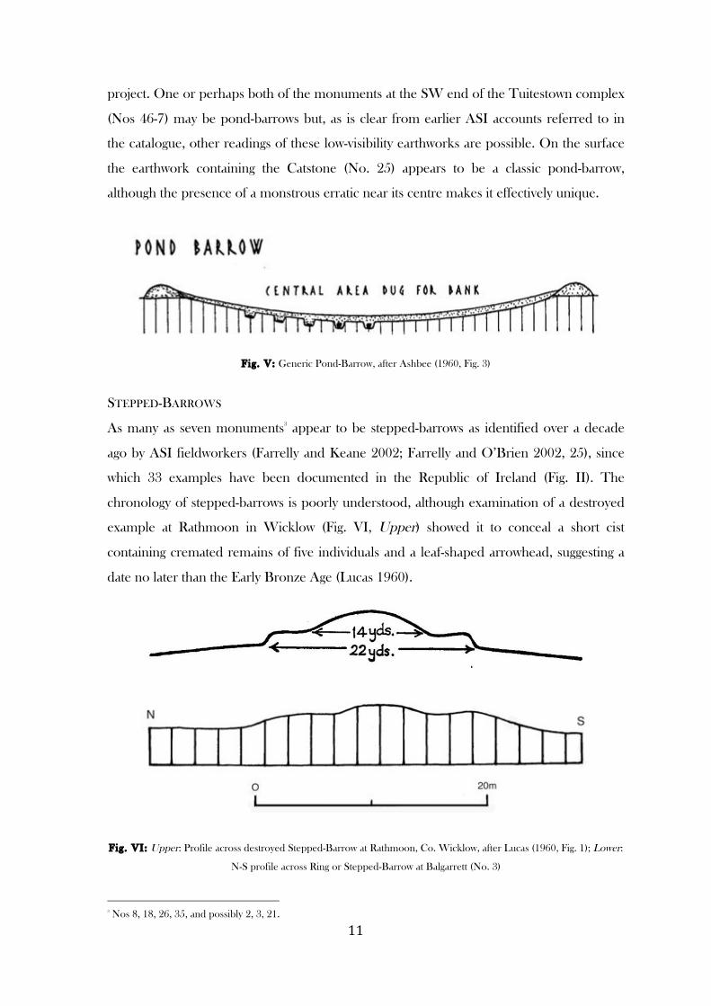
! **!
project. One or perhaps both of the monuments at the SW end of the Tuitestown complex
(Nos 46-7) may be pond-barrows but, as is clear from earlier ASI accounts referred to in
the catalogue, other readings of these low-visibility earthworks are possible. On the surface
the earthwork containing the Catstone (No. 25) appears to be a classic pond-barrow,
although the presence of a monstrous erratic near its centre makes it effectively unique.
Fig. V: Generic Pond-Barrow, after Ashbee (1960, Fig. 3)
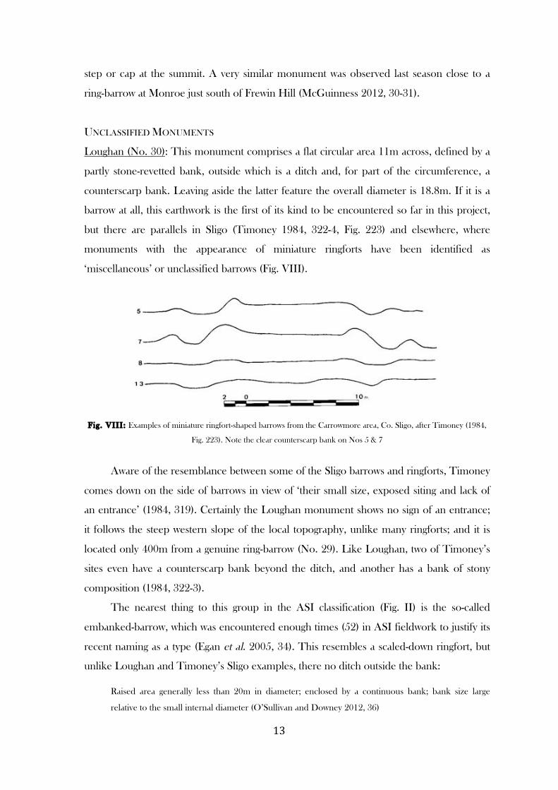
STEPPED-BARROWS
As many as seven monuments3 appear to be stepped-barrows as identified over a decade
ago by ASI fieldworkers (Farrelly and Keane 2002; Farrelly and O’Brien 2002, 25), since
which 33 examples have been documented in the Republic of Ireland (Fig. II). The
chronology of stepped-barrows is poorly understood, although examination of a destroyed
example at Rathmoon in Wicklow (Fig. VI, Upper) showed it to conceal a short cist
containing cremated remains of five individuals and a leaf-shaped arrowhead, suggesting a
date no later than the Early Bronze Age (Lucas 1960).
Fig. VI: Upper: Profile across destroyed Stepped-Barrow at Rathmoon, Co. Wicklow, after Lucas (1960, Fig. 1); Lower:
N-S profile across Ring or Stepped-Barrow at Balgarrett (No. 3)
!!!!!!!!!!!!!!!!!!!!!!!!!!!!!!!!!!!!!!!!!!!!!!!!!!!!!!!!3 Nos 8, 18, 26, 35, and possibly 2, 3, 21.

! *"!
As understood by the ASI, this type of barrow comprises a raised platform,
occasionally with a bank at the outer edge, which supports a flat-topped or domed mound
at the centre, giving a stepped profile (Fig. II). We have seen above how many ring-barrows
shaped from natural knolls can have markedly stepped profiles, in that their outer banks
are low and in places non-existent, so that the ditch is more like a berm which then drops
down to the natural ground; and the outer bank allowed by but not essential to the ASI
definition effectively brings these monuments fully within the stepped-barrow category. In
view of this ambiguity, at least three monuments this season (Nos 2, 3, 21) have been
classified as either ring or stepped-barrows (Figs IV, Left; VI, Lower).
Others (Nos 8, 18, 26, 35) with no evidence of an outer bank conform more to the
normal type of stepped-barrow. The most impressive of these this season is the large
barrow at Cumminstown (No. 18), which has a central mound 10.8m across and up to
1.9m high, perched on top of a broader platform up to 34.9m across and c. 2m above
external ground level (Figs VII, 12, 22). Here and at Ballinlug (No. 8), the upper mound or
step is eccentrically positioned on the platform. The monument at Mweelra (No. 35) on
the Hill of Ushnagh, though classified as a ringfort by the ASI, appears to be a form of
stepped-barrow with a low, poorly defined circular mound or platform over 19m across,
surrounded by a lower berm-like feature 41m across. The Kilcumreragh example (No. 26)
is on a much smaller scale (D. 8m) than the others, with two or three tiers and a pair of
megalithic portals against one side; this monument bears comparison with the stepped-
barrows at Slane More and other sites discussed last season, where the steps or ledges are
on a small scale and may have represented circular benches (McGuinness 2012, 12-13, 39-
40).
Fig. VII: LIDAR profile of Stepped-Barrow at Cumminstown (No. 18) (© OSI)
A stepped effect has been created at Kilpatrick by shaping the top of a knoll into a
mound-barrow, which, with the knoll beneath it, gives the impression of a large barrow with
! *#!
step or cap at the summit. A very similar monument was observed last season close to a
ring-barrow at Monroe just south of Frewin Hill (McGuinness 2012, 30-31).
UNCLASSIFIED MONUMENTS
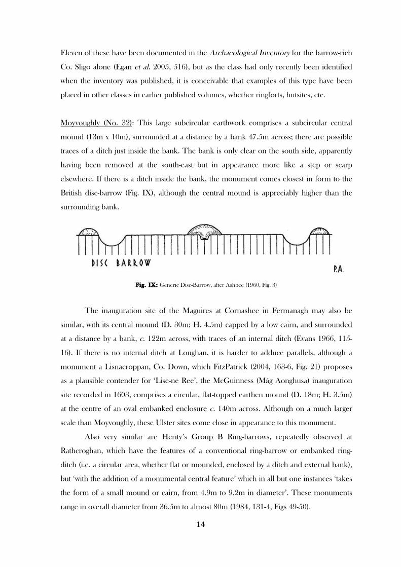
Loughan (No. 30): This monument comprises a flat circular area 11m across, defined by a
partly stone-revetted bank, outside which is a ditch and, for part of the circumference, a
counterscarp bank. Leaving aside the latter feature the overall diameter is 18.8m. If it is a
barrow at all, this earthwork is the first of its kind to be encountered so far in this project,
but there are parallels in Sligo (Timoney 1984, 322-4, Fig. 223) and elsewhere, where
monuments with the appearance of miniature ringforts have been identified as
‘miscellaneous’ or unclassified barrows (Fig. VIII).
Fig. VIII: Examples of miniature ringfort-shaped barrows from the Carrowmore area, Co. Sligo, after Timoney (1984,
Fig. 223). Note the clear counterscarp bank on Nos 5 & 7
Aware of the resemblance between some of the Sligo barrows and ringforts, Timoney
comes down on the side of barrows in view of ‘their small size, exposed siting and lack of
an entrance’ (1984, 319). Certainly the Loughan monument shows no sign of an entrance;
it follows the steep western slope of the local topography, unlike many ringforts; and it is
located only 400m from a genuine ring-barrow (No. 29). Like Loughan, two of Timoney’s
sites even have a counterscarp bank beyond the ditch, and another has a bank of stony
composition (1984, 322-3).
The nearest thing to this group in the ASI classification (Fig. II) is the so-called
embanked-barrow, which was encountered enough times (52) in ASI fieldwork to justify its
recent naming as a type (Egan et al. 2005, 34). This resembles a scaled-down ringfort, but
unlike Loughan and Timoney’s Sligo examples, there no ditch outside the bank:
Raised area generally less than 20m in diameter; enclosed by a continuous bank; bank size large
relative to the small internal diameter (O’Sullivan and Downey 2012, 36)
! *$!
Eleven of these have been documented in the Archaeological Inventory for the barrow-rich
Co. Sligo alone (Egan et al. 2005, 516), but as the class had only recently been identified
when the inventory was published, it is conceivable that examples of this type have been
placed in other classes in earlier published volumes, whether ringforts, hutsites, etc.
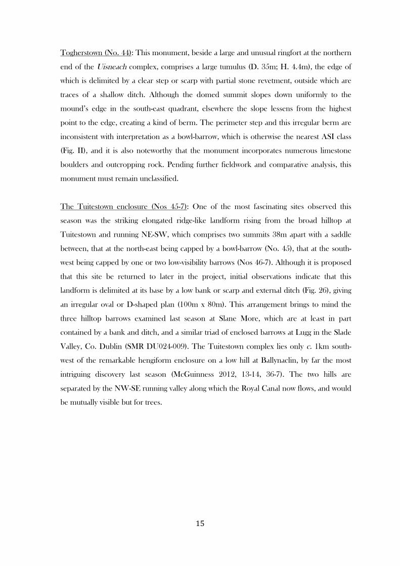
Moyvoughly (No. 32): This large subcircular earthwork comprises a subcircular central
mound (13m x 10m), surrounded at a distance by a bank 47.5m across; there are possible
traces of a ditch just inside the bank. The bank is only clear on the south side, apparently
having been removed at the south-east but in appearance more like a step or scarp
elsewhere. If there is a ditch inside the bank, the monument comes closest in form to the
British disc-barrow (Fig. IX), although the central mound is appreciably higher than the
surrounding bank.
Fig. IX: Generic Disc-Barrow, after Ashbee (1960, Fig. 3)
The inauguration site of the Maguires at Cornashee in Fermanagh may also be
similar, with its central mound (D. 30m; H. 4.5m) capped by a low cairn, and surrounded
at a distance by a bank, c. 122m across, with traces of an internal ditch (Evans 1966, 115-
16). If there is no internal ditch at Loughan, it is harder to adduce parallels, although a
monument a Lisnacroppan, Co. Down, which FitzPatrick (2004, 163-6, Fig. 21) proposes
as a plausible contender for ‘Lise-ne Ree’, the McGuinness (Mág Aonghusa) inauguration
site recorded in 1603, comprises a circular, flat-topped earthen mound (D. 18m; H. 3.5m)
at the centre of an oval embanked enclosure c. 140m across. Although on a much larger
scale than Moyvoughly, these Ulster sites come close in appearance to this monument.
Also very similar are Herity’s Group B Ring-barrows, repeatedly observed at
Rathcroghan, which have the features of a conventional ring-barrow or embanked ring-
ditch (i.e. a circular area, whether flat or mounded, enclosed by a ditch and external bank),
but ‘with the addition of a monumental central feature’ which in all but one instances ‘takes
the form of a small mound or cairn, from 4.9m to 9.2m in diameter’. These monuments
range in overall diameter from 36.5m to almost 80m (1984, 131-4, Figs 49-50).
! *%!
Togherstown (No. 44): This monument, beside a large and unusual ringfort at the northern
end of the Uisneach complex, comprises a large tumulus (D. 35m; H. 4.4m), the edge of
which is delimited by a clear step or scarp with partial stone revetment, outside which are
traces of a shallow ditch. Although the domed summit slopes down uniformly to the
mound’s edge in the south-east quadrant, elsewhere the slope lessens from the highest
point to the edge, creating a kind of berm. The perimeter step and this irregular berm are
inconsistent with interpretation as a bowl-barrow, which is otherwise the nearest ASI class
(Fig. II), and it is also noteworthy that the monument incorporates numerous limestone
boulders and outcropping rock. Pending further fieldwork and comparative analysis, this
monument must remain unclassified.
The Tuitestown enclosure (Nos 45-7): One of the most fascinating sites observed this
season was the striking elongated ridge-like landform rising from the broad hilltop at
Tuitestown and running NE-SW, which comprises two summits 38m apart with a saddle
between, that at the north-east being capped by a bowl-barrow (No. 45), that at the south-
west being capped by one or two low-visibility barrows (Nos 46-7). Although it is proposed
that this site be returned to later in the project, initial observations indicate that this
landform is delimited at its base by a low bank or scarp and external ditch (Fig. 26), giving
an irregular oval or D-shaped plan (100m x 80m). This arrangement brings to mind the
three hilltop barrows examined last season at Slane More, which are at least in part
contained by a bank and ditch, and a similar triad of enclosed barrows at Lugg in the Slade
Valley, Co. Dublin (SMR DU024-009). The Tuitestown complex lies only c. 1km south-
west of the remarkable hengiform enclosure on a low hill at Ballynaclin, by far the most
intriguing discovery last season (McGuinness 2012, 13-14, 36-7). The two hills are
separated by the NW-SE running valley along which the Royal Canal now flows, and would
be mutually visible but for trees.
! *&!
RANSACKED & EXCAVATED SITES
Several of this season’s sites have been dug into over the years. Depressions at the centre of five
barrows (Nos 3, 11, 16, 22, 27), if not marking collapsed chambers, probably indicate that they
were ransacked by treasure-hunters in recent centuries. Macalister and Praeger (1928, 83) also
heard of the Mweelra mound-barrow (No. 34), that it ‘had been violated in comparatively
recent times, and that a cist had been found within it’. The barrow at Bredagh (No. 11) had a
drain cut through it before its complete destruction, but no ancient features were visible in the
face of the drain during ASI fieldwork.
Other sites have been excavated by professional archaeologists, though not always to a
high standard. The well-known cemetery mound of Coolatoor on the summit of Knockast (No.
13), which was meticulously excavated by a Harvard University team over three weeks in 1932
as part of their anthropological survey of Ireland (Hencken and Movius 1932-4), produced
forty-three Early-Middle Bronze Age burials. Grave-goods were high status and included an
assortment of ornamented funerary pots, men’s razors, and bone mounts similar to those for a
wooden mace-head shaft from the princely Bush Barrow in Wessex (Herity and Eogan 1977,
153). The graves were mostly concentrated in the south-east quadrant, a preference evident at
the analogous Mound of the Hostages and many other Bronze Age barrows and cairns (Mount
1997, 151; O’Sullivan 2005, 240). A large limestone boulder, just over 1.5m across and 60cm
high, was deliberately incorporated in the western quadrant of the Coolatoor mound, and bears
comparison with the large limestone boulder incorporated in the south-east quadrant of the
Stepped-Barrow at Mweelra, at the point of intersection of central mound and lower step or
berm, and with the boulders and outcrop incorporated into other barrows this season.
In stark contrast to Coolatoor, Macalister and Praeger’s unrewarding excavations of at
least three of the Uisneach monuments (Nos 34, 38, 48), and probably also the Togherstown
tumulus (No. 44), were very poorly documented. Of greatest interest from these excavations, it
was reported that near the top of the Mweelra mound-barrow ‘stones seemed to have been laid
intentionally, in an arc 25’ [c. 7.6m] in diameter, surrounding the centre; but nothing was found
within it’ (Macalister and Praeger 1928, 83). This kind of feature is well known from passage-
tombs and some other kinds of prehistoric burial mound (e.g. Waddell 1998, Fig. 35).
Macalister and Praeger’s excavation of the tiny ring-barrow at Ushnagh Hill (No. 48) also
uncovered a setting of stones (Fig. 27), which they thought might have been a roughly
constructed grave, although no burial remains were found.
! *'!
SITING & TOPOGRAPHY
As was the case in the 2012 season, it was again observed that many barrows are located in
prominent positions on the landscape. While the available altitude range is quite low in this
midlands county, barrows are repeatedly located on local heights with excellent visibility of
the natural landscape and other burial mounds or their locations. This phenomenon is
widespread in Ireland and elsewhere, but it is by no means the norm: A few barrows this
season were in low-lying locations close to marshland or fens (e.g. Nos 11, 29, 32), and it
should be remembered that in the 1990s the Discovery Programme documented great
numbers of barrows, forming huge cemeteries, along river valleys in north Munster
(O’Sullivan and Downey 2012, 33-4, Fig. 3).
Unsurprisingly, the striking visual presence of Frewin Hill (Frémainn) (171m OD),
capped by a huge mound or cairn, which was the focus for a group of eleven of last
season’s barrows and visible from many others (McGuinness 2012, 17-18), maintains its
hold this season, particularly with barrows in the northern part of the study area. A
dominant visual focus for monuments further south is the even higher hill of Knockastia
(Cnoc in Coscair) (200m OD), with a cemetery mound or cairn (No. 13) prominently
positioned on its summit. Also clearly visible from barrows in the south of the county is the
! *(!
remarkable volcanic plug known as Croghan Hill (Cruachan Brí Éile) in north-east Offaly
(234m OD), which is again surmounted by a tumulus and has two other barrows at its foot
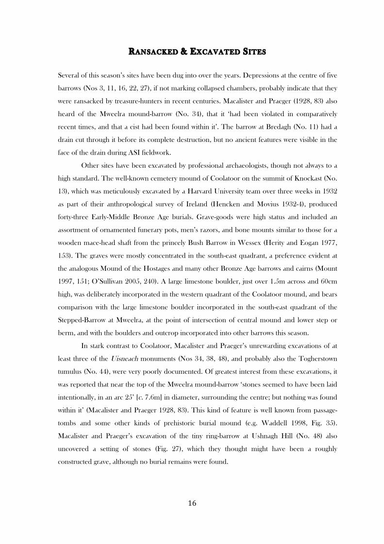
(O’Brien and Sweetman 1997, 8, 9, 11). At 182m OD, the broad Hill of Ushnagh
(Uisneach), location for at least six barrows and many related monuments, takes in
panoramic views of a large portion of Ireland (Fig. X), but is itself often difficult to discern
from other heights. All four places have important associations in medieval Irish literature.
With geographer Seamus O’Brien of Westmeath Archaeological & Historical Society, the
survey-team was particularly impressed by the extent to which some of this season’s
barrows form an integral part of their glaciated surroundings, being sited on or shaped from
eskers, kames and other sand and gravel knolls and ridges, with the frequent presence of
dry or flooded kettle-holes nearby.
At least fourteen monuments4 have been deliberately sited on kames, eskers,
moraines and other glacial knolls and ridges, in six cases with clear or probable kettle-holes
close by (Nos 22, 23, 24, 27, 34, 37). In at least two further instances (Nos 38, 43), kettle-
holes are visible nearby, even though the barrow has not obviously been sited on a kame or
other prominent glacial landform. The Tuitestown barrows (Nos 45-7) are sited on the high
points of a 100m-long ridge, apparently of glacial origin, which rises dramatically from a
broad hilltop; uniquely, the entire ridge has been enclosed by a scarp and ditch (Fig. 26).
In addition to their siting on kames, eskers, etc., at least nine of these monuments5
have actually been sculpted from the upper part of the landform in question, sometimes
with the slightest alterations (e.g. No. 27), the barest imposition of cultural order on the
natural topography. This phenomenon was repeatedly observed among the diverse
Rathcroghan barrows by Herity, whose classification alone specifically accommodates these
monuments (1984, 131). We have seen above that this shaping or modifying of natural
landforms means that certain monuments fall ambiguously between different barrow-types
in the orthodox classification (Fig. II). Could it be that this subtle interplay between
traditional, cultural forms, and more fluid natural forms, is what makes it so difficult to pin
down a classification of later prehistoric burial mounds that is universally applicable or of
predictive value? Further fieldwork is undoubtedly required before we can begin to answer
this question, but it may prove to be the case that we cannot ever have a classification of
barrows as clean-cut as, say, the fourfold classification of Irish megalithic tombs.
!!!!!!!!!!!!!!!!!!!!!!!!!!!!!!!!!!!!!!!!!!!!!!!!!!!!!!!!4 Nos 2, 3, 4, 5, 14, 17, 18, 21, 22, 23, 24, 27, 37, 48. 5 Nos 2, 3, 4, 14, 17, 18, 22, 24, 27.
! *)!
The placement of unmarked Bronze Age burials on hillocks and ridges of glacial
drift, often on summits, is a recognised phenomenon (Ó Ríordáin 1969, 130; Mount 1997,
115). The two Early Bronze Age burials at Rashinashurrock, containing similar high-status
grave goods to Knockast (15km to west), ‘had been inserted into the summit of a flat-
topped drumlin which would have been a feature of the local landscape’ (Eogan 1997, 28);
and six burials of a similar date were buried on top of a rounded esker at Knockmant near
Killucan (Ó Ríordáin 1969, 125). Many similar examples could be cited, suggesting a
further, more extreme manifestation of the trend for subtle land-sculpting noticed this
season, in which the visible cultural component to the ‘monument’ is now apparent only in
the preference for a high point on a barrow-like landform as a location for the burial of
certain individuals.
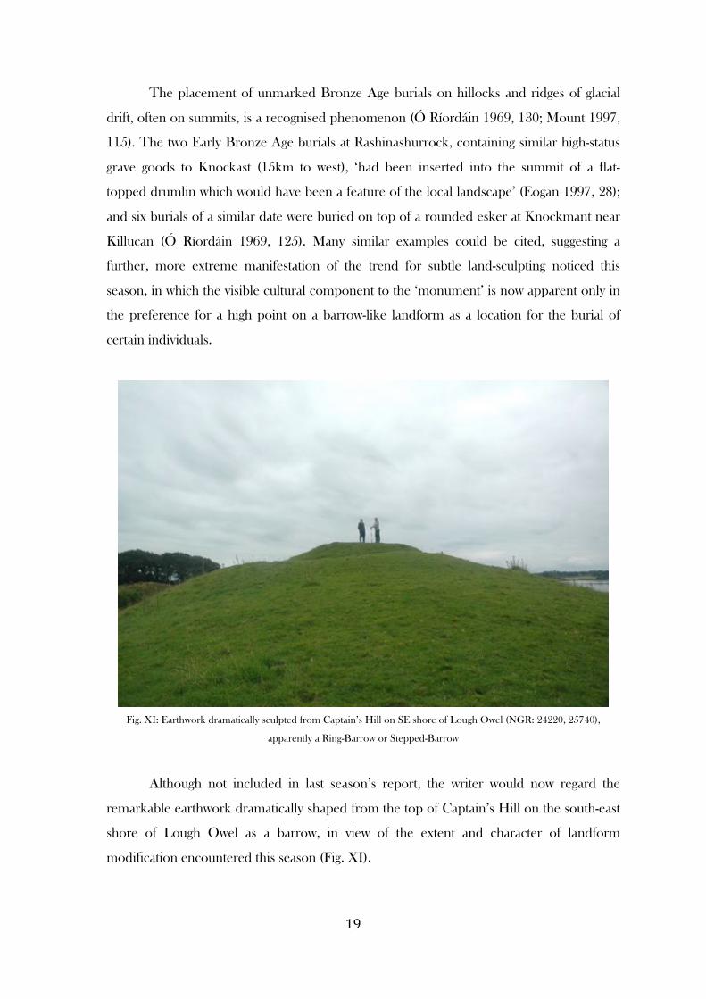
Fig. XI: Earthwork dramatically sculpted from Captain’s Hill on SE shore of Lough Owel (NGR: 24220, 25740),
apparently a Ring-Barrow or Stepped-Barrow
Although not included in last season’s report, the writer would now regard the
remarkable earthwork dramatically shaped from the top of Captain’s Hill on the south-east
shore of Lough Owel as a barrow, in view of the extent and character of landform
modification encountered this season (Fig. XI).
! "+!
Another impressive effect produced by this elegant sculpting of glacial drift, also
evident in some fully constructed barrows (e.g. Nos 37, 45), is that the monument appears
level in spite of sloping or irregular ground, being of varying height above ground level at
different points on its circumference (Nos 13, 24, 32, 37, 45) (See Fig. 6, section D-C; Fig.
20). This is in striking contrast to those barrows, often ring-barrows, deliberately sited on
sloping ground, several examples of which were noted this season (Nos 4, 9, 25, 30) and
last (McGuinness 2012, 8-9).
Interaction with the natural landscape is also evidence in the frequent incorporation
of boulders or rock outcrop in monuments (e.g. Nos 13, 18, 35, 44), and the deliberate
enclosing of the enormous erratic known as the Catstone within a pond-barrow (No. 25).
! "*!
BARROWS, MEGALITHS AND ROCK ART
Only one megalithic tomb has been identified with certainty in Westmeath, a late Neolithic
or Early Bronze Age wedge tomb at Lickbla north of Castlepollard (SMR: WM003-039).
There are other possible contenders, however, two of which are found in close proximity to
barrows. The subrectangular cairn with megalithic uprights known as St. Patrick’s Bed, on
the western summit of the Hill of Ushnagh c. 150m south of a ring-barrow (No. 48), might
well have been a megalithic tomb, but was so severely damaged by Ordnance Survey
sappers in the 1830s that little more can be said on the basis of surface evidence.
Geophysical prospection places it at the centre of a circular enclosure 35m across (Schot
2006, 45, Pl. 3), strongly suggesting that, like the Catstone, it was deliberately emphasised in
later prehistoric times.
Although the survey-team was unable to gain access this season, the monument at
Ballyglass (No. 9) has been clearly described by the ASI. A ring-barrow on the upper south-
western slope of a low hill lies just 3m south-west of a NW-SE oriented, linear arrangement
of three close-set megalithic orthostats incorporated in a fence. The two south-easternmost
are broad slabs placed edge to edge, while the third, north-western pillar is much narrower
and placed at right angles to the others like a jamb (See sketch in SMR file). They have the
appearance of one side of the chamber of a megalithic tomb and were collectively
recognized as a monument in folk tradition, being known as the ‘Leegaun’ almost a century
ago (Shaw 1921, 137). Also in Ballyglass townland, at an unspecified location, Shaw (1921,
136-7, Pl. XXIII) documented an arrangement of two upright megalithic slabs facing one
another less than 2m apart, and said locally to be the burial place of a king.
Perhaps of a different tradition are two large upright boulders, one now collapsed,
on the north-east side of a stepped-barrow at Kilcumreragh (No. 26), which appear to have
once formed a portal facing the striking mound, apparently natural, on which the early
medieval foundation of Kilcumreragh was located just 38.5m to north-east. The reused
bowl-barrow at Rahugh, medieval inauguration site of the Mageoghegans and plausibly the
location for an important rígdál or political conference in AD 859, lies a short distance
from the early medieval monastery of Ráith Áeda, and was arguably linked to it by a
processional way (FitzPatrick 2005). The Kilcumreragh barrow, with portals framing the
most direct route to the nearby church site, appears to belong to FitzPatrick’s group of
‘throne mounds’, and bears close comparison with the stepped mounds, arguably circular
benches, encountered last season (McGuinness 2012, 12-13)
! ""!
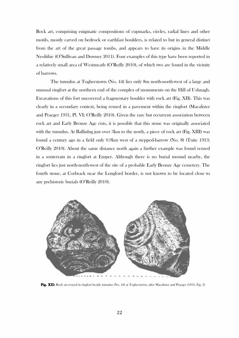
Rock art, comprising enigmatic compositions of cupmarks, circles, radial lines and other
motifs, mostly carved on bedrock or earthfast boulders, is related to but in general distinct
from the art of the great passage tombs, and appears to have its origins in the Middle
Neolithic (O’Sullivan and Downey 2011). Four examples of this type have been reported in
a relatively small area of Westmeath (O’Reilly 2010), of which two are found in the vicinity
of barrows.
The tumulus at Togherstown (No. 44) lies only 8m north-north-west of a large and
unusual ringfort at the northern end of the complex of monuments on the Hill of Ushnagh.
Excavations of this fort uncovered a fragmentary boulder with rock art (Fig. XII). This was
clearly in a secondary context, being reused in a pavement within the ringfort (Macalister
and Praeger 1931, Pl. VI; O’Reilly 2010). Given the rare but recurrent association between
rock art and Early Bronze Age cists, it is possible that this stone was originally associated
with the tumulus. At Ballinlug just over 3km to the north, a piece of rock art (Fig. XIII) was
found a century ago in a field only 0.9km west of a stepped-barrow (No. 8) (Tuite 1913;
O’Reilly 2010). About the same distance north again a further example was found reused
in a souterrain in a ringfort at Emper. Although there is no burial mound nearby, the
ringfort lies just north-north-west of the site of a probable Early Bronze Age cemetery. The
fourth stone, at Corbrack near the Longford border, is not known to be located close to
any prehistoric burials (O’Reilly 2010).
Fig. XII: Rock art reused in ringfort beside tumulus (No. 44) at Togherstown, after Macalister and Praeger (1931, Fig. 3)

! "#!
Fig. XIII: Rock art found in a field in Ballinlug townland 900m W of Stepped-Barrow (No. 8), after Tuite (1913, Fig. 8)
Rock art is rare in Ireland and mostly confined to a few core areas, most notably
south-west Kerry, the Louth/Monaghan area and north Donegal (O’Sullivan and Downey
2011, Fig. 3). That there are three examples only a few kilometres apart in an area of
Westmeath that is rich in burial mounds may not be a coincidence. It is of interest that
rock art has been recorded in the Navan complex (Eamhain Mhacha), an important later
prehistoric royal site including a hilltop mound and ring-barrow (Mallory 1995, 81, 83, Fig.
28).
! "$!
BARROWS & EARLY MEDIEVAL CHURCH SITES
There was impressive evidence last season for an association between later prehistoric
burial mounds and early medieval ecclesiastical foundations, with groups of barrows found
in close proximity to monastic sites at Portloman and Leny, the former being just south-east
of Frewin Hill, the site of a royal palace in medieval Irish literature and the focus for a large
number of barrows.
This pattern, well known from Ireland as a whole, is again evident this season. Only
1km south-west of Uisneach is the site of St. Áed mac Bric’s monastery of Killare (Cell
Fháir), including two ruined churches, a holy well, and a graveyard around which Leo Swan
(1988, 22) traced the outline of a large curvilinear vallum of early medieval type. Two sites
on the Hill of Ushnagh itself are linked to St. Patrick, a holy well and a ruined megalithic
structure named as his ‘Bed’, presumably a former pilgrimage site. That these Patrician
associations are not of recent origin is evident from Tírechán’s seventh-century Life of St.
Patrick, in which the Catstone (‘Petra Cothrigi’) with its surrounding pond-barrow (No. 25)
is the location for a meeting between St. Patrick and local royalty; and in the Tripartite Life
the saint is reported to have founded a monastery at Uisneach, although clear
archaeological evidence of this has not been found (Macalister and Praeger 1928, 78-80).
Prominently sited close to St. Áed’s monastery of Rahugh, traditionally
remembered as the place of his birth, is a bowl-barrow, which FitzPatrick (2005) argues was
linked to it by a processional way. The seat or throne-like stepped-barrow at Kilcumreragh
lies only 38.5m west of the striking but apparently natural mound on which the early
medieval church of Cell Comráire was sited, and appears to have had two megalithic
portals incorporated into it which face towards the church site. If this is not indicative of a
processional route similar to Rahugh, it may indicate that the mound on which the church
was located was formerly crowned by a barrow. The church site of Portloman near Frewin
Hill, encountered last season, is sited on a similar, apparently natural mound, and lies just
190m from a huge bowl-barrow (McGuinness 2012, 31-2). There is some evidence to
suggest that church sites could actually be located on prehistoric burial sites, as at
Monasterboice, where a Bronze Age urn burial was found in a cist beneath the North
Church in the late nineteenth century (Gógan 1931); or Derrynaflan, where three barrows
were included within the monastic enclosure (Kelly 1983, 48).
A possible ditch-barrow (No. 43) lies immediately south of Templepatrick Church,
at which there is evidence for an early medieval monastic vallum (Swan 1988, 23). The
! "%!
monastic site of Killahugh, another of Áed mac Bric’s foundations, is again enclosed by a
vallum (Swan 1988, 23), and lies just south of Rathconrath in an area rich in prehistoric
burial mounds; a second Killahugh is marked on the first edition OS 6” map just south of
the destroyed ring-barrow at Simonstown (No. 41). The barrow at Moyvoughly lies 400m
west of St. Patrick’s Well with its associated bullaun stone (WM030-02501/02), indicating a
place of pilgrimage in early medieval times.
This widespread phenomenon, and the whole subject of the pagan-Christian
transition in Ireland, is in great need of a combination of focused archaeological, historical
and folkloric research. It is well over a century since Wood-Martin’s pioneering
multidisciplinary study of this theme (1902).
! "&!
MEDIEVAL LITERATURE & FOLK TRADITION
Although the project has so far not pursued this line of inquiry, it is apparent again, as with
last season (McGuinness 2012, 20-23), that several of this season’s monuments or their sites
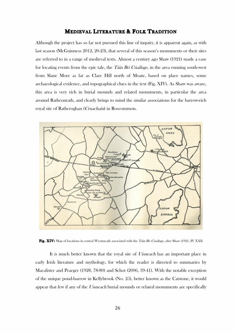
are referred to in a range of medieval texts. Almost a century ago Shaw (1921) made a case
for locating events from the epic tale, the Táin Bó Cúailnge, in the area running south-west
from Slane More as far as Clare Hill north of Moate, based on place names, some
archaeological evidence, and topographical clues in the text (Fig. XIV). As Shaw was aware,
this area is very rich in burial mounds and related monuments, in particular the area
around Rathconrath, and clearly brings to mind the similar associations for the barrow-rich
royal site of Rathcroghan (Cruachain) in Roscommon.
Fig. XIV: Map of locations in central Westmeath associated with the Táin Bó Cúailnge, after Shaw (1921, Pl. XXI)
It is much better known that the royal site of Uisneach has an important place in
early Irish literature and mythology, for which the reader is directed to summaries by
Macalister and Praeger (1928, 78-80) and Schot (2006, 39-41). With the notable exception
of the unique pond-barrow in Kellybrook (No. 25), better known as the Catstone, it would
appear that few if any of the Uisneach burial mounds or related monuments are specifically
! "'!
referred to in medieval literature, unlike the archaeologically comparable royal site of Tara,
where many of the monuments are named in the metrical and prose Dindshenchas texts.
The cemetery mound at Coolatoor (No. 13) is located on the summit of
Knockastia, pronounced ‘Knock Costha’ or ‘Connacostha’ in the 1930s, which has been
identified as the Cnoc in Coscair referred to in the medieval text Bruiden Da Chocae,
where ‘Eochain Bece, having gone away out of a battle described, fell on Cnoc Ni Coscair
after weariness of conflict, so that there are many graves on it and it is called Beces Hill’
(Shaw 1921, 142-3; see also Hogan 1910, 275; Hencken and Movius 1932-4, 2)
In the realm of history rather than literature, FitzPatrick (2004, 43-4; 2005) makes a
compelling case for identifying the bowl-barrow beside the early medieval monastery of
Rahugh (Ráith Áeda) as the location for Máel Sechnaill’s important political meeting or
rígdál of AD 859. It was later documented as the inauguration site of the Mageoghegan
(Mic Eochagáin) chiefs.
There is little by way of oral tradition relating to the barrows in this season’s study
area, although four are named as ‘Crockaphuca’ (No. 27), ‘Mweeleen Moat’ or ‘Cnoc na
Maoilin’ (No. 8), ‘The Moat of Nicholastown’ (No. 36) and ‘Knisheen Fort’ (No. 21). At
least the first of these implies some aetiological legend to account for the monument.
! "(!
CATALOGUE OF MONUMENTS
The forty-eight monuments in the main body of this catalogue are arranged alphabetically by townland, as
are the four disqualified sites in the appendix. The first line of each catalogue entry contains the site
number, followed by the name of the townland and (in brackets) the barony in which it is located, its
suggested classification in the opinion of the writer, and references to any illustrations; on the far right of
this line the presence of a V indicates that the monument was visited and examined by the 2013 survey-
team. The second line contains the number of the monument, where this exists, in the Sites and
Monuments Record for Westmeath as provided in the Record of Monuments and Places (1996) and on the
Archaeological Survey of Ireland website, followed, in brackets, by the classification assigned to it in that
source. This is in turn followed by a 10-figure map coordinate for locating the monument on the national
grid and the height of the monument above Ordnance Datum (i.e. sea level) to within 10m. The bulk of the
catalogue entry comprises a fresh description of the monument; information from earlier accounts where a
monument has been damaged or destroyed, or is inaccessible; information on the monument’s location in
the natural landscape and with reference to other archaeological remains; and, where available, information
on associated medieval literary references and folklore. A list of any references to the monument in
publications is given at the end. Unless otherwise stated, diameter measurements refer to the overall
diameter of the monument, rather than to, say, the central mound of a ring-barrow; overall diameters are
taken to the outside of any surrounding banks or ditches. Widths of banks and ditches and banks are based
on visual estimation of where one ends and the other begins, a boundary that is not always obvious;
similarly, diameters of central mounds or platforms are to the base of the mound, where this is judged by
eye to intersect with the ditch, rather than the often flat upper surface of the mound. Given the generally
imprecise boundaries between different elements of earthworks, and the difficulties in distinguishing
between peripheral features and the natural ground, it should be taken that the majority of measurements
are only approximations. This seems preferable to cluttering the text with use of the abbreviation ‘c.’ (i.e.
circa).
THE HILL OF USHNAGH (UISNEACH)
Six of the monuments covered by this report (Nos 25, 34, 35, 38, 44, 48), although located in five separate
townlands (Kellybrook, Mweelra, Rathnew, Togherstown and Ushnagh Hill) and therefore spread
throughout the alphabetically arranged catalogue, form part of the complex of monuments associated with
the Hill of Ushnagh, the ancient royal site known as Uisneach. For a full account of this complex, its place in
medieval literary sources and its archaeology, the reader is directed to important papers by Macalister and
Praeger (1928; 1931) and Schot (2006). The Discovery Programme has recently carried out further work at
the site, which will be published in due course.
! ")!
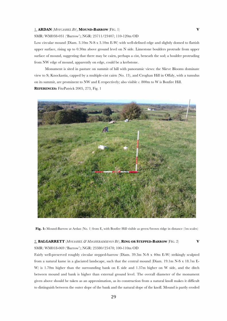
1. ARDAN (MOYCASHEL BY), MOUND-BARROW (FIG. 1) V
SMR: WM038-031 (‘Barrow’); NGR: 23711/23407; 110-120m OD
Low circular mound (Diam. 3.10m N-S x 3.10m E-W) with well-defined edge and slightly domed to flattish
upper surface, rising up to 0.30m above ground level on N side. Limestone boulders protrude from upper
surface of mound, suggesting that there may be cairn, perhaps a cist, beneath the sod; a boulder protruding
from NW edge of mound, apparently on edge, could be a kerbstone.
Monument is sited in pasture on summit of hill with panoramic views: the Slieve Blooms dominate
view to S; Knockastia, capped by a multiple-cist cairn (No. 13), and Croghan Hill in Offaly, with a tumulus
on its summit, are prominent to NW and E respectively; also visible c. 800m to W is Bonfire Hill.
REFERENCES: FitzPatrick 2005, 273, Fig. 1
Fig. 1: Mound-Barrow at Ardan (No. 1) from E, with Bonfire Hill visible as green/brown ridge in distance (1m scales)
2. BALGARRETT (MOYASHEL & MAGHERADERNON BY), RING OR STEPPED-BARROW (FIG. 2) V
SMR: WM018-069 (‘Barrow’); NGR: 23380/25470; 100-110m OD
Fairly well-preserved roughly circular stepped-barrow (Diam. 39.3m N-S x 40m E-W) strikingly sculpted
from a natural kame in a glaciated landscape, such that the central mound (Diam. 19.1m N-S x 18.7m E-
W) is 1.70m higher than the surrounding bank on E side and 1.37m higher on W side, and the ditch
between mound and bank is higher than external ground level. The overall diameter of the monument
given above should be taken as an approximation, as its construction from a natural knoll makes it difficult
to distinguish between the outer slope of the bank and the natural slope of the knoll. Mound is partly eroded
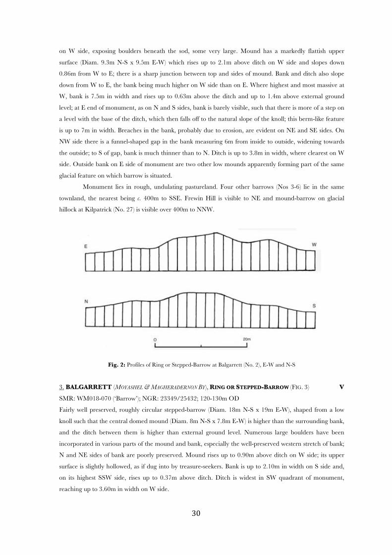
! #+!
on W side, exposing boulders beneath the sod, some very large. Mound has a markedly flattish upper
surface (Diam. 9.3m N-S x 9.5m E-W) which rises up to 2.1m above ditch on W side and slopes down
0.86m from W to E; there is a sharp junction between top and sides of mound. Bank and ditch also slope
down from W to E, the bank being much higher on W side than on E. Where highest and most massive at
W, bank is 7.5m in width and rises up to 0.63m above the ditch and up to 1.4m above external ground
level; at E end of monument, as on N and S sides, bank is barely visible, such that there is more of a step on
a level with the base of the ditch, which then falls off to the natural slope of the knoll; this berm-like feature
is up to 7m in width. Breaches in the bank, probably due to erosion, are evident on NE and SE sides. On
NW side there is a funnel-shaped gap in the bank measuring 6m from inside to outside, widening towards
the outside; to S of gap, bank is much thinner than to N. Ditch is up to 3.8m in width, where clearest on W
side. Outside bank on E side of monument are two other low mounds apparently forming part of the same
glacial feature on which barrow is situated.
Monument lies in rough, undulating pastureland. Four other barrows (Nos 3-6) lie in the same
townland, the nearest being c. 400m to SSE. Frewin Hill is visible to NE and mound-barrow on glacial
hillock at Kilpatrick (No. 27) is visible over 400m to NNW.
Fig. 2: Profiles of Ring or Stepped-Barrow at Balgarrett (No. 2), E-W and N-S
3. BALGARRETT (MOYASHEL & MAGHERADERNON BY), RING OR STEPPED-BARROW (FIG. 3) V
SMR: WM018-070 (‘Barrow’); NGR: 23349/25432; 120-130m OD
Fairly well preserved, roughly circular stepped-barrow (Diam. 18m N-S x 19m E-W), shaped from a low
knoll such that the central domed mound (Diam. 8m N-S x 7.8m E-W) is higher than the surrounding bank,
and the ditch between them is higher than external ground level. Numerous large boulders have been
incorporated in various parts of the mound and bank, especially the well-preserved western stretch of bank;
N and NE sides of bank are poorly preserved. Mound rises up to 0.90m above ditch on W side; its upper
surface is slightly hollowed, as if dug into by treasure-seekers. Bank is up to 2.10m in width on S side and,
on its highest SSW side, rises up to 0.37m above ditch. Ditch is widest in SW quadrant of monument,
reaching up to 3.60m in width on W side.
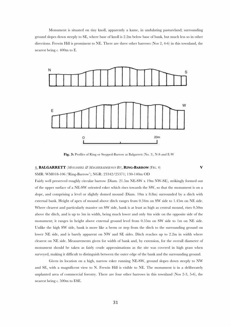
! #*!
Monument is situated on tiny knoll, apparently a kame, in undulating pastureland; surrounding
ground slopes down steeply to SE, where base of knoll is 2.2m below base of bank, but much less so in other
directions. Frewin Hill is prominent to NE. There are three other barrows (Nos 2, 4-6) in this townland, the
nearest being c. 400m to E.
Fig. 3: Profiles of Ring or Stepped-Barrow at Balgarrett (No. 3), N-S and E-W
4. BALGARRETT (MOYASHEL & MAGHERADERNON BY), RING-BARROW (FIG. 4) V
SMR: WM018-106 (‘Ring-Barrow’); NGR: 23342/25371; 130-140m OD
Fairly well preserved roughly circular barrow (Diam. 21.5m NE-SW x 19m NW-SE), strikingly formed out
of the upper surface of a NE-SW oriented esker which rises towards the SW, so that the monument is on a
slope, and comprising a level or slightly domed mound (Diam. 10m x 8.8m) surrounded by a ditch with
external bank. Height of apex of mound above ditch ranges from 0.34m on SW side to 1.45m on NE side.
Where clearest and particularly massive on SW side, bank is at least as high as central mound, rises 0.50m
above the ditch, and is up to 5m in width, being much lower and only 4m wide on the opposite side of the
monument; it ranges in height above external ground level from 0.55m on SW side to 1m on NE side.
Unlike the high SW side, bank is more like a berm or step from the ditch to the surrounding ground on
lower NE side, and is barely apparent on NW and SE sides. Ditch reaches up to 2.2m in width where
clearest on NE side. Measurements given for width of bank and, by extension, for the overall diameter of
monument should be taken as fairly crude approximations as the site was covered in high grass when
surveyed, making it difficult to distinguish between the outer edge of the bank and the surrounding ground.
Given its location on a high, narrow esker running NE-SW, ground slopes down steeply to NW
and SE, with a magnificent view to N. Frewin Hill is visible to NE. The monument is in a deliberately
unplanted area of commercial forestry. There are four other barrows in this townland (Nos 2-3, 5-6), the
nearest being c. 500m to ESE.
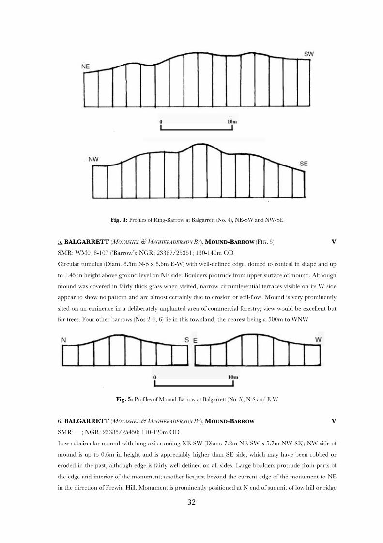
! #"!
Fig. 4: Profiles of Ring-Barrow at Balgarrett (No. 4), NE-SW and NW-SE
5. BALGARRETT (MOYASHEL & MAGHERADERNON BY), MOUND-BARROW (FIG. 5) V
SMR: WM018-107 (‘Barrow’); NGR: 23387/25351; 130-140m OD
Circular tumulus (Diam. 8.5m N-S x 8.6m E-W) with well-defined edge, domed to conical in shape and up
to 1.45 in height above ground level on NE side. Boulders protrude from upper surface of mound. Although
mound was covered in fairly thick grass when visited, narrow circumferential terraces visible on its W side
appear to show no pattern and are almost certainly due to erosion or soil-flow. Mound is very prominently
sited on an eminence in a deliberately unplanted area of commercial forestry; view would be excellent but
for trees. Four other barrows (Nos 2-4, 6) lie in this townland, the nearest being c. 500m to WNW.
Fig. 5: Profiles of Mound-Barrow at Balgarrett (No. 5), N-S and E-W
6. BALGARRETT (MOYASHEL & MAGHERADERNON BY), MOUND-BARROW V
SMR: —; NGR: 23385/25450; 110-120m OD
Low subcircular mound with long axis running NE-SW (Diam. 7.8m NE-SW x 5.7m NW-SE); NW side of
mound is up to 0.6m in height and is appreciably higher than SE side, which may have been robbed or
eroded in the past, although edge is fairly well defined on all sides. Large boulders protrude from parts of
the edge and interior of the monument; another lies just beyond the current edge of the monument to NE
in the direction of Frewin Hill. Monument is prominently positioned at N end of summit of low hill or ridge
! ##!
running N-S, with spectacular views to NE, centred on Frewin Hill. Four other barrows (Nos 2-5) lie in this
townland, the two nearest being c. 400m to W and NNW respectively. This monument has not previously
been recorded.
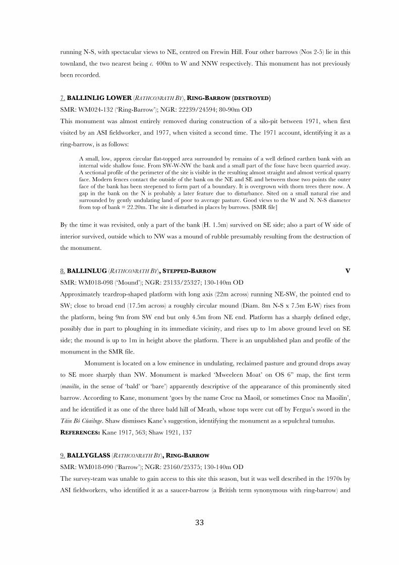
7. BALLINLIG LOWER (RATHCONRATH BY), RING-BARROW (DESTROYED)
SMR: WM024-132 (‘Ring-Barrow’); NGR: 22239/24594; 80-90m OD
This monument was almost entirely removed during construction of a silo-pit between 1971, when first
visited by an ASI fieldworker, and 1977, when visited a second time. The 1971 account, identifying it as a
ring-barrow, is as follows:
A small, low, approx circular flat-topped area surrounded by remains of a well defined earthen bank with an internal wide shallow fosse. From SW-W-NW the bank and a small part of the fosse have been quarried away. A sectional profile of the perimeter of the site is visible in the resulting almost straight and almost vertical quarry face. Modern fences contact the outside of the bank on the NE and SE and between those two points the outer face of the bank has been steepened to form part of a boundary. It is overgrown with thorn trees there now. A gap in the bank on the N is probably a later feature due to disturbance. Sited on a small natural rise and surrounded by gently undulating land of poor to average pasture. Good views to the W and N. N-S diameter from top of bank = 22.20m. The site is disturbed in places by burrows. [SMR file]
By the time it was revisited, only a part of the bank (H. 1.5m) survived on SE side; also a part of W side of
interior survived, outside which to NW was a mound of rubble presumably resulting from the destruction of
the monument.
8. BALLINLUG (RATHCONRATH BY), STEPPED-BARROW V
SMR: WM018-098 (‘Mound’); NGR: 23133/25327; 130-140m OD
Approximately teardrop-shaped platform with long axis (22m across) running NE-SW, the pointed end to
SW; close to broad end (17.5m across) a roughly circular mound (Diam. 8m N-S x 7.5m E-W) rises from
the platform, being 9m from SW end but only 4.5m from NE end. Platform has a sharply defined edge,
possibly due in part to ploughing in its immediate vicinity, and rises up to 1m above ground level on SE
side; the mound is up to 1m in height above the platform. There is an unpublished plan and profile of the
monument in the SMR file.
Monument is located on a low eminence in undulating, reclaimed pasture and ground drops away
to SE more sharply than NW. Monument is marked ‘Mweeleen Moat’ on OS 6” map, the first term
(maoilín, in the sense of ‘bald’ or ‘bare’) apparently descriptive of the appearance of this prominently sited
barrow. According to Kane, monument ‘goes by the name Croc na Maoil, or sometimes Cnoc na Maoilin’,
and he identified it as one of the three bald hill of Meath, whose tops were cut off by Fergus’s sword in the
Táin Bó Cúailnge. Shaw dismisses Kane’s suggestion, identifying the monument as a sepulchral tumulus.
REFERENCES: Kane 1917, 563; Shaw 1921, 137
9. BALLYGLASS (RATHCONRATH BY), RING-BARROW
SMR: WM018-090 (‘Barrow’); NGR: 23160/25375; 130-140m OD
The survey-team was unable to gain access to this site this season, but it was well described in the 1970s by
ASI fieldworkers, who identified it as a saucer-barrow (a British term synonymous with ring-barrow) and
! #$!
noted the occurrence of a megalithic structure which is clearly related to the barrow. The 1970 account is
given here:
A small oval mound surrounded by a substantial earthen bank with a very wide shallow fosse between them. The bank is denuded almost to the bottom of the fosse on the WNW. It has a slight modern gap on the ESE. The bank supports some furze. No formal entrance way. Situated on the WSW side of the top of a prominent NE-SW ridge on gently undulating and hilly ground of good pasture. A modern NW-SE fence of earth and stone extends outside the bank on the NE. In this, to NE of the barrow are three stones of megalithic proportions, two set longitudinally in a line as if forming the side of a chamber grave and the standing upright at the NW end as if a jamb. L of barrow NE-SW = 7m (overall); B of barrow NW-SE = 5.70m (overall); Height of barrow = c. 1.10m [SMR file]
There is an unpublished plan and profile in the SMR file, showing the three close-set orthostats in fence to
NE of barrow, which appears also to slope down from NE-SW. In 1921, when Shaw saw them, they were
collectively known as the ‘leegaun’, although he mistakenly placed them ‘on the west, facing the barrow’.
Monument is marked as a roughly circular mound on OS 6” map.
REFERENCES: Shaw 1921, 137
10. BENALBIT (MOYCASHEL BY), POSSIBLE BARROW (DESTROYED)
SMR: WM032-083 (‘Barrow Possible’); NGR: 23438/24012; 100-110m OD
According to SMR file, the inclusion of this in the ASI database was based on a cropmark ‘consisting of 2
small concentric circles’ visible in an aerial photograph, but ground-level examination of ‘this small rounded
hillock’ with ‘Good views from SW-S-SE-E’ in 1982 found no feature to correspond with the cropmark.
The area had been recently reclaimed and a nearby field-fence removed.
11. BREDAGH (MOYCASHEL BY), RING-BARROW/BOWL-BARROW (DESTROYED)
SMR: WM032-066 (‘Barrow Site’); NGR: 23088/24068; 70-80m OD
Ploughed out sometime in the 1970s according to ASI, and entirely gone by 1982, the site was first
documented by local historian N.W. English, whose short description in the ASI SMR file is suggestive of a
ring- or bowl-barrow, possibly with an entrance at the N, although the centre of the mound had apparently
already been ransacked by treasure-hunters:
It has an outer bank with a gap on the N. There is a shallow depression at the centre of the barrow. A trench exists between barrow and outer bank ... [SMR file]
The site was visited by another ASI fieldworker in 1977, before its complete destruction, when an E-W
drain had been recently cut through it. Its diameter was estimated as c. 6m. On N edge of drain was visible
‘a slight rise in the ground with a slight fosse-like depression around it... [which] seems to represent approx.
! of an originally circular mound’. Although there were no ancient features in the exposed face of the
drain, there was some evidence of more recent activity:
At a depth of approx 0.25 metres below the grass & c. 1.0 metres apart 2 horse-shoes were noticed sticking out of the exposed face. This low mound may therefore be an old horse burial but there is no indication of this in the exposed side of the drain, & the shoes may have simply been buried by silt dumped out from the drain. [SMR file]
According to English, barrow was at the edge of former swampland. According to the 1977 ASI
account, ‘The ground at this point is very marshy & rushes grow in the corner of the field which is an
! #%!
uneven land of mixed pasture’; and old field-banks, old drains and rock outcrop were noted in the field to
SW and W of the monument.
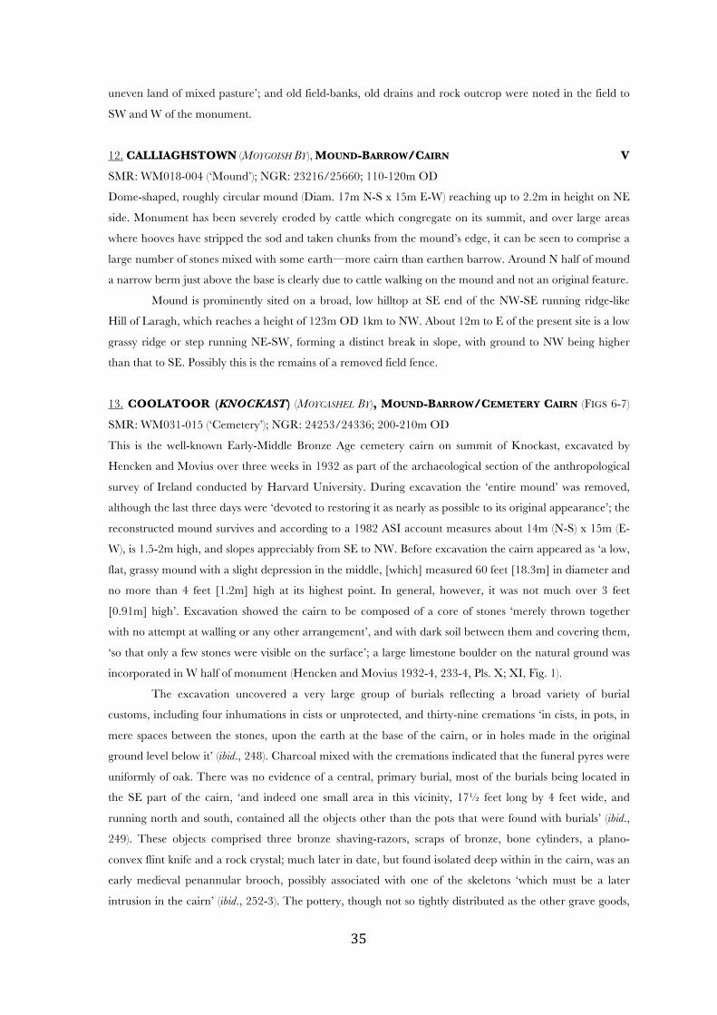
12. CALLIAGHSTOWN (MOYGOISH BY), MOUND-BARROW/CAIRN V
SMR: WM018-004 (‘Mound’); NGR: 23216/25660; 110-120m OD
Dome-shaped, roughly circular mound (Diam. 17m N-S x 15m E-W) reaching up to 2.2m in height on NE
side. Monument has been severely eroded by cattle which congregate on its summit, and over large areas
where hooves have stripped the sod and taken chunks from the mound’s edge, it can be seen to comprise a
large number of stones mixed with some earth—more cairn than earthen barrow. Around N half of mound
a narrow berm just above the base is clearly due to cattle walking on the mound and not an original feature.
Mound is prominently sited on a broad, low hilltop at SE end of the NW-SE running ridge-like
Hill of Laragh, which reaches a height of 123m OD 1km to NW. About 12m to E of the present site is a low
grassy ridge or step running NE-SW, forming a distinct break in slope, with ground to NW being higher
than that to SE. Possibly this is the remains of a removed field fence.
13. COOLATOOR (KNOCKAST) (MOYCASHEL BY), MOUND-BARROW/CEMETERY CAIRN (FIGS 6-7)
SMR: WM031-015 (‘Cemetery’); NGR: 24253/24336; 200-210m OD
This is the well-known Early-Middle Bronze Age cemetery cairn on summit of Knockast, excavated by
Hencken and Movius over three weeks in 1932 as part of the archaeological section of the anthropological
survey of Ireland conducted by Harvard University. During excavation the ‘entire mound’ was removed,
although the last three days were ‘devoted to restoring it as nearly as possible to its original appearance’; the
reconstructed mound survives and according to a 1982 ASI account measures about 14m (N-S) x 15m (E-
W), is 1.5-2m high, and slopes appreciably from SE to NW. Before excavation the cairn appeared as ‘a low,
flat, grassy mound with a slight depression in the middle, [which] measured 60 feet [18.3m] in diameter and
no more than 4 feet [1.2m] high at its highest point. In general, however, it was not much over 3 feet
[0.91m] high’. Excavation showed the cairn to be composed of a core of stones ‘merely thrown together
with no attempt at walling or any other arrangement’, and with dark soil between them and covering them,
‘so that only a few stones were visible on the surface’; a large limestone boulder on the natural ground was
incorporated in W half of monument (Hencken and Movius 1932-4, 233-4, Pls. X; XI, Fig. 1).
The excavation uncovered a very large group of burials reflecting a broad variety of burial
customs, including four inhumations in cists or unprotected, and thirty-nine cremations ‘in cists, in pots, in
mere spaces between the stones, upon the earth at the base of the cairn, or in holes made in the original
ground level below it’ (ibid., 248). Charcoal mixed with the cremations indicated that the funeral pyres were
uniformly of oak. There was no evidence of a central, primary burial, most of the burials being located in
the SE part of the cairn, ‘and indeed one small area in this vicinity, 17! feet long by 4 feet wide, and
running north and south, contained all the objects other than the pots that were found with burials’ (ibid.,
249). These objects comprised three bronze shaving-razors, scraps of bronze, bone cylinders, a plano-
convex flint knife and a rock crystal; much later in date, but found isolated deep within in the cairn, was an
early medieval penannular brooch, possibly associated with one of the skeletons ‘which must be a later
intrusion in the cairn’ (ibid., 252-3). The pottery, though not so tightly distributed as the other grave goods,

! #&!
was again confined to the S and E quadrants, and amounted to ten pots, among which a Bowl Food Vessel,
a Vase Food Vessel, an Encrusted Urn, a Vase Urn and a Cordoned Urn were identified. Also found were
three pits dug in the original ground surface, containing ox, horse and sheep or goat bones, which, along
with signs of intense conflagrations beneath the cairn, were interpreted as ‘probably traces of some
ceremonial that took place before the cairn was erected’ (ibid., 247)
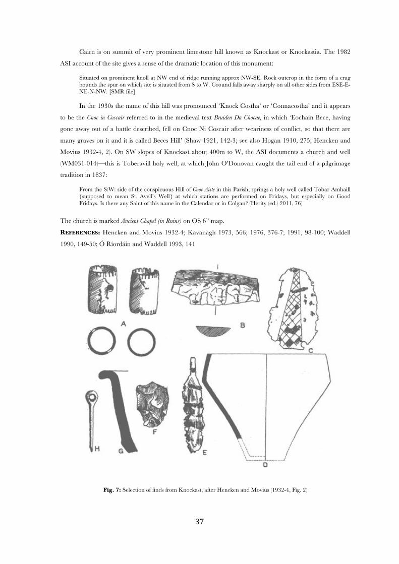
Fig. 6: Plan and sections (SE-NW & SW-NE) of excavated cemetery cairn at Coolatoor (Knockast) (No. 13), containing
an exceptional group of over 40 high-status Bronze Age burials, after Hencken and Movius (1932-4, Pl. IX)
! #'!
Cairn is on summit of very prominent limestone hill known as Knockast or Knockastia. The 1982
ASI account of the site gives a sense of the dramatic location of this monument:
Situated on prominent knoll at NW end of ridge running approx NW-SE. Rock outcrop in the form of a crag bounds the spur on which site is situated from S to W. Ground falls away sharply on all other sides from ESE-E-NE-N-NW. [SMR file] In the 1930s the name of this hill was pronounced ‘Knock Costha’ or ‘Connacostha’ and it appears
to be the Cnoc in Coscair referred to in the medieval text Bruiden Da Chocae, in which ‘Eochain Bece, having
gone away out of a battle described, fell on Cnoc Ni Coscair after weariness of conflict, so that there are
many graves on it and it is called Beces Hill’ (Shaw 1921, 142-3; see also Hogan 1910, 275; Hencken and
Movius 1932-4, 2). On SW slopes of Knockast about 400m to W, the ASI documents a church and well
(WM031-014)—this is Toberavill holy well, at which John O’Donovan caught the tail end of a pilgrimage
tradition in 1837:
From the S:W: side of the conspicuous Hill of Cnoc Aiste in this Parish, springs a holy well called Tobar Amhaill {supposed to mean St. Avell’s Well} at which stations are performed on Fridays, but especially on Good Fridays. Is there any Saint of this name in the Calendar or in Colgan? (Herity (ed.) 2011, 76)
The church is marked Ancient Chapel (in Ruins) on OS 6” map.
REFERENCES: Hencken and Movius 1932-4; Kavanagh 1973, 566; 1976, 376-7; 1991, 98-100; Waddell
1990, 149-50; Ó Ríordáin and Waddell 1993, 141
Fig. 7: Selection of finds from Knockast, after Hencken and Movius (1932-4, Fig. 2)
! #(!
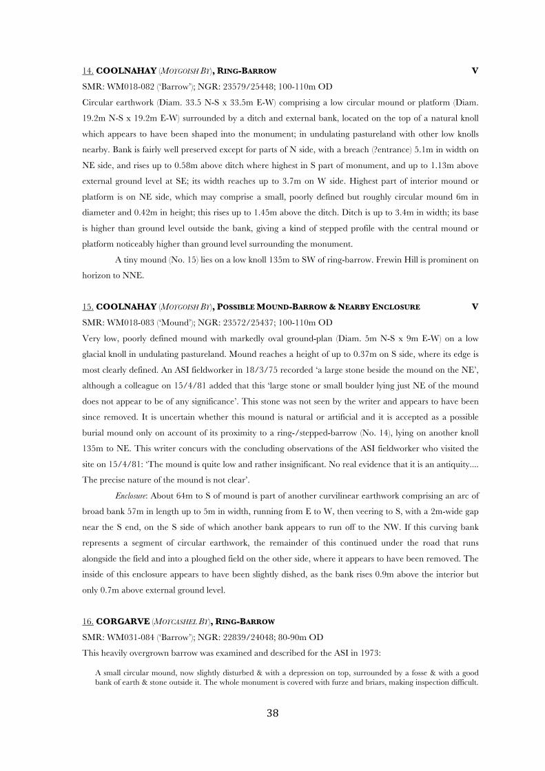
14. COOLNAHAY (MOYGOISH BY), RING-BARROW V
SMR: WM018-082 (‘Barrow’); NGR: 23579/25448; 100-110m OD
Circular earthwork (Diam. 33.5 N-S x 33.5m E-W) comprising a low circular mound or platform (Diam.
19.2m N-S x 19.2m E-W) surrounded by a ditch and external bank, located on the top of a natural knoll
which appears to have been shaped into the monument; in undulating pastureland with other low knolls
nearby. Bank is fairly well preserved except for parts of N side, with a breach (?entrance) 5.1m in width on
NE side, and rises up to 0.58m above ditch where highest in S part of monument, and up to 1.13m above
external ground level at SE; its width reaches up to 3.7m on W side. Highest part of interior mound or
platform is on NE side, which may comprise a small, poorly defined but roughly circular mound 6m in
diameter and 0.42m in height; this rises up to 1.45m above the ditch. Ditch is up to 3.4m in width; its base
is higher than ground level outside the bank, giving a kind of stepped profile with the central mound or
platform noticeably higher than ground level surrounding the monument.
A tiny mound (No. 15) lies on a low knoll 135m to SW of ring-barrow. Frewin Hill is prominent on
horizon to NNE.
15. COOLNAHAY (MOYGOISH BY), POSSIBLE MOUND-BARROW & NEARBY ENCLOSURE V
SMR: WM018-083 (‘Mound’); NGR: 23572/25437; 100-110m OD
Very low, poorly defined mound with markedly oval ground-plan (Diam. 5m N-S x 9m E-W) on a low
glacial knoll in undulating pastureland. Mound reaches a height of up to 0.37m on S side, where its edge is
most clearly defined. An ASI fieldworker in 18/3/75 recorded ‘a large stone beside the mound on the NE’,
although a colleague on 15/4/81 added that this ‘large stone or small boulder lying just NE of the mound
does not appear to be of any significance’. This stone was not seen by the writer and appears to have been
since removed. It is uncertain whether this mound is natural or artificial and it is accepted as a possible
burial mound only on account of its proximity to a ring-/stepped-barrow (No. 14), lying on another knoll
135m to NE. This writer concurs with the concluding observations of the ASI fieldworker who visited the
site on 15/4/81: ‘The mound is quite low and rather insignificant. No real evidence that it is an antiquity....
The precise nature of the mound is not clear’.
Enclosure: About 64m to S of mound is part of another curvilinear earthwork comprising an arc of
broad bank 57m in length up to 5m in width, running from E to W, then veering to S, with a 2m-wide gap
near the S end, on the S side of which another bank appears to run off to the NW. If this curving bank
represents a segment of circular earthwork, the remainder of this continued under the road that runs
alongside the field and into a ploughed field on the other side, where it appears to have been removed. The
inside of this enclosure appears to have been slightly dished, as the bank rises 0.9m above the interior but
only 0.7m above external ground level.
16. CORGARVE (MOYCASHEL BY), RING-BARROW
SMR: WM031-084 (‘Barrow’); NGR: 22839/24048; 80-90m OD
This heavily overgrown barrow was examined and described for the ASI in 1973:
A small circular mound, now slightly disturbed & with a depression on top, surrounded by a fosse & with a good bank of earth & stone outside it. The whole monument is covered with furze and briars, making inspection difficult.
! #)!
The diam of the earthwork is approx 26m. The barrow is situated on a ridge with good views of the surrounding countryside, which is fairly well drained pasture land. [SMR file]
From this description the monument, with a small mound and substantial bank, appears to be a ring-
barrow rather than a bowl-barrow with external bank. The depression on top of mound possibly indicates
that it has been ransacked by treasurehunters.
17. CUMMINSTOWN (MOYCASHEL BY), MOUND-BARROW (FIGS 8-9) V
SMR: WM038-019 (‘Barrow’); NGR: 23549/23642; 70-80m OD
Enormous, steep-sided, roughly circular mound (Diam. 33.5m NW-SE) with domed top, and no visible
traces of a surrounding ditch or bank. Mound is covered by trees and other vegetation, making it difficult to
examine in places; as such, only a single diameter measurement could be recorded. Mound rises up to 5.8m
above surrounding ground on NE side. Monument is located in a fluvioglacial landscape, with numerous
kames in the area—two close set kames form a ridge just SW of the mound—and has presumably been
moulded from such a glacial landform given that there is no trace of a ditch from which the material for the
massive mound might have derived; the landowner did, however, inform the writer that the soil around the
mound was of a different quality to elsewhere in the same field, which might indicate that topsoil was
scraped from a broad area to construct the mound or, more likely, enlarge an existing landform. On NW
side, mound seems to taper off gradually to the natural ground, making it difficult to identify its edge.
Around circumference of mound at varying heights are narrow terraces apparently due to soil-flow and/or
animal movement; certainly a few parts of the mound have been poached by animals, showing it to be
composed of earth with some stones. Although this prominent monument has the proportions of a Norman
motte, and looks superficially like one, it has neither bank, ditch nor bailey, and its domed upper surface is
unlike the flat top more usual for a motte.
Monument is located in undulating pasture. Croghan Hill in Offaly is visible to ESE.
18. CUMMINSTOWN (MOYCASHEL BY), STEPPED-BARROW (FIGS 10-12) V
SMR: WM038-021 (‘Barrow’); NGR: 23625/23616; 70-80m OD
Well-preserved stepped barrow comprising a subcircular mound (Diam. 10.8m N-S x 10.8m E-W) with
flattish top and shallow sloping sides erected on top of a larger, flat-topped, subcircular mound (Diam.
27.5m N-S x 34.9m E-W), which slopes down gradually to natural ground level, such that there is a ‘step’
around the uppermost mound. As upper mound is not located centrally on lower platform, being located
closer to NE than SE side, step varies greatly in width, being 1m at N, 2.4m at S, 3.6m at W and 4.8m at E;
the narrow step on N side is not clearly evident as a flat area. Upper mound rises up to 1.9m above step on
N side, and overall height of monument reaches up to 4m at S. An additional low ‘step’ at base of
monument on N side appears to relate to the construction of field fence on this side. Upper mound has
large boulders or rock outcrop visible around the edges and on top, apparently representing the natural
topography; this, and the fact that there is no ditch visible around this substantial monument, strongly
suggests that it, like many other Westmeath barrows, has been shaped from a kame or other pre-existing
glacial landform. Thorn trees are growing on and especially around the edge of the monument except for a
short arc of perimeter on SE side.
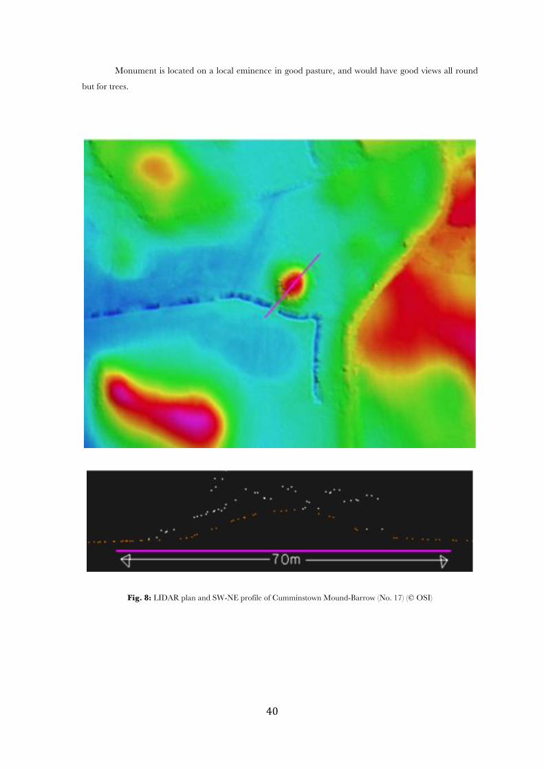
! $+!
Monument is located on a local eminence in good pasture, and would have good views all round
but for trees.
Fig. 8: LIDAR plan and SW-NE profile of Cumminstown Mound-Barrow (No. 17) (© OSI)

! $*!
Fig. 9: LIDAR oblique overhead view of Cumminstown Mound-Barrow (No. 17), from south (© OSI)
Fig. 10: LIDAR profile of Cumminstown Stepped-Barrow (No. 18) (© OSI)
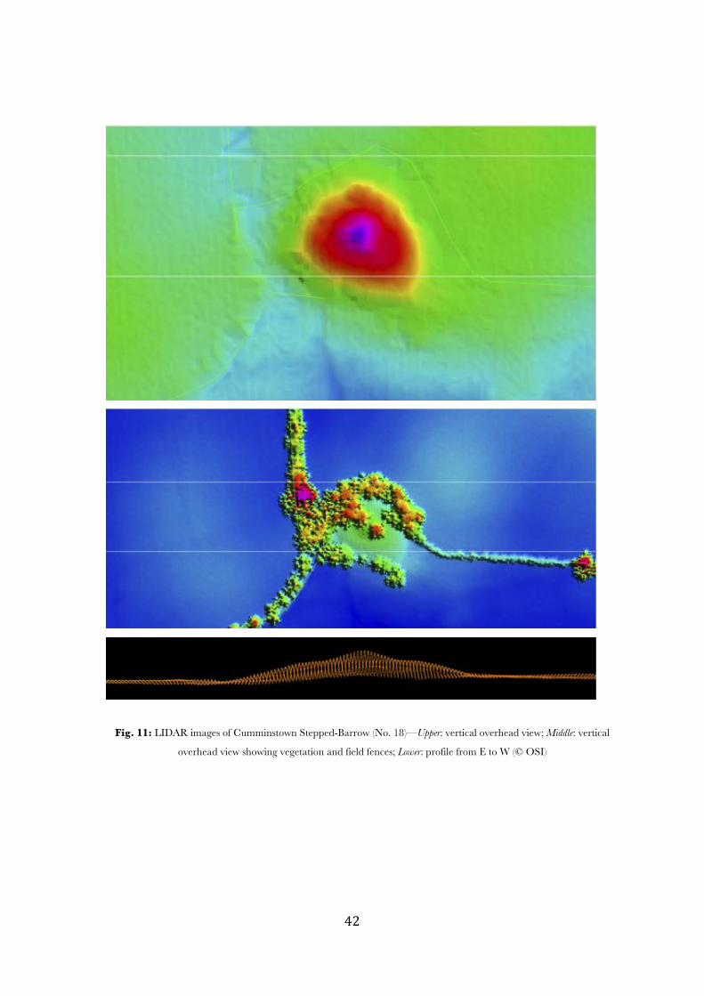
! $"!
Fig. 11: LIDAR images of Cumminstown Stepped-Barrow (No. 18)—Upper: vertical overhead view; Middle: vertical
overhead view showing vegetation and field fences; Lower: profile from E to W (© OSI)
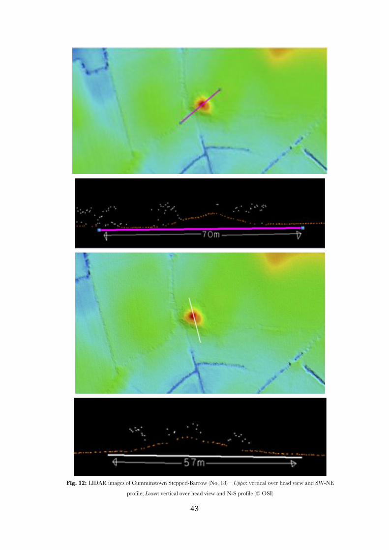
! $#!
Fig. 12: LIDAR images of Cumminstown Stepped-Barrow (No. 18)—Upper: vertical over head view and SW-NE
profile; Lower: vertical over head view and N-S profile (© OSI)
! $$!
19. FREVANAGH (MOYCASHEL BY), POSSIBLE BARROW (DESTROYED)
SMR: WM040-001 (‘Barrow’); NGR: 234622/231686; 70-80m OD
Caimin O’Brien’s 2013 account of this destroyed site on the ASI website is as follows:
On a low rise of ground with good views of the surrounding countryside. Cairn (WM040-002) located 140m to S. No surface remains visible of a small mound depicted on the current ed. OS 6-inch map. Not indicated on the 1837 ed. OS 6-inch map. The depiction of this monument suggests that it may have been a barrow.
20. GADDRYSTOWN (MOYGOISH BY), MOUND OR BOWL-BARROW (DESTROYED) V
SMR: WM018-066 (‘Barrow’); NGR: 23425/25553; 100-110m OD
This site of this monument now comprises a jumble of boulders on a small patch of rough ground, perhaps
field clearance (but see ASI description below), and it appears to have been destroyed or greatly altered
since two ASI fieldworkers visited it in 1983 and 1984 and identified it as a barrow. The 1984 description:
This site comprises an artificial mound, roughly oval in shape; the northern end of which is obscured by bushes and a tree with some rose bushes scattered on it. The mound reaches a maximum height of 1 metre on the west and slopes gradually towards the east. It is 4 metres E-W by 8m N-S. There is a faint suggestion of a ditch on the S, SSW & W. Some large stones protrude up from the mound on the E & N. Situated on a slight rise in a level field in undulating pasture land. It is probably a small barrow. [SMR file]
If the possible ditch—observed by both fieldworkers—were genuine, the monument could be identified as a
small bowl-barrow; otherwise it was presumably a mound barrow.
21. GARRYDUFF (MOYCASHEL BY), RING OR STEPPED-BARROW (FIGS 13-14)
SMR: WM038-024 (‘Barrow’); NGR: 23680/23542; 90-100m OD
Although the survey-team was unable to gain access to the monument this season, it was described twice by
ASI fieldworkers in the 1970s; and LIDAR data is now available. The 1973 ASI account:
This is a small circular barrow about 2m high at its maximum height, & approx 9m in diam. The barrow is surrounded by a wide fosse with a wide low bank outside. The barrow is quite overgrown & is situated on a rise in rather rushy pasture land. There are wide views of the surrounding countryside from the barrow. [SMR file]
And the 1977 account:
This well-defined circular site consists of a central mound surrounded by a fosse and outer bank. The outer bank is highest to N and S, and lowest to E and W. The ground slopes away steeply from the site on all sides, except to NW where a hillock overlooks the site. The site supports many trees but is clear of undergrowth. There are extensive views from the site, especially to W & S.... Diameter of mound N-S = 10.5m [SMR file]
From these descriptions, the monument appears to be a ring-barrow; the LIDAR images given here show it
to be moulded from a natural knoll, such that the bank is much lower than the central mound, and the
ditch appears almost like a step. The monument seems to be depicted as stepped on historic OS 25” map
on OSI website, where it is marked Knisheen Fort; a spring is shown less than 20m to N. A second, similar
knoll is conjoined to the first at NW side, although no archaeological feature has been documented here.
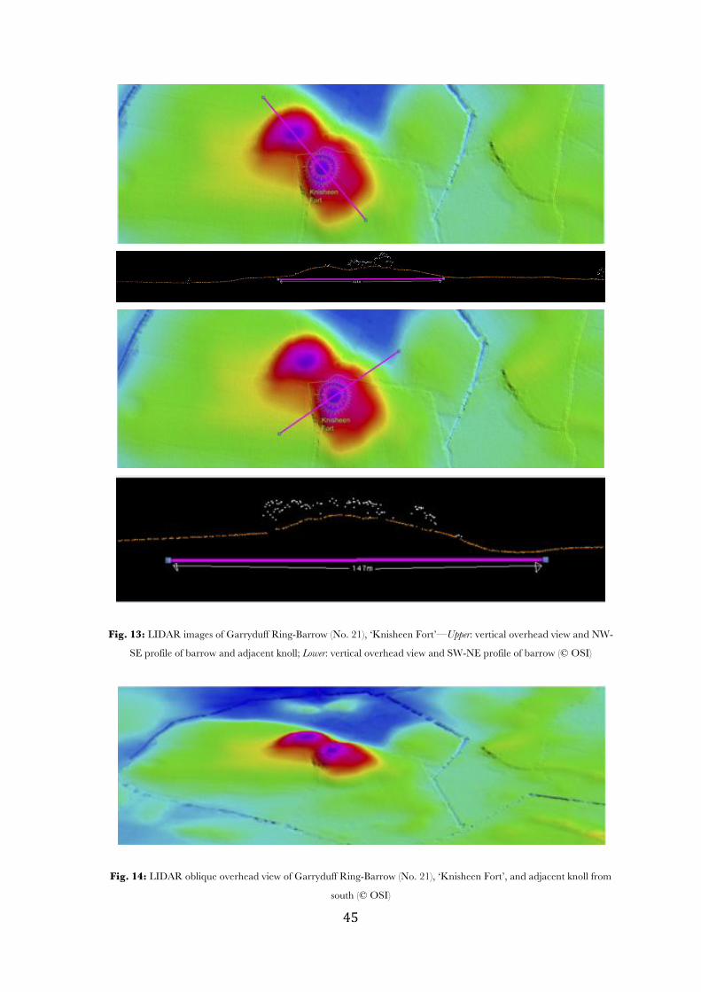
! $%!
Fig. 13: LIDAR images of Garryduff Ring-Barrow (No. 21), ‘Knisheen Fort’—Upper: vertical overhead view and NW-
SE profile of barrow and adjacent knoll; Lower: vertical overhead view and SW-NE profile of barrow (© OSI)
Fig. 14: LIDAR oblique overhead view of Garryduff Ring-Barrow (No. 21), ‘Knisheen Fort’, and adjacent knoll from
south (© OSI)
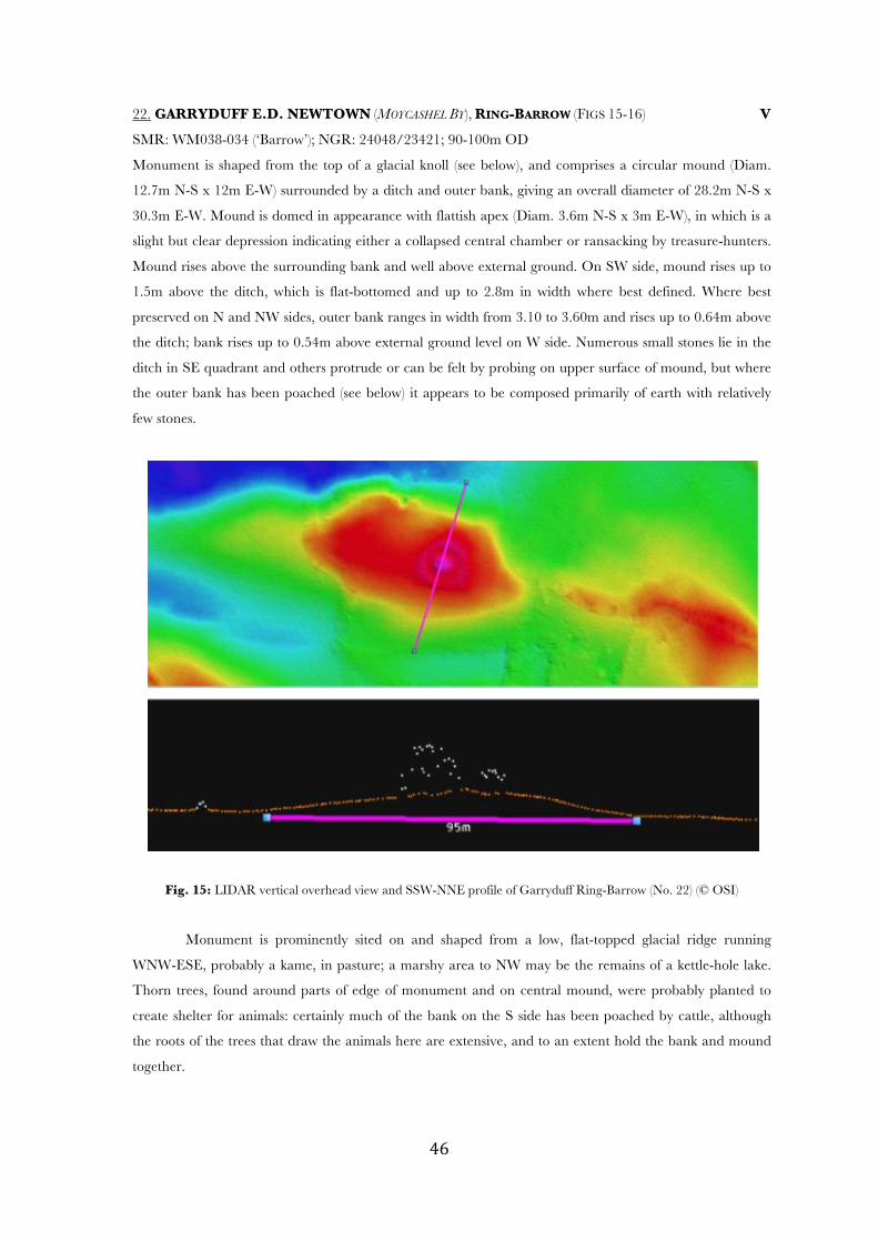
! $&!
22. GARRYDUFF E.D. NEWTOWN (MOYCASHEL BY), RING-BARROW (FIGS 15-16) V
SMR: WM038-034 (‘Barrow’); NGR: 24048/23421; 90-100m OD
Monument is shaped from the top of a glacial knoll (see below), and comprises a circular mound (Diam.
12.7m N-S x 12m E-W) surrounded by a ditch and outer bank, giving an overall diameter of 28.2m N-S x
30.3m E-W. Mound is domed in appearance with flattish apex (Diam. 3.6m N-S x 3m E-W), in which is a
slight but clear depression indicating either a collapsed central chamber or ransacking by treasure-hunters.
Mound rises above the surrounding bank and well above external ground. On SW side, mound rises up to
1.5m above the ditch, which is flat-bottomed and up to 2.8m in width where best defined. Where best
preserved on N and NW sides, outer bank ranges in width from 3.10 to 3.60m and rises up to 0.64m above
the ditch; bank rises up to 0.54m above external ground level on W side. Numerous small stones lie in the
ditch in SE quadrant and others protrude or can be felt by probing on upper surface of mound, but where
the outer bank has been poached (see below) it appears to be composed primarily of earth with relatively
few stones.
Fig. 15: LIDAR vertical overhead view and SSW-NNE profile of Garryduff Ring-Barrow (No. 22) (© OSI)
Monument is prominently sited on and shaped from a low, flat-topped glacial ridge running
WNW-ESE, probably a kame, in pasture; a marshy area to NW may be the remains of a kettle-hole lake.
Thorn trees, found around parts of edge of monument and on central mound, were probably planted to
create shelter for animals: certainly much of the bank on the S side has been poached by cattle, although
the roots of the trees that draw the animals here are extensive, and to an extent hold the bank and mound
together.
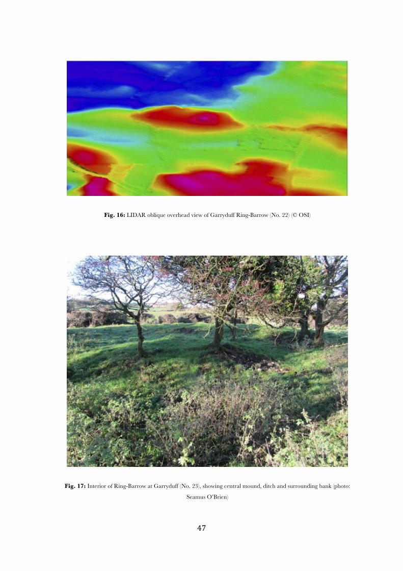
! $'!
Fig. 16: LIDAR oblique overhead view of Garryduff Ring-Barrow (No. 22) (© OSI)
Fig. 17: Interior of Ring-Barrow at Garryduff (No. 23), showing central mound, ditch and surrounding bank (photo:
Seamus O’Brien)
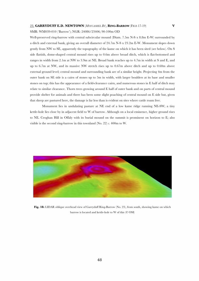
! $(!
23. GARRYDUFF E.D. NEWTOWN (MOYCASHEL BY), RING-BARROW (FIGS 17-19) V
SMR: WM039-010 (‘Barrow’); NGR: 24086/23406; 90-100m OD
Well-preserved ring-barrow with central subcircular mound (Diam. 7.5m N-S x 8.8m E-W) surrounded by
a ditch and external bank, giving an overall diameter of 24.7m N-S x 23.2m E-W. Monument slopes down
gently from NW to SE, apparently the topography of the kame on which it has been sited (see below). On S
side flattish, dome-shaped central mound rises up to 0.6m above broad ditch, which is flat-bottomed and
ranges in width from 2.1m at NW to 3.9m at NE. Broad bank reaches up to 4.7m in width at S and E, and
up to 6.7m at NW, and its massive NW stretch rises up to 0.67m above ditch and up to 0.60m above
external ground level; central mound and surrounding bank are of a similar height. Projecting 4m from the
outer bank on SE side is a cairn of stones up to 5m in width, with larger boulders at its base and smaller
stones on top; this has the appearance of a field-clearance cairn, and numerous stones in E half of ditch may
relate to similar clearance. Thorn trees growing around E half of outer bank and on parts of central mound
provide shelter for animals and there has been some slight poaching of central mound on E side but, given
that sheep are pastured here, the damage is far less than is evident on sites where cattle roam free.
Monument lies in undulating pasture at NE end of a low kame ridge running NE-SW; a tiny
kettle-hole lies close by in adjacent field to W of barrow. Although on a local eminence, higher ground rises
to NE. Croghan Hill in Offaly with its burial mound on the summit is prominent on horizon to E; also
visible is the second ring-barrow in this townland (No. 22) c. 400m to W.
Fig. 18: LIDAR oblique overhead view of Garryduff Ring-Barrow (No. 23), from south, showing kame on which
barrow is located and kettle-hole to W of this (© OSI)
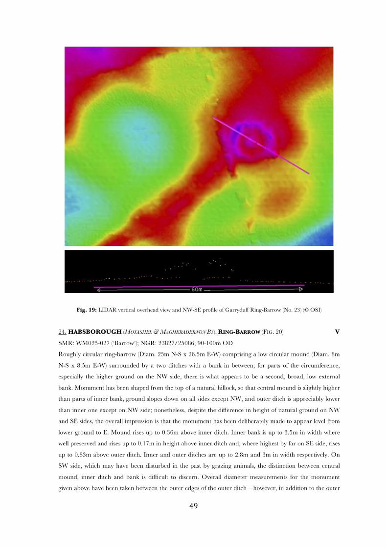
! $)!
Fig. 19: LIDAR vertical overhead view and NW-SE profile of Garryduff Ring-Barrow (No. 23) (© OSI)
24. HABSBOROUGH (MOYASHEL & MAGHERADERNON BY), RING-BARROW (FIG. 20) V
SMR: WM025-027 (‘Barrow’); NGR: 23827/25086; 90-100m OD
Roughly circular ring-barrow (Diam. 25m N-S x 26.5m E-W) comprising a low circular mound (Diam. 8m
N-S x 8.5m E-W) surrounded by a two ditches with a bank in between; for parts of the circumference,
especially the higher ground on the NW side, there is what appears to be a second, broad, low external
bank. Monument has been shaped from the top of a natural hillock, so that central mound is slightly higher
than parts of inner bank, ground slopes down on all sides except NW, and outer ditch is appreciably lower
than inner one except on NW side; nonetheless, despite the difference in height of natural ground on NW
and SE sides, the overall impression is that the monument has been deliberately made to appear level from
lower ground to E. Mound rises up to 0.36m above inner ditch. Inner bank is up to 3.5m in width where
well preserved and rises up to 0.17m in height above inner ditch and, where highest by far on SE side, rises
up to 0.83m above outer ditch. Inner and outer ditches are up to 2.8m and 3m in width respectively. On
SW side, which may have been disturbed in the past by grazing animals, the distinction between central
mound, inner ditch and bank is difficult to discern. Overall diameter measurements for the monument
given above have been taken between the outer edges of the outer ditch—however, in addition to the outer
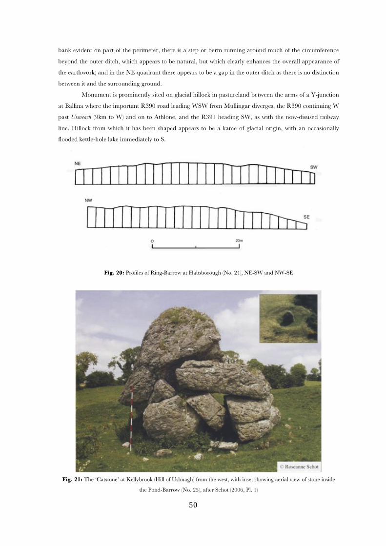
! %+!
bank evident on part of the perimeter, there is a step or berm running around much of the circumference
beyond the outer ditch, which appears to be natural, but which clearly enhances the overall appearance of
the earthwork; and in the NE quadrant there appears to be a gap in the outer ditch as there is no distinction
between it and the surrounding ground.
Monument is prominently sited on glacial hillock in pastureland between the arms of a Y-junction
at Ballina where the important R390 road leading WSW from Mullingar diverges, the R390 continuing W
past Uisneach (9km to W) and on to Athlone, and the R391 heading SW, as with the now-disused railway
line. Hillock from which it has been shaped appears to be a kame of glacial origin, with an occasionally
flooded kettle-hole lake immediately to S.
Fig. 20: Profiles of Ring-Barrow at Habsborough (No. 24), NE-SW and NW-SE
Fig. 21: The ‘Catstone’ at Kellybrook (Hill of Ushnagh) from the west, with inset showing aerial view of stone inside
the Pond-Barrow (No. 25), after Schot (2006, Pl. 1)
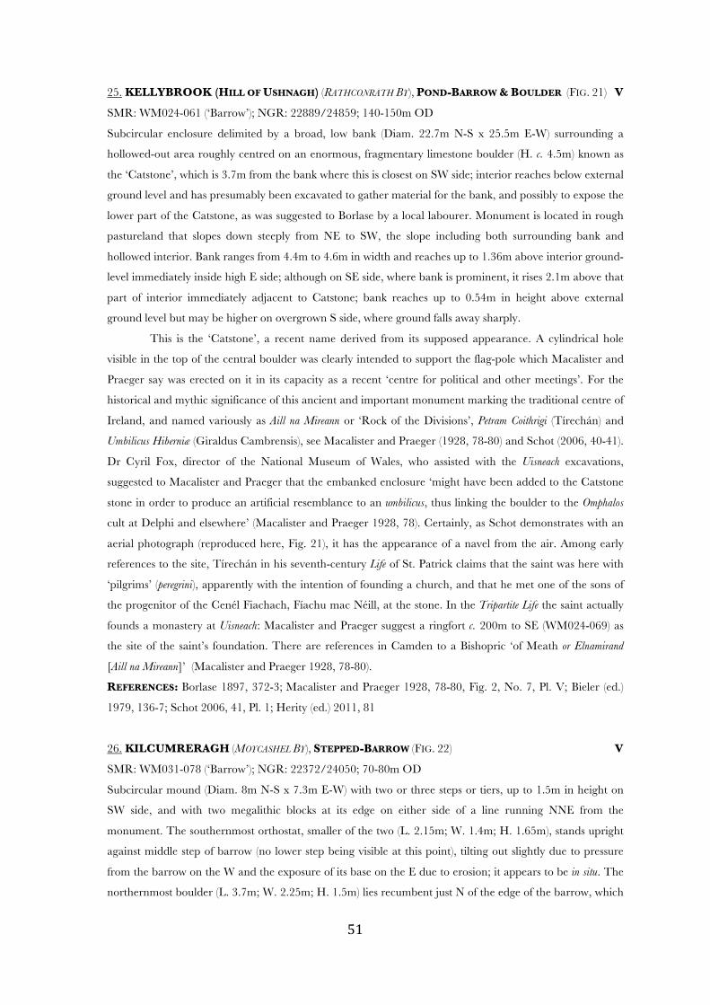
! %*!
25. KELLYBROOK (HILL OF USHNAGH) (RATHCONRATH BY), POND-BARROW & BOULDER (FIG. 21) V
SMR: WM024-061 (‘Barrow’); NGR: 22889/24859; 140-150m OD
Subcircular enclosure delimited by a broad, low bank (Diam. 22.7m N-S x 25.5m E-W) surrounding a
hollowed-out area roughly centred on an enormous, fragmentary limestone boulder (H. c. 4.5m) known as
the ‘Catstone’, which is 3.7m from the bank where this is closest on SW side; interior reaches below external
ground level and has presumably been excavated to gather material for the bank, and possibly to expose the
lower part of the Catstone, as was suggested to Borlase by a local labourer. Monument is located in rough
pastureland that slopes down steeply from NE to SW, the slope including both surrounding bank and
hollowed interior. Bank ranges from 4.4m to 4.6m in width and reaches up to 1.36m above interior ground-
level immediately inside high E side; although on SE side, where bank is prominent, it rises 2.1m above that
part of interior immediately adjacent to Catstone; bank reaches up to 0.54m in height above external
ground level but may be higher on overgrown S side, where ground falls away sharply.
This is the ‘Catstone’, a recent name derived from its supposed appearance. A cylindrical hole
visible in the top of the central boulder was clearly intended to support the flag-pole which Macalister and
Praeger say was erected on it in its capacity as a recent ‘centre for political and other meetings’. For the
historical and mythic significance of this ancient and important monument marking the traditional centre of
Ireland, and named variously as Aill na Mireann or ‘Rock of the Divisions’, Petram Coithrigi (Tírechán) and
Umbilicus Hiberniæ (Giraldus Cambrensis), see Macalister and Praeger (1928, 78-80) and Schot (2006, 40-41).
Dr Cyril Fox, director of the National Museum of Wales, who assisted with the Uisneach excavations,
suggested to Macalister and Praeger that the embanked enclosure ‘might have been added to the Catstone
stone in order to produce an artificial resemblance to an umbilicus, thus linking the boulder to the Omphalos
cult at Delphi and elsewhere’ (Macalister and Praeger 1928, 78). Certainly, as Schot demonstrates with an
aerial photograph (reproduced here, Fig. 21), it has the appearance of a navel from the air. Among early
references to the site, Tírechán in his seventh-century Life of St. Patrick claims that the saint was here with
‘pilgrims’ (peregrini), apparently with the intention of founding a church, and that he met one of the sons of
the progenitor of the Cenél Fiachach, Fíachu mac Néill, at the stone. In the Tripartite Life the saint actually
founds a monastery at Uisneach: Macalister and Praeger suggest a ringfort c. 200m to SE (WM024-069) as
the site of the saint’s foundation. There are references in Camden to a Bishopric ‘of Meath or Elnamirand
[Aill na Mireann]’ (Macalister and Praeger 1928, 78-80).
REFERENCES: Borlase 1897, 372-3; Macalister and Praeger 1928, 78-80, Fig. 2, No. 7, Pl. V; Bieler (ed.)
1979, 136-7; Schot 2006, 41, Pl. 1; Herity (ed.) 2011, 81
26. KILCUMRERAGH (MOYCASHEL BY), STEPPED-BARROW (FIG. 22) V
SMR: WM031-078 (‘Barrow’); NGR: 22372/24050; 70-80m OD
Subcircular mound (Diam. 8m N-S x 7.3m E-W) with two or three steps or tiers, up to 1.5m in height on
SW side, and with two megalithic blocks at its edge on either side of a line running NNE from the
monument. The southernmost orthostat, smaller of the two (L. 2.15m; W. 1.4m; H. 1.65m), stands upright
against middle step of barrow (no lower step being visible at this point), tilting out slightly due to pressure
from the barrow on the W and the exposure of its base on the E due to erosion; it appears to be in situ. The
northernmost boulder (L. 3.7m; W. 2.25m; H. 1.5m) lies recumbent just N of the edge of the barrow, which
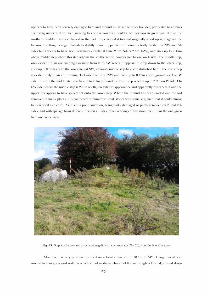
! %"!
appears to have been severely damaged here and around as far as the other boulder, partly due to animals
sheltering under a thorn tree growing beside the southern boulder but perhaps in great part due to the
northern boulder having collapsed in the past—especially if it too had originally stood upright against the
barrow, revetting its edge. Flattish to slightly domed upper tier of mound is badly eroded on NW and SE
sides but appears to have been originally circular (Diam. 2.3m N-S x 2.5m E-W), and rises up to 1.45m
above middle step where this step adjoins the southernmost boulder (see below) on E side. The middle step,
only evident in an arc running clockwise from N to SW where it appears to drop down to the lower step,
rises up to 0.55m above the lower step at SW, although middle step has been disturbed here. The lower step
is evident only in an arc running clockwise from S to NW and rises up to 0.42m above ground level on W
side. In width the middle step reaches up to 2.1m at E and the lower step reaches up to 2.9m on W side. On
SW side, where the middle step is 2m in width, irregular in appearance and apparently disturbed, it and the
upper tier appear to have spilled out onto the lower step. Where the mound has been eroded and the sod
removed in many places, it is composed of numerous small stones with some soil, such that it could almost
be described as a cairn. As it is in a poor condition, being badly damaged or partly removed on N and NE
sides, and with spillage from different tiers on all sides, other readings of this monument than the one given
here are conceivable.
Fig. 22: Stepped-Barrow and associated megaliths at Kilcumreragh (No. 26), from the NW (2m scale)
Monument is very prominently sited on a local eminence, c. 38.5m to SW of large curvilinear
mound (within graveyard wall) on which site of medieval church of Kilcumreragh is located; ground drops
! %#!
sharply 12m to NE of barrow before rising again towards the church. Little is known about the history of
this church. When John O’Donovan visited the site in 1837, the locals had ‘entirely forgotten the latter part
of the name’, referring only to the parish of Kill, and the original dedication to a native, pre-Norman saint
had been replaced by one to St. Thomas. But O’Donovan knew well his Martyrologies and saints’ Lives:
Groping thus in the dark it is very difficult (for one) to come to any certain conclusion and still I have no hesitation in asserting with every confidence that this is the church of com�ái�e!near Uisneach, where in the primitive ages St. Colman was venerated on the 25th of September (Herity (ed.) 2011, 76)
In support of this, Leo Swan inferred from the quadrantal shape of the graveyard an original monastic
enclosure or vallum having formerly surrounded the site, sound indication of an early medieval origin (1988,
17).
27. KILPATRICK (RATHCONRATH BY), MOUND-BARROW V
SMR: WM018-065 (‘Barrow’); NGR: 23365/25510; 100-110m OD
Monument comprises a small, roughly circular but poorly defined mound (Diam. 5.9m N-S x 5.4m E-W)
up to 0.51m in height on W and SE sides, which appears to have been shaped from the summit of a
prominent conical knoll that reaches up to 2m in height below mound on N side. Mound has been
hollowed out in the centre (2.5m N-S x 2m E-W) as if ransacked by treasure-hunters. Knoll appears to be a
kame with kettle-hole lake close by in same field to SW; its NE side, adjacent to modern field fence, has
been severely damaged or shorn off. The ASI fieldworker who visited the site in 1983 thought the knoll had
been scarped and shaped, but this does not seem obvious to the writer except for the damaged NE side.
Monument is currently located in pastureland but surrounding field is full of old cultivation-ridges
or lazy-beds. The monument is marked Crockaphuca (‘Hill of the Pooka’) on OS 6” map.
28. KILPATRICK (RATHCONRATH BY), RING-BARROW (?DESTROYED)
SMR: WM018-097 (‘Barrow’); NGR: 23248/25381; 140-150m OD
The survey-team was unable to gain access to this monument this season, although a partial view of the site
from over a high roadside field fence suggested that it might have been removed. Monument was described
during ASI fieldwork:
This trig. point is situated on the remains of a barrow. The site consistes of a low central, roughly circular mound, surrounded by a shallow fosse, and traces of a possible outer bank. The central mound is c. 18 m diameter N-S. The fosse is c. 3m wide. The outer bank, which is more of a raised outer lip of the fosse, is clearest on NE-E. Roughly " of the site survives. It is cut by a field fence which runs N-S. This fence cuts off the W section of the site. Slight traces of the enclosure can be made out in the next field to W. The site is situated on top of a hill, in good pasture land. It commands a very fine view especially to N. [SMR file]
29. LOUGHAN (RATHCONRATH BY), RING-BARROW V
SMR: WM017-103 (‘Ring-Barrow’); NGR: 23024/25221; 120-130m OD
Fairly well preserved ring-barrow (Diam. 23.7m N-S x 24.4m E-W), comprising a domed mound (Diam.
11.5m N-S x 12.2m E-W) with flattish top surrounded by a ditch and outer bank. Mound is slightly higher
than the bank in places, especially at its highest NE side, where it rises up to 1.10m above ditch. On SE
side, mound appears to have been eroded as there is a step where its height is reduced but still rises above
the ditch. Bank is up to 3.50m in width and rises up to 0.80m above ditch on NNE side and up to 0.46m

! %$!
above external ground level on N side, its lowest points being on NW and SSE sides; where well preserved
around much of its circumference, it is flat-topped. At WSW a large flattish-topped block of limestone has
been incorporated in the bank. On NNW side a stretch of bank about 9m in length has been removed.
Ditch is 2.70m in greatest width. Just beyond bank on SE side of monument is a hollowed-out circular pit
(7m x 6.5m) which opens out to ground level on E side; possibly this represents a limekiln.
Monument lies in lush pastureland in the W corner of Mount Dalton demesne, about 400m to SW
of a second possible barrow (No. 30); there is a small lake or fen 32m to SE.
30. LOUGHAN (RATHCONRATH BY), POSSIBLE BARROW, UNCLASSIFIED V
SMR: WM017-082 (‘Ring-Barrow’); NGR: 23049/25254; 130-140m OD
Small circular enclosure (Diam. 18.8m N-S x 18.3m E-W) with flat central area (Diam. 10.4m N-S x 11m
E-W) defined by bank and external ditch. Ground slopes down fairly steeply to W and all elements of the
monument follow this slope. Bank is up to 1.9m in width and rises up to 0.7m above ditch; on E side, where
two small boulders appear to be the remains of an internal revetment to the bank, it rises 0.5m above
interior. Ditch is up to 2.2m in width. On NW side of monument there appears to be a counterscarp bank,
indicated by a curving line of partly grassed-over boulders; this does not continue around the monument
and has not been included in the diameter measurements given above. Monument is located in lush
pastureland near the edge of Mount Dalton demesne and has three mature deciduous trees on its perimeter,
presumably planted along with many others in this planned demesne. With its internal, stone-revetted bank,
external ditch and possible counterscarp bank, monument has the appearance of a ringfort, although its
small size—well below the norm of 25-30m for a ringfort; its steeply sloping interior; the lack of any obvious
entrance; and the presence of planted trees on its perimeter, might also indicate that it represents a
landscape feature designed for the demesne. Either way, it is only tentatively accepted as a barrow here,
despite the presence of a genuine ring-barrow (No. 29) in the demesne c. 400m to SW.
31. MONTRATH (MOYCASHEL BY), POSSIBLE BARROW (DESTROYED)
SMR: WM039-012 (‘Barrow’); NGR: 241819/233544
Caimin O’Brien’s 2013 account of this destroyed site on the ASI website is as follows: ‘On flat well drained
land with good views of surrounding countryside. Depicted as a small mound on the revised 1910 ed. OS
25-inch map. No surface remains visible of mound that has been destroyed by quarrying’.
32 & 32a. MOYVOUGHLY (RATHCONRATH BY), UNCLASSIFIED BARROW & DOUBTFUL BARROW V
SMR: WM030-022 (‘Barrow’); NGR: 21943/24377; 70-80m OD
Large, roughly subcircular monument (Diam. 47.5m N-S) comprising a subcircular central mound (Diam.
10.2m N-S x 13.2m E-W) surrounded at a considerable distance by a bank, giving the impression of a
broad, shallow ‘ditch’ in between. SE stretch of bank appears to have been removed, precluding a
measurement of the E-W diameter of the monument. Although on undulating ground, monument is level
when viewed from a distance. Where highest on NW side, central mound rises up to 1.55m above area
between mound and bank; it has irregular upper surface, perhaps damaged by cattle but with exposed
blocks of limestone visible in places. Other limestone blocks have been incorporated in the outer bank,
! %%!
which is really only a clear bank on the S side, where it reaches up to 3.5m in width and up to 0.45m in
height above the interior, being more like a step elsewhere—that is to say the broad level area surrounding
the mound simply drops down to external ground level, especially on the N side where the ‘step’ is up to
1.45m high and the ‘bank’ has no clearly defined inner edge. There may be a true ditch immediately inside
the bank, giving the overall monument the appearance of a Wessex disc-barrow or of a hengiform ditched
enclosure with central mound, but this is by no means certain. Immediately W of monument is a stretch of
a second earthen bank, apparently not part of the barrow but running almost tangentially to it and swerving
off to NW.
Monument is located in low-lying pastureland with higher ground to S; local landowner pointed
out that major drainage operations had taken place here over the years, such that large parts were
previously marshy or fully flooded, immediately to NE and E of the barrow. About 400m to E a holy well
and bullaun stone (WM030-02501/02) indicate early medieval ecclesiastical activity.
Possible Second Barrow: Less than 150m NNW of monument just described, is another feature which
on the surface could be interpreted as a barrow. This greatly damaged monument is preserved only on N
side of E-W running field fence, S side of monument apparently having been removed. Although remaining
part of monument is by no means regular in appearance or easily classifiable, it appears to comprise an
irregular-shaped mound incorporating blocks of limestone and rising to its highest point on E side. This
mound appears to be delimited on E and W halves by a bank, but bank on the W side is on markedly
higher ground than that on E, being not much lower than the mound itself. It is not certain that the western
stretch of ‘bank’ is indeed a bank and it does not obviously join up with the much better defined eastern
stretch; if it is accepted that the two banks join up to form one half of the perimeter of the monument, its
maximum visible diameter from E to W is 46.5m. There appears to be a slight inner ditch associated with
both E and W stretches of bank. On E side, where bank is much more low-lying than on W side, the central
mound rises 1.95m above the ‘ditch’ on inside of bank. On E side, bank is 4m in width; on W side it is 2.6m
in width. Although this is unclear, eastern stretch of bank appears to veer off to N, running towards the
rushy, reedy area close by; if this is so, it would clearly not join up with the western stretch. The aerial
photograph of the genuine barrow in Moyvoughly on the ASI website, which takes in the present
monument, suggests that the impression of an outer ‘bank’ of unusual form, and by implication the
monument as a whole, may be the accidental result of the intersection of snaking natural escarpments and
man-made banks. Though possibly a barrow, this monument must be treated with serious doubt.
Monument is located in undulating, partly drained pastureland. Immediately to N of monument is
a narrow band of low-lying grassland adjoining a rushy area 23m to N of barrow that may formerly have
been a lake; part of the ‘lakeshore’ appears to be delimited by a bank of uncertain origin. In this area of
grassland just NW of barrow and between it and the ‘lake’ is a small oval or subrectangular earthwork
possibly representing a hutsite.
33. MULLENMEEHAN (RATHCONRATH BY), MOUND-BARROW
SMR: WM023-068 (‘Bowl-Barrow’); NGR: 22072/24720; 90-100m OD
The survey-team was unable to gain access to this monument, which was described in 1971 and 1977 by
ASI fieldworkers. The 1971 account is given here:
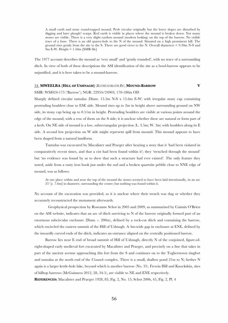
! %&!
A small earth and stone round-topped mound. Prob circular originally but the lower slopes are disturbed by digging and later plough? scarps. Red earth is visible in places where the mound is broken down. Not many stones are visible. There is a very slight earthen mound (modern looking) on the top of the barrow. No visible trace of a fosse. There is an old quarry-hole to the N of the mound. Situated on a high prominent hill. The ground rises gently from the site to the S. There are good views to the N. Overall diameters = 9.30m N-S and 9m E-W. Height = 1.50m [SMR file]
The 1977 account describes the mound as ‘very small’ and ‘gently rounded’, with no trace of a surrounding
ditch. In view of both of these descriptions the ASI identification of the site as a bowl-barrow appears to be
unjustified, and it is here taken to be a mound-barrow.
34. MWEELRA (HILL OF USHNAGH) (RATHCONRATH BY), MOUND-BARROW V
SMR: WM024-173 (‘Barrow’); NGR: 22954/24903; 170-180m OD
Sharply defined circular tumulus (Diam. 15.5m N-S x 15.6m E-W) with irregular stony cap containing
protruding boulders close to ESE side. Mound rises up to 2m in height above surrounding ground on NW
side, its stony cap being up to 0.51m in height. Protruding boulders are visible at various points around the
edge of the mound, with a row of them on the S side; it is unclear whether these are natural or form part of
a kerb. On NE side of mound is a low, subrectangular projection (L. 3.5m; W. 3m) with boulders along its E
side. A second low projection on W side might represent spill from mound. This mound appears to have
been shaped from a natural landform.
Tumulus was excavated by Macalister and Praeger after hearing a story that it ‘had been violated in
comparatively recent times, and that a cist had been found within it’; they ‘trenched through the mound’
but ‘no evidence was found by us to shew that such a structure had ever existed’. The only feature they
noted, aside from a rusty iron hook just under the sod and a broken quartzite pebble close to NNE edge of
mound, was as follows:
At one place within and near the top of the mound the stones seemed to have been laid intentionally, in an arc 25’ [c. 7.6m] in diameter, surrounding the centre; but nothing was found within it.
No account of the excavation was provided, so it is unclear where their trench was dug or whether they
accurately reconstructed the monument afterwards.
Geophysical prospection by Roseanne Schot in 2005 and 2009, as summarised by Caimin O’Brien
on the ASI website, indicates that an arc of ditch surviving to N of the barrow originally formed part of an
enormous subcircular enclosure (Diam. c. 200m), defined by a rock-cut ditch and containing the barrow,
which encircled the eastern summit of the Hill of Ushnagh. A 4m-wide gap in enclosure at ENE, defined by
the inwardly curved ends of the ditch, indicates an entrance aligned on the centrally positioned barrow.
Barrow lies near E end of broad summit of Hill of Ushnagh, directly N of the conjoined, figure-of-
eight-shaped early medieval fort excavated by Macalister and Praeger, and precisely on a line that takes in
part of the ancient avenue approaching this fort from the S and continues on to the Togherstown ringfort
and tumulus at the north end of the Uisneach complex. There is a small, shallow pond 21m to N; farther N
again is a larger kettle-hole lake, beyond which is another barrow (No. 35). Frewin Hill and Knockdrin, sites
of hilltop barrows (McGuinness 2012, 28, 34-5), are visible to NE and ENE respectively.
REFERENCES: Macalister and Praeger 1928, 83, Fig. 2, No. 15; Schot 2006, 45, Fig. 2, Pl. 4
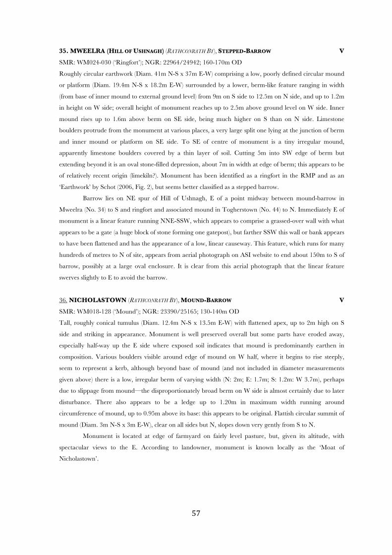
! %'!
35. MWEELRA (HILL OF USHNAGH) (RATHCONRATH BY), STEPPED-BARROW V
SMR: WM024-030 (‘Ringfort’); NGR: 22964/24942; 160-170m OD
Roughly circular earthwork (Diam. 41m N-S x 37m E-W) comprising a low, poorly defined circular mound
or platform (Diam. 19.4m N-S x 18.2m E-W) surrounded by a lower, berm-like feature ranging in width
(from base of inner mound to external ground level) from 9m on S side to 12.5m on N side, and up to 1.2m
in height on W side; overall height of monument reaches up to 2.5m above ground level on W side. Inner
mound rises up to 1.6m above berm on SE side, being much higher on S than on N side. Limestone
boulders protrude from the monument at various places, a very large split one lying at the junction of berm
and inner mound or platform on SE side. To SE of centre of monument is a tiny irregular mound,
apparently limestone boulders covered by a thin layer of soil. Cutting 5m into SW edge of berm but
extending beyond it is an oval stone-filled depression, about 7m in width at edge of berm; this appears to be
of relatively recent origin (limekiln?). Monument has been identified as a ringfort in the RMP and as an
‘Earthwork’ by Schot (2006, Fig. 2), but seems better classified as a stepped barrow.
Barrow lies on NE spur of Hill of Ushnagh, E of a point midway between mound-barrow in
Mweelra (No. 34) to S and ringfort and associated mound in Togherstown (No. 44) to N. Immediately E of
monument is a linear feature running NNE-SSW, which appears to comprise a grassed-over wall with what
appears to be a gate (a huge block of stone forming one gatepost), but farther SSW this wall or bank appears
to have been flattened and has the appearance of a low, linear causeway. This feature, which runs for many
hundreds of metres to N of site, appears from aerial photograph on ASI website to end about 150m to S of
barrow, possibly at a large oval enclosure. It is clear from this aerial photograph that the linear feature
swerves slightly to E to avoid the barrow.
36. NICHOLASTOWN (RATHCONRATH BY), MOUND-BARROW V
SMR: WM018-128 (‘Mound’); NGR: 23390/25165; 130-140m OD
Tall, roughly conical tumulus (Diam. 12.4m N-S x 13.5m E-W) with flattened apex, up to 2m high on S
side and striking in appearance. Monument is well preserved overall but some parts have eroded away,
especially half-way up the E side where exposed soil indicates that mound is predominantly earthen in
composition. Various boulders visible around edge of mound on W half, where it begins to rise steeply,
seem to represent a kerb, although beyond base of mound (and not included in diameter measurements
given above) there is a low, irregular berm of varying width (N: 2m; E: 1.7m; S: 1.2m: W 3.7m), perhaps
due to slippage from mound—the disproportionately broad berm on W side is almost certainly due to later
disturbance. There also appears to be a ledge up to 1.20m in maximum width running around
circumference of mound, up to 0.95m above its base: this appears to be original. Flattish circular summit of
mound (Diam. 3m N-S x 3m E-W), clear on all sides but N, slopes down very gently from S to N.
Monument is located at edge of farmyard on fairly level pasture, but, given its altitude, with
spectacular views to the E. According to landowner, monument is known locally as the ‘Moat of
Nicholastown’.
! %(!
37. RAHUGH (MOYCASHEL BY), BOWL-BARROW (FIGS 23-4) V
SMR: WM038-038 (‘Barrow’); NGR: 23691/23236; 90-100m OD
Large circular mound (Diam. 13m N-S x 13.3m E-W), domed in appearance with slightly flattened upper
surface at edge of which is a mature beech; a much silted-up ditch up to 2.2m in width is visible around the
base of the mound running clockwise from NE to SW, being absent or difficult to trace elsewhere. Where
ditch is clearest on NE side, the natural ground just beyond it rises higher than surrounding areas, giving
the illusory impression of an outer bank. Mound rises up to 1.95m in height on NW side, where
surrounding ground is lowest and ditch is barely visible. Although summit of eminence on which it lies (see
below) slopes down from SE to NW, flattish upper surface of mound appears level when viewed from NE,
SE side of mound being much lower than NW side. In the SMR file are a good plan and profile of the
barrow and the flat summit of the knoll on which it lies.
Fig. 23: Bowl-Barrow at Rahugh (No. 37) from the west (2m scale)
Monument is very prominently sited on the flattened summit of a striking landform, apparently a
kame with dry kettle-hole lake close by to SW, at the N end of an esker ridge (FitzPatrick 2005, 270-71) in a
heavily glaciated landscape littered with kames (pers comm. Seamus O’Brien). The Slieve Blooms dominate
the view to the S; Knockastia and Croghan Hill, each with burial mounds (see No. 13), are prominent to
NW and E respectively; Ardan Hill, capped by a mound-barrow (No. 1), is visible to N.
Monument lies on Knockbo Hill c. 700m to NW of graveyard marking the core of the important
early medieval monastery of Rahugh (Ráith Áeda), of which little remains but a ruined medieval church
partly surrounded by an early medieval earthen bank or vallum, along with St. Hugh’s Well and his birth-
! %)!
stone (a monumental early medieval cross-slab with large central cupmark shaped like the crown of an
infant’s head, venerated since ancient times for its headache cures). FitzPatrick (2005) makes a convincing
case for identifying Knockbo Hill and its bowl-barrow as the Cnoc Buadha of early medieval times, where the
Clann Cholmáin king—and titular King of Ireland—Máel Sechnaill staged an important rígdál or political
conference in AD 859. In later times it was the inauguration site of the Mageoghegans (Mac Eochagáin),
chiefs of the Clann Cholmáin subkingdom of Cenél Fiachach. The barrow was linked visually and possibly
by a processional way to the important monastery of Rahugh, supposed birthplace of its founder, the Cenél
Fiachach saint Áed mac Bricc; less than 1km to SE in Lowerstown, FitzPatrick draws attention to an
impressive bivallate ringfort and associated standing stone, another possible location for Máel Sechnaill’s
rígdál.
REFERENCES: Hogan 1910, 566; FitzPatrick 2004, 44, Fig. 4, Pl. 8; 2005, 271-5, Fig. 1, Pls 3-5
Fig. 24: Landscape around bowl-barrow No. 37) on Knockbo Hill (Cnoc Buadha) and remains of monastery of Rahugh, after
FitzPatrick (2005, Fig. 1)
38. RATHNEW (HILL OF USHNAGH) (RATHCONRATH BY), RING-BARROW (DESTROYED) V
SMR: — ; NGR: na
Monument was not located by the survey-team after repeated searches of the areas indicated by Macalister
and Praeger (1928, Fig. 2) and by Schot (2006, Pl. 2), and appears to have been removed. From Macalister
and Praeger’s statement that this earthwork was ‘identical in character’ with No. 48 below, it is clear that
this monument was a ring-barrow. Their account (1928, 83) is as follows:
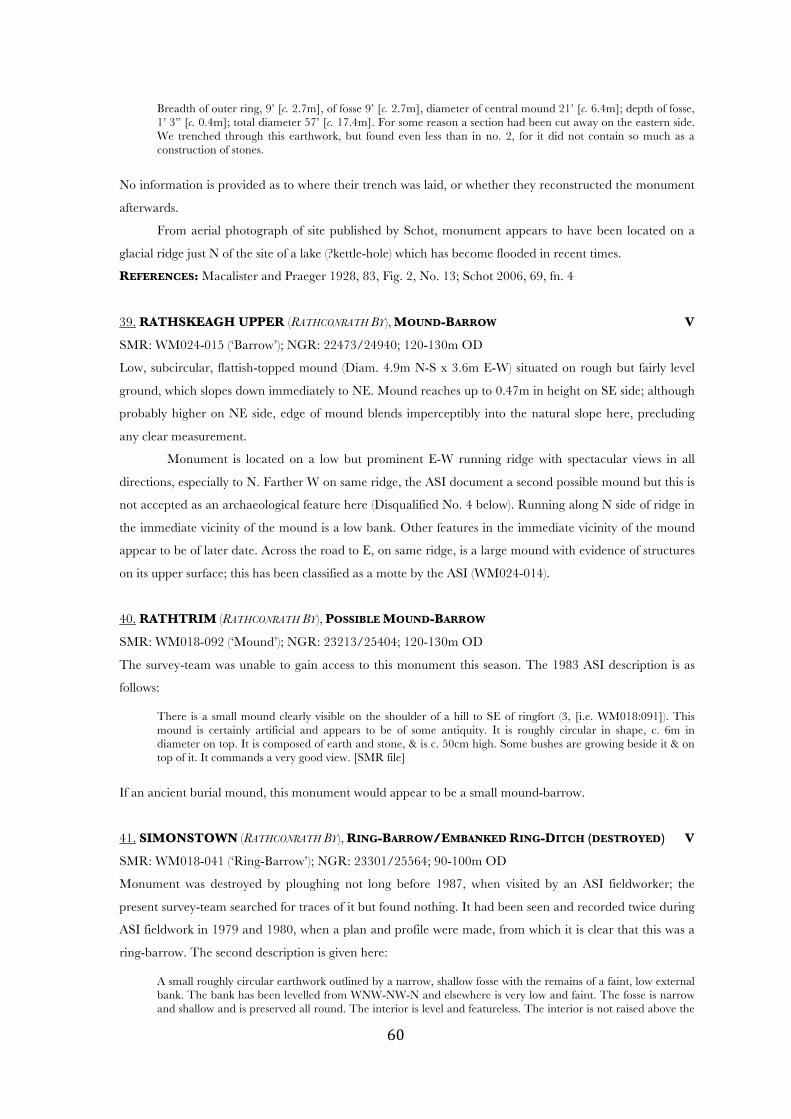
! &+!
Breadth of outer ring, 9’ [c. 2.7m], of fosse 9’ [c. 2.7m], diameter of central mound 21’ [c. 6.4m]; depth of fosse, 1’ 3” [c. 0.4m]; total diameter 57’ [c. 17.4m]. For some reason a section had been cut away on the eastern side. We trenched through this earthwork, but found even less than in no. 2, for it did not contain so much as a construction of stones.
No information is provided as to where their trench was laid, or whether they reconstructed the monument
afterwards.
From aerial photograph of site published by Schot, monument appears to have been located on a
glacial ridge just N of the site of a lake (?kettle-hole) which has become flooded in recent times.
REFERENCES: Macalister and Praeger 1928, 83, Fig. 2, No. 13; Schot 2006, 69, fn. 4
39. RATHSKEAGH UPPER (RATHCONRATH BY), MOUND-BARROW V
SMR: WM024-015 (‘Barrow’); NGR: 22473/24940; 120-130m OD
Low, subcircular, flattish-topped mound (Diam. 4.9m N-S x 3.6m E-W) situated on rough but fairly level
ground, which slopes down immediately to NE. Mound reaches up to 0.47m in height on SE side; although
probably higher on NE side, edge of mound blends imperceptibly into the natural slope here, precluding
any clear measurement.
Monument is located on a low but prominent E-W running ridge with spectacular views in all
directions, especially to N. Farther W on same ridge, the ASI document a second possible mound but this is
not accepted as an archaeological feature here (Disqualified No. 4 below). Running along N side of ridge in
the immediate vicinity of the mound is a low bank. Other features in the immediate vicinity of the mound
appear to be of later date. Across the road to E, on same ridge, is a large mound with evidence of structures
on its upper surface; this has been classified as a motte by the ASI (WM024-014).
40. RATHTRIM (RATHCONRATH BY), POSSIBLE MOUND-BARROW
SMR: WM018-092 (‘Mound’); NGR: 23213/25404; 120-130m OD
The survey-team was unable to gain access to this monument this season. The 1983 ASI description is as
follows:
There is a small mound clearly visible on the shoulder of a hill to SE of ringfort (3, [i.e. WM018:091]). This mound is certainly artificial and appears to be of some antiquity. It is roughly circular in shape, c. 6m in diameter on top. It is composed of earth and stone, & is c. 50cm high. Some bushes are growing beside it & on top of it. It commands a very good view. [SMR file]
If an ancient burial mound, this monument would appear to be a small mound-barrow.
41. SIMONSTOWN (RATHCONRATH BY), RING-BARROW/EMBANKED RING-DITCH (DESTROYED) V
SMR: WM018-041 (‘Ring-Barrow’); NGR: 23301/25564; 90-100m OD
Monument was destroyed by ploughing not long before 1987, when visited by an ASI fieldworker; the
present survey-team searched for traces of it but found nothing. It had been seen and recorded twice during
ASI fieldwork in 1979 and 1980, when a plan and profile were made, from which it is clear that this was a
ring-barrow. The second description is given here:
A small roughly circular earthwork outlined by a narrow, shallow fosse with the remains of a faint, low external bank. The bank has been levelled from WNW-NW-N and elsewhere is very low and faint. The fosse is narrow and shallow and is preserved all round. The interior is level and featureless. The interior is not raised above the
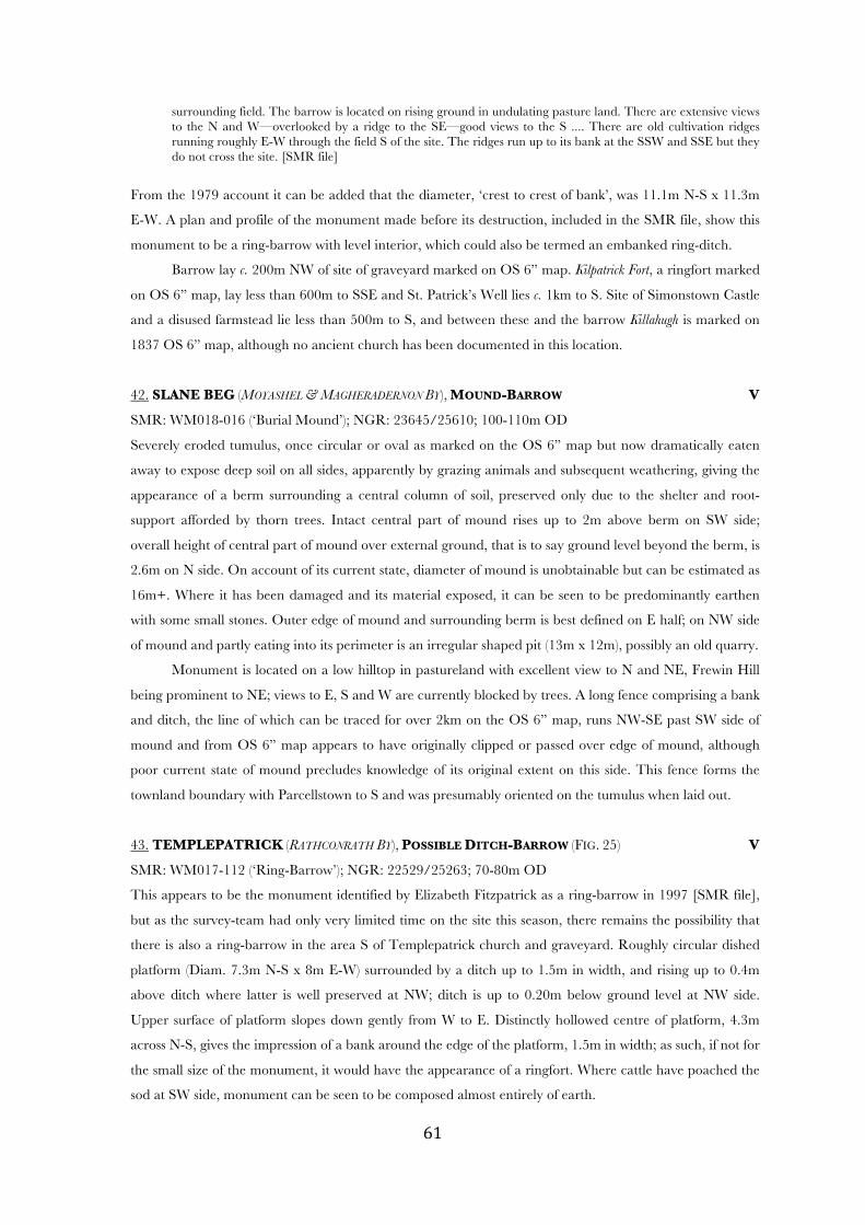
! &*!
surrounding field. The barrow is located on rising ground in undulating pasture land. There are extensive views to the N and W—overlooked by a ridge to the SE—good views to the S .... There are old cultivation ridges running roughly E-W through the field S of the site. The ridges run up to its bank at the SSW and SSE but they do not cross the site. [SMR file]
From the 1979 account it can be added that the diameter, ‘crest to crest of bank’, was 11.1m N-S x 11.3m
E-W. A plan and profile of the monument made before its destruction, included in the SMR file, show this
monument to be a ring-barrow with level interior, which could also be termed an embanked ring-ditch.
Barrow lay c. 200m NW of site of graveyard marked on OS 6” map. Kilpatrick Fort, a ringfort marked
on OS 6” map, lay less than 600m to SSE and St. Patrick’s Well lies c. 1km to S. Site of Simonstown Castle
and a disused farmstead lie less than 500m to S, and between these and the barrow Killahugh is marked on
1837 OS 6” map, although no ancient church has been documented in this location.
42. SLANE BEG (MOYASHEL & MAGHERADERNON BY), MOUND-BARROW V
SMR: WM018-016 (‘Burial Mound’); NGR: 23645/25610; 100-110m OD
Severely eroded tumulus, once circular or oval as marked on the OS 6” map but now dramatically eaten
away to expose deep soil on all sides, apparently by grazing animals and subsequent weathering, giving the
appearance of a berm surrounding a central column of soil, preserved only due to the shelter and root-
support afforded by thorn trees. Intact central part of mound rises up to 2m above berm on SW side;
overall height of central part of mound over external ground, that is to say ground level beyond the berm, is
2.6m on N side. On account of its current state, diameter of mound is unobtainable but can be estimated as
16m+. Where it has been damaged and its material exposed, it can be seen to be predominantly earthen
with some small stones. Outer edge of mound and surrounding berm is best defined on E half; on NW side
of mound and partly eating into its perimeter is an irregular shaped pit (13m x 12m), possibly an old quarry.
Monument is located on a low hilltop in pastureland with excellent view to N and NE, Frewin Hill
being prominent to NE; views to E, S and W are currently blocked by trees. A long fence comprising a bank
and ditch, the line of which can be traced for over 2km on the OS 6” map, runs NW-SE past SW side of
mound and from OS 6” map appears to have originally clipped or passed over edge of mound, although
poor current state of mound precludes knowledge of its original extent on this side. This fence forms the
townland boundary with Parcellstown to S and was presumably oriented on the tumulus when laid out.
43. TEMPLEPATRICK (RATHCONRATH BY), POSSIBLE DITCH-BARROW (FIG. 25) V
SMR: WM017-112 (‘Ring-Barrow’); NGR: 22529/25263; 70-80m OD
This appears to be the monument identified by Elizabeth Fitzpatrick as a ring-barrow in 1997 [SMR file],
but as the survey-team had only very limited time on the site this season, there remains the possibility that
there is also a ring-barrow in the area S of Templepatrick church and graveyard. Roughly circular dished
platform (Diam. 7.3m N-S x 8m E-W) surrounded by a ditch up to 1.5m in width, and rising up to 0.4m
above ditch where latter is well preserved at NW; ditch is up to 0.20m below ground level at NW side.
Upper surface of platform slopes down gently from W to E. Distinctly hollowed centre of platform, 4.3m
across N-S, gives the impression of a bank around the edge of the platform, 1.5m in width; as such, if not for
the small size of the monument, it would have the appearance of a ringfort. Where cattle have poached the
sod at SW side, monument can be seen to be composed almost entirely of earth.
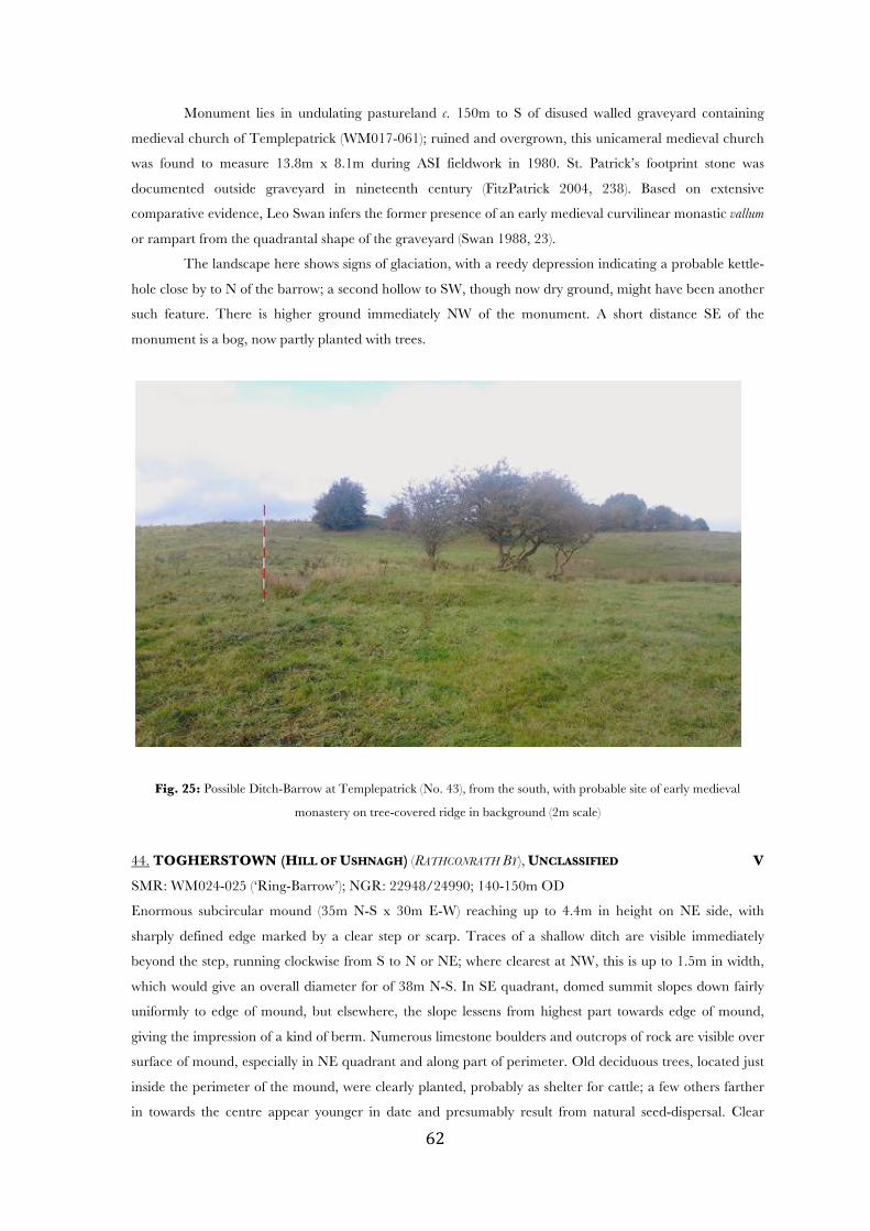
! &"!
Monument lies in undulating pastureland c. 150m to S of disused walled graveyard containing
medieval church of Templepatrick (WM017-061); ruined and overgrown, this unicameral medieval church
was found to measure 13.8m x 8.1m during ASI fieldwork in 1980. St. Patrick’s footprint stone was
documented outside graveyard in nineteenth century (FitzPatrick 2004, 238). Based on extensive
comparative evidence, Leo Swan infers the former presence of an early medieval curvilinear monastic vallum
or rampart from the quadrantal shape of the graveyard (Swan 1988, 23).
The landscape here shows signs of glaciation, with a reedy depression indicating a probable kettle-
hole close by to N of the barrow; a second hollow to SW, though now dry ground, might have been another
such feature. There is higher ground immediately NW of the monument. A short distance SE of the
monument is a bog, now partly planted with trees.
Fig. 25: Possible Ditch-Barrow at Templepatrick (No. 43), from the south, with probable site of early medieval
monastery on tree-covered ridge in background (2m scale)
44. TOGHERSTOWN (HILL OF USHNAGH) (RATHCONRATH BY), UNCLASSIFIED V
SMR: WM024-025 (‘Ring-Barrow’); NGR: 22948/24990; 140-150m OD
Enormous subcircular mound (35m N-S x 30m E-W) reaching up to 4.4m in height on NE side, with
sharply defined edge marked by a clear step or scarp. Traces of a shallow ditch are visible immediately
beyond the step, running clockwise from S to N or NE; where clearest at NW, this is up to 1.5m in width,
which would give an overall diameter for of 38m N-S. In SE quadrant, domed summit slopes down fairly
uniformly to edge of mound, but elsewhere, the slope lessens from highest part towards edge of mound,
giving the impression of a kind of berm. Numerous limestone boulders and outcrops of rock are visible over
surface of mound, especially in NE quadrant and along part of perimeter. Old deciduous trees, located just
inside the perimeter of the mound, were clearly planted, probably as shelter for cattle; a few others farther
in towards the centre appear younger in date and presumably result from natural seed-dispersal. Clear

! &#!
traces of a dry-walled revetment to the stepped edge of the mound on SW, S and E sides may relate to the
same episode of landscaping that involved the planting of trees; the step is best preserved where the walling
has survived, reaching up to 0.84m in height.
Macalister and Praeger ‘examined’ the mound ‘with no satisfactory results’. They had taken it ‘for
a mound of stones, possibly a large artificial carn’, but it ‘proved to be a mere outcrop of much decomposed
rock’. Their ‘examination’ presumably involved some kind of excavation but no record of this has been left.
Their dismissal of the site as ‘a mere outcrop’ is completely inconsistent with its current appearance, that of
an artificially shaped mound, although substantial areas of outcrop were clearly incorporated into it by its
builders; its location in immediate proximity to a large ringfort-like structure (see below) is also consistent
with an artificial origin. Presumably with similar reservations about Macalister and Praeger’s conclusions,
Schot marks it as a ‘Barrow/mound’ on her map of the Uisneach complex.
Monument lies on a low eminence just 8m to NNW of the large and complex bivallate ringfort
excavated by Macalister and Praeger (1931); prehistoric rock art reused in this fort (O’Reilly 2010) was
conceivably taken from the barrow. At least one other ringfort (WM024-027) lies close by to W.
REFERENCES: Macalister and Praeger 1928, 84, Fig. 2, No. 18; 1931, 83; Schot 2006, Fig. 2
45. TUITESTOWN (MOYASHEL & MAGHERADERNON BY), BOWL-BARROW (FIG. 26) V
SMR: WM018-133 (‘Barrow’); NGR: 23695/25179; 120-130m OD
Roughly conical tumulus (Diam. 10.4m N-S x 8.9m E-W) with flattened summit and fairly well defined
edge, up to 1.40m in height on N side; traces of a much-silted ditch are visible on the S and SE sides where
it is up to 2.8m in width. Flattish summit of mound slopes down to NE, although the overall impression
when seen from the SW end of the ridge is that the upper surface of the mound has been kept level in spite
of the widely varying micro-topography.
Mound is located on NE summit of striking glacial landform comprising a NE-SW running ridge
with high points at NE and SW ends and a saddle between, the overall feature appearing like a small steep
hill rising from the broad summit of a larger hill. Faint curvilinear earthworks on SW summit, 38m from the
mound-barrow, appear to indicate the presence of one or two barrows (No. 46-7) The entire basal
perimeter of this landform has been delimited by a low bank, scarp or step, outside which is a much-silted
ditch, best preserved on the SE side where it is 2.5m in width. The enclosure thus formed is roughly D-
shaped (c. 100m NE-SW x c. 80m NW-SE). A low bank, with a possible ditch on its uphill SE side, runs in a
SW direction from a point 4.2m NW of mound-barrow obliquely down the slope of NW side of ridge;
where best preserved, near its ENE end, this is c. 2.4m in width and rises c. 0.35m above the ‘ditch’.
Clearest for a 37m stretch, this appears to terminate before reaching the perimeter of the D-shaped
enclosure, but at its NE end aerial photographs on the OSI website suggest that it might continue past the
mound-barrow, partly clipping off a sector of the D-shaped enclosure on the NW side (Fig. 26). Running
from midway along the best-preserved stretch of this bank towards the mound-barrow, but not connected to
either, is another stretch of low bank, best seen on OSI aerial photographs. Material has been removed
from various parts of the ridge for sand or top-dressing, leaving large hollows.
Monument is located on hilltop in lush pastureland, and but for trees the view would be extensive
in all directions. On a low hilltop in Ballynaclin townalnd c. 1km to NE, across the valley through which the

! &$!
Royal Canal passes, is an enormous hengiform or barrow-like monument with a mound and other internal
features (McGuinness 2012, 36-7).
Fig. 26: Striking landform delimited by bank or scarp and ditch at Tuitestown, containing Bowl-Barrow (A, No. 45)
and one or two possible barrows (B, Nos 46-7), with low bank running NE-SW (Traced from OSI aerial photograph)
46-47. TUITESTOWN (MOYASHEL & MAGHERADERNON BY), POSSIBLE BARROWS (2) (FIG. 26) V
SMR: WM018-146 (‘Barrow’); NGR: 23693/25173; 120-130m OD
Very low relief, roughly circular earthworks 38m from a mound-barrow (No. 45) on SW summit of a
striking and anciently embanked glacial landform, itself rising dramatically from a hilltop, appear to
indicate the presence of one or two barrows. The northernmost example, which would be the smaller of the
two (Diam. c. 5.5m), comprises a bank surrounding a hollowed area, as in a pond-barrow. The southern one
is similar (Diam. c. 12.5m NE-SW) but with a possible low mound at the centre.
In the absence of other visible evidence, other readings of these features are possible. It is worth
noting that two separate ASI fieldworkers, who examined the site in 1980 and 1981, saw only a single oval
barrow at this location, measuring c. 20m NW-SE x c. 16m NE-SW. The first account is given here:
This is a small oval area outlined by the remains of a shallow and narrow fosse with a low outer bank of earth. The bank is rather poorly preserved but is visible from W-NNW & from NNE-E-S & from SE-E-W. It is situated on the top of the natural slope. The fosse is shallow & rather poorly preserved but is discernible all round. The interior is not raised above the ground outside & appears somewhat defaced. This appears to be a poorly preserved ring-barrow [SMR file]
The present writer examined the Tuitestown complex of earthworks on a single visit before having
read these ASI accounts. As with other low visibility earthworks, further visits may force him to revise his
interpretation.
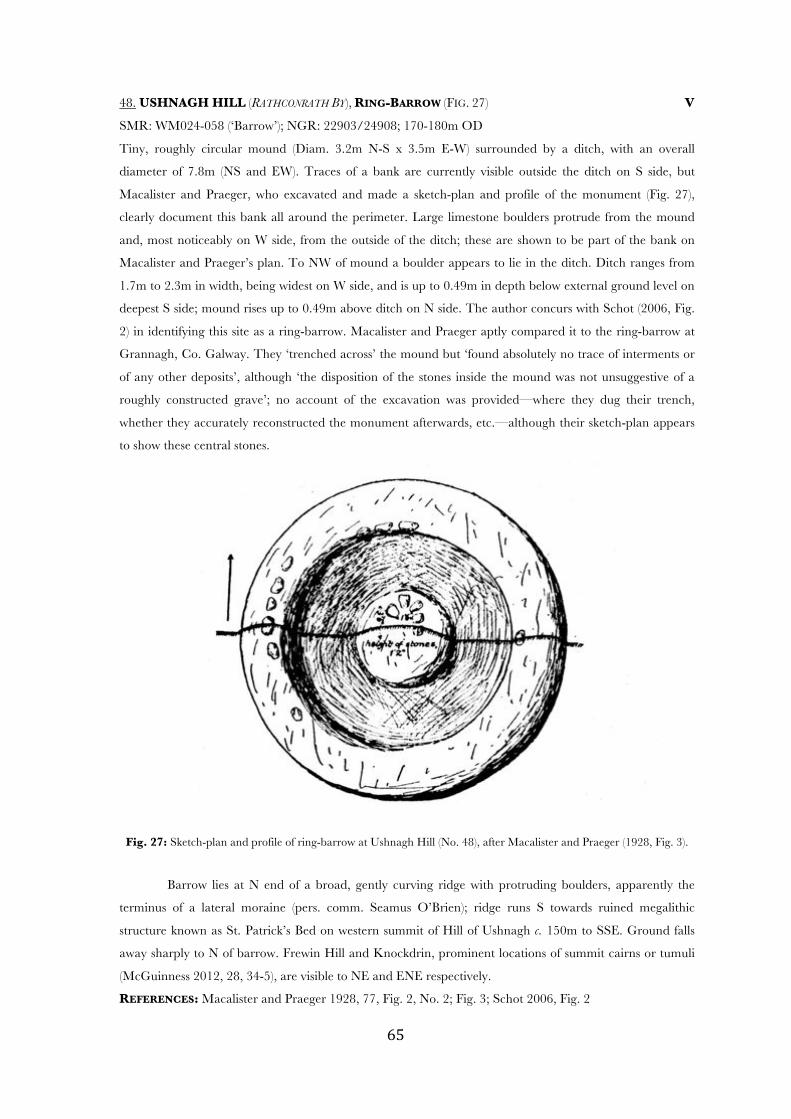
! &%!
48. USHNAGH HILL (RATHCONRATH BY), RING-BARROW (FIG. 27) V
SMR: WM024-058 (‘Barrow’); NGR: 22903/24908; 170-180m OD
Tiny, roughly circular mound (Diam. 3.2m N-S x 3.5m E-W) surrounded by a ditch, with an overall
diameter of 7.8m (NS and EW). Traces of a bank are currently visible outside the ditch on S side, but
Macalister and Praeger, who excavated and made a sketch-plan and profile of the monument (Fig. 27),
clearly document this bank all around the perimeter. Large limestone boulders protrude from the mound
and, most noticeably on W side, from the outside of the ditch; these are shown to be part of the bank on
Macalister and Praeger’s plan. To NW of mound a boulder appears to lie in the ditch. Ditch ranges from
1.7m to 2.3m in width, being widest on W side, and is up to 0.49m in depth below external ground level on
deepest S side; mound rises up to 0.49m above ditch on N side. The author concurs with Schot (2006, Fig.
2) in identifying this site as a ring-barrow. Macalister and Praeger aptly compared it to the ring-barrow at
Grannagh, Co. Galway. They ‘trenched across’ the mound but ‘found absolutely no trace of interments or
of any other deposits’, although ‘the disposition of the stones inside the mound was not unsuggestive of a
roughly constructed grave’; no account of the excavation was provided—where they dug their trench,
whether they accurately reconstructed the monument afterwards, etc.—although their sketch-plan appears
to show these central stones.
Fig. 27: Sketch-plan and profile of ring-barrow at Ushnagh Hill (No. 48), after Macalister and Praeger (1928, Fig. 3).
Barrow lies at N end of a broad, gently curving ridge with protruding boulders, apparently the
terminus of a lateral moraine (pers. comm. Seamus O’Brien); ridge runs S towards ruined megalithic
structure known as St. Patrick’s Bed on western summit of Hill of Ushnagh c. 150m to SSE. Ground falls
away sharply to N of barrow. Frewin Hill and Knockdrin, prominent locations of summit cairns or tumuli
(McGuinness 2012, 28, 34-5), are visible to NE and ENE respectively.
REFERENCES: Macalister and Praeger 1928, 77, Fig. 2, No. 2; Fig. 3; Schot 2006, Fig. 2

! &&!
DISQUALIFIED
1. DAVIDSTOWN (RATHCONRATH BY) V
SMR: WM018-033 (‘Mound’); NGR: 23113/25542; 90-100m OD
Small, roughly circular, flattish-topped mound (Diam. 5.5m) up to 0.75m in height, stony in composition and
revetted by a loose dry-built wall probably of recent origin; edge of mound is noticeably flattened on SE side.
Surrounding the mound is a low earthen berm about 2m in width. Monument is located on a low rise in
pastureland and has a lone thorn tree beside it. Although it is fairly prominently sited it is difficult to see how this
could be classified as a prehistoric burial mound, even one that has been modified with drystone revetment
added; it bears comparison with the revetted mound at Laragh (Dis. 3), even more prominently sited, and might
like it represent a recent pilgrimage station.
Although appearance and dimensions differ appreciably, this appears to be the monument described by
the ASI in 1983 as ‘a small mound of earth with some stone incorporated into it. The mound is 1!m high and is
c. 3m diameter E-W. A bush is growing on the top of the mound on N side’ [SMR file]. Certainly no other
mound is visible in this area and the landowner did not know of any.
2. DYSART (MOYASHEL & MAGHERADERNON BY)
SMR: WM025-070 (‘Mound’); NGR: 23689/24833; 100-110m OD
This monument was described by an ASI fieldworker in 1982 as ‘an earthen mound, rectangular in shape, flat-
topped, measuring 24m N-S, by 8m-10m E-W, and rising to a height of 3.5m, the surface area of the flat top is
12m by 4.5m’ [SMR file]. It was suggested from its location that it might have been a landscape feature, although
it appeared more ancient than this. Its sharply rectilinear shape, as indicated in a rough sketch by same ASI
fieldworker, is certainly inconsistent with prehistoric earthen burial mounds, and it is rejected as one here.
3. LARAGH (MOYGOISH BY) V
SMR: WM018-001 (‘Mound’); NGR: 23152/25722; 120-130m OD
Roughly pointed-oval or eye-shaped mound (10m x 5.5m), its long axis running ENE-WSW, revetted by slabs of
stone and dry-walling up to 1m in height, possibly ancient, with a roughly constructed stone chair at edge on SE
side. Central part of mound rises slightly above revetment. A small modern stature of St. Patrick in a concrete
shelter stands a short distance to SSE. Stone chair is named after St. Patrick and resembles a rough stone chair
constructed beside a mass-rock in Rathduff townland about 1km to S. Mound lies at cross-roads and road clearly
curves around it on N side, indicating its presence here when the infrastructure was developed. Although this
mound cannot be classified as a prehistoric barrow on the basis of its current appearance, and has clearly
functioned in and been shaped by recent pilgrimage tradition, it is nonetheless located near the summit of the
prominent Hill of Laragh 1km to NW of a genuine mound-barrow or cairn (No. 12) and conceivably represents
an altered or reused burial mound.
4. RATHSKEAGH UPPER (RATHCONRATH BY) V
SMR: WM024-015 (‘Barrow’); NGR: 22473/24940; 120-130m OD
What appears to be the second of two possible barrows recorded during ASI fieldwork on E-W running ridge,
24m to W of a genuine barrow (No. 39), seemed to the present survey-team to be overgrown rock outcrop.
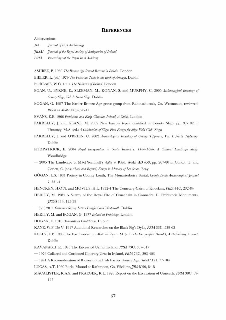
! &'!
REFERENCES
Abbreviations:
JIA Journal of Irish Archaeology
JRSAI Journal of the Royal Society of Antiquaries of Ireland
PRIA Proceedings of the Royal Irish Academy
ASHBEE, P. 1960 The Bronze Age Round Barrow in Britain. London
BIELER, L. (ed.) 1979 The Patrician Texts in the Book of Armagh. Dublin
BORLASE, W.C. 1897 The Dolmens of Ireland. London
EGAN, U., BYRNE, E., SLEEMAN, M., RONAN, S. and MURPHY, C. 2005 Archaeological Inventory of
County Sligo, Vol. I: South Sligo. Dublin
EOGAN, G. 1997 The Earlier Bronze Age grave-group from Rahinashurock, Co. Westmeath, reviewed,
Ríocht na Midhe IX(3), 28-45
EVANS, E.E. 1966 Prehistoric and Early Christian Ireland, A Guide. London
FARRELLY, J. and KEANE, M. 2002 New barrow types identified in County Sligo, pp. 97-102 in
Timoney, M.A. (ed.) A Celebration of Sligo: First Essays for Sligo Field Club. Sligo
FARRELLY, J. and O’BRIEN, C. 2002 Archaeological Inventory of County Tipperary, Vol. I: North Tipperary.
Dublin
FITZPATRICK, E. 2004 Royal Inauguration in Gaelic Ireland c. 1100-1600: A Cultural Landscape Study.
Woodbridge
— 2005 The Landscape of Máel Sechnaill’s rígdál at Ráith Áeda, AD 859, pp. 267-80 in Condit, T. and
Corlett, C. (eds) Above and Beyond, Essays in Memory of Leo Swan. Bray
GÓGAN, L.S. 1931 Pottery in County Louth, The Monasterboice Burial, County Louth Archaeological Journal
7, 331-4
HENCKEN, H.O’N. and MOVIUS, H.L. 1932-4 The Cemetery-Cairn of Knockast, PRIA 41C, 232-84
HERITY, M. 1984 A Survey of the Royal Site of Cruachain in Connacht, II. Prehistoric Monuments,
JRSAI 114, 125-38
— (ed.) 2011 Ordnance Survey Letters Longford and Westmeath. Dublin
HERITY, M. and EOGAN, G. 1977 Ireland in Prehistory. London
HOGAN, E. 1910 Onomasticon Goedelicum. Dublin
KANE, W.F. De V. 1917 Additional Researches on the Black Pig’s Dyke, PRIA 33C, 539-63
KELLY, E.P. 1983 The Earthworks, pp. 46-8 in Ryan, M. (ed.) The Derrynaflan Hoard I, A Preliminary Account.
Dublin
KAVANAGH, R. 1973 The Encrusted Urn in Ireland, PRIA 73C, 507-617
— 1976 Collared and Cordoned Cinerary Urns in Ireland, PRIA 76C, 293-403
— 1991 A Reconsideration of Razors in the Irish Earlier Bronze Age, JRSAI 121, 77-104
LUCAS, A.T. 1960 Burial Mound at Rathmoon, Co. Wicklow, JRSAI 90, 84-8
MACALISTER, R.A.S. and PRAEGER, R.L. 1928 Report on the Excavation of Uisneach, PRIA 38C, 69-
127
! &(!
MACALISTER, R.A.S. and PRAEGER, R.L. 1931 The Excavation of an Ancient Structure in the
Townland of Togherstown, Co. Westmeath, PRIA 39C, 54-99
MALLORY, J. 1995 Haughey’s Fort and the Navan Complex in the Late Bronze Age, pp. 73-87 in
Waddell, J. and Shee Twohig, E. (eds) Ireland in the Bronze Age, Proceedings of the Dublin Conference, April
1995. Dublin
MCGUINNESS, D. 2012 The Prehistoric Burial Mounds and Related Monuments of County Westmeath, I. Preliminary
Account of the Monuments in the Lough Owel Area (Barony of Corkaree and part of Barony of Moyashel &
Magheradernon). Project report for 2012 season, www.academia.edu.
MOUNT, C. 1997 Early Bronze Age Burial in South-East Ireland in the Light of Recent Research, PRIA
97C, 101-93
O’BRIEN, C. and SWEETMAN, P.D. 1997 Archaeological Inventory of County Offaly. Dublin
Ó RÍORDÁIN, B. 1969 Prehistoric Burials at the Bishop’s Bush, Knockmant, Co. Westmeath, JRSAI 99,
125-31
— 1997 A Bronze Age Cemetery Mound at Grange, Co. Roscommon, JIA 8, 43-72
Ó RÍORDÁIN, B. and WADDELL, J. 1993 The Funerary Bowls and Vases of the Irish Bronze Age. Galway
O’SULLIVAN, M. 2005 Duma na nGiall, The Mound of the Hostages, Tara. Bray
O’SULLIVAN, M. and DOWNEY, L. 2011 Rock Art, Archaeology Ireland 25(4), 15-18
— 2012 Burial Barrows, Archaeology Ireland 26(4), 33-7
O’REILLY, D. 2010 Some forgotten prehistoric rock art from the Hill of Uisneach, Co. Westmeath, JRSAI
140, 75-82
RMP 1996 Record of Monuments and Places, as Established under Section 12 of the National Monuments (Amendment) Act
1994, County Westmeath. Dublin
SCHOT, R. 2006 Uisneach Midi a medón Érenn: a prehistoric ‘cult’ centre and ‘royal site’ in Co. Westmeath,
JIA 15, 39-71
SHAW, T.J. 1921 Some Notes Regarding Slemain Midhe, the Probable Site of the Battlefield of Gairech
and Ilgairech, and other Places in Westmeath Referred to in the Táin Bo Cúailgne, JRSAI 51, 133-
46
SWAN, L. 1988 The Early Christian Ecclesiastical Sites of County Westmeath, pp. 3-31 in Bradley, J. (ed.)
Settlement and Society in Medieval Ireland. Kilkenny
TIMONEY, M.A. 1984 Earthen Burial Sites on the Carrowmore Peninsula, Co. Sligo, pp. 319-25 in
Burenhult, G. The Archaeology of Carrowmore. Stockholm
TUITE, J. 1913 Concentric Circle and Cup-marked Stone in Westmeath, JRSAI 43, 180-82
WADDELL, J. 1990 The Bronze Age Burials of Ireland. Galway
— 1998 The Prehistoric Archaeology of Ireland. Galway
WOOD-MARTIN, W.G. 1902 Traces of the Elder Faiths of Ireland (2 vols). London