The Open-Air Rock-Art Site at Leirfall, Central Norway, within the Context of Northern Scandinavian...
16
INTRODUCTION The open-air rock-art site at Leirfall, Central Norway, has been known since the early twentieth century. It is the largest locality in this region of Norway that is rich in open-air rock-art panels and is one of the few that is open to the public. For the past 50 years, it has acted as a field laboratory for in situ research into the documentation, conservation, and management of fully exposed, rural, open-air rock-art in Central Norway. Leirfall is rep- resentative of other exposed open-air rock-art sites and the management challenges confronting cultural heritage managers not only in this region but also across Northern Scandinavia. The aim of this chapter is to pres- ent the biography of Leirfall within the context of evolving developments in Norwegian and Northern Scandinavian open-air rock-art management practices and to further contribute more generally to discussions of site man- agement in cold regions. THE LEIRFALL SITE The Leirfall rock carvings are situated on the northern side of the east-west– orientated Stjørdal Valley, in the region of Trøndelag in Central Norway (63° 46′ N / 11° 32′ E), approximately 10 km east of Trondheim Fjord (Figure 6.1). These carvings form one of 20 known sites with Bronze Age– style rock carvings in the municipality of Stjørdal (Sognnes 2001). The site lies in damp terrain on the western side of Solemsbekken Creek at Leirfall farm. It comprises five separate exposed engraved panels (Leirfall I–V) executed on a naturally smoothed rock outcrop facing southeast. The panels are aligned more or less vertically up the steep wooded slope of an The Open-Air Rock-Art Site at Leirfall, Central Norway, within the Context of Northern Scandinavian Rock-Art Conservation and Management Practices over the Past 50 Years Elizabeth E. Peacock, Eva Lindgaard, Kalle Sognnes, Roar Sæterhaug, and Gordon Turner-Walker 6
Transcript of The Open-Air Rock-Art Site at Leirfall, Central Norway, within the Context of Northern Scandinavian...
INTRODUCTION
The open-air rock-art site at Leirfall, Central Norway, has been known since the early twentieth century. It is the largest locality in this region of Norway that is rich in open-air rock-art panels and is one of the few that is open to the public. For the past 50 years, it has acted as a field laboratory for in situ research into the documentation, conservation, and management of fully exposed, rural, open-air rock-art in Central Norway. Leirfall is rep-resentative of other exposed open-air rock-art sites and the management challenges confronting cultural heritage managers not only in this region but also across Northern Scandinavia. The aim of this chapter is to pres-ent the biography of Leirfall within the context of evolving developments in Norwegian and Northern Scandinavian open-air rock-art management practices and to further contribute more generally to discussions of site man-agement in cold regions.
THE LEIRFALL SITE
The Leirfall rock carvings are situated on the northern side of the east-west–orientated Stjørdal Valley, in the region of Trøndelag in Central Norway (63° 46′ N / 11° 32′ E), approximately 10 km east of Trondheim Fjord (Figure 6.1). These carvings form one of 20 known sites with Bronze Age–style rock carvings in the municipality of Stjørdal (Sognnes 2001).
The site lies in damp terrain on the western side of Solemsbekken Creek at Leirfall farm. It comprises five separate exposed engraved panels (Leirfall I–V) executed on a naturally smoothed rock outcrop facing southeast. The panels are aligned more or less vertically up the steep wooded slope of an
The Open-Air Rock-Art Site at Leirfall, Central Norway, within the Context of Northern Scandinavian Rock-Art Conservation and Management Practices over the Past 50 Years
Elizabeth E. Peacock, Eva Lindgaard, Kalle Sognnes, Roar Sæterhaug, and Gordon Turner-Walker
6
6244-0305-006.indd 82 4/16/2014 9:41:11 PM
Rock-Art Site at Leirfall, Central Norway 83
old river terrace bordered by cultivated fields. The tree cover comprises Norwegian spruce, birch, bird cherry, and grey alder, while the ground cover is grass, berry bushes, ferns, and shrubs.
The first panel (Leirfall I) was reported in the 1920s (Petersen 1926), and shortly after World War II, two further panels (II and III) were discovered. Leirfall I and II are located alongside the creek, whereas the larger Leirfall III panel lies approximately 50 m to the west at the same elevation as Leirfall II. Marstrander (1970) began documenting the carvings in the early 1960s,and during his work two more panels were found nearby: Leirfall IV and V. The site was purchased by the Norwegian government in 1971. It is curated by the NTNU University Museum together with Nord-Trøndelag County Council, with maintenance and conservation financed by the Norwegian Directorate for Cultural Heritage.
The rock outcrop at Leirfall is medium-grained, calcite-rich greywacke sandstone with a porous outer weathering zone where quartz, muscovite, and calcite are the dominant minerals. Other minerals present are chlorite,
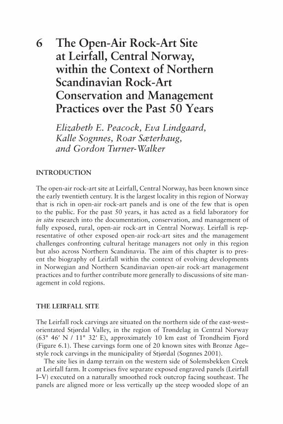
Figure 6.1 Map of Scandinavia showing the location of the Leirfall rock-art site in central Norway (•). Other rock-art sites referred to in the text (♦): Hjemmeluft, Vingen, Ekeberg, and Begby in northern, western, and southern (2) Norway respectively, and Litsleby in western Sweden. (Map: Turner-Walker and Peacock after Sognnes)
6244-0305-006.indd 83 4/16/2014 9:41:11 PM
84 E. E. Peacock et al.
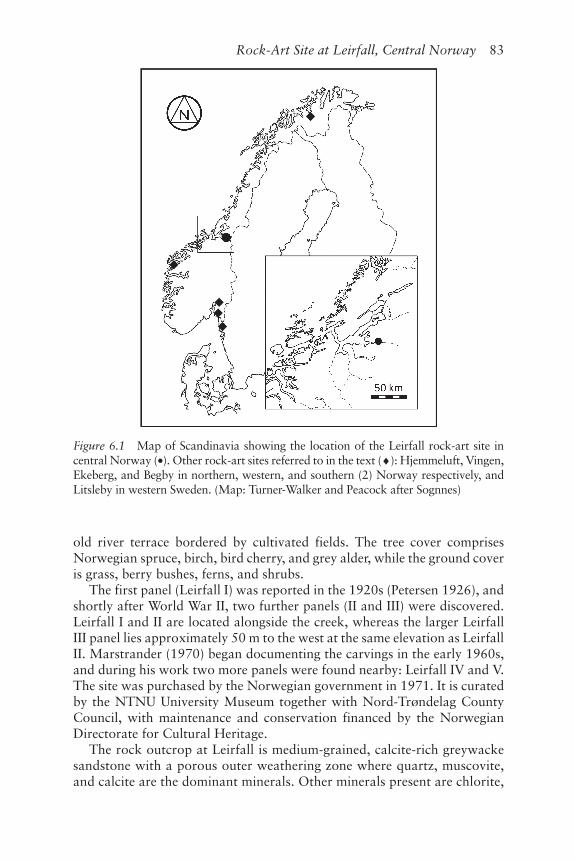
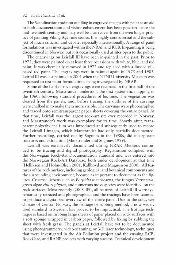
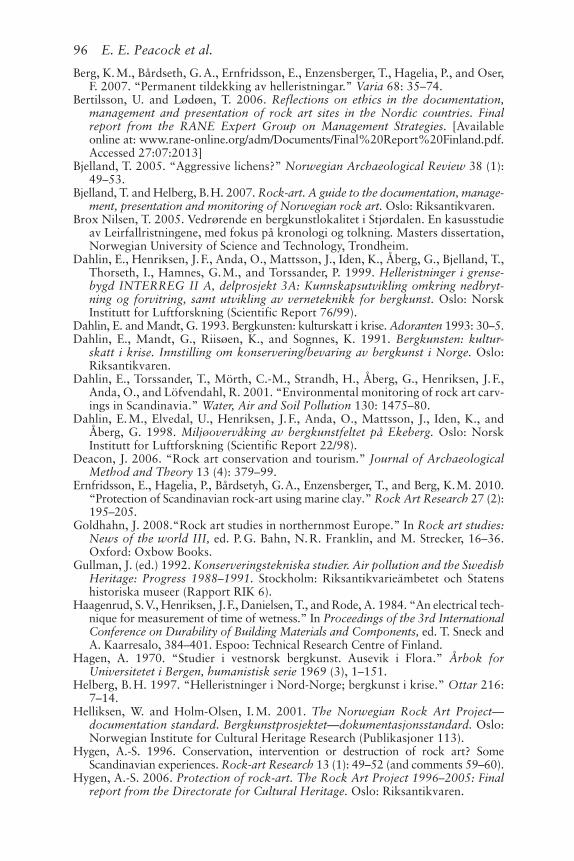
feldspar, zircon, and tourmaline (Prestvik 1981). Microscopic analysis revealed no calcite minerals in the weathering zone. The rock surface is characterized by small, cubic holes remaining from oxidized and dissolved iron pyrite (FeS2) crystals. Leirfall III, the largest panel in Tøndelag, is exe-cuted on a sloping, semidomed rock outcrop measuring around 400 m2 (Figure 6.2).
Across the surface of Leirfall III, the thick greywacke layers are bisected by narrow, curving, and well-developed foliated phyllitic strata that are heavily weathered and disintegrating where exposed (Figure 6.2). The panel is also crossed by three main fissure planes, two of which cross one another at right angles. This network of fissures and bands physically breaks up the panel into a natural patchwork of subpanels that provided a framework for grouping figures and, furthermore, was incorporated into design motifs (Brox Nilsen 2005).
Taken together, the Leirfall panels feature more than 1,200 figures rang-ing in date from approximately 1800 to 1 BC. The panels feature numerous carvings rendering horses, and imprints of shoe-soles, often in pairs and ori-ented to the dip of the rock (Sognnes 2011). Cup-marks are few compared with other Bronze Age sites in Scandinavia. There are few boat images, although several types are represented. Geometric designs, especially rect-angles, dominate some of the subpanels at Leirfall III. On this panel there is a group of human figures forming a ‘procession’ in two parallel rows (Marstrander and Sognnes 1999; Sognnes 2001; see Figure 6.2).
Figure 6.2 Part of the main Leirfall panel (Leirfall III) with engravings viewed from the lower right-hand corner. (Photograph by Kalle Sognnes. Copyright reserved.)
6244-0305-006.indd 84 4/16/2014 9:41:12 PM
Rock-Art Site at Leirfall, Central Norway 85
Open-air rock-art sites in Norway are subjected to a range of natural processes, including freeze-thaw cycles, biomediated physical and chemi-cal weathering, and solar insolation; Leirfall is no exception. The conse-quences of these processes include exfoliation, cracking, air pockets, flaking, biological accretions, and biogeocorrosion . During past periods when site vegetation was not kept ‘in check’, soil, turf, roots, trees, and bushes have encroached up to and onto the panels. Leaf-litter from overhanging trees accumulates on panel surfaces, providing a reservoir for water and thus contributing to the growth of mosses and biofilms. Lichens also colonize the exposed rock surfaces. Panels I and II are frequently inundated, whereas Leirfall III is subjected to water seepage that until recently was combined with farm effluent from the field up-slope. The panels inevitably suffer from the wear and tear of site visitors. However, the site’s rural setting safeguards it from damage through other human-caused agencies such as acid rain, local urban and industrial air pollution, and long-range air pollution.
CULTURAL HERITAGE IN CRISIS
Reports of discoveries of rock-art in Norway began to appear in the nine-teenth century, and rock-art entered the Norwegian archaeologists’ research agenda in the 1920s. Rock-art has been found at more than 1,700 localities (totalling approximately 31,000 images) throughout the country. The dete-rioration and disintegration of engraved rock surfaces was recognized early on but rarely documented. More than a century ago, Rygh (1908), an early pioneer in Norwegian rock-art research, highlighted the preservation prob-lems pertaining to rock carvings. He recommended that landowners cover the panels with soil. Baltzer (1911), active in Bohuslän, Sweden, during the same period, warned of the need to keep panels vegetation free. Gullman (1992) reports the deliberate reburial with clay in the 1920s of a rock-art site on Gotland, Sweden.
In the latter half of the twentieth century, increasing claims were made that ongoing deterioration (as the result of weathering and, later, human-caused factors including acid rain and pollution) of exposed rock-art sites in Northern Scandinavia was accelerating at an alarming rate (Hagen 1970; Strömberg 1959). Sognnes (2005) noted that this coincided with the grow-ing expectation that rock-art should be available for the viewing public. The Arts Council of Norway financed a four-year project between 1976 and 1980 to map the conditions at a selected number of sites (Michelsen 1978; Michelsen and Mandt 1981), including Leirfall (Sognnes 1981). The project’s recommendations led to the initiation in 1981 of the five-year Rock-art Project (RAP) funded by the Ministry of the Environment to study suitable conservation methods for threatened sites (Michelsen 1992). In the early 1990s, the National Council for Cultural Heritage Norway commis-sioned the first nationwide survey of the condition of rock-art. The need
6244-0305-006.indd 85 4/16/2014 9:41:12 PM
86 E. E. Peacock et al.
for further study was again emphasized (Dahlin et al. 1991), and in the intervening years, the university museums continued to carry out individual projects. Ongoing efforts to raise public and political awareness (Dahlin and Mandt 1993; Helberg 1997; Solli 1997) eventually led to the launch of the Norwegian Rock-Art Project (NRAP) that ran from 1996 through to 2006 (Hygen 2006).
NRAP, financed by the Norwegian Ministry of the Environment and administered by the Directorate for Cultural Heritage, aimed to protect 300 of the total known rock-art sites in Norway. Protection was defined as docu-mentation, the development of a management plan, conservation works, and follow-up. Research into the causes of breakdown and the develop-ment of methods to minimize damage were an integral part of this national project. Leirfall was included in this programme. National research centres and national and regional institutions developed subprojects, which were then commissioned by the Directorate upon application. One outcome was national guidelines for documentation, management, presentation, and monitoring of rock-art in Norway (Bjelland and Helberg 2007).
This period saw similar developments in Sweden. Both the Air Pollution Programme (1988–1991) and the Air Pollution and Heritage Programme (1992–1995) initiated by the National Heritage Board addressed the seem-ingly disastrous deterioration of stone buildings and monuments, including exposed open-air rock-art. Their express purpose was to study the influence of pollution (Gullman 1992; Österlund 1996). Both projects produced a general inventory of rock carvings; however, it was not possible to differ-entiate between damage caused by natural as against anthropogenic factors (Gullman 1992). The National Heritage Board pointed out that established techniques and methods to preserve rock-art did not exist. Several large EU–funded projects followed: Interreg IIA Rock Carvings in the Borderlands (RCB) between 1996 and 2000; RockCare between 1998 and 2001, man-aged by the Heritage Board within the EU Raphael/Culture 2000 pro-grammes; and Baltic Sea Region Interreg IIIB Rock-art in Northern Europe (RANE) between 2002 and 2005 (Bertilsson and Lødøen 2006; Kallhovd and Magnusson 2000). A central focus of these projects, run concurrently with NRAP, was documentation and recording of rock-art. Research into chemical and physical weathering and remedial conservation was also undertaken.
The results of these large projects were disseminated principally through internal reports and institution-based serials, with the result that not much of it reached wider academic and practitioner communities. It is unavailable for comparison with or synthesis with various other approaches and results. Little has been published in peer-reviewed books and journals nationally or internationally. Moreover, there is no useful overview of the results and con-clusions from these projects (Goldhahn 2008). This has led to criticism and debate over their goals and the value of the results within the Norwegian research community (Bakkevig 2004; Bjelland 2005; Walderhaug 1998;
6244-0305-006.indd 86 4/16/2014 9:41:12 PM
Rock-Art Site at Leirfall, Central Norway 87
Walderhaug and Walderhaug 1998; Walderhaug Sætersdal 2000). Much of the debate centres on the role of weathering, methods and extent of conser-vation intervention, and the role of lichens.
LEIRFALL IN CRISIS?
Leirfall was included in several surveys that led to the establishment of NRAP. However, were Leirfall open-air panels really in a state of accel-erating deterioration? The 1976 to 1980 survey concluded that although the rock surfaces at Leirfall were deteriorating, it was not a major crisis (Sognnes 1981). Visual comparison of Leirfall III documentation from 1967 with that from 2008 to 2009 revealed little damage to the engravings them-selves. By documenting the fractures, fissures, and exfoliation, the recent tracings illustrate why the figures are grouped in eight or nine narrow seg-ments running from northwest to southeast across the panel and why some figures are incomplete. This is especially the case in areas where layers of extensively weathered phyllite bisect the sandstone surface and where hori-zontal fractures intersect vertical open ledges of phyllite, leading to exfolia-tion (see Figure 6.2).
One boat figure illustrates damage due to a “blistered rock” surface. Marstrander’s 1967 photo-documentation shows three small holes which developed into one large hole by 1996 but which appear further unchanged in 2012. The situation for the Leirfall III engravings is similar to that of other sites in Norway, where few figures have been damaged during the last century as a result of natural deterioration. Documentation at Leirfall in the 1960s focused on the images rather than the medium into which they were carved. The evolution of exfoliation at surface level and subsequent deterioration is difficult to monitor and track (Walderhaug and Walderhaug 1998), and the Leirfall III surfaces can be crushed simply by treading on them because they are open to the viewing public.
THE NORWEGIAN ROCK-ART PROJECT AT LEIRFALL
The NTNU University Museum contributed several subprojects to NRAP that studied registration, documentation, and the development of manage-ment plans for several sites in Central Norway, including Leirfall (Sognnes 2000). Research into remedial conservation (of the type practised at rock-art localities in Northern Scandinavia) such as consolidation methods, mortars and cements, formulations for in-painting, and methods for the removal/reduction of surface accretions were not pursued.
Of particular focus was the establishment at Leirfall in October 1997 of a weather station and a five-year environmental monitoring pro-gramme based on systematic data acquisition in order to investigate the
6244-0305-006.indd 87 4/16/2014 9:41:12 PM
88 E. E. Peacock et al.
impact of thermal cycling and insulation surface covering on the largest Leirfall panel. Surface wetness and temperature were monitored hourly using the Wetcorr® system developed by the Norwegian Institute for Air Research (Dahlin et al. 1998; Haagenrud et al. 1984). Three rock sur-faces were included in the study: the Leirfall III panel (one wet and one dry zone), a weather station reference panel, and a section of bedrock without engravings . The bedrock test panel was an unexposed outcrop from which the turf was lifted. Half of this panel was covered with an isolating layer of geotextile, a 5-cm-thick sheet of mineral wool and 10 cm of replaced turf (giving a total of 15 cm). The remaining half of the panel was covered with 15 cm of replaced turf only. Both halves were monitored.
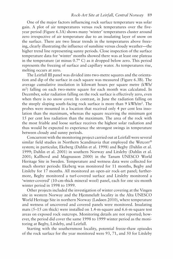
Hourly values of air temperature and wetness were compared to records from the Norwegian Meteorological Institute (DNMI) weather station at nearby Værnes and showed an excellent match between the datasets. Long-term trends in air temperature and surface temperature, and wetness on both exposed and covered rock surfaces, were studied. Results confirmed that the exposed panel (monitored for 62 months) was subjected to multiple freeze-thaw episodes between October and April. No freeze-thaw episodes were recorded on the turf-covered panel (monitored for 43 months). The most vulnerable periods were when the rock surface was not covered with an insulating layer of snow and in the early spring. The annual number of episodes on the exposed rock surface varied greatly over the five-year period—40, 24, 40, 24, and 41 with an annual average of 34—highlighting that monitoring programmes of one to two years’ duration do not give a rep-resentative picture. To date, no other site in Scandinavia has been monitored as intensively or extensively.
Total variation in temperature over the course of one year was about 51° C for the air and 41° C and 13° C for the exposed and covered rock surfaces, respectively. In the summer months, the rock surface has a higher maximum temperature (in excess of 30° C) than the air but smaller diur-nal differences. Large diurnal variations in temperature are considered to contribute to physical weathering, although there is debate regarding the threshold difference. At Leirfall, the average number of days per year with a temperature difference of 15° C and 20° C was 36 and 10, respectively, concentrated between April and June.
Comparing rock surface wetness with local DNMI rainfall records dem-onstrated a good correlation between surface water and rainfall, with peri-ods of dryness between showers. Both surface probes showed increasingly prolonged periods of full saturation after the first two years. A similar deg-radation in performance after three years was evident on the weather sta-tion probe, ruling out an accumulation of wet leaves on the probes as an explanation. The degradation in performance must be attributed to either a slow deterioration of the Wetcorr® probes or, more likely, the formation of a hygroscopic biofilm on the sensors’ surfaces.
6244-0305-006.indd 88 4/16/2014 9:41:12 PM
Rock-Art Site at Leirfall, Central Norway 89
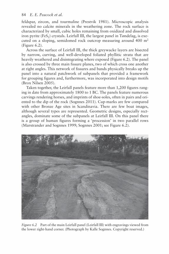
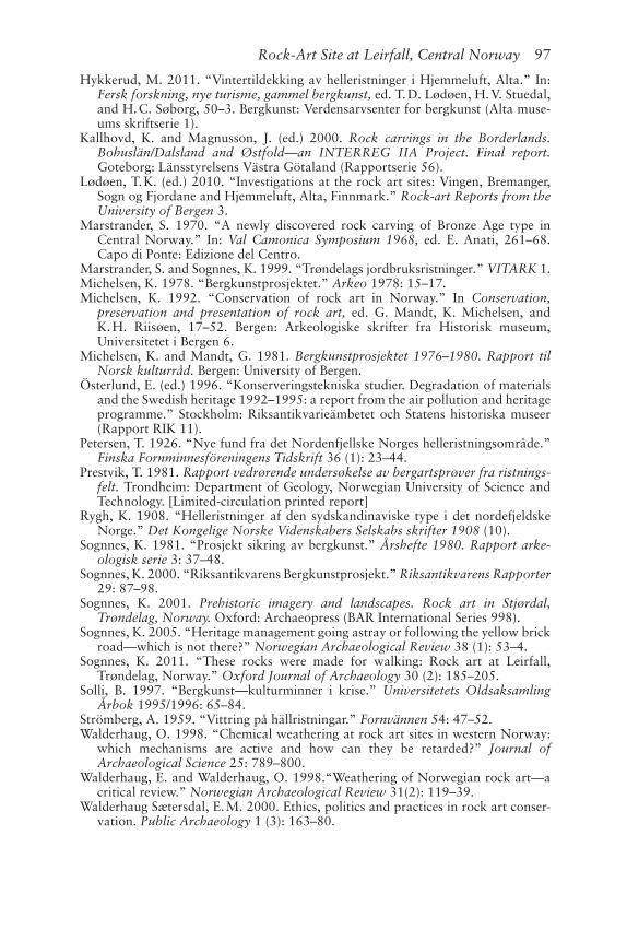
One of the major factors influencing rock surface temperature was solar gain. A plot of air temperatures versus rock temperatures over the five-year period (Figure 6.3A) shows many ‘winter’ temperatures cluster around zero irrespective of air temperature due to an insulating layer of snow on the surface. There are two linear trends in the temperatures above freez-ing, clearly illustrating the influence of sunshine versus cloudy weather—the higher trend line representing sunny periods. Close inspection of the surface temperature data for ‘winter’ months showed there was at least one plateau in the temperature (at minus 0.7° C) as it dropped below zero. This period represents the freezing of surface and capillary water. As temperatures rise, melting occurs at zero.
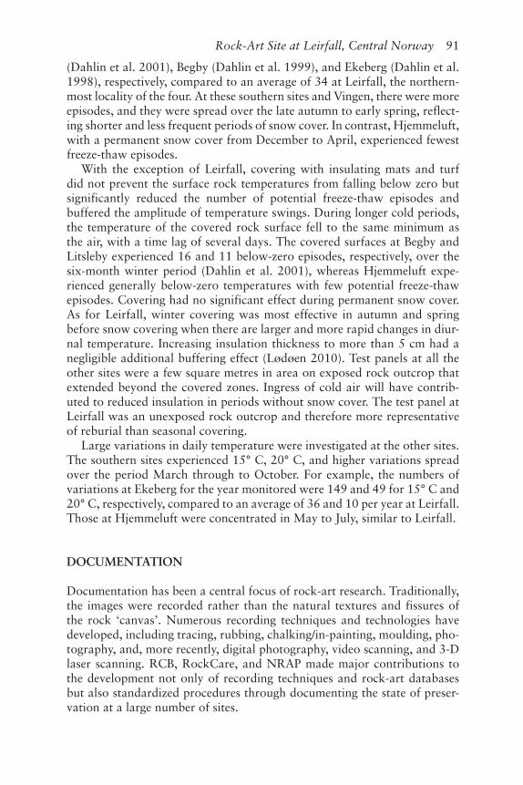
The Leirfall III panel was divided into two-metre squares and the orienta-tion and dip of the surface in each square was measured (Figure 6.3B). The average cumulative insolation in kilowatt hours per square metre (kWh/m2) falling on each two-metre square for each month was calculated. In December, solar radiation falling on the rock surface is effectively zero, even when there is no snow cover. In contrast, in June the radiation falling on the steeply sloping south-facing rock surface is more than 9 kWh/m2. The probes were mounted in a location that received only 4 per cent less inso-lation than the maximum, whereas the square receiving the minimum got 15 per cent less radiation than the maximum. The area of the rock with the most friable and loose surface receives the highest solar radiation and thus would be expected to experience the strongest swings in temperature between cloudy and sunny periods.
Concurrent with the monitoring project carried out at Leirfall were several similar field studies in Northern Scandinavia that employed the Wetcorr® system; in particular, Ekeberg (Dahlin et al. 1998) and Begby (Dahlin et al. 1999; Dahlin et al. 2001) in southern Norway and Litsleby (Dahlin et al. 2001; Kallhovd and Magnusson 2000) in the Tanum UNESCO World Heritage Site in Sweden. Temperature and wetness data were collected for much shorter periods: Ekeberg was monitored for 11 months, Begby and Litsleby for 17 months. All monitored an open-air rock-art panel; further-more, Begby monitored a turf-covered surface and Litsleby monitored a ‘winter-covered’ (10-cm-thick mineral wool) panel, each for one six-month winter period in 1998 to 1999.
Other projects included the investigation of winter covering at the Vingen site in western Norway and the Hjemmeluft locality in the Alta UNESCO World Heritage Site in northern Norway (Lødøen 2010), where temperature and wetness of uncovered and covered panels were monitored. Insulating mats (5–15 cm thick) were installed on 1.4-m-square and 6.6-m-square test areas on exposed rock outcrops. Monitoring details are not reported; how-ever, the period did cover the same 1998 to 1999 winter period as the moni-toring at Begby, Litsleby, and Leirfall.
Starting with the southernmost locality, potential freeze-thaw episodes of the rock surface for the year monitored were 93, 71, and 50 for Litsleby
6244-0305-006.indd 89 4/16/2014 9:41:12 PM
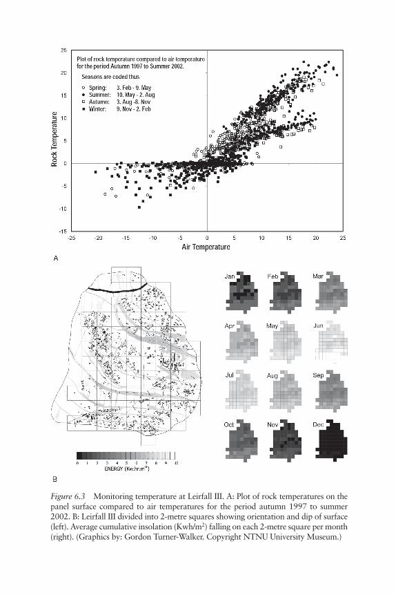
Figure 6.3 Monitoring temperature at Leirfall III. A: Plot of rock temperatures on the panel surface compared to air temperatures for the period autumn 1997 to summer 2002. B: Leirfall III divided into 2-metre squares showing orientation and dip of surface (left). Average cumulative insolation (Kwh/m2) falling on each 2-metre square per month (right). (Graphics by: Gordon Turner-Walker. Copyright NTNU University Museum.)
6244-0305-006.indd 90 4/16/2014 9:41:12 PM
Rock-Art Site at Leirfall, Central Norway 91
(Dahlin et al. 2001), Begby (Dahlin et al. 1999), and Ekeberg (Dahlin et al. 1998), respectively, compared to an average of 34 at Leirfall, the northern-most locality of the four. At these southern sites and Vingen, there were more episodes, and they were spread over the late autumn to early spring, reflect-ing shorter and less frequent periods of snow cover. In contrast, Hjemmeluft, with a permanent snow cover from December to April, experienced fewest freeze-thaw episodes.
With the exception of Leirfall, covering with insulating mats and turf did not prevent the surface rock temperatures from falling below zero but significantly reduced the number of potential freeze-thaw episodes and buffered the amplitude of temperature swings. During longer cold periods, the temperature of the covered rock surface fell to the same minimum as the air, with a time lag of several days. The covered surfaces at Begby and Litsleby experienced 16 and 11 below-zero episodes, respectively, over the six-month winter period (Dahlin et al. 2001), whereas Hjemmeluft expe-rienced generally below-zero temperatures with few potential freeze-thaw episodes. Covering had no significant effect during permanent snow cover. As for Leirfall, winter covering was most effective in autumn and spring before snow covering when there are larger and more rapid changes in diur-nal temperature. Increasing insulation thickness to more than 5 cm had a negligible additional buffering effect (Lødøen 2010). Test panels at all the other sites were a few square metres in area on exposed rock outcrop that extended beyond the covered zones. Ingress of cold air will have contrib-uted to reduced insulation in periods without snow cover. The test panel at Leirfall was an unexposed rock outcrop and therefore more representative of reburial than seasonal covering.
Large variations in daily temperature were investigated at the other sites. The southern sites experienced 15° C, 20° C, and higher variations spread over the period March through to October. For example, the numbers of variations at Ekeberg for the year monitored were 149 and 49 for 15° C and 20° C, respectively, compared to an average of 36 and 10 per year at Leirfall. Those at Hjemmeluft were concentrated in May to July, similar to Leirfall.
DOCUMENTATION
Documentation has been a central focus of rock-art research. Traditionally, the images were recorded rather than the natural textures and fissures of the rock ‘canvas’. Numerous recording techniques and technologies have developed, including tracing, rubbing, chalking/in-painting, moulding, pho-tography, and, more recently, digital photography, video scanning, and 3-D laser scanning. RCB, RockCare, and NRAP made major contributions to the development not only of recording techniques and rock-art databases but also standardized procedures through documenting the state of preser-vation at a large number of sites.
6244-0305-006.indd 91 4/16/2014 9:41:12 PM
92 E. E. Peacock et al.
The Scandinavian tradition of filling in engraved images with paint as an aid to both documentation and visitor enhancement has been practised since the mid-twentieth century and may well be a carryover from the even longer prac-tice of painting Viking Age rune stones. It is highly controversial and the sub-ject of much criticism and debate, especially internationally. A range of paint formulations was investigated within the NRAP and RCB. In-painting is being discontinued in Norway, but it is occasionally used at sites open to the public.
The engravings on Leirfall III have been in-painted in the past. Prior to 1972, they were painted on at least three occasions with white, blue, and red paint. It was chemically removed in 1972 and replaced with a linseed oil–based red paint. The engravings were in-painted again in 1975 and 1983. Leirfal III was last painted in 2001 when the NTNU University Museum was requested to test paint formulations being investigated by NRAP.
Some of the Leirfall rock engravings were recorded in the first half of the twentieth century. Marstrander undertook the first systematic mapping in the 1960s following standard procedures of his time. The vegetation was cleared from the panels, and, before tracing, the outlines of the carvings were chalked in to make them more visible. The carvings were photographed and traced onto semitransparent paper sheets covering the entire panel. At that time, Leirfall was the largest rock-art site ever recorded in Norway, and Marstrander’s work was exemplary for its time. Shortly after, trans-parent polyethylene film was introduced and subsequently used to record the Leirfall I images, which Marstrander had only partially documented. Further recording, carried out by Sognnes in the 1980s, did incorporate fractures and exfoliation (Marstrander and Sognnes 1999).
Leirfall was extensively documented during NRAP. Methods contin-ued to be tracing and digital photography. Registration complied with the Norwegian Rock-Art Documentation Standard and was entered into the Norwegian Rock-Art Database, both under development at that time (Helliksen and Holm-Olsen 2001; Kallhovd and Magnusson 2000). All fea-tures of the rock surface, including geological and botanical components and the surrounding environment, became as important to document as the fig-ures. Crustose lichens such as Porpidia macrocarpa, the fungus Verrucaria, green algae chlorophytes, and numerous moss species were identified on the rock surfaces. Most recently (2008–09), all features of Leirfall III were sys-tematically retraced and photographed, and the tracings have been scanned to produce a digitalized overview of the entire panel. Due to the cold, wet climate of Central Norway, the frottage or rubbing method, a now widely used standard in Sweden, has proved to be impractical. The frottage tech-nique is based on rubbing large sheets of paper placed on rock surfaces with a soft sponge wrapped in carbon paper, followed by fixing by rubbing the sheet with fresh grass. The panels at Leirfall have yet to be documented using photogrammetry, video-scanning, or 3-D laser technology, techniques that were investigated in the Air Pollution project and the ensuing RCB, RockCare, and RANE projects with varying success. Technical development
6244-0305-006.indd 92 4/16/2014 9:41:12 PM
Rock-Art Site at Leirfall, Central Norway 93
within the field is rapid. Recently a 3-D topographical model of Leirfall III was created upon which the latest digitalized documentation has been over-laid to create a 3-D image of the entire panel.
CONSERVATION AND MANAGEMENT
By the 1980s, remedial conservation was being carried out at rock-art localities in most regions of Norway. This coincided with the increase in alarming reports of the deterioration of open-air rock-art sites. Surface vegetation and films were treated with a range of biocides followed by scrubbing. More invasive (not necessarily knowledge-based) interventions were introduced, including adhe-sives to consolidate crumbling areas of rock surface; adhesives or mixtures of adhesive, Portland cement, and sand to readhere loose pieces; infilling of lacuna with a mortar of cement, adhesive, and sand; and in-filling of large crevices with gravel and cement mortar. Many of these interventions have proved to be unstable (Bakkevig 2004), but Hygen (1996) argues that many preservation interventions resulted from desperation among managers of threatened rock-art because panels were “literally falling apart before their very eyes”. In Central Norway, other than the practise of in-painting engravings, invasive conserva-tion methods to stabilize disintegrating or exfoliating panels or disintegration of the supporting rock substrate have not been implemented.
The Leirfall site has a long history of efforts to make the panels available to the viewing public, including removal of turf, mechanical cleaning and in-painting of the engravings, chemical removal of surface micro-vegetation, reduction of surrounding woodland, and installation of visitor facilities such as signage, walkways, and parking facilities. Much of this work was car-ried out on an ad hoc basis using local volunteers. Remedial activities from 1970 until 1990 were sporadic and incompletely documented. The surface micro-vegetation of one or more panels was treated in 1989 and 1994 with the biocide Pingo®. Pingo® (dialkyl dimethyl ammonium chloride 5–10%, sodium meta-silicate 0–1%, and isopropanol 1–5%, produced by Jotun), has been widely used in Norway to reduce lichen cover on rock-art surfaces.
When the Leirfall site was documented in the 1960s, it was surrounded by an open landscape of uncultivated pastureland that, as the result of changing agricultural patterns, returned to woodland. In 2001, the site was cleared of overhanging and encroaching vegetation. However, by 2004 the engrav-ings were again covered with soil and decomposing leaves, and shrubs and shoots had reestablished themselves around the panels. In 2005, a site man-agement programme was established for Leirfall that continues today. The site was returned to its 2001 state and has since been held in check, requiring an input of two person-months per year.
To reduce the presence of biofilms and other surface flora at Leirfall, the rock surface and fissures are manually cleaned in the autumn of vegetation with brushing, sprayed with undiluted denatured ethanol (0.2 l per m2),
6244-0305-006.indd 93 4/16/2014 9:41:13 PM
94 E. E. Peacock et al.
then covered with plastic sheeting to delay evaporation. This method was investigated at Vingen during NRAP (Lødøen 2010), and has since been promoted by the Norwegian rock-art guidelines (Bjelland and Helberg 2007). Repeated treatment is necessary to fully remove lichens. Although the guidelines outline treatment for lichen removal, they do not comment upon whether removal is recommended.
Trials were carried out with denatured ethanol and Pingo® and found both to be effective (Lødøen 2010). However, following treatment with Pingo®, recolonization by algae was quicker upon exposure, and its use is not recom-mended by the guidelines. Studies to investigate methods to reduce surface bio-logical activity were also carried out at Litsleby during RCB (Dahlin et al. 1999; Kallhovd and Magnusson 2000). These entailed covering the rock surface with a range of materials such as geotextile and insulation in various combinations; however, surfaces were not treated with a biocide prior to covering.
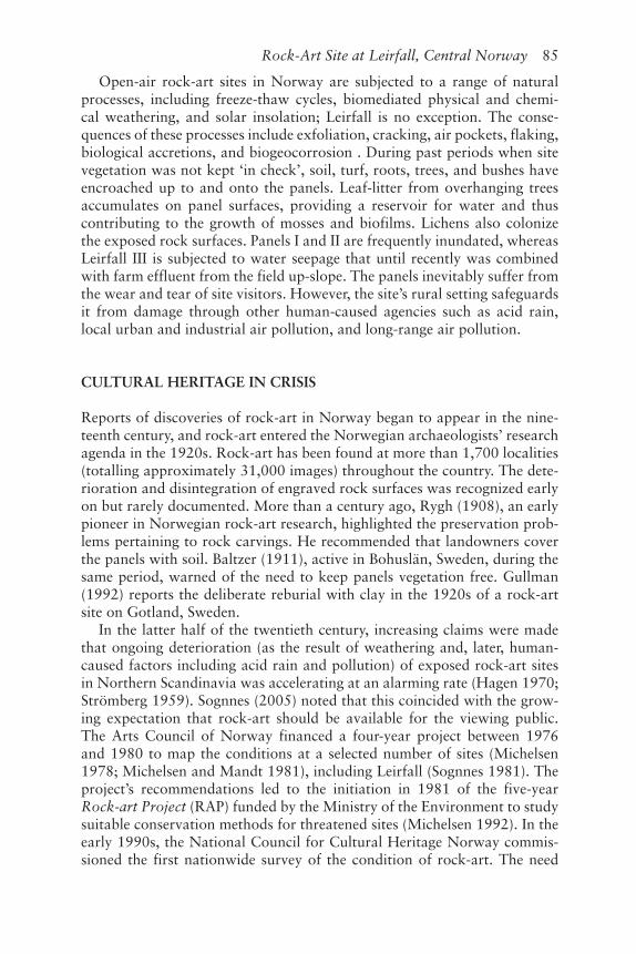
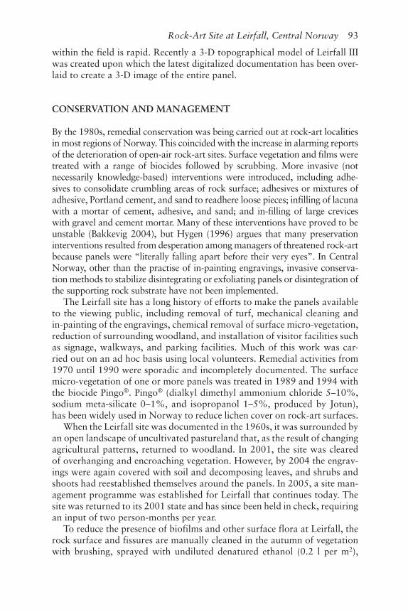
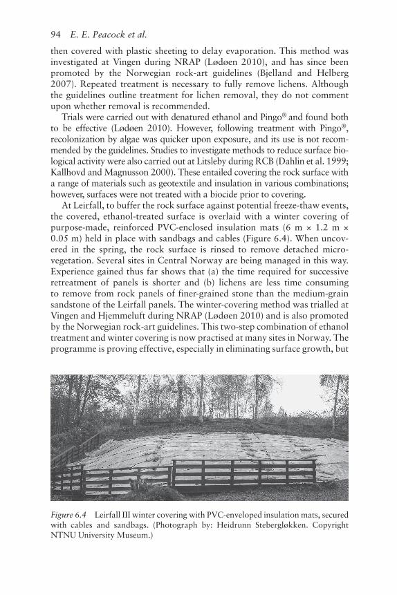
At Leirfall, to buffer the rock surface against potential freeze-thaw events, the covered, ethanol-treated surface is overlaid with a winter covering of purpose-made, reinforced PVC-enclosed insulation mats (6 m × 1.2 m × 0.05 m) held in place with sandbags and cables (Figure 6.4). When uncov-ered in the spring, the rock surface is rinsed to remove detached micro-vegetation. Several sites in Central Norway are being managed in this way. Experience gained thus far shows that (a) the time required for successive retreatment of panels is shorter and (b) lichens are less time consuming to remove from rock panels of finer-grained stone than the medium-grain sandstone of the Leirfall panels. The winter-covering method was trialled at Vingen and Hjemmeluft during NRAP (Lødøen 2010) and is also promoted by the Norwegian rock-art guidelines. This two-step combination of ethanol treatment and winter covering is now practised at many sites in Norway. The programme is proving effective, especially in eliminating surface growth, but
Figure 6.4 Leirfall III winter covering with PVC-enveloped insulation mats, secured with cables and sandbags. (Photograph by: Heidrunn Stebergløkken. Copyright NTNU University Museum.)
6244-0305-006.indd 94 4/16/2014 9:41:13 PM
Rock-Art Site at Leirfall, Central Norway 95
most managers report it to be very labour intensive (Hykkerud 2011) and now question whether it is financially viable in the longer term.
Approximately 15 person-days are required each year to treat and winter-cover the panels at Leirfall. Four of the five panels have been treated since 2005; however, on several occasions the winter covering has not been removed from selected panels for the summer due to reduced resources. Comparative investigations of the practicalities of both winter and long-term covering are being carried out at Hjemmeluft (Hykkerud 2011). Permanent covering, consisting of a layer of geotextile covered with a layer of soil, has been carried out at several sites in Central Norway. Several sites in southern Norway have been reburied (Berg et al. 2007; Ernfridsson et al. 2010).
CONCLUSION
The open-air rock-art site at Leirfall in Central Norway has been known since the early twentieth century. It is a site with a long tradition of intervention; however, a cautious approach since the 1980s led to it not being subjected to what has proved to be a range of unstable remedial interventions widely implemented at sites in other regions of Norway. Its research contribution to the Norwegian Rock-Art Project—a five-year investigation of the impact of thermal cycling and insulating covering on exposed rock-art surfaces—far exceeded similar projects in Northern Scandinavia in both scope and dura-tion. It highlighted that monitoring programmes of one to two years’ duration do not give a representative picture of climatic impacts over time, thus calling into question the long-term applicability of the results of other shorter studies.
Today, the focus is on site management. The engravings are no longer in-painted, nor are the surfaces scrubbed with quaternary ammonium biocides. Labour-intensive efforts are invested each year to reduce surface accretions on exposed rock surfaces and buffer them against freeze-thaw episodes, and the financial sustainability of this work of making the site available to the public is coming into question. Deacon (2006) observes that due to the absence of an indigenous descendent community, decisions regarding the opening and clos-ing of suitable rock-art sites to the public in Scandinavia can be made based on perceived significance of the rock-art and ability to sustainably manage it. Leirfall is the largest open-air rock-art locality in Central Norway, and recent experience points to the need for a more realistic approach to its management.
REFERENCES
Bakkevig, S. 2004. “Rock art preservation: improved and ecology-based methods can give weathered sites prolonged life.” Norwegian Archaeological Review 37 (1): 65–81.
Baltzer, L. 1911. “Några af de viktigaste hällristnagarna samt en del af de fasta forn-minnena i Bohuslän.” Instituttet for sammenlignede kulturforskning skrifter 15.
6244-0305-006.indd 95 4/16/2014 9:41:13 PM
96 E. E. Peacock et al.
Berg, K. M., Bårdseth, G. A., Ernfridsson, E., Enzensberger, T., Hagelia, P., and Oser, F. 2007. “Permanent tildekking av helleristningar.” Varia 68: 35–74.
Bertilsson, U. and Lødøen, T. 2006. Reflections on ethics in the documentation, management and presentation of rock art sites in the Nordic countries. Final report from the RANE Expert Group on Management Strategies. [Available online at: www.rane-online.org/adm/Documents/Final%20Report%20Finland.pdf. Accessed 27:07:2013]
Bjelland, T. 2005. “Aggressive lichens?” Norwegian Archaeological Review 38 (1): 49–53.
Bjelland, T. and Helberg, B. H. 2007. Rock-art. A guide to the documentation, manage-ment, presentation and monitoring of Norwegian rock art. Oslo: Riksantikvaren.
Brox Nilsen, T. 2005. Vedrørende en bergkunstlokalitet i Stjørdalen. En kasusstudie av Leirfallristningene, med fokus på kronologi og tolkning. Masters dissertation, Norwegian University of Science and Technology, Trondheim.
Dahlin, E., Henriksen, J. F., Anda, O., Mattsson, J., Iden, K., Åberg, G., Bjelland, T., Thorseth, I., Hamnes, G. M., and Torssander, P. 1999. Helleristninger i grense-bygd INTERREG II A, delprosjekt 3A: Kunnskapsutvikling omkring nedbryt-ning og forvitring, samt utvikling av verneteknikk for bergkunst. Oslo: Norsk Institutt for Luftforskning (Scientific Report 76/99).
Dahlin, E. and Mandt, G. 1993. Bergkunsten: kulturskatt i krise. Adoranten 1993: 30–5.Dahlin, E., Mandt, G., Riisøen, K., and Sognnes, K. 1991. Bergkunsten: kultur-
skatt i krise. Innstilling om konservering/bevaring av bergkunst i Norge. Oslo: Riksantikvaren.
Dahlin, E., Torssander, T., Mörth, C.-M., Strandh, H., Åberg, G., Henriksen, J. F., Anda, O., and Löfvendahl, R. 2001. “Environmental monitoring of rock art carv-ings in Scandinavia.” Water, Air and Soil Pollution 130: 1475–80.
Dahlin, E. M., Elvedal, U., Henriksen, J. F., Anda, O., Mattsson, J., Iden, K., and Åberg, G. 1998. Miljøovervåking av bergkunstfeltet på Ekeberg. Oslo: Norsk Institutt for Luftforskning (Scientific Report 22/98).
Deacon, J. 2006. “Rock art conservation and tourism.” Journal of Archaeological Method and Theory 13 (4): 379–99.
Ernfridsson, E., Hagelia, P., Bårdsetyh, G. A., Enzensberger, T., and Berg, K. M. 2010. “Protection of Scandinavian rock-art using marine clay.” Rock Art Research 27 (2): 195–205.
Goldhahn, J. 2008.“Rock art studies in northernmost Europe.” In Rock art studies: News of the world III, ed. P. G. Bahn, N. R. Franklin, and M. Strecker, 16–36. Oxford: Oxbow Books.
Gullman, J. (ed.) 1992. Konserveringstekniska studier. Air pollution and the Swedish Heritage: Progress 1988–1991. Stockholm: Riksantikvarieämbetet och Statens historiska museer (Rapport RIK 6).
Haagenrud, S. V., Henriksen, J. F., Danielsen, T., and Rode, A. 1984. “An electrical tech-nique for measurement of time of wetness.” In Proceedings of the 3rd International Conference on Durability of Building Materials and Components, ed. T. Sneck and A. Kaarresalo, 384–401. Espoo: Technical Research Centre of Finland.
Hagen, A. 1970. “Studier i vestnorsk bergkunst. Ausevik i Flora.” Årbok for Universitetet i Bergen, humanistisk serie 1969 (3), 1–151.
Helberg, B. H. 1997. “Helleristninger i Nord-Norge; bergkunst i krise.” Ottar 216: 7–14.
Helliksen, W. and Holm-Olsen, I. M. 2001. The Norwegian Rock Art Project—documentation standard. Bergkunstprosjektet—dokumentasjonsstandard. Oslo: Norwegian Institute for Cultural Heritage Research (Publikasjoner 113).
Hygen, A.-S. 1996. Conservation, intervention or destruction of rock art? Some Scandinavian experiences. Rock-art Research 13 (1): 49–52 (and comments 59–60).
Hygen, A.-S. 2006. Protection of rock-art. The Rock Art Project 1996–2005: Final report from the Directorate for Cultural Heritage. Oslo: Riksantikvaren.
6244-0305-006.indd 96 4/16/2014 9:41:13 PM
Rock-Art Site at Leirfall, Central Norway 97
Hykkerud, M. 2011. “Vintertildekking av helleristninger i Hjemmeluft, Alta.” In: Fersk forskning, nye turisme, gammel bergkunst, ed. T. D. Lødøen, H. V. Stuedal, and H. C. Søborg, 50–3. Bergkunst: Verdensarvsenter for bergkunst (Alta muse-ums skriftserie 1).
Kallhovd, K. and Magnusson, J. (ed.) 2000. Rock carvings in the Borderlands. Bohuslän/Dalsland and Østfold—an INTERREG IIA Project. Final report. Goteborg: Länsstyrelsens Västra Götaland (Rapportserie 56).
Lødøen, T. K. (ed.) 2010. “Investigations at the rock art sites: Vingen, Bremanger, Sogn og Fjordane and Hjemmeluft, Alta, Finnmark.” Rock-art Reports from the University of Bergen 3.
Marstrander, S. 1970. “A newly discovered rock carving of Bronze Age type in Central Norway.” In: Val Camonica Symposium 1968, ed. E. Anati, 261–68. Capo di Ponte: Edizione del Centro.
Marstrander, S. and Sognnes, K. 1999. “Trøndelags jordbruksristninger.” VITARK 1.Michelsen, K. 1978. “Bergkunstprosjektet.” Arkeo 1978: 15–17.Michelsen, K. 1992. “Conservation of rock art in Norway.” In Conservation,
preservation and presentation of rock art, ed. G. Mandt, K. Michelsen, and K. H. Riisøen, 17–52. Bergen: Arkeologiske skrifter fra Historisk museum, Universitetet i Bergen 6.
Michelsen, K. and Mandt, G. 1981. Bergkunstprosjektet 1976–1980. Rapport til Norsk kulturråd. Bergen: University of Bergen.
Österlund, E. (ed.) 1996. “Konserveringstekniska studier. Degradation of materials and the Swedish heritage 1992–1995: a report from the air pollution and heritage programme.” Stockholm: Riksantikvarieämbetet och Statens historiska museer (Rapport RIK 11).
Petersen, T. 1926. “Nye fund fra det Nordenfjellske Norges helleristningsområde.” Finska Fornminnesföreningens Tidskrift 36 (1): 23–44.
Prestvik, T. 1981. Rapport vedrørende undersøkelse av bergartsprøver fra ristnings-felt. Trondheim: Department of Geology, Norwegian University of Science and Technology. [Limited-circulation printed report]
Rygh, K. 1908. “Helleristninger af den sydskandinaviske type i det nordefjeldske Norge.” Det Kongelige Norske Videnskabers Selskabs skrifter 1908 (10).
Sognnes, K. 1981. “Prosjekt sikring av bergkunst.” Årshefte 1980. Rapport arke-ologisk serie 3: 37–48.
Sognnes, K. 2000. “Riksantikvarens Bergkunstprosjekt.” Riksantikvarens Rapporter 29: 87–98.
Sognnes, K. 2001. Prehistoric imagery and landscapes. Rock art in Stjørdal, Trøndelag, Norway. Oxford: Archaeopress (BAR International Series 998).
Sognnes, K. 2005. “Heritage management going astray or following the yellow brick road—which is not there?” Norwegian Archaeological Review 38 (1): 53–4.
Sognnes, K. 2011. “These rocks were made for walking: Rock art at Leirfall, Trøndelag, Norway.” Oxford Journal of Archaeology 30 (2): 185–205.
Solli, B. 1997. “Bergkunst—kulturminner i krise.” Universitetets Oldsaksamling Årbok 1995/1996: 65–84.
Strömberg, A. 1959. “Vittring på hällristningar.” Fornvännen 54: 47–52.Walderhaug, O. 1998. “Chemical weathering at rock art sites in western Norway:
which mechanisms are active and how can they be retarded?” Journal of Archaeological Science 25: 789–800.
Walderhaug, E. and Walderhaug, O. 1998.“Weathering of Norwegian rock art—a critical review.” Norwegian Archaeological Review 31(2): 119–39.
Walderhaug Sætersdal, E. M. 2000. Ethics, politics and practices in rock art conser-vation. Public Archaeology 1 (3): 163–80.
6244-0305-006.indd 97 4/16/2014 9:41:13 PM